

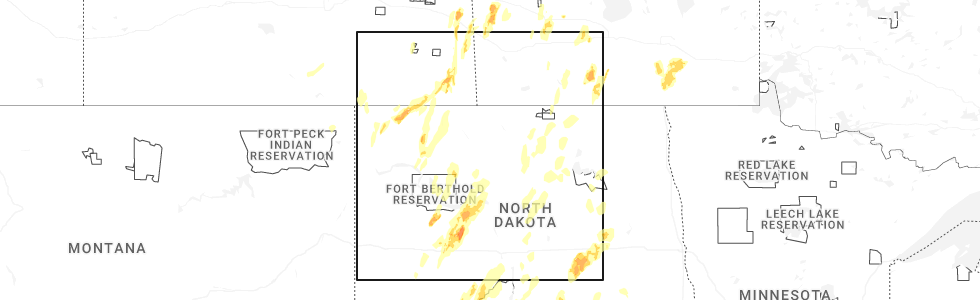
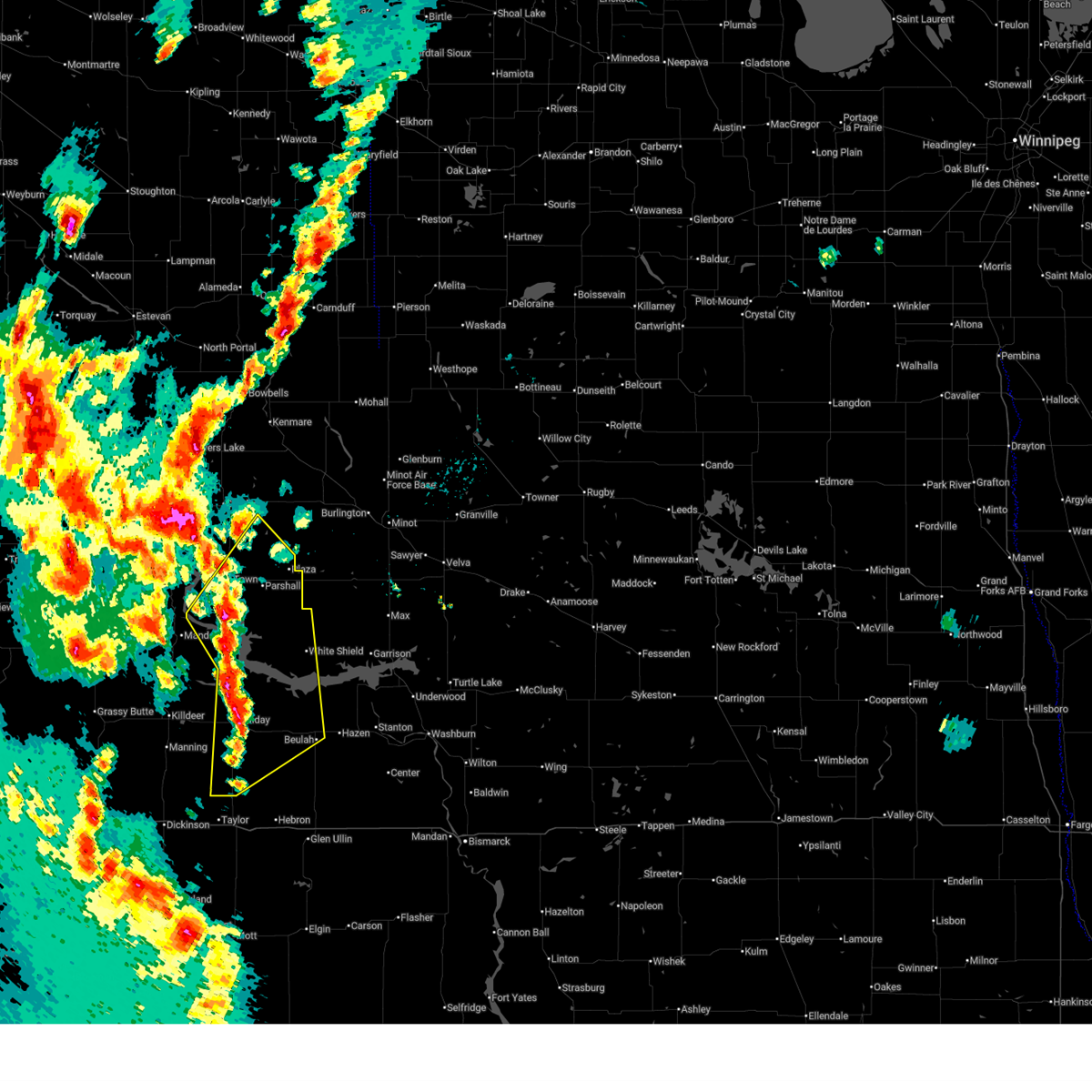
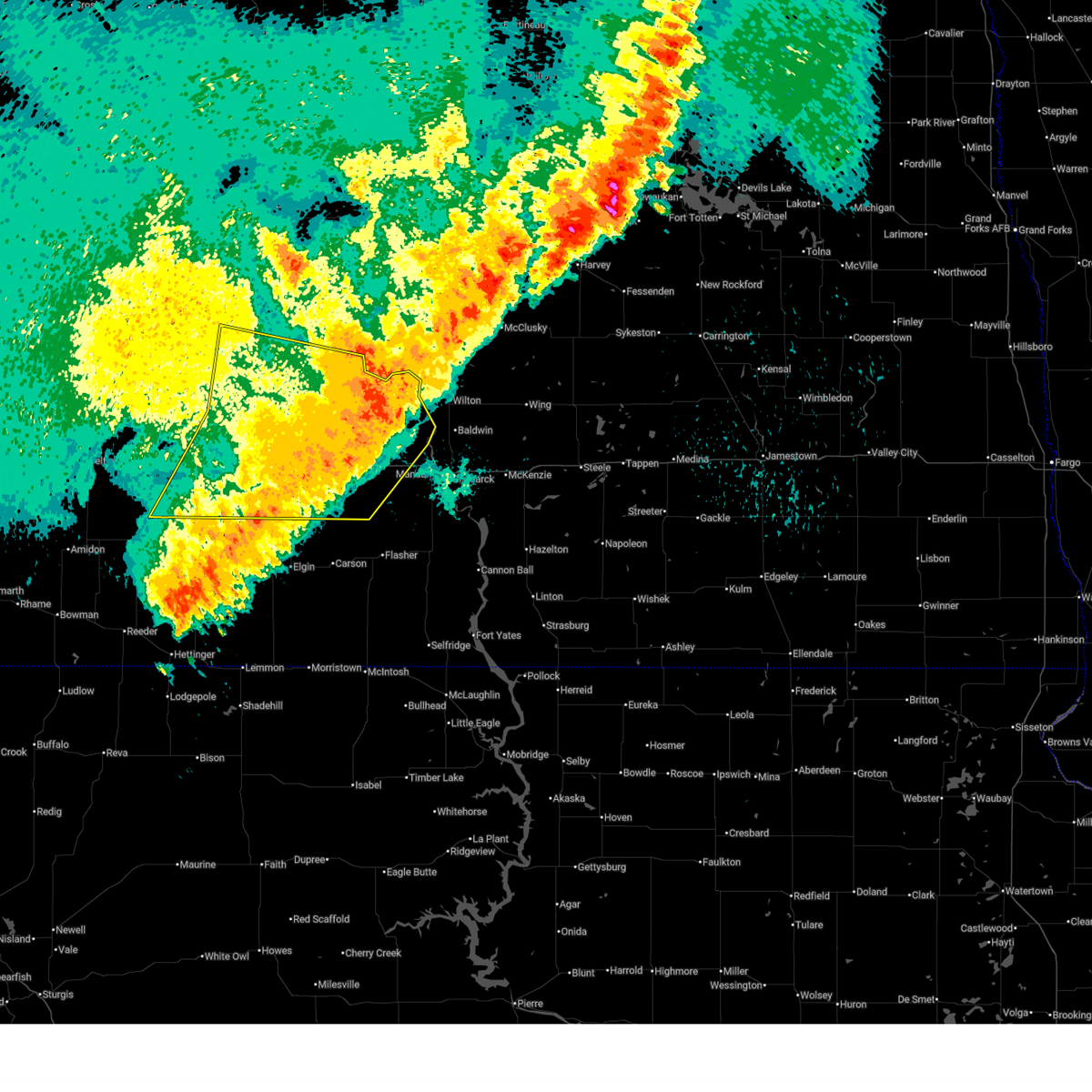
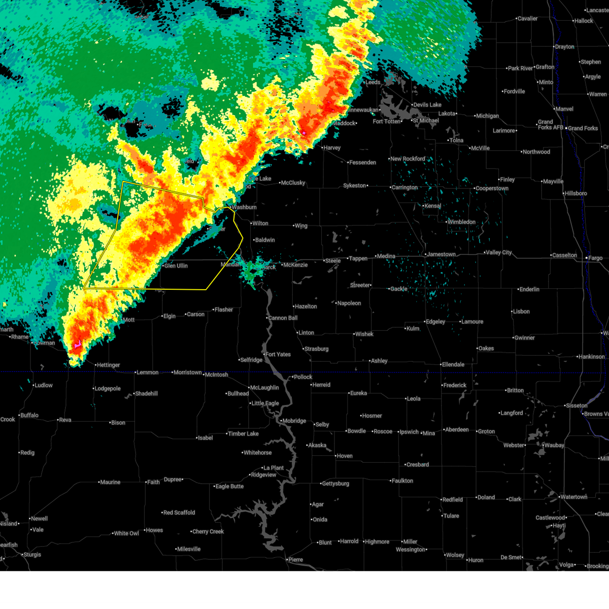
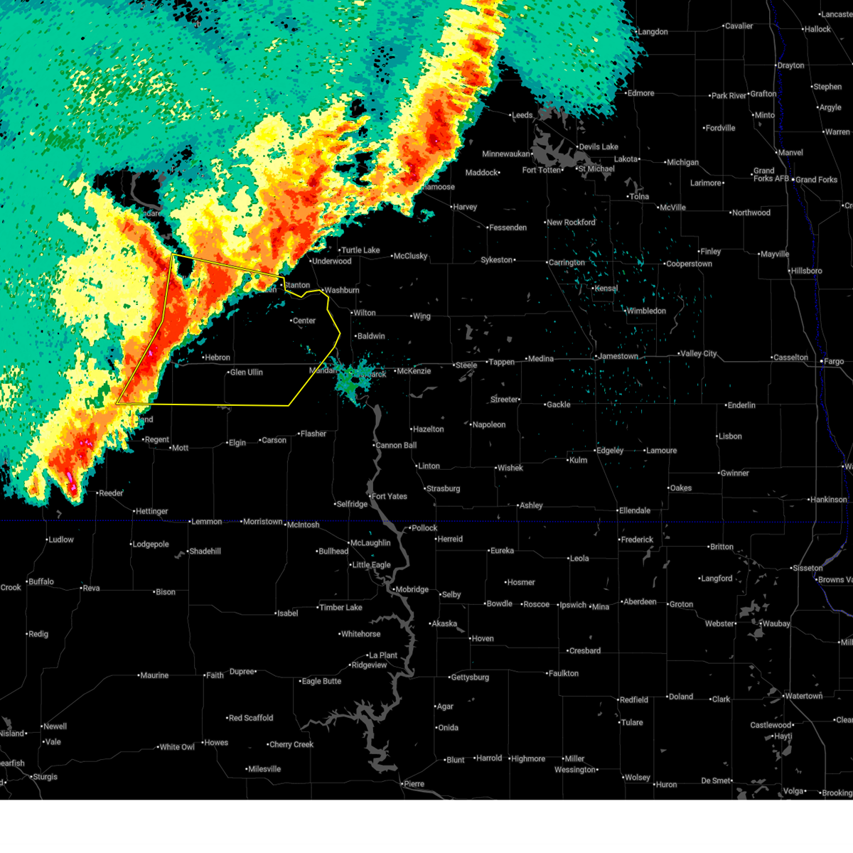
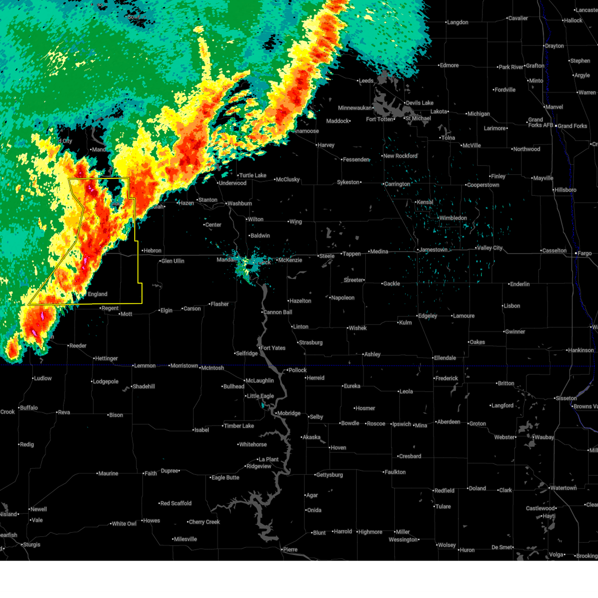
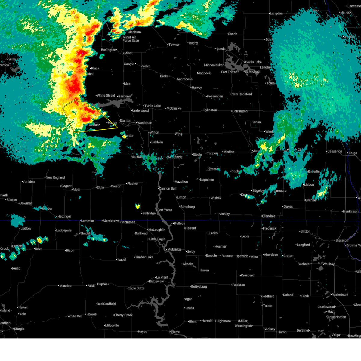
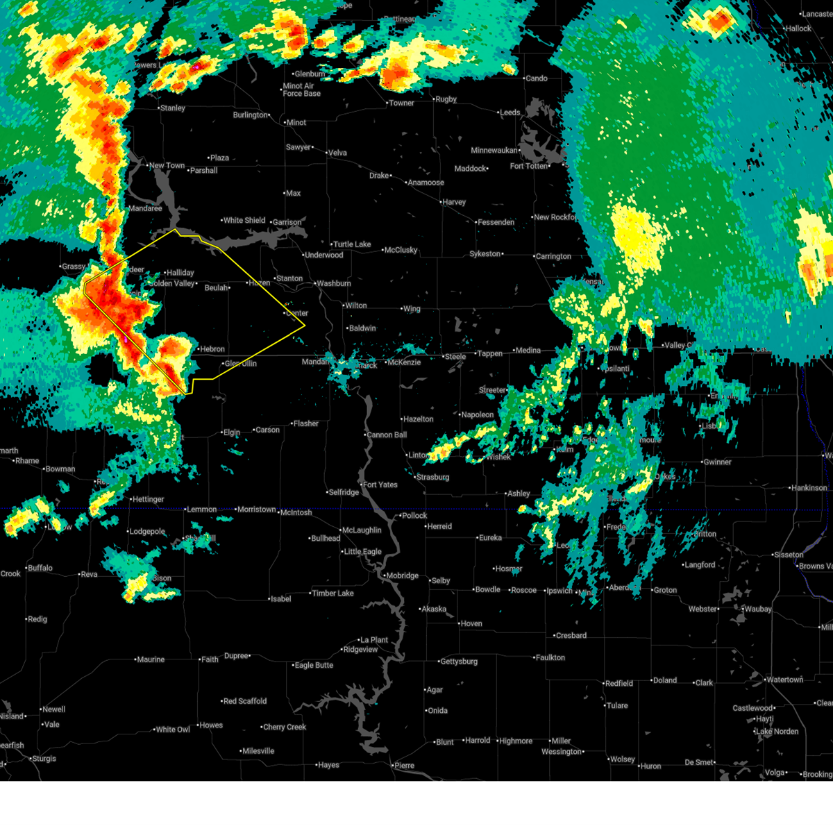
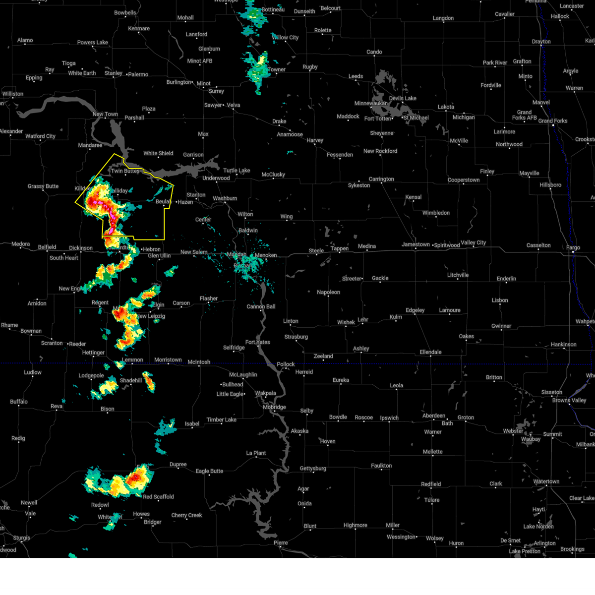
Hail Map for Halliday, ND
The Halliday, ND area has had 22 reports of on-the-ground hail by trained spotters, and has been under severe weather warnings 19 times during the past 12 months. Doppler radar has detected hail at or near Halliday, ND on 40 occasions, including 3 occasions during the past year.
| Name: | Halliday, ND |
| Where Located: | 77.9 miles SW of Minot, ND |
| Map: | Google Map for Halliday, ND |
| Population: | 188 |
| Housing Units: | 135 |
| More Info: | Search Google for Halliday, ND |
4
The Top Recent Hail Date for Halliday, ND is Tuesday, June 9, 2026 (7th out of 40)
Hail and Wind Damage Spotted near Halliday, ND
| Date / Time | Report Details |
|---|---|
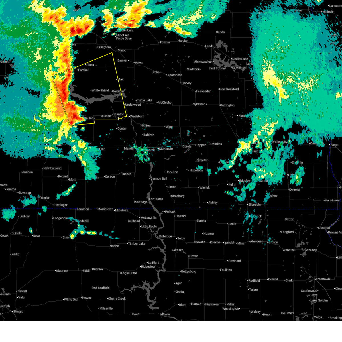
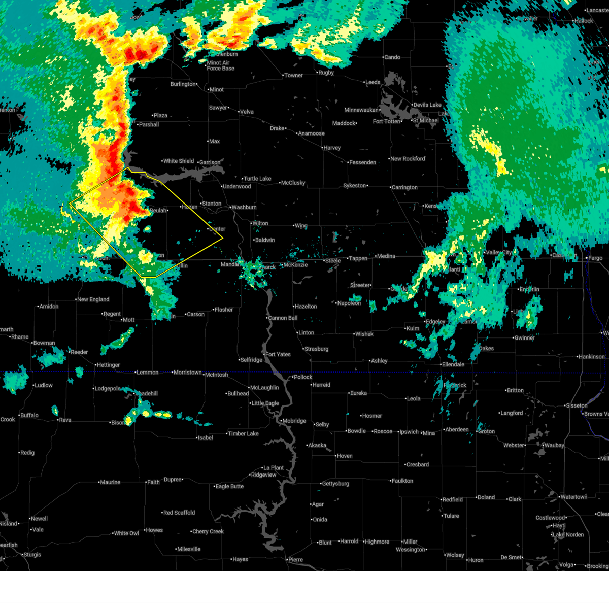
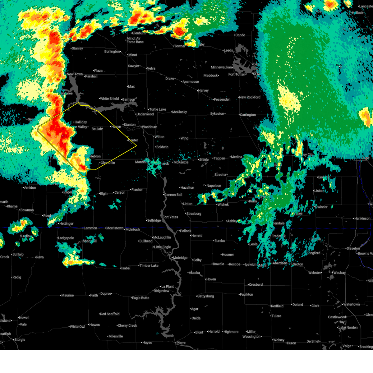
| 6/9/2026 5:24 PM MDT |
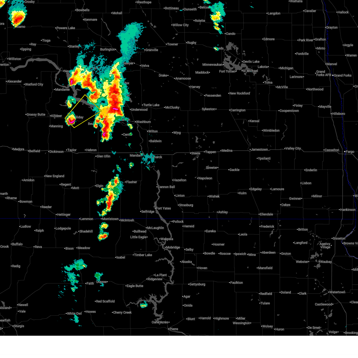 Svrbis the national weather service in bismarck has issued a * severe thunderstorm warning for, west central mclean county in south central north dakota, northwestern mercer county in south central north dakota, east central dunn county in southwestern north dakota, * until 715 pm cdt /615 pm mdt/. * at 624 pm cdt /524 pm mdt/, a severe thunderstorm was located near halliday, or 25 miles west of beulah, moving northeast at 35 mph (radar indicated). Hazards include golf ball size hail and 60 mph wind gusts. People and animals outdoors will be injured. expect hail damage to roofs, siding, windows, and vehicles. Expect wind damage to roofs, siding, and trees. Svrbis the national weather service in bismarck has issued a * severe thunderstorm warning for, west central mclean county in south central north dakota, northwestern mercer county in south central north dakota, east central dunn county in southwestern north dakota, * until 715 pm cdt /615 pm mdt/. * at 624 pm cdt /524 pm mdt/, a severe thunderstorm was located near halliday, or 25 miles west of beulah, moving northeast at 35 mph (radar indicated). Hazards include golf ball size hail and 60 mph wind gusts. People and animals outdoors will be injured. expect hail damage to roofs, siding, windows, and vehicles. Expect wind damage to roofs, siding, and trees.
|
| 6/9/2026 4:42 PM MDT | 62mph at 10m at 5n halliday ndaw in dunn county ND, 4.6 miles S of Halliday, ND |
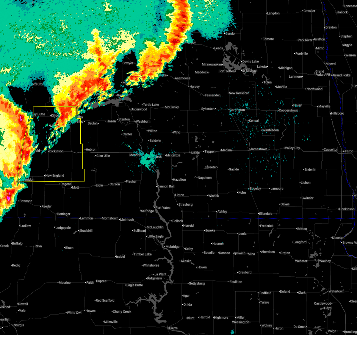
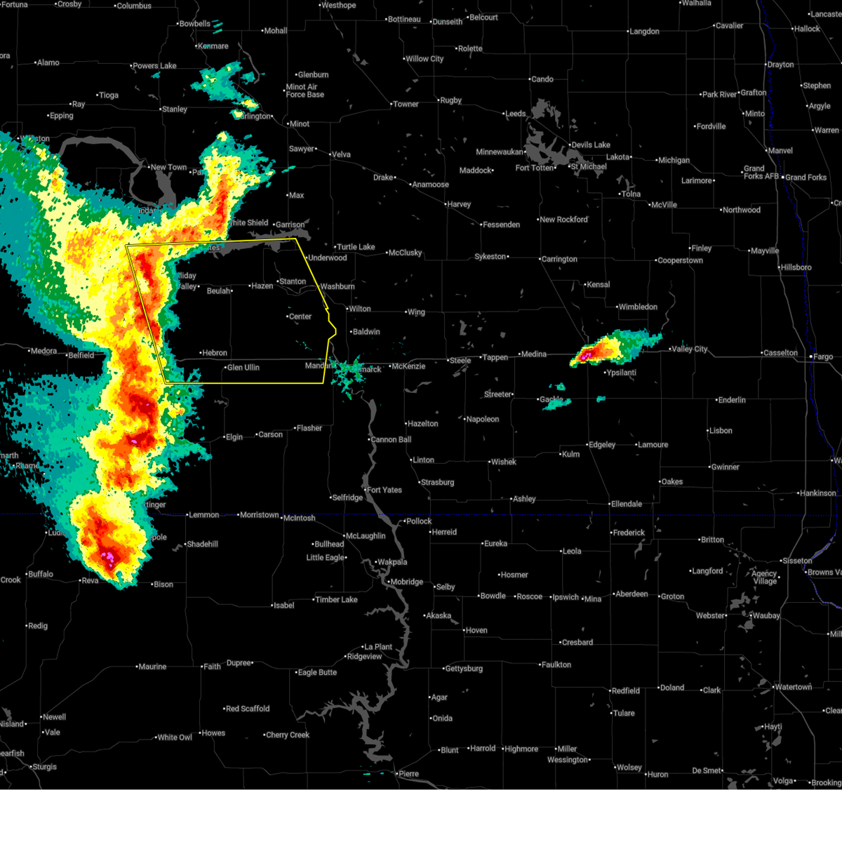
| 6/7/2026 9:30 PM CDT |
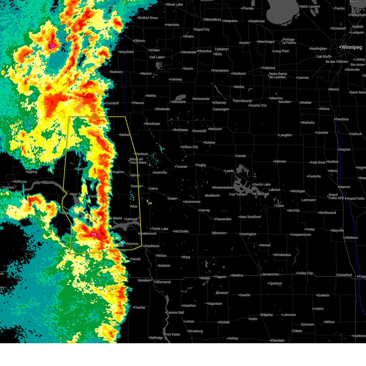 At 930 pm cdt /830 pm mdt/, severe thunderstorms were located along a line from 8 miles northwest of sherwood to 7 miles south of hazen bay recreation area, or along a line from 60 miles northeast of stanley to 12 miles northeast of beulah, moving northeast at 35 mph (radar indicated). Hazards include 60 mph wind gusts and quarter size hail. Hail damage to vehicles is expected. expect wind damage to roofs, siding, and trees. Locations impacted include, minot, beulah, stanley, garrison, minot air force base, hazen, new town, kenmare, burlington, parshall, mohall, underwood, berthold, glenburn, stanton, bowbells, max, lansford, sherwood and zap. At 930 pm cdt /830 pm mdt/, severe thunderstorms were located along a line from 8 miles northwest of sherwood to 7 miles south of hazen bay recreation area, or along a line from 60 miles northeast of stanley to 12 miles northeast of beulah, moving northeast at 35 mph (radar indicated). Hazards include 60 mph wind gusts and quarter size hail. Hail damage to vehicles is expected. expect wind damage to roofs, siding, and trees. Locations impacted include, minot, beulah, stanley, garrison, minot air force base, hazen, new town, kenmare, burlington, parshall, mohall, underwood, berthold, glenburn, stanton, bowbells, max, lansford, sherwood and zap.
|
| 6/7/2026 8:15 PM MDT | 64 mph wind gust measured 5n of halliday at 10m by ndawn statio in dunn county ND, 4.6 miles S of Halliday, ND |
| 6/7/2026 9:00 PM CDT |
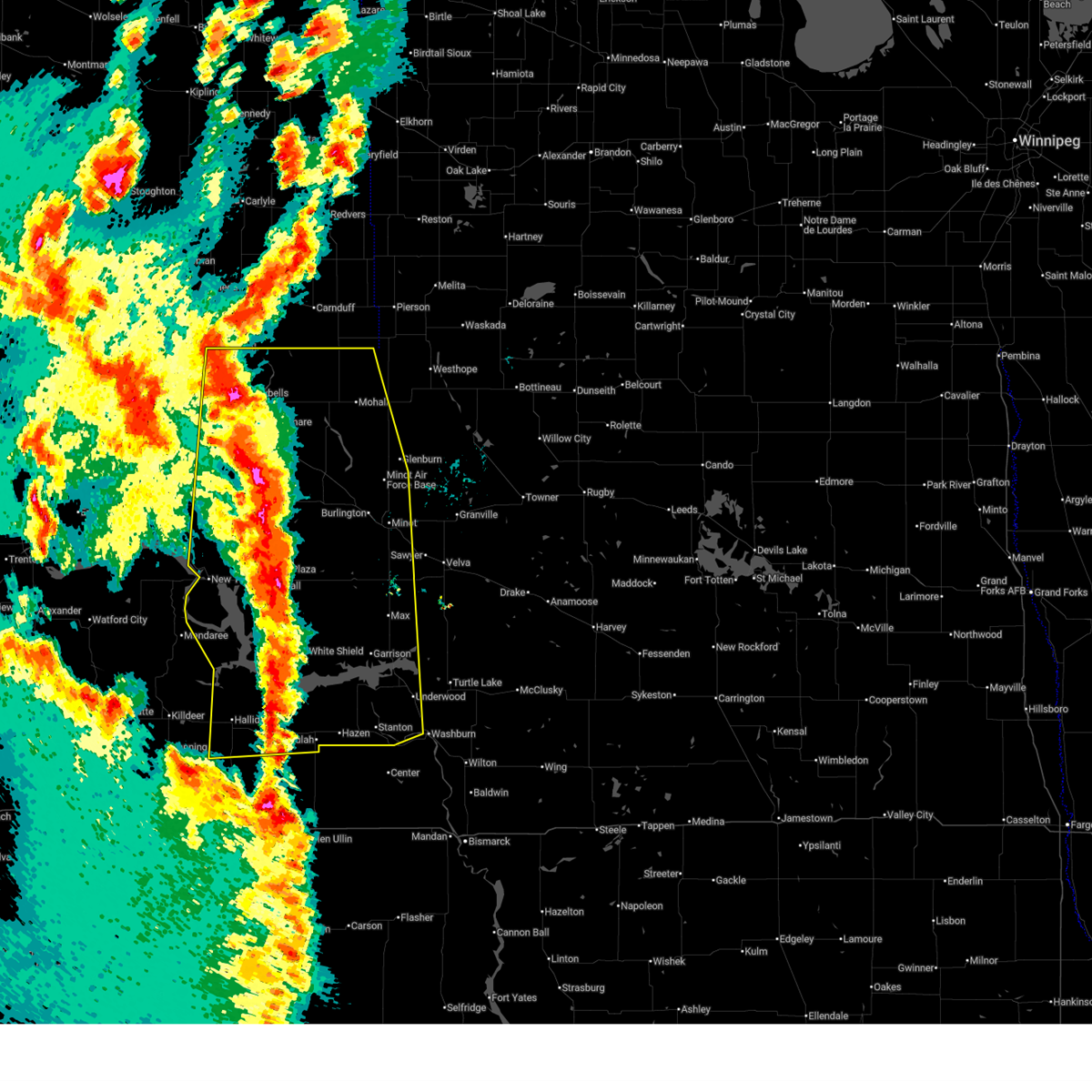 Svrbis the national weather service in bismarck has issued a * severe thunderstorm warning for, western bottineau county in north central north dakota, renville county in north central north dakota, ward county in north central north dakota, eastern burke county in northwestern north dakota, mountrail county in northwestern north dakota, mclean county in south central north dakota, mercer county in south central north dakota, northeastern dunn county in southwestern north dakota, * until 1000 pm cdt /900 pm mdt/. * at 900 pm cdt /800 pm mdt/, severe thunderstorms were located along a line from 7 miles south of donnybrook to near beulah, or along a line from 22 miles east of stanley to near beulah, moving east at 35 mph (radar indicated). Hazards include 70 mph wind gusts and quarter size hail. Hail damage to vehicles is expected. expect considerable tree damage. Wind damage is also likely to mobile homes, roofs, and outbuildings. Svrbis the national weather service in bismarck has issued a * severe thunderstorm warning for, western bottineau county in north central north dakota, renville county in north central north dakota, ward county in north central north dakota, eastern burke county in northwestern north dakota, mountrail county in northwestern north dakota, mclean county in south central north dakota, mercer county in south central north dakota, northeastern dunn county in southwestern north dakota, * until 1000 pm cdt /900 pm mdt/. * at 900 pm cdt /800 pm mdt/, severe thunderstorms were located along a line from 7 miles south of donnybrook to near beulah, or along a line from 22 miles east of stanley to near beulah, moving east at 35 mph (radar indicated). Hazards include 70 mph wind gusts and quarter size hail. Hail damage to vehicles is expected. expect considerable tree damage. Wind damage is also likely to mobile homes, roofs, and outbuildings.
|
| 6/7/2026 8:08 PM CDT |
 At 808 pm cdt /708 pm mdt/, severe thunderstorms were located along a line from 9 miles south of van hook park to over marshall, or along a line from 34 miles south of stanley to 26 miles west of beulah, moving northeast at 25 mph (public reported). Hazards include 70 mph wind gusts and half dollar size hail. Hail damage to vehicles is expected. expect considerable tree damage. wind damage is also likely to mobile homes, roofs, and outbuildings. Locations impacted include, beulah, new town, parshall, zap, halliday, golden valley, plaza, dodge, marshall, roseglen, mckenzie bay recreation area, van hook park, beulah bay recreation area, indian hills state recreation area, deep water creek recreation area, twin buttes, raub, fort berthold, skunk creek bay recreation area and pouch point recreation area. At 808 pm cdt /708 pm mdt/, severe thunderstorms were located along a line from 9 miles south of van hook park to over marshall, or along a line from 34 miles south of stanley to 26 miles west of beulah, moving northeast at 25 mph (public reported). Hazards include 70 mph wind gusts and half dollar size hail. Hail damage to vehicles is expected. expect considerable tree damage. wind damage is also likely to mobile homes, roofs, and outbuildings. Locations impacted include, beulah, new town, parshall, zap, halliday, golden valley, plaza, dodge, marshall, roseglen, mckenzie bay recreation area, van hook park, beulah bay recreation area, indian hills state recreation area, deep water creek recreation area, twin buttes, raub, fort berthold, skunk creek bay recreation area and pouch point recreation area.
|
| 6/7/2026 7:04 PM MDT | 10 meter measured wind gust at ndawn station 4 n hallida in dunn county ND, 4.6 miles S of Halliday, ND |
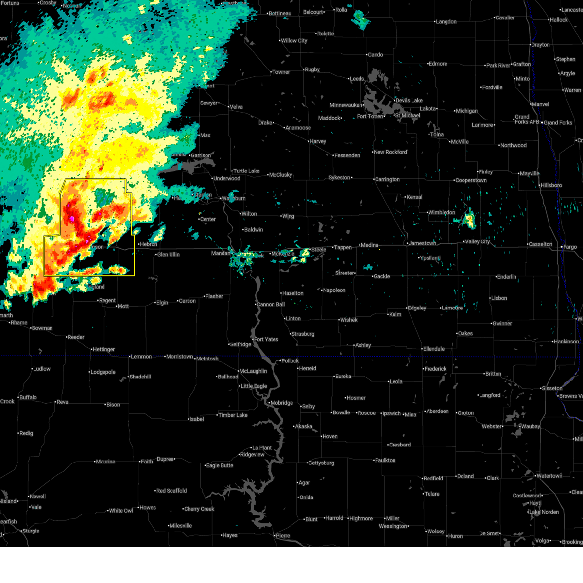
| 8/8/2025 12:47 AM CDT |
 At 1247 am cdt/1147 pm mdt/, severe thunderstorms were located along a line extending from 7 miles northwest of wilton to 13 miles northwest of mandan to 6 miles east of heart butte dam, moving east at 55 mph (radar indicated). Hazards include 60 mph wind gusts. Expect damage to roofs, siding, and trees. Locations impacted include, beulah, hazen, new salem, glen ullin, hebron, center, richardton, stanton, gladstone, zap, halliday, golden valley, taylor, almont, dodge, marshall, hannover, judson, lefor, and crown butte lake. At 1247 am cdt/1147 pm mdt/, severe thunderstorms were located along a line extending from 7 miles northwest of wilton to 13 miles northwest of mandan to 6 miles east of heart butte dam, moving east at 55 mph (radar indicated). Hazards include 60 mph wind gusts. Expect damage to roofs, siding, and trees. Locations impacted include, beulah, hazen, new salem, glen ullin, hebron, center, richardton, stanton, gladstone, zap, halliday, golden valley, taylor, almont, dodge, marshall, hannover, judson, lefor, and crown butte lake.
|
| 8/8/2025 12:29 AM CDT |
 At 1229 am cdt/1129 pm mdt/, severe thunderstorms were located along a line extending from near stanton to 10 miles southwest of hannover to 13 miles west of heart butte dam, moving east at 45 mph (radar indicated). Hazards include 70 mph wind gusts. Expect considerable tree damage. damage is likely to mobile homes, roofs, and outbuildings. Locations impacted include, beulah, hazen, new salem, glen ullin, hebron, center, richardton, stanton, gladstone, zap, halliday, golden valley, taylor, almont, dodge, marshall, hannover, judson, lefor, and crown butte lake. At 1229 am cdt/1129 pm mdt/, severe thunderstorms were located along a line extending from near stanton to 10 miles southwest of hannover to 13 miles west of heart butte dam, moving east at 45 mph (radar indicated). Hazards include 70 mph wind gusts. Expect considerable tree damage. damage is likely to mobile homes, roofs, and outbuildings. Locations impacted include, beulah, hazen, new salem, glen ullin, hebron, center, richardton, stanton, gladstone, zap, halliday, golden valley, taylor, almont, dodge, marshall, hannover, judson, lefor, and crown butte lake.
|
| 8/7/2025 11:11 PM MDT | Ndawn station halliday 4n. reported at 10 meters... 56 mph observed at the surfac in dunn county ND, 3.9 miles S of Halliday, ND |
| 8/8/2025 12:08 AM CDT |
 Svrbis the national weather service in bismarck has issued a * severe thunderstorm warning for, southeastern dunn county in southwestern north dakota, northwestern morton county in south central north dakota, eastern stark county in southwestern north dakota, oliver county in south central north dakota, mercer county in south central north dakota, northwestern grant county in south central north dakota, * until 115 am cdt/1215 am mdt/. * at 1208 am cdt/1108 pm mdt/, severe thunderstorms were located along a line extending from 6 miles south of hazen bay recreation area to 13 miles south of zap to 14 miles north of regent, moving east at 45 mph (radar indicated). Hazards include 70 mph wind gusts and penny size hail. Expect considerable tree damage. Damage is likely to mobile homes, roofs, and outbuildings. Svrbis the national weather service in bismarck has issued a * severe thunderstorm warning for, southeastern dunn county in southwestern north dakota, northwestern morton county in south central north dakota, eastern stark county in southwestern north dakota, oliver county in south central north dakota, mercer county in south central north dakota, northwestern grant county in south central north dakota, * until 115 am cdt/1215 am mdt/. * at 1208 am cdt/1108 pm mdt/, severe thunderstorms were located along a line extending from 6 miles south of hazen bay recreation area to 13 miles south of zap to 14 miles north of regent, moving east at 45 mph (radar indicated). Hazards include 70 mph wind gusts and penny size hail. Expect considerable tree damage. Damage is likely to mobile homes, roofs, and outbuildings.
|
| 8/7/2025 11:01 PM MDT |
 the severe thunderstorm warning has been cancelled and is no longer in effect the severe thunderstorm warning has been cancelled and is no longer in effect
|
| 8/7/2025 11:01 PM MDT |
 At 1100 pm mdt, severe thunderstorms were located along a line extending from 10 miles southwest of mckenzie bay recreation area to 8 miles south of marshall to 9 miles east of new england, moving east at 80 mph (public. at 1051 pm mdt, a 62 mph wind gust was reported in dickinson). Hazards include 60 mph wind gusts. Expect damage to roofs, siding, and trees. Locations impacted include, dickinson, killdeer, new england, richardton, gladstone, halliday, taylor, dunn center, dodge, marshall, amidon, havelock, hirschville, oakdale, lefor, schefield, and dickinson regional airport. At 1100 pm mdt, severe thunderstorms were located along a line extending from 10 miles southwest of mckenzie bay recreation area to 8 miles south of marshall to 9 miles east of new england, moving east at 80 mph (public. at 1051 pm mdt, a 62 mph wind gust was reported in dickinson). Hazards include 60 mph wind gusts. Expect damage to roofs, siding, and trees. Locations impacted include, dickinson, killdeer, new england, richardton, gladstone, halliday, taylor, dunn center, dodge, marshall, amidon, havelock, hirschville, oakdale, lefor, schefield, and dickinson regional airport.
|
| 8/7/2025 10:31 PM MDT |
 Svrbis the national weather service in bismarck has issued a * severe thunderstorm warning for, dunn county in southwestern north dakota, northern hettinger county in southwestern north dakota, eastern billings county in southwestern north dakota, northeastern slope county in southwestern north dakota, stark county in southwestern north dakota, * until 1130 pm mdt. * at 1030 pm mdt, severe thunderstorms were located along a line extending from grassy butte to 4 miles northwest of south heart to 4 miles southwest of amidon, moving east at 75 mph (radar indicated). Hazards include 60 mph wind gusts. expect damage to roofs, siding, and trees Svrbis the national weather service in bismarck has issued a * severe thunderstorm warning for, dunn county in southwestern north dakota, northern hettinger county in southwestern north dakota, eastern billings county in southwestern north dakota, northeastern slope county in southwestern north dakota, stark county in southwestern north dakota, * until 1130 pm mdt. * at 1030 pm mdt, severe thunderstorms were located along a line extending from grassy butte to 4 miles northwest of south heart to 4 miles southwest of amidon, moving east at 75 mph (radar indicated). Hazards include 60 mph wind gusts. expect damage to roofs, siding, and trees
|
| 7/28/2025 7:24 AM MDT |
 At 723 am mdt, severe thunderstorms were located along a line extending from manning to gladstone to 11 miles northwest of new england, moving east at 30 mph (trained weather spotters. at 708 am mdt, a 76 mph wind gust was reported 9 miles southwest of manning). Hazards include 70 mph wind gusts and quarter size hail. Hail damage to vehicles is expected. expect considerable tree damage. wind damage is also likely to mobile homes, roofs, and outbuildings. Locations impacted include, dickinson, belfield, killdeer, richardton, south heart, gladstone, halliday, taylor, dunn center, dodge, manning, marshall, hirschville, lefor, new hradec, schefield, and dickinson regional airport. At 723 am mdt, severe thunderstorms were located along a line extending from manning to gladstone to 11 miles northwest of new england, moving east at 30 mph (trained weather spotters. at 708 am mdt, a 76 mph wind gust was reported 9 miles southwest of manning). Hazards include 70 mph wind gusts and quarter size hail. Hail damage to vehicles is expected. expect considerable tree damage. wind damage is also likely to mobile homes, roofs, and outbuildings. Locations impacted include, dickinson, belfield, killdeer, richardton, south heart, gladstone, halliday, taylor, dunn center, dodge, manning, marshall, hirschville, lefor, new hradec, schefield, and dickinson regional airport.
|
| 7/28/2025 7:02 AM MDT |
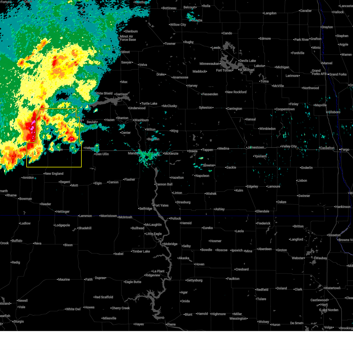 Svrbis the national weather service in bismarck has issued a * severe thunderstorm warning for, dunn county in southwestern north dakota, stark county in southwestern north dakota, * until 815 am mdt. * at 701 am mdt, severe thunderstorms were located along a line extending from 9 miles west of killdeer to near south heart to 14 miles northwest of amidon, moving east at 30 mph (radar indicated). Hazards include 70 mph wind gusts and quarter size hail. Hail damage to vehicles is expected. expect considerable tree damage. Wind damage is also likely to mobile homes, roofs, and outbuildings. Svrbis the national weather service in bismarck has issued a * severe thunderstorm warning for, dunn county in southwestern north dakota, stark county in southwestern north dakota, * until 815 am mdt. * at 701 am mdt, severe thunderstorms were located along a line extending from 9 miles west of killdeer to near south heart to 14 miles northwest of amidon, moving east at 30 mph (radar indicated). Hazards include 70 mph wind gusts and quarter size hail. Hail damage to vehicles is expected. expect considerable tree damage. Wind damage is also likely to mobile homes, roofs, and outbuildings.
|
| 7/27/2025 3:04 AM MDT |
 the severe thunderstorm warning has been cancelled and is no longer in effect the severe thunderstorm warning has been cancelled and is no longer in effect
|
| 7/27/2025 3:04 AM MDT |
 At 404 am cdt, severe thunderstorms were located along a line extending from 4 miles northwest of halliday to 8 miles south of golden valley to 11 miles northeast of glen ullin, moving northeast at 35 mph (radar indicated). Hazards include 60 mph wind gusts and penny size hail. Expect damage to roofs, siding, and trees. Locations impacted include, beulah, hazen, zap, halliday, golden valley, dodge, twin buttes, and fort berthold. At 404 am cdt, severe thunderstorms were located along a line extending from 4 miles northwest of halliday to 8 miles south of golden valley to 11 miles northeast of glen ullin, moving northeast at 35 mph (radar indicated). Hazards include 60 mph wind gusts and penny size hail. Expect damage to roofs, siding, and trees. Locations impacted include, beulah, hazen, zap, halliday, golden valley, dodge, twin buttes, and fort berthold.
|
| 7/27/2025 2:55 AM MDT |
 Svrbis the national weather service in bismarck has issued a * severe thunderstorm warning for, south central ward county in north central north dakota, northeastern dunn county in southwestern north dakota, western mclean county in south central north dakota, southeastern mountrail county in northwestern north dakota, mercer county in south central north dakota, * until 445 am cdt. * at 354 am cdt, severe thunderstorms were located along a line extending from 8 miles northwest of mckenzie bay recreation area to near dodge, moving northeast at 45 mph (radar indicated). Hazards include 60 mph wind gusts and penny size hail. expect damage to roofs, siding, and trees Svrbis the national weather service in bismarck has issued a * severe thunderstorm warning for, south central ward county in north central north dakota, northeastern dunn county in southwestern north dakota, western mclean county in south central north dakota, southeastern mountrail county in northwestern north dakota, mercer county in south central north dakota, * until 445 am cdt. * at 354 am cdt, severe thunderstorms were located along a line extending from 8 miles northwest of mckenzie bay recreation area to near dodge, moving northeast at 45 mph (radar indicated). Hazards include 60 mph wind gusts and penny size hail. expect damage to roofs, siding, and trees
|
| 7/27/2025 2:50 AM MDT |
 At 348 am cdt/248 am mdt/, severe thunderstorms were located along a line extending from 4 miles east of dunn center to 5 miles east of marshall to 7 miles north of glen ullin, moving northeast at 40 mph (at 344 am cdt, a 64 mph wind gust was reported 11 miles north of zap). Hazards include 60 mph wind gusts and penny size hail. Expect damage to roofs, siding, and trees. Locations impacted include, beulah, hazen, glen ullin, killdeer, hebron, center, richardton, zap, halliday, golden valley, dunn center, dodge, manning, marshall, hannover, hirschville, nelson lake, twin buttes, and fort berthold. At 348 am cdt/248 am mdt/, severe thunderstorms were located along a line extending from 4 miles east of dunn center to 5 miles east of marshall to 7 miles north of glen ullin, moving northeast at 40 mph (at 344 am cdt, a 64 mph wind gust was reported 11 miles north of zap). Hazards include 60 mph wind gusts and penny size hail. Expect damage to roofs, siding, and trees. Locations impacted include, beulah, hazen, glen ullin, killdeer, hebron, center, richardton, zap, halliday, golden valley, dunn center, dodge, manning, marshall, hannover, hirschville, nelson lake, twin buttes, and fort berthold.
|
| 7/27/2025 2:26 AM MDT |
 At 325 am cdt/225 am mdt/, severe thunderstorms were located along a line extending from near manning to 6 miles northwest of taylor to 10 miles southeast of richardton, moving northeast at 35 mph (ndawn mesonet site observed 63 mph wind gust 7 s hebron at 320 am cdt). Hazards include 60 mph wind gusts and quarter size hail. Hail damage to vehicles is expected. expect wind damage to roofs, siding, and trees. Locations impacted include, beulah, hazen, glen ullin, killdeer, hebron, center, richardton, zap, halliday, golden valley, taylor, dunn center, dodge, manning, marshall, hannover, hirschville, nelson lake, twin buttes, and fort berthold. At 325 am cdt/225 am mdt/, severe thunderstorms were located along a line extending from near manning to 6 miles northwest of taylor to 10 miles southeast of richardton, moving northeast at 35 mph (ndawn mesonet site observed 63 mph wind gust 7 s hebron at 320 am cdt). Hazards include 60 mph wind gusts and quarter size hail. Hail damage to vehicles is expected. expect wind damage to roofs, siding, and trees. Locations impacted include, beulah, hazen, glen ullin, killdeer, hebron, center, richardton, zap, halliday, golden valley, taylor, dunn center, dodge, manning, marshall, hannover, hirschville, nelson lake, twin buttes, and fort berthold.
|
| 7/27/2025 2:16 AM MDT |
 Svrbis the national weather service in bismarck has issued a * severe thunderstorm warning for, southern dunn county in southwestern north dakota, northwestern morton county in south central north dakota, eastern stark county in southwestern north dakota, western oliver county in south central north dakota, mercer county in south central north dakota, * until 415 am cdt/315 am mdt/. * at 315 am cdt/215 am mdt/, severe thunderstorms were located along a line extending from 7 miles southwest of manning to 5 miles north of gladstone to 10 miles south of richardton, moving northeast at 35 mph (radar indicated). Hazards include 70 mph wind gusts and quarter size hail. Hail damage to vehicles is expected. expect considerable tree damage. Wind damage is also likely to mobile homes, roofs, and outbuildings. Svrbis the national weather service in bismarck has issued a * severe thunderstorm warning for, southern dunn county in southwestern north dakota, northwestern morton county in south central north dakota, eastern stark county in southwestern north dakota, western oliver county in south central north dakota, mercer county in south central north dakota, * until 415 am cdt/315 am mdt/. * at 315 am cdt/215 am mdt/, severe thunderstorms were located along a line extending from 7 miles southwest of manning to 5 miles north of gladstone to 10 miles south of richardton, moving northeast at 35 mph (radar indicated). Hazards include 70 mph wind gusts and quarter size hail. Hail damage to vehicles is expected. expect considerable tree damage. Wind damage is also likely to mobile homes, roofs, and outbuildings.
|
| 6/20/2025 8:04 PM CDT |
 Svrbis the national weather service in bismarck has issued a * severe thunderstorm warning for, southeastern dunn county in southwestern north dakota, central mclean county in south central north dakota, northwestern morton county in south central north dakota, northeastern stark county in southwestern north dakota, oliver county in south central north dakota, mercer county in south central north dakota, * until 900 pm cdt/800 pm mdt/. * at 804 pm cdt/704 pm mdt/, severe thunderstorms were located along a line extending from 7 miles north of halliday to 9 miles southeast of marshall to 7 miles south of richardton, moving east at 50 mph (radar indicated). Hazards include 70 mph wind gusts and quarter size hail. Hail damage to vehicles is expected. expect considerable tree damage. Wind damage is also likely to mobile homes, roofs, and outbuildings. Svrbis the national weather service in bismarck has issued a * severe thunderstorm warning for, southeastern dunn county in southwestern north dakota, central mclean county in south central north dakota, northwestern morton county in south central north dakota, northeastern stark county in southwestern north dakota, oliver county in south central north dakota, mercer county in south central north dakota, * until 900 pm cdt/800 pm mdt/. * at 804 pm cdt/704 pm mdt/, severe thunderstorms were located along a line extending from 7 miles north of halliday to 9 miles southeast of marshall to 7 miles south of richardton, moving east at 50 mph (radar indicated). Hazards include 70 mph wind gusts and quarter size hail. Hail damage to vehicles is expected. expect considerable tree damage. Wind damage is also likely to mobile homes, roofs, and outbuildings.
|
| 7/30/2024 4:39 PM MDT |
 At 538 pm cdt, severe thunderstorms were located along a line extending from 8 miles southeast of mckenzie bay recreation area to 7 miles south of golden valley to 10 miles north of hebron, moving east at 40 mph (radar indicated). Hazards include 60 mph wind gusts and half dollar size hail. Hail damage to vehicles is expected. expect wind damage to roofs, siding, and trees. Locations impacted include, beulah, zap, halliday, golden valley, dodge, mckenzie bay recreation area, twin buttes, and fort berthold. At 538 pm cdt, severe thunderstorms were located along a line extending from 8 miles southeast of mckenzie bay recreation area to 7 miles south of golden valley to 10 miles north of hebron, moving east at 40 mph (radar indicated). Hazards include 60 mph wind gusts and half dollar size hail. Hail damage to vehicles is expected. expect wind damage to roofs, siding, and trees. Locations impacted include, beulah, zap, halliday, golden valley, dodge, mckenzie bay recreation area, twin buttes, and fort berthold.
|
| 7/30/2024 4:31 PM MDT |
 At 531 pm cdt, severe thunderstorms were located along a line extending from 7 miles north of halliday to near golden valley to 10 miles northeast of richardton, moving east at 30 mph (radar indicated). Hazards include 60 mph wind gusts and nickel size hail. Expect damage to roofs, siding, and trees. Locations impacted include, beulah, zap, halliday, golden valley, dunn center, dodge, marshall, mckenzie bay recreation area, twin buttes, and fort berthold. At 531 pm cdt, severe thunderstorms were located along a line extending from 7 miles north of halliday to near golden valley to 10 miles northeast of richardton, moving east at 30 mph (radar indicated). Hazards include 60 mph wind gusts and nickel size hail. Expect damage to roofs, siding, and trees. Locations impacted include, beulah, zap, halliday, golden valley, dunn center, dodge, marshall, mckenzie bay recreation area, twin buttes, and fort berthold.
|
| 7/30/2024 4:17 PM MDT |
 Svrbis the national weather service in bismarck has issued a * severe thunderstorm warning for, eastern dunn county in southwestern north dakota, mercer county in south central north dakota, * until 615 pm cdt. * at 517 pm cdt, severe thunderstorms were located along a line extending from 7 miles northeast of dunn center to 6 miles southwest of dodge to 4 miles northeast of taylor, moving east at 25 mph (radar indicated). Hazards include 60 mph wind gusts and penny size hail. expect damage to roofs, siding, and trees Svrbis the national weather service in bismarck has issued a * severe thunderstorm warning for, eastern dunn county in southwestern north dakota, mercer county in south central north dakota, * until 615 pm cdt. * at 517 pm cdt, severe thunderstorms were located along a line extending from 7 miles northeast of dunn center to 6 miles southwest of dodge to 4 miles northeast of taylor, moving east at 25 mph (radar indicated). Hazards include 60 mph wind gusts and penny size hail. expect damage to roofs, siding, and trees
|
| 7/12/2024 7:27 PM MDT |
 The storm which prompted the warning has weakened below severe limits. therefore, the warning will be allowed to expire. however, gusty winds and heavy rain are still possible with this thunderstorm. a severe thunderstorm watch remains in effect until midnight cdt for south central and southwestern north dakota. The storm which prompted the warning has weakened below severe limits. therefore, the warning will be allowed to expire. however, gusty winds and heavy rain are still possible with this thunderstorm. a severe thunderstorm watch remains in effect until midnight cdt for south central and southwestern north dakota.
|
| 7/12/2024 7:15 PM MDT |
 At 815 pm cdt, a severe thunderstorm was located near halliday, or 29 miles west of beulah, moving southeast at 20 mph (radar indicated). Hazards include 60 mph wind gusts and quarter size hail. Hail damage to vehicles is expected. expect wind damage to roofs, siding, and trees. Locations impacted include, halliday. At 815 pm cdt, a severe thunderstorm was located near halliday, or 29 miles west of beulah, moving southeast at 20 mph (radar indicated). Hazards include 60 mph wind gusts and quarter size hail. Hail damage to vehicles is expected. expect wind damage to roofs, siding, and trees. Locations impacted include, halliday.
|
| 7/12/2024 7:04 PM MDT |
 At 804 pm cdt, a severe thunderstorm was located 7 miles southeast of dunn center, or 32 miles northeast of dickinson, moving southeast at 25 mph (radar indicated). Hazards include ping pong ball size hail and 60 mph wind gusts. People and animals outdoors will be injured. expect hail damage to roofs, siding, windows, and vehicles. expect wind damage to roofs, siding, and trees. Locations impacted include, halliday and dunn center. At 804 pm cdt, a severe thunderstorm was located 7 miles southeast of dunn center, or 32 miles northeast of dickinson, moving southeast at 25 mph (radar indicated). Hazards include ping pong ball size hail and 60 mph wind gusts. People and animals outdoors will be injured. expect hail damage to roofs, siding, windows, and vehicles. expect wind damage to roofs, siding, and trees. Locations impacted include, halliday and dunn center.
|
| 7/12/2024 6:56 PM MDT |
 At 755 pm cdt, a severe thunderstorm was located near dunn center, or 34 miles north of dickinson, moving southeast at 25 mph (radar indicated). Hazards include golf ball size hail and 60 mph wind gusts. People and animals outdoors will be injured. expect hail damage to roofs, siding, windows, and vehicles. expect wind damage to roofs, siding, and trees. Locations impacted include, killdeer, halliday, dunn center, and little missouri state park. At 755 pm cdt, a severe thunderstorm was located near dunn center, or 34 miles north of dickinson, moving southeast at 25 mph (radar indicated). Hazards include golf ball size hail and 60 mph wind gusts. People and animals outdoors will be injured. expect hail damage to roofs, siding, windows, and vehicles. expect wind damage to roofs, siding, and trees. Locations impacted include, killdeer, halliday, dunn center, and little missouri state park.
|
| 7/12/2024 6:43 PM MDT |
 At 743 pm cdt, a severe thunderstorm was located near dunn center, or 37 miles north of dickinson, moving southeast at 25 mph (radar indicated). Hazards include tennis ball size hail and 60 mph wind gusts. People and animals outdoors will be injured. expect hail damage to roofs, siding, windows, and vehicles. expect wind damage to roofs, siding, and trees. Locations impacted include, killdeer, halliday, dunn center, oakdale, and little missouri state park. At 743 pm cdt, a severe thunderstorm was located near dunn center, or 37 miles north of dickinson, moving southeast at 25 mph (radar indicated). Hazards include tennis ball size hail and 60 mph wind gusts. People and animals outdoors will be injured. expect hail damage to roofs, siding, windows, and vehicles. expect wind damage to roofs, siding, and trees. Locations impacted include, killdeer, halliday, dunn center, oakdale, and little missouri state park.
|
| 7/12/2024 6:28 PM MDT |
 Svrbis the national weather service in bismarck has issued a * severe thunderstorm warning for, central dunn county in southwestern north dakota, * until 830 pm cdt. * at 728 pm cdt, a severe thunderstorm was located 7 miles north of killdeer, or 33 miles southeast of watford city, moving southeast at 25 mph (radar indicated). Hazards include tennis ball size hail and 60 mph wind gusts. People and animals outdoors will be injured. expect hail damage to roofs, siding, windows, and vehicles. Expect wind damage to roofs, siding, and trees. Svrbis the national weather service in bismarck has issued a * severe thunderstorm warning for, central dunn county in southwestern north dakota, * until 830 pm cdt. * at 728 pm cdt, a severe thunderstorm was located 7 miles north of killdeer, or 33 miles southeast of watford city, moving southeast at 25 mph (radar indicated). Hazards include tennis ball size hail and 60 mph wind gusts. People and animals outdoors will be injured. expect hail damage to roofs, siding, windows, and vehicles. Expect wind damage to roofs, siding, and trees.
|
| 6/27/2024 8:36 PM CDT |
 The storms which prompted the warning have weakened below severe limits. therefore, the warning will be allowed to expire. a tornado watch remains in effect until 1000 pm cdt for southwestern and northwestern north dakota. a severe thunderstorm watch remains in effect until 200 am cdt for south central and northwestern north dakota. The storms which prompted the warning have weakened below severe limits. therefore, the warning will be allowed to expire. a tornado watch remains in effect until 1000 pm cdt for southwestern and northwestern north dakota. a severe thunderstorm watch remains in effect until 200 am cdt for south central and northwestern north dakota.
|
| 6/27/2024 8:11 PM CDT |
 At 810 pm cdt, severe thunderstorms were located along a line extending from 14 miles northeast of watford city to 7 miles west of mandaree to 5 miles north of dunn center, moving east at 45 mph (radar indicated). Hazards include 60 mph wind gusts and penny size hail. Expect damage to roofs, siding, and trees. Locations impacted include, watford city, new town, killdeer, halliday, dunn center, arnegard, mandaree, 4 bears lodge, mckenzie bay recreation area, four bears village, keene, white earth bay recreation area, pouch point recreation area, little missouri state park, oakdale, charlson, skunk creek bay recreation area, twin buttes, tobacco garden bay recreation area, and crow flies high state recreation area. At 810 pm cdt, severe thunderstorms were located along a line extending from 14 miles northeast of watford city to 7 miles west of mandaree to 5 miles north of dunn center, moving east at 45 mph (radar indicated). Hazards include 60 mph wind gusts and penny size hail. Expect damage to roofs, siding, and trees. Locations impacted include, watford city, new town, killdeer, halliday, dunn center, arnegard, mandaree, 4 bears lodge, mckenzie bay recreation area, four bears village, keene, white earth bay recreation area, pouch point recreation area, little missouri state park, oakdale, charlson, skunk creek bay recreation area, twin buttes, tobacco garden bay recreation area, and crow flies high state recreation area.
|
| 6/27/2024 7:40 PM CDT |
 Svrbis the national weather service in bismarck has issued a * severe thunderstorm warning for, northern dunn county in southwestern north dakota, central mckenzie county in northwestern north dakota, southwestern mountrail county in northwestern north dakota, * until 845 pm cdt. * at 740 pm cdt, severe thunderstorms were located along a line extending from near alexander to theodore roosevelt national park north unit to 9 miles southeast of grassy butte, moving northeast at 40 mph (radar indicated). Hazards include 60 mph wind gusts and quarter size hail. Hail damage to vehicles is expected. Expect wind damage to roofs, siding, and trees. Svrbis the national weather service in bismarck has issued a * severe thunderstorm warning for, northern dunn county in southwestern north dakota, central mckenzie county in northwestern north dakota, southwestern mountrail county in northwestern north dakota, * until 845 pm cdt. * at 740 pm cdt, severe thunderstorms were located along a line extending from near alexander to theodore roosevelt national park north unit to 9 miles southeast of grassy butte, moving northeast at 40 mph (radar indicated). Hazards include 60 mph wind gusts and quarter size hail. Hail damage to vehicles is expected. Expect wind damage to roofs, siding, and trees.
|
| 6/15/2024 11:17 PM MDT |
 Svrbis the national weather service in bismarck has issued a * severe thunderstorm warning for, east central dunn county in southwestern north dakota, central mclean county in south central north dakota, northern mercer county in south central north dakota, * until 100 am cdt. * at 1216 am cdt, a severe thunderstorm was located near dodge, or 21 miles west of beulah, moving northeast at 55 mph (radar indicated). Hazards include 60 mph wind gusts and quarter size hail. Hail damage to vehicles is expected. Expect wind damage to roofs, siding, and trees. Svrbis the national weather service in bismarck has issued a * severe thunderstorm warning for, east central dunn county in southwestern north dakota, central mclean county in south central north dakota, northern mercer county in south central north dakota, * until 100 am cdt. * at 1216 am cdt, a severe thunderstorm was located near dodge, or 21 miles west of beulah, moving northeast at 55 mph (radar indicated). Hazards include 60 mph wind gusts and quarter size hail. Hail damage to vehicles is expected. Expect wind damage to roofs, siding, and trees.
|
| 6/15/2024 11:57 PM CDT |
 the severe thunderstorm warning has been cancelled and is no longer in effect the severe thunderstorm warning has been cancelled and is no longer in effect
|
| 6/15/2024 11:57 PM CDT |
 At 1157 pm cdt, severe thunderstorms were located along a line extending from 4 miles west of parshall to 6 miles east of dunn center, moving east at 35 mph (radar indicated). Hazards include 60 mph wind gusts and quarter size hail. Hail damage to vehicles is expected. expect wind damage to roofs, siding, and trees. Locations impacted include, parshall, halliday, dunn center, van hook park, mckenzie bay recreation area, skunk creek bay recreation area, twin buttes, pouch point recreation area, deep water creek recreation area, parshall bay recreation area, and fort berthold. At 1157 pm cdt, severe thunderstorms were located along a line extending from 4 miles west of parshall to 6 miles east of dunn center, moving east at 35 mph (radar indicated). Hazards include 60 mph wind gusts and quarter size hail. Hail damage to vehicles is expected. expect wind damage to roofs, siding, and trees. Locations impacted include, parshall, halliday, dunn center, van hook park, mckenzie bay recreation area, skunk creek bay recreation area, twin buttes, pouch point recreation area, deep water creek recreation area, parshall bay recreation area, and fort berthold.
|
| 6/15/2024 11:36 PM CDT |
 At 1136 pm cdt, severe thunderstorms were located along a line extending from near new town to near killdeer, moving east at 45 mph (radar indicated). Hazards include 60 mph wind gusts and quarter size hail. Hail damage to vehicles is expected. expect wind damage to roofs, siding, and trees. Locations impacted include, parshall, killdeer, halliday, dunn center, mandaree, van hook park, mckenzie bay recreation area, keene, pouch point recreation area, little missouri state park, deep water creek recreation area, oakdale, skunk creek bay recreation area, twin buttes, parshall bay recreation area, johnsons corner, and fort berthold. At 1136 pm cdt, severe thunderstorms were located along a line extending from near new town to near killdeer, moving east at 45 mph (radar indicated). Hazards include 60 mph wind gusts and quarter size hail. Hail damage to vehicles is expected. expect wind damage to roofs, siding, and trees. Locations impacted include, parshall, killdeer, halliday, dunn center, mandaree, van hook park, mckenzie bay recreation area, keene, pouch point recreation area, little missouri state park, deep water creek recreation area, oakdale, skunk creek bay recreation area, twin buttes, parshall bay recreation area, johnsons corner, and fort berthold.
|
| 6/15/2024 11:15 PM CDT |
 Svrbis the national weather service in bismarck has issued a * severe thunderstorm warning for, northern dunn county in southwestern north dakota, northwestern mclean county in south central north dakota, southeastern mckenzie county in northwestern north dakota, southeastern mountrail county in northwestern north dakota, * until 1215 am cdt. * at 1114 pm cdt, severe thunderstorms were located along a line extending from 7 miles southwest of four bears village to 10 miles east of grassy butte, moving east at 35 mph (radar indicated). Hazards include 70 mph wind gusts and half dollar size hail. Hail damage to vehicles is expected. expect considerable tree damage. Wind damage is also likely to mobile homes, roofs, and outbuildings. Svrbis the national weather service in bismarck has issued a * severe thunderstorm warning for, northern dunn county in southwestern north dakota, northwestern mclean county in south central north dakota, southeastern mckenzie county in northwestern north dakota, southeastern mountrail county in northwestern north dakota, * until 1215 am cdt. * at 1114 pm cdt, severe thunderstorms were located along a line extending from 7 miles southwest of four bears village to 10 miles east of grassy butte, moving east at 35 mph (radar indicated). Hazards include 70 mph wind gusts and half dollar size hail. Hail damage to vehicles is expected. expect considerable tree damage. Wind damage is also likely to mobile homes, roofs, and outbuildings.
|
| 8/1/2023 7:01 PM MDT |
 At 701 pm mdt, severe thunderstorms were located along a line extending from near grassy butte to 8 miles north of south fairfield to 10 miles northeast of medora, moving east at 30 mph (radar indicated). Hazards include 70 mph wind gusts and quarter size hail. Hail damage to vehicles is expected. expect considerable tree damage. wind damage is also likely to mobile homes, roofs, and outbuildings. severe thunderstorms will be near, south fairfield around 705 pm mdt. manning around 740 pm mdt. killdeer around 750 pm mdt. dunn center around 800 pm mdt. taylor and marshall around 815 pm mdt. other locations impacted by these severe thunderstorms include hirschville, oakdale, fairfield and new hradec. thunderstorm damage threat, considerable hail threat, radar indicated max hail size, 1. 00 in wind threat, radar indicated max wind gust, 70 mph. At 701 pm mdt, severe thunderstorms were located along a line extending from near grassy butte to 8 miles north of south fairfield to 10 miles northeast of medora, moving east at 30 mph (radar indicated). Hazards include 70 mph wind gusts and quarter size hail. Hail damage to vehicles is expected. expect considerable tree damage. wind damage is also likely to mobile homes, roofs, and outbuildings. severe thunderstorms will be near, south fairfield around 705 pm mdt. manning around 740 pm mdt. killdeer around 750 pm mdt. dunn center around 800 pm mdt. taylor and marshall around 815 pm mdt. other locations impacted by these severe thunderstorms include hirschville, oakdale, fairfield and new hradec. thunderstorm damage threat, considerable hail threat, radar indicated max hail size, 1. 00 in wind threat, radar indicated max wind gust, 70 mph.
|
| 8/1/2023 6:46 PM MDT |
 At 746 pm cdt, a severe thunderstorm was located over dunn center, or 31 miles north of dickinson, moving southeast at 40 mph (radar indicated). Hazards include golf ball size hail and 70 mph wind gusts. People and animals outdoors will be injured. expect hail damage to roofs, siding, windows, and vehicles. expect considerable tree damage. wind damage is also likely to mobile homes, roofs, and outbuildings. this severe storm will be near, halliday around 700 pm mdt. other locations impacted by this severe thunderstorm include twin buttes. thunderstorm damage threat, considerable hail threat, observed max hail size, 1. 75 in wind threat, radar indicated max wind gust, 70 mph. At 746 pm cdt, a severe thunderstorm was located over dunn center, or 31 miles north of dickinson, moving southeast at 40 mph (radar indicated). Hazards include golf ball size hail and 70 mph wind gusts. People and animals outdoors will be injured. expect hail damage to roofs, siding, windows, and vehicles. expect considerable tree damage. wind damage is also likely to mobile homes, roofs, and outbuildings. this severe storm will be near, halliday around 700 pm mdt. other locations impacted by this severe thunderstorm include twin buttes. thunderstorm damage threat, considerable hail threat, observed max hail size, 1. 75 in wind threat, radar indicated max wind gust, 70 mph.
|
| 8/1/2023 6:30 PM MDT |
 At 730 pm cdt, a severe thunderstorm was located near killdeer, or 35 miles southeast of watford city, moving southeast at 35 mph (radar indicated). Hazards include golf ball size hail and 70 mph wind gusts. People and animals outdoors will be injured. expect hail damage to roofs, siding, windows, and vehicles. expect considerable tree damage. wind damage is also likely to mobile homes, roofs, and outbuildings. this severe storm will be near, killdeer around 635 pm mdt. dunn center around 645 pm mdt. other locations impacted by this severe thunderstorm include oakdale, twin buttes and little missouri state park. thunderstorm damage threat, considerable hail threat, observed max hail size, 1. 75 in wind threat, radar indicated max wind gust, 70 mph. At 730 pm cdt, a severe thunderstorm was located near killdeer, or 35 miles southeast of watford city, moving southeast at 35 mph (radar indicated). Hazards include golf ball size hail and 70 mph wind gusts. People and animals outdoors will be injured. expect hail damage to roofs, siding, windows, and vehicles. expect considerable tree damage. wind damage is also likely to mobile homes, roofs, and outbuildings. this severe storm will be near, killdeer around 635 pm mdt. dunn center around 645 pm mdt. other locations impacted by this severe thunderstorm include oakdale, twin buttes and little missouri state park. thunderstorm damage threat, considerable hail threat, observed max hail size, 1. 75 in wind threat, radar indicated max wind gust, 70 mph.
|
| 8/1/2023 6:18 PM MDT | Half Dollar sized hail reported 12.2 miles SSW of Halliday, ND, picture relayed through broadcast media of hail bigger than a quarter in twin buttes. time estimated based on radar. |
| 8/1/2023 6:09 PM MDT |
 At 708 pm cdt, a severe thunderstorm was located 13 miles southeast of theodore roosevelt national park north unit, or 23 miles southeast of watford city, moving southeast at 40 mph (radar indicated). Hazards include golf ball size hail and 60 mph wind gusts. People and animals outdoors will be injured. expect hail damage to roofs, siding, windows, and vehicles. expect wind damage to roofs, siding, and trees. this severe thunderstorm will be near, killdeer around 630 pm mdt. dunn center around 640 pm mdt. halliday around 655 pm mdt. other locations impacted by this severe thunderstorm include oakdale, twin buttes, little missouri state park and fort berthold. thunderstorm damage threat, considerable hail threat, observed max hail size, 1. 75 in wind threat, radar indicated max wind gust, 60 mph. At 708 pm cdt, a severe thunderstorm was located 13 miles southeast of theodore roosevelt national park north unit, or 23 miles southeast of watford city, moving southeast at 40 mph (radar indicated). Hazards include golf ball size hail and 60 mph wind gusts. People and animals outdoors will be injured. expect hail damage to roofs, siding, windows, and vehicles. expect wind damage to roofs, siding, and trees. this severe thunderstorm will be near, killdeer around 630 pm mdt. dunn center around 640 pm mdt. halliday around 655 pm mdt. other locations impacted by this severe thunderstorm include oakdale, twin buttes, little missouri state park and fort berthold. thunderstorm damage threat, considerable hail threat, observed max hail size, 1. 75 in wind threat, radar indicated max wind gust, 60 mph.
|
| 8/1/2023 6:26 PM CDT |
 At 625 pm cdt, a severe thunderstorm was located 8 miles southwest of van hook park, or 32 miles south of stanley, moving southeast at 40 mph (radar indicated). Hazards include golf ball size hail and 60 mph wind gusts. People and animals outdoors will be injured. expect hail damage to roofs, siding, windows, and vehicles. expect wind damage to roofs, siding, and trees. this severe thunderstorm will be near, mckenzie bay recreation area around 655 pm cdt. other locations impacted by this severe thunderstorm include skunk creek bay recreation area, white shield, twin buttes, pouch point recreation area, deep water creek recreation area, indian hills state recreation area, raub, crow flies high state recreation area, parshall bay recreation area and fort berthold. thunderstorm damage threat, considerable hail threat, observed max hail size, 1. 75 in wind threat, radar indicated max wind gust, 60 mph. At 625 pm cdt, a severe thunderstorm was located 8 miles southwest of van hook park, or 32 miles south of stanley, moving southeast at 40 mph (radar indicated). Hazards include golf ball size hail and 60 mph wind gusts. People and animals outdoors will be injured. expect hail damage to roofs, siding, windows, and vehicles. expect wind damage to roofs, siding, and trees. this severe thunderstorm will be near, mckenzie bay recreation area around 655 pm cdt. other locations impacted by this severe thunderstorm include skunk creek bay recreation area, white shield, twin buttes, pouch point recreation area, deep water creek recreation area, indian hills state recreation area, raub, crow flies high state recreation area, parshall bay recreation area and fort berthold. thunderstorm damage threat, considerable hail threat, observed max hail size, 1. 75 in wind threat, radar indicated max wind gust, 60 mph.
|
| 7/29/2023 8:14 PM MDT | Ping Pong Ball sized hail reported 15.8 miles S of Halliday, ND |
| 7/25/2022 10:13 PM CDT |
 The severe thunderstorm warning for southeastern dunn, northern hettinger, northwestern morton, eastern stark, western oliver, mercer and northwestern grant counties will expire at 1015 pm cdt/915 pm mdt/, the storms which prompted the warning have weakened below severe limits, and no longer pose an immediate threat to life or property. therefore, the warning will be allowed to expire. however gusty winds are still possible with these thunderstorms. The severe thunderstorm warning for southeastern dunn, northern hettinger, northwestern morton, eastern stark, western oliver, mercer and northwestern grant counties will expire at 1015 pm cdt/915 pm mdt/, the storms which prompted the warning have weakened below severe limits, and no longer pose an immediate threat to life or property. therefore, the warning will be allowed to expire. however gusty winds are still possible with these thunderstorms.
|
| 7/25/2022 9:52 PM CDT |
 At 951 pm cdt/851 pm mdt/, severe thunderstorms were located along a line extending from near zap to near glen ullin to 5 miles northwest of mott, moving east at 45 mph (radar indicated). Hazards include 60 mph wind gusts. Expect damage to roofs, siding, and trees. locations impacted include, glen ullin, zap, beulah, hazen, new salem, new leipzig, stanton and elgin. hail threat, radar indicated max hail size, <. 75 in wind threat, radar indicated max wind gust, 60 mph. At 951 pm cdt/851 pm mdt/, severe thunderstorms were located along a line extending from near zap to near glen ullin to 5 miles northwest of mott, moving east at 45 mph (radar indicated). Hazards include 60 mph wind gusts. Expect damage to roofs, siding, and trees. locations impacted include, glen ullin, zap, beulah, hazen, new salem, new leipzig, stanton and elgin. hail threat, radar indicated max hail size, <. 75 in wind threat, radar indicated max wind gust, 60 mph.
|
| 7/25/2022 8:24 PM MDT |
 At 923 pm cdt/823 pm mdt/, severe thunderstorms were located along a line extending from 4 miles west of halliday to 4 miles northeast of richardton to near new england, moving east at 50 mph (radar indicated). Hazards include 60 mph wind gusts. Expect damage to roofs, siding, and trees. severe thunderstorms will be near, hebron around 935 pm cdt. dodge around 835 pm mdt. other locations in the path of these severe thunderstorms include golden valley, glen ullin, zap, beulah, hazen, new salem, stanton, elgin and new leipzig. hail threat, radar indicated max hail size, <. 75 in wind threat, radar indicated max wind gust, 60 mph. At 923 pm cdt/823 pm mdt/, severe thunderstorms were located along a line extending from 4 miles west of halliday to 4 miles northeast of richardton to near new england, moving east at 50 mph (radar indicated). Hazards include 60 mph wind gusts. Expect damage to roofs, siding, and trees. severe thunderstorms will be near, hebron around 935 pm cdt. dodge around 835 pm mdt. other locations in the path of these severe thunderstorms include golden valley, glen ullin, zap, beulah, hazen, new salem, stanton, elgin and new leipzig. hail threat, radar indicated max hail size, <. 75 in wind threat, radar indicated max wind gust, 60 mph.
|
| 7/10/2022 2:58 AM MDT |
 The severe thunderstorm warning for eastern dunn, northeastern hettinger and eastern stark counties will expire at 400 am cdt/300 am mdt/, the storms which prompted the warning have moved out of the area. therefore, the warning will be allowed to expire. a severe thunderstorm watch remains in effect until 500 am cdt/400 am mdt/ for south central and southwestern north dakota. The severe thunderstorm warning for eastern dunn, northeastern hettinger and eastern stark counties will expire at 400 am cdt/300 am mdt/, the storms which prompted the warning have moved out of the area. therefore, the warning will be allowed to expire. a severe thunderstorm watch remains in effect until 500 am cdt/400 am mdt/ for south central and southwestern north dakota.
|
| 7/10/2022 2:33 AM MDT |
 At 333 am cdt/233 am mdt/, severe thunderstorms were located along a line extending from 4 miles south of mckenzie bay recreation area to near dodge to 6 miles north of richardton to 13 miles northeast of regent, moving east at 55 mph (radar indicated). Hazards include 70 mph wind gusts and quarter size hail. Hail damage to vehicles is expected. expect considerable tree damage. wind damage is also likely to mobile homes, roofs, and outbuildings. locations impacted include, richardton, gladstone, halliday, taylor, dunn center, dodge, marshall, hirschville, and lefor. thunderstorm damage threat, considerable hail threat, radar indicated max hail size, 1. 00 in wind threat, radar indicated max wind gust, 70 mph. At 333 am cdt/233 am mdt/, severe thunderstorms were located along a line extending from 4 miles south of mckenzie bay recreation area to near dodge to 6 miles north of richardton to 13 miles northeast of regent, moving east at 55 mph (radar indicated). Hazards include 70 mph wind gusts and quarter size hail. Hail damage to vehicles is expected. expect considerable tree damage. wind damage is also likely to mobile homes, roofs, and outbuildings. locations impacted include, richardton, gladstone, halliday, taylor, dunn center, dodge, marshall, hirschville, and lefor. thunderstorm damage threat, considerable hail threat, radar indicated max hail size, 1. 00 in wind threat, radar indicated max wind gust, 70 mph.
|
| 7/10/2022 2:28 AM MDT |
 At 327 am cdt/227 am mdt/, severe thunderstorms were located along a line extending from 6 miles west of mckenzie bay recreation area to 6 miles north of halliday to 5 miles south of marshall, moving northeast at 60 mph (radar indicated). Hazards include 70 mph wind gusts and quarter size hail. Hail damage to vehicles is expected. expect considerable tree damage. wind damage is also likely to mobile homes, roofs, and outbuildings. severe thunderstorms will be near, indian hills recreation area around 340 am cdt. golden valley around 350 am cdt. zap around 355 am cdt. beulah and roseglen around 400 am cdt. hazen around 405 am cdt. hazen bay recreation area around 415 am cdt. pick city and lake sakakawea state park around 420 am cdt. riverdale and fort stevenson state park around 425 am cdt. other locations impacted by these severe thunderstorms include skunk creek bay recreation area, white shield, twin buttes, deep water creek recreation area, raub, dakota waters recreation area, and emmet. thunderstorm damage threat, considerable hail threat, radar indicated max hail size, 1. 00 in wind threat, radar indicated max wind gust, 70 mph. At 327 am cdt/227 am mdt/, severe thunderstorms were located along a line extending from 6 miles west of mckenzie bay recreation area to 6 miles north of halliday to 5 miles south of marshall, moving northeast at 60 mph (radar indicated). Hazards include 70 mph wind gusts and quarter size hail. Hail damage to vehicles is expected. expect considerable tree damage. wind damage is also likely to mobile homes, roofs, and outbuildings. severe thunderstorms will be near, indian hills recreation area around 340 am cdt. golden valley around 350 am cdt. zap around 355 am cdt. beulah and roseglen around 400 am cdt. hazen around 405 am cdt. hazen bay recreation area around 415 am cdt. pick city and lake sakakawea state park around 420 am cdt. riverdale and fort stevenson state park around 425 am cdt. other locations impacted by these severe thunderstorms include skunk creek bay recreation area, white shield, twin buttes, deep water creek recreation area, raub, dakota waters recreation area, and emmet. thunderstorm damage threat, considerable hail threat, radar indicated max hail size, 1. 00 in wind threat, radar indicated max wind gust, 70 mph.
|
| 7/10/2022 2:15 AM MDT |
 At 314 am cdt/214 am mdt/, severe thunderstorms were located along a line extending from near little missouri state park to 7 miles southwest of halliday to 7 miles northwest of gladstone to 8 miles east of new england, moving east at 55 mph (radar indicated). Hazards include 70 mph wind gusts and quarter size hail. Hail damage to vehicles is expected. expect considerable tree damage. wind damage is also likely to mobile homes, roofs, and outbuildings. locations impacted include, dickinson, killdeer, new england, richardton, south heart, gladstone, halliday, taylor, dunn center, dodge, manning, marshall, little missouri state park, lefor, and schefield. thunderstorm damage threat, considerable hail threat, radar indicated max hail size, 1. 00 in wind threat, observed max wind gust, 70 mph. At 314 am cdt/214 am mdt/, severe thunderstorms were located along a line extending from near little missouri state park to 7 miles southwest of halliday to 7 miles northwest of gladstone to 8 miles east of new england, moving east at 55 mph (radar indicated). Hazards include 70 mph wind gusts and quarter size hail. Hail damage to vehicles is expected. expect considerable tree damage. wind damage is also likely to mobile homes, roofs, and outbuildings. locations impacted include, dickinson, killdeer, new england, richardton, south heart, gladstone, halliday, taylor, dunn center, dodge, manning, marshall, little missouri state park, lefor, and schefield. thunderstorm damage threat, considerable hail threat, radar indicated max hail size, 1. 00 in wind threat, observed max wind gust, 70 mph.
|
| 7/10/2022 2:02 AM MDT |
 At 300 am cdt/200 am mdt/, severe thunderstorms were located along a line extending from 7 miles east of grassy butte to 4 miles northeast of manning to 6 miles northwest of dickinson to 4 miles west of new england, moving east at 50 mph (radar indicated). Hazards include 70 mph wind gusts and half dollar size hail. Hail damage to vehicles is expected. expect considerable tree damage. wind damage is also likely to mobile homes, roofs, and outbuildings. these severe storms will be near, manning around 205 am mdt. dunn center around 210 am mdt. killdeer around 220 am mdt. halliday and taylor around 225 am mdt. dodge around 230 am mdt. marshall around 240 am mdt. other locations impacted by these severe thunderstorms include hirschville, schefield, oakdale, fairfield, havelock, lefor, new hradec and dickinson regional airport. thunderstorm damage threat, considerable hail threat, radar indicated max hail size, 1. 25 in wind threat, observed max wind gust, 70 mph. At 300 am cdt/200 am mdt/, severe thunderstorms were located along a line extending from 7 miles east of grassy butte to 4 miles northeast of manning to 6 miles northwest of dickinson to 4 miles west of new england, moving east at 50 mph (radar indicated). Hazards include 70 mph wind gusts and half dollar size hail. Hail damage to vehicles is expected. expect considerable tree damage. wind damage is also likely to mobile homes, roofs, and outbuildings. these severe storms will be near, manning around 205 am mdt. dunn center around 210 am mdt. killdeer around 220 am mdt. halliday and taylor around 225 am mdt. dodge around 230 am mdt. marshall around 240 am mdt. other locations impacted by these severe thunderstorms include hirschville, schefield, oakdale, fairfield, havelock, lefor, new hradec and dickinson regional airport. thunderstorm damage threat, considerable hail threat, radar indicated max hail size, 1. 25 in wind threat, observed max wind gust, 70 mph.
|
| 7/10/2022 1:42 AM MDT |
 At 242 am cdt/142 am mdt/, severe thunderstorms were located along a line extending from 9 miles southwest of grassy butte to 6 miles southeast of south fairfield to near amidon, moving east at 55 mph (radar indicated). Hazards include 70 mph wind gusts and half dollar size hail. Hail damage to vehicles is expected. expect considerable tree damage. wind damage is also likely to mobile homes, roofs, and outbuildings. severe thunderstorms will be near, new england around 205 am mdt. killdeer around 220 am mdt. dunn center and marshall around 225 am mdt. halliday around 240 am mdt. dodge around 245 am mdt. other locations impacted by these severe thunderstorms include fryburg, hirschville, schefield, oakdale, fairfield, havelock, lefor, new hradec, and dickinson. thunderstorm damage threat, considerable hail threat, radar indicated max hail size, 1. 25 in wind threat, observed max wind gust, 70 mph. At 242 am cdt/142 am mdt/, severe thunderstorms were located along a line extending from 9 miles southwest of grassy butte to 6 miles southeast of south fairfield to near amidon, moving east at 55 mph (radar indicated). Hazards include 70 mph wind gusts and half dollar size hail. Hail damage to vehicles is expected. expect considerable tree damage. wind damage is also likely to mobile homes, roofs, and outbuildings. severe thunderstorms will be near, new england around 205 am mdt. killdeer around 220 am mdt. dunn center and marshall around 225 am mdt. halliday around 240 am mdt. dodge around 245 am mdt. other locations impacted by these severe thunderstorms include fryburg, hirschville, schefield, oakdale, fairfield, havelock, lefor, new hradec, and dickinson. thunderstorm damage threat, considerable hail threat, radar indicated max hail size, 1. 25 in wind threat, observed max wind gust, 70 mph.
|
| 6/20/2022 5:38 PM MDT |
 At 638 pm cdt/538 pm mdt/, a severe thunderstorm was located 5 miles southwest of golden valley, or 16 miles west of beulah, moving east at 40 mph (radar indicated). Hazards include 60 mph wind gusts and quarter size hail. Hail damage to vehicles is expected. expect wind damage to roofs, siding, and trees. locations impacted include, zap and beulah. hail threat, radar indicated max hail size, 1. 00 in wind threat, radar indicated max wind gust, 60 mph. At 638 pm cdt/538 pm mdt/, a severe thunderstorm was located 5 miles southwest of golden valley, or 16 miles west of beulah, moving east at 40 mph (radar indicated). Hazards include 60 mph wind gusts and quarter size hail. Hail damage to vehicles is expected. expect wind damage to roofs, siding, and trees. locations impacted include, zap and beulah. hail threat, radar indicated max hail size, 1. 00 in wind threat, radar indicated max wind gust, 60 mph.
|
| 6/20/2022 5:20 PM MDT |
 At 620 pm cdt/520 pm mdt/, a severe thunderstorm was located over marshall, or 26 miles southeast of killdeer, moving northeast at 40 mph (radar indicated). Hazards include 60 mph wind gusts and quarter size hail. Hail damage to vehicles is expected. expect wind damage to roofs, siding, and trees. this severe thunderstorm will be near, dodge around 540 pm mdt. other locations in the path of this severe thunderstorm include golden valley, zap and beulah. hail threat, radar indicated max hail size, 1. 00 in wind threat, radar indicated max wind gust, 60 mph. At 620 pm cdt/520 pm mdt/, a severe thunderstorm was located over marshall, or 26 miles southeast of killdeer, moving northeast at 40 mph (radar indicated). Hazards include 60 mph wind gusts and quarter size hail. Hail damage to vehicles is expected. expect wind damage to roofs, siding, and trees. this severe thunderstorm will be near, dodge around 540 pm mdt. other locations in the path of this severe thunderstorm include golden valley, zap and beulah. hail threat, radar indicated max hail size, 1. 00 in wind threat, radar indicated max wind gust, 60 mph.
|
| 6/5/2021 11:56 PM MDT |
 At 1255 am cdt/1155 pm mdt/, severe thunderstorms were located along a line extending from 6 miles southwest of dodge to 11 miles southeast of marshall to near hebron, moving northeast at 50 mph (radar indicated). Hazards include 60 mph wind gusts and quarter size hail. Hail damage to vehicles is expected. expect wind damage to roofs, siding, and trees. Locations impacted include, hebron, halliday, golden valley, dodge, and marshall. At 1255 am cdt/1155 pm mdt/, severe thunderstorms were located along a line extending from 6 miles southwest of dodge to 11 miles southeast of marshall to near hebron, moving northeast at 50 mph (radar indicated). Hazards include 60 mph wind gusts and quarter size hail. Hail damage to vehicles is expected. expect wind damage to roofs, siding, and trees. Locations impacted include, hebron, halliday, golden valley, dodge, and marshall.
|
| 6/5/2021 11:39 PM MDT |
 The national weather service in bismarck has issued a * severe thunderstorm warning for. southeastern dunn county in southwestern north dakota. northwestern morton county in south central north dakota. northeastern stark county in southwestern north dakota. Southwestern mercer county in south central north dakota. The national weather service in bismarck has issued a * severe thunderstorm warning for. southeastern dunn county in southwestern north dakota. northwestern morton county in south central north dakota. northeastern stark county in southwestern north dakota. Southwestern mercer county in south central north dakota.
|
| 6/5/2021 10:38 PM MDT |
 At 1138 pm cdt/1038 pm mdt/, severe thunderstorms were located along a line extending from 5 miles northwest of mckenzie bay recreation area to 7 miles southwest of marshall, moving northeast at 50 mph (radar indicated). Hazards include 60 mph wind gusts. Expect damage to roofs, siding, and trees. Locations impacted include, killdeer, halliday, dunn center, dodge, manning, marshall, mckenzie bay recreation area, little missouri state park, skunk creek bay recreation area, twin buttes, hirschville, and oakdale. At 1138 pm cdt/1038 pm mdt/, severe thunderstorms were located along a line extending from 5 miles northwest of mckenzie bay recreation area to 7 miles southwest of marshall, moving northeast at 50 mph (radar indicated). Hazards include 60 mph wind gusts. Expect damage to roofs, siding, and trees. Locations impacted include, killdeer, halliday, dunn center, dodge, manning, marshall, mckenzie bay recreation area, little missouri state park, skunk creek bay recreation area, twin buttes, hirschville, and oakdale.
|
| 6/5/2021 10:25 PM MDT |
 At 1124 pm cdt/1024 pm mdt/, severe thunderstorms were located along a line extending from 8 miles northwest of mckenzie bay recreation area to marshall to 14 miles south of gladstone, moving east at 60 mph (surface observations). Hazards include 60 mph wind gusts and penny size hail. Expect damage to roofs, siding, and trees. Locations impacted include, dickinson, killdeer, richardton, south heart, gladstone, halliday, taylor, dunn center, dodge, manning, marshall, little missouri state park, mckenzie bay recreation area, hirschville, oakdale, lefor, new hradec, skunk creek bay recreation area, and twin buttes. At 1124 pm cdt/1024 pm mdt/, severe thunderstorms were located along a line extending from 8 miles northwest of mckenzie bay recreation area to marshall to 14 miles south of gladstone, moving east at 60 mph (surface observations). Hazards include 60 mph wind gusts and penny size hail. Expect damage to roofs, siding, and trees. Locations impacted include, dickinson, killdeer, richardton, south heart, gladstone, halliday, taylor, dunn center, dodge, manning, marshall, little missouri state park, mckenzie bay recreation area, hirschville, oakdale, lefor, new hradec, skunk creek bay recreation area, and twin buttes.
|
| 6/5/2021 10:11 PM MDT |
 At 1110 pm cdt/1010 pm mdt/, severe thunderstorms were located along a line extending from 5 miles north of little missouri state park to 8 miles northeast of new england, moving east at 45 mph (surface observations). Hazards include 60 mph wind gusts and penny size hail. expect damage to roofs, siding, and trees At 1110 pm cdt/1010 pm mdt/, severe thunderstorms were located along a line extending from 5 miles north of little missouri state park to 8 miles northeast of new england, moving east at 45 mph (surface observations). Hazards include 60 mph wind gusts and penny size hail. expect damage to roofs, siding, and trees
|
| 8/11/2020 7:38 PM MDT |
 At 838 pm cdt/738 pm mdt/, severe thunderstorms were located along a line extending from 11 miles south of parshall to 7 miles northeast of dickinson, moving east at 30 mph (radar indicated). Hazards include 70 mph wind gusts and quarter size hail. Hail damage to vehicles is expected. expect considerable tree damage. wind damage is also likely to mobile homes, roofs, and outbuildings. these severe storms will be near, roseglen around 905 pm cdt. Other locations impacted by these severe thunderstorms include skunk creek bay recreation area, white shield, twin buttes, pouch point recreation area, hirschville, deep water creek recreation area, dakota waters recreation area, raub, emmet and new hradec. At 838 pm cdt/738 pm mdt/, severe thunderstorms were located along a line extending from 11 miles south of parshall to 7 miles northeast of dickinson, moving east at 30 mph (radar indicated). Hazards include 70 mph wind gusts and quarter size hail. Hail damage to vehicles is expected. expect considerable tree damage. wind damage is also likely to mobile homes, roofs, and outbuildings. these severe storms will be near, roseglen around 905 pm cdt. Other locations impacted by these severe thunderstorms include skunk creek bay recreation area, white shield, twin buttes, pouch point recreation area, hirschville, deep water creek recreation area, dakota waters recreation area, raub, emmet and new hradec.
|
| 8/11/2020 7:19 PM MDT |
 At 818 pm cdt/718 pm mdt/, severe thunderstorms were located along a line extending from 10 miles south of van hook park to 8 miles north of south heart, moving east at 30 mph (radar indicated). Hazards include 70 mph wind gusts and quarter size hail. Hail damage to vehicles is expected. expect considerable tree damage. wind damage is also likely to mobile homes, roofs, and outbuildings. severe thunderstorms will be near, roseglen around 905 pm cdt. Other locations impacted by these severe thunderstorms include skunk creek bay recreation area, white shield, twin buttes, pouch point recreation area, hirschville, deep water creek recreation area, dakota waters recreation area, oakdale, raub and emmet. At 818 pm cdt/718 pm mdt/, severe thunderstorms were located along a line extending from 10 miles south of van hook park to 8 miles north of south heart, moving east at 30 mph (radar indicated). Hazards include 70 mph wind gusts and quarter size hail. Hail damage to vehicles is expected. expect considerable tree damage. wind damage is also likely to mobile homes, roofs, and outbuildings. severe thunderstorms will be near, roseglen around 905 pm cdt. Other locations impacted by these severe thunderstorms include skunk creek bay recreation area, white shield, twin buttes, pouch point recreation area, hirschville, deep water creek recreation area, dakota waters recreation area, oakdale, raub and emmet.
|
| 7/13/2020 1:45 AM MDT |
 At 244 am cdt/144 am mdt/, a severe thunderstorm was located 7 miles southwest of dodge, or 22 miles southeast of killdeer, moving northeast at 30 mph (radar indicated). Hazards include quarter size hail. damage to vehicles is expected At 244 am cdt/144 am mdt/, a severe thunderstorm was located 7 miles southwest of dodge, or 22 miles southeast of killdeer, moving northeast at 30 mph (radar indicated). Hazards include quarter size hail. damage to vehicles is expected
|
| 7/13/2020 12:03 AM MDT |
 At 102 am cdt/1202 am mdt/, a severe thunderstorm was located 8 miles north of halliday, or 19 miles east of killdeer, moving northeast at 40 mph (radar indicated). Hazards include ping pong ball size hail and 60 mph wind gusts. People and animals outdoors will be injured. expect hail damage to roofs, siding, windows, and vehicles. Expect wind damage to roofs, siding, and trees. At 102 am cdt/1202 am mdt/, a severe thunderstorm was located 8 miles north of halliday, or 19 miles east of killdeer, moving northeast at 40 mph (radar indicated). Hazards include ping pong ball size hail and 60 mph wind gusts. People and animals outdoors will be injured. expect hail damage to roofs, siding, windows, and vehicles. Expect wind damage to roofs, siding, and trees.
|
| 7/7/2020 9:39 PM MDT |
 At 1039 pm cdt/939 pm mdt/, severe thunderstorms were located along a line extending from 5 miles northeast of manning to 9 miles east of marshall to 10 miles southwest of glen ullin to 9 miles south of mott, moving northeast at 55 mph. these are very dangerous storms (radar indicated). Hazards include 80 mph wind gusts and half dollar size hail. Flying debris will be dangerous to those caught without shelter. mobile homes will be heavily damaged. expect considerable damage to roofs, windows, and vehicles. extensive tree damage and power outages are likely. these severe storms will be near, glen ullin around 1050 pm cdt. zap and halliday around 1055 pm cdt. beulah and new leipzig around 1100 pm cdt. elgin and hazen around 1110 pm cdt. Other locations impacted by these severe thunderstorms include heil, twin buttes, hirschville, burt, bentley, lefor and new hradec. At 1039 pm cdt/939 pm mdt/, severe thunderstorms were located along a line extending from 5 miles northeast of manning to 9 miles east of marshall to 10 miles southwest of glen ullin to 9 miles south of mott, moving northeast at 55 mph. these are very dangerous storms (radar indicated). Hazards include 80 mph wind gusts and half dollar size hail. Flying debris will be dangerous to those caught without shelter. mobile homes will be heavily damaged. expect considerable damage to roofs, windows, and vehicles. extensive tree damage and power outages are likely. these severe storms will be near, glen ullin around 1050 pm cdt. zap and halliday around 1055 pm cdt. beulah and new leipzig around 1100 pm cdt. elgin and hazen around 1110 pm cdt. Other locations impacted by these severe thunderstorms include heil, twin buttes, hirschville, burt, bentley, lefor and new hradec.
|
| 7/7/2020 9:13 PM MDT |
 At 1013 pm cdt/913 pm mdt/, severe thunderstorms were located along a line extending from 8 miles east of south fairfield to 5 miles north of gladstone to 10 miles northeast of regent to 7 miles northeast of reeder, moving northeast at 50 mph. these are very dangerous storms (radar indicated). Hazards include 80 mph wind gusts and half dollar size hail. Flying debris will be dangerous to those caught without shelter. mobile homes will be heavily damaged. expect considerable damage to roofs, windows, and vehicles. extensive tree damage and power outages are likely. severe thunderstorms will be near, taylor around 920 pm mdt. manning and marshall around 935 pm mdt. regent around 940 pm mdt. dunn center around 945 pm mdt. mott around 950 pm mdt. glen ullin and golden valley around 1055 pm cdt. zap and halliday around 1100 pm cdt. dodge around 1105 pm cdt. Other locations impacted by these severe thunderstorms include heil, twin buttes, hirschville, burt, bentley, lefor and new hradec. At 1013 pm cdt/913 pm mdt/, severe thunderstorms were located along a line extending from 8 miles east of south fairfield to 5 miles north of gladstone to 10 miles northeast of regent to 7 miles northeast of reeder, moving northeast at 50 mph. these are very dangerous storms (radar indicated). Hazards include 80 mph wind gusts and half dollar size hail. Flying debris will be dangerous to those caught without shelter. mobile homes will be heavily damaged. expect considerable damage to roofs, windows, and vehicles. extensive tree damage and power outages are likely. severe thunderstorms will be near, taylor around 920 pm mdt. manning and marshall around 935 pm mdt. regent around 940 pm mdt. dunn center around 945 pm mdt. mott around 950 pm mdt. glen ullin and golden valley around 1055 pm cdt. zap and halliday around 1100 pm cdt. dodge around 1105 pm cdt. Other locations impacted by these severe thunderstorms include heil, twin buttes, hirschville, burt, bentley, lefor and new hradec.
|
| 7/2/2020 5:53 PM MDT |
 The severe thunderstorm warning for southeastern dunn and southwestern mercer counties will expire at 700 pm cdt/600 pm mdt/, the storm which prompted the warning has weakened below severe limits, and no longer poses an immediate threat to life or property. therefore, the warning will be allowed to expire. a severe thunderstorm watch remains in effect until 1000 pm cdt/900 pm mdt/ for south central and southwestern north dakota. The severe thunderstorm warning for southeastern dunn and southwestern mercer counties will expire at 700 pm cdt/600 pm mdt/, the storm which prompted the warning has weakened below severe limits, and no longer poses an immediate threat to life or property. therefore, the warning will be allowed to expire. a severe thunderstorm watch remains in effect until 1000 pm cdt/900 pm mdt/ for south central and southwestern north dakota.
|
| 7/2/2020 5:28 PM MDT |
 At 628 pm cdt/528 pm mdt/, a severe thunderstorm was located over marshall, or 25 miles west of beulah, moving north at 25 mph (radar indicated). Hazards include ping pong ball size hail and 60 mph wind gusts. People and animals outdoors will be injured. expect hail damage to roofs, siding, windows, and vehicles. expect wind damage to roofs, siding, and trees. this severe storm will be near, golden valley and dodge around 600 pm mdt. Halliday around 605 pm mdt. At 628 pm cdt/528 pm mdt/, a severe thunderstorm was located over marshall, or 25 miles west of beulah, moving north at 25 mph (radar indicated). Hazards include ping pong ball size hail and 60 mph wind gusts. People and animals outdoors will be injured. expect hail damage to roofs, siding, windows, and vehicles. expect wind damage to roofs, siding, and trees. this severe storm will be near, golden valley and dodge around 600 pm mdt. Halliday around 605 pm mdt.
|
| 7/2/2020 5:06 PM MDT |
 At 605 pm cdt/505 pm mdt/, a severe thunderstorm was located 8 miles north of indian hills recreation area, or 34 miles west of garrison, moving northeast at 50 mph (radar indicated). Hazards include 60 mph wind gusts and quarter size hail. Hail damage to vehicles is expected. expect wind damage to roofs, siding, and trees. Locations impacted include, halliday, dodge, indian hills recreation area, mckenzie bay recreation area, twin buttes, deep water creek recreation area and white shield. At 605 pm cdt/505 pm mdt/, a severe thunderstorm was located 8 miles north of indian hills recreation area, or 34 miles west of garrison, moving northeast at 50 mph (radar indicated). Hazards include 60 mph wind gusts and quarter size hail. Hail damage to vehicles is expected. expect wind damage to roofs, siding, and trees. Locations impacted include, halliday, dodge, indian hills recreation area, mckenzie bay recreation area, twin buttes, deep water creek recreation area and white shield.
|
| 7/2/2020 5:06 PM MDT |
 At 606 pm cdt/506 pm mdt/, a severe thunderstorm was located 5 miles south of marshall, or 23 miles northeast of dickinson, moving north at 25 mph (radar indicated). Hazards include golf ball size hail and 60 mph wind gusts. People and animals outdoors will be injured. expect hail damage to roofs, siding, windows, and vehicles. expect wind damage to roofs, siding, and trees. this severe thunderstorm will be near, marshall around 520 pm mdt. dodge around 550 pm mdt. Halliday around 555 pm mdt. At 606 pm cdt/506 pm mdt/, a severe thunderstorm was located 5 miles south of marshall, or 23 miles northeast of dickinson, moving north at 25 mph (radar indicated). Hazards include golf ball size hail and 60 mph wind gusts. People and animals outdoors will be injured. expect hail damage to roofs, siding, windows, and vehicles. expect wind damage to roofs, siding, and trees. this severe thunderstorm will be near, marshall around 520 pm mdt. dodge around 550 pm mdt. Halliday around 555 pm mdt.
|
| 7/2/2020 4:41 PM MDT |
 At 540 pm cdt/440 pm mdt/, a severe thunderstorm was located 7 miles northwest of indian hills recreation area, or 32 miles northeast of killdeer, moving north at 55 mph (radar indicated). Hazards include golf ball size hail and 60 mph wind gusts. People and animals outdoors will be injured. expect hail damage to roofs, siding, windows, and vehicles. expect wind damage to roofs, siding, and trees. This severe thunderstorm will remain over mainly rural areas of northeastern dunn, northwestern mclean and northwestern mercer counties, including the following locations, deep water creek recreation area, twin buttes and white shield. At 540 pm cdt/440 pm mdt/, a severe thunderstorm was located 7 miles northwest of indian hills recreation area, or 32 miles northeast of killdeer, moving north at 55 mph (radar indicated). Hazards include golf ball size hail and 60 mph wind gusts. People and animals outdoors will be injured. expect hail damage to roofs, siding, windows, and vehicles. expect wind damage to roofs, siding, and trees. This severe thunderstorm will remain over mainly rural areas of northeastern dunn, northwestern mclean and northwestern mercer counties, including the following locations, deep water creek recreation area, twin buttes and white shield.
|
| 7/2/2020 4:30 PM MDT |
 At 529 pm cdt/429 pm mdt/, a severe thunderstorm was located 9 miles northeast of halliday, or 24 miles northwest of beulah, moving north at 35 mph (radar indicated). Hazards include 60 mph wind gusts and quarter size hail. Hail damage to vehicles is expected. expect wind damage to roofs, siding, and trees. this severe thunderstorm will be near, indian hills recreation area around 550 pm cdt. Other locations impacted by this severe thunderstorm include deep water creek recreation area, twin buttes and white shield. At 529 pm cdt/429 pm mdt/, a severe thunderstorm was located 9 miles northeast of halliday, or 24 miles northwest of beulah, moving north at 35 mph (radar indicated). Hazards include 60 mph wind gusts and quarter size hail. Hail damage to vehicles is expected. expect wind damage to roofs, siding, and trees. this severe thunderstorm will be near, indian hills recreation area around 550 pm cdt. Other locations impacted by this severe thunderstorm include deep water creek recreation area, twin buttes and white shield.
|
| 7/2/2020 4:28 PM MDT | Quarter sized hail reported 7.6 miles SSW of Halliday, ND, arb observer. hail varied in size from pea to quarter. |
| 7/2/2020 4:20 PM MDT |
 At 520 pm cdt/420 pm mdt/, a severe thunderstorm was located over halliday, or 21 miles east of killdeer, moving north at 30 mph (trained weather spotters). Hazards include 60 mph wind gusts and half dollar size hail. Hail damage to vehicles is expected. expect wind damage to roofs, siding, and trees. Locations impacted include, halliday, dodge, marshall and twin buttes. At 520 pm cdt/420 pm mdt/, a severe thunderstorm was located over halliday, or 21 miles east of killdeer, moving north at 30 mph (trained weather spotters). Hazards include 60 mph wind gusts and half dollar size hail. Hail damage to vehicles is expected. expect wind damage to roofs, siding, and trees. Locations impacted include, halliday, dodge, marshall and twin buttes.
|
| 7/2/2020 4:17 PM MDT | Quarter sized hail reported 9.8 miles NNE of Halliday, ND |
| 7/2/2020 4:08 PM MDT |
 At 507 pm cdt/407 pm mdt/, a severe thunderstorm was located near halliday, or 21 miles east of killdeer, moving north at 35 mph (radar indicated). Hazards include 60 mph wind gusts and quarter size hail. Hail damage to vehicles is expected. expect wind damage to roofs, siding, and trees. This severe thunderstorm will remain over mainly rural areas of southeastern dunn county, including the following locations, twin buttes. At 507 pm cdt/407 pm mdt/, a severe thunderstorm was located near halliday, or 21 miles east of killdeer, moving north at 35 mph (radar indicated). Hazards include 60 mph wind gusts and quarter size hail. Hail damage to vehicles is expected. expect wind damage to roofs, siding, and trees. This severe thunderstorm will remain over mainly rural areas of southeastern dunn county, including the following locations, twin buttes.
|
| 7/2/2020 3:49 PM MDT |
 At 449 pm cdt/349 pm mdt/, a severe thunderstorm was located over marshall, or 23 miles southeast of killdeer, moving north at 45 mph (radar indicated). Hazards include 60 mph wind gusts and half dollar size hail. Hail damage to vehicles is expected. expect wind damage to roofs, siding, and trees. this severe thunderstorm will be near, halliday around 410 pm mdt. Other locations impacted by this severe thunderstorm include twin buttes. At 449 pm cdt/349 pm mdt/, a severe thunderstorm was located over marshall, or 23 miles southeast of killdeer, moving north at 45 mph (radar indicated). Hazards include 60 mph wind gusts and half dollar size hail. Hail damage to vehicles is expected. expect wind damage to roofs, siding, and trees. this severe thunderstorm will be near, halliday around 410 pm mdt. Other locations impacted by this severe thunderstorm include twin buttes.
|
| 6/29/2020 8:21 PM MDT |
 At 921 pm cdt/821 pm mdt/, severe thunderstorms were located along a line extending from 8 miles south of van hook park to 7 miles southwest of marshall, moving northeast at 10 mph (radar indicated). Hazards include 60 mph wind gusts and nickel size hail. Expect damage to roofs, siding, and trees. Locations impacted include, halliday, mckenzie bay recreation area, hirschville and skunk creek bay recreation area. At 921 pm cdt/821 pm mdt/, severe thunderstorms were located along a line extending from 8 miles south of van hook park to 7 miles southwest of marshall, moving northeast at 10 mph (radar indicated). Hazards include 60 mph wind gusts and nickel size hail. Expect damage to roofs, siding, and trees. Locations impacted include, halliday, mckenzie bay recreation area, hirschville and skunk creek bay recreation area.
|
| 6/29/2020 8:49 PM CDT |
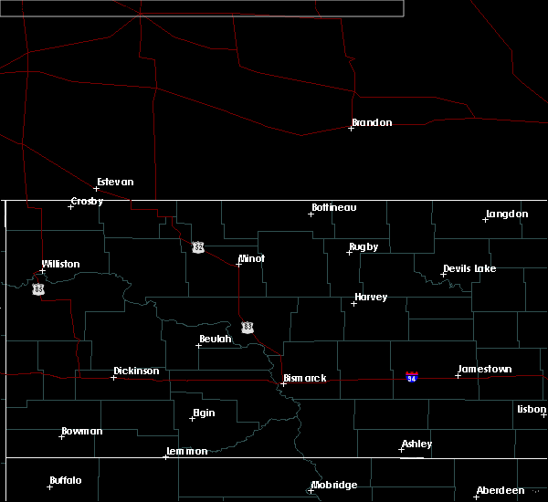 At 849 pm cdt/749 pm mdt/, severe thunderstorms were located along a line extending from 8 miles northeast of mandaree to 10 miles northwest of taylor, moving northeast at 10 mph (radar indicated). Hazards include 60 mph wind gusts and quarter size hail. Hail damage to vehicles is expected. expect wind damage to roofs, siding, and trees. Locations impacted include, killdeer, halliday, dunn center, manning, mckenzie bay recreation area, little missouri state park, skunk creek bay recreation area and hirschville. At 849 pm cdt/749 pm mdt/, severe thunderstorms were located along a line extending from 8 miles northeast of mandaree to 10 miles northwest of taylor, moving northeast at 10 mph (radar indicated). Hazards include 60 mph wind gusts and quarter size hail. Hail damage to vehicles is expected. expect wind damage to roofs, siding, and trees. Locations impacted include, killdeer, halliday, dunn center, manning, mckenzie bay recreation area, little missouri state park, skunk creek bay recreation area and hirschville.
|
| 6/29/2020 8:29 PM CDT |
 At 829 pm cdt/729 pm mdt/, severe thunderstorms were located along a line extending from 4 miles northeast of mandaree to 9 miles north of gladstone, moving northeast at 10 mph (radar indicated). Hazards include 60 mph wind gusts and quarter size hail. Hail damage to vehicles is expected. expect wind damage to roofs, siding, and trees. These severe thunderstorms will remain over mainly rural areas of dunn county, including the following locations, hirschville, oakdale, skunk creek bay recreation area and new hradec. At 829 pm cdt/729 pm mdt/, severe thunderstorms were located along a line extending from 4 miles northeast of mandaree to 9 miles north of gladstone, moving northeast at 10 mph (radar indicated). Hazards include 60 mph wind gusts and quarter size hail. Hail damage to vehicles is expected. expect wind damage to roofs, siding, and trees. These severe thunderstorms will remain over mainly rural areas of dunn county, including the following locations, hirschville, oakdale, skunk creek bay recreation area and new hradec.
|
| 8/6/2019 1:22 PM MDT |
 At 222 pm cdt/122 pm mdt/, a severe thunderstorm was located 5 miles northeast of halliday, or 22 miles northwest of beulah, moving east at 15 mph (radar indicated). Hazards include 60 mph wind gusts and half dollar size hail. Hail damage to vehicles is expected. expect wind damage to roofs, siding, and trees. this severe thunderstorm will be near, dodge around 230 pm cdt. Golden valley around 255 pm cdt. At 222 pm cdt/122 pm mdt/, a severe thunderstorm was located 5 miles northeast of halliday, or 22 miles northwest of beulah, moving east at 15 mph (radar indicated). Hazards include 60 mph wind gusts and half dollar size hail. Hail damage to vehicles is expected. expect wind damage to roofs, siding, and trees. this severe thunderstorm will be near, dodge around 230 pm cdt. Golden valley around 255 pm cdt.
|
| 8/1/2019 4:40 PM CDT |
 A severe thunderstorm warning remains in effect until 500 pm cdt/400 pm mdt/ for northeastern dunn. northwestern mclean and south central mountrail counties. At 438 pm cdt/338 pm mdt/, severe thunderstorms were located along a line extending from 5 miles southwest of parshall to near halliday, moving east at 20 mph. A severe thunderstorm warning remains in effect until 500 pm cdt/400 pm mdt/ for northeastern dunn. northwestern mclean and south central mountrail counties. At 438 pm cdt/338 pm mdt/, severe thunderstorms were located along a line extending from 5 miles southwest of parshall to near halliday, moving east at 20 mph.
|
| 8/1/2019 4:20 PM CDT |
 At 418 pm cdt/318 pm mdt/, severe thunderstorms were located along a line extending from near van hook park to near halliday, moving east at 15 mph (radar indicated). Hazards include 60 mph wind gusts and quarter size hail. Hail damage to vehicles is expected. expect wind damage to roofs, siding, and trees. these severe storms will be near, halliday around 430 pm cdt. Other locations impacted by these severe thunderstorms include twin buttes, skunk creek bay recreation area and pouch point recreation area. At 418 pm cdt/318 pm mdt/, severe thunderstorms were located along a line extending from near van hook park to near halliday, moving east at 15 mph (radar indicated). Hazards include 60 mph wind gusts and quarter size hail. Hail damage to vehicles is expected. expect wind damage to roofs, siding, and trees. these severe storms will be near, halliday around 430 pm cdt. Other locations impacted by these severe thunderstorms include twin buttes, skunk creek bay recreation area and pouch point recreation area.
|
| 8/1/2019 4:10 PM CDT |
 At 409 pm cdt/309 pm mdt/, severe thunderstorms were located along a line extending from 9 miles northeast of mandaree to 6 miles north of mckenzie bay recreation area to 8 miles northwest of halliday, moving east at 20 mph (radar indicated). Hazards include 60 mph wind gusts and quarter size hail. Hail damage to vehicles is expected. expect wind damage to roofs, siding, and trees. these severe storms will be near, mckenzie bay recreation area around 415 pm cdt. halliday around 425 pm cdt. Other locations impacted by these severe thunderstorms include skunk creek bay recreation area, parshall bay recreation area, twin buttes and pouch point recreation area. At 409 pm cdt/309 pm mdt/, severe thunderstorms were located along a line extending from 9 miles northeast of mandaree to 6 miles north of mckenzie bay recreation area to 8 miles northwest of halliday, moving east at 20 mph (radar indicated). Hazards include 60 mph wind gusts and quarter size hail. Hail damage to vehicles is expected. expect wind damage to roofs, siding, and trees. these severe storms will be near, mckenzie bay recreation area around 415 pm cdt. halliday around 425 pm cdt. Other locations impacted by these severe thunderstorms include skunk creek bay recreation area, parshall bay recreation area, twin buttes and pouch point recreation area.
|
| 8/1/2019 3:56 PM CDT |
 At 355 pm cdt/255 pm mdt/, severe thunderstorms were located along a line extending from 7 miles northwest of mandaree to 5 miles north of killdeer, moving east at 20 mph (radar indicated). Hazards include 60 mph wind gusts and half dollar size hail. Hail damage to vehicles is expected. expect wind damage to roofs, siding, and trees. severe thunderstorms will be near, dunn center and mandaree around 410 pm cdt. halliday around 455 pm cdt. Other locations impacted by these severe thunderstorms include skunk creek bay recreation area, parshall bay recreation area, twin buttes and pouch point recreation area. At 355 pm cdt/255 pm mdt/, severe thunderstorms were located along a line extending from 7 miles northwest of mandaree to 5 miles north of killdeer, moving east at 20 mph (radar indicated). Hazards include 60 mph wind gusts and half dollar size hail. Hail damage to vehicles is expected. expect wind damage to roofs, siding, and trees. severe thunderstorms will be near, dunn center and mandaree around 410 pm cdt. halliday around 455 pm cdt. Other locations impacted by these severe thunderstorms include skunk creek bay recreation area, parshall bay recreation area, twin buttes and pouch point recreation area.
|
| 7/31/2019 5:41 PM MDT |
 The severe thunderstorm warning for east central dunn county will expire at 645 pm cdt/545 pm mdt/, the storm which prompted the warning has weakened below severe limits, and no longer poses an immediate threat to life or property. therefore, the warning will be allowed to expire. however heavy rain is still possible with this thunderstorm. a severe thunderstorm watch remains in effect until 1100 pm cdt/1000 pm mdt/ for south central and southwestern north dakota. The severe thunderstorm warning for east central dunn county will expire at 645 pm cdt/545 pm mdt/, the storm which prompted the warning has weakened below severe limits, and no longer poses an immediate threat to life or property. therefore, the warning will be allowed to expire. however heavy rain is still possible with this thunderstorm. a severe thunderstorm watch remains in effect until 1100 pm cdt/1000 pm mdt/ for south central and southwestern north dakota.
|
| 7/31/2019 5:21 PM MDT |
 At 559 pm cdt/459 pm mdt/, a severe thunderstorm was located near little missouri state park, or 10 miles north of killdeer, moving east at 20 mph (radar indicated). Hazards include golf ball size hail and 60 mph wind gusts. People and animals outdoors will be injured. expect hail damage to roofs, siding, windows, and vehicles. expect wind damage to roofs, siding, and trees. this severe storm will be near, halliday around 545 pm mdt. Other locations impacted by this severe thunderstorm include twin buttes. At 559 pm cdt/459 pm mdt/, a severe thunderstorm was located near little missouri state park, or 10 miles north of killdeer, moving east at 20 mph (radar indicated). Hazards include golf ball size hail and 60 mph wind gusts. People and animals outdoors will be injured. expect hail damage to roofs, siding, windows, and vehicles. expect wind damage to roofs, siding, and trees. this severe storm will be near, halliday around 545 pm mdt. Other locations impacted by this severe thunderstorm include twin buttes.
|
| 7/31/2019 4:59 PM MDT |
 At 559 pm cdt/459 pm mdt/, a severe thunderstorm was located near little missouri state park, or 10 miles north of killdeer, moving east at 20 mph (radar indicated). Hazards include golf ball size hail and 60 mph wind gusts. People and animals outdoors will be injured. expect hail damage to roofs, siding, windows, and vehicles. expect wind damage to roofs, siding, and trees. this severe storm will be near, halliday around 545 pm mdt. Other locations impacted by this severe thunderstorm include twin buttes. At 559 pm cdt/459 pm mdt/, a severe thunderstorm was located near little missouri state park, or 10 miles north of killdeer, moving east at 20 mph (radar indicated). Hazards include golf ball size hail and 60 mph wind gusts. People and animals outdoors will be injured. expect hail damage to roofs, siding, windows, and vehicles. expect wind damage to roofs, siding, and trees. this severe storm will be near, halliday around 545 pm mdt. Other locations impacted by this severe thunderstorm include twin buttes.
|
| 7/31/2019 5:47 PM CDT |
 At 547 pm cdt/447 pm mdt/, a severe thunderstorm was located over little missouri state park, or 11 miles north of killdeer, moving east at 20 mph (radar indicated). Hazards include 60 mph wind gusts and half dollar size hail. Hail damage to vehicles is expected. expect wind damage to roofs, siding, and trees. this severe thunderstorm will be near, halliday around 545 pm mdt. Other locations impacted by this severe thunderstorm include twin buttes and oakdale. At 547 pm cdt/447 pm mdt/, a severe thunderstorm was located over little missouri state park, or 11 miles north of killdeer, moving east at 20 mph (radar indicated). Hazards include 60 mph wind gusts and half dollar size hail. Hail damage to vehicles is expected. expect wind damage to roofs, siding, and trees. this severe thunderstorm will be near, halliday around 545 pm mdt. Other locations impacted by this severe thunderstorm include twin buttes and oakdale.
|
| 7/15/2019 12:19 AM MDT |
 At 117 am cdt/1217 am mdt/, severe thunderstorms were located along a line extending from 8 miles southeast of mandaree to 9 miles south of regent, moving east at 55 mph. these are very dangerous storms (radar indicated. also, a 77 mph wind gust was measured at the dickinson airport). Hazards include 80 mph wind gusts. Flying debris will be dangerous to those caught without shelter. mobile homes will be heavily damaged. expect considerable damage to roofs, windows, and vehicles. extensive tree damage and power outages are likely. Locations impacted include, dickinson, killdeer, mott, amidon, belfield, new england, richardton, south heart, gladstone, halliday, regent, taylor, dunn center, dodge, manning, marshall, grassy butte, south fairfield, little missouri state park and mckenzie bay recreation area. At 117 am cdt/1217 am mdt/, severe thunderstorms were located along a line extending from 8 miles southeast of mandaree to 9 miles south of regent, moving east at 55 mph. these are very dangerous storms (radar indicated. also, a 77 mph wind gust was measured at the dickinson airport). Hazards include 80 mph wind gusts. Flying debris will be dangerous to those caught without shelter. mobile homes will be heavily damaged. expect considerable damage to roofs, windows, and vehicles. extensive tree damage and power outages are likely. Locations impacted include, dickinson, killdeer, mott, amidon, belfield, new england, richardton, south heart, gladstone, halliday, regent, taylor, dunn center, dodge, manning, marshall, grassy butte, south fairfield, little missouri state park and mckenzie bay recreation area.
|
| 7/15/2019 12:12 AM MDT |
 At 111 am cdt/1211 am mdt/, severe thunderstorms were located along a line extending from 7 miles northwest of little missouri state park to 12 miles north of reeder, moving east at 50 mph (radar indicated). Hazards include 70 mph wind gusts. Expect considerable tree damage. damage is likely to mobile homes, roofs, and outbuildings. severe thunderstorms will be near, little missouri state park around 1220 am mdt. mckenzie bay recreation area around 1240 am mdt. mott around 1250 am mdt. Other locations impacted by these severe thunderstorms include fryburg, twin buttes, hirschville, schefield, burt, oakdale, fairfield, havelock, bentley and lefor. At 111 am cdt/1211 am mdt/, severe thunderstorms were located along a line extending from 7 miles northwest of little missouri state park to 12 miles north of reeder, moving east at 50 mph (radar indicated). Hazards include 70 mph wind gusts. Expect considerable tree damage. damage is likely to mobile homes, roofs, and outbuildings. severe thunderstorms will be near, little missouri state park around 1220 am mdt. mckenzie bay recreation area around 1240 am mdt. mott around 1250 am mdt. Other locations impacted by these severe thunderstorms include fryburg, twin buttes, hirschville, schefield, burt, oakdale, fairfield, havelock, bentley and lefor.
|
| 7/10/2018 1:36 AM MDT |
 At 236 am cdt/136 am mdt/, severe thunderstorms were located along a line extending from 7 miles northwest of garrison to 4 miles southwest of hazen bay recreation area to 4 miles north of halliday, moving east at 45 mph (radar indicated). Hazards include 60 mph wind gusts and penny size hail. Expect damage to roofs, siding, and trees. these severe storms will be near, hazen bay recreation area and beulah bay recreation area around 240 am cdt. garrison around 245 am cdt. pick city and lake sakakawea state park around 250 am cdt. golden valley around 255 am cdt. zap around 305 am cdt. beulah and hazen around 315 am cdt. Other locations impacted by these severe thunderstorms include dakota waters recreation area, emmet, white shield and twin buttes. At 236 am cdt/136 am mdt/, severe thunderstorms were located along a line extending from 7 miles northwest of garrison to 4 miles southwest of hazen bay recreation area to 4 miles north of halliday, moving east at 45 mph (radar indicated). Hazards include 60 mph wind gusts and penny size hail. Expect damage to roofs, siding, and trees. these severe storms will be near, hazen bay recreation area and beulah bay recreation area around 240 am cdt. garrison around 245 am cdt. pick city and lake sakakawea state park around 250 am cdt. golden valley around 255 am cdt. zap around 305 am cdt. beulah and hazen around 315 am cdt. Other locations impacted by these severe thunderstorms include dakota waters recreation area, emmet, white shield and twin buttes.
|
| 7/10/2018 2:19 AM CDT |
 A severe thunderstorm warning remains in effect until 230 am cdt/130 am mdt/ for central dunn and western mclean counties. at 219 am cdt/119 am mdt/, severe thunderstorms were located along a line extending from 5 miles south of roseglen to near halliday to 11 miles east of grassy butte, moving southeast at 30 mph. hazard. 60 mph wind gusts and quarter size hail. A severe thunderstorm warning remains in effect until 230 am cdt/130 am mdt/ for central dunn and western mclean counties. at 219 am cdt/119 am mdt/, severe thunderstorms were located along a line extending from 5 miles south of roseglen to near halliday to 11 miles east of grassy butte, moving southeast at 30 mph. hazard. 60 mph wind gusts and quarter size hail.
|
| 7/10/2018 1:18 AM MDT |
 At 217 am cdt/117 am mdt/, a severe thunderstorm was located 6 miles south of indian hills recreation area, or 24 miles northwest of beulah, moving east at 45 mph (radar indicated). Hazards include 60 mph wind gusts and penny size hail. Expect damage to roofs, siding, and trees. this severe thunderstorm will be near, beulah bay recreation area around 240 am cdt. hazen bay recreation area around 250 am cdt. hazen around 255 am cdt. Other locations impacted by this severe thunderstorm include dakota waters recreation area, emmet, white shield and twin buttes. At 217 am cdt/117 am mdt/, a severe thunderstorm was located 6 miles south of indian hills recreation area, or 24 miles northwest of beulah, moving east at 45 mph (radar indicated). Hazards include 60 mph wind gusts and penny size hail. Expect damage to roofs, siding, and trees. this severe thunderstorm will be near, beulah bay recreation area around 240 am cdt. hazen bay recreation area around 250 am cdt. hazen around 255 am cdt. Other locations impacted by this severe thunderstorm include dakota waters recreation area, emmet, white shield and twin buttes.
|
| 7/10/2018 1:54 AM CDT |
 At 152 am cdt/1252 am mdt/, severe thunderstorms were located along a line extending from 6 miles northeast of mandaree to 5 miles north of dunn center to 4 miles north of grassy butte, moving southeast at 35 mph (radar indicated). Hazards include 70 mph wind gusts and ping pong ball size hail. People and animals outdoors will be injured. expect hail damage to roofs, siding, windows, and vehicles. expect considerable tree damage. wind damage is also likely to mobile homes, roofs, and outbuildings. these severe storms will be near, killdeer around 1255 am mdt. dunn center around 100 am mdt. mckenzie bay recreation area around 115 am mdt. halliday around 120 am mdt. Other locations impacted by these severe thunderstorms include deep water creek recreation area, oakdale, skunk creek bay recreation area and twin buttes. At 152 am cdt/1252 am mdt/, severe thunderstorms were located along a line extending from 6 miles northeast of mandaree to 5 miles north of dunn center to 4 miles north of grassy butte, moving southeast at 35 mph (radar indicated). Hazards include 70 mph wind gusts and ping pong ball size hail. People and animals outdoors will be injured. expect hail damage to roofs, siding, windows, and vehicles. expect considerable tree damage. wind damage is also likely to mobile homes, roofs, and outbuildings. these severe storms will be near, killdeer around 1255 am mdt. dunn center around 100 am mdt. mckenzie bay recreation area around 115 am mdt. halliday around 120 am mdt. Other locations impacted by these severe thunderstorms include deep water creek recreation area, oakdale, skunk creek bay recreation area and twin buttes.
|
| 7/10/2018 12:37 AM MDT |
 At 137 am cdt/1237 am mdt/, severe thunderstorms were located along a line extending from 8 miles southwest of 4 bears lodge to 4 miles south of little missouri state park to 8 miles southwest of theodore roosevelt national park north unit, moving southeast at 30 mph (public. extensive wind damage was reported in watford city). Hazards include golf ball size hail and 70 mph wind gusts. People and animals outdoors will be injured. expect hail damage to roofs, siding, windows, and vehicles. expect considerable tree damage. wind damage is also likely to mobile homes, roofs, and outbuildings. severe thunderstorms will be near, little missouri state park around 1240 am mdt. killdeer around 1250 am mdt. dunn center around 100 am mdt. halliday around 120 am mdt. Other locations impacted by these severe thunderstorms include deep water creek recreation area, oakdale, skunk creek bay recreation area, twin buttes and pouch point recreation area. At 137 am cdt/1237 am mdt/, severe thunderstorms were located along a line extending from 8 miles southwest of 4 bears lodge to 4 miles south of little missouri state park to 8 miles southwest of theodore roosevelt national park north unit, moving southeast at 30 mph (public. extensive wind damage was reported in watford city). Hazards include golf ball size hail and 70 mph wind gusts. People and animals outdoors will be injured. expect hail damage to roofs, siding, windows, and vehicles. expect considerable tree damage. wind damage is also likely to mobile homes, roofs, and outbuildings. severe thunderstorms will be near, little missouri state park around 1240 am mdt. killdeer around 1250 am mdt. dunn center around 100 am mdt. halliday around 120 am mdt. Other locations impacted by these severe thunderstorms include deep water creek recreation area, oakdale, skunk creek bay recreation area, twin buttes and pouch point recreation area.
|
| 6/28/2018 10:40 PM MDT |
 The severe thunderstorm warning for dunn, northwestern mclean, northeastern billings, east central mckenzie, south central mountrail and mercer counties will expire at 1145 pm cdt/1045 pm mdt/, the storms which prompted the warning have moved out of the area. therefore, the warning will be allowed to expire. however small hail and gusty winds are still possible with these thunderstorms. a severe thunderstorm watch remains in effect until 800 am cdt/700 am mdt/ for south central, southwestern, north central and northwestern north dakota. remember, a severe thunderstorm warning still remains in effect for eastern dunn, mclean, and mercer counties. The severe thunderstorm warning for dunn, northwestern mclean, northeastern billings, east central mckenzie, south central mountrail and mercer counties will expire at 1145 pm cdt/1045 pm mdt/, the storms which prompted the warning have moved out of the area. therefore, the warning will be allowed to expire. however small hail and gusty winds are still possible with these thunderstorms. a severe thunderstorm watch remains in effect until 800 am cdt/700 am mdt/ for south central, southwestern, north central and northwestern north dakota. remember, a severe thunderstorm warning still remains in effect for eastern dunn, mclean, and mercer counties.
|
| 6/28/2018 11:38 PM CDT |
 At 1138 pm cdt/1038 pm mdt/, severe thunderstorms were located along a line extending from 4 miles east of garrison to 8 miles southeast of indian hills recreation area to 8 miles north of richardton, moving east at 40 mph. these are very dangerous storms (radar indicated). Hazards include 80 mph wind gusts and half dollar size hail. Flying debris will be dangerous to those caught without shelter. mobile homes will be heavily damaged. expect considerable damage to roofs, windows, and vehicles. extensive tree damage and power outages are likely. severe thunderstorms will be near, beulah bay recreation area around 1155 pm cdt. hazen bay recreation area around 1200 am cdt. pick city, lake sakakawea state park and fort stevenson state park around 1215 am cdt. riverdale around 1220 am cdt. coleharbor around 1230 am cdt. underwood around 1235 am cdt. turtle lake around 1245 am cdt. Other locations impacted by these severe thunderstorms include white shield, strawberry lake, price, twin buttes, falkirk, sanger, ruso, hensler, dakota waters recreation area and emmet. At 1138 pm cdt/1038 pm mdt/, severe thunderstorms were located along a line extending from 4 miles east of garrison to 8 miles southeast of indian hills recreation area to 8 miles north of richardton, moving east at 40 mph. these are very dangerous storms (radar indicated). Hazards include 80 mph wind gusts and half dollar size hail. Flying debris will be dangerous to those caught without shelter. mobile homes will be heavily damaged. expect considerable damage to roofs, windows, and vehicles. extensive tree damage and power outages are likely. severe thunderstorms will be near, beulah bay recreation area around 1155 pm cdt. hazen bay recreation area around 1200 am cdt. pick city, lake sakakawea state park and fort stevenson state park around 1215 am cdt. riverdale around 1220 am cdt. coleharbor around 1230 am cdt. underwood around 1235 am cdt. turtle lake around 1245 am cdt. Other locations impacted by these severe thunderstorms include white shield, strawberry lake, price, twin buttes, falkirk, sanger, ruso, hensler, dakota waters recreation area and emmet.
|
| 6/28/2018 10:09 PM MDT |
 At 1046 pm cdt/946 pm mdt/, severe thunderstorms were located along a line extending from 6 miles south of van hook park to 4 miles northwest of halliday to 10 miles northwest of dickinson, moving east at 50 mph (radar indicated). Hazards include 70 mph wind gusts and quarter size hail. Hail damage to vehicles is expected. expect considerable tree damage. wind damage is also likely to mobile homes, roofs, and outbuildings. severe thunderstorms will be near, halliday around 950 pm mdt. dodge around 1000 pm mdt. golden valley around 1005 pm mdt. zap around 1115 pm cdt. roseglen around 1120 pm cdt. beulah and beulah bay recreation area around 1125 pm cdt. hazen and hazen bay recreation area around 1130 pm cdt. other locations impacted by these severe thunderstorms include skunk creek bay recreation area, white shield, twin buttes, pouch point recreation area, hirschville, deep water creek recreation area, dakota waters recreation area, oakdale, raub and emmet. A tornado watch remains in effect until 1100 pm cdt/1000 pm mdt/ for south central, southwestern, north central and northwestern north dakota. At 1046 pm cdt/946 pm mdt/, severe thunderstorms were located along a line extending from 6 miles south of van hook park to 4 miles northwest of halliday to 10 miles northwest of dickinson, moving east at 50 mph (radar indicated). Hazards include 70 mph wind gusts and quarter size hail. Hail damage to vehicles is expected. expect considerable tree damage. wind damage is also likely to mobile homes, roofs, and outbuildings. severe thunderstorms will be near, halliday around 950 pm mdt. dodge around 1000 pm mdt. golden valley around 1005 pm mdt. zap around 1115 pm cdt. roseglen around 1120 pm cdt. beulah and beulah bay recreation area around 1125 pm cdt. hazen and hazen bay recreation area around 1130 pm cdt. other locations impacted by these severe thunderstorms include skunk creek bay recreation area, white shield, twin buttes, pouch point recreation area, hirschville, deep water creek recreation area, dakota waters recreation area, oakdale, raub and emmet. A tornado watch remains in effect until 1100 pm cdt/1000 pm mdt/ for south central, southwestern, north central and northwestern north dakota.
|
| 6/28/2018 9:46 PM MDT |
 At 1046 pm cdt/946 pm mdt/, severe thunderstorms were located along a line extending from 6 miles south of van hook park to 4 miles northwest of halliday to 10 miles northwest of dickinson, moving east at 50 mph (radar indicated). Hazards include 70 mph wind gusts and quarter size hail. Hail damage to vehicles is expected. expect considerable tree damage. wind damage is also likely to mobile homes, roofs, and outbuildings. severe thunderstorms will be near, halliday around 950 pm mdt. dodge around 1000 pm mdt. golden valley around 1005 pm mdt. zap around 1115 pm cdt. roseglen around 1120 pm cdt. beulah and beulah bay recreation area around 1125 pm cdt. hazen and hazen bay recreation area around 1130 pm cdt. other locations impacted by these severe thunderstorms include skunk creek bay recreation area, white shield, twin buttes, pouch point recreation area, hirschville, deep water creek recreation area, dakota waters recreation area, oakdale, raub and emmet. A tornado watch remains in effect until 1100 pm cdt/1000 pm mdt/ for south central, southwestern, north central and northwestern north dakota. At 1046 pm cdt/946 pm mdt/, severe thunderstorms were located along a line extending from 6 miles south of van hook park to 4 miles northwest of halliday to 10 miles northwest of dickinson, moving east at 50 mph (radar indicated). Hazards include 70 mph wind gusts and quarter size hail. Hail damage to vehicles is expected. expect considerable tree damage. wind damage is also likely to mobile homes, roofs, and outbuildings. severe thunderstorms will be near, halliday around 950 pm mdt. dodge around 1000 pm mdt. golden valley around 1005 pm mdt. zap around 1115 pm cdt. roseglen around 1120 pm cdt. beulah and beulah bay recreation area around 1125 pm cdt. hazen and hazen bay recreation area around 1130 pm cdt. other locations impacted by these severe thunderstorms include skunk creek bay recreation area, white shield, twin buttes, pouch point recreation area, hirschville, deep water creek recreation area, dakota waters recreation area, oakdale, raub and emmet. A tornado watch remains in effect until 1100 pm cdt/1000 pm mdt/ for south central, southwestern, north central and northwestern north dakota.
|
| 6/28/2018 9:06 PM MDT | Quarter sized hail reported 7.8 miles SW of Halliday, ND, hail lasted about 5 minutes until 1011 pm. |
| 6/28/2018 8:48 PM MDT | Quarter sized hail reported 0.4 miles SSE of Halliday, ND |
| 6/28/2018 8:45 PM MDT | Ping Pong Ball sized hail reported 7.6 miles SSW of Halliday, ND, marble size hail lasted 20 to 30 minutes. largest hail was ping-pong size. |
| 6/28/2018 8:36 PM MDT |
 At 935 pm cdt/835 pm mdt/, a severe thunderstorm was located 5 miles northwest of halliday, or 15 miles east of killdeer, moving northeast at 20 mph (radar indicated). Hazards include 60 mph wind gusts and half dollar size hail. Hail damage to vehicles is expected. expect wind damage to roofs, siding, and trees. this severe storm will be near, halliday around 840 pm mdt. other locations impacted by this severe thunderstorm include twin buttes. A tornado watch remains in effect until 1100 pm cdt/1000 pm mdt/ for south central and southwestern north dakota. At 935 pm cdt/835 pm mdt/, a severe thunderstorm was located 5 miles northwest of halliday, or 15 miles east of killdeer, moving northeast at 20 mph (radar indicated). Hazards include 60 mph wind gusts and half dollar size hail. Hail damage to vehicles is expected. expect wind damage to roofs, siding, and trees. this severe storm will be near, halliday around 840 pm mdt. other locations impacted by this severe thunderstorm include twin buttes. A tornado watch remains in effect until 1100 pm cdt/1000 pm mdt/ for south central and southwestern north dakota.
|
| 6/28/2018 8:16 PM MDT |
 At 916 pm cdt/816 pm mdt/, a severe thunderstorm was located near dunn center, or 11 miles east of killdeer, moving northeast at 20 mph (radar indicated). Hazards include 60 mph wind gusts and half dollar size hail. Hail damage to vehicles is expected. expect wind damage to roofs, siding, and trees. this severe thunderstorm will be near, halliday around 835 pm mdt. mckenzie bay recreation area around 910 pm mdt. other locations impacted by this severe thunderstorm include twin buttes. A tornado watch remains in effect until 1100 pm cdt/1000 pm mdt/ for south central and southwestern north dakota. At 916 pm cdt/816 pm mdt/, a severe thunderstorm was located near dunn center, or 11 miles east of killdeer, moving northeast at 20 mph (radar indicated). Hazards include 60 mph wind gusts and half dollar size hail. Hail damage to vehicles is expected. expect wind damage to roofs, siding, and trees. this severe thunderstorm will be near, halliday around 835 pm mdt. mckenzie bay recreation area around 910 pm mdt. other locations impacted by this severe thunderstorm include twin buttes. A tornado watch remains in effect until 1100 pm cdt/1000 pm mdt/ for south central and southwestern north dakota.
|
| 6/28/2018 8:05 PM MDT |
 At 804 pm mdt, a severe thunderstorm capable of producing a tornado was located near halliday, or 17 miles east of killdeer, moving southeast at 5 mph (radar indicated rotation). Hazards include tornado and two inch hail. Flying debris will be dangerous to those caught without shelter. mobile homes will be damaged or destroyed. damage to roofs, windows, and vehicles will occur. tree damage is likely. This dangerous storm will be near, halliday around 815 pm mdt. At 804 pm mdt, a severe thunderstorm capable of producing a tornado was located near halliday, or 17 miles east of killdeer, moving southeast at 5 mph (radar indicated rotation). Hazards include tornado and two inch hail. Flying debris will be dangerous to those caught without shelter. mobile homes will be damaged or destroyed. damage to roofs, windows, and vehicles will occur. tree damage is likely. This dangerous storm will be near, halliday around 815 pm mdt.
|
| 6/28/2018 7:44 PM MDT |
 At 743 pm mdt, a severe thunderstorm capable of producing a tornado was located 5 miles southwest of halliday, or 15 miles east of killdeer, moving southeast at 5 mph (radar indicated rotation). Hazards include tornado and quarter size hail. Flying debris will be dangerous to those caught without shelter. mobile homes will be damaged or destroyed. damage to roofs, windows, and vehicles will occur. tree damage is likely. this dangerous storm will be near, halliday around 810 pm mdt. Dodge around 815 pm mdt. At 743 pm mdt, a severe thunderstorm capable of producing a tornado was located 5 miles southwest of halliday, or 15 miles east of killdeer, moving southeast at 5 mph (radar indicated rotation). Hazards include tornado and quarter size hail. Flying debris will be dangerous to those caught without shelter. mobile homes will be damaged or destroyed. damage to roofs, windows, and vehicles will occur. tree damage is likely. this dangerous storm will be near, halliday around 810 pm mdt. Dodge around 815 pm mdt.
|
| 6/28/2018 7:28 PM MDT |
 At 728 pm mdt, a severe thunderstorm capable of producing a tornado was located 7 miles southeast of dunn center, or 13 miles east of killdeer, moving southeast at 10 mph (radar indicated rotation). Hazards include tornado and quarter size hail. Flying debris will be dangerous to those caught without shelter. mobile homes will be damaged or destroyed. damage to roofs, windows, and vehicles will occur. tree damage is likely. Locations impacted include, halliday. At 728 pm mdt, a severe thunderstorm capable of producing a tornado was located 7 miles southeast of dunn center, or 13 miles east of killdeer, moving southeast at 10 mph (radar indicated rotation). Hazards include tornado and quarter size hail. Flying debris will be dangerous to those caught without shelter. mobile homes will be damaged or destroyed. damage to roofs, windows, and vehicles will occur. tree damage is likely. Locations impacted include, halliday.
|
| 6/28/2018 7:10 PM MDT |
 At 709 pm mdt, a severe thunderstorm capable of producing a tornado was located 6 miles southeast of dunn center, or 12 miles southeast of killdeer, moving southeast at 10 mph (radar indicated rotation). Hazards include tornado and quarter size hail. Flying debris will be dangerous to those caught without shelter. mobile homes will be damaged or destroyed. damage to roofs, windows, and vehicles will occur. tree damage is likely. This tornadic thunderstorm will remain over mainly rural areas of southeastern dunn county. At 709 pm mdt, a severe thunderstorm capable of producing a tornado was located 6 miles southeast of dunn center, or 12 miles southeast of killdeer, moving southeast at 10 mph (radar indicated rotation). Hazards include tornado and quarter size hail. Flying debris will be dangerous to those caught without shelter. mobile homes will be damaged or destroyed. damage to roofs, windows, and vehicles will occur. tree damage is likely. This tornadic thunderstorm will remain over mainly rural areas of southeastern dunn county.
|
| 6/28/2018 7:06 PM MDT |
 At 705 pm mdt, a severe thunderstorm was located 6 miles west of halliday, or 13 miles east of killdeer, moving southeast at 15 mph (radar indicated). Hazards include 60 mph wind gusts and quarter size hail. Hail damage to vehicles is expected. expect wind damage to roofs, siding, and trees. this severe storm will be near, halliday around 725 pm mdt. A tornado watch remains in effect until 1000 pm mdt for southwestern north dakota. At 705 pm mdt, a severe thunderstorm was located 6 miles west of halliday, or 13 miles east of killdeer, moving southeast at 15 mph (radar indicated). Hazards include 60 mph wind gusts and quarter size hail. Hail damage to vehicles is expected. expect wind damage to roofs, siding, and trees. this severe storm will be near, halliday around 725 pm mdt. A tornado watch remains in effect until 1000 pm mdt for southwestern north dakota.
|
| 6/28/2018 6:30 PM MDT |
 At 630 pm mdt, a severe thunderstorm was located 6 miles northeast of dunn center, or 11 miles east of killdeer, moving southeast at 10 mph (radar indicated). Hazards include 60 mph wind gusts and half dollar size hail. Hail damage to vehicles is expected. expect wind damage to roofs, siding, and trees. this severe thunderstorm will be near, halliday around 715 pm mdt. dodge around 730 pm mdt. A tornado watch remains in effect until 1000 pm mdt for south central and southwestern north dakota. At 630 pm mdt, a severe thunderstorm was located 6 miles northeast of dunn center, or 11 miles east of killdeer, moving southeast at 10 mph (radar indicated). Hazards include 60 mph wind gusts and half dollar size hail. Hail damage to vehicles is expected. expect wind damage to roofs, siding, and trees. this severe thunderstorm will be near, halliday around 715 pm mdt. dodge around 730 pm mdt. A tornado watch remains in effect until 1000 pm mdt for south central and southwestern north dakota.
|
| 6/28/2018 6:21 PM MDT |
 At 721 pm cdt/621 pm mdt/, a severe thunderstorm was located 7 miles northwest of halliday, or 13 miles east of killdeer, moving southeast at 10 mph (radar indicated). Hazards include ping pong ball size hail and 60 mph wind gusts. People and animals outdoors will be injured. expect hail damage to roofs, siding, windows, and vehicles. expect wind damage to roofs, siding, and trees. this severe storm will be near, halliday around 630 pm mdt. other locations impacted by this severe thunderstorm include twin buttes. A tornado watch remains in effect until 1100 pm cdt/1000 pm mdt/ for south central and southwestern north dakota. At 721 pm cdt/621 pm mdt/, a severe thunderstorm was located 7 miles northwest of halliday, or 13 miles east of killdeer, moving southeast at 10 mph (radar indicated). Hazards include ping pong ball size hail and 60 mph wind gusts. People and animals outdoors will be injured. expect hail damage to roofs, siding, windows, and vehicles. expect wind damage to roofs, siding, and trees. this severe storm will be near, halliday around 630 pm mdt. other locations impacted by this severe thunderstorm include twin buttes. A tornado watch remains in effect until 1100 pm cdt/1000 pm mdt/ for south central and southwestern north dakota.
|
| 6/28/2018 6:02 PM MDT |
 At 646 pm cdt/546 pm mdt/, a severe thunderstorm was located 9 miles northeast of dunn center, or 12 miles northeast of killdeer, moving southeast at 10 mph (radar indicated). Hazards include 60 mph wind gusts and half dollar size hail. Hail damage to vehicles is expected. expect wind damage to roofs, siding, and trees. this severe storm will be near, halliday around 630 pm mdt. other locations impacted by this severe thunderstorm include twin buttes. A tornado watch remains in effect until 1100 pm cdt/1000 pm mdt/ for south central and southwestern north dakota. At 646 pm cdt/546 pm mdt/, a severe thunderstorm was located 9 miles northeast of dunn center, or 12 miles northeast of killdeer, moving southeast at 10 mph (radar indicated). Hazards include 60 mph wind gusts and half dollar size hail. Hail damage to vehicles is expected. expect wind damage to roofs, siding, and trees. this severe storm will be near, halliday around 630 pm mdt. other locations impacted by this severe thunderstorm include twin buttes. A tornado watch remains in effect until 1100 pm cdt/1000 pm mdt/ for south central and southwestern north dakota.
|
| 6/28/2018 5:46 PM MDT |
 At 646 pm cdt/546 pm mdt/, a severe thunderstorm was located 9 miles northeast of dunn center, or 12 miles northeast of killdeer, moving southeast at 10 mph (radar indicated). Hazards include 60 mph wind gusts and half dollar size hail. Hail damage to vehicles is expected. expect wind damage to roofs, siding, and trees. this severe storm will be near, halliday around 630 pm mdt. other locations impacted by this severe thunderstorm include twin buttes. A tornado watch remains in effect until 1100 pm cdt/1000 pm mdt/ for south central and southwestern north dakota. At 646 pm cdt/546 pm mdt/, a severe thunderstorm was located 9 miles northeast of dunn center, or 12 miles northeast of killdeer, moving southeast at 10 mph (radar indicated). Hazards include 60 mph wind gusts and half dollar size hail. Hail damage to vehicles is expected. expect wind damage to roofs, siding, and trees. this severe storm will be near, halliday around 630 pm mdt. other locations impacted by this severe thunderstorm include twin buttes. A tornado watch remains in effect until 1100 pm cdt/1000 pm mdt/ for south central and southwestern north dakota.
|
| 6/28/2018 5:32 PM MDT |
 At 631 pm cdt/531 pm mdt/, a severe thunderstorm was located 8 miles southeast of little missouri state park, or 11 miles northeast of killdeer, moving southeast at 20 mph (radar indicated). Hazards include 60 mph wind gusts and half dollar size hail. Hail damage to vehicles is expected. expect wind damage to roofs, siding, and trees. this severe thunderstorm will be near, halliday around 620 pm mdt. dodge around 630 pm mdt. other locations impacted by this severe thunderstorm include twin buttes. A tornado watch remains in effect until 1100 pm cdt/1000 pm mdt/ for south central and southwestern north dakota. At 631 pm cdt/531 pm mdt/, a severe thunderstorm was located 8 miles southeast of little missouri state park, or 11 miles northeast of killdeer, moving southeast at 20 mph (radar indicated). Hazards include 60 mph wind gusts and half dollar size hail. Hail damage to vehicles is expected. expect wind damage to roofs, siding, and trees. this severe thunderstorm will be near, halliday around 620 pm mdt. dodge around 630 pm mdt. other locations impacted by this severe thunderstorm include twin buttes. A tornado watch remains in effect until 1100 pm cdt/1000 pm mdt/ for south central and southwestern north dakota.
|
| 6/26/2018 5:24 PM MDT |
 At 624 pm cdt/524 pm mdt/, a severe thunderstorm was located near halliday, or 16 miles east of killdeer, moving east at 15 mph (radar indicated). Hazards include 60 mph wind gusts and quarter size hail. Hail damage to vehicles is expected. expect wind damage to roofs, siding, and trees. this severe thunderstorm will be near, halliday around 535 pm mdt. dodge around 555 pm mdt. Golden valley around 715 pm cdt. At 624 pm cdt/524 pm mdt/, a severe thunderstorm was located near halliday, or 16 miles east of killdeer, moving east at 15 mph (radar indicated). Hazards include 60 mph wind gusts and quarter size hail. Hail damage to vehicles is expected. expect wind damage to roofs, siding, and trees. this severe thunderstorm will be near, halliday around 535 pm mdt. dodge around 555 pm mdt. Golden valley around 715 pm cdt.
|
| 6/14/2018 7:29 PM MDT | Quarter sized hail reported 0.3 miles NNE of Halliday, ND, hail ongoing at time this report was sent. |
| 6/14/2018 7:27 PM MDT |
 At 824 pm cdt/724 pm mdt/, a severe thunderstorm was located 5 miles southwest of dodge, or 23 miles east of killdeer, moving northeast at 35 mph. this storm was moving towards lake sakakawea (radar indicated). Hazards include 60 mph wind gusts and quarter size hail. Hail damage to vehicles is expected. expect wind damage to roofs, siding, and trees. this severe thunderstorm will be near, dodge around 735 pm mdt. golden valley around 840 pm cdt. beulah bay recreation area around 915 pm cdt. hazen bay recreation area around 925 pm cdt. other locations impacted by this severe thunderstorm include dakota waters recreation area. if you are on lake sakakawea, between indians hills recreation area and lake sakakawea state park, get to land and move indoors. A tornado watch remains in effect until 1100 pm cdt/1000 pm mdt/ for south central and southwestern north dakota. At 824 pm cdt/724 pm mdt/, a severe thunderstorm was located 5 miles southwest of dodge, or 23 miles east of killdeer, moving northeast at 35 mph. this storm was moving towards lake sakakawea (radar indicated). Hazards include 60 mph wind gusts and quarter size hail. Hail damage to vehicles is expected. expect wind damage to roofs, siding, and trees. this severe thunderstorm will be near, dodge around 735 pm mdt. golden valley around 840 pm cdt. beulah bay recreation area around 915 pm cdt. hazen bay recreation area around 925 pm cdt. other locations impacted by this severe thunderstorm include dakota waters recreation area. if you are on lake sakakawea, between indians hills recreation area and lake sakakawea state park, get to land and move indoors. A tornado watch remains in effect until 1100 pm cdt/1000 pm mdt/ for south central and southwestern north dakota.
|
| 6/10/2018 6:32 PM MDT |
 At 732 pm cdt/632 pm mdt/, a severe thunderstorm was located 5 miles west of indian hills recreation area, or 29 miles northeast of killdeer, moving northeast at 30 mph (radar indicated). Hazards include 60 mph wind gusts and quarter size hail. Hail damage to vehicles is expected. expect wind damage to roofs, siding, and trees. Locations impacted include, halliday, mckenzie bay recreation area and twin buttes. At 732 pm cdt/632 pm mdt/, a severe thunderstorm was located 5 miles west of indian hills recreation area, or 29 miles northeast of killdeer, moving northeast at 30 mph (radar indicated). Hazards include 60 mph wind gusts and quarter size hail. Hail damage to vehicles is expected. expect wind damage to roofs, siding, and trees. Locations impacted include, halliday, mckenzie bay recreation area and twin buttes.
|
| 6/10/2018 6:19 PM MDT |
 At 718 pm cdt/618 pm mdt/, a severe thunderstorm was located 8 miles north of halliday, or 22 miles east of killdeer, moving northeast at 30 mph. at 7:14 pm cdt trained spotters in halliday reported quarter size hail (trained weather spotters). Hazards include ping pong ball size hail and 60 mph wind gusts. People and animals outdoors will be injured. expect hail damage to roofs, siding, windows, and vehicles. expect wind damage to roofs, siding, and trees. Locations impacted include, halliday, mckenzie bay recreation area and twin buttes. At 718 pm cdt/618 pm mdt/, a severe thunderstorm was located 8 miles north of halliday, or 22 miles east of killdeer, moving northeast at 30 mph. at 7:14 pm cdt trained spotters in halliday reported quarter size hail (trained weather spotters). Hazards include ping pong ball size hail and 60 mph wind gusts. People and animals outdoors will be injured. expect hail damage to roofs, siding, windows, and vehicles. expect wind damage to roofs, siding, and trees. Locations impacted include, halliday, mckenzie bay recreation area and twin buttes.
|
| 6/10/2018 6:14 PM MDT | Quarter sized hail reported 0.4 miles SSE of Halliday, ND, quarter size hail falling at the time of report. |
| 6/10/2018 6:13 PM MDT |
 At 713 pm cdt/613 pm mdt/, a severe thunderstorm was located 6 miles north of halliday, or 20 miles east of killdeer, moving northeast at 30 mph (radar indicated). Hazards include ping pong ball size hail and 60 mph wind gusts. People and animals outdoors will be injured. expect hail damage to roofs, siding, windows, and vehicles. expect wind damage to roofs, siding, and trees. Locations impacted include, halliday, mckenzie bay recreation area and twin buttes. At 713 pm cdt/613 pm mdt/, a severe thunderstorm was located 6 miles north of halliday, or 20 miles east of killdeer, moving northeast at 30 mph (radar indicated). Hazards include ping pong ball size hail and 60 mph wind gusts. People and animals outdoors will be injured. expect hail damage to roofs, siding, windows, and vehicles. expect wind damage to roofs, siding, and trees. Locations impacted include, halliday, mckenzie bay recreation area and twin buttes.
|
| 6/10/2018 6:02 PM MDT |
 At 701 pm cdt/601 pm mdt/, a severe thunderstorm was located near halliday, or 16 miles east of killdeer, moving northeast at 25 mph. this will affect highway 8 near halliday (radar indicated). Hazards include 60 mph wind gusts and quarter size hail. Hail damage to vehicles is expected. expect wind damage to roofs, siding, and trees. this severe thunderstorm will be near, halliday around 605 pm mdt. mckenzie bay recreation area around 645 pm mdt. Other locations impacted by this severe thunderstorm include twin buttes. At 701 pm cdt/601 pm mdt/, a severe thunderstorm was located near halliday, or 16 miles east of killdeer, moving northeast at 25 mph. this will affect highway 8 near halliday (radar indicated). Hazards include 60 mph wind gusts and quarter size hail. Hail damage to vehicles is expected. expect wind damage to roofs, siding, and trees. this severe thunderstorm will be near, halliday around 605 pm mdt. mckenzie bay recreation area around 645 pm mdt. Other locations impacted by this severe thunderstorm include twin buttes.
|
| 6/1/2018 5:02 PM MDT |
 At 602 pm cdt/502 pm mdt/, a severe thunderstorm capable of producing a tornado was located over dodge, or 18 miles west of beulah, moving northeast at 25 mph (radar indicated rotation). Hazards include tornado and quarter size hail. Flying debris will be dangerous to those caught without shelter. mobile homes will be damaged or destroyed. damage to roofs, windows, and vehicles will occur. Tree damage is likely. At 602 pm cdt/502 pm mdt/, a severe thunderstorm capable of producing a tornado was located over dodge, or 18 miles west of beulah, moving northeast at 25 mph (radar indicated rotation). Hazards include tornado and quarter size hail. Flying debris will be dangerous to those caught without shelter. mobile homes will be damaged or destroyed. damage to roofs, windows, and vehicles will occur. Tree damage is likely.
|
| 5/31/2018 2:00 PM MDT | Strong winds and hail....largest hail stones nickel in dunn county ND, 12.9 miles N of Halliday, ND |
| 5/31/2018 2:00 PM MDT | Half Dollar sized hail reported 14.8 miles N of Halliday, ND, busted window due to hail. report of 1.75 inches of rain. |
| 5/31/2018 1:58 PM MDT |
 At 158 pm mdt, a severe thunderstorm was located over marshall, or 24 miles southeast of killdeer, moving northeast at 30 mph (radar indicated). Hazards include tennis ball size hail and 60 mph wind gusts. a tornado warning is also in effect. People and animals outdoors will be injured. expect hail damage to roofs, siding, windows, and vehicles. expect wind damage to roofs, siding, and trees. Locations impacted include, halliday, dodge and marshall. At 158 pm mdt, a severe thunderstorm was located over marshall, or 24 miles southeast of killdeer, moving northeast at 30 mph (radar indicated). Hazards include tennis ball size hail and 60 mph wind gusts. a tornado warning is also in effect. People and animals outdoors will be injured. expect hail damage to roofs, siding, windows, and vehicles. expect wind damage to roofs, siding, and trees. Locations impacted include, halliday, dodge and marshall.
|
| 5/31/2018 1:41 PM MDT |
 At 141 pm mdt, a severe thunderstorm was located 11 miles southwest of marshall, or 16 miles northeast of dickinson, moving northeast at 20 mph (radar indicated). Hazards include 60 mph wind gusts and quarter size hail. Hail damage to vehicles is expected. expect wind damage to roofs, siding, and trees. this severe thunderstorm will be near, marshall around 220 pm mdt. halliday and dodge around 245 pm mdt. Other locations impacted by this severe thunderstorm include hirschville. At 141 pm mdt, a severe thunderstorm was located 11 miles southwest of marshall, or 16 miles northeast of dickinson, moving northeast at 20 mph (radar indicated). Hazards include 60 mph wind gusts and quarter size hail. Hail damage to vehicles is expected. expect wind damage to roofs, siding, and trees. this severe thunderstorm will be near, marshall around 220 pm mdt. halliday and dodge around 245 pm mdt. Other locations impacted by this severe thunderstorm include hirschville.
|
| 5/28/2018 7:05 PM MDT | Half Dollar sized hail reported 2.5 miles S of Halliday, ND, mping report from 2 miles north of halliday along highway 8. |
| 5/28/2018 7:03 PM MDT | Golf Ball sized hail reported 1.7 miles SW of Halliday, ND, quarter to golf ball size hail reported. |
| 5/28/2018 7:01 PM MDT |
 At 759 pm cdt/659 pm mdt/, a severe thunderstorm was located over halliday, or 19 miles east of killdeer, moving northeast at 25 mph (trained weather spotters). Hazards include 60 mph wind gusts and quarter size hail. Hail damage to vehicles is expected. Expect wind damage to roofs, siding, and trees. At 759 pm cdt/659 pm mdt/, a severe thunderstorm was located over halliday, or 19 miles east of killdeer, moving northeast at 25 mph (trained weather spotters). Hazards include 60 mph wind gusts and quarter size hail. Hail damage to vehicles is expected. Expect wind damage to roofs, siding, and trees.
|
| 5/28/2018 6:39 PM MDT |
 At 638 pm mdt, a severe thunderstorm was located 5 miles southwest of halliday, or 17 miles east of killdeer, moving northeast at 25 mph (trained weather spotters). Hazards include 60 mph wind gusts and quarter size hail. Hail damage to vehicles is expected. expect wind damage to roofs, siding, and trees. Locations impacted include, halliday. At 638 pm mdt, a severe thunderstorm was located 5 miles southwest of halliday, or 17 miles east of killdeer, moving northeast at 25 mph (trained weather spotters). Hazards include 60 mph wind gusts and quarter size hail. Hail damage to vehicles is expected. expect wind damage to roofs, siding, and trees. Locations impacted include, halliday.
|
| 5/28/2018 6:30 PM MDT |
 At 628 pm mdt, a severe thunderstorm was located 8 miles northwest of marshall, or 17 miles southeast of killdeer, moving northeast at 20 mph (trained weather spotters). Hazards include 60 mph wind gusts and quarter size hail. Hail damage to vehicles is expected. expect wind damage to roofs, siding, and trees. Locations impacted include, halliday. At 628 pm mdt, a severe thunderstorm was located 8 miles northwest of marshall, or 17 miles southeast of killdeer, moving northeast at 20 mph (trained weather spotters). Hazards include 60 mph wind gusts and quarter size hail. Hail damage to vehicles is expected. expect wind damage to roofs, siding, and trees. Locations impacted include, halliday.
|
| 5/28/2018 6:24 PM MDT | Quarter sized hail reported 13.1 miles NE of Halliday, ND, also 50-60 mph winds. |
| 5/28/2018 6:15 PM MDT |
 At 614 pm mdt, a severe thunderstorm was located 7 miles west of marshall, or 18 miles southeast of killdeer, moving northeast at 25 mph (radar indicated). Hazards include 60 mph wind gusts and half dollar size hail. Hail damage to vehicles is expected. Expect wind damage to roofs, siding, and trees. At 614 pm mdt, a severe thunderstorm was located 7 miles west of marshall, or 18 miles southeast of killdeer, moving northeast at 25 mph (radar indicated). Hazards include 60 mph wind gusts and half dollar size hail. Hail damage to vehicles is expected. Expect wind damage to roofs, siding, and trees.
|
| 5/27/2018 2:37 AM CDT |
 At 236 am cdt/136 am mdt/, severe thunderstorms were located along a line extending from 4 miles east of belden to 4 miles northwest of indian hills recreation area, moving northeast at 45 mph (radar indicated). Hazards include 70 mph wind gusts. Expect considerable tree damage. damage is likely to mobile homes, roofs, and outbuildings. These severe thunderstorms will remain over mainly rural areas of northern dunn, northwestern mclean, northeastern mckenzie and southern mountrail counties, including the following locations, skunk creek bay recreation area, white earth bay recreation area, twin buttes, pouch point recreation area, deep water creek recreation area, oakdale, raub, charlson and parshall bay recreation area. At 236 am cdt/136 am mdt/, severe thunderstorms were located along a line extending from 4 miles east of belden to 4 miles northwest of indian hills recreation area, moving northeast at 45 mph (radar indicated). Hazards include 70 mph wind gusts. Expect considerable tree damage. damage is likely to mobile homes, roofs, and outbuildings. These severe thunderstorms will remain over mainly rural areas of northern dunn, northwestern mclean, northeastern mckenzie and southern mountrail counties, including the following locations, skunk creek bay recreation area, white earth bay recreation area, twin buttes, pouch point recreation area, deep water creek recreation area, oakdale, raub, charlson and parshall bay recreation area.
|
| 5/27/2018 2:21 AM CDT |
 At 221 am cdt/121 am mdt/, severe thunderstorms were located along a line extending from 8 miles north of 4 bears lodge to 11 miles south of van hook park to 6 miles southeast of little missouri state park, moving east at 50 mph (radar indicated). Hazards include 70 mph wind gusts. Expect considerable tree damage. damage is likely to mobile homes, roofs, and outbuildings. these severe storms will be near, belden around 235 am cdt. mckenzie bay recreation area around 240 am cdt. Other locations impacted by these severe thunderstorms include keene, skunk creek bay recreation area, white earth bay recreation area, twin buttes, pouch point recreation area, deep water creek recreation area, tobacco garden bay recreation area, oakdale, raub and charlson. At 221 am cdt/121 am mdt/, severe thunderstorms were located along a line extending from 8 miles north of 4 bears lodge to 11 miles south of van hook park to 6 miles southeast of little missouri state park, moving east at 50 mph (radar indicated). Hazards include 70 mph wind gusts. Expect considerable tree damage. damage is likely to mobile homes, roofs, and outbuildings. these severe storms will be near, belden around 235 am cdt. mckenzie bay recreation area around 240 am cdt. Other locations impacted by these severe thunderstorms include keene, skunk creek bay recreation area, white earth bay recreation area, twin buttes, pouch point recreation area, deep water creek recreation area, tobacco garden bay recreation area, oakdale, raub and charlson.
|
| 5/27/2018 2:04 AM CDT |
 At 203 am cdt/103 am mdt/, severe thunderstorms were located along a line extending from 13 miles northwest of 4 bears lodge to near mandaree to 4 miles northwest of killdeer, moving east at 45 mph (radar indicated). Hazards include 70 mph wind gusts and quarter size hail. Hail damage to vehicles is expected. expect considerable tree damage. wind damage is also likely to mobile homes, roofs, and outbuildings. these severe storms will be near, halliday around 230 am cdt. belden around 235 am cdt. Other locations impacted by these severe thunderstorms include keene, skunk creek bay recreation area, white earth bay recreation area, twin buttes, pouch point recreation area, deep water creek recreation area, tobacco garden bay recreation area, oakdale, raub and charlson. At 203 am cdt/103 am mdt/, severe thunderstorms were located along a line extending from 13 miles northwest of 4 bears lodge to near mandaree to 4 miles northwest of killdeer, moving east at 45 mph (radar indicated). Hazards include 70 mph wind gusts and quarter size hail. Hail damage to vehicles is expected. expect considerable tree damage. wind damage is also likely to mobile homes, roofs, and outbuildings. these severe storms will be near, halliday around 230 am cdt. belden around 235 am cdt. Other locations impacted by these severe thunderstorms include keene, skunk creek bay recreation area, white earth bay recreation area, twin buttes, pouch point recreation area, deep water creek recreation area, tobacco garden bay recreation area, oakdale, raub and charlson.
|
| 5/27/2018 1:43 AM CDT |
 At 141 am cdt/1241 am mdt/, severe thunderstorms were located along a line extending from 18 miles southeast of epping to 14 miles west of mandaree to grassy butte, moving east at 45 mph (radar indicated). Hazards include 70 mph wind gusts and quarter size hail. Hail damage to vehicles is expected. expect considerable tree damage. Wind damage is also likely to mobile homes, roofs, and outbuildings. At 141 am cdt/1241 am mdt/, severe thunderstorms were located along a line extending from 18 miles southeast of epping to 14 miles west of mandaree to grassy butte, moving east at 45 mph (radar indicated). Hazards include 70 mph wind gusts and quarter size hail. Hail damage to vehicles is expected. expect considerable tree damage. Wind damage is also likely to mobile homes, roofs, and outbuildings.
|
| 7/20/2017 5:44 PM CDT |
 At 542 pm cdt/442 pm mdt/, a line of severe thunderstorms extended from dodge and halliday northward to deep water creek recreation area, moving southeast at 35 mph (radar indicated). Hazards include 70 mph wind gusts and half dollar size hail. Hail damage to vehicles is expected. expect considerable tree damage. wind damage is also likely to mobile homes, roofs, and outbuildings. Locations impacted include, beulah, zap, halliday, golden valley, dodge, roseglen, indian hills recreation area, mckenzie bay recreation area, beulah bay recreation area, deep water creek recreation area, white shield, twin buttes, dakota waters recreation area and raub. At 542 pm cdt/442 pm mdt/, a line of severe thunderstorms extended from dodge and halliday northward to deep water creek recreation area, moving southeast at 35 mph (radar indicated). Hazards include 70 mph wind gusts and half dollar size hail. Hail damage to vehicles is expected. expect considerable tree damage. wind damage is also likely to mobile homes, roofs, and outbuildings. Locations impacted include, beulah, zap, halliday, golden valley, dodge, roseglen, indian hills recreation area, mckenzie bay recreation area, beulah bay recreation area, deep water creek recreation area, white shield, twin buttes, dakota waters recreation area and raub.
|
| 7/20/2017 4:34 PM MDT | Quarter sized hail reported 0.4 miles SSE of Halliday, ND, 60 mph winds also estimated. the duration of the hail event was 10 minutes. |
| 7/20/2017 4:23 PM MDT | Deputy reports multiple snapped power polls in halliday. time estimated from rada in dunn county ND, 0.4 miles SSE of Halliday, ND |
| 7/20/2017 5:17 PM CDT |
 At 514 pm cdt/414 pm mdt/, a severe thunderstorm was located 8 miles northwest of halliday, or 13 miles east of killdeer, moving southeast at 35 mph. another severe thunderstorm was near skunk creek and mckenzie bay recreation areas, moving east at 35 mph (radar indicated). Hazards include 70 mph wind gusts and half dollar size hail. Hail damage to vehicles is expected. expect considerable tree damage. wind damage is also likely to mobile homes, roofs, and outbuildings. these severe thunderstorm will be near, halliday around 425 pm mdt. dodge around 540 pm cdt. golden valley around 550 pm cdt. zap around 600 pm cdt. beulah around 610 pm cdt. mckenzie bay recreation area around 520 pm cdt. Other locations impacted by this severe thunderstorm include deep water creek recreation area, dakota waters recreation area, raub, skunk creek bay recreation area, white shield and twin buttes. At 514 pm cdt/414 pm mdt/, a severe thunderstorm was located 8 miles northwest of halliday, or 13 miles east of killdeer, moving southeast at 35 mph. another severe thunderstorm was near skunk creek and mckenzie bay recreation areas, moving east at 35 mph (radar indicated). Hazards include 70 mph wind gusts and half dollar size hail. Hail damage to vehicles is expected. expect considerable tree damage. wind damage is also likely to mobile homes, roofs, and outbuildings. these severe thunderstorm will be near, halliday around 425 pm mdt. dodge around 540 pm cdt. golden valley around 550 pm cdt. zap around 600 pm cdt. beulah around 610 pm cdt. mckenzie bay recreation area around 520 pm cdt. Other locations impacted by this severe thunderstorm include deep water creek recreation area, dakota waters recreation area, raub, skunk creek bay recreation area, white shield and twin buttes.
|
| 7/20/2017 3:41 PM MDT |
 At 417 pm cdt/317 pm mdt/, a severe thunderstorm was located 6 miles west of mandaree, or 22 miles east of watford city, moving east at 25 mph. another severe thunderstorm was located over the south unit of theodore roosevelt national park, moving east at 35 mph (radar indicated). Hazards include 60 mph wind gusts and quarter size hail. Hail damage to vehicles is expected. expect wind damage to roofs, siding, and trees. this severe thunderstorm will be near, mandaree around 430 pm cdt. Other locations impacted by this severe thunderstorm include skunk creek bay recreation area, twin buttes, pouch point recreation area, deep water creek recreation area, oakdale, parshall bay recreation area and johnsons corner. At 417 pm cdt/317 pm mdt/, a severe thunderstorm was located 6 miles west of mandaree, or 22 miles east of watford city, moving east at 25 mph. another severe thunderstorm was located over the south unit of theodore roosevelt national park, moving east at 35 mph (radar indicated). Hazards include 60 mph wind gusts and quarter size hail. Hail damage to vehicles is expected. expect wind damage to roofs, siding, and trees. this severe thunderstorm will be near, mandaree around 430 pm cdt. Other locations impacted by this severe thunderstorm include skunk creek bay recreation area, twin buttes, pouch point recreation area, deep water creek recreation area, oakdale, parshall bay recreation area and johnsons corner.
|
| 7/20/2017 3:19 PM MDT |
 At 417 pm cdt/317 pm mdt/, a severe thunderstorm was located 6 miles west of mandaree, or 22 miles east of watford city, moving east at 25 mph. another severe thunderstorm was located over the south unit of theodore roosevelt national park, moving east at 35 mph (radar indicated). Hazards include 60 mph wind gusts and quarter size hail. Hail damage to vehicles is expected. expect wind damage to roofs, siding, and trees. this severe thunderstorm will be near, mandaree around 430 pm cdt. Other locations impacted by this severe thunderstorm include skunk creek bay recreation area, twin buttes, pouch point recreation area, deep water creek recreation area, oakdale, parshall bay recreation area and johnsons corner. At 417 pm cdt/317 pm mdt/, a severe thunderstorm was located 6 miles west of mandaree, or 22 miles east of watford city, moving east at 25 mph. another severe thunderstorm was located over the south unit of theodore roosevelt national park, moving east at 35 mph (radar indicated). Hazards include 60 mph wind gusts and quarter size hail. Hail damage to vehicles is expected. expect wind damage to roofs, siding, and trees. this severe thunderstorm will be near, mandaree around 430 pm cdt. Other locations impacted by this severe thunderstorm include skunk creek bay recreation area, twin buttes, pouch point recreation area, deep water creek recreation area, oakdale, parshall bay recreation area and johnsons corner.
|
| 8/10/2016 6:35 PM MDT | Measured thunderstorm wind gust. report from wednesday evenin in dunn county ND, 1.8 miles SSW of Halliday, ND |
| 8/10/2016 6:22 PM MDT |
 At 722 pm cdt/622 pm mdt/, severe thunderstorms were located along a line extending from 5 miles northeast of mckenzie bay recreation area to 4 miles northwest of halliday, moving east at 30 mph (radar indicated). Hazards include 60 mph wind gusts and half dollar size hail. Hail damage to vehicles is expected. expect wind damage to roofs, siding, and trees. Locations impacted include, halliday, dunn center, mckenzie bay recreation area, indian hills recreation area, raub, deep water creek recreation area, skunk creek bay recreation area, pouch point recreation area and twin buttes. At 722 pm cdt/622 pm mdt/, severe thunderstorms were located along a line extending from 5 miles northeast of mckenzie bay recreation area to 4 miles northwest of halliday, moving east at 30 mph (radar indicated). Hazards include 60 mph wind gusts and half dollar size hail. Hail damage to vehicles is expected. expect wind damage to roofs, siding, and trees. Locations impacted include, halliday, dunn center, mckenzie bay recreation area, indian hills recreation area, raub, deep water creek recreation area, skunk creek bay recreation area, pouch point recreation area and twin buttes.
|
| 8/10/2016 6:07 PM MDT |
 At 706 pm cdt/606 pm mdt/, a severe thunderstorm was located 8 miles southwest of mckenzie bay recreation area, or 15 miles northeast of killdeer, moving east at 25 mph (radar indicated). Hazards include golf ball size hail and 60 mph wind gusts. People and animals outdoors will be injured. expect hail damage to roofs, siding, windows, and vehicles. expect wind damage to roofs, siding, and trees. Locations impacted include, killdeer, halliday, dunn center, mandaree, little missouri state park, mckenzie bay recreation area, indian hills recreation area, raub, deep water creek recreation area, skunk creek bay recreation area, pouch point recreation area and twin buttes. At 706 pm cdt/606 pm mdt/, a severe thunderstorm was located 8 miles southwest of mckenzie bay recreation area, or 15 miles northeast of killdeer, moving east at 25 mph (radar indicated). Hazards include golf ball size hail and 60 mph wind gusts. People and animals outdoors will be injured. expect hail damage to roofs, siding, windows, and vehicles. expect wind damage to roofs, siding, and trees. Locations impacted include, killdeer, halliday, dunn center, mandaree, little missouri state park, mckenzie bay recreation area, indian hills recreation area, raub, deep water creek recreation area, skunk creek bay recreation area, pouch point recreation area and twin buttes.
|
| 8/10/2016 6:45 PM CDT |
 At 644 pm cdt/544 pm mdt/, a severe thunderstorm was located near little missouri state park, or 8 miles north of killdeer, moving east at 25 mph. another severe storm was northeast of mandaree, also moving east at 25 mph (radar indicated). Hazards include golf ball size hail and 60 mph wind gusts. People and animals outdoors will be injured. expect hail damage to roofs, siding, windows, and vehicles. Expect wind damage to roofs, siding, and trees. At 644 pm cdt/544 pm mdt/, a severe thunderstorm was located near little missouri state park, or 8 miles north of killdeer, moving east at 25 mph. another severe storm was northeast of mandaree, also moving east at 25 mph (radar indicated). Hazards include golf ball size hail and 60 mph wind gusts. People and animals outdoors will be injured. expect hail damage to roofs, siding, windows, and vehicles. Expect wind damage to roofs, siding, and trees.
|
| 7/10/2016 5:36 PM MDT |
 At 635 pm cdt/535 pm mdt/, severe thunderstorms were located along a line extending from 5 miles east of south fairfield to 13 miles north of regent to 6 miles east of reeder, moving east at 70 mph (radar indicated). Hazards include two inch hail and 70 mph wind gusts. People and animals outdoors will be injured. expect hail damage to roofs, siding, windows, and vehicles. expect considerable tree damage. Wind damage is also likely to mobile homes, roofs, and outbuildings. At 635 pm cdt/535 pm mdt/, severe thunderstorms were located along a line extending from 5 miles east of south fairfield to 13 miles north of regent to 6 miles east of reeder, moving east at 70 mph (radar indicated). Hazards include two inch hail and 70 mph wind gusts. People and animals outdoors will be injured. expect hail damage to roofs, siding, windows, and vehicles. expect considerable tree damage. Wind damage is also likely to mobile homes, roofs, and outbuildings.
|
| 7/10/2016 6:02 PM CDT |
 At 559 pm cdt/459 pm mdt/, a severe thunderstorm was located 5 miles northwest of indian hills recreation area, or 32 miles northeast of killdeer, moving northeast at 30 mph (radar indicated). Hazards include golf ball size hail and 70 mph wind gusts. People and animals outdoors will be injured. expect hail damage to roofs, siding, windows, and vehicles. expect considerable tree damage. wind damage is also likely to mobile homes, roofs, and outbuildings. Locations impacted include, parshall, halliday, makoti, roseglen, van hook park, indian hills recreation area, mckenzie bay recreation area, emmet, raub, and white shield. At 559 pm cdt/459 pm mdt/, a severe thunderstorm was located 5 miles northwest of indian hills recreation area, or 32 miles northeast of killdeer, moving northeast at 30 mph (radar indicated). Hazards include golf ball size hail and 70 mph wind gusts. People and animals outdoors will be injured. expect hail damage to roofs, siding, windows, and vehicles. expect considerable tree damage. wind damage is also likely to mobile homes, roofs, and outbuildings. Locations impacted include, parshall, halliday, makoti, roseglen, van hook park, indian hills recreation area, mckenzie bay recreation area, emmet, raub, and white shield.
|
| 7/10/2016 5:37 PM CDT |
 At 533 pm cdt/433 pm mdt/, a severe thunderstorm was located near mckenzie bay recreation area, or 22 miles northeast of killdeer, moving northeast at 45 mph. this is a very dangerous storm (radar indicated). Hazards include baseball size hail and 70 mph wind gusts. People and animals outdoors will be severely injured. Expect shattered windows, extensive damage to roofs, siding, and vehicles. At 533 pm cdt/433 pm mdt/, a severe thunderstorm was located near mckenzie bay recreation area, or 22 miles northeast of killdeer, moving northeast at 45 mph. this is a very dangerous storm (radar indicated). Hazards include baseball size hail and 70 mph wind gusts. People and animals outdoors will be severely injured. Expect shattered windows, extensive damage to roofs, siding, and vehicles.
|
| 7/10/2016 3:57 PM MDT |
 At 456 pm cdt/356 pm mdt/, a severe thunderstorm was located near dunn center, or 6 miles southeast of killdeer, moving northeast at 35 mph (radar indicated). Hazards include golf ball size hail and 70 mph wind gusts. People and animals outdoors will be injured. expect hail damage to roofs, siding, windows, and vehicles. expect considerable tree damage. wind damage is also likely to mobile homes, roofs, and outbuildings. this severe storm will be near, dunn center around 400 pm mdt. halliday around 420 pm mdt. other locations impacted by this severe thunderstorm include oakdale. torrential rain is occurring with this storm, and may lead to flooding of streets, ditches, and creeks. Do not drive your vehicle through flooded roadways. At 456 pm cdt/356 pm mdt/, a severe thunderstorm was located near dunn center, or 6 miles southeast of killdeer, moving northeast at 35 mph (radar indicated). Hazards include golf ball size hail and 70 mph wind gusts. People and animals outdoors will be injured. expect hail damage to roofs, siding, windows, and vehicles. expect considerable tree damage. wind damage is also likely to mobile homes, roofs, and outbuildings. this severe storm will be near, dunn center around 400 pm mdt. halliday around 420 pm mdt. other locations impacted by this severe thunderstorm include oakdale. torrential rain is occurring with this storm, and may lead to flooding of streets, ditches, and creeks. Do not drive your vehicle through flooded roadways.
|
| 7/10/2016 3:41 PM MDT |
 At 438 pm cdt/338 pm mdt/, a severe thunderstorm was located near manning, or 10 miles southwest of killdeer, moving northeast at 35 mph (radar indicated). Hazards include golf ball size hail and 70 mph wind gusts. People and animals outdoors will be injured. expect hail damage to roofs, siding, windows, and vehicles. expect considerable tree damage. wind damage is also likely to mobile homes, roofs, and outbuildings. this severe thunderstorm will be near, manning around 345 pm mdt. killdeer around 355 pm mdt. dunn center around 400 pm mdt. halliday around 425 pm mdt. other locations impacted by this severe thunderstorm include oakdale. very heavy rain is occurring with this storm, and may lead to minor flooding of low lying and poor drainage areas as well as streets and culverts. Do not drive or walk into flood water. At 438 pm cdt/338 pm mdt/, a severe thunderstorm was located near manning, or 10 miles southwest of killdeer, moving northeast at 35 mph (radar indicated). Hazards include golf ball size hail and 70 mph wind gusts. People and animals outdoors will be injured. expect hail damage to roofs, siding, windows, and vehicles. expect considerable tree damage. wind damage is also likely to mobile homes, roofs, and outbuildings. this severe thunderstorm will be near, manning around 345 pm mdt. killdeer around 355 pm mdt. dunn center around 400 pm mdt. halliday around 425 pm mdt. other locations impacted by this severe thunderstorm include oakdale. very heavy rain is occurring with this storm, and may lead to minor flooding of low lying and poor drainage areas as well as streets and culverts. Do not drive or walk into flood water.
|
| 7/10/2016 1:17 AM MDT |
 At 214 am cdt/114 am mdt/, a severe thunderstorm was located 5 miles south of zap, or 6 miles southwest of beulah, moving east at 40 mph. this is a very dangerous storm (radar indicated). Hazards include 80 mph wind gusts and penny size hail. Flying debris will be dangerous to those caught without shelter. mobile homes will be heavily damaged. expect considerable damage to roofs, windows, and vehicles. extensive tree damage and power outages are likely. this severe storm will be near, beulah around 225 am cdt. hazen around 235 am cdt. stanton around 245 am cdt. strong gust front winds of 50 to 60 mph extend well south of this storm, into morton county and along interstate 94. Other locations impacted by this severe thunderstorm include sweet briar lake, fort clark, judson, dakota waters recreation area, nelson lake and twin buttes. At 214 am cdt/114 am mdt/, a severe thunderstorm was located 5 miles south of zap, or 6 miles southwest of beulah, moving east at 40 mph. this is a very dangerous storm (radar indicated). Hazards include 80 mph wind gusts and penny size hail. Flying debris will be dangerous to those caught without shelter. mobile homes will be heavily damaged. expect considerable damage to roofs, windows, and vehicles. extensive tree damage and power outages are likely. this severe storm will be near, beulah around 225 am cdt. hazen around 235 am cdt. stanton around 245 am cdt. strong gust front winds of 50 to 60 mph extend well south of this storm, into morton county and along interstate 94. Other locations impacted by this severe thunderstorm include sweet briar lake, fort clark, judson, dakota waters recreation area, nelson lake and twin buttes.
|
| 7/10/2016 1:05 AM MDT |
 At 201 am cdt/101 am mdt/, severe thunderstorms were located along a line extending from near indian hills recreation area to 9 miles south of beulah to near almont, moving east at 55 mph. these are very dangerous storms (radar indicated). Hazards include 80 mph wind gusts and penny size hail. Flying debris will be dangerous to those caught without shelter. mobile homes will be heavily damaged. expect considerable damage to roofs, windows, and vehicles. extensive tree damage and power outages are likely. these severe storms will be near, almont around 205 am cdt. fish creek dam, hannover and beulah bay recreation area around 220 am cdt. beulah, center and hazen bay recreation area around 225 am cdt. hazen around 230 am cdt. pick city and lake sakakawea state park around 235 am cdt. Other locations impacted by these severe thunderstorms include sweet briar lake, fort clark, judson, dakota waters recreation area, nelson lake and twin buttes. At 201 am cdt/101 am mdt/, severe thunderstorms were located along a line extending from near indian hills recreation area to 9 miles south of beulah to near almont, moving east at 55 mph. these are very dangerous storms (radar indicated). Hazards include 80 mph wind gusts and penny size hail. Flying debris will be dangerous to those caught without shelter. mobile homes will be heavily damaged. expect considerable damage to roofs, windows, and vehicles. extensive tree damage and power outages are likely. these severe storms will be near, almont around 205 am cdt. fish creek dam, hannover and beulah bay recreation area around 220 am cdt. beulah, center and hazen bay recreation area around 225 am cdt. hazen around 230 am cdt. pick city and lake sakakawea state park around 235 am cdt. Other locations impacted by these severe thunderstorms include sweet briar lake, fort clark, judson, dakota waters recreation area, nelson lake and twin buttes.
|
| 7/10/2016 12:47 AM MDT |
 At 146 am cdt/1246 am mdt/, severe thunderstorms were located along a line extending from 7 miles southwest of indian hills recreation area to 12 miles north of hebron to 5 miles west of glen ullin, moving northeast at 55 mph. these are very dangerous storms (radar indicated). Hazards include 80 mph wind gusts. Flying debris will be dangerous to those caught without shelter. mobile homes will be heavily damaged. expect considerable damage to roofs, windows, and vehicles. extensive tree damage and power outages are likely. severe thunderstorms will be near, hazen around 210 am cdt. new salem around 215 am cdt. stanton around 220 am cdt. Other locations impacted by these severe thunderstorms include sweet briar lake, fort clark, judson, dakota waters recreation area, and twin buttes. At 146 am cdt/1246 am mdt/, severe thunderstorms were located along a line extending from 7 miles southwest of indian hills recreation area to 12 miles north of hebron to 5 miles west of glen ullin, moving northeast at 55 mph. these are very dangerous storms (radar indicated). Hazards include 80 mph wind gusts. Flying debris will be dangerous to those caught without shelter. mobile homes will be heavily damaged. expect considerable damage to roofs, windows, and vehicles. extensive tree damage and power outages are likely. severe thunderstorms will be near, hazen around 210 am cdt. new salem around 215 am cdt. stanton around 220 am cdt. Other locations impacted by these severe thunderstorms include sweet briar lake, fort clark, judson, dakota waters recreation area, and twin buttes.
|
| 7/10/2016 12:26 AM MDT |
 At 1225 am mdt, severe thunderstorms were located along a line extending from near dunn center to 12 miles southeast of manning to near gladstone, moving east at 55 mph. these are very dangerous storms (radar indicated). Hazards include 80 mph wind gusts and nickel size hail. Flying debris will be dangerous to those caught without shelter. mobile homes will be heavily damaged. expect considerable damage to roofs, windows, and vehicles. extensive tree damage and power outages are likely. these severe storms will be near, dunn center around 1230 am mdt. taylor around 1235 am mdt. richardton, halliday and marshall around 1240 am mdt. dodge around 1245 am mdt. Other locations impacted by these severe thunderstorms include twin buttes, hirschville and new hradec. At 1225 am mdt, severe thunderstorms were located along a line extending from near dunn center to 12 miles southeast of manning to near gladstone, moving east at 55 mph. these are very dangerous storms (radar indicated). Hazards include 80 mph wind gusts and nickel size hail. Flying debris will be dangerous to those caught without shelter. mobile homes will be heavily damaged. expect considerable damage to roofs, windows, and vehicles. extensive tree damage and power outages are likely. these severe storms will be near, dunn center around 1230 am mdt. taylor around 1235 am mdt. richardton, halliday and marshall around 1240 am mdt. dodge around 1245 am mdt. Other locations impacted by these severe thunderstorms include twin buttes, hirschville and new hradec.
|
| 7/10/2016 12:11 AM MDT |
 At 1210 am mdt, severe thunderstorms were located along a line extending from 7 miles west of manning to near south heart, moving northeast at 45 mph (radar indicated). Hazards include 70 mph wind gusts and nickel size hail. Expect considerable tree damage. damage is likely to mobile homes, roofs, and outbuildings. these severe storms will be near, dickinson around 1210 am mdt. manning around 1215 am mdt. killdeer around 1225 am mdt. dunn center around 1230 am mdt. halliday around 1245 am mdt. marshall around 1250 am mdt. Other locations impacted by these severe thunderstorms include twin buttes, hirschville and new hradec. At 1210 am mdt, severe thunderstorms were located along a line extending from 7 miles west of manning to near south heart, moving northeast at 45 mph (radar indicated). Hazards include 70 mph wind gusts and nickel size hail. Expect considerable tree damage. damage is likely to mobile homes, roofs, and outbuildings. these severe storms will be near, dickinson around 1210 am mdt. manning around 1215 am mdt. killdeer around 1225 am mdt. dunn center around 1230 am mdt. halliday around 1245 am mdt. marshall around 1250 am mdt. Other locations impacted by these severe thunderstorms include twin buttes, hirschville and new hradec.
|
| 7/10/2016 12:02 AM MDT |
 At 1201 am mdt, severe thunderstorms were located along a line extending from 10 miles northeast of south fairfield to south heart, moving northeast at 45 mph (radar indicated). Hazards include 70 mph wind gusts and nickel size hail. Expect considerable tree damage. damage is likely to mobile homes, roofs, and outbuildings. severe thunderstorms will be near, dickinson and manning around 1210 am mdt. killdeer around 1220 am mdt. dunn center around 1230 am mdt. halliday around 1240 am mdt. marshall around 1250 am mdt. Other locations impacted by these severe thunderstorms include twin buttes, hirschville and new hradec. At 1201 am mdt, severe thunderstorms were located along a line extending from 10 miles northeast of south fairfield to south heart, moving northeast at 45 mph (radar indicated). Hazards include 70 mph wind gusts and nickel size hail. Expect considerable tree damage. damage is likely to mobile homes, roofs, and outbuildings. severe thunderstorms will be near, dickinson and manning around 1210 am mdt. killdeer around 1220 am mdt. dunn center around 1230 am mdt. halliday around 1240 am mdt. marshall around 1250 am mdt. Other locations impacted by these severe thunderstorms include twin buttes, hirschville and new hradec.
|
| 7/3/2016 4:26 PM MDT |
 At 525 pm cdt/425 pm mdt/, a severe thunderstorm was located 10 miles north of golden valley, or 17 miles northwest of beulah, moving east at 15 mph (radar indicated). Hazards include 60 mph wind gusts and quarter size hail. Hail damage to vehicles is expected. expect wind damage to roofs, siding, and trees. this severe storm will be near, beulah bay recreation area around 545 pm cdt. Other locations impacted by this severe thunderstorm include dakota waters recreation area. At 525 pm cdt/425 pm mdt/, a severe thunderstorm was located 10 miles north of golden valley, or 17 miles northwest of beulah, moving east at 15 mph (radar indicated). Hazards include 60 mph wind gusts and quarter size hail. Hail damage to vehicles is expected. expect wind damage to roofs, siding, and trees. this severe storm will be near, beulah bay recreation area around 545 pm cdt. Other locations impacted by this severe thunderstorm include dakota waters recreation area.
|
| 7/3/2016 4:24 PM MDT |
 At 523 pm cdt/423 pm mdt/, a severe thunderstorm was located near halliday, or 18 miles east of killdeer, moving northeast at 25 mph (radar indicated. hail up to quarter size was reported 9 miles southwest of halliday between 505 and 510 pm cdt). Hazards include ping pong ball size hail and 60 mph wind gusts. People and animals outdoors will be injured. expect hail damage to roofs, siding, windows, and vehicles. expect wind damage to roofs, siding, and trees. this severe storm will be near, halliday around 430 pm mdt. Dodge around 440 pm mdt. At 523 pm cdt/423 pm mdt/, a severe thunderstorm was located near halliday, or 18 miles east of killdeer, moving northeast at 25 mph (radar indicated. hail up to quarter size was reported 9 miles southwest of halliday between 505 and 510 pm cdt). Hazards include ping pong ball size hail and 60 mph wind gusts. People and animals outdoors will be injured. expect hail damage to roofs, siding, windows, and vehicles. expect wind damage to roofs, siding, and trees. this severe storm will be near, halliday around 430 pm mdt. Dodge around 440 pm mdt.
|
| 7/3/2016 4:15 PM MDT | Golf Ball sized hail reported 10.1 miles NE of Halliday, ND, hail from 515 pm cdt to 525 pm cdt. damage to siding. |
| 7/3/2016 4:09 PM MDT |
 At 509 pm cdt/409 pm mdt/, a severe thunderstorm was located 9 miles southwest of halliday, or 16 miles southeast of killdeer, moving northeast at 25 mph (radar indicated). Hazards include ping pong ball size hail and 60 mph wind gusts. People and animals outdoors will be injured. expect hail damage to roofs, siding, windows, and vehicles. expect wind damage to roofs, siding, and trees. this severe thunderstorm will be near, halliday around 435 pm mdt. Dodge around 440 pm mdt. At 509 pm cdt/409 pm mdt/, a severe thunderstorm was located 9 miles southwest of halliday, or 16 miles southeast of killdeer, moving northeast at 25 mph (radar indicated). Hazards include ping pong ball size hail and 60 mph wind gusts. People and animals outdoors will be injured. expect hail damage to roofs, siding, windows, and vehicles. expect wind damage to roofs, siding, and trees. this severe thunderstorm will be near, halliday around 435 pm mdt. Dodge around 440 pm mdt.
|
| 7/3/2016 4:05 PM MDT | Quarter sized hail reported 9 miles NE of Halliday, ND |
| 7/3/2016 4:05 PM MDT |
 At 505 pm cdt/405 pm mdt/, a severe thunderstorm was located 8 miles north of dodge, or 20 miles northwest of beulah, moving east at 20 mph (radar indicated). Hazards include 60 mph wind gusts and quarter size hail. Hail damage to vehicles is expected. expect wind damage to roofs, siding, and trees. this severe storm will be near, beulah bay recreation area around 545 pm cdt. Other locations impacted by this severe thunderstorm include dakota waters recreation area. At 505 pm cdt/405 pm mdt/, a severe thunderstorm was located 8 miles north of dodge, or 20 miles northwest of beulah, moving east at 20 mph (radar indicated). Hazards include 60 mph wind gusts and quarter size hail. Hail damage to vehicles is expected. expect wind damage to roofs, siding, and trees. this severe storm will be near, beulah bay recreation area around 545 pm cdt. Other locations impacted by this severe thunderstorm include dakota waters recreation area.
|
| 7/3/2016 3:41 PM MDT |
 At 441 pm cdt/341 pm mdt/, a severe thunderstorm was located 5 miles northeast of halliday, or 23 miles northwest of beulah, moving east at 15 mph (radar indicated). Hazards include 60 mph wind gusts and quarter size hail. Hail damage to vehicles is expected. expect wind damage to roofs, siding, and trees. this severe thunderstorm will be near, dodge around 345 pm mdt. beulah bay recreation area around 545 pm cdt. Other locations impacted by this severe thunderstorm include dakota waters recreation area. At 441 pm cdt/341 pm mdt/, a severe thunderstorm was located 5 miles northeast of halliday, or 23 miles northwest of beulah, moving east at 15 mph (radar indicated). Hazards include 60 mph wind gusts and quarter size hail. Hail damage to vehicles is expected. expect wind damage to roofs, siding, and trees. this severe thunderstorm will be near, dodge around 345 pm mdt. beulah bay recreation area around 545 pm cdt. Other locations impacted by this severe thunderstorm include dakota waters recreation area.
|
| 6/24/2016 10:16 PM CDT |
 At 1015 pm cdt/915 pm mdt/, severe thunderstorms were located along a line extending from 10 miles southwest of westby to near theodore roosevelt national park north unit, moving east at 60 mph. these are very dangerous storms (public. at 1005 pm cdt...wind gusts of 60 mph were estimated in williston, breaking tree branches). Hazards include 80 mph wind gusts and quarter size hail. Flying debris will be dangerous to those caught without shelter. mobile homes will be heavily damaged. expect considerable damage to roofs, windows, and vehicles. extensive tree damage and power outages are likely. these severe storms will be near, watford city, epping and theodore roosevelt national park north unit around 1020 pm cdt. ray around 1025 pm cdt. tioga, writing rock state historical site and alkabo around 1030 pm cdt. Other locations impacted by these severe thunderstorms include keene, rawson, twin buttes, fort buford state historical site, wheelock, trenton, oakdale, appam, white earth bay recreation area and hamlet. At 1015 pm cdt/915 pm mdt/, severe thunderstorms were located along a line extending from 10 miles southwest of westby to near theodore roosevelt national park north unit, moving east at 60 mph. these are very dangerous storms (public. at 1005 pm cdt...wind gusts of 60 mph were estimated in williston, breaking tree branches). Hazards include 80 mph wind gusts and quarter size hail. Flying debris will be dangerous to those caught without shelter. mobile homes will be heavily damaged. expect considerable damage to roofs, windows, and vehicles. extensive tree damage and power outages are likely. these severe storms will be near, watford city, epping and theodore roosevelt national park north unit around 1020 pm cdt. ray around 1025 pm cdt. tioga, writing rock state historical site and alkabo around 1030 pm cdt. Other locations impacted by these severe thunderstorms include keene, rawson, twin buttes, fort buford state historical site, wheelock, trenton, oakdale, appam, white earth bay recreation area and hamlet.
|
| 6/24/2016 10:03 PM CDT |
 At 1001 pm cdt/901 pm mdt/, severe thunderstorms were located along a line extending from 43 miles north of fortuna to near theodore roosevelt national park north unit, moving northeast at 60 mph. these are very dangerous storms (radar indicated). Hazards include 80 mph wind gusts and quarter size hail. Flying debris will be dangerous to those caught without shelter. mobile homes will be heavily damaged. expect considerable damage to roofs, windows, and vehicles. extensive tree damage and power outages are likely. these severe storms will be near, tioga around 1015 pm cdt mandaree around 1030 pm cdt. Other locations impacted by these severe thunderstorms include keene, rawson, sather dam, twin buttes, fort buford state historical site, wheelock, trenton, oakdale, appam and white earth bay recreation area. At 1001 pm cdt/901 pm mdt/, severe thunderstorms were located along a line extending from 43 miles north of fortuna to near theodore roosevelt national park north unit, moving northeast at 60 mph. these are very dangerous storms (radar indicated). Hazards include 80 mph wind gusts and quarter size hail. Flying debris will be dangerous to those caught without shelter. mobile homes will be heavily damaged. expect considerable damage to roofs, windows, and vehicles. extensive tree damage and power outages are likely. these severe storms will be near, tioga around 1015 pm cdt mandaree around 1030 pm cdt. Other locations impacted by these severe thunderstorms include keene, rawson, sather dam, twin buttes, fort buford state historical site, wheelock, trenton, oakdale, appam and white earth bay recreation area.
|
| 6/24/2016 9:34 PM CDT |
 At 932 pm cdt/832 pm mdt/, severe thunderstorms were located along a line extending from 25 miles north of port of raymond to 7 miles northeast of trotters, moving northeast at 60 mph. these are very dangerous storms (radar indicated). Hazards include 80 mph wind gusts and quarter size hail. Flying debris will be dangerous to those caught without shelter. mobile homes will be heavily damaged. expect considerable damage to roofs, windows, and vehicles. extensive tree damage and power outages are likely. severe thunderstorms will be near, theodore roosevelt national park north unit around 1005 pm cdt. williston and watford city around 1000 pm cdt mandaree around 1030 pm cdt. Other locations impacted by these severe thunderstorms include keene, rawson, sather dam, twin buttes, fort buford state historical site, wheelock, trenton, oakdale, appam and white earth bay recreation area. At 932 pm cdt/832 pm mdt/, severe thunderstorms were located along a line extending from 25 miles north of port of raymond to 7 miles northeast of trotters, moving northeast at 60 mph. these are very dangerous storms (radar indicated). Hazards include 80 mph wind gusts and quarter size hail. Flying debris will be dangerous to those caught without shelter. mobile homes will be heavily damaged. expect considerable damage to roofs, windows, and vehicles. extensive tree damage and power outages are likely. severe thunderstorms will be near, theodore roosevelt national park north unit around 1005 pm cdt. williston and watford city around 1000 pm cdt mandaree around 1030 pm cdt. Other locations impacted by these severe thunderstorms include keene, rawson, sather dam, twin buttes, fort buford state historical site, wheelock, trenton, oakdale, appam and white earth bay recreation area.
|
| 6/21/2016 7:36 PM MDT |
 At 835 pm cdt/735 pm mdt/, a severe thunderstorm was located near dodge, or 21 miles west of beulah, moving northeast at 55 mph (radar indicated). Hazards include ping pong ball size hail and 60 mph wind gusts. People and animals outdoors will be injured. expect hail damage to roofs, siding, windows, and vehicles. expect wind damage to roofs, siding, and trees. this severe storm will be near, golden valley around 845 pm cdt. Zap around 850 pm cdt. At 835 pm cdt/735 pm mdt/, a severe thunderstorm was located near dodge, or 21 miles west of beulah, moving northeast at 55 mph (radar indicated). Hazards include ping pong ball size hail and 60 mph wind gusts. People and animals outdoors will be injured. expect hail damage to roofs, siding, windows, and vehicles. expect wind damage to roofs, siding, and trees. this severe storm will be near, golden valley around 845 pm cdt. Zap around 850 pm cdt.
|
| 6/21/2016 7:30 PM MDT | Golf Ball sized hail reported 7.9 miles N of Halliday, ND, mostly quarters... few golf balls |
| 6/21/2016 7:22 PM MDT |
 At 821 pm cdt/721 pm mdt/, a severe thunderstorm was located 9 miles west of marshall, or 18 miles southeast of killdeer, moving northeast at 40 mph (radar indicated). Hazards include ping pong ball size hail and 60 mph wind gusts. People and animals outdoors will be injured. expect hail damage to roofs, siding, windows, and vehicles. expect wind damage to roofs, siding, and trees. this severe thunderstorm will be near, marshall around 730 pm mdt. halliday around 745 pm mdt. dodge around 750 pm mdt. golden valley around 855 pm cdt. Other locations impacted by this severe thunderstorm include hirschville. At 821 pm cdt/721 pm mdt/, a severe thunderstorm was located 9 miles west of marshall, or 18 miles southeast of killdeer, moving northeast at 40 mph (radar indicated). Hazards include ping pong ball size hail and 60 mph wind gusts. People and animals outdoors will be injured. expect hail damage to roofs, siding, windows, and vehicles. expect wind damage to roofs, siding, and trees. this severe thunderstorm will be near, marshall around 730 pm mdt. halliday around 745 pm mdt. dodge around 750 pm mdt. golden valley around 855 pm cdt. Other locations impacted by this severe thunderstorm include hirschville.
|
| 6/9/2016 11:00 PM CDT |
 At 1059 pm cdt/959 pm mdt/, a severe thunderstorm was located near mckenzie bay recreation area, or 23 miles northeast of killdeer, moving northeast at 50 mph (radar indicated). Hazards include 60 mph wind gusts and quarter size hail. Hail damage to vehicles is expected. expect wind damage to roofs, siding, and trees. This severe thunderstorm will remain over mainly rural areas of northwestern mercer and central dunn counties, including the following locations: skunk creek bay recreation area, twin buttes and oakdale. At 1059 pm cdt/959 pm mdt/, a severe thunderstorm was located near mckenzie bay recreation area, or 23 miles northeast of killdeer, moving northeast at 50 mph (radar indicated). Hazards include 60 mph wind gusts and quarter size hail. Hail damage to vehicles is expected. expect wind damage to roofs, siding, and trees. This severe thunderstorm will remain over mainly rural areas of northwestern mercer and central dunn counties, including the following locations: skunk creek bay recreation area, twin buttes and oakdale.
|
| 6/9/2016 10:30 PM CDT |
 At 1029 pm cdt/929 pm mdt/, a severe thunderstorm was located 7 miles west of killdeer, moving northeast at 45 mph (radar indicated). Hazards include 60 mph wind gusts and half dollar size hail. Hail damage to vehicles is expected. expect wind damage to roofs, siding, and trees. this severe thunderstorm will be near, little missouri state park around 945 pm mdt. mandaree around 1105 pm cdt. Other locations impacted by this severe thunderstorm include skunk creek bay recreation area, twin buttes and oakdale. At 1029 pm cdt/929 pm mdt/, a severe thunderstorm was located 7 miles west of killdeer, moving northeast at 45 mph (radar indicated). Hazards include 60 mph wind gusts and half dollar size hail. Hail damage to vehicles is expected. expect wind damage to roofs, siding, and trees. this severe thunderstorm will be near, little missouri state park around 945 pm mdt. mandaree around 1105 pm cdt. Other locations impacted by this severe thunderstorm include skunk creek bay recreation area, twin buttes and oakdale.
|
| 6/25/2015 4:27 PM MDT | The severe thunderstorm warning for east central dunn and western mercer counties will expire at 530 pm cdt, the storm which prompted the warning has weakened below severe limits, and no longer poses an immediate threat to life or property. therefore the warning will be allowed to expire. |
| 6/25/2015 4:07 PM MDT |
 At 507 pm cdt /407 pm mdt/, a severe thunderstorm was located 5 miles north of halliday, or 21 miles east of killdeer, moving south at 15 mph (radar indicated). Hazards include 60 mph wind gusts and quarter size hail. Hail damage to vehicles is expected. expect wind damage to roofs, siding and trees. this severe storm will be near, halliday around 425 pm mdt. Other locations impacted by this severe thunderstorm include twin buttes. At 507 pm cdt /407 pm mdt/, a severe thunderstorm was located 5 miles north of halliday, or 21 miles east of killdeer, moving south at 15 mph (radar indicated). Hazards include 60 mph wind gusts and quarter size hail. Hail damage to vehicles is expected. expect wind damage to roofs, siding and trees. this severe storm will be near, halliday around 425 pm mdt. Other locations impacted by this severe thunderstorm include twin buttes.
|
| 6/25/2015 3:55 PM MDT | Quarter sized hail reported 8 miles S of Halliday, ND, very few stones 1 inch diameter...mostly pea size hail. a little standing water in the yard. hail lasted about 4 minutes. |
| 6/25/2015 3:53 PM MDT |
 At 453 pm cdt /353 pm mdt/, a severe thunderstorm was located 8 miles north of halliday, or 21 miles east of killdeer, moving southeast at 10 mph (radar indicated). Hazards include 60 mph wind gusts and half dollar size hail. Hail damage to vehicles is expected. expect wind damage to roofs, siding and trees. this severe storm will be near, halliday around 430 pm mdt. Other locations impacted by this severe thunderstorm include twin buttes. At 453 pm cdt /353 pm mdt/, a severe thunderstorm was located 8 miles north of halliday, or 21 miles east of killdeer, moving southeast at 10 mph (radar indicated). Hazards include 60 mph wind gusts and half dollar size hail. Hail damage to vehicles is expected. expect wind damage to roofs, siding and trees. this severe storm will be near, halliday around 430 pm mdt. Other locations impacted by this severe thunderstorm include twin buttes.
|
| 6/25/2015 3:33 PM MDT |
 At 432 pm cdt /332 pm mdt/, a severe thunderstorm was located 6 miles south of mckenzie bay recreation area, or 20 miles northeast of killdeer, moving south at 15 mph (radar indicated). Hazards include 60 mph wind gusts and half dollar size hail. Hail damage to vehicles is expected. expect wind damage to roofs, siding and trees. this severe thunderstorm will be near, halliday around 420 pm mdt. Other locations impacted by this severe thunderstorm include twin buttes. At 432 pm cdt /332 pm mdt/, a severe thunderstorm was located 6 miles south of mckenzie bay recreation area, or 20 miles northeast of killdeer, moving south at 15 mph (radar indicated). Hazards include 60 mph wind gusts and half dollar size hail. Hail damage to vehicles is expected. expect wind damage to roofs, siding and trees. this severe thunderstorm will be near, halliday around 420 pm mdt. Other locations impacted by this severe thunderstorm include twin buttes.
|
| 6/19/2015 6:38 PM MDT |
 At 737 pm cdt /637 pm mdt/, severe thunderstorms were located along a line extending from golden valley to 8 miles southeast of south heart, moving southeast at 30 mph (radar indicated). Hazards include 60 mph wind gusts and half dollar size hail. Hail damage to vehicles is expected. expect wind damage to roofs, siding and trees. severe thunderstorms will be near, zap around 645 pm mdt. Other locations impacted by these severe thunderstorms include dickinson regional airport and hirschville. At 737 pm cdt /637 pm mdt/, severe thunderstorms were located along a line extending from golden valley to 8 miles southeast of south heart, moving southeast at 30 mph (radar indicated). Hazards include 60 mph wind gusts and half dollar size hail. Hail damage to vehicles is expected. expect wind damage to roofs, siding and trees. severe thunderstorms will be near, zap around 645 pm mdt. Other locations impacted by these severe thunderstorms include dickinson regional airport and hirschville.
|
| 6/19/2015 6:21 PM MDT |
 At 719 pm cdt /619 pm mdt/, severe thunderstorms were located along a line extending from 11 miles north of indian hills recreation area to dunn center, moving east at 40 mph (radar indicated). Hazards include 60 mph wind gusts and quarter size hail. Hail damage to vehicles is expected. expect wind damage to roofs, siding and trees. these severe storms will be near, dodge around 740 pm cdt. golden valley around 745 pm cdt. Other locations impacted by these severe thunderstorms include twin buttes and hirschville. At 719 pm cdt /619 pm mdt/, severe thunderstorms were located along a line extending from 11 miles north of indian hills recreation area to dunn center, moving east at 40 mph (radar indicated). Hazards include 60 mph wind gusts and quarter size hail. Hail damage to vehicles is expected. expect wind damage to roofs, siding and trees. these severe storms will be near, dodge around 740 pm cdt. golden valley around 745 pm cdt. Other locations impacted by these severe thunderstorms include twin buttes and hirschville.
|
| 6/19/2015 6:02 PM MDT |
 At 701 pm cdt /601 pm mdt/, severe thunderstorms were located along a line extending from 10 miles north of mckenzie bay recreation area to 5 miles southwest of killdeer, moving east at 50 mph (radar indicated). Hazards include 60 mph wind gusts and quarter size hail. Hail damage to vehicles is expected. expect wind damage to roofs, siding and trees. these severe storms will be near, roseglen around 725 pm cdt. halliday around 730 pm cdt. dodge around 735 pm cdt. golden valley around 740 pm cdt. Other locations impacted by these severe thunderstorms include raub, hirschville, oakdale, white shield, deep water creek recreation area, dakota waters recreation area and twin buttes. At 701 pm cdt /601 pm mdt/, severe thunderstorms were located along a line extending from 10 miles north of mckenzie bay recreation area to 5 miles southwest of killdeer, moving east at 50 mph (radar indicated). Hazards include 60 mph wind gusts and quarter size hail. Hail damage to vehicles is expected. expect wind damage to roofs, siding and trees. these severe storms will be near, roseglen around 725 pm cdt. halliday around 730 pm cdt. dodge around 735 pm cdt. golden valley around 740 pm cdt. Other locations impacted by these severe thunderstorms include raub, hirschville, oakdale, white shield, deep water creek recreation area, dakota waters recreation area and twin buttes.
|
| 6/19/2015 6:41 PM CDT |
 At 637 pm cdt /537 pm mdt/, severe thunderstorms were located along a line extending from mandaree to 8 miles south of grassy butte, moving east at 50 mph (radar indicated). Hazards include 60 mph wind gusts and half dollar size hail. Hail damage to vehicles is expected. expect wind damage to roofs, siding and trees. severe thunderstorms will be near, mandaree around 545 pm mdt. manning around 600 pm mdt. killdeer around 705 pm cdt. halliday and roseglen around 725 pm cdt. dodge around 735 pm cdt. golden valley around 740 pm cdt. zap around 745 pm cdt. Other locations impacted by these severe thunderstorms include raub, hirschville, oakdale, white shield, deep water creek recreation area, skunk creek bay recreation area, fairfield, dakota waters recreation area and twin buttes. At 637 pm cdt /537 pm mdt/, severe thunderstorms were located along a line extending from mandaree to 8 miles south of grassy butte, moving east at 50 mph (radar indicated). Hazards include 60 mph wind gusts and half dollar size hail. Hail damage to vehicles is expected. expect wind damage to roofs, siding and trees. severe thunderstorms will be near, mandaree around 545 pm mdt. manning around 600 pm mdt. killdeer around 705 pm cdt. halliday and roseglen around 725 pm cdt. dodge around 735 pm cdt. golden valley around 740 pm cdt. zap around 745 pm cdt. Other locations impacted by these severe thunderstorms include raub, hirschville, oakdale, white shield, deep water creek recreation area, skunk creek bay recreation area, fairfield, dakota waters recreation area and twin buttes.
|
| 6/1/2015 9:30 PM MDT | Also had hail a little larger than pea size. too dark to determine if there was any damage. caller will call back tuesday if there is damag in dunn county ND, 7.6 miles SSW of Halliday, ND |
| 3/28/2015 5:55 PM MDT | A severe thunderstorm warning remains in effect for southeastern dunn. northwestern morton. eastern stark and mercer counties until 730 pm cdt/630 pm mdt/. at 652 pm cdt/552 pm mdt/. severe thunderstorms were located along a line extending from 15 miles northeast of halliday to 6 miles northeast of lefor. Moving east at 50 mph. |
| 3/28/2015 5:41 PM MDT | The national weather service in bismarck has issued a * severe thunderstorm warning for. eastern dunn county in southwest north dakota. mercer county in south central north dakota. northwestern morton county in south central north dakota. Eastern stark county in southwest north dakota. |
| 9/3/2014 10:45 PM MDT | Quarter sized hail reported 9.9 miles N of Halliday, ND, report relayed by broadcast meteorologist. hail time estimated. gusty winds reports with no estimate of speed. |
| 7/21/2013 3:57 PM MDT | Tennis Ball sized hail reported 1.1 miles ENE of Halliday, ND, a lot of damage |
| 7/21/2013 3:56 PM MDT | Hen Egg sized hail reported 0.3 miles NNE of Halliday, ND, some crop damage |
| 7/21/2013 3:45 PM MDT | Half Dollar sized hail reported 9.5 miles NE of Halliday, ND, hailing and raining heavily |
| 7/11/2013 7:02 PM MDT | Also had about 3 minutes of pea hai in dunn county ND, 11.8 miles NNE of Halliday, ND |
| 7/8/2013 8:05 PM MDT | Heavy rain was also reporte in dunn county ND, 1.7 miles SW of Halliday, ND |
| 7/8/2013 8:00 PM MDT | Storm damage reported in dunn county ND, 0.3 miles NNE of Halliday, ND |
| 7/8/2013 7:53 PM MDT | Estimated 90 mph winds. campers tipped over. power lines down. siding ripped from side of houses. multiple trees down in tow in dunn county ND, 0.3 miles NNE of Halliday, ND |
| 1/1/0001 12:00 AM | Along highway 200. zero visibility from heavy rain as wel in dunn county ND, 2.1 miles NW of Halliday, ND |
Hail Maps for Halliday, ND
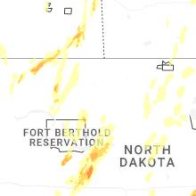
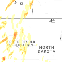
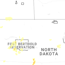


Connect with Interactive Hail Maps