

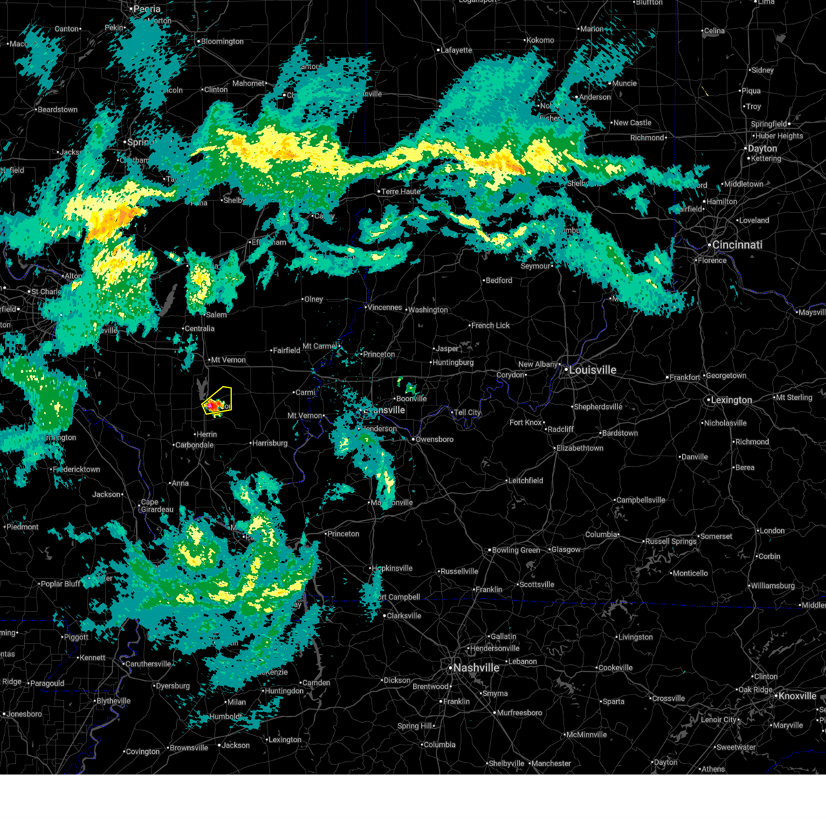
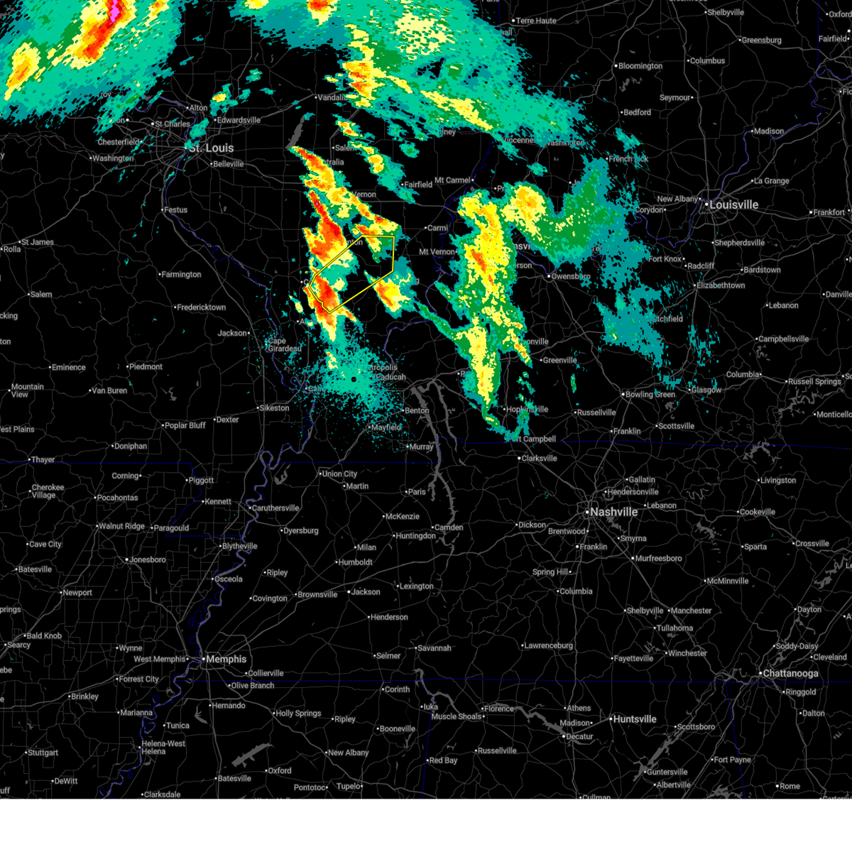
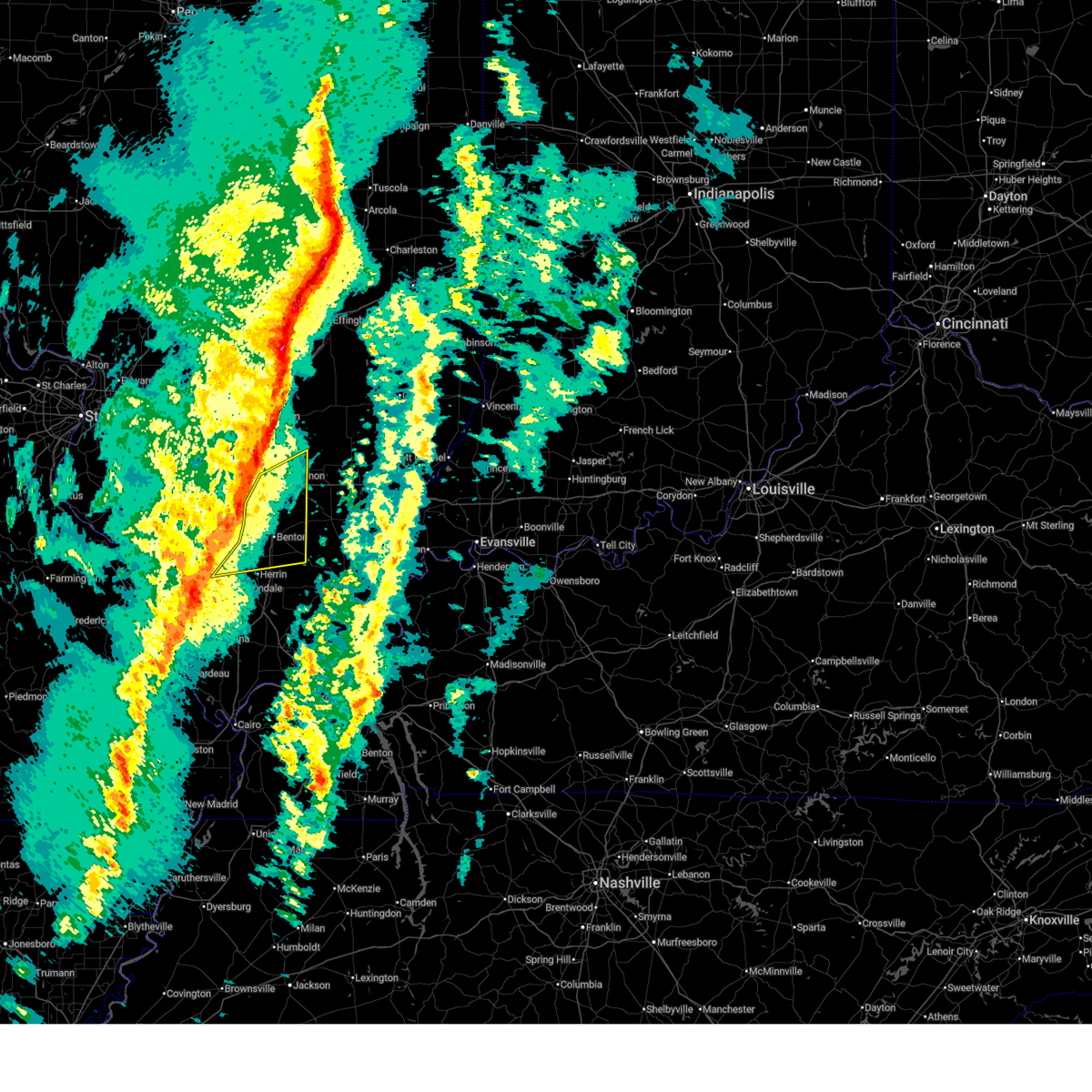
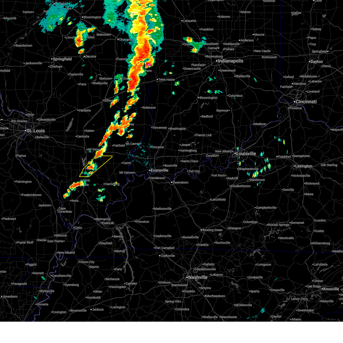
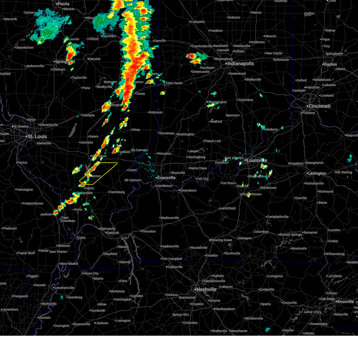
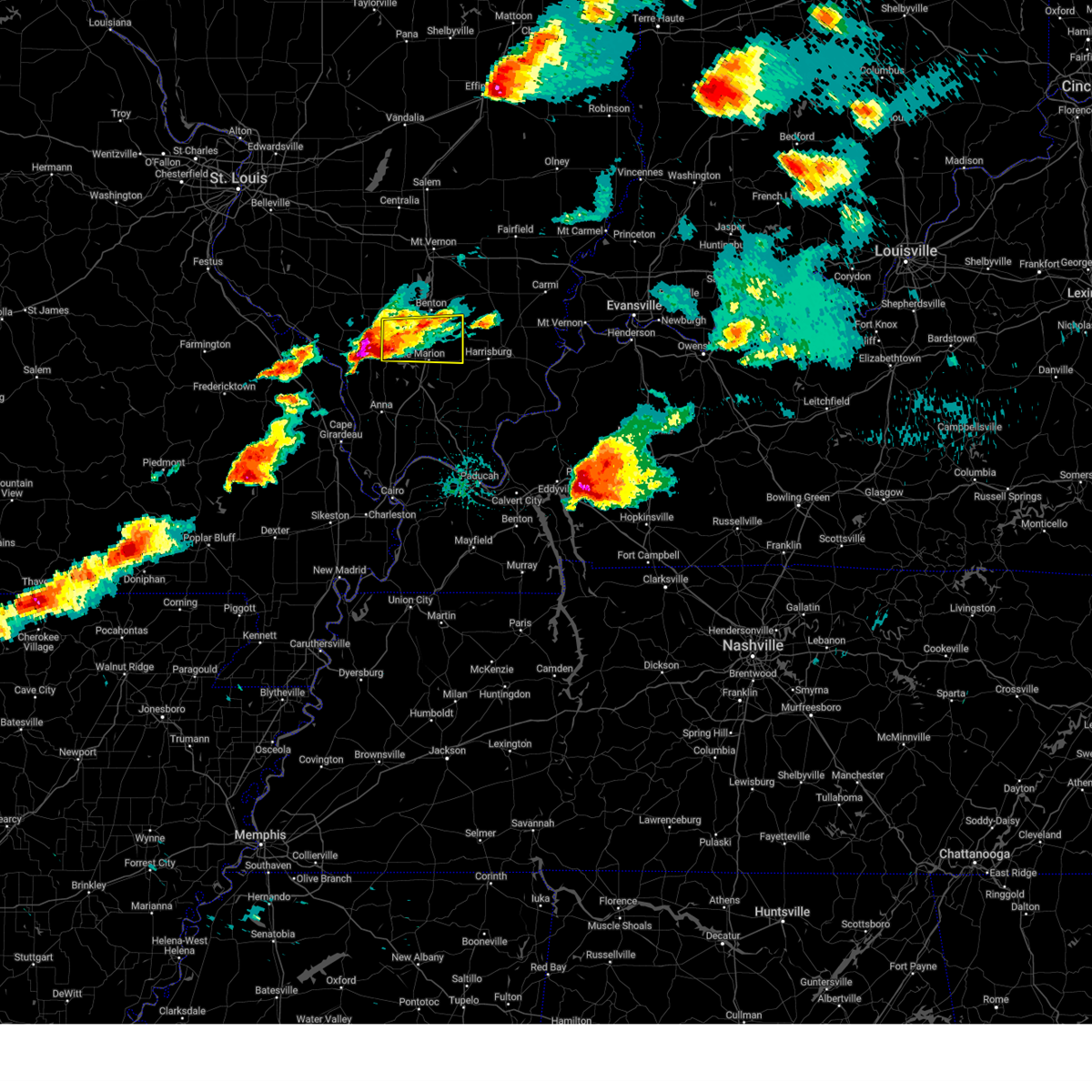
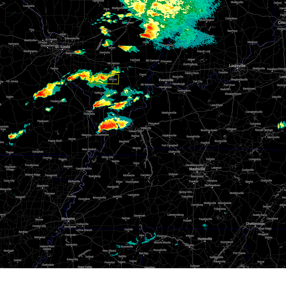
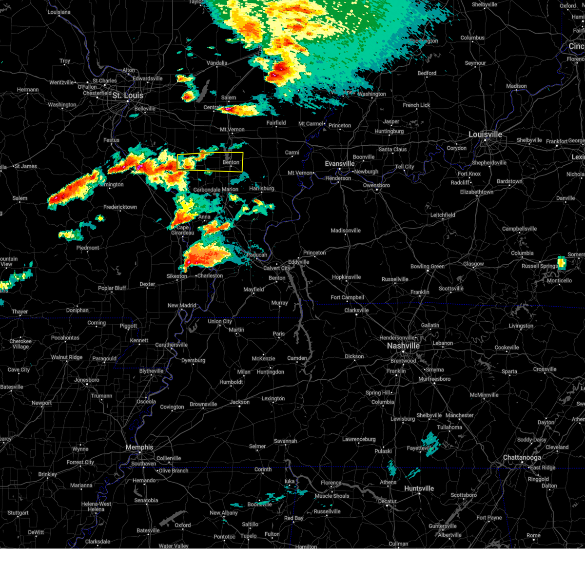
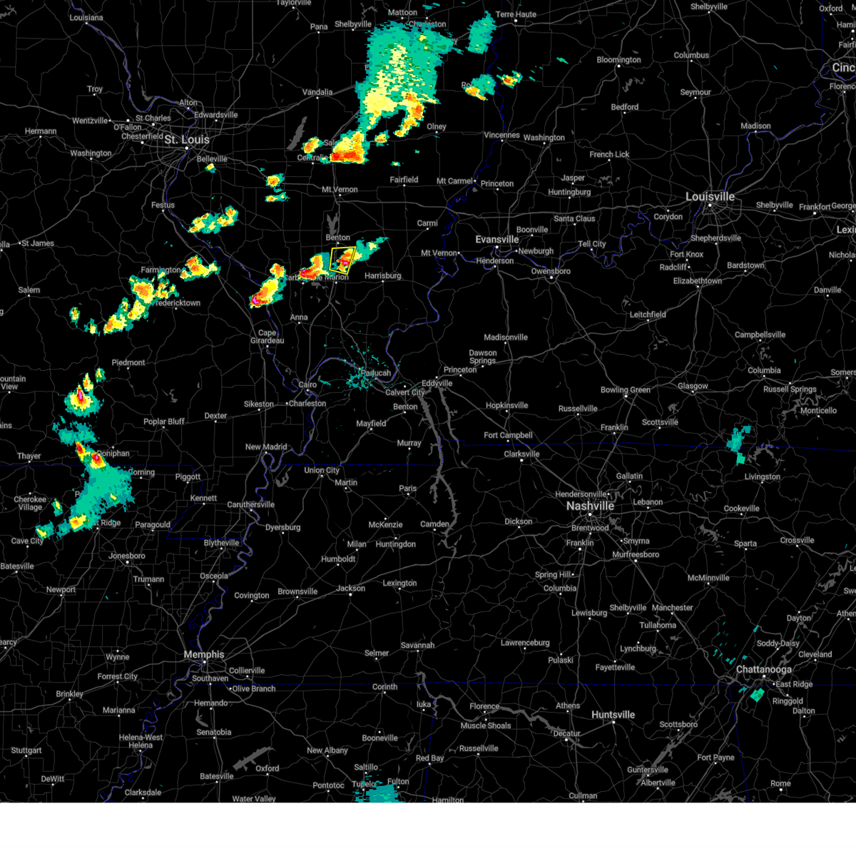
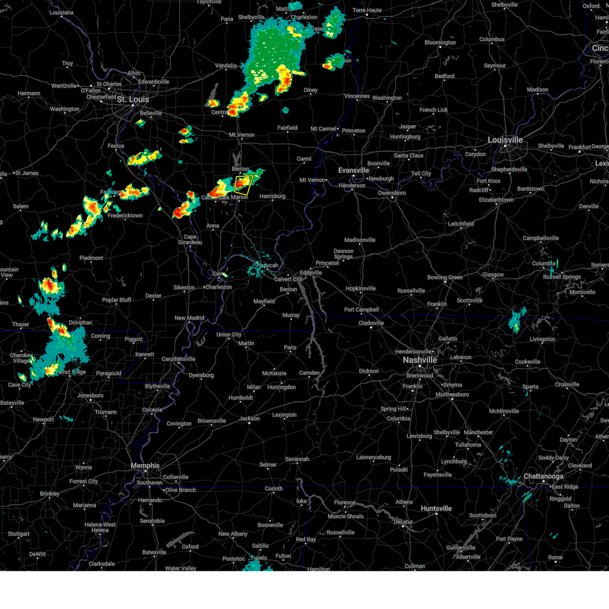
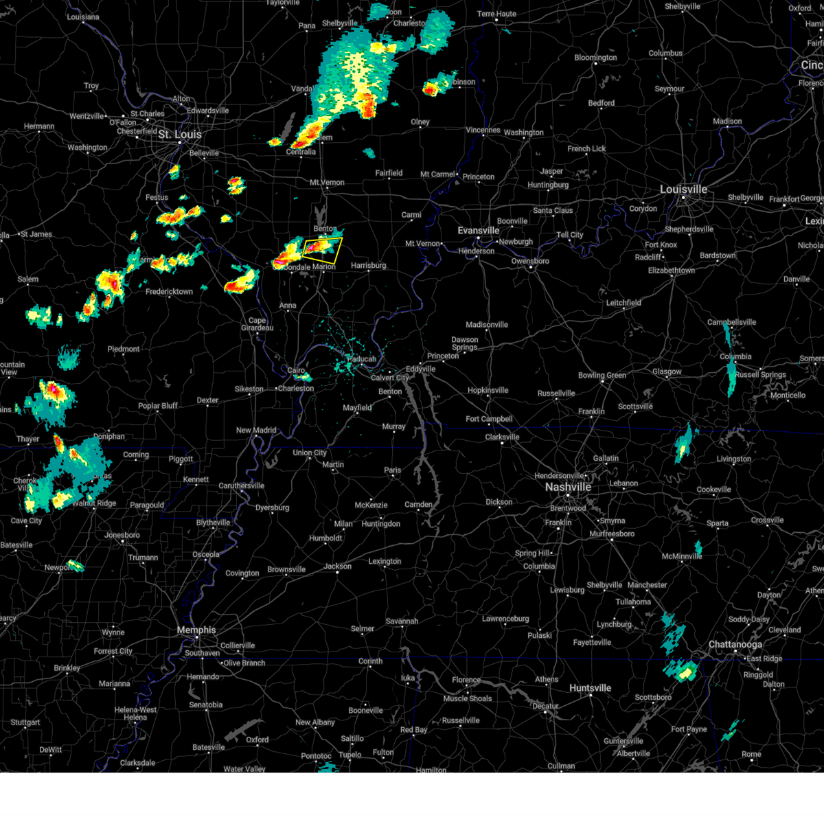
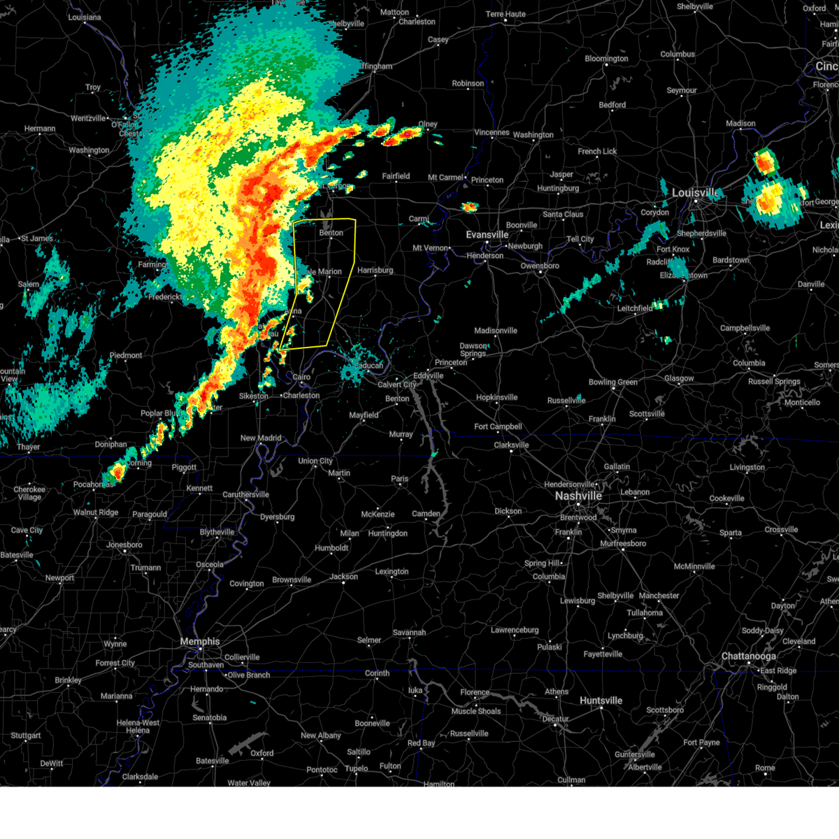
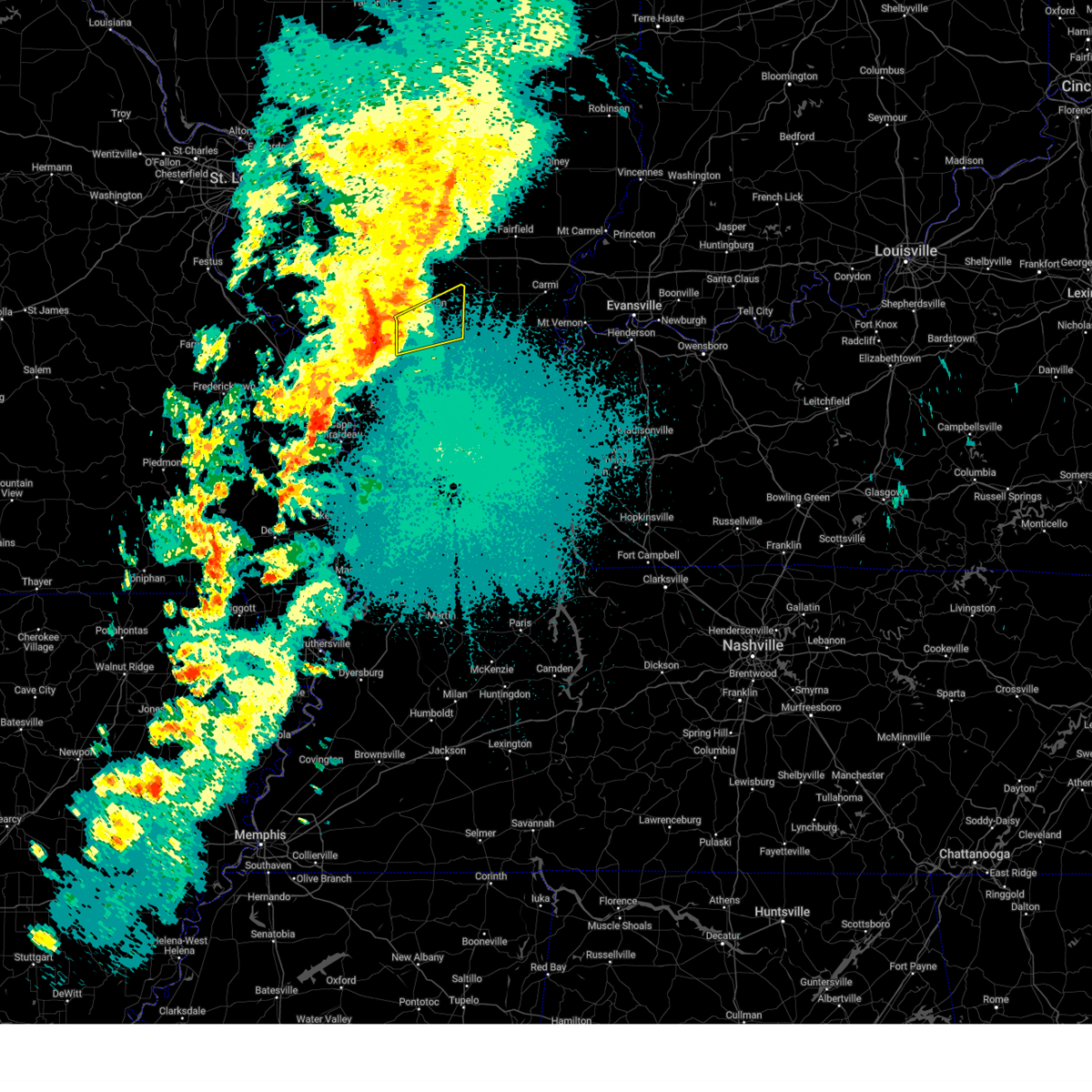
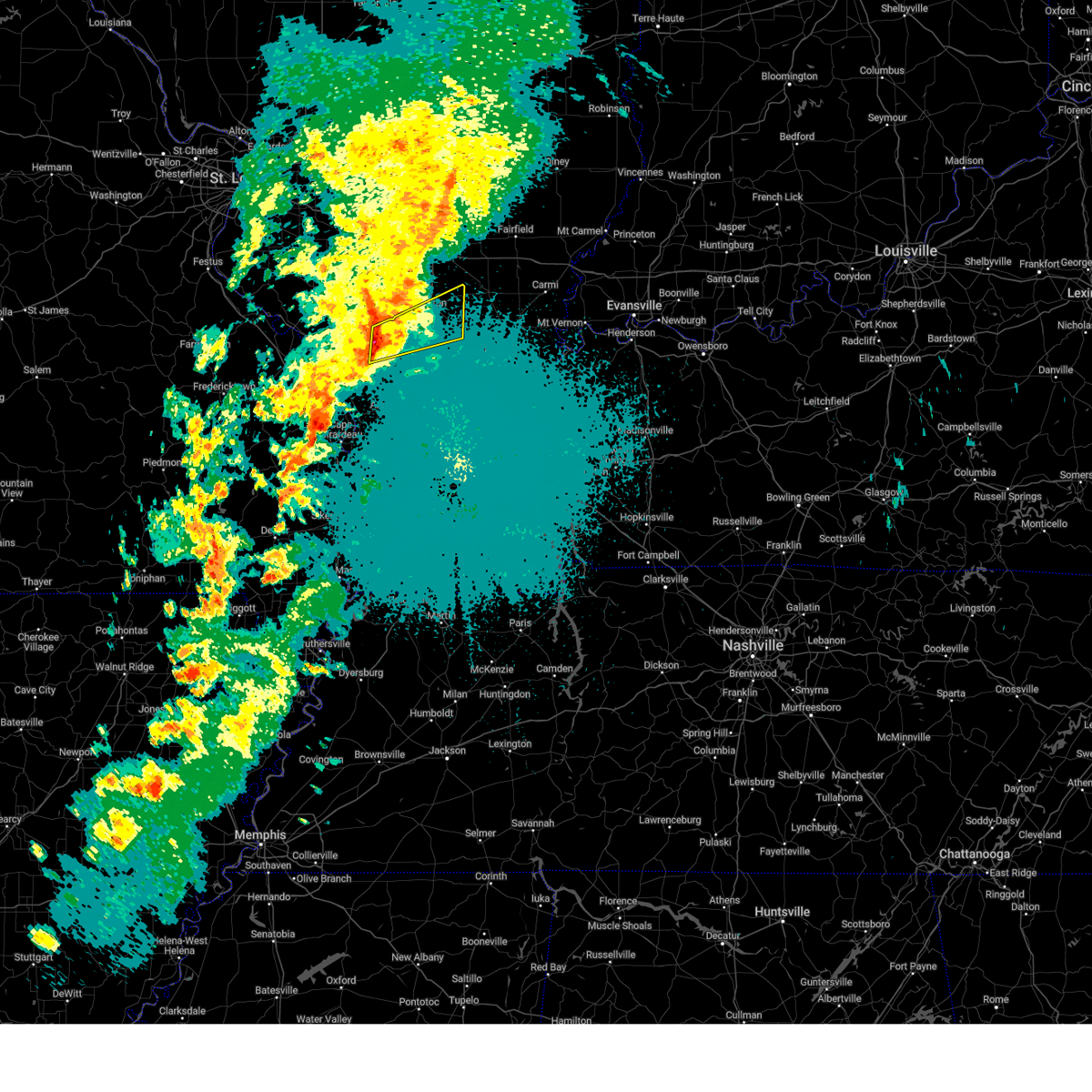
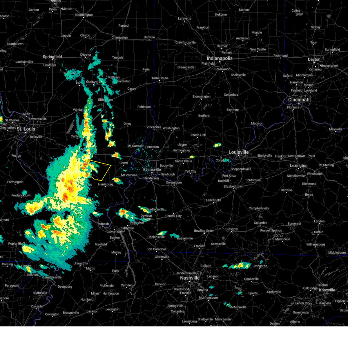
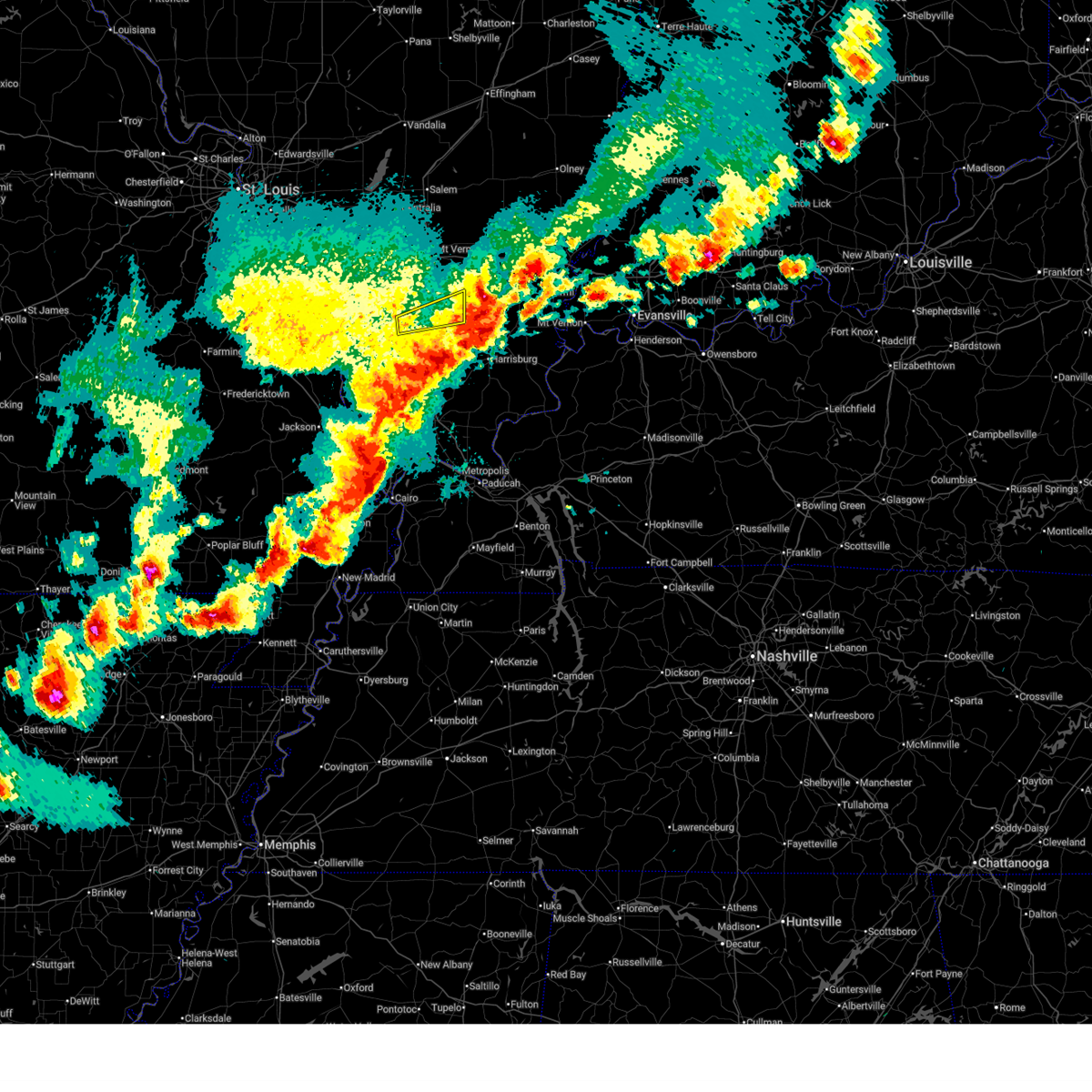
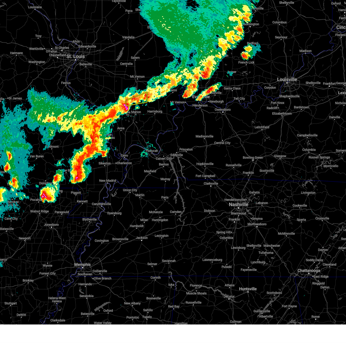
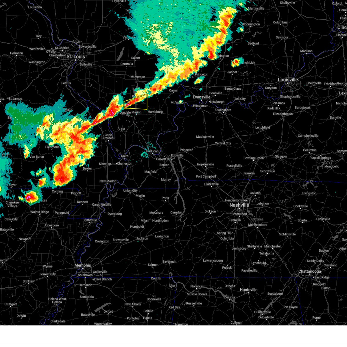
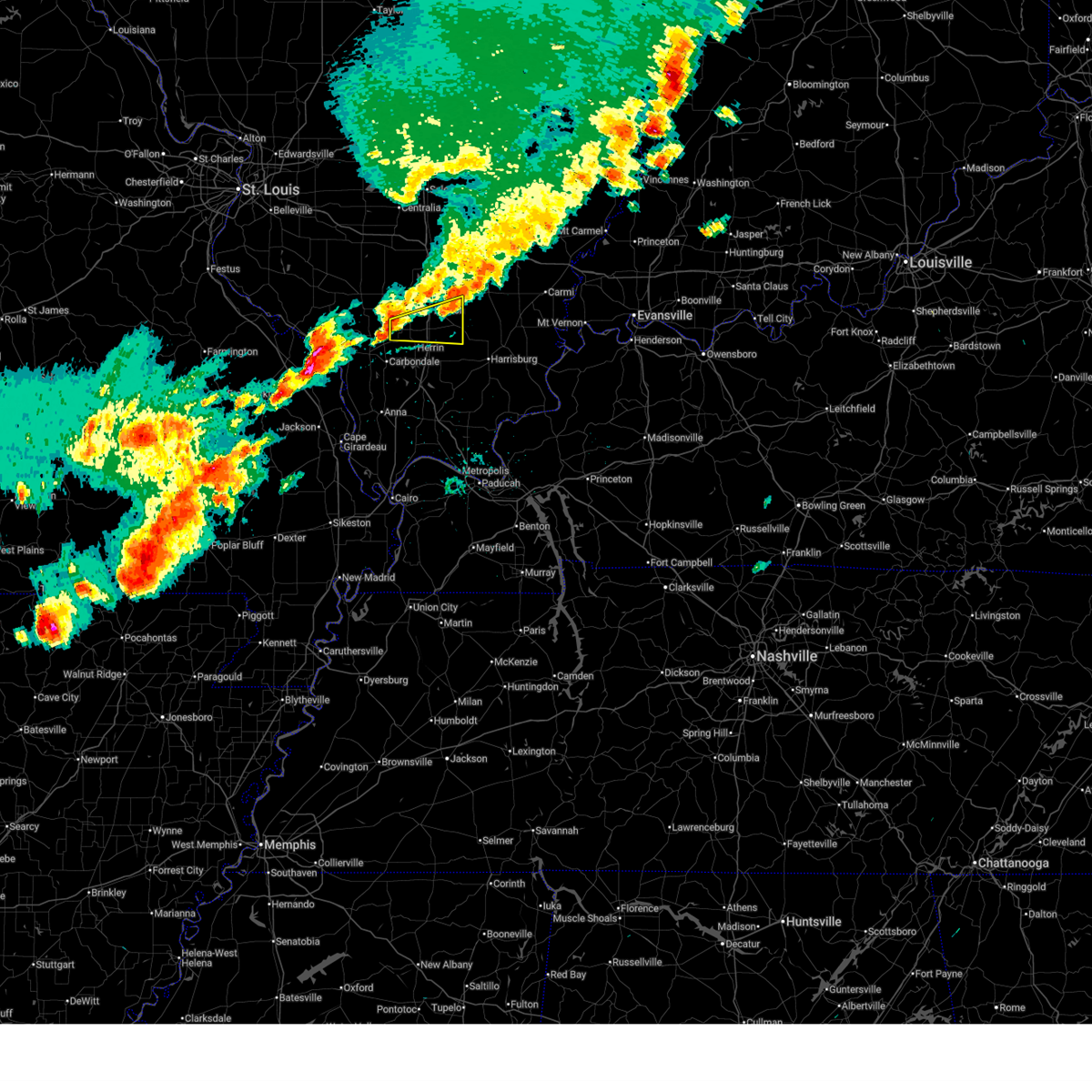
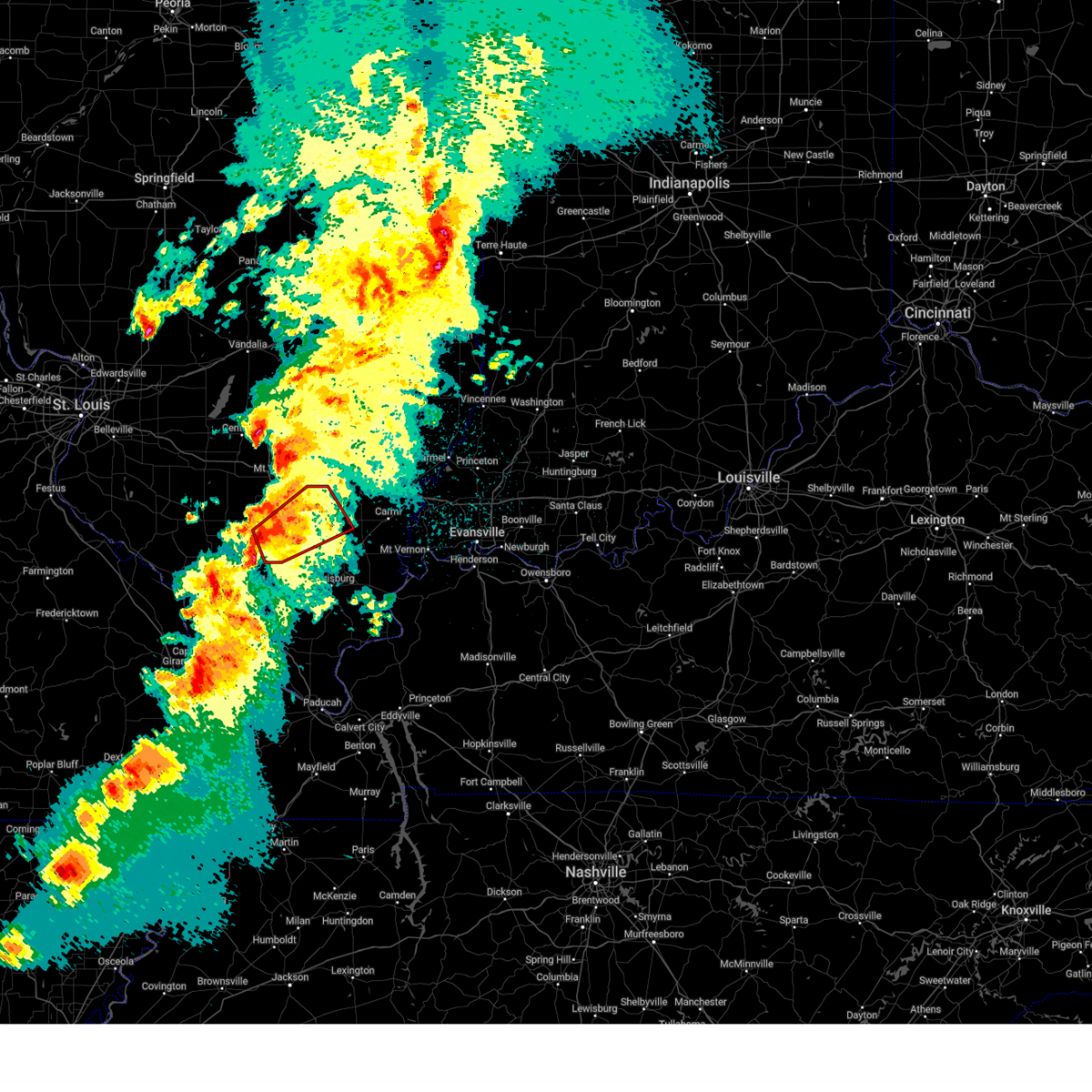
Hail Map for Hanaford, IL
The Hanaford, IL area has had 0 reports of on-the-ground hail by trained spotters, and has been under severe weather warnings 14 times during the past 12 months. Doppler radar has detected hail at or near Hanaford, IL on 65 occasions, including 3 occasions during the past year.
| Name: | Hanaford, IL |
| Where Located: | 59.5 miles NE of Cape Girardeau, MO |
| Map: | Google Map for Hanaford, IL |
| Population: | 327 |
| Housing Units: | 155 |
| More Info: | Search Google for Hanaford, IL |
1
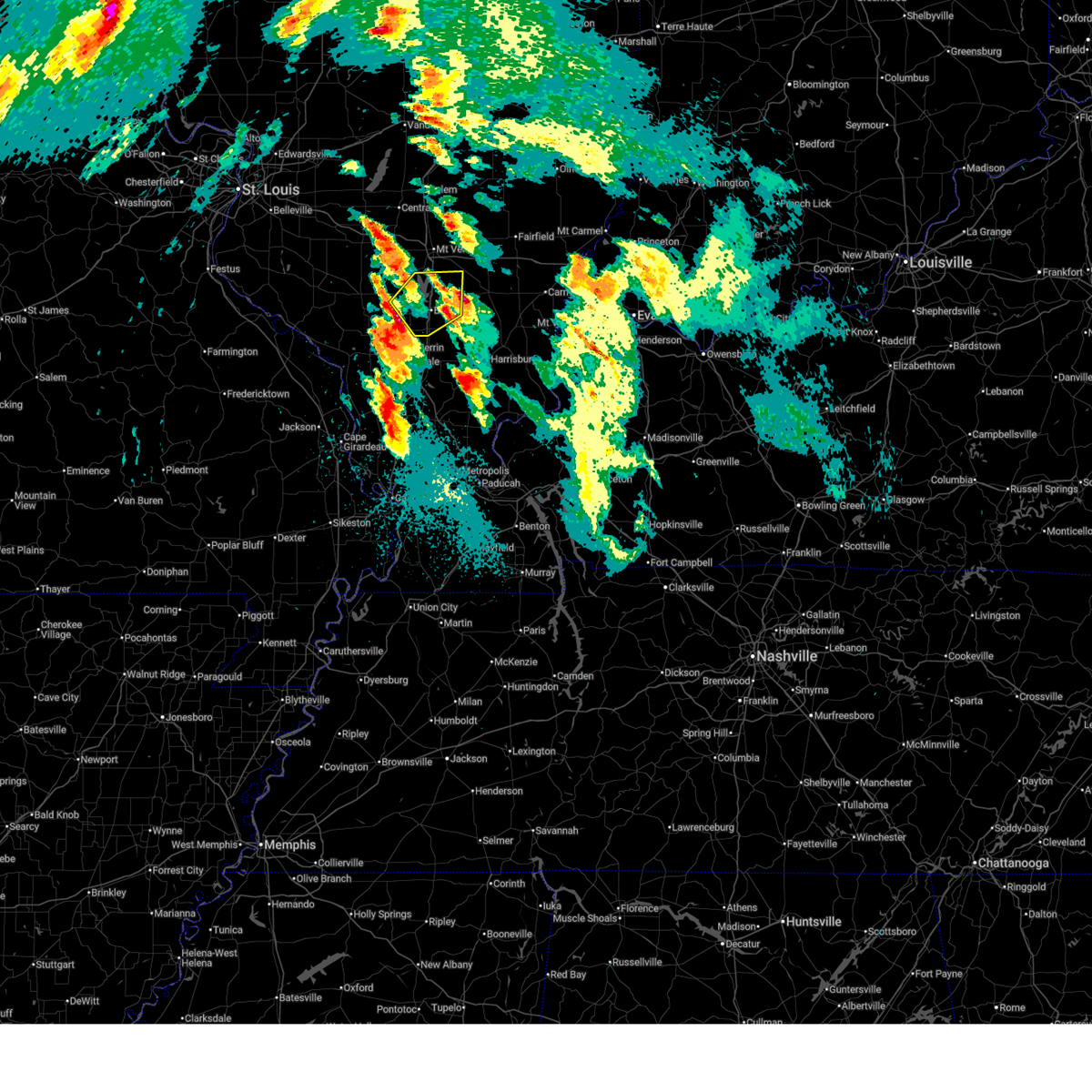
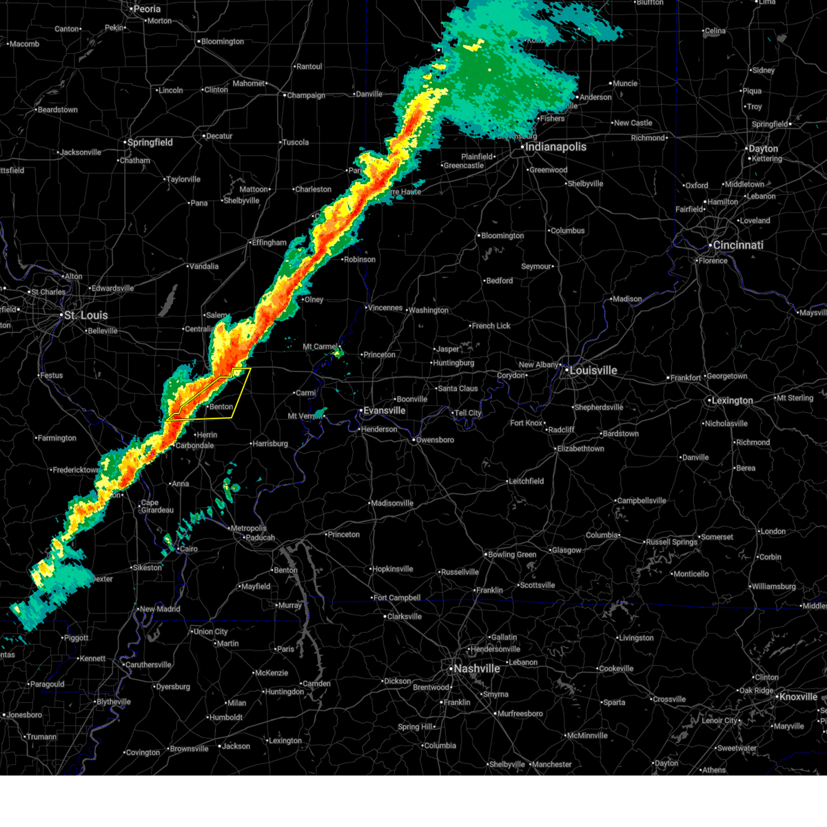
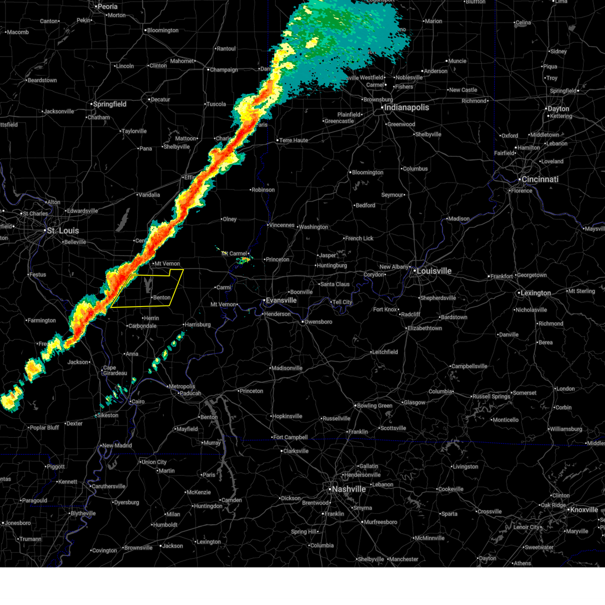
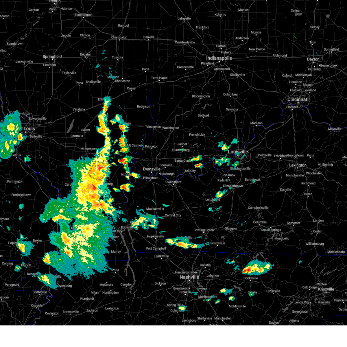
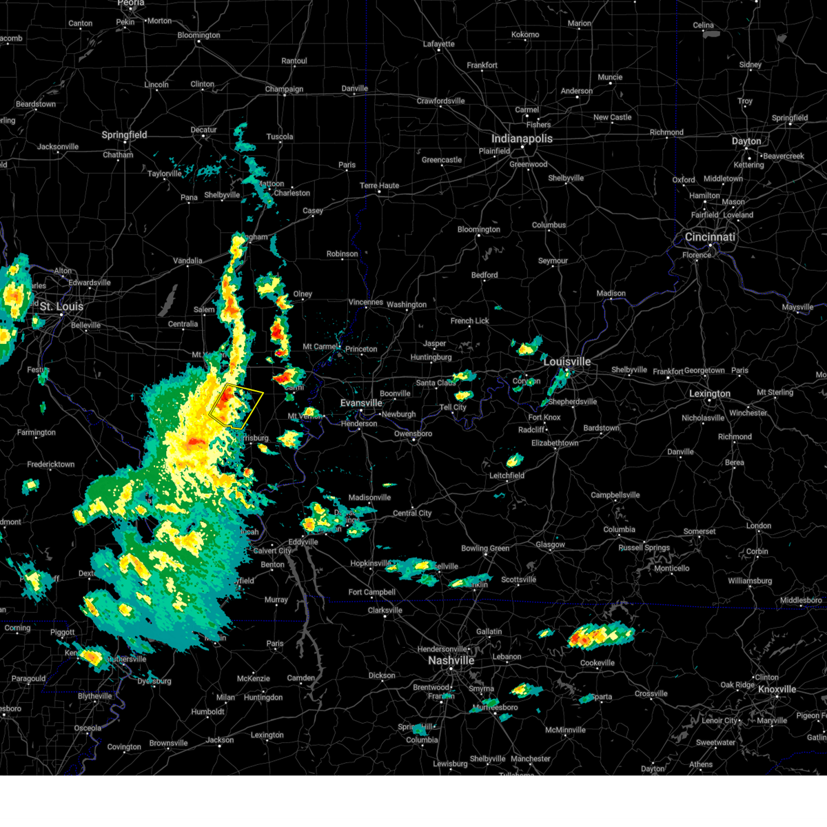
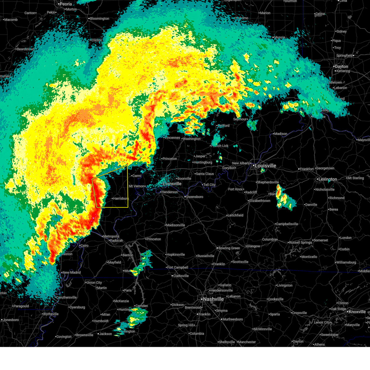
The Top Recent Hail Date for Hanaford, IL is Monday, April 27, 2026 (25th out of 65)

Hail and Wind Damage Spotted near Hanaford, IL
| Date / Time | Report Details |
|---|---|
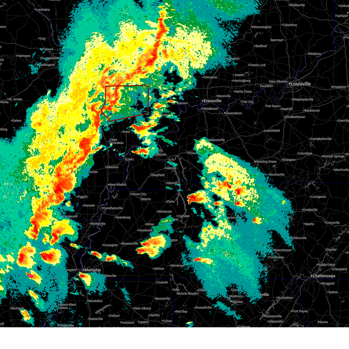
| 5/16/2026 2:10 PM CDT |
 Svrpah the national weather service in paducah has issued a * severe thunderstorm warning for, northeastern franklin county in south central illinois, * until 245 pm cdt. * at 209 pm cdt, a severe thunderstorm was located over benton, moving northeast at 20 mph (radar indicated). Hazards include 60 mph wind gusts and half dollar size hail. Hail damage to vehicles is expected. Expect wind damage to roofs, siding, and trees. Svrpah the national weather service in paducah has issued a * severe thunderstorm warning for, northeastern franklin county in south central illinois, * until 245 pm cdt. * at 209 pm cdt, a severe thunderstorm was located over benton, moving northeast at 20 mph (radar indicated). Hazards include 60 mph wind gusts and half dollar size hail. Hail damage to vehicles is expected. Expect wind damage to roofs, siding, and trees.
|
| 4/27/2026 10:09 PM CDT |
 Svrpah the national weather service in paducah has issued a * severe thunderstorm warning for, southern white county in southeastern illinois, saline county in southern illinois, southern hamilton county in south central illinois, southeastern franklin county in south central illinois, gallatin county in southern illinois, * until 1100 pm cdt. * at 1009 pm cdt, severe thunderstorms were located along a line extending from 10 miles east of rend lake area to cedar lake area, moving east at 50 mph (radar indicated). Hazards include 60 mph wind gusts and penny size hail. expect damage to roofs, siding, and trees Svrpah the national weather service in paducah has issued a * severe thunderstorm warning for, southern white county in southeastern illinois, saline county in southern illinois, southern hamilton county in south central illinois, southeastern franklin county in south central illinois, gallatin county in southern illinois, * until 1100 pm cdt. * at 1009 pm cdt, severe thunderstorms were located along a line extending from 10 miles east of rend lake area to cedar lake area, moving east at 50 mph (radar indicated). Hazards include 60 mph wind gusts and penny size hail. expect damage to roofs, siding, and trees
|
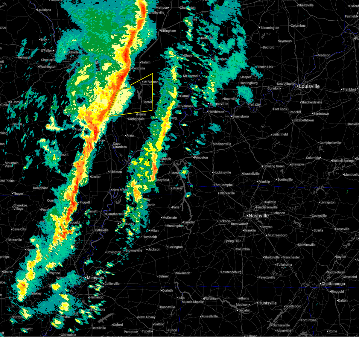
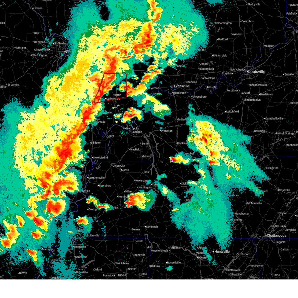
| 4/27/2026 9:33 AM CDT |
 At 933 am cdt, severe thunderstorms were located along a line extending from west frankfort to creal springs, moving northeast at 50 mph (radar indicated). Hazards include quarter size hail. Damage to vehicles is expected. Locations impacted include, marion, harrisburg, west frankfort, eldorado, johnston city, galatia, pittsburg, creal springs, thompsonville, raleigh, broughton, and muddy. At 933 am cdt, severe thunderstorms were located along a line extending from west frankfort to creal springs, moving northeast at 50 mph (radar indicated). Hazards include quarter size hail. Damage to vehicles is expected. Locations impacted include, marion, harrisburg, west frankfort, eldorado, johnston city, galatia, pittsburg, creal springs, thompsonville, raleigh, broughton, and muddy.
|
| 4/27/2026 9:26 AM CDT |
 The storms which prompted the warning have weakened below severe limits, and no longer pose an immediate threat to life or property. therefore, the warning will be allowed to expire. a severe thunderstorm watch remains in effect until 1000 am cdt for south central and southern illinois. The storms which prompted the warning have weakened below severe limits, and no longer pose an immediate threat to life or property. therefore, the warning will be allowed to expire. a severe thunderstorm watch remains in effect until 1000 am cdt for south central and southern illinois.
|
| 4/27/2026 9:16 AM CDT |
 Svrpah the national weather service in paducah has issued a * severe thunderstorm warning for, northwestern johnson county in southern illinois, williamson county in southern illinois, northern saline county in southern illinois, southern hamilton county in south central illinois, southeastern franklin county in south central illinois, * until 1000 am cdt. * at 915 am cdt, severe thunderstorms were located along a line extending from carterville to lake of egypt area, moving northeast at 50 mph (radar indicated). Hazards include quarter size hail. damage to vehicles is expected Svrpah the national weather service in paducah has issued a * severe thunderstorm warning for, northwestern johnson county in southern illinois, williamson county in southern illinois, northern saline county in southern illinois, southern hamilton county in south central illinois, southeastern franklin county in south central illinois, * until 1000 am cdt. * at 915 am cdt, severe thunderstorms were located along a line extending from carterville to lake of egypt area, moving northeast at 50 mph (radar indicated). Hazards include quarter size hail. damage to vehicles is expected
|
| 4/27/2026 9:02 AM CDT |
 At 901 am cdt, severe thunderstorms were located along a line extending from near valier to near west frankfort, moving northeast at 50 mph (trained weather spotters. at 859 am cdt, quarter size hail was reported in christopher). Hazards include quarter size hail. Damage to vehicles is expected. locations impacted include, west frankfort, benton, christopher, rend lake area, sesser, zeigler, valier, west city, ina, north city, buckner, orient, hanaford, ewing, freeman spur, and nason. This includes interstate 57 in illinois between mile markers 62 and 85. At 901 am cdt, severe thunderstorms were located along a line extending from near valier to near west frankfort, moving northeast at 50 mph (trained weather spotters. at 859 am cdt, quarter size hail was reported in christopher). Hazards include quarter size hail. Damage to vehicles is expected. locations impacted include, west frankfort, benton, christopher, rend lake area, sesser, zeigler, valier, west city, ina, north city, buckner, orient, hanaford, ewing, freeman spur, and nason. This includes interstate 57 in illinois between mile markers 62 and 85.
|
| 4/27/2026 8:44 AM CDT |
 Svrpah the national weather service in paducah has issued a * severe thunderstorm warning for, southeastern perry county in south central illinois, southeastern jefferson county in south central illinois, northwestern williamson county in southern illinois, northeastern jackson county in southern illinois, franklin county in south central illinois, * until 930 am cdt. * at 843 am cdt, severe thunderstorms were located along a line extending from near elkville to near carbondale, moving northeast at 55 mph (emergency management. at 841 am cdt quarter size hail was reported in murphysboro). Hazards include quarter size hail. damage to vehicles is expected Svrpah the national weather service in paducah has issued a * severe thunderstorm warning for, southeastern perry county in south central illinois, southeastern jefferson county in south central illinois, northwestern williamson county in southern illinois, northeastern jackson county in southern illinois, franklin county in south central illinois, * until 930 am cdt. * at 843 am cdt, severe thunderstorms were located along a line extending from near elkville to near carbondale, moving northeast at 55 mph (emergency management. at 841 am cdt quarter size hail was reported in murphysboro). Hazards include quarter size hail. damage to vehicles is expected
|
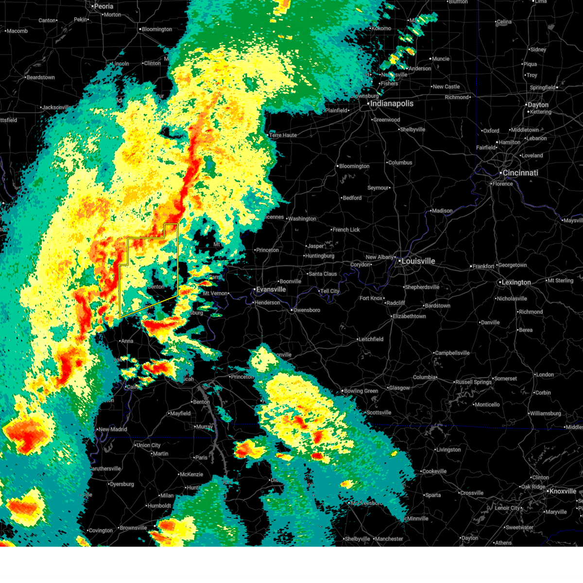
| 3/15/2026 7:14 PM CDT |
 The storms which prompted the warning have weakened below severe limits, and no longer pose an immediate threat to life or property. therefore, the warning will be allowed to expire. a tornado watch remains in effect until 1100 pm cdt for south central and southern illinois. The storms which prompted the warning have weakened below severe limits, and no longer pose an immediate threat to life or property. therefore, the warning will be allowed to expire. a tornado watch remains in effect until 1100 pm cdt for south central and southern illinois.
|
| 3/15/2026 7:03 PM CDT |
 the severe thunderstorm warning has been cancelled and is no longer in effect the severe thunderstorm warning has been cancelled and is no longer in effect
|
| 3/15/2026 7:03 PM CDT |
 At 702 pm cdt, severe thunderstorms were located along a line extending from near mount vernon to near sesser to near de soto, moving east at 45 mph (radar indicated). Hazards include 60 mph wind gusts. Expect damage to roofs, siding, and trees. locations impacted include, mount vernon, herrin, west frankfort, benton, christopher, rend lake area, sesser, zeigler, de soto, royalton, hurst, bluford, valier, west city, thompsonville, ina, north city, buckner, waltonville, and bonnie. this includes the following highways, interstate 57 in illinois between mile markers 61 and 96. Interstate 64 in illinois between mile markers 74 and 90. At 702 pm cdt, severe thunderstorms were located along a line extending from near mount vernon to near sesser to near de soto, moving east at 45 mph (radar indicated). Hazards include 60 mph wind gusts. Expect damage to roofs, siding, and trees. locations impacted include, mount vernon, herrin, west frankfort, benton, christopher, rend lake area, sesser, zeigler, de soto, royalton, hurst, bluford, valier, west city, thompsonville, ina, north city, buckner, waltonville, and bonnie. this includes the following highways, interstate 57 in illinois between mile markers 61 and 96. Interstate 64 in illinois between mile markers 74 and 90.
|
| 3/15/2026 6:36 PM CDT |
 Svrpah the national weather service in paducah has issued a * severe thunderstorm warning for, perry county in south central illinois, jefferson county in south central illinois, northern williamson county in southern illinois, northern jackson county in southern illinois, franklin county in south central illinois, * until 715 pm cdt. * at 636 pm cdt, severe thunderstorms were located along a line extending from 6 miles northwest of tamaroa to 7 miles southwest of ava, moving east at 65 mph (radar indicated). Hazards include 60 mph wind gusts. expect damage to roofs, siding, and trees Svrpah the national weather service in paducah has issued a * severe thunderstorm warning for, perry county in south central illinois, jefferson county in south central illinois, northern williamson county in southern illinois, northern jackson county in southern illinois, franklin county in south central illinois, * until 715 pm cdt. * at 636 pm cdt, severe thunderstorms were located along a line extending from 6 miles northwest of tamaroa to 7 miles southwest of ava, moving east at 65 mph (radar indicated). Hazards include 60 mph wind gusts. expect damage to roofs, siding, and trees
|
| 12/28/2025 5:25 PM CST |
 the severe thunderstorm warning has been cancelled and is no longer in effect the severe thunderstorm warning has been cancelled and is no longer in effect
|
| 12/28/2025 5:25 PM CST |
 At 525 pm cst, severe thunderstorms were located along a line extending from near bluford to near zeigler, moving east at 50 mph (radar indicated). Hazards include 60 mph wind gusts. Expect damage to roofs, siding, and trees. locations impacted include, west frankfort, benton, christopher, rend lake area, zeigler, elkville, valier, west city, thompsonville, north city, dahlgren, buckner, orient, hanaford, ewing, macedonia, and belle prairie city. This includes interstate 57 in illinois between mile markers 66 and 81. At 525 pm cst, severe thunderstorms were located along a line extending from near bluford to near zeigler, moving east at 50 mph (radar indicated). Hazards include 60 mph wind gusts. Expect damage to roofs, siding, and trees. locations impacted include, west frankfort, benton, christopher, rend lake area, zeigler, elkville, valier, west city, thompsonville, north city, dahlgren, buckner, orient, hanaford, ewing, macedonia, and belle prairie city. This includes interstate 57 in illinois between mile markers 66 and 81.
|
| 12/28/2025 5:01 PM CST |
 Svrpah the national weather service in paducah has issued a * severe thunderstorm warning for, eastern perry county in south central illinois, southern jefferson county in south central illinois, northeastern jackson county in southern illinois, northwestern hamilton county in south central illinois, franklin county in south central illinois, * until 545 pm cst. * at 501 pm cst, severe thunderstorms were located along a line extending from 7 miles south of woodlawn to 6 miles west of elkville, moving east at 50 mph (radar indicated). Hazards include 60 mph wind gusts. expect damage to roofs, siding, and trees Svrpah the national weather service in paducah has issued a * severe thunderstorm warning for, eastern perry county in south central illinois, southern jefferson county in south central illinois, northeastern jackson county in southern illinois, northwestern hamilton county in south central illinois, franklin county in south central illinois, * until 545 pm cst. * at 501 pm cst, severe thunderstorms were located along a line extending from 7 miles south of woodlawn to 6 miles west of elkville, moving east at 50 mph (radar indicated). Hazards include 60 mph wind gusts. expect damage to roofs, siding, and trees
|
| 6/18/2025 1:23 PM CDT |
 At 123 pm cdt, a severe thunderstorm was located near benton, moving northeast at 45 mph (radar indicated). Hazards include 60 mph wind gusts and quarter size hail. Hail damage to vehicles is expected. expect wind damage to roofs, siding, and trees. locations impacted include, west frankfort, benton, mcleansboro, west city, thompsonville, dahlgren, orient, hanaford, ewing, freeman spur, and macedonia. This includes interstate 57 in illinois between mile markers 62 and 74. At 123 pm cdt, a severe thunderstorm was located near benton, moving northeast at 45 mph (radar indicated). Hazards include 60 mph wind gusts and quarter size hail. Hail damage to vehicles is expected. expect wind damage to roofs, siding, and trees. locations impacted include, west frankfort, benton, mcleansboro, west city, thompsonville, dahlgren, orient, hanaford, ewing, freeman spur, and macedonia. This includes interstate 57 in illinois between mile markers 62 and 74.
|
| 6/18/2025 1:07 PM CDT |
 Svrpah the national weather service in paducah has issued a * severe thunderstorm warning for, southeastern jefferson county in south central illinois, northern hamilton county in south central illinois, franklin county in south central illinois, * until 145 pm cdt. * at 107 pm cdt, a severe thunderstorm was located near west frankfort, moving northeast at 45 mph (radar indicated). Hazards include 60 mph wind gusts and quarter size hail. Hail damage to vehicles is expected. Expect wind damage to roofs, siding, and trees. Svrpah the national weather service in paducah has issued a * severe thunderstorm warning for, southeastern jefferson county in south central illinois, northern hamilton county in south central illinois, franklin county in south central illinois, * until 145 pm cdt. * at 107 pm cdt, a severe thunderstorm was located near west frankfort, moving northeast at 45 mph (radar indicated). Hazards include 60 mph wind gusts and quarter size hail. Hail damage to vehicles is expected. Expect wind damage to roofs, siding, and trees.
|
| 5/16/2025 6:07 PM CDT |
 Svrpah the national weather service in paducah has issued a * severe thunderstorm warning for, northern williamson county in southern illinois, northeastern jackson county in southern illinois, southern franklin county in south central illinois, * until 645 pm cdt. * at 606 pm cdt, a severe thunderstorm was located over de soto, or near carbondale, moving east at 50 mph (radar indicated. ping pong ball sized hail has also been reported near murphysboro). Hazards include two inch hail and 60 mph wind gusts. People and animals outdoors will be injured. expect hail damage to roofs, siding, windows, and vehicles. Expect wind damage to roofs, siding, and trees. Svrpah the national weather service in paducah has issued a * severe thunderstorm warning for, northern williamson county in southern illinois, northeastern jackson county in southern illinois, southern franklin county in south central illinois, * until 645 pm cdt. * at 606 pm cdt, a severe thunderstorm was located over de soto, or near carbondale, moving east at 50 mph (radar indicated. ping pong ball sized hail has also been reported near murphysboro). Hazards include two inch hail and 60 mph wind gusts. People and animals outdoors will be injured. expect hail damage to roofs, siding, windows, and vehicles. Expect wind damage to roofs, siding, and trees.
|
| 5/16/2025 4:40 PM CDT |
 the severe thunderstorm warning has been cancelled and is no longer in effect the severe thunderstorm warning has been cancelled and is no longer in effect
|
| 5/16/2025 4:34 PM CDT |
 At 433 pm cdt, a severe thunderstorm was located near du quoin, moving east at 60 mph (radar indicated). Hazards include 60 mph wind gusts and quarter size hail. Hail damage to vehicles is expected. expect wind damage to roofs, siding, and trees. locations impacted include, benton, du quoin, pinckneyville, christopher, rend lake area, sesser, valier, west city, north city, buckner, hanaford, ewing, and st. johns. This includes interstate 57 in illinois between mile markers 68 and 81. At 433 pm cdt, a severe thunderstorm was located near du quoin, moving east at 60 mph (radar indicated). Hazards include 60 mph wind gusts and quarter size hail. Hail damage to vehicles is expected. expect wind damage to roofs, siding, and trees. locations impacted include, benton, du quoin, pinckneyville, christopher, rend lake area, sesser, valier, west city, north city, buckner, hanaford, ewing, and st. johns. This includes interstate 57 in illinois between mile markers 68 and 81.
|
| 5/16/2025 4:23 PM CDT |
 Svrpah the national weather service in paducah has issued a * severe thunderstorm warning for, perry county in south central illinois, northern franklin county in south central illinois, * until 515 pm cdt. * at 423 pm cdt, a severe thunderstorm was located near willisville, or 9 miles southwest of pinckneyville, moving east at 70 mph (radar indicated). Hazards include ping pong ball size hail and 60 mph wind gusts. People and animals outdoors will be injured. expect hail damage to roofs, siding, windows, and vehicles. Expect wind damage to roofs, siding, and trees. Svrpah the national weather service in paducah has issued a * severe thunderstorm warning for, perry county in south central illinois, northern franklin county in south central illinois, * until 515 pm cdt. * at 423 pm cdt, a severe thunderstorm was located near willisville, or 9 miles southwest of pinckneyville, moving east at 70 mph (radar indicated). Hazards include ping pong ball size hail and 60 mph wind gusts. People and animals outdoors will be injured. expect hail damage to roofs, siding, windows, and vehicles. Expect wind damage to roofs, siding, and trees.
|
| 5/1/2025 6:11 PM CDT |
 the severe thunderstorm warning has been cancelled and is no longer in effect the severe thunderstorm warning has been cancelled and is no longer in effect
|
| 5/1/2025 5:57 PM CDT |
 At 557 pm cdt, a severe thunderstorm was located over west frankfort, moving east at 20 mph (radar indicated). Hazards include 60 mph wind gusts and quarter size hail. Hail damage to vehicles is expected. expect wind damage to roofs, siding, and trees. locations impacted include, west frankfort, johnston city, orient, and hanaford. This includes interstate 57 in illinois between mile markers 59 and 69. At 557 pm cdt, a severe thunderstorm was located over west frankfort, moving east at 20 mph (radar indicated). Hazards include 60 mph wind gusts and quarter size hail. Hail damage to vehicles is expected. expect wind damage to roofs, siding, and trees. locations impacted include, west frankfort, johnston city, orient, and hanaford. This includes interstate 57 in illinois between mile markers 59 and 69.
|
| 5/1/2025 5:43 PM CDT |
 Svrpah the national weather service in paducah has issued a * severe thunderstorm warning for, northwestern williamson county in southern illinois, southern franklin county in south central illinois, * until 630 pm cdt. * at 543 pm cdt, a severe thunderstorm was located over zeigler, or near christopher, moving east at 20 mph (radar indicated). Hazards include 60 mph wind gusts and quarter size hail. Hail damage to vehicles is expected. Expect wind damage to roofs, siding, and trees. Svrpah the national weather service in paducah has issued a * severe thunderstorm warning for, northwestern williamson county in southern illinois, southern franklin county in south central illinois, * until 630 pm cdt. * at 543 pm cdt, a severe thunderstorm was located over zeigler, or near christopher, moving east at 20 mph (radar indicated). Hazards include 60 mph wind gusts and quarter size hail. Hail damage to vehicles is expected. Expect wind damage to roofs, siding, and trees.
|
| 4/29/2025 2:03 PM CDT |
 Svrpah the national weather service in paducah has issued a * severe thunderstorm warning for, southeastern perry county in south central illinois, eastern union county in southern illinois, northern pulaski county in southern illinois, western johnson county in southern illinois, williamson county in southern illinois, eastern jackson county in southern illinois, north central alexander county in southern illinois, franklin county in south central illinois, * until 245 pm cdt. * at 202 pm cdt, severe thunderstorms were located along a line extending from du quoin to near carbondale to near scott city, moving east at 40 mph (radar indicated). Hazards include 60 mph wind gusts. expect damage to roofs, siding, and trees Svrpah the national weather service in paducah has issued a * severe thunderstorm warning for, southeastern perry county in south central illinois, eastern union county in southern illinois, northern pulaski county in southern illinois, western johnson county in southern illinois, williamson county in southern illinois, eastern jackson county in southern illinois, north central alexander county in southern illinois, franklin county in south central illinois, * until 245 pm cdt. * at 202 pm cdt, severe thunderstorms were located along a line extending from du quoin to near carbondale to near scott city, moving east at 40 mph (radar indicated). Hazards include 60 mph wind gusts. expect damage to roofs, siding, and trees
|
| 4/20/2025 10:16 PM CDT |
 the severe thunderstorm warning has been cancelled and is no longer in effect the severe thunderstorm warning has been cancelled and is no longer in effect
|
| 4/20/2025 10:16 PM CDT |
 At 1016 pm cdt, a severe thunderstorm was located over benton, moving northeast at 60 mph (radar indicated). Hazards include 60 mph wind gusts. Expect damage to roofs, siding, and trees. locations impacted include, zeigler, west frankfort, orient, thompsonville, west city, buckner, macedonia, benton, hanaford, and christopher. This includes interstate 57 in illinois between mile markers 63 and 74. At 1016 pm cdt, a severe thunderstorm was located over benton, moving northeast at 60 mph (radar indicated). Hazards include 60 mph wind gusts. Expect damage to roofs, siding, and trees. locations impacted include, zeigler, west frankfort, orient, thompsonville, west city, buckner, macedonia, benton, hanaford, and christopher. This includes interstate 57 in illinois between mile markers 63 and 74.
|
| 4/20/2025 10:07 PM CDT |
 At 1006 pm cdt, a severe thunderstorm was located over zeigler, or near christopher, moving northeast at 60 mph (radar indicated). Hazards include 60 mph wind gusts. Expect damage to roofs, siding, and trees. locations impacted include, cambria, christopher, west frankfort, herrin, orient, west city, north city, buckner, benton, hanaford, hurst, freeman spur, johnston city, colp, zeigler, royalton, thompsonville, bush, macedonia, and carterville. This includes interstate 57 in illinois between mile markers 58 and 75. At 1006 pm cdt, a severe thunderstorm was located over zeigler, or near christopher, moving northeast at 60 mph (radar indicated). Hazards include 60 mph wind gusts. Expect damage to roofs, siding, and trees. locations impacted include, cambria, christopher, west frankfort, herrin, orient, west city, north city, buckner, benton, hanaford, hurst, freeman spur, johnston city, colp, zeigler, royalton, thompsonville, bush, macedonia, and carterville. This includes interstate 57 in illinois between mile markers 58 and 75.
|
| 4/20/2025 10:07 PM CDT |
 the severe thunderstorm warning has been cancelled and is no longer in effect the severe thunderstorm warning has been cancelled and is no longer in effect
|
| 4/20/2025 9:54 PM CDT |
 Svrpah the national weather service in paducah has issued a * severe thunderstorm warning for, northern williamson county in southern illinois, northeastern jackson county in southern illinois, franklin county in south central illinois, * until 1030 pm cdt. * at 954 pm cdt, a severe thunderstorm was located over de soto, or near murphysboro, moving northeast at 60 mph (radar indicated). Hazards include 60 mph wind gusts. expect damage to roofs, siding, and trees Svrpah the national weather service in paducah has issued a * severe thunderstorm warning for, northern williamson county in southern illinois, northeastern jackson county in southern illinois, franklin county in south central illinois, * until 1030 pm cdt. * at 954 pm cdt, a severe thunderstorm was located over de soto, or near murphysboro, moving northeast at 60 mph (radar indicated). Hazards include 60 mph wind gusts. expect damage to roofs, siding, and trees
|
| 4/10/2025 2:35 PM CDT |
 the severe thunderstorm warning has been cancelled and is no longer in effect the severe thunderstorm warning has been cancelled and is no longer in effect
|
| 4/10/2025 2:22 PM CDT |
 At 222 pm cdt, a severe thunderstorm was located 9 miles north of thompsonville, or 9 miles west of mcleansboro, moving east at 30 mph (radar indicated). Hazards include 60 mph wind gusts and quarter size hail. Hail damage to vehicles is expected. expect wind damage to roofs, siding, and trees. Locations impacted include, macedonia, hanaford, mcleansboro, and thompsonville. At 222 pm cdt, a severe thunderstorm was located 9 miles north of thompsonville, or 9 miles west of mcleansboro, moving east at 30 mph (radar indicated). Hazards include 60 mph wind gusts and quarter size hail. Hail damage to vehicles is expected. expect wind damage to roofs, siding, and trees. Locations impacted include, macedonia, hanaford, mcleansboro, and thompsonville.
|
| 4/10/2025 2:05 PM CDT |
 Svrpah the national weather service in paducah has issued a * severe thunderstorm warning for, southeastern jefferson county in south central illinois, northwestern saline county in southern illinois, southern hamilton county in south central illinois, eastern franklin county in south central illinois, * until 245 pm cdt. * at 204 pm cdt, a severe thunderstorm was located near benton, moving southeast at 30 mph (radar indicated). Hazards include 60 mph wind gusts and quarter size hail. Hail damage to vehicles is expected. Expect wind damage to roofs, siding, and trees. Svrpah the national weather service in paducah has issued a * severe thunderstorm warning for, southeastern jefferson county in south central illinois, northwestern saline county in southern illinois, southern hamilton county in south central illinois, eastern franklin county in south central illinois, * until 245 pm cdt. * at 204 pm cdt, a severe thunderstorm was located near benton, moving southeast at 30 mph (radar indicated). Hazards include 60 mph wind gusts and quarter size hail. Hail damage to vehicles is expected. Expect wind damage to roofs, siding, and trees.
|
| 4/4/2025 9:24 PM CDT |
 Svrpah the national weather service in paducah has issued a * severe thunderstorm warning for, western white county in southeastern illinois, eastern williamson county in southern illinois, saline county in southern illinois, hamilton county in south central illinois, eastern franklin county in south central illinois, western gallatin county in southern illinois, * until 1015 pm cdt. * at 924 pm cdt, severe thunderstorms were located along a line extending from near benton to near creal springs, moving east at 40 mph (radar indicated). Hazards include 60 mph wind gusts. expect damage to roofs, siding, and trees Svrpah the national weather service in paducah has issued a * severe thunderstorm warning for, western white county in southeastern illinois, eastern williamson county in southern illinois, saline county in southern illinois, hamilton county in south central illinois, eastern franklin county in south central illinois, western gallatin county in southern illinois, * until 1015 pm cdt. * at 924 pm cdt, severe thunderstorms were located along a line extending from near benton to near creal springs, moving east at 40 mph (radar indicated). Hazards include 60 mph wind gusts. expect damage to roofs, siding, and trees
|
| 4/2/2025 7:31 PM CDT |
 At 731 pm cdt, severe thunderstorms were located along a line extending from 7 miles south of noble to 8 miles north of mcleansboro to near energy, moving east at 40 mph (radar indicated). Hazards include 60 mph wind gusts and quarter size hail. Hail damage to vehicles is expected. expect wind damage to roofs, siding, and trees. locations impacted include, enfield, whiteash, mount erie, jeffersonville, burnt prairie, spillertown, eldorado, cisne, browns, pittsburg, hanaford, golden gate, crainville, bone gap, energy, norris city, thompsonville, west salem, raleigh, and springerton. this includes the following highways, interstate 57 in illinois between mile markers 54 and 63. Interstate 64 in illinois between mile markers 94 and 126. At 731 pm cdt, severe thunderstorms were located along a line extending from 7 miles south of noble to 8 miles north of mcleansboro to near energy, moving east at 40 mph (radar indicated). Hazards include 60 mph wind gusts and quarter size hail. Hail damage to vehicles is expected. expect wind damage to roofs, siding, and trees. locations impacted include, enfield, whiteash, mount erie, jeffersonville, burnt prairie, spillertown, eldorado, cisne, browns, pittsburg, hanaford, golden gate, crainville, bone gap, energy, norris city, thompsonville, west salem, raleigh, and springerton. this includes the following highways, interstate 57 in illinois between mile markers 54 and 63. Interstate 64 in illinois between mile markers 94 and 126.
|
| 4/2/2025 7:31 PM CDT |
 the severe thunderstorm warning has been cancelled and is no longer in effect the severe thunderstorm warning has been cancelled and is no longer in effect
|
| 4/2/2025 7:14 PM CDT |
 Svrpah the national weather service in paducah has issued a * severe thunderstorm warning for, western white county in southeastern illinois, wayne county in south central illinois, northwestern wabash county in southeastern illinois, southeastern jefferson county in south central illinois, edwards county in southeastern illinois, northern williamson county in southern illinois, northern saline county in southern illinois, hamilton county in south central illinois, eastern franklin county in south central illinois, * until 800 pm cdt. * at 714 pm cdt, severe thunderstorms were located along a line extending from near xenia to 7 miles south of bluford to carterville, moving east at 50 mph (radar indicated). Hazards include 70 mph wind gusts and quarter size hail. Hail damage to vehicles is expected. expect considerable tree damage. Wind damage is also likely to mobile homes, roofs, and outbuildings. Svrpah the national weather service in paducah has issued a * severe thunderstorm warning for, western white county in southeastern illinois, wayne county in south central illinois, northwestern wabash county in southeastern illinois, southeastern jefferson county in south central illinois, edwards county in southeastern illinois, northern williamson county in southern illinois, northern saline county in southern illinois, hamilton county in south central illinois, eastern franklin county in south central illinois, * until 800 pm cdt. * at 714 pm cdt, severe thunderstorms were located along a line extending from near xenia to 7 miles south of bluford to carterville, moving east at 50 mph (radar indicated). Hazards include 70 mph wind gusts and quarter size hail. Hail damage to vehicles is expected. expect considerable tree damage. Wind damage is also likely to mobile homes, roofs, and outbuildings.
|
| 4/2/2025 6:59 PM CDT |
 At 659 pm cdt, a severe squall line capable of producing both tornadoes and extensive straight line wind damage was located along a line extending from du quoin to near herrin to near marion, moving east at 85 mph (radar indicated rotation). Hazards include tornado. Flying debris will be dangerous to those caught without shelter. mobile homes will be damaged or destroyed. damage to roofs, windows, and vehicles will occur. tree damage is likely. these dangerous storms will be near, thompsonville, johnston city, benton, west frankfort, west city, sesser, valier, marion, rend lake area, and pittsburg around 705 pm cdt. other locations impacted by these tornadic storms include whiteash, orient, spillertown, dowell, bonnie, north city, nason, buckner, hanaford, and freeman spur. This includes interstate 57 in illinois between mile markers 53 and 87. At 659 pm cdt, a severe squall line capable of producing both tornadoes and extensive straight line wind damage was located along a line extending from du quoin to near herrin to near marion, moving east at 85 mph (radar indicated rotation). Hazards include tornado. Flying debris will be dangerous to those caught without shelter. mobile homes will be damaged or destroyed. damage to roofs, windows, and vehicles will occur. tree damage is likely. these dangerous storms will be near, thompsonville, johnston city, benton, west frankfort, west city, sesser, valier, marion, rend lake area, and pittsburg around 705 pm cdt. other locations impacted by these tornadic storms include whiteash, orient, spillertown, dowell, bonnie, north city, nason, buckner, hanaford, and freeman spur. This includes interstate 57 in illinois between mile markers 53 and 87.
|
| 4/2/2025 6:36 PM CDT |
 Svrpah the national weather service in paducah has issued a * severe thunderstorm warning for, eastern perry county in south central illinois, western wayne county in south central illinois, jefferson county in south central illinois, northern williamson county in southern illinois, northwestern saline county in southern illinois, northeastern jackson county in southern illinois, western hamilton county in south central illinois, franklin county in south central illinois, * until 715 pm cdt. * at 636 pm cdt, severe thunderstorms were located along a line extending from near irvington to near tamaroa to 6 miles east of ava, moving northeast at 55 mph (radar indicated). Hazards include 60 mph wind gusts and quarter size hail. Hail damage to vehicles is expected. Expect wind damage to roofs, siding, and trees. Svrpah the national weather service in paducah has issued a * severe thunderstorm warning for, eastern perry county in south central illinois, western wayne county in south central illinois, jefferson county in south central illinois, northern williamson county in southern illinois, northwestern saline county in southern illinois, northeastern jackson county in southern illinois, western hamilton county in south central illinois, franklin county in south central illinois, * until 715 pm cdt. * at 636 pm cdt, severe thunderstorms were located along a line extending from near irvington to near tamaroa to 6 miles east of ava, moving northeast at 55 mph (radar indicated). Hazards include 60 mph wind gusts and quarter size hail. Hail damage to vehicles is expected. Expect wind damage to roofs, siding, and trees.
|
| 4/2/2025 6:31 PM CDT |
 At 631 pm cdt, a severe thunderstorm was located over creal springs, or 9 miles southeast of marion, moving northeast at 70 mph (radar indicated). Hazards include 60 mph wind gusts and quarter size hail. Hail damage to vehicles is expected. expect wind damage to roofs, siding, and trees. locations impacted include, whiteash, lake of egypt area, muddy, spillertown, eldorado, raleigh, pittsburg, hanaford, belle prairie city, johnston city, stonefort, carrier mills, creal springs, dahlgren, thompsonville, new burnside, macedonia, goreville, harrisburg, and mcleansboro. this includes the following highways, interstate 24 in illinois between mile markers 1 and 10. Interstate 57 in illinois between mile markers 39 and 57. At 631 pm cdt, a severe thunderstorm was located over creal springs, or 9 miles southeast of marion, moving northeast at 70 mph (radar indicated). Hazards include 60 mph wind gusts and quarter size hail. Hail damage to vehicles is expected. expect wind damage to roofs, siding, and trees. locations impacted include, whiteash, lake of egypt area, muddy, spillertown, eldorado, raleigh, pittsburg, hanaford, belle prairie city, johnston city, stonefort, carrier mills, creal springs, dahlgren, thompsonville, new burnside, macedonia, goreville, harrisburg, and mcleansboro. this includes the following highways, interstate 24 in illinois between mile markers 1 and 10. Interstate 57 in illinois between mile markers 39 and 57.
|
| 4/2/2025 6:28 PM CDT |
 Torpah the national weather service in paducah has issued a * tornado warning for, perry county in south central illinois, southern jefferson county in south central illinois, northern williamson county in southern illinois, jackson county in southern illinois, franklin county in south central illinois, * until 715 pm cdt. * at 628 pm cdt, severe thunderstorms capable of producing both tornadoes and extensive straight line wind damage were located along a line extending from near st. mary to 8 miles east of perryville to 6 miles southwest of altenburg, moving east at 85 mph (radar indicated rotation). Hazards include tornado. Flying debris will be dangerous to those caught without shelter. mobile homes will be damaged or destroyed. damage to roofs, windows, and vehicles will occur. tree damage is likely. these dangerous storms will be near, grand tower around 635 pm cdt. willisville, ava, murphysboro, and carbondale around 640 pm cdt. de soto around 645 pm cdt. royalton, energy, elkville, hurst, crainville, herrin, cambria, carterville, and du quoin around 650 pm cdt. johnston city, west frankfort, marion, christopher, and zeigler around 655 pm cdt. benton, west city, sesser, valier, rend lake area, and pittsburg around 700 pm cdt. thompsonville around 705 pm cdt. other locations impacted by these tornadic storms include whiteash, orient, spillertown, dowell, bonnie, north city, nason, buckner, hanaford, and campbell hill. This includes interstate 57 in illinois between mile markers 53 and 87. Torpah the national weather service in paducah has issued a * tornado warning for, perry county in south central illinois, southern jefferson county in south central illinois, northern williamson county in southern illinois, jackson county in southern illinois, franklin county in south central illinois, * until 715 pm cdt. * at 628 pm cdt, severe thunderstorms capable of producing both tornadoes and extensive straight line wind damage were located along a line extending from near st. mary to 8 miles east of perryville to 6 miles southwest of altenburg, moving east at 85 mph (radar indicated rotation). Hazards include tornado. Flying debris will be dangerous to those caught without shelter. mobile homes will be damaged or destroyed. damage to roofs, windows, and vehicles will occur. tree damage is likely. these dangerous storms will be near, grand tower around 635 pm cdt. willisville, ava, murphysboro, and carbondale around 640 pm cdt. de soto around 645 pm cdt. royalton, energy, elkville, hurst, crainville, herrin, cambria, carterville, and du quoin around 650 pm cdt. johnston city, west frankfort, marion, christopher, and zeigler around 655 pm cdt. benton, west city, sesser, valier, rend lake area, and pittsburg around 700 pm cdt. thompsonville around 705 pm cdt. other locations impacted by these tornadic storms include whiteash, orient, spillertown, dowell, bonnie, north city, nason, buckner, hanaford, and campbell hill. This includes interstate 57 in illinois between mile markers 53 and 87.
|
| 4/2/2025 6:28 PM CDT |
 Svrpah the national weather service in paducah has issued a * severe thunderstorm warning for, eastern union county in southern illinois, northwestern pope county in southern illinois, southeastern jefferson county in south central illinois, northern johnson county in southern illinois, williamson county in southern illinois, saline county in southern illinois, hamilton county in south central illinois, eastern franklin county in south central illinois, * until 715 pm cdt. * at 628 pm cdt, a severe thunderstorm was located near lake of egypt area, or 10 miles north of vienna, moving northeast at 70 mph (radar indicated). Hazards include 60 mph wind gusts. expect damage to roofs, siding, and trees Svrpah the national weather service in paducah has issued a * severe thunderstorm warning for, eastern union county in southern illinois, northwestern pope county in southern illinois, southeastern jefferson county in south central illinois, northern johnson county in southern illinois, williamson county in southern illinois, saline county in southern illinois, hamilton county in south central illinois, eastern franklin county in south central illinois, * until 715 pm cdt. * at 628 pm cdt, a severe thunderstorm was located near lake of egypt area, or 10 miles north of vienna, moving northeast at 70 mph (radar indicated). Hazards include 60 mph wind gusts. expect damage to roofs, siding, and trees
|
| 3/30/2025 6:17 PM CDT |
 the severe thunderstorm warning has been cancelled and is no longer in effect the severe thunderstorm warning has been cancelled and is no longer in effect
|
| 3/30/2025 5:40 PM CDT |
 Svrpah the national weather service in paducah has issued a * severe thunderstorm warning for, west central hamilton county in south central illinois, central franklin county in south central illinois, * until 630 pm cdt. * at 540 pm cdt, a severe thunderstorm was located over zeigler, or near christopher, moving northeast at 50 mph (radar indicated). Hazards include ping pong ball size hail and 60 mph wind gusts. People and animals outdoors will be injured. expect hail damage to roofs, siding, windows, and vehicles. Expect wind damage to roofs, siding, and trees. Svrpah the national weather service in paducah has issued a * severe thunderstorm warning for, west central hamilton county in south central illinois, central franklin county in south central illinois, * until 630 pm cdt. * at 540 pm cdt, a severe thunderstorm was located over zeigler, or near christopher, moving northeast at 50 mph (radar indicated). Hazards include ping pong ball size hail and 60 mph wind gusts. People and animals outdoors will be injured. expect hail damage to roofs, siding, windows, and vehicles. Expect wind damage to roofs, siding, and trees.
|
| 3/30/2025 5:15 PM CDT |
 At 514 pm cdt, a severe thunderstorm was located over zeigler, or near christopher, moving east at 35 mph (emergency management reported ping pong sized hail near zeigler). Hazards include ping pong ball size hail and 60 mph wind gusts. People and animals outdoors will be injured. expect hail damage to roofs, siding, windows, and vehicles. expect wind damage to roofs, siding, and trees. locations impacted include, christopher, west frankfort, orient, west city, buckner, benton, hanaford, freeman spur, zeigler, royalton, thompsonville, bush, hurst, north city, and herrin. This includes interstate 57 in illinois between mile markers 60 and 72. At 514 pm cdt, a severe thunderstorm was located over zeigler, or near christopher, moving east at 35 mph (emergency management reported ping pong sized hail near zeigler). Hazards include ping pong ball size hail and 60 mph wind gusts. People and animals outdoors will be injured. expect hail damage to roofs, siding, windows, and vehicles. expect wind damage to roofs, siding, and trees. locations impacted include, christopher, west frankfort, orient, west city, buckner, benton, hanaford, freeman spur, zeigler, royalton, thompsonville, bush, hurst, north city, and herrin. This includes interstate 57 in illinois between mile markers 60 and 72.
|
| 3/30/2025 4:57 PM CDT |
 Svrpah the national weather service in paducah has issued a * severe thunderstorm warning for, northern williamson county in southern illinois, northeastern jackson county in southern illinois, southern franklin county in south central illinois, * until 545 pm cdt. * at 457 pm cdt, a severe thunderstorm was located over royalton, or near christopher, moving east at 45 mph (radar indicated). Hazards include 60 mph wind gusts and half dollar size hail. Hail damage to vehicles is expected. Expect wind damage to roofs, siding, and trees. Svrpah the national weather service in paducah has issued a * severe thunderstorm warning for, northern williamson county in southern illinois, northeastern jackson county in southern illinois, southern franklin county in south central illinois, * until 545 pm cdt. * at 457 pm cdt, a severe thunderstorm was located over royalton, or near christopher, moving east at 45 mph (radar indicated). Hazards include 60 mph wind gusts and half dollar size hail. Hail damage to vehicles is expected. Expect wind damage to roofs, siding, and trees.
|
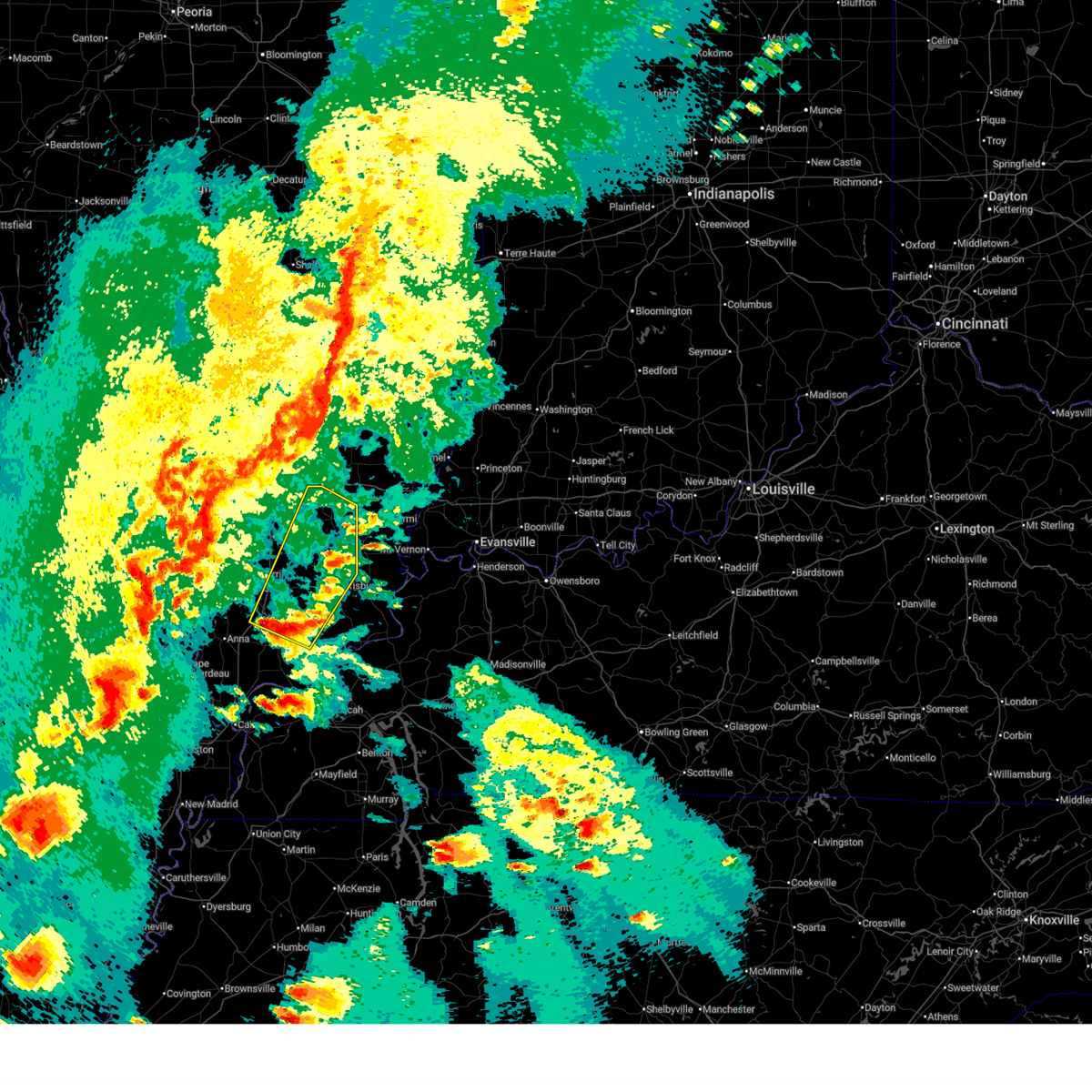
| 3/15/2025 12:47 AM CDT |
 At 1246 am cdt, a large and extremely dangerous tornado was located over zeigler, or near christopher, moving northeast at 55 mph. this is a particularly dangerous situation. take cover now! (radar indicated rotation). Hazards include damaging tornado. You are in a life-threatening situation. flying debris may be deadly to those caught without shelter. mobile homes will be destroyed. considerable damage to homes, businesses, and vehicles is likely and complete destruction is possible. the tornado will be near, benton, west frankfort, west city, valier, and rend lake area around 1250 am cdt. mcleansboro around 110 am cdt. other locations impacted by this tornadic thunderstorm include dahlgren, orient, ewing, belle rive, buckner, macedonia, hanaford, and belle prairie city. This includes interstate 57 in illinois between mile markers 62 and 80. At 1246 am cdt, a large and extremely dangerous tornado was located over zeigler, or near christopher, moving northeast at 55 mph. this is a particularly dangerous situation. take cover now! (radar indicated rotation). Hazards include damaging tornado. You are in a life-threatening situation. flying debris may be deadly to those caught without shelter. mobile homes will be destroyed. considerable damage to homes, businesses, and vehicles is likely and complete destruction is possible. the tornado will be near, benton, west frankfort, west city, valier, and rend lake area around 1250 am cdt. mcleansboro around 110 am cdt. other locations impacted by this tornadic thunderstorm include dahlgren, orient, ewing, belle rive, buckner, macedonia, hanaford, and belle prairie city. This includes interstate 57 in illinois between mile markers 62 and 80.
|
| 3/15/2025 12:44 AM CDT |
 Torpah the national weather service in paducah has issued a * tornado warning for, southeastern jefferson county in south central illinois, hamilton county in south central illinois, franklin county in south central illinois, * until 130 am cdt. * at 1244 am cdt, a severe thunderstorm capable of producing a tornado was located over zeigler, or near christopher, moving northeast at 55 mph (radar indicated rotation). Hazards include tornado. Flying debris will be dangerous to those caught without shelter. mobile homes will be damaged or destroyed. damage to roofs, windows, and vehicles will occur. tree damage is likely. this dangerous storm will be near, benton, west frankfort, west city, valier, and rend lake area around 1250 am cdt. mcleansboro around 110 am cdt. other locations impacted by this tornadic thunderstorm include dahlgren, orient, ewing, belle rive, buckner, macedonia, hanaford, and belle prairie city. This includes interstate 57 in illinois between mile markers 62 and 80. Torpah the national weather service in paducah has issued a * tornado warning for, southeastern jefferson county in south central illinois, hamilton county in south central illinois, franklin county in south central illinois, * until 130 am cdt. * at 1244 am cdt, a severe thunderstorm capable of producing a tornado was located over zeigler, or near christopher, moving northeast at 55 mph (radar indicated rotation). Hazards include tornado. Flying debris will be dangerous to those caught without shelter. mobile homes will be damaged or destroyed. damage to roofs, windows, and vehicles will occur. tree damage is likely. this dangerous storm will be near, benton, west frankfort, west city, valier, and rend lake area around 1250 am cdt. mcleansboro around 110 am cdt. other locations impacted by this tornadic thunderstorm include dahlgren, orient, ewing, belle rive, buckner, macedonia, hanaford, and belle prairie city. This includes interstate 57 in illinois between mile markers 62 and 80.
|
| 7/11/2024 7:33 PM CDT |
 the severe thunderstorm warning has been cancelled and is no longer in effect the severe thunderstorm warning has been cancelled and is no longer in effect
|
| 7/11/2024 7:22 PM CDT |
 Svrpah the national weather service in paducah has issued a * severe thunderstorm warning for, northeastern williamson county in southern illinois, southeastern franklin county in south central illinois, * until 800 pm cdt. * at 721 pm cdt, a severe thunderstorm was located near west frankfort, moving southeast at 30 mph (radar indicated). Hazards include 60 mph wind gusts and penny size hail. expect damage to roofs, siding, and trees Svrpah the national weather service in paducah has issued a * severe thunderstorm warning for, northeastern williamson county in southern illinois, southeastern franklin county in south central illinois, * until 800 pm cdt. * at 721 pm cdt, a severe thunderstorm was located near west frankfort, moving southeast at 30 mph (radar indicated). Hazards include 60 mph wind gusts and penny size hail. expect damage to roofs, siding, and trees
|
| 7/11/2024 7:11 PM CDT |
 the severe thunderstorm warning has been cancelled and is no longer in effect the severe thunderstorm warning has been cancelled and is no longer in effect
|
| 7/11/2024 7:11 PM CDT |
 At 709 pm cdt, a severe thunderstorm was located near west city, moving southeast at 30 mph (radar indicated). Hazards include 60 mph wind gusts and penny size hail. Expect damage to roofs, siding, and trees. locations impacted include, west frankfort, benton, christopher, rend lake area, sesser, valier, west city, north city, buckner, orient, hanaford, and ewing. This includes interstate 57 in illinois between mile markers 64 and 80. At 709 pm cdt, a severe thunderstorm was located near west city, moving southeast at 30 mph (radar indicated). Hazards include 60 mph wind gusts and penny size hail. Expect damage to roofs, siding, and trees. locations impacted include, west frankfort, benton, christopher, rend lake area, sesser, valier, west city, north city, buckner, orient, hanaford, and ewing. This includes interstate 57 in illinois between mile markers 64 and 80.
|
| 7/11/2024 7:06 PM CDT |
 the severe thunderstorm warning has been cancelled and is no longer in effect the severe thunderstorm warning has been cancelled and is no longer in effect
|
| 7/11/2024 7:06 PM CDT |
 At 705 pm cdt, a severe thunderstorm was located near valier, or near rend lake area, moving southeast at 25 mph (radar indicated). Hazards include 60 mph wind gusts and penny size hail. Expect damage to roofs, siding, and trees. locations impacted include, west frankfort, benton, christopher, rend lake area, sesser, valier, west city, north city, buckner, orient, hanaford, and ewing. This includes interstate 57 in illinois between mile markers 64 and 81. At 705 pm cdt, a severe thunderstorm was located near valier, or near rend lake area, moving southeast at 25 mph (radar indicated). Hazards include 60 mph wind gusts and penny size hail. Expect damage to roofs, siding, and trees. locations impacted include, west frankfort, benton, christopher, rend lake area, sesser, valier, west city, north city, buckner, orient, hanaford, and ewing. This includes interstate 57 in illinois between mile markers 64 and 81.
|
| 7/11/2024 6:52 PM CDT |
 Svrpah the national weather service in paducah has issued a * severe thunderstorm warning for, east central perry county in south central illinois, southwestern jefferson county in south central illinois, central franklin county in south central illinois, * until 730 pm cdt. * at 651 pm cdt, a severe thunderstorm was located over sesser, or near rend lake area, moving southeast at 30 mph (radar indicated). Hazards include 60 mph wind gusts and penny size hail. expect damage to roofs, siding, and trees Svrpah the national weather service in paducah has issued a * severe thunderstorm warning for, east central perry county in south central illinois, southwestern jefferson county in south central illinois, central franklin county in south central illinois, * until 730 pm cdt. * at 651 pm cdt, a severe thunderstorm was located over sesser, or near rend lake area, moving southeast at 30 mph (radar indicated). Hazards include 60 mph wind gusts and penny size hail. expect damage to roofs, siding, and trees
|
| 7/5/2024 4:13 AM CDT |
 Svrpah the national weather service in paducah has issued a * severe thunderstorm warning for, northeastern williamson county in southern illinois, franklin county in south central illinois, * until 500 am cdt. * at 413 am cdt, severe thunderstorms were located along a line extending from near christopher to west frankfort, moving east at 30 mph (emergency management). Hazards include 60 mph wind gusts. expect damage to roofs, siding, and trees Svrpah the national weather service in paducah has issued a * severe thunderstorm warning for, northeastern williamson county in southern illinois, franklin county in south central illinois, * until 500 am cdt. * at 413 am cdt, severe thunderstorms were located along a line extending from near christopher to west frankfort, moving east at 30 mph (emergency management). Hazards include 60 mph wind gusts. expect damage to roofs, siding, and trees
|
| 5/26/2024 7:59 PM CDT |
 At 759 pm cdt, severe thunderstorms were located along a line extending from near cisne to 10 miles west of mcleansboro to near zeigler, moving southeast at 45 mph (radar indicated). Hazards include 70 mph wind gusts and quarter size hail. Hail damage to vehicles is expected. expect considerable tree damage. wind damage is also likely to mobile homes, roofs, and outbuildings. locations impacted include, west frankfort, benton, fairfield, mcleansboro, zeigler, norris city, wayne city, cisne, enfield, thompsonville, dahlgren, jeffersonville, orient, hanaford, freeman spur, sims, mill shoals, broughton, springerton, and mount erie. this includes the following highways, interstate 57 in illinois between mile markers 62 and 71. Interstate 64 in illinois between mile markers 92 and 120. At 759 pm cdt, severe thunderstorms were located along a line extending from near cisne to 10 miles west of mcleansboro to near zeigler, moving southeast at 45 mph (radar indicated). Hazards include 70 mph wind gusts and quarter size hail. Hail damage to vehicles is expected. expect considerable tree damage. wind damage is also likely to mobile homes, roofs, and outbuildings. locations impacted include, west frankfort, benton, fairfield, mcleansboro, zeigler, norris city, wayne city, cisne, enfield, thompsonville, dahlgren, jeffersonville, orient, hanaford, freeman spur, sims, mill shoals, broughton, springerton, and mount erie. this includes the following highways, interstate 57 in illinois between mile markers 62 and 71. Interstate 64 in illinois between mile markers 92 and 120.
|
| 5/26/2024 7:39 PM CDT |
 Svrpah the national weather service in paducah has issued a * severe thunderstorm warning for, northwestern white county in southeastern illinois, wayne county in south central illinois, hamilton county in south central illinois, eastern franklin county in south central illinois, * until 900 pm cdt. * at 738 pm cdt, severe thunderstorms were located along a line extending from 7 miles west of helm to 7 miles south of woodlawn to elkville, moving southeast at 45 mph (radar indicated). Hazards include 60 mph wind gusts and quarter size hail. Hail damage to vehicles is expected. Expect wind damage to roofs, siding, and trees. Svrpah the national weather service in paducah has issued a * severe thunderstorm warning for, northwestern white county in southeastern illinois, wayne county in south central illinois, hamilton county in south central illinois, eastern franklin county in south central illinois, * until 900 pm cdt. * at 738 pm cdt, severe thunderstorms were located along a line extending from 7 miles west of helm to 7 miles south of woodlawn to elkville, moving southeast at 45 mph (radar indicated). Hazards include 60 mph wind gusts and quarter size hail. Hail damage to vehicles is expected. Expect wind damage to roofs, siding, and trees.
|
| 5/8/2024 8:23 PM CDT |
 The storm which prompted the warning has moved out of the area. therefore, the warning will be allowed to expire. a tornado watch remains in effect until midnight cdt for south central, southern and southeastern illinois. The storm which prompted the warning has moved out of the area. therefore, the warning will be allowed to expire. a tornado watch remains in effect until midnight cdt for south central, southern and southeastern illinois.
|
| 5/8/2024 8:05 PM CDT |
 At 805 pm cdt, a severe thunderstorm was located just west of mcleansboro, moving east at 50 mph (radar indicated). Hazards include 60 mph wind gusts and half dollar size hail. Hail damage to vehicles is expected. expect wind damage to roofs, siding, and trees. Locations impacted include, carmi, mcleansboro, norris city, enfield, thompsonville, dahlgren, hanaford, broughton, springerton, and macedonia. At 805 pm cdt, a severe thunderstorm was located just west of mcleansboro, moving east at 50 mph (radar indicated). Hazards include 60 mph wind gusts and half dollar size hail. Hail damage to vehicles is expected. expect wind damage to roofs, siding, and trees. Locations impacted include, carmi, mcleansboro, norris city, enfield, thompsonville, dahlgren, hanaford, broughton, springerton, and macedonia.
|
| 5/8/2024 7:55 PM CDT |
 At 755 pm cdt, severe thunderstorms were located along a line extending from 8 miles south of wayne city to near west frankfort, moving east at 45 mph (radar indicated). Hazards include 60 mph wind gusts and half dollar size hail. Hail damage to vehicles is expected. expect wind damage to roofs, siding, and trees. locations impacted include, west frankfort, benton, carmi, mcleansboro, rend lake area, norris city, west city, enfield, thompsonville, dahlgren, buckner, orient, hanaford, ewing, freeman spur, broughton, springerton, and macedonia. This includes interstate 57 in illinois between mile markers 63 and 79. At 755 pm cdt, severe thunderstorms were located along a line extending from 8 miles south of wayne city to near west frankfort, moving east at 45 mph (radar indicated). Hazards include 60 mph wind gusts and half dollar size hail. Hail damage to vehicles is expected. expect wind damage to roofs, siding, and trees. locations impacted include, west frankfort, benton, carmi, mcleansboro, rend lake area, norris city, west city, enfield, thompsonville, dahlgren, buckner, orient, hanaford, ewing, freeman spur, broughton, springerton, and macedonia. This includes interstate 57 in illinois between mile markers 63 and 79.
|
| 5/8/2024 7:39 PM CDT |
 The tornado threat has diminished and the tornado warning has been cancelled. however, large hail and damaging winds remain likely and a severe thunderstorm warning remains in effect for the area. a tornado watch remains in effect until midnight cdt for south central and southern illinois. The tornado threat has diminished and the tornado warning has been cancelled. however, large hail and damaging winds remain likely and a severe thunderstorm warning remains in effect for the area. a tornado watch remains in effect until midnight cdt for south central and southern illinois.
|
| 5/8/2024 7:38 PM CDT |
 Svrpah the national weather service in paducah has issued a * severe thunderstorm warning for, western white county in southeastern illinois, southeastern jefferson county in south central illinois, northern saline county in southern illinois, hamilton county in south central illinois, franklin county in south central illinois, * until 830 pm cdt. * at 737 pm cdt, severe thunderstorms were located along a line extending from 7 miles south of bluford to near royalton, moving east at 45 mph (radar indicated). Hazards include 60 mph wind gusts and half dollar size hail. Hail damage to vehicles is expected. Expect wind damage to roofs, siding, and trees. Svrpah the national weather service in paducah has issued a * severe thunderstorm warning for, western white county in southeastern illinois, southeastern jefferson county in south central illinois, northern saline county in southern illinois, hamilton county in south central illinois, franklin county in south central illinois, * until 830 pm cdt. * at 737 pm cdt, severe thunderstorms were located along a line extending from 7 miles south of bluford to near royalton, moving east at 45 mph (radar indicated). Hazards include 60 mph wind gusts and half dollar size hail. Hail damage to vehicles is expected. Expect wind damage to roofs, siding, and trees.
|
| 5/8/2024 7:26 PM CDT |
 At 725 pm cdt, severe thunderstorms were located along a line extending from near sesser to near murphysboro, moving east at 50 mph (radar indicated). Hazards include 60 mph wind gusts and quarter size hail. Hail damage to vehicles is expected. expect wind damage to roofs, siding, and trees. locations impacted include, carbondale, herrin, west frankfort, murphysboro, benton, carterville, johnston city, christopher, rend lake area, sesser, zeigler, de soto, crainville, cambria, royalton, energy, elkville, hurst, valier, and west city. This includes interstate 57 in illinois between mile markers 56 and 80. At 725 pm cdt, severe thunderstorms were located along a line extending from near sesser to near murphysboro, moving east at 50 mph (radar indicated). Hazards include 60 mph wind gusts and quarter size hail. Hail damage to vehicles is expected. expect wind damage to roofs, siding, and trees. locations impacted include, carbondale, herrin, west frankfort, murphysboro, benton, carterville, johnston city, christopher, rend lake area, sesser, zeigler, de soto, crainville, cambria, royalton, energy, elkville, hurst, valier, and west city. This includes interstate 57 in illinois between mile markers 56 and 80.
|
| 5/8/2024 7:04 PM CDT |
 Torpah the national weather service in paducah has issued a * tornado warning for, southeastern perry county in south central illinois, southern jefferson county in south central illinois, franklin county in south central illinois, * until 745 pm cdt. * at 704 pm cdt, a severe thunderstorm capable of producing a tornado was located over pinckneyville, moving east at 50 mph (radar indicated rotation). Hazards include tornado. Flying debris will be dangerous to those caught without shelter. mobile homes will be damaged or destroyed. damage to roofs, windows, and vehicles will occur. tree damage is likely. this dangerous storm will be near, du quoin and tamaroa around 710 pm cdt. christopher, sesser, and valier around 715 pm cdt. rend lake area around 720 pm cdt. benton and west city around 725 pm cdt. other locations impacted by this tornadic thunderstorm include ewing, north city, nason, buckner, macedonia, hanaford, and ina. This includes interstate 57 in illinois between mile markers 69 and 85. Torpah the national weather service in paducah has issued a * tornado warning for, southeastern perry county in south central illinois, southern jefferson county in south central illinois, franklin county in south central illinois, * until 745 pm cdt. * at 704 pm cdt, a severe thunderstorm capable of producing a tornado was located over pinckneyville, moving east at 50 mph (radar indicated rotation). Hazards include tornado. Flying debris will be dangerous to those caught without shelter. mobile homes will be damaged or destroyed. damage to roofs, windows, and vehicles will occur. tree damage is likely. this dangerous storm will be near, du quoin and tamaroa around 710 pm cdt. christopher, sesser, and valier around 715 pm cdt. rend lake area around 720 pm cdt. benton and west city around 725 pm cdt. other locations impacted by this tornadic thunderstorm include ewing, north city, nason, buckner, macedonia, hanaford, and ina. This includes interstate 57 in illinois between mile markers 69 and 85.
|
| 5/8/2024 6:58 PM CDT |
 Svrpah the national weather service in paducah has issued a * severe thunderstorm warning for, williamson county in southern illinois, jackson county in southern illinois, franklin county in south central illinois, * until 745 pm cdt. * at 658 pm cdt, severe thunderstorms were located along a line extending from 6 miles northeast of percy to 9 miles north of altenburg, moving east at 60 mph (radar indicated). Hazards include 60 mph wind gusts and quarter size hail. Hail damage to vehicles is expected. Expect wind damage to roofs, siding, and trees. Svrpah the national weather service in paducah has issued a * severe thunderstorm warning for, williamson county in southern illinois, jackson county in southern illinois, franklin county in south central illinois, * until 745 pm cdt. * at 658 pm cdt, severe thunderstorms were located along a line extending from 6 miles northeast of percy to 9 miles north of altenburg, moving east at 60 mph (radar indicated). Hazards include 60 mph wind gusts and quarter size hail. Hail damage to vehicles is expected. Expect wind damage to roofs, siding, and trees.
|
| 5/8/2024 3:47 PM CDT |
 the severe thunderstorm warning has been cancelled and is no longer in effect the severe thunderstorm warning has been cancelled and is no longer in effect
|
| 5/8/2024 3:47 PM CDT |
 At 346 pm cdt, severe thunderstorms were located along a line extending from christopher to cambria, moving east at 30 mph (radar indicated). Hazards include 60 mph wind gusts and penny size hail. Expect damage to roofs, siding, and trees. locations impacted include, herrin, west frankfort, murphysboro, benton, du quoin, johnston city, christopher, rend lake area, zeigler, de soto, cambria, royalton, elkville, hurst, valier, west city, north city, buckner, dowell, and orient. This includes interstate 57 in illinois between mile markers 58 and 76. At 346 pm cdt, severe thunderstorms were located along a line extending from christopher to cambria, moving east at 30 mph (radar indicated). Hazards include 60 mph wind gusts and penny size hail. Expect damage to roofs, siding, and trees. locations impacted include, herrin, west frankfort, murphysboro, benton, du quoin, johnston city, christopher, rend lake area, zeigler, de soto, cambria, royalton, elkville, hurst, valier, west city, north city, buckner, dowell, and orient. This includes interstate 57 in illinois between mile markers 58 and 76.
|
| 5/8/2024 3:24 PM CDT |
 Svrpah the national weather service in paducah has issued a * severe thunderstorm warning for, eastern perry county in south central illinois, southern jefferson county in south central illinois, northwestern williamson county in southern illinois, northeastern jackson county in southern illinois, franklin county in south central illinois, * until 415 pm cdt. * at 323 pm cdt, severe thunderstorms were located along a line extending from near tamaroa to murphysboro, moving east at 30 mph (radar indicated). Hazards include 70 mph wind gusts and ping pong ball size hail. People and animals outdoors will be injured. expect hail damage to roofs, siding, windows, and vehicles. expect considerable tree damage. Wind damage is also likely to mobile homes, roofs, and outbuildings. Svrpah the national weather service in paducah has issued a * severe thunderstorm warning for, eastern perry county in south central illinois, southern jefferson county in south central illinois, northwestern williamson county in southern illinois, northeastern jackson county in southern illinois, franklin county in south central illinois, * until 415 pm cdt. * at 323 pm cdt, severe thunderstorms were located along a line extending from near tamaroa to murphysboro, moving east at 30 mph (radar indicated). Hazards include 70 mph wind gusts and ping pong ball size hail. People and animals outdoors will be injured. expect hail damage to roofs, siding, windows, and vehicles. expect considerable tree damage. Wind damage is also likely to mobile homes, roofs, and outbuildings.
|
| 4/18/2024 8:22 PM CDT |
 the severe thunderstorm warning has been cancelled and is no longer in effect the severe thunderstorm warning has been cancelled and is no longer in effect
|
| 4/18/2024 8:22 PM CDT |
 At 822 pm cdt, severe thunderstorms were located along a line extending from 9 miles southwest of parkersburg to near thompsonville, moving east at 50 mph (radar indicated). Hazards include 60 mph wind gusts. Expect damage to roofs, siding, and trees. locations impacted include, west frankfort, fairfield, mcleansboro, wayne city, cisne, thompsonville, dahlgren, jeffersonville, hanaford, freeman spur, sims, mill shoals, broughton, mount erie, golden gate, macedonia, and belle prairie city. this includes the following highways, interstate 57 in illinois between mile markers 62 and 66. Interstate 64 in illinois between mile markers 94 and 116. At 822 pm cdt, severe thunderstorms were located along a line extending from 9 miles southwest of parkersburg to near thompsonville, moving east at 50 mph (radar indicated). Hazards include 60 mph wind gusts. Expect damage to roofs, siding, and trees. locations impacted include, west frankfort, fairfield, mcleansboro, wayne city, cisne, thompsonville, dahlgren, jeffersonville, hanaford, freeman spur, sims, mill shoals, broughton, mount erie, golden gate, macedonia, and belle prairie city. this includes the following highways, interstate 57 in illinois between mile markers 62 and 66. Interstate 64 in illinois between mile markers 94 and 116.
|
| 4/18/2024 8:13 PM CDT |
 At 813 pm cdt, severe thunderstorms were located along a line extending from near cisne to near benton, moving east at 45 mph (radar indicated). Hazards include 70 mph wind gusts. Expect considerable tree damage. damage is likely to mobile homes, roofs, and outbuildings. locations impacted include, west frankfort, benton, du quoin, fairfield, mcleansboro, christopher, rend lake area, sesser, zeigler, royalton, wayne city, elkville, bluford, cisne, valier, west city, ava, thompsonville, ina, and north city. this includes the following highways, interstate 57 in illinois between mile markers 62 and 86. Interstate 64 in illinois between mile markers 83 and 116. At 813 pm cdt, severe thunderstorms were located along a line extending from near cisne to near benton, moving east at 45 mph (radar indicated). Hazards include 70 mph wind gusts. Expect considerable tree damage. damage is likely to mobile homes, roofs, and outbuildings. locations impacted include, west frankfort, benton, du quoin, fairfield, mcleansboro, christopher, rend lake area, sesser, zeigler, royalton, wayne city, elkville, bluford, cisne, valier, west city, ava, thompsonville, ina, and north city. this includes the following highways, interstate 57 in illinois between mile markers 62 and 86. Interstate 64 in illinois between mile markers 83 and 116.
|
| 4/18/2024 7:52 PM CDT |
 At 751 pm cdt, severe thunderstorms were located along a line extending from 6 miles north of wayne city to near christopher, moving east at 55 mph (radar indicated). Hazards include 70 mph wind gusts. Expect considerable tree damage. damage is likely to mobile homes, roofs, and outbuildings. locations impacted include, mount vernon, west frankfort, benton, du quoin, pinckneyville, fairfield, mcleansboro, christopher, rend lake area, sesser, zeigler, royalton, wayne city, elkville, woodlawn, bluford, cisne, valier, west city, and ava. this includes the following highways, interstate 57 in illinois between mile markers 62 and 105. Interstate 64 in illinois between mile markers 63 and 116. At 751 pm cdt, severe thunderstorms were located along a line extending from 6 miles north of wayne city to near christopher, moving east at 55 mph (radar indicated). Hazards include 70 mph wind gusts. Expect considerable tree damage. damage is likely to mobile homes, roofs, and outbuildings. locations impacted include, mount vernon, west frankfort, benton, du quoin, pinckneyville, fairfield, mcleansboro, christopher, rend lake area, sesser, zeigler, royalton, wayne city, elkville, woodlawn, bluford, cisne, valier, west city, and ava. this includes the following highways, interstate 57 in illinois between mile markers 62 and 105. Interstate 64 in illinois between mile markers 63 and 116.
|
| 4/18/2024 7:28 PM CDT |
 Svrpah the national weather service in paducah has issued a * severe thunderstorm warning for, perry county in south central illinois, wayne county in south central illinois, jefferson county in south central illinois, northern jackson county in southern illinois, hamilton county in south central illinois, franklin county in south central illinois, * until 845 pm cdt. * at 727 pm cdt, severe thunderstorms were located along a line extending from near centralia to near willisville, moving east at 50 mph (trained weather spotters. these storms have a history of widespread wind damage). Hazards include 70 mph wind gusts. Expect considerable tree damage. Damage is likely to mobile homes, roofs, and outbuildings. Svrpah the national weather service in paducah has issued a * severe thunderstorm warning for, perry county in south central illinois, wayne county in south central illinois, jefferson county in south central illinois, northern jackson county in southern illinois, hamilton county in south central illinois, franklin county in south central illinois, * until 845 pm cdt. * at 727 pm cdt, severe thunderstorms were located along a line extending from near centralia to near willisville, moving east at 50 mph (trained weather spotters. these storms have a history of widespread wind damage). Hazards include 70 mph wind gusts. Expect considerable tree damage. Damage is likely to mobile homes, roofs, and outbuildings.
|
| 4/2/2024 12:40 PM CDT |
 the severe thunderstorm warning has been cancelled and is no longer in effect the severe thunderstorm warning has been cancelled and is no longer in effect
|
| 4/2/2024 12:40 PM CDT |
 At 1240 pm cdt, a severe thunderstorm was located near crainville, or near carterville, moving northeast at 70 mph (radar indicated). Hazards include 60 mph wind gusts and quarter size hail. Hail damage to vehicles is expected. expect wind damage to roofs, siding, and trees. locations impacted include, marion, herrin, west frankfort, carterville, johnston city, crainville, energy, pittsburg, thompsonville, hanaford, freeman spur, whiteash, williamson county regional airport, and spillertown. This includes interstate 57 in illinois between mile markers 48 and 64. At 1240 pm cdt, a severe thunderstorm was located near crainville, or near carterville, moving northeast at 70 mph (radar indicated). Hazards include 60 mph wind gusts and quarter size hail. Hail damage to vehicles is expected. expect wind damage to roofs, siding, and trees. locations impacted include, marion, herrin, west frankfort, carterville, johnston city, crainville, energy, pittsburg, thompsonville, hanaford, freeman spur, whiteash, williamson county regional airport, and spillertown. This includes interstate 57 in illinois between mile markers 48 and 64.
|
| 4/2/2024 12:30 PM CDT |
 Svrpah the national weather service in paducah has issued a * severe thunderstorm warning for, northeastern union county in southern illinois, northwestern johnson county in southern illinois, williamson county in southern illinois, southeastern jackson county in southern illinois, southeastern franklin county in south central illinois, * until 100 pm cdt. * at 1229 pm cdt, a severe thunderstorm was located near cedar lake area, or 7 miles south of carbondale, moving northeast at 70 mph (radar indicated). Hazards include 60 mph wind gusts and quarter size hail. Hail damage to vehicles is expected. Expect wind damage to roofs, siding, and trees. Svrpah the national weather service in paducah has issued a * severe thunderstorm warning for, northeastern union county in southern illinois, northwestern johnson county in southern illinois, williamson county in southern illinois, southeastern jackson county in southern illinois, southeastern franklin county in south central illinois, * until 100 pm cdt. * at 1229 pm cdt, a severe thunderstorm was located near cedar lake area, or 7 miles south of carbondale, moving northeast at 70 mph (radar indicated). Hazards include 60 mph wind gusts and quarter size hail. Hail damage to vehicles is expected. Expect wind damage to roofs, siding, and trees.
|
| 2/10/2024 1:22 AM CST |
 At 121 am cst, a severe thunderstorm was located near benton, moving east at 50 mph (emergency management. quarter sized hail was reported as this storm moved through christopher). Hazards include 60 mph wind gusts and quarter size hail. Hail damage to vehicles is expected. Expect wind damage to roofs, siding, and trees. At 121 am cst, a severe thunderstorm was located near benton, moving east at 50 mph (emergency management. quarter sized hail was reported as this storm moved through christopher). Hazards include 60 mph wind gusts and quarter size hail. Hail damage to vehicles is expected. Expect wind damage to roofs, siding, and trees.
|
| 2/10/2024 1:09 AM CST |
 At 109 am cst, a severe thunderstorm was located over valier, or over christopher, moving east at 45 mph (radar indicated). Hazards include 60 mph wind gusts and quarter size hail. Hail damage to vehicles is expected. expect wind damage to roofs, siding, and trees. locations impacted include, west frankfort, benton, christopher, rend lake area, sesser, zeigler, royalton, valier, west city, north city, buckner, orient, hanaford, and ewing. This includes interstate 57 in illinois between mile markers 66 and 80. At 109 am cst, a severe thunderstorm was located over valier, or over christopher, moving east at 45 mph (radar indicated). Hazards include 60 mph wind gusts and quarter size hail. Hail damage to vehicles is expected. expect wind damage to roofs, siding, and trees. locations impacted include, west frankfort, benton, christopher, rend lake area, sesser, zeigler, royalton, valier, west city, north city, buckner, orient, hanaford, and ewing. This includes interstate 57 in illinois between mile markers 66 and 80.
|
| 2/10/2024 12:58 AM CST |
 At 1258 am cst, a severe thunderstorm was located near du quoin, moving east at 45 mph (radar indicated). Hazards include 60 mph wind gusts and quarter size hail. Hail damage to vehicles is expected. Expect wind damage to roofs, siding, and trees. At 1258 am cst, a severe thunderstorm was located near du quoin, moving east at 45 mph (radar indicated). Hazards include 60 mph wind gusts and quarter size hail. Hail damage to vehicles is expected. Expect wind damage to roofs, siding, and trees.
|
| 8/7/2023 12:10 AM CDT |
 At 1210 am cdt, a severe thunderstorm was located over west frankfort, moving east at 40 mph (radar indicated). Hazards include 60 mph wind gusts and penny size hail. Expect damage to roofs, siding, and trees. locations impacted include, herrin, west frankfort, benton, johnston city, zeigler, west city, thompsonville, buckner, orient, hanaford and freeman spur. this includes interstate 57 in illinois between mile markers 60 and 71. hail threat, radar indicated max hail size, 0. 75 in wind threat, radar indicated max wind gust, 60 mph. At 1210 am cdt, a severe thunderstorm was located over west frankfort, moving east at 40 mph (radar indicated). Hazards include 60 mph wind gusts and penny size hail. Expect damage to roofs, siding, and trees. locations impacted include, herrin, west frankfort, benton, johnston city, zeigler, west city, thompsonville, buckner, orient, hanaford and freeman spur. this includes interstate 57 in illinois between mile markers 60 and 71. hail threat, radar indicated max hail size, 0. 75 in wind threat, radar indicated max wind gust, 60 mph.
|
| 8/6/2023 11:57 PM CDT |
 At 1157 pm cdt, a severe thunderstorm was located near royalton, or near christopher, moving east at 40 mph (radar indicated). Hazards include 60 mph wind gusts and quarter size hail. Hail damage to vehicles is expected. Expect wind damage to roofs, siding, and trees. At 1157 pm cdt, a severe thunderstorm was located near royalton, or near christopher, moving east at 40 mph (radar indicated). Hazards include 60 mph wind gusts and quarter size hail. Hail damage to vehicles is expected. Expect wind damage to roofs, siding, and trees.
|
| 7/29/2023 6:14 PM CDT |
 At 614 pm cdt, severe thunderstorms were located along a line extending from near bluford to 7 miles north of thompsonville to near pittsburg, moving east at 35 mph (radar indicated). Hazards include 60 mph wind gusts and penny size hail. expect damage to roofs, siding, and trees At 614 pm cdt, severe thunderstorms were located along a line extending from near bluford to 7 miles north of thompsonville to near pittsburg, moving east at 35 mph (radar indicated). Hazards include 60 mph wind gusts and penny size hail. expect damage to roofs, siding, and trees
|
| 7/29/2023 6:10 PM CDT |
 At 609 pm cdt, severe thunderstorms were located along a line extending from near bluford to 11 miles west of mcleansboro to near pittsburg, moving east at 35 mph (trained weather spotters). Hazards include 60 mph wind gusts and penny size hail. Expect damage to roofs, siding, and trees. locations impacted include, marion, mount vernon, johnston city, bluford, pittsburg, thompsonville, belle rive, hanaford, ewing, whiteash and spillertown. this includes the following highways, interstate 57 in illinois between mile markers 55 and 57. interstate 64 in illinois between mile markers 83 and 90. hail threat, radar indicated max hail size, 0. 75 in wind threat, observed max wind gust, 60 mph. At 609 pm cdt, severe thunderstorms were located along a line extending from near bluford to 11 miles west of mcleansboro to near pittsburg, moving east at 35 mph (trained weather spotters). Hazards include 60 mph wind gusts and penny size hail. Expect damage to roofs, siding, and trees. locations impacted include, marion, mount vernon, johnston city, bluford, pittsburg, thompsonville, belle rive, hanaford, ewing, whiteash and spillertown. this includes the following highways, interstate 57 in illinois between mile markers 55 and 57. interstate 64 in illinois between mile markers 83 and 90. hail threat, radar indicated max hail size, 0. 75 in wind threat, observed max wind gust, 60 mph.
|
| 7/29/2023 5:43 PM CDT |
 At 543 pm cdt, severe thunderstorms were located along a line extending from near irvington to near rend lake area to near johnston city, moving east at 40 mph (trained weather spotters). Hazards include 70 mph wind gusts and quarter size hail. Hail damage to vehicles is expected. expect considerable tree damage. wind damage is also likely to mobile homes, roofs, and outbuildings. locations impacted include, marion, mount vernon, herrin, west frankfort, benton, johnston city, christopher, rend lake area, sesser, zeigler, royalton, energy, hurst, woodlawn, bluford, valier, west city, pittsburg, thompsonville and ina. this includes the following highways, interstate 57 in illinois between mile markers 55 and 105. interstate 64 in illinois between mile markers 63 and 90. thunderstorm damage threat, considerable hail threat, radar indicated max hail size, 1. 00 in wind threat, observed max wind gust, 70 mph. At 543 pm cdt, severe thunderstorms were located along a line extending from near irvington to near rend lake area to near johnston city, moving east at 40 mph (trained weather spotters). Hazards include 70 mph wind gusts and quarter size hail. Hail damage to vehicles is expected. expect considerable tree damage. wind damage is also likely to mobile homes, roofs, and outbuildings. locations impacted include, marion, mount vernon, herrin, west frankfort, benton, johnston city, christopher, rend lake area, sesser, zeigler, royalton, energy, hurst, woodlawn, bluford, valier, west city, pittsburg, thompsonville and ina. this includes the following highways, interstate 57 in illinois between mile markers 55 and 105. interstate 64 in illinois between mile markers 63 and 90. thunderstorm damage threat, considerable hail threat, radar indicated max hail size, 1. 00 in wind threat, observed max wind gust, 70 mph.
|
| 7/29/2023 5:15 PM CDT |
 At 514 pm cdt, severe thunderstorms were located along a line extending from near okawville to 7 miles north of pinckneyville to 7 miles northeast of ava, moving east at 40 mph (trained weather spotters). Hazards include 70 mph wind gusts and quarter size hail. Hail damage to vehicles is expected. expect considerable tree damage. Wind damage is also likely to mobile homes, roofs, and outbuildings. At 514 pm cdt, severe thunderstorms were located along a line extending from near okawville to 7 miles north of pinckneyville to 7 miles northeast of ava, moving east at 40 mph (trained weather spotters). Hazards include 70 mph wind gusts and quarter size hail. Hail damage to vehicles is expected. expect considerable tree damage. Wind damage is also likely to mobile homes, roofs, and outbuildings.
|
| 7/24/2023 4:52 AM CDT |
 At 451 am cdt, a severe thunderstorm was located over west frankfort, moving southeast at 20 mph (radar indicated). Hazards include 60 mph wind gusts and quarter size hail. Hail damage to vehicles is expected. expect wind damage to roofs, siding, and trees. locations impacted include, marion, herrin, west frankfort, johnston city, pittsburg, thompsonville, orient, hanaford, freeman spur, whiteash and spillertown. this includes interstate 57 in illinois between mile markers 54 and 68. hail threat, radar indicated max hail size, 1. 00 in wind threat, radar indicated max wind gust, 60 mph. At 451 am cdt, a severe thunderstorm was located over west frankfort, moving southeast at 20 mph (radar indicated). Hazards include 60 mph wind gusts and quarter size hail. Hail damage to vehicles is expected. expect wind damage to roofs, siding, and trees. locations impacted include, marion, herrin, west frankfort, johnston city, pittsburg, thompsonville, orient, hanaford, freeman spur, whiteash and spillertown. this includes interstate 57 in illinois between mile markers 54 and 68. hail threat, radar indicated max hail size, 1. 00 in wind threat, radar indicated max wind gust, 60 mph.
|
| 7/24/2023 4:35 AM CDT |
 At 435 am cdt, a severe thunderstorm was located over christopher, moving southeast at 20 mph (radar indicated). Hazards include 60 mph wind gusts and quarter size hail. Hail damage to vehicles is expected. Expect wind damage to roofs, siding, and trees. At 435 am cdt, a severe thunderstorm was located over christopher, moving southeast at 20 mph (radar indicated). Hazards include 60 mph wind gusts and quarter size hail. Hail damage to vehicles is expected. Expect wind damage to roofs, siding, and trees.
|
| 7/2/2023 3:15 PM CDT |
 At 315 pm cdt, a severe thunderstorm was located over west frankfort, moving northeast at 40 mph (radar indicated). Hazards include 60 mph wind gusts. Expect damage to roofs, siding, and trees. locations impacted include, herrin, west frankfort, benton, johnston city, christopher, rend lake area, zeigler, west city, north city, buckner, orient, hanaford and freeman spur. this includes interstate 57 in illinois between mile markers 58 and 75. hail threat, radar indicated max hail size, <. 75 in wind threat, radar indicated max wind gust, 60 mph. At 315 pm cdt, a severe thunderstorm was located over west frankfort, moving northeast at 40 mph (radar indicated). Hazards include 60 mph wind gusts. Expect damage to roofs, siding, and trees. locations impacted include, herrin, west frankfort, benton, johnston city, christopher, rend lake area, zeigler, west city, north city, buckner, orient, hanaford and freeman spur. this includes interstate 57 in illinois between mile markers 58 and 75. hail threat, radar indicated max hail size, <. 75 in wind threat, radar indicated max wind gust, 60 mph.
|
| 7/2/2023 2:52 PM CDT |
 At 252 pm cdt, a severe thunderstorm was located over hurst, or near carterville, moving east at 45 mph (radar indicated). Hazards include 60 mph wind gusts. expect damage to roofs, siding, and trees At 252 pm cdt, a severe thunderstorm was located over hurst, or near carterville, moving east at 45 mph (radar indicated). Hazards include 60 mph wind gusts. expect damage to roofs, siding, and trees
|
| 7/1/2023 6:08 PM CDT |
 The severe thunderstorm warning for southwestern wayne, eastern jefferson, western hamilton and eastern franklin counties will expire at 615 pm cdt, the storms which prompted the warning have moved out of the area. therefore, the warning will be allowed to expire. however gusty winds are still possible with these thunderstorms. a severe thunderstorm watch remains in effect until 900 pm cdt for south central and southern illinois. The severe thunderstorm warning for southwestern wayne, eastern jefferson, western hamilton and eastern franklin counties will expire at 615 pm cdt, the storms which prompted the warning have moved out of the area. therefore, the warning will be allowed to expire. however gusty winds are still possible with these thunderstorms. a severe thunderstorm watch remains in effect until 900 pm cdt for south central and southern illinois.
|
| 7/1/2023 5:58 PM CDT |
 At 558 pm cdt, severe thunderstorms were located along a line extending from near cisne to 6 miles southeast of wayne city to 7 miles north of thompsonville, moving east at 45 mph (radar indicated). Hazards include 70 mph wind gusts. Expect considerable tree damage. damage is likely to mobile homes, roofs, and outbuildings. locations impacted include, west frankfort, wayne city, bluford, thompsonville, dahlgren, belle rive, hanaford, keenes, macedonia and belle prairie city. this includes interstate 64 in illinois between mile markers 86 and 100. thunderstorm damage threat, considerable hail threat, radar indicated max hail size, <. 75 in wind threat, radar indicated max wind gust, 70 mph. At 558 pm cdt, severe thunderstorms were located along a line extending from near cisne to 6 miles southeast of wayne city to 7 miles north of thompsonville, moving east at 45 mph (radar indicated). Hazards include 70 mph wind gusts. Expect considerable tree damage. damage is likely to mobile homes, roofs, and outbuildings. locations impacted include, west frankfort, wayne city, bluford, thompsonville, dahlgren, belle rive, hanaford, keenes, macedonia and belle prairie city. this includes interstate 64 in illinois between mile markers 86 and 100. thunderstorm damage threat, considerable hail threat, radar indicated max hail size, <. 75 in wind threat, radar indicated max wind gust, 70 mph.
|
| 7/1/2023 5:46 PM CDT |
 At 545 pm cdt, severe thunderstorms were located along a line extending from near helm to 6 miles southeast of bluford to benton, moving east at 45 mph (radar indicated). Hazards include 70 mph wind gusts. Expect considerable tree damage. damage is likely to mobile homes, roofs, and outbuildings. locations impacted include, mount vernon, west frankfort, benton, rend lake area, wayne city, bluford, west city, thompsonville, ina, dahlgren, buckner, dix, bonnie, belle rive, orient, hanaford, ewing, nason, keenes and macedonia. this includes the following highways, interstate 57 in illinois between mile markers 66 and 105. interstate 64 in illinois between mile markers 73 and 100. thunderstorm damage threat, considerable hail threat, radar indicated max hail size, <. 75 in wind threat, radar indicated max wind gust, 70 mph. At 545 pm cdt, severe thunderstorms were located along a line extending from near helm to 6 miles southeast of bluford to benton, moving east at 45 mph (radar indicated). Hazards include 70 mph wind gusts. Expect considerable tree damage. damage is likely to mobile homes, roofs, and outbuildings. locations impacted include, mount vernon, west frankfort, benton, rend lake area, wayne city, bluford, west city, thompsonville, ina, dahlgren, buckner, dix, bonnie, belle rive, orient, hanaford, ewing, nason, keenes and macedonia. this includes the following highways, interstate 57 in illinois between mile markers 66 and 105. interstate 64 in illinois between mile markers 73 and 100. thunderstorm damage threat, considerable hail threat, radar indicated max hail size, <. 75 in wind threat, radar indicated max wind gust, 70 mph.
|
| 7/1/2023 5:39 PM CDT |
 At 538 pm cdt, severe thunderstorms were located along a line extending from near omega to 11 miles east of rend lake area to near johnston city, moving east at 35 mph (radar indicated). Hazards include 70 mph wind gusts. Expect considerable tree damage. Damage is likely to mobile homes, roofs, and outbuildings. At 538 pm cdt, severe thunderstorms were located along a line extending from near omega to 11 miles east of rend lake area to near johnston city, moving east at 35 mph (radar indicated). Hazards include 70 mph wind gusts. Expect considerable tree damage. Damage is likely to mobile homes, roofs, and outbuildings.
|
| 7/1/2023 5:26 PM CDT |
 At 525 pm cdt, severe thunderstorms were located along a line extending from 8 miles southeast of salem to near mount vernon to near christopher, moving east at 45 mph (radar indicated). Hazards include 70 mph wind gusts. Expect considerable tree damage. Damage is likely to mobile homes, roofs, and outbuildings. At 525 pm cdt, severe thunderstorms were located along a line extending from 8 miles southeast of salem to near mount vernon to near christopher, moving east at 45 mph (radar indicated). Hazards include 70 mph wind gusts. Expect considerable tree damage. Damage is likely to mobile homes, roofs, and outbuildings.
|
| 7/1/2023 5:07 PM CDT |
 At 507 pm cdt, severe thunderstorms were located along a line extending from centralia to 7 miles southeast of ashley to near pinckneyville, moving east at 45 mph (radar indicated). Hazards include 70 mph wind gusts. Expect considerable tree damage. Damage is likely to mobile homes, roofs, and outbuildings. At 507 pm cdt, severe thunderstorms were located along a line extending from centralia to 7 miles southeast of ashley to near pinckneyville, moving east at 45 mph (radar indicated). Hazards include 70 mph wind gusts. Expect considerable tree damage. Damage is likely to mobile homes, roofs, and outbuildings.
|
| 7/1/2023 4:44 PM CDT |
 At 444 pm cdt, a severe thunderstorm capable of producing a tornado was located over thompsonville, or 9 miles east of west frankfort, moving northeast at 30 mph (radar indicated rotation). Hazards include tornado and quarter size hail. Flying debris will be dangerous to those caught without shelter. mobile homes will be damaged or destroyed. damage to roofs, windows, and vehicles will occur. tree damage is likely. Locations impacted include, thompsonville and broughton. At 444 pm cdt, a severe thunderstorm capable of producing a tornado was located over thompsonville, or 9 miles east of west frankfort, moving northeast at 30 mph (radar indicated rotation). Hazards include tornado and quarter size hail. Flying debris will be dangerous to those caught without shelter. mobile homes will be damaged or destroyed. damage to roofs, windows, and vehicles will occur. tree damage is likely. Locations impacted include, thompsonville and broughton.
|
| 7/1/2023 4:43 PM CDT |
 At 443 pm cdt, a severe thunderstorm was located over thompsonville, or 9 miles east of west frankfort, moving east at 35 mph (radar indicated). Hazards include 60 mph wind gusts and quarter size hail. Hail damage to vehicles is expected. expect wind damage to roofs, siding, and trees. locations impacted include, west frankfort, benton, west city, thompsonville and hanaford. this includes interstate 57 in illinois between mile markers 69 and 72. hail threat, radar indicated max hail size, 1. 00 in wind threat, radar indicated max wind gust, 60 mph. At 443 pm cdt, a severe thunderstorm was located over thompsonville, or 9 miles east of west frankfort, moving east at 35 mph (radar indicated). Hazards include 60 mph wind gusts and quarter size hail. Hail damage to vehicles is expected. expect wind damage to roofs, siding, and trees. locations impacted include, west frankfort, benton, west city, thompsonville and hanaford. this includes interstate 57 in illinois between mile markers 69 and 72. hail threat, radar indicated max hail size, 1. 00 in wind threat, radar indicated max wind gust, 60 mph.
|
| 7/1/2023 4:41 PM CDT |
 At 440 pm cdt, a severe thunderstorm capable of producing a tornado was located over thompsonville, or 9 miles east of west frankfort, moving east at 40 mph (radar indicated rotation). Hazards include tornado. Flying debris will be dangerous to those caught without shelter. mobile homes will be damaged or destroyed. damage to roofs, windows, and vehicles will occur. tree damage is likely. This tornadic thunderstorm will remain over mainly rural areas of northern saline, southern hamilton and southeastern franklin counties, including the following locations, broughton and hanaford. At 440 pm cdt, a severe thunderstorm capable of producing a tornado was located over thompsonville, or 9 miles east of west frankfort, moving east at 40 mph (radar indicated rotation). Hazards include tornado. Flying debris will be dangerous to those caught without shelter. mobile homes will be damaged or destroyed. damage to roofs, windows, and vehicles will occur. tree damage is likely. This tornadic thunderstorm will remain over mainly rural areas of northern saline, southern hamilton and southeastern franklin counties, including the following locations, broughton and hanaford.
|
| 7/1/2023 4:35 PM CDT |
 At 435 pm cdt, a severe thunderstorm was located near thompsonville, or near west frankfort, moving east at 35 mph (radar indicated). Hazards include 60 mph wind gusts and quarter size hail. Hail damage to vehicles is expected. expect wind damage to roofs, siding, and trees. locations impacted include, west frankfort, benton, galatia, west city, thompsonville, raleigh and hanaford. this includes interstate 57 in illinois between mile markers 69 and 72. hail threat, radar indicated max hail size, 1. 00 in wind threat, radar indicated max wind gust, 60 mph. At 435 pm cdt, a severe thunderstorm was located near thompsonville, or near west frankfort, moving east at 35 mph (radar indicated). Hazards include 60 mph wind gusts and quarter size hail. Hail damage to vehicles is expected. expect wind damage to roofs, siding, and trees. locations impacted include, west frankfort, benton, galatia, west city, thompsonville, raleigh and hanaford. this includes interstate 57 in illinois between mile markers 69 and 72. hail threat, radar indicated max hail size, 1. 00 in wind threat, radar indicated max wind gust, 60 mph.
|
| 7/1/2023 4:20 PM CDT |
 At 420 pm cdt, a severe thunderstorm was located near zeigler, or near west frankfort, moving east at 35 mph (radar indicated). Hazards include 60 mph wind gusts and quarter size hail. Hail damage to vehicles is expected. Expect wind damage to roofs, siding, and trees. At 420 pm cdt, a severe thunderstorm was located near zeigler, or near west frankfort, moving east at 35 mph (radar indicated). Hazards include 60 mph wind gusts and quarter size hail. Hail damage to vehicles is expected. Expect wind damage to roofs, siding, and trees.
|
| 6/30/2023 8:52 PM CDT |
 At 852 pm cdt, severe thunderstorms were located along a line extending from near bluford to near sesser, moving east at 45 mph (trained weather spotters). Hazards include 60 mph wind gusts and quarter size hail. Hail damage to vehicles is expected. expect wind damage to roofs, siding, and trees. locations impacted include, mount vernon, benton, fairfield, mcleansboro, christopher, rend lake area, sesser, wayne city, woodlawn, bluford, valier, west city, thompsonville, ina, north city, dahlgren, buckner, waltonville, bonnie and belle rive. this includes the following highways, interstate 57 in illinois between mile markers 67 and 100. interstate 64 in illinois between mile markers 71 and 114. hail threat, radar indicated max hail size, 1. 00 in wind threat, radar indicated max wind gust, 60 mph. At 852 pm cdt, severe thunderstorms were located along a line extending from near bluford to near sesser, moving east at 45 mph (trained weather spotters). Hazards include 60 mph wind gusts and quarter size hail. Hail damage to vehicles is expected. expect wind damage to roofs, siding, and trees. locations impacted include, mount vernon, benton, fairfield, mcleansboro, christopher, rend lake area, sesser, wayne city, woodlawn, bluford, valier, west city, thompsonville, ina, north city, dahlgren, buckner, waltonville, bonnie and belle rive. this includes the following highways, interstate 57 in illinois between mile markers 67 and 100. interstate 64 in illinois between mile markers 71 and 114. hail threat, radar indicated max hail size, 1. 00 in wind threat, radar indicated max wind gust, 60 mph.
|
| 6/30/2023 8:39 PM CDT |
 At 838 pm cdt, severe thunderstorms were located along a line extending from mount vernon to near tamaroa, moving east at 40 mph (trained weather spotters. wind damage and hail to goflball size has been reported with these storms). Hazards include two inch hail and 70 mph wind gusts. People and animals outdoors will be injured. expect hail damage to roofs, siding, windows, and vehicles. expect considerable tree damage. wind damage is also likely to mobile homes, roofs, and outbuildings. locations impacted include, mount vernon, benton, du quoin, fairfield, mcleansboro, christopher, rend lake area, sesser, wayne city, woodlawn, bluford, valier, west city, tamaroa, thompsonville, ina, north city, dahlgren, buckner and waltonville. this includes the following highways, interstate 57 in illinois between mile markers 67 and 100. interstate 64 in illinois between mile markers 71 and 114. thunderstorm damage threat, considerable hail threat, radar indicated max hail size, 2. 00 in wind threat, radar indicated max wind gust, 70 mph. At 838 pm cdt, severe thunderstorms were located along a line extending from mount vernon to near tamaroa, moving east at 40 mph (trained weather spotters. wind damage and hail to goflball size has been reported with these storms). Hazards include two inch hail and 70 mph wind gusts. People and animals outdoors will be injured. expect hail damage to roofs, siding, windows, and vehicles. expect considerable tree damage. wind damage is also likely to mobile homes, roofs, and outbuildings. locations impacted include, mount vernon, benton, du quoin, fairfield, mcleansboro, christopher, rend lake area, sesser, wayne city, woodlawn, bluford, valier, west city, tamaroa, thompsonville, ina, north city, dahlgren, buckner and waltonville. this includes the following highways, interstate 57 in illinois between mile markers 67 and 100. interstate 64 in illinois between mile markers 71 and 114. thunderstorm damage threat, considerable hail threat, radar indicated max hail size, 2. 00 in wind threat, radar indicated max wind gust, 70 mph.
|
| 6/30/2023 8:35 PM CDT |
 At 834 pm cdt, severe thunderstorms were located along a line extending from near tamaroa to near du quoin, moving east at 30 mph (trained weather spotters. golfball sized hail was reported at tamaroa). Hazards include golf ball size hail and 70 mph wind gusts. People and animals outdoors will be injured. expect hail damage to roofs, siding, windows, and vehicles. expect considerable tree damage. wind damage is also likely to mobile homes, roofs, and outbuildings. locations impacted include, west frankfort, benton, du quoin, pinckneyville, christopher, rend lake area, sesser, valier, west city, tamaroa, ina, north city, buckner, orient, hanaford, ewing, nason and st. johns. this includes interstate 57 in illinois between mile markers 66 and 83. thunderstorm damage threat, considerable hail threat, radar indicated max hail size, 1. 75 in wind threat, radar indicated max wind gust, 70 mph. At 834 pm cdt, severe thunderstorms were located along a line extending from near tamaroa to near du quoin, moving east at 30 mph (trained weather spotters. golfball sized hail was reported at tamaroa). Hazards include golf ball size hail and 70 mph wind gusts. People and animals outdoors will be injured. expect hail damage to roofs, siding, windows, and vehicles. expect considerable tree damage. wind damage is also likely to mobile homes, roofs, and outbuildings. locations impacted include, west frankfort, benton, du quoin, pinckneyville, christopher, rend lake area, sesser, valier, west city, tamaroa, ina, north city, buckner, orient, hanaford, ewing, nason and st. johns. this includes interstate 57 in illinois between mile markers 66 and 83. thunderstorm damage threat, considerable hail threat, radar indicated max hail size, 1. 75 in wind threat, radar indicated max wind gust, 70 mph.
|
| 6/30/2023 8:30 PM CDT |
 At 830 pm cdt, severe thunderstorms were located along a line extending from near tamaroa to near pinckneyville, moving east at 30 mph. another severe storm was located near sesser moving northeast at 40 mph (radar indicated). Hazards include 70 mph wind gusts and ping pong ball size hail. People and animals outdoors will be injured. expect hail damage to roofs, siding, windows, and vehicles. expect considerable tree damage. wind damage is also likely to mobile homes, roofs, and outbuildings. locations impacted include, west frankfort, benton, du quoin, pinckneyville, christopher, rend lake area, sesser, valier, west city, tamaroa, ina, north city, buckner, orient, hanaford, ewing, nason and st. johns. this includes interstate 57 in illinois between mile markers 66 and 83. thunderstorm damage threat, considerable hail threat, radar indicated max hail size, 1. 50 in wind threat, radar indicated max wind gust, 70 mph. At 830 pm cdt, severe thunderstorms were located along a line extending from near tamaroa to near pinckneyville, moving east at 30 mph. another severe storm was located near sesser moving northeast at 40 mph (radar indicated). Hazards include 70 mph wind gusts and ping pong ball size hail. People and animals outdoors will be injured. expect hail damage to roofs, siding, windows, and vehicles. expect considerable tree damage. wind damage is also likely to mobile homes, roofs, and outbuildings. locations impacted include, west frankfort, benton, du quoin, pinckneyville, christopher, rend lake area, sesser, valier, west city, tamaroa, ina, north city, buckner, orient, hanaford, ewing, nason and st. johns. this includes interstate 57 in illinois between mile markers 66 and 83. thunderstorm damage threat, considerable hail threat, radar indicated max hail size, 1. 50 in wind threat, radar indicated max wind gust, 70 mph.
|
| 6/30/2023 8:27 PM CDT |
 At 827 pm cdt, severe thunderstorms were located along a line extending from mount vernon to near tamaroa, moving east at 40 mph (trained weather spotters). Hazards include 70 mph wind gusts and half dollar size hail. Hail damage to vehicles is expected. expect considerable tree damage. Wind damage is also likely to mobile homes, roofs, and outbuildings. At 827 pm cdt, severe thunderstorms were located along a line extending from mount vernon to near tamaroa, moving east at 40 mph (trained weather spotters). Hazards include 70 mph wind gusts and half dollar size hail. Hail damage to vehicles is expected. expect considerable tree damage. Wind damage is also likely to mobile homes, roofs, and outbuildings.
|
| 6/30/2023 8:06 PM CDT |
 At 806 pm cdt, severe thunderstorms were located along a line extending from 7 miles south of nashville to near pinckneyville, moving east at 40 mph (radar indicated). Hazards include 60 mph wind gusts and quarter size hail. Hail damage to vehicles is expected. Expect wind damage to roofs, siding, and trees. At 806 pm cdt, severe thunderstorms were located along a line extending from 7 miles south of nashville to near pinckneyville, moving east at 40 mph (radar indicated). Hazards include 60 mph wind gusts and quarter size hail. Hail damage to vehicles is expected. Expect wind damage to roofs, siding, and trees.
|
| 6/30/2023 7:19 PM CDT |
 At 719 pm cdt, a severe thunderstorm was located near thompsonville, or near west frankfort, moving east at 25 mph (radar indicated). Hazards include 60 mph wind gusts and quarter size hail. Hail damage to vehicles is expected. expect wind damage to roofs, siding, and trees. locations impacted include, benton, thompsonville, hanaford and macedonia. hail threat, radar indicated max hail size, 1. 00 in wind threat, radar indicated max wind gust, 60 mph. At 719 pm cdt, a severe thunderstorm was located near thompsonville, or near west frankfort, moving east at 25 mph (radar indicated). Hazards include 60 mph wind gusts and quarter size hail. Hail damage to vehicles is expected. expect wind damage to roofs, siding, and trees. locations impacted include, benton, thompsonville, hanaford and macedonia. hail threat, radar indicated max hail size, 1. 00 in wind threat, radar indicated max wind gust, 60 mph.
|
| 6/30/2023 6:59 PM CDT |
 At 658 pm cdt, a severe thunderstorm was located near zeigler, moving east at 25 mph. a second severe thunderstorm was just northeast of thompsonville (radar indicated). Hazards include ping pong ball size hail and 60 mph wind gusts. People and animals outdoors will be injured. expect hail damage to roofs, siding, windows, and vehicles. Expect wind damage to roofs, siding, and trees. At 658 pm cdt, a severe thunderstorm was located near zeigler, moving east at 25 mph. a second severe thunderstorm was just northeast of thompsonville (radar indicated). Hazards include ping pong ball size hail and 60 mph wind gusts. People and animals outdoors will be injured. expect hail damage to roofs, siding, windows, and vehicles. Expect wind damage to roofs, siding, and trees.
|
| 5/7/2023 2:51 PM CDT |
 At 251 pm cdt, severe thunderstorms were located along a line extending from near benton to 7 miles south of carrier mills to 11 miles south of harrisburg, moving northeast at 35 mph (trained weather spotters). Hazards include 60 mph wind gusts and quarter size hail. Hail damage to vehicles is expected. expect wind damage to roofs, siding, and trees. locations impacted include, marion, herrin, harrisburg, west frankfort, benton, eldorado, johnston city, mcleansboro, christopher, rend lake area, zeigler, galatia, valier, west city, pittsburg, creal springs, thompsonville, carrier mills, lake of egypt area and north city. this includes interstate 57 in illinois between mile markers 52 and 80. hail threat, radar indicated max hail size, 1. 00 in wind threat, radar indicated max wind gust, 60 mph. At 251 pm cdt, severe thunderstorms were located along a line extending from near benton to 7 miles south of carrier mills to 11 miles south of harrisburg, moving northeast at 35 mph (trained weather spotters). Hazards include 60 mph wind gusts and quarter size hail. Hail damage to vehicles is expected. expect wind damage to roofs, siding, and trees. locations impacted include, marion, herrin, harrisburg, west frankfort, benton, eldorado, johnston city, mcleansboro, christopher, rend lake area, zeigler, galatia, valier, west city, pittsburg, creal springs, thompsonville, carrier mills, lake of egypt area and north city. this includes interstate 57 in illinois between mile markers 52 and 80. hail threat, radar indicated max hail size, 1. 00 in wind threat, radar indicated max wind gust, 60 mph.
|
| 5/7/2023 2:26 PM CDT |
 At 225 pm cdt, severe thunderstorms were located along a line extending from royalton to 9 miles south of creal springs to near vienna, moving northeast at 35 mph (trained weather spotters. reports of quarter sized hail have been recieved). Hazards include 60 mph wind gusts and quarter size hail. Hail damage to vehicles is expected. Expect wind damage to roofs, siding, and trees. At 225 pm cdt, severe thunderstorms were located along a line extending from royalton to 9 miles south of creal springs to near vienna, moving northeast at 35 mph (trained weather spotters. reports of quarter sized hail have been recieved). Hazards include 60 mph wind gusts and quarter size hail. Hail damage to vehicles is expected. Expect wind damage to roofs, siding, and trees.
|
| 5/7/2023 2:16 PM CDT |
 At 215 pm cdt, severe thunderstorms were located along a line extending from near du quoin to 7 miles southeast of creal springs to near dixon springs, moving northeast at 50 mph (radar indicated). Hazards include 60 mph wind gusts and quarter size hail. Hail damage to vehicles is expected. expect wind damage to roofs, siding, and trees. locations impacted include, carbondale, marion, herrin, harrisburg, west frankfort, murphysboro, benton, carterville, johnston city, christopher, vienna, zeigler, de soto, crainville, cambria, royalton, energy, goreville, elkville and hurst. this includes the following highways, interstate 24 in illinois between mile markers 1 and 22. interstate 57 in illinois between mile markers 33 and 73. hail threat, radar indicated max hail size, 1. 00 in wind threat, radar indicated max wind gust, 60 mph. At 215 pm cdt, severe thunderstorms were located along a line extending from near du quoin to 7 miles southeast of creal springs to near dixon springs, moving northeast at 50 mph (radar indicated). Hazards include 60 mph wind gusts and quarter size hail. Hail damage to vehicles is expected. expect wind damage to roofs, siding, and trees. locations impacted include, carbondale, marion, herrin, harrisburg, west frankfort, murphysboro, benton, carterville, johnston city, christopher, vienna, zeigler, de soto, crainville, cambria, royalton, energy, goreville, elkville and hurst. this includes the following highways, interstate 24 in illinois between mile markers 1 and 22. interstate 57 in illinois between mile markers 33 and 73. hail threat, radar indicated max hail size, 1. 00 in wind threat, radar indicated max wind gust, 60 mph.
|
| 5/7/2023 2:01 PM CDT |
 At 200 pm cdt, severe thunderstorms were located along a line extending from near ava to 6 miles southeast of goreville to near vienna, moving northeast at 50 mph (radar indicated). Hazards include 60 mph wind gusts and quarter size hail. Hail damage to vehicles is expected. expect wind damage to roofs, siding, and trees. locations impacted include, carbondale, marion, herrin, harrisburg, west frankfort, murphysboro, benton, carterville, anna, johnston city, christopher, jonesboro, vienna, zeigler, de soto, crainville, cambria, cobden, royalton and energy. this includes the following highways, interstate 24 in illinois between mile markers 1 and 22. interstate 57 in illinois between mile markers 24 and 73. hail threat, radar indicated max hail size, 1. 00 in wind threat, radar indicated max wind gust, 60 mph. At 200 pm cdt, severe thunderstorms were located along a line extending from near ava to 6 miles southeast of goreville to near vienna, moving northeast at 50 mph (radar indicated). Hazards include 60 mph wind gusts and quarter size hail. Hail damage to vehicles is expected. expect wind damage to roofs, siding, and trees. locations impacted include, carbondale, marion, herrin, harrisburg, west frankfort, murphysboro, benton, carterville, anna, johnston city, christopher, jonesboro, vienna, zeigler, de soto, crainville, cambria, cobden, royalton and energy. this includes the following highways, interstate 24 in illinois between mile markers 1 and 22. interstate 57 in illinois between mile markers 24 and 73. hail threat, radar indicated max hail size, 1. 00 in wind threat, radar indicated max wind gust, 60 mph.
|
| 5/7/2023 1:47 PM CDT |
 At 146 pm cdt, severe thunderstorms were located along a line extending from 6 miles west of ava to 8 miles northeast of dongola to near karnak, moving east at 50 mph (radar indicated). Hazards include 60 mph wind gusts and quarter size hail. Hail damage to vehicles is expected. Expect wind damage to roofs, siding, and trees. At 146 pm cdt, severe thunderstorms were located along a line extending from 6 miles west of ava to 8 miles northeast of dongola to near karnak, moving east at 50 mph (radar indicated). Hazards include 60 mph wind gusts and quarter size hail. Hail damage to vehicles is expected. Expect wind damage to roofs, siding, and trees.
|
| 5/7/2023 9:37 AM CDT |
 At 937 am cdt, a severe thunderstorm was located near thompsonville, or 9 miles east of benton, moving east at 35 mph (radar indicated). Hazards include 60 mph wind gusts and quarter size hail. Hail damage to vehicles is expected. Expect wind damage to roofs, siding, and trees. At 937 am cdt, a severe thunderstorm was located near thompsonville, or 9 miles east of benton, moving east at 35 mph (radar indicated). Hazards include 60 mph wind gusts and quarter size hail. Hail damage to vehicles is expected. Expect wind damage to roofs, siding, and trees.
|
| 5/7/2023 9:20 AM CDT |
 At 919 am cdt, a severe thunderstorm was located near valier, or near benton, moving east at 35 mph (radar indicated). Hazards include 60 mph wind gusts and quarter size hail. Hail damage to vehicles is expected. expect wind damage to roofs, siding, and trees. locations impacted include, benton, christopher, rend lake area, sesser, valier, west city, ina, north city, buckner, hanaford and ewing. this includes interstate 57 in illinois between mile markers 68 and 82. hail threat, radar indicated max hail size, 1. 00 in wind threat, radar indicated max wind gust, 60 mph. At 919 am cdt, a severe thunderstorm was located near valier, or near benton, moving east at 35 mph (radar indicated). Hazards include 60 mph wind gusts and quarter size hail. Hail damage to vehicles is expected. expect wind damage to roofs, siding, and trees. locations impacted include, benton, christopher, rend lake area, sesser, valier, west city, ina, north city, buckner, hanaford and ewing. this includes interstate 57 in illinois between mile markers 68 and 82. hail threat, radar indicated max hail size, 1. 00 in wind threat, radar indicated max wind gust, 60 mph.
|
| 5/7/2023 9:09 AM CDT |
 At 909 am cdt, a severe thunderstorm was located near valier, or near christopher, moving east at 35 mph (radar indicated). Hazards include 60 mph wind gusts and quarter size hail. Hail damage to vehicles is expected. Expect wind damage to roofs, siding, and trees. At 909 am cdt, a severe thunderstorm was located near valier, or near christopher, moving east at 35 mph (radar indicated). Hazards include 60 mph wind gusts and quarter size hail. Hail damage to vehicles is expected. Expect wind damage to roofs, siding, and trees.
|
| 3/23/2023 10:40 PM CDT |
 At 1040 pm cdt, severe thunderstorms were located along a line extending from near west city to johnston city, moving east at 55 mph (radar indicated). Hazards include 60 mph wind gusts and penny size hail. expect damage to roofs, siding, and trees At 1040 pm cdt, severe thunderstorms were located along a line extending from near west city to johnston city, moving east at 55 mph (radar indicated). Hazards include 60 mph wind gusts and penny size hail. expect damage to roofs, siding, and trees
|
| 2/22/2023 3:08 PM CST |
 At 307 pm cst, severe thunderstorms were located along a line extending from near wamac to near cedar lake area, moving east at 50 mph (radar indicated). Hazards include 60 mph wind gusts. Expect damage to roofs, siding, and trees. severe thunderstorms will be near, lake of egypt area around 325 pm cst. other locations in the path of these severe thunderstorms include creal springs. this includes the following highways, interstate 24 in illinois near mile marker 1. interstate 57 in illinois between mile markers 44 and 105. interstate 64 in illinois between mile markers 63 and 90. hail threat, radar indicated max hail size, <. 75 in wind threat, radar indicated max wind gust, 60 mph. At 307 pm cst, severe thunderstorms were located along a line extending from near wamac to near cedar lake area, moving east at 50 mph (radar indicated). Hazards include 60 mph wind gusts. Expect damage to roofs, siding, and trees. severe thunderstorms will be near, lake of egypt area around 325 pm cst. other locations in the path of these severe thunderstorms include creal springs. this includes the following highways, interstate 24 in illinois near mile marker 1. interstate 57 in illinois between mile markers 44 and 105. interstate 64 in illinois between mile markers 63 and 90. hail threat, radar indicated max hail size, <. 75 in wind threat, radar indicated max wind gust, 60 mph.
|
| 2/9/2023 3:26 AM CST |
 At 325 am cst, severe thunderstorms were located along a line extending from near west frankfort to near carrier mills to 6 miles northeast of dixon springs, moving northeast at 60 mph (radar indicated). Hazards include 60 mph wind gusts. Expect damage to roofs, siding, and trees. severe thunderstorms will be near, thompsonville around 330 am cst. harrisburg around 335 am cst. eldorado and galatia around 340 am cst. mcleansboro around 345 am cst. other locations in the path of these severe thunderstorms include equality, norris city and ridgway. hail threat, radar indicated max hail size, <. 75 in wind threat, observed max wind gust, 60 mph. At 325 am cst, severe thunderstorms were located along a line extending from near west frankfort to near carrier mills to 6 miles northeast of dixon springs, moving northeast at 60 mph (radar indicated). Hazards include 60 mph wind gusts. Expect damage to roofs, siding, and trees. severe thunderstorms will be near, thompsonville around 330 am cst. harrisburg around 335 am cst. eldorado and galatia around 340 am cst. mcleansboro around 345 am cst. other locations in the path of these severe thunderstorms include equality, norris city and ridgway. hail threat, radar indicated max hail size, <. 75 in wind threat, observed max wind gust, 60 mph.
|
| 6/17/2022 7:17 AM CDT |
 At 716 am cdt, severe thunderstorms were located along a line extending from near mcleansboro to near herrin, moving southeast at 35 mph (radar indicated). Hazards include 60 mph wind gusts and nickel size hail. Expect damage to roofs, siding, and trees. locations impacted include, mcleansboro. this includes interstate 57 in illinois between mile markers 62 and 80. hail threat, radar indicated max hail size, 0. 88 in wind threat, radar indicated max wind gust, 60 mph. At 716 am cdt, severe thunderstorms were located along a line extending from near mcleansboro to near herrin, moving southeast at 35 mph (radar indicated). Hazards include 60 mph wind gusts and nickel size hail. Expect damage to roofs, siding, and trees. locations impacted include, mcleansboro. this includes interstate 57 in illinois between mile markers 62 and 80. hail threat, radar indicated max hail size, 0. 88 in wind threat, radar indicated max wind gust, 60 mph.
|
| 6/17/2022 6:44 AM CDT |
 At 644 am cdt, severe thunderstorms were located along a line extending from near bluford to near du quoin, moving southeast at 30 mph (radar indicated). Hazards include 60 mph wind gusts and nickel size hail. Expect damage to roofs, siding, and trees. severe thunderstorms will be near, valier around 700 am cdt. other locations in the path of these severe thunderstorms include christopher, zeigler, royalton, west frankfort and mcleansboro. this includes the following highways, interstate 57 in illinois between mile markers 62 and 103. interstate 64 in illinois between mile markers 65 and 91. hail threat, radar indicated max hail size, 0. 88 in wind threat, radar indicated max wind gust, 60 mph. At 644 am cdt, severe thunderstorms were located along a line extending from near bluford to near du quoin, moving southeast at 30 mph (radar indicated). Hazards include 60 mph wind gusts and nickel size hail. Expect damage to roofs, siding, and trees. severe thunderstorms will be near, valier around 700 am cdt. other locations in the path of these severe thunderstorms include christopher, zeigler, royalton, west frankfort and mcleansboro. this includes the following highways, interstate 57 in illinois between mile markers 62 and 103. interstate 64 in illinois between mile markers 65 and 91. hail threat, radar indicated max hail size, 0. 88 in wind threat, radar indicated max wind gust, 60 mph.
|
| 4/30/2022 9:50 PM CDT |
 The severe thunderstorm warning for northern williamson and southern franklin counties will expire at 1000 pm cdt, the storm which prompted the warning has weakened below severe limits, and no longer poses an immediate threat to life or property. therefore, the warning will be allowed to expire. a tornado watch remains in effect until 1000 pm cdt for south central and southern illinois. The severe thunderstorm warning for northern williamson and southern franklin counties will expire at 1000 pm cdt, the storm which prompted the warning has weakened below severe limits, and no longer poses an immediate threat to life or property. therefore, the warning will be allowed to expire. a tornado watch remains in effect until 1000 pm cdt for south central and southern illinois.
|
| 4/30/2022 9:38 PM CDT |
 At 937 pm cdt, a severe thunderstorm was located over zeigler, or near herrin, moving east at 35 mph (radar indicated). Hazards include 60 mph wind gusts and quarter size hail. Hail damage to vehicles is expected. expect wind damage to roofs, siding, and trees. this severe storm will be near, west frankfort and johnston city around 945 pm cdt. other locations in the path of this severe thunderstorm include thompsonville. this includes interstate 57 in illinois between mile markers 55 and 68. hail threat, radar indicated max hail size, 1. 00 in wind threat, radar indicated max wind gust, 60 mph. At 937 pm cdt, a severe thunderstorm was located over zeigler, or near herrin, moving east at 35 mph (radar indicated). Hazards include 60 mph wind gusts and quarter size hail. Hail damage to vehicles is expected. expect wind damage to roofs, siding, and trees. this severe storm will be near, west frankfort and johnston city around 945 pm cdt. other locations in the path of this severe thunderstorm include thompsonville. this includes interstate 57 in illinois between mile markers 55 and 68. hail threat, radar indicated max hail size, 1. 00 in wind threat, radar indicated max wind gust, 60 mph.
|
| 4/30/2022 9:25 PM CDT |
 At 924 pm cdt, a severe thunderstorm was located over hurst, or near carterville, moving east at 35 mph (radar indicated). Hazards include 60 mph wind gusts and quarter size hail. Hail damage to vehicles is expected. expect wind damage to roofs, siding, and trees. this severe thunderstorm will be near, carterville around 930 pm cdt. herrin, zeigler, crainville and energy around 935 pm cdt. other locations in the path of this severe thunderstorm include marion, west frankfort, johnston city, pittsburg and thompsonville. this includes interstate 57 in illinois between mile markers 55 and 68. hail threat, radar indicated max hail size, 1. 00 in wind threat, radar indicated max wind gust, 60 mph. At 924 pm cdt, a severe thunderstorm was located over hurst, or near carterville, moving east at 35 mph (radar indicated). Hazards include 60 mph wind gusts and quarter size hail. Hail damage to vehicles is expected. expect wind damage to roofs, siding, and trees. this severe thunderstorm will be near, carterville around 930 pm cdt. herrin, zeigler, crainville and energy around 935 pm cdt. other locations in the path of this severe thunderstorm include marion, west frankfort, johnston city, pittsburg and thompsonville. this includes interstate 57 in illinois between mile markers 55 and 68. hail threat, radar indicated max hail size, 1. 00 in wind threat, radar indicated max wind gust, 60 mph.
|
| 3/30/2022 5:10 PM CDT |
 At 509 pm cdt, severe thunderstorms were located along a line extending from near west city to near karnak, moving east at 30 mph (radar indicated). Hazards include 70 mph wind gusts. Expect considerable tree damage. Damage is likely to mobile homes, roofs, and outbuildings. At 509 pm cdt, severe thunderstorms were located along a line extending from near west city to near karnak, moving east at 30 mph (radar indicated). Hazards include 70 mph wind gusts. Expect considerable tree damage. Damage is likely to mobile homes, roofs, and outbuildings.
|
| 12/5/2021 10:27 PM CST |
 At 1027 pm cst, a severe thunderstorm capable of producing a tornado was located over west frankfort, moving east at 45 mph (radar indicated rotation). Hazards include tornado. Flying debris will be dangerous to those caught without shelter. mobile homes will be damaged or destroyed. damage to roofs, windows, and vehicles will occur. tree damage is likely. This dangerous storm will be near, thompsonville around 1035 pm cst. At 1027 pm cst, a severe thunderstorm capable of producing a tornado was located over west frankfort, moving east at 45 mph (radar indicated rotation). Hazards include tornado. Flying debris will be dangerous to those caught without shelter. mobile homes will be damaged or destroyed. damage to roofs, windows, and vehicles will occur. tree damage is likely. This dangerous storm will be near, thompsonville around 1035 pm cst.
|
| 12/5/2021 10:16 PM CST |
 At 1016 pm cst, a severe thunderstorm was located over royalton, or near herrin, moving east at 45 mph (radar indicated). Hazards include 60 mph wind gusts and quarter size hail. Hail damage to vehicles is expected. expect wind damage to roofs, siding, and trees. locations impacted include, herrin, zeigler, christopher, west frankfort, benton, johnston city, west city and thompsonville. this includes interstate 57 in illinois between mile markers 58 and 71. hail threat, radar indicated max hail size, 1. 00 in wind threat, radar indicated max wind gust, 60 mph. At 1016 pm cst, a severe thunderstorm was located over royalton, or near herrin, moving east at 45 mph (radar indicated). Hazards include 60 mph wind gusts and quarter size hail. Hail damage to vehicles is expected. expect wind damage to roofs, siding, and trees. locations impacted include, herrin, zeigler, christopher, west frankfort, benton, johnston city, west city and thompsonville. this includes interstate 57 in illinois between mile markers 58 and 71. hail threat, radar indicated max hail size, 1. 00 in wind threat, radar indicated max wind gust, 60 mph.
|
| 12/5/2021 9:59 PM CST |
 At 959 pm cst, a severe thunderstorm was located near murphysboro, moving east at 45 mph (radar indicated). Hazards include 60 mph wind gusts and quarter size hail. Hail damage to vehicles is expected. expect wind damage to roofs, siding, and trees. this severe thunderstorm will be near, de soto around 1005 pm cst. elkville around 1010 pm cst. cambria, royalton and hurst around 1015 pm cst. other locations in the path of this severe thunderstorm include zeigler, herrin, christopher, west frankfort, johnston city, west city, benton and thompsonville. this includes interstate 57 in illinois between mile markers 58 and 72. hail threat, radar indicated max hail size, 1. 00 in wind threat, radar indicated max wind gust, 60 mph. At 959 pm cst, a severe thunderstorm was located near murphysboro, moving east at 45 mph (radar indicated). Hazards include 60 mph wind gusts and quarter size hail. Hail damage to vehicles is expected. expect wind damage to roofs, siding, and trees. this severe thunderstorm will be near, de soto around 1005 pm cst. elkville around 1010 pm cst. cambria, royalton and hurst around 1015 pm cst. other locations in the path of this severe thunderstorm include zeigler, herrin, christopher, west frankfort, johnston city, west city, benton and thompsonville. this includes interstate 57 in illinois between mile markers 58 and 72. hail threat, radar indicated max hail size, 1. 00 in wind threat, radar indicated max wind gust, 60 mph.
|
| 7/10/2021 6:00 PM CDT |
 At 559 pm cdt, severe thunderstorms were located along a line extending from near west frankfort to near marion, moving east at 40 mph (trained weather spotters. trees were reported down near bush and hurst in northwest williamson county). Hazards include 60 mph wind gusts and penny size hail. Expect damage to roofs, siding, and trees. severe thunderstorms will be near, pittsburg around 605 pm cdt. thompsonville around 610 pm cdt. Other locations in the path of these severe thunderstorms include galatia, carrier mills, harrisburg and eldorado. At 559 pm cdt, severe thunderstorms were located along a line extending from near west frankfort to near marion, moving east at 40 mph (trained weather spotters. trees were reported down near bush and hurst in northwest williamson county). Hazards include 60 mph wind gusts and penny size hail. Expect damage to roofs, siding, and trees. severe thunderstorms will be near, pittsburg around 605 pm cdt. thompsonville around 610 pm cdt. Other locations in the path of these severe thunderstorms include galatia, carrier mills, harrisburg and eldorado.
|
| 7/10/2021 5:33 PM CDT |
 At 533 pm cdt, a severe thunderstorm was located 7 miles east of rend lake area, moving east at 40 mph (radar indicated). Hazards include 60 mph wind gusts and penny size hail. Expect damage to roofs, siding, and trees. This severe thunderstorm will remain over mainly rural areas of southern jefferson and franklin counties, including the following locations, orient, ewing, north city, and bonnie. At 533 pm cdt, a severe thunderstorm was located 7 miles east of rend lake area, moving east at 40 mph (radar indicated). Hazards include 60 mph wind gusts and penny size hail. Expect damage to roofs, siding, and trees. This severe thunderstorm will remain over mainly rural areas of southern jefferson and franklin counties, including the following locations, orient, ewing, north city, and bonnie.
|
| 7/10/2021 5:09 PM CDT |
 At 509 pm cdt, a severe thunderstorm was located over tamaroa, or 8 miles north of du quoin, moving east at 55 mph (radar indicated). Hazards include 60 mph wind gusts and nickel size hail. Expect damage to roofs, siding, and trees. this severe thunderstorm will be near, sesser around 515 pm cdt. Rend lake area around 520 pm cdt. At 509 pm cdt, a severe thunderstorm was located over tamaroa, or 8 miles north of du quoin, moving east at 55 mph (radar indicated). Hazards include 60 mph wind gusts and nickel size hail. Expect damage to roofs, siding, and trees. this severe thunderstorm will be near, sesser around 515 pm cdt. Rend lake area around 520 pm cdt.
|
| 5/27/2021 4:59 PM CDT |
 At 459 pm cdt, severe thunderstorms were located along a line extending from near mount vernon to near murphysboro, moving east at 45 mph (radar indicated). Hazards include 60 mph wind gusts and quarter size hail. Hail damage to vehicles is expected. expect wind damage to roofs, siding, and trees. Locations impacted include, cambria, hurst, herrin, carterville, crainville, energy, marion, johnston city and pittsburg. At 459 pm cdt, severe thunderstorms were located along a line extending from near mount vernon to near murphysboro, moving east at 45 mph (radar indicated). Hazards include 60 mph wind gusts and quarter size hail. Hail damage to vehicles is expected. expect wind damage to roofs, siding, and trees. Locations impacted include, cambria, hurst, herrin, carterville, crainville, energy, marion, johnston city and pittsburg.
|
| 5/27/2021 4:47 PM CDT |
 At 447 pm cdt, severe thunderstorms were located along a line extending from near mount vernon to 8 miles north of grand tower, moving east at 30 mph (radar indicated). Hazards include 60 mph wind gusts and quarter size hail. Hail damage to vehicles is expected. expect wind damage to roofs, siding, and trees. these severe storms will be near, mount vernon around 450 pm cdt. Other locations in the path of these severe thunderstorms include carbondale, de soto, cambria, carterville, crainville and energy. At 447 pm cdt, severe thunderstorms were located along a line extending from near mount vernon to 8 miles north of grand tower, moving east at 30 mph (radar indicated). Hazards include 60 mph wind gusts and quarter size hail. Hail damage to vehicles is expected. expect wind damage to roofs, siding, and trees. these severe storms will be near, mount vernon around 450 pm cdt. Other locations in the path of these severe thunderstorms include carbondale, de soto, cambria, carterville, crainville and energy.
|
| 5/27/2021 4:31 PM CDT |
 At 430 pm cdt, severe thunderstorms were located along a line extending from near woodlawn to 7 miles southwest of ava, moving east at 45 mph (radar indicated). Hazards include 60 mph wind gusts and quarter size hail. Hail damage to vehicles is expected. expect wind damage to roofs, siding, and trees. severe thunderstorms will be near, mount vernon around 440 pm cdt. murphysboro around 450 pm cdt. Other locations in the path of these severe thunderstorms include carbondale, de soto, elkville, royalton, hurst, carterville, zeigler, cambria, marion, herrin, johnston city, crainville and energy. At 430 pm cdt, severe thunderstorms were located along a line extending from near woodlawn to 7 miles southwest of ava, moving east at 45 mph (radar indicated). Hazards include 60 mph wind gusts and quarter size hail. Hail damage to vehicles is expected. expect wind damage to roofs, siding, and trees. severe thunderstorms will be near, mount vernon around 440 pm cdt. murphysboro around 450 pm cdt. Other locations in the path of these severe thunderstorms include carbondale, de soto, elkville, royalton, hurst, carterville, zeigler, cambria, marion, herrin, johnston city, crainville and energy.
|
| 8/10/2020 7:36 PM CDT |
 At 735 pm cdt, severe thunderstorms were located along a line extending from 8 miles west of mcleansboro to near murphysboro, moving east at 65 mph (radar indicated). Hazards include 60 mph wind gusts. expect damage to roofs, siding, and trees At 735 pm cdt, severe thunderstorms were located along a line extending from 8 miles west of mcleansboro to near murphysboro, moving east at 65 mph (radar indicated). Hazards include 60 mph wind gusts. expect damage to roofs, siding, and trees
|
| 5/25/2020 4:08 PM CDT |
 The severe thunderstorm warning for north central williamson and southeastern franklin counties will expire at 415 pm cdt, the storm which prompted the warning has weakened below severe limits, and no longer poses an immediate threat to life or property. therefore, the warning will be allowed to expire. The severe thunderstorm warning for north central williamson and southeastern franklin counties will expire at 415 pm cdt, the storm which prompted the warning has weakened below severe limits, and no longer poses an immediate threat to life or property. therefore, the warning will be allowed to expire.
|
| 5/25/2020 3:56 PM CDT |
 At 355 pm cdt, a severe thunderstorm was located near west frankfort, moving north at 35 mph (radar indicated). Hazards include 60 mph wind gusts. Expect damage to roofs, siding, and trees. Locations impacted include, west frankfort, thompsonville and hanaford. At 355 pm cdt, a severe thunderstorm was located near west frankfort, moving north at 35 mph (radar indicated). Hazards include 60 mph wind gusts. Expect damage to roofs, siding, and trees. Locations impacted include, west frankfort, thompsonville and hanaford.
|
| 5/25/2020 3:47 PM CDT |
 At 347 pm cdt, a severe thunderstorm was located near pittsburg, or near johnston city, moving north at 25 mph (radar indicated). Hazards include 60 mph wind gusts. expect damage to roofs, siding, and trees At 347 pm cdt, a severe thunderstorm was located near pittsburg, or near johnston city, moving north at 25 mph (radar indicated). Hazards include 60 mph wind gusts. expect damage to roofs, siding, and trees
|
| 3/12/2020 2:25 PM CDT |
 At 224 pm cdt, severe thunderstorms were located along a line extending from near west frankfort to near crainville, moving southeast at 45 mph (trained weather spotters. wind driven 2 inch hail was reported along i-57 south of west frankfort). Hazards include two inch hail and 60 mph wind gusts. People and animals outdoors will be injured. expect hail damage to roofs, siding, windows, and vehicles. expect wind damage to roofs, siding, and trees. Locations impacted include, marion, harrisburg, eldorado, johnston city, galatia, golconda, pittsburg, creal springs, thompsonville, lake of egypt area, carrier mills, raleigh, hanaford, stonefort, whiteash, williamson county regional airport, new burnside, spillertown, broughton and eddyville. At 224 pm cdt, severe thunderstorms were located along a line extending from near west frankfort to near crainville, moving southeast at 45 mph (trained weather spotters. wind driven 2 inch hail was reported along i-57 south of west frankfort). Hazards include two inch hail and 60 mph wind gusts. People and animals outdoors will be injured. expect hail damage to roofs, siding, windows, and vehicles. expect wind damage to roofs, siding, and trees. Locations impacted include, marion, harrisburg, eldorado, johnston city, galatia, golconda, pittsburg, creal springs, thompsonville, lake of egypt area, carrier mills, raleigh, hanaford, stonefort, whiteash, williamson county regional airport, new burnside, spillertown, broughton and eddyville.
|
| 3/12/2020 2:21 PM CDT |
 At 221 pm cdt, severe thunderstorms were located along a line extending from west frankfort to near crainville, moving southeast at 45 mph (radar indicated). Hazards include 60 mph wind gusts and half dollar size hail. Hail damage to vehicles is expected. Expect wind damage to roofs, siding, and trees. At 221 pm cdt, severe thunderstorms were located along a line extending from west frankfort to near crainville, moving southeast at 45 mph (radar indicated). Hazards include 60 mph wind gusts and half dollar size hail. Hail damage to vehicles is expected. Expect wind damage to roofs, siding, and trees.
|
| 3/12/2020 2:10 PM CDT |
 At 209 pm cdt, severe thunderstorms were located along a line extending from near benton to carbondale, moving east at 50 mph (trained weather spotters). Hazards include 60 mph wind gusts and half dollar size hail. Hail damage to vehicles is expected. expect wind damage to roofs, siding, and trees. Locations impacted include, carbondale, marion, herrin, west frankfort, murphysboro, benton, carterville, johnston city, christopher, zeigler, de soto, crainville, cambria, royalton, energy, elkville, hurst, valier, west city and pittsburg. At 209 pm cdt, severe thunderstorms were located along a line extending from near benton to carbondale, moving east at 50 mph (trained weather spotters). Hazards include 60 mph wind gusts and half dollar size hail. Hail damage to vehicles is expected. expect wind damage to roofs, siding, and trees. Locations impacted include, carbondale, marion, herrin, west frankfort, murphysboro, benton, carterville, johnston city, christopher, zeigler, de soto, crainville, cambria, royalton, energy, elkville, hurst, valier, west city and pittsburg.
|
| 3/12/2020 1:54 PM CDT |
 At 152 pm cdt, severe thunderstorms were located along a line extending from du quoin to 8 miles south of ava, moving east at 40 mph (trained weather spotters. quarter size hail was reported in southern perry county). Hazards include 60 mph wind gusts and quarter size hail. Hail damage to vehicles is expected. expect wind damage to roofs, siding, and trees. Locations impacted include, carbondale, marion, herrin, west frankfort, murphysboro, benton, du quoin, carterville, johnston city, christopher, rend lake area, zeigler, de soto, crainville, cambria, royalton, energy, elkville, hurst and valier. At 152 pm cdt, severe thunderstorms were located along a line extending from du quoin to 8 miles south of ava, moving east at 40 mph (trained weather spotters. quarter size hail was reported in southern perry county). Hazards include 60 mph wind gusts and quarter size hail. Hail damage to vehicles is expected. expect wind damage to roofs, siding, and trees. Locations impacted include, carbondale, marion, herrin, west frankfort, murphysboro, benton, du quoin, carterville, johnston city, christopher, rend lake area, zeigler, de soto, crainville, cambria, royalton, energy, elkville, hurst and valier.
|
| 3/12/2020 1:39 PM CDT |
 At 139 pm cdt, severe thunderstorms were located along a line extending from pinckneyville to 11 miles southeast of chester, moving east at 40 mph (radar indicated). Hazards include 60 mph wind gusts and quarter size hail. Hail damage to vehicles is expected. Expect wind damage to roofs, siding, and trees. At 139 pm cdt, severe thunderstorms were located along a line extending from pinckneyville to 11 miles southeast of chester, moving east at 40 mph (radar indicated). Hazards include 60 mph wind gusts and quarter size hail. Hail damage to vehicles is expected. Expect wind damage to roofs, siding, and trees.
|
| 8/18/2019 3:21 PM CDT |
 At 321 pm cdt, a severe thunderstorm was located 9 miles north of thompsonville, or 10 miles east of benton, moving east at 30 mph (radar indicated). Hazards include 60 mph wind gusts and quarter size hail. Hail damage to vehicles is expected. Expect wind damage to roofs, siding, and trees. At 321 pm cdt, a severe thunderstorm was located 9 miles north of thompsonville, or 10 miles east of benton, moving east at 30 mph (radar indicated). Hazards include 60 mph wind gusts and quarter size hail. Hail damage to vehicles is expected. Expect wind damage to roofs, siding, and trees.
|
| 8/13/2019 6:35 AM CDT |
 At 634 am cdt, a severe thunderstorm was located 7 miles northeast of benton, moving east at 50 mph (radar indicated). Hazards include 60 mph wind gusts and penny size hail. Expect damage to roofs, siding, and trees. Locations impacted include, west frankfort, benton, rend lake area, bluford, west city, thompsonville, ina, waltonville, bonnie, belle rive, hanaford, ewing and nason. At 634 am cdt, a severe thunderstorm was located 7 miles northeast of benton, moving east at 50 mph (radar indicated). Hazards include 60 mph wind gusts and penny size hail. Expect damage to roofs, siding, and trees. Locations impacted include, west frankfort, benton, rend lake area, bluford, west city, thompsonville, ina, waltonville, bonnie, belle rive, hanaford, ewing and nason.
|
| 8/13/2019 6:16 AM CDT |
 At 616 am cdt, a severe thunderstorm was located over sesser, or near rend lake area, moving northeast at 40 mph (radar indicated). Hazards include 60 mph wind gusts and penny size hail. expect damage to roofs, siding, and trees At 616 am cdt, a severe thunderstorm was located over sesser, or near rend lake area, moving northeast at 40 mph (radar indicated). Hazards include 60 mph wind gusts and penny size hail. expect damage to roofs, siding, and trees
|
| 6/21/2019 3:17 PM CDT |
 At 317 pm cdt, severe thunderstorms were located along a line extending from near lancaster to near crossville to johnston city, moving southeast at 30 mph (radar indicated). Hazards include 60 mph wind gusts and penny size hail. Expect damage to roofs, siding, and trees. Locations impacted include, marion, herrin, harrisburg, princeton, west frankfort, mount carmel, mount vernon, carterville, carmi, eldorado, johnston city, albion, grayville, lancaster, owensville, norris city, crainville, cambria, energy and poseyville. At 317 pm cdt, severe thunderstorms were located along a line extending from near lancaster to near crossville to johnston city, moving southeast at 30 mph (radar indicated). Hazards include 60 mph wind gusts and penny size hail. Expect damage to roofs, siding, and trees. Locations impacted include, marion, herrin, harrisburg, princeton, west frankfort, mount carmel, mount vernon, carterville, carmi, eldorado, johnston city, albion, grayville, lancaster, owensville, norris city, crainville, cambria, energy and poseyville.
|
| 6/21/2019 2:59 PM CDT |
 At 257 pm cdt, severe thunderstorms were located along a line extending from near parkersburg to 10 miles northwest of crossville to near hurst, moving southeast at 35 mph (radar indicated). Hazards include 60 mph wind gusts and penny size hail. isolated power outages have been reported from these storms. expect damage to roofs, siding, and trees At 257 pm cdt, severe thunderstorms were located along a line extending from near parkersburg to 10 miles northwest of crossville to near hurst, moving southeast at 35 mph (radar indicated). Hazards include 60 mph wind gusts and penny size hail. isolated power outages have been reported from these storms. expect damage to roofs, siding, and trees
|
| 6/21/2019 2:40 PM CDT |
 At 239 pm cdt, severe thunderstorms were located along a line extending from near cisne to near wayne city to sesser, moving east at 40 mph (radar indicated). Hazards include 60 mph wind gusts and nickel size hail. the strongest winds estimated by radar are over northern wayne county. Expect damage to roofs, siding, and trees. Locations impacted include, benton, carmi, fairfield, mcleansboro, christopher, albion, rend lake area, sesser, norris city, wayne city, west salem, cisne, valier, west city, enfield, thompsonville, ina, dahlgren, buckner and bonnie. At 239 pm cdt, severe thunderstorms were located along a line extending from near cisne to near wayne city to sesser, moving east at 40 mph (radar indicated). Hazards include 60 mph wind gusts and nickel size hail. the strongest winds estimated by radar are over northern wayne county. Expect damage to roofs, siding, and trees. Locations impacted include, benton, carmi, fairfield, mcleansboro, christopher, albion, rend lake area, sesser, norris city, wayne city, west salem, cisne, valier, west city, enfield, thompsonville, ina, dahlgren, buckner and bonnie.
|
| 6/21/2019 2:21 PM CDT |
 At 221 pm cdt, severe thunderstorms were located along a line extending from near xenia to bluford to near tamaroa, moving east at 40 mph (trained weather spotters). Hazards include 60 mph wind gusts and nickel size hail. reported on the south side of mount vernon. expect damage to roofs, siding, and trees At 221 pm cdt, severe thunderstorms were located along a line extending from near xenia to bluford to near tamaroa, moving east at 40 mph (trained weather spotters). Hazards include 60 mph wind gusts and nickel size hail. reported on the south side of mount vernon. expect damage to roofs, siding, and trees
|
| 5/21/2019 5:20 PM CDT |
 The national weather service in paducah has issued a * severe thunderstorm warning for. northwestern williamson county in southern illinois. franklin county in south central illinois. until 1100 pm cdt. At 1019 pm cdt, a severe thunderstorm was located over carterville,. The national weather service in paducah has issued a * severe thunderstorm warning for. northwestern williamson county in southern illinois. franklin county in south central illinois. until 1100 pm cdt. At 1019 pm cdt, a severe thunderstorm was located over carterville,.
|
| 3/14/2019 7:01 AM CDT |
 At 659 am cdt, a severe thunderstorm was located between du quoin and desoto, moving northeast at 70 mph (radar indicated). Hazards include 60 mph wind gusts and penny size hail. expect damage to roofs, siding, and trees At 659 am cdt, a severe thunderstorm was located between du quoin and desoto, moving northeast at 70 mph (radar indicated). Hazards include 60 mph wind gusts and penny size hail. expect damage to roofs, siding, and trees
|
| 6/28/2018 7:09 PM CDT |
 At 708 pm cdt, severe thunderstorms were located along a line extending from 6 miles south of schnell to 8 miles northeast of mcleansboro to near johnston city to near ava, moving southeast at 55 mph (trained weather spotters. numerous reports of 60 to 70 mph winds with this line of storms. more damage is likely). Hazards include 70 mph wind gusts and quarter size hail. Hail damage to vehicles is expected. expect considerable tree damage. wind damage is also likely to mobile homes, roofs, and outbuildings. Locations impacted include, west frankfort, murphysboro, mount carmel, benton, du quoin, pinckneyville, carmi, fairfield, mcleansboro, christopher, albion, mount vernon, rend lake area, sesser, zeigler, grayville, de soto, lancaster, norris city and royalton. At 708 pm cdt, severe thunderstorms were located along a line extending from 6 miles south of schnell to 8 miles northeast of mcleansboro to near johnston city to near ava, moving southeast at 55 mph (trained weather spotters. numerous reports of 60 to 70 mph winds with this line of storms. more damage is likely). Hazards include 70 mph wind gusts and quarter size hail. Hail damage to vehicles is expected. expect considerable tree damage. wind damage is also likely to mobile homes, roofs, and outbuildings. Locations impacted include, west frankfort, murphysboro, mount carmel, benton, du quoin, pinckneyville, carmi, fairfield, mcleansboro, christopher, albion, mount vernon, rend lake area, sesser, zeigler, grayville, de soto, lancaster, norris city and royalton.
|
| 6/28/2018 6:25 PM CDT |
 At 624 pm cdt, severe thunderstorms were located along a line extending from near bible grove to near omega to near lively grove to near smithton, moving southeast at 65 mph (radar indicated). Hazards include 60 mph wind gusts and nickel size hail. expect damage to roofs, siding, and trees At 624 pm cdt, severe thunderstorms were located along a line extending from near bible grove to near omega to near lively grove to near smithton, moving southeast at 65 mph (radar indicated). Hazards include 60 mph wind gusts and nickel size hail. expect damage to roofs, siding, and trees
|
| 6/26/2018 8:32 AM CDT |
 At 831 am cdt, a severe thunderstorm was located near thompsonville, or near benton, moving northeast at 55 mph (radar indicated). Hazards include 60 mph wind gusts and quarter size hail. Hail damage to vehicles is expected. Expect wind damage to roofs, siding, and trees. At 831 am cdt, a severe thunderstorm was located near thompsonville, or near benton, moving northeast at 55 mph (radar indicated). Hazards include 60 mph wind gusts and quarter size hail. Hail damage to vehicles is expected. Expect wind damage to roofs, siding, and trees.
|
| 5/31/2018 10:02 AM CDT |
 The national weather service in paducah has issued a * severe thunderstorm warning for. williamson county in southern illinois. saline county in southern illinois. southern franklin county in south central illinois. Southern hamilton county in south central illinois. The national weather service in paducah has issued a * severe thunderstorm warning for. williamson county in southern illinois. saline county in southern illinois. southern franklin county in south central illinois. Southern hamilton county in south central illinois.
|
| 11/18/2017 12:27 PM CST |
 At 1226 pm cst, severe thunderstorms were located along a line extending from flora to near valier to near murphysboro, moving east at 45 mph (radar indicated). Hazards include 60 mph wind gusts and nickel size hail. expect damage to roofs, siding, and trees At 1226 pm cst, severe thunderstorms were located along a line extending from flora to near valier to near murphysboro, moving east at 45 mph (radar indicated). Hazards include 60 mph wind gusts and nickel size hail. expect damage to roofs, siding, and trees
|
| 11/2/2017 11:50 PM CDT |
 At 1149 pm cdt, a severe thunderstorm was located near thompsonville, or 9 miles east of benton, moving southeast at 15 mph (radar indicated). Hazards include 60 mph wind gusts and quarter size hail. Hail damage to vehicles is expected. expect wind damage to roofs, siding, and trees. Locations impacted include, benton, thompsonville, hanaford and macedonia. At 1149 pm cdt, a severe thunderstorm was located near thompsonville, or 9 miles east of benton, moving southeast at 15 mph (radar indicated). Hazards include 60 mph wind gusts and quarter size hail. Hail damage to vehicles is expected. expect wind damage to roofs, siding, and trees. Locations impacted include, benton, thompsonville, hanaford and macedonia.
|
| 11/2/2017 11:36 PM CDT |
 At 1136 pm cdt, a severe thunderstorm was located near benton, moving southeast at 15 mph (radar indicated). Hazards include 60 mph wind gusts and quarter size hail. Hail damage to vehicles is expected. Expect wind damage to roofs, siding, and trees. At 1136 pm cdt, a severe thunderstorm was located near benton, moving southeast at 15 mph (radar indicated). Hazards include 60 mph wind gusts and quarter size hail. Hail damage to vehicles is expected. Expect wind damage to roofs, siding, and trees.
|
| 9/4/2017 10:06 PM CDT |
 At 1006 pm cdt, a severe thunderstorm was located near thompsonville, or near benton, moving southeast at 20 mph (radar indicated). Hazards include 60 mph wind gusts and quarter size hail. Hail damage to vehicles is expected. Expect wind damage to roofs, siding, and trees. At 1006 pm cdt, a severe thunderstorm was located near thompsonville, or near benton, moving southeast at 20 mph (radar indicated). Hazards include 60 mph wind gusts and quarter size hail. Hail damage to vehicles is expected. Expect wind damage to roofs, siding, and trees.
|
| 5/18/2017 5:16 PM CDT |
 At 515 pm cdt, a severe thunderstorm was located over benton, moving northeast at 20 mph (dime size hail and wind gusts to 45 mph was reported by frankin county emergency management at 512 pm cdt). Hazards include 60 mph wind gusts and quarter size hail. Hail damage to vehicles is expected. Expect wind damage to roofs, siding, and trees. At 515 pm cdt, a severe thunderstorm was located over benton, moving northeast at 20 mph (dime size hail and wind gusts to 45 mph was reported by frankin county emergency management at 512 pm cdt). Hazards include 60 mph wind gusts and quarter size hail. Hail damage to vehicles is expected. Expect wind damage to roofs, siding, and trees.
|
| 4/26/2017 3:04 PM CDT |
 At 304 pm cdt, severe thunderstorms were located along a line extending from near ashley to 9 miles south of woodlawn to near sesser, moving northeast at 50 mph. these storms have a history of producing damaging winds, so take cover now! (radar indicated). Hazards include 70 mph wind gusts and quarter size hail. Hail damage to vehicles is expected. expect considerable tree damage. wind damage is also likely to mobile homes, roofs, and outbuildings. Locations impacted include, mount vernon, west frankfort, benton, christopher, rend lake area, sesser, zeigler, royalton, woodlawn, bluford, valier, west city, thompsonville, ina, north city, buckner, dix, waltonville, bonnie and belle rive. At 304 pm cdt, severe thunderstorms were located along a line extending from near ashley to 9 miles south of woodlawn to near sesser, moving northeast at 50 mph. these storms have a history of producing damaging winds, so take cover now! (radar indicated). Hazards include 70 mph wind gusts and quarter size hail. Hail damage to vehicles is expected. expect considerable tree damage. wind damage is also likely to mobile homes, roofs, and outbuildings. Locations impacted include, mount vernon, west frankfort, benton, christopher, rend lake area, sesser, zeigler, royalton, woodlawn, bluford, valier, west city, thompsonville, ina, north city, buckner, dix, waltonville, bonnie and belle rive.
|
| 4/26/2017 2:47 PM CDT |
 At 246 pm cdt, severe thunderstorms were located along a line extending from 9 miles southeast of coulterville to near pinckneyville to elkville to near de soto, moving northeast at 50 mph. spotters reported 65 mph wind gusts with these storms as they moved through pinckneyville recently (radar indicated). Hazards include 70 mph wind gusts and quarter size hail. Hail damage to vehicles is expected. expect considerable tree damage. Wind damage is also likely to mobile homes, roofs, and outbuildings. At 246 pm cdt, severe thunderstorms were located along a line extending from 9 miles southeast of coulterville to near pinckneyville to elkville to near de soto, moving northeast at 50 mph. spotters reported 65 mph wind gusts with these storms as they moved through pinckneyville recently (radar indicated). Hazards include 70 mph wind gusts and quarter size hail. Hail damage to vehicles is expected. expect considerable tree damage. Wind damage is also likely to mobile homes, roofs, and outbuildings.
|
| 2/28/2017 9:15 PM CST |
 At 915 pm cst, a severe thunderstorm capable of producing a tornado was located 9 miles southwest of mcleansboro, moving east at 50 mph (radar indicated rotation). Hazards include tornado and ping pong ball size hail. Flying debris will be dangerous to those caught without shelter. mobile homes will be damaged or destroyed. damage to roofs, windows, and vehicles will occur. tree damage is likely. Locations impacted include, mcleansboro, hanaford, ewing and macedonia. At 915 pm cst, a severe thunderstorm capable of producing a tornado was located 9 miles southwest of mcleansboro, moving east at 50 mph (radar indicated rotation). Hazards include tornado and ping pong ball size hail. Flying debris will be dangerous to those caught without shelter. mobile homes will be damaged or destroyed. damage to roofs, windows, and vehicles will occur. tree damage is likely. Locations impacted include, mcleansboro, hanaford, ewing and macedonia.
|
| 2/28/2017 8:59 PM CST |
 At 858 pm cst, a large and extremely dangerous tornado was located over christopher, moving east at 45 mph. this is a particularly dangerous situation. take cover now! (radar indicated rotation. this storm has produced significant damage along its path. this is a life threatening situation). Hazards include damaging tornado. You are in a life-threatening situation. flying debris may be deadly to those caught without shelter. mobile homes will be destroyed. Considerable damage to homes, businesses, and vehicles is likely and complete destruction is possible. At 858 pm cst, a large and extremely dangerous tornado was located over christopher, moving east at 45 mph. this is a particularly dangerous situation. take cover now! (radar indicated rotation. this storm has produced significant damage along its path. this is a life threatening situation). Hazards include damaging tornado. You are in a life-threatening situation. flying debris may be deadly to those caught without shelter. mobile homes will be destroyed. Considerable damage to homes, businesses, and vehicles is likely and complete destruction is possible.
|
| 7/13/2016 5:23 PM CDT |
 The severe thunderstorm warning for franklin, jefferson and williamson counties will expire at 530 pm cdt, the main wind damaging part of the storms which prompted the warning have moved out of the area. therefore, the warning will be allowed to expire. however gusty winds 45 to 55 mph are still possible with these thunderstorms lingering across especially southern williamson county. a severe thunderstorm watch remains in effect until 900 pm cdt for south central and southern illinois. The severe thunderstorm warning for franklin, jefferson and williamson counties will expire at 530 pm cdt, the main wind damaging part of the storms which prompted the warning have moved out of the area. therefore, the warning will be allowed to expire. however gusty winds 45 to 55 mph are still possible with these thunderstorms lingering across especially southern williamson county. a severe thunderstorm watch remains in effect until 900 pm cdt for south central and southern illinois.
|
| 7/13/2016 4:53 PM CDT |
 At 452 pm cdt, severe thunderstorms were located along a line extending from near mount vernon to 6 miles northeast of benton to near carterville, moving east at 60 mph. there have been numerous reports of trees and power lines and wind damage with this line of storms as it moved across communities from pinckneyville, to murhphsboro, to carbondale (radar indicated). Hazards include 70 mph wind gusts and penny size hail. Expect considerable tree damage. damage is likely to mobile homes, roofs, and outbuildings. Locations impacted include, marion, mount vernon, herrin, west frankfort, benton, carterville, johnston city, christopher, rend lake area, sesser, zeigler, crainville, cambria, royalton, energy, hurst, woodlawn, bluford, valier and west city. At 452 pm cdt, severe thunderstorms were located along a line extending from near mount vernon to 6 miles northeast of benton to near carterville, moving east at 60 mph. there have been numerous reports of trees and power lines and wind damage with this line of storms as it moved across communities from pinckneyville, to murhphsboro, to carbondale (radar indicated). Hazards include 70 mph wind gusts and penny size hail. Expect considerable tree damage. damage is likely to mobile homes, roofs, and outbuildings. Locations impacted include, marion, mount vernon, herrin, west frankfort, benton, carterville, johnston city, christopher, rend lake area, sesser, zeigler, crainville, cambria, royalton, energy, hurst, woodlawn, bluford, valier and west city.
|
| 7/13/2016 4:27 PM CDT |
 At 427 pm cdt, severe thunderstorms were located along a line extending from near tamaroa to 7 miles west of du quoin to 7 miles west of murphysboro, moving east at 55 mph (radar indicated). Hazards include 70 mph wind gusts and penny size hail. Expect considerable tree damage. Damage is likely to mobile homes, roofs, and outbuildings. At 427 pm cdt, severe thunderstorms were located along a line extending from near tamaroa to 7 miles west of du quoin to 7 miles west of murphysboro, moving east at 55 mph (radar indicated). Hazards include 70 mph wind gusts and penny size hail. Expect considerable tree damage. Damage is likely to mobile homes, roofs, and outbuildings.
|
| 5/11/2016 10:59 PM CDT |
 At 1059 pm cdt, a severe thunderstorm was located near elkville, or 9 miles north of murphysboro, moving southeast at 60 mph (radar indicated). Hazards include 60 mph wind gusts and quarter size hail. Hail damage to vehicles is expected. Expect wind damage to roofs, siding, and trees. At 1059 pm cdt, a severe thunderstorm was located near elkville, or 9 miles north of murphysboro, moving southeast at 60 mph (radar indicated). Hazards include 60 mph wind gusts and quarter size hail. Hail damage to vehicles is expected. Expect wind damage to roofs, siding, and trees.
|
| 5/11/2016 6:45 PM CDT |
 At 643 pm cdt, spotters report a tremendous wall cloud near johnston city. and spotters recently reported a confirmed tornado was located near orient, . moving east at 35 mph (weather spotters confirmed tornado). Hazards include damaging tornado. Flying debris will be dangerous to those caught without shelter. mobile homes will be damaged or destroyed. damage to roofs, windows, and vehicles will occur. tree damage is likely. the tornado will be near, galatia around 700 pm cdt. eldorado around 710 pm cdt. Other locations impacted by this tornadic thunderstorm include broughton, raleigh, macedonia, whiteash, muddy, spillertown and hanaford. At 643 pm cdt, spotters report a tremendous wall cloud near johnston city. and spotters recently reported a confirmed tornado was located near orient, . moving east at 35 mph (weather spotters confirmed tornado). Hazards include damaging tornado. Flying debris will be dangerous to those caught without shelter. mobile homes will be damaged or destroyed. damage to roofs, windows, and vehicles will occur. tree damage is likely. the tornado will be near, galatia around 700 pm cdt. eldorado around 710 pm cdt. Other locations impacted by this tornadic thunderstorm include broughton, raleigh, macedonia, whiteash, muddy, spillertown and hanaford.
|
| 5/11/2016 6:33 PM CDT |
 At 633 pm cdt, a severe thunderstorm was located 7 miles west of norris city, or 8 miles north of eldorado, moving east at 30 mph (radar indicated). Hazards include 60 mph wind gusts and quarter size hail. Hail damage to vehicles is expected. Expect wind damage to roofs, siding, and trees. At 633 pm cdt, a severe thunderstorm was located 7 miles west of norris city, or 8 miles north of eldorado, moving east at 30 mph (radar indicated). Hazards include 60 mph wind gusts and quarter size hail. Hail damage to vehicles is expected. Expect wind damage to roofs, siding, and trees.
|
| 5/11/2016 6:00 PM CDT |
 At 600 pm cdt, a severe thunderstorm capable of producing a tornado was located over west frankfort, moving northeast at 35 mph (radar indicated rotation). Hazards include tornado. Flying debris will be dangerous to those caught without shelter. mobile homes will be damaged or destroyed. damage to roofs, windows, and vehicles will occur. tree damage is likely. this dangerous storm will be near, thompsonville around 615 pm cdt. Other locations impacted by this tornadic thunderstorm include hanaford and raleigh. At 600 pm cdt, a severe thunderstorm capable of producing a tornado was located over west frankfort, moving northeast at 35 mph (radar indicated rotation). Hazards include tornado. Flying debris will be dangerous to those caught without shelter. mobile homes will be damaged or destroyed. damage to roofs, windows, and vehicles will occur. tree damage is likely. this dangerous storm will be near, thompsonville around 615 pm cdt. Other locations impacted by this tornadic thunderstorm include hanaford and raleigh.
|
| 5/11/2016 5:34 PM CDT |
 At 534 pm cdt, a severe thunderstorm was located over west frankfort, moving east at 40 mph (radar indicated). Hazards include ping pong ball size hail and 60 mph wind gusts. People and animals outdoors will be injured. expect hail damage to roofs, siding, windows, and vehicles. Expect wind damage to roofs, siding, and trees. At 534 pm cdt, a severe thunderstorm was located over west frankfort, moving east at 40 mph (radar indicated). Hazards include ping pong ball size hail and 60 mph wind gusts. People and animals outdoors will be injured. expect hail damage to roofs, siding, windows, and vehicles. Expect wind damage to roofs, siding, and trees.
|
| 5/11/2016 5:32 PM CDT |
 At 532 pm cdt, a severe thunderstorm was located over christopher, moving east at 35 mph. spotters report quarter to half dollar sized hail 7 miles east of du quoin with this storm just inside the franklin countyl ine (trained weather spotters). Hazards include 60 mph wind gusts and half dollar size hail. Hail damage to vehicles is expected. expect wind damage to roofs, siding, and trees. Locations impacted include, west frankfort, benton, du quoin, pinckneyville, christopher, rend lake area, sesser, zeigler, royalton, elkville, hurst, valier, west city, ina, north city, buckner, dowell, orient, ewing and freeman spur. At 532 pm cdt, a severe thunderstorm was located over christopher, moving east at 35 mph. spotters report quarter to half dollar sized hail 7 miles east of du quoin with this storm just inside the franklin countyl ine (trained weather spotters). Hazards include 60 mph wind gusts and half dollar size hail. Hail damage to vehicles is expected. expect wind damage to roofs, siding, and trees. Locations impacted include, west frankfort, benton, du quoin, pinckneyville, christopher, rend lake area, sesser, zeigler, royalton, elkville, hurst, valier, west city, ina, north city, buckner, dowell, orient, ewing and freeman spur.
|
| 5/11/2016 5:21 PM CDT |
 At 521 pm cdt, a severe thunderstorm was located near elkville, or near du quoin, moving east at 20 mph (radar indicated). Hazards include ping pong ball size hail and 60 mph wind gusts. People and animals outdoors will be injured. expect hail damage to roofs, siding, windows, and vehicles. Expect wind damage to roofs, siding, and trees. At 521 pm cdt, a severe thunderstorm was located near elkville, or near du quoin, moving east at 20 mph (radar indicated). Hazards include ping pong ball size hail and 60 mph wind gusts. People and animals outdoors will be injured. expect hail damage to roofs, siding, windows, and vehicles. Expect wind damage to roofs, siding, and trees.
|
| 4/26/2016 4:34 PM CDT |
 At 433 pm cdt, severe thunderstorms were located along a line extending from 10 miles west of mcleansboro to near west frankfort, moving east at 30 mph (radar indicated). Hazards include 60 mph wind gusts and quarter size hail. Hail damage to vehicles is expected. expect wind damage to roofs, siding, and trees. Locations impacted include, west frankfort, benton, west city, thompsonville, orient, hanaford, ewing and macedonia. At 433 pm cdt, severe thunderstorms were located along a line extending from 10 miles west of mcleansboro to near west frankfort, moving east at 30 mph (radar indicated). Hazards include 60 mph wind gusts and quarter size hail. Hail damage to vehicles is expected. expect wind damage to roofs, siding, and trees. Locations impacted include, west frankfort, benton, west city, thompsonville, orient, hanaford, ewing and macedonia.
|
| 4/26/2016 4:17 PM CDT |
 At 416 pm cdt, severe thunderstorms were located along a line extending from near rend lake area to near zeigler, moving east at 30 mph (radar indicated). Hazards include 60 mph wind gusts and quarter size hail. Hail damage to vehicles is expected. expect wind damage to roofs, siding, and trees. Locations impacted include, west frankfort, benton, christopher, rend lake area, sesser, zeigler, royalton, valier, west city, thompsonville, ina, north city, buckner, orient, hanaford, ewing and macedonia. At 416 pm cdt, severe thunderstorms were located along a line extending from near rend lake area to near zeigler, moving east at 30 mph (radar indicated). Hazards include 60 mph wind gusts and quarter size hail. Hail damage to vehicles is expected. expect wind damage to roofs, siding, and trees. Locations impacted include, west frankfort, benton, christopher, rend lake area, sesser, zeigler, royalton, valier, west city, thompsonville, ina, north city, buckner, orient, hanaford, ewing and macedonia.
|
| 4/26/2016 4:09 PM CDT |
 At 409 pm cdt, severe thunderstorms were located along a line extending from rend lake area to near zeigler, moving east at 30 mph (radar indicated). Hazards include 60 mph wind gusts and quarter size hail. Hail damage to vehicles is expected. expect wind damage to roofs, siding, and trees. Locations impacted include, west frankfort, benton, du quoin, christopher, rend lake area, sesser, zeigler, royalton, elkville, valier, west city, thompsonville, ina, north city, buckner, dowell, orient, hanaford, ewing and freeman spur. At 409 pm cdt, severe thunderstorms were located along a line extending from rend lake area to near zeigler, moving east at 30 mph (radar indicated). Hazards include 60 mph wind gusts and quarter size hail. Hail damage to vehicles is expected. expect wind damage to roofs, siding, and trees. Locations impacted include, west frankfort, benton, du quoin, christopher, rend lake area, sesser, zeigler, royalton, elkville, valier, west city, thompsonville, ina, north city, buckner, dowell, orient, hanaford, ewing and freeman spur.
|
| 4/26/2016 4:02 PM CDT |
 At 401 pm cdt, severe thunderstorms were located along a line extending from near sesser to near royalton, moving east at 30 mph (radar indicated). Hazards include 60 mph wind gusts and quarter size hail. Hail damage to vehicles is expected. Expect wind damage to roofs, siding, and trees. At 401 pm cdt, severe thunderstorms were located along a line extending from near sesser to near royalton, moving east at 30 mph (radar indicated). Hazards include 60 mph wind gusts and quarter size hail. Hail damage to vehicles is expected. Expect wind damage to roofs, siding, and trees.
|
| 12/23/2015 11:56 AM CST | At 1155 am cst, severe thunderstorms were located along a line extending from 10 miles northeast of rend lake area to near pittsburg to near new columbia, moving east at 60 mph (radar indicated. there have been a few reports of 60 mph wind gusts with this line). Hazards include 60 mph wind gusts. Expect damage to roofs. siding and trees. locations impacted include, marion, mount vernon, west frankfort, benton, johnston city, vienna, goreville, bluford, pittsburg, creal springs, thompsonville, lake of egypt area, ina, belle rive, hanaford, ewing, stonefort, cypress, new burnside and buncombe. A tornado watch remains in effect until 500 pm cst for southern illinois. |
| 12/23/2015 11:28 AM CST | At 1127 am cst, severe thunderstorms were located along a line extending from near du quoin to near cobden to near olive branch, moving east at 60 mph (radar indicated). Hazards include 60 mph wind gusts. Expect damage to roofs. Siding and trees. |
| 6/21/2015 5:29 PM CDT |
 At 527 pm cdt, a severe thunderstorm was located two miles east of west frankfort, moving southeast at 20 mph (radar indicated). Hazards include 60 mph wind gusts and quarter size hail. Hail damage to vehicles is expected. Expect wind damage to roofs, siding and trees. At 527 pm cdt, a severe thunderstorm was located two miles east of west frankfort, moving southeast at 20 mph (radar indicated). Hazards include 60 mph wind gusts and quarter size hail. Hail damage to vehicles is expected. Expect wind damage to roofs, siding and trees.
|
| 6/21/2015 5:14 PM CDT |
 At 512 pm cdt, a severe thunderstorm was located between benton and west frankfort along interstate 57, moving southeast at 20 mph (radar indicated). Hazards include 60 mph wind gusts and quarter size hail. Hail damage to vehicles is expected. expect wind damage to roofs, siding and trees. Locations impacted include, west frankfort, benton, west city, thompsonville, orient and hanaford. At 512 pm cdt, a severe thunderstorm was located between benton and west frankfort along interstate 57, moving southeast at 20 mph (radar indicated). Hazards include 60 mph wind gusts and quarter size hail. Hail damage to vehicles is expected. expect wind damage to roofs, siding and trees. Locations impacted include, west frankfort, benton, west city, thompsonville, orient and hanaford.
|
| 6/21/2015 5:00 PM CDT |
 At 459 pm cdt, a severe thunderstorm was located over christopher, moving southeast at 20 mph (radar indicated). Hazards include 60 mph wind gusts and quarter size hail. Hail damage to vehicles is expected. Expect wind damage to roofs, siding and trees. At 459 pm cdt, a severe thunderstorm was located over christopher, moving southeast at 20 mph (radar indicated). Hazards include 60 mph wind gusts and quarter size hail. Hail damage to vehicles is expected. Expect wind damage to roofs, siding and trees.
|
Hail Maps for Hanaford, IL


Connect with Interactive Hail Maps