

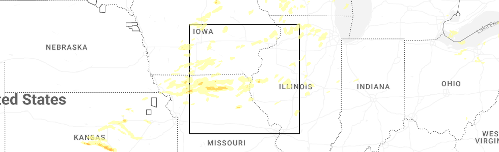
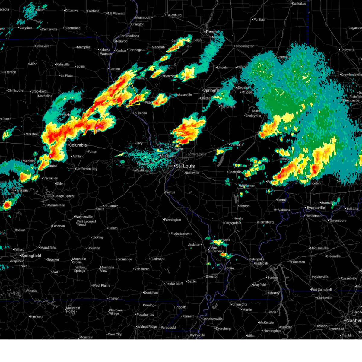
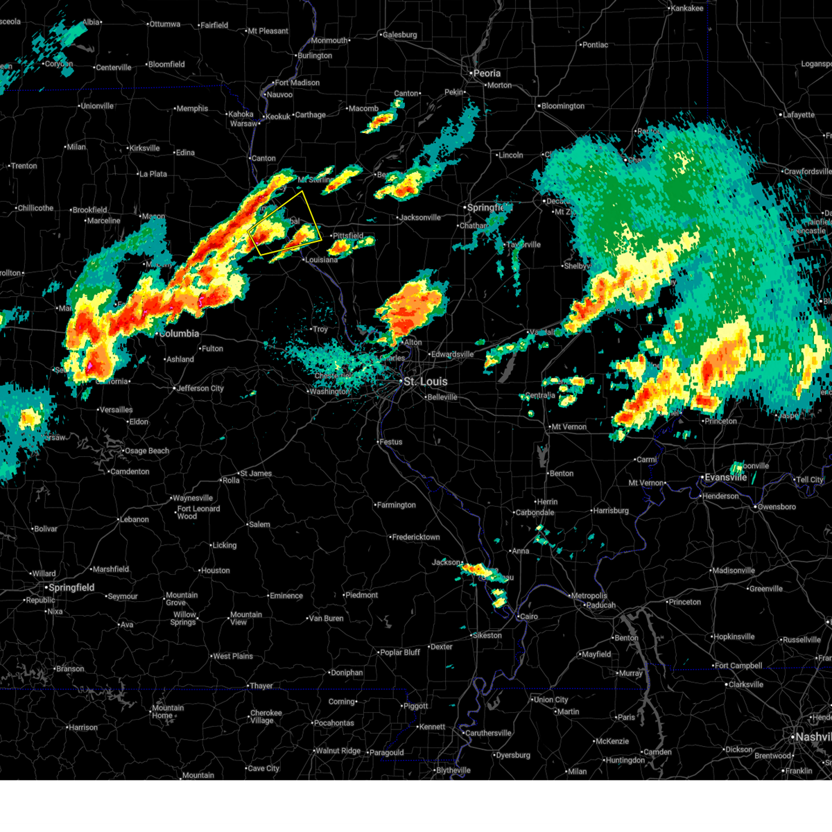
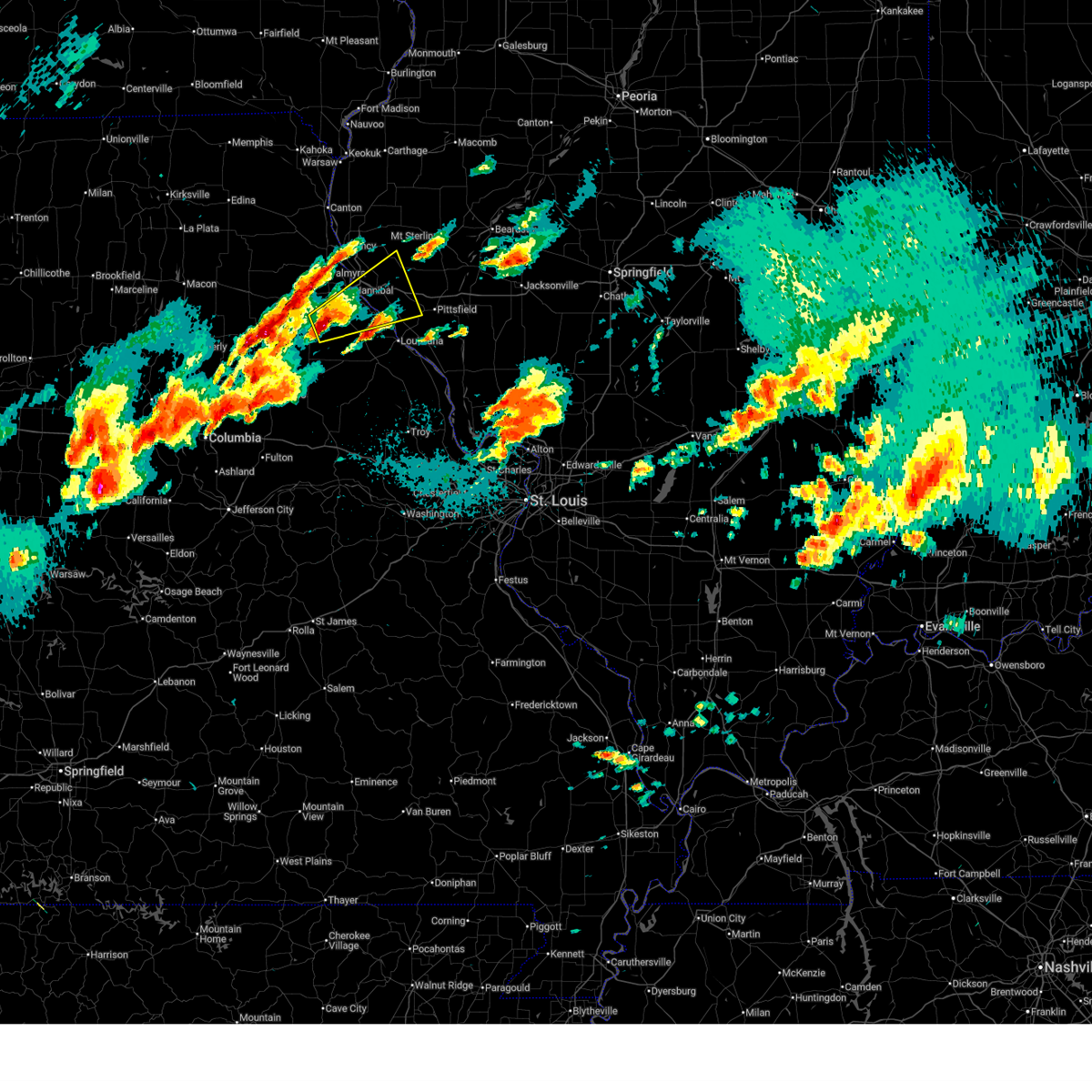
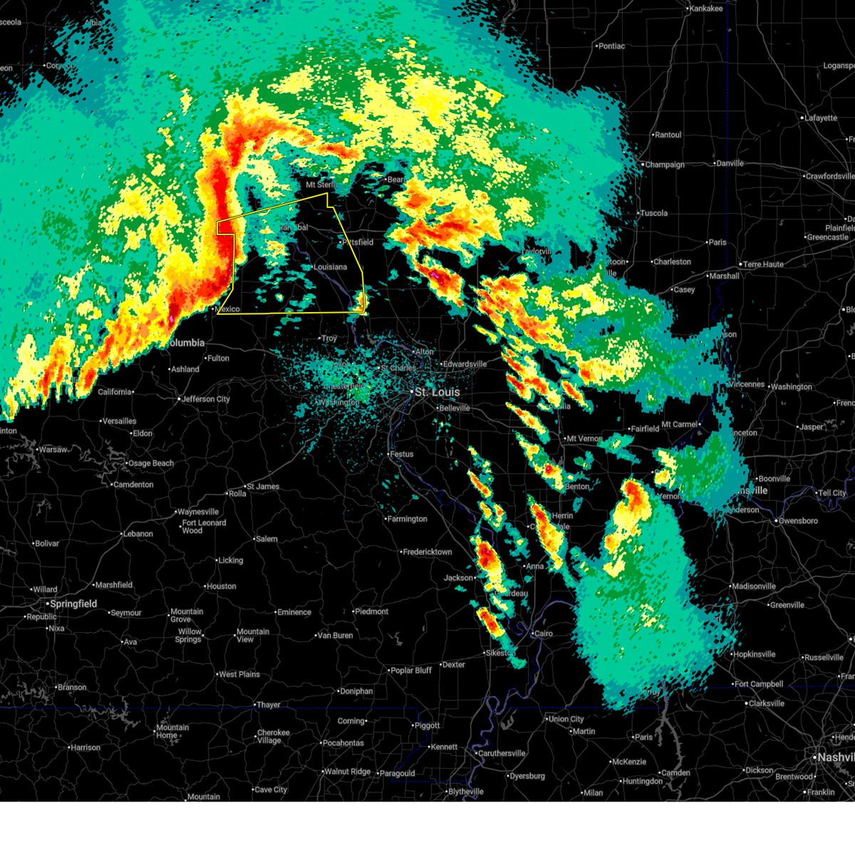
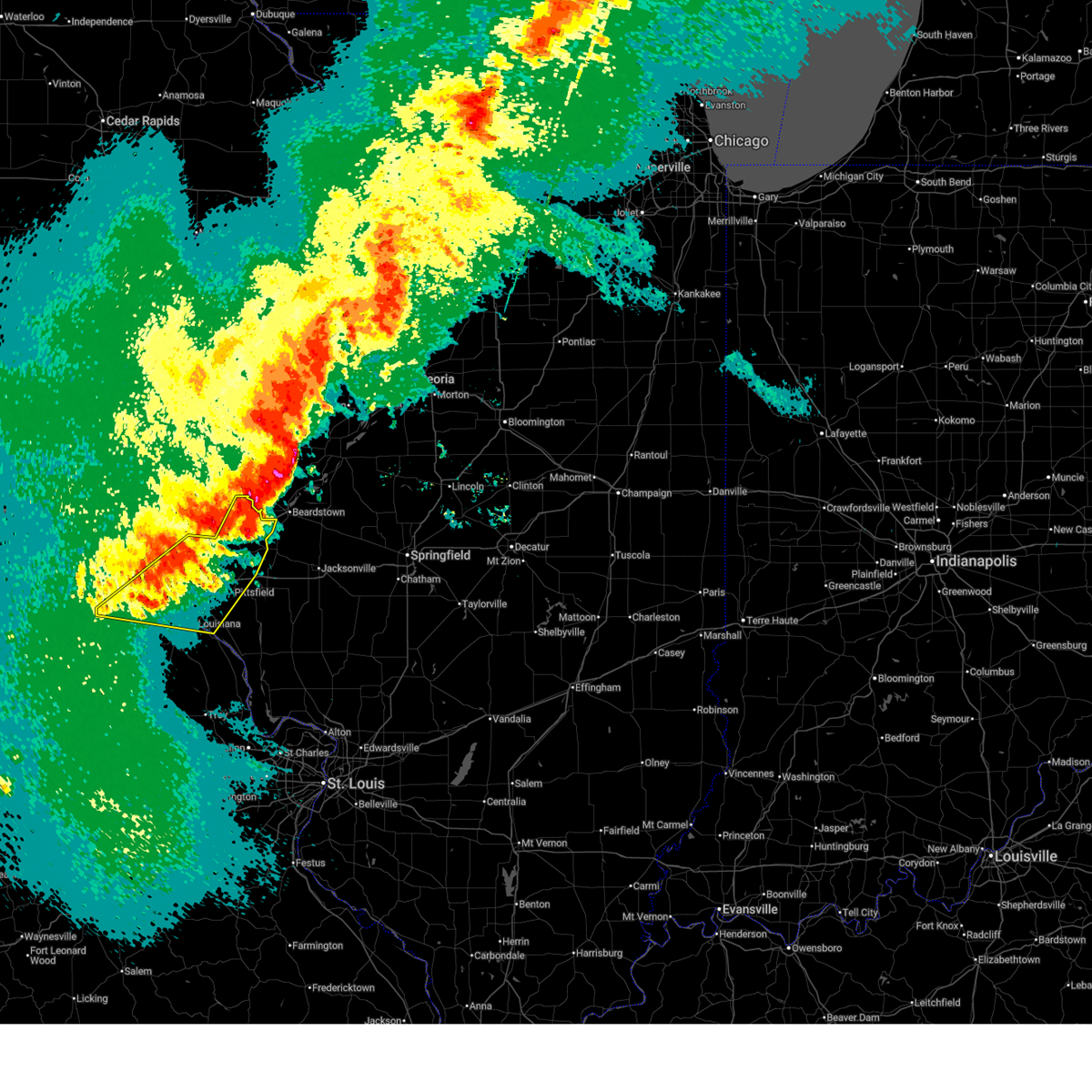
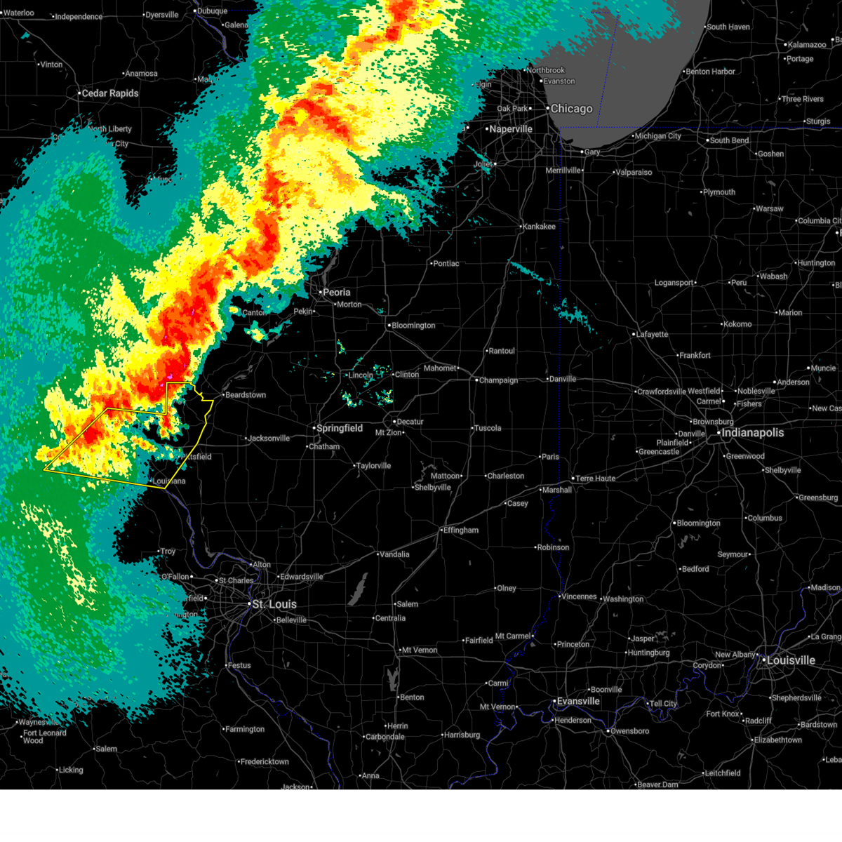
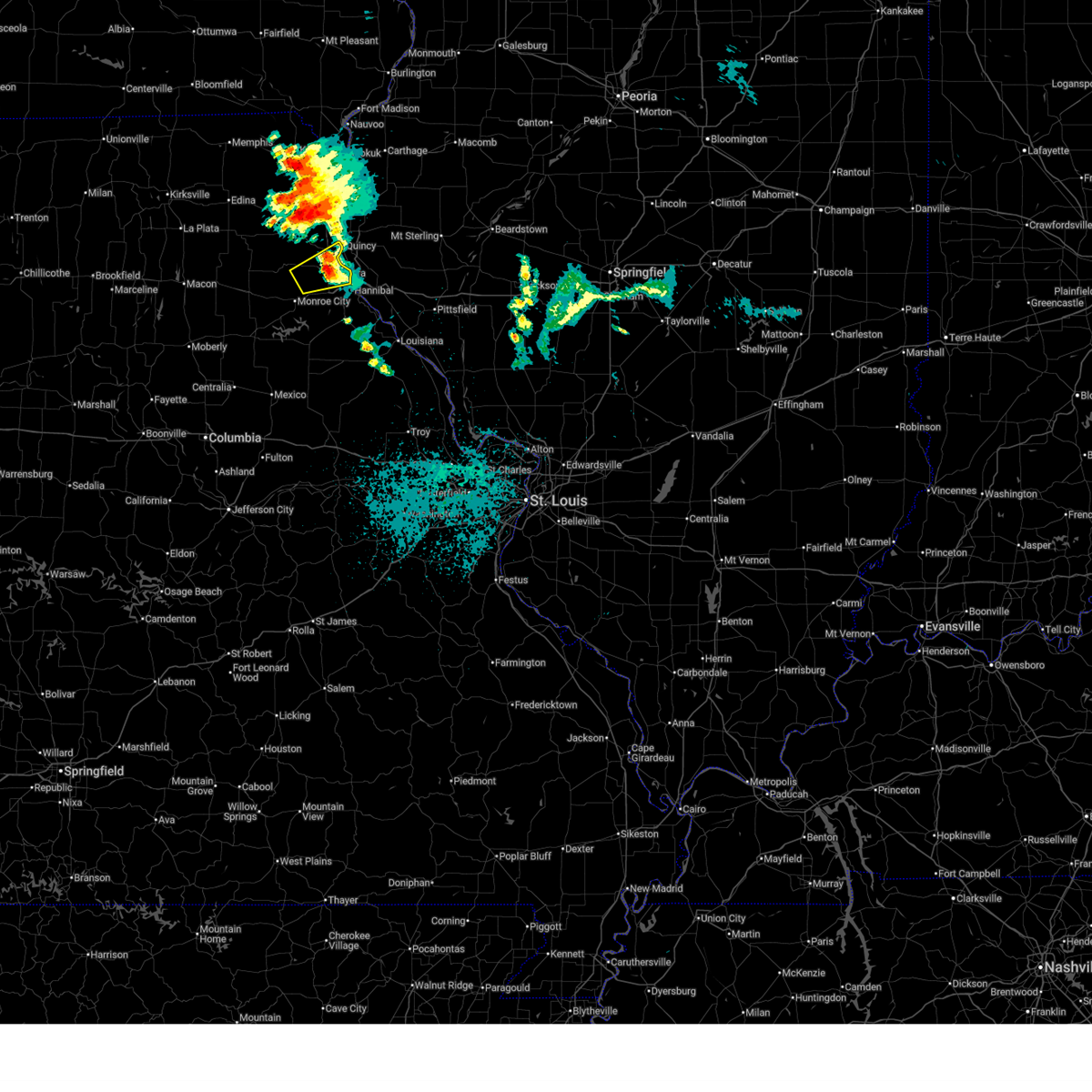
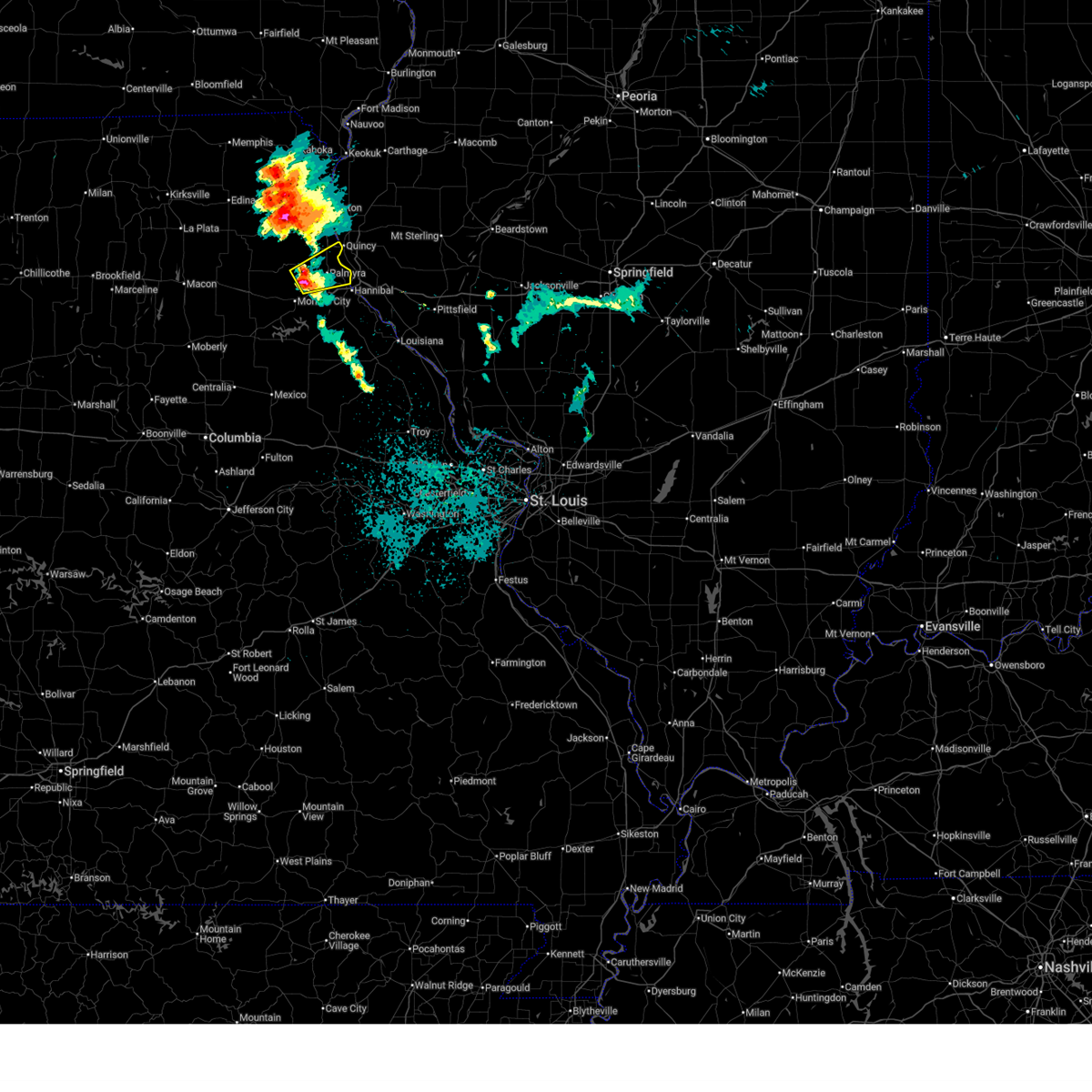
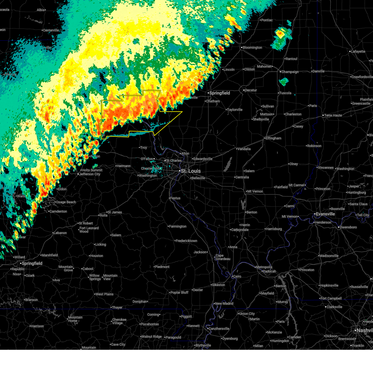
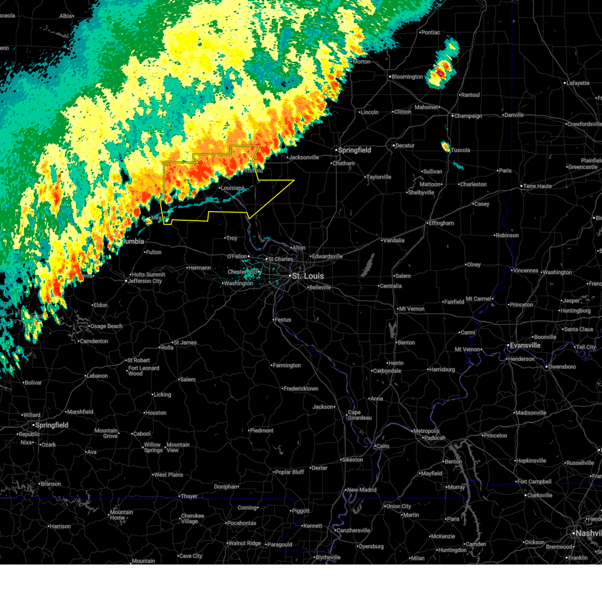
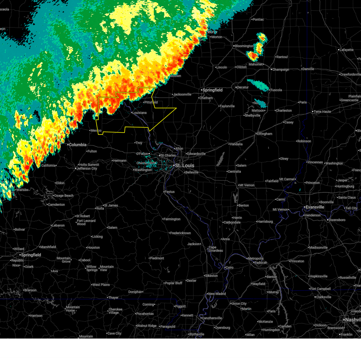
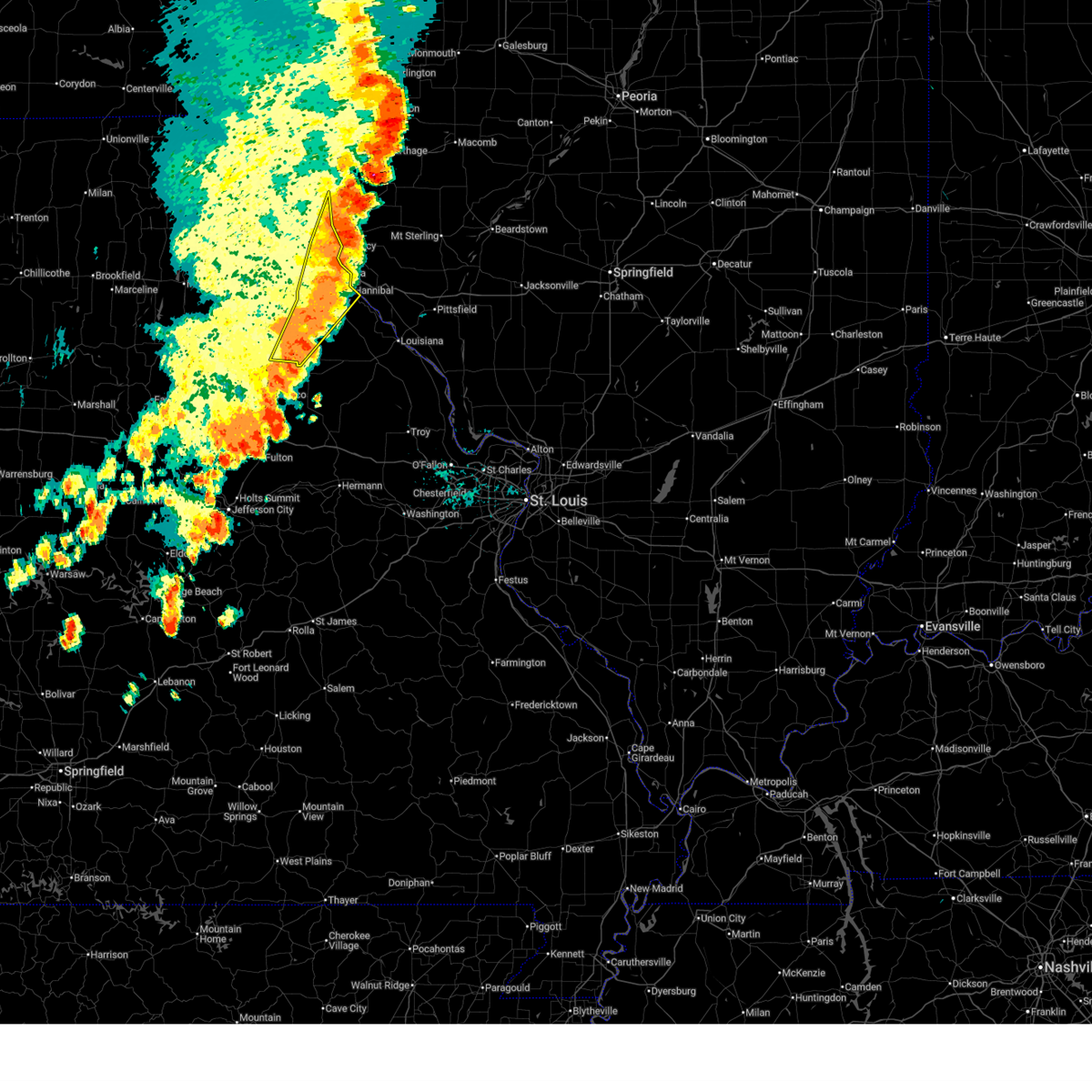
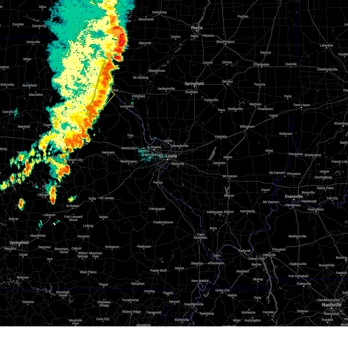
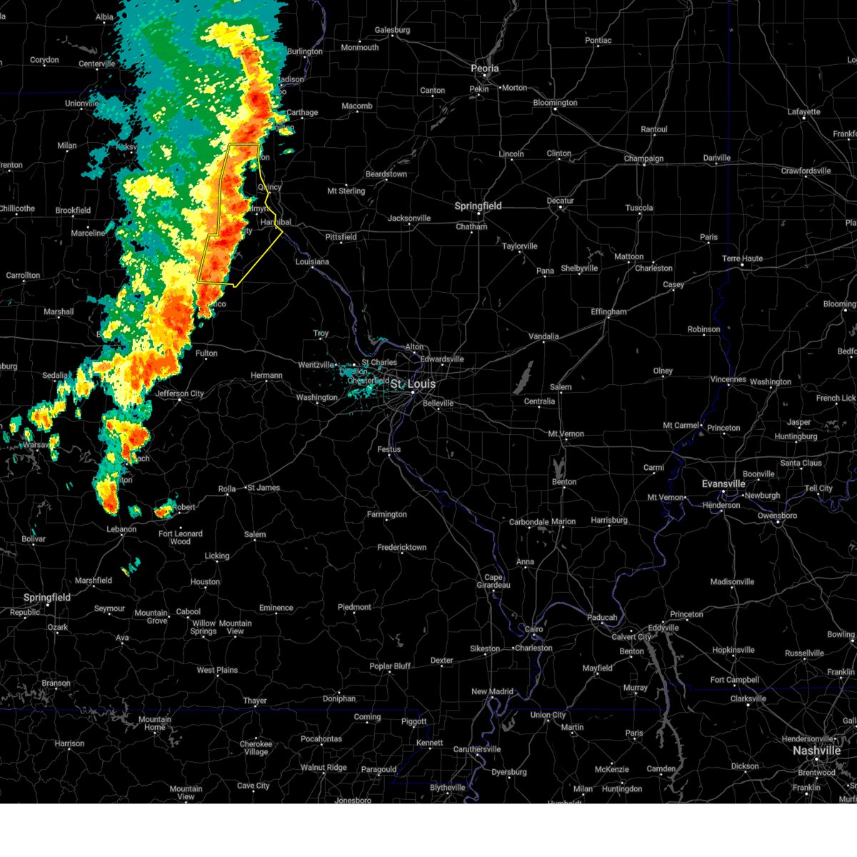
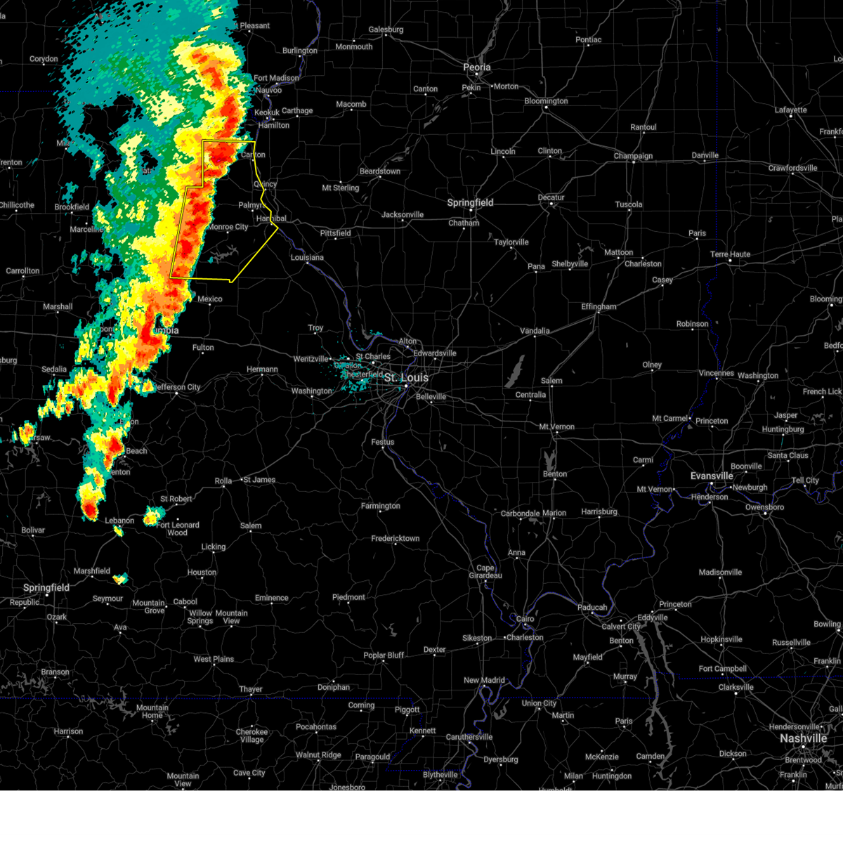
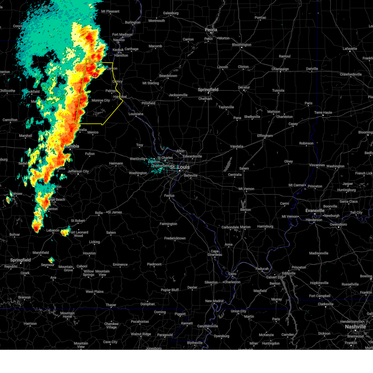
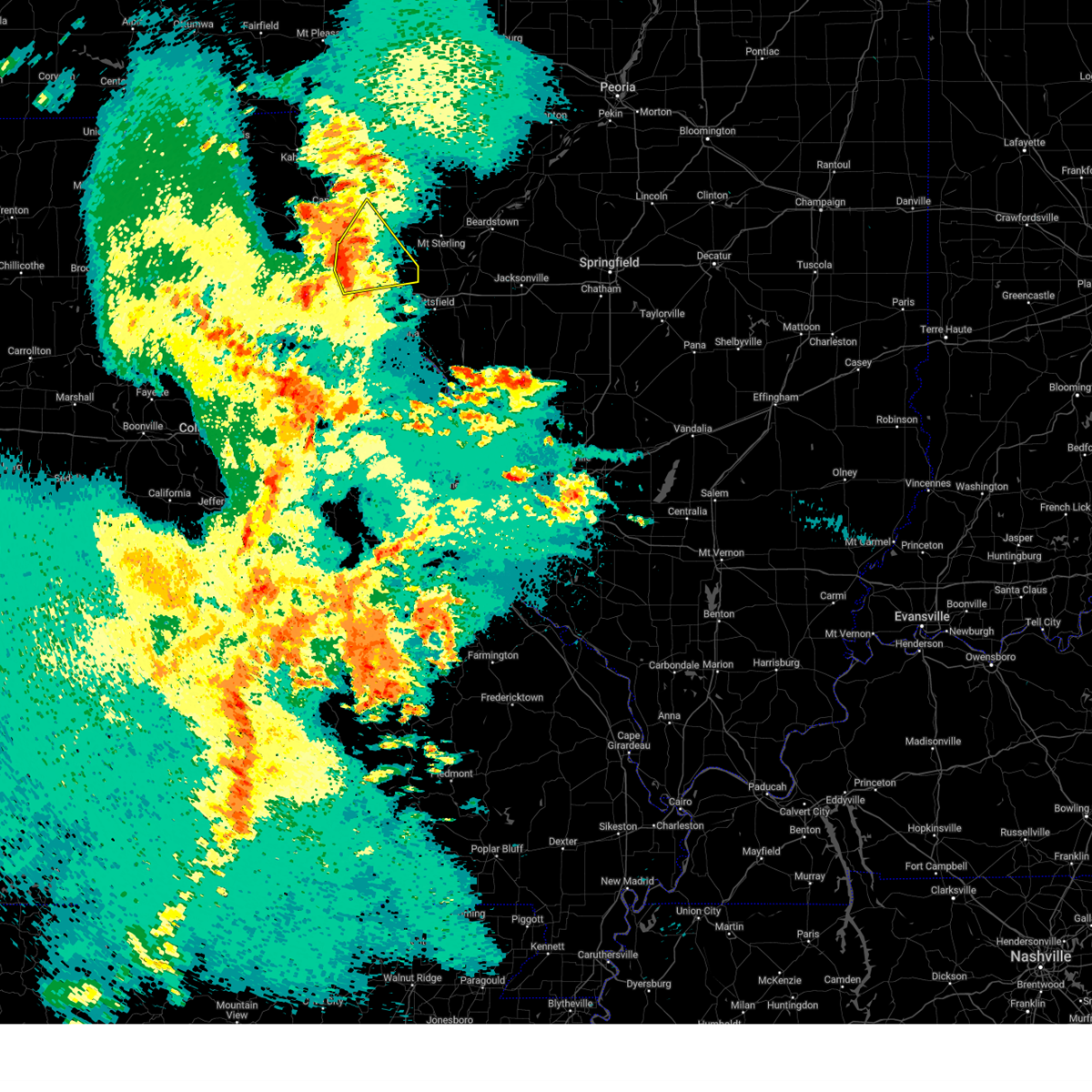
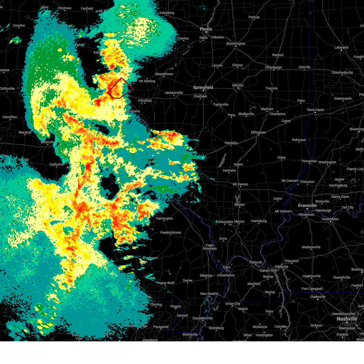
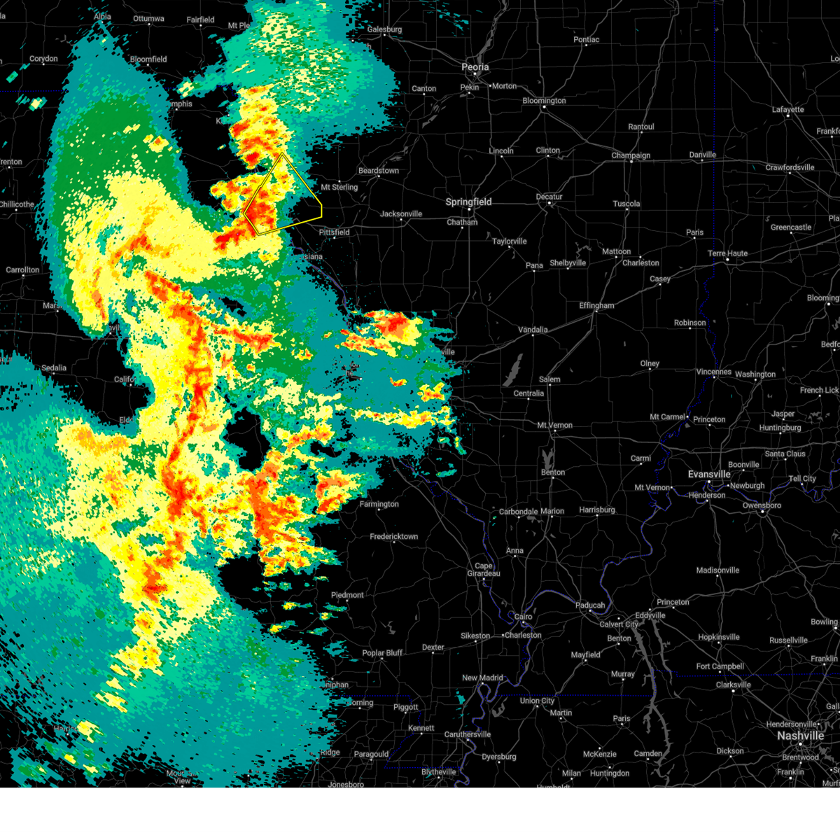
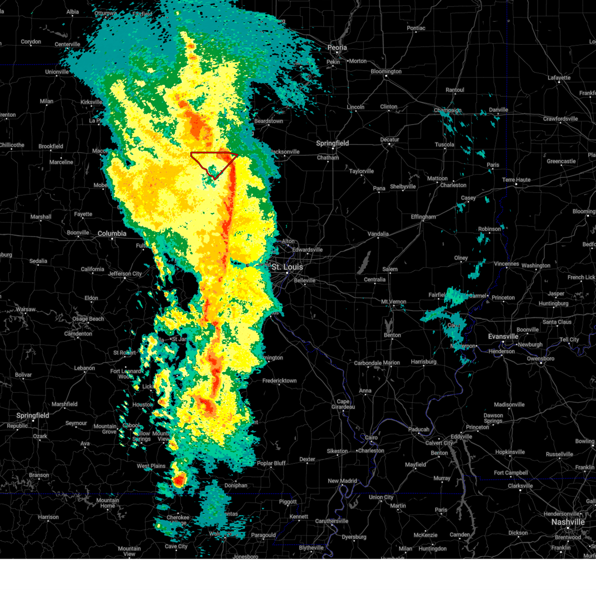
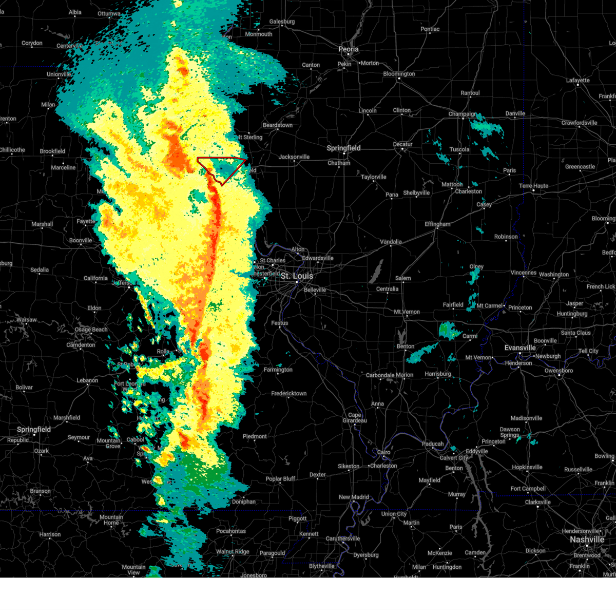
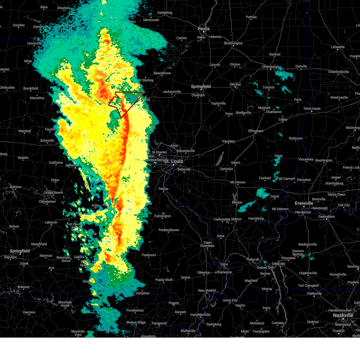
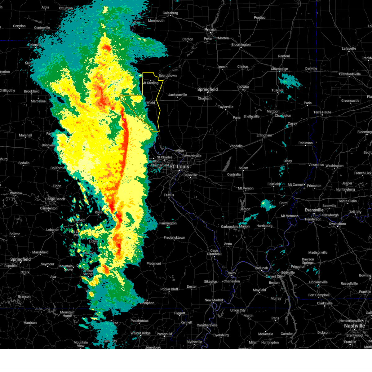
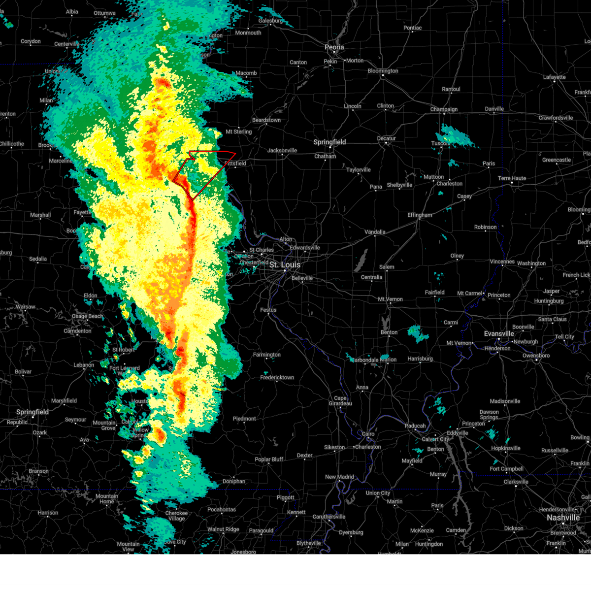
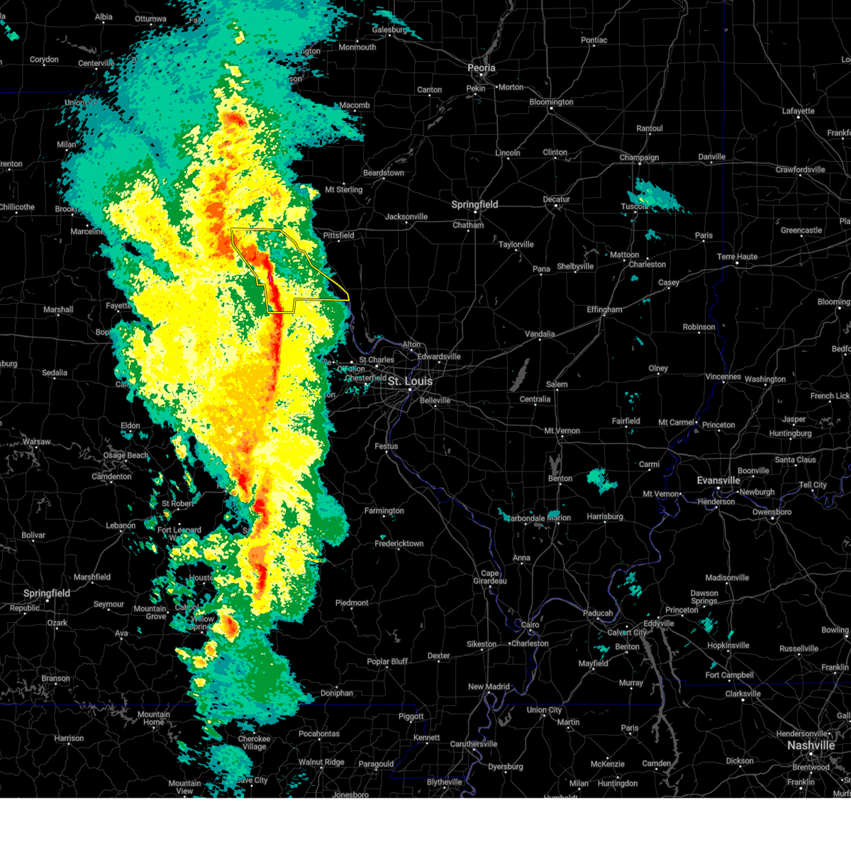
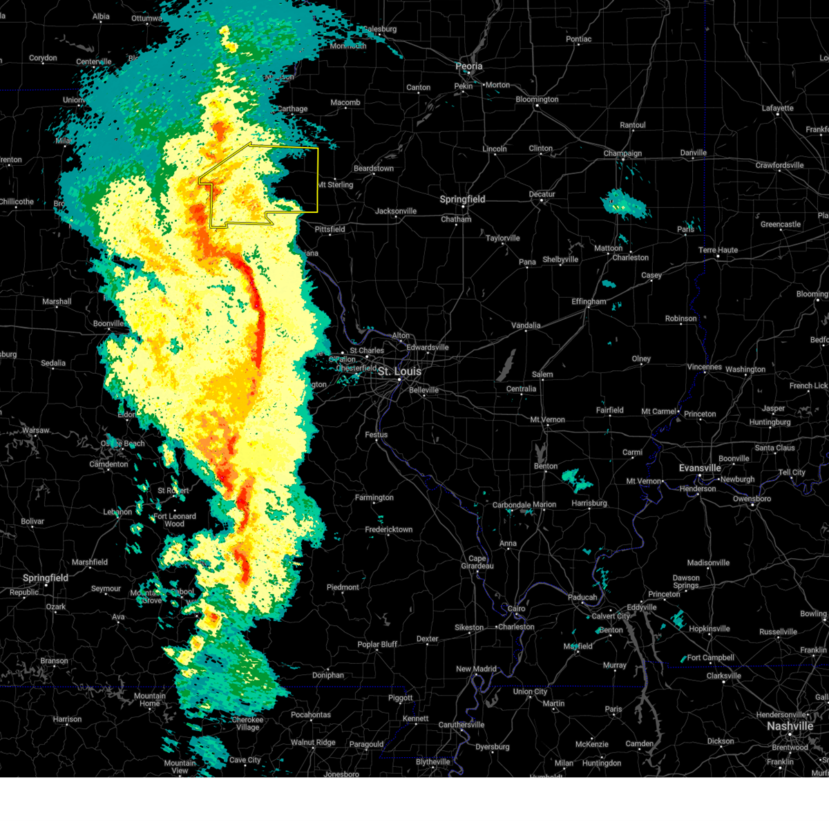
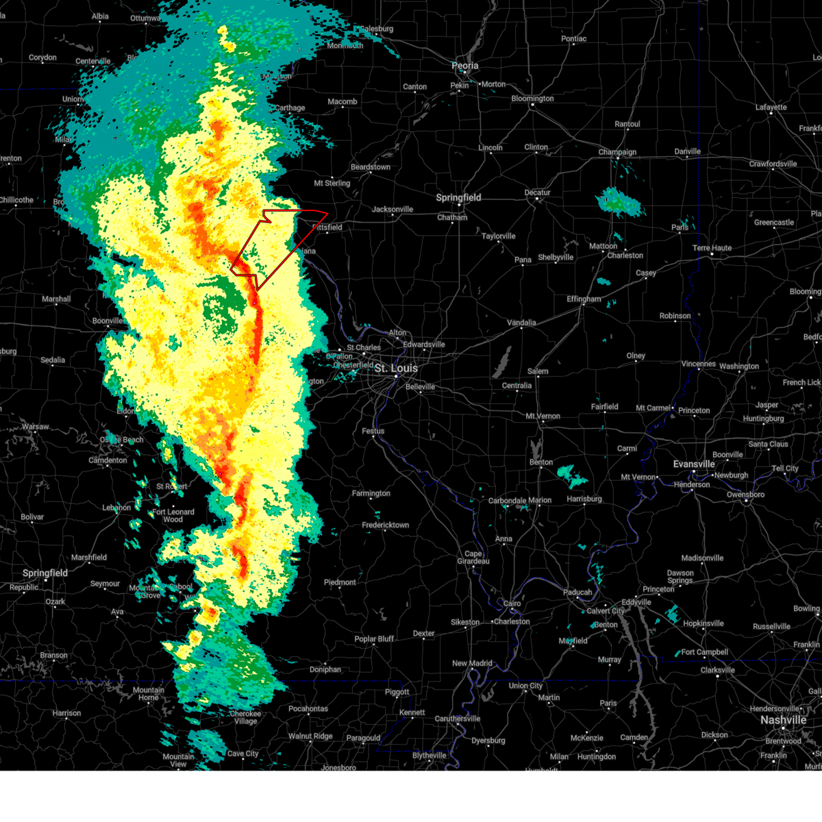
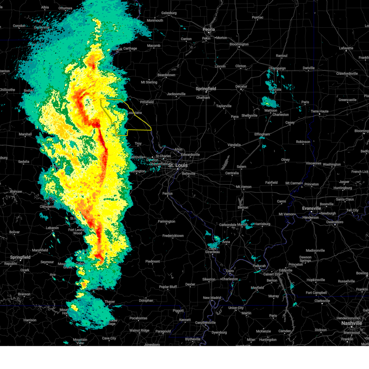
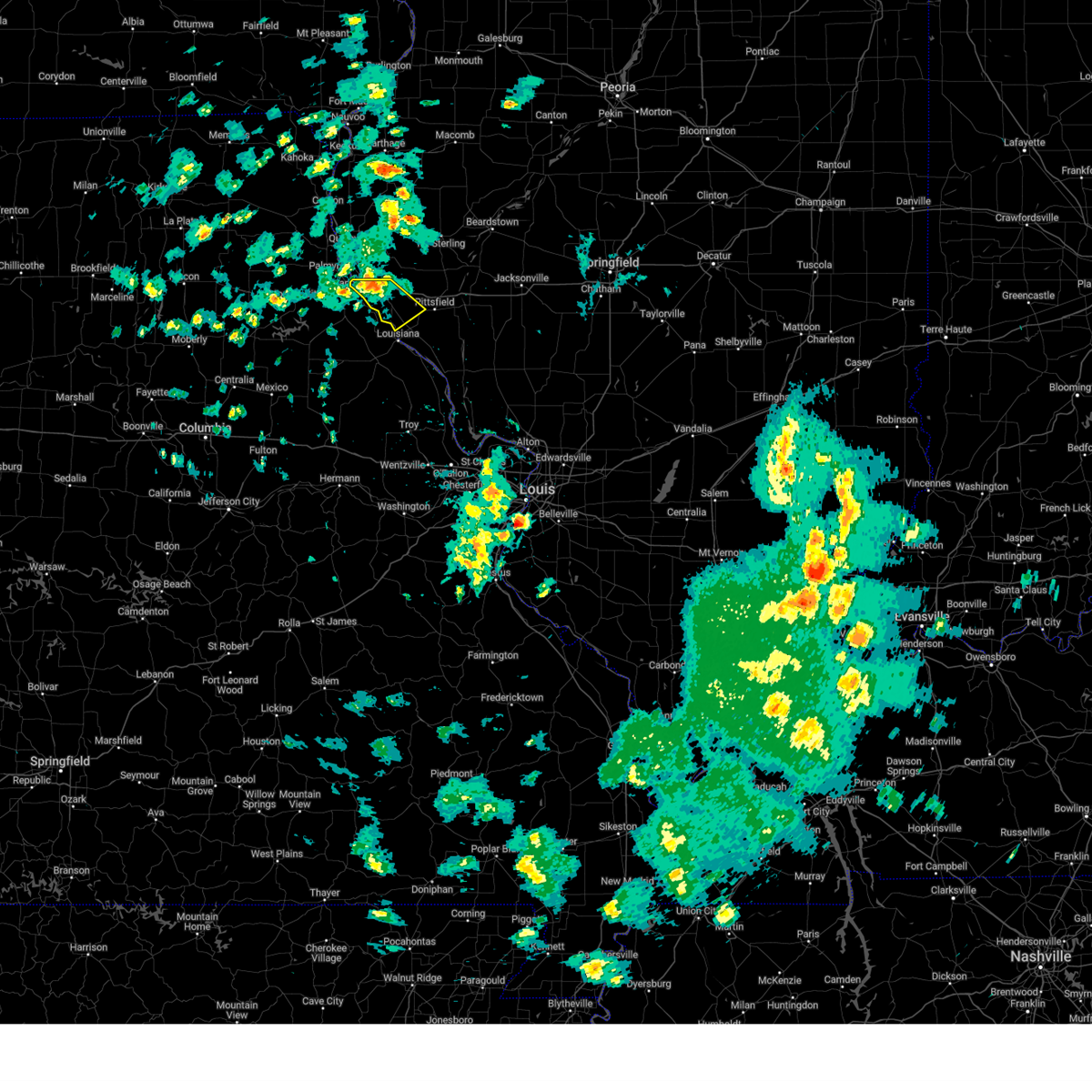
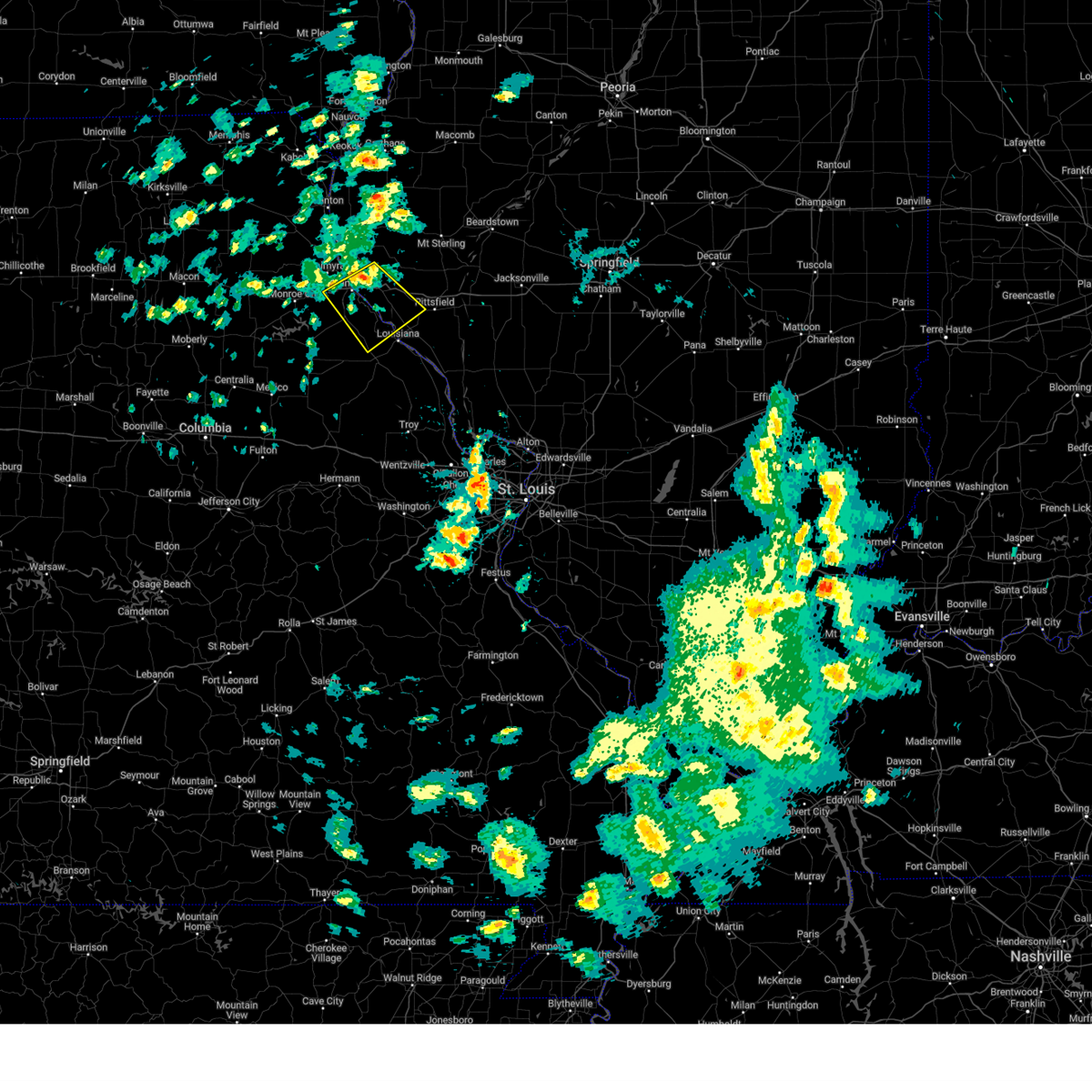
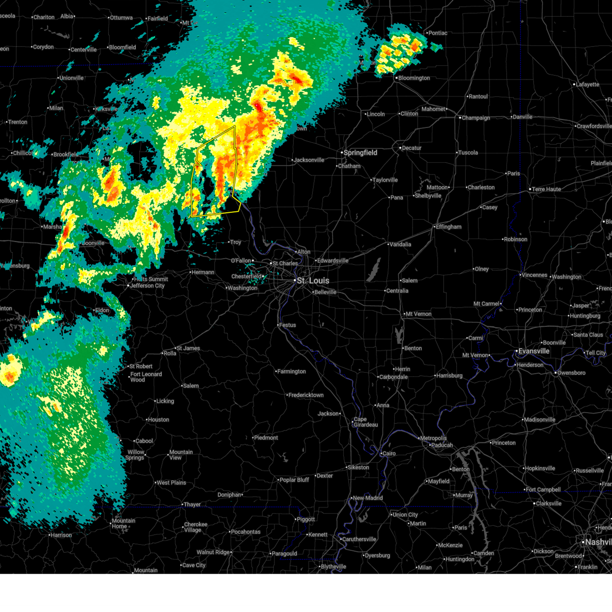
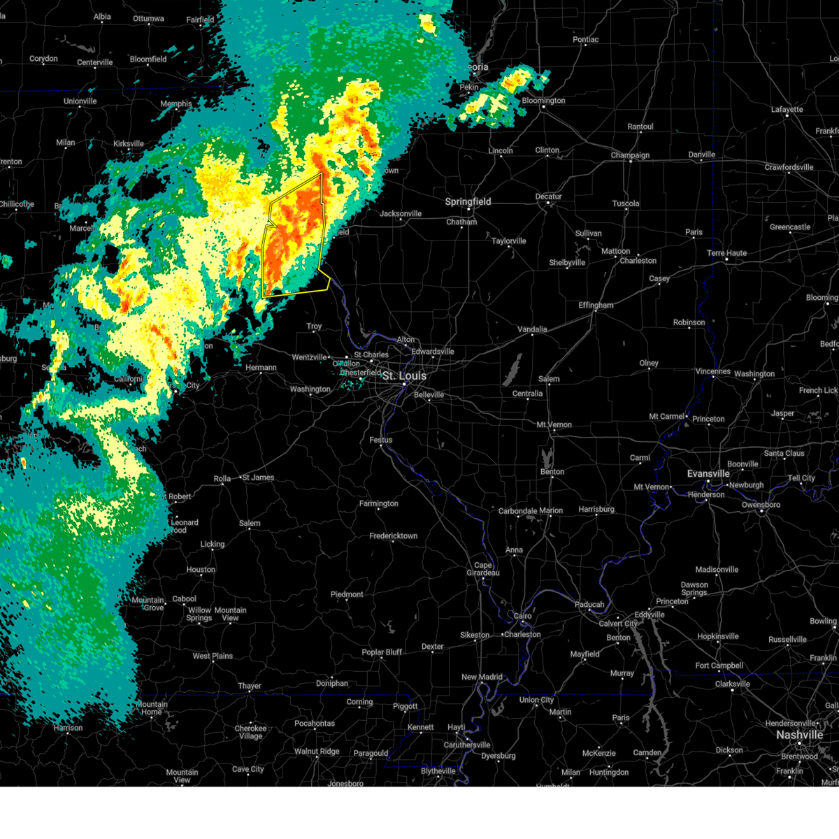
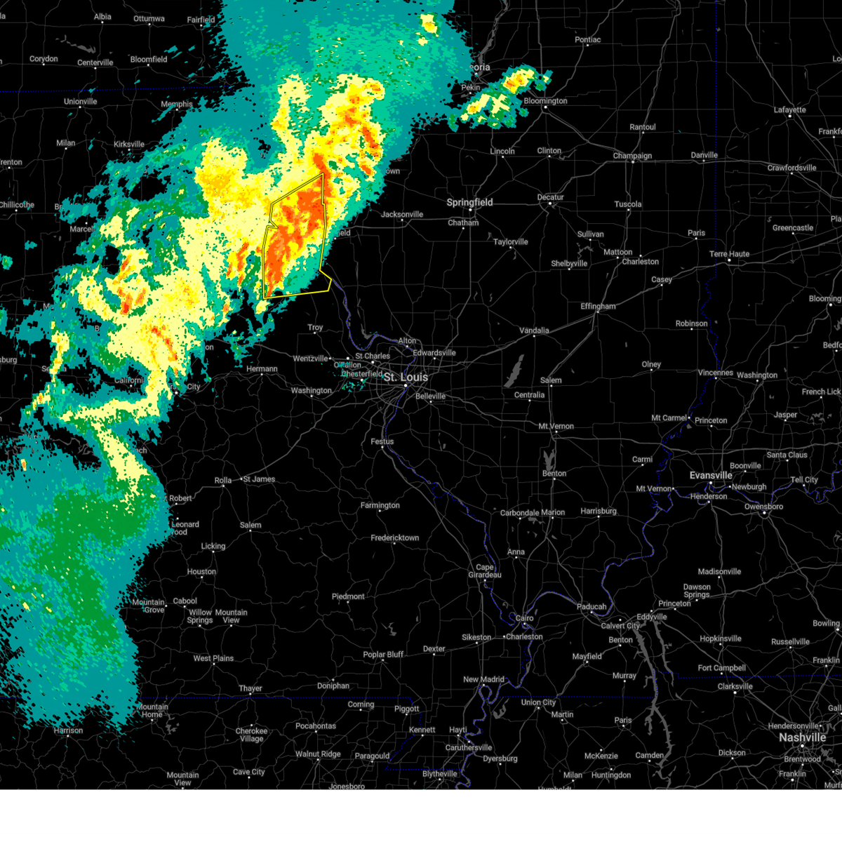
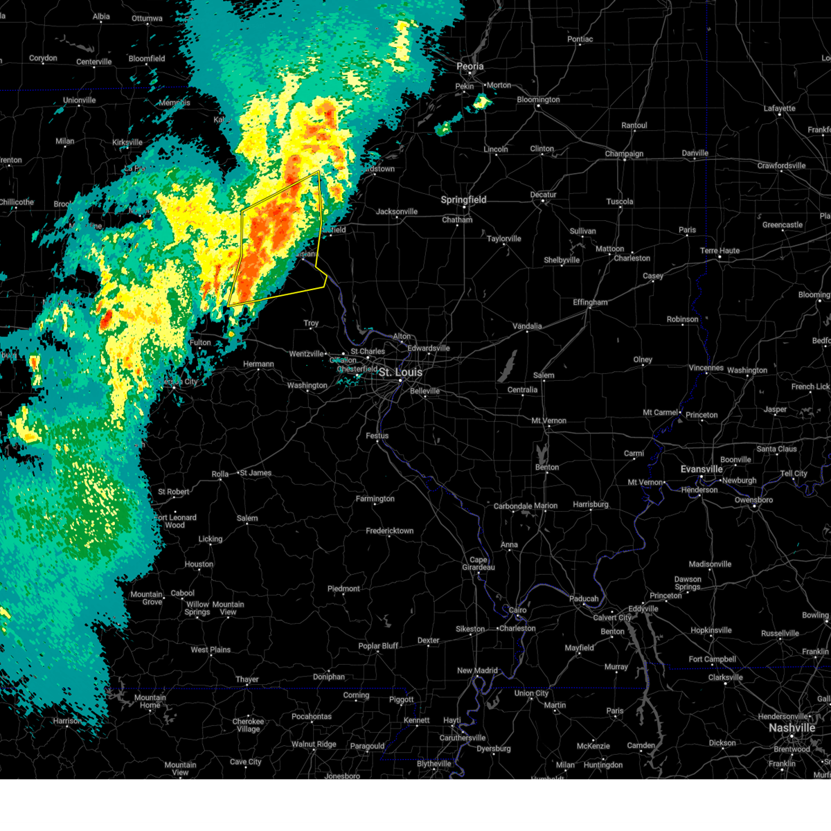
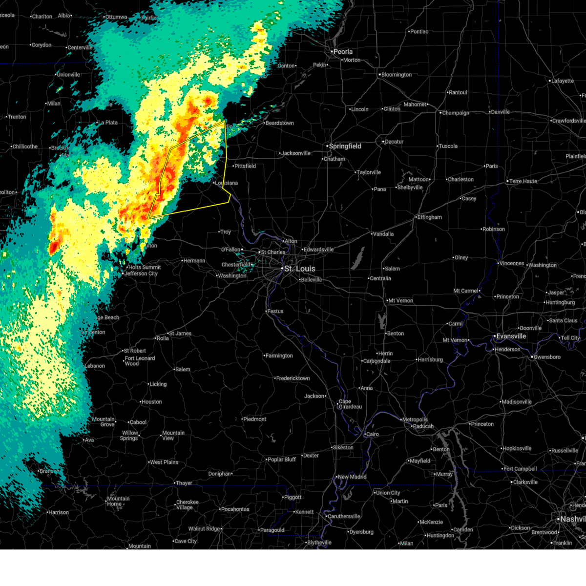
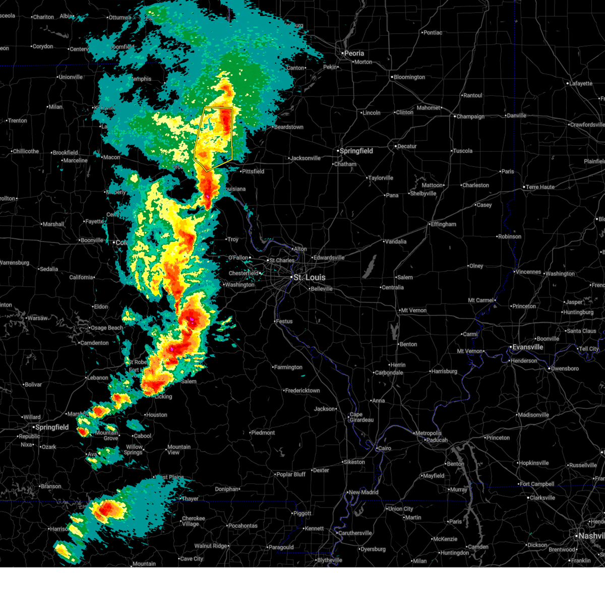
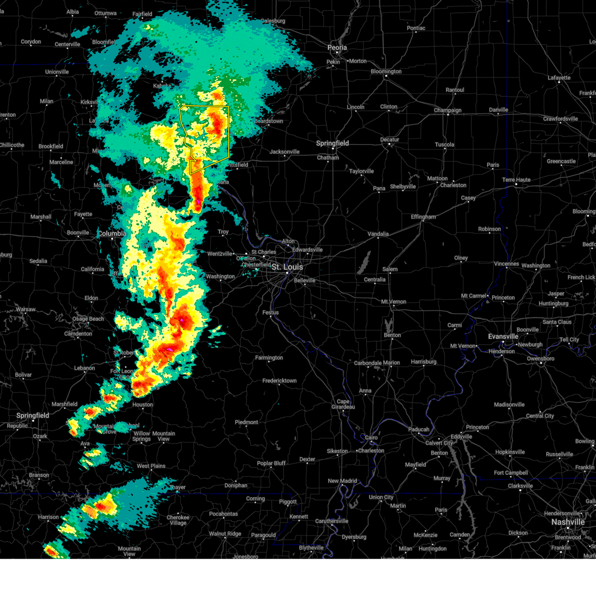
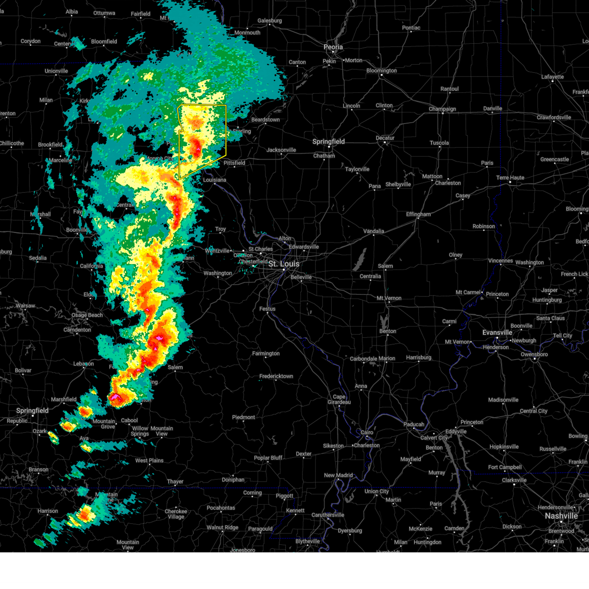
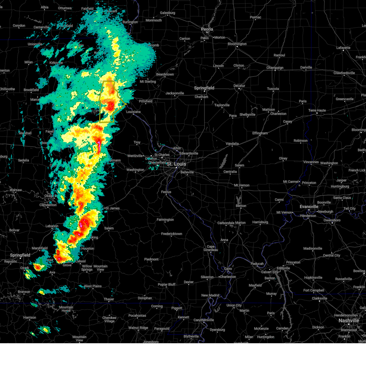
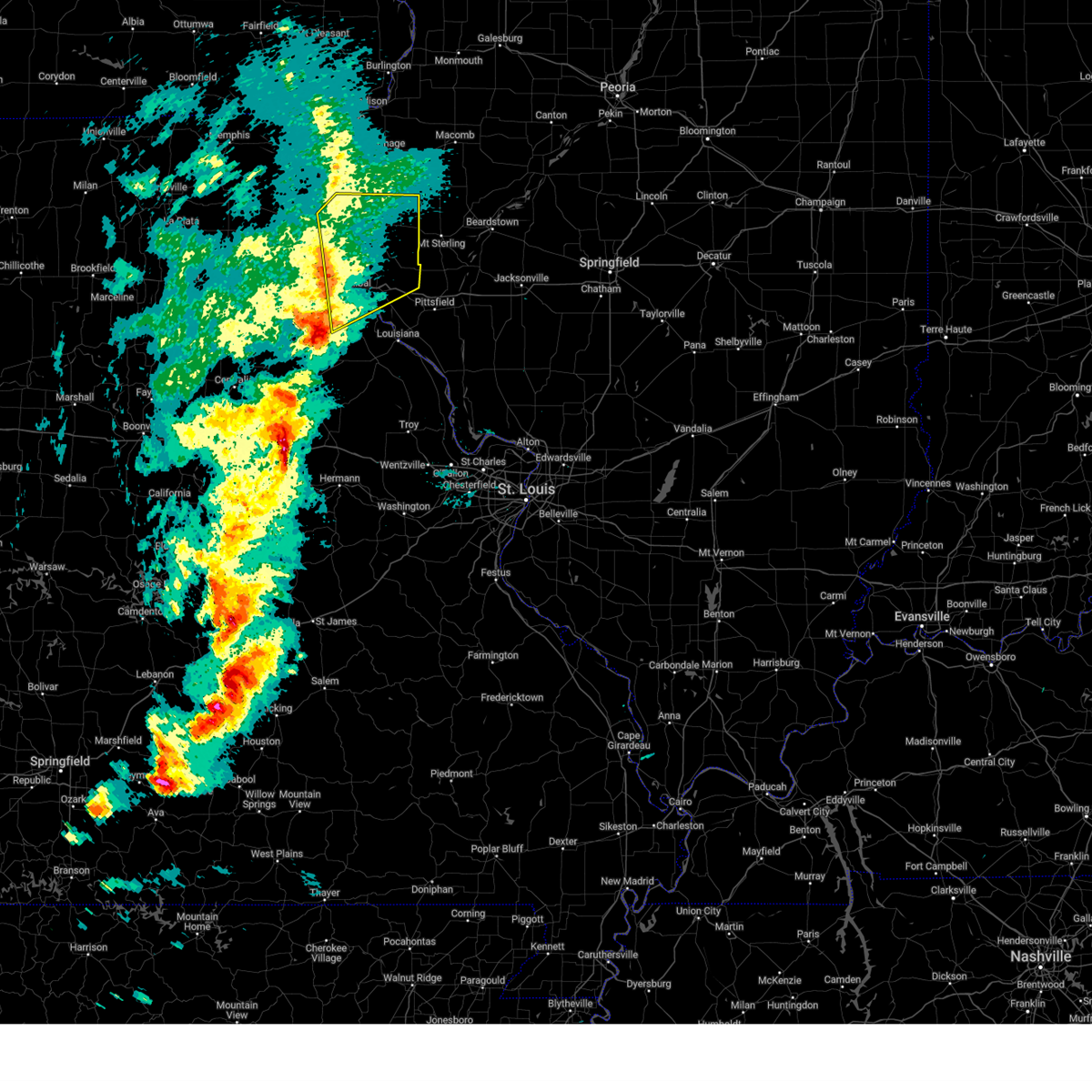
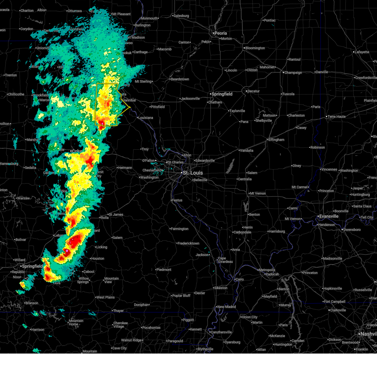
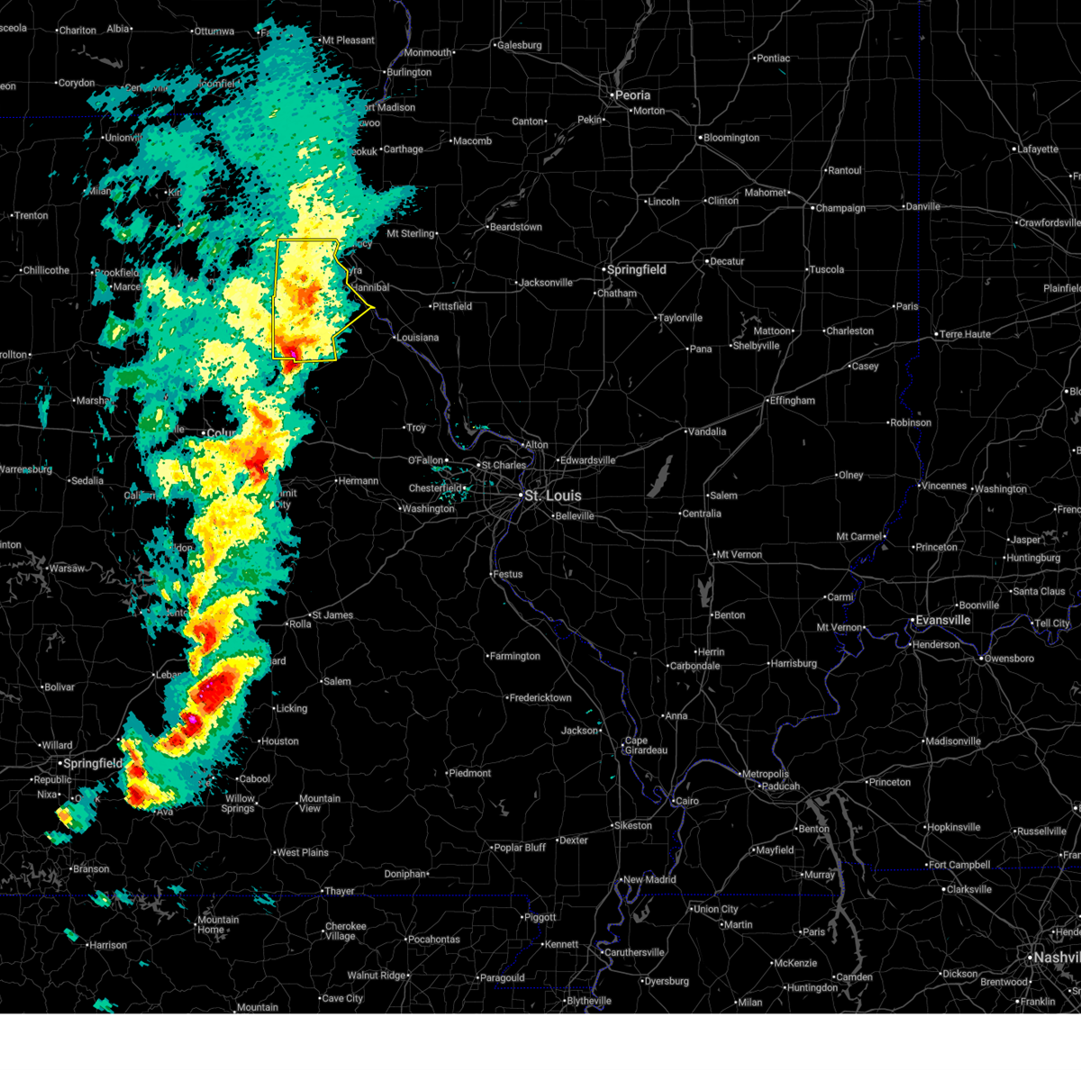
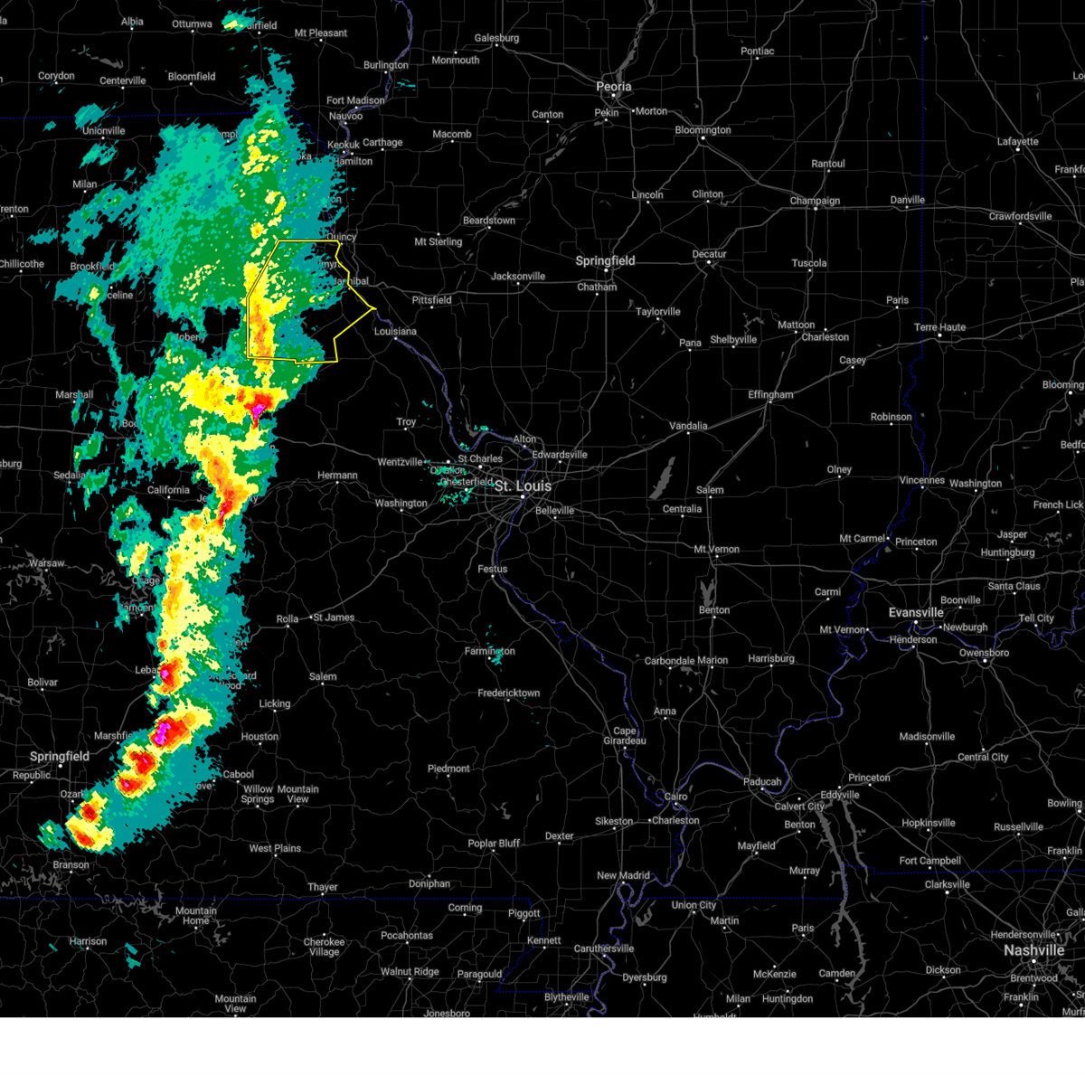
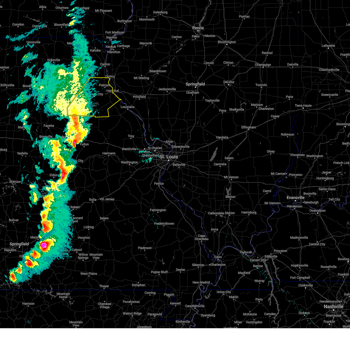
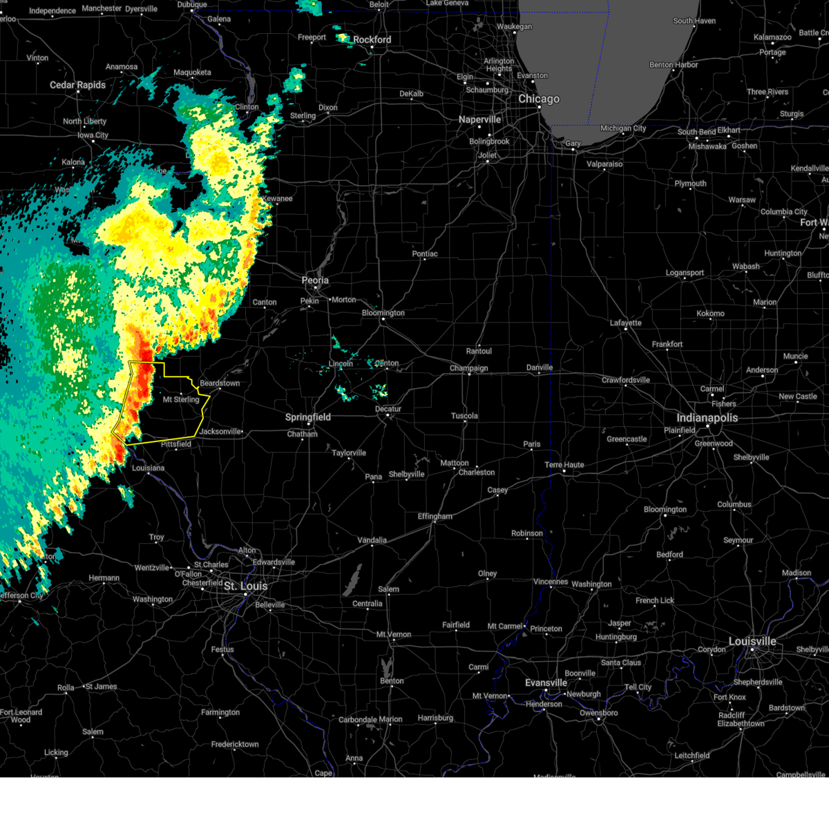
Hail Map for Hannibal, MO
The Hannibal, MO area has had 42 reports of on-the-ground hail by trained spotters, and has been under severe weather warnings 26 times during the past 12 months. Doppler radar has detected hail at or near Hannibal, MO on 83 occasions, including 5 occasions during the past year.
| Name: | Hannibal, MO |
| Where Located: | 51.9 miles SSE of Kahoka, MO |
| Map: | Google Map for Hannibal, MO |
| Population: | 17916 |
| Housing Units: | 8021 |
| More Info: | Search Google for Hannibal, MO |
1
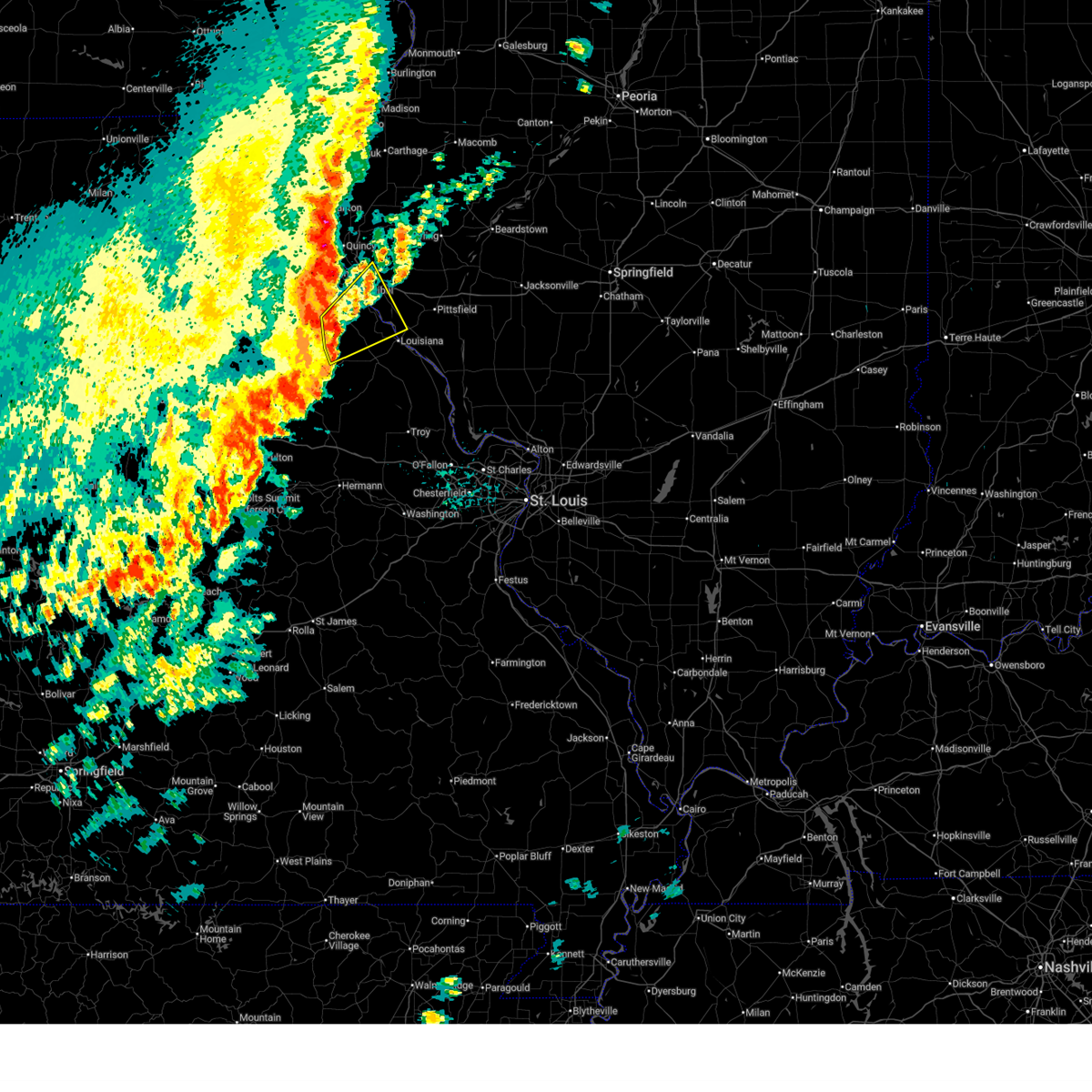
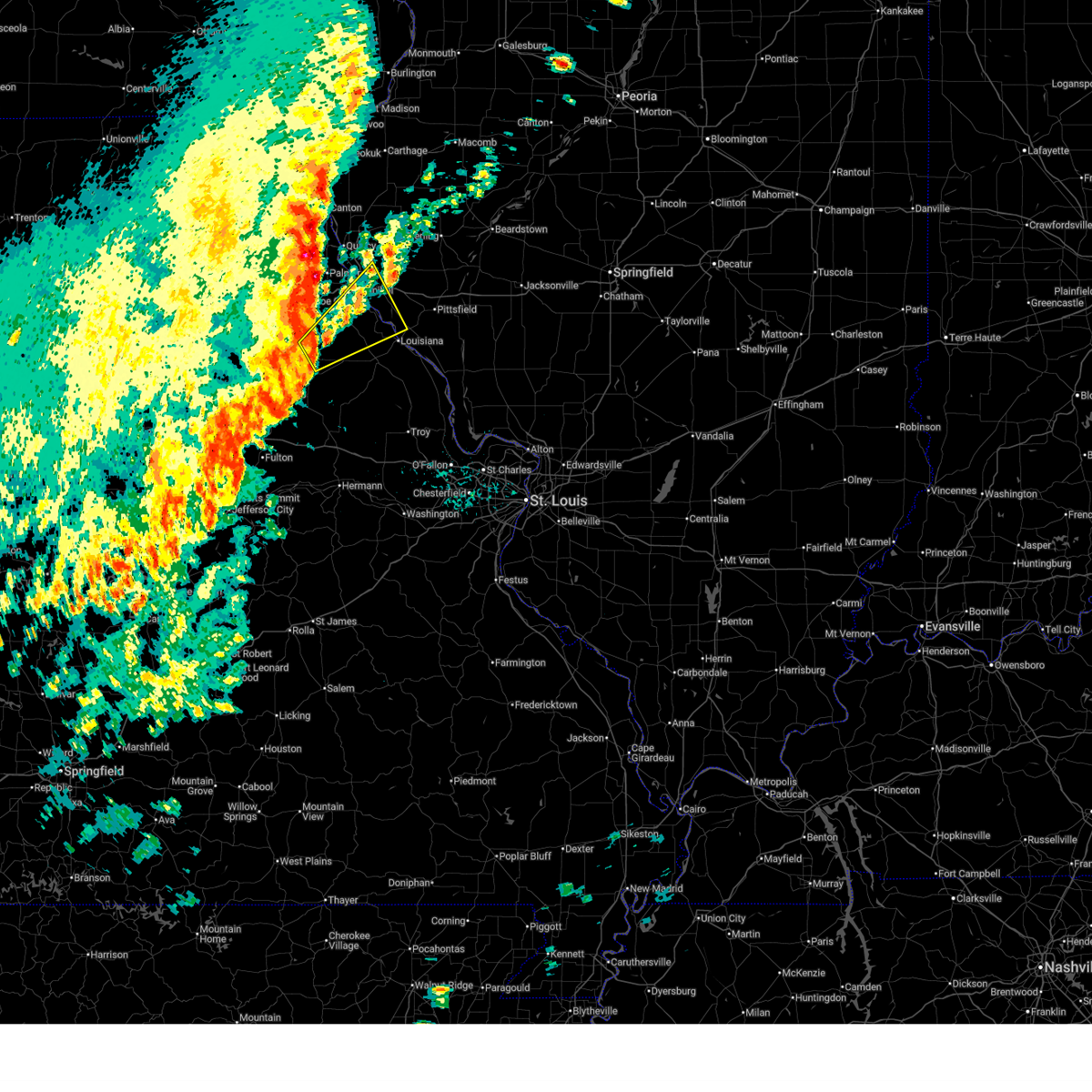
The Top Recent Hail Date for Hannibal, MO is Wednesday, June 10, 2026 (9th out of 83)
Hail and Wind Damage Spotted near Hannibal, MO
| Date / Time | Report Details |
|---|---|
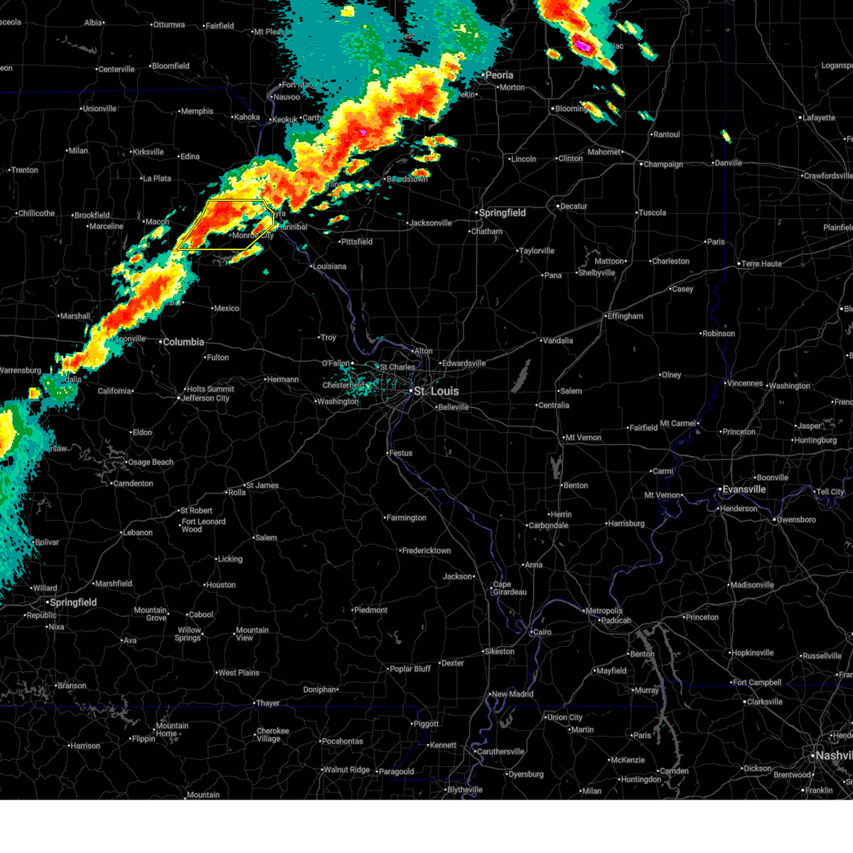
| 6/11/2026 6:02 PM CDT |
 the severe thunderstorm warning has been cancelled and is no longer in effect the severe thunderstorm warning has been cancelled and is no longer in effect
|
| 6/11/2026 6:02 PM CDT |
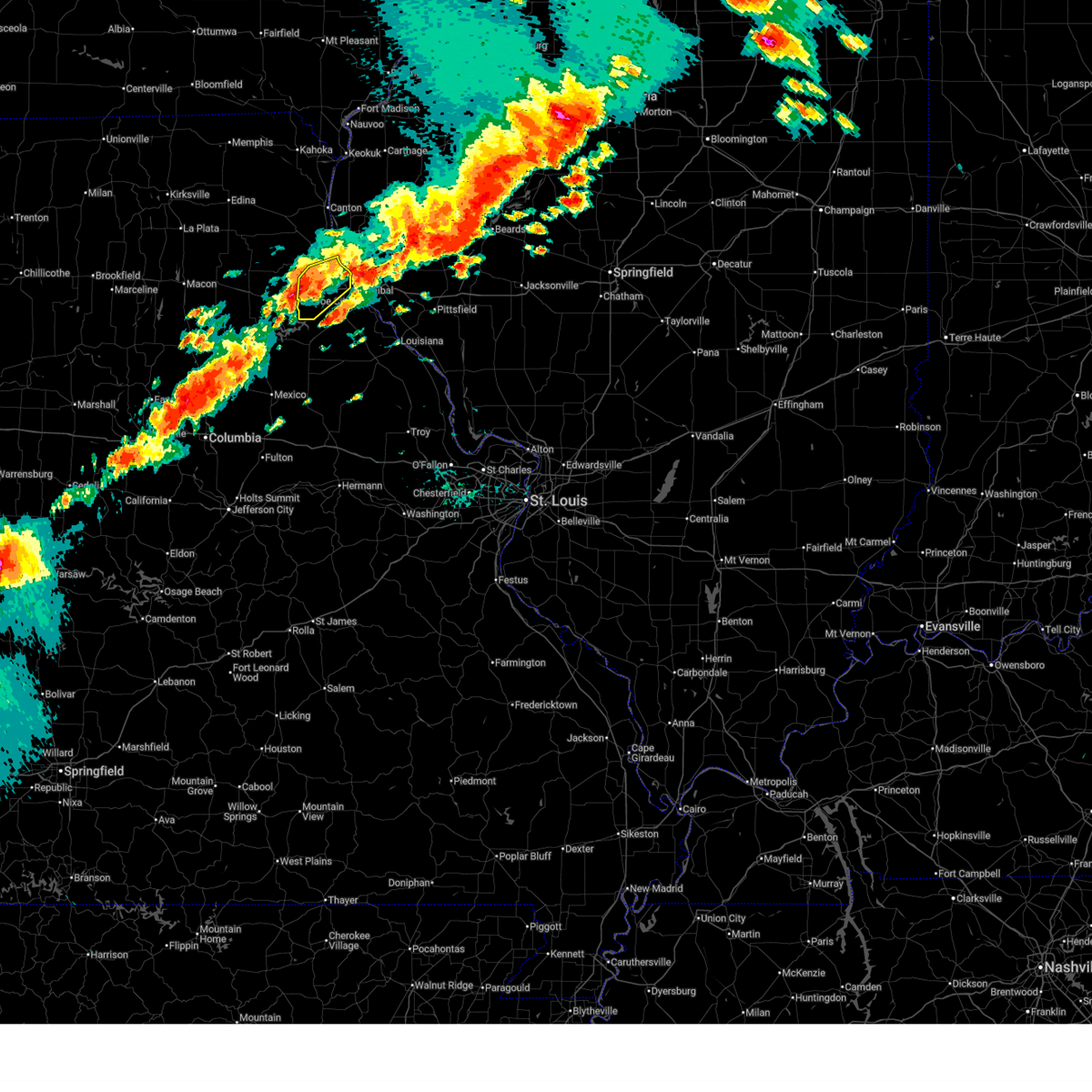
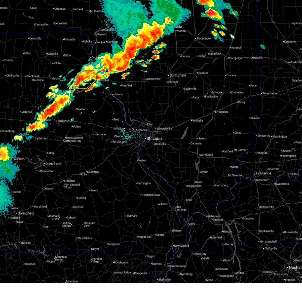
 At 602 pm cdt, severe thunderstorms were located along a line from over palmyra to 8 miles southwest of monroe city, moving east at 50 mph (radar indicated). Hazards include 60 mph wind gusts and quarter size hail. Hail damage to vehicles is expected. expect wind damage to roofs, siding, and trees. Locations impacted include, palmyra, rensselaer, hannibal, the landing and spaulding. At 602 pm cdt, severe thunderstorms were located along a line from over palmyra to 8 miles southwest of monroe city, moving east at 50 mph (radar indicated). Hazards include 60 mph wind gusts and quarter size hail. Hail damage to vehicles is expected. expect wind damage to roofs, siding, and trees. Locations impacted include, palmyra, rensselaer, hannibal, the landing and spaulding.
|
| 6/11/2026 5:49 PM CDT |
 At 549 pm cdt, severe thunderstorms were located along a line from over philadelphia to 8 miles northeast of paris, or along a line from 9 miles west of palmyra to 8 miles northeast of paris, moving east at 30 mph (radar indicated). Hazards include 60 mph wind gusts and quarter size hail. Hail damage to vehicles is expected. expect wind damage to roofs, siding, and trees. Locations impacted include, philadelphia, warren, monroe city, indian creek, palmyra, rensselaer, hannibal, the landing and spaulding. At 549 pm cdt, severe thunderstorms were located along a line from over philadelphia to 8 miles northeast of paris, or along a line from 9 miles west of palmyra to 8 miles northeast of paris, moving east at 30 mph (radar indicated). Hazards include 60 mph wind gusts and quarter size hail. Hail damage to vehicles is expected. expect wind damage to roofs, siding, and trees. Locations impacted include, philadelphia, warren, monroe city, indian creek, palmyra, rensselaer, hannibal, the landing and spaulding.
|
| 6/11/2026 5:34 PM CDT |
 Svrlsx the national weather service in st louis has issued a * severe thunderstorm warning for, marion county in northeastern missouri, northeastern monroe county in northeastern missouri, northwestern ralls county in northeastern missouri, southeastern shelby county in northeastern missouri, * until 630 pm cdt. * at 534 pm cdt, severe thunderstorms were located along a line from near emden to over granville, or along a line from 14 miles north of monroe city to 7 miles south of shelbina, moving east at 30 mph (radar indicated). Hazards include 60 mph wind gusts and quarter size hail. Hail damage to vehicles is expected. Expect wind damage to roofs, siding, and trees. Svrlsx the national weather service in st louis has issued a * severe thunderstorm warning for, marion county in northeastern missouri, northeastern monroe county in northeastern missouri, northwestern ralls county in northeastern missouri, southeastern shelby county in northeastern missouri, * until 630 pm cdt. * at 534 pm cdt, severe thunderstorms were located along a line from near emden to over granville, or along a line from 14 miles north of monroe city to 7 miles south of shelbina, moving east at 30 mph (radar indicated). Hazards include 60 mph wind gusts and quarter size hail. Hail damage to vehicles is expected. Expect wind damage to roofs, siding, and trees.
|
| 5/18/2026 6:28 AM CDT |
 the severe thunderstorm warning has been cancelled and is no longer in effect the severe thunderstorm warning has been cancelled and is no longer in effect
|
| 5/18/2026 6:28 AM CDT |
 At 628 am cdt, a severe thunderstorm was located near spencerburg, or 12 miles north of vandalia, moving northeast at 45 mph (radar indicated). Hazards include 60 mph wind gusts. Expect damage to roofs, siding, and trees. locations impacted include, center, spencerburg, frankford, new london, ilasco, hannibal, saverton, ashburn, fall creek, seehorn, hull, new canton, kinderhook, payson, rockport and plainville. this includes the following state parks, fall creek scenic overlook state natural area. This includes interstate 72 between exits 4 and 10. At 628 am cdt, a severe thunderstorm was located near spencerburg, or 12 miles north of vandalia, moving northeast at 45 mph (radar indicated). Hazards include 60 mph wind gusts. Expect damage to roofs, siding, and trees. locations impacted include, center, spencerburg, frankford, new london, ilasco, hannibal, saverton, ashburn, fall creek, seehorn, hull, new canton, kinderhook, payson, rockport and plainville. this includes the following state parks, fall creek scenic overlook state natural area. This includes interstate 72 between exits 4 and 10.
|
| 5/18/2026 6:12 AM CDT |
 Svrlsx the national weather service in st louis has issued a * severe thunderstorm warning for, south central adams county in west central illinois, western pike county in west central illinois, northeastern audrain county in central missouri, southeastern marion county in northeastern missouri, northwestern pike county in northeastern missouri, ralls county in northeastern missouri, * until 700 am cdt. * at 612 am cdt, a severe thunderstorm was located near perry, or 8 miles northwest of vandalia, moving northeast at 40 mph (radar indicated). Hazards include 60 mph wind gusts. expect damage to roofs, siding, and trees Svrlsx the national weather service in st louis has issued a * severe thunderstorm warning for, south central adams county in west central illinois, western pike county in west central illinois, northeastern audrain county in central missouri, southeastern marion county in northeastern missouri, northwestern pike county in northeastern missouri, ralls county in northeastern missouri, * until 700 am cdt. * at 612 am cdt, a severe thunderstorm was located near perry, or 8 miles northwest of vandalia, moving northeast at 40 mph (radar indicated). Hazards include 60 mph wind gusts. expect damage to roofs, siding, and trees
|
| 4/27/2026 4:34 PM CDT |
 Torlsx the national weather service in st louis has issued a * tornado warning for, adams county in west central illinois, northwestern brown county in west central illinois, eastern marion county in northeastern missouri, * until 530 pm cdt. * at 434 pm cdt, a severe thunderstorm capable of producing a tornado was located near palmyra, moving northeast at 30 mph. another storm capable of a tornado is located east of quincy in adams county (radar indicated rotation). Hazards include tornado and quarter size hail. Flying debris will be dangerous to those caught without shelter. mobile homes will be damaged or destroyed. damage to roofs, windows and vehicles will occur. tree damage is likely. this tornado will be near, hannibal and palmyra around 435 pm cdt. fall creek around 450 pm cdt. other locations impacted by the tornado include marblehead, burton, adams, fowler, liberty, columbus, coatsburg and paloma. This includes interstate 172 between exits 2 and 19. Torlsx the national weather service in st louis has issued a * tornado warning for, adams county in west central illinois, northwestern brown county in west central illinois, eastern marion county in northeastern missouri, * until 530 pm cdt. * at 434 pm cdt, a severe thunderstorm capable of producing a tornado was located near palmyra, moving northeast at 30 mph. another storm capable of a tornado is located east of quincy in adams county (radar indicated rotation). Hazards include tornado and quarter size hail. Flying debris will be dangerous to those caught without shelter. mobile homes will be damaged or destroyed. damage to roofs, windows and vehicles will occur. tree damage is likely. this tornado will be near, hannibal and palmyra around 435 pm cdt. fall creek around 450 pm cdt. other locations impacted by the tornado include marblehead, burton, adams, fowler, liberty, columbus, coatsburg and paloma. This includes interstate 172 between exits 2 and 19.
|
| 4/27/2026 4:27 PM CDT |
 The storm which prompted the warning has moved out of the area. therefore, the warning will be allowed to expire. a severe thunderstorm warning still remains in effect for adams and pike counties. a tornado watch remains in effect until 900 pm cdt for a portion of west central illinois. The storm which prompted the warning has moved out of the area. therefore, the warning will be allowed to expire. a severe thunderstorm warning still remains in effect for adams and pike counties. a tornado watch remains in effect until 900 pm cdt for a portion of west central illinois.
|
| 4/27/2026 4:18 PM CDT |
 At 418 pm cdt, a severe thunderstorm was located 5 miles west of barry, or 14 miles east of hannibal, moving northeast at 45 mph (radar indicated). Hazards include 60 mph wind gusts and quarter size hail. Hail damage to vehicles is expected. expect wind damage to roofs, siding, and trees. locations impacted include, seehorn, hull, kinderhook, new canton, plainville, barry, el dara, richfield, liberty and kingston. This includes interstate 72 between exits 4 and 20. At 418 pm cdt, a severe thunderstorm was located 5 miles west of barry, or 14 miles east of hannibal, moving northeast at 45 mph (radar indicated). Hazards include 60 mph wind gusts and quarter size hail. Hail damage to vehicles is expected. expect wind damage to roofs, siding, and trees. locations impacted include, seehorn, hull, kinderhook, new canton, plainville, barry, el dara, richfield, liberty and kingston. This includes interstate 72 between exits 4 and 20.
|
| 4/27/2026 4:11 PM CDT |
 At 411 pm cdt, a severe thunderstorm was located 9 miles southeast of fall creek, or 9 miles east of hannibal, moving northeast at 45 mph (radar indicated). Hazards include 60 mph wind gusts and quarter size hail. Hail damage to vehicles is expected. expect wind damage to roofs, siding, and trees. locations impacted include, ilasco, hannibal, saverton, seehorn, hull, kinderhook, new canton, plainville, barry, el dara, richfield, liberty and kingston. This includes interstate 72 between exits 4 and 20. At 411 pm cdt, a severe thunderstorm was located 9 miles southeast of fall creek, or 9 miles east of hannibal, moving northeast at 45 mph (radar indicated). Hazards include 60 mph wind gusts and quarter size hail. Hail damage to vehicles is expected. expect wind damage to roofs, siding, and trees. locations impacted include, ilasco, hannibal, saverton, seehorn, hull, kinderhook, new canton, plainville, barry, el dara, richfield, liberty and kingston. This includes interstate 72 between exits 4 and 20.
|
| 4/27/2026 4:01 PM CDT |
 At 401 pm cdt, a severe thunderstorm was located over new london, or 7 miles south of hannibal, moving northeast at 45 mph (radar indicated). Hazards include 60 mph wind gusts and quarter size hail. Hail damage to vehicles is expected. expect wind damage to roofs, siding, and trees. locations impacted include, new london, ilasco, hannibal, saverton, ashburn, seehorn, hull, kinderhook, new canton, plainville, barry, el dara, richfield, new hartford, liberty and kingston. This includes interstate 72 between exits 4 and 20. At 401 pm cdt, a severe thunderstorm was located over new london, or 7 miles south of hannibal, moving northeast at 45 mph (radar indicated). Hazards include 60 mph wind gusts and quarter size hail. Hail damage to vehicles is expected. expect wind damage to roofs, siding, and trees. locations impacted include, new london, ilasco, hannibal, saverton, ashburn, seehorn, hull, kinderhook, new canton, plainville, barry, el dara, richfield, new hartford, liberty and kingston. This includes interstate 72 between exits 4 and 20.
|
| 4/27/2026 3:46 PM CDT |
 Svrlsx the national weather service in st louis has issued a * severe thunderstorm warning for, southeastern adams county in west central illinois, northwestern pike county in west central illinois, southeastern marion county in northeastern missouri, northwestern pike county in northeastern missouri, northern ralls county in northeastern missouri, * until 430 pm cdt. * at 346 pm cdt, a severe thunderstorm was located over center, or 14 miles southeast of monroe city, moving northeast at 50 mph (radar indicated). Hazards include 60 mph wind gusts and quarter size hail. Hail damage to vehicles is expected. Expect wind damage to roofs, siding, and trees. Svrlsx the national weather service in st louis has issued a * severe thunderstorm warning for, southeastern adams county in west central illinois, northwestern pike county in west central illinois, southeastern marion county in northeastern missouri, northwestern pike county in northeastern missouri, northern ralls county in northeastern missouri, * until 430 pm cdt. * at 346 pm cdt, a severe thunderstorm was located over center, or 14 miles southeast of monroe city, moving northeast at 50 mph (radar indicated). Hazards include 60 mph wind gusts and quarter size hail. Hail damage to vehicles is expected. Expect wind damage to roofs, siding, and trees.
|
| 4/27/2026 8:38 AM CDT |
 At 838 am cdt, severe thunderstorms were located along a line from over fall creek to near vandalia, or along a line from 6 miles northeast of hannibal to near vandalia, moving east at 50 mph (radar indicated). Hazards include 70 mph wind gusts and quarter size hail. Hail damage to vehicles is expected. expect considerable tree damage. wind damage is also likely to mobile homes, roofs, and outbuildings. locations impacted include, farber, hannibal, vandalia, new london, frankford, fall creek, payson, bowling green, louisiana, barry, pike, atlas, beverly, pleasant hill, eolia, pittsfield, clarksville, elsberry and hardin. this includes the following state parks, siloam springs state park. this includes the following highways, interstate 72 between exits 4 and 31. Interstate 172 near exit 2. At 838 am cdt, severe thunderstorms were located along a line from over fall creek to near vandalia, or along a line from 6 miles northeast of hannibal to near vandalia, moving east at 50 mph (radar indicated). Hazards include 70 mph wind gusts and quarter size hail. Hail damage to vehicles is expected. expect considerable tree damage. wind damage is also likely to mobile homes, roofs, and outbuildings. locations impacted include, farber, hannibal, vandalia, new london, frankford, fall creek, payson, bowling green, louisiana, barry, pike, atlas, beverly, pleasant hill, eolia, pittsfield, clarksville, elsberry and hardin. this includes the following state parks, siloam springs state park. this includes the following highways, interstate 72 between exits 4 and 31. Interstate 172 near exit 2.
|
| 4/27/2026 8:35 AM CDT | Quarter sized hail reported 3.6 miles NNW of Hannibal, MO |
| 4/27/2026 8:10 AM CDT |
 Svrlsx the national weather service in st louis has issued a * severe thunderstorm warning for, northwestern calhoun county in southwestern illinois, southern adams county in west central illinois, pike county in west central illinois, northeastern audrain county in central missouri, northern lincoln county in east central missouri, southern marion county in northeastern missouri, pike county in northeastern missouri, ralls county in northeastern missouri, * until 915 am cdt. * at 810 am cdt, severe thunderstorms were located along a line from over warren to near mexico, or along a line from 6 miles north of monroe city to near mexico, moving east at 60 mph (radar indicated). Hazards include 70 mph wind gusts and quarter size hail. Hail damage to vehicles is expected. expect considerable tree damage. Wind damage is also likely to mobile homes, roofs, and outbuildings. Svrlsx the national weather service in st louis has issued a * severe thunderstorm warning for, northwestern calhoun county in southwestern illinois, southern adams county in west central illinois, pike county in west central illinois, northeastern audrain county in central missouri, northern lincoln county in east central missouri, southern marion county in northeastern missouri, pike county in northeastern missouri, ralls county in northeastern missouri, * until 915 am cdt. * at 810 am cdt, severe thunderstorms were located along a line from over warren to near mexico, or along a line from 6 miles north of monroe city to near mexico, moving east at 60 mph (radar indicated). Hazards include 70 mph wind gusts and quarter size hail. Hail damage to vehicles is expected. expect considerable tree damage. Wind damage is also likely to mobile homes, roofs, and outbuildings.
|
| 4/17/2026 7:47 PM CDT |
 At 747 pm cdt, severe thunderstorms were located along a line from 21 miles northeast of mount sterling to over new london, or along a line from 42 miles east of quincy regional airport to 10 miles south of hannibal, moving east at 45 mph (radar indicated). Hazards include 70 mph wind gusts and quarter size hail. Hail damage to vehicles is expected. expect considerable tree damage. wind damage is also likely to mobile homes, roofs, and outbuildings. locations impacted include, payson, hannibal, liberty, spaulding, center, mount sterling, kingston, hull, buckhorn, new london, beverly, barry, frankford, versailles, la grange, griggsville, pittsfield, atlas, louisiana and pike. this includes the following state parks, siloam springs state park. This includes interstate 72 between exits 4 and 35. At 747 pm cdt, severe thunderstorms were located along a line from 21 miles northeast of mount sterling to over new london, or along a line from 42 miles east of quincy regional airport to 10 miles south of hannibal, moving east at 45 mph (radar indicated). Hazards include 70 mph wind gusts and quarter size hail. Hail damage to vehicles is expected. expect considerable tree damage. wind damage is also likely to mobile homes, roofs, and outbuildings. locations impacted include, payson, hannibal, liberty, spaulding, center, mount sterling, kingston, hull, buckhorn, new london, beverly, barry, frankford, versailles, la grange, griggsville, pittsfield, atlas, louisiana and pike. this includes the following state parks, siloam springs state park. This includes interstate 72 between exits 4 and 35.
|
| 4/17/2026 7:21 PM CDT |
 Svrlsx the national weather service in st louis has issued a * severe thunderstorm warning for, southern adams county in west central illinois, brown county in west central illinois, pike county in west central illinois, eastern marion county in northeastern missouri, northeastern monroe county in northeastern missouri, northwestern pike county in northeastern missouri, ralls county in northeastern missouri, * until 815 pm cdt. * at 721 pm cdt, severe thunderstorms were located along a line from 14 miles north of mount sterling to near monroe city, or along a line from 27 miles northeast of quincy regional airport to near monroe city, moving east at 45 mph (radar indicated). Hazards include 70 mph wind gusts and quarter size hail. Hail damage to vehicles is expected. expect considerable tree damage. Wind damage is also likely to mobile homes, roofs, and outbuildings. Svrlsx the national weather service in st louis has issued a * severe thunderstorm warning for, southern adams county in west central illinois, brown county in west central illinois, pike county in west central illinois, eastern marion county in northeastern missouri, northeastern monroe county in northeastern missouri, northwestern pike county in northeastern missouri, ralls county in northeastern missouri, * until 815 pm cdt. * at 721 pm cdt, severe thunderstorms were located along a line from 14 miles north of mount sterling to near monroe city, or along a line from 27 miles northeast of quincy regional airport to near monroe city, moving east at 45 mph (radar indicated). Hazards include 70 mph wind gusts and quarter size hail. Hail damage to vehicles is expected. expect considerable tree damage. Wind damage is also likely to mobile homes, roofs, and outbuildings.
|
| 4/14/2026 3:48 AM CDT |
 the severe thunderstorm warning has been cancelled and is no longer in effect the severe thunderstorm warning has been cancelled and is no longer in effect
|
| 4/14/2026 3:28 AM CDT |
 Svrlsx the national weather service in st louis has issued a * severe thunderstorm warning for, central marion county in northeastern missouri, * until 415 am cdt. * at 328 am cdt, a severe thunderstorm was located 6 miles southwest of palmyra, moving northeast at 35 mph (radar indicated). Hazards include 60 mph wind gusts and quarter size hail. Hail damage to vehicles is expected. Expect wind damage to roofs, siding, and trees. Svrlsx the national weather service in st louis has issued a * severe thunderstorm warning for, central marion county in northeastern missouri, * until 415 am cdt. * at 328 am cdt, a severe thunderstorm was located 6 miles southwest of palmyra, moving northeast at 35 mph (radar indicated). Hazards include 60 mph wind gusts and quarter size hail. Hail damage to vehicles is expected. Expect wind damage to roofs, siding, and trees.
|
| 9/21/2025 6:02 PM CDT | the severe thunderstorm warning has been cancelled and is no longer in effect |
| 9/21/2025 5:53 PM CDT | At 553 pm cdt, a severe thunderstorm was located over frankford, or 13 miles northwest of bowling green, moving east at 20 mph (radar indicated). Hazards include 60 mph wind gusts. Expect damage to roofs, siding, and trees. Locations impacted include, hannibal, louisiana, new london, frankford, spaulding, saverton, ilasco and ashburn. |
| 9/21/2025 5:38 PM CDT | At 538 pm cdt, a severe thunderstorm was located near spencerburg, or 13 miles northeast of vandalia, moving east at 20 mph (radar indicated). Hazards include 60 mph wind gusts. Expect damage to roofs, siding, and trees. Locations impacted include, hannibal, louisiana, new london, center, frankford, spencerburg, spaulding, saverton, ilasco and ashburn. |
| 9/21/2025 5:19 PM CDT | Svrlsx the national weather service in st louis has issued a * severe thunderstorm warning for, northwestern pike county in northeastern missouri, ralls county in northeastern missouri, * until 615 pm cdt. * at 519 pm cdt, a severe thunderstorm was located near center, or 9 miles north of vandalia, moving east at 20 mph (radar indicated). Hazards include 60 mph wind gusts and quarter size hail. Hail damage to vehicles is expected. Expect wind damage to roofs, siding, and trees. |
| 7/11/2025 10:59 PM CDT |
 The storms which prompted the warning have weakened below severe limits, and no longer pose an immediate threat to life or property. therefore, the warning will be allowed to expire. however, gusty winds and heavy rain are still possible with these thunderstorms. The storms which prompted the warning have weakened below severe limits, and no longer pose an immediate threat to life or property. therefore, the warning will be allowed to expire. however, gusty winds and heavy rain are still possible with these thunderstorms.
|
| 7/11/2025 10:35 PM CDT |
 At 1035 pm cdt, severe thunderstorms were located along a line from 10 miles northwest of white hall to over laddonia, or along a line from 10 miles northwest of white hall to 7 miles southwest of vandalia, moving south at 25 mph (law enforcement reported tree damage in hannibal, mo and highway 79 in eastern ralls county). Hazards include 60 mph wind gusts. Expect damage to roofs, siding, and trees. this severe thunderstorm will be near, atlas, spencerburg, pittsfield, perry, frankford, griggsville and center around 1015 pm cdt. louisiana and pike around 1020 pm cdt. other locations impacted by the severe thunderstorm include detroit, summer hill, rockport, new hartford, valley city, ashburn, el dara, time, martinsburg and independence. This includes interstate 72 between exits 10 and 35. At 1035 pm cdt, severe thunderstorms were located along a line from 10 miles northwest of white hall to over laddonia, or along a line from 10 miles northwest of white hall to 7 miles southwest of vandalia, moving south at 25 mph (law enforcement reported tree damage in hannibal, mo and highway 79 in eastern ralls county). Hazards include 60 mph wind gusts. Expect damage to roofs, siding, and trees. this severe thunderstorm will be near, atlas, spencerburg, pittsfield, perry, frankford, griggsville and center around 1015 pm cdt. louisiana and pike around 1020 pm cdt. other locations impacted by the severe thunderstorm include detroit, summer hill, rockport, new hartford, valley city, ashburn, el dara, time, martinsburg and independence. This includes interstate 72 between exits 10 and 35.
|
| 7/11/2025 10:15 PM CDT |
 Svrlsx the national weather service in st louis has issued a * severe thunderstorm warning for, northwestern calhoun county in southwestern illinois, northern greene county in southwestern illinois, pike county in west central illinois, eastern audrain county in central missouri, pike county in northeastern missouri, ralls county in northeastern missouri, * until 1100 pm cdt. * at 1015 pm cdt, severe thunderstorms were located along a line from 9 miles southeast of griggsville to near perry, or along a line from 12 miles east of pittsfield to 9 miles east of santa fe, moving south at 20 mph (law enforcement reported tree damage was reported in hannibal, mo and highway 79 in eastern ralls county). Hazards include 60 mph wind gusts. Expect damage to roofs, siding, and trees. this severe thunderstorm will be near, atlas, spencerburg, pittsfield, louisiana, perry, frankford, griggsville and center around 1015 pm cdt. pike around 1020 pm cdt. other locations impacted by the severe thunderstorm include detroit, summer hill, rockport, new hartford, valley city, ashburn, el dara, independence, milton and martinsburg. This includes interstate 72 between exits 10 and 35. Svrlsx the national weather service in st louis has issued a * severe thunderstorm warning for, northwestern calhoun county in southwestern illinois, northern greene county in southwestern illinois, pike county in west central illinois, eastern audrain county in central missouri, pike county in northeastern missouri, ralls county in northeastern missouri, * until 1100 pm cdt. * at 1015 pm cdt, severe thunderstorms were located along a line from 9 miles southeast of griggsville to near perry, or along a line from 12 miles east of pittsfield to 9 miles east of santa fe, moving south at 20 mph (law enforcement reported tree damage was reported in hannibal, mo and highway 79 in eastern ralls county). Hazards include 60 mph wind gusts. Expect damage to roofs, siding, and trees. this severe thunderstorm will be near, atlas, spencerburg, pittsfield, louisiana, perry, frankford, griggsville and center around 1015 pm cdt. pike around 1020 pm cdt. other locations impacted by the severe thunderstorm include detroit, summer hill, rockport, new hartford, valley city, ashburn, el dara, independence, milton and martinsburg. This includes interstate 72 between exits 10 and 35.
|
| 6/3/2025 6:22 PM CDT |
 The storms which prompted the warning have weakened below severe limits, and no longer pose an immediate threat to life or property. therefore, the warning will be allowed to expire. however, gusty winds are still possible with these thunderstorms. a severe thunderstorm watch remains in effect until 1100 pm cdt tuesday for a portion of northeast missouri. a tornado watch remains in effect until 800 pm cdt for a portion of northeast missouri. The storms which prompted the warning have weakened below severe limits, and no longer pose an immediate threat to life or property. therefore, the warning will be allowed to expire. however, gusty winds are still possible with these thunderstorms. a severe thunderstorm watch remains in effect until 1100 pm cdt tuesday for a portion of northeast missouri. a tornado watch remains in effect until 800 pm cdt for a portion of northeast missouri.
|
| 6/3/2025 6:17 PM CDT |
 At 617 pm cdt, severe thunderstorms were located along a line from 23 miles north of mendon to near perry, or along a line from 22 miles northeast of canton to 10 miles northwest of vandalia, moving east at 35 mph (radar indicated). Hazards include 60 mph wind gusts and small hail. Expect damage to roofs, siding, and trees. other locations impacted by the severe thunderstorm include florida, taylor, the landing and ilasco. This includes the following state parks, wakonda state park and mark twain lake recreational area. At 617 pm cdt, severe thunderstorms were located along a line from 23 miles north of mendon to near perry, or along a line from 22 miles northeast of canton to 10 miles northwest of vandalia, moving east at 35 mph (radar indicated). Hazards include 60 mph wind gusts and small hail. Expect damage to roofs, siding, and trees. other locations impacted by the severe thunderstorm include florida, taylor, the landing and ilasco. This includes the following state parks, wakonda state park and mark twain lake recreational area.
|
| 6/3/2025 5:56 PM CDT |
 the severe thunderstorm warning has been cancelled and is no longer in effect the severe thunderstorm warning has been cancelled and is no longer in effect
|
| 6/3/2025 5:56 PM CDT |
 At 556 pm cdt, severe thunderstorms were located along a line from 15 miles north of canton to over santa fe, moving northeast at 35 mph (radar indicated). Hazards include 60 mph wind gusts and quarter size hail. Hail damage to vehicles is expected. expect wind damage to roofs, siding, and trees. this severe thunderstorm will be near, lewistown around 530 pm cdt. other locations impacted by the severe thunderstorm include stoutsville, monticello, indian creek, florida, taylor, the landing and ilasco. This includes the following state parks, wakonda state park and mark twain lake recreational area. At 556 pm cdt, severe thunderstorms were located along a line from 15 miles north of canton to over santa fe, moving northeast at 35 mph (radar indicated). Hazards include 60 mph wind gusts and quarter size hail. Hail damage to vehicles is expected. expect wind damage to roofs, siding, and trees. this severe thunderstorm will be near, lewistown around 530 pm cdt. other locations impacted by the severe thunderstorm include stoutsville, monticello, indian creek, florida, taylor, the landing and ilasco. This includes the following state parks, wakonda state park and mark twain lake recreational area.
|
| 6/3/2025 5:34 PM CDT |
 At 534 pm cdt, severe thunderstorms were located along a line from 13 miles north of lewistown to near paris, or along a line from 17 miles northwest of canton to near paris, moving northeast at 35 mph (radar indicated). Hazards include 60 mph wind gusts and quarter size hail. Hail damage to vehicles is expected. expect wind damage to roofs, siding, and trees. this severe thunderstorm will be near, la belle, shelbina, granville and shelbyville around 525 pm cdt. paris, steffenville and lewistown around 530 pm cdt. other locations impacted by the severe thunderstorm include holliday, bethel, hunnewell, stoutsville, monticello, indian creek, florida, taylor, the landing and ilasco. This includes the following state parks, wakonda state park, union covered bridge historic site and mark twain lake recreational area. At 534 pm cdt, severe thunderstorms were located along a line from 13 miles north of lewistown to near paris, or along a line from 17 miles northwest of canton to near paris, moving northeast at 35 mph (radar indicated). Hazards include 60 mph wind gusts and quarter size hail. Hail damage to vehicles is expected. expect wind damage to roofs, siding, and trees. this severe thunderstorm will be near, la belle, shelbina, granville and shelbyville around 525 pm cdt. paris, steffenville and lewistown around 530 pm cdt. other locations impacted by the severe thunderstorm include holliday, bethel, hunnewell, stoutsville, monticello, indian creek, florida, taylor, the landing and ilasco. This includes the following state parks, wakonda state park, union covered bridge historic site and mark twain lake recreational area.
|
| 6/3/2025 5:31 PM CDT |
 the severe thunderstorm warning has been cancelled and is no longer in effect the severe thunderstorm warning has been cancelled and is no longer in effect
|
| 6/3/2025 5:31 PM CDT |
 At 531 pm cdt, severe thunderstorms were located along a line from 8 miles east of colony to 6 miles south of paris, or along a line from 18 miles northwest of canton to 6 miles south of paris, moving northeast at 35 mph (radar indicated). Hazards include 60 mph wind gusts and quarter size hail. Hail damage to vehicles is expected. expect wind damage to roofs, siding, and trees. this severe thunderstorm will be near, la belle, shelbina, granville and shelbyville around 525 pm cdt. paris, steffenville and lewistown around 530 pm cdt. other locations impacted by the severe thunderstorm include holliday, bethel, hunnewell, stoutsville, monticello, indian creek, florida, taylor, the landing and ilasco. This includes the following state parks, wakonda state park, union covered bridge historic site and mark twain lake recreational area. At 531 pm cdt, severe thunderstorms were located along a line from 8 miles east of colony to 6 miles south of paris, or along a line from 18 miles northwest of canton to 6 miles south of paris, moving northeast at 35 mph (radar indicated). Hazards include 60 mph wind gusts and quarter size hail. Hail damage to vehicles is expected. expect wind damage to roofs, siding, and trees. this severe thunderstorm will be near, la belle, shelbina, granville and shelbyville around 525 pm cdt. paris, steffenville and lewistown around 530 pm cdt. other locations impacted by the severe thunderstorm include holliday, bethel, hunnewell, stoutsville, monticello, indian creek, florida, taylor, the landing and ilasco. This includes the following state parks, wakonda state park, union covered bridge historic site and mark twain lake recreational area.
|
| 6/3/2025 5:23 PM CDT |
 Svrlsx the national weather service in st louis has issued a * severe thunderstorm warning for, eastern knox county in northeastern missouri, lewis county in northeastern missouri, marion county in northeastern missouri, monroe county in northeastern missouri, ralls county in northeastern missouri, eastern shelby county in northeastern missouri, * until 630 pm cdt. * at 523 pm cdt, severe thunderstorms were located along a line from near colony to 9 miles southeast of madison, or along a line from 15 miles east of edina to 9 miles southwest of paris, moving northeast at 35 mph (radar indicated). Hazards include 60 mph wind gusts and small hail. Expect damage to roofs, siding, and trees. this severe thunderstorm will be near, la belle, shelbina, granville, shelbyville, colony and knox city around 525 pm cdt. paris, steffenville and lewistown around 530 pm cdt. other locations impacted by the severe thunderstorm include newark, holliday, bethel, hunnewell, stoutsville, monticello, indian creek, florida, taylor and the landing. This includes the following state parks, wakonda state park, union covered bridge historic site and mark twain lake recreational area. Svrlsx the national weather service in st louis has issued a * severe thunderstorm warning for, eastern knox county in northeastern missouri, lewis county in northeastern missouri, marion county in northeastern missouri, monroe county in northeastern missouri, ralls county in northeastern missouri, eastern shelby county in northeastern missouri, * until 630 pm cdt. * at 523 pm cdt, severe thunderstorms were located along a line from near colony to 9 miles southeast of madison, or along a line from 15 miles east of edina to 9 miles southwest of paris, moving northeast at 35 mph (radar indicated). Hazards include 60 mph wind gusts and small hail. Expect damage to roofs, siding, and trees. this severe thunderstorm will be near, la belle, shelbina, granville, shelbyville, colony and knox city around 525 pm cdt. paris, steffenville and lewistown around 530 pm cdt. other locations impacted by the severe thunderstorm include newark, holliday, bethel, hunnewell, stoutsville, monticello, indian creek, florida, taylor and the landing. This includes the following state parks, wakonda state park, union covered bridge historic site and mark twain lake recreational area.
|
| 5/19/2025 9:47 PM CDT |
 the severe thunderstorm warning has been cancelled and is no longer in effect the severe thunderstorm warning has been cancelled and is no longer in effect
|
| 5/19/2025 9:47 PM CDT |
 At 947 pm cdt, a severe thunderstorm was located near fall creek, or 8 miles south of quincy, moving northeast at 30 mph (radar indicated). Hazards include ping pong ball size hail and 60 mph wind gusts. People and animals outdoors will be injured. expect hail damage to roofs, siding, windows, and vehicles. expect wind damage to roofs, siding, and trees. locations impacted include, quincy, hannibal, quincy regional airport, payson, mendon, fall creek, beverly, adams, kingston, burton, liberty, hull, richfield, plainville, coatsburg, columbus, fowler, seehorn, paloma and marblehead. this includes the following highways, interstate 72 between exits 4 and 10. Interstate 172 between exits 2 and 19. At 947 pm cdt, a severe thunderstorm was located near fall creek, or 8 miles south of quincy, moving northeast at 30 mph (radar indicated). Hazards include ping pong ball size hail and 60 mph wind gusts. People and animals outdoors will be injured. expect hail damage to roofs, siding, windows, and vehicles. expect wind damage to roofs, siding, and trees. locations impacted include, quincy, hannibal, quincy regional airport, payson, mendon, fall creek, beverly, adams, kingston, burton, liberty, hull, richfield, plainville, coatsburg, columbus, fowler, seehorn, paloma and marblehead. this includes the following highways, interstate 72 between exits 4 and 10. Interstate 172 between exits 2 and 19.
|
| 5/19/2025 9:34 PM CDT |
 Torlsx the national weather service in st louis has issued a * tornado warning for, southwestern adams county in west central illinois, northwestern pike county in west central illinois, southeastern marion county in northeastern missouri, * until 1015 pm cdt. * at 934 pm cdt, a severe thunderstorm capable of producing a tornado was located over hannibal, moving northeast at 25 mph (radar indicated rotation). Hazards include tornado and quarter size hail. Flying debris will be dangerous to those caught without shelter. mobile homes will be damaged or destroyed. damage to roofs, windows and vehicles will occur. Tree damage is likely. Torlsx the national weather service in st louis has issued a * tornado warning for, southwestern adams county in west central illinois, northwestern pike county in west central illinois, southeastern marion county in northeastern missouri, * until 1015 pm cdt. * at 934 pm cdt, a severe thunderstorm capable of producing a tornado was located over hannibal, moving northeast at 25 mph (radar indicated rotation). Hazards include tornado and quarter size hail. Flying debris will be dangerous to those caught without shelter. mobile homes will be damaged or destroyed. damage to roofs, windows and vehicles will occur. Tree damage is likely.
|
| 5/19/2025 9:28 PM CDT |
 Svrlsx the national weather service in st louis has issued a * severe thunderstorm warning for, adams county in west central illinois, northwestern pike county in west central illinois, eastern marion county in northeastern missouri, north central ralls county in northeastern missouri, * until 1015 pm cdt. * at 928 pm cdt, a severe thunderstorm was located near hannibal, moving northeast at 35 mph (radar indicated). Hazards include 60 mph wind gusts. expect damage to roofs, siding, and trees Svrlsx the national weather service in st louis has issued a * severe thunderstorm warning for, adams county in west central illinois, northwestern pike county in west central illinois, eastern marion county in northeastern missouri, north central ralls county in northeastern missouri, * until 1015 pm cdt. * at 928 pm cdt, a severe thunderstorm was located near hannibal, moving northeast at 35 mph (radar indicated). Hazards include 60 mph wind gusts. expect damage to roofs, siding, and trees
|
| 4/20/2025 6:58 PM CDT |
 The storm which prompted the warning has moved out of the area. therefore, the warning will be allowed to expire. another tornado warning still remains in effect for northeastern pike county. The storm which prompted the warning has moved out of the area. therefore, the warning will be allowed to expire. another tornado warning still remains in effect for northeastern pike county.
|
| 4/20/2025 6:39 PM CDT |
 the tornado warning has been cancelled and is no longer in effect the tornado warning has been cancelled and is no longer in effect
|
| 4/20/2025 6:39 PM CDT |
 At 639 pm cdt, a severe thunderstorm capable of producing a tornado was located 8 miles southwest of barry, or 11 miles north of louisiana, moving northeast at 65 mph (radar indicated rotation). Hazards include tornado. Flying debris will be dangerous to those caught without shelter. mobile homes will be damaged or destroyed. damage to roofs, windows and vehicles will occur. tree damage is likely. other locations impacted by the tornado include new canton, el dara, kinderhook, baylis and new salem. This includes interstate 72 between exits 10 and 20. At 639 pm cdt, a severe thunderstorm capable of producing a tornado was located 8 miles southwest of barry, or 11 miles north of louisiana, moving northeast at 65 mph (radar indicated rotation). Hazards include tornado. Flying debris will be dangerous to those caught without shelter. mobile homes will be damaged or destroyed. damage to roofs, windows and vehicles will occur. tree damage is likely. other locations impacted by the tornado include new canton, el dara, kinderhook, baylis and new salem. This includes interstate 72 between exits 10 and 20.
|
| 4/20/2025 6:38 PM CDT | From two sources west of hannibal... m in marion county MO, 3.7 miles ESE of Hannibal, MO |
| 4/20/2025 6:35 PM CDT | Multiple reports of damage including trailers destroyed near hannibal regional hospita in marion county MO, 2.5 miles E of Hannibal, MO |
| 4/20/2025 6:32 PM CDT |
 At 632 pm cdt, a severe thunderstorm capable of producing a tornado was located 6 miles east of frankford, or 8 miles northwest of louisiana, moving northeast at 60 mph (radar indicated rotation). Hazards include tornado. Flying debris will be dangerous to those caught without shelter. mobile homes will be damaged or destroyed. damage to roofs, windows and vehicles will occur. tree damage is likely. other locations impacted by the tornado include ashburn, new canton, el dara, kinderhook, baylis and new salem. This includes interstate 72 between exits 10 and 20. At 632 pm cdt, a severe thunderstorm capable of producing a tornado was located 6 miles east of frankford, or 8 miles northwest of louisiana, moving northeast at 60 mph (radar indicated rotation). Hazards include tornado. Flying debris will be dangerous to those caught without shelter. mobile homes will be damaged or destroyed. damage to roofs, windows and vehicles will occur. tree damage is likely. other locations impacted by the tornado include ashburn, new canton, el dara, kinderhook, baylis and new salem. This includes interstate 72 between exits 10 and 20.
|
| 4/20/2025 6:27 PM CDT |
 Svrlsx the national weather service in st louis has issued a * severe thunderstorm warning for, northwestern calhoun county in southwestern illinois, brown county in west central illinois, pike county in west central illinois, * until 730 pm cdt. * at 627 pm cdt, severe thunderstorms were located along a line from near center to 6 miles southwest of eolia, or along a line from 12 miles south of hannibal to 11 miles southeast of bowling green, moving northeast at 60 mph (radar indicated). Hazards include 70 mph wind gusts and quarter size hail. Hail damage to vehicles is expected. expect considerable tree damage. wind damage is also likely to mobile homes, roofs, and outbuildings. this severe thunderstorm will be near, pike around 635 pm cdt. other locations impacted by the severe thunderstorm include rockport, summer hill, hull, new canton, new hartford, el dara, kinderhook, seehorn, mozier and martinsburg. This includes interstate 72 between exits 10 and 35. Svrlsx the national weather service in st louis has issued a * severe thunderstorm warning for, northwestern calhoun county in southwestern illinois, brown county in west central illinois, pike county in west central illinois, * until 730 pm cdt. * at 627 pm cdt, severe thunderstorms were located along a line from near center to 6 miles southwest of eolia, or along a line from 12 miles south of hannibal to 11 miles southeast of bowling green, moving northeast at 60 mph (radar indicated). Hazards include 70 mph wind gusts and quarter size hail. Hail damage to vehicles is expected. expect considerable tree damage. wind damage is also likely to mobile homes, roofs, and outbuildings. this severe thunderstorm will be near, pike around 635 pm cdt. other locations impacted by the severe thunderstorm include rockport, summer hill, hull, new canton, new hartford, el dara, kinderhook, seehorn, mozier and martinsburg. This includes interstate 72 between exits 10 and 35.
|
| 4/20/2025 6:21 PM CDT |
 At 621 pm cdt, a severe thunderstorm capable of producing a tornado was located over frankford, or 11 miles northwest of bowling green, moving northeast at 60 mph (radar indicated rotation). Hazards include tornado. Flying debris will be dangerous to those caught without shelter. mobile homes will be damaged or destroyed. damage to roofs, windows and vehicles will occur. tree damage is likely. this tornado will be near, spencerburg and curryville around 615 pm cdt. frankford around 625 pm cdt. other locations impacted by the tornado include ashburn, saverton, new canton, kinderhook, hull, el dara and baylis. This includes interstate 72 between exits 10 and 20. At 621 pm cdt, a severe thunderstorm capable of producing a tornado was located over frankford, or 11 miles northwest of bowling green, moving northeast at 60 mph (radar indicated rotation). Hazards include tornado. Flying debris will be dangerous to those caught without shelter. mobile homes will be damaged or destroyed. damage to roofs, windows and vehicles will occur. tree damage is likely. this tornado will be near, spencerburg and curryville around 615 pm cdt. frankford around 625 pm cdt. other locations impacted by the tornado include ashburn, saverton, new canton, kinderhook, hull, el dara and baylis. This includes interstate 72 between exits 10 and 20.
|
| 4/20/2025 6:16 PM CDT |
 At 616 pm cdt, severe thunderstorms were located along a line from near spaulding to near bellflower, or along a line from 10 miles southeast of monroe city to 11 miles northeast of montgomery city, moving northeast at 60 mph (trained spotters reported. at 6:10 pm a 63 mph wind gust was reported at vandalia, mo). Hazards include 70 mph wind gusts. Expect considerable tree damage. damage is likely to mobile homes, roofs, and outbuildings. this severe thunderstorm will be near, vandalia around 610 pm cdt. other locations impacted by the severe thunderstorm include the landing, st. Clement, ashley, cyrene, saverton, ilasco, edgewood and ashburn. At 616 pm cdt, severe thunderstorms were located along a line from near spaulding to near bellflower, or along a line from 10 miles southeast of monroe city to 11 miles northeast of montgomery city, moving northeast at 60 mph (trained spotters reported. at 6:10 pm a 63 mph wind gust was reported at vandalia, mo). Hazards include 70 mph wind gusts. Expect considerable tree damage. damage is likely to mobile homes, roofs, and outbuildings. this severe thunderstorm will be near, vandalia around 610 pm cdt. other locations impacted by the severe thunderstorm include the landing, st. Clement, ashley, cyrene, saverton, ilasco, edgewood and ashburn.
|
| 4/20/2025 6:15 PM CDT |
 Svrlsx the national weather service in st louis has issued a * severe thunderstorm warning for, adams county in west central illinois, southeastern lewis county in northeastern missouri, marion county in northeastern missouri, * until 715 pm cdt. * at 615 pm cdt, severe thunderstorms were located along a line from near steffenville to over monroe city, or along a line from 17 miles southeast of edina to over monroe city, moving east at 50 mph (radar indicated). Hazards include 60 mph wind gusts and small hail. Expect damage to roofs, siding, and trees. this severe thunderstorm will be near, monroe city, steffenville and warren around 615 pm cdt. philadelphia around 620 pm cdt. other locations impacted by the severe thunderstorm include monticello, taylor, meyer, marblehead, burton, lima, ursa, adams, paloma and fowler. this includes the following state parks, wakonda state park and siloam springs state park. this includes the following highways, interstate 72 near exit 4. Interstate 172 between exits 2 and 19. Svrlsx the national weather service in st louis has issued a * severe thunderstorm warning for, adams county in west central illinois, southeastern lewis county in northeastern missouri, marion county in northeastern missouri, * until 715 pm cdt. * at 615 pm cdt, severe thunderstorms were located along a line from near steffenville to over monroe city, or along a line from 17 miles southeast of edina to over monroe city, moving east at 50 mph (radar indicated). Hazards include 60 mph wind gusts and small hail. Expect damage to roofs, siding, and trees. this severe thunderstorm will be near, monroe city, steffenville and warren around 615 pm cdt. philadelphia around 620 pm cdt. other locations impacted by the severe thunderstorm include monticello, taylor, meyer, marblehead, burton, lima, ursa, adams, paloma and fowler. this includes the following state parks, wakonda state park and siloam springs state park. this includes the following highways, interstate 72 near exit 4. Interstate 172 between exits 2 and 19.
|
| 4/20/2025 6:11 PM CDT |
 Torlsx the national weather service in st louis has issued a * tornado warning for, northwestern pike county in west central illinois, northwestern pike county in northeastern missouri, central ralls county in northeastern missouri, * until 700 pm cdt. * at 611 pm cdt, a severe thunderstorm capable of producing a tornado was located near vandalia, moving northeast at 70 mph (radar indicated rotation). Hazards include tornado. Flying debris will be dangerous to those caught without shelter. mobile homes will be damaged or destroyed. damage to roofs, windows and vehicles will occur. tree damage is likely. this tornado will be near, spencerburg, curryville and vandalia around 615 pm cdt. frankford around 620 pm cdt. other locations impacted by the tornado include ashburn, saverton, ilasco, new canton, kinderhook, hull, el dara and baylis. This includes interstate 72 between exits 10 and 20. Torlsx the national weather service in st louis has issued a * tornado warning for, northwestern pike county in west central illinois, northwestern pike county in northeastern missouri, central ralls county in northeastern missouri, * until 700 pm cdt. * at 611 pm cdt, a severe thunderstorm capable of producing a tornado was located near vandalia, moving northeast at 70 mph (radar indicated rotation). Hazards include tornado. Flying debris will be dangerous to those caught without shelter. mobile homes will be damaged or destroyed. damage to roofs, windows and vehicles will occur. tree damage is likely. this tornado will be near, spencerburg, curryville and vandalia around 615 pm cdt. frankford around 620 pm cdt. other locations impacted by the tornado include ashburn, saverton, ilasco, new canton, kinderhook, hull, el dara and baylis. This includes interstate 72 between exits 10 and 20.
|
| 4/20/2025 6:03 PM CDT |
 Svrlsx the national weather service in st louis has issued a * severe thunderstorm warning for, pike county in northeastern missouri, ralls county in northeastern missouri, * until 645 pm cdt. * at 603 pm cdt, severe thunderstorms were located along a line from over perry to over new florence, or along a line from 8 miles northeast of santa fe to 5 miles southeast of montgomery city, moving northeast at 60 mph (radar indicated). Hazards include 70 mph wind gusts. Expect considerable tree damage. damage is likely to mobile homes, roofs, and outbuildings. this severe thunderstorm will be near, vandalia around 610 pm cdt. other locations impacted by the severe thunderstorm include the landing, st. Clement, ashley, cyrene, saverton, ilasco, edgewood and ashburn. Svrlsx the national weather service in st louis has issued a * severe thunderstorm warning for, pike county in northeastern missouri, ralls county in northeastern missouri, * until 645 pm cdt. * at 603 pm cdt, severe thunderstorms were located along a line from over perry to over new florence, or along a line from 8 miles northeast of santa fe to 5 miles southeast of montgomery city, moving northeast at 60 mph (radar indicated). Hazards include 70 mph wind gusts. Expect considerable tree damage. damage is likely to mobile homes, roofs, and outbuildings. this severe thunderstorm will be near, vandalia around 610 pm cdt. other locations impacted by the severe thunderstorm include the landing, st. Clement, ashley, cyrene, saverton, ilasco, edgewood and ashburn.
|
| 4/10/2025 2:47 PM CDT |
 At 247 pm cdt, a severe thunderstorm was located 10 miles south of payson, or 11 miles east of hannibal, moving southeast at 25 mph (radar indicated). Hazards include quarter size hail. Damage to vehicles is expected. locations impacted include, hannibal, barry, hull, new canton, kinderhook, el dara, rockport and seehorn. This includes interstate 72 between exits 10 and 20. At 247 pm cdt, a severe thunderstorm was located 10 miles south of payson, or 11 miles east of hannibal, moving southeast at 25 mph (radar indicated). Hazards include quarter size hail. Damage to vehicles is expected. locations impacted include, hannibal, barry, hull, new canton, kinderhook, el dara, rockport and seehorn. This includes interstate 72 between exits 10 and 20.
|
| 4/10/2025 2:47 PM CDT |
 the severe thunderstorm warning has been cancelled and is no longer in effect the severe thunderstorm warning has been cancelled and is no longer in effect
|
| 4/10/2025 2:33 PM CDT |
 Svrlsx the national weather service in st louis has issued a * severe thunderstorm warning for, south central adams county in west central illinois, western pike county in west central illinois, southeastern marion county in northeastern missouri, northwestern pike county in northeastern missouri, northeastern ralls county in northeastern missouri, * until 315 pm cdt. * at 233 pm cdt, a severe thunderstorm was located near fall creek, or 8 miles east of hannibal, moving southeast at 25 mph (radar indicated). Hazards include quarter size hail. damage to vehicles is expected Svrlsx the national weather service in st louis has issued a * severe thunderstorm warning for, south central adams county in west central illinois, western pike county in west central illinois, southeastern marion county in northeastern missouri, northwestern pike county in northeastern missouri, northeastern ralls county in northeastern missouri, * until 315 pm cdt. * at 233 pm cdt, a severe thunderstorm was located near fall creek, or 8 miles east of hannibal, moving southeast at 25 mph (radar indicated). Hazards include quarter size hail. damage to vehicles is expected
|
| 4/2/2025 9:16 AM CDT |
 The severe thunderstorm warning that was previously in effect has been reissued for pike and pike counties and is in effect until 1000 am cdt. please refer to that bulletin for the latest severe weather information. a tornado watch remains in effect until 400 pm cdt wednesday for portions of west central illinois and northeast missouri. The severe thunderstorm warning that was previously in effect has been reissued for pike and pike counties and is in effect until 1000 am cdt. please refer to that bulletin for the latest severe weather information. a tornado watch remains in effect until 400 pm cdt wednesday for portions of west central illinois and northeast missouri.
|
| 4/2/2025 8:55 AM CDT |
 At 855 am cdt, severe thunderstorms were located along a line from over beverly to 5 miles north of new hartford, or along a line from 13 miles southeast of quincy regional airport to 6 miles southwest of bowling green, moving east at 60 mph (radar indicated). Hazards include 60 mph wind gusts and small hail. Expect damage to roofs, siding, and trees. locations impacted include, hannibal, bowling green, louisiana, barry, payson, new london, atlas, fall creek, eolia, clarksville, beverly, frankford, pike, curryville, tarrants, spencerburg, adams, kingston, liberty and hull. this includes the following state parks, siloam springs state park. this includes the following highways, interstate 72 between exits 4 and 20. Interstate 172 near exit 2. At 855 am cdt, severe thunderstorms were located along a line from over beverly to 5 miles north of new hartford, or along a line from 13 miles southeast of quincy regional airport to 6 miles southwest of bowling green, moving east at 60 mph (radar indicated). Hazards include 60 mph wind gusts and small hail. Expect damage to roofs, siding, and trees. locations impacted include, hannibal, bowling green, louisiana, barry, payson, new london, atlas, fall creek, eolia, clarksville, beverly, frankford, pike, curryville, tarrants, spencerburg, adams, kingston, liberty and hull. this includes the following state parks, siloam springs state park. this includes the following highways, interstate 72 between exits 4 and 20. Interstate 172 near exit 2.
|
| 4/2/2025 8:55 AM CDT |
 the severe thunderstorm warning has been cancelled and is no longer in effect the severe thunderstorm warning has been cancelled and is no longer in effect
|
| 4/2/2025 8:45 AM CDT |
 At 845 am cdt, severe thunderstorms were located along a line from near payson to 6 miles south of vandalia, or along a line from 11 miles south of quincy regional airport to 6 miles south of vandalia, moving east at 60 mph (radar indicated). Hazards include 60 mph wind gusts and small hail. Expect damage to roofs, siding, and trees. locations impacted include, hannibal, bowling green, vandalia, palmyra, louisiana, barry, payson, new london, clayton, atlas, fall creek, eolia, laddonia, center, clarksville, beverly, frankford, farber, pike and rensselaer. this includes the following state parks, siloam springs state park. this includes the following highways, interstate 72 between exits 4 and 20. Interstate 172 near exit 2. At 845 am cdt, severe thunderstorms were located along a line from near payson to 6 miles south of vandalia, or along a line from 11 miles south of quincy regional airport to 6 miles south of vandalia, moving east at 60 mph (radar indicated). Hazards include 60 mph wind gusts and small hail. Expect damage to roofs, siding, and trees. locations impacted include, hannibal, bowling green, vandalia, palmyra, louisiana, barry, payson, new london, clayton, atlas, fall creek, eolia, laddonia, center, clarksville, beverly, frankford, farber, pike and rensselaer. this includes the following state parks, siloam springs state park. this includes the following highways, interstate 72 between exits 4 and 20. Interstate 172 near exit 2.
|
| 4/2/2025 8:27 AM CDT |
 Svrlsx the national weather service in st louis has issued a * severe thunderstorm warning for, southern adams county in west central illinois, western pike county in west central illinois, eastern audrain county in central missouri, southeastern marion county in northeastern missouri, pike county in northeastern missouri, ralls county in northeastern missouri, * until 915 am cdt. * at 827 am cdt, severe thunderstorms were located along a line from near hannibal to 6 miles northwest of martinsburg, or along a line from near hannibal to 8 miles east of mexico, moving east at 60 mph (radar indicated). Hazards include 60 mph wind gusts and small hail. expect damage to roofs, siding, and trees Svrlsx the national weather service in st louis has issued a * severe thunderstorm warning for, southern adams county in west central illinois, western pike county in west central illinois, eastern audrain county in central missouri, southeastern marion county in northeastern missouri, pike county in northeastern missouri, ralls county in northeastern missouri, * until 915 am cdt. * at 827 am cdt, severe thunderstorms were located along a line from near hannibal to 6 miles northwest of martinsburg, or along a line from near hannibal to 8 miles east of mexico, moving east at 60 mph (radar indicated). Hazards include 60 mph wind gusts and small hail. expect damage to roofs, siding, and trees
|
| 3/14/2025 8:19 PM CDT |
 At 819 pm cdt, severe thunderstorms were located along a line from 19 miles north of golden to over buckhorn, or along a line from 33 miles northeast of quincy regional airport to 18 miles east of quincy regional airport, moving northeast at 55 mph (radar indicated). Hazards include 70 mph wind gusts and small hail. Expect considerable tree damage. damage is likely to mobile homes, roofs, and outbuildings. this severe thunderstorm will be near, hannibal around 735 pm cdt. quincy around 740 pm cdt. other locations impacted by the severe thunderstorm include seehorn, fowler, hull, burton, paloma, loraine, kinderhook, plainville, adams and liberty. this includes the following state parks, siloam springs state park. this includes the following highways, interstate 72 between exits 4 and 20. Interstate 172 between exits 2 and 14. At 819 pm cdt, severe thunderstorms were located along a line from 19 miles north of golden to over buckhorn, or along a line from 33 miles northeast of quincy regional airport to 18 miles east of quincy regional airport, moving northeast at 55 mph (radar indicated). Hazards include 70 mph wind gusts and small hail. Expect considerable tree damage. damage is likely to mobile homes, roofs, and outbuildings. this severe thunderstorm will be near, hannibal around 735 pm cdt. quincy around 740 pm cdt. other locations impacted by the severe thunderstorm include seehorn, fowler, hull, burton, paloma, loraine, kinderhook, plainville, adams and liberty. this includes the following state parks, siloam springs state park. this includes the following highways, interstate 72 between exits 4 and 20. Interstate 172 between exits 2 and 14.
|
| 3/14/2025 8:19 PM CDT |
 the severe thunderstorm warning has been cancelled and is no longer in effect the severe thunderstorm warning has been cancelled and is no longer in effect
|
| 3/14/2025 8:11 PM CDT |
 At 811 pm cdt, severe thunderstorms were located along a line from 13 miles north of golden to near beverly, or along a line from 26 miles north of quincy regional airport to 14 miles southeast of quincy regional airport, moving northeast at 55 mph (trained spotters reported. at 7:28 pm 70 mph winds were reported in hannibal, mo). Hazards include 70 mph wind gusts and small hail. Expect considerable tree damage. damage is likely to mobile homes, roofs, and outbuildings. severe thunderstorms will remain over mainly rural areas of adams and northwestern pike counties in west central illinois and northeastern ralls county in northeastern missouri. this includes the following state parks, siloam springs state park. this includes the following highways, interstate 72 between exits 4 and 20. Interstate 172 between exits 2 and 19. At 811 pm cdt, severe thunderstorms were located along a line from 13 miles north of golden to near beverly, or along a line from 26 miles north of quincy regional airport to 14 miles southeast of quincy regional airport, moving northeast at 55 mph (trained spotters reported. at 7:28 pm 70 mph winds were reported in hannibal, mo). Hazards include 70 mph wind gusts and small hail. Expect considerable tree damage. damage is likely to mobile homes, roofs, and outbuildings. severe thunderstorms will remain over mainly rural areas of adams and northwestern pike counties in west central illinois and northeastern ralls county in northeastern missouri. this includes the following state parks, siloam springs state park. this includes the following highways, interstate 72 between exits 4 and 20. Interstate 172 between exits 2 and 19.
|
| 3/14/2025 8:11 PM CDT |
 the severe thunderstorm warning has been cancelled and is no longer in effect the severe thunderstorm warning has been cancelled and is no longer in effect
|
| 3/14/2025 7:53 PM CDT | Ems relayed report to 911 center. dime size hail fell at the locatio in marion county MO, 4.6 miles ESE of Hannibal, MO |
| 3/14/2025 7:50 PM CDT |
 At 750 pm cdt, severe thunderstorms were located along a line from over mendon to 9 miles west of barry, or along a line from 12 miles north of quincy regional airport to 11 miles east of hannibal, moving northeast at 55 mph (trained spotters reported. at 7:28 pm 70 mph winds were reported in hannibal, mo). Hazards include 70 mph wind gusts and small hail. Expect considerable tree damage. damage is likely to mobile homes, roofs, and outbuildings. this severe thunderstorm will be near, hannibal, new london and la grange around 735 pm cdt. quincy around 740 pm cdt. other locations impacted by the severe thunderstorm include marblehead, ilasco, saverton, seehorn, ursa, fowler, hull, burton, lima and paloma. this includes the following state parks, siloam springs state park. this includes the following highways, interstate 72 between exits 4 and 20. Interstate 172 between exits 2 and 19. At 750 pm cdt, severe thunderstorms were located along a line from over mendon to 9 miles west of barry, or along a line from 12 miles north of quincy regional airport to 11 miles east of hannibal, moving northeast at 55 mph (trained spotters reported. at 7:28 pm 70 mph winds were reported in hannibal, mo). Hazards include 70 mph wind gusts and small hail. Expect considerable tree damage. damage is likely to mobile homes, roofs, and outbuildings. this severe thunderstorm will be near, hannibal, new london and la grange around 735 pm cdt. quincy around 740 pm cdt. other locations impacted by the severe thunderstorm include marblehead, ilasco, saverton, seehorn, ursa, fowler, hull, burton, lima and paloma. this includes the following state parks, siloam springs state park. this includes the following highways, interstate 72 between exits 4 and 20. Interstate 172 between exits 2 and 19.
|
| 3/14/2025 7:50 PM CDT |
 the severe thunderstorm warning has been cancelled and is no longer in effect the severe thunderstorm warning has been cancelled and is no longer in effect
|
| 3/14/2025 7:37 PM CDT |
 At 737 pm cdt, severe thunderstorms were located along a line from 6 miles southwest of mendon to near center, or along a line from 7 miles north of quincy to 13 miles north of vandalia, moving northeast at 70 mph (trained spotters reported. quarter sized hail was reported near mexico, mo at 7:03 pm). Hazards include 70 mph wind gusts and quarter size hail. Hail damage to vehicles is expected. expect considerable tree damage. wind damage is also likely to mobile homes, roofs, and outbuildings. Other locations impacted by the severe thunderstorm include the landing, taylor, ilasco and saverton. At 737 pm cdt, severe thunderstorms were located along a line from 6 miles southwest of mendon to near center, or along a line from 7 miles north of quincy to 13 miles north of vandalia, moving northeast at 70 mph (trained spotters reported. quarter sized hail was reported near mexico, mo at 7:03 pm). Hazards include 70 mph wind gusts and quarter size hail. Hail damage to vehicles is expected. expect considerable tree damage. wind damage is also likely to mobile homes, roofs, and outbuildings. Other locations impacted by the severe thunderstorm include the landing, taylor, ilasco and saverton.
|
| 3/14/2025 7:37 PM CDT |
 the severe thunderstorm warning has been cancelled and is no longer in effect the severe thunderstorm warning has been cancelled and is no longer in effect
|
| 3/14/2025 7:35 PM CDT |
 Svrlsx the national weather service in st louis has issued a * severe thunderstorm warning for, adams county in west central illinois, northwestern pike county in west central illinois, southeastern lewis county in northeastern missouri, eastern marion county in northeastern missouri, northeastern ralls county in northeastern missouri, * until 830 pm cdt. * at 735 pm cdt, severe thunderstorms were located along a line from near quincy to near center, or along a line from near quincy to 12 miles north of vandalia, moving northeast at 45 mph (radar indicated). Hazards include 70 mph wind gusts. Expect considerable tree damage. damage is likely to mobile homes, roofs, and outbuildings. this severe thunderstorm will be near, hannibal, quincy, new london, la grange and palmyra around 735 pm cdt. other locations impacted by the severe thunderstorm include taylor, marblehead, ursa, ilasco, burton, saverton, seehorn, fowler, lima and adams. this includes the following state parks, wakonda state park and siloam springs state park. this includes the following highways, interstate 72 between exits 4 and 20. Interstate 172 between exits 2 and 19. Svrlsx the national weather service in st louis has issued a * severe thunderstorm warning for, adams county in west central illinois, northwestern pike county in west central illinois, southeastern lewis county in northeastern missouri, eastern marion county in northeastern missouri, northeastern ralls county in northeastern missouri, * until 830 pm cdt. * at 735 pm cdt, severe thunderstorms were located along a line from near quincy to near center, or along a line from near quincy to 12 miles north of vandalia, moving northeast at 45 mph (radar indicated). Hazards include 70 mph wind gusts. Expect considerable tree damage. damage is likely to mobile homes, roofs, and outbuildings. this severe thunderstorm will be near, hannibal, quincy, new london, la grange and palmyra around 735 pm cdt. other locations impacted by the severe thunderstorm include taylor, marblehead, ursa, ilasco, burton, saverton, seehorn, fowler, lima and adams. this includes the following state parks, wakonda state park and siloam springs state park. this includes the following highways, interstate 72 between exits 4 and 20. Interstate 172 between exits 2 and 19.
|
| 3/14/2025 7:34 PM CDT | Medical transport indicated permanent modot signs were dow in marion county MO, 6.1 miles ESE of Hannibal, MO |
| 3/14/2025 7:28 PM CDT | Ambulance driver estimated wind spee in marion county MO, 4.6 miles ESE of Hannibal, MO |
| 3/14/2025 7:20 PM CDT |
 the severe thunderstorm warning has been cancelled and is no longer in effect the severe thunderstorm warning has been cancelled and is no longer in effect
|
| 3/14/2025 7:20 PM CDT |
 At 720 pm cdt, severe thunderstorms were located along a line from near palmyra to over laddonia, or along a line from near palmyra to 10 miles west of vandalia, moving northeast at 70 mph (trained spotters reported. quarter sized hail was reported near mexico, mo at 7:03 pm). Hazards include 70 mph wind gusts and quarter size hail. Hail damage to vehicles is expected. expect considerable tree damage. wind damage is also likely to mobile homes, roofs, and outbuildings. other locations impacted by the severe thunderstorm include stoutsville, indian creek, florida, the landing, taylor, ilasco and saverton. This includes the following state parks, mark twain lake recreational area. At 720 pm cdt, severe thunderstorms were located along a line from near palmyra to over laddonia, or along a line from near palmyra to 10 miles west of vandalia, moving northeast at 70 mph (trained spotters reported. quarter sized hail was reported near mexico, mo at 7:03 pm). Hazards include 70 mph wind gusts and quarter size hail. Hail damage to vehicles is expected. expect considerable tree damage. wind damage is also likely to mobile homes, roofs, and outbuildings. other locations impacted by the severe thunderstorm include stoutsville, indian creek, florida, the landing, taylor, ilasco and saverton. This includes the following state parks, mark twain lake recreational area.
|
| 3/14/2025 6:58 PM CDT |
 At 658 pm cdt, severe thunderstorms were located along a line from 7 miles west of monroe city to over santa fe, moving northeast at 65 mph (radar indicated). Hazards include 70 mph wind gusts and small hail. Expect considerable tree damage. damage is likely to mobile homes, roofs, and outbuildings. this severe thunderstorm will be near, paris around 645 pm cdt. other locations impacted by the severe thunderstorm include stoutsville, florida, hunnewell, indian creek, the landing, taylor and ilasco. This includes the following state parks, mark twain lake recreational area. At 658 pm cdt, severe thunderstorms were located along a line from 7 miles west of monroe city to over santa fe, moving northeast at 65 mph (radar indicated). Hazards include 70 mph wind gusts and small hail. Expect considerable tree damage. damage is likely to mobile homes, roofs, and outbuildings. this severe thunderstorm will be near, paris around 645 pm cdt. other locations impacted by the severe thunderstorm include stoutsville, florida, hunnewell, indian creek, the landing, taylor and ilasco. This includes the following state parks, mark twain lake recreational area.
|
| 3/14/2025 6:38 PM CDT |
 Svrlsx the national weather service in st louis has issued a * severe thunderstorm warning for, marion county in northeastern missouri, monroe county in northeastern missouri, ralls county in northeastern missouri, southeastern shelby county in northeastern missouri, * until 745 pm cdt. * at 638 pm cdt, severe thunderstorms were located along a line from 7 miles southeast of madison to 5 miles northeast of murry, or along a line from 8 miles southwest of paris to 9 miles south of centralia, moving northeast at 70 mph (radar indicated). Hazards include 70 mph wind gusts and small hail. Expect considerable tree damage. damage is likely to mobile homes, roofs, and outbuildings. this severe thunderstorm will be near, madison around 640 pm cdt. paris and granville around 645 pm cdt. other locations impacted by the severe thunderstorm include holliday, stoutsville, indian creek, florida, hunnewell, the landing and taylor. This includes the following state parks, union covered bridge historic site and mark twain lake recreational area. Svrlsx the national weather service in st louis has issued a * severe thunderstorm warning for, marion county in northeastern missouri, monroe county in northeastern missouri, ralls county in northeastern missouri, southeastern shelby county in northeastern missouri, * until 745 pm cdt. * at 638 pm cdt, severe thunderstorms were located along a line from 7 miles southeast of madison to 5 miles northeast of murry, or along a line from 8 miles southwest of paris to 9 miles south of centralia, moving northeast at 70 mph (radar indicated). Hazards include 70 mph wind gusts and small hail. Expect considerable tree damage. damage is likely to mobile homes, roofs, and outbuildings. this severe thunderstorm will be near, madison around 640 pm cdt. paris and granville around 645 pm cdt. other locations impacted by the severe thunderstorm include holliday, stoutsville, indian creek, florida, hunnewell, the landing and taylor. This includes the following state parks, union covered bridge historic site and mark twain lake recreational area.
|
| 10/31/2024 12:22 AM CDT | 2 foot diameter tree down on market st and 1 ft diameter tree down on beech s in marion county MO, 1.4 miles WNW of Hannibal, MO |
| 10/30/2024 11:53 PM CDT |
 At 1153 pm cdt, severe thunderstorms were located along a line from 8 miles northwest of golden to 7 miles southeast of quincy regional airport, or along a line from 19 miles north of quincy regional airport to 7 miles southeast of quincy regional airport, moving east at 50 mph (public reported). Hazards include 70 mph wind gusts. Expect considerable tree damage. damage is likely to mobile homes, roofs, and outbuildings. locations impacted include, hannibal, quincy regional airport, mount sterling, barry, griggsville, camp point, payson, clayton, golden, fall creek, beverly, buckhorn, adams, la grange, kingston, burton, liberty, versailles, hull and richfield. this includes the following state parks, siloam springs state park. this includes the following highways, interstate 72 between exits 4 and 20. Interstate 172 near exit 2. At 1153 pm cdt, severe thunderstorms were located along a line from 8 miles northwest of golden to 7 miles southeast of quincy regional airport, or along a line from 19 miles north of quincy regional airport to 7 miles southeast of quincy regional airport, moving east at 50 mph (public reported). Hazards include 70 mph wind gusts. Expect considerable tree damage. damage is likely to mobile homes, roofs, and outbuildings. locations impacted include, hannibal, quincy regional airport, mount sterling, barry, griggsville, camp point, payson, clayton, golden, fall creek, beverly, buckhorn, adams, la grange, kingston, burton, liberty, versailles, hull and richfield. this includes the following state parks, siloam springs state park. this includes the following highways, interstate 72 between exits 4 and 20. Interstate 172 near exit 2.
|
| 10/30/2024 11:52 PM CDT |
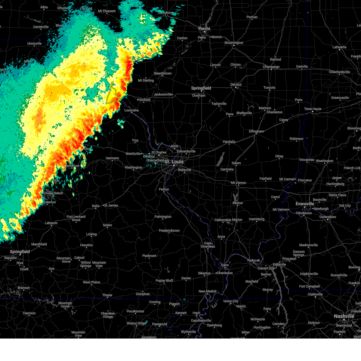 The storms which prompted the warning have moved out of the area. therefore, the warning will be allowed to expire. a severe thunderstorm watch remains in effect until 400 am cdt thursday for a portion of northeast missouri. The storms which prompted the warning have moved out of the area. therefore, the warning will be allowed to expire. a severe thunderstorm watch remains in effect until 400 am cdt thursday for a portion of northeast missouri.
|
| 10/30/2024 11:48 PM CDT |
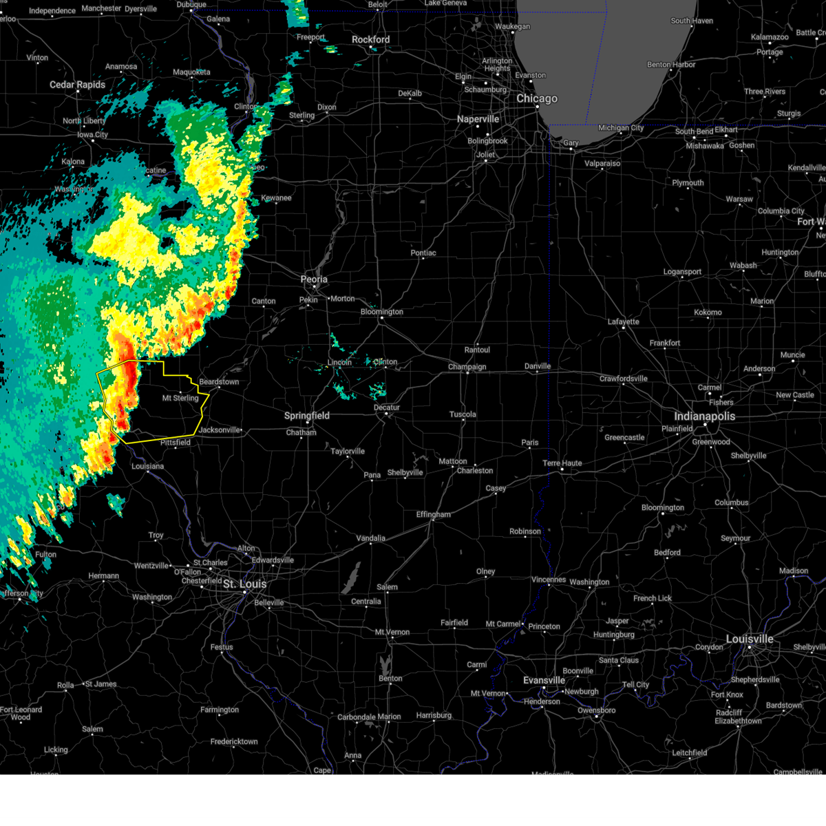 At 1148 pm cdt, severe thunderstorms were located along a line from 8 miles northwest of golden to 6 miles south of quincy regional airport, or along a line from 17 miles north of quincy regional airport to 6 miles south of quincy regional airport, moving east at 55 mph (automated observing station at quincy (kuin) reported a wind gust of 81 mph). Hazards include 70 mph wind gusts. Expect considerable tree damage. damage is likely to mobile homes, roofs, and outbuildings. locations impacted include, quincy, hannibal, quincy regional airport, mount sterling, barry, griggsville, camp point, payson, mendon, clayton, golden, fall creek, beverly, buckhorn, adams, la grange, kingston, burton, ursa and liberty. this includes the following state parks, siloam springs state park. this includes the following highways, interstate 72 between exits 4 and 20. Interstate 172 between exits 2 and 19. At 1148 pm cdt, severe thunderstorms were located along a line from 8 miles northwest of golden to 6 miles south of quincy regional airport, or along a line from 17 miles north of quincy regional airport to 6 miles south of quincy regional airport, moving east at 55 mph (automated observing station at quincy (kuin) reported a wind gust of 81 mph). Hazards include 70 mph wind gusts. Expect considerable tree damage. damage is likely to mobile homes, roofs, and outbuildings. locations impacted include, quincy, hannibal, quincy regional airport, mount sterling, barry, griggsville, camp point, payson, mendon, clayton, golden, fall creek, beverly, buckhorn, adams, la grange, kingston, burton, ursa and liberty. this includes the following state parks, siloam springs state park. this includes the following highways, interstate 72 between exits 4 and 20. Interstate 172 between exits 2 and 19.
|
| 10/30/2024 11:40 PM CDT |
 At 1140 pm cdt, severe thunderstorms were located along a line from 6 miles north of mendon to over fall creek, or along a line from 13 miles east of canton to near hannibal, moving northeast at 60 mph (radar indicated). Hazards include 60 mph wind gusts and small hail. Expect damage to roofs, siding, and trees. Locations impacted include, hannibal, rensselaer, spaulding and ilasco. At 1140 pm cdt, severe thunderstorms were located along a line from 6 miles north of mendon to over fall creek, or along a line from 13 miles east of canton to near hannibal, moving northeast at 60 mph (radar indicated). Hazards include 60 mph wind gusts and small hail. Expect damage to roofs, siding, and trees. Locations impacted include, hannibal, rensselaer, spaulding and ilasco.
|
| 10/30/2024 11:40 PM CDT |
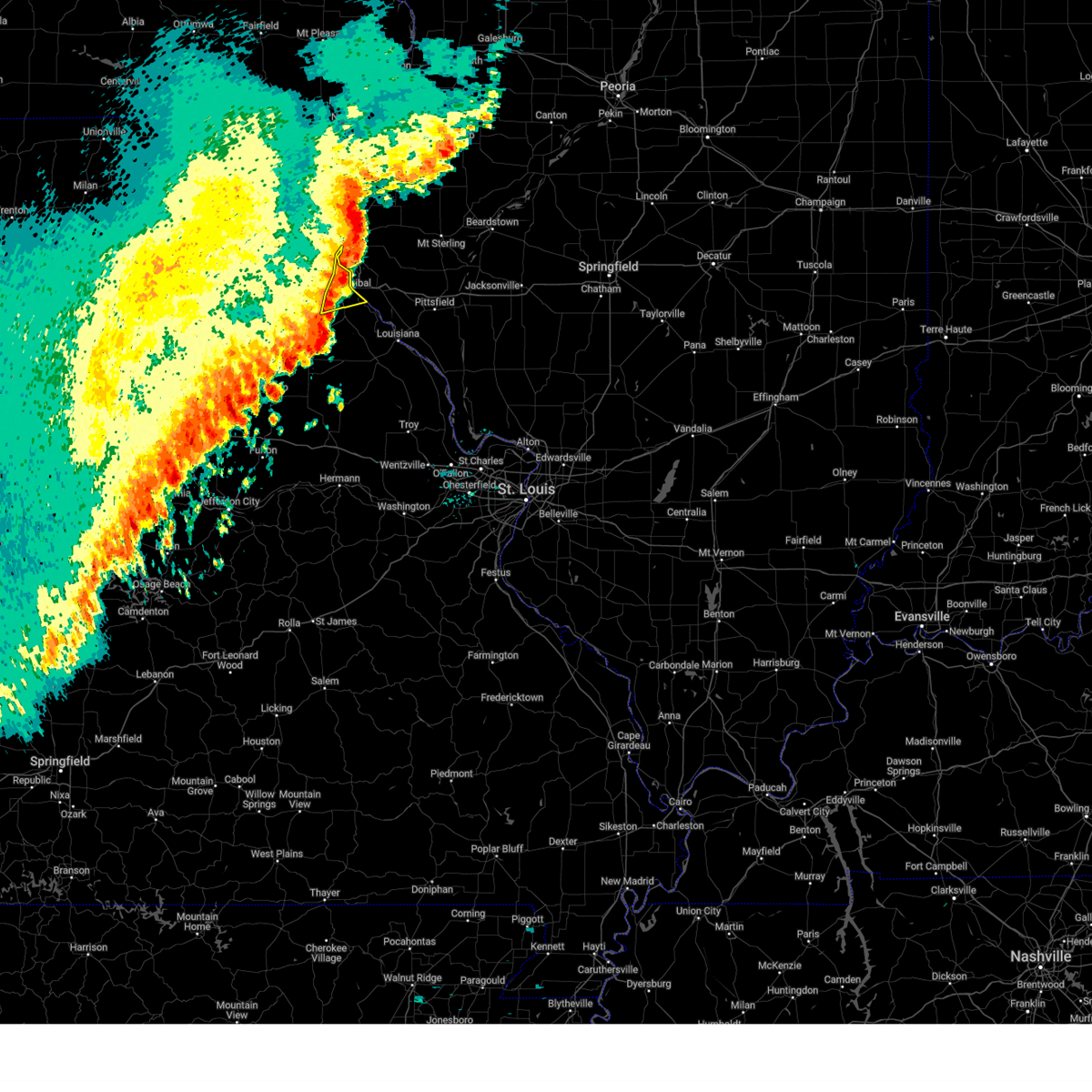 the severe thunderstorm warning has been cancelled and is no longer in effect the severe thunderstorm warning has been cancelled and is no longer in effect
|
| 10/30/2024 11:26 PM CDT |
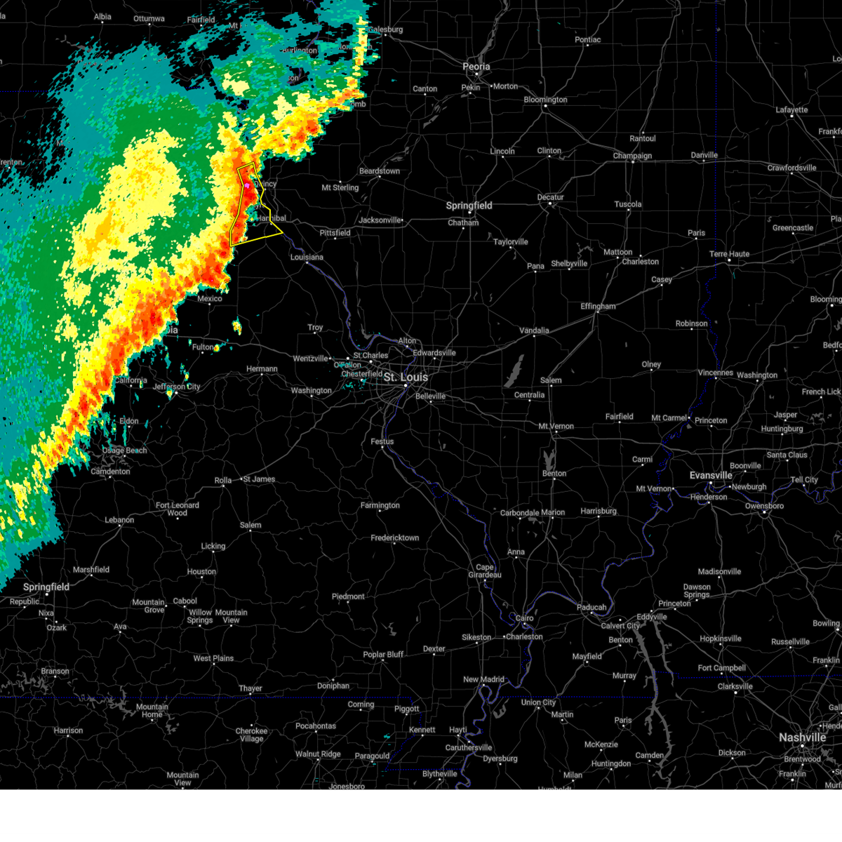 At 1126 pm cdt, severe thunderstorms were located along a line from over canton to over rensselaer, or along a line from over canton to 9 miles west of hannibal, moving northeast at 60 mph (radar indicated). Hazards include 60 mph wind gusts and small hail. Expect damage to roofs, siding, and trees. locations impacted include, hannibal, palmyra, monroe city, la grange, rensselaer, spaulding, taylor and ilasco. This includes the following state parks, wakonda state park. At 1126 pm cdt, severe thunderstorms were located along a line from over canton to over rensselaer, or along a line from over canton to 9 miles west of hannibal, moving northeast at 60 mph (radar indicated). Hazards include 60 mph wind gusts and small hail. Expect damage to roofs, siding, and trees. locations impacted include, hannibal, palmyra, monroe city, la grange, rensselaer, spaulding, taylor and ilasco. This includes the following state parks, wakonda state park.
|
| 10/30/2024 11:25 PM CDT |
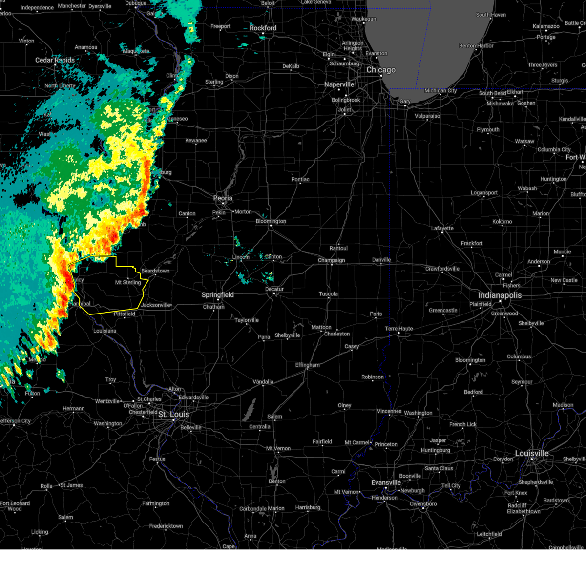 Svrlsx the national weather service in st louis has issued a * severe thunderstorm warning for, adams county in west central illinois, brown county in west central illinois, northern pike county in west central illinois, * until 1230 am cdt. * at 1125 pm cdt, severe thunderstorms were located along a line from over la grange to near palmyra, or along a line from near canton to near palmyra, moving east at 60 mph (radar indicated). Hazards include 60 mph wind gusts. expect damage to roofs, siding, and trees Svrlsx the national weather service in st louis has issued a * severe thunderstorm warning for, adams county in west central illinois, brown county in west central illinois, northern pike county in west central illinois, * until 1230 am cdt. * at 1125 pm cdt, severe thunderstorms were located along a line from over la grange to near palmyra, or along a line from near canton to near palmyra, moving east at 60 mph (radar indicated). Hazards include 60 mph wind gusts. expect damage to roofs, siding, and trees
|
| 10/30/2024 11:19 PM CDT |
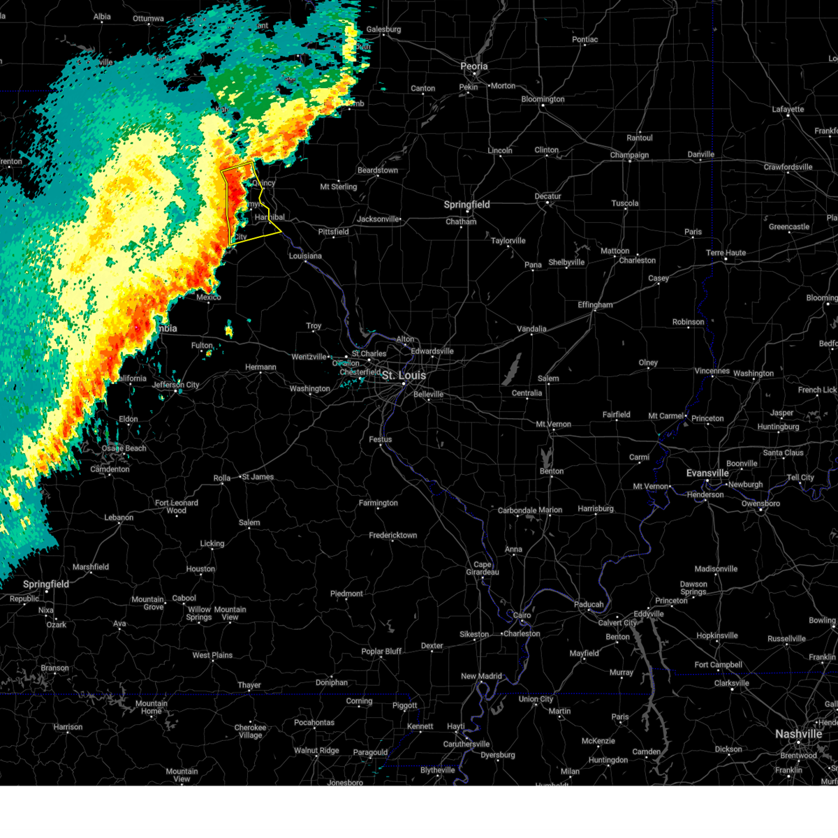 At 1119 pm cdt, severe thunderstorms were located along a line from 6 miles northeast of ewing to near monroe city, or along a line from 7 miles southwest of canton to near monroe city, moving northeast at 60 mph (radar indicated). Hazards include 60 mph wind gusts and small hail. Expect damage to roofs, siding, and trees. locations impacted include, hannibal, palmyra, monroe city, la grange, ewing, rensselaer, maywood, spaulding, taylor and ilasco. This includes the following state parks, wakonda state park. At 1119 pm cdt, severe thunderstorms were located along a line from 6 miles northeast of ewing to near monroe city, or along a line from 7 miles southwest of canton to near monroe city, moving northeast at 60 mph (radar indicated). Hazards include 60 mph wind gusts and small hail. Expect damage to roofs, siding, and trees. locations impacted include, hannibal, palmyra, monroe city, la grange, ewing, rensselaer, maywood, spaulding, taylor and ilasco. This includes the following state parks, wakonda state park.
|
| 10/30/2024 11:07 PM CDT |
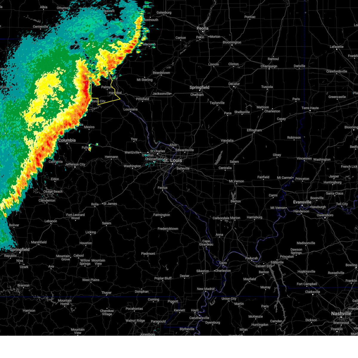 Svrlsx the national weather service in st louis has issued a * severe thunderstorm warning for, southern lewis county in northeastern missouri, marion county in northeastern missouri, northwestern ralls county in northeastern missouri, * until midnight cdt. * at 1107 pm cdt, severe thunderstorms were located along a line from over steffenville to 8 miles northeast of paris, or along a line from 20 miles northeast of shelbina to 8 miles northeast of paris, moving east at 40 mph (radar indicated). Hazards include 60 mph wind gusts and small hail. expect damage to roofs, siding, and trees Svrlsx the national weather service in st louis has issued a * severe thunderstorm warning for, southern lewis county in northeastern missouri, marion county in northeastern missouri, northwestern ralls county in northeastern missouri, * until midnight cdt. * at 1107 pm cdt, severe thunderstorms were located along a line from over steffenville to 8 miles northeast of paris, or along a line from 20 miles northeast of shelbina to 8 miles northeast of paris, moving east at 40 mph (radar indicated). Hazards include 60 mph wind gusts and small hail. expect damage to roofs, siding, and trees
|
| 8/27/2024 5:40 PM CDT |
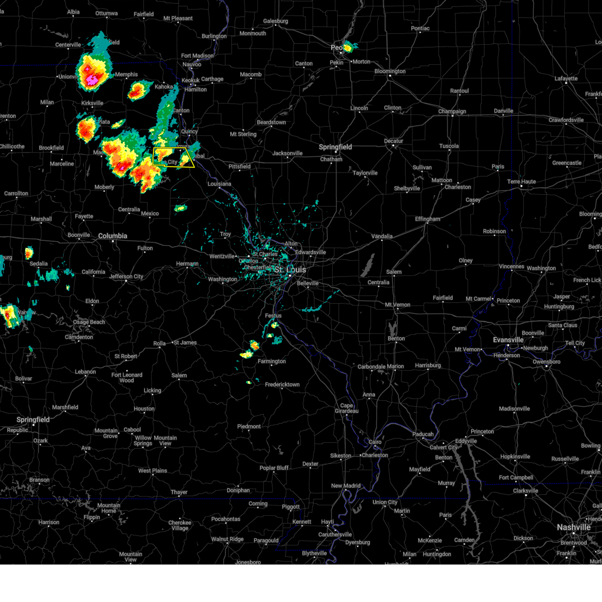 The storm which prompted the warning has weakened below severe limits, and no longer poses an immediate threat to life or property. therefore, the warning will be allowed to expire. however, small hail and gusty winds are still possible with this thunderstorm. to report severe weather, contact your nearest law enforcement agency. they will send your report to the national weather service office. The storm which prompted the warning has weakened below severe limits, and no longer poses an immediate threat to life or property. therefore, the warning will be allowed to expire. however, small hail and gusty winds are still possible with this thunderstorm. to report severe weather, contact your nearest law enforcement agency. they will send your report to the national weather service office.
|
| 8/27/2024 5:18 PM CDT |
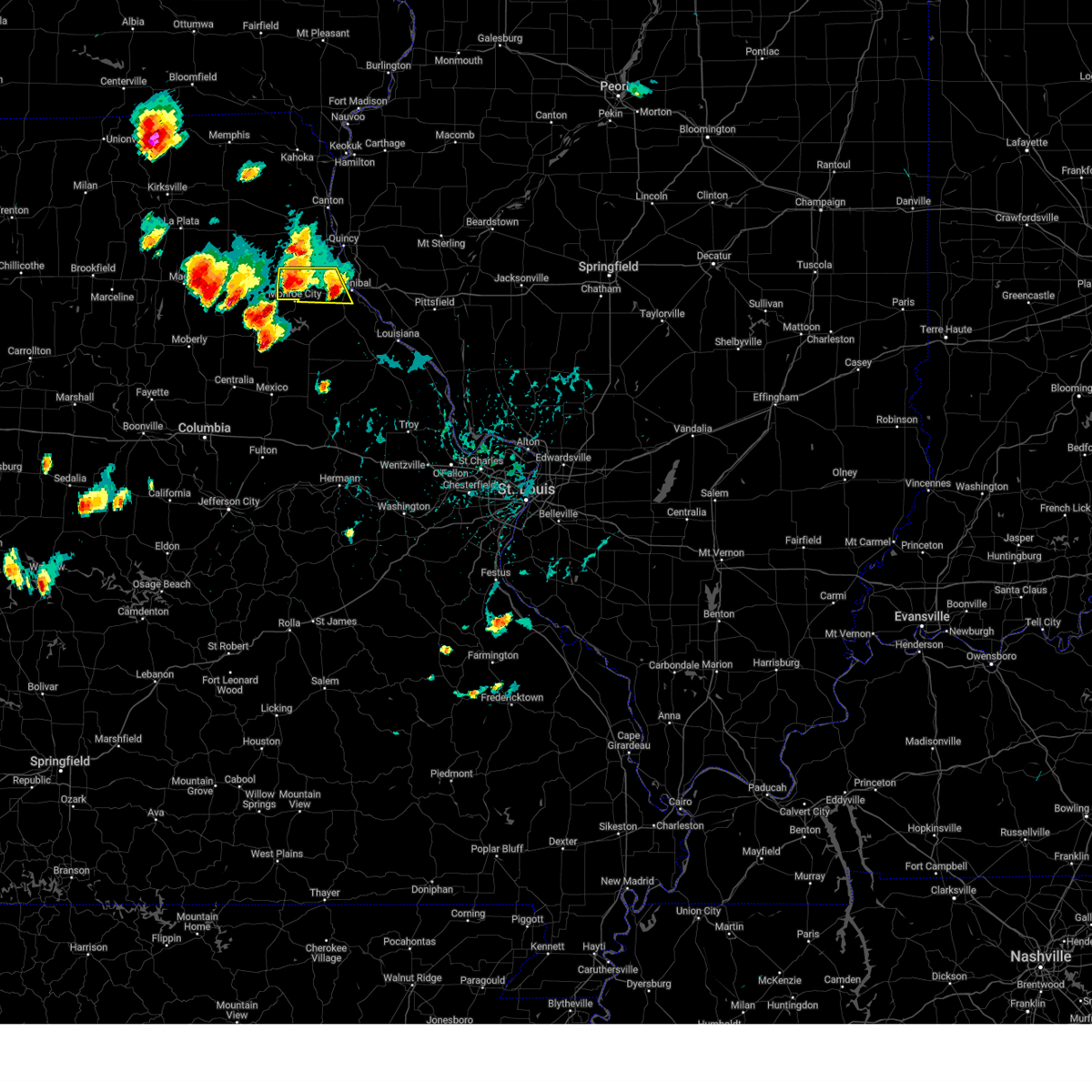 At 518 pm cdt, a severe thunderstorm was located over warren, or 7 miles northwest of monroe city, moving northwest at 5 mph (radar indicated). Hazards include 60 mph wind gusts and small hail. Expect damage to roofs, siding, and trees. Locations impacted include, hannibal, palmyra, monroe city, warren and rensselaer. At 518 pm cdt, a severe thunderstorm was located over warren, or 7 miles northwest of monroe city, moving northwest at 5 mph (radar indicated). Hazards include 60 mph wind gusts and small hail. Expect damage to roofs, siding, and trees. Locations impacted include, hannibal, palmyra, monroe city, warren and rensselaer.
|
| 8/27/2024 5:02 PM CDT |
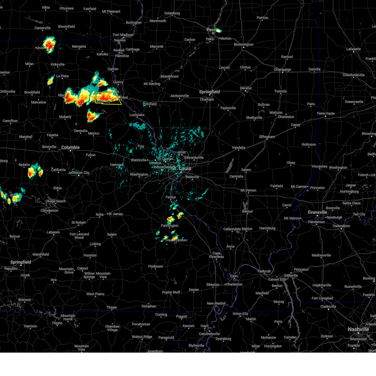 Svrlsx the national weather service in st louis has issued a * severe thunderstorm warning for, southern marion county in northeastern missouri, northwestern ralls county in northeastern missouri, * until 545 pm cdt. * at 502 pm cdt, a severe thunderstorm was located near warren, or 5 miles north of monroe city. this storm was stationary (radar indicated). Hazards include 60 mph wind gusts and small hail. expect damage to roofs, siding, and trees Svrlsx the national weather service in st louis has issued a * severe thunderstorm warning for, southern marion county in northeastern missouri, northwestern ralls county in northeastern missouri, * until 545 pm cdt. * at 502 pm cdt, a severe thunderstorm was located near warren, or 5 miles north of monroe city. this storm was stationary (radar indicated). Hazards include 60 mph wind gusts and small hail. expect damage to roofs, siding, and trees
|
| 7/16/2024 5:15 AM CDT | Half Dollar sized hail reported 8.3 miles ENE of Hannibal, MO, sent via nwschat with picture... time reported from 911 call center. |
| 6/13/2024 5:48 PM CDT |
 At 547 pm cdt, severe thunderstorms were located along a line extending from near la grange to near maywood to near ewing, moving southeast at 35 mph (law enforcement). Hazards include golf ball size hail and 70 mph wind gusts. People and animals outdoors will be injured. expect hail damage to roofs, siding, windows, and vehicles. expect considerable tree damage. wind damage is also likely to mobile homes, roofs, and outbuildings. locations impacted include, quincy, hannibal, palmyra, canton, quincy regional airport, payson, la grange, fall creek, ewing, maywood, burton, ursa, taylor, coatsburg, columbus, marblehead, paloma, and fowler. this also includes wakonda state park. This includes interstate 172 between exits 2 and 19. At 547 pm cdt, severe thunderstorms were located along a line extending from near la grange to near maywood to near ewing, moving southeast at 35 mph (law enforcement). Hazards include golf ball size hail and 70 mph wind gusts. People and animals outdoors will be injured. expect hail damage to roofs, siding, windows, and vehicles. expect considerable tree damage. wind damage is also likely to mobile homes, roofs, and outbuildings. locations impacted include, quincy, hannibal, palmyra, canton, quincy regional airport, payson, la grange, fall creek, ewing, maywood, burton, ursa, taylor, coatsburg, columbus, marblehead, paloma, and fowler. this also includes wakonda state park. This includes interstate 172 between exits 2 and 19.
|
| 6/13/2024 5:36 PM CDT |
 At 535 pm cdt, severe thunderstorms were located along a line extending from near canton to near ewing to steffenville, moving southeast at 30 mph (law enforcement reported 60 mph winds in ewing). Hazards include golf ball size hail and 70 mph wind gusts. People and animals outdoors will be injured. expect hail damage to roofs, siding, windows, and vehicles. expect considerable tree damage. wind damage is also likely to mobile homes, roofs, and outbuildings. locations impacted include, quincy, hannibal, palmyra, quincy regional airport, warren, payson, la grange, fall creek, ewing, steffenville, maywood, philadelphia, burton, ursa, taylor, coatsburg, columbus, marblehead, paloma, and fowler. this also includes wakonda state park. This includes interstate 172 between exits 2 and 19. At 535 pm cdt, severe thunderstorms were located along a line extending from near canton to near ewing to steffenville, moving southeast at 30 mph (law enforcement reported 60 mph winds in ewing). Hazards include golf ball size hail and 70 mph wind gusts. People and animals outdoors will be injured. expect hail damage to roofs, siding, windows, and vehicles. expect considerable tree damage. wind damage is also likely to mobile homes, roofs, and outbuildings. locations impacted include, quincy, hannibal, palmyra, quincy regional airport, warren, payson, la grange, fall creek, ewing, steffenville, maywood, philadelphia, burton, ursa, taylor, coatsburg, columbus, marblehead, paloma, and fowler. this also includes wakonda state park. This includes interstate 172 between exits 2 and 19.
|
| 6/13/2024 5:33 PM CDT |
 Svrlsx the national weather service in st louis has issued a * severe thunderstorm warning for, southwestern adams county in west central illinois, marion county in northeastern missouri, southern lewis county in northeastern missouri, * until 630 pm cdt. * at 533 pm cdt, severe thunderstorms were located along a line extending from near canton to near ewing to steffenville, moving southeast at 30 mph (radar indicated). Hazards include golf ball size hail and 70 mph wind gusts. People and animals outdoors will be injured. expect hail damage to roofs, siding, windows, and vehicles. expect considerable tree damage. Wind damage is also likely to mobile homes, roofs, and outbuildings. Svrlsx the national weather service in st louis has issued a * severe thunderstorm warning for, southwestern adams county in west central illinois, marion county in northeastern missouri, southern lewis county in northeastern missouri, * until 630 pm cdt. * at 533 pm cdt, severe thunderstorms were located along a line extending from near canton to near ewing to steffenville, moving southeast at 30 mph (radar indicated). Hazards include golf ball size hail and 70 mph wind gusts. People and animals outdoors will be injured. expect hail damage to roofs, siding, windows, and vehicles. expect considerable tree damage. Wind damage is also likely to mobile homes, roofs, and outbuildings.
|
| 5/2/2024 3:27 PM CDT |
 At 326 pm cdt, a severe thunderstorm was located over palmyra, moving northeast at 15 mph (law enforcement reported golf ball sized hail in palmyra at 3:25 pm). Hazards include golf ball size hail and 60 mph wind gusts. People and animals outdoors will be injured. expect hail damage to roofs, siding, windows, and vehicles. expect wind damage to roofs, siding, and trees. Locations impacted include, palmyra and taylor. At 326 pm cdt, a severe thunderstorm was located over palmyra, moving northeast at 15 mph (law enforcement reported golf ball sized hail in palmyra at 3:25 pm). Hazards include golf ball size hail and 60 mph wind gusts. People and animals outdoors will be injured. expect hail damage to roofs, siding, windows, and vehicles. expect wind damage to roofs, siding, and trees. Locations impacted include, palmyra and taylor.
|
| 5/2/2024 3:21 PM CDT |
 Svrlsx the national weather service in st louis has issued a * severe thunderstorm warning for, central marion county in northeastern missouri, * until 400 pm cdt. * at 321 pm cdt, a severe thunderstorm was located near palmyra, moving northeast at 15 mph (radar indicated). Hazards include 60 mph wind gusts and quarter size hail. Hail damage to vehicles is expected. Expect wind damage to roofs, siding, and trees. Svrlsx the national weather service in st louis has issued a * severe thunderstorm warning for, central marion county in northeastern missouri, * until 400 pm cdt. * at 321 pm cdt, a severe thunderstorm was located near palmyra, moving northeast at 15 mph (radar indicated). Hazards include 60 mph wind gusts and quarter size hail. Hail damage to vehicles is expected. Expect wind damage to roofs, siding, and trees.
|
| 4/18/2024 2:42 PM CDT |
 Svrlsx the national weather service in st louis has issued a * severe thunderstorm warning for, ralls county in northeastern missouri, northern pike county in northeastern missouri, * until 345 pm cdt. * at 241 pm cdt, a severe thunderstorm was located near center, moving northeast at 35 mph (radar indicated). Hazards include 60 mph wind gusts and quarter size hail. Hail damage to vehicles is expected. Expect wind damage to roofs, siding, and trees. Svrlsx the national weather service in st louis has issued a * severe thunderstorm warning for, ralls county in northeastern missouri, northern pike county in northeastern missouri, * until 345 pm cdt. * at 241 pm cdt, a severe thunderstorm was located near center, moving northeast at 35 mph (radar indicated). Hazards include 60 mph wind gusts and quarter size hail. Hail damage to vehicles is expected. Expect wind damage to roofs, siding, and trees.
|
| 3/14/2024 2:40 AM CDT |
 Svrlsx the national weather service in st louis has issued a * severe thunderstorm warning for, adams county in west central illinois, central marion county in northeastern missouri, eastern lewis county in northeastern missouri, * until 330 am cdt. * at 240 am cdt, severe thunderstorms were located along a line extending from near south gorin to near lewistown to 6 miles east of shelbina, moving east at 55 mph (radar indicated). Hazards include 60 mph wind gusts. expect damage to roofs, siding, and trees Svrlsx the national weather service in st louis has issued a * severe thunderstorm warning for, adams county in west central illinois, central marion county in northeastern missouri, eastern lewis county in northeastern missouri, * until 330 am cdt. * at 240 am cdt, severe thunderstorms were located along a line extending from near south gorin to near lewistown to 6 miles east of shelbina, moving east at 55 mph (radar indicated). Hazards include 60 mph wind gusts. expect damage to roofs, siding, and trees
|
| 8/12/2023 1:23 AM CDT |
 At 122 am cdt, a severe thunderstorm was located near hannibal, moving east at 35 mph (radar indicated). Hazards include 60 mph wind gusts and penny size hail. Expect damage to roofs, siding, and trees. locations impacted include, quincy, hannibal, palmyra, quincy regional airport, payson, fall creek, adams, burton, hull, taylor, marblehead, and seehorn. this includes the following highways, interstate 172 between exits 2 and 14. interstate 72 near exit 4. hail threat, radar indicated max hail size, 0. 75 in wind threat, radar indicated max wind gust, 60 mph. At 122 am cdt, a severe thunderstorm was located near hannibal, moving east at 35 mph (radar indicated). Hazards include 60 mph wind gusts and penny size hail. Expect damage to roofs, siding, and trees. locations impacted include, quincy, hannibal, palmyra, quincy regional airport, payson, fall creek, adams, burton, hull, taylor, marblehead, and seehorn. this includes the following highways, interstate 172 between exits 2 and 14. interstate 72 near exit 4. hail threat, radar indicated max hail size, 0. 75 in wind threat, radar indicated max wind gust, 60 mph.
|
| 8/12/2023 1:21 AM CDT |
 At 120 am cdt, a severe thunderstorm was located near spaulding, moving southeast at 40 mph (radar indicated). Hazards include 60 mph wind gusts and penny size hail. Expect damage to roofs, siding, and trees. Locations impacted include, hannibal, monroe city, new london, center, rensselaer, spaulding, ilasco, saverton, and the landing. At 120 am cdt, a severe thunderstorm was located near spaulding, moving southeast at 40 mph (radar indicated). Hazards include 60 mph wind gusts and penny size hail. Expect damage to roofs, siding, and trees. Locations impacted include, hannibal, monroe city, new london, center, rensselaer, spaulding, ilasco, saverton, and the landing.
|
| 8/12/2023 1:13 AM CDT |
 At 113 am cdt, a severe thunderstorm was located near monroe city, moving southeast at 50 mph (radar indicated). Hazards include 60 mph wind gusts and penny size hail. expect damage to roofs, siding, and trees At 113 am cdt, a severe thunderstorm was located near monroe city, moving southeast at 50 mph (radar indicated). Hazards include 60 mph wind gusts and penny size hail. expect damage to roofs, siding, and trees
|
| 8/12/2023 1:08 AM CDT |
 At 107 am cdt, a severe thunderstorm was located near palmyra, moving southeast at 35 mph (radar indicated). Hazards include 60 mph wind gusts and quarter size hail. Hail damage to vehicles is expected. expect wind damage to roofs, siding, and trees. locations impacted include, quincy, hannibal, palmyra, quincy regional airport, payson, fall creek, philadelphia, adams, burton, hull, taylor, marblehead, and seehorn. this includes the following highways, interstate 172 between exits 2 and 14. Interstate 72 near exit 4. At 107 am cdt, a severe thunderstorm was located near palmyra, moving southeast at 35 mph (radar indicated). Hazards include 60 mph wind gusts and quarter size hail. Hail damage to vehicles is expected. expect wind damage to roofs, siding, and trees. locations impacted include, quincy, hannibal, palmyra, quincy regional airport, payson, fall creek, philadelphia, adams, burton, hull, taylor, marblehead, and seehorn. this includes the following highways, interstate 172 between exits 2 and 14. Interstate 72 near exit 4.
|
| 8/12/2023 12:56 AM CDT |
 At 1255 am cdt, a severe thunderstorm was located over philadelphia, moving southeast at 40 mph (radar indicated). Hazards include ping pong ball size hail and 60 mph wind gusts. People and animals outdoors will be injured. expect hail damage to roofs, siding, windows, and vehicles. expect wind damage to roofs, siding, and trees. locations impacted include, quincy, hannibal, palmyra, quincy regional airport, payson, la grange, fall creek, ewing, maywood, philadelphia, adams, burton, ursa, hull, taylor, marblehead, seehorn, and fowler. this also includes wakonda state park. this includes the following highways, interstate 172 between exits 2 and 19. interstate 72 near exit 4. hail threat, radar indicated max hail size, 1. 50 in wind threat, radar indicated max wind gust, 60 mph. At 1255 am cdt, a severe thunderstorm was located over philadelphia, moving southeast at 40 mph (radar indicated). Hazards include ping pong ball size hail and 60 mph wind gusts. People and animals outdoors will be injured. expect hail damage to roofs, siding, windows, and vehicles. expect wind damage to roofs, siding, and trees. locations impacted include, quincy, hannibal, palmyra, quincy regional airport, payson, la grange, fall creek, ewing, maywood, philadelphia, adams, burton, ursa, hull, taylor, marblehead, seehorn, and fowler. this also includes wakonda state park. this includes the following highways, interstate 172 between exits 2 and 19. interstate 72 near exit 4. hail threat, radar indicated max hail size, 1. 50 in wind threat, radar indicated max wind gust, 60 mph.
|
| 8/12/2023 12:48 AM CDT |
 At 1248 am cdt, a severe thunderstorm was located over maywood, moving southeast at 40 mph (radar indicated). Hazards include 60 mph wind gusts and quarter size hail. Hail damage to vehicles is expected. Expect wind damage to roofs, siding, and trees. At 1248 am cdt, a severe thunderstorm was located over maywood, moving southeast at 40 mph (radar indicated). Hazards include 60 mph wind gusts and quarter size hail. Hail damage to vehicles is expected. Expect wind damage to roofs, siding, and trees.
|
| 7/14/2023 9:03 PM CDT | Tree limbs downed power lines 5 miles south of hannibal on highway 7 in ralls county MO, 7.3 miles NW of Hannibal, MO |
| 6/29/2023 11:07 AM CDT | Large tree blown into hous in marion county MO, 1.5 miles NNW of Hannibal, MO |
| 6/29/2023 11:01 AM CDT | 6 inch tree spli in marion county MO, 1 miles SW of Hannibal, MO |
| 6/29/2023 11:01 AM CDT |
 At 1100 am cdt, severe thunderstorms were located along a line extending from fall creek to near new london to near perry, moving southeast at 50 mph (radar indicated). Hazards include 60 mph wind gusts and quarter size hail. Hail damage to vehicles is expected. Expect wind damage to roofs, siding, and trees. At 1100 am cdt, severe thunderstorms were located along a line extending from fall creek to near new london to near perry, moving southeast at 50 mph (radar indicated). Hazards include 60 mph wind gusts and quarter size hail. Hail damage to vehicles is expected. Expect wind damage to roofs, siding, and trees.
|
| 6/24/2023 9:31 PM CDT |
 At 930 pm cdt, a severe thunderstorm was located near new london, moving east at 30 mph (radar indicated). Hazards include two inch hail and 60 mph wind gusts. People and animals outdoors will be injured. expect hail damage to roofs, siding, windows, and vehicles. expect wind damage to roofs, siding, and trees. this severe thunderstorm will remain over mainly rural areas of west central pike county in west central illinois, northeastern ralls and north central pike counties in northeastern missouri, including the following locations, ilasco, saverton, and ashburn. thunderstorm damage threat, considerable hail threat, radar indicated max hail size, 2. 00 in wind threat, radar indicated max wind gust, 60 mph. At 930 pm cdt, a severe thunderstorm was located near new london, moving east at 30 mph (radar indicated). Hazards include two inch hail and 60 mph wind gusts. People and animals outdoors will be injured. expect hail damage to roofs, siding, windows, and vehicles. expect wind damage to roofs, siding, and trees. this severe thunderstorm will remain over mainly rural areas of west central pike county in west central illinois, northeastern ralls and north central pike counties in northeastern missouri, including the following locations, ilasco, saverton, and ashburn. thunderstorm damage threat, considerable hail threat, radar indicated max hail size, 2. 00 in wind threat, radar indicated max wind gust, 60 mph.
|
| 6/24/2023 9:23 PM CDT |
 At 922 pm cdt, a severe thunderstorm was located near hannibal, moving east at 30 mph (radar indicated). Hazards include two inch hail and 60 mph wind gusts. People and animals outdoors will be injured. expect hail damage to roofs, siding, windows, and vehicles. expect wind damage to roofs, siding, and trees. this severe storm will be near, hannibal around 930 pm cdt. other locations impacted by this severe thunderstorm include ilasco, saverton, ashburn, and hull. thunderstorm damage threat, considerable hail threat, radar indicated max hail size, 2. 00 in wind threat, radar indicated max wind gust, 60 mph. At 922 pm cdt, a severe thunderstorm was located near hannibal, moving east at 30 mph (radar indicated). Hazards include two inch hail and 60 mph wind gusts. People and animals outdoors will be injured. expect hail damage to roofs, siding, windows, and vehicles. expect wind damage to roofs, siding, and trees. this severe storm will be near, hannibal around 930 pm cdt. other locations impacted by this severe thunderstorm include ilasco, saverton, ashburn, and hull. thunderstorm damage threat, considerable hail threat, radar indicated max hail size, 2. 00 in wind threat, radar indicated max wind gust, 60 mph.
|
| 6/24/2023 9:15 PM CDT |
 At 914 pm cdt, a severe thunderstorm was located near barry, moving east at 20 mph (radar indicated). Hazards include 60 mph wind gusts and quarter size hail. Hail damage to vehicles is expected. expect wind damage to roofs, siding, and trees. this severe thunderstorm will remain over mainly rural areas of northwestern pike county in west central illinois, including the following locations, seehorn, kinderhook, and hull. this includes interstate 72 between exits 4 and 10. hail threat, radar indicated max hail size, 1. 00 in wind threat, radar indicated max wind gust, 60 mph. At 914 pm cdt, a severe thunderstorm was located near barry, moving east at 20 mph (radar indicated). Hazards include 60 mph wind gusts and quarter size hail. Hail damage to vehicles is expected. expect wind damage to roofs, siding, and trees. this severe thunderstorm will remain over mainly rural areas of northwestern pike county in west central illinois, including the following locations, seehorn, kinderhook, and hull. this includes interstate 72 between exits 4 and 10. hail threat, radar indicated max hail size, 1. 00 in wind threat, radar indicated max wind gust, 60 mph.
|
| 6/24/2023 9:12 PM CDT |
 At 911 pm cdt, a severe thunderstorm was located over rensselaer, moving east at 30 mph (radar indicated). Hazards include 60 mph wind gusts and half dollar size hail. Hail damage to vehicles is expected. expect wind damage to roofs, siding, and trees. this severe thunderstorm will be near, hannibal and spaulding around 915 pm cdt. new london around 925 pm cdt. other locations impacted by this severe thunderstorm include ilasco, saverton, ashburn, and hull. hail threat, radar indicated max hail size, 1. 25 in wind threat, radar indicated max wind gust, 60 mph. At 911 pm cdt, a severe thunderstorm was located over rensselaer, moving east at 30 mph (radar indicated). Hazards include 60 mph wind gusts and half dollar size hail. Hail damage to vehicles is expected. expect wind damage to roofs, siding, and trees. this severe thunderstorm will be near, hannibal and spaulding around 915 pm cdt. new london around 925 pm cdt. other locations impacted by this severe thunderstorm include ilasco, saverton, ashburn, and hull. hail threat, radar indicated max hail size, 1. 25 in wind threat, radar indicated max wind gust, 60 mph.
|
| 6/24/2023 8:55 PM CDT |
 At 854 pm cdt, a severe thunderstorm was located near palmyra, moving east at 30 mph (radar indicated). Hazards include 60 mph wind gusts. Expect damage to roofs, siding, and trees. this severe storm will be near, palmyra around 900 pm cdt. hannibal around 905 pm cdt. hail threat, radar indicated max hail size, <. 75 in wind threat, radar indicated max wind gust, 60 mph. At 854 pm cdt, a severe thunderstorm was located near palmyra, moving east at 30 mph (radar indicated). Hazards include 60 mph wind gusts. Expect damage to roofs, siding, and trees. this severe storm will be near, palmyra around 900 pm cdt. hannibal around 905 pm cdt. hail threat, radar indicated max hail size, <. 75 in wind threat, radar indicated max wind gust, 60 mph.
|
| 6/24/2023 8:42 PM CDT |
 At 842 pm cdt, a severe thunderstorm was located over hannibal, moving east at 20 mph (radar indicated). Hazards include two inch hail and 60 mph wind gusts. People and animals outdoors will be injured. expect hail damage to roofs, siding, windows, and vehicles. expect wind damage to roofs, siding, and trees. this severe thunderstorm will be near, fall creek around 845 pm cdt. payson around 855 pm cdt. other locations impacted by this severe thunderstorm include seehorn, richfield, kinderhook, plainville, and hull. this includes the following highways, interstate 172 near exit 2. interstate 72 between exits 4 and 10. thunderstorm damage threat, considerable hail threat, radar indicated max hail size, 2. 00 in wind threat, radar indicated max wind gust, 60 mph. At 842 pm cdt, a severe thunderstorm was located over hannibal, moving east at 20 mph (radar indicated). Hazards include two inch hail and 60 mph wind gusts. People and animals outdoors will be injured. expect hail damage to roofs, siding, windows, and vehicles. expect wind damage to roofs, siding, and trees. this severe thunderstorm will be near, fall creek around 845 pm cdt. payson around 855 pm cdt. other locations impacted by this severe thunderstorm include seehorn, richfield, kinderhook, plainville, and hull. this includes the following highways, interstate 172 near exit 2. interstate 72 between exits 4 and 10. thunderstorm damage threat, considerable hail threat, radar indicated max hail size, 2. 00 in wind threat, radar indicated max wind gust, 60 mph.
|
| 6/24/2023 8:40 PM CDT | Ping Pong Ball sized hail reported 1.4 miles WSW of Hannibal, MO, report 1 inch to 1.5 inch hail falling just north of hannibal proper. |
| 6/24/2023 8:37 PM CDT |
 At 836 pm cdt, a severe thunderstorm was located over warren, moving east at 35 mph. another strong thunderstorm was also located near hannibal (radar indicated). Hazards include ping pong ball size hail and 60 mph wind gusts. People and animals outdoors will be injured. expect hail damage to roofs, siding, windows, and vehicles. expect wind damage to roofs, siding, and trees. this severe thunderstorm will be near, palmyra around 855 pm cdt. hannibal around 905 pm cdt. hail threat, radar indicated max hail size, 1. 50 in wind threat, radar indicated max wind gust, 60 mph. At 836 pm cdt, a severe thunderstorm was located over warren, moving east at 35 mph. another strong thunderstorm was also located near hannibal (radar indicated). Hazards include ping pong ball size hail and 60 mph wind gusts. People and animals outdoors will be injured. expect hail damage to roofs, siding, windows, and vehicles. expect wind damage to roofs, siding, and trees. this severe thunderstorm will be near, palmyra around 855 pm cdt. hannibal around 905 pm cdt. hail threat, radar indicated max hail size, 1. 50 in wind threat, radar indicated max wind gust, 60 mph.
|
| 6/24/2023 7:46 PM CDT | Report of tree fallen on house... no significant damag in marion county MO, 1.4 miles WNW of Hannibal, MO |
| 5/6/2023 10:12 AM CDT |
 At 1012 am cdt, a severe thunderstorm was located near center, moving east at 30 mph (radar indicated). Hazards include quarter size hail. damage to vehicles is expected At 1012 am cdt, a severe thunderstorm was located near center, moving east at 30 mph (radar indicated). Hazards include quarter size hail. damage to vehicles is expected
|
| 4/20/2023 1:13 PM CDT |
 At 112 pm cdt, a severe thunderstorm was located near shelbyville, moving northeast at 55 mph (radar indicated). Hazards include 60 mph wind gusts and quarter size hail. Hail damage to vehicles is expected. expect wind damage to roofs, siding, and trees. this severe thunderstorm will be near, emden around 115 pm cdt. philadelphia around 125 pm cdt. other locations in the path of this severe thunderstorm include maywood. this also includes wakonda state park. hail threat, radar indicated max hail size, 1. 00 in wind threat, radar indicated max wind gust, 60 mph. At 112 pm cdt, a severe thunderstorm was located near shelbyville, moving northeast at 55 mph (radar indicated). Hazards include 60 mph wind gusts and quarter size hail. Hail damage to vehicles is expected. expect wind damage to roofs, siding, and trees. this severe thunderstorm will be near, emden around 115 pm cdt. philadelphia around 125 pm cdt. other locations in the path of this severe thunderstorm include maywood. this also includes wakonda state park. hail threat, radar indicated max hail size, 1. 00 in wind threat, radar indicated max wind gust, 60 mph.
|
| 3/31/2023 4:25 PM CDT | Golf Ball sized hail reported 2.9 miles WNW of Hannibal, MO, mping report... time estimated from radar. |
| 3/31/2023 4:15 PM CDT | Hen Egg sized hail reported 0.9 miles NW of Hannibal, MO |
| 3/31/2023 4:11 PM CDT | Golf Ball sized hail reported 0.7 miles W of Hannibal, MO, up to golf ball sized hail... ended at the time of the call. very heavy rain falling now. |
| 3/31/2023 4:10 PM CDT | Hen Egg sized hail reported 4.1 miles ENE of Hannibal, MO, delayed report. |
| 3/31/2023 4:09 PM CDT | Hen Egg sized hail reported 1.3 miles N of Hannibal, MO |
| 3/31/2023 4:07 PM CDT | Half Dollar sized hail reported 2.2 miles NW of Hannibal, MO |
| 3/31/2023 4:06 PM CDT | Half Dollar sized hail reported 1.5 miles NNW of Hannibal, MO |
| 3/31/2023 4:06 PM CDT | Golf Ball sized hail reported 1.2 miles W of Hannibal, MO |
| 3/31/2023 4:05 PM CDT | Tennis Ball sized hail reported 1.4 miles WNW of Hannibal, MO |
| 3/31/2023 4:05 PM CDT | Golf Ball sized hail reported 2.3 miles W of Hannibal, MO |
| 3/31/2023 4:04 PM CDT | Half Dollar sized hail reported 0.7 miles W of Hannibal, MO |
| 3/31/2023 4:03 PM CDT | Quarter sized hail reported 1.4 miles WNW of Hannibal, MO |
| 3/31/2023 4:03 PM CDT | Ping Pong Ball sized hail reported 1.2 miles W of Hannibal, MO |
| 3/31/2023 4:02 PM CDT | Quarter sized hail reported 0.7 miles W of Hannibal, MO, report from mping: quarter (1.00 in.). |
| 3/31/2023 4:01 PM CDT | Golf Ball sized hail reported 4.1 miles NE of Hannibal, MO, report from mping: golf ball (1.75 in.). |
| 3/31/2023 4:01 PM CDT | Golf Ball sized hail reported 1 miles SW of Hannibal, MO |
| 3/31/2023 4:00 PM CDT | Ping Pong Ball sized hail reported 2.9 miles WNW of Hannibal, MO |
| 3/31/2023 4:00 PM CDT | Hen Egg sized hail reported 2 miles E of Hannibal, MO, time estimated from radar. |
| 3/31/2023 3:59 PM CDT | Ping Pong Ball sized hail reported 4.1 miles NE of Hannibal, MO, report from mping: ping pong ball (1.50 in.). |
| 3/31/2023 3:59 PM CDT | Baseball sized hail reported 5.2 miles E of Hannibal, MO, house was being heavily damaged by baseball size hail. |
| 3/31/2023 1:00 PM CDT | Quarter sized hail reported 0.9 miles NW of Hannibal, MO |
| 3/31/2023 12:59 PM CDT | Quarter sized hail reported 2.3 miles W of Hannibal, MO, public report relayed by media. |
| 3/31/2023 12:56 PM CDT | Golf Ball sized hail reported 1.2 miles W of Hannibal, MO, law enforcement relayed reports of hail ranging from pea to golf ball size. |
| 3/31/2023 12:55 PM CDT | Quarter sized hail reported 1.4 miles WSW of Hannibal, MO |
| 3/31/2023 12:54 PM CDT | Quarter sized hail reported 1.9 miles SW of Hannibal, MO, report from mping: quarter (1.00 in.). |
| 3/31/2023 12:50 PM CDT | Golf Ball sized hail reported 1.8 miles NW of Hannibal, MO |
| 8/29/2022 8:00 PM CDT |
 At 759 pm cdt, a severe thunderstorm was located over hannibal, moving southeast at 25 mph (radar indicated). Hazards include 60 mph wind gusts and penny size hail. Expect damage to roofs, siding, and trees. locations impacted include, new london. this includes interstate 72 between exits 4 and 10. hail threat, radar indicated max hail size, 0. 75 in wind threat, radar indicated max wind gust, 60 mph. At 759 pm cdt, a severe thunderstorm was located over hannibal, moving southeast at 25 mph (radar indicated). Hazards include 60 mph wind gusts and penny size hail. Expect damage to roofs, siding, and trees. locations impacted include, new london. this includes interstate 72 between exits 4 and 10. hail threat, radar indicated max hail size, 0. 75 in wind threat, radar indicated max wind gust, 60 mph.
|
| 8/29/2022 7:51 PM CDT | Several large tree limbs blown dow in marion county MO, 1.4 miles WSW of Hannibal, MO |
| 8/29/2022 7:47 PM CDT |
 At 747 pm cdt, a severe thunderstorm was located near hannibal, moving southeast at 20 mph (radar indicated). Hazards include 60 mph wind gusts and penny size hail. Expect damage to roofs, siding, and trees. this severe thunderstorm will be near, hannibal around 750 pm cdt. fall creek around 755 pm cdt. other locations in the path of this severe thunderstorm include new london. this includes the following highways, interstate 172 between exits 2 and 10. interstate 72 between exits 4 and 10. hail threat, radar indicated max hail size, 0. 75 in wind threat, radar indicated max wind gust, 60 mph. At 747 pm cdt, a severe thunderstorm was located near hannibal, moving southeast at 20 mph (radar indicated). Hazards include 60 mph wind gusts and penny size hail. Expect damage to roofs, siding, and trees. this severe thunderstorm will be near, hannibal around 750 pm cdt. fall creek around 755 pm cdt. other locations in the path of this severe thunderstorm include new london. this includes the following highways, interstate 172 between exits 2 and 10. interstate 72 between exits 4 and 10. hail threat, radar indicated max hail size, 0. 75 in wind threat, radar indicated max wind gust, 60 mph.
|
| 6/17/2022 3:49 AM CDT |
 At 349 am cdt, severe thunderstorms were located along a line extending from near fall creek to near frankford to near martinsburg, moving east at 65 mph (trained weather spotters reported trees down and power out in hannibal). Hazards include 70 mph wind gusts. Expect considerable tree damage. damage is likely to mobile homes, roofs, and outbuildings. these severe storms will be near, bowling green and tarrants around 355 am cdt. other locations in the path of these severe thunderstorms include louisiana, barry, beverly, pike, atlas, clarksville, new hartford, pittsfield, pleasant hill and eolia. this also includes siloam springs state park. this includes the following highways, interstate 172 between exits 2 and 10. interstate 72 between exits 4 and 31. thunderstorm damage threat, considerable hail threat, radar indicated max hail size, <. 75 in wind threat, radar indicated max wind gust, 70 mph. At 349 am cdt, severe thunderstorms were located along a line extending from near fall creek to near frankford to near martinsburg, moving east at 65 mph (trained weather spotters reported trees down and power out in hannibal). Hazards include 70 mph wind gusts. Expect considerable tree damage. damage is likely to mobile homes, roofs, and outbuildings. these severe storms will be near, bowling green and tarrants around 355 am cdt. other locations in the path of these severe thunderstorms include louisiana, barry, beverly, pike, atlas, clarksville, new hartford, pittsfield, pleasant hill and eolia. this also includes siloam springs state park. this includes the following highways, interstate 172 between exits 2 and 10. interstate 72 between exits 4 and 31. thunderstorm damage threat, considerable hail threat, radar indicated max hail size, <. 75 in wind threat, radar indicated max wind gust, 70 mph.
|
| 6/17/2022 3:45 AM CDT | Mature tree with foliage uprooted and fell into house. no considerable structural damage reporte in marion county MO, 1.4 miles WNW of Hannibal, MO |
| 6/17/2022 3:38 AM CDT |
 At 337 am cdt, severe thunderstorms were located along a line extending from near palmyra to near center to near mexico, moving east at 50 mph (a missouri mesonet in monroe city sited reported a wind gust of 74 mph). Hazards include 70 mph wind gusts and penny size hail. Expect considerable tree damage. damage is likely to mobile homes, roofs, and outbuildings. severe thunderstorms will be near, hannibal and spencerburg around 345 am cdt. fall creek, frankford and curryville around 350 am cdt. wellsville around 355 am cdt. other locations in the path of these severe thunderstorms include bowling green, tarrants, louisiana, barry, pike, buell, atlas, clarksville and pittsfield. this includes the following highways, interstate 172 between exits 2 and 10. interstate 72 between exits 4 and 31. this also includes siloam springs state park. thunderstorm damage threat, considerable hail threat, radar indicated max hail size, 0. 75 in wind threat, radar indicated max wind gust, 70 mph. At 337 am cdt, severe thunderstorms were located along a line extending from near palmyra to near center to near mexico, moving east at 50 mph (a missouri mesonet in monroe city sited reported a wind gust of 74 mph). Hazards include 70 mph wind gusts and penny size hail. Expect considerable tree damage. damage is likely to mobile homes, roofs, and outbuildings. severe thunderstorms will be near, hannibal and spencerburg around 345 am cdt. fall creek, frankford and curryville around 350 am cdt. wellsville around 355 am cdt. other locations in the path of these severe thunderstorms include bowling green, tarrants, louisiana, barry, pike, buell, atlas, clarksville and pittsfield. this includes the following highways, interstate 172 between exits 2 and 10. interstate 72 between exits 4 and 31. this also includes siloam springs state park. thunderstorm damage threat, considerable hail threat, radar indicated max hail size, 0. 75 in wind threat, radar indicated max wind gust, 70 mph.
|
| 6/17/2022 3:11 AM CDT |
 At 311 am cdt, severe thunderstorms were located along a line extending from near colony to near steffenville to shelbina, moving east at 45 mph (radar indicated). Hazards include 60 mph wind gusts and penny size hail. Expect damage to roofs, siding, and trees. severe thunderstorms will be near, emden around 320 am cdt. ewing around 325 am cdt. warren around 330 am cdt. other locations in the path of these severe thunderstorms include maywood, la grange and canton. This also includes wakonda state park. At 311 am cdt, severe thunderstorms were located along a line extending from near colony to near steffenville to shelbina, moving east at 45 mph (radar indicated). Hazards include 60 mph wind gusts and penny size hail. Expect damage to roofs, siding, and trees. severe thunderstorms will be near, emden around 320 am cdt. ewing around 325 am cdt. warren around 330 am cdt. other locations in the path of these severe thunderstorms include maywood, la grange and canton. This also includes wakonda state park.
|
| 9/20/2021 11:00 PM CDT |
 At 1100 pm cdt, severe thunderstorms were located along a line extending from near hannibal to 7 miles northeast of frankford to near tarrants, moving east at 50 mph (radar indicated). Hazards include 60 mph wind gusts. Expect damage to roofs, siding, and trees. locations impacted include, louisiana, payson, pike, barry, pleasant hill, atlas, beverly and pittsfield. this includes the following highways, interstate 172 near exit 2. interstate 72 between exits 4 and 35. hail threat, radar indicated max hail size, <. 75 in wind threat, radar indicated max wind gust, 60 mph. At 1100 pm cdt, severe thunderstorms were located along a line extending from near hannibal to 7 miles northeast of frankford to near tarrants, moving east at 50 mph (radar indicated). Hazards include 60 mph wind gusts. Expect damage to roofs, siding, and trees. locations impacted include, louisiana, payson, pike, barry, pleasant hill, atlas, beverly and pittsfield. this includes the following highways, interstate 172 near exit 2. interstate 72 between exits 4 and 35. hail threat, radar indicated max hail size, <. 75 in wind threat, radar indicated max wind gust, 60 mph.
|
| 9/20/2021 10:35 PM CDT |
 At 1035 pm cdt, severe thunderstorms were located along a line extending from near monroe city to near center to near vandalia, moving east at 45 mph (radar indicated). Hazards include 60 mph wind gusts. Expect damage to roofs, siding, and trees. severe thunderstorms will be near, curryville and spencerburg around 1045 pm cdt. new london, frankford, rensselaer and spaulding around 1050 pm cdt. tarrants around 1055 pm cdt. other locations in the path of these severe thunderstorms include hannibal, fall creek, louisiana, payson, pike, barry, pleasant hill and atlas. this includes the following highways, interstate 172 near exit 2. interstate 72 between exits 4 and 35. hail threat, radar indicated max hail size, <. 75 in wind threat, radar indicated max wind gust, 60 mph. At 1035 pm cdt, severe thunderstorms were located along a line extending from near monroe city to near center to near vandalia, moving east at 45 mph (radar indicated). Hazards include 60 mph wind gusts. Expect damage to roofs, siding, and trees. severe thunderstorms will be near, curryville and spencerburg around 1045 pm cdt. new london, frankford, rensselaer and spaulding around 1050 pm cdt. tarrants around 1055 pm cdt. other locations in the path of these severe thunderstorms include hannibal, fall creek, louisiana, payson, pike, barry, pleasant hill and atlas. this includes the following highways, interstate 172 near exit 2. interstate 72 between exits 4 and 35. hail threat, radar indicated max hail size, <. 75 in wind threat, radar indicated max wind gust, 60 mph.
|
| 8/12/2021 4:55 PM CDT | Camper flipped ove in marion county MO, 3.5 miles S of Hannibal, MO |
| 8/12/2021 4:50 PM CDT | Trees dow in marion county MO, 1.4 miles WSW of Hannibal, MO |
| 8/12/2021 4:45 PM CDT | Tree down onto a campe in marion county MO, 3.2 miles SSE of Hannibal, MO |
| 8/12/2021 4:45 PM CDT |
 At 444 pm cdt, severe thunderstorms were located along a line extending from near quincy regional airport to near hannibal to near warren, moving southeast at 25 mph (radar indicated). Hazards include 60 mph wind gusts and penny size hail. Expect damage to roofs, siding, and trees. severe thunderstorms will be near, hannibal and quincy regional airport around 450 pm cdt. payson and fall creek around 455 pm cdt. other locations in the path of these severe thunderstorms include rensselaer, beverly, spaulding, barry, new london and center. this includes the following highways, interstate 172 between exits 2 and 14. interstate 72 between exits 4 and 31. this also includes siloam springs state park. hail threat, radar indicated max hail size, 0. 75 in wind threat, radar indicated max wind gust, 60 mph. At 444 pm cdt, severe thunderstorms were located along a line extending from near quincy regional airport to near hannibal to near warren, moving southeast at 25 mph (radar indicated). Hazards include 60 mph wind gusts and penny size hail. Expect damage to roofs, siding, and trees. severe thunderstorms will be near, hannibal and quincy regional airport around 450 pm cdt. payson and fall creek around 455 pm cdt. other locations in the path of these severe thunderstorms include rensselaer, beverly, spaulding, barry, new london and center. this includes the following highways, interstate 172 between exits 2 and 14. interstate 72 between exits 4 and 31. this also includes siloam springs state park. hail threat, radar indicated max hail size, 0. 75 in wind threat, radar indicated max wind gust, 60 mph.
|
| 7/9/2021 10:17 PM CDT |
 At 1016 pm cdt, a severe thunderstorm was located near spaulding, moving southeast at 20 mph (radar indicated). Hazards include 60 mph wind gusts and half dollar size hail. Hail damage to vehicles is expected. expect wind damage to roofs, siding, and trees. Locations impacted include, hannibal, monroe city, new london, center, rensselaer, spaulding, woodlawn, granville, stoutsville, saverton, the landing, ilasco, duncans bridge, indian creek and ashburn. At 1016 pm cdt, a severe thunderstorm was located near spaulding, moving southeast at 20 mph (radar indicated). Hazards include 60 mph wind gusts and half dollar size hail. Hail damage to vehicles is expected. expect wind damage to roofs, siding, and trees. Locations impacted include, hannibal, monroe city, new london, center, rensselaer, spaulding, woodlawn, granville, stoutsville, saverton, the landing, ilasco, duncans bridge, indian creek and ashburn.
|
| 7/9/2021 9:56 PM CDT |
 At 936 pm cdt, a severe thunderstorm was located near monroe city, moving southeast at 20 mph (radar indicated). Hazards include 60 mph wind gusts and half dollar size hail. Hail damage to vehicles is expected. expect wind damage to roofs, siding, and trees. this severe thunderstorm will be near, monroe city around 940 pm cdt. rensselaer around 955 pm cdt. Other locations in the path of this severe thunderstorm include spaulding and center. At 936 pm cdt, a severe thunderstorm was located near monroe city, moving southeast at 20 mph (radar indicated). Hazards include 60 mph wind gusts and half dollar size hail. Hail damage to vehicles is expected. expect wind damage to roofs, siding, and trees. this severe thunderstorm will be near, monroe city around 940 pm cdt. rensselaer around 955 pm cdt. Other locations in the path of this severe thunderstorm include spaulding and center.
|
| 7/9/2021 9:36 PM CDT |
 At 936 pm cdt, a severe thunderstorm was located near monroe city, moving southeast at 20 mph (radar indicated). Hazards include 60 mph wind gusts and half dollar size hail. Hail damage to vehicles is expected. expect wind damage to roofs, siding, and trees. this severe thunderstorm will be near, monroe city around 940 pm cdt. rensselaer around 955 pm cdt. Other locations in the path of this severe thunderstorm include spaulding and center. At 936 pm cdt, a severe thunderstorm was located near monroe city, moving southeast at 20 mph (radar indicated). Hazards include 60 mph wind gusts and half dollar size hail. Hail damage to vehicles is expected. expect wind damage to roofs, siding, and trees. this severe thunderstorm will be near, monroe city around 940 pm cdt. rensselaer around 955 pm cdt. Other locations in the path of this severe thunderstorm include spaulding and center.
|
| 7/9/2021 8:55 PM CDT |
 At 854 pm cdt, a severe thunderstorm was located near maywood, moving southeast at 20 mph (trained weather spotters reported quarter size hail). Hazards include 60 mph wind gusts and half dollar size hail. Hail damage to vehicles is expected. Expect wind damage to roofs, siding, and trees. At 854 pm cdt, a severe thunderstorm was located near maywood, moving southeast at 20 mph (trained weather spotters reported quarter size hail). Hazards include 60 mph wind gusts and half dollar size hail. Hail damage to vehicles is expected. Expect wind damage to roofs, siding, and trees.
|
| 7/9/2021 8:44 PM CDT |
 At 844 pm cdt, a severe thunderstorm was located near maywood, moving southeast at 25 mph (radar indicated). Hazards include 60 mph wind gusts and half dollar size hail. Hail damage to vehicles is expected. expect wind damage to roofs, siding, and trees. Locations impacted include, philadelphia, palmyra and hannibal. At 844 pm cdt, a severe thunderstorm was located near maywood, moving southeast at 25 mph (radar indicated). Hazards include 60 mph wind gusts and half dollar size hail. Hail damage to vehicles is expected. expect wind damage to roofs, siding, and trees. Locations impacted include, philadelphia, palmyra and hannibal.
|
| 7/9/2021 8:21 PM CDT |
 At 821 pm cdt, a severe thunderstorm was located near ewing, moving southeast at 40 mph (radar indicated). Hazards include golf ball size hail and 60 mph wind gusts. People and animals outdoors will be injured. expect hail damage to roofs, siding, windows, and vehicles. expect wind damage to roofs, siding, and trees. this severe thunderstorm will be near, philadelphia around 830 pm cdt. palmyra around 840 pm cdt. Other locations in the path of this severe thunderstorm include hannibal. At 821 pm cdt, a severe thunderstorm was located near ewing, moving southeast at 40 mph (radar indicated). Hazards include golf ball size hail and 60 mph wind gusts. People and animals outdoors will be injured. expect hail damage to roofs, siding, windows, and vehicles. expect wind damage to roofs, siding, and trees. this severe thunderstorm will be near, philadelphia around 830 pm cdt. palmyra around 840 pm cdt. Other locations in the path of this severe thunderstorm include hannibal.
|
| 6/25/2021 12:12 AM CDT | Large locust tree fell onto a house. walls are buckling under the weight of the tree and breaking windows. on highway o at silvers lan in ralls county MO, 2.2 miles NW of Hannibal, MO |
| 6/25/2021 12:12 AM CDT |
 At 1211 am cdt, a severe thunderstorm capable of producing a tornado was located over hannibal, moving east at 50 mph (radar indicated rotation). Hazards include tornado. Flying debris will be dangerous to those caught without shelter. mobile homes will be damaged or destroyed. damage to roofs, windows, and vehicles will occur. tree damage is likely. This tornadic thunderstorm will remain over mainly rural areas of north central ralls and eastern marion counties, including the following locations, ilasco and saverton. At 1211 am cdt, a severe thunderstorm capable of producing a tornado was located over hannibal, moving east at 50 mph (radar indicated rotation). Hazards include tornado. Flying debris will be dangerous to those caught without shelter. mobile homes will be damaged or destroyed. damage to roofs, windows, and vehicles will occur. tree damage is likely. This tornadic thunderstorm will remain over mainly rural areas of north central ralls and eastern marion counties, including the following locations, ilasco and saverton.
|
| 6/25/2021 12:11 AM CDT | 60 to 70 mph wind gusts in town. no damage so fa in marion county MO, 2.3 miles W of Hannibal, MO |
| 6/24/2021 11:52 PM CDT |
 At 1151 pm cdt, severe thunderstorms were located along a line extending from canton to near maywood to near rensselaer to 7 miles northeast of mexico, moving east at 45 mph (radar indicated). Hazards include 60 mph wind gusts. Expect damage to roofs, siding, and trees. locations impacted include, palmyra, canton, la grange, rensselaer, quincy, spaulding, new london, laddonia, mendon, fall creek, farber, vandalia, quincy regional airport, payson, camp point, golden, barry, beverly and clayton. this also includes wakonda state park, mark twain lake recreational area, and siloam springs state park. this includes the following highways, interstate 172 between exits 2 and 19. Interstate 72 between exits 4 and 20. At 1151 pm cdt, severe thunderstorms were located along a line extending from canton to near maywood to near rensselaer to 7 miles northeast of mexico, moving east at 45 mph (radar indicated). Hazards include 60 mph wind gusts. Expect damage to roofs, siding, and trees. locations impacted include, palmyra, canton, la grange, rensselaer, quincy, spaulding, new london, laddonia, mendon, fall creek, farber, vandalia, quincy regional airport, payson, camp point, golden, barry, beverly and clayton. this also includes wakonda state park, mark twain lake recreational area, and siloam springs state park. this includes the following highways, interstate 172 between exits 2 and 19. Interstate 72 between exits 4 and 20.
|
| 6/24/2021 11:48 PM CDT |
 At 1148 pm cdt, a severe thunderstorm capable of producing a tornado was located over monroe city, moving east at 45 mph (radar indicated rotation). Hazards include tornado. Flying debris will be dangerous to those caught without shelter. mobile homes will be damaged or destroyed. damage to roofs, windows, and vehicles will occur. tree damage is likely. this dangerous storm will be near, rensselaer and spaulding around 1200 am cdt. Other locations in the path of this tornadic thunderstorm include palmyra and hannibal. At 1148 pm cdt, a severe thunderstorm capable of producing a tornado was located over monroe city, moving east at 45 mph (radar indicated rotation). Hazards include tornado. Flying debris will be dangerous to those caught without shelter. mobile homes will be damaged or destroyed. damage to roofs, windows, and vehicles will occur. tree damage is likely. this dangerous storm will be near, rensselaer and spaulding around 1200 am cdt. Other locations in the path of this tornadic thunderstorm include palmyra and hannibal.
|
| 6/24/2021 11:40 PM CDT |
 At 1140 pm cdt, a severe thunderstorm capable of producing a tornado was located near monroe city, moving east at 50 mph (radar indicated rotation). Hazards include tornado. Flying debris will be dangerous to those caught without shelter. mobile homes will be damaged or destroyed. damage to roofs, windows, and vehicles will occur. tree damage is likely. this dangerous storm will be near, warren around 1145 pm cdt. monroe city around 1150 pm cdt. rensselaer and spaulding around 1200 am cdt. Other locations in the path of this tornadic thunderstorm include palmyra and hannibal. At 1140 pm cdt, a severe thunderstorm capable of producing a tornado was located near monroe city, moving east at 50 mph (radar indicated rotation). Hazards include tornado. Flying debris will be dangerous to those caught without shelter. mobile homes will be damaged or destroyed. damage to roofs, windows, and vehicles will occur. tree damage is likely. this dangerous storm will be near, warren around 1145 pm cdt. monroe city around 1150 pm cdt. rensselaer and spaulding around 1200 am cdt. Other locations in the path of this tornadic thunderstorm include palmyra and hannibal.
|
| 6/24/2021 11:29 PM CDT |
 At 1129 pm cdt, severe thunderstorms were located along a line extending from near la belle to near steffenville to near shelbina to near centralia, moving east at 45 mph (radar indicated). Hazards include 60 mph wind gusts. Expect damage to roofs, siding, and trees. severe thunderstorms will be near, lewistown around 1135 pm cdt. warren, ewing and philadelphia around 1140 pm cdt. monroe city and maywood around 1145 pm cdt. other locations in the path of these severe thunderstorms include mexico, santa fe, palmyra, canton, la grange, rensselaer, spaulding, quincy, new london, laddonia, farber, mendon and fall creek. this includes the following highways, interstate 172 between exits 2 and 19. interstate 72 between exits 4 and 20. This also includes wakonda state park, union covered bridge historic site, mark twain lake recreational area, and siloam springs state park. At 1129 pm cdt, severe thunderstorms were located along a line extending from near la belle to near steffenville to near shelbina to near centralia, moving east at 45 mph (radar indicated). Hazards include 60 mph wind gusts. Expect damage to roofs, siding, and trees. severe thunderstorms will be near, lewistown around 1135 pm cdt. warren, ewing and philadelphia around 1140 pm cdt. monroe city and maywood around 1145 pm cdt. other locations in the path of these severe thunderstorms include mexico, santa fe, palmyra, canton, la grange, rensselaer, spaulding, quincy, new london, laddonia, farber, mendon and fall creek. this includes the following highways, interstate 172 between exits 2 and 19. interstate 72 between exits 4 and 20. This also includes wakonda state park, union covered bridge historic site, mark twain lake recreational area, and siloam springs state park.
|
| 6/20/2021 10:16 PM CDT |
 At 1016 pm cdt, severe thunderstorms were located along a line extending from 6 miles north of atlas to near curryville, moving east at 60 mph (radar indicated). Hazards include 70 mph wind gusts and quarter size hail. Hail damage to vehicles is expected. expect considerable tree damage. wind damage is also likely to mobile homes, roofs, and outbuildings. locations impacted include, tarrants. This also includes mark twain lake recreational area. At 1016 pm cdt, severe thunderstorms were located along a line extending from 6 miles north of atlas to near curryville, moving east at 60 mph (radar indicated). Hazards include 70 mph wind gusts and quarter size hail. Hail damage to vehicles is expected. expect considerable tree damage. wind damage is also likely to mobile homes, roofs, and outbuildings. locations impacted include, tarrants. This also includes mark twain lake recreational area.
|
| 6/20/2021 9:59 PM CDT |
 At 959 pm cdt, severe thunderstorms were located along a line extending from 8 miles southeast of hannibal to near perry, moving east at 60 mph (radar indicated). Hazards include 70 mph wind gusts and quarter size hail. Hail damage to vehicles is expected. expect considerable tree damage. wind damage is also likely to mobile homes, roofs, and outbuildings. severe thunderstorms will be near, spencerburg around 1015 pm cdt. other locations in the path of these severe thunderstorms include curryville, bowling green and tarrants. This also includes mark twain lake recreational area. At 959 pm cdt, severe thunderstorms were located along a line extending from 8 miles southeast of hannibal to near perry, moving east at 60 mph (radar indicated). Hazards include 70 mph wind gusts and quarter size hail. Hail damage to vehicles is expected. expect considerable tree damage. wind damage is also likely to mobile homes, roofs, and outbuildings. severe thunderstorms will be near, spencerburg around 1015 pm cdt. other locations in the path of these severe thunderstorms include curryville, bowling green and tarrants. This also includes mark twain lake recreational area.
|
| 6/20/2021 9:47 PM CDT |
 At 946 pm cdt, severe thunderstorms were located along a line extending from rensselaer to paris, moving east at 50 mph (radar indicated). Hazards include 70 mph wind gusts and quarter size hail. Hail damage to vehicles is expected. expect considerable tree damage. wind damage is also likely to mobile homes, roofs, and outbuildings. locations impacted include, hannibal, palmyra, monroe city, shelbina, paris, warren, perry, madison, center, rensselaer, spaulding, maud, woodlawn, granville, philadelphia, hunnewell, holliday, stoutsville, the landing and florida. This also includes mark twain lake recreational area. At 946 pm cdt, severe thunderstorms were located along a line extending from rensselaer to paris, moving east at 50 mph (radar indicated). Hazards include 70 mph wind gusts and quarter size hail. Hail damage to vehicles is expected. expect considerable tree damage. wind damage is also likely to mobile homes, roofs, and outbuildings. locations impacted include, hannibal, palmyra, monroe city, shelbina, paris, warren, perry, madison, center, rensselaer, spaulding, maud, woodlawn, granville, philadelphia, hunnewell, holliday, stoutsville, the landing and florida. This also includes mark twain lake recreational area.
|
| 6/20/2021 9:35 PM CDT |
 At 934 pm cdt, severe thunderstorms were located along a line extending from near monroe city to madison, moving east at 30 mph (radar indicated). Hazards include 70 mph wind gusts and quarter size hail. Hail damage to vehicles is expected. expect considerable tree damage. wind damage is also likely to mobile homes, roofs, and outbuildings. locations impacted include, monroe city, rensselaer, spaulding and hannibal. This also includes mark twain lake recreational area. At 934 pm cdt, severe thunderstorms were located along a line extending from near monroe city to madison, moving east at 30 mph (radar indicated). Hazards include 70 mph wind gusts and quarter size hail. Hail damage to vehicles is expected. expect considerable tree damage. wind damage is also likely to mobile homes, roofs, and outbuildings. locations impacted include, monroe city, rensselaer, spaulding and hannibal. This also includes mark twain lake recreational area.
|
| 6/20/2021 9:17 PM CDT |
 At 917 pm cdt, severe thunderstorms were located along a line extending from near ewing to near paris, moving east at 50 mph (radar indicated). Hazards include 70 mph wind gusts and quarter size hail. Hail damage to vehicles is expected. expect considerable tree damage. wind damage is also likely to mobile homes, roofs, and outbuildings. severe thunderstorms will be near, lewistown and ewing around 920 pm cdt. maywood around 930 pm cdt. la grange around 935 pm cdt. other locations in the path of these severe thunderstorms include quincy, perry and center. this includes interstate 172 between exits 10 and 19. This also includes wakonda state park and mark twain lake recreational area. At 917 pm cdt, severe thunderstorms were located along a line extending from near ewing to near paris, moving east at 50 mph (radar indicated). Hazards include 70 mph wind gusts and quarter size hail. Hail damage to vehicles is expected. expect considerable tree damage. wind damage is also likely to mobile homes, roofs, and outbuildings. severe thunderstorms will be near, lewistown and ewing around 920 pm cdt. maywood around 930 pm cdt. la grange around 935 pm cdt. other locations in the path of these severe thunderstorms include quincy, perry and center. this includes interstate 172 between exits 10 and 19. This also includes wakonda state park and mark twain lake recreational area.
|
| 6/19/2021 6:16 PM CDT | Part of a tree downe in marion county MO, 1.6 miles SSW of Hannibal, MO |
| 6/19/2021 5:53 PM CDT |
 At 553 pm cdt, a severe thunderstorm was located near rensselaer, moving southeast at 25 mph (radar indicated). Hazards include 60 mph wind gusts and quarter size hail. Hail damage to vehicles is expected. expect wind damage to roofs, siding, and trees. Locations impacted include, rensselaer, spaulding and new london. At 553 pm cdt, a severe thunderstorm was located near rensselaer, moving southeast at 25 mph (radar indicated). Hazards include 60 mph wind gusts and quarter size hail. Hail damage to vehicles is expected. expect wind damage to roofs, siding, and trees. Locations impacted include, rensselaer, spaulding and new london.
|
| 6/19/2021 5:31 PM CDT |
 At 530 pm cdt, a severe thunderstorm was located over philadelphia, moving southeast at 30 mph (radar indicated). Hazards include 60 mph wind gusts and quarter size hail. Hail damage to vehicles is expected. expect wind damage to roofs, siding, and trees. this severe thunderstorm will be near, warren around 540 pm cdt. Other locations in the path of this severe thunderstorm include monroe city, rensselaer and spaulding. At 530 pm cdt, a severe thunderstorm was located over philadelphia, moving southeast at 30 mph (radar indicated). Hazards include 60 mph wind gusts and quarter size hail. Hail damage to vehicles is expected. expect wind damage to roofs, siding, and trees. this severe thunderstorm will be near, warren around 540 pm cdt. Other locations in the path of this severe thunderstorm include monroe city, rensselaer and spaulding.
|
| 4/7/2021 5:20 PM CDT |
 At 520 pm cdt, severe thunderstorms were located along a line extending from near plevna to near steffenville to near monroe city, moving northeast at 50 mph (radar indicated). Hazards include 60 mph wind gusts and nickel size hail. Expect damage to roofs, siding, and trees. locations impacted include, hannibal, palmyra, monroe city, canton, warren, la grange, la belle, lewistown, ewing, rensselaer, knox city, maywood, spaulding, plevna, steffenville, colony, emden, philadelphia, hunnewell and taylor. this also includes wakonda state park and mark twain lake recreational area. This includes interstate 72 near exit 4. At 520 pm cdt, severe thunderstorms were located along a line extending from near plevna to near steffenville to near monroe city, moving northeast at 50 mph (radar indicated). Hazards include 60 mph wind gusts and nickel size hail. Expect damage to roofs, siding, and trees. locations impacted include, hannibal, palmyra, monroe city, canton, warren, la grange, la belle, lewistown, ewing, rensselaer, knox city, maywood, spaulding, plevna, steffenville, colony, emden, philadelphia, hunnewell and taylor. this also includes wakonda state park and mark twain lake recreational area. This includes interstate 72 near exit 4.
|
| 4/7/2021 5:09 PM CDT |
 At 509 pm cdt, severe thunderstorms were located along a line extending from 6 miles northeast of clarence to emden to near perry, moving northeast at 40 mph (radar indicated). Hazards include 60 mph wind gusts and nickel size hail. expect damage to roofs, siding, and trees At 509 pm cdt, severe thunderstorms were located along a line extending from 6 miles northeast of clarence to emden to near perry, moving northeast at 40 mph (radar indicated). Hazards include 60 mph wind gusts and nickel size hail. expect damage to roofs, siding, and trees
|
| 11/10/2020 1:50 PM CST |
 At 150 pm cst, severe thunderstorms were located along a line extending from near la harpe to tennessee to 6 miles east of quincy regional airport, moving northeast at 65 mph (radar indicated). Hazards include 60 mph wind gusts. Expect damage to roofs, siding, and trees. locations impacted include, quincy, quincy regional airport, payson, mendon, fall creek, adams, burton, hull, loraine, plainville, woodville, coatsburg, columbus, saverton, paloma, seehorn, fowler and ilasco. this includes the following highways, interstate 172 between exits 2 and 19. Interstate 72 between exits 4 and 10. At 150 pm cst, severe thunderstorms were located along a line extending from near la harpe to tennessee to 6 miles east of quincy regional airport, moving northeast at 65 mph (radar indicated). Hazards include 60 mph wind gusts. Expect damage to roofs, siding, and trees. locations impacted include, quincy, quincy regional airport, payson, mendon, fall creek, adams, burton, hull, loraine, plainville, woodville, coatsburg, columbus, saverton, paloma, seehorn, fowler and ilasco. this includes the following highways, interstate 172 between exits 2 and 19. Interstate 72 between exits 4 and 10.
|
| 11/10/2020 1:36 PM CST |
 At 135 pm cst, severe thunderstorms were located along a line extending from near adrian to near bowen to fall creek, moving east at 65 mph (radar indicated). Hazards include 60 mph wind gusts. Expect damage to roofs, siding, and trees. locations impacted include, quincy, hannibal, quincy regional airport, payson, mendon, fall creek, adams, burton, ursa, hull, loraine, plainville, woodville, lima, coatsburg, columbus, saverton, marblehead, paloma and seehorn. this includes the following highways, interstate 172 between exits 2 and 19. Interstate 72 between exits 4 and 10. At 135 pm cst, severe thunderstorms were located along a line extending from near adrian to near bowen to fall creek, moving east at 65 mph (radar indicated). Hazards include 60 mph wind gusts. Expect damage to roofs, siding, and trees. locations impacted include, quincy, hannibal, quincy regional airport, payson, mendon, fall creek, adams, burton, ursa, hull, loraine, plainville, woodville, lima, coatsburg, columbus, saverton, marblehead, paloma and seehorn. this includes the following highways, interstate 172 between exits 2 and 19. Interstate 72 between exits 4 and 10.
|
| 11/10/2020 1:35 PM CST | Report of 12 inch diameter tree blocking new london gravel roa in ralls county MO, 2.4 miles NNW of Hannibal, MO |
| 11/10/2020 1:21 PM CST |
 At 120 pm cst, severe thunderstorms were located along a line extending from near warsaw to near mendon to rensselaer, moving northeast at 65 mph (radar indicated). Hazards include 60 mph wind gusts. Expect damage to roofs, siding, and trees. locations impacted include, quincy, hannibal, quincy regional airport, payson, mendon, fall creek, adams, burton, ursa, hull, loraine, plainville, woodville, lima, coatsburg, columbus, saverton, marblehead, paloma and seehorn. this includes the following highways, interstate 172 between exits 2 and 19. Interstate 72 between exits 4 and 10. At 120 pm cst, severe thunderstorms were located along a line extending from near warsaw to near mendon to rensselaer, moving northeast at 65 mph (radar indicated). Hazards include 60 mph wind gusts. Expect damage to roofs, siding, and trees. locations impacted include, quincy, hannibal, quincy regional airport, payson, mendon, fall creek, adams, burton, ursa, hull, loraine, plainville, woodville, lima, coatsburg, columbus, saverton, marblehead, paloma and seehorn. this includes the following highways, interstate 172 between exits 2 and 19. Interstate 72 between exits 4 and 10.
|
| 11/10/2020 1:08 PM CST |
 At 108 pm cst, severe thunderstorms were located along a line extending from near maywood to near monroe city to near santa fe, moving east at 30 mph (radar indicated). Hazards include 60 mph wind gusts. Expect damage to roofs, siding, and trees. locations impacted include, hannibal, vandalia, palmyra, monroe city, santa fe, new london, perry, center, farber, rensselaer, spaulding, taylor, saverton, the landing, florida and ilasco. This also includes mark twain lake recreational area. At 108 pm cst, severe thunderstorms were located along a line extending from near maywood to near monroe city to near santa fe, moving east at 30 mph (radar indicated). Hazards include 60 mph wind gusts. Expect damage to roofs, siding, and trees. locations impacted include, hannibal, vandalia, palmyra, monroe city, santa fe, new london, perry, center, farber, rensselaer, spaulding, taylor, saverton, the landing, florida and ilasco. This also includes mark twain lake recreational area.
|
| 11/10/2020 1:07 PM CST |
 At 106 pm cst, severe thunderstorms were located along a line extending from 7 miles northwest of canton to near la grange to 7 miles northwest of perry, moving northeast at 65 mph (radar indicated). Hazards include 60 mph wind gusts. expect damage to roofs, siding, and trees At 106 pm cst, severe thunderstorms were located along a line extending from 7 miles northwest of canton to near la grange to 7 miles northwest of perry, moving northeast at 65 mph (radar indicated). Hazards include 60 mph wind gusts. expect damage to roofs, siding, and trees
|
| 11/10/2020 12:55 PM CST |
 At 1254 pm cst, severe thunderstorms were located along a line extending from near maywood to near monroe city to 8 miles southwest of santa fe, moving east at 35 mph (radar indicated). Hazards include 60 mph wind gusts. expect damage to roofs, siding, and trees At 1254 pm cst, severe thunderstorms were located along a line extending from near maywood to near monroe city to 8 miles southwest of santa fe, moving east at 35 mph (radar indicated). Hazards include 60 mph wind gusts. expect damage to roofs, siding, and trees
|
| 7/21/2020 1:50 PM CDT |
 At 150 pm cdt, severe thunderstorms were located along a line extending from 6 miles east of new london to near frankford to near spencerburg, moving east at 30 mph (radar indicated). Hazards include 60 mph wind gusts and quarter size hail. Hail damage to vehicles is expected. expect wind damage to roofs, siding, and trees. locations impacted include, hannibal, louisiana, barry, new london, atlas, frankford, pike, spencerburg, hull, new canton, kinderhook, baylis, el dara, saverton, new hartford, summer hill, ilasco, rockport and ashburn. This includes interstate 72 between exits 10 and 20. At 150 pm cdt, severe thunderstorms were located along a line extending from 6 miles east of new london to near frankford to near spencerburg, moving east at 30 mph (radar indicated). Hazards include 60 mph wind gusts and quarter size hail. Hail damage to vehicles is expected. expect wind damage to roofs, siding, and trees. locations impacted include, hannibal, louisiana, barry, new london, atlas, frankford, pike, spencerburg, hull, new canton, kinderhook, baylis, el dara, saverton, new hartford, summer hill, ilasco, rockport and ashburn. This includes interstate 72 between exits 10 and 20.
|
| 7/21/2020 1:36 PM CDT |
 At 135 pm cdt, severe thunderstorms were located along a line extending from new london to near frankford to near spencerburg, moving east at 25 mph (radar indicated). Hazards include 60 mph wind gusts and quarter size hail. Hail damage to vehicles is expected. Expect wind damage to roofs, siding, and trees. At 135 pm cdt, severe thunderstorms were located along a line extending from new london to near frankford to near spencerburg, moving east at 25 mph (radar indicated). Hazards include 60 mph wind gusts and quarter size hail. Hail damage to vehicles is expected. Expect wind damage to roofs, siding, and trees.
|
| 6/21/2020 3:30 PM CDT |
 At 330 pm cdt, a severe thunderstorm was located near payson, moving southeast at 20 mph (radar indicated). Hazards include 60 mph wind gusts and quarter size hail. Hail damage to vehicles is expected. expect wind damage to roofs, siding, and trees. locations impacted include, quincy, hannibal, payson, fall creek, hull, plainville, kinderhook, marblehead and seehorn. this includes the following highways, interstate 172 between exits 2 and 15. Interstate 72 between exits 4 and 10. At 330 pm cdt, a severe thunderstorm was located near payson, moving southeast at 20 mph (radar indicated). Hazards include 60 mph wind gusts and quarter size hail. Hail damage to vehicles is expected. expect wind damage to roofs, siding, and trees. locations impacted include, quincy, hannibal, payson, fall creek, hull, plainville, kinderhook, marblehead and seehorn. this includes the following highways, interstate 172 between exits 2 and 15. Interstate 72 between exits 4 and 10.
|
| 6/21/2020 3:08 PM CDT |
 At 308 pm cdt, a severe thunderstorm was located over quincy, moving southeast at 15 mph (radar indicated). Hazards include 60 mph wind gusts and quarter size hail. Hail damage to vehicles is expected. Expect wind damage to roofs, siding, and trees. At 308 pm cdt, a severe thunderstorm was located over quincy, moving southeast at 15 mph (radar indicated). Hazards include 60 mph wind gusts and quarter size hail. Hail damage to vehicles is expected. Expect wind damage to roofs, siding, and trees.
|
| 6/5/2020 7:12 AM CDT |
 At 711 am cdt, a severe thunderstorm was located near clarence, moving east at 35 mph (radar indicated). Hazards include 60 mph wind gusts and quarter size hail. Hail damage to vehicles is expected. Expect wind damage to roofs, siding, and trees. At 711 am cdt, a severe thunderstorm was located near clarence, moving east at 35 mph (radar indicated). Hazards include 60 mph wind gusts and quarter size hail. Hail damage to vehicles is expected. Expect wind damage to roofs, siding, and trees.
|
| 6/3/2020 7:56 PM CDT |
 At 755 pm cdt, a severe thunderstorm was located near palmyra, moving southeast at 15 mph (law enforcement. several reports of quarter sized hail). Hazards include 60 mph wind gusts and quarter size hail. Hail damage to vehicles is expected. expect wind damage to roofs, siding, and trees. locations impacted include, hannibal, palmyra, monroe city, warren, payson, fall creek, rensselaer, spaulding, philadelphia and marblehead. this includes the following highways, interstate 172 near exit 2. Interstate 72 near exit 4. At 755 pm cdt, a severe thunderstorm was located near palmyra, moving southeast at 15 mph (law enforcement. several reports of quarter sized hail). Hazards include 60 mph wind gusts and quarter size hail. Hail damage to vehicles is expected. expect wind damage to roofs, siding, and trees. locations impacted include, hannibal, palmyra, monroe city, warren, payson, fall creek, rensselaer, spaulding, philadelphia and marblehead. this includes the following highways, interstate 172 near exit 2. Interstate 72 near exit 4.
|
| 6/3/2020 7:36 PM CDT |
 At 735 pm cdt, a severe thunderstorm was located near palmyra, moving southeast at 15 mph (law enforcement reported quarter sized hail north of palmyra). Hazards include 60 mph wind gusts and quarter size hail. Hail damage to vehicles is expected. expect wind damage to roofs, siding, and trees. locations impacted include, quincy, hannibal, palmyra, monroe city, quincy regional airport, warren, payson, fall creek, rensselaer, spaulding, philadelphia, adams, burton, taylor, marblehead, the landing and indian creek. this includes the following highways, interstate 172 between exits 2 and 14. Interstate 72 near exit 4. At 735 pm cdt, a severe thunderstorm was located near palmyra, moving southeast at 15 mph (law enforcement reported quarter sized hail north of palmyra). Hazards include 60 mph wind gusts and quarter size hail. Hail damage to vehicles is expected. expect wind damage to roofs, siding, and trees. locations impacted include, quincy, hannibal, palmyra, monroe city, quincy regional airport, warren, payson, fall creek, rensselaer, spaulding, philadelphia, adams, burton, taylor, marblehead, the landing and indian creek. this includes the following highways, interstate 172 between exits 2 and 14. Interstate 72 near exit 4.
|
| 6/3/2020 7:23 PM CDT |
 At 722 pm cdt, a severe thunderstorm was located near philadelphia, moving southeast at 15 mph (radar indicated). Hazards include 60 mph wind gusts and quarter size hail. Hail damage to vehicles is expected. Expect wind damage to roofs, siding, and trees. At 722 pm cdt, a severe thunderstorm was located near philadelphia, moving southeast at 15 mph (radar indicated). Hazards include 60 mph wind gusts and quarter size hail. Hail damage to vehicles is expected. Expect wind damage to roofs, siding, and trees.
|
| 4/28/2020 5:15 PM CDT |
 At 515 pm cdt, a severe thunderstorm was located over new london, moving east at 30 mph (radar indicated). Hazards include 60 mph wind gusts and quarter size hail. Hail damage to vehicles is expected. expect wind damage to roofs, siding, and trees. Locations impacted include, hannibal, new london, perry, center, rensselaer, spaulding, ilasco, saverton and the landing. At 515 pm cdt, a severe thunderstorm was located over new london, moving east at 30 mph (radar indicated). Hazards include 60 mph wind gusts and quarter size hail. Hail damage to vehicles is expected. expect wind damage to roofs, siding, and trees. Locations impacted include, hannibal, new london, perry, center, rensselaer, spaulding, ilasco, saverton and the landing.
|
| 4/28/2020 4:57 PM CDT |
 At 456 pm cdt, a severe thunderstorm was located near spaulding, moving east at 20 mph (radar indicated). Hazards include 60 mph wind gusts and quarter size hail. Hail damage to vehicles is expected. Expect wind damage to roofs, siding, and trees. At 456 pm cdt, a severe thunderstorm was located near spaulding, moving east at 20 mph (radar indicated). Hazards include 60 mph wind gusts and quarter size hail. Hail damage to vehicles is expected. Expect wind damage to roofs, siding, and trees.
|
| 4/28/2020 4:34 PM CDT |
 At 434 pm cdt, a severe thunderstorm was located over palmyra, moving east at 25 mph (radar indicated). Hazards include 60 mph wind gusts and half dollar size hail. Hail damage to vehicles is expected. expect wind damage to roofs, siding, and trees. Locations impacted include, hannibal and palmyra. At 434 pm cdt, a severe thunderstorm was located over palmyra, moving east at 25 mph (radar indicated). Hazards include 60 mph wind gusts and half dollar size hail. Hail damage to vehicles is expected. expect wind damage to roofs, siding, and trees. Locations impacted include, hannibal and palmyra.
|
| 4/28/2020 4:22 PM CDT |
 At 422 pm cdt, a severe thunderstorm was located near palmyra, moving east at 25 mph (radar indicated). Hazards include 60 mph wind gusts and half dollar size hail. Hail damage to vehicles is expected. Expect wind damage to roofs, siding, and trees. At 422 pm cdt, a severe thunderstorm was located near palmyra, moving east at 25 mph (radar indicated). Hazards include 60 mph wind gusts and half dollar size hail. Hail damage to vehicles is expected. Expect wind damage to roofs, siding, and trees.
|
| 4/8/2020 5:08 PM CDT |
 At 508 pm cdt, a severe thunderstorm was located over fall creek, moving east at 40 mph (radar indicated). Hazards include 60 mph wind gusts and quarter size hail. Hail damage to vehicles is expected. expect wind damage to roofs, siding, and trees. locations impacted include, barry, payson, fall creek, beverly, kingston, hull, richfield, new canton, plainville, kinderhook, el dara and seehorn. this includes the following highways, interstate 172 near exit 2. Interstate 72 between exits 4 and 20. At 508 pm cdt, a severe thunderstorm was located over fall creek, moving east at 40 mph (radar indicated). Hazards include 60 mph wind gusts and quarter size hail. Hail damage to vehicles is expected. expect wind damage to roofs, siding, and trees. locations impacted include, barry, payson, fall creek, beverly, kingston, hull, richfield, new canton, plainville, kinderhook, el dara and seehorn. this includes the following highways, interstate 172 near exit 2. Interstate 72 between exits 4 and 20.
|
| 4/8/2020 4:52 PM CDT |
 At 452 pm cdt, a severe thunderstorm was located near palmyra, moving east at 40 mph (radar indicated). Hazards include 60 mph wind gusts and quarter size hail. Hail damage to vehicles is expected. Expect wind damage to roofs, siding, and trees. At 452 pm cdt, a severe thunderstorm was located near palmyra, moving east at 40 mph (radar indicated). Hazards include 60 mph wind gusts and quarter size hail. Hail damage to vehicles is expected. Expect wind damage to roofs, siding, and trees.
|
| 11/26/2019 10:42 PM CST |
 The severe thunderstorm warning for northeastern ralls and eastern marion counties will expire at 1045 pm cst, the storms which prompted the warning have moved out of the area. therefore, the warning will be allowed to expire. a tornado watch remains in effect until midnight cst for northeastern missouri. a tornado watch also remains in effect until 300 am cst for west central illinois. The severe thunderstorm warning for northeastern ralls and eastern marion counties will expire at 1045 pm cst, the storms which prompted the warning have moved out of the area. therefore, the warning will be allowed to expire. a tornado watch remains in effect until midnight cst for northeastern missouri. a tornado watch also remains in effect until 300 am cst for west central illinois.
|
| 11/26/2019 10:33 PM CST |
 At 1032 pm cst, severe thunderstorms were located along a line extending from near quincy to near hannibal, moving northeast at 60 mph (radar indicated). Hazards include 60 mph wind gusts and penny size hail. Expect damage to roofs, siding, and trees. locations impacted include, quincy, quincy regional airport, barry, camp point, payson, clayton, golden, fall creek, beverly, adams, kingston, burton, liberty, hull, richfield, plainville, kinderhook, coatsburg, columbus and la prairie. this also includes siloam springs state park. this includes the following highways, interstate 172 between exits 2 and 19. Interstate 72 between exits 4 and 20. At 1032 pm cst, severe thunderstorms were located along a line extending from near quincy to near hannibal, moving northeast at 60 mph (radar indicated). Hazards include 60 mph wind gusts and penny size hail. Expect damage to roofs, siding, and trees. locations impacted include, quincy, quincy regional airport, barry, camp point, payson, clayton, golden, fall creek, beverly, adams, kingston, burton, liberty, hull, richfield, plainville, kinderhook, coatsburg, columbus and la prairie. this also includes siloam springs state park. this includes the following highways, interstate 172 between exits 2 and 19. Interstate 72 between exits 4 and 20.
|
| 11/26/2019 10:28 PM CST |
 At 1028 pm cst, severe thunderstorms were located along a line extending from near quincy to near rensselaer, moving northeast at 55 mph (radar indicated). Hazards include 60 mph wind gusts and penny size hail. Expect damage to roofs, siding, and trees. Locations impacted include, hannibal, palmyra, new london, rensselaer, spaulding, ilasco and saverton. At 1028 pm cst, severe thunderstorms were located along a line extending from near quincy to near rensselaer, moving northeast at 55 mph (radar indicated). Hazards include 60 mph wind gusts and penny size hail. Expect damage to roofs, siding, and trees. Locations impacted include, hannibal, palmyra, new london, rensselaer, spaulding, ilasco and saverton.
|
| 11/26/2019 10:20 PM CST |
 At 1019 pm cst, a severe thunderstorm was located near palmyra, moving northeast at 60 mph (radar indicated). Hazards include 60 mph wind gusts and penny size hail. expect damage to roofs, siding, and trees At 1019 pm cst, a severe thunderstorm was located near palmyra, moving northeast at 60 mph (radar indicated). Hazards include 60 mph wind gusts and penny size hail. expect damage to roofs, siding, and trees
|
| 11/26/2019 10:06 PM CST |
 At 1005 pm cst, a severe thunderstorm was located 7 miles northwest of perry, moving northeast at 60 mph (radar indicated). Hazards include 60 mph wind gusts and penny size hail. Expect damage to roofs, siding, and trees. locations impacted include, hannibal, palmyra, monroe city, new london, perry, center, rensselaer, spaulding, stoutsville, saverton, the landing, florida, ilasco and indian creek. This also includes mark twain lake recreational area. At 1005 pm cst, a severe thunderstorm was located 7 miles northwest of perry, moving northeast at 60 mph (radar indicated). Hazards include 60 mph wind gusts and penny size hail. Expect damage to roofs, siding, and trees. locations impacted include, hannibal, palmyra, monroe city, new london, perry, center, rensselaer, spaulding, stoutsville, saverton, the landing, florida, ilasco and indian creek. This also includes mark twain lake recreational area.
|
| 11/26/2019 9:56 PM CST |
 At 956 pm cst, a severe thunderstorm was located near paris, moving northeast at 60 mph (radar indicated). Hazards include 60 mph wind gusts and penny size hail. expect damage to roofs, siding, and trees At 956 pm cst, a severe thunderstorm was located near paris, moving northeast at 60 mph (radar indicated). Hazards include 60 mph wind gusts and penny size hail. expect damage to roofs, siding, and trees
|
| 9/27/2019 10:26 PM CDT |
 At 1026 pm cdt, severe thunderstorms were located along a line extending from near golden to near quincy, moving east at 50 mph (radar indicated). Hazards include 60 mph wind gusts and quarter size hail. Hail damage to vehicles is expected. expect wind damage to roofs, siding, and trees. locations impacted include, quincy, hannibal, palmyra, quincy regional airport, mount sterling, barry, griggsville, camp point, payson, clayton, golden, fall creek, beverly, buckhorn, adams, la grange, kingston, burton, liberty and versailles. this also includes siloam springs state park. this includes the following highways, interstate 172 between exits 2 and 19. Interstate 72 between exits 4 and 20. At 1026 pm cdt, severe thunderstorms were located along a line extending from near golden to near quincy, moving east at 50 mph (radar indicated). Hazards include 60 mph wind gusts and quarter size hail. Hail damage to vehicles is expected. expect wind damage to roofs, siding, and trees. locations impacted include, quincy, hannibal, palmyra, quincy regional airport, mount sterling, barry, griggsville, camp point, payson, clayton, golden, fall creek, beverly, buckhorn, adams, la grange, kingston, burton, liberty and versailles. this also includes siloam springs state park. this includes the following highways, interstate 172 between exits 2 and 19. Interstate 72 between exits 4 and 20.
|
| 9/27/2019 10:14 PM CDT |
 At 1014 pm cdt, severe thunderstorms were located along a line extending from near camp point to near palmyra, moving east at 55 mph (radar indicated). Hazards include 60 mph wind gusts and quarter size hail. Hail damage to vehicles is expected. Expect wind damage to roofs, siding, and trees. At 1014 pm cdt, severe thunderstorms were located along a line extending from near camp point to near palmyra, moving east at 55 mph (radar indicated). Hazards include 60 mph wind gusts and quarter size hail. Hail damage to vehicles is expected. Expect wind damage to roofs, siding, and trees.
|
| 8/20/2019 9:48 AM CDT |
 At 948 am cdt, severe thunderstorms were located along a line extending from bluff springs to near new london, moving southeast at 35 mph (radar indicated). Hazards include 60 mph wind gusts and quarter size hail. Hail damage to vehicles is expected. expect wind damage to roofs, siding, and trees. locations impacted include, hannibal, quincy regional airport, mount sterling, barry, camp point, payson, new london, clayton, golden, fall creek, beverly, buckhorn, adams, la grange, kingston, burton, liberty, versailles, hull and richfield. this also includes siloam springs state park. this includes the following highways, interstate 172 near exit 2. Interstate 72 between exits 4 and 20. At 948 am cdt, severe thunderstorms were located along a line extending from bluff springs to near new london, moving southeast at 35 mph (radar indicated). Hazards include 60 mph wind gusts and quarter size hail. Hail damage to vehicles is expected. expect wind damage to roofs, siding, and trees. locations impacted include, hannibal, quincy regional airport, mount sterling, barry, camp point, payson, new london, clayton, golden, fall creek, beverly, buckhorn, adams, la grange, kingston, burton, liberty, versailles, hull and richfield. this also includes siloam springs state park. this includes the following highways, interstate 172 near exit 2. Interstate 72 between exits 4 and 20.
|
| 8/20/2019 9:32 AM CDT |
 At 931 am cdt, severe thunderstorms were located along a line extending from near rushville to near rensselaer, moving southeast at 35 mph (law enforcement). Hazards include 60 mph wind gusts and quarter size hail. Hail damage to vehicles is expected. expect wind damage to roofs, siding, and trees. locations impacted include, quincy, hannibal, palmyra, monroe city, quincy regional airport, mount sterling, barry, camp point, payson, new london, mendon, clayton, golden, fall creek, beverly, rensselaer, buckhorn, spaulding, adams and la grange. this also includes siloam springs state park. this includes the following highways, interstate 172 between exits 2 and 19. Interstate 72 between exits 4 and 20. At 931 am cdt, severe thunderstorms were located along a line extending from near rushville to near rensselaer, moving southeast at 35 mph (law enforcement). Hazards include 60 mph wind gusts and quarter size hail. Hail damage to vehicles is expected. expect wind damage to roofs, siding, and trees. locations impacted include, quincy, hannibal, palmyra, monroe city, quincy regional airport, mount sterling, barry, camp point, payson, new london, mendon, clayton, golden, fall creek, beverly, rensselaer, buckhorn, spaulding, adams and la grange. this also includes siloam springs state park. this includes the following highways, interstate 172 between exits 2 and 19. Interstate 72 between exits 4 and 20.
|
| 8/20/2019 9:19 AM CDT |
 At 853 am cdt, severe thunderstorms were located along a line extending from near fandon to near philadelphia, moving southeast at 35 mph (radar indicated). Hazards include 60 mph wind gusts and quarter size hail. Hail damage to vehicles is expected. Expect wind damage to roofs, siding, and trees. At 853 am cdt, severe thunderstorms were located along a line extending from near fandon to near philadelphia, moving southeast at 35 mph (radar indicated). Hazards include 60 mph wind gusts and quarter size hail. Hail damage to vehicles is expected. Expect wind damage to roofs, siding, and trees.
|
| 8/20/2019 8:54 AM CDT |
 At 853 am cdt, severe thunderstorms were located along a line extending from near fandon to near philadelphia, moving southeast at 35 mph (radar indicated). Hazards include 60 mph wind gusts and quarter size hail. Hail damage to vehicles is expected. Expect wind damage to roofs, siding, and trees. At 853 am cdt, severe thunderstorms were located along a line extending from near fandon to near philadelphia, moving southeast at 35 mph (radar indicated). Hazards include 60 mph wind gusts and quarter size hail. Hail damage to vehicles is expected. Expect wind damage to roofs, siding, and trees.
|
| 7/17/2019 4:13 PM CDT |
 At 413 pm cdt, severe thunderstorms were located along a line extending from 6 miles east of mount sterling to near griggsville to spaulding, moving southeast at 55 mph (law enforcement reported power outages and tree damage in hannibal). Hazards include 60 mph wind gusts and penny size hail. Expect damage to roofs, siding, and trees. locations impacted include, hannibal, bowling green, pittsfield, louisiana, white hall, carrollton, mount sterling, roodhouse, barry, griggsville, greenfield, new london, hardin, pleasant hill, atlas, eolia, clarksville, athensville, frankford and pike. This includes interstate 72 between exits 10 and 35. At 413 pm cdt, severe thunderstorms were located along a line extending from 6 miles east of mount sterling to near griggsville to spaulding, moving southeast at 55 mph (law enforcement reported power outages and tree damage in hannibal). Hazards include 60 mph wind gusts and penny size hail. Expect damage to roofs, siding, and trees. locations impacted include, hannibal, bowling green, pittsfield, louisiana, white hall, carrollton, mount sterling, roodhouse, barry, griggsville, greenfield, new london, hardin, pleasant hill, atlas, eolia, clarksville, athensville, frankford and pike. This includes interstate 72 between exits 10 and 35.
|
| 7/17/2019 4:11 PM CDT |
 At 411 pm cdt, severe thunderstorms were located along a line extending from 6 miles east of mount sterling to near griggsville to spaulding, moving southeast at 55 mph (radar indicated). Hazards include 60 mph wind gusts and penny size hail. expect damage to roofs, siding, and trees At 411 pm cdt, severe thunderstorms were located along a line extending from 6 miles east of mount sterling to near griggsville to spaulding, moving southeast at 55 mph (radar indicated). Hazards include 60 mph wind gusts and penny size hail. expect damage to roofs, siding, and trees
|
| 7/17/2019 4:09 PM CDT | Several trees and power lines blown dow in marion county MO, 1.2 miles W of Hannibal, MO |
| 7/17/2019 3:56 PM CDT |
 At 356 pm cdt, severe thunderstorms were located along a line extending from near golden to 6 miles north of beverly to payson, moving southeast at 40 mph (radar indicated). Hazards include 60 mph wind gusts and nickel size hail. Expect damage to roofs, siding, and trees. locations impacted include, quincy, pittsfield, quincy regional airport, mount sterling, barry, griggsville, camp point, payson, clayton, golden, fall creek, beverly, buckhorn, adams, la grange, kingston, burton, liberty, versailles and hull. this also includes siloam springs state park. this includes the following highways, interstate 172 between exits 2 and 15. Interstate 72 between exits 4 and 35. At 356 pm cdt, severe thunderstorms were located along a line extending from near golden to 6 miles north of beverly to payson, moving southeast at 40 mph (radar indicated). Hazards include 60 mph wind gusts and nickel size hail. Expect damage to roofs, siding, and trees. locations impacted include, quincy, pittsfield, quincy regional airport, mount sterling, barry, griggsville, camp point, payson, clayton, golden, fall creek, beverly, buckhorn, adams, la grange, kingston, burton, liberty, versailles and hull. this also includes siloam springs state park. this includes the following highways, interstate 172 between exits 2 and 15. Interstate 72 between exits 4 and 35.
|
| 7/17/2019 3:36 PM CDT |
 At 336 pm cdt, severe thunderstorms were located along a line extending from near bowen to near mendon to near quincy, moving southeast at 40 mph (radar indicated). Hazards include 60 mph wind gusts and penny size hail. expect damage to roofs, siding, and trees At 336 pm cdt, severe thunderstorms were located along a line extending from near bowen to near mendon to near quincy, moving southeast at 40 mph (radar indicated). Hazards include 60 mph wind gusts and penny size hail. expect damage to roofs, siding, and trees
|
| 6/21/2019 10:31 AM CDT |
 At 1031 am cdt, a severe thunderstorm capable of producing a tornado was located near fall creek, moving east at 45 mph (radar indicated rotation). Hazards include tornado. Flying debris will be dangerous to those caught without shelter. mobile homes will be damaged or destroyed. damage to roofs, windows, and vehicles will occur. tree damage is likely. this tornadic thunderstorm will remain over mainly rural areas of northwestern pike and south central adams counties in west central illinois, including the following locations, new canton, kinderhook, adams, seehorn, richfield, liberty, plainville and hull. this includes the following highways, interstate 172 near exit 2. Interstate 72 between exits 4 and 10. At 1031 am cdt, a severe thunderstorm capable of producing a tornado was located near fall creek, moving east at 45 mph (radar indicated rotation). Hazards include tornado. Flying debris will be dangerous to those caught without shelter. mobile homes will be damaged or destroyed. damage to roofs, windows, and vehicles will occur. tree damage is likely. this tornadic thunderstorm will remain over mainly rural areas of northwestern pike and south central adams counties in west central illinois, including the following locations, new canton, kinderhook, adams, seehorn, richfield, liberty, plainville and hull. this includes the following highways, interstate 172 near exit 2. Interstate 72 between exits 4 and 10.
|
| 6/21/2019 10:30 AM CDT |
 At 1030 am cdt, severe thunderstorms were located along a line extending from near mendon to near frankford, moving east at 50 mph (radar indicated). Hazards include 60 mph wind gusts and quarter size hail. Hail damage to vehicles is expected. expect wind damage to roofs, siding, and trees. locations impacted include, hannibal, bowling green, louisiana, payson, fall creek, frankford, curryville, tarrants, spencerburg, adams, liberty, hull, richfield, new canton, plainville, kinderhook, saverton, marblehead, seehorn and ilasco. this includes the following highways, interstate 172 near exit 2. Interstate 72 between exits 4 and 10. At 1030 am cdt, severe thunderstorms were located along a line extending from near mendon to near frankford, moving east at 50 mph (radar indicated). Hazards include 60 mph wind gusts and quarter size hail. Hail damage to vehicles is expected. expect wind damage to roofs, siding, and trees. locations impacted include, hannibal, bowling green, louisiana, payson, fall creek, frankford, curryville, tarrants, spencerburg, adams, liberty, hull, richfield, new canton, plainville, kinderhook, saverton, marblehead, seehorn and ilasco. this includes the following highways, interstate 172 near exit 2. Interstate 72 between exits 4 and 10.
|
| 6/21/2019 10:24 AM CDT |
 At 1024 am cdt, a line of severe thunderstorms capable of producing a few tornadoes was located near hannibal, moving east at 40 mph (radar indicated rotation). Hazards include tornado. Flying debris will be dangerous to those caught without shelter. mobile homes will be damaged or destroyed. damage to roofs, windows, and vehicles will occur. tree damage is likely. this dangerous storm will be near, payson around 1035 am cdt. other locations impacted by this tornadic thunderstorm include ilasco, saverton, new canton, kinderhook, adams, seehorn, richfield, liberty, plainville and hull. this includes the following highways, interstate 172 near exit 2. Interstate 72 between exits 4 and 10. At 1024 am cdt, a line of severe thunderstorms capable of producing a few tornadoes was located near hannibal, moving east at 40 mph (radar indicated rotation). Hazards include tornado. Flying debris will be dangerous to those caught without shelter. mobile homes will be damaged or destroyed. damage to roofs, windows, and vehicles will occur. tree damage is likely. this dangerous storm will be near, payson around 1035 am cdt. other locations impacted by this tornadic thunderstorm include ilasco, saverton, new canton, kinderhook, adams, seehorn, richfield, liberty, plainville and hull. this includes the following highways, interstate 172 near exit 2. Interstate 72 between exits 4 and 10.
|
| 6/21/2019 10:21 AM CDT |
 At 1021 am cdt, severe thunderstorms were located along a line extending from near la grange to near frankford, moving east at 50 mph (radar indicated). Hazards include 60 mph wind gusts and quarter size hail. Hail damage to vehicles is expected. expect wind damage to roofs, siding, and trees. locations impacted include, quincy, hannibal, bowling green, palmyra, louisiana, quincy regional airport, payson, new london, mendon, la grange, fall creek, frankford, curryville, tarrants, spencerburg, adams, burton, ursa, liberty and hull. this also includes wakonda state park. this includes the following highways, interstate 172 between exits 2 and 19. Interstate 72 between exits 4 and 10. At 1021 am cdt, severe thunderstorms were located along a line extending from near la grange to near frankford, moving east at 50 mph (radar indicated). Hazards include 60 mph wind gusts and quarter size hail. Hail damage to vehicles is expected. expect wind damage to roofs, siding, and trees. locations impacted include, quincy, hannibal, bowling green, palmyra, louisiana, quincy regional airport, payson, new london, mendon, la grange, fall creek, frankford, curryville, tarrants, spencerburg, adams, burton, ursa, liberty and hull. this also includes wakonda state park. this includes the following highways, interstate 172 between exits 2 and 19. Interstate 72 between exits 4 and 10.
|
| 6/21/2019 10:20 AM CDT | Trees down across multiple roads in ralls county... including near ilasco. time estimated from rada in ralls county MO, 5.6 miles WNW of Hannibal, MO |
| 6/21/2019 10:12 AM CDT |
 At 1011 am cdt, a line of severe thunderstorms capable of producing a tornado was located near rensselaer, moving east at 40 mph (radar indicated rotation). Hazards include tornado. Flying debris will be dangerous to those caught without shelter. mobile homes will be damaged or destroyed. damage to roofs, windows, and vehicles will occur. tree damage is likely. this dangerous storm will be near, hannibal around 1020 am cdt. fall creek around 1025 am cdt. payson around 1035 am cdt. other locations impacted by this tornadic thunderstorm include ilasco, saverton, new canton, burton, kinderhook, marblehead, adams, seehorn, richfield and liberty. this includes the following highways, interstate 172 between exits 2 and 10. Interstate 72 between exits 4 and 10. At 1011 am cdt, a line of severe thunderstorms capable of producing a tornado was located near rensselaer, moving east at 40 mph (radar indicated rotation). Hazards include tornado. Flying debris will be dangerous to those caught without shelter. mobile homes will be damaged or destroyed. damage to roofs, windows, and vehicles will occur. tree damage is likely. this dangerous storm will be near, hannibal around 1020 am cdt. fall creek around 1025 am cdt. payson around 1035 am cdt. other locations impacted by this tornadic thunderstorm include ilasco, saverton, new canton, burton, kinderhook, marblehead, adams, seehorn, richfield and liberty. this includes the following highways, interstate 172 between exits 2 and 10. Interstate 72 between exits 4 and 10.
|
| 6/21/2019 10:08 AM CDT |
 At 1008 am cdt, severe thunderstorms were located along a line extending from near maywood to near center, moving northeast at 45 mph (radar indicated). Hazards include 60 mph wind gusts and quarter size hail. Hail damage to vehicles is expected. expect wind damage to roofs, siding, and trees. locations impacted include, quincy, hannibal, bowling green, palmyra, louisiana, monroe city, quincy regional airport, santa fe, payson, new london, mendon, la grange, perry, fall creek, center, frankford, rensselaer, curryville, maywood and spaulding. this also includes wakonda state park. this includes the following highways, interstate 172 between exits 2 and 19. Interstate 72 between exits 4 and 10. At 1008 am cdt, severe thunderstorms were located along a line extending from near maywood to near center, moving northeast at 45 mph (radar indicated). Hazards include 60 mph wind gusts and quarter size hail. Hail damage to vehicles is expected. expect wind damage to roofs, siding, and trees. locations impacted include, quincy, hannibal, bowling green, palmyra, louisiana, monroe city, quincy regional airport, santa fe, payson, new london, mendon, la grange, perry, fall creek, center, frankford, rensselaer, curryville, maywood and spaulding. this also includes wakonda state park. this includes the following highways, interstate 172 between exits 2 and 19. Interstate 72 between exits 4 and 10.
|
| 6/21/2019 10:01 AM CDT |
 At 1000 am cdt, a line of severe thunderstorm capable of producing a few tornadoes was located from monroe city to perry, moving east at 50 mph (radar indicated rotation). Hazards include tornado. Flying debris will be dangerous to those caught without shelter. mobile homes will be damaged or destroyed. damage to roofs, windows, and vehicles will occur. tree damage is likely. this dangerous storm will be near, palmyra around 1005 am cdt. hannibal around 1015 am cdt. fall creek around 1020 am cdt. payson around 1025 am cdt. other locations impacted by this tornadic thunderstorm include saverton, marblehead, adams, seehorn, richfield, the landing, liberty, hull, ilasco and new canton. this includes the following highways, interstate 172 between exits 2 and 10. Interstate 72 between exits 4 and 10. At 1000 am cdt, a line of severe thunderstorm capable of producing a few tornadoes was located from monroe city to perry, moving east at 50 mph (radar indicated rotation). Hazards include tornado. Flying debris will be dangerous to those caught without shelter. mobile homes will be damaged or destroyed. damage to roofs, windows, and vehicles will occur. tree damage is likely. this dangerous storm will be near, palmyra around 1005 am cdt. hannibal around 1015 am cdt. fall creek around 1020 am cdt. payson around 1025 am cdt. other locations impacted by this tornadic thunderstorm include saverton, marblehead, adams, seehorn, richfield, the landing, liberty, hull, ilasco and new canton. this includes the following highways, interstate 172 between exits 2 and 10. Interstate 72 between exits 4 and 10.
|
| 6/21/2019 9:39 AM CDT |
 At 939 am cdt, severe thunderstorms were located along a line extending from 6 miles northwest of emden to 6 miles west of santa fe, moving east at 50 mph (radar indicated). Hazards include 60 mph wind gusts. expect damage to roofs, siding, and trees At 939 am cdt, severe thunderstorms were located along a line extending from 6 miles northwest of emden to 6 miles west of santa fe, moving east at 50 mph (radar indicated). Hazards include 60 mph wind gusts. expect damage to roofs, siding, and trees
|
| 6/15/2019 11:27 PM CDT |
 The severe thunderstorm warning for northwestern pike and southwestern adams counties in west central illinois, ralls, southern marion, northeastern monroe and northwestern pike counties in northeastern missouri will expire at 1130 pm cdt, the storms which prompted the warning have weakened below severe limits, and have exited the warned area. therefore, the warning will be allowed to expire. however small hail and gusty winds are still possible with these thunderstorms. a severe thunderstorm watch remains in effect until 200 am cdt for west central illinois, and northeastern missouri. to report severe weather, contact your nearest law enforcement agency. they will relay your report to the national weather service st louis. The severe thunderstorm warning for northwestern pike and southwestern adams counties in west central illinois, ralls, southern marion, northeastern monroe and northwestern pike counties in northeastern missouri will expire at 1130 pm cdt, the storms which prompted the warning have weakened below severe limits, and have exited the warned area. therefore, the warning will be allowed to expire. however small hail and gusty winds are still possible with these thunderstorms. a severe thunderstorm watch remains in effect until 200 am cdt for west central illinois, and northeastern missouri. to report severe weather, contact your nearest law enforcement agency. they will relay your report to the national weather service st louis.
|
| 6/15/2019 11:05 PM CDT |
 At 1104 pm cdt, severe thunderstorms were located along a line extending from near palmyra to near perry, moving east at 65 mph (radar indicated). Hazards include 60 mph wind gusts and quarter size hail. Hail damage to vehicles is expected. expect wind damage to roofs, siding, and trees. locations impacted include, hannibal, palmyra, monroe city, payson, new london, perry, fall creek, center, frankford, rensselaer, curryville, spaulding, spencerburg, adams, hull, plainville, kinderhook, saverton, marblehead and seehorn. this also includes mark twain lake recreational area. this includes the following highways, interstate 172 near exit 2. Interstate 72 between exits 4 and 10. At 1104 pm cdt, severe thunderstorms were located along a line extending from near palmyra to near perry, moving east at 65 mph (radar indicated). Hazards include 60 mph wind gusts and quarter size hail. Hail damage to vehicles is expected. expect wind damage to roofs, siding, and trees. locations impacted include, hannibal, palmyra, monroe city, payson, new london, perry, fall creek, center, frankford, rensselaer, curryville, spaulding, spencerburg, adams, hull, plainville, kinderhook, saverton, marblehead and seehorn. this also includes mark twain lake recreational area. this includes the following highways, interstate 172 near exit 2. Interstate 72 between exits 4 and 10.
|
| 6/15/2019 10:43 PM CDT |
 At 1042 pm cdt, severe thunderstorms were located along a line extending from near shelbina to near paris, moving east at 45 mph (radar indicated). Hazards include 60 mph wind gusts and quarter size hail. Hail damage to vehicles is expected. Expect wind damage to roofs, siding, and trees. At 1042 pm cdt, severe thunderstorms were located along a line extending from near shelbina to near paris, moving east at 45 mph (radar indicated). Hazards include 60 mph wind gusts and quarter size hail. Hail damage to vehicles is expected. Expect wind damage to roofs, siding, and trees.
|
| 6/5/2019 4:56 PM CDT |
 The severe thunderstorm warning for marion, northern shelby and southern lewis counties will expire at 500 pm cdt, the storms which prompted the warning have weakened below severe limits, and no longer pose an immediate threat to life or property. therefore, the warning will be allowed to expire. however gusty winds are still possible with these thunderstorms. a severe thunderstorm watch remains in effect until 1000 pm cdt for west central illinois, and northeastern missouri. The severe thunderstorm warning for marion, northern shelby and southern lewis counties will expire at 500 pm cdt, the storms which prompted the warning have weakened below severe limits, and no longer pose an immediate threat to life or property. therefore, the warning will be allowed to expire. however gusty winds are still possible with these thunderstorms. a severe thunderstorm watch remains in effect until 1000 pm cdt for west central illinois, and northeastern missouri.
|
| 6/5/2019 4:48 PM CDT |
 At 448 pm cdt, severe thunderstorms were located along a line extending from near plevna to philadelphia to hannibal, moving east at 25 mph (radar indicated). Hazards include 60 mph wind gusts and nickel size hail. Expect damage to roofs, siding, and trees. locations impacted include, hannibal, palmyra, canton, la grange, lewistown, ewing, steffenville, maywood, emden, philadelphia, taylor, bethel, monticello and leonard. This also includes wakonda state park. At 448 pm cdt, severe thunderstorms were located along a line extending from near plevna to philadelphia to hannibal, moving east at 25 mph (radar indicated). Hazards include 60 mph wind gusts and nickel size hail. Expect damage to roofs, siding, and trees. locations impacted include, hannibal, palmyra, canton, la grange, lewistown, ewing, steffenville, maywood, emden, philadelphia, taylor, bethel, monticello and leonard. This also includes wakonda state park.
|
| 6/5/2019 4:27 PM CDT |
 At 427 pm cdt, severe thunderstorms were located along a line extending from near plevna to near steffenville to near palmyra, moving southeast at 25 mph (radar indicated). Hazards include 60 mph wind gusts and quarter size hail. Hail damage to vehicles is expected. expect wind damage to roofs, siding, and trees. locations impacted include, hannibal, palmyra, canton, la grange, la belle, lewistown, ewing, plevna, steffenville, maywood, emden, philadelphia, taylor, novelty, bethel, monticello, newark and leonard. This also includes wakonda state park. At 427 pm cdt, severe thunderstorms were located along a line extending from near plevna to near steffenville to near palmyra, moving southeast at 25 mph (radar indicated). Hazards include 60 mph wind gusts and quarter size hail. Hail damage to vehicles is expected. expect wind damage to roofs, siding, and trees. locations impacted include, hannibal, palmyra, canton, la grange, la belle, lewistown, ewing, plevna, steffenville, maywood, emden, philadelphia, taylor, novelty, bethel, monticello, newark and leonard. This also includes wakonda state park.
|
| 6/5/2019 4:11 PM CDT |
 At 411 pm cdt, severe thunderstorms were located along a line extending from 8 miles southeast of brashear to near steffenville to near palmyra, moving southeast at 25 mph (radar indicated). Hazards include 60 mph wind gusts and quarter size hail. Hail damage to vehicles is expected. Expect wind damage to roofs, siding, and trees. At 411 pm cdt, severe thunderstorms were located along a line extending from 8 miles southeast of brashear to near steffenville to near palmyra, moving southeast at 25 mph (radar indicated). Hazards include 60 mph wind gusts and quarter size hail. Hail damage to vehicles is expected. Expect wind damage to roofs, siding, and trees.
|
| 6/1/2019 5:38 PM CDT |
 At 538 pm cdt, a severe thunderstorm was located over spaulding, moving southeast at 30 mph (radar indicated). Hazards include 60 mph wind gusts and quarter size hail. Hail damage to vehicles is expected. expect wind damage to roofs, siding, and trees. Locations impacted include, hannibal, monroe city, center, rensselaer and spaulding. At 538 pm cdt, a severe thunderstorm was located over spaulding, moving southeast at 30 mph (radar indicated). Hazards include 60 mph wind gusts and quarter size hail. Hail damage to vehicles is expected. expect wind damage to roofs, siding, and trees. Locations impacted include, hannibal, monroe city, center, rensselaer and spaulding.
|
| 6/1/2019 5:23 PM CDT |
 At 523 pm cdt, a severe thunderstorm was located near warren, moving southeast at 25 mph (radar indicated). Hazards include 60 mph wind gusts and quarter size hail. Hail damage to vehicles is expected. Expect wind damage to roofs, siding, and trees. At 523 pm cdt, a severe thunderstorm was located near warren, moving southeast at 25 mph (radar indicated). Hazards include 60 mph wind gusts and quarter size hail. Hail damage to vehicles is expected. Expect wind damage to roofs, siding, and trees.
|
| 6/1/2019 5:08 PM CDT |
 At 508 pm cdt, severe thunderstorms were located along a line extending from near palmyra to near payson, moving southeast at 25 mph (radar indicated). Hazards include 60 mph wind gusts and quarter size hail. Hail damage to vehicles is expected. Expect wind damage to roofs, siding, and trees. At 508 pm cdt, severe thunderstorms were located along a line extending from near palmyra to near payson, moving southeast at 25 mph (radar indicated). Hazards include 60 mph wind gusts and quarter size hail. Hail damage to vehicles is expected. Expect wind damage to roofs, siding, and trees.
|
| 5/28/2019 3:11 PM CDT |
 At 311 pm cdt, a severe thunderstorm was located near new london, moving east at 20 mph (radar indicated). Hazards include 60 mph wind gusts and quarter size hail. Hail damage to vehicles is expected. expect wind damage to roofs, siding, and trees. locations impacted include, hannibal, new london, rensselaer, spaulding, ilasco, saverton and seehorn. This includes interstate 72 near exit 4. At 311 pm cdt, a severe thunderstorm was located near new london, moving east at 20 mph (radar indicated). Hazards include 60 mph wind gusts and quarter size hail. Hail damage to vehicles is expected. expect wind damage to roofs, siding, and trees. locations impacted include, hannibal, new london, rensselaer, spaulding, ilasco, saverton and seehorn. This includes interstate 72 near exit 4.
|
| 5/28/2019 2:55 PM CDT |
 At 254 pm cdt, a severe thunderstorm was located over spaulding, moving east at 20 mph (radar indicated). Hazards include 60 mph wind gusts and half dollar size hail. Hail damage to vehicles is expected. Expect wind damage to roofs, siding, and trees. At 254 pm cdt, a severe thunderstorm was located over spaulding, moving east at 20 mph (radar indicated). Hazards include 60 mph wind gusts and half dollar size hail. Hail damage to vehicles is expected. Expect wind damage to roofs, siding, and trees.
|
| 5/28/2019 2:42 PM CDT |
 At 242 pm cdt, a severe thunderstorm capable of producing a tornado was located near monroe city, moving east at 15 mph (radar indicated rotation). Hazards include tornado and ping pong ball size hail. Flying debris will be dangerous to those caught without shelter. mobile homes will be damaged or destroyed. damage to roofs, windows, and vehicles will occur. tree damage is likely. this dangerous storm will be near, rensselaer and spaulding around 300 pm cdt. Other locations impacted by this tornadic thunderstorm include the landing. At 242 pm cdt, a severe thunderstorm capable of producing a tornado was located near monroe city, moving east at 15 mph (radar indicated rotation). Hazards include tornado and ping pong ball size hail. Flying debris will be dangerous to those caught without shelter. mobile homes will be damaged or destroyed. damage to roofs, windows, and vehicles will occur. tree damage is likely. this dangerous storm will be near, rensselaer and spaulding around 300 pm cdt. Other locations impacted by this tornadic thunderstorm include the landing.
|
| 5/28/2019 2:21 PM CDT |
 At 221 pm cdt, a severe thunderstorm capable of producing a tornado was located near monroe city, moving east at 20 mph (radar indicated rotation). Hazards include tornado and ping pong ball size hail. Flying debris will be dangerous to those caught without shelter. mobile homes will be damaged or destroyed. damage to roofs, windows, and vehicles will occur. tree damage is likely. this dangerous storm will be near, monroe city around 240 pm cdt. rensselaer and spaulding around 300 pm cdt. Other locations impacted by this tornadic thunderstorm include indian creek and the landing. At 221 pm cdt, a severe thunderstorm capable of producing a tornado was located near monroe city, moving east at 20 mph (radar indicated rotation). Hazards include tornado and ping pong ball size hail. Flying debris will be dangerous to those caught without shelter. mobile homes will be damaged or destroyed. damage to roofs, windows, and vehicles will occur. tree damage is likely. this dangerous storm will be near, monroe city around 240 pm cdt. rensselaer and spaulding around 300 pm cdt. Other locations impacted by this tornadic thunderstorm include indian creek and the landing.
|
| 5/25/2019 10:22 PM CDT |
 At 1022 pm cdt, a severe thunderstorm was located near philadelphia, moving east at 30 mph (radar indicated). Hazards include 60 mph wind gusts and quarter size hail. Hail damage to vehicles is expected. expect wind damage to roofs, siding, and trees. Locations impacted include, hannibal, palmyra, warren, philadelphia and taylor. At 1022 pm cdt, a severe thunderstorm was located near philadelphia, moving east at 30 mph (radar indicated). Hazards include 60 mph wind gusts and quarter size hail. Hail damage to vehicles is expected. expect wind damage to roofs, siding, and trees. Locations impacted include, hannibal, palmyra, warren, philadelphia and taylor.
|
| 5/25/2019 9:54 PM CDT |
 At 954 pm cdt, a severe thunderstorm was located near emden, moving east at 30 mph (radar indicated). Hazards include 60 mph wind gusts and quarter size hail. Hail damage to vehicles is expected. Expect wind damage to roofs, siding, and trees. At 954 pm cdt, a severe thunderstorm was located near emden, moving east at 30 mph (radar indicated). Hazards include 60 mph wind gusts and quarter size hail. Hail damage to vehicles is expected. Expect wind damage to roofs, siding, and trees.
|
| 5/22/2019 10:38 PM CDT |
 At 1037 pm cdt, a severe thunderstorm was located near barry, moving northeast at 45 mph (radar indicated). Hazards include 70 mph wind gusts and half dollar size hail. Hail damage to vehicles is expected. expect considerable tree damage. Wind damage is also likely to mobile homes, roofs, and outbuildings. At 1037 pm cdt, a severe thunderstorm was located near barry, moving northeast at 45 mph (radar indicated). Hazards include 70 mph wind gusts and half dollar size hail. Hail damage to vehicles is expected. expect considerable tree damage. Wind damage is also likely to mobile homes, roofs, and outbuildings.
|
| 5/22/2019 10:33 PM CDT |
 At 1033 pm cdt, severe thunderstorms were located along a line extending from near new london to near spencerburg to near curryville, moving northeast at 60 mph (radar indicated). Hazards include 70 mph wind gusts. Expect considerable tree damage. damage is likely to mobile homes, roofs, and outbuildings. locations impacted include, hannibal, bowling green, vandalia, louisiana, new london, perry, laddonia, center, clarksville, frankford, farber, curryville, tarrants, spencerburg, rush hill, saverton, st. Clement, ilasco and ashburn. At 1033 pm cdt, severe thunderstorms were located along a line extending from near new london to near spencerburg to near curryville, moving northeast at 60 mph (radar indicated). Hazards include 70 mph wind gusts. Expect considerable tree damage. damage is likely to mobile homes, roofs, and outbuildings. locations impacted include, hannibal, bowling green, vandalia, louisiana, new london, perry, laddonia, center, clarksville, frankford, farber, curryville, tarrants, spencerburg, rush hill, saverton, st. Clement, ilasco and ashburn.
|
| 5/22/2019 10:12 PM CDT |
 At 1012 pm cdt, severe thunderstorms were located along a line extending from near santa fe to near laddonia to 7 miles northwest of martinsburg, moving northeast at 60 mph (radar indicated). Hazards include 70 mph wind gusts. Expect considerable tree damage. Damage is likely to mobile homes, roofs, and outbuildings. At 1012 pm cdt, severe thunderstorms were located along a line extending from near santa fe to near laddonia to 7 miles northwest of martinsburg, moving northeast at 60 mph (radar indicated). Hazards include 70 mph wind gusts. Expect considerable tree damage. Damage is likely to mobile homes, roofs, and outbuildings.
|
| 5/22/2019 4:50 PM CDT |
 At 450 pm cdt, a severe thunderstorm was located over warren, moving northeast at 45 mph. a tornado warning has seen replaced this severe thunderstorm warning (radar indicated). Hazards include 60 mph wind gusts and quarter size hail. Hail damage to vehicles is expected. expect wind damage to roofs, siding, and trees. Locations impacted include, hannibal, palmyra, monroe city, warren and philadelphia. At 450 pm cdt, a severe thunderstorm was located over warren, moving northeast at 45 mph. a tornado warning has seen replaced this severe thunderstorm warning (radar indicated). Hazards include 60 mph wind gusts and quarter size hail. Hail damage to vehicles is expected. expect wind damage to roofs, siding, and trees. Locations impacted include, hannibal, palmyra, monroe city, warren and philadelphia.
|
| 5/22/2019 4:39 PM CDT |
 A severe thunderstorm warning remains in effect until 515 pm cdt for marion and southeastern shelby counties. at 438 pm cdt, a severe thunderstorm was located near emden, moving northeast at 45 mph. the severe thunderstorm warning has since been replaced with a tornado warning. hazard. 60 mph wind gusts and quarter size hail. A severe thunderstorm warning remains in effect until 515 pm cdt for marion and southeastern shelby counties. at 438 pm cdt, a severe thunderstorm was located near emden, moving northeast at 45 mph. the severe thunderstorm warning has since been replaced with a tornado warning. hazard. 60 mph wind gusts and quarter size hail.
|
| 5/22/2019 4:28 PM CDT |
 At 428 pm cdt, a severe thunderstorm was located over shelbina, moving northeast at 45 mph (radar indicated). Hazards include 60 mph wind gusts and quarter size hail. Hail damage to vehicles is expected. Expect wind damage to roofs, siding, and trees. At 428 pm cdt, a severe thunderstorm was located over shelbina, moving northeast at 45 mph (radar indicated). Hazards include 60 mph wind gusts and quarter size hail. Hail damage to vehicles is expected. Expect wind damage to roofs, siding, and trees.
|
| 4/7/2019 7:04 PM CDT |
 At 704 pm cdt, a severe thunderstorm was located over center, moving east at 30 mph (law enforcement). Hazards include golf ball size hail and 60 mph wind gusts. People and animals outdoors will be injured. expect hail damage to roofs, siding, windows, and vehicles. expect wind damage to roofs, siding, and trees. Locations impacted include, hannibal, new london, perry, center, rensselaer, spaulding, ilasco, saverton and the landing. At 704 pm cdt, a severe thunderstorm was located over center, moving east at 30 mph (law enforcement). Hazards include golf ball size hail and 60 mph wind gusts. People and animals outdoors will be injured. expect hail damage to roofs, siding, windows, and vehicles. expect wind damage to roofs, siding, and trees. Locations impacted include, hannibal, new london, perry, center, rensselaer, spaulding, ilasco, saverton and the landing.
|
| 4/7/2019 6:59 PM CDT |
 At 659 pm cdt, a severe thunderstorm was located near center, moving east at 30 mph (law enforcement). Hazards include 60 mph wind gusts and half dollar size hail. Hail damage to vehicles is expected. expect wind damage to roofs, siding, and trees. Locations impacted include, hannibal, new london, perry, center, rensselaer, spaulding, ilasco, saverton and the landing. At 659 pm cdt, a severe thunderstorm was located near center, moving east at 30 mph (law enforcement). Hazards include 60 mph wind gusts and half dollar size hail. Hail damage to vehicles is expected. expect wind damage to roofs, siding, and trees. Locations impacted include, hannibal, new london, perry, center, rensselaer, spaulding, ilasco, saverton and the landing.
|
| 4/7/2019 6:50 PM CDT |
 At 650 pm cdt, a severe thunderstorm was located 7 miles north of perry, moving east at 30 mph (radar indicated). Hazards include 60 mph wind gusts and quarter size hail. Hail damage to vehicles is expected. Expect wind damage to roofs, siding, and trees. At 650 pm cdt, a severe thunderstorm was located 7 miles north of perry, moving east at 30 mph (radar indicated). Hazards include 60 mph wind gusts and quarter size hail. Hail damage to vehicles is expected. Expect wind damage to roofs, siding, and trees.
|
| 8/29/2018 12:38 AM CDT |
 At 1238 am cdt, a severe thunderstorm was located near shelbyville, moving east at 35 mph (radar indicated). Hazards include 60 mph wind gusts and penny size hail. Expect damage to roofs, siding, and trees. Locations impacted include, hannibal, palmyra, warren, clarence, shelbyville, plevna, steffenville, maywood, emden, philadelphia, taylor, bethel and leonard. At 1238 am cdt, a severe thunderstorm was located near shelbyville, moving east at 35 mph (radar indicated). Hazards include 60 mph wind gusts and penny size hail. Expect damage to roofs, siding, and trees. Locations impacted include, hannibal, palmyra, warren, clarence, shelbyville, plevna, steffenville, maywood, emden, philadelphia, taylor, bethel and leonard.
|
| 8/29/2018 12:17 AM CDT |
 At 1217 am cdt, a severe thunderstorm was located 9 miles southwest of plevna, moving east at 55 mph (radar indicated). Hazards include 60 mph wind gusts and penny size hail. expect damage to roofs, siding, and trees At 1217 am cdt, a severe thunderstorm was located 9 miles southwest of plevna, moving east at 55 mph (radar indicated). Hazards include 60 mph wind gusts and penny size hail. expect damage to roofs, siding, and trees
|
| 7/19/2018 9:11 PM CDT |
 At 910 pm cdt, a severe thunderstorm was located near hannibal, moving southeast at 35 mph (emergency management). Hazards include 60 mph wind gusts and quarter size hail. Hail damage to vehicles is expected. expect wind damage to roofs, siding, and trees. locations impacted include, hannibal, louisiana, barry, new london, atlas, frankford, pike, hull, new canton, plainville, kinderhook, el dara, saverton, seehorn, ilasco, rockport and ashburn. This includes interstate 72 between exits 10 and 20. At 910 pm cdt, a severe thunderstorm was located near hannibal, moving southeast at 35 mph (emergency management). Hazards include 60 mph wind gusts and quarter size hail. Hail damage to vehicles is expected. expect wind damage to roofs, siding, and trees. locations impacted include, hannibal, louisiana, barry, new london, atlas, frankford, pike, hull, new canton, plainville, kinderhook, el dara, saverton, seehorn, ilasco, rockport and ashburn. This includes interstate 72 between exits 10 and 20.
|
| 7/19/2018 8:58 PM CDT |
 At 857 pm cdt, a severe thunderstorm was located near fall creek, moving southeast at 30 mph (emergency management reports quarter sized hail in quincy). Hazards include ping pong ball size hail and 60 mph wind gusts. People and animals outdoors will be injured. expect hail damage to roofs, siding, windows, and vehicles. Expect wind damage to roofs, siding, and trees. At 857 pm cdt, a severe thunderstorm was located near fall creek, moving southeast at 30 mph (emergency management reports quarter sized hail in quincy). Hazards include ping pong ball size hail and 60 mph wind gusts. People and animals outdoors will be injured. expect hail damage to roofs, siding, windows, and vehicles. Expect wind damage to roofs, siding, and trees.
|
| 7/19/2018 8:45 PM CDT |
 At 845 pm cdt, a severe thunderstorm was located over fall creek, moving southeast at 40 mph (law enforcement reported gold ball sized hail in la grange). Hazards include two inch hail and 60 mph wind gusts. People and animals outdoors will be injured. expect hail damage to roofs, siding, windows, and vehicles. expect wind damage to roofs, siding, and trees. locations impacted include, quincy, hannibal, palmyra, payson, fall creek, maywood, adams, burton, ursa, richfield, plainville, taylor, marblehead and seehorn. this also includes wakonda state park. this includes the following highways, interstate 172 between exits 2 and 15. Interstate 72 near exit 4. At 845 pm cdt, a severe thunderstorm was located over fall creek, moving southeast at 40 mph (law enforcement reported gold ball sized hail in la grange). Hazards include two inch hail and 60 mph wind gusts. People and animals outdoors will be injured. expect hail damage to roofs, siding, windows, and vehicles. expect wind damage to roofs, siding, and trees. locations impacted include, quincy, hannibal, palmyra, payson, fall creek, maywood, adams, burton, ursa, richfield, plainville, taylor, marblehead and seehorn. this also includes wakonda state park. this includes the following highways, interstate 172 between exits 2 and 15. Interstate 72 near exit 4.
|
| 7/19/2018 8:41 PM CDT |
 At 840 pm cdt, a severe thunderstorm was located over fall creek, moving southeast at 40 mph (law enforcement reports quarter size hail). Hazards include two inch hail and 60 mph wind gusts. People and animals outdoors will be injured. expect hail damage to roofs, siding, windows, and vehicles. expect wind damage to roofs, siding, and trees. locations impacted include, quincy, hannibal, palmyra, payson, fall creek, maywood, adams, burton, ursa, richfield, plainville, taylor, marblehead and seehorn. this also includes wakonda state park. this includes the following highways, interstate 172 between exits 2 and 15. Interstate 72 near exit 4. At 840 pm cdt, a severe thunderstorm was located over fall creek, moving southeast at 40 mph (law enforcement reports quarter size hail). Hazards include two inch hail and 60 mph wind gusts. People and animals outdoors will be injured. expect hail damage to roofs, siding, windows, and vehicles. expect wind damage to roofs, siding, and trees. locations impacted include, quincy, hannibal, palmyra, payson, fall creek, maywood, adams, burton, ursa, richfield, plainville, taylor, marblehead and seehorn. this also includes wakonda state park. this includes the following highways, interstate 172 between exits 2 and 15. Interstate 72 near exit 4.
|
| 7/19/2018 8:34 PM CDT |
 At 833 pm cdt, a severe thunderstorm was located near quincy, moving southeast at 40 mph (law enforcement reports quarter size hail). Hazards include 60 mph wind gusts and quarter size hail. Hail damage to vehicles is expected. expect wind damage to roofs, siding, and trees. locations impacted include, quincy, hannibal, palmyra, payson, la grange, fall creek, maywood, adams, burton, ursa, richfield, plainville, taylor, marblehead and seehorn. this also includes wakonda state park. this includes the following highways, interstate 172 between exits 2 and 19. Interstate 72 near exit 4. At 833 pm cdt, a severe thunderstorm was located near quincy, moving southeast at 40 mph (law enforcement reports quarter size hail). Hazards include 60 mph wind gusts and quarter size hail. Hail damage to vehicles is expected. expect wind damage to roofs, siding, and trees. locations impacted include, quincy, hannibal, palmyra, payson, la grange, fall creek, maywood, adams, burton, ursa, richfield, plainville, taylor, marblehead and seehorn. this also includes wakonda state park. this includes the following highways, interstate 172 between exits 2 and 19. Interstate 72 near exit 4.
|
| 7/19/2018 8:20 PM CDT |
 At 820 pm cdt, a severe thunderstorm was located near maywood, moving southeast at 40 mph (radar indicated). Hazards include 60 mph wind gusts and quarter size hail. Hail damage to vehicles is expected. expect wind damage to roofs, siding, and trees. locations impacted include, quincy, hannibal, palmyra, canton, payson, la grange, fall creek, ewing, maywood, adams, burton, ursa, richfield, plainville, taylor, meyer, marblehead and seehorn. this also includes wakonda state park. this includes the following highways, interstate 172 between exits 2 and 19. Interstate 72 near exit 4. At 820 pm cdt, a severe thunderstorm was located near maywood, moving southeast at 40 mph (radar indicated). Hazards include 60 mph wind gusts and quarter size hail. Hail damage to vehicles is expected. expect wind damage to roofs, siding, and trees. locations impacted include, quincy, hannibal, palmyra, canton, payson, la grange, fall creek, ewing, maywood, adams, burton, ursa, richfield, plainville, taylor, meyer, marblehead and seehorn. this also includes wakonda state park. this includes the following highways, interstate 172 between exits 2 and 19. Interstate 72 near exit 4.
|
| 7/19/2018 7:56 PM CDT |
 At 756 pm cdt, a severe thunderstorm was located near lewistown, moving southeast at 40 mph (radar indicated). Hazards include 60 mph wind gusts and quarter size hail. Hail damage to vehicles is expected. Expect wind damage to roofs, siding, and trees. At 756 pm cdt, a severe thunderstorm was located near lewistown, moving southeast at 40 mph (radar indicated). Hazards include 60 mph wind gusts and quarter size hail. Hail damage to vehicles is expected. Expect wind damage to roofs, siding, and trees.
|
| 6/28/2018 4:26 PM CDT |
 At 412 pm cdt, severe thunderstorms were located along a line extending from near belleview to near spaulding, moving southeast at 50 mph (radar indicated). Hazards include 60 mph wind gusts and nickel size hail. Expect damage to roofs, siding, and trees. Locations impacted include, hannibal, pittsfield, monroe city, new london, atlas, center, frankford, rensselaer, spaulding, independence, martinsburg, new canton, el dara, saverton, the landing, new hartford, summer hill, ilasco, rockport and ashburn. At 412 pm cdt, severe thunderstorms were located along a line extending from near belleview to near spaulding, moving southeast at 50 mph (radar indicated). Hazards include 60 mph wind gusts and nickel size hail. Expect damage to roofs, siding, and trees. Locations impacted include, hannibal, pittsfield, monroe city, new london, atlas, center, frankford, rensselaer, spaulding, independence, martinsburg, new canton, el dara, saverton, the landing, new hartford, summer hill, ilasco, rockport and ashburn.
|
| 6/28/2018 4:13 PM CDT |
 At 412 pm cdt, severe thunderstorms were located along a line extending from near belleview to near spaulding, moving southeast at 50 mph (radar indicated). Hazards include 60 mph wind gusts and nickel size hail. Expect damage to roofs, siding, and trees. Locations impacted include, hannibal, pittsfield, monroe city, new london, atlas, center, frankford, rensselaer, spaulding, independence, martinsburg, new canton, el dara, saverton, the landing, new hartford, summer hill, ilasco, rockport and ashburn. At 412 pm cdt, severe thunderstorms were located along a line extending from near belleview to near spaulding, moving southeast at 50 mph (radar indicated). Hazards include 60 mph wind gusts and nickel size hail. Expect damage to roofs, siding, and trees. Locations impacted include, hannibal, pittsfield, monroe city, new london, atlas, center, frankford, rensselaer, spaulding, independence, martinsburg, new canton, el dara, saverton, the landing, new hartford, summer hill, ilasco, rockport and ashburn.
|
| 6/28/2018 4:03 PM CDT |
 At 403 pm cdt, severe thunderstorms were located along a line extending from beardstown to near griggsville to 7 miles southwest of monroe city, moving southeast at 50 mph (radar indicated). Hazards include 60 mph wind gusts and nickel size hail. Expect damage to roofs, siding, and trees. locations impacted include, hannibal, pittsfield, palmyra, monroe city, paris, warren, barry, griggsville, new london, atlas, center, frankford, rensselaer, spaulding, la grange, independence, bedford, montezuma, versailles and hull. this also includes mark twain lake recreational area. This includes interstate 72 between exits 4 and 35. At 403 pm cdt, severe thunderstorms were located along a line extending from beardstown to near griggsville to 7 miles southwest of monroe city, moving southeast at 50 mph (radar indicated). Hazards include 60 mph wind gusts and nickel size hail. Expect damage to roofs, siding, and trees. locations impacted include, hannibal, pittsfield, palmyra, monroe city, paris, warren, barry, griggsville, new london, atlas, center, frankford, rensselaer, spaulding, la grange, independence, bedford, montezuma, versailles and hull. this also includes mark twain lake recreational area. This includes interstate 72 between exits 4 and 35.
|
| 6/28/2018 4:03 PM CDT |
 A severe thunderstorm warning remains in effect until 430 pm cdt for pike and southeastern brown counties in west central illinois. ralls. southern marion. northeastern monroe and northwestern pike counties in northeastern missouri. At 403 pm cdt, severe thunderstorms were located along a line extending from beardstown to near griggsville to 7 miles southwest of. A severe thunderstorm warning remains in effect until 430 pm cdt for pike and southeastern brown counties in west central illinois. ralls. southern marion. northeastern monroe and northwestern pike counties in northeastern missouri. At 403 pm cdt, severe thunderstorms were located along a line extending from beardstown to near griggsville to 7 miles southwest of.
|
| 6/28/2018 3:51 PM CDT |
 At 350 pm cdt, severe thunderstorms were located along a line extending from rushville to near griggsville to near shelbina, moving southeast at 40 mph (trained weather spotters. a 57 mph wind gust was reported at the quincy airport at 308 pm cdt). Hazards include 60 mph wind gusts and nickel size hail. Expect damage to roofs, siding, and trees. locations impacted include, hannibal, pittsfield, palmyra, monroe city, shelbina, paris, quincy regional airport, warren, mount sterling, barry, griggsville, payson, new london, clayton, atlas, shelbyville, fall creek, center, beverly and frankford. this also includes mark twain lake recreational area and siloam springs state park. this includes the following highways, interstate 172 near exit 2. Interstate 72 between exits 4 and 35. At 350 pm cdt, severe thunderstorms were located along a line extending from rushville to near griggsville to near shelbina, moving southeast at 40 mph (trained weather spotters. a 57 mph wind gust was reported at the quincy airport at 308 pm cdt). Hazards include 60 mph wind gusts and nickel size hail. Expect damage to roofs, siding, and trees. locations impacted include, hannibal, pittsfield, palmyra, monroe city, shelbina, paris, quincy regional airport, warren, mount sterling, barry, griggsville, payson, new london, clayton, atlas, shelbyville, fall creek, center, beverly and frankford. this also includes mark twain lake recreational area and siloam springs state park. this includes the following highways, interstate 172 near exit 2. Interstate 72 between exits 4 and 35.
|
| 6/28/2018 3:21 PM CDT |
 The national weather service in st louis has issued a * severe thunderstorm warning for. pike county in west central illinois. adams county in west central illinois. brown county in west central illinois. Ralls county in northeastern missouri. The national weather service in st louis has issued a * severe thunderstorm warning for. pike county in west central illinois. adams county in west central illinois. brown county in west central illinois. Ralls county in northeastern missouri.
|
| 6/28/2018 3:21 PM CDT |
 At 320 pm cdt, severe thunderstorms were located along a line extending from near colmar to 6 miles south of camp point to 9 miles north of clarence, moving southeast at 55 mph (trained weather spotters. a 57 mph wind gust was reported at the quincy airport at 308 pm cdt). Hazards include 60 mph wind gusts and nickel size hail. expect damage to roofs, siding, and trees At 320 pm cdt, severe thunderstorms were located along a line extending from near colmar to 6 miles south of camp point to 9 miles north of clarence, moving southeast at 55 mph (trained weather spotters. a 57 mph wind gust was reported at the quincy airport at 308 pm cdt). Hazards include 60 mph wind gusts and nickel size hail. expect damage to roofs, siding, and trees
|
| 6/14/2018 2:08 PM CDT |
 At 208 pm cdt, a severe thunderstorm was located near palmyra, moving southeast at 15 mph (law enforcement). Hazards include 70 mph wind gusts and nickel size hail. Expect considerable tree damage. Damage is likely to mobile homes, roofs, and outbuildings. At 208 pm cdt, a severe thunderstorm was located near palmyra, moving southeast at 15 mph (law enforcement). Hazards include 70 mph wind gusts and nickel size hail. Expect considerable tree damage. Damage is likely to mobile homes, roofs, and outbuildings.
|
| 6/2/2018 8:56 AM CDT |
 At 856 am cdt, severe thunderstorms were located along a line extending from 7 miles east of hannibal to near bowling green to near buell, moving east at 25 mph (radar indicated). Hazards include 60 mph wind gusts and quarter size hail. Hail damage to vehicles is expected. expect wind damage to roofs, siding, and trees. locations impacted include, hannibal, bowling green, vandalia, louisiana, elsberry, wellsville, barry, new london, atlas, eolia, center, clarksville, frankford, farber, martinsburg, pike, curryville, new hartford, tarrants and spencerburg. This includes interstate 72 between exits 10 and 20. At 856 am cdt, severe thunderstorms were located along a line extending from 7 miles east of hannibal to near bowling green to near buell, moving east at 25 mph (radar indicated). Hazards include 60 mph wind gusts and quarter size hail. Hail damage to vehicles is expected. expect wind damage to roofs, siding, and trees. locations impacted include, hannibal, bowling green, vandalia, louisiana, elsberry, wellsville, barry, new london, atlas, eolia, center, clarksville, frankford, farber, martinsburg, pike, curryville, new hartford, tarrants and spencerburg. This includes interstate 72 between exits 10 and 20.
|
| 6/2/2018 8:32 AM CDT |
 At 831 am cdt, severe thunderstorms were located along a line extending from near hannibal to near spencerburg to near wellsville, moving northeast at 40 mph (radar indicated). Hazards include 60 mph wind gusts and quarter size hail. Hail damage to vehicles is expected. Expect wind damage to roofs, siding, and trees. At 831 am cdt, severe thunderstorms were located along a line extending from near hannibal to near spencerburg to near wellsville, moving northeast at 40 mph (radar indicated). Hazards include 60 mph wind gusts and quarter size hail. Hail damage to vehicles is expected. Expect wind damage to roofs, siding, and trees.
|
| 5/27/2018 4:03 PM CDT |
 At 403 pm cdt, a severe thunderstorm was located near payson, moving south at 10 mph (radar indicated). Hazards include 60 mph wind gusts and quarter size hail. Hail damage to vehicles is expected. Expect wind damage to roofs, siding, and trees. At 403 pm cdt, a severe thunderstorm was located near payson, moving south at 10 mph (radar indicated). Hazards include 60 mph wind gusts and quarter size hail. Hail damage to vehicles is expected. Expect wind damage to roofs, siding, and trees.
|
| 5/14/2018 5:42 PM CDT |
 At 541 pm cdt, severe thunderstorms were located along a line extending from 6 miles southwest of buckhorn to near pittsfield, moving northeast at 45 mph (trained weather spotters). Hazards include 60 mph wind gusts. Expect damage to roofs, siding, and trees. locations impacted include, pittsfield, quincy regional airport, mount sterling, barry, griggsville, payson, pleasant hill, clayton, atlas, fall creek, beverly, pike, buckhorn, adams, la grange, kingston, independence, liberty, versailles and hull. this also includes siloam springs state park. this includes the following highways, interstate 172 near exit 2. Interstate 72 between exits 4 and 35. At 541 pm cdt, severe thunderstorms were located along a line extending from 6 miles southwest of buckhorn to near pittsfield, moving northeast at 45 mph (trained weather spotters). Hazards include 60 mph wind gusts. Expect damage to roofs, siding, and trees. locations impacted include, pittsfield, quincy regional airport, mount sterling, barry, griggsville, payson, pleasant hill, clayton, atlas, fall creek, beverly, pike, buckhorn, adams, la grange, kingston, independence, liberty, versailles and hull. this also includes siloam springs state park. this includes the following highways, interstate 172 near exit 2. Interstate 72 between exits 4 and 35.
|
| 5/14/2018 5:15 PM CDT |
 At 515 pm cdt, severe thunderstorms were located along a line extending from near payson to louisiana, moving northeast at 45 mph (trained weather spotters). Hazards include 70 mph wind gusts. Expect considerable tree damage. Damage is likely to mobile homes, roofs, and outbuildings. At 515 pm cdt, severe thunderstorms were located along a line extending from near payson to louisiana, moving northeast at 45 mph (trained weather spotters). Hazards include 70 mph wind gusts. Expect considerable tree damage. Damage is likely to mobile homes, roofs, and outbuildings.
|
| 5/14/2018 5:00 PM CDT | Large tree limbs reported down on 2 parked cars in hanniba in marion county MO, 1.2 miles W of Hannibal, MO |
| 5/14/2018 5:00 PM CDT | Large tree limbs reported down on 2 parked cars in hanniba in marion county MO, 1.2 miles W of Hannibal, MO |
| 5/14/2018 5:00 PM CDT | Large tree had top portion snapped off about 30 feet up. no other damage noticed at this tim in ralls county MO, 8.3 miles ENE of Hannibal, MO |
| 5/14/2018 4:55 PM CDT | At hannibal regional airpor in marion county MO, 2.6 miles ESE of Hannibal, MO |
| 5/14/2018 4:55 PM CDT | Trees down near highway mm and county route 40 in marion county MO, 2.1 miles ENE of Hannibal, MO |
| 10/14/2017 9:18 PM CDT |
 At 917 pm cdt, a severe thunderstorm was located near barry, moving northeast at 60 mph (radar indicated). Hazards include 60 mph wind gusts and penny size hail. Expect damage to roofs, siding, and trees. locations impacted include, hannibal, barry, payson, fall creek, beverly, adams, kingston, liberty, hull, richfield, plainville, kinderhook, saverton, seehorn, kellerville and ilasco. this also includes siloam springs state park. this includes the following highways, interstate 172 near exit 2. interstate 72 between exits 4 and 20. A tornado watch remains in effect until 100 am cdt for west central illinois, and northeastern missouri. At 917 pm cdt, a severe thunderstorm was located near barry, moving northeast at 60 mph (radar indicated). Hazards include 60 mph wind gusts and penny size hail. Expect damage to roofs, siding, and trees. locations impacted include, hannibal, barry, payson, fall creek, beverly, adams, kingston, liberty, hull, richfield, plainville, kinderhook, saverton, seehorn, kellerville and ilasco. this also includes siloam springs state park. this includes the following highways, interstate 172 near exit 2. interstate 72 between exits 4 and 20. A tornado watch remains in effect until 100 am cdt for west central illinois, and northeastern missouri.
|
| 10/14/2017 9:07 PM CDT |
 At 906 pm cdt, a severe thunderstorm was located 7 miles southeast of hannibal, moving northeast at 65 mph (radar indicated). Hazards include 60 mph wind gusts and quarter size hail. Hail damage to vehicles is expected. expect wind damage to roofs, siding, and trees. locations impacted include, quincy, hannibal, quincy regional airport, barry, camp point, payson, new london, clayton, golden, fall creek, beverly, adams, kingston, burton, liberty, hull, richfield, plainville, kinderhook and coatsburg. this also includes siloam springs state park. this includes the following highways, interstate 172 between exits 2 and 15. interstate 72 between exits 4 and 20. A tornado watch remains in effect until 100 am cdt for west central illinois, and northeastern missouri. At 906 pm cdt, a severe thunderstorm was located 7 miles southeast of hannibal, moving northeast at 65 mph (radar indicated). Hazards include 60 mph wind gusts and quarter size hail. Hail damage to vehicles is expected. expect wind damage to roofs, siding, and trees. locations impacted include, quincy, hannibal, quincy regional airport, barry, camp point, payson, new london, clayton, golden, fall creek, beverly, adams, kingston, burton, liberty, hull, richfield, plainville, kinderhook and coatsburg. this also includes siloam springs state park. this includes the following highways, interstate 172 between exits 2 and 15. interstate 72 between exits 4 and 20. A tornado watch remains in effect until 100 am cdt for west central illinois, and northeastern missouri.
|
| 10/14/2017 8:55 PM CDT |
 At 855 pm cdt, severe thunderstorms were located along a line extending from near palmyra to near hannibal to near spaulding, moving northeast at 55 mph (radar indicated). Hazards include 60 mph wind gusts and quarter size hail. Hail damage to vehicles is expected. expect wind damage to roofs, siding, and trees. locations impacted include, quincy, hannibal, palmyra, quincy regional airport, barry, camp point, payson, new london, clayton, golden, fall creek, beverly, rensselaer, spaulding, adams, kingston, burton, liberty, hull and richfield. this also includes siloam springs state park. this includes the following highways, interstate 172 between exits 2 and 15. interstate 72 between exits 4 and 20. A tornado watch remains in effect until 100 am cdt for west central illinois, and northeastern missouri. At 855 pm cdt, severe thunderstorms were located along a line extending from near palmyra to near hannibal to near spaulding, moving northeast at 55 mph (radar indicated). Hazards include 60 mph wind gusts and quarter size hail. Hail damage to vehicles is expected. expect wind damage to roofs, siding, and trees. locations impacted include, quincy, hannibal, palmyra, quincy regional airport, barry, camp point, payson, new london, clayton, golden, fall creek, beverly, rensselaer, spaulding, adams, kingston, burton, liberty, hull and richfield. this also includes siloam springs state park. this includes the following highways, interstate 172 between exits 2 and 15. interstate 72 between exits 4 and 20. A tornado watch remains in effect until 100 am cdt for west central illinois, and northeastern missouri.
|
| 10/14/2017 8:40 PM CDT |
 At 840 pm cdt, a severe thunderstorm was located near monroe city, moving northeast at 60 mph (radar indicated). Hazards include 60 mph wind gusts and quarter size hail. Hail damage to vehicles is expected. Expect wind damage to roofs, siding, and trees. At 840 pm cdt, a severe thunderstorm was located near monroe city, moving northeast at 60 mph (radar indicated). Hazards include 60 mph wind gusts and quarter size hail. Hail damage to vehicles is expected. Expect wind damage to roofs, siding, and trees.
|
| 6/28/2017 5:24 PM CDT |
 At 1024 pm cdt, severe thunderstorms were located along a line extending from near plevna to 10 miles southwest of steffenville to near shelbyville, moving east at 40 mph (radar indicated). Hazards include 60 mph wind gusts and nickel size hail. expect damage to roofs, siding, and trees At 1024 pm cdt, severe thunderstorms were located along a line extending from near plevna to 10 miles southwest of steffenville to near shelbyville, moving east at 40 mph (radar indicated). Hazards include 60 mph wind gusts and nickel size hail. expect damage to roofs, siding, and trees
|
| 6/17/2017 10:46 PM CDT |
 At 1045 pm cdt, a severe thunderstorm was located near warren, moving southeast at 30 mph (radar indicated). Hazards include 60 mph wind gusts and quarter size hail. Hail damage to vehicles is expected. expect wind damage to roofs, siding, and trees. locations impacted include, hannibal, palmyra, warren, new london, rensselaer, spaulding, philadelphia, ilasco and seehorn. This includes interstate 72 near exit 4. At 1045 pm cdt, a severe thunderstorm was located near warren, moving southeast at 30 mph (radar indicated). Hazards include 60 mph wind gusts and quarter size hail. Hail damage to vehicles is expected. expect wind damage to roofs, siding, and trees. locations impacted include, hannibal, palmyra, warren, new london, rensselaer, spaulding, philadelphia, ilasco and seehorn. This includes interstate 72 near exit 4.
|
| 6/17/2017 10:29 PM CDT |
 At 1029 pm cdt, a severe thunderstorm was located near emden, moving southeast at 30 mph (radar indicated). Hazards include 60 mph wind gusts and quarter size hail. Hail damage to vehicles is expected. Expect wind damage to roofs, siding, and trees. At 1029 pm cdt, a severe thunderstorm was located near emden, moving southeast at 30 mph (radar indicated). Hazards include 60 mph wind gusts and quarter size hail. Hail damage to vehicles is expected. Expect wind damage to roofs, siding, and trees.
|
| 6/14/2017 6:41 PM CDT |
 At 641 pm cdt, a severe thunderstorm was located near hannibal, moving east at 25 mph (radar indicated). Hazards include 60 mph wind gusts and nickel size hail. expect damage to roofs, siding, and trees At 641 pm cdt, a severe thunderstorm was located near hannibal, moving east at 25 mph (radar indicated). Hazards include 60 mph wind gusts and nickel size hail. expect damage to roofs, siding, and trees
|
| 6/14/2017 6:19 PM CDT |
 At 619 pm cdt, a severe thunderstorm was located near rensselaer, moving east at 30 mph (radar indicated). Hazards include 60 mph wind gusts and quarter size hail. Hail damage to vehicles is expected. expect wind damage to roofs, siding, and trees. locations impacted include, hannibal, palmyra, monroe city, warren, new london, fall creek, rensselaer, spaulding, emden, philadelphia, hunnewell, marblehead, ilasco and indian creek. this includes the following highways, interstate 172 near exit 2. Interstate 72 near exit 4. At 619 pm cdt, a severe thunderstorm was located near rensselaer, moving east at 30 mph (radar indicated). Hazards include 60 mph wind gusts and quarter size hail. Hail damage to vehicles is expected. expect wind damage to roofs, siding, and trees. locations impacted include, hannibal, palmyra, monroe city, warren, new london, fall creek, rensselaer, spaulding, emden, philadelphia, hunnewell, marblehead, ilasco and indian creek. this includes the following highways, interstate 172 near exit 2. Interstate 72 near exit 4.
|
| 6/14/2017 6:07 PM CDT | Several trees blown down onto u.s. highway 61/24 south of palmyr in marion county MO, 6.8 miles ESE of Hannibal, MO |
| 6/14/2017 5:59 PM CDT |
 At 559 pm cdt, a severe thunderstorm was located over warren, moving east at 35 mph (radar indicated). Hazards include 60 mph wind gusts and quarter size hail. Hail damage to vehicles is expected. Expect wind damage to roofs, siding, and trees. At 559 pm cdt, a severe thunderstorm was located over warren, moving east at 35 mph (radar indicated). Hazards include 60 mph wind gusts and quarter size hail. Hail damage to vehicles is expected. Expect wind damage to roofs, siding, and trees.
|
| 6/14/2017 5:38 PM CDT |
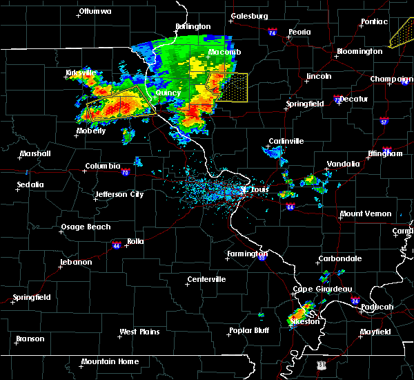 At 538 pm cdt, a severe thunderstorm was located near shelbyville, moving east at 25 mph (radar indicated). Hazards include 60 mph wind gusts and quarter size hail. Hail damage to vehicles is expected. expect wind damage to roofs, siding, and trees. Locations impacted include, hannibal, palmyra, shelbina, warren, clarence, shelbyville, ewing, maud, steffenville, maywood, emden, philadelphia, hunnewell, taylor and bethel. At 538 pm cdt, a severe thunderstorm was located near shelbyville, moving east at 25 mph (radar indicated). Hazards include 60 mph wind gusts and quarter size hail. Hail damage to vehicles is expected. expect wind damage to roofs, siding, and trees. Locations impacted include, hannibal, palmyra, shelbina, warren, clarence, shelbyville, ewing, maud, steffenville, maywood, emden, philadelphia, hunnewell, taylor and bethel.
|
| 6/14/2017 5:15 PM CDT |
 At 514 pm cdt, a severe thunderstorm was located near clarence, moving east at 30 mph (radar indicated). Hazards include 60 mph wind gusts and quarter size hail. Hail damage to vehicles is expected. Expect wind damage to roofs, siding, and trees. At 514 pm cdt, a severe thunderstorm was located near clarence, moving east at 30 mph (radar indicated). Hazards include 60 mph wind gusts and quarter size hail. Hail damage to vehicles is expected. Expect wind damage to roofs, siding, and trees.
|
| 3/6/2017 11:10 PM CST |
 The severe thunderstorm warning for northern pike, adams and brown counties in west central illinois will expire at 1115 pm cst, the storms which prompted the warning have weakened below severe limits, and no longer poses an immediate threat to life or property. therefore, the warning will be allowed to expire. however gusty winds are still possible with these thunderstorms. a tornado watch remains in effect until 400 am cst for west central illinois, and northeastern missouri. The severe thunderstorm warning for northern pike, adams and brown counties in west central illinois will expire at 1115 pm cst, the storms which prompted the warning have weakened below severe limits, and no longer poses an immediate threat to life or property. therefore, the warning will be allowed to expire. however gusty winds are still possible with these thunderstorms. a tornado watch remains in effect until 400 am cst for west central illinois, and northeastern missouri.
|
| 3/6/2017 10:49 PM CST |
 At 1048 pm cst, severe thunderstorms were located along a line extending from 7 miles northwest of colmar to camp point to near payson, moving east at 65 mph (trained weather spotters. a 60 mph wind gust was reported at the quincy airport). Hazards include 60 mph wind gusts and quarter size hail. Hail damage to vehicles is expected. expect wind damage to roofs, siding, and trees. locations impacted include, quincy, pittsfield, quincy regional airport, mount sterling, barry, griggsville, camp point, payson, mendon, clayton, golden, fall creek, beverly, buckhorn, adams, la grange, kingston, burton, ursa and liberty. this also includes siloam springs state park. this includes the following highways, interstate 172 between exits 2 and 19. interstate 72 between exits 4 and 35. A tornado watch remains in effect until 400 am cst for west central illinois, and northeastern missouri. At 1048 pm cst, severe thunderstorms were located along a line extending from 7 miles northwest of colmar to camp point to near payson, moving east at 65 mph (trained weather spotters. a 60 mph wind gust was reported at the quincy airport). Hazards include 60 mph wind gusts and quarter size hail. Hail damage to vehicles is expected. expect wind damage to roofs, siding, and trees. locations impacted include, quincy, pittsfield, quincy regional airport, mount sterling, barry, griggsville, camp point, payson, mendon, clayton, golden, fall creek, beverly, buckhorn, adams, la grange, kingston, burton, ursa and liberty. this also includes siloam springs state park. this includes the following highways, interstate 172 between exits 2 and 19. interstate 72 between exits 4 and 35. A tornado watch remains in effect until 400 am cst for west central illinois, and northeastern missouri.
|
| 3/6/2017 10:35 PM CST | Storm damage reported in marion county MO, 2.1 miles ESE of Hannibal, MO |
| 3/6/2017 10:20 PM CST |
 At 1020 pm cst, severe thunderstorms were located along a line extending from near alexandria to maywood to near monroe city, moving east at 65 mph (radar indicated). Hazards include 60 mph wind gusts and quarter size hail. Hail damage to vehicles is expected. Expect wind damage to roofs, siding, and trees. At 1020 pm cst, severe thunderstorms were located along a line extending from near alexandria to maywood to near monroe city, moving east at 65 mph (radar indicated). Hazards include 60 mph wind gusts and quarter size hail. Hail damage to vehicles is expected. Expect wind damage to roofs, siding, and trees.
|
| 3/6/2017 10:06 PM CST |
 At 1005 pm cst, severe thunderstorms were located along a line extending from near kahoka to near granville, moving east at 55 mph (trained weather spotters. trained spotters reported winds near 60 mph near the knox and shelby county line). Hazards include 60 mph wind gusts and quarter size hail. Hail damage to vehicles is expected. expect wind damage to roofs, siding, and trees. locations impacted include, hannibal, palmyra, monroe city, canton, shelbina, paris, santa fe, warren, new london, la grange, perry, la belle, madison, shelbyville, lewistown, center, ewing, rensselaer, maywood and spaulding. this also includes wakonda state park, union covered bridge historic site, and mark twain lake recreational area. A tornado watch remains in effect until 400 am cst for west central illinois, and central and northeastern missouri. At 1005 pm cst, severe thunderstorms were located along a line extending from near kahoka to near granville, moving east at 55 mph (trained weather spotters. trained spotters reported winds near 60 mph near the knox and shelby county line). Hazards include 60 mph wind gusts and quarter size hail. Hail damage to vehicles is expected. expect wind damage to roofs, siding, and trees. locations impacted include, hannibal, palmyra, monroe city, canton, shelbina, paris, santa fe, warren, new london, la grange, perry, la belle, madison, shelbyville, lewistown, center, ewing, rensselaer, maywood and spaulding. this also includes wakonda state park, union covered bridge historic site, and mark twain lake recreational area. A tornado watch remains in effect until 400 am cst for west central illinois, and central and northeastern missouri.
|
| 3/6/2017 9:33 PM CST |
 At 932 pm cst, severe thunderstorms were located along a line extending from near memphis to 9 miles northwest of huntsville, moving east at 55 mph (radar indicated). Hazards include 60 mph wind gusts and quarter size hail. Hail damage to vehicles is expected. Expect wind damage to roofs, siding, and trees. At 932 pm cst, severe thunderstorms were located along a line extending from near memphis to 9 miles northwest of huntsville, moving east at 55 mph (radar indicated). Hazards include 60 mph wind gusts and quarter size hail. Hail damage to vehicles is expected. Expect wind damage to roofs, siding, and trees.
|
| 2/28/2017 8:52 PM CST |
 At 850 pm cst, a severe thunderstorm capable of producing a tornado was located over hannibal, moving east at 60 mph (weather spotters reported a funnel cloud. broadcast media reported a funnel to the west of hannibal with this storm). Hazards include tornado and quarter size hail. Flying debris will be dangerous to those caught without shelter. mobile homes will be damaged or destroyed. damage to roofs, windows, and vehicles will occur. tree damage is likely. this dangerous storm will be near, payson around 900 pm cst. other locations impacted by this tornadic thunderstorm include ilasco, seehorn, saverton, kinderhook, plainville and hull. this includes the following highways, interstate 172 near exit 2. Interstate 72 between exits 4 and 10. At 850 pm cst, a severe thunderstorm capable of producing a tornado was located over hannibal, moving east at 60 mph (weather spotters reported a funnel cloud. broadcast media reported a funnel to the west of hannibal with this storm). Hazards include tornado and quarter size hail. Flying debris will be dangerous to those caught without shelter. mobile homes will be damaged or destroyed. damage to roofs, windows, and vehicles will occur. tree damage is likely. this dangerous storm will be near, payson around 900 pm cst. other locations impacted by this tornadic thunderstorm include ilasco, seehorn, saverton, kinderhook, plainville and hull. this includes the following highways, interstate 172 near exit 2. Interstate 72 between exits 4 and 10.
|
| 2/28/2017 8:50 PM CST | Quarter sized hail reported 1.2 miles W of Hannibal, MO |
| 2/28/2017 8:46 PM CST | Quarter sized hail reported 1.2 miles W of Hannibal, MO |
| 2/28/2017 8:37 PM CST |
 At 837 pm cst, a severe thunderstorm capable of producing a tornado was located over rensselaer, moving east at 55 mph (radar indicated rotation). Hazards include tornado and quarter size hail. Flying debris will be dangerous to those caught without shelter. mobile homes will be damaged or destroyed. damage to roofs, windows, and vehicles will occur. tree damage is likely. this dangerous storm will be near, hannibal around 850 pm cst. fall creek around 855 pm cst. payson around 900 pm cst. other locations impacted by this tornadic thunderstorm include ilasco, seehorn, saverton, kinderhook, plainville and hull. this includes the following highways, interstate 172 near exit 2. Interstate 72 between exits 4 and 10. At 837 pm cst, a severe thunderstorm capable of producing a tornado was located over rensselaer, moving east at 55 mph (radar indicated rotation). Hazards include tornado and quarter size hail. Flying debris will be dangerous to those caught without shelter. mobile homes will be damaged or destroyed. damage to roofs, windows, and vehicles will occur. tree damage is likely. this dangerous storm will be near, hannibal around 850 pm cst. fall creek around 855 pm cst. payson around 900 pm cst. other locations impacted by this tornadic thunderstorm include ilasco, seehorn, saverton, kinderhook, plainville and hull. this includes the following highways, interstate 172 near exit 2. Interstate 72 between exits 4 and 10.
|
| 2/28/2017 8:29 PM CST |
 At 828 pm cst, a severe thunderstorm was located near monroe city, moving east at 60 mph (radar indicated). Hazards include 60 mph wind gusts and quarter size hail. Hail damage to vehicles is expected. Expect wind damage to roofs, siding, and trees. At 828 pm cst, a severe thunderstorm was located near monroe city, moving east at 60 mph (radar indicated). Hazards include 60 mph wind gusts and quarter size hail. Hail damage to vehicles is expected. Expect wind damage to roofs, siding, and trees.
|
| 7/19/2016 5:01 PM CDT |
 At 500 pm cdt, a severe thunderstorm was located near center, moving northeast at 15 mph (radar indicated). Hazards include 60 mph wind gusts and penny size hail. Expect damage to roofs. siding. And trees. At 500 pm cdt, a severe thunderstorm was located near center, moving northeast at 15 mph (radar indicated). Hazards include 60 mph wind gusts and penny size hail. Expect damage to roofs. siding. And trees.
|
| 7/13/2016 2:10 PM CDT | Trees and limbs down...concentrated in south part of the city in marion county MO, 1.2 miles W of Hannibal, MO |
| 7/13/2016 1:48 PM CDT |
 At 148 pm cdt, severe thunderstorms were located along a line extending from near rensselaer to near williamsburg to st. thomas, moving east at 50 mph (trained weather spotters). Hazards include 60 mph wind gusts. Expect damage to roofs. siding. and trees. locations impacted include, jefferson city, hannibal, fulton, mexico, bowling green, vandalia, ashland, holts summit, montgomery city, owensville, monroe city, hermann, linn, wellsville, santa fe, belle, wardsville, gerald, st. martins and auxvasse. this also includes deutschheim historic site, clarks hill/norton historic site, jefferson landing historic site, graham cave state park, and mark twain lake recreational area. this includes the following highways, interstate 72 near exit 10. Interstate 70 in missouri between exits 133 and 183. At 148 pm cdt, severe thunderstorms were located along a line extending from near rensselaer to near williamsburg to st. thomas, moving east at 50 mph (trained weather spotters). Hazards include 60 mph wind gusts. Expect damage to roofs. siding. and trees. locations impacted include, jefferson city, hannibal, fulton, mexico, bowling green, vandalia, ashland, holts summit, montgomery city, owensville, monroe city, hermann, linn, wellsville, santa fe, belle, wardsville, gerald, st. martins and auxvasse. this also includes deutschheim historic site, clarks hill/norton historic site, jefferson landing historic site, graham cave state park, and mark twain lake recreational area. this includes the following highways, interstate 72 near exit 10. Interstate 70 in missouri between exits 133 and 183.
|
| 7/13/2016 1:40 PM CDT |
 At 139 pm cdt, severe thunderstorms were located along a line extending from near monroe city to near fulton to hickory hill, moving east at 45 mph (trained weather spotters. numerous reports of trees and tree limbs down and power lines down). Hazards include 60 mph wind gusts. Expect damage to roofs. siding. And trees. At 139 pm cdt, severe thunderstorms were located along a line extending from near monroe city to near fulton to hickory hill, moving east at 45 mph (trained weather spotters. numerous reports of trees and tree limbs down and power lines down). Hazards include 60 mph wind gusts. Expect damage to roofs. siding. And trees.
|
| 7/7/2016 7:52 AM CDT |
 At 752 am cdt, severe thunderstorms were located along a line extending from near frankford to near jonesburg to 7 miles southwest of mount sterling, moving east at 35 mph (radar indicated). Hazards include 70 mph wind gusts. Expect considerable tree damage. damage is likely to mobile homes, roofs, and outbuildings. locations impacted include, hannibal, washington, troy, warrenton, bowling green, vandalia, louisiana, wright city, montgomery city, owensville, monroe city, hermann, new haven, linn, wellsville, belle, gerald, davis, marthasville and new london. this also includes deutschheim historic site, clarks hill/norton historic site, and graham cave state park. This includes interstate 70 in missouri between exits 161 and 200. At 752 am cdt, severe thunderstorms were located along a line extending from near frankford to near jonesburg to 7 miles southwest of mount sterling, moving east at 35 mph (radar indicated). Hazards include 70 mph wind gusts. Expect considerable tree damage. damage is likely to mobile homes, roofs, and outbuildings. locations impacted include, hannibal, washington, troy, warrenton, bowling green, vandalia, louisiana, wright city, montgomery city, owensville, monroe city, hermann, new haven, linn, wellsville, belle, gerald, davis, marthasville and new london. this also includes deutschheim historic site, clarks hill/norton historic site, and graham cave state park. This includes interstate 70 in missouri between exits 161 and 200.
|
| 7/7/2016 7:39 AM CDT |
 At 738 am cdt, severe thunderstorms were located along a line extending from 11 miles south of kahoka to warren, moving east at 45 mph (radar indicated). Hazards include 60 mph wind gusts and penny size hail. Expect damage to roofs. siding. and trees. locations impacted include, hannibal, palmyra, canton, warren, la grange, la belle, lewistown, ewing, emden, philadelphia, steffenville, maywood, taylor and monticello. This also includes wakonda state park. At 738 am cdt, severe thunderstorms were located along a line extending from 11 miles south of kahoka to warren, moving east at 45 mph (radar indicated). Hazards include 60 mph wind gusts and penny size hail. Expect damage to roofs. siding. and trees. locations impacted include, hannibal, palmyra, canton, warren, la grange, la belle, lewistown, ewing, emden, philadelphia, steffenville, maywood, taylor and monticello. This also includes wakonda state park.
|
| 7/7/2016 7:29 AM CDT |
 At 728 am cdt, severe thunderstorms were located along a line extending from near perry to near williamsburg to near westphalia, moving east at 60 mph (radar indicated). Hazards include 70 mph wind gusts. Expect considerable tree damage. damage is likely to mobile homes, roofs, and outbuildings. locations impacted include, hannibal, washington, troy, warrenton, bowling green, vandalia, louisiana, wright city, montgomery city, owensville, monroe city, hermann, new haven, linn, wellsville, belle, gerald, davis, marthasville and new london. this also includes deutschheim historic site and graham cave state park. This includes interstate 70 in missouri between exits 155 and 200. At 728 am cdt, severe thunderstorms were located along a line extending from near perry to near williamsburg to near westphalia, moving east at 60 mph (radar indicated). Hazards include 70 mph wind gusts. Expect considerable tree damage. damage is likely to mobile homes, roofs, and outbuildings. locations impacted include, hannibal, washington, troy, warrenton, bowling green, vandalia, louisiana, wright city, montgomery city, owensville, monroe city, hermann, new haven, linn, wellsville, belle, gerald, davis, marthasville and new london. this also includes deutschheim historic site and graham cave state park. This includes interstate 70 in missouri between exits 155 and 200.
|
| 7/7/2016 7:11 AM CDT |
 At 710 am cdt, severe thunderstorms were located along a line extending from near rutledge to near shelbyville, moving east at 45 mph (radar indicated. a 61 mile per hour wind gust was reported 1 mile east of novelty at 7:02 am). Hazards include 60 mph wind gusts. Expect damage to roofs. siding. And trees. At 710 am cdt, severe thunderstorms were located along a line extending from near rutledge to near shelbyville, moving east at 45 mph (radar indicated. a 61 mile per hour wind gust was reported 1 mile east of novelty at 7:02 am). Hazards include 60 mph wind gusts. Expect damage to roofs. siding. And trees.
|
| 7/7/2016 7:06 AM CDT |
 At 705 am cdt, severe thunderstorms were located along a line extending from near granville to 8 miles northwest of fulton to near russellville, moving east at 60 mph (public reported damage in northern boone county). Hazards include 60 mph wind gusts. Expect damage to roofs. siding. And trees. At 705 am cdt, severe thunderstorms were located along a line extending from near granville to 8 miles northwest of fulton to near russellville, moving east at 60 mph (public reported damage in northern boone county). Hazards include 60 mph wind gusts. Expect damage to roofs. siding. And trees.
|
| 5/11/2016 7:00 PM CDT | Quarter sized hail reported 1.2 miles W of Hannibal, MO |
| 5/11/2016 6:42 PM CDT |
 At 642 pm cdt, a severe thunderstorm was located near center, moving east at 40 mph (radar indicated). Hazards include quarter size hail. damage to vehicles is expected At 642 pm cdt, a severe thunderstorm was located near center, moving east at 40 mph (radar indicated). Hazards include quarter size hail. damage to vehicles is expected
|
| 5/7/2016 2:52 PM CDT | Tree branches of unknown size and power lines downed in marion county MO, 1.2 miles W of Hannibal, MO |
| 4/30/2016 6:38 PM CDT |
 At 638 pm cdt, a severe thunderstorm was located near philadelphia, moving east at 35 mph (radar indicated). Hazards include quarter size hail. damage to vehicles is expected At 638 pm cdt, a severe thunderstorm was located near philadelphia, moving east at 35 mph (radar indicated). Hazards include quarter size hail. damage to vehicles is expected
|
| 4/30/2016 4:53 PM CDT |
 At 453 pm cdt, a severe thunderstorm was located over fall creek, moving east at 25 mph (radar indicated). Hazards include quarter size hail. damage to vehicles is expected At 453 pm cdt, a severe thunderstorm was located over fall creek, moving east at 25 mph (radar indicated). Hazards include quarter size hail. damage to vehicles is expected
|
| 12/23/2015 3:13 PM CST | The national weather service in st louis has issued a * severe thunderstorm warning for. northwestern pike county in west central illinois. southeastern marion county in northeastern missouri. until 400 pm cst * at 313 pm cst. A severe thunderstorm was located near. |
| 12/23/2015 3:13 PM CST | The national weather service in st louis has issued a * severe thunderstorm warning for. northwestern pike county in west central illinois. southeastern marion county in northeastern missouri. until 400 pm cst * at 313 pm cst. A severe thunderstorm was located near. |
| 12/23/2015 2:57 PM CST | At 256 pm cst, a severe thunderstorm was located near warren, moving northeast at 70 mph (radar indicated). Hazards include 60 mph wind gusts and quarter size hail. Hail damage to vehicles is expected. expect wind damage to roofs, siding and trees. locations impacted include, hannibal and palmyra. A tornado watch remains in effect until 800 pm cst for west central illinois and northeastern missouri. |
| 12/23/2015 2:46 PM CST | At 246 pm cst, a severe thunderstorm was located near monroe city, moving northeast at 45 mph (radar indicated). Hazards include 60 mph wind gusts and quarter size hail. Hail damage to vehicles is expected. Expect wind damage to roofs, siding and trees. |
| 11/11/2015 5:29 PM CST |
 At 529 pm cst, a severe thunderstorm was located over spaulding, moving northeast at 60 mph (radar indicated). Hazards include 70 mph wind gusts. Expect considerable tree damage. damage is likely to mobile homes, roofs and outbuildings. locations impacted include, quincy, hannibal, palmyra, monroe city, warren, barry, payson, new london, perry, fall creek, center, frankford, rensselaer, spaulding, adams, burton, hull, new canton, plainville and kinderhook. this warning also includes mark twain lake recreational area. this includes the following highways, interstate 172 between exits 2 and 15. interstate 72 between exits 4 and 10. A tornado watch remains in effect until 900 pm cst for west central illinois and northeastern missouri. At 529 pm cst, a severe thunderstorm was located over spaulding, moving northeast at 60 mph (radar indicated). Hazards include 70 mph wind gusts. Expect considerable tree damage. damage is likely to mobile homes, roofs and outbuildings. locations impacted include, quincy, hannibal, palmyra, monroe city, warren, barry, payson, new london, perry, fall creek, center, frankford, rensselaer, spaulding, adams, burton, hull, new canton, plainville and kinderhook. this warning also includes mark twain lake recreational area. this includes the following highways, interstate 172 between exits 2 and 15. interstate 72 between exits 4 and 10. A tornado watch remains in effect until 900 pm cst for west central illinois and northeastern missouri.
|
| 11/11/2015 5:12 PM CST |
 At 512 pm cst, a severe thunderstorm was located near santa fe, moving northeast at 55 mph (radar indicated). Hazards include 70 mph wind gusts. Expect considerable tree damage. damage is likely to mobile homes, roofs and outbuildings. locations impacted include, quincy, hannibal, palmyra, monroe city, paris, santa fe, warren, barry, payson, new london, perry, fall creek, center, frankford, rensselaer, spaulding, adams, burton, hull and new canton. this warning also includes mark twain lake recreational area. this includes the following highways, interstate 172 between exits 2 and 15. interstate 72 between exits 4 and 10. A tornado watch remains in effect until 900 pm cst for west central illinois and northeastern missouri. At 512 pm cst, a severe thunderstorm was located near santa fe, moving northeast at 55 mph (radar indicated). Hazards include 70 mph wind gusts. Expect considerable tree damage. damage is likely to mobile homes, roofs and outbuildings. locations impacted include, quincy, hannibal, palmyra, monroe city, paris, santa fe, warren, barry, payson, new london, perry, fall creek, center, frankford, rensselaer, spaulding, adams, burton, hull and new canton. this warning also includes mark twain lake recreational area. this includes the following highways, interstate 172 between exits 2 and 15. interstate 72 between exits 4 and 10. A tornado watch remains in effect until 900 pm cst for west central illinois and northeastern missouri.
|
| 11/11/2015 5:05 PM CST |
 At 505 pm cst, a severe thunderstorm was located near santa fe, moving northeast at 85 mph (radar indicated). Hazards include 70 mph wind gusts. Expect considerable tree damage. Damage is likely to mobile homes, roofs and outbuildings. At 505 pm cst, a severe thunderstorm was located near santa fe, moving northeast at 85 mph (radar indicated). Hazards include 70 mph wind gusts. Expect considerable tree damage. Damage is likely to mobile homes, roofs and outbuildings.
|
| 7/19/2015 3:12 AM CDT |
 At 312 am cdt, a severe thunderstorm was located near maywood, moving southeast at 10 mph (radar indicated). Hazards include 60 mph wind gusts and quarter size hail. Hail damage to vehicles is expected. Expect wind damage to roofs, siding and trees. At 312 am cdt, a severe thunderstorm was located near maywood, moving southeast at 10 mph (radar indicated). Hazards include 60 mph wind gusts and quarter size hail. Hail damage to vehicles is expected. Expect wind damage to roofs, siding and trees.
|
| 6/28/2015 4:37 PM CDT |
 At 435 pm cdt, a severe thunderstorm capable of producing a tornado was located near hannibal, and moving east at 30 mph (radar indicated rotation). Hazards include tornado and quarter size hail. Flying debris will be dangerous to those caught without shelter. mobile homes will be damaged or destroyed. damage to roofs, windows and vehicles will occur. tree damage is likely. This dangerous storm will affect mainly rural areas of north central pike, northeastern ralls and west central pike counties, including the following locations, saverton, new canton and ashburn. At 435 pm cdt, a severe thunderstorm capable of producing a tornado was located near hannibal, and moving east at 30 mph (radar indicated rotation). Hazards include tornado and quarter size hail. Flying debris will be dangerous to those caught without shelter. mobile homes will be damaged or destroyed. damage to roofs, windows and vehicles will occur. tree damage is likely. This dangerous storm will affect mainly rural areas of north central pike, northeastern ralls and west central pike counties, including the following locations, saverton, new canton and ashburn.
|
| 6/28/2015 4:12 PM CDT |
 At 410 pm cdt, a severe thunderstorm capable of producing a tornado was located near rensselaer, and moving east at 45 mph (radar indicated rotation. spotters reported a lowering and rotating wall cloud). Hazards include tornado and half dollar size hail. Flying debris will be dangerous to those caught without shelter. mobile homes will be damaged or destroyed. damage to roofs, windows and vehicles will occur. tree damage is likely. this dangerous storm will be near, hannibal and new london around 420 pm cdt. other locations in the warning include ilasco, saverton and hull. This warning also includes, interstate 72 near exit 10. At 410 pm cdt, a severe thunderstorm capable of producing a tornado was located near rensselaer, and moving east at 45 mph (radar indicated rotation. spotters reported a lowering and rotating wall cloud). Hazards include tornado and half dollar size hail. Flying debris will be dangerous to those caught without shelter. mobile homes will be damaged or destroyed. damage to roofs, windows and vehicles will occur. tree damage is likely. this dangerous storm will be near, hannibal and new london around 420 pm cdt. other locations in the warning include ilasco, saverton and hull. This warning also includes, interstate 72 near exit 10.
|
| 6/28/2015 4:06 PM CDT | Half Dollar sized hail reported 4.1 miles E of Hannibal, MO |
| 6/28/2015 4:04 PM CDT |
 At 402 pm cdt, a severe thunderstorm capable of producing a tornado was located near rensselaer, and moving east at 45 mph (radar indicated rotation). Hazards include tornado. Flying debris will be dangerous to those caught without shelter. mobile homes will be damaged or destroyed. damage to roofs, windows and vehicles will occur. tree damage is likely. this dangerous storm will be near, hannibal and new london around 415 pm cdt. other locations in the warning include ilasco, saverton, hull and kinderhook. This warning also includes, interstate 72 near exit 10. At 402 pm cdt, a severe thunderstorm capable of producing a tornado was located near rensselaer, and moving east at 45 mph (radar indicated rotation). Hazards include tornado. Flying debris will be dangerous to those caught without shelter. mobile homes will be damaged or destroyed. damage to roofs, windows and vehicles will occur. tree damage is likely. this dangerous storm will be near, hannibal and new london around 415 pm cdt. other locations in the warning include ilasco, saverton, hull and kinderhook. This warning also includes, interstate 72 near exit 10.
|
| 6/22/2015 8:26 PM CDT |
 At 823 pm cdt, a severe thunderstorm was located near canton, and moving southeast at 50 mph (trained weather spotters. damage was reported to a metal barn north of monticello missouri). Hazards include 60 mph wind gusts. Expect damage to roofs. siding and trees. locations impacted include, quincy, maywood, la grange, mendon, golden, camp point, lima, taylor, ursa, loraine, woodville, fowler, paloma, marblehead, coatsburg, chatton, burton, la prairie and columbus. this warning includes wakonda state park. This warning also includes, interstate 172 from exit 10 to exit 19. At 823 pm cdt, a severe thunderstorm was located near canton, and moving southeast at 50 mph (trained weather spotters. damage was reported to a metal barn north of monticello missouri). Hazards include 60 mph wind gusts. Expect damage to roofs. siding and trees. locations impacted include, quincy, maywood, la grange, mendon, golden, camp point, lima, taylor, ursa, loraine, woodville, fowler, paloma, marblehead, coatsburg, chatton, burton, la prairie and columbus. this warning includes wakonda state park. This warning also includes, interstate 172 from exit 10 to exit 19.
|
| 6/22/2015 8:12 PM CDT |
 At 811 pm cdt, a severe thunderstorm was located 11 miles southwest of wayland, and moving southeast at 50 mph (radar indicated). Hazards include 60 mph wind gusts. Expect damage to roofs. Siding and trees. At 811 pm cdt, a severe thunderstorm was located 11 miles southwest of wayland, and moving southeast at 50 mph (radar indicated). Hazards include 60 mph wind gusts. Expect damage to roofs. Siding and trees.
|
| 7/7/2014 11:50 PM CDT | Traffic light blown down in downtown hannibal. several store front windows shattere in marion county MO, 1.2 miles W of Hannibal, MO |
| 7/7/2014 11:35 PM CDT | Stop sign blown over at route hh and u.s. highway 6 in ralls county MO, 3.4 miles NE of Hannibal, MO |
| 7/7/2014 11:35 PM CDT | Store front windows broken out of 3 stores and several cars move in marion county MO, 1.2 miles W of Hannibal, MO |
| 7/7/2014 11:30 PM CDT | Stop sign blown over at highway 61 and route hh in ralls county MO, 4.2 miles NE of Hannibal, MO |
| 2/20/2014 1:58 PM CST | Quarter sized hail reported 1.2 miles W of Hannibal, MO |
| 2/20/2014 1:55 PM CST | Storm damage reported in marion county MO, 2.1 miles ESE of Hannibal, MO |
| 5/20/2013 8:09 PM CDT | Nuimerous branches downed. wind speed 55 mp in marion county MO, 0.2 miles WSW of Hannibal, MO |
| 5/20/2013 7:35 PM CDT | Storm damage reported in marion county MO, 1.2 miles W of Hannibal, MO |
| 5/20/2013 7:30 PM CDT | Numerous trees uprooted in marion county MO, 0.2 miles WSW of Hannibal, MO |
| 5/20/2013 7:29 PM CDT | Large limbs blown down in marion county MO, 1.2 miles W of Hannibal, MO |
| 5/20/2013 7:25 PM CDT | Trees uprooted one quarter mile southeast of airport in marion county MO, 1.2 miles W of Hannibal, MO |
| 5/15/2013 10:35 PM CDT | Half Dollar sized hail reported 1.8 miles NW of Hannibal, MO |
| 4/17/2013 6:30 PM CDT | 3 semi trucks blown over on highway 36 near west ely in marion county MO, 4.1 miles E of Hannibal, MO |
| 1/1/0001 12:00 AM | Siding ripped off several homes in addition to numerous tree limbs down... some over a foot in diamete in marion county MO, 1.2 miles W of Hannibal, MO |
| 1/1/0001 12:00 AM | Storm damage reported in marion county MO, 1.2 miles W of Hannibal, MO |
| 1/1/0001 12:00 AM | Numerous reports of trees and power lines down throughout town. also several trees on cars and homes. in addition... several fires caused by power lines down and possib in marion county MO, 1.2 miles W of Hannibal, MO |
| 1/1/0001 12:00 AM | Storm damage reported in marion county MO, 2.1 miles ESE of Hannibal, MO |
| 1/1/0001 12:00 AM | Multiple tree limbs down...8 inches in diameter in marion county MO, 2.4 miles SSW of Hannibal, MO |
| 1/1/0001 12:00 AM | Highway billboard knocked down onto highway 7 in marion county MO, 1.2 miles W of Hannibal, MO |
| 1/1/0001 12:00 AM | Dime size hail...across the road from the airport in marion county MO, 1.2 miles W of Hannibal, MO |
| 1/1/0001 12:00 AM | Storm damage reported in marion county MO, 2.1 miles ESE of Hannibal, MO |
| 1/1/0001 12:00 AM | Quarter sized hail reported 5.2 miles E of Hannibal, MO |
| 1/1/0001 12:00 AM | 4 foot diamter tree down on paris gravel roa in marion county MO, 2 miles E of Hannibal, MO |
| 1/1/0001 12:00 AM | Estimated 70 mph wind just south of hannibal missouri near highway 61. 2 foot diameter tree uproote in marion county MO, 1.2 miles W of Hannibal, MO |
| 1/1/0001 12:00 AM | Relayed by marion county 991 call cente in ralls county MO, 2.2 miles NNE of Hannibal, MO |
| 1/1/0001 12:00 AM | Numerous roofs blown off houses on 1100 block of stable driv in ralls county MO, 4.2 miles NNE of Hannibal, MO |
| 1/1/0001 12:00 AM | Power is out due to the thunderstorm wind in ralls county MO, 5.4 miles NNE of Hannibal, MO |
| 1/1/0001 12:00 AM | Quarter sized hail reported 0.7 miles W of Hannibal, MO, at the intersection of u.s. highway 61 and west ely road. |
| 1/1/0001 12:00 AM | Garage blown down from a residenc in ralls county MO, 4.6 miles NE of Hannibal, MO |
| 1/1/0001 12:00 AM | 54000 block of highway m reported north side of a 200 x 60 shed has been damaged. approximately 30-40 feet of the north side of the metal structure has been torn of in ralls county MO, 4.9 miles NE of Hannibal, MO |
| 1/1/0001 12:00 AM | 4 foot diamter tree down on paris gravel roa in marion county MO, 2 miles E of Hannibal, MO |
| 1/1/0001 12:00 AM | Billboards down on us 6 in ralls county MO, 2.4 miles NNW of Hannibal, MO |
| 1/1/0001 12:00 AM | Quarter sized hail reported 2.2 miles NNE of Hannibal, MO |
| 1/1/0001 12:00 AM | Half Dollar sized hail reported 4.6 miles E of Hannibal, MO, hail lasted 5 minutes. |
| 1/1/0001 12:00 AM | Golf Ball sized hail reported 1.2 miles W of Hannibal, MO |
| 1/1/0001 12:00 AM | Quarter sized hail reported 1.2 miles W of Hannibal, MO, still hailing. |
| 1/1/0001 12:00 AM | Quarter sized hail reported 2.3 miles W of Hannibal, MO |
| 1/1/0001 12:00 AM | 4 foot diameter tree blown down across roadway. falling tree crushed car and took down power line in marion county MO, 1.2 miles W of Hannibal, MO |
| 1/1/0001 12:00 AM | Two reports of 24-36 inch diameter trees blown down. one was across a road. officer reported that roots were pulled out of the groun in marion county MO, 1.2 miles W of Hannibal, MO |
| 1/1/0001 12:00 AM | One plane flipped over at airport... several other planes damaged... minor structural damage to a hangar in marion county MO, 1.5 miles SSE of Hannibal, MO |
| 1/1/0001 12:00 AM | Storm damage reported in marion county MO, 2.4 miles SE of Hannibal, MO |
| 1/1/0001 12:00 AM | Storm damage reported in marion county MO, 2.1 miles ESE of Hannibal, MO |
Hail Maps for Hannibal, MO

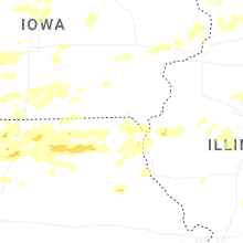
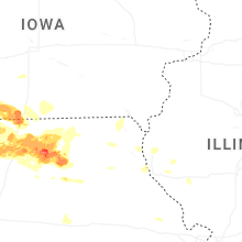


Connect with Interactive Hail Maps