

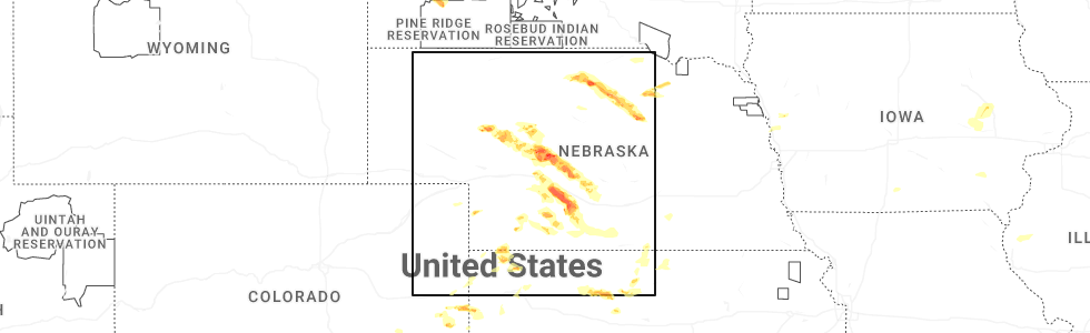
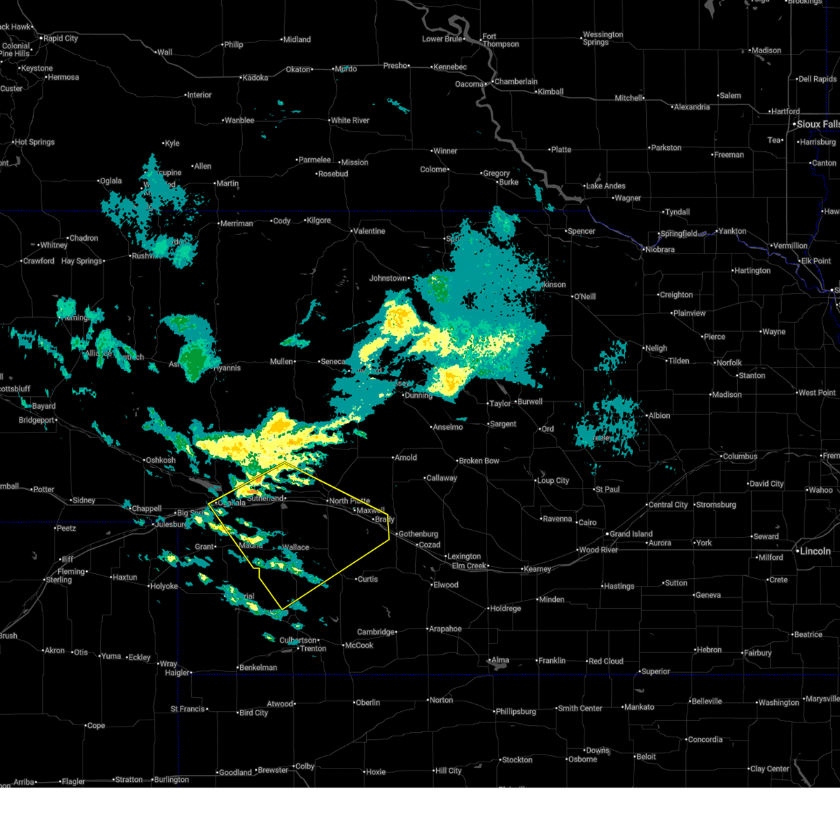
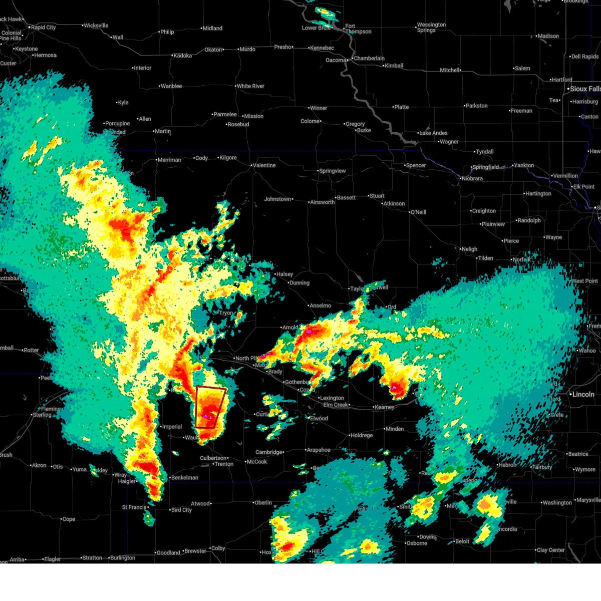
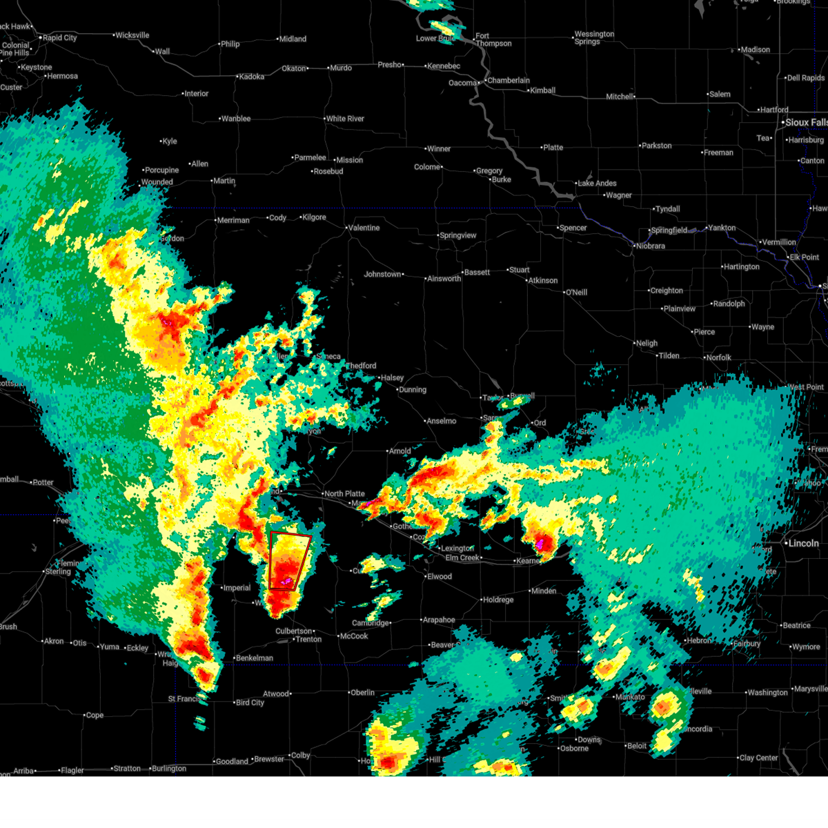
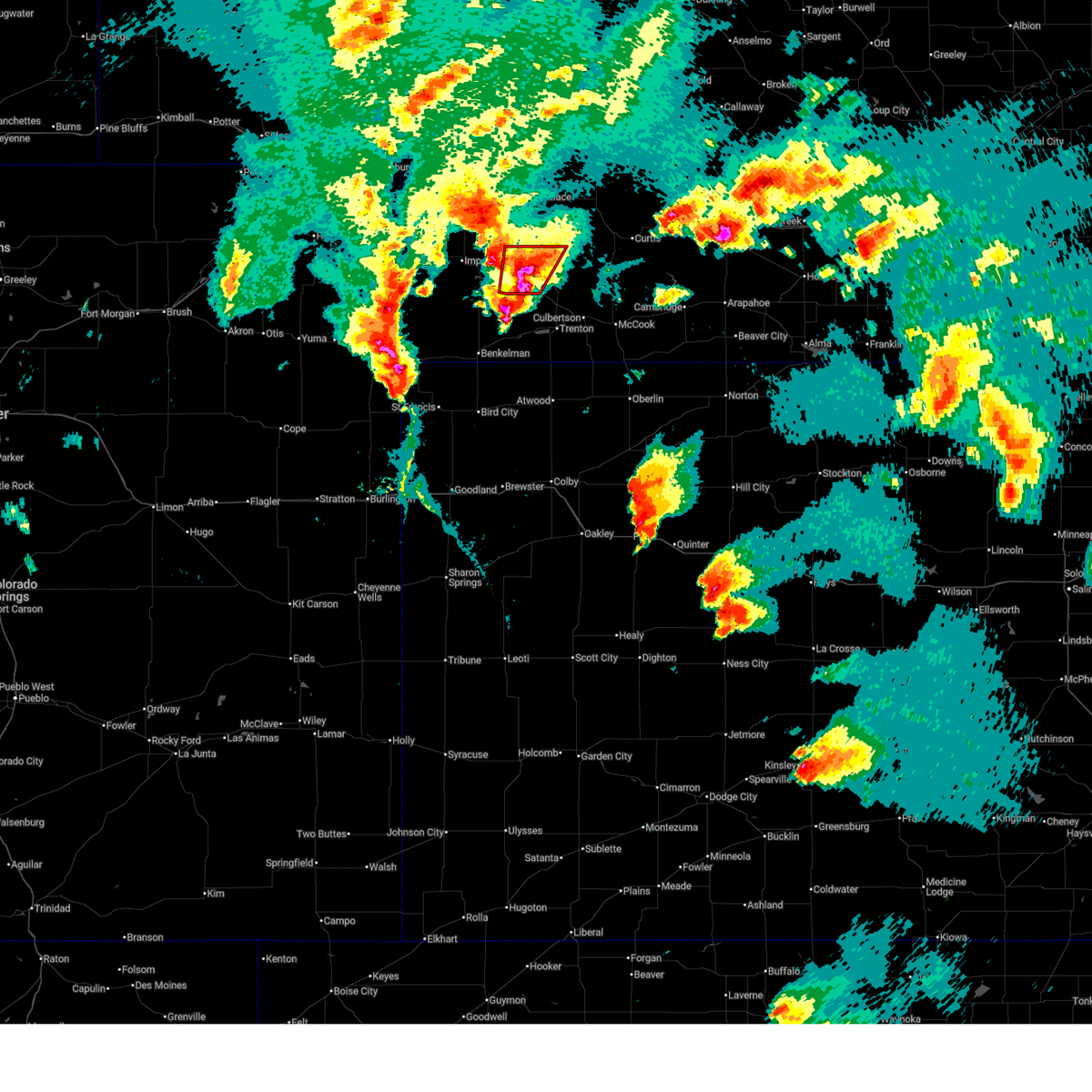
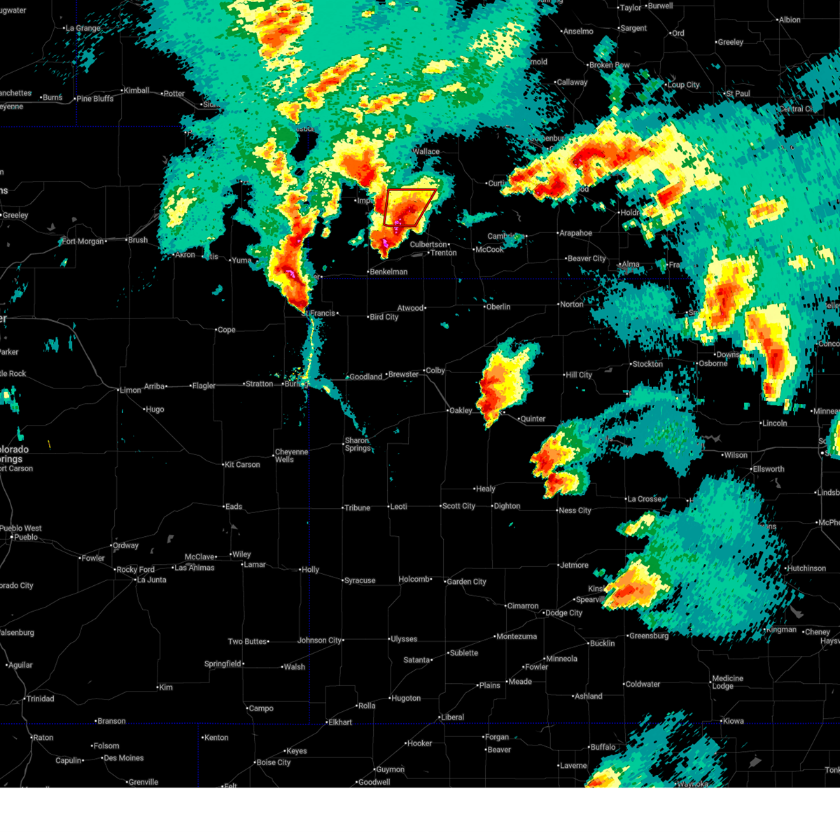
Hail Map for Hayes Center, NE
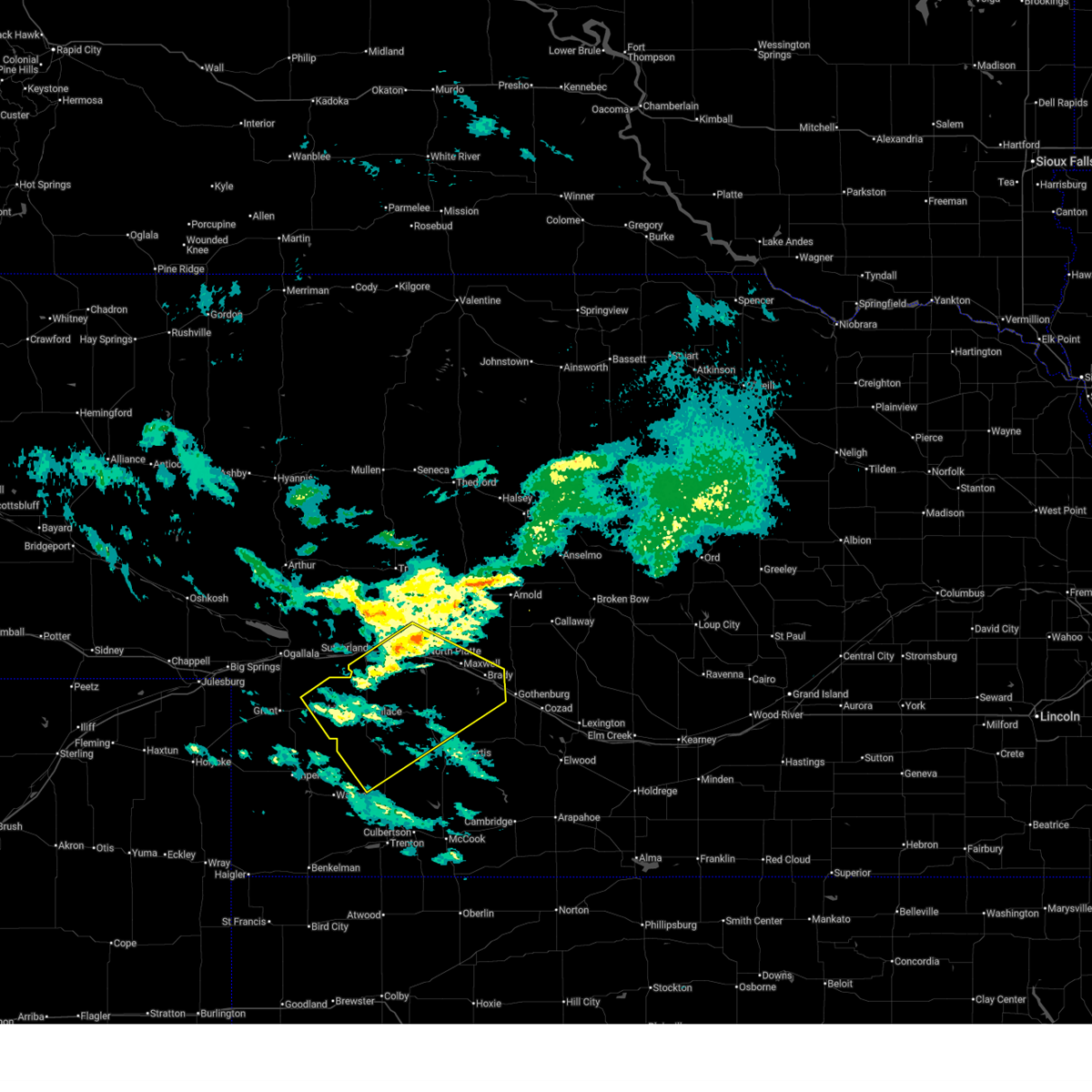
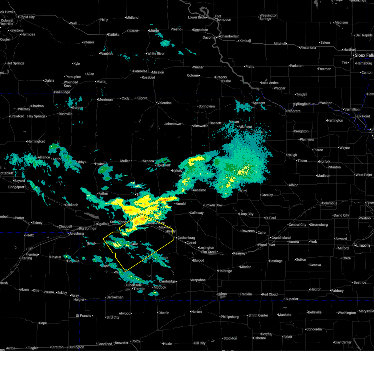
The Hayes Center, NE area has had 48 reports of on-the-ground hail by trained spotters, and has been under severe weather warnings 20 times during the past 12 months. Doppler radar has detected hail at or near Hayes Center, NE on 106 occasions, including 10 occasions during the past year.
| Name: | Hayes Center, NE |
| Where Located: | 45.1 miles SSW of North Platte, NE |
| Map: | Google Map for Hayes Center, NE |
| Population: | 214 |
| Housing Units: | 122 |
| More Info: | Search Google for Hayes Center, NE |
2
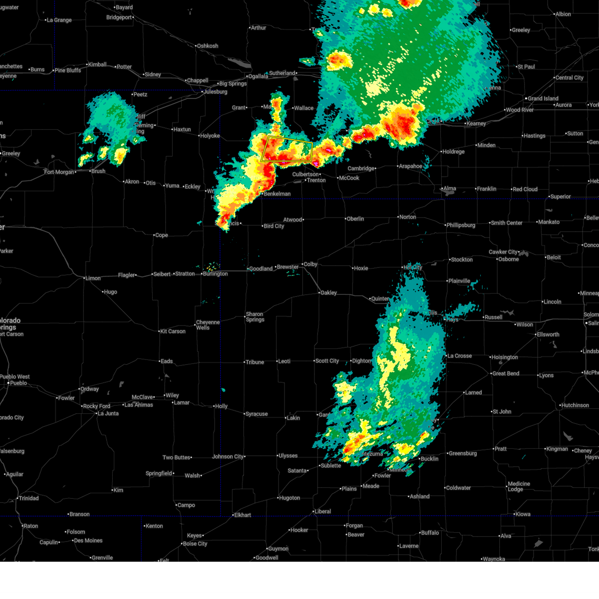
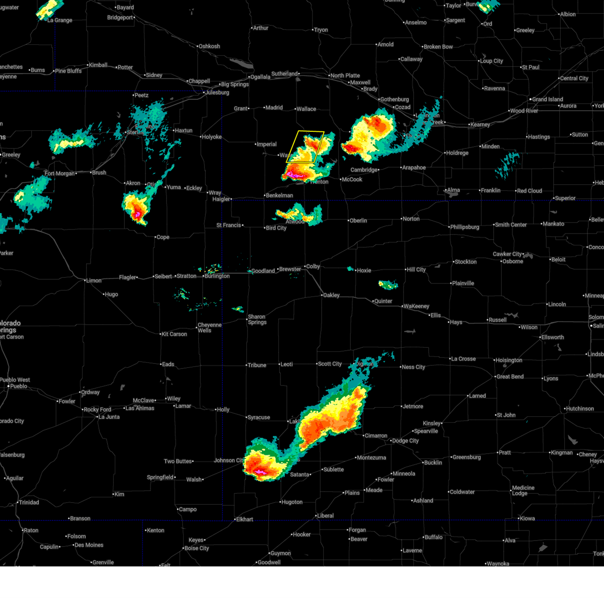
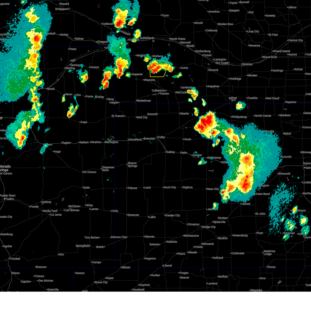
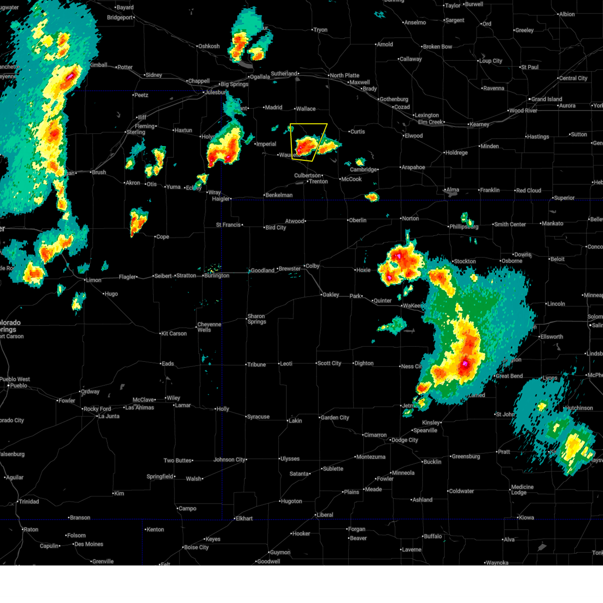
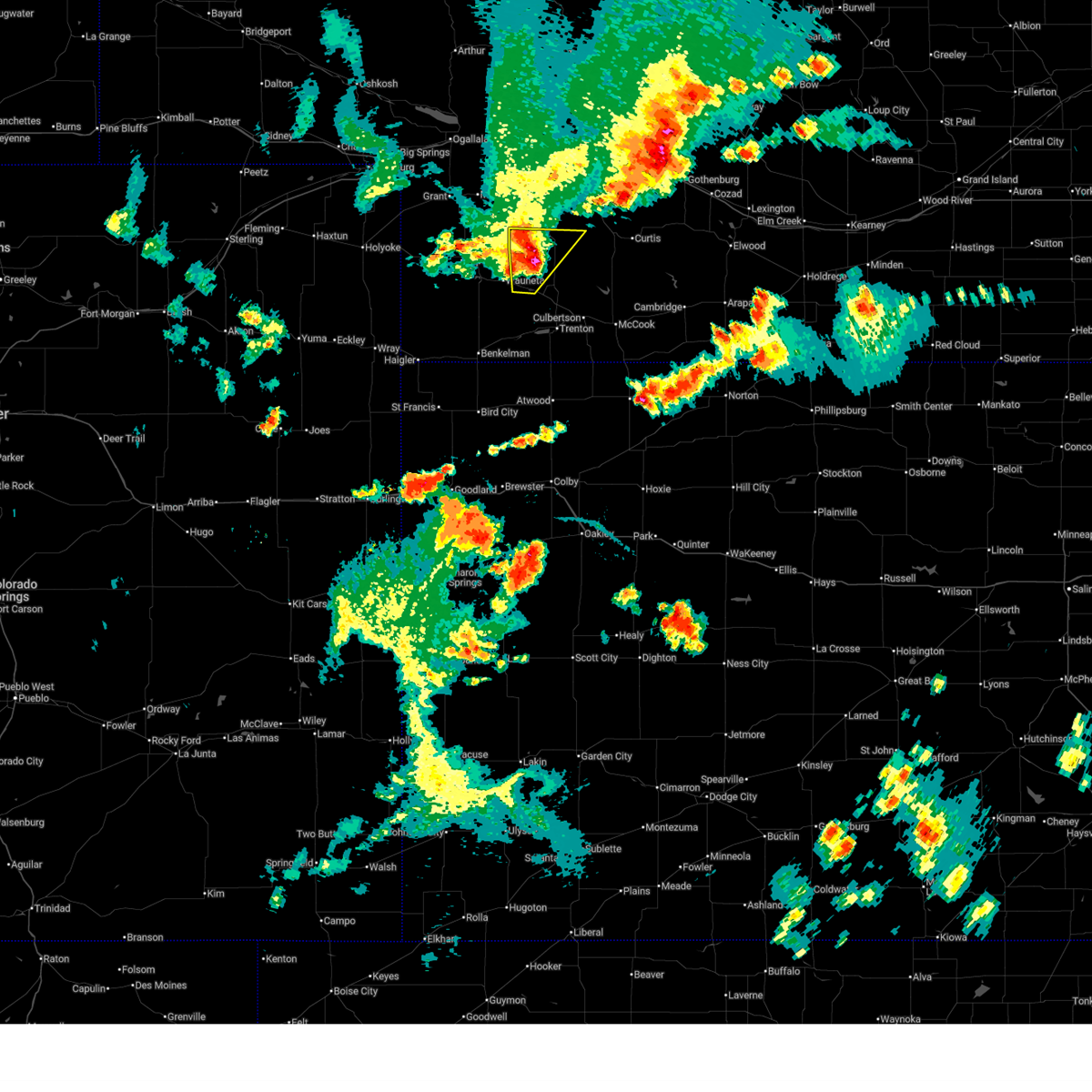
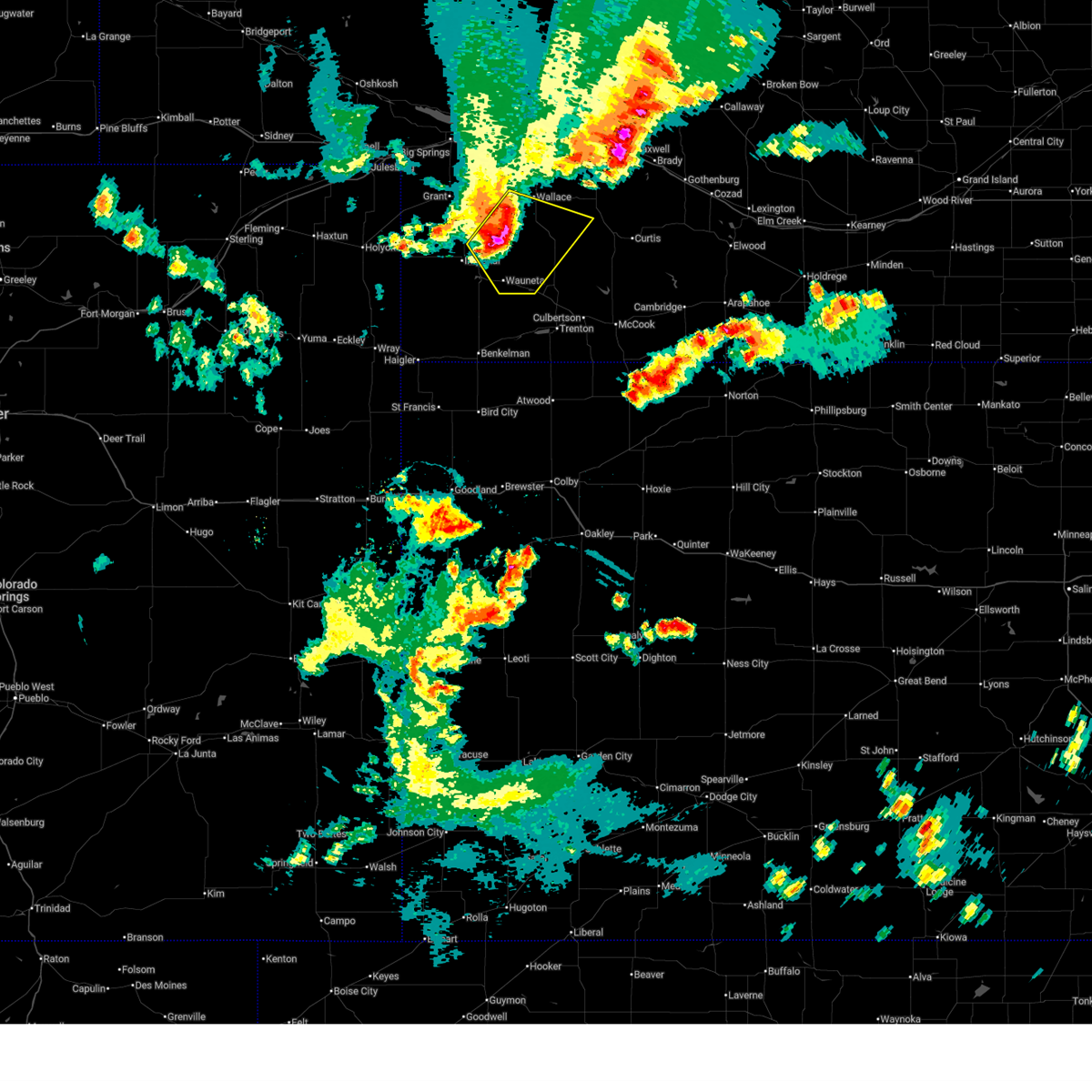
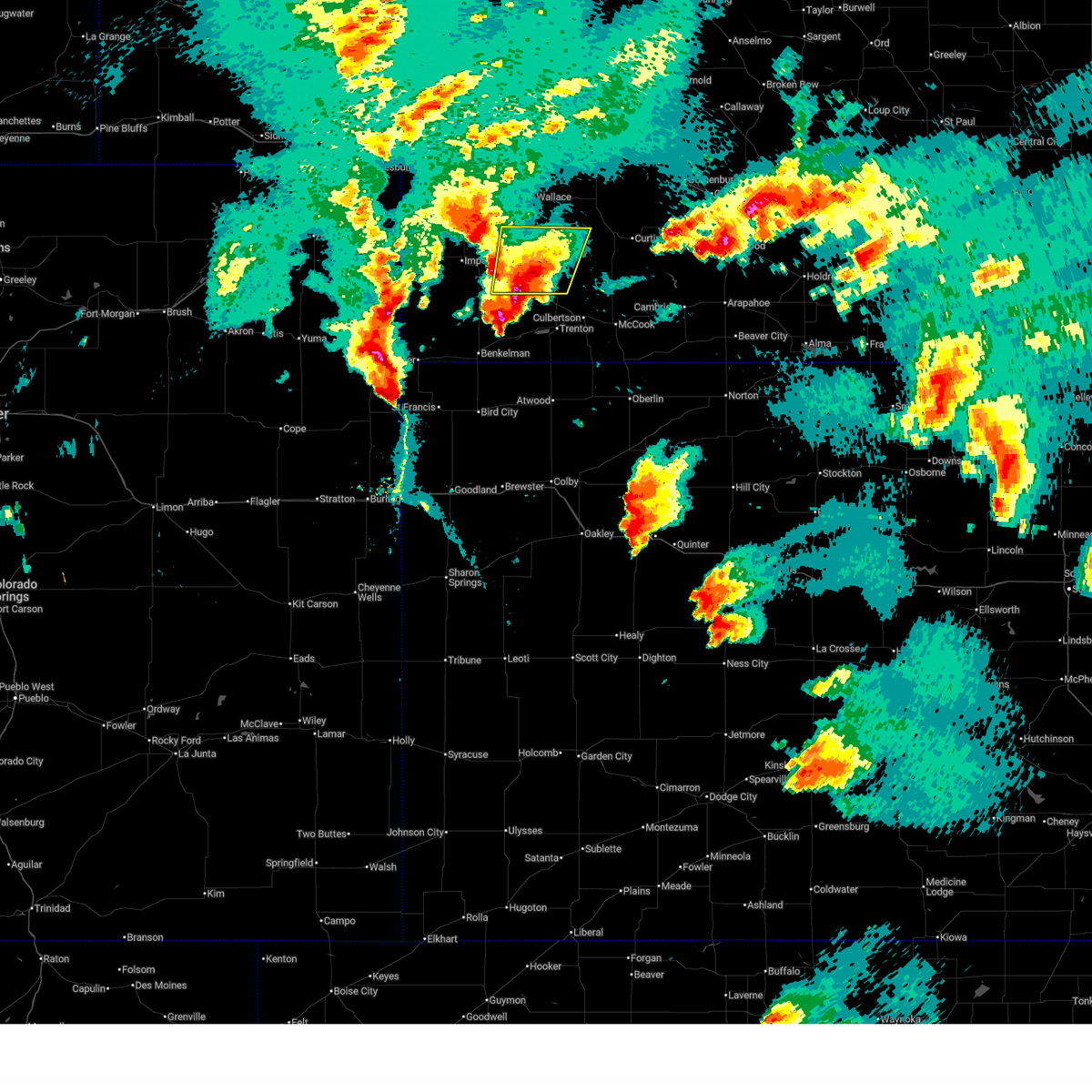
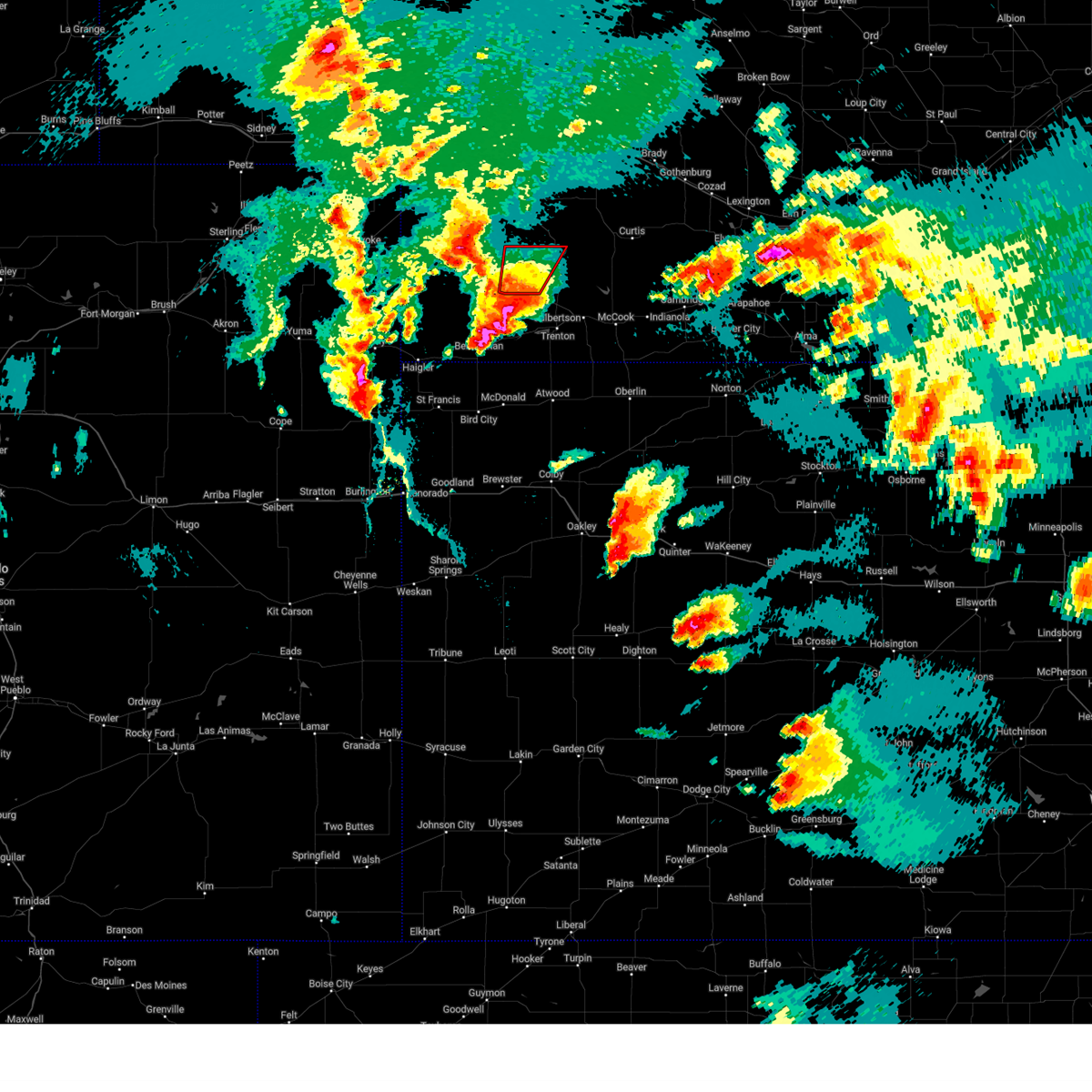
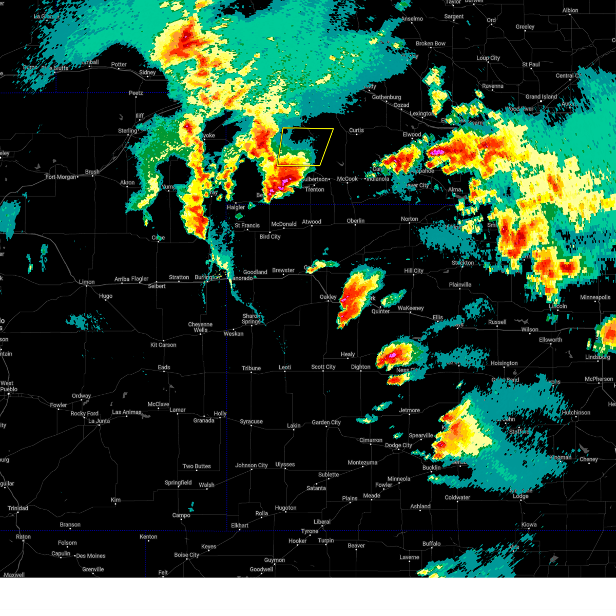
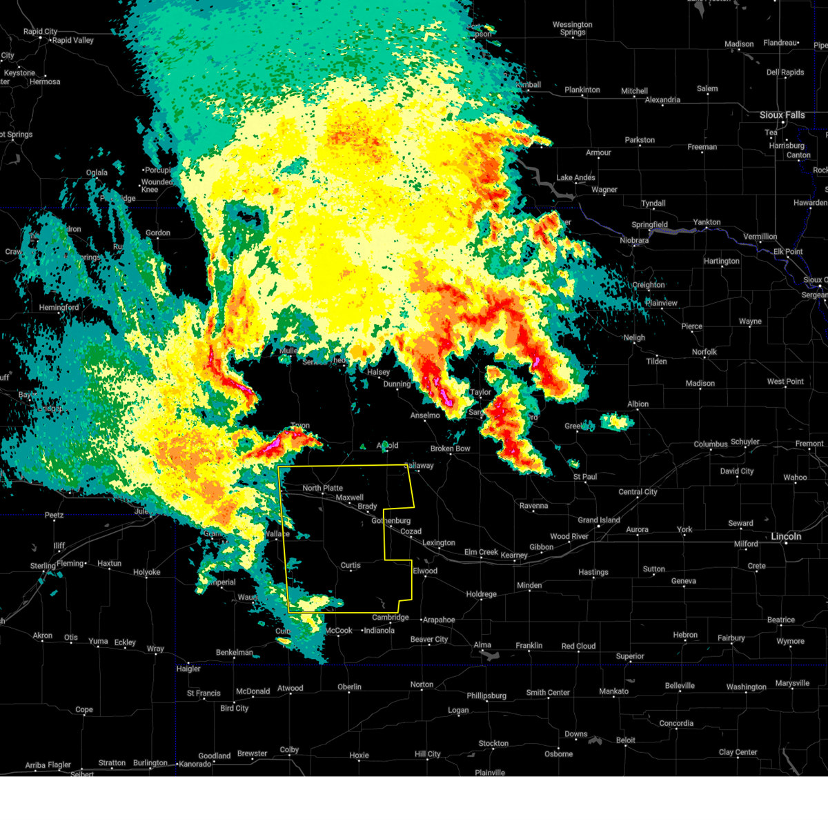
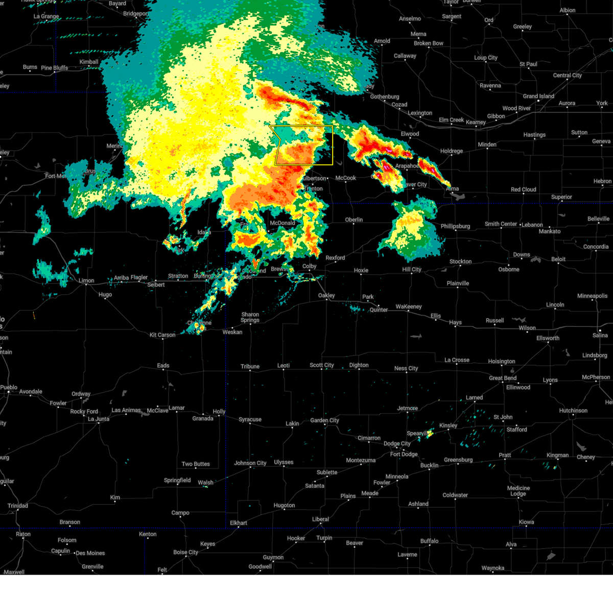
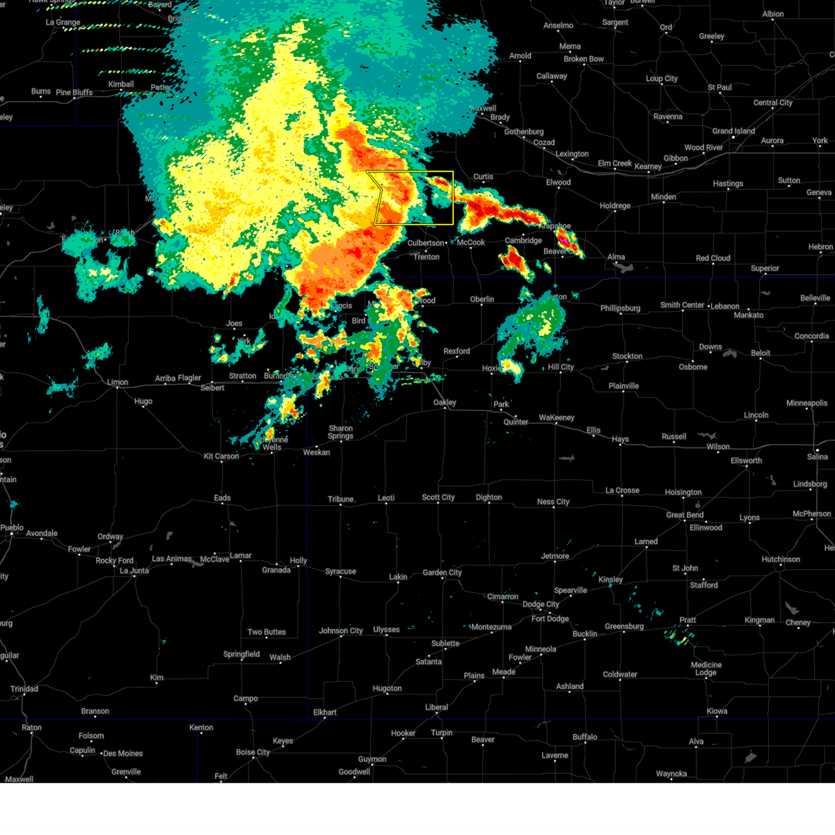
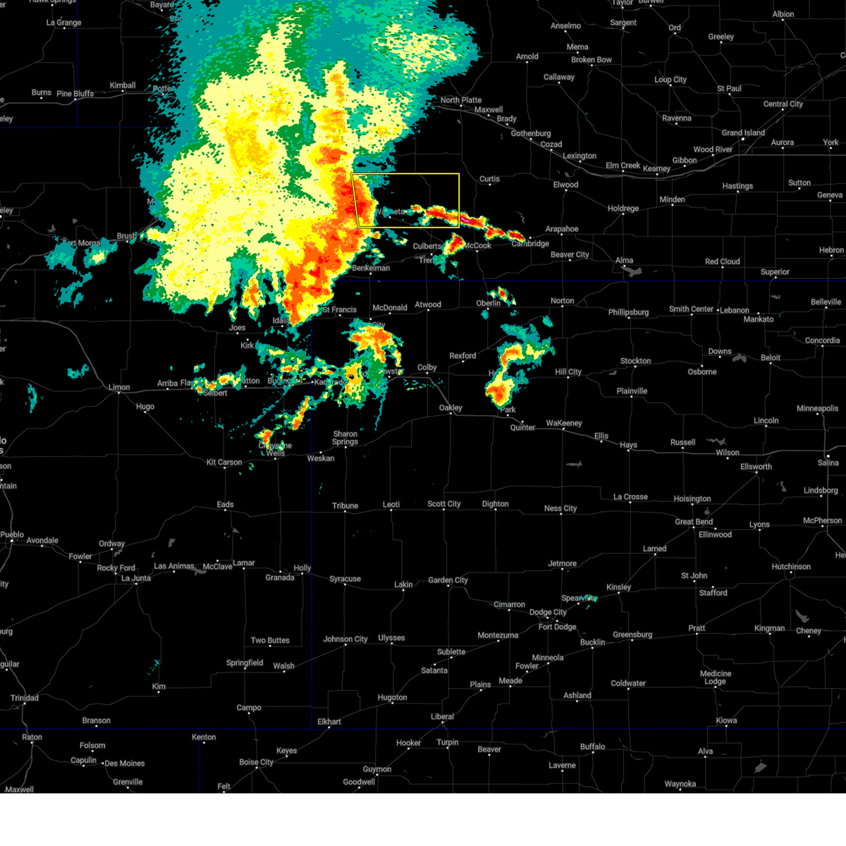
The Top Recent Hail Date for Hayes Center, NE is Saturday, July 19, 2025 (13th out of 106)
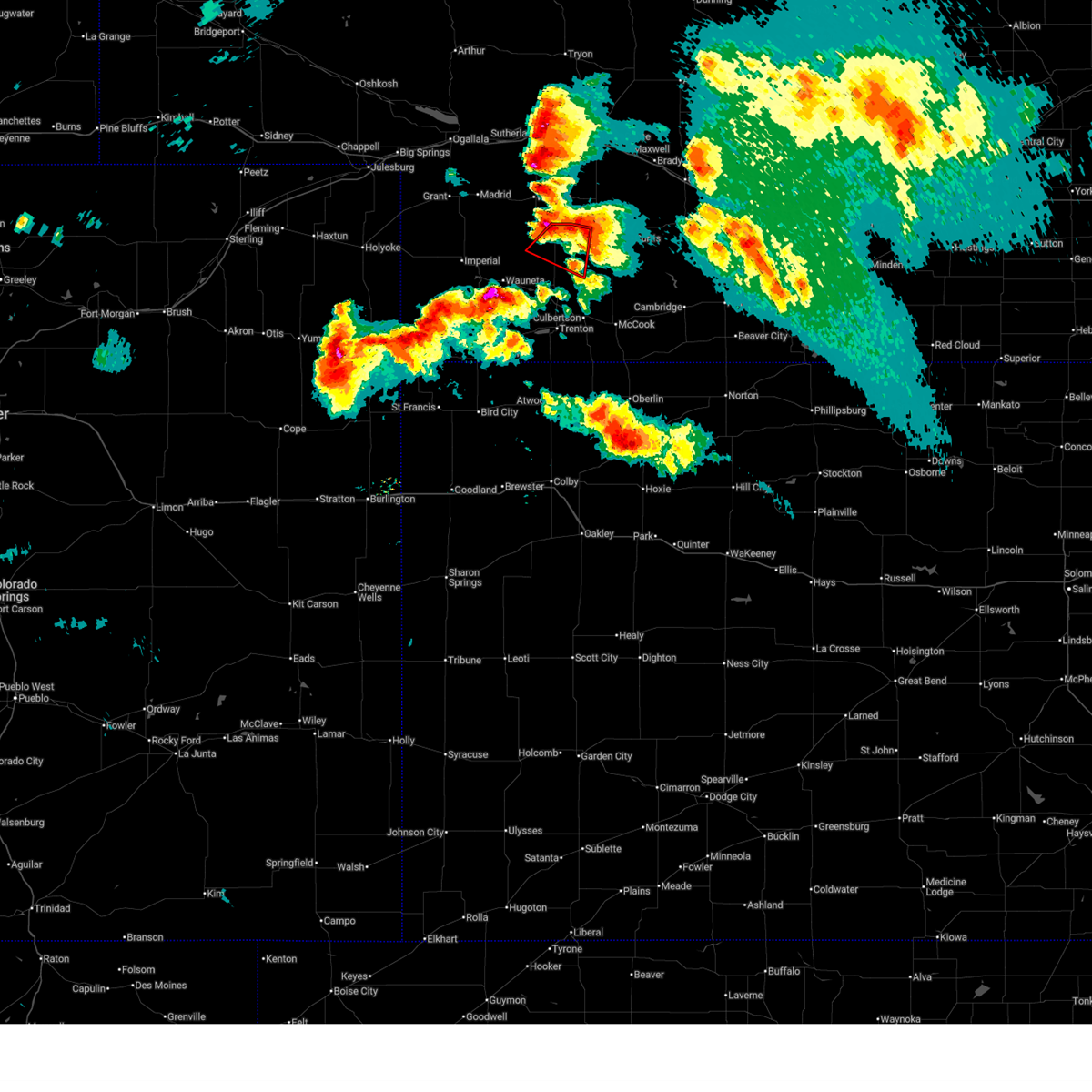
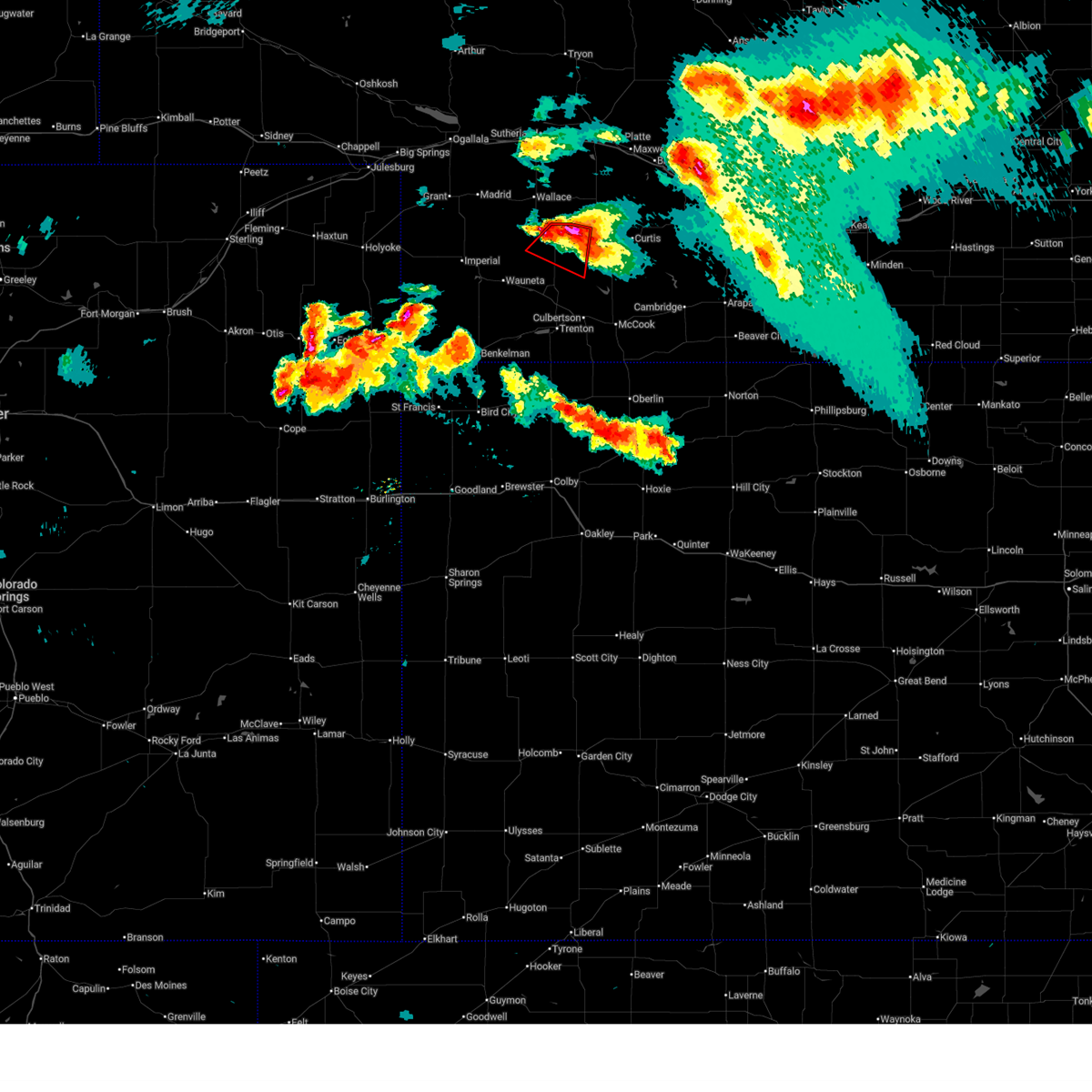
Hail and Wind Damage Spotted near Hayes Center, NE
| Date / Time | Report Details |
|---|---|
| 7/2/2026 10:25 PM CDT |
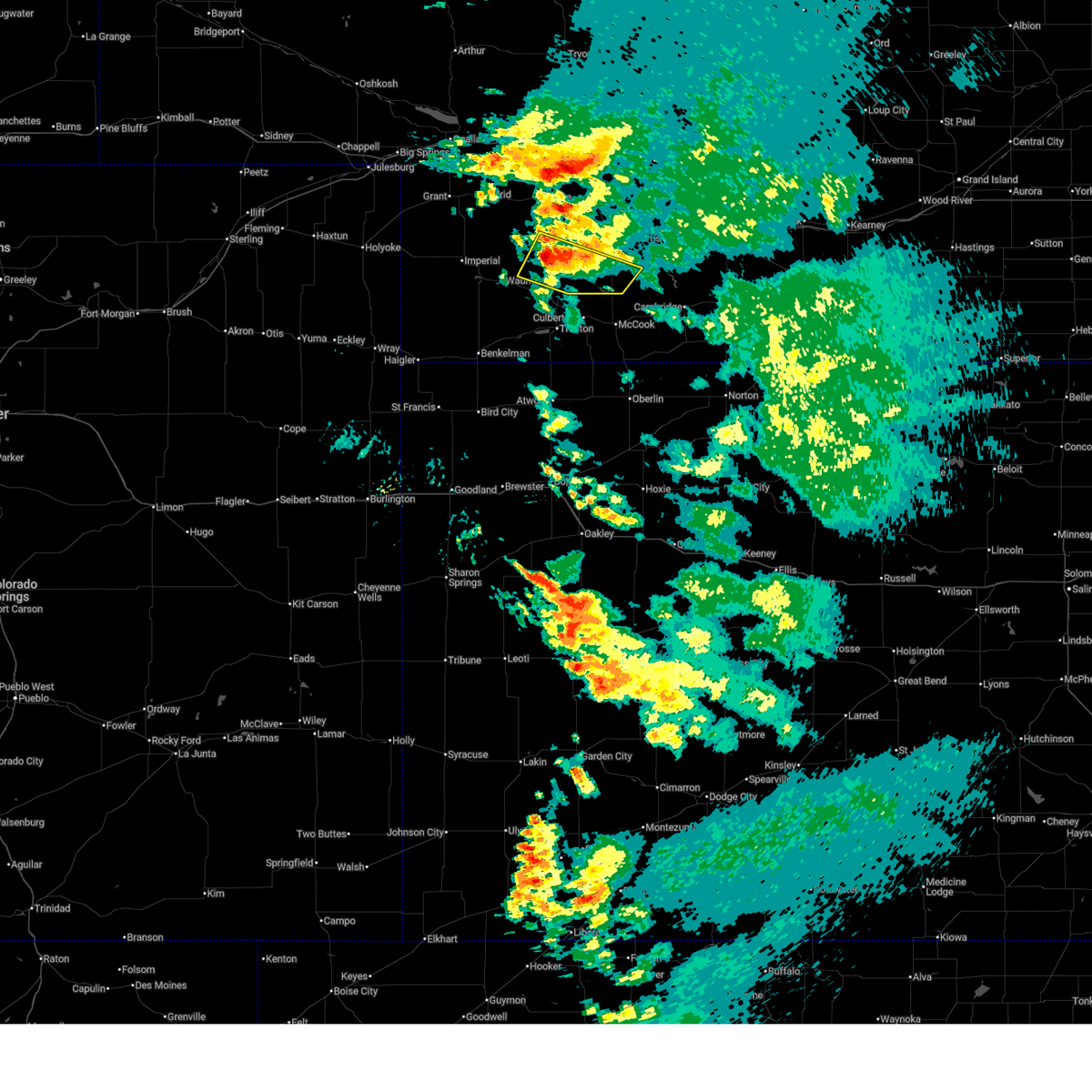
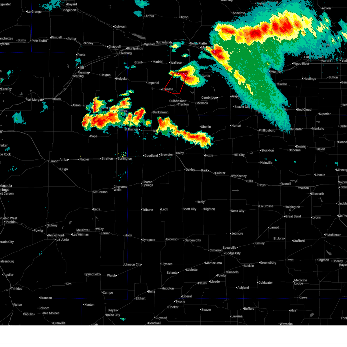
 Svrlbf the national weather service in north platte has issued a * severe thunderstorm warning for, southeastern chase county in southwestern nebraska, southwestern hayes county in southwestern nebraska, * until 1115 pm cdt/1015 pm mdt/. * at 1024 pm cdt/924 pm mdt/, a severe thunderstorm was located near wauneta, or 16 miles southwest of hayes center, moving east northeast at 40 mph (radar indicated). Hazards include 60 mph wind gusts and quarter size hail. Hail damage to vehicles is expected. Expect wind damage to roofs, siding, and trees. Svrlbf the national weather service in north platte has issued a * severe thunderstorm warning for, southeastern chase county in southwestern nebraska, southwestern hayes county in southwestern nebraska, * until 1115 pm cdt/1015 pm mdt/. * at 1024 pm cdt/924 pm mdt/, a severe thunderstorm was located near wauneta, or 16 miles southwest of hayes center, moving east northeast at 40 mph (radar indicated). Hazards include 60 mph wind gusts and quarter size hail. Hail damage to vehicles is expected. Expect wind damage to roofs, siding, and trees.
|
| 7/2/2026 9:43 PM CDT |
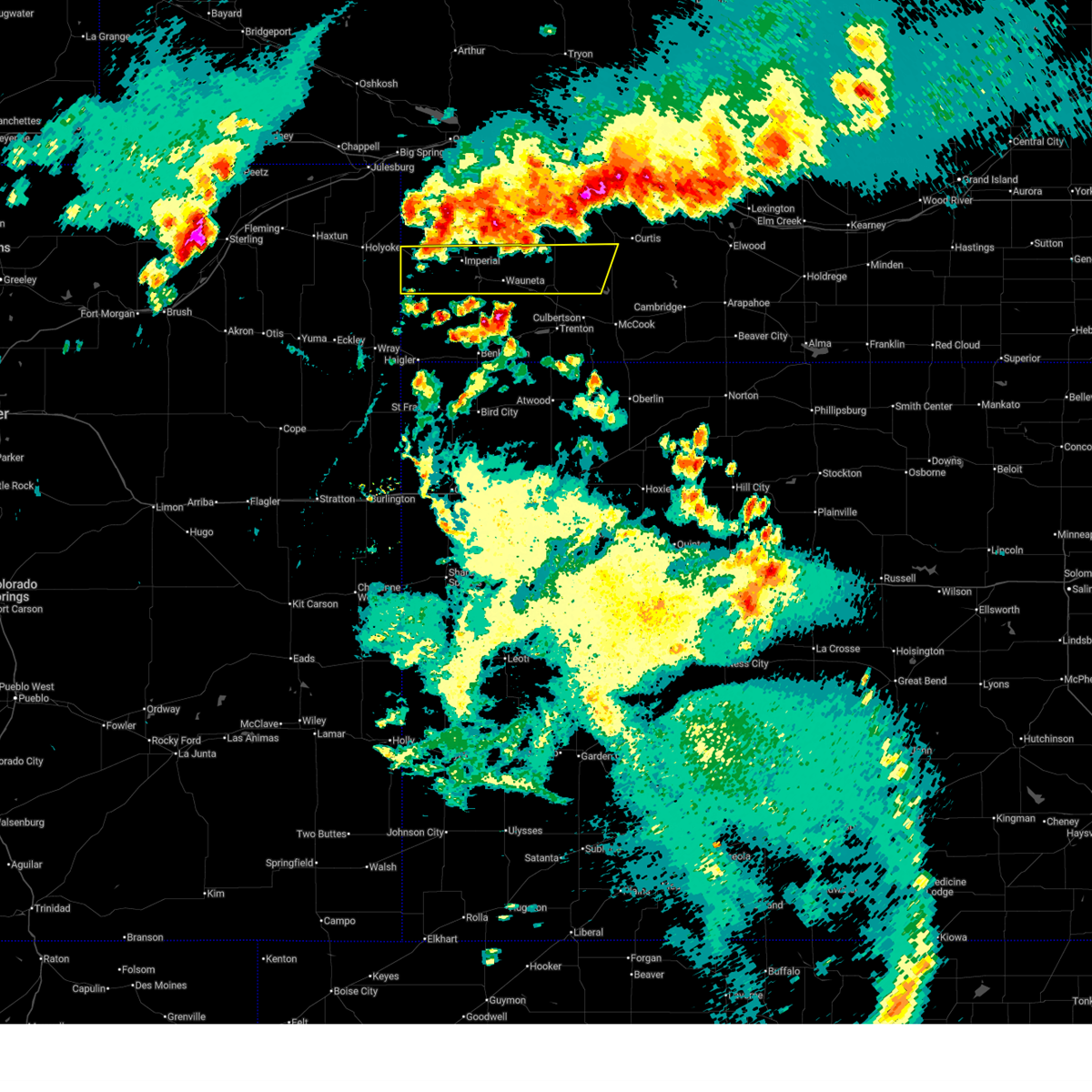
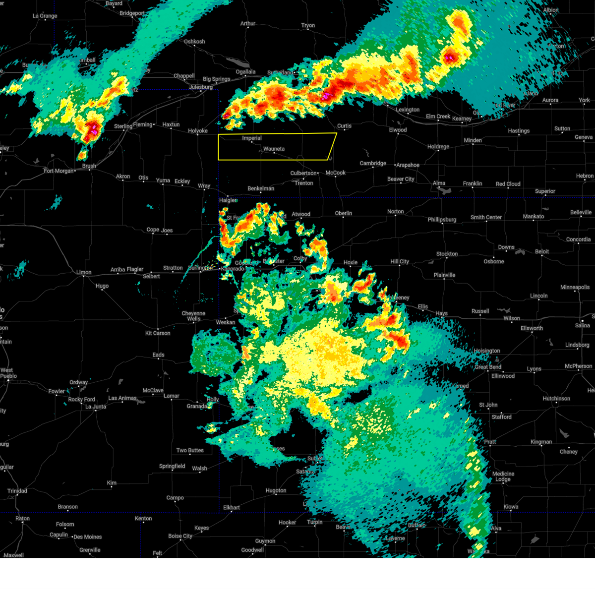
 At 942 pm cdt/842 pm mdt/, a severe thunderstorm was located over wauneta, or 15 miles east of imperial, moving north at 30 mph (radar indicated). Hazards include 60 mph wind gusts and half dollar size hail. Hail damage to vehicles is expected. expect wind damage to roofs, siding, and trees. locations impacted include, hayes center, wauneta, enders, enders reservoir state recreation area, hamlet, center dam campground, and area a campground. This includes highway 61 between mile markers 25 and 30. At 942 pm cdt/842 pm mdt/, a severe thunderstorm was located over wauneta, or 15 miles east of imperial, moving north at 30 mph (radar indicated). Hazards include 60 mph wind gusts and half dollar size hail. Hail damage to vehicles is expected. expect wind damage to roofs, siding, and trees. locations impacted include, hayes center, wauneta, enders, enders reservoir state recreation area, hamlet, center dam campground, and area a campground. This includes highway 61 between mile markers 25 and 30.
|
| 7/2/2026 9:18 PM CDT |
 Svrlbf the national weather service in north platte has issued a * severe thunderstorm warning for, southeastern chase county in southwestern nebraska, southwestern hayes county in southwestern nebraska, * until 1000 pm cdt/900 pm mdt/. * at 918 pm cdt/818 pm mdt/, a severe thunderstorm was located near wauneta, or 15 miles southwest of hayes center, moving north at 15 mph (radar indicated). Hazards include 60 mph wind gusts and half dollar size hail. Hail damage to vehicles is expected. Expect wind damage to roofs, siding, and trees. Svrlbf the national weather service in north platte has issued a * severe thunderstorm warning for, southeastern chase county in southwestern nebraska, southwestern hayes county in southwestern nebraska, * until 1000 pm cdt/900 pm mdt/. * at 918 pm cdt/818 pm mdt/, a severe thunderstorm was located near wauneta, or 15 miles southwest of hayes center, moving north at 15 mph (radar indicated). Hazards include 60 mph wind gusts and half dollar size hail. Hail damage to vehicles is expected. Expect wind damage to roofs, siding, and trees.
|
| 7/2/2026 8:15 PM CDT |
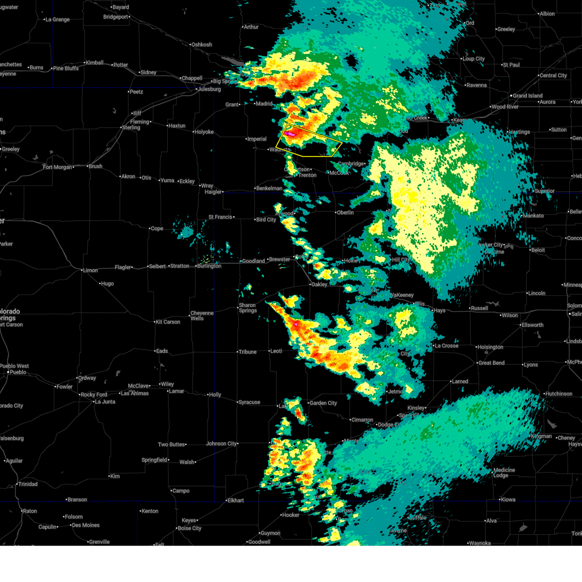
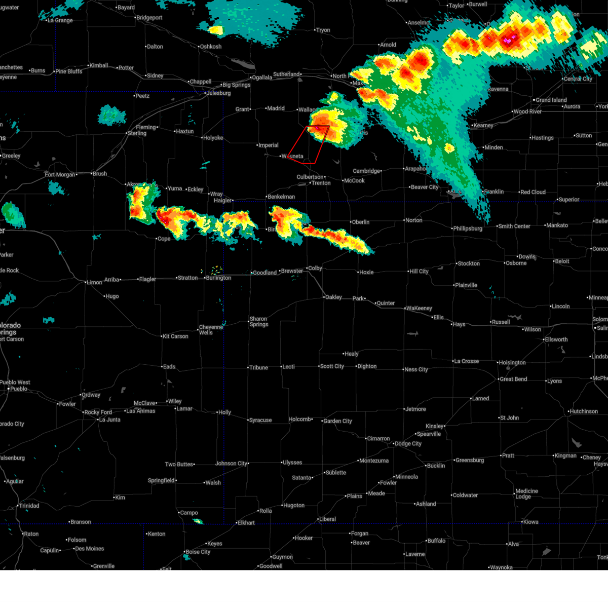
 At 809 pm cdt, a severe thunderstorm was located over hayes center, moving northeast at 30 mph (radar indicated). Hazards include 60 mph wind gusts and half dollar size hail. Hail damage to vehicles is expected. expect wind damage to roofs, siding, and trees. Locations impacted include, hayes center, hamlet, and hayes center state wildlife management area. At 809 pm cdt, a severe thunderstorm was located over hayes center, moving northeast at 30 mph (radar indicated). Hazards include 60 mph wind gusts and half dollar size hail. Hail damage to vehicles is expected. expect wind damage to roofs, siding, and trees. Locations impacted include, hayes center, hamlet, and hayes center state wildlife management area.
|
| 7/2/2026 8:05 PM CDT |
 At 805 pm cdt, a severe thunderstorm was located near palisade, or 8 miles southwest of hayes center, moving northeast at 20 mph (radar indicated). Hazards include 60 mph wind gusts and half dollar size hail. Hail damage to vehicles is expected. expect wind damage to roofs, siding, and trees. Locations impacted include, hayes center, hamlet, and hayes center state wildlife management area. At 805 pm cdt, a severe thunderstorm was located near palisade, or 8 miles southwest of hayes center, moving northeast at 20 mph (radar indicated). Hazards include 60 mph wind gusts and half dollar size hail. Hail damage to vehicles is expected. expect wind damage to roofs, siding, and trees. Locations impacted include, hayes center, hamlet, and hayes center state wildlife management area.
|
| 7/2/2026 7:56 PM CDT |
 At 756 pm cdt, a severe thunderstorm was located over palisade, or 11 miles southwest of hayes center, moving northeast at 25 mph (radar indicated). Hazards include ping pong ball size hail and 60 mph wind gusts. People and animals outdoors will be injured. expect hail damage to roofs, siding, windows, and vehicles. expect wind damage to roofs, siding, and trees. Locations impacted include, hayes center, hamlet, and hayes center state wildlife management area. At 756 pm cdt, a severe thunderstorm was located over palisade, or 11 miles southwest of hayes center, moving northeast at 25 mph (radar indicated). Hazards include ping pong ball size hail and 60 mph wind gusts. People and animals outdoors will be injured. expect hail damage to roofs, siding, windows, and vehicles. expect wind damage to roofs, siding, and trees. Locations impacted include, hayes center, hamlet, and hayes center state wildlife management area.
|
| 7/2/2026 7:42 PM CDT |
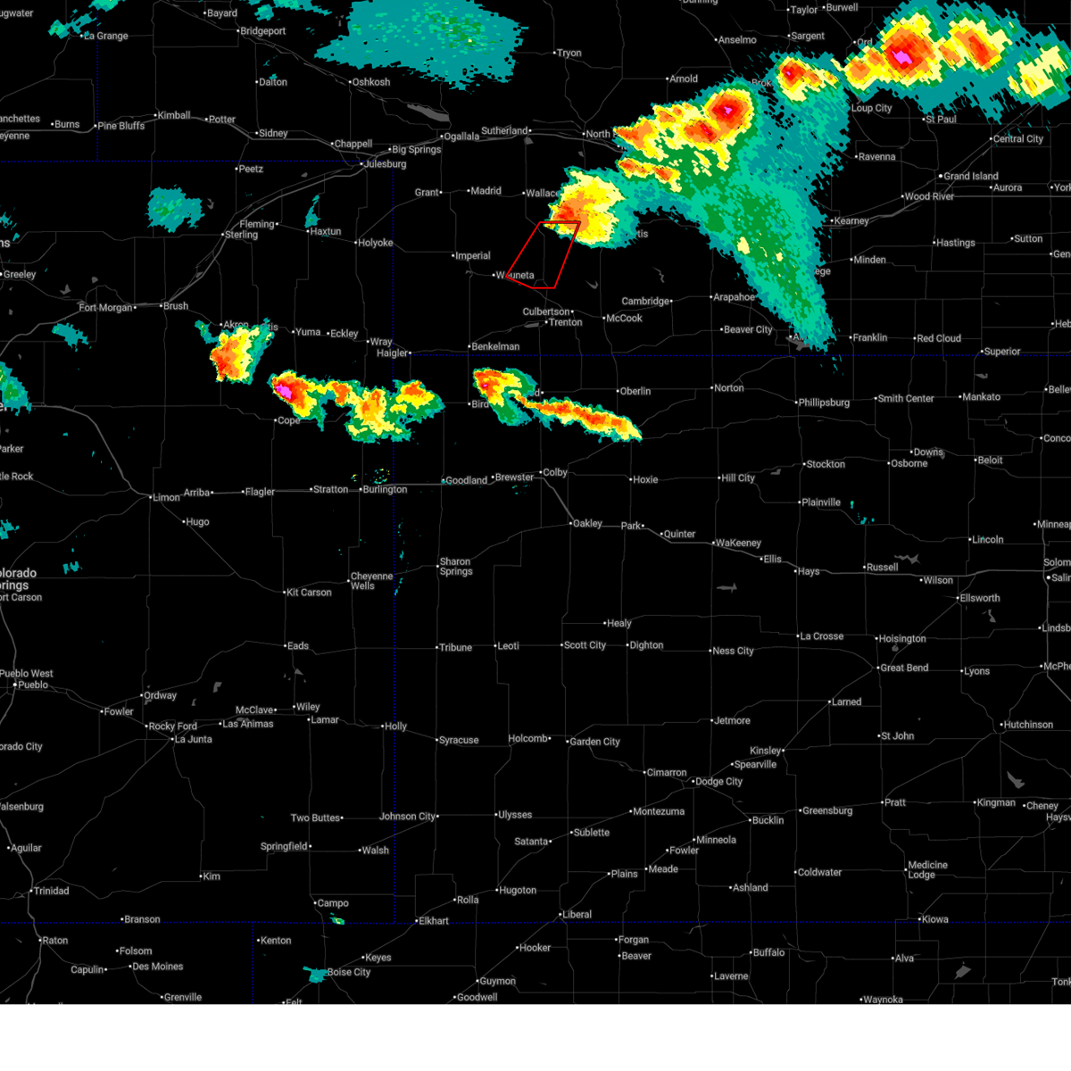
 Svrlbf the national weather service in north platte has issued a * severe thunderstorm warning for, hayes county in southwestern nebraska, * until 845 pm cdt. * at 742 pm cdt, a severe thunderstorm was located near palisade, or 12 miles northwest of trenton, moving north at 20 mph (radar indicated). Hazards include two inch hail and 60 mph wind gusts. People and animals outdoors will be injured. expect hail damage to roofs, siding, windows, and vehicles. Expect wind damage to roofs, siding, and trees. Svrlbf the national weather service in north platte has issued a * severe thunderstorm warning for, hayes county in southwestern nebraska, * until 845 pm cdt. * at 742 pm cdt, a severe thunderstorm was located near palisade, or 12 miles northwest of trenton, moving north at 20 mph (radar indicated). Hazards include two inch hail and 60 mph wind gusts. People and animals outdoors will be injured. expect hail damage to roofs, siding, windows, and vehicles. Expect wind damage to roofs, siding, and trees.
|
| 6/23/2026 8:45 AM CDT |
 the severe thunderstorm warning has been cancelled and is no longer in effect the severe thunderstorm warning has been cancelled and is no longer in effect
|
| 6/23/2026 8:30 AM CDT |
 Svrlbf the national weather service in north platte has issued a * severe thunderstorm warning for, southwestern frontier county in southwestern nebraska, central hayes county in southwestern nebraska, * until 930 am cdt. * at 829 am cdt, a severe thunderstorm was located near hayes center, moving southeast at 25 mph (radar indicated). Hazards include 60 mph wind gusts and quarter size hail. Hail damage to vehicles is expected. Expect wind damage to roofs, siding, and trees. Svrlbf the national weather service in north platte has issued a * severe thunderstorm warning for, southwestern frontier county in southwestern nebraska, central hayes county in southwestern nebraska, * until 930 am cdt. * at 829 am cdt, a severe thunderstorm was located near hayes center, moving southeast at 25 mph (radar indicated). Hazards include 60 mph wind gusts and quarter size hail. Hail damage to vehicles is expected. Expect wind damage to roofs, siding, and trees.
|
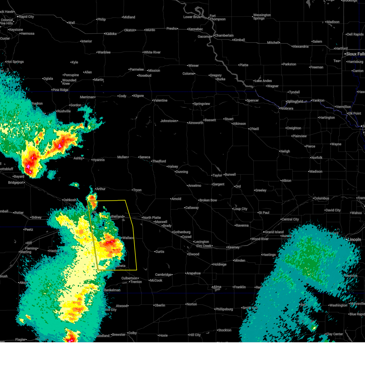
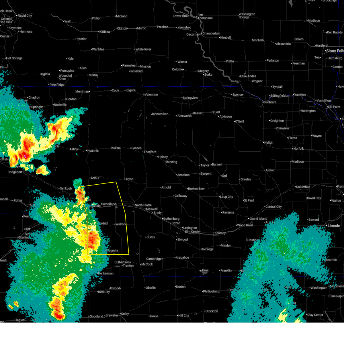
| 6/8/2026 9:57 PM CDT | Storm damage reported in hayes county NE, 3.3 miles S of Hayes Center, NE |
| 6/8/2026 8:52 PM MDT |
 At 950 pm cdt/850 pm mdt/, severe thunderstorms were located along a line extending from 12 miles northeast of keystone to 10 miles south of paxton to 9 miles northeast of wauneta, moving east at 50 mph (radar indicated. at 945 pm cdt, 72 mph winds were reported 11 miles north northeast wauneta). Hazards include 70 mph wind gusts. Expect considerable tree damage. damage is likely to mobile homes, roofs, and outbuildings. locations impacted include, ogallala, imperial, grant, hayes center, sutherland, hershey, wauneta, paxton, wallace, madrid, elsie, dickens, keystone, enders reservoir state recreation area, kingsley dam, sarben, enders, lemoyne, sutherland reservoir state recreation area, and roscoe. this includes the following highways, highway 61 between mile markers 25 and 109. highway 92 between mile markers 132 and 138. Interstate 80 in nebraska between mile markers 123 and 164. At 950 pm cdt/850 pm mdt/, severe thunderstorms were located along a line extending from 12 miles northeast of keystone to 10 miles south of paxton to 9 miles northeast of wauneta, moving east at 50 mph (radar indicated. at 945 pm cdt, 72 mph winds were reported 11 miles north northeast wauneta). Hazards include 70 mph wind gusts. Expect considerable tree damage. damage is likely to mobile homes, roofs, and outbuildings. locations impacted include, ogallala, imperial, grant, hayes center, sutherland, hershey, wauneta, paxton, wallace, madrid, elsie, dickens, keystone, enders reservoir state recreation area, kingsley dam, sarben, enders, lemoyne, sutherland reservoir state recreation area, and roscoe. this includes the following highways, highway 61 between mile markers 25 and 109. highway 92 between mile markers 132 and 138. Interstate 80 in nebraska between mile markers 123 and 164.
|
| 6/8/2026 8:52 PM MDT |
 the severe thunderstorm warning has been cancelled and is no longer in effect the severe thunderstorm warning has been cancelled and is no longer in effect
|
| 6/8/2026 8:26 PM MDT |
 Svrlbf the national weather service in north platte has issued a * severe thunderstorm warning for, southeastern arthur county in west central nebraska, perkins county in southwestern nebraska, keith county in southwestern nebraska, eastern chase county in southwestern nebraska, western lincoln county in southwestern nebraska, southwestern mcpherson county in west central nebraska, hayes county in southwestern nebraska, * until 1015 pm cdt/915 pm mdt/. * at 926 pm cdt/826 pm mdt/, severe thunderstorms were located along a line extending from near lemoyne to 9 miles north of grant to near imperial, moving east at 35 mph (radar indicated). Hazards include 60 mph wind gusts. expect damage to roofs, siding, and trees Svrlbf the national weather service in north platte has issued a * severe thunderstorm warning for, southeastern arthur county in west central nebraska, perkins county in southwestern nebraska, keith county in southwestern nebraska, eastern chase county in southwestern nebraska, western lincoln county in southwestern nebraska, southwestern mcpherson county in west central nebraska, hayes county in southwestern nebraska, * until 1015 pm cdt/915 pm mdt/. * at 926 pm cdt/826 pm mdt/, severe thunderstorms were located along a line extending from near lemoyne to 9 miles north of grant to near imperial, moving east at 35 mph (radar indicated). Hazards include 60 mph wind gusts. expect damage to roofs, siding, and trees
|
| 5/30/2026 6:04 PM CDT | Quarter sized hail reported 3.3 miles S of Hayes Center, NE |
| 5/30/2026 5:52 PM CDT |
 At 552 pm cdt, a severe thunderstorm was located near hayes center, moving north at 30 mph (radar indicated). Hazards include 60 mph wind gusts and half dollar size hail. Hail damage to vehicles is expected. expect wind damage to roofs, siding, and trees. Locations impacted include, hayes center, marengo, and hayes center state wildlife management area. At 552 pm cdt, a severe thunderstorm was located near hayes center, moving north at 30 mph (radar indicated). Hazards include 60 mph wind gusts and half dollar size hail. Hail damage to vehicles is expected. expect wind damage to roofs, siding, and trees. Locations impacted include, hayes center, marengo, and hayes center state wildlife management area.
|
| 5/30/2026 5:37 PM CDT |
 Svrlbf the national weather service in north platte has issued a * severe thunderstorm warning for, central hayes county in southwestern nebraska, * until 615 pm cdt. * at 537 pm cdt, a severe thunderstorm was located near hayes center, moving north at 25 mph (radar indicated). Hazards include 60 mph wind gusts and half dollar size hail. Hail damage to vehicles is expected. Expect wind damage to roofs, siding, and trees. Svrlbf the national weather service in north platte has issued a * severe thunderstorm warning for, central hayes county in southwestern nebraska, * until 615 pm cdt. * at 537 pm cdt, a severe thunderstorm was located near hayes center, moving north at 25 mph (radar indicated). Hazards include 60 mph wind gusts and half dollar size hail. Hail damage to vehicles is expected. Expect wind damage to roofs, siding, and trees.
|
| 2/25/2026 3:01 PM CST |
 At 301 pm cst/201 pm mst/, severe thunderstorms were located along a line extending from north platte airport to near wallace, moving southeast at 50 mph (radar indicated). Hazards include 60 mph wind gusts. Expect damage to roofs, siding, and trees. locations impacted include, north platte, hayes center, sutherland, hershey, brady, wallace, maxwell, madrid, elsie, wellfleet, dickens, sutherland reservoir state recreation area, lake maloney state recreation area, north platte airport, keith, cottonwood canyon state wildlife management area, grainton, jeffrey canyon state wildlife management area, o'fallons, and hayes center state wildlife management area. this includes the following highways, highway 97 between mile markers 1 and 7. interstate 80 in nebraska between mile markers 158 and 207. Highway 83 between mile markers 50 and 90. At 301 pm cst/201 pm mst/, severe thunderstorms were located along a line extending from north platte airport to near wallace, moving southeast at 50 mph (radar indicated). Hazards include 60 mph wind gusts. Expect damage to roofs, siding, and trees. locations impacted include, north platte, hayes center, sutherland, hershey, brady, wallace, maxwell, madrid, elsie, wellfleet, dickens, sutherland reservoir state recreation area, lake maloney state recreation area, north platte airport, keith, cottonwood canyon state wildlife management area, grainton, jeffrey canyon state wildlife management area, o'fallons, and hayes center state wildlife management area. this includes the following highways, highway 97 between mile markers 1 and 7. interstate 80 in nebraska between mile markers 158 and 207. Highway 83 between mile markers 50 and 90.
|
| 2/25/2026 3:01 PM CST |
 the severe thunderstorm warning has been cancelled and is no longer in effect the severe thunderstorm warning has been cancelled and is no longer in effect
|
| 2/25/2026 2:34 PM CST |
 Svrlbf the national weather service in north platte has issued a * severe thunderstorm warning for, northwestern frontier county in southwestern nebraska, eastern perkins county in southwestern nebraska, southeastern keith county in southwestern nebraska, lincoln county in southwestern nebraska, northern hayes county in southwestern nebraska, * until 315 pm cst/215 pm mst/. * at 233 pm cst/133 pm mst/, severe thunderstorms were located along a line extending from 11 miles north of sutherland to near ogallala, moving southeast at 60 mph (radar indicated). Hazards include 60 mph wind gusts. expect damage to roofs, siding, and trees Svrlbf the national weather service in north platte has issued a * severe thunderstorm warning for, northwestern frontier county in southwestern nebraska, eastern perkins county in southwestern nebraska, southeastern keith county in southwestern nebraska, lincoln county in southwestern nebraska, northern hayes county in southwestern nebraska, * until 315 pm cst/215 pm mst/. * at 233 pm cst/133 pm mst/, severe thunderstorms were located along a line extending from 11 miles north of sutherland to near ogallala, moving southeast at 60 mph (radar indicated). Hazards include 60 mph wind gusts. expect damage to roofs, siding, and trees
|
| 7/19/2025 7:42 PM CDT |
 The storm which prompted the warning has weakened below severe limits, and has exited the warned area. therefore, the warning will be allowed to expire. however, heavy rain is still possible with this thunderstorm. a tornado watch remains in effect until 1100 pm cdt for southwestern nebraska. The storm which prompted the warning has weakened below severe limits, and has exited the warned area. therefore, the warning will be allowed to expire. however, heavy rain is still possible with this thunderstorm. a tornado watch remains in effect until 1100 pm cdt for southwestern nebraska.
|
| 7/19/2025 7:05 PM CDT |
 At 704 pm cdt, a severe thunderstorm was located over hayes center, moving northeast at 20 mph (radar indicated). Hazards include two inch hail. People and animals outdoors will be injured. expect damage to roofs, siding, windows, and vehicles. Locations impacted include, hayes center, hamlet, marengo, and hayes center state wildlife management area. At 704 pm cdt, a severe thunderstorm was located over hayes center, moving northeast at 20 mph (radar indicated). Hazards include two inch hail. People and animals outdoors will be injured. expect damage to roofs, siding, windows, and vehicles. Locations impacted include, hayes center, hamlet, marengo, and hayes center state wildlife management area.
|
| 7/19/2025 7:04 PM CDT | Quarter sized hail reported 0.7 miles SE of Hayes Center, NE |
| 7/19/2025 6:56 PM CDT |
 Svrlbf the national weather service in north platte has issued a * severe thunderstorm warning for, southwestern frontier county in southwestern nebraska, hayes county in southwestern nebraska, * until 745 pm cdt. * at 655 pm cdt, a severe thunderstorm was located over hayes center, moving east at 20 mph (radar indicated). Hazards include ping pong ball size hail. People and animals outdoors will be injured. Expect damage to roofs, siding, windows, and vehicles. Svrlbf the national weather service in north platte has issued a * severe thunderstorm warning for, southwestern frontier county in southwestern nebraska, hayes county in southwestern nebraska, * until 745 pm cdt. * at 655 pm cdt, a severe thunderstorm was located over hayes center, moving east at 20 mph (radar indicated). Hazards include ping pong ball size hail. People and animals outdoors will be injured. Expect damage to roofs, siding, windows, and vehicles.
|
| 6/30/2025 1:51 AM CDT |
 The storm which prompted the warning has weakened below severe limits, and no longer poses an immediate threat to life or property. therefore, the warning will be allowed to expire. however, gusty winds and heavy rain are still possible with this thunderstorm. a severe thunderstorm watch remains in effect until 600 am cdt for southwestern nebraska. The storm which prompted the warning has weakened below severe limits, and no longer poses an immediate threat to life or property. therefore, the warning will be allowed to expire. however, gusty winds and heavy rain are still possible with this thunderstorm. a severe thunderstorm watch remains in effect until 600 am cdt for southwestern nebraska.
|
| 6/30/2025 1:22 AM CDT |
 Svrlbf the national weather service in north platte has issued a * severe thunderstorm warning for, northwestern hayes county in southwestern nebraska, * until 200 am cdt. * at 121 am cdt, a severe thunderstorm was located near hayes center, moving southeast at 45 mph (radar indicated). Hazards include 60 mph wind gusts and quarter size hail. Hail damage to vehicles is expected. Expect wind damage to roofs, siding, and trees. Svrlbf the national weather service in north platte has issued a * severe thunderstorm warning for, northwestern hayes county in southwestern nebraska, * until 200 am cdt. * at 121 am cdt, a severe thunderstorm was located near hayes center, moving southeast at 45 mph (radar indicated). Hazards include 60 mph wind gusts and quarter size hail. Hail damage to vehicles is expected. Expect wind damage to roofs, siding, and trees.
|
| 6/30/2025 12:52 AM CDT |
 Svrlbf the national weather service in north platte has issued a * severe thunderstorm warning for, southeastern perkins county in southwestern nebraska, eastern chase county in southwestern nebraska, southwestern lincoln county in southwestern nebraska, hayes county in southwestern nebraska, * until 130 am cdt/1230 am mdt/. * at 1252 am cdt/1152 pm mdt/, a severe thunderstorm was located 12 miles south of elsie, or 16 miles northeast of imperial, moving southeast at 30 mph (radar indicated). Hazards include 60 mph wind gusts and quarter size hail. Hail damage to vehicles is expected. expect wind damage to roofs, siding, and trees. This severe thunderstorm will remain over mainly rural areas of southeastern perkins, eastern chase, southwestern lincoln and hayes counties, including the following locations, hamlet, grainton, marengo, and hayes center state wildlife management area. Svrlbf the national weather service in north platte has issued a * severe thunderstorm warning for, southeastern perkins county in southwestern nebraska, eastern chase county in southwestern nebraska, southwestern lincoln county in southwestern nebraska, hayes county in southwestern nebraska, * until 130 am cdt/1230 am mdt/. * at 1252 am cdt/1152 pm mdt/, a severe thunderstorm was located 12 miles south of elsie, or 16 miles northeast of imperial, moving southeast at 30 mph (radar indicated). Hazards include 60 mph wind gusts and quarter size hail. Hail damage to vehicles is expected. expect wind damage to roofs, siding, and trees. This severe thunderstorm will remain over mainly rural areas of southeastern perkins, eastern chase, southwestern lincoln and hayes counties, including the following locations, hamlet, grainton, marengo, and hayes center state wildlife management area.
|
| 6/16/2025 9:38 PM CDT |
 the tornado warning has been cancelled and is no longer in effect the tornado warning has been cancelled and is no longer in effect
|
| 6/16/2025 9:15 PM CDT |
 Torlbf the national weather service in north platte has issued a * tornado warning for, northeastern hayes county in southwestern nebraska, * until 1000 pm cdt. * at 915 pm cdt, a severe thunderstorm capable of producing a tornado was located 8 miles north of hayes center, and is nearly stationary (radar indicated rotation). Hazards include tornado and hail up to two inches in diameter. Flying debris will be dangerous to those caught without shelter. mobile homes will be damaged or destroyed. damage to roofs, windows, and vehicles will occur. tree damage is likely. This tornadic thunderstorm will remain over mainly rural areas of northeastern hayes county, including the following locations, marengo and hayes center state wildlife management area. Torlbf the national weather service in north platte has issued a * tornado warning for, northeastern hayes county in southwestern nebraska, * until 1000 pm cdt. * at 915 pm cdt, a severe thunderstorm capable of producing a tornado was located 8 miles north of hayes center, and is nearly stationary (radar indicated rotation). Hazards include tornado and hail up to two inches in diameter. Flying debris will be dangerous to those caught without shelter. mobile homes will be damaged or destroyed. damage to roofs, windows, and vehicles will occur. tree damage is likely. This tornadic thunderstorm will remain over mainly rural areas of northeastern hayes county, including the following locations, marengo and hayes center state wildlife management area.
|
| 6/16/2025 9:14 PM CDT | Quarter sized hail reported 12.6 miles SE of Hayes Center, NE |
| 6/16/2025 9:04 PM CDT |
 At 903 pm cdt, a severe thunderstorm capable of producing a tornado was located 8 miles north of hayes center, moving southwest at 5 mph (radar indicated rotation). Hazards include tornado and ping pong ball size hail. Flying debris will be dangerous to those caught without shelter. mobile homes will be damaged or destroyed. damage to roofs, windows, and vehicles will occur. tree damage is likely. This tornadic thunderstorm will remain over mainly rural areas of central hayes county, including the following locations, marengo and hayes center state wildlife management area. At 903 pm cdt, a severe thunderstorm capable of producing a tornado was located 8 miles north of hayes center, moving southwest at 5 mph (radar indicated rotation). Hazards include tornado and ping pong ball size hail. Flying debris will be dangerous to those caught without shelter. mobile homes will be damaged or destroyed. damage to roofs, windows, and vehicles will occur. tree damage is likely. This tornadic thunderstorm will remain over mainly rural areas of central hayes county, including the following locations, marengo and hayes center state wildlife management area.
|
| 6/16/2025 8:38 PM CDT |
 At 837 pm cdt, a severe thunderstorm capable of producing a tornado was located 8 miles north of hayes center, moving south at 15 mph (radar indicated rotation). Hazards include tornado and ping pong ball size hail. Flying debris will be dangerous to those caught without shelter. mobile homes will be damaged or destroyed. damage to roofs, windows, and vehicles will occur. tree damage is likely. this dangerous storm will be near, hayes center around 855 pm cdt. Other locations impacted by this tornadic thunderstorm include marengo and hayes center state wildlife management area. At 837 pm cdt, a severe thunderstorm capable of producing a tornado was located 8 miles north of hayes center, moving south at 15 mph (radar indicated rotation). Hazards include tornado and ping pong ball size hail. Flying debris will be dangerous to those caught without shelter. mobile homes will be damaged or destroyed. damage to roofs, windows, and vehicles will occur. tree damage is likely. this dangerous storm will be near, hayes center around 855 pm cdt. Other locations impacted by this tornadic thunderstorm include marengo and hayes center state wildlife management area.
|
| 6/16/2025 8:27 PM CDT |
 Torlbf the national weather service in north platte has issued a * tornado warning for, central hayes county in southwestern nebraska, * until 915 pm cdt. * at 827 pm cdt, a severe thunderstorm capable of producing a tornado was located 9 miles north of hayes center, moving southwest at 20 mph (radar indicated rotation). Hazards include tornado and quarter size hail. Flying debris will be dangerous to those caught without shelter. mobile homes will be damaged or destroyed. damage to roofs, windows, and vehicles will occur. tree damage is likely. this dangerous storm will be near, hayes center around 845 pm cdt. Other locations impacted by this tornadic thunderstorm include marengo and hayes center state wildlife management area. Torlbf the national weather service in north platte has issued a * tornado warning for, central hayes county in southwestern nebraska, * until 915 pm cdt. * at 827 pm cdt, a severe thunderstorm capable of producing a tornado was located 9 miles north of hayes center, moving southwest at 20 mph (radar indicated rotation). Hazards include tornado and quarter size hail. Flying debris will be dangerous to those caught without shelter. mobile homes will be damaged or destroyed. damage to roofs, windows, and vehicles will occur. tree damage is likely. this dangerous storm will be near, hayes center around 845 pm cdt. Other locations impacted by this tornadic thunderstorm include marengo and hayes center state wildlife management area.
|
| 6/2/2025 8:10 PM MDT |
 The storms which prompted the warning have weakened below severe limits, and no longer pose an immediate threat to life or property. therefore, the warning will be allowed to expire. however, gusty winds and heavy rain are still possible with these thunderstorms. a severe thunderstorm watch remains in effect until 100 am cdt/midnight mdt/ for southwestern nebraska. The storms which prompted the warning have weakened below severe limits, and no longer pose an immediate threat to life or property. therefore, the warning will be allowed to expire. however, gusty winds and heavy rain are still possible with these thunderstorms. a severe thunderstorm watch remains in effect until 100 am cdt/midnight mdt/ for southwestern nebraska.
|
| 6/2/2025 7:44 PM MDT |
 At 842 pm cdt/742 pm mdt/, severe thunderstorms were located along a line extending from 7 miles southeast of lamar to 6 miles north of wauneta to 6 miles north of culbertson, moving north at 60 mph (automated weather sensor. a 58 mile per hour wind gust was reported at imperial airport at 740 pm mdt). Hazards include 70 mph wind gusts and blowing dust. Expect considerable tree damage. damage is likely to mobile homes, roofs, and outbuildings. locations impacted include, imperial, hayes center, wauneta, lamar, enders, enders reservoir state recreation area, champion, crete, chase, hamlet, center dam campground, hayes center state wildlife management area, wanamaker state wildfire management area, area a campground, and church grove campground. this includes the following highways, highway 61 between mile markers 25 and 46. Highway 83 between mile markers 38 and 43. At 842 pm cdt/742 pm mdt/, severe thunderstorms were located along a line extending from 7 miles southeast of lamar to 6 miles north of wauneta to 6 miles north of culbertson, moving north at 60 mph (automated weather sensor. a 58 mile per hour wind gust was reported at imperial airport at 740 pm mdt). Hazards include 70 mph wind gusts and blowing dust. Expect considerable tree damage. damage is likely to mobile homes, roofs, and outbuildings. locations impacted include, imperial, hayes center, wauneta, lamar, enders, enders reservoir state recreation area, champion, crete, chase, hamlet, center dam campground, hayes center state wildlife management area, wanamaker state wildfire management area, area a campground, and church grove campground. this includes the following highways, highway 61 between mile markers 25 and 46. Highway 83 between mile markers 38 and 43.
|
| 6/2/2025 7:20 PM MDT |
 Svrlbf the national weather service in north platte has issued a * severe thunderstorm warning for, southwestern frontier county in southwestern nebraska, chase county in southwestern nebraska, hayes county in southwestern nebraska, * until 915 pm cdt/815 pm mdt/. * at 819 pm cdt/719 pm mdt/, severe thunderstorms were located along a line extending from 12 miles northeast of wray to 11 miles north of benkelman to 11 miles northwest of herndon, moving north at 60 mph (radar indicated). Hazards include 70 mph wind gusts. blowing dust has also been reported across portions of northwest kansas and southwest nebraska with the damaging winds. Expect considerable tree damage. Damage is likely to mobile homes, roofs, and outbuildings. Svrlbf the national weather service in north platte has issued a * severe thunderstorm warning for, southwestern frontier county in southwestern nebraska, chase county in southwestern nebraska, hayes county in southwestern nebraska, * until 915 pm cdt/815 pm mdt/. * at 819 pm cdt/719 pm mdt/, severe thunderstorms were located along a line extending from 12 miles northeast of wray to 11 miles north of benkelman to 11 miles northwest of herndon, moving north at 60 mph (radar indicated). Hazards include 70 mph wind gusts. blowing dust has also been reported across portions of northwest kansas and southwest nebraska with the damaging winds. Expect considerable tree damage. Damage is likely to mobile homes, roofs, and outbuildings.
|
| 5/18/2025 8:14 PM CDT |
 At 813 pm cdt, a severe thunderstorm was located over dickens, or 22 miles north of hayes center, moving north at 35 mph (radar indicated). Hazards include two inch hail and 70 mph wind gusts. People and animals outdoors will be injured. expect hail damage to roofs, siding, windows, and vehicles. expect considerable tree damage. wind damage is also likely to mobile homes, roofs, and outbuildings. Locations impacted include, hayes center, wallace, dickens, marengo, hayes center state wildlife management area, and somerset. At 813 pm cdt, a severe thunderstorm was located over dickens, or 22 miles north of hayes center, moving north at 35 mph (radar indicated). Hazards include two inch hail and 70 mph wind gusts. People and animals outdoors will be injured. expect hail damage to roofs, siding, windows, and vehicles. expect considerable tree damage. wind damage is also likely to mobile homes, roofs, and outbuildings. Locations impacted include, hayes center, wallace, dickens, marengo, hayes center state wildlife management area, and somerset.
|
| 5/18/2025 8:09 PM CDT |
 At 809 pm cdt, a severe thunderstorm capable of producing a tornado was located 7 miles south of dickens, or 14 miles north of hayes center, moving north at 35 mph (radar indicated rotation). Hazards include tornado and two inch hail. Flying debris will be dangerous to those caught without shelter. mobile homes will be damaged or destroyed. damage to roofs, windows, and vehicles will occur. tree damage is likely. This dangerous storm will be near, dickens around 815 pm cdt. At 809 pm cdt, a severe thunderstorm capable of producing a tornado was located 7 miles south of dickens, or 14 miles north of hayes center, moving north at 35 mph (radar indicated rotation). Hazards include tornado and two inch hail. Flying debris will be dangerous to those caught without shelter. mobile homes will be damaged or destroyed. damage to roofs, windows, and vehicles will occur. tree damage is likely. This dangerous storm will be near, dickens around 815 pm cdt.
|
| 5/18/2025 8:00 PM CDT | Storm damage reported in hayes county NE, 2.6 miles S of Hayes Center, NE |
| 5/18/2025 7:56 PM CDT |
 At 755 pm cdt, a severe thunderstorm capable of producing a tornado was located 7 miles north of hayes center, moving northeast at 35 mph (radar indicated rotation). Hazards include tornado and two inch hail. Flying debris will be dangerous to those caught without shelter. mobile homes will be damaged or destroyed. damage to roofs, windows, and vehicles will occur. tree damage is likely. This dangerous storm will be near, dickens around 815 pm cdt. At 755 pm cdt, a severe thunderstorm capable of producing a tornado was located 7 miles north of hayes center, moving northeast at 35 mph (radar indicated rotation). Hazards include tornado and two inch hail. Flying debris will be dangerous to those caught without shelter. mobile homes will be damaged or destroyed. damage to roofs, windows, and vehicles will occur. tree damage is likely. This dangerous storm will be near, dickens around 815 pm cdt.
|
| 5/18/2025 7:48 PM CDT |
 Svrlbf the national weather service in north platte has issued a * severe thunderstorm warning for, southwestern lincoln county in southwestern nebraska, hayes county in southwestern nebraska, * until 845 pm cdt. * at 748 pm cdt, a severe thunderstorm was located near hayes center, moving north at 35 mph (radar indicated). Hazards include two inch hail and 60 mph wind gusts. People and animals outdoors will be injured. expect hail damage to roofs, siding, windows, and vehicles. Expect wind damage to roofs, siding, and trees. Svrlbf the national weather service in north platte has issued a * severe thunderstorm warning for, southwestern lincoln county in southwestern nebraska, hayes county in southwestern nebraska, * until 845 pm cdt. * at 748 pm cdt, a severe thunderstorm was located near hayes center, moving north at 35 mph (radar indicated). Hazards include two inch hail and 60 mph wind gusts. People and animals outdoors will be injured. expect hail damage to roofs, siding, windows, and vehicles. Expect wind damage to roofs, siding, and trees.
|
| 5/18/2025 7:45 PM CDT |
 Torlbf the national weather service in north platte has issued a * tornado warning for, southwestern lincoln county in southwestern nebraska, northwestern hayes county in southwestern nebraska, * until 830 pm cdt. * at 745 pm cdt, a severe thunderstorm capable of producing a tornado was located near hayes center, moving north at 35 mph (radar indicated rotation). Hazards include tornado and hail up to two inches in diameter. Flying debris will be dangerous to those caught without shelter. mobile homes will be damaged or destroyed. damage to roofs, windows, and vehicles will occur. tree damage is likely. This dangerous storm will be near, dickens around 815 pm cdt. Torlbf the national weather service in north platte has issued a * tornado warning for, southwestern lincoln county in southwestern nebraska, northwestern hayes county in southwestern nebraska, * until 830 pm cdt. * at 745 pm cdt, a severe thunderstorm capable of producing a tornado was located near hayes center, moving north at 35 mph (radar indicated rotation). Hazards include tornado and hail up to two inches in diameter. Flying debris will be dangerous to those caught without shelter. mobile homes will be damaged or destroyed. damage to roofs, windows, and vehicles will occur. tree damage is likely. This dangerous storm will be near, dickens around 815 pm cdt.
|
| 5/18/2025 7:32 PM CDT |
 At 732 pm cdt/632 pm mdt/, a severe thunderstorm capable of producing a tornado was located 9 miles northwest of palisade, or 9 miles west of hayes center, moving north at 35 mph (radar indicated rotation). Hazards include tornado and two inch hail. Flying debris will be dangerous to those caught without shelter. mobile homes will be damaged or destroyed. damage to roofs, windows, and vehicles will occur. tree damage is likely. Locations impacted include, hayes center, wauneta, and hamlet. At 732 pm cdt/632 pm mdt/, a severe thunderstorm capable of producing a tornado was located 9 miles northwest of palisade, or 9 miles west of hayes center, moving north at 35 mph (radar indicated rotation). Hazards include tornado and two inch hail. Flying debris will be dangerous to those caught without shelter. mobile homes will be damaged or destroyed. damage to roofs, windows, and vehicles will occur. tree damage is likely. Locations impacted include, hayes center, wauneta, and hamlet.
|
| 5/18/2025 7:19 PM CDT |
 At 718 pm cdt/618 pm mdt/, a severe thunderstorm capable of producing a tornado was located near hamlet, or 15 miles southwest of hayes center, moving north at 35 mph (radar indicated rotation). Hazards include tornado and two inch hail. Flying debris will be dangerous to those caught without shelter. mobile homes will be damaged or destroyed. damage to roofs, windows, and vehicles will occur. tree damage is likely. Locations impacted include, hayes center, wauneta, and hamlet. At 718 pm cdt/618 pm mdt/, a severe thunderstorm capable of producing a tornado was located near hamlet, or 15 miles southwest of hayes center, moving north at 35 mph (radar indicated rotation). Hazards include tornado and two inch hail. Flying debris will be dangerous to those caught without shelter. mobile homes will be damaged or destroyed. damage to roofs, windows, and vehicles will occur. tree damage is likely. Locations impacted include, hayes center, wauneta, and hamlet.
|
| 5/18/2025 7:13 PM CDT |
 At 713 pm cdt/613 pm mdt/, a severe thunderstorm was located near palisade, or 13 miles southwest of hayes center, moving north at 40 mph (radar indicated). Hazards include golf ball size hail and 60 mph wind gusts. People and animals outdoors will be injured. expect hail damage to roofs, siding, windows, and vehicles. expect wind damage to roofs, siding, and trees. Locations impacted include, hayes center, wauneta, hamlet, marengo, and hayes center state wildlife management area. At 713 pm cdt/613 pm mdt/, a severe thunderstorm was located near palisade, or 13 miles southwest of hayes center, moving north at 40 mph (radar indicated). Hazards include golf ball size hail and 60 mph wind gusts. People and animals outdoors will be injured. expect hail damage to roofs, siding, windows, and vehicles. expect wind damage to roofs, siding, and trees. Locations impacted include, hayes center, wauneta, hamlet, marengo, and hayes center state wildlife management area.
|
| 5/18/2025 7:05 PM CDT |
 Torlbf the national weather service in north platte has issued a * tornado warning for, southeastern chase county in southwestern nebraska, southwestern hayes county in southwestern nebraska, * until 745 pm cdt/645 pm mdt/. * at 704 pm cdt/604 pm mdt/, a severe thunderstorm capable of producing a tornado was located 8 miles northwest of stratton, or 16 miles west of trenton, moving north at 40 mph (radar indicated rotation). Hazards include tornado and golf ball size hail. Flying debris will be dangerous to those caught without shelter. mobile homes will be damaged or destroyed. damage to roofs, windows, and vehicles will occur. tree damage is likely. This tornadic thunderstorm will remain over mainly rural areas of southeastern chase and southwestern hayes counties, including the following locations, hamlet. Torlbf the national weather service in north platte has issued a * tornado warning for, southeastern chase county in southwestern nebraska, southwestern hayes county in southwestern nebraska, * until 745 pm cdt/645 pm mdt/. * at 704 pm cdt/604 pm mdt/, a severe thunderstorm capable of producing a tornado was located 8 miles northwest of stratton, or 16 miles west of trenton, moving north at 40 mph (radar indicated rotation). Hazards include tornado and golf ball size hail. Flying debris will be dangerous to those caught without shelter. mobile homes will be damaged or destroyed. damage to roofs, windows, and vehicles will occur. tree damage is likely. This tornadic thunderstorm will remain over mainly rural areas of southeastern chase and southwestern hayes counties, including the following locations, hamlet.
|
| 5/18/2025 6:52 PM CDT |
 Svrlbf the national weather service in north platte has issued a * severe thunderstorm warning for, southeastern chase county in southwestern nebraska, hayes county in southwestern nebraska, * until 745 pm cdt/645 pm mdt/. * at 651 pm cdt/551 pm mdt/, a severe thunderstorm was located 9 miles north of stratton, or 16 miles northwest of trenton, moving north at 40 mph (radar indicated). Hazards include 60 mph wind gusts and quarter size hail. Hail damage to vehicles is expected. Expect wind damage to roofs, siding, and trees. Svrlbf the national weather service in north platte has issued a * severe thunderstorm warning for, southeastern chase county in southwestern nebraska, hayes county in southwestern nebraska, * until 745 pm cdt/645 pm mdt/. * at 651 pm cdt/551 pm mdt/, a severe thunderstorm was located 9 miles north of stratton, or 16 miles northwest of trenton, moving north at 40 mph (radar indicated). Hazards include 60 mph wind gusts and quarter size hail. Hail damage to vehicles is expected. Expect wind damage to roofs, siding, and trees.
|
| 5/14/2025 9:56 PM CDT |
 The storms which prompted the warning have weakened below severe limits, and no longer pose an immediate threat to life or property. therefore, the warning will be allowed to expire. however, gusty winds to around 50 mph are still possible. a severe thunderstorm watch remains in effect until 1100 pm cdt for central and southwestern nebraska. The storms which prompted the warning have weakened below severe limits, and no longer pose an immediate threat to life or property. therefore, the warning will be allowed to expire. however, gusty winds to around 50 mph are still possible. a severe thunderstorm watch remains in effect until 1100 pm cdt for central and southwestern nebraska.
|
| 5/14/2025 9:39 PM CDT |
 At 938 pm cdt, the leading edge of damaging winds were located along a line extending from 8 miles southwest of stapleton to 11 miles northeast of brady to 7 miles southwest of elwood, moving east at 60 mph (radar indicated). Hazards include 70 mph wind gusts. Expect considerable tree damage. damage is likely to mobile homes, roofs, and outbuildings. locations impacted include, north platte, curtis, hayes center, sutherland, hershey, brady, eustis, maxwell, wellfleet, moorefield, stockville, dickens, lake maloney state recreation area, medicine creek reservoir state recreation area, sutherland reservoir state recreation area, north platte airport. this includes the following highways, highway 97 between mile markers 1 and 11. interstate 80 in nebraska between mile markers 158 and 207. Highway 83 between mile markers 27 and 99. At 938 pm cdt, the leading edge of damaging winds were located along a line extending from 8 miles southwest of stapleton to 11 miles northeast of brady to 7 miles southwest of elwood, moving east at 60 mph (radar indicated). Hazards include 70 mph wind gusts. Expect considerable tree damage. damage is likely to mobile homes, roofs, and outbuildings. locations impacted include, north platte, curtis, hayes center, sutherland, hershey, brady, eustis, maxwell, wellfleet, moorefield, stockville, dickens, lake maloney state recreation area, medicine creek reservoir state recreation area, sutherland reservoir state recreation area, north platte airport. this includes the following highways, highway 97 between mile markers 1 and 11. interstate 80 in nebraska between mile markers 158 and 207. Highway 83 between mile markers 27 and 99.
|
| 5/14/2025 9:25 PM CDT |
 At 923 pm cdt, damaging winds were located along a line extending from 13 miles north of north platte to maxwell to near medicine creek reservoir state recreation area, moving east at 60 mph (radar indicated). Hazards include 80 mph wind gusts and blowing dust. Flying debris will be dangerous to those caught without shelter. mobile homes will be heavily damaged. expect considerable damage to roofs, windows, and vehicles. extensive tree damage and power outages are likely. locations impacted include, north platte, curtis, hayes center, sutherland, hershey, brady, eustis, maxwell, wellfleet, moorefield, stockville, dickens, lake maloney state recreation area, medicine creek reservoir state recreation area, sutherland reservoir state recreation area, north platte airport, keith, maywood, cottonwood canyon state wildlife management area, and o'fallons. this includes the following highways, highway 97 between mile markers 1 and 11. interstate 80 in nebraska between mile markers 158 and 207. Highway 83 between mile markers 27 and 99. At 923 pm cdt, damaging winds were located along a line extending from 13 miles north of north platte to maxwell to near medicine creek reservoir state recreation area, moving east at 60 mph (radar indicated). Hazards include 80 mph wind gusts and blowing dust. Flying debris will be dangerous to those caught without shelter. mobile homes will be heavily damaged. expect considerable damage to roofs, windows, and vehicles. extensive tree damage and power outages are likely. locations impacted include, north platte, curtis, hayes center, sutherland, hershey, brady, eustis, maxwell, wellfleet, moorefield, stockville, dickens, lake maloney state recreation area, medicine creek reservoir state recreation area, sutherland reservoir state recreation area, north platte airport, keith, maywood, cottonwood canyon state wildlife management area, and o'fallons. this includes the following highways, highway 97 between mile markers 1 and 11. interstate 80 in nebraska between mile markers 158 and 207. Highway 83 between mile markers 27 and 99.
|
| 5/14/2025 9:08 PM CDT |
 Svrlbf the national weather service in north platte has issued a * severe thunderstorm warning for, frontier county in southwestern nebraska, lincoln county in southwestern nebraska, southwestern custer county in central nebraska, eastern hayes county in southwestern nebraska, * until 1000 pm cdt. * at 906 pm cdt, severe thunderstorms were located along a line extending from 9 miles north of hershey to north platte to 14 miles southwest of stockville, moving east at 55 mph (radar indicated). Hazards include 80 mph wind gusts. Flying debris will be dangerous to those caught without shelter. mobile homes will be heavily damaged. expect considerable damage to roofs, windows, and vehicles. Extensive tree damage and power outages are likely. Svrlbf the national weather service in north platte has issued a * severe thunderstorm warning for, frontier county in southwestern nebraska, lincoln county in southwestern nebraska, southwestern custer county in central nebraska, eastern hayes county in southwestern nebraska, * until 1000 pm cdt. * at 906 pm cdt, severe thunderstorms were located along a line extending from 9 miles north of hershey to north platte to 14 miles southwest of stockville, moving east at 55 mph (radar indicated). Hazards include 80 mph wind gusts. Flying debris will be dangerous to those caught without shelter. mobile homes will be heavily damaged. expect considerable damage to roofs, windows, and vehicles. Extensive tree damage and power outages are likely.
|
| 5/14/2025 7:57 PM MDT |
 At 855 pm cdt/755 pm mdt/, damaging winds were located along a line extending from 14 miles north of sarben to 8 miles west of lake maloney state recreation area to 8 miles west of stockville, moving northeast at 55 mph (radar indicated). Hazards include 80 mph wind gusts. Flying debris will be dangerous to those caught without shelter. mobile homes will be heavily damaged. expect considerable damage to roofs, windows, and vehicles. extensive tree damage and power outages are likely. locations impacted include, north platte, ogallala, imperial, grant, curtis, hayes center, sutherland, hershey, wauneta, paxton, wallace, brule, madrid, elsie, wellfleet, lamar, dickens, lake maloney state recreation area, kingsley dam, and enders. this includes the following highways, highway 61 between mile markers 26 and 107. highway 92 between mile markers 120 and 138. highway 97 between mile markers 1 and 5. interstate 80 in nebraska between mile markers 110 and 184. Highway 83 between mile markers 28 and 90. At 855 pm cdt/755 pm mdt/, damaging winds were located along a line extending from 14 miles north of sarben to 8 miles west of lake maloney state recreation area to 8 miles west of stockville, moving northeast at 55 mph (radar indicated). Hazards include 80 mph wind gusts. Flying debris will be dangerous to those caught without shelter. mobile homes will be heavily damaged. expect considerable damage to roofs, windows, and vehicles. extensive tree damage and power outages are likely. locations impacted include, north platte, ogallala, imperial, grant, curtis, hayes center, sutherland, hershey, wauneta, paxton, wallace, brule, madrid, elsie, wellfleet, lamar, dickens, lake maloney state recreation area, kingsley dam, and enders. this includes the following highways, highway 61 between mile markers 26 and 107. highway 92 between mile markers 120 and 138. highway 97 between mile markers 1 and 5. interstate 80 in nebraska between mile markers 110 and 184. Highway 83 between mile markers 28 and 90.
|
| 5/14/2025 7:28 PM MDT |
 Svrlbf the national weather service in north platte has issued a * severe thunderstorm warning for, western frontier county in southwestern nebraska, perkins county in southwestern nebraska, keith county in southwestern nebraska, chase county in southwestern nebraska, western lincoln county in southwestern nebraska, hayes county in southwestern nebraska, * until 930 pm cdt/830 pm mdt/. * at 827 pm cdt/727 pm mdt/, severe thunderstorms were located along a line extending from roscoe to 7 miles northwest of palisade, moving east at 55 mph (radar indicated). Hazards include 80 mph wind gusts. Flying debris will be dangerous to those caught without shelter. mobile homes will be heavily damaged. expect considerable damage to roofs, windows, and vehicles. Extensive tree damage and power outages are likely. Svrlbf the national weather service in north platte has issued a * severe thunderstorm warning for, western frontier county in southwestern nebraska, perkins county in southwestern nebraska, keith county in southwestern nebraska, chase county in southwestern nebraska, western lincoln county in southwestern nebraska, hayes county in southwestern nebraska, * until 930 pm cdt/830 pm mdt/. * at 827 pm cdt/727 pm mdt/, severe thunderstorms were located along a line extending from roscoe to 7 miles northwest of palisade, moving east at 55 mph (radar indicated). Hazards include 80 mph wind gusts. Flying debris will be dangerous to those caught without shelter. mobile homes will be heavily damaged. expect considerable damage to roofs, windows, and vehicles. Extensive tree damage and power outages are likely.
|
| 8/13/2024 10:39 PM CDT |
 The storms which prompted the warning have weakened below severe limits, and no longer pose an immediate threat to life or property. therefore, the warning will be allowed to expire. however, gusty winds are still possible with these thunderstorms. a severe thunderstorm watch remains in effect until 200 am cdt/100 am mdt/ for southwestern nebraska. The storms which prompted the warning have weakened below severe limits, and no longer pose an immediate threat to life or property. therefore, the warning will be allowed to expire. however, gusty winds are still possible with these thunderstorms. a severe thunderstorm watch remains in effect until 200 am cdt/100 am mdt/ for southwestern nebraska.
|
| 8/13/2024 10:16 PM CDT |
 At 1016 pm cdt/916 pm mdt/, severe thunderstorms were located along a line extending from 11 miles south of wallace to near hayes center to near palisade, moving east at 50 mph (radar indicated). Hazards include 60 mph wind gusts and penny size hail. Expect damage to roofs, siding, and trees. Locations impacted include, hayes center, wauneta, hamlet, marengo, and hayes center state wildlife management area. At 1016 pm cdt/916 pm mdt/, severe thunderstorms were located along a line extending from 11 miles south of wallace to near hayes center to near palisade, moving east at 50 mph (radar indicated). Hazards include 60 mph wind gusts and penny size hail. Expect damage to roofs, siding, and trees. Locations impacted include, hayes center, wauneta, hamlet, marengo, and hayes center state wildlife management area.
|
| 8/13/2024 9:50 PM CDT |
 Svrlbf the national weather service in north platte has issued a * severe thunderstorm warning for, eastern chase county in southwestern nebraska, hayes county in southwestern nebraska, * until 1045 pm cdt/945 pm mdt/. * at 949 pm cdt/849 pm mdt/, severe thunderstorms were located along a line extending from 7 miles north of imperial to near enders to near enders reservoir state recreation area, moving east at 50 mph (radar indicated). Hazards include 60 mph wind gusts and penny size hail. expect damage to roofs, siding, and trees Svrlbf the national weather service in north platte has issued a * severe thunderstorm warning for, eastern chase county in southwestern nebraska, hayes county in southwestern nebraska, * until 1045 pm cdt/945 pm mdt/. * at 949 pm cdt/849 pm mdt/, severe thunderstorms were located along a line extending from 7 miles north of imperial to near enders to near enders reservoir state recreation area, moving east at 50 mph (radar indicated). Hazards include 60 mph wind gusts and penny size hail. expect damage to roofs, siding, and trees
|
| 7/1/2024 4:45 PM CDT |
 The storm which prompted the warning has weakened below severe limits, and no longer poses an immediate threat to life or property. therefore, the warning has been allowed to expire. however, small hail, gusty winds and heavy rain are still possible with this thunderstorm. a tornado watch remains in effect until 1000 pm cdt for southwestern nebraska. The storm which prompted the warning has weakened below severe limits, and no longer poses an immediate threat to life or property. therefore, the warning has been allowed to expire. however, small hail, gusty winds and heavy rain are still possible with this thunderstorm. a tornado watch remains in effect until 1000 pm cdt for southwestern nebraska.
|
| 7/1/2024 4:32 PM CDT |
 At 432 pm cdt, a severe thunderstorm was located 7 miles northeast of hayes center, moving northeast at 45 mph (radar indicated). Hazards include 60 mph wind gusts and quarter size hail. Hail damage to vehicles is expected. expect wind damage to roofs, siding, and trees. Locations impacted include, hayes center, marengo, and hayes center state wildlife management area. At 432 pm cdt, a severe thunderstorm was located 7 miles northeast of hayes center, moving northeast at 45 mph (radar indicated). Hazards include 60 mph wind gusts and quarter size hail. Hail damage to vehicles is expected. expect wind damage to roofs, siding, and trees. Locations impacted include, hayes center, marengo, and hayes center state wildlife management area.
|
| 7/1/2024 4:04 PM CDT |
 Svrlbf the national weather service in north platte has issued a * severe thunderstorm warning for, hayes county in southwestern nebraska, * until 445 pm cdt. * at 403 pm cdt, a severe thunderstorm was located over palisade, or 11 miles northwest of trenton, moving northeast at 45 mph (radar indicated). Hazards include 60 mph wind gusts and quarter size hail. Hail damage to vehicles is expected. Expect wind damage to roofs, siding, and trees. Svrlbf the national weather service in north platte has issued a * severe thunderstorm warning for, hayes county in southwestern nebraska, * until 445 pm cdt. * at 403 pm cdt, a severe thunderstorm was located over palisade, or 11 miles northwest of trenton, moving northeast at 45 mph (radar indicated). Hazards include 60 mph wind gusts and quarter size hail. Hail damage to vehicles is expected. Expect wind damage to roofs, siding, and trees.
|
| 6/14/2024 9:30 PM CDT |
 Svrlbf the national weather service in north platte has issued a * severe thunderstorm warning for, frontier county in southwestern nebraska, southeastern lincoln county in southwestern nebraska, eastern hayes county in southwestern nebraska, * until 1015 pm cdt. * at 930 pm cdt, severe thunderstorms were located along a line extending from 9 miles south of dickens to 7 miles northwest of culbertson, moving east at 40 mph (public). Hazards include 60 mph wind gusts and penny size hail. expect damage to roofs, siding, and trees Svrlbf the national weather service in north platte has issued a * severe thunderstorm warning for, frontier county in southwestern nebraska, southeastern lincoln county in southwestern nebraska, eastern hayes county in southwestern nebraska, * until 1015 pm cdt. * at 930 pm cdt, severe thunderstorms were located along a line extending from 9 miles south of dickens to 7 miles northwest of culbertson, moving east at 40 mph (public). Hazards include 60 mph wind gusts and penny size hail. expect damage to roofs, siding, and trees
|
| 6/14/2024 9:02 PM CDT |
 At 902 pm cdt/802 pm mdt/, severe thunderstorms were located along a line extending from 13 miles northeast of enders to 11 miles northeast of wauneta to near palisade, moving east at 45 mph (radar indicated). Hazards include 60 mph wind gusts and penny size hail. Expect damage to roofs, siding, and trees. Locations impacted include, hayes center, wauneta, hamlet, marengo, and hayes center state wildlife management area. At 902 pm cdt/802 pm mdt/, severe thunderstorms were located along a line extending from 13 miles northeast of enders to 11 miles northeast of wauneta to near palisade, moving east at 45 mph (radar indicated). Hazards include 60 mph wind gusts and penny size hail. Expect damage to roofs, siding, and trees. Locations impacted include, hayes center, wauneta, hamlet, marengo, and hayes center state wildlife management area.
|
| 6/14/2024 8:47 PM CDT |
 Svrlbf the national weather service in north platte has issued a * severe thunderstorm warning for, southeastern chase county in southwestern nebraska, hayes county in southwestern nebraska, * until 930 pm cdt/830 pm mdt/. * at 846 pm cdt/746 pm mdt/, severe thunderstorms were located along a line extending from near imperial to near enders to 8 miles south of wauneta, moving east at 40 mph (radar indicated). Hazards include 60 mph wind gusts and nickel size hail. expect damage to roofs, siding, and trees Svrlbf the national weather service in north platte has issued a * severe thunderstorm warning for, southeastern chase county in southwestern nebraska, hayes county in southwestern nebraska, * until 930 pm cdt/830 pm mdt/. * at 846 pm cdt/746 pm mdt/, severe thunderstorms were located along a line extending from near imperial to near enders to 8 miles south of wauneta, moving east at 40 mph (radar indicated). Hazards include 60 mph wind gusts and nickel size hail. expect damage to roofs, siding, and trees
|
| 6/2/2024 6:52 PM CDT |
 Svrlbf the national weather service in north platte has issued a * severe thunderstorm warning for, western frontier county in southwestern nebraska, hayes county in southwestern nebraska, * until 730 pm cdt. * at 651 pm cdt, severe thunderstorms were located along a line extending from 11 miles south of wallace to near wauneta, moving east at 35 mph. these are destructive storms for hayes and western frontier counties! (radar indicated). Hazards include 80 mph wind gusts. Flying debris will be dangerous to those caught without shelter. mobile homes will be heavily damaged. expect considerable damage to roofs, windows, and vehicles. Extensive tree damage and power outages are likely. Svrlbf the national weather service in north platte has issued a * severe thunderstorm warning for, western frontier county in southwestern nebraska, hayes county in southwestern nebraska, * until 730 pm cdt. * at 651 pm cdt, severe thunderstorms were located along a line extending from 11 miles south of wallace to near wauneta, moving east at 35 mph. these are destructive storms for hayes and western frontier counties! (radar indicated). Hazards include 80 mph wind gusts. Flying debris will be dangerous to those caught without shelter. mobile homes will be heavily damaged. expect considerable damage to roofs, windows, and vehicles. Extensive tree damage and power outages are likely.
|
| 5/23/2024 8:55 PM CDT |
 the tornado warning has been cancelled and is no longer in effect the tornado warning has been cancelled and is no longer in effect
|
| 5/23/2024 8:54 PM CDT |
 At 854 pm cdt, a severe thunderstorm was located near hayes center, moving east at 25 mph (radar indicated). Hazards include 60 mph wind gusts and half dollar size hail. Hail damage to vehicles is expected. expect wind damage to roofs, siding, and trees. Locations impacted include, hayes center, hamlet, marengo, and hayes center state wildlife management area. At 854 pm cdt, a severe thunderstorm was located near hayes center, moving east at 25 mph (radar indicated). Hazards include 60 mph wind gusts and half dollar size hail. Hail damage to vehicles is expected. expect wind damage to roofs, siding, and trees. Locations impacted include, hayes center, hamlet, marengo, and hayes center state wildlife management area.
|
| 5/23/2024 8:38 PM CDT |
 Svrlbf the national weather service in north platte has issued a * severe thunderstorm warning for, hayes county in southwestern nebraska, * until 930 pm cdt. * at 838 pm cdt, a severe thunderstorm was located near hayes center, moving southeast at 30 mph (radar indicated). Hazards include golf ball size hail and 60 mph wind gusts. People and animals outdoors will be injured. expect hail damage to roofs, siding, windows, and vehicles. Expect wind damage to roofs, siding, and trees. Svrlbf the national weather service in north platte has issued a * severe thunderstorm warning for, hayes county in southwestern nebraska, * until 930 pm cdt. * at 838 pm cdt, a severe thunderstorm was located near hayes center, moving southeast at 30 mph (radar indicated). Hazards include golf ball size hail and 60 mph wind gusts. People and animals outdoors will be injured. expect hail damage to roofs, siding, windows, and vehicles. Expect wind damage to roofs, siding, and trees.
|
| 5/23/2024 8:38 PM CDT |
 At 837 pm cdt, a severe thunderstorm capable of producing a tornado was located 12 miles south of wallace, or 13 miles northwest of hayes center, moving east at 20 mph (radar indicated rotation). Hazards include tornado and ping pong ball size hail. Flying debris will be dangerous to those caught without shelter. mobile homes will be damaged or destroyed. damage to roofs, windows, and vehicles will occur. tree damage is likely. Locations impacted include, hayes center. At 837 pm cdt, a severe thunderstorm capable of producing a tornado was located 12 miles south of wallace, or 13 miles northwest of hayes center, moving east at 20 mph (radar indicated rotation). Hazards include tornado and ping pong ball size hail. Flying debris will be dangerous to those caught without shelter. mobile homes will be damaged or destroyed. damage to roofs, windows, and vehicles will occur. tree damage is likely. Locations impacted include, hayes center.
|
| 5/23/2024 8:25 PM CDT |
 Torlbf the national weather service in north platte has issued a * tornado warning for, northwestern hayes county in southwestern nebraska, * until 915 pm cdt. * at 825 pm cdt, a confirmed tornado was located 14 miles southwest of wallace, or 16 miles northwest of hayes center, moving east at 15 mph (weather spotters confirmed tornado). Hazards include damaging tornado. Flying debris will be dangerous to those caught without shelter. mobile homes will be damaged or destroyed. damage to roofs, windows, and vehicles will occur. tree damage is likely. This tornadic thunderstorm will remain over mainly rural areas of northwestern hayes county. Torlbf the national weather service in north platte has issued a * tornado warning for, northwestern hayes county in southwestern nebraska, * until 915 pm cdt. * at 825 pm cdt, a confirmed tornado was located 14 miles southwest of wallace, or 16 miles northwest of hayes center, moving east at 15 mph (weather spotters confirmed tornado). Hazards include damaging tornado. Flying debris will be dangerous to those caught without shelter. mobile homes will be damaged or destroyed. damage to roofs, windows, and vehicles will occur. tree damage is likely. This tornadic thunderstorm will remain over mainly rural areas of northwestern hayes county.
|
| 5/23/2024 6:49 PM MDT |
 Svrlbf the national weather service in north platte has issued a * severe thunderstorm warning for, southeastern perkins county in southwestern nebraska, eastern chase county in southwestern nebraska, southwestern lincoln county in southwestern nebraska, hayes county in southwestern nebraska, * until 830 pm cdt/730 pm mdt/. * at 748 pm cdt/648 pm mdt/, a severe thunderstorm was located 11 miles northeast of imperial, moving east at 35 mph (radar indicated). Hazards include two inch hail and 60 mph wind gusts. People and animals outdoors will be injured. expect hail damage to roofs, siding, windows, and vehicles. expect wind damage to roofs, siding, and trees. this severe thunderstorm will remain over mainly rural areas of southeastern perkins, eastern chase, southwestern lincoln and hayes counties, including the following locations, hamlet, wanamaker state wildfire management area, area a campground, center dam campground, and church grove campground. This includes highway 61 between mile markers 25 and 50. Svrlbf the national weather service in north platte has issued a * severe thunderstorm warning for, southeastern perkins county in southwestern nebraska, eastern chase county in southwestern nebraska, southwestern lincoln county in southwestern nebraska, hayes county in southwestern nebraska, * until 830 pm cdt/730 pm mdt/. * at 748 pm cdt/648 pm mdt/, a severe thunderstorm was located 11 miles northeast of imperial, moving east at 35 mph (radar indicated). Hazards include two inch hail and 60 mph wind gusts. People and animals outdoors will be injured. expect hail damage to roofs, siding, windows, and vehicles. expect wind damage to roofs, siding, and trees. this severe thunderstorm will remain over mainly rural areas of southeastern perkins, eastern chase, southwestern lincoln and hayes counties, including the following locations, hamlet, wanamaker state wildfire management area, area a campground, center dam campground, and church grove campground. This includes highway 61 between mile markers 25 and 50.
|
| 5/21/2024 2:25 AM CDT |
 The storms which prompted the warning have weakened below severe limits, and have exited the warned area. therefore, the warning will be allowed to expire. a tornado watch remains in effect until 300 am cdt for southwestern nebraska. to report severe weather, contact your nearest law enforcement agency. they will relay your report to the national weather service north platte. remember, a severe thunderstorm warning still remains in effect for western frontier county until 300 am cdt. The storms which prompted the warning have weakened below severe limits, and have exited the warned area. therefore, the warning will be allowed to expire. a tornado watch remains in effect until 300 am cdt for southwestern nebraska. to report severe weather, contact your nearest law enforcement agency. they will relay your report to the national weather service north platte. remember, a severe thunderstorm warning still remains in effect for western frontier county until 300 am cdt.
|
| 5/21/2024 1:48 AM CDT |
 At 147 am cdt, severe thunderstorms were located along a line extending from 6 miles southwest of hayes center to 17 miles north of culbertson to 12 miles north of mccook, moving east at 35 mph (radar indicated). Hazards include 70 mph wind gusts and quarter size hail. Hail damage to vehicles is expected. expect considerable tree damage. wind damage is also likely to mobile homes, roofs, and outbuildings. locations impacted include, hayes center, quick, bluegill haven campground, willow view campground, hayes center state wildlife management area, and red willow reservoir state recreation area. This includes highway 83 between mile markers 27 and 42. At 147 am cdt, severe thunderstorms were located along a line extending from 6 miles southwest of hayes center to 17 miles north of culbertson to 12 miles north of mccook, moving east at 35 mph (radar indicated). Hazards include 70 mph wind gusts and quarter size hail. Hail damage to vehicles is expected. expect considerable tree damage. wind damage is also likely to mobile homes, roofs, and outbuildings. locations impacted include, hayes center, quick, bluegill haven campground, willow view campground, hayes center state wildlife management area, and red willow reservoir state recreation area. This includes highway 83 between mile markers 27 and 42.
|
| 5/21/2024 1:24 AM CDT |
 Svrlbf the national weather service in north platte has issued a * severe thunderstorm warning for, southwestern frontier county in southwestern nebraska, hayes county in southwestern nebraska, * until 230 am cdt. * at 123 am cdt, severe thunderstorms were located along a line extending from near wauneta to 6 miles south of hayes center to 7 miles northwest of culbertson, moving east at 25 mph (radar indicated). Hazards include golf ball size hail and 70 mph wind gusts. People and animals outdoors will be injured. expect hail damage to roofs, siding, windows, and vehicles. expect considerable tree damage. Wind damage is also likely to mobile homes, roofs, and outbuildings. Svrlbf the national weather service in north platte has issued a * severe thunderstorm warning for, southwestern frontier county in southwestern nebraska, hayes county in southwestern nebraska, * until 230 am cdt. * at 123 am cdt, severe thunderstorms were located along a line extending from near wauneta to 6 miles south of hayes center to 7 miles northwest of culbertson, moving east at 25 mph (radar indicated). Hazards include golf ball size hail and 70 mph wind gusts. People and animals outdoors will be injured. expect hail damage to roofs, siding, windows, and vehicles. expect considerable tree damage. Wind damage is also likely to mobile homes, roofs, and outbuildings.
|
| 5/21/2024 1:04 AM CDT |
 At 104 am cdt/1204 am mdt/, severe thunderstorms were located along a line extending from near enders to 7 miles east of wauneta to near palisade, moving east at 25 mph (radar indicated). Hazards include two inch hail and 70 mph wind gusts. People and animals outdoors will be injured. expect hail damage to roofs, siding, windows, and vehicles. expect considerable tree damage. wind damage is also likely to mobile homes, roofs, and outbuildings. locations impacted include, hayes center, wauneta, and hamlet. This includes highway 61 between mile markers 25 and 26. At 104 am cdt/1204 am mdt/, severe thunderstorms were located along a line extending from near enders to 7 miles east of wauneta to near palisade, moving east at 25 mph (radar indicated). Hazards include two inch hail and 70 mph wind gusts. People and animals outdoors will be injured. expect hail damage to roofs, siding, windows, and vehicles. expect considerable tree damage. wind damage is also likely to mobile homes, roofs, and outbuildings. locations impacted include, hayes center, wauneta, and hamlet. This includes highway 61 between mile markers 25 and 26.
|
| 5/21/2024 12:44 AM CDT |
 At 1243 am cdt/1143 pm mdt/, severe thunderstorms were located along a line extending from enders to near wauneta to 7 miles southwest of palisade, moving east at 25 mph (at 1241 am cdt, the public reported golf ball sized hail 4 miles south-southwest of wauneta). Hazards include golf ball size hail and 70 mph wind gusts. People and animals outdoors will be injured. expect hail damage to roofs, siding, windows, and vehicles. expect considerable tree damage. wind damage is also likely to mobile homes, roofs, and outbuildings. locations impacted include, hayes center, wauneta, enders, hamlet, and area a campground. This includes highway 61 between mile markers 25 and 30. At 1243 am cdt/1143 pm mdt/, severe thunderstorms were located along a line extending from enders to near wauneta to 7 miles southwest of palisade, moving east at 25 mph (at 1241 am cdt, the public reported golf ball sized hail 4 miles south-southwest of wauneta). Hazards include golf ball size hail and 70 mph wind gusts. People and animals outdoors will be injured. expect hail damage to roofs, siding, windows, and vehicles. expect considerable tree damage. wind damage is also likely to mobile homes, roofs, and outbuildings. locations impacted include, hayes center, wauneta, enders, hamlet, and area a campground. This includes highway 61 between mile markers 25 and 30.
|
| 5/21/2024 12:41 AM CDT |
 Svrlbf the national weather service in north platte has issued a * severe thunderstorm warning for, southeastern chase county in southwestern nebraska, hayes county in southwestern nebraska, * until 130 am cdt/1230 am mdt/. * at 1241 am cdt/1141 pm mdt/, severe thunderstorms were located along a line extending from enders reservoir state recreation area to near wauneta to 8 miles southwest of palisade, moving northeast at 25 mph (radar indicated). Hazards include 70 mph wind gusts and quarter size hail. Hail damage to vehicles is expected. expect considerable tree damage. Wind damage is also likely to mobile homes, roofs, and outbuildings. Svrlbf the national weather service in north platte has issued a * severe thunderstorm warning for, southeastern chase county in southwestern nebraska, hayes county in southwestern nebraska, * until 130 am cdt/1230 am mdt/. * at 1241 am cdt/1141 pm mdt/, severe thunderstorms were located along a line extending from enders reservoir state recreation area to near wauneta to 8 miles southwest of palisade, moving northeast at 25 mph (radar indicated). Hazards include 70 mph wind gusts and quarter size hail. Hail damage to vehicles is expected. expect considerable tree damage. Wind damage is also likely to mobile homes, roofs, and outbuildings.
|
| 5/3/2024 7:13 PM CDT |
 At 713 pm cdt, severe thunderstorms were located along a line extending from 6 miles south of brady to moorefield to 10 miles northeast of culbertson, moving east at 45 mph (radar indicated). Hazards include 60 mph wind gusts and quarter size hail. Hail damage to vehicles is expected. expect wind damage to roofs, siding, and trees. locations impacted include, north platte, curtis, hayes center, brady, maxwell, wellfleet, moorefield, stockville, lake maloney state recreation area, north platte airport, keith, maywood, quick, cottonwood canyon state wildlife management area, hansen memorial reserve state wildlife management area, jeffrey canyon state wildlife management area, willow view campground, hayes center state wildlife management area, bluegill haven campground, and vroman. this includes the following highways, interstate 80 in nebraska between mile markers 178 and 208. Highway 83 between mile markers 27 and 81, and near mile marker 87. At 713 pm cdt, severe thunderstorms were located along a line extending from 6 miles south of brady to moorefield to 10 miles northeast of culbertson, moving east at 45 mph (radar indicated). Hazards include 60 mph wind gusts and quarter size hail. Hail damage to vehicles is expected. expect wind damage to roofs, siding, and trees. locations impacted include, north platte, curtis, hayes center, brady, maxwell, wellfleet, moorefield, stockville, lake maloney state recreation area, north platte airport, keith, maywood, quick, cottonwood canyon state wildlife management area, hansen memorial reserve state wildlife management area, jeffrey canyon state wildlife management area, willow view campground, hayes center state wildlife management area, bluegill haven campground, and vroman. this includes the following highways, interstate 80 in nebraska between mile markers 178 and 208. Highway 83 between mile markers 27 and 81, and near mile marker 87.
|
| 5/3/2024 6:49 PM CDT |
 Svrlbf the national weather service in north platte has issued a * severe thunderstorm warning for, frontier county in southwestern nebraska, southeastern lincoln county in southwestern nebraska, eastern hayes county in southwestern nebraska, * until 730 pm cdt. * at 649 pm cdt, severe thunderstorms were located along a line extending from near lake maloney state recreation area to near wellfleet to near palisade, moving east at 45 mph (radar indicated). Hazards include 60 mph wind gusts and quarter size hail. Hail damage to vehicles is expected. Expect wind damage to roofs, siding, and trees. Svrlbf the national weather service in north platte has issued a * severe thunderstorm warning for, frontier county in southwestern nebraska, southeastern lincoln county in southwestern nebraska, eastern hayes county in southwestern nebraska, * until 730 pm cdt. * at 649 pm cdt, severe thunderstorms were located along a line extending from near lake maloney state recreation area to near wellfleet to near palisade, moving east at 45 mph (radar indicated). Hazards include 60 mph wind gusts and quarter size hail. Hail damage to vehicles is expected. Expect wind damage to roofs, siding, and trees.
|
| 9/9/2023 7:39 PM CDT |
 The severe thunderstorm warning for southwestern frontier and eastern hayes counties will expire at 745 pm cdt, the storm which prompted the warning has weakened below severe limits, and no longer poses an immediate threat to life or property. therefore, the warning will be allowed to expire. a severe thunderstorm watch remains in effect until 900 pm cdt for southwestern nebraska. to report severe weather, contact your nearest law enforcement agency. they will relay your report to the national weather service north platte. The severe thunderstorm warning for southwestern frontier and eastern hayes counties will expire at 745 pm cdt, the storm which prompted the warning has weakened below severe limits, and no longer poses an immediate threat to life or property. therefore, the warning will be allowed to expire. a severe thunderstorm watch remains in effect until 900 pm cdt for southwestern nebraska. to report severe weather, contact your nearest law enforcement agency. they will relay your report to the national weather service north platte.
|
| 9/9/2023 7:20 PM CDT |
 At 720 pm cdt, a severe thunderstorm was located near hayes center, moving southeast at 20 mph (radar indicated). Hazards include ping pong ball size hail and 60 mph wind gusts. People and animals outdoors will be injured. expect hail damage to roofs, siding, windows, and vehicles. Expect wind damage to roofs, siding, and trees. At 720 pm cdt, a severe thunderstorm was located near hayes center, moving southeast at 20 mph (radar indicated). Hazards include ping pong ball size hail and 60 mph wind gusts. People and animals outdoors will be injured. expect hail damage to roofs, siding, windows, and vehicles. Expect wind damage to roofs, siding, and trees.
|
| 9/9/2023 7:16 PM CDT |
 At 714 pm cdt, a severe thunderstorm was located near hayes center, moving southeast at 20 mph (radar indicated). Hazards include ping pong ball size hail and 60 mph wind gusts. People and animals outdoors will be injured. expect hail damage to roofs, siding, windows, and vehicles. expect wind damage to roofs, siding, and trees. locations impacted include, hayes center, quick, bluegill haven campground, marengo, hayes center state wildlife management area, and red willow reservoir state recreation area. this includes highway 83 between mile markers 32 and 40. hail threat, radar indicated max hail size, 1. 50 in wind threat, radar indicated max wind gust, 60 mph. At 714 pm cdt, a severe thunderstorm was located near hayes center, moving southeast at 20 mph (radar indicated). Hazards include ping pong ball size hail and 60 mph wind gusts. People and animals outdoors will be injured. expect hail damage to roofs, siding, windows, and vehicles. expect wind damage to roofs, siding, and trees. locations impacted include, hayes center, quick, bluegill haven campground, marengo, hayes center state wildlife management area, and red willow reservoir state recreation area. this includes highway 83 between mile markers 32 and 40. hail threat, radar indicated max hail size, 1. 50 in wind threat, radar indicated max wind gust, 60 mph.
|
| 9/9/2023 7:04 PM CDT |
 At 703 pm cdt, a severe thunderstorm was located near hayes center, moving southeast at 20 mph (trained weather spotters. at 700 pm cdt, golf ball size hail was reported two miles north of hayes center). Hazards include two inch hail and 60 mph wind gusts. People and animals outdoors will be injured. expect hail damage to roofs, siding, windows, and vehicles. expect wind damage to roofs, siding, and trees. locations impacted include, hayes center, quick, bluegill haven campground, marengo, hayes center state wildlife management area, and red willow reservoir state recreation area. this includes highway 83 between mile markers 32 and 40. thunderstorm damage threat, considerable hail threat, radar indicated max hail size, 2. 00 in wind threat, radar indicated max wind gust, 60 mph. At 703 pm cdt, a severe thunderstorm was located near hayes center, moving southeast at 20 mph (trained weather spotters. at 700 pm cdt, golf ball size hail was reported two miles north of hayes center). Hazards include two inch hail and 60 mph wind gusts. People and animals outdoors will be injured. expect hail damage to roofs, siding, windows, and vehicles. expect wind damage to roofs, siding, and trees. locations impacted include, hayes center, quick, bluegill haven campground, marengo, hayes center state wildlife management area, and red willow reservoir state recreation area. this includes highway 83 between mile markers 32 and 40. thunderstorm damage threat, considerable hail threat, radar indicated max hail size, 2. 00 in wind threat, radar indicated max wind gust, 60 mph.
|
| 9/9/2023 7:02 PM CDT | Golf Ball sized hail reported 1.9 miles S of Hayes Center, NE |
| 9/9/2023 6:55 PM CDT |
 At 655 pm cdt, a severe thunderstorm was located near hayes center, moving southeast at 20 mph (radar indicated). Hazards include ping pong ball size hail and 60 mph wind gusts. People and animals outdoors will be injured. expect hail damage to roofs, siding, windows, and vehicles. Expect wind damage to roofs, siding, and trees. At 655 pm cdt, a severe thunderstorm was located near hayes center, moving southeast at 20 mph (radar indicated). Hazards include ping pong ball size hail and 60 mph wind gusts. People and animals outdoors will be injured. expect hail damage to roofs, siding, windows, and vehicles. Expect wind damage to roofs, siding, and trees.
|
| 8/4/2023 6:14 PM MDT |
 At 714 pm cdt/614 pm mdt/, severe thunderstorms were located along a line extending from near grant to 13 miles southwest of madrid to near imperial to 12 miles southwest of champion, moving southeast at 40 mph (radar indicated). Hazards include 60 mph wind gusts. expect damage to roofs, siding, and trees At 714 pm cdt/614 pm mdt/, severe thunderstorms were located along a line extending from near grant to 13 miles southwest of madrid to near imperial to 12 miles southwest of champion, moving southeast at 40 mph (radar indicated). Hazards include 60 mph wind gusts. expect damage to roofs, siding, and trees
|
| 7/22/2023 8:40 PM CDT |
 At 840 pm cdt, a severe thunderstorm was located 12 miles east of hayes center, moving south at 40 mph (radar indicated). Hazards include 60 mph wind gusts and quarter size hail. Hail damage to vehicles is expected. expect wind damage to roofs, siding, and trees. locations impacted include, hayes center, quick, bluegill haven campground, willow view campground and red willow reservoir state recreation area. this includes highway 83 between mile markers 27 and 42. hail threat, radar indicated max hail size, 1. 00 in wind threat, radar indicated max wind gust, 60 mph. At 840 pm cdt, a severe thunderstorm was located 12 miles east of hayes center, moving south at 40 mph (radar indicated). Hazards include 60 mph wind gusts and quarter size hail. Hail damage to vehicles is expected. expect wind damage to roofs, siding, and trees. locations impacted include, hayes center, quick, bluegill haven campground, willow view campground and red willow reservoir state recreation area. this includes highway 83 between mile markers 27 and 42. hail threat, radar indicated max hail size, 1. 00 in wind threat, radar indicated max wind gust, 60 mph.
|
| 7/22/2023 8:26 PM CDT |
 At 826 pm cdt, a severe thunderstorm was located 7 miles south of wellfleet, or 9 miles west of curtis, moving south at 45 mph (radar indicated). Hazards include 70 mph wind gusts and ping pong ball size hail. People and animals outdoors will be injured. expect hail damage to roofs, siding, windows, and vehicles. expect considerable tree damage. Wind damage is also likely to mobile homes, roofs, and outbuildings. At 826 pm cdt, a severe thunderstorm was located 7 miles south of wellfleet, or 9 miles west of curtis, moving south at 45 mph (radar indicated). Hazards include 70 mph wind gusts and ping pong ball size hail. People and animals outdoors will be injured. expect hail damage to roofs, siding, windows, and vehicles. expect considerable tree damage. Wind damage is also likely to mobile homes, roofs, and outbuildings.
|
| 7/13/2023 8:58 PM CDT |
 At 858 pm cdt, severe thunderstorms were located along a line extending from 6 miles southwest of brady to near hayes center, moving southeast at 35 mph (radar indicated). Hazards include 60 mph wind gusts. Expect damage to roofs, siding, and trees. locations impacted include, north platte, curtis, hayes center, wellfleet, moorefield, dickens, lake maloney state recreation area, north platte airport, maywood, cottonwood canyon state wildlife management area, hansen memorial reserve state wildlife management area, hayes center state wildlife management area, marengo and somerset. this includes the following highways, interstate 80 in nebraska between mile markers 176 and 189. highway 83 between mile markers 37 and 83. hail threat, radar indicated max hail size, <. 75 in wind threat, observed max wind gust, 60 mph. At 858 pm cdt, severe thunderstorms were located along a line extending from 6 miles southwest of brady to near hayes center, moving southeast at 35 mph (radar indicated). Hazards include 60 mph wind gusts. Expect damage to roofs, siding, and trees. locations impacted include, north platte, curtis, hayes center, wellfleet, moorefield, dickens, lake maloney state recreation area, north platte airport, maywood, cottonwood canyon state wildlife management area, hansen memorial reserve state wildlife management area, hayes center state wildlife management area, marengo and somerset. this includes the following highways, interstate 80 in nebraska between mile markers 176 and 189. highway 83 between mile markers 37 and 83. hail threat, radar indicated max hail size, <. 75 in wind threat, observed max wind gust, 60 mph.
|
| 7/13/2023 8:40 PM CDT |
 At 840 pm cdt, severe thunderstorms were located along a line extending from near maxwell to 10 miles northwest of hayes center, moving southeast at 40 mph (public). Hazards include 60 mph wind gusts. Expect damage to roofs, siding, and trees. locations impacted include, north platte, curtis, hayes center, wellfleet, moorefield, dickens, lake maloney state recreation area, north platte airport, maywood, cottonwood canyon state wildlife management area, hansen memorial reserve state wildlife management area, hayes center state wildlife management area, marengo and somerset. this includes the following highways, interstate 80 in nebraska between mile markers 176 and 189. highway 83 between mile markers 37 and 83. hail threat, radar indicated max hail size, <. 75 in wind threat, observed max wind gust, 60 mph. At 840 pm cdt, severe thunderstorms were located along a line extending from near maxwell to 10 miles northwest of hayes center, moving southeast at 40 mph (public). Hazards include 60 mph wind gusts. Expect damage to roofs, siding, and trees. locations impacted include, north platte, curtis, hayes center, wellfleet, moorefield, dickens, lake maloney state recreation area, north platte airport, maywood, cottonwood canyon state wildlife management area, hansen memorial reserve state wildlife management area, hayes center state wildlife management area, marengo and somerset. this includes the following highways, interstate 80 in nebraska between mile markers 176 and 189. highway 83 between mile markers 37 and 83. hail threat, radar indicated max hail size, <. 75 in wind threat, observed max wind gust, 60 mph.
|
| 7/13/2023 8:35 PM CDT |
 At 835 pm cdt, severe thunderstorms were located along a line extending from near lake maloney state recreation area to 13 miles south of wallace, moving south at 45 mph (radar indicated). Hazards include 60 mph wind gusts. expect damage to roofs, siding, and trees At 835 pm cdt, severe thunderstorms were located along a line extending from near lake maloney state recreation area to 13 miles south of wallace, moving south at 45 mph (radar indicated). Hazards include 60 mph wind gusts. expect damage to roofs, siding, and trees
|
| 6/27/2023 4:09 AM CDT |
 The severe thunderstorm warning for western frontier and southeastern hayes counties will expire at 415 am cdt, the storm which prompted the warning has weakened below severe limits, and no longer poses an immediate threat to life or property. therefore, the warning will be allowed to expire. however small hail is still possible with this thunderstorm. The severe thunderstorm warning for western frontier and southeastern hayes counties will expire at 415 am cdt, the storm which prompted the warning has weakened below severe limits, and no longer poses an immediate threat to life or property. therefore, the warning will be allowed to expire. however small hail is still possible with this thunderstorm.
|
| 6/27/2023 3:38 AM CDT |
 At 338 am cdt, a severe thunderstorm was located near hayes center, moving east at 45 mph (radar indicated). Hazards include 60 mph wind gusts and quarter size hail. Hail damage to vehicles is expected. Expect wind damage to roofs, siding, and trees. At 338 am cdt, a severe thunderstorm was located near hayes center, moving east at 45 mph (radar indicated). Hazards include 60 mph wind gusts and quarter size hail. Hail damage to vehicles is expected. Expect wind damage to roofs, siding, and trees.
|
| 6/27/2023 2:17 AM CDT |
 At 217 am cdt/117 am mdt/, a severe thunderstorm was located 10 miles west of hayes center, moving east at 45 mph (radar indicated). Hazards include 60 mph wind gusts. Expect damage to roofs, siding, and trees. locations impacted include, hayes center. hail threat, radar indicated max hail size, <. 75 in wind threat, radar indicated max wind gust, 60 mph. At 217 am cdt/117 am mdt/, a severe thunderstorm was located 10 miles west of hayes center, moving east at 45 mph (radar indicated). Hazards include 60 mph wind gusts. Expect damage to roofs, siding, and trees. locations impacted include, hayes center. hail threat, radar indicated max hail size, <. 75 in wind threat, radar indicated max wind gust, 60 mph.
|
| 6/27/2023 1:57 AM CDT |
 At 156 am cdt/1256 am mdt/, a severe thunderstorm was located 9 miles northeast of imperial, moving southeast at 30 mph (radar indicated). Hazards include 60 mph wind gusts and quarter size hail. Hail damage to vehicles is expected. Expect wind damage to roofs, siding, and trees. At 156 am cdt/1256 am mdt/, a severe thunderstorm was located 9 miles northeast of imperial, moving southeast at 30 mph (radar indicated). Hazards include 60 mph wind gusts and quarter size hail. Hail damage to vehicles is expected. Expect wind damage to roofs, siding, and trees.
|
| 5/5/2023 10:00 PM CDT | Mesonet 3 n of hayes center reports 60 mph wind gus in hayes county NE, 2.6 miles S of Hayes Center, NE |
| 5/5/2023 9:50 PM CDT |
 At 949 pm cdt, severe thunderstorms were located along a line extending from near wellfleet to 12 miles southwest of curtis to 7 miles north of culbertson, moving east at 50 mph (radar indicated). Hazards include 70 mph wind gusts and half dollar size hail. Hail damage to vehicles is expected. expect considerable tree damage. wind damage is also likely to mobile homes, roofs, and outbuildings. locations impacted include, curtis, hayes center, moorefield, stockville, medicine creek reservoir state recreation area, maywood, quick, willow view campground, freedom, hayes center state wildlife management area, marengo, orafino, bluegill haven campground, red willow reservoir state recreation area and dancing leaf earth lodge. this includes highway 83 between mile markers 27 and 53. thunderstorm damage threat, considerable hail threat, radar indicated max hail size, 1. 25 in wind threat, radar indicated max wind gust, 70 mph. At 949 pm cdt, severe thunderstorms were located along a line extending from near wellfleet to 12 miles southwest of curtis to 7 miles north of culbertson, moving east at 50 mph (radar indicated). Hazards include 70 mph wind gusts and half dollar size hail. Hail damage to vehicles is expected. expect considerable tree damage. wind damage is also likely to mobile homes, roofs, and outbuildings. locations impacted include, curtis, hayes center, moorefield, stockville, medicine creek reservoir state recreation area, maywood, quick, willow view campground, freedom, hayes center state wildlife management area, marengo, orafino, bluegill haven campground, red willow reservoir state recreation area and dancing leaf earth lodge. this includes highway 83 between mile markers 27 and 53. thunderstorm damage threat, considerable hail threat, radar indicated max hail size, 1. 25 in wind threat, radar indicated max wind gust, 70 mph.
|
| 5/5/2023 9:34 PM CDT |
 At 933 pm cdt, severe thunderstorms were located along a line extending from 9 miles southeast of dickens to 8 miles east of hayes center to 8 miles east of palisade, moving southeast at 45 mph (radar indicated). Hazards include 70 mph wind gusts and ping pong ball size hail. People and animals outdoors will be injured. expect hail damage to roofs, siding, windows, and vehicles. expect considerable tree damage. Wind damage is also likely to mobile homes, roofs, and outbuildings. At 933 pm cdt, severe thunderstorms were located along a line extending from 9 miles southeast of dickens to 8 miles east of hayes center to 8 miles east of palisade, moving southeast at 45 mph (radar indicated). Hazards include 70 mph wind gusts and ping pong ball size hail. People and animals outdoors will be injured. expect hail damage to roofs, siding, windows, and vehicles. expect considerable tree damage. Wind damage is also likely to mobile homes, roofs, and outbuildings.
|
| 5/5/2023 9:25 PM CDT |
 At 924 pm cdt, a severe thunderstorm capable of producing a tornado was located 9 miles east of hayes center, moving east at 20 mph (radar indicated rotation). Hazards include tornado and two inch hail. Flying debris will be dangerous to those caught without shelter. mobile homes will be damaged or destroyed. damage to roofs, windows, and vehicles will occur. tree damage is likely. Locations impacted include, hayes center, marengo and hayes center state wildlife management area. At 924 pm cdt, a severe thunderstorm capable of producing a tornado was located 9 miles east of hayes center, moving east at 20 mph (radar indicated rotation). Hazards include tornado and two inch hail. Flying debris will be dangerous to those caught without shelter. mobile homes will be damaged or destroyed. damage to roofs, windows, and vehicles will occur. tree damage is likely. Locations impacted include, hayes center, marengo and hayes center state wildlife management area.
|
| 5/5/2023 9:15 PM CDT | Golf Ball sized hail reported 0.6 miles WNW of Hayes Center, NE, spotter drove through hayes center and noticed golf ball sized hail along the roadway. |
| 5/5/2023 9:12 PM CDT |
 At 911 pm cdt, a severe thunderstorm capable of producing a tornado was located near hayes center, moving east at 20 mph (radar indicated rotation). Hazards include tornado and hail up to two inches in diameter. Flying debris will be dangerous to those caught without shelter. mobile homes will be damaged or destroyed. damage to roofs, windows, and vehicles will occur. tree damage is likely. This tornadic thunderstorm will remain over mainly rural areas of west central frontier and eastern hayes counties, including the following locations, marengo and hayes center state wildlife management area. At 911 pm cdt, a severe thunderstorm capable of producing a tornado was located near hayes center, moving east at 20 mph (radar indicated rotation). Hazards include tornado and hail up to two inches in diameter. Flying debris will be dangerous to those caught without shelter. mobile homes will be damaged or destroyed. damage to roofs, windows, and vehicles will occur. tree damage is likely. This tornadic thunderstorm will remain over mainly rural areas of west central frontier and eastern hayes counties, including the following locations, marengo and hayes center state wildlife management area.
|
| 5/5/2023 9:05 PM CDT |
 At 904 pm cdt, a severe thunderstorm capable of producing a tornado was located near hayes center, moving east at 15 mph (radar indicated rotation). Hazards include tornado and two inch hail. Flying debris will be dangerous to those caught without shelter. mobile homes will be damaged or destroyed. damage to roofs, windows, and vehicles will occur. tree damage is likely. This tornadic thunderstorm will remain over mainly rural areas of central hayes county, including the following locations, marengo and hayes center state wildlife management area. At 904 pm cdt, a severe thunderstorm capable of producing a tornado was located near hayes center, moving east at 15 mph (radar indicated rotation). Hazards include tornado and two inch hail. Flying debris will be dangerous to those caught without shelter. mobile homes will be damaged or destroyed. damage to roofs, windows, and vehicles will occur. tree damage is likely. This tornadic thunderstorm will remain over mainly rural areas of central hayes county, including the following locations, marengo and hayes center state wildlife management area.
|
| 5/5/2023 9:00 PM CDT | Mesonet 3n of hayes center reports 84 mph wind gus in hayes county NE, 2.6 miles S of Hayes Center, NE |
| 5/5/2023 8:52 PM CDT |
 At 852 pm cdt, a severe thunderstorm capable of producing a tornado was located near hayes center, moving east at 20 mph (radar indicated rotation). Hazards include tornado and two inch hail. Flying debris will be dangerous to those caught without shelter. mobile homes will be damaged or destroyed. damage to roofs, windows, and vehicles will occur. tree damage is likely. this dangerous storm will be near, hayes center around 855 pm cdt. Other locations impacted by this tornadic thunderstorm include marengo and hayes center state wildlife management area. At 852 pm cdt, a severe thunderstorm capable of producing a tornado was located near hayes center, moving east at 20 mph (radar indicated rotation). Hazards include tornado and two inch hail. Flying debris will be dangerous to those caught without shelter. mobile homes will be damaged or destroyed. damage to roofs, windows, and vehicles will occur. tree damage is likely. this dangerous storm will be near, hayes center around 855 pm cdt. Other locations impacted by this tornadic thunderstorm include marengo and hayes center state wildlife management area.
|
| 5/5/2023 8:40 PM CDT |
 At 839 pm cdt, a severe thunderstorm capable of producing a tornado was located near hayes center, moving east at 20 mph (radar indicated rotation). Hazards include tornado and two inch hail. Flying debris will be dangerous to those caught without shelter. mobile homes will be damaged or destroyed. damage to roofs, windows, and vehicles will occur. tree damage is likely. this dangerous storm will be near, hayes center around 855 pm cdt. Other locations impacted by this tornadic thunderstorm include marengo and hayes center state wildlife management area. At 839 pm cdt, a severe thunderstorm capable of producing a tornado was located near hayes center, moving east at 20 mph (radar indicated rotation). Hazards include tornado and two inch hail. Flying debris will be dangerous to those caught without shelter. mobile homes will be damaged or destroyed. damage to roofs, windows, and vehicles will occur. tree damage is likely. this dangerous storm will be near, hayes center around 855 pm cdt. Other locations impacted by this tornadic thunderstorm include marengo and hayes center state wildlife management area.
|
| 5/5/2023 8:30 PM CDT |
 At 829 pm cdt, a severe thunderstorm capable of producing a tornado was located 8 miles west of hayes center, moving northeast at 20 mph (radar indicated rotation). Hazards include tornado and hail up to two inches in diameter. Flying debris will be dangerous to those caught without shelter. mobile homes will be damaged or destroyed. damage to roofs, windows, and vehicles will occur. tree damage is likely. this dangerous storm will be near, hayes center around 850 pm cdt. Other locations impacted by this tornadic thunderstorm include marengo and hayes center state wildlife management area. At 829 pm cdt, a severe thunderstorm capable of producing a tornado was located 8 miles west of hayes center, moving northeast at 20 mph (radar indicated rotation). Hazards include tornado and hail up to two inches in diameter. Flying debris will be dangerous to those caught without shelter. mobile homes will be damaged or destroyed. damage to roofs, windows, and vehicles will occur. tree damage is likely. this dangerous storm will be near, hayes center around 850 pm cdt. Other locations impacted by this tornadic thunderstorm include marengo and hayes center state wildlife management area.
|
| 5/5/2023 8:25 PM CDT |
 At 824 pm cdt/724 pm mdt/, a severe thunderstorm was located 12 miles northwest of hayes center, moving northeast at 25 mph (radar indicated). Hazards include two inch hail and 60 mph wind gusts. People and animals outdoors will be injured. expect hail damage to roofs, siding, windows, and vehicles. Expect wind damage to roofs, siding, and trees. At 824 pm cdt/724 pm mdt/, a severe thunderstorm was located 12 miles northwest of hayes center, moving northeast at 25 mph (radar indicated). Hazards include two inch hail and 60 mph wind gusts. People and animals outdoors will be injured. expect hail damage to roofs, siding, windows, and vehicles. Expect wind damage to roofs, siding, and trees.
|
| 5/5/2023 8:15 PM CDT |
 At 815 pm cdt/715 pm mdt/, a severe thunderstorm was located 11 miles north of wauneta, or 15 miles west of hayes center, moving northeast at 25 mph (radar indicated). Hazards include two inch hail. People and animals outdoors will be injured. expect damage to roofs, siding, windows, and vehicles. Locations impacted include, hayes center, wauneta and hamlet. At 815 pm cdt/715 pm mdt/, a severe thunderstorm was located 11 miles north of wauneta, or 15 miles west of hayes center, moving northeast at 25 mph (radar indicated). Hazards include two inch hail. People and animals outdoors will be injured. expect damage to roofs, siding, windows, and vehicles. Locations impacted include, hayes center, wauneta and hamlet.
|
| 5/5/2023 8:07 PM CDT |
 At 807 pm cdt/707 pm mdt/, a severe thunderstorm was located 9 miles north of wauneta, or 15 miles east of imperial, moving northeast at 25 mph (radar indicated). Hazards include two inch hail. People and animals outdoors will be injured. expect damage to roofs, siding, windows, and vehicles. locations impacted include, hayes center, wauneta and hamlet. thunderstorm damage threat, considerable hail threat, radar indicated max hail size, 2. 00 in wind threat, radar indicated max wind gust, <50 mph. At 807 pm cdt/707 pm mdt/, a severe thunderstorm was located 9 miles north of wauneta, or 15 miles east of imperial, moving northeast at 25 mph (radar indicated). Hazards include two inch hail. People and animals outdoors will be injured. expect damage to roofs, siding, windows, and vehicles. locations impacted include, hayes center, wauneta and hamlet. thunderstorm damage threat, considerable hail threat, radar indicated max hail size, 2. 00 in wind threat, radar indicated max wind gust, <50 mph.
|
| 5/5/2023 7:55 PM CDT |
 At 754 pm cdt/654 pm mdt/, a severe thunderstorm was located near enders, or 10 miles east of imperial, moving northeast at 20 mph (radar indicated). Hazards include two inch hail. People and animals outdoors will be injured. expect damage to roofs, siding, windows, and vehicles. locations impacted include, imperial, hayes center, wauneta, enders, enders reservoir state recreation area, hamlet, center dam campground and area a campground. this includes highway 61 between mile markers 29 and 42. thunderstorm damage threat, considerable hail threat, radar indicated max hail size, 2. 00 in wind threat, radar indicated max wind gust, <50 mph. At 754 pm cdt/654 pm mdt/, a severe thunderstorm was located near enders, or 10 miles east of imperial, moving northeast at 20 mph (radar indicated). Hazards include two inch hail. People and animals outdoors will be injured. expect damage to roofs, siding, windows, and vehicles. locations impacted include, imperial, hayes center, wauneta, enders, enders reservoir state recreation area, hamlet, center dam campground and area a campground. this includes highway 61 between mile markers 29 and 42. thunderstorm damage threat, considerable hail threat, radar indicated max hail size, 2. 00 in wind threat, radar indicated max wind gust, <50 mph.
|
| 5/5/2023 7:44 PM CDT |
 At 743 pm cdt/643 pm mdt/, a severe thunderstorm was located near enders, or 10 miles east of imperial, moving northeast at 30 mph (radar indicated). Hazards include half dollar size hail. damage to vehicles is expected At 743 pm cdt/643 pm mdt/, a severe thunderstorm was located near enders, or 10 miles east of imperial, moving northeast at 30 mph (radar indicated). Hazards include half dollar size hail. damage to vehicles is expected
|
| 7/21/2022 8:56 PM CDT |
 At 856 pm cdt/756 pm mdt/, severe thunderstorms were located along a line extending from 12 miles southwest of curtis to 9 miles southeast of hayes center to near palisade to 6 miles south of wauneta to 9 miles southwest of enders reservoir state recreation area, moving east at 50 mph (radar indicated). Hazards include 60 mph wind gusts and nickel size hail. Expect damage to roofs, siding, and trees. locations impacted include, hayes center, wauneta, hamlet, quick, bluegill haven campground, willow view campground, hayes center state wildlife management area and red willow reservoir state recreation area. this includes the following highways, highway 61 between mile markers 25 and 27. highway 83 between mile markers 27 and 37. hail threat, radar indicated max hail size, 0. 88 in wind threat, radar indicated max wind gust, 60 mph. At 856 pm cdt/756 pm mdt/, severe thunderstorms were located along a line extending from 12 miles southwest of curtis to 9 miles southeast of hayes center to near palisade to 6 miles south of wauneta to 9 miles southwest of enders reservoir state recreation area, moving east at 50 mph (radar indicated). Hazards include 60 mph wind gusts and nickel size hail. Expect damage to roofs, siding, and trees. locations impacted include, hayes center, wauneta, hamlet, quick, bluegill haven campground, willow view campground, hayes center state wildlife management area and red willow reservoir state recreation area. this includes the following highways, highway 61 between mile markers 25 and 27. highway 83 between mile markers 27 and 37. hail threat, radar indicated max hail size, 0. 88 in wind threat, radar indicated max wind gust, 60 mph.
|
| 7/21/2022 8:29 PM CDT |
 At 829 pm cdt/729 pm mdt/, severe thunderstorms were located along a line extending from 11 miles north of hayes center to 15 miles northeast of wauneta to 7 miles north of enders to champion to 7 miles south of lamar, moving southeast at 45 mph (radar indicated). Hazards include 60 mph wind gusts and nickel size hail. expect damage to roofs, siding, and trees At 829 pm cdt/729 pm mdt/, severe thunderstorms were located along a line extending from 11 miles north of hayes center to 15 miles northeast of wauneta to 7 miles north of enders to champion to 7 miles south of lamar, moving southeast at 45 mph (radar indicated). Hazards include 60 mph wind gusts and nickel size hail. expect damage to roofs, siding, and trees
|
| 6/24/2022 9:47 PM CDT |
 At 947 pm cdt, severe thunderstorms were located along a line extending from near wellfleet to 12 miles east of hayes center to near palisade, moving east at 20 mph (radar indicated). Hazards include 70 mph wind gusts and penny size hail. Expect considerable tree damage. Damage is likely to mobile homes, roofs, and outbuildings. At 947 pm cdt, severe thunderstorms were located along a line extending from near wellfleet to 12 miles east of hayes center to near palisade, moving east at 20 mph (radar indicated). Hazards include 70 mph wind gusts and penny size hail. Expect considerable tree damage. Damage is likely to mobile homes, roofs, and outbuildings.
|
| 6/7/2022 7:56 PM CDT |
 At 755 pm cdt, a severe thunderstorm was located 7 miles east of palisade, or 10 miles south of hayes center, moving southeast at 35 mph (radar indicated). Hazards include 60 mph wind gusts and half dollar size hail. Hail damage to vehicles is expected. expect wind damage to roofs, siding, and trees. locations impacted include, hayes center, hamlet, quick, bluegill haven campground, willow view campground, hayes center state wildlife management area and red willow reservoir state recreation area. this includes highway 83 between mile markers 27 and 43. hail threat, radar indicated max hail size, 1. 25 in wind threat, radar indicated max wind gust, 60 mph. At 755 pm cdt, a severe thunderstorm was located 7 miles east of palisade, or 10 miles south of hayes center, moving southeast at 35 mph (radar indicated). Hazards include 60 mph wind gusts and half dollar size hail. Hail damage to vehicles is expected. expect wind damage to roofs, siding, and trees. locations impacted include, hayes center, hamlet, quick, bluegill haven campground, willow view campground, hayes center state wildlife management area and red willow reservoir state recreation area. this includes highway 83 between mile markers 27 and 43. hail threat, radar indicated max hail size, 1. 25 in wind threat, radar indicated max wind gust, 60 mph.
|
| 6/7/2022 7:33 PM CDT |
 At 733 pm cdt, a severe thunderstorm was located 7 miles west of hayes center, moving east at 40 mph (radar indicated). Hazards include two inch hail and 60 mph wind gusts. People and animals outdoors will be injured. expect hail damage to roofs, siding, windows, and vehicles. Expect wind damage to roofs, siding, and trees. At 733 pm cdt, a severe thunderstorm was located 7 miles west of hayes center, moving east at 40 mph (radar indicated). Hazards include two inch hail and 60 mph wind gusts. People and animals outdoors will be injured. expect hail damage to roofs, siding, windows, and vehicles. Expect wind damage to roofs, siding, and trees.
|
| 5/16/2022 10:29 PM CDT |
 At 1028 pm cdt, a severe thunderstorm was located near wallace, or 19 miles north of hayes center, moving east at 25 mph (radar indicated). Hazards include 60 mph wind gusts and penny size hail. Expect damage to roofs, siding, and trees. locations impacted include, hayes center, wallace, dickens, hamlet, marengo, hayes center state wildlife management area and somerset. this includes highway 83 between mile markers 59 and 71. hail threat, radar indicated max hail size, 0. 75 in wind threat, radar indicated max wind gust, 60 mph. At 1028 pm cdt, a severe thunderstorm was located near wallace, or 19 miles north of hayes center, moving east at 25 mph (radar indicated). Hazards include 60 mph wind gusts and penny size hail. Expect damage to roofs, siding, and trees. locations impacted include, hayes center, wallace, dickens, hamlet, marengo, hayes center state wildlife management area and somerset. this includes highway 83 between mile markers 59 and 71. hail threat, radar indicated max hail size, 0. 75 in wind threat, radar indicated max wind gust, 60 mph.
|
| 5/16/2022 8:54 PM MDT |
 At 953 pm cdt/853 pm mdt/, severe thunderstorms were located along a line extending from near wallace to champion, moving east at 30 mph (radar indicated). Hazards include 70 mph wind gusts. Expect considerable tree damage. Damage is likely to mobile homes, roofs, and outbuildings. At 953 pm cdt/853 pm mdt/, severe thunderstorms were located along a line extending from near wallace to champion, moving east at 30 mph (radar indicated). Hazards include 70 mph wind gusts. Expect considerable tree damage. Damage is likely to mobile homes, roofs, and outbuildings.
|
| 5/7/2022 11:00 PM CDT |
 At 1100 pm cdt, a severe thunderstorm was located near hayes center, moving northeast at 35 mph (radar indicated). Hazards include two inch hail and 60 mph wind gusts. People and animals outdoors will be injured. expect hail damage to roofs, siding, windows, and vehicles. expect wind damage to roofs, siding, and trees. locations impacted include, hayes center, wellfleet, maywood, marengo and hayes center state wildlife management area. this includes highway 83 between mile markers 34 and 61. thunderstorm damage threat, considerable hail threat, radar indicated max hail size, 2. 00 in wind threat, radar indicated max wind gust, 60 mph. At 1100 pm cdt, a severe thunderstorm was located near hayes center, moving northeast at 35 mph (radar indicated). Hazards include two inch hail and 60 mph wind gusts. People and animals outdoors will be injured. expect hail damage to roofs, siding, windows, and vehicles. expect wind damage to roofs, siding, and trees. locations impacted include, hayes center, wellfleet, maywood, marengo and hayes center state wildlife management area. this includes highway 83 between mile markers 34 and 61. thunderstorm damage threat, considerable hail threat, radar indicated max hail size, 2. 00 in wind threat, radar indicated max wind gust, 60 mph.
|
| 5/7/2022 10:46 PM CDT |
 At 1046 pm cdt, a severe thunderstorm was located near hayes center, moving northeast at 35 mph (radar indicated). Hazards include 60 mph wind gusts and half dollar size hail. Hail damage to vehicles is expected. Expect wind damage to roofs, siding, and trees. At 1046 pm cdt, a severe thunderstorm was located near hayes center, moving northeast at 35 mph (radar indicated). Hazards include 60 mph wind gusts and half dollar size hail. Hail damage to vehicles is expected. Expect wind damage to roofs, siding, and trees.
|
| 8/26/2021 6:51 PM CDT | Quarter sized hail reported 8.6 miles SSW of Hayes Center, NE |
| 8/19/2021 10:11 PM CDT |
 At 1011 pm cdt/911 pm mdt/, severe thunderstorms were located along a line extending from near lake maloney state recreation area to 6 miles southwest of wellfleet to near palisade, moving east at 35 mph (radar indicated). Hazards include 70 mph wind gusts and penny size hail. Expect considerable tree damage. damage is likely to mobile homes, roofs, and outbuildings. locations impacted include, hayes center, wauneta, wallace, wellfleet, dickens, maywood, hamlet, quick, cottonwood canyon state wildlife management area, hansen memorial reserve state wildlife management area, hayes center state wildlife management area, marengo, bluegill haven campground and somerset. this includes highway 83 between mile markers 32 and 76. thunderstorm damage threat, considerable hail threat, radar indicated max hail size, 0. 75 in wind threat, observed max wind gust, 70 mph. At 1011 pm cdt/911 pm mdt/, severe thunderstorms were located along a line extending from near lake maloney state recreation area to 6 miles southwest of wellfleet to near palisade, moving east at 35 mph (radar indicated). Hazards include 70 mph wind gusts and penny size hail. Expect considerable tree damage. damage is likely to mobile homes, roofs, and outbuildings. locations impacted include, hayes center, wauneta, wallace, wellfleet, dickens, maywood, hamlet, quick, cottonwood canyon state wildlife management area, hansen memorial reserve state wildlife management area, hayes center state wildlife management area, marengo, bluegill haven campground and somerset. this includes highway 83 between mile markers 32 and 76. thunderstorm damage threat, considerable hail threat, radar indicated max hail size, 0. 75 in wind threat, observed max wind gust, 70 mph.
|
| 8/19/2021 9:40 PM CDT |
 At 939 pm cdt/839 pm mdt/, severe thunderstorms were located along a line extending from 9 miles south of sutherland reservoir state recreation area to wallace to near wauneta, moving east at 40 mph (radar indicated). Hazards include 70 mph wind gusts and penny size hail. Expect considerable tree damage. Damage is likely to mobile homes, roofs, and outbuildings. At 939 pm cdt/839 pm mdt/, severe thunderstorms were located along a line extending from 9 miles south of sutherland reservoir state recreation area to wallace to near wauneta, moving east at 40 mph (radar indicated). Hazards include 70 mph wind gusts and penny size hail. Expect considerable tree damage. Damage is likely to mobile homes, roofs, and outbuildings.
|
| 5/26/2021 8:04 PM CDT |
 At 804 pm cdt/704 pm mdt/, a severe thunderstorm was located over enders reservoir state recreation area, or 9 miles southeast of imperial, moving east at 40 mph (radar indicated). Hazards include 60 mph wind gusts and half dollar size hail. Hail damage to vehicles is expected. Expect wind damage to roofs, siding, and trees. At 804 pm cdt/704 pm mdt/, a severe thunderstorm was located over enders reservoir state recreation area, or 9 miles southeast of imperial, moving east at 40 mph (radar indicated). Hazards include 60 mph wind gusts and half dollar size hail. Hail damage to vehicles is expected. Expect wind damage to roofs, siding, and trees.
|
| 5/26/2021 6:22 PM CDT |
 At 622 pm cdt, a severe thunderstorm capable of producing a tornado was located near hayes center, moving northeast at 30 mph (radar indicated rotation). Hazards include tornado and half dollar size hail. Flying debris will be dangerous to those caught without shelter. mobile homes will be damaged or destroyed. damage to roofs, windows, and vehicles will occur. tree damage is likely. This dangerous storm will be near, hayes center around 630 pm cdt. At 622 pm cdt, a severe thunderstorm capable of producing a tornado was located near hayes center, moving northeast at 30 mph (radar indicated rotation). Hazards include tornado and half dollar size hail. Flying debris will be dangerous to those caught without shelter. mobile homes will be damaged or destroyed. damage to roofs, windows, and vehicles will occur. tree damage is likely. This dangerous storm will be near, hayes center around 630 pm cdt.
|
| 5/26/2021 6:07 PM CDT |
 At 607 pm cdt, a severe thunderstorm capable of producing a tornado was located near palisade, or 9 miles southwest of hayes center, moving north at 15 mph (radar indicated rotation). Hazards include tornado and half dollar size hail. Flying debris will be dangerous to those caught without shelter. mobile homes will be damaged or destroyed. damage to roofs, windows, and vehicles will occur. tree damage is likely. this dangerous storm will be near, hayes center around 640 pm cdt. Other locations impacted by this tornadic thunderstorm include hamlet. At 607 pm cdt, a severe thunderstorm capable of producing a tornado was located near palisade, or 9 miles southwest of hayes center, moving north at 15 mph (radar indicated rotation). Hazards include tornado and half dollar size hail. Flying debris will be dangerous to those caught without shelter. mobile homes will be damaged or destroyed. damage to roofs, windows, and vehicles will occur. tree damage is likely. this dangerous storm will be near, hayes center around 640 pm cdt. Other locations impacted by this tornadic thunderstorm include hamlet.
|
| 5/26/2021 5:54 PM CDT |
 At 553 pm cdt, a severe thunderstorm capable of producing a tornado was located near palisade, or 13 miles southwest of hayes center, moving northeast at 10 mph (radar indicated rotation). Hazards include tornado and ping pong ball size hail. Flying debris will be dangerous to those caught without shelter. mobile homes will be damaged or destroyed. damage to roofs, windows, and vehicles will occur. tree damage is likely. Locations impacted include, hayes center and hamlet. At 553 pm cdt, a severe thunderstorm capable of producing a tornado was located near palisade, or 13 miles southwest of hayes center, moving northeast at 10 mph (radar indicated rotation). Hazards include tornado and ping pong ball size hail. Flying debris will be dangerous to those caught without shelter. mobile homes will be damaged or destroyed. damage to roofs, windows, and vehicles will occur. tree damage is likely. Locations impacted include, hayes center and hamlet.
|
| 5/26/2021 5:30 PM CDT |
 At 530 pm cdt, a severe thunderstorm capable of producing a tornado was located near palisade, or 15 miles southwest of hayes center, moving northeast at 30 mph (radar indicated rotation). Hazards include tornado and ping pong ball size hail. Flying debris will be dangerous to those caught without shelter. mobile homes will be damaged or destroyed. damage to roofs, windows, and vehicles will occur. Tree damage is likely. At 530 pm cdt, a severe thunderstorm capable of producing a tornado was located near palisade, or 15 miles southwest of hayes center, moving northeast at 30 mph (radar indicated rotation). Hazards include tornado and ping pong ball size hail. Flying debris will be dangerous to those caught without shelter. mobile homes will be damaged or destroyed. damage to roofs, windows, and vehicles will occur. Tree damage is likely.
|
| 5/26/2021 5:30 PM CDT |
 At 529 pm cdt, a severe thunderstorm capable of producing a tornado was located 7 miles west of palisade, or 15 miles southwest of hayes center, moving northeast at 30 mph (radar indicated rotation). Hazards include tornado and ping pong ball size hail. Flying debris will be dangerous to those caught without shelter. mobile homes will be damaged or destroyed. damage to roofs, windows, and vehicles will occur. Tree damage is likely. At 529 pm cdt, a severe thunderstorm capable of producing a tornado was located 7 miles west of palisade, or 15 miles southwest of hayes center, moving northeast at 30 mph (radar indicated rotation). Hazards include tornado and ping pong ball size hail. Flying debris will be dangerous to those caught without shelter. mobile homes will be damaged or destroyed. damage to roofs, windows, and vehicles will occur. Tree damage is likely.
|
| 5/23/2021 9:57 PM CDT |
 The severe thunderstorm warning for southeastern perkins, northeastern chase and northwestern hayes counties will expire at 1000 pm cdt/900 pm mdt/, the storm which prompted the warning has weakened below severe limits, and no longer poses an immediate threat to life or property. therefore, the warning will be allowed to expire. however gusty winds and heavy rain are still possible with this thunderstorm. a severe thunderstorm watch remains in effect until 100 am cdt/midnight mdt/ for southwestern nebraska. The severe thunderstorm warning for southeastern perkins, northeastern chase and northwestern hayes counties will expire at 1000 pm cdt/900 pm mdt/, the storm which prompted the warning has weakened below severe limits, and no longer poses an immediate threat to life or property. therefore, the warning will be allowed to expire. however gusty winds and heavy rain are still possible with this thunderstorm. a severe thunderstorm watch remains in effect until 100 am cdt/midnight mdt/ for southwestern nebraska.
|
| 5/23/2021 9:38 PM CDT |
 At 937 pm cdt/837 pm mdt/, a severe thunderstorm was located 10 miles north of wauneta, or 14 miles west of hayes center, moving northeast at 50 mph (radar indicated). Hazards include 60 mph wind gusts and nickel size hail. Expect damage to roofs, siding, and trees. Locations impacted include, hayes center, wauneta, hamlet, marengo and hayes center state wildlife management area. At 937 pm cdt/837 pm mdt/, a severe thunderstorm was located 10 miles north of wauneta, or 14 miles west of hayes center, moving northeast at 50 mph (radar indicated). Hazards include 60 mph wind gusts and nickel size hail. Expect damage to roofs, siding, and trees. Locations impacted include, hayes center, wauneta, hamlet, marengo and hayes center state wildlife management area.
|
| 5/23/2021 9:17 PM CDT |
 At 916 pm cdt/816 pm mdt/, a severe thunderstorm was located near enders reservoir state recreation area, or 10 miles southeast of imperial, moving northeast at 50 mph (radar indicated). Hazards include 60 mph wind gusts and quarter size hail. Hail damage to vehicles is expected. Expect wind damage to roofs, siding, and trees. At 916 pm cdt/816 pm mdt/, a severe thunderstorm was located near enders reservoir state recreation area, or 10 miles southeast of imperial, moving northeast at 50 mph (radar indicated). Hazards include 60 mph wind gusts and quarter size hail. Hail damage to vehicles is expected. Expect wind damage to roofs, siding, and trees.
|
| 5/13/2021 8:11 PM CDT |
 The severe thunderstorm warning for northwestern frontier, southwestern lincoln and hayes counties will expire at 815 pm cdt, the storm which prompted the warning has weakened below severe limits, and no longer poses an immediate threat to life or property. therefore, the warning will be allowed to expire. however small hail, gusty winds and heavy rain are still possible with this thunderstorm. The severe thunderstorm warning for northwestern frontier, southwestern lincoln and hayes counties will expire at 815 pm cdt, the storm which prompted the warning has weakened below severe limits, and no longer poses an immediate threat to life or property. therefore, the warning will be allowed to expire. however small hail, gusty winds and heavy rain are still possible with this thunderstorm.
|
| 5/13/2021 7:52 PM CDT |
 At 752 pm cdt, a severe thunderstorm was located 8 miles east of hayes center, moving southeast at 45 mph (radar indicated). Hazards include 60 mph wind gusts and quarter size hail. Hail damage to vehicles is expected. expect wind damage to roofs, siding, and trees. locations impacted include, curtis, hayes center, wellfleet, moorefield, dickens, maywood, marengo, hansen memorial reserve state wildlife management area, hayes center state wildlife management area and somerset. This includes highway 83 between mile markers 34 and 76. At 752 pm cdt, a severe thunderstorm was located 8 miles east of hayes center, moving southeast at 45 mph (radar indicated). Hazards include 60 mph wind gusts and quarter size hail. Hail damage to vehicles is expected. expect wind damage to roofs, siding, and trees. locations impacted include, curtis, hayes center, wellfleet, moorefield, dickens, maywood, marengo, hansen memorial reserve state wildlife management area, hayes center state wildlife management area and somerset. This includes highway 83 between mile markers 34 and 76.
|
| 5/13/2021 7:23 PM CDT |
 At 722 pm cdt/622 pm mdt/, severe thunderstorms were located along a line extending from near lake maloney state recreation area to 6 miles south of wallace, moving south at 45 mph (radar indicated. at 713 pm cdt, trained spotters reported two inch hail in wallace). Hazards include ping pong ball size hail and 60 mph wind gusts. People and animals outdoors will be injured. expect hail damage to roofs, siding, windows, and vehicles. Expect wind damage to roofs, siding, and trees. At 722 pm cdt/622 pm mdt/, severe thunderstorms were located along a line extending from near lake maloney state recreation area to 6 miles south of wallace, moving south at 45 mph (radar indicated. at 713 pm cdt, trained spotters reported two inch hail in wallace). Hazards include ping pong ball size hail and 60 mph wind gusts. People and animals outdoors will be injured. expect hail damage to roofs, siding, windows, and vehicles. Expect wind damage to roofs, siding, and trees.
|
| 5/13/2021 6:50 PM CDT |
 At 649 pm cdt/549 pm mdt/, a severe thunderstorm was located 7 miles southwest of sutherland reservoir state recreation area, or 23 miles west of north platte, moving southeast at 40 mph (radar indicated. at 543 pm mdt, quarter size hail was reported near paxton). Hazards include 60 mph wind gusts and quarter size hail. Hail damage to vehicles is expected. Expect wind damage to roofs, siding, and trees. At 649 pm cdt/549 pm mdt/, a severe thunderstorm was located 7 miles southwest of sutherland reservoir state recreation area, or 23 miles west of north platte, moving southeast at 40 mph (radar indicated. at 543 pm mdt, quarter size hail was reported near paxton). Hazards include 60 mph wind gusts and quarter size hail. Hail damage to vehicles is expected. Expect wind damage to roofs, siding, and trees.
|
| 8/16/2020 3:48 PM CDT | Ping Pong Ball sized hail reported 6.2 miles WNW of Hayes Center, NE, mostly quarter sized hail with a few ping pong ball sized. |
| 8/16/2020 3:26 PM CDT | Quarter sized hail reported 0.9 miles N of Hayes Center, NE |
| 8/16/2020 3:25 PM CDT |
 At 325 pm cdt, a severe thunderstorm was located over hayes center, moving southeast at 10 mph (radar indicated). Hazards include half dollar size hail. damage to vehicles is expected At 325 pm cdt, a severe thunderstorm was located over hayes center, moving southeast at 10 mph (radar indicated). Hazards include half dollar size hail. damage to vehicles is expected
|
| 8/16/2020 3:14 PM CDT | Golf Ball sized hail reported 11.7 miles SW of Hayes Center, NE, golf ball sized hail and lots of lightning |
| 8/8/2020 7:57 PM CDT |
 At 757 pm cdt, a severe thunderstorm was located 7 miles east of palisade, or 11 miles north of trenton, moving northeast at 20 mph (radar indicated). Hazards include ping pong ball size hail and 60 mph wind gusts. People and animals outdoors will be injured. expect hail damage to roofs, siding, windows, and vehicles. Expect wind damage to roofs, siding, and trees. At 757 pm cdt, a severe thunderstorm was located 7 miles east of palisade, or 11 miles north of trenton, moving northeast at 20 mph (radar indicated). Hazards include ping pong ball size hail and 60 mph wind gusts. People and animals outdoors will be injured. expect hail damage to roofs, siding, windows, and vehicles. Expect wind damage to roofs, siding, and trees.
|
| 7/24/2020 10:37 PM CDT |
 At 1037 pm cdt/937 pm mdt/, a severe thunderstorm was located 13 miles northwest of hayes center, moving northeast at 35 mph (radar indicated). Hazards include 60 mph wind gusts. Expect damage to roofs, siding, and trees. Locations impacted include, hayes center and grainton. At 1037 pm cdt/937 pm mdt/, a severe thunderstorm was located 13 miles northwest of hayes center, moving northeast at 35 mph (radar indicated). Hazards include 60 mph wind gusts. Expect damage to roofs, siding, and trees. Locations impacted include, hayes center and grainton.
|
| 7/24/2020 10:19 PM CDT |
 At 1018 pm cdt/918 pm mdt/, a severe thunderstorm was located 7 miles north of enders, or 8 miles east of imperial, moving northeast at 35 mph (radar indicated). Hazards include 70 mph wind gusts. Expect considerable tree damage. Damage is likely to mobile homes, roofs, and outbuildings. At 1018 pm cdt/918 pm mdt/, a severe thunderstorm was located 7 miles north of enders, or 8 miles east of imperial, moving northeast at 35 mph (radar indicated). Hazards include 70 mph wind gusts. Expect considerable tree damage. Damage is likely to mobile homes, roofs, and outbuildings.
|
| 7/20/2020 8:00 PM CDT | Golf Ball sized hail reported 0.2 miles N of Hayes Center, NE, delayed report via social media. time estimated from radar. |
| 7/20/2020 7:59 PM CDT |
 At 758 pm cdt, a severe thunderstorm capable of producing a tornado was located over hayes center, moving south at 30 mph (radar indicated rotation). Hazards include tornado and golf ball size hail. Flying debris will be dangerous to those caught without shelter. mobile homes will be damaged or destroyed. damage to roofs, windows, and vehicles will occur. tree damage is likely. This tornadic thunderstorm will remain over mainly rural areas of eastern hayes county, including the following locations, hayes center state wildlife management area. At 758 pm cdt, a severe thunderstorm capable of producing a tornado was located over hayes center, moving south at 30 mph (radar indicated rotation). Hazards include tornado and golf ball size hail. Flying debris will be dangerous to those caught without shelter. mobile homes will be damaged or destroyed. damage to roofs, windows, and vehicles will occur. tree damage is likely. This tornadic thunderstorm will remain over mainly rural areas of eastern hayes county, including the following locations, hayes center state wildlife management area.
|
| 7/20/2020 7:48 PM CDT |
 At 748 pm cdt, a severe thunderstorm capable of producing a tornado was located near hayes center, moving south at 35 mph (radar indicated rotation). Hazards include tornado and golf ball size hail. Flying debris will be dangerous to those caught without shelter. mobile homes will be damaged or destroyed. damage to roofs, windows, and vehicles will occur. tree damage is likely. this dangerous storm will be near, hayes center around 755 pm cdt. Other locations impacted by this tornadic thunderstorm include hayes center state wildlife management area. At 748 pm cdt, a severe thunderstorm capable of producing a tornado was located near hayes center, moving south at 35 mph (radar indicated rotation). Hazards include tornado and golf ball size hail. Flying debris will be dangerous to those caught without shelter. mobile homes will be damaged or destroyed. damage to roofs, windows, and vehicles will occur. tree damage is likely. this dangerous storm will be near, hayes center around 755 pm cdt. Other locations impacted by this tornadic thunderstorm include hayes center state wildlife management area.
|
| 7/20/2020 7:44 PM CDT |
 At 744 pm cdt/644 pm mdt/, severe thunderstorms were located along a line extending from 8 miles west of curtis to near hayes center to 6 miles north of wauneta, moving southeast at 35 mph (trained weather spotters). Hazards include golf ball size hail and 70 mph wind gusts. People and animals outdoors will be injured. expect hail damage to roofs, siding, windows, and vehicles. expect considerable tree damage. wind damage is also likely to mobile homes, roofs, and outbuildings. locations impacted include, curtis, hayes center, wauneta, wellfleet, stockville, maywood, hamlet, quick, hansen memorial reserve state wildlife management area, willow view campground, freedom, hayes center state wildlife management area, marengo, bluegill haven campground, red willow reservoir state recreation area and dancing leaf earth lodge. This includes highway 83 between mile markers 27 and 62. At 744 pm cdt/644 pm mdt/, severe thunderstorms were located along a line extending from 8 miles west of curtis to near hayes center to 6 miles north of wauneta, moving southeast at 35 mph (trained weather spotters). Hazards include golf ball size hail and 70 mph wind gusts. People and animals outdoors will be injured. expect hail damage to roofs, siding, windows, and vehicles. expect considerable tree damage. wind damage is also likely to mobile homes, roofs, and outbuildings. locations impacted include, curtis, hayes center, wauneta, wellfleet, stockville, maywood, hamlet, quick, hansen memorial reserve state wildlife management area, willow view campground, freedom, hayes center state wildlife management area, marengo, bluegill haven campground, red willow reservoir state recreation area and dancing leaf earth lodge. This includes highway 83 between mile markers 27 and 62.
|
| 7/20/2020 7:29 PM CDT |
 At 729 pm cdt/629 pm mdt/, severe thunderstorms were located along a line extending from near wellfleet to 10 miles northwest of hayes center to 13 miles north of wauneta, moving southeast at 35 mph (trained weather spotters). Hazards include golf ball size hail and 70 mph wind gusts. People and animals outdoors will be injured. expect hail damage to roofs, siding, windows, and vehicles. expect considerable tree damage. Wind damage is also likely to mobile homes, roofs, and outbuildings. At 729 pm cdt/629 pm mdt/, severe thunderstorms were located along a line extending from near wellfleet to 10 miles northwest of hayes center to 13 miles north of wauneta, moving southeast at 35 mph (trained weather spotters). Hazards include golf ball size hail and 70 mph wind gusts. People and animals outdoors will be injured. expect hail damage to roofs, siding, windows, and vehicles. expect considerable tree damage. Wind damage is also likely to mobile homes, roofs, and outbuildings.
|
| 7/20/2020 7:26 PM CDT | Storm damage reported in hayes county NE, 14.3 miles SSE of Hayes Center, NE |
| 7/13/2020 8:48 PM CDT |
 At 848 pm cdt, severe thunderstorms were located along a line extending from 7 miles southwest of maxwell to 7 miles east of wellfleet to 13 miles southwest of curtis, moving east at 50 mph (radar indicated). Hazards include 70 mph wind gusts and nickel size hail. Expect considerable tree damage. damage is likely to mobile homes, roofs, and outbuildings. locations impacted include, curtis, hayes center, brady, wellfleet, moorefield, stockville, lake maloney state recreation area, maywood, quick, cottonwood canyon state wildlife management area, hansen memorial reserve state wildlife management area, jeffrey canyon state wildlife management area, willow view campground, freedom, hayes center state wildlife management area, marengo, bluegill haven campground, red willow reservoir state recreation area, somerset and dancing leaf earth lodge. this includes the following highways, interstate 80 in nebraska between mile markers 193 and 202. Highway 83 between mile markers 27 and 76. At 848 pm cdt, severe thunderstorms were located along a line extending from 7 miles southwest of maxwell to 7 miles east of wellfleet to 13 miles southwest of curtis, moving east at 50 mph (radar indicated). Hazards include 70 mph wind gusts and nickel size hail. Expect considerable tree damage. damage is likely to mobile homes, roofs, and outbuildings. locations impacted include, curtis, hayes center, brady, wellfleet, moorefield, stockville, lake maloney state recreation area, maywood, quick, cottonwood canyon state wildlife management area, hansen memorial reserve state wildlife management area, jeffrey canyon state wildlife management area, willow view campground, freedom, hayes center state wildlife management area, marengo, bluegill haven campground, red willow reservoir state recreation area, somerset and dancing leaf earth lodge. this includes the following highways, interstate 80 in nebraska between mile markers 193 and 202. Highway 83 between mile markers 27 and 76.
|
| 7/13/2020 8:26 PM CDT |
 At 826 pm cdt, severe thunderstorms were located along a line extending from near wallace to 12 miles south of dickens to hayes center, moving east at 35 mph (radar indicated). Hazards include 70 mph wind gusts and nickel size hail. Expect considerable tree damage. Damage is likely to mobile homes, roofs, and outbuildings. At 826 pm cdt, severe thunderstorms were located along a line extending from near wallace to 12 miles south of dickens to hayes center, moving east at 35 mph (radar indicated). Hazards include 70 mph wind gusts and nickel size hail. Expect considerable tree damage. Damage is likely to mobile homes, roofs, and outbuildings.
|
| 7/13/2020 8:12 PM CDT |
 At 811 pm cdt/711 pm mdt/, severe thunderstorms were located along a line extending from near wallace to 9 miles northwest of palisade, moving east at 45 mph (trained weather spotters. at 805 pm cdt, trained spotters reported 70 mph winds near grainton). Hazards include 70 mph wind gusts and quarter size hail. Hail damage to vehicles is expected. expect considerable tree damage. wind damage is also likely to mobile homes, roofs, and outbuildings. locations impacted include, imperial, hayes center, wauneta, wallace, elsie, dickens, enders, enders reservoir state recreation area, champion, hamlet, grainton, center dam campground, hayes center state wildlife management area, marengo, wanamaker state wildfire management area, area a campground, church grove campground and somerset. this includes the following highways, highway 61 between mile markers 25 and 45. Highway 83 between mile markers 61 and 75. At 811 pm cdt/711 pm mdt/, severe thunderstorms were located along a line extending from near wallace to 9 miles northwest of palisade, moving east at 45 mph (trained weather spotters. at 805 pm cdt, trained spotters reported 70 mph winds near grainton). Hazards include 70 mph wind gusts and quarter size hail. Hail damage to vehicles is expected. expect considerable tree damage. wind damage is also likely to mobile homes, roofs, and outbuildings. locations impacted include, imperial, hayes center, wauneta, wallace, elsie, dickens, enders, enders reservoir state recreation area, champion, hamlet, grainton, center dam campground, hayes center state wildlife management area, marengo, wanamaker state wildfire management area, area a campground, church grove campground and somerset. this includes the following highways, highway 61 between mile markers 25 and 45. Highway 83 between mile markers 61 and 75.
|
| 7/13/2020 7:58 PM CDT |
 At 757 pm cdt/657 pm mdt/, severe thunderstorms were located along a line extending from near sutherland reservoir state recreation area to 10 miles south of champion, moving east at 30 mph (radar indicated). Hazards include 60 mph wind gusts and half dollar size hail. Hail damage to vehicles is expected. Expect wind damage to roofs, siding, and trees. At 757 pm cdt/657 pm mdt/, severe thunderstorms were located along a line extending from near sutherland reservoir state recreation area to 10 miles south of champion, moving east at 30 mph (radar indicated). Hazards include 60 mph wind gusts and half dollar size hail. Hail damage to vehicles is expected. Expect wind damage to roofs, siding, and trees.
|
| 6/26/2020 11:16 PM CDT | Estimated 60-70 mph winds with heavy rainfal in hayes county NE, 14.3 miles SSE of Hayes Center, NE |
| 6/4/2020 6:23 PM CDT |
 At 623 pm cdt, severe thunderstorms were located along a line extending from wellfleet to near palisade, moving east at 35 mph (radar indicated). Hazards include 70 mph wind gusts and a blinding cloud of dust. Expect considerable tree damage. Damage is likely to mobile homes, roofs, and outbuildings. At 623 pm cdt, severe thunderstorms were located along a line extending from wellfleet to near palisade, moving east at 35 mph (radar indicated). Hazards include 70 mph wind gusts and a blinding cloud of dust. Expect considerable tree damage. Damage is likely to mobile homes, roofs, and outbuildings.
|
| 6/3/2020 7:07 PM CDT |
 At 707 pm cdt, a severe thunderstorm was located 9 miles east of hayes center, moving east at 40 mph (radar indicated). Hazards include 60 mph wind gusts and quarter size hail. Hail damage to vehicles is expected. expect wind damage to roofs, siding, and trees. locations impacted include, hayes center, bluegill haven campground, willow view campground and red willow reservoir state recreation area. This includes highway 83 near mile marker 27. At 707 pm cdt, a severe thunderstorm was located 9 miles east of hayes center, moving east at 40 mph (radar indicated). Hazards include 60 mph wind gusts and quarter size hail. Hail damage to vehicles is expected. expect wind damage to roofs, siding, and trees. locations impacted include, hayes center, bluegill haven campground, willow view campground and red willow reservoir state recreation area. This includes highway 83 near mile marker 27.
|
| 6/3/2020 6:51 PM CDT |
 At 650 pm cdt, a severe thunderstorm was located near palisade, or 7 miles southwest of hayes center, moving east at 35 mph (radar indicated). Hazards include 60 mph wind gusts and quarter size hail. Hail damage to vehicles is expected. Expect wind damage to roofs, siding, and trees. At 650 pm cdt, a severe thunderstorm was located near palisade, or 7 miles southwest of hayes center, moving east at 35 mph (radar indicated). Hazards include 60 mph wind gusts and quarter size hail. Hail damage to vehicles is expected. Expect wind damage to roofs, siding, and trees.
|
| 5/3/2020 7:12 PM CDT |
 The severe thunderstorm warning for southwestern frontier and hayes counties will expire at 715 pm cdt, the storm which prompted the warning has weakened below severe limits, and no longer poses an immediate threat to life or property. therefore, the warning will be allowed to expire. however gusty winds are still possible with this thunderstorm. The severe thunderstorm warning for southwestern frontier and hayes counties will expire at 715 pm cdt, the storm which prompted the warning has weakened below severe limits, and no longer poses an immediate threat to life or property. therefore, the warning will be allowed to expire. however gusty winds are still possible with this thunderstorm.
|
| 5/3/2020 6:54 PM CDT |
 At 654 pm cdt, a severe thunderstorm was located near hayes center, moving southeast at 30 mph (radar indicated). Hazards include 60 mph wind gusts and quarter size hail. Hail damage to vehicles is expected. expect wind damage to roofs, siding, and trees. locations impacted include, hayes center, quick, marengo, bluegill haven campground, willow view campground, hayes center state wildlife management area and red willow reservoir state recreation area. This includes highway 83 between mile markers 27 and 44. At 654 pm cdt, a severe thunderstorm was located near hayes center, moving southeast at 30 mph (radar indicated). Hazards include 60 mph wind gusts and quarter size hail. Hail damage to vehicles is expected. expect wind damage to roofs, siding, and trees. locations impacted include, hayes center, quick, marengo, bluegill haven campground, willow view campground, hayes center state wildlife management area and red willow reservoir state recreation area. This includes highway 83 between mile markers 27 and 44.
|
| 5/3/2020 6:50 PM CDT | Estimated 60 mph wind gust. observer said it knocked over a wind break which is supposed to sustain 50 to 60 mph winds. small hail as wel in hayes county NE, 0.7 miles SE of Hayes Center, NE |
| 5/3/2020 6:28 PM CDT |
 At 627 pm cdt/527 pm mdt/, a severe thunderstorm was located 10 miles northwest of hayes center, moving southeast at 30 mph (radar indicated). Hazards include 60 mph wind gusts and quarter size hail. Hail damage to vehicles is expected. Expect wind damage to roofs, siding, and trees. At 627 pm cdt/527 pm mdt/, a severe thunderstorm was located 10 miles northwest of hayes center, moving southeast at 30 mph (radar indicated). Hazards include 60 mph wind gusts and quarter size hail. Hail damage to vehicles is expected. Expect wind damage to roofs, siding, and trees.
|
| 5/3/2020 6:07 PM CDT |
 At 607 pm cdt/507 pm mdt/, severe thunderstorms were located along a line extending from 12 miles northwest of hayes center to 14 miles north of wauneta to 8 miles northeast of imperial, moving southeast at 30 mph (radar indicated). Hazards include 60 mph wind gusts and quarter size hail. Hail damage to vehicles is expected. expect wind damage to roofs, siding, and trees. locations impacted include, imperial, hayes center, wauneta, enders, enders reservoir state recreation area, champion, center dam campground, marengo, wanamaker state wildfire management area, area a campground, hayes center state wildlife management area and church grove campground. This includes highway 61 between mile markers 30 and 59. At 607 pm cdt/507 pm mdt/, severe thunderstorms were located along a line extending from 12 miles northwest of hayes center to 14 miles north of wauneta to 8 miles northeast of imperial, moving southeast at 30 mph (radar indicated). Hazards include 60 mph wind gusts and quarter size hail. Hail damage to vehicles is expected. expect wind damage to roofs, siding, and trees. locations impacted include, imperial, hayes center, wauneta, enders, enders reservoir state recreation area, champion, center dam campground, marengo, wanamaker state wildfire management area, area a campground, hayes center state wildlife management area and church grove campground. This includes highway 61 between mile markers 30 and 59.
|
| 5/3/2020 5:42 PM CDT |
 At 542 pm cdt/442 pm mdt/, severe thunderstorms were located along a line extending from 7 miles south of elsie to 10 miles south of madrid to 10 miles southwest of grant, moving southeast at 30 mph (radar indicated). Hazards include 60 mph wind gusts and quarter size hail. Hail damage to vehicles is expected. Expect wind damage to roofs, siding, and trees. At 542 pm cdt/442 pm mdt/, severe thunderstorms were located along a line extending from 7 miles south of elsie to 10 miles south of madrid to 10 miles southwest of grant, moving southeast at 30 mph (radar indicated). Hazards include 60 mph wind gusts and quarter size hail. Hail damage to vehicles is expected. Expect wind damage to roofs, siding, and trees.
|
| 9/19/2019 6:54 PM CDT |
 The national weather service in north platte has issued a * severe thunderstorm warning for. northwestern frontier county in southwestern nebraska. southern lincoln county in southwestern nebraska. northeastern hayes county in southwestern nebraska. Until 745 pm cdt. The national weather service in north platte has issued a * severe thunderstorm warning for. northwestern frontier county in southwestern nebraska. southern lincoln county in southwestern nebraska. northeastern hayes county in southwestern nebraska. Until 745 pm cdt.
|
| 9/11/2019 9:59 PM CDT | Storm damage reported in hayes county NE, 6.8 miles E of Hayes Center, NE |
| 9/11/2019 9:57 PM CDT | Golf Ball sized hail reported 8 miles ESE of Hayes Center, NE, report passed on from em |
| 9/11/2019 9:57 PM CDT | Semi-truck and trailer flipped. report passed on from e in hayes county NE, 8 miles ESE of Hayes Center, NE |
| 8/29/2019 5:47 PM CDT |
 At 547 pm cdt, a severe thunderstorm was located near hayes center, moving south at 20 mph (radar indicated). Hazards include two inch hail and 70 mph wind gusts. People and animals outdoors will be injured. expect hail damage to roofs, siding, windows, and vehicles. expect considerable tree damage. wind damage is also likely to mobile homes, roofs, and outbuildings. Locations impacted include, hayes center and hamlet. At 547 pm cdt, a severe thunderstorm was located near hayes center, moving south at 20 mph (radar indicated). Hazards include two inch hail and 70 mph wind gusts. People and animals outdoors will be injured. expect hail damage to roofs, siding, windows, and vehicles. expect considerable tree damage. wind damage is also likely to mobile homes, roofs, and outbuildings. Locations impacted include, hayes center and hamlet.
|
| 8/29/2019 5:27 PM CDT |
 At 527 pm cdt, severe thunderstorms were located along a line extending from 7 miles northeast of hayes center to 8 miles northeast of wauneta, moving south at 20 mph (radar indicated). Hazards include golf ball size hail and 70 mph wind gusts. People and animals outdoors will be injured. expect hail damage to roofs, siding, windows, and vehicles. expect considerable tree damage. Wind damage is also likely to mobile homes, roofs, and outbuildings. At 527 pm cdt, severe thunderstorms were located along a line extending from 7 miles northeast of hayes center to 8 miles northeast of wauneta, moving south at 20 mph (radar indicated). Hazards include golf ball size hail and 70 mph wind gusts. People and animals outdoors will be injured. expect hail damage to roofs, siding, windows, and vehicles. expect considerable tree damage. Wind damage is also likely to mobile homes, roofs, and outbuildings.
|
| 8/29/2019 5:25 PM CDT | Golf Ball sized hail reported 1.9 miles S of Hayes Center, NE |
| 8/29/2019 5:25 PM CDT |
 At 524 pm cdt, a severe thunderstorm capable of producing a tornado was located over hayes center, moving south at 25 mph (weather spotters reported funnel cloud). Hazards include tornado and golf ball size hail. Flying debris will be dangerous to those caught without shelter. mobile homes will be damaged or destroyed. damage to roofs, windows, and vehicles will occur. tree damage is likely. This tornadic thunderstorm will remain over mainly rural areas of south central hayes county. At 524 pm cdt, a severe thunderstorm capable of producing a tornado was located over hayes center, moving south at 25 mph (weather spotters reported funnel cloud). Hazards include tornado and golf ball size hail. Flying debris will be dangerous to those caught without shelter. mobile homes will be damaged or destroyed. damage to roofs, windows, and vehicles will occur. tree damage is likely. This tornadic thunderstorm will remain over mainly rural areas of south central hayes county.
|
| 8/29/2019 5:05 PM CDT |
 At 504 pm cdt, severe thunderstorms were located along a line extending from 10 miles south of dickens to 12 miles northwest of hayes center, moving south at 25 mph (radar indicated). Hazards include two inch hail and 70 mph wind gusts. People and animals outdoors will be injured. expect hail damage to roofs, siding, windows, and vehicles. expect considerable tree damage. wind damage is also likely to mobile homes, roofs, and outbuildings. Locations impacted include, hayes center, marengo and hayes center state wildlife management area. At 504 pm cdt, severe thunderstorms were located along a line extending from 10 miles south of dickens to 12 miles northwest of hayes center, moving south at 25 mph (radar indicated). Hazards include two inch hail and 70 mph wind gusts. People and animals outdoors will be injured. expect hail damage to roofs, siding, windows, and vehicles. expect considerable tree damage. wind damage is also likely to mobile homes, roofs, and outbuildings. Locations impacted include, hayes center, marengo and hayes center state wildlife management area.
|
| 8/29/2019 4:53 PM CDT |
 At 452 pm cdt/352 pm mdt/, a severe thunderstorm was located 7 miles south of wallace, or 16 miles north of hayes center, moving southeast at 20 mph (trained weather spotters). Hazards include 60 mph wind gusts and half dollar size hail. Hail damage to vehicles is expected. expect wind damage to roofs, siding, and trees. Locations impacted include, hayes center, dickens, marengo and hayes center state wildlife management area. At 452 pm cdt/352 pm mdt/, a severe thunderstorm was located 7 miles south of wallace, or 16 miles north of hayes center, moving southeast at 20 mph (trained weather spotters). Hazards include 60 mph wind gusts and half dollar size hail. Hail damage to vehicles is expected. expect wind damage to roofs, siding, and trees. Locations impacted include, hayes center, dickens, marengo and hayes center state wildlife management area.
|
| 8/29/2019 4:52 PM CDT | Half Dollar sized hail reported 12.6 miles SE of Hayes Center, NE |
| 8/29/2019 4:52 PM CDT | Storm damage reported in hayes county NE, 12.6 miles SE of Hayes Center, NE |
| 8/29/2019 4:43 PM CDT | Ping Pong Ball sized hail reported 14.3 miles SSE of Hayes Center, NE |
| 8/29/2019 4:43 PM CDT |
 At 442 pm cdt/342 pm mdt/, a severe thunderstorm was located near wallace, or 20 miles north of hayes center, moving southeast at 20 mph (radar indicated). Hazards include ping pong ball size hail and 60 mph wind gusts. People and animals outdoors will be injured. expect hail damage to roofs, siding, windows, and vehicles. Expect wind damage to roofs, siding, and trees. At 442 pm cdt/342 pm mdt/, a severe thunderstorm was located near wallace, or 20 miles north of hayes center, moving southeast at 20 mph (radar indicated). Hazards include ping pong ball size hail and 60 mph wind gusts. People and animals outdoors will be injured. expect hail damage to roofs, siding, windows, and vehicles. Expect wind damage to roofs, siding, and trees.
|
| 8/13/2019 3:48 PM CDT |
 At 347 pm cdt/247 pm mdt/, a severe thunderstorm was located 8 miles northeast of wauneta, or 12 miles west of hayes center, moving southeast at 30 mph. this is a very dangerous storm (radar indicated). Hazards include 80 mph wind gusts and tennis ball size hail. Flying debris will be dangerous to those caught without shelter. mobile homes will be heavily damaged. expect considerable damage to roofs, windows, and vehicles. extensive tree damage and power outages are likely. locations impacted include, hayes center, wauneta, enders, hamlet, area a campground and center dam campground. this includes highway 61 between mile markers 26 and 30. A tornado watch remains in effect until 800 pm cdt/700 pm mdt/ for southwestern nebraska. At 347 pm cdt/247 pm mdt/, a severe thunderstorm was located 8 miles northeast of wauneta, or 12 miles west of hayes center, moving southeast at 30 mph. this is a very dangerous storm (radar indicated). Hazards include 80 mph wind gusts and tennis ball size hail. Flying debris will be dangerous to those caught without shelter. mobile homes will be heavily damaged. expect considerable damage to roofs, windows, and vehicles. extensive tree damage and power outages are likely. locations impacted include, hayes center, wauneta, enders, hamlet, area a campground and center dam campground. this includes highway 61 between mile markers 26 and 30. A tornado watch remains in effect until 800 pm cdt/700 pm mdt/ for southwestern nebraska.
|
| 8/13/2019 3:37 PM CDT |
 At 337 pm cdt/237 pm mdt/, a severe thunderstorm was located 11 miles north of wauneta, or 15 miles west of hayes center, moving southeast at 30 mph. this is a very dangerous storm (radar indicated). Hazards include 80 mph wind gusts and tennis ball size hail. Flying debris will be dangerous to those caught without shelter. mobile homes will be heavily damaged. expect considerable damage to roofs, windows, and vehicles. extensive tree damage and power outages are likely. this severe thunderstorm will remain over mainly rural areas of southeastern chase and hayes counties, including the following locations, hamlet, area a campground and center dam campground. this includes highway 61 between mile markers 26 and 30. A tornado watch remains in effect until 800 pm cdt/700 pm mdt/ for southwestern nebraska. At 337 pm cdt/237 pm mdt/, a severe thunderstorm was located 11 miles north of wauneta, or 15 miles west of hayes center, moving southeast at 30 mph. this is a very dangerous storm (radar indicated). Hazards include 80 mph wind gusts and tennis ball size hail. Flying debris will be dangerous to those caught without shelter. mobile homes will be heavily damaged. expect considerable damage to roofs, windows, and vehicles. extensive tree damage and power outages are likely. this severe thunderstorm will remain over mainly rural areas of southeastern chase and hayes counties, including the following locations, hamlet, area a campground and center dam campground. this includes highway 61 between mile markers 26 and 30. A tornado watch remains in effect until 800 pm cdt/700 pm mdt/ for southwestern nebraska.
|
| 8/10/2019 7:02 PM CDT |
 At 702 pm cdt, a severe thunderstorm was located near hayes center, moving east at 15 mph (radar indicated). Hazards include 60 mph wind gusts and half dollar size hail. Hail damage to vehicles is expected. expect wind damage to roofs, siding, and trees. Locations impacted include, hayes center, hamlet, marengo and hayes center state wildlife management area. At 702 pm cdt, a severe thunderstorm was located near hayes center, moving east at 15 mph (radar indicated). Hazards include 60 mph wind gusts and half dollar size hail. Hail damage to vehicles is expected. expect wind damage to roofs, siding, and trees. Locations impacted include, hayes center, hamlet, marengo and hayes center state wildlife management area.
|
| 8/10/2019 6:43 PM CDT |
 At 642 pm cdt, a severe thunderstorm was located 9 miles west of hayes center, moving east at 20 mph (radar indicated). Hazards include 60 mph wind gusts and half dollar size hail. Hail damage to vehicles is expected. Expect wind damage to roofs, siding, and trees. At 642 pm cdt, a severe thunderstorm was located 9 miles west of hayes center, moving east at 20 mph (radar indicated). Hazards include 60 mph wind gusts and half dollar size hail. Hail damage to vehicles is expected. Expect wind damage to roofs, siding, and trees.
|
| 7/7/2019 2:54 AM CDT |
 The severe thunderstorm warning for western frontier, lincoln and hayes counties will expire at 300 am cdt, the storms which prompted the warning have weakened below severe limits, and no longer pose an immediate threat to life or property. therefore, the warning will be allowed to expire. however gusty winds and heavy rain are still possible with these thunderstorms. a severe thunderstorm watch remains in effect until 500 am cdt for southwestern nebraska. The severe thunderstorm warning for western frontier, lincoln and hayes counties will expire at 300 am cdt, the storms which prompted the warning have weakened below severe limits, and no longer pose an immediate threat to life or property. therefore, the warning will be allowed to expire. however gusty winds and heavy rain are still possible with these thunderstorms. a severe thunderstorm watch remains in effect until 500 am cdt for southwestern nebraska.
|
| 7/7/2019 2:30 AM CDT |
 At 229 am cdt, severe thunderstorms were located along a line extending from 6 miles north of north platte to near hayes center to near wauneta, moving southeast at 35 mph (radar indicated). Hazards include 60 mph wind gusts and penny size hail. Expect damage to roofs, siding, and trees. locations impacted include, north platte, curtis, hayes center, sutherland, hershey, brady, wallace, maxwell, wellfleet, dickens, lake maloney, maywood, hamlet, o`fallons, willow view campground and red willow reservoir. this includes the following highways, highway 97 between mile markers 1 and 9. interstate 80 in nebraska between mile markers 160 and 202. Highway 83 between mile markers 27 and 93. At 229 am cdt, severe thunderstorms were located along a line extending from 6 miles north of north platte to near hayes center to near wauneta, moving southeast at 35 mph (radar indicated). Hazards include 60 mph wind gusts and penny size hail. Expect damage to roofs, siding, and trees. locations impacted include, north platte, curtis, hayes center, sutherland, hershey, brady, wallace, maxwell, wellfleet, dickens, lake maloney, maywood, hamlet, o`fallons, willow view campground and red willow reservoir. this includes the following highways, highway 97 between mile markers 1 and 9. interstate 80 in nebraska between mile markers 160 and 202. Highway 83 between mile markers 27 and 93.
|
| 7/7/2019 2:05 AM CDT |
 At 204 am cdt/104 am mdt/, severe thunderstorms were located along a line extending from 12 miles north of hershey to 12 miles south of wallace to near imperial, moving southeast at 35 mph (radar indicated). Hazards include 60 mph wind gusts and penny size hail. expect damage to roofs, siding, and trees At 204 am cdt/104 am mdt/, severe thunderstorms were located along a line extending from 12 miles north of hershey to 12 miles south of wallace to near imperial, moving southeast at 35 mph (radar indicated). Hazards include 60 mph wind gusts and penny size hail. expect damage to roofs, siding, and trees
|
| 7/6/2019 2:57 AM CDT |
 At 236 am cdt/136 am mdt/, severe thunderstorms were located along a line extending from 7 miles northwest of north platte to 9 miles southwest of wellfleet to near enders reservoir, moving southeast at 40 mph (radar indicated). Hazards include 60 mph wind gusts and penny size hail. Expect damage to roofs, siding, and trees. locations impacted include, north platte, imperial, hayes center, sutherland, hershey, wauneta, wallace, wellfleet, dickens, lake maloney, enders reservoir, sutherland reservoir, champion, crete, chase, maywood and hamlet. this includes the following highways, highway 61 between mile markers 25 and 48. highway 97 between mile markers 1 and 3. interstate 80 in nebraska between mile markers 158 and 190. Highway 83 between mile markers 34 and 87. At 236 am cdt/136 am mdt/, severe thunderstorms were located along a line extending from 7 miles northwest of north platte to 9 miles southwest of wellfleet to near enders reservoir, moving southeast at 40 mph (radar indicated). Hazards include 60 mph wind gusts and penny size hail. Expect damage to roofs, siding, and trees. locations impacted include, north platte, imperial, hayes center, sutherland, hershey, wauneta, wallace, wellfleet, dickens, lake maloney, enders reservoir, sutherland reservoir, champion, crete, chase, maywood and hamlet. this includes the following highways, highway 61 between mile markers 25 and 48. highway 97 between mile markers 1 and 3. interstate 80 in nebraska between mile markers 158 and 190. Highway 83 between mile markers 34 and 87.
|
| 7/6/2019 2:37 AM CDT |
 At 236 am cdt/136 am mdt/, severe thunderstorms were located along a line extending from 7 miles northwest of north platte to 9 miles southwest of wellfleet to near enders reservoir, moving southeast at 40 mph (radar indicated). Hazards include 60 mph wind gusts and penny size hail. Expect damage to roofs, siding, and trees. locations impacted include, north platte, imperial, hayes center, sutherland, hershey, wauneta, wallace, wellfleet, dickens, lake maloney, enders reservoir, sutherland reservoir, champion, crete, chase, maywood and hamlet. this includes the following highways, highway 61 between mile markers 25 and 48. highway 97 between mile markers 1 and 3. interstate 80 in nebraska between mile markers 158 and 190. Highway 83 between mile markers 34 and 87. At 236 am cdt/136 am mdt/, severe thunderstorms were located along a line extending from 7 miles northwest of north platte to 9 miles southwest of wellfleet to near enders reservoir, moving southeast at 40 mph (radar indicated). Hazards include 60 mph wind gusts and penny size hail. Expect damage to roofs, siding, and trees. locations impacted include, north platte, imperial, hayes center, sutherland, hershey, wauneta, wallace, wellfleet, dickens, lake maloney, enders reservoir, sutherland reservoir, champion, crete, chase, maywood and hamlet. this includes the following highways, highway 61 between mile markers 25 and 48. highway 97 between mile markers 1 and 3. interstate 80 in nebraska between mile markers 158 and 190. Highway 83 between mile markers 34 and 87.
|
| 7/6/2019 1:56 AM CDT |
 At 155 am cdt/1255 am mdt/, severe thunderstorms were located along a line extending from 14 miles southwest of tryon to 8 miles northwest of wallace to 10 miles north of imperial, moving southeast at 40 mph (radar indicated). Hazards include 60 mph wind gusts and penny size hail. expect damage to roofs, siding, and trees At 155 am cdt/1255 am mdt/, severe thunderstorms were located along a line extending from 14 miles southwest of tryon to 8 miles northwest of wallace to 10 miles north of imperial, moving southeast at 40 mph (radar indicated). Hazards include 60 mph wind gusts and penny size hail. expect damage to roofs, siding, and trees
|
| 6/8/2019 6:52 PM CDT |
 At 652 pm cdt, severe thunderstorms were located along a line extending from 7 miles northeast of cozad to near eustis to near stockville to 10 miles southeast of hayes center, moving southeast at 30 mph (radar indicated). Hazards include 60 mph wind gusts and half dollar size hail. Hail damage to vehicles is expected. expect wind damage to roofs, siding, and trees. locations impacted include, curtis, hayes center, brady, eustis, wellfleet, moorefield, stockville, maywood, quick, cottonwood canyon state wildlife management area, etna, hansen memorial reserve state wildlife management area, jeffrey canyon state wildlife management area, hayes center state wildlife management area, marengo, vroman, somerset and dancing leaf earth lodge. this includes the following highways, interstate 80 in nebraska between mile markers 193 and 207. Highway 83 between mile markers 30 and 66. At 652 pm cdt, severe thunderstorms were located along a line extending from 7 miles northeast of cozad to near eustis to near stockville to 10 miles southeast of hayes center, moving southeast at 30 mph (radar indicated). Hazards include 60 mph wind gusts and half dollar size hail. Hail damage to vehicles is expected. expect wind damage to roofs, siding, and trees. locations impacted include, curtis, hayes center, brady, eustis, wellfleet, moorefield, stockville, maywood, quick, cottonwood canyon state wildlife management area, etna, hansen memorial reserve state wildlife management area, jeffrey canyon state wildlife management area, hayes center state wildlife management area, marengo, vroman, somerset and dancing leaf earth lodge. this includes the following highways, interstate 80 in nebraska between mile markers 193 and 207. Highway 83 between mile markers 30 and 66.
|
| 6/8/2019 6:13 PM CDT |
 At 613 pm cdt, severe thunderstorms were located along a line extending from 12 miles southwest of callaway to near brady to near wellfleet to 10 miles south of dickens, moving southeast at 30 mph (radar indicated). Hazards include 60 mph wind gusts and half dollar size hail. Hail damage to vehicles is expected. Expect wind damage to roofs, siding, and trees. At 613 pm cdt, severe thunderstorms were located along a line extending from 12 miles southwest of callaway to near brady to near wellfleet to 10 miles south of dickens, moving southeast at 30 mph (radar indicated). Hazards include 60 mph wind gusts and half dollar size hail. Hail damage to vehicles is expected. Expect wind damage to roofs, siding, and trees.
|
| 6/3/2019 9:51 PM CDT |
 At 950 pm cdt, a severe thunderstorm was located 14 miles east of hayes center, moving east at 45 mph (radar indicated). Hazards include 60 mph wind gusts and penny size hail. Expect damage to roofs, siding, and trees. this severe storm will be near, curtis around 1010 pm cdt. stockville around 1015 pm cdt. other locations impacted by this severe thunderstorm include quick, marengo, maywood, hansen memorial reserve state wildlife management area, bluegill haven campground, willow view campground, freedom, hayes center state wildlife management area, red willow reservoir state recreation area and dancing leaf earth lodge. This includes highway 83 between mile markers 27 and 59. At 950 pm cdt, a severe thunderstorm was located 14 miles east of hayes center, moving east at 45 mph (radar indicated). Hazards include 60 mph wind gusts and penny size hail. Expect damage to roofs, siding, and trees. this severe storm will be near, curtis around 1010 pm cdt. stockville around 1015 pm cdt. other locations impacted by this severe thunderstorm include quick, marengo, maywood, hansen memorial reserve state wildlife management area, bluegill haven campground, willow view campground, freedom, hayes center state wildlife management area, red willow reservoir state recreation area and dancing leaf earth lodge. This includes highway 83 between mile markers 27 and 59.
|
| 6/3/2019 9:46 PM CDT | Storm damage reported in hayes county NE, 0.2 miles N of Hayes Center, NE |
| 6/3/2019 9:30 PM CDT |
 At 930 pm cdt, a severe thunderstorm was located over hayes center, moving east at 40 mph (radar indicated). Hazards include 60 mph wind gusts and quarter size hail. Hail damage to vehicles is expected. Expect wind damage to roofs, siding, and trees. At 930 pm cdt, a severe thunderstorm was located over hayes center, moving east at 40 mph (radar indicated). Hazards include 60 mph wind gusts and quarter size hail. Hail damage to vehicles is expected. Expect wind damage to roofs, siding, and trees.
|
| 5/28/2019 1:50 AM CDT |
 At 150 am cdt, a severe thunderstorm was located over hayes center, moving east at 50 mph (radar indicated). Hazards include 60 mph wind gusts and quarter size hail. Hail damage to vehicles is expected. expect wind damage to roofs, siding, and trees. Locations impacted include, hayes center. At 150 am cdt, a severe thunderstorm was located over hayes center, moving east at 50 mph (radar indicated). Hazards include 60 mph wind gusts and quarter size hail. Hail damage to vehicles is expected. expect wind damage to roofs, siding, and trees. Locations impacted include, hayes center.
|
| 5/28/2019 1:27 AM CDT |
 At 127 am cdt/1227 am mdt/, a severe thunderstorm was located near wauneta, or 14 miles east of imperial, moving northeast at 40 mph (radar indicated). Hazards include 60 mph wind gusts and quarter size hail. Hail damage to vehicles is expected. Expect wind damage to roofs, siding, and trees. At 127 am cdt/1227 am mdt/, a severe thunderstorm was located near wauneta, or 14 miles east of imperial, moving northeast at 40 mph (radar indicated). Hazards include 60 mph wind gusts and quarter size hail. Hail damage to vehicles is expected. Expect wind damage to roofs, siding, and trees.
|
| 5/27/2019 10:42 PM CDT |
 At 1042 pm cdt, a severe thunderstorm was located over hayes center, moving east at 45 mph (radar indicated). Hazards include 60 mph wind gusts and half dollar size hail. Hail damage to vehicles is expected. Expect wind damage to roofs, siding, and trees. At 1042 pm cdt, a severe thunderstorm was located over hayes center, moving east at 45 mph (radar indicated). Hazards include 60 mph wind gusts and half dollar size hail. Hail damage to vehicles is expected. Expect wind damage to roofs, siding, and trees.
|
| 5/27/2019 10:08 PM CDT |
 At 1007 pm cdt/907 pm mdt/, a severe thunderstorm was located near enders, or 9 miles east of imperial, moving east at 35 mph (radar indicated). Hazards include 60 mph wind gusts and half dollar size hail. Hail damage to vehicles is expected. Expect wind damage to roofs, siding, and trees. At 1007 pm cdt/907 pm mdt/, a severe thunderstorm was located near enders, or 9 miles east of imperial, moving east at 35 mph (radar indicated). Hazards include 60 mph wind gusts and half dollar size hail. Hail damage to vehicles is expected. Expect wind damage to roofs, siding, and trees.
|
| 5/17/2019 6:53 PM CDT |
 The severe thunderstorm warning for northwestern frontier and eastern hayes counties will expire at 700 pm cdt, the storm which prompted the warning has moved out of the area. therefore, the warning will be allowed to expire. a tornado watch remains in effect until 1000 pm cdt for southwestern nebraska. remember, a tornado warning still remains in effect for central frontier county until 730 pm cdt. The severe thunderstorm warning for northwestern frontier and eastern hayes counties will expire at 700 pm cdt, the storm which prompted the warning has moved out of the area. therefore, the warning will be allowed to expire. a tornado watch remains in effect until 1000 pm cdt for southwestern nebraska. remember, a tornado warning still remains in effect for central frontier county until 730 pm cdt.
|
| 5/17/2019 6:30 PM CDT | Quarter sized hail reported 12.9 miles SE of Hayes Center, NE |
| 5/17/2019 6:07 PM CDT |
 At 607 pm cdt, a severe thunderstorm was located 9 miles southeast of hayes center, moving northeast at 50 mph (radar indicated). Hazards include half dollar size hail. damage to vehicles is expected At 607 pm cdt, a severe thunderstorm was located 9 miles southeast of hayes center, moving northeast at 50 mph (radar indicated). Hazards include half dollar size hail. damage to vehicles is expected
|
| 7/26/2018 5:35 PM CDT |
 At 535 pm cdt, a severe thunderstorm was located near dickens, or 16 miles north of hayes center, moving south at 40 mph (radar indicated). Hazards include quarter size hail. damage to vehicles is expected At 535 pm cdt, a severe thunderstorm was located near dickens, or 16 miles north of hayes center, moving south at 40 mph (radar indicated). Hazards include quarter size hail. damage to vehicles is expected
|
| 7/18/2018 6:16 AM CDT |
 At 615 am cdt, a severe thunderstorm was located near hayes center, moving southeast at 25 mph (radar indicated). Hazards include ping pong ball size hail and 60 mph wind gusts. People and animals outdoors will be injured. expect hail damage to roofs, siding, windows, and vehicles. expect wind damage to roofs, siding, and trees. Locations impacted include, hayes center and hayes center state wildlife management area. At 615 am cdt, a severe thunderstorm was located near hayes center, moving southeast at 25 mph (radar indicated). Hazards include ping pong ball size hail and 60 mph wind gusts. People and animals outdoors will be injured. expect hail damage to roofs, siding, windows, and vehicles. expect wind damage to roofs, siding, and trees. Locations impacted include, hayes center and hayes center state wildlife management area.
|
| 7/18/2018 5:59 AM CDT |
 At 558 am cdt, a severe thunderstorm was located 11 miles south of wallace, or 11 miles north of hayes center, moving southeast at 30 mph (radar indicated). Hazards include 60 mph wind gusts and half dollar size hail. Hail damage to vehicles is expected. Expect wind damage to roofs, siding, and trees. At 558 am cdt, a severe thunderstorm was located 11 miles south of wallace, or 11 miles north of hayes center, moving southeast at 30 mph (radar indicated). Hazards include 60 mph wind gusts and half dollar size hail. Hail damage to vehicles is expected. Expect wind damage to roofs, siding, and trees.
|
| 6/6/2018 10:55 PM CDT |
 The severe thunderstorm warning for southeastern perkins, southern chase, southwestern lincoln and western hayes counties will expire at 1100 pm cdt/1000 pm mdt/, the storms which prompted the warning have weakened below severe limits, and no longer pose an immediate threat to life or property. therefore, the warning will be allowed to expire. however gusty winds are still possible with these thunderstorms. a severe thunderstorm watch remains in effect until 200 am cdt/100 am mdt/ for southwestern nebraska. The severe thunderstorm warning for southeastern perkins, southern chase, southwestern lincoln and western hayes counties will expire at 1100 pm cdt/1000 pm mdt/, the storms which prompted the warning have weakened below severe limits, and no longer pose an immediate threat to life or property. therefore, the warning will be allowed to expire. however gusty winds are still possible with these thunderstorms. a severe thunderstorm watch remains in effect until 200 am cdt/100 am mdt/ for southwestern nebraska.
|
| 6/6/2018 10:26 PM CDT |
 At 1026 pm cdt/926 pm mdt/, severe thunderstorms were located along a line extending from 12 miles northwest of hayes center to 16 miles southwest of champion, moving southeast at 20 mph (radar indicated). Hazards include 60 mph wind gusts and penny size hail. Expect damage to roofs, siding, and trees. locations impacted include, imperial, hayes center, wauneta, enders, enders reservoir state recreation area, champion, hamlet, center dam campground, area a campground and church grove campground. This includes highway 61 between mile markers 25 and 43. At 1026 pm cdt/926 pm mdt/, severe thunderstorms were located along a line extending from 12 miles northwest of hayes center to 16 miles southwest of champion, moving southeast at 20 mph (radar indicated). Hazards include 60 mph wind gusts and penny size hail. Expect damage to roofs, siding, and trees. locations impacted include, imperial, hayes center, wauneta, enders, enders reservoir state recreation area, champion, hamlet, center dam campground, area a campground and church grove campground. This includes highway 61 between mile markers 25 and 43.
|
| 6/6/2018 9:12 PM MDT |
 At 1012 pm cdt/912 pm mdt/, severe thunderstorms were located along a line extending from 12 miles south of wallace to 15 miles southwest of champion, moving southeast at 20 mph (radar indicated). Hazards include 60 mph wind gusts and penny size hail. expect damage to roofs, siding, and trees At 1012 pm cdt/912 pm mdt/, severe thunderstorms were located along a line extending from 12 miles south of wallace to 15 miles southwest of champion, moving southeast at 20 mph (radar indicated). Hazards include 60 mph wind gusts and penny size hail. expect damage to roofs, siding, and trees
|
| 10/2/2017 7:48 PM CDT |
 At 748 pm cdt, a severe thunderstorm was located near palisade, or 7 miles southwest of hayes center, moving northeast at 45 mph (radar indicated). Hazards include 60 mph wind gusts and half dollar size hail. Hail damage to vehicles is expected. Expect wind damage to roofs, siding, and trees. At 748 pm cdt, a severe thunderstorm was located near palisade, or 7 miles southwest of hayes center, moving northeast at 45 mph (radar indicated). Hazards include 60 mph wind gusts and half dollar size hail. Hail damage to vehicles is expected. Expect wind damage to roofs, siding, and trees.
|
| 10/1/2017 6:13 PM CDT |
 The national weather service in north platte has issued a * severe thunderstorm warning for. northwestern frontier county in southwestern nebraska. eastern perkins county in southwestern nebraska. southeastern keith county in southwestern nebraska. Southwestern lincoln county in southwestern nebraska. The national weather service in north platte has issued a * severe thunderstorm warning for. northwestern frontier county in southwestern nebraska. eastern perkins county in southwestern nebraska. southeastern keith county in southwestern nebraska. Southwestern lincoln county in southwestern nebraska.
|
| 8/2/2017 7:33 PM CDT |
 At 733 pm cdt, a severe thunderstorm was located 12 miles northwest of hayes center, moving south at 20 mph (radar indicated). Hazards include ping pong ball size hail. People and animals outdoors will be injured. expect damage to roofs, siding, windows, and vehicles. Locations impacted include, hayes center, hamlet and hayes center state wildlife management area. At 733 pm cdt, a severe thunderstorm was located 12 miles northwest of hayes center, moving south at 20 mph (radar indicated). Hazards include ping pong ball size hail. People and animals outdoors will be injured. expect damage to roofs, siding, windows, and vehicles. Locations impacted include, hayes center, hamlet and hayes center state wildlife management area.
|
| 8/2/2017 7:09 PM CDT |
 At 708 pm cdt, a severe thunderstorm was located near wallace, or 18 miles north of hayes center, moving south at 30 mph (radar indicated). Hazards include golf ball size hail. People and animals outdoors will be injured. Expect damage to roofs, siding, windows, and vehicles. At 708 pm cdt, a severe thunderstorm was located near wallace, or 18 miles north of hayes center, moving south at 30 mph (radar indicated). Hazards include golf ball size hail. People and animals outdoors will be injured. Expect damage to roofs, siding, windows, and vehicles.
|
| 7/2/2017 9:37 PM CDT |
 The severe thunderstorm warning for southern hayes county will expire at 945 pm cdt, the storms which prompted the warning have moved out of the area. therefore the warning will be allowed to expire. however gusty winds and heavy rain are still possible with these thunderstorms. a severe thunderstorm watch remains in effect until midnight cdt for southwestern nebraska. The severe thunderstorm warning for southern hayes county will expire at 945 pm cdt, the storms which prompted the warning have moved out of the area. therefore the warning will be allowed to expire. however gusty winds and heavy rain are still possible with these thunderstorms. a severe thunderstorm watch remains in effect until midnight cdt for southwestern nebraska.
|
| 7/2/2017 9:19 PM CDT |
 At 918 pm cdt, severe thunderstorms were located along a line extending from 12 miles north of culbertson to near palisade, moving south at 40 mph (radar indicated). Hazards include 60 mph wind gusts and penny size hail. Expect damage to roofs, siding, and trees. Locations impacted include, hayes center, hamlet and hayes center state wildlife management area. At 918 pm cdt, severe thunderstorms were located along a line extending from 12 miles north of culbertson to near palisade, moving south at 40 mph (radar indicated). Hazards include 60 mph wind gusts and penny size hail. Expect damage to roofs, siding, and trees. Locations impacted include, hayes center, hamlet and hayes center state wildlife management area.
|
| 7/2/2017 9:05 PM CDT | Storm damage reported in hayes county NE, 0.2 miles N of Hayes Center, NE |
| 7/2/2017 8:58 PM CDT |
 At 858 pm cdt, severe thunderstorms were located along a line extending from near dickens to 7 miles northeast of hayes center to near wauneta, moving southeast at 30 mph (radar indicated). Hazards include 60 mph wind gusts and penny size hail. expect damage to roofs, siding, and trees At 858 pm cdt, severe thunderstorms were located along a line extending from near dickens to 7 miles northeast of hayes center to near wauneta, moving southeast at 30 mph (radar indicated). Hazards include 60 mph wind gusts and penny size hail. expect damage to roofs, siding, and trees
|
| 7/2/2017 8:35 PM CDT |
 At 834 pm cdt/734 pm mdt/, severe thunderstorms were located along a line extending from near dickens to 14 miles south of wallace to near enders reservoir state recreation area, moving southeast at 40 mph (radar indicated). Hazards include 70 mph wind gusts and penny size hail. Expect considerable tree damage. damage is likely to mobile homes, roofs, and outbuildings. locations impacted include, hayes center, wauneta, wallace, dickens, enders, enders reservoir state recreation area, hamlet, grainton, center dam campground, hayes center state wildlife management area, marengo, area a campground, church grove campground and somerset. This includes highway 61 between mile markers 25 and 30. At 834 pm cdt/734 pm mdt/, severe thunderstorms were located along a line extending from near dickens to 14 miles south of wallace to near enders reservoir state recreation area, moving southeast at 40 mph (radar indicated). Hazards include 70 mph wind gusts and penny size hail. Expect considerable tree damage. damage is likely to mobile homes, roofs, and outbuildings. locations impacted include, hayes center, wauneta, wallace, dickens, enders, enders reservoir state recreation area, hamlet, grainton, center dam campground, hayes center state wildlife management area, marengo, area a campground, church grove campground and somerset. This includes highway 61 between mile markers 25 and 30.
|
| 7/2/2017 8:22 PM CDT |
 At 821 pm cdt/721 pm mdt/, severe thunderstorms were located along a line extending from 7 miles southwest of sutherland reservoir state recreation area to 11 miles northeast of enders to near enders reservoir state recreation area, moving east at 65 mph (radar indicated). Hazards include 70 mph wind gusts. Expect considerable tree damage. damage is likely to mobile homes, roofs, and outbuildings. severe thunderstorms will be near, wauneta around 835 pm cdt. hayes center around 840 pm cdt. other locations impacted by these severe thunderstorms include hamlet, grainton, center dam campground, marengo, area a campground, hayes center state wildlife management area, church grove campground and somerset. This includes highway 61 between mile markers 25 and 30. At 821 pm cdt/721 pm mdt/, severe thunderstorms were located along a line extending from 7 miles southwest of sutherland reservoir state recreation area to 11 miles northeast of enders to near enders reservoir state recreation area, moving east at 65 mph (radar indicated). Hazards include 70 mph wind gusts. Expect considerable tree damage. damage is likely to mobile homes, roofs, and outbuildings. severe thunderstorms will be near, wauneta around 835 pm cdt. hayes center around 840 pm cdt. other locations impacted by these severe thunderstorms include hamlet, grainton, center dam campground, marengo, area a campground, hayes center state wildlife management area, church grove campground and somerset. This includes highway 61 between mile markers 25 and 30.
|
| 5/15/2017 10:55 PM CDT |
 At 1054 pm cdt, a severe thunderstorm was located over hayes center, moving northeast at 20 mph (radar indicated). Hazards include 60 mph wind gusts and quarter size hail. Hail damage to vehicles is expected. Expect wind damage to roofs, siding, and trees. At 1054 pm cdt, a severe thunderstorm was located over hayes center, moving northeast at 20 mph (radar indicated). Hazards include 60 mph wind gusts and quarter size hail. Hail damage to vehicles is expected. Expect wind damage to roofs, siding, and trees.
|
| 5/15/2017 10:31 PM CDT |
 At 1030 pm cdt, a severe thunderstorm was located 7 miles east of wauneta, or 11 miles southwest of hayes center, moving northeast at 30 mph (radar indicated). Hazards include 60 mph wind gusts and quarter size hail. Hail damage to vehicles is expected. expect wind damage to roofs, siding, and trees. Locations impacted include, hayes center and hamlet. At 1030 pm cdt, a severe thunderstorm was located 7 miles east of wauneta, or 11 miles southwest of hayes center, moving northeast at 30 mph (radar indicated). Hazards include 60 mph wind gusts and quarter size hail. Hail damage to vehicles is expected. expect wind damage to roofs, siding, and trees. Locations impacted include, hayes center and hamlet.
|
| 5/15/2017 10:15 PM CDT |
 At 1015 pm cdt/915 pm mdt/, a severe thunderstorm was located near wauneta, or 19 miles northwest of trenton, moving northeast at 20 mph (radar indicated). Hazards include 60 mph wind gusts and quarter size hail. Hail damage to vehicles is expected. Expect wind damage to roofs, siding, and trees. At 1015 pm cdt/915 pm mdt/, a severe thunderstorm was located near wauneta, or 19 miles northwest of trenton, moving northeast at 20 mph (radar indicated). Hazards include 60 mph wind gusts and quarter size hail. Hail damage to vehicles is expected. Expect wind damage to roofs, siding, and trees.
|
| 9/15/2016 7:51 PM CDT |
 At 750 pm cdt, a severe thunderstorm was located 6 miles east of hayes center, moving east at 15 mph (trained weather spotters). Hazards include golf ball size hail. People and animals outdoors will be injured. expect damage to roofs, siding, windows, and vehicles. Locations impacted include, hayes center, hayes center state wildlife management area and marengo. At 750 pm cdt, a severe thunderstorm was located 6 miles east of hayes center, moving east at 15 mph (trained weather spotters). Hazards include golf ball size hail. People and animals outdoors will be injured. expect damage to roofs, siding, windows, and vehicles. Locations impacted include, hayes center, hayes center state wildlife management area and marengo.
|
| 9/15/2016 7:35 PM CDT | Golf Ball sized hail reported 0.2 miles N of Hayes Center, NE, ground covered in hail. |
| 9/15/2016 7:27 PM CDT |
 At 727 pm cdt, a severe thunderstorm was located over hayes center, moving east at 15 mph (radar indicated). Hazards include 60 mph wind gusts and quarter size hail. Hail damage to vehicles is expected. Expect wind damage to roofs, siding, and trees. At 727 pm cdt, a severe thunderstorm was located over hayes center, moving east at 15 mph (radar indicated). Hazards include 60 mph wind gusts and quarter size hail. Hail damage to vehicles is expected. Expect wind damage to roofs, siding, and trees.
|
| 6/28/2016 10:55 PM CDT |
 The severe thunderstorm warning for hayes, southeastern chase, northwestern frontier and southeastern lincoln counties will expire at 1100 pm cdt/1000 pm mdt/, the storms which prompted the warning have weakened below severe limits, and have exited the warned area. therefore the warning will be allowed to expire. however gusty winds and heavy rain are still possible with these thunderstorms. a severe thunderstorm watch remains in effect until 400 am cdt/300 am mdt/ for southwestern nebraska. The severe thunderstorm warning for hayes, southeastern chase, northwestern frontier and southeastern lincoln counties will expire at 1100 pm cdt/1000 pm mdt/, the storms which prompted the warning have weakened below severe limits, and have exited the warned area. therefore the warning will be allowed to expire. however gusty winds and heavy rain are still possible with these thunderstorms. a severe thunderstorm watch remains in effect until 400 am cdt/300 am mdt/ for southwestern nebraska.
|
| 6/28/2016 10:33 PM CDT | Storm damage reported in hayes county NE, 0.2 miles N of Hayes Center, NE |
| 6/28/2016 10:33 PM CDT |
 At 1032 pm cdt/932 pm mdt/, severe thunderstorms were located along a line extending from 9 miles north of moorefield to 13 miles east of hayes center to 7 miles west of palisade, moving east at 70 mph (radar indicated). Hazards include 70 mph wind gusts and penny size hail. Expect considerable tree damage. damage is likely to mobile homes, roofs, and outbuildings. locations impacted include, curtis, hayes center, wauneta, brady, wellfleet, moorefield, maywood, hamlet, hansen memorial reserve state wildlife management area, marengo, hayes center state wildlife management area, jeffrey canyon state wildlife management area, vroman and cottonwood canyon state wildlife management area. this includes the following highways, interstate 80 in nebraska between mile markers 197 and 208. Highway 83 between mile markers 34 and 66. At 1032 pm cdt/932 pm mdt/, severe thunderstorms were located along a line extending from 9 miles north of moorefield to 13 miles east of hayes center to 7 miles west of palisade, moving east at 70 mph (radar indicated). Hazards include 70 mph wind gusts and penny size hail. Expect considerable tree damage. damage is likely to mobile homes, roofs, and outbuildings. locations impacted include, curtis, hayes center, wauneta, brady, wellfleet, moorefield, maywood, hamlet, hansen memorial reserve state wildlife management area, marengo, hayes center state wildlife management area, jeffrey canyon state wildlife management area, vroman and cottonwood canyon state wildlife management area. this includes the following highways, interstate 80 in nebraska between mile markers 197 and 208. Highway 83 between mile markers 34 and 66.
|
| 6/28/2016 10:00 PM CDT |
 At 1000 pm cdt/900 pm mdt/, severe thunderstorms were located along a line extending from near dickens to 11 miles north of wauneta to 9 miles southwest of champion, moving east at 65 mph (radar indicated). Hazards include 70 mph wind gusts and penny size hail. Expect considerable tree damage. damage is likely to mobile homes, roofs, and outbuildings. locations impacted include, imperial, curtis, hayes center, wauneta, brady, wallace, wellfleet, moorefield, dickens, champion, enders, enders reservoir state recreation area, crete, maywood, hamlet, somerset, marengo, grainton, jeffrey canyon state wildlife management area and area a campground. this includes the following highways, highway 61 between mile markers 25 and 48. interstate 80 in nebraska between mile markers 195 and 208. Highway 83 between mile markers 33 and 75. At 1000 pm cdt/900 pm mdt/, severe thunderstorms were located along a line extending from near dickens to 11 miles north of wauneta to 9 miles southwest of champion, moving east at 65 mph (radar indicated). Hazards include 70 mph wind gusts and penny size hail. Expect considerable tree damage. damage is likely to mobile homes, roofs, and outbuildings. locations impacted include, imperial, curtis, hayes center, wauneta, brady, wallace, wellfleet, moorefield, dickens, champion, enders, enders reservoir state recreation area, crete, maywood, hamlet, somerset, marengo, grainton, jeffrey canyon state wildlife management area and area a campground. this includes the following highways, highway 61 between mile markers 25 and 48. interstate 80 in nebraska between mile markers 195 and 208. Highway 83 between mile markers 33 and 75.
|
| 6/28/2016 9:56 PM CDT |
 At 956 pm cdt/856 pm mdt/, severe thunderstorms were located along a line extending from near dickens to 13 miles north of wauneta to 9 miles southwest of champion, moving southeast at 65 mph (radar indicated). Hazards include 60 mph wind gusts and penny size hail. Expect damage to roofs. siding. And trees. At 956 pm cdt/856 pm mdt/, severe thunderstorms were located along a line extending from near dickens to 13 miles north of wauneta to 9 miles southwest of champion, moving southeast at 65 mph (radar indicated). Hazards include 60 mph wind gusts and penny size hail. Expect damage to roofs. siding. And trees.
|
| 6/17/2016 6:29 PM CDT |
 At 629 pm cdt, a severe thunderstorm was located 7 miles northwest of palisade, or 11 miles southwest of hayes center, moving north at 15 mph (radar indicated). Hazards include golf ball size hail. People and animals outdoors will be injured. expect damage to roofs, siding, windows, and vehicles. Locations impacted include, hayes center and hamlet. At 629 pm cdt, a severe thunderstorm was located 7 miles northwest of palisade, or 11 miles southwest of hayes center, moving north at 15 mph (radar indicated). Hazards include golf ball size hail. People and animals outdoors will be injured. expect damage to roofs, siding, windows, and vehicles. Locations impacted include, hayes center and hamlet.
|
| 6/17/2016 6:16 PM CDT |
 At 616 pm cdt, a severe thunderstorm was located near palisade, or 13 miles southwest of hayes center, moving north at 15 mph (radar indicated). Hazards include golf ball size hail. People and animals outdoors will be injured. Expect damage to roofs, siding, windows, and vehicles. At 616 pm cdt, a severe thunderstorm was located near palisade, or 13 miles southwest of hayes center, moving north at 15 mph (radar indicated). Hazards include golf ball size hail. People and animals outdoors will be injured. Expect damage to roofs, siding, windows, and vehicles.
|
| 5/30/2016 7:15 PM CDT |
 At 715 pm cdt/615 pm mdt/, severe thunderstorms were located along a line extending from 6 miles east of lake maloney state recreation area to near palisade, moving east at 60 mph (radar indicated). Hazards include 60 mph wind gusts. Expect damage to roofs. siding. and trees. locations impacted include, hayes center, wauneta, wallace, wellfleet, dickens, hamlet, somerset, marengo, hayes center state wildlife management area and grainton. This includes highway 83 between mile markers 52 and 72. At 715 pm cdt/615 pm mdt/, severe thunderstorms were located along a line extending from 6 miles east of lake maloney state recreation area to near palisade, moving east at 60 mph (radar indicated). Hazards include 60 mph wind gusts. Expect damage to roofs. siding. and trees. locations impacted include, hayes center, wauneta, wallace, wellfleet, dickens, hamlet, somerset, marengo, hayes center state wildlife management area and grainton. This includes highway 83 between mile markers 52 and 72.
|
| 5/30/2016 6:54 PM CDT |
 At 654 pm cdt/554 pm mdt/, severe thunderstorms were located along a line extending from 8 miles south of sutherland reservoir state recreation area to near enders reservoir state recreation area, moving east at 60 mph (radar indicated). Hazards include 60 mph wind gusts. Expect damage to roofs. siding. And trees. At 654 pm cdt/554 pm mdt/, severe thunderstorms were located along a line extending from 8 miles south of sutherland reservoir state recreation area to near enders reservoir state recreation area, moving east at 60 mph (radar indicated). Hazards include 60 mph wind gusts. Expect damage to roofs. siding. And trees.
|
| 5/26/2016 9:28 PM CDT |
 At 928 pm cdt/828 pm mdt/, severe thunderstorms were located along a line extending from wauneta to 6 miles east of palisade to 8 miles southwest of mccook, moving northeast at 35 mph (radar indicated). Hazards include 60 mph wind gusts and penny size hail. Expect damage to roofs. siding. and trees. these severe storms will be near, hayes center around 940 pm cdt. other locations impacted by these severe thunderstorms include bluegill haven campground, church grove campground, hayes center state wildlife management area, red willow reservoir state recreation area, willow view campground, center dam campground, hamlet, quick and area a campground. this includes the following highways, highway 61 between mile markers 25 and 30. Highway 83 between mile markers 27 and 39. At 928 pm cdt/828 pm mdt/, severe thunderstorms were located along a line extending from wauneta to 6 miles east of palisade to 8 miles southwest of mccook, moving northeast at 35 mph (radar indicated). Hazards include 60 mph wind gusts and penny size hail. Expect damage to roofs. siding. and trees. these severe storms will be near, hayes center around 940 pm cdt. other locations impacted by these severe thunderstorms include bluegill haven campground, church grove campground, hayes center state wildlife management area, red willow reservoir state recreation area, willow view campground, center dam campground, hamlet, quick and area a campground. this includes the following highways, highway 61 between mile markers 25 and 30. Highway 83 between mile markers 27 and 39.
|
| 5/26/2016 9:06 PM CDT |
 At 905 pm cdt/805 pm mdt/, severe thunderstorms were located along a line extending from 10 miles south of enders reservoir state recreation area to 6 miles northwest of trenton to near herndon, moving northeast at 35 mph (radar indicated). Hazards include 70 mph wind gusts and quarter size hail. Hail damage to vehicles is expected. expect considerable tree damage. wind damage is also likely to mobile homes, roofs, and outbuildings. severe thunderstorms will be near, enders reservoir state recreation area around 920 pm cdt. wauneta and enders around 925 pm cdt. hayes center around 940 pm cdt. other locations impacted by these severe thunderstorms include bluegill haven campground, church grove campground, hayes center state wildlife management area, red willow reservoir state recreation area, willow view campground, center dam campground, hamlet, quick and area a campground. this includes the following highways, highway 61 between mile markers 25 and 30. Highway 83 between mile markers 27 and 39. At 905 pm cdt/805 pm mdt/, severe thunderstorms were located along a line extending from 10 miles south of enders reservoir state recreation area to 6 miles northwest of trenton to near herndon, moving northeast at 35 mph (radar indicated). Hazards include 70 mph wind gusts and quarter size hail. Hail damage to vehicles is expected. expect considerable tree damage. wind damage is also likely to mobile homes, roofs, and outbuildings. severe thunderstorms will be near, enders reservoir state recreation area around 920 pm cdt. wauneta and enders around 925 pm cdt. hayes center around 940 pm cdt. other locations impacted by these severe thunderstorms include bluegill haven campground, church grove campground, hayes center state wildlife management area, red willow reservoir state recreation area, willow view campground, center dam campground, hamlet, quick and area a campground. this includes the following highways, highway 61 between mile markers 25 and 30. Highway 83 between mile markers 27 and 39.
|
| 5/24/2016 11:15 PM CDT |
 At 1138 pm cdt, a severe thunderstorm was located 14 miles east of hayes center, moving east at 30 mph (radar indicated). Hazards include 60 mph wind gusts and half dollar size hail. Hail damage to vehicles is expected. expect wind damage to roofs, siding, and trees. locations impacted include, quick. this includes highway 83 between mile markers 32 and 39. A tornado watch remains in effect until 100 am cdt for southwestern nebraska. At 1138 pm cdt, a severe thunderstorm was located 14 miles east of hayes center, moving east at 30 mph (radar indicated). Hazards include 60 mph wind gusts and half dollar size hail. Hail damage to vehicles is expected. expect wind damage to roofs, siding, and trees. locations impacted include, quick. this includes highway 83 between mile markers 32 and 39. A tornado watch remains in effect until 100 am cdt for southwestern nebraska.
|
| 5/24/2016 10:56 PM CDT | A severe thunderstorm warning remains in effect until 1130 pm cdt for southwestern hayes county. at 1055 pm cdt. a severe thunderstorm was located near palisade. or 12 miles southwest of hayes center. moving east at 25 mph. hazard. golf ball size hail and 70 mph wind gusts. source. Radar indicated. |
| 8/7/2015 9:53 PM CDT |
 At 953 pm cdt, a severe thunderstorm was located 7 miles north of hayes center, moving northeast at 55 mph (radar indicated). Hazards include 60 mph wind gusts. Expect damage to roofs. siding and trees. Locations impacted include, marengo, hayes center state wildlife management area, hayes center and hamlet. At 953 pm cdt, a severe thunderstorm was located 7 miles north of hayes center, moving northeast at 55 mph (radar indicated). Hazards include 60 mph wind gusts. Expect damage to roofs. siding and trees. Locations impacted include, marengo, hayes center state wildlife management area, hayes center and hamlet.
|
| 8/7/2015 9:26 PM CDT |
 At 926 pm cdt /826 pm mdt/, a severe thunderstorm was located near wauneta, or 14 miles southeast of imperial, moving east at 25 mph (radar indicated). Hazards include 70 mph wind gusts and quarter size hail. Hail damage to vehicles is expected. expect considerable tree damage. Wind damage is also likely to mobile homes, roofs and outbuildings. At 926 pm cdt /826 pm mdt/, a severe thunderstorm was located near wauneta, or 14 miles southeast of imperial, moving east at 25 mph (radar indicated). Hazards include 70 mph wind gusts and quarter size hail. Hail damage to vehicles is expected. expect considerable tree damage. Wind damage is also likely to mobile homes, roofs and outbuildings.
|
| 6/25/2015 10:16 PM CDT |
 At 1014 pm cdt, severe thunderstorms were located along a line extending from hayes center to palisade, and moving east at 45 mph (radar indicated). Hazards include 60 mph wind gusts. Expect damage to roofs. siding and trees. Locations impacted include, hayes center. At 1014 pm cdt, severe thunderstorms were located along a line extending from hayes center to palisade, and moving east at 45 mph (radar indicated). Hazards include 60 mph wind gusts. Expect damage to roofs. siding and trees. Locations impacted include, hayes center.
|
| 6/25/2015 9:58 PM CDT |
 At 956 pm cdt, severe thunderstorms were located along a line extending from 8 miles northeast of wauneta to hamlet, and moving southeast at 50 mph (radar indicated). Hazards include 60 mph wind gusts. Expect damage to roofs. siding and trees. locations impacted include, hayes center. This includes highway 61 between mile markers 25 and 55. At 956 pm cdt, severe thunderstorms were located along a line extending from 8 miles northeast of wauneta to hamlet, and moving southeast at 50 mph (radar indicated). Hazards include 60 mph wind gusts. Expect damage to roofs. siding and trees. locations impacted include, hayes center. This includes highway 61 between mile markers 25 and 55.
|
| 6/25/2015 9:43 PM CDT |
 At 840 pm mdt, severe thunderstorms were located along a line extending from 11 miles northeast of imperial to 8 miles north of enders to enders reservoir state recreation area, and moving southeast at 55 mph (radar indicated). Hazards include 60 mph wind gusts. Expect damage to roofs. Siding and trees. At 840 pm mdt, severe thunderstorms were located along a line extending from 11 miles northeast of imperial to 8 miles north of enders to enders reservoir state recreation area, and moving southeast at 55 mph (radar indicated). Hazards include 60 mph wind gusts. Expect damage to roofs. Siding and trees.
|
| 6/21/2015 9:11 AM CDT |
 At 909 am cdt, a severe thunderstorm was located 10 miles northwest of red willow reservoir state recreation area, and moving southeast at 40 mph (radar indicated). Hazards include tennis ball size hail and 60 mph wind gusts. People and animals outdoors will be injured. expect hail damage to roofs, siding, windows and vehicles. expect wind damage to roofs, siding and trees. locations impacted include, stockville, dancing leaf earth lodge and quick. This includes highway 83 between mile markers 31 and 49. At 909 am cdt, a severe thunderstorm was located 10 miles northwest of red willow reservoir state recreation area, and moving southeast at 40 mph (radar indicated). Hazards include tennis ball size hail and 60 mph wind gusts. People and animals outdoors will be injured. expect hail damage to roofs, siding, windows and vehicles. expect wind damage to roofs, siding and trees. locations impacted include, stockville, dancing leaf earth lodge and quick. This includes highway 83 between mile markers 31 and 49.
|
| 6/21/2015 9:07 AM CDT | Ping Pong Ball sized hail reported 9.6 miles W of Hayes Center, NE |
| 6/21/2015 8:52 AM CDT |
 At 850 am cdt, a severe thunderstorm was located 7 miles southwest of wellfleet, and moving southeast at 40 mph (radar indicated). Hazards include tennis ball size hail and 60 mph wind gusts. People and animals outdoors will be injured. expect hail damage to roofs, siding, windows and vehicles. expect wind damage to roofs, siding and trees. locations impacted include, curtis, maywood, stockville, hansen memorial reserve state wildlife management area, quick and dancing leaf earth lodge. This includes highway 83 between mile markers 31 and 71. At 850 am cdt, a severe thunderstorm was located 7 miles southwest of wellfleet, and moving southeast at 40 mph (radar indicated). Hazards include tennis ball size hail and 60 mph wind gusts. People and animals outdoors will be injured. expect hail damage to roofs, siding, windows and vehicles. expect wind damage to roofs, siding and trees. locations impacted include, curtis, maywood, stockville, hansen memorial reserve state wildlife management area, quick and dancing leaf earth lodge. This includes highway 83 between mile markers 31 and 71.
|
| 6/21/2015 8:39 AM CDT |
 At 836 am cdt, a severe thunderstorm was located near dickens, and moving southeast at 40 mph. this is a very dangerous storm (radar indicated). Hazards include baseball size hail and 60 mph wind gusts. People and animals outdoors will be severely injured. Expect shattered windows, extensive damage to roofs, siding and vehicles. At 836 am cdt, a severe thunderstorm was located near dickens, and moving southeast at 40 mph. this is a very dangerous storm (radar indicated). Hazards include baseball size hail and 60 mph wind gusts. People and animals outdoors will be severely injured. Expect shattered windows, extensive damage to roofs, siding and vehicles.
|
| 6/17/2015 10:12 AM CDT | Ping Pong Ball sized hail reported 12.3 miles SW of Hayes Center, NE |
| 5/29/2015 4:00 PM CDT | Quarter sized hail reported 5.3 miles W of Hayes Center, NE, time estimated...public reported hail stones to quarter in size. |
| 6/27/2014 6:47 PM CDT | Hayes county emergency manager reported estimated 100 mph wind gusts. large tree limbs down and very poor visibility in heavy rai in hayes county NE, 6.8 miles E of Hayes Center, NE |
| 6/18/2014 11:58 PM CDT | Storm damage reported in hayes county NE, 6.8 miles E of Hayes Center, NE |
| 6/18/2014 11:58 AM CDT | Storm damage reported in hayes county NE, 6.8 miles E of Hayes Center, NE |
| 5/7/2014 6:15 PM CDT | Quarter sized hail reported 13.7 miles SSE of Hayes Center, NE |
| 10/10/2013 9:04 PM CDT | Storm damage reported in hayes county NE, 0.2 miles N of Hayes Center, NE |
| 8/30/2013 8:20 PM CDT | Estimated time of 820 pm cdt winds of 60 to 80 mph blew over tree in hayes county NE, 10.2 miles S of Hayes Center, NE |
| 8/5/2013 6:20 PM CDT | Golf Ball sized hail reported 2.8 miles SE of Hayes Center, NE, corn field is damaged and the ground is white from the hail. |
| 6/22/2013 10:50 PM CDT | Golf Ball sized hail reported 1.2 miles S of Hayes Center, NE |
| 6/22/2013 10:45 PM CDT | Baseball sized hail reported 2.1 miles E of Hayes Center, NE |
| 5/29/2013 3:00 PM CDT | Quarter sized hail reported 0.7 miles SE of Hayes Center, NE, 1.95 inches of rainfall since 2 pm. |
| 8/7/2012 6:38 PM CDT | Quarter sized hail reported 0.2 miles N of Hayes Center, NE, quarter size hail slowly got smaller. ground was white. 0.75 of an inch of rainfall reported. |
| 5/30/2012 4:57 PM CDT | Quarter sized hail reported 6.4 miles N of Hayes Center, NE |
| 5/30/2012 4:50 PM CDT | Quarter sized hail reported 2.9 miles N of Hayes Center, NE |
| 5/19/2012 2:07 PM CDT | Quarter sized hail reported 13.2 miles W of Hayes Center, NE |
| 5/19/2012 1:58 PM CDT | Half Dollar sized hail reported 10.9 miles WNW of Hayes Center, NE, ground covered white with hail. |
| 3/18/2012 8:30 PM CDT | Quarter sized hail reported 6.7 miles S of Hayes Center, NE |
| 1/1/0001 12:00 AM | Golf Ball sized hail reported 10.3 miles ESE of Hayes Center, NE |
| 1/1/0001 12:00 AM | Ping Pong Ball sized hail reported 5.8 miles SW of Hayes Center, NE, law enforcement reported ping pong ball sized hail 6 miles northeast of hayes center. |
| 1/1/0001 12:00 AM | Golf Ball sized hail reported 6.7 miles S of Hayes Center, NE, spotter reported golf ball sized hail 7 miles north of hayes center. |
| 1/1/0001 12:00 AM | Baseball sized hail reported 9.6 miles SSW of Hayes Center, NE, public reported baseball sized hail 10 miles north northeast of hayes center. |
| 1/1/0001 12:00 AM | Tennis Ball sized hail reported 15.8 miles E of Hayes Center, NE |
| 1/1/0001 12:00 AM | Delayed report from evening of july 10th. southwest public power substation at hayes center recorded a wind gust to 71 mph on automated davis weather statio in hayes county NE, 0.2 miles N of Hayes Center, NE |
| 1/1/0001 12:00 AM | Golf Ball sized hail reported 12.8 miles W of Hayes Center, NE, delayed report...public reported marble and golf ball sized hail 12 miles sw of maywood early this morning |
| 1/1/0001 12:00 AM | Quarter sized hail reported 12.8 miles NW of Hayes Center, NE |
| 1/1/0001 12:00 AM | Quarter sized hail reported 12 miles NW of Hayes Center, NE, the hail damaged siding. |
| 1/1/0001 12:00 AM | Ping Pong Ball sized hail reported 18.1 miles SW of Hayes Center, NE, delayed report. large hail to ping pong ball size cracked truck windshield and punched holes in vinyl siding on home. |
| 1/1/0001 12:00 AM | Quarter sized hail reported 11.7 miles SW of Hayes Center, NE |
| 1/1/0001 12:00 AM | Tennis Ball sized hail reported 2.1 miles W of Hayes Center, NE, hail ranged from quarter to golf ball size - with some hail as large as tennis balls. roof damage at residence. |
| 1/1/0001 12:00 AM | Half Dollar sized hail reported 6.8 miles E of Hayes Center, NE, hail with 60 mph wind gusts. |
| 1/1/0001 12:00 AM | Quarter sized hail reported 13 miles SW of Hayes Center, NE, delayed report of pea to quarter size hail. storm total rainfall was 1.70 inches at this location. |
| 1/1/0001 12:00 AM | Half Dollar sized hail reported 10.2 miles E of Hayes Center, NE, delayed report of hail the size of quarters with a few half dollar sized stones. |
| 1/1/0001 12:00 AM | Golf Ball sized hail reported 10.6 miles W of Hayes Center, NE, estimated around 10 pm cdt with extensive crop damage from three separate storm cells. |
| 1/1/0001 12:00 AM | Quarter sized hail reported 6.9 miles NE of Hayes Center, NE |
| 1/1/0001 12:00 AM | Golf Ball sized hail reported 9 miles NW of Hayes Center, NE, golf ball sized hail 9 se of hayes center |
| 1/1/0001 12:00 AM | Golf Ball sized hail reported 9.8 miles N of Hayes Center, NE, public reported golf ball sized hail 10 s of hayes center |
Hail Maps for Hayes Center, NE
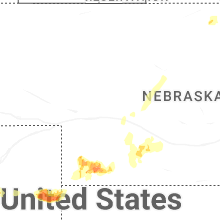
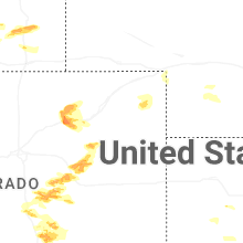
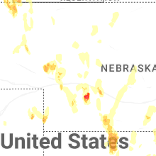
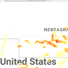

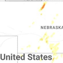
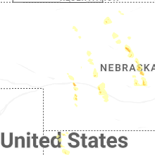
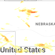
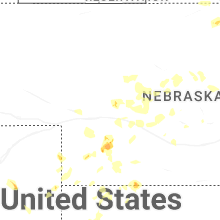
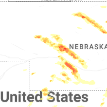
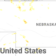
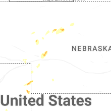
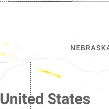


Connect with Interactive Hail Maps