

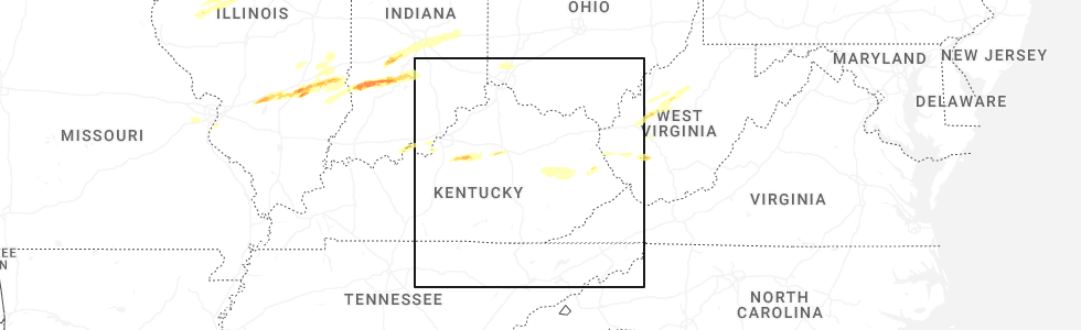
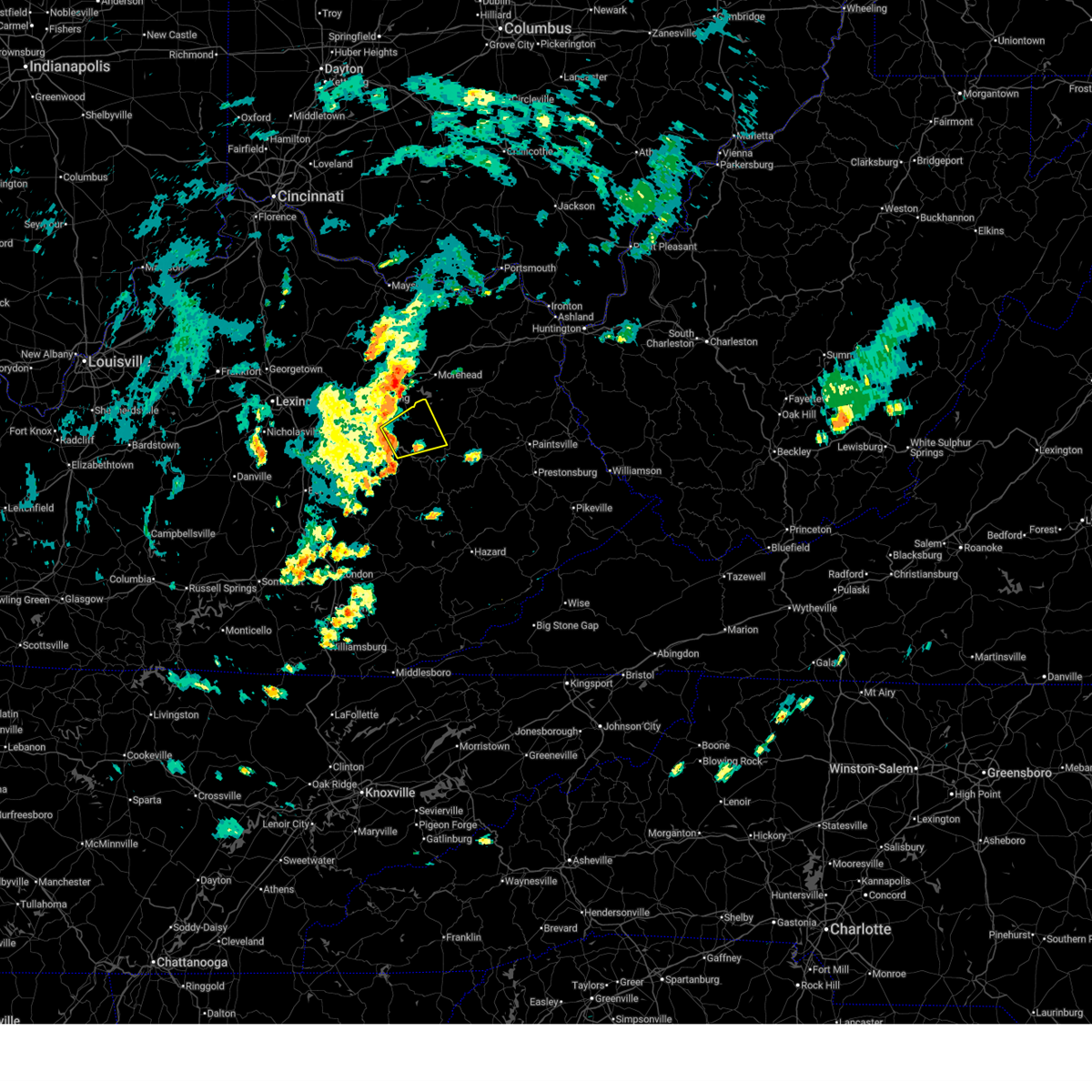
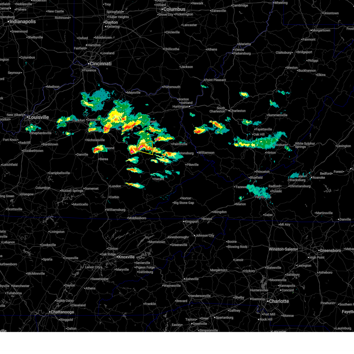
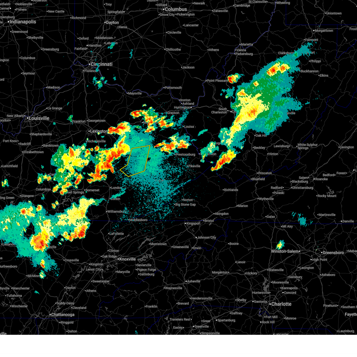
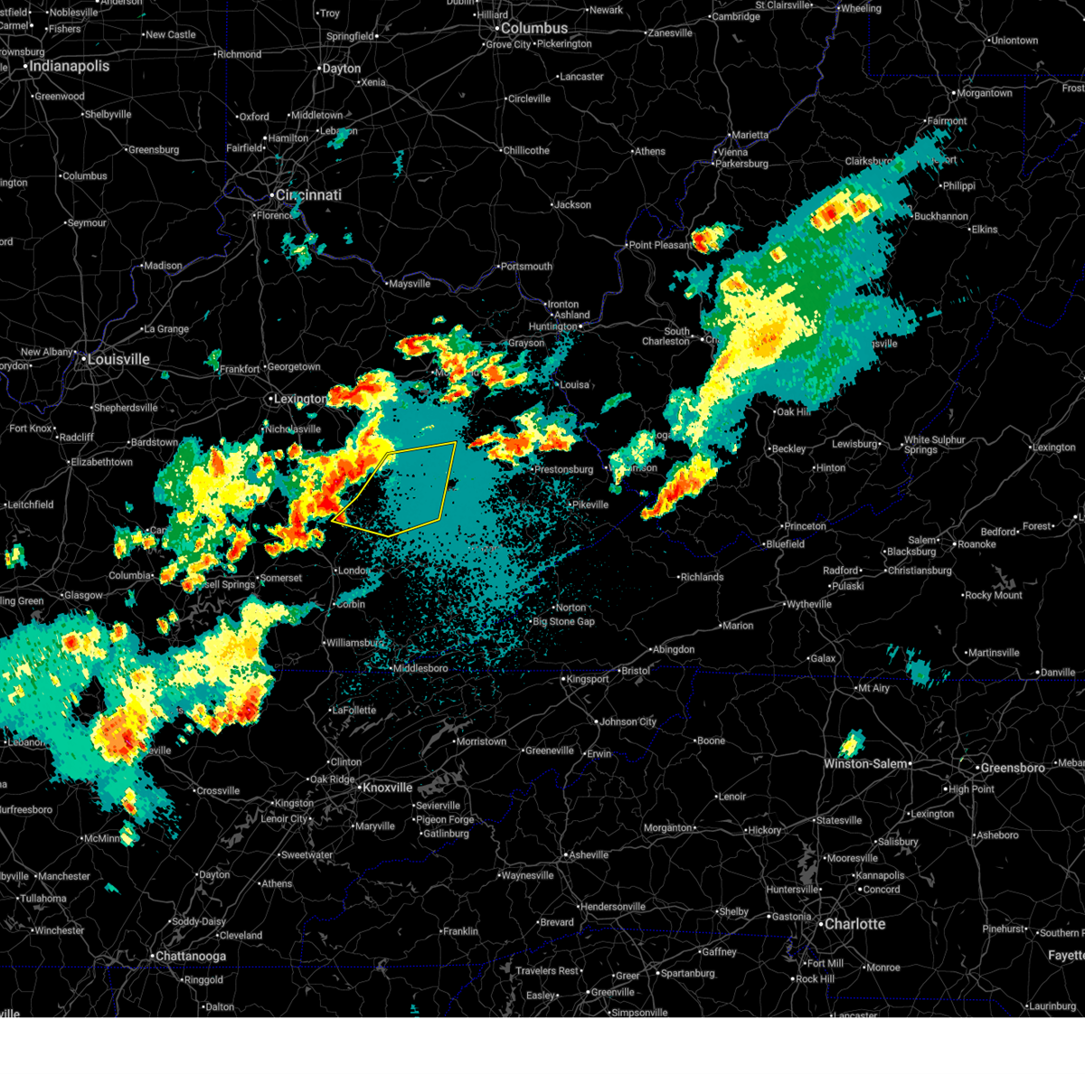
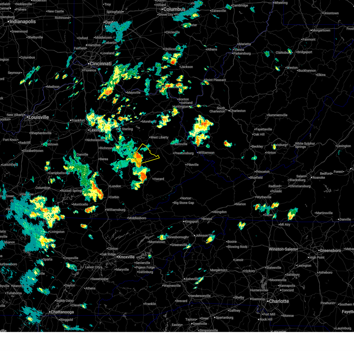
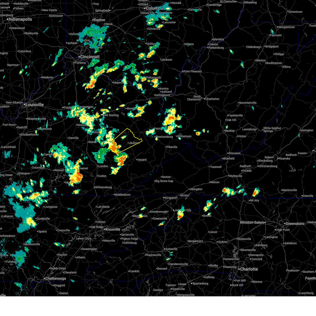
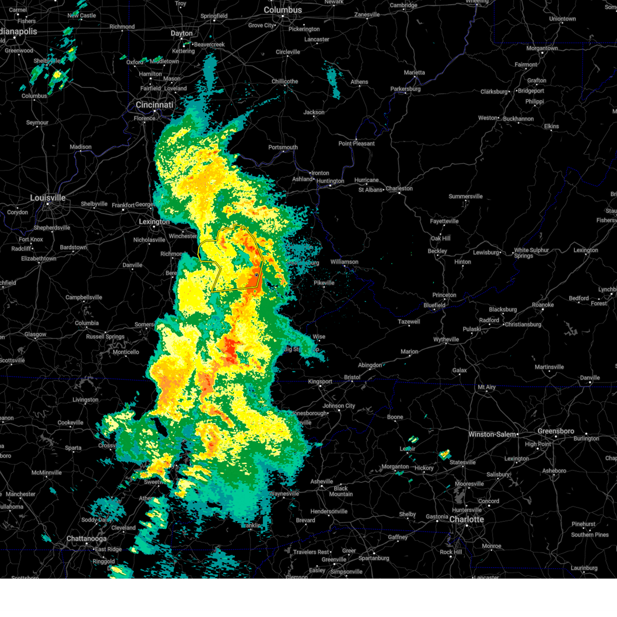
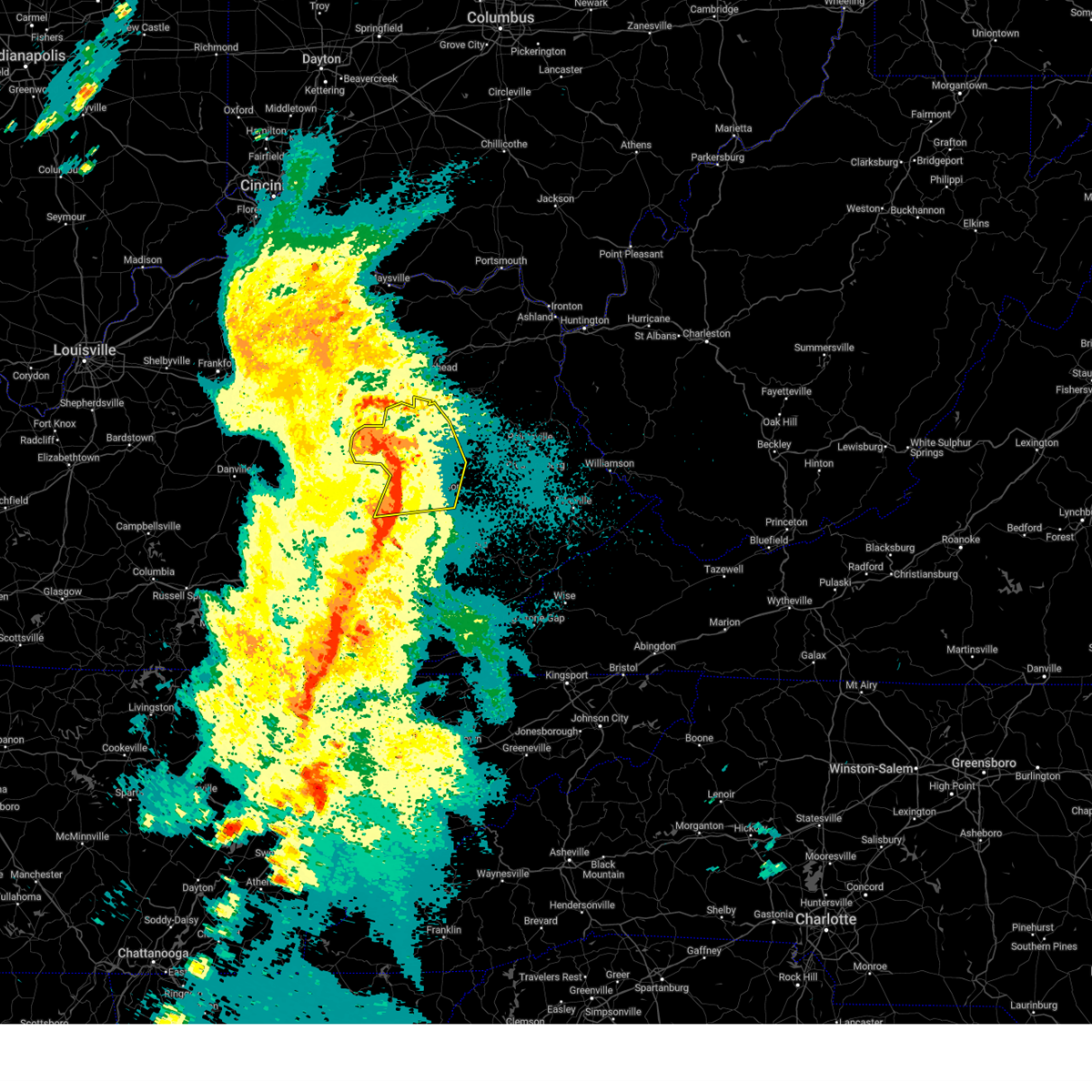
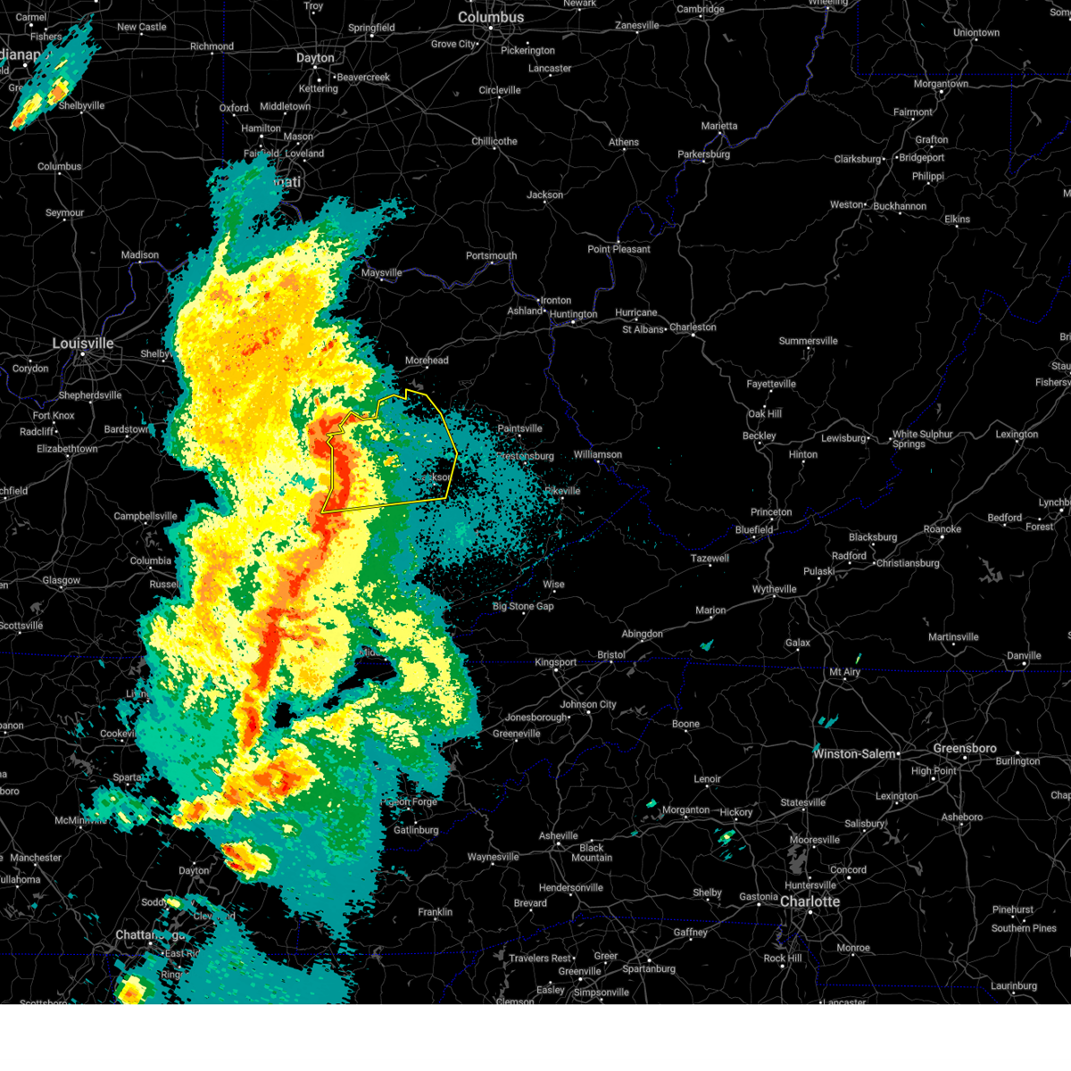
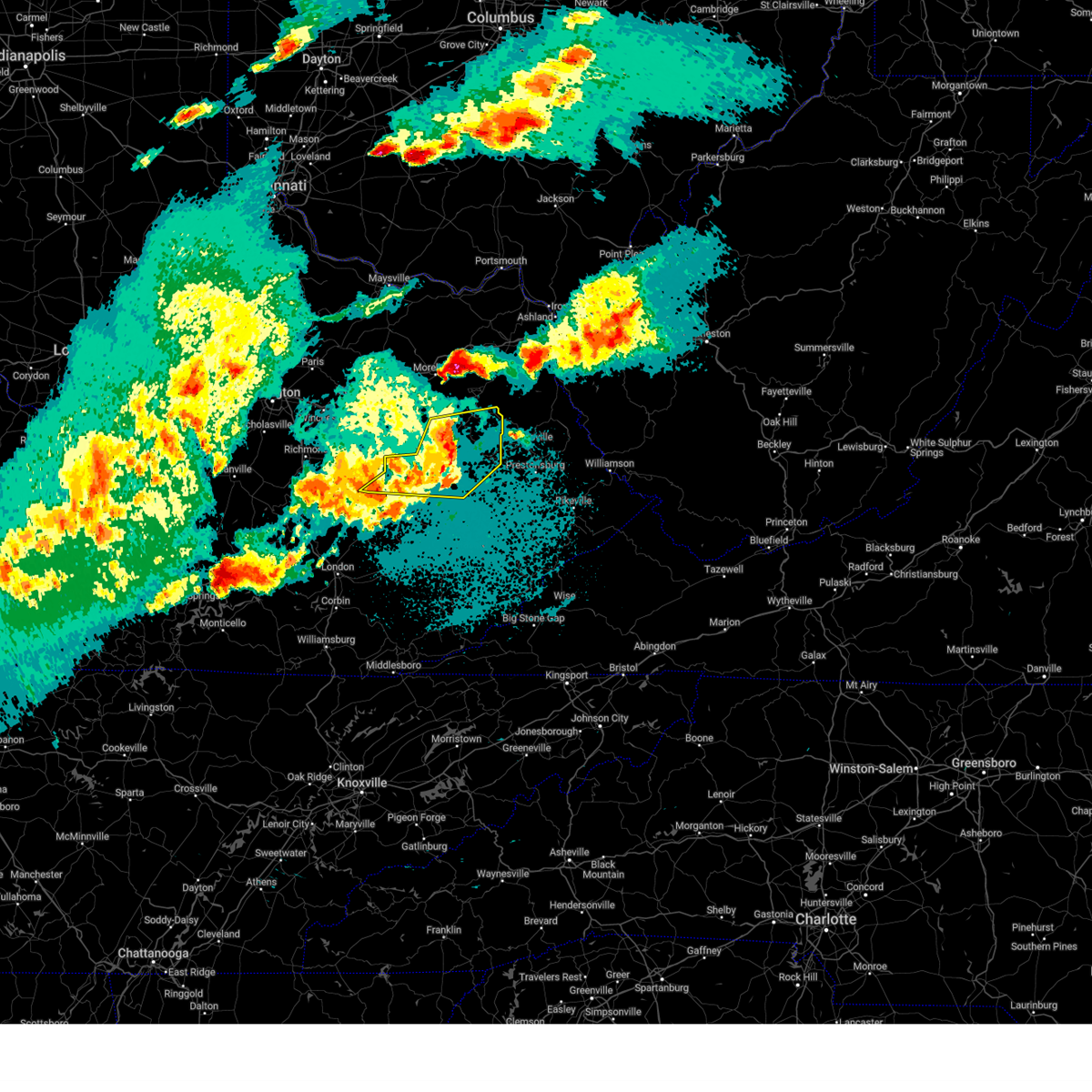
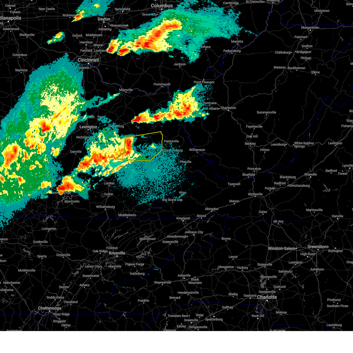
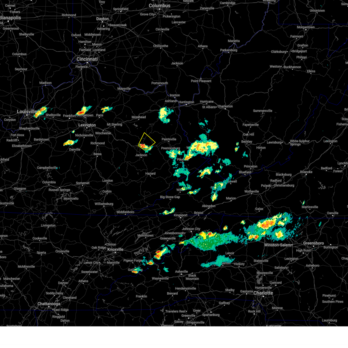
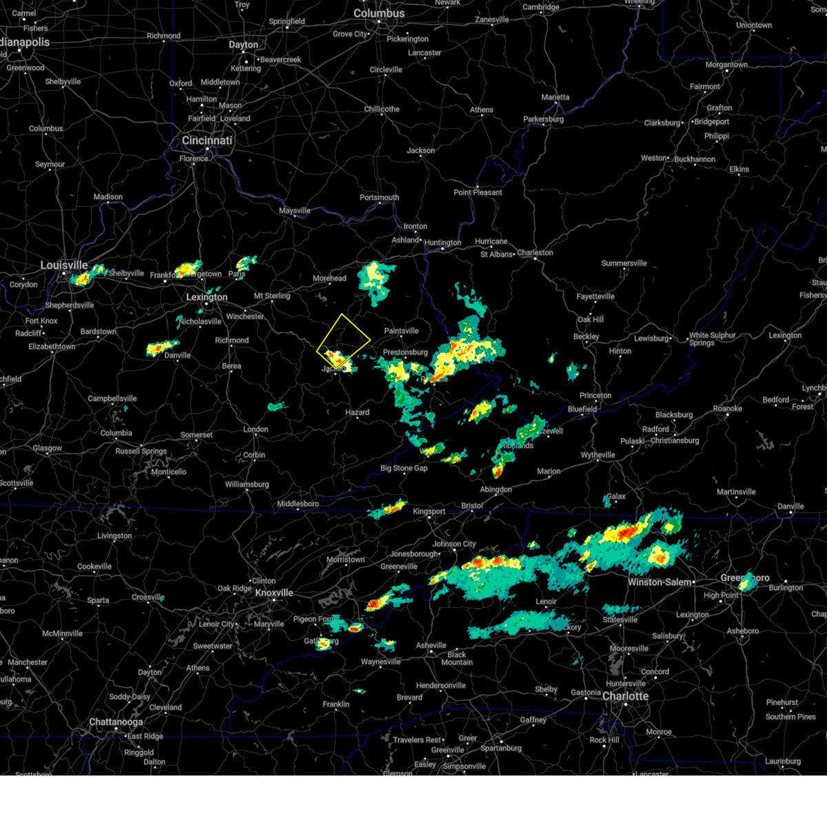
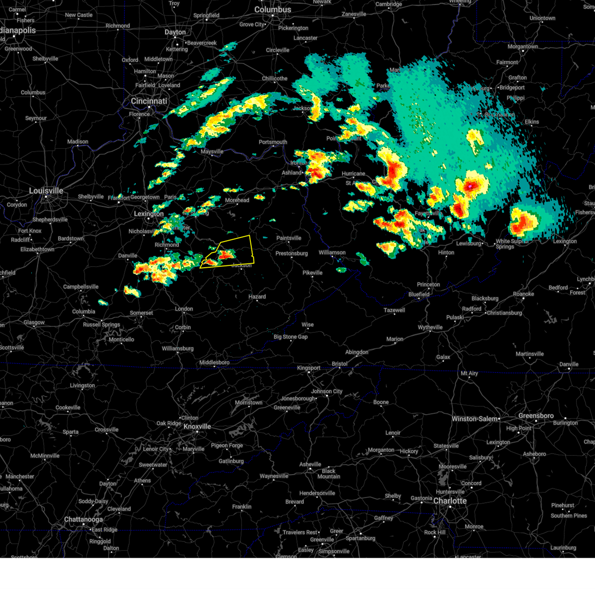
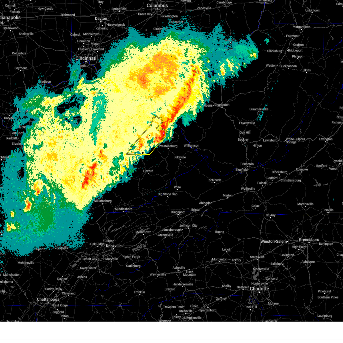
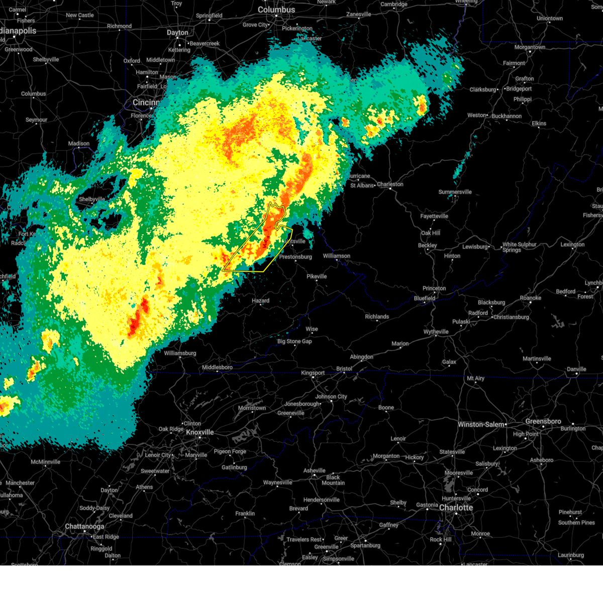
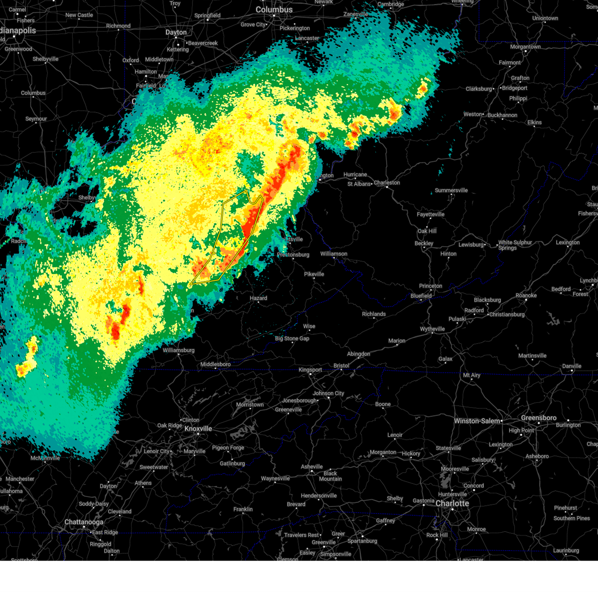
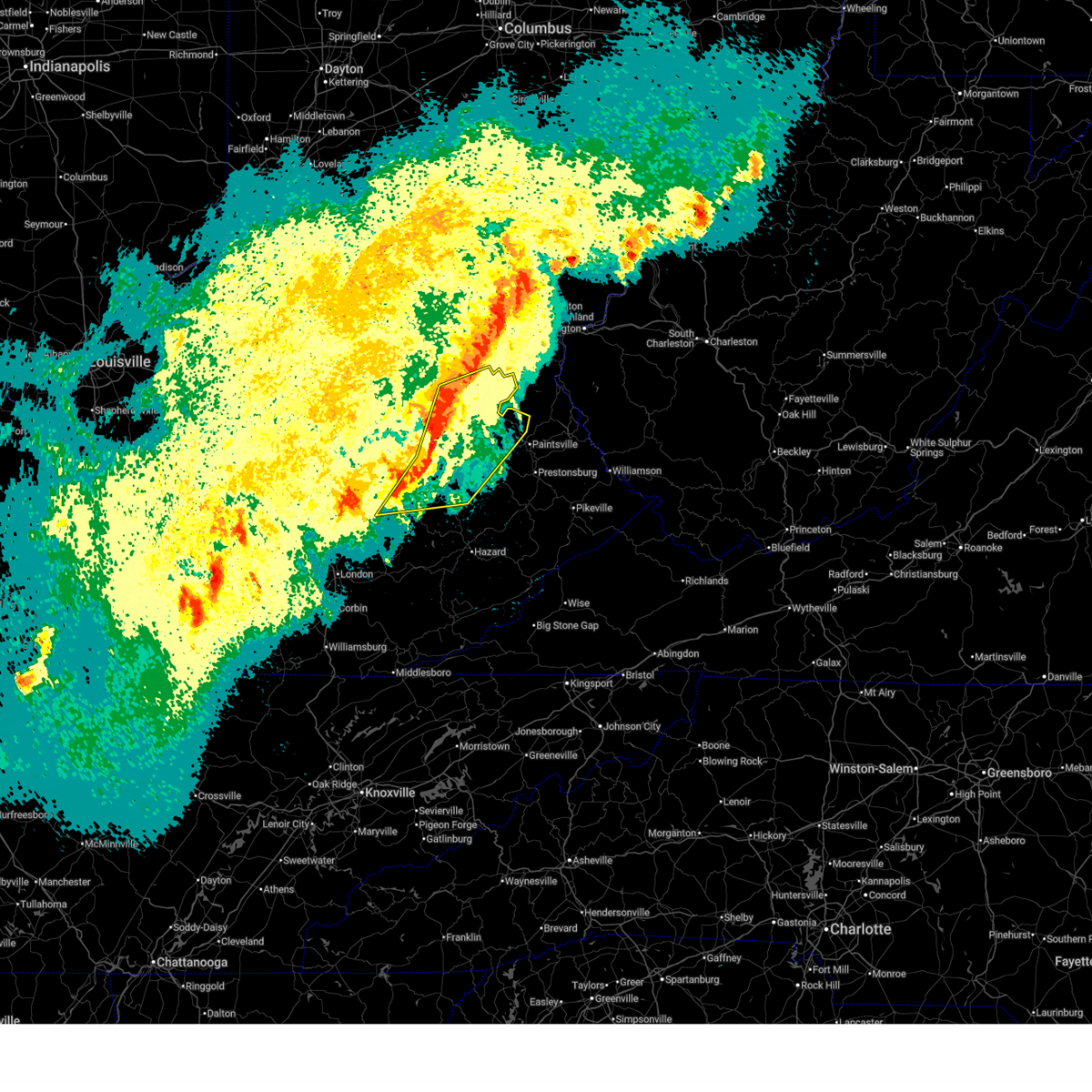
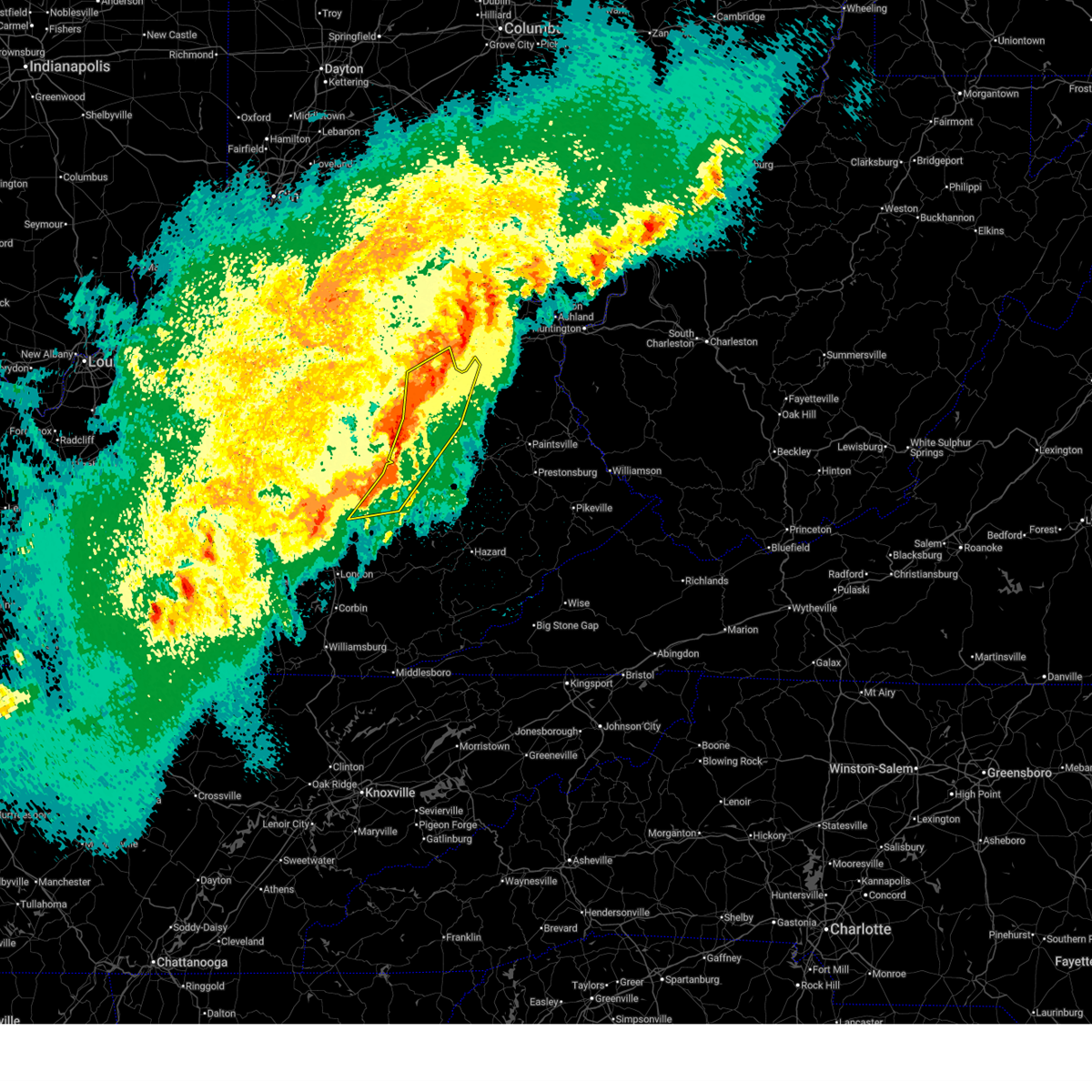
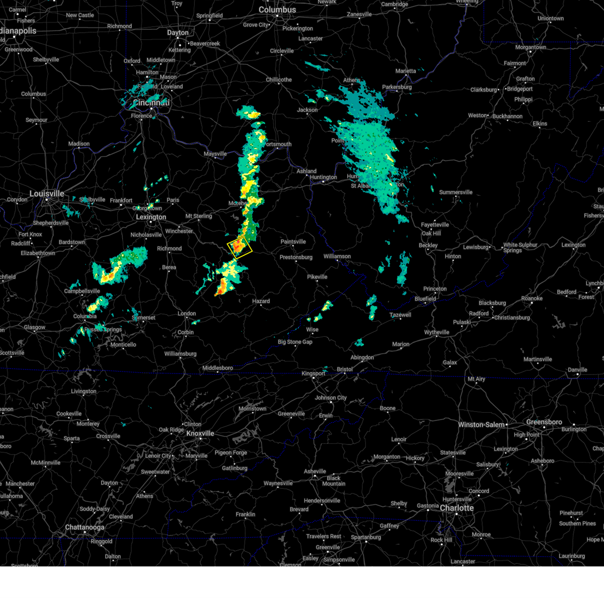
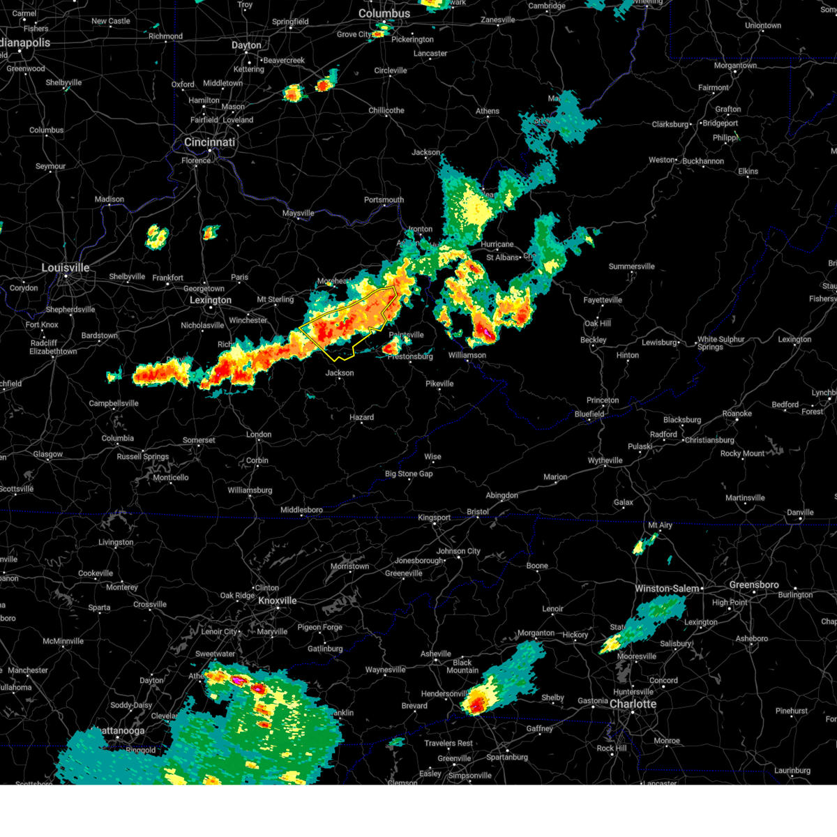
Hail Map for Hazel Green, KY
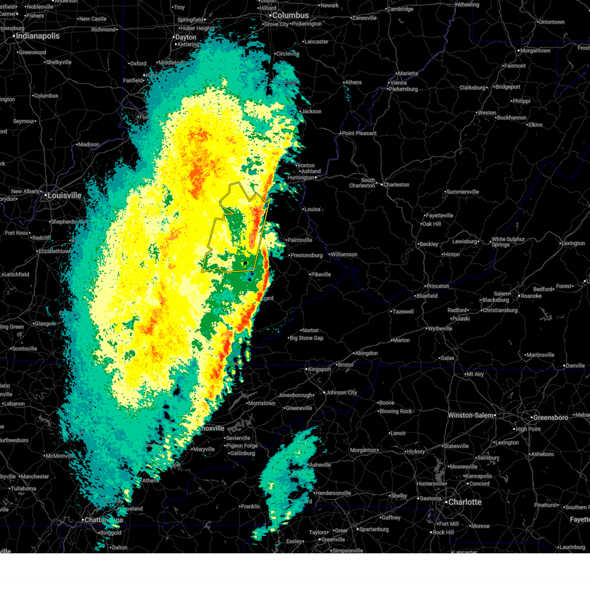
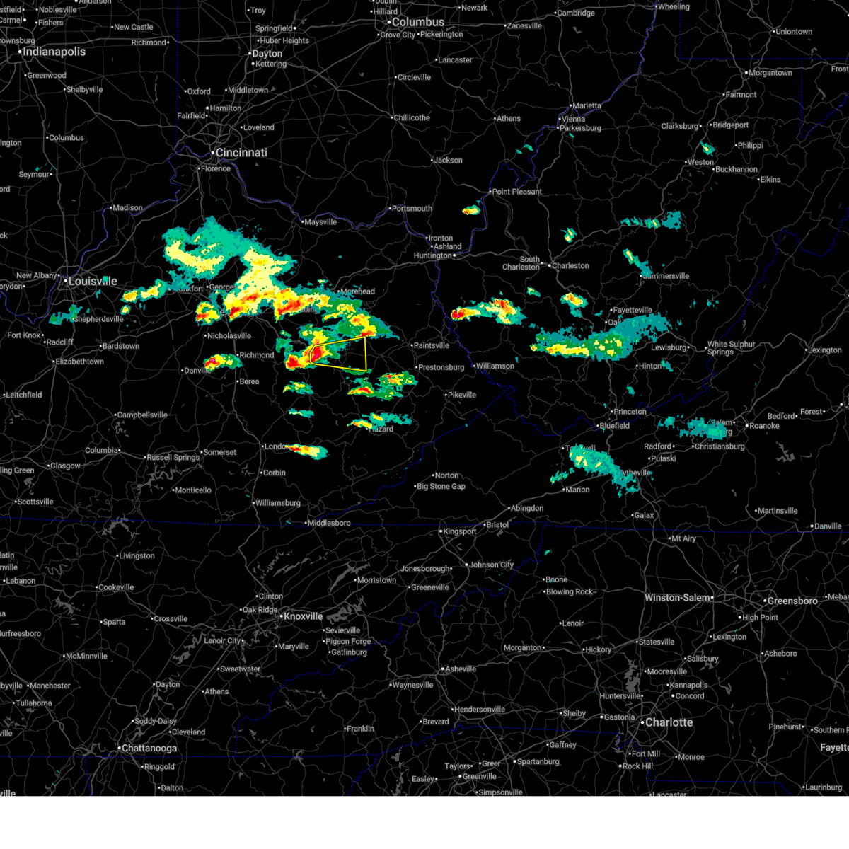
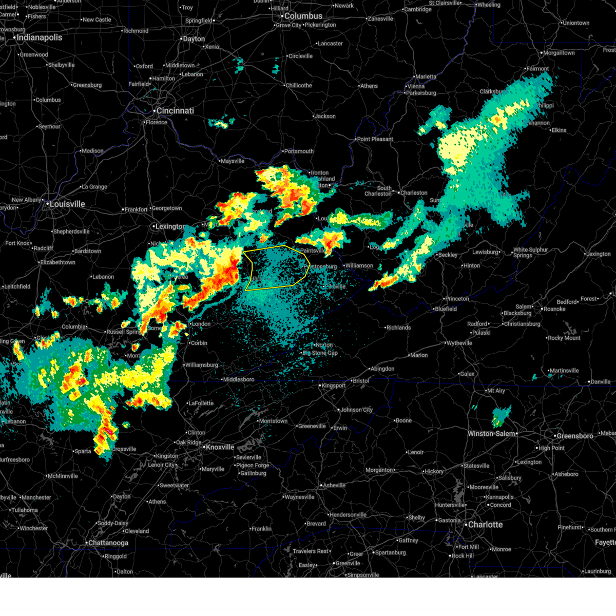
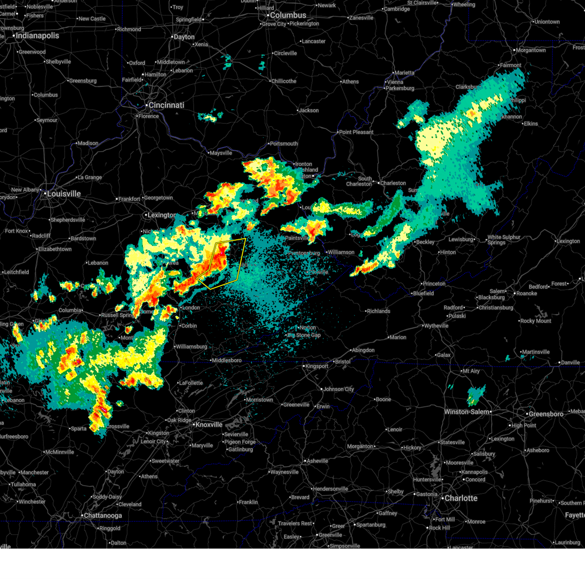
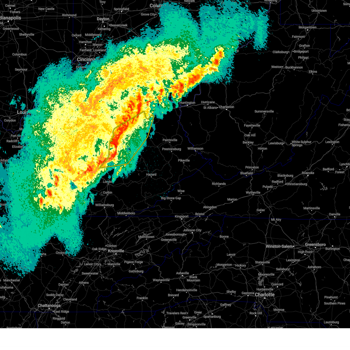
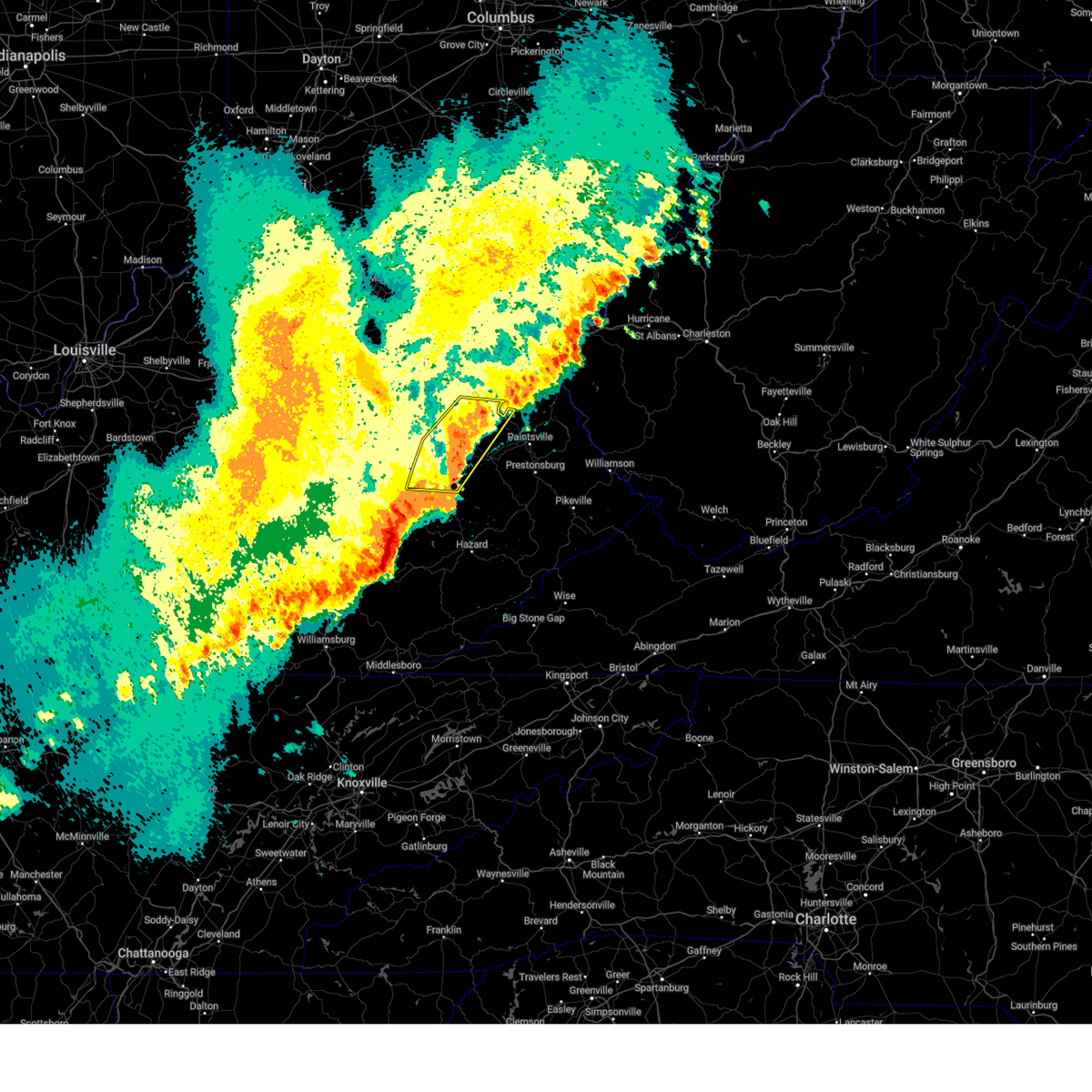
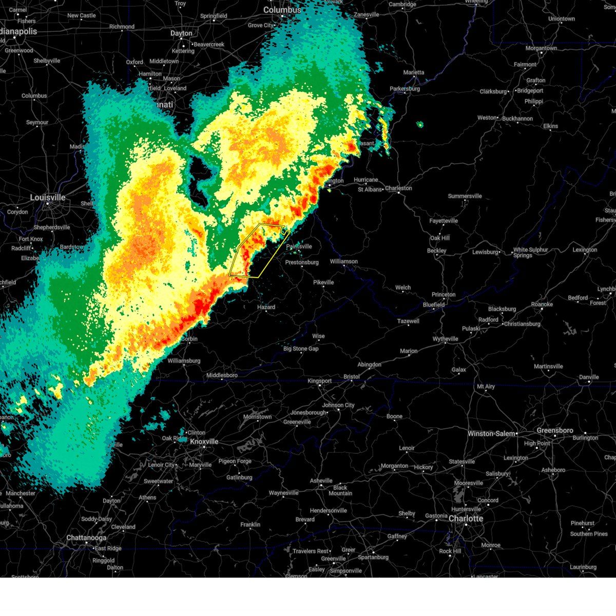
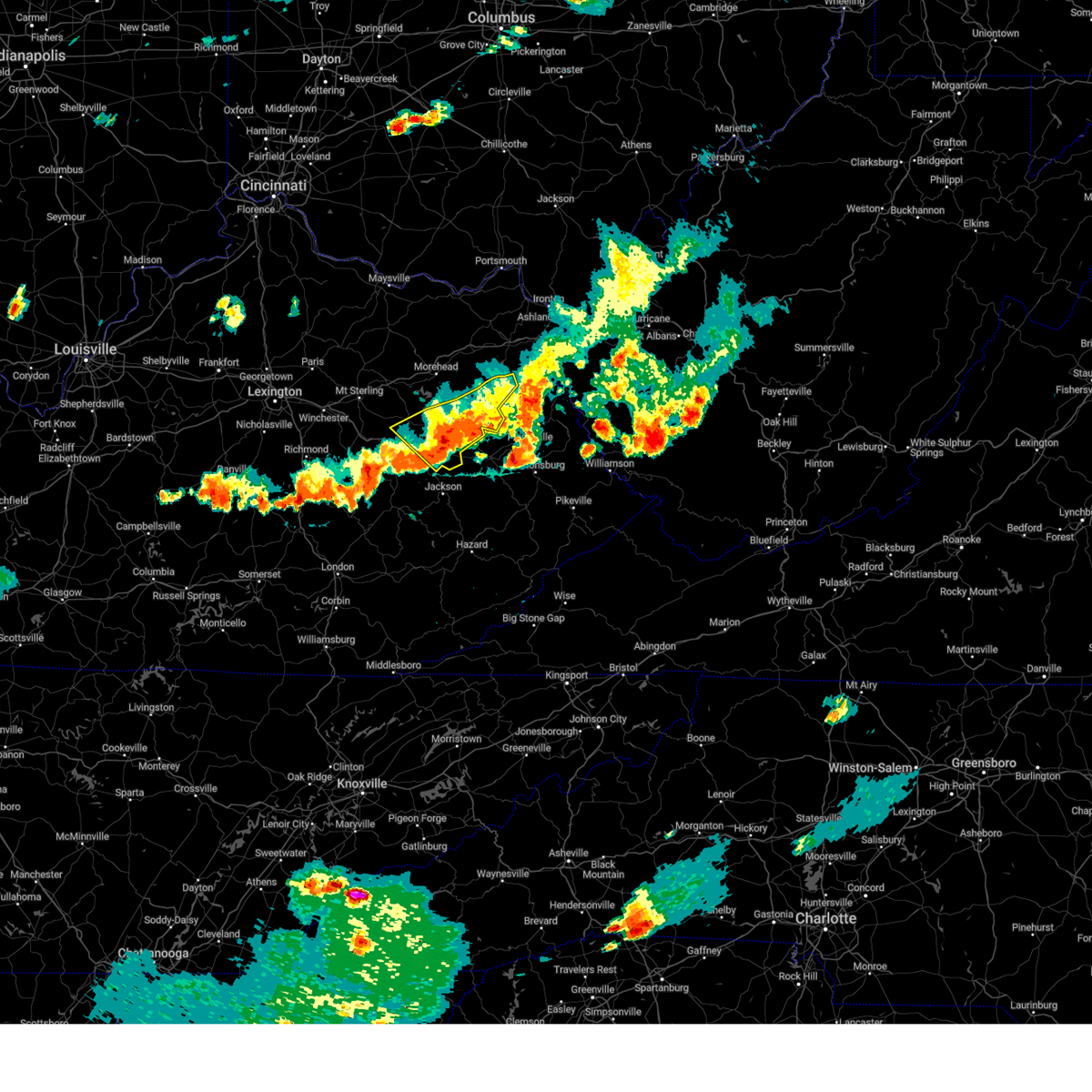
The Hazel Green, KY area has had 6 reports of on-the-ground hail by trained spotters, and has been under severe weather warnings 29 times during the past 12 months. Doppler radar has detected hail at or near Hazel Green, KY on 46 occasions, including 1 occasion during the past year.
| Name: | Hazel Green, KY |
| Where Located: | 31.3 miles ENE of Irvine, KY |
| Map: | Google Map for Hazel Green, KY |
| Population: | 228 |
| Housing Units: | 115 |
| More Info: | Search Google for Hazel Green, KY |
1
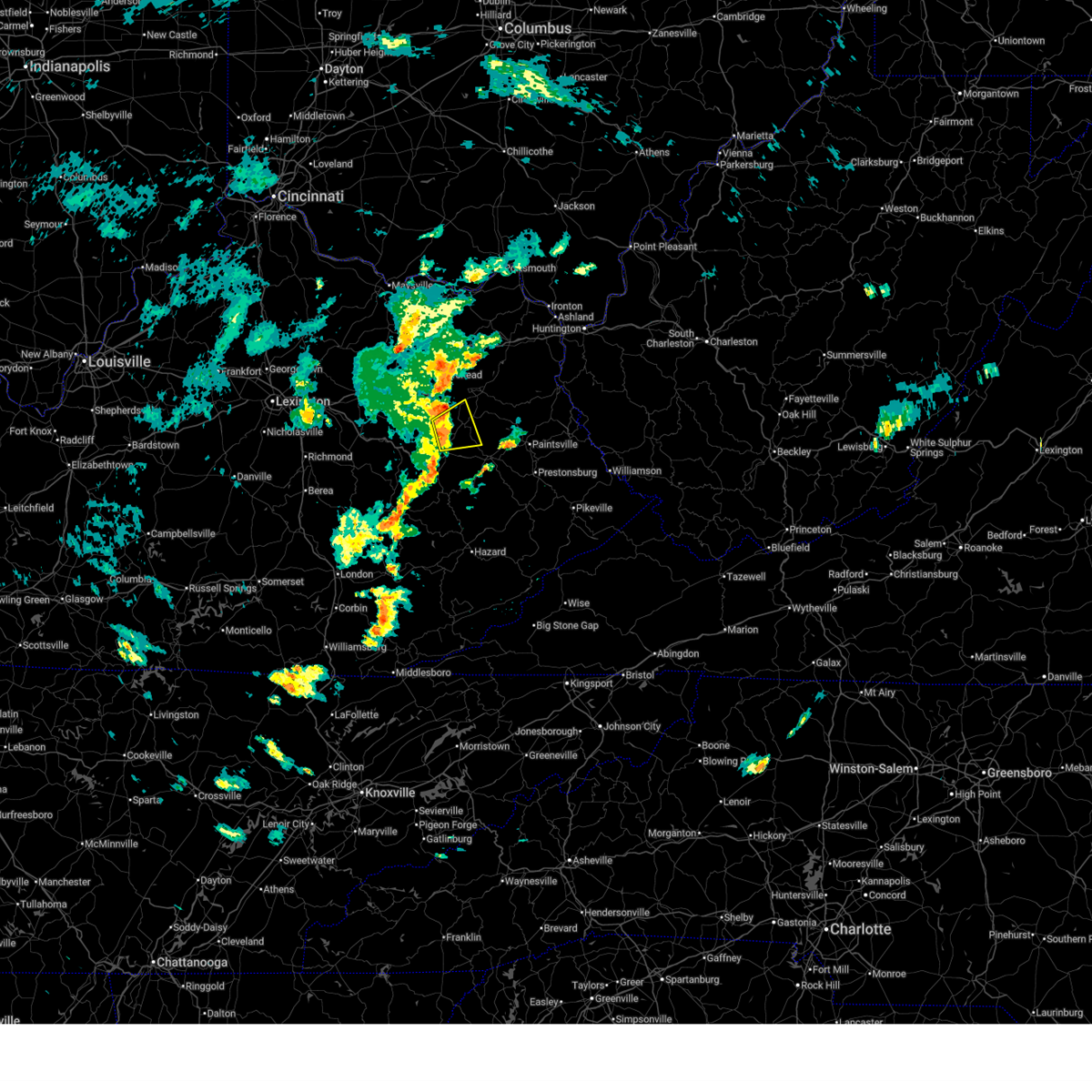
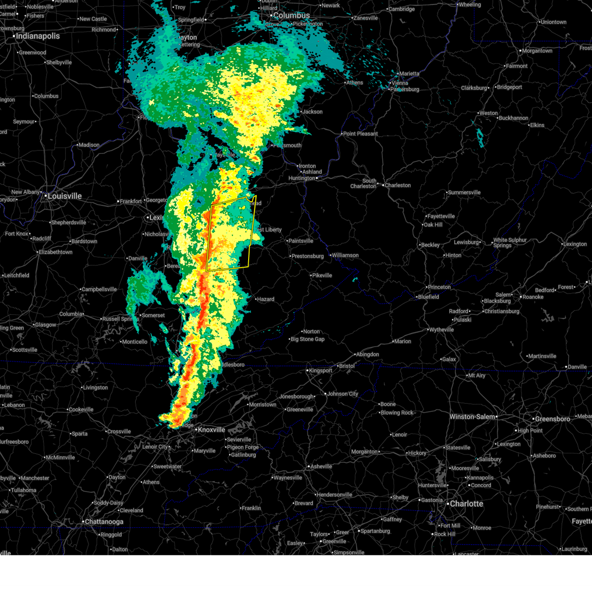
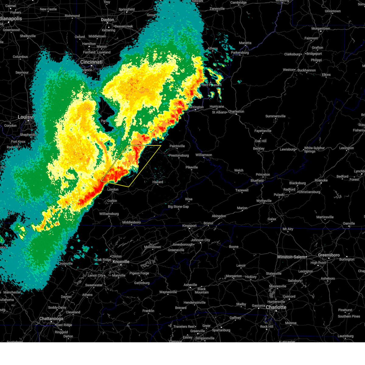
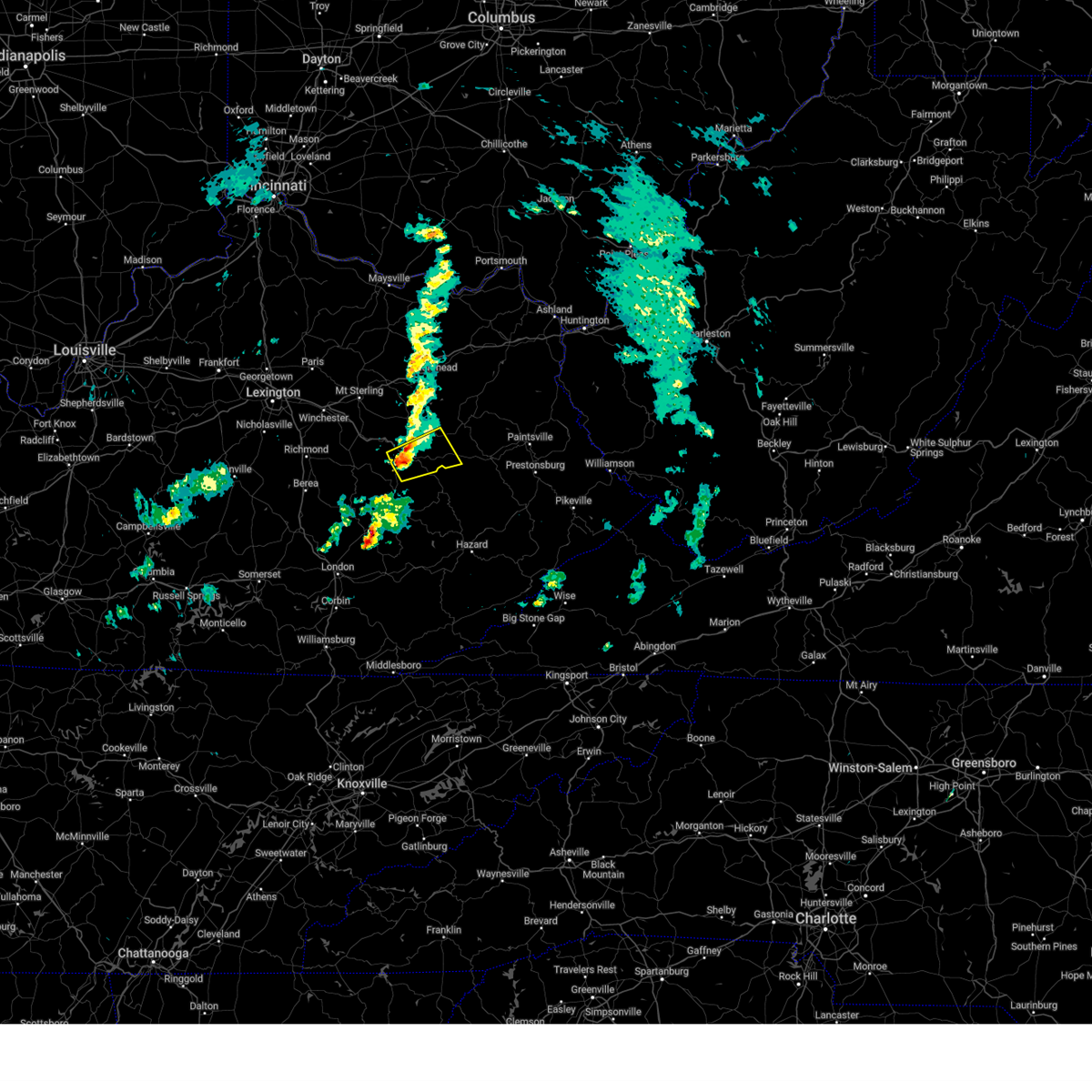
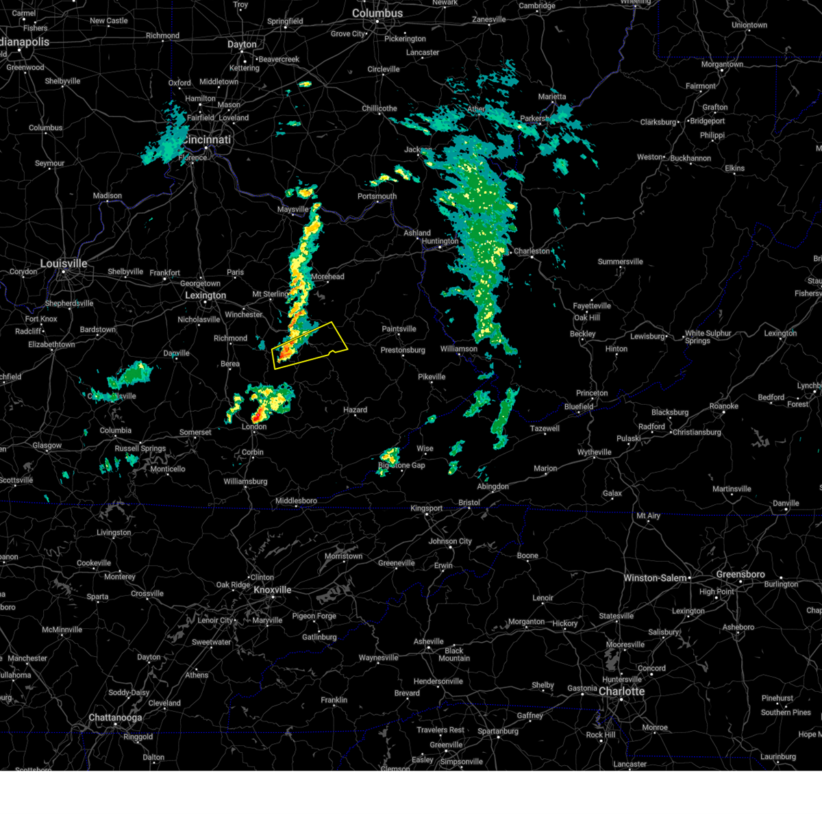
The Top Recent Hail Date for Hazel Green, KY is Thursday, February 19, 2026 (17th out of 46)
Hail and Wind Damage Spotted near Hazel Green, KY
| Date / Time | Report Details |
|---|---|
| 6/26/2026 3:41 PM EDT |
 At 340 pm edt, a severe thunderstorm was located over new cummer, or near west liberty, moving northeast at 25 mph (radar indicated). Hazards include 60 mph wind gusts. Expect damage to roofs, siding, and trees. Locations impacted include, west liberty, pomp and gordon ford. At 340 pm edt, a severe thunderstorm was located over new cummer, or near west liberty, moving northeast at 25 mph (radar indicated). Hazards include 60 mph wind gusts. Expect damage to roofs, siding, and trees. Locations impacted include, west liberty, pomp and gordon ford.
|
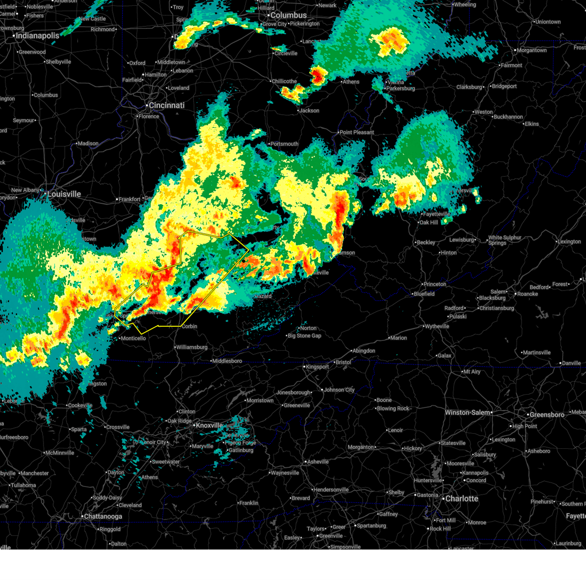
| 6/26/2026 3:25 PM EDT | Large tree limb was down blocking ky 1010. event time is radar estimate in wolfe county KY, 1.5 miles ESE of Hazel Green, KY |
| 6/26/2026 3:22 PM EDT |
 Svrjkl the national weather service in jackson ky has issued a * severe thunderstorm warning for, western morgan county in southeastern kentucky, southeastern menifee county in east central kentucky, northwestern magoffin county in southeastern kentucky, northeastern wolfe county in southeastern kentucky, * until 415 pm edt. * at 322 pm edt, a severe thunderstorm was located over maytown, or 8 miles northeast of campton, moving northeast at 25 mph (radar indicated). Hazards include 60 mph wind gusts and quarter size hail. Hail damage to vehicles is expected. expect wind damage to roofs, siding, and trees. this severe thunderstorm will be near, murphyfork around 330 pm edt. henry around 335 pm edt. west liberty around 340 pm edt. Other locations in the path of this severe thunderstorm include dehart, pomp and lenox. Svrjkl the national weather service in jackson ky has issued a * severe thunderstorm warning for, western morgan county in southeastern kentucky, southeastern menifee county in east central kentucky, northwestern magoffin county in southeastern kentucky, northeastern wolfe county in southeastern kentucky, * until 415 pm edt. * at 322 pm edt, a severe thunderstorm was located over maytown, or 8 miles northeast of campton, moving northeast at 25 mph (radar indicated). Hazards include 60 mph wind gusts and quarter size hail. Hail damage to vehicles is expected. expect wind damage to roofs, siding, and trees. this severe thunderstorm will be near, murphyfork around 330 pm edt. henry around 335 pm edt. west liberty around 340 pm edt. Other locations in the path of this severe thunderstorm include dehart, pomp and lenox.
|
| 6/26/2026 3:21 PM EDT |
 the severe thunderstorm warning has been cancelled and is no longer in effect the severe thunderstorm warning has been cancelled and is no longer in effect
|
| 6/26/2026 3:21 PM EDT |
 At 320 pm edt, a severe thunderstorm was located over wellington, or near frenchburg, moving northeast at 25 mph (radar indicated). Hazards include 60 mph wind gusts and penny size hail. Expect damage to roofs, siding, and trees. Locations impacted include, korea and big woods. At 320 pm edt, a severe thunderstorm was located over wellington, or near frenchburg, moving northeast at 25 mph (radar indicated). Hazards include 60 mph wind gusts and penny size hail. Expect damage to roofs, siding, and trees. Locations impacted include, korea and big woods.
|
| 6/26/2026 2:57 PM EDT |
 Svrjkl the national weather service in jackson ky has issued a * severe thunderstorm warning for, eastern powell county in east central kentucky, southwestern morgan county in southeastern kentucky, menifee county in east central kentucky, northwestern wolfe county in southeastern kentucky, * until 330 pm edt. * at 257 pm edt, a severe thunderstorm was located over haystack, or 8 miles south of frenchburg, moving northeast at 25 mph (radar indicated). Hazards include 60 mph wind gusts and penny size hail. Expect damage to roofs, siding, and trees. this severe thunderstorm will be near, campsites in the indian creek area of the daniel boone national forrest around 300 pm edt. mariba around 305 pm edt. frenchburg around 310 pm edt. wellington around 315 pm edt. Other locations in the path of this severe thunderstorm include korea and ezel. Svrjkl the national weather service in jackson ky has issued a * severe thunderstorm warning for, eastern powell county in east central kentucky, southwestern morgan county in southeastern kentucky, menifee county in east central kentucky, northwestern wolfe county in southeastern kentucky, * until 330 pm edt. * at 257 pm edt, a severe thunderstorm was located over haystack, or 8 miles south of frenchburg, moving northeast at 25 mph (radar indicated). Hazards include 60 mph wind gusts and penny size hail. Expect damage to roofs, siding, and trees. this severe thunderstorm will be near, campsites in the indian creek area of the daniel boone national forrest around 300 pm edt. mariba around 305 pm edt. frenchburg around 310 pm edt. wellington around 315 pm edt. Other locations in the path of this severe thunderstorm include korea and ezel.
|
| 6/18/2026 7:09 AM EDT |
 At 709 am edt, severe thunderstorms were located along a line extending from bloomington to belknap to flat, moving southeast at 45 mph (radar indicated). Hazards include 60 mph wind gusts. Expect damage to roofs, siding, and trees. Locations impacted include, irvine, beattyville, campton, lewis, fincastle, ravenna, torrent, florress, lexie, leeco, sellars, and patsey. At 709 am edt, severe thunderstorms were located along a line extending from bloomington to belknap to flat, moving southeast at 45 mph (radar indicated). Hazards include 60 mph wind gusts. Expect damage to roofs, siding, and trees. Locations impacted include, irvine, beattyville, campton, lewis, fincastle, ravenna, torrent, florress, lexie, leeco, sellars, and patsey.
|
| 6/18/2026 6:57 AM EDT |
 At 656 am edt, severe thunderstorms were located along a line extending from panama to trent to zoe, moving southeast at 45 mph (radar indicated). Hazards include 60 mph wind gusts. Expect damage to roofs, siding, and trees. Locations impacted include, west liberty, irvine, beattyville, campton, henry, lewis, fincastle, ravenna, pilot, bowen, florress, and lexie. At 656 am edt, severe thunderstorms were located along a line extending from panama to trent to zoe, moving southeast at 45 mph (radar indicated). Hazards include 60 mph wind gusts. Expect damage to roofs, siding, and trees. Locations impacted include, west liberty, irvine, beattyville, campton, henry, lewis, fincastle, ravenna, pilot, bowen, florress, and lexie.
|
| 6/18/2026 6:25 AM EDT |
 Svrjkl the national weather service in jackson ky has issued a * severe thunderstorm warning for, powell county in east central kentucky, southeastern montgomery county in east central kentucky, southwestern morgan county in southeastern kentucky, northern estill county in east central kentucky, menifee county in east central kentucky, northern lee county in southeastern kentucky, wolfe county in southeastern kentucky, * until 715 am edt. * at 624 am edt, severe thunderstorms were located along a line extending from frenchburg to near cat creek to iron mound, moving southeast at 45 mph (radar indicated). Hazards include 60 mph wind gusts. Expect damage to roofs, siding, and trees. severe thunderstorms will be near, stanton around 630 am edt. ravenna around 635 am edt. campton around 640 am edt. Other locations in the path of these severe thunderstorms include west liberty, lewis and williams. Svrjkl the national weather service in jackson ky has issued a * severe thunderstorm warning for, powell county in east central kentucky, southeastern montgomery county in east central kentucky, southwestern morgan county in southeastern kentucky, northern estill county in east central kentucky, menifee county in east central kentucky, northern lee county in southeastern kentucky, wolfe county in southeastern kentucky, * until 715 am edt. * at 624 am edt, severe thunderstorms were located along a line extending from frenchburg to near cat creek to iron mound, moving southeast at 45 mph (radar indicated). Hazards include 60 mph wind gusts. Expect damage to roofs, siding, and trees. severe thunderstorms will be near, stanton around 630 am edt. ravenna around 635 am edt. campton around 640 am edt. Other locations in the path of these severe thunderstorms include west liberty, lewis and williams.
|
| 3/16/2026 3:52 AM EDT |
 The storms which prompted the warning have moved out of the area. therefore, the warning has been allowed to expire. however, gusty winds are still possible with these thunderstorms. a severe thunderstorm watch remains in effect until 700 am edt for southeastern and east central kentucky. to report severe weather, contact your nearest law enforcement agency. they will relay your report to the national weather service jackson ky. The storms which prompted the warning have moved out of the area. therefore, the warning has been allowed to expire. however, gusty winds are still possible with these thunderstorms. a severe thunderstorm watch remains in effect until 700 am edt for southeastern and east central kentucky. to report severe weather, contact your nearest law enforcement agency. they will relay your report to the national weather service jackson ky.
|
| 3/16/2026 3:00 AM EDT |
 Svrjkl the national weather service in jackson ky has issued a * severe thunderstorm warning for, southeastern powell county in east central kentucky, morgan county in southeastern kentucky, menifee county in east central kentucky, northwestern breathitt county in southeastern kentucky, northwestern magoffin county in southeastern kentucky, lee county in southeastern kentucky, rowan county in east central kentucky, wolfe county in southeastern kentucky, elliott county in east central kentucky, * until 345 am edt. * at 300 am edt, severe thunderstorms were located along a line extending from waltz to sturgeon, moving east at 60 mph (radar indicated). Hazards include 60 mph wind gusts. Expect damage to roofs, siding, and trees. severe thunderstorms will be near, morehead around 305 am edt. west liberty around 310 am edt. sandy hook around 315 am edt. Harper around 320 am edt. Svrjkl the national weather service in jackson ky has issued a * severe thunderstorm warning for, southeastern powell county in east central kentucky, morgan county in southeastern kentucky, menifee county in east central kentucky, northwestern breathitt county in southeastern kentucky, northwestern magoffin county in southeastern kentucky, lee county in southeastern kentucky, rowan county in east central kentucky, wolfe county in southeastern kentucky, elliott county in east central kentucky, * until 345 am edt. * at 300 am edt, severe thunderstorms were located along a line extending from waltz to sturgeon, moving east at 60 mph (radar indicated). Hazards include 60 mph wind gusts. Expect damage to roofs, siding, and trees. severe thunderstorms will be near, morehead around 305 am edt. west liberty around 310 am edt. sandy hook around 315 am edt. Harper around 320 am edt.
|
| 3/4/2026 10:08 AM EST |
 Torjkl the national weather service in jackson ky has issued a * tornado warning for, montgomery county in east central kentucky, mccreary county in south central kentucky, rowan county in east central kentucky, morgan county in southeastern kentucky, bath county in east central kentucky, leslie county in southeastern kentucky, estill county in east central kentucky, pulaski county in south central kentucky, rockcastle county in south central kentucky, clay county in southeastern kentucky, elliott county in east central kentucky, wayne county in south central kentucky, harlan county in southeastern kentucky, knox county in southeastern kentucky, owsley county in southeastern kentucky, jackson county in southeastern kentucky, knott county in southeastern kentucky, whitley county in south central kentucky, floyd county in southeastern kentucky, menifee county in east central kentucky, lee county in southeastern kentucky, fleming county in east central kentucky, wolfe county in southeastern kentucky, powell county in east central kentucky, laurel county in south central kentucky, martin county in northeastern kentucky, bell county in southeastern kentucky, letcher county in southeastern kentucky, johnson county in northeastern kentucky, perry county in southeastern kentucky, breathitt county in southeastern kentucky, pike county in southeastern kentucky, magoffin county in southeastern kentucky, * until 1030 am est. Torjkl the national weather service in jackson ky has issued a * tornado warning for, montgomery county in east central kentucky, mccreary county in south central kentucky, rowan county in east central kentucky, morgan county in southeastern kentucky, bath county in east central kentucky, leslie county in southeastern kentucky, estill county in east central kentucky, pulaski county in south central kentucky, rockcastle county in south central kentucky, clay county in southeastern kentucky, elliott county in east central kentucky, wayne county in south central kentucky, harlan county in southeastern kentucky, knox county in southeastern kentucky, owsley county in southeastern kentucky, jackson county in southeastern kentucky, knott county in southeastern kentucky, whitley county in south central kentucky, floyd county in southeastern kentucky, menifee county in east central kentucky, lee county in southeastern kentucky, fleming county in east central kentucky, wolfe county in southeastern kentucky, powell county in east central kentucky, laurel county in south central kentucky, martin county in northeastern kentucky, bell county in southeastern kentucky, letcher county in southeastern kentucky, johnson county in northeastern kentucky, perry county in southeastern kentucky, breathitt county in southeastern kentucky, pike county in southeastern kentucky, magoffin county in southeastern kentucky, * until 1030 am est.
|
| 2/19/2026 4:48 PM EST |
 The severe thunderstorm which prompted the warning is moving east out of the original warning area, and a new warning was issued further east. The severe thunderstorm which prompted the warning is moving east out of the original warning area, and a new warning was issued further east.
|
| 2/19/2026 4:33 PM EST |
 At 433 pm est, a severe thunderstorm was located over adele, or 10 miles south of west liberty, moving east at 50 mph (radar indicated). Hazards include 60 mph wind gusts and quarter size hail. Hail damage to vehicles is expected. expect wind damage to roofs, siding, and trees. Locations impacted include, holliday. At 433 pm est, a severe thunderstorm was located over adele, or 10 miles south of west liberty, moving east at 50 mph (radar indicated). Hazards include 60 mph wind gusts and quarter size hail. Hail damage to vehicles is expected. expect wind damage to roofs, siding, and trees. Locations impacted include, holliday.
|
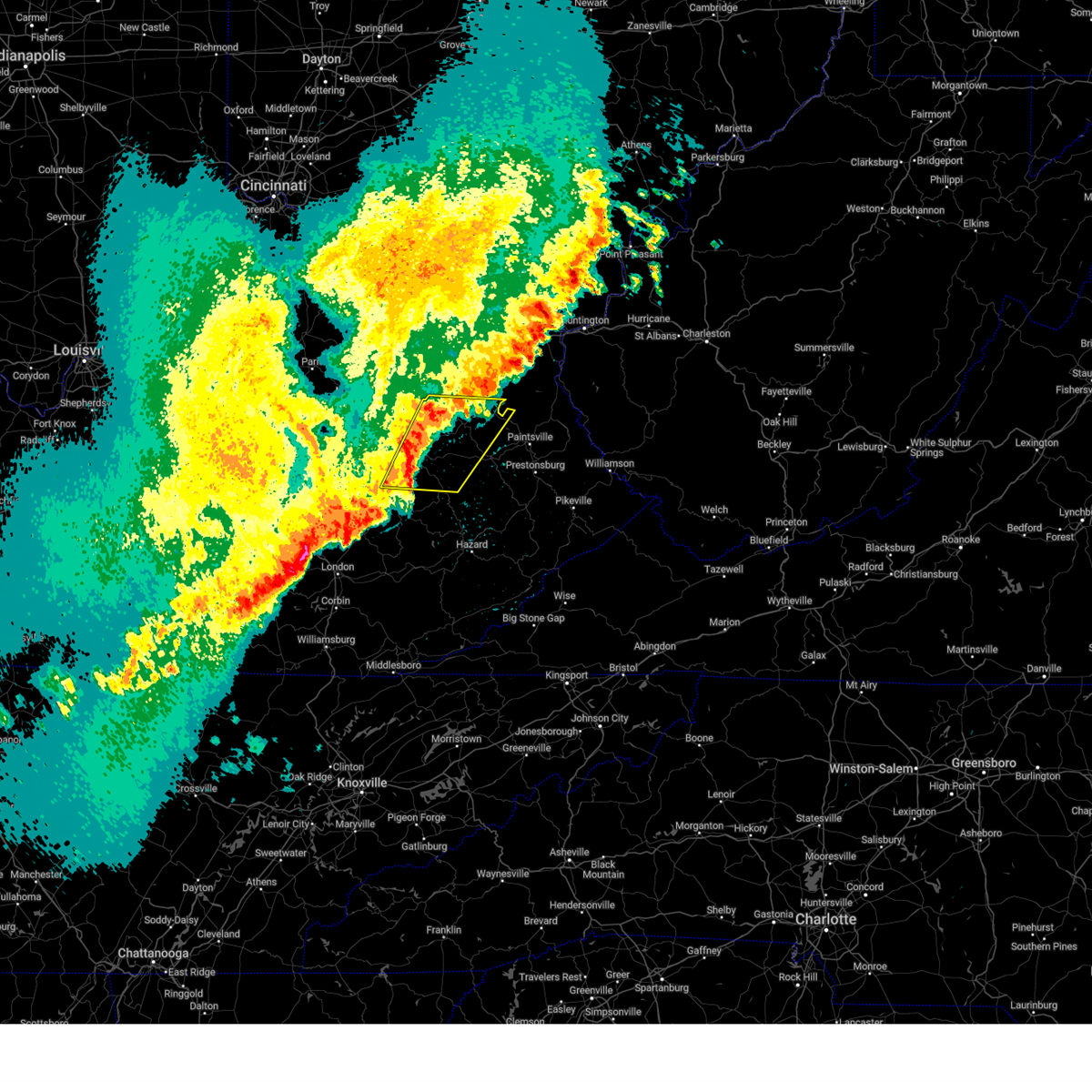
| 2/19/2026 4:32 PM EST | Quarter sized hail reported 0.6 miles NNE of Hazel Green, KY, social media user shared approximately quarter-sized hailstones. time estimated from radar. |
| 2/19/2026 4:16 PM EST |
 Svrjkl the national weather service in jackson ky has issued a * severe thunderstorm warning for, southwestern morgan county in southeastern kentucky, north central breathitt county in southeastern kentucky, west central magoffin county in southeastern kentucky, wolfe county in southeastern kentucky, * until 445 pm est. * at 415 pm est, a severe thunderstorm was located over high falls, or over campton, moving east at 50 mph (radar indicated). Hazards include 60 mph wind gusts and quarter size hail. Hail damage to vehicles is expected. expect wind damage to roofs, siding, and trees. this severe thunderstorm will be near, campton around 420 pm est. helechawa around 425 pm est. payton around 430 pm est. Caney around 435 pm est. Svrjkl the national weather service in jackson ky has issued a * severe thunderstorm warning for, southwestern morgan county in southeastern kentucky, north central breathitt county in southeastern kentucky, west central magoffin county in southeastern kentucky, wolfe county in southeastern kentucky, * until 445 pm est. * at 415 pm est, a severe thunderstorm was located over high falls, or over campton, moving east at 50 mph (radar indicated). Hazards include 60 mph wind gusts and quarter size hail. Hail damage to vehicles is expected. expect wind damage to roofs, siding, and trees. this severe thunderstorm will be near, campton around 420 pm est. helechawa around 425 pm est. payton around 430 pm est. Caney around 435 pm est.
|
| 9/22/2025 7:09 PM EDT | The storms which prompted the warning have weakened below severe limits, and were also exiting the warned area. therefore, the warning will be allowed to expire. however, gusty winds are still possible with these thunderstorms. |
| 9/22/2025 6:35 PM EDT | At 633 pm edt, severe thunderstorms were located along a line extending from minor to near taulbee, moving northeast at 55 mph (radar indicated). Hazards include 60 mph wind gusts and penny size hail. Expect damage to roofs, siding, and trees. Locations impacted include, west liberty, jackson, beattyville, frenchburg, campton, booneville, simpson, henry, fincastle, wellington, turin, and zag. |
| 9/22/2025 6:35 PM EDT | the severe thunderstorm warning has been cancelled and is no longer in effect |
| 9/22/2025 6:31 PM EDT | Svrjkl the national weather service in jackson ky has issued a * severe thunderstorm warning for, morgan county in southeastern kentucky, western johnson county in northeastern kentucky, east central menifee county in east central kentucky, northern breathitt county in southeastern kentucky, magoffin county in southeastern kentucky, eastern wolfe county in southeastern kentucky, southern elliott county in east central kentucky, * until 715 pm edt. * at 631 pm edt, severe thunderstorms were located along a line extending from big woods to arnett, moving east at 40 mph (radar indicated). Hazards include 60 mph wind gusts. Expect damage to roofs, siding, and trees. severe thunderstorms will be near, jackson around 635 pm edt. west liberty around 640 pm edt. lewis around 645 pm edt. sandy hook around 650 pm edt. Other locations in the path of these severe thunderstorms include salyersville and mason. |
| 9/22/2025 6:09 PM EDT | At 608 pm edt, severe thunderstorms were located along a line extending from frenchburg to chestnut gap, moving northeast at 50 mph (radar indicated). Hazards include 60 mph wind gusts and penny size hail. Expect damage to roofs, siding, and trees. Locations impacted include, campton, jackson, west liberty and wrigley. |
| 9/22/2025 5:52 PM EDT | Svrjkl the national weather service in jackson ky has issued a * severe thunderstorm warning for, powell county in east central kentucky, western morgan county in southeastern kentucky, northern owsley county in southeastern kentucky, estill county in east central kentucky, jackson county in southeastern kentucky, southern menifee county in east central kentucky, northwestern breathitt county in southeastern kentucky, lee county in southeastern kentucky, wolfe county in southeastern kentucky, * until 645 pm edt. * at 551 pm edt, severe thunderstorms were located along a line extending from near stanton to herd, moving northeast at 50 mph (radar indicated). Hazards include 60 mph wind gusts and penny size hail. Expect damage to roofs, siding, and trees. severe thunderstorms will be near, stanton around 555 pm edt. frenchburg around 600 pm edt. campton around 605 pm edt. wellington around 610 pm edt. Other locations in the path of these severe thunderstorms include stillwater and jackson. |
| 9/5/2025 11:16 PM EDT |
 Svrjkl the national weather service in jackson ky has issued a * severe thunderstorm warning for, southwestern morgan county in southeastern kentucky, southwestern johnson county in northeastern kentucky, northwestern knott county in southeastern kentucky, northwestern floyd county in southeastern kentucky, central breathitt county in southeastern kentucky, magoffin county in southeastern kentucky, northeastern wolfe county in southeastern kentucky, * until 1145 pm edt. * at 1116 pm edt, severe thunderstorms were located along a line extending from helechawa to cutuno to near cornelia to sikes to flintville, moving east at 50 mph (radar indicated). Hazards include 60 mph wind gusts. Expect damage to roofs, siding, and trees. severe thunderstorms will be near, salyersville around 1120 pm edt. gapville around 1125 pm edt. dotson around 1130 pm edt. prestonsburg around 1135 pm edt. Other locations in the path of these severe thunderstorms include hueysville. Svrjkl the national weather service in jackson ky has issued a * severe thunderstorm warning for, southwestern morgan county in southeastern kentucky, southwestern johnson county in northeastern kentucky, northwestern knott county in southeastern kentucky, northwestern floyd county in southeastern kentucky, central breathitt county in southeastern kentucky, magoffin county in southeastern kentucky, northeastern wolfe county in southeastern kentucky, * until 1145 pm edt. * at 1116 pm edt, severe thunderstorms were located along a line extending from helechawa to cutuno to near cornelia to sikes to flintville, moving east at 50 mph (radar indicated). Hazards include 60 mph wind gusts. Expect damage to roofs, siding, and trees. severe thunderstorms will be near, salyersville around 1120 pm edt. gapville around 1125 pm edt. dotson around 1130 pm edt. prestonsburg around 1135 pm edt. Other locations in the path of these severe thunderstorms include hueysville.
|
| 9/5/2025 10:56 PM EDT |
 The storms which prompted the warning have moved out of the area. therefore, the warning will be allowed to expire. a severe thunderstorm watch remains in effect until 100 am edt for southeastern kentucky. a new severe thunderstorm warning was issued for wolfe, lee and breathitt counties until 11:30 pm. The storms which prompted the warning have moved out of the area. therefore, the warning will be allowed to expire. a severe thunderstorm watch remains in effect until 100 am edt for southeastern kentucky. a new severe thunderstorm warning was issued for wolfe, lee and breathitt counties until 11:30 pm.
|
| 9/5/2025 10:52 PM EDT |
 the severe thunderstorm warning has been cancelled and is no longer in effect the severe thunderstorm warning has been cancelled and is no longer in effect
|
| 9/5/2025 10:52 PM EDT |
 At 1051 pm edt, severe thunderstorms were located along a line extending from campton to near lerose to green hall, moving east at 45 mph (radar indicated). Hazards include 60 mph wind gusts and penny size hail. Expect damage to roofs, siding, and trees. these severe storms will be near, jackson around 1055 pm edt. Other locations in the path of these severe thunderstorms include simpson and payton. At 1051 pm edt, severe thunderstorms were located along a line extending from campton to near lerose to green hall, moving east at 45 mph (radar indicated). Hazards include 60 mph wind gusts and penny size hail. Expect damage to roofs, siding, and trees. these severe storms will be near, jackson around 1055 pm edt. Other locations in the path of these severe thunderstorms include simpson and payton.
|
| 9/5/2025 10:37 PM EDT |
 Svrjkl the national weather service in jackson ky has issued a * severe thunderstorm warning for, southeastern powell county in east central kentucky, south central morgan county in southeastern kentucky, owsley county in southeastern kentucky, southeastern estill county in east central kentucky, central jackson county in southeastern kentucky, western breathitt county in southeastern kentucky, lee county in southeastern kentucky, wolfe county in southeastern kentucky, north central clay county in southeastern kentucky, * until 1100 pm edt. * at 1037 pm edt, severe thunderstorms were located along a line extending from glencairn to travellers rest to atkinstown, moving east at 45 mph (radar indicated). Hazards include 60 mph wind gusts and penny size hail. Expect damage to roofs, siding, and trees. severe thunderstorms will be near, beattyville around 1040 pm edt. athol around 1045 pm edt. Morris fork around 1050 pm edt. Svrjkl the national weather service in jackson ky has issued a * severe thunderstorm warning for, southeastern powell county in east central kentucky, south central morgan county in southeastern kentucky, owsley county in southeastern kentucky, southeastern estill county in east central kentucky, central jackson county in southeastern kentucky, western breathitt county in southeastern kentucky, lee county in southeastern kentucky, wolfe county in southeastern kentucky, north central clay county in southeastern kentucky, * until 1100 pm edt. * at 1037 pm edt, severe thunderstorms were located along a line extending from glencairn to travellers rest to atkinstown, moving east at 45 mph (radar indicated). Hazards include 60 mph wind gusts and penny size hail. Expect damage to roofs, siding, and trees. severe thunderstorms will be near, beattyville around 1040 pm edt. athol around 1045 pm edt. Morris fork around 1050 pm edt.
|
| 9/5/2025 6:57 PM EDT |
 The severe thunderstorm which prompted the warning has weakened. therefore, the warning will be allowed to expire. a severe thunderstorm watch remains in effect until 100 am edt for southeastern and east central kentucky. The severe thunderstorm which prompted the warning has weakened. therefore, the warning will be allowed to expire. a severe thunderstorm watch remains in effect until 100 am edt for southeastern and east central kentucky.
|
| 9/5/2025 6:43 PM EDT |
 At 641 pm edt, a severe thunderstorm was located over campton, moving east at 30 mph (radar indicated). Hazards include 60 mph wind gusts and penny size hail. Expect damage to roofs, siding, and trees. Locations impacted include, stillwater, daysboro, helechawa, rexville and belknap. At 641 pm edt, a severe thunderstorm was located over campton, moving east at 30 mph (radar indicated). Hazards include 60 mph wind gusts and penny size hail. Expect damage to roofs, siding, and trees. Locations impacted include, stillwater, daysboro, helechawa, rexville and belknap.
|
| 9/5/2025 6:43 PM EDT |
 the severe thunderstorm warning has been cancelled and is no longer in effect the severe thunderstorm warning has been cancelled and is no longer in effect
|
| 9/5/2025 6:23 PM EDT |
 Svrjkl the national weather service in jackson ky has issued a * severe thunderstorm warning for, southeastern powell county in east central kentucky, southwestern morgan county in southeastern kentucky, eastern estill county in east central kentucky, north central breathitt county in southeastern kentucky, northeastern lee county in southeastern kentucky, wolfe county in southeastern kentucky, * until 700 pm edt. * at 622 pm edt, a severe thunderstorm was located over booth, or near campton, moving east at 40 mph (radar indicated). Hazards include 60 mph wind gusts and penny size hail. Expect damage to roofs, siding, and trees. this severe thunderstorm will be near, campton around 630 pm edt. malaga around 635 pm edt. helechawa around 640 pm edt. rosefork around 645 pm edt. Burkhart around 650 pm edt. Svrjkl the national weather service in jackson ky has issued a * severe thunderstorm warning for, southeastern powell county in east central kentucky, southwestern morgan county in southeastern kentucky, eastern estill county in east central kentucky, north central breathitt county in southeastern kentucky, northeastern lee county in southeastern kentucky, wolfe county in southeastern kentucky, * until 700 pm edt. * at 622 pm edt, a severe thunderstorm was located over booth, or near campton, moving east at 40 mph (radar indicated). Hazards include 60 mph wind gusts and penny size hail. Expect damage to roofs, siding, and trees. this severe thunderstorm will be near, campton around 630 pm edt. malaga around 635 pm edt. helechawa around 640 pm edt. rosefork around 645 pm edt. Burkhart around 650 pm edt.
|
| 6/17/2025 4:59 PM EDT |
 The storm which prompted the warning has weakened below severe limits, and no longer poses an immediate threat to life or property. therefore, the warning will be allowed to expire. however, gusty winds and heavy rain are still possible with this thunderstorm. to report severe weather, contact your nearest law enforcement agency. they will relay your report to the national weather service jackson ky. The storm which prompted the warning has weakened below severe limits, and no longer poses an immediate threat to life or property. therefore, the warning will be allowed to expire. however, gusty winds and heavy rain are still possible with this thunderstorm. to report severe weather, contact your nearest law enforcement agency. they will relay your report to the national weather service jackson ky.
|
| 6/17/2025 4:47 PM EDT |
 the severe thunderstorm warning has been cancelled and is no longer in effect the severe thunderstorm warning has been cancelled and is no longer in effect
|
| 6/17/2025 4:47 PM EDT |
 At 446 pm edt, a severe thunderstorm was located over fivemile, or near jackson, moving northeast at 40 mph (radar indicated). Hazards include 60 mph wind gusts. Expect damage to roofs, siding, and trees. this severe storm will be near, jackson around 450 pm edt. Other locations in the path of this severe thunderstorm include mountain valley and belknap. At 446 pm edt, a severe thunderstorm was located over fivemile, or near jackson, moving northeast at 40 mph (radar indicated). Hazards include 60 mph wind gusts. Expect damage to roofs, siding, and trees. this severe storm will be near, jackson around 450 pm edt. Other locations in the path of this severe thunderstorm include mountain valley and belknap.
|
| 6/17/2025 4:30 PM EDT |
 Svrjkl the national weather service in jackson ky has issued a * severe thunderstorm warning for, northeastern owsley county in southeastern kentucky, breathitt county in southeastern kentucky, eastern lee county in southeastern kentucky, central wolfe county in southeastern kentucky, * until 500 pm edt. * at 430 pm edt, a severe thunderstorm was located over lone, or near booneville, moving northeast at 40 mph (radar indicated). Hazards include 60 mph wind gusts. Expect damage to roofs, siding, and trees. this severe thunderstorm will be near, athol around 435 pm edt. jackson around 440 pm edt. simpson around 445 pm edt. rosefork around 450 pm edt. Other locations in the path of this severe thunderstorm include mountain valley and lee city. Svrjkl the national weather service in jackson ky has issued a * severe thunderstorm warning for, northeastern owsley county in southeastern kentucky, breathitt county in southeastern kentucky, eastern lee county in southeastern kentucky, central wolfe county in southeastern kentucky, * until 500 pm edt. * at 430 pm edt, a severe thunderstorm was located over lone, or near booneville, moving northeast at 40 mph (radar indicated). Hazards include 60 mph wind gusts. Expect damage to roofs, siding, and trees. this severe thunderstorm will be near, athol around 435 pm edt. jackson around 440 pm edt. simpson around 445 pm edt. rosefork around 450 pm edt. Other locations in the path of this severe thunderstorm include mountain valley and lee city.
|
| 5/20/2025 10:31 PM EDT |
 The storms which prompted the warning have moved out of the area. therefore, the warning has been allowed to expire. however, heavy rain is still possible with these thunderstorms. a tornado watch remains in effect until 200 am edt for southeastern and east central kentucky. The storms which prompted the warning have moved out of the area. therefore, the warning has been allowed to expire. however, heavy rain is still possible with these thunderstorms. a tornado watch remains in effect until 200 am edt for southeastern and east central kentucky.
|
| 5/20/2025 10:20 PM EDT |
 Svrjkl the national weather service in jackson ky has issued a * severe thunderstorm warning for, martin county in northeastern kentucky, morgan county in southeastern kentucky, johnson county in northeastern kentucky, northern perry county in southeastern kentucky, northern knott county in southeastern kentucky, floyd county in southeastern kentucky, breathitt county in southeastern kentucky, northwestern pike county in southeastern kentucky, magoffin county in southeastern kentucky, northeastern wolfe county in southeastern kentucky, * until 1115 pm edt. * at 1020 pm edt, severe thunderstorms were located along a line extending from pekin to lee city to haginsville to little, moving east at 45 mph (radar indicated). Hazards include 60 mph wind gusts. Expect damage to roofs, siding, and trees. severe thunderstorms will be near, west liberty around 1025 pm edt. salyersville around 1030 pm edt. mason around 1035 pm edt. crockett around 1040 pm edt. Other locations in the path of these severe thunderstorms include elna and paintsville. Svrjkl the national weather service in jackson ky has issued a * severe thunderstorm warning for, martin county in northeastern kentucky, morgan county in southeastern kentucky, johnson county in northeastern kentucky, northern perry county in southeastern kentucky, northern knott county in southeastern kentucky, floyd county in southeastern kentucky, breathitt county in southeastern kentucky, northwestern pike county in southeastern kentucky, magoffin county in southeastern kentucky, northeastern wolfe county in southeastern kentucky, * until 1115 pm edt. * at 1020 pm edt, severe thunderstorms were located along a line extending from pekin to lee city to haginsville to little, moving east at 45 mph (radar indicated). Hazards include 60 mph wind gusts. Expect damage to roofs, siding, and trees. severe thunderstorms will be near, west liberty around 1025 pm edt. salyersville around 1030 pm edt. mason around 1035 pm edt. crockett around 1040 pm edt. Other locations in the path of these severe thunderstorms include elna and paintsville.
|
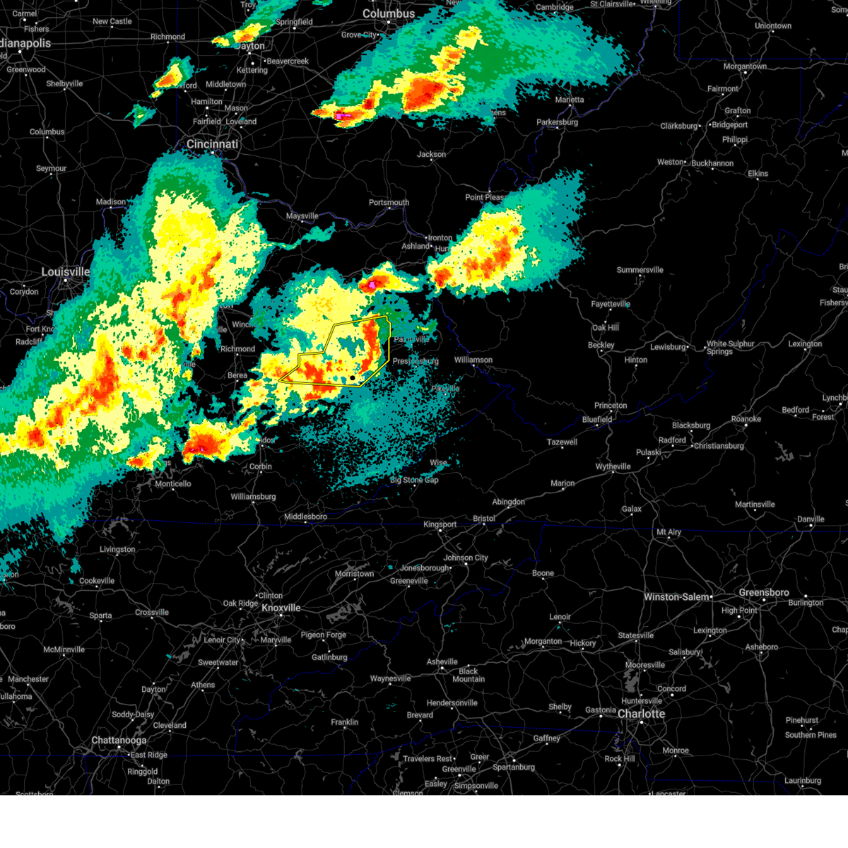
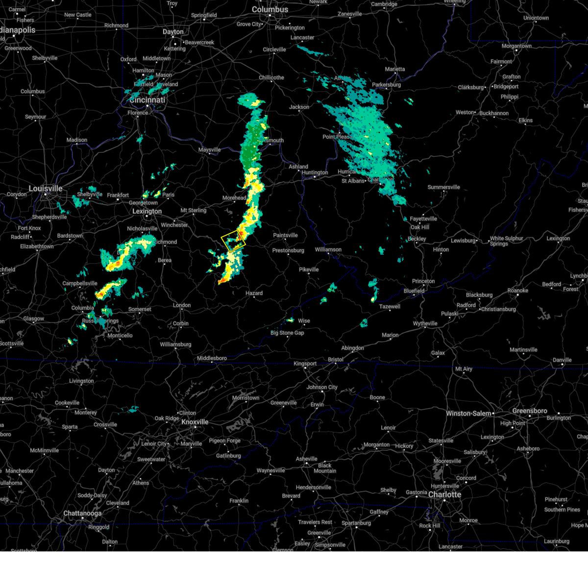
| 5/20/2025 10:19 PM EDT | A large tree and powerlines were reported to have been blown down between mm 12 and the red river elementary school. the event time is radar estimate in wolfe county KY, 1.6 miles WNW of Hazel Green, KY |
| 5/20/2025 10:03 PM EDT |
 the severe thunderstorm warning has been cancelled and is no longer in effect the severe thunderstorm warning has been cancelled and is no longer in effect
|
| 5/20/2025 10:03 PM EDT |
 At 1002 pm edt, severe thunderstorms were located along a line extending from near cat creek to bowen to nada to pine ridge to grannie to canyon falls to cowcreek, moving east at 45 mph (radar indicated). Hazards include 60 mph wind gusts and penny size hail. Expect damage to roofs, siding, and trees. Locations impacted include, jackson, wellington, payton and henry. At 1002 pm edt, severe thunderstorms were located along a line extending from near cat creek to bowen to nada to pine ridge to grannie to canyon falls to cowcreek, moving east at 45 mph (radar indicated). Hazards include 60 mph wind gusts and penny size hail. Expect damage to roofs, siding, and trees. Locations impacted include, jackson, wellington, payton and henry.
|
| 5/20/2025 9:34 PM EDT |
 Svrjkl the national weather service in jackson ky has issued a * severe thunderstorm warning for, powell county in east central kentucky, southwestern morgan county in southeastern kentucky, northern owsley county in southeastern kentucky, estill county in east central kentucky, northern jackson county in southeastern kentucky, menifee county in east central kentucky, northwestern breathitt county in southeastern kentucky, west central magoffin county in southeastern kentucky, lee county in southeastern kentucky, wolfe county in southeastern kentucky, * until 1030 pm edt. * at 934 pm edt, severe thunderstorms were located along a line extending from near palmer to harris ferry to fox to north irvine to wagersville to wind cave to hurley, moving east at 40 mph (radar indicated). Hazards include 60 mph wind gusts and penny size hail. Expect damage to roofs, siding, and trees. severe thunderstorms will be near, irvine around 940 pm edt. stanton around 945 pm edt. booneville around 950 pm edt. Other locations in the path of these severe thunderstorms include fincastle, campton and fagan. Svrjkl the national weather service in jackson ky has issued a * severe thunderstorm warning for, powell county in east central kentucky, southwestern morgan county in southeastern kentucky, northern owsley county in southeastern kentucky, estill county in east central kentucky, northern jackson county in southeastern kentucky, menifee county in east central kentucky, northwestern breathitt county in southeastern kentucky, west central magoffin county in southeastern kentucky, lee county in southeastern kentucky, wolfe county in southeastern kentucky, * until 1030 pm edt. * at 934 pm edt, severe thunderstorms were located along a line extending from near palmer to harris ferry to fox to north irvine to wagersville to wind cave to hurley, moving east at 40 mph (radar indicated). Hazards include 60 mph wind gusts and penny size hail. Expect damage to roofs, siding, and trees. severe thunderstorms will be near, irvine around 940 pm edt. stanton around 945 pm edt. booneville around 950 pm edt. Other locations in the path of these severe thunderstorms include fincastle, campton and fagan.
|
| 5/20/2025 4:10 PM EDT |
 The storms which prompted the warning have moved out of the area. therefore, the warning will be allowed to expire. a tornado watch remains in effect until 800 pm edt for southeastern and east central kentucky. to report severe weather, contact your nearest law enforcement agency. they will relay your report to the national weather service jackson ky. The storms which prompted the warning have moved out of the area. therefore, the warning will be allowed to expire. a tornado watch remains in effect until 800 pm edt for southeastern and east central kentucky. to report severe weather, contact your nearest law enforcement agency. they will relay your report to the national weather service jackson ky.
|
| 5/20/2025 3:48 PM EDT |
 the severe thunderstorm warning has been cancelled and is no longer in effect the severe thunderstorm warning has been cancelled and is no longer in effect
|
| 5/20/2025 3:48 PM EDT |
 At 347 pm edt, severe thunderstorms were located along a line extending from cranston to omer to landsaw to oakdale, moving east at 40 mph (radar indicated). Hazards include 60 mph wind gusts and penny size hail. Expect damage to roofs, siding, and trees. these severe storms will be near, west liberty around 355 pm edt. haginsville around 400 pm edt. Other locations impacted by these severe thunderstorms include lakeview heights. At 347 pm edt, severe thunderstorms were located along a line extending from cranston to omer to landsaw to oakdale, moving east at 40 mph (radar indicated). Hazards include 60 mph wind gusts and penny size hail. Expect damage to roofs, siding, and trees. these severe storms will be near, west liberty around 355 pm edt. haginsville around 400 pm edt. Other locations impacted by these severe thunderstorms include lakeview heights.
|
| 5/20/2025 3:24 PM EDT |
 Svrjkl the national weather service in jackson ky has issued a * severe thunderstorm warning for, eastern powell county in east central kentucky, southeastern bath county in east central kentucky, morgan county in southeastern kentucky, east central estill county in east central kentucky, menifee county in east central kentucky, northwestern breathitt county in southeastern kentucky, lee county in southeastern kentucky, southern rowan county in east central kentucky, wolfe county in southeastern kentucky, northwestern elliott county in east central kentucky, * until 415 pm edt. * at 323 pm edt, severe thunderstorms were located along a line extending from polksville to white ash, moving east at 35 mph (radar indicated). Hazards include 60 mph wind gusts and penny size hail. Expect damage to roofs, siding, and trees. severe thunderstorms will be near, morehead around 330 pm edt. wellington around 335 pm edt. murphyfork around 340 pm edt. craney around 345 pm edt. simpson around 350 pm edt. west liberty around 355 pm edt. Other locations impacted by these severe thunderstorms include lakeview heights. Svrjkl the national weather service in jackson ky has issued a * severe thunderstorm warning for, eastern powell county in east central kentucky, southeastern bath county in east central kentucky, morgan county in southeastern kentucky, east central estill county in east central kentucky, menifee county in east central kentucky, northwestern breathitt county in southeastern kentucky, lee county in southeastern kentucky, southern rowan county in east central kentucky, wolfe county in southeastern kentucky, northwestern elliott county in east central kentucky, * until 415 pm edt. * at 323 pm edt, severe thunderstorms were located along a line extending from polksville to white ash, moving east at 35 mph (radar indicated). Hazards include 60 mph wind gusts and penny size hail. Expect damage to roofs, siding, and trees. severe thunderstorms will be near, morehead around 330 pm edt. wellington around 335 pm edt. murphyfork around 340 pm edt. craney around 345 pm edt. simpson around 350 pm edt. west liberty around 355 pm edt. Other locations impacted by these severe thunderstorms include lakeview heights.
|
| 5/17/2025 12:00 AM EDT |
 At 1200 am edt, severe thunderstorms were located along a line extending from rosslyn to mill springs, moving east at 35 mph (radar indicated). Hazards include 60 mph wind gusts and penny size hail. Expect damage to roofs, siding, and trees. Locations impacted include, somerset, lakes, mckee, new zion, beattyville and london. At 1200 am edt, severe thunderstorms were located along a line extending from rosslyn to mill springs, moving east at 35 mph (radar indicated). Hazards include 60 mph wind gusts and penny size hail. Expect damage to roofs, siding, and trees. Locations impacted include, somerset, lakes, mckee, new zion, beattyville and london.
|
| 5/16/2025 11:35 PM EDT |
 Svrjkl the national weather service in jackson ky has issued a * severe thunderstorm warning for, powell county in east central kentucky, laurel county in south central kentucky, owsley county in southeastern kentucky, estill county in east central kentucky, pulaski county in south central kentucky, jackson county in southeastern kentucky, rockcastle county in south central kentucky, northwestern breathitt county in southeastern kentucky, lee county in southeastern kentucky, wolfe county in southeastern kentucky, northwestern clay county in southeastern kentucky, * until 1215 am edt. * at 1135 pm edt, severe thunderstorms were located along a line extending from palmer to near jamestown, moving east at 35 mph (radar indicated). Hazards include 60 mph wind gusts and penny size hail. Expect damage to roofs, siding, and trees. severe thunderstorms will be near, mount vernon around 1140 pm edt. somerset around 1145 pm edt. ravenna around 1150 pm edt. burnside around 1155 pm edt. Other locations in the path of these severe thunderstorms include jep hill and grade. Svrjkl the national weather service in jackson ky has issued a * severe thunderstorm warning for, powell county in east central kentucky, laurel county in south central kentucky, owsley county in southeastern kentucky, estill county in east central kentucky, pulaski county in south central kentucky, jackson county in southeastern kentucky, rockcastle county in south central kentucky, northwestern breathitt county in southeastern kentucky, lee county in southeastern kentucky, wolfe county in southeastern kentucky, northwestern clay county in southeastern kentucky, * until 1215 am edt. * at 1135 pm edt, severe thunderstorms were located along a line extending from palmer to near jamestown, moving east at 35 mph (radar indicated). Hazards include 60 mph wind gusts and penny size hail. Expect damage to roofs, siding, and trees. severe thunderstorms will be near, mount vernon around 1140 pm edt. somerset around 1145 pm edt. ravenna around 1150 pm edt. burnside around 1155 pm edt. Other locations in the path of these severe thunderstorms include jep hill and grade.
|
| 5/16/2025 10:54 PM EDT |
 The storms which prompted the warning have moved out of the area. therefore, the warning will be allowed to expire. a new warning was issued. a tornado watch remains in effect until 300 am edt for southeastern, northeastern and east central kentucky. The storms which prompted the warning have moved out of the area. therefore, the warning will be allowed to expire. a new warning was issued. a tornado watch remains in effect until 300 am edt for southeastern, northeastern and east central kentucky.
|
| 5/16/2025 10:40 PM EDT |
 At 1040 pm edt, severe thunderstorms were located along a line extending from licking river to shockey to canyon falls, moving east at 70 mph (radar indicated). Hazards include 70 mph wind gusts and quarter size hail. Hail damage to vehicles is expected. expect considerable tree damage. wind damage is also likely to mobile homes, roofs, and outbuildings. these severe storms will be near, west liberty around 1045 pm edt. Other locations in the path of these severe thunderstorms include salyersville and sikes. At 1040 pm edt, severe thunderstorms were located along a line extending from licking river to shockey to canyon falls, moving east at 70 mph (radar indicated). Hazards include 70 mph wind gusts and quarter size hail. Hail damage to vehicles is expected. expect considerable tree damage. wind damage is also likely to mobile homes, roofs, and outbuildings. these severe storms will be near, west liberty around 1045 pm edt. Other locations in the path of these severe thunderstorms include salyersville and sikes.
|
| 5/16/2025 10:25 PM EDT |
 Svrjkl the national weather service in jackson ky has issued a * severe thunderstorm warning for, eastern powell county in east central kentucky, morgan county in southeastern kentucky, southeastern estill county in east central kentucky, southern menifee county in east central kentucky, northwestern breathitt county in southeastern kentucky, magoffin county in southeastern kentucky, lee county in southeastern kentucky, wolfe county in southeastern kentucky, * until 1100 pm edt. * at 1025 pm edt, severe thunderstorms were located along a line extending from mariba to booth to near yellow rock, moving east at 70 mph (radar indicated). Hazards include 70 mph wind gusts and quarter size hail. Hail damage to vehicles is expected. expect considerable tree damage. wind damage is also likely to mobile homes, roofs, and outbuildings. severe thunderstorms will be near, beattyville around 1030 pm edt. west liberty around 1035 pm edt. jackson around 1040 pm edt. salyersville around 1045 pm edt. Other locations in the path of these severe thunderstorms include cyrus. Svrjkl the national weather service in jackson ky has issued a * severe thunderstorm warning for, eastern powell county in east central kentucky, morgan county in southeastern kentucky, southeastern estill county in east central kentucky, southern menifee county in east central kentucky, northwestern breathitt county in southeastern kentucky, magoffin county in southeastern kentucky, lee county in southeastern kentucky, wolfe county in southeastern kentucky, * until 1100 pm edt. * at 1025 pm edt, severe thunderstorms were located along a line extending from mariba to booth to near yellow rock, moving east at 70 mph (radar indicated). Hazards include 70 mph wind gusts and quarter size hail. Hail damage to vehicles is expected. expect considerable tree damage. wind damage is also likely to mobile homes, roofs, and outbuildings. severe thunderstorms will be near, beattyville around 1030 pm edt. west liberty around 1035 pm edt. jackson around 1040 pm edt. salyersville around 1045 pm edt. Other locations in the path of these severe thunderstorms include cyrus.
|
| 4/30/2025 6:06 PM EDT |
 At 606 pm edt, a severe thunderstorm was located over lower gilmore, or 10 miles east of campton, moving northeast at 20 mph (radar indicated). Hazards include 60 mph wind gusts and quarter size hail. Hail damage to vehicles is expected. expect wind damage to roofs, siding, and trees. this severe storm will be near, payton around 610 pm edt. Other locations in the path of this severe thunderstorm include caney, well station, gordon ford and williams. At 606 pm edt, a severe thunderstorm was located over lower gilmore, or 10 miles east of campton, moving northeast at 20 mph (radar indicated). Hazards include 60 mph wind gusts and quarter size hail. Hail damage to vehicles is expected. expect wind damage to roofs, siding, and trees. this severe storm will be near, payton around 610 pm edt. Other locations in the path of this severe thunderstorm include caney, well station, gordon ford and williams.
|
| 4/30/2025 6:06 PM EDT |
 the severe thunderstorm warning has been cancelled and is no longer in effect the severe thunderstorm warning has been cancelled and is no longer in effect
|
| 4/30/2025 5:52 PM EDT |
 Svrjkl the national weather service in jackson ky has issued a * severe thunderstorm warning for, southwestern morgan county in southeastern kentucky, north central breathitt county in southeastern kentucky, northwestern magoffin county in southeastern kentucky, eastern wolfe county in southeastern kentucky, * until 630 pm edt. * at 552 pm edt, a severe thunderstorm was located over malaga, or 7 miles east of campton, moving northeast at 20 mph (radar indicated). Hazards include 60 mph wind gusts and quarter size hail. Hail damage to vehicles is expected. expect wind damage to roofs, siding, and trees. this severe thunderstorm will be near, helechawa around 600 pm edt. payton around 605 pm edt. rexville around 610 pm edt. Other locations in the path of this severe thunderstorm include caney. Svrjkl the national weather service in jackson ky has issued a * severe thunderstorm warning for, southwestern morgan county in southeastern kentucky, north central breathitt county in southeastern kentucky, northwestern magoffin county in southeastern kentucky, eastern wolfe county in southeastern kentucky, * until 630 pm edt. * at 552 pm edt, a severe thunderstorm was located over malaga, or 7 miles east of campton, moving northeast at 20 mph (radar indicated). Hazards include 60 mph wind gusts and quarter size hail. Hail damage to vehicles is expected. expect wind damage to roofs, siding, and trees. this severe thunderstorm will be near, helechawa around 600 pm edt. payton around 605 pm edt. rexville around 610 pm edt. Other locations in the path of this severe thunderstorm include caney.
|
| 4/14/2025 7:26 PM EDT |
 The storm which prompted the warning will have a new warning issued on it. therefore, the warning will be allowed to expire. a severe thunderstorm watch remains in effect until 1100 pm edt for southeastern and east central kentucky. to report severe weather, contact your nearest law enforcement agency. they will relay your report to the national weather service jackson ky. remember, a severe thunderstorm warning still remains in effect for portions of the warned area until 8 pm. The storm which prompted the warning will have a new warning issued on it. therefore, the warning will be allowed to expire. a severe thunderstorm watch remains in effect until 1100 pm edt for southeastern and east central kentucky. to report severe weather, contact your nearest law enforcement agency. they will relay your report to the national weather service jackson ky. remember, a severe thunderstorm warning still remains in effect for portions of the warned area until 8 pm.
|
| 4/14/2025 7:15 PM EDT |
 the severe thunderstorm warning has been cancelled and is no longer in effect the severe thunderstorm warning has been cancelled and is no longer in effect
|
| 4/14/2025 7:15 PM EDT |
 At 715 pm edt, a severe thunderstorm was located over zachariah, or 7 miles west of campton, moving east at 55 mph (radar indicated). Hazards include 60 mph wind gusts and quarter size hail. Hail damage to vehicles is expected. expect wind damage to roofs, siding, and trees. this severe storm will be near, campton around 720 pm edt. stillwater around 725 pm edt. Other locations in the path of this severe thunderstorm include lower gilmore, helechawa and payton. At 715 pm edt, a severe thunderstorm was located over zachariah, or 7 miles west of campton, moving east at 55 mph (radar indicated). Hazards include 60 mph wind gusts and quarter size hail. Hail damage to vehicles is expected. expect wind damage to roofs, siding, and trees. this severe storm will be near, campton around 720 pm edt. stillwater around 725 pm edt. Other locations in the path of this severe thunderstorm include lower gilmore, helechawa and payton.
|
| 4/14/2025 7:05 PM EDT |
 Svrjkl the national weather service in jackson ky has issued a * severe thunderstorm warning for, southeastern powell county in east central kentucky, southwestern morgan county in southeastern kentucky, central estill county in east central kentucky, northwestern breathitt county in southeastern kentucky, lee county in southeastern kentucky, wolfe county in southeastern kentucky, * until 730 pm edt. * at 704 pm edt, a severe thunderstorm was located over pryse, or near irvine, moving east at 55 mph (radar indicated). Hazards include 60 mph wind gusts and quarter size hail. Hail damage to vehicles is expected. expect wind damage to roofs, siding, and trees. this severe thunderstorm will be near, old landing around 710 pm edt. torrent around 715 pm edt. campton around 720 pm edt. Other locations in the path of this severe thunderstorm include stillwater. Svrjkl the national weather service in jackson ky has issued a * severe thunderstorm warning for, southeastern powell county in east central kentucky, southwestern morgan county in southeastern kentucky, central estill county in east central kentucky, northwestern breathitt county in southeastern kentucky, lee county in southeastern kentucky, wolfe county in southeastern kentucky, * until 730 pm edt. * at 704 pm edt, a severe thunderstorm was located over pryse, or near irvine, moving east at 55 mph (radar indicated). Hazards include 60 mph wind gusts and quarter size hail. Hail damage to vehicles is expected. expect wind damage to roofs, siding, and trees. this severe thunderstorm will be near, old landing around 710 pm edt. torrent around 715 pm edt. campton around 720 pm edt. Other locations in the path of this severe thunderstorm include stillwater.
|
| 4/3/2025 5:39 AM EDT |
 Svrjkl the national weather service in jackson ky has issued a * severe thunderstorm warning for, southwestern morgan county in southeastern kentucky, owsley county in southeastern kentucky, northwestern perry county in southeastern kentucky, northwestern knott county in southeastern kentucky, southeastern menifee county in east central kentucky, breathitt county in southeastern kentucky, southern magoffin county in southeastern kentucky, lee county in southeastern kentucky, wolfe county in southeastern kentucky, north central clay county in southeastern kentucky, * until 615 am edt. * at 539 am edt, a severe thunderstorm was located over jetts creek, or near booneville, moving northeast at 65 mph (radar indicated). Hazards include 60 mph wind gusts. Expect damage to roofs, siding, and trees. this severe thunderstorm will be near, chenowee around 545 am edt. dumont around 550 am edt. mountain valley around 555 am edt. Other locations in the path of this severe thunderstorm include hendricks and ova. Svrjkl the national weather service in jackson ky has issued a * severe thunderstorm warning for, southwestern morgan county in southeastern kentucky, owsley county in southeastern kentucky, northwestern perry county in southeastern kentucky, northwestern knott county in southeastern kentucky, southeastern menifee county in east central kentucky, breathitt county in southeastern kentucky, southern magoffin county in southeastern kentucky, lee county in southeastern kentucky, wolfe county in southeastern kentucky, north central clay county in southeastern kentucky, * until 615 am edt. * at 539 am edt, a severe thunderstorm was located over jetts creek, or near booneville, moving northeast at 65 mph (radar indicated). Hazards include 60 mph wind gusts. Expect damage to roofs, siding, and trees. this severe thunderstorm will be near, chenowee around 545 am edt. dumont around 550 am edt. mountain valley around 555 am edt. Other locations in the path of this severe thunderstorm include hendricks and ova.
|
| 4/3/2025 4:47 AM EDT |
 The storms which prompted the warning have moved out of the area. therefore, the warning has been allowed to expire. however, gusty winds and heavy rain are still possible with these thunderstorms. a tornado watch remains in effect until 700 am edt for southeastern, northeastern and east central kentucky. to report severe weather, contact your nearest law enforcement agency. they will relay your report to the national weather service jackson ky. The storms which prompted the warning have moved out of the area. therefore, the warning has been allowed to expire. however, gusty winds and heavy rain are still possible with these thunderstorms. a tornado watch remains in effect until 700 am edt for southeastern, northeastern and east central kentucky. to report severe weather, contact your nearest law enforcement agency. they will relay your report to the national weather service jackson ky.
|
| 4/3/2025 4:35 AM EDT |
 At 434 am edt, severe thunderstorms were located along a line extending from near webbville to wheelersburg to rousseau, moving east at 65 mph (radar indicated). Hazards include 60 mph wind gusts and nickel size hail. Expect damage to roofs, siding, and trees. Locations impacted include, win and skaggs. At 434 am edt, severe thunderstorms were located along a line extending from near webbville to wheelersburg to rousseau, moving east at 65 mph (radar indicated). Hazards include 60 mph wind gusts and nickel size hail. Expect damage to roofs, siding, and trees. Locations impacted include, win and skaggs.
|
| 4/3/2025 4:35 AM EDT |
 the severe thunderstorm warning has been cancelled and is no longer in effect the severe thunderstorm warning has been cancelled and is no longer in effect
|
| 4/3/2025 4:21 AM EDT |
 The storms which prompted the warning have moved out of the area. therefore, the warning will be allowed to expire. however, small hail and gusty winds are still possible with these thunderstorms. a tornado watch remains in effect until 700 am edt for southeastern and east central kentucky. The storms which prompted the warning have moved out of the area. therefore, the warning will be allowed to expire. however, small hail and gusty winds are still possible with these thunderstorms. a tornado watch remains in effect until 700 am edt for southeastern and east central kentucky.
|
| 4/3/2025 4:12 AM EDT |
 Svrjkl the national weather service in jackson ky has issued a * severe thunderstorm warning for, morgan county in southeastern kentucky, northern owsley county in southeastern kentucky, northwestern johnson county in northeastern kentucky, southeastern menifee county in east central kentucky, northwestern breathitt county in southeastern kentucky, magoffin county in southeastern kentucky, eastern lee county in southeastern kentucky, southeastern rowan county in east central kentucky, wolfe county in southeastern kentucky, elliott county in east central kentucky, * until 445 am edt. * at 412 am edt, severe thunderstorms were located along a line extending from blairs mills to lexie to stay, moving east at 65 mph (radar indicated). Hazards include 60 mph wind gusts. Expect damage to roofs, siding, and trees. severe thunderstorms will be near, tallega around 415 am edt. harper around 420 am edt. mima around 425 am edt. win around 430 am edt. Other locations in the path of these severe thunderstorms include sip. Svrjkl the national weather service in jackson ky has issued a * severe thunderstorm warning for, morgan county in southeastern kentucky, northern owsley county in southeastern kentucky, northwestern johnson county in northeastern kentucky, southeastern menifee county in east central kentucky, northwestern breathitt county in southeastern kentucky, magoffin county in southeastern kentucky, eastern lee county in southeastern kentucky, southeastern rowan county in east central kentucky, wolfe county in southeastern kentucky, elliott county in east central kentucky, * until 445 am edt. * at 412 am edt, severe thunderstorms were located along a line extending from blairs mills to lexie to stay, moving east at 65 mph (radar indicated). Hazards include 60 mph wind gusts. Expect damage to roofs, siding, and trees. severe thunderstorms will be near, tallega around 415 am edt. harper around 420 am edt. mima around 425 am edt. win around 430 am edt. Other locations in the path of these severe thunderstorms include sip.
|
| 4/3/2025 4:05 AM EDT |
 At 404 am edt, severe thunderstorms were located along a line extending from near olive hill to dan to near vada to near privett, moving east at 75 mph (radar indicated). Hazards include 60 mph wind gusts. Expect damage to roofs, siding, and trees. Locations impacted include, tallega. At 404 am edt, severe thunderstorms were located along a line extending from near olive hill to dan to near vada to near privett, moving east at 75 mph (radar indicated). Hazards include 60 mph wind gusts. Expect damage to roofs, siding, and trees. Locations impacted include, tallega.
|
| 4/3/2025 4:05 AM EDT |
 the severe thunderstorm warning has been cancelled and is no longer in effect the severe thunderstorm warning has been cancelled and is no longer in effect
|
| 4/3/2025 3:46 AM EDT |
 Svrjkl the national weather service in jackson ky has issued a * severe thunderstorm warning for, southeastern montgomery county in east central kentucky, northwestern owsley county in southeastern kentucky, northern jackson county in southeastern kentucky, menifee county in east central kentucky, lee county in southeastern kentucky, rowan county in east central kentucky, wolfe county in southeastern kentucky, powell county in east central kentucky, southeastern bath county in east central kentucky, western morgan county in southeastern kentucky, estill county in east central kentucky, east central rockcastle county in south central kentucky, western elliott county in east central kentucky, * until 430 am edt. * at 346 am edt, severe thunderstorms were located along a line extending from cranston to near means to alumbaugh to dudley station, moving northeast at 90 mph (radar indicated). Hazards include 60 mph wind gusts. Expect damage to roofs, siding, and trees. severe thunderstorms will be near, midland around 350 am edt. pomeroyton around 355 am edt. new zion around 400 am edt. pekin around 405 am edt. Other locations in the path of these severe thunderstorms include pomp and vada. Svrjkl the national weather service in jackson ky has issued a * severe thunderstorm warning for, southeastern montgomery county in east central kentucky, northwestern owsley county in southeastern kentucky, northern jackson county in southeastern kentucky, menifee county in east central kentucky, lee county in southeastern kentucky, rowan county in east central kentucky, wolfe county in southeastern kentucky, powell county in east central kentucky, southeastern bath county in east central kentucky, western morgan county in southeastern kentucky, estill county in east central kentucky, east central rockcastle county in south central kentucky, western elliott county in east central kentucky, * until 430 am edt. * at 346 am edt, severe thunderstorms were located along a line extending from cranston to near means to alumbaugh to dudley station, moving northeast at 90 mph (radar indicated). Hazards include 60 mph wind gusts. Expect damage to roofs, siding, and trees. severe thunderstorms will be near, midland around 350 am edt. pomeroyton around 355 am edt. new zion around 400 am edt. pekin around 405 am edt. Other locations in the path of these severe thunderstorms include pomp and vada.
|
| 3/31/2025 1:23 AM EDT |
 The storms which prompted the warning have moved out of the area. therefore, the warning will be allowed to expire. however, small hail and gusty winds are still possible with these thunderstorms. a severe thunderstorm watch remains in effect until 600 am edt for southeastern, northeastern and east central kentucky. The storms which prompted the warning have moved out of the area. therefore, the warning will be allowed to expire. however, small hail and gusty winds are still possible with these thunderstorms. a severe thunderstorm watch remains in effect until 600 am edt for southeastern, northeastern and east central kentucky.
|
| 3/31/2025 1:14 AM EDT |
 At 114 am edt, severe thunderstorms were located along a line extending from near isonville to licking river to lexie to elkatawa, moving east at 35 mph (radar indicated). Hazards include 60 mph wind gusts. Expect damage to roofs, siding, and trees. Locations impacted include, payton, harper and kernie. At 114 am edt, severe thunderstorms were located along a line extending from near isonville to licking river to lexie to elkatawa, moving east at 35 mph (radar indicated). Hazards include 60 mph wind gusts. Expect damage to roofs, siding, and trees. Locations impacted include, payton, harper and kernie.
|
| 3/31/2025 1:14 AM EDT |
 the severe thunderstorm warning has been cancelled and is no longer in effect the severe thunderstorm warning has been cancelled and is no longer in effect
|
| 3/31/2025 12:58 AM EDT |
 Svrjkl the national weather service in jackson ky has issued a * severe thunderstorm warning for, southeastern powell county in east central kentucky, morgan county in southeastern kentucky, northwestern johnson county in northeastern kentucky, eastern menifee county in east central kentucky, northwestern breathitt county in southeastern kentucky, northwestern magoffin county in southeastern kentucky, central lee county in southeastern kentucky, south central rowan county in east central kentucky, wolfe county in southeastern kentucky, southwestern elliott county in east central kentucky, * until 130 am edt. * at 1257 am edt, severe thunderstorms were located along a line extending from big woods to belle point, moving east at 35 mph (radar indicated). Hazards include 60 mph wind gusts. Expect damage to roofs, siding, and trees. severe thunderstorms will be near, stillwater around 105 am edt. daysboro around 110 am edt. Payton around 115 am edt. Svrjkl the national weather service in jackson ky has issued a * severe thunderstorm warning for, southeastern powell county in east central kentucky, morgan county in southeastern kentucky, northwestern johnson county in northeastern kentucky, eastern menifee county in east central kentucky, northwestern breathitt county in southeastern kentucky, northwestern magoffin county in southeastern kentucky, central lee county in southeastern kentucky, south central rowan county in east central kentucky, wolfe county in southeastern kentucky, southwestern elliott county in east central kentucky, * until 130 am edt. * at 1257 am edt, severe thunderstorms were located along a line extending from big woods to belle point, moving east at 35 mph (radar indicated). Hazards include 60 mph wind gusts. Expect damage to roofs, siding, and trees. severe thunderstorms will be near, stillwater around 105 am edt. daysboro around 110 am edt. Payton around 115 am edt.
|
| 3/31/2025 12:56 AM EDT |
 The storms which prompted the warning have moved out of the area. therefore, the warning will be allowed to expire. however, small hail and gusty winds are still possible with these thunderstorms. a severe thunderstorm watch remains in effect until 600 am edt for south central, southeastern and east central kentucky. The storms which prompted the warning have moved out of the area. therefore, the warning will be allowed to expire. however, small hail and gusty winds are still possible with these thunderstorms. a severe thunderstorm watch remains in effect until 600 am edt for south central, southeastern and east central kentucky.
|
| 3/31/2025 12:22 AM EDT |
 Svrjkl the national weather service in jackson ky has issued a * severe thunderstorm warning for, owsley county in southeastern kentucky, jackson county in southeastern kentucky, south central menifee county in east central kentucky, lee county in southeastern kentucky, wolfe county in southeastern kentucky, southeastern powell county in east central kentucky, northeastern laurel county in south central kentucky, southwestern morgan county in southeastern kentucky, southeastern estill county in east central kentucky, east central rockcastle county in south central kentucky, northwestern breathitt county in southeastern kentucky, northwestern magoffin county in southeastern kentucky, northwestern clay county in southeastern kentucky, * until 100 am edt. * at 1222 am edt, severe thunderstorms were located along a line extending from lombard to pine hill, moving east at 40 mph (radar indicated). Hazards include 60 mph wind gusts and penny size hail. Expect damage to roofs, siding, and trees. severe thunderstorms will be near, torrent around 1230 am edt. atkinstown around 1235 am edt. stillwater around 1240 am edt. Other locations in the path of these severe thunderstorms include sturgeon. Svrjkl the national weather service in jackson ky has issued a * severe thunderstorm warning for, owsley county in southeastern kentucky, jackson county in southeastern kentucky, south central menifee county in east central kentucky, lee county in southeastern kentucky, wolfe county in southeastern kentucky, southeastern powell county in east central kentucky, northeastern laurel county in south central kentucky, southwestern morgan county in southeastern kentucky, southeastern estill county in east central kentucky, east central rockcastle county in south central kentucky, northwestern breathitt county in southeastern kentucky, northwestern magoffin county in southeastern kentucky, northwestern clay county in southeastern kentucky, * until 100 am edt. * at 1222 am edt, severe thunderstorms were located along a line extending from lombard to pine hill, moving east at 40 mph (radar indicated). Hazards include 60 mph wind gusts and penny size hail. Expect damage to roofs, siding, and trees. severe thunderstorms will be near, torrent around 1230 am edt. atkinstown around 1235 am edt. stillwater around 1240 am edt. Other locations in the path of these severe thunderstorms include sturgeon.
|
| 12/31/2024 9:38 AM EST |
 The storm which prompted the warning has weakened below severe limits, and has exited the warned area. therefore, the warning will be allowed to expire. however, small hail and gusty winds are still possible with this thunderstorm. The storm which prompted the warning has weakened below severe limits, and has exited the warned area. therefore, the warning will be allowed to expire. however, small hail and gusty winds are still possible with this thunderstorm.
|
| 12/31/2024 9:28 AM EST |
 the severe thunderstorm warning has been cancelled and is no longer in effect the severe thunderstorm warning has been cancelled and is no longer in effect
|
| 12/31/2024 9:28 AM EST |
 At 928 am est, a severe thunderstorm was located over toliver, or 8 miles northeast of campton, moving northeast at 50 mph (radar indicated). Hazards include 60 mph wind gusts and penny size hail. Expect damage to roofs, siding, and trees. Locations impacted include, rexville. At 928 am est, a severe thunderstorm was located over toliver, or 8 miles northeast of campton, moving northeast at 50 mph (radar indicated). Hazards include 60 mph wind gusts and penny size hail. Expect damage to roofs, siding, and trees. Locations impacted include, rexville.
|
| 12/31/2024 9:14 AM EST |
 At 913 am est, a severe thunderstorm was located over grannie, or near campton, moving east at 50 mph (radar indicated). Hazards include 60 mph wind gusts and penny size hail. Expect damage to roofs, siding, and trees. this severe storm will be near, campton around 920 am est. Other locations in the path of this severe thunderstorm include helechawa and daysboro. At 913 am est, a severe thunderstorm was located over grannie, or near campton, moving east at 50 mph (radar indicated). Hazards include 60 mph wind gusts and penny size hail. Expect damage to roofs, siding, and trees. this severe storm will be near, campton around 920 am est. Other locations in the path of this severe thunderstorm include helechawa and daysboro.
|
| 12/31/2024 9:14 AM EST |
 the severe thunderstorm warning has been cancelled and is no longer in effect the severe thunderstorm warning has been cancelled and is no longer in effect
|
| 12/31/2024 9:00 AM EST |
 Svrjkl the national weather service in jackson ky has issued a * severe thunderstorm warning for, southeastern powell county in east central kentucky, southwestern morgan county in southeastern kentucky, southeastern estill county in east central kentucky, south central menifee county in east central kentucky, northern lee county in southeastern kentucky, wolfe county in southeastern kentucky, * until 945 am est. * at 900 am est, a severe thunderstorm was located over crystal, or near beattyville, moving east at 50 mph (radar indicated). Hazards include 60 mph wind gusts and penny size hail. Expect damage to roofs, siding, and trees. this severe thunderstorm will be near, fincastle around 905 am est. grannie around 910 am est. campton around 915 am est. stillwater around 920 am est. Other locations in the path of this severe thunderstorm include helechawa and sellars. Svrjkl the national weather service in jackson ky has issued a * severe thunderstorm warning for, southeastern powell county in east central kentucky, southwestern morgan county in southeastern kentucky, southeastern estill county in east central kentucky, south central menifee county in east central kentucky, northern lee county in southeastern kentucky, wolfe county in southeastern kentucky, * until 945 am est. * at 900 am est, a severe thunderstorm was located over crystal, or near beattyville, moving east at 50 mph (radar indicated). Hazards include 60 mph wind gusts and penny size hail. Expect damage to roofs, siding, and trees. this severe thunderstorm will be near, fincastle around 905 am est. grannie around 910 am est. campton around 915 am est. stillwater around 920 am est. Other locations in the path of this severe thunderstorm include helechawa and sellars.
|
| 8/17/2024 5:34 PM EDT |
 At 534 pm edt, severe thunderstorms were located along a line extending from lower gilmore to hollonville to primrose, moving east at 35 mph (radar indicated). Hazards include 60 mph wind gusts and quarter size hail. Hail damage to vehicles is expected. expect wind damage to roofs, siding, and trees. Locations impacted include, jackson and jetts creek. At 534 pm edt, severe thunderstorms were located along a line extending from lower gilmore to hollonville to primrose, moving east at 35 mph (radar indicated). Hazards include 60 mph wind gusts and quarter size hail. Hail damage to vehicles is expected. expect wind damage to roofs, siding, and trees. Locations impacted include, jackson and jetts creek.
|
| 8/17/2024 5:31 PM EDT |
 The storms which prompted the warning have weakened below severe limits, and no longer pose an immediate threat to life or property. therefore, the warning has been allowed to expire. The storms which prompted the warning have weakened below severe limits, and no longer pose an immediate threat to life or property. therefore, the warning has been allowed to expire.
|
| 8/17/2024 5:21 PM EDT |
 At 521 pm edt, severe thunderstorms were located along a line extending from near moon to white oak to lexie, moving southeast at 30 mph (radar indicated). Hazards include 70 mph wind gusts and half dollar size hail. Hail damage to vehicles is expected. expect considerable tree damage. wind damage is also likely to mobile homes, roofs, and outbuildings. Locations impacted include, lewis. At 521 pm edt, severe thunderstorms were located along a line extending from near moon to white oak to lexie, moving southeast at 30 mph (radar indicated). Hazards include 70 mph wind gusts and half dollar size hail. Hail damage to vehicles is expected. expect considerable tree damage. wind damage is also likely to mobile homes, roofs, and outbuildings. Locations impacted include, lewis.
|
| 8/17/2024 5:21 PM EDT |
 the severe thunderstorm warning has been cancelled and is no longer in effect the severe thunderstorm warning has been cancelled and is no longer in effect
|
| 8/17/2024 5:06 PM EDT |
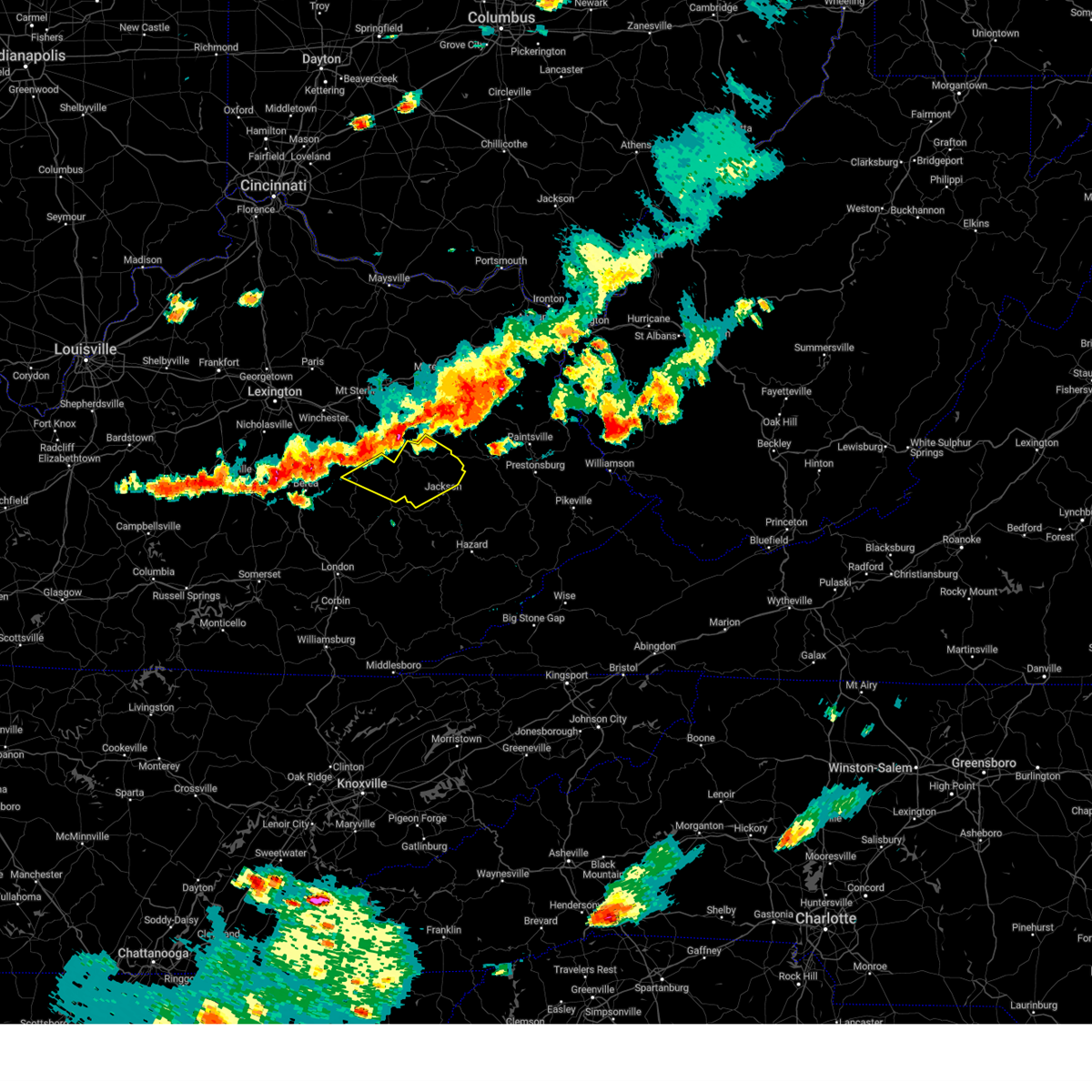 Svrjkl the national weather service in jackson ky has issued a * severe thunderstorm warning for, central estill county in east central kentucky, northwestern breathitt county in southeastern kentucky, lee county in southeastern kentucky, wolfe county in southeastern kentucky, * until 545 pm edt. * at 505 pm edt, severe thunderstorms were located along a line extending from red river gorge to see to pryse, moving east at 35 mph (radar indicated). Hazards include 60 mph wind gusts and quarter size hail. Hail damage to vehicles is expected. expect wind damage to roofs, siding, and trees. severe thunderstorms will be near, campton around 510 pm edt. beattyville around 515 pm edt. white ash around 520 pm edt. daysboro around 525 pm edt. Other locations in the path of these severe thunderstorms include simpson and rosefork. Svrjkl the national weather service in jackson ky has issued a * severe thunderstorm warning for, central estill county in east central kentucky, northwestern breathitt county in southeastern kentucky, lee county in southeastern kentucky, wolfe county in southeastern kentucky, * until 545 pm edt. * at 505 pm edt, severe thunderstorms were located along a line extending from red river gorge to see to pryse, moving east at 35 mph (radar indicated). Hazards include 60 mph wind gusts and quarter size hail. Hail damage to vehicles is expected. expect wind damage to roofs, siding, and trees. severe thunderstorms will be near, campton around 510 pm edt. beattyville around 515 pm edt. white ash around 520 pm edt. daysboro around 525 pm edt. Other locations in the path of these severe thunderstorms include simpson and rosefork.
|
| 8/17/2024 4:43 PM EDT |
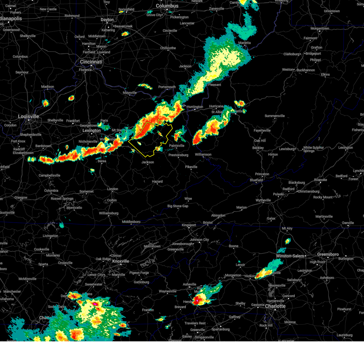 At 443 pm edt, severe thunderstorms were located along a line extending from wagner store to big woods to campsites in the indian creek area of the daniel boone national forrest, moving southeast at 30 mph (radar indicated). Hazards include 70 mph wind gusts and half dollar size hail. Hail damage to vehicles is expected. expect considerable tree damage. wind damage is also likely to mobile homes, roofs, and outbuildings. these severe storms will be near, sandy hook around 450 pm edt. west liberty around 455 pm edt. Other locations in the path of these severe thunderstorms include steele, lewis, moon and mima. At 443 pm edt, severe thunderstorms were located along a line extending from wagner store to big woods to campsites in the indian creek area of the daniel boone national forrest, moving southeast at 30 mph (radar indicated). Hazards include 70 mph wind gusts and half dollar size hail. Hail damage to vehicles is expected. expect considerable tree damage. wind damage is also likely to mobile homes, roofs, and outbuildings. these severe storms will be near, sandy hook around 450 pm edt. west liberty around 455 pm edt. Other locations in the path of these severe thunderstorms include steele, lewis, moon and mima.
|
| 8/17/2024 4:35 PM EDT |
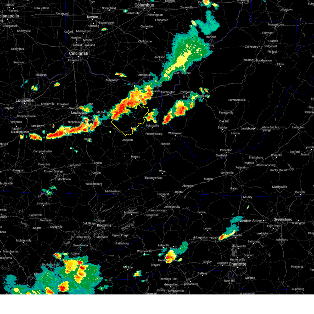 Svrjkl the national weather service in jackson ky has issued a * severe thunderstorm warning for, morgan county in southeastern kentucky, southeastern bath county in east central kentucky, menifee county in east central kentucky, southeastern rowan county in east central kentucky, central wolfe county in southeastern kentucky, elliott county in east central kentucky, * until 530 pm edt. * at 434 pm edt, severe thunderstorms were located along a line extending from christy to near yale to fagan, moving southeast at 30 mph (radar indicated). Hazards include 60 mph wind gusts and quarter size hail. Hail damage to vehicles is expected. expect wind damage to roofs, siding, and trees. severe thunderstorms will be near, frenchburg around 440 pm edt. stoll around 445 pm edt. henry around 450 pm edt. Other locations in the path of these severe thunderstorms include west liberty, steele and lewis. Svrjkl the national weather service in jackson ky has issued a * severe thunderstorm warning for, morgan county in southeastern kentucky, southeastern bath county in east central kentucky, menifee county in east central kentucky, southeastern rowan county in east central kentucky, central wolfe county in southeastern kentucky, elliott county in east central kentucky, * until 530 pm edt. * at 434 pm edt, severe thunderstorms were located along a line extending from christy to near yale to fagan, moving southeast at 30 mph (radar indicated). Hazards include 60 mph wind gusts and quarter size hail. Hail damage to vehicles is expected. expect wind damage to roofs, siding, and trees. severe thunderstorms will be near, frenchburg around 440 pm edt. stoll around 445 pm edt. henry around 450 pm edt. Other locations in the path of these severe thunderstorms include west liberty, steele and lewis.
|
| 8/1/2024 8:14 PM EDT | Dispatch reports tree blown down on ky-134 approximately 2 miles from the intersection with ky-191 at adele. event time estimate from rada in morgan county KY, 8.5 miles WNW of Hazel Green, KY |
| 8/1/2024 8:08 PM EDT |
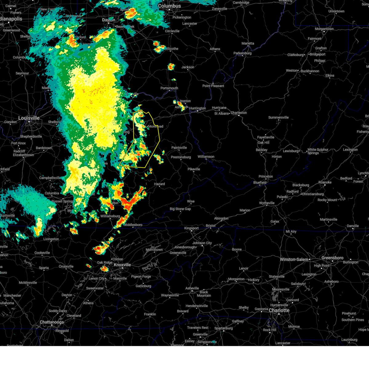 The storms which prompted the warning have moved out of the area. therefore, the warning will be allowed to expire. however, a new warning has been issued. a severe thunderstorm watch remains in effect until midnight edt for southeastern and east central kentucky. The storms which prompted the warning have moved out of the area. therefore, the warning will be allowed to expire. however, a new warning has been issued. a severe thunderstorm watch remains in effect until midnight edt for southeastern and east central kentucky.
|
| 8/1/2024 8:07 PM EDT |
 Svrjkl the national weather service in jackson ky has issued a * severe thunderstorm warning for, morgan county in southeastern kentucky, southeastern bath county in east central kentucky, northwestern johnson county in northeastern kentucky, eastern menifee county in east central kentucky, northern breathitt county in southeastern kentucky, magoffin county in southeastern kentucky, southeastern lee county in southeastern kentucky, east central fleming county in east central kentucky, rowan county in east central kentucky, wolfe county in southeastern kentucky, elliott county in east central kentucky, * until 845 pm edt. * at 807 pm edt, severe thunderstorms were located along a line extending from near waltz to dehart to athol, moving east at 35 mph (radar indicated). Hazards include 60 mph wind gusts. Expect damage to roofs, siding, and trees. severe thunderstorms will be near, west liberty around 810 pm edt. lewis around 815 pm edt. sandy hook around 820 pm edt. crockett around 825 pm edt. Other locations in the path of these severe thunderstorms include moon and hendricks. Svrjkl the national weather service in jackson ky has issued a * severe thunderstorm warning for, morgan county in southeastern kentucky, southeastern bath county in east central kentucky, northwestern johnson county in northeastern kentucky, eastern menifee county in east central kentucky, northern breathitt county in southeastern kentucky, magoffin county in southeastern kentucky, southeastern lee county in southeastern kentucky, east central fleming county in east central kentucky, rowan county in east central kentucky, wolfe county in southeastern kentucky, elliott county in east central kentucky, * until 845 pm edt. * at 807 pm edt, severe thunderstorms were located along a line extending from near waltz to dehart to athol, moving east at 35 mph (radar indicated). Hazards include 60 mph wind gusts. Expect damage to roofs, siding, and trees. severe thunderstorms will be near, west liberty around 810 pm edt. lewis around 815 pm edt. sandy hook around 820 pm edt. crockett around 825 pm edt. Other locations in the path of these severe thunderstorms include moon and hendricks.
|
| 8/1/2024 8:00 PM EDT | Nws employee reported that a tree had blown down across ky-3356 near mm 1. event time estimated from rada in wolfe county KY, 3.2 miles ENE of Hazel Green, KY |
| 8/1/2024 7:58 PM EDT |
 At 758 pm edt, severe thunderstorms were located along a line extending from near muses mills to ebon to maloney, moving east at 50 mph (radar indicated). Hazards include 60 mph wind gusts. Expect damage to roofs, siding, and trees. Locations impacted include, west liberty and farley. At 758 pm edt, severe thunderstorms were located along a line extending from near muses mills to ebon to maloney, moving east at 50 mph (radar indicated). Hazards include 60 mph wind gusts. Expect damage to roofs, siding, and trees. Locations impacted include, west liberty and farley.
|
| 8/1/2024 7:58 PM EDT |
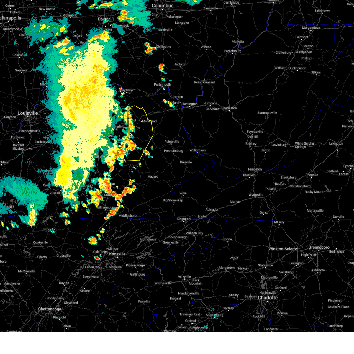 the severe thunderstorm warning has been cancelled and is no longer in effect the severe thunderstorm warning has been cancelled and is no longer in effect
|
| 8/1/2024 7:39 PM EDT |
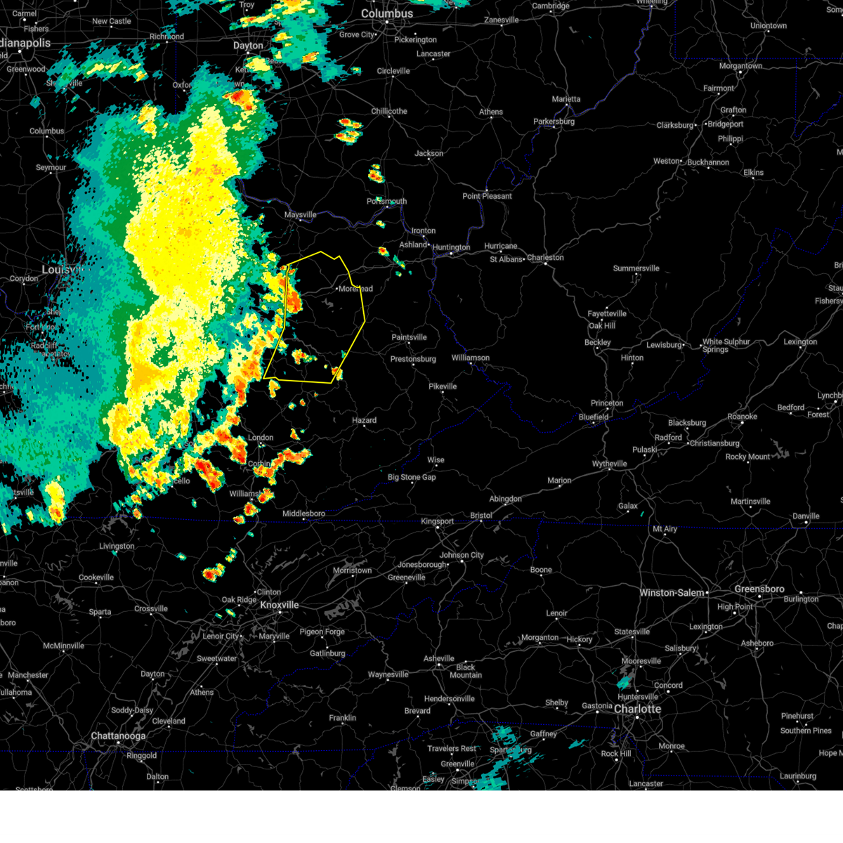 Svrjkl the national weather service in jackson ky has issued a * severe thunderstorm warning for, powell county in east central kentucky, southeastern montgomery county in east central kentucky, western morgan county in southeastern kentucky, bath county in east central kentucky, central estill county in east central kentucky, menifee county in east central kentucky, northwestern breathitt county in southeastern kentucky, lee county in southeastern kentucky, southeastern fleming county in east central kentucky, rowan county in east central kentucky, wolfe county in southeastern kentucky, southwestern elliott county in east central kentucky, * until 815 pm edt. * at 739 pm edt, severe thunderstorms were located along a line extending from near tilton to tabor to near leighton, moving east at 50 mph (radar indicated). Hazards include 60 mph wind gusts. Expect damage to roofs, siding, and trees. severe thunderstorms will be near, morehead around 745 pm edt. campton around 750 pm edt. henry around 755 pm edt. Other locations in the path of these severe thunderstorms include west liberty and farley. Svrjkl the national weather service in jackson ky has issued a * severe thunderstorm warning for, powell county in east central kentucky, southeastern montgomery county in east central kentucky, western morgan county in southeastern kentucky, bath county in east central kentucky, central estill county in east central kentucky, menifee county in east central kentucky, northwestern breathitt county in southeastern kentucky, lee county in southeastern kentucky, southeastern fleming county in east central kentucky, rowan county in east central kentucky, wolfe county in southeastern kentucky, southwestern elliott county in east central kentucky, * until 815 pm edt. * at 739 pm edt, severe thunderstorms were located along a line extending from near tilton to tabor to near leighton, moving east at 50 mph (radar indicated). Hazards include 60 mph wind gusts. Expect damage to roofs, siding, and trees. severe thunderstorms will be near, morehead around 745 pm edt. campton around 750 pm edt. henry around 755 pm edt. Other locations in the path of these severe thunderstorms include west liberty and farley.
|
| 7/16/2024 5:15 PM EDT | Trees were blown down and a barn roof was damaged at a residence on ky 844. event time is estimated form rada in morgan county KY, 6.4 miles W of Hazel Green, KY |
| 7/5/2024 12:42 PM EDT |
 At 1241 pm edt, severe thunderstorms were located along a line extending from high falls to canyon falls to near turkey to near confluence to hosea, moving east at 35 mph (radar indicated). Hazards include 60 mph wind gusts. Expect damage to roofs, siding, and trees. Locations impacted include, jackson, flintville, simpson and taulbee. At 1241 pm edt, severe thunderstorms were located along a line extending from high falls to canyon falls to near turkey to near confluence to hosea, moving east at 35 mph (radar indicated). Hazards include 60 mph wind gusts. Expect damage to roofs, siding, and trees. Locations impacted include, jackson, flintville, simpson and taulbee.
|
| 7/5/2024 12:22 PM EDT |
 Svrjkl the national weather service in jackson ky has issued a * severe thunderstorm warning for, owsley county in southeastern kentucky, northwestern leslie county in southeastern kentucky, northwestern perry county in southeastern kentucky, breathitt county in southeastern kentucky, lee county in southeastern kentucky, wolfe county in southeastern kentucky, northeastern clay county in southeastern kentucky, * until 100 pm edt. * at 1221 pm edt, severe thunderstorms were located along a line extending from greeley to mistletoe to botto, moving northeast at 35 mph (radar indicated). Hazards include 60 mph wind gusts. Expect damage to roofs, siding, and trees. severe thunderstorms will be near, beattyville around 1225 pm edt. oakdale around 1230 pm edt. campton around 1235 pm edt. jackson around 1240 pm edt. Other locations in the path of these severe thunderstorms include hyden and simpson. Svrjkl the national weather service in jackson ky has issued a * severe thunderstorm warning for, owsley county in southeastern kentucky, northwestern leslie county in southeastern kentucky, northwestern perry county in southeastern kentucky, breathitt county in southeastern kentucky, lee county in southeastern kentucky, wolfe county in southeastern kentucky, northeastern clay county in southeastern kentucky, * until 100 pm edt. * at 1221 pm edt, severe thunderstorms were located along a line extending from greeley to mistletoe to botto, moving northeast at 35 mph (radar indicated). Hazards include 60 mph wind gusts. Expect damage to roofs, siding, and trees. severe thunderstorms will be near, beattyville around 1225 pm edt. oakdale around 1230 pm edt. campton around 1235 pm edt. jackson around 1240 pm edt. Other locations in the path of these severe thunderstorms include hyden and simpson.
|
| 5/27/2024 2:31 AM EDT |
 The storms which prompted the warning have weakened below severe limits, and no longer pose an immediate threat to life or property. therefore, the warning has been allowed to expire. however, small hail and gusty winds are still possible with these thunderstorms. a tornado watch remains in effect until 600 am edt for southeastern, northeastern and east central kentucky. The storms which prompted the warning have weakened below severe limits, and no longer pose an immediate threat to life or property. therefore, the warning has been allowed to expire. however, small hail and gusty winds are still possible with these thunderstorms. a tornado watch remains in effect until 600 am edt for southeastern, northeastern and east central kentucky.
|
| 5/27/2024 2:15 AM EDT |
 the severe thunderstorm warning has been cancelled and is no longer in effect the severe thunderstorm warning has been cancelled and is no longer in effect
|
| 5/27/2024 2:15 AM EDT |
 At 215 am edt, severe thunderstorms were located along a line extending from yocum to rosefork to curt, moving east at 55 mph (radar indicated). Hazards include 60 mph wind gusts. Expect damage to roofs, siding, and trees. Locations impacted include, west liberty, salyersville, isonville and gapville. At 215 am edt, severe thunderstorms were located along a line extending from yocum to rosefork to curt, moving east at 55 mph (radar indicated). Hazards include 60 mph wind gusts. Expect damage to roofs, siding, and trees. Locations impacted include, west liberty, salyersville, isonville and gapville.
|
| 5/27/2024 1:55 AM EDT |
 Svrjkl the national weather service in jackson ky has issued a * severe thunderstorm warning for, northern owsley county in southeastern kentucky, northeastern jackson county in southeastern kentucky, menifee county in east central kentucky, lee county in southeastern kentucky, southeastern rowan county in east central kentucky, wolfe county in southeastern kentucky, eastern powell county in east central kentucky, morgan county in southeastern kentucky, southeastern bath county in east central kentucky, southeastern estill county in east central kentucky, breathitt county in southeastern kentucky, magoffin county in southeastern kentucky, elliott county in east central kentucky, * until 230 am edt. * at 155 am edt, severe thunderstorms were located along a line extending from near rothwell to whisman to levi, moving east at 55 mph (radar indicated). Hazards include 60 mph wind gusts. Expect damage to roofs, siding, and trees. severe thunderstorms will be near, frenchburg around 200 am edt. jackson around 205 am edt. west liberty around 210 am edt. lewis around 215 am edt. Other locations in the path of these severe thunderstorms include steele and jeptha. Svrjkl the national weather service in jackson ky has issued a * severe thunderstorm warning for, northern owsley county in southeastern kentucky, northeastern jackson county in southeastern kentucky, menifee county in east central kentucky, lee county in southeastern kentucky, southeastern rowan county in east central kentucky, wolfe county in southeastern kentucky, eastern powell county in east central kentucky, morgan county in southeastern kentucky, southeastern bath county in east central kentucky, southeastern estill county in east central kentucky, breathitt county in southeastern kentucky, magoffin county in southeastern kentucky, elliott county in east central kentucky, * until 230 am edt. * at 155 am edt, severe thunderstorms were located along a line extending from near rothwell to whisman to levi, moving east at 55 mph (radar indicated). Hazards include 60 mph wind gusts. Expect damage to roofs, siding, and trees. severe thunderstorms will be near, frenchburg around 200 am edt. jackson around 205 am edt. west liberty around 210 am edt. lewis around 215 am edt. Other locations in the path of these severe thunderstorms include steele and jeptha.
|
| 5/26/2024 2:58 PM EDT |
 A severe thunderstorm watch remains in effect until 800 pm edt for southeastern and east central kentucky. a severe thunderstorm watch also remains in effect until 900 pm edt for southeastern and northeastern kentucky. to report severe weather, contact your nearest law enforcement agency. they will relay your report to the national weather service jackson ky. A severe thunderstorm watch remains in effect until 800 pm edt for southeastern and east central kentucky. a severe thunderstorm watch also remains in effect until 900 pm edt for southeastern and northeastern kentucky. to report severe weather, contact your nearest law enforcement agency. they will relay your report to the national weather service jackson ky.
|
| 5/26/2024 2:41 PM EDT |
 At 241 pm edt, severe thunderstorms were located along a line extending from holliday to keck to near krypton to daley, moving east at 55 mph (radar indicated). Hazards include 70 mph wind gusts and nickel size hail. Expect considerable tree damage. damage is likely to mobile homes, roofs, and outbuildings. Locations impacted include, hazard, mason, hindman, paintsville, estill and prestonsburg. At 241 pm edt, severe thunderstorms were located along a line extending from holliday to keck to near krypton to daley, moving east at 55 mph (radar indicated). Hazards include 70 mph wind gusts and nickel size hail. Expect considerable tree damage. damage is likely to mobile homes, roofs, and outbuildings. Locations impacted include, hazard, mason, hindman, paintsville, estill and prestonsburg.
|
| 5/26/2024 2:41 PM EDT |
 the severe thunderstorm warning has been cancelled and is no longer in effect the severe thunderstorm warning has been cancelled and is no longer in effect
|
| 5/26/2024 2:39 PM EDT |
 At 238 pm edt, severe thunderstorms were located along a line extending from near head of grassy to near sandy hook to matthew to burg, moving east at 35 mph (radar indicated). Hazards include 70 mph wind gusts and nickel size hail. Expect considerable tree damage. damage is likely to mobile homes, roofs, and outbuildings. Locations impacted include, salyersville, elna, conley, paintsville, perston estates and oaklawn estates. At 238 pm edt, severe thunderstorms were located along a line extending from near head of grassy to near sandy hook to matthew to burg, moving east at 35 mph (radar indicated). Hazards include 70 mph wind gusts and nickel size hail. Expect considerable tree damage. damage is likely to mobile homes, roofs, and outbuildings. Locations impacted include, salyersville, elna, conley, paintsville, perston estates and oaklawn estates.
|
| 5/26/2024 2:34 PM EDT | A tree was blown down on ky 191 near adele and helechawa. the event time is radar estimate in morgan county KY, 5.4 miles WNW of Hazel Green, KY |
| 5/26/2024 2:14 PM EDT |
 A tornado watch remains in effect until 400 pm edt for southeastern and east central kentucky. a severe thunderstorm watch remains in effect until 800 pm edt for southeastern and east central kentucky. a severe thunderstorm watch also remains in effect until 900 pm edt for southeastern kentucky. A tornado watch remains in effect until 400 pm edt for southeastern and east central kentucky. a severe thunderstorm watch remains in effect until 800 pm edt for southeastern and east central kentucky. a severe thunderstorm watch also remains in effect until 900 pm edt for southeastern kentucky.
|
| 5/26/2024 2:13 PM EDT |
 Svrjkl the national weather service in jackson ky has issued a * severe thunderstorm warning for, southwestern morgan county in southeastern kentucky, eastern owsley county in southeastern kentucky, southern johnson county in northeastern kentucky, northern leslie county in southeastern kentucky, perry county in southeastern kentucky, knott county in southeastern kentucky, floyd county in southeastern kentucky, breathitt county in southeastern kentucky, magoffin county in southeastern kentucky, eastern lee county in southeastern kentucky, wolfe county in southeastern kentucky, northeastern clay county in southeastern kentucky, * until 315 pm edt. * at 213 pm edt, severe thunderstorms were located along a line extending from stillwater to morris fork, moving east at 40 mph (radar indicated). Hazards include 70 mph wind gusts and nickel size hail. Expect considerable tree damage. damage is likely to mobile homes, roofs, and outbuildings. severe thunderstorms will be near, jackson around 220 pm edt. payton around 225 pm edt. caney around 230 pm edt. Other locations in the path of these severe thunderstorms include harper, salyersville and mason. Svrjkl the national weather service in jackson ky has issued a * severe thunderstorm warning for, southwestern morgan county in southeastern kentucky, eastern owsley county in southeastern kentucky, southern johnson county in northeastern kentucky, northern leslie county in southeastern kentucky, perry county in southeastern kentucky, knott county in southeastern kentucky, floyd county in southeastern kentucky, breathitt county in southeastern kentucky, magoffin county in southeastern kentucky, eastern lee county in southeastern kentucky, wolfe county in southeastern kentucky, northeastern clay county in southeastern kentucky, * until 315 pm edt. * at 213 pm edt, severe thunderstorms were located along a line extending from stillwater to morris fork, moving east at 40 mph (radar indicated). Hazards include 70 mph wind gusts and nickel size hail. Expect considerable tree damage. damage is likely to mobile homes, roofs, and outbuildings. severe thunderstorms will be near, jackson around 220 pm edt. payton around 225 pm edt. caney around 230 pm edt. Other locations in the path of these severe thunderstorms include harper, salyersville and mason.
|
| 5/26/2024 2:08 PM EDT |
 Svrjkl the national weather service in jackson ky has issued a * severe thunderstorm warning for, morgan county in southeastern kentucky, johnson county in northeastern kentucky, northern magoffin county in southeastern kentucky, rowan county in east central kentucky, northeastern wolfe county in southeastern kentucky, elliott county in east central kentucky, * until 300 pm edt. * at 208 pm edt, severe thunderstorms were located along a line extending from near waltz to maytown, moving east at 65 mph (radar indicated). Hazards include 70 mph wind gusts and nickel size hail. Expect considerable tree damage. damage is likely to mobile homes, roofs, and outbuildings. severe thunderstorms will be near, morehead around 215 pm edt. sandy hook around 220 pm edt. crockett around 225 pm edt. Other locations in the path of these severe thunderstorms include cyrus, paintsville and perston estates. Svrjkl the national weather service in jackson ky has issued a * severe thunderstorm warning for, morgan county in southeastern kentucky, johnson county in northeastern kentucky, northern magoffin county in southeastern kentucky, rowan county in east central kentucky, northeastern wolfe county in southeastern kentucky, elliott county in east central kentucky, * until 300 pm edt. * at 208 pm edt, severe thunderstorms were located along a line extending from near waltz to maytown, moving east at 65 mph (radar indicated). Hazards include 70 mph wind gusts and nickel size hail. Expect considerable tree damage. damage is likely to mobile homes, roofs, and outbuildings. severe thunderstorms will be near, morehead around 215 pm edt. sandy hook around 220 pm edt. crockett around 225 pm edt. Other locations in the path of these severe thunderstorms include cyrus, paintsville and perston estates.
|
| 5/26/2024 1:56 PM EDT |
 the severe thunderstorm warning has been cancelled and is no longer in effect the severe thunderstorm warning has been cancelled and is no longer in effect
|
| 5/26/2024 1:56 PM EDT |
 At 156 pm edt, severe thunderstorms were located along a line extending from crooks to haystack to leighton, moving east at 50 mph (radar indicated). Hazards include 70 mph wind gusts and nickel size hail. Expect considerable tree damage. damage is likely to mobile homes, roofs, and outbuildings. Locations impacted include, beattyville, campton, stillwater, west liberty, payton and lewis. At 156 pm edt, severe thunderstorms were located along a line extending from crooks to haystack to leighton, moving east at 50 mph (radar indicated). Hazards include 70 mph wind gusts and nickel size hail. Expect considerable tree damage. damage is likely to mobile homes, roofs, and outbuildings. Locations impacted include, beattyville, campton, stillwater, west liberty, payton and lewis.
|
| 5/26/2024 1:15 PM EDT |
 Svrjkl the national weather service in jackson ky has issued a * severe thunderstorm warning for, powell county in east central kentucky, montgomery county in east central kentucky, western morgan county in southeastern kentucky, estill county in east central kentucky, north central rockcastle county in south central kentucky, menifee county in east central kentucky, west central magoffin county in southeastern kentucky, lee county in southeastern kentucky, wolfe county in southeastern kentucky, * until 215 pm edt. * at 114 pm edt, severe thunderstorms were located along a line extending from near winchester to climax, moving east at 60 mph (radar indicated). Hazards include 70 mph wind gusts and nickel size hail. Expect considerable tree damage. damage is likely to mobile homes, roofs, and outbuildings. severe thunderstorms will be near, station camp around 120 pm edt. mount sterling around 125 pm edt. stanton around 130 pm edt. Other locations in the path of these severe thunderstorms include beattyville, frenchburg and campton. Svrjkl the national weather service in jackson ky has issued a * severe thunderstorm warning for, powell county in east central kentucky, montgomery county in east central kentucky, western morgan county in southeastern kentucky, estill county in east central kentucky, north central rockcastle county in south central kentucky, menifee county in east central kentucky, west central magoffin county in southeastern kentucky, lee county in southeastern kentucky, wolfe county in southeastern kentucky, * until 215 pm edt. * at 114 pm edt, severe thunderstorms were located along a line extending from near winchester to climax, moving east at 60 mph (radar indicated). Hazards include 70 mph wind gusts and nickel size hail. Expect considerable tree damage. damage is likely to mobile homes, roofs, and outbuildings. severe thunderstorms will be near, station camp around 120 pm edt. mount sterling around 125 pm edt. stanton around 130 pm edt. Other locations in the path of these severe thunderstorms include beattyville, frenchburg and campton.
|
| 4/2/2024 10:41 AM EDT |
 The storms which prompted the warning have moved out of the area. therefore, the warning will be allowed to expire. a tornado watch remains in effect until noon edt for southeastern and east central kentucky. to report severe weather, contact your nearest law enforcement agency. they will relay your report to the national weather service jackson ky. The storms which prompted the warning have moved out of the area. therefore, the warning will be allowed to expire. a tornado watch remains in effect until noon edt for southeastern and east central kentucky. to report severe weather, contact your nearest law enforcement agency. they will relay your report to the national weather service jackson ky.
|
| 4/2/2024 10:32 AM EDT |
 At 1031 am edt, severe thunderstorms were located along a line extending from barnrock to belknap, moving southeast at 45 mph (radar indicated). Hazards include 60 mph wind gusts. Expect damage to roofs, siding, and trees. Locations impacted include, simpson, lewis, haleburg, burkhart, moon, florress, lexie, bethanna, gifford, logville, wonnie, and kernie. At 1031 am edt, severe thunderstorms were located along a line extending from barnrock to belknap, moving southeast at 45 mph (radar indicated). Hazards include 60 mph wind gusts. Expect damage to roofs, siding, and trees. Locations impacted include, simpson, lewis, haleburg, burkhart, moon, florress, lexie, bethanna, gifford, logville, wonnie, and kernie.
|
| 4/2/2024 10:32 AM EDT |
 the severe thunderstorm warning has been cancelled and is no longer in effect the severe thunderstorm warning has been cancelled and is no longer in effect
|
| 4/2/2024 10:27 AM EDT |
 The storm which prompted the warning has weakened below severe limits, and no longer appears capable of producing a tornado. therefore, the warning will be allowed to expire. however gusty winds are still possible with this thunderstorm. a tornado watch remains in effect until noon edt for southeastern and east central kentucky. to report severe weather, contact your nearest law enforcement agency. they will relay your report to the national weather service jackson ky. remember, a severe thunderstorm warning still remains in effect. The storm which prompted the warning has weakened below severe limits, and no longer appears capable of producing a tornado. therefore, the warning will be allowed to expire. however gusty winds are still possible with this thunderstorm. a tornado watch remains in effect until noon edt for southeastern and east central kentucky. to report severe weather, contact your nearest law enforcement agency. they will relay your report to the national weather service jackson ky. remember, a severe thunderstorm warning still remains in effect.
|
| 4/2/2024 10:24 AM EDT |
 At 1023 am edt, severe thunderstorms were located along a line extending from rush to malaga, moving east at 70 mph (radar indicated). Hazards include 60 mph wind gusts. Expect damage to roofs, siding, and trees. Locations impacted include, lewis and hendricks. At 1023 am edt, severe thunderstorms were located along a line extending from rush to malaga, moving east at 70 mph (radar indicated). Hazards include 60 mph wind gusts. Expect damage to roofs, siding, and trees. Locations impacted include, lewis and hendricks.
|
| 4/2/2024 10:24 AM EDT |
 the severe thunderstorm warning has been cancelled and is no longer in effect the severe thunderstorm warning has been cancelled and is no longer in effect
|
| 4/2/2024 10:13 AM EDT |
 the tornado warning has been cancelled and is no longer in effect the tornado warning has been cancelled and is no longer in effect
|
| 4/2/2024 10:13 AM EDT |
 At 1012 am edt, a severe thunderstorm capable of producing a tornado was located over valeria, or 7 miles north of campton, moving southeast at 50 mph (radar indicated rotation). Hazards include tornado. Flying debris will be dangerous to those caught without shelter. mobile homes will be damaged or destroyed. damage to roofs, windows, and vehicles will occur. tree damage is likely. Locations impacted include, payton, caney and burkhart. At 1012 am edt, a severe thunderstorm capable of producing a tornado was located over valeria, or 7 miles north of campton, moving southeast at 50 mph (radar indicated rotation). Hazards include tornado. Flying debris will be dangerous to those caught without shelter. mobile homes will be damaged or destroyed. damage to roofs, windows, and vehicles will occur. tree damage is likely. Locations impacted include, payton, caney and burkhart.
|
| 4/2/2024 10:04 AM EDT |
 Svrjkl the national weather service in jackson ky has issued a * severe thunderstorm warning for, eastern powell county in east central kentucky, morgan county in southeastern kentucky, southeastern bath county in east central kentucky, east central estill county in east central kentucky, menifee county in east central kentucky, north central breathitt county in southeastern kentucky, northwestern magoffin county in southeastern kentucky, north central lee county in southeastern kentucky, southeastern rowan county in east central kentucky, wolfe county in southeastern kentucky, elliott county in east central kentucky, * until 1045 am edt. * at 1004 am edt, severe thunderstorms were located along a line extending from near olive hill to patsey, moving east at 75 mph (radar indicated). Hazards include 70 mph wind gusts. Expect considerable tree damage. damage is likely to mobile homes, roofs, and outbuildings. severe thunderstorms will be near, west liberty around 1010 am edt. simpson around 1015 am edt. harper around 1020 am edt. Hendricks around 1025 am edt. Svrjkl the national weather service in jackson ky has issued a * severe thunderstorm warning for, eastern powell county in east central kentucky, morgan county in southeastern kentucky, southeastern bath county in east central kentucky, east central estill county in east central kentucky, menifee county in east central kentucky, north central breathitt county in southeastern kentucky, northwestern magoffin county in southeastern kentucky, north central lee county in southeastern kentucky, southeastern rowan county in east central kentucky, wolfe county in southeastern kentucky, elliott county in east central kentucky, * until 1045 am edt. * at 1004 am edt, severe thunderstorms were located along a line extending from near olive hill to patsey, moving east at 75 mph (radar indicated). Hazards include 70 mph wind gusts. Expect considerable tree damage. damage is likely to mobile homes, roofs, and outbuildings. severe thunderstorms will be near, west liberty around 1010 am edt. simpson around 1015 am edt. harper around 1020 am edt. Hendricks around 1025 am edt.
|
| 4/2/2024 9:54 AM EDT |
 Torjkl the national weather service in jackson ky has issued a * tornado warning for, northeastern powell county in east central kentucky, southeastern montgomery county in east central kentucky, southwestern morgan county in southeastern kentucky, south central bath county in east central kentucky, menifee county in east central kentucky, wolfe county in southeastern kentucky, * until 1030 am edt. * at 953 am edt, a severe thunderstorm capable of producing a tornado was located over means, or 7 miles west of frenchburg, moving southeast at 50 mph (radar indicated rotation). Hazards include tornado. Flying debris will be dangerous to those caught without shelter. mobile homes will be damaged or destroyed. damage to roofs, windows, and vehicles will occur. tree damage is likely. this dangerous storm will be near, frenchburg around 1000 am edt. pomeroyton around 1005 am edt. gosneyville around 1010 am edt. Other locations in the path of this tornadic thunderstorm include murphyfork, helechawa and payton. Torjkl the national weather service in jackson ky has issued a * tornado warning for, northeastern powell county in east central kentucky, southeastern montgomery county in east central kentucky, southwestern morgan county in southeastern kentucky, south central bath county in east central kentucky, menifee county in east central kentucky, wolfe county in southeastern kentucky, * until 1030 am edt. * at 953 am edt, a severe thunderstorm capable of producing a tornado was located over means, or 7 miles west of frenchburg, moving southeast at 50 mph (radar indicated rotation). Hazards include tornado. Flying debris will be dangerous to those caught without shelter. mobile homes will be damaged or destroyed. damage to roofs, windows, and vehicles will occur. tree damage is likely. this dangerous storm will be near, frenchburg around 1000 am edt. pomeroyton around 1005 am edt. gosneyville around 1010 am edt. Other locations in the path of this tornadic thunderstorm include murphyfork, helechawa and payton.
|
| 3/6/2024 10:07 AM EST |
 Torjkl the national weather service in jackson ky has issued a * this is a test message. tornado warning for, montgomery county in east central kentucky, mccreary county in south central kentucky, rowan county in east central kentucky, morgan county in southeastern kentucky, bath county in east central kentucky, leslie county in southeastern kentucky, estill county in east central kentucky, pulaski county in south central kentucky, rockcastle county in south central kentucky, clay county in southeastern kentucky, elliott county in east central kentucky, wayne county in south central kentucky, harlan county in southeastern kentucky, knox county in southeastern kentucky, owsley county in southeastern kentucky, jackson county in southeastern kentucky, knott county in southeastern kentucky, floyd county in southeastern kentucky, whitley county in south central kentucky, menifee county in east central kentucky, lee county in southeastern kentucky, fleming county in east central kentucky, wolfe county in southeastern kentucky, powell county in east central kentucky, laurel county in south central kentucky, martin county in northeastern kentucky, bell county in southeastern kentucky, johnson county in northeastern kentucky, letcher county in southeastern kentucky, perry county in southeastern kentucky, breathitt county in southeastern kentucky, pike county in southeastern kentucky, magoffin county in southeastern kentucky, * this is a test message. until 1030 am est. * this is a test message. repeat, this is a test tornado warning message. there is no severe weather occuring at this time. this test warning message is part of the annual kentucky tornado drill. if this were an actual severe weather event, you would be given information about the hazard. the national weather service, kentucky emergency management angency, and the kentucky weather preparedness committee, encourges the use of this time to activate and review your severe weather safety plans. repeating, this has been a test tornado warning message for the 2024 kentucky tornado drill. this concludes the test. * this is a test message. Torjkl the national weather service in jackson ky has issued a * this is a test message. tornado warning for, montgomery county in east central kentucky, mccreary county in south central kentucky, rowan county in east central kentucky, morgan county in southeastern kentucky, bath county in east central kentucky, leslie county in southeastern kentucky, estill county in east central kentucky, pulaski county in south central kentucky, rockcastle county in south central kentucky, clay county in southeastern kentucky, elliott county in east central kentucky, wayne county in south central kentucky, harlan county in southeastern kentucky, knox county in southeastern kentucky, owsley county in southeastern kentucky, jackson county in southeastern kentucky, knott county in southeastern kentucky, floyd county in southeastern kentucky, whitley county in south central kentucky, menifee county in east central kentucky, lee county in southeastern kentucky, fleming county in east central kentucky, wolfe county in southeastern kentucky, powell county in east central kentucky, laurel county in south central kentucky, martin county in northeastern kentucky, bell county in southeastern kentucky, johnson county in northeastern kentucky, letcher county in southeastern kentucky, perry county in southeastern kentucky, breathitt county in southeastern kentucky, pike county in southeastern kentucky, magoffin county in southeastern kentucky, * this is a test message. until 1030 am est. * this is a test message. repeat, this is a test tornado warning message. there is no severe weather occuring at this time. this test warning message is part of the annual kentucky tornado drill. if this were an actual severe weather event, you would be given information about the hazard. the national weather service, kentucky emergency management angency, and the kentucky weather preparedness committee, encourges the use of this time to activate and review your severe weather safety plans. repeating, this has been a test tornado warning message for the 2024 kentucky tornado drill. this concludes the test. * this is a test message.
|
| 8/25/2023 6:07 PM EDT |
 The severe thunderstorm warning for powell, southwestern morgan, estill, south central menifee, northern lee and wolfe counties will expire at 615 pm edt, the storms which prompted the warning have weakened below severe limits, and no longer pose an immediate threat to life or property. therefore, the warning will be allowed to expire. however gusty winds and heavy rain are still possible with these thunderstorms. The severe thunderstorm warning for powell, southwestern morgan, estill, south central menifee, northern lee and wolfe counties will expire at 615 pm edt, the storms which prompted the warning have weakened below severe limits, and no longer pose an immediate threat to life or property. therefore, the warning will be allowed to expire. however gusty winds and heavy rain are still possible with these thunderstorms.
|
| 8/25/2023 6:06 PM EDT |
 At 605 pm edt, severe thunderstorms were located along a line extending from fox to fixer to trent, moving south at 15 mph (radar indicated). Hazards include 60 mph wind gusts and penny size hail. Expect damage to roofs, siding, and trees. locations impacted include, fox, whynot, mount olive, winston and vortex. hail threat, radar indicated max hail size, 0. 75 in wind threat, radar indicated max wind gust, 60 mph. At 605 pm edt, severe thunderstorms were located along a line extending from fox to fixer to trent, moving south at 15 mph (radar indicated). Hazards include 60 mph wind gusts and penny size hail. Expect damage to roofs, siding, and trees. locations impacted include, fox, whynot, mount olive, winston and vortex. hail threat, radar indicated max hail size, 0. 75 in wind threat, radar indicated max wind gust, 60 mph.
|
| 8/25/2023 5:49 PM EDT |
 At 549 pm edt, severe thunderstorms were located along a line extending from palmer to standing rock to murphyfork, moving south at 15 mph (radar indicated). Hazards include 60 mph wind gusts and penny size hail. Expect damage to roofs, siding, and trees. severe thunderstorms will be near, palmer around 555 pm edt. fixer around 600 pm edt. fox around 605 pm edt. other locations in the path of these severe thunderstorms include stillwater and landsaw. hail threat, radar indicated max hail size, 0. 75 in wind threat, radar indicated max wind gust, 60 mph. At 549 pm edt, severe thunderstorms were located along a line extending from palmer to standing rock to murphyfork, moving south at 15 mph (radar indicated). Hazards include 60 mph wind gusts and penny size hail. Expect damage to roofs, siding, and trees. severe thunderstorms will be near, palmer around 555 pm edt. fixer around 600 pm edt. fox around 605 pm edt. other locations in the path of these severe thunderstorms include stillwater and landsaw. hail threat, radar indicated max hail size, 0. 75 in wind threat, radar indicated max wind gust, 60 mph.
|
| 8/25/2023 2:21 PM EDT |
 The severe thunderstorm warning for east central powell, west central morgan, menifee and northwestern wolfe counties will expire at 230 pm edt, the storm which prompted the warning has weakened below severe limits, and no longer poses an immediate threat to life or property. therefore, the warning will be allowed to expire. however gusty winds are still possible with this thunderstorm. The severe thunderstorm warning for east central powell, west central morgan, menifee and northwestern wolfe counties will expire at 230 pm edt, the storm which prompted the warning has weakened below severe limits, and no longer poses an immediate threat to life or property. therefore, the warning will be allowed to expire. however gusty winds are still possible with this thunderstorm.
|
| 8/25/2023 2:06 PM EDT |
 At 206 pm edt, a severe thunderstorm was located over mariba, or near frenchburg, moving southeast at 15 mph (radar indicated). Hazards include 60 mph wind gusts and quarter size hail. Hail damage to vehicles is expected. expect wind damage to roofs, siding, and trees. this severe storm will be near, denniston around 215 pm edt. other locations in the path of this severe thunderstorm include wellington, stoll, valeria, maytown and gosneyville. hail threat, radar indicated max hail size, 1. 00 in wind threat, radar indicated max wind gust, 60 mph. At 206 pm edt, a severe thunderstorm was located over mariba, or near frenchburg, moving southeast at 15 mph (radar indicated). Hazards include 60 mph wind gusts and quarter size hail. Hail damage to vehicles is expected. expect wind damage to roofs, siding, and trees. this severe storm will be near, denniston around 215 pm edt. other locations in the path of this severe thunderstorm include wellington, stoll, valeria, maytown and gosneyville. hail threat, radar indicated max hail size, 1. 00 in wind threat, radar indicated max wind gust, 60 mph.
|
| 8/25/2023 1:55 PM EDT |
 At 155 pm edt, a severe thunderstorm was located over tabor, or over frenchburg, moving southeast at 15 mph (radar indicated). Hazards include 60 mph wind gusts and quarter size hail. Hail damage to vehicles is expected. expect wind damage to roofs, siding, and trees. this severe thunderstorm will be near, mariba around 205 pm edt. denniston around 215 pm edt. other locations in the path of this severe thunderstorm include wellington, stoll and maytown. hail threat, radar indicated max hail size, 1. 00 in wind threat, radar indicated max wind gust, 60 mph. At 155 pm edt, a severe thunderstorm was located over tabor, or over frenchburg, moving southeast at 15 mph (radar indicated). Hazards include 60 mph wind gusts and quarter size hail. Hail damage to vehicles is expected. expect wind damage to roofs, siding, and trees. this severe thunderstorm will be near, mariba around 205 pm edt. denniston around 215 pm edt. other locations in the path of this severe thunderstorm include wellington, stoll and maytown. hail threat, radar indicated max hail size, 1. 00 in wind threat, radar indicated max wind gust, 60 mph.
|
| 7/29/2023 7:50 AM EDT |
 At 749 am edt, a severe thunderstorm was located over valeria, or 7 miles north of campton, moving east at 45 mph (radar indicated). Hazards include 60 mph wind gusts. Expect damage to roofs, siding, and trees. locations impacted include, murphyfork, rexville and payton. hail threat, radar indicated max hail size, <. 75 in wind threat, radar indicated max wind gust, 60 mph. At 749 am edt, a severe thunderstorm was located over valeria, or 7 miles north of campton, moving east at 45 mph (radar indicated). Hazards include 60 mph wind gusts. Expect damage to roofs, siding, and trees. locations impacted include, murphyfork, rexville and payton. hail threat, radar indicated max hail size, <. 75 in wind threat, radar indicated max wind gust, 60 mph.
|
| 7/29/2023 7:34 AM EDT |
 At 733 am edt, a severe thunderstorm was located over tabor, or near frenchburg, moving east at 30 mph (radar indicated). Hazards include 60 mph wind gusts. Expect damage to roofs, siding, and trees. this severe thunderstorm will be near, mariba around 745 am edt. wellington around 750 am edt. other locations in the path of this severe thunderstorm include maytown and murphyfork. hail threat, radar indicated max hail size, <. 75 in wind threat, radar indicated max wind gust, 60 mph. At 733 am edt, a severe thunderstorm was located over tabor, or near frenchburg, moving east at 30 mph (radar indicated). Hazards include 60 mph wind gusts. Expect damage to roofs, siding, and trees. this severe thunderstorm will be near, mariba around 745 am edt. wellington around 750 am edt. other locations in the path of this severe thunderstorm include maytown and murphyfork. hail threat, radar indicated max hail size, <. 75 in wind threat, radar indicated max wind gust, 60 mph.
|
| 7/28/2023 2:49 PM EDT |
 At 248 pm edt, a severe thunderstorm was located over pine ridge, or over campton, moving east at 10 mph (radar indicated). Hazards include 60 mph wind gusts. Expect damage to roofs, siding, and trees. this severe storm will be near, campton around 300 pm edt. other locations in the path of this severe thunderstorm include gosneyville, stillwater, trent, landsaw and hazel green. hail threat, radar indicated max hail size, <. 75 in wind threat, radar indicated max wind gust, 60 mph. At 248 pm edt, a severe thunderstorm was located over pine ridge, or over campton, moving east at 10 mph (radar indicated). Hazards include 60 mph wind gusts. Expect damage to roofs, siding, and trees. this severe storm will be near, campton around 300 pm edt. other locations in the path of this severe thunderstorm include gosneyville, stillwater, trent, landsaw and hazel green. hail threat, radar indicated max hail size, <. 75 in wind threat, radar indicated max wind gust, 60 mph.
|
| 7/28/2023 2:40 PM EDT |
 At 240 pm edt, a severe thunderstorm was located over pine ridge, or near campton, moving east at 10 mph (radar indicated). Hazards include 60 mph wind gusts. Expect damage to roofs, siding, and trees. this severe storm will be near, high falls around 245 pm edt. other locations in the path of this severe thunderstorm include campton, gosneyville and stillwater. hail threat, radar indicated max hail size, <. 75 in wind threat, radar indicated max wind gust, 60 mph. At 240 pm edt, a severe thunderstorm was located over pine ridge, or near campton, moving east at 10 mph (radar indicated). Hazards include 60 mph wind gusts. Expect damage to roofs, siding, and trees. this severe storm will be near, high falls around 245 pm edt. other locations in the path of this severe thunderstorm include campton, gosneyville and stillwater. hail threat, radar indicated max hail size, <. 75 in wind threat, radar indicated max wind gust, 60 mph.
|
| 7/28/2023 2:33 PM EDT |
 At 232 pm edt, a severe thunderstorm was located over jenson, or near campton, moving east at 10 mph (radar indicated). Hazards include 60 mph wind gusts. Expect damage to roofs, siding, and trees. this severe thunderstorm will be near, high falls around 250 pm edt. other locations in the path of this severe thunderstorm include campton, vortex, gosneyville and stillwater. hail threat, radar indicated max hail size, <. 75 in wind threat, radar indicated max wind gust, 60 mph. At 232 pm edt, a severe thunderstorm was located over jenson, or near campton, moving east at 10 mph (radar indicated). Hazards include 60 mph wind gusts. Expect damage to roofs, siding, and trees. this severe thunderstorm will be near, high falls around 250 pm edt. other locations in the path of this severe thunderstorm include campton, vortex, gosneyville and stillwater. hail threat, radar indicated max hail size, <. 75 in wind threat, radar indicated max wind gust, 60 mph.
|
| 7/18/2023 4:47 PM EDT |
 At 445 pm edt, severe thunderstorms were located along a line extending from near triplett to wagner to near ratlitt to red river gorge, moving northeast at 45 mph (radar indicated). Hazards include 60 mph wind gusts and quarter size hail. Hail damage to vehicles is expected. expect wind damage to roofs, siding, and trees. severe thunderstorms will be near, farley around 450 pm edt. maytown around 455 pm edt. pelfrey around 500 pm edt. henry around 505 pm edt. other locations in the path of these severe thunderstorms include west liberty and lenox. hail threat, radar indicated max hail size, 1. 00 in wind threat, radar indicated max wind gust, 60 mph. At 445 pm edt, severe thunderstorms were located along a line extending from near triplett to wagner to near ratlitt to red river gorge, moving northeast at 45 mph (radar indicated). Hazards include 60 mph wind gusts and quarter size hail. Hail damage to vehicles is expected. expect wind damage to roofs, siding, and trees. severe thunderstorms will be near, farley around 450 pm edt. maytown around 455 pm edt. pelfrey around 500 pm edt. henry around 505 pm edt. other locations in the path of these severe thunderstorms include west liberty and lenox. hail threat, radar indicated max hail size, 1. 00 in wind threat, radar indicated max wind gust, 60 mph.
|
| 7/18/2023 4:37 PM EDT |
 The severe thunderstorm warning for southeastern powell, northern owsley, east central estill, northwestern breathitt, lee and wolfe counties will expire at 445 pm edt, the storms which prompted the warning have weakened or moved out of the warned area. therefore, the warning will be allowed to expire. however gusty winds are still possible with these thunderstorms. remember, a severe thunderstorm warning still remains in effect for portions of lee, breatthit, and wolfe counties. The severe thunderstorm warning for southeastern powell, northern owsley, east central estill, northwestern breathitt, lee and wolfe counties will expire at 445 pm edt, the storms which prompted the warning have weakened or moved out of the warned area. therefore, the warning will be allowed to expire. however gusty winds are still possible with these thunderstorms. remember, a severe thunderstorm warning still remains in effect for portions of lee, breatthit, and wolfe counties.
|
| 7/18/2023 4:26 PM EDT |
 At 424 pm edt, severe thunderstorms were located along a line extending from near pilot to zoe to pebworth, moving east at 50 mph (radar indicated). Hazards include 70 mph wind gusts. Expect considerable tree damage. damage is likely to mobile homes, roofs, and outbuildings. these severe storms will be near, koomer ridge campground around 430 pm edt. campton around 435 pm edt. other locations in the path of these severe thunderstorms include gosneyville, hazel green and jackson. thunderstorm damage threat, considerable hail threat, radar indicated max hail size, <. 75 in wind threat, radar indicated max wind gust, 70 mph. At 424 pm edt, severe thunderstorms were located along a line extending from near pilot to zoe to pebworth, moving east at 50 mph (radar indicated). Hazards include 70 mph wind gusts. Expect considerable tree damage. damage is likely to mobile homes, roofs, and outbuildings. these severe storms will be near, koomer ridge campground around 430 pm edt. campton around 435 pm edt. other locations in the path of these severe thunderstorms include gosneyville, hazel green and jackson. thunderstorm damage threat, considerable hail threat, radar indicated max hail size, <. 75 in wind threat, radar indicated max wind gust, 70 mph.
|
| 7/18/2023 4:18 PM EDT |
 At 416 pm edt, severe thunderstorms were located along a line extending from vaughns mill to furnace to whynot to vincent, moving east at 45 mph (radar indicated). Hazards include 60 mph wind gusts. Expect damage to roofs, siding, and trees. these severe storms will be near, rogers chapel around 420 pm edt. other locations in the path of these severe thunderstorms include booneville, lone, campton, baptist and fivemile. hail threat, radar indicated max hail size, <. 75 in wind threat, radar indicated max wind gust, 60 mph. At 416 pm edt, severe thunderstorms were located along a line extending from vaughns mill to furnace to whynot to vincent, moving east at 45 mph (radar indicated). Hazards include 60 mph wind gusts. Expect damage to roofs, siding, and trees. these severe storms will be near, rogers chapel around 420 pm edt. other locations in the path of these severe thunderstorms include booneville, lone, campton, baptist and fivemile. hail threat, radar indicated max hail size, <. 75 in wind threat, radar indicated max wind gust, 60 mph.
|
| 7/18/2023 4:03 PM EDT |
 At 403 pm edt, severe thunderstorms were located along a line extending from near fox to weedon to wagersville to turkey foot, moving northeast at 45 mph (radar indicated). Hazards include 60 mph wind gusts. Expect damage to roofs, siding, and trees. severe thunderstorms will be near, pryse around 410 pm edt. ida may around 415 pm edt. stanton around 420 pm edt. other locations in the path of these severe thunderstorms include lombard, campsites in the indian creek area of the daniel boone national forrest and campton. hail threat, radar indicated max hail size, <. 75 in wind threat, radar indicated max wind gust, 60 mph. At 403 pm edt, severe thunderstorms were located along a line extending from near fox to weedon to wagersville to turkey foot, moving northeast at 45 mph (radar indicated). Hazards include 60 mph wind gusts. Expect damage to roofs, siding, and trees. severe thunderstorms will be near, pryse around 410 pm edt. ida may around 415 pm edt. stanton around 420 pm edt. other locations in the path of these severe thunderstorms include lombard, campsites in the indian creek area of the daniel boone national forrest and campton. hail threat, radar indicated max hail size, <. 75 in wind threat, radar indicated max wind gust, 60 mph.
|
| 7/2/2023 8:32 PM EDT |
 At 831 pm edt, severe thunderstorms were located along a line extending from near rothwell to standing rock to shade, moving east at 40 mph (radar indicated). Hazards include 60 mph wind gusts. Expect damage to roofs, siding, and trees. severe thunderstorms will be near, frenchburg around 835 pm edt. ratlitt around 840 pm edt. campton around 845 pm edt. fincastle around 850 pm edt. other locations in the path of these severe thunderstorms include kellacey and simpson. hail threat, radar indicated max hail size, <. 75 in wind threat, radar indicated max wind gust, 60 mph. At 831 pm edt, severe thunderstorms were located along a line extending from near rothwell to standing rock to shade, moving east at 40 mph (radar indicated). Hazards include 60 mph wind gusts. Expect damage to roofs, siding, and trees. severe thunderstorms will be near, frenchburg around 835 pm edt. ratlitt around 840 pm edt. campton around 845 pm edt. fincastle around 850 pm edt. other locations in the path of these severe thunderstorms include kellacey and simpson. hail threat, radar indicated max hail size, <. 75 in wind threat, radar indicated max wind gust, 60 mph.
|
| 7/2/2023 6:12 PM EDT |
 The severe thunderstorm warning for menifee, northern lee, southeastern fleming, rowan, wolfe, southeastern powell, morgan, central bath, northwestern johnson, southeastern estill, northwestern breathitt, northwestern magoffin and elliott counties will expire at 615 pm edt, the storms which prompted the warning have moved out of the area. therefore, the warning will be allowed to expire. however, a new warning has been reissued. a severe thunderstorm watch remains in effect until midnight edt for southeastern, northeastern and east central kentucky. The severe thunderstorm warning for menifee, northern lee, southeastern fleming, rowan, wolfe, southeastern powell, morgan, central bath, northwestern johnson, southeastern estill, northwestern breathitt, northwestern magoffin and elliott counties will expire at 615 pm edt, the storms which prompted the warning have moved out of the area. therefore, the warning will be allowed to expire. however, a new warning has been reissued. a severe thunderstorm watch remains in effect until midnight edt for southeastern, northeastern and east central kentucky.
|
| 7/2/2023 6:11 PM EDT |
 At 610 pm edt, severe thunderstorms were located along a line extending from near blairs mills to lenox to lykins to moct to oakdale, moving east at 40 mph (radar indicated). Hazards include 60 mph wind gusts and nickel size hail. Expect damage to roofs, siding, and trees. severe thunderstorms will be near, elamton around 615 pm edt. jackson around 620 pm edt. mason around 625 pm edt. press around 630 pm edt. other locations in the path of these severe thunderstorms include keaton and waldo. hail threat, radar indicated max hail size, 0. 88 in wind threat, radar indicated max wind gust, 60 mph. At 610 pm edt, severe thunderstorms were located along a line extending from near blairs mills to lenox to lykins to moct to oakdale, moving east at 40 mph (radar indicated). Hazards include 60 mph wind gusts and nickel size hail. Expect damage to roofs, siding, and trees. severe thunderstorms will be near, elamton around 615 pm edt. jackson around 620 pm edt. mason around 625 pm edt. press around 630 pm edt. other locations in the path of these severe thunderstorms include keaton and waldo. hail threat, radar indicated max hail size, 0. 88 in wind threat, radar indicated max wind gust, 60 mph.
|
| 7/2/2023 5:53 PM EDT |
 At 552 pm edt, severe thunderstorms were located along a line extending from ramey to omer to baptist to booth to doe creek, moving east at 35 mph (radar indicated). Hazards include 70 mph wind gusts and quarter size hail. Hail damage to vehicles is expected. expect considerable tree damage. wind damage is also likely to mobile homes, roofs, and outbuildings. Locations impacted include, henry, west liberty, morehead, simpson, fincastle and williba. At 552 pm edt, severe thunderstorms were located along a line extending from ramey to omer to baptist to booth to doe creek, moving east at 35 mph (radar indicated). Hazards include 70 mph wind gusts and quarter size hail. Hail damage to vehicles is expected. expect considerable tree damage. wind damage is also likely to mobile homes, roofs, and outbuildings. Locations impacted include, henry, west liberty, morehead, simpson, fincastle and williba.
|
| 7/2/2023 5:35 PM EDT |
 At 534 pm edt, severe thunderstorms were located along a line extending from odessa to mariba to see, moving east at 45 mph (radar indicated). Hazards include 70 mph wind gusts and quarter size hail. Hail damage to vehicles is expected. expect considerable tree damage. wind damage is also likely to mobile homes, roofs, and outbuildings. severe thunderstorms will be near, wellington around 540 pm edt. ebon around 545 pm edt. campton around 550 pm edt. Other locations in the path of these severe thunderstorms include licking river, morehead and elamton. At 534 pm edt, severe thunderstorms were located along a line extending from odessa to mariba to see, moving east at 45 mph (radar indicated). Hazards include 70 mph wind gusts and quarter size hail. Hail damage to vehicles is expected. expect considerable tree damage. wind damage is also likely to mobile homes, roofs, and outbuildings. severe thunderstorms will be near, wellington around 540 pm edt. ebon around 545 pm edt. campton around 550 pm edt. Other locations in the path of these severe thunderstorms include licking river, morehead and elamton.
|
| 6/26/2023 9:13 PM EDT |
 The severe thunderstorm warning for southwestern morgan and northeastern wolfe counties will expire at 915 pm edt, the storm which prompted the warning has weakened below severe limits, and no longer poses an immediate threat to life or property. therefore, the warning will be allowed to expire. however gusty winds are still possible with this thunderstorm. The severe thunderstorm warning for southwestern morgan and northeastern wolfe counties will expire at 915 pm edt, the storm which prompted the warning has weakened below severe limits, and no longer poses an immediate threat to life or property. therefore, the warning will be allowed to expire. however gusty winds are still possible with this thunderstorm.
|
| 6/26/2023 9:08 PM EDT |
 At 908 pm edt, a severe thunderstorm was located over cannel city, or 8 miles south of west liberty, moving southeast at 25 mph (radar indicated). Hazards include 60 mph wind gusts and penny size hail. Expect damage to roofs, siding, and trees. locations impacted include, west liberty, lewis, lower gilmore, malone, greear, rexville, stacy fork, daysboro, index, williams, sellars and lee city. hail threat, radar indicated max hail size, 0. 75 in wind threat, radar indicated max wind gust, 60 mph. At 908 pm edt, a severe thunderstorm was located over cannel city, or 8 miles south of west liberty, moving southeast at 25 mph (radar indicated). Hazards include 60 mph wind gusts and penny size hail. Expect damage to roofs, siding, and trees. locations impacted include, west liberty, lewis, lower gilmore, malone, greear, rexville, stacy fork, daysboro, index, williams, sellars and lee city. hail threat, radar indicated max hail size, 0. 75 in wind threat, radar indicated max wind gust, 60 mph.
|
| 6/26/2023 8:56 PM EDT |
 At 855 pm edt, a severe thunderstorm was located over lizzielane, or 7 miles south of west liberty, moving southeast at 40 mph (radar indicated). Hazards include 60 mph wind gusts and penny size hail. Expect damage to roofs, siding, and trees. this severe storm will be near, lewis around 900 pm edt. hail threat, radar indicated max hail size, 0. 75 in wind threat, radar indicated max wind gust, 60 mph. At 855 pm edt, a severe thunderstorm was located over lizzielane, or 7 miles south of west liberty, moving southeast at 40 mph (radar indicated). Hazards include 60 mph wind gusts and penny size hail. Expect damage to roofs, siding, and trees. this severe storm will be near, lewis around 900 pm edt. hail threat, radar indicated max hail size, 0. 75 in wind threat, radar indicated max wind gust, 60 mph.
|
| 6/26/2023 8:49 PM EDT |
 At 848 pm edt, a severe thunderstorm was located over pekin, or 8 miles southwest of west liberty, moving southeast at 40 mph (radar indicated). Hazards include 60 mph wind gusts and penny size hail. Expect damage to roofs, siding, and trees. this severe thunderstorm will be near, demund around 855 pm edt. payton around 900 pm edt. lewis around 905 pm edt. hail threat, radar indicated max hail size, 0. 75 in wind threat, radar indicated max wind gust, 60 mph. At 848 pm edt, a severe thunderstorm was located over pekin, or 8 miles southwest of west liberty, moving southeast at 40 mph (radar indicated). Hazards include 60 mph wind gusts and penny size hail. Expect damage to roofs, siding, and trees. this severe thunderstorm will be near, demund around 855 pm edt. payton around 900 pm edt. lewis around 905 pm edt. hail threat, radar indicated max hail size, 0. 75 in wind threat, radar indicated max wind gust, 60 mph.
|
| 5/16/2023 3:58 PM EDT |
 At 356 pm edt, a severe thunderstorm was located over stillwater, or over campton, moving east at 35 mph (radar indicated). Hazards include 60 mph wind gusts and quarter size hail. Hail damage to vehicles is expected. expect wind damage to roofs, siding, and trees. this severe storm will be near, trent around 400 pm edt. landsaw around 405 pm edt. Other locations in the path of this severe thunderstorm include gilmore, lee city and belknap. At 356 pm edt, a severe thunderstorm was located over stillwater, or over campton, moving east at 35 mph (radar indicated). Hazards include 60 mph wind gusts and quarter size hail. Hail damage to vehicles is expected. expect wind damage to roofs, siding, and trees. this severe storm will be near, trent around 400 pm edt. landsaw around 405 pm edt. Other locations in the path of this severe thunderstorm include gilmore, lee city and belknap.
|
| 5/16/2023 3:48 PM EDT |
 At 347 pm edt, a severe thunderstorm was located over pine ridge, or near campton, moving east at 35 mph (radar indicated). Hazards include 60 mph wind gusts and quarter size hail. Hail damage to vehicles is expected. expect wind damage to roofs, siding, and trees. this severe thunderstorm will be near, campton around 355 pm edt. stillwater around 400 pm edt. lexie around 405 pm edt. Other locations in the path of this severe thunderstorm include gilmore and belknap. At 347 pm edt, a severe thunderstorm was located over pine ridge, or near campton, moving east at 35 mph (radar indicated). Hazards include 60 mph wind gusts and quarter size hail. Hail damage to vehicles is expected. expect wind damage to roofs, siding, and trees. this severe thunderstorm will be near, campton around 355 pm edt. stillwater around 400 pm edt. lexie around 405 pm edt. Other locations in the path of this severe thunderstorm include gilmore and belknap.
|
| 5/16/2023 3:37 PM EDT |
 At 337 pm edt, a severe thunderstorm capable of producing a tornado was located over see, or 10 miles southeast of stanton, moving east at 35 mph (radar indicated rotation). Hazards include tornado and quarter size hail. Flying debris will be dangerous to those caught without shelter. mobile homes will be damaged or destroyed. damage to roofs, windows, and vehicles will occur. tree damage is likely. this dangerous storm will be near, standing rock around 340 pm edt. torrent around 345 pm edt. Other locations in the path of this tornadic thunderstorm include booth, campton, vortex and hollonville. At 337 pm edt, a severe thunderstorm capable of producing a tornado was located over see, or 10 miles southeast of stanton, moving east at 35 mph (radar indicated rotation). Hazards include tornado and quarter size hail. Flying debris will be dangerous to those caught without shelter. mobile homes will be damaged or destroyed. damage to roofs, windows, and vehicles will occur. tree damage is likely. this dangerous storm will be near, standing rock around 340 pm edt. torrent around 345 pm edt. Other locations in the path of this tornadic thunderstorm include booth, campton, vortex and hollonville.
|
| 5/16/2023 3:26 PM EDT |
 At 325 pm edt, a severe thunderstorm capable of producing a tornado was located over fitchburg, or near stanton, moving east at 35 mph (radar indicated rotation). Hazards include tornado and half dollar size hail. Flying debris will be dangerous to those caught without shelter. mobile homes will be damaged or destroyed. damage to roofs, windows, and vehicles will occur. tree damage is likely. this dangerous storm will be near, cobhill around 330 pm edt. pilot around 335 pm edt. standing rock around 340 pm edt. torrent around 345 pm edt. booth around 350 pm edt. Campton around 355 pm edt. At 325 pm edt, a severe thunderstorm capable of producing a tornado was located over fitchburg, or near stanton, moving east at 35 mph (radar indicated rotation). Hazards include tornado and half dollar size hail. Flying debris will be dangerous to those caught without shelter. mobile homes will be damaged or destroyed. damage to roofs, windows, and vehicles will occur. tree damage is likely. this dangerous storm will be near, cobhill around 330 pm edt. pilot around 335 pm edt. standing rock around 340 pm edt. torrent around 345 pm edt. booth around 350 pm edt. Campton around 355 pm edt.
|
| 5/7/2023 11:14 AM EDT |
 At 1113 am edt, severe thunderstorms were located along a line extending from glencairn to shade to near shirley, moving east at 35 mph (radar indicated). Hazards include 60 mph wind gusts and penny size hail. Expect damage to roofs, siding, and trees. severe thunderstorms will be near, whynot around 1120 am edt. campton around 1125 am edt. beattyville around 1130 am edt. other locations in the path of these severe thunderstorms include red river gorge, natural bridge, st. helens, canyon falls and wild dog. hail threat, radar indicated max hail size, 0. 75 in wind threat, radar indicated max wind gust, 60 mph. At 1113 am edt, severe thunderstorms were located along a line extending from glencairn to shade to near shirley, moving east at 35 mph (radar indicated). Hazards include 60 mph wind gusts and penny size hail. Expect damage to roofs, siding, and trees. severe thunderstorms will be near, whynot around 1120 am edt. campton around 1125 am edt. beattyville around 1130 am edt. other locations in the path of these severe thunderstorms include red river gorge, natural bridge, st. helens, canyon falls and wild dog. hail threat, radar indicated max hail size, 0. 75 in wind threat, radar indicated max wind gust, 60 mph.
|
| 3/3/2023 4:21 PM EST |
 The severe thunderstorm warning for southwestern morgan, owsley, northwestern breathitt, eastern lee and wolfe counties will expire at 430 pm est, the storms which prompted the warning have moved out of the area. therefore, the warning will be allowed to expire. however gusty winds are still possible with these thunderstorms. a tornado watch remains in effect until 500 pm est for southeastern kentucky. a tornado watch also remains in effect until 700 pm est for southeastern kentucky. The severe thunderstorm warning for southwestern morgan, owsley, northwestern breathitt, eastern lee and wolfe counties will expire at 430 pm est, the storms which prompted the warning have moved out of the area. therefore, the warning will be allowed to expire. however gusty winds are still possible with these thunderstorms. a tornado watch remains in effect until 500 pm est for southeastern kentucky. a tornado watch also remains in effect until 700 pm est for southeastern kentucky.
|
| 3/3/2023 4:05 PM EST |
 At 404 pm est, severe thunderstorms were located along a line extending from big woods to lane to island city, moving northeast at 80 mph (radar indicated). Hazards include 70 mph wind gusts. Expect considerable tree damage. damage is likely to mobile homes, roofs, and outbuildings. locations impacted include, malaga, sellars, fillmore, hollonville, upper gilmore and payton. thunderstorm damage threat, considerable hail threat, radar indicated max hail size, <. 75 in wind threat, radar indicated max wind gust, 70 mph. At 404 pm est, severe thunderstorms were located along a line extending from big woods to lane to island city, moving northeast at 80 mph (radar indicated). Hazards include 70 mph wind gusts. Expect considerable tree damage. damage is likely to mobile homes, roofs, and outbuildings. locations impacted include, malaga, sellars, fillmore, hollonville, upper gilmore and payton. thunderstorm damage threat, considerable hail threat, radar indicated max hail size, <. 75 in wind threat, radar indicated max wind gust, 70 mph.
|
| 3/3/2023 3:46 PM EST |
 At 346 pm est, severe thunderstorms were located along a line extending from pilot to elian to sublimity city, moving northeast at 50 mph (radar indicated). Hazards include 70 mph wind gusts. Expect considerable tree damage. damage is likely to mobile homes, roofs, and outbuildings. severe thunderstorms will be near, sturgeon around 350 pm est. scoville around 355 pm est. booneville around 400 pm est. lone around 405 pm est. other locations in the path of these severe thunderstorms include canyon falls and sextons creek. thunderstorm damage threat, considerable hail threat, radar indicated max hail size, <. 75 in wind threat, radar indicated max wind gust, 70 mph. At 346 pm est, severe thunderstorms were located along a line extending from pilot to elian to sublimity city, moving northeast at 50 mph (radar indicated). Hazards include 70 mph wind gusts. Expect considerable tree damage. damage is likely to mobile homes, roofs, and outbuildings. severe thunderstorms will be near, sturgeon around 350 pm est. scoville around 355 pm est. booneville around 400 pm est. lone around 405 pm est. other locations in the path of these severe thunderstorms include canyon falls and sextons creek. thunderstorm damage threat, considerable hail threat, radar indicated max hail size, <. 75 in wind threat, radar indicated max wind gust, 70 mph.
|
| 1/12/2023 10:56 AM EST |
 The severe thunderstorm warning for southwestern morgan, west central magoffin and central wolfe counties will expire at 1100 am est, the storm which prompted the warning has weakened below severe limits, and no longer poses an immediate threat to life or property. therefore, the warning will be allowed to expire. however gusty winds are still possible with this thunderstorm. a severe thunderstorm watch remains in effect until 400 pm est for southeastern and east central kentucky. to report severe weather, contact your nearest law enforcement agency. they will relay your report to the national weather service jackson ky. The severe thunderstorm warning for southwestern morgan, west central magoffin and central wolfe counties will expire at 1100 am est, the storm which prompted the warning has weakened below severe limits, and no longer poses an immediate threat to life or property. therefore, the warning will be allowed to expire. however gusty winds are still possible with this thunderstorm. a severe thunderstorm watch remains in effect until 400 pm est for southeastern and east central kentucky. to report severe weather, contact your nearest law enforcement agency. they will relay your report to the national weather service jackson ky.
|
| 1/12/2023 10:44 AM EST |
 At 1043 am est, a severe thunderstorm was located over murphyfork, or 8 miles southwest of west liberty, moving east at 55 mph (radar indicated). Hazards include 60 mph wind gusts. Expect damage to roofs, siding, and trees. this severe storm will be near, malone around 1050 am est. Other locations in the path of this severe thunderstorm include west liberty. At 1043 am est, a severe thunderstorm was located over murphyfork, or 8 miles southwest of west liberty, moving east at 55 mph (radar indicated). Hazards include 60 mph wind gusts. Expect damage to roofs, siding, and trees. this severe storm will be near, malone around 1050 am est. Other locations in the path of this severe thunderstorm include west liberty.
|
| 1/12/2023 10:31 AM EST |
 At 1031 am est, a severe thunderstorm was located over calaboose, or near campton, moving east at 55 mph (radar indicated). Hazards include 60 mph wind gusts. Expect damage to roofs, siding, and trees. this severe thunderstorm will be near, gosneyville around 1035 am est. murphyfork around 1040 am est. grassy creek around 1045 am est. west liberty around 1050 am est. other locations in the path of this severe thunderstorm include cottle. hail threat, radar indicated max hail size, <. 75 in wind threat, radar indicated max wind gust, 60 mph. At 1031 am est, a severe thunderstorm was located over calaboose, or near campton, moving east at 55 mph (radar indicated). Hazards include 60 mph wind gusts. Expect damage to roofs, siding, and trees. this severe thunderstorm will be near, gosneyville around 1035 am est. murphyfork around 1040 am est. grassy creek around 1045 am est. west liberty around 1050 am est. other locations in the path of this severe thunderstorm include cottle. hail threat, radar indicated max hail size, <. 75 in wind threat, radar indicated max wind gust, 60 mph.
|
| 1/12/2023 10:07 AM EST |
 At 1006 am est, a severe thunderstorm was located over cottage furnace, or near irvine, moving east at 55 mph (radar indicated). Hazards include 60 mph wind gusts. Expect damage to roofs, siding, and trees. this severe thunderstorm will be near, furnace around 1010 am est. rogers chapel around 1015 am est. natural bridge s. p. around 1020 am est. red river gorge around 1025 am est. Other locations in the path of this severe thunderstorm include valeria. At 1006 am est, a severe thunderstorm was located over cottage furnace, or near irvine, moving east at 55 mph (radar indicated). Hazards include 60 mph wind gusts. Expect damage to roofs, siding, and trees. this severe thunderstorm will be near, furnace around 1010 am est. rogers chapel around 1015 am est. natural bridge s. p. around 1020 am est. red river gorge around 1025 am est. Other locations in the path of this severe thunderstorm include valeria.
|
| 7/12/2022 4:35 PM EDT |
 At 434 pm edt, a severe thunderstorm was located over artville, or 7 miles east of frenchburg, moving east at 30 mph (radar indicated). Hazards include 60 mph wind gusts and quarter size hail. Hail damage to vehicles is expected. expect wind damage to roofs, siding, and trees. this severe storm will be near, ebon around 440 pm edt. omer around 445 pm edt. other locations in the path of this severe thunderstorm include henry, liberty road and west liberty. hail threat, radar indicated max hail size, 1. 00 in wind threat, radar indicated max wind gust, 60 mph. At 434 pm edt, a severe thunderstorm was located over artville, or 7 miles east of frenchburg, moving east at 30 mph (radar indicated). Hazards include 60 mph wind gusts and quarter size hail. Hail damage to vehicles is expected. expect wind damage to roofs, siding, and trees. this severe storm will be near, ebon around 440 pm edt. omer around 445 pm edt. other locations in the path of this severe thunderstorm include henry, liberty road and west liberty. hail threat, radar indicated max hail size, 1. 00 in wind threat, radar indicated max wind gust, 60 mph.
|
| 7/12/2022 4:28 PM EDT |
 At 428 pm edt, a severe thunderstorm was located over mariba, or near frenchburg, moving east at 30 mph (radar indicated). Hazards include 60 mph wind gusts and quarter size hail. Hail damage to vehicles is expected. expect wind damage to roofs, siding, and trees. this severe thunderstorm will be near, wellington around 435 pm edt. artville around 440 pm edt. omer around 445 pm edt. other locations in the path of this severe thunderstorm include henry, licking river and west liberty. hail threat, radar indicated max hail size, 1. 00 in wind threat, radar indicated max wind gust, 60 mph. At 428 pm edt, a severe thunderstorm was located over mariba, or near frenchburg, moving east at 30 mph (radar indicated). Hazards include 60 mph wind gusts and quarter size hail. Hail damage to vehicles is expected. expect wind damage to roofs, siding, and trees. this severe thunderstorm will be near, wellington around 435 pm edt. artville around 440 pm edt. omer around 445 pm edt. other locations in the path of this severe thunderstorm include henry, licking river and west liberty. hail threat, radar indicated max hail size, 1. 00 in wind threat, radar indicated max wind gust, 60 mph.
|
| 7/6/2022 6:12 PM EDT |
 The severe thunderstorm warning for southeastern powell, morgan, western owsley, estill, northeastern jackson, menifee, lee, wolfe and elliott counties will expire at 615 pm edt, the storms which prompted the warning have weakened below severe limits, and no longer pose an immediate threat to life or property. therefore, the warning will be allowed to expire. a severe thunderstorm watch remains in effect until 700 pm edt for southeastern and east central kentucky. to report severe weather, contact your nearest law enforcement agency. they will relay your report to the national weather service jackson ky. remember, a severe thunderstorm warning still remains in effect for portions of southern estill, lee, northeastern jackson, and northwestern owsley county until 6:35 pm edt. The severe thunderstorm warning for southeastern powell, morgan, western owsley, estill, northeastern jackson, menifee, lee, wolfe and elliott counties will expire at 615 pm edt, the storms which prompted the warning have weakened below severe limits, and no longer pose an immediate threat to life or property. therefore, the warning will be allowed to expire. a severe thunderstorm watch remains in effect until 700 pm edt for southeastern and east central kentucky. to report severe weather, contact your nearest law enforcement agency. they will relay your report to the national weather service jackson ky. remember, a severe thunderstorm warning still remains in effect for portions of southern estill, lee, northeastern jackson, and northwestern owsley county until 6:35 pm edt.
|
| 7/6/2022 6:00 PM EDT |
 At 600 pm edt, severe thunderstorms were located along a line extending from little sandy to wind cave, moving southeast at 30 mph (radar indicated). Hazards include 60 mph wind gusts and nickel size hail. Expect damage to roofs, siding, and trees. Locations impacted include, sandy hook, wild dog and elkfork. At 600 pm edt, severe thunderstorms were located along a line extending from little sandy to wind cave, moving southeast at 30 mph (radar indicated). Hazards include 60 mph wind gusts and nickel size hail. Expect damage to roofs, siding, and trees. Locations impacted include, sandy hook, wild dog and elkfork.
|
| 7/6/2022 5:50 PM EDT |
 At 550 pm edt, a severe thunderstorm capable of producing a tornado was located over denniston, or near frenchburg, moving east at 35 mph (radar indicated rotation). Hazards include tornado. Flying debris will be dangerous to those caught without shelter. mobile homes will be damaged or destroyed. damage to roofs, windows, and vehicles will occur. tree damage is likely. Locations impacted include, ezel, mize and rexville. At 550 pm edt, a severe thunderstorm capable of producing a tornado was located over denniston, or near frenchburg, moving east at 35 mph (radar indicated rotation). Hazards include tornado. Flying debris will be dangerous to those caught without shelter. mobile homes will be damaged or destroyed. damage to roofs, windows, and vehicles will occur. tree damage is likely. Locations impacted include, ezel, mize and rexville.
|
| 7/6/2022 5:42 PM EDT |
 At 541 pm edt, severe thunderstorms were located along a line extending from elliottville to jinks, moving southeast at 30 mph (radar indicated). Hazards include 60 mph wind gusts and nickel size hail. Expect damage to roofs, siding, and trees. severe thunderstorms will be near, wagner store around 545 pm edt. fannin valley around 550 pm edt. lytten around 555 pm edt. sandy hook around 600 pm edt. Other locations in the path of these severe thunderstorms include new zion and wild dog. At 541 pm edt, severe thunderstorms were located along a line extending from elliottville to jinks, moving southeast at 30 mph (radar indicated). Hazards include 60 mph wind gusts and nickel size hail. Expect damage to roofs, siding, and trees. severe thunderstorms will be near, wagner store around 545 pm edt. fannin valley around 550 pm edt. lytten around 555 pm edt. sandy hook around 600 pm edt. Other locations in the path of these severe thunderstorms include new zion and wild dog.
|
| 7/6/2022 5:38 PM EDT |
 At 538 pm edt, a severe thunderstorm capable of producing a tornado was located over tabor, or near frenchburg, moving east at 35 mph (radar indicated rotation). Hazards include tornado. Flying debris will be dangerous to those caught without shelter. mobile homes will be damaged or destroyed. damage to roofs, windows, and vehicles will occur. tree damage is likely. this dangerous storm will be near, mariba around 550 pm edt. wellington around 555 pm edt. Other locations in the path of this tornadic thunderstorm include ezel, pekin and mize. At 538 pm edt, a severe thunderstorm capable of producing a tornado was located over tabor, or near frenchburg, moving east at 35 mph (radar indicated rotation). Hazards include tornado. Flying debris will be dangerous to those caught without shelter. mobile homes will be damaged or destroyed. damage to roofs, windows, and vehicles will occur. tree damage is likely. this dangerous storm will be near, mariba around 550 pm edt. wellington around 555 pm edt. Other locations in the path of this tornadic thunderstorm include ezel, pekin and mize.
|
| 7/5/2022 2:20 PM EDT |
 At 220 pm edt, severe thunderstorms were located along a line extending from near davisport to adele, moving southeast at 35 mph (radar indicated). Hazards include 60 mph wind gusts. expect damage to roofs, siding, and trees At 220 pm edt, severe thunderstorms were located along a line extending from near davisport to adele, moving southeast at 35 mph (radar indicated). Hazards include 60 mph wind gusts. expect damage to roofs, siding, and trees
|
| 6/22/2022 7:41 PM EDT |
 The severe thunderstorm warning for morgan, west central johnson, north central breathitt, magoffin and wolfe counties will expire at 745 pm edt, the storms which prompted the warning have weakened below severe limits, and no longer pose an immediate threat to life or property. therefore, the warning will be allowed to expire. a severe thunderstorm watch remains in effect until midnight edt for southeastern, northeastern and east central kentucky. The severe thunderstorm warning for morgan, west central johnson, north central breathitt, magoffin and wolfe counties will expire at 745 pm edt, the storms which prompted the warning have weakened below severe limits, and no longer pose an immediate threat to life or property. therefore, the warning will be allowed to expire. a severe thunderstorm watch remains in effect until midnight edt for southeastern, northeastern and east central kentucky.
|
| 6/22/2022 7:29 PM EDT |
 At 729 pm edt, severe thunderstorms were located along a line extending from dingus to gilmore, moving east at 40 mph (radar indicated). Hazards include 60 mph wind gusts. Expect damage to roofs, siding, and trees. these severe storms will be near, silverhill around 735 pm edt. win around 740 pm edt. other locations in the path of these severe thunderstorms include puncheon and foraker. hail threat, radar indicated max hail size, <. 75 in wind threat, radar indicated max wind gust, 60 mph. At 729 pm edt, severe thunderstorms were located along a line extending from dingus to gilmore, moving east at 40 mph (radar indicated). Hazards include 60 mph wind gusts. Expect damage to roofs, siding, and trees. these severe storms will be near, silverhill around 735 pm edt. win around 740 pm edt. other locations in the path of these severe thunderstorms include puncheon and foraker. hail threat, radar indicated max hail size, <. 75 in wind threat, radar indicated max wind gust, 60 mph.
|
| 6/22/2022 7:20 PM EDT |
 At 720 pm edt, severe thunderstorms were located along a line extending from lenox to trent, moving east at 40 mph (radar indicated). Hazards include 60 mph wind gusts. Expect damage to roofs, siding, and trees. severe thunderstorms will be near, elamton around 725 pm edt. silverhill around 730 pm edt. burkhart around 735 pm edt. dale around 740 pm edt. other locations in the path of these severe thunderstorms include eugene. hail threat, radar indicated max hail size, <. 75 in wind threat, radar indicated max wind gust, 60 mph. At 720 pm edt, severe thunderstorms were located along a line extending from lenox to trent, moving east at 40 mph (radar indicated). Hazards include 60 mph wind gusts. Expect damage to roofs, siding, and trees. severe thunderstorms will be near, elamton around 725 pm edt. silverhill around 730 pm edt. burkhart around 735 pm edt. dale around 740 pm edt. other locations in the path of these severe thunderstorms include eugene. hail threat, radar indicated max hail size, <. 75 in wind threat, radar indicated max wind gust, 60 mph.
|
| 6/17/2022 1:10 PM EDT |
 The severe thunderstorm warning for northeastern powell, southeastern montgomery, western morgan, south central bath, menifee, south central rowan and northern wolfe counties will expire at 115 pm edt, the storm which prompted the warning has moved out of the area. therefore, the warning will be allowed to expire. a new warning has been issued. a severe thunderstorm watch remains in effect until 300 pm edt for southeastern and east central kentucky. The severe thunderstorm warning for northeastern powell, southeastern montgomery, western morgan, south central bath, menifee, south central rowan and northern wolfe counties will expire at 115 pm edt, the storm which prompted the warning has moved out of the area. therefore, the warning will be allowed to expire. a new warning has been issued. a severe thunderstorm watch remains in effect until 300 pm edt for southeastern and east central kentucky.
|
| 6/17/2022 1:09 PM EDT |
 The severe thunderstorm warning for southeastern powell, southwestern morgan, northwestern breathitt, northeastern lee and wolfe counties will expire at 115 pm edt, the storm which prompted the warning has moved out of the area. therefore, the warning will be allowed to expire. a new warning has been issued. a severe thunderstorm watch remains in effect until 300 pm edt for southeastern and east central kentucky. The severe thunderstorm warning for southeastern powell, southwestern morgan, northwestern breathitt, northeastern lee and wolfe counties will expire at 115 pm edt, the storm which prompted the warning has moved out of the area. therefore, the warning will be allowed to expire. a new warning has been issued. a severe thunderstorm watch remains in effect until 300 pm edt for southeastern and east central kentucky.
|
| 6/17/2022 1:08 PM EDT |
 At 108 pm edt, severe thunderstorms were located along a line extending from steele to portsmouth, moving southeast at 25 mph (radar indicated). Hazards include 60 mph wind gusts and penny size hail. Expect damage to roofs, siding, and trees. severe thunderstorms will be near, press around 115 pm edt. moon around 125 pm edt. other locations in the path of these severe thunderstorms include mima, buck, win and elmrock. hail threat, radar indicated max hail size, 0. 75 in wind threat, radar indicated max wind gust, 60 mph. At 108 pm edt, severe thunderstorms were located along a line extending from steele to portsmouth, moving southeast at 25 mph (radar indicated). Hazards include 60 mph wind gusts and penny size hail. Expect damage to roofs, siding, and trees. severe thunderstorms will be near, press around 115 pm edt. moon around 125 pm edt. other locations in the path of these severe thunderstorms include mima, buck, win and elmrock. hail threat, radar indicated max hail size, 0. 75 in wind threat, radar indicated max wind gust, 60 mph.
|
| 6/17/2022 1:07 PM EDT | A tree was down on the mountain parkway near adele. the event time is radar estimate in morgan county KY, 5.4 miles WNW of Hazel Green, KY |
| 6/17/2022 12:44 PM EDT |
 At 1244 pm edt, a severe thunderstorm was located over cornwell, or near frenchburg, moving east at 40 mph (radar indicated). Hazards include 70 mph wind gusts and penny size hail. Expect considerable tree damage. damage is likely to mobile homes, roofs, and outbuildings. this severe thunderstorm will be near, frenchburg around 1250 pm edt. mariba around 1255 pm edt. wellington around 100 pm edt. other locations in the path of this severe thunderstorm include ezel, murphyfork and henry. thunderstorm damage threat, considerable hail threat, radar indicated max hail size, 0. 75 in wind threat, radar indicated max wind gust, 70 mph. At 1244 pm edt, a severe thunderstorm was located over cornwell, or near frenchburg, moving east at 40 mph (radar indicated). Hazards include 70 mph wind gusts and penny size hail. Expect considerable tree damage. damage is likely to mobile homes, roofs, and outbuildings. this severe thunderstorm will be near, frenchburg around 1250 pm edt. mariba around 1255 pm edt. wellington around 100 pm edt. other locations in the path of this severe thunderstorm include ezel, murphyfork and henry. thunderstorm damage threat, considerable hail threat, radar indicated max hail size, 0. 75 in wind threat, radar indicated max wind gust, 70 mph.
|
| 6/17/2022 12:39 PM EDT |
 At 1239 pm edt, a severe thunderstorm was located over high falls, or near campton, moving east at 35 mph (radar indicated). Hazards include 60 mph wind gusts and penny size hail. Expect damage to roofs, siding, and trees. this severe thunderstorm will be near, vortex around 1245 pm edt. baptist around 1250 pm edt. lexie around 1255 pm edt. other locations in the path of this severe thunderstorm include upper gilmore, belknap and burg. hail threat, radar indicated max hail size, 0. 75 in wind threat, radar indicated max wind gust, 60 mph. At 1239 pm edt, a severe thunderstorm was located over high falls, or near campton, moving east at 35 mph (radar indicated). Hazards include 60 mph wind gusts and penny size hail. Expect damage to roofs, siding, and trees. this severe thunderstorm will be near, vortex around 1245 pm edt. baptist around 1250 pm edt. lexie around 1255 pm edt. other locations in the path of this severe thunderstorm include upper gilmore, belknap and burg. hail threat, radar indicated max hail size, 0. 75 in wind threat, radar indicated max wind gust, 60 mph.
|
| 5/19/2022 7:48 PM EDT |
 At 748 pm edt, a severe thunderstorm was located over sewell, or near jackson, moving northeast at 20 mph (trained weather spotters. nws employees report half dollar size hail). Hazards include 60 mph wind gusts and half dollar size hail. Hail damage to vehicles is expected. expect wind damage to roofs, siding, and trees. Locations impacted include, taulbee, rock lick, mountain valley and wheel rim. At 748 pm edt, a severe thunderstorm was located over sewell, or near jackson, moving northeast at 20 mph (trained weather spotters. nws employees report half dollar size hail). Hazards include 60 mph wind gusts and half dollar size hail. Hail damage to vehicles is expected. expect wind damage to roofs, siding, and trees. Locations impacted include, taulbee, rock lick, mountain valley and wheel rim.
|
| 5/19/2022 7:23 PM EDT |
 At 722 pm edt, a severe thunderstorm was located over fillmore, or 8 miles west of jackson, moving east at 20 mph (radar indicated). Hazards include 60 mph wind gusts and quarter size hail. Hail damage to vehicles is expected. expect wind damage to roofs, siding, and trees. this severe thunderstorm will be near, war creek around 730 pm edt. lawson around 735 pm edt. vancleve around 740 pm edt. Other locations in the path of this severe thunderstorm include sewell, simpson and moct. At 722 pm edt, a severe thunderstorm was located over fillmore, or 8 miles west of jackson, moving east at 20 mph (radar indicated). Hazards include 60 mph wind gusts and quarter size hail. Hail damage to vehicles is expected. expect wind damage to roofs, siding, and trees. this severe thunderstorm will be near, war creek around 730 pm edt. lawson around 735 pm edt. vancleve around 740 pm edt. Other locations in the path of this severe thunderstorm include sewell, simpson and moct.
|
| 5/3/2022 9:01 PM EDT |
 At 900 pm edt, a severe thunderstorm was located over knowlton, or near stanton, moving east at 55 mph (radar indicated). Hazards include 60 mph wind gusts. Expect damage to roofs, siding, and trees. this severe storm will be near, nada around 905 pm edt. other locations in the path of this severe thunderstorm include campsites in the indian creek area of the daniel boone national forrest, wellington and ezel. hail threat, radar indicated max hail size, <. 75 in wind threat, radar indicated max wind gust, 60 mph. At 900 pm edt, a severe thunderstorm was located over knowlton, or near stanton, moving east at 55 mph (radar indicated). Hazards include 60 mph wind gusts. Expect damage to roofs, siding, and trees. this severe storm will be near, nada around 905 pm edt. other locations in the path of this severe thunderstorm include campsites in the indian creek area of the daniel boone national forrest, wellington and ezel. hail threat, radar indicated max hail size, <. 75 in wind threat, radar indicated max wind gust, 60 mph.
|
| 5/3/2022 8:49 PM EDT |
 At 848 pm edt, a severe thunderstorm was located over sandhill, or near irvine, moving east at 55 mph (radar indicated). Hazards include 60 mph wind gusts. Expect damage to roofs, siding, and trees. this severe thunderstorm will be near, cottage furnace around 855 pm edt. knowlton around 900 pm edt. lombard around 905 pm edt. other locations in the path of this severe thunderstorm include campsites in the indian creek area of the daniel boone national forrest and red river gorge. hail threat, radar indicated max hail size, <. 75 in wind threat, radar indicated max wind gust, 60 mph. At 848 pm edt, a severe thunderstorm was located over sandhill, or near irvine, moving east at 55 mph (radar indicated). Hazards include 60 mph wind gusts. Expect damage to roofs, siding, and trees. this severe thunderstorm will be near, cottage furnace around 855 pm edt. knowlton around 900 pm edt. lombard around 905 pm edt. other locations in the path of this severe thunderstorm include campsites in the indian creek area of the daniel boone national forrest and red river gorge. hail threat, radar indicated max hail size, <. 75 in wind threat, radar indicated max wind gust, 60 mph.
|
| 3/23/2022 2:42 PM EDT |
 At 241 pm edt, a severe thunderstorm was located over belknap, or 12 miles north of jackson, moving northeast at 45 mph (radar indicated). Hazards include 60 mph wind gusts and half dollar size hail. Hail damage to vehicles is expected. expect wind damage to roofs, siding, and trees. Locations impacted include, burg, lewis, williams and florress. At 241 pm edt, a severe thunderstorm was located over belknap, or 12 miles north of jackson, moving northeast at 45 mph (radar indicated). Hazards include 60 mph wind gusts and half dollar size hail. Hail damage to vehicles is expected. expect wind damage to roofs, siding, and trees. Locations impacted include, burg, lewis, williams and florress.
|
| 3/23/2022 2:22 PM EDT |
 At 221 pm edt, a severe thunderstorm was located over chenowee, or near jackson, moving northeast at 45 mph (radar indicated). Hazards include 60 mph wind gusts and half dollar size hail. Hail damage to vehicles is expected. expect wind damage to roofs, siding, and trees. this severe thunderstorm will be near, lawson around 225 pm edt. vancleve around 230 pm edt. simpson around 235 pm edt. rosefork around 240 pm edt. Other locations in the path of this severe thunderstorm include adele and lewis. At 221 pm edt, a severe thunderstorm was located over chenowee, or near jackson, moving northeast at 45 mph (radar indicated). Hazards include 60 mph wind gusts and half dollar size hail. Hail damage to vehicles is expected. expect wind damage to roofs, siding, and trees. this severe thunderstorm will be near, lawson around 225 pm edt. vancleve around 230 pm edt. simpson around 235 pm edt. rosefork around 240 pm edt. Other locations in the path of this severe thunderstorm include adele and lewis.
|
| 6/21/2021 2:35 PM EDT |
 At 234 pm edt, a severe thunderstorm was located over yocum, or near west liberty, moving northeast at 30 mph (radar indicated). Hazards include 60 mph wind gusts and nickel size hail. Expect damage to roofs, siding, and trees. This severe thunderstorm will remain over mainly rural areas of northwestern morgan, eastern menifee, south central rowan and north central wolfe counties. At 234 pm edt, a severe thunderstorm was located over yocum, or near west liberty, moving northeast at 30 mph (radar indicated). Hazards include 60 mph wind gusts and nickel size hail. Expect damage to roofs, siding, and trees. This severe thunderstorm will remain over mainly rural areas of northwestern morgan, eastern menifee, south central rowan and north central wolfe counties.
|
| 6/21/2021 2:08 PM EDT |
 At 208 pm edt, a severe thunderstorm was located over pomeroyton, or 7 miles southeast of frenchburg, moving northeast at 30 mph (radar indicated). Hazards include 60 mph wind gusts and nickel size hail. Expect damage to roofs, siding, and trees. this severe thunderstorm will be near, wellington around 215 pm edt. artville around 220 pm edt. ebon around 225 pm edt. Other locations in the path of this severe thunderstorm include henry, dehart and blaze. At 208 pm edt, a severe thunderstorm was located over pomeroyton, or 7 miles southeast of frenchburg, moving northeast at 30 mph (radar indicated). Hazards include 60 mph wind gusts and nickel size hail. Expect damage to roofs, siding, and trees. this severe thunderstorm will be near, wellington around 215 pm edt. artville around 220 pm edt. ebon around 225 pm edt. Other locations in the path of this severe thunderstorm include henry, dehart and blaze.
|
| 4/8/2021 7:43 PM EDT |
 At 742 pm edt, a severe thunderstorm was located over lizzielane, or 7 miles southwest of west liberty, moving northeast at 35 mph (radar indicated). Hazards include 60 mph wind gusts and half dollar size hail. Hail damage to vehicles is expected. expect wind damage to roofs, siding, and trees. Locations impacted include, henry, lewis, lower gilmore, greear, mize, lexie, rexville, stacy fork, daysboro, bethanna, pekin and sellars. At 742 pm edt, a severe thunderstorm was located over lizzielane, or 7 miles southwest of west liberty, moving northeast at 35 mph (radar indicated). Hazards include 60 mph wind gusts and half dollar size hail. Hail damage to vehicles is expected. expect wind damage to roofs, siding, and trees. Locations impacted include, henry, lewis, lower gilmore, greear, mize, lexie, rexville, stacy fork, daysboro, bethanna, pekin and sellars.
|
| 4/8/2021 7:11 PM EDT |
 At 711 pm edt, a severe thunderstorm was located over williba, or 7 miles south of campton, moving northeast at 35 mph (radar indicated). Hazards include 60 mph wind gusts and half dollar size hail. Hail damage to vehicles is expected. Expect wind damage to roofs, siding, and trees. At 711 pm edt, a severe thunderstorm was located over williba, or 7 miles south of campton, moving northeast at 35 mph (radar indicated). Hazards include 60 mph wind gusts and half dollar size hail. Hail damage to vehicles is expected. Expect wind damage to roofs, siding, and trees.
|
| 7/10/2020 3:30 PM EDT | Trees blown down and tin peeled off of the roof of a barn/shed. time approximated from rada in morgan county KY, 7.5 miles W of Hazel Green, KY |
| 7/10/2020 3:27 PM EDT |
 The severe thunderstorm warning for wolfe county will expire at 330 pm edt, the storm which prompted the warning has weakened below severe limits, and no longer poses an immediate threat to life or property. therefore, the warning will be allowed to expire. however gusty winds are still possible with this thunderstorm. The severe thunderstorm warning for wolfe county will expire at 330 pm edt, the storm which prompted the warning has weakened below severe limits, and no longer poses an immediate threat to life or property. therefore, the warning will be allowed to expire. however gusty winds are still possible with this thunderstorm.
|
| 7/10/2020 3:16 PM EDT |
 At 315 pm edt, a severe thunderstorm was located over high falls, or over campton, moving east at 20 mph (radar indicated). Hazards include 60 mph wind gusts and penny size hail. Expect damage to roofs, siding, and trees. Locations impacted include, campton, lower gilmore, booth, torrent, rogers, lexie, baptist, daysboro, red river gorge, pence, hollonville and pine ridge. At 315 pm edt, a severe thunderstorm was located over high falls, or over campton, moving east at 20 mph (radar indicated). Hazards include 60 mph wind gusts and penny size hail. Expect damage to roofs, siding, and trees. Locations impacted include, campton, lower gilmore, booth, torrent, rogers, lexie, baptist, daysboro, red river gorge, pence, hollonville and pine ridge.
|
| 7/10/2020 3:00 PM EDT |
 At 259 pm edt, a severe thunderstorm was located over glencairn, or 7 miles west of campton, moving east at 20 mph (radar indicated). Hazards include 60 mph wind gusts and penny size hail. expect damage to roofs, siding, and trees At 259 pm edt, a severe thunderstorm was located over glencairn, or 7 miles west of campton, moving east at 20 mph (radar indicated). Hazards include 60 mph wind gusts and penny size hail. expect damage to roofs, siding, and trees
|
| 6/10/2020 7:28 PM EDT |
 The severe thunderstorm warning for northern owsley, western breathitt, eastern lee and wolfe counties will expire at 730 pm edt, the storms which prompted the warning have weakened below severe limits, and no longer pose an immediate threat to life or property. therefore, the warning will be allowed to expire. however gusty winds are still possible with these thunderstorms. a severe thunderstorm watch remains in effect until 1000 pm edt for southeastern and east central kentucky. The severe thunderstorm warning for northern owsley, western breathitt, eastern lee and wolfe counties will expire at 730 pm edt, the storms which prompted the warning have weakened below severe limits, and no longer pose an immediate threat to life or property. therefore, the warning will be allowed to expire. however gusty winds are still possible with these thunderstorms. a severe thunderstorm watch remains in effect until 1000 pm edt for southeastern and east central kentucky.
|
| 6/10/2020 7:12 PM EDT |
 At 712 pm edt, severe thunderstorms were located along a line extending from high falls to cowcreek, moving east at 35 mph (radar indicated). Hazards include 60 mph wind gusts and penny size hail. Expect damage to roofs, siding, and trees. Locations impacted include, jackson, beattyville, campton, booneville, simpson, fincastle, turin, travellers rest, lexie, leeco, southfork and fillmore. At 712 pm edt, severe thunderstorms were located along a line extending from high falls to cowcreek, moving east at 35 mph (radar indicated). Hazards include 60 mph wind gusts and penny size hail. Expect damage to roofs, siding, and trees. Locations impacted include, jackson, beattyville, campton, booneville, simpson, fincastle, turin, travellers rest, lexie, leeco, southfork and fillmore.
|
| 6/10/2020 7:00 PM EDT |
 At 659 pm edt, severe thunderstorms were located along a line extending from glencairn to endee, moving east at 35 mph (radar indicated). Hazards include 60 mph wind gusts and penny size hail. expect damage to roofs, siding, and trees At 659 pm edt, severe thunderstorms were located along a line extending from glencairn to endee, moving east at 35 mph (radar indicated). Hazards include 60 mph wind gusts and penny size hail. expect damage to roofs, siding, and trees
|
| 5/3/2020 6:51 PM EDT |
 At 651 pm edt, a severe thunderstorm was located over wellington, or 7 miles southeast of frenchburg, moving southeast at 40 mph (radar indicated). Hazards include 60 mph wind gusts and quarter size hail. Hail damage to vehicles is expected. Expect wind damage to roofs, siding, and trees. At 651 pm edt, a severe thunderstorm was located over wellington, or 7 miles southeast of frenchburg, moving southeast at 40 mph (radar indicated). Hazards include 60 mph wind gusts and quarter size hail. Hail damage to vehicles is expected. Expect wind damage to roofs, siding, and trees.
|
| 6/5/2019 9:53 PM EDT |
 At 952 pm edt, severe thunderstorms were located along a line extending from isonville to west liberty to valeria, moving east at 55 mph (radar indicated). Hazards include 60 mph wind gusts and penny size hail. Expect damage to roofs, siding, and trees. Locations impacted include, west liberty, sandy hook, frenchburg, henry, lewis, jeffersonville, wellington, campsites in the indian creek area of the daniel boone national forrest, zag, moon, florress and cornwell. At 952 pm edt, severe thunderstorms were located along a line extending from isonville to west liberty to valeria, moving east at 55 mph (radar indicated). Hazards include 60 mph wind gusts and penny size hail. Expect damage to roofs, siding, and trees. Locations impacted include, west liberty, sandy hook, frenchburg, henry, lewis, jeffersonville, wellington, campsites in the indian creek area of the daniel boone national forrest, zag, moon, florress and cornwell.
|
| 6/5/2019 9:29 PM EDT |
 At 929 pm edt, severe thunderstorms were located along a line extending from crix to near ratlitt to near bean, moving east at 55 mph (radar indicated). Hazards include 60 mph wind gusts and penny size hail. expect damage to roofs, siding, and trees At 929 pm edt, severe thunderstorms were located along a line extending from crix to near ratlitt to near bean, moving east at 55 mph (radar indicated). Hazards include 60 mph wind gusts and penny size hail. expect damage to roofs, siding, and trees
|
| 6/5/2019 6:29 PM EDT | 2 large trees down on stamper branch r in wolfe county KY, 0.2 miles SE of Hazel Green, KY |
| 6/5/2019 6:28 PM EDT |
 At 627 pm edt, a severe thunderstorm was located over belknap, or 12 miles west of salyersville, moving east at 30 mph (radar indicated). Hazards include 60 mph wind gusts and half dollar size hail. Hail damage to vehicles is expected. Expect wind damage to roofs, siding, and trees. At 627 pm edt, a severe thunderstorm was located over belknap, or 12 miles west of salyersville, moving east at 30 mph (radar indicated). Hazards include 60 mph wind gusts and half dollar size hail. Hail damage to vehicles is expected. Expect wind damage to roofs, siding, and trees.
|
| 6/5/2019 6:23 PM EDT | Half Dollar sized hail reported 4.6 miles WNW of Hazel Green, KY |
| 6/5/2019 6:21 PM EDT | Golf Ball sized hail reported 0.2 miles SE of Hazel Green, KY, time of the event is radar estimated. |
| 6/5/2019 6:21 PM EDT |
 At 620 pm edt, a severe thunderstorm was located over gilmore, or 10 miles east of campton, moving east at 30 mph (radar indicated). Hazards include 60 mph wind gusts and half dollar size hail. Hail damage to vehicles is expected. expect wind damage to roofs, siding, and trees. Locations impacted include, simpson, lewis, burkhart, lexie, rexville, bethanna, gifford, wonnie, kernie, sellars, rock lick and moct. At 620 pm edt, a severe thunderstorm was located over gilmore, or 10 miles east of campton, moving east at 30 mph (radar indicated). Hazards include 60 mph wind gusts and half dollar size hail. Hail damage to vehicles is expected. expect wind damage to roofs, siding, and trees. Locations impacted include, simpson, lewis, burkhart, lexie, rexville, bethanna, gifford, wonnie, kernie, sellars, rock lick and moct.
|
| 6/5/2019 6:16 PM EDT | Hen Egg sized hail reported 3.2 miles ENE of Hazel Green, KY, report on gosneyville rd. |
| 6/5/2019 6:06 PM EDT |
 At 605 pm edt, a severe thunderstorm was located over gosneyville, or near campton, moving east at 30 mph (radar indicated). Hazards include 60 mph wind gusts and quarter size hail. Hail damage to vehicles is expected. Expect wind damage to roofs, siding, and trees. At 605 pm edt, a severe thunderstorm was located over gosneyville, or near campton, moving east at 30 mph (radar indicated). Hazards include 60 mph wind gusts and quarter size hail. Hail damage to vehicles is expected. Expect wind damage to roofs, siding, and trees.
|
| 5/29/2019 1:46 PM EDT |
 At 145 pm edt, severe thunderstorms were located along a line extending from orient to rock lick to chenowee, moving southeast at 30 mph (radar indicated). Hazards include 60 mph wind gusts and quarter size hail. Hail damage to vehicles is expected. expect wind damage to roofs, siding, and trees. Locations impacted include, paintsville, west liberty, jackson, salyersville, mason, simpson, lewis, oaklawn estates, florress, lick branch, falcon and noctor. At 145 pm edt, severe thunderstorms were located along a line extending from orient to rock lick to chenowee, moving southeast at 30 mph (radar indicated). Hazards include 60 mph wind gusts and quarter size hail. Hail damage to vehicles is expected. expect wind damage to roofs, siding, and trees. Locations impacted include, paintsville, west liberty, jackson, salyersville, mason, simpson, lewis, oaklawn estates, florress, lick branch, falcon and noctor.
|
| 5/29/2019 1:34 PM EDT |
 At 133 pm edt, severe thunderstorms were located along a line extending from florress to simpson to canyon falls, moving southeast at 30 mph (radar indicated). Hazards include 60 mph wind gusts and quarter size hail. Hail damage to vehicles is expected. Expect wind damage to roofs, siding, and trees. At 133 pm edt, severe thunderstorms were located along a line extending from florress to simpson to canyon falls, moving southeast at 30 mph (radar indicated). Hazards include 60 mph wind gusts and quarter size hail. Hail damage to vehicles is expected. Expect wind damage to roofs, siding, and trees.
|
| 7/20/2018 5:29 PM EDT |
 A severe thunderstorm warning remains in effect until 545 pm edt for morgan. eastern menifee. southeastern rowan. northeastern wolfe and elliott counties. at 528 pm edt, severe thunderstorms were located along a line extending from near farley to well station, moving east at 50 mph. hazard. 60 mph wind gusts and penny size hail. A severe thunderstorm warning remains in effect until 545 pm edt for morgan. eastern menifee. southeastern rowan. northeastern wolfe and elliott counties. at 528 pm edt, severe thunderstorms were located along a line extending from near farley to well station, moving east at 50 mph. hazard. 60 mph wind gusts and penny size hail.
|
| 7/20/2018 4:57 PM EDT |
 At 456 pm edt, severe thunderstorms were located along a line extending from moore`s ferry to campsites in the indian creek area of the daniel boone national forrest, moving east at 55 mph (radar indicated). Hazards include 70 mph wind gusts and penny size hail. Expect considerable tree damage. Damage is likely to mobile homes, roofs, and outbuildings. At 456 pm edt, severe thunderstorms were located along a line extending from moore`s ferry to campsites in the indian creek area of the daniel boone national forrest, moving east at 55 mph (radar indicated). Hazards include 70 mph wind gusts and penny size hail. Expect considerable tree damage. Damage is likely to mobile homes, roofs, and outbuildings.
|
| 6/22/2018 4:20 PM EDT |
 At 419 pm edt, severe thunderstorms were located along a line extending from lexie to moct to inverness, moving northeast at 40 mph (radar indicated). Hazards include 60 mph wind gusts. Expect damage to roofs, siding, and trees. Locations impacted include, jackson, campton, simpson, lewis, burkhart, lexie, noctor, panama, war creek, elkatawa, high falls and lane. At 419 pm edt, severe thunderstorms were located along a line extending from lexie to moct to inverness, moving northeast at 40 mph (radar indicated). Hazards include 60 mph wind gusts. Expect damage to roofs, siding, and trees. Locations impacted include, jackson, campton, simpson, lewis, burkhart, lexie, noctor, panama, war creek, elkatawa, high falls and lane.
|
| 6/22/2018 4:00 PM EDT |
 The national weather service in jackson ky has issued a * severe thunderstorm warning for. southwestern morgan county in southeastern kentucky. northeastern owsley county in southeastern kentucky. breathitt county in southeastern kentucky. West central magoffin county in southeastern kentucky. The national weather service in jackson ky has issued a * severe thunderstorm warning for. southwestern morgan county in southeastern kentucky. northeastern owsley county in southeastern kentucky. breathitt county in southeastern kentucky. West central magoffin county in southeastern kentucky.
|
| 5/31/2018 4:44 PM EDT |
 At 444 pm edt, severe thunderstorms were located along a line extending from marshall to ratlitt to red river gorge to patsey, moving east at 45 mph (radar indicated). Hazards include 60 mph wind gusts and penny size hail. expect damage to roofs, siding, and trees At 444 pm edt, severe thunderstorms were located along a line extending from marshall to ratlitt to red river gorge to patsey, moving east at 45 mph (radar indicated). Hazards include 60 mph wind gusts and penny size hail. expect damage to roofs, siding, and trees
|
| 4/3/2018 11:14 PM EDT |
 At 1114 pm edt, severe thunderstorms were located along a line extending from blaze to daysboro, moving east at 50 mph (radar indicated). Hazards include 60 mph wind gusts. Expect damage to roofs, siding, and trees. Locations impacted include, west liberty, sandy hook, campton, henry, lewis, zag, moon, florress, leeco, lick branch, pekin, omer, pine ridge, wonnie, panama, ezel, ever, cottle, perlie and gordon ford. At 1114 pm edt, severe thunderstorms were located along a line extending from blaze to daysboro, moving east at 50 mph (radar indicated). Hazards include 60 mph wind gusts. Expect damage to roofs, siding, and trees. Locations impacted include, west liberty, sandy hook, campton, henry, lewis, zag, moon, florress, leeco, lick branch, pekin, omer, pine ridge, wonnie, panama, ezel, ever, cottle, perlie and gordon ford.
|
| 4/3/2018 10:53 PM EDT |
 At 1053 pm edt, severe thunderstorms were located along a line extending from tabor to leeco, moving east at 50 mph (radar indicated). Hazards include 60 mph wind gusts. expect damage to roofs, siding, and trees At 1053 pm edt, severe thunderstorms were located along a line extending from tabor to leeco, moving east at 50 mph (radar indicated). Hazards include 60 mph wind gusts. expect damage to roofs, siding, and trees
|
| 6/23/2017 9:15 PM EDT | Trees down blocking the mountain parkway and also blocking hwy 191 at bethel chapel roa in wolfe county KY, 4.6 miles WNW of Hazel Green, KY |
| 6/23/2017 9:08 PM EDT |
 At 908 pm edt, a severe thunderstorm was located over wilhurst, or near jackson, moving southeast at 35 mph (radar indicated). Hazards include 60 mph wind gusts. Expect damage to roofs, siding, and trees. locations impacted include, jackson, salyersville, simpson, lewis, burkhart, lexie, fillmore, wonnie, noctor, kernie, panama, war creek, elkatawa, tallega, lane, sewell, haddix, malaga, guage and lizzielane. A tornado watch remains in effect until 1000 pm edt for southeastern kentucky. At 908 pm edt, a severe thunderstorm was located over wilhurst, or near jackson, moving southeast at 35 mph (radar indicated). Hazards include 60 mph wind gusts. Expect damage to roofs, siding, and trees. locations impacted include, jackson, salyersville, simpson, lewis, burkhart, lexie, fillmore, wonnie, noctor, kernie, panama, war creek, elkatawa, tallega, lane, sewell, haddix, malaga, guage and lizzielane. A tornado watch remains in effect until 1000 pm edt for southeastern kentucky.
|
| 6/23/2017 8:51 PM EDT |
 At 851 pm edt, a severe thunderstorm was located over grannie, or near campton, moving southeast at 30 mph (radar indicated). Hazards include 60 mph wind gusts. expect damage to roofs, siding, and trees At 851 pm edt, a severe thunderstorm was located over grannie, or near campton, moving southeast at 30 mph (radar indicated). Hazards include 60 mph wind gusts. expect damage to roofs, siding, and trees
|
| 6/14/2017 3:57 PM EDT |
 The severe thunderstorm warning for northern breathitt, central magoffin and central wolfe counties will expire at 400 pm edt, the storms which prompted the warning have weakened below severe limits, and no longer pose an immediate threat to life or property. therefore the warning will be allowed to expire. however small hail, gusty winds and heavy rain are still possible with these thunderstorms. The severe thunderstorm warning for northern breathitt, central magoffin and central wolfe counties will expire at 400 pm edt, the storms which prompted the warning have weakened below severe limits, and no longer pose an immediate threat to life or property. therefore the warning will be allowed to expire. however small hail, gusty winds and heavy rain are still possible with these thunderstorms.
|
| 6/14/2017 3:44 PM EDT |
 At 343 pm edt, severe thunderstorms were located along a line extending from carver to dale to shockey to campton, moving southeast at 15 mph (radar indicated). Hazards include 60 mph wind gusts and quarter size hail. Hail damage to vehicles is expected. expect wind damage to roofs, siding, and trees. Locations impacted include, salyersville, campton, mason, simpson, burkhart, lexie, bethanna, gifford, pence, carver, kernie, rock lick, vancleve, west royalton station, carver station, moct, wilhurst, gosneyville, bays and lane. At 343 pm edt, severe thunderstorms were located along a line extending from carver to dale to shockey to campton, moving southeast at 15 mph (radar indicated). Hazards include 60 mph wind gusts and quarter size hail. Hail damage to vehicles is expected. expect wind damage to roofs, siding, and trees. Locations impacted include, salyersville, campton, mason, simpson, burkhart, lexie, bethanna, gifford, pence, carver, kernie, rock lick, vancleve, west royalton station, carver station, moct, wilhurst, gosneyville, bays and lane.
|
| 6/14/2017 3:25 PM EDT | A tree was reported down on dry branch roa in wolfe county KY, 1.5 miles ESE of Hazel Green, KY |
| 6/14/2017 3:16 PM EDT |
 At 316 pm edt, severe thunderstorms were located along a line extending from gullett to adele to lexie to near pine ridge, moving southeast at 15 mph (radar indicated). Hazards include 60 mph wind gusts and quarter size hail. Hail damage to vehicles is expected. Expect wind damage to roofs, siding, and trees. At 316 pm edt, severe thunderstorms were located along a line extending from gullett to adele to lexie to near pine ridge, moving southeast at 15 mph (radar indicated). Hazards include 60 mph wind gusts and quarter size hail. Hail damage to vehicles is expected. Expect wind damage to roofs, siding, and trees.
|
| 5/27/2017 4:51 PM EDT |
 At 451 pm edt, a severe thunderstorm was located over booth, or near campton, moving northeast at 10 mph (radar indicated). Hazards include 60 mph wind gusts and quarter size hail. Hail damage to vehicles is expected. Expect wind damage to roofs, siding, and trees. At 451 pm edt, a severe thunderstorm was located over booth, or near campton, moving northeast at 10 mph (radar indicated). Hazards include 60 mph wind gusts and quarter size hail. Hail damage to vehicles is expected. Expect wind damage to roofs, siding, and trees.
|
| 5/19/2017 9:58 PM EDT |
 At 958 pm edt, a severe thunderstorm was located over simpson, or 9 miles north of jackson, moving southeast at 20 mph (radar indicated). Hazards include 60 mph wind gusts and quarter size hail. Hail damage to vehicles is expected. Expect wind damage to roofs, siding, and trees. At 958 pm edt, a severe thunderstorm was located over simpson, or 9 miles north of jackson, moving southeast at 20 mph (radar indicated). Hazards include 60 mph wind gusts and quarter size hail. Hail damage to vehicles is expected. Expect wind damage to roofs, siding, and trees.
|
| 5/18/2017 4:58 PM EDT |
 At 457 pm edt, a severe thunderstorm was located over trent, or near campton, moving northeast at 65 mph (radar indicated). Hazards include 60 mph wind gusts and quarter size hail. Hail damage to vehicles is expected. expect wind damage to roofs, siding, and trees. Locations impacted include, campton, lower gilmore, mize, lexie, rexville, baptist, daysboro, pekin, hollonville, omer, pine ridge, sellars, toliver, gilmore, lee city, panama, payton, trent, hazel green and stillwater. At 457 pm edt, a severe thunderstorm was located over trent, or near campton, moving northeast at 65 mph (radar indicated). Hazards include 60 mph wind gusts and quarter size hail. Hail damage to vehicles is expected. expect wind damage to roofs, siding, and trees. Locations impacted include, campton, lower gilmore, mize, lexie, rexville, baptist, daysboro, pekin, hollonville, omer, pine ridge, sellars, toliver, gilmore, lee city, panama, payton, trent, hazel green and stillwater.
|
| 5/18/2017 4:42 PM EDT |
 At 442 pm edt, a severe thunderstorm was located over zoe, or near beattyville, moving northeast at 45 mph (radar indicated). Hazards include 60 mph wind gusts and quarter size hail. Hail damage to vehicles is expected. Expect wind damage to roofs, siding, and trees. At 442 pm edt, a severe thunderstorm was located over zoe, or near beattyville, moving northeast at 45 mph (radar indicated). Hazards include 60 mph wind gusts and quarter size hail. Hail damage to vehicles is expected. Expect wind damage to roofs, siding, and trees.
|
| 3/1/2017 9:07 AM EST |
 At 907 am est, severe thunderstorms were located along a line extending from liberty road to gentry to olin, moving east at 55 mph. these are very dangerous storms (radar indicated). Hazards include 90 mph wind gusts. You are in a life-threatening situation. flying debris may be deadly to those caught without shelter. mobile homes will be heavily damaged or destroyed. homes and businesses will have substantial roof and window damage. expect extensive tree damage and power outages. Locations impacted include, west liberty, jackson, salyersville, beattyville, mckee, campton, booneville, mason, simpson, henry, lewis, fincastle, turin, zag, travellers rest, florress, southfork, lick branch, cowcreek and shop branch. At 907 am est, severe thunderstorms were located along a line extending from liberty road to gentry to olin, moving east at 55 mph. these are very dangerous storms (radar indicated). Hazards include 90 mph wind gusts. You are in a life-threatening situation. flying debris may be deadly to those caught without shelter. mobile homes will be heavily damaged or destroyed. homes and businesses will have substantial roof and window damage. expect extensive tree damage and power outages. Locations impacted include, west liberty, jackson, salyersville, beattyville, mckee, campton, booneville, mason, simpson, henry, lewis, fincastle, turin, zag, travellers rest, florress, southfork, lick branch, cowcreek and shop branch.
|
| 3/1/2017 8:54 AM EST |
 At 854 am est, severe thunderstorms were located along a line extending from dan to mount olive to dudley station, moving east at 60 mph (radar indicated). Hazards include 60 mph wind gusts. expect damage to roofs, siding, and trees At 854 am est, severe thunderstorms were located along a line extending from dan to mount olive to dudley station, moving east at 60 mph (radar indicated). Hazards include 60 mph wind gusts. expect damage to roofs, siding, and trees
|
| 7/8/2016 1:50 PM EDT |
 The severe thunderstorm warning for northwestern knott, southwestern morgan, northeastern wolfe, magoffin, northeastern breathitt and west central floyd counties will expire at 200 pm edt, the storm which prompted the warning has weakened below severe limits, and no longer pose an immediate threat to life or property. therefore the warning will be allowed to expire. a severe thunderstorm watch remains in effect until 600 pm edt for southeastern kentucky. The severe thunderstorm warning for northwestern knott, southwestern morgan, northeastern wolfe, magoffin, northeastern breathitt and west central floyd counties will expire at 200 pm edt, the storm which prompted the warning has weakened below severe limits, and no longer pose an immediate threat to life or property. therefore the warning will be allowed to expire. a severe thunderstorm watch remains in effect until 600 pm edt for southeastern kentucky.
|
| 7/8/2016 1:34 PM EDT |
 At 134 pm edt, a severe thunderstorm was located over burkhart, or 11 miles northeast of jackson, moving southeast at 35 mph (radar indicated). Hazards include 60 mph wind gusts. Expect damage to roofs. siding. and trees. locations impacted include, salyersville, mason, simpson, lewis, malaga, cornelia, orchard, daisydell, gunlock, puncheon, hager, seiltz, marshallville, evanston, bethanna, gypsy, tiptop, swampton, gilmore and cutuno. this includes bert t. Combs mountain parkway between mile markers 49 and 76. At 134 pm edt, a severe thunderstorm was located over burkhart, or 11 miles northeast of jackson, moving southeast at 35 mph (radar indicated). Hazards include 60 mph wind gusts. Expect damage to roofs. siding. and trees. locations impacted include, salyersville, mason, simpson, lewis, malaga, cornelia, orchard, daisydell, gunlock, puncheon, hager, seiltz, marshallville, evanston, bethanna, gypsy, tiptop, swampton, gilmore and cutuno. this includes bert t. Combs mountain parkway between mile markers 49 and 76.
|
| 7/8/2016 1:19 PM EDT |
 At 117 pm edt, a severe thunderstorm was located over hazel green, or 9 miles northeast of campton, moving southeast at 50 mph (radar indicated). Hazards include 60 mph wind gusts. Expect damage to roofs. siding. And trees. At 117 pm edt, a severe thunderstorm was located over hazel green, or 9 miles northeast of campton, moving southeast at 50 mph (radar indicated). Hazards include 60 mph wind gusts. Expect damage to roofs. siding. And trees.
|
| 6/23/2016 6:43 PM EDT |
 At 642 pm edt, a severe thunderstorm was located over paxton, or 7 miles southeast of campton, moving southeast at 55 mph (radar indicated). Hazards include 70 mph wind gusts. Expect considerable tree damage. Damage is likely to mobile homes, roofs, and outbuildings. At 642 pm edt, a severe thunderstorm was located over paxton, or 7 miles southeast of campton, moving southeast at 55 mph (radar indicated). Hazards include 70 mph wind gusts. Expect considerable tree damage. Damage is likely to mobile homes, roofs, and outbuildings.
|
| 6/23/2016 6:34 PM EDT |
 At 634 pm edt, a severe thunderstorm was located over campton, moving southeast at 60 mph (radar indicated). Hazards include 70 mph wind gusts. Expect considerable tree damage. damage is likely to mobile homes, roofs, and outbuildings. locations impacted include, beattyville, campton, fincastle, campsites in the indian creek area of the daniel boone national forest, lane, willow shoals, vada, stoll, cressmont, pitts, ida may, zachariah, st. helens, koomer ridge campground, fitchburg, airedale, rogers, cottage furnace, lombard and levi. this includes bert t. combs mountain parkway between mile markers 25 and 58. A tornado watch remains in effect until 1000 pm edt for southeastern and east central kentucky. At 634 pm edt, a severe thunderstorm was located over campton, moving southeast at 60 mph (radar indicated). Hazards include 70 mph wind gusts. Expect considerable tree damage. damage is likely to mobile homes, roofs, and outbuildings. locations impacted include, beattyville, campton, fincastle, campsites in the indian creek area of the daniel boone national forest, lane, willow shoals, vada, stoll, cressmont, pitts, ida may, zachariah, st. helens, koomer ridge campground, fitchburg, airedale, rogers, cottage furnace, lombard and levi. this includes bert t. combs mountain parkway between mile markers 25 and 58. A tornado watch remains in effect until 1000 pm edt for southeastern and east central kentucky.
|
| 6/23/2016 6:15 PM EDT |
 At 614 pm edt, a severe thunderstorm was located over hope, or 7 miles south of owingsville, moving east at 55 mph (radar indicated). Hazards include 70 mph wind gusts. Expect considerable tree damage. damage is likely to mobile homes, roofs, and outbuildings. locations impacted include, mount sterling, frenchburg, jeffersonville, camargo, wellington, campsites in the indian creek area of the daniel boone national forest, lower spencer, stoll, tabor, preston, ewington, walkers crossing, hope, murphyfork, stepstone, denniston, prewitt, ezel, cedar groves and coons station. this includes interstate 64 in eastern kentucky between mile markers 107 and 117. A tornado watch remains in effect until 1000 pm edt for southeastern and east central kentucky. At 614 pm edt, a severe thunderstorm was located over hope, or 7 miles south of owingsville, moving east at 55 mph (radar indicated). Hazards include 70 mph wind gusts. Expect considerable tree damage. damage is likely to mobile homes, roofs, and outbuildings. locations impacted include, mount sterling, frenchburg, jeffersonville, camargo, wellington, campsites in the indian creek area of the daniel boone national forest, lower spencer, stoll, tabor, preston, ewington, walkers crossing, hope, murphyfork, stepstone, denniston, prewitt, ezel, cedar groves and coons station. this includes interstate 64 in eastern kentucky between mile markers 107 and 117. A tornado watch remains in effect until 1000 pm edt for southeastern and east central kentucky.
|
| 6/23/2016 6:02 PM EDT |
 At 602 pm edt, a severe thunderstorm was located over mount sterling, moving east at 55 mph (radar indicated). Hazards include 70 mph wind gusts. Expect considerable tree damage. Damage is likely to mobile homes, roofs, and outbuildings. At 602 pm edt, a severe thunderstorm was located over mount sterling, moving east at 55 mph (radar indicated). Hazards include 70 mph wind gusts. Expect considerable tree damage. Damage is likely to mobile homes, roofs, and outbuildings.
|
| 6/15/2016 9:56 PM EDT |
 The severe thunderstorm warning for menifee, morgan, central wolfe, northwestern magoffin, north central breathitt, elliott, rowan and southeastern bath counties will expire at 1000 pm edt, the storms which prompted the warning have weakened below severe limits, and no longer pose an immediate threat to life or property. therefore the warning will be allowed to expire. The severe thunderstorm warning for menifee, morgan, central wolfe, northwestern magoffin, north central breathitt, elliott, rowan and southeastern bath counties will expire at 1000 pm edt, the storms which prompted the warning have weakened below severe limits, and no longer pose an immediate threat to life or property. therefore the warning will be allowed to expire.
|
| 6/15/2016 9:27 PM EDT |
 At 927 pm edt, severe thunderstorms were located along a line extending from near triplett to cogswell to cornwell, moving southeast at 40 mph (radar indicated). Hazards include 60 mph wind gusts. Expect damage to roofs. siding. And trees. At 927 pm edt, severe thunderstorms were located along a line extending from near triplett to cogswell to cornwell, moving southeast at 40 mph (radar indicated). Hazards include 60 mph wind gusts. Expect damage to roofs. siding. And trees.
|
| 5/10/2016 7:36 PM EDT |
 At 736 pm edt, a severe thunderstorm was located over flat, or near campton, moving northeast at 35 mph (radar indicated). Hazards include 60 mph wind gusts and quarter size hail. Hail damage to vehicles is expected. Expect wind damage to roofs, siding, and trees. At 736 pm edt, a severe thunderstorm was located over flat, or near campton, moving northeast at 35 mph (radar indicated). Hazards include 60 mph wind gusts and quarter size hail. Hail damage to vehicles is expected. Expect wind damage to roofs, siding, and trees.
|
| 5/1/2016 6:08 PM EDT |
 At 608 pm edt, a severe thunderstorm was located over gosneyville, or near campton, moving east at 35 mph (radar indicated). Hazards include 60 mph wind gusts and quarter size hail. Hail damage to vehicles is expected. Expect wind damage to roofs, siding, and trees. At 608 pm edt, a severe thunderstorm was located over gosneyville, or near campton, moving east at 35 mph (radar indicated). Hazards include 60 mph wind gusts and quarter size hail. Hail damage to vehicles is expected. Expect wind damage to roofs, siding, and trees.
|
| 4/27/2016 12:02 AM EDT |
 At 1201 am edt, severe thunderstorms were located along a line extending from scranton to lower buffalo, moving east at 40 mph (radar indicated). Hazards include 60 mph wind gusts. Expect damage to roofs. siding. and trees. locations impacted include, beattyville, frenchburg, campton, booneville, fincastle, wellington, campsites in the indian creek area of the daniel boone national forest, lane, willow shoals, cressmont, stoll, vada, lerose, ida may, st. helens, zachariah, koomer ridge campground, rogers, airedale and blaze. this includes bert t. Combs mountain parkway between mile markers 26 and 51. At 1201 am edt, severe thunderstorms were located along a line extending from scranton to lower buffalo, moving east at 40 mph (radar indicated). Hazards include 60 mph wind gusts. Expect damage to roofs. siding. and trees. locations impacted include, beattyville, frenchburg, campton, booneville, fincastle, wellington, campsites in the indian creek area of the daniel boone national forest, lane, willow shoals, cressmont, stoll, vada, lerose, ida may, st. helens, zachariah, koomer ridge campground, rogers, airedale and blaze. this includes bert t. Combs mountain parkway between mile markers 26 and 51.
|
| 4/26/2016 11:32 PM EDT |
 At 1132 pm edt, severe thunderstorms were located along a line extending from upper spencer to alcorn, moving east at 40 mph (radar indicated). Hazards include 60 mph wind gusts. Expect damage to roofs. siding. And trees. At 1132 pm edt, severe thunderstorms were located along a line extending from upper spencer to alcorn, moving east at 40 mph (radar indicated). Hazards include 60 mph wind gusts. Expect damage to roofs. siding. And trees.
|
| 7/14/2015 7:36 PM EDT |
 At 736 pm edt, severe thunderstorms were located along a line extending from woodman to phyllis to near garden village to near melvin to near noble, moving southeast at 40 mph (radar indicated). Hazards include quarter size hail and 60 mph wind gusts. Hail damage to vehicles is expected. expect wind damage to roofs, siding and trees. locations impacted include, pikeville, whitesburg, hindman, estill, jenkins, coal run village, elkhorn city, wheelwright, fleming-neon, martin, pippa passes, forest hills, wayland, allen, chloe, stoll, ehkhorn mine, evanston, east mcdowell and alphoretta. this includes the following highways, bert t. combs mountain parkway between mile markers 55 and 66. kentucky highway 80 in floyd county between mile markers 1 and 11. kentucky highway 80 in knott county between mile markers 4 and 20. u. s. highway 119 in pike county between mile markers 1 and 24. u. s. highway 23 in floyd county between mile markers 1 and 10. u. s. highway 23 in letcher county between mile markers 1 and 7. u. s. Highway 23 in pike county between mile markers 0 and 32. At 736 pm edt, severe thunderstorms were located along a line extending from woodman to phyllis to near garden village to near melvin to near noble, moving southeast at 40 mph (radar indicated). Hazards include quarter size hail and 60 mph wind gusts. Hail damage to vehicles is expected. expect wind damage to roofs, siding and trees. locations impacted include, pikeville, whitesburg, hindman, estill, jenkins, coal run village, elkhorn city, wheelwright, fleming-neon, martin, pippa passes, forest hills, wayland, allen, chloe, stoll, ehkhorn mine, evanston, east mcdowell and alphoretta. this includes the following highways, bert t. combs mountain parkway between mile markers 55 and 66. kentucky highway 80 in floyd county between mile markers 1 and 11. kentucky highway 80 in knott county between mile markers 4 and 20. u. s. highway 119 in pike county between mile markers 1 and 24. u. s. highway 23 in floyd county between mile markers 1 and 10. u. s. highway 23 in letcher county between mile markers 1 and 7. u. s. Highway 23 in pike county between mile markers 0 and 32.
|
| 7/14/2015 7:08 PM EDT |
 At 708 pm edt, severe thunderstorms were located along a line extending from mize to trent to high falls to near cat creek, moving southeast at 45 mph (radar indicated). Hazards include half dollar size hail and 60 mph wind gusts. Hail damage to vehicles is expected. Expect wind damage to roofs, siding and trees. At 708 pm edt, severe thunderstorms were located along a line extending from mize to trent to high falls to near cat creek, moving southeast at 45 mph (radar indicated). Hazards include half dollar size hail and 60 mph wind gusts. Hail damage to vehicles is expected. Expect wind damage to roofs, siding and trees.
|
| 7/14/2015 7:05 PM EDT | Tree fell on hous in morgan county KY, 7.5 miles W of Hazel Green, KY |
| 7/14/2015 6:47 PM EDT |
 At 645 pm edt, severe thunderstorms were located along a line extending from 6 miles northwest of mount gay-shamrock to hode to hammond to kerz to ballot to kernie to murphyfork, moving southeast at 55 mph (radar indicated). Hazards include half dollar size hail and 70 mph wind gusts. Hail damage to vehicles is expected. expect considerable tree damage. Wind damage is also likely to mobile homes, roofs and outbuildings. At 645 pm edt, severe thunderstorms were located along a line extending from 6 miles northwest of mount gay-shamrock to hode to hammond to kerz to ballot to kernie to murphyfork, moving southeast at 55 mph (radar indicated). Hazards include half dollar size hail and 70 mph wind gusts. Hail damage to vehicles is expected. expect considerable tree damage. Wind damage is also likely to mobile homes, roofs and outbuildings.
|
| 7/14/2015 6:43 PM EDT |
 At 642 pm edt, a severe thunderstorm was located over mariba, or near frenchburg, moving southeast at 40 mph (radar indicated). Hazards include ping pong size hail and 70 mph wind gusts. People and animals outdoors will be injured. expect hail damage to roofs, siding, windows and vehicles. expect considerable tree damage. wind damage is also likely to mobile homes, roofs and outbuildings. locations impacted include, frenchburg, wellington, malaga, maytown, stoll, tabor, rothwell, gilmore, gosneyville, burkhart, murphyfork, baptist, sellars, calaboose, denniston, trent, ezel, cedar groves, rosefork and cornwell. this includes bert t. Combs mountain parkway between mile markers 46 and 61. At 642 pm edt, a severe thunderstorm was located over mariba, or near frenchburg, moving southeast at 40 mph (radar indicated). Hazards include ping pong size hail and 70 mph wind gusts. People and animals outdoors will be injured. expect hail damage to roofs, siding, windows and vehicles. expect considerable tree damage. wind damage is also likely to mobile homes, roofs and outbuildings. locations impacted include, frenchburg, wellington, malaga, maytown, stoll, tabor, rothwell, gilmore, gosneyville, burkhart, murphyfork, baptist, sellars, calaboose, denniston, trent, ezel, cedar groves, rosefork and cornwell. this includes bert t. Combs mountain parkway between mile markers 46 and 61.
|
| 7/14/2015 6:38 PM EDT |
 At 638 pm edt, a severe thunderstorm was located over ratlitt, or over frenchburg, moving southeast at 35 mph (radar indicated). Hazards include quarter size hail and 60 mph wind gusts. Hail damage to vehicles is expected. expect wind damage to roofs, siding and trees. locations impacted include, frenchburg, wellington, malaga, maytown, stoll, tabor, rothwell, gilmore, gosneyville, burkhart, murphyfork, baptist, sellars, calaboose, denniston, trent, ezel, cedar groves, rosefork and cornwell. this includes bert t. Combs mountain parkway between mile markers 46 and 61. At 638 pm edt, a severe thunderstorm was located over ratlitt, or over frenchburg, moving southeast at 35 mph (radar indicated). Hazards include quarter size hail and 60 mph wind gusts. Hail damage to vehicles is expected. expect wind damage to roofs, siding and trees. locations impacted include, frenchburg, wellington, malaga, maytown, stoll, tabor, rothwell, gilmore, gosneyville, burkhart, murphyfork, baptist, sellars, calaboose, denniston, trent, ezel, cedar groves, rosefork and cornwell. this includes bert t. Combs mountain parkway between mile markers 46 and 61.
|
| 7/14/2015 6:12 PM EDT |
 The national weather service in jackson ky has issued a * severe thunderstorm warning for. menifee county in east central kentucky. central montgomery county in east central kentucky. southwestern morgan county in southeastern kentucky. Western bath county in east central kentucky. The national weather service in jackson ky has issued a * severe thunderstorm warning for. menifee county in east central kentucky. central montgomery county in east central kentucky. southwestern morgan county in southeastern kentucky. Western bath county in east central kentucky.
|
| 7/14/2015 6:12 PM EDT |
 At 612 pm edt, a severe thunderstorm was located over flat creek, or near owingsville, moving southeast at 35 mph (radar indicated). Hazards include quarter size hail and 60 mph wind gusts. Hail damage to vehicles is expected. Expect wind damage to roofs, siding and trees. At 612 pm edt, a severe thunderstorm was located over flat creek, or near owingsville, moving southeast at 35 mph (radar indicated). Hazards include quarter size hail and 60 mph wind gusts. Hail damage to vehicles is expected. Expect wind damage to roofs, siding and trees.
|
| 7/13/2015 3:42 PM EDT |
 At 341 pm edt, severe thunderstorms were located along a line extending from near blaine to dehart to stanton, moving southeast at 55 mph (radar indicated). Hazards include 70 mph wind gusts and penny size hail. Expect considerable tree damage. Damage is likely to mobile homes, roofs and outbuildings. At 341 pm edt, severe thunderstorms were located along a line extending from near blaine to dehart to stanton, moving southeast at 55 mph (radar indicated). Hazards include 70 mph wind gusts and penny size hail. Expect considerable tree damage. Damage is likely to mobile homes, roofs and outbuildings.
|
| 7/13/2015 3:34 PM EDT |
 At 334 pm edt, severe thunderstorms were located along a line extending from near webbville to lytten to dan to clay city to near westbend, moving southeast at 55 mph (radar indicated). Hazards include 70 mph wind gusts and penny size hail. Expect considerable tree damage. damage is likely to mobile homes, roofs and outbuildings. locations impacted include, mount sterling, morehead, paintsville, west liberty, stanton, salyersville, owingsville, sandy hook, frenchburg, campton, marshall, mason, henry, lewis, jeffersonville, camargo, wellington, sharpsburg, salt lick and brownlow. this includes the following highways, bert t. combs mountain parkway between mile markers 24 and 76. interstate 64 in eastern kentucky between mile markers 105 and 148. u. s. Highway 23 in johnson county between mile markers 6 and 16. At 334 pm edt, severe thunderstorms were located along a line extending from near webbville to lytten to dan to clay city to near westbend, moving southeast at 55 mph (radar indicated). Hazards include 70 mph wind gusts and penny size hail. Expect considerable tree damage. damage is likely to mobile homes, roofs and outbuildings. locations impacted include, mount sterling, morehead, paintsville, west liberty, stanton, salyersville, owingsville, sandy hook, frenchburg, campton, marshall, mason, henry, lewis, jeffersonville, camargo, wellington, sharpsburg, salt lick and brownlow. this includes the following highways, bert t. combs mountain parkway between mile markers 24 and 76. interstate 64 in eastern kentucky between mile markers 105 and 148. u. s. Highway 23 in johnson county between mile markers 6 and 16.
|
| 7/13/2015 3:15 PM EDT |
 At 314 pm edt, severe thunderstorms were located along a line extending from olive hill to young springs to near mount sterling to grassy lick, moving southeast at 60 mph (radar indicated). Hazards include 60 mph wind gusts and penny size hail. Expect damage to roofs. Siding and trees. At 314 pm edt, severe thunderstorms were located along a line extending from olive hill to young springs to near mount sterling to grassy lick, moving southeast at 60 mph (radar indicated). Hazards include 60 mph wind gusts and penny size hail. Expect damage to roofs. Siding and trees.
|
| 7/12/2015 7:29 PM EDT |
 At 728 pm edt, a severe thunderstorm was located over ezel, or 9 miles west of west liberty, moving southeast at 25 mph (radar indicated). Hazards include 60 mph wind gusts and penny size hail. Expect damage to roofs. siding and trees. Locations impacted include, west liberty, frenchburg, henry, lewis, wellington, dan, maytown, stoll, big woods, lizzielane, kellacey, gosneyville, stacy fork, greear, liberty road, murphyfork, denniston, panama, mize and ezel. At 728 pm edt, a severe thunderstorm was located over ezel, or 9 miles west of west liberty, moving southeast at 25 mph (radar indicated). Hazards include 60 mph wind gusts and penny size hail. Expect damage to roofs. siding and trees. Locations impacted include, west liberty, frenchburg, henry, lewis, wellington, dan, maytown, stoll, big woods, lizzielane, kellacey, gosneyville, stacy fork, greear, liberty road, murphyfork, denniston, panama, mize and ezel.
|
| 7/12/2015 7:07 PM EDT |
 At 707 pm edt, a severe thunderstorm was located over ratlitt, or near frenchburg, moving southeast at 25 mph (radar indicated). Hazards include half dollar size hail and 60 mph wind gusts. Hail damage to vehicles is expected. Expect wind damage to roofs, siding and trees. At 707 pm edt, a severe thunderstorm was located over ratlitt, or near frenchburg, moving southeast at 25 mph (radar indicated). Hazards include half dollar size hail and 60 mph wind gusts. Hail damage to vehicles is expected. Expect wind damage to roofs, siding and trees.
|
| 7/10/2015 1:54 PM EDT |
 At 153 pm edt, severe thunderstorms were located along a line extending from near stark to isonville to dingus to harper, moving east at 50 mph (radar indicated). Hazards include 70 mph wind gusts. Expect considerable tree damage. damage is likely to mobile homes, roofs and outbuildings. locations impacted include, west liberty, salyersville, sandy hook, lewis, brownlow, gordon ford, williams, cisco, white oak, crockett, grayfox, elna, perlie, bethanna, mima, quod, ever, relief, bruin and lenox. this includes bert t. Combs mountain parkway near mile marker 58, and between mile markers 68 and 69. At 153 pm edt, severe thunderstorms were located along a line extending from near stark to isonville to dingus to harper, moving east at 50 mph (radar indicated). Hazards include 70 mph wind gusts. Expect considerable tree damage. damage is likely to mobile homes, roofs and outbuildings. locations impacted include, west liberty, salyersville, sandy hook, lewis, brownlow, gordon ford, williams, cisco, white oak, crockett, grayfox, elna, perlie, bethanna, mima, quod, ever, relief, bruin and lenox. this includes bert t. Combs mountain parkway near mile marker 58, and between mile markers 68 and 69.
|
| 7/10/2015 1:20 PM EDT |
 At 119 pm edt, severe thunderstorms were located along a line extending from farmers to yale to denniston to slade, moving east at 45 mph (radar indicated). Hazards include 70 mph wind gusts. Expect considerable tree damage. Damage is likely to mobile homes, roofs and outbuildings. At 119 pm edt, severe thunderstorms were located along a line extending from farmers to yale to denniston to slade, moving east at 45 mph (radar indicated). Hazards include 70 mph wind gusts. Expect considerable tree damage. Damage is likely to mobile homes, roofs and outbuildings.
|
| 7/9/2015 3:27 PM EDT |
 At 326 pm edt, a severe thunderstorm was located 11 miles south of west liberty, moving east at 55 mph (radar indicated). Hazards include 60 mph wind gusts. Expect damage to roofs. siding and trees. locations impacted include, west liberty, salyersville, campton, mason, simpson, lewis, cornelia, sewell, gordon ford, lane, white oak, seiltz, vancleve, bethanna, cutuno, elsie, plutarch, liberty road, murphyfork and epson. this includes bert t. Combs mountain parkway between mile markers 45 and 76. At 326 pm edt, a severe thunderstorm was located 11 miles south of west liberty, moving east at 55 mph (radar indicated). Hazards include 60 mph wind gusts. Expect damage to roofs. siding and trees. locations impacted include, west liberty, salyersville, campton, mason, simpson, lewis, cornelia, sewell, gordon ford, lane, white oak, seiltz, vancleve, bethanna, cutuno, elsie, plutarch, liberty road, murphyfork and epson. this includes bert t. Combs mountain parkway between mile markers 45 and 76.
|
| 7/9/2015 3:20 PM EDT | Tree down on sandfield road at junction of hwy 746 in wolfe county KY, 1.5 miles ESE of Hazel Green, KY |
| 7/9/2015 3:06 PM EDT |
 At 305 pm edt, a severe thunderstorm was located over rogers, or near campton, moving east at 50 mph (radar indicated). Hazards include 60 mph wind gusts. Expect damage to roofs. Siding and trees. At 305 pm edt, a severe thunderstorm was located over rogers, or near campton, moving east at 50 mph (radar indicated). Hazards include 60 mph wind gusts. Expect damage to roofs. Siding and trees.
|
| 6/25/2015 9:25 PM EDT |
 At 925 pm edt, a severe thunderstorm was located over lower gilmore, or 9 miles east of campton, moving east at 20 mph (radar indicated). Hazards include quarter size hail and 60 mph wind gusts. Hail damage to vehicles is expected. Expect wind damage to roofs, siding and trees. At 925 pm edt, a severe thunderstorm was located over lower gilmore, or 9 miles east of campton, moving east at 20 mph (radar indicated). Hazards include quarter size hail and 60 mph wind gusts. Hail damage to vehicles is expected. Expect wind damage to roofs, siding and trees.
|
| 6/18/2015 3:37 PM EDT | The severe thunderstorm warning for central wolfe county will expire at 345 pm edt, the storm which prompted the warning has moved out of the area. therefore the warning will be allowed to expire. however, a severe thunderstorm warning continues for southeastern wolfe county until 400 pm edt. |
| 6/18/2015 3:14 PM EDT | At 314 pm edt, a severe thunderstorm was located over vortex, or over campton, moving east at 20 mph (radar indicated). Hazards include 60 mph wind gusts and penny size hail. Expect damage to roofs. siding and trees. locations impacted include, campton, malaga, bethany, trent, lane, hollonville, stillwater, grannie, vortex, landsaw, lexie, flat, hazel green, pence, baptist and high falls. this includes bert t. Combs mountain parkway between mile markers 42 and 54. |
| 6/18/2015 3:02 PM EDT | At 302 pm edt, a severe thunderstorm was located over grannie, or near campton, moving east at 20 mph (radar indicated). Hazards include 60 mph wind gusts and penny size hail. Expect damage to roofs. Siding and trees. |
| 5/11/2015 3:17 PM EDT | At 316 pm edt, a severe thunderstorm was located over war creek, or 7 miles northwest of jackson, moving northeast at 35 mph (radar indicated). Hazards include 60 mph wind gusts and penny size hail. Expect damage to roofs. siding and trees. locations impacted include, jackson, beattyville, campton, simpson, malaga, sewell, lane, vada, st. helens, vancleve, gilmore, airedale, yeadon, oakdale, burkhart, baptist, bays, jetts creek, elkatawa and lone. this includes bert t. combs mountain parkway between mile markers 46 and 58. 0. 75in. |
| 5/11/2015 3:06 PM EDT | At 305 pm edt, a severe thunderstorm was located over monica, or near beattyville, moving northeast at 40 mph (radar indicated). Hazards include 60 mph wind gusts and penny size hail. Expect damage to roofs. Siding and trees. |
| 4/8/2015 9:32 PM EDT | The national weather service in jackson ky has issued a * severe thunderstorm warning for. central morgan county in southeastern kentucky. northeastern wolfe county in southeastern kentucky. northwestern magoffin county in southeastern kentucky. Until 1015 pm edt. |
| 4/7/2015 8:07 PM EDT | A severe thunderstorm warning remains in effect until 815 pm edt for northeastern lee. menifee. powell. eastern montgomery. northwestern morgan. southern bath. western wolfe. east central estill and southern rowan counties. at 807 pm edt. Severe thunderstorms were located along a line extending from moore`s ferry to near young springs to cornwell to. |
| 4/7/2015 7:53 PM EDT | A severe thunderstorm warning remains in effect until 815 pm edt for northeastern lee. menifee. powell. montgomery. northwestern morgan. southern bath. western wolfe. central estill and southern rowan counties. at 752 pm edt. Severe thunderstorms were located along a line extending from near owingsville to olympia to near camargo to near. |
| 4/7/2015 7:23 PM EDT | The national weather service in jackson ky has issued a * severe thunderstorm warning for. northeastern lee county in southeastern kentucky. menifee county in east central kentucky. powell county in east central kentucky. Montgomery county in east central kentucky. |
| 8/21/2014 3:25 PM EDT | Trees down across are in wolfe county KY, 0.2 miles SE of Hazel Green, KY |
| 4/3/2014 4:25 PM EDT | Treees down highway 19 in wolfe county KY, 0.2 miles SE of Hazel Green, KY |
| 11/1/2013 2:30 AM EDT | Cluster of trees down 1 mile into wolfe county along the wolfe/morgan county line. this cluster of trees has fallen onto a power in wolfe county KY, 4.6 miles WNW of Hazel Green, KY |
| 11/1/2013 2:20 AM EDT | Tree down on hwy 195 in wolfe county KY, 4.8 miles NNW of Hazel Green, KY |
| 11/1/2013 2:16 AM EDT | Storm damage reported in wolfe county KY, 2.1 miles NNE of Hazel Green, KY |
| 7/4/2013 9:53 PM EDT | One tree down on rexville road in wolfe county KY, 2.1 miles WNW of Hazel Green, KY |
| 7/4/2013 9:48 PM EDT | One tree down at the intersection of chapel branch road and highway 1010 in wolfe county KY, 2.5 miles ESE of Hazel Green, KY |
| 6/9/2013 4:15 PM EDT | Twitter report of two barn roofs heavily damaged by winds along the mt parkway at the wolf/morgan county line. debris in road. estimated time of event off of previous r in wolfe county KY, 4.6 miles WNW of Hazel Green, KY |
| 6/9/2013 4:14 PM EDT | Several trees reported down along the mountain parkway between mile markers 58 and 6 in morgan county KY, 5.7 miles WNW of Hazel Green, KY |
| 5/21/2013 6:22 PM EDT | Two trees down near intersection of hwy 119 and 13 in morgan county KY, 6.9 miles WNW of Hazel Green, KY |
| 1/30/2013 7:45 AM EST | Trees down on hwy 19 in wolfe county KY, 0.2 miles SE of Hazel Green, KY |
| 9/2/2012 4:45 PM EDT | Tree down on highway 191 at mile marker 9 between trent and highway 1010. time estimated off of rada in wolfe county KY, 1.4 miles ENE of Hazel Green, KY |
| 7/19/2012 3:20 PM EDT | Tree down on wilson branch road. time estimated from rada in wolfe county KY, 4.6 miles WNW of Hazel Green, KY |
| 7/8/2012 5:35 PM EDT | Tree fell and broke power line and power pol in wolfe county KY, 2.5 miles ESE of Hazel Green, KY |
| 7/8/2012 5:27 PM EDT | Trees and power lines down on highway 20 in morgan county KY, 3.4 miles SW of Hazel Green, KY |
| 7/1/2012 9:05 PM EDT | A tree fell onto a truck in the upper gilmore communit in wolfe county KY, 6 miles NNW of Hazel Green, KY |
| 7/1/2012 8:50 PM EDT | Several trees down and a barn flattened along highway 19 in wolfe county KY, 0.2 miles SE of Hazel Green, KY |
| 7/1/2012 8:47 PM EDT | Large tree down on 191. tree had been across the roadwa in wolfe county KY, 2.1 miles WNW of Hazel Green, KY |
| 7/1/2012 8:45 PM EDT | Tree across road on hwy 13 in morgan county KY, 6.9 miles WNW of Hazel Green, KY |
| 7/1/2012 8:45 PM EDT | Large branches are down in several locations in the town of hazel gree in wolfe county KY, 0.2 miles SE of Hazel Green, KY |
| 6/29/2012 7:18 PM EDT | One tree dow in wolfe county KY, 2.5 miles ESE of Hazel Green, KY |
| 1/1/0001 12:00 AM | Quarter sized hail reported 7.9 miles WNW of Hazel Green, KY |
| 1/1/0001 12:00 AM | Tree down across hwy 1010. employee estimated diameter between 1.5 and 2 feet. time estimated from rada in wolfe county KY, 0.7 miles E of Hazel Green, KY |
| 1/1/0001 12:00 AM | Tree across roa in wolfe county KY, 2.1 miles WNW of Hazel Green, KY |
| 1/1/0001 12:00 AM | Golf Ball sized hail reported 7.5 miles W of Hazel Green, KY, golf ball size hail caused damage to an automobile and a tow behind camper. |
| 1/1/0001 12:00 AM | Structure damage to mobile homes...barn and house on chapels branc in wolfe county KY, 2.5 miles ESE of Hazel Green, KY |
| 1/1/0001 12:00 AM | Overhang porch and pieces of siding torn off a mobile hom in wolfe county KY, 4.8 miles NNW of Hazel Green, KY |
| 1/1/0001 12:00 AM | Large trees down on ky 1010 and along the mountain parkway from thunderstorm wind in wolfe county KY, 4.1 miles NNW of Hazel Green, KY |
| 1/1/0001 12:00 AM | Several houses along landsaw road with tin roofing damaged. also several trees knocked over from thunderstorm winds along the mountain parkway in wolfe county KY, 4.4 miles NNE of Hazel Green, KY |
| 1/1/0001 12:00 AM | Trees were blown down on hwy 1010 in tolive in wolfe county KY, 2.5 miles ESE of Hazel Green, KY |
Hail Maps for Hazel Green, KY
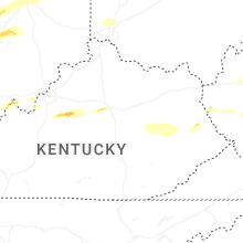
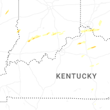
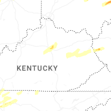


Connect with Interactive Hail Maps