

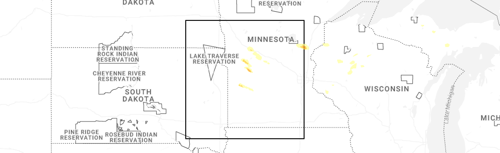
Hail Map for Hazel Run, MN
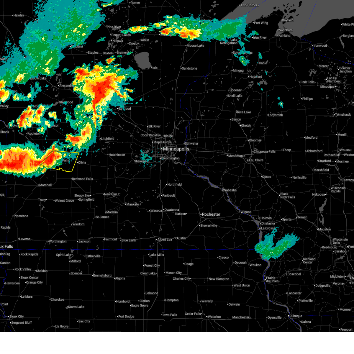
The Hazel Run, MN area has had 0 reports of on-the-ground hail by trained spotters, and has been under severe weather warnings 17 times during the past 12 months. Doppler radar has detected hail at or near Hazel Run, MN on 56 occasions, including 4 occasions during the past year.
| Name: | Hazel Run, MN |
| Where Located: | 14 miles S of Montevideo, MN |
| Map: | Google Map for Hazel Run, MN |
| Population: | 63 |
| Housing Units: | 29 |
| More Info: | Search Google for Hazel Run, MN |
1
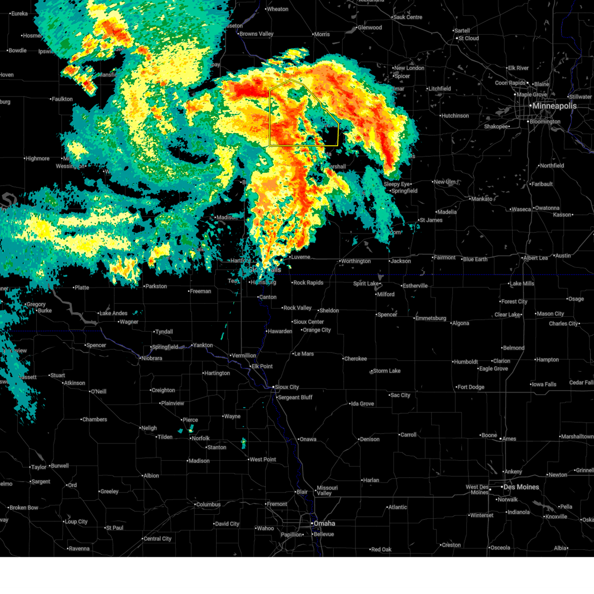
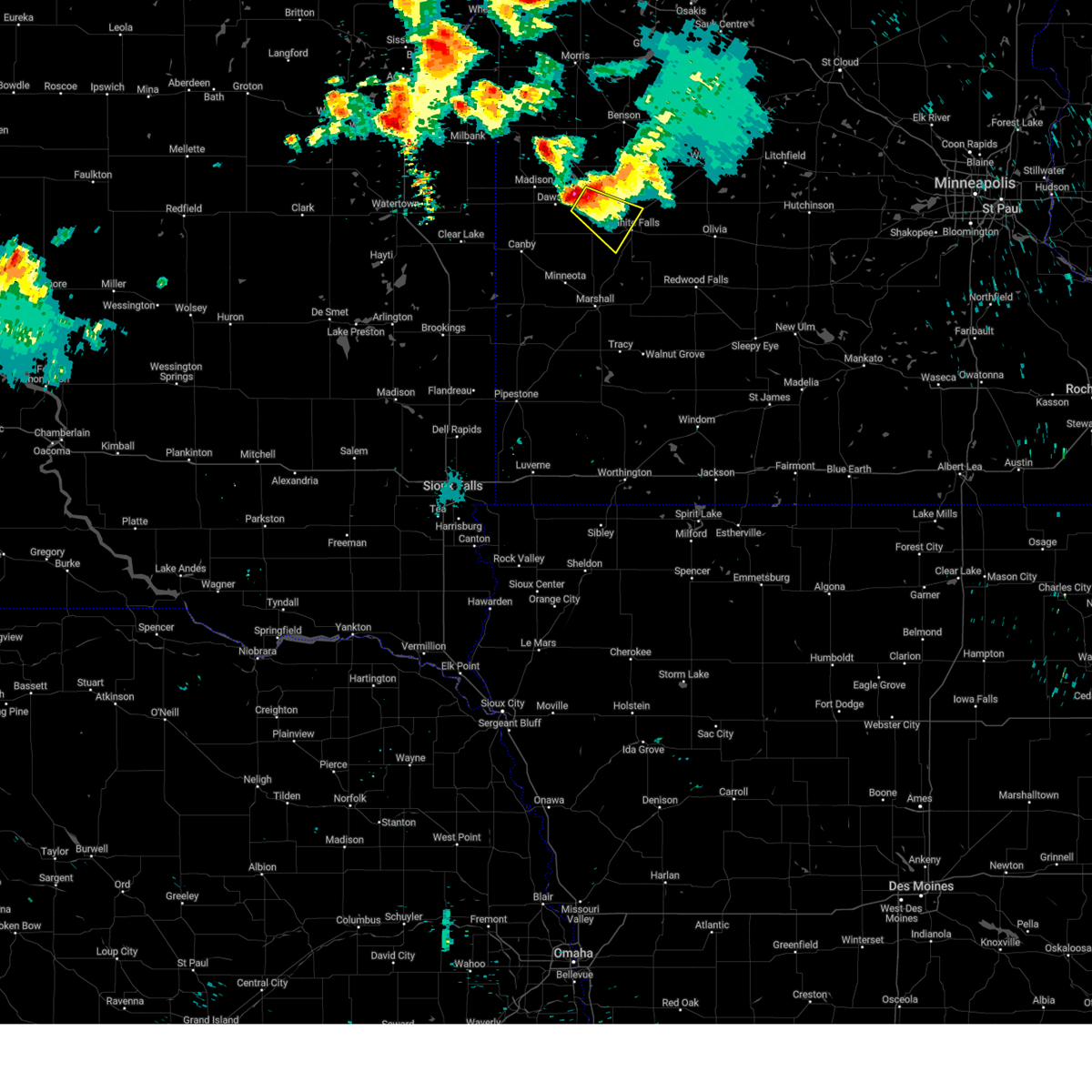
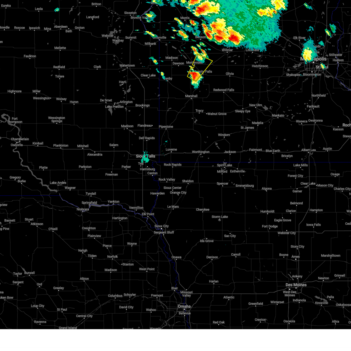
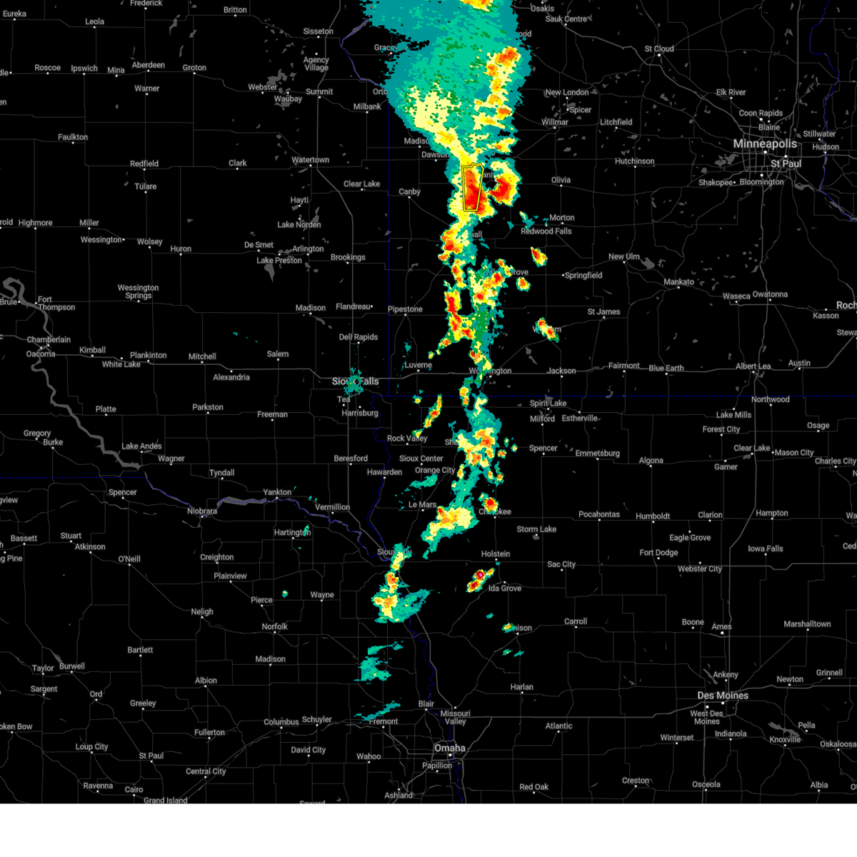
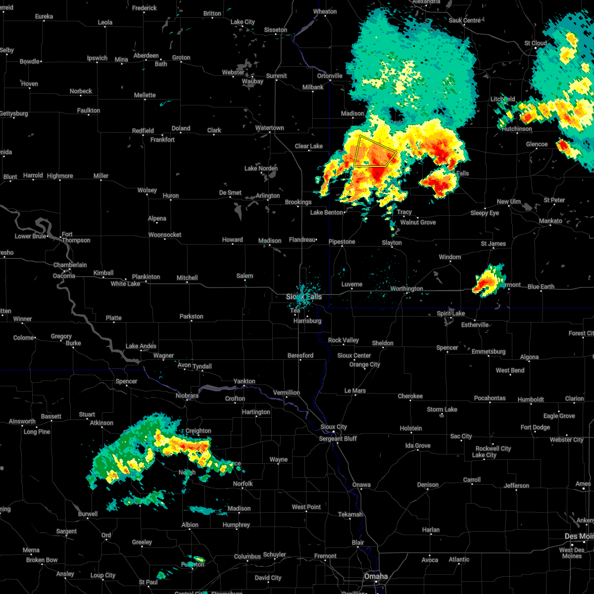
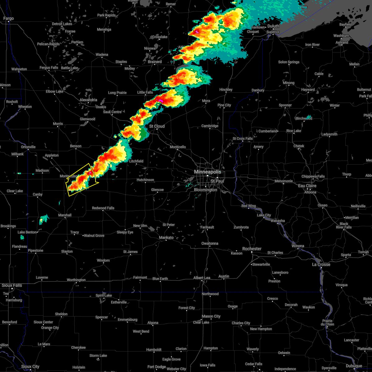
The Top Recent Hail Date for Hazel Run, MN is Friday, June 5, 2026 (14th out of 56)
Hail and Wind Damage Spotted near Hazel Run, MN
| Date / Time | Report Details |
|---|---|
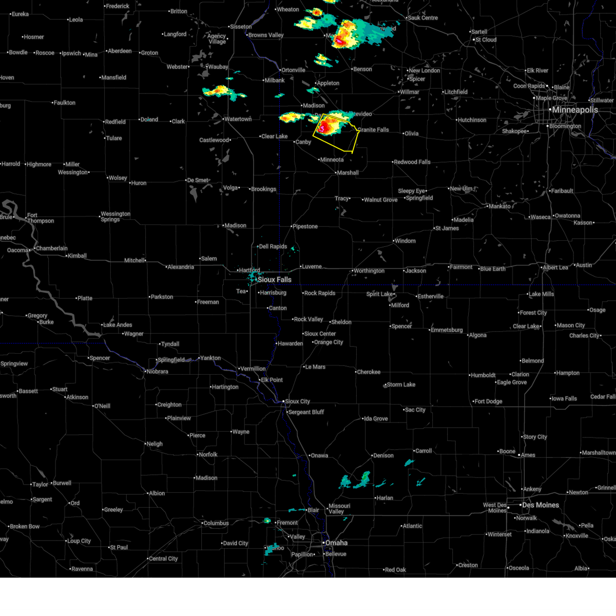
| 6/5/2026 3:36 PM CDT |
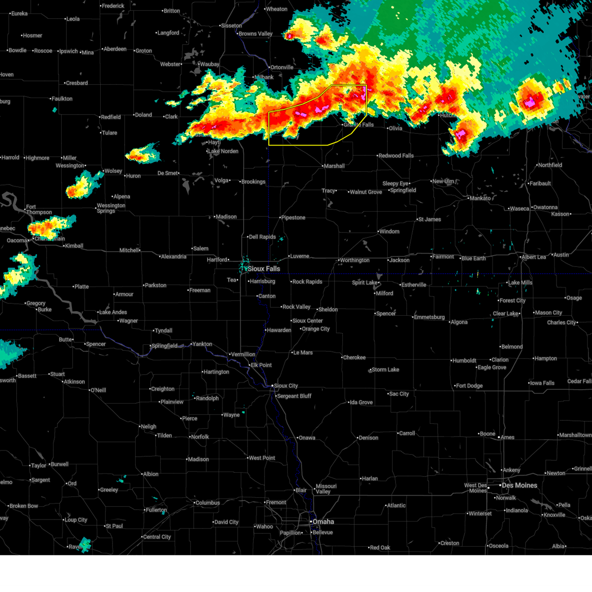
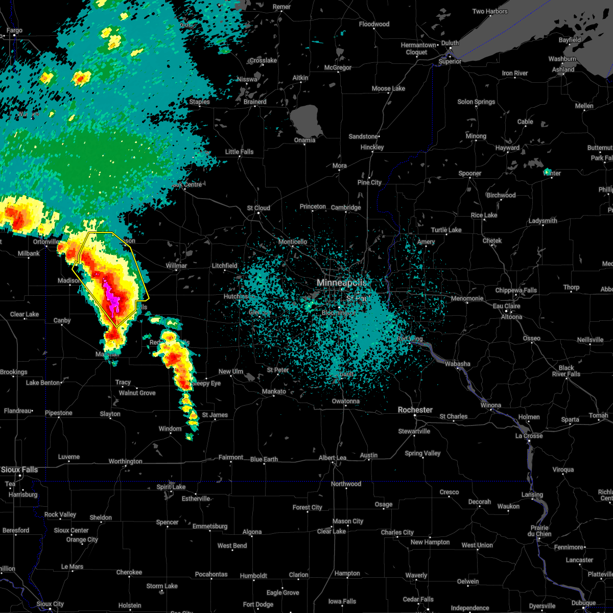
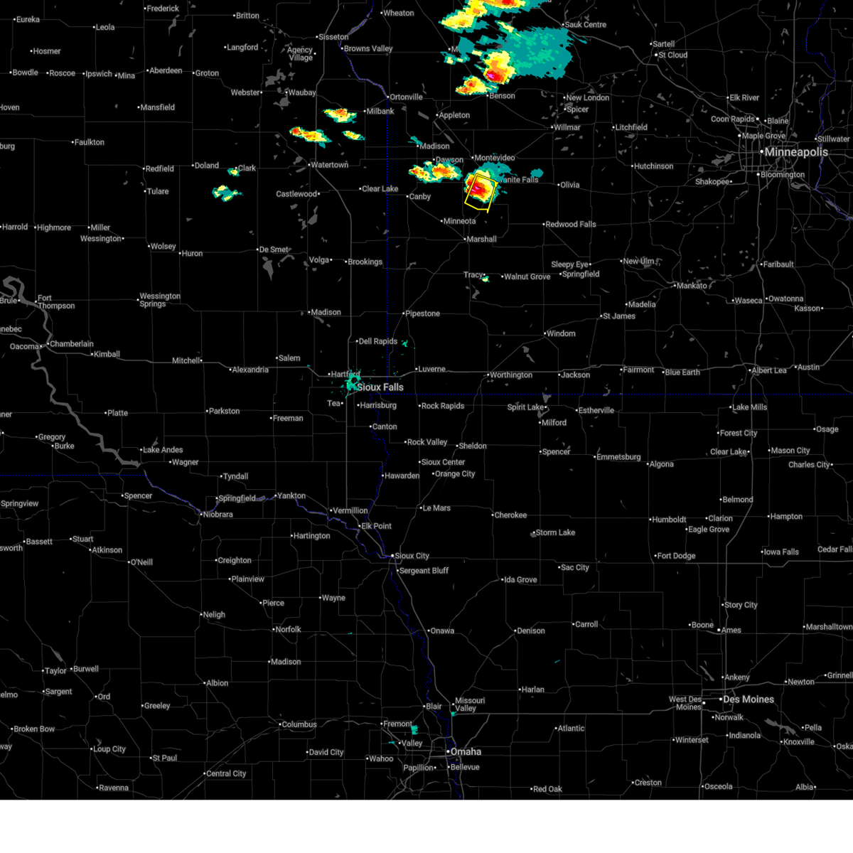 At 336 pm cdt, a severe thunderstorm was located near hanley falls, or 15 miles south of montevideo, moving southeast at 25 mph (radar indicated). Hazards include quarter size hail. Damage to vehicles is expected. Locations impacted include, spellman lake, hazel run, hanley falls and granite falls airport. At 336 pm cdt, a severe thunderstorm was located near hanley falls, or 15 miles south of montevideo, moving southeast at 25 mph (radar indicated). Hazards include quarter size hail. Damage to vehicles is expected. Locations impacted include, spellman lake, hazel run, hanley falls and granite falls airport.
|
| 6/5/2026 3:24 PM CDT |
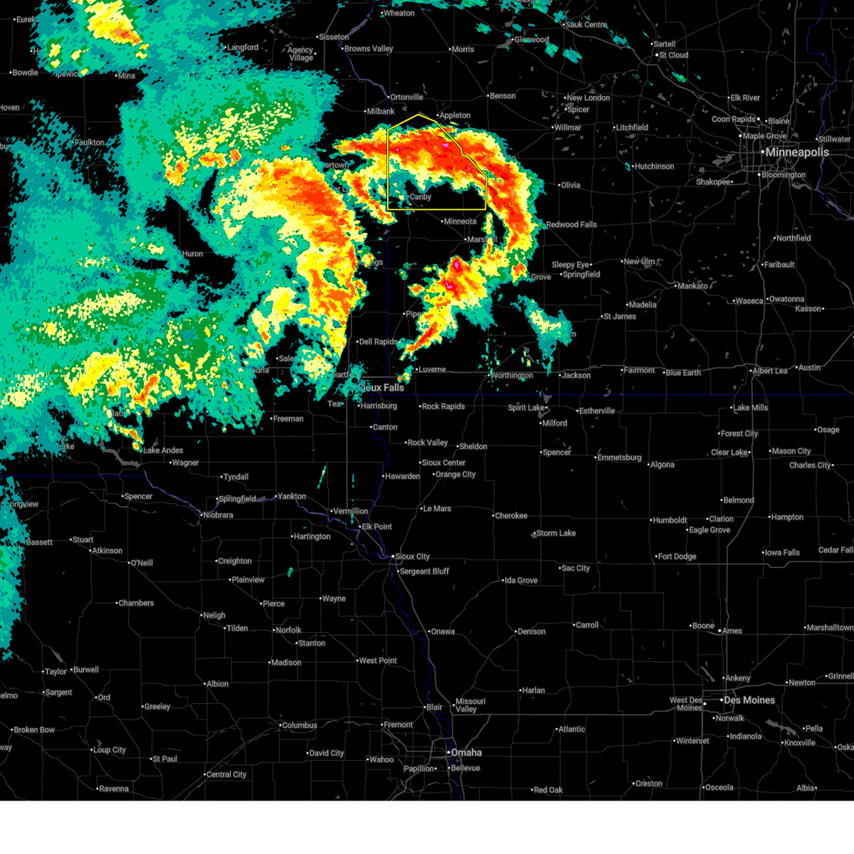
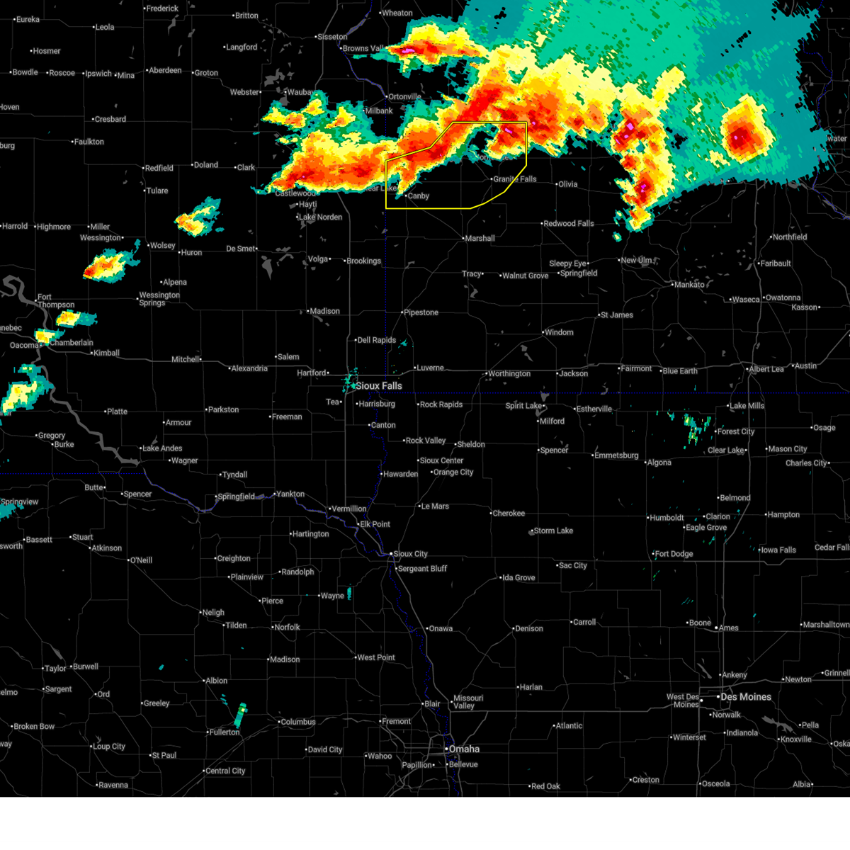
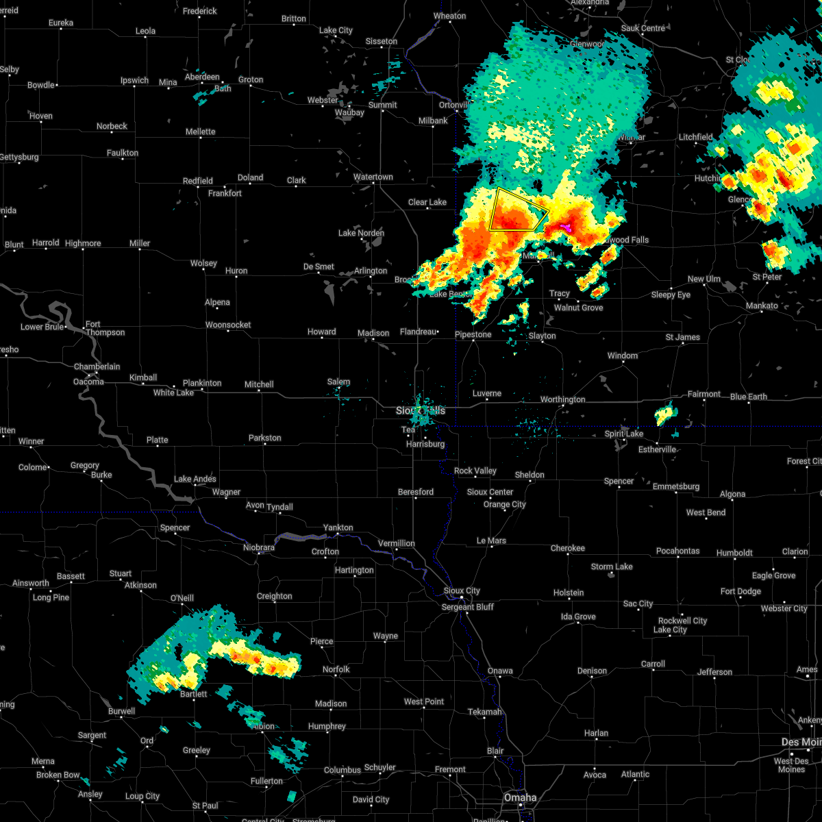
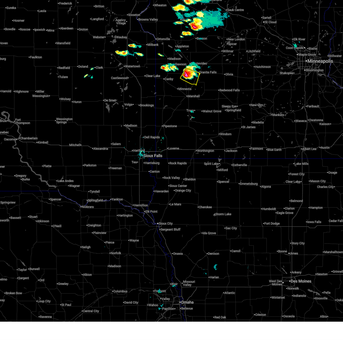 At 324 pm cdt, a severe thunderstorm was located over clarkfield, or 13 miles south of montevideo, moving southeast at 25 mph (radar indicated). Hazards include 60 mph wind gusts and half dollar size hail. Hail damage to vehicles is expected. expect wind damage to roofs, siding, and trees. Locations impacted include, clarkfield, spring creek, hazel run, spellman lake, hanley falls and granite falls airport. At 324 pm cdt, a severe thunderstorm was located over clarkfield, or 13 miles south of montevideo, moving southeast at 25 mph (radar indicated). Hazards include 60 mph wind gusts and half dollar size hail. Hail damage to vehicles is expected. expect wind damage to roofs, siding, and trees. Locations impacted include, clarkfield, spring creek, hazel run, spellman lake, hanley falls and granite falls airport.
|
| 6/5/2026 3:16 PM CDT |
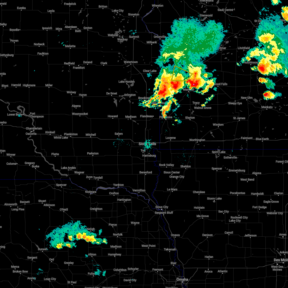
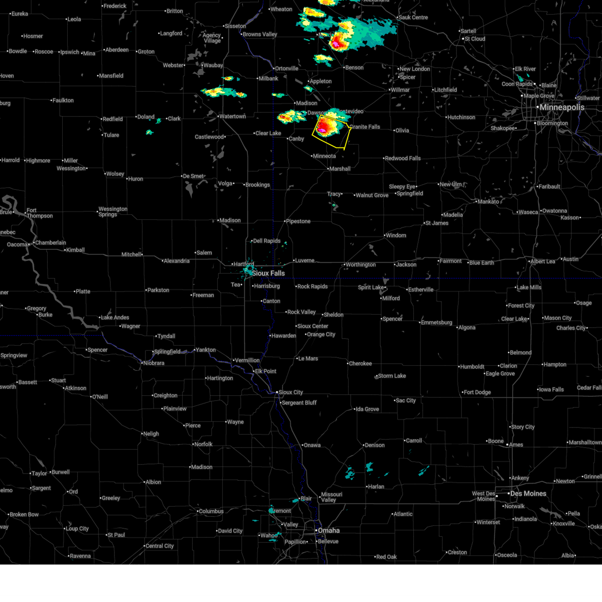 At 316 pm cdt, a severe thunderstorm was located over clarkfield, or 13 miles southwest of montevideo, moving southeast at 25 mph (radar indicated). Hazards include ping pong ball size hail. People and animals outdoors will be injured. expect damage to roofs, siding, windows, and vehicles. Locations impacted include, boyd, clarkfield, spring creek, hazel run, spellman lake, granite falls, hanley falls and granite falls airport. At 316 pm cdt, a severe thunderstorm was located over clarkfield, or 13 miles southwest of montevideo, moving southeast at 25 mph (radar indicated). Hazards include ping pong ball size hail. People and animals outdoors will be injured. expect damage to roofs, siding, windows, and vehicles. Locations impacted include, boyd, clarkfield, spring creek, hazel run, spellman lake, granite falls, hanley falls and granite falls airport.
|
| 6/5/2026 3:08 PM CDT |
 Svrmpx the national weather service in the twin cities has issued a * severe thunderstorm warning for, southeastern lac qui parle county in west central minnesota, eastern yellow medicine county in west central minnesota, * until 415 pm cdt. * at 308 pm cdt, a severe thunderstorm was located over boyd, or 13 miles southwest of montevideo, moving east at 20 mph (radar indicated). Hazards include quarter size hail. damage to vehicles is expected Svrmpx the national weather service in the twin cities has issued a * severe thunderstorm warning for, southeastern lac qui parle county in west central minnesota, eastern yellow medicine county in west central minnesota, * until 415 pm cdt. * at 308 pm cdt, a severe thunderstorm was located over boyd, or 13 miles southwest of montevideo, moving east at 20 mph (radar indicated). Hazards include quarter size hail. damage to vehicles is expected
|
| 8/16/2025 5:18 AM CDT |
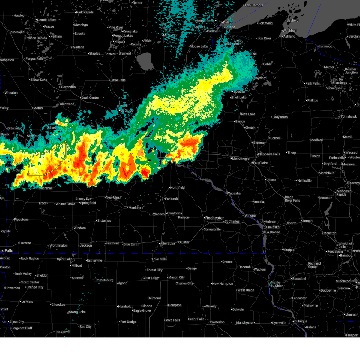
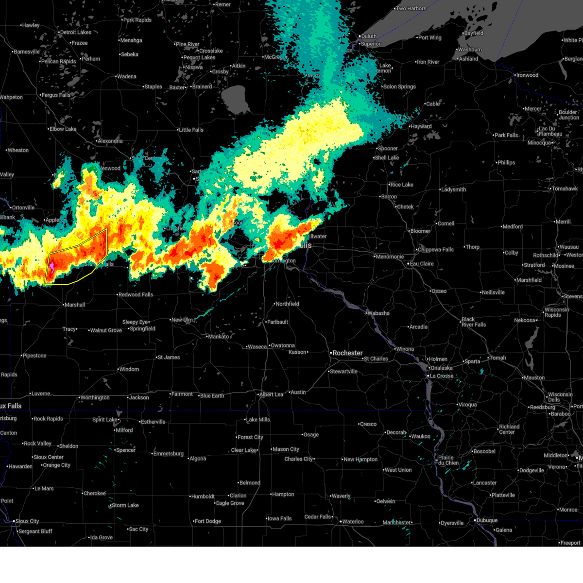
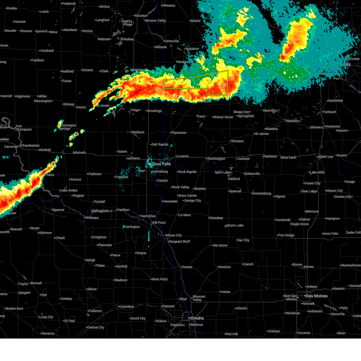
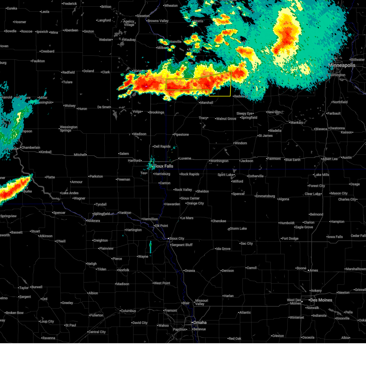
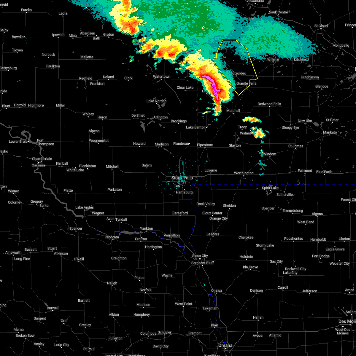
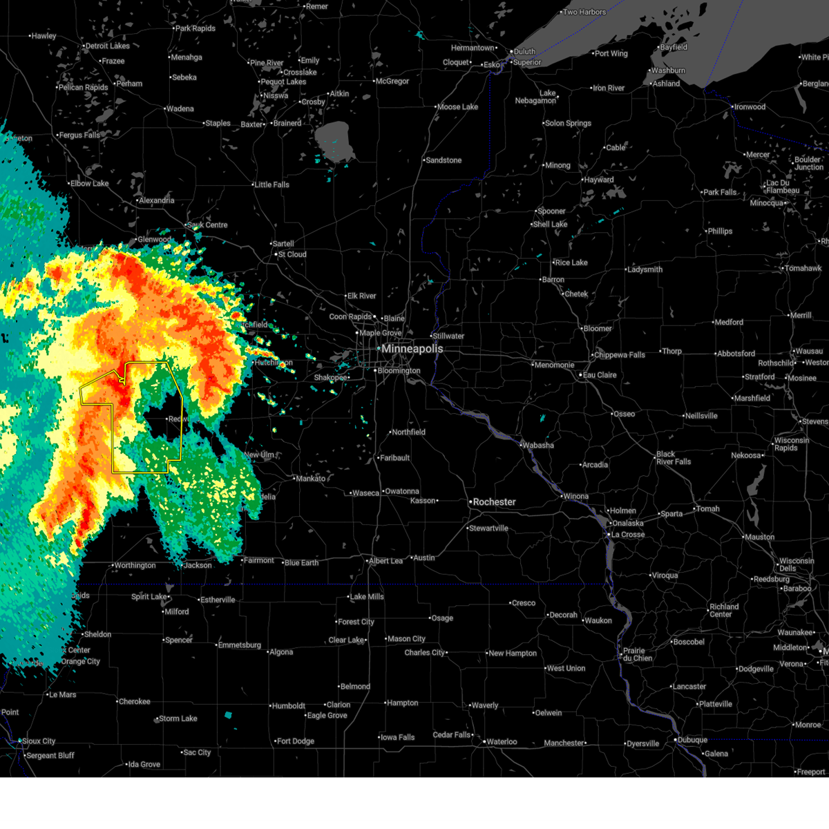 At 518 am cdt, severe thunderstorms were located along a line from over sacred heart to 5 miles southeast of wabasso, or along a line from 20 miles northwest of redwood falls to 13 miles south of redwood falls, moving northeast at 55 mph (the granite falls airport measured a 75 mph gust at 515 am). Hazards include 70 mph wind gusts and quarter size hail. Hail damage to vehicles is expected. expect considerable tree damage. wind damage is also likely to mobile homes, roofs, and outbuildings. Locations impacted include, redwood falls, granite falls, renville, walnut grove, lamberton, wabasso, sacred heart, wood lake, morton, hanley falls, echo, danube, minnesota falls, belview, sanborn, vesta, milroy, lucan, clements and spring creek. At 518 am cdt, severe thunderstorms were located along a line from over sacred heart to 5 miles southeast of wabasso, or along a line from 20 miles northwest of redwood falls to 13 miles south of redwood falls, moving northeast at 55 mph (the granite falls airport measured a 75 mph gust at 515 am). Hazards include 70 mph wind gusts and quarter size hail. Hail damage to vehicles is expected. expect considerable tree damage. wind damage is also likely to mobile homes, roofs, and outbuildings. Locations impacted include, redwood falls, granite falls, renville, walnut grove, lamberton, wabasso, sacred heart, wood lake, morton, hanley falls, echo, danube, minnesota falls, belview, sanborn, vesta, milroy, lucan, clements and spring creek.
|
| 8/16/2025 5:01 AM CDT |
 At 501 am cdt, severe thunderstorms were located along a line from near dawson to 19 miles south of clarkfield, or along a line from 17 miles west of montevideo to 30 miles south of montevideo, moving east at 60 mph (trained spotters reported). Hazards include 60 mph wind gusts and quarter size hail. Hail damage to vehicles is expected. expect wind damage to roofs, siding, and trees. locations impacted include, madison, dawson, clarkfield, hanley falls, boyd, bellingham, cerro gordo, providence, spring creek, hazel run, louisburg, st. Leo, lac qui parle state park, madison airport and spellman lake. At 501 am cdt, severe thunderstorms were located along a line from near dawson to 19 miles south of clarkfield, or along a line from 17 miles west of montevideo to 30 miles south of montevideo, moving east at 60 mph (trained spotters reported). Hazards include 60 mph wind gusts and quarter size hail. Hail damage to vehicles is expected. expect wind damage to roofs, siding, and trees. locations impacted include, madison, dawson, clarkfield, hanley falls, boyd, bellingham, cerro gordo, providence, spring creek, hazel run, louisburg, st. Leo, lac qui parle state park, madison airport and spellman lake.
|
| 8/16/2025 4:50 AM CDT |
 Svrmpx the national weather service in the twin cities has issued a * severe thunderstorm warning for, western renville county in central minnesota, redwood county in southwestern minnesota, southeastern yellow medicine county in west central minnesota, * until 545 am cdt. * at 450 am cdt, severe thunderstorms were located along a line from 11 miles south of clarkfield to 9 miles west of walnut grove, or along a line from 22 miles south of montevideo to 36 miles southwest of redwood falls, moving northeast at 55 mph (radar indicated). Hazards include 60 mph wind gusts and quarter size hail. Hail damage to vehicles is expected. Expect wind damage to roofs, siding, and trees. Svrmpx the national weather service in the twin cities has issued a * severe thunderstorm warning for, western renville county in central minnesota, redwood county in southwestern minnesota, southeastern yellow medicine county in west central minnesota, * until 545 am cdt. * at 450 am cdt, severe thunderstorms were located along a line from 11 miles south of clarkfield to 9 miles west of walnut grove, or along a line from 22 miles south of montevideo to 36 miles southwest of redwood falls, moving northeast at 55 mph (radar indicated). Hazards include 60 mph wind gusts and quarter size hail. Hail damage to vehicles is expected. Expect wind damage to roofs, siding, and trees.
|
| 8/16/2025 4:45 AM CDT |
 At 445 am cdt, severe thunderstorms were located along a line from 7 miles southeast of marietta to 12 miles south of porter, or along a line from 31 miles west of montevideo to 40 miles southwest of montevideo, moving east at 60 mph (the canby airport measured a 61 mph wind gust at 445 am). Hazards include 60 mph wind gusts and quarter size hail. Hail damage to vehicles is expected. expect wind damage to roofs, siding, and trees. locations impacted include, canby, madison, dawson, clarkfield, hanley falls, porter, boyd, bellingham, marietta, cerro gordo, providence, spring creek, nassau, hazel run, louisburg, st. Leo, madison airport, florida creek wildlife management area, lac qui parle state park and burr. At 445 am cdt, severe thunderstorms were located along a line from 7 miles southeast of marietta to 12 miles south of porter, or along a line from 31 miles west of montevideo to 40 miles southwest of montevideo, moving east at 60 mph (the canby airport measured a 61 mph wind gust at 445 am). Hazards include 60 mph wind gusts and quarter size hail. Hail damage to vehicles is expected. expect wind damage to roofs, siding, and trees. locations impacted include, canby, madison, dawson, clarkfield, hanley falls, porter, boyd, bellingham, marietta, cerro gordo, providence, spring creek, nassau, hazel run, louisburg, st. Leo, madison airport, florida creek wildlife management area, lac qui parle state park and burr.
|
| 8/16/2025 4:17 AM CDT |
 Svrmpx the national weather service in the twin cities has issued a * severe thunderstorm warning for, lac qui parle county in west central minnesota, yellow medicine county in west central minnesota, * until 515 am cdt. * at 417 am cdt, severe thunderstorms were located along a line from 26 miles southwest of marietta to 32 miles southwest of canby, or along a line from 58 miles west of montevideo to 63 miles southwest of montevideo, moving east at 60 mph (radar indicated). Hazards include 60 mph wind gusts and quarter size hail. Hail damage to vehicles is expected. Expect wind damage to roofs, siding, and trees. Svrmpx the national weather service in the twin cities has issued a * severe thunderstorm warning for, lac qui parle county in west central minnesota, yellow medicine county in west central minnesota, * until 515 am cdt. * at 417 am cdt, severe thunderstorms were located along a line from 26 miles southwest of marietta to 32 miles southwest of canby, or along a line from 58 miles west of montevideo to 63 miles southwest of montevideo, moving east at 60 mph (radar indicated). Hazards include 60 mph wind gusts and quarter size hail. Hail damage to vehicles is expected. Expect wind damage to roofs, siding, and trees.
|
| 7/27/2025 8:40 PM CDT |
 The storms which prompted the warning have weakened below severe limits, and no longer poses an immediate threat to life or property. therefore, the warning will be allowed to expire. however, heavy rain is still possible with these thunderstorms. a severe thunderstorm watch remains in effect until 1200 am cdt for portions of central and west central minnesota. The storms which prompted the warning have weakened below severe limits, and no longer poses an immediate threat to life or property. therefore, the warning will be allowed to expire. however, heavy rain is still possible with these thunderstorms. a severe thunderstorm watch remains in effect until 1200 am cdt for portions of central and west central minnesota.
|
| 7/27/2025 8:19 PM CDT |
 At 819 pm cdt, a severe thunderstorm was located over clarkfield, or 13 miles south of montevideo, moving east at 40 mph (radar indicated). Hazards include ping pong ball size hail and 60 mph wind gusts. People and animals outdoors will be injured. expect hail damage to roofs, siding, windows, and vehicles. expect wind damage to roofs, siding, and trees. Locations impacted include, montevideo, granite falls, clara city, clarkfield, maynard, hanley falls, boyd, minnesota falls, spring creek, hazel run, granite falls airport, asbury, upper sioux agency state park, gluek and spellman lake. At 819 pm cdt, a severe thunderstorm was located over clarkfield, or 13 miles south of montevideo, moving east at 40 mph (radar indicated). Hazards include ping pong ball size hail and 60 mph wind gusts. People and animals outdoors will be injured. expect hail damage to roofs, siding, windows, and vehicles. expect wind damage to roofs, siding, and trees. Locations impacted include, montevideo, granite falls, clara city, clarkfield, maynard, hanley falls, boyd, minnesota falls, spring creek, hazel run, granite falls airport, asbury, upper sioux agency state park, gluek and spellman lake.
|
| 7/27/2025 7:57 PM CDT |
 At 757 pm cdt, severe thunderstorms were located along a line from 11 miles northwest of maynard to 7 miles north of porter, or along a line from 10 miles northeast of montevideo to 26 miles southwest of montevideo, moving east at 40 mph (radar indicated). Hazards include 60 mph wind gusts and quarter size hail. Hail damage to vehicles is expected. expect wind damage to roofs, siding, and trees. locations impacted include, montevideo, granite falls, canby, dawson, clara city, clarkfield, maynard, hanley falls, watson, porter, boyd, minnesota falls, providence, spring creek, hazel run, montevideo airport, lac qui parle state park, spellman lake, asbury and st. Leo. At 757 pm cdt, severe thunderstorms were located along a line from 11 miles northwest of maynard to 7 miles north of porter, or along a line from 10 miles northeast of montevideo to 26 miles southwest of montevideo, moving east at 40 mph (radar indicated). Hazards include 60 mph wind gusts and quarter size hail. Hail damage to vehicles is expected. expect wind damage to roofs, siding, and trees. locations impacted include, montevideo, granite falls, canby, dawson, clara city, clarkfield, maynard, hanley falls, watson, porter, boyd, minnesota falls, providence, spring creek, hazel run, montevideo airport, lac qui parle state park, spellman lake, asbury and st. Leo.
|
| 7/27/2025 7:44 PM CDT |
 Svrmpx the national weather service in the twin cities has issued a * severe thunderstorm warning for, northwestern renville county in central minnesota, chippewa county in west central minnesota, southern lac qui parle county in west central minnesota, yellow medicine county in west central minnesota, * until 845 pm cdt. * at 744 pm cdt, severe thunderstorms were located along a line from 6 miles northeast of watson to 8 miles northeast of canby, or along a line from 10 miles north of montevideo to 25 miles west of montevideo, moving southeast at 30 mph (radar indicated). Hazards include 60 mph wind gusts and quarter size hail. Hail damage to vehicles is expected. Expect wind damage to roofs, siding, and trees. Svrmpx the national weather service in the twin cities has issued a * severe thunderstorm warning for, northwestern renville county in central minnesota, chippewa county in west central minnesota, southern lac qui parle county in west central minnesota, yellow medicine county in west central minnesota, * until 845 pm cdt. * at 744 pm cdt, severe thunderstorms were located along a line from 6 miles northeast of watson to 8 miles northeast of canby, or along a line from 10 miles north of montevideo to 25 miles west of montevideo, moving southeast at 30 mph (radar indicated). Hazards include 60 mph wind gusts and quarter size hail. Hail damage to vehicles is expected. Expect wind damage to roofs, siding, and trees.
|
| 6/28/2025 10:56 PM CDT |
 The storms which prompted the warning have moved out of the area. therefore, the warning will be allowed to expire. another severe thunderstorm warning still remains in effect for redwood county, renville county, and yellow medicine county until 1145 pm. The storms which prompted the warning have moved out of the area. therefore, the warning will be allowed to expire. another severe thunderstorm warning still remains in effect for redwood county, renville county, and yellow medicine county until 1145 pm.
|
| 6/28/2025 10:35 PM CDT |
 At 1035 pm cdt, severe thunderstorms were located along a line from over renville to 9 miles southwest of canby, or along a line from 16 miles north of redwood falls to 40 miles southwest of montevideo, moving southeast at 25 mph (radar indicated). Hazards include 60 mph wind gusts and quarter size hail. Hail damage to vehicles is expected. expect wind damage to roofs, siding, and trees. locations impacted include, granite falls, canby, renville, clarkfield, sacred heart, wood lake, hanley falls, echo, porter, minnesota falls, belview, spring creek, delhi, hazel run, spellman lake, granite falls airport, upper sioux agency state park, st. Leo and burr. At 1035 pm cdt, severe thunderstorms were located along a line from over renville to 9 miles southwest of canby, or along a line from 16 miles north of redwood falls to 40 miles southwest of montevideo, moving southeast at 25 mph (radar indicated). Hazards include 60 mph wind gusts and quarter size hail. Hail damage to vehicles is expected. expect wind damage to roofs, siding, and trees. locations impacted include, granite falls, canby, renville, clarkfield, sacred heart, wood lake, hanley falls, echo, porter, minnesota falls, belview, spring creek, delhi, hazel run, spellman lake, granite falls airport, upper sioux agency state park, st. Leo and burr.
|
| 6/28/2025 10:21 PM CDT |
 Svrmpx the national weather service in the twin cities has issued a * severe thunderstorm warning for, northwestern renville county in central minnesota, northwestern redwood county in southwestern minnesota, south central chippewa county in west central minnesota, yellow medicine county in west central minnesota, * until 1100 pm cdt. * at 1021 pm cdt, severe thunderstorms were located along a line from near renville to 9 miles southwest of canby, or along a line from 18 miles northwest of redwood falls to 40 miles southwest of montevideo, moving east at 30 mph (radar indicated). Hazards include 60 mph wind gusts and quarter size hail. Hail damage to vehicles is expected. Expect wind damage to roofs, siding, and trees. Svrmpx the national weather service in the twin cities has issued a * severe thunderstorm warning for, northwestern renville county in central minnesota, northwestern redwood county in southwestern minnesota, south central chippewa county in west central minnesota, yellow medicine county in west central minnesota, * until 1100 pm cdt. * at 1021 pm cdt, severe thunderstorms were located along a line from near renville to 9 miles southwest of canby, or along a line from 18 miles northwest of redwood falls to 40 miles southwest of montevideo, moving east at 30 mph (radar indicated). Hazards include 60 mph wind gusts and quarter size hail. Hail damage to vehicles is expected. Expect wind damage to roofs, siding, and trees.
|
| 6/28/2025 9:41 PM CDT |
 Svrmpx the national weather service in the twin cities has issued a * severe thunderstorm warning for, southwestern kandiyohi county in central minnesota, northwestern renville county in central minnesota, southeastern chippewa county in west central minnesota, northeastern yellow medicine county in west central minnesota, * until 1030 pm cdt. * at 941 pm cdt, a severe thunderstorm was located over granite falls, or 15 miles southeast of montevideo, moving east at 30 mph (radar indicated). Hazards include 60 mph wind gusts and quarter size hail. Hail damage to vehicles is expected. Expect wind damage to roofs, siding, and trees. Svrmpx the national weather service in the twin cities has issued a * severe thunderstorm warning for, southwestern kandiyohi county in central minnesota, northwestern renville county in central minnesota, southeastern chippewa county in west central minnesota, northeastern yellow medicine county in west central minnesota, * until 1030 pm cdt. * at 941 pm cdt, a severe thunderstorm was located over granite falls, or 15 miles southeast of montevideo, moving east at 30 mph (radar indicated). Hazards include 60 mph wind gusts and quarter size hail. Hail damage to vehicles is expected. Expect wind damage to roofs, siding, and trees.
|
| 7/15/2024 4:02 AM CDT |
 At 401 am cdt, a severe thunderstorm was located near montevideo, moving southeast at 45 mph (radar indicated). Hazards include golf ball size hail. People and animals outdoors will be injured. expect damage to roofs, siding, windows, and vehicles. Locations impacted include, montevideo, granite falls, maynard, hazel run, and montevideo airport. At 401 am cdt, a severe thunderstorm was located near montevideo, moving southeast at 45 mph (radar indicated). Hazards include golf ball size hail. People and animals outdoors will be injured. expect damage to roofs, siding, windows, and vehicles. Locations impacted include, montevideo, granite falls, maynard, hazel run, and montevideo airport.
|
| 7/15/2024 3:56 AM CDT |
 Svrmpx the national weather service in the twin cities has issued a * severe thunderstorm warning for, southeastern lac qui parle county in west central minnesota, central chippewa county in west central minnesota, northeastern yellow medicine county in west central minnesota, * until 430 am cdt. * at 356 am cdt, a severe thunderstorm was located 6 miles north of boyd, or 7 miles west of montevideo, moving southeast at 45 mph (radar indicated). Hazards include quarter size hail. damage to vehicles is expected Svrmpx the national weather service in the twin cities has issued a * severe thunderstorm warning for, southeastern lac qui parle county in west central minnesota, central chippewa county in west central minnesota, northeastern yellow medicine county in west central minnesota, * until 430 am cdt. * at 356 am cdt, a severe thunderstorm was located 6 miles north of boyd, or 7 miles west of montevideo, moving southeast at 45 mph (radar indicated). Hazards include quarter size hail. damage to vehicles is expected
|
| 7/13/2024 7:25 AM CDT |
 Svrmpx the national weather service in the twin cities has issued a * severe thunderstorm warning for, northwestern redwood county in southwestern minnesota, eastern yellow medicine county in west central minnesota, west central renville county in central minnesota, * until 815 am cdt. * at 725 am cdt, a severe thunderstorm was located near hanley falls, or 16 miles south of montevideo, moving southeast at 20 mph (radar indicated). Hazards include ping pong ball size hail and 60 mph wind gusts. People and animals outdoors will be injured. expect hail damage to roofs, siding, windows, and vehicles. expect wind damage to roofs, siding, and trees. this severe thunderstorm will be near, hanley falls around 730 am cdt. wood lake around 735 am cdt. Other locations in the path of this severe thunderstorm include echo. Svrmpx the national weather service in the twin cities has issued a * severe thunderstorm warning for, northwestern redwood county in southwestern minnesota, eastern yellow medicine county in west central minnesota, west central renville county in central minnesota, * until 815 am cdt. * at 725 am cdt, a severe thunderstorm was located near hanley falls, or 16 miles south of montevideo, moving southeast at 20 mph (radar indicated). Hazards include ping pong ball size hail and 60 mph wind gusts. People and animals outdoors will be injured. expect hail damage to roofs, siding, windows, and vehicles. expect wind damage to roofs, siding, and trees. this severe thunderstorm will be near, hanley falls around 730 am cdt. wood lake around 735 am cdt. Other locations in the path of this severe thunderstorm include echo.
|
| 6/17/2024 11:19 PM CDT |
 Svrmpx the national weather service in the twin cities has issued a * severe thunderstorm warning for, central chippewa county in west central minnesota, northeastern yellow medicine county in west central minnesota, * until midnight cdt. * at 1119 pm cdt, a severe thunderstorm was located over clarkfield, or 10 miles south of montevideo, moving northeast at 40 mph (radar indicated). Hazards include quarter size hail. damage to vehicles is expected Svrmpx the national weather service in the twin cities has issued a * severe thunderstorm warning for, central chippewa county in west central minnesota, northeastern yellow medicine county in west central minnesota, * until midnight cdt. * at 1119 pm cdt, a severe thunderstorm was located over clarkfield, or 10 miles south of montevideo, moving northeast at 40 mph (radar indicated). Hazards include quarter size hail. damage to vehicles is expected
|
| 5/31/2023 4:34 PM CDT |
 At 434 pm cdt, a severe thunderstorm was located over clarkfield, or 9 miles southwest of montevideo, moving north at 40 mph (radar indicated). Hazards include 60 mph wind gusts and quarter size hail. Hail damage to vehicles is expected. expect wind damage to roofs, siding, and trees. this severe thunderstorm will remain over mainly rural areas of north central yellow medicine county, including the following locations, spellman lake and hazel run. hail threat, radar indicated max hail size, 1. 00 in wind threat, radar indicated max wind gust, 60 mph. At 434 pm cdt, a severe thunderstorm was located over clarkfield, or 9 miles southwest of montevideo, moving north at 40 mph (radar indicated). Hazards include 60 mph wind gusts and quarter size hail. Hail damage to vehicles is expected. expect wind damage to roofs, siding, and trees. this severe thunderstorm will remain over mainly rural areas of north central yellow medicine county, including the following locations, spellman lake and hazel run. hail threat, radar indicated max hail size, 1. 00 in wind threat, radar indicated max wind gust, 60 mph.
|
| 5/31/2023 4:16 PM CDT |
 At 416 pm cdt, a severe thunderstorm was located 6 miles northwest of cottonwood, or 13 miles north of marshall, moving north at 40 mph (radar indicated). Hazards include 60 mph wind gusts and quarter size hail. Hail damage to vehicles is expected. expect wind damage to roofs, siding, and trees. this severe thunderstorm will be near, clarkfield around 430 pm cdt. boyd around 435 pm cdt. hail threat, radar indicated max hail size, 1. 00 in wind threat, radar indicated max wind gust, 60 mph. At 416 pm cdt, a severe thunderstorm was located 6 miles northwest of cottonwood, or 13 miles north of marshall, moving north at 40 mph (radar indicated). Hazards include 60 mph wind gusts and quarter size hail. Hail damage to vehicles is expected. expect wind damage to roofs, siding, and trees. this severe thunderstorm will be near, clarkfield around 430 pm cdt. boyd around 435 pm cdt. hail threat, radar indicated max hail size, 1. 00 in wind threat, radar indicated max wind gust, 60 mph.
|
| 8/2/2022 10:29 PM CDT |
 At 1029 pm cdt, severe thunderstorms were located along a line extending from 5 miles southeast of montevideo to wood lake to 8 miles north of walnut grove, moving east at 60 mph (radar indicated). Hazards include 70 mph wind gusts. Expect considerable tree damage. damage is likely to mobile homes, roofs, and outbuildings. locations impacted include, echo, wabasso, sacred heart, maynard, clara city, renville, redwood falls, olivia, morgan, morton and franklin. thunderstorm damage threat, considerable hail threat, radar indicated max hail size, <. 75 in wind threat, radar indicated max wind gust, 70 mph. At 1029 pm cdt, severe thunderstorms were located along a line extending from 5 miles southeast of montevideo to wood lake to 8 miles north of walnut grove, moving east at 60 mph (radar indicated). Hazards include 70 mph wind gusts. Expect considerable tree damage. damage is likely to mobile homes, roofs, and outbuildings. locations impacted include, echo, wabasso, sacred heart, maynard, clara city, renville, redwood falls, olivia, morgan, morton and franklin. thunderstorm damage threat, considerable hail threat, radar indicated max hail size, <. 75 in wind threat, radar indicated max wind gust, 70 mph.
|
| 8/2/2022 10:13 PM CDT |
 At 1012 pm cdt, severe thunderstorms were located along a line extending from near boyd to 6 miles northeast of ghent to 7 miles northwest of tracy, moving east at 60 mph (radar indicated). Hazards include 70 mph wind gusts. a 74 mph gust was reported at marshall airport. Expect considerable tree damage. damage is likely to mobile homes, roofs, and outbuildings. severe thunderstorms will be near, clarkfield around 1020 pm cdt. montevideo, wood lake and hanley falls around 1025 pm cdt. granite falls and echo around 1030 pm cdt. wabasso, sacred heart and maynard around 1035 pm cdt. clara city around 1040 pm cdt. redwood falls and renville around 1045 pm cdt. thunderstorm damage threat, considerable hail threat, radar indicated max hail size, <. 75 in wind threat, observed max wind gust, 70 mph. At 1012 pm cdt, severe thunderstorms were located along a line extending from near boyd to 6 miles northeast of ghent to 7 miles northwest of tracy, moving east at 60 mph (radar indicated). Hazards include 70 mph wind gusts. a 74 mph gust was reported at marshall airport. Expect considerable tree damage. damage is likely to mobile homes, roofs, and outbuildings. severe thunderstorms will be near, clarkfield around 1020 pm cdt. montevideo, wood lake and hanley falls around 1025 pm cdt. granite falls and echo around 1030 pm cdt. wabasso, sacred heart and maynard around 1035 pm cdt. clara city around 1040 pm cdt. redwood falls and renville around 1045 pm cdt. thunderstorm damage threat, considerable hail threat, radar indicated max hail size, <. 75 in wind threat, observed max wind gust, 70 mph.
|
| 6/21/2022 12:08 AM CDT |
 At 1208 am cdt, severe thunderstorms were located along a line extending from 8 miles southwest of kerkhoven to near granite falls to near cottonwood, moving east at 40 mph (radar indicated). Hazards include 60 mph wind gusts. Expect damage to roofs, siding, and trees. locations impacted include, willmar, granite falls, clara city, raymond, sacred heart, prinsburg, wood lake, maynard, hanley falls, echo, pennock and minnesota falls. hail threat, radar indicated max hail size, <. 75 in wind threat, radar indicated max wind gust, 60 mph. At 1208 am cdt, severe thunderstorms were located along a line extending from 8 miles southwest of kerkhoven to near granite falls to near cottonwood, moving east at 40 mph (radar indicated). Hazards include 60 mph wind gusts. Expect damage to roofs, siding, and trees. locations impacted include, willmar, granite falls, clara city, raymond, sacred heart, prinsburg, wood lake, maynard, hanley falls, echo, pennock and minnesota falls. hail threat, radar indicated max hail size, <. 75 in wind threat, radar indicated max wind gust, 60 mph.
|
| 6/20/2022 11:49 PM CDT |
 At 1148 pm cdt, severe thunderstorms were located along a line extending from 8 miles northeast of watson to 5 miles northeast of taunton, moving east at 30 mph (radar indicated). Hazards include 60 mph wind gusts. expect damage to roofs, siding, and trees At 1148 pm cdt, severe thunderstorms were located along a line extending from 8 miles northeast of watson to 5 miles northeast of taunton, moving east at 30 mph (radar indicated). Hazards include 60 mph wind gusts. expect damage to roofs, siding, and trees
|
| 6/20/2022 9:37 PM CDT |
 At 936 pm cdt, a severe thunderstorm was located over wood lake, or 20 miles southeast of montevideo, moving east at 45 mph (radar indicated). Hazards include 60 mph wind gusts. Expect damage to roofs, siding, and trees. this severe thunderstorm will remain over mainly rural areas of eastern yellow medicine county, including the following locations, granite falls airport, spellman lake and hazel run. hail threat, radar indicated max hail size, <. 75 in wind threat, observed max wind gust, 60 mph. At 936 pm cdt, a severe thunderstorm was located over wood lake, or 20 miles southeast of montevideo, moving east at 45 mph (radar indicated). Hazards include 60 mph wind gusts. Expect damage to roofs, siding, and trees. this severe thunderstorm will remain over mainly rural areas of eastern yellow medicine county, including the following locations, granite falls airport, spellman lake and hazel run. hail threat, radar indicated max hail size, <. 75 in wind threat, observed max wind gust, 60 mph.
|
| 6/20/2022 9:19 PM CDT |
 At 918 pm cdt, severe thunderstorms were located along a line extending from 5 miles southwest of clarkfield to 6 miles southwest of cottonwood, moving northeast at 50 mph (radar indicated. at 902 pm, a 68 mph gust was measured at taunton). Hazards include 60 mph wind gusts. Expect damage to roofs, siding, and trees. these severe storms will be near, hanley falls around 930 pm cdt. wood lake around 935 pm cdt. granite falls around 940 pm cdt. other locations impacted by these severe thunderstorms include granite falls airport, spring creek, spellman lake and hazel run. hail threat, radar indicated max hail size, <. 75 in wind threat, observed max wind gust, 60 mph. At 918 pm cdt, severe thunderstorms were located along a line extending from 5 miles southwest of clarkfield to 6 miles southwest of cottonwood, moving northeast at 50 mph (radar indicated. at 902 pm, a 68 mph gust was measured at taunton). Hazards include 60 mph wind gusts. Expect damage to roofs, siding, and trees. these severe storms will be near, hanley falls around 930 pm cdt. wood lake around 935 pm cdt. granite falls around 940 pm cdt. other locations impacted by these severe thunderstorms include granite falls airport, spring creek, spellman lake and hazel run. hail threat, radar indicated max hail size, <. 75 in wind threat, observed max wind gust, 60 mph.
|
| 6/20/2022 9:02 PM CDT |
 At 902 pm cdt, severe thunderstorms were located along a line extending from near taunton to near minneota to arco, moving northeast at 45 mph (radar indicated). Hazards include 60 mph wind gusts. Expect damage to roofs, siding, and trees. severe thunderstorms will be near, clarkfield around 925 pm cdt. hanley falls around 935 pm cdt. granite falls around 945 pm cdt. wood lake around 950 pm cdt. other locations impacted by these severe thunderstorms include granite falls airport, spring creek, spellman lake, hazel run and st. leo. hail threat, radar indicated max hail size, <. 75 in wind threat, radar indicated max wind gust, 60 mph. At 902 pm cdt, severe thunderstorms were located along a line extending from near taunton to near minneota to arco, moving northeast at 45 mph (radar indicated). Hazards include 60 mph wind gusts. Expect damage to roofs, siding, and trees. severe thunderstorms will be near, clarkfield around 925 pm cdt. hanley falls around 935 pm cdt. granite falls around 945 pm cdt. wood lake around 950 pm cdt. other locations impacted by these severe thunderstorms include granite falls airport, spring creek, spellman lake, hazel run and st. leo. hail threat, radar indicated max hail size, <. 75 in wind threat, radar indicated max wind gust, 60 mph.
|
| 5/30/2022 7:12 PM CDT |
 At 711 pm cdt, severe thunderstorms were located along a line extending from 5 miles northeast of gary to 9 miles northeast of taunton to marshall, moving northeast at 75 mph (radar indicated). Hazards include 60 mph wind gusts. Expect damage to roofs, siding, and trees. these severe storms will be near, clarkfield and boyd around 720 pm cdt. madison, wood lake, hanley falls and echo around 725 pm cdt. granite falls around 730 pm cdt. other locations impacted by these severe thunderstorms include granite falls airport, nassau, providence, big stone national wildlife refuge, burr, st. leo, madison airport, hazel run, louisburg and spring creek. hail threat, radar indicated max hail size, <. 75 in wind threat, radar indicated max wind gust, 60 mph. At 711 pm cdt, severe thunderstorms were located along a line extending from 5 miles northeast of gary to 9 miles northeast of taunton to marshall, moving northeast at 75 mph (radar indicated). Hazards include 60 mph wind gusts. Expect damage to roofs, siding, and trees. these severe storms will be near, clarkfield and boyd around 720 pm cdt. madison, wood lake, hanley falls and echo around 725 pm cdt. granite falls around 730 pm cdt. other locations impacted by these severe thunderstorms include granite falls airport, nassau, providence, big stone national wildlife refuge, burr, st. leo, madison airport, hazel run, louisburg and spring creek. hail threat, radar indicated max hail size, <. 75 in wind threat, radar indicated max wind gust, 60 mph.
|
| 5/30/2022 6:56 PM CDT |
 At 655 pm cdt, severe thunderstorms were located along a line extending from near brandt to ivanhoe to near balaton, moving northeast at 75 mph (radar indicated). Hazards include 60 mph wind gusts. Expect damage to roofs, siding, and trees. severe thunderstorms will be near, porter around 705 pm cdt. clarkfield and boyd around 720 pm cdt. madison, wood lake and echo around 725 pm cdt. other locations impacted by these severe thunderstorms include granite falls airport, nassau, providence, big stone national wildlife refuge, burr, st. leo, madison airport, hazel run, louisburg and spring creek. hail threat, radar indicated max hail size, <. 75 in wind threat, radar indicated max wind gust, 60 mph. At 655 pm cdt, severe thunderstorms were located along a line extending from near brandt to ivanhoe to near balaton, moving northeast at 75 mph (radar indicated). Hazards include 60 mph wind gusts. Expect damage to roofs, siding, and trees. severe thunderstorms will be near, porter around 705 pm cdt. clarkfield and boyd around 720 pm cdt. madison, wood lake and echo around 725 pm cdt. other locations impacted by these severe thunderstorms include granite falls airport, nassau, providence, big stone national wildlife refuge, burr, st. leo, madison airport, hazel run, louisburg and spring creek. hail threat, radar indicated max hail size, <. 75 in wind threat, radar indicated max wind gust, 60 mph.
|
| 5/30/2022 4:12 PM CDT |
 At 412 pm cdt, severe thunderstorms were located along a line extending from near boyd to 6 miles northwest of cottonwood to marshall, moving northeast at 65 mph (radar indicated). Hazards include 70 mph wind gusts and penny size hail. Expect considerable tree damage. damage is likely to mobile homes, roofs, and outbuildings. these severe storms will be near, boyd around 415 pm cdt. montevideo and clarkfield around 420 pm cdt. Other locations in the path of these severe thunderstorms include watson, wood lake, hanley falls, granite falls and maynard. At 412 pm cdt, severe thunderstorms were located along a line extending from near boyd to 6 miles northwest of cottonwood to marshall, moving northeast at 65 mph (radar indicated). Hazards include 70 mph wind gusts and penny size hail. Expect considerable tree damage. damage is likely to mobile homes, roofs, and outbuildings. these severe storms will be near, boyd around 415 pm cdt. montevideo and clarkfield around 420 pm cdt. Other locations in the path of these severe thunderstorms include watson, wood lake, hanley falls, granite falls and maynard.
|
| 5/30/2022 4:00 PM CDT |
 At 359 pm cdt, severe thunderstorms were located along a line extending from 9 miles southwest of boyd to ghent to near camden state park, moving northeast at 70 mph (radar indicated). Hazards include 70 mph wind gusts and half dollar size hail. Hail damage to vehicles is expected. expect considerable tree damage. wind damage is also likely to mobile homes, roofs, and outbuildings. severe thunderstorms will be near, clarkfield around 405 pm cdt. boyd around 410 pm cdt. montevideo around 415 pm cdt. Other locations in the path of these severe thunderstorms include watson, wood lake, maynard, hanley falls and granite falls. At 359 pm cdt, severe thunderstorms were located along a line extending from 9 miles southwest of boyd to ghent to near camden state park, moving northeast at 70 mph (radar indicated). Hazards include 70 mph wind gusts and half dollar size hail. Hail damage to vehicles is expected. expect considerable tree damage. wind damage is also likely to mobile homes, roofs, and outbuildings. severe thunderstorms will be near, clarkfield around 405 pm cdt. boyd around 410 pm cdt. montevideo around 415 pm cdt. Other locations in the path of these severe thunderstorms include watson, wood lake, maynard, hanley falls and granite falls.
|
| 5/12/2022 9:23 PM CDT |
 The severe thunderstorm warning for northern redwood and yellow medicine counties will expire at 930 pm cdt, the storm which prompted the warning has weakened below severe limits, and no longer poses an immediate threat to life or property. therefore, the warning will be allowed to expire. however gusty winds and heavy rain are still possible with this thunderstorm. a tornado watch remains in effect until midnight cdt for central, southwestern and west central minnesota. The severe thunderstorm warning for northern redwood and yellow medicine counties will expire at 930 pm cdt, the storm which prompted the warning has weakened below severe limits, and no longer poses an immediate threat to life or property. therefore, the warning will be allowed to expire. however gusty winds and heavy rain are still possible with this thunderstorm. a tornado watch remains in effect until midnight cdt for central, southwestern and west central minnesota.
|
| 5/12/2022 8:54 PM CDT |
 At 853 pm cdt, a severe thunderstorm was located near ghent, or near marshall, moving northeast at 60 mph (radar indicated). Hazards include 60 mph wind gusts and quarter size hail. Hail damage to vehicles is expected. Expect wind damage to roofs, siding, and trees. At 853 pm cdt, a severe thunderstorm was located near ghent, or near marshall, moving northeast at 60 mph (radar indicated). Hazards include 60 mph wind gusts and quarter size hail. Hail damage to vehicles is expected. Expect wind damage to roofs, siding, and trees.
|
| 5/12/2022 6:34 PM CDT |
 At 633 pm cdt, severe thunderstorms were located along a line extending from near bellingham to 5 miles southwest of watson to cottonwood, moving northeast at 45 mph (radar indicated). Hazards include 70 mph wind gusts continuing behind the line of storms. Expect considerable tree damage. Damage is likely to mobile homes, roofs, and outbuildings. At 633 pm cdt, severe thunderstorms were located along a line extending from near bellingham to 5 miles southwest of watson to cottonwood, moving northeast at 45 mph (radar indicated). Hazards include 70 mph wind gusts continuing behind the line of storms. Expect considerable tree damage. Damage is likely to mobile homes, roofs, and outbuildings.
|
| 5/12/2022 6:12 PM CDT |
 At 612 pm cdt, severe thunderstorms were located along a line extending from near twin brooks to 6 miles northeast of madison to 5 miles south of wood lake, moving northeast at 95 mph. these are destructive storms for madison, montevideo, and granite falls (radar indicated). Hazards include 100 mph wind gusts and quarter size hail. a 94 mph gust was measured in madison!. You are in a life-threatening situation. flying debris may be deadly to those caught without shelter. mobile homes will be destroyed. expect considerable damage to homes and businesses. expect extensive tree damage and power outages. these severe storms will be near, appleton around 620 pm cdt. lake oliver around 625 pm cdt. other locations impacted by these severe thunderstorms include granite falls airport, nassau, asbury, providence, big stone national wildlife refuge, montevideo airport, burr, st. leo, hagen and big bend city. thunderstorm damage threat, destructive hail threat, radar indicated max hail size, 1. 00 in wind threat, observed max wind gust, 100 mph. At 612 pm cdt, severe thunderstorms were located along a line extending from near twin brooks to 6 miles northeast of madison to 5 miles south of wood lake, moving northeast at 95 mph. these are destructive storms for madison, montevideo, and granite falls (radar indicated). Hazards include 100 mph wind gusts and quarter size hail. a 94 mph gust was measured in madison!. You are in a life-threatening situation. flying debris may be deadly to those caught without shelter. mobile homes will be destroyed. expect considerable damage to homes and businesses. expect extensive tree damage and power outages. these severe storms will be near, appleton around 620 pm cdt. lake oliver around 625 pm cdt. other locations impacted by these severe thunderstorms include granite falls airport, nassau, asbury, providence, big stone national wildlife refuge, montevideo airport, burr, st. leo, hagen and big bend city. thunderstorm damage threat, destructive hail threat, radar indicated max hail size, 1. 00 in wind threat, observed max wind gust, 100 mph.
|
| 5/12/2022 5:54 PM CDT |
 At 553 pm cdt, severe thunderstorms were located along a line extending from 6 miles southeast of pelican lake to lake cochrane rec area to near ruthton, moving northeast at 85 mph. these are destructive storms for canby and madison (trained weather spotters). Hazards include 90 mph wind gusts and quarter size hail. You are in a life-threatening situation. flying debris may be deadly to those caught without shelter. mobile homes will be heavily damaged or destroyed. homes and businesses will have substantial roof and window damage. expect extensive tree damage and power outages. these severe storms will be near, marietta around 605 pm cdt. madison around 610 pm cdt. bellingham around 615 pm cdt. appleton around 620 pm cdt. clarkfield, hanley falls and lake oliver around 625 pm cdt. granite falls around 630 pm cdt. other locations impacted by these severe thunderstorms include granite falls airport, nassau, asbury, providence, big stone national wildlife refuge, montevideo airport, burr, st. leo, hagen and big bend city. thunderstorm damage threat, destructive hail threat, radar indicated max hail size, 1. 00 in wind threat, observed max wind gust, 90 mph. At 553 pm cdt, severe thunderstorms were located along a line extending from 6 miles southeast of pelican lake to lake cochrane rec area to near ruthton, moving northeast at 85 mph. these are destructive storms for canby and madison (trained weather spotters). Hazards include 90 mph wind gusts and quarter size hail. You are in a life-threatening situation. flying debris may be deadly to those caught without shelter. mobile homes will be heavily damaged or destroyed. homes and businesses will have substantial roof and window damage. expect extensive tree damage and power outages. these severe storms will be near, marietta around 605 pm cdt. madison around 610 pm cdt. bellingham around 615 pm cdt. appleton around 620 pm cdt. clarkfield, hanley falls and lake oliver around 625 pm cdt. granite falls around 630 pm cdt. other locations impacted by these severe thunderstorms include granite falls airport, nassau, asbury, providence, big stone national wildlife refuge, montevideo airport, burr, st. leo, hagen and big bend city. thunderstorm damage threat, destructive hail threat, radar indicated max hail size, 1. 00 in wind threat, observed max wind gust, 90 mph.
|
| 5/12/2022 5:41 PM CDT |
 At 540 pm cdt, severe thunderstorms were located along a line extending from near hayti to near toronto to near pipestone, moving north at 90 mph. these are destructive storms for canby and madison (trained weather spotters). Hazards include 90 mph wind gusts and quarter size hail. You are in a life-threatening situation. flying debris may be deadly to those caught without shelter. mobile homes will be heavily damaged or destroyed. homes and businesses will have substantial roof and window damage. expect extensive tree damage and power outages. severe thunderstorms will be near, marietta around 605 pm cdt. porter and bellingham around 610 pm cdt. boyd around 620 pm cdt. dawson around 625 pm cdt. milan and watson around 630 pm cdt. other locations impacted by these severe thunderstorms include granite falls airport, nassau, asbury, providence, big stone national wildlife refuge, montevideo airport, burr, st. leo, hagen and big bend city. thunderstorm damage threat, destructive hail threat, radar indicated max hail size, 1. 00 in wind threat, observed max wind gust, 90 mph. At 540 pm cdt, severe thunderstorms were located along a line extending from near hayti to near toronto to near pipestone, moving north at 90 mph. these are destructive storms for canby and madison (trained weather spotters). Hazards include 90 mph wind gusts and quarter size hail. You are in a life-threatening situation. flying debris may be deadly to those caught without shelter. mobile homes will be heavily damaged or destroyed. homes and businesses will have substantial roof and window damage. expect extensive tree damage and power outages. severe thunderstorms will be near, marietta around 605 pm cdt. porter and bellingham around 610 pm cdt. boyd around 620 pm cdt. dawson around 625 pm cdt. milan and watson around 630 pm cdt. other locations impacted by these severe thunderstorms include granite falls airport, nassau, asbury, providence, big stone national wildlife refuge, montevideo airport, burr, st. leo, hagen and big bend city. thunderstorm damage threat, destructive hail threat, radar indicated max hail size, 1. 00 in wind threat, observed max wind gust, 90 mph.
|
| 5/11/2022 5:46 PM CDT |
 At 545 pm cdt, a severe thunderstorm was located over hanley falls, or 18 miles southeast of montevideo, moving northwest at 30 mph (radar indicated). Hazards include 60 mph wind gusts and quarter size hail. Hail damage to vehicles is expected. expect wind damage to roofs, siding, and trees. locations impacted include, granite falls. hail threat, radar indicated max hail size, 1. 00 in wind threat, radar indicated max wind gust, 60 mph. At 545 pm cdt, a severe thunderstorm was located over hanley falls, or 18 miles southeast of montevideo, moving northwest at 30 mph (radar indicated). Hazards include 60 mph wind gusts and quarter size hail. Hail damage to vehicles is expected. expect wind damage to roofs, siding, and trees. locations impacted include, granite falls. hail threat, radar indicated max hail size, 1. 00 in wind threat, radar indicated max wind gust, 60 mph.
|
| 5/11/2022 5:23 PM CDT |
 At 523 pm cdt, a severe thunderstorm was located over hanley falls, or 17 miles northeast of marshall, moving northwest at 30 mph (radar indicated). Hazards include 60 mph wind gusts and quarter size hail. Hail damage to vehicles is expected. expect wind damage to roofs, siding, and trees. this severe thunderstorm will be near, granite falls around 540 pm cdt. Other locations in the path of this severe thunderstorm include clarkfield and boyd. At 523 pm cdt, a severe thunderstorm was located over hanley falls, or 17 miles northeast of marshall, moving northwest at 30 mph (radar indicated). Hazards include 60 mph wind gusts and quarter size hail. Hail damage to vehicles is expected. expect wind damage to roofs, siding, and trees. this severe thunderstorm will be near, granite falls around 540 pm cdt. Other locations in the path of this severe thunderstorm include clarkfield and boyd.
|
| 5/11/2022 1:05 PM CDT |
 The severe thunderstorm warning for south central lac qui parle and central yellow medicine counties will expire at 115 pm cdt, the storm which prompted the warning has weakened below severe limits, and no longer poses an immediate threat to life or property. therefore, the warning will be allowed to expire. however small hail is still possible with this thunderstorm. The severe thunderstorm warning for south central lac qui parle and central yellow medicine counties will expire at 115 pm cdt, the storm which prompted the warning has weakened below severe limits, and no longer poses an immediate threat to life or property. therefore, the warning will be allowed to expire. however small hail is still possible with this thunderstorm.
|
| 5/11/2022 12:43 PM CDT |
 At 1243 pm cdt, a severe thunderstorm was located near taunton, or 17 miles northwest of marshall, moving northeast at 25 mph (radar indicated). Hazards include quarter size hail. Damage to vehicles is expected. locations impacted include, porter, providence, spring creek, hazel run and st. leo. hail threat, radar indicated max hail size, 1. 00 in wind threat, radar indicated max wind gust, <50 mph. At 1243 pm cdt, a severe thunderstorm was located near taunton, or 17 miles northwest of marshall, moving northeast at 25 mph (radar indicated). Hazards include quarter size hail. Damage to vehicles is expected. locations impacted include, porter, providence, spring creek, hazel run and st. leo. hail threat, radar indicated max hail size, 1. 00 in wind threat, radar indicated max wind gust, <50 mph.
|
| 5/11/2022 12:37 PM CDT |
 At 1237 pm cdt, a severe thunderstorm was located over cottonwood, or 14 miles northeast of marshall, moving northeast at 25 mph (radar indicated). Hazards include half dollar size hail. Damage to vehicles is expected. this severe thunderstorm will be near, wood lake around 1245 pm cdt. hanley falls around 1250 pm cdt. other locations in the path of this severe thunderstorm include granite falls and maynard. hail threat, radar indicated max hail size, 1. 25 in wind threat, radar indicated max wind gust, <50 mph. At 1237 pm cdt, a severe thunderstorm was located over cottonwood, or 14 miles northeast of marshall, moving northeast at 25 mph (radar indicated). Hazards include half dollar size hail. Damage to vehicles is expected. this severe thunderstorm will be near, wood lake around 1245 pm cdt. hanley falls around 1250 pm cdt. other locations in the path of this severe thunderstorm include granite falls and maynard. hail threat, radar indicated max hail size, 1. 25 in wind threat, radar indicated max wind gust, <50 mph.
|
| 5/11/2022 12:30 PM CDT |
 At 1229 pm cdt, a severe thunderstorm was located over taunton, or 16 miles northwest of marshall, moving northeast at 25 mph (radar indicated). Hazards include ping pong ball size hail. People and animals outdoors will be injured. expect damage to roofs, siding, windows, and vehicles. this severe thunderstorm will remain over mainly rural areas of south central lac qui parle and central yellow medicine counties, including the following locations, spring creek, providence, st. leo and hazel run. hail threat, radar indicated max hail size, 1. 50 in wind threat, radar indicated max wind gust, <50 mph. At 1229 pm cdt, a severe thunderstorm was located over taunton, or 16 miles northwest of marshall, moving northeast at 25 mph (radar indicated). Hazards include ping pong ball size hail. People and animals outdoors will be injured. expect damage to roofs, siding, windows, and vehicles. this severe thunderstorm will remain over mainly rural areas of south central lac qui parle and central yellow medicine counties, including the following locations, spring creek, providence, st. leo and hazel run. hail threat, radar indicated max hail size, 1. 50 in wind threat, radar indicated max wind gust, <50 mph.
|
| 5/11/2022 12:20 PM CDT |
 At 1220 pm cdt, a severe thunderstorm was located near hanley falls, or 16 miles south of montevideo, moving northeast at 30 mph (radar indicated). Hazards include golf ball size hail and 60 mph wind gusts. People and animals outdoors will be injured. expect hail damage to roofs, siding, windows, and vehicles. expect wind damage to roofs, siding, and trees. locations impacted include, granite falls, clarkfield, hanley falls, hazel run, granite falls airport and spellman lake. thunderstorm damage threat, considerable hail threat, radar indicated max hail size, 1. 75 in wind threat, radar indicated max wind gust, 60 mph. At 1220 pm cdt, a severe thunderstorm was located near hanley falls, or 16 miles south of montevideo, moving northeast at 30 mph (radar indicated). Hazards include golf ball size hail and 60 mph wind gusts. People and animals outdoors will be injured. expect hail damage to roofs, siding, windows, and vehicles. expect wind damage to roofs, siding, and trees. locations impacted include, granite falls, clarkfield, hanley falls, hazel run, granite falls airport and spellman lake. thunderstorm damage threat, considerable hail threat, radar indicated max hail size, 1. 75 in wind threat, radar indicated max wind gust, 60 mph.
|
| 5/11/2022 12:05 PM CDT |
 At 1205 pm cdt, a severe thunderstorm was located 6 miles west of cottonwood, or 11 miles north of marshall, moving northeast at 30 mph (radar indicated). Hazards include golf ball size hail and 60 mph wind gusts. People and animals outdoors will be injured. expect hail damage to roofs, siding, windows, and vehicles. expect wind damage to roofs, siding, and trees. locations impacted include, granite falls, clarkfield, hanley falls, spring creek, hazel run, granite falls airport and spellman lake. thunderstorm damage threat, considerable hail threat, radar indicated max hail size, 1. 75 in wind threat, radar indicated max wind gust, 60 mph. At 1205 pm cdt, a severe thunderstorm was located 6 miles west of cottonwood, or 11 miles north of marshall, moving northeast at 30 mph (radar indicated). Hazards include golf ball size hail and 60 mph wind gusts. People and animals outdoors will be injured. expect hail damage to roofs, siding, windows, and vehicles. expect wind damage to roofs, siding, and trees. locations impacted include, granite falls, clarkfield, hanley falls, spring creek, hazel run, granite falls airport and spellman lake. thunderstorm damage threat, considerable hail threat, radar indicated max hail size, 1. 75 in wind threat, radar indicated max wind gust, 60 mph.
|
| 5/11/2022 11:56 AM CDT |
 At 1156 am cdt, a severe thunderstorm was located near ghent, or 8 miles northwest of marshall, moving northeast at 30 mph (radar indicated). Hazards include golf ball size hail and 60 mph wind gusts. People and animals outdoors will be injured. expect hail damage to roofs, siding, windows, and vehicles. Expect wind damage to roofs, siding, and trees. At 1156 am cdt, a severe thunderstorm was located near ghent, or 8 miles northwest of marshall, moving northeast at 30 mph (radar indicated). Hazards include golf ball size hail and 60 mph wind gusts. People and animals outdoors will be injured. expect hail damage to roofs, siding, windows, and vehicles. Expect wind damage to roofs, siding, and trees.
|
| 5/9/2022 7:37 AM CDT |
 The severe thunderstorm warning for eastern lac qui parle, chippewa, northeastern yellow medicine and western swift counties will expire at 745 am cdt, the storms which prompted the warning have moved out of the area. therefore, the warning will be allowed to expire. to report severe weather, contact your nearest law enforcement agency. they will relay your report to the national weather service the twin cities. The severe thunderstorm warning for eastern lac qui parle, chippewa, northeastern yellow medicine and western swift counties will expire at 745 am cdt, the storms which prompted the warning have moved out of the area. therefore, the warning will be allowed to expire. to report severe weather, contact your nearest law enforcement agency. they will relay your report to the national weather service the twin cities.
|
| 5/9/2022 7:24 AM CDT |
 At 723 am cdt, severe thunderstorms were located along a line extending from near milan to near montevideo to near clarkfield, moving northeast at 65 mph. these are destructive storms for montevideo and granite falls (radar indicated). Hazards include baseball size hail and 60 mph wind gusts. People and animals outdoors will be severely injured. expect shattered windows, extensive damage to roofs, siding, and vehicles. these severe storms will be near, maynard around 735 am cdt. benson and clara city around 745 am cdt. other locations impacted by these severe thunderstorms include asbury, benson airport, danvers, hagen, big bend city, appleton airport, hazel run, montevideo airport, cerro gordo and gluek. thunderstorm damage threat, destructive hail threat, radar indicated max hail size, 2. 75 in wind threat, radar indicated max wind gust, 60 mph. At 723 am cdt, severe thunderstorms were located along a line extending from near milan to near montevideo to near clarkfield, moving northeast at 65 mph. these are destructive storms for montevideo and granite falls (radar indicated). Hazards include baseball size hail and 60 mph wind gusts. People and animals outdoors will be severely injured. expect shattered windows, extensive damage to roofs, siding, and vehicles. these severe storms will be near, maynard around 735 am cdt. benson and clara city around 745 am cdt. other locations impacted by these severe thunderstorms include asbury, benson airport, danvers, hagen, big bend city, appleton airport, hazel run, montevideo airport, cerro gordo and gluek. thunderstorm damage threat, destructive hail threat, radar indicated max hail size, 2. 75 in wind threat, radar indicated max wind gust, 60 mph.
|
| 5/9/2022 7:05 AM CDT |
 At 704 am cdt, severe thunderstorms were located along a line extending from near madison to 7 miles south of dawson to 5 miles north of taunton, moving northeast at 70 mph. these are destructive storms for montevideo (radar indicated). Hazards include baseball size hail and 60 mph wind gusts. People and animals outdoors will be severely injured. expect shattered windows, extensive damage to roofs, siding, and vehicles. severe thunderstorms will be near, clarkfield around 715 am cdt. appleton, milan and watson around 720 am cdt. montevideo around 725 am cdt. benson around 740 am cdt. other locations impacted by these severe thunderstorms include asbury, benson airport, danvers, hagen, big bend city, appleton airport, hazel run, montevideo airport, cerro gordo and gluek. thunderstorm damage threat, destructive hail threat, radar indicated max hail size, 2. 75 in wind threat, radar indicated max wind gust, 60 mph. At 704 am cdt, severe thunderstorms were located along a line extending from near madison to 7 miles south of dawson to 5 miles north of taunton, moving northeast at 70 mph. these are destructive storms for montevideo (radar indicated). Hazards include baseball size hail and 60 mph wind gusts. People and animals outdoors will be severely injured. expect shattered windows, extensive damage to roofs, siding, and vehicles. severe thunderstorms will be near, clarkfield around 715 am cdt. appleton, milan and watson around 720 am cdt. montevideo around 725 am cdt. benson around 740 am cdt. other locations impacted by these severe thunderstorms include asbury, benson airport, danvers, hagen, big bend city, appleton airport, hazel run, montevideo airport, cerro gordo and gluek. thunderstorm damage threat, destructive hail threat, radar indicated max hail size, 2. 75 in wind threat, radar indicated max wind gust, 60 mph.
|
| 9/16/2021 6:54 PM CDT |
 At 653 pm cdt, a severe thunderstorm was located 6 miles west of maynard, or 6 miles southeast of montevideo, moving northeast at 50 mph (radar indicated). Hazards include 60 mph wind gusts and quarter size hail. Hail damage to vehicles is expected. expect wind damage to roofs, siding, and trees. this severe storm will be near, maynard around 700 pm cdt. other locations in the path of this severe thunderstorm include clara city. hail threat, radar indicated max hail size, 1. 00 in wind threat, radar indicated max wind gust, 60 mph. At 653 pm cdt, a severe thunderstorm was located 6 miles west of maynard, or 6 miles southeast of montevideo, moving northeast at 50 mph (radar indicated). Hazards include 60 mph wind gusts and quarter size hail. Hail damage to vehicles is expected. expect wind damage to roofs, siding, and trees. this severe storm will be near, maynard around 700 pm cdt. other locations in the path of this severe thunderstorm include clara city. hail threat, radar indicated max hail size, 1. 00 in wind threat, radar indicated max wind gust, 60 mph.
|
| 9/16/2021 6:40 PM CDT |
 At 640 pm cdt, a severe thunderstorm was located over clarkfield, or 9 miles southwest of montevideo, moving northeast at 50 mph (radar indicated). Hazards include 60 mph wind gusts and quarter size hail. Hail damage to vehicles is expected. expect wind damage to roofs, siding, and trees. this severe thunderstorm will be near, montevideo around 650 pm cdt. granite falls around 655 pm cdt. maynard around 700 pm cdt. other locations in the path of this severe thunderstorm include clara city. hail threat, radar indicated max hail size, 1. 00 in wind threat, radar indicated max wind gust, 60 mph. At 640 pm cdt, a severe thunderstorm was located over clarkfield, or 9 miles southwest of montevideo, moving northeast at 50 mph (radar indicated). Hazards include 60 mph wind gusts and quarter size hail. Hail damage to vehicles is expected. expect wind damage to roofs, siding, and trees. this severe thunderstorm will be near, montevideo around 650 pm cdt. granite falls around 655 pm cdt. maynard around 700 pm cdt. other locations in the path of this severe thunderstorm include clara city. hail threat, radar indicated max hail size, 1. 00 in wind threat, radar indicated max wind gust, 60 mph.
|
| 9/6/2020 12:09 AM CDT |
 The national weather service in the twin cities has issued a * severe thunderstorm warning for. southeastern chippewa county in west central minnesota. northeastern yellow medicine county in west central minnesota. northwestern renville county in central minnesota. Until 115 am cdt. The national weather service in the twin cities has issued a * severe thunderstorm warning for. southeastern chippewa county in west central minnesota. northeastern yellow medicine county in west central minnesota. northwestern renville county in central minnesota. Until 115 am cdt.
|
| 8/28/2020 2:58 AM CDT |
 At 258 am cdt, severe thunderstorms were located along a line extending from near madison to near clarkfield to ghent to near balaton, moving east at 65 mph (radar indicated). Hazards include 60 mph wind gusts. Expect damage to roofs, siding, and trees. severe thunderstorms will be near, clarkfield around 305 am cdt. dawson and hanley falls around 310 am cdt. granite falls, wood lake and milan around 315 am cdt. walnut grove, maynard, echo and watson around 320 am cdt. sacred heart around 325 am cdt. redwood falls, renville and wabasso around 330 am cdt. prinsburg around 335 am cdt. olivia, morton and murdock around 340 am cdt. other locations impacted by these severe thunderstorms include bechyn, seaforth, asbury, delhi, clements, willmar airport, revere, blomkest, lake lillian and belview. This includes prairies edge casino resort and jackpot junction casino. At 258 am cdt, severe thunderstorms were located along a line extending from near madison to near clarkfield to ghent to near balaton, moving east at 65 mph (radar indicated). Hazards include 60 mph wind gusts. Expect damage to roofs, siding, and trees. severe thunderstorms will be near, clarkfield around 305 am cdt. dawson and hanley falls around 310 am cdt. granite falls, wood lake and milan around 315 am cdt. walnut grove, maynard, echo and watson around 320 am cdt. sacred heart around 325 am cdt. redwood falls, renville and wabasso around 330 am cdt. prinsburg around 335 am cdt. olivia, morton and murdock around 340 am cdt. other locations impacted by these severe thunderstorms include bechyn, seaforth, asbury, delhi, clements, willmar airport, revere, blomkest, lake lillian and belview. This includes prairies edge casino resort and jackpot junction casino.
|
| 8/8/2020 12:53 PM CDT |
 At 1251 pm cdt, a severe thunderstorm was located near porter, or 23 miles northwest of marshall, moving east at 40 mph. at 1243 pm cdt, a 72 mph wind gust was measured at the canby airport. a trained weather spotter also reported large trees down in canby (trained weather spotters). Hazards include 70 mph wind gusts and nickel size hail. Expect considerable tree damage. damage is likely to mobile homes, roofs, and outbuildings. locations impacted include, canby, clarkfield, porter, boyd, providence, spring creek, hazel run, burr, spellman lake and st. Leo. At 1251 pm cdt, a severe thunderstorm was located near porter, or 23 miles northwest of marshall, moving east at 40 mph. at 1243 pm cdt, a 72 mph wind gust was measured at the canby airport. a trained weather spotter also reported large trees down in canby (trained weather spotters). Hazards include 70 mph wind gusts and nickel size hail. Expect considerable tree damage. damage is likely to mobile homes, roofs, and outbuildings. locations impacted include, canby, clarkfield, porter, boyd, providence, spring creek, hazel run, burr, spellman lake and st. Leo.
|
| 8/8/2020 12:45 PM CDT |
 At 1245 pm cdt, a severe thunderstorm was located near canby, or 23 miles east of clear lake, moving east at 40 mph (radar indicated). Hazards include 70 mph wind gusts and nickel size hail. Expect considerable tree damage. Damage is likely to mobile homes, roofs, and outbuildings. At 1245 pm cdt, a severe thunderstorm was located near canby, or 23 miles east of clear lake, moving east at 40 mph (radar indicated). Hazards include 70 mph wind gusts and nickel size hail. Expect considerable tree damage. Damage is likely to mobile homes, roofs, and outbuildings.
|
| 7/18/2020 1:21 AM CDT |
 At 120 am cdt, severe thunderstorms were located along a line extending from near canby to near granite falls to spicer, moving southeast at 45 mph (radar indicated). Hazards include 60 mph wind gusts. Expect damage to roofs, siding, and trees. these severe storms will be near, granite falls, new london, spicer and maynard around 125 am cdt. atwater around 135 am cdt. sacred heart around 140 am cdt. Renville around 145 am cdt. At 120 am cdt, severe thunderstorms were located along a line extending from near canby to near granite falls to spicer, moving southeast at 45 mph (radar indicated). Hazards include 60 mph wind gusts. Expect damage to roofs, siding, and trees. these severe storms will be near, granite falls, new london, spicer and maynard around 125 am cdt. atwater around 135 am cdt. sacred heart around 140 am cdt. Renville around 145 am cdt.
|
| 7/18/2020 12:44 AM CDT |
 At 1244 am cdt, severe thunderstorms were located along a line extending from near revillo to 7 miles west of milan to 8 miles northeast of kerkhoven, moving southeast at 55 mph (radar indicated). Hazards include 70 mph wind gusts. Expect considerable tree damage. damage is likely to mobile homes, roofs, and outbuildings. severe thunderstorms will be near, willmar, new london and spicer around 1255 am cdt. watson around 100 am cdt. montevideo around 105 am cdt. canby and atwater around 110 am cdt. granite falls, maynard and porter around 120 am cdt. sacred heart around 130 am cdt. renville around 135 am cdt. other locations impacted by these severe thunderstorms include nassau, asbury, willmar airport, blomkest, st. leo, lake lillian, green lake, madison airport, hazel run and cerro gordo. This also includes prairies edge casino resort. At 1244 am cdt, severe thunderstorms were located along a line extending from near revillo to 7 miles west of milan to 8 miles northeast of kerkhoven, moving southeast at 55 mph (radar indicated). Hazards include 70 mph wind gusts. Expect considerable tree damage. damage is likely to mobile homes, roofs, and outbuildings. severe thunderstorms will be near, willmar, new london and spicer around 1255 am cdt. watson around 100 am cdt. montevideo around 105 am cdt. canby and atwater around 110 am cdt. granite falls, maynard and porter around 120 am cdt. sacred heart around 130 am cdt. renville around 135 am cdt. other locations impacted by these severe thunderstorms include nassau, asbury, willmar airport, blomkest, st. leo, lake lillian, green lake, madison airport, hazel run and cerro gordo. This also includes prairies edge casino resort.
|
| 7/1/2019 2:42 AM CDT |
 At 242 am cdt, a severe thunderstorm was located over wood lake, or 17 miles northeast of marshall, moving east at 55 mph (radar indicated). Hazards include 60 mph wind gusts and penny size hail. expect damage to roofs, siding, and trees At 242 am cdt, a severe thunderstorm was located over wood lake, or 17 miles northeast of marshall, moving east at 55 mph (radar indicated). Hazards include 60 mph wind gusts and penny size hail. expect damage to roofs, siding, and trees
|
| 6/30/2019 7:58 PM CDT |
 At 757 pm cdt, a severe thunderstorm was located over wood lake, or 19 miles northeast of marshall, moving east at 20 mph (radar indicated). Hazards include ping pong ball size hail and 60 mph wind gusts. People and animals outdoors will be injured. expect hail damage to roofs, siding, windows, and vehicles. Expect wind damage to roofs, siding, and trees. At 757 pm cdt, a severe thunderstorm was located over wood lake, or 19 miles northeast of marshall, moving east at 20 mph (radar indicated). Hazards include ping pong ball size hail and 60 mph wind gusts. People and animals outdoors will be injured. expect hail damage to roofs, siding, windows, and vehicles. Expect wind damage to roofs, siding, and trees.
|
| 6/20/2019 3:54 PM CDT |
 At 354 pm cdt, a severe thunderstorm was located near hanley falls, or 13 miles south of montevideo, moving east at 20 mph (radar indicated). Hazards include 60 mph wind gusts and half dollar size hail. Hail damage to vehicles is expected. expect wind damage to roofs, siding, and trees. this severe storm will be near, granite falls around 410 pm cdt. Other locations impacted by this severe thunderstorm include granite falls airport and hazel run. At 354 pm cdt, a severe thunderstorm was located near hanley falls, or 13 miles south of montevideo, moving east at 20 mph (radar indicated). Hazards include 60 mph wind gusts and half dollar size hail. Hail damage to vehicles is expected. expect wind damage to roofs, siding, and trees. this severe storm will be near, granite falls around 410 pm cdt. Other locations impacted by this severe thunderstorm include granite falls airport and hazel run.
|
| 6/20/2019 3:40 PM CDT |
 At 339 pm cdt, a severe thunderstorm was located near clarkfield, or 13 miles south of montevideo, moving east at 20 mph (radar indicated). Hazards include 60 mph wind gusts and half dollar size hail. Hail damage to vehicles is expected. expect wind damage to roofs, siding, and trees. this severe thunderstorm will be near, hanley falls around 355 pm cdt. granite falls around 410 pm cdt. other locations impacted by this severe thunderstorm include granite falls airport, spellman lake and hazel run. this includes the following highways, u. s. highway 212 between mile markers 42 and 52. u. s. highway 59 between mile markers 89 and 100. This includes prairies edge casino resort. At 339 pm cdt, a severe thunderstorm was located near clarkfield, or 13 miles south of montevideo, moving east at 20 mph (radar indicated). Hazards include 60 mph wind gusts and half dollar size hail. Hail damage to vehicles is expected. expect wind damage to roofs, siding, and trees. this severe thunderstorm will be near, hanley falls around 355 pm cdt. granite falls around 410 pm cdt. other locations impacted by this severe thunderstorm include granite falls airport, spellman lake and hazel run. this includes the following highways, u. s. highway 212 between mile markers 42 and 52. u. s. highway 59 between mile markers 89 and 100. This includes prairies edge casino resort.
|
| 6/4/2019 2:07 PM CDT |
 At 207 pm cdt, a severe thunderstorm was located over maynard, or 9 miles east of montevideo, moving southeast at 25 mph (radar indicated). Hazards include 60 mph wind gusts and quarter size hail. Hail damage to vehicles is expected. expect wind damage to roofs, siding, and trees. Locations impacted include, granite falls, clara city, clarkfield, wood lake, maynard, hanley falls, minnesota falls, hazel run, granite falls airport, asbury and gluek. At 207 pm cdt, a severe thunderstorm was located over maynard, or 9 miles east of montevideo, moving southeast at 25 mph (radar indicated). Hazards include 60 mph wind gusts and quarter size hail. Hail damage to vehicles is expected. expect wind damage to roofs, siding, and trees. Locations impacted include, granite falls, clara city, clarkfield, wood lake, maynard, hanley falls, minnesota falls, hazel run, granite falls airport, asbury and gluek.
|
| 6/4/2019 1:47 PM CDT |
 At 147 pm cdt, a severe thunderstorm was located near montevideo, moving southeast at 25 mph (radar indicated). Hazards include golf ball size hail and 60 mph wind gusts. People and animals outdoors will be injured. expect hail damage to roofs, siding, windows, and vehicles. Expect wind damage to roofs, siding, and trees. At 147 pm cdt, a severe thunderstorm was located near montevideo, moving southeast at 25 mph (radar indicated). Hazards include golf ball size hail and 60 mph wind gusts. People and animals outdoors will be injured. expect hail damage to roofs, siding, windows, and vehicles. Expect wind damage to roofs, siding, and trees.
|
| 6/6/2018 2:46 AM CDT |
 At 246 am cdt, severe thunderstorms were located along a line extending from near morris to near cerro gordo to near porter, moving east at 60 mph (radar indicated). Hazards include 60 mph wind gusts and penny size hail. Expect damage to roofs, siding, and trees. these severe storms will be near, milan around 250 am cdt. watson around 255 am cdt. montevideo around 300 am cdt. maynard around 315 am cdt. other locations impacted by these severe thunderstorms include asbury, providence, burr, st. Leo, gluek, big bend city, and hazel run. At 246 am cdt, severe thunderstorms were located along a line extending from near morris to near cerro gordo to near porter, moving east at 60 mph (radar indicated). Hazards include 60 mph wind gusts and penny size hail. Expect damage to roofs, siding, and trees. these severe storms will be near, milan around 250 am cdt. watson around 255 am cdt. montevideo around 300 am cdt. maynard around 315 am cdt. other locations impacted by these severe thunderstorms include asbury, providence, burr, st. Leo, gluek, big bend city, and hazel run.
|
| 6/6/2018 2:20 AM CDT |
 At 220 am cdt, severe thunderstorms were located along a line extending from graceville to near albee to toronto, moving east at 60 mph (radar indicated). Hazards include 60 mph wind gusts and penny size hail. Expect damage to roofs, siding, and trees. severe thunderstorms will be near, marietta around 225 am cdt. bellingham around 230 am cdt. madison around 235 am cdt. dawson and porter around 245 am cdt. milan around 250 am cdt. watson around 255 am cdt. other locations impacted by these severe thunderstorms include nassau, asbury, providence, big stone national wildlife refuge, burr, st. leo, gluek and big bend city. This includes prairies edge casino resort. At 220 am cdt, severe thunderstorms were located along a line extending from graceville to near albee to toronto, moving east at 60 mph (radar indicated). Hazards include 60 mph wind gusts and penny size hail. Expect damage to roofs, siding, and trees. severe thunderstorms will be near, marietta around 225 am cdt. bellingham around 230 am cdt. madison around 235 am cdt. dawson and porter around 245 am cdt. milan around 250 am cdt. watson around 255 am cdt. other locations impacted by these severe thunderstorms include nassau, asbury, providence, big stone national wildlife refuge, burr, st. leo, gluek and big bend city. This includes prairies edge casino resort.
|
| 8/18/2017 5:07 PM CDT |
 At 506 pm cdt, a severe thunderstorm was located near st. leo, or 24 miles southwest of montevideo, moving east at 30 mph (radar indicated). Hazards include 60 mph wind gusts and quarter size hail. Hail damage to vehicles is expected. expect wind damage to roofs, siding, and trees. this severe thunderstorm will be near, clarkfield around 530 pm cdt. other locations impacted by this severe thunderstorm include spring creek, providence, spellman lake, st. leo and hazel run. this includes the following highways, u. s. highway 212 between mile markers 12 and 21, and between mile markers 39 and 47. u. s. highway 75 between mile markers 95 and 104. u. s. Highway 59 between mile markers 87 and 106. At 506 pm cdt, a severe thunderstorm was located near st. leo, or 24 miles southwest of montevideo, moving east at 30 mph (radar indicated). Hazards include 60 mph wind gusts and quarter size hail. Hail damage to vehicles is expected. expect wind damage to roofs, siding, and trees. this severe thunderstorm will be near, clarkfield around 530 pm cdt. other locations impacted by this severe thunderstorm include spring creek, providence, spellman lake, st. leo and hazel run. this includes the following highways, u. s. highway 212 between mile markers 12 and 21, and between mile markers 39 and 47. u. s. highway 75 between mile markers 95 and 104. u. s. Highway 59 between mile markers 87 and 106.
|
| 7/9/2017 9:54 PM CDT |
 The severe thunderstorm warning for south central lac qui parle and central yellow medicine counties will expire at 1000 pm cdt, the storm which prompted the warning has moved out of the area. therefore the warning will be allowed to expire. a tornado watch remains in effect until 100 am cdt for west central minnesota. The severe thunderstorm warning for south central lac qui parle and central yellow medicine counties will expire at 1000 pm cdt, the storm which prompted the warning has moved out of the area. therefore the warning will be allowed to expire. a tornado watch remains in effect until 100 am cdt for west central minnesota.
|
| 7/9/2017 9:38 PM CDT |
 At 938 pm cdt, a severe thunderstorm was located near spring creek, or 17 miles north of marshall, moving south at 35 mph (radar indicated). Hazards include 60 mph wind gusts and quarter size hail. Hail damage to vehicles is expected. expect wind damage to roofs, siding, and trees. this severe thunderstorm will remain over mainly rural areas of south central lac qui parle and central yellow medicine counties, including the following locations: spring creek, spellman lake, st. leo and hazel run. A tornado watch remains in effect until 100 am cdt for west central minnesota. At 938 pm cdt, a severe thunderstorm was located near spring creek, or 17 miles north of marshall, moving south at 35 mph (radar indicated). Hazards include 60 mph wind gusts and quarter size hail. Hail damage to vehicles is expected. expect wind damage to roofs, siding, and trees. this severe thunderstorm will remain over mainly rural areas of south central lac qui parle and central yellow medicine counties, including the following locations: spring creek, spellman lake, st. leo and hazel run. A tornado watch remains in effect until 100 am cdt for west central minnesota.
|
| 7/9/2017 8:54 PM CDT |
 At 853 pm cdt, a severe thunderstorm was located near dawson, or 12 miles west of montevideo, moving south at 30 mph (radar indicated). Hazards include two inch hail and 60 mph wind gusts. People and animals outdoors will be injured. expect hail damage to roofs, siding, windows, and vehicles. expect wind damage to roofs, siding, and trees. this severe thunderstorm will be near, boyd around 910 pm cdt. clarkfield around 920 pm cdt. other locations impacted by this severe thunderstorm include spring creek, montevideo airport, spellman lake, st. leo, hazel run and cerro gordo. this includes the following highways, u. s. highway 212 between mile markers 19 and 37. u. s. highway 59 between mile markers 87 and 107. A tornado watch remains in effect until 100 am cdt for west central minnesota. At 853 pm cdt, a severe thunderstorm was located near dawson, or 12 miles west of montevideo, moving south at 30 mph (radar indicated). Hazards include two inch hail and 60 mph wind gusts. People and animals outdoors will be injured. expect hail damage to roofs, siding, windows, and vehicles. expect wind damage to roofs, siding, and trees. this severe thunderstorm will be near, boyd around 910 pm cdt. clarkfield around 920 pm cdt. other locations impacted by this severe thunderstorm include spring creek, montevideo airport, spellman lake, st. leo, hazel run and cerro gordo. this includes the following highways, u. s. highway 212 between mile markers 19 and 37. u. s. highway 59 between mile markers 87 and 107. A tornado watch remains in effect until 100 am cdt for west central minnesota.
|
| 6/11/2017 6:29 AM CDT |
 At 628 am cdt, severe thunderstorms were located along a line extending from near appleton to near boyd, moving northeast at 60 mph (radar indicated). Hazards include 70 mph wind gusts and quarter size hail. Hail damage to vehicles is expected. expect considerable tree damage. wind damage is also likely to mobile homes, roofs, and outbuildings. these severe storms will be near, montevideo around 640 am cdt. granite falls around 645 am cdt. other locations impacted by these severe thunderstorms include providence, madison airport, hazel run, louisburg, spring creek, montevideo airport, st. Leo and cerro gordo. At 628 am cdt, severe thunderstorms were located along a line extending from near appleton to near boyd, moving northeast at 60 mph (radar indicated). Hazards include 70 mph wind gusts and quarter size hail. Hail damage to vehicles is expected. expect considerable tree damage. wind damage is also likely to mobile homes, roofs, and outbuildings. these severe storms will be near, montevideo around 640 am cdt. granite falls around 645 am cdt. other locations impacted by these severe thunderstorms include providence, madison airport, hazel run, louisburg, spring creek, montevideo airport, st. Leo and cerro gordo.
|
| 6/11/2017 6:19 AM CDT |
 At 619 am cdt, severe thunderstorms were located along a line extending from near louisburg to near st. leo, moving east at 60 mph (radar indicated). Hazards include 70 mph wind gusts and quarter size hail. Hail damage to vehicles is expected. expect considerable tree damage. wind damage is also likely to mobile homes, roofs, and outbuildings. these severe storms will be near, appleton around 625 am cdt. clarkfield, milan and boyd around 630 am cdt. granite falls around 645 am cdt. other locations impacted by these severe thunderstorms include nassau, providence, madison airport, hazel run, louisburg, spring creek, montevideo airport, burr, st. Leo and cerro gordo. At 619 am cdt, severe thunderstorms were located along a line extending from near louisburg to near st. leo, moving east at 60 mph (radar indicated). Hazards include 70 mph wind gusts and quarter size hail. Hail damage to vehicles is expected. expect considerable tree damage. wind damage is also likely to mobile homes, roofs, and outbuildings. these severe storms will be near, appleton around 625 am cdt. clarkfield, milan and boyd around 630 am cdt. granite falls around 645 am cdt. other locations impacted by these severe thunderstorms include nassau, providence, madison airport, hazel run, louisburg, spring creek, montevideo airport, burr, st. Leo and cerro gordo.
|
| 6/11/2017 5:56 AM CDT |
 At 554 am cdt, severe thunderstorms were located along a line extending from near la bolt to near lake cochrane rec area, moving northeast at 55 mph (radar indicated). Hazards include 60 mph wind gusts. Expect damage to roofs, siding, and trees. severe thunderstorms will be near, canby around 605 am cdt. bellingham around 615 am cdt. dawson around 625 am cdt. appleton, clarkfield and boyd around 630 am cdt. montevideo and watson around 640 am cdt. other locations impacted by these severe thunderstorms include nassau, providence, madison airport, hazel run, louisburg, spring creek, montevideo airport, burr, st. leo and cerro gordo. this includes the following highways, u. s. highway 212 between mile markers 0 and 52. u. s. highway 75 between mile markers 95 and 121. u. s. Highway 59 between mile markers 91 and 107. At 554 am cdt, severe thunderstorms were located along a line extending from near la bolt to near lake cochrane rec area, moving northeast at 55 mph (radar indicated). Hazards include 60 mph wind gusts. Expect damage to roofs, siding, and trees. severe thunderstorms will be near, canby around 605 am cdt. bellingham around 615 am cdt. dawson around 625 am cdt. appleton, clarkfield and boyd around 630 am cdt. montevideo and watson around 640 am cdt. other locations impacted by these severe thunderstorms include nassau, providence, madison airport, hazel run, louisburg, spring creek, montevideo airport, burr, st. leo and cerro gordo. this includes the following highways, u. s. highway 212 between mile markers 0 and 52. u. s. highway 75 between mile markers 95 and 121. u. s. Highway 59 between mile markers 91 and 107.
|
| 7/23/2016 8:00 AM CDT |
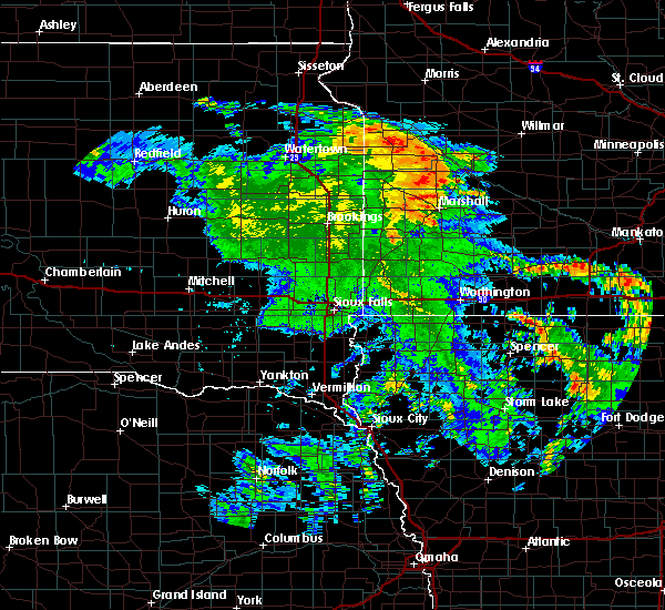 At 800 am cdt, a severe thunderstorm was located over clarkfield, or 11 miles south of montevideo, moving northeast at 55 mph (radar indicated). Hazards include 60 mph wind gusts and penny size hail. Expect damage to roofs. siding. and trees. this severe thunderstorm will be near, montevideo around 815 am cdt. maynard around 820 am cdt. other locations impacted by this severe thunderstorm include minnesota falls, hazel run, spellman lake, spring creek, granite falls airport, gluek and asbury. this includes the following highways, u. s. highway 212 between mile markers 37 and 54. u. s. Highway 59 between mile markers 89 and 102. At 800 am cdt, a severe thunderstorm was located over clarkfield, or 11 miles south of montevideo, moving northeast at 55 mph (radar indicated). Hazards include 60 mph wind gusts and penny size hail. Expect damage to roofs. siding. and trees. this severe thunderstorm will be near, montevideo around 815 am cdt. maynard around 820 am cdt. other locations impacted by this severe thunderstorm include minnesota falls, hazel run, spellman lake, spring creek, granite falls airport, gluek and asbury. this includes the following highways, u. s. highway 212 between mile markers 37 and 54. u. s. Highway 59 between mile markers 89 and 102.
|
| 7/16/2016 8:09 PM CDT |
 At 809 pm cdt, severe thunderstorms were located along a line extending from near clara city to near maynard to granite falls airport, moving east at 35 mph. these are very dangerous storms (radar indicated). Hazards include 80 mph wind gusts and ping pong ball size hail. Flying debris will be dangerous to those caught without shelter. mobile homes will be heavily damaged. expect considerable damage to roofs, windows, and vehicles. extensive tree damage and power outages are likely. these severe storms will be near, clara city around 815 pm cdt. sacred heart around 820 pm cdt. Other locations impacted by these severe thunderstorms include minnesota falls, hazel run, spellman lake, spring creek, granite falls airport, gluek and asbury. At 809 pm cdt, severe thunderstorms were located along a line extending from near clara city to near maynard to granite falls airport, moving east at 35 mph. these are very dangerous storms (radar indicated). Hazards include 80 mph wind gusts and ping pong ball size hail. Flying debris will be dangerous to those caught without shelter. mobile homes will be heavily damaged. expect considerable damage to roofs, windows, and vehicles. extensive tree damage and power outages are likely. these severe storms will be near, clara city around 815 pm cdt. sacred heart around 820 pm cdt. Other locations impacted by these severe thunderstorms include minnesota falls, hazel run, spellman lake, spring creek, granite falls airport, gluek and asbury.
|
| 7/16/2016 7:53 PM CDT |
 At 752 pm cdt, severe thunderstorms were located along a line extending from near gluek to near montevideo to clarkfield, moving east at 20 mph. these are very dangerous storms (radar indicated). Hazards include 80 mph wind gusts and ping pong ball size hail. Flying debris will be dangerous to those caught without shelter. mobile homes will be heavily damaged. expect considerable damage to roofs, windows, and vehicles. extensive tree damage and power outages are likely. these severe storms will be near, clara city and maynard around 820 pm cdt. granite falls and hanley falls around 825 pm cdt. sacred heart and wood lake around 830 pm cdt. Other locations impacted by these severe thunderstorms include minnesota falls, hazel run, spellman lake, spring creek, granite falls airport, montevideo airport, gluek and asbury. At 752 pm cdt, severe thunderstorms were located along a line extending from near gluek to near montevideo to clarkfield, moving east at 20 mph. these are very dangerous storms (radar indicated). Hazards include 80 mph wind gusts and ping pong ball size hail. Flying debris will be dangerous to those caught without shelter. mobile homes will be heavily damaged. expect considerable damage to roofs, windows, and vehicles. extensive tree damage and power outages are likely. these severe storms will be near, clara city and maynard around 820 pm cdt. granite falls and hanley falls around 825 pm cdt. sacred heart and wood lake around 830 pm cdt. Other locations impacted by these severe thunderstorms include minnesota falls, hazel run, spellman lake, spring creek, granite falls airport, montevideo airport, gluek and asbury.
|
| 7/16/2016 7:40 PM CDT |
 At 739 pm cdt, severe thunderstorms were located along a line extending from 8 miles northeast of montevideo airport to near montevideo to near boyd, moving southeast at 30 mph (radar indicated. at 737 pm...a gust to 63 mph was measured at montevideo airport!). Hazards include 70 mph wind gusts and quarter size hail. Hail damage to vehicles is expected. expect considerable tree damage. wind damage is also likely to mobile homes, roofs, and outbuildings. these severe storms will be near, granite falls around 800 pm cdt. maynard around 805 pm cdt. clara city around 810 pm cdt. sacred heart and hanley falls around 820 pm cdt. wood lake around 830 pm cdt. Other locations impacted by these severe thunderstorms include minnesota falls, hazel run, spellman lake, spring creek, granite falls airport, montevideo airport, gluek, asbury and providence. At 739 pm cdt, severe thunderstorms were located along a line extending from 8 miles northeast of montevideo airport to near montevideo to near boyd, moving southeast at 30 mph (radar indicated. at 737 pm...a gust to 63 mph was measured at montevideo airport!). Hazards include 70 mph wind gusts and quarter size hail. Hail damage to vehicles is expected. expect considerable tree damage. wind damage is also likely to mobile homes, roofs, and outbuildings. these severe storms will be near, granite falls around 800 pm cdt. maynard around 805 pm cdt. clara city around 810 pm cdt. sacred heart and hanley falls around 820 pm cdt. wood lake around 830 pm cdt. Other locations impacted by these severe thunderstorms include minnesota falls, hazel run, spellman lake, spring creek, granite falls airport, montevideo airport, gluek, asbury and providence.
|
| 7/16/2016 7:31 PM CDT |
 At 731 pm cdt, severe thunderstorms were located along a line extending from 7 miles northeast of montevideo airport to montevideo to near boyd, moving southeast at 25 mph (radar indicated). Hazards include 60 mph wind gusts and quarter size hail. Hail damage to vehicles is expected. expect wind damage to roofs, siding, and trees. severe thunderstorms will be near, montevideo around 735 pm cdt. clarkfield around 750 pm cdt. granite falls and maynard around 800 pm cdt. clara city around 805 pm cdt. hanley falls around 815 pm cdt. sacred heart around 820 pm cdt. Other locations impacted by these severe thunderstorms include minnesota falls, hazel run, spellman lake, spring creek, granite falls airport, montevideo airport, gluek, asbury and providence. At 731 pm cdt, severe thunderstorms were located along a line extending from 7 miles northeast of montevideo airport to montevideo to near boyd, moving southeast at 25 mph (radar indicated). Hazards include 60 mph wind gusts and quarter size hail. Hail damage to vehicles is expected. expect wind damage to roofs, siding, and trees. severe thunderstorms will be near, montevideo around 735 pm cdt. clarkfield around 750 pm cdt. granite falls and maynard around 800 pm cdt. clara city around 805 pm cdt. hanley falls around 815 pm cdt. sacred heart around 820 pm cdt. Other locations impacted by these severe thunderstorms include minnesota falls, hazel run, spellman lake, spring creek, granite falls airport, montevideo airport, gluek, asbury and providence.
|
| 8/6/2015 6:26 PM CDT |
 The severe thunderstorm warning for southeastern yellow medicine county will expire at 630 pm cdt, the storm which prompted the warning has weakened below severe limits. therefore the warning will be allowed to expire. however small hail and gusty winds up to 50 mph are still possible with this thunderstorm. a severe thunderstorm watch remains in effect until 1000 pm cdt for southwestern minnesota. The severe thunderstorm warning for southeastern yellow medicine county will expire at 630 pm cdt, the storm which prompted the warning has weakened below severe limits. therefore the warning will be allowed to expire. however small hail and gusty winds up to 50 mph are still possible with this thunderstorm. a severe thunderstorm watch remains in effect until 1000 pm cdt for southwestern minnesota.
|
| 8/6/2015 5:46 PM CDT |
 At 546 pm cdt, a severe thunderstorm was located near st. leo, or 18 miles northwest of marshall, moving east at 30 mph (radar indicated). Hazards include 70 mph wind gusts and quarter size hail. Hail damage to vehicles is expected. expect considerable tree damage. wind damage is also likely to mobile homes, roofs and outbuildings. this severe thunderstorm will be near, clarkfield around 610 pm cdt. granite falls, wood lake and hanley falls around 630 pm cdt. other locations impacted by this severe thunderstorm include hazel run, spellman lake, st. leo, spring creek and granite falls airport. this includes the following highways, u. s. highway 212 between mile markers 45 and 48. u. s. Highway 59 between mile markers 87 and 99. At 546 pm cdt, a severe thunderstorm was located near st. leo, or 18 miles northwest of marshall, moving east at 30 mph (radar indicated). Hazards include 70 mph wind gusts and quarter size hail. Hail damage to vehicles is expected. expect considerable tree damage. wind damage is also likely to mobile homes, roofs and outbuildings. this severe thunderstorm will be near, clarkfield around 610 pm cdt. granite falls, wood lake and hanley falls around 630 pm cdt. other locations impacted by this severe thunderstorm include hazel run, spellman lake, st. leo, spring creek and granite falls airport. this includes the following highways, u. s. highway 212 between mile markers 45 and 48. u. s. Highway 59 between mile markers 87 and 99.
|
| 7/17/2015 10:17 PM CDT |
 At 1017 pm cdt, severe thunderstorms were located along a line extending from montevideo to near clarkfield to canby, moving southeast at 35 mph (radar indicated). Hazards include 70 mph wind gusts and quarter size hail. Hail damage to vehicles is expected. expect considerable tree damage. wind damage is also likely to mobile homes, roofs and outbuildings. severe thunderstorms will be near, clarkfield around 1025 pm cdt. granite falls and maynard around 1035 pm cdt. hanley falls around 1040 pm cdt. sacred heart and wood lake around 1045 pm cdt. other locations impacted by these severe thunderstorms include minnesota falls, hazel run, spellman lake, st. leo, spring creek, granite falls airport and burr. this includes the following highways, u. s. highway 212 between mile markers 37 and 63. u. s. Highway 59 between mile markers 87 and 104. At 1017 pm cdt, severe thunderstorms were located along a line extending from montevideo to near clarkfield to canby, moving southeast at 35 mph (radar indicated). Hazards include 70 mph wind gusts and quarter size hail. Hail damage to vehicles is expected. expect considerable tree damage. wind damage is also likely to mobile homes, roofs and outbuildings. severe thunderstorms will be near, clarkfield around 1025 pm cdt. granite falls and maynard around 1035 pm cdt. hanley falls around 1040 pm cdt. sacred heart and wood lake around 1045 pm cdt. other locations impacted by these severe thunderstorms include minnesota falls, hazel run, spellman lake, st. leo, spring creek, granite falls airport and burr. this includes the following highways, u. s. highway 212 between mile markers 37 and 63. u. s. Highway 59 between mile markers 87 and 104.
|
| 6/27/2015 10:01 PM CDT |
 The national weather service in the twin cities has issued a * severe thunderstorm warning for. central yellow medicine county in west central minnesota. until 1030 pm cdt * at 1000 pm cdt. a severe thunderstorm was located near boyd. or 16 miles southwest of montevideo. Moving southeast at 40 mph. The national weather service in the twin cities has issued a * severe thunderstorm warning for. central yellow medicine county in west central minnesota. until 1030 pm cdt * at 1000 pm cdt. a severe thunderstorm was located near boyd. or 16 miles southwest of montevideo. Moving southeast at 40 mph.
|
| 5/16/2015 4:16 PM CDT | At 415 pm cdt, a severe thunderstorm was located over hazel run, or 12 miles south of montevideo, moving north at 30 mph (radar indicated). Hazards include 60 mph wind gusts and half dollar size hail. Hail damage to vehicles is expected. expect wind damage to roofs, siding and trees. this severe thunderstorm will be near, granite falls around 420 pm cdt. montevideo around 440 pm cdt. watson around 445 pm cdt. other locations impacted by this severe thunderstorm include big bend city, hazel run, granite falls airport, montevideo airport and asbury. 1. 25in. |
Hail Maps for Hazel Run, MN
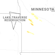

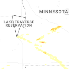


Connect with Interactive Hail Maps