

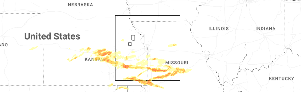
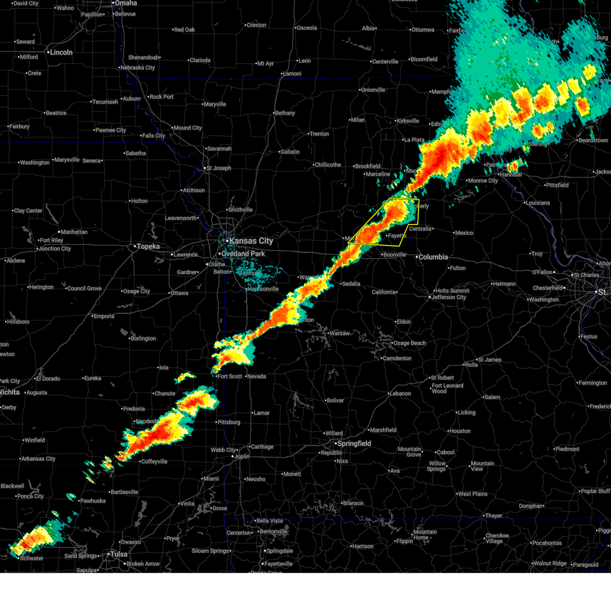
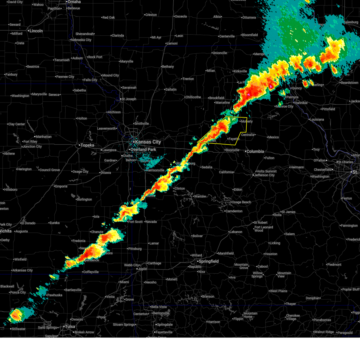
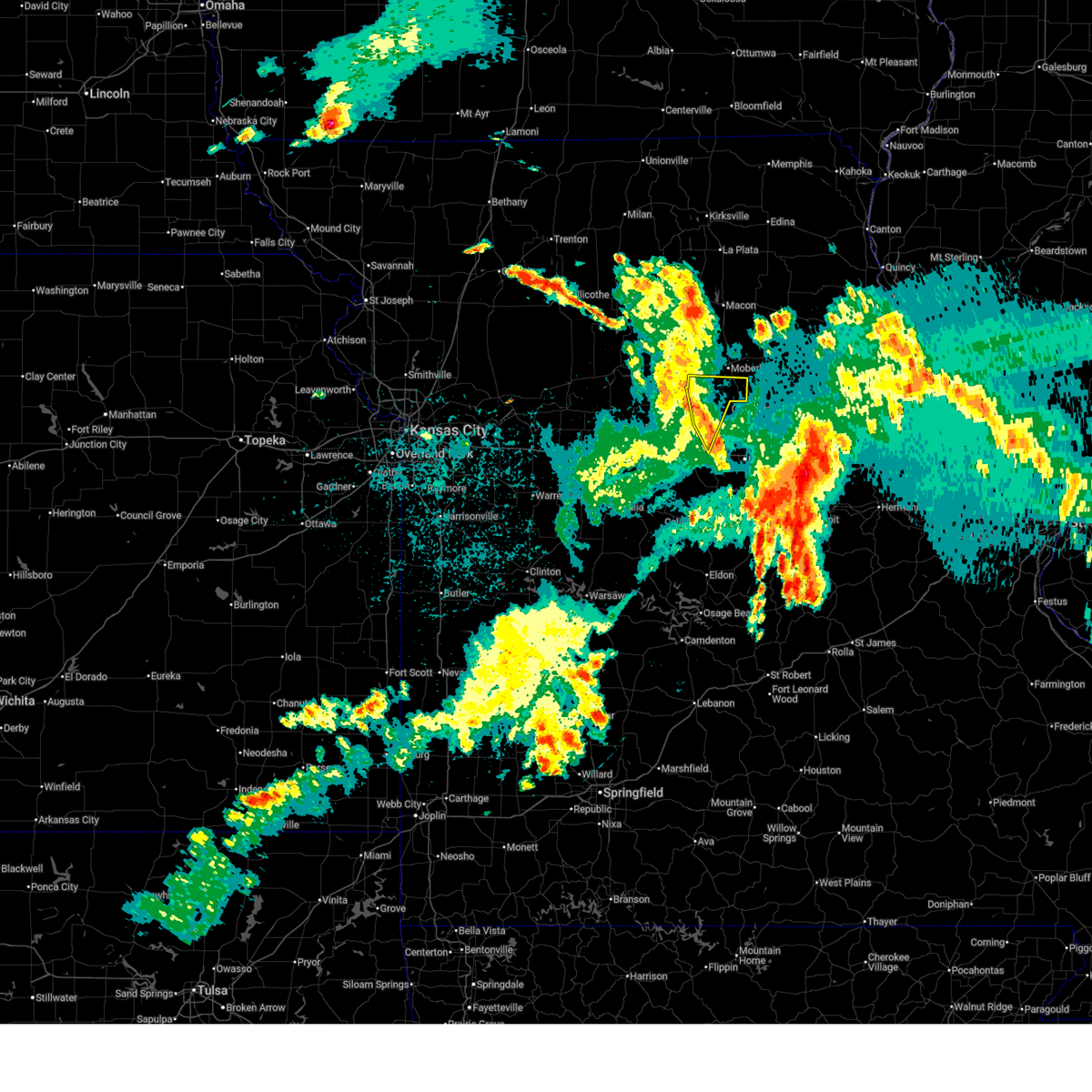
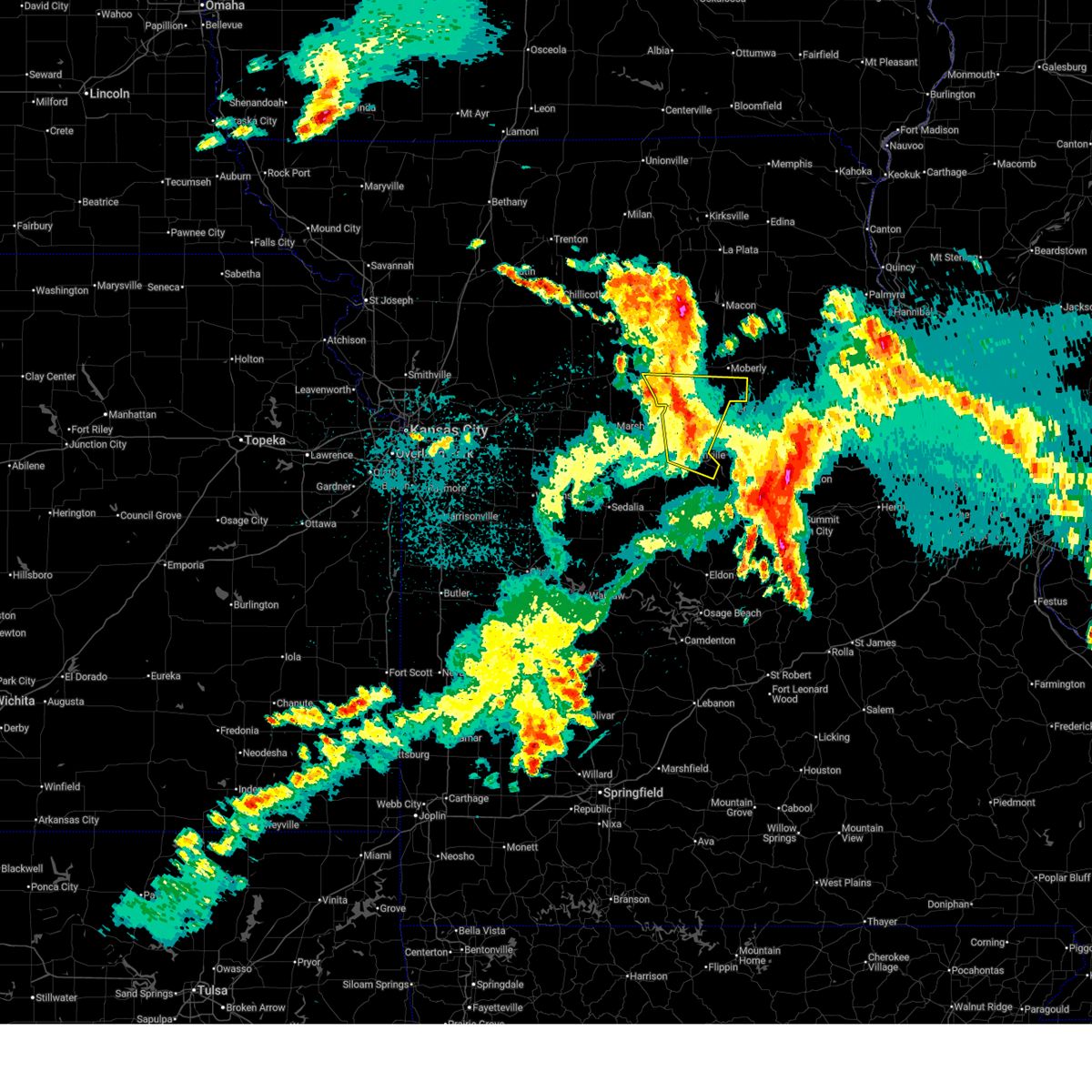
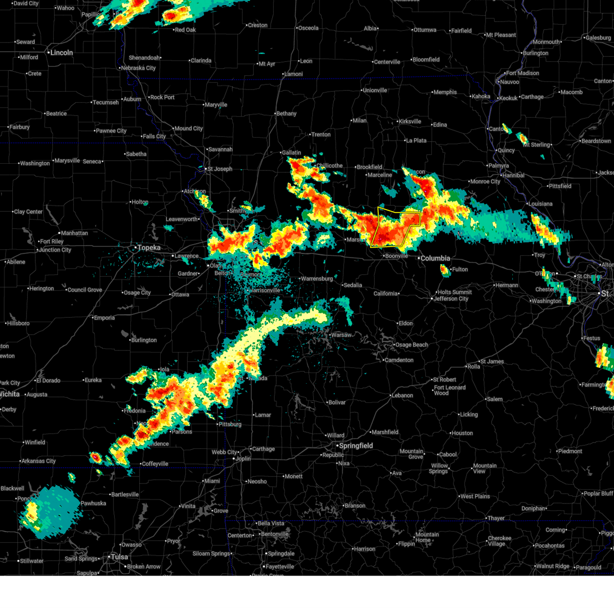
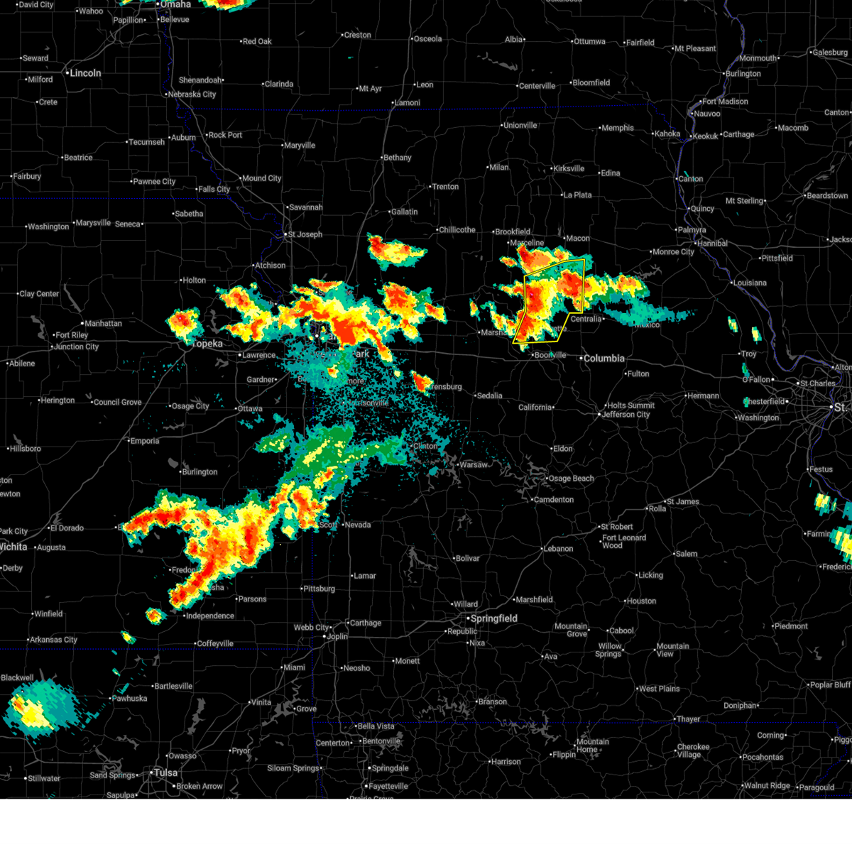
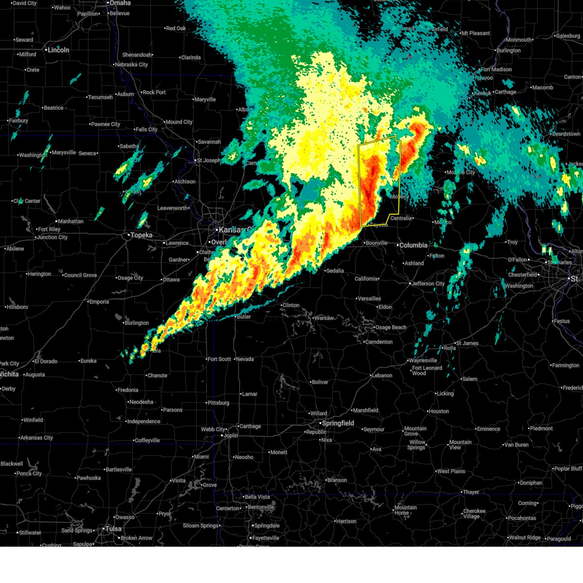
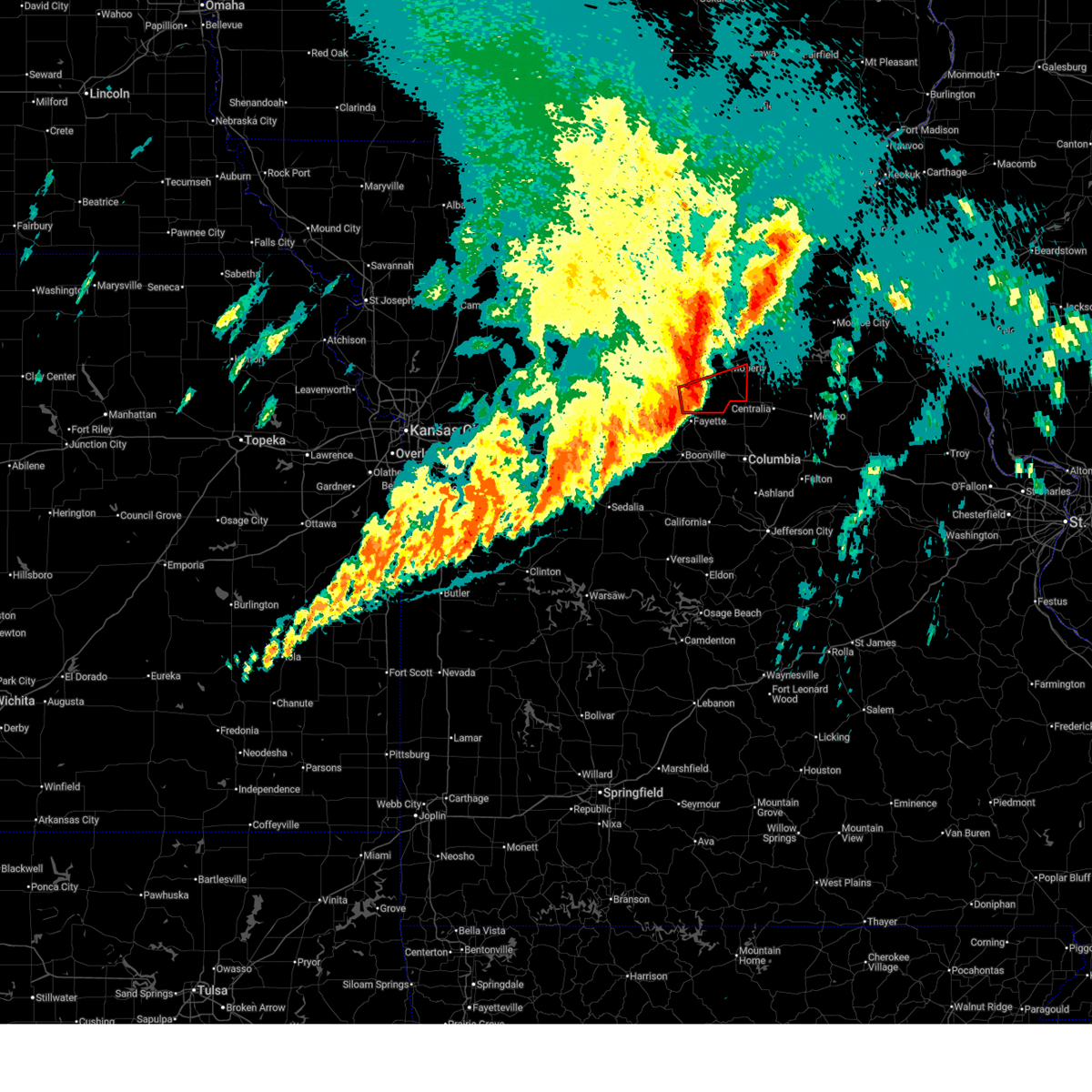
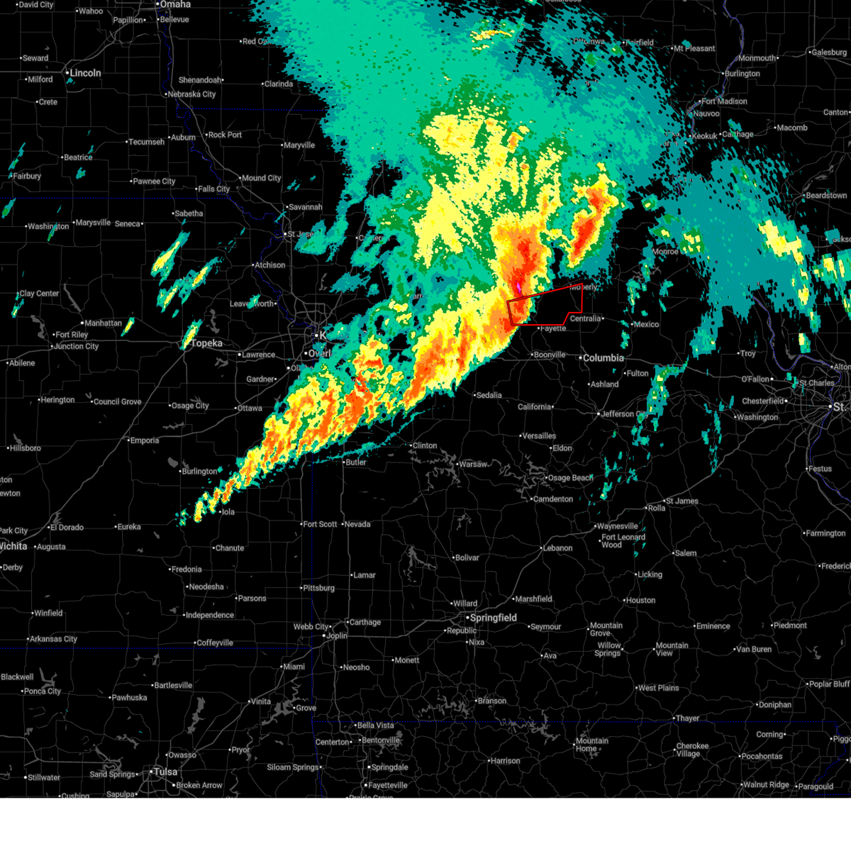
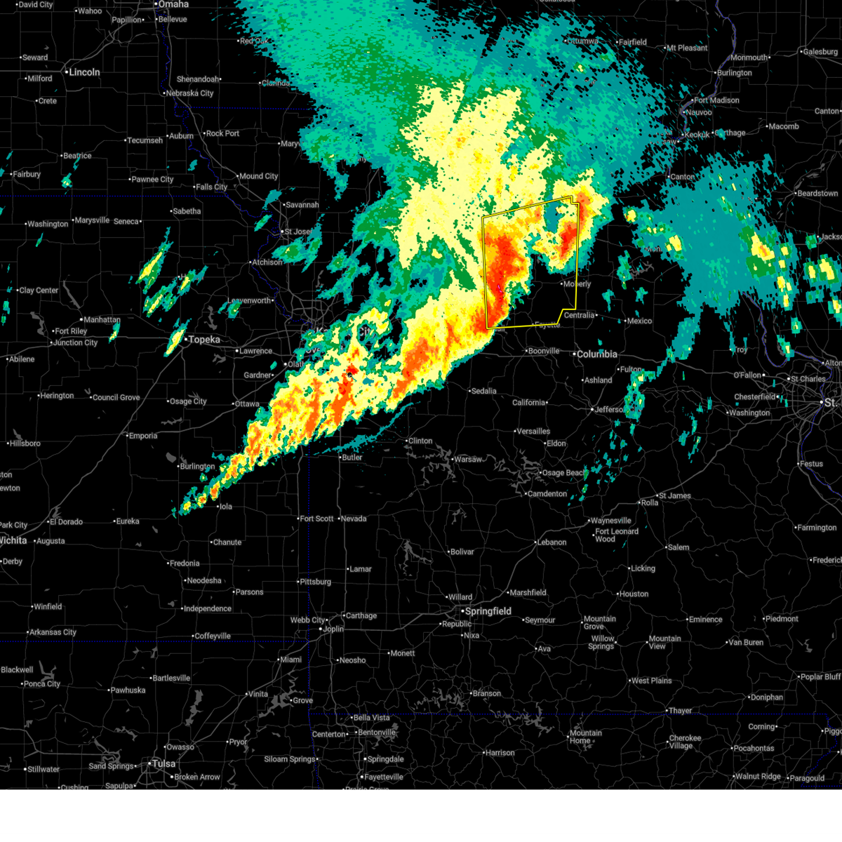
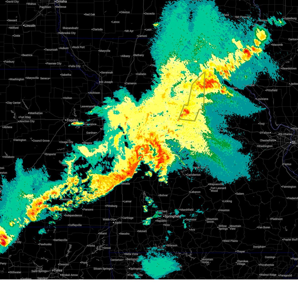
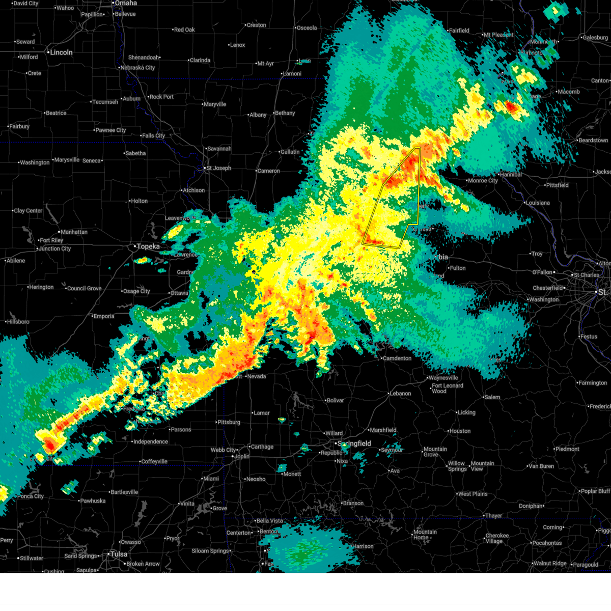
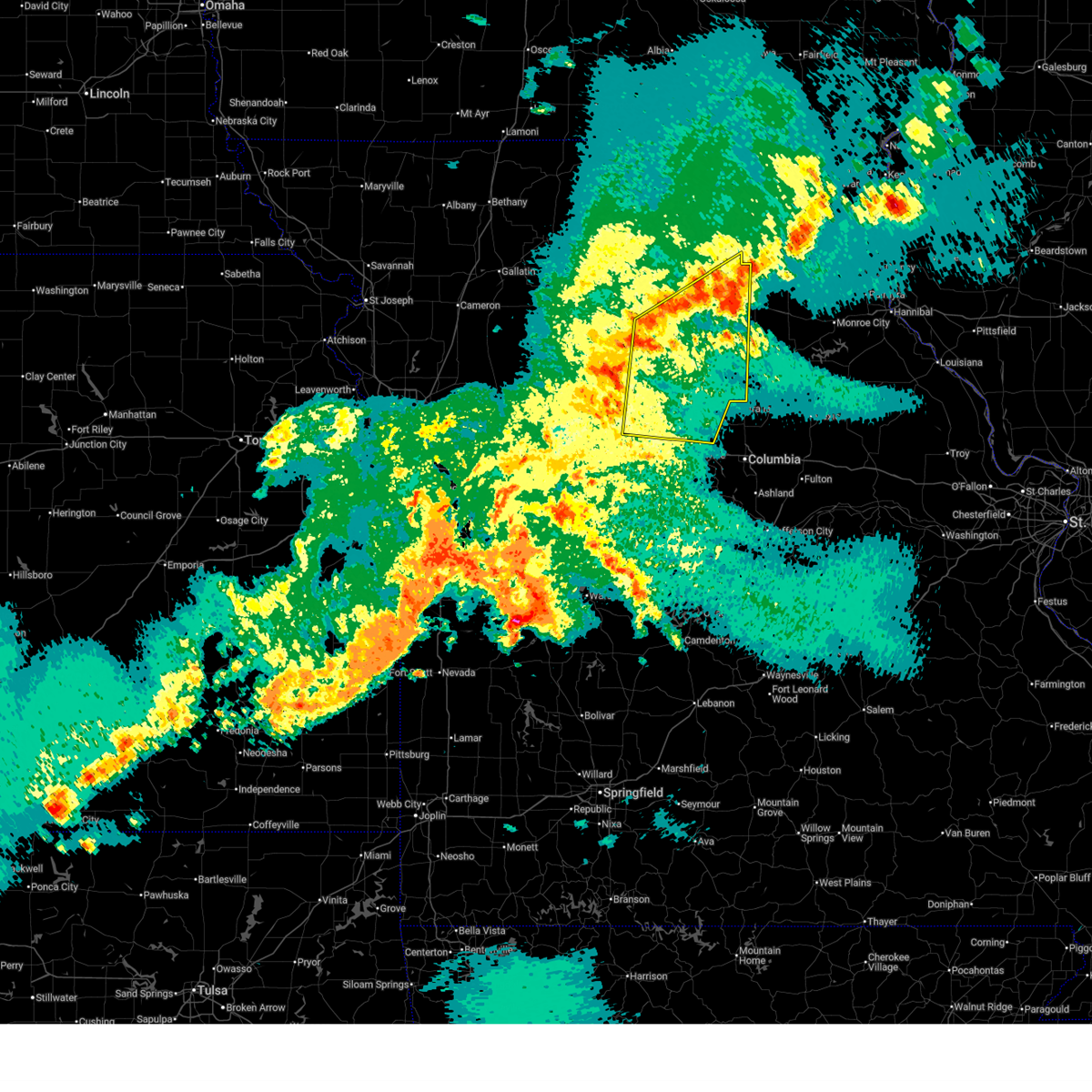
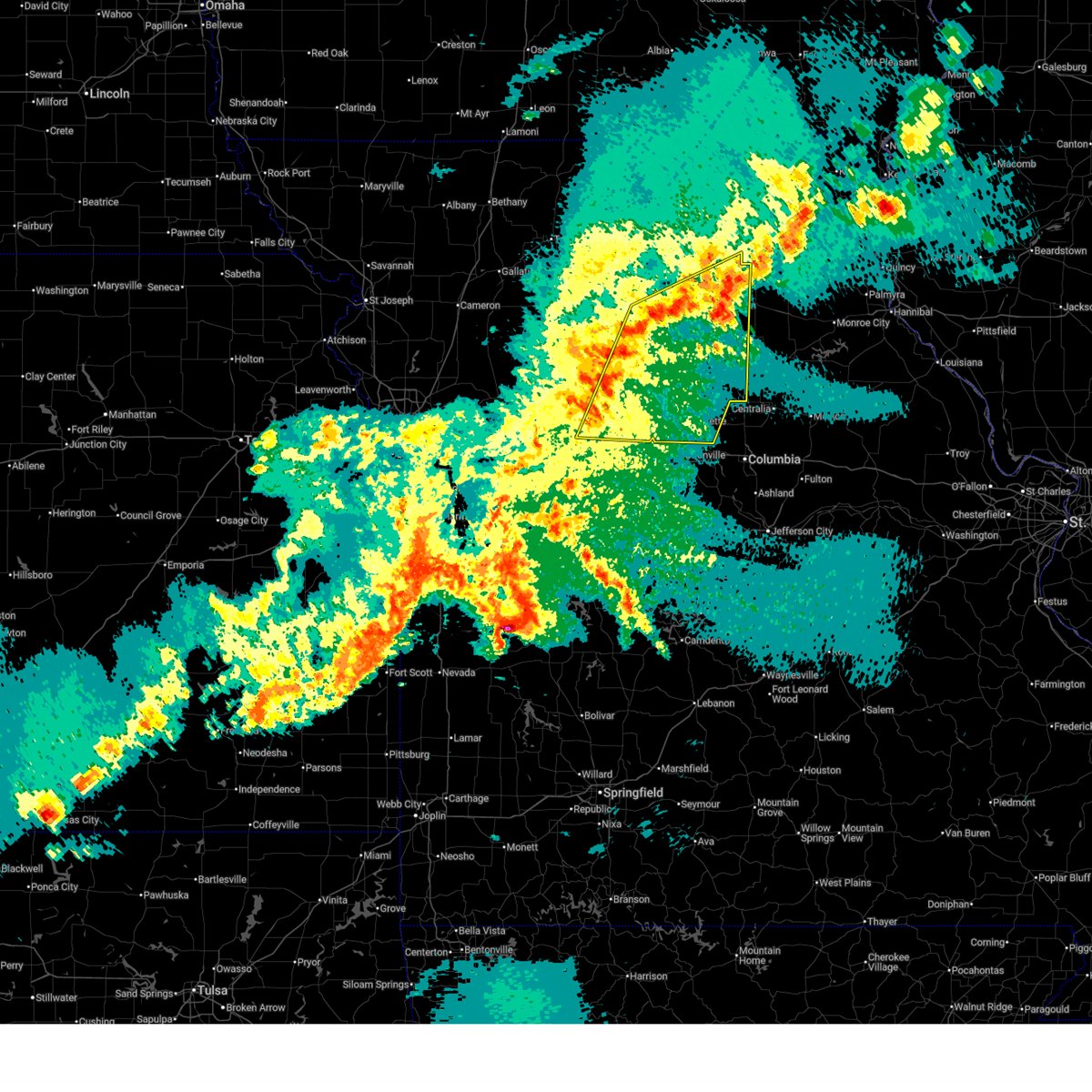
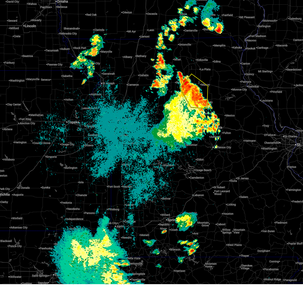
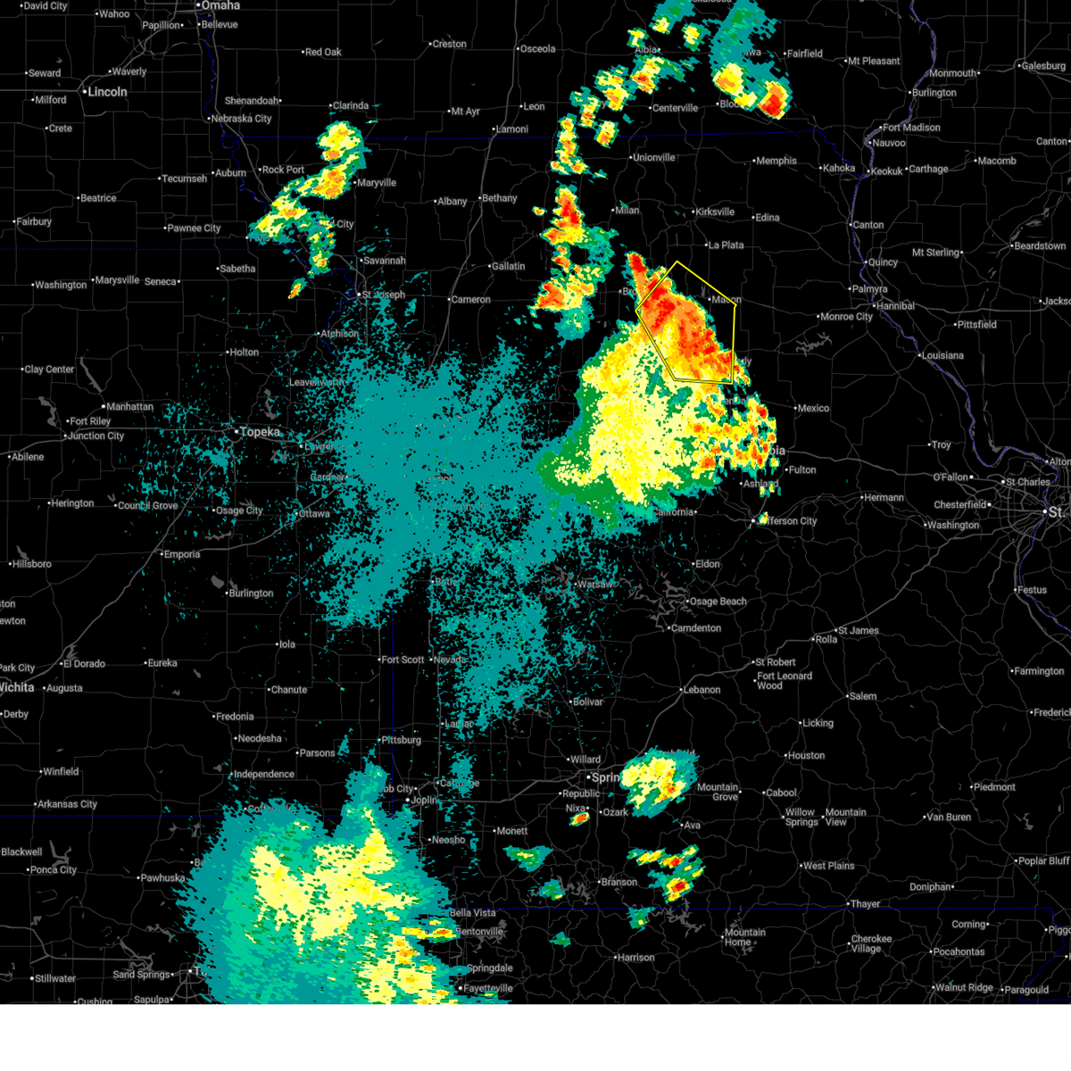
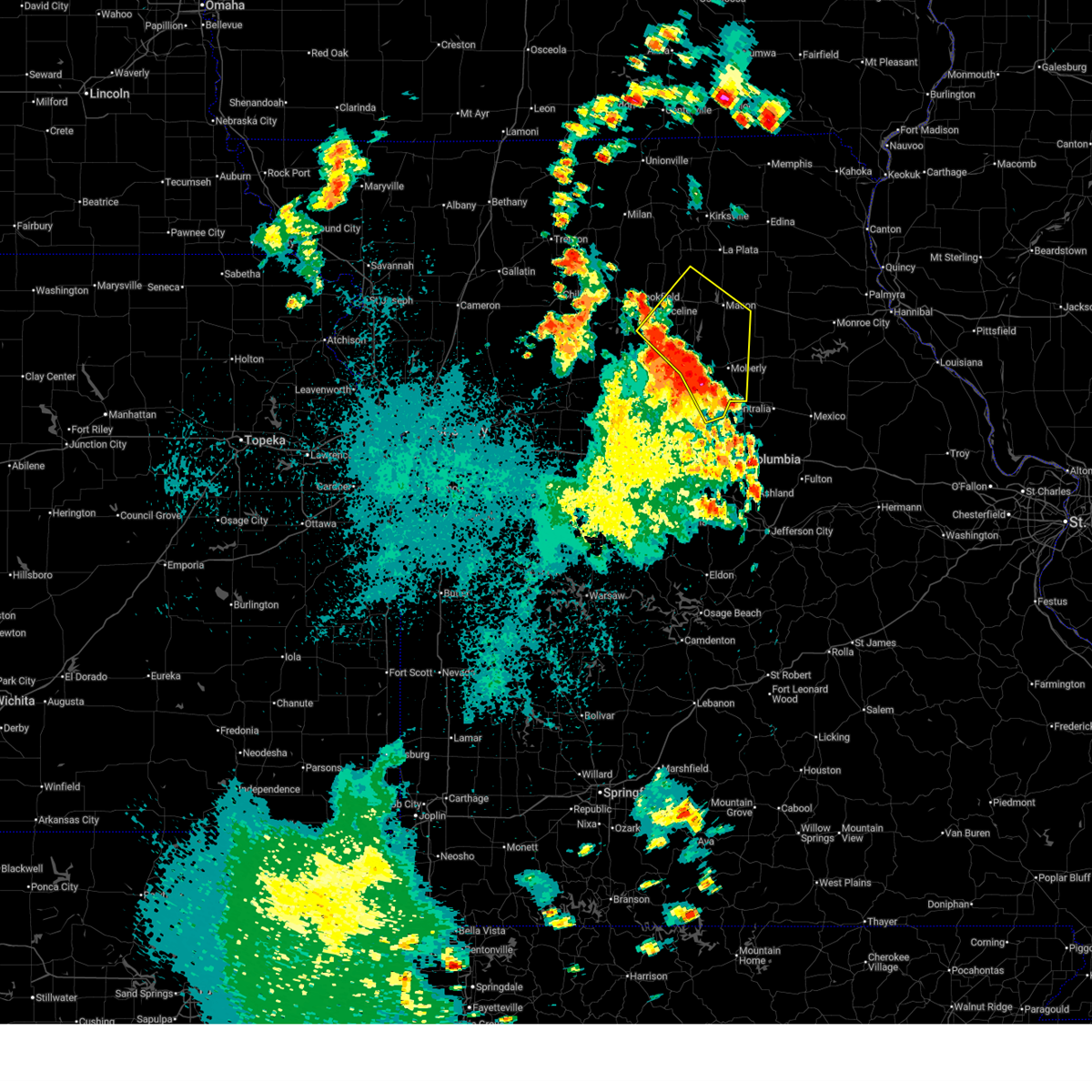
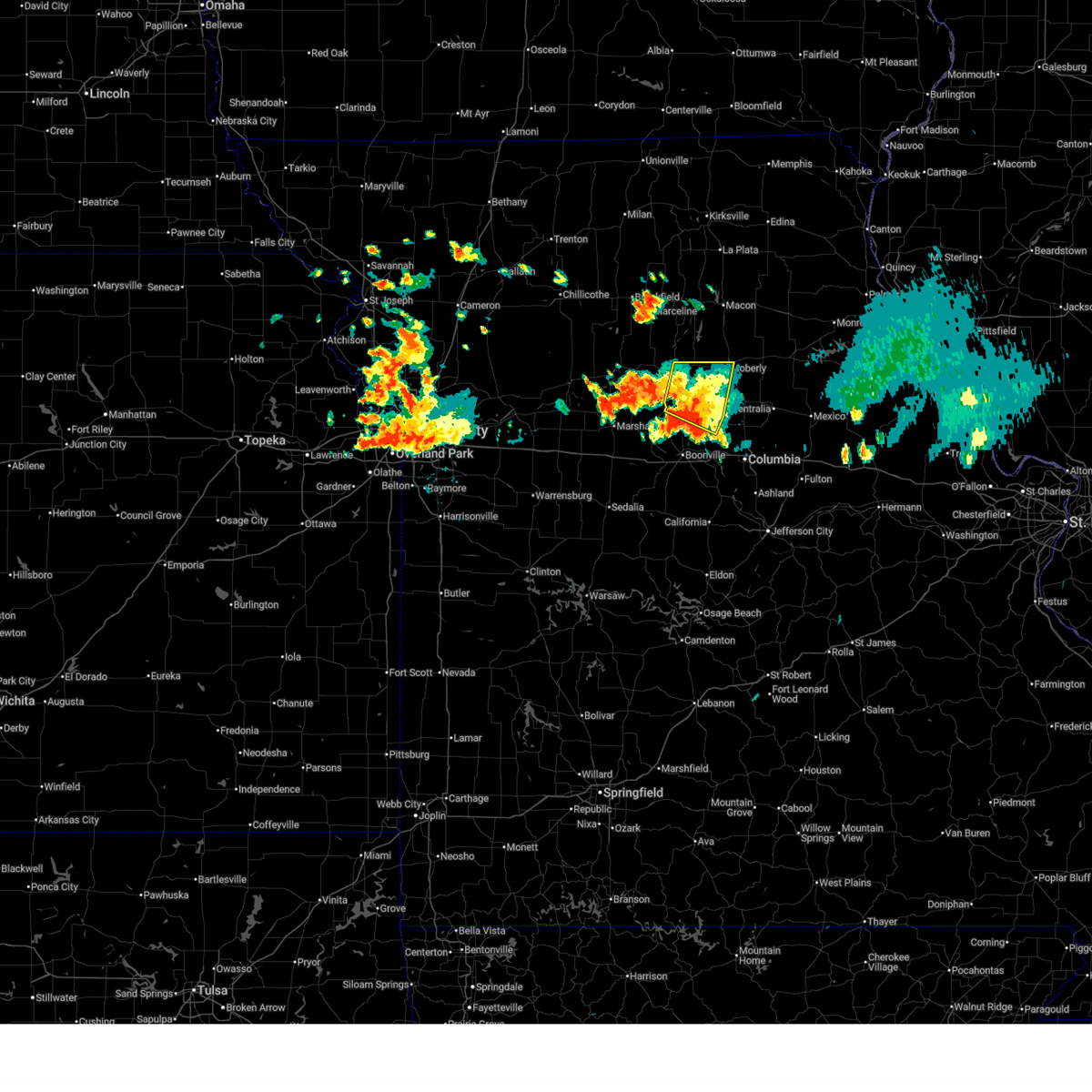
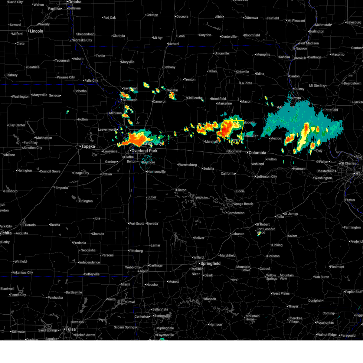
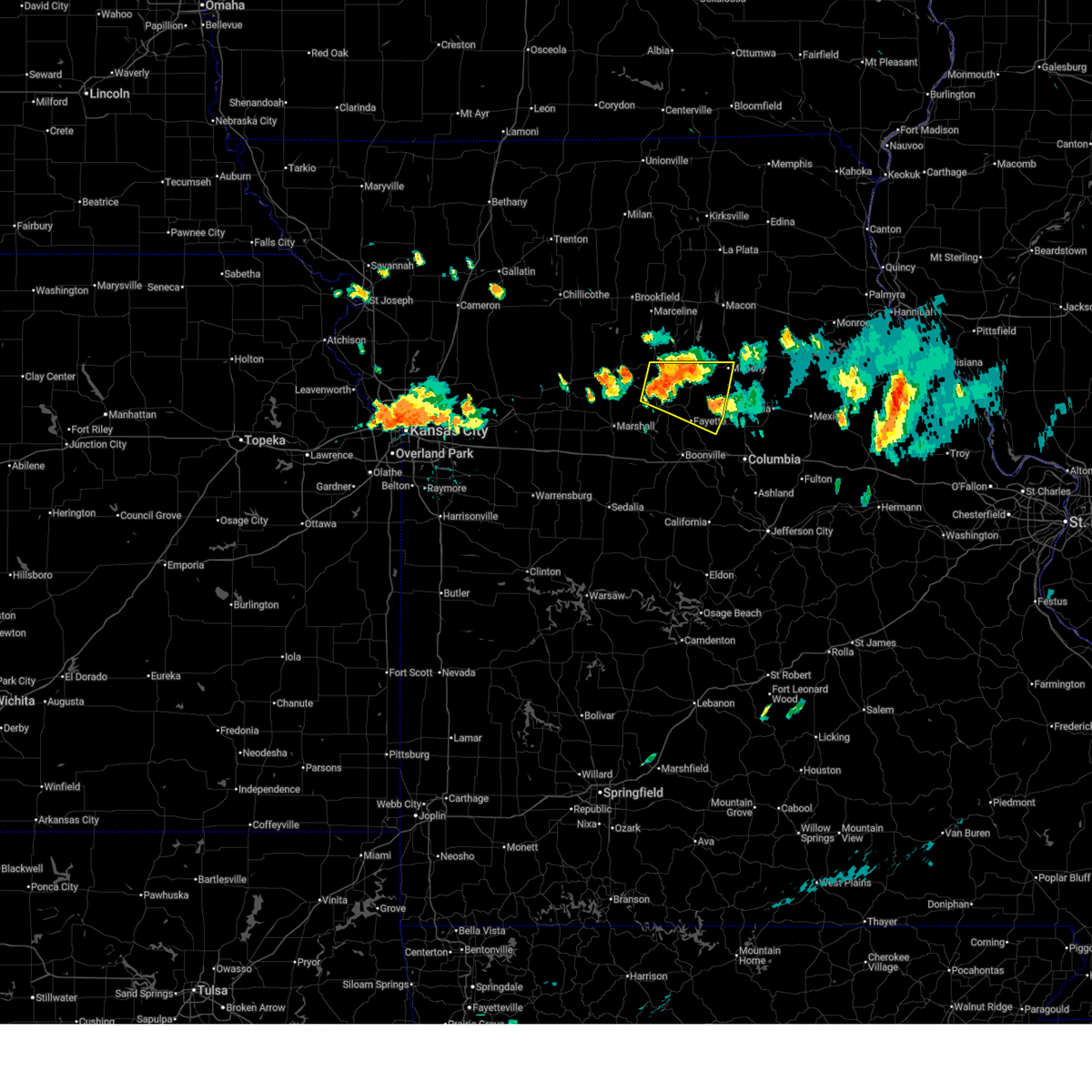
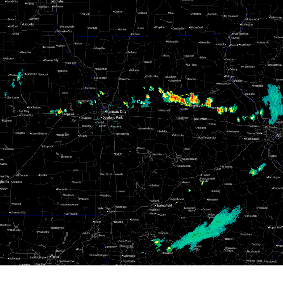
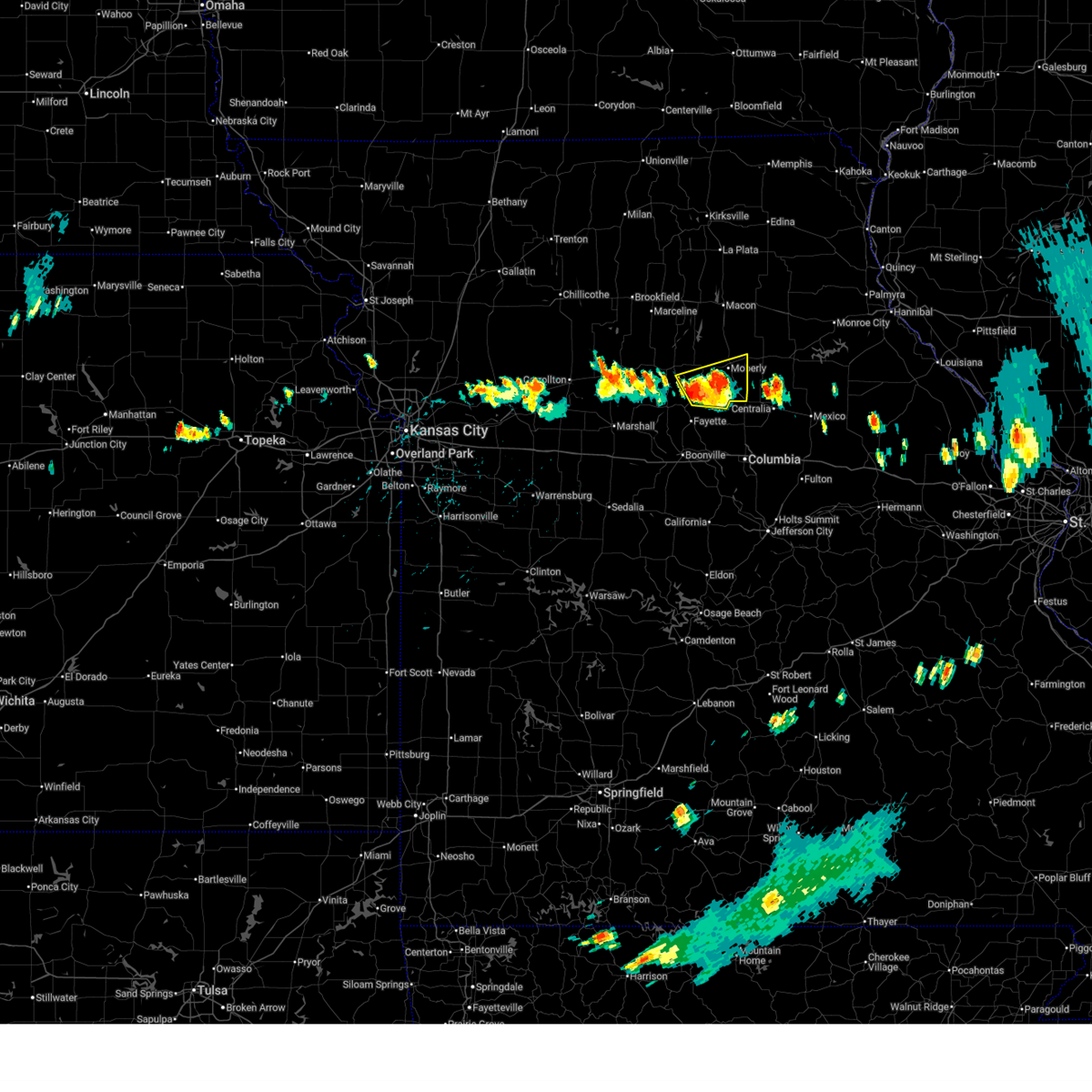
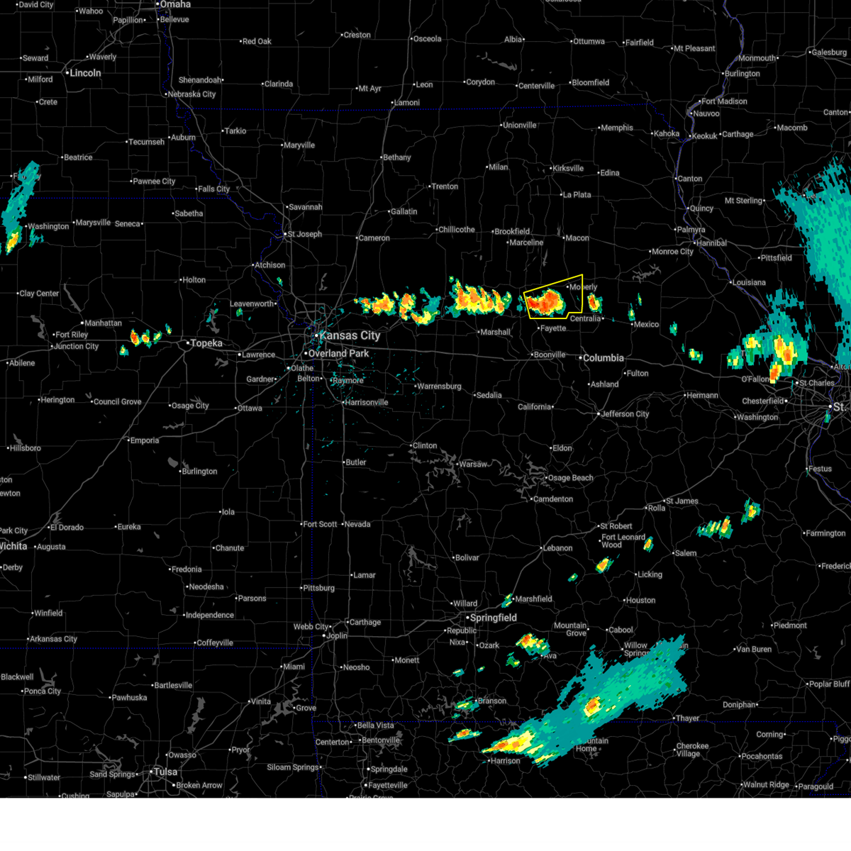
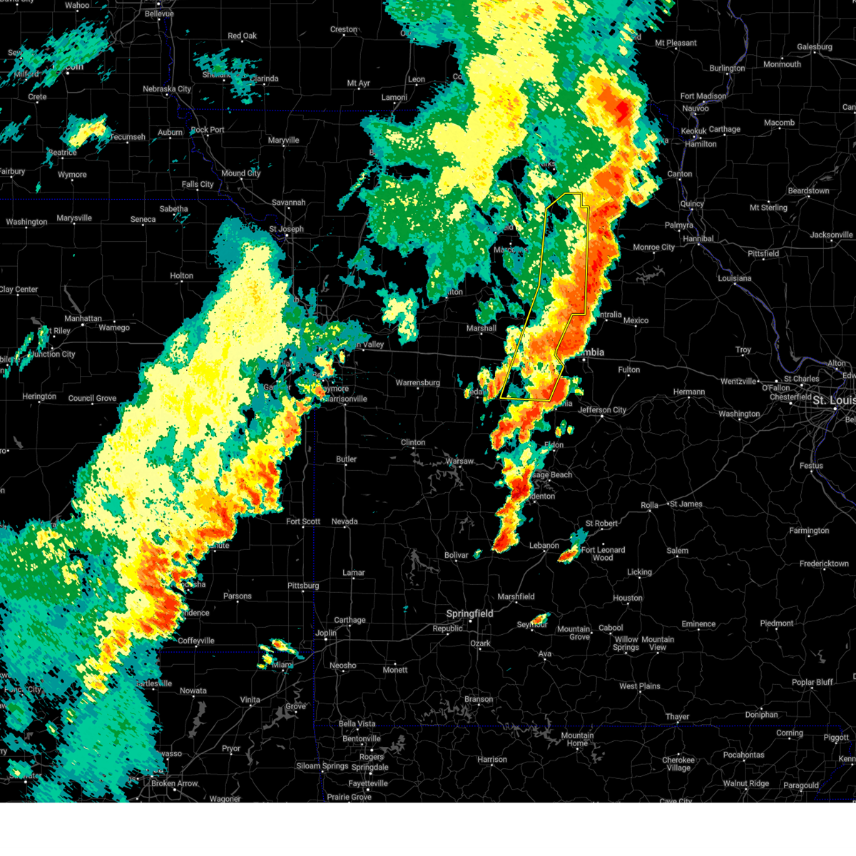
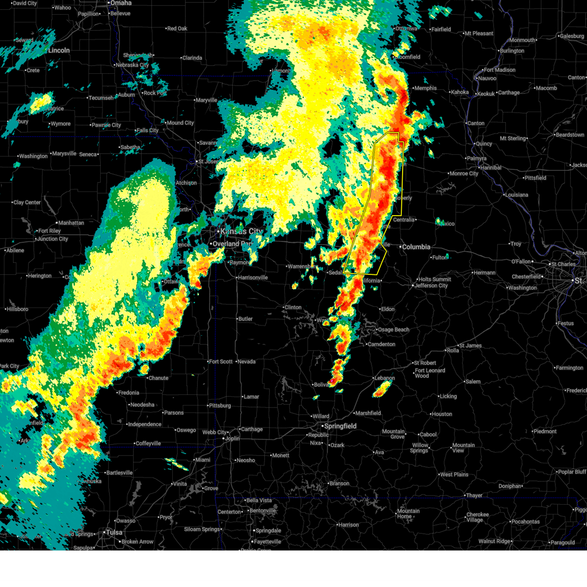
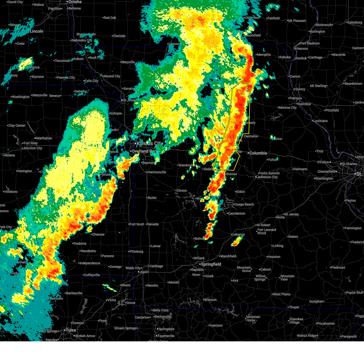
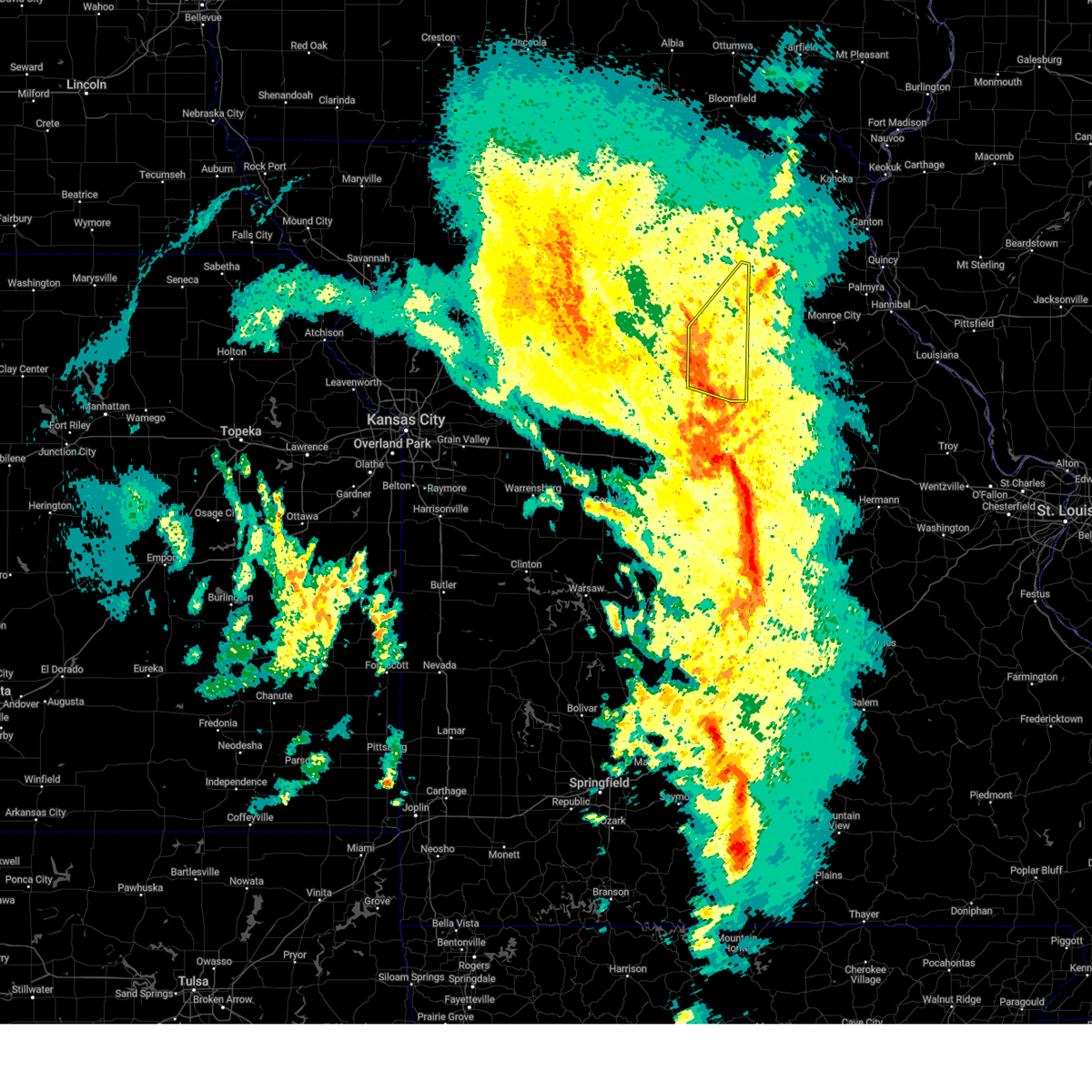
Hail Map for Higbee, MO
The Higbee, MO area has had 3 reports of on-the-ground hail by trained spotters, and has been under severe weather warnings 32 times during the past 12 months. Doppler radar has detected hail at or near Higbee, MO on 57 occasions, including 7 occasions during the past year.
| Name: | Higbee, MO |
| Where Located: | 26.3 miles NNW of Columbia, MO |
| Map: | Google Map for Higbee, MO |
| Population: | 568 |
| Housing Units: | 273 |
| More Info: | Search Google for Higbee, MO |
1
The Top Recent Hail Date for Higbee, MO is Sunday, April 26, 2026 (6th out of 57)
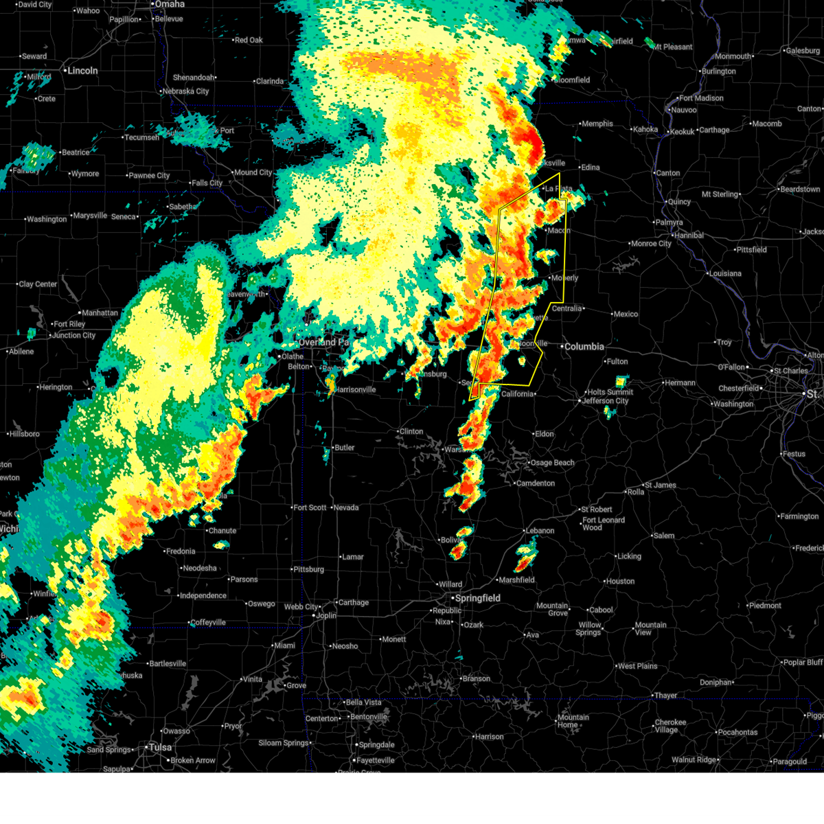
Hail and Wind Damage Spotted near Higbee, MO
| Date / Time | Report Details |
|---|---|
| 7/10/2026 5:48 PM CDT |
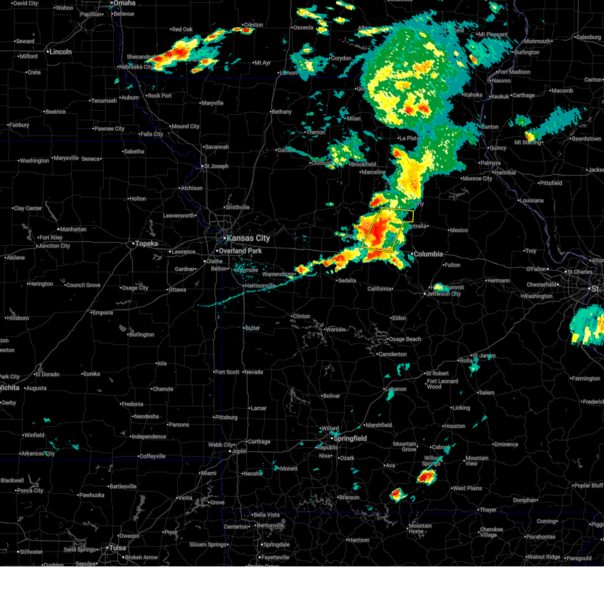 At 548 pm cdt, severe thunderstorms were located along a line extending from near higbee to near fayette to new franklin, moving east at 45 mph (radar indicated). Hazards include 60 mph wind gusts and penny size hail. Expect damage to roofs, siding, and trees. Locations impacted include, moberly, fayette, new franklin, higbee, clark, armstrong, rocheport, renick, and franklin. At 548 pm cdt, severe thunderstorms were located along a line extending from near higbee to near fayette to new franklin, moving east at 45 mph (radar indicated). Hazards include 60 mph wind gusts and penny size hail. Expect damage to roofs, siding, and trees. Locations impacted include, moberly, fayette, new franklin, higbee, clark, armstrong, rocheport, renick, and franklin.
|
| 7/10/2026 5:35 PM CDT |
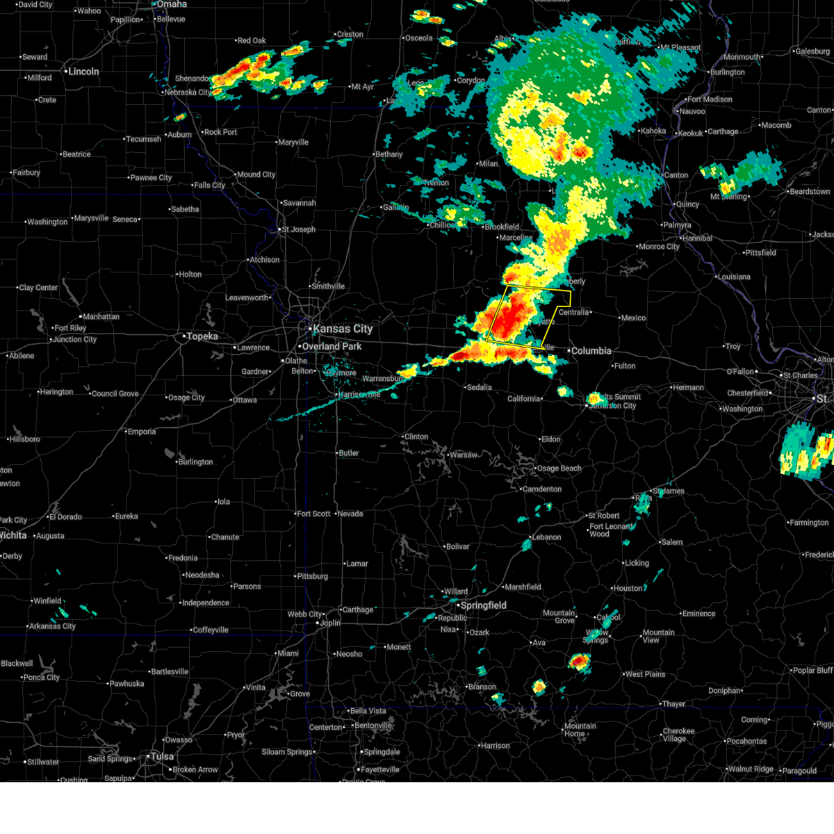 Svreax the national weather service in pleasant hill has issued a * severe thunderstorm warning for, southern randolph county in north central missouri, southeastern chariton county in north central missouri, howard county in central missouri, southeastern saline county in central missouri, northern cooper county in central missouri, * until 615 pm cdt. * at 535 pm cdt, severe thunderstorms were located along a line extending from near armstrong to near fayette to 9 miles west of new franklin, moving east at 45 mph (radar indicated). Hazards include 60 mph wind gusts and penny size hail. expect damage to roofs, siding, and trees Svreax the national weather service in pleasant hill has issued a * severe thunderstorm warning for, southern randolph county in north central missouri, southeastern chariton county in north central missouri, howard county in central missouri, southeastern saline county in central missouri, northern cooper county in central missouri, * until 615 pm cdt. * at 535 pm cdt, severe thunderstorms were located along a line extending from near armstrong to near fayette to 9 miles west of new franklin, moving east at 45 mph (radar indicated). Hazards include 60 mph wind gusts and penny size hail. expect damage to roofs, siding, and trees
|
| 6/11/2026 5:27 PM CDT |
 the severe thunderstorm warning has been cancelled and is no longer in effect the severe thunderstorm warning has been cancelled and is no longer in effect
|
| 6/11/2026 5:27 PM CDT |
 At 526 pm cdt, severe thunderstorms were located along a line extending from near madison to near higbee to fayette, moving east at 40 mph (radar indicated). Hazards include 60 mph wind gusts and quarter size hail. Hail damage to vehicles is expected. expect wind damage to roofs, siding, and trees. Locations impacted include, moberly, fayette, huntsville, higbee, clark, armstrong, and renick. At 526 pm cdt, severe thunderstorms were located along a line extending from near madison to near higbee to fayette, moving east at 40 mph (radar indicated). Hazards include 60 mph wind gusts and quarter size hail. Hail damage to vehicles is expected. expect wind damage to roofs, siding, and trees. Locations impacted include, moberly, fayette, huntsville, higbee, clark, armstrong, and renick.
|
| 6/11/2026 5:10 PM CDT |
 At 510 pm cdt, severe thunderstorms were located along a line extending from near moberly to armstrong to 7 miles south of glasgow, moving east at 50 mph (radar indicated). Hazards include 60 mph wind gusts and quarter size hail. Hail damage to vehicles is expected. expect wind damage to roofs, siding, and trees. Locations impacted include, moberly, fayette, huntsville, glasgow, higbee, clark, armstrong, renick, clifton hill, and arrow rock. At 510 pm cdt, severe thunderstorms were located along a line extending from near moberly to armstrong to 7 miles south of glasgow, moving east at 50 mph (radar indicated). Hazards include 60 mph wind gusts and quarter size hail. Hail damage to vehicles is expected. expect wind damage to roofs, siding, and trees. Locations impacted include, moberly, fayette, huntsville, glasgow, higbee, clark, armstrong, renick, clifton hill, and arrow rock.
|
| 6/11/2026 4:49 PM CDT |
 Svreax the national weather service in pleasant hill has issued a * severe thunderstorm warning for, randolph county in north central missouri, southeastern chariton county in north central missouri, howard county in central missouri, east central saline county in central missouri, * until 545 pm cdt. * at 449 pm cdt, severe thunderstorms were located along a line extending from near salisbury to near glasgow to near marshall, moving east at 45 mph (radar indicated). Hazards include 60 mph wind gusts and quarter size hail. Hail damage to vehicles is expected. Expect wind damage to roofs, siding, and trees. Svreax the national weather service in pleasant hill has issued a * severe thunderstorm warning for, randolph county in north central missouri, southeastern chariton county in north central missouri, howard county in central missouri, east central saline county in central missouri, * until 545 pm cdt. * at 449 pm cdt, severe thunderstorms were located along a line extending from near salisbury to near glasgow to near marshall, moving east at 45 mph (radar indicated). Hazards include 60 mph wind gusts and quarter size hail. Hail damage to vehicles is expected. Expect wind damage to roofs, siding, and trees.
|
| 6/1/2026 4:25 AM CDT |
 the severe thunderstorm warning has been cancelled and is no longer in effect the severe thunderstorm warning has been cancelled and is no longer in effect
|
| 6/1/2026 4:25 AM CDT |
 At 424 am cdt, severe thunderstorms were located along a line extending from near armstrong to near fayette to near rocheport, moving east at 35 mph (radar indicated). Hazards include 60 mph wind gusts and penny size hail. Expect damage to roofs, siding, and trees. Locations impacted include, moberly, fayette, higbee, clark, armstrong, and renick. At 424 am cdt, severe thunderstorms were located along a line extending from near armstrong to near fayette to near rocheport, moving east at 35 mph (radar indicated). Hazards include 60 mph wind gusts and penny size hail. Expect damage to roofs, siding, and trees. Locations impacted include, moberly, fayette, higbee, clark, armstrong, and renick.
|
| 6/1/2026 4:10 AM CDT |
 Svreax the national weather service in pleasant hill has issued a * severe thunderstorm warning for, southern randolph county in north central missouri, southeastern chariton county in north central missouri, howard county in central missouri, northeastern cooper county in central missouri, * until 445 am cdt. * at 410 am cdt, severe thunderstorms were located along a line extending from 6 miles southwest of salisbury to near fayette to new franklin, moving east at 35 mph (radar indicated). Hazards include 60 mph wind gusts and nickel size hail. expect damage to roofs, siding, and trees Svreax the national weather service in pleasant hill has issued a * severe thunderstorm warning for, southern randolph county in north central missouri, southeastern chariton county in north central missouri, howard county in central missouri, northeastern cooper county in central missouri, * until 445 am cdt. * at 410 am cdt, severe thunderstorms were located along a line extending from 6 miles southwest of salisbury to near fayette to new franklin, moving east at 35 mph (radar indicated). Hazards include 60 mph wind gusts and nickel size hail. expect damage to roofs, siding, and trees
|
| 6/1/2026 2:53 AM CDT |
 At 253 am cdt, severe thunderstorms were located along a line extending from near armstrong to near fayette, moving east at 30 mph (automated weather station). Hazards include 60 mph wind gusts and quarter size hail. Hail damage to vehicles is expected. expect wind damage to roofs, siding, and trees. Locations impacted include, moberly, fayette, salisbury, higbee, clark, armstrong, and renick. At 253 am cdt, severe thunderstorms were located along a line extending from near armstrong to near fayette, moving east at 30 mph (automated weather station). Hazards include 60 mph wind gusts and quarter size hail. Hail damage to vehicles is expected. expect wind damage to roofs, siding, and trees. Locations impacted include, moberly, fayette, salisbury, higbee, clark, armstrong, and renick.
|
| 6/1/2026 2:13 AM CDT |
 Svreax the national weather service in pleasant hill has issued a * severe thunderstorm warning for, randolph county in north central missouri, east central chariton county in north central missouri, howard county in central missouri, * until 315 am cdt. * at 212 am cdt, severe thunderstorms were located along a line extending from near salisbury to armstrong to near fayette, moving east at 25 mph (radar indicated). Hazards include 60 mph wind gusts and quarter size hail. Hail damage to vehicles is expected. Expect wind damage to roofs, siding, and trees. Svreax the national weather service in pleasant hill has issued a * severe thunderstorm warning for, randolph county in north central missouri, east central chariton county in north central missouri, howard county in central missouri, * until 315 am cdt. * at 212 am cdt, severe thunderstorms were located along a line extending from near salisbury to armstrong to near fayette, moving east at 25 mph (radar indicated). Hazards include 60 mph wind gusts and quarter size hail. Hail damage to vehicles is expected. Expect wind damage to roofs, siding, and trees.
|
| 4/27/2026 7:32 AM CDT |
 At 731 am cdt, a severe thunderstorm was located near huntsville, moving east at 55 mph (radar indicated). Hazards include 60 mph wind gusts and quarter size hail. Hail damage to vehicles is expected. expect wind damage to roofs, siding, and trees. Locations impacted include, moberly, macon, huntsville, bevier, higbee, atlanta, clark, cairo, renick, jacksonville, and excello. At 731 am cdt, a severe thunderstorm was located near huntsville, moving east at 55 mph (radar indicated). Hazards include 60 mph wind gusts and quarter size hail. Hail damage to vehicles is expected. expect wind damage to roofs, siding, and trees. Locations impacted include, moberly, macon, huntsville, bevier, higbee, atlanta, clark, cairo, renick, jacksonville, and excello.
|
| 4/27/2026 7:32 AM CDT |
 the severe thunderstorm warning has been cancelled and is no longer in effect the severe thunderstorm warning has been cancelled and is no longer in effect
|
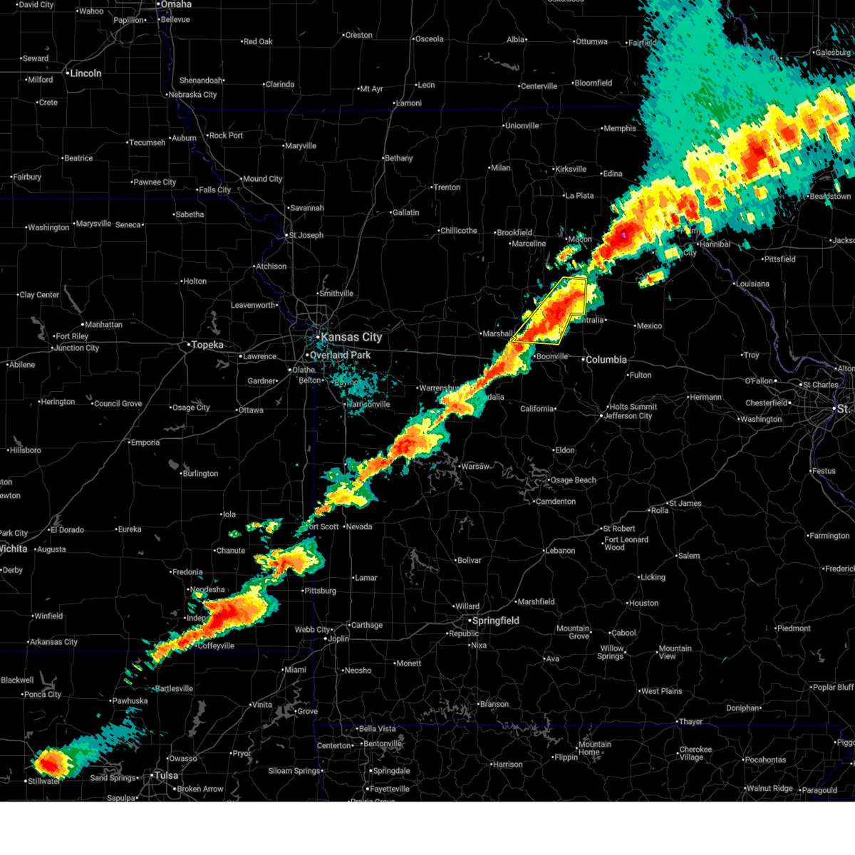
| 4/27/2026 7:31 AM CDT |
 At 731 am cdt, a severe thunderstorm capable of producing a tornado was located over higbee, or 10 miles south of moberly, moving east at 55 mph (radar indicated rotation). Hazards include tornado. Flying debris will be dangerous to those caught without shelter. mobile homes will be damaged or destroyed. damage to roofs, windows, and vehicles will occur. tree damage is likely. Locations impacted include, moberly, higbee, clark, and renick. At 731 am cdt, a severe thunderstorm capable of producing a tornado was located over higbee, or 10 miles south of moberly, moving east at 55 mph (radar indicated rotation). Hazards include tornado. Flying debris will be dangerous to those caught without shelter. mobile homes will be damaged or destroyed. damage to roofs, windows, and vehicles will occur. tree damage is likely. Locations impacted include, moberly, higbee, clark, and renick.
|
| 4/27/2026 7:30 AM CDT | Flag pole knocked over. time estimated from rada in howard county MO, 5.3 miles N of Higbee, MO |
| 4/27/2026 7:30 AM CDT | Large branch snapped. time estimated from rada in howard county MO, 4.6 miles N of Higbee, MO |
| 4/27/2026 7:30 AM CDT | Large branch snapped. time estimated from rada in howard county MO, 4.6 miles N of Higbee, MO |
| 4/27/2026 7:28 AM CDT | Powerlines down on state route a. time estimated from rada in randolph county MO, 3.5 miles SSW of Higbee, MO |
| 4/27/2026 7:21 AM CDT |
 At 720 am cdt, a severe thunderstorm was located near salisbury, moving east at 55 mph (radar indicated). Hazards include 60 mph wind gusts and quarter size hail. Hail damage to vehicles is expected. expect wind damage to roofs, siding, and trees. Locations impacted include, moberly, macon, fayette, salisbury, huntsville, bevier, higbee, atlanta, clark, callao, cairo, armstrong, new cambria, renick, jacksonville, clifton hill, ethel, excello, prairie hill, and wien. At 720 am cdt, a severe thunderstorm was located near salisbury, moving east at 55 mph (radar indicated). Hazards include 60 mph wind gusts and quarter size hail. Hail damage to vehicles is expected. expect wind damage to roofs, siding, and trees. Locations impacted include, moberly, macon, fayette, salisbury, huntsville, bevier, higbee, atlanta, clark, callao, cairo, armstrong, new cambria, renick, jacksonville, clifton hill, ethel, excello, prairie hill, and wien.
|
| 4/27/2026 7:20 AM CDT |
 At 720 am cdt, a severe thunderstorm capable of producing a tornado was located over armstrong, or 7 miles north of fayette, moving east at 55 mph (radar indicated rotation). Hazards include tornado. Flying debris will be dangerous to those caught without shelter. mobile homes will be damaged or destroyed. damage to roofs, windows, and vehicles will occur. tree damage is likely. Locations impacted include, moberly, higbee, clark, armstrong, and renick. At 720 am cdt, a severe thunderstorm capable of producing a tornado was located over armstrong, or 7 miles north of fayette, moving east at 55 mph (radar indicated rotation). Hazards include tornado. Flying debris will be dangerous to those caught without shelter. mobile homes will be damaged or destroyed. damage to roofs, windows, and vehicles will occur. tree damage is likely. Locations impacted include, moberly, higbee, clark, armstrong, and renick.
|
| 4/27/2026 7:12 AM CDT |
 Toreax the national weather service in pleasant hill has issued a * tornado warning for, southern randolph county in north central missouri, southeastern chariton county in north central missouri, northern howard county in central missouri, northeastern saline county in central missouri, * until 800 am cdt. * at 712 am cdt, a severe thunderstorm capable of producing a tornado was located over glasgow, moving east at 55 mph (radar indicated rotation). Hazards include tornado. Flying debris will be dangerous to those caught without shelter. mobile homes will be damaged or destroyed. damage to roofs, windows, and vehicles will occur. Tree damage is likely. Toreax the national weather service in pleasant hill has issued a * tornado warning for, southern randolph county in north central missouri, southeastern chariton county in north central missouri, northern howard county in central missouri, northeastern saline county in central missouri, * until 800 am cdt. * at 712 am cdt, a severe thunderstorm capable of producing a tornado was located over glasgow, moving east at 55 mph (radar indicated rotation). Hazards include tornado. Flying debris will be dangerous to those caught without shelter. mobile homes will be damaged or destroyed. damage to roofs, windows, and vehicles will occur. Tree damage is likely.
|
| 4/27/2026 7:08 AM CDT |
 Svreax the national weather service in pleasant hill has issued a * severe thunderstorm warning for, randolph county in north central missouri, chariton county in north central missouri, southeastern linn county in north central missouri, northern howard county in central missouri, northeastern saline county in central missouri, macon county in north central missouri, * until 800 am cdt. * at 708 am cdt, a severe thunderstorm was located near keytesville, or near salisbury, moving east at 55 mph (radar indicated). Hazards include 60 mph wind gusts and quarter size hail. Hail damage to vehicles is expected. Expect wind damage to roofs, siding, and trees. Svreax the national weather service in pleasant hill has issued a * severe thunderstorm warning for, randolph county in north central missouri, chariton county in north central missouri, southeastern linn county in north central missouri, northern howard county in central missouri, northeastern saline county in central missouri, macon county in north central missouri, * until 800 am cdt. * at 708 am cdt, a severe thunderstorm was located near keytesville, or near salisbury, moving east at 55 mph (radar indicated). Hazards include 60 mph wind gusts and quarter size hail. Hail damage to vehicles is expected. Expect wind damage to roofs, siding, and trees.
|
| 4/17/2026 6:55 PM CDT |
 At 655 pm cdt, severe thunderstorms were located along a line extending from near macon to near huntsville to near armstrong, moving east at 45 mph (radar indicated). Hazards include 60 mph wind gusts and nickel size hail. Expect damage to roofs, siding, and trees. Locations impacted include, moberly, macon, fayette, huntsville, glasgow, bevier, higbee, clark, cairo, armstrong, renick, jacksonville, clifton hill, and excello. At 655 pm cdt, severe thunderstorms were located along a line extending from near macon to near huntsville to near armstrong, moving east at 45 mph (radar indicated). Hazards include 60 mph wind gusts and nickel size hail. Expect damage to roofs, siding, and trees. Locations impacted include, moberly, macon, fayette, huntsville, glasgow, bevier, higbee, clark, cairo, armstrong, renick, jacksonville, clifton hill, and excello.
|
| 4/17/2026 6:46 PM CDT |
 At 646 pm cdt, severe thunderstorms were located along a line extending from near bevier to near salisbury to 6 miles northwest of armstrong, moving east at 60 mph (radar indicated). Hazards include 60 mph wind gusts and nickel size hail. Expect damage to roofs, siding, and trees. Locations impacted include, moberly, macon, fayette, salisbury, huntsville, glasgow, bevier, higbee, clark, cairo, armstrong, renick, jacksonville, clifton hill, arrow rock, excello, and prairie hill. At 646 pm cdt, severe thunderstorms were located along a line extending from near bevier to near salisbury to 6 miles northwest of armstrong, moving east at 60 mph (radar indicated). Hazards include 60 mph wind gusts and nickel size hail. Expect damage to roofs, siding, and trees. Locations impacted include, moberly, macon, fayette, salisbury, huntsville, glasgow, bevier, higbee, clark, cairo, armstrong, renick, jacksonville, clifton hill, arrow rock, excello, and prairie hill.
|
| 4/17/2026 6:46 PM CDT |
 the severe thunderstorm warning has been cancelled and is no longer in effect the severe thunderstorm warning has been cancelled and is no longer in effect
|
| 4/17/2026 6:33 PM CDT |
 At 632 pm cdt, severe thunderstorms were located along a line extending from 9 miles southeast of marceline to near brunswick to near slater, moving northeast at 65 mph (radar indicated). Hazards include 60 mph wind gusts and nickel size hail. Expect damage to roofs, siding, and trees. Locations impacted include, moberly, macon, fayette, marceline, slater, salisbury, huntsville, glasgow, bevier, higbee, keytesville, atlanta, clark, callao, cairo, armstrong, gilliam, new cambria, renick, and jacksonville. At 632 pm cdt, severe thunderstorms were located along a line extending from 9 miles southeast of marceline to near brunswick to near slater, moving northeast at 65 mph (radar indicated). Hazards include 60 mph wind gusts and nickel size hail. Expect damage to roofs, siding, and trees. Locations impacted include, moberly, macon, fayette, marceline, slater, salisbury, huntsville, glasgow, bevier, higbee, keytesville, atlanta, clark, callao, cairo, armstrong, gilliam, new cambria, renick, and jacksonville.
|
| 4/17/2026 6:33 PM CDT |
 the severe thunderstorm warning has been cancelled and is no longer in effect the severe thunderstorm warning has been cancelled and is no longer in effect
|
| 4/17/2026 6:20 PM CDT |
 Svreax the national weather service in pleasant hill has issued a * severe thunderstorm warning for, chariton county in north central missouri, randolph county in north central missouri, southeastern linn county in north central missouri, southeastern carroll county in north central missouri, howard county in central missouri, saline county in central missouri, macon county in north central missouri, * until 715 pm cdt. * at 620 pm cdt, severe thunderstorms were located along a line extending from near marceline to 8 miles southwest of brunswick to near blackburn, moving east at 45 mph (radar indicated). Hazards include 60 mph wind gusts and nickel size hail. expect damage to roofs, siding, and trees Svreax the national weather service in pleasant hill has issued a * severe thunderstorm warning for, chariton county in north central missouri, randolph county in north central missouri, southeastern linn county in north central missouri, southeastern carroll county in north central missouri, howard county in central missouri, saline county in central missouri, macon county in north central missouri, * until 715 pm cdt. * at 620 pm cdt, severe thunderstorms were located along a line extending from near marceline to 8 miles southwest of brunswick to near blackburn, moving east at 45 mph (radar indicated). Hazards include 60 mph wind gusts and nickel size hail. expect damage to roofs, siding, and trees
|
| 9/18/2025 8:13 PM CDT | The storm which prompted the warning has weakened below severe limits, and no longer poses an immediate threat to life or property. therefore, the warning will be allowed to expire. however, small hail, gusty winds and heavy rain are still possible with this thunderstorm. a severe thunderstorm watch remains in effect until 1000 pm cdt for central and north central missouri. |
| 9/18/2025 8:03 PM CDT | At 803 pm cdt, a severe thunderstorm was located over moberly, moving northeast at 30 mph (radar indicated). Hazards include 60 mph wind gusts and quarter size hail. Hail damage to vehicles is expected. expect wind damage to roofs, siding, and trees. Locations impacted include, moberly, huntsville, higbee, clark, and renick. |
| 9/18/2025 8:03 PM CDT | the severe thunderstorm warning has been cancelled and is no longer in effect |
| 9/18/2025 7:43 PM CDT | At 743 pm cdt, a severe thunderstorm was located near higbee, or 10 miles south of moberly, moving northeast at 30 mph (radar indicated). Hazards include 60 mph wind gusts and quarter size hail. Hail damage to vehicles is expected. expect wind damage to roofs, siding, and trees. Locations impacted include, moberly, fayette, huntsville, higbee, clark, and renick. |
| 9/18/2025 7:29 PM CDT | Svreax the national weather service in pleasant hill has issued a * severe thunderstorm warning for, southeastern randolph county in north central missouri, eastern howard county in central missouri, * until 815 pm cdt. * at 729 pm cdt, a severe thunderstorm was located 8 miles east of fayette, moving northeast at 30 mph (radar indicated). Hazards include 60 mph wind gusts and quarter size hail. Hail damage to vehicles is expected. Expect wind damage to roofs, siding, and trees. |
| 8/11/2025 10:20 PM CDT |
 the severe thunderstorm warning has been cancelled and is no longer in effect the severe thunderstorm warning has been cancelled and is no longer in effect
|
| 8/11/2025 10:20 PM CDT |
 At 1020 pm cdt, severe thunderstorms were located along a line extending from 7 miles east of bucklin to 6 miles north of cairo to 7 miles northeast of clark, moving northeast at 35 mph (radar indicated). Hazards include 60 mph wind gusts and penny size hail. Expect damage to roofs, siding, and trees. Locations impacted include, moberly, macon, marceline, salisbury, huntsville, bevier, higbee, callao, cairo, new cambria, renick, jacksonville, clifton hill, ethel, excello, prairie hill, and wien. At 1020 pm cdt, severe thunderstorms were located along a line extending from 7 miles east of bucklin to 6 miles north of cairo to 7 miles northeast of clark, moving northeast at 35 mph (radar indicated). Hazards include 60 mph wind gusts and penny size hail. Expect damage to roofs, siding, and trees. Locations impacted include, moberly, macon, marceline, salisbury, huntsville, bevier, higbee, callao, cairo, new cambria, renick, jacksonville, clifton hill, ethel, excello, prairie hill, and wien.
|
| 8/11/2025 10:02 PM CDT |
 Svreax the national weather service in pleasant hill has issued a * severe thunderstorm warning for, northeastern chariton county in north central missouri, randolph county in north central missouri, southeastern linn county in north central missouri, northeastern howard county in central missouri, southern macon county in north central missouri, * until 1045 pm cdt. * at 1001 pm cdt, severe thunderstorms were located along a line extending from near marceline to 6 miles northwest of huntsville to near clark, moving east at 35 mph (radar indicated). Hazards include 60 mph wind gusts and penny size hail. expect damage to roofs, siding, and trees Svreax the national weather service in pleasant hill has issued a * severe thunderstorm warning for, northeastern chariton county in north central missouri, randolph county in north central missouri, southeastern linn county in north central missouri, northeastern howard county in central missouri, southern macon county in north central missouri, * until 1045 pm cdt. * at 1001 pm cdt, severe thunderstorms were located along a line extending from near marceline to 6 miles northwest of huntsville to near clark, moving east at 35 mph (radar indicated). Hazards include 60 mph wind gusts and penny size hail. expect damage to roofs, siding, and trees
|
| 7/16/2025 8:30 PM CDT |
 The storm which prompted the warning has weakened below severe limits, and no longer poses an immediate threat to life or property. therefore, the warning has been allowed to expire. however, gusty winds and heavy rain are still possible with this thunderstorm. The storm which prompted the warning has weakened below severe limits, and no longer poses an immediate threat to life or property. therefore, the warning has been allowed to expire. however, gusty winds and heavy rain are still possible with this thunderstorm.
|
| 7/16/2025 7:59 PM CDT |
 At 759 pm cdt, a severe thunderstorm was located over armstrong, or near glasgow, moving east at 20 mph (radar indicated). Hazards include 60 mph wind gusts and quarter size hail. Hail damage to vehicles is expected. expect wind damage to roofs, siding, and trees. Locations impacted include, moberly, fayette, salisbury, huntsville, glasgow, higbee, armstrong, and clifton hill. At 759 pm cdt, a severe thunderstorm was located over armstrong, or near glasgow, moving east at 20 mph (radar indicated). Hazards include 60 mph wind gusts and quarter size hail. Hail damage to vehicles is expected. expect wind damage to roofs, siding, and trees. Locations impacted include, moberly, fayette, salisbury, huntsville, glasgow, higbee, armstrong, and clifton hill.
|
| 7/16/2025 7:59 PM CDT |
 the severe thunderstorm warning has been cancelled and is no longer in effect the severe thunderstorm warning has been cancelled and is no longer in effect
|
| 7/16/2025 7:38 PM CDT |
 Svreax the national weather service in pleasant hill has issued a * severe thunderstorm warning for, southeastern chariton county in north central missouri, southwestern randolph county in north central missouri, northern howard county in central missouri, northeastern saline county in central missouri, * until 830 pm cdt. * at 738 pm cdt, a severe thunderstorm was located near armstrong, or near glasgow, moving east at 25 mph (radar indicated). Hazards include 60 mph wind gusts and quarter size hail. Hail damage to vehicles is expected. Expect wind damage to roofs, siding, and trees. Svreax the national weather service in pleasant hill has issued a * severe thunderstorm warning for, southeastern chariton county in north central missouri, southwestern randolph county in north central missouri, northern howard county in central missouri, northeastern saline county in central missouri, * until 830 pm cdt. * at 738 pm cdt, a severe thunderstorm was located near armstrong, or near glasgow, moving east at 25 mph (radar indicated). Hazards include 60 mph wind gusts and quarter size hail. Hail damage to vehicles is expected. Expect wind damage to roofs, siding, and trees.
|
| 7/16/2025 6:13 PM CDT |
 The storm which prompted the warning has weakened below severe limits, and no longer poses an immediate threat to life or property. therefore, the warning will be allowed to expire. there are a few other sub-severe storms to the west that may move into the same area over the next 30 minutes. The storm which prompted the warning has weakened below severe limits, and no longer poses an immediate threat to life or property. therefore, the warning will be allowed to expire. there are a few other sub-severe storms to the west that may move into the same area over the next 30 minutes.
|
| 7/16/2025 6:01 PM CDT |
 the severe thunderstorm warning has been cancelled and is no longer in effect the severe thunderstorm warning has been cancelled and is no longer in effect
|
| 7/16/2025 6:01 PM CDT |
 At 601 pm cdt, a severe thunderstorm was located over higbee, or 7 miles southwest of moberly, moving east at 30 mph (radar indicated). Hazards include 60 mph wind gusts and quarter size hail. Hail damage to vehicles is expected. expect wind damage to roofs, siding, and trees. Locations impacted include, moberly, huntsville, higbee, clark, and renick. At 601 pm cdt, a severe thunderstorm was located over higbee, or 7 miles southwest of moberly, moving east at 30 mph (radar indicated). Hazards include 60 mph wind gusts and quarter size hail. Hail damage to vehicles is expected. expect wind damage to roofs, siding, and trees. Locations impacted include, moberly, huntsville, higbee, clark, and renick.
|
| 7/16/2025 5:50 PM CDT |
 At 550 pm cdt, a severe thunderstorm was located near higbee, or 9 miles south of huntsville, moving east at 25 mph (radar indicated). Hazards include 60 mph wind gusts and quarter size hail. Hail damage to vehicles is expected. expect wind damage to roofs, siding, and trees. Locations impacted include, moberly, huntsville, higbee, clark, armstrong, and renick. At 550 pm cdt, a severe thunderstorm was located near higbee, or 9 miles south of huntsville, moving east at 25 mph (radar indicated). Hazards include 60 mph wind gusts and quarter size hail. Hail damage to vehicles is expected. expect wind damage to roofs, siding, and trees. Locations impacted include, moberly, huntsville, higbee, clark, armstrong, and renick.
|
| 7/16/2025 5:41 PM CDT | Downed tree and wires near railroad street. time estimated from rada in randolph county MO, 0.5 miles NNW of Higbee, MO |
| 7/16/2025 5:32 PM CDT |
 Svreax the national weather service in pleasant hill has issued a * severe thunderstorm warning for, southeastern chariton county in north central missouri, southern randolph county in north central missouri, northeastern howard county in central missouri, * until 615 pm cdt. * at 532 pm cdt, a severe thunderstorm was located over armstrong, or 9 miles northeast of glasgow, moving east at 25 mph (radar indicated). Hazards include 60 mph wind gusts and quarter size hail. Hail damage to vehicles is expected. Expect wind damage to roofs, siding, and trees. Svreax the national weather service in pleasant hill has issued a * severe thunderstorm warning for, southeastern chariton county in north central missouri, southern randolph county in north central missouri, northeastern howard county in central missouri, * until 615 pm cdt. * at 532 pm cdt, a severe thunderstorm was located over armstrong, or 9 miles northeast of glasgow, moving east at 25 mph (radar indicated). Hazards include 60 mph wind gusts and quarter size hail. Hail damage to vehicles is expected. Expect wind damage to roofs, siding, and trees.
|
| 6/3/2025 5:22 PM CDT |
 The storms which prompted the warning have moved out of the area. therefore, the warning will be allowed to expire. however, heavy rain is still possible with these thunderstorms. a tornado watch remains in effect until 800 pm cdt for central, north central and northeastern missouri. The storms which prompted the warning have moved out of the area. therefore, the warning will be allowed to expire. however, heavy rain is still possible with these thunderstorms. a tornado watch remains in effect until 800 pm cdt for central, north central and northeastern missouri.
|
| 6/3/2025 5:00 PM CDT |
 the severe thunderstorm warning has been cancelled and is no longer in effect the severe thunderstorm warning has been cancelled and is no longer in effect
|
| 6/3/2025 5:00 PM CDT |
 At 459 pm cdt, severe thunderstorms were located along a line extending from near clarence to 7 miles east of moberly to near easley, moving east at 45 mph (radar indicated). Hazards include 60 mph wind gusts and nickel size hail. Expect damage to roofs, siding, and trees. locations impacted include, moberly, boonville, macon, fayette, huntsville, la plata, new franklin, pilot grove, bevier, higbee, otterville, atlanta, bunceton, clark, callao, cairo, armstrong, prairie home, renick, and jacksonville. This includes interstate 70 in missouri between mile markers 93 and 114. At 459 pm cdt, severe thunderstorms were located along a line extending from near clarence to 7 miles east of moberly to near easley, moving east at 45 mph (radar indicated). Hazards include 60 mph wind gusts and nickel size hail. Expect damage to roofs, siding, and trees. locations impacted include, moberly, boonville, macon, fayette, huntsville, la plata, new franklin, pilot grove, bevier, higbee, otterville, atlanta, bunceton, clark, callao, cairo, armstrong, prairie home, renick, and jacksonville. This includes interstate 70 in missouri between mile markers 93 and 114.
|
| 6/3/2025 4:32 PM CDT |
 Svreax the national weather service in pleasant hill has issued a * severe thunderstorm warning for, southeastern adair county in northeastern missouri, eastern chariton county in north central missouri, randolph county in north central missouri, southeastern linn county in north central missouri, southeastern pettis county in central missouri, howard county in central missouri, southeastern saline county in central missouri, macon county in north central missouri, cooper county in central missouri, * until 530 pm cdt. * at 431 pm cdt, severe thunderstorms were located along a line extending from near callao to near armstrong to bunceton, moving east at 45 mph (automated weather station. a 62 mph wind gust was just reported at sedalia memorial airport). Hazards include 60 mph wind gusts and nickel size hail. expect damage to roofs, siding, and trees Svreax the national weather service in pleasant hill has issued a * severe thunderstorm warning for, southeastern adair county in northeastern missouri, eastern chariton county in north central missouri, randolph county in north central missouri, southeastern linn county in north central missouri, southeastern pettis county in central missouri, howard county in central missouri, southeastern saline county in central missouri, macon county in north central missouri, cooper county in central missouri, * until 530 pm cdt. * at 431 pm cdt, severe thunderstorms were located along a line extending from near callao to near armstrong to bunceton, moving east at 45 mph (automated weather station. a 62 mph wind gust was just reported at sedalia memorial airport). Hazards include 60 mph wind gusts and nickel size hail. expect damage to roofs, siding, and trees
|
| 4/20/2025 5:14 PM CDT |
 Svreax the national weather service in pleasant hill has issued a * severe thunderstorm warning for, randolph county in north central missouri, southeastern macon county in north central missouri, * until 600 pm cdt. * at 514 pm cdt, a severe thunderstorm was located near huntsville, moving northeast at 35 mph (radar indicated). Hazards include 60 mph wind gusts. expect damage to roofs, siding, and trees Svreax the national weather service in pleasant hill has issued a * severe thunderstorm warning for, randolph county in north central missouri, southeastern macon county in north central missouri, * until 600 pm cdt. * at 514 pm cdt, a severe thunderstorm was located near huntsville, moving northeast at 35 mph (radar indicated). Hazards include 60 mph wind gusts. expect damage to roofs, siding, and trees
|
| 7/16/2024 9:08 AM CDT |
 At 907 am cdt, a severe thunderstorm was located near huntsville, moving east at 50 mph (radar indicated). Hazards include 70 mph wind gusts and penny size hail. Expect considerable tree damage. damage is likely to mobile homes, roofs, and outbuildings. Locations impacted include, moberly, huntsville, higbee, clark, cairo, renick, jacksonville, and clifton hill. At 907 am cdt, a severe thunderstorm was located near huntsville, moving east at 50 mph (radar indicated). Hazards include 70 mph wind gusts and penny size hail. Expect considerable tree damage. damage is likely to mobile homes, roofs, and outbuildings. Locations impacted include, moberly, huntsville, higbee, clark, cairo, renick, jacksonville, and clifton hill.
|
| 7/16/2024 9:08 AM CDT |
 the severe thunderstorm warning has been cancelled and is no longer in effect the severe thunderstorm warning has been cancelled and is no longer in effect
|
| 7/16/2024 8:47 AM CDT |
 Svreax the national weather service in pleasant hill has issued a * severe thunderstorm warning for, eastern chariton county in north central missouri, randolph county in north central missouri, northeastern howard county in central missouri, south central macon county in north central missouri, * until 930 am cdt. * at 846 am cdt, a severe thunderstorm was located over salisbury, moving east at 50 mph (radar indicated). Hazards include 70 mph wind gusts and penny size hail. Expect considerable tree damage. Damage is likely to mobile homes, roofs, and outbuildings. Svreax the national weather service in pleasant hill has issued a * severe thunderstorm warning for, eastern chariton county in north central missouri, randolph county in north central missouri, northeastern howard county in central missouri, south central macon county in north central missouri, * until 930 am cdt. * at 846 am cdt, a severe thunderstorm was located over salisbury, moving east at 50 mph (radar indicated). Hazards include 70 mph wind gusts and penny size hail. Expect considerable tree damage. Damage is likely to mobile homes, roofs, and outbuildings.
|
| 7/2/2024 11:43 PM CDT |
 The storms which prompted the warning have weakened below severe limits, and have exited the warned area. therefore, the warning will be allowed to expire. however, gusty winds and heavy rain are still possible with these thunderstorms. a severe thunderstorm watch remains in effect until midnight cdt for central and north central missouri. The storms which prompted the warning have weakened below severe limits, and have exited the warned area. therefore, the warning will be allowed to expire. however, gusty winds and heavy rain are still possible with these thunderstorms. a severe thunderstorm watch remains in effect until midnight cdt for central and north central missouri.
|
| 7/2/2024 11:36 PM CDT |
 At 1135 pm cdt, severe thunderstorms were located along a line extending from near madison to 10 miles east of fayette to 6 miles east of bunceton, moving east at 35 mph (radar indicated). Hazards include 60 mph wind gusts. Expect damage to roofs, siding, and trees. locations impacted include, moberly, boonville, fayette, huntsville, new franklin, pilot grove, higbee, bunceton, clark, cairo, prairie home, renick, franklin, wooldridge, and lamine. This includes interstate 70 in missouri between mile markers 96 and 114. At 1135 pm cdt, severe thunderstorms were located along a line extending from near madison to 10 miles east of fayette to 6 miles east of bunceton, moving east at 35 mph (radar indicated). Hazards include 60 mph wind gusts. Expect damage to roofs, siding, and trees. locations impacted include, moberly, boonville, fayette, huntsville, new franklin, pilot grove, higbee, bunceton, clark, cairo, prairie home, renick, franklin, wooldridge, and lamine. This includes interstate 70 in missouri between mile markers 96 and 114.
|
| 7/2/2024 11:36 PM CDT |
 the severe thunderstorm warning has been cancelled and is no longer in effect the severe thunderstorm warning has been cancelled and is no longer in effect
|
| 7/2/2024 11:27 PM CDT |
 the severe thunderstorm warning has been cancelled and is no longer in effect the severe thunderstorm warning has been cancelled and is no longer in effect
|
| 7/2/2024 11:27 PM CDT |
 At 1126 pm cdt, severe thunderstorms were located along a line extending from near moberly to 6 miles east of fayette to bunceton, moving east at 35 mph (radar indicated). Hazards include 60 mph wind gusts. Expect damage to roofs, siding, and trees. locations impacted include, moberly, boonville, fayette, huntsville, new franklin, pilot grove, higbee, bunceton, clark, cairo, armstrong, prairie home, renick, clifton hill, franklin, wooldridge, and lamine. This includes interstate 70 in missouri between mile markers 94 and 114. At 1126 pm cdt, severe thunderstorms were located along a line extending from near moberly to 6 miles east of fayette to bunceton, moving east at 35 mph (radar indicated). Hazards include 60 mph wind gusts. Expect damage to roofs, siding, and trees. locations impacted include, moberly, boonville, fayette, huntsville, new franklin, pilot grove, higbee, bunceton, clark, cairo, armstrong, prairie home, renick, clifton hill, franklin, wooldridge, and lamine. This includes interstate 70 in missouri between mile markers 94 and 114.
|
| 7/2/2024 11:13 PM CDT |
 At 1112 pm cdt, severe thunderstorms were located along a line extending from cairo to near fayette to near pilot grove, moving east at 35 mph (radar indicated). Hazards include 60 mph wind gusts. Expect damage to roofs, siding, and trees. locations impacted include, moberly, boonville, fayette, salisbury, huntsville, glasgow, new franklin, pilot grove, higbee, bunceton, clark, cairo, armstrong, prairie home, nelson, renick, blackwater, clifton hill, franklin, and wooldridge. This includes interstate 70 in missouri between mile markers 83 and 114. At 1112 pm cdt, severe thunderstorms were located along a line extending from cairo to near fayette to near pilot grove, moving east at 35 mph (radar indicated). Hazards include 60 mph wind gusts. Expect damage to roofs, siding, and trees. locations impacted include, moberly, boonville, fayette, salisbury, huntsville, glasgow, new franklin, pilot grove, higbee, bunceton, clark, cairo, armstrong, prairie home, nelson, renick, blackwater, clifton hill, franklin, and wooldridge. This includes interstate 70 in missouri between mile markers 83 and 114.
|
| 7/2/2024 10:44 PM CDT |
 Svreax the national weather service in pleasant hill has issued a * severe thunderstorm warning for, southeastern chariton county in north central missouri, randolph county in north central missouri, northern pettis county in central missouri, howard county in central missouri, saline county in central missouri, cooper county in central missouri, * until 1145 pm cdt. * at 1043 pm cdt, severe thunderstorms were located along a line extending from near callao to 10 miles southeast of marshall to near sedalia, moving east at 35 mph (radar indicated). Hazards include 60 mph wind gusts. expect damage to roofs, siding, and trees Svreax the national weather service in pleasant hill has issued a * severe thunderstorm warning for, southeastern chariton county in north central missouri, randolph county in north central missouri, northern pettis county in central missouri, howard county in central missouri, saline county in central missouri, cooper county in central missouri, * until 1145 pm cdt. * at 1043 pm cdt, severe thunderstorms were located along a line extending from near callao to 10 miles southeast of marshall to near sedalia, moving east at 35 mph (radar indicated). Hazards include 60 mph wind gusts. expect damage to roofs, siding, and trees
|
| 6/26/2024 2:52 AM CDT |
 The storms which prompted the warning have weakened below severe limits. therefore, the warning will be allowed to expire. however, gusty winds and heavy rain are still possible with these thunderstorms. a severe thunderstorm watch remains in effect until 700 am cdt for central and north central missouri. The storms which prompted the warning have weakened below severe limits. therefore, the warning will be allowed to expire. however, gusty winds and heavy rain are still possible with these thunderstorms. a severe thunderstorm watch remains in effect until 700 am cdt for central and north central missouri.
|
| 6/26/2024 2:29 AM CDT |
 At 229 am cdt, severe thunderstorms were located along a line extending from near cairo to 6 miles northeast of fayette to 8 miles northwest of new franklin, moving southeast at 30 mph (radar indicated). Hazards include 60 mph wind gusts and penny size hail. Expect damage to roofs, siding, and trees. locations impacted include, moberly, boonville, fayette, huntsville, glasgow, new franklin, higbee, clark, cairo, armstrong, prairie home, renick, jacksonville, clifton hill, franklin, and wooldridge. This includes interstate 70 in missouri between mile markers 102 and 114. At 229 am cdt, severe thunderstorms were located along a line extending from near cairo to 6 miles northeast of fayette to 8 miles northwest of new franklin, moving southeast at 30 mph (radar indicated). Hazards include 60 mph wind gusts and penny size hail. Expect damage to roofs, siding, and trees. locations impacted include, moberly, boonville, fayette, huntsville, glasgow, new franklin, higbee, clark, cairo, armstrong, prairie home, renick, jacksonville, clifton hill, franklin, and wooldridge. This includes interstate 70 in missouri between mile markers 102 and 114.
|
| 6/26/2024 2:29 AM CDT |
 the severe thunderstorm warning has been cancelled and is no longer in effect the severe thunderstorm warning has been cancelled and is no longer in effect
|
| 6/26/2024 2:14 AM CDT |
 Svreax the national weather service in pleasant hill has issued a * severe thunderstorm warning for, southeastern chariton county in north central missouri, randolph county in north central missouri, howard county in central missouri, east central saline county in central missouri, eastern cooper county in central missouri, * until 300 am cdt. * at 213 am cdt, severe thunderstorms were located along a line extending from near cairo to near armstrong to near slater, moving southeast at 45 mph (radar indicated). Hazards include 60 mph wind gusts and penny size hail. expect damage to roofs, siding, and trees Svreax the national weather service in pleasant hill has issued a * severe thunderstorm warning for, southeastern chariton county in north central missouri, randolph county in north central missouri, howard county in central missouri, east central saline county in central missouri, eastern cooper county in central missouri, * until 300 am cdt. * at 213 am cdt, severe thunderstorms were located along a line extending from near cairo to near armstrong to near slater, moving southeast at 45 mph (radar indicated). Hazards include 60 mph wind gusts and penny size hail. expect damage to roofs, siding, and trees
|
| 6/25/2024 5:17 PM CDT |
 At 517 pm cdt, a severe thunderstorm was located near fayette, moving southeast at 25 mph (law enforcement). Hazards include 60 mph wind gusts and quarter size hail. Hail damage to vehicles is expected. expect wind damage to roofs, siding, and trees. Locations impacted include, fayette, new franklin, higbee, clark, armstrong, renick, and franklin. At 517 pm cdt, a severe thunderstorm was located near fayette, moving southeast at 25 mph (law enforcement). Hazards include 60 mph wind gusts and quarter size hail. Hail damage to vehicles is expected. expect wind damage to roofs, siding, and trees. Locations impacted include, fayette, new franklin, higbee, clark, armstrong, renick, and franklin.
|
| 6/25/2024 4:54 PM CDT |
 Svreax the national weather service in pleasant hill has issued a * severe thunderstorm warning for, southern randolph county in north central missouri, howard county in central missouri, * until 545 pm cdt. * at 454 pm cdt, a severe thunderstorm was located near armstrong, or near fayette, moving southeast at 30 mph (radar indicated). Hazards include 60 mph wind gusts and quarter size hail. Hail damage to vehicles is expected. Expect wind damage to roofs, siding, and trees. Svreax the national weather service in pleasant hill has issued a * severe thunderstorm warning for, southern randolph county in north central missouri, howard county in central missouri, * until 545 pm cdt. * at 454 pm cdt, a severe thunderstorm was located near armstrong, or near fayette, moving southeast at 30 mph (radar indicated). Hazards include 60 mph wind gusts and quarter size hail. Hail damage to vehicles is expected. Expect wind damage to roofs, siding, and trees.
|
| 6/13/2024 9:33 PM CDT |
 At 932 pm cdt, severe thunderstorms were located along a line extending from near brunswick to 6 miles southwest of higbee, moving south at 40 mph (radar indicated). Hazards include 60 mph wind gusts and half dollar size hail. Hail damage to vehicles is expected. expect wind damage to roofs, siding, and trees. Locations impacted include, fayette, slater, salisbury, glasgow, brunswick, higbee, keytesville, clark, armstrong, gilliam, triplett, and dalton. At 932 pm cdt, severe thunderstorms were located along a line extending from near brunswick to 6 miles southwest of higbee, moving south at 40 mph (radar indicated). Hazards include 60 mph wind gusts and half dollar size hail. Hail damage to vehicles is expected. expect wind damage to roofs, siding, and trees. Locations impacted include, fayette, slater, salisbury, glasgow, brunswick, higbee, keytesville, clark, armstrong, gilliam, triplett, and dalton.
|
| 6/13/2024 9:06 PM CDT | Multiple trees down on houses in higbee. time estimated from rada in randolph county MO, 0.3 miles SW of Higbee, MO |
| 6/13/2024 9:06 PM CDT |
 Svreax the national weather service in pleasant hill has issued a * severe thunderstorm warning for, central chariton county in north central missouri, southern randolph county in north central missouri, northeastern carroll county in north central missouri, central howard county in central missouri, northeastern saline county in central missouri, * until 1000 pm cdt. * at 905 pm cdt, severe thunderstorms were located along a line extending from 7 miles northwest of brunswick to clark, moving southeast at 40 mph (emergency management). Hazards include golf ball size hail and 60 mph wind gusts. People and animals outdoors will be injured. expect hail damage to roofs, siding, windows, and vehicles. Expect wind damage to roofs, siding, and trees. Svreax the national weather service in pleasant hill has issued a * severe thunderstorm warning for, central chariton county in north central missouri, southern randolph county in north central missouri, northeastern carroll county in north central missouri, central howard county in central missouri, northeastern saline county in central missouri, * until 1000 pm cdt. * at 905 pm cdt, severe thunderstorms were located along a line extending from 7 miles northwest of brunswick to clark, moving southeast at 40 mph (emergency management). Hazards include golf ball size hail and 60 mph wind gusts. People and animals outdoors will be injured. expect hail damage to roofs, siding, windows, and vehicles. Expect wind damage to roofs, siding, and trees.
|
| 6/13/2024 8:44 PM CDT |
 At 843 pm cdt, severe thunderstorms were located along a line extending from 7 miles east of hale to near moberly, moving southeast at 30 mph (radar indicated). Hazards include golf ball size hail and 70 mph wind gusts. People and animals outdoors will be injured. expect hail damage to roofs, siding, windows, and vehicles. expect considerable tree damage. wind damage is also likely to mobile homes, roofs, and outbuildings. Locations impacted include, moberly, marceline, salisbury, huntsville, brunswick, higbee, keytesville, meadville, clark, cairo, renick, mendon, jacksonville, clifton hill, sumner, rothville, triplett, dalton, excello, and prairie hill. At 843 pm cdt, severe thunderstorms were located along a line extending from 7 miles east of hale to near moberly, moving southeast at 30 mph (radar indicated). Hazards include golf ball size hail and 70 mph wind gusts. People and animals outdoors will be injured. expect hail damage to roofs, siding, windows, and vehicles. expect considerable tree damage. wind damage is also likely to mobile homes, roofs, and outbuildings. Locations impacted include, moberly, marceline, salisbury, huntsville, brunswick, higbee, keytesville, meadville, clark, cairo, renick, mendon, jacksonville, clifton hill, sumner, rothville, triplett, dalton, excello, and prairie hill.
|
| 6/13/2024 8:23 PM CDT |
 Svreax the national weather service in pleasant hill has issued a * severe thunderstorm warning for, chariton county in north central missouri, randolph county in north central missouri, southern linn county in north central missouri, southern macon county in north central missouri, * until 915 pm cdt. * at 823 pm cdt, severe thunderstorms were located along a line extending from near meadville to near cairo, moving southeast at 30 mph (radar indicated). Hazards include golf ball size hail and 70 mph wind gusts. People and animals outdoors will be injured. expect hail damage to roofs, siding, windows, and vehicles. expect considerable tree damage. Wind damage is also likely to mobile homes, roofs, and outbuildings. Svreax the national weather service in pleasant hill has issued a * severe thunderstorm warning for, chariton county in north central missouri, randolph county in north central missouri, southern linn county in north central missouri, southern macon county in north central missouri, * until 915 pm cdt. * at 823 pm cdt, severe thunderstorms were located along a line extending from near meadville to near cairo, moving southeast at 30 mph (radar indicated). Hazards include golf ball size hail and 70 mph wind gusts. People and animals outdoors will be injured. expect hail damage to roofs, siding, windows, and vehicles. expect considerable tree damage. Wind damage is also likely to mobile homes, roofs, and outbuildings.
|
| 5/7/2024 1:58 AM CDT |
 At 158 am cdt, severe thunderstorms were located along a line extending from callao to near clark to near jamestown, moving east at 45 mph (radar indicated). Hazards include 60 mph wind gusts. Expect damage to roofs, siding, and trees. locations impacted include, moberly, fayette, huntsville, higbee, clark, cairo, prairie home, renick, jacksonville, clifton hill, wooldridge, and excello. This includes interstate 70 in missouri between mile markers 109 and 114. At 158 am cdt, severe thunderstorms were located along a line extending from callao to near clark to near jamestown, moving east at 45 mph (radar indicated). Hazards include 60 mph wind gusts. Expect damage to roofs, siding, and trees. locations impacted include, moberly, fayette, huntsville, higbee, clark, cairo, prairie home, renick, jacksonville, clifton hill, wooldridge, and excello. This includes interstate 70 in missouri between mile markers 109 and 114.
|
| 5/7/2024 1:58 AM CDT |
 the severe thunderstorm warning has been cancelled and is no longer in effect the severe thunderstorm warning has been cancelled and is no longer in effect
|
| 5/7/2024 1:51 AM CDT |
 The tornado threat has diminished. therefore, the warning will be allowed to expire. a tornado watch remains in effect until 400 am cdt for central and north central missouri. remember, a severe thunderstorm warning still remains in effect for randolph and howard counties until 230 am. The tornado threat has diminished. therefore, the warning will be allowed to expire. a tornado watch remains in effect until 400 am cdt for central and north central missouri. remember, a severe thunderstorm warning still remains in effect for randolph and howard counties until 230 am.
|
| 5/7/2024 1:46 AM CDT | Tree down on power lines in higbe in randolph county MO, 0.3 miles SW of Higbee, MO |
| 5/7/2024 1:46 AM CDT | Downed trees and wires near route b. time estimated from rada in randolph county MO, 0.5 miles NNW of Higbee, MO |
| 5/7/2024 1:42 AM CDT |
 the tornado warning has been cancelled and is no longer in effect the tornado warning has been cancelled and is no longer in effect
|
| 5/7/2024 1:42 AM CDT |
 At 142 am cdt, a severe squall line capable of producing both tornadoes and extensive straight line wind damage was located along a line extending from near armstrong to near fayette, moving northeast at 40 mph (radar indicated rotation). Hazards include tornado. Flying debris will be dangerous to those caught without shelter. mobile homes will be damaged or destroyed. damage to roofs, windows, and vehicles will occur. tree damage is likely. Locations impacted include, moberly, fayette, huntsville, and higbee. At 142 am cdt, a severe squall line capable of producing both tornadoes and extensive straight line wind damage was located along a line extending from near armstrong to near fayette, moving northeast at 40 mph (radar indicated rotation). Hazards include tornado. Flying debris will be dangerous to those caught without shelter. mobile homes will be damaged or destroyed. damage to roofs, windows, and vehicles will occur. tree damage is likely. Locations impacted include, moberly, fayette, huntsville, and higbee.
|
| 5/7/2024 1:35 AM CDT |
 At 134 am cdt, severe thunderstorms were located along a line extending from near marceline to near fayette to near clarksburg, moving east at 45 mph (public). Hazards include 70 mph wind gusts. Expect considerable tree damage. damage is likely to mobile homes, roofs, and outbuildings. locations impacted include, moberly, boonville, fayette, salisbury, huntsville, glasgow, new franklin, pilot grove, higbee, keytesville, bunceton, clark, cairo, armstrong, prairie home, renick, jacksonville, clifton hill, franklin, and wooldridge. This includes interstate 70 in missouri between mile markers 92 and 114. At 134 am cdt, severe thunderstorms were located along a line extending from near marceline to near fayette to near clarksburg, moving east at 45 mph (public). Hazards include 70 mph wind gusts. Expect considerable tree damage. damage is likely to mobile homes, roofs, and outbuildings. locations impacted include, moberly, boonville, fayette, salisbury, huntsville, glasgow, new franklin, pilot grove, higbee, keytesville, bunceton, clark, cairo, armstrong, prairie home, renick, jacksonville, clifton hill, franklin, and wooldridge. This includes interstate 70 in missouri between mile markers 92 and 114.
|
| 5/7/2024 1:29 AM CDT |
 Toreax the national weather service in pleasant hill has issued a * tornado warning for, southeastern chariton county in north central missouri, southwestern randolph county in north central missouri, central howard county in central missouri, * until 200 am cdt. * at 128 am cdt, severe thunderstorms capable of producing both tornadoes and extensive straight line wind damage were located along a line extending from near armstrong to near fayette, moving northeast at 40 mph (radar indicated rotation). Hazards include tornado. Flying debris will be dangerous to those caught without shelter. mobile homes will be damaged or destroyed. damage to roofs, windows, and vehicles will occur. Tree damage is likely. Toreax the national weather service in pleasant hill has issued a * tornado warning for, southeastern chariton county in north central missouri, southwestern randolph county in north central missouri, central howard county in central missouri, * until 200 am cdt. * at 128 am cdt, severe thunderstorms capable of producing both tornadoes and extensive straight line wind damage were located along a line extending from near armstrong to near fayette, moving northeast at 40 mph (radar indicated rotation). Hazards include tornado. Flying debris will be dangerous to those caught without shelter. mobile homes will be damaged or destroyed. damage to roofs, windows, and vehicles will occur. Tree damage is likely.
|
| 5/7/2024 1:10 AM CDT |
 Svreax the national weather service in pleasant hill has issued a * severe thunderstorm warning for, chariton county in north central missouri, randolph county in north central missouri, howard county in central missouri, eastern saline county in central missouri, southeastern macon county in north central missouri, cooper county in central missouri, * until 230 am cdt. * at 109 am cdt, severe thunderstorms were located along a line extending from 8 miles northeast of hale to 10 miles southeast of slater to 7 miles southeast of smithton, moving east at 45 mph (public). Hazards include 70 mph wind gusts. Expect considerable tree damage. Damage is likely to mobile homes, roofs, and outbuildings. Svreax the national weather service in pleasant hill has issued a * severe thunderstorm warning for, chariton county in north central missouri, randolph county in north central missouri, howard county in central missouri, eastern saline county in central missouri, southeastern macon county in north central missouri, cooper county in central missouri, * until 230 am cdt. * at 109 am cdt, severe thunderstorms were located along a line extending from 8 miles northeast of hale to 10 miles southeast of slater to 7 miles southeast of smithton, moving east at 45 mph (public). Hazards include 70 mph wind gusts. Expect considerable tree damage. Damage is likely to mobile homes, roofs, and outbuildings.
|
| 3/14/2024 5:38 AM CDT |
 The storm which prompted the warning has weakened below severe limits, and no longer poses an immediate threat to life or property. therefore, the warning will be allowed to expire. a severe thunderstorm watch remains in effect until 600 am cdt for central and north central missouri. The storm which prompted the warning has weakened below severe limits, and no longer poses an immediate threat to life or property. therefore, the warning will be allowed to expire. a severe thunderstorm watch remains in effect until 600 am cdt for central and north central missouri.
|
| 3/14/2024 5:32 AM CDT |
 At 531 am cdt, a severe thunderstorm was located near madison, or 7 miles west of paris, moving east at 30 mph (radar indicated). Hazards include 60 mph wind gusts and quarter size hail. Hail damage to vehicles is expected. expect wind damage to roofs, siding, and trees. Locations impacted include, moberly, huntsville, higbee, clark, cairo, renick, and jacksonville. At 531 am cdt, a severe thunderstorm was located near madison, or 7 miles west of paris, moving east at 30 mph (radar indicated). Hazards include 60 mph wind gusts and quarter size hail. Hail damage to vehicles is expected. expect wind damage to roofs, siding, and trees. Locations impacted include, moberly, huntsville, higbee, clark, cairo, renick, and jacksonville.
|
| 3/14/2024 5:11 AM CDT |
 Svreax the national weather service in pleasant hill has issued a * severe thunderstorm warning for, randolph county in north central missouri, northeastern howard county in central missouri, * until 545 am cdt. * at 511 am cdt, a severe thunderstorm was located near huntsville, moving east at 60 mph (radar indicated). Hazards include 60 mph wind gusts and quarter size hail. Hail damage to vehicles is expected. Expect wind damage to roofs, siding, and trees. Svreax the national weather service in pleasant hill has issued a * severe thunderstorm warning for, randolph county in north central missouri, northeastern howard county in central missouri, * until 545 am cdt. * at 511 am cdt, a severe thunderstorm was located near huntsville, moving east at 60 mph (radar indicated). Hazards include 60 mph wind gusts and quarter size hail. Hail damage to vehicles is expected. Expect wind damage to roofs, siding, and trees.
|
| 8/12/2023 2:25 AM CDT |
 At 224 am cdt, a severe thunderstorm was located near clark, or 10 miles south of moberly, moving southeast at 95 mph (radar indicated). Hazards include 60 mph wind gusts and quarter size hail. Hail damage to vehicles is expected. Expect wind damage to roofs, siding, and trees. At 224 am cdt, a severe thunderstorm was located near clark, or 10 miles south of moberly, moving southeast at 95 mph (radar indicated). Hazards include 60 mph wind gusts and quarter size hail. Hail damage to vehicles is expected. Expect wind damage to roofs, siding, and trees.
|
| 8/2/2023 2:36 AM CDT |
 At 236 am cdt, a severe thunderstorm was located near moberly, moving southeast at 50 mph (radar indicated). Hazards include 60 mph wind gusts and quarter size hail. Hail damage to vehicles is expected. Expect wind damage to roofs, siding, and trees. At 236 am cdt, a severe thunderstorm was located near moberly, moving southeast at 50 mph (radar indicated). Hazards include 60 mph wind gusts and quarter size hail. Hail damage to vehicles is expected. Expect wind damage to roofs, siding, and trees.
|
| 7/29/2023 1:23 PM CDT |
 At 123 pm cdt, severe thunderstorms were located along a line extending from near cairo to 7 miles northeast of sturgeon to 6 miles south of murry, moving east at 40 mph (radar indicated). Hazards include 60 mph wind gusts. Expect damage to roofs, siding, and trees. locations impacted include, moberly, macon, fayette, marceline, salisbury, huntsville, bevier, higbee, bucklin, atlanta, clark, callao, cairo, armstrong, new cambria, renick, jacksonville, clifton hill, elmer and ethel. this includes interstate 70 in missouri between mile markers 113 and 114. hail threat, radar indicated max hail size, <. 75 in wind threat, radar indicated max wind gust, 60 mph. At 123 pm cdt, severe thunderstorms were located along a line extending from near cairo to 7 miles northeast of sturgeon to 6 miles south of murry, moving east at 40 mph (radar indicated). Hazards include 60 mph wind gusts. Expect damage to roofs, siding, and trees. locations impacted include, moberly, macon, fayette, marceline, salisbury, huntsville, bevier, higbee, bucklin, atlanta, clark, callao, cairo, armstrong, new cambria, renick, jacksonville, clifton hill, elmer and ethel. this includes interstate 70 in missouri between mile markers 113 and 114. hail threat, radar indicated max hail size, <. 75 in wind threat, radar indicated max wind gust, 60 mph.
|
| 7/29/2023 1:12 PM CDT |
 At 112 pm cdt, severe thunderstorms were located along a line extending from 9 miles northwest of cairo to near clark to near columbia, moving east at 45 mph (radar indicated). Hazards include 60 mph wind gusts. Expect damage to roofs, siding, and trees. locations impacted include, moberly, boonville, macon, fayette, marceline, salisbury, huntsville, glasgow, new franklin, bevier, higbee, bucklin, atlanta, clark, callao, cairo, armstrong, new cambria, renick and blackwater. this includes interstate 70 in missouri between mile markers 86 and 89, and between mile markers 92 and 114. hail threat, radar indicated max hail size, <. 75 in wind threat, radar indicated max wind gust, 60 mph. At 112 pm cdt, severe thunderstorms were located along a line extending from 9 miles northwest of cairo to near clark to near columbia, moving east at 45 mph (radar indicated). Hazards include 60 mph wind gusts. Expect damage to roofs, siding, and trees. locations impacted include, moberly, boonville, macon, fayette, marceline, salisbury, huntsville, glasgow, new franklin, bevier, higbee, bucklin, atlanta, clark, callao, cairo, armstrong, new cambria, renick and blackwater. this includes interstate 70 in missouri between mile markers 86 and 89, and between mile markers 92 and 114. hail threat, radar indicated max hail size, <. 75 in wind threat, radar indicated max wind gust, 60 mph.
|
| 7/29/2023 1:10 PM CDT | Estimated wind of 60-70 mph from caseys gas station employe in randolph county MO, 0.5 miles NNW of Higbee, MO |
| 7/29/2023 12:36 PM CDT |
 At 1235 pm cdt, severe thunderstorms were located along a line extending from near brookfield to 9 miles north of salisbury to near fayette, moving east at 40 mph (radar indicated). Hazards include 60 mph wind gusts. expect damage to roofs, siding, and trees At 1235 pm cdt, severe thunderstorms were located along a line extending from near brookfield to 9 miles north of salisbury to near fayette, moving east at 40 mph (radar indicated). Hazards include 60 mph wind gusts. expect damage to roofs, siding, and trees
|
| 7/12/2023 6:11 PM CDT |
 The severe thunderstorm warning for southern randolph and northeastern howard counties will expire at 615 pm cdt, the storm which prompted the warning has moved out of the area. therefore, the warning will be allowed to expire. however gusty winds are still possible with this thunderstorm. The severe thunderstorm warning for southern randolph and northeastern howard counties will expire at 615 pm cdt, the storm which prompted the warning has moved out of the area. therefore, the warning will be allowed to expire. however gusty winds are still possible with this thunderstorm.
|
| 7/12/2023 6:02 PM CDT |
 At 601 pm cdt, a severe thunderstorm was located 8 miles east of fayette, moving southeast at 35 mph (radar indicated). Hazards include 60 mph wind gusts and penny size hail. Expect damage to roofs, siding, and trees. locations impacted include, moberly, higbee, clark and renick. hail threat, radar indicated max hail size, 0. 75 in wind threat, radar indicated max wind gust, 60 mph. At 601 pm cdt, a severe thunderstorm was located 8 miles east of fayette, moving southeast at 35 mph (radar indicated). Hazards include 60 mph wind gusts and penny size hail. Expect damage to roofs, siding, and trees. locations impacted include, moberly, higbee, clark and renick. hail threat, radar indicated max hail size, 0. 75 in wind threat, radar indicated max wind gust, 60 mph.
|
| 7/12/2023 5:51 PM CDT |
 At 551 pm cdt, a severe thunderstorm was located near higbee, or 9 miles south of huntsville, moving southeast at 45 mph (radar indicated). Hazards include 60 mph wind gusts and penny size hail. expect damage to roofs, siding, and trees At 551 pm cdt, a severe thunderstorm was located near higbee, or 9 miles south of huntsville, moving southeast at 45 mph (radar indicated). Hazards include 60 mph wind gusts and penny size hail. expect damage to roofs, siding, and trees
|
| 4/5/2023 3:04 AM CDT |
 At 304 am cdt, a severe thunderstorm was located near clark, or 9 miles south of moberly, moving northeast at 55 mph (radar indicated). Hazards include 60 mph wind gusts and quarter size hail. Hail damage to vehicles is expected. Expect wind damage to roofs, siding, and trees. At 304 am cdt, a severe thunderstorm was located near clark, or 9 miles south of moberly, moving northeast at 55 mph (radar indicated). Hazards include 60 mph wind gusts and quarter size hail. Hail damage to vehicles is expected. Expect wind damage to roofs, siding, and trees.
|
| 6/22/2022 1:09 AM CDT |
 At 109 am cdt, severe thunderstorms were located along a line extending from near huntsville to higbee to 9 miles southwest of clark, moving east at 25 mph (radar indicated). Hazards include 60 mph wind gusts. Expect damage to roofs, siding, and trees. locations impacted include, moberly, huntsville, higbee, clark, cairo, armstrong, renick and clifton hill. hail threat, radar indicated max hail size, <. 75 in wind threat, radar indicated max wind gust, 60 mph. At 109 am cdt, severe thunderstorms were located along a line extending from near huntsville to higbee to 9 miles southwest of clark, moving east at 25 mph (radar indicated). Hazards include 60 mph wind gusts. Expect damage to roofs, siding, and trees. locations impacted include, moberly, huntsville, higbee, clark, cairo, armstrong, renick and clifton hill. hail threat, radar indicated max hail size, <. 75 in wind threat, radar indicated max wind gust, 60 mph.
|
| 6/22/2022 1:01 AM CDT |
 At 101 am cdt, severe thunderstorms were located along a line extending from 8 miles northeast of salisbury to near huntsville to 8 miles south of higbee, moving east at 20 mph (radar indicated). Hazards include 60 mph wind gusts. Expect damage to roofs, siding, and trees. locations impacted include, moberly, huntsville, higbee, clark, cairo, armstrong, renick, jacksonville, clifton hill and prairie hill. hail threat, radar indicated max hail size, <. 75 in wind threat, radar indicated max wind gust, 60 mph. At 101 am cdt, severe thunderstorms were located along a line extending from 8 miles northeast of salisbury to near huntsville to 8 miles south of higbee, moving east at 20 mph (radar indicated). Hazards include 60 mph wind gusts. Expect damage to roofs, siding, and trees. locations impacted include, moberly, huntsville, higbee, clark, cairo, armstrong, renick, jacksonville, clifton hill and prairie hill. hail threat, radar indicated max hail size, <. 75 in wind threat, radar indicated max wind gust, 60 mph.
|
| 6/22/2022 12:48 AM CDT |
 At 1248 am cdt, severe thunderstorms were located along a line extending from 9 miles north of keytesville to 6 miles southeast of salisbury to near armstrong, moving east at 20 mph (radar indicated). Hazards include 60 mph wind gusts. Expect damage to roofs, siding, and trees. locations impacted include, moberly, salisbury, huntsville, higbee, clark, callao, cairo, armstrong, renick, jacksonville, clifton hill, prairie hill and wien. hail threat, radar indicated max hail size, <. 75 in wind threat, radar indicated max wind gust, 60 mph. At 1248 am cdt, severe thunderstorms were located along a line extending from 9 miles north of keytesville to 6 miles southeast of salisbury to near armstrong, moving east at 20 mph (radar indicated). Hazards include 60 mph wind gusts. Expect damage to roofs, siding, and trees. locations impacted include, moberly, salisbury, huntsville, higbee, clark, callao, cairo, armstrong, renick, jacksonville, clifton hill, prairie hill and wien. hail threat, radar indicated max hail size, <. 75 in wind threat, radar indicated max wind gust, 60 mph.
|
| 6/22/2022 12:39 AM CDT |
 At 1239 am cdt, severe thunderstorms were located along a line extending from 7 miles north of keytesville to near salisbury to near fayette, moving east at 20 mph (radar indicated). Hazards include 60 mph wind gusts. expect damage to roofs, siding, and trees At 1239 am cdt, severe thunderstorms were located along a line extending from 7 miles north of keytesville to near salisbury to near fayette, moving east at 20 mph (radar indicated). Hazards include 60 mph wind gusts. expect damage to roofs, siding, and trees
|
| 6/8/2022 2:56 AM CDT |
 The severe thunderstorm warning for southeastern randolph county will expire at 300 am cdt, the storm which prompted the warning has moved out of the area. therefore, the warning will be allowed to expire. a severe thunderstorm watch remains in effect until 500 am cdt for central and north central missouri. The severe thunderstorm warning for southeastern randolph county will expire at 300 am cdt, the storm which prompted the warning has moved out of the area. therefore, the warning will be allowed to expire. a severe thunderstorm watch remains in effect until 500 am cdt for central and north central missouri.
|
| 6/8/2022 2:53 AM CDT |
 At 253 am cdt, a severe thunderstorm was located near clark, or 8 miles southeast of moberly, moving northeast at 35 mph (radar indicated). Hazards include 60 mph wind gusts and quarter size hail. Hail damage to vehicles is expected. expect wind damage to roofs, siding, and trees. locations impacted include, moberly, clark and renick. hail threat, radar indicated max hail size, 1. 00 in wind threat, radar indicated max wind gust, 60 mph. At 253 am cdt, a severe thunderstorm was located near clark, or 8 miles southeast of moberly, moving northeast at 35 mph (radar indicated). Hazards include 60 mph wind gusts and quarter size hail. Hail damage to vehicles is expected. expect wind damage to roofs, siding, and trees. locations impacted include, moberly, clark and renick. hail threat, radar indicated max hail size, 1. 00 in wind threat, radar indicated max wind gust, 60 mph.
|
| 6/8/2022 2:27 AM CDT |
 At 227 am cdt, a severe thunderstorm was located near higbee, or 8 miles northeast of fayette, moving northeast at 35 mph (radar indicated). Hazards include 60 mph wind gusts and half dollar size hail. Hail damage to vehicles is expected. Expect wind damage to roofs, siding, and trees. At 227 am cdt, a severe thunderstorm was located near higbee, or 8 miles northeast of fayette, moving northeast at 35 mph (radar indicated). Hazards include 60 mph wind gusts and half dollar size hail. Hail damage to vehicles is expected. Expect wind damage to roofs, siding, and trees.
|
| 4/30/2022 1:11 AM CDT |
 The severe thunderstorm warning for southeastern chariton, randolph, eastern pettis, howard, southeastern saline and cooper counties will expire at 115 am cdt, the storms which prompted the warning have weakened below severe limits, and have exited the warned area. therefore, the warning will be allowed to expire. however gusty winds are still possible with these thunderstorms. The severe thunderstorm warning for southeastern chariton, randolph, eastern pettis, howard, southeastern saline and cooper counties will expire at 115 am cdt, the storms which prompted the warning have weakened below severe limits, and have exited the warned area. therefore, the warning will be allowed to expire. however gusty winds are still possible with these thunderstorms.
|
| 4/30/2022 12:49 AM CDT |
 At 1249 am cdt, severe thunderstorms were located along a line extending from near armstrong to near boonville to 8 miles south of smithton, moving east at 55 mph (radar indicated). Hazards include 60 mph wind gusts and penny size hail. Expect damage to roofs, siding, and trees. locations impacted include, sedalia, moberly, boonville, fayette, salisbury, huntsville, glasgow, new franklin, pilot grove, smithton, higbee, otterville, bunceton, clark, cairo, armstrong, prairie home, nelson, renick and blackwater. this includes interstate 70 in missouri between mile markers 77 and 114. hail threat, radar indicated max hail size, 0. 75 in wind threat, observed max wind gust, 60 mph. At 1249 am cdt, severe thunderstorms were located along a line extending from near armstrong to near boonville to 8 miles south of smithton, moving east at 55 mph (radar indicated). Hazards include 60 mph wind gusts and penny size hail. Expect damage to roofs, siding, and trees. locations impacted include, sedalia, moberly, boonville, fayette, salisbury, huntsville, glasgow, new franklin, pilot grove, smithton, higbee, otterville, bunceton, clark, cairo, armstrong, prairie home, nelson, renick and blackwater. this includes interstate 70 in missouri between mile markers 77 and 114. hail threat, radar indicated max hail size, 0. 75 in wind threat, observed max wind gust, 60 mph.
|
| 4/30/2022 12:22 AM CDT |
 At 1222 am cdt, severe thunderstorms were located along a line extending from near slater to 7 miles east of houstonia to near windsor, moving east at 55 mph (radar indicated). Hazards include 60 mph wind gusts. expect damage to roofs, siding, and trees At 1222 am cdt, severe thunderstorms were located along a line extending from near slater to 7 miles east of houstonia to near windsor, moving east at 55 mph (radar indicated). Hazards include 60 mph wind gusts. expect damage to roofs, siding, and trees
|
| 7/10/2021 12:27 AM CDT |
 At 1226 am cdt, a severe thunderstorm was located near huntsville, moving southeast at 40 mph (radar indicated). Hazards include 60 mph wind gusts and penny size hail. Expect damage to roofs, siding, and trees. Locations impacted include, moberly, salisbury, huntsville, glasgow, higbee, keytesville, cairo, armstrong, renick, clifton hill and prairie hill. At 1226 am cdt, a severe thunderstorm was located near huntsville, moving southeast at 40 mph (radar indicated). Hazards include 60 mph wind gusts and penny size hail. Expect damage to roofs, siding, and trees. Locations impacted include, moberly, salisbury, huntsville, glasgow, higbee, keytesville, cairo, armstrong, renick, clifton hill and prairie hill.
|
| 7/10/2021 12:04 AM CDT |
 At 1204 am cdt, a severe thunderstorm was located 9 miles southeast of marceline, moving southeast at 40 mph (radar indicated). Hazards include 60 mph wind gusts and penny size hail. expect damage to roofs, siding, and trees At 1204 am cdt, a severe thunderstorm was located 9 miles southeast of marceline, moving southeast at 40 mph (radar indicated). Hazards include 60 mph wind gusts and penny size hail. expect damage to roofs, siding, and trees
|
| 6/19/2021 9:40 PM CDT |
 At 939 pm cdt, a severe thunderstorm was located near huntsville, moving east at 35 mph (radar indicated). Hazards include 60 mph wind gusts and quarter size hail. Hail damage to vehicles is expected. Expect wind damage to roofs, siding, and trees. At 939 pm cdt, a severe thunderstorm was located near huntsville, moving east at 35 mph (radar indicated). Hazards include 60 mph wind gusts and quarter size hail. Hail damage to vehicles is expected. Expect wind damage to roofs, siding, and trees.
|
| 6/19/2021 9:25 PM CDT |
 At 925 pm cdt, a severe thunderstorm was located over moberly, moving east at 25 mph (radar indicated). Hazards include 60 mph wind gusts and quarter size hail. Hail damage to vehicles is expected. Expect wind damage to roofs, siding, and trees. At 925 pm cdt, a severe thunderstorm was located over moberly, moving east at 25 mph (radar indicated). Hazards include 60 mph wind gusts and quarter size hail. Hail damage to vehicles is expected. Expect wind damage to roofs, siding, and trees.
|
| 6/19/2021 8:28 PM CDT |
 At 828 pm cdt, a severe thunderstorm was located over clark, or 9 miles southeast of moberly, moving east at 30 mph (radar indicated). Hazards include 60 mph wind gusts and quarter size hail. Hail damage to vehicles is expected. Expect wind damage to roofs, siding, and trees. At 828 pm cdt, a severe thunderstorm was located over clark, or 9 miles southeast of moberly, moving east at 30 mph (radar indicated). Hazards include 60 mph wind gusts and quarter size hail. Hail damage to vehicles is expected. Expect wind damage to roofs, siding, and trees.
|
| 11/10/2020 11:49 AM CST |
 At 1148 am cst, a severe thunderstorm was located near cairo, or near huntsville, moving northeast at 55 mph (radar indicated). Hazards include 60 mph wind gusts and penny size hail. expect damage to roofs, siding, and trees At 1148 am cst, a severe thunderstorm was located near cairo, or near huntsville, moving northeast at 55 mph (radar indicated). Hazards include 60 mph wind gusts and penny size hail. expect damage to roofs, siding, and trees
|
| 8/10/2020 3:47 PM CDT |
 At 347 pm cdt, severe thunderstorms were located along a line extending from near slater to 8 miles south of glasgow to near new franklin to near pilot grove to near otterville, moving east at 45 mph (radar indicated). Hazards include 60 mph wind gusts. Expect damage to roofs, siding, and trees. Locations impacted include, sedalia, moberly, marshall, boonville, fayette, glasgow, new franklin, pilot grove, smithton, higbee, otterville, bunceton, clark, armstrong, prairie home, nelson, renick, blackwater, franklin and wooldridge. At 347 pm cdt, severe thunderstorms were located along a line extending from near slater to 8 miles south of glasgow to near new franklin to near pilot grove to near otterville, moving east at 45 mph (radar indicated). Hazards include 60 mph wind gusts. Expect damage to roofs, siding, and trees. Locations impacted include, sedalia, moberly, marshall, boonville, fayette, glasgow, new franklin, pilot grove, smithton, higbee, otterville, bunceton, clark, armstrong, prairie home, nelson, renick, blackwater, franklin and wooldridge.
|
| 8/10/2020 3:20 PM CDT |
 At 319 pm cdt, severe thunderstorms were located along a line extending from near blackburn to 8 miles east of sweet springs to 9 miles east of houstonia to 6 miles north of sedalia to 7 miles east of green ridge, moving east at 60 mph (trained weather spotters). Hazards include 70 mph wind gusts and nickel size hail. Expect considerable tree damage. Damage is likely to mobile homes, roofs, and outbuildings. At 319 pm cdt, severe thunderstorms were located along a line extending from near blackburn to 8 miles east of sweet springs to 9 miles east of houstonia to 6 miles north of sedalia to 7 miles east of green ridge, moving east at 60 mph (trained weather spotters). Hazards include 70 mph wind gusts and nickel size hail. Expect considerable tree damage. Damage is likely to mobile homes, roofs, and outbuildings.
|
| 6/3/2020 10:23 PM CDT |
 At 1022 pm cdt, a severe thunderstorm was located over clark, or 10 miles south of moberly, and is nearly stationary (radar indicated). Hazards include 60 mph wind gusts and half dollar size hail. Hail damage to vehicles is expected. expect wind damage to roofs, siding, and trees. Locations impacted include, moberly, huntsville, higbee, clark, renick and clifton hill. At 1022 pm cdt, a severe thunderstorm was located over clark, or 10 miles south of moberly, and is nearly stationary (radar indicated). Hazards include 60 mph wind gusts and half dollar size hail. Hail damage to vehicles is expected. expect wind damage to roofs, siding, and trees. Locations impacted include, moberly, huntsville, higbee, clark, renick and clifton hill.
|
| 6/3/2020 10:15 PM CDT |
 At 1015 pm cdt, a severe thunderstorm was located near clark, or 10 miles south of moberly, moving east at 30 mph (radar indicated). Hazards include 60 mph wind gusts and quarter size hail. Hail damage to vehicles is expected. Expect wind damage to roofs, siding, and trees. At 1015 pm cdt, a severe thunderstorm was located near clark, or 10 miles south of moberly, moving east at 30 mph (radar indicated). Hazards include 60 mph wind gusts and quarter size hail. Hail damage to vehicles is expected. Expect wind damage to roofs, siding, and trees.
|
| 8/29/2019 6:19 PM CDT |
 At 618 pm cdt, severe thunderstorms were located along a line extending from higbee to near armstrong to near slater, moving south at 30 mph (radar indicated). Hazards include 70 mph wind gusts and penny size hail. Expect considerable tree damage. Damage is likely to mobile homes, roofs, and outbuildings. At 618 pm cdt, severe thunderstorms were located along a line extending from higbee to near armstrong to near slater, moving south at 30 mph (radar indicated). Hazards include 70 mph wind gusts and penny size hail. Expect considerable tree damage. Damage is likely to mobile homes, roofs, and outbuildings.
|
| 8/29/2019 6:09 PM CDT |
 At 602 pm cdt, a severe thunderstorm was located near salisbury, moving southeast at 25 mph (radar indicated). Hazards include 60 mph wind gusts and penny size hail. Expect damage to roofs, siding, and trees. Locations impacted include, moberly, salisbury, huntsville, glasgow, higbee, keytesville, cairo, armstrong, renick, clifton hill and prairie hill. At 602 pm cdt, a severe thunderstorm was located near salisbury, moving southeast at 25 mph (radar indicated). Hazards include 60 mph wind gusts and penny size hail. Expect damage to roofs, siding, and trees. Locations impacted include, moberly, salisbury, huntsville, glasgow, higbee, keytesville, cairo, armstrong, renick, clifton hill and prairie hill.
|
| 8/29/2019 6:03 PM CDT |
 At 602 pm cdt, a severe thunderstorm was located near salisbury, moving southeast at 25 mph (radar indicated). Hazards include 60 mph wind gusts and penny size hail. Expect damage to roofs, siding, and trees. Locations impacted include, moberly, salisbury, huntsville, glasgow, higbee, keytesville, cairo, armstrong, renick, clifton hill and prairie hill. At 602 pm cdt, a severe thunderstorm was located near salisbury, moving southeast at 25 mph (radar indicated). Hazards include 60 mph wind gusts and penny size hail. Expect damage to roofs, siding, and trees. Locations impacted include, moberly, salisbury, huntsville, glasgow, higbee, keytesville, cairo, armstrong, renick, clifton hill and prairie hill.
|
| 8/29/2019 5:49 PM CDT |
 At 549 pm cdt, a severe thunderstorm was located near salisbury, moving southeast at 30 mph (radar indicated). Hazards include 60 mph wind gusts and quarter size hail. Hail damage to vehicles is expected. Expect wind damage to roofs, siding, and trees. At 549 pm cdt, a severe thunderstorm was located near salisbury, moving southeast at 30 mph (radar indicated). Hazards include 60 mph wind gusts and quarter size hail. Hail damage to vehicles is expected. Expect wind damage to roofs, siding, and trees.
|
| 6/21/2019 11:32 AM CDT |
 At 1132 am cdt, a severe thunderstorm was located 8 miles north of pilot grove, or 11 miles west of boonville, moving east at 80 mph (radar indicated). Hazards include 60 mph wind gusts. expect damage to roofs, siding, and trees At 1132 am cdt, a severe thunderstorm was located 8 miles north of pilot grove, or 11 miles west of boonville, moving east at 80 mph (radar indicated). Hazards include 60 mph wind gusts. expect damage to roofs, siding, and trees
|
| 6/21/2019 8:57 AM CDT |
 At 857 am cdt, a severe thunderstorm was located near glasgow, moving east at 40 mph (radar indicated). Hazards include 60 mph wind gusts and quarter size hail. Hail damage to vehicles is expected. Expect wind damage to roofs, siding, and trees. At 857 am cdt, a severe thunderstorm was located near glasgow, moving east at 40 mph (radar indicated). Hazards include 60 mph wind gusts and quarter size hail. Hail damage to vehicles is expected. Expect wind damage to roofs, siding, and trees.
|
| 5/22/2019 8:54 PM CDT |
 The tornado warning for southeastern randolph county will expire at 900 pm cdt, the tornadic thunderstorm which prompted the warning has moved out of the warned area. therefore, the warning will be allowed to expire. a tornado watch remains in effect until 1100 pm cdt for central and north central missouri. The tornado warning for southeastern randolph county will expire at 900 pm cdt, the tornadic thunderstorm which prompted the warning has moved out of the warned area. therefore, the warning will be allowed to expire. a tornado watch remains in effect until 1100 pm cdt for central and north central missouri.
|
| 5/22/2019 8:43 PM CDT |
 At 842 pm cdt, a severe thunderstorm capable of producing a tornado was located near clark, or 9 miles south of moberly, moving east at 35 mph (radar indicated rotation). Hazards include tornado and two inch hail. Flying debris will be dangerous to those caught without shelter. mobile homes will be damaged or destroyed. damage to roofs, windows, and vehicles will occur. tree damage is likely. Locations impacted include, moberly, higbee, clark and renick. At 842 pm cdt, a severe thunderstorm capable of producing a tornado was located near clark, or 9 miles south of moberly, moving east at 35 mph (radar indicated rotation). Hazards include tornado and two inch hail. Flying debris will be dangerous to those caught without shelter. mobile homes will be damaged or destroyed. damage to roofs, windows, and vehicles will occur. tree damage is likely. Locations impacted include, moberly, higbee, clark and renick.
|
| 5/22/2019 8:33 PM CDT |
 At 833 pm cdt, a severe thunderstorm capable of producing a tornado was located over higbee, or 9 miles south of huntsville, moving northeast at 30 mph (radar indicated rotation). Hazards include tornado and two inch hail. Flying debris will be dangerous to those caught without shelter. mobile homes will be damaged or destroyed. damage to roofs, windows, and vehicles will occur. tree damage is likely. Locations impacted include, moberly, higbee, clark and renick. At 833 pm cdt, a severe thunderstorm capable of producing a tornado was located over higbee, or 9 miles south of huntsville, moving northeast at 30 mph (radar indicated rotation). Hazards include tornado and two inch hail. Flying debris will be dangerous to those caught without shelter. mobile homes will be damaged or destroyed. damage to roofs, windows, and vehicles will occur. tree damage is likely. Locations impacted include, moberly, higbee, clark and renick.
|
| 5/22/2019 8:30 PM CDT | Golf Ball sized hail reported 0.3 miles SW of Higbee, MO, golf ball sized hail caused damage to numerous cars. |
| 5/22/2019 8:30 PM CDT | Tea Cup sized hail reported 1.3 miles NNW of Higbee, MO, largest hail was estimated to be 3 inches. but there were piles of smaller hail a foot deep. windshields of cars were punched through. time estimated from radar. |
| 5/22/2019 8:15 PM CDT |
 At 814 pm cdt, a severe thunderstorm capable of producing a tornado was located near armstrong, or near glasgow, moving northeast at 30 mph (howard county 911 reported funnel cloud). Hazards include tornado and ping pong ball size hail. Flying debris will be dangerous to those caught without shelter. mobile homes will be damaged or destroyed. damage to roofs, windows, and vehicles will occur. Tree damage is likely. At 814 pm cdt, a severe thunderstorm capable of producing a tornado was located near armstrong, or near glasgow, moving northeast at 30 mph (howard county 911 reported funnel cloud). Hazards include tornado and ping pong ball size hail. Flying debris will be dangerous to those caught without shelter. mobile homes will be damaged or destroyed. damage to roofs, windows, and vehicles will occur. Tree damage is likely.
|
| 4/28/2019 9:47 PM CDT |
 At 947 pm cdt, a severe thunderstorm was located near salisbury, moving east at 30 mph (radar indicated). Hazards include quarter size hail. damage to vehicles is expected At 947 pm cdt, a severe thunderstorm was located near salisbury, moving east at 30 mph (radar indicated). Hazards include quarter size hail. damage to vehicles is expected
|
| 8/28/2018 7:32 PM CDT |
 A severe thunderstorm warning remains in effect until 800 pm cdt for eastern chariton. randolph. northwestern howard. east central saline and southern macon counties. At 732 pm cdt, severe thunderstorms were located along a line extending from 6 miles west of callao to 10 miles northeast of salisbury to near glasgow, moving northeast at 35 mph. A severe thunderstorm warning remains in effect until 800 pm cdt for eastern chariton. randolph. northwestern howard. east central saline and southern macon counties. At 732 pm cdt, severe thunderstorms were located along a line extending from 6 miles west of callao to 10 miles northeast of salisbury to near glasgow, moving northeast at 35 mph.
|
| 8/28/2018 7:21 PM CDT |
 At 721 pm cdt, severe thunderstorms were located along a line extending from near marceline to near salisbury to near slater, moving east at 40 mph (radar indicated). Hazards include 60 mph wind gusts and quarter size hail. Hail damage to vehicles is expected. Expect wind damage to roofs, siding, and trees. At 721 pm cdt, severe thunderstorms were located along a line extending from near marceline to near salisbury to near slater, moving east at 40 mph (radar indicated). Hazards include 60 mph wind gusts and quarter size hail. Hail damage to vehicles is expected. Expect wind damage to roofs, siding, and trees.
|
| 8/16/2018 8:37 PM CDT |
 The severe thunderstorm warning for southeastern randolph county will expire at 845 pm cdt, the storm which prompted the warning has moved out of the area. therefore, the warning will be allowed to expire. to report severe weather, contact your nearest law enforcement agency. they will relay your report to the national weather service pleasant hill. The severe thunderstorm warning for southeastern randolph county will expire at 845 pm cdt, the storm which prompted the warning has moved out of the area. therefore, the warning will be allowed to expire. to report severe weather, contact your nearest law enforcement agency. they will relay your report to the national weather service pleasant hill.
|
| 8/16/2018 8:20 PM CDT |
 At 820 pm cdt, a severe thunderstorm was located over moberly, moving east at 40 mph (radar indicated). Hazards include 60 mph wind gusts and quarter size hail. Hail damage to vehicles is expected. Expect wind damage to roofs, siding, and trees. At 820 pm cdt, a severe thunderstorm was located over moberly, moving east at 40 mph (radar indicated). Hazards include 60 mph wind gusts and quarter size hail. Hail damage to vehicles is expected. Expect wind damage to roofs, siding, and trees.
|
| 8/6/2018 11:48 PM CDT |
 At 1148 pm cdt, a severe thunderstorm was located over moberly, moving east at 40 mph (radar indicated). Hazards include 60 mph wind gusts and quarter size hail. Hail damage to vehicles is expected. expect wind damage to roofs, siding, and trees. Locations impacted include, moberly, huntsville, higbee, clark, cairo and renick. At 1148 pm cdt, a severe thunderstorm was located over moberly, moving east at 40 mph (radar indicated). Hazards include 60 mph wind gusts and quarter size hail. Hail damage to vehicles is expected. expect wind damage to roofs, siding, and trees. Locations impacted include, moberly, huntsville, higbee, clark, cairo and renick.
|
| 8/6/2018 11:33 PM CDT |
 At 1133 pm cdt, a severe thunderstorm was located over huntsville, moving east at 35 mph (radar indicated). Hazards include 60 mph wind gusts and quarter size hail. Hail damage to vehicles is expected. Expect wind damage to roofs, siding, and trees. At 1133 pm cdt, a severe thunderstorm was located over huntsville, moving east at 35 mph (radar indicated). Hazards include 60 mph wind gusts and quarter size hail. Hail damage to vehicles is expected. Expect wind damage to roofs, siding, and trees.
|
| 5/14/2018 3:17 PM CDT |
 At 317 pm cdt, a severe thunderstorm was located near huntsville, moving east at 30 mph (radar indicated). Hazards include 60 mph wind gusts and quarter size hail. Hail damage to vehicles is expected. Expect wind damage to roofs, siding, and trees. At 317 pm cdt, a severe thunderstorm was located near huntsville, moving east at 30 mph (radar indicated). Hazards include 60 mph wind gusts and quarter size hail. Hail damage to vehicles is expected. Expect wind damage to roofs, siding, and trees.
|
| 5/14/2018 2:50 PM CDT |
 At 250 pm cdt, a severe thunderstorm was located near salisbury, moving northeast at 25 mph (radar indicated). Hazards include 60 mph wind gusts and quarter size hail. Hail damage to vehicles is expected. Expect wind damage to roofs, siding, and trees. At 250 pm cdt, a severe thunderstorm was located near salisbury, moving northeast at 25 mph (radar indicated). Hazards include 60 mph wind gusts and quarter size hail. Hail damage to vehicles is expected. Expect wind damage to roofs, siding, and trees.
|
| 12/4/2017 4:53 PM CST | 20x40 brick building collapsed due to high wind in randolph county MO, 0.3 miles SW of Higbee, MO |
| 12/4/2017 4:41 PM CST |
 At 441 pm cst, a severe thunderstorm was located near armstrong, or 7 miles north of fayette, moving east at 50 mph (radar indicated). Hazards include 60 mph wind gusts and quarter size hail. Hail damage to vehicles is expected. Expect wind damage to roofs, siding, and trees. At 441 pm cst, a severe thunderstorm was located near armstrong, or 7 miles north of fayette, moving east at 50 mph (radar indicated). Hazards include 60 mph wind gusts and quarter size hail. Hail damage to vehicles is expected. Expect wind damage to roofs, siding, and trees.
|
| 7/23/2017 1:18 AM CDT |
 At 118 am cdt, a severe thunderstorm was located over moberly, moving east at 35 mph (radar indicated). Hazards include 60 mph wind gusts. Expect damage to roofs, siding, and trees. Locations impacted include, moberly, huntsville, higbee, clark, renick and clifton hill. At 118 am cdt, a severe thunderstorm was located over moberly, moving east at 35 mph (radar indicated). Hazards include 60 mph wind gusts. Expect damage to roofs, siding, and trees. Locations impacted include, moberly, huntsville, higbee, clark, renick and clifton hill.
|
| 7/23/2017 1:07 AM CDT |
 At 107 am cdt, a severe thunderstorm was located over moberly, moving east at 35 mph (radar indicated). Hazards include 60 mph wind gusts. Expect damage to roofs, siding, and trees. locations impacted include, moberly, boonville, fayette, salisbury, huntsville, glasgow, new franklin, higbee, keytesville, clark, armstrong, prairie home, renick, clifton hill, franklin and wooldridge. This includes interstate 70 in missouri between mile markers 102 and 113. At 107 am cdt, a severe thunderstorm was located over moberly, moving east at 35 mph (radar indicated). Hazards include 60 mph wind gusts. Expect damage to roofs, siding, and trees. locations impacted include, moberly, boonville, fayette, salisbury, huntsville, glasgow, new franklin, higbee, keytesville, clark, armstrong, prairie home, renick, clifton hill, franklin and wooldridge. This includes interstate 70 in missouri between mile markers 102 and 113.
|
| 7/23/2017 12:53 AM CDT |
 At 1253 am cdt, a severe thunderstorm was located over higbee, or 10 miles south of moberly, moving east at 40 mph (radar indicated). Hazards include 60 mph wind gusts. Expect damage to roofs, siding, and trees. locations impacted include, moberly, boonville, fayette, salisbury, huntsville, glasgow, new franklin, higbee, keytesville, bunceton, clark, armstrong, prairie home, gilliam, renick, clifton hill, franklin, wooldridge, dalton and lamine. This includes interstate 70 in missouri between mile markers 95 and 113. At 1253 am cdt, a severe thunderstorm was located over higbee, or 10 miles south of moberly, moving east at 40 mph (radar indicated). Hazards include 60 mph wind gusts. Expect damage to roofs, siding, and trees. locations impacted include, moberly, boonville, fayette, salisbury, huntsville, glasgow, new franklin, higbee, keytesville, bunceton, clark, armstrong, prairie home, gilliam, renick, clifton hill, franklin, wooldridge, dalton and lamine. This includes interstate 70 in missouri between mile markers 95 and 113.
|
| 7/23/2017 12:12 AM CDT |
 At 1211 am cdt, a severe thunderstorm was located near slater, moving east at 35 mph (radar indicated). Hazards include 60 mph wind gusts. expect damage to roofs, siding, and trees At 1211 am cdt, a severe thunderstorm was located near slater, moving east at 35 mph (radar indicated). Hazards include 60 mph wind gusts. expect damage to roofs, siding, and trees
|
| 6/29/2017 7:21 PM CDT |
 The severe thunderstorm warning for southern randolph and northeastern howard counties will expire at 1230 am cdt, the storm which prompted the warning has weakened below severe limits, and no longer poses an immediate threat to life or property. therefore the warning will be allowed to expire. however gusty winds and heavy rain are still possible with this thunderstorm. The severe thunderstorm warning for southern randolph and northeastern howard counties will expire at 1230 am cdt, the storm which prompted the warning has weakened below severe limits, and no longer poses an immediate threat to life or property. therefore the warning will be allowed to expire. however gusty winds and heavy rain are still possible with this thunderstorm.
|
| 6/29/2017 7:05 PM CDT |
 At 1205 am cdt, a severe thunderstorm was located near higbee, or 10 miles northeast of fayette, moving east at 25 mph (radar indicated). Hazards include 60 mph wind gusts and quarter size hail. Hail damage to vehicles is expected. expect wind damage to roofs, siding, and trees. Locations impacted include, moberly, higbee, clark and renick. At 1205 am cdt, a severe thunderstorm was located near higbee, or 10 miles northeast of fayette, moving east at 25 mph (radar indicated). Hazards include 60 mph wind gusts and quarter size hail. Hail damage to vehicles is expected. expect wind damage to roofs, siding, and trees. Locations impacted include, moberly, higbee, clark and renick.
|
| 6/29/2017 6:52 PM CDT |
 At 1151 pm cdt, a severe thunderstorm was located near armstrong, or 9 miles southeast of salisbury, moving east at 35 mph (radar indicated). Hazards include 60 mph wind gusts and quarter size hail. Hail damage to vehicles is expected. Expect wind damage to roofs, siding, and trees. At 1151 pm cdt, a severe thunderstorm was located near armstrong, or 9 miles southeast of salisbury, moving east at 35 mph (radar indicated). Hazards include 60 mph wind gusts and quarter size hail. Hail damage to vehicles is expected. Expect wind damage to roofs, siding, and trees.
|
| 6/17/2017 11:04 PM CDT |
 At 1104 pm cdt, a severe thunderstorm was located near fayette, moving east at 50 mph (radar indicated). Hazards include 60 mph wind gusts. Expect damage to roofs, siding, and trees. Locations impacted include, fayette, glasgow, higbee, clark, armstrong and renick. At 1104 pm cdt, a severe thunderstorm was located near fayette, moving east at 50 mph (radar indicated). Hazards include 60 mph wind gusts. Expect damage to roofs, siding, and trees. Locations impacted include, fayette, glasgow, higbee, clark, armstrong and renick.
|
| 6/17/2017 10:40 PM CDT |
 At 1040 pm cdt, a severe thunderstorm was located near glasgow, moving east at 50 mph (radar indicated). Hazards include 60 mph wind gusts. expect damage to roofs, siding, and trees At 1040 pm cdt, a severe thunderstorm was located near glasgow, moving east at 50 mph (radar indicated). Hazards include 60 mph wind gusts. expect damage to roofs, siding, and trees
|
| 3/6/2017 10:01 PM CST |
 At 1000 pm cst, severe thunderstorms were located along a line extending from 7 miles southeast of shelbina to near easley, moving east at 70 mph (radar indicated). Hazards include 60 mph wind gusts and nickel size hail. Expect damage to roofs, siding, and trees. locations impacted include, moberly, boonville, fayette, huntsville, new franklin, pilot grove, smithton, higbee, otterville, bunceton, clark, cairo, armstrong, rocheport, prairie home, renick, jacksonville, franklin, wooldridge and excello. This includes interstate 70 in missouri between mile markers 92 and 114. At 1000 pm cst, severe thunderstorms were located along a line extending from 7 miles southeast of shelbina to near easley, moving east at 70 mph (radar indicated). Hazards include 60 mph wind gusts and nickel size hail. Expect damage to roofs, siding, and trees. locations impacted include, moberly, boonville, fayette, huntsville, new franklin, pilot grove, smithton, higbee, otterville, bunceton, clark, cairo, armstrong, rocheport, prairie home, renick, jacksonville, franklin, wooldridge and excello. This includes interstate 70 in missouri between mile markers 92 and 114.
|
| 3/6/2017 9:28 PM CST |
 At 928 pm cst, severe thunderstorms were located along a line extending from near bevier to 11 miles northeast of sedalia, moving east at 70 mph (radar indicated). Hazards include 60 mph wind gusts and nickel size hail. expect damage to roofs, siding, and trees At 928 pm cst, severe thunderstorms were located along a line extending from near bevier to 11 miles northeast of sedalia, moving east at 70 mph (radar indicated). Hazards include 60 mph wind gusts and nickel size hail. expect damage to roofs, siding, and trees
|
| 3/6/2017 8:55 PM CST |
 At 854 pm cst, severe thunderstorms were located along a line extending from 6 miles north of hale to 9 miles southeast of odessa, moving east at 50. mph (radar indicated). Hazards include 70 mph wind gusts and nickel size hail. Expect considerable tree damage. Damage is likely to mobile homes, roofs, and outbuildings. At 854 pm cst, severe thunderstorms were located along a line extending from 6 miles north of hale to 9 miles southeast of odessa, moving east at 50. mph (radar indicated). Hazards include 70 mph wind gusts and nickel size hail. Expect considerable tree damage. Damage is likely to mobile homes, roofs, and outbuildings.
|
| 2/28/2017 7:33 PM CST |
 At 733 pm cst, a severe thunderstorm was located near huntsville, moving east at 50 mph (radar indicated). Hazards include 60 mph wind gusts and quarter size hail. Hail damage to vehicles is expected. expect wind damage to roofs, siding, and trees. locations impacted include, moberly, huntsville, higbee, cairo, renick and clifton hill. A tornado watch remains in effect until 100 am cst for central and north central missouri. At 733 pm cst, a severe thunderstorm was located near huntsville, moving east at 50 mph (radar indicated). Hazards include 60 mph wind gusts and quarter size hail. Hail damage to vehicles is expected. expect wind damage to roofs, siding, and trees. locations impacted include, moberly, huntsville, higbee, cairo, renick and clifton hill. A tornado watch remains in effect until 100 am cst for central and north central missouri.
|
| 2/28/2017 7:20 PM CST |
 At 720 pm cst, a severe thunderstorm was located over salisbury, moving east at 60 mph (radar indicated). Hazards include 60 mph wind gusts and quarter size hail. Hail damage to vehicles is expected. expect wind damage to roofs, siding, and trees. locations impacted include, moberly, salisbury, huntsville, higbee, clark, cairo, armstrong, renick and clifton hill. A tornado watch remains in effect until 100 am cst for central and north central missouri. At 720 pm cst, a severe thunderstorm was located over salisbury, moving east at 60 mph (radar indicated). Hazards include 60 mph wind gusts and quarter size hail. Hail damage to vehicles is expected. expect wind damage to roofs, siding, and trees. locations impacted include, moberly, salisbury, huntsville, higbee, clark, cairo, armstrong, renick and clifton hill. A tornado watch remains in effect until 100 am cst for central and north central missouri.
|
| 2/28/2017 7:11 PM CST |
 At 710 pm cst, a severe thunderstorm was located 7 miles southwest of keytesville, or 9 miles northeast of slater, moving east at 60 mph (radar indicated). Hazards include 60 mph wind gusts. expect damage to roofs, siding, and trees At 710 pm cst, a severe thunderstorm was located 7 miles southwest of keytesville, or 9 miles northeast of slater, moving east at 60 mph (radar indicated). Hazards include 60 mph wind gusts. expect damage to roofs, siding, and trees
|
| 7/13/2016 1:24 PM CDT |
 The severe thunderstorm warning for randolph and northeastern howard counties will expire at 130 pm cdt, the storms which prompted the warning have moved out of the area. therefore the warning will be allowed to expire. a severe thunderstorm watch remains in effect until 600 pm cdt for north central and central missouri. The severe thunderstorm warning for randolph and northeastern howard counties will expire at 130 pm cdt, the storms which prompted the warning have moved out of the area. therefore the warning will be allowed to expire. a severe thunderstorm watch remains in effect until 600 pm cdt for north central and central missouri.
|
| 7/13/2016 1:22 PM CDT | A severe thunderstorm warning remains in effect until 130 pm cdt for randolph and northeastern howard counties. at 121 pm cdt. severe thunderstorms were located along a line extending from near paris to near auxvasse to lake mykee town. moving east at 70 mph. hazard. 70 mph wind gusts. |
| 7/13/2016 1:16 PM CDT |
 At 115 pm cdt, severe thunderstorms were located along a line extending from near paris to 6 miles northwest of auxvasse to 6 miles west of holts summit, moving east at 70 mph (radar indicated). Hazards include 70 mph wind gusts. Expect considerable tree damage. damage is likely to mobile homes, roofs, and outbuildings. locations impacted include, moberly, boonville, fayette, huntsville, higbee, clark, cairo, rocheport, prairie home, renick and wooldridge. This includes interstate 70 in missouri between mile markers 104 and 114. At 115 pm cdt, severe thunderstorms were located along a line extending from near paris to 6 miles northwest of auxvasse to 6 miles west of holts summit, moving east at 70 mph (radar indicated). Hazards include 70 mph wind gusts. Expect considerable tree damage. damage is likely to mobile homes, roofs, and outbuildings. locations impacted include, moberly, boonville, fayette, huntsville, higbee, clark, cairo, rocheport, prairie home, renick and wooldridge. This includes interstate 70 in missouri between mile markers 104 and 114.
|
| 7/13/2016 12:58 PM CDT |
 At 1257 pm cdt, severe thunderstorms were located along a line extending from near cairo to near hallsville to near california, moving east at 70 mph (radar indicated). Hazards include 70 mph wind gusts. Expect considerable tree damage. Damage is likely to mobile homes, roofs, and outbuildings. At 1257 pm cdt, severe thunderstorms were located along a line extending from near cairo to near hallsville to near california, moving east at 70 mph (radar indicated). Hazards include 70 mph wind gusts. Expect considerable tree damage. Damage is likely to mobile homes, roofs, and outbuildings.
|
| 7/13/2016 12:55 PM CDT | Delayed report...roof damage to homes and outbuildings from wind and tree limbs. a couple trees fell on to homes. trees and power lines blocking roads. mid-sized transm in randolph county MO, 0.3 miles SW of Higbee, MO |
| 7/13/2016 11:58 AM CDT |
 At 1158 am cdt, severe thunderstorms were located along a line extending from carrollton to near houstonia to near calhoun, moving east at 45 mph (radar indicated). Hazards include 60 mph wind gusts and penny size hail. Expect damage to roofs. siding. And trees. At 1158 am cdt, severe thunderstorms were located along a line extending from carrollton to near houstonia to near calhoun, moving east at 45 mph (radar indicated). Hazards include 60 mph wind gusts and penny size hail. Expect damage to roofs. siding. And trees.
|
| 7/7/2016 6:44 AM CDT |
 At 643 am cdt, severe thunderstorms were located along a line extending from near cairo to near sturgeon to near rocheport to near clarksburg to near stover, moving southeast at 50 mph (radar indicated). Hazards include 60 mph wind gusts. Expect damage to roofs. siding. and trees. locations impacted include, moberly, boonville, macon, huntsville, bevier, higbee, bunceton, clark, cairo, callao, rocheport, prairie home, renick, jacksonville, wooldridge and excello. This includes interstate 70 in missouri between mile markers 103 and 113. At 643 am cdt, severe thunderstorms were located along a line extending from near cairo to near sturgeon to near rocheport to near clarksburg to near stover, moving southeast at 50 mph (radar indicated). Hazards include 60 mph wind gusts. Expect damage to roofs. siding. and trees. locations impacted include, moberly, boonville, macon, huntsville, bevier, higbee, bunceton, clark, cairo, callao, rocheport, prairie home, renick, jacksonville, wooldridge and excello. This includes interstate 70 in missouri between mile markers 103 and 113.
|
| 7/7/2016 6:32 AM CDT |
 At 631 am cdt, severe thunderstorms were located along a line extending from near cairo to higbee to near new franklin to near bunceton to near smithton, moving southeast at 55 mph (radar indicated). Hazards include 60 mph wind gusts. Expect damage to roofs. siding. and trees. locations impacted include, moberly, boonville, macon, fayette, huntsville, new franklin, pilot grove, bevier, smithton, higbee, otterville, bunceton, clark, cairo, callao, armstrong, rocheport, prairie home, renick and jacksonville. This includes interstate 70 in missouri between mile markers 91 and 113. At 631 am cdt, severe thunderstorms were located along a line extending from near cairo to higbee to near new franklin to near bunceton to near smithton, moving southeast at 55 mph (radar indicated). Hazards include 60 mph wind gusts. Expect damage to roofs. siding. and trees. locations impacted include, moberly, boonville, macon, fayette, huntsville, new franklin, pilot grove, bevier, smithton, higbee, otterville, bunceton, clark, cairo, callao, armstrong, rocheport, prairie home, renick and jacksonville. This includes interstate 70 in missouri between mile markers 91 and 113.
|
| 7/7/2016 6:22 AM CDT |
 At 621 am cdt, severe thunderstorms were located along a line extending from 11 miles northwest of huntsville to near armstrong to 7 miles northwest of new franklin to near pilot grove to near sedalia, moving east at 55 mph (radar indicated). Hazards include 60 mph wind gusts. Expect damage to roofs. siding. and trees. locations impacted include, sedalia, moberly, boonville, macon, fayette, marceline, salisbury, huntsville, glasgow, new franklin, pilot grove, bevier, smithton, higbee, green ridge, keytesville, bucklin, otterville, bunceton and clark. This includes interstate 70 in missouri between mile markers 81 and 113. At 621 am cdt, severe thunderstorms were located along a line extending from 11 miles northwest of huntsville to near armstrong to 7 miles northwest of new franklin to near pilot grove to near sedalia, moving east at 55 mph (radar indicated). Hazards include 60 mph wind gusts. Expect damage to roofs. siding. and trees. locations impacted include, sedalia, moberly, boonville, macon, fayette, marceline, salisbury, huntsville, glasgow, new franklin, pilot grove, bevier, smithton, higbee, green ridge, keytesville, bucklin, otterville, bunceton and clark. This includes interstate 70 in missouri between mile markers 81 and 113.
|
| 7/7/2016 6:06 AM CDT |
 At 605 am cdt, severe thunderstorms were located along a line extending from near marceline to near keytesville to near slater to 8 miles east of houstonia to near whiteman air force base, moving southeast at 50 mph (radar indicated). Hazards include 60 mph wind gusts. Expect damage to roofs. siding. and trees. locations impacted include, sedalia, moberly, marshall, boonville, macon, fayette, marceline, slater, salisbury, huntsville, glasgow, la monte, new franklin, pilot grove, bevier, smithton, higbee, green ridge, keytesville and bucklin. This includes interstate 70 in missouri between mile markers 74 and 114. At 605 am cdt, severe thunderstorms were located along a line extending from near marceline to near keytesville to near slater to 8 miles east of houstonia to near whiteman air force base, moving southeast at 50 mph (radar indicated). Hazards include 60 mph wind gusts. Expect damage to roofs. siding. and trees. locations impacted include, sedalia, moberly, marshall, boonville, macon, fayette, marceline, slater, salisbury, huntsville, glasgow, la monte, new franklin, pilot grove, bevier, smithton, higbee, green ridge, keytesville and bucklin. This includes interstate 70 in missouri between mile markers 74 and 114.
|
| 7/7/2016 5:52 AM CDT |
 At 551 am cdt, severe thunderstorms were located along a line extending from 8 miles south of laclede to near malta bend to near concordia, moving southeast at 55 mph (radar indicated). Hazards include 60 mph wind gusts. Expect damage to roofs. siding. And trees. At 551 am cdt, severe thunderstorms were located along a line extending from 8 miles south of laclede to near malta bend to near concordia, moving southeast at 55 mph (radar indicated). Hazards include 60 mph wind gusts. Expect damage to roofs. siding. And trees.
|
| 4/27/2016 5:05 PM CDT |
 At 504 pm cdt, a severe thunderstorm was located near armstrong, or near fayette, moving north at 30 mph (radar indicated). Hazards include quarter size hail. damage to vehicles is expected At 504 pm cdt, a severe thunderstorm was located near armstrong, or near fayette, moving north at 30 mph (radar indicated). Hazards include quarter size hail. damage to vehicles is expected
|
| 4/26/2016 11:23 AM CDT |
 The severe thunderstorm warning for cooper, southeastern saline, randolph, howard, southern macon and eastern chariton counties will expire at 1130 am cdt, the storms which prompted the warning have weakened below severe limits, and no longer pose an immediate threat to life or property. therefore the warning will be allowed to expire. however small. The severe thunderstorm warning for cooper, southeastern saline, randolph, howard, southern macon and eastern chariton counties will expire at 1130 am cdt, the storms which prompted the warning have weakened below severe limits, and no longer pose an immediate threat to life or property. therefore the warning will be allowed to expire. however small.
|
| 4/26/2016 11:12 AM CDT |
 At 1112 am cdt, severe thunderstorms were located along a line extending from near huntsville to near tipton, moving east at 35 mph (trained weather spotters). Hazards include 60 mph wind gusts and half dollar size hail. Hail damage to vehicles is expected. expect wind damage to roofs, siding, and trees. locations impacted include, moberly, boonville, fayette, salisbury, huntsville, glasgow, new franklin, pilot grove, higbee, otterville, bunceton, clark, cairo, armstrong, rocheport, prairie home, nelson, renick, blackwater and jacksonville. This includes interstate 70 in missouri between mile markers 87 and 114. At 1112 am cdt, severe thunderstorms were located along a line extending from near huntsville to near tipton, moving east at 35 mph (trained weather spotters). Hazards include 60 mph wind gusts and half dollar size hail. Hail damage to vehicles is expected. expect wind damage to roofs, siding, and trees. locations impacted include, moberly, boonville, fayette, salisbury, huntsville, glasgow, new franklin, pilot grove, higbee, otterville, bunceton, clark, cairo, armstrong, rocheport, prairie home, nelson, renick, blackwater and jacksonville. This includes interstate 70 in missouri between mile markers 87 and 114.
|
| 4/26/2016 11:04 AM CDT |
 At 1104 am cdt, severe thunderstorms were located along a line extending from 7 miles southwest of huntsville to 7 miles southwest of tipton, moving east at 35 mph (trained weather spotters). Hazards include 60 mph wind gusts and half dollar size hail. Hail damage to vehicles is expected. expect wind damage to roofs, siding, and trees. locations impacted include, sedalia, moberly, boonville, fayette, salisbury, huntsville, glasgow, new franklin, pilot grove, smithton, higbee, otterville, bunceton, clark, cairo, armstrong, rocheport, prairie home, nelson and renick. This includes interstate 70 in missouri between mile markers 84 and 114. At 1104 am cdt, severe thunderstorms were located along a line extending from 7 miles southwest of huntsville to 7 miles southwest of tipton, moving east at 35 mph (trained weather spotters). Hazards include 60 mph wind gusts and half dollar size hail. Hail damage to vehicles is expected. expect wind damage to roofs, siding, and trees. locations impacted include, sedalia, moberly, boonville, fayette, salisbury, huntsville, glasgow, new franklin, pilot grove, smithton, higbee, otterville, bunceton, clark, cairo, armstrong, rocheport, prairie home, nelson and renick. This includes interstate 70 in missouri between mile markers 84 and 114.
|
| 4/26/2016 10:55 AM CDT |
 At 1055 am cdt, severe thunderstorms were located along a line extending from near salisbury to 7 miles south of otterville, moving east at 35 mph (radar indicated). Hazards include 60 mph wind gusts and half dollar size hail. Hail damage to vehicles is expected. expect wind damage to roofs, siding, and trees. locations impacted include, sedalia, moberly, boonville, fayette, slater, salisbury, huntsville, glasgow, new franklin, pilot grove, smithton, higbee, keytesville, otterville, bunceton, clark, cairo, armstrong, rocheport and prairie home. This includes interstate 70 in missouri between mile markers 79 and 114. At 1055 am cdt, severe thunderstorms were located along a line extending from near salisbury to 7 miles south of otterville, moving east at 35 mph (radar indicated). Hazards include 60 mph wind gusts and half dollar size hail. Hail damage to vehicles is expected. expect wind damage to roofs, siding, and trees. locations impacted include, sedalia, moberly, boonville, fayette, slater, salisbury, huntsville, glasgow, new franklin, pilot grove, smithton, higbee, keytesville, otterville, bunceton, clark, cairo, armstrong, rocheport and prairie home. This includes interstate 70 in missouri between mile markers 79 and 114.
|
| 4/26/2016 10:40 AM CDT |
 At 1040 am cdt, severe thunderstorms were located along a line extending from near keytesville to near smithton, moving east at 35 mph (radar indicated). Hazards include 60 mph wind gusts and half dollar size hail. Hail damage to vehicles is expected. Expect wind damage to roofs, siding, and trees. At 1040 am cdt, severe thunderstorms were located along a line extending from near keytesville to near smithton, moving east at 35 mph (radar indicated). Hazards include 60 mph wind gusts and half dollar size hail. Hail damage to vehicles is expected. Expect wind damage to roofs, siding, and trees.
|
| 11/11/2015 4:11 PM CST |
 At 410 pm cst, severe thunderstorms were located along a line extending from huntsville to higbee to near boonville, moving northeast at 45 mph (radar indicated). Hazards include 60 mph wind gusts. Expect damage to roofs. siding and trees. locations impacted include, moberly, boonville, fayette, huntsville, new franklin, higbee, bunceton, clark, armstrong, rocheport, prairie home, renick, clifton hill, franklin and wooldridge. this includes interstate 70 in missouri between mile markers 102 and 114. A tornado watch remains in effect until 600 pm cst for north central missouri. At 410 pm cst, severe thunderstorms were located along a line extending from huntsville to higbee to near boonville, moving northeast at 45 mph (radar indicated). Hazards include 60 mph wind gusts. Expect damage to roofs. siding and trees. locations impacted include, moberly, boonville, fayette, huntsville, new franklin, higbee, bunceton, clark, armstrong, rocheport, prairie home, renick, clifton hill, franklin and wooldridge. this includes interstate 70 in missouri between mile markers 102 and 114. A tornado watch remains in effect until 600 pm cst for north central missouri.
|
| 11/11/2015 3:54 PM CST |
 At 353 pm cst, severe thunderstorms were located along a line extending from near glasgow to 7 miles northwest of new franklin to near pilot grove, moving northeast at 65 mph (radar indicated). Hazards include 60 mph wind gusts. Expect damage to roofs. siding and trees. locations impacted include, moberly, boonville, fayette, salisbury, huntsville, glasgow, new franklin, pilot grove, higbee, bunceton, clark, armstrong, rocheport, prairie home, renick, clifton hill, franklin, wooldridge and lamine. this includes interstate 70 in missouri between mile markers 93 and 114. A tornado watch remains in effect until 600 pm cst for north central missouri. At 353 pm cst, severe thunderstorms were located along a line extending from near glasgow to 7 miles northwest of new franklin to near pilot grove, moving northeast at 65 mph (radar indicated). Hazards include 60 mph wind gusts. Expect damage to roofs. siding and trees. locations impacted include, moberly, boonville, fayette, salisbury, huntsville, glasgow, new franklin, pilot grove, higbee, bunceton, clark, armstrong, rocheport, prairie home, renick, clifton hill, franklin, wooldridge and lamine. this includes interstate 70 in missouri between mile markers 93 and 114. A tornado watch remains in effect until 600 pm cst for north central missouri.
|
| 11/11/2015 3:38 PM CST |
 At 337 pm cst, severe thunderstorms were located along a line extending from near salisbury to near glasgow to 10 miles southeast of marshall, moving northeast at 55 mph (radar indicated). Hazards include 60 mph wind gusts. Expect damage to roofs. siding and trees. locations impacted include, moberly, boonville, fayette, huntsville, glasgow, new franklin, pilot grove, higbee, bunceton, clark, armstrong, rocheport, prairie home, gilliam, nelson, renick, blackwater, clifton hill, franklin and wooldridge. this includes interstate 70 in missouri between mile markers 86 and 114. A tornado watch remains in effect until 600 pm cst for north central missouri. At 337 pm cst, severe thunderstorms were located along a line extending from near salisbury to near glasgow to 10 miles southeast of marshall, moving northeast at 55 mph (radar indicated). Hazards include 60 mph wind gusts. Expect damage to roofs. siding and trees. locations impacted include, moberly, boonville, fayette, huntsville, glasgow, new franklin, pilot grove, higbee, bunceton, clark, armstrong, rocheport, prairie home, gilliam, nelson, renick, blackwater, clifton hill, franklin and wooldridge. this includes interstate 70 in missouri between mile markers 86 and 114. A tornado watch remains in effect until 600 pm cst for north central missouri.
|
| 11/11/2015 3:26 PM CST |
 At 325 pm cst, severe thunderstorms were located along a line extending from near keytesville to near slater to 9 miles east of houstonia, moving northeast at 50 mph (radar indicated). Hazards include 60 mph wind gusts. Expect damage to roofs. Siding and trees. At 325 pm cst, severe thunderstorms were located along a line extending from near keytesville to near slater to 9 miles east of houstonia, moving northeast at 50 mph (radar indicated). Hazards include 60 mph wind gusts. Expect damage to roofs. Siding and trees.
|
| 7/25/2015 2:02 AM CDT |
 At 202 am cdt, a severe thunderstorm was located over huntsville, moving southeast at 45 mph (radar indicated). Hazards include 60 mph wind gusts and quarter size hail. Hail damage to vehicles is expected. Expect wind damage to roofs, siding and trees. At 202 am cdt, a severe thunderstorm was located over huntsville, moving southeast at 45 mph (radar indicated). Hazards include 60 mph wind gusts and quarter size hail. Hail damage to vehicles is expected. Expect wind damage to roofs, siding and trees.
|
| 6/7/2015 10:27 PM CDT | At 1025 pm cdt, a severe thunderstorm was located near armstrong, and moving southeast at 30 mph (radar indicated). Hazards include 60 mph wind gusts and penny size hail. Expect damage to roofs. siding and trees. Locations impacted include, higbee, clark and renick. |
| 6/7/2015 10:19 PM CDT | At 1016 pm cdt, a severe thunderstorm was located near armstrong, and moving southeast at 30 mph (radar indicated). Hazards include 60 mph wind gusts and penny size hail. Expect damage to roofs. siding and trees. Locations impacted include, fayette, higbee, clark and renick. |
| 6/7/2015 10:09 PM CDT | At 1007 pm cdt, a severe thunderstorm was located near glasgow, and moving southeast at 25 mph (radar indicated). Hazards include 60 mph wind gusts and quarter size hail. Hail damage to vehicles is expected. Expect wind damage to roofs, siding and trees. |
| 4/8/2015 6:47 PM CDT | A severe thunderstorm warning remains in effect for southern randolph and northeastern howard counties until 700 pm cdt. at 645 pm cdt. severe thunderstorms were located along a line extending from moberly to sturgeon. and moving northeast at 60 mph. hazard. 60 mph wind gusts and quarter size hail. source. Radar indicated. |
| 4/8/2015 6:38 PM CDT | A severe thunderstorm warning remains in effect for southern randolph. eastern howard and east central cooper counties until 700 pm cdt. at 637 pm cdt. severe thunderstorms were located along a line extending from higbee to 10 miles north of midway. And moving northeast at 60 mph. |
| 4/8/2015 6:24 PM CDT | A severe thunderstorm warning remains in effect for southern randolph. howard and cooper counties until 700 pm cdt. at 620 pm cdt. severe thunderstorms were located along a line extending from glasgow to boonville. and moving northeast at 60 mph. hazard. 60 mph wind gusts and quarter size hail. source. Radar indicated. |
| 4/8/2015 6:06 PM CDT | The national weather service in pleasant hill has issued a * severe thunderstorm warning for. cooper county in central missouri. howard county in central missouri. northeastern pettis county in central missouri. Southern randolph county in north central missouri. |
| 4/3/2014 3:17 PM CDT | Ping Pong Ball sized hail reported 0.3 miles SW of Higbee, MO |
| 1/1/0001 12:00 AM | Powerpole reported down...relayed by moberly radio statio in randolph county MO, 0.3 miles SW of Higbee, MO |
| 1/1/0001 12:00 AM | Relayed through media. blew a lawn windmill through a residence windo in randolph county MO, 4.7 miles ESE of Higbee, MO |
Hail Maps for Higbee, MO
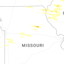
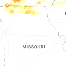

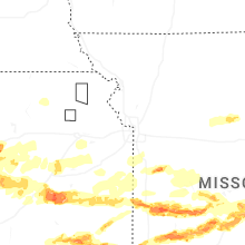
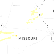
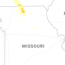
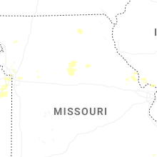
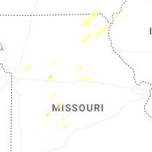


Connect with Interactive Hail Maps