

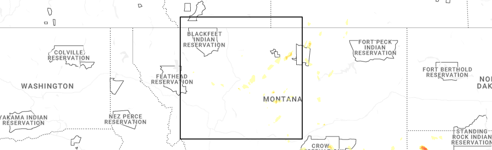
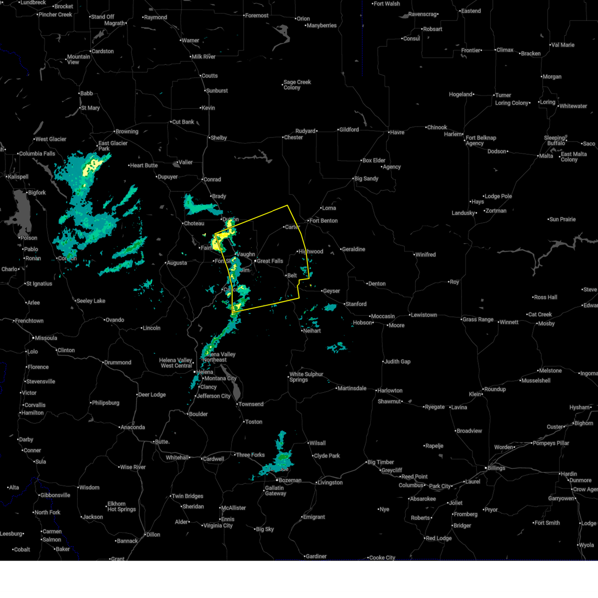
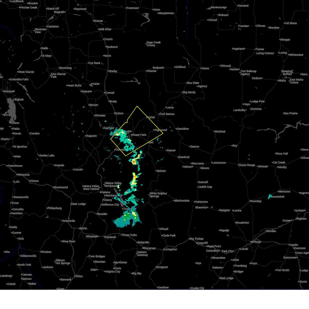
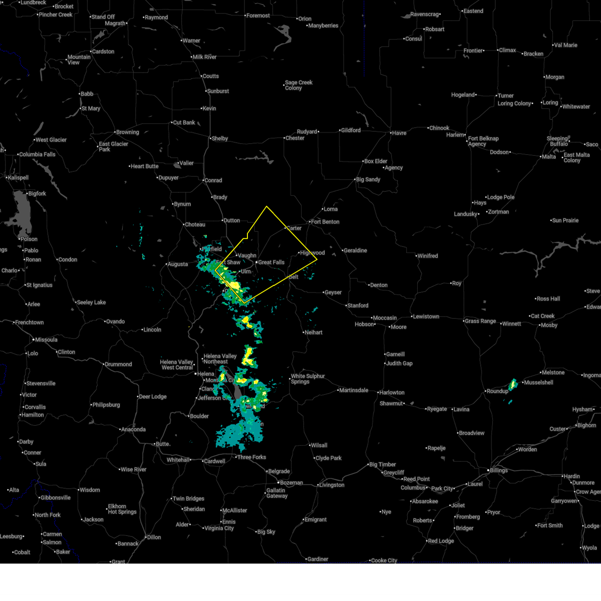
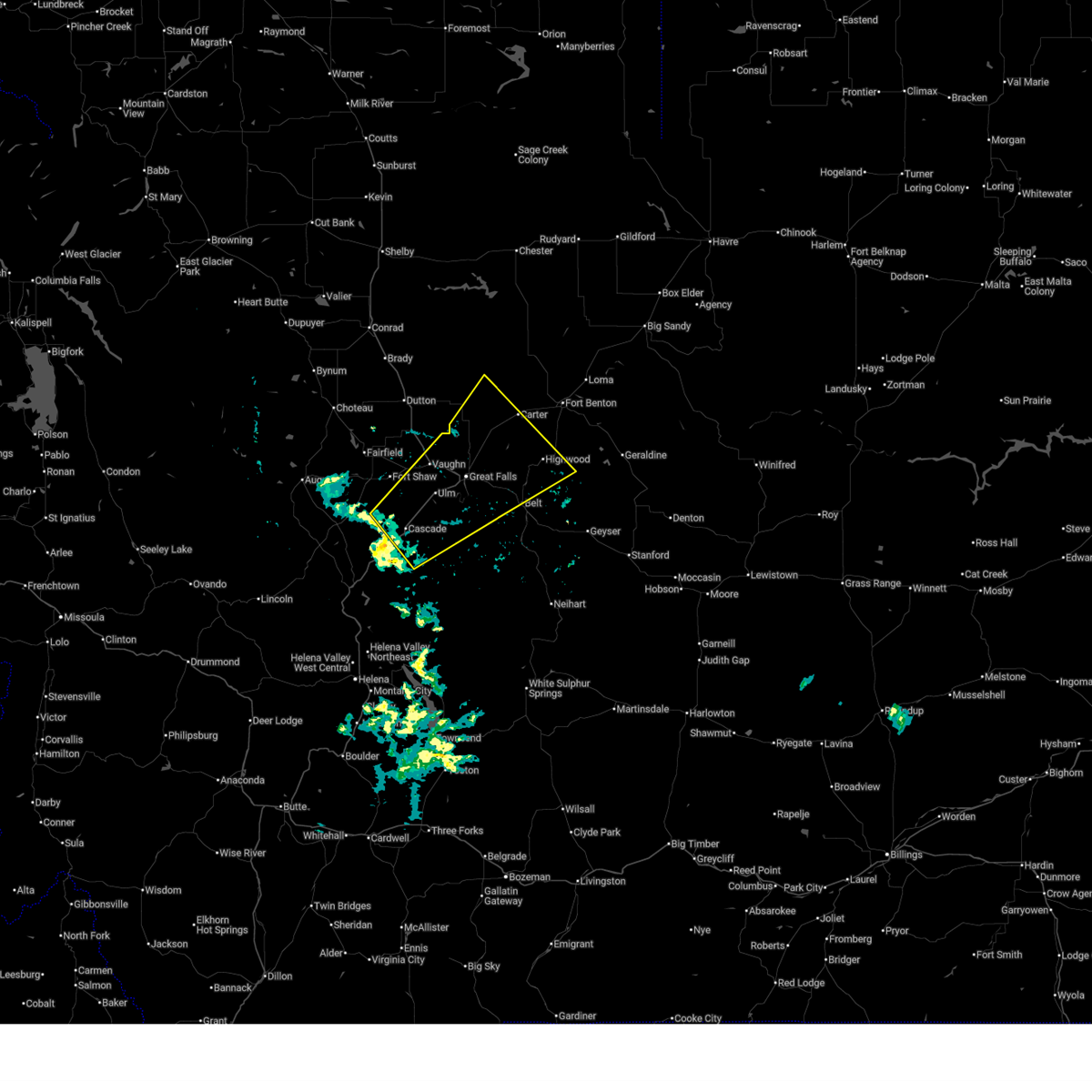
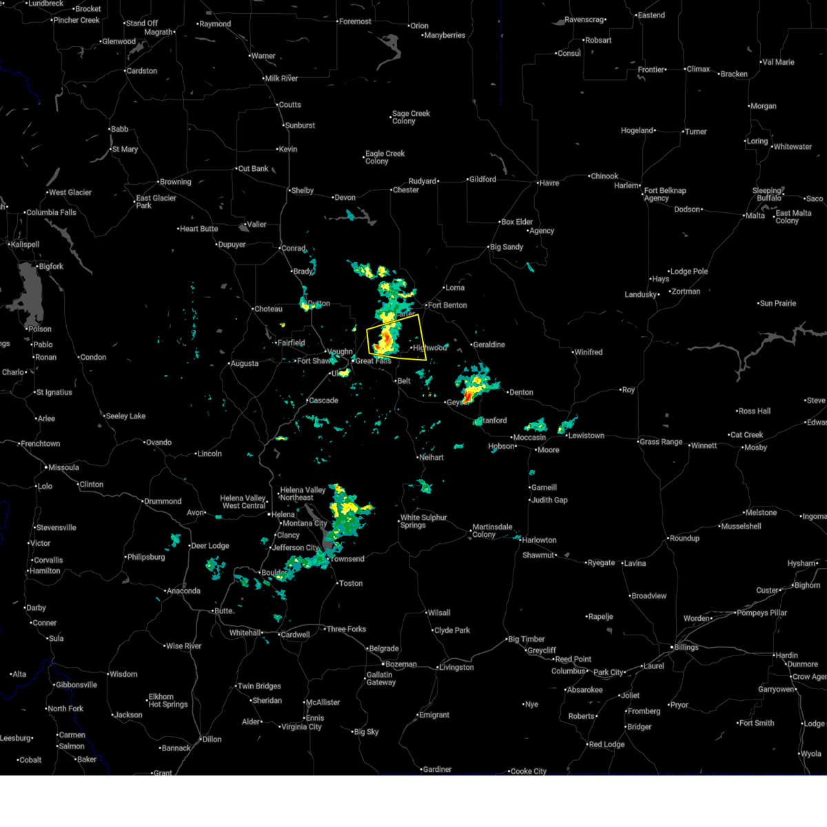
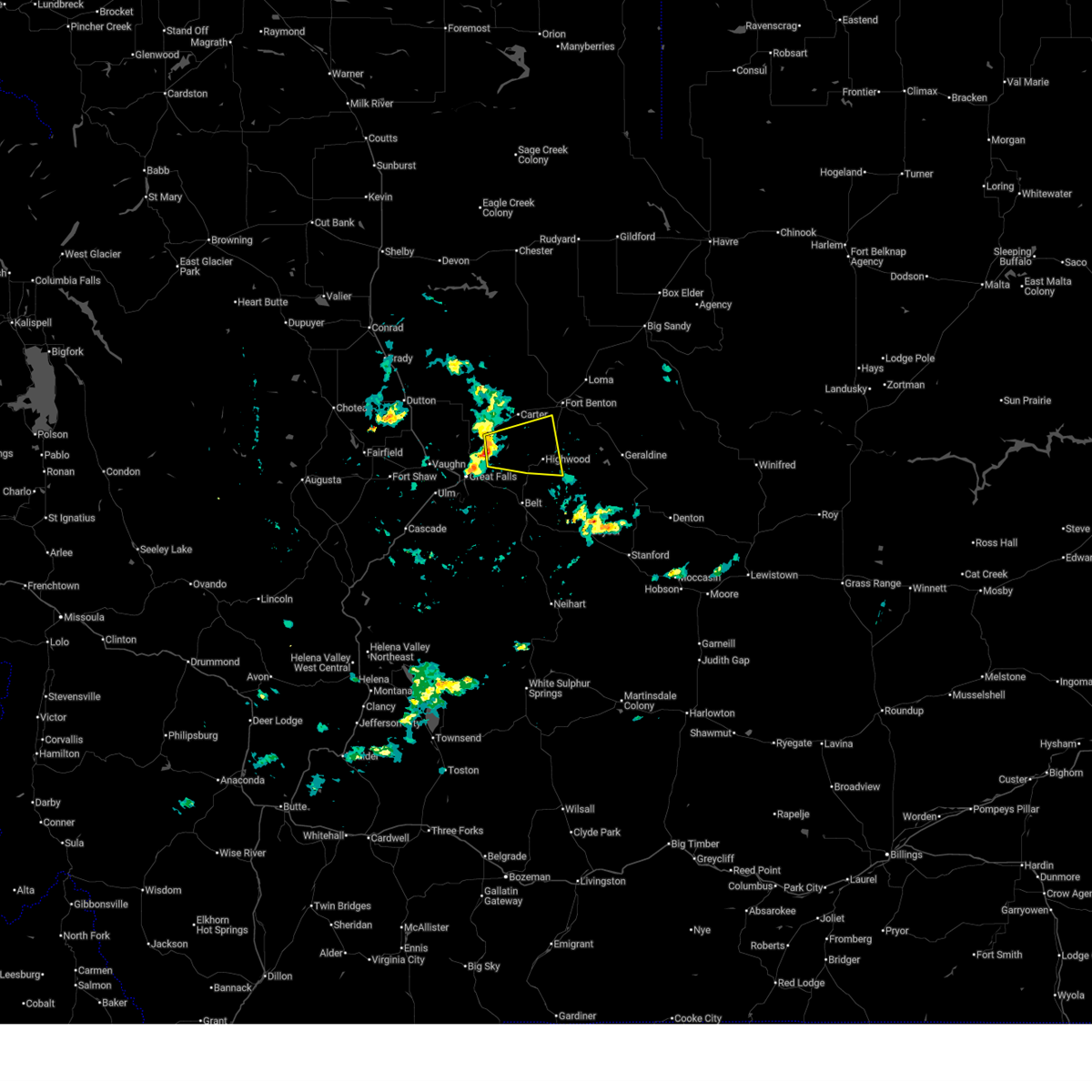
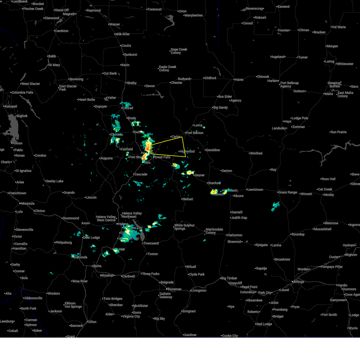
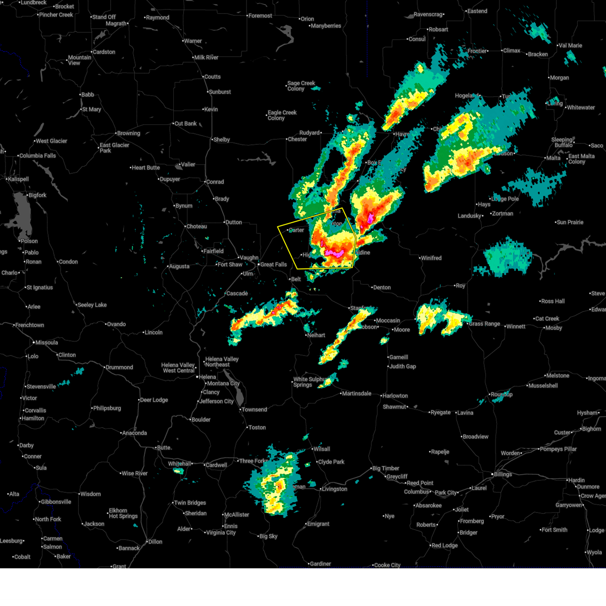
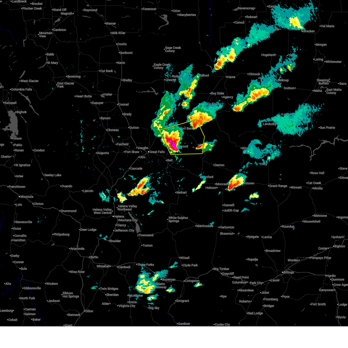
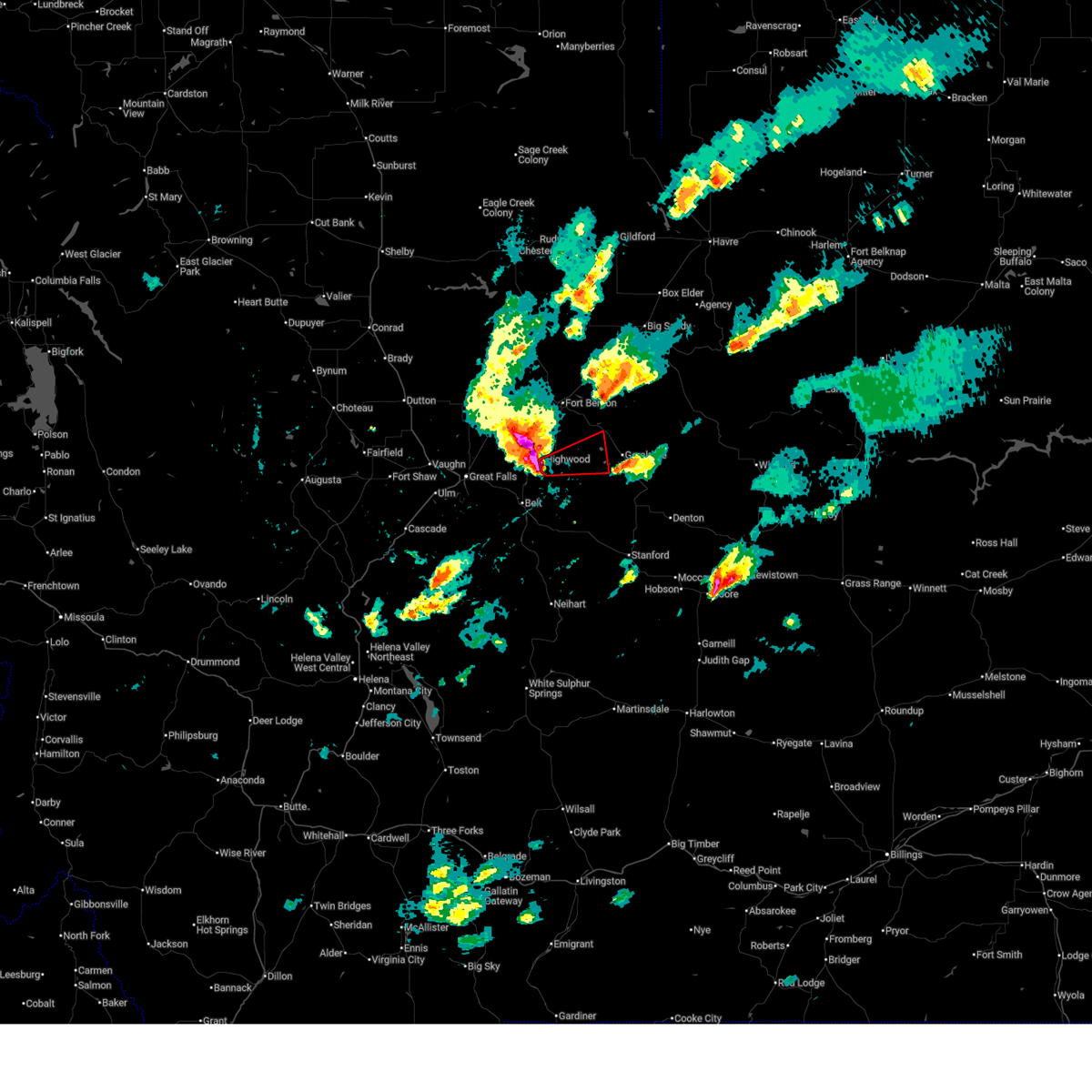
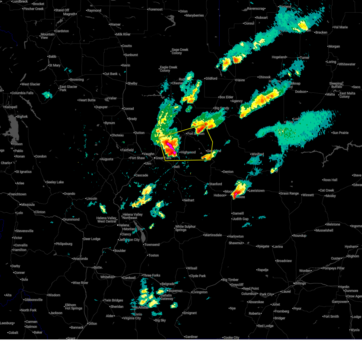
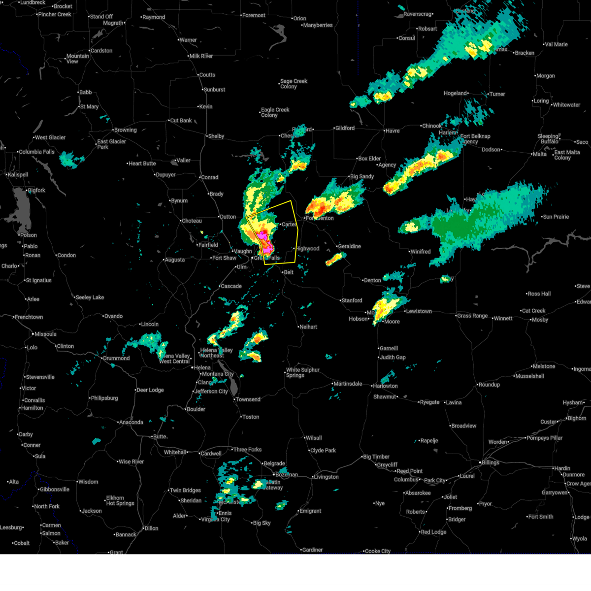
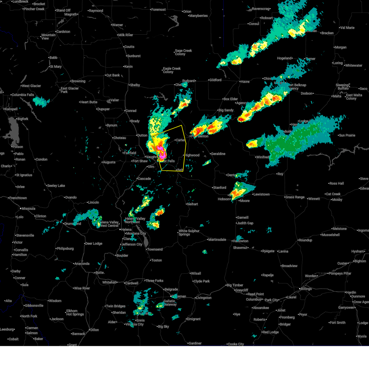
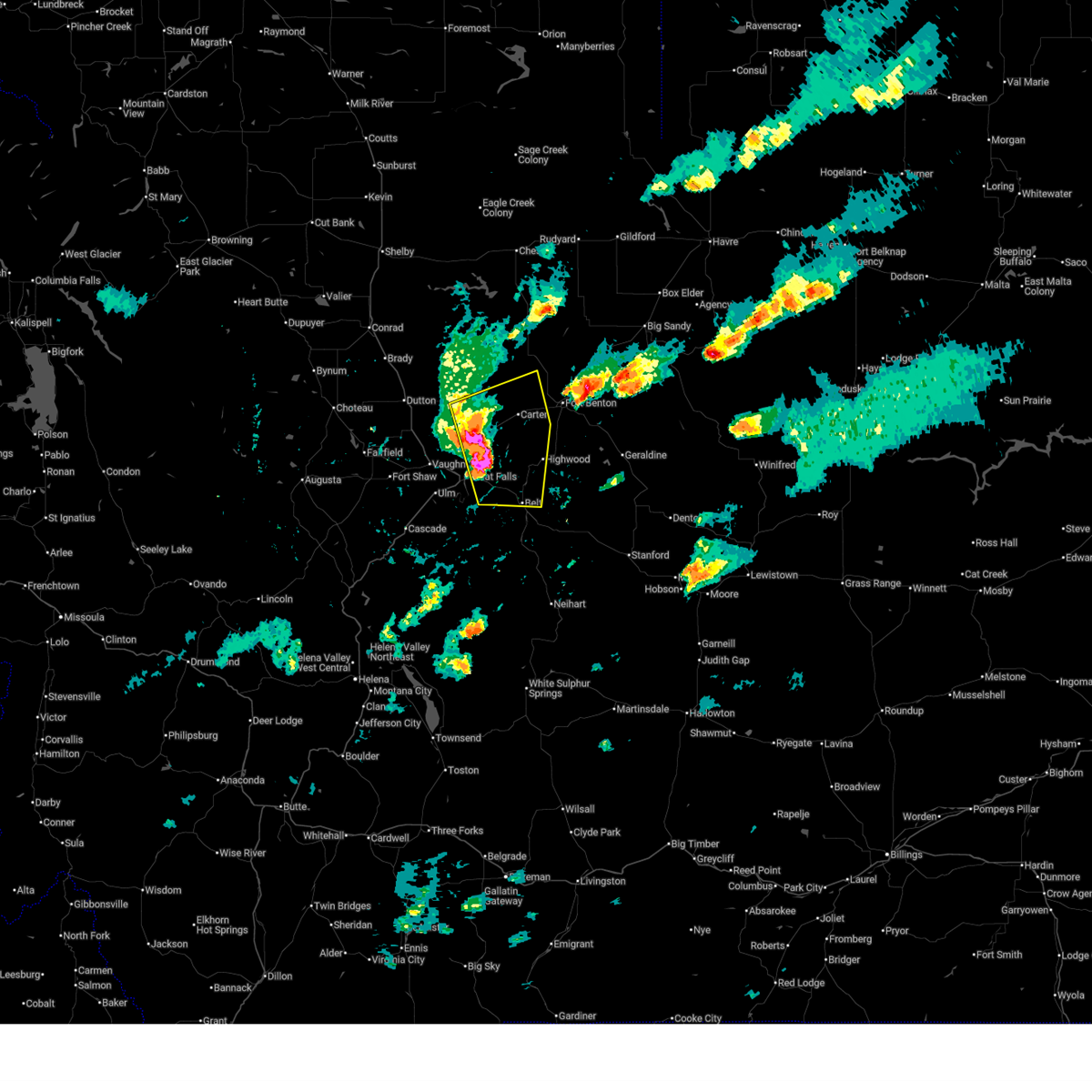
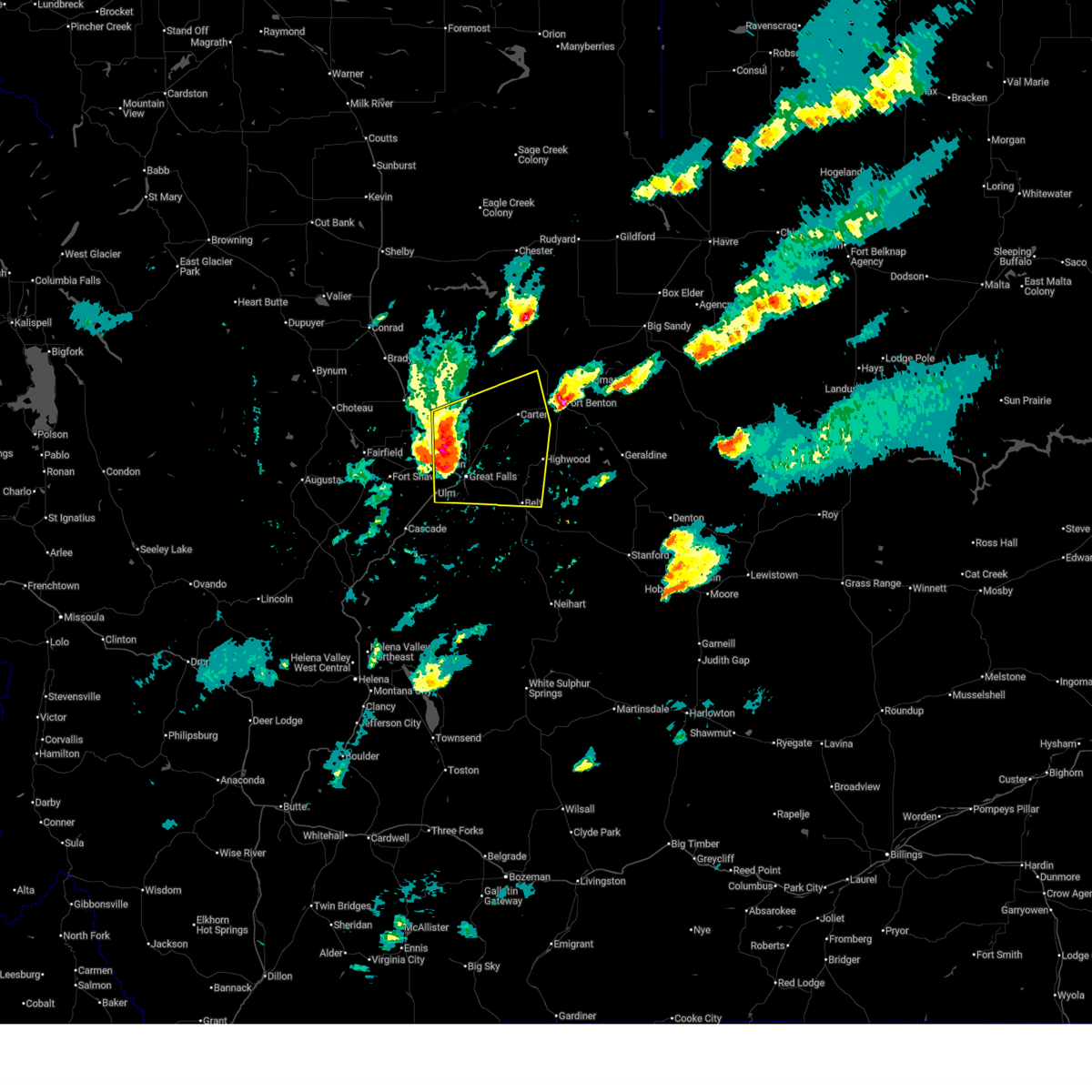
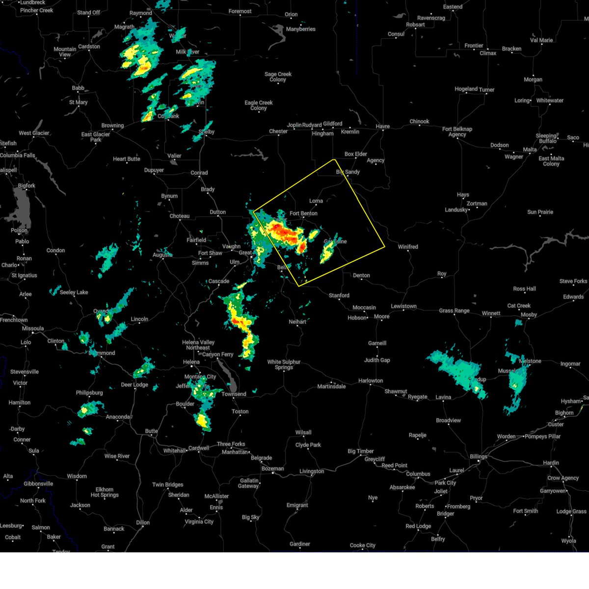
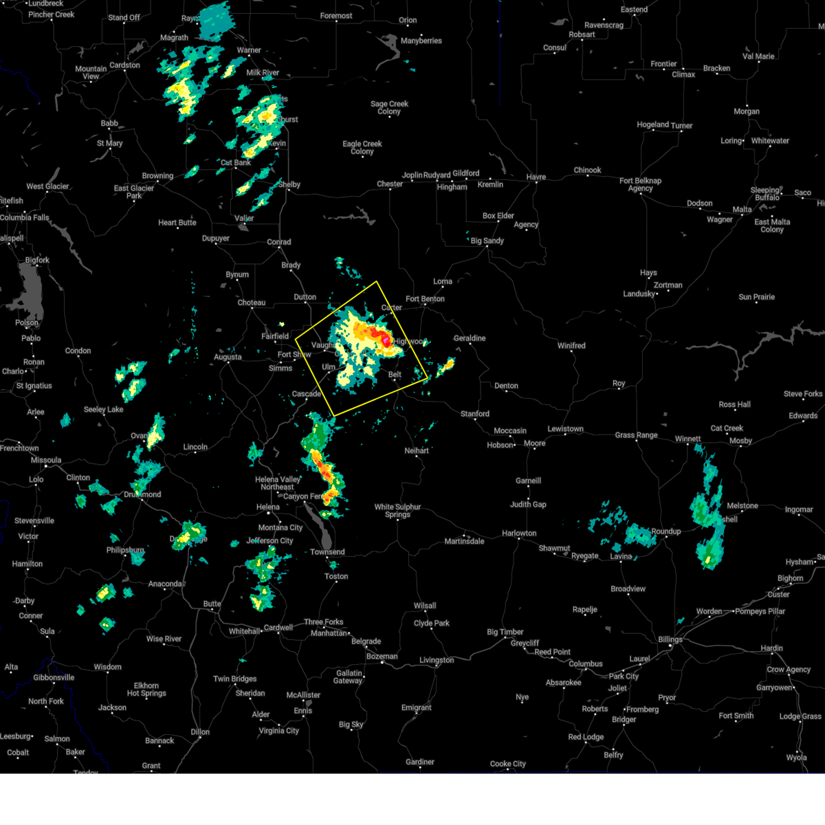
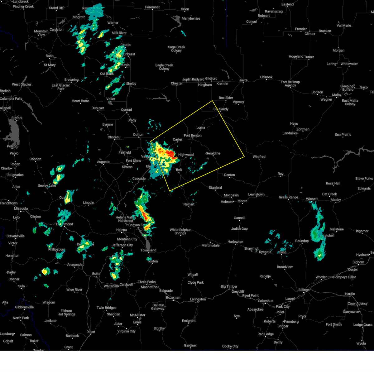
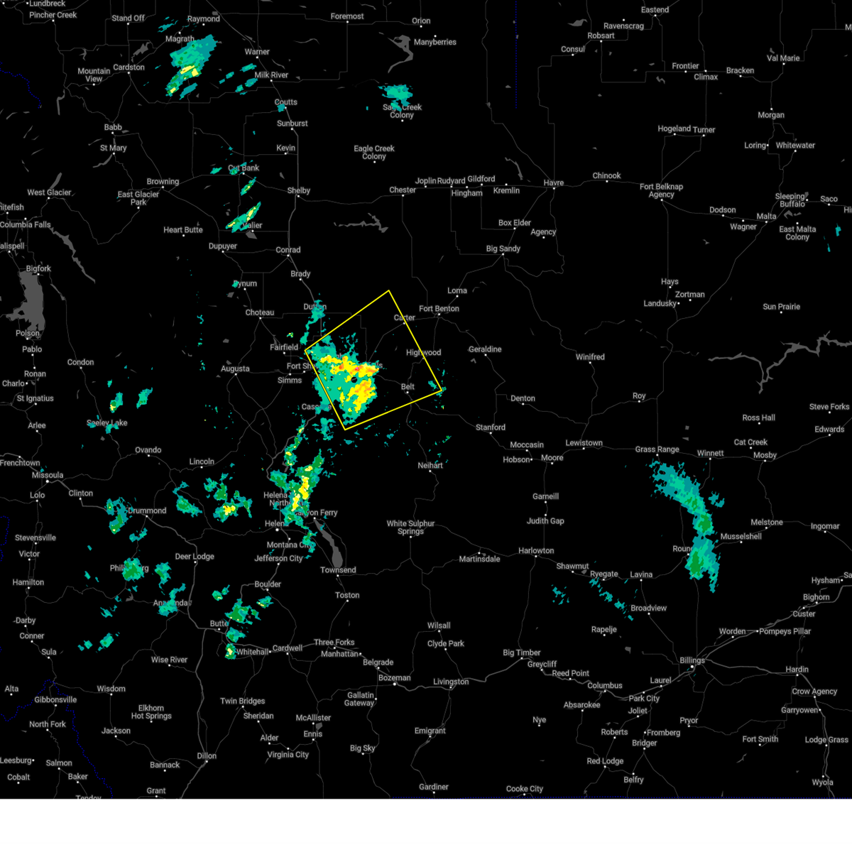
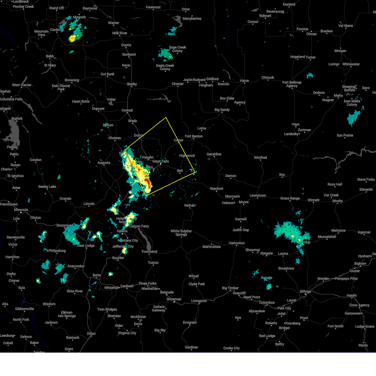
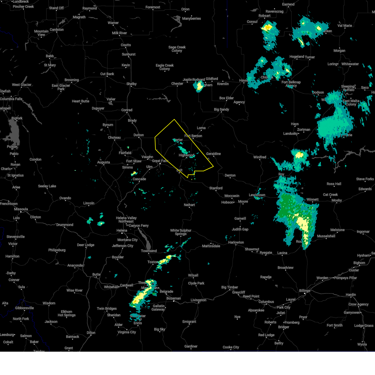
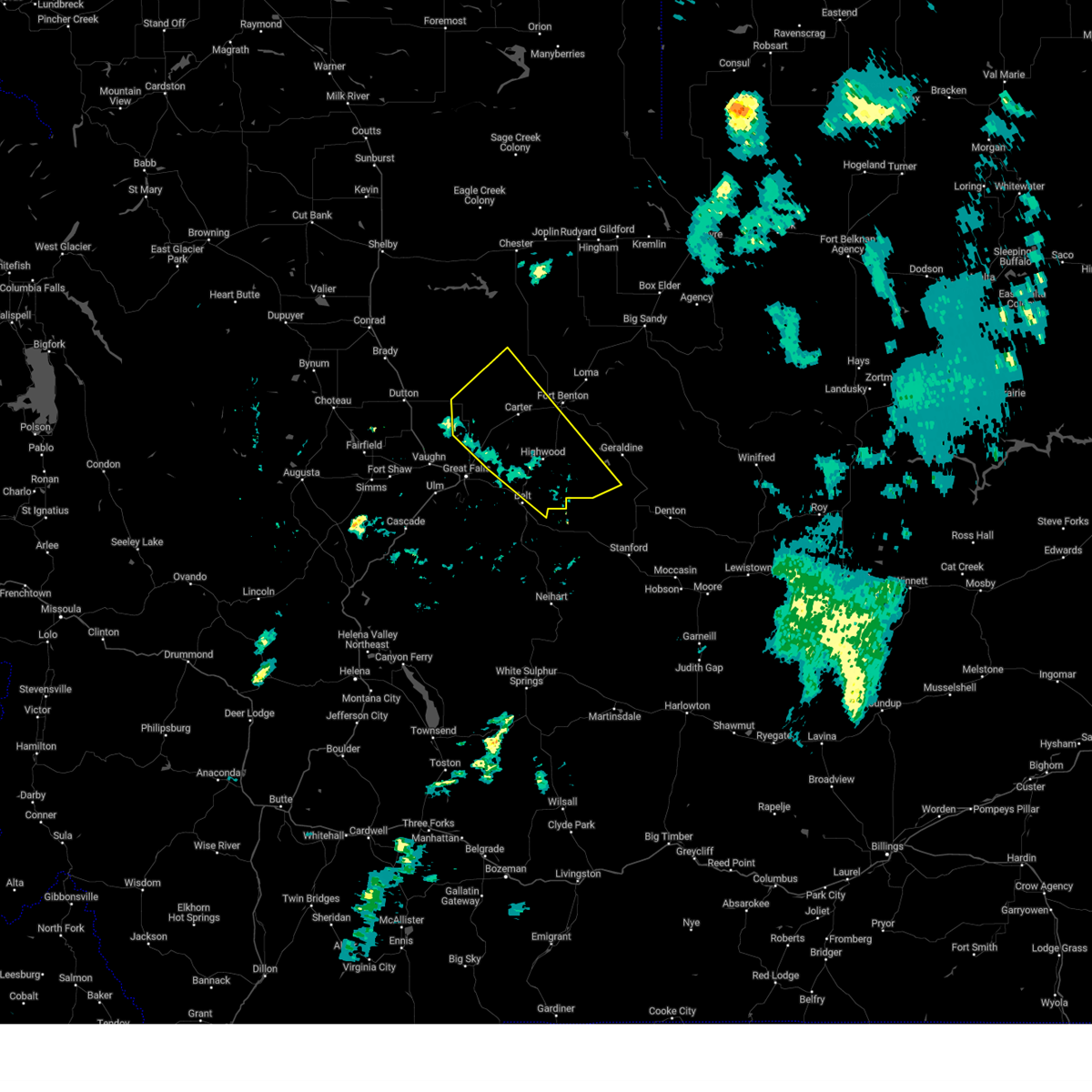
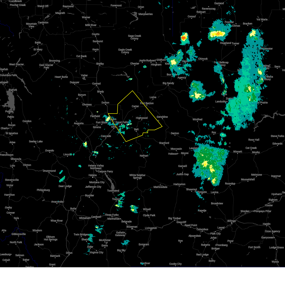
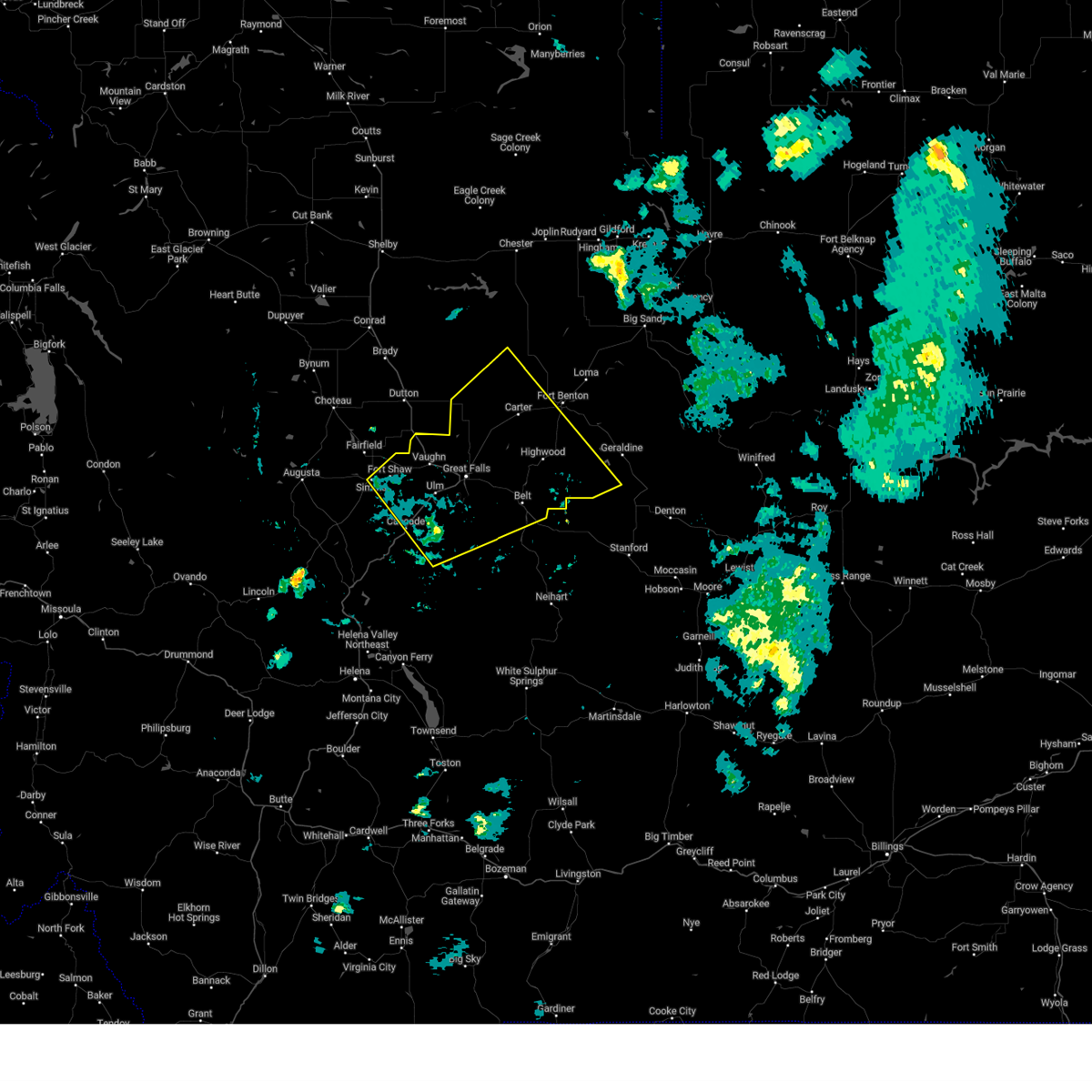
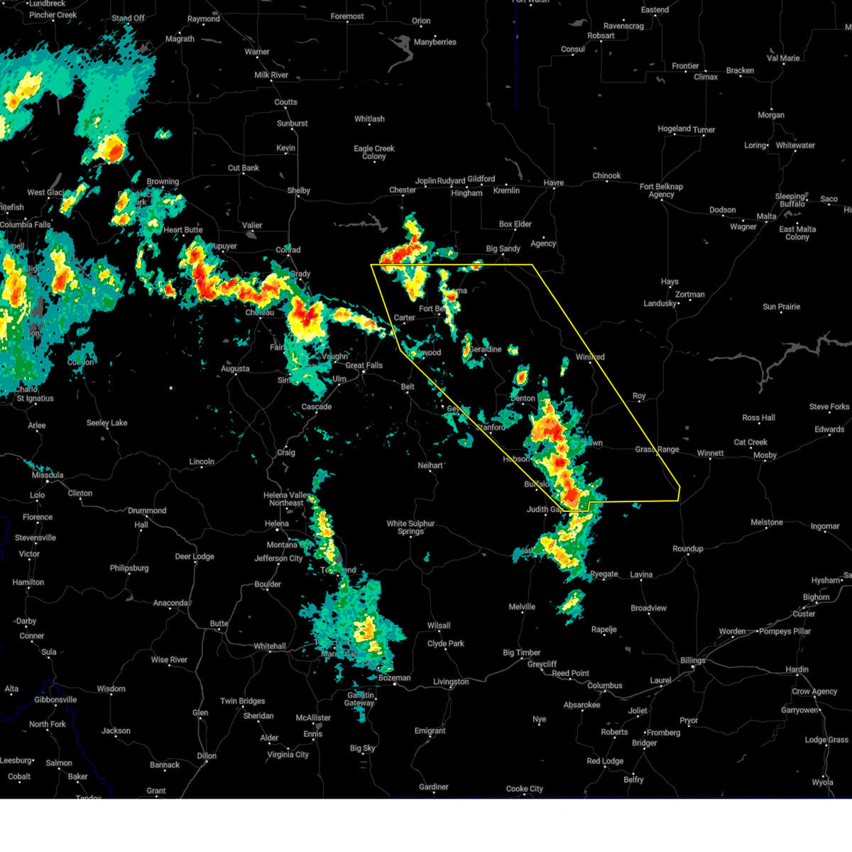
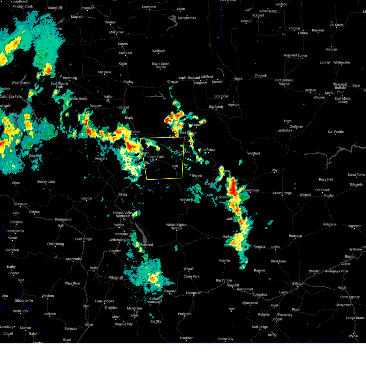
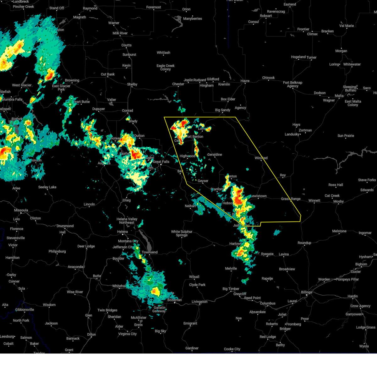
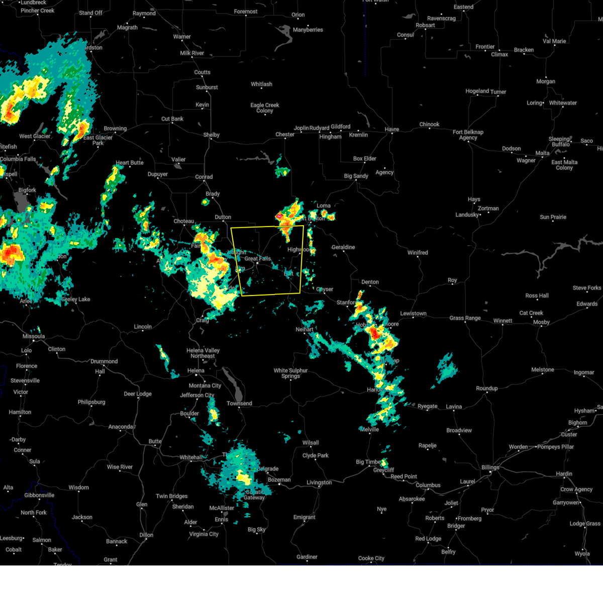
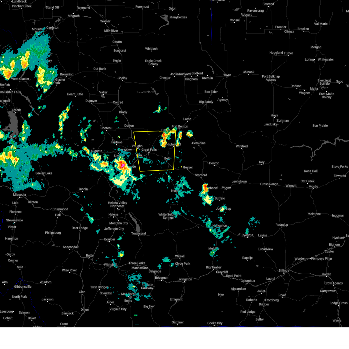
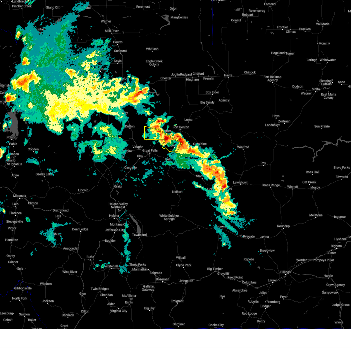
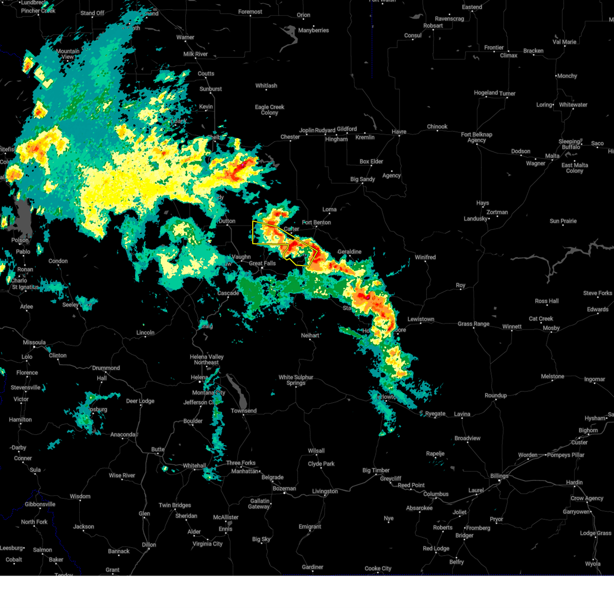
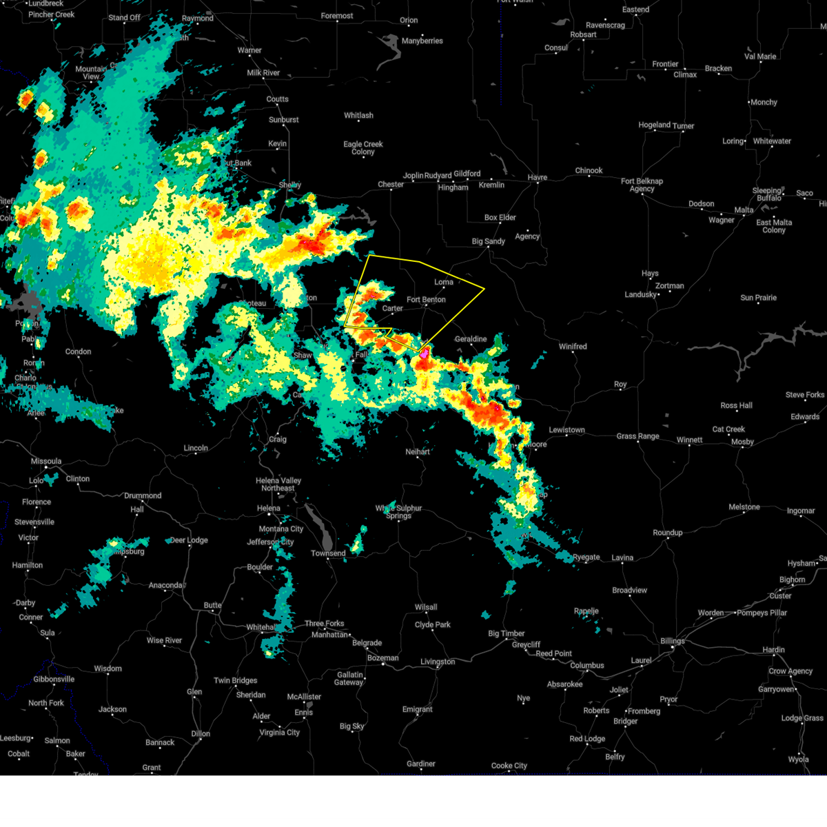
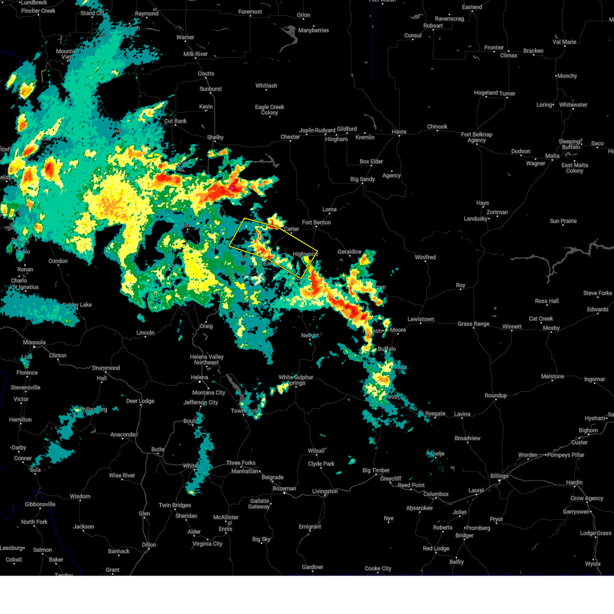
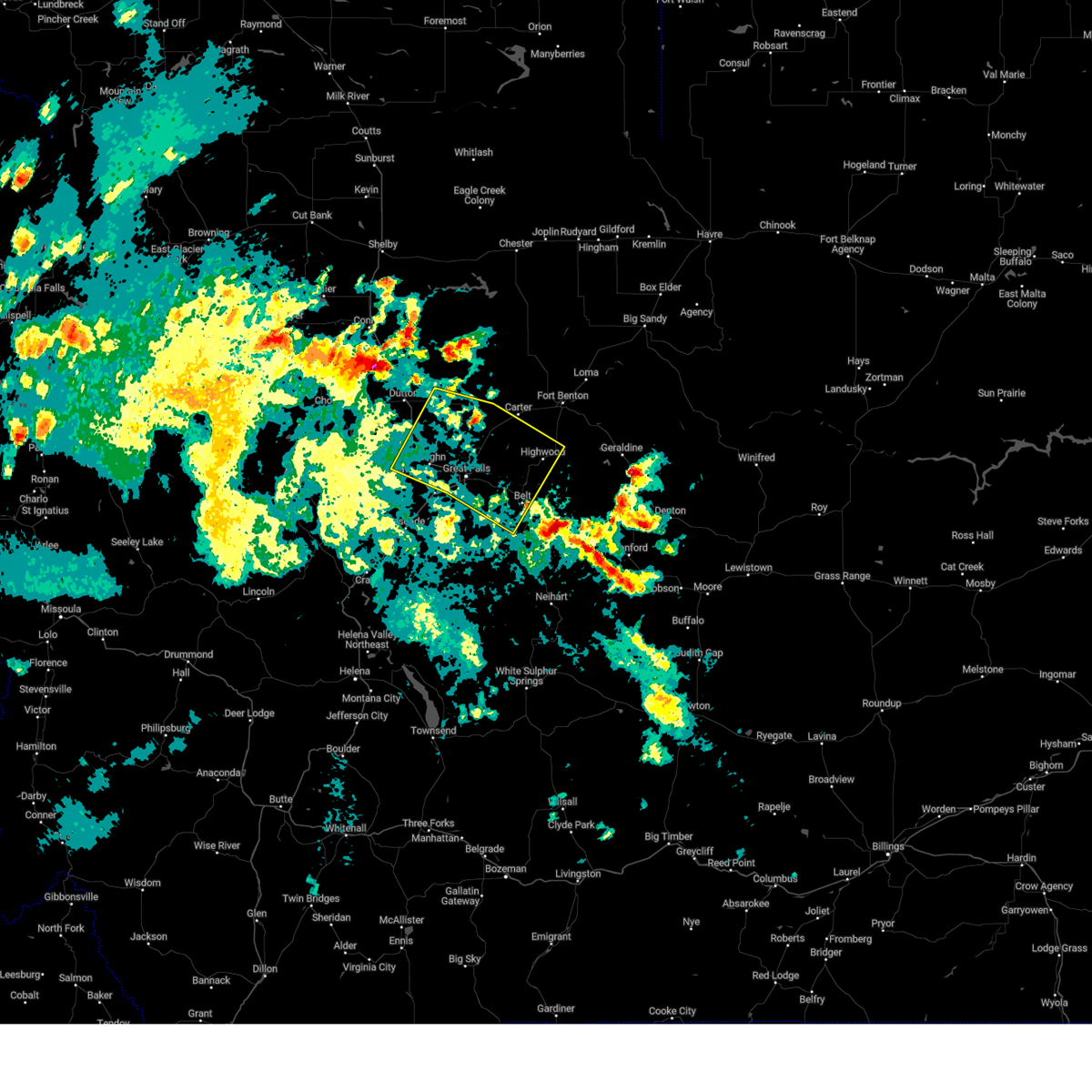
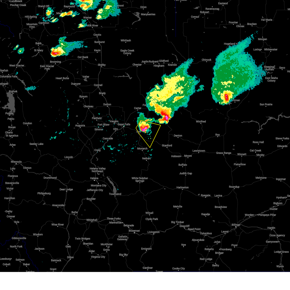
Hail Map for Highwood, MT
The Highwood, MT area has had 6 reports of on-the-ground hail by trained spotters, and has been under severe weather warnings 12 times during the past 12 months. Doppler radar has detected hail at or near Highwood, MT on 30 occasions, including 3 occasions during the past year.
| Name: | Highwood, MT |
| Where Located: | 25.3 miles ENE of Great Falls, MT |
| Map: | Google Map for Highwood, MT |
| Population: | 176 |
| Housing Units: | 73 |
| More Info: | Search Google for Highwood, MT |
1
The Top Recent Hail Date for Highwood, MT is Friday, August 1, 2025 (7th out of 30)
Hail and Wind Damage Spotted near Highwood, MT
| Date / Time | Report Details |
|---|---|
| 5/13/2026 3:35 PM MDT | Mesonet station dvi04529 fort bento in chouteau county MT, 9.6 miles SW of Highwood, MT |
| 5/13/2026 3:28 PM MDT |
 Svrtfx the national weather service in great falls has issued a * severe thunderstorm warning for, northeastern judith basin county in central montana, southeastern liberty county in north central montana, northwestern fergus county in central montana, southwestern blaine county in north central montana, southwestern hill county in north central montana, chouteau county in north central montana, northeastern cascade county in central montana, * until 415 pm mdt. * at 328 pm mdt, severe thunderstorms were located along a line extending from 10 miles south of the knees to near fort benton to 11 miles northwest of denton to near hobson, moving northeast at 50 mph (radar indicated). Hazards include 70 mph wind gusts. Expect considerable tree damage. Damage is likely to mobile homes, roofs, and outbuildings. Svrtfx the national weather service in great falls has issued a * severe thunderstorm warning for, northeastern judith basin county in central montana, southeastern liberty county in north central montana, northwestern fergus county in central montana, southwestern blaine county in north central montana, southwestern hill county in north central montana, chouteau county in north central montana, northeastern cascade county in central montana, * until 415 pm mdt. * at 328 pm mdt, severe thunderstorms were located along a line extending from 10 miles south of the knees to near fort benton to 11 miles northwest of denton to near hobson, moving northeast at 50 mph (radar indicated). Hazards include 70 mph wind gusts. Expect considerable tree damage. Damage is likely to mobile homes, roofs, and outbuildings.
|
| 5/13/2026 3:00 PM MDT | Montana mesonet highwood benc in chouteau county MT, 8.1 miles SE of Highwood, MT |
| 12/26/2025 1:01 PM MST |
 the severe thunderstorm warning has been cancelled and is no longer in effect the severe thunderstorm warning has been cancelled and is no longer in effect
|
| 12/26/2025 12:44 PM MST |
 the severe thunderstorm warning has been cancelled and is no longer in effect the severe thunderstorm warning has been cancelled and is no longer in effect
|
| 12/26/2025 12:44 PM MST |
 At 1243 pm mst, gusty showers were located along a line extending from 16 miles north of great falls to 7 miles east of black eagle to 9 miles northwest of belt, moving northeast at 55 mph (radar indicated). Hazards include 60 mph wind gusts. Expect damage to roofs, siding, and trees. Locations impacted include, belt, highwood, carter, floweree, armington, portage, sluice boxes state park, centerville, and malmstrom afb. At 1243 pm mst, gusty showers were located along a line extending from 16 miles north of great falls to 7 miles east of black eagle to 9 miles northwest of belt, moving northeast at 55 mph (radar indicated). Hazards include 60 mph wind gusts. Expect damage to roofs, siding, and trees. Locations impacted include, belt, highwood, carter, floweree, armington, portage, sluice boxes state park, centerville, and malmstrom afb.
|
| 12/26/2025 12:27 PM MST |
 At 1227 pm mst, a gusty shower was located along a line extending from 9 miles southeast of power to 7 miles west of great falls to 12 miles southwest of black eagle to 14 miles east of cascade, moving northeast at 45 mph (radar indicated). Hazards include 60 mph wind gusts. Expect damage to roofs, siding, and trees. Locations impacted include, great falls, belt, black eagle, highwood, power, carter, floweree, portage, malmstrom afb, sluice boxes state park, eden, stockett, tracy, vaughn, first peoples buffalo jump state park, centerville, armington, ulm, and sand coulee. At 1227 pm mst, a gusty shower was located along a line extending from 9 miles southeast of power to 7 miles west of great falls to 12 miles southwest of black eagle to 14 miles east of cascade, moving northeast at 45 mph (radar indicated). Hazards include 60 mph wind gusts. Expect damage to roofs, siding, and trees. Locations impacted include, great falls, belt, black eagle, highwood, power, carter, floweree, portage, malmstrom afb, sluice boxes state park, eden, stockett, tracy, vaughn, first peoples buffalo jump state park, centerville, armington, ulm, and sand coulee.
|
| 12/26/2025 12:23 PM MST |
 Svrtfx the national weather service in great falls has issued a * severe thunderstorm warning for, southeastern teton county in north central montana, southwestern chouteau county in north central montana, northeastern cascade county in central montana, * until 115 pm mst. * at 1222 pm mst, a gusty shower was located along a line extending from 8 miles southeast of power to 8 miles west of great falls to 14 miles southwest of black eagle to 13 miles southeast of cascade, moving northeast at 45 mph (radar indicated). Hazards include 60 mph wind gusts. expect damage to roofs, siding, and trees Svrtfx the national weather service in great falls has issued a * severe thunderstorm warning for, southeastern teton county in north central montana, southwestern chouteau county in north central montana, northeastern cascade county in central montana, * until 115 pm mst. * at 1222 pm mst, a gusty shower was located along a line extending from 8 miles southeast of power to 8 miles west of great falls to 14 miles southwest of black eagle to 13 miles southeast of cascade, moving northeast at 45 mph (radar indicated). Hazards include 60 mph wind gusts. expect damage to roofs, siding, and trees
|
| 8/18/2025 8:43 PM MDT |
 The storm which prompted the warning has weakened below severe limits, and no longer poses an immediate threat to life or property. therefore, the warning will be allowed to expire. however, gusty winds and heavy rain are still possible with this thunderstorm. The storm which prompted the warning has weakened below severe limits, and no longer poses an immediate threat to life or property. therefore, the warning will be allowed to expire. however, gusty winds and heavy rain are still possible with this thunderstorm.
|
| 8/18/2025 8:23 PM MDT |
 At 823 pm mdt, a severe thunderstorm was located 9 miles southwest of great falls, moving northeast at 40 mph (radar indicated). Hazards include 60 mph wind gusts. Expect damage to roofs, siding, and trees. Locations impacted include, great falls, belt, black eagle, highwood, carter, floweree, portage, malmstrom afb, eden, stockett, tracy, vaughn, first peoples buffalo jump state park, centerville, ulm, and sand coulee. At 823 pm mdt, a severe thunderstorm was located 9 miles southwest of great falls, moving northeast at 40 mph (radar indicated). Hazards include 60 mph wind gusts. Expect damage to roofs, siding, and trees. Locations impacted include, great falls, belt, black eagle, highwood, carter, floweree, portage, malmstrom afb, eden, stockett, tracy, vaughn, first peoples buffalo jump state park, centerville, ulm, and sand coulee.
|
| 8/18/2025 8:07 PM MDT |
 Svrtfx the national weather service in great falls has issued a * severe thunderstorm warning for, eastern teton county in north central montana, southwestern chouteau county in north central montana, northern cascade county in central montana, * until 845 pm mdt. * at 807 pm mdt, a severe thunderstorm was located near cascade, moving northeast at 40 mph (radar indicated). Hazards include 60 mph wind gusts. expect damage to roofs, siding, and trees Svrtfx the national weather service in great falls has issued a * severe thunderstorm warning for, eastern teton county in north central montana, southwestern chouteau county in north central montana, northern cascade county in central montana, * until 845 pm mdt. * at 807 pm mdt, a severe thunderstorm was located near cascade, moving northeast at 40 mph (radar indicated). Hazards include 60 mph wind gusts. expect damage to roofs, siding, and trees
|
| 6/27/2025 1:35 PM MDT |
 The storm which prompted the warning has weakened below severe limits, and no longer poses an immediate threat to life or property. therefore, the warning will be allowed to expire. however, gusty winds are still possible with this thunderstorm. The storm which prompted the warning has weakened below severe limits, and no longer poses an immediate threat to life or property. therefore, the warning will be allowed to expire. however, gusty winds are still possible with this thunderstorm.
|
| 6/27/2025 1:22 PM MDT |
 At 122 pm mdt, a severe thunderstorm was located 12 miles northeast of black eagle, or 14 miles northeast of great falls, moving east at 35 mph (radar indicated). Hazards include 60 mph wind gusts. Expect damage to roofs, siding, and trees. Locations impacted include, highwood and portage. At 122 pm mdt, a severe thunderstorm was located 12 miles northeast of black eagle, or 14 miles northeast of great falls, moving east at 35 mph (radar indicated). Hazards include 60 mph wind gusts. Expect damage to roofs, siding, and trees. Locations impacted include, highwood and portage.
|
| 6/27/2025 1:05 PM MDT |
 Svrtfx the national weather service in great falls has issued a * severe thunderstorm warning for, southwestern chouteau county in north central montana, northeastern cascade county in central montana, * until 145 pm mdt. * at 105 pm mdt, a severe thunderstorm was located near black eagle, or 7 miles north of great falls, moving east at 40 mph (radar indicated). Hazards include 60 mph wind gusts. expect damage to roofs, siding, and trees Svrtfx the national weather service in great falls has issued a * severe thunderstorm warning for, southwestern chouteau county in north central montana, northeastern cascade county in central montana, * until 145 pm mdt. * at 105 pm mdt, a severe thunderstorm was located near black eagle, or 7 miles north of great falls, moving east at 40 mph (radar indicated). Hazards include 60 mph wind gusts. expect damage to roofs, siding, and trees
|
| 6/15/2025 4:59 PM MDT |
 The storms which prompted the warning have moved out of the area. therefore, the warning will be allowed to expire. a severe thunderstorm watch remains in effect until 1100 pm mdt for central and north central montana. remember, a severe thunderstorm warning still remains in effect portions of chouteau county until 530 pm mdt. The storms which prompted the warning have moved out of the area. therefore, the warning will be allowed to expire. a severe thunderstorm watch remains in effect until 1100 pm mdt for central and north central montana. remember, a severe thunderstorm warning still remains in effect portions of chouteau county until 530 pm mdt.
|
| 6/15/2025 4:34 PM MDT |
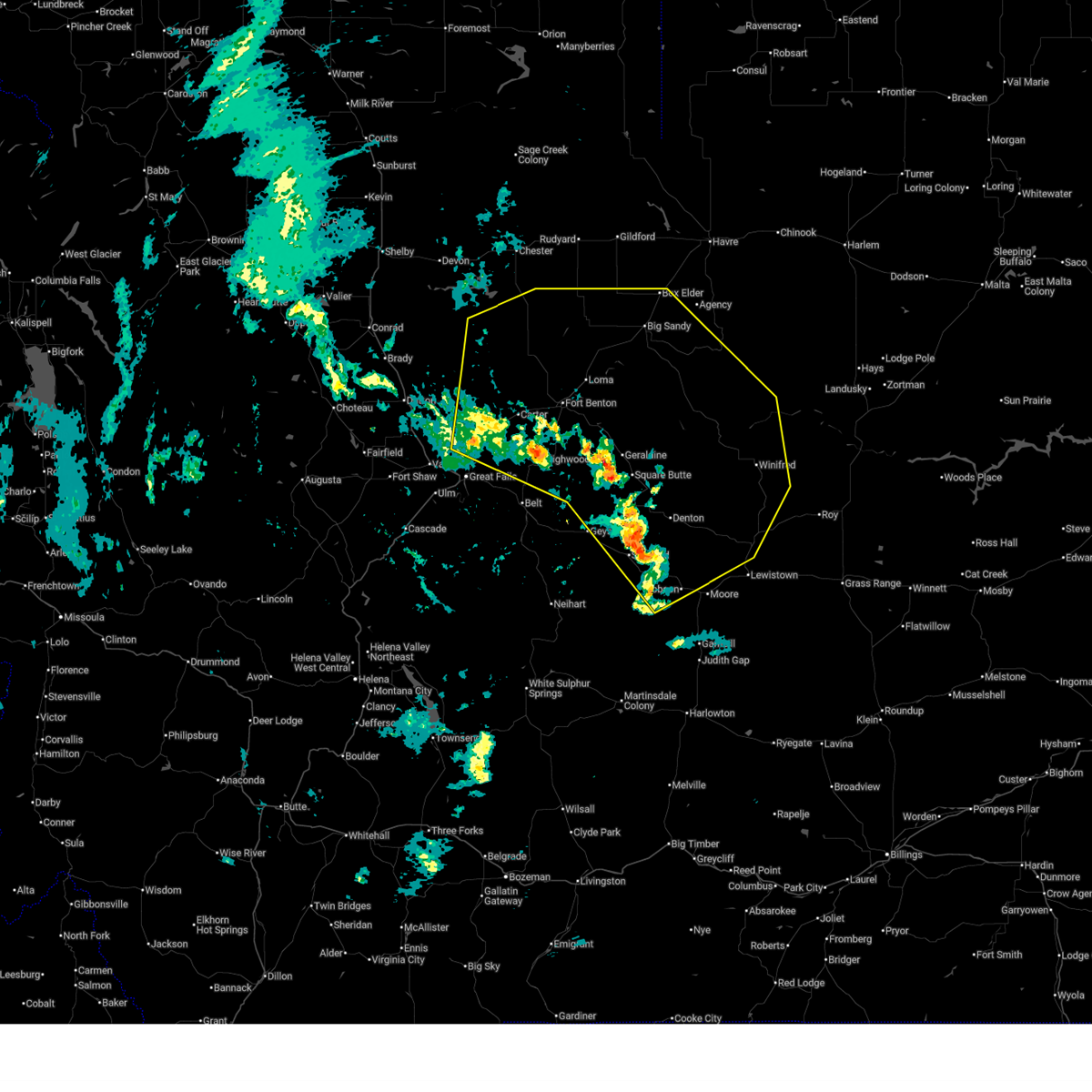
 At 434 pm mdt, severe thunderstorms were located along a line extending from 14 miles southwest of fort benton to near highwood, moving east at 40 mph (radar indicated). Hazards include golf ball size hail and 60 mph wind gusts. People and animals outdoors will be injured. expect hail damage to roofs, siding, windows, and vehicles. expect wind damage to roofs, siding, and trees. Locations impacted include, fort benton, geraldine, highwood, carter, shonkin, and square butte. At 434 pm mdt, severe thunderstorms were located along a line extending from 14 miles southwest of fort benton to near highwood, moving east at 40 mph (radar indicated). Hazards include golf ball size hail and 60 mph wind gusts. People and animals outdoors will be injured. expect hail damage to roofs, siding, windows, and vehicles. expect wind damage to roofs, siding, and trees. Locations impacted include, fort benton, geraldine, highwood, carter, shonkin, and square butte.
|
| 6/15/2025 4:30 PM MDT | Golf Ball sized hail reported 1.2 miles NNE of Highwood, MT, social media image of approximately golf ball sized hail in highwood. time estimated using radar. |
| 6/15/2025 4:30 PM MDT | Tennis Ball sized hail reported 2.6 miles WNW of Highwood, MT, report from social media. hail started at 4:30 pm and lasted for approximately 15 minutes. |
| 6/15/2025 4:29 PM MDT |
 Tortfx the national weather service in great falls has issued a * tornado warning for, south central chouteau county in north central montana, * until 500 pm mdt. * at 429 pm mdt, a severe thunderstorm capable of producing a tornado was located near highwood, or 18 miles south of fort benton, moving east at 30 mph (radar indicated rotation). Hazards include tornado and golf ball size hail. Flying debris will be dangerous to those caught without shelter. mobile homes will be damaged or destroyed. damage to roofs, windows, and vehicles will occur. tree damage is likely. This tornadic thunderstorm will remain over mainly rural areas of south central chouteau county, including the following locations, shonkin. Tortfx the national weather service in great falls has issued a * tornado warning for, south central chouteau county in north central montana, * until 500 pm mdt. * at 429 pm mdt, a severe thunderstorm capable of producing a tornado was located near highwood, or 18 miles south of fort benton, moving east at 30 mph (radar indicated rotation). Hazards include tornado and golf ball size hail. Flying debris will be dangerous to those caught without shelter. mobile homes will be damaged or destroyed. damage to roofs, windows, and vehicles will occur. tree damage is likely. This tornadic thunderstorm will remain over mainly rural areas of south central chouteau county, including the following locations, shonkin.
|
| 6/15/2025 4:22 PM MDT |
 Svrtfx the national weather service in great falls has issued a * severe thunderstorm warning for, southwestern chouteau county in north central montana, northeastern cascade county in central montana, * until 500 pm mdt. * at 421 pm mdt, severe thunderstorms were located along a line extending from 15 miles northeast of black eagle to 9 miles northwest of highwood to 13 miles north of belt, moving east at 40 mph (radar indicated). Hazards include golf ball size hail and 60 mph wind gusts. People and animals outdoors will be injured. expect hail damage to roofs, siding, windows, and vehicles. Expect wind damage to roofs, siding, and trees. Svrtfx the national weather service in great falls has issued a * severe thunderstorm warning for, southwestern chouteau county in north central montana, northeastern cascade county in central montana, * until 500 pm mdt. * at 421 pm mdt, severe thunderstorms were located along a line extending from 15 miles northeast of black eagle to 9 miles northwest of highwood to 13 miles north of belt, moving east at 40 mph (radar indicated). Hazards include golf ball size hail and 60 mph wind gusts. People and animals outdoors will be injured. expect hail damage to roofs, siding, windows, and vehicles. Expect wind damage to roofs, siding, and trees.
|
| 6/15/2025 4:14 PM MDT |
 At 413 pm mdt, severe thunderstorms were located along a line extending from 17 miles south of the knees to 12 miles northeast of great falls to near black eagle, moving east at 30 mph (radar indicated). Hazards include golf ball size hail and 60 mph wind gusts. People and animals outdoors will be injured. expect hail damage to roofs, siding, windows, and vehicles. expect wind damage to roofs, siding, and trees. Locations impacted include, highwood, carter, floweree, portage, and malmstrom afb. At 413 pm mdt, severe thunderstorms were located along a line extending from 17 miles south of the knees to 12 miles northeast of great falls to near black eagle, moving east at 30 mph (radar indicated). Hazards include golf ball size hail and 60 mph wind gusts. People and animals outdoors will be injured. expect hail damage to roofs, siding, windows, and vehicles. expect wind damage to roofs, siding, and trees. Locations impacted include, highwood, carter, floweree, portage, and malmstrom afb.
|
| 6/15/2025 4:09 PM MDT |
 At 409 pm mdt, severe thunderstorms were located along a line extending from 17 miles south of the knees to 12 miles northeast of great falls to near black eagle, moving east at 30 mph (trained weather spotters). Hazards include 60 mph wind gusts and quarter size hail. Hail damage to vehicles is expected. expect wind damage to roofs, siding, and trees. Locations impacted include, great falls, belt, black eagle, highwood, carter, floweree, portage, malmstrom afb, sand coulee, tracy, and centerville. At 409 pm mdt, severe thunderstorms were located along a line extending from 17 miles south of the knees to 12 miles northeast of great falls to near black eagle, moving east at 30 mph (trained weather spotters). Hazards include 60 mph wind gusts and quarter size hail. Hail damage to vehicles is expected. expect wind damage to roofs, siding, and trees. Locations impacted include, great falls, belt, black eagle, highwood, carter, floweree, portage, malmstrom afb, sand coulee, tracy, and centerville.
|
| 6/15/2025 4:09 PM MDT |
 the severe thunderstorm warning has been cancelled and is no longer in effect the severe thunderstorm warning has been cancelled and is no longer in effect
|
| 6/15/2025 3:49 PM MDT |
 Svrtfx the national weather service in great falls has issued a * severe thunderstorm warning for, eastern teton county in north central montana, southwestern chouteau county in north central montana, northeastern cascade county in central montana, * until 430 pm mdt. * at 349 pm mdt, severe thunderstorms were located along a line extending from 12 miles east of power to 9 miles northwest of black eagle to 7 miles northwest of great falls, moving east at 30 mph (radar indicated). Hazards include 60 mph wind gusts and quarter size hail. Hail damage to vehicles is expected. Expect wind damage to roofs, siding, and trees. Svrtfx the national weather service in great falls has issued a * severe thunderstorm warning for, eastern teton county in north central montana, southwestern chouteau county in north central montana, northeastern cascade county in central montana, * until 430 pm mdt. * at 349 pm mdt, severe thunderstorms were located along a line extending from 12 miles east of power to 9 miles northwest of black eagle to 7 miles northwest of great falls, moving east at 30 mph (radar indicated). Hazards include 60 mph wind gusts and quarter size hail. Hail damage to vehicles is expected. Expect wind damage to roofs, siding, and trees.
|
| 5/11/2025 3:47 PM MDT |
 the severe thunderstorm warning has been cancelled and is no longer in effect the severe thunderstorm warning has been cancelled and is no longer in effect
|
| 5/11/2025 3:47 PM MDT |
 At 346 pm mdt, severe thunderstorms were located along a line extending from 12 miles northwest of fort benton to 13 miles southwest of geraldine, moving east at 45 mph (radar indicated). Hazards include 60 mph wind gusts. Expect damage to roofs, siding, and trees. Locations impacted include, shonkin, fort benton, floweree, loma, geraldine, square butte, kenilworth, highwood, carter, virgelle, and raynesford. At 346 pm mdt, severe thunderstorms were located along a line extending from 12 miles northwest of fort benton to 13 miles southwest of geraldine, moving east at 45 mph (radar indicated). Hazards include 60 mph wind gusts. Expect damage to roofs, siding, and trees. Locations impacted include, shonkin, fort benton, floweree, loma, geraldine, square butte, kenilworth, highwood, carter, virgelle, and raynesford.
|
| 5/11/2025 3:29 PM MDT |
 The storms which prompted the warning have moved out of the area. therefore, the warning will be allowed to expire. remember, a severe thunderstorm warning still remains in effect for eastern portions of cascade and southwestern chouteau counties. The storms which prompted the warning have moved out of the area. therefore, the warning will be allowed to expire. remember, a severe thunderstorm warning still remains in effect for eastern portions of cascade and southwestern chouteau counties.
|
| 5/11/2025 3:27 PM MDT |
 Svrtfx the national weather service in great falls has issued a * severe thunderstorm warning for, northwestern judith basin county in central montana, northwestern fergus county in central montana, eastern teton county in north central montana, south central hill county in north central montana, chouteau county in north central montana, northeastern cascade county in central montana, * until 430 pm mdt. * at 327 pm mdt, severe thunderstorms were located along a line extending from 12 miles southeast of the knees to 8 miles east of belt, moving northeast at 45 mph (radar indicated). Hazards include 60 mph wind gusts. expect damage to roofs, siding, and trees Svrtfx the national weather service in great falls has issued a * severe thunderstorm warning for, northwestern judith basin county in central montana, northwestern fergus county in central montana, eastern teton county in north central montana, south central hill county in north central montana, chouteau county in north central montana, northeastern cascade county in central montana, * until 430 pm mdt. * at 327 pm mdt, severe thunderstorms were located along a line extending from 12 miles southeast of the knees to 8 miles east of belt, moving northeast at 45 mph (radar indicated). Hazards include 60 mph wind gusts. expect damage to roofs, siding, and trees
|
| 5/11/2025 3:09 PM MDT |
 At 305 pm mdt, severe thunderstorms were located along a line extending from 9 miles east of power to 10 miles southeast of great falls, moving east at 40 mph (multiple stations reported wind gusts greater than 58 mph). Hazards include 60 mph wind gusts. Expect damage to roofs, siding, and trees. Locations impacted include, floweree, portage, black eagle, eden, malmstrom afb, stockett, tracy, great falls, carter, vaughn, first peoples buffalo jump state park, centerville, sun river, belt, armington, ulm, sand coulee, and highwood. At 305 pm mdt, severe thunderstorms were located along a line extending from 9 miles east of power to 10 miles southeast of great falls, moving east at 40 mph (multiple stations reported wind gusts greater than 58 mph). Hazards include 60 mph wind gusts. Expect damage to roofs, siding, and trees. Locations impacted include, floweree, portage, black eagle, eden, malmstrom afb, stockett, tracy, great falls, carter, vaughn, first peoples buffalo jump state park, centerville, sun river, belt, armington, ulm, sand coulee, and highwood.
|
| 5/11/2025 3:09 PM MDT |
 the severe thunderstorm warning has been cancelled and is no longer in effect the severe thunderstorm warning has been cancelled and is no longer in effect
|
| 5/11/2025 2:44 PM MDT |
 Svrtfx the national weather service in great falls has issued a * severe thunderstorm warning for, southeastern pondera county in north central montana, southeastern teton county in north central montana, southwestern chouteau county in north central montana, northern cascade county in central montana, * until 330 pm mdt. * at 242 pm mdt, severe thunderstorms were located along a line extending from near power to 11 miles east of cascade, moving northeast at 40 mph (radar indicated). Hazards include 60 mph wind gusts. expect damage to roofs, siding, and trees Svrtfx the national weather service in great falls has issued a * severe thunderstorm warning for, southeastern pondera county in north central montana, southeastern teton county in north central montana, southwestern chouteau county in north central montana, northern cascade county in central montana, * until 330 pm mdt. * at 242 pm mdt, severe thunderstorms were located along a line extending from near power to 11 miles east of cascade, moving northeast at 40 mph (radar indicated). Hazards include 60 mph wind gusts. expect damage to roofs, siding, and trees
|
| 5/10/2025 7:52 PM MDT |
 The storms which prompted the warning have weakened below severe limits, and no longer pose an immediate threat to life or property. therefore, the warning will be allowed to expire. however, gusty winds are still possible with these thunderstorms. The storms which prompted the warning have weakened below severe limits, and no longer pose an immediate threat to life or property. therefore, the warning will be allowed to expire. however, gusty winds are still possible with these thunderstorms.
|
| 5/10/2025 7:35 PM MDT |
 At 735 pm mdt, severe thunderstorms were located along a line extending from 12 miles southeast of the knees to highwood, moving northeast at 45 mph (radar indicated). Hazards include 60 mph wind gusts. Expect damage to roofs, siding, and trees. Locations impacted include, highwood, shonkin, floweree, carter, and portage. At 735 pm mdt, severe thunderstorms were located along a line extending from 12 miles southeast of the knees to highwood, moving northeast at 45 mph (radar indicated). Hazards include 60 mph wind gusts. Expect damage to roofs, siding, and trees. Locations impacted include, highwood, shonkin, floweree, carter, and portage.
|
| 5/10/2025 7:25 PM MDT |
 At 725 pm mdt, severe thunderstorms were located along a line extending from 16 miles north of black eagle to 7 miles northwest of belt, moving northeast at 45 mph (radar indicated). Hazards include 60 mph wind gusts. Expect damage to roofs, siding, and trees. Locations impacted include, floweree, portage, black eagle, malmstrom afb, stockett, tracy, great falls, carter, centerville, shonkin, belt, armington, highwood, and sand coulee. At 725 pm mdt, severe thunderstorms were located along a line extending from 16 miles north of black eagle to 7 miles northwest of belt, moving northeast at 45 mph (radar indicated). Hazards include 60 mph wind gusts. Expect damage to roofs, siding, and trees. Locations impacted include, floweree, portage, black eagle, malmstrom afb, stockett, tracy, great falls, carter, centerville, shonkin, belt, armington, highwood, and sand coulee.
|
| 5/10/2025 7:05 PM MDT |
 Svrtfx the national weather service in great falls has issued a * severe thunderstorm warning for, southwestern chouteau county in north central montana, northern cascade county in central montana, * until 800 pm mdt. * at 704 pm mdt, severe thunderstorms were located along a line extending from fort shaw to 10 miles east of cascade, moving northeast at 45 mph (radar indicated). Hazards include 60 mph wind gusts. expect damage to roofs, siding, and trees Svrtfx the national weather service in great falls has issued a * severe thunderstorm warning for, southwestern chouteau county in north central montana, northern cascade county in central montana, * until 800 pm mdt. * at 704 pm mdt, severe thunderstorms were located along a line extending from fort shaw to 10 miles east of cascade, moving northeast at 45 mph (radar indicated). Hazards include 60 mph wind gusts. expect damage to roofs, siding, and trees
|
| 8/23/2024 5:43 PM MDT |
 At 542 pm mdt, severe thunderstorms were located along a line extending from 7 miles northwest of fort benton to 7 miles west of denton to 20 miles southeast of moore, moving east at 30 mph (radar indicated). Hazards include 70 mph wind gusts. Expect considerable tree damage. damage is likely to mobile homes, roofs, and outbuildings. Locations impacted include, lewistown, fort benton, stanford, geraldine, denton, hobson, winifred, moore, grass range, highwood, carter, floweree, windham, forestgrove, shonkin, danvers, loma, hilger, iliad, and virgelle. At 542 pm mdt, severe thunderstorms were located along a line extending from 7 miles northwest of fort benton to 7 miles west of denton to 20 miles southeast of moore, moving east at 30 mph (radar indicated). Hazards include 70 mph wind gusts. Expect considerable tree damage. damage is likely to mobile homes, roofs, and outbuildings. Locations impacted include, lewistown, fort benton, stanford, geraldine, denton, hobson, winifred, moore, grass range, highwood, carter, floweree, windham, forestgrove, shonkin, danvers, loma, hilger, iliad, and virgelle.
|
| 8/23/2024 5:31 PM MDT |
 The storm which prompted the warning has moved out of the area. therefore, the warning will be allowed to expire. however, gusty winds are still possible with this thunderstorm. a severe thunderstorm watch remains in effect until 900 pm mdt for central and north central montana. remember, a severe thunderstorm warning still remains in effect for northern cascade, northern teton, and western choteau counties until 600 pm. The storm which prompted the warning has moved out of the area. therefore, the warning will be allowed to expire. however, gusty winds are still possible with this thunderstorm. a severe thunderstorm watch remains in effect until 900 pm mdt for central and north central montana. remember, a severe thunderstorm warning still remains in effect for northern cascade, northern teton, and western choteau counties until 600 pm.
|
| 8/23/2024 5:23 PM MDT |
 Svrtfx the national weather service in great falls has issued a * severe thunderstorm warning for, judith basin county in central montana, fergus county in central montana, southwestern blaine county in north central montana, chouteau county in north central montana, northeastern cascade county in central montana, * until 630 pm mdt. * at 523 pm mdt, severe thunderstorms were located along a line extending from 15 miles southeast of the knees to 8 miles east of geyser to 16 miles south of moore, moving east at 30 mph (radar indicated). Hazards include 70 mph wind gusts. Expect considerable tree damage. Damage is likely to mobile homes, roofs, and outbuildings. Svrtfx the national weather service in great falls has issued a * severe thunderstorm warning for, judith basin county in central montana, fergus county in central montana, southwestern blaine county in north central montana, chouteau county in north central montana, northeastern cascade county in central montana, * until 630 pm mdt. * at 523 pm mdt, severe thunderstorms were located along a line extending from 15 miles southeast of the knees to 8 miles east of geyser to 16 miles south of moore, moving east at 30 mph (radar indicated). Hazards include 70 mph wind gusts. Expect considerable tree damage. Damage is likely to mobile homes, roofs, and outbuildings.
|
| 8/23/2024 5:14 PM MDT |
 At 512 pm mdt, a severe thunderstorm was located 15 miles northeast of black eagle, or 18 miles northeast of great falls, moving north at 80 mph. this is a destructive storm for great falls, malmstrom air force base, and black eagle (automated weather sensor near ulm reported a wind gust of 77 mph). Hazards include 80 mph wind gusts. Flying debris will be dangerous to those caught without shelter. mobile homes will be heavily damaged. expect considerable damage to roofs, windows, and vehicles. extensive tree damage and power outages are likely. Locations impacted include, great falls, belt, black eagle, highwood, carter, floweree, portage, malmstrom afb, eden, stockett, tracy, vaughn, first peoples buffalo jump state park, centerville, armington, ulm, and sand coulee. At 512 pm mdt, a severe thunderstorm was located 15 miles northeast of black eagle, or 18 miles northeast of great falls, moving north at 80 mph. this is a destructive storm for great falls, malmstrom air force base, and black eagle (automated weather sensor near ulm reported a wind gust of 77 mph). Hazards include 80 mph wind gusts. Flying debris will be dangerous to those caught without shelter. mobile homes will be heavily damaged. expect considerable damage to roofs, windows, and vehicles. extensive tree damage and power outages are likely. Locations impacted include, great falls, belt, black eagle, highwood, carter, floweree, portage, malmstrom afb, eden, stockett, tracy, vaughn, first peoples buffalo jump state park, centerville, armington, ulm, and sand coulee.
|
| 8/23/2024 5:04 PM MDT |
 Svrtfx the national weather service in great falls has issued a * severe thunderstorm warning for, northwestern judith basin county in central montana, eastern teton county in north central montana, southwestern chouteau county in north central montana, northeastern cascade county in central montana, * until 530 pm mdt. * at 503 pm mdt, a severe thunderstorm was located 7 miles east of black eagle, or 9 miles east of great falls, moving north at 80 mph (radar indicated). Hazards include 70 mph wind gusts. Expect considerable tree damage. Damage is likely to mobile homes, roofs, and outbuildings. Svrtfx the national weather service in great falls has issued a * severe thunderstorm warning for, northwestern judith basin county in central montana, eastern teton county in north central montana, southwestern chouteau county in north central montana, northeastern cascade county in central montana, * until 530 pm mdt. * at 503 pm mdt, a severe thunderstorm was located 7 miles east of black eagle, or 9 miles east of great falls, moving north at 80 mph (radar indicated). Hazards include 70 mph wind gusts. Expect considerable tree damage. Damage is likely to mobile homes, roofs, and outbuildings.
|
| 8/19/2024 7:53 PM MDT |
 The storms which prompted the warning have moved out of far southwest chouteau county. therefore, the warning will be allowed to expire. however, gusty winds are still possible with these thunderstorms. a severe thunderstorm watch remains in effect until 1000 pm mdt for central and north central montana. remember, a severe thunderstorm warning still remains in effect for most of chouteau county. The storms which prompted the warning have moved out of far southwest chouteau county. therefore, the warning will be allowed to expire. however, gusty winds are still possible with these thunderstorms. a severe thunderstorm watch remains in effect until 1000 pm mdt for central and north central montana. remember, a severe thunderstorm warning still remains in effect for most of chouteau county.
|
| 8/19/2024 7:50 PM MDT |
 the severe thunderstorm warning has been cancelled and is no longer in effect the severe thunderstorm warning has been cancelled and is no longer in effect
|
| 8/19/2024 7:50 PM MDT |
 At 750 pm mdt, severe thunderstorms were located along a line extending from 12 miles south of the knees to 18 miles west of fort benton to near highwood, moving northeast at 30 mph (radar indicated). Hazards include 60 mph wind gusts. Expect damage to roofs, siding, and trees. Locations impacted include, highwood and floweree. At 750 pm mdt, severe thunderstorms were located along a line extending from 12 miles south of the knees to 18 miles west of fort benton to near highwood, moving northeast at 30 mph (radar indicated). Hazards include 60 mph wind gusts. Expect damage to roofs, siding, and trees. Locations impacted include, highwood and floweree.
|
| 8/19/2024 7:39 PM MDT |
 Svrtfx the national weather service in great falls has issued a * severe thunderstorm warning for, southwestern chouteau county in north central montana, * until 830 pm mdt. * at 739 pm mdt, severe thunderstorms were located along a line extending from 15 miles south of the knees to 18 miles northeast of black eagle to near highwood, moving northeast at 35 mph (radar indicated). Hazards include 60 mph wind gusts. expect damage to roofs, siding, and trees Svrtfx the national weather service in great falls has issued a * severe thunderstorm warning for, southwestern chouteau county in north central montana, * until 830 pm mdt. * at 739 pm mdt, severe thunderstorms were located along a line extending from 15 miles south of the knees to 18 miles northeast of black eagle to near highwood, moving northeast at 35 mph (radar indicated). Hazards include 60 mph wind gusts. expect damage to roofs, siding, and trees
|
| 8/19/2024 7:29 PM MDT |
 At 729 pm mdt, severe thunderstorms were located along a line extending from 12 miles east of power to 10 miles northeast of black eagle to near highwood, moving northeast at 35 mph (radar indicated). Hazards include 60 mph wind gusts. Expect damage to roofs, siding, and trees. Locations impacted include, highwood, floweree, and portage. At 729 pm mdt, severe thunderstorms were located along a line extending from 12 miles east of power to 10 miles northeast of black eagle to near highwood, moving northeast at 35 mph (radar indicated). Hazards include 60 mph wind gusts. Expect damage to roofs, siding, and trees. Locations impacted include, highwood, floweree, and portage.
|
| 8/19/2024 7:13 PM MDT |
 Svrtfx the national weather service in great falls has issued a * severe thunderstorm warning for, southeastern teton county in north central montana, southwestern chouteau county in north central montana, northern cascade county in central montana, * until 800 pm mdt. * at 713 pm mdt, severe thunderstorms were located along a line extending from 8 miles northeast of fort shaw to near great falls to 6 miles west of belt, moving northeast at 30 mph (radar indicated). Hazards include 60 mph wind gusts. expect damage to roofs, siding, and trees Svrtfx the national weather service in great falls has issued a * severe thunderstorm warning for, southeastern teton county in north central montana, southwestern chouteau county in north central montana, northern cascade county in central montana, * until 800 pm mdt. * at 713 pm mdt, severe thunderstorms were located along a line extending from 8 miles northeast of fort shaw to near great falls to 6 miles west of belt, moving northeast at 30 mph (radar indicated). Hazards include 60 mph wind gusts. expect damage to roofs, siding, and trees
|
| 6/21/2024 6:39 PM MDT |
 At 638 pm mdt, a severe thunderstorm was located 8 miles northeast of belt, or 22 miles east of great falls, moving southeast at 30 mph (radar indicated). Hazards include 60 mph wind gusts and quarter size hail. Hail damage to vehicles is expected. expect wind damage to roofs, siding, and trees. Locations impacted include, highwood and raynesford. At 638 pm mdt, a severe thunderstorm was located 8 miles northeast of belt, or 22 miles east of great falls, moving southeast at 30 mph (radar indicated). Hazards include 60 mph wind gusts and quarter size hail. Hail damage to vehicles is expected. expect wind damage to roofs, siding, and trees. Locations impacted include, highwood and raynesford.
|
| 6/21/2024 6:34 PM MDT |
 At 633 pm mdt, a severe thunderstorm was located 8 miles north of belt, or 20 miles east of great falls, moving southeast at 30 mph (radar indicated). Hazards include ping pong ball size hail and 60 mph wind gusts. People and animals outdoors will be injured. expect hail damage to roofs, siding, windows, and vehicles. expect wind damage to roofs, siding, and trees. Locations impacted include, highwood and raynesford. At 633 pm mdt, a severe thunderstorm was located 8 miles north of belt, or 20 miles east of great falls, moving southeast at 30 mph (radar indicated). Hazards include ping pong ball size hail and 60 mph wind gusts. People and animals outdoors will be injured. expect hail damage to roofs, siding, windows, and vehicles. expect wind damage to roofs, siding, and trees. Locations impacted include, highwood and raynesford.
|
| 6/21/2024 6:22 PM MDT |
 Svrtfx the national weather service in great falls has issued a * severe thunderstorm warning for, northwestern judith basin county in central montana, southwestern chouteau county in north central montana, northeastern cascade county in central montana, * until 715 pm mdt. * at 622 pm mdt, a severe thunderstorm was located 10 miles north of belt, or 15 miles east of great falls, moving southeast at 35 mph (radar indicated). Hazards include ping pong ball size hail and 60 mph wind gusts. People and animals outdoors will be injured. expect hail damage to roofs, siding, windows, and vehicles. Expect wind damage to roofs, siding, and trees. Svrtfx the national weather service in great falls has issued a * severe thunderstorm warning for, northwestern judith basin county in central montana, southwestern chouteau county in north central montana, northeastern cascade county in central montana, * until 715 pm mdt. * at 622 pm mdt, a severe thunderstorm was located 10 miles north of belt, or 15 miles east of great falls, moving southeast at 35 mph (radar indicated). Hazards include ping pong ball size hail and 60 mph wind gusts. People and animals outdoors will be injured. expect hail damage to roofs, siding, windows, and vehicles. Expect wind damage to roofs, siding, and trees.
|
| 6/15/2024 1:43 PM MDT |
 The storms which prompted the warning have moved out of the area. therefore, the warning will be allowed to expire. The storms which prompted the warning have moved out of the area. therefore, the warning will be allowed to expire.
|
| 6/15/2024 1:25 PM MDT |
 At 124 pm mdt, severe thunderstorms were located along a line extending from 6 miles south of fort benton to belt, moving northeast at 35 mph (radar indicated). Hazards include 60 mph wind gusts and penny size hail. Expect damage to roofs, siding, and trees. Locations impacted include, fort benton, belt, highwood, shonkin, raynesford, armington, and sluice boxes state park. At 124 pm mdt, severe thunderstorms were located along a line extending from 6 miles south of fort benton to belt, moving northeast at 35 mph (radar indicated). Hazards include 60 mph wind gusts and penny size hail. Expect damage to roofs, siding, and trees. Locations impacted include, fort benton, belt, highwood, shonkin, raynesford, armington, and sluice boxes state park.
|
| 6/15/2024 1:04 PM MDT |
 Svrtfx the national weather service in great falls has issued a * severe thunderstorm warning for, northwestern judith basin county in central montana, southwestern chouteau county in north central montana, northeastern cascade county in central montana, * until 145 pm mdt. * at 104 pm mdt, severe thunderstorms were located along a line extending from 6 miles northwest of highwood to 12 miles southwest of belt, moving northeast at 35 mph (radar indicated). Hazards include 60 mph wind gusts. expect damage to roofs, siding, and trees Svrtfx the national weather service in great falls has issued a * severe thunderstorm warning for, northwestern judith basin county in central montana, southwestern chouteau county in north central montana, northeastern cascade county in central montana, * until 145 pm mdt. * at 104 pm mdt, severe thunderstorms were located along a line extending from 6 miles northwest of highwood to 12 miles southwest of belt, moving northeast at 35 mph (radar indicated). Hazards include 60 mph wind gusts. expect damage to roofs, siding, and trees
|
| 8/29/2023 8:09 PM MDT |
 The severe thunderstorm warning for southeastern pondera, southwestern liberty, east central teton, southwestern chouteau and central cascade counties will expire at 815 pm mdt, the storms which prompted the warning have weakened below severe limits, and no longer pose an immediate threat to life or property. therefore, the warning will be allowed to expire. however gusty winds are still possible with these thunderstorms. The severe thunderstorm warning for southeastern pondera, southwestern liberty, east central teton, southwestern chouteau and central cascade counties will expire at 815 pm mdt, the storms which prompted the warning have weakened below severe limits, and no longer pose an immediate threat to life or property. therefore, the warning will be allowed to expire. however gusty winds are still possible with these thunderstorms.
|
| 8/29/2023 7:49 PM MDT |
 At 748 pm mdt, strong wind gust were located along a line extending from 10 miles west of the knees to 12 miles north of black eagle to 11 miles south of great falls to 13 miles southeast of cascade, moving east at 25 mph (radar indicated). Hazards include 60 mph wind gusts. Expect damage to roofs, siding, and trees. locations impacted include, great falls, belt, black eagle, the knees, highwood, carter, floweree, portage, malmstrom afb, eden, stockett, tracy, centerville, armington, and sand coulee. hail threat, radar indicated max hail size, <. 75 in wind threat, radar indicated max wind gust, 60 mph. At 748 pm mdt, strong wind gust were located along a line extending from 10 miles west of the knees to 12 miles north of black eagle to 11 miles south of great falls to 13 miles southeast of cascade, moving east at 25 mph (radar indicated). Hazards include 60 mph wind gusts. Expect damage to roofs, siding, and trees. locations impacted include, great falls, belt, black eagle, the knees, highwood, carter, floweree, portage, malmstrom afb, eden, stockett, tracy, centerville, armington, and sand coulee. hail threat, radar indicated max hail size, <. 75 in wind threat, radar indicated max wind gust, 60 mph.
|
| 8/29/2023 7:32 PM MDT |
 At 731 pm mdt, an outflow boundary of strong wind gusts from collapsing severe thunderstorms was located along a line extending from 9 miles east of brady to 12 miles north of black eagle to 12 miles south of great falls to 9 miles southeast of cascade, moving east at 25 mph (radar indicated). Hazards include 60 mph wind gusts. expect damage to roofs, siding, and trees At 731 pm mdt, an outflow boundary of strong wind gusts from collapsing severe thunderstorms was located along a line extending from 9 miles east of brady to 12 miles north of black eagle to 12 miles south of great falls to 9 miles southeast of cascade, moving east at 25 mph (radar indicated). Hazards include 60 mph wind gusts. expect damage to roofs, siding, and trees
|
| 7/30/2023 8:24 PM MDT |
 At 823 pm mdt, a severe thunderstorm was located near belt, or 24 miles east of great falls, moving east at 35 mph (radar indicated). Hazards include ping pong ball size hail and 60 mph wind gusts. People and animals outdoors will be injured. expect hail damage to roofs, siding, windows, and vehicles. expect wind damage to roofs, siding, and trees. locations impacted include, belt, highwood, shonkin and armington. hail threat, radar indicated max hail size, 1. 50 in wind threat, radar indicated max wind gust, 60 mph. At 823 pm mdt, a severe thunderstorm was located near belt, or 24 miles east of great falls, moving east at 35 mph (radar indicated). Hazards include ping pong ball size hail and 60 mph wind gusts. People and animals outdoors will be injured. expect hail damage to roofs, siding, windows, and vehicles. expect wind damage to roofs, siding, and trees. locations impacted include, belt, highwood, shonkin and armington. hail threat, radar indicated max hail size, 1. 50 in wind threat, radar indicated max wind gust, 60 mph.
|
| 7/30/2023 7:59 PM MDT |
 At 758 pm mdt, a severe thunderstorm was located 9 miles southeast of black eagle, or 9 miles east of great falls, moving northeast at 40 mph (radar indicated). Hazards include 60 mph wind gusts and half dollar size hail. Hail damage to vehicles is expected. Expect wind damage to roofs, siding, and trees. At 758 pm mdt, a severe thunderstorm was located 9 miles southeast of black eagle, or 9 miles east of great falls, moving northeast at 40 mph (radar indicated). Hazards include 60 mph wind gusts and half dollar size hail. Hail damage to vehicles is expected. Expect wind damage to roofs, siding, and trees.
|
| 9/7/2022 6:53 PM MDT |
 At 652 pm mdt, severe thunderstorms were located along a line extending from 12 miles west of fort benton to 7 miles southwest of geyser to 14 miles east of white sulphur springs, moving east at 40 mph (radar indicated). Hazards include 60 mph wind gusts, with widespread blowing dust and smoke. Expect damage to roofs, siding, and trees. visibility will be reduced to less than 2 miles at times in blowing dust and smoke. locations impacted include, fort benton, stanford, geraldine, geyser, highwood, carter, floweree, raynesford, windham, sapphire village, utica, shonkin, loma, square butte, checkerboard, benchland and armington. hail threat, radar indicated max hail size, <. 75 in wind threat, radar indicated max wind gust, 60 mph. At 652 pm mdt, severe thunderstorms were located along a line extending from 12 miles west of fort benton to 7 miles southwest of geyser to 14 miles east of white sulphur springs, moving east at 40 mph (radar indicated). Hazards include 60 mph wind gusts, with widespread blowing dust and smoke. Expect damage to roofs, siding, and trees. visibility will be reduced to less than 2 miles at times in blowing dust and smoke. locations impacted include, fort benton, stanford, geraldine, geyser, highwood, carter, floweree, raynesford, windham, sapphire village, utica, shonkin, loma, square butte, checkerboard, benchland and armington. hail threat, radar indicated max hail size, <. 75 in wind threat, radar indicated max wind gust, 60 mph.
|
| 9/7/2022 6:32 PM MDT |
 At 630 pm mdt, severe thunderstorms were located along a line extending from 16 miles north of black eagle to 19 miles southwest of geyser to near white sulphur springs, moving east at 40 mph (radar indicated). Hazards include 70 mph wind gusts, and widespread blowing dust. Expect considerable tree damage. damage is likely to mobile homes, roofs, and outbuildings. Visibility will be reduced to less than 2 miles at times in blowing dust. At 630 pm mdt, severe thunderstorms were located along a line extending from 16 miles north of black eagle to 19 miles southwest of geyser to near white sulphur springs, moving east at 40 mph (radar indicated). Hazards include 70 mph wind gusts, and widespread blowing dust. Expect considerable tree damage. damage is likely to mobile homes, roofs, and outbuildings. Visibility will be reduced to less than 2 miles at times in blowing dust.
|
| 9/7/2022 6:13 PM MDT |
 At 611 pm mdt, severe thunderstorms were located along a line extending from 9 miles east of dutton to 19 miles south of belt to near townsend, moving east at 50 mph (radar indicated). Hazards include 70 mph wind gusts, and blowing dust. Expect considerable tree damage. damage is likely to mobile homes, roofs, and outbuildings. visibility will be reduced to less than 2 miles at times in blowing dust. locations impacted include, great falls, townsend, fort benton, white sulphur springs, stanford, belt, dutton, highwood, black eagle, geyser, power, carter, neihart, fort logan on the smith river, floweree, eden, sapphire village, fort logan, stockett and first peoples buffalo jump state park. thunderstorm damage threat, considerable hail threat, radar indicated max hail size, <. 75 in wind threat, radar indicated max wind gust, 70 mph. At 611 pm mdt, severe thunderstorms were located along a line extending from 9 miles east of dutton to 19 miles south of belt to near townsend, moving east at 50 mph (radar indicated). Hazards include 70 mph wind gusts, and blowing dust. Expect considerable tree damage. damage is likely to mobile homes, roofs, and outbuildings. visibility will be reduced to less than 2 miles at times in blowing dust. locations impacted include, great falls, townsend, fort benton, white sulphur springs, stanford, belt, dutton, highwood, black eagle, geyser, power, carter, neihart, fort logan on the smith river, floweree, eden, sapphire village, fort logan, stockett and first peoples buffalo jump state park. thunderstorm damage threat, considerable hail threat, radar indicated max hail size, <. 75 in wind threat, radar indicated max wind gust, 70 mph.
|
| 9/7/2022 5:57 PM MDT |
 At 556 pm mdt, severe thunderstorms were located along a line extending from near dutton to 23 miles southeast of cascade to 10 miles southwest of townsend, moving east at 50 mph (radar indicated). Hazards include 70 mph wind gusts. Expect considerable tree damage. Damage is likely to mobile homes, roofs, and outbuildings. At 556 pm mdt, severe thunderstorms were located along a line extending from near dutton to 23 miles southeast of cascade to 10 miles southwest of townsend, moving east at 50 mph (radar indicated). Hazards include 70 mph wind gusts. Expect considerable tree damage. Damage is likely to mobile homes, roofs, and outbuildings.
|
| 7/15/2022 1:12 PM MDT |
 At 111 pm mdt, severe thunderstorms were located along a line extending from 6 miles northeast of highwood to near geyser, moving northeast at 45 mph (radar indicated). Hazards include 60 mph wind gusts and penny size hail. expect damage to roofs, siding, and trees At 111 pm mdt, severe thunderstorms were located along a line extending from 6 miles northeast of highwood to near geyser, moving northeast at 45 mph (radar indicated). Hazards include 60 mph wind gusts and penny size hail. expect damage to roofs, siding, and trees
|
| 7/15/2022 1:12 PM MDT |
 The severe thunderstorm warning for north central meagher, northwestern judith basin, chouteau and cascade counties will expire at 115 pm mdt, the storms which prompted the warning have moved out of the area. therefore, the warning will be allowed to expire. however gusty winds are still possible with these thunderstorms. a severe thunderstorm watch remains in effect until 700 pm mdt for central and north central montana. The severe thunderstorm warning for north central meagher, northwestern judith basin, chouteau and cascade counties will expire at 115 pm mdt, the storms which prompted the warning have moved out of the area. therefore, the warning will be allowed to expire. however gusty winds are still possible with these thunderstorms. a severe thunderstorm watch remains in effect until 700 pm mdt for central and north central montana.
|
| 7/15/2022 12:48 PM MDT |
 At 1247 pm mdt, severe thunderstorms were located along a line extending from 6 miles west of brady to 22 miles south of geyser, moving northeast at 35 mph (radar indicated. at 1229 pm 66 mph wind gust was reported near ulm). Hazards include 60 mph wind gusts. Expect damage to roofs, siding, and trees. locations impacted include, great falls, fort benton, stanford, belt, geraldine, fort shaw, the knees, highwood, black eagle, geyser, fort shaw, carter, neihart, floweree, eden, stockett, first peoples buffalo jump state park, shonkin, loma and ulm. hail threat, radar indicated max hail size, <. 75 in wind threat, observed max wind gust, 60 mph. At 1247 pm mdt, severe thunderstorms were located along a line extending from 6 miles west of brady to 22 miles south of geyser, moving northeast at 35 mph (radar indicated. at 1229 pm 66 mph wind gust was reported near ulm). Hazards include 60 mph wind gusts. Expect damage to roofs, siding, and trees. locations impacted include, great falls, fort benton, stanford, belt, geraldine, fort shaw, the knees, highwood, black eagle, geyser, fort shaw, carter, neihart, floweree, eden, stockett, first peoples buffalo jump state park, shonkin, loma and ulm. hail threat, radar indicated max hail size, <. 75 in wind threat, observed max wind gust, 60 mph.
|
| 7/15/2022 12:13 PM MDT |
 At 1213 pm mdt, severe thunderstorms were located along a line extending from near choteau to 14 miles north of white sulphur springs, moving northeast at 35 mph (radar indicated). Hazards include 60 mph wind gusts. expect damage to roofs, siding, and trees At 1213 pm mdt, severe thunderstorms were located along a line extending from near choteau to 14 miles north of white sulphur springs, moving northeast at 35 mph (radar indicated). Hazards include 60 mph wind gusts. expect damage to roofs, siding, and trees
|
| 7/9/2022 6:07 PM MDT |
 At 606 pm mdt, a severe thunderstorm was located near black eagle, or near great falls, moving east at 35 mph (radar indicated). Hazards include 60 mph wind gusts. Expect damage to roofs, siding, and trees. locations impacted include, great falls, cascade, belt, black eagle, highwood, floweree, portage, eden, sluice boxes state park, malmstrom afb, stockett, tracy, vaughn, first peoples buffalo jump state park, centerville, sun river, armington, ulm and sand coulee. hail threat, radar indicated max hail size, <. 75 in wind threat, radar indicated max wind gust, 60 mph. At 606 pm mdt, a severe thunderstorm was located near black eagle, or near great falls, moving east at 35 mph (radar indicated). Hazards include 60 mph wind gusts. Expect damage to roofs, siding, and trees. locations impacted include, great falls, cascade, belt, black eagle, highwood, floweree, portage, eden, sluice boxes state park, malmstrom afb, stockett, tracy, vaughn, first peoples buffalo jump state park, centerville, sun river, armington, ulm and sand coulee. hail threat, radar indicated max hail size, <. 75 in wind threat, radar indicated max wind gust, 60 mph.
|
| 7/9/2022 5:43 PM MDT |
 At 542 pm mdt, a severe thunderstorm was located 12 miles west of great falls, moving east at 35 mph (radar indicated). Hazards include 60 mph wind gusts and penny size hail. expect damage to roofs, siding, and trees At 542 pm mdt, a severe thunderstorm was located 12 miles west of great falls, moving east at 35 mph (radar indicated). Hazards include 60 mph wind gusts and penny size hail. expect damage to roofs, siding, and trees
|
| 7/7/2022 9:18 PM MDT |
 At 918 pm mdt, severe thunderstorms were located along a line extending from near highwood to 14 miles south of fort benton to 11 miles southwest of geraldine to 8 miles north of geyser, moving northeast at 25 mph (radar indicated). Hazards include quarter size hail. Damage to vehicles is expected. locations impacted include, fort benton, geraldine, highwood, shonkin and square butte. hail threat, radar indicated max hail size, 1. 00 in wind threat, radar indicated max wind gust, <50 mph. At 918 pm mdt, severe thunderstorms were located along a line extending from near highwood to 14 miles south of fort benton to 11 miles southwest of geraldine to 8 miles north of geyser, moving northeast at 25 mph (radar indicated). Hazards include quarter size hail. Damage to vehicles is expected. locations impacted include, fort benton, geraldine, highwood, shonkin and square butte. hail threat, radar indicated max hail size, 1. 00 in wind threat, radar indicated max wind gust, <50 mph.
|
| 7/7/2022 9:09 PM MDT |
 At 908 pm mdt, severe thunderstorms were located along a line extending from 10 miles north of belt to near highwood to 16 miles west of geraldine to near geyser, moving northeast at 30 mph (radar indicated). Hazards include quarter size hail. damage to vehicles is expected At 908 pm mdt, severe thunderstorms were located along a line extending from 10 miles north of belt to near highwood to 16 miles west of geraldine to near geyser, moving northeast at 30 mph (radar indicated). Hazards include quarter size hail. damage to vehicles is expected
|
| 7/7/2022 8:49 PM MDT |
 At 848 pm mdt, severe thunderstorms were located along a line extending from 12 miles east of black eagle to near belt to 10 miles west of geyser, moving northeast at 20 mph (radar indicated). Hazards include quarter size hail. damage to vehicles is expected At 848 pm mdt, severe thunderstorms were located along a line extending from 12 miles east of black eagle to near belt to 10 miles west of geyser, moving northeast at 20 mph (radar indicated). Hazards include quarter size hail. damage to vehicles is expected
|
| 7/7/2022 6:44 PM MDT |
 At 644 pm mdt, severe thunderstorms were located along a line extending from 7 miles southwest of fort benton to 12 miles northeast of highwood to 6 miles southwest of geraldine, moving east at 35 mph (radar indicated). Hazards include 60 mph wind gusts and quarter size hail. Hail damage to vehicles is expected. expect wind damage to roofs, siding, and trees. locations impacted include, fort benton, geraldine, highwood, carter, shonkin, loma and square butte. hail threat, radar indicated max hail size, 1. 00 in wind threat, radar indicated max wind gust, 60 mph. At 644 pm mdt, severe thunderstorms were located along a line extending from 7 miles southwest of fort benton to 12 miles northeast of highwood to 6 miles southwest of geraldine, moving east at 35 mph (radar indicated). Hazards include 60 mph wind gusts and quarter size hail. Hail damage to vehicles is expected. expect wind damage to roofs, siding, and trees. locations impacted include, fort benton, geraldine, highwood, carter, shonkin, loma and square butte. hail threat, radar indicated max hail size, 1. 00 in wind threat, radar indicated max wind gust, 60 mph.
|
| 7/7/2022 6:35 PM MDT |
 At 634 pm mdt, severe thunderstorms were located along a line extending from 11 miles southwest of fort benton to 6 miles northeast of highwood to 12 miles southwest of geraldine, moving east at 30 mph (radar indicated). Hazards include 70 mph wind gusts and half dollar size hail. Hail damage to vehicles is expected. expect considerable tree damage. wind damage is also likely to mobile homes, roofs, and outbuildings. these storms have a history of producing 2 inch diameter hail and funnel clouds. locations impacted include, fort benton, geraldine, highwood, carter, shonkin, loma and square butte. thunderstorm damage threat, considerable hail threat, radar indicated max hail size, 1. 25 in wind threat, radar indicated max wind gust, 70 mph. At 634 pm mdt, severe thunderstorms were located along a line extending from 11 miles southwest of fort benton to 6 miles northeast of highwood to 12 miles southwest of geraldine, moving east at 30 mph (radar indicated). Hazards include 70 mph wind gusts and half dollar size hail. Hail damage to vehicles is expected. expect considerable tree damage. wind damage is also likely to mobile homes, roofs, and outbuildings. these storms have a history of producing 2 inch diameter hail and funnel clouds. locations impacted include, fort benton, geraldine, highwood, carter, shonkin, loma and square butte. thunderstorm damage threat, considerable hail threat, radar indicated max hail size, 1. 25 in wind threat, radar indicated max wind gust, 70 mph.
|
| 7/7/2022 6:32 PM MDT |
 At 632 pm mdt, severe thunderstorms were located along a line extending from 14 miles southwest of fort benton to near highwood to 16 miles west of geraldine, moving east at 30 mph (radar indicated). Hazards include golf ball size hail and 70 mph wind gusts. People and animals outdoors will be injured. expect hail damage to roofs, siding, windows, and vehicles. expect considerable tree damage. wind damage is also likely to mobile homes, roofs, and outbuildings. these storms have a history of producing 2 inch diameter hail and funnel clouds. Locations impacted include, fort benton, geraldine, highwood, carter, shonkin, floweree, loma and square butte. At 632 pm mdt, severe thunderstorms were located along a line extending from 14 miles southwest of fort benton to near highwood to 16 miles west of geraldine, moving east at 30 mph (radar indicated). Hazards include golf ball size hail and 70 mph wind gusts. People and animals outdoors will be injured. expect hail damage to roofs, siding, windows, and vehicles. expect considerable tree damage. wind damage is also likely to mobile homes, roofs, and outbuildings. these storms have a history of producing 2 inch diameter hail and funnel clouds. Locations impacted include, fort benton, geraldine, highwood, carter, shonkin, floweree, loma and square butte.
|
| 7/7/2022 6:23 PM MDT |
 The severe thunderstorm warning for southwestern chouteau and northeastern cascade counties will expire at 630 pm mdt, the storms which prompted the warning have moved out of the area. therefore, the warning will be allowed to expire. a severe thunderstorm watch remains in effect until 900 pm mdt for central and north central montana. The severe thunderstorm warning for southwestern chouteau and northeastern cascade counties will expire at 630 pm mdt, the storms which prompted the warning have moved out of the area. therefore, the warning will be allowed to expire. a severe thunderstorm watch remains in effect until 900 pm mdt for central and north central montana.
|
| 7/7/2022 6:22 PM MDT |
 At 622 pm mdt, severe thunderstorms were located along a line extending from 15 miles southwest of fort benton to near highwood to 16 miles northeast of belt, moving east at 30 mph (radar indicated). Hazards include 70 mph wind gusts and quarter size hail. Hail damage to vehicles is expected. expect considerable tree damage. wind damage is also likely to mobile homes, roofs, and outbuildings. These storms have a history of producing 2 inch diameter hail and funnel clouds. At 622 pm mdt, severe thunderstorms were located along a line extending from 15 miles southwest of fort benton to near highwood to 16 miles northeast of belt, moving east at 30 mph (radar indicated). Hazards include 70 mph wind gusts and quarter size hail. Hail damage to vehicles is expected. expect considerable tree damage. wind damage is also likely to mobile homes, roofs, and outbuildings. These storms have a history of producing 2 inch diameter hail and funnel clouds.
|
| 7/7/2022 6:16 PM MDT |
 At 615 pm mdt, severe thunderstorms were located along a line extending from 7 miles northeast of black eagle to 8 miles northwest of highwood to 15 miles northeast of belt, moving east at 25 mph (radar indicated). Hazards include 60 mph wind gusts and half dollar size hail. Hail damage to vehicles is expected. expect wind damage to roofs, siding, and trees. these storms have a history of producing 2 inch diameter hail and funnel clouds. Locations impacted include, fort benton, geraldine, highwood, carter, shonkin, floweree and portage. At 615 pm mdt, severe thunderstorms were located along a line extending from 7 miles northeast of black eagle to 8 miles northwest of highwood to 15 miles northeast of belt, moving east at 25 mph (radar indicated). Hazards include 60 mph wind gusts and half dollar size hail. Hail damage to vehicles is expected. expect wind damage to roofs, siding, and trees. these storms have a history of producing 2 inch diameter hail and funnel clouds. Locations impacted include, fort benton, geraldine, highwood, carter, shonkin, floweree and portage.
|
| 7/7/2022 6:12 PM MDT |
 At 611 pm mdt, severe thunderstorms were located along a line extending from near black eagle to 10 miles west of highwood to 11 miles east of belt, moving east at 25 mph (radar indicated). Hazards include two inch hail and 60 mph wind gusts. People and animals outdoors will be injured. expect hail damage to roofs, siding, windows, and vehicles. expect wind damage to roofs, siding, and trees. these storms have a history of producing 2 inch diameter hail and funnel clouds. Locations impacted include, great falls, fort benton, belt, geraldine, black eagle, highwood, carter, floweree, portage, malmstrom afb, tracy, centerville, shonkin and sand coulee. At 611 pm mdt, severe thunderstorms were located along a line extending from near black eagle to 10 miles west of highwood to 11 miles east of belt, moving east at 25 mph (radar indicated). Hazards include two inch hail and 60 mph wind gusts. People and animals outdoors will be injured. expect hail damage to roofs, siding, windows, and vehicles. expect wind damage to roofs, siding, and trees. these storms have a history of producing 2 inch diameter hail and funnel clouds. Locations impacted include, great falls, fort benton, belt, geraldine, black eagle, highwood, carter, floweree, portage, malmstrom afb, tracy, centerville, shonkin and sand coulee.
|
| 7/7/2022 6:10 PM MDT |
 At 610 pm mdt, severe thunderstorms were located along a line extending from near black eagle to 8 miles west of highwood to 12 miles east of belt, moving east at 25 mph (radar indicated). Hazards include two inch hail and 60 mph wind gusts. People and animals outdoors will be injured. expect hail damage to roofs, siding, windows, and vehicles. expect wind damage to roofs, siding, and trees. Locations impacted include, great falls, fort benton, belt, geraldine, black eagle, highwood, carter, floweree, portage, malmstrom afb, tracy, centerville, shonkin and sand coulee. At 610 pm mdt, severe thunderstorms were located along a line extending from near black eagle to 8 miles west of highwood to 12 miles east of belt, moving east at 25 mph (radar indicated). Hazards include two inch hail and 60 mph wind gusts. People and animals outdoors will be injured. expect hail damage to roofs, siding, windows, and vehicles. expect wind damage to roofs, siding, and trees. Locations impacted include, great falls, fort benton, belt, geraldine, black eagle, highwood, carter, floweree, portage, malmstrom afb, tracy, centerville, shonkin and sand coulee.
|
| 7/7/2022 6:08 PM MDT |
 At 607 pm mdt, severe thunderstorms were located along a line extending from 6 miles northeast of black eagle to 7 miles west of highwood to 12 miles northwest of geyser, moving east at 25 mph (radar indicated). Hazards include two inch hail and 60 mph wind gusts. People and animals outdoors will be injured. expect hail damage to roofs, siding, windows, and vehicles. expect wind damage to roofs, siding, and trees. locations impacted include, great falls, fort benton, belt, geraldine, black eagle, highwood, carter, floweree, portage, malmstrom afb, tracy, centerville, shonkin and sand coulee. These storms have a history of producing 2 inch diameter hail and funnel clouds. At 607 pm mdt, severe thunderstorms were located along a line extending from 6 miles northeast of black eagle to 7 miles west of highwood to 12 miles northwest of geyser, moving east at 25 mph (radar indicated). Hazards include two inch hail and 60 mph wind gusts. People and animals outdoors will be injured. expect hail damage to roofs, siding, windows, and vehicles. expect wind damage to roofs, siding, and trees. locations impacted include, great falls, fort benton, belt, geraldine, black eagle, highwood, carter, floweree, portage, malmstrom afb, tracy, centerville, shonkin and sand coulee. These storms have a history of producing 2 inch diameter hail and funnel clouds.
|
| 7/7/2022 5:54 PM MDT |
 At 554 pm mdt, severe thunderstorms were located along a line extending from 10 miles north of great falls to 8 miles northeast of black eagle to near belt, moving east at 25 mph (radar indicated). Hazards include two inch hail and 60 mph wind gusts. People and animals outdoors will be injured. expect hail damage to roofs, siding, windows, and vehicles. expect wind damage to roofs, siding, and trees. locations impacted include, great falls, fort benton, belt, geraldine, black eagle, highwood, carter, floweree, portage, malmstrom afb, tracy, centerville, shonkin and sand coulee. These storms have a history of producing 2 inch diameter hail and funnel clouds. At 554 pm mdt, severe thunderstorms were located along a line extending from 10 miles north of great falls to 8 miles northeast of black eagle to near belt, moving east at 25 mph (radar indicated). Hazards include two inch hail and 60 mph wind gusts. People and animals outdoors will be injured. expect hail damage to roofs, siding, windows, and vehicles. expect wind damage to roofs, siding, and trees. locations impacted include, great falls, fort benton, belt, geraldine, black eagle, highwood, carter, floweree, portage, malmstrom afb, tracy, centerville, shonkin and sand coulee. These storms have a history of producing 2 inch diameter hail and funnel clouds.
|
| 7/7/2022 5:45 PM MDT |
 At 544 pm mdt, severe thunderstorms were located along a line extending from 9 miles east of power to near black eagle to belt, moving east at 20 mph (radar indicated). Hazards include two inch hail and 60 mph wind gusts. People and animals outdoors will be injured. expect hail damage to roofs, siding, windows, and vehicles. expect wind damage to roofs, siding, and trees. Locations impacted include, great falls, fort benton, belt, geraldine, black eagle, highwood, carter, floweree, portage, malmstrom afb, tracy, centerville, shonkin and sand coulee. At 544 pm mdt, severe thunderstorms were located along a line extending from 9 miles east of power to near black eagle to belt, moving east at 20 mph (radar indicated). Hazards include two inch hail and 60 mph wind gusts. People and animals outdoors will be injured. expect hail damage to roofs, siding, windows, and vehicles. expect wind damage to roofs, siding, and trees. Locations impacted include, great falls, fort benton, belt, geraldine, black eagle, highwood, carter, floweree, portage, malmstrom afb, tracy, centerville, shonkin and sand coulee.
|
| 7/7/2022 5:35 PM MDT |
 At 534 pm mdt, severe thunderstorms were located along a line extending from 6 miles northeast of power to near black eagle to near belt, moving east at 25 mph (radar indicated). Hazards include 60 mph wind gusts and half dollar size hail. Hail damage to vehicles is expected. Expect wind damage to roofs, siding, and trees. At 534 pm mdt, severe thunderstorms were located along a line extending from 6 miles northeast of power to near black eagle to near belt, moving east at 25 mph (radar indicated). Hazards include 60 mph wind gusts and half dollar size hail. Hail damage to vehicles is expected. Expect wind damage to roofs, siding, and trees.
|
| 7/2/2022 8:25 PM MDT |
 At 825 pm mdt, severe thunderstorms were located along a line extending from 7 miles west of power to 14 miles southwest of belt, moving northeast at 50 mph (radar indicated). Hazards include 60 mph wind gusts. expect damage to roofs, siding, and trees At 825 pm mdt, severe thunderstorms were located along a line extending from 7 miles west of power to 14 miles southwest of belt, moving northeast at 50 mph (radar indicated). Hazards include 60 mph wind gusts. expect damage to roofs, siding, and trees
|
| 5/5/2022 8:49 PM MDT |
 At 847 pm mdt, a line of thunderstorms with severe wind gusts was located along a line extending from 10 miles northeast of black eagle to near belt to 23 miles west of geyser, moving east at 50 mph (radar indicated and observed gusts in excess of 60 mph near great falls). Hazards include 60 mph wind gusts. expect damage to roofs, siding, and trees At 847 pm mdt, a line of thunderstorms with severe wind gusts was located along a line extending from 10 miles northeast of black eagle to near belt to 23 miles west of geyser, moving east at 50 mph (radar indicated and observed gusts in excess of 60 mph near great falls). Hazards include 60 mph wind gusts. expect damage to roofs, siding, and trees
|
| 12/23/2021 6:50 PM MST |
 At 648 pm mst, severe thunderstorms were located along a line extending from near big sandy to 9 miles southwest of fort benton to 9 miles south of belt, moving east at 60 mph (radar indicated). Hazards include 60 mph wind gusts. expect damage to roofs, siding, and trees At 648 pm mst, severe thunderstorms were located along a line extending from near big sandy to 9 miles southwest of fort benton to 9 miles south of belt, moving east at 60 mph (radar indicated). Hazards include 60 mph wind gusts. expect damage to roofs, siding, and trees
|
| 12/23/2021 6:11 PM MST |
 At 609 pm mst, severe thunderstorms were located along a line extending from near great falls to near cascade, moving east at 60 mph (radar indicated. at 5:56 pm, a trained spotter reported a 63 mph wind gust just south of ulm). Hazards include 60 mph wind gusts. expect damage to roofs, siding, and trees At 609 pm mst, severe thunderstorms were located along a line extending from near great falls to near cascade, moving east at 60 mph (radar indicated. at 5:56 pm, a trained spotter reported a 63 mph wind gust just south of ulm). Hazards include 60 mph wind gusts. expect damage to roofs, siding, and trees
|
| 7/3/2020 7:55 PM MDT |
 The severe thunderstorm warning for southwestern chouteau and northern cascade counties will expire at 800 pm mdt, the storms which prompted the warning have weakened below severe limits, and no longer pose an immediate threat to life or property. therefore, the warning will be allowed to expire. The severe thunderstorm warning for southwestern chouteau and northern cascade counties will expire at 800 pm mdt, the storms which prompted the warning have weakened below severe limits, and no longer pose an immediate threat to life or property. therefore, the warning will be allowed to expire.
|
| 7/3/2020 7:38 PM MDT |
 At 737 pm mdt, severe thunderstorms were located along a line extending from 9 miles northwest of belt to 6 miles east of fort shaw, moving northeast at 30 mph (radar indicated). Hazards include 60 mph wind gusts and quarter size hail. Hail damage to vehicles is expected. expect wind damage to roofs, siding, and trees. locations impacted include, the east side of great falls will likely be impacted the most. Expect brief heavy rainfall. At 737 pm mdt, severe thunderstorms were located along a line extending from 9 miles northwest of belt to 6 miles east of fort shaw, moving northeast at 30 mph (radar indicated). Hazards include 60 mph wind gusts and quarter size hail. Hail damage to vehicles is expected. expect wind damage to roofs, siding, and trees. locations impacted include, the east side of great falls will likely be impacted the most. Expect brief heavy rainfall.
|
| 7/3/2020 7:23 PM MDT |
 At 722 pm mdt, severe thunderstorms were located along a line extending from 10 miles southwest of belt to 7 miles northwest of cascade, moving northeast at 25 mph (radar indicated). Hazards include 60 mph wind gusts and quarter size hail. Hail damage to vehicles is expected. expect wind damage to roofs, siding, and trees. Locations impacted include, great falls, cascade, belt, black eagle, fort shaw, highwood, portage, malmstrom afb, eden, stockett, tracy, vaughn, centerville, sun river, ulm and sand coulee. At 722 pm mdt, severe thunderstorms were located along a line extending from 10 miles southwest of belt to 7 miles northwest of cascade, moving northeast at 25 mph (radar indicated). Hazards include 60 mph wind gusts and quarter size hail. Hail damage to vehicles is expected. expect wind damage to roofs, siding, and trees. Locations impacted include, great falls, cascade, belt, black eagle, fort shaw, highwood, portage, malmstrom afb, eden, stockett, tracy, vaughn, centerville, sun river, ulm and sand coulee.
|
| 7/3/2020 7:15 PM MDT |
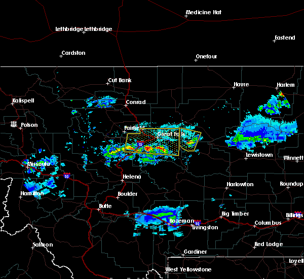 At 715 pm mdt, a severe thunderstorm was located 12 miles northwest of geyser, or 26 miles northwest of stanford, moving north at 20 mph (radar indicated). Hazards include 60 mph wind gusts and quarter size hail. Hail damage to vehicles is expected. expect wind damage to roofs, siding, and trees. Locations impacted include, highwood and shonkin. At 715 pm mdt, a severe thunderstorm was located 12 miles northwest of geyser, or 26 miles northwest of stanford, moving north at 20 mph (radar indicated). Hazards include 60 mph wind gusts and quarter size hail. Hail damage to vehicles is expected. expect wind damage to roofs, siding, and trees. Locations impacted include, highwood and shonkin.
|
| 7/3/2020 7:07 PM MDT |
 At 706 pm mdt, severe thunderstorms were located along a line extending from 16 miles southwest of belt to 11 miles west of cascade, moving north at 25 mph (radar indicated). Hazards include 60 mph wind gusts and quarter size hail. Hail damage to vehicles is expected. Expect wind damage to roofs, siding, and trees. At 706 pm mdt, severe thunderstorms were located along a line extending from 16 miles southwest of belt to 11 miles west of cascade, moving north at 25 mph (radar indicated). Hazards include 60 mph wind gusts and quarter size hail. Hail damage to vehicles is expected. Expect wind damage to roofs, siding, and trees.
|
| 7/3/2020 6:54 PM MDT |
 At 654 pm mdt, a severe thunderstorm was located 7 miles northwest of geyser, or 22 miles northwest of stanford, moving north at 20 mph (radar indicated). Hazards include 60 mph wind gusts and quarter size hail. Hail damage to vehicles is expected. Expect wind damage to roofs, siding, and trees. At 654 pm mdt, a severe thunderstorm was located 7 miles northwest of geyser, or 22 miles northwest of stanford, moving north at 20 mph (radar indicated). Hazards include 60 mph wind gusts and quarter size hail. Hail damage to vehicles is expected. Expect wind damage to roofs, siding, and trees.
|
| 7/14/2019 5:05 PM MDT | Quarter sized hail reported 2.9 miles SW of Highwood, MT, report relayed via nwschat. |
| 7/14/2019 5:04 PM MDT |
 At 504 pm mdt, severe thunderstorms were located along a line extending from 15 miles southwest of fort benton to highwood to 20 miles northwest of geyser to near belt, moving east at 45 mph (doppler radar indicated). Hazards include 60 mph wind gusts and penny size hail. Expect damage to roofs, siding, and trees. Locations impacted include, fort benton, geraldine, highwood, carter, shonkin and floweree. At 504 pm mdt, severe thunderstorms were located along a line extending from 15 miles southwest of fort benton to highwood to 20 miles northwest of geyser to near belt, moving east at 45 mph (doppler radar indicated). Hazards include 60 mph wind gusts and penny size hail. Expect damage to roofs, siding, and trees. Locations impacted include, fort benton, geraldine, highwood, carter, shonkin and floweree.
|
| 7/14/2019 4:43 PM MDT |
 At 442 pm mdt, severe thunderstorms were located along a line extending from 21 miles east of power to 12 miles northwest of belt to 8 miles southeast of black eagle to 6 miles south of great falls, moving east at 45 mph (trained weather spotters). Hazards include 60 mph wind gusts and quarter size hail. Hail damage to vehicles is expected. Expect wind damage to roofs, siding, and trees. At 442 pm mdt, severe thunderstorms were located along a line extending from 21 miles east of power to 12 miles northwest of belt to 8 miles southeast of black eagle to 6 miles south of great falls, moving east at 45 mph (trained weather spotters). Hazards include 60 mph wind gusts and quarter size hail. Hail damage to vehicles is expected. Expect wind damage to roofs, siding, and trees.
|
| 7/6/2019 6:41 PM MDT |
 The severe thunderstorm warning for southwestern chouteau and northeastern cascade counties will expire at 645 pm mdt, the storm which prompted the warning has weakened below severe limits, and no longer poses an immediate threat to life or property. therefore, the warning will be allowed to expire. however small hail, gusty winds and heavy rain are still possible with this thunderstorm. The severe thunderstorm warning for southwestern chouteau and northeastern cascade counties will expire at 645 pm mdt, the storm which prompted the warning has weakened below severe limits, and no longer poses an immediate threat to life or property. therefore, the warning will be allowed to expire. however small hail, gusty winds and heavy rain are still possible with this thunderstorm.
|
| 7/6/2019 6:22 PM MDT |
 The severe thunderstorm warning for southwestern chouteau and northeastern cascade counties will expire at 630 pm mdt, the storm which prompted the warning has moved out of the area and a new warning has been issued for far-northeastern cascade and southwestern chouteau counties. therefore, the warning will be allowed to expire. however small hail, gusty winds and heavy rain are still possible with separate thunderstorms over the great falls area. The severe thunderstorm warning for southwestern chouteau and northeastern cascade counties will expire at 630 pm mdt, the storm which prompted the warning has moved out of the area and a new warning has been issued for far-northeastern cascade and southwestern chouteau counties. therefore, the warning will be allowed to expire. however small hail, gusty winds and heavy rain are still possible with separate thunderstorms over the great falls area.
|
| 7/6/2019 6:18 PM MDT |
 At 618 pm mdt, a severe thunderstorm was located 10 miles east of black eagle, or 12 miles northeast of great falls, moving east at 50 mph (radar indicated). Hazards include 60 mph wind gusts and quarter size hail. Hail damage to vehicles is expected. Expect wind damage to roofs, siding, and trees. At 618 pm mdt, a severe thunderstorm was located 10 miles east of black eagle, or 12 miles northeast of great falls, moving east at 50 mph (radar indicated). Hazards include 60 mph wind gusts and quarter size hail. Hail damage to vehicles is expected. Expect wind damage to roofs, siding, and trees.
|
| 7/6/2019 5:57 PM MDT |
 At 557 pm mdt, a severe thunderstorm was located over great falls, moving east at 45 mph (radar indicated). Hazards include 60 mph wind gusts and nickel size hail. expect damage to roofs, siding, and trees At 557 pm mdt, a severe thunderstorm was located over great falls, moving east at 45 mph (radar indicated). Hazards include 60 mph wind gusts and nickel size hail. expect damage to roofs, siding, and trees
|
| 6/27/2019 4:58 PM MDT |
 At 457 pm mdt, severe thunderstorms were located along a line extending from near highwood to 12 miles south of stanford, moving northeast at 35 mph (radar indicated. at 415 pm tree damage, power outages and winds estimated to 70 mph were reported in belt). Hazards include 70 mph wind gusts and quarter size hail. Hail damage to vehicles is expected. expect considerable tree damage. wind damage is also likely to mobile homes, roofs, and outbuildings. Locations impacted include, fort benton, stanford, geraldine, hobson, geyser, highwood, windham, moccasin, utica, shonkin, coffee creek, square butte and benchland. At 457 pm mdt, severe thunderstorms were located along a line extending from near highwood to 12 miles south of stanford, moving northeast at 35 mph (radar indicated. at 415 pm tree damage, power outages and winds estimated to 70 mph were reported in belt). Hazards include 70 mph wind gusts and quarter size hail. Hail damage to vehicles is expected. expect considerable tree damage. wind damage is also likely to mobile homes, roofs, and outbuildings. Locations impacted include, fort benton, stanford, geraldine, hobson, geyser, highwood, windham, moccasin, utica, shonkin, coffee creek, square butte and benchland.
|
| 6/27/2019 4:49 PM MDT |
 The national weather service in great falls has issued a * severe thunderstorm warning for. northeastern judith basin county in central montana. west central fergus county in central montana. south central chouteau county in north central montana. Until 515 pm mdt. The national weather service in great falls has issued a * severe thunderstorm warning for. northeastern judith basin county in central montana. west central fergus county in central montana. south central chouteau county in north central montana. Until 515 pm mdt.
|
| 6/27/2019 4:28 PM MDT |
 At 428 pm mdt, severe thunderstorms were located along a line extending from belt to 14 miles southwest of stanford, moving northeast at 40 mph (radar indicated). Hazards include 60 mph wind gusts and quarter size hail. Hail damage to vehicles is expected. expect wind damage to roofs, siding, and trees. Locations impacted include, stanford, belt, highwood, geyser, raynesford and armington. At 428 pm mdt, severe thunderstorms were located along a line extending from belt to 14 miles southwest of stanford, moving northeast at 40 mph (radar indicated). Hazards include 60 mph wind gusts and quarter size hail. Hail damage to vehicles is expected. expect wind damage to roofs, siding, and trees. Locations impacted include, stanford, belt, highwood, geyser, raynesford and armington.
|
| 6/27/2019 4:10 PM MDT |
 At 409 pm mdt, severe thunderstorms were located along a line extending from 11 miles west of belt to 23 miles southwest of stanford, moving northeast at 40 mph (radar indicated). Hazards include 60 mph wind gusts and quarter size hail. Hail damage to vehicles is expected. Expect wind damage to roofs, siding, and trees. At 409 pm mdt, severe thunderstorms were located along a line extending from 11 miles west of belt to 23 miles southwest of stanford, moving northeast at 40 mph (radar indicated). Hazards include 60 mph wind gusts and quarter size hail. Hail damage to vehicles is expected. Expect wind damage to roofs, siding, and trees.
|
| 6/14/2019 3:45 PM MDT |
 At 344 pm mdt, a severe thunderstorm was located near highwood, or 22 miles south of fort benton, moving southeast at 35 mph (radar indicated). Hazards include 60 mph wind gusts and quarter size hail. Hail damage to vehicles is expected. Expect wind damage to roofs, siding, and trees. At 344 pm mdt, a severe thunderstorm was located near highwood, or 22 miles south of fort benton, moving southeast at 35 mph (radar indicated). Hazards include 60 mph wind gusts and quarter size hail. Hail damage to vehicles is expected. Expect wind damage to roofs, siding, and trees.
|
| 6/14/2019 3:31 PM MDT |
 At 331 pm mdt, a severe thunderstorm was located 12 miles west of highwood, or 14 miles northeast of great falls, moving southeast at 35 mph (radar indicated). Hazards include 60 mph wind gusts and quarter size hail. Hail damage to vehicles is expected. expect wind damage to roofs, siding, and trees. Locations impacted include, highwood, floweree and portage. At 331 pm mdt, a severe thunderstorm was located 12 miles west of highwood, or 14 miles northeast of great falls, moving southeast at 35 mph (radar indicated). Hazards include 60 mph wind gusts and quarter size hail. Hail damage to vehicles is expected. expect wind damage to roofs, siding, and trees. Locations impacted include, highwood, floweree and portage.
|
| 6/14/2019 3:13 PM MDT |
 At 313 pm mdt, a severe thunderstorm was located 14 miles north of black eagle, or 15 miles north of great falls, moving southeast at 35 mph (radar indicated). Hazards include 60 mph wind gusts and quarter size hail. Hail damage to vehicles is expected. Expect wind damage to roofs, siding, and trees. At 313 pm mdt, a severe thunderstorm was located 14 miles north of black eagle, or 15 miles north of great falls, moving southeast at 35 mph (radar indicated). Hazards include 60 mph wind gusts and quarter size hail. Hail damage to vehicles is expected. Expect wind damage to roofs, siding, and trees.
|
| 6/25/2018 7:42 PM MDT |
 The severe thunderstorm warning for northwestern judith basin, southwestern chouteau and northeastern cascade counties will expire at 745 pm mdt, the storms which prompted the warning have weakened below severe limits, and no longer pose an immediate threat to life or property. therefore, the warning will be allowed to expire. however small hail, gusty winds and heavy rain are still possible with these thunderstorms. The severe thunderstorm warning for northwestern judith basin, southwestern chouteau and northeastern cascade counties will expire at 745 pm mdt, the storms which prompted the warning have weakened below severe limits, and no longer pose an immediate threat to life or property. therefore, the warning will be allowed to expire. however small hail, gusty winds and heavy rain are still possible with these thunderstorms.
|
| 6/25/2018 7:33 PM MDT |
 At 733 pm mdt, severe thunderstorms were located along a line extending from 14 miles north of black eagle to near belt, moving east at 45 mph (radar indicated). Hazards include 60 mph wind gusts and penny size hail. Expect damage to roofs, siding, and trees. Locations impacted include, belt, highwood, carter, shonkin, floweree, armington and portage. At 733 pm mdt, severe thunderstorms were located along a line extending from 14 miles north of black eagle to near belt, moving east at 45 mph (radar indicated). Hazards include 60 mph wind gusts and penny size hail. Expect damage to roofs, siding, and trees. Locations impacted include, belt, highwood, carter, shonkin, floweree, armington and portage.
|
| 6/25/2018 7:17 PM MDT |
 At 717 pm mdt, severe thunderstorms were located along a line extending from 11 miles north of black eagle to 9 miles west of belt, moving east at 45 mph (radar indicated). Hazards include 60 mph wind gusts and penny size hail. expect damage to roofs, siding, and trees At 717 pm mdt, severe thunderstorms were located along a line extending from 11 miles north of black eagle to 9 miles west of belt, moving east at 45 mph (radar indicated). Hazards include 60 mph wind gusts and penny size hail. expect damage to roofs, siding, and trees
|
| 6/9/2018 6:35 PM MDT |
 At 634 pm mdt, severe thunderstorms were located along a line extending from 8 miles south of highwood to 18 miles southwest of hobson, moving north at 40 mph (radar indicated). Hazards include 70 mph wind gusts. Expect considerable tree damage. Damage is likely to mobile homes, roofs, and outbuildings. At 634 pm mdt, severe thunderstorms were located along a line extending from 8 miles south of highwood to 18 miles southwest of hobson, moving north at 40 mph (radar indicated). Hazards include 70 mph wind gusts. Expect considerable tree damage. Damage is likely to mobile homes, roofs, and outbuildings.
|
| 6/4/2017 5:13 PM MDT |
 At 512 pm mdt, a severe thunderstorm was located near fort benton, moving northeast at 35 mph (trained weather spotters. this storm has a history of producing damaging wind gusts up to 60 mph). Hazards include 60 mph wind gusts and nickel size hail. expect damage to roofs, siding, and trees At 512 pm mdt, a severe thunderstorm was located near fort benton, moving northeast at 35 mph (trained weather spotters. this storm has a history of producing damaging wind gusts up to 60 mph). Hazards include 60 mph wind gusts and nickel size hail. expect damage to roofs, siding, and trees
|
| 6/4/2017 4:49 PM MDT |
 At 447 pm mdt, a severe thunderstorm was located 10 miles southwest of highwood, or 14 miles east of great falls, moving northeast at 25 mph (at 443 pm, trained weather spotters reported quarter size hail 7 miles northeast of great falls. this storm also has a history of producing damaging wind gusts). Hazards include 60 mph wind gusts and quarter size hail. Hail damage to vehicles is expected. expect wind damage to roofs, siding, and trees. Locations impacted include, belt, highwood, carter, shonkin, floweree, portage and malmstrom afb. At 447 pm mdt, a severe thunderstorm was located 10 miles southwest of highwood, or 14 miles east of great falls, moving northeast at 25 mph (at 443 pm, trained weather spotters reported quarter size hail 7 miles northeast of great falls. this storm also has a history of producing damaging wind gusts). Hazards include 60 mph wind gusts and quarter size hail. Hail damage to vehicles is expected. expect wind damage to roofs, siding, and trees. Locations impacted include, belt, highwood, carter, shonkin, floweree, portage and malmstrom afb.
|
| 6/4/2017 4:40 PM MDT |
 The national weather service in great falls has issued a * severe thunderstorm warning for. southwestern chouteau county in north central montana. northeastern cascade county in central montana. Until 515 pm mdt * at 438 pm mdt, a severe thunderstorm was located 8 miles northwest. The national weather service in great falls has issued a * severe thunderstorm warning for. southwestern chouteau county in north central montana. northeastern cascade county in central montana. Until 515 pm mdt * at 438 pm mdt, a severe thunderstorm was located 8 miles northwest.
|
| 6/1/2017 5:56 PM MDT |
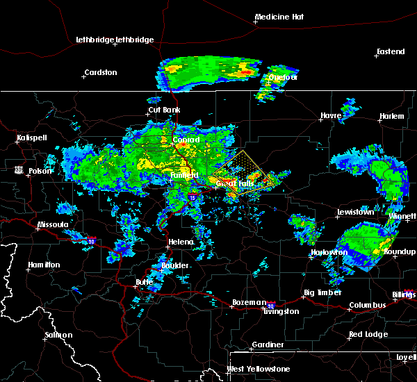 At 554 pm mdt, a severe thunderstorm was located 10 miles northwest of highwood, or 17 miles northeast of great falls, moving northeast at 35 mph (trained weather spotters have observed winds to 60 mph and hail up to the size of quarters with this storm ). Hazards include 60 mph wind gusts and quarter size hail. Hail damage to vehicles is expected. expect wind damage to roofs, siding, and trees. this severe storm will be near, fort benton around 630 pm mdt. Other locations impacted by this severe thunderstorm include shonkin, floweree, carter and portage. At 554 pm mdt, a severe thunderstorm was located 10 miles northwest of highwood, or 17 miles northeast of great falls, moving northeast at 35 mph (trained weather spotters have observed winds to 60 mph and hail up to the size of quarters with this storm ). Hazards include 60 mph wind gusts and quarter size hail. Hail damage to vehicles is expected. expect wind damage to roofs, siding, and trees. this severe storm will be near, fort benton around 630 pm mdt. Other locations impacted by this severe thunderstorm include shonkin, floweree, carter and portage.
|
| 6/1/2017 5:29 PM MDT |
 At 527 pm mdt, a severe thunderstorm was located near black eagle, or near great falls, moving northeast at 40 mph (60 to 70 mph winds have been observed along with very heavy rainfall and small hail). Hazards include 60 mph wind gusts and quarter size hail. Expect wind damage to roofs, siding, and trees. This severe thunderstorm will affect southwestern chouteau and northeastern cascade counties, including the following locations: shonkin, floweree, portage, ulm, malmstrom afb, sand coulee, stockett, tracy, carter and first peoples buffalo jump state park. At 527 pm mdt, a severe thunderstorm was located near black eagle, or near great falls, moving northeast at 40 mph (60 to 70 mph winds have been observed along with very heavy rainfall and small hail). Hazards include 60 mph wind gusts and quarter size hail. Expect wind damage to roofs, siding, and trees. This severe thunderstorm will affect southwestern chouteau and northeastern cascade counties, including the following locations: shonkin, floweree, portage, ulm, malmstrom afb, sand coulee, stockett, tracy, carter and first peoples buffalo jump state park.
|
| 5/6/2017 6:51 PM MDT |
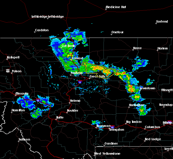 At 650 pm mdt, severe thunderstorms were located along a line extending from 8 miles west of geraldine to 11 miles northwest of black eagle, moving northeast at 30 mph (trained weather spotters). Hazards include 60 mph wind gusts and penny size hail. Expect damage to roofs, siding, and trees. Locations impacted include, fort benton, highwood, the knees, carter, shonkin and floweree. At 650 pm mdt, severe thunderstorms were located along a line extending from 8 miles west of geraldine to 11 miles northwest of black eagle, moving northeast at 30 mph (trained weather spotters). Hazards include 60 mph wind gusts and penny size hail. Expect damage to roofs, siding, and trees. Locations impacted include, fort benton, highwood, the knees, carter, shonkin and floweree.
|
| 5/6/2017 6:36 PM MDT |
 At 636 pm mdt, severe thunderstorms were located along a line extending from 11 miles east of highwood to 10 miles southeast of power, moving northeast at 30 mph (trained weather spotters reported gusts of 60 to 70 mph). Hazards include 60 mph wind gusts and penny size hail. Expect damage to roofs, siding, and trees. Locations impacted include, fort benton, the knees, highwood, power, carter, shonkin, floweree, portage and vaughn. At 636 pm mdt, severe thunderstorms were located along a line extending from 11 miles east of highwood to 10 miles southeast of power, moving northeast at 30 mph (trained weather spotters reported gusts of 60 to 70 mph). Hazards include 60 mph wind gusts and penny size hail. Expect damage to roofs, siding, and trees. Locations impacted include, fort benton, the knees, highwood, power, carter, shonkin, floweree, portage and vaughn.
|
| 5/6/2017 6:14 PM MDT |
 At 613 pm mdt, severe thunderstorms were located along a line extending from 8 miles northeast of belt to near fort shaw, moving northeast at 30 mph (radar and trained spotter indicated). Hazards include 60 mph wind gusts and quarter size hail. Hail damage to vehicles is expected. Expect wind damage to roofs, siding, and trees. At 613 pm mdt, severe thunderstorms were located along a line extending from 8 miles northeast of belt to near fort shaw, moving northeast at 30 mph (radar and trained spotter indicated). Hazards include 60 mph wind gusts and quarter size hail. Hail damage to vehicles is expected. Expect wind damage to roofs, siding, and trees.
|
| 5/6/2017 6:05 PM MDT |
 At 604 pm mdt, severe thunderstorms were located along a line extending from 6 miles south of power to 6 miles southeast of highwood, moving northeast at 55 mph (trained weather spotters reported estimated wind gusts of 60 mph on the southwest end of great falls). Hazards include 60 mph wind gusts and half dollar size hail. Hail damage to vehicles is expected. expect wind damage to roofs, siding, and trees. Locations impacted include, great falls, belt, black eagle, fort shaw, highwood, fort shaw, power, carter, floweree, portage, malmstrom afb, tracy, vaughn, first peoples buffalo jump state park, sun river, shonkin, armington, ulm and sand coulee. At 604 pm mdt, severe thunderstorms were located along a line extending from 6 miles south of power to 6 miles southeast of highwood, moving northeast at 55 mph (trained weather spotters reported estimated wind gusts of 60 mph on the southwest end of great falls). Hazards include 60 mph wind gusts and half dollar size hail. Hail damage to vehicles is expected. expect wind damage to roofs, siding, and trees. Locations impacted include, great falls, belt, black eagle, fort shaw, highwood, fort shaw, power, carter, floweree, portage, malmstrom afb, tracy, vaughn, first peoples buffalo jump state park, sun river, shonkin, armington, ulm and sand coulee.
|
| 5/6/2017 5:44 PM MDT |
 At 544 pm mdt, severe thunderstorms were located along a line extending from 6 miles south of fort shaw to 7 miles south of belt, moving northeast at 55 mph (radar indicated). Hazards include 70 mph wind gusts and half dollar size hail. Hail damage to vehicles is expected. expect considerable tree damage. Wind damage is also likely to mobile homes, roofs, and outbuildings. At 544 pm mdt, severe thunderstorms were located along a line extending from 6 miles south of fort shaw to 7 miles south of belt, moving northeast at 55 mph (radar indicated). Hazards include 70 mph wind gusts and half dollar size hail. Hail damage to vehicles is expected. expect considerable tree damage. Wind damage is also likely to mobile homes, roofs, and outbuildings.
|
| 8/18/2016 1:33 AM MDT |
 At 132 am mdt, a severe thunderstorm was located 12 miles northwest of highwood, or 15 miles southwest of fort benton, moving northeast at 20 mph (radar indicated). Hazards include half dollar size hail. damage to vehicles is expected At 132 am mdt, a severe thunderstorm was located 12 miles northwest of highwood, or 15 miles southwest of fort benton, moving northeast at 20 mph (radar indicated). Hazards include half dollar size hail. damage to vehicles is expected
|
| 8/10/2016 12:29 AM MDT |
 At 1228 am mdt, severe thunderstorms were located along a line extending from 11 miles east of power to 8 miles west of highwood, moving northeast at 35 mph (trained weather spotters). Hazards include 60 mph wind gusts and quarter size hail. Hail damage to vehicles is expected. expect wind damage to roofs, siding, and trees. Locations impacted include, highwood, carter, portage and floweree. At 1228 am mdt, severe thunderstorms were located along a line extending from 11 miles east of power to 8 miles west of highwood, moving northeast at 35 mph (trained weather spotters). Hazards include 60 mph wind gusts and quarter size hail. Hail damage to vehicles is expected. expect wind damage to roofs, siding, and trees. Locations impacted include, highwood, carter, portage and floweree.
|
| 8/10/2016 12:08 AM MDT |
 At 1208 am mdt, severe thunderstorms were located along a line extending from 8 miles southeast of power to 9 miles east of black eagle, moving northeast at 35 mph (trained weather spotters). Hazards include 60 mph wind gusts and quarter size hail. Hail damage to vehicles is expected. Expect wind damage to roofs, siding, and trees. At 1208 am mdt, severe thunderstorms were located along a line extending from 8 miles southeast of power to 9 miles east of black eagle, moving northeast at 35 mph (trained weather spotters). Hazards include 60 mph wind gusts and quarter size hail. Hail damage to vehicles is expected. Expect wind damage to roofs, siding, and trees.
|
| 8/9/2016 6:54 PM MDT |
 The severe thunderstorm warning for southwestern chouteau and northeastern cascade counties will expire at 700 pm mdt, the storm which prompted the warning has weakened below severe limits, and no longer pose an immediate threat to life or property. therefore, the warning will be allowed to expire. however gusty winds are still possible with this thunderstorm. a severe thunderstorm watch remains in effect until midnight mdt for north central and central montana. The severe thunderstorm warning for southwestern chouteau and northeastern cascade counties will expire at 700 pm mdt, the storm which prompted the warning has weakened below severe limits, and no longer pose an immediate threat to life or property. therefore, the warning will be allowed to expire. however gusty winds are still possible with this thunderstorm. a severe thunderstorm watch remains in effect until midnight mdt for north central and central montana.
|
| 8/9/2016 6:22 PM MDT |
 At 621 pm mdt, a severe thunderstorm was located near black eagle, or near great falls, moving east at 20 mph (malmstrom air force base reported a 58 mph wind gust at 619 pm mdt). Hazards include 60 mph wind gusts and quarter size hail. Hail damage to vehicles is expected. Expect wind damage to roofs, siding, and trees. At 621 pm mdt, a severe thunderstorm was located near black eagle, or near great falls, moving east at 20 mph (malmstrom air force base reported a 58 mph wind gust at 619 pm mdt). Hazards include 60 mph wind gusts and quarter size hail. Hail damage to vehicles is expected. Expect wind damage to roofs, siding, and trees.
|
| 6/11/2016 5:13 AM MDT |
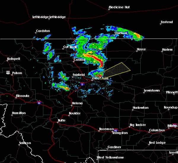 At 513 am mdt, a severe thunderstorm was located 9 miles northwest of highwood, or 17 miles southwest of fort benton, moving northeast at 55 mph (radar indicated). Hazards include ping pong ball size hail has been reported with this storm. People and animals outdoors will be injured. Expect damage to roofs, siding, windows, and vehicles. At 513 am mdt, a severe thunderstorm was located 9 miles northwest of highwood, or 17 miles southwest of fort benton, moving northeast at 55 mph (radar indicated). Hazards include ping pong ball size hail has been reported with this storm. People and animals outdoors will be injured. Expect damage to roofs, siding, windows, and vehicles.
|
| 6/10/2016 3:45 PM MDT |
 At 344 pm mdt, a severe thunderstorm was located 10 miles southeast of highwood, or 21 miles south of fort benton, moving northeast at 45 mph (radar indicated). Hazards include golf ball size hail and 70 mph wind gusts. this storm has a history of producing severe hail in cascade county. People and animals outdoors will be injured. expect hail damage to roofs, siding, windows, and vehicles. expect considerable tree damage. Wind damage is also likely to mobile homes, roofs, and outbuildings. At 344 pm mdt, a severe thunderstorm was located 10 miles southeast of highwood, or 21 miles south of fort benton, moving northeast at 45 mph (radar indicated). Hazards include golf ball size hail and 70 mph wind gusts. this storm has a history of producing severe hail in cascade county. People and animals outdoors will be injured. expect hail damage to roofs, siding, windows, and vehicles. expect considerable tree damage. Wind damage is also likely to mobile homes, roofs, and outbuildings.
|
| 6/10/2016 3:35 PM MDT | Golf Ball sized hail reported 10.3 miles NW of Highwood, MT, hail and wind lasted 14 minutes. no broken windows and no injuries. small tree limbs down. |
| 6/10/2016 3:33 PM MDT |
 At 332 pm mdt, a severe thunderstorm was located 7 miles southeast of highwood, or 22 miles south of fort benton, moving east at 55 mph (trained weather spotters. at 315pm...trained spotters reported quarter size hail. this storm may produce hail up to ping pong size). Hazards include 70 mph wind gusts and ping pong ball size hail. People and animals outdoors will be injured. expect hail damage to roofs, siding, windows, and vehicles. expect considerable tree damage. wind damage is also likely to mobile homes, roofs, and outbuildings. Locations impacted include, belt, geraldine, shonkin, square butte and armington. At 332 pm mdt, a severe thunderstorm was located 7 miles southeast of highwood, or 22 miles south of fort benton, moving east at 55 mph (trained weather spotters. at 315pm...trained spotters reported quarter size hail. this storm may produce hail up to ping pong size). Hazards include 70 mph wind gusts and ping pong ball size hail. People and animals outdoors will be injured. expect hail damage to roofs, siding, windows, and vehicles. expect considerable tree damage. wind damage is also likely to mobile homes, roofs, and outbuildings. Locations impacted include, belt, geraldine, shonkin, square butte and armington.
|
| 6/10/2016 3:20 PM MDT |
 At 319 pm mdt, a severe thunderstorm was located near belt, or 18 miles east of great falls, moving east at 55 mph (trained spotters. at 315pm...trained spotters reported quarter size hail near stocket). Hazards include 60 mph wind gusts and quarter size hail. Hail damage to vehicles is expected. Expect wind damage to roofs, siding, and trees. At 319 pm mdt, a severe thunderstorm was located near belt, or 18 miles east of great falls, moving east at 55 mph (trained spotters. at 315pm...trained spotters reported quarter size hail near stocket). Hazards include 60 mph wind gusts and quarter size hail. Hail damage to vehicles is expected. Expect wind damage to roofs, siding, and trees.
|
| 8/29/2015 5:55 PM MDT | Storm damage reported in chouteau county MT, 1.2 miles NNE of Highwood, MT |
| 5/28/2014 6:00 PM MDT | Quarter sized hail reported 6 miles WSW of Highwood, MT, very strong wind in addition to hail |
| 5/28/2014 5:55 PM MDT | Quarter sized hail reported 1.2 miles NNE of Highwood, MT |
| 1/1/0001 12:00 AM | 65 to 70 mph winds... small hail... and heavy rain reporte in cascade county MT, 8.1 miles NE of Highwood, MT |
Hail Maps for Highwood, MT
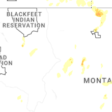

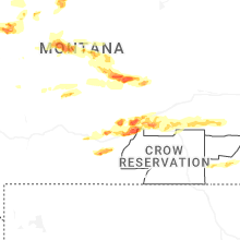
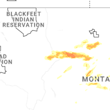


Connect with Interactive Hail Maps