

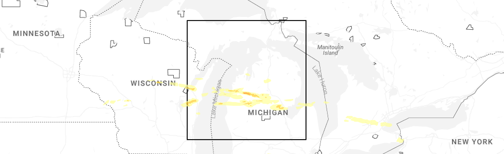
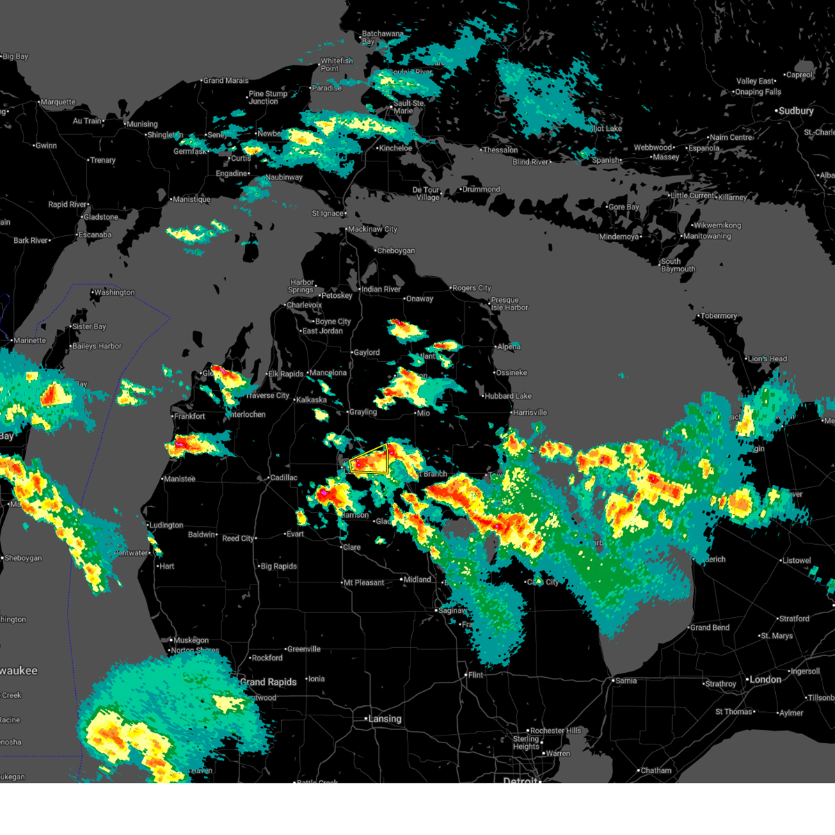
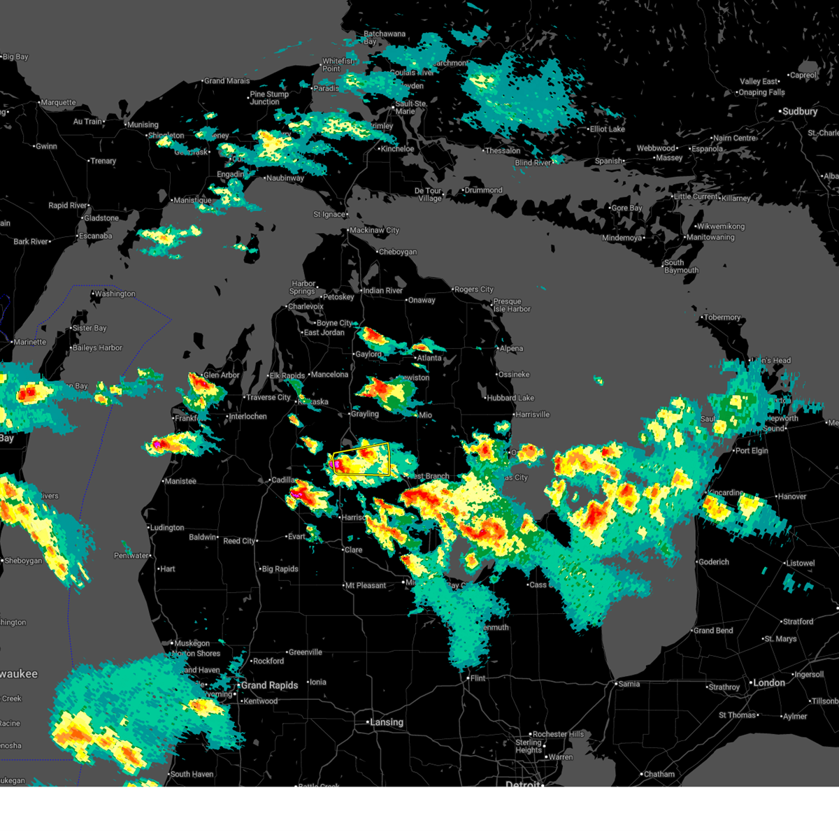
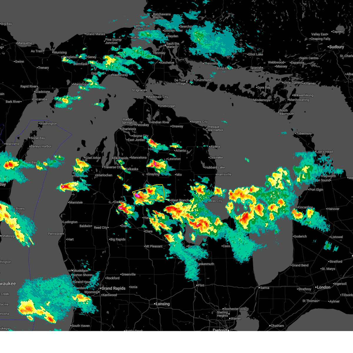
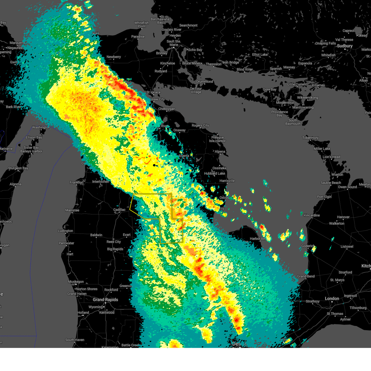
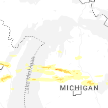
Hail Map for Houghton Lake, MI
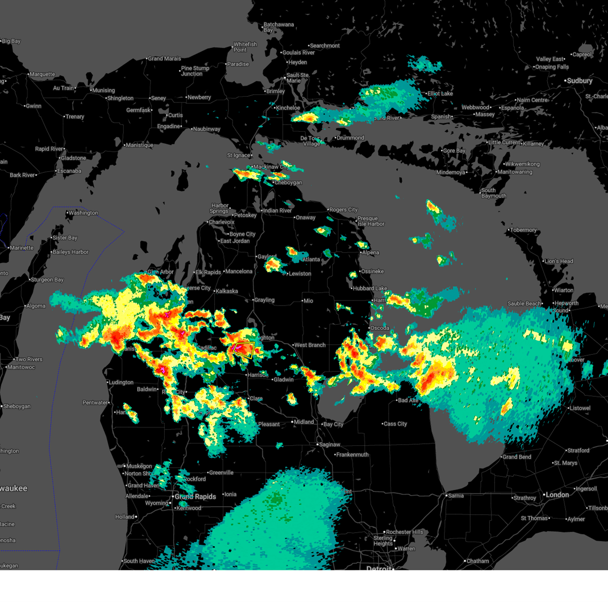
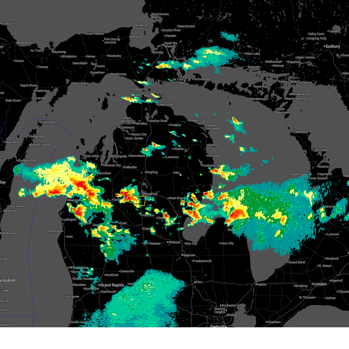
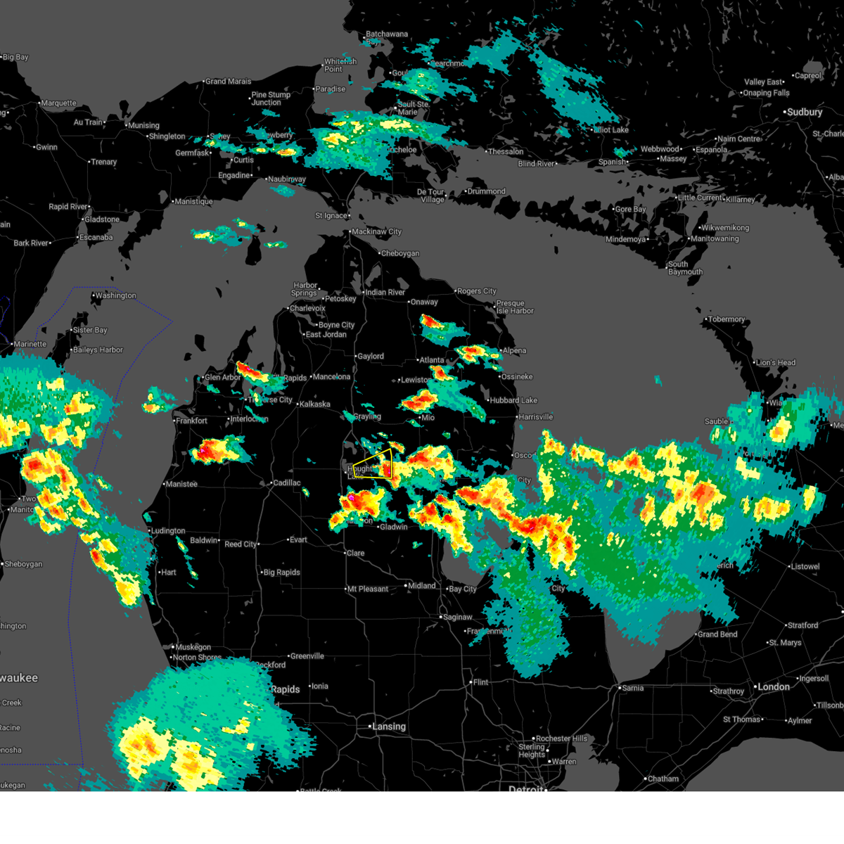
The Houghton Lake, MI area has had 3 reports of on-the-ground hail by trained spotters, and has been under severe weather warnings 7 times during the past 12 months. Doppler radar has detected hail at or near Houghton Lake, MI on 27 occasions, including 1 occasion during the past year.
| Name: | Houghton Lake, MI |
| Where Located: | 53.3 miles SE of Traverse City, MI |
| Map: | Google Map for Houghton Lake, MI |
| Population: | 3427 |
| Housing Units: | 3119 |
| More Info: | Search Google for Houghton Lake, MI |
4
The Top Recent Hail Date for Houghton Lake, MI is Monday, March 30, 2026 (4th out of 27)
Hail and Wind Damage Spotted near Houghton Lake, MI
| Date / Time | Report Details |
|---|---|
| 6/10/2026 8:10 PM EDT | Power lines downed on crawford av in roscommon county MI, 1 miles E of Houghton Lake, MI |
| 6/10/2026 8:07 PM EDT | Comms lines downe in roscommon county MI, 3.3 miles ESE of Houghton Lake, MI |
| 3/31/2026 2:32 AM EDT |
 At 232 am edt, a severe thunderstorm was located near roscommon township, or near houghton lake, moving east at 40 mph (radar indicated). Hazards include quarter size hail. Damage to vehicles is expected. This severe storm will be near, houghton lake around 235 am edt. At 232 am edt, a severe thunderstorm was located near roscommon township, or near houghton lake, moving east at 40 mph (radar indicated). Hazards include quarter size hail. Damage to vehicles is expected. This severe storm will be near, houghton lake around 235 am edt.
|
| 3/31/2026 2:15 AM EDT |
 Svrapx the national weather service in gaylord has issued a * severe thunderstorm warning for, southwestern roscommon county in northern michigan, southeastern missaukee county in northern michigan, * until 245 am edt. * at 215 am edt, a severe thunderstorm was located over falmouth, or 9 miles southeast of lake city, moving east at 35 mph (radar indicated). Hazards include quarter size hail. Damage to vehicles is expected. this severe thunderstorm will be near, moddersville around 220 am edt. Houghton lake around 225 am edt. Svrapx the national weather service in gaylord has issued a * severe thunderstorm warning for, southwestern roscommon county in northern michigan, southeastern missaukee county in northern michigan, * until 245 am edt. * at 215 am edt, a severe thunderstorm was located over falmouth, or 9 miles southeast of lake city, moving east at 35 mph (radar indicated). Hazards include quarter size hail. Damage to vehicles is expected. this severe thunderstorm will be near, moddersville around 220 am edt. Houghton lake around 225 am edt.
|
| 3/31/2026 1:12 AM EDT |
 The storm which prompted the warning has weakened below severe limits, and has exited the warned area. therefore, the warning will be allowed to expire. The storm which prompted the warning has weakened below severe limits, and has exited the warned area. therefore, the warning will be allowed to expire.
|
| 3/31/2026 12:56 AM EDT |
 At 1255 am edt, a severe thunderstorm was located near lake st. helen, or near prudenville, moving east at 40 mph. this storm has a history of producing one half inch hail (radar indicated). Hazards include quarter size hail. Damage to vehicles is expected. this severe storm will be near, st. helen and lake st. Helen around 100 am edt. At 1255 am edt, a severe thunderstorm was located near lake st. helen, or near prudenville, moving east at 40 mph. this storm has a history of producing one half inch hail (radar indicated). Hazards include quarter size hail. Damage to vehicles is expected. this severe storm will be near, st. helen and lake st. Helen around 100 am edt.
|
| 3/31/2026 12:44 AM EDT |
 At 1243 am edt, a severe thunderstorm was located over houghton lake, moving east at 40 mph (radar indicated). Hazards include quarter size hail. Damage to vehicles is expected. this severe storm will be near, prudenville, lake st. helen, south higgins lake, and roscommon county airport around 1250 am edt. st. Helen around 1255 am edt. At 1243 am edt, a severe thunderstorm was located over houghton lake, moving east at 40 mph (radar indicated). Hazards include quarter size hail. Damage to vehicles is expected. this severe storm will be near, prudenville, lake st. helen, south higgins lake, and roscommon county airport around 1250 am edt. st. Helen around 1255 am edt.
|
| 3/31/2026 12:44 AM EDT |
 the severe thunderstorm warning has been cancelled and is no longer in effect the severe thunderstorm warning has been cancelled and is no longer in effect
|
| 3/31/2026 12:36 AM EDT |
 Svrapx the national weather service in gaylord has issued a * severe thunderstorm warning for, central roscommon county in northern michigan, east central missaukee county in northern michigan, * until 115 am edt. * at 1236 am edt, a severe thunderstorm was located near houghton lake, moving east at 40 mph (radar indicated). Hazards include quarter size hail. Damage to vehicles is expected. this severe thunderstorm will be near, houghton lake, prudenville, higgins lake, and roscommon county airport around 1240 am edt. south higgins lake around 1245 am edt. roscommon around 1250 am edt. st. helen and lake st. helen around 1255 am edt. Other locations impacted by this severe thunderstorm include merritt. Svrapx the national weather service in gaylord has issued a * severe thunderstorm warning for, central roscommon county in northern michigan, east central missaukee county in northern michigan, * until 115 am edt. * at 1236 am edt, a severe thunderstorm was located near houghton lake, moving east at 40 mph (radar indicated). Hazards include quarter size hail. Damage to vehicles is expected. this severe thunderstorm will be near, houghton lake, prudenville, higgins lake, and roscommon county airport around 1240 am edt. south higgins lake around 1245 am edt. roscommon around 1250 am edt. st. helen and lake st. helen around 1255 am edt. Other locations impacted by this severe thunderstorm include merritt.
|
| 5/16/2025 12:34 AM EDT |
 the severe thunderstorm warning has been cancelled and is no longer in effect the severe thunderstorm warning has been cancelled and is no longer in effect
|
| 5/15/2025 11:50 PM EDT |
 Svrapx the national weather service in gaylord has issued a * severe thunderstorm warning for, gladwin county in northern michigan, roscommon county in northern michigan, eastern missaukee county in northern michigan, * until 1245 am edt. * at 1150 pm edt, severe thunderstorms were located along a line extending from near falmouth to near roscommon township to near clare, moving north at 40 mph (radar indicated). Hazards include 60 mph wind gusts. Expect damage to roofs, siding, and trees. severe thunderstorms will be near, prudenville, roscommon township, and houghton lake around 1155 pm edt. moorestown, roscommon county airport, and skeels around 1205 am edt. south higgins lake and higgins lake around 1210 am edt. north higgins lake and nester township around 1215 am edt. roscommon around 1220 am edt. lake st. helen around 1225 am edt. twin lakes area around 1230 am edt. st. helen around 1235 am edt. Other locations impacted by these severe thunderstorms include stittsville and merritt. Svrapx the national weather service in gaylord has issued a * severe thunderstorm warning for, gladwin county in northern michigan, roscommon county in northern michigan, eastern missaukee county in northern michigan, * until 1245 am edt. * at 1150 pm edt, severe thunderstorms were located along a line extending from near falmouth to near roscommon township to near clare, moving north at 40 mph (radar indicated). Hazards include 60 mph wind gusts. Expect damage to roofs, siding, and trees. severe thunderstorms will be near, prudenville, roscommon township, and houghton lake around 1155 pm edt. moorestown, roscommon county airport, and skeels around 1205 am edt. south higgins lake and higgins lake around 1210 am edt. north higgins lake and nester township around 1215 am edt. roscommon around 1220 am edt. lake st. helen around 1225 am edt. twin lakes area around 1230 am edt. st. helen around 1235 am edt. Other locations impacted by these severe thunderstorms include stittsville and merritt.
|
| 5/20/2024 8:30 PM EDT |
 the severe thunderstorm warning has been cancelled and is no longer in effect the severe thunderstorm warning has been cancelled and is no longer in effect
|
| 5/20/2024 8:30 PM EDT |
 At 829 pm edt, severe thunderstorms were located along a line extending from near roscommon township to near nester township to gladwin, moving northeast at 40 mph (radar indicated). Hazards include 60 mph wind gusts and penny size hail. Expect damage to roofs, siding, and trees. These severe storms will be near, houghton lake, prudenville, hockaday, twin lakes area, roscommon county airport, and nester township around 835 pm edt. At 829 pm edt, severe thunderstorms were located along a line extending from near roscommon township to near nester township to gladwin, moving northeast at 40 mph (radar indicated). Hazards include 60 mph wind gusts and penny size hail. Expect damage to roofs, siding, and trees. These severe storms will be near, houghton lake, prudenville, hockaday, twin lakes area, roscommon county airport, and nester township around 835 pm edt.
|
| 5/20/2024 8:04 PM EDT |
 Svrapx the national weather service in gaylord has issued a * severe thunderstorm warning for, northwestern gladwin county in northern michigan, southern roscommon county in northern michigan, southeastern missaukee county in northern michigan, * until 845 pm edt. * at 803 pm edt, severe thunderstorms were located along a line extending from 7 miles south of vogel center to harrison to near clare, moving northeast at 40 mph (radar indicated). Hazards include 60 mph wind gusts and penny size hail. Expect damage to roofs, siding, and trees. severe thunderstorms will be near, moddersville around 810 pm edt. roscommon township and skeels around 815 pm edt. gladwin around 820 pm edt. houghton lake, prudenville, and nester township around 825 pm edt. hockaday, twin lakes area, and roscommon county airport around 830 pm edt. Other locations impacted by these severe thunderstorms include merritt. Svrapx the national weather service in gaylord has issued a * severe thunderstorm warning for, northwestern gladwin county in northern michigan, southern roscommon county in northern michigan, southeastern missaukee county in northern michigan, * until 845 pm edt. * at 803 pm edt, severe thunderstorms were located along a line extending from 7 miles south of vogel center to harrison to near clare, moving northeast at 40 mph (radar indicated). Hazards include 60 mph wind gusts and penny size hail. Expect damage to roofs, siding, and trees. severe thunderstorms will be near, moddersville around 810 pm edt. roscommon township and skeels around 815 pm edt. gladwin around 820 pm edt. houghton lake, prudenville, and nester township around 825 pm edt. hockaday, twin lakes area, and roscommon county airport around 830 pm edt. Other locations impacted by these severe thunderstorms include merritt.
|
| 4/28/2024 12:22 AM EDT |
 Svrapx the national weather service in gaylord has issued a * severe thunderstorm warning for, northern gladwin county in northern michigan, western ogemaw county in northern michigan, southern roscommon county in northern michigan, * until 100 am edt. * at 1222 am edt, severe thunderstorms were located along a line extending from near houghton lake to 6 miles north of harrison, moving east at 50 mph (radar indicated). Hazards include 60 mph wind gusts. Expect damage to roofs, siding, and trees. severe thunderstorms will be near, houghton lake, prudenville, and roscommon township around 1225 am edt. nester township around 1235 am edt. st. helen, lake st. Helen, and twin lakes area around 1240 am edt. Svrapx the national weather service in gaylord has issued a * severe thunderstorm warning for, northern gladwin county in northern michigan, western ogemaw county in northern michigan, southern roscommon county in northern michigan, * until 100 am edt. * at 1222 am edt, severe thunderstorms were located along a line extending from near houghton lake to 6 miles north of harrison, moving east at 50 mph (radar indicated). Hazards include 60 mph wind gusts. Expect damage to roofs, siding, and trees. severe thunderstorms will be near, houghton lake, prudenville, and roscommon township around 1225 am edt. nester township around 1235 am edt. st. helen, lake st. Helen, and twin lakes area around 1240 am edt.
|
| 7/24/2023 3:21 PM EDT | Delayed reported. several trees down with power outages near moddersville. time estimated via rada in missaukee county MI, 12.6 miles ENE of Houghton Lake, MI |
| 6/29/2023 7:09 PM EDT |
 At 708 pm edt, a severe thunderstorm was located 7 miles south of moorestown, or 10 miles west of houghton lake, moving east at 20 mph (radar indicated). Hazards include 60 mph wind gusts and quarter size hail. Hail damage to vehicles is expected. expect wind damage to roofs, siding, and trees. locations impacted include, western houghton lake, western higgins lake, merritt and stittsville. hail threat, radar indicated max hail size, 1. 00 in wind threat, radar indicated max wind gust, 60 mph. At 708 pm edt, a severe thunderstorm was located 7 miles south of moorestown, or 10 miles west of houghton lake, moving east at 20 mph (radar indicated). Hazards include 60 mph wind gusts and quarter size hail. Hail damage to vehicles is expected. expect wind damage to roofs, siding, and trees. locations impacted include, western houghton lake, western higgins lake, merritt and stittsville. hail threat, radar indicated max hail size, 1. 00 in wind threat, radar indicated max wind gust, 60 mph.
|
| 6/29/2023 6:57 PM EDT |
 At 657 pm edt, a severe thunderstorm was located 7 miles north of falmouth, or 8 miles east of lake city, moving east at 10 mph (radar indicated). Hazards include 60 mph wind gusts and quarter size hail. Hail damage to vehicles is expected. Expect wind damage to roofs, siding, and trees. At 657 pm edt, a severe thunderstorm was located 7 miles north of falmouth, or 8 miles east of lake city, moving east at 10 mph (radar indicated). Hazards include 60 mph wind gusts and quarter size hail. Hail damage to vehicles is expected. Expect wind damage to roofs, siding, and trees.
|
| 6/25/2023 6:46 PM EDT |
 At 646 pm edt, severe thunderstorms were located along a line extending from near winegars to near nester township to near moorestown, moving northeast at 30 mph (radar indicated). Hazards include 60 mph wind gusts and penny size hail. expect damage to roofs, siding, and trees At 646 pm edt, severe thunderstorms were located along a line extending from near winegars to near nester township to near moorestown, moving northeast at 30 mph (radar indicated). Hazards include 60 mph wind gusts and penny size hail. expect damage to roofs, siding, and trees
|
| 8/3/2022 11:30 AM EDT |
 At 1130 am edt, a severe thunderstorm was located near st. helen, moving east at 60 mph (radar indicated). Hazards include 60 mph wind gusts and penny size hail. Expect damage to roofs, siding, and trees. locations impacted include, clear lake, rose city, rose township and mack lake. hail threat, radar indicated max hail size, 0. 75 in wind threat, observed max wind gust, 60 mph. At 1130 am edt, a severe thunderstorm was located near st. helen, moving east at 60 mph (radar indicated). Hazards include 60 mph wind gusts and penny size hail. Expect damage to roofs, siding, and trees. locations impacted include, clear lake, rose city, rose township and mack lake. hail threat, radar indicated max hail size, 0. 75 in wind threat, observed max wind gust, 60 mph.
|
| 8/3/2022 11:14 AM EDT | Central dispatch reports trees down on top of powerlines near old us-27 and w emery rd. time estimated via rada in roscommon county MI, 3.7 miles NE of Houghton Lake, MI |
| 8/3/2022 11:02 AM EDT |
 At 1101 am edt, a severe thunderstorm was located near moorestown, or 12 miles northwest of houghton lake, moving east at 60 mph (radar indicated. at 1043 am, wexford county airport gusted to 55 mph). Hazards include 60 mph wind gusts and penny size hail. Expect damage to roofs, siding, and trees. this severe thunderstorm will be near, houghton lake around 1110 am edt. south higgins lake, higgins lake, north higgins lake and roscommon county airport around 1115 am edt. roscommon around 1120 am edt. other locations in the path of this severe thunderstorm include south branch township, luzerne, rose township and mack lake. hail threat, radar indicated max hail size, 0. 75 in wind threat, observed max wind gust, 60 mph. At 1101 am edt, a severe thunderstorm was located near moorestown, or 12 miles northwest of houghton lake, moving east at 60 mph (radar indicated. at 1043 am, wexford county airport gusted to 55 mph). Hazards include 60 mph wind gusts and penny size hail. Expect damage to roofs, siding, and trees. this severe thunderstorm will be near, houghton lake around 1110 am edt. south higgins lake, higgins lake, north higgins lake and roscommon county airport around 1115 am edt. roscommon around 1120 am edt. other locations in the path of this severe thunderstorm include south branch township, luzerne, rose township and mack lake. hail threat, radar indicated max hail size, 0. 75 in wind threat, observed max wind gust, 60 mph.
|
| 5/14/2022 1:59 PM EDT |
 At 158 pm edt, a severe thunderstorm was located over prudenville, moving northeast at 15 mph (radar indicated). Hazards include quarter size hail. Damage to vehicles is expected. this severe thunderstorm will remain over mainly rural areas of western roscommon county. hail threat, radar indicated max hail size, 1. 00 in wind threat, radar indicated max wind gust, <50 mph. At 158 pm edt, a severe thunderstorm was located over prudenville, moving northeast at 15 mph (radar indicated). Hazards include quarter size hail. Damage to vehicles is expected. this severe thunderstorm will remain over mainly rural areas of western roscommon county. hail threat, radar indicated max hail size, 1. 00 in wind threat, radar indicated max wind gust, <50 mph.
|
| 9/7/2021 1:31 PM EDT |
 At 131 pm edt, a severe thunderstorm was located over vogel center, or 13 miles southeast of lake city, moving east at 50 mph (radar indicated). Hazards include ping pong ball size hail and 60 mph wind gusts. People and animals outdoors will be injured. expect hail damage to roofs, siding, windows, and vehicles. expect wind damage to roofs, siding, and trees. this severe thunderstorm will be near, moddersville around 135 pm edt. houghton lake and roscommon township around 150 pm edt. other locations in the path of this severe thunderstorm include prudenville and roscommon county airport. hail threat, radar indicated max hail size, 1. 50 in wind threat, radar indicated max wind gust, 60 mph. At 131 pm edt, a severe thunderstorm was located over vogel center, or 13 miles southeast of lake city, moving east at 50 mph (radar indicated). Hazards include ping pong ball size hail and 60 mph wind gusts. People and animals outdoors will be injured. expect hail damage to roofs, siding, windows, and vehicles. expect wind damage to roofs, siding, and trees. this severe thunderstorm will be near, moddersville around 135 pm edt. houghton lake and roscommon township around 150 pm edt. other locations in the path of this severe thunderstorm include prudenville and roscommon county airport. hail threat, radar indicated max hail size, 1. 50 in wind threat, radar indicated max wind gust, 60 mph.
|
| 9/7/2021 1:00 PM EDT |
 At 1259 pm edt, a severe thunderstorm was located 7 miles north of moddersville, or 9 miles west of houghton lake, moving east at 45 mph (radar indicated). Hazards include 60 mph wind gusts and quarter size hail. Hail damage to vehicles is expected. expect wind damage to roofs, siding, and trees. locations impacted include, houghton lake, prudenville and merritt. hail threat, radar indicated max hail size, 1. 00 in wind threat, radar indicated max wind gust, 60 mph. At 1259 pm edt, a severe thunderstorm was located 7 miles north of moddersville, or 9 miles west of houghton lake, moving east at 45 mph (radar indicated). Hazards include 60 mph wind gusts and quarter size hail. Hail damage to vehicles is expected. expect wind damage to roofs, siding, and trees. locations impacted include, houghton lake, prudenville and merritt. hail threat, radar indicated max hail size, 1. 00 in wind threat, radar indicated max wind gust, 60 mph.
|
| 9/7/2021 12:50 PM EDT |
 At 1249 pm edt, a severe thunderstorm was located near lake city, moving east at 40 mph (trained weather spotters. at 1230 pm edt, 2 inch hail was reported near cadillac). Hazards include two inch hail and 60 mph wind gusts. People and animals outdoors will be injured. expect hail damage to roofs, siding, windows, and vehicles. expect wind damage to roofs, siding, and trees. locations impacted include, houghton lake, roscommon county airport and prudenville. thunderstorm damage threat, considerable hail threat, radar indicated max hail size, 2. 00 in wind threat, radar indicated max wind gust, 60 mph. At 1249 pm edt, a severe thunderstorm was located near lake city, moving east at 40 mph (trained weather spotters. at 1230 pm edt, 2 inch hail was reported near cadillac). Hazards include two inch hail and 60 mph wind gusts. People and animals outdoors will be injured. expect hail damage to roofs, siding, windows, and vehicles. expect wind damage to roofs, siding, and trees. locations impacted include, houghton lake, roscommon county airport and prudenville. thunderstorm damage threat, considerable hail threat, radar indicated max hail size, 2. 00 in wind threat, radar indicated max wind gust, 60 mph.
|
| 9/7/2021 12:38 PM EDT |
 At 1235 pm edt, a severe thunderstorm was located over jennings, or near lake city, moving east at 40 mph (trained weather spotters. at 1230 pm edt, 2 inch hail was reported near cadillac). Hazards include two inch hail and 60 mph wind gusts. People and animals outdoors will be injured. expect hail damage to roofs, siding, windows, and vehicles. expect wind damage to roofs, siding, and trees. this severe storm will be near, lake city around 1240 pm edt. other locations in the path of this severe thunderstorm include houghton lake, higgins lake and prudenville. thunderstorm damage threat, considerable hail threat, radar indicated max hail size, 2. 00 in wind threat, radar indicated max wind gust, 60 mph. At 1235 pm edt, a severe thunderstorm was located over jennings, or near lake city, moving east at 40 mph (trained weather spotters. at 1230 pm edt, 2 inch hail was reported near cadillac). Hazards include two inch hail and 60 mph wind gusts. People and animals outdoors will be injured. expect hail damage to roofs, siding, windows, and vehicles. expect wind damage to roofs, siding, and trees. this severe storm will be near, lake city around 1240 pm edt. other locations in the path of this severe thunderstorm include houghton lake, higgins lake and prudenville. thunderstorm damage threat, considerable hail threat, radar indicated max hail size, 2. 00 in wind threat, radar indicated max wind gust, 60 mph.
|
| 9/7/2021 12:28 PM EDT |
 At 1228 pm edt, a severe thunderstorm was located near jennings, or near cadillac, moving east at 50 mph (trained weather spotters). Hazards include ping pong ball size hail and 60 mph wind gusts. People and animals outdoors will be injured. expect hail damage to roofs, siding, windows, and vehicles. expect wind damage to roofs, siding, and trees. this severe thunderstorm will be near, lake city and morey around 1235 pm edt. other locations in the path of this severe thunderstorm include moorestown, houghton lake, higgins lake and north higgins lake. hail threat, radar indicated max hail size, 1. 50 in wind threat, radar indicated max wind gust, 60 mph. At 1228 pm edt, a severe thunderstorm was located near jennings, or near cadillac, moving east at 50 mph (trained weather spotters). Hazards include ping pong ball size hail and 60 mph wind gusts. People and animals outdoors will be injured. expect hail damage to roofs, siding, windows, and vehicles. expect wind damage to roofs, siding, and trees. this severe thunderstorm will be near, lake city and morey around 1235 pm edt. other locations in the path of this severe thunderstorm include moorestown, houghton lake, higgins lake and north higgins lake. hail threat, radar indicated max hail size, 1. 50 in wind threat, radar indicated max wind gust, 60 mph.
|
| 9/7/2021 11:14 AM EDT |
 At 1114 am edt, severe thunderstorms were located along a line extending from near roscommon to near lake st. helen to near moddersville, moving east at 45 mph (radar indicated). Hazards include 60 mph wind gusts. Expect damage to roofs, siding, and trees. these severe storms will be near, roscommon and lake st. helen around 1120 am edt. st. helen and south branch township around 1125 am edt. other locations in the path of these severe thunderstorms include prudenville and clear lake. hail threat, radar indicated max hail size, <. 75 in wind threat, radar indicated max wind gust, 60 mph. At 1114 am edt, severe thunderstorms were located along a line extending from near roscommon to near lake st. helen to near moddersville, moving east at 45 mph (radar indicated). Hazards include 60 mph wind gusts. Expect damage to roofs, siding, and trees. these severe storms will be near, roscommon and lake st. helen around 1120 am edt. st. helen and south branch township around 1125 am edt. other locations in the path of these severe thunderstorms include prudenville and clear lake. hail threat, radar indicated max hail size, <. 75 in wind threat, radar indicated max wind gust, 60 mph.
|
| 9/7/2021 11:06 AM EDT |
 At 1106 am edt, severe thunderstorms were located along a line extending from near roscommon to near roscommon county airport to moddersville, moving east at 45 mph (radar indicated). Hazards include 60 mph wind gusts. Expect damage to roofs, siding, and trees. severe thunderstorms will be near, roscommon and south higgins lake around 1110 am edt. lake st. helen and south branch township around 1115 am edt. st. helen and roscommon township around 1120 am edt. other locations in the path of these severe thunderstorms include clear lake, nester township and twin lakes area. hail threat, radar indicated max hail size, <. 75 in wind threat, radar indicated max wind gust, 60 mph. At 1106 am edt, severe thunderstorms were located along a line extending from near roscommon to near roscommon county airport to moddersville, moving east at 45 mph (radar indicated). Hazards include 60 mph wind gusts. Expect damage to roofs, siding, and trees. severe thunderstorms will be near, roscommon and south higgins lake around 1110 am edt. lake st. helen and south branch township around 1115 am edt. st. helen and roscommon township around 1120 am edt. other locations in the path of these severe thunderstorms include clear lake, nester township and twin lakes area. hail threat, radar indicated max hail size, <. 75 in wind threat, radar indicated max wind gust, 60 mph.
|
| 8/29/2021 3:15 PM EDT |
 At 315 pm edt, severe thunderstorms were located along a line extending from near grayling to near north higgins lake to near houghton lake, moving northeast at 50 mph (radar indicated). Hazards include 60 mph wind gusts. Expect damage to roofs, siding, and trees. locations impacted include, roscommon, lewiston, garland, red oak, south branch township and luzerne. hail threat, radar indicated max hail size, <. 75 in wind threat, radar indicated max wind gust, 60 mph. At 315 pm edt, severe thunderstorms were located along a line extending from near grayling to near north higgins lake to near houghton lake, moving northeast at 50 mph (radar indicated). Hazards include 60 mph wind gusts. Expect damage to roofs, siding, and trees. locations impacted include, roscommon, lewiston, garland, red oak, south branch township and luzerne. hail threat, radar indicated max hail size, <. 75 in wind threat, radar indicated max wind gust, 60 mph.
|
| 8/29/2021 3:01 PM EDT |
 At 301 pm edt, severe thunderstorms were located along a line extending from near grayling to near north higgins lake to 6 miles north of moddersville, moving northeast at 50 mph (radar indicated). Hazards include 60 mph wind gusts. Expect damage to roofs, siding, and trees. severe thunderstorms will be near, grayling and north higgins lake around 305 pm edt. higgins lake and roscommon county airport around 320 pm edt. other locations in the path of these severe thunderstorms include lovells, south higgins lake, roscommon, garland, lewiston, red oak, south branch township and luzerne. hail threat, radar indicated max hail size, <. 75 in wind threat, radar indicated max wind gust, 60 mph. At 301 pm edt, severe thunderstorms were located along a line extending from near grayling to near north higgins lake to 6 miles north of moddersville, moving northeast at 50 mph (radar indicated). Hazards include 60 mph wind gusts. Expect damage to roofs, siding, and trees. severe thunderstorms will be near, grayling and north higgins lake around 305 pm edt. higgins lake and roscommon county airport around 320 pm edt. other locations in the path of these severe thunderstorms include lovells, south higgins lake, roscommon, garland, lewiston, red oak, south branch township and luzerne. hail threat, radar indicated max hail size, <. 75 in wind threat, radar indicated max wind gust, 60 mph.
|
| 8/28/2021 2:59 PM EDT |
 At 258 pm edt, a severe thunderstorm was located near higgins lake, or 7 miles north of houghton lake, moving northeast at 35 mph (radar indicated). Hazards include 60 mph wind gusts and quarter size hail. Hail damage to vehicles is expected. expect wind damage to roofs, siding, and trees. this severe thunderstorm will be near, south higgins lake around 305 pm edt. roscommon around 315 pm edt. other locations in the path of this severe thunderstorm include south branch township, luzerne and red oak. hail threat, radar indicated max hail size, 1. 00 in wind threat, radar indicated max wind gust, 60 mph. At 258 pm edt, a severe thunderstorm was located near higgins lake, or 7 miles north of houghton lake, moving northeast at 35 mph (radar indicated). Hazards include 60 mph wind gusts and quarter size hail. Hail damage to vehicles is expected. expect wind damage to roofs, siding, and trees. this severe thunderstorm will be near, south higgins lake around 305 pm edt. roscommon around 315 pm edt. other locations in the path of this severe thunderstorm include south branch township, luzerne and red oak. hail threat, radar indicated max hail size, 1. 00 in wind threat, radar indicated max wind gust, 60 mph.
|
| 8/28/2021 4:30 AM EDT |
 At 429 am edt, severe thunderstorms were located along a line extending from near lake st. helen to near hockaday to near beaverton, moving east at 45 mph (radar indicated). Hazards include 60 mph wind gusts. Expect damage to roofs, siding, and trees. locations impacted include, alger, houghton lake, gladwin, west branch, standish, sterling, prudenville, st. helen, maple ridge, beaverton, rose city, skidway lake, hockaday, rhodes, rifle river state park, twin lakes area, roscommon county airport, wooden shoe village, clear lake and lupton. hail threat, radar indicated max hail size, <. 75 in wind threat, radar indicated max wind gust, 60 mph. At 429 am edt, severe thunderstorms were located along a line extending from near lake st. helen to near hockaday to near beaverton, moving east at 45 mph (radar indicated). Hazards include 60 mph wind gusts. Expect damage to roofs, siding, and trees. locations impacted include, alger, houghton lake, gladwin, west branch, standish, sterling, prudenville, st. helen, maple ridge, beaverton, rose city, skidway lake, hockaday, rhodes, rifle river state park, twin lakes area, roscommon county airport, wooden shoe village, clear lake and lupton. hail threat, radar indicated max hail size, <. 75 in wind threat, radar indicated max wind gust, 60 mph.
|
| 8/28/2021 4:02 AM EDT |
 At 402 am edt, severe thunderstorms were located along a line extending from near houghton lake to 6 miles west of skeels to near farwell, moving east at 40 mph (radar indicated). Hazards include 60 mph wind gusts. Expect damage to roofs, siding, and trees. locations impacted include, alger, houghton lake, gladwin, west branch, standish, sterling, prudenville, st. helen, maple ridge, beaverton, rose city, skidway lake, hockaday, rhodes, rifle river state park, twin lakes area, roscommon county airport, wooden shoe village, clear lake and lupton. hail threat, radar indicated max hail size, <. 75 in wind threat, radar indicated max wind gust, 60 mph. At 402 am edt, severe thunderstorms were located along a line extending from near houghton lake to 6 miles west of skeels to near farwell, moving east at 40 mph (radar indicated). Hazards include 60 mph wind gusts. Expect damage to roofs, siding, and trees. locations impacted include, alger, houghton lake, gladwin, west branch, standish, sterling, prudenville, st. helen, maple ridge, beaverton, rose city, skidway lake, hockaday, rhodes, rifle river state park, twin lakes area, roscommon county airport, wooden shoe village, clear lake and lupton. hail threat, radar indicated max hail size, <. 75 in wind threat, radar indicated max wind gust, 60 mph.
|
| 8/28/2021 3:42 AM EDT |
 At 341 am edt, severe thunderstorms were located along a line extending from near moddersville to 8 miles northwest of farwell, moving east at 45 mph (radar indicated). Hazards include 60 mph wind gusts. expect damage to roofs, siding, and trees At 341 am edt, severe thunderstorms were located along a line extending from near moddersville to 8 miles northwest of farwell, moving east at 45 mph (radar indicated). Hazards include 60 mph wind gusts. expect damage to roofs, siding, and trees
|
| 8/10/2021 11:28 PM EDT |
 At 1127 pm edt, severe thunderstorms were located along a line extending from near grayling to near moorestown, moving east at 50 mph (radar indicated). Hazards include 60 mph wind gusts and nickel size hail. Expect damage to roofs, siding, and trees. severe thunderstorms will be near, houghton lake, higgins lake and north higgins lake around 1135 pm edt. south higgins lake and roscommon county airport around 1140 pm edt. roscommon and prudenville around 1145 pm edt. other locations in the path of these severe thunderstorms include lake st. helen, south branch township and st. helen. hail threat, radar indicated max hail size, 0. 88 in wind threat, radar indicated max wind gust, 60 mph. At 1127 pm edt, severe thunderstorms were located along a line extending from near grayling to near moorestown, moving east at 50 mph (radar indicated). Hazards include 60 mph wind gusts and nickel size hail. Expect damage to roofs, siding, and trees. severe thunderstorms will be near, houghton lake, higgins lake and north higgins lake around 1135 pm edt. south higgins lake and roscommon county airport around 1140 pm edt. roscommon and prudenville around 1145 pm edt. other locations in the path of these severe thunderstorms include lake st. helen, south branch township and st. helen. hail threat, radar indicated max hail size, 0. 88 in wind threat, radar indicated max wind gust, 60 mph.
|
| 6/12/2021 10:31 PM EDT | Half Dollar sized hail reported 7.7 miles NNE of Houghton Lake, MI, time estimated from radar. |
| 6/12/2021 6:45 PM EDT | Half Dollar sized hail reported 7.7 miles NNE of Houghton Lake, MI, time estimated from radar. |
| 6/12/2021 6:29 PM EDT |
 At 628 pm edt, a severe thunderstorm was located over houghton lake, moving east at 20 mph (radar indicated). Hazards include 60 mph wind gusts and quarter size hail. Hail damage to vehicles is expected. expect wind damage to roofs, siding, and trees. this severe thunderstorm will be near, houghton lake around 635 pm edt. Other locations in the path of this severe thunderstorm include prudenville, roscommon township, nester township and twin lakes area. At 628 pm edt, a severe thunderstorm was located over houghton lake, moving east at 20 mph (radar indicated). Hazards include 60 mph wind gusts and quarter size hail. Hail damage to vehicles is expected. expect wind damage to roofs, siding, and trees. this severe thunderstorm will be near, houghton lake around 635 pm edt. Other locations in the path of this severe thunderstorm include prudenville, roscommon township, nester township and twin lakes area.
|
| 4/7/2020 8:26 PM EDT |
 At 825 pm edt, a severe thunderstorm was located near houghton lake, moving east at 50 mph (radar indicated). Hazards include 60 mph wind gusts and quarter size hail. Hail damage to vehicles is expected. expect wind damage to roofs, siding, and trees. this severe thunderstorm will be near, houghton lake around 830 pm edt. prudenville, roscommon township and roscommon county airport around 835 pm edt. nester township around 845 pm edt. Twin lakes area around 850 pm edt. At 825 pm edt, a severe thunderstorm was located near houghton lake, moving east at 50 mph (radar indicated). Hazards include 60 mph wind gusts and quarter size hail. Hail damage to vehicles is expected. expect wind damage to roofs, siding, and trees. this severe thunderstorm will be near, houghton lake around 830 pm edt. prudenville, roscommon township and roscommon county airport around 835 pm edt. nester township around 845 pm edt. Twin lakes area around 850 pm edt.
|
| 7/4/2019 8:30 PM EDT | Numerous large trees downed onto buildings... vehicles and power lines. street flooding on m-5 in roscommon county MI, 0.8 miles NNW of Houghton Lake, MI |
| 7/6/2017 9:53 PM EDT |
 The severe thunderstorm warning for southern roscommon county will expire at 1000 pm edt, the storm which prompted the warning has moved out of the area. therefore the warning will be allowed to expire. to report severe weather, contact your nearest law enforcement agency. they will relay your report to the national weather service gaylord. The severe thunderstorm warning for southern roscommon county will expire at 1000 pm edt, the storm which prompted the warning has moved out of the area. therefore the warning will be allowed to expire. to report severe weather, contact your nearest law enforcement agency. they will relay your report to the national weather service gaylord.
|
| 7/6/2017 9:35 PM EDT |
 At 934 pm edt, a severe thunderstorm was located over nester township, or 9 miles southeast of prudenville, moving southeast at 25 mph (radar indicated). Hazards include 60 mph wind gusts and quarter size hail. Hail damage to vehicles is expected. expect wind damage to roofs, siding, and trees. Locations impacted include, houghton lake, prudenville, nester township, roscommon township and twin lakes area. At 934 pm edt, a severe thunderstorm was located over nester township, or 9 miles southeast of prudenville, moving southeast at 25 mph (radar indicated). Hazards include 60 mph wind gusts and quarter size hail. Hail damage to vehicles is expected. expect wind damage to roofs, siding, and trees. Locations impacted include, houghton lake, prudenville, nester township, roscommon township and twin lakes area.
|
| 7/6/2017 9:15 PM EDT |
 At 914 pm edt, a severe thunderstorm was located over prudenville, moving southeast at 20 mph (radar indicated. at 855 pm...quarter size hail was reported on the west side of houghton lake). Hazards include 60 mph wind gusts and quarter size hail. Hail damage to vehicles is expected. Expect wind damage to roofs, siding, and trees. At 914 pm edt, a severe thunderstorm was located over prudenville, moving southeast at 20 mph (radar indicated. at 855 pm...quarter size hail was reported on the west side of houghton lake). Hazards include 60 mph wind gusts and quarter size hail. Hail damage to vehicles is expected. Expect wind damage to roofs, siding, and trees.
|
| 7/6/2017 8:55 PM EDT | Quarter sized hail reported 4.1 miles SE of Houghton Lake, MI, report of quarter sized hail. relayed from 9 & 10 news broadcast meteorologist. |
| 7/6/2017 8:46 PM EDT |
 At 846 pm edt, a severe thunderstorm was located near higgins lake, or near houghton lake, moving southeast at 20 mph (radar indicated). Hazards include 60 mph wind gusts and quarter size hail. Hail damage to vehicles is expected. expect wind damage to roofs, siding, and trees. Locations impacted include, houghton lake, roscommon, prudenville, roscommon county airport, higgins lake and south higgins lake. At 846 pm edt, a severe thunderstorm was located near higgins lake, or near houghton lake, moving southeast at 20 mph (radar indicated). Hazards include 60 mph wind gusts and quarter size hail. Hail damage to vehicles is expected. expect wind damage to roofs, siding, and trees. Locations impacted include, houghton lake, roscommon, prudenville, roscommon county airport, higgins lake and south higgins lake.
|
| 7/6/2017 8:19 PM EDT |
 At 818 pm edt, doppler radar indicated a severe thunderstorm capable of producing half dollar size hail and damaging winds in excess of 60 mph. this storm was located over moorestown, or 15 miles northeast of lake city, and moving southeast at 15 mph. At 818 pm edt, doppler radar indicated a severe thunderstorm capable of producing half dollar size hail and damaging winds in excess of 60 mph. this storm was located over moorestown, or 15 miles northeast of lake city, and moving southeast at 15 mph.
|
| 7/8/2016 2:09 PM EDT |
 At 208 pm edt, a severe thunderstorm was located near houghton lake, moving east at 40 mph (radar indicated). Hazards include 60 mph wind gusts and quarter size hail. Hail damage to vehicles is expected. expect wind damage to roofs, siding, and trees. locations impacted include, houghton lake, roscommon, prudenville, st. helen, falmouth, north higgins lake, roscommon township, lake st. Helen, moddersville, higgins lake, vogel center, nester township, roscommon county airport, twin lakes area, south higgins lake, moorestown and merritt. At 208 pm edt, a severe thunderstorm was located near houghton lake, moving east at 40 mph (radar indicated). Hazards include 60 mph wind gusts and quarter size hail. Hail damage to vehicles is expected. expect wind damage to roofs, siding, and trees. locations impacted include, houghton lake, roscommon, prudenville, st. helen, falmouth, north higgins lake, roscommon township, lake st. Helen, moddersville, higgins lake, vogel center, nester township, roscommon county airport, twin lakes area, south higgins lake, moorestown and merritt.
|
| 7/8/2016 1:40 PM EDT |
 At 140 pm edt, a severe thunderstorm was located over lake city, moving east at 30 mph (radar indicated). Hazards include ping pong ball size hail and 60 mph wind gusts. People and animals outdoors will be injured. expect hail damage to roofs, siding, windows, and vehicles. Expect wind damage to roofs, siding, and trees. At 140 pm edt, a severe thunderstorm was located over lake city, moving east at 30 mph (radar indicated). Hazards include ping pong ball size hail and 60 mph wind gusts. People and animals outdoors will be injured. expect hail damage to roofs, siding, windows, and vehicles. Expect wind damage to roofs, siding, and trees.
|
| 7/7/2016 6:30 PM EDT |
 At 630 pm edt, a severe thunderstorm was located over roscommon county airport, or near prudenville, moving east at 30 mph (radar indicated). Hazards include 60 mph wind gusts and quarter size hail. Hail damage to vehicles is expected. expect wind damage to roofs, siding, and trees. locations impacted include, houghton lake, prudenville, st. helen, south higgins lake, roscommon county airport and lake st. Helen. At 630 pm edt, a severe thunderstorm was located over roscommon county airport, or near prudenville, moving east at 30 mph (radar indicated). Hazards include 60 mph wind gusts and quarter size hail. Hail damage to vehicles is expected. expect wind damage to roofs, siding, and trees. locations impacted include, houghton lake, prudenville, st. helen, south higgins lake, roscommon county airport and lake st. Helen.
|
| 7/7/2016 6:11 PM EDT |
 At 610 pm edt, a severe thunderstorm was located near houghton lake, moving east at 25 mph (radar indicated). Hazards include 60 mph wind gusts and quarter size hail. Hail damage to vehicles is expected. Expect wind damage to roofs, siding, and trees. At 610 pm edt, a severe thunderstorm was located near houghton lake, moving east at 25 mph (radar indicated). Hazards include 60 mph wind gusts and quarter size hail. Hail damage to vehicles is expected. Expect wind damage to roofs, siding, and trees.
|
| 5/26/2016 4:03 PM EDT |
 At 402 pm edt, a severe thunderstorm was located over prudenville, moving northeast at 30 mph (radar indicated). Hazards include 60 mph wind gusts and quarter size hail. Hail damage to vehicles is expected. expect wind damage to roofs, siding, and trees. locations impacted include, houghton lake, prudenville, st. helen, roscommon county airport, roscommon township and lake st. Helen. At 402 pm edt, a severe thunderstorm was located over prudenville, moving northeast at 30 mph (radar indicated). Hazards include 60 mph wind gusts and quarter size hail. Hail damage to vehicles is expected. expect wind damage to roofs, siding, and trees. locations impacted include, houghton lake, prudenville, st. helen, roscommon county airport, roscommon township and lake st. Helen.
|
| 5/26/2016 3:40 PM EDT |
 At 340 pm edt, a severe thunderstorm was located near moddersville, or 7 miles southwest of houghton lake, moving northeast at 35 mph (radar indicated). Hazards include 60 mph wind gusts and quarter size hail. Hail damage to vehicles is expected. Expect wind damage to roofs, siding, and trees. At 340 pm edt, a severe thunderstorm was located near moddersville, or 7 miles southwest of houghton lake, moving northeast at 35 mph (radar indicated). Hazards include 60 mph wind gusts and quarter size hail. Hail damage to vehicles is expected. Expect wind damage to roofs, siding, and trees.
|
| 5/25/2016 5:28 PM EDT |
 At 526 pm edt, a line of thunderstorms were located along a line extending from near lake st. helen to 6 miles north of moddersville, moving northeast at 15 mph (radar indicated). Hazards include 60 mph wind gusts and penny size hail. Expect damage to roofs. siding. and trees. severe thunderstorms will be near, lake st. helen around 530 pm edt. roscommon county airport around 610 pm edt. higgins lake around 625 pm edt. roscommon, north higgins lake and south higgins lake around 630 pm edt. Other locations impacted by these severe thunderstorms include merritt. At 526 pm edt, a line of thunderstorms were located along a line extending from near lake st. helen to 6 miles north of moddersville, moving northeast at 15 mph (radar indicated). Hazards include 60 mph wind gusts and penny size hail. Expect damage to roofs. siding. and trees. severe thunderstorms will be near, lake st. helen around 530 pm edt. roscommon county airport around 610 pm edt. higgins lake around 625 pm edt. roscommon, north higgins lake and south higgins lake around 630 pm edt. Other locations impacted by these severe thunderstorms include merritt.
|
| 5/25/2016 5:11 PM EDT | Storm damage reported in roscommon county MI, 4.9 miles SW of Houghton Lake, MI |
| 5/25/2016 5:07 PM EDT | Car port was thrown into trees in roscommon county MI, 1 miles E of Houghton Lake, MI |
| 8/2/2015 7:08 PM EDT |
 At 707 pm edt, severe thunderstorms were located along a line extending from 6 miles southeast of moorestown to 11 miles southeast of marion, moving east at 70 mph (radar indicated). Hazards include 60 mph wind gusts and quarter size hail. Hail damage to vehicles is expected. Expect wind damage to roofs, siding and trees. At 707 pm edt, severe thunderstorms were located along a line extending from 6 miles southeast of moorestown to 11 miles southeast of marion, moving east at 70 mph (radar indicated). Hazards include 60 mph wind gusts and quarter size hail. Hail damage to vehicles is expected. Expect wind damage to roofs, siding and trees.
|
| 8/2/2015 6:09 PM EDT |
 At 609 pm edt, severe thunderstorms were located along a line extending from near national city to 7 miles southwest of roscommon township, and are nearly stationary (radar indicated). Hazards include 70 mph wind gusts and quarter size hail. Hail damage to vehicles is expected. expect considerable tree damage. wind damage is also likely to mobile homes, roofs and outbuildings. Locations impacted include, houghton lake, west branch, prudenville, rose city, twin lakes area, lupton, rifle river state park, skidway lake, roscommon township, selkirk, nester township and prescott. At 609 pm edt, severe thunderstorms were located along a line extending from near national city to 7 miles southwest of roscommon township, and are nearly stationary (radar indicated). Hazards include 70 mph wind gusts and quarter size hail. Hail damage to vehicles is expected. expect considerable tree damage. wind damage is also likely to mobile homes, roofs and outbuildings. Locations impacted include, houghton lake, west branch, prudenville, rose city, twin lakes area, lupton, rifle river state park, skidway lake, roscommon township, selkirk, nester township and prescott.
|
| 8/2/2015 5:59 PM EDT |
 At 558 pm edt, severe thunderstorms were located along a line extending from near national city to 6 miles southwest of roscommon township, moving east at 65 mph (radar indicated). Hazards include 70 mph wind gusts and quarter size hail. Hail damage to vehicles is expected. expect considerable tree damage. wind damage is also likely to mobile homes, roofs and outbuildings. Locations impacted include, houghton lake, west branch, prudenville, rose city, twin lakes area, lupton, rifle river state park, skidway lake, roscommon township, selkirk, nester township and prescott. At 558 pm edt, severe thunderstorms were located along a line extending from near national city to 6 miles southwest of roscommon township, moving east at 65 mph (radar indicated). Hazards include 70 mph wind gusts and quarter size hail. Hail damage to vehicles is expected. expect considerable tree damage. wind damage is also likely to mobile homes, roofs and outbuildings. Locations impacted include, houghton lake, west branch, prudenville, rose city, twin lakes area, lupton, rifle river state park, skidway lake, roscommon township, selkirk, nester township and prescott.
|
| 8/2/2015 5:25 PM EDT |
 At 525 pm edt, severe thunderstorms were located along a line extending from near south branch township to 7 miles northwest of houghton lake, moving east at 65 mph (radar indicated). Hazards include 70 mph wind gusts and quarter size hail. Hail damage to vehicles is expected. expect considerable tree damage. Wind damage is also likely to mobile homes, roofs and outbuildings. At 525 pm edt, severe thunderstorms were located along a line extending from near south branch township to 7 miles northwest of houghton lake, moving east at 65 mph (radar indicated). Hazards include 70 mph wind gusts and quarter size hail. Hail damage to vehicles is expected. expect considerable tree damage. Wind damage is also likely to mobile homes, roofs and outbuildings.
|
| 8/2/2015 4:29 PM EDT |
 At 426 pm edt, a severe thunderstorm was located near roscommon county airport, or near prudenville, moving east at 35 mph (trained weather spotters. at 425 pm a trained weather spotter reported one inch hail on the south shore of higgins lake with this storm). Hazards include 60 mph wind gusts and quarter size hail. Hail damage to vehicles is expected. expect wind damage to roofs, siding and trees. locations impacted include, houghton lake, roscommon, prudenville, st. helen, north higgins lake, lake st. Helen, higgins lake, south higgins lake and roscommon county airport. At 426 pm edt, a severe thunderstorm was located near roscommon county airport, or near prudenville, moving east at 35 mph (trained weather spotters. at 425 pm a trained weather spotter reported one inch hail on the south shore of higgins lake with this storm). Hazards include 60 mph wind gusts and quarter size hail. Hail damage to vehicles is expected. expect wind damage to roofs, siding and trees. locations impacted include, houghton lake, roscommon, prudenville, st. helen, north higgins lake, lake st. Helen, higgins lake, south higgins lake and roscommon county airport.
|
| 8/2/2015 4:05 PM EDT |
 At 404 pm edt, a severe thunderstorm was located near moorestown, or 12 miles northwest of houghton lake, moving east at 35 mph (trained weather spotters). Hazards include 60 mph wind gusts and quarter size hail. Hail damage to vehicles is expected. Expect wind damage to roofs, siding and trees. At 404 pm edt, a severe thunderstorm was located near moorestown, or 12 miles northwest of houghton lake, moving east at 35 mph (trained weather spotters). Hazards include 60 mph wind gusts and quarter size hail. Hail damage to vehicles is expected. Expect wind damage to roofs, siding and trees.
|
| 6/8/2015 1:16 PM EDT |
 At 115 pm edt, a severe thunderstorm was located over south higgins lake, or 7 miles southwest of roscommon, moving east at 25 mph (radar indicated). Hazards include 60 mph wind gusts and quarter size hail. Hail damage to vehicles is expected. Expect wind damage to roofs, siding and trees. At 115 pm edt, a severe thunderstorm was located over south higgins lake, or 7 miles southwest of roscommon, moving east at 25 mph (radar indicated). Hazards include 60 mph wind gusts and quarter size hail. Hail damage to vehicles is expected. Expect wind damage to roofs, siding and trees.
|
| 7/27/2014 3:12 PM EDT | Powerlines down in houghton lake in roscommon county MI, 1.2 miles ENE of Houghton Lake, MI |
| 5/20/2013 3:10 PM EDT | Trees dow in roscommon county MI, 1.2 miles ENE of Houghton Lake, MI |
| 7/25/2012 9:50 PM EDT | About 100 trees down at old 27 and the clare roscommon county border in roscommon county MI, 9 miles N of Houghton Lake, MI |
| 7/14/2012 1:00 PM EDT | Pontoon boat fl in roscommon county MI, 1.7 miles SE of Houghton Lake, MI |
| 7/14/2012 12:58 PM EDT | Pontoon boat fl in roscommon county MI, 1.7 miles SE of Houghton Lake, MI |
Hail Maps for Houghton Lake, MI


Connect with Interactive Hail Maps