

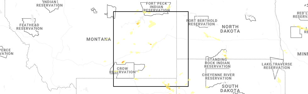
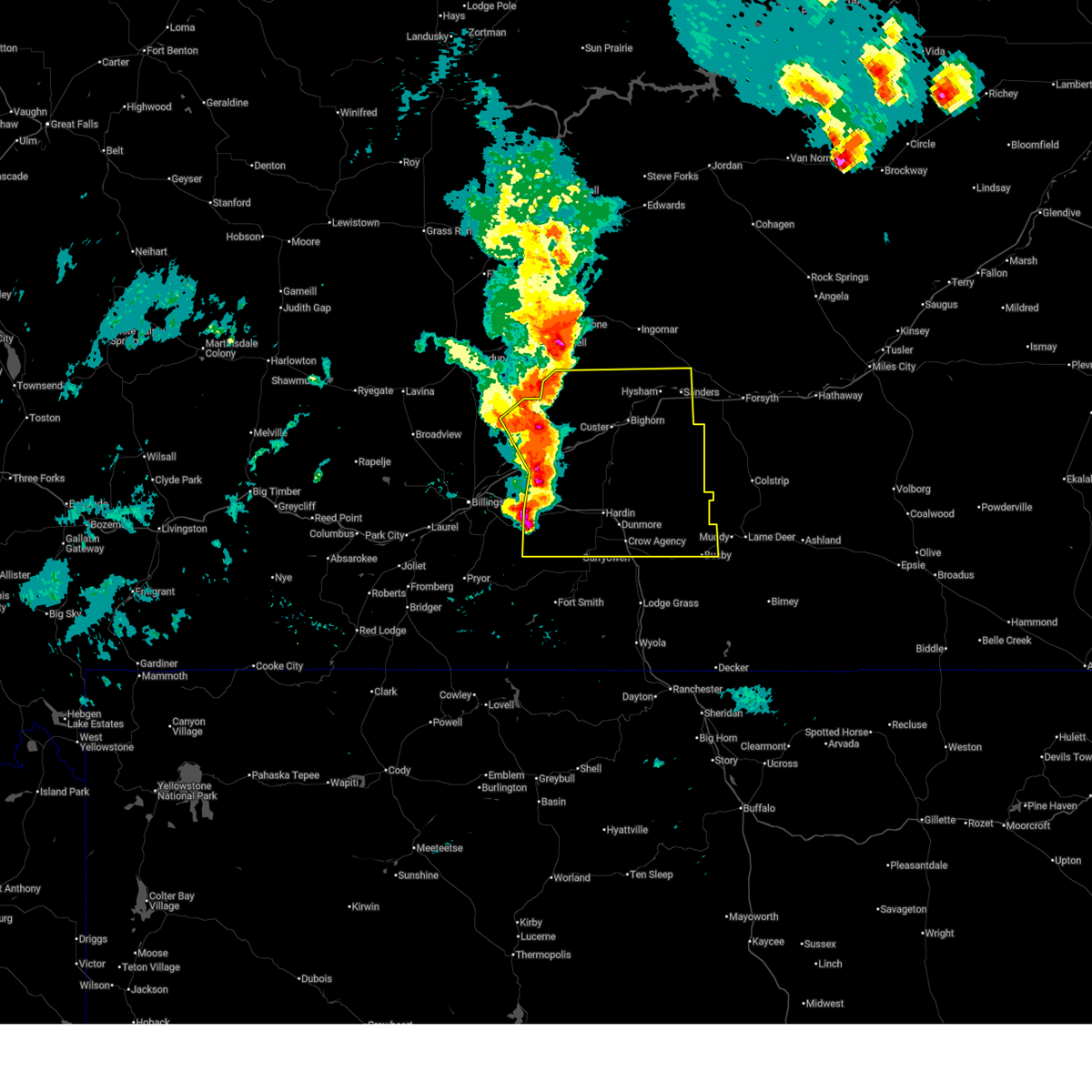
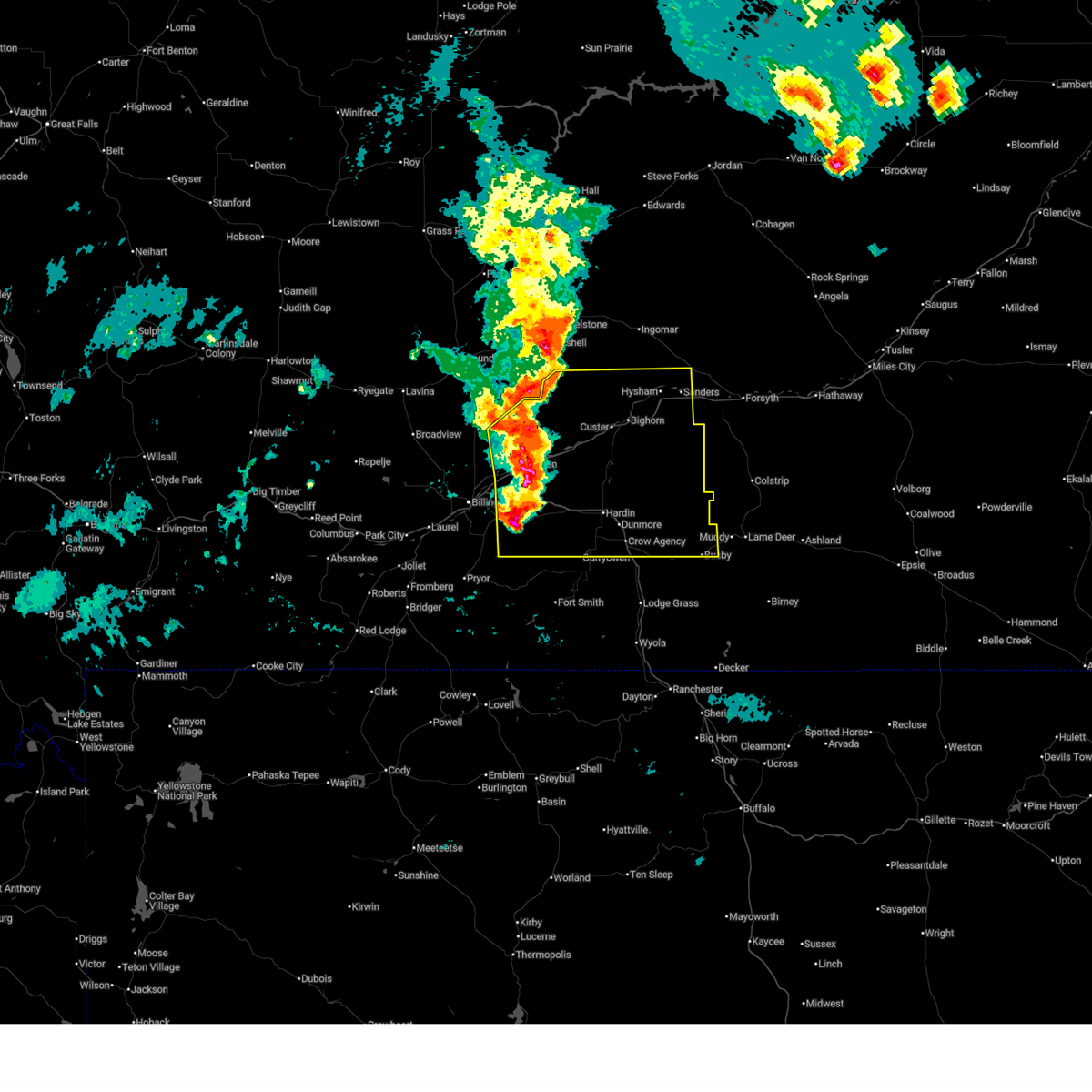
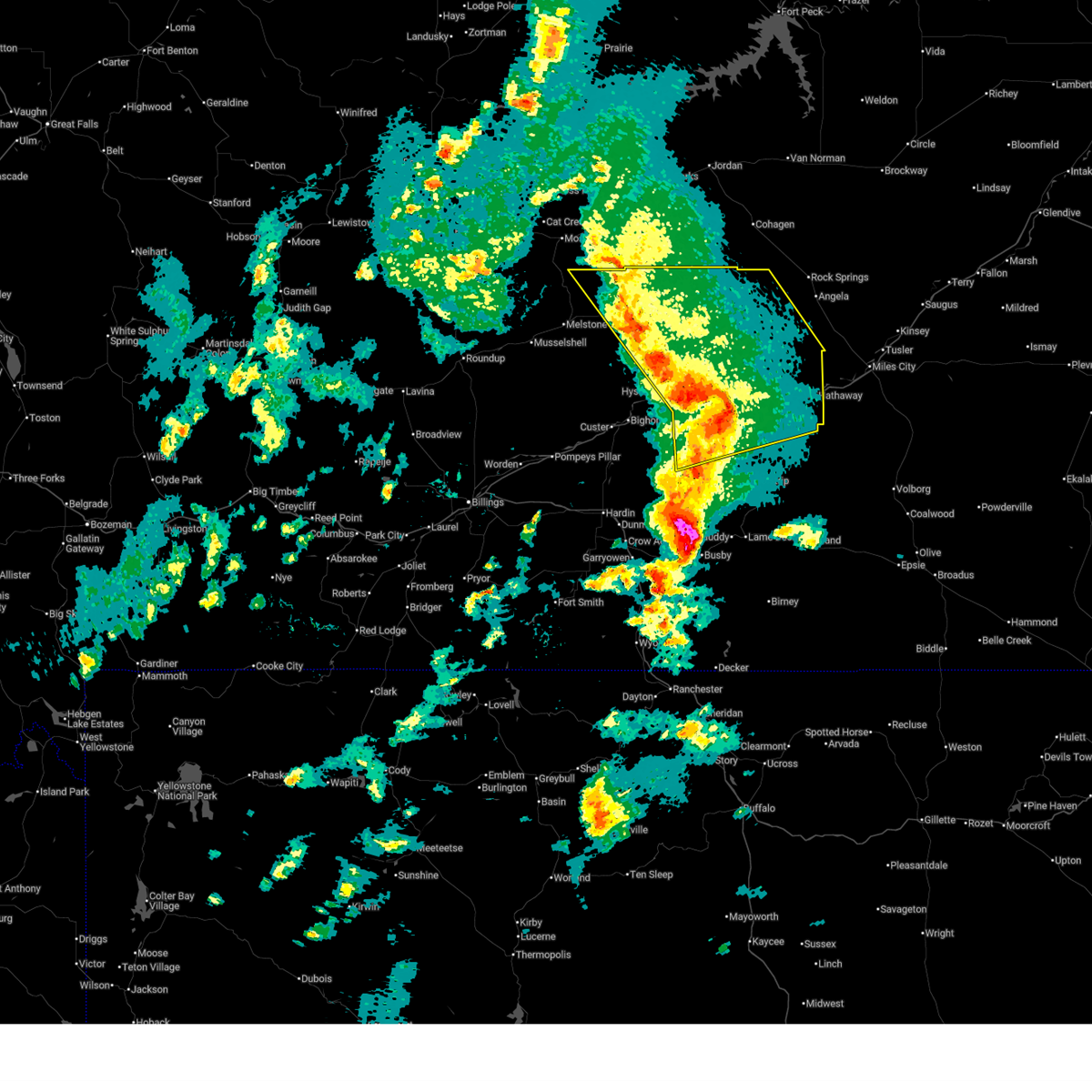
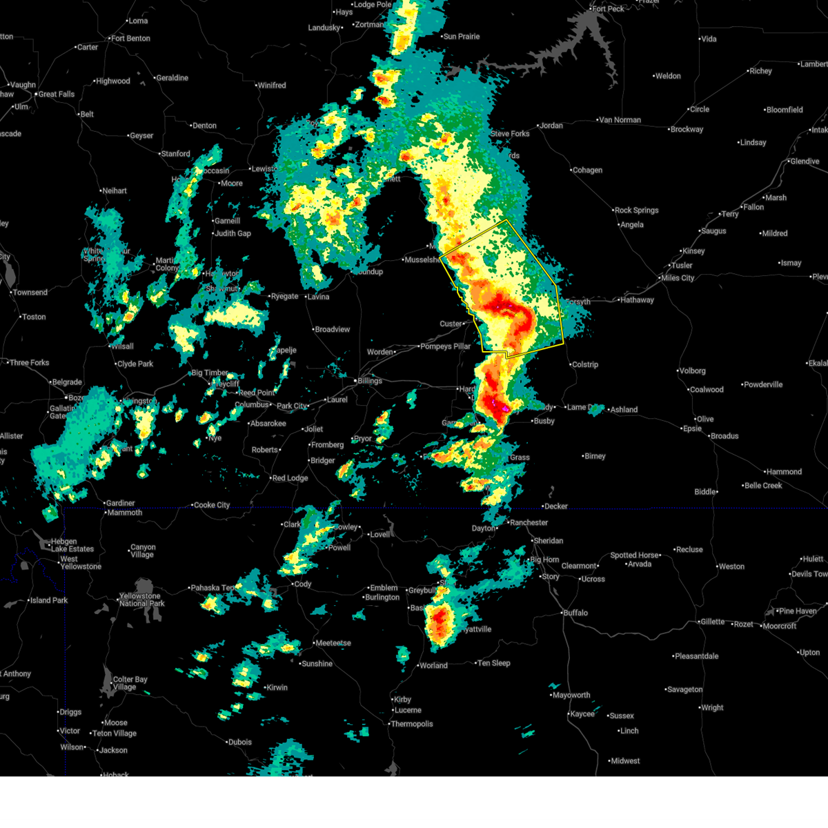
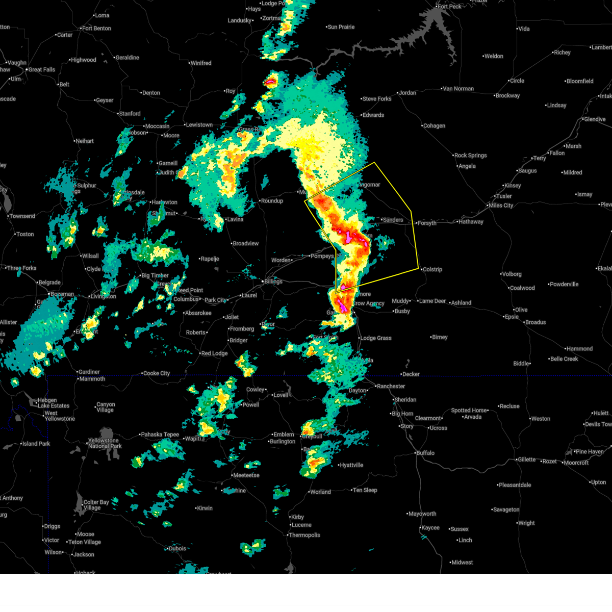
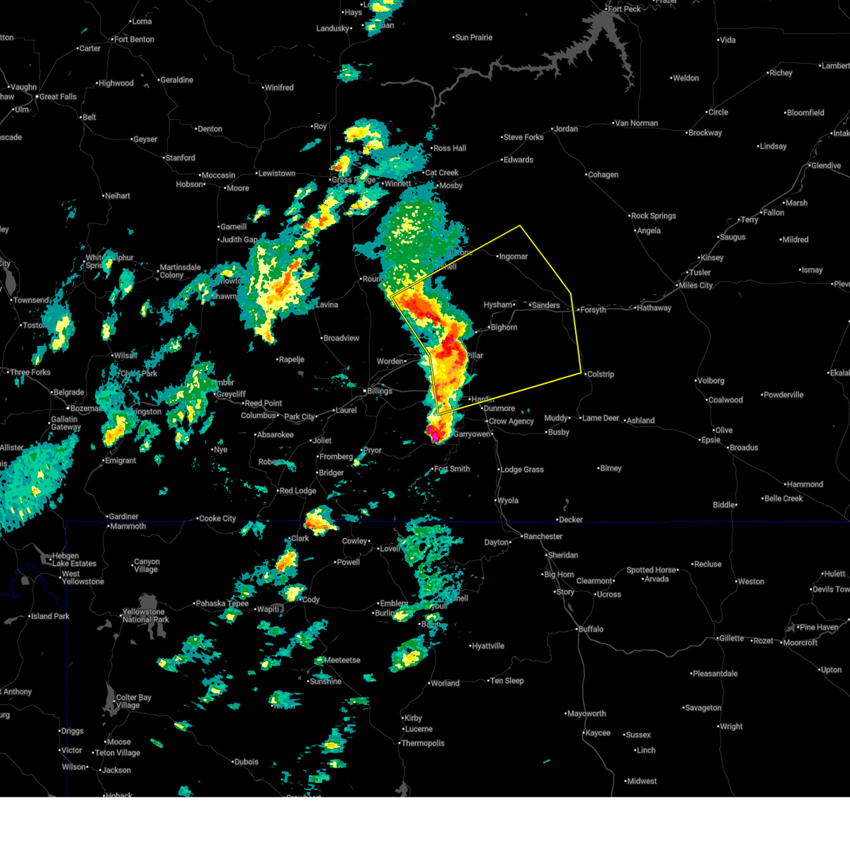
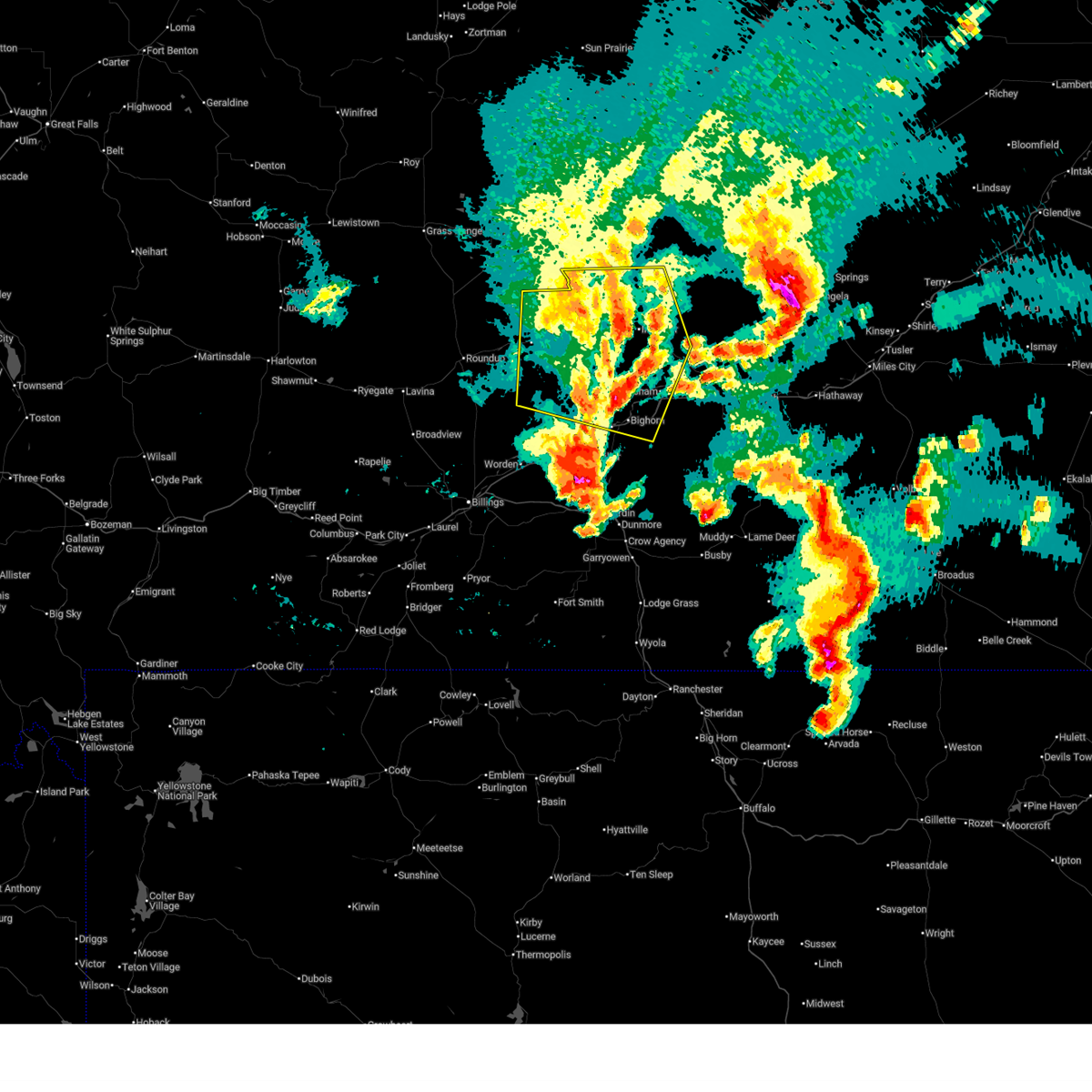
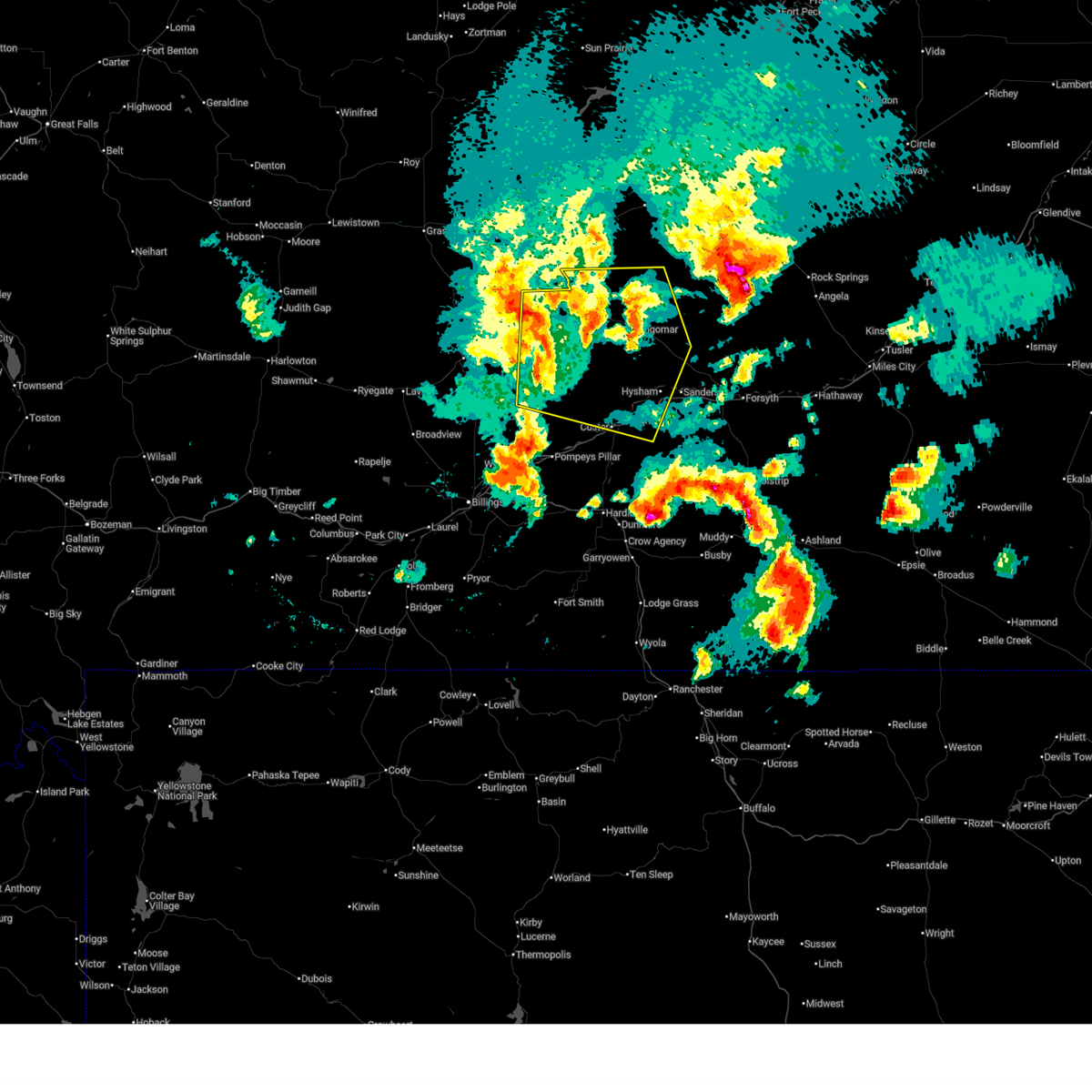
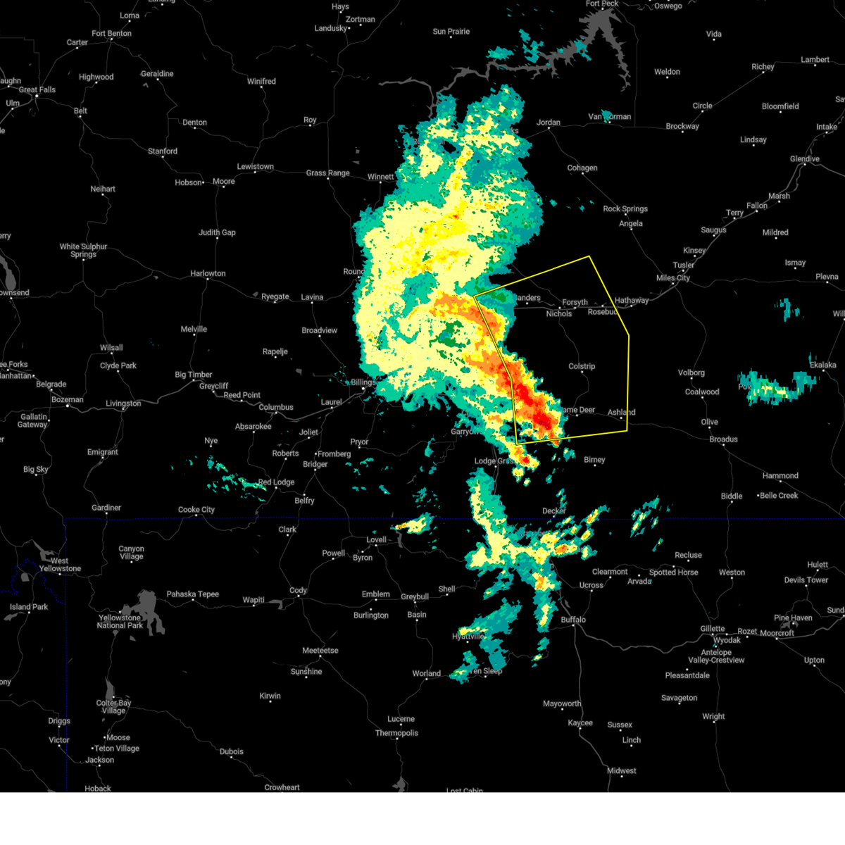
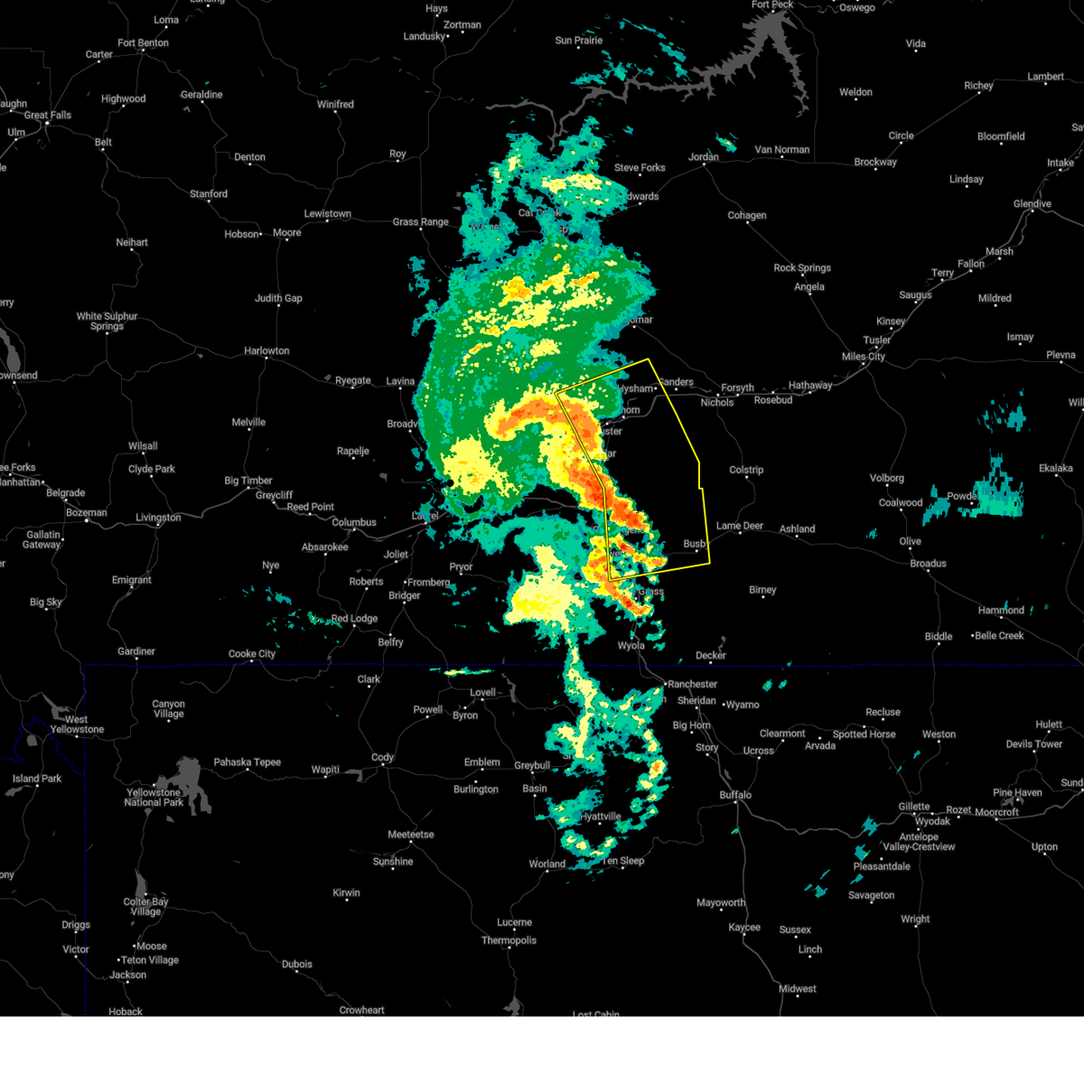
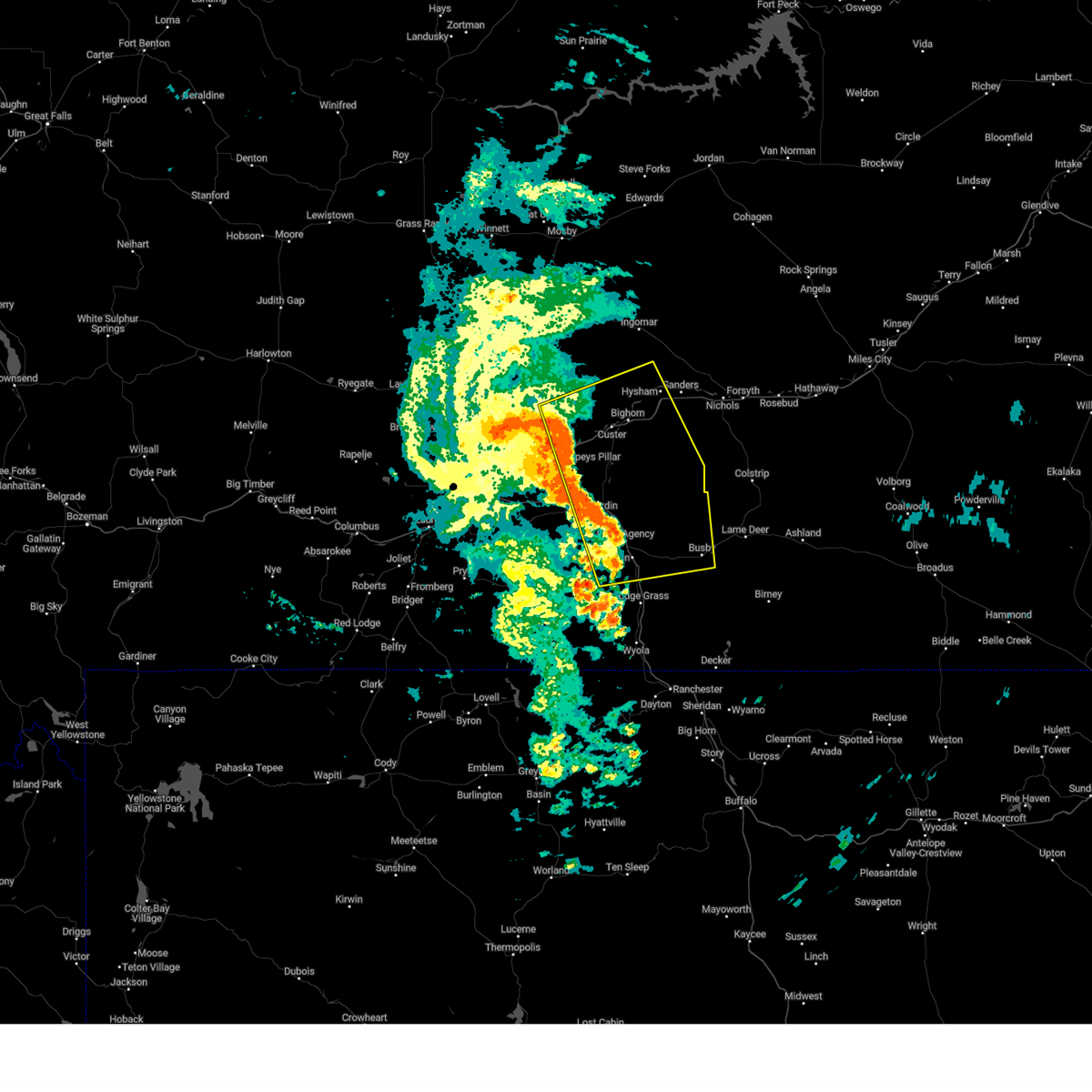
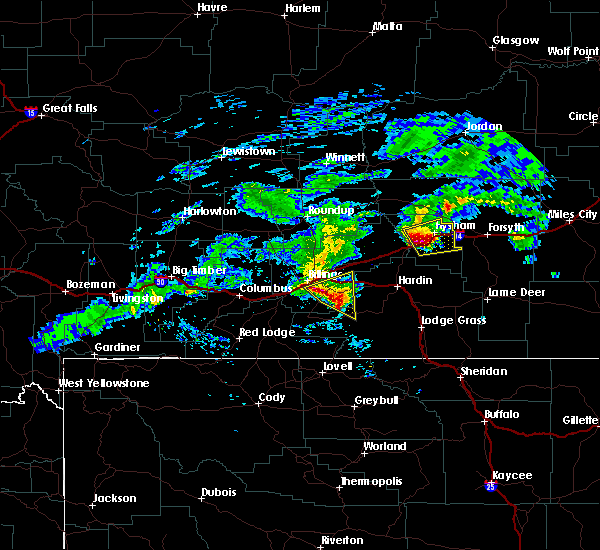
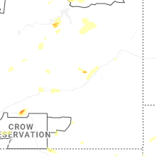
Hail Map for Hysham, MT
The Hysham, MT area has had 14 reports of on-the-ground hail by trained spotters, and has been under severe weather warnings 8 times during the past 12 months. Doppler radar has detected hail at or near Hysham, MT on 24 occasions, including 2 occasions during the past year.
| Name: | Hysham, MT |
| Where Located: | 66.5 miles W of Miles City, MT |
| Map: | Google Map for Hysham, MT |
| Population: | 312 |
| Housing Units: | 175 |
| More Info: | Search Google for Hysham, MT |
1
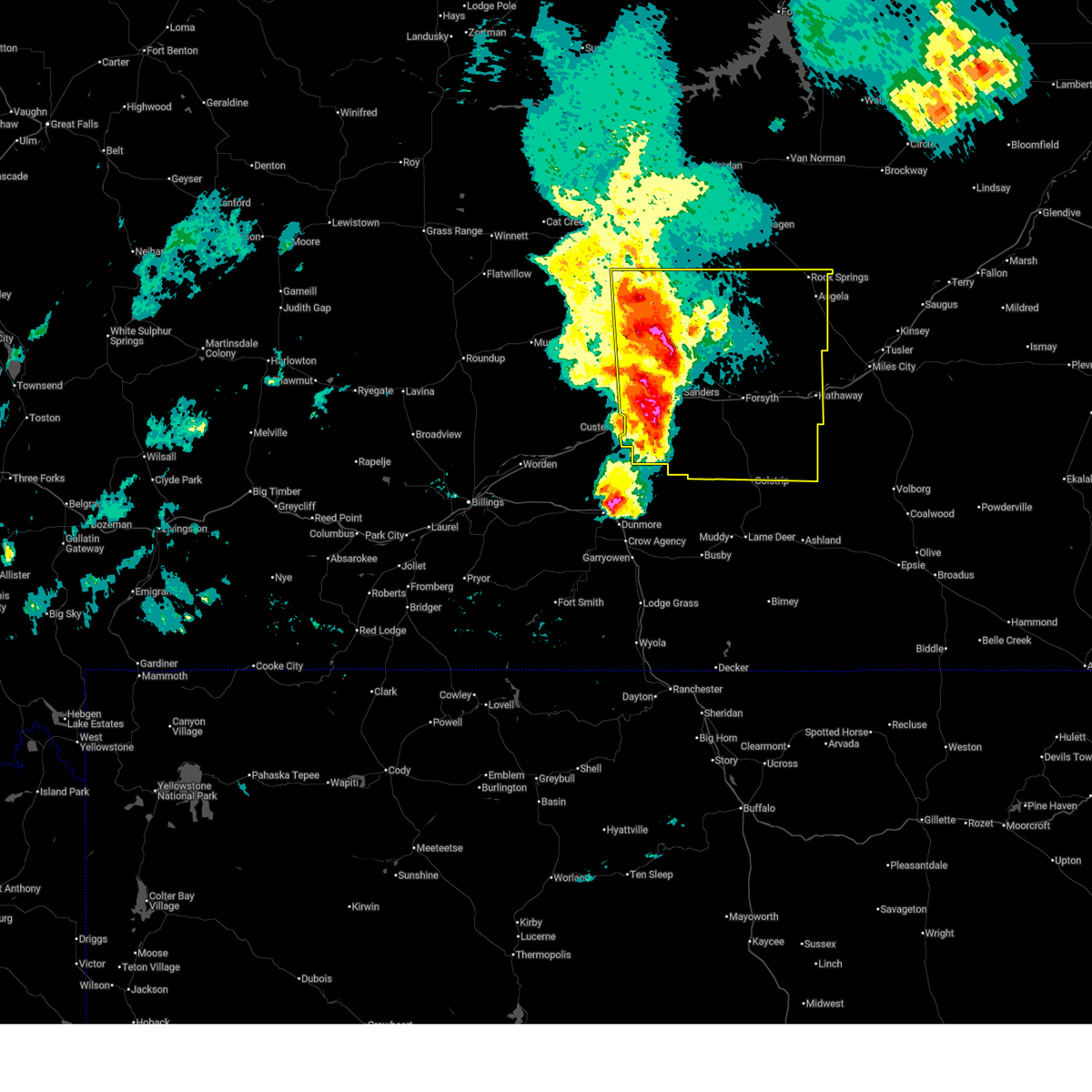
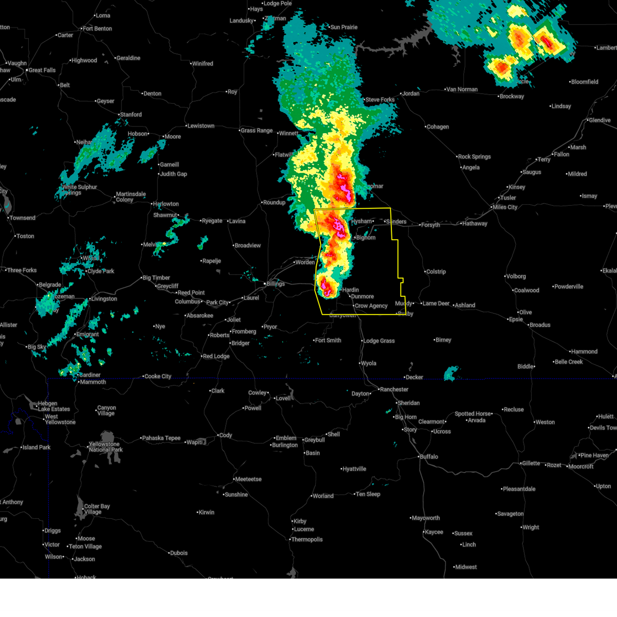
The Top Recent Hail Date for Hysham, MT is Friday, July 3, 2026 (5th out of 24)
Hail and Wind Damage Spotted near Hysham, MT
| Date / Time | Report Details |
|---|---|
| 8/7/2025 7:21 PM MDT |
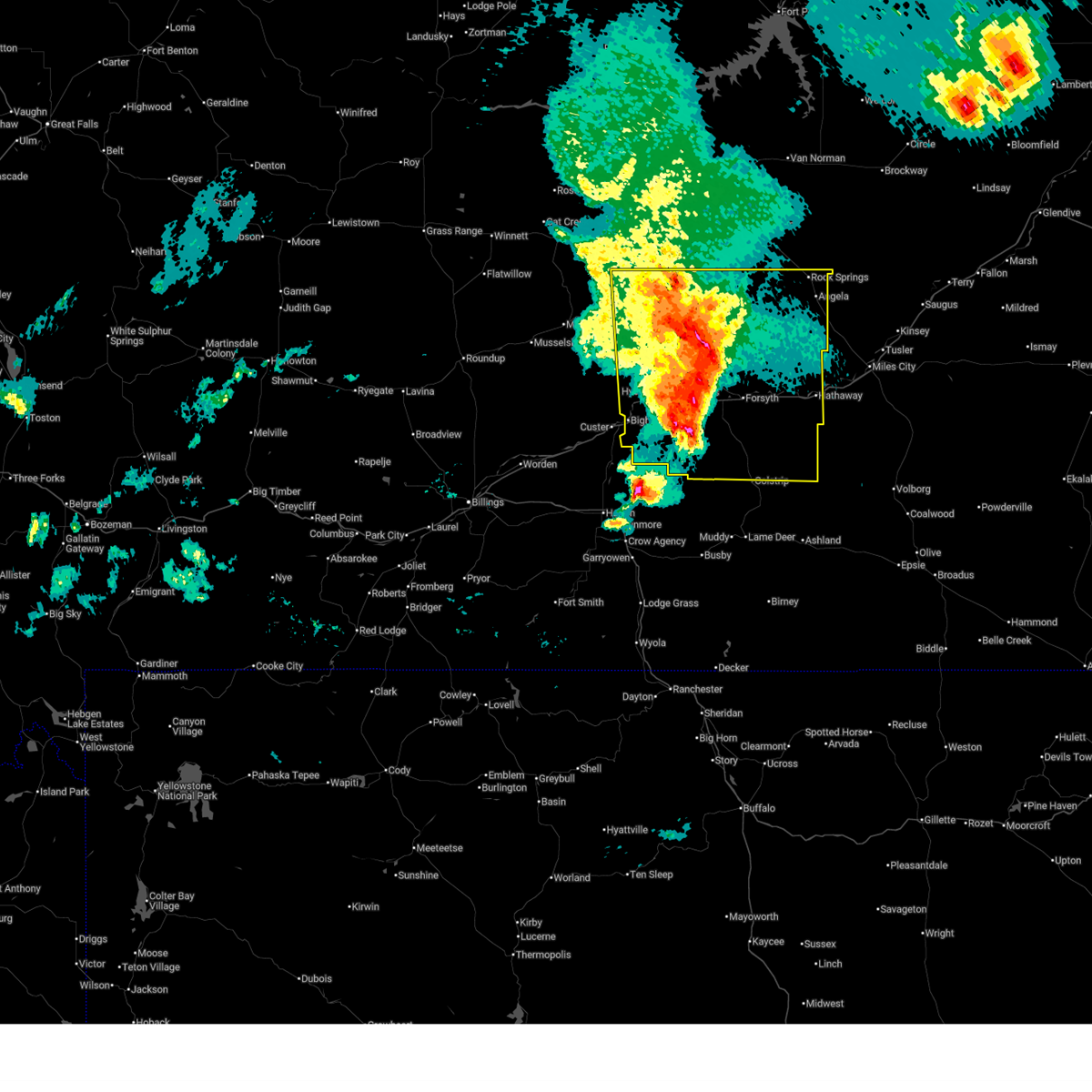 At 721 pm mdt, severe thunderstorms were located along a line from 26 miles north of hysham to 20 miles southeast of hysham, moving east at 40 mph (mesonet station south of hysham recorded a 64 mph wind gust at 610 pm). Hazards include 70 mph wind gusts and half dollar size hail. Hail damage to vehicles is expected. expect considerable tree damage. wind damage is also likely to mobile homes, roofs, and outbuildings. Locations impacted include, colstrip, forsyth, hysham, rosebud, vananda, cartersville, ingomar, hathaway, bighorn, angela and rock springs. At 721 pm mdt, severe thunderstorms were located along a line from 26 miles north of hysham to 20 miles southeast of hysham, moving east at 40 mph (mesonet station south of hysham recorded a 64 mph wind gust at 610 pm). Hazards include 70 mph wind gusts and half dollar size hail. Hail damage to vehicles is expected. expect considerable tree damage. wind damage is also likely to mobile homes, roofs, and outbuildings. Locations impacted include, colstrip, forsyth, hysham, rosebud, vananda, cartersville, ingomar, hathaway, bighorn, angela and rock springs.
|
| 8/7/2025 7:10 PM MDT | Storm damage reported in treasure county MT, 23.9 miles NNW of Hysham, MT |
| 8/7/2025 7:09 PM MDT |
 the severe thunderstorm warning has been cancelled and is no longer in effect the severe thunderstorm warning has been cancelled and is no longer in effect
|
| 8/7/2025 7:08 PM MDT |
 Svrbyz the national weather service in billings has issued a * severe thunderstorm warning for, rosebud county in southeastern montana, treasure county in southeastern montana, * until 845 pm mdt. * at 708 pm mdt, severe thunderstorms were located along a line from 25 miles north of hysham to 19 miles south of hysham, moving east at 40 mph (radar indicated). Hazards include 70 mph wind gusts and half dollar size hail. Hail damage to vehicles is expected. expect considerable tree damage. Wind damage is also likely to mobile homes, roofs, and outbuildings. Svrbyz the national weather service in billings has issued a * severe thunderstorm warning for, rosebud county in southeastern montana, treasure county in southeastern montana, * until 845 pm mdt. * at 708 pm mdt, severe thunderstorms were located along a line from 25 miles north of hysham to 19 miles south of hysham, moving east at 40 mph (radar indicated). Hazards include 70 mph wind gusts and half dollar size hail. Hail damage to vehicles is expected. expect considerable tree damage. Wind damage is also likely to mobile homes, roofs, and outbuildings.
|
| 8/7/2025 6:46 PM MDT |
 At 646 pm mdt, severe thunderstorms were located along a line from 12 miles northwest of custer to 6 miles southwest of hardin, or along a line from 21 miles west of hysham to 6 miles southwest of hardin, moving east at 40 mph (radar indicated). Hazards include 70 mph wind gusts and ping pong ball size hail. the largest hail is located along i-90 east heading towards hardin. People and animals outdoors will be injured. expect hail damage to roofs, siding, windows, and vehicles. expect considerable tree damage. wind damage is also likely to mobile homes, roofs, and outbuildings. locations impacted include, hardin, hysham, custer, crow agency, busby, bighorn, crow indian reservation and northern cheyenne indian reservation. This does not include billings. At 646 pm mdt, severe thunderstorms were located along a line from 12 miles northwest of custer to 6 miles southwest of hardin, or along a line from 21 miles west of hysham to 6 miles southwest of hardin, moving east at 40 mph (radar indicated). Hazards include 70 mph wind gusts and ping pong ball size hail. the largest hail is located along i-90 east heading towards hardin. People and animals outdoors will be injured. expect hail damage to roofs, siding, windows, and vehicles. expect considerable tree damage. wind damage is also likely to mobile homes, roofs, and outbuildings. locations impacted include, hardin, hysham, custer, crow agency, busby, bighorn, crow indian reservation and northern cheyenne indian reservation. This does not include billings.
|
| 8/7/2025 6:28 PM MDT |
 At 628 pm mdt, severe thunderstorms were located along a line from 21 miles northeast of ballantine to 21 miles north of fort smith, or along a line from 33 miles southeast of roundup to 19 miles southwest of hardin, moving east at 40 mph (radar indicated). Hazards include two inch hail and 70 mph wind gusts. the largest hail is currently located south of i-90 and 10 miles east of lockwood. People and animals outdoors will be injured. expect hail damage to roofs, siding, windows, and vehicles. expect considerable tree damage. wind damage is also likely to mobile homes, roofs, and outbuildings. locations impacted include, hardin, hysham, custer, crow agency, busby, bighorn, pompeys pillar, crow indian reservation and northern cheyenne indian reservation. This does not include billings. At 628 pm mdt, severe thunderstorms were located along a line from 21 miles northeast of ballantine to 21 miles north of fort smith, or along a line from 33 miles southeast of roundup to 19 miles southwest of hardin, moving east at 40 mph (radar indicated). Hazards include two inch hail and 70 mph wind gusts. the largest hail is currently located south of i-90 and 10 miles east of lockwood. People and animals outdoors will be injured. expect hail damage to roofs, siding, windows, and vehicles. expect considerable tree damage. wind damage is also likely to mobile homes, roofs, and outbuildings. locations impacted include, hardin, hysham, custer, crow agency, busby, bighorn, pompeys pillar, crow indian reservation and northern cheyenne indian reservation. This does not include billings.
|
| 8/7/2025 6:21 PM MDT |
 At 621 pm mdt, severe thunderstorms were located along a line from 18 miles north of ballantine to 21 miles north of fort smith, or along a line from 30 miles southeast of roundup to 24 miles west of hardin, moving east at 40 mph (radar indicated). Hazards include 70 mph wind gusts and ping pong ball size hail. the largest hail is currently located south of i-90 east of lockwood. People and animals outdoors will be injured. expect hail damage to roofs, siding, windows, and vehicles. expect considerable tree damage. wind damage is also likely to mobile homes, roofs, and outbuildings. locations impacted include, hardin, hysham, custer, crow agency, ballantine, worden, huntley, shepherd, busby, bighorn, pompeys pillar, crow indian reservation and northern cheyenne indian reservation. This does not include billings. At 621 pm mdt, severe thunderstorms were located along a line from 18 miles north of ballantine to 21 miles north of fort smith, or along a line from 30 miles southeast of roundup to 24 miles west of hardin, moving east at 40 mph (radar indicated). Hazards include 70 mph wind gusts and ping pong ball size hail. the largest hail is currently located south of i-90 east of lockwood. People and animals outdoors will be injured. expect hail damage to roofs, siding, windows, and vehicles. expect considerable tree damage. wind damage is also likely to mobile homes, roofs, and outbuildings. locations impacted include, hardin, hysham, custer, crow agency, ballantine, worden, huntley, shepherd, busby, bighorn, pompeys pillar, crow indian reservation and northern cheyenne indian reservation. This does not include billings.
|
| 8/7/2025 6:17 PM MDT |
 At 617 pm mdt, severe thunderstorms were located along a line from 16 miles north of worden to 21 miles northwest of fort smith, or along a line from 28 miles southeast of roundup to 24 miles southeast of billings, moving east at 40 mph (radar indicated). Hazards include 70 mph wind gusts and quarter size hail. Hail damage to vehicles is expected. expect considerable tree damage. wind damage is also likely to mobile homes, roofs, and outbuildings. locations impacted include, hardin, hysham, custer, crow agency, ballantine, worden, huntley, shepherd, busby, bighorn, pompeys pillar, crow indian reservation and northern cheyenne indian reservation. This does not include billings. At 617 pm mdt, severe thunderstorms were located along a line from 16 miles north of worden to 21 miles northwest of fort smith, or along a line from 28 miles southeast of roundup to 24 miles southeast of billings, moving east at 40 mph (radar indicated). Hazards include 70 mph wind gusts and quarter size hail. Hail damage to vehicles is expected. expect considerable tree damage. wind damage is also likely to mobile homes, roofs, and outbuildings. locations impacted include, hardin, hysham, custer, crow agency, ballantine, worden, huntley, shepherd, busby, bighorn, pompeys pillar, crow indian reservation and northern cheyenne indian reservation. This does not include billings.
|
| 8/7/2025 6:16 PM MDT |
 Svrbyz the national weather service in billings has issued a * severe thunderstorm warning for, north central big horn county in south central montana, central yellowstone county in south central montana, treasure county in southeastern montana, * until 715 pm mdt. * at 616 pm mdt, severe thunderstorms were located along a line from 16 miles north of worden to 21 miles northwest of fort smith, or along a line from 28 miles southeast of roundup to 24 miles southeast of billings, moving east at 40 mph (radar indicated). Hazards include 70 mph wind gusts and quarter size hail. Hail damage to vehicles is expected. expect considerable tree damage. Wind damage is also likely to mobile homes, roofs, and outbuildings. Svrbyz the national weather service in billings has issued a * severe thunderstorm warning for, north central big horn county in south central montana, central yellowstone county in south central montana, treasure county in southeastern montana, * until 715 pm mdt. * at 616 pm mdt, severe thunderstorms were located along a line from 16 miles north of worden to 21 miles northwest of fort smith, or along a line from 28 miles southeast of roundup to 24 miles southeast of billings, moving east at 40 mph (radar indicated). Hazards include 70 mph wind gusts and quarter size hail. Hail damage to vehicles is expected. expect considerable tree damage. Wind damage is also likely to mobile homes, roofs, and outbuildings.
|
| 7/5/2025 3:30 PM MDT |
 Svrbyz the national weather service in billings has issued a * severe thunderstorm warning for, northern rosebud county in southeastern montana, eastern treasure county in southeastern montana, * until 415 pm mdt. * at 330 pm mdt, severe thunderstorms were located along a line from 22 miles north of hysham to 10 miles north of colstrip, moving northeast at 40 mph (radar indicated). Hazards include 60 to 70 mph wind gusts and quarter size hail. Hail damage to vehicles is expected. expect considerable tree damage. Wind damage is also likely to mobile homes, roofs, and outbuildings. Svrbyz the national weather service in billings has issued a * severe thunderstorm warning for, northern rosebud county in southeastern montana, eastern treasure county in southeastern montana, * until 415 pm mdt. * at 330 pm mdt, severe thunderstorms were located along a line from 22 miles north of hysham to 10 miles north of colstrip, moving northeast at 40 mph (radar indicated). Hazards include 60 to 70 mph wind gusts and quarter size hail. Hail damage to vehicles is expected. expect considerable tree damage. Wind damage is also likely to mobile homes, roofs, and outbuildings.
|
| 7/5/2025 3:19 PM MDT |
 the severe thunderstorm warning has been cancelled and is no longer in effect the severe thunderstorm warning has been cancelled and is no longer in effect
|
| 7/5/2025 3:19 PM MDT |
 At 319 pm mdt, severe thunderstorms were located along a line from 18 miles north of hysham to 15 miles northwest of colstrip, moving east at 45 mph (radar indicated). Hazards include 70 mph wind gusts and quarter size hail. Hail damage to vehicles is expected. expect considerable tree damage. wind damage is also likely to mobile homes, roofs, and outbuildings. locations impacted include, hysham, vananda, bighorn and ingomar. Radar indicates the strongest winds are occurring along and south of interstate 94. At 319 pm mdt, severe thunderstorms were located along a line from 18 miles north of hysham to 15 miles northwest of colstrip, moving east at 45 mph (radar indicated). Hazards include 70 mph wind gusts and quarter size hail. Hail damage to vehicles is expected. expect considerable tree damage. wind damage is also likely to mobile homes, roofs, and outbuildings. locations impacted include, hysham, vananda, bighorn and ingomar. Radar indicates the strongest winds are occurring along and south of interstate 94.
|
| 7/5/2025 3:15 PM MDT | Storm damage reported in treasure county MT, 9.9 miles NNE of Hysham, MT |
| 7/5/2025 2:57 PM MDT |
 At 257 pm mdt, severe thunderstorms were located along a line from 16 miles southeast of melstone to 24 miles northeast of crow agency, moving east at 45 mph (radar indicated). Hazards include 70 mph wind gusts and quarter size hail. Hail damage to vehicles is expected. expect considerable tree damage. wind damage is also likely to mobile homes, roofs, and outbuildings. locations impacted include, hardin, hysham, custer, bighorn, vananda, ingomar and crow indian reservation. Radar indicates the strongest winds are occurring near and south of custer and bighorn, montana. At 257 pm mdt, severe thunderstorms were located along a line from 16 miles southeast of melstone to 24 miles northeast of crow agency, moving east at 45 mph (radar indicated). Hazards include 70 mph wind gusts and quarter size hail. Hail damage to vehicles is expected. expect considerable tree damage. wind damage is also likely to mobile homes, roofs, and outbuildings. locations impacted include, hardin, hysham, custer, bighorn, vananda, ingomar and crow indian reservation. Radar indicates the strongest winds are occurring near and south of custer and bighorn, montana.
|
| 7/5/2025 2:31 PM MDT |
 Svrbyz the national weather service in billings has issued a * severe thunderstorm warning for, southeastern musselshell county in central montana, north central big horn county in south central montana, northeastern yellowstone county in south central montana, northern rosebud county in southeastern montana, treasure county in southeastern montana, * until 330 pm mdt. * at 231 pm mdt, severe thunderstorms were located along a line from 16 miles south of melstone to near hardin, moving east at 45 mph (radar indicated). Hazards include 60 to 70 mph wind gusts and quarter size hail. Hail damage to vehicles is expected. Expect wind damage to roofs, siding, and trees. Svrbyz the national weather service in billings has issued a * severe thunderstorm warning for, southeastern musselshell county in central montana, north central big horn county in south central montana, northeastern yellowstone county in south central montana, northern rosebud county in southeastern montana, treasure county in southeastern montana, * until 330 pm mdt. * at 231 pm mdt, severe thunderstorms were located along a line from 16 miles south of melstone to near hardin, moving east at 45 mph (radar indicated). Hazards include 60 to 70 mph wind gusts and quarter size hail. Hail damage to vehicles is expected. Expect wind damage to roofs, siding, and trees.
|
| 6/15/2025 9:28 PM MDT |
 the severe thunderstorm warning has been cancelled and is no longer in effect the severe thunderstorm warning has been cancelled and is no longer in effect
|
| 6/15/2025 9:03 PM MDT |
 Svrbyz the national weather service in billings has issued a * severe thunderstorm warning for, eastern musselshell county in central montana, northeastern yellowstone county in south central montana, northern rosebud county in southeastern montana, northern treasure county in southeastern montana, * until 1000 pm mdt. * at 903 pm mdt, severe thunderstorms were located along a line from 11 miles north of melstone to 15 miles west of custer, or along a line from 37 miles northeast of roundup to 30 miles west of hysham, moving east at 40 mph (radar indicated). Hazards include 60 mph wind gusts and quarter size hail. Hail damage to vehicles is expected. Expect wind damage to roofs, siding, and trees. Svrbyz the national weather service in billings has issued a * severe thunderstorm warning for, eastern musselshell county in central montana, northeastern yellowstone county in south central montana, northern rosebud county in southeastern montana, northern treasure county in southeastern montana, * until 1000 pm mdt. * at 903 pm mdt, severe thunderstorms were located along a line from 11 miles north of melstone to 15 miles west of custer, or along a line from 37 miles northeast of roundup to 30 miles west of hysham, moving east at 40 mph (radar indicated). Hazards include 60 mph wind gusts and quarter size hail. Hail damage to vehicles is expected. Expect wind damage to roofs, siding, and trees.
|
| 8/4/2024 9:27 PM MDT |
 Svrbyz the national weather service in billings has issued a * severe thunderstorm warning for, northeastern big horn county in south central montana, rosebud county in southeastern montana, treasure county in southeastern montana, * until 1030 pm mdt. * at 926 pm mdt, severe thunderstorms were located along a line extending from near hysham to 17 miles west of colstrip to busby, moving east at 40 mph (radar indicated). Hazards include 60 mph wind gusts. expect damage to roofs, siding, and trees Svrbyz the national weather service in billings has issued a * severe thunderstorm warning for, northeastern big horn county in south central montana, rosebud county in southeastern montana, treasure county in southeastern montana, * until 1030 pm mdt. * at 926 pm mdt, severe thunderstorms were located along a line extending from near hysham to 17 miles west of colstrip to busby, moving east at 40 mph (radar indicated). Hazards include 60 mph wind gusts. expect damage to roofs, siding, and trees
|
| 8/4/2024 9:04 PM MDT |
 At 904 pm mdt, severe thunderstorms were located along a line extending from 8 miles north of custer to 17 miles northeast of hardin to 11 miles southeast of crow agency, moving east at 40 mph (radar indicated). Hazards include 60 mph wind gusts. Expect damage to roofs, siding, and trees. Locations impacted include, hysham, custer, crow agency, busby, bighorn, northern cheyenne indian reservation, and crow indian reservation. At 904 pm mdt, severe thunderstorms were located along a line extending from 8 miles north of custer to 17 miles northeast of hardin to 11 miles southeast of crow agency, moving east at 40 mph (radar indicated). Hazards include 60 mph wind gusts. Expect damage to roofs, siding, and trees. Locations impacted include, hysham, custer, crow agency, busby, bighorn, northern cheyenne indian reservation, and crow indian reservation.
|
| 8/4/2024 8:41 PM MDT |
 Svrbyz the national weather service in billings has issued a * severe thunderstorm warning for, north central big horn county in south central montana, northeastern yellowstone county in south central montana, treasure county in southeastern montana, * until 930 pm mdt. * at 840 pm mdt, severe thunderstorms were located along a line extending from 17 miles west of custer to 6 miles north of hardin to 11 miles southwest of crow agency, moving east at 40 mph (radar indicated). Hazards include 60 mph wind gusts. expect damage to roofs, siding, and trees Svrbyz the national weather service in billings has issued a * severe thunderstorm warning for, north central big horn county in south central montana, northeastern yellowstone county in south central montana, treasure county in southeastern montana, * until 930 pm mdt. * at 840 pm mdt, severe thunderstorms were located along a line extending from 17 miles west of custer to 6 miles north of hardin to 11 miles southwest of crow agency, moving east at 40 mph (radar indicated). Hazards include 60 mph wind gusts. expect damage to roofs, siding, and trees
|
| 6/30/2024 8:37 PM MDT | Golf Ball sized hail reported 2.9 miles W of Hysham, MT, hail up to golf balls with 60 mph winds estimated. |
| 6/30/2024 8:30 PM MDT | Quarter sized hail reported 2.9 miles WSW of Hysham, MT, dime to quarter size hail. very heavy rainfall. |
| 6/30/2024 8:21 PM MDT |
 Svrbyz the national weather service in billings has issued a * severe thunderstorm warning for, north central rosebud county in southeastern montana, northeastern treasure county in southeastern montana, * until 845 pm mdt. * at 821 pm mdt, a severe thunderstorm was located over hysham, moving northeast at 35 mph (radar indicated). Hazards include 60 mph wind gusts and quarter size hail. Hail damage to vehicles is expected. Expect wind damage to roofs, siding, and trees. Svrbyz the national weather service in billings has issued a * severe thunderstorm warning for, north central rosebud county in southeastern montana, northeastern treasure county in southeastern montana, * until 845 pm mdt. * at 821 pm mdt, a severe thunderstorm was located over hysham, moving northeast at 35 mph (radar indicated). Hazards include 60 mph wind gusts and quarter size hail. Hail damage to vehicles is expected. Expect wind damage to roofs, siding, and trees.
|
| 6/27/2024 3:01 PM MDT |
 The storm which prompted the warning has weakened below severe limits, and has exited the warned area. therefore, the warning has been allowed to expire. a severe thunderstorm watch remains in effect until 800 pm mdt for south central and southeastern montana. The storm which prompted the warning has weakened below severe limits, and has exited the warned area. therefore, the warning has been allowed to expire. a severe thunderstorm watch remains in effect until 800 pm mdt for south central and southeastern montana.
|
| 6/27/2024 2:47 PM MDT |
 At 244 pm mdt, a severe thunderstorm was located near hysham, moving east at 45 mph (radar indicated). Hazards include 60 mph wind gusts and quarter size hail. Hail damage to vehicles is expected. expect wind damage to roofs, siding, and trees. locations impacted include, hysham and bighorn. Motorists on i-94 around bighorn and hysham should prepare for rapidly changing conditions. At 244 pm mdt, a severe thunderstorm was located near hysham, moving east at 45 mph (radar indicated). Hazards include 60 mph wind gusts and quarter size hail. Hail damage to vehicles is expected. expect wind damage to roofs, siding, and trees. locations impacted include, hysham and bighorn. Motorists on i-94 around bighorn and hysham should prepare for rapidly changing conditions.
|
| 6/27/2024 2:47 PM MDT |
 the severe thunderstorm warning has been cancelled and is no longer in effect the severe thunderstorm warning has been cancelled and is no longer in effect
|
| 6/27/2024 2:25 PM MDT |
 At 223 pm mdt, a severe thunderstorm was located near custer, or 20 miles west of hysham, moving east at 45 mph (radar indicated). Hazards include 60 mph wind gusts and quarter size hail. Hail damage to vehicles is expected. expect wind damage to roofs, siding, and trees. locations impacted include, hysham, custer, and bighorn. motorists on i-94 around custer, bighorn, and hysham should prepare for rapidly changing conditions. This warning does not include the city of billings. At 223 pm mdt, a severe thunderstorm was located near custer, or 20 miles west of hysham, moving east at 45 mph (radar indicated). Hazards include 60 mph wind gusts and quarter size hail. Hail damage to vehicles is expected. expect wind damage to roofs, siding, and trees. locations impacted include, hysham, custer, and bighorn. motorists on i-94 around custer, bighorn, and hysham should prepare for rapidly changing conditions. This warning does not include the city of billings.
|
| 6/27/2024 2:07 PM MDT |
 Svrbyz the national weather service in billings has issued a * severe thunderstorm warning for, northeastern yellowstone county in south central montana, treasure county in southeastern montana, * until 300 pm mdt. * at 207 pm mdt, a severe thunderstorm was located 15 miles west of custer, or 32 miles west of hysham, moving east at 45 mph (radar indicated). Hazards include 60 mph wind gusts and quarter size hail. Hail damage to vehicles is expected. Expect wind damage to roofs, siding, and trees. Svrbyz the national weather service in billings has issued a * severe thunderstorm warning for, northeastern yellowstone county in south central montana, treasure county in southeastern montana, * until 300 pm mdt. * at 207 pm mdt, a severe thunderstorm was located 15 miles west of custer, or 32 miles west of hysham, moving east at 45 mph (radar indicated). Hazards include 60 mph wind gusts and quarter size hail. Hail damage to vehicles is expected. Expect wind damage to roofs, siding, and trees.
|
| 8/30/2023 5:10 PM MDT | Storm damage reported in treasure county MT, 9.9 miles NNE of Hysham, MT |
| 8/21/2023 11:31 PM MDT |
 At 1129 pm mdt, a severe thunderstorm was located near hysham, moving northeast at 55 mph (radar indicated). Hazards include 70 mph wind gusts. Expect considerable tree damage. damage is likely to mobile homes, roofs, and outbuildings. locations impacted include, hysham. thunderstorm damage threat, considerable hail threat, radar indicated max hail size, <. 75 in wind threat, radar indicated max wind gust, 70 mph. At 1129 pm mdt, a severe thunderstorm was located near hysham, moving northeast at 55 mph (radar indicated). Hazards include 70 mph wind gusts. Expect considerable tree damage. damage is likely to mobile homes, roofs, and outbuildings. locations impacted include, hysham. thunderstorm damage threat, considerable hail threat, radar indicated max hail size, <. 75 in wind threat, radar indicated max wind gust, 70 mph.
|
| 8/21/2023 11:08 PM MDT |
 At 1105 pm mdt, a severe thunderstorm was located near custer, or 17 miles southwest of hysham, moving northeast at 55 mph (radar indicated. at 10:20 pm, billings airport weather station reported a gust of 59 mph). Hazards include 70 mph wind gusts. Expect considerable tree damage. Damage is likely to mobile homes, roofs, and outbuildings. At 1105 pm mdt, a severe thunderstorm was located near custer, or 17 miles southwest of hysham, moving northeast at 55 mph (radar indicated. at 10:20 pm, billings airport weather station reported a gust of 59 mph). Hazards include 70 mph wind gusts. Expect considerable tree damage. Damage is likely to mobile homes, roofs, and outbuildings.
|
| 7/9/2022 9:11 PM MDT |
 At 909 pm mdt, a severe thunderstorm was located 10 miles southeast of melstone, or 26 miles northwest of hysham, moving east at 45 mph (radar indicated. at 903 pm golfball size hail was reported 6 miles west of melstone). Hazards include golf ball size hail and 60 mph wind gusts. People and animals outdoors will be injured. expect hail and wind damage to roofs, siding, windows, and vehicles. locations impacted include, hysham, melstone and ingomar. thunderstorm damage threat, considerable hail threat, observed max hail size, 1. 75 in wind threat, radar indicated max wind gust, 60 mph. At 909 pm mdt, a severe thunderstorm was located 10 miles southeast of melstone, or 26 miles northwest of hysham, moving east at 45 mph (radar indicated. at 903 pm golfball size hail was reported 6 miles west of melstone). Hazards include golf ball size hail and 60 mph wind gusts. People and animals outdoors will be injured. expect hail and wind damage to roofs, siding, windows, and vehicles. locations impacted include, hysham, melstone and ingomar. thunderstorm damage threat, considerable hail threat, observed max hail size, 1. 75 in wind threat, radar indicated max wind gust, 60 mph.
|
| 7/9/2022 8:59 PM MDT |
 At 859 pm mdt, a severe thunderstorm was located near melstone, or 31 miles east of roundup, moving east at 40 mph (radar indicated). Hazards include 60 mph wind gusts and half dollar size hail. Hail damage to vehicles is expected. expect wind damage to roofs, siding, and trees. this severe thunderstorm will remain over mainly rural areas of east central musselshell, northeastern yellowstone, northern rosebud and northwestern treasure counties, including the following locations, ingomar. this warning does not include the city of billings. hail threat, radar indicated max hail size, 1. 25 in wind threat, radar indicated max wind gust, 60 mph. At 859 pm mdt, a severe thunderstorm was located near melstone, or 31 miles east of roundup, moving east at 40 mph (radar indicated). Hazards include 60 mph wind gusts and half dollar size hail. Hail damage to vehicles is expected. expect wind damage to roofs, siding, and trees. this severe thunderstorm will remain over mainly rural areas of east central musselshell, northeastern yellowstone, northern rosebud and northwestern treasure counties, including the following locations, ingomar. this warning does not include the city of billings. hail threat, radar indicated max hail size, 1. 25 in wind threat, radar indicated max wind gust, 60 mph.
|
| 6/11/2022 4:21 PM MDT | Storm damage reported in treasure county MT, 9.9 miles NNE of Hysham, MT |
| 7/6/2021 7:25 PM MDT | Quarter sized hail reported 26.4 miles NNW of Hysham, MT |
| 7/6/2021 6:38 PM MDT | Golf Ball sized hail reported 12.3 miles NE of Hysham, MT |
| 7/7/2020 6:39 PM MDT |
 The severe thunderstorm warning for northeastern big horn, rosebud and treasure counties will expire at 645 pm mdt, the storms which prompted the warning have weakened below severe limits, and no longer pose an immediate threat to life or property. therefore, the warning will be allowed to expire. however gusty winds are still possible with these thunderstorms. a severe thunderstorm watch remains in effect until 900 pm mdt for south central and southeastern montana. The severe thunderstorm warning for northeastern big horn, rosebud and treasure counties will expire at 645 pm mdt, the storms which prompted the warning have weakened below severe limits, and no longer pose an immediate threat to life or property. therefore, the warning will be allowed to expire. however gusty winds are still possible with these thunderstorms. a severe thunderstorm watch remains in effect until 900 pm mdt for south central and southeastern montana.
|
| 7/7/2020 6:14 PM MDT |
 At 613 pm mdt, severe thunderstorms were located along a line extending from 16 miles southwest of cohagen to 13 miles northwest of busby, moving east at 40 mph (radar indicated). Hazards include 60 mph wind gusts and nickel size hail. Expect damage to roofs, siding, and trees. Locations impacted include, colstrip, forsyth, hysham, lame deer, rosebud, vananda, bighorn, rock springs, ingomar, cartersville, muddy cluster and northern cheyenne indian reservation. At 613 pm mdt, severe thunderstorms were located along a line extending from 16 miles southwest of cohagen to 13 miles northwest of busby, moving east at 40 mph (radar indicated). Hazards include 60 mph wind gusts and nickel size hail. Expect damage to roofs, siding, and trees. Locations impacted include, colstrip, forsyth, hysham, lame deer, rosebud, vananda, bighorn, rock springs, ingomar, cartersville, muddy cluster and northern cheyenne indian reservation.
|
| 7/7/2020 5:41 PM MDT |
 At 539 pm mdt, severe thunderstorms were located along a line extending from 18 miles south of edwards to hardin, moving east at 40 mph (radar indicated). Hazards include 70 mph wind gusts and quarter size hail. Hail damage to vehicles is expected. expect considerable tree damage. Wind damage is also likely to mobile homes, roofs, and outbuildings. At 539 pm mdt, severe thunderstorms were located along a line extending from 18 miles south of edwards to hardin, moving east at 40 mph (radar indicated). Hazards include 70 mph wind gusts and quarter size hail. Hail damage to vehicles is expected. expect considerable tree damage. Wind damage is also likely to mobile homes, roofs, and outbuildings.
|
| 7/6/2020 3:50 PM MDT | Hen Egg sized hail reported 6.2 miles W of Hysham, MT, property damage |
| 7/6/2020 3:50 PM MDT | Quarter sized hail reported 8.8 miles WSW of Hysham, MT |
| 7/6/2020 3:50 PM MDT | Golf Ball sized hail reported 6.7 miles W of Hysham, MT |
| 7/6/2020 3:26 PM MDT |
 At 325 pm mdt, a severe thunderstorm was located 7 miles northwest of hysham, moving east at 35 mph (trained weather spotters. at 250 pm mdt, golf ball sized hail was reported 8 miles south southwest of melstone). Hazards include golf ball size hail and 60 mph wind gusts. People and animals outdoors will be injured. expect hail damage to roofs, siding, windows, and vehicles. expect wind damage to roofs, siding, and trees. Locations impacted include, hysham and vananda. At 325 pm mdt, a severe thunderstorm was located 7 miles northwest of hysham, moving east at 35 mph (trained weather spotters. at 250 pm mdt, golf ball sized hail was reported 8 miles south southwest of melstone). Hazards include golf ball size hail and 60 mph wind gusts. People and animals outdoors will be injured. expect hail damage to roofs, siding, windows, and vehicles. expect wind damage to roofs, siding, and trees. Locations impacted include, hysham and vananda.
|
| 7/6/2020 2:54 PM MDT |
 At 254 pm mdt, a severe thunderstorm was located 14 miles southeast of melstone, or 24 miles west of hysham, moving east at 35 mph (trained weather spotters. at 242 pm mdt, golf ball sized hail was reported near musselshell). Hazards include golf ball size hail and 60 mph wind gusts. People and animals outdoors will be injured. expect hail damage to roofs, siding, windows, and vehicles. Expect wind damage to roofs, siding, and trees. At 254 pm mdt, a severe thunderstorm was located 14 miles southeast of melstone, or 24 miles west of hysham, moving east at 35 mph (trained weather spotters. at 242 pm mdt, golf ball sized hail was reported near musselshell). Hazards include golf ball size hail and 60 mph wind gusts. People and animals outdoors will be injured. expect hail damage to roofs, siding, windows, and vehicles. Expect wind damage to roofs, siding, and trees.
|
| 8/11/2019 8:39 PM MDT |
 At 836 pm mdt, severe thunderstorms were located along a line extending from 12 miles southwest of hillside to 6 miles south of crow agency, moving east at 30 mph. another severe thunderstorm was located 5 miles east of muddy moving northeast at 20 mph (radar indicated). Hazards include ping pong ball size hail and 60 mph wind gusts. People and animals outdoors will be injured. expect hail damage to roofs, siding, windows, and vehicles. expect wind damage to roofs, siding, and trees. Locations impacted include, hardin, colstrip, forsyth, hysham, lame deer, busby, crow agency, rosebud, cartersville, birney village, vananda, muddy cluster, northern cheyenne indian reservation and crow indian reservation. At 836 pm mdt, severe thunderstorms were located along a line extending from 12 miles southwest of hillside to 6 miles south of crow agency, moving east at 30 mph. another severe thunderstorm was located 5 miles east of muddy moving northeast at 20 mph (radar indicated). Hazards include ping pong ball size hail and 60 mph wind gusts. People and animals outdoors will be injured. expect hail damage to roofs, siding, windows, and vehicles. expect wind damage to roofs, siding, and trees. Locations impacted include, hardin, colstrip, forsyth, hysham, lame deer, busby, crow agency, rosebud, cartersville, birney village, vananda, muddy cluster, northern cheyenne indian reservation and crow indian reservation.
|
| 8/11/2019 8:16 PM MDT |
 At 814 pm mdt, severe thunderstorms were located along a line extending from 17 miles southwest of cohagen to 11 miles west of crow agency, moving east at 30 mph. another severe thunderstorm was located 5 miles east of busby, moving east at 20 mph (radar indicated. these storms have a history of producing large hail and damaging winds). Hazards include 70 mph wind gusts and ping pong ball size hail. People and animals outdoors will be injured. expect hail damage to roofs, siding, windows, and vehicles. expect considerable tree damage. wind damage is also likely to mobile homes, roofs, and outbuildings. Locations impacted include, hardin, colstrip, forsyth, hysham, custer, lame deer, busby, crow agency, rosebud, bighorn, ingomar, cartersville, birney village, vananda, muddy cluster, northern cheyenne indian reservation and crow indian reservation. At 814 pm mdt, severe thunderstorms were located along a line extending from 17 miles southwest of cohagen to 11 miles west of crow agency, moving east at 30 mph. another severe thunderstorm was located 5 miles east of busby, moving east at 20 mph (radar indicated. these storms have a history of producing large hail and damaging winds). Hazards include 70 mph wind gusts and ping pong ball size hail. People and animals outdoors will be injured. expect hail damage to roofs, siding, windows, and vehicles. expect considerable tree damage. wind damage is also likely to mobile homes, roofs, and outbuildings. Locations impacted include, hardin, colstrip, forsyth, hysham, custer, lame deer, busby, crow agency, rosebud, bighorn, ingomar, cartersville, birney village, vananda, muddy cluster, northern cheyenne indian reservation and crow indian reservation.
|
| 8/11/2019 8:02 PM MDT |
 At 801 pm mdt, severe thunderstorms were located along a line extending from 20 miles southwest of cohagen to 13 miles southwest of hardin, moving east at 30 mph. another severe thunderstorm was located near busby, moving north at 25 mph (radar indicated). Hazards include golf ball size hail and 70 mph wind gusts. People and animals outdoors will be injured. expect hail damage to roofs, siding, windows, and vehicles. expect considerable tree damage. Wind damage is also likely to mobile homes, roofs, and outbuildings. At 801 pm mdt, severe thunderstorms were located along a line extending from 20 miles southwest of cohagen to 13 miles southwest of hardin, moving east at 30 mph. another severe thunderstorm was located near busby, moving north at 25 mph (radar indicated). Hazards include golf ball size hail and 70 mph wind gusts. People and animals outdoors will be injured. expect hail damage to roofs, siding, windows, and vehicles. expect considerable tree damage. Wind damage is also likely to mobile homes, roofs, and outbuildings.
|
| 7/1/2019 6:11 PM MDT |
 At 611 pm mdt, a severe thunderstorm was located 17 miles northwest of hysham, moving southeast at 30 mph (radar indicated). Hazards include 60 mph wind gusts and quarter size hail. Hail damage to vehicles is expected. Expect wind damage to roofs, siding, and trees. At 611 pm mdt, a severe thunderstorm was located 17 miles northwest of hysham, moving southeast at 30 mph (radar indicated). Hazards include 60 mph wind gusts and quarter size hail. Hail damage to vehicles is expected. Expect wind damage to roofs, siding, and trees.
|
| 7/2/2018 8:42 PM MDT |
 At 840 pm mdt, a severe thunderstorm was located near hysham, moving northeast at 35 mph (trained weather spotters reported quarter to golf ball size hail near myers with this storm). Hazards include 60 mph wind gusts and half dollar size hail. Hail damage to vehicles is expected. expect wind damage to roofs, siding, and trees. Locations impacted include, hysham. At 840 pm mdt, a severe thunderstorm was located near hysham, moving northeast at 35 mph (trained weather spotters reported quarter to golf ball size hail near myers with this storm). Hazards include 60 mph wind gusts and half dollar size hail. Hail damage to vehicles is expected. expect wind damage to roofs, siding, and trees. Locations impacted include, hysham.
|
| 7/2/2018 8:32 PM MDT | Golf Ball sized hail reported 7.4 miles NE of Hysham, MT, hail from the size of quarters to golf balls. |
| 7/2/2018 8:28 PM MDT |
 At 827 pm mdt, a severe thunderstorm was located 9 miles southwest of hysham, moving northeast at 35 mph (radar indicated). Hazards include 60 mph wind gusts and quarter size hail. hail may pile up and cause slick roads. Hail damage to vehicles is expected. Expect wind damage to roofs, siding, and trees. At 827 pm mdt, a severe thunderstorm was located 9 miles southwest of hysham, moving northeast at 35 mph (radar indicated). Hazards include 60 mph wind gusts and quarter size hail. hail may pile up and cause slick roads. Hail damage to vehicles is expected. Expect wind damage to roofs, siding, and trees.
|
| 6/19/2018 4:24 PM MDT | Quarter sized hail reported 5.7 miles N of Hysham, MT, quarter size hail covering interstate 94 in hysham hills mp 61-64 reportedly like a sheet of ice. |
| 6/19/2018 3:56 PM MDT |
 At 354 pm mdt, a severe thunderstorm was located 5 miles southwest of hysham, moving slowly southeast at 10 mph (radar indicated). Hazards include 60 mph wind gusts and quarter size hail, along with very heavy rain. flash flooding is possible due to the heavy rainfall. Hail damage to vehicles is expected. expect wind damage to roofs, siding, and trees. Travel on i-94 will be impacted. At 354 pm mdt, a severe thunderstorm was located 5 miles southwest of hysham, moving slowly southeast at 10 mph (radar indicated). Hazards include 60 mph wind gusts and quarter size hail, along with very heavy rain. flash flooding is possible due to the heavy rainfall. Hail damage to vehicles is expected. expect wind damage to roofs, siding, and trees. Travel on i-94 will be impacted.
|
| 6/7/2018 6:12 PM MDT |
 The severe thunderstorm warning for northeastern big horn and treasure counties will expire at 615 pm mdt, the storm which prompted the warning has moved out of the area. therefore, the warning will be allowed to expire. a severe thunderstorm watch remains in effect until 1100 pm mdt for south central and southeastern montana. The severe thunderstorm warning for northeastern big horn and treasure counties will expire at 615 pm mdt, the storm which prompted the warning has moved out of the area. therefore, the warning will be allowed to expire. a severe thunderstorm watch remains in effect until 1100 pm mdt for south central and southeastern montana.
|
| 6/7/2018 5:42 PM MDT |
 At 541 pm mdt, a severe thunderstorm was located 10 miles southwest of hysham, moving east at 25 mph (trained weather spotters). Hazards include half dollar size hail. Damage to vehicles is expected. Locations impacted include, hysham. At 541 pm mdt, a severe thunderstorm was located 10 miles southwest of hysham, moving east at 25 mph (trained weather spotters). Hazards include half dollar size hail. Damage to vehicles is expected. Locations impacted include, hysham.
|
| 6/7/2018 5:35 PM MDT | Half Dollar sized hail reported 24.7 miles N of Hysham, MT |
| 6/7/2018 5:27 PM MDT |
 At 526 pm mdt, a line of severe thunderstorm was located in the custer area, or 14 miles southwest of hysham, moving east at 20 mph (radar indicated). Hazards include 60 mph wind gusts and half dollar size hail. Hail damage to vehicles is expected. Expect wind damage to roofs, siding, and trees. At 526 pm mdt, a line of severe thunderstorm was located in the custer area, or 14 miles southwest of hysham, moving east at 20 mph (radar indicated). Hazards include 60 mph wind gusts and half dollar size hail. Hail damage to vehicles is expected. Expect wind damage to roofs, siding, and trees.
|
| 5/23/2018 7:11 PM MDT |
 The severe thunderstorm warning for northern rosebud and northeastern treasure counties will expire at 715 pm mdt. the storm which prompted the warning has weakened below severe limits, and no longer poses an immediate threat to life or property. therefore, the warning will be allowed to expire. However small hail, gusty winds and heavy rain are still possible with this. The severe thunderstorm warning for northern rosebud and northeastern treasure counties will expire at 715 pm mdt. the storm which prompted the warning has weakened below severe limits, and no longer poses an immediate threat to life or property. therefore, the warning will be allowed to expire. However small hail, gusty winds and heavy rain are still possible with this.
|
| 5/23/2018 6:57 PM MDT |
 A severe thunderstorm warning remains in effect until 715 pm mdt for northern rosebud and northeastern treasure counties. at 656 pm mdt, a severe thunderstorm was located near hysham, moving north at 30 mph. hazard. 60 mph wind gusts and quarter size hail. source. Trained weather spotters reported quarter size hail east of. A severe thunderstorm warning remains in effect until 715 pm mdt for northern rosebud and northeastern treasure counties. at 656 pm mdt, a severe thunderstorm was located near hysham, moving north at 30 mph. hazard. 60 mph wind gusts and quarter size hail. source. Trained weather spotters reported quarter size hail east of.
|
| 5/23/2018 6:45 PM MDT | Quarter sized hail reported 4.8 miles W of Hysham, MT |
| 5/23/2018 6:30 PM MDT |
 At 629 pm mdt, a severe thunderstorm was located 11 miles southwest of hysham, moving north at 30 mph (radar indicated). Hazards include 60 mph wind gusts and quarter size hail. Hail damage to vehicles is expected. expect wind damage to roofs, siding, and trees. Locations impacted include, hysham, ingomar, vananda and bighorn. At 629 pm mdt, a severe thunderstorm was located 11 miles southwest of hysham, moving north at 30 mph (radar indicated). Hazards include 60 mph wind gusts and quarter size hail. Hail damage to vehicles is expected. expect wind damage to roofs, siding, and trees. Locations impacted include, hysham, ingomar, vananda and bighorn.
|
| 5/23/2018 6:12 PM MDT |
 At 611 pm mdt, a severe thunderstorm was located near custer, or 15 miles southwest of hysham, moving north northeast at 30 mph (radar indicated). Hazards include 60 mph wind gusts and quarter size hail. Hail damage to vehicles is expected. Expect wind damage to roofs, siding, and trees. At 611 pm mdt, a severe thunderstorm was located near custer, or 15 miles southwest of hysham, moving north northeast at 30 mph (radar indicated). Hazards include 60 mph wind gusts and quarter size hail. Hail damage to vehicles is expected. Expect wind damage to roofs, siding, and trees.
|
| 8/1/2017 10:29 PM MDT |
 At 1028 pm mdt, a severe thunderstorm was located 10 miles north of hardin, moving southeast at 25 mph (radar indicated). Hazards include 60 mph wind gusts and quarter size hail. Hail damage to vehicles is expected. expect wind damage to roofs, siding, and trees. this warning does not include the city of billings. Locations impacted include, hysham, vananda and bighorn. At 1028 pm mdt, a severe thunderstorm was located 10 miles north of hardin, moving southeast at 25 mph (radar indicated). Hazards include 60 mph wind gusts and quarter size hail. Hail damage to vehicles is expected. expect wind damage to roofs, siding, and trees. this warning does not include the city of billings. Locations impacted include, hysham, vananda and bighorn.
|
| 8/1/2017 10:00 PM MDT |
 At 959 pm mdt, a severe thunderstorm was located 11 miles west of custer, or 26 miles north of hardin, moving southeast at 20 mph (radar indicated). Hazards include 60 mph wind gusts and quarter size hail. Hail damage to vehicles is expected. Expect wind damage to roofs, siding, and trees. At 959 pm mdt, a severe thunderstorm was located 11 miles west of custer, or 26 miles north of hardin, moving southeast at 20 mph (radar indicated). Hazards include 60 mph wind gusts and quarter size hail. Hail damage to vehicles is expected. Expect wind damage to roofs, siding, and trees.
|
| 7/10/2017 4:45 PM MDT | Storm damage reported in treasure county MT, 9.9 miles NNE of Hysham, MT |
| 7/6/2017 6:19 PM MDT |
 At 616 pm mdt, severe thunderstorm wind gusts were located along a line extending from 9 miles east of melstone to near hardin to 7 miles southwest of fort smith, moving east at 40 mph (radar indicated). Hazards include 60 mph wind gusts. Expect damage to roofs, siding, and trees. a severe thunderstorm was also located near saint xavier moving east at 20 mph. this storm was producing quarter size hail in addition to damaging wind gusts. locations impacted include, hardin, hysham, custer, melstone, fort smith, crow agency, st. Xavier, bighorn, ingomar, pompeys pillar and crow indian reservation. At 616 pm mdt, severe thunderstorm wind gusts were located along a line extending from 9 miles east of melstone to near hardin to 7 miles southwest of fort smith, moving east at 40 mph (radar indicated). Hazards include 60 mph wind gusts. Expect damage to roofs, siding, and trees. a severe thunderstorm was also located near saint xavier moving east at 20 mph. this storm was producing quarter size hail in addition to damaging wind gusts. locations impacted include, hardin, hysham, custer, melstone, fort smith, crow agency, st. Xavier, bighorn, ingomar, pompeys pillar and crow indian reservation.
|
| 7/6/2017 5:59 PM MDT |
 At 556 pm mdt, severe thunderstorm wind gusts were located along a line extending from melstone to 12 miles west of hardin to 12 miles southeast of pryor, moving east at 45 mph (radar indicated. gusts to 60 mph were reported in the billings area as this activity moved through). Hazards include 55 to 65 mph wind gusts. Expect damage to roofs, siding, and trees. locations impacted include, hardin, hysham, custer, melstone, pryor, worden, fort smith, crow agency, ballantine, musselshell, pompeys pillar, bighorn, ingomar, st. xavier and crow indian reservation. This does not include the city of billings. At 556 pm mdt, severe thunderstorm wind gusts were located along a line extending from melstone to 12 miles west of hardin to 12 miles southeast of pryor, moving east at 45 mph (radar indicated. gusts to 60 mph were reported in the billings area as this activity moved through). Hazards include 55 to 65 mph wind gusts. Expect damage to roofs, siding, and trees. locations impacted include, hardin, hysham, custer, melstone, pryor, worden, fort smith, crow agency, ballantine, musselshell, pompeys pillar, bighorn, ingomar, st. xavier and crow indian reservation. This does not include the city of billings.
|
| 7/6/2017 5:43 PM MDT |
 At 541 pm mdt, a line of severe thunderstorm winds was located from 14 miles west of melstone to 11 miles south of ballantine to 8 miles southwest of pryor, moving east at 45 mph (radar indicated. damaging wind gusts to 60 mph have been reported with these storms in the billings area). Hazards include 55 to 65 mph wind gusts. expect damage to roofs, siding, and trees At 541 pm mdt, a line of severe thunderstorm winds was located from 14 miles west of melstone to 11 miles south of ballantine to 8 miles southwest of pryor, moving east at 45 mph (radar indicated. damaging wind gusts to 60 mph have been reported with these storms in the billings area). Hazards include 55 to 65 mph wind gusts. expect damage to roofs, siding, and trees
|
| 6/20/2017 9:20 PM MDT |
 At 918 pm mdt, a severe thunderstorm was located 13 miles southwest of forsyth, moving east at 45 mph (trained weather spotters 13 miles southeast of hysham reported nickel sized hail at 915 pm mdt). Hazards include 60 mph wind gusts and quarter size hail. Expect damage to roofs, siding, and trees. Locations impacted include, forsyth, hysham, vananda and bighorn. At 918 pm mdt, a severe thunderstorm was located 13 miles southwest of forsyth, moving east at 45 mph (trained weather spotters 13 miles southeast of hysham reported nickel sized hail at 915 pm mdt). Hazards include 60 mph wind gusts and quarter size hail. Expect damage to roofs, siding, and trees. Locations impacted include, forsyth, hysham, vananda and bighorn.
|
| 6/20/2017 8:55 PM MDT |
 At 852 pm mdt, a severe thunderstorm was located 14 miles southeast of custer, or 18 miles south of hysham, moving east at 55 mph (radar indicated). Hazards include 60 mph wind gusts and quarter size hail. Hail damage to vehicles is expected. Expect wind damage to roofs, siding, and trees. At 852 pm mdt, a severe thunderstorm was located 14 miles southeast of custer, or 18 miles south of hysham, moving east at 55 mph (radar indicated). Hazards include 60 mph wind gusts and quarter size hail. Hail damage to vehicles is expected. Expect wind damage to roofs, siding, and trees.
|
| 7/27/2016 7:43 PM MDT |
 At 742 pm mdt, a severe thunderstorm was located near hysham, moving southeast at 35 mph (trained weather spotters. ping pong ball size hail was reported in hysham). Hazards include golf ball size hail and 60 mph wind gusts. People and animals outdoors will be injured. expect hail damage to roofs, siding, windows, and vehicles. expect wind damage to roofs, siding, and trees. Locations impacted include, hysham, sanders. At 742 pm mdt, a severe thunderstorm was located near hysham, moving southeast at 35 mph (trained weather spotters. ping pong ball size hail was reported in hysham). Hazards include golf ball size hail and 60 mph wind gusts. People and animals outdoors will be injured. expect hail damage to roofs, siding, windows, and vehicles. expect wind damage to roofs, siding, and trees. Locations impacted include, hysham, sanders.
|
| 7/27/2016 7:39 PM MDT | Ping Pong Ball sized hail reported 0.1 miles N of Hysham, MT |
| 7/27/2016 7:21 PM MDT |
 At 720 pm mdt, a severe thunderstorm was located near hysham, moving southeast at 40 mph (radar indicated). Hazards include ping pong ball size hail and 60 mph wind gusts. People and animals outdoors will be injured. expect hail damage to roofs, siding, windows, and vehicles. Expect wind damage to roofs, siding, and trees. At 720 pm mdt, a severe thunderstorm was located near hysham, moving southeast at 40 mph (radar indicated). Hazards include ping pong ball size hail and 60 mph wind gusts. People and animals outdoors will be injured. expect hail damage to roofs, siding, windows, and vehicles. Expect wind damage to roofs, siding, and trees.
|
| 6/9/2016 7:31 PM MDT |
 At 729 pm mdt, a severe thunderstorm was located 12 miles north of hysham, moving east northeast at 60 mph (radar indicated). Hazards include 60 mph wind gusts and quarter size hail. weak rotation has been noted in the storm. a tornado may possible. Hail damage to vehicles is expected. expect wind damage to roofs, siding, and trees. Locations impacted include, hysham, bighorn, ingomar and vananda. At 729 pm mdt, a severe thunderstorm was located 12 miles north of hysham, moving east northeast at 60 mph (radar indicated). Hazards include 60 mph wind gusts and quarter size hail. weak rotation has been noted in the storm. a tornado may possible. Hail damage to vehicles is expected. expect wind damage to roofs, siding, and trees. Locations impacted include, hysham, bighorn, ingomar and vananda.
|
| 6/9/2016 7:06 PM MDT | Tree down on property in the town of hysha in treasure county MT, 0.1 miles N of Hysham, MT |
| 6/9/2016 6:57 PM MDT |
 At 653 pm mdt, a cluster of severe thunderstorms were located across eastern musselshell county, northeast yellowstone county, treasure county, northern rosebud county (spotter reported and radar indicated). Hazards include golf ball size hail and 60 mph wind gusts. People and animals outdoors will be injured. expect hail damage to roofs, siding, windows, and vehicles. Expect wind damage to roofs, siding, and trees. At 653 pm mdt, a cluster of severe thunderstorms were located across eastern musselshell county, northeast yellowstone county, treasure county, northern rosebud county (spotter reported and radar indicated). Hazards include golf ball size hail and 60 mph wind gusts. People and animals outdoors will be injured. expect hail damage to roofs, siding, windows, and vehicles. Expect wind damage to roofs, siding, and trees.
|
| 6/1/2015 8:30 PM MDT | Storm damage reported in treasure county MT, 0.1 miles N of Hysham, MT |
| 7/8/2013 6:00 PM MDT | 4 to 6 inch diameter tree limbs down in treasure county MT, 13.6 miles NNW of Hysham, MT |
| 7/8/2013 5:40 PM MDT | 6 cottonwood trees uprooted. substantial crop damage in treasure county MT, 7.8 miles E of Hysham, MT |
| 7/8/2013 5:38 PM MDT | 3 foot cottonwood tree blown over. several 8 inch diameter tree limbs blown of in treasure county MT, 7.8 miles E of Hysham, MT |
| 5/26/2013 10:59 PM MDT | Quarter sized hail reported 12.8 miles NNW of Hysham, MT |
| 6/8/2012 11:20 PM MDT | Estimated wind gusting to 60 plus. damage - 2 trees blown over and tin roofing material blown of in treasure county MT, 7.3 miles ENE of Hysham, MT |
| 6/8/2012 11:20 PM MDT | Estimated winds gusting 60-70 mph. damage - 5 inch tree limbs broken off tree. 0.50 inch hai in treasure county MT, 2.9 miles W of Hysham, MT |
| 6/8/2012 11:00 PM MDT | Estimated wind gusts of 60 to 70 mph. large cotton wood tree blown dow in treasure county MT, 8.1 miles E of Hysham, MT |
| 1/1/0001 12:00 AM | Half Dollar sized hail reported 0.1 miles N of Hysham, MT |
| 1/1/0001 12:00 AM | Storm damage reported in treasure county MT, 0.1 miles N of Hysham, MT |
| 1/1/0001 12:00 AM | Winds estimated at 60 mph with a 12 ft fence blown dow in treasure county MT, 0.1 miles N of Hysham, MT |
Hail Maps for Hysham, MT
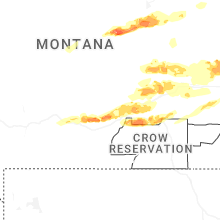
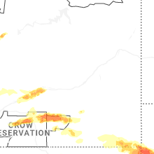


Connect with Interactive Hail Maps