

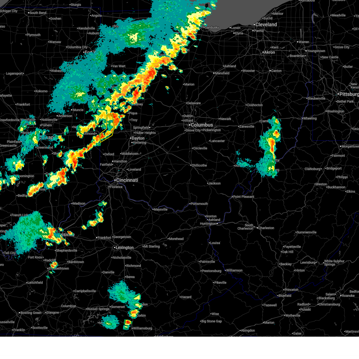
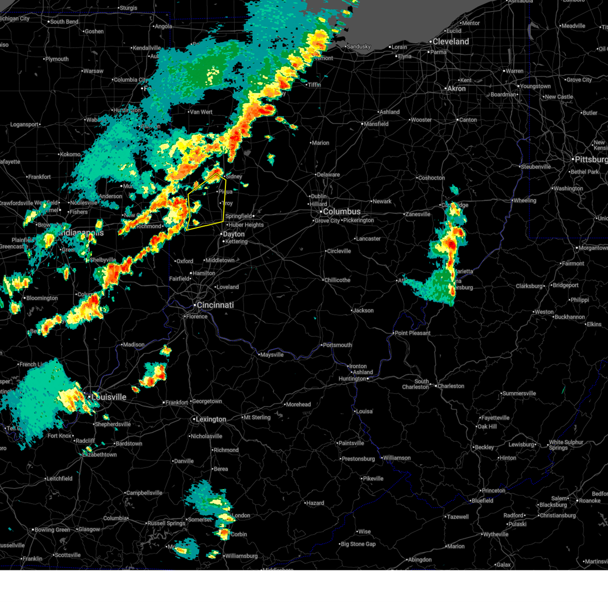
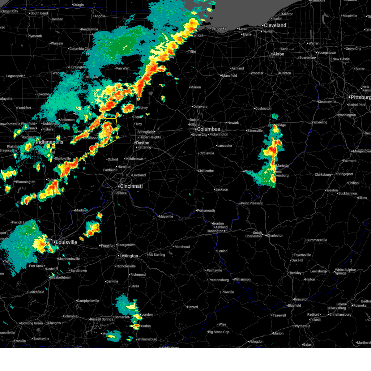
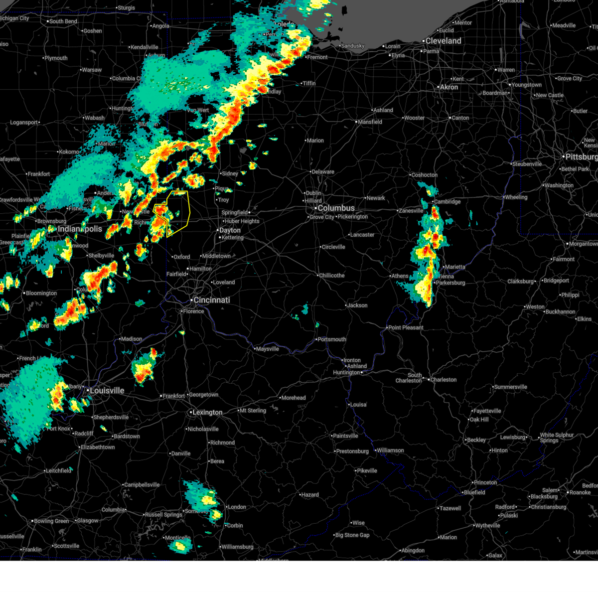
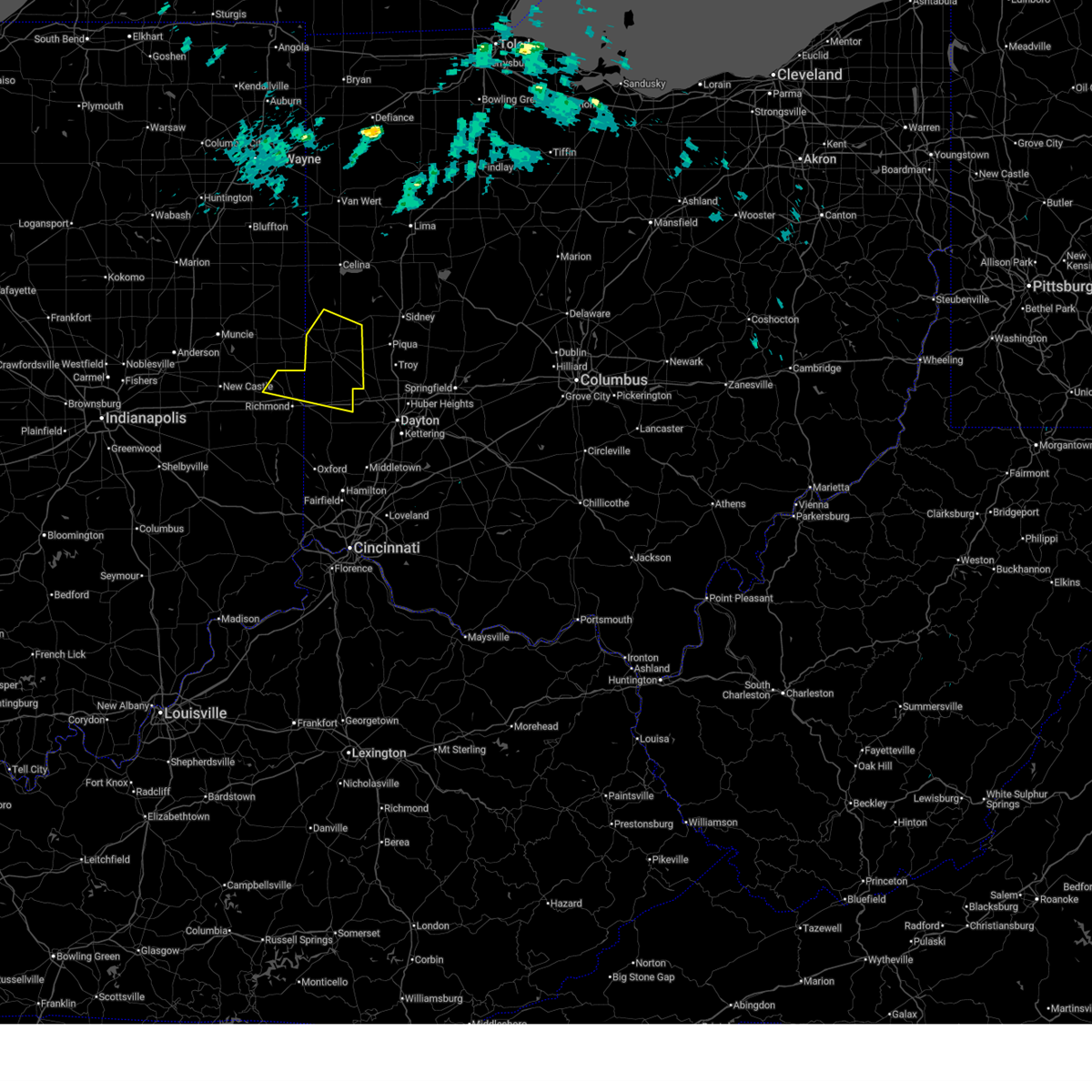
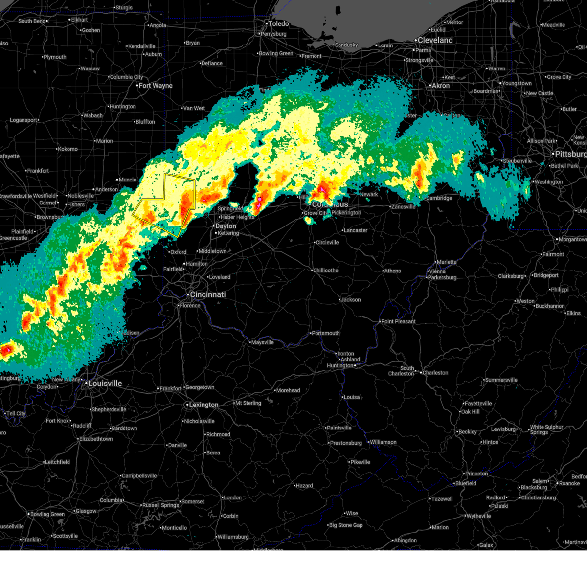
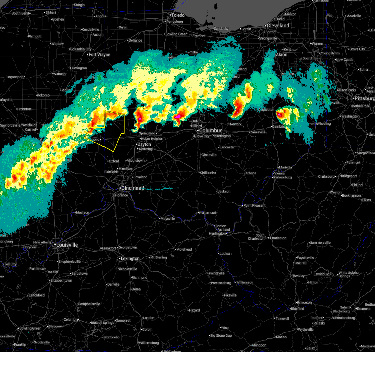
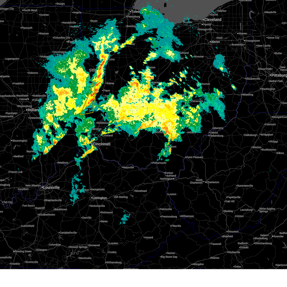
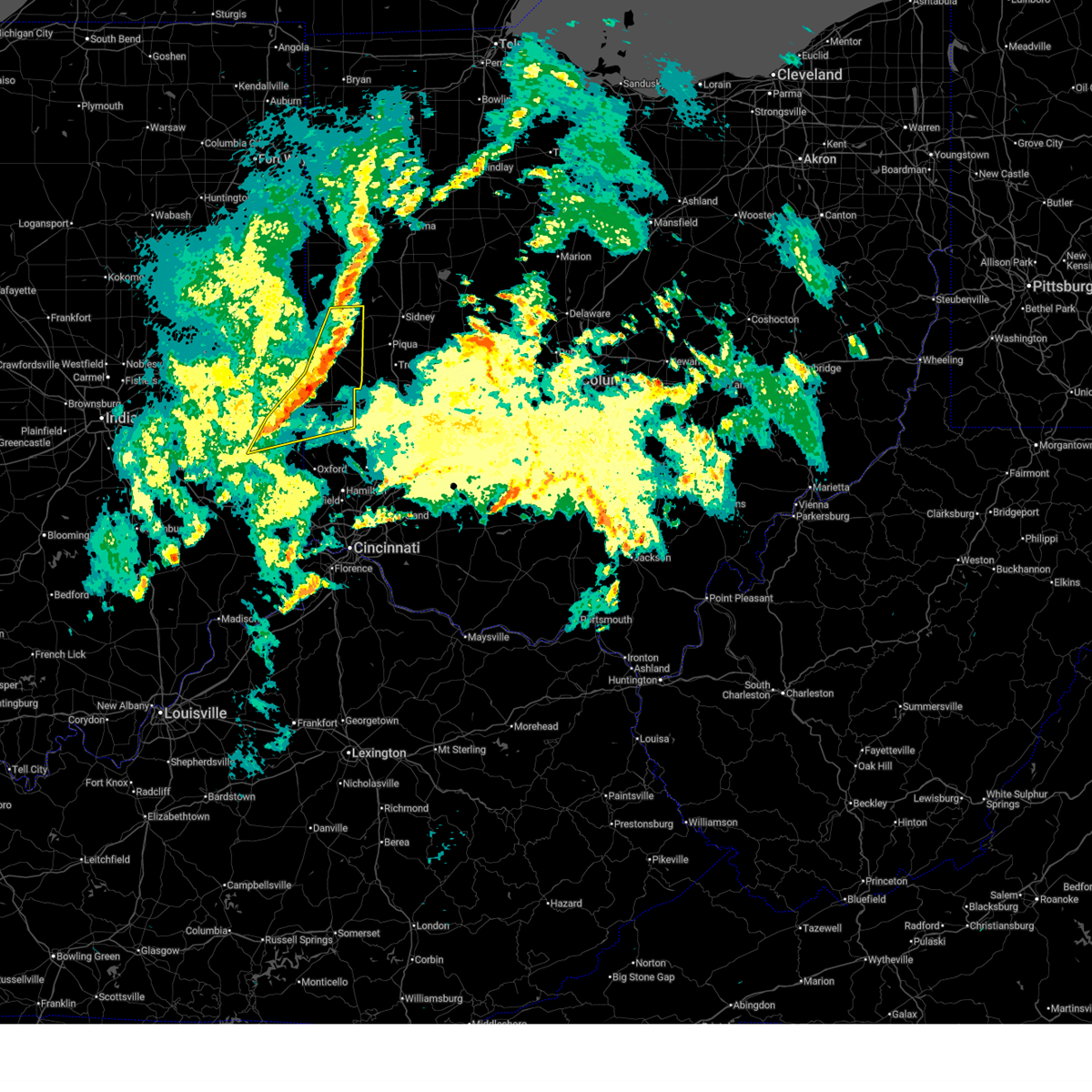
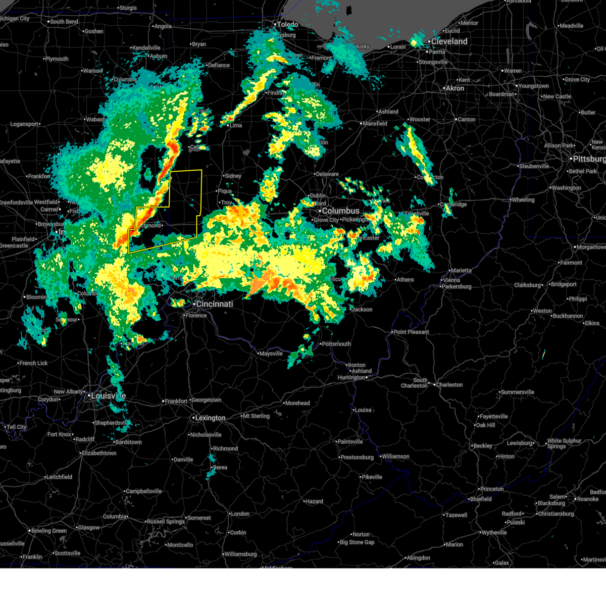
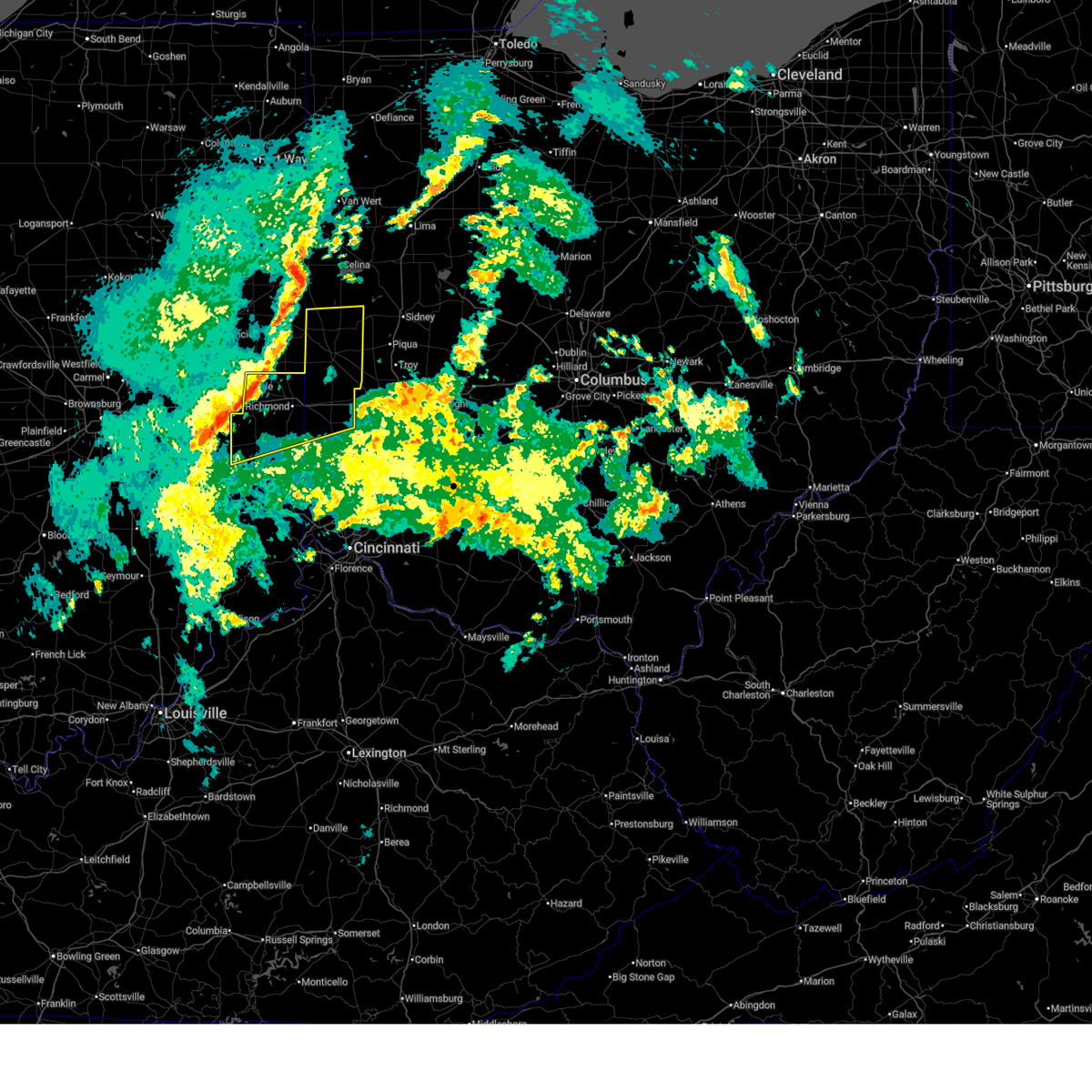
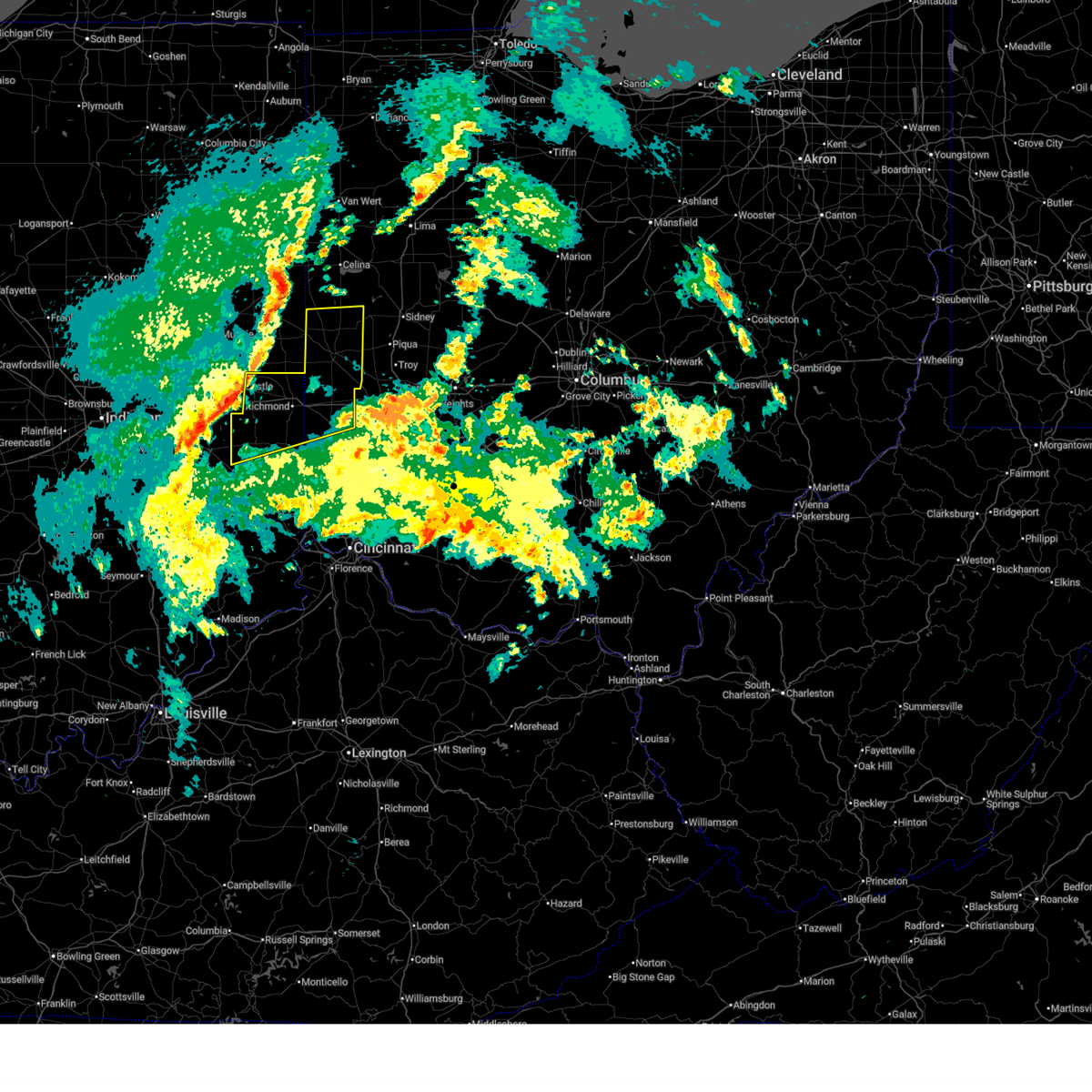
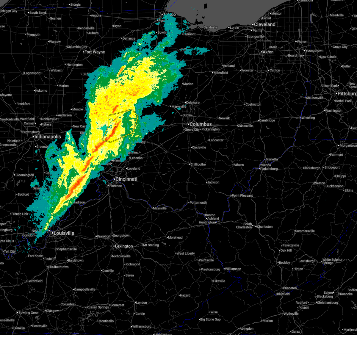
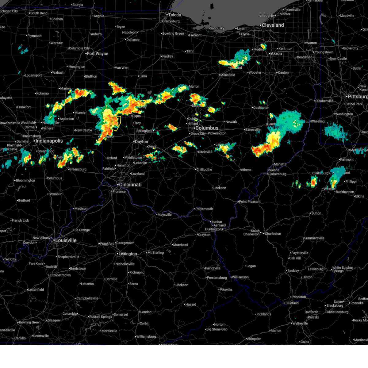
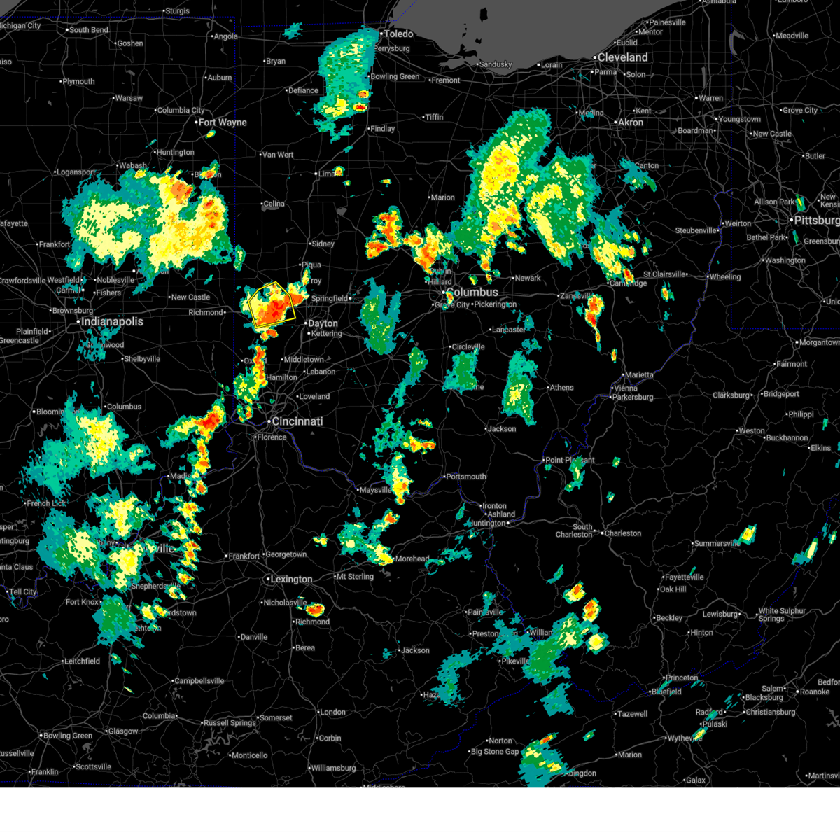
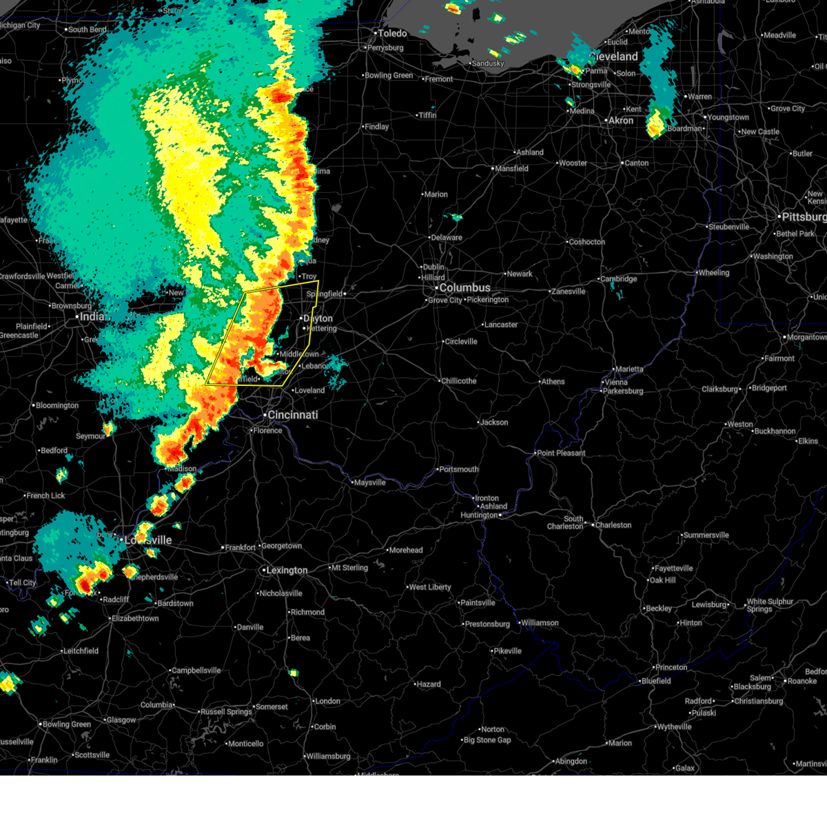
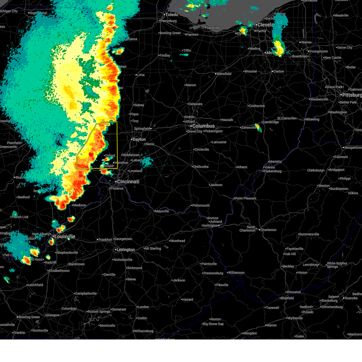
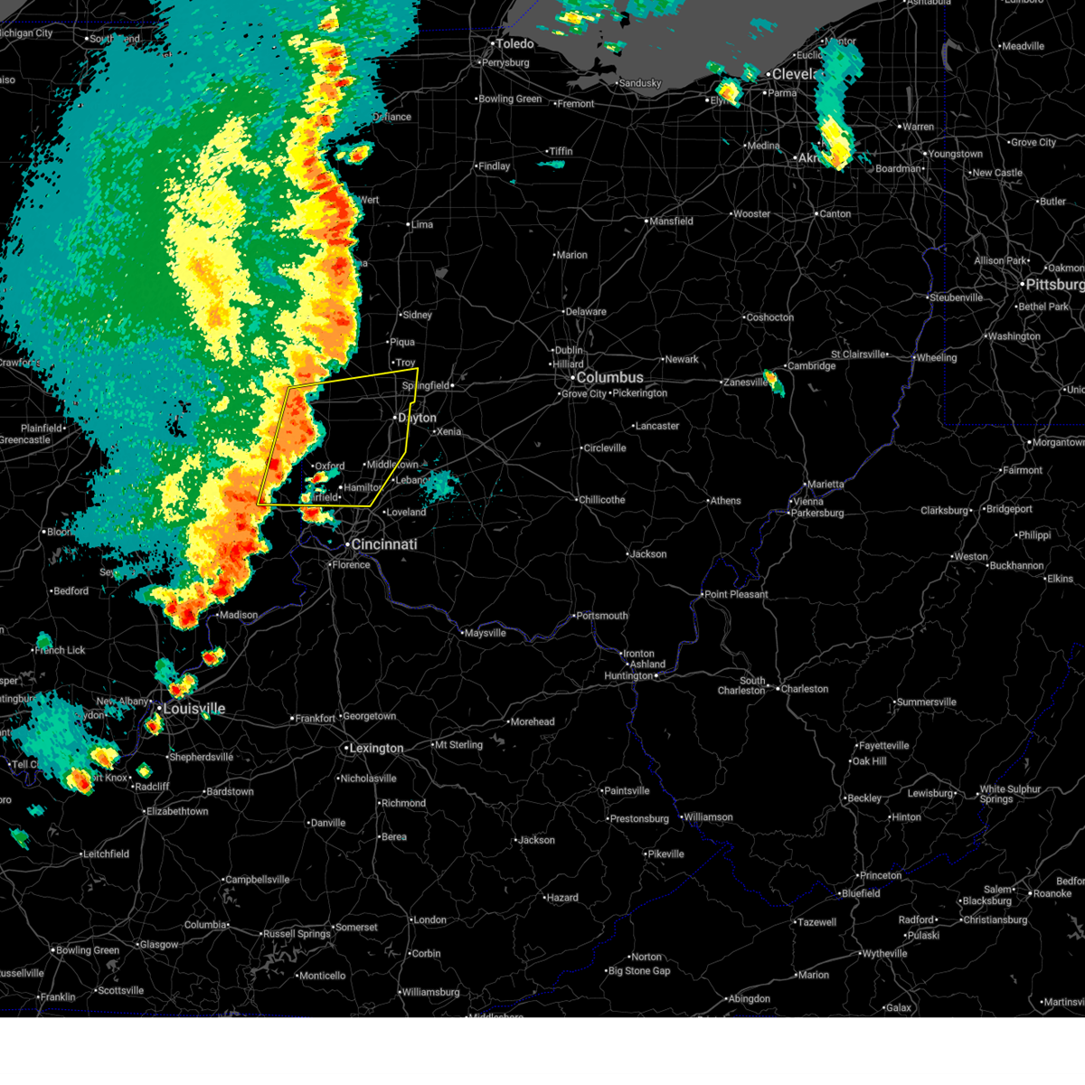
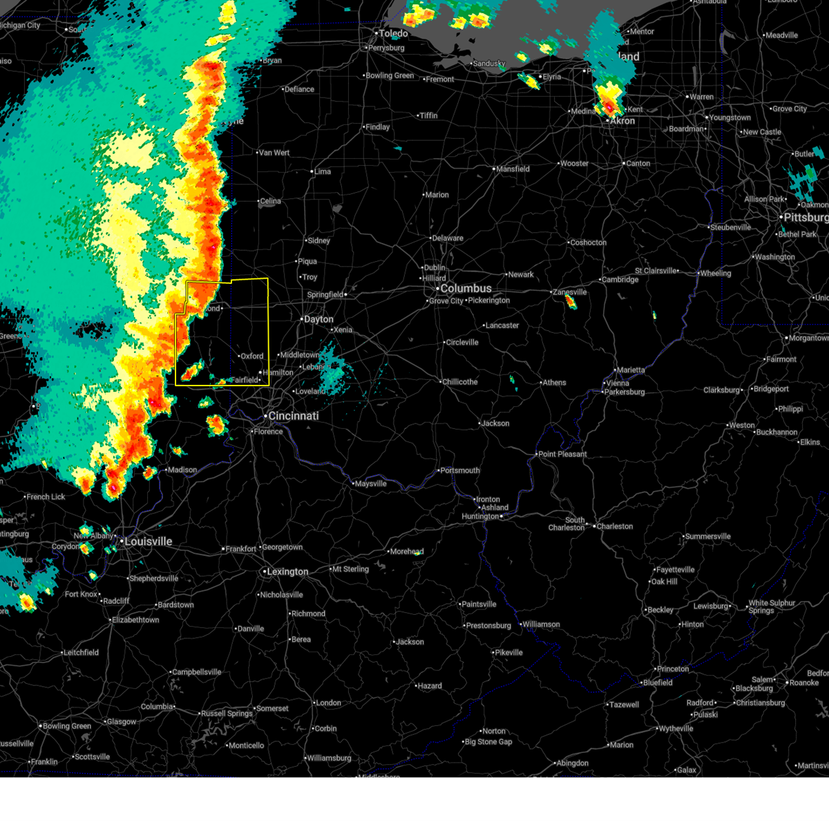
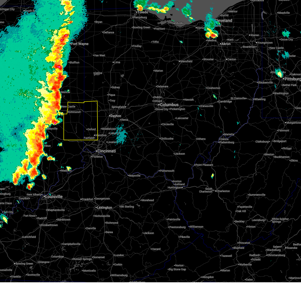
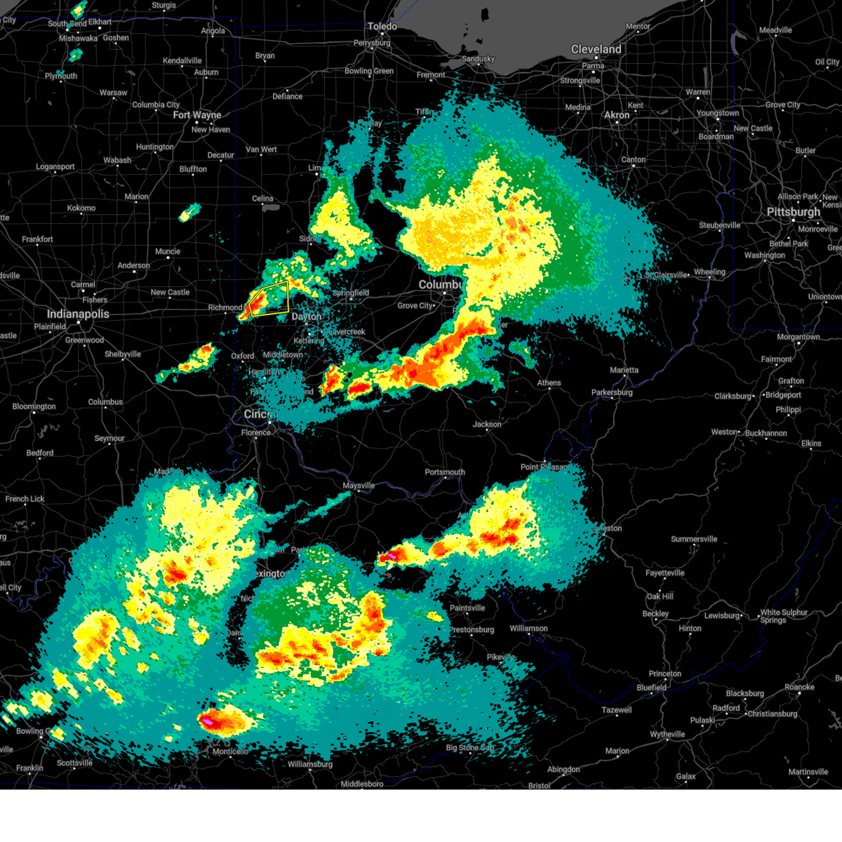
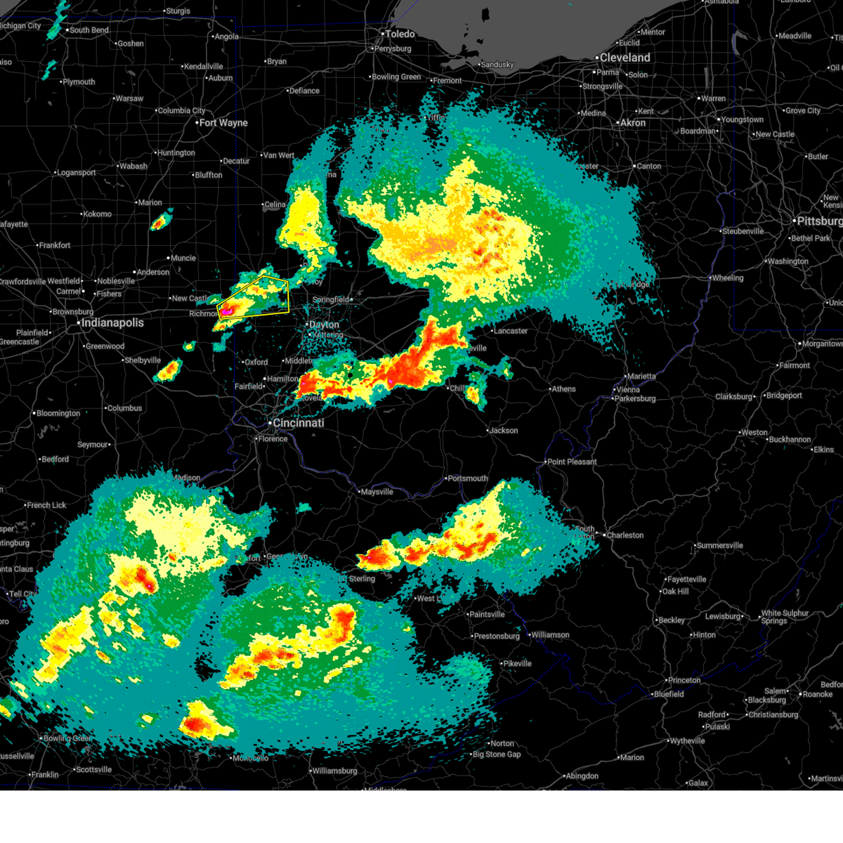
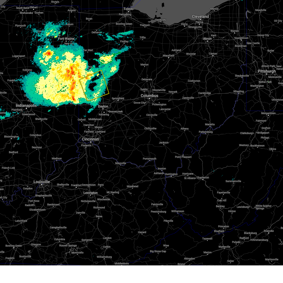
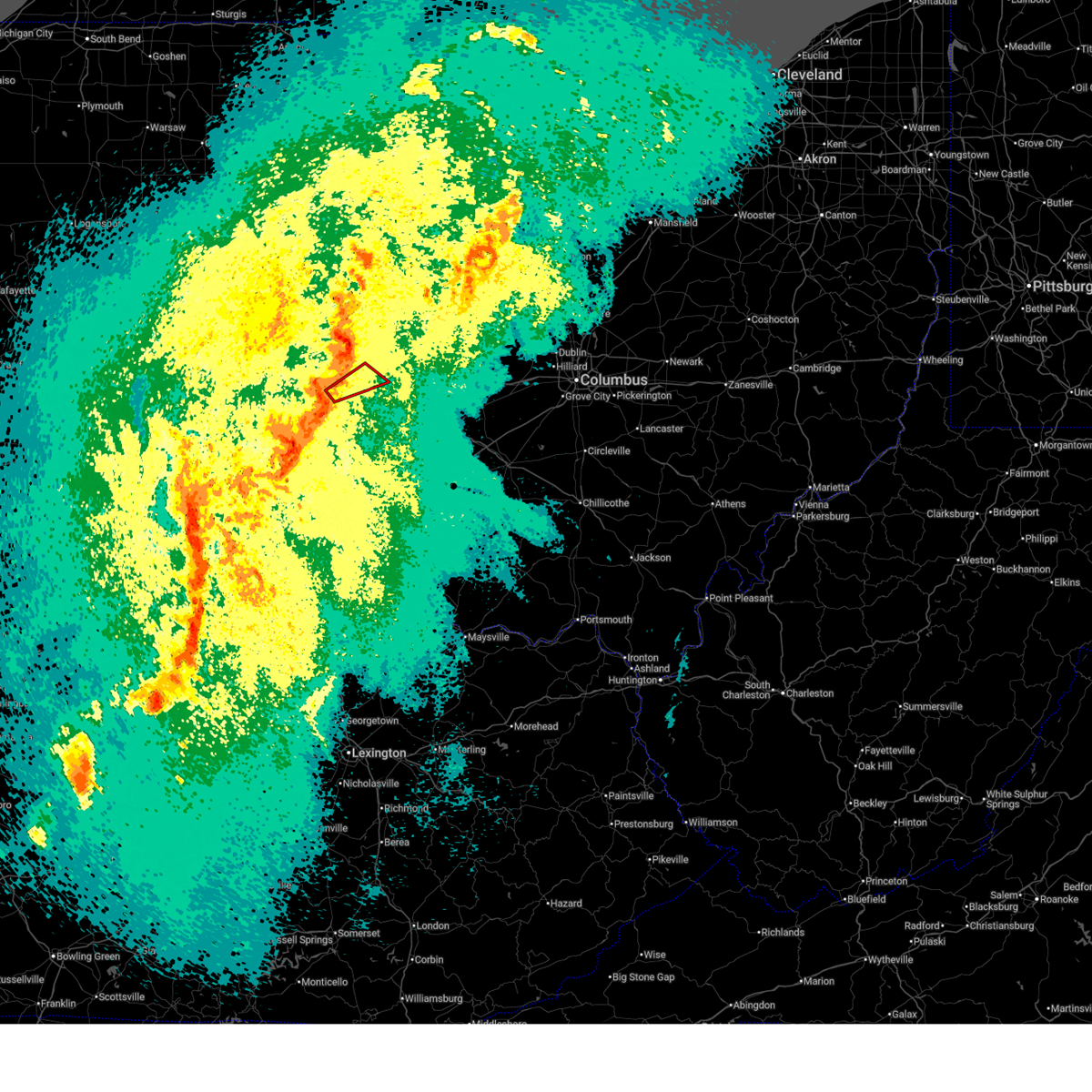
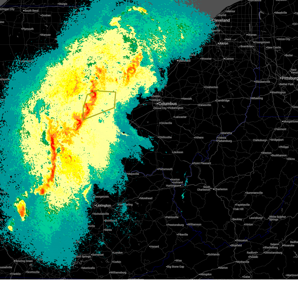
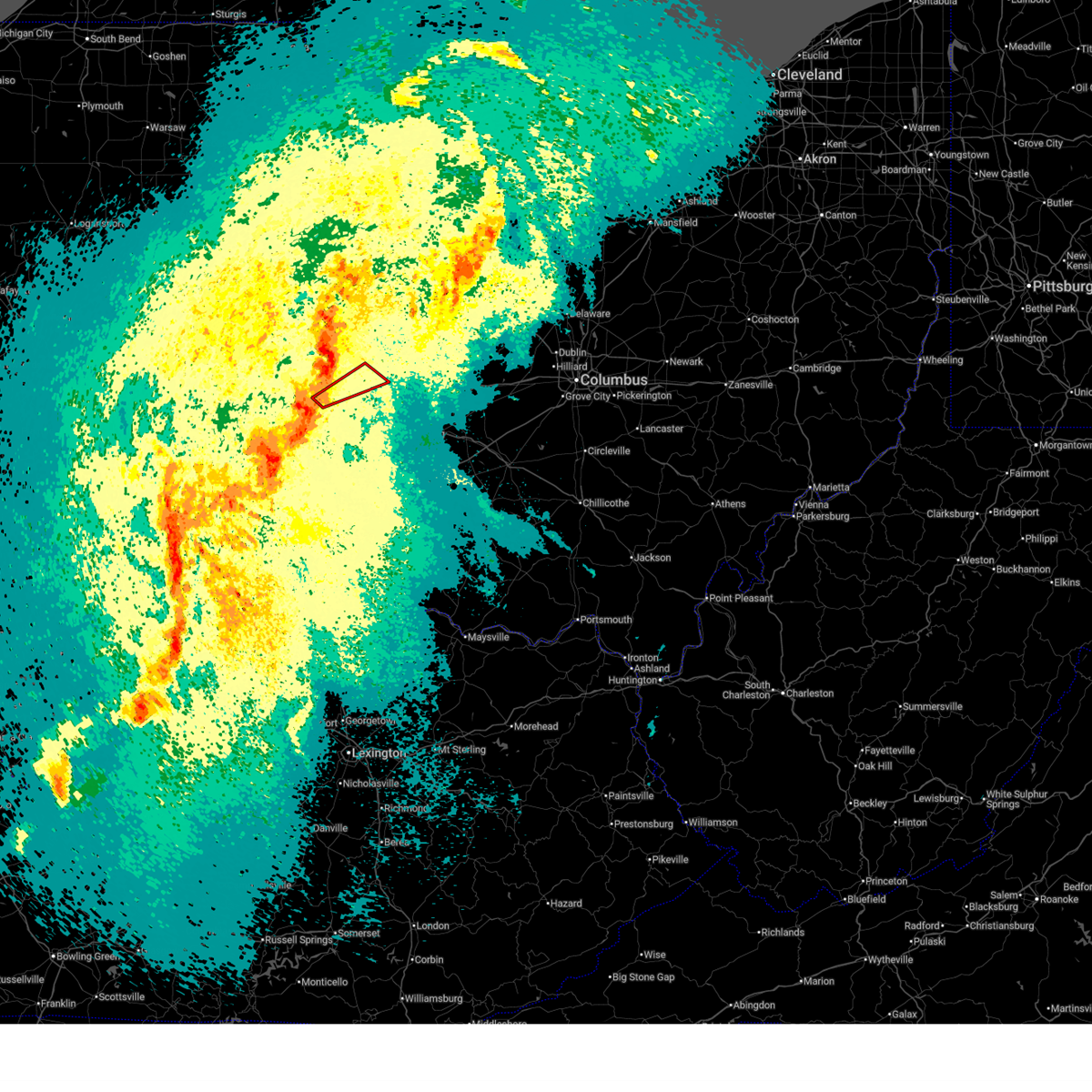
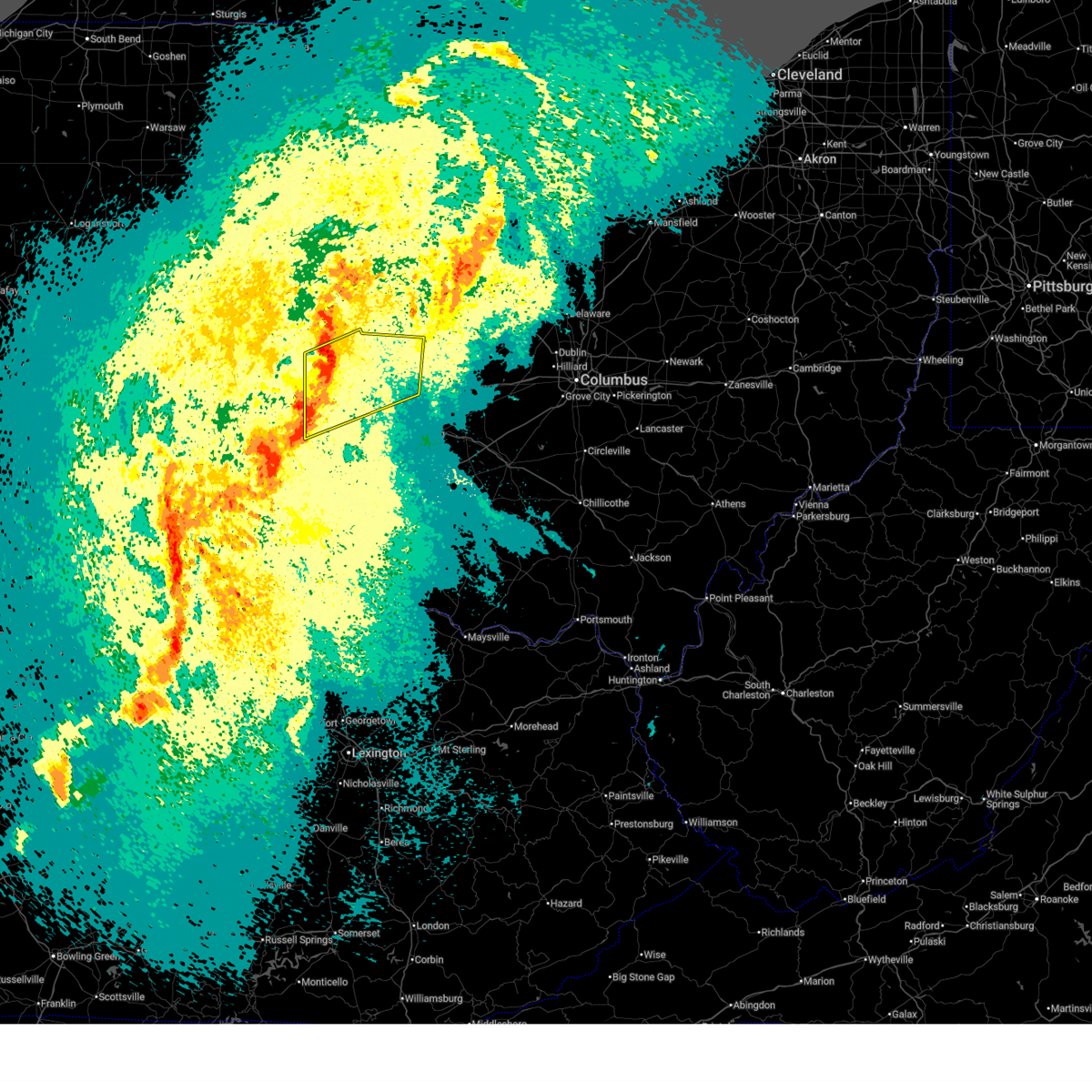
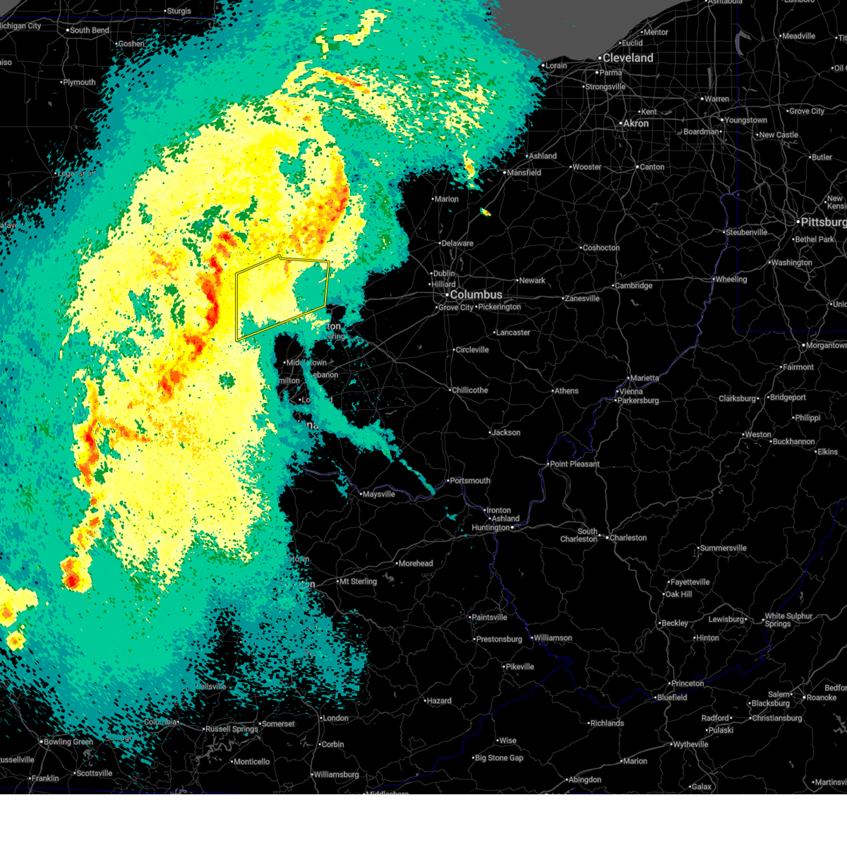
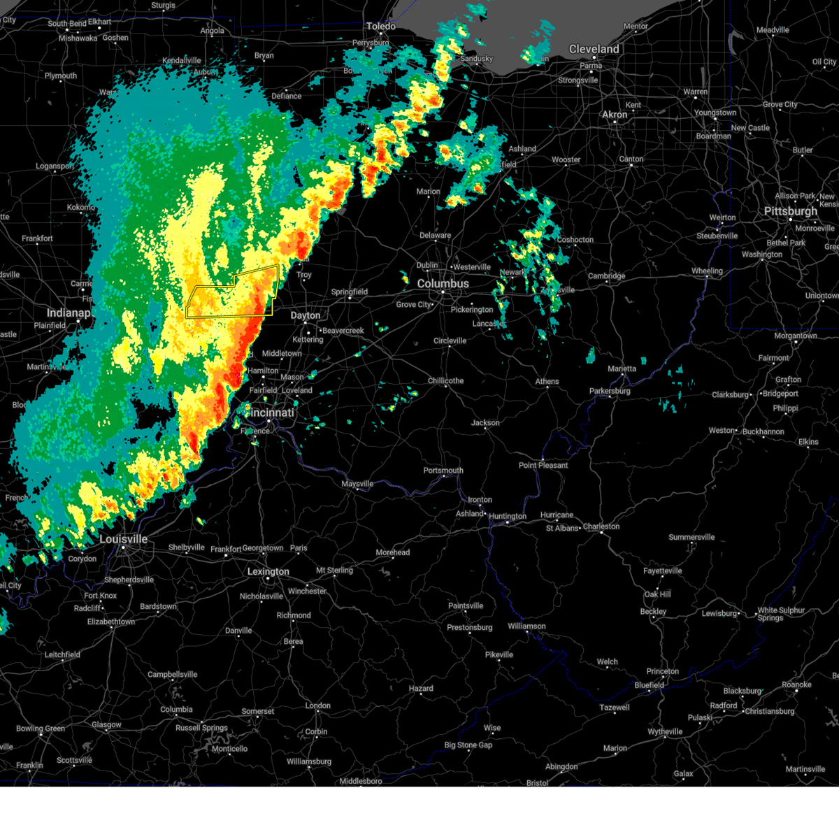
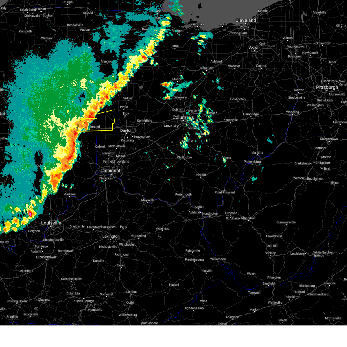
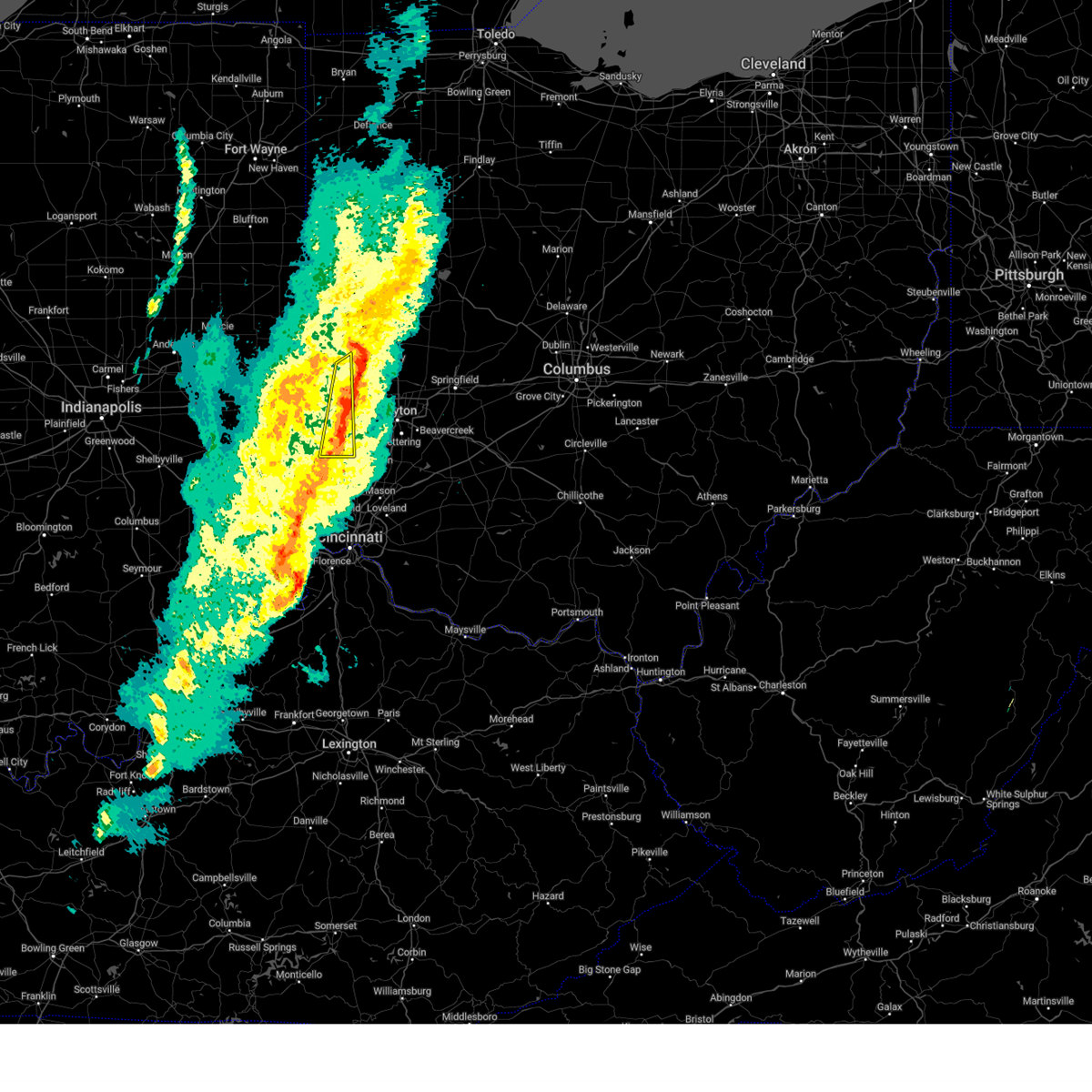
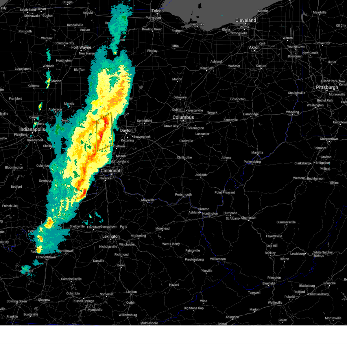
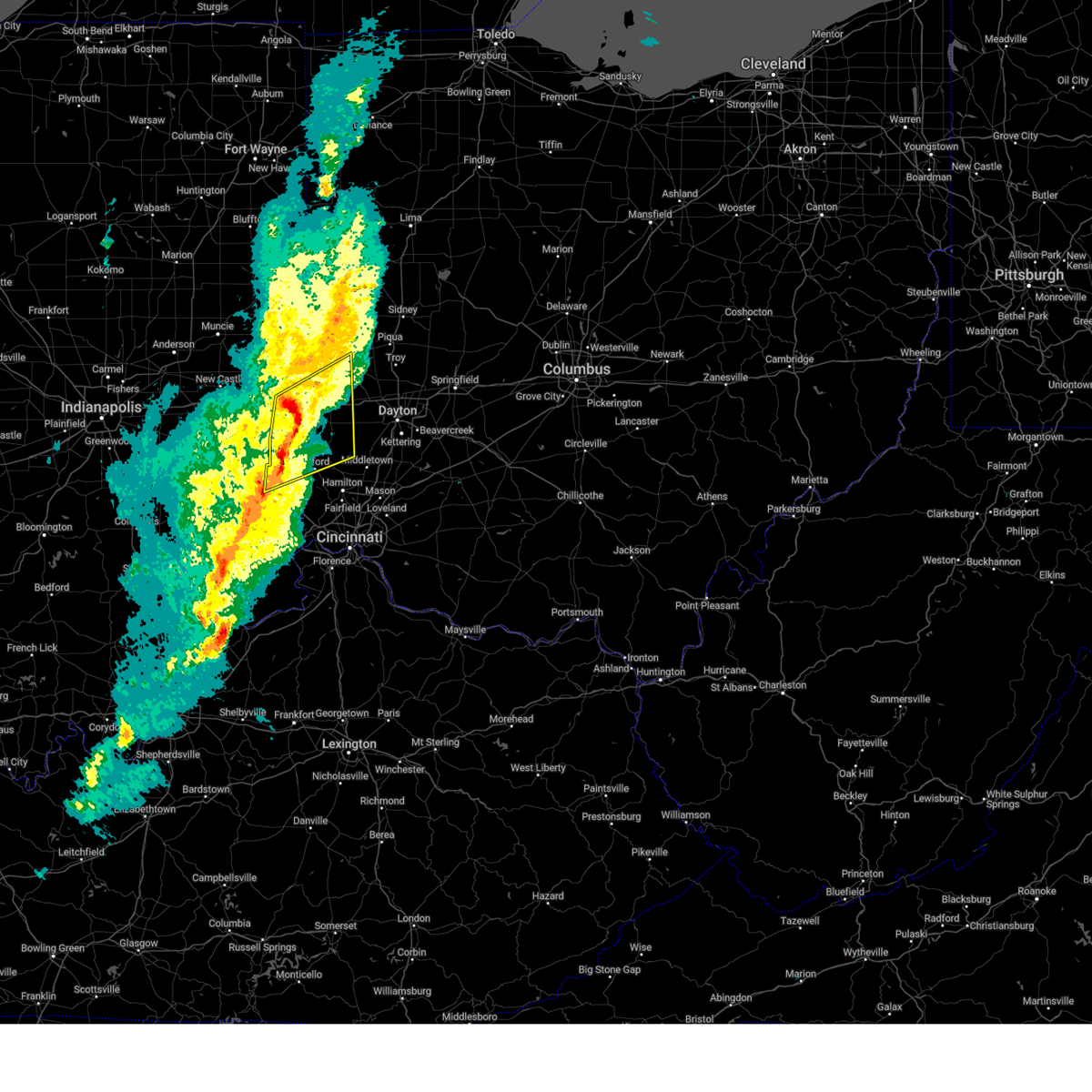
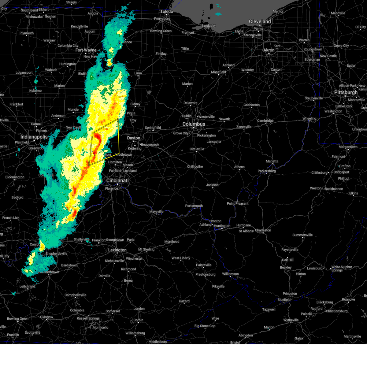
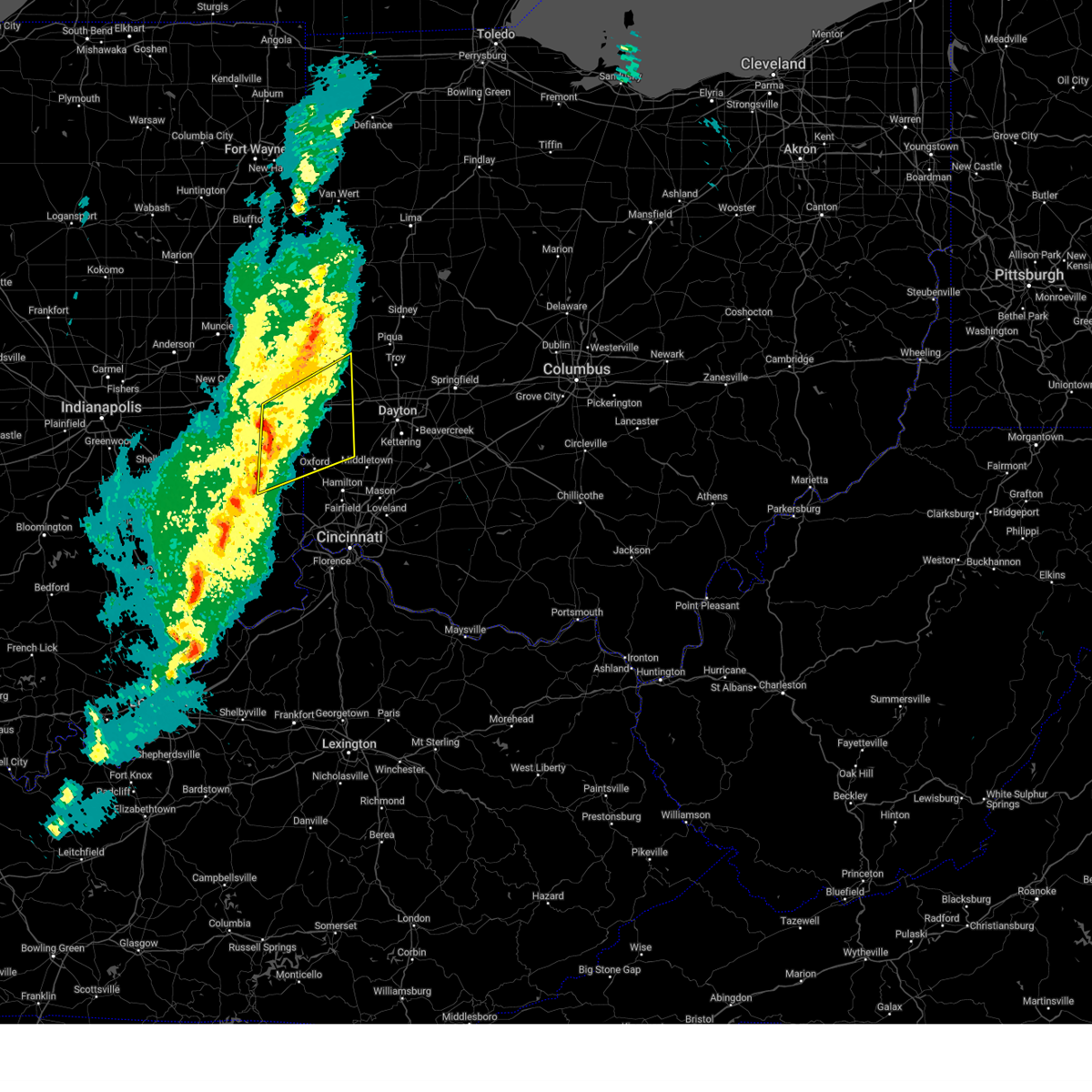
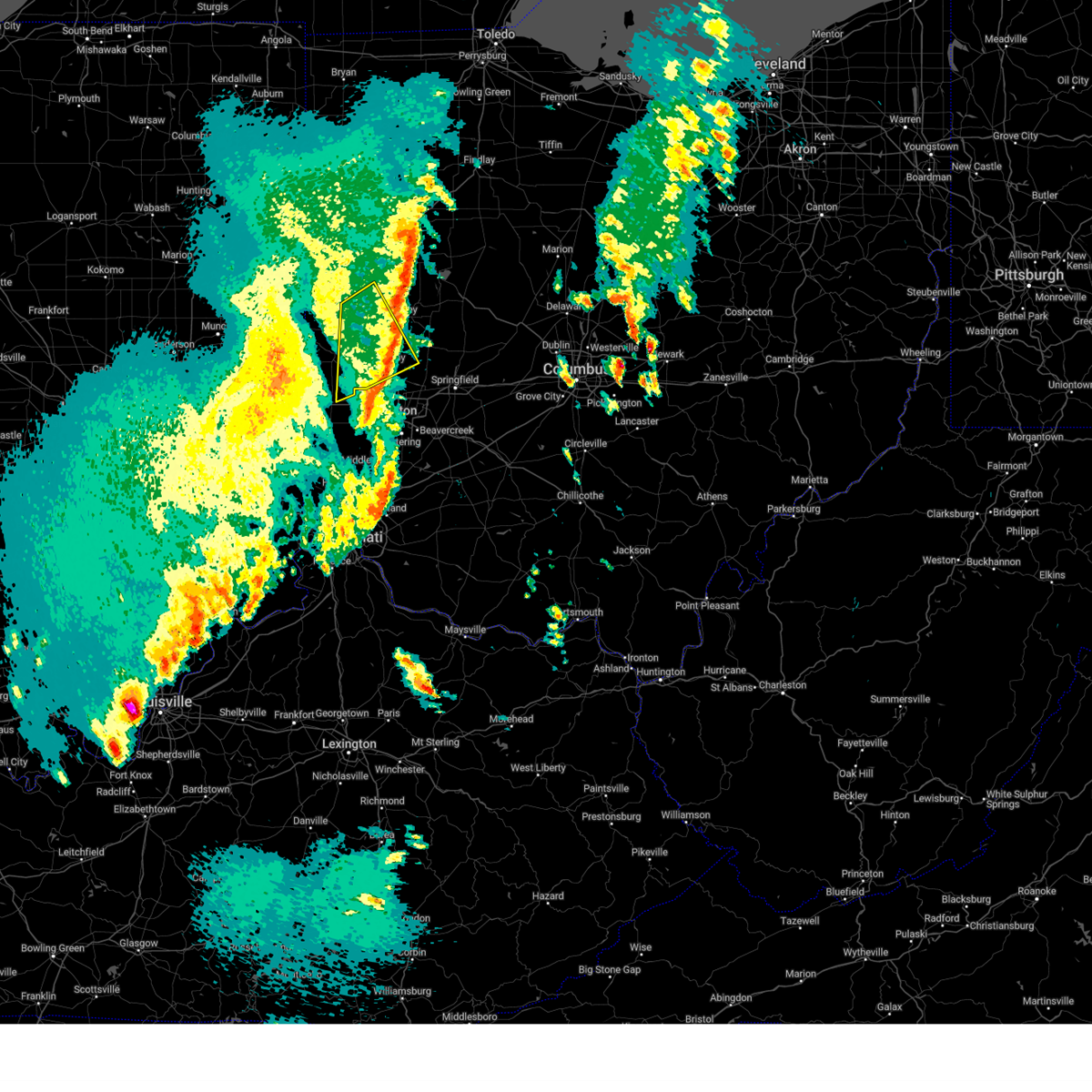
Hail Map for Ithaca, OH
The Ithaca, OH area has had 0 reports of on-the-ground hail by trained spotters, and has been under severe weather warnings 47 times during the past 12 months. Doppler radar has detected hail at or near Ithaca, OH on 32 occasions, including 2 occasions during the past year.
| Name: | Ithaca, OH |
| Where Located: | 57.4 miles N of Cincinnati, OH |
| Map: | Google Map for Ithaca, OH |
| Population: | 136 |
| Housing Units: | 52 |
| More Info: | Search Google for Ithaca, OH |
0
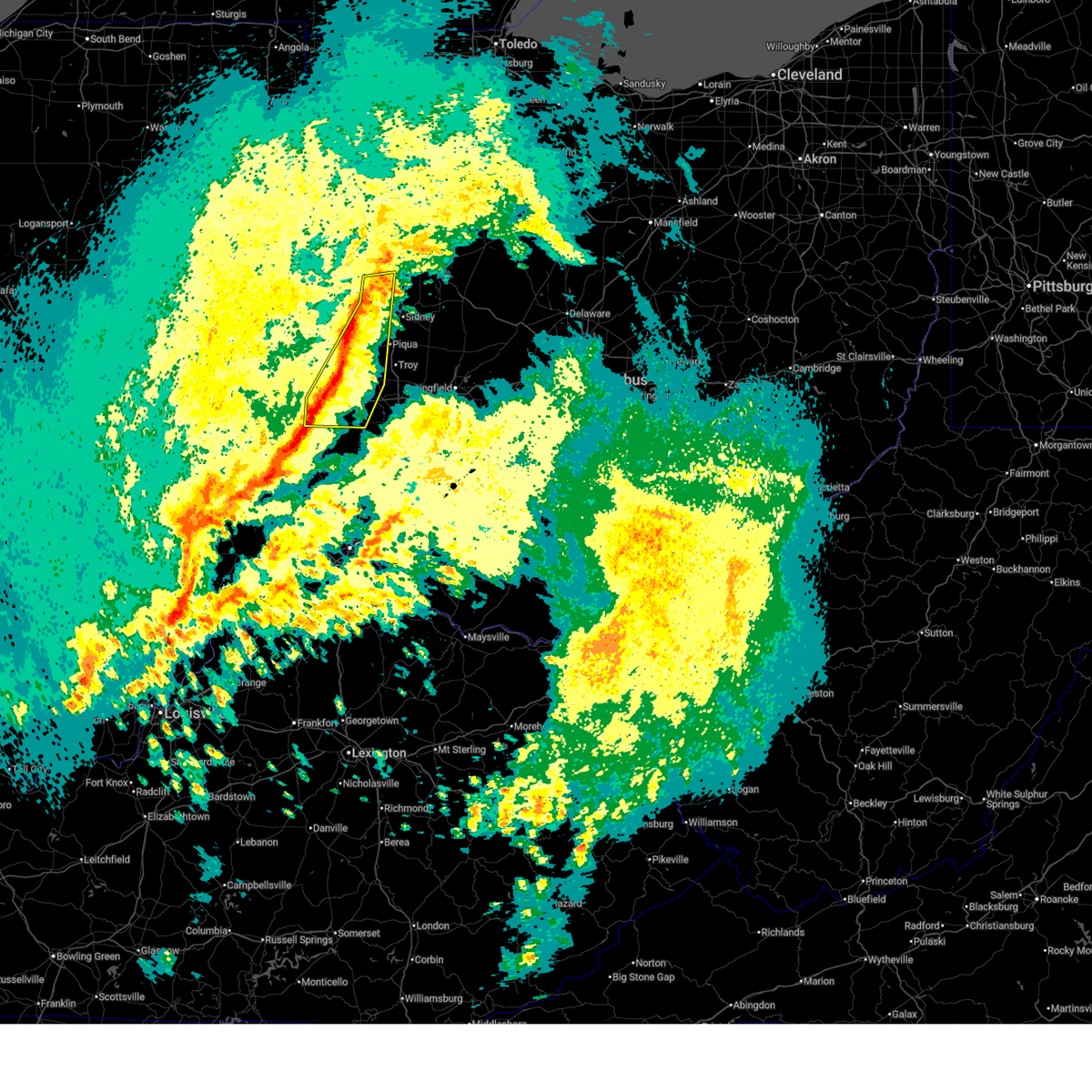
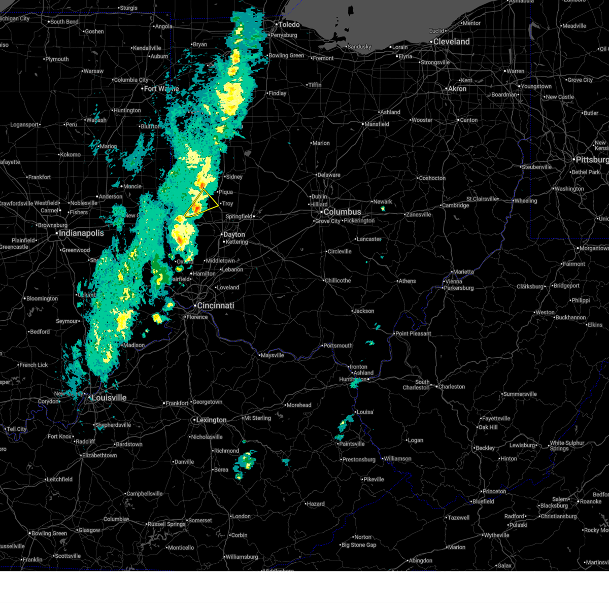
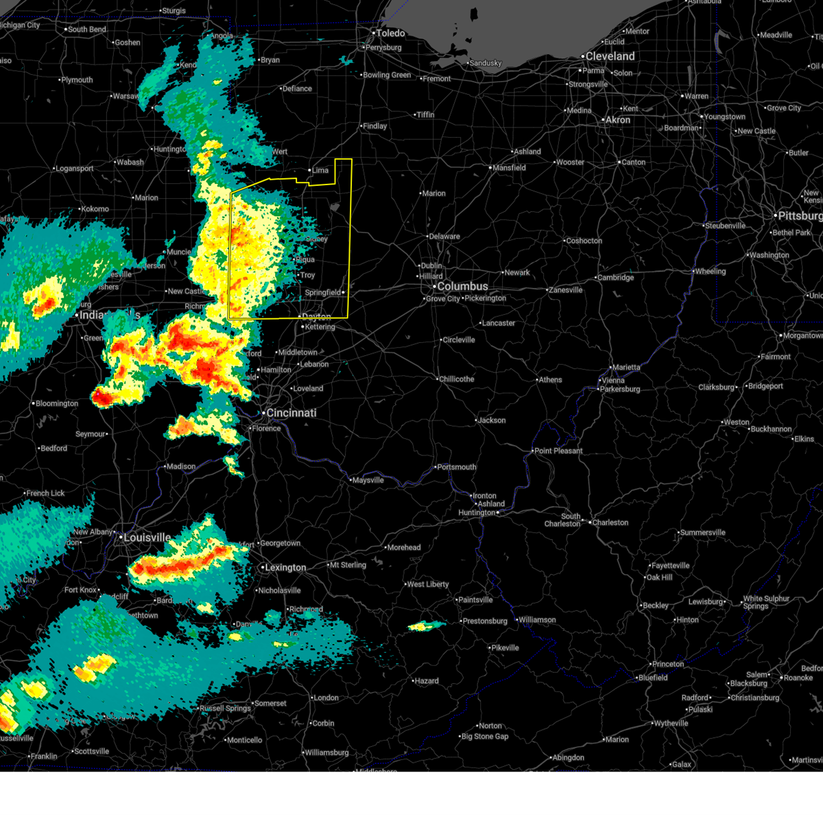
The Top Recent Hail Date for Ithaca, OH is Sunday, March 22, 2026 (20th out of 32)

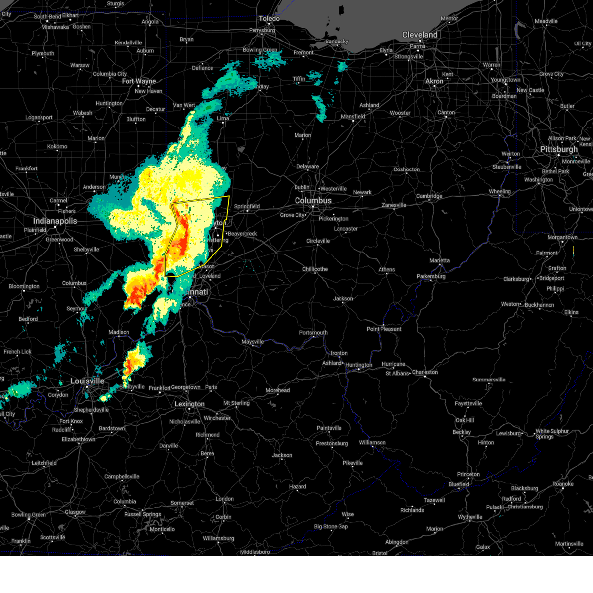
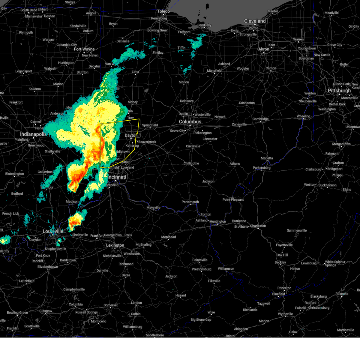
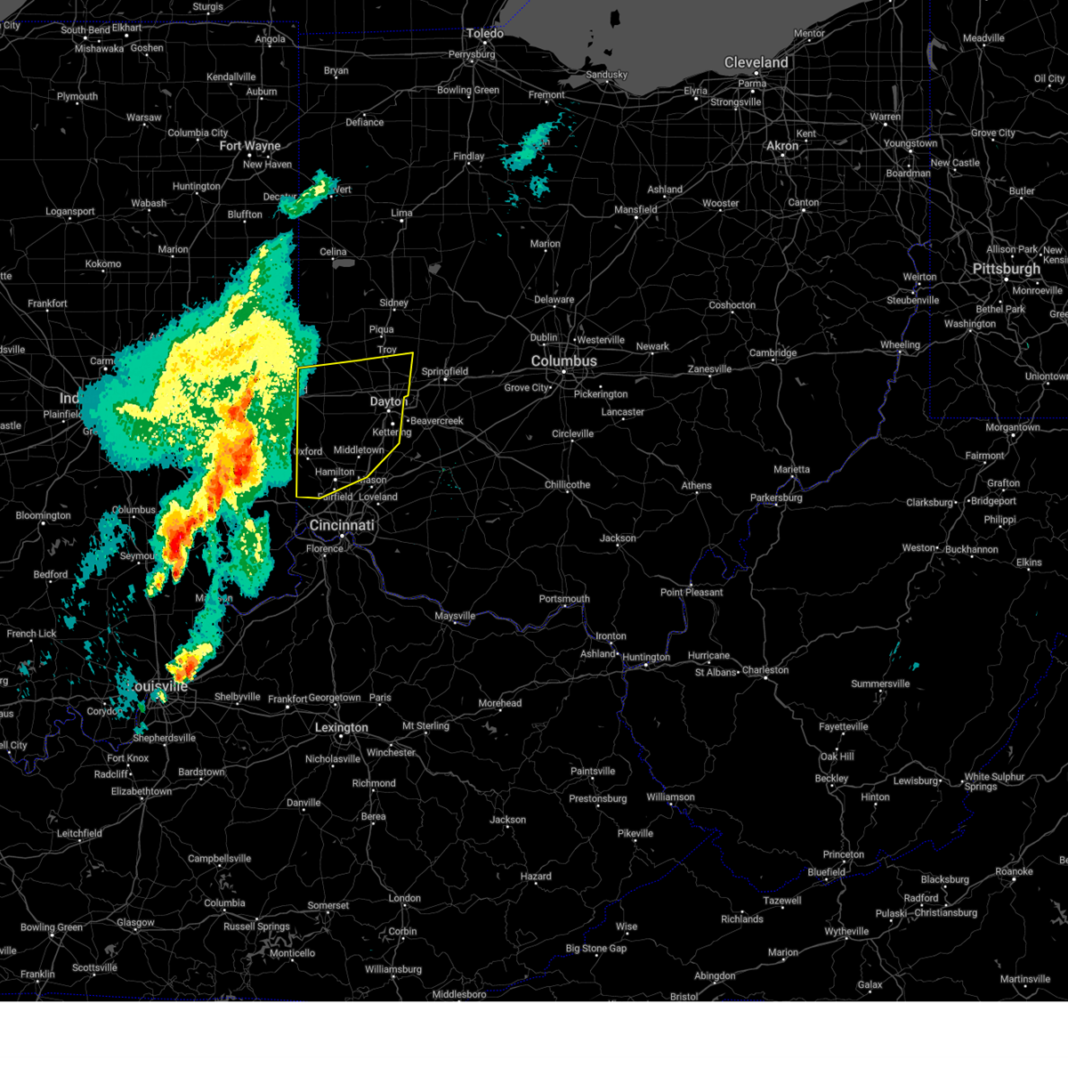
Hail and Wind Damage Spotted near Ithaca, OH
| Date / Time | Report Details |
|---|---|
| 6/12/2026 12:04 AM EDT |
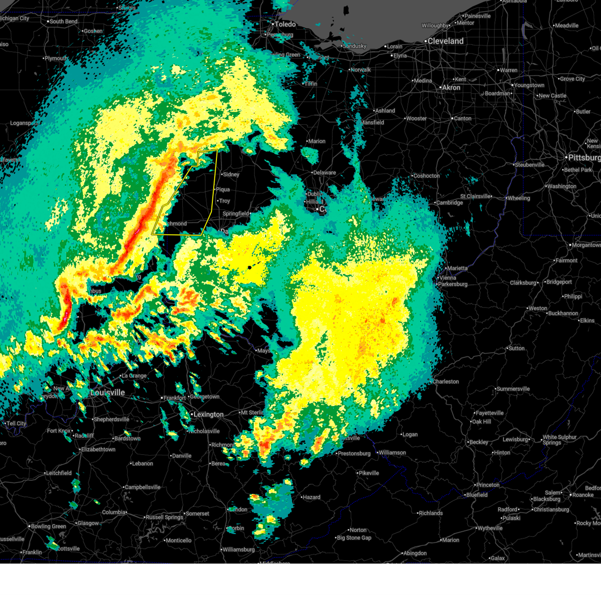
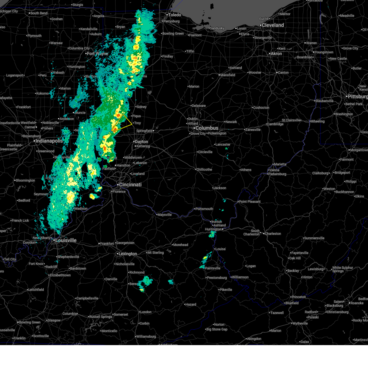
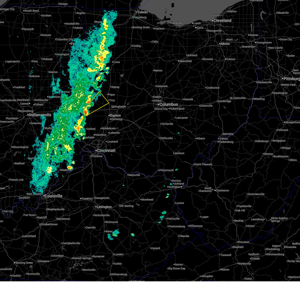
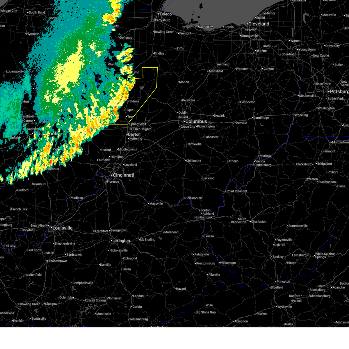 At 1203 am edt, severe thunderstorms were located along a line extending from near elida to near botkins to near bradford, moving east at 55 mph (radar indicated). Hazards include 60 mph wind gusts. Expect damage to trees and power lines. locations impacted include, troy, sidney, piqua, bellefontaine, wapakoneta, tipp city, kenton, ada, west milton, fort shawnee, covington, arcanum, st. paris, cridersville, bradford, anna, jackson center, russells point, de graff, and pleasant hill. This includes i-75 in ohio between mile markers 66 and 118. At 1203 am edt, severe thunderstorms were located along a line extending from near elida to near botkins to near bradford, moving east at 55 mph (radar indicated). Hazards include 60 mph wind gusts. Expect damage to trees and power lines. locations impacted include, troy, sidney, piqua, bellefontaine, wapakoneta, tipp city, kenton, ada, west milton, fort shawnee, covington, arcanum, st. paris, cridersville, bradford, anna, jackson center, russells point, de graff, and pleasant hill. This includes i-75 in ohio between mile markers 66 and 118.
|
| 6/11/2026 11:39 PM EDT |
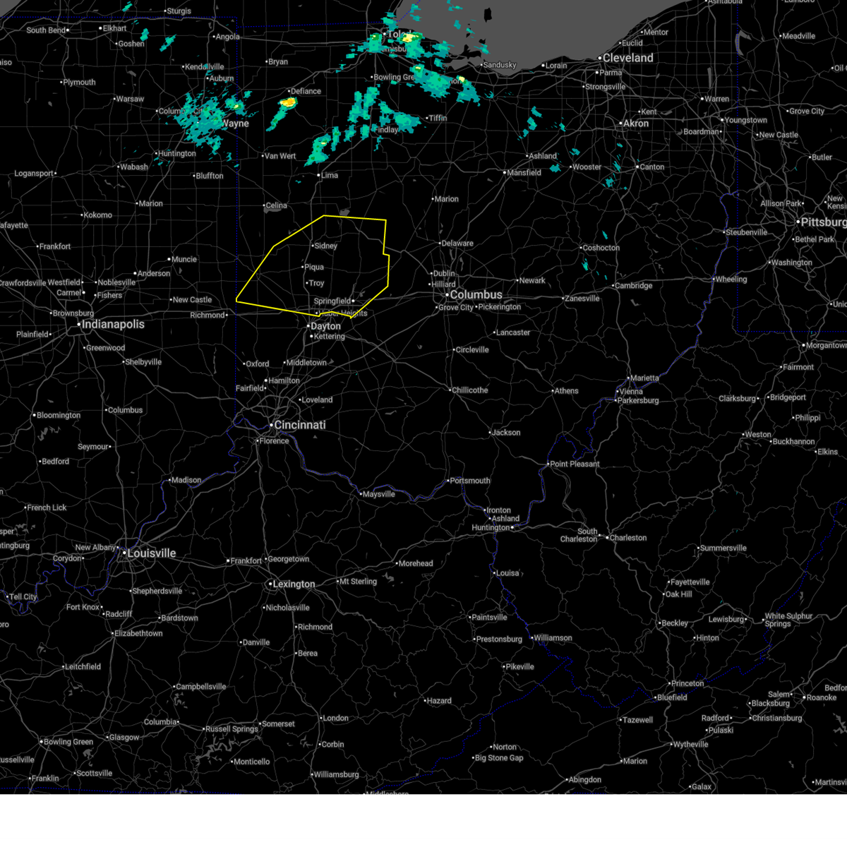
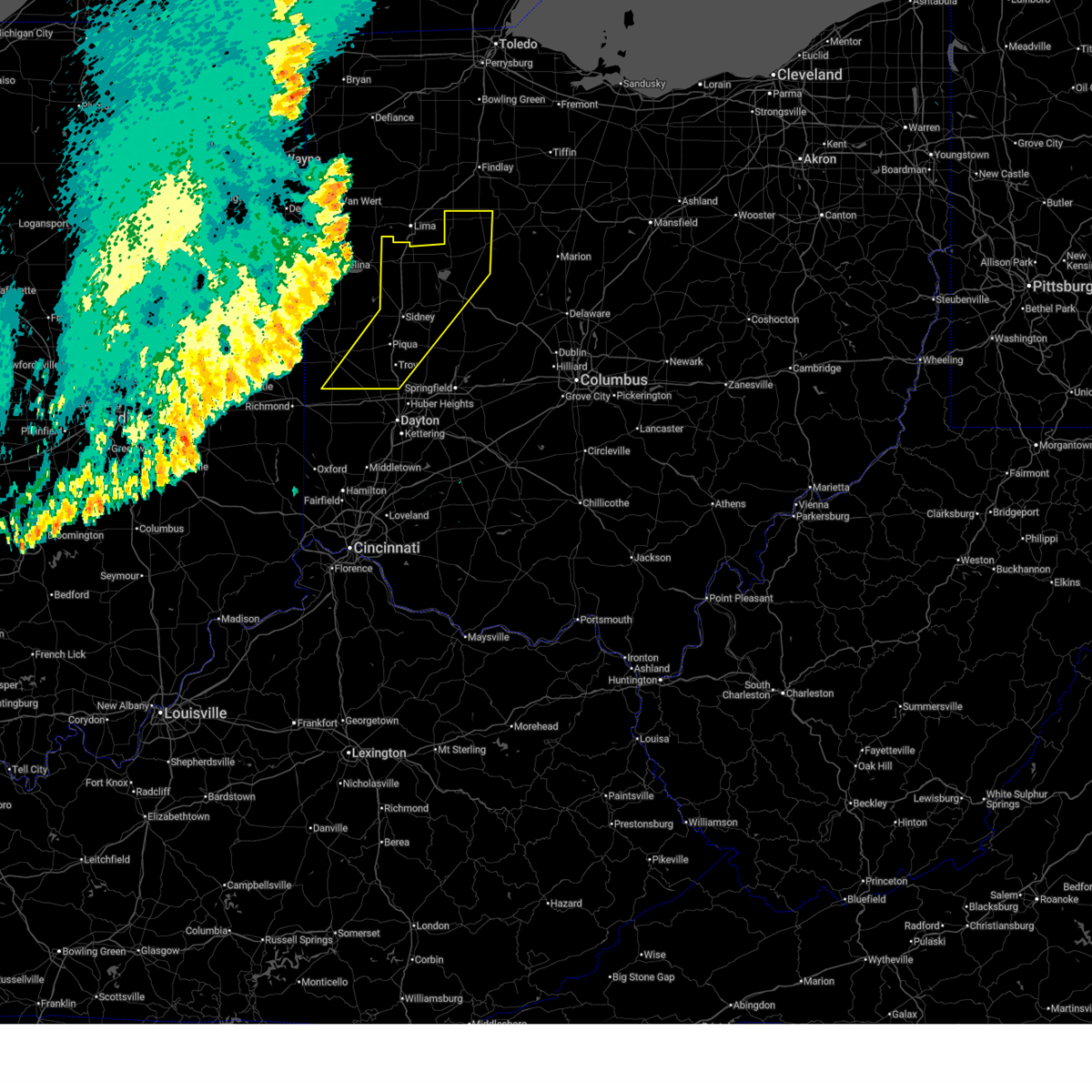 Svriln the national weather service in wilmington has issued a * severe thunderstorm warning for, shelby county in west central ohio, northwestern champaign county in west central ohio, logan county in west central ohio, southeastern darke county in west central ohio, hardin county in west central ohio, auglaize county in west central ohio, miami county in west central ohio, * until 1245 am edt. * at 1139 pm edt, severe thunderstorms were located along a line extending from near van wert to 6 miles east of coldwater to 6 miles north of fountain city, moving east at 55 mph (radar indicated). Hazards include 60 mph wind gusts. expect damage to trees and power lines Svriln the national weather service in wilmington has issued a * severe thunderstorm warning for, shelby county in west central ohio, northwestern champaign county in west central ohio, logan county in west central ohio, southeastern darke county in west central ohio, hardin county in west central ohio, auglaize county in west central ohio, miami county in west central ohio, * until 1245 am edt. * at 1139 pm edt, severe thunderstorms were located along a line extending from near van wert to 6 miles east of coldwater to 6 miles north of fountain city, moving east at 55 mph (radar indicated). Hazards include 60 mph wind gusts. expect damage to trees and power lines
|
| 6/6/2026 5:48 PM EDT |
 At 547 pm edt, a severe thunderstorm was located near lewisburg, moving southeast at 25 mph (radar indicated). Hazards include 60 mph wind gusts and quarter size hail. Hail damage to vehicles is expected. expect wind damage to roofs, siding, and trees. Locations impacted include, eaton, lewisburg and west alexandria. At 547 pm edt, a severe thunderstorm was located near lewisburg, moving southeast at 25 mph (radar indicated). Hazards include 60 mph wind gusts and quarter size hail. Hail damage to vehicles is expected. expect wind damage to roofs, siding, and trees. Locations impacted include, eaton, lewisburg and west alexandria.
|
| 6/6/2026 5:31 PM EDT |
 Svriln the national weather service in wilmington has issued a * severe thunderstorm warning for, northern preble county in west central ohio, southern darke county in west central ohio, northwestern montgomery county in west central ohio, * until 600 pm edt. * at 530 pm edt, a severe thunderstorm was located near new madison, moving southeast at 30 mph (radar indicated). Hazards include 60 mph wind gusts and quarter size hail. Hail damage to vehicles is expected. expect wind damage to roofs, siding, and trees. this severe thunderstorm will be near, eaton and lewisburg around 535 pm edt. West alexandria around 545 pm edt. Svriln the national weather service in wilmington has issued a * severe thunderstorm warning for, northern preble county in west central ohio, southern darke county in west central ohio, northwestern montgomery county in west central ohio, * until 600 pm edt. * at 530 pm edt, a severe thunderstorm was located near new madison, moving southeast at 30 mph (radar indicated). Hazards include 60 mph wind gusts and quarter size hail. Hail damage to vehicles is expected. expect wind damage to roofs, siding, and trees. this severe thunderstorm will be near, eaton and lewisburg around 535 pm edt. West alexandria around 545 pm edt.
|
| 5/19/2026 6:42 PM EDT |
 At 642 pm edt, a severe thunderstorm was located near pleasant hill, moving northeast at 40 mph (radar indicated). Hazards include 60 mph wind gusts and penny size hail. Expect damage to trees and power lines. locations impacted include, troy, sidney, piqua, vandalia, englewood, tipp city, west milton, covington, arcanum, bradford, lewisburg, pleasant hill, hardin, clayton, union, brookville, phillipsburg, gettysburg, and verona. this includes the following interstates, i-70 in ohio between mile markers 13 and 33. I-75 in ohio between mile markers 62 and 90. At 642 pm edt, a severe thunderstorm was located near pleasant hill, moving northeast at 40 mph (radar indicated). Hazards include 60 mph wind gusts and penny size hail. Expect damage to trees and power lines. locations impacted include, troy, sidney, piqua, vandalia, englewood, tipp city, west milton, covington, arcanum, bradford, lewisburg, pleasant hill, hardin, clayton, union, brookville, phillipsburg, gettysburg, and verona. this includes the following interstates, i-70 in ohio between mile markers 13 and 33. I-75 in ohio between mile markers 62 and 90.
|
| 5/19/2026 6:41 PM EDT |
 At 641 pm edt, a severe thunderstorm was located over arcanum, moving east at 25 mph (radar indicated). Hazards include 60 mph wind gusts and penny size hail. Expect damage to trees and power lines. locations impacted include, greenville, eaton, arcanum, lewisburg, wayne lakes, eldorado, west manchester, ithaca, castine, west florence, abbottsville, and new hope. This includes i-70 in ohio between mile markers 1 and 13. At 641 pm edt, a severe thunderstorm was located over arcanum, moving east at 25 mph (radar indicated). Hazards include 60 mph wind gusts and penny size hail. Expect damage to trees and power lines. locations impacted include, greenville, eaton, arcanum, lewisburg, wayne lakes, eldorado, west manchester, ithaca, castine, west florence, abbottsville, and new hope. This includes i-70 in ohio between mile markers 1 and 13.
|
| 5/19/2026 6:31 PM EDT |
 Svriln the national weather service in wilmington has issued a * severe thunderstorm warning for, southwestern shelby county in west central ohio, northeastern preble county in west central ohio, southeastern darke county in west central ohio, northwestern montgomery county in west central ohio, miami county in west central ohio, * until 715 pm edt. * at 631 pm edt, a severe thunderstorm was located near arcanum, moving northeast at 30 mph (radar indicated). Hazards include 60 mph wind gusts and penny size hail. expect damage to trees and power lines Svriln the national weather service in wilmington has issued a * severe thunderstorm warning for, southwestern shelby county in west central ohio, northeastern preble county in west central ohio, southeastern darke county in west central ohio, northwestern montgomery county in west central ohio, miami county in west central ohio, * until 715 pm edt. * at 631 pm edt, a severe thunderstorm was located near arcanum, moving northeast at 30 mph (radar indicated). Hazards include 60 mph wind gusts and penny size hail. expect damage to trees and power lines
|
| 5/19/2026 6:28 PM EDT |
 At 628 pm edt, a severe thunderstorm was located over new madison, moving northeast at 35 mph (radar indicated). Hazards include 60 mph wind gusts and penny size hail. Expect damage to trees and power lines. locations impacted include, greenville, eaton, arcanum, lewisburg, new paris, new madison, wayne lakes, eldorado, west manchester, hollansburg, palestine, ithaca, castine, oklahoma, west florence, abbottsville, and new hope. This includes i-70 in ohio between mile markers 1 and 13. At 628 pm edt, a severe thunderstorm was located over new madison, moving northeast at 35 mph (radar indicated). Hazards include 60 mph wind gusts and penny size hail. Expect damage to trees and power lines. locations impacted include, greenville, eaton, arcanum, lewisburg, new paris, new madison, wayne lakes, eldorado, west manchester, hollansburg, palestine, ithaca, castine, oklahoma, west florence, abbottsville, and new hope. This includes i-70 in ohio between mile markers 1 and 13.
|
| 5/19/2026 6:10 PM EDT |
 Svriln the national weather service in wilmington has issued a * severe thunderstorm warning for, northeastern wayne county in east central indiana, northern preble county in west central ohio, southwestern darke county in west central ohio, * until 700 pm edt. * at 609 pm edt, a severe thunderstorm was located over richmond, moving northeast at 35 mph (radar indicated). Hazards include 60 mph wind gusts and quarter size hail. Minor hail damage to vehicles is possible. Expect wind damage to trees and power lines. Svriln the national weather service in wilmington has issued a * severe thunderstorm warning for, northeastern wayne county in east central indiana, northern preble county in west central ohio, southwestern darke county in west central ohio, * until 700 pm edt. * at 609 pm edt, a severe thunderstorm was located over richmond, moving northeast at 35 mph (radar indicated). Hazards include 60 mph wind gusts and quarter size hail. Minor hail damage to vehicles is possible. Expect wind damage to trees and power lines.
|
| 4/28/2026 12:25 AM EDT |
 At 1225 am edt, severe thunderstorms were located along a line extending from near newport to near eaton, moving northeast at 70 mph (radar indicated). Hazards include 60 mph wind gusts. Expect damage to trees and power lines. locations impacted include, trotwood, piqua, englewood, greenville, eaton, west milton, new bremen, minster, versailles, covington, arcanum, newport, bradford, lewisburg, new paris, fort loramie, west alexandria, pleasant hill, new madison, and new knoxville. This includes i-70 in ohio between mile markers 1 and 26. At 1225 am edt, severe thunderstorms were located along a line extending from near newport to near eaton, moving northeast at 70 mph (radar indicated). Hazards include 60 mph wind gusts. Expect damage to trees and power lines. locations impacted include, trotwood, piqua, englewood, greenville, eaton, west milton, new bremen, minster, versailles, covington, arcanum, newport, bradford, lewisburg, new paris, fort loramie, west alexandria, pleasant hill, new madison, and new knoxville. This includes i-70 in ohio between mile markers 1 and 26.
|
| 4/27/2026 11:56 PM EDT |
 Svriln the national weather service in wilmington has issued a * severe thunderstorm warning for, eastern wayne county in east central indiana, western shelby county in west central ohio, northern preble county in west central ohio, darke county in west central ohio, northwestern montgomery county in west central ohio, southwestern auglaize county in west central ohio, western miami county in west central ohio, * until 100 am edt. * at 1156 pm edt, severe thunderstorms were located along a line extending from near winchester to glenwood, moving east at 50 mph (radar indicated). Hazards include 60 mph wind gusts. expect damage to trees and power lines Svriln the national weather service in wilmington has issued a * severe thunderstorm warning for, eastern wayne county in east central indiana, western shelby county in west central ohio, northern preble county in west central ohio, darke county in west central ohio, northwestern montgomery county in west central ohio, southwestern auglaize county in west central ohio, western miami county in west central ohio, * until 100 am edt. * at 1156 pm edt, severe thunderstorms were located along a line extending from near winchester to glenwood, moving east at 50 mph (radar indicated). Hazards include 60 mph wind gusts. expect damage to trees and power lines
|
| 4/14/2026 7:22 PM EDT |
 At 722 pm edt, a severe thunderstorm was located near new madison, moving east at 30 mph (radar indicated). Hazards include 60 mph wind gusts. Expect damage to trees and power lines. Locations impacted include, greenville, arcanum, new madison, wayne lakes, gettysburg, hollansburg, gordon, palestine, ithaca, castine, and abbottsville. At 722 pm edt, a severe thunderstorm was located near new madison, moving east at 30 mph (radar indicated). Hazards include 60 mph wind gusts. Expect damage to trees and power lines. Locations impacted include, greenville, arcanum, new madison, wayne lakes, gettysburg, hollansburg, gordon, palestine, ithaca, castine, and abbottsville.
|
| 4/14/2026 7:07 PM EDT |
 Svriln the national weather service in wilmington has issued a * severe thunderstorm warning for, northeastern wayne county in east central indiana, southern darke county in west central ohio, * until 745 pm edt. * at 707 pm edt, a severe thunderstorm was located over fountain city, moving east at 35 mph (radar indicated). Hazards include 60 mph wind gusts. expect damage to trees and power lines Svriln the national weather service in wilmington has issued a * severe thunderstorm warning for, northeastern wayne county in east central indiana, southern darke county in west central ohio, * until 745 pm edt. * at 707 pm edt, a severe thunderstorm was located over fountain city, moving east at 35 mph (radar indicated). Hazards include 60 mph wind gusts. expect damage to trees and power lines
|
| 4/4/2026 2:55 PM EDT |
 The storm which prompted the warning has weakened below severe limits and no longer poses an immediate threat to life or property. therefore, the warning will be allowed to expire. however, gusty winds are still possible with this thunderstorm. a severe thunderstorm watch remains in effect until 900 pm edt for west central ohio. please report previous wind damage or hail to the national weather service by going to our website at weather.gov/iln and submitting your report via social media. The storm which prompted the warning has weakened below severe limits and no longer poses an immediate threat to life or property. therefore, the warning will be allowed to expire. however, gusty winds are still possible with this thunderstorm. a severe thunderstorm watch remains in effect until 900 pm edt for west central ohio. please report previous wind damage or hail to the national weather service by going to our website at weather.gov/iln and submitting your report via social media.
|
| 4/4/2026 2:49 PM EDT |
 the severe thunderstorm warning has been cancelled and is no longer in effect the severe thunderstorm warning has been cancelled and is no longer in effect
|
| 4/4/2026 2:49 PM EDT |
 At 249 pm edt, a severe thunderstorm was located over arcanum, moving northeast at 50 mph (radar indicated). Hazards include 60 mph wind gusts. Expect damage to trees and power lines. Locations impacted include, troy, covington, arcanum, bradford, pleasant hill, laura, pitsburg, potsdam, ludlow falls, ithaca, castine, union corners, and circle hill. At 249 pm edt, a severe thunderstorm was located over arcanum, moving northeast at 50 mph (radar indicated). Hazards include 60 mph wind gusts. Expect damage to trees and power lines. Locations impacted include, troy, covington, arcanum, bradford, pleasant hill, laura, pitsburg, potsdam, ludlow falls, ithaca, castine, union corners, and circle hill.
|
| 4/4/2026 2:32 PM EDT |
 Svriln the national weather service in wilmington has issued a * severe thunderstorm warning for, northern preble county in west central ohio, southeastern darke county in west central ohio, northwestern montgomery county in west central ohio, western miami county in west central ohio, * until 300 pm edt. * at 232 pm edt, a severe thunderstorm was located near new paris, moving northeast at 50 mph (radar indicated). Hazards include 60 mph wind gusts. expect damage to trees and power lines Svriln the national weather service in wilmington has issued a * severe thunderstorm warning for, northern preble county in west central ohio, southeastern darke county in west central ohio, northwestern montgomery county in west central ohio, western miami county in west central ohio, * until 300 pm edt. * at 232 pm edt, a severe thunderstorm was located near new paris, moving northeast at 50 mph (radar indicated). Hazards include 60 mph wind gusts. expect damage to trees and power lines
|
| 3/26/2026 8:54 PM EDT |
 Svriln the national weather service in wilmington has issued a * severe thunderstorm warning for, shelby county in west central ohio, champaign county in west central ohio, northeastern preble county in west central ohio, logan county in west central ohio, southern darke county in west central ohio, clark county in west central ohio, northern montgomery county in west central ohio, miami county in west central ohio, * until 945 pm edt. * at 854 pm edt, severe thunderstorms were located along a line extending from near de graff to near bradford to near new madison, moving east at 55 mph (radar indicated). Hazards include 60 mph wind gusts and quarter size hail. Minor hail damage to vehicles is possible. Expect wind damage to trees and power lines. Svriln the national weather service in wilmington has issued a * severe thunderstorm warning for, shelby county in west central ohio, champaign county in west central ohio, northeastern preble county in west central ohio, logan county in west central ohio, southern darke county in west central ohio, clark county in west central ohio, northern montgomery county in west central ohio, miami county in west central ohio, * until 945 pm edt. * at 854 pm edt, severe thunderstorms were located along a line extending from near de graff to near bradford to near new madison, moving east at 55 mph (radar indicated). Hazards include 60 mph wind gusts and quarter size hail. Minor hail damage to vehicles is possible. Expect wind damage to trees and power lines.
|
| 3/26/2026 8:39 PM EDT |
 At 838 pm edt, severe thunderstorms were located along a line extending from near ansonia to near fountain city, moving east at 45 mph (radar indicated). Hazards include 60 mph wind gusts and quarter size hail. Minor hail damage to vehicles is possible. expect wind damage to trees and power lines. Locations impacted include, richmond, greenville, versailles, arcanum, bradford, lewisburg, union city, new paris, ansonia, new madison, fountain city, webster, wayne lakes, gettysburg, eldorado, verona, west manchester, greens fork, pitsburg, and bethel. At 838 pm edt, severe thunderstorms were located along a line extending from near ansonia to near fountain city, moving east at 45 mph (radar indicated). Hazards include 60 mph wind gusts and quarter size hail. Minor hail damage to vehicles is possible. expect wind damage to trees and power lines. Locations impacted include, richmond, greenville, versailles, arcanum, bradford, lewisburg, union city, new paris, ansonia, new madison, fountain city, webster, wayne lakes, gettysburg, eldorado, verona, west manchester, greens fork, pitsburg, and bethel.
|
| 3/26/2026 8:20 PM EDT |
 Svriln the national weather service in wilmington has issued a * severe thunderstorm warning for, northern wayne county in east central indiana, northern preble county in west central ohio, darke county in west central ohio, * until 900 pm edt. * at 820 pm edt, severe thunderstorms were located along a line extending from 6 miles southeast of portland to 8 miles southwest of winchester, moving east at 55 mph (radar indicated). Hazards include 60 mph wind gusts and quarter size hail. Minor hail damage to vehicles is possible. Expect wind damage to trees and power lines. Svriln the national weather service in wilmington has issued a * severe thunderstorm warning for, northern wayne county in east central indiana, northern preble county in west central ohio, darke county in west central ohio, * until 900 pm edt. * at 820 pm edt, severe thunderstorms were located along a line extending from 6 miles southeast of portland to 8 miles southwest of winchester, moving east at 55 mph (radar indicated). Hazards include 60 mph wind gusts and quarter size hail. Minor hail damage to vehicles is possible. Expect wind damage to trees and power lines.
|
| 3/22/2026 10:29 PM EDT |
 The storms which prompted the warning have weakened below severe limits and no longer pose an immediate threat to life or property. therefore, the warning will be allowed to expire. a severe thunderstorm watch remains in effect until midnight edt for east central indiana, and west central ohio. please report previous wind damage or hail to the national weather service by going to our website at weather.gov/iln and submitting your report via social media. The storms which prompted the warning have weakened below severe limits and no longer pose an immediate threat to life or property. therefore, the warning will be allowed to expire. a severe thunderstorm watch remains in effect until midnight edt for east central indiana, and west central ohio. please report previous wind damage or hail to the national weather service by going to our website at weather.gov/iln and submitting your report via social media.
|
| 3/22/2026 10:01 PM EDT |
 Svriln the national weather service in wilmington has issued a * severe thunderstorm warning for, wayne county in east central indiana, northern preble county in west central ohio, darke county in west central ohio, * until 1030 pm edt. * at 1001 pm edt, severe thunderstorms were located along a line extending from near union city to near cambridge city, moving southeast at 50 mph (radar indicated). Hazards include 60 mph wind gusts and quarter size hail. Minor hail damage to vehicles is possible. Expect wind damage to trees and power lines. Svriln the national weather service in wilmington has issued a * severe thunderstorm warning for, wayne county in east central indiana, northern preble county in west central ohio, darke county in west central ohio, * until 1030 pm edt. * at 1001 pm edt, severe thunderstorms were located along a line extending from near union city to near cambridge city, moving southeast at 50 mph (radar indicated). Hazards include 60 mph wind gusts and quarter size hail. Minor hail damage to vehicles is possible. Expect wind damage to trees and power lines.
|
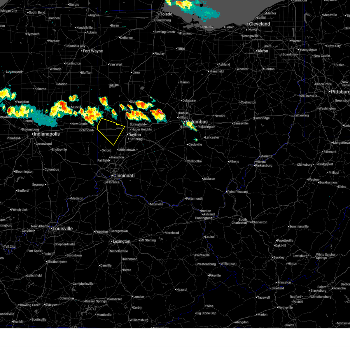
| 3/11/2026 10:09 AM EDT |
 At 1009 am edt, a severe thunderstorm was located over piqua, moving east at 80 mph (radar indicated). Hazards include 60 mph wind gusts. Expect damage to trees and power lines. locations impacted include, eaton, versailles, arcanum, bradford, lewisburg, west alexandria, webster, gettysburg, eldorado, verona, west manchester, pitsburg, gordon, ithaca, castine, union corners, oklahoma, west florence, interstate 70 at us route 127, and willowdell. This includes i-70 in ohio between mile markers 6 and 17. At 1009 am edt, a severe thunderstorm was located over piqua, moving east at 80 mph (radar indicated). Hazards include 60 mph wind gusts. Expect damage to trees and power lines. locations impacted include, eaton, versailles, arcanum, bradford, lewisburg, west alexandria, webster, gettysburg, eldorado, verona, west manchester, pitsburg, gordon, ithaca, castine, union corners, oklahoma, west florence, interstate 70 at us route 127, and willowdell. This includes i-70 in ohio between mile markers 6 and 17.
|
| 3/11/2026 10:09 AM EDT |
 the severe thunderstorm warning has been cancelled and is no longer in effect the severe thunderstorm warning has been cancelled and is no longer in effect
|
| 3/11/2026 9:59 AM EDT |
 At 959 am edt, a severe thunderstorm was located near greenville, moving east at 80 mph (radar indicated). Hazards include 60 mph wind gusts. Expect damage to trees and power lines. locations impacted include, richmond, connersville, greenville, eaton, centerville, versailles, liberty, arcanum, bradford, lewisburg, new paris, west alexandria, ansonia, new madison, waterloo, webster, abington, brownsville, wayne lakes, and russia. this includes the following interstates, i-70 in indiana between mile markers 148 and 156. I-70 in ohio between mile markers 0 and 17. At 959 am edt, a severe thunderstorm was located near greenville, moving east at 80 mph (radar indicated). Hazards include 60 mph wind gusts. Expect damage to trees and power lines. locations impacted include, richmond, connersville, greenville, eaton, centerville, versailles, liberty, arcanum, bradford, lewisburg, new paris, west alexandria, ansonia, new madison, waterloo, webster, abington, brownsville, wayne lakes, and russia. this includes the following interstates, i-70 in indiana between mile markers 148 and 156. I-70 in ohio between mile markers 0 and 17.
|
| 3/11/2026 9:45 AM EDT |
 At 945 am edt, a severe thunderstorm was located near fountain city, moving east at 75 mph (radar indicated). Hazards include 60 mph wind gusts. Expect damage to trees and power lines. locations impacted include, richmond, connersville, greenville, eaton, centerville, cambridge city, versailles, liberty, arcanum, bradford, lewisburg, hagerstown, union city, new paris, west alexandria, ansonia, new madison, fountain city, dublin, and franklin. this includes the following interstates, i-70 in indiana between mile markers 134 and 156. I-70 in ohio between mile markers 0 and 17. At 945 am edt, a severe thunderstorm was located near fountain city, moving east at 75 mph (radar indicated). Hazards include 60 mph wind gusts. Expect damage to trees and power lines. locations impacted include, richmond, connersville, greenville, eaton, centerville, cambridge city, versailles, liberty, arcanum, bradford, lewisburg, hagerstown, union city, new paris, west alexandria, ansonia, new madison, fountain city, dublin, and franklin. this includes the following interstates, i-70 in indiana between mile markers 134 and 156. I-70 in ohio between mile markers 0 and 17.
|
| 3/11/2026 9:32 AM EDT |
 At 931 am edt, a severe thunderstorm was located over hagerstown, moving east at 80 mph (radar indicated). Hazards include 60 mph wind gusts. Expect damage to trees and power lines. locations impacted include, richmond, connersville, greenville, eaton, centerville, cambridge city, versailles, liberty, arcanum, bradford, lewisburg, hagerstown, union city, new paris, west alexandria, ansonia, new madison, fountain city, dublin, and glenwood. this includes the following interstates, i-70 in indiana between mile markers 134 and 156. I-70 in ohio between mile markers 0 and 17. At 931 am edt, a severe thunderstorm was located over hagerstown, moving east at 80 mph (radar indicated). Hazards include 60 mph wind gusts. Expect damage to trees and power lines. locations impacted include, richmond, connersville, greenville, eaton, centerville, cambridge city, versailles, liberty, arcanum, bradford, lewisburg, hagerstown, union city, new paris, west alexandria, ansonia, new madison, fountain city, dublin, and glenwood. this includes the following interstates, i-70 in indiana between mile markers 134 and 156. I-70 in ohio between mile markers 0 and 17.
|
| 3/11/2026 9:26 AM EDT |
 Svriln the national weather service in wilmington has issued a * severe thunderstorm warning for, wayne county in east central indiana, northern union county in east central indiana, fayette county in east central indiana, west central shelby county in west central ohio, preble county in west central ohio, darke county in west central ohio, * until 1015 am edt. * at 926 am edt, a severe thunderstorm was located near hagerstown, moving east at 90 mph (radar indicated). Hazards include 60 mph wind gusts. expect damage to trees and power lines Svriln the national weather service in wilmington has issued a * severe thunderstorm warning for, wayne county in east central indiana, northern union county in east central indiana, fayette county in east central indiana, west central shelby county in west central ohio, preble county in west central ohio, darke county in west central ohio, * until 1015 am edt. * at 926 am edt, a severe thunderstorm was located near hagerstown, moving east at 90 mph (radar indicated). Hazards include 60 mph wind gusts. expect damage to trees and power lines
|
| 12/28/2025 9:27 PM EST |
 At 926 pm est, severe thunderstorms were located along a line extending from bradford to near eaton to near west college corner, moving east at 55 mph (radar indicated). Hazards include 60 mph wind gusts. Expect damage to trees and power lines. locations impacted include, dayton, huber heights, troy, trotwood, piqua, vandalia, englewood, greenville, tipp city, eaton, west milton, covington, arcanum, bradford, lewisburg, west alexandria, pleasant hill, clayton, union, and brookville. this includes the following interstates, i-70 in ohio between mile markers 7 and 37. I-75 in ohio between mile markers 58 and 83. At 926 pm est, severe thunderstorms were located along a line extending from bradford to near eaton to near west college corner, moving east at 55 mph (radar indicated). Hazards include 60 mph wind gusts. Expect damage to trees and power lines. locations impacted include, dayton, huber heights, troy, trotwood, piqua, vandalia, englewood, greenville, tipp city, eaton, west milton, covington, arcanum, bradford, lewisburg, west alexandria, pleasant hill, clayton, union, and brookville. this includes the following interstates, i-70 in ohio between mile markers 7 and 37. I-75 in ohio between mile markers 58 and 83.
|
| 12/28/2025 9:20 PM EST |
 At 918 pm est, severe thunderstorms were located along a line extending from near greenville to near eaton to 7 miles southwest of liberty, moving east at 45 mph (observed wind gust of 58 knots at richmond municipal airport). Hazards include 60 mph wind gusts. Expect damage to trees and power lines. locations impacted include, dayton, huber heights, troy, trotwood, piqua, vandalia, englewood, greenville, tipp city, eaton, west milton, covington, arcanum, camden, bradford, lewisburg, new paris, west alexandria, pleasant hill, and new madison. this includes the following interstates, i-70 in ohio between mile markers 1 and 37. I-75 in ohio between mile markers 58 and 83. At 918 pm est, severe thunderstorms were located along a line extending from near greenville to near eaton to 7 miles southwest of liberty, moving east at 45 mph (observed wind gust of 58 knots at richmond municipal airport). Hazards include 60 mph wind gusts. Expect damage to trees and power lines. locations impacted include, dayton, huber heights, troy, trotwood, piqua, vandalia, englewood, greenville, tipp city, eaton, west milton, covington, arcanum, camden, bradford, lewisburg, new paris, west alexandria, pleasant hill, and new madison. this includes the following interstates, i-70 in ohio between mile markers 1 and 37. I-75 in ohio between mile markers 58 and 83.
|
| 12/28/2025 9:20 PM EST |
 the severe thunderstorm warning has been cancelled and is no longer in effect the severe thunderstorm warning has been cancelled and is no longer in effect
|
| 12/28/2025 9:05 PM EST |
 Svriln the national weather service in wilmington has issued a * severe thunderstorm warning for, eastern wayne county in east central indiana, union county in east central indiana, southeastern fayette county in east central indiana, preble county in west central ohio, northwestern butler county in southwestern ohio, southern darke county in west central ohio, northwestern montgomery county in west central ohio, miami county in west central ohio, * until 945 pm est. * at 905 pm est, severe thunderstorms were located along a line extending from 6 miles west of greenville to near richmond to 9 miles south of connersville, moving east at 45 mph (radar indicated). Hazards include 60 mph wind gusts. expect damage to trees and power lines Svriln the national weather service in wilmington has issued a * severe thunderstorm warning for, eastern wayne county in east central indiana, union county in east central indiana, southeastern fayette county in east central indiana, preble county in west central ohio, northwestern butler county in southwestern ohio, southern darke county in west central ohio, northwestern montgomery county in west central ohio, miami county in west central ohio, * until 945 pm est. * at 905 pm est, severe thunderstorms were located along a line extending from 6 miles west of greenville to near richmond to 9 miles south of connersville, moving east at 45 mph (radar indicated). Hazards include 60 mph wind gusts. expect damage to trees and power lines
|
| 7/25/2025 4:37 PM EDT |
 The storm which prompted the warning has weakened below severe limits and no longer poses an immediate threat to life or property. therefore, the warning will be allowed to expire. however, gusty winds are still possible with this thunderstorm. please report previous wind damage or hail to the national weather service by going to our website at weather.gov/iln and submitting your report via social media. The storm which prompted the warning has weakened below severe limits and no longer poses an immediate threat to life or property. therefore, the warning will be allowed to expire. however, gusty winds are still possible with this thunderstorm. please report previous wind damage or hail to the national weather service by going to our website at weather.gov/iln and submitting your report via social media.
|
| 7/25/2025 4:28 PM EDT |
 The storms which prompted the warning have moved out of the warned area. therefore, the warning will be allowed to expire. however, gusty winds are still possible with these thunderstorms. a severe thunderstorm warning still exists for portions of southeastern darke county. please report previous wind damage or hail to the national weather service by going to our website at weather.gov/iln and submitting your report via social media. The storms which prompted the warning have moved out of the warned area. therefore, the warning will be allowed to expire. however, gusty winds are still possible with these thunderstorms. a severe thunderstorm warning still exists for portions of southeastern darke county. please report previous wind damage or hail to the national weather service by going to our website at weather.gov/iln and submitting your report via social media.
|
| 7/25/2025 4:17 PM EDT |
 At 417 pm edt, severe thunderstorms were located along a line extending from near greenville to near new paris, moving east at 35 mph (radar indicated). Hazards include 60 mph wind gusts. Expect damage to trees and power lines. Locations impacted include, greenville, arcanum, gettysburg, ithaca, union corners, and abbottsville. At 417 pm edt, severe thunderstorms were located along a line extending from near greenville to near new paris, moving east at 35 mph (radar indicated). Hazards include 60 mph wind gusts. Expect damage to trees and power lines. Locations impacted include, greenville, arcanum, gettysburg, ithaca, union corners, and abbottsville.
|
| 7/25/2025 4:17 PM EDT |
 Svriln the national weather service in wilmington has issued a * severe thunderstorm warning for, southeastern darke county in west central ohio, northwestern montgomery county in west central ohio, southwestern miami county in west central ohio, * until 445 pm edt. * at 416 pm edt, a severe thunderstorm was located over arcanum, moving east at 30 mph (radar indicated). Hazards include 60 mph wind gusts. expect damage to trees and power lines Svriln the national weather service in wilmington has issued a * severe thunderstorm warning for, southeastern darke county in west central ohio, northwestern montgomery county in west central ohio, southwestern miami county in west central ohio, * until 445 pm edt. * at 416 pm edt, a severe thunderstorm was located over arcanum, moving east at 30 mph (radar indicated). Hazards include 60 mph wind gusts. expect damage to trees and power lines
|
| 7/25/2025 4:06 PM EDT |
 the severe thunderstorm warning has been cancelled and is no longer in effect the severe thunderstorm warning has been cancelled and is no longer in effect
|
| 7/25/2025 4:06 PM EDT |
 At 406 pm edt, severe thunderstorms were located along a line extending from near greenville to near new paris, moving east at 35 mph (radar indicated). Hazards include 60 mph wind gusts. Expect damage to trees and power lines. Locations impacted include, greenville, arcanum, union city, new madison, webster, wayne lakes, gettysburg, hollansburg, palestine, ithaca, castine, union corners, sharpeye, abbottsville, sharps crossing, and pikeville. At 406 pm edt, severe thunderstorms were located along a line extending from near greenville to near new paris, moving east at 35 mph (radar indicated). Hazards include 60 mph wind gusts. Expect damage to trees and power lines. Locations impacted include, greenville, arcanum, union city, new madison, webster, wayne lakes, gettysburg, hollansburg, palestine, ithaca, castine, union corners, sharpeye, abbottsville, sharps crossing, and pikeville.
|
| 7/25/2025 3:49 PM EDT |
 Svriln the national weather service in wilmington has issued a * severe thunderstorm warning for, northeastern wayne county in east central indiana, northwestern preble county in west central ohio, southern darke county in west central ohio, * until 430 pm edt. * at 349 pm edt, severe thunderstorms were located along a line extending from near union city to near centerville, moving east at 30 mph (radar indicated). Hazards include 60 mph wind gusts. expect damage to trees and power lines Svriln the national weather service in wilmington has issued a * severe thunderstorm warning for, northeastern wayne county in east central indiana, northwestern preble county in west central ohio, southern darke county in west central ohio, * until 430 pm edt. * at 349 pm edt, severe thunderstorms were located along a line extending from near union city to near centerville, moving east at 30 mph (radar indicated). Hazards include 60 mph wind gusts. expect damage to trees and power lines
|
| 7/12/2025 6:14 PM EDT |
 At 614 pm edt, a severe thunderstorm was located over lewisburg, moving northeast at 30 mph (radar indicated). Hazards include 60 mph wind gusts. Expect damage to trees and power lines. locations impacted include, trotwood, englewood, eaton, arcanum, lewisburg, west alexandria, clayton, union, brookville, phillipsburg, eldorado, verona, west manchester, laura, pitsburg, potsdam, gordon, ithaca, castine, and oklahoma. This includes i-70 in ohio between mile markers 9 and 27. At 614 pm edt, a severe thunderstorm was located over lewisburg, moving northeast at 30 mph (radar indicated). Hazards include 60 mph wind gusts. Expect damage to trees and power lines. locations impacted include, trotwood, englewood, eaton, arcanum, lewisburg, west alexandria, clayton, union, brookville, phillipsburg, eldorado, verona, west manchester, laura, pitsburg, potsdam, gordon, ithaca, castine, and oklahoma. This includes i-70 in ohio between mile markers 9 and 27.
|
| 7/12/2025 5:54 PM EDT |
 Svriln the national weather service in wilmington has issued a * severe thunderstorm warning for, northern preble county in west central ohio, southeastern darke county in west central ohio, northwestern montgomery county in west central ohio, southwestern miami county in west central ohio, * until 645 pm edt. * at 554 pm edt, a severe thunderstorm was located near new paris, moving northeast at 30 mph (radar indicated). Hazards include 60 mph wind gusts. expect damage to trees and power lines Svriln the national weather service in wilmington has issued a * severe thunderstorm warning for, northern preble county in west central ohio, southeastern darke county in west central ohio, northwestern montgomery county in west central ohio, southwestern miami county in west central ohio, * until 645 pm edt. * at 554 pm edt, a severe thunderstorm was located near new paris, moving northeast at 30 mph (radar indicated). Hazards include 60 mph wind gusts. expect damage to trees and power lines
|
| 6/18/2025 6:47 PM EDT |
 the severe thunderstorm warning has been cancelled and is no longer in effect the severe thunderstorm warning has been cancelled and is no longer in effect
|
| 6/18/2025 6:47 PM EDT |
 At 646 pm edt, severe thunderstorms were located along a line extending from pleasant hill to near darrtown, moving northeast at 60 mph (radar indicated). Hazards include 70 mph wind gusts and quarter size hail. Minor hail damage to vehicles is possible. expect considerable tree damage. wind damage is also likely to mobile homes, roofs, and outbuildings. locations impacted include, dayton, hamilton, kettering, middletown, beavercreek, fairfield, huber heights, mason, trotwood, oxford, miamisburg, lebanon, forest park, springboro, vandalia, englewood, monroe, trenton, franklin, and springdale. this includes the following interstates, i-70 in ohio between mile markers 4 and 40. I-75 in ohio between mile markers 18 and 70. At 646 pm edt, severe thunderstorms were located along a line extending from pleasant hill to near darrtown, moving northeast at 60 mph (radar indicated). Hazards include 70 mph wind gusts and quarter size hail. Minor hail damage to vehicles is possible. expect considerable tree damage. wind damage is also likely to mobile homes, roofs, and outbuildings. locations impacted include, dayton, hamilton, kettering, middletown, beavercreek, fairfield, huber heights, mason, trotwood, oxford, miamisburg, lebanon, forest park, springboro, vandalia, englewood, monroe, trenton, franklin, and springdale. this includes the following interstates, i-70 in ohio between mile markers 4 and 40. I-75 in ohio between mile markers 18 and 70.
|
| 6/18/2025 6:23 PM EDT |
 At 623 pm edt, severe thunderstorms were located along a line extending from near arcanum to near oxford, moving east at 60 mph (radar indicated). Hazards include 70 mph wind gusts and quarter size hail. Minor hail damage to vehicles is possible. expect considerable tree damage. wind damage is also likely to mobile homes, roofs, and outbuildings. locations impacted include, hamilton, fairfield, richmond, oxford, connersville, eaton, batesville, brookville, centerville, ross, liberty, arcanum, camden, lewisburg, new paris, west alexandria, new madison, gratis, fountain city, and seven mile. this includes the following interstates, i-70 in indiana between mile markers 145 and 156. i-70 in ohio between mile markers 0 and 17. I-74 in indiana between mile markers 145 and 148. At 623 pm edt, severe thunderstorms were located along a line extending from near arcanum to near oxford, moving east at 60 mph (radar indicated). Hazards include 70 mph wind gusts and quarter size hail. Minor hail damage to vehicles is possible. expect considerable tree damage. wind damage is also likely to mobile homes, roofs, and outbuildings. locations impacted include, hamilton, fairfield, richmond, oxford, connersville, eaton, batesville, brookville, centerville, ross, liberty, arcanum, camden, lewisburg, new paris, west alexandria, new madison, gratis, fountain city, and seven mile. this includes the following interstates, i-70 in indiana between mile markers 145 and 156. i-70 in ohio between mile markers 0 and 17. I-74 in indiana between mile markers 145 and 148.
|
| 6/18/2025 6:21 PM EDT |
 Svriln the national weather service in wilmington has issued a * severe thunderstorm warning for, eastern franklin county in southeastern indiana, southeastern wayne county in east central indiana, union county in east central indiana, preble county in west central ohio, butler county in southwestern ohio, northwestern warren county in southwestern ohio, southern darke county in west central ohio, montgomery county in west central ohio, southern miami county in west central ohio, * until 715 pm edt. * at 620 pm edt, severe thunderstorms were located along a line extending from near new madison to near brookville, moving northeast at 60 mph (radar indicated). Hazards include 70 mph wind gusts and quarter size hail. Minor hail damage to vehicles is possible. expect considerable tree damage. Wind damage is also likely to mobile homes, roofs, and outbuildings. Svriln the national weather service in wilmington has issued a * severe thunderstorm warning for, eastern franklin county in southeastern indiana, southeastern wayne county in east central indiana, union county in east central indiana, preble county in west central ohio, butler county in southwestern ohio, northwestern warren county in southwestern ohio, southern darke county in west central ohio, montgomery county in west central ohio, southern miami county in west central ohio, * until 715 pm edt. * at 620 pm edt, severe thunderstorms were located along a line extending from near new madison to near brookville, moving northeast at 60 mph (radar indicated). Hazards include 70 mph wind gusts and quarter size hail. Minor hail damage to vehicles is possible. expect considerable tree damage. Wind damage is also likely to mobile homes, roofs, and outbuildings.
|
| 6/18/2025 5:57 PM EDT |
 At 557 pm edt, severe thunderstorms were located along a line extending from near fountain city to near lake santee, moving east at 40 mph (trained weather spotters). Hazards include 70 mph wind gusts and penny size hail. Expect considerable tree damage. damage is likely to mobile homes, roofs, and outbuildings. locations impacted include, hamilton, fairfield, richmond, oxford, connersville, eaton, batesville, brookville, centerville, cambridge city, ross, liberty, arcanum, camden, lewisburg, hagerstown, new paris, west alexandria, new madison, and gratis. this includes the following interstates, i-70 in indiana between mile markers 134 and 156. i-70 in ohio between mile markers 0 and 17. I-74 in indiana between mile markers 145 and 148. At 557 pm edt, severe thunderstorms were located along a line extending from near fountain city to near lake santee, moving east at 40 mph (trained weather spotters). Hazards include 70 mph wind gusts and penny size hail. Expect considerable tree damage. damage is likely to mobile homes, roofs, and outbuildings. locations impacted include, hamilton, fairfield, richmond, oxford, connersville, eaton, batesville, brookville, centerville, cambridge city, ross, liberty, arcanum, camden, lewisburg, hagerstown, new paris, west alexandria, new madison, and gratis. this includes the following interstates, i-70 in indiana between mile markers 134 and 156. i-70 in ohio between mile markers 0 and 17. I-74 in indiana between mile markers 145 and 148.
|
| 6/18/2025 5:27 PM EDT |
 Svriln the national weather service in wilmington has issued a * severe thunderstorm warning for, franklin county in southeastern indiana, wayne county in east central indiana, union county in east central indiana, fayette county in east central indiana, preble county in west central ohio, butler county in southwestern ohio, southern darke county in west central ohio, * until 630 pm edt. * at 527 pm edt, severe thunderstorms were located along a line extending from 9 miles northwest of new castle to 10 miles southwest of rushville, moving east at 60 mph (public). Hazards include 70 mph wind gusts and penny size hail. Expect considerable tree damage. Damage is likely to mobile homes, roofs, and outbuildings. Svriln the national weather service in wilmington has issued a * severe thunderstorm warning for, franklin county in southeastern indiana, wayne county in east central indiana, union county in east central indiana, fayette county in east central indiana, preble county in west central ohio, butler county in southwestern ohio, southern darke county in west central ohio, * until 630 pm edt. * at 527 pm edt, severe thunderstorms were located along a line extending from 9 miles northwest of new castle to 10 miles southwest of rushville, moving east at 60 mph (public). Hazards include 70 mph wind gusts and penny size hail. Expect considerable tree damage. Damage is likely to mobile homes, roofs, and outbuildings.
|
| 5/16/2025 10:33 PM EDT |
 the severe thunderstorm warning has been cancelled and is no longer in effect the severe thunderstorm warning has been cancelled and is no longer in effect
|
| 5/16/2025 10:33 PM EDT |
 At 1032 pm edt, a severe thunderstorm was located near lewisburg, moving east at 45 mph (radar indicated). Hazards include 60 mph wind gusts and quarter size hail. Minor hail damage to vehicles is possible. expect wind damage to trees and power lines. locations impacted include, gordon, pitsburg, potsdam, ithaca, arcanum, west manchester, lewisburg, brookville, castine, laura, interstate 70 at us route 127, garland, phillipsburg, verona, eldorado, and clayton. This includes i-70 in ohio between mile markers 8 and 25. At 1032 pm edt, a severe thunderstorm was located near lewisburg, moving east at 45 mph (radar indicated). Hazards include 60 mph wind gusts and quarter size hail. Minor hail damage to vehicles is possible. expect wind damage to trees and power lines. locations impacted include, gordon, pitsburg, potsdam, ithaca, arcanum, west manchester, lewisburg, brookville, castine, laura, interstate 70 at us route 127, garland, phillipsburg, verona, eldorado, and clayton. This includes i-70 in ohio between mile markers 8 and 25.
|
| 5/16/2025 10:14 PM EDT |
 Svriln the national weather service in wilmington has issued a * severe thunderstorm warning for, east central wayne county in east central indiana, northern preble county in west central ohio, southern darke county in west central ohio, northwestern montgomery county in west central ohio, southwestern miami county in west central ohio, * until 1100 pm edt. * at 1013 pm edt, a severe thunderstorm was located over richmond, moving east at 45 mph (radar indicated). Hazards include 60 mph wind gusts and quarter size hail. Minor hail damage to vehicles is possible. Expect wind damage to trees and power lines. Svriln the national weather service in wilmington has issued a * severe thunderstorm warning for, east central wayne county in east central indiana, northern preble county in west central ohio, southern darke county in west central ohio, northwestern montgomery county in west central ohio, southwestern miami county in west central ohio, * until 1100 pm edt. * at 1013 pm edt, a severe thunderstorm was located over richmond, moving east at 45 mph (radar indicated). Hazards include 60 mph wind gusts and quarter size hail. Minor hail damage to vehicles is possible. Expect wind damage to trees and power lines.
|
| 5/16/2025 8:13 PM EDT |
 Svriln the national weather service in wilmington has issued a * severe thunderstorm warning for, east central wayne county in east central indiana, shelby county in west central ohio, western champaign county in west central ohio, northern preble county in west central ohio, western logan county in west central ohio, darke county in west central ohio, western clark county in west central ohio, auglaize county in west central ohio, mercer county in west central ohio, northwestern greene county in west central ohio, northern montgomery county in west central ohio, western hardin county in west central ohio, miami county in west central ohio, * until 900 pm edt. * at 813 pm edt, severe thunderstorms were located along a line extending from near fort recovery to 6 miles west of new madison, moving east at 65 mph (radar indicated). Hazards include 60 mph wind gusts. expect damage to trees and power lines Svriln the national weather service in wilmington has issued a * severe thunderstorm warning for, east central wayne county in east central indiana, shelby county in west central ohio, western champaign county in west central ohio, northern preble county in west central ohio, western logan county in west central ohio, darke county in west central ohio, western clark county in west central ohio, auglaize county in west central ohio, mercer county in west central ohio, northwestern greene county in west central ohio, northern montgomery county in west central ohio, western hardin county in west central ohio, miami county in west central ohio, * until 900 pm edt. * at 813 pm edt, severe thunderstorms were located along a line extending from near fort recovery to 6 miles west of new madison, moving east at 65 mph (radar indicated). Hazards include 60 mph wind gusts. expect damage to trees and power lines
|
| 4/29/2025 1:25 PM EDT |
 At 125 pm edt, a severe thunderstorm was located near west alexandria, moving east at 55 mph (radar indicated). Hazards include 70 mph wind gusts and quarter size hail. Minor hail damage to vehicles is possible. expect considerable tree damage. wind damage is also likely to mobile homes, roofs, and outbuildings. locations impacted include, franklin, ginghamsburg, vandalia, hughes, englewood, seven mile, potsdam, collinsville, morning sun, west milton, carlisle, new madison, west alexandria, south middletown, wheatville, interstate 70 at us route 127, muttonville, dayton international airport, millville, and overlook-page mano. this includes the following interstates, i-70 in ohio between mile markers 8 and 40. I-75 in ohio between mile markers 27 and 74. At 125 pm edt, a severe thunderstorm was located near west alexandria, moving east at 55 mph (radar indicated). Hazards include 70 mph wind gusts and quarter size hail. Minor hail damage to vehicles is possible. expect considerable tree damage. wind damage is also likely to mobile homes, roofs, and outbuildings. locations impacted include, franklin, ginghamsburg, vandalia, hughes, englewood, seven mile, potsdam, collinsville, morning sun, west milton, carlisle, new madison, west alexandria, south middletown, wheatville, interstate 70 at us route 127, muttonville, dayton international airport, millville, and overlook-page mano. this includes the following interstates, i-70 in ohio between mile markers 8 and 40. I-75 in ohio between mile markers 27 and 74.
|
| 4/29/2025 1:08 PM EDT |
 At 107 pm edt, a severe thunderstorm was located near camden, moving east at 55 mph (radar indicated). Hazards include 70 mph wind gusts and quarter size hail. Minor hail damage to vehicles is possible. expect considerable tree damage. wind damage is also likely to mobile homes, roofs, and outbuildings. locations impacted include, franklin, englewood, potsdam, west florence, morning sun, west milton, new madison, south middletown, interstate 70 at us route 127, muttonville, camden, hunter, arcanum, new paris, clayton, reily, college corner, brookville, kettering, and drexel. this includes the following interstates, i-70 in ohio between mile markers 1 and 40. I-75 in ohio between mile markers 27 and 74. At 107 pm edt, a severe thunderstorm was located near camden, moving east at 55 mph (radar indicated). Hazards include 70 mph wind gusts and quarter size hail. Minor hail damage to vehicles is possible. expect considerable tree damage. wind damage is also likely to mobile homes, roofs, and outbuildings. locations impacted include, franklin, englewood, potsdam, west florence, morning sun, west milton, new madison, south middletown, interstate 70 at us route 127, muttonville, camden, hunter, arcanum, new paris, clayton, reily, college corner, brookville, kettering, and drexel. this includes the following interstates, i-70 in ohio between mile markers 1 and 40. I-75 in ohio between mile markers 27 and 74.
|
| 4/29/2025 12:50 PM EDT |
 Svriln the national weather service in wilmington has issued a * severe thunderstorm warning for, butler county in southwestern ohio, preble county in west central ohio, northwestern warren county in southwestern ohio, southern darke county in west central ohio, montgomery county in west central ohio, southern miami county in west central ohio, * until 145 pm edt. * at 1249 pm edt, a severe thunderstorm was located near connersville, moving east at 55 mph (radar indicated). Hazards include 70 mph wind gusts and quarter size hail. Minor hail damage to vehicles is possible. expect considerable tree damage. Wind damage is also likely to mobile homes, roofs, and outbuildings. Svriln the national weather service in wilmington has issued a * severe thunderstorm warning for, butler county in southwestern ohio, preble county in west central ohio, northwestern warren county in southwestern ohio, southern darke county in west central ohio, montgomery county in west central ohio, southern miami county in west central ohio, * until 145 pm edt. * at 1249 pm edt, a severe thunderstorm was located near connersville, moving east at 55 mph (radar indicated). Hazards include 70 mph wind gusts and quarter size hail. Minor hail damage to vehicles is possible. expect considerable tree damage. Wind damage is also likely to mobile homes, roofs, and outbuildings.
|
| 4/19/2025 6:31 AM EDT |
 Svriln the national weather service in wilmington has issued a * severe thunderstorm warning for, shelby county in west central ohio, darke county in west central ohio, southwestern auglaize county in west central ohio, southeastern mercer county in west central ohio, miami county in west central ohio, * until 700 am edt. * at 631 am edt, a severe thunderstorm was located over union city, moving northeast at 75 mph (radar indicated). Hazards include 60 mph wind gusts and penny size hail. expect damage to trees and power lines Svriln the national weather service in wilmington has issued a * severe thunderstorm warning for, shelby county in west central ohio, darke county in west central ohio, southwestern auglaize county in west central ohio, southeastern mercer county in west central ohio, miami county in west central ohio, * until 700 am edt. * at 631 am edt, a severe thunderstorm was located over union city, moving northeast at 75 mph (radar indicated). Hazards include 60 mph wind gusts and penny size hail. expect damage to trees and power lines
|
| 4/3/2025 12:07 AM EDT |
 Svriln the national weather service in wilmington has issued a * severe thunderstorm warning for, south central shelby county in west central ohio, southwestern champaign county in west central ohio, preble county in west central ohio, southeastern darke county in west central ohio, northwestern clark county in west central ohio, northern montgomery county in west central ohio, miami county in west central ohio, * until 1245 am edt. * at 1207 am edt, a severe thunderstorm was located over eaton, moving northeast at 55 mph (radar indicated). Hazards include 60 mph wind gusts. expect damage to trees and power lines Svriln the national weather service in wilmington has issued a * severe thunderstorm warning for, south central shelby county in west central ohio, southwestern champaign county in west central ohio, preble county in west central ohio, southeastern darke county in west central ohio, northwestern clark county in west central ohio, northern montgomery county in west central ohio, miami county in west central ohio, * until 1245 am edt. * at 1207 am edt, a severe thunderstorm was located over eaton, moving northeast at 55 mph (radar indicated). Hazards include 60 mph wind gusts. expect damage to trees and power lines
|
| 4/2/2025 11:57 PM EDT |
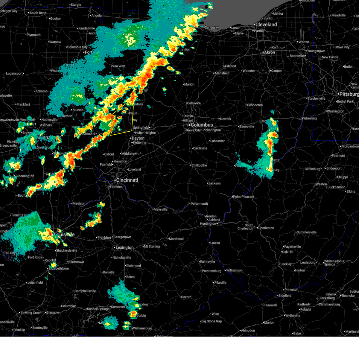
 At 1157 pm edt, a severe thunderstorm capable of producing a tornado was located near lewisburg, moving northeast at 60 mph (radar indicated rotation). Hazards include tornado. Flying debris will be dangerous to those caught without shelter. mobile homes will be damaged or destroyed. damage to roofs, windows, and vehicles will occur. tree damage is likely. Locations impacted include, gordon, pitsburg, castine, laura, potsdam, ithaca, garland, verona, west manchester, west milton, ludlow falls, and phillipsburg. At 1157 pm edt, a severe thunderstorm capable of producing a tornado was located near lewisburg, moving northeast at 60 mph (radar indicated rotation). Hazards include tornado. Flying debris will be dangerous to those caught without shelter. mobile homes will be damaged or destroyed. damage to roofs, windows, and vehicles will occur. tree damage is likely. Locations impacted include, gordon, pitsburg, castine, laura, potsdam, ithaca, garland, verona, west manchester, west milton, ludlow falls, and phillipsburg.
|
| 4/2/2025 11:52 PM EDT |
 At 1152 pm edt, a severe thunderstorm was located near greenville, moving northeast at 60 mph (radar indicated). Hazards include 60 mph wind gusts and penny size hail. Expect damage to trees and power lines. locations impacted include, ginghamsburg, vandalia, englewood, casstown, union corners, bradford, potsdam, west florence, west milton, new madison, covington, west alexandria, interstate 70 at us route 127, dayton international airport, new hope, piqua, bloomer, greenville, arcanum, and lewisburg. this includes the following interstates, i-70 in ohio between mile markers 1 and 37. I-75 in ohio between mile markers 61 and 84. At 1152 pm edt, a severe thunderstorm was located near greenville, moving northeast at 60 mph (radar indicated). Hazards include 60 mph wind gusts and penny size hail. Expect damage to trees and power lines. locations impacted include, ginghamsburg, vandalia, englewood, casstown, union corners, bradford, potsdam, west florence, west milton, new madison, covington, west alexandria, interstate 70 at us route 127, dayton international airport, new hope, piqua, bloomer, greenville, arcanum, and lewisburg. this includes the following interstates, i-70 in ohio between mile markers 1 and 37. I-75 in ohio between mile markers 61 and 84.
|
| 4/2/2025 11:51 PM EDT |
 Toriln the national weather service in wilmington has issued a * tornado warning for, northeastern preble county in west central ohio, southeastern darke county in west central ohio, northwestern montgomery county in west central ohio, southwestern miami county in west central ohio, * until 1215 am edt. * at 1151 pm edt, a severe thunderstorm capable of producing a tornado was located near lewisburg, moving northeast at 60 mph (radar indicated rotation). Hazards include tornado. Flying debris will be dangerous to those caught without shelter. mobile homes will be damaged or destroyed. damage to roofs, windows, and vehicles will occur. Tree damage is likely. Toriln the national weather service in wilmington has issued a * tornado warning for, northeastern preble county in west central ohio, southeastern darke county in west central ohio, northwestern montgomery county in west central ohio, southwestern miami county in west central ohio, * until 1215 am edt. * at 1151 pm edt, a severe thunderstorm capable of producing a tornado was located near lewisburg, moving northeast at 60 mph (radar indicated rotation). Hazards include tornado. Flying debris will be dangerous to those caught without shelter. mobile homes will be damaged or destroyed. damage to roofs, windows, and vehicles will occur. Tree damage is likely.
|
| 4/2/2025 11:47 PM EDT |
 At 1147 pm edt, a severe thunderstorm was located near greenville, moving northeast at 60 mph (radar indicated). Hazards include 60 mph wind gusts and penny size hail. Expect damage to trees and power lines. locations impacted include, ginghamsburg, vandalia, englewood, casstown, union corners, bradford, potsdam, west florence, west milton, new madison, covington, west alexandria, interstate 70 at us route 127, dayton international airport, hollansburg, new hope, piqua, bloomer, greenville, and arcanum. this includes the following interstates, i-70 in ohio between mile markers 1 and 37. I-75 in ohio between mile markers 61 and 84. At 1147 pm edt, a severe thunderstorm was located near greenville, moving northeast at 60 mph (radar indicated). Hazards include 60 mph wind gusts and penny size hail. Expect damage to trees and power lines. locations impacted include, ginghamsburg, vandalia, englewood, casstown, union corners, bradford, potsdam, west florence, west milton, new madison, covington, west alexandria, interstate 70 at us route 127, dayton international airport, hollansburg, new hope, piqua, bloomer, greenville, and arcanum. this includes the following interstates, i-70 in ohio between mile markers 1 and 37. I-75 in ohio between mile markers 61 and 84.
|
| 4/2/2025 11:28 PM EDT |
 Svriln the national weather service in wilmington has issued a * severe thunderstorm warning for, northern preble county in west central ohio, southern darke county in west central ohio, northern montgomery county in west central ohio, miami county in west central ohio, * until 1215 am edt. * at 1128 pm edt, a severe thunderstorm was located over fountain city, moving northeast at 60 mph (radar indicated). Hazards include 60 mph wind gusts and penny size hail. expect damage to trees and power lines Svriln the national weather service in wilmington has issued a * severe thunderstorm warning for, northern preble county in west central ohio, southern darke county in west central ohio, northern montgomery county in west central ohio, miami county in west central ohio, * until 1215 am edt. * at 1128 pm edt, a severe thunderstorm was located over fountain city, moving northeast at 60 mph (radar indicated). Hazards include 60 mph wind gusts and penny size hail. expect damage to trees and power lines
|
| 4/2/2025 10:32 PM EDT |
 At 1032 pm edt, a severe thunderstorm was located near fort recovery, moving northeast at 70 mph (radar indicated). Hazards include 70 mph wind gusts and quarter size hail. Minor hail damage to vehicles is possible. expect considerable tree damage. wind damage is also likely to mobile homes, roofs, and outbuildings. locations impacted include, fryburg, union corners, newbern, bradford, chickasaw, lockington, darke county airport, new madison, covington, new knoxville, neptune, fort loramie, sharps crossing, hardin, pemberton, kossuth, bloomer, lake loramie state park, arcanum, and north dayton. This includes i-75 in ohio between mile markers 76 and 118. At 1032 pm edt, a severe thunderstorm was located near fort recovery, moving northeast at 70 mph (radar indicated). Hazards include 70 mph wind gusts and quarter size hail. Minor hail damage to vehicles is possible. expect considerable tree damage. wind damage is also likely to mobile homes, roofs, and outbuildings. locations impacted include, fryburg, union corners, newbern, bradford, chickasaw, lockington, darke county airport, new madison, covington, new knoxville, neptune, fort loramie, sharps crossing, hardin, pemberton, kossuth, bloomer, lake loramie state park, arcanum, and north dayton. This includes i-75 in ohio between mile markers 76 and 118.
|
| 4/2/2025 10:18 PM EDT |
 Svriln the national weather service in wilmington has issued a * severe thunderstorm warning for, shelby county in west central ohio, northwestern preble county in west central ohio, darke county in west central ohio, auglaize county in west central ohio, mercer county in west central ohio, northern miami county in west central ohio, * until 1115 pm edt. * at 1018 pm edt, a severe thunderstorm was located near winchester, moving northeast at 70 mph (radar indicated). Hazards include 70 mph wind gusts and quarter size hail. Minor hail damage to vehicles is possible. expect considerable tree damage. Wind damage is also likely to mobile homes, roofs, and outbuildings. Svriln the national weather service in wilmington has issued a * severe thunderstorm warning for, shelby county in west central ohio, northwestern preble county in west central ohio, darke county in west central ohio, auglaize county in west central ohio, mercer county in west central ohio, northern miami county in west central ohio, * until 1115 pm edt. * at 1018 pm edt, a severe thunderstorm was located near winchester, moving northeast at 70 mph (radar indicated). Hazards include 70 mph wind gusts and quarter size hail. Minor hail damage to vehicles is possible. expect considerable tree damage. Wind damage is also likely to mobile homes, roofs, and outbuildings.
|
| 3/30/2025 8:26 PM EDT |
 The storms which prompted the warning have weakened below severe limits and no longer pose an immediate threat to life or property. therefore, the warning will be allowed to expire. however, gusty winds are still possible with these thunderstorms. a tornado watch remains in effect until 100 am edt for east central indiana, and west central ohio. a severe thunderstorm watch remains in effect until 1000 pm edt for west central ohio. please report previous wind damage or hail to the national weather service by going to our website at weather.gov/iln and submitting your report via social media. The storms which prompted the warning have weakened below severe limits and no longer pose an immediate threat to life or property. therefore, the warning will be allowed to expire. however, gusty winds are still possible with these thunderstorms. a tornado watch remains in effect until 100 am edt for east central indiana, and west central ohio. a severe thunderstorm watch remains in effect until 1000 pm edt for west central ohio. please report previous wind damage or hail to the national weather service by going to our website at weather.gov/iln and submitting your report via social media.
|
| 3/30/2025 7:51 PM EDT |
 Svriln the national weather service in wilmington has issued a * severe thunderstorm warning for, wayne county in east central indiana, northern preble county in west central ohio, southern darke county in west central ohio, * until 830 pm edt. * at 750 pm edt, severe thunderstorms were located along a line extending from 6 miles west of fountain city to connersville, moving east at 60 mph (radar indicated). Hazards include 60 mph wind gusts and penny size hail. expect damage to trees and power lines Svriln the national weather service in wilmington has issued a * severe thunderstorm warning for, wayne county in east central indiana, northern preble county in west central ohio, southern darke county in west central ohio, * until 830 pm edt. * at 750 pm edt, severe thunderstorms were located along a line extending from 6 miles west of fountain city to connersville, moving east at 60 mph (radar indicated). Hazards include 60 mph wind gusts and penny size hail. expect damage to trees and power lines
|
| 3/19/2025 10:42 PM EDT |
 The storm which prompted the warning has moved out of the area. therefore, the warning will be allowed to expire. however, gusty winds and heavy rain are still possible with this thunderstorm. a severe thunderstorm watch remains in effect until 100 am edt for west central ohio. please report previous wind damage or hail to the national weather service by going to our website at weather.gov/iln and submitting your report via social media. The storm which prompted the warning has moved out of the area. therefore, the warning will be allowed to expire. however, gusty winds and heavy rain are still possible with this thunderstorm. a severe thunderstorm watch remains in effect until 100 am edt for west central ohio. please report previous wind damage or hail to the national weather service by going to our website at weather.gov/iln and submitting your report via social media.
|
| 3/19/2025 10:38 PM EDT |
 At 1038 pm edt, a severe thunderstorm was located over lewisburg, moving northeast at 65 mph (radar indicated). Hazards include 60 mph wind gusts. Expect damage to trees and power lines. locations impacted include, camden, gordon, west elkton, oklahoma, ithaca, arcanum, west manchester, lewisburg, eaton, west alexandria, wheatville, castine, interstate 70 at us route 127, gratis, abbottsville, muttonville, verona, and lake lakengren. This includes i-70 in ohio between mile markers 9 and 17. At 1038 pm edt, a severe thunderstorm was located over lewisburg, moving northeast at 65 mph (radar indicated). Hazards include 60 mph wind gusts. Expect damage to trees and power lines. locations impacted include, camden, gordon, west elkton, oklahoma, ithaca, arcanum, west manchester, lewisburg, eaton, west alexandria, wheatville, castine, interstate 70 at us route 127, gratis, abbottsville, muttonville, verona, and lake lakengren. This includes i-70 in ohio between mile markers 9 and 17.
|
| 3/19/2025 10:38 PM EDT |
 the severe thunderstorm warning has been cancelled and is no longer in effect the severe thunderstorm warning has been cancelled and is no longer in effect
|
| 3/19/2025 10:28 PM EDT |
 At 1027 pm edt, a severe thunderstorm was located near arcanum, moving northeast at 50 mph (radar indicated). Hazards include 60 mph wind gusts. Expect damage to trees and power lines. locations impacted include, eldorado, oklahoma, west florence, ithaca, morning sun, new madison, west alexandria, wheatville, interstate 70 at us route 127, muttonville, lake lakengren, new hope, somerville, oxford, camden, gordon, west elkton, fairhaven, hueston woods state park, and arcanum. This includes i-70 in ohio between mile markers 1 and 17. At 1027 pm edt, a severe thunderstorm was located near arcanum, moving northeast at 50 mph (radar indicated). Hazards include 60 mph wind gusts. Expect damage to trees and power lines. locations impacted include, eldorado, oklahoma, west florence, ithaca, morning sun, new madison, west alexandria, wheatville, interstate 70 at us route 127, muttonville, lake lakengren, new hope, somerville, oxford, camden, gordon, west elkton, fairhaven, hueston woods state park, and arcanum. This includes i-70 in ohio between mile markers 1 and 17.
|
| 3/19/2025 10:28 PM EDT |
 the severe thunderstorm warning has been cancelled and is no longer in effect the severe thunderstorm warning has been cancelled and is no longer in effect
|
| 3/19/2025 10:09 PM EDT |
 the severe thunderstorm warning has been cancelled and is no longer in effect the severe thunderstorm warning has been cancelled and is no longer in effect
|
| 3/19/2025 10:09 PM EDT |
 At 1009 pm edt, a severe thunderstorm was located over richmond, moving northeast at 50 mph (radar indicated). Hazards include 60 mph wind gusts. Expect damage to trees and power lines. locations impacted include, goodwins corner, west florence, abington, brownsville, morning sun, new madison, west alexandria, wheatville, interstate 70 at us route 127, muttonville, new hope, boston, camden, fairhaven, billingsville, arcanum, clifton, whitewater, lewisburg, and new paris. this includes the following interstates, i-70 in indiana between mile markers 145 and 156. I-70 in ohio between mile markers 0 and 17. At 1009 pm edt, a severe thunderstorm was located over richmond, moving northeast at 50 mph (radar indicated). Hazards include 60 mph wind gusts. Expect damage to trees and power lines. locations impacted include, goodwins corner, west florence, abington, brownsville, morning sun, new madison, west alexandria, wheatville, interstate 70 at us route 127, muttonville, new hope, boston, camden, fairhaven, billingsville, arcanum, clifton, whitewater, lewisburg, and new paris. this includes the following interstates, i-70 in indiana between mile markers 145 and 156. I-70 in ohio between mile markers 0 and 17.
|
| 3/19/2025 9:58 PM EDT |
 Svriln the national weather service in wilmington has issued a * severe thunderstorm warning for, northeastern franklin county in southeastern indiana, southeastern wayne county in east central indiana, union county in east central indiana, southeastern fayette county in east central indiana, northwestern butler county in southwestern ohio, preble county in west central ohio, southern darke county in west central ohio, * until 1045 pm edt. * at 958 pm edt, a severe thunderstorm was located 7 miles south of centerville, moving northeast at 50 mph (radar indicated). Hazards include 60 mph wind gusts. expect damage to trees and power lines Svriln the national weather service in wilmington has issued a * severe thunderstorm warning for, northeastern franklin county in southeastern indiana, southeastern wayne county in east central indiana, union county in east central indiana, southeastern fayette county in east central indiana, northwestern butler county in southwestern ohio, preble county in west central ohio, southern darke county in west central ohio, * until 1045 pm edt. * at 958 pm edt, a severe thunderstorm was located 7 miles south of centerville, moving northeast at 50 mph (radar indicated). Hazards include 60 mph wind gusts. expect damage to trees and power lines
|
| 3/15/2025 7:10 AM EDT |
 The storm which prompted the warning has weakened below severe limits and no longer poses an immediate threat to life or property. therefore, the warning will be allowed to expire. however, gusty winds are still possible with this thunderstorm. a tornado watch remains in effect until 1000 am edt for west central ohio. please report previous wind damage or hail to the national weather service by going to our website at weather.gov/iln and submitting your report via social media. The storm which prompted the warning has weakened below severe limits and no longer poses an immediate threat to life or property. therefore, the warning will be allowed to expire. however, gusty winds are still possible with this thunderstorm. a tornado watch remains in effect until 1000 am edt for west central ohio. please report previous wind damage or hail to the national weather service by going to our website at weather.gov/iln and submitting your report via social media.
|
| 3/15/2025 6:54 AM EDT |
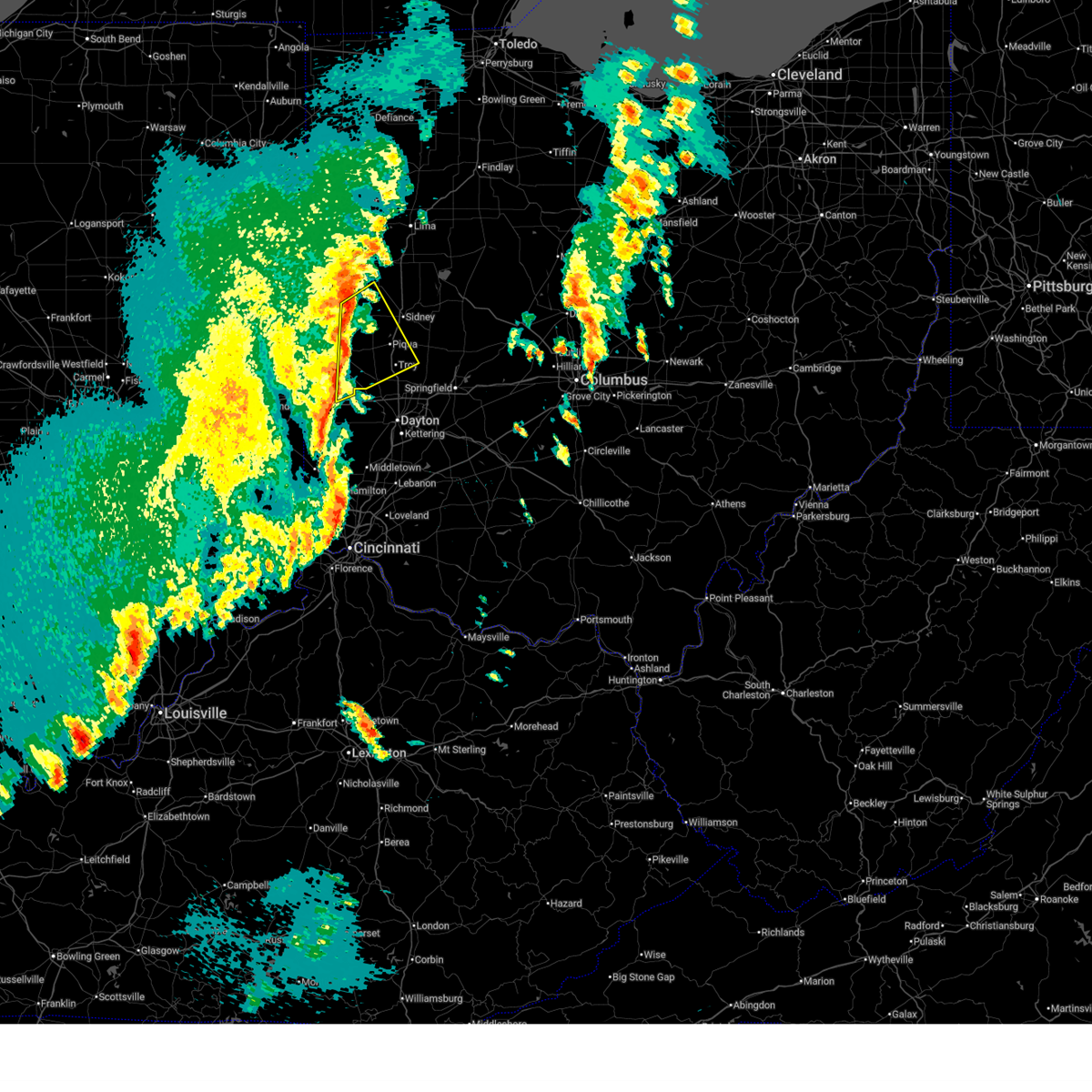 At 654 am edt, a severe thunderstorm was located over bradford, moving northeast at 65 mph (radar indicated). Hazards include 60 mph wind gusts and penny size hail. Expect damage to trees and power lines. locations impacted include, newport, casstown, union corners, polo, newbern, bradford, potsdam, egypt, ithaca, lockington, new bremen, darke county airport, north star, west milton, covington, russia, state route 47 at us route 127, fort loramie, osgood, and gettysburg. This includes i-75 in ohio between mile markers 71 and 88. At 654 am edt, a severe thunderstorm was located over bradford, moving northeast at 65 mph (radar indicated). Hazards include 60 mph wind gusts and penny size hail. Expect damage to trees and power lines. locations impacted include, newport, casstown, union corners, polo, newbern, bradford, potsdam, egypt, ithaca, lockington, new bremen, darke county airport, north star, west milton, covington, russia, state route 47 at us route 127, fort loramie, osgood, and gettysburg. This includes i-75 in ohio between mile markers 71 and 88.
|
| 3/15/2025 6:44 AM EDT |
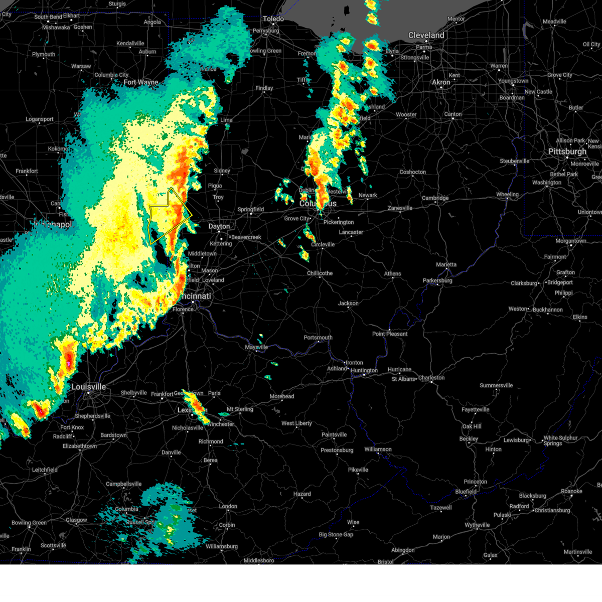 The severe thunderstorm which prompted the warning has moved out of the warned area. therefore, the warning will be allowed to expire. however, gusty winds are still possible with this thunderstorm. a tornado watch remains in effect until 1000 am edt for east central indiana, and west central ohio. please report previous wind damage or hail to the national weather service by going to our website at weather.gov/iln and submitting your report via social media. The severe thunderstorm which prompted the warning has moved out of the warned area. therefore, the warning will be allowed to expire. however, gusty winds are still possible with this thunderstorm. a tornado watch remains in effect until 1000 am edt for east central indiana, and west central ohio. please report previous wind damage or hail to the national weather service by going to our website at weather.gov/iln and submitting your report via social media.
|
| 3/15/2025 6:39 AM EDT |
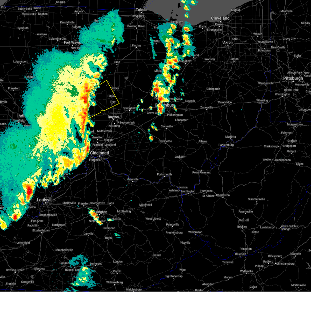 Svriln the national weather service in wilmington has issued a * severe thunderstorm warning for, western shelby county in west central ohio, northern preble county in west central ohio, darke county in west central ohio, southwestern auglaize county in west central ohio, southeastern mercer county in west central ohio, miami county in west central ohio, * until 715 am edt. * at 638 am edt, a severe thunderstorm was located near new madison, moving northeast at 65 mph (radar indicated). Hazards include 60 mph wind gusts and penny size hail. expect damage to trees and power lines Svriln the national weather service in wilmington has issued a * severe thunderstorm warning for, western shelby county in west central ohio, northern preble county in west central ohio, darke county in west central ohio, southwestern auglaize county in west central ohio, southeastern mercer county in west central ohio, miami county in west central ohio, * until 715 am edt. * at 638 am edt, a severe thunderstorm was located near new madison, moving northeast at 65 mph (radar indicated). Hazards include 60 mph wind gusts and penny size hail. expect damage to trees and power lines
|
| 3/15/2025 6:29 AM EDT |
 the severe thunderstorm warning has been cancelled and is no longer in effect the severe thunderstorm warning has been cancelled and is no longer in effect
|
| 3/15/2025 6:29 AM EDT |
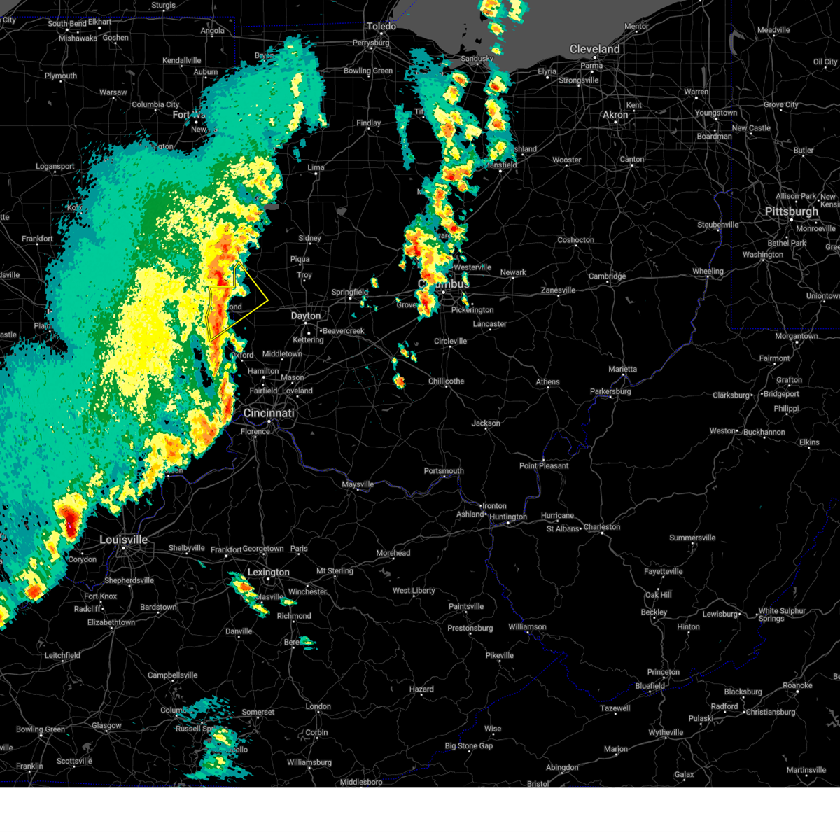 At 629 am edt, a severe thunderstorm was located near fountain city, moving northeast at 65 mph (radar indicated). Hazards include 60 mph wind gusts and penny size hail. Expect damage to trees and power lines. locations impacted include, richmond municipal airport, eldorado, ithaca, spring grove, abington, brownsville, new madison, interstate 70 at exit 145, williamsburg, hollansburg, bethel, fountain city, boston, middleboro, clifton, west manchester, whitewater, new paris, sharpeye, and centerville. this includes the following interstates, i-70 in indiana between mile markers 144 and 156. I-70 in ohio between mile markers 0 and 8. At 629 am edt, a severe thunderstorm was located near fountain city, moving northeast at 65 mph (radar indicated). Hazards include 60 mph wind gusts and penny size hail. Expect damage to trees and power lines. locations impacted include, richmond municipal airport, eldorado, ithaca, spring grove, abington, brownsville, new madison, interstate 70 at exit 145, williamsburg, hollansburg, bethel, fountain city, boston, middleboro, clifton, west manchester, whitewater, new paris, sharpeye, and centerville. this includes the following interstates, i-70 in indiana between mile markers 144 and 156. I-70 in ohio between mile markers 0 and 8.
|
| 3/15/2025 6:23 AM EDT |
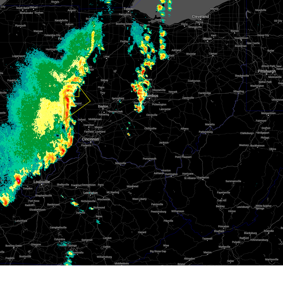 At 622 am edt, a severe thunderstorm was located over centerville, moving northeast at 65 mph (radar indicated). Hazards include 60 mph wind gusts and penny size hail. Expect damage to trees and power lines. locations impacted include, richmond municipal airport, eldorado, ithaca, spring grove, abington, mettel field, brownsville, cambridge city, new madison, waterloo, east germantown, connersville, interstate 70 at exit 145, economy, greens fork, williamsburg, hollansburg, bethel, hagerstown, and fountain city. this includes the following interstates, i-70 in indiana between mile markers 136 and 156. I-70 in ohio between mile markers 0 and 8. At 622 am edt, a severe thunderstorm was located over centerville, moving northeast at 65 mph (radar indicated). Hazards include 60 mph wind gusts and penny size hail. Expect damage to trees and power lines. locations impacted include, richmond municipal airport, eldorado, ithaca, spring grove, abington, mettel field, brownsville, cambridge city, new madison, waterloo, east germantown, connersville, interstate 70 at exit 145, economy, greens fork, williamsburg, hollansburg, bethel, hagerstown, and fountain city. this includes the following interstates, i-70 in indiana between mile markers 136 and 156. I-70 in ohio between mile markers 0 and 8.
|
| 3/15/2025 6:23 AM EDT |
 the severe thunderstorm warning has been cancelled and is no longer in effect the severe thunderstorm warning has been cancelled and is no longer in effect
|
| 3/15/2025 5:59 AM EDT |
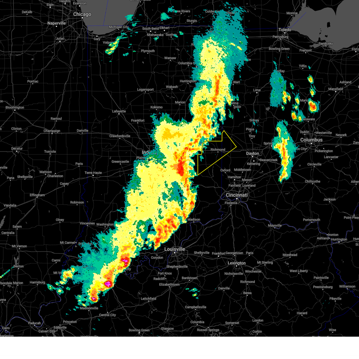 Svriln the national weather service in wilmington has issued a * severe thunderstorm warning for, northwestern franklin county in southeastern indiana, wayne county in east central indiana, northwestern union county in east central indiana, fayette county in east central indiana, northwestern preble county in west central ohio, southwestern darke county in west central ohio, * until 645 am edt. * at 558 am edt, a severe thunderstorm was located over rushville, moving northeast at 65 mph (radar indicated). Hazards include 70 mph wind gusts and quarter size hail. Minor hail damage to vehicles is possible. expect considerable tree damage. Wind damage is also likely to mobile homes, roofs, and outbuildings. Svriln the national weather service in wilmington has issued a * severe thunderstorm warning for, northwestern franklin county in southeastern indiana, wayne county in east central indiana, northwestern union county in east central indiana, fayette county in east central indiana, northwestern preble county in west central ohio, southwestern darke county in west central ohio, * until 645 am edt. * at 558 am edt, a severe thunderstorm was located over rushville, moving northeast at 65 mph (radar indicated). Hazards include 70 mph wind gusts and quarter size hail. Minor hail damage to vehicles is possible. expect considerable tree damage. Wind damage is also likely to mobile homes, roofs, and outbuildings.
|
| 4/2/2024 6:09 PM EDT |
 the severe thunderstorm warning has been cancelled and is no longer in effect the severe thunderstorm warning has been cancelled and is no longer in effect
|
| 4/2/2024 6:04 PM EDT |
 At 604 pm edt, a severe thunderstorm was located over new madison, moving northeast at 55 mph (radar indicated). Hazards include 60 mph wind gusts and quarter size hail. Minor hail damage to vehicles is possible. expect wind damage to trees and power lines. locations impacted include, troy, piqua, greenville, tipp city, west milton, versailles, covington, arcanum, newport, bradford, new paris, pleasant hill, new madison, webster, wayne lakes, russia, gettysburg, eldorado, west manchester, and laura. This includes i-75 in ohio between mile markers 70 and 84. At 604 pm edt, a severe thunderstorm was located over new madison, moving northeast at 55 mph (radar indicated). Hazards include 60 mph wind gusts and quarter size hail. Minor hail damage to vehicles is possible. expect wind damage to trees and power lines. locations impacted include, troy, piqua, greenville, tipp city, west milton, versailles, covington, arcanum, newport, bradford, new paris, pleasant hill, new madison, webster, wayne lakes, russia, gettysburg, eldorado, west manchester, and laura. This includes i-75 in ohio between mile markers 70 and 84.
|
| 4/2/2024 6:04 PM EDT |
 the severe thunderstorm warning has been cancelled and is no longer in effect the severe thunderstorm warning has been cancelled and is no longer in effect
|
| 4/2/2024 5:54 PM EDT |
 Svriln the national weather service in wilmington has issued a * severe thunderstorm warning for, northeastern wayne county in east central indiana, southwestern shelby county in west central ohio, northern preble county in west central ohio, southern darke county in west central ohio, miami county in west central ohio, * until 645 pm edt. * at 554 pm edt, a severe thunderstorm was located near new paris, moving northeast at 55 mph (radar indicated). Hazards include 60 mph wind gusts and quarter size hail. Minor hail damage to vehicles is possible. Expect wind damage to trees and power lines. Svriln the national weather service in wilmington has issued a * severe thunderstorm warning for, northeastern wayne county in east central indiana, southwestern shelby county in west central ohio, northern preble county in west central ohio, southern darke county in west central ohio, miami county in west central ohio, * until 645 pm edt. * at 554 pm edt, a severe thunderstorm was located near new paris, moving northeast at 55 mph (radar indicated). Hazards include 60 mph wind gusts and quarter size hail. Minor hail damage to vehicles is possible. Expect wind damage to trees and power lines.
|
| 3/14/2024 10:00 PM EDT |
 The storm which prompted the warning has moved out of the area. therefore, the warning will be allowed to expire. a tornado watch remains in effect until midnight edt for west central ohio. please report previous wind damage or hail to the national weather service by going to our website at weather.gov/iln and submitting your report via social media. The storm which prompted the warning has moved out of the area. therefore, the warning will be allowed to expire. a tornado watch remains in effect until midnight edt for west central ohio. please report previous wind damage or hail to the national weather service by going to our website at weather.gov/iln and submitting your report via social media.
|
| 3/14/2024 9:44 PM EDT |
 Svriln the national weather service in wilmington has issued a * severe thunderstorm warning for, northeastern preble county in west central ohio, southeastern darke county in west central ohio, western clark county in west central ohio, northwestern greene county in west central ohio, northern montgomery county in west central ohio, southern miami county in west central ohio, * until 1030 pm edt. * at 944 pm edt, a severe thunderstorm was located near arcanum, moving east at 50 mph (radar indicated). Hazards include 60 mph wind gusts and quarter size hail. Minor hail damage to vehicles is possible. Expect wind damage to trees and power lines. Svriln the national weather service in wilmington has issued a * severe thunderstorm warning for, northeastern preble county in west central ohio, southeastern darke county in west central ohio, western clark county in west central ohio, northwestern greene county in west central ohio, northern montgomery county in west central ohio, southern miami county in west central ohio, * until 1030 pm edt. * at 944 pm edt, a severe thunderstorm was located near arcanum, moving east at 50 mph (radar indicated). Hazards include 60 mph wind gusts and quarter size hail. Minor hail damage to vehicles is possible. Expect wind damage to trees and power lines.
|
| 3/14/2024 9:42 PM EDT |
 At 942 pm edt, a severe thunderstorm was located near new madison, moving east at 50 mph (radar indicated). Hazards include 60 mph wind gusts and quarter size hail. Minor hail damage to vehicles is possible. expect wind damage to trees and power lines. Locations impacted include, arcanum, lewisburg, wayne lakes, eldorado, verona, west manchester, pitsburg, gordon, ithaca, and castine. At 942 pm edt, a severe thunderstorm was located near new madison, moving east at 50 mph (radar indicated). Hazards include 60 mph wind gusts and quarter size hail. Minor hail damage to vehicles is possible. expect wind damage to trees and power lines. Locations impacted include, arcanum, lewisburg, wayne lakes, eldorado, verona, west manchester, pitsburg, gordon, ithaca, and castine.
|
| 3/14/2024 9:42 PM EDT |
 the severe thunderstorm warning has been cancelled and is no longer in effect the severe thunderstorm warning has been cancelled and is no longer in effect
|
| 3/14/2024 9:34 PM EDT |
 At 933 pm edt, a severe thunderstorm was located near fountain city, moving east at 60 mph (radar indicated). Hazards include 60 mph wind gusts and quarter size hail. Minor hail damage to vehicles is possible. expect wind damage to trees and power lines. Locations impacted include, arcanum, lewisburg, new madison, wayne lakes, eldorado, verona, west manchester, pitsburg, bethel, hollansburg, gordon, ithaca, castine, whitewater, and middleboro. At 933 pm edt, a severe thunderstorm was located near fountain city, moving east at 60 mph (radar indicated). Hazards include 60 mph wind gusts and quarter size hail. Minor hail damage to vehicles is possible. expect wind damage to trees and power lines. Locations impacted include, arcanum, lewisburg, new madison, wayne lakes, eldorado, verona, west manchester, pitsburg, bethel, hollansburg, gordon, ithaca, castine, whitewater, and middleboro.
|
| 3/14/2024 9:15 PM EDT |
 Svriln the national weather service in wilmington has issued a * severe thunderstorm warning for, northern wayne county in east central indiana, northern preble county in west central ohio, southern darke county in west central ohio, northwestern montgomery county in west central ohio, * until 1000 pm edt. * at 914 pm edt, a severe thunderstorm was located near fountain city, moving east at 45 mph (radar indicated). Hazards include 60 mph wind gusts and quarter size hail. Minor hail damage to vehicles is possible. Expect wind damage to trees and power lines. Svriln the national weather service in wilmington has issued a * severe thunderstorm warning for, northern wayne county in east central indiana, northern preble county in west central ohio, southern darke county in west central ohio, northwestern montgomery county in west central ohio, * until 1000 pm edt. * at 914 pm edt, a severe thunderstorm was located near fountain city, moving east at 45 mph (radar indicated). Hazards include 60 mph wind gusts and quarter size hail. Minor hail damage to vehicles is possible. Expect wind damage to trees and power lines.
|
| 7/17/2023 8:12 PM EDT |
 The severe thunderstorm warning for northeastern preble, southeastern darke and northwestern montgomery counties will expire at 815 pm edt, remember, a severe thunderstorm warning still remains in effect for montgomery county and southeastern preble county. a severe thunderstorm watch remains in effect until midnight edt for west central ohio. please report previous wind damage or hail to the national weather service by going to our website at weather.gov/iln and submitting your report via social media. The severe thunderstorm warning for northeastern preble, southeastern darke and northwestern montgomery counties will expire at 815 pm edt, remember, a severe thunderstorm warning still remains in effect for montgomery county and southeastern preble county. a severe thunderstorm watch remains in effect until midnight edt for west central ohio. please report previous wind damage or hail to the national weather service by going to our website at weather.gov/iln and submitting your report via social media.
|
| 7/17/2023 7:57 PM EDT |
 At 756 pm edt, a severe thunderstorm was located over lewisburg, moving southeast at 25 mph (radar indicated). Hazards include 60 mph wind gusts and quarter size hail. Minor hail damage to vehicles is possible. expect wind damage to trees and power lines. locations impacted include, lewisburg, west alexandria, clayton, brookville, new lebanon, phillipsburg, verona, gordon, ithaca and pyrmont. this includes i-70 in ohio between mile markers 12 and 24. hail threat, radar indicated max hail size, 1. 00 in wind threat, radar indicated max wind gust, 60 mph. At 756 pm edt, a severe thunderstorm was located over lewisburg, moving southeast at 25 mph (radar indicated). Hazards include 60 mph wind gusts and quarter size hail. Minor hail damage to vehicles is possible. expect wind damage to trees and power lines. locations impacted include, lewisburg, west alexandria, clayton, brookville, new lebanon, phillipsburg, verona, gordon, ithaca and pyrmont. this includes i-70 in ohio between mile markers 12 and 24. hail threat, radar indicated max hail size, 1. 00 in wind threat, radar indicated max wind gust, 60 mph.
|
| 7/17/2023 7:47 PM EDT |
 At 746 pm edt, a severe thunderstorm was located near lewisburg, moving southeast at 25 mph (radar indicated). Hazards include ping pong ball size hail and 60 mph wind gusts. People and animals outdoors will be injured. expect hail damage to roofs, siding, windows, and vehicles. expect wind damage to trees and power lines. locations impacted include, lewisburg, west alexandria, clayton, brookville, new lebanon, phillipsburg, eldorado, verona, west manchester, gordon, ithaca, castine, interstate 70 at us route 127 and pyrmont. this includes i-70 in ohio between mile markers 9 and 24. hail threat, radar indicated max hail size, 1. 50 in wind threat, radar indicated max wind gust, 60 mph. At 746 pm edt, a severe thunderstorm was located near lewisburg, moving southeast at 25 mph (radar indicated). Hazards include ping pong ball size hail and 60 mph wind gusts. People and animals outdoors will be injured. expect hail damage to roofs, siding, windows, and vehicles. expect wind damage to trees and power lines. locations impacted include, lewisburg, west alexandria, clayton, brookville, new lebanon, phillipsburg, eldorado, verona, west manchester, gordon, ithaca, castine, interstate 70 at us route 127 and pyrmont. this includes i-70 in ohio between mile markers 9 and 24. hail threat, radar indicated max hail size, 1. 50 in wind threat, radar indicated max wind gust, 60 mph.
|
| 7/17/2023 7:42 PM EDT |
 At 741 pm edt, a severe thunderstorm was located near lewisburg, moving southeast at 25 mph (radar indicated). Hazards include 60 mph wind gusts and quarter size hail. Minor hail damage to vehicles is possible. Expect wind damage to trees and power lines. At 741 pm edt, a severe thunderstorm was located near lewisburg, moving southeast at 25 mph (radar indicated). Hazards include 60 mph wind gusts and quarter size hail. Minor hail damage to vehicles is possible. Expect wind damage to trees and power lines.
|
| 7/17/2023 7:27 PM EDT |
 At 726 pm edt, a severe thunderstorm was located near new madison, moving southeast at 25 mph (radar indicated). Hazards include 60 mph wind gusts and quarter size hail. Minor hail damage to vehicles is possible. expect wind damage to trees and power lines. locations impacted include, eaton, lewisburg, new paris, west alexandria, new madison, clayton, brookville, wayne lakes, phillipsburg, eldorado, verona, west manchester, hollansburg, gordon, palestine, ithaca, castine, oklahoma, wheatville and interstate 70 at us route 127. this includes i-70 in ohio between mile markers 2 and 23. hail threat, radar indicated max hail size, 1. 00 in wind threat, radar indicated max wind gust, 60 mph. At 726 pm edt, a severe thunderstorm was located near new madison, moving southeast at 25 mph (radar indicated). Hazards include 60 mph wind gusts and quarter size hail. Minor hail damage to vehicles is possible. expect wind damage to trees and power lines. locations impacted include, eaton, lewisburg, new paris, west alexandria, new madison, clayton, brookville, wayne lakes, phillipsburg, eldorado, verona, west manchester, hollansburg, gordon, palestine, ithaca, castine, oklahoma, wheatville and interstate 70 at us route 127. this includes i-70 in ohio between mile markers 2 and 23. hail threat, radar indicated max hail size, 1. 00 in wind threat, radar indicated max wind gust, 60 mph.
|
| 7/17/2023 7:17 PM EDT |
 At 716 pm edt, a severe thunderstorm was located over new madison, moving southeast at 25 mph (radar indicated). Hazards include 60 mph wind gusts and quarter size hail. Minor hail damage to vehicles is possible. expect wind damage to trees and power lines. locations impacted include, eaton, arcanum, lewisburg, new paris, west alexandria, new madison, clayton, brookville, wayne lakes, phillipsburg, eldorado, verona, west manchester, bethel, hollansburg, gordon, palestine, ithaca, castine and whitewater. this includes i-70 in ohio between mile markers 2 and 23. hail threat, radar indicated max hail size, 1. 00 in wind threat, radar indicated max wind gust, 60 mph. At 716 pm edt, a severe thunderstorm was located over new madison, moving southeast at 25 mph (radar indicated). Hazards include 60 mph wind gusts and quarter size hail. Minor hail damage to vehicles is possible. expect wind damage to trees and power lines. locations impacted include, eaton, arcanum, lewisburg, new paris, west alexandria, new madison, clayton, brookville, wayne lakes, phillipsburg, eldorado, verona, west manchester, bethel, hollansburg, gordon, palestine, ithaca, castine and whitewater. this includes i-70 in ohio between mile markers 2 and 23. hail threat, radar indicated max hail size, 1. 00 in wind threat, radar indicated max wind gust, 60 mph.
|
| 7/17/2023 7:05 PM EDT |
 At 705 pm edt, a severe thunderstorm was located near fountain city, moving southeast at 25 mph (radar indicated). Hazards include 60 mph wind gusts and quarter size hail. Minor hail damage to vehicles is possible. Expect wind damage to trees and power lines. At 705 pm edt, a severe thunderstorm was located near fountain city, moving southeast at 25 mph (radar indicated). Hazards include 60 mph wind gusts and quarter size hail. Minor hail damage to vehicles is possible. Expect wind damage to trees and power lines.
|
| 7/2/2023 6:15 PM EDT |
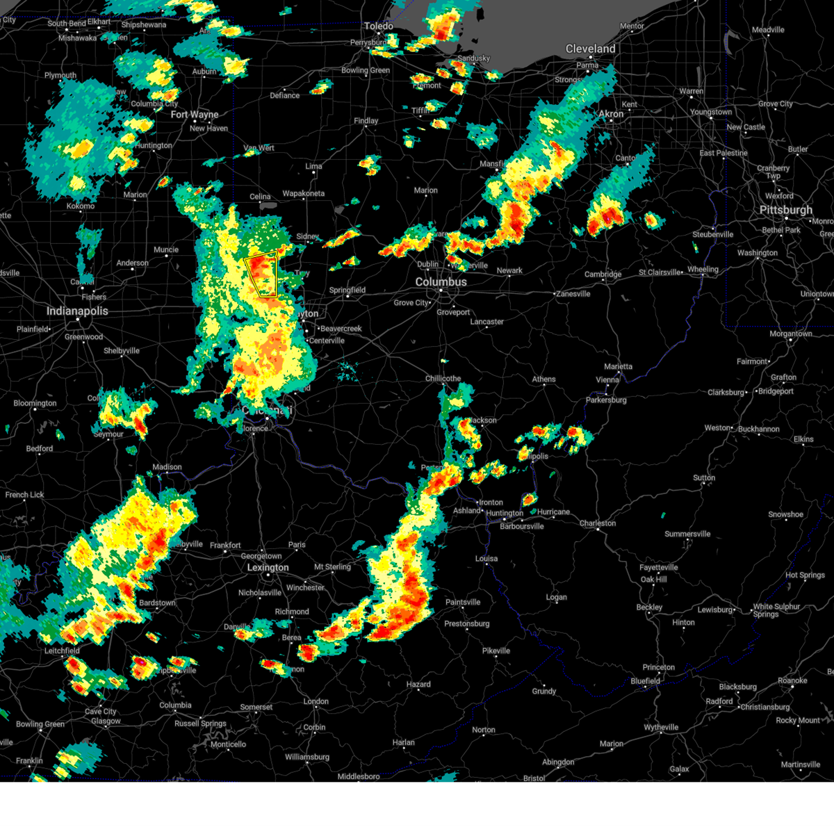 At 615 pm edt, severe thunderstorms were located along a line extending from near versailles to englewood, moving east at 40 mph (radar indicated). Hazards include 60 mph wind gusts. Expect damage to trees and power lines. locations impacted include, greenville, arcanum, bradford, webster, gettysburg, pitsburg, gordon, ithaca, union corners, abbottsville, horatio and pikeville. hail threat, radar indicated max hail size, <. 75 in wind threat, radar indicated max wind gust, 60 mph. At 615 pm edt, severe thunderstorms were located along a line extending from near versailles to englewood, moving east at 40 mph (radar indicated). Hazards include 60 mph wind gusts. Expect damage to trees and power lines. locations impacted include, greenville, arcanum, bradford, webster, gettysburg, pitsburg, gordon, ithaca, union corners, abbottsville, horatio and pikeville. hail threat, radar indicated max hail size, <. 75 in wind threat, radar indicated max wind gust, 60 mph.
|
| 7/2/2023 6:03 PM EDT |
 At 603 pm edt, severe thunderstorms were located along a line extending from near greenville to near lewisburg, moving east at 40 mph (radar indicated). Hazards include 60 mph wind gusts. Expect damage to trees and power lines. locations impacted include, greenville, arcanum, bradford, lewisburg, new madison, webster, wayne lakes, gettysburg, eldorado, verona, west manchester, pitsburg, gordon, ithaca, castine, union corners, interstate 70 at us route 127, abbottsville, horatio and pikeville. this includes i-70 in ohio between mile markers 6 and 17. hail threat, radar indicated max hail size, <. 75 in wind threat, radar indicated max wind gust, 60 mph. At 603 pm edt, severe thunderstorms were located along a line extending from near greenville to near lewisburg, moving east at 40 mph (radar indicated). Hazards include 60 mph wind gusts. Expect damage to trees and power lines. locations impacted include, greenville, arcanum, bradford, lewisburg, new madison, webster, wayne lakes, gettysburg, eldorado, verona, west manchester, pitsburg, gordon, ithaca, castine, union corners, interstate 70 at us route 127, abbottsville, horatio and pikeville. this includes i-70 in ohio between mile markers 6 and 17. hail threat, radar indicated max hail size, <. 75 in wind threat, radar indicated max wind gust, 60 mph.
|
| 7/2/2023 5:40 PM EDT |
 At 540 pm edt, severe thunderstorms were located along a line extending from 7 miles south of winchester to near richmond, moving east at 40 mph (radar indicated). Hazards include 60 mph wind gusts. expect damage to trees and power lines At 540 pm edt, severe thunderstorms were located along a line extending from 7 miles south of winchester to near richmond, moving east at 40 mph (radar indicated). Hazards include 60 mph wind gusts. expect damage to trees and power lines
|
| 2/27/2023 2:38 PM EST |
 The severe thunderstorm warning for southeastern darke county will expire at 245 pm est, the storm which prompted the warning has weakened below severe limits, and no longer poses an immediate threat to life or property. therefore, the warning will be allowed to expire. however small hail is still possible with this thunderstorm. a tornado watch remains in effect until 600 pm est for west central ohio. please report previous wind damage or hail to the national weather service by going to our website at weather.gov/iln and submitting your report via social media. The severe thunderstorm warning for southeastern darke county will expire at 245 pm est, the storm which prompted the warning has weakened below severe limits, and no longer poses an immediate threat to life or property. therefore, the warning will be allowed to expire. however small hail is still possible with this thunderstorm. a tornado watch remains in effect until 600 pm est for west central ohio. please report previous wind damage or hail to the national weather service by going to our website at weather.gov/iln and submitting your report via social media.
|
| 2/27/2023 2:33 PM EST |
 At 233 pm est, a severe thunderstorm was located over arcanum, moving northeast at 55 mph (radar indicated). Hazards include 60 mph wind gusts and quarter size hail. Minor hail damage to vehicles is possible. expect wind damage to trees and power lines. Locations impacted include, arcanum, pitsburg, gordon, ithaca and castine. At 233 pm est, a severe thunderstorm was located over arcanum, moving northeast at 55 mph (radar indicated). Hazards include 60 mph wind gusts and quarter size hail. Minor hail damage to vehicles is possible. expect wind damage to trees and power lines. Locations impacted include, arcanum, pitsburg, gordon, ithaca and castine.
|
| 2/27/2023 2:27 PM EST |
 At 226 pm est, a severe thunderstorm was located near new madison, moving northeast at 55 mph (radar indicated). Hazards include 60 mph wind gusts and quarter size hail. Minor hail damage to vehicles is possible. expect wind damage to trees and power lines. locations impacted include, arcanum, lewisburg, new madison, eldorado, verona, west manchester, pitsburg, gordon, ithaca and castine. This includes i-70 in ohio between mile markers 3 and 8. At 226 pm est, a severe thunderstorm was located near new madison, moving northeast at 55 mph (radar indicated). Hazards include 60 mph wind gusts and quarter size hail. Minor hail damage to vehicles is possible. expect wind damage to trees and power lines. locations impacted include, arcanum, lewisburg, new madison, eldorado, verona, west manchester, pitsburg, gordon, ithaca and castine. This includes i-70 in ohio between mile markers 3 and 8.
|
| 2/27/2023 2:10 PM EST |
 At 209 pm est, a severe thunderstorm was located near centerville, moving northeast at 55 mph (radar indicated). Hazards include 60 mph wind gusts and quarter size hail. Minor hail damage to vehicles is possible. Expect wind damage to trees and power lines. At 209 pm est, a severe thunderstorm was located near centerville, moving northeast at 55 mph (radar indicated). Hazards include 60 mph wind gusts and quarter size hail. Minor hail damage to vehicles is possible. Expect wind damage to trees and power lines.
|
| 7/23/2022 10:41 AM EDT |
 At 1040 am edt, severe thunderstorms were located along a line extending from near piqua to near west milton to near eaton, moving southeast at 60 mph (radar indicated). Hazards include 60 mph wind gusts. Expect damage to trees and power lines. locations impacted include, greenville, versailles, arcanum, webster, gettysburg, eldorado, verona, west manchester, pitsburg, gordon, ithaca, castine, union corners, interstate 70 at us route 127, abbottsville, horatio and new hope. this includes i-70 in ohio between mile markers 2 and 11. hail threat, radar indicated max hail size, <. 75 in wind threat, radar indicated max wind gust, 60 mph. At 1040 am edt, severe thunderstorms were located along a line extending from near piqua to near west milton to near eaton, moving southeast at 60 mph (radar indicated). Hazards include 60 mph wind gusts. Expect damage to trees and power lines. locations impacted include, greenville, versailles, arcanum, webster, gettysburg, eldorado, verona, west manchester, pitsburg, gordon, ithaca, castine, union corners, interstate 70 at us route 127, abbottsville, horatio and new hope. this includes i-70 in ohio between mile markers 2 and 11. hail threat, radar indicated max hail size, <. 75 in wind threat, radar indicated max wind gust, 60 mph.
|
| 7/23/2022 10:28 AM EDT |
 At 1028 am edt, severe thunderstorms were located along a line extending from near covington to arcanum to near richmond, moving southeast at 55 mph (radar indicated). Hazards include 60 mph wind gusts. Expect damage to trees and power lines. locations impacted include, richmond, greenville, centerville, cambridge city, versailles, arcanum, hagerstown, new paris, ansonia, new madison, fountain city, dublin, franklin, webster, wayne lakes, gettysburg, eldorado, verona, west manchester and greens fork. this includes the following interstates, i-70 in indiana between mile markers 134 and 156. i-70 in ohio between mile markers 0 and 11. hail threat, radar indicated max hail size, <. 75 in wind threat, radar indicated max wind gust, 60 mph. At 1028 am edt, severe thunderstorms were located along a line extending from near covington to arcanum to near richmond, moving southeast at 55 mph (radar indicated). Hazards include 60 mph wind gusts. Expect damage to trees and power lines. locations impacted include, richmond, greenville, centerville, cambridge city, versailles, arcanum, hagerstown, new paris, ansonia, new madison, fountain city, dublin, franklin, webster, wayne lakes, gettysburg, eldorado, verona, west manchester and greens fork. this includes the following interstates, i-70 in indiana between mile markers 134 and 156. i-70 in ohio between mile markers 0 and 11. hail threat, radar indicated max hail size, <. 75 in wind threat, radar indicated max wind gust, 60 mph.
|
| 7/23/2022 10:14 AM EDT |
 At 1014 am edt, severe thunderstorms were located along a line extending from 7 miles north of ansonia to 6 miles south of union city to near hagerstown, moving southeast at 55 mph (radar indicated). Hazards include 60 mph wind gusts and penny size hail. Expect damage to trees and power lines. locations impacted include, richmond, greenville, coldwater, centerville, cambridge city, versailles, st. henry, arcanum, hagerstown, union city, new paris, fort recovery, ansonia, new madison, fountain city, dublin, franklin, webster, wayne lakes and gettysburg. this includes the following interstates, i-70 in indiana between mile markers 134 and 156. i-70 in ohio between mile markers 0 and 11. hail threat, radar indicated max hail size, 0. 75 in wind threat, radar indicated max wind gust, 60 mph. At 1014 am edt, severe thunderstorms were located along a line extending from 7 miles north of ansonia to 6 miles south of union city to near hagerstown, moving southeast at 55 mph (radar indicated). Hazards include 60 mph wind gusts and penny size hail. Expect damage to trees and power lines. locations impacted include, richmond, greenville, coldwater, centerville, cambridge city, versailles, st. henry, arcanum, hagerstown, union city, new paris, fort recovery, ansonia, new madison, fountain city, dublin, franklin, webster, wayne lakes and gettysburg. this includes the following interstates, i-70 in indiana between mile markers 134 and 156. i-70 in ohio between mile markers 0 and 11. hail threat, radar indicated max hail size, 0. 75 in wind threat, radar indicated max wind gust, 60 mph.
|
| 7/23/2022 9:59 AM EDT |
 At 959 am edt, severe thunderstorms were located along a line extending from near portland to 7 miles west of winchester to 8 miles south of muncie, moving southeast at 60 mph (radar indicated). Hazards include 60 mph wind gusts and penny size hail. expect damage to trees and power lines At 959 am edt, severe thunderstorms were located along a line extending from near portland to 7 miles west of winchester to 8 miles south of muncie, moving southeast at 60 mph (radar indicated). Hazards include 60 mph wind gusts and penny size hail. expect damage to trees and power lines
|
| 5/21/2022 4:42 PM EDT |
 At 442 pm edt, a severe thunderstorm was located near eaton, moving northeast at 25 mph (radar indicated). Hazards include 60 mph wind gusts and quarter size hail. Minor hail damage to vehicles is possible. Expect wind damage to trees and power lines. At 442 pm edt, a severe thunderstorm was located near eaton, moving northeast at 25 mph (radar indicated). Hazards include 60 mph wind gusts and quarter size hail. Minor hail damage to vehicles is possible. Expect wind damage to trees and power lines.
|
| 3/23/2022 3:10 PM EDT |
 The severe thunderstorm warning for eastern preble, north central butler, southeastern darke and western montgomery counties will expire at 315 pm edt, the storm which prompted the warning has weakened below severe limits, and no longer poses an immediate threat to life or property. therefore, the warning will be allowed to expire. however gusty winds are still possible with this thunderstorm. a severe thunderstorm watch remains in effect until 900 pm edt for southwestern and west central ohio. please report previous wind damage or hail to the national weather service by going to our website at weather.gov/iln and submitting your report via social media. The severe thunderstorm warning for eastern preble, north central butler, southeastern darke and western montgomery counties will expire at 315 pm edt, the storm which prompted the warning has weakened below severe limits, and no longer poses an immediate threat to life or property. therefore, the warning will be allowed to expire. however gusty winds are still possible with this thunderstorm. a severe thunderstorm watch remains in effect until 900 pm edt for southwestern and west central ohio. please report previous wind damage or hail to the national weather service by going to our website at weather.gov/iln and submitting your report via social media.
|
| 3/23/2022 3:01 PM EDT |
 At 300 pm edt, a severe thunderstorm was located near west alexandria, moving northeast at 45 mph (radar indicated). Hazards include 60 mph wind gusts and penny size hail. Expect damage to trees and power lines. locations impacted include, eaton, arcanum, lewisburg, west alexandria, gratis, brookville, new lebanon, farmersville, verona, west manchester, pitsburg, gordon, west elkton, ithaca, castine, jacksonburg, oklahoma, wheatville, interstate 70 at us route 127 and pyrmont. this includes i-70 in ohio between mile markers 8 and 22. hail threat, radar indicated max hail size, 0. 75 in wind threat, radar indicated max wind gust, 60 mph. At 300 pm edt, a severe thunderstorm was located near west alexandria, moving northeast at 45 mph (radar indicated). Hazards include 60 mph wind gusts and penny size hail. Expect damage to trees and power lines. locations impacted include, eaton, arcanum, lewisburg, west alexandria, gratis, brookville, new lebanon, farmersville, verona, west manchester, pitsburg, gordon, west elkton, ithaca, castine, jacksonburg, oklahoma, wheatville, interstate 70 at us route 127 and pyrmont. this includes i-70 in ohio between mile markers 8 and 22. hail threat, radar indicated max hail size, 0. 75 in wind threat, radar indicated max wind gust, 60 mph.
|
| 3/23/2022 2:52 PM EDT |
 At 252 pm edt, a severe thunderstorm was located over eaton, moving northeast at 35 mph (radar indicated). Hazards include 60 mph wind gusts and penny size hail. Expect damage to trees and power lines. locations impacted include, eaton, arcanum, camden, lewisburg, west alexandria, gratis, brookville, new lebanon, farmersville, eldorado, verona, west manchester, pitsburg, somerville, gordon, west elkton, ithaca, castine, jacksonburg and oklahoma. this includes i-70 in ohio between mile markers 5 and 22. hail threat, radar indicated max hail size, 0. 75 in wind threat, radar indicated max wind gust, 60 mph. At 252 pm edt, a severe thunderstorm was located over eaton, moving northeast at 35 mph (radar indicated). Hazards include 60 mph wind gusts and penny size hail. Expect damage to trees and power lines. locations impacted include, eaton, arcanum, camden, lewisburg, west alexandria, gratis, brookville, new lebanon, farmersville, eldorado, verona, west manchester, pitsburg, somerville, gordon, west elkton, ithaca, castine, jacksonburg and oklahoma. this includes i-70 in ohio between mile markers 5 and 22. hail threat, radar indicated max hail size, 0. 75 in wind threat, radar indicated max wind gust, 60 mph.
|
| 3/23/2022 2:44 PM EDT |
 At 244 pm edt, a severe thunderstorm was located near camden, moving northeast at 45 mph (radar indicated). Hazards include 60 mph wind gusts and penny size hail. expect damage to trees and power lines At 244 pm edt, a severe thunderstorm was located near camden, moving northeast at 45 mph (radar indicated). Hazards include 60 mph wind gusts and penny size hail. expect damage to trees and power lines
|
| 3/6/2022 3:56 AM EST |
 At 355 am est, severe thunderstorms were located along a line extending from 6 miles south of winchester to near hagerstown, moving east at 50 mph (radar indicated). Hazards include 60 mph wind gusts. Expect damage to trees and power lines. locations impacted include, richmond, arcanum, hagerstown, new paris, new madison, fountain city, franklin, wayne lakes, eldorado, verona, west manchester, pitsburg, bethel, hollansburg, gordon, palestine, economy, ithaca, castine and whitewater. this includes i-70 in indiana near mile marker 152. hail threat, radar indicated max hail size, <. 75 in wind threat, radar indicated max wind gust, 60 mph. At 355 am est, severe thunderstorms were located along a line extending from 6 miles south of winchester to near hagerstown, moving east at 50 mph (radar indicated). Hazards include 60 mph wind gusts. Expect damage to trees and power lines. locations impacted include, richmond, arcanum, hagerstown, new paris, new madison, fountain city, franklin, wayne lakes, eldorado, verona, west manchester, pitsburg, bethel, hollansburg, gordon, palestine, economy, ithaca, castine and whitewater. this includes i-70 in indiana near mile marker 152. hail threat, radar indicated max hail size, <. 75 in wind threat, radar indicated max wind gust, 60 mph.
|
| 3/6/2022 3:37 AM EST |
 At 337 am est, severe thunderstorms were located along a line extending from near muncie to 7 miles west of new castle, moving east at 55 mph (radar indicated). Hazards include 60 mph wind gusts. expect damage to trees and power lines At 337 am est, severe thunderstorms were located along a line extending from near muncie to 7 miles west of new castle, moving east at 55 mph (radar indicated). Hazards include 60 mph wind gusts. expect damage to trees and power lines
|
| 6/19/2021 12:16 AM EDT |
 At 1216 am edt, a severe thunderstorm was located near greenville, moving east at 35 mph (radar indicated). Hazards include quarter size hail. Minor damage to vehicles is possible. Locations impacted include, greenville, versailles, arcanum, bradford, ansonia, new madison, fountain city, webster, wayne lakes, gettysburg, pitsburg, bethel, hollansburg, gordon, palestine, ithaca, castine, whitewater, union corners and darke county airport. At 1216 am edt, a severe thunderstorm was located near greenville, moving east at 35 mph (radar indicated). Hazards include quarter size hail. Minor damage to vehicles is possible. Locations impacted include, greenville, versailles, arcanum, bradford, ansonia, new madison, fountain city, webster, wayne lakes, gettysburg, pitsburg, bethel, hollansburg, gordon, palestine, ithaca, castine, whitewater, union corners and darke county airport.
|
| 6/19/2021 12:01 AM EDT |
 At 1201 am edt, a severe thunderstorm was located near union city, moving east at 35 mph (radar indicated). Hazards include quarter size hail. minor damage to vehicles is possible At 1201 am edt, a severe thunderstorm was located near union city, moving east at 35 mph (radar indicated). Hazards include quarter size hail. minor damage to vehicles is possible
|
| 6/18/2021 6:20 PM EDT |
 At 619 pm edt, a severe thunderstorm capable of producing a tornado was located near lewisburg, moving southeast at 20 mph (radar indicated rotation). Hazards include tornado and golf ball size hail. Flying debris will be dangerous to those caught without shelter. mobile homes will be damaged or destroyed. damage to roofs, windows, and vehicles will occur. tree damage is likely. locations impacted include, trotwood, englewood, west milton, arcanum, lewisburg, clayton, union, brookville, phillipsburg, verona, west manchester, laura, pitsburg, potsdam, gordon, ludlow falls, ithaca, pyrmont and garland. This includes i-70 in ohio between mile markers 14 and 26. At 619 pm edt, a severe thunderstorm capable of producing a tornado was located near lewisburg, moving southeast at 20 mph (radar indicated rotation). Hazards include tornado and golf ball size hail. Flying debris will be dangerous to those caught without shelter. mobile homes will be damaged or destroyed. damage to roofs, windows, and vehicles will occur. tree damage is likely. locations impacted include, trotwood, englewood, west milton, arcanum, lewisburg, clayton, union, brookville, phillipsburg, verona, west manchester, laura, pitsburg, potsdam, gordon, ludlow falls, ithaca, pyrmont and garland. This includes i-70 in ohio between mile markers 14 and 26.
|
| 6/18/2021 6:11 PM EDT |
 At 610 pm edt, a severe thunderstorm capable of producing a tornado was located near arcanum, moving southeast at 30 mph (radar indicated rotation). Hazards include tornado and ping pong ball size hail. Flying debris will be dangerous to those caught without shelter. mobile homes will be damaged or destroyed. damage to roofs, windows, and vehicles will occur. Tree damage is likely. At 610 pm edt, a severe thunderstorm capable of producing a tornado was located near arcanum, moving southeast at 30 mph (radar indicated rotation). Hazards include tornado and ping pong ball size hail. Flying debris will be dangerous to those caught without shelter. mobile homes will be damaged or destroyed. damage to roofs, windows, and vehicles will occur. Tree damage is likely.
|
| 6/18/2021 6:00 PM EDT |
 At 559 pm edt, a severe thunderstorm capable of producing a tornado was located over arcanum, moving southeast at 30 mph (radar indicated rotation). Hazards include tornado and quarter size hail. Flying debris will be dangerous to those caught without shelter. mobile homes will be damaged or destroyed. damage to roofs, windows, and vehicles will occur. Tree damage is likely. At 559 pm edt, a severe thunderstorm capable of producing a tornado was located over arcanum, moving southeast at 30 mph (radar indicated rotation). Hazards include tornado and quarter size hail. Flying debris will be dangerous to those caught without shelter. mobile homes will be damaged or destroyed. damage to roofs, windows, and vehicles will occur. Tree damage is likely.
|
| 6/18/2021 5:44 PM EDT |
 At 544 pm edt, a severe thunderstorm capable of producing a tornado was located near greenville, moving southeast at 35 mph (radar indicated rotation). Hazards include tornado and ping pong ball size hail. Flying debris will be dangerous to those caught without shelter. mobile homes will be damaged or destroyed. damage to roofs, windows, and vehicles will occur. tree damage is likely. Locations impacted include, greenville, arcanum, new madison, wayne lakes, gettysburg, pitsburg, hollansburg, gordon, palestine, ithaca, castine, union corners, sharpeye, abbottsville, sharps crossing and pikeville. At 544 pm edt, a severe thunderstorm capable of producing a tornado was located near greenville, moving southeast at 35 mph (radar indicated rotation). Hazards include tornado and ping pong ball size hail. Flying debris will be dangerous to those caught without shelter. mobile homes will be damaged or destroyed. damage to roofs, windows, and vehicles will occur. tree damage is likely. Locations impacted include, greenville, arcanum, new madison, wayne lakes, gettysburg, pitsburg, hollansburg, gordon, palestine, ithaca, castine, union corners, sharpeye, abbottsville, sharps crossing and pikeville.
|
| 6/18/2021 5:42 PM EDT |
 At 542 pm edt, a severe thunderstorm capable of producing a tornado was located near greenville, moving southeast at 35 mph (radar indicated rotation). Hazards include tornado and ping pong ball size hail. Flying debris will be dangerous to those caught without shelter. mobile homes will be damaged or destroyed. damage to roofs, windows, and vehicles will occur. tree damage is likely. Locations impacted include, greenville, arcanum, union city, new madison, wayne lakes, gettysburg, pitsburg, hollansburg, gordon, palestine, ithaca, castine, union corners, sharpeye, abbottsville, sharps crossing and pikeville. At 542 pm edt, a severe thunderstorm capable of producing a tornado was located near greenville, moving southeast at 35 mph (radar indicated rotation). Hazards include tornado and ping pong ball size hail. Flying debris will be dangerous to those caught without shelter. mobile homes will be damaged or destroyed. damage to roofs, windows, and vehicles will occur. tree damage is likely. Locations impacted include, greenville, arcanum, union city, new madison, wayne lakes, gettysburg, pitsburg, hollansburg, gordon, palestine, ithaca, castine, union corners, sharpeye, abbottsville, sharps crossing and pikeville.
|
| 6/18/2021 5:34 PM EDT |
 At 534 pm edt, a severe thunderstorm capable of producing a tornado was located near union city, moving southeast at 35 mph (radar indicated rotation). Hazards include tornado and quarter size hail. Flying debris will be dangerous to those caught without shelter. mobile homes will be damaged or destroyed. damage to roofs, windows, and vehicles will occur. Tree damage is likely. At 534 pm edt, a severe thunderstorm capable of producing a tornado was located near union city, moving southeast at 35 mph (radar indicated rotation). Hazards include tornado and quarter size hail. Flying debris will be dangerous to those caught without shelter. mobile homes will be damaged or destroyed. damage to roofs, windows, and vehicles will occur. Tree damage is likely.
|
| 6/12/2021 11:25 PM EDT |
 The severe thunderstorm warning for southwestern shelby, darke and northwestern miami counties will expire at 1130 pm edt, the storms which prompted the warning have weakened below severe limits, and no longer pose an immediate threat to life or property. therefore, the warning will be allowed to expire. however gusty winds are still possible with these thunderstorms. please report previous wind damage or hail to the national weather service by going to our website at weather.gov/iln and submitting your report via social media. The severe thunderstorm warning for southwestern shelby, darke and northwestern miami counties will expire at 1130 pm edt, the storms which prompted the warning have weakened below severe limits, and no longer pose an immediate threat to life or property. therefore, the warning will be allowed to expire. however gusty winds are still possible with these thunderstorms. please report previous wind damage or hail to the national weather service by going to our website at weather.gov/iln and submitting your report via social media.
|
| 6/12/2021 10:57 PM EDT |
 At 1056 pm edt, severe thunderstorms were located along a line extending from 6 miles south of st. henry to greenville to near new madison, moving east at 20 mph (radar indicated). Hazards include 60 mph wind gusts and quarter size hail. Minor hail damage to vehicles is possible. Expect wind damage to trees and power lines. At 1056 pm edt, severe thunderstorms were located along a line extending from 6 miles south of st. henry to greenville to near new madison, moving east at 20 mph (radar indicated). Hazards include 60 mph wind gusts and quarter size hail. Minor hail damage to vehicles is possible. Expect wind damage to trees and power lines.
|
| 4/9/2021 4:15 PM EDT |
 At 415 pm edt, a severe thunderstorm was located near lewisburg, moving east at 55 mph (radar indicated). Hazards include 60 mph wind gusts. Expect damage to trees and power lines. locations impacted include, dayton, huber heights, troy, trotwood, vandalia, englewood, tipp city, new carlisle, west milton, arcanum, lewisburg, west alexandria, pleasant hill, brown, clayton, union, brookville, phillipsburg, verona and west manchester. this includes the following interstates, i-70 in ohio between mile markers 11 and 40. I-75 in ohio between mile markers 60 and 80. At 415 pm edt, a severe thunderstorm was located near lewisburg, moving east at 55 mph (radar indicated). Hazards include 60 mph wind gusts. Expect damage to trees and power lines. locations impacted include, dayton, huber heights, troy, trotwood, vandalia, englewood, tipp city, new carlisle, west milton, arcanum, lewisburg, west alexandria, pleasant hill, brown, clayton, union, brookville, phillipsburg, verona and west manchester. this includes the following interstates, i-70 in ohio between mile markers 11 and 40. I-75 in ohio between mile markers 60 and 80.
|
| 4/9/2021 4:07 PM EDT |
 At 407 pm edt, a severe thunderstorm was located over lewisburg, moving east at 55 mph (radar indicated). Hazards include 60 mph wind gusts. expect damage to trees and power lines At 407 pm edt, a severe thunderstorm was located over lewisburg, moving east at 55 mph (radar indicated). Hazards include 60 mph wind gusts. expect damage to trees and power lines
|
| 11/25/2020 7:46 PM EST |
 At 745 pm est, a severe thunderstorm was located over west alexandria, moving northeast at 40 mph (radar indicated). Hazards include 60 mph wind gusts. expect damage to trees and power lines At 745 pm est, a severe thunderstorm was located over west alexandria, moving northeast at 40 mph (radar indicated). Hazards include 60 mph wind gusts. expect damage to trees and power lines
|
| 8/1/2020 5:52 PM EDT |
 The severe thunderstorm warning for northeastern preble, southeastern darke and northwestern montgomery counties will expire at 600 pm edt, the storm which prompted the warning has weakened below severe limits, and has exited the warned area. therefore, the warning will be allowed to expire. please report previous wind damage or hail to the national weather service by going to our website at weather.gov/iln and submitting your report via social media. The severe thunderstorm warning for northeastern preble, southeastern darke and northwestern montgomery counties will expire at 600 pm edt, the storm which prompted the warning has weakened below severe limits, and has exited the warned area. therefore, the warning will be allowed to expire. please report previous wind damage or hail to the national weather service by going to our website at weather.gov/iln and submitting your report via social media.
|
| 8/1/2020 5:40 PM EDT |
 At 540 pm edt, a severe thunderstorm was located near lewisburg, moving northeast at 30 mph (radar indicated). Hazards include 60 mph wind gusts. Expect damage to trees and power lines. locations impacted include, trotwood, englewood, eaton, arcanum, lewisburg, west alexandria, clayton, brookville, new lebanon, farmersville, phillipsburg, verona, gordon, ithaca, northview and pyrmont. This includes i-70 in ohio between mile markers 12 and 28. At 540 pm edt, a severe thunderstorm was located near lewisburg, moving northeast at 30 mph (radar indicated). Hazards include 60 mph wind gusts. Expect damage to trees and power lines. locations impacted include, trotwood, englewood, eaton, arcanum, lewisburg, west alexandria, clayton, brookville, new lebanon, farmersville, phillipsburg, verona, gordon, ithaca, northview and pyrmont. This includes i-70 in ohio between mile markers 12 and 28.
|
| 8/1/2020 5:11 PM EDT |
 At 510 pm edt, a severe thunderstorm was located over camden, moving northeast at 30 mph (radar indicated). Hazards include 60 mph wind gusts. expect damage to trees and power lines At 510 pm edt, a severe thunderstorm was located over camden, moving northeast at 30 mph (radar indicated). Hazards include 60 mph wind gusts. expect damage to trees and power lines
|
| 7/9/2020 5:39 PM EDT |
 The severe thunderstorm warning for southeastern darke, northwestern montgomery and southwestern miami counties will expire at 545 pm edt, the storm which prompted the warning has weakened below severe limits, and no longer poses an immediate threat to life or property. therefore, the warning will be allowed to expire. however gusty winds are still possible with this thunderstorm. please report previous wind damage or hail to the national weather service by going to our website at weather.gov/iln and submitting your report via social media. The severe thunderstorm warning for southeastern darke, northwestern montgomery and southwestern miami counties will expire at 545 pm edt, the storm which prompted the warning has weakened below severe limits, and no longer poses an immediate threat to life or property. therefore, the warning will be allowed to expire. however gusty winds are still possible with this thunderstorm. please report previous wind damage or hail to the national weather service by going to our website at weather.gov/iln and submitting your report via social media.
|
| 7/9/2020 5:31 PM EDT |
 At 530 pm edt, a severe thunderstorm was located near arcanum, moving northwest at 30 mph (radar indicated). Hazards include 60 mph wind gusts and quarter size hail. Minor hail damage to vehicles is possible. expect wind damage to trees and power lines. Locations impacted include, greenville, west milton, arcanum, phillipsburg, gettysburg, verona, laura, pitsburg, potsdam, gordon, ithaca, castine, union corners, abbottsville, circle hill and garland. At 530 pm edt, a severe thunderstorm was located near arcanum, moving northwest at 30 mph (radar indicated). Hazards include 60 mph wind gusts and quarter size hail. Minor hail damage to vehicles is possible. expect wind damage to trees and power lines. Locations impacted include, greenville, west milton, arcanum, phillipsburg, gettysburg, verona, laura, pitsburg, potsdam, gordon, ithaca, castine, union corners, abbottsville, circle hill and garland.
|
| 7/9/2020 5:16 PM EDT |
 At 516 pm edt, a severe thunderstorm was located near arcanum, moving northwest at 20 mph (radar indicated). Hazards include 60 mph wind gusts and quarter size hail. Minor hail damage to vehicles is possible. Expect wind damage to trees and power lines. At 516 pm edt, a severe thunderstorm was located near arcanum, moving northwest at 20 mph (radar indicated). Hazards include 60 mph wind gusts and quarter size hail. Minor hail damage to vehicles is possible. Expect wind damage to trees and power lines.
|
| 6/9/2020 7:53 PM EDT |
 At 753 pm edt, a severe thunderstorm was located near lewisburg, moving northeast at 35 mph (radar indicated). Hazards include 60 mph wind gusts. Expect damage to trees and power lines. locations impacted include, trotwood, greenville, eaton, arcanum, camden, lewisburg, west alexandria, new madison, clayton, brookville, phillipsburg, gettysburg, eldorado, verona, pitsburg, gordon and ithaca. This includes i-70 in ohio between mile markers 6 and 24. At 753 pm edt, a severe thunderstorm was located near lewisburg, moving northeast at 35 mph (radar indicated). Hazards include 60 mph wind gusts. Expect damage to trees and power lines. locations impacted include, trotwood, greenville, eaton, arcanum, camden, lewisburg, west alexandria, new madison, clayton, brookville, phillipsburg, gettysburg, eldorado, verona, pitsburg, gordon and ithaca. This includes i-70 in ohio between mile markers 6 and 24.
|
| 6/9/2020 7:40 PM EDT |
 At 739 pm edt, a severe thunderstorm was located over new paris, moving northeast at 35 mph (radar indicated). Hazards include 60 mph wind gusts. expect damage to trees and power lines At 739 pm edt, a severe thunderstorm was located over new paris, moving northeast at 35 mph (radar indicated). Hazards include 60 mph wind gusts. expect damage to trees and power lines
|
| 5/10/2020 3:04 PM EDT |
 At 303 pm edt, severe thunderstorms were located along a line extending from near bradford to near lewisburg, moving east at 50 mph. these storms have produced damage in southern darke county (radar indicated). Hazards include 60 mph wind gusts and penny size hail. Expect damage to trees and power lines. locations impacted include, dayton, huber heights, troy, trotwood, sidney, piqua, vandalia, englewood, greenville, tipp city, west milton, versailles, covington, arcanum, newport, bradford, lewisburg, pleasant hill, brown and hardin. this includes the following interstates, i-70 in ohio between mile markers 10 and 40. I-75 in ohio between mile markers 56 and 95. At 303 pm edt, severe thunderstorms were located along a line extending from near bradford to near lewisburg, moving east at 50 mph. these storms have produced damage in southern darke county (radar indicated). Hazards include 60 mph wind gusts and penny size hail. Expect damage to trees and power lines. locations impacted include, dayton, huber heights, troy, trotwood, sidney, piqua, vandalia, englewood, greenville, tipp city, west milton, versailles, covington, arcanum, newport, bradford, lewisburg, pleasant hill, brown and hardin. this includes the following interstates, i-70 in ohio between mile markers 10 and 40. I-75 in ohio between mile markers 56 and 95.
|
| 5/10/2020 2:56 PM EDT |
 The severe thunderstorm warning for eastern wayne, southwestern shelby, northern preble, darke and northwestern miami counties will expire at 300 pm edt, an additional severe thunderstorm warning has been issued for portions of darke, preble, shelby, and miami counties until 345 pm. please report previous wind damage or hail to the national weather service by going to our website at weather.gov/iln and submitting your report via social media. The severe thunderstorm warning for eastern wayne, southwestern shelby, northern preble, darke and northwestern miami counties will expire at 300 pm edt, an additional severe thunderstorm warning has been issued for portions of darke, preble, shelby, and miami counties until 345 pm. please report previous wind damage or hail to the national weather service by going to our website at weather.gov/iln and submitting your report via social media.
|
| 5/10/2020 2:54 PM EDT |
 At 253 pm edt, severe thunderstorms were located along a line extending from near versailles to near new paris, moving east at 45 mph (radar indicated). Hazards include 60 mph wind gusts and penny size hail. expect damage to trees and power lines At 253 pm edt, severe thunderstorms were located along a line extending from near versailles to near new paris, moving east at 45 mph (radar indicated). Hazards include 60 mph wind gusts and penny size hail. expect damage to trees and power lines
|
| 5/10/2020 2:49 PM EDT |
 At 249 pm edt, severe thunderstorms were located along a line extending from near ansonia to richmond, moving east at 45 mph (radar indicated). Hazards include 60 mph wind gusts and penny size hail. Expect damage to trees and power lines. locations impacted include, richmond, greenville, centerville, versailles, covington, arcanum, newport, bradford, lewisburg, new paris, ansonia, new madison, fountain city, webster, wayne lakes, russia, gettysburg, eldorado, verona and west manchester. this includes the following interstates, i-70 in indiana between mile markers 144 and 156. I-70 in ohio between mile markers 0 and 15. At 249 pm edt, severe thunderstorms were located along a line extending from near ansonia to richmond, moving east at 45 mph (radar indicated). Hazards include 60 mph wind gusts and penny size hail. Expect damage to trees and power lines. locations impacted include, richmond, greenville, centerville, versailles, covington, arcanum, newport, bradford, lewisburg, new paris, ansonia, new madison, fountain city, webster, wayne lakes, russia, gettysburg, eldorado, verona and west manchester. this includes the following interstates, i-70 in indiana between mile markers 144 and 156. I-70 in ohio between mile markers 0 and 15.
|
| 5/10/2020 2:37 PM EDT |
 At 236 pm edt, severe thunderstorms were located along a line extending from near union city to near cambridge city, moving northeast at 65 mph (radar indicated). Hazards include 60 mph wind gusts and penny size hail. expect damage to trees and power lines At 236 pm edt, severe thunderstorms were located along a line extending from near union city to near cambridge city, moving northeast at 65 mph (radar indicated). Hazards include 60 mph wind gusts and penny size hail. expect damage to trees and power lines
|
| 4/8/2020 3:28 AM EDT |
 The severe thunderstorm warning for southwestern champaign, southeastern darke, clark, northern greene, northern montgomery and southern miami counties will expire at 330 am edt, this warning has been replaced by a new severe thunderstorm warning, which is in effect for portions of miami, montgomery, clark, and greene counties until 415 am. a severe thunderstorm watch remains in effect until 600 am edt for west central ohio. please report previous wind damage or hail to the national weather service by going to our website at weather.gov/iln and submitting your report via social media. The severe thunderstorm warning for southwestern champaign, southeastern darke, clark, northern greene, northern montgomery and southern miami counties will expire at 330 am edt, this warning has been replaced by a new severe thunderstorm warning, which is in effect for portions of miami, montgomery, clark, and greene counties until 415 am. a severe thunderstorm watch remains in effect until 600 am edt for west central ohio. please report previous wind damage or hail to the national weather service by going to our website at weather.gov/iln and submitting your report via social media.
|
| 4/8/2020 3:12 AM EDT |
 At 311 am edt, a severe thunderstorm was located over springfield. another severe thunderstorm was located over laura. these storms are moving east at 55 mph (radar indicated). Hazards include 60 mph wind gusts and half dollar size hail. Minor hail damage to vehicles is possible. expect wind damage to trees and power lines. locations impacted include, dayton, springfield, huber heights, fairborn, troy, vandalia, englewood, tipp city, new carlisle, west milton, yellow springs, wright-patterson afb, northridge, cedarville, enon, arcanum, south charleston, pleasant hill, brown and riverside. this includes the following interstates, i-70 in ohio between mile markers 25 and 69. I-75 in ohio between mile markers 59 and 75. At 311 am edt, a severe thunderstorm was located over springfield. another severe thunderstorm was located over laura. these storms are moving east at 55 mph (radar indicated). Hazards include 60 mph wind gusts and half dollar size hail. Minor hail damage to vehicles is possible. expect wind damage to trees and power lines. locations impacted include, dayton, springfield, huber heights, fairborn, troy, vandalia, englewood, tipp city, new carlisle, west milton, yellow springs, wright-patterson afb, northridge, cedarville, enon, arcanum, south charleston, pleasant hill, brown and riverside. this includes the following interstates, i-70 in ohio between mile markers 25 and 69. I-75 in ohio between mile markers 59 and 75.
|
| 4/8/2020 3:03 AM EDT |
 At 303 am edt, a severe thunderstorm was located over new carlisle. another severe thunderstorm was located 3 miles north of pitsburg. these storms are moving southeast at 30 mph (radar indicated). Hazards include 60 mph wind gusts and half dollar size hail. Minor hail damage to vehicles is possible. expect wind damage to trees and power lines. locations impacted include, dayton, springfield, huber heights, fairborn, troy, vandalia, englewood, greenville, tipp city, new carlisle, west milton, yellow springs, wright-patterson afb, northridge, cedarville, enon, arcanum, south charleston, pleasant hill and brown. this includes the following interstates, i-70 in ohio between mile markers 25 and 70. I-75 in ohio between mile markers 59 and 76. At 303 am edt, a severe thunderstorm was located over new carlisle. another severe thunderstorm was located 3 miles north of pitsburg. these storms are moving southeast at 30 mph (radar indicated). Hazards include 60 mph wind gusts and half dollar size hail. Minor hail damage to vehicles is possible. expect wind damage to trees and power lines. locations impacted include, dayton, springfield, huber heights, fairborn, troy, vandalia, englewood, greenville, tipp city, new carlisle, west milton, yellow springs, wright-patterson afb, northridge, cedarville, enon, arcanum, south charleston, pleasant hill and brown. this includes the following interstates, i-70 in ohio between mile markers 25 and 70. I-75 in ohio between mile markers 59 and 76.
|
| 4/8/2020 2:55 AM EDT |
 At 254 am edt, a severe thunderstorm was located near new carlisle. another severe thunderstorm was located 4 miles south of gettysburg. these storms are moving east at 45 mph (radar indicated). Hazards include 60 mph wind gusts and half dollar size hail. Minor hail damage to vehicles is possible. expect wind damage to trees and power lines. locations impacted include, dayton, springfield, huber heights, fairborn, troy, piqua, vandalia, englewood, greenville, urbana, tipp city, new carlisle, west milton, yellow springs, wright-patterson afb, northridge, cedarville, covington, enon and arcanum. this includes the following interstates, i-70 in ohio between mile markers 25 and 70. I-75 in ohio between mile markers 59 and 81. At 254 am edt, a severe thunderstorm was located near new carlisle. another severe thunderstorm was located 4 miles south of gettysburg. these storms are moving east at 45 mph (radar indicated). Hazards include 60 mph wind gusts and half dollar size hail. Minor hail damage to vehicles is possible. expect wind damage to trees and power lines. locations impacted include, dayton, springfield, huber heights, fairborn, troy, piqua, vandalia, englewood, greenville, urbana, tipp city, new carlisle, west milton, yellow springs, wright-patterson afb, northridge, cedarville, covington, enon and arcanum. this includes the following interstates, i-70 in ohio between mile markers 25 and 70. I-75 in ohio between mile markers 59 and 81.
|
| 4/8/2020 2:45 AM EDT |
 At 245 am edt, a severe thunderstorm was located near troy, moving east at 45 mph (radar indicated). Hazards include 60 mph wind gusts and quarter size hail. Minor hail damage to vehicles is possible. Expect wind damage to trees and power lines. At 245 am edt, a severe thunderstorm was located near troy, moving east at 45 mph (radar indicated). Hazards include 60 mph wind gusts and quarter size hail. Minor hail damage to vehicles is possible. Expect wind damage to trees and power lines.
|
| 3/28/2020 1:23 PM EDT |
 At 123 pm edt, a severe thunderstorm was located over lewisburg, moving east at 50 mph (radar indicated). Hazards include 60 mph wind gusts and half dollar size hail. Minor hail damage to vehicles is possible. expect wind damage to trees and power lines. locations impacted include, dayton, huber heights, troy, trotwood, vandalia, englewood, tipp city, eaton, west milton, wright-patterson afb, lewisburg, west alexandria, riverside, clayton, union, brookville, new lebanon, shiloh, phillipsburg and verona. this includes the following interstates, i-70 in ohio between mile markers 8 and 38. I-75 in ohio between mile markers 54 and 73. At 123 pm edt, a severe thunderstorm was located over lewisburg, moving east at 50 mph (radar indicated). Hazards include 60 mph wind gusts and half dollar size hail. Minor hail damage to vehicles is possible. expect wind damage to trees and power lines. locations impacted include, dayton, huber heights, troy, trotwood, vandalia, englewood, tipp city, eaton, west milton, wright-patterson afb, lewisburg, west alexandria, riverside, clayton, union, brookville, new lebanon, shiloh, phillipsburg and verona. this includes the following interstates, i-70 in ohio between mile markers 8 and 38. I-75 in ohio between mile markers 54 and 73.
|
| 3/28/2020 1:10 PM EDT |
 At 109 pm edt, a severe thunderstorm was located near new paris, moving east at 55 mph (radar indicated). Hazards include 60 mph wind gusts and half dollar size hail. Minor hail damage to vehicles is possible. Expect wind damage to trees and power lines. At 109 pm edt, a severe thunderstorm was located near new paris, moving east at 55 mph (radar indicated). Hazards include 60 mph wind gusts and half dollar size hail. Minor hail damage to vehicles is possible. Expect wind damage to trees and power lines.
|
| 7/16/2019 5:29 PM EDT |
 At 528 pm edt, a severe thunderstorm was located near west milton, moving northeast at 35 mph (radar indicated). Hazards include 60 mph wind gusts. Expect damage to trees and power lines. locations impacted include, troy, west milton, arcanum, pleasant hill, laura, pitsburg, potsdam, gordon, ludlow falls, ithaca, castine and garland. This includes i-75 in ohio between mile markers 73 and 74. At 528 pm edt, a severe thunderstorm was located near west milton, moving northeast at 35 mph (radar indicated). Hazards include 60 mph wind gusts. Expect damage to trees and power lines. locations impacted include, troy, west milton, arcanum, pleasant hill, laura, pitsburg, potsdam, gordon, ludlow falls, ithaca, castine and garland. This includes i-75 in ohio between mile markers 73 and 74.
|
| 7/16/2019 5:11 PM EDT |
 At 511 pm edt, a severe thunderstorm was located over lewisburg, moving northeast at 35 mph (radar indicated). Hazards include 60 mph wind gusts. expect damage to trees and power lines At 511 pm edt, a severe thunderstorm was located over lewisburg, moving northeast at 35 mph (radar indicated). Hazards include 60 mph wind gusts. expect damage to trees and power lines
|
| 7/16/2019 4:46 PM EDT |
 At 445 pm edt, a severe thunderstorm was located near richmond, moving northeast at 30 mph (radar indicated). Hazards include 60 mph wind gusts. expect damage to trees and power lines At 445 pm edt, a severe thunderstorm was located near richmond, moving northeast at 30 mph (radar indicated). Hazards include 60 mph wind gusts. expect damage to trees and power lines
|
| 5/27/2019 10:37 PM EDT |
 The tornado warning for southern darke county will expire at 1045 pm edt, the storm which prompted the warning has moved out of the area. therefore, the warning will be allowed to expire. a tornado watch remains in effect until 200 am edt for west central ohio. please report previous tornadoes, wind damage or hail to the national weather service by going to our website at weather.gov/iln and submitting your report via social media. The tornado warning for southern darke county will expire at 1045 pm edt, the storm which prompted the warning has moved out of the area. therefore, the warning will be allowed to expire. a tornado watch remains in effect until 200 am edt for west central ohio. please report previous tornadoes, wind damage or hail to the national weather service by going to our website at weather.gov/iln and submitting your report via social media.
|
| 5/27/2019 10:21 PM EDT |
 At 1020 pm edt, a severe thunderstorm capable of producing a tornado was located over arcanum, moving east at 35 mph (radar indicated rotation). Hazards include tornado and quarter size hail. Flying debris will be dangerous to those caught without shelter. mobile homes will be damaged or destroyed. damage to roofs, windows, and vehicles will occur. Tree damage is likely. At 1020 pm edt, a severe thunderstorm capable of producing a tornado was located over arcanum, moving east at 35 mph (radar indicated rotation). Hazards include tornado and quarter size hail. Flying debris will be dangerous to those caught without shelter. mobile homes will be damaged or destroyed. damage to roofs, windows, and vehicles will occur. Tree damage is likely.
|
| 5/27/2019 10:06 PM EDT |
 At 1006 pm edt, a severe thunderstorm with strong rotation was located over new madison, moving east at 40 mph. a tornado is occurring or imminent (radar indicated rotation). Hazards include tornado and quarter size hail. Flying debris will be dangerous to those caught without shelter. mobile homes will be damaged or destroyed. damage to roofs, windows, and vehicles will occur. Tree damage is likely. At 1006 pm edt, a severe thunderstorm with strong rotation was located over new madison, moving east at 40 mph. a tornado is occurring or imminent (radar indicated rotation). Hazards include tornado and quarter size hail. Flying debris will be dangerous to those caught without shelter. mobile homes will be damaged or destroyed. damage to roofs, windows, and vehicles will occur. Tree damage is likely.
|
| 5/27/2019 10:00 PM EDT |
 At 959 pm edt, a severe thunderstorm capable of producing a tornado was located near new madison, moving east at 40 mph (radar indicated rotation). Hazards include tornado and quarter size hail. Flying debris will be dangerous to those caught without shelter. mobile homes will be damaged or destroyed. damage to roofs, windows, and vehicles will occur. tree damage is likely. locations impacted include, richmond, eaton, arcanum, lewisburg, new paris, new madison, wayne lakes, eldorado, west manchester, hollansburg, ithaca, castine, oklahoma, interstate 70 at us route 127, abbottsville and new hope. this includes the following interstates, i-70 in indiana near mile marker 156. I-70 in ohio between mile markers 0 and 13. At 959 pm edt, a severe thunderstorm capable of producing a tornado was located near new madison, moving east at 40 mph (radar indicated rotation). Hazards include tornado and quarter size hail. Flying debris will be dangerous to those caught without shelter. mobile homes will be damaged or destroyed. damage to roofs, windows, and vehicles will occur. tree damage is likely. locations impacted include, richmond, eaton, arcanum, lewisburg, new paris, new madison, wayne lakes, eldorado, west manchester, hollansburg, ithaca, castine, oklahoma, interstate 70 at us route 127, abbottsville and new hope. this includes the following interstates, i-70 in indiana near mile marker 156. I-70 in ohio between mile markers 0 and 13.
|
| 5/27/2019 9:48 PM EDT |
 At 936 pm edt, a severe thunderstorm capable of producing a tornado was located over fountain city, moving east at 40 mph (radar indicated rotation). Hazards include tornado and hail up to two inches in diameter. Flying debris will be dangerous to those caught without shelter. mobile homes will be damaged or destroyed. damage to roofs, windows, and vehicles will occur. Tree damage is likely. At 936 pm edt, a severe thunderstorm capable of producing a tornado was located over fountain city, moving east at 40 mph (radar indicated rotation). Hazards include tornado and hail up to two inches in diameter. Flying debris will be dangerous to those caught without shelter. mobile homes will be damaged or destroyed. damage to roofs, windows, and vehicles will occur. Tree damage is likely.
|
| 5/27/2019 9:36 PM EDT |
 At 936 pm edt, a severe thunderstorm capable of producing a tornado was located over fountain city, moving east at 40 mph (radar indicated rotation). Hazards include tornado and hail up to two inches in diameter. Flying debris will be dangerous to those caught without shelter. mobile homes will be damaged or destroyed. damage to roofs, windows, and vehicles will occur. Tree damage is likely. At 936 pm edt, a severe thunderstorm capable of producing a tornado was located over fountain city, moving east at 40 mph (radar indicated rotation). Hazards include tornado and hail up to two inches in diameter. Flying debris will be dangerous to those caught without shelter. mobile homes will be damaged or destroyed. damage to roofs, windows, and vehicles will occur. Tree damage is likely.
|
| 5/26/2019 6:22 AM EDT |
 At 621 am edt, severe thunderstorms were located along a line extending from near bradford to near new madison, moving east at 35 mph (radar indicated). Hazards include 60 mph wind gusts. Expect damage to trees and power lines. Locations impacted include, greenville, versailles, arcanum, bradford, new madison, webster, wayne lakes, gettysburg, pitsburg, gordon, palestine, ithaca, castine, union corners, darke county airport, abbottsville, willowdell, horatio and pikeville. At 621 am edt, severe thunderstorms were located along a line extending from near bradford to near new madison, moving east at 35 mph (radar indicated). Hazards include 60 mph wind gusts. Expect damage to trees and power lines. Locations impacted include, greenville, versailles, arcanum, bradford, new madison, webster, wayne lakes, gettysburg, pitsburg, gordon, palestine, ithaca, castine, union corners, darke county airport, abbottsville, willowdell, horatio and pikeville.
|
| 5/26/2019 5:53 AM EDT |
 At 553 am edt, severe thunderstorms were located along a line extending from 6 miles northwest of ansonia to near new madison, moving east at 40 mph (radar indicated). Hazards include 60 mph wind gusts. expect damage to trees and power lines At 553 am edt, severe thunderstorms were located along a line extending from 6 miles northwest of ansonia to near new madison, moving east at 40 mph (radar indicated). Hazards include 60 mph wind gusts. expect damage to trees and power lines
|
| 5/19/2019 8:54 PM EDT |
 At 853 pm edt, a severe thunderstorm was located near lewisburg, moving east at 55 mph (radar indicated). Hazards include 60 mph wind gusts. expect damage to trees and power lines At 853 pm edt, a severe thunderstorm was located near lewisburg, moving east at 55 mph (radar indicated). Hazards include 60 mph wind gusts. expect damage to trees and power lines
|
| 5/19/2019 8:40 PM EDT |
 At 840 pm edt, a severe thunderstorm was located near eaton, moving east at 45 mph (radar indicated). Hazards include 60 mph wind gusts. Expect damage to trees and power lines. locations impacted include, eaton, arcanum, camden, lewisburg, new paris, west alexandria, new madison, gratis, wayne lakes, eldorado, verona, west manchester, pitsburg, hollansburg, gordon, ithaca, castine, oklahoma, west florence and wheatville. This includes i-70 in ohio between mile markers 0 and 17. At 840 pm edt, a severe thunderstorm was located near eaton, moving east at 45 mph (radar indicated). Hazards include 60 mph wind gusts. Expect damage to trees and power lines. locations impacted include, eaton, arcanum, camden, lewisburg, new paris, west alexandria, new madison, gratis, wayne lakes, eldorado, verona, west manchester, pitsburg, hollansburg, gordon, ithaca, castine, oklahoma, west florence and wheatville. This includes i-70 in ohio between mile markers 0 and 17.
|
| 5/19/2019 8:32 PM EDT |
 At 832 pm edt, a severe thunderstorm was located near new paris, moving east at 40 mph (radar indicated). Hazards include 60 mph wind gusts. Expect damage to trees and power lines. locations impacted include, richmond, eaton, arcanum, camden, lewisburg, new paris, west alexandria, new madison, gratis, fountain city, wayne lakes, eldorado, verona, west manchester, pitsburg, spring grove, bethel, hollansburg, gordon and boston. this includes the following interstates, i-70 in indiana between mile markers 150 and 156. I-70 in ohio between mile markers 0 and 17. At 832 pm edt, a severe thunderstorm was located near new paris, moving east at 40 mph (radar indicated). Hazards include 60 mph wind gusts. Expect damage to trees and power lines. locations impacted include, richmond, eaton, arcanum, camden, lewisburg, new paris, west alexandria, new madison, gratis, fountain city, wayne lakes, eldorado, verona, west manchester, pitsburg, spring grove, bethel, hollansburg, gordon and boston. this includes the following interstates, i-70 in indiana between mile markers 150 and 156. I-70 in ohio between mile markers 0 and 17.
|
| 5/19/2019 8:22 PM EDT |
 At 822 pm edt, a severe thunderstorm was located near richmond, moving east at 45 mph (radar indicated). Hazards include 60 mph wind gusts. expect damage to trees and power lines At 822 pm edt, a severe thunderstorm was located near richmond, moving east at 45 mph (radar indicated). Hazards include 60 mph wind gusts. expect damage to trees and power lines
|
| 4/14/2019 4:20 PM EDT |
 The severe thunderstorm warning for northeastern preble, southeastern darke and northwestern montgomery counties will expire at 430 pm edt, the storm which prompted the warning has weakened below severe limits, and no longer poses an immediate threat to life or property. therefore, the warning will be allowed to expire. however gusty winds are still possible with this thunderstorm. a tornado watch remains in effect until 900 pm edt for west central ohio. please report previous wind damage or hail to the national weather service by going to our website at weather.gov/iln and submitting your report via social media. The severe thunderstorm warning for northeastern preble, southeastern darke and northwestern montgomery counties will expire at 430 pm edt, the storm which prompted the warning has weakened below severe limits, and no longer poses an immediate threat to life or property. therefore, the warning will be allowed to expire. however gusty winds are still possible with this thunderstorm. a tornado watch remains in effect until 900 pm edt for west central ohio. please report previous wind damage or hail to the national weather service by going to our website at weather.gov/iln and submitting your report via social media.
|
| 4/14/2019 4:16 PM EDT |
 At 416 pm edt, a severe thunderstorm was located near lewisburg, moving northeast at 40 mph (radar indicated). Hazards include 60 mph wind gusts. Expect damage to trees and power lines. locations impacted include, arcanum, lewisburg, verona, west manchester, pitsburg, gordon, ithaca and castine. this includes i-70 in ohio between mile markers 11 and 16. A tornado watch remains in effect until 900 pm edt for west central ohio. At 416 pm edt, a severe thunderstorm was located near lewisburg, moving northeast at 40 mph (radar indicated). Hazards include 60 mph wind gusts. Expect damage to trees and power lines. locations impacted include, arcanum, lewisburg, verona, west manchester, pitsburg, gordon, ithaca and castine. this includes i-70 in ohio between mile markers 11 and 16. A tornado watch remains in effect until 900 pm edt for west central ohio.
|
| 4/14/2019 4:06 PM EDT |
 At 406 pm edt, a severe thunderstorm was located near lewisburg, moving northeast at 40 mph (radar indicated). Hazards include 60 mph wind gusts. Expect damage to trees and power lines. locations impacted include, eaton, arcanum, lewisburg, eldorado, verona, west manchester, pitsburg, gordon, ithaca, castine, oklahoma, interstate 70 at us route 127 and new hope. this includes i-70 in ohio between mile markers 5 and 18. A tornado watch remains in effect until 900 pm edt for west central ohio. At 406 pm edt, a severe thunderstorm was located near lewisburg, moving northeast at 40 mph (radar indicated). Hazards include 60 mph wind gusts. Expect damage to trees and power lines. locations impacted include, eaton, arcanum, lewisburg, eldorado, verona, west manchester, pitsburg, gordon, ithaca, castine, oklahoma, interstate 70 at us route 127 and new hope. this includes i-70 in ohio between mile markers 5 and 18. A tornado watch remains in effect until 900 pm edt for west central ohio.
|
| 4/14/2019 3:58 PM EDT |
 At 358 pm edt, a severe thunderstorm was located near eaton, moving northeast at 40 mph (radar indicated). Hazards include 60 mph wind gusts. Expect damage to trees and power lines. locations impacted include, eaton, arcanum, lewisburg, new paris, west alexandria, eldorado, verona, west manchester, pitsburg, gordon, ithaca, castine, fairhaven, oklahoma, west florence, wheatville, interstate 70 at us route 127, muttonville, sugar valley and lake lakengren. this includes i-70 in ohio between mile markers 1 and 18. A tornado watch remains in effect until 900 pm edt for west central ohio. At 358 pm edt, a severe thunderstorm was located near eaton, moving northeast at 40 mph (radar indicated). Hazards include 60 mph wind gusts. Expect damage to trees and power lines. locations impacted include, eaton, arcanum, lewisburg, new paris, west alexandria, eldorado, verona, west manchester, pitsburg, gordon, ithaca, castine, fairhaven, oklahoma, west florence, wheatville, interstate 70 at us route 127, muttonville, sugar valley and lake lakengren. this includes i-70 in ohio between mile markers 1 and 18. A tornado watch remains in effect until 900 pm edt for west central ohio.
|
| 4/14/2019 3:45 PM EDT |
 At 345 pm edt, a severe thunderstorm was located 7 miles southeast of richmond, moving northeast at 40 mph (radar indicated). Hazards include 60 mph wind gusts. expect damage to trees and power lines At 345 pm edt, a severe thunderstorm was located 7 miles southeast of richmond, moving northeast at 40 mph (radar indicated). Hazards include 60 mph wind gusts. expect damage to trees and power lines
|
| 6/9/2018 4:53 PM EDT |
 The severe thunderstorm warning for northeastern preble, southeastern darke, northwestern montgomery and miami counties will expire at 500 pm edt, the storm which prompted the warning has moved out of the area. therefore, the warning will be allowed to expire. a new severe thunderstorm warning is in effect for portions of miami, clark and champaign counties until 530 pm edt. please report previous wind damage or hail to the national weather service by going to our website at weather.gov/iln and submitting your report via social media. The severe thunderstorm warning for northeastern preble, southeastern darke, northwestern montgomery and miami counties will expire at 500 pm edt, the storm which prompted the warning has moved out of the area. therefore, the warning will be allowed to expire. a new severe thunderstorm warning is in effect for portions of miami, clark and champaign counties until 530 pm edt. please report previous wind damage or hail to the national weather service by going to our website at weather.gov/iln and submitting your report via social media.
|
| 6/9/2018 4:24 PM EDT |
 At 412 pm edt, a severe thunderstorm was located near arcanum, moving east at 30 mph (radar indicated). Hazards include 60 mph wind gusts. expect damage to trees and power lines At 412 pm edt, a severe thunderstorm was located near arcanum, moving east at 30 mph (radar indicated). Hazards include 60 mph wind gusts. expect damage to trees and power lines
|
| 6/9/2018 4:13 PM EDT |
 At 412 pm edt, a severe thunderstorm was located near arcanum, moving east at 30 mph (radar indicated). Hazards include 60 mph wind gusts. expect damage to trees and power lines At 412 pm edt, a severe thunderstorm was located near arcanum, moving east at 30 mph (radar indicated). Hazards include 60 mph wind gusts. expect damage to trees and power lines
|
| 5/31/2018 4:52 PM EDT |
 At 452 pm edt, a severe thunderstorm was located near lewisburg, moving east at 35 mph (radar indicated). Hazards include 60 mph wind gusts. Expect damage to trees and power lines. locations impacted include, greenville, arcanum, bradford, lewisburg, new madison, webster, wayne lakes, gettysburg, eldorado, verona, west manchester, pitsburg, gordon, palestine, ithaca, castine, union corners, sharpeye, interstate 70 at us route 127 and abbottsville. This includes i-70 in ohio between mile markers 8 and 17. At 452 pm edt, a severe thunderstorm was located near lewisburg, moving east at 35 mph (radar indicated). Hazards include 60 mph wind gusts. Expect damage to trees and power lines. locations impacted include, greenville, arcanum, bradford, lewisburg, new madison, webster, wayne lakes, gettysburg, eldorado, verona, west manchester, pitsburg, gordon, palestine, ithaca, castine, union corners, sharpeye, interstate 70 at us route 127 and abbottsville. This includes i-70 in ohio between mile markers 8 and 17.
|
| 5/31/2018 4:28 PM EDT |
 At 428 pm edt, a severe thunderstorm was located near new paris, moving east at 35 mph (radar indicated). Hazards include 60 mph wind gusts. expect damage to trees and power lines At 428 pm edt, a severe thunderstorm was located near new paris, moving east at 35 mph (radar indicated). Hazards include 60 mph wind gusts. expect damage to trees and power lines
|
| 5/4/2018 2:53 PM EDT |
 At 253 pm edt, a severe thunderstorm was located near pleasant hill, moving east at 55 mph (radar indicated). Hazards include 60 mph wind gusts. expect damage to trees and power lines At 253 pm edt, a severe thunderstorm was located near pleasant hill, moving east at 55 mph (radar indicated). Hazards include 60 mph wind gusts. expect damage to trees and power lines
|
| 4/3/2018 3:38 PM EDT |
 The severe thunderstorm warning for northeastern wayne, northern preble and southern darke counties will expire at 345 pm edt, the storm which prompted the warning has weakened below severe limits, and no longer poses an immediate threat to life or property. therefore, the warning will be allowed to expire. a tornado watch remains in effect until 800 pm edt for east central indiana, and west central ohio. please report previous wind damage or hail to the national weather service by going to our website at weather.gov/iln and submitting your report via social media. The severe thunderstorm warning for northeastern wayne, northern preble and southern darke counties will expire at 345 pm edt, the storm which prompted the warning has weakened below severe limits, and no longer poses an immediate threat to life or property. therefore, the warning will be allowed to expire. a tornado watch remains in effect until 800 pm edt for east central indiana, and west central ohio. please report previous wind damage or hail to the national weather service by going to our website at weather.gov/iln and submitting your report via social media.
|
| 4/3/2018 3:27 PM EDT |
 At 327 pm edt, a severe thunderstorm was located near new madison, moving northeast at 55 mph (radar indicated). Hazards include 60 mph wind gusts and quarter size hail. Minor hail damage to vehicles is possible. expect wind damage to trees and power lines. locations impacted include, greenville, arcanum, new madison, wayne lakes, gettysburg, eldorado, verona, west manchester, pitsburg, bethel, hollansburg, gordon, ithaca, castine, whitewater, middleboro and abbottsville. A tornado watch remains in effect until 800 pm edt for east central indiana, and west central ohio. At 327 pm edt, a severe thunderstorm was located near new madison, moving northeast at 55 mph (radar indicated). Hazards include 60 mph wind gusts and quarter size hail. Minor hail damage to vehicles is possible. expect wind damage to trees and power lines. locations impacted include, greenville, arcanum, new madison, wayne lakes, gettysburg, eldorado, verona, west manchester, pitsburg, bethel, hollansburg, gordon, ithaca, castine, whitewater, middleboro and abbottsville. A tornado watch remains in effect until 800 pm edt for east central indiana, and west central ohio.
|
| 4/3/2018 3:11 PM EDT |
 At 310 pm edt, a severe thunderstorm was located near richmond, moving northeast at 55 mph (radar indicated). Hazards include 60 mph wind gusts and quarter size hail. Minor hail damage to vehicles is possible. Expect wind damage to trees and power lines. At 310 pm edt, a severe thunderstorm was located near richmond, moving northeast at 55 mph (radar indicated). Hazards include 60 mph wind gusts and quarter size hail. Minor hail damage to vehicles is possible. Expect wind damage to trees and power lines.
|
| 11/18/2017 4:31 PM EST |
 At 430 pm est, a severe thunderstorm was located near arcanum, moving east at 45 mph (radar indicated). Hazards include 60 mph wind gusts. Expect damage to trees and power lines. locations impacted include, dayton, huber heights, troy, piqua, vandalia, englewood, tipp city, west milton, covington, arcanum, bradford, pleasant hill, brown, riverside, clayton, union, phillipsburg, gettysburg, laura and fletcher. this includes the following interstates, i-70 in ohio between mile markers 29 and 39. I-75 in ohio between mile markers 60 and 82. At 430 pm est, a severe thunderstorm was located near arcanum, moving east at 45 mph (radar indicated). Hazards include 60 mph wind gusts. Expect damage to trees and power lines. locations impacted include, dayton, huber heights, troy, piqua, vandalia, englewood, tipp city, west milton, covington, arcanum, bradford, pleasant hill, brown, riverside, clayton, union, phillipsburg, gettysburg, laura and fletcher. this includes the following interstates, i-70 in ohio between mile markers 29 and 39. I-75 in ohio between mile markers 60 and 82.
|
| 11/18/2017 4:23 PM EST |
 At 422 pm est, a severe thunderstorm was located over arcanum, moving east at 45 mph (radar indicated). Hazards include 60 mph wind gusts. expect damage to trees and power lines At 422 pm est, a severe thunderstorm was located over arcanum, moving east at 45 mph (radar indicated). Hazards include 60 mph wind gusts. expect damage to trees and power lines
|
| 9/4/2017 10:53 PM EDT |
 At 1053 pm edt, a severe thunderstorm was located over lewisburg, moving east at 55 mph (radar indicated). Hazards include 60 mph wind gusts. Expect damage to trees and power lines. locations impacted include, trotwood, englewood, west milton, arcanum, lewisburg, clayton, union, brookville, phillipsburg, eldorado, verona, west manchester, potsdam, gordon, ithaca, castine, oklahoma, interstate 70 at us route 127, pyrmont and garland. This includes i-70 in ohio between mile markers 2 and 27. At 1053 pm edt, a severe thunderstorm was located over lewisburg, moving east at 55 mph (radar indicated). Hazards include 60 mph wind gusts. Expect damage to trees and power lines. locations impacted include, trotwood, englewood, west milton, arcanum, lewisburg, clayton, union, brookville, phillipsburg, eldorado, verona, west manchester, potsdam, gordon, ithaca, castine, oklahoma, interstate 70 at us route 127, pyrmont and garland. This includes i-70 in ohio between mile markers 2 and 27.
|
| 9/4/2017 10:41 PM EDT |
 At 1041 pm edt, a severe thunderstorm was located near new madison, moving east at 55 mph (radar indicated). Hazards include 60 mph wind gusts. expect damage to trees and power lines At 1041 pm edt, a severe thunderstorm was located near new madison, moving east at 55 mph (radar indicated). Hazards include 60 mph wind gusts. expect damage to trees and power lines
|
| 9/4/2017 10:27 PM EDT |
 At 1027 pm edt, a severe thunderstorm was located near new paris, moving east at 45 mph (radar indicated). Hazards include 60 mph wind gusts and penny size hail. Expect damage to trees and power lines. locations impacted include, richmond, eaton, centerville, arcanum, lewisburg, new paris, new madison, fountain city, eldorado, verona, west manchester, greens fork, spring grove, bethel, hollansburg, gordon, economy, ithaca, castine and whitewater. this includes the following interstates, i-70 in indiana between mile markers 138 and 156. I-70 in ohio between mile markers 0 and 17. At 1027 pm edt, a severe thunderstorm was located near new paris, moving east at 45 mph (radar indicated). Hazards include 60 mph wind gusts and penny size hail. Expect damage to trees and power lines. locations impacted include, richmond, eaton, centerville, arcanum, lewisburg, new paris, new madison, fountain city, eldorado, verona, west manchester, greens fork, spring grove, bethel, hollansburg, gordon, economy, ithaca, castine and whitewater. this includes the following interstates, i-70 in indiana between mile markers 138 and 156. I-70 in ohio between mile markers 0 and 17.
|
| 9/4/2017 10:13 PM EDT |
 At 1013 pm edt, a severe thunderstorm was located near fountain city, moving east at 45 mph (radar indicated). Hazards include 60 mph wind gusts and quarter size hail. Minor hail damage to vehicles is possible. Expect wind damage to trees and power lines. At 1013 pm edt, a severe thunderstorm was located near fountain city, moving east at 45 mph (radar indicated). Hazards include 60 mph wind gusts and quarter size hail. Minor hail damage to vehicles is possible. Expect wind damage to trees and power lines.
|
| 7/16/2017 10:23 PM EDT |
 At 1023 pm edt, a severe thunderstorm was located near greenville, moving southeast at 10 mph (radar indicated). Hazards include quarter size hail. Minor damage to vehicles is possible. Locations impacted include, arcanum, new madison, wayne lakes, pitsburg, hollansburg, gordon, palestine, ithaca, castine and abbottsville. At 1023 pm edt, a severe thunderstorm was located near greenville, moving southeast at 10 mph (radar indicated). Hazards include quarter size hail. Minor damage to vehicles is possible. Locations impacted include, arcanum, new madison, wayne lakes, pitsburg, hollansburg, gordon, palestine, ithaca, castine and abbottsville.
|
| 7/16/2017 9:55 PM EDT |
 At 955 pm edt, a severe thunderstorm was located near greenville, moving southeast at 10 mph (radar indicated). Hazards include 60 mph wind gusts and quarter size hail. Minor hail damage to vehicles is possible. Expect wind damage to trees and power lines. At 955 pm edt, a severe thunderstorm was located near greenville, moving southeast at 10 mph (radar indicated). Hazards include 60 mph wind gusts and quarter size hail. Minor hail damage to vehicles is possible. Expect wind damage to trees and power lines.
|
| 7/11/2017 2:49 PM EDT |
 At 249 pm edt, showers with embedded severe thunderstorms were located along a line extending from near englewood to monroe, moving east at 60 mph (radar indicated). Hazards include 70 mph wind gusts. Expect considerable tree damage. damage is likely to mobile homes, roofs, and outbuildings. locations impacted include, dayton, hamilton, middletown, fairfield, mason, troy, trotwood, miamisburg, lebanon, springboro, vandalia, englewood, monroe, trenton, franklin, tipp city, eaton, moraine, carlisle and west milton. this includes the following interstates, i-70 in ohio between mile markers 10 and 33. i-71 in ohio between mile markers 27 and 28. I-75 in ohio between mile markers 24 and 53, and between mile markers 70 and 76. At 249 pm edt, showers with embedded severe thunderstorms were located along a line extending from near englewood to monroe, moving east at 60 mph (radar indicated). Hazards include 70 mph wind gusts. Expect considerable tree damage. damage is likely to mobile homes, roofs, and outbuildings. locations impacted include, dayton, hamilton, middletown, fairfield, mason, troy, trotwood, miamisburg, lebanon, springboro, vandalia, englewood, monroe, trenton, franklin, tipp city, eaton, moraine, carlisle and west milton. this includes the following interstates, i-70 in ohio between mile markers 10 and 33. i-71 in ohio between mile markers 27 and 28. I-75 in ohio between mile markers 24 and 53, and between mile markers 70 and 76.
|
| 7/11/2017 2:28 PM EDT |
 At 227 pm edt, showers and embedded severe thunderstorms were located along a line extending from near new madison to near darrtown, moving east at 60 mph (radar indicated). Hazards include 60 mph wind gusts. expect damage to trees and power lines At 227 pm edt, showers and embedded severe thunderstorms were located along a line extending from near new madison to near darrtown, moving east at 60 mph (radar indicated). Hazards include 60 mph wind gusts. expect damage to trees and power lines
|
| 1/10/2017 8:36 PM EST |
 At 836 pm est, severe thunderstorms were located along a line extending from near new madison to near connersville to greensburg, moving east at 55 mph (radar indicated). Hazards include 60 mph wind gusts. Expect damage to roofs, siding, and trees. locations impacted include, richmond, oxford, connersville, greenville, eaton, batesville, west milton, brookville, centerville, liberty, arcanum, versailles, camden, milan, lewisburg, new paris, osgood, west alexandria, new madison and fountain city. this includes the following interstates, i-70 in indiana between mile markers 140 and 156. i-70 in ohio between mile markers 0 and 20. I-74 in indiana between mile markers 145 and 164. At 836 pm est, severe thunderstorms were located along a line extending from near new madison to near connersville to greensburg, moving east at 55 mph (radar indicated). Hazards include 60 mph wind gusts. Expect damage to roofs, siding, and trees. locations impacted include, richmond, oxford, connersville, greenville, eaton, batesville, west milton, brookville, centerville, liberty, arcanum, versailles, camden, milan, lewisburg, new paris, osgood, west alexandria, new madison and fountain city. this includes the following interstates, i-70 in indiana between mile markers 140 and 156. i-70 in ohio between mile markers 0 and 20. I-74 in indiana between mile markers 145 and 164.
|
| 1/10/2017 8:06 PM EST |
 At 805 pm est, severe thunderstorms were located along a line extending from 9 miles east of muncie to 9 miles southwest of shelbyville, moving east at 50 mph (radar indicated). Hazards include 60 mph wind gusts. expect damage to roofs, siding, and trees At 805 pm est, severe thunderstorms were located along a line extending from 9 miles east of muncie to 9 miles southwest of shelbyville, moving east at 50 mph (radar indicated). Hazards include 60 mph wind gusts. expect damage to roofs, siding, and trees
|
| 8/27/2016 2:45 PM EDT |
 At 245 pm edt, severe thunderstorms were located along a line extending from lewisburg to miamisburg to near kings island, moving northeast at 40 mph (radar indicated). Hazards include 60 mph wind gusts and penny size hail. Expect damage to roofs. siding. And trees. At 245 pm edt, severe thunderstorms were located along a line extending from lewisburg to miamisburg to near kings island, moving northeast at 40 mph (radar indicated). Hazards include 60 mph wind gusts and penny size hail. Expect damage to roofs. siding. And trees.
|
| 7/13/2016 8:56 PM EDT | The severe thunderstorm warning for western montgomery, preble and southern darke counties will expire at 900 pm edt, the storm which prompted the warning has weakened below severe limits, and no longer poses an immediate threat to life or property. therefore the warning will be allowed to expire. a severe thunderstorm watch remains in effect until 100 am edt for west central ohio. please report previous wind damage or hail to the national weather service by going to our website at weather.gov/iln and submitting your report via social media. |
| 7/13/2016 8:48 PM EDT |
 At 847 pm edt, a severe thunderstorm was located near lewisburg, moving east at 45 mph (radar indicated). Hazards include 60 mph wind gusts. Expect damage to roofs. siding. and trees. Locations impacted include, trotwood, miamisburg, greenville, eaton, moraine, arcanum, camden, lewisburg, new paris, west alexandria, new madison, gratis, brookville, germantown, new lebanon, farmersville, wayne lakes, eldorado, verona and west manchester. At 847 pm edt, a severe thunderstorm was located near lewisburg, moving east at 45 mph (radar indicated). Hazards include 60 mph wind gusts. Expect damage to roofs. siding. and trees. Locations impacted include, trotwood, miamisburg, greenville, eaton, moraine, arcanum, camden, lewisburg, new paris, west alexandria, new madison, gratis, brookville, germantown, new lebanon, farmersville, wayne lakes, eldorado, verona and west manchester.
|
| 7/13/2016 8:41 PM EDT |
 At 840 pm edt, a severe thunderstorm was located near new paris, moving east at 45 mph (radar indicated). Hazards include 60 mph wind gusts. Expect damage to roofs. siding. and trees. Locations impacted include, richmond, trotwood, miamisburg, greenville, eaton, centerville, liberty, arcanum, camden, lewisburg, new paris, west alexandria, new madison, gratis, fountain city, brookville, germantown, new lebanon, farmersville and abington. At 840 pm edt, a severe thunderstorm was located near new paris, moving east at 45 mph (radar indicated). Hazards include 60 mph wind gusts. Expect damage to roofs. siding. and trees. Locations impacted include, richmond, trotwood, miamisburg, greenville, eaton, centerville, liberty, arcanum, camden, lewisburg, new paris, west alexandria, new madison, gratis, fountain city, brookville, germantown, new lebanon, farmersville and abington.
|
| 7/13/2016 8:25 PM EDT |
 At 825 pm edt, a severe thunderstorm was located near richmond, moving east at 45 mph (radar indicated). Hazards include 60 mph wind gusts. Expect damage to roofs. siding. And trees. At 825 pm edt, a severe thunderstorm was located near richmond, moving east at 45 mph (radar indicated). Hazards include 60 mph wind gusts. Expect damage to roofs. siding. And trees.
|
| 7/13/2016 7:31 PM EDT |
 At 731 pm edt, a severe thunderstorm was located near lewisburg, moving northeast at 45 mph (radar indicated). Hazards include 60 mph wind gusts and quarter size hail. Hail damage to vehicles is expected. expect wind damage to roofs, siding, and trees. Locations impacted include, dayton, trotwood, englewood, eaton, west milton, lewisburg, west alexandria, clayton, union, brookville, new lebanon, shiloh, phillipsburg, eldorado, verona, laura, west manchester, pitsburg, potsdam and gordon. At 731 pm edt, a severe thunderstorm was located near lewisburg, moving northeast at 45 mph (radar indicated). Hazards include 60 mph wind gusts and quarter size hail. Hail damage to vehicles is expected. expect wind damage to roofs, siding, and trees. Locations impacted include, dayton, trotwood, englewood, eaton, west milton, lewisburg, west alexandria, clayton, union, brookville, new lebanon, shiloh, phillipsburg, eldorado, verona, laura, west manchester, pitsburg, potsdam and gordon.
|
| 7/13/2016 7:17 PM EDT |
 At 717 pm edt, a severe thunderstorm was located near eaton, moving east at 45 mph (radar indicated). Hazards include 60 mph wind gusts and quarter size hail. Hail damage to vehicles is expected. Expect wind damage to roofs, siding, and trees. At 717 pm edt, a severe thunderstorm was located near eaton, moving east at 45 mph (radar indicated). Hazards include 60 mph wind gusts and quarter size hail. Hail damage to vehicles is expected. Expect wind damage to roofs, siding, and trees.
|
| 6/23/2016 2:01 AM EDT |
 At 201 am edt, severe thunderstorms were located along a line extending from ansonia to near dublin, moving east at 55 mph (radar indicated). Hazards include 70 mph wind gusts and penny size hail. Expect considerable tree damage. damage is likely to mobile homes, roofs, and outbuildings. locations impacted include, richmond, greenville, eaton, centerville, cambridge city, liberty, arcanum, lewisburg, hagerstown, union city, new paris, west alexandria, ansonia, new madison, fountain city, dublin, webster, abington, wayne lakes and gettysburg. A tornado watch remains in effect until 500 am edt for east central indiana, and west central ohio. At 201 am edt, severe thunderstorms were located along a line extending from ansonia to near dublin, moving east at 55 mph (radar indicated). Hazards include 70 mph wind gusts and penny size hail. Expect considerable tree damage. damage is likely to mobile homes, roofs, and outbuildings. locations impacted include, richmond, greenville, eaton, centerville, cambridge city, liberty, arcanum, lewisburg, hagerstown, union city, new paris, west alexandria, ansonia, new madison, fountain city, dublin, webster, abington, wayne lakes and gettysburg. A tornado watch remains in effect until 500 am edt for east central indiana, and west central ohio.
|
| 6/23/2016 1:47 AM EDT |
 At 146 am edt, a severe thunderstorm was located 7 miles north of hagerstown, moving southeast at 65 mph (radar indicated). Hazards include 70 mph wind gusts and penny size hail. Expect considerable tree damage. Damage is likely to mobile homes, roofs, and outbuildings. At 146 am edt, a severe thunderstorm was located 7 miles north of hagerstown, moving southeast at 65 mph (radar indicated). Hazards include 70 mph wind gusts and penny size hail. Expect considerable tree damage. Damage is likely to mobile homes, roofs, and outbuildings.
|
| 6/20/2016 7:47 PM EDT |
 At 747 pm edt, a severe thunderstorm was located over new madison, moving southeast at 35 mph (radar indicated). Hazards include 60 mph wind gusts. Expect damage to roofs. siding. and trees. Locations impacted include, greenville, arcanum, new madison, wayne lakes, eldorado, laura, west manchester, pitsburg, potsdam, gordon, palestine, ithaca, castine and abbottsville. At 747 pm edt, a severe thunderstorm was located over new madison, moving southeast at 35 mph (radar indicated). Hazards include 60 mph wind gusts. Expect damage to roofs. siding. and trees. Locations impacted include, greenville, arcanum, new madison, wayne lakes, eldorado, laura, west manchester, pitsburg, potsdam, gordon, palestine, ithaca, castine and abbottsville.
|
| 6/20/2016 7:34 PM EDT |
 At 734 pm edt, a severe thunderstorm was located near greenville, moving southeast at 35 mph (radar indicated). Hazards include 60 mph wind gusts. Expect damage to roofs. siding. And trees. At 734 pm edt, a severe thunderstorm was located near greenville, moving southeast at 35 mph (radar indicated). Hazards include 60 mph wind gusts. Expect damage to roofs. siding. And trees.
|
| 3/27/2016 10:32 PM EDT |
 At 1032 pm edt, radar indicated a severe thunderstorm located over lewisburg, moving northeast at 50 mph. storm hazards include, winds to 60 mph, locations impacted include, dayton, trotwood, englewood, greenville, eaton, west milton, covington, arcanum, bradford, lewisburg, west alexandria, pleasant hill, clayton, union, brookville, new lebanon, wayne lakes, phillipsburg, gettysburg and verona. this includes i-70 in ohio between mile markers 9 and 28. At 1032 pm edt, radar indicated a severe thunderstorm located over lewisburg, moving northeast at 50 mph. storm hazards include, winds to 60 mph, locations impacted include, dayton, trotwood, englewood, greenville, eaton, west milton, covington, arcanum, bradford, lewisburg, west alexandria, pleasant hill, clayton, union, brookville, new lebanon, wayne lakes, phillipsburg, gettysburg and verona. this includes i-70 in ohio between mile markers 9 and 28.
|
| 3/27/2016 10:21 PM EDT |
 At 1021 pm edt, radar indicated a severe thunderstorm located near new paris, moving east at 50 mph. this storm has a history of producing severe winds in wayne county indiana. storm hazards include, winds to 60 mph,. At 1021 pm edt, radar indicated a severe thunderstorm located near new paris, moving east at 50 mph. this storm has a history of producing severe winds in wayne county indiana. storm hazards include, winds to 60 mph,.
|
| 3/14/2016 2:28 PM EDT |
 At 227 pm edt, radar indicated a severe thunderstorm capable of producing a tornado over arcanum, moving north at 30 mph. At 227 pm edt, radar indicated a severe thunderstorm capable of producing a tornado over arcanum, moving north at 30 mph.
|
| 3/14/2016 1:38 PM EDT |
 At 138 pm edt, radar indicated a severe thunderstorm capable of producing a tornado near west alexandria, moving northeast at 25 mph. At 138 pm edt, radar indicated a severe thunderstorm capable of producing a tornado near west alexandria, moving northeast at 25 mph.
|
| 12/23/2015 5:06 PM EST | At 506 pm est, radar indicated severe thunderstorms located along a line extending from 7 miles north of union city to near lewisburg, moving east at 55 mph. storm hazards include, damaging winds to 70 mph, very heavy rain which may cause minor flooding, locations impacted include, richmond, greenville, versailles, arcanum, hagerstown, union city, new paris, ansonia, new madison, fountain city, franklin, webster, wayne lakes, gettysburg, eldorado, verona, west manchester, greens fork, pitsburg and spring grove. this includes i-70 in indiana between mile markers 134 and 154. |
| 12/23/2015 5:06 PM EST | At 506 pm est, radar indicated severe thunderstorms located along a line extending from 7 miles north of union city to near lewisburg, moving east at 55 mph. storm hazards include, damaging winds to 70 mph, very heavy rain which may cause minor flooding, locations impacted include, richmond, greenville, versailles, arcanum, hagerstown, union city, new paris, ansonia, new madison, fountain city, franklin, webster, wayne lakes, gettysburg, eldorado, verona, west manchester, greens fork, pitsburg and spring grove. this includes i-70 in indiana between mile markers 134 and 154. |
| 12/23/2015 5:02 PM EST | At 502 pm est, radar indicated a severe thunderstorm capable of producing a tornado located near new madison, moving east at 50 mph. locations impacted include, arcanum, new madison, wayne lakes, eldorado, west manchester, hollansburg, gordon, ithaca, castine and abbottsville. |
| 12/23/2015 4:51 PM EST | At 451 pm est, radar indicated a severe thunderstorm capable of producing a tornado over fountain city, moving east at 50 mph. |
| 12/23/2015 4:51 PM EST | At 451 pm est, radar indicated a severe thunderstorm capable of producing a tornado over fountain city, moving east at 50 mph. |
| 12/23/2015 4:27 PM EST | At 427 pm est, radar indicated severe thunderstorms located along a line extending from near muncie to dublin, moving east at 60 mph. storm hazards include, winds to 60 mph, very heavy rain which may cause minor flooding,. |
| 12/23/2015 4:27 PM EST | At 427 pm est, radar indicated severe thunderstorms located along a line extending from near muncie to dublin, moving east at 60 mph. storm hazards include, winds to 60 mph, very heavy rain which may cause minor flooding,. |
| 7/18/2015 8:55 PM EDT |
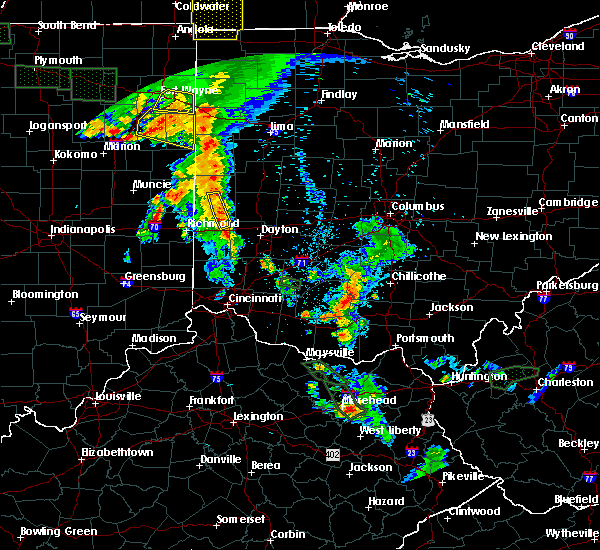 The severe thunderstorm warning for southeastern darke and northeastern preble counties will expire at 900 pm edt, the storms which prompted the warning have weakened below severe limits and moved out of the warned area. therefore the warning will be allowed to expire. gusty winds and heavy rain are still possible with these storms. please report previous wind damage or hail to the national weather service by going to our website at weather.gov/iln and submit your report via social media. The severe thunderstorm warning for southeastern darke and northeastern preble counties will expire at 900 pm edt, the storms which prompted the warning have weakened below severe limits and moved out of the warned area. therefore the warning will be allowed to expire. gusty winds and heavy rain are still possible with these storms. please report previous wind damage or hail to the national weather service by going to our website at weather.gov/iln and submit your report via social media.
|
| 7/18/2015 8:51 PM EDT |
 At 851 pm edt, radar indicated that the severe thunderstorms had weakened. these storms were located along a line extending from near versailles to near lewisburg, moving east at 25 mph. storm hazards include, winds to 60 mph, frequent cloud to ground lightning, very heavy rain which may cause minor flooding, locations impacted include, greenville, arcanum, lewisburg, verona, gordon, ithaca, pikeville and abbottsville. At 851 pm edt, radar indicated that the severe thunderstorms had weakened. these storms were located along a line extending from near versailles to near lewisburg, moving east at 25 mph. storm hazards include, winds to 60 mph, frequent cloud to ground lightning, very heavy rain which may cause minor flooding, locations impacted include, greenville, arcanum, lewisburg, verona, gordon, ithaca, pikeville and abbottsville.
|
| 7/18/2015 8:32 PM EDT |
 At 832 pm edt, radar indicated severe thunderstorms located along a line extending from near greenville to near lewisburg, moving east at 40 mph. storm hazards include, winds to 60 mph, frequent cloud to ground lightning, very heavy rain which may cause minor flooding, locations impacted include, greenville, arcanum, lewisburg, new madison, wayne lakes, eldorado, verona, west manchester, gordon, palestine, ithaca, castine, sharps crossing, pikeville, abbottsville, interstate 70 at us route 127 and sharpeye. At 832 pm edt, radar indicated severe thunderstorms located along a line extending from near greenville to near lewisburg, moving east at 40 mph. storm hazards include, winds to 60 mph, frequent cloud to ground lightning, very heavy rain which may cause minor flooding, locations impacted include, greenville, arcanum, lewisburg, new madison, wayne lakes, eldorado, verona, west manchester, gordon, palestine, ithaca, castine, sharps crossing, pikeville, abbottsville, interstate 70 at us route 127 and sharpeye.
|
| 7/18/2015 8:26 PM EDT |
 At 826 pm edt, radar indicated severe thunderstorms located along a line extending from near union city to near new madison, moving east at 35 mph. storm hazards include, winds to 60 mph, frequent cloud to ground lightning, very heavy rain which may cause minor flooding, locations impacted include, richmond, greenville, arcanum, lewisburg, new paris, new madison, wayne lakes, eldorado, verona, west manchester, hollansburg, gordon, palestine, ithaca, castine, sharps crossing, pikeville, abbottsville, interstate 70 at us route 127 and sharpeye. At 826 pm edt, radar indicated severe thunderstorms located along a line extending from near union city to near new madison, moving east at 35 mph. storm hazards include, winds to 60 mph, frequent cloud to ground lightning, very heavy rain which may cause minor flooding, locations impacted include, richmond, greenville, arcanum, lewisburg, new paris, new madison, wayne lakes, eldorado, verona, west manchester, hollansburg, gordon, palestine, ithaca, castine, sharps crossing, pikeville, abbottsville, interstate 70 at us route 127 and sharpeye.
|
| 7/18/2015 8:14 PM EDT |
 At 814 pm edt, radar indicated severe thunderstorms located along a line extending from near fountain city to near new paris, moving east at 25 mph. storm hazards include, winds to 60 mph,. At 814 pm edt, radar indicated severe thunderstorms located along a line extending from near fountain city to near new paris, moving east at 25 mph. storm hazards include, winds to 60 mph,.
|
| 7/17/2015 4:26 PM EDT |
 The severe thunderstorm warning for southern darke and north central preble counties will expire at 430 pm edt, the storm which prompted the warning has weakened below severe limits. therefore the warning will be allowed to expire. small hail and gusty winds are still possible with these storms. a flash flood warning remains in effect for southern darke county. please report previous wind damage or hail to the national weather service by going to our website at weather.gov/iln and submit your report via social media. The severe thunderstorm warning for southern darke and north central preble counties will expire at 430 pm edt, the storm which prompted the warning has weakened below severe limits. therefore the warning will be allowed to expire. small hail and gusty winds are still possible with these storms. a flash flood warning remains in effect for southern darke county. please report previous wind damage or hail to the national weather service by going to our website at weather.gov/iln and submit your report via social media.
|
| 7/17/2015 4:15 PM EDT |
 At 414 pm edt, radar indicated a severe thunderstorm located over new madison, moving southeast at 20 mph. storm hazards include, winds to 60 mph, quarter size hail, very heavy rain which may cause minor flooding, locations impacted include, arcanum, new madison, wayne lakes, eldorado, west manchester, pitsburg, hollansburg, gordon, palestine, ithaca, castine and abbottsville. At 414 pm edt, radar indicated a severe thunderstorm located over new madison, moving southeast at 20 mph. storm hazards include, winds to 60 mph, quarter size hail, very heavy rain which may cause minor flooding, locations impacted include, arcanum, new madison, wayne lakes, eldorado, west manchester, pitsburg, hollansburg, gordon, palestine, ithaca, castine and abbottsville.
|
| 7/17/2015 4:07 PM EDT |
 At 407 pm edt, radar indicated a severe thunderstorm located over new madison, moving southeast at 15 mph. storm hazards include, winds to 60 mph, quarter size hail, very heavy rain which may cause minor flooding, locations impacted include, arcanum, new madison, wayne lakes, eldorado, west manchester, pitsburg, bethel, hollansburg, gordon, palestine, ithaca, castine, whitewater and abbottsville. At 407 pm edt, radar indicated a severe thunderstorm located over new madison, moving southeast at 15 mph. storm hazards include, winds to 60 mph, quarter size hail, very heavy rain which may cause minor flooding, locations impacted include, arcanum, new madison, wayne lakes, eldorado, west manchester, pitsburg, bethel, hollansburg, gordon, palestine, ithaca, castine, whitewater and abbottsville.
|
| 7/17/2015 3:55 PM EDT |
 At 354 pm edt, radar indicated a severe thunderstorm located near new madison, moving southeast at 25 mph. storm hazards include, winds to 60 mph, quarter size hail, very heavy rain which may cause minor flooding, locations impacted include, arcanum, new madison, wayne lakes, eldorado, west manchester, pitsburg, bethel, hollansburg, gordon, palestine, ithaca, castine, whitewater and abbottsville. At 354 pm edt, radar indicated a severe thunderstorm located near new madison, moving southeast at 25 mph. storm hazards include, winds to 60 mph, quarter size hail, very heavy rain which may cause minor flooding, locations impacted include, arcanum, new madison, wayne lakes, eldorado, west manchester, pitsburg, bethel, hollansburg, gordon, palestine, ithaca, castine, whitewater and abbottsville.
|
| 7/17/2015 3:45 PM EDT |
 At 345 pm edt, radar indicated a severe thunderstorm located near new madison, moving southeast at 25 mph. storm hazards include, winds to 60 mph, quarter size hail,. At 345 pm edt, radar indicated a severe thunderstorm located near new madison, moving southeast at 25 mph. storm hazards include, winds to 60 mph, quarter size hail,.
|
| 7/13/2015 12:25 PM EDT |
 At 1225 pm edt, radar indicated severe thunderstorms located along a line extending from near lewisburg to near dublin, moving southeast at 40 mph. storm hazards include, winds to 60 mph, frequent cloud to ground lightning, very heavy rain which may cause minor flooding,. At 1225 pm edt, radar indicated severe thunderstorms located along a line extending from near lewisburg to near dublin, moving southeast at 40 mph. storm hazards include, winds to 60 mph, frequent cloud to ground lightning, very heavy rain which may cause minor flooding,.
|
| 5/11/2015 4:00 PM EDT | At 358 pm edt, radar continued to indicate a severe thunderstorm located near gordon, moving northeast at 50 mph. storm hazards include, winds to 60 mph, locations impacted include, arcanum, west milton, covington, troy and piqua. in addition, phillipsburg, pitsburg, garland, potsdam, union, laura, union corners and ludlow falls are near the path of this storm. this includes the following interstates, i-70 between mile markers 9 and 23, i-75 between mile markers 69 and 80, , <0.75in. |
| 5/11/2015 3:43 PM EDT | At 341 pm edt, radar indicated a severe thunderstorm located near new hope, moving northeast at 50 mph. storm hazards include, winds to 60 mph, penny size hail,. |
| 5/11/2015 3:27 PM EDT | At 326 pm edt, radar continued to indicate severe thunderstorms located along a line extending from union city to west florence, moving northeast at 60 mph. storm hazards include, winds to 60 mph, penny size hail, locations impacted include, greenville, ansonia, lewisburg, arcanum and versailles. in addition, west florence, palestine, sharpeye, new hope, sharps crossing, new madison, eldorado and rossburg are near the path of these storms. this includes the following interstate, i-70 between mile markers 0 and 21 in ohio, , 0.75in. |
| 5/11/2015 3:27 PM EDT | At 326 pm edt, radar continued to indicate severe thunderstorms located along a line extending from union city to west florence, moving northeast at 60 mph. storm hazards include, winds to 60 mph, penny size hail, locations impacted include, greenville, ansonia, lewisburg, arcanum and versailles. in addition, west florence, palestine, sharpeye, new hope, sharps crossing, new madison, eldorado and rossburg are near the path of these storms. this includes the following interstate, i-70 between mile markers 0 and 21 in ohio, , 0.75in. |
| 5/11/2015 3:09 PM EDT | At 307 pm edt, radar continued to indicate severe thunderstorms located along a line extending from 7 miles northeast of economy to clifton, moving northeast at 60 mph. storm hazards include, winds to 60 mph, penny size hail, locations impacted include, richmond, new paris, greenville, ansonia, arcanum, lewisburg and versailles. in addition, boston, spring grove, witts station, richmond municipal airport, whitewater, middleboro, bethel and west florence are near the path of these storms. this includes the following interstate, i-70 between mile markers 136 and 156 in indiana and between mile markers 0 and 21 in ohio, , 0.75in. |
| 5/11/2015 3:09 PM EDT | At 307 pm edt, radar continued to indicate severe thunderstorms located along a line extending from 7 miles northeast of economy to clifton, moving northeast at 60 mph. storm hazards include, winds to 60 mph, penny size hail, locations impacted include, richmond, new paris, greenville, ansonia, arcanum, lewisburg and versailles. in addition, boston, spring grove, witts station, richmond municipal airport, whitewater, middleboro, bethel and west florence are near the path of these storms. this includes the following interstate, i-70 between mile markers 136 and 156 in indiana and between mile markers 0 and 21 in ohio, , 0.75in. |
| 5/11/2015 2:54 PM EDT | At 251 pm edt, radar indicated severe thunderstorms located along a line extending from franklin to columbia, moving northeast at 60 mph. storm hazards include, winds to 60 mph, penny size hail,. |
| 5/11/2015 2:54 PM EDT | At 251 pm edt, radar indicated severe thunderstorms located along a line extending from franklin to columbia, moving northeast at 60 mph. storm hazards include, winds to 60 mph, penny size hail,. |
| 4/10/2015 2:48 AM EDT | A severe thunderstorm warning remains in effect until 315 am edt for northeastern preble. northern montgomery. southwestern miami and southeastern darke counties. at 245 am edt. radar continued to indicate a severe thunderstorm located near verona. moving east at 65 mph. Storm hazards include. |
| 4/10/2015 2:39 AM EDT | The national weather service in wilmington has issued a * severe thunderstorm warning for. northern preble county in west central ohio. northern montgomery county in west central ohio. southwestern miami county in west central ohio. Southeastern darke county in west central ohio. |
| 4/8/2015 10:16 AM EDT | The national weather service in wilmington has issued a * severe thunderstorm warning for. southern miami county in west central ohio. southeastern darke county in west central ohio. until 1100 am edt. at 1014 am edt. Radar indicated a severe thunderstorm located near. |
Hail Maps for Ithaca, OH


Connect with Interactive Hail Maps