

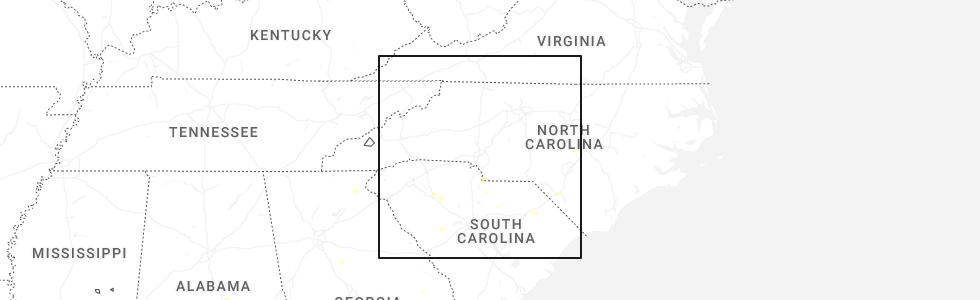
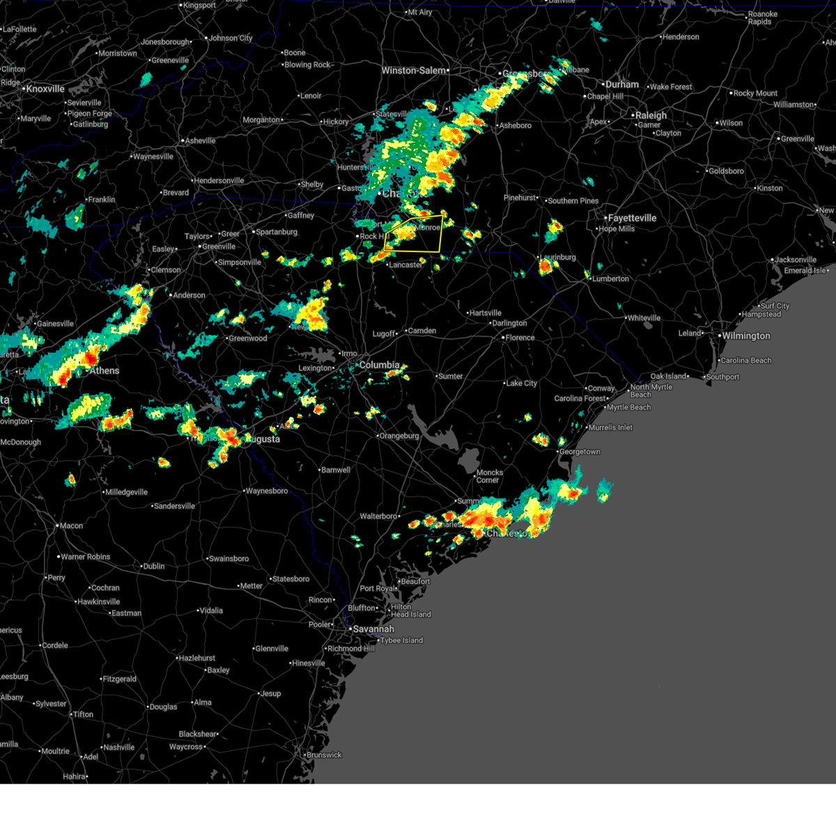
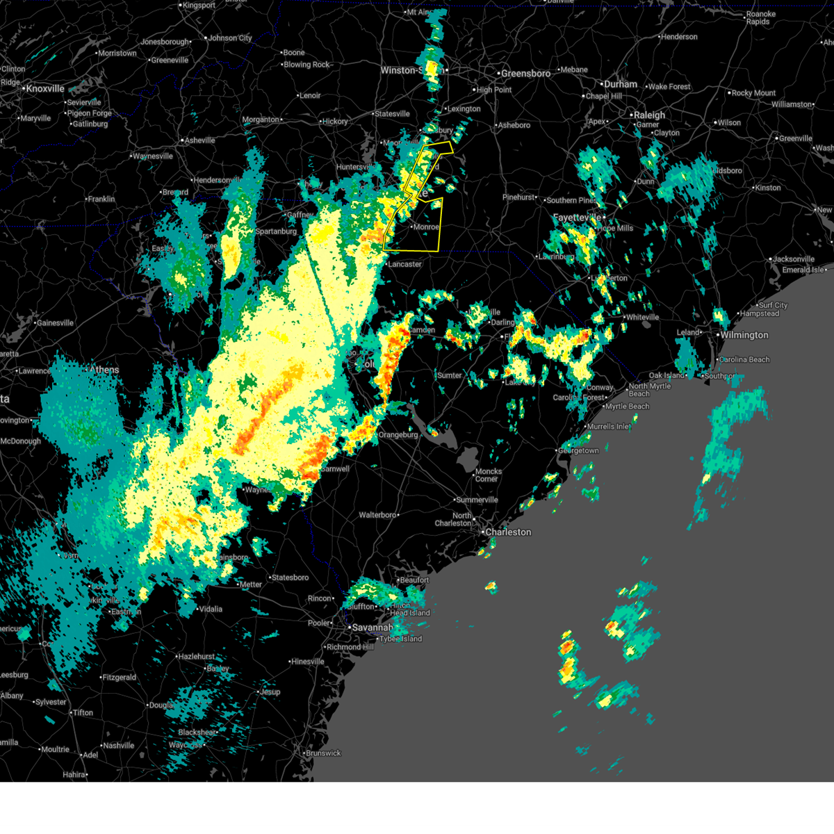
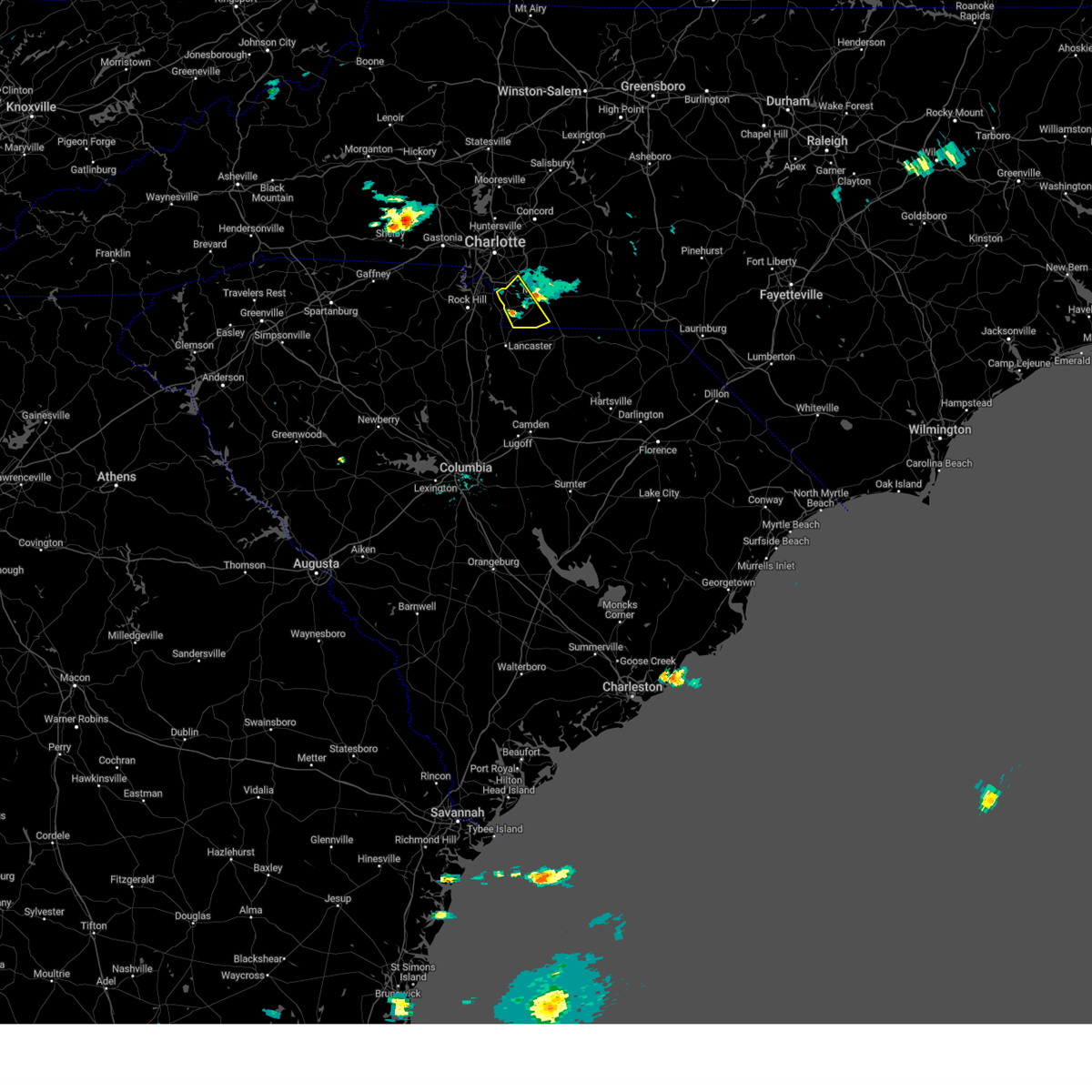
Hail Map for JAARS, NC
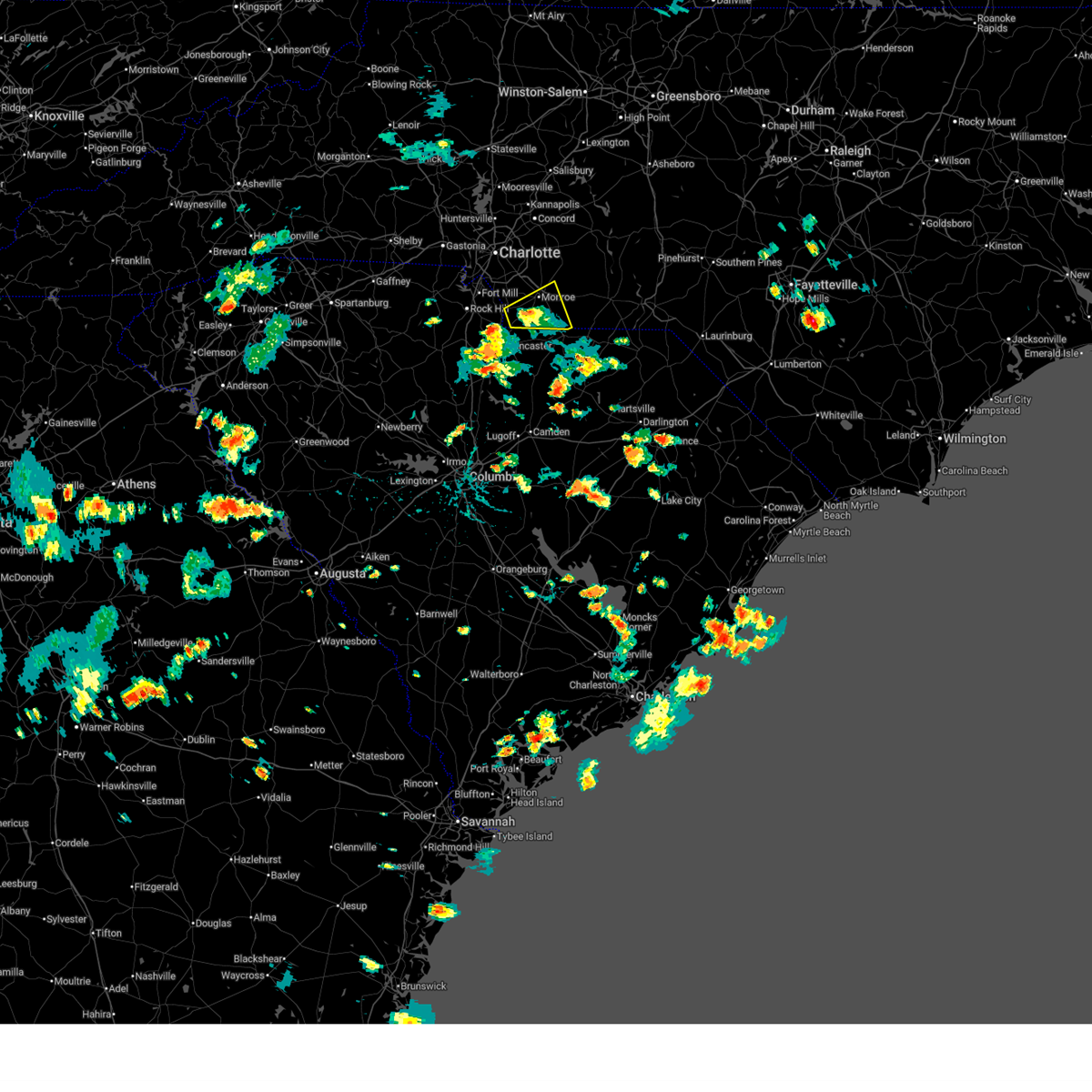
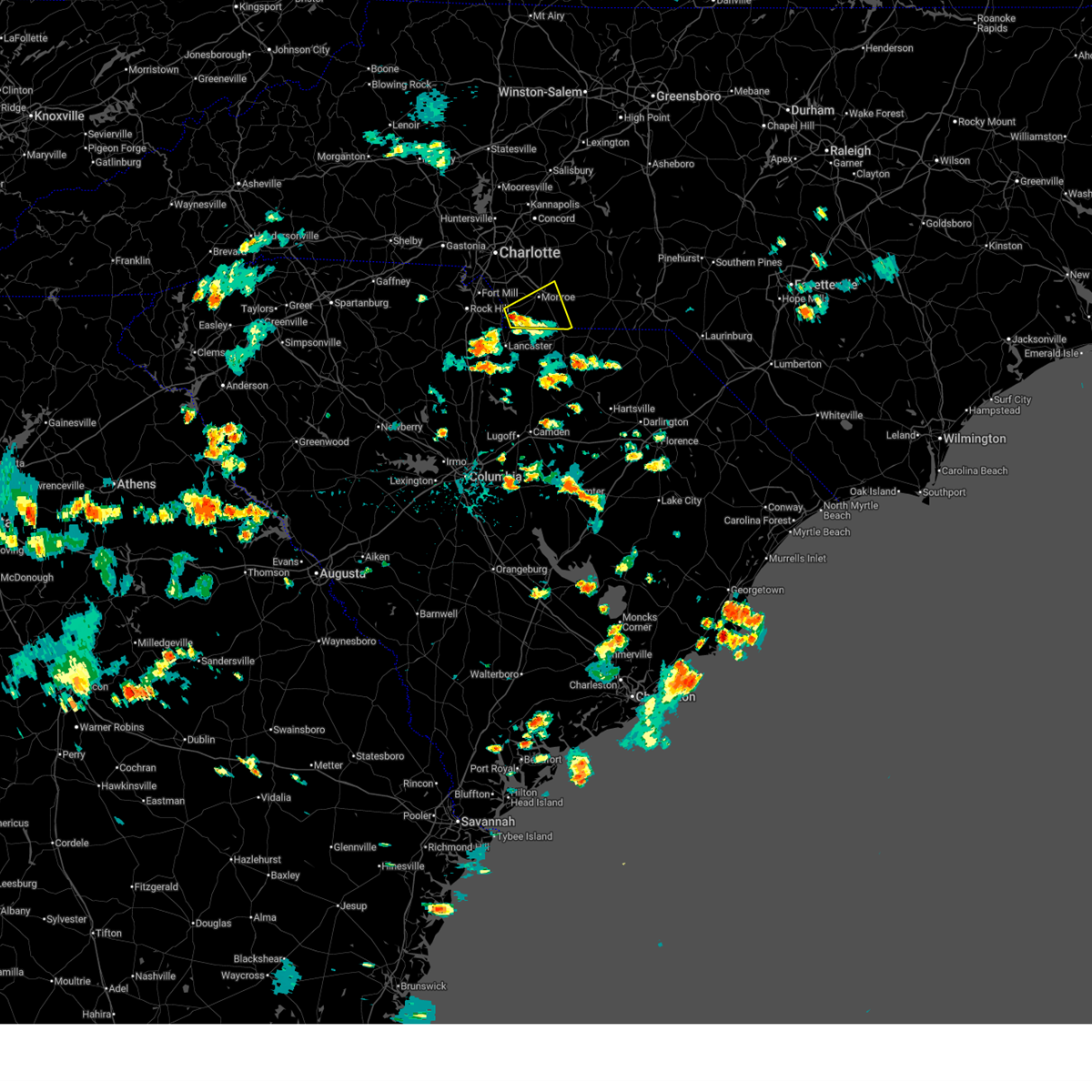
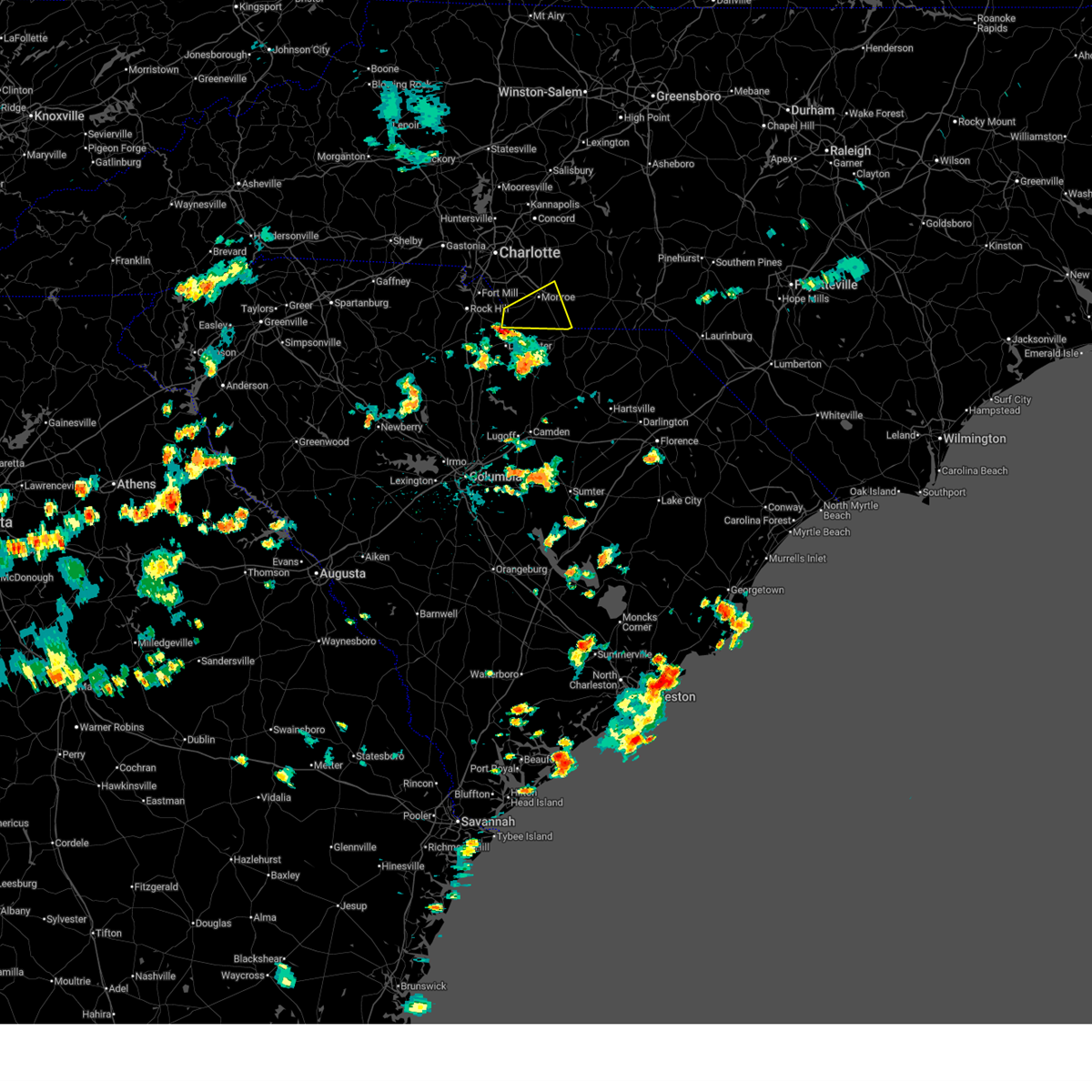
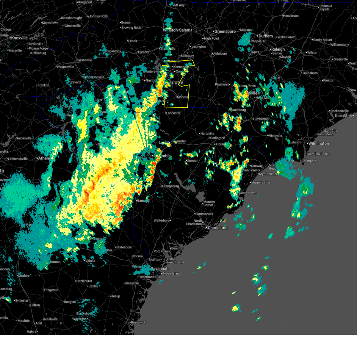
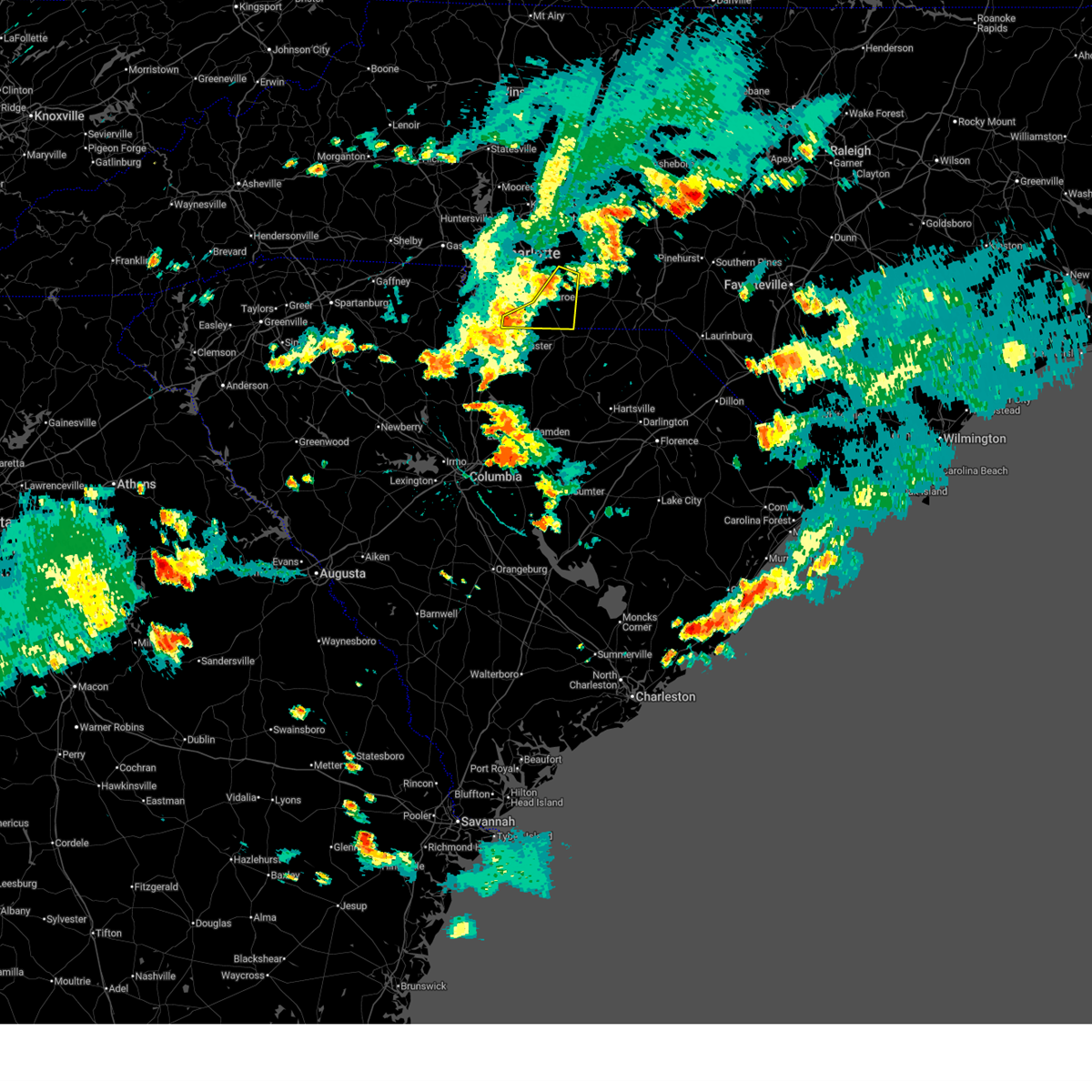
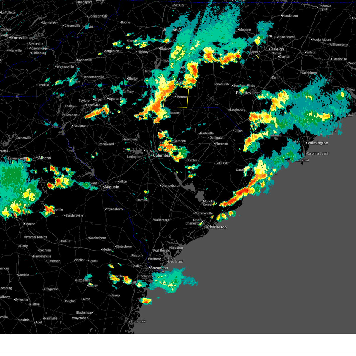
The JAARS, NC area has had 0 reports of on-the-ground hail by trained spotters, and has been under severe weather warnings 13 times during the past 12 months. Doppler radar has detected hail at or near JAARS, NC on 30 occasions, including 1 occasion during the past year.
| Name: | JAARS, NC |
| Where Located: | 25.3 miles S of Charlotte, NC |
| Map: | Google Map for JAARS, NC |
| Population: | 597 |
| Housing Units: | 177 |
| More Info: | Search Google for JAARS, NC |
2
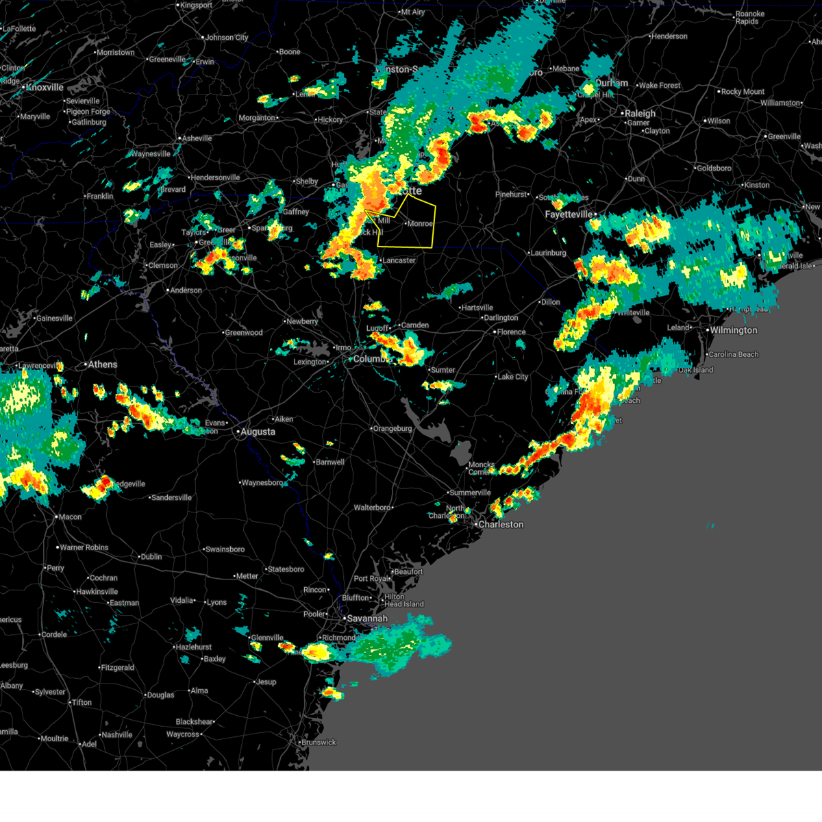
The Top Recent Hail Date for JAARS, NC is Sunday, July 12, 2026 (3rd out of 30)
Hail and Wind Damage Spotted near JAARS, NC
| Date / Time | Report Details |
|---|---|
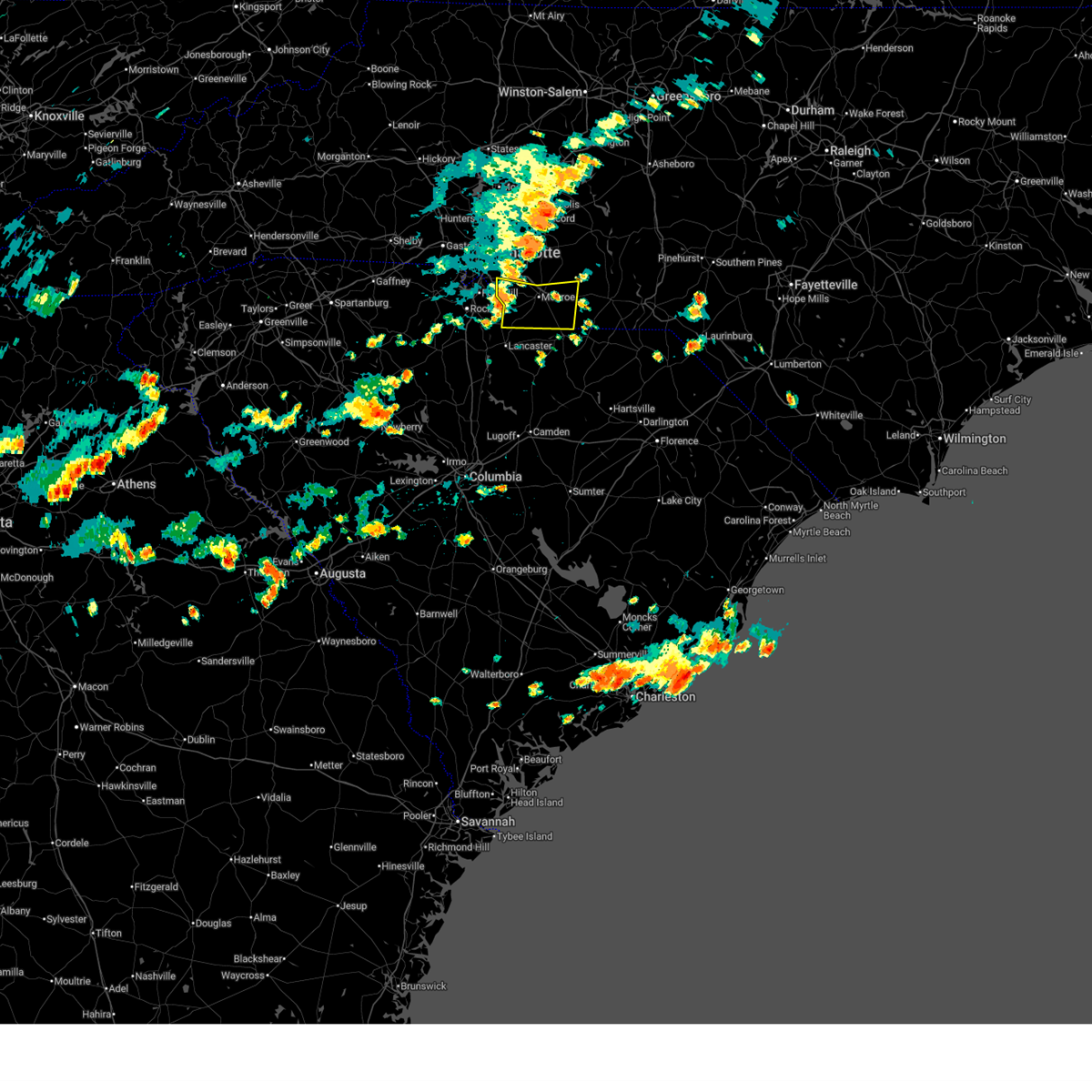
| 7/12/2026 4:07 PM EDT |
 The storm which prompted the warning has weakened below severe limits, and no longer poses an immediate threat to life or property. therefore, the warning will be allowed to expire. however, gusty winds are still possible with this thunderstorm. The storm which prompted the warning has weakened below severe limits, and no longer poses an immediate threat to life or property. therefore, the warning will be allowed to expire. however, gusty winds are still possible with this thunderstorm.
|
| 7/12/2026 3:46 PM EDT |
 At 346 pm edt, a severe thunderstorm was located 11 miles northeast of lancaster, or 4 miles southeast of waxhaw, moving northeast at 10 mph (radar indicated). Hazards include 60 mph wind gusts and quarter size hail. Minor hail damage to vehicles is expected. expect wind damage to trees and power lines. Locations impacted include, monroe, wingate, waxhaw, mineral springs, jaars, trinity, and unionville. At 346 pm edt, a severe thunderstorm was located 11 miles northeast of lancaster, or 4 miles southeast of waxhaw, moving northeast at 10 mph (radar indicated). Hazards include 60 mph wind gusts and quarter size hail. Minor hail damage to vehicles is expected. expect wind damage to trees and power lines. Locations impacted include, monroe, wingate, waxhaw, mineral springs, jaars, trinity, and unionville.
|
| 7/12/2026 3:18 PM EDT |
 Svrgsp the national weather service in greenville-spartanburg has issued a * severe thunderstorm warning for, southern union county in the piedmont of north carolina, * until 415 pm edt. * at 318 pm edt, a severe thunderstorm was located 7 miles north of lancaster, or near andrew jackson state park, moving east at 15 mph (radar indicated). Hazards include 60 mph wind gusts and quarter size hail. Minor hail damage to vehicles is expected. Expect wind damage to trees and power lines. Svrgsp the national weather service in greenville-spartanburg has issued a * severe thunderstorm warning for, southern union county in the piedmont of north carolina, * until 415 pm edt. * at 318 pm edt, a severe thunderstorm was located 7 miles north of lancaster, or near andrew jackson state park, moving east at 15 mph (radar indicated). Hazards include 60 mph wind gusts and quarter size hail. Minor hail damage to vehicles is expected. Expect wind damage to trees and power lines.
|
| 7/10/2026 4:11 PM EDT |
 At 411 pm edt, a severe thunderstorm was located 4 miles southwest of monroe, moving east at 30 mph (radar indicated). Hazards include 60 mph wind gusts and penny size hail. Expect damage to trees and power lines. Locations impacted include, monroe, wingate, waxhaw, marshville, mineral springs, sturdivants, jaars, trinity, wesley chapel, and unionville. At 411 pm edt, a severe thunderstorm was located 4 miles southwest of monroe, moving east at 30 mph (radar indicated). Hazards include 60 mph wind gusts and penny size hail. Expect damage to trees and power lines. Locations impacted include, monroe, wingate, waxhaw, marshville, mineral springs, sturdivants, jaars, trinity, wesley chapel, and unionville.
|
| 7/10/2026 3:53 PM EDT |
 Svrgsp the national weather service in greenville-spartanburg has issued a * severe thunderstorm warning for, south central mecklenburg county in the piedmont of north carolina, union county in the piedmont of north carolina, * until 445 pm edt. * at 353 pm edt, a severe thunderstorm was located 6 miles southeast of indian land, or near waxhaw, moving east at 30 mph (radar indicated). Hazards include 60 mph wind gusts and penny size hail. expect damage to trees and power lines Svrgsp the national weather service in greenville-spartanburg has issued a * severe thunderstorm warning for, south central mecklenburg county in the piedmont of north carolina, union county in the piedmont of north carolina, * until 445 pm edt. * at 353 pm edt, a severe thunderstorm was located 6 miles southeast of indian land, or near waxhaw, moving east at 30 mph (radar indicated). Hazards include 60 mph wind gusts and penny size hail. expect damage to trees and power lines
|
| 6/27/2026 5:50 PM EDT |
 Svrgsp the national weather service in greenville-spartanburg has issued a * severe thunderstorm warning for, southeastern mecklenburg county in the piedmont of north carolina, union county in the piedmont of north carolina, * until 645 pm edt. * at 550 pm edt, severe thunderstorms were located along a line extending from 14 miles south of downtown concord to near indian land, moving southeast at 35 mph (radar indicated). Hazards include 60 mph wind gusts. expect damage to trees and power lines Svrgsp the national weather service in greenville-spartanburg has issued a * severe thunderstorm warning for, southeastern mecklenburg county in the piedmont of north carolina, union county in the piedmont of north carolina, * until 645 pm edt. * at 550 pm edt, severe thunderstorms were located along a line extending from 14 miles south of downtown concord to near indian land, moving southeast at 35 mph (radar indicated). Hazards include 60 mph wind gusts. expect damage to trees and power lines
|
| 3/16/2026 10:09 AM EDT |
 the severe thunderstorm warning has been cancelled and is no longer in effect the severe thunderstorm warning has been cancelled and is no longer in effect
|
| 3/16/2026 10:09 AM EDT |
 At 1009 am edt, severe thunderstorms were located along a line extending from 11 miles east of kannapolis to 7 miles southwest of monroe, moving east at 35 mph (radar indicated). Hazards include 60 mph wind gusts. Expect damage to trees and power lines. Locations impacted include, monroe, indian trail, stallings, unionville, wesley chapel, wingate, waxhaw, marshville, lake park, and mineral springs. At 1009 am edt, severe thunderstorms were located along a line extending from 11 miles east of kannapolis to 7 miles southwest of monroe, moving east at 35 mph (radar indicated). Hazards include 60 mph wind gusts. Expect damage to trees and power lines. Locations impacted include, monroe, indian trail, stallings, unionville, wesley chapel, wingate, waxhaw, marshville, lake park, and mineral springs.
|
| 3/16/2026 9:39 AM EDT |
 Svrgsp the national weather service in greenville-spartanburg has issued a * severe thunderstorm warning for, cabarrus county in the piedmont of north carolina, mecklenburg county in the piedmont of north carolina, southern rowan county in the piedmont of north carolina, union county in the piedmont of north carolina, * until 1045 am edt. * at 937 am edt, severe thunderstorms were located along a line extending from 7 miles northeast of huntersville to 3 miles east of rock hill, moving east at 40 mph (radar indicated). Hazards include 60 mph wind gusts. expect damage to trees and power lines Svrgsp the national weather service in greenville-spartanburg has issued a * severe thunderstorm warning for, cabarrus county in the piedmont of north carolina, mecklenburg county in the piedmont of north carolina, southern rowan county in the piedmont of north carolina, union county in the piedmont of north carolina, * until 1045 am edt. * at 937 am edt, severe thunderstorms were located along a line extending from 7 miles northeast of huntersville to 3 miles east of rock hill, moving east at 40 mph (radar indicated). Hazards include 60 mph wind gusts. expect damage to trees and power lines
|
| 8/1/2025 6:32 PM EDT |
 At 632 pm edt, severe thunderstorms were located along a line extending from 15 miles northwest of wadesboro to 7 miles south of monroe to 3 miles east of lancaster, moving southeast at 25 mph (radar indicated). Hazards include 60 mph wind gusts. Expect damage to trees and power lines. Locations impacted include, monroe, wingate, marshville, sturdivants, jaars, trinity, new salem, mineral springs, and unionville. At 632 pm edt, severe thunderstorms were located along a line extending from 15 miles northwest of wadesboro to 7 miles south of monroe to 3 miles east of lancaster, moving southeast at 25 mph (radar indicated). Hazards include 60 mph wind gusts. Expect damage to trees and power lines. Locations impacted include, monroe, wingate, marshville, sturdivants, jaars, trinity, new salem, mineral springs, and unionville.
|
| 8/1/2025 6:10 PM EDT |
 the severe thunderstorm warning has been cancelled and is no longer in effect the severe thunderstorm warning has been cancelled and is no longer in effect
|
| 8/1/2025 6:10 PM EDT |
 At 610 pm edt, severe thunderstorms were located along a line extending from 11 miles north of monroe to 7 miles southeast of indian land to 9 miles northwest of lancaster, moving southeast at 15 mph (radar indicated). Hazards include 60 mph wind gusts. Expect damage to trees and power lines. Locations impacted include, monroe, unionville, wesley chapel, wingate, waxhaw, marshville, mineral springs, fairview in union county, sturdivants, and jaars. At 610 pm edt, severe thunderstorms were located along a line extending from 11 miles north of monroe to 7 miles southeast of indian land to 9 miles northwest of lancaster, moving southeast at 15 mph (radar indicated). Hazards include 60 mph wind gusts. Expect damage to trees and power lines. Locations impacted include, monroe, unionville, wesley chapel, wingate, waxhaw, marshville, mineral springs, fairview in union county, sturdivants, and jaars.
|
| 8/1/2025 5:52 PM EDT |
 Svrgsp the national weather service in greenville-spartanburg has issued a * severe thunderstorm warning for, south central mecklenburg county in the piedmont of north carolina, union county in the piedmont of north carolina, * until 715 pm edt. * at 552 pm edt, severe thunderstorms were located along a line extending from 13 miles south of downtown concord to 4 miles east of indian land to 8 miles south of rock hill, moving southeast at 20 mph (radar indicated). Hazards include 60 mph wind gusts. expect damage to trees and power lines Svrgsp the national weather service in greenville-spartanburg has issued a * severe thunderstorm warning for, south central mecklenburg county in the piedmont of north carolina, union county in the piedmont of north carolina, * until 715 pm edt. * at 552 pm edt, severe thunderstorms were located along a line extending from 13 miles south of downtown concord to 4 miles east of indian land to 8 miles south of rock hill, moving southeast at 20 mph (radar indicated). Hazards include 60 mph wind gusts. expect damage to trees and power lines
|
| 3/31/2025 4:57 PM EDT |
 Svrgsp the national weather service in greenville-spartanburg has issued a * severe thunderstorm warning for, southern mecklenburg county in the piedmont of north carolina, union county in the piedmont of north carolina, * until 615 pm edt. * at 457 pm edt, severe thunderstorms were located along a line extending from 7 miles east of york to 6 miles southeast of rock hill to 13 miles north of springdale, moving east at 50 mph (radar indicated). Hazards include 60 mph wind gusts. expect damage to trees and power lines Svrgsp the national weather service in greenville-spartanburg has issued a * severe thunderstorm warning for, southern mecklenburg county in the piedmont of north carolina, union county in the piedmont of north carolina, * until 615 pm edt. * at 457 pm edt, severe thunderstorms were located along a line extending from 7 miles east of york to 6 miles southeast of rock hill to 13 miles north of springdale, moving east at 50 mph (radar indicated). Hazards include 60 mph wind gusts. expect damage to trees and power lines
|
| 3/5/2025 8:08 AM EST |
 Svrgsp the national weather service in greenville-spartanburg has issued a * severe thunderstorm warning for, cabarrus county in the piedmont of north carolina, central mecklenburg county in the piedmont of north carolina, southeastern rowan county in the piedmont of north carolina, union county in the piedmont of north carolina, * until 900 am est. * at 808 am est, severe thunderstorms were located along a line extending from 3 miles east of huntersville to 10 miles southeast of rock hill, moving northeast at 45 mph (radar indicated). Hazards include 60 mph wind gusts. expect damage to trees and power lines Svrgsp the national weather service in greenville-spartanburg has issued a * severe thunderstorm warning for, cabarrus county in the piedmont of north carolina, central mecklenburg county in the piedmont of north carolina, southeastern rowan county in the piedmont of north carolina, union county in the piedmont of north carolina, * until 900 am est. * at 808 am est, severe thunderstorms were located along a line extending from 3 miles east of huntersville to 10 miles southeast of rock hill, moving northeast at 45 mph (radar indicated). Hazards include 60 mph wind gusts. expect damage to trees and power lines
|
| 12/29/2024 8:59 AM EST |
 Svrgsp the national weather service in greenville-spartanburg has issued a * severe thunderstorm warning for, cabarrus county in the piedmont of north carolina, mecklenburg county in the piedmont of north carolina, south central rowan county in the piedmont of north carolina, southeastern gaston county in the piedmont of north carolina, union county in the piedmont of north carolina, * until 1015 am est. * at 859 am est, severe thunderstorms were located along a line extending from 8 miles north of york to 5 miles west of rock hill to 3 miles north of winnsboro, moving northeast at 50 mph (radar indicated). Hazards include 60 mph wind gusts. expect damage to trees and power lines Svrgsp the national weather service in greenville-spartanburg has issued a * severe thunderstorm warning for, cabarrus county in the piedmont of north carolina, mecklenburg county in the piedmont of north carolina, south central rowan county in the piedmont of north carolina, southeastern gaston county in the piedmont of north carolina, union county in the piedmont of north carolina, * until 1015 am est. * at 859 am est, severe thunderstorms were located along a line extending from 8 miles north of york to 5 miles west of rock hill to 3 miles north of winnsboro, moving northeast at 50 mph (radar indicated). Hazards include 60 mph wind gusts. expect damage to trees and power lines
|
| 8/19/2024 7:18 PM EDT |
 the severe thunderstorm warning has been cancelled and is no longer in effect the severe thunderstorm warning has been cancelled and is no longer in effect
|
| 8/19/2024 6:57 PM EDT |
 the severe thunderstorm warning has been cancelled and is no longer in effect the severe thunderstorm warning has been cancelled and is no longer in effect
|
| 8/19/2024 6:57 PM EDT |
 At 657 pm edt, a severe thunderstorm was located 7 miles east of indian land, or near weddington, moving southeast at 15 mph (radar indicated). Hazards include 60 mph wind gusts. Expect damage to trees and power lines. Locations impacted include, indian trail, weddington, stallings, wesley chapel, waxhaw, mineral springs, marvin, trinity, and jaars. At 657 pm edt, a severe thunderstorm was located 7 miles east of indian land, or near weddington, moving southeast at 15 mph (radar indicated). Hazards include 60 mph wind gusts. Expect damage to trees and power lines. Locations impacted include, indian trail, weddington, stallings, wesley chapel, waxhaw, mineral springs, marvin, trinity, and jaars.
|
| 8/19/2024 6:37 PM EDT |
 Svrgsp the national weather service in greenville-spartanburg has issued a * severe thunderstorm warning for, south central mecklenburg county in the piedmont of north carolina, southwestern union county in the piedmont of north carolina, * until 745 pm edt. * at 637 pm edt, a severe thunderstorm was located 5 miles northeast of indian land, or near the arboretum, moving southeast at 15 mph (radar indicated). Hazards include 60 mph wind gusts and penny size hail. expect damage to trees and power lines Svrgsp the national weather service in greenville-spartanburg has issued a * severe thunderstorm warning for, south central mecklenburg county in the piedmont of north carolina, southwestern union county in the piedmont of north carolina, * until 745 pm edt. * at 637 pm edt, a severe thunderstorm was located 5 miles northeast of indian land, or near the arboretum, moving southeast at 15 mph (radar indicated). Hazards include 60 mph wind gusts and penny size hail. expect damage to trees and power lines
|
| 7/6/2024 5:20 PM EDT |
 The storm which prompted the warning has weakened below severe limits, and no longer poses an immediate threat to life or property. therefore, the warning will be allowed to expire. however, heavy rain is still possible with this thunderstorm. The storm which prompted the warning has weakened below severe limits, and no longer poses an immediate threat to life or property. therefore, the warning will be allowed to expire. however, heavy rain is still possible with this thunderstorm.
|
| 7/6/2024 5:05 PM EDT |
 At 505 pm edt, a severe thunderstorm was located 6 miles southwest of monroe, or near mineral springs, moving northeast at 15 mph (radar indicated). Hazards include 60 mph wind gusts and penny size hail. Expect damage to trees and power lines. Locations impacted include, monroe, wesley chapel, waxhaw, mineral springs, jaars, trinity, and weddington. At 505 pm edt, a severe thunderstorm was located 6 miles southwest of monroe, or near mineral springs, moving northeast at 15 mph (radar indicated). Hazards include 60 mph wind gusts and penny size hail. Expect damage to trees and power lines. Locations impacted include, monroe, wesley chapel, waxhaw, mineral springs, jaars, trinity, and weddington.
|
| 7/6/2024 4:53 PM EDT |
 Svrgsp the national weather service in greenville-spartanburg has issued a * severe thunderstorm warning for, southern union county in the piedmont of north carolina, * until 530 pm edt. * at 453 pm edt, a severe thunderstorm was located 9 miles southwest of monroe, or near mineral springs, moving northeast at 15 mph (radar indicated). Hazards include 60 mph wind gusts and penny size hail. expect damage to trees and power lines Svrgsp the national weather service in greenville-spartanburg has issued a * severe thunderstorm warning for, southern union county in the piedmont of north carolina, * until 530 pm edt. * at 453 pm edt, a severe thunderstorm was located 9 miles southwest of monroe, or near mineral springs, moving northeast at 15 mph (radar indicated). Hazards include 60 mph wind gusts and penny size hail. expect damage to trees and power lines
|
| 5/15/2024 5:40 PM EDT |
 The storm which prompted the warning has moved out of the area. therefore, the warning will be allowed to expire. however, gusty winds and heavy rain are still possible with this thunderstorm. a severe thunderstorm watch remains in effect until 800 pm edt for the piedmont of north carolina. The storm which prompted the warning has moved out of the area. therefore, the warning will be allowed to expire. however, gusty winds and heavy rain are still possible with this thunderstorm. a severe thunderstorm watch remains in effect until 800 pm edt for the piedmont of north carolina.
|
| 5/15/2024 4:47 PM EDT |
 Svrgsp the national weather service in greenville-spartanburg has issued a * severe thunderstorm warning for, south central mecklenburg county in the piedmont of north carolina, union county in the piedmont of north carolina, * until 545 pm edt. * at 447 pm edt, a severe thunderstorm was located near indian land, or near marvin, moving east at 25 mph (radar indicated). Hazards include 60 mph wind gusts and quarter size hail. Minor hail damage to vehicles is expected. Expect wind damage to trees and power lines. Svrgsp the national weather service in greenville-spartanburg has issued a * severe thunderstorm warning for, south central mecklenburg county in the piedmont of north carolina, union county in the piedmont of north carolina, * until 545 pm edt. * at 447 pm edt, a severe thunderstorm was located near indian land, or near marvin, moving east at 25 mph (radar indicated). Hazards include 60 mph wind gusts and quarter size hail. Minor hail damage to vehicles is expected. Expect wind damage to trees and power lines.
|
| 5/10/2024 2:04 PM EDT |
 Svrgsp the national weather service in greenville-spartanburg has issued a * severe thunderstorm warning for, southern union county in the piedmont of north carolina, * until 245 pm edt. * at 204 pm edt, a severe thunderstorm was located 10 miles south of monroe, or 8 miles northwest of pageland, moving east at 35 mph (radar indicated). Hazards include 60 mph wind gusts and quarter size hail. Minor hail damage to vehicles is expected. Expect wind damage to trees and power lines. Svrgsp the national weather service in greenville-spartanburg has issued a * severe thunderstorm warning for, southern union county in the piedmont of north carolina, * until 245 pm edt. * at 204 pm edt, a severe thunderstorm was located 10 miles south of monroe, or 8 miles northwest of pageland, moving east at 35 mph (radar indicated). Hazards include 60 mph wind gusts and quarter size hail. Minor hail damage to vehicles is expected. Expect wind damage to trees and power lines.
|
| 5/8/2024 4:43 PM EDT |
 Svrgsp the national weather service in greenville-spartanburg has issued a * severe thunderstorm warning for, southern union county in the piedmont of north carolina, * until 545 pm edt. * at 443 pm edt, a severe thunderstorm was located 5 miles south of indian land, or 4 miles north of van wyck, moving east at 50 mph (radar indicated). Hazards include 70 mph wind gusts and penny size hail. Expect considerable tree damage. Damage is likely to mobile homes, roofs, and outbuildings. Svrgsp the national weather service in greenville-spartanburg has issued a * severe thunderstorm warning for, southern union county in the piedmont of north carolina, * until 545 pm edt. * at 443 pm edt, a severe thunderstorm was located 5 miles south of indian land, or 4 miles north of van wyck, moving east at 50 mph (radar indicated). Hazards include 70 mph wind gusts and penny size hail. Expect considerable tree damage. Damage is likely to mobile homes, roofs, and outbuildings.
|
| 4/20/2024 5:26 PM EDT |
 The storm which prompted the warning has moved out of the area. therefore, the warning will be allowed to expire. The storm which prompted the warning has moved out of the area. therefore, the warning will be allowed to expire.
|
| 4/20/2024 4:53 PM EDT |
 At 452 pm edt, a severe thunderstorm was located 6 miles north of lancaster, or 4 miles southeast of andrew jackson state park, moving southeast at 30 mph (radar indicated). Hazards include 60 mph wind gusts and half dollar size hail. Minor hail damage to vehicles is expected. expect wind damage to trees and power lines. Locations impacted include, jaars and trinity. At 452 pm edt, a severe thunderstorm was located 6 miles north of lancaster, or 4 miles southeast of andrew jackson state park, moving southeast at 30 mph (radar indicated). Hazards include 60 mph wind gusts and half dollar size hail. Minor hail damage to vehicles is expected. expect wind damage to trees and power lines. Locations impacted include, jaars and trinity.
|
| 4/20/2024 4:53 PM EDT |
 the severe thunderstorm warning has been cancelled and is no longer in effect the severe thunderstorm warning has been cancelled and is no longer in effect
|
| 4/20/2024 4:43 PM EDT |
 Svrgsp the national weather service in greenville-spartanburg has issued a * severe thunderstorm warning for, southwestern union county in the piedmont of north carolina, northeastern chester county in upstate south carolina, southeastern york county in upstate south carolina, * until 530 pm edt. * at 443 pm edt, a severe thunderstorm was located 8 miles north of lancaster, or near andrew jackson state park, moving southeast at 30 mph (radar indicated). Hazards include tennis ball size hail and 70 mph wind gusts. People and animals outdoors will be injured. expect hail damage to roofs, siding, windows, and vehicles. expect considerable tree damage. Wind damage is also likely to mobile homes, roofs, and outbuildings. Svrgsp the national weather service in greenville-spartanburg has issued a * severe thunderstorm warning for, southwestern union county in the piedmont of north carolina, northeastern chester county in upstate south carolina, southeastern york county in upstate south carolina, * until 530 pm edt. * at 443 pm edt, a severe thunderstorm was located 8 miles north of lancaster, or near andrew jackson state park, moving southeast at 30 mph (radar indicated). Hazards include tennis ball size hail and 70 mph wind gusts. People and animals outdoors will be injured. expect hail damage to roofs, siding, windows, and vehicles. expect considerable tree damage. Wind damage is also likely to mobile homes, roofs, and outbuildings.
|
| 2/28/2024 5:19 PM EST | At 518 pm est, severe thunderstorms were located along a line extending from near monroe to 10 miles south of chester, moving east at 65 mph (radar indicated). Hazards include 60 mph wind gusts. Expect damage to trees and power lines. Locations impacted include, monroe, wingate, marshville, mineral springs, great falls, fort lawn, sturdivants, jaars, trinity, and fishing creek reservoir. |
| 2/28/2024 4:52 PM EST | Svrgsp the national weather service in greenville-spartanburg has issued a * severe thunderstorm warning for, south central mecklenburg county in the piedmont of north carolina, union county in the piedmont of north carolina, chester county in upstate south carolina, southeastern york county in upstate south carolina, southeastern union county in upstate south carolina, * until 530 pm est. * at 452 pm est, severe thunderstorms were located along a line extending from 5 miles west of indian land to 15 miles north of newberry, moving east at 45 mph (radar indicated). Hazards include 60 mph wind gusts. expect damage to trees and power lines |
| 1/9/2024 2:45 PM EST |
 At 245 pm est, severe thunderstorms were located along a line extending from 10 miles northeast of indian land to 5 miles northeast of lancaster to 8 miles northwest of lake wateree dam, moving northeast at 60 mph (radar indicated). Hazards include 60 mph wind gusts. expect damage to trees and power lines At 245 pm est, severe thunderstorms were located along a line extending from 10 miles northeast of indian land to 5 miles northeast of lancaster to 8 miles northwest of lake wateree dam, moving northeast at 60 mph (radar indicated). Hazards include 60 mph wind gusts. expect damage to trees and power lines
|
| 1/9/2024 1:32 PM EST |
 At 132 pm est, severe thunderstorms were located along a line extending from 8 miles southwest of uptown charlotte to 4 miles southeast of rock hill to 12 miles south of chester, moving northeast at 75 mph (radar indicated). Hazards include 60 mph wind gusts. expect damage to trees and power lines At 132 pm est, severe thunderstorms were located along a line extending from 8 miles southwest of uptown charlotte to 4 miles southeast of rock hill to 12 miles south of chester, moving northeast at 75 mph (radar indicated). Hazards include 60 mph wind gusts. expect damage to trees and power lines
|
| 9/7/2023 7:28 PM EDT |
 At 727 pm edt, a severe thunderstorm was located 4 miles south of monroe, moving east at 25 mph (radar indicated). Hazards include 60 mph wind gusts and quarter size hail. Minor hail damage to vehicles is expected. Expect wind damage to trees and power lines. At 727 pm edt, a severe thunderstorm was located 4 miles south of monroe, moving east at 25 mph (radar indicated). Hazards include 60 mph wind gusts and quarter size hail. Minor hail damage to vehicles is expected. Expect wind damage to trees and power lines.
|
| 8/7/2023 6:31 PM EDT |
 At 631 pm edt, severe thunderstorms were located along a line extending from 15 miles northeast of monroe to 6 miles north of lancaster, moving east at 40 mph (radar indicated). Hazards include 60 mph wind gusts and penny size hail. Expect damage to trees and power lines. locations impacted include, monroe, unionville, wesley chapel, wingate, waxhaw, marshville, mineral springs, fairview in union county, sturdivants and jaars. hail threat, radar indicated max hail size, 0. 75 in wind threat, radar indicated max wind gust, 60 mph. At 631 pm edt, severe thunderstorms were located along a line extending from 15 miles northeast of monroe to 6 miles north of lancaster, moving east at 40 mph (radar indicated). Hazards include 60 mph wind gusts and penny size hail. Expect damage to trees and power lines. locations impacted include, monroe, unionville, wesley chapel, wingate, waxhaw, marshville, mineral springs, fairview in union county, sturdivants and jaars. hail threat, radar indicated max hail size, 0. 75 in wind threat, radar indicated max wind gust, 60 mph.
|
| 8/7/2023 6:16 PM EDT |
 At 615 pm edt, severe thunderstorms were located along a line extending from 10 miles north of monroe to 9 miles northwest of lancaster, moving east at 40 mph (radar indicated). Hazards include 60 mph wind gusts and penny size hail. expect damage to trees and power lines At 615 pm edt, severe thunderstorms were located along a line extending from 10 miles north of monroe to 9 miles northwest of lancaster, moving east at 40 mph (radar indicated). Hazards include 60 mph wind gusts and penny size hail. expect damage to trees and power lines
|
| 1/12/2023 7:20 PM EST |
 At 719 pm est, severe thunderstorms were located along a line extending from 14 miles southeast of downtown concord to near monroe to 8 miles northwest of lancaster, moving east at 40 mph (radar indicated). Hazards include 60 mph wind gusts. Expect damage to trees and power lines. locations impacted include, monroe, unionville, wingate, waxhaw, marshville, mineral springs, sturdivants, jaars, trinity and new salem. hail threat, radar indicated max hail size, <. 75 in wind threat, radar indicated max wind gust, 60 mph. At 719 pm est, severe thunderstorms were located along a line extending from 14 miles southeast of downtown concord to near monroe to 8 miles northwest of lancaster, moving east at 40 mph (radar indicated). Hazards include 60 mph wind gusts. Expect damage to trees and power lines. locations impacted include, monroe, unionville, wingate, waxhaw, marshville, mineral springs, sturdivants, jaars, trinity and new salem. hail threat, radar indicated max hail size, <. 75 in wind threat, radar indicated max wind gust, 60 mph.
|
| 1/12/2023 6:59 PM EST |
 At 658 pm est, severe thunderstorms were located along a line extending from 3 miles west of downtown concord to 5 miles southeast of uptown charlotte to 4 miles west of indian land, moving east at 40 mph (radar indicated). Hazards include 60 mph wind gusts. expect damage to trees and power lines At 658 pm est, severe thunderstorms were located along a line extending from 3 miles west of downtown concord to 5 miles southeast of uptown charlotte to 4 miles west of indian land, moving east at 40 mph (radar indicated). Hazards include 60 mph wind gusts. expect damage to trees and power lines
|
| 8/12/2022 7:02 PM EDT |
 At 702 pm edt, a severe thunderstorm was located 9 miles northwest of lancaster, or near catawba, moving south at 25 mph. the eastern edge of the storm may just clip the southwestern corner of union county, north carolina (radar indicated). Hazards include 60 mph wind gusts and nickel size hail. Expect damage to trees and power lines. locations impacted include, lesslie, great falls, fort lawn, catawba, jaars, carolina commons shopping center, fishing creek reservoir, waxhaw, edgemoor and marvin. hail threat, radar indicated max hail size, 0. 88 in wind threat, radar indicated max wind gust, 60 mph. At 702 pm edt, a severe thunderstorm was located 9 miles northwest of lancaster, or near catawba, moving south at 25 mph. the eastern edge of the storm may just clip the southwestern corner of union county, north carolina (radar indicated). Hazards include 60 mph wind gusts and nickel size hail. Expect damage to trees and power lines. locations impacted include, lesslie, great falls, fort lawn, catawba, jaars, carolina commons shopping center, fishing creek reservoir, waxhaw, edgemoor and marvin. hail threat, radar indicated max hail size, 0. 88 in wind threat, radar indicated max wind gust, 60 mph.
|
| 8/12/2022 6:40 PM EDT |
 At 640 pm edt, a severe thunderstorm was located 4 miles southwest of indian land, moving south at 30 mph (radar indicated). Hazards include 60 mph wind gusts. expect damage to trees and power lines At 640 pm edt, a severe thunderstorm was located 4 miles southwest of indian land, moving south at 30 mph (radar indicated). Hazards include 60 mph wind gusts. expect damage to trees and power lines
|
| 6/17/2022 5:57 PM EDT |
 At 557 pm edt, a severe thunderstorm was located 11 miles northeast of lancaster, or 4 miles south of mineral springs, moving southeast at 30 mph (radar indicated). Hazards include 60 mph wind gusts and penny size hail. expect damage to trees and power lines At 557 pm edt, a severe thunderstorm was located 11 miles northeast of lancaster, or 4 miles south of mineral springs, moving southeast at 30 mph (radar indicated). Hazards include 60 mph wind gusts and penny size hail. expect damage to trees and power lines
|
| 6/16/2022 5:08 PM EDT |
 At 507 pm edt, a severe thunderstorm was located 5 miles south of indian land, or 4 miles north of van wyck, moving east at 20 mph (radar indicated). Hazards include 60 mph wind gusts and quarter size hail. Minor hail damage to vehicles is expected. Expect wind damage to trees and power lines. At 507 pm edt, a severe thunderstorm was located 5 miles south of indian land, or 4 miles north of van wyck, moving east at 20 mph (radar indicated). Hazards include 60 mph wind gusts and quarter size hail. Minor hail damage to vehicles is expected. Expect wind damage to trees and power lines.
|
| 6/3/2022 4:16 PM EDT |
 At 416 pm edt, a severe thunderstorm was located 8 miles north of lancaster, or near andrew jackson state park, moving east at 20 mph (radar indicated). Hazards include golf ball size hail and 60 mph wind gusts. People and animals outdoors will be injured. expect hail damage to roofs, siding, windows, and vehicles. Expect wind damage to trees and power lines. At 416 pm edt, a severe thunderstorm was located 8 miles north of lancaster, or near andrew jackson state park, moving east at 20 mph (radar indicated). Hazards include golf ball size hail and 60 mph wind gusts. People and animals outdoors will be injured. expect hail damage to roofs, siding, windows, and vehicles. Expect wind damage to trees and power lines.
|
| 5/6/2022 6:53 PM EDT |
 The severe thunderstorm warning for western cabarrus, southeastern catawba, southern iredell, mecklenburg and western union counties will expire at 700 pm edt, the storms which prompted the warning have weakened below severe limits, and have exited the warned area. therefore, the warning will be allowed to expire. a tornado watch remains in effect until 800 pm edt for the piedmont of north carolina, and upstate south carolina. The severe thunderstorm warning for western cabarrus, southeastern catawba, southern iredell, mecklenburg and western union counties will expire at 700 pm edt, the storms which prompted the warning have weakened below severe limits, and have exited the warned area. therefore, the warning will be allowed to expire. a tornado watch remains in effect until 800 pm edt for the piedmont of north carolina, and upstate south carolina.
|
| 5/6/2022 6:37 PM EDT |
 At 636 pm edt, severe thunderstorms were located along a line extending from 9 miles northeast of lincolnton to 6 miles west of uptown charlotte to 3 miles southeast of rock hill, moving northeast at 35 mph (radar indicated). Hazards include 60 mph wind gusts and half dollar size hail. Minor hail damage to vehicles is expected. expect wind damage to trees and power lines. Locations impacted include, uptown charlotte, huntersville, statesville, central charlotte, south charlotte, northeast charlotte, east charlotte, northwest charlotte, west concord and matthews. At 636 pm edt, severe thunderstorms were located along a line extending from 9 miles northeast of lincolnton to 6 miles west of uptown charlotte to 3 miles southeast of rock hill, moving northeast at 35 mph (radar indicated). Hazards include 60 mph wind gusts and half dollar size hail. Minor hail damage to vehicles is expected. expect wind damage to trees and power lines. Locations impacted include, uptown charlotte, huntersville, statesville, central charlotte, south charlotte, northeast charlotte, east charlotte, northwest charlotte, west concord and matthews.
|
| 5/6/2022 6:28 PM EDT |
 At 627 pm edt, severe thunderstorms were located along a line extending from 6 miles northeast of lincolnton to 9 miles west of uptown charlotte to 4 miles south of rock hill, moving northeast at 35 mph (radar indicated). Hazards include 60 mph wind gusts and half dollar size hail. Minor hail damage to vehicles is expected. expect wind damage to trees and power lines. Locations impacted include, uptown charlotte, huntersville, statesville, central charlotte, south charlotte, northeast charlotte, southwest charlotte, east charlotte, northwest charlotte and west concord. At 627 pm edt, severe thunderstorms were located along a line extending from 6 miles northeast of lincolnton to 9 miles west of uptown charlotte to 4 miles south of rock hill, moving northeast at 35 mph (radar indicated). Hazards include 60 mph wind gusts and half dollar size hail. Minor hail damage to vehicles is expected. expect wind damage to trees and power lines. Locations impacted include, uptown charlotte, huntersville, statesville, central charlotte, south charlotte, northeast charlotte, southwest charlotte, east charlotte, northwest charlotte and west concord.
|
| 5/6/2022 6:08 PM EDT |
 At 607 pm edt, severe thunderstorms were located along a line extending from 4 miles west of lincolnton to 5 miles south of gastonia to 7 miles north of chester, moving northeast at 35 mph (radar indicated). Hazards include 60 mph wind gusts and half dollar size hail. Minor hail damage to vehicles is expected. Expect wind damage to trees and power lines. At 607 pm edt, severe thunderstorms were located along a line extending from 4 miles west of lincolnton to 5 miles south of gastonia to 7 miles north of chester, moving northeast at 35 mph (radar indicated). Hazards include 60 mph wind gusts and half dollar size hail. Minor hail damage to vehicles is expected. Expect wind damage to trees and power lines.
|
| 5/4/2022 6:32 PM EDT |
 At 631 pm edt, a severe thunderstorm was located 13 miles northeast of monroe, or 8 miles east of unionville, moving east at 25 mph. additional severe thunderstorms winds are arriving from mecklenburg county in the western end of union county (radar indicated). Hazards include 60 mph wind gusts and quarter size hail. Minor hail damage to vehicles is expected. expect wind damage to trees and power lines. locations impacted include, monroe, indian trail, weddington, stallings, unionville, wesley chapel, wingate, waxhaw, marshville and lake park. hail threat, radar indicated max hail size, 1. 00 in wind threat, radar indicated max wind gust, 60 mph. At 631 pm edt, a severe thunderstorm was located 13 miles northeast of monroe, or 8 miles east of unionville, moving east at 25 mph. additional severe thunderstorms winds are arriving from mecklenburg county in the western end of union county (radar indicated). Hazards include 60 mph wind gusts and quarter size hail. Minor hail damage to vehicles is expected. expect wind damage to trees and power lines. locations impacted include, monroe, indian trail, weddington, stallings, unionville, wesley chapel, wingate, waxhaw, marshville and lake park. hail threat, radar indicated max hail size, 1. 00 in wind threat, radar indicated max wind gust, 60 mph.
|
| 5/4/2022 6:18 PM EDT |
 At 617 pm edt, a severe thunderstorm was located 7 miles northeast of indian land, or near the arboretum, moving east at 15 mph (radar indicated). Hazards include 60 mph wind gusts and quarter size hail. Minor hail damage to vehicles is expected. expect wind damage to trees and power lines. locations impacted include, monroe, south charlotte, matthews, mint hill, indian trail, weddington, stallings, unionville, wesley chapel and wingate. hail threat, radar indicated max hail size, 1. 00 in wind threat, radar indicated max wind gust, 60 mph. At 617 pm edt, a severe thunderstorm was located 7 miles northeast of indian land, or near the arboretum, moving east at 15 mph (radar indicated). Hazards include 60 mph wind gusts and quarter size hail. Minor hail damage to vehicles is expected. expect wind damage to trees and power lines. locations impacted include, monroe, south charlotte, matthews, mint hill, indian trail, weddington, stallings, unionville, wesley chapel and wingate. hail threat, radar indicated max hail size, 1. 00 in wind threat, radar indicated max wind gust, 60 mph.
|
| 5/4/2022 6:03 PM EDT |
 At 602 pm edt, severe thunderstorms were located along a line extending from 5 miles southeast of uptown charlotte to near indian land, moving east at 15 mph (radar indicated). Hazards include 60 mph wind gusts and quarter size hail. Minor hail damage to vehicles is expected. Expect wind damage to trees and power lines. At 602 pm edt, severe thunderstorms were located along a line extending from 5 miles southeast of uptown charlotte to near indian land, moving east at 15 mph (radar indicated). Hazards include 60 mph wind gusts and quarter size hail. Minor hail damage to vehicles is expected. Expect wind damage to trees and power lines.
|
| 5/3/2022 4:03 PM EDT |
 At 402 pm edt, a severe thunderstorm was located 7 miles southeast of indian land, or near waxhaw, moving east at 20 mph (radar indicated). Hazards include 60 mph wind gusts and penny size hail. expect damage to trees and power lines At 402 pm edt, a severe thunderstorm was located 7 miles southeast of indian land, or near waxhaw, moving east at 20 mph (radar indicated). Hazards include 60 mph wind gusts and penny size hail. expect damage to trees and power lines
|
| 8/14/2021 4:26 PM EDT |
 The severe thunderstorm warning for western union county will expire at 430 pm edt, the storm which prompted the warning has weakened below severe limits, and no longer poses an immediate threat to life or property. therefore, the warning will be allowed to expire. however, gusty winds and heavy rain are still possible with this thunderstorm. The severe thunderstorm warning for western union county will expire at 430 pm edt, the storm which prompted the warning has weakened below severe limits, and no longer poses an immediate threat to life or property. therefore, the warning will be allowed to expire. however, gusty winds and heavy rain are still possible with this thunderstorm.
|
| 8/14/2021 4:13 PM EDT |
 At 412 pm edt, a severe thunderstorm was located 10 miles southeast of indian land, or near waxhaw, moving southwest at 15 mph (radar indicated). Hazards include 60 mph wind gusts and quarter size hail. Minor hail damage to vehicles is expected. expect wind damage to trees and power lines. locations impacted include, monroe, indian trail, weddington, stallings, wesley chapel, wingate, waxhaw, lake park, mineral springs and hemby bridge. hail threat, radar indicated max hail size, 1. 00 in wind threat, radar indicated max wind gust, 60 mph. At 412 pm edt, a severe thunderstorm was located 10 miles southeast of indian land, or near waxhaw, moving southwest at 15 mph (radar indicated). Hazards include 60 mph wind gusts and quarter size hail. Minor hail damage to vehicles is expected. expect wind damage to trees and power lines. locations impacted include, monroe, indian trail, weddington, stallings, wesley chapel, wingate, waxhaw, lake park, mineral springs and hemby bridge. hail threat, radar indicated max hail size, 1. 00 in wind threat, radar indicated max wind gust, 60 mph.
|
| 8/14/2021 3:39 PM EDT |
 At 339 pm edt, a severe thunderstorm was located 4 miles west of monroe, or near wesley chapel, moving west at 5 mph (radar indicated). Hazards include 60 mph wind gusts and quarter size hail. Minor hail damage to vehicles is expected. Expect wind damage to trees and power lines. At 339 pm edt, a severe thunderstorm was located 4 miles west of monroe, or near wesley chapel, moving west at 5 mph (radar indicated). Hazards include 60 mph wind gusts and quarter size hail. Minor hail damage to vehicles is expected. Expect wind damage to trees and power lines.
|
| 5/4/2021 4:38 PM EDT |
 The severe thunderstorm warning for union county will expire at 445 pm edt, the storm which prompted the warning has weakened below severe limits, and has exited the warned area. therefore the warning will be allowed to expire. The severe thunderstorm warning for union county will expire at 445 pm edt, the storm which prompted the warning has weakened below severe limits, and has exited the warned area. therefore the warning will be allowed to expire.
|
| 5/4/2021 4:11 PM EDT |
 At 411 pm edt, a severe thunderstorm was located 9 miles southeast of indian land, or near waxhaw, moving east at 40 mph (radar indicated). Hazards include 60 mph wind gusts and penny size hail. Expect damage to trees and power lines. Locations impacted include, monroe, indian trail, weddington, stallings, unionville, wesley chapel, wingate, waxhaw, lake park and mineral springs. At 411 pm edt, a severe thunderstorm was located 9 miles southeast of indian land, or near waxhaw, moving east at 40 mph (radar indicated). Hazards include 60 mph wind gusts and penny size hail. Expect damage to trees and power lines. Locations impacted include, monroe, indian trail, weddington, stallings, unionville, wesley chapel, wingate, waxhaw, lake park and mineral springs.
|
| 5/4/2021 3:53 PM EDT |
 At 353 pm edt, a severe thunderstorm was located 6 miles southeast of rock hill, or near lesslie, moving east at 40 mph (radar indicated). Hazards include 70 mph wind gusts and penny size hail. Expect considerable tree damage. Damage is likely to mobile homes, roofs, and outbuildings. At 353 pm edt, a severe thunderstorm was located 6 miles southeast of rock hill, or near lesslie, moving east at 40 mph (radar indicated). Hazards include 70 mph wind gusts and penny size hail. Expect considerable tree damage. Damage is likely to mobile homes, roofs, and outbuildings.
|
| 6/28/2020 5:12 PM EDT |
 At 511 pm edt, a severe thunderstorm was located 9 miles north of lancaster, or near andrew jackson state park, moving east at 20 mph (radar indicated). Hazards include 60 mph wind gusts and quarter size hail. Minor hail damage to vehicles is expected. Expect wind damage to trees and power lines. At 511 pm edt, a severe thunderstorm was located 9 miles north of lancaster, or near andrew jackson state park, moving east at 20 mph (radar indicated). Hazards include 60 mph wind gusts and quarter size hail. Minor hail damage to vehicles is expected. Expect wind damage to trees and power lines.
|
| 6/11/2020 11:36 PM EDT |
 The severe thunderstorm warning for southwestern union county will expire at 1145 pm edt, the storm which prompted the warning has weakened below severe limits, and no longer poses an immediate threat to life or property. therefore the warning will be allowed to expire. however heavy rain is still possible with this thunderstorm. if you observed large hail or wind damage, please report it to the national weather service greenville-spartanburg by calling toll free, 1, 800, 2 6 7, 8 1 0 1, or by posting on our facebook page, or tweet it using hashtag nwsgsp. your message should describe the event and the specific location where it occurred. The severe thunderstorm warning for southwestern union county will expire at 1145 pm edt, the storm which prompted the warning has weakened below severe limits, and no longer poses an immediate threat to life or property. therefore the warning will be allowed to expire. however heavy rain is still possible with this thunderstorm. if you observed large hail or wind damage, please report it to the national weather service greenville-spartanburg by calling toll free, 1, 800, 2 6 7, 8 1 0 1, or by posting on our facebook page, or tweet it using hashtag nwsgsp. your message should describe the event and the specific location where it occurred.
|
| 6/11/2020 11:24 PM EDT |
 At 1124 pm edt, a severe thunderstorm was located 8 miles east of indian land, or near wesley chapel, moving southeast at 10 mph (radar indicated). Hazards include 60 mph wind gusts. Expect damage to trees and power lines. Locations impacted include, monroe, indian trail, weddington, stallings, wesley chapel, waxhaw, mineral springs, jaars, wingate and marvin. At 1124 pm edt, a severe thunderstorm was located 8 miles east of indian land, or near wesley chapel, moving southeast at 10 mph (radar indicated). Hazards include 60 mph wind gusts. Expect damage to trees and power lines. Locations impacted include, monroe, indian trail, weddington, stallings, wesley chapel, waxhaw, mineral springs, jaars, wingate and marvin.
|
| 6/11/2020 11:05 PM EDT |
 At 1105 pm edt, a severe thunderstorm was located 6 miles east of indian land, or near weddington, moving southeast at 10 mph (radar indicated). Hazards include 60 mph wind gusts. expect damage to trees and power lines At 1105 pm edt, a severe thunderstorm was located 6 miles east of indian land, or near weddington, moving southeast at 10 mph (radar indicated). Hazards include 60 mph wind gusts. expect damage to trees and power lines
|
| 5/22/2020 4:30 PM EDT |
 At 430 pm edt, severe thunderstorms were located along a line extending from 14 miles south of downtown concord to 3 miles north of lancaster, moving east at 40 mph (radar indicated). Hazards include 60 mph wind gusts and penny size hail. expect damage to trees and power lines At 430 pm edt, severe thunderstorms were located along a line extending from 14 miles south of downtown concord to 3 miles north of lancaster, moving east at 40 mph (radar indicated). Hazards include 60 mph wind gusts and penny size hail. expect damage to trees and power lines
|
| 5/5/2020 4:33 AM EDT |
 At 432 am edt, severe thunderstorms were located along a line extending from 11 miles southeast of uptown charlotte to 6 miles northeast of lancaster, moving east at 45 mph (radar indicated). Hazards include 60 mph wind gusts and quarter size hail. Minor hail damage to vehicles is expected. Expect wind damage to trees and power lines. At 432 am edt, severe thunderstorms were located along a line extending from 11 miles southeast of uptown charlotte to 6 miles northeast of lancaster, moving east at 45 mph (radar indicated). Hazards include 60 mph wind gusts and quarter size hail. Minor hail damage to vehicles is expected. Expect wind damage to trees and power lines.
|
| 5/5/2020 4:13 AM EDT |
 At 413 am edt, severe thunderstorms were located along a line extending from 11 miles northwest of indian land to 8 miles southeast of rock hill to 12 miles southeast of chester, moving east at 55 mph (radar indicated). Hazards include 60 mph wind gusts and quarter size hail. Minor hail damage to vehicles is expected. expect wind damage to trees and power lines. Locations impacted include, rock hill, york, chester, south charlotte, indian trail, weddington, fort mill, stallings, pineville and tega cay. At 413 am edt, severe thunderstorms were located along a line extending from 11 miles northwest of indian land to 8 miles southeast of rock hill to 12 miles southeast of chester, moving east at 55 mph (radar indicated). Hazards include 60 mph wind gusts and quarter size hail. Minor hail damage to vehicles is expected. expect wind damage to trees and power lines. Locations impacted include, rock hill, york, chester, south charlotte, indian trail, weddington, fort mill, stallings, pineville and tega cay.
|
| 5/5/2020 3:57 AM EDT |
 At 356 am edt, severe thunderstorms were located along a line extending from 6 miles north of york to 9 miles southwest of rock hill to 8 miles southwest of chester, moving east at 55 mph (radar indicated). Hazards include 60 mph wind gusts and quarter size hail. Minor hail damage to vehicles is expected. Expect wind damage to trees and power lines. At 356 am edt, severe thunderstorms were located along a line extending from 6 miles north of york to 9 miles southwest of rock hill to 8 miles southwest of chester, moving east at 55 mph (radar indicated). Hazards include 60 mph wind gusts and quarter size hail. Minor hail damage to vehicles is expected. Expect wind damage to trees and power lines.
|
| 4/13/2020 5:51 AM EDT |
 The severe thunderstorm warning for cabarrus, central davie, mecklenburg, rowan, union, chester and southeastern york counties will expire at 600 am edt, the storms which prompted the warning have moved out of the area. therefore the warning will be allowed to expire. a tornado watch remains in effect until 800 am edt for the piedmont of north carolina, and upstate south carolina. if you observed large hail or wind damage, please report it to the national weather service greenville-spartanburg by calling toll free, 1, 800, 2 6 7, 8 1 0 1, or by posting on our facebook page, or tweet it using hashtag nwsgsp. your message should describe the event and the specific location where it occurred. remember, a severe thunderstorm warning still remains in effect for central and eastern union county in north carolina until 630 am edt. The severe thunderstorm warning for cabarrus, central davie, mecklenburg, rowan, union, chester and southeastern york counties will expire at 600 am edt, the storms which prompted the warning have moved out of the area. therefore the warning will be allowed to expire. a tornado watch remains in effect until 800 am edt for the piedmont of north carolina, and upstate south carolina. if you observed large hail or wind damage, please report it to the national weather service greenville-spartanburg by calling toll free, 1, 800, 2 6 7, 8 1 0 1, or by posting on our facebook page, or tweet it using hashtag nwsgsp. your message should describe the event and the specific location where it occurred. remember, a severe thunderstorm warning still remains in effect for central and eastern union county in north carolina until 630 am edt.
|
| 4/13/2020 5:48 AM EDT |
 At 548 am edt, severe thunderstorms were located along a line extending from 14 miles southeast of downtown concord to near lancaster, moving northeast at 60 mph (radar indicated). Hazards include 60 mph wind gusts. expect damage to trees and power lines At 548 am edt, severe thunderstorms were located along a line extending from 14 miles southeast of downtown concord to near lancaster, moving northeast at 60 mph (radar indicated). Hazards include 60 mph wind gusts. expect damage to trees and power lines
|
| 4/13/2020 5:10 AM EDT |
 At 509 am edt, severe thunderstorms were located along a line extending from 5 miles east of mocksville to 9 miles southeast of chester, moving northeast at 60 mph (radar indicated). Hazards include 60 mph wind gusts. expect damage to trees and power lines At 509 am edt, severe thunderstorms were located along a line extending from 5 miles east of mocksville to 9 miles southeast of chester, moving northeast at 60 mph (radar indicated). Hazards include 60 mph wind gusts. expect damage to trees and power lines
|
| 4/8/2020 9:43 PM EDT |
 The severe thunderstorm warning for mecklenburg, cleveland, gaston, union, central york and northeastern cherokee counties will expire at 945 pm edt, the storms which prompted the warning have weakened below severe limits, and no longer pose an immediate threat to life or property. therefore the warning will be allowed to expire. however heavy rain is still possible with these thunderstorms. The severe thunderstorm warning for mecklenburg, cleveland, gaston, union, central york and northeastern cherokee counties will expire at 945 pm edt, the storms which prompted the warning have weakened below severe limits, and no longer pose an immediate threat to life or property. therefore the warning will be allowed to expire. however heavy rain is still possible with these thunderstorms.
|
| 4/8/2020 9:26 PM EDT |
 At 925 pm edt, severe thunderstorms were located along a line extending from 3 miles south of shelby to 10 miles east of monroe, moving southeast at 5 mph (radar indicated). Hazards include 60 mph wind gusts and quarter size hail. Minor hail damage to vehicles is expected. expect wind damage to trees and power lines. Locations impacted include, gastonia, rock hill, uptown charlotte, monroe, shelby, york, central charlotte, south charlotte, southwest charlotte and east charlotte. At 925 pm edt, severe thunderstorms were located along a line extending from 3 miles south of shelby to 10 miles east of monroe, moving southeast at 5 mph (radar indicated). Hazards include 60 mph wind gusts and quarter size hail. Minor hail damage to vehicles is expected. expect wind damage to trees and power lines. Locations impacted include, gastonia, rock hill, uptown charlotte, monroe, shelby, york, central charlotte, south charlotte, southwest charlotte and east charlotte.
|
| 4/8/2020 8:56 PM EDT |
 At 855 pm edt, severe thunderstorms were located along a line extending from 3 miles west of shelby to 8 miles east of monroe, moving southeast at 5 mph (radar indicated). Hazards include 60 mph wind gusts and quarter size hail. Minor hail damage to vehicles is expected. Expect wind damage to trees and power lines. At 855 pm edt, severe thunderstorms were located along a line extending from 3 miles west of shelby to 8 miles east of monroe, moving southeast at 5 mph (radar indicated). Hazards include 60 mph wind gusts and quarter size hail. Minor hail damage to vehicles is expected. Expect wind damage to trees and power lines.
|
| 2/6/2020 12:30 PM EST |
 At 1230 pm est, severe thunderstorms were located along a line extending from 3 miles west of downtown concord to 7 miles east of uptown charlotte to 6 miles northwest of indian land, moving east at 70 mph (radar indicated). Hazards include 60 mph wind gusts and quarter size hail. Minor hail damage to vehicles is expected. expect wind damage to trees and power lines. Locations impacted include, rock hill, kannapolis, downtown concord, monroe, south charlotte, east charlotte, west concord, matthews, mint hill and indian trail. At 1230 pm est, severe thunderstorms were located along a line extending from 3 miles west of downtown concord to 7 miles east of uptown charlotte to 6 miles northwest of indian land, moving east at 70 mph (radar indicated). Hazards include 60 mph wind gusts and quarter size hail. Minor hail damage to vehicles is expected. expect wind damage to trees and power lines. Locations impacted include, rock hill, kannapolis, downtown concord, monroe, south charlotte, east charlotte, west concord, matthews, mint hill and indian trail.
|
| 2/6/2020 12:02 PM EST |
 At 1202 pm est, severe thunderstorms were located along a line extending from near gastonia to near york to 15 miles northeast of union, moving east at 70 mph (radar indicated). Hazards include 60 mph wind gusts. expect damage to trees and power lines At 1202 pm est, severe thunderstorms were located along a line extending from near gastonia to near york to 15 miles northeast of union, moving east at 70 mph (radar indicated). Hazards include 60 mph wind gusts. expect damage to trees and power lines
|
| 1/11/2020 10:23 PM EST |
 At 1022 pm est, severe thunderstorms were located along a line extending from 11 miles east of uptown charlotte to 5 miles northwest of monroe to 11 miles northeast of lancaster, moving east at 45 mph (radar indicated). Hazards include 60 mph wind gusts. Expect damage to trees and power lines. locations impacted include, monroe, south charlotte, matthews, mint hill, indian trail, weddington, stallings, unionville, wesley chapel and wingate. A tornado watch remains in effect until midnight est for the piedmont of north carolina. At 1022 pm est, severe thunderstorms were located along a line extending from 11 miles east of uptown charlotte to 5 miles northwest of monroe to 11 miles northeast of lancaster, moving east at 45 mph (radar indicated). Hazards include 60 mph wind gusts. Expect damage to trees and power lines. locations impacted include, monroe, south charlotte, matthews, mint hill, indian trail, weddington, stallings, unionville, wesley chapel and wingate. A tornado watch remains in effect until midnight est for the piedmont of north carolina.
|
| 1/11/2020 9:55 PM EST |
 At 955 pm est, severe thunderstorms were located along a line extending from 7 miles south of gastonia to 12 miles southeast of chester, moving east at 55 mph (radar indicated). Hazards include 60 mph wind gusts. expect damage to trees and power lines At 955 pm est, severe thunderstorms were located along a line extending from 7 miles south of gastonia to 12 miles southeast of chester, moving east at 55 mph (radar indicated). Hazards include 60 mph wind gusts. expect damage to trees and power lines
|
| 10/31/2019 6:33 PM EDT |
 At 633 pm edt, a severe thunderstorm was located 11 miles east of monroe, or near marshville, moving northeast at 50 mph (radar indicated). Hazards include 60 mph wind gusts. Expect damage to trees and power lines. locations impacted include, monroe, unionville, wingate, marshville, mineral springs, fairview in union county, sturdivants, jaars, trinity and new salem. A tornado watch remains in effect until 1100 pm edt for the piedmont of north carolina. At 633 pm edt, a severe thunderstorm was located 11 miles east of monroe, or near marshville, moving northeast at 50 mph (radar indicated). Hazards include 60 mph wind gusts. Expect damage to trees and power lines. locations impacted include, monroe, unionville, wingate, marshville, mineral springs, fairview in union county, sturdivants, jaars, trinity and new salem. A tornado watch remains in effect until 1100 pm edt for the piedmont of north carolina.
|
| 10/31/2019 6:17 PM EDT |
 At 616 pm edt, severe thunderstorms were located along a line extending from 5 miles southeast of downtown concord to 10 miles northeast of lancaster, moving northeast at 45 mph (radar indicated). Hazards include 60 mph wind gusts. Expect damage to trees and power lines. locations impacted include, monroe, unionville, wesley chapel, wingate, waxhaw, marshville, lake park, mineral springs, rockwell and hemby bridge. A tornado watch remains in effect until 1100 pm edt for the piedmont of north carolina. At 616 pm edt, severe thunderstorms were located along a line extending from 5 miles southeast of downtown concord to 10 miles northeast of lancaster, moving northeast at 45 mph (radar indicated). Hazards include 60 mph wind gusts. Expect damage to trees and power lines. locations impacted include, monroe, unionville, wesley chapel, wingate, waxhaw, marshville, lake park, mineral springs, rockwell and hemby bridge. A tornado watch remains in effect until 1100 pm edt for the piedmont of north carolina.
|
| 10/31/2019 5:53 PM EDT |
 At 553 pm edt, severe thunderstorms were located along a line extending from 6 miles southeast of uptown charlotte to 7 miles north of lancaster, moving northeast at 55 mph (radar indicated). Hazards include 60 mph wind gusts. expect damage to trees and power lines At 553 pm edt, severe thunderstorms were located along a line extending from 6 miles southeast of uptown charlotte to 7 miles north of lancaster, moving northeast at 55 mph (radar indicated). Hazards include 60 mph wind gusts. expect damage to trees and power lines
|
| 6/24/2019 10:17 PM EDT |
 At 1016 pm edt, severe thunderstorms were located along a line extending from 7 miles southwest of winston-salem to 6 miles west of lexington to 11 miles north of badin lake to 9 miles east of downtown concord to 13 miles south of albemarle to 8 miles south of monroe to 14 miles northeast of lake wateree dam, moving east at 40 mph (radar indicated). Hazards include 60 mph wind gusts. Expect damage to trees and power lines. Locations impacted include, monroe, chester, indian trail, weddington, stallings, unionville, wesley chapel, wingate, waxhaw and marshville. At 1016 pm edt, severe thunderstorms were located along a line extending from 7 miles southwest of winston-salem to 6 miles west of lexington to 11 miles north of badin lake to 9 miles east of downtown concord to 13 miles south of albemarle to 8 miles south of monroe to 14 miles northeast of lake wateree dam, moving east at 40 mph (radar indicated). Hazards include 60 mph wind gusts. Expect damage to trees and power lines. Locations impacted include, monroe, chester, indian trail, weddington, stallings, unionville, wesley chapel, wingate, waxhaw and marshville.
|
| 6/24/2019 10:03 PM EDT |
 At 1003 pm edt, severe thunderstorms were located along a line extending from 12 miles southwest of winston-salem to 5 miles southeast of mocksville to 12 miles south of lexington to near downtown concord to 16 miles southwest of albemarle to 11 miles southwest of monroe to 13 miles south of lancaster, moving east at 40 mph (radar indicated). Hazards include 60 mph wind gusts. Expect damage to trees and power lines. Locations impacted include, rock hill, kannapolis, downtown concord, monroe, salisbury, mocksville, central charlotte, south charlotte, southwest charlotte and east charlotte. At 1003 pm edt, severe thunderstorms were located along a line extending from 12 miles southwest of winston-salem to 5 miles southeast of mocksville to 12 miles south of lexington to near downtown concord to 16 miles southwest of albemarle to 11 miles southwest of monroe to 13 miles south of lancaster, moving east at 40 mph (radar indicated). Hazards include 60 mph wind gusts. Expect damage to trees and power lines. Locations impacted include, rock hill, kannapolis, downtown concord, monroe, salisbury, mocksville, central charlotte, south charlotte, southwest charlotte and east charlotte.
|
| 6/24/2019 9:48 PM EDT |
 At 948 pm edt, severe thunderstorms were located along a line extending from 7 miles south of yadkinville to 7 miles southwest of mocksville to 4 miles east of salisbury to 6 miles east of huntersville to 14 miles north of monroe to 8 miles south of indian land to 14 miles southwest of lancaster, moving east at 25 mph (radar indicated). Hazards include 60 mph wind gusts. Expect damage to trees and power lines. Locations impacted include, rock hill, uptown charlotte, huntersville, kannapolis, downtown concord, monroe, salisbury, chester, mocksville and central charlotte. At 948 pm edt, severe thunderstorms were located along a line extending from 7 miles south of yadkinville to 7 miles southwest of mocksville to 4 miles east of salisbury to 6 miles east of huntersville to 14 miles north of monroe to 8 miles south of indian land to 14 miles southwest of lancaster, moving east at 25 mph (radar indicated). Hazards include 60 mph wind gusts. Expect damage to trees and power lines. Locations impacted include, rock hill, uptown charlotte, huntersville, kannapolis, downtown concord, monroe, salisbury, chester, mocksville and central charlotte.
|
| 6/24/2019 9:27 PM EDT |
 At 927 pm edt, severe thunderstorms were located along a line extending from 6 miles south of yadkinville to 4 miles north of statesville to 8 miles north of kannapolis to near huntersville to 7 miles northeast of indian land to 4 miles southwest of rock hill to 11 miles north of winnsboro, moving east at 40 mph (radar indicated). Hazards include 70 mph wind gusts. Expect considerable tree damage. Damage is likely to mobile homes, roofs, and outbuildings. At 927 pm edt, severe thunderstorms were located along a line extending from 6 miles south of yadkinville to 4 miles north of statesville to 8 miles north of kannapolis to near huntersville to 7 miles northeast of indian land to 4 miles southwest of rock hill to 11 miles north of winnsboro, moving east at 40 mph (radar indicated). Hazards include 70 mph wind gusts. Expect considerable tree damage. Damage is likely to mobile homes, roofs, and outbuildings.
|
| 6/24/2019 9:16 PM EDT |
 At 916 pm edt, severe thunderstorms were located along a line extending from 15 miles east of taylorsville to 7 miles northwest of statesville to 14 miles northwest of kannapolis to 5 miles west of huntersville to 6 miles southwest of uptown charlotte to 7 miles south of york to 6 miles south of chester, moving northeast at 70 mph (radar indicated). Hazards include 70 mph wind gusts. Expect considerable tree damage. damage is likely to mobile homes, roofs, and outbuildings. Locations impacted include, gastonia, rock hill, uptown charlotte, huntersville, statesville, lincolnton, york, chester, mocksville and central charlotte. At 916 pm edt, severe thunderstorms were located along a line extending from 15 miles east of taylorsville to 7 miles northwest of statesville to 14 miles northwest of kannapolis to 5 miles west of huntersville to 6 miles southwest of uptown charlotte to 7 miles south of york to 6 miles south of chester, moving northeast at 70 mph (radar indicated). Hazards include 70 mph wind gusts. Expect considerable tree damage. damage is likely to mobile homes, roofs, and outbuildings. Locations impacted include, gastonia, rock hill, uptown charlotte, huntersville, statesville, lincolnton, york, chester, mocksville and central charlotte.
|
| 6/24/2019 9:00 PM EDT |
 At 859 pm edt, severe thunderstorms were located along a line extending from 4 miles southeast of taylorsville to 10 miles southwest of statesville to 7 miles southeast of lincolnton to 8 miles southeast of gastonia to 7 miles southwest of york to 16 miles southeast of union, moving northeast at 50 mph (radar indicated). Hazards include 70 mph wind gusts. Expect considerable tree damage. Damage is likely to mobile homes, roofs, and outbuildings. At 859 pm edt, severe thunderstorms were located along a line extending from 4 miles southeast of taylorsville to 10 miles southwest of statesville to 7 miles southeast of lincolnton to 8 miles southeast of gastonia to 7 miles southwest of york to 16 miles southeast of union, moving northeast at 50 mph (radar indicated). Hazards include 70 mph wind gusts. Expect considerable tree damage. Damage is likely to mobile homes, roofs, and outbuildings.
|
| 4/19/2019 2:56 PM EDT |
 At 256 pm edt, a severe thunderstorm was located 9 miles south of monroe, or 7 miles northeast of buford, moving north at 45 mph (radar indicated). Hazards include 60 mph wind gusts and penny size hail. expect damage to trees and power lines At 256 pm edt, a severe thunderstorm was located 9 miles south of monroe, or 7 miles northeast of buford, moving north at 45 mph (radar indicated). Hazards include 60 mph wind gusts and penny size hail. expect damage to trees and power lines
|
| 9/27/2018 9:27 PM EDT |
 At 925 pm edt, severe thunderstorms were located along a line extending from 9 miles north of kannapolis to 7 miles northwest of lancaster, moving east at 40 mph (law enforcement reported widespread wind damage as this line of storms moved through the western parts of the charlotte metropolitan area). Hazards include 60 mph wind gusts. expect damage to trees and power lines At 925 pm edt, severe thunderstorms were located along a line extending from 9 miles north of kannapolis to 7 miles northwest of lancaster, moving east at 40 mph (law enforcement reported widespread wind damage as this line of storms moved through the western parts of the charlotte metropolitan area). Hazards include 60 mph wind gusts. expect damage to trees and power lines
|
| 7/6/2018 4:41 PM EDT |
 At 440 pm edt, severe thunderstorms were located along a line extending from near uptown charlotte to 11 miles north of lancaster, moving west at 5 mph (radar indicated). Hazards include 60 mph wind gusts and quarter size hail. Minor hail damage to vehicles is expected. Expect wind damage to trees and power lines. At 440 pm edt, severe thunderstorms were located along a line extending from near uptown charlotte to 11 miles north of lancaster, moving west at 5 mph (radar indicated). Hazards include 60 mph wind gusts and quarter size hail. Minor hail damage to vehicles is expected. Expect wind damage to trees and power lines.
|
| 7/6/2018 4:41 PM EDT |
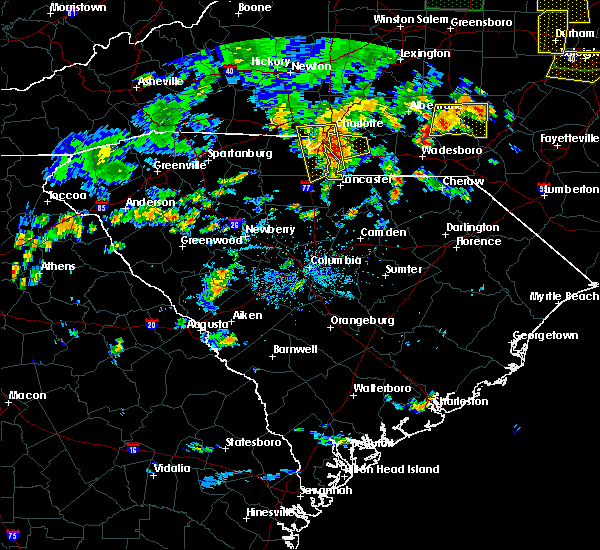 At 440 pm edt, severe thunderstorms were located along a line extending from near uptown charlotte to 11 miles north of lancaster, moving west at 5 mph (radar indicated). Hazards include 60 mph wind gusts and quarter size hail. Minor hail damage to vehicles is expected. Expect wind damage to trees and power lines. At 440 pm edt, severe thunderstorms were located along a line extending from near uptown charlotte to 11 miles north of lancaster, moving west at 5 mph (radar indicated). Hazards include 60 mph wind gusts and quarter size hail. Minor hail damage to vehicles is expected. Expect wind damage to trees and power lines.
|
| 6/25/2018 8:40 PM EDT |
 The severe thunderstorm warning for union county will expire at 845 pm edt, the storm which prompted the warning has moved out of the area. therefore the warning will be allowed to expire. however gusty winds are still possible with this thunderstorm. a severe thunderstorm watch remains in effect until 1000 pm edt for the piedmont of north carolina. The severe thunderstorm warning for union county will expire at 845 pm edt, the storm which prompted the warning has moved out of the area. therefore the warning will be allowed to expire. however gusty winds are still possible with this thunderstorm. a severe thunderstorm watch remains in effect until 1000 pm edt for the piedmont of north carolina.
|
| 6/25/2018 8:13 PM EDT |
 At 813 pm edt, a severe thunderstorm was located 12 miles northwest of wadesboro, or 8 miles west of ansonville, moving east at 25 mph (radar indicated). Hazards include 60 mph wind gusts and quarter size hail. Minor hail damage to vehicles is expected. expect wind damage to trees and power lines. Locations impacted include, monroe, indian trail, weddington, stallings, unionville, wesley chapel, wingate, waxhaw, marshville and lake park. At 813 pm edt, a severe thunderstorm was located 12 miles northwest of wadesboro, or 8 miles west of ansonville, moving east at 25 mph (radar indicated). Hazards include 60 mph wind gusts and quarter size hail. Minor hail damage to vehicles is expected. expect wind damage to trees and power lines. Locations impacted include, monroe, indian trail, weddington, stallings, unionville, wesley chapel, wingate, waxhaw, marshville and lake park.
|
| 6/25/2018 7:59 PM EDT |
 At 758 pm edt, a severe thunderstorm was located 12 miles northeast of monroe, or 6 miles north of marshville, moving east at 25 mph (radar indicated). Hazards include 60 mph wind gusts and quarter size hail. Minor hail damage to vehicles is expected. Expect wind damage to trees and power lines. At 758 pm edt, a severe thunderstorm was located 12 miles northeast of monroe, or 6 miles north of marshville, moving east at 25 mph (radar indicated). Hazards include 60 mph wind gusts and quarter size hail. Minor hail damage to vehicles is expected. Expect wind damage to trees and power lines.
|
| 6/25/2018 7:39 PM EDT |
 At 739 pm edt, a severe thunderstorm was located 7 miles north of monroe, or over unionville, moving east at 25 mph (radar indicated). Hazards include 60 mph wind gusts and quarter size hail. Minor hail damage to vehicles is expected. expect wind damage to trees and power lines. Locations impacted include, monroe, indian trail, weddington, stallings, unionville, wesley chapel, wingate, waxhaw, marshville and lake park. At 739 pm edt, a severe thunderstorm was located 7 miles north of monroe, or over unionville, moving east at 25 mph (radar indicated). Hazards include 60 mph wind gusts and quarter size hail. Minor hail damage to vehicles is expected. expect wind damage to trees and power lines. Locations impacted include, monroe, indian trail, weddington, stallings, unionville, wesley chapel, wingate, waxhaw, marshville and lake park.
|
| 6/25/2018 7:21 PM EDT |
 At 721 pm edt, a severe thunderstorm was located 10 miles northwest of monroe, or near hemby bridge, moving east at 25 mph (radar indicated). Hazards include 60 mph wind gusts and quarter size hail. Minor hail damage to vehicles is expected. Expect wind damage to trees and power lines. At 721 pm edt, a severe thunderstorm was located 10 miles northwest of monroe, or near hemby bridge, moving east at 25 mph (radar indicated). Hazards include 60 mph wind gusts and quarter size hail. Minor hail damage to vehicles is expected. Expect wind damage to trees and power lines.
|
| 6/1/2018 8:34 PM EDT |
 At 834 pm edt, severe thunderstorms were located along a line extending from 5 miles south of uptown charlotte to 9 miles west of monroe to 7 miles northeast of lancaster, moving east at 25 mph (radar indicated). Hazards include 60 mph wind gusts and quarter size hail. Minor hail damage to vehicles is expected. expect wind damage to trees and power lines. Locations impacted include, uptown charlotte, monroe, central charlotte, south charlotte, southwest charlotte, east charlotte, northwest charlotte, matthews, mint hill and indian trail. At 834 pm edt, severe thunderstorms were located along a line extending from 5 miles south of uptown charlotte to 9 miles west of monroe to 7 miles northeast of lancaster, moving east at 25 mph (radar indicated). Hazards include 60 mph wind gusts and quarter size hail. Minor hail damage to vehicles is expected. expect wind damage to trees and power lines. Locations impacted include, uptown charlotte, monroe, central charlotte, south charlotte, southwest charlotte, east charlotte, northwest charlotte, matthews, mint hill and indian trail.
|
| 6/1/2018 8:17 PM EDT |
 At 817 pm edt, severe thunderstorms were located along a line extending from 9 miles west of uptown charlotte to 12 miles east of rock hill to 6 miles north of lancaster, moving east at 20 mph (radar indicated). Hazards include 60 mph wind gusts and quarter size hail. Minor hail damage to vehicles is expected. Expect wind damage to trees and power lines. At 817 pm edt, severe thunderstorms were located along a line extending from 9 miles west of uptown charlotte to 12 miles east of rock hill to 6 miles north of lancaster, moving east at 20 mph (radar indicated). Hazards include 60 mph wind gusts and quarter size hail. Minor hail damage to vehicles is expected. Expect wind damage to trees and power lines.
|
| 4/15/2018 3:25 PM EDT |
 At 324 pm edt, a severe thunderstorm was located 8 miles west of monroe, or over wesley chapel, moving north at 60 mph (radar indicated). Hazards include 60 mph wind gusts and quarter size hail. Minor hail damage to vehicles is expected. expect wind damage to trees and power lines. locations impacted include, uptown charlotte, monroe, south charlotte, east charlotte, matthews, mint hill, indian trail, weddington, stallings and unionville. A tornado watch remains in effect until 700 pm edt for the piedmont of north carolina. At 324 pm edt, a severe thunderstorm was located 8 miles west of monroe, or over wesley chapel, moving north at 60 mph (radar indicated). Hazards include 60 mph wind gusts and quarter size hail. Minor hail damage to vehicles is expected. expect wind damage to trees and power lines. locations impacted include, uptown charlotte, monroe, south charlotte, east charlotte, matthews, mint hill, indian trail, weddington, stallings and unionville. A tornado watch remains in effect until 700 pm edt for the piedmont of north carolina.
|
| 4/15/2018 3:15 PM EDT |
 At 315 pm edt, a severe thunderstorm was located 9 miles north of lancaster, or 4 miles south of waxhaw, moving north at 65 mph (radar indicated). Hazards include 60 mph wind gusts and quarter size hail. Minor hail damage to vehicles is expected. Expect wind damage to trees and power lines. At 315 pm edt, a severe thunderstorm was located 9 miles north of lancaster, or 4 miles south of waxhaw, moving north at 65 mph (radar indicated). Hazards include 60 mph wind gusts and quarter size hail. Minor hail damage to vehicles is expected. Expect wind damage to trees and power lines.
|
| 9/1/2017 3:05 PM EDT |
 The severe thunderstorm warning for southeastern mecklenburg, western union and southeastern york counties will expire at 315 pm edt, the storm which prompted the warning has weakened below severe limits, and no longer poses an immediate threat to life or property. therefore the warning will be allowed to expire. a tornado watch remains in effect until 1000 pm edt for the piedmont of north carolina, and upstate south carolina. The severe thunderstorm warning for southeastern mecklenburg, western union and southeastern york counties will expire at 315 pm edt, the storm which prompted the warning has weakened below severe limits, and no longer poses an immediate threat to life or property. therefore the warning will be allowed to expire. a tornado watch remains in effect until 1000 pm edt for the piedmont of north carolina, and upstate south carolina.
|
| 9/1/2017 2:55 PM EDT |
 At 254 pm edt, a severe thunderstorm was located 13 miles east of rock hill, or near marvin, moving northeast at 45 mph (radar indicated). Hazards include 60 mph wind gusts and quarter size hail. Minor hail damage to vehicles is expected. expect wind damage to trees and power lines. locations impacted include, south charlotte, east charlotte, matthews, mint hill, indian trail, weddington, stallings, unionville, wesley chapel and waxhaw. A tornado watch remains in effect until 1000 pm edt for the piedmont of north carolina, and upstate south carolina. At 254 pm edt, a severe thunderstorm was located 13 miles east of rock hill, or near marvin, moving northeast at 45 mph (radar indicated). Hazards include 60 mph wind gusts and quarter size hail. Minor hail damage to vehicles is expected. expect wind damage to trees and power lines. locations impacted include, south charlotte, east charlotte, matthews, mint hill, indian trail, weddington, stallings, unionville, wesley chapel and waxhaw. A tornado watch remains in effect until 1000 pm edt for the piedmont of north carolina, and upstate south carolina.
|
| 9/1/2017 2:25 PM EDT |
 At 225 pm edt, a severe thunderstorm was located 10 miles east of chester, or near richburg, moving northeast at 45 mph (radar indicated). Hazards include 60 mph wind gusts and quarter size hail. Minor hail damage to vehicles is expected. Expect wind damage to trees and power lines. At 225 pm edt, a severe thunderstorm was located 10 miles east of chester, or near richburg, moving northeast at 45 mph (radar indicated). Hazards include 60 mph wind gusts and quarter size hail. Minor hail damage to vehicles is expected. Expect wind damage to trees and power lines.
|
| 7/28/2017 5:01 PM EDT |
 At 501 pm edt, severe thunderstorms were located along a line extending from 6 miles northeast of huntersville to 4 miles southeast of uptown charlotte to 11 miles northeast of lancaster, moving east at 30 mph (radar indicated). Hazards include 70 mph wind gusts. Expect considerable tree damage. damage is likely to mobile homes, roofs, and outbuildings. Locations impacted include, uptown charlotte, huntersville, kannapolis, downtown concord, monroe, central charlotte, south charlotte, northeast charlotte, southwest charlotte and east charlotte. At 501 pm edt, severe thunderstorms were located along a line extending from 6 miles northeast of huntersville to 4 miles southeast of uptown charlotte to 11 miles northeast of lancaster, moving east at 30 mph (radar indicated). Hazards include 70 mph wind gusts. Expect considerable tree damage. damage is likely to mobile homes, roofs, and outbuildings. Locations impacted include, uptown charlotte, huntersville, kannapolis, downtown concord, monroe, central charlotte, south charlotte, northeast charlotte, southwest charlotte and east charlotte.
|
| 7/28/2017 4:47 PM EDT |
 At 447 pm edt, severe thunderstorms were located along a line extending from 5 miles northwest of huntersville to 3 miles southwest of uptown charlotte to 6 miles northeast of lancaster, moving east at 30 mph (radar indicated). Hazards include 70 mph wind gusts. Expect considerable tree damage. damage is likely to mobile homes, roofs, and outbuildings. Locations impacted include, rock hill, uptown charlotte, huntersville, kannapolis, downtown concord, monroe, central charlotte, south charlotte, northeast charlotte and southwest charlotte. At 447 pm edt, severe thunderstorms were located along a line extending from 5 miles northwest of huntersville to 3 miles southwest of uptown charlotte to 6 miles northeast of lancaster, moving east at 30 mph (radar indicated). Hazards include 70 mph wind gusts. Expect considerable tree damage. damage is likely to mobile homes, roofs, and outbuildings. Locations impacted include, rock hill, uptown charlotte, huntersville, kannapolis, downtown concord, monroe, central charlotte, south charlotte, northeast charlotte and southwest charlotte.
|
| 7/28/2017 4:22 PM EDT |
 At 422 pm edt, severe thunderstorms were located along a line extending from 10 miles northeast of lincolnton to 9 miles southeast of gastonia to 8 miles south of rock hill, moving east at 30 mph (radar indicated). Hazards include 60 mph wind gusts. expect damage to trees and power lines At 422 pm edt, severe thunderstorms were located along a line extending from 10 miles northeast of lincolnton to 9 miles southeast of gastonia to 8 miles south of rock hill, moving east at 30 mph (radar indicated). Hazards include 60 mph wind gusts. expect damage to trees and power lines
|
| 7/23/2017 4:51 PM EDT |
 At 450 pm edt, severe thunderstorms were located along a line extending from 13 miles west of monroe to 12 miles southeast of union, moving east at 15 mph (radar indicated). Hazards include 60 mph wind gusts and quarter size hail. Minor hail damage to vehicles is expected. expect wind damage to trees and power lines. Locations impacted include, rock hill, chester, fort mill, waxhaw, mineral springs, lesslie, great falls, marvin, fort lawn and carlisle. At 450 pm edt, severe thunderstorms were located along a line extending from 13 miles west of monroe to 12 miles southeast of union, moving east at 15 mph (radar indicated). Hazards include 60 mph wind gusts and quarter size hail. Minor hail damage to vehicles is expected. expect wind damage to trees and power lines. Locations impacted include, rock hill, chester, fort mill, waxhaw, mineral springs, lesslie, great falls, marvin, fort lawn and carlisle.
|
| 7/23/2017 4:20 PM EDT |
 At 419 pm edt, severe thunderstorms were located along a line extending from 11 miles south of uptown charlotte to 6 miles south of union, moving east at 15 mph (radar indicated). Hazards include 60 mph wind gusts and quarter size hail. Minor hail damage to vehicles is expected. Expect wind damage to trees and power lines. At 419 pm edt, severe thunderstorms were located along a line extending from 11 miles south of uptown charlotte to 6 miles south of union, moving east at 15 mph (radar indicated). Hazards include 60 mph wind gusts and quarter size hail. Minor hail damage to vehicles is expected. Expect wind damage to trees and power lines.
|
| 7/5/2017 6:40 PM EDT |
 At 640 pm edt, a severe thunderstorm was located 6 miles southwest of monroe, or near mineral springs, moving east at 25 mph (radar indicated). Hazards include 60 mph wind gusts and quarter size hail. Minor hail damage to vehicles is expected. Expect wind damage to trees and power lines. At 640 pm edt, a severe thunderstorm was located 6 miles southwest of monroe, or near mineral springs, moving east at 25 mph (radar indicated). Hazards include 60 mph wind gusts and quarter size hail. Minor hail damage to vehicles is expected. Expect wind damage to trees and power lines.
|
| 7/1/2017 7:25 PM EDT |
 The severe thunderstorm warning for southern union county will expire at 730 pm edt, the storms which prompted the warning are moving south out of the area. therefore the warning will be allowed to expire. however gusty winds and heavy rain are still possible with these thunderstorms. The severe thunderstorm warning for southern union county will expire at 730 pm edt, the storms which prompted the warning are moving south out of the area. therefore the warning will be allowed to expire. however gusty winds and heavy rain are still possible with these thunderstorms.
|
| 7/1/2017 7:04 PM EDT |
 At 703 pm edt, severe thunderstorms were located along a line extending from 3 miles north of monroe to 12 miles northeast of lancaster to 11 miles east of rock hill, moving south at 15 mph (radar indicated). Hazards include 60 mph wind gusts and penny size hail. Expect damage to trees and power lines. Locations impacted include, monroe, wesley chapel, wingate, waxhaw, mineral springs, jaars, trinity, sturdivants, marvin and unionville. At 703 pm edt, severe thunderstorms were located along a line extending from 3 miles north of monroe to 12 miles northeast of lancaster to 11 miles east of rock hill, moving south at 15 mph (radar indicated). Hazards include 60 mph wind gusts and penny size hail. Expect damage to trees and power lines. Locations impacted include, monroe, wesley chapel, wingate, waxhaw, mineral springs, jaars, trinity, sturdivants, marvin and unionville.
|
| 7/1/2017 6:46 PM EDT |
 At 646 pm edt, severe thunderstorms were located along a line extending from 4 miles north of monroe to 16 miles northeast of lancaster to 10 miles east of rock hill, moving southeast at 15 mph (radar indicated). Hazards include 60 mph wind gusts and nickel size hail. expect damage to trees and power lines At 646 pm edt, severe thunderstorms were located along a line extending from 4 miles north of monroe to 16 miles northeast of lancaster to 10 miles east of rock hill, moving southeast at 15 mph (radar indicated). Hazards include 60 mph wind gusts and nickel size hail. expect damage to trees and power lines
|
| 4/3/2017 4:24 PM EDT |
 At 423 pm edt, a severe thunderstorm was located 11 miles southeast of uptown charlotte, or near matthews, moving northeast at 60 mph (radar indicated). Hazards include 60 mph wind gusts and penny size hail. expect damage to trees and minor damage to roofs and siding At 423 pm edt, a severe thunderstorm was located 11 miles southeast of uptown charlotte, or near matthews, moving northeast at 60 mph (radar indicated). Hazards include 60 mph wind gusts and penny size hail. expect damage to trees and minor damage to roofs and siding
|
| 3/1/2017 8:54 PM EST |
 The severe thunderstorm warning for union and chester counties will expire at 900 pm est, the storms which prompted the warning have weakened below severe limits, and have exited the warned area. therefore the warning will be allowed to expire. if you observed large hail or wind damage, please report it to the national weather service greenville-spartanburg by calling toll free, 1, 800, 2 6 7, 8 1 0 1, or by posting on our facebook page, or tweet it using hashtag nwsgsp. your message should describe the event and the specific location where it occurred. The severe thunderstorm warning for union and chester counties will expire at 900 pm est, the storms which prompted the warning have weakened below severe limits, and have exited the warned area. therefore the warning will be allowed to expire. if you observed large hail or wind damage, please report it to the national weather service greenville-spartanburg by calling toll free, 1, 800, 2 6 7, 8 1 0 1, or by posting on our facebook page, or tweet it using hashtag nwsgsp. your message should describe the event and the specific location where it occurred.
|
| 3/1/2017 8:36 PM EST |
 At 834 pm est, severe thunderstorms were located along a line extending from 9 miles southwest of albemarle north carolina, to 11 miles southwest of monroe, to 11 miles north of winnsboro south carolina, moving east at 65 mph (indicated by radar. some of these storms also have a history of producing damaging winds). Hazards include 60 mph wind gusts and penny size hail. Expect damage to roofs. siding and trees. Locations impacted include, monroe, chester, indian trail, weddington, stallings, unionville, wesley chapel, wingate, waxhaw and marshville. At 834 pm est, severe thunderstorms were located along a line extending from 9 miles southwest of albemarle north carolina, to 11 miles southwest of monroe, to 11 miles north of winnsboro south carolina, moving east at 65 mph (indicated by radar. some of these storms also have a history of producing damaging winds). Hazards include 60 mph wind gusts and penny size hail. Expect damage to roofs. siding and trees. Locations impacted include, monroe, chester, indian trail, weddington, stallings, unionville, wesley chapel, wingate, waxhaw and marshville.
|
| 3/1/2017 8:21 PM EST |
 At 820 pm est, severe thunderstorms were located along a line extending from 9 miles east of uptown charlotte to 3 miles south of rock hill to 16 miles southwest of chester, moving east at 60 mph. several of these storms have already produced damaging winds and large hail (indicated by radar and public reports). Hazards include 60 mph wind gusts and quarter size hail. Hail damage to vehicles is expected. expect wind damage to roofs, siding and trees. Locations impacted include, rock hill, uptown charlotte, monroe, chester, central charlotte, south charlotte, southwest charlotte, east charlotte, matthews and mint hill. At 820 pm est, severe thunderstorms were located along a line extending from 9 miles east of uptown charlotte to 3 miles south of rock hill to 16 miles southwest of chester, moving east at 60 mph. several of these storms have already produced damaging winds and large hail (indicated by radar and public reports). Hazards include 60 mph wind gusts and quarter size hail. Hail damage to vehicles is expected. expect wind damage to roofs, siding and trees. Locations impacted include, rock hill, uptown charlotte, monroe, chester, central charlotte, south charlotte, southwest charlotte, east charlotte, matthews and mint hill.
|
| 3/1/2017 7:45 PM EST |
 At 745 pm est, severe thunderstorms were located along a line extending from 11 miles northwest of york to 10 miles northeast of union to 18 miles northeast of newberry, moving east at 55 mph (radar indicated). Hazards include 60 mph wind gusts and quarter size hail. Hail damage to vehicles is expected. Expect wind damage to roofs, siding and trees. At 745 pm est, severe thunderstorms were located along a line extending from 11 miles northwest of york to 10 miles northeast of union to 18 miles northeast of newberry, moving east at 55 mph (radar indicated). Hazards include 60 mph wind gusts and quarter size hail. Hail damage to vehicles is expected. Expect wind damage to roofs, siding and trees.
|
| 11/30/2016 6:40 PM EST |
 At 639 pm est, severe thunderstorms were located along a line extending from 9 miles southeast of yadkinville to 7 miles southeast of statesville to 10 miles north of huntersville to 10 miles southeast of uptown charlotte to 13 miles south of lancaster, moving east at 25 mph (radar indicated). Hazards include 60 mph wind gusts. Expect damage to roofs. siding and trees. Locations impacted include, uptown charlotte, huntersville, kannapolis, downtown concord, monroe, salisbury, statesville, mocksville, central charlotte and south charlotte. At 639 pm est, severe thunderstorms were located along a line extending from 9 miles southeast of yadkinville to 7 miles southeast of statesville to 10 miles north of huntersville to 10 miles southeast of uptown charlotte to 13 miles south of lancaster, moving east at 25 mph (radar indicated). Hazards include 60 mph wind gusts. Expect damage to roofs. siding and trees. Locations impacted include, uptown charlotte, huntersville, kannapolis, downtown concord, monroe, salisbury, statesville, mocksville, central charlotte and south charlotte.
|
| 11/30/2016 6:13 PM EST |
 At 613 pm est, severe thunderstorms were located along a line extending from 6 miles north of mocksville to 9 miles southwest of statesville to 10 miles northeast of lincolnton to 9 miles north of winnsboro, moving east at 35 mph (radar indicated). Hazards include 60 mph wind gusts. Expect damage to roofs. Siding and trees. At 613 pm est, severe thunderstorms were located along a line extending from 6 miles north of mocksville to 9 miles southwest of statesville to 10 miles northeast of lincolnton to 9 miles north of winnsboro, moving east at 35 mph (radar indicated). Hazards include 60 mph wind gusts. Expect damage to roofs. Siding and trees.
|
| 7/8/2016 9:32 PM EDT |
 At 931 pm edt, severe thunderstorms were located along a line extending from 5 miles south of albemarle to 9 miles north of lancaster, moving southeast at 35 mph (radar indicated). Hazards include 60 mph wind gusts. Expect damage to roofs. siding and trees. Locations impacted include, monroe, wingate, marshville, mineral springs, sturdivants, jaars, trinity, new salem and unionville. At 931 pm edt, severe thunderstorms were located along a line extending from 5 miles south of albemarle to 9 miles north of lancaster, moving southeast at 35 mph (radar indicated). Hazards include 60 mph wind gusts. Expect damage to roofs. siding and trees. Locations impacted include, monroe, wingate, marshville, mineral springs, sturdivants, jaars, trinity, new salem and unionville.
|
| 7/8/2016 9:06 PM EDT |
 At 906 pm edt, severe thunderstorms were located along a line extending from 4 miles northwest of albemarle to 11 miles west of monroe, moving southeast at 45 mph (radar indicated). Hazards include 60 mph wind gusts. Expect damage to roofs. Siding and trees. At 906 pm edt, severe thunderstorms were located along a line extending from 4 miles northwest of albemarle to 11 miles west of monroe, moving southeast at 45 mph (radar indicated). Hazards include 60 mph wind gusts. Expect damage to roofs. Siding and trees.
|
| 7/5/2016 5:18 PM EDT |
 At 517 pm edt, a gust front preceding strong thunderstorms was oriented along a line extending from 11 miles southeast of albemarle to 12 miles east of monroe to 5 miles northeast of lancaster, moving east at 35 mph (radar indicated. this gust front is known to have caused damage over the charlotte area). Hazards include 60 mph wind gusts. Expect damage to roofs. siding and trees. Locations impacted include, wingate, waxhaw, marshville, mineral springs, sturdivants, jaars and trinity. At 517 pm edt, a gust front preceding strong thunderstorms was oriented along a line extending from 11 miles southeast of albemarle to 12 miles east of monroe to 5 miles northeast of lancaster, moving east at 35 mph (radar indicated. this gust front is known to have caused damage over the charlotte area). Hazards include 60 mph wind gusts. Expect damage to roofs. siding and trees. Locations impacted include, wingate, waxhaw, marshville, mineral springs, sturdivants, jaars and trinity.
|
| 7/5/2016 5:06 PM EDT |
 At 505 pm edt, severe thunderstorms were located along a line extending from 5 miles south of albemarle to 6 miles east of monroe to 7 miles northwest of lancaster, moving east at 35 mph (radar indicated). Hazards include 60 mph wind gusts. Expect damage to roofs. siding and trees. Locations impacted include, monroe, unionville, wesley chapel, wingate, waxhaw, marshville, mineral springs, sturdivants, fairview in union county and jaars. At 505 pm edt, severe thunderstorms were located along a line extending from 5 miles south of albemarle to 6 miles east of monroe to 7 miles northwest of lancaster, moving east at 35 mph (radar indicated). Hazards include 60 mph wind gusts. Expect damage to roofs. siding and trees. Locations impacted include, monroe, unionville, wesley chapel, wingate, waxhaw, marshville, mineral springs, sturdivants, fairview in union county and jaars.
|
| 7/5/2016 4:44 PM EDT |
 At 443 pm edt, the leading edge of very strong winds associated with severe thunderstorms were located along a line extending from 11 miles west of albemarle to 7 miles northwest of monroe to 4 miles south of rock hill, moving east at 35 mph (radar indicated). Hazards include 60 mph wind gusts. Expect damage to roofs. Siding and trees. At 443 pm edt, the leading edge of very strong winds associated with severe thunderstorms were located along a line extending from 11 miles west of albemarle to 7 miles northwest of monroe to 4 miles south of rock hill, moving east at 35 mph (radar indicated). Hazards include 60 mph wind gusts. Expect damage to roofs. Siding and trees.
|
| 2/24/2016 1:35 PM EST |
 At 134 pm est, doppler radar indicated a line of severe thunderstorms with a history of producing damaging winds in excess of 60 mph, along with numerous downed trees. these storms were located along a line extending from 8 miles southwest of lexington to 9 miles south of salisbury to 10 miles northeast of lancaster, moving northeast at 50 mph. locations impacted include, kannapolis, downtown concord, monroe, salisbury, west concord, matthews, mint hill, indian trail, weddington and stallings. a tornado watch remains in effect until 700 pm est for central north carolina. At 134 pm est, doppler radar indicated a line of severe thunderstorms with a history of producing damaging winds in excess of 60 mph, along with numerous downed trees. these storms were located along a line extending from 8 miles southwest of lexington to 9 miles south of salisbury to 10 miles northeast of lancaster, moving northeast at 50 mph. locations impacted include, kannapolis, downtown concord, monroe, salisbury, west concord, matthews, mint hill, indian trail, weddington and stallings. a tornado watch remains in effect until 700 pm est for central north carolina.
|
| 2/24/2016 1:14 PM EST |
 At 113 pm est, doppler radar indicated a line of severe thunderstorms with a history of producing hurricane force winds in excess of 70 mph, along with numerous downed trees. these storms were located along a line extending from 8 miles northeast of mocksville to 5 miles southeast of salisbury to near downtown concord to 6 miles north of lancaster, and moving northeast at 80 mph. * locations in the warning include, kannapolis, downtown concord, monroe, salisbury, mocksville, west concord, matthews, mint hill, indian trail and weddington. At 113 pm est, doppler radar indicated a line of severe thunderstorms with a history of producing hurricane force winds in excess of 70 mph, along with numerous downed trees. these storms were located along a line extending from 8 miles northeast of mocksville to 5 miles southeast of salisbury to near downtown concord to 6 miles north of lancaster, and moving northeast at 80 mph. * locations in the warning include, kannapolis, downtown concord, monroe, salisbury, mocksville, west concord, matthews, mint hill, indian trail and weddington.
|
| 2/24/2016 1:03 PM EST |
 At 102 pm est, doppler radar indicated a line of severe thunderstorms with a history of producing hurricane force winds in excess of 70 mph, along with downing numerous trees. these storms were located along a line extending from 8 miles northeast of mocksville to 6 miles northeast of kannapolis to 11 miles east of rock hill, moving northeast at 85 mph. locations impacted include, uptown charlotte, huntersville, kannapolis, downtown concord, monroe, salisbury, mocksville, central charlotte, south charlotte and southwest charlotte. a tornado watch remains in effect until 700 pm est for central north carolina and central south carolina. At 102 pm est, doppler radar indicated a line of severe thunderstorms with a history of producing hurricane force winds in excess of 70 mph, along with downing numerous trees. these storms were located along a line extending from 8 miles northeast of mocksville to 6 miles northeast of kannapolis to 11 miles east of rock hill, moving northeast at 85 mph. locations impacted include, uptown charlotte, huntersville, kannapolis, downtown concord, monroe, salisbury, mocksville, central charlotte, south charlotte and southwest charlotte. a tornado watch remains in effect until 700 pm est for central north carolina and central south carolina.
|
| 2/24/2016 12:55 PM EST |
 At 1255 pm est, doppler radar indicated a line of severe thunderstorms capable of producing damaging winds in excess of 60 mph. these storms were located along a line extending from 4 miles southeast of mocksville to near downtown concord to 7 miles southeast of rock hill, moving northeast at 70 mph. locations impacted include, rock hill, uptown charlotte, huntersville, kannapolis, downtown concord, monroe, salisbury, york, chester and mocksville. a tornado watch remains in effect until 700 pm est for central north carolina and central south carolina. At 1255 pm est, doppler radar indicated a line of severe thunderstorms capable of producing damaging winds in excess of 60 mph. these storms were located along a line extending from 4 miles southeast of mocksville to near downtown concord to 7 miles southeast of rock hill, moving northeast at 70 mph. locations impacted include, rock hill, uptown charlotte, huntersville, kannapolis, downtown concord, monroe, salisbury, york, chester and mocksville. a tornado watch remains in effect until 700 pm est for central north carolina and central south carolina.
|
| 2/24/2016 12:13 PM EST |
 At 1212 pm est, doppler radar indicated a line of severe thunderstorms capable of producing damaging winds in excess of 60 mph. these storms were located along a line extending from 8 miles east of gastonia to 15 miles west of winnsboro, and moving northeast at 85 mph. * locations in the warning include, rock hill, uptown charlotte, huntersville, kannapolis, downtown concord, monroe, salisbury, york, chester and mocksville. At 1212 pm est, doppler radar indicated a line of severe thunderstorms capable of producing damaging winds in excess of 60 mph. these storms were located along a line extending from 8 miles east of gastonia to 15 miles west of winnsboro, and moving northeast at 85 mph. * locations in the warning include, rock hill, uptown charlotte, huntersville, kannapolis, downtown concord, monroe, salisbury, york, chester and mocksville.
|
| 8/6/2015 2:29 PM EDT |
 At 229 pm edt, doppler radar indicated a line of severe thunderstorms capable of producing damaging winds in excess of 60 mph. these storms were located along a line extending from 11 miles west of monroe to 7 miles northeast of lancaster, and moving northeast at 20 mph. penny size hail may also accompany the damaging winds. * locations in the warning include, monroe, indian trail, weddington, unionville, wesley chapel, wingate, waxhaw, marshville, lake park and mineral springs. At 229 pm edt, doppler radar indicated a line of severe thunderstorms capable of producing damaging winds in excess of 60 mph. these storms were located along a line extending from 11 miles west of monroe to 7 miles northeast of lancaster, and moving northeast at 20 mph. penny size hail may also accompany the damaging winds. * locations in the warning include, monroe, indian trail, weddington, unionville, wesley chapel, wingate, waxhaw, marshville, lake park and mineral springs.
|
| 7/13/2015 9:54 PM EDT |
 At 952 pm edt, doppler radar indicated a line of severe thunderstorms capable of producing damaging winds in excess of 60 mph. the leading edge of these storms were located along a line extending from 5 miles south of monroe to 8 miles west of lancaster to 13 miles southwest of union to 14 miles northeast of laurens, moving southeast at 40 mph. penny size hail may also accompany the damaging winds. locations impacted include, rock hill, union, weddington, waxhaw, mineral springs, lesslie, great falls, monarch mill, marvin and buffalo. At 952 pm edt, doppler radar indicated a line of severe thunderstorms capable of producing damaging winds in excess of 60 mph. the leading edge of these storms were located along a line extending from 5 miles south of monroe to 8 miles west of lancaster to 13 miles southwest of union to 14 miles northeast of laurens, moving southeast at 40 mph. penny size hail may also accompany the damaging winds. locations impacted include, rock hill, union, weddington, waxhaw, mineral springs, lesslie, great falls, monarch mill, marvin and buffalo.
|
| 7/13/2015 9:44 PM EDT |
 At 943 pm edt, doppler radar indicated a line of severe thunderstorms capable of producing damaging winds in excess of 60 mph. these storms were located along a line extending from 4 miles southwest of monroe to 7 miles northeast of chester to 13 miles southwest of union to 15 miles north of laurens, moving southeast at 20 mph. penny size hail may also accompany the damaging winds. locations impacted include, rock hill, union, chester, weddington, waxhaw, mineral springs, lesslie, great falls, monarch mill and marvin. At 943 pm edt, doppler radar indicated a line of severe thunderstorms capable of producing damaging winds in excess of 60 mph. these storms were located along a line extending from 4 miles southwest of monroe to 7 miles northeast of chester to 13 miles southwest of union to 15 miles north of laurens, moving southeast at 20 mph. penny size hail may also accompany the damaging winds. locations impacted include, rock hill, union, chester, weddington, waxhaw, mineral springs, lesslie, great falls, monarch mill and marvin.
|
| 7/13/2015 9:24 PM EDT |
 At 923 pm edt, doppler radar indicated a line of severe thunderstorms capable of producing quarter size hail and damaging winds in excess of 60 mph. these storms were located along a line extending from 13 miles west of monroe to 6 miles southwest of york to 4 miles southwest of union to 15 miles south of spartanburg, and moving southeast at 25 mph. At 923 pm edt, doppler radar indicated a line of severe thunderstorms capable of producing quarter size hail and damaging winds in excess of 60 mph. these storms were located along a line extending from 13 miles west of monroe to 6 miles southwest of york to 4 miles southwest of union to 15 miles south of spartanburg, and moving southeast at 25 mph.
|
| 1/1/0001 12:00 AM | Numerous trees dow in union county NC, 3 miles NNW of JAARS, NC |
Hail Maps for JAARS, NC


Connect with Interactive Hail Maps