

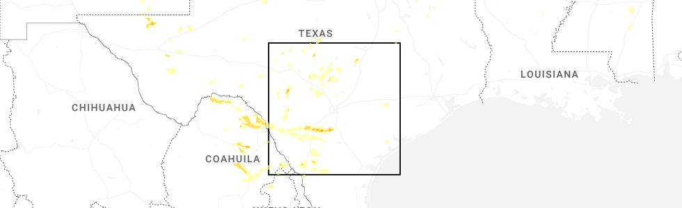
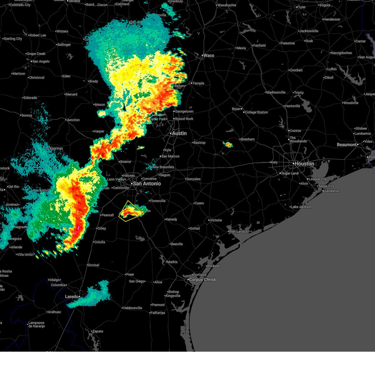
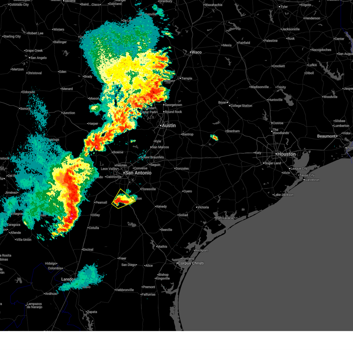
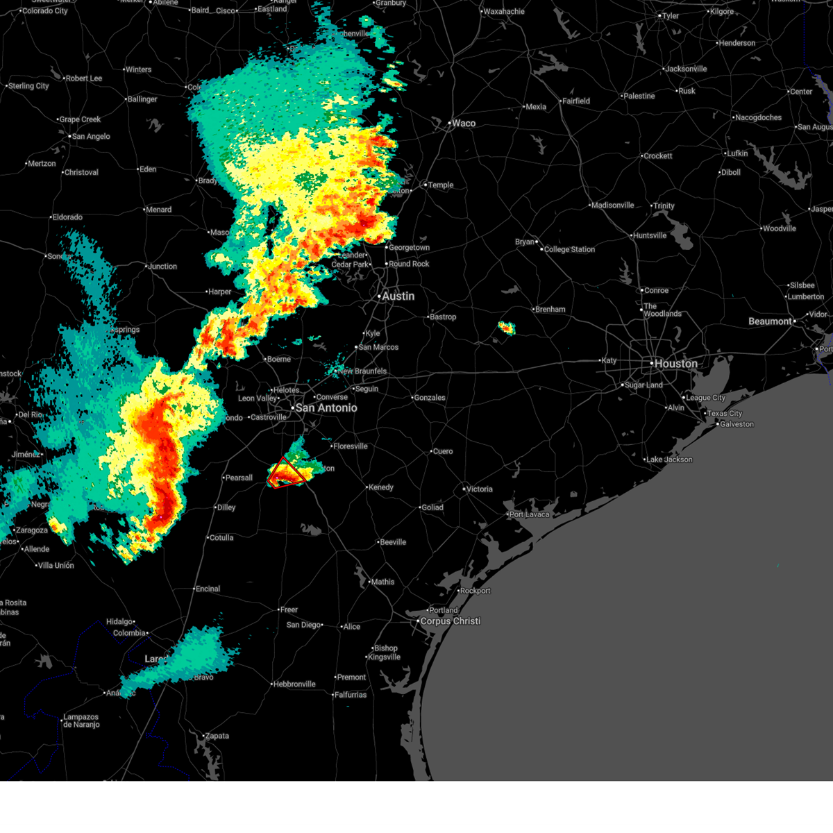
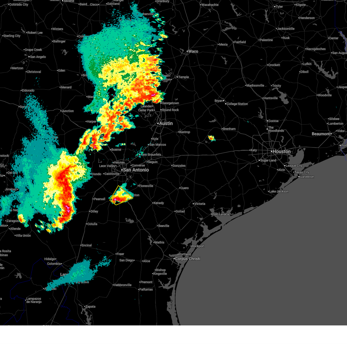
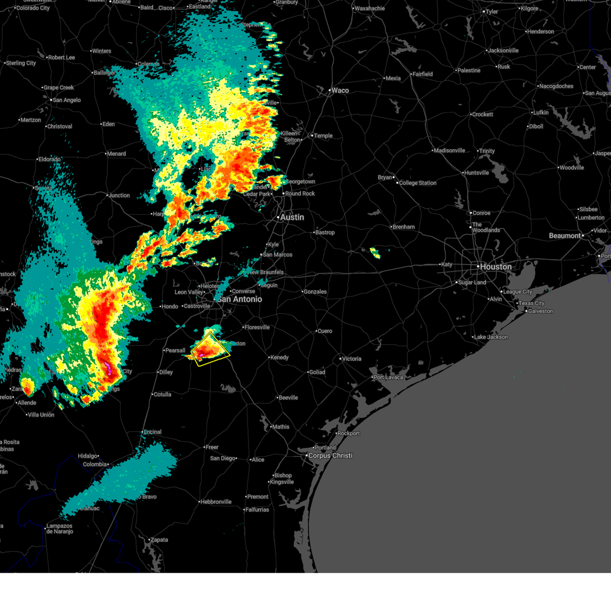
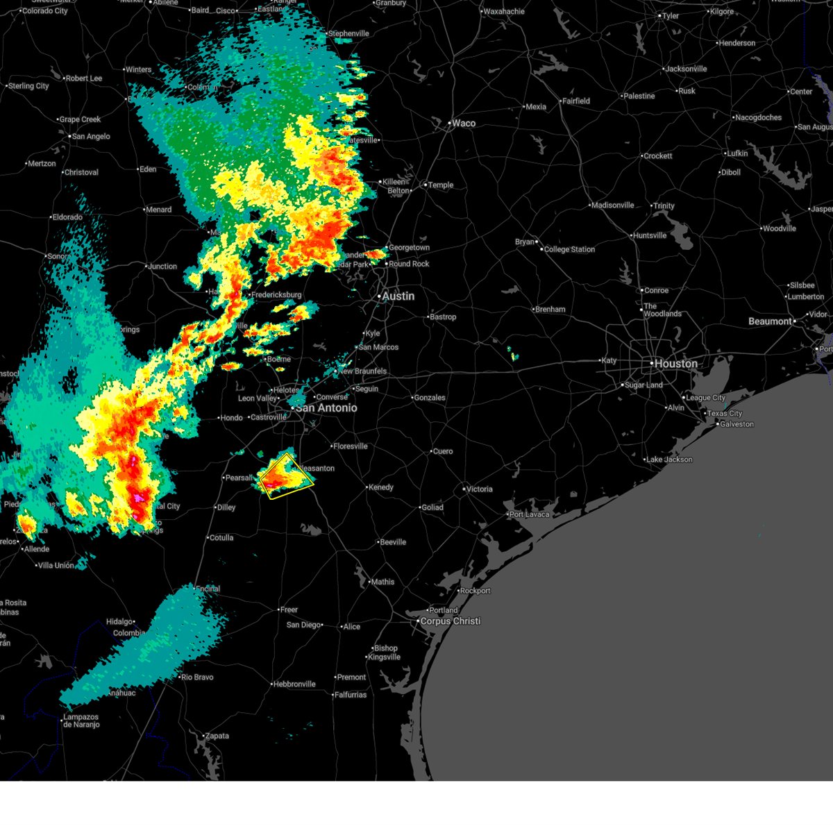
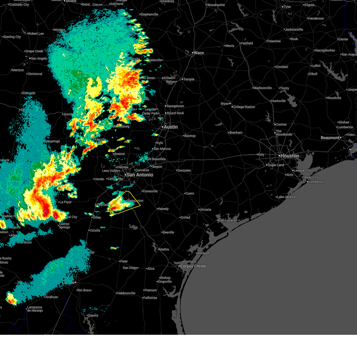
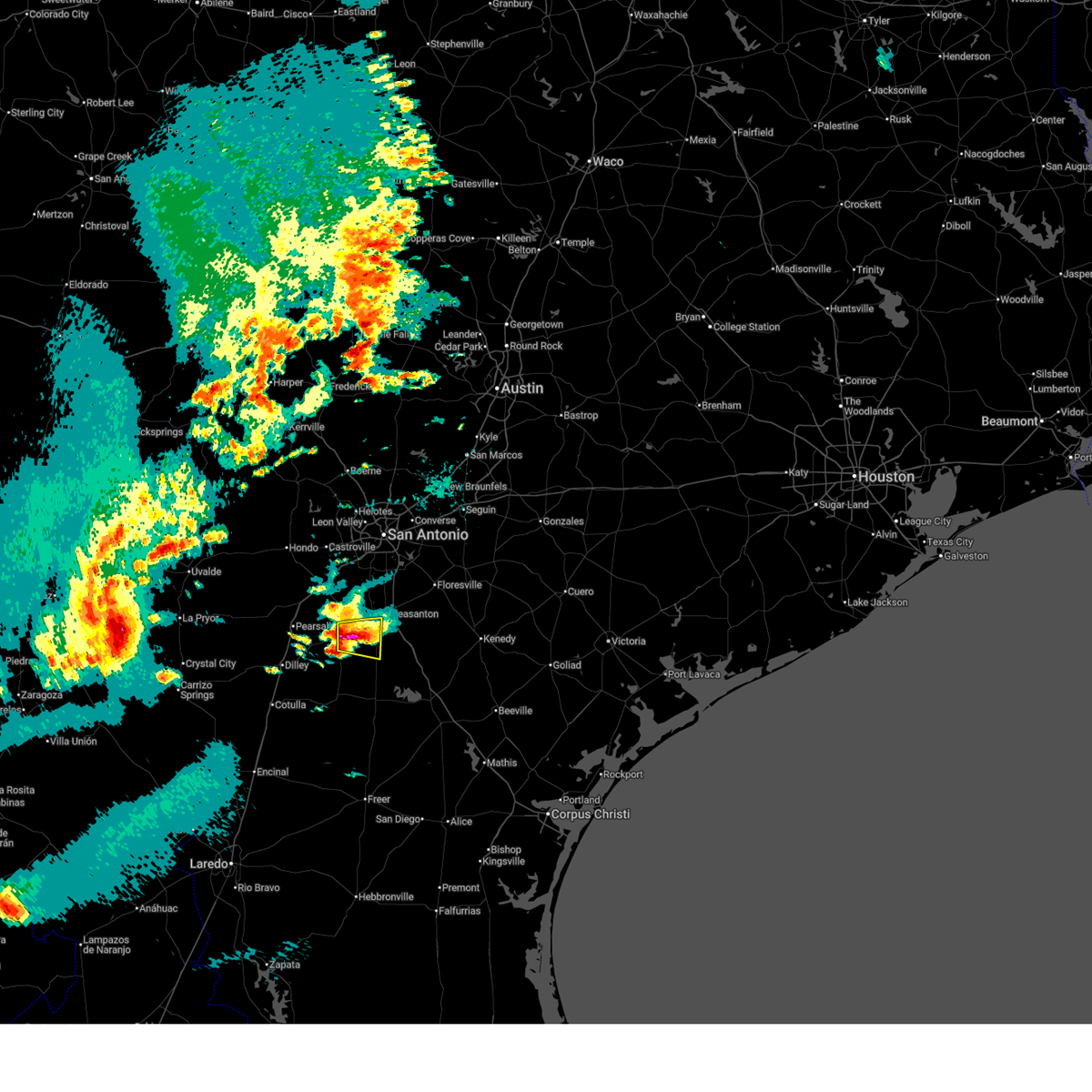
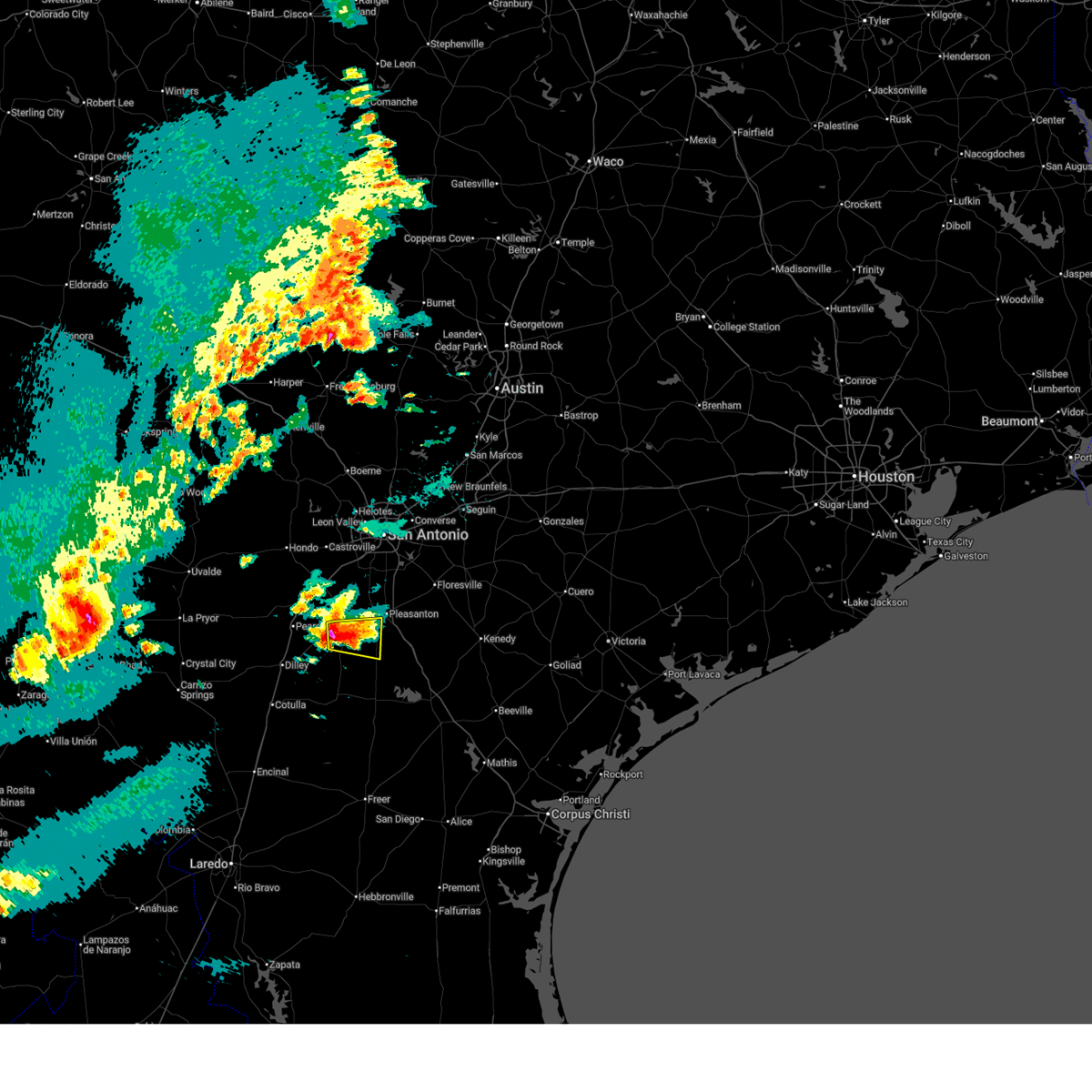
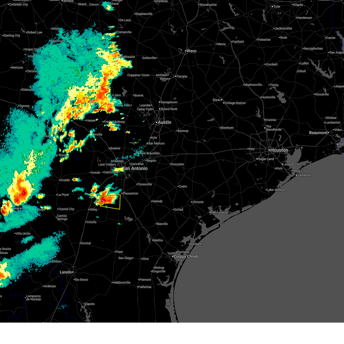
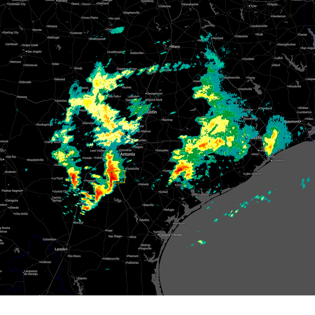
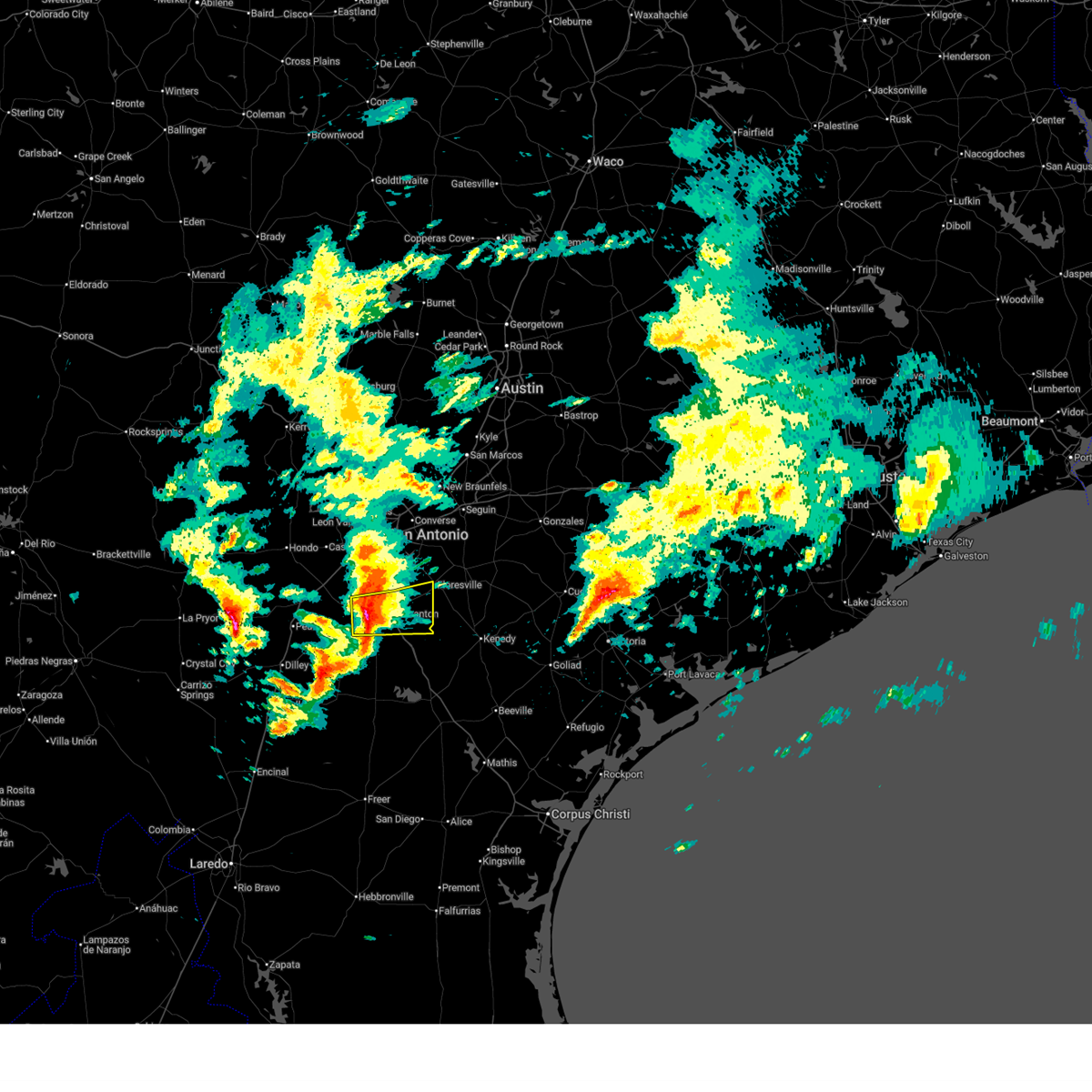
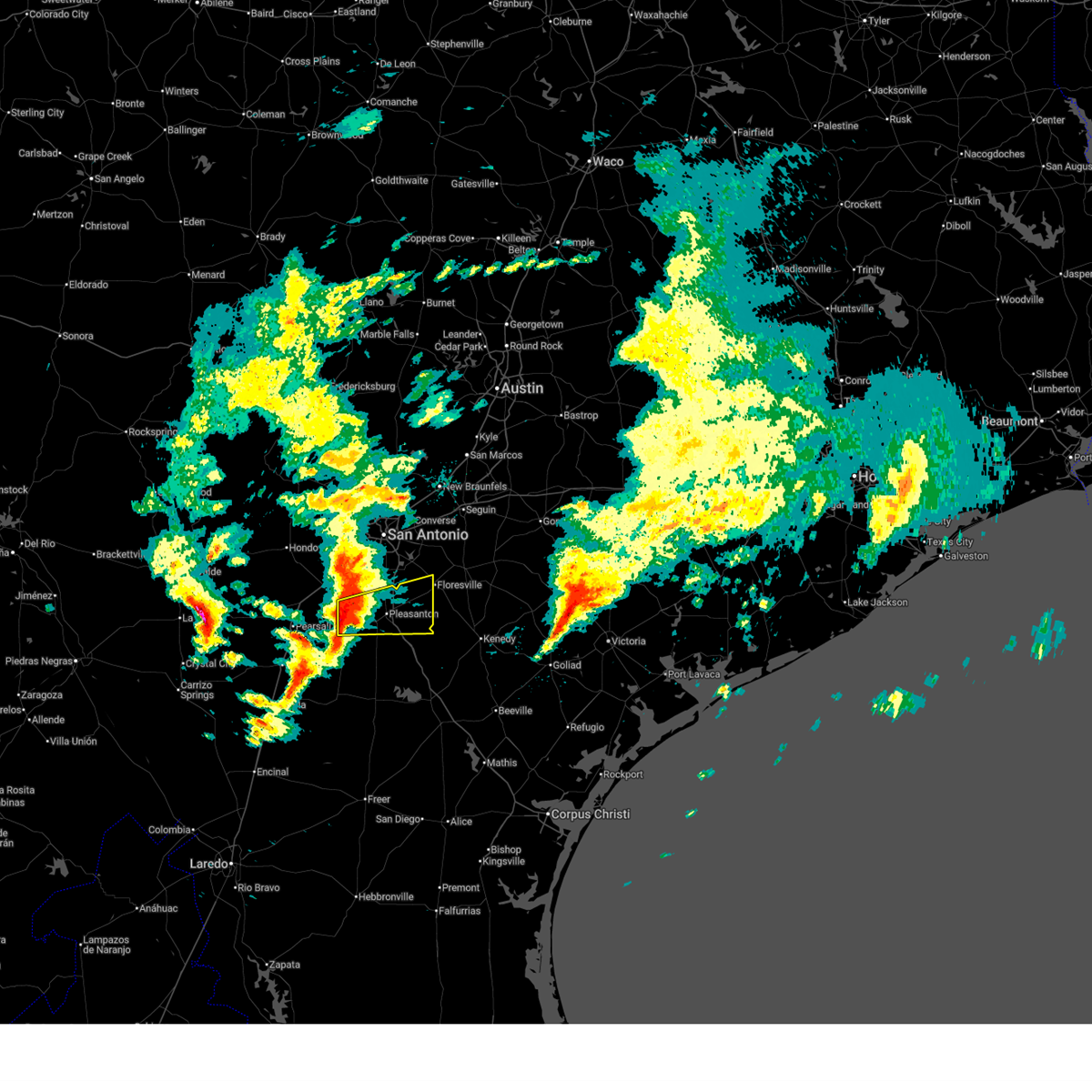
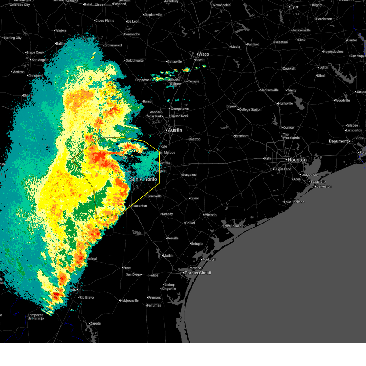
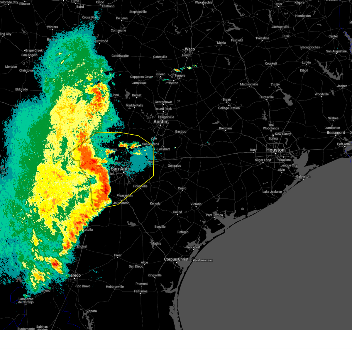
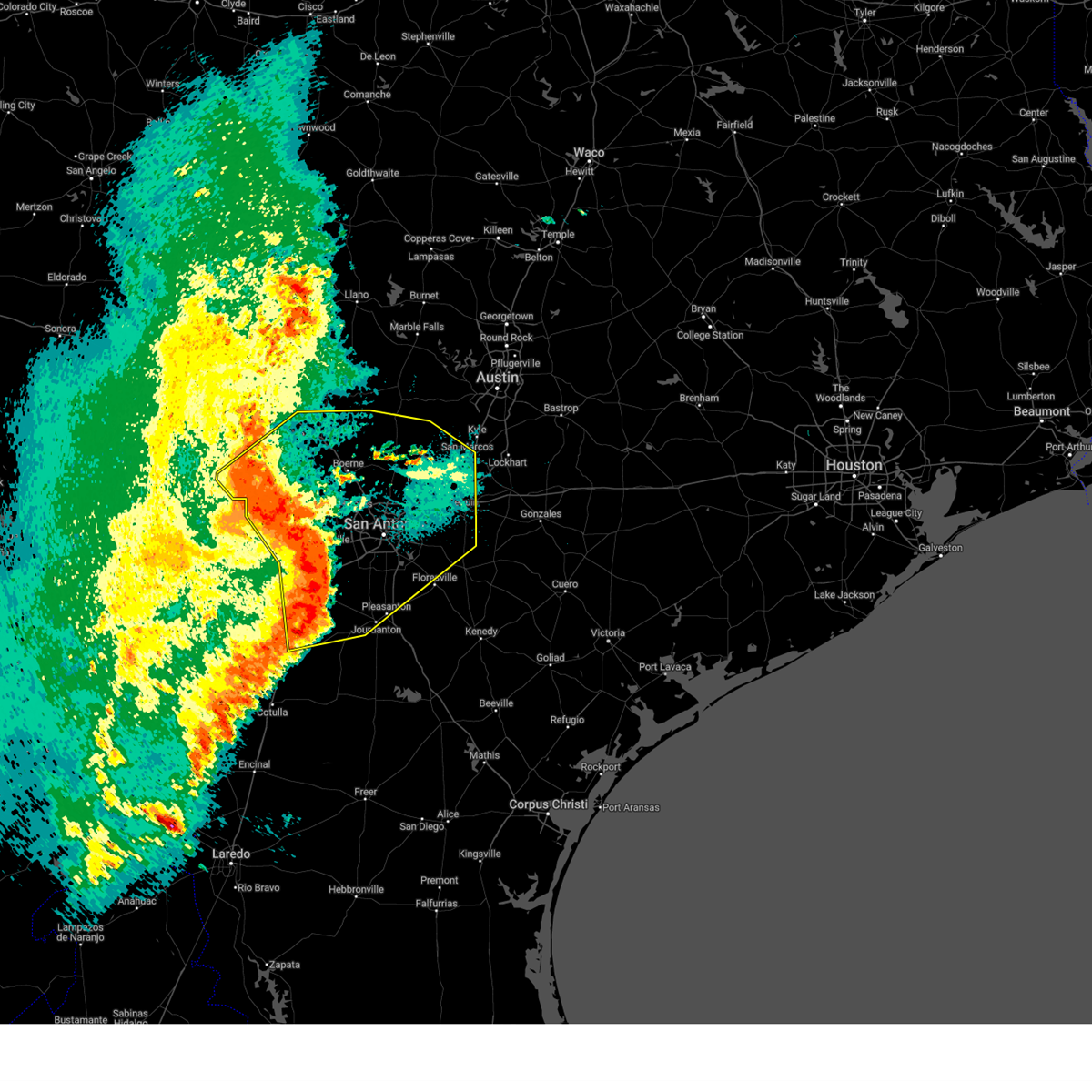
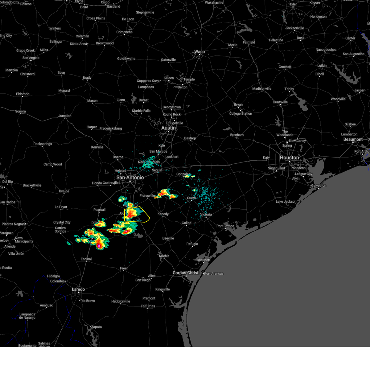
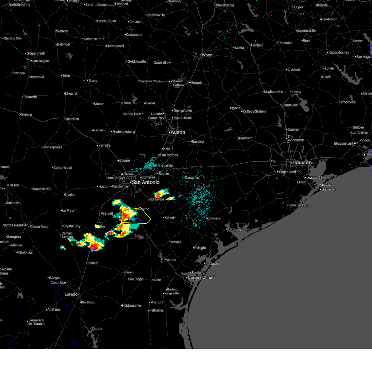
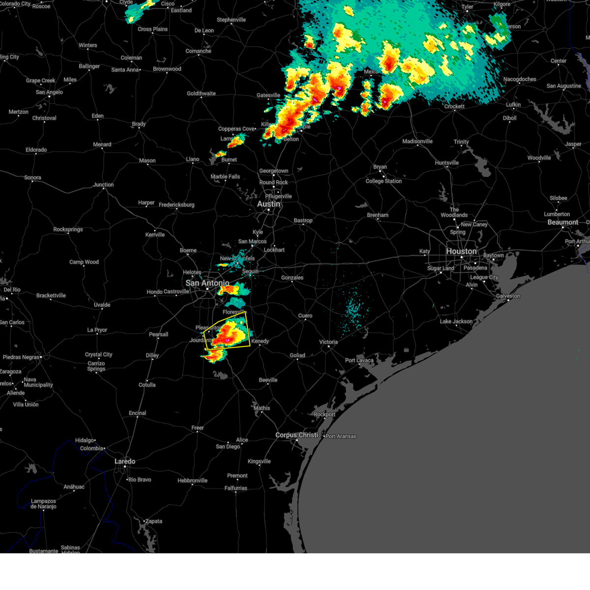
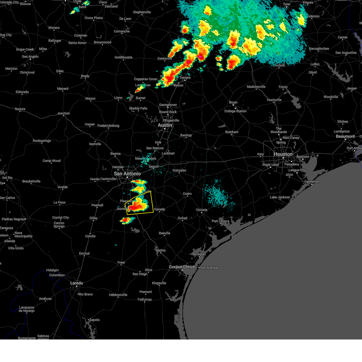
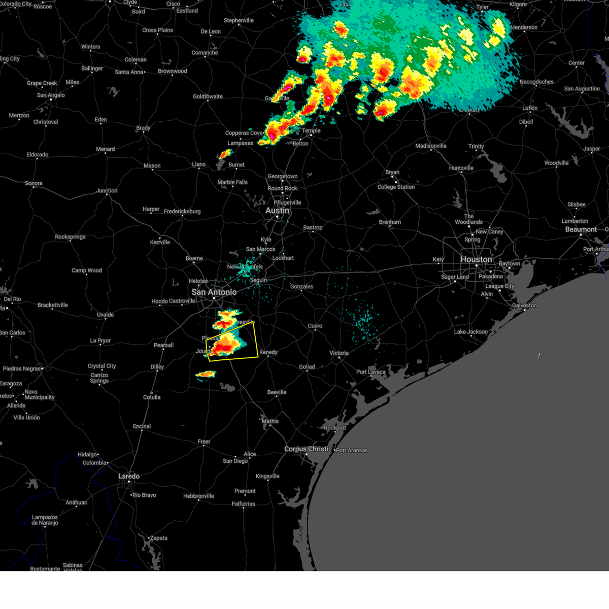
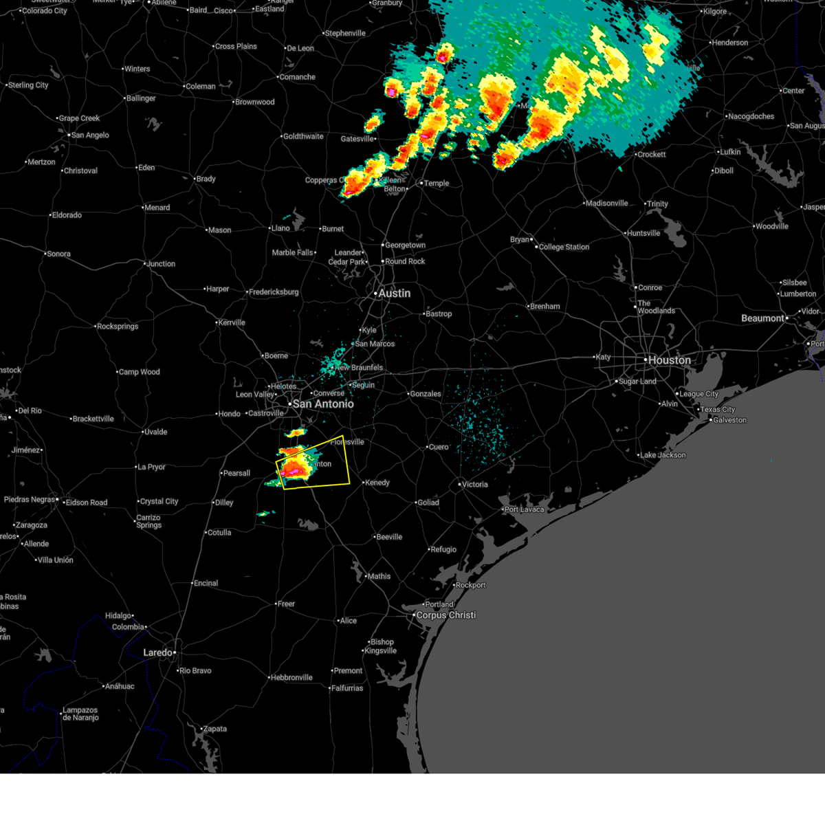
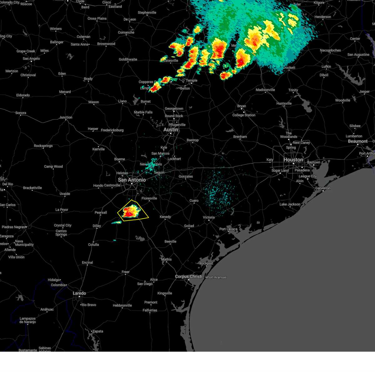
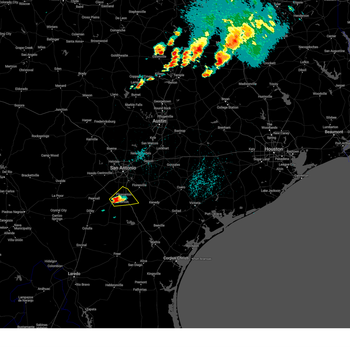
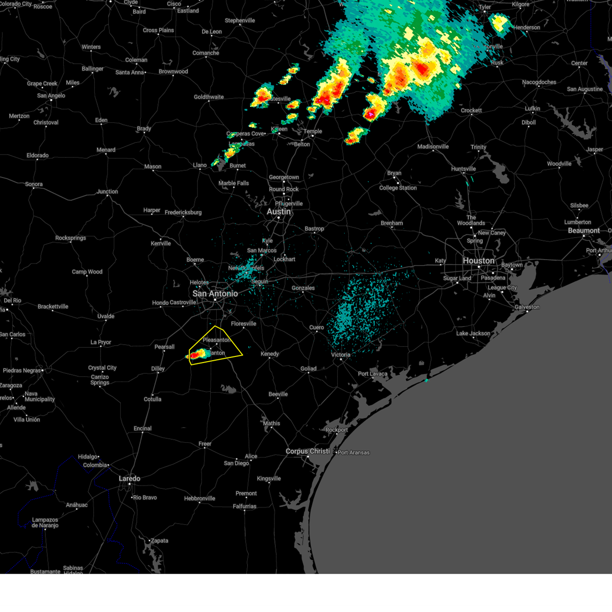
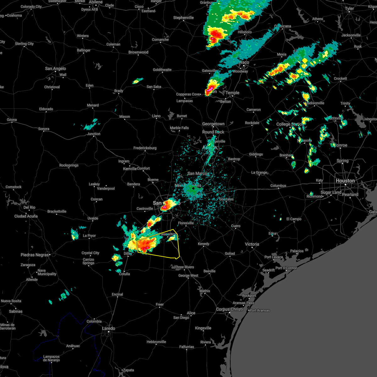
Hail Map for Jourdanton, TX
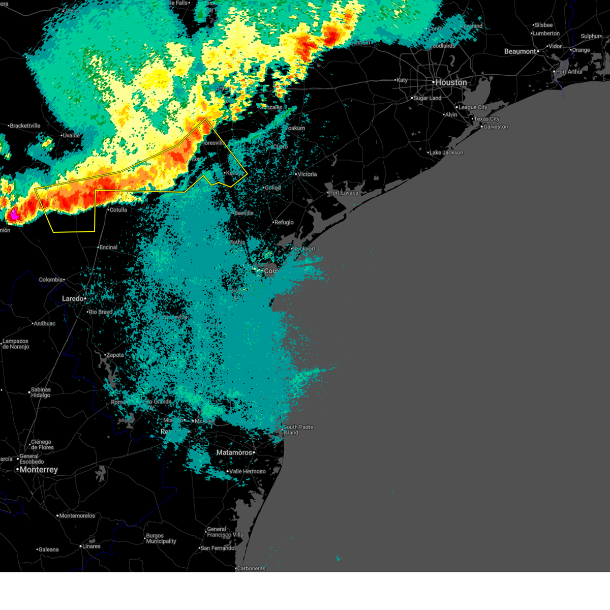
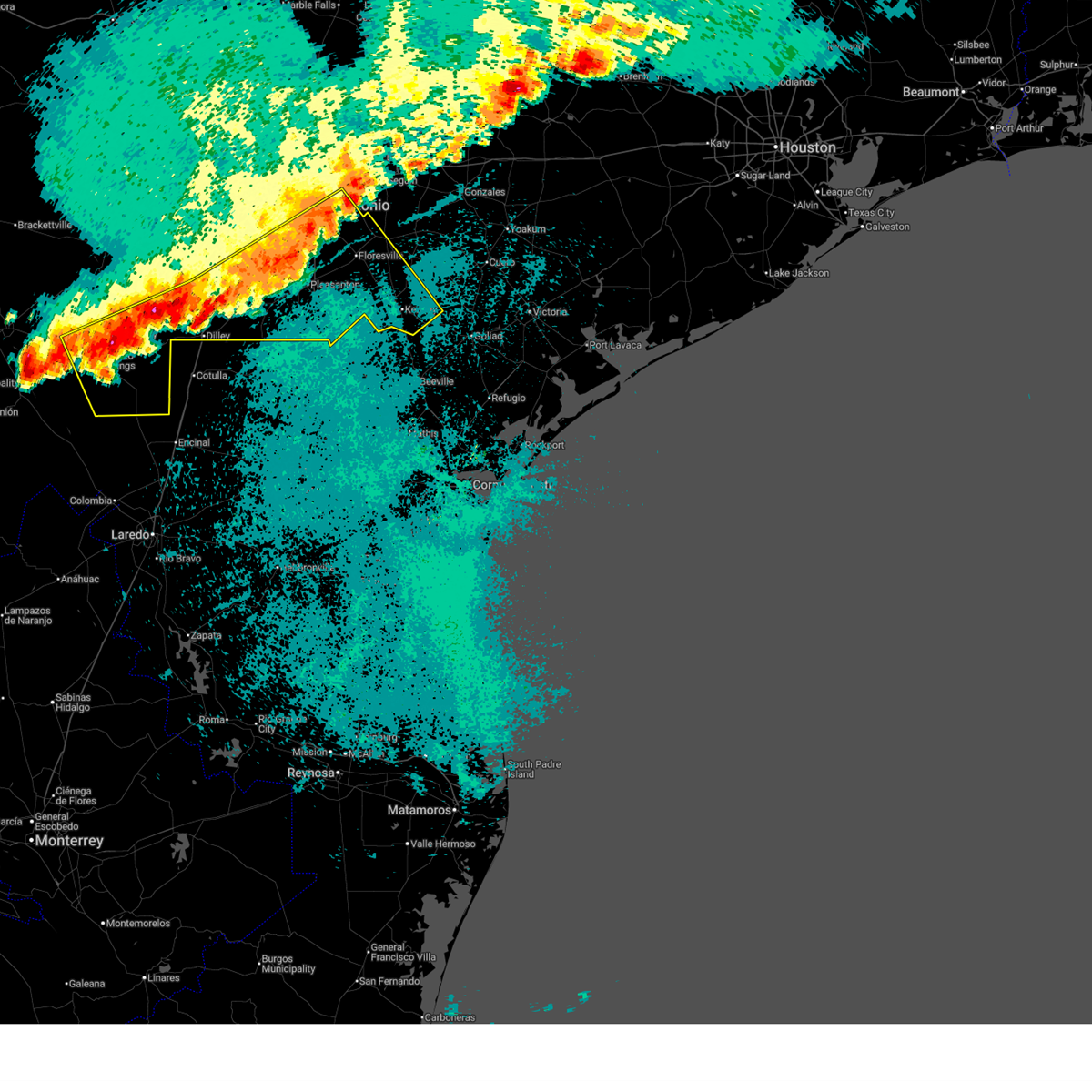
The Jourdanton, TX area has had 6 reports of on-the-ground hail by trained spotters, and has been under severe weather warnings 19 times during the past 12 months. Doppler radar has detected hail at or near Jourdanton, TX on 55 occasions, including 5 occasions during the past year.
| Name: | Jourdanton, TX |
| Where Located: | 34.8 miles S of San Antonio, TX |
| Map: | Google Map for Jourdanton, TX |
| Population: | 3871 |
| Housing Units: | 1546 |
| More Info: | Search Google for Jourdanton, TX |
1
The Top Recent Hail Date for Jourdanton, TX is Tuesday, May 26, 2026 (11th out of 55)
Hail and Wind Damage Spotted near Jourdanton, TX
| Date / Time | Report Details |
|---|---|
| 5/26/2026 9:35 PM CDT |
 The storms which prompted the warning have weakened below severe limits, and have exited the warned area. therefore, the warning will be allowed to expire. however gusty winds and heavy rain are still possible with these thunderstorms. a severe thunderstorm watch remains in effect until 600 am cdt for south central texas. The storms which prompted the warning have weakened below severe limits, and have exited the warned area. therefore, the warning will be allowed to expire. however gusty winds and heavy rain are still possible with these thunderstorms. a severe thunderstorm watch remains in effect until 600 am cdt for south central texas.
|
| 5/26/2026 9:10 PM CDT |
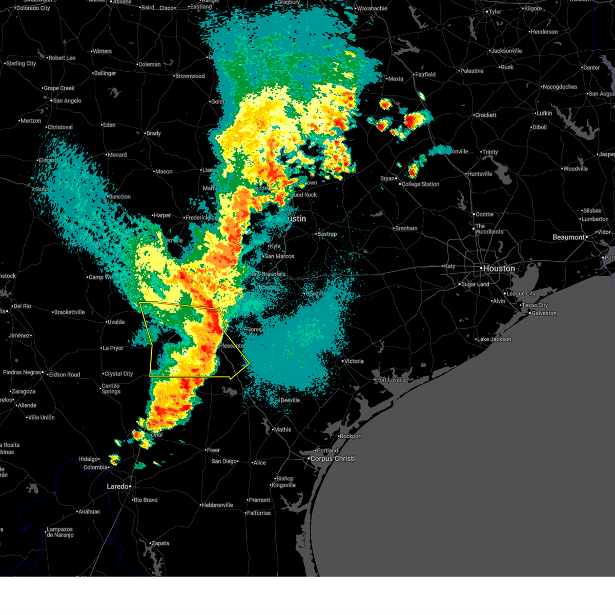
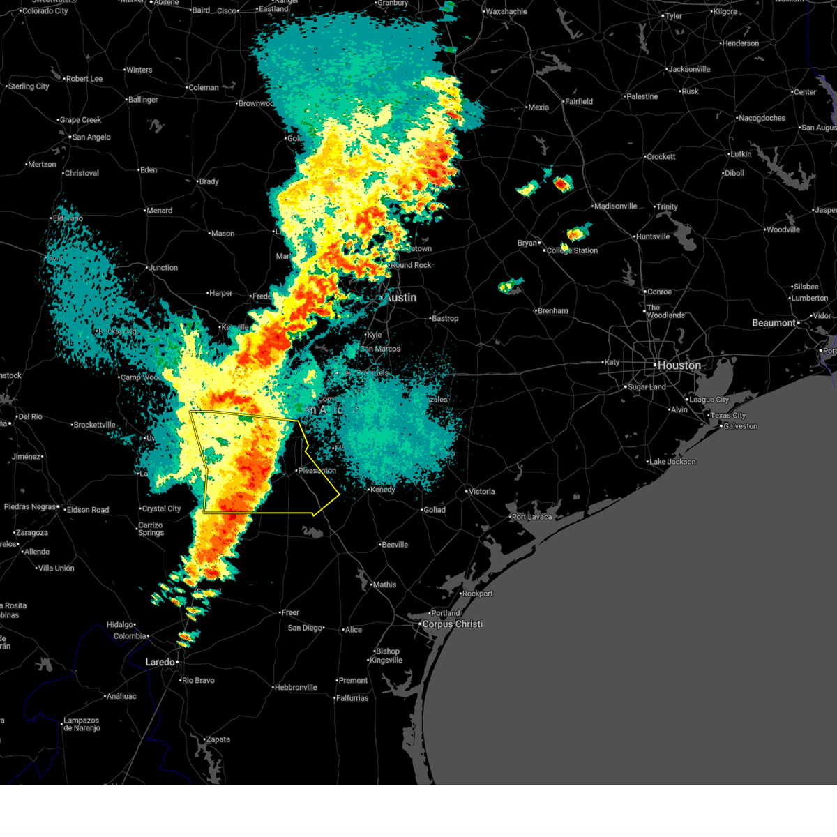 At 909 pm cdt, severe thunderstorms were located along a line extending from near hondo to near schattel to near artesia wells, moving east at 25 mph (radar indicated). Hazards include 60 mph wind gusts and nickel size hail. Expect damage to roofs, siding, and trees. Locations impacted include, san antonio, pleasanton, pearsall, hondo, devine, jourdanton, dilley, poteet, castroville, charlotte, christine, stinson municipal airport, campbellton, lytle, somerset, natalia, lacoste, north pearsall, moore, and goldfinch. At 909 pm cdt, severe thunderstorms were located along a line extending from near hondo to near schattel to near artesia wells, moving east at 25 mph (radar indicated). Hazards include 60 mph wind gusts and nickel size hail. Expect damage to roofs, siding, and trees. Locations impacted include, san antonio, pleasanton, pearsall, hondo, devine, jourdanton, dilley, poteet, castroville, charlotte, christine, stinson municipal airport, campbellton, lytle, somerset, natalia, lacoste, north pearsall, moore, and goldfinch.
|
| 5/26/2026 8:37 PM CDT |
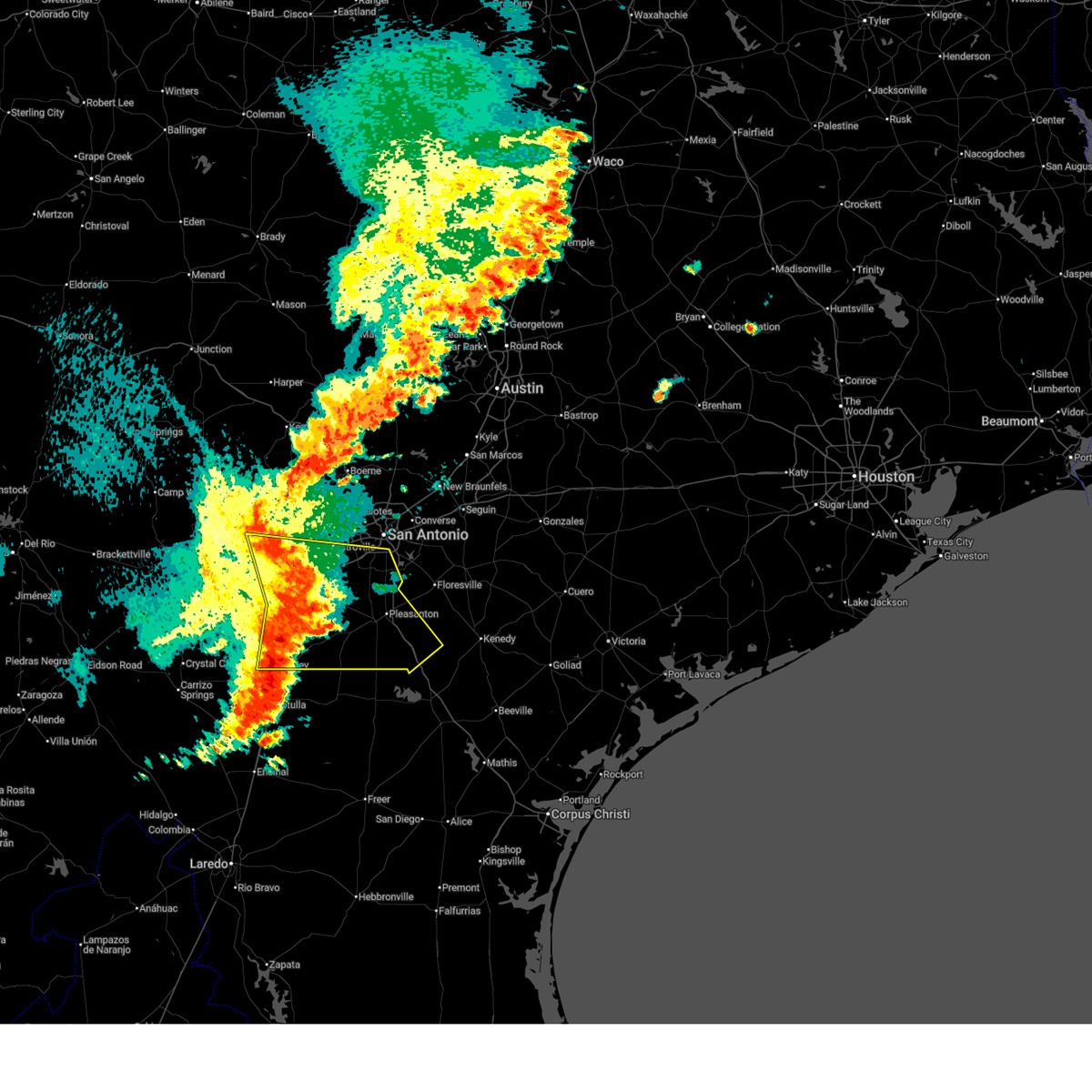 Svrewx the national weather service in austin san antonio has issued a * severe thunderstorm warning for, southern medina county in south central texas, frio county in south central texas, atascosa county in south central texas, southwestern bexar county in south central texas, * until 945 pm cdt. * at 837 pm cdt, severe thunderstorms were located along a line extending from near d'hanis to near moore to near chaparral wildlife management area, moving east at 30 mph (radar indicated). Hazards include 60 mph wind gusts and quarter size hail. Hail damage to vehicles is expected. Expect wind damage to roofs, siding, and trees. Svrewx the national weather service in austin san antonio has issued a * severe thunderstorm warning for, southern medina county in south central texas, frio county in south central texas, atascosa county in south central texas, southwestern bexar county in south central texas, * until 945 pm cdt. * at 837 pm cdt, severe thunderstorms were located along a line extending from near d'hanis to near moore to near chaparral wildlife management area, moving east at 30 mph (radar indicated). Hazards include 60 mph wind gusts and quarter size hail. Hail damage to vehicles is expected. Expect wind damage to roofs, siding, and trees.
|
| 5/26/2026 8:07 PM CDT |
 the severe thunderstorm warning has been cancelled and is no longer in effect the severe thunderstorm warning has been cancelled and is no longer in effect
|
| 5/26/2026 7:54 PM CDT |
 At 754 pm cdt, a severe thunderstorm was located near jourdanton, moving northeast at 10 mph (radar indicated). Hazards include 60 mph wind gusts and quarter size hail. Hail damage to vehicles is expected. expect wind damage to roofs, siding, and trees. Locations impacted include, pleasanton, jourdanton, poteet, charlotte, leming, coughran, dobrowolski, and amphion. At 754 pm cdt, a severe thunderstorm was located near jourdanton, moving northeast at 10 mph (radar indicated). Hazards include 60 mph wind gusts and quarter size hail. Hail damage to vehicles is expected. expect wind damage to roofs, siding, and trees. Locations impacted include, pleasanton, jourdanton, poteet, charlotte, leming, coughran, dobrowolski, and amphion.
|
| 5/26/2026 7:42 PM CDT |
 Torewx the national weather service in austin san antonio has issued a * tornado warning for, west central atascosa county in south central texas, * until 830 pm cdt. * at 742 pm cdt, a severe thunderstorm capable of producing a tornado was located near charlotte, moving northeast at 10 mph (radar indicated rotation). Hazards include tornado and golf ball size hail. Flying debris will be dangerous to those caught without shelter. mobile homes will be damaged or destroyed. damage to roofs, windows, and vehicles will occur. tree damage is likely. this dangerous storm will be near, jourdanton around 755 pm cdt. Other locations impacted by this tornadic thunderstorm include dobrowolski. Torewx the national weather service in austin san antonio has issued a * tornado warning for, west central atascosa county in south central texas, * until 830 pm cdt. * at 742 pm cdt, a severe thunderstorm capable of producing a tornado was located near charlotte, moving northeast at 10 mph (radar indicated rotation). Hazards include tornado and golf ball size hail. Flying debris will be dangerous to those caught without shelter. mobile homes will be damaged or destroyed. damage to roofs, windows, and vehicles will occur. tree damage is likely. this dangerous storm will be near, jourdanton around 755 pm cdt. Other locations impacted by this tornadic thunderstorm include dobrowolski.
|
| 5/26/2026 7:37 PM CDT |
 Svrewx the national weather service in austin san antonio has issued a * severe thunderstorm warning for, central atascosa county in south central texas, * until 845 pm cdt. * at 737 pm cdt, a severe thunderstorm was located near charlotte, moving northeast at 10 mph (radar indicated). Hazards include golf ball size hail and 60 mph wind gusts. People and animals outdoors will be injured. expect hail damage to roofs, siding, windows, and vehicles. Expect wind damage to roofs, siding, and trees. Svrewx the national weather service in austin san antonio has issued a * severe thunderstorm warning for, central atascosa county in south central texas, * until 845 pm cdt. * at 737 pm cdt, a severe thunderstorm was located near charlotte, moving northeast at 10 mph (radar indicated). Hazards include golf ball size hail and 60 mph wind gusts. People and animals outdoors will be injured. expect hail damage to roofs, siding, windows, and vehicles. Expect wind damage to roofs, siding, and trees.
|
| 5/26/2026 7:23 PM CDT |
 At 723 pm cdt, a severe thunderstorm was located near charlotte, moving northeast at 25 mph (radar indicated). Hazards include tennis ball size hail and 60 mph wind gusts. People and animals outdoors will be injured. expect hail damage to roofs, siding, windows, and vehicles. expect wind damage to roofs, siding, and trees. Locations impacted include, pleasanton, jourdanton, poteet, charlotte, christine, dobrowolski, amphion, mccoy, and coughran. At 723 pm cdt, a severe thunderstorm was located near charlotte, moving northeast at 25 mph (radar indicated). Hazards include tennis ball size hail and 60 mph wind gusts. People and animals outdoors will be injured. expect hail damage to roofs, siding, windows, and vehicles. expect wind damage to roofs, siding, and trees. Locations impacted include, pleasanton, jourdanton, poteet, charlotte, christine, dobrowolski, amphion, mccoy, and coughran.
|
| 5/26/2026 7:15 PM CDT |
 At 715 pm cdt, a severe thunderstorm was located near charlotte, moving northeast at 15 mph (radar indicated). Hazards include two inch hail and 60 mph wind gusts. People and animals outdoors will be injured. expect hail damage to roofs, siding, windows, and vehicles. expect wind damage to roofs, siding, and trees. Locations impacted include, pleasanton, jourdanton, poteet, charlotte, christine, dobrowolski, amphion, mccoy, and coughran. At 715 pm cdt, a severe thunderstorm was located near charlotte, moving northeast at 15 mph (radar indicated). Hazards include two inch hail and 60 mph wind gusts. People and animals outdoors will be injured. expect hail damage to roofs, siding, windows, and vehicles. expect wind damage to roofs, siding, and trees. Locations impacted include, pleasanton, jourdanton, poteet, charlotte, christine, dobrowolski, amphion, mccoy, and coughran.
|
| 5/26/2026 6:44 PM CDT |
 At 644 pm cdt, a severe thunderstorm was located over charlotte, moving northeast at 25 mph (radar indicated). Hazards include golf ball size hail and 60 mph wind gusts. People and animals outdoors will be injured. expect hail damage to roofs, siding, windows, and vehicles. expect wind damage to roofs, siding, and trees. Locations impacted include, pleasanton, jourdanton, poteet, charlotte, christine, leming, graytown, davis, coughran, dobrowolski, espey, amphion, and mccoy. At 644 pm cdt, a severe thunderstorm was located over charlotte, moving northeast at 25 mph (radar indicated). Hazards include golf ball size hail and 60 mph wind gusts. People and animals outdoors will be injured. expect hail damage to roofs, siding, windows, and vehicles. expect wind damage to roofs, siding, and trees. Locations impacted include, pleasanton, jourdanton, poteet, charlotte, christine, leming, graytown, davis, coughran, dobrowolski, espey, amphion, and mccoy.
|
| 5/26/2026 6:18 PM CDT |
 At 618 pm cdt, a severe thunderstorm was located near charlotte, moving east at 15 mph (radar indicated). Hazards include 60 mph wind gusts and half dollar size hail. Hail damage to vehicles is expected. expect wind damage to roofs, siding, and trees. Locations impacted include, pleasanton, jourdanton, charlotte, dobrowolski, and davis. At 618 pm cdt, a severe thunderstorm was located near charlotte, moving east at 15 mph (radar indicated). Hazards include 60 mph wind gusts and half dollar size hail. Hail damage to vehicles is expected. expect wind damage to roofs, siding, and trees. Locations impacted include, pleasanton, jourdanton, charlotte, dobrowolski, and davis.
|
| 5/26/2026 6:05 PM CDT |
 At 605 pm cdt, a severe thunderstorm was located near goldfinch, or near charlotte, moving east at 15 mph (radar indicated). Hazards include ping pong ball size hail and 60 mph wind gusts. People and animals outdoors will be injured. expect hail damage to roofs, siding, windows, and vehicles. expect wind damage to roofs, siding, and trees. Locations impacted include, pleasanton, jourdanton, charlotte, dobrowolski, and davis. At 605 pm cdt, a severe thunderstorm was located near goldfinch, or near charlotte, moving east at 15 mph (radar indicated). Hazards include ping pong ball size hail and 60 mph wind gusts. People and animals outdoors will be injured. expect hail damage to roofs, siding, windows, and vehicles. expect wind damage to roofs, siding, and trees. Locations impacted include, pleasanton, jourdanton, charlotte, dobrowolski, and davis.
|
| 5/26/2026 5:46 PM CDT |
 Svrewx the national weather service in austin san antonio has issued a * severe thunderstorm warning for, southeastern frio county in south central texas, southwestern atascosa county in south central texas, * until 645 pm cdt. * at 546 pm cdt, a severe thunderstorm was located over goldfinch, or 9 miles west of charlotte, moving east at 15 mph (radar indicated). Hazards include two inch hail and 60 mph wind gusts. People and animals outdoors will be injured. expect hail damage to roofs, siding, windows, and vehicles. Expect wind damage to roofs, siding, and trees. Svrewx the national weather service in austin san antonio has issued a * severe thunderstorm warning for, southeastern frio county in south central texas, southwestern atascosa county in south central texas, * until 645 pm cdt. * at 546 pm cdt, a severe thunderstorm was located over goldfinch, or 9 miles west of charlotte, moving east at 15 mph (radar indicated). Hazards include two inch hail and 60 mph wind gusts. People and animals outdoors will be injured. expect hail damage to roofs, siding, windows, and vehicles. Expect wind damage to roofs, siding, and trees.
|
| 5/10/2026 11:21 PM CDT |
 At 1121 pm cdt, severe thunderstorms were located along a line extending from near sutherland springs to 10 miles northwest of zella to near catarina, moving southeast at 30 mph (radar indicated). Hazards include 60 mph wind gusts and quarter size hail. Hail damage to vehicles is expected. expect wind damage to roofs, siding, and trees. Locations impacted include, pleasanton, floresville, crystal city, carrizo springs, jourdanton, dilley, poteet, kenedy, karnes city, poth, charlotte, stockdale, big wells, christine, kosciusko, campbellton, la vernia, asherton, runge, and falls city. At 1121 pm cdt, severe thunderstorms were located along a line extending from near sutherland springs to 10 miles northwest of zella to near catarina, moving southeast at 30 mph (radar indicated). Hazards include 60 mph wind gusts and quarter size hail. Hail damage to vehicles is expected. expect wind damage to roofs, siding, and trees. Locations impacted include, pleasanton, floresville, crystal city, carrizo springs, jourdanton, dilley, poteet, kenedy, karnes city, poth, charlotte, stockdale, big wells, christine, kosciusko, campbellton, la vernia, asherton, runge, and falls city.
|
| 5/10/2026 10:54 PM CDT |
 Svrewx the national weather service in austin san antonio has issued a * severe thunderstorm warning for, southeastern medina county in south central texas, dimmit county in south central texas, karnes county in south central texas, southern zavala county in south central texas, frio county in south central texas, atascosa county in south central texas, wilson county in south central texas, southern bexar county in south central texas, * until midnight cdt. * at 1054 pm cdt, severe thunderstorms were located along a line extending from near st. hedwig to near derby to near asherton, moving southeast at 30 mph (radar indicated). Hazards include 60 mph wind gusts and quarter size hail. Hail damage to vehicles is expected. Expect wind damage to roofs, siding, and trees. Svrewx the national weather service in austin san antonio has issued a * severe thunderstorm warning for, southeastern medina county in south central texas, dimmit county in south central texas, karnes county in south central texas, southern zavala county in south central texas, frio county in south central texas, atascosa county in south central texas, wilson county in south central texas, southern bexar county in south central texas, * until midnight cdt. * at 1054 pm cdt, severe thunderstorms were located along a line extending from near st. hedwig to near derby to near asherton, moving southeast at 30 mph (radar indicated). Hazards include 60 mph wind gusts and quarter size hail. Hail damage to vehicles is expected. Expect wind damage to roofs, siding, and trees.
|
| 5/1/2026 12:16 PM CDT |
 At 1216 pm cdt, a severe thunderstorm was located near pleasanton, moving east at 45 mph (radar indicated). Hazards include quarter size hail. Damage to vehicles is expected. Locations impacted include, pleasanton, jourdanton, poteet, leming, coughran, graytown, and mccoy. At 1216 pm cdt, a severe thunderstorm was located near pleasanton, moving east at 45 mph (radar indicated). Hazards include quarter size hail. Damage to vehicles is expected. Locations impacted include, pleasanton, jourdanton, poteet, leming, coughran, graytown, and mccoy.
|
| 5/1/2026 12:05 PM CDT |
 At 1205 pm cdt, a severe thunderstorm was located over pleasanton, moving east at 45 mph (radar indicated). Hazards include quarter size hail. Damage to vehicles is expected. Locations impacted include, pleasanton, floresville, jourdanton, poteet, charlotte, leming, coughran, dobrowolski, amphion, graytown, and mccoy. At 1205 pm cdt, a severe thunderstorm was located over pleasanton, moving east at 45 mph (radar indicated). Hazards include quarter size hail. Damage to vehicles is expected. Locations impacted include, pleasanton, floresville, jourdanton, poteet, charlotte, leming, coughran, dobrowolski, amphion, graytown, and mccoy.
|
| 5/1/2026 11:54 AM CDT |
 Svrewx the national weather service in austin san antonio has issued a * severe thunderstorm warning for, central atascosa county in south central texas, southwestern wilson county in south central texas, * until 1245 pm cdt. * at 1153 am cdt, a severe thunderstorm was located 7 miles north of charlotte, moving east at 45 mph (radar indicated). Hazards include quarter size hail. damage to vehicles is expected Svrewx the national weather service in austin san antonio has issued a * severe thunderstorm warning for, central atascosa county in south central texas, southwestern wilson county in south central texas, * until 1245 pm cdt. * at 1153 am cdt, a severe thunderstorm was located 7 miles north of charlotte, moving east at 45 mph (radar indicated). Hazards include quarter size hail. damage to vehicles is expected
|
| 10/25/2025 4:05 AM CDT | Svrewx the national weather service in austin san antonio has issued a * severe thunderstorm warning for, west central karnes county in south central texas, central atascosa county in south central texas, southwestern wilson county in south central texas, * until 445 am cdt. * at 405 am cdt, a severe thunderstorm was located over poteet, moving east at 45 mph (radar indicated). Hazards include 60 mph wind gusts and quarter size hail. Hail damage to vehicles is expected. Expect wind damage to roofs, siding, and trees. |
| 6/11/2025 12:53 AM CDT |
 The storms which prompted the warning have weakened below severe limits, and no longer pose an immediate threat to life or property. therefore, the warning will be allowed to expire. a severe thunderstorm watch remains in effect until 200 am cdt for south central texas. The storms which prompted the warning have weakened below severe limits, and no longer pose an immediate threat to life or property. therefore, the warning will be allowed to expire. a severe thunderstorm watch remains in effect until 200 am cdt for south central texas.
|
| 6/11/2025 12:19 AM CDT |
 At 1218 am cdt, severe thunderstorms were located along a line extending from near lakehills to near sea world to near somerset, moving east at 60 mph (radar indicated). Hazards include 60 mph wind gusts and quarter size hail. Hail damage to vehicles is expected. expect wind damage to roofs, siding, and trees. Locations impacted include, san antonio, new braunfels, san marcos, medina, schertz, seguin, cibolo, kerrville, converse, universal city, live oak, boerne, pleasanton, selma, pearsall, hondo, floresville, devine, jourdanton, and poteet. At 1218 am cdt, severe thunderstorms were located along a line extending from near lakehills to near sea world to near somerset, moving east at 60 mph (radar indicated). Hazards include 60 mph wind gusts and quarter size hail. Hail damage to vehicles is expected. expect wind damage to roofs, siding, and trees. Locations impacted include, san antonio, new braunfels, san marcos, medina, schertz, seguin, cibolo, kerrville, converse, universal city, live oak, boerne, pleasanton, selma, pearsall, hondo, floresville, devine, jourdanton, and poteet.
|
| 6/11/2025 12:10 AM CDT |
 Svrewx the national weather service in austin san antonio has issued a * severe thunderstorm warning for, medina county in south central texas, bandera county in south central texas, southeastern kerr county in south central texas, southwestern hays county in south central texas, guadalupe county in south central texas, southwestern blanco county in south central texas, northeastern frio county in south central texas, northwestern atascosa county in south central texas, kendall county in south central texas, northwestern wilson county in south central texas, bexar county in south central texas, comal county in south central texas, * until 100 am cdt. * at 1207 am cdt, severe thunderstorms were located along a line extending from near mico to near rio medina to near lytle, moving northeast at 55 mph (radar indicated). Hazards include 60 mph wind gusts and quarter size hail. Hail damage to vehicles is expected. Expect wind damage to roofs, siding, and trees. Svrewx the national weather service in austin san antonio has issued a * severe thunderstorm warning for, medina county in south central texas, bandera county in south central texas, southeastern kerr county in south central texas, southwestern hays county in south central texas, guadalupe county in south central texas, southwestern blanco county in south central texas, northeastern frio county in south central texas, northwestern atascosa county in south central texas, kendall county in south central texas, northwestern wilson county in south central texas, bexar county in south central texas, comal county in south central texas, * until 100 am cdt. * at 1207 am cdt, severe thunderstorms were located along a line extending from near mico to near rio medina to near lytle, moving northeast at 55 mph (radar indicated). Hazards include 60 mph wind gusts and quarter size hail. Hail damage to vehicles is expected. Expect wind damage to roofs, siding, and trees.
|
| 5/20/2025 9:07 AM CDT |
 At 907 am cdt, a severe thunderstorm was located near christine, moving east at 20 mph (radar indicated). Hazards include 60 mph wind gusts and quarter size hail. Hail damage to vehicles is expected. expect wind damage to roofs, siding, and trees. Locations impacted include, pleasanton, jourdanton, christine, campbellton, coughran, peggy, mccoy, and fashing. At 907 am cdt, a severe thunderstorm was located near christine, moving east at 20 mph (radar indicated). Hazards include 60 mph wind gusts and quarter size hail. Hail damage to vehicles is expected. expect wind damage to roofs, siding, and trees. Locations impacted include, pleasanton, jourdanton, christine, campbellton, coughran, peggy, mccoy, and fashing.
|
| 5/20/2025 8:55 AM CDT |
 Svrewx the national weather service in austin san antonio has issued a * severe thunderstorm warning for, southern atascosa county in south central texas, * until 1000 am cdt. * at 855 am cdt, a severe thunderstorm was located near jourdanton, moving east at 25 mph (radar indicated). Hazards include 60 mph wind gusts and quarter size hail. Hail damage to vehicles is expected. Expect wind damage to roofs, siding, and trees. Svrewx the national weather service in austin san antonio has issued a * severe thunderstorm warning for, southern atascosa county in south central texas, * until 1000 am cdt. * at 855 am cdt, a severe thunderstorm was located near jourdanton, moving east at 25 mph (radar indicated). Hazards include 60 mph wind gusts and quarter size hail. Hail damage to vehicles is expected. Expect wind damage to roofs, siding, and trees.
|
| 4/30/2025 6:35 PM CDT |
 At 634 pm cdt, a severe thunderstorm was located 11 miles southwest of falls city, or 12 miles southwest of poth, moving east at 25 mph (radar indicated). Hazards include two inch hail and 60 mph wind gusts. People and animals outdoors will be injured. expect hail damage to roofs, siding, windows, and vehicles. expect wind damage to roofs, siding, and trees. this severe storm will be near, falls city around 650 pm cdt. Other locations impacted by this severe thunderstorm include coughran, hobson, coy city, mccoy, and deweesville. At 634 pm cdt, a severe thunderstorm was located 11 miles southwest of falls city, or 12 miles southwest of poth, moving east at 25 mph (radar indicated). Hazards include two inch hail and 60 mph wind gusts. People and animals outdoors will be injured. expect hail damage to roofs, siding, windows, and vehicles. expect wind damage to roofs, siding, and trees. this severe storm will be near, falls city around 650 pm cdt. Other locations impacted by this severe thunderstorm include coughran, hobson, coy city, mccoy, and deweesville.
|
| 4/30/2025 6:21 PM CDT |
 At 621 pm cdt, a severe thunderstorm was located 10 miles north of campbellton, moving east at 25 mph (broadcast media). Hazards include tennis ball size hail and 60 mph wind gusts. People and animals outdoors will be injured. expect hail damage to roofs, siding, windows, and vehicles. expect wind damage to roofs, siding, and trees. this severe storm will be near, falls city around 655 pm cdt. Other locations impacted by this severe thunderstorm include coughran, hobson, coy city, mccoy, and deweesville. At 621 pm cdt, a severe thunderstorm was located 10 miles north of campbellton, moving east at 25 mph (broadcast media). Hazards include tennis ball size hail and 60 mph wind gusts. People and animals outdoors will be injured. expect hail damage to roofs, siding, windows, and vehicles. expect wind damage to roofs, siding, and trees. this severe storm will be near, falls city around 655 pm cdt. Other locations impacted by this severe thunderstorm include coughran, hobson, coy city, mccoy, and deweesville.
|
| 4/30/2025 6:07 PM CDT |
 At 606 pm cdt, a severe thunderstorm was located 10 miles southeast of pleasanton, moving east at 25 mph (broadcast media). Hazards include tennis ball size hail and 60 mph wind gusts. People and animals outdoors will be injured. expect hail damage to roofs, siding, windows, and vehicles. expect wind damage to roofs, siding, and trees. this severe storm will be near, falls city around 645 pm cdt. Other locations impacted by this severe thunderstorm include coughran, hobson, coy city, graytown, mccoy, and deweesville. At 606 pm cdt, a severe thunderstorm was located 10 miles southeast of pleasanton, moving east at 25 mph (broadcast media). Hazards include tennis ball size hail and 60 mph wind gusts. People and animals outdoors will be injured. expect hail damage to roofs, siding, windows, and vehicles. expect wind damage to roofs, siding, and trees. this severe storm will be near, falls city around 645 pm cdt. Other locations impacted by this severe thunderstorm include coughran, hobson, coy city, graytown, mccoy, and deweesville.
|
| 4/30/2025 5:52 PM CDT |
 Svrewx the national weather service in austin san antonio has issued a * severe thunderstorm warning for, west central karnes county in south central texas, central atascosa county in south central texas, southwestern wilson county in south central texas, * until 700 pm cdt. * at 552 pm cdt, a severe thunderstorm was located near pleasanton, moving east at 25 mph (radar indicated). Hazards include golf ball size hail and 60 mph wind gusts. People and animals outdoors will be injured. expect hail damage to roofs, siding, windows, and vehicles. Expect wind damage to roofs, siding, and trees. Svrewx the national weather service in austin san antonio has issued a * severe thunderstorm warning for, west central karnes county in south central texas, central atascosa county in south central texas, southwestern wilson county in south central texas, * until 700 pm cdt. * at 552 pm cdt, a severe thunderstorm was located near pleasanton, moving east at 25 mph (radar indicated). Hazards include golf ball size hail and 60 mph wind gusts. People and animals outdoors will be injured. expect hail damage to roofs, siding, windows, and vehicles. Expect wind damage to roofs, siding, and trees.
|
| 4/30/2025 5:50 PM CDT | Tea Cup sized hail reported 1.6 miles NNE of Jourdanton, TX, delayed report from picture received from media. |
| 4/30/2025 5:35 PM CDT |
 At 535 pm cdt, a severe thunderstorm was located over pleasanton, moving northeast at 30 mph (radar indicated). Hazards include golf ball size hail and 60 mph wind gusts. People and animals outdoors will be injured. expect hail damage to roofs, siding, windows, and vehicles. expect wind damage to roofs, siding, and trees. this severe storm will be near, pleasanton around 540 pm cdt. Other locations impacted by this severe thunderstorm include coughran, graytown, dobrowolski, amphion, mccoy, and espey. At 535 pm cdt, a severe thunderstorm was located over pleasanton, moving northeast at 30 mph (radar indicated). Hazards include golf ball size hail and 60 mph wind gusts. People and animals outdoors will be injured. expect hail damage to roofs, siding, windows, and vehicles. expect wind damage to roofs, siding, and trees. this severe storm will be near, pleasanton around 540 pm cdt. Other locations impacted by this severe thunderstorm include coughran, graytown, dobrowolski, amphion, mccoy, and espey.
|
| 4/30/2025 5:30 PM CDT | Tennis Ball sized hail reported 0.7 miles N of Jourdanton, TX |
| 4/30/2025 5:24 PM CDT |
 At 523 pm cdt, a severe thunderstorm was located near jourdanton, moving northeast at 25 mph (radar indicated). Hazards include 60 mph wind gusts and quarter size hail. Hail damage to vehicles is expected. expect wind damage to roofs, siding, and trees. this severe storm will be near, pleasanton and jourdanton around 530 pm cdt. leming around 545 pm cdt. Other locations impacted by this severe thunderstorm include coughran, graytown, dobrowolski, amphion, mccoy, and espey. At 523 pm cdt, a severe thunderstorm was located near jourdanton, moving northeast at 25 mph (radar indicated). Hazards include 60 mph wind gusts and quarter size hail. Hail damage to vehicles is expected. expect wind damage to roofs, siding, and trees. this severe storm will be near, pleasanton and jourdanton around 530 pm cdt. leming around 545 pm cdt. Other locations impacted by this severe thunderstorm include coughran, graytown, dobrowolski, amphion, mccoy, and espey.
|
| 4/30/2025 5:07 PM CDT |
 Svrewx the national weather service in austin san antonio has issued a * severe thunderstorm warning for, central atascosa county in south central texas, * until 600 pm cdt. * at 506 pm cdt, a severe thunderstorm was located over charlotte, moving northeast at 30 mph (radar indicated). Hazards include 60 mph wind gusts and quarter size hail. Hail damage to vehicles is expected. expect wind damage to roofs, siding, and trees. this severe thunderstorm will be near, charlotte around 510 pm cdt. jourdanton around 520 pm cdt. pleasanton around 525 pm cdt. Other locations impacted by this severe thunderstorm include coughran, dobrowolski, amphion, espey, graytown, mccoy, and davis. Svrewx the national weather service in austin san antonio has issued a * severe thunderstorm warning for, central atascosa county in south central texas, * until 600 pm cdt. * at 506 pm cdt, a severe thunderstorm was located over charlotte, moving northeast at 30 mph (radar indicated). Hazards include 60 mph wind gusts and quarter size hail. Hail damage to vehicles is expected. expect wind damage to roofs, siding, and trees. this severe thunderstorm will be near, charlotte around 510 pm cdt. jourdanton around 520 pm cdt. pleasanton around 525 pm cdt. Other locations impacted by this severe thunderstorm include coughran, dobrowolski, amphion, espey, graytown, mccoy, and davis.
|
| 5/13/2024 1:02 PM CDT |
 At 102 pm cdt, a severe thunderstorm was located over jourdanton, moving east at 45 mph (radar indicated). Hazards include 60 mph wind gusts and quarter size hail. Hail damage to vehicles is expected. expect wind damage to roofs, siding, and trees. Locations impacted include, pleasanton, jourdanton, poteet, charlotte, leming, coughran, dobrowolski, amphion, and graytown. At 102 pm cdt, a severe thunderstorm was located over jourdanton, moving east at 45 mph (radar indicated). Hazards include 60 mph wind gusts and quarter size hail. Hail damage to vehicles is expected. expect wind damage to roofs, siding, and trees. Locations impacted include, pleasanton, jourdanton, poteet, charlotte, leming, coughran, dobrowolski, amphion, and graytown.
|
| 5/13/2024 1:02 PM CDT |
 the severe thunderstorm warning has been cancelled and is no longer in effect the severe thunderstorm warning has been cancelled and is no longer in effect
|
| 5/13/2024 12:34 PM CDT |
 Svrewx the national weather service in austin san antonio has issued a * severe thunderstorm warning for, northeastern frio county in south central texas, northern atascosa county in south central texas, * until 115 pm cdt. * at 1233 pm cdt, a severe thunderstorm was located near schattel, or 11 miles west of charlotte, moving east at 35 mph (radar indicated). Hazards include 60 mph wind gusts and quarter size hail. Hail damage to vehicles is expected. Expect wind damage to roofs, siding, and trees. Svrewx the national weather service in austin san antonio has issued a * severe thunderstorm warning for, northeastern frio county in south central texas, northern atascosa county in south central texas, * until 115 pm cdt. * at 1233 pm cdt, a severe thunderstorm was located near schattel, or 11 miles west of charlotte, moving east at 35 mph (radar indicated). Hazards include 60 mph wind gusts and quarter size hail. Hail damage to vehicles is expected. Expect wind damage to roofs, siding, and trees.
|
| 5/13/2024 11:52 AM CDT |
 At 1151 am cdt, a severe thunderstorm was located over poteet, moving east at 35 mph. another severe thunderstorm was located near moore and was also moving east at 35 mph (radar indicated). Hazards include ping pong ball size hail and 60 mph wind gusts. People and animals outdoors will be injured. expect hail damage to roofs, siding, windows, and vehicles. expect wind damage to roofs, siding, and trees. Locations impacted include, pleasanton, devine, jourdanton, poteet, lytle, natalia, moore, bigfoot, leming, schattel, iuka, kyote, dobrowolski, amphion, espey, rossville, and three oaks. At 1151 am cdt, a severe thunderstorm was located over poteet, moving east at 35 mph. another severe thunderstorm was located near moore and was also moving east at 35 mph (radar indicated). Hazards include ping pong ball size hail and 60 mph wind gusts. People and animals outdoors will be injured. expect hail damage to roofs, siding, windows, and vehicles. expect wind damage to roofs, siding, and trees. Locations impacted include, pleasanton, devine, jourdanton, poteet, lytle, natalia, moore, bigfoot, leming, schattel, iuka, kyote, dobrowolski, amphion, espey, rossville, and three oaks.
|
| 5/13/2024 11:42 AM CDT | Quarter sized hail reported 2.2 miles SE of Jourdanton, TX, time estimated via radar. |
| 5/13/2024 11:15 AM CDT |
 Svrewx the national weather service in austin san antonio has issued a * severe thunderstorm warning for, southeastern medina county in south central texas, northeastern frio county in south central texas, northwestern atascosa county in south central texas, * until 1215 pm cdt. * at 1114 am cdt, a severe thunderstorm was located near bigfoot, or near devine, moving east at 35 mph (radar indicated). Hazards include tennis ball size hail and 60 mph wind gusts. People and animals outdoors will be injured. expect hail damage to roofs, siding, windows, and vehicles. Expect wind damage to roofs, siding, and trees. Svrewx the national weather service in austin san antonio has issued a * severe thunderstorm warning for, southeastern medina county in south central texas, northeastern frio county in south central texas, northwestern atascosa county in south central texas, * until 1215 pm cdt. * at 1114 am cdt, a severe thunderstorm was located near bigfoot, or near devine, moving east at 35 mph (radar indicated). Hazards include tennis ball size hail and 60 mph wind gusts. People and animals outdoors will be injured. expect hail damage to roofs, siding, windows, and vehicles. Expect wind damage to roofs, siding, and trees.
|
| 1/24/2024 1:42 AM CST |
 At 141 am cst, a severe thunderstorm was located 8 miles west of poteet, moving northeast at 45 mph (radar indicated). Hazards include golf ball size hail and 60 mph wind gusts. People and animals outdoors will be injured. expect hail damage to roofs, siding, windows, and vehicles. expect wind damage to roofs, siding, and trees. locations impacted include, pleasanton, jourdanton, poteet, somerset, leming, bigfoot, iuka, coughran, amphion, kyote, and rossville. thunderstorm damage threat, considerable hail threat, radar indicated max hail size, 1. 75 in wind threat, radar indicated max wind gust, 60 mph. At 141 am cst, a severe thunderstorm was located 8 miles west of poteet, moving northeast at 45 mph (radar indicated). Hazards include golf ball size hail and 60 mph wind gusts. People and animals outdoors will be injured. expect hail damage to roofs, siding, windows, and vehicles. expect wind damage to roofs, siding, and trees. locations impacted include, pleasanton, jourdanton, poteet, somerset, leming, bigfoot, iuka, coughran, amphion, kyote, and rossville. thunderstorm damage threat, considerable hail threat, radar indicated max hail size, 1. 75 in wind threat, radar indicated max wind gust, 60 mph.
|
| 1/24/2024 1:33 AM CST |
 At 133 am cst, a severe thunderstorm was located near schattel, or 11 miles northwest of charlotte, moving northeast at 40 mph (radar indicated). Hazards include two inch hail and 60 mph wind gusts. People and animals outdoors will be injured. expect hail damage to roofs, siding, windows, and vehicles. expect wind damage to roofs, siding, and trees. locations impacted include, pleasanton, jourdanton, poteet, somerset, bigfoot, leming, schattel, iuka, kyote, coughran, amphion, rossville, and dobrowolski. thunderstorm damage threat, considerable hail threat, radar indicated max hail size, 2. 00 in wind threat, radar indicated max wind gust, 60 mph. At 133 am cst, a severe thunderstorm was located near schattel, or 11 miles northwest of charlotte, moving northeast at 40 mph (radar indicated). Hazards include two inch hail and 60 mph wind gusts. People and animals outdoors will be injured. expect hail damage to roofs, siding, windows, and vehicles. expect wind damage to roofs, siding, and trees. locations impacted include, pleasanton, jourdanton, poteet, somerset, bigfoot, leming, schattel, iuka, kyote, coughran, amphion, rossville, and dobrowolski. thunderstorm damage threat, considerable hail threat, radar indicated max hail size, 2. 00 in wind threat, radar indicated max wind gust, 60 mph.
|
| 1/24/2024 1:25 AM CST |
 At 124 am cst, a severe thunderstorm was located over schattel, or 13 miles south of devine, moving northeast at 40 mph (radar indicated). Hazards include golf ball size hail and 60 mph wind gusts. People and animals outdoors will be injured. expect hail damage to roofs, siding, windows, and vehicles. expect wind damage to roofs, siding, and trees. locations impacted include, pleasanton, jourdanton, poteet, somerset, goldfinch, bigfoot, leming, schattel, iuka, kyote, coughran, dobrowolski, amphion, rossville, and three oaks. thunderstorm damage threat, considerable hail threat, radar indicated max hail size, 1. 75 in wind threat, radar indicated max wind gust, 60 mph. At 124 am cst, a severe thunderstorm was located over schattel, or 13 miles south of devine, moving northeast at 40 mph (radar indicated). Hazards include golf ball size hail and 60 mph wind gusts. People and animals outdoors will be injured. expect hail damage to roofs, siding, windows, and vehicles. expect wind damage to roofs, siding, and trees. locations impacted include, pleasanton, jourdanton, poteet, somerset, goldfinch, bigfoot, leming, schattel, iuka, kyote, coughran, dobrowolski, amphion, rossville, and three oaks. thunderstorm damage threat, considerable hail threat, radar indicated max hail size, 1. 75 in wind threat, radar indicated max wind gust, 60 mph.
|
| 1/24/2024 1:03 AM CST |
 At 103 am cst, a severe thunderstorm was located over pearsall, moving northeast at 45 mph (radar indicated). Hazards include 60 mph wind gusts and quarter size hail. Hail damage to vehicles is expected. Expect wind damage to roofs, siding, and trees. At 103 am cst, a severe thunderstorm was located over pearsall, moving northeast at 45 mph (radar indicated). Hazards include 60 mph wind gusts and quarter size hail. Hail damage to vehicles is expected. Expect wind damage to roofs, siding, and trees.
|
| 10/26/2023 10:54 AM CDT |
 At 1053 am cdt, a severe thunderstorm was located near pleasanton, moving northeast at 25 mph (radar indicated). Hazards include 60 mph wind gusts and penny size hail. Expect damage to roofs, siding, and trees. locations impacted include, pleasanton, floresville, jourdanton, poteet, leming, sandy oaks, mitchell lake, losoya, graytown, thelma, coughran, amphion, and espey. hail threat, radar indicated max hail size, 0. 75 in wind threat, radar indicated max wind gust, 60 mph. At 1053 am cdt, a severe thunderstorm was located near pleasanton, moving northeast at 25 mph (radar indicated). Hazards include 60 mph wind gusts and penny size hail. Expect damage to roofs, siding, and trees. locations impacted include, pleasanton, floresville, jourdanton, poteet, leming, sandy oaks, mitchell lake, losoya, graytown, thelma, coughran, amphion, and espey. hail threat, radar indicated max hail size, 0. 75 in wind threat, radar indicated max wind gust, 60 mph.
|
| 10/26/2023 10:42 AM CDT |
 At 1042 am cdt, a severe thunderstorm was located near jourdanton, moving northeast at 25 mph (radar indicated). Hazards include 60 mph wind gusts and penny size hail. expect damage to roofs, siding, and trees At 1042 am cdt, a severe thunderstorm was located near jourdanton, moving northeast at 25 mph (radar indicated). Hazards include 60 mph wind gusts and penny size hail. expect damage to roofs, siding, and trees
|
| 6/5/2023 3:21 AM CDT |
 The severe thunderstorm warning for southeastern atascosa county will expire at 330 am cdt, the severe thunderstorm which prompted the warning has weakened to below severe levels, but could still produce small hail and gusty winds. the warning will be allowed to expire. heavy rainfall is still possible with this thunderstorm. The severe thunderstorm warning for southeastern atascosa county will expire at 330 am cdt, the severe thunderstorm which prompted the warning has weakened to below severe levels, but could still produce small hail and gusty winds. the warning will be allowed to expire. heavy rainfall is still possible with this thunderstorm.
|
| 6/5/2023 3:05 AM CDT |
 At 305 am cdt, a severe thunderstorm was located near pleasanton, moving southeast at 20 mph (radar indicated). Hazards include 60 mph wind gusts and quarter size hail. Hail damage to vehicles is expected. expect wind damage to roofs, siding, and trees. locations impacted include, pleasanton, jourdanton, campbellton, coughran and mccoy. hail threat, radar indicated max hail size, 1. 00 in wind threat, radar indicated max wind gust, 60 mph. At 305 am cdt, a severe thunderstorm was located near pleasanton, moving southeast at 20 mph (radar indicated). Hazards include 60 mph wind gusts and quarter size hail. Hail damage to vehicles is expected. expect wind damage to roofs, siding, and trees. locations impacted include, pleasanton, jourdanton, campbellton, coughran and mccoy. hail threat, radar indicated max hail size, 1. 00 in wind threat, radar indicated max wind gust, 60 mph.
|
| 6/5/2023 2:43 AM CDT |
 At 243 am cdt, a severe thunderstorm was located 7 miles southeast of pleasanton, moving southeast at 20 mph (radar indicated). Hazards include ping pong ball size hail and 60 mph wind gusts. People and animals outdoors will be injured. expect hail damage to roofs, siding, windows, and vehicles. expect wind damage to roofs, siding, and trees. locations impacted include, pleasanton, jourdanton, campbellton, coughran and mccoy. hail threat, radar indicated max hail size, 1. 50 in wind threat, radar indicated max wind gust, 60 mph. At 243 am cdt, a severe thunderstorm was located 7 miles southeast of pleasanton, moving southeast at 20 mph (radar indicated). Hazards include ping pong ball size hail and 60 mph wind gusts. People and animals outdoors will be injured. expect hail damage to roofs, siding, windows, and vehicles. expect wind damage to roofs, siding, and trees. locations impacted include, pleasanton, jourdanton, campbellton, coughran and mccoy. hail threat, radar indicated max hail size, 1. 50 in wind threat, radar indicated max wind gust, 60 mph.
|
| 6/5/2023 2:39 AM CDT |
 At 239 am cdt, a severe thunderstorm was located near pleasanton, moving southeast at 20 mph (radar indicated). Hazards include 60 mph wind gusts and quarter size hail. Hail damage to vehicles is expected. Expect wind damage to roofs, siding, and trees. At 239 am cdt, a severe thunderstorm was located near pleasanton, moving southeast at 20 mph (radar indicated). Hazards include 60 mph wind gusts and quarter size hail. Hail damage to vehicles is expected. Expect wind damage to roofs, siding, and trees.
|
| 6/3/2023 1:16 AM CDT |
 At 115 am cdt, a severe thunderstorm was located near charlotte, moving east at 40 mph (radar indicated). Hazards include quarter size hail. Damage to vehicles is expected. locations impacted include, jourdanton, charlotte, christine, campbellton, mccoy, hindes and davis. hail threat, radar indicated max hail size, 1. 00 in wind threat, radar indicated max wind gust, <50 mph. At 115 am cdt, a severe thunderstorm was located near charlotte, moving east at 40 mph (radar indicated). Hazards include quarter size hail. Damage to vehicles is expected. locations impacted include, jourdanton, charlotte, christine, campbellton, mccoy, hindes and davis. hail threat, radar indicated max hail size, 1. 00 in wind threat, radar indicated max wind gust, <50 mph.
|
| 6/3/2023 1:06 AM CDT |
 At 106 am cdt, a severe thunderstorm was located near goldfinch, or 9 miles southwest of charlotte, moving east at 40 mph (radar indicated). Hazards include quarter size hail. Damage to vehicles is expected. locations impacted include, jourdanton, charlotte, christine, campbellton, goldfinch, dobrowolski, mccoy, hindes and davis. hail threat, radar indicated max hail size, 1. 00 in wind threat, radar indicated max wind gust, <50 mph. At 106 am cdt, a severe thunderstorm was located near goldfinch, or 9 miles southwest of charlotte, moving east at 40 mph (radar indicated). Hazards include quarter size hail. Damage to vehicles is expected. locations impacted include, jourdanton, charlotte, christine, campbellton, goldfinch, dobrowolski, mccoy, hindes and davis. hail threat, radar indicated max hail size, 1. 00 in wind threat, radar indicated max wind gust, <50 mph.
|
| 6/3/2023 12:53 AM CDT |
 At 1253 am cdt, a severe thunderstorm was located 7 miles west of goldfinch, or 8 miles southeast of pearsall, moving east at 40 mph (radar indicated). Hazards include half dollar size hail. damage to vehicles is expected At 1253 am cdt, a severe thunderstorm was located 7 miles west of goldfinch, or 8 miles southeast of pearsall, moving east at 40 mph (radar indicated). Hazards include half dollar size hail. damage to vehicles is expected
|
| 6/3/2023 12:23 AM CDT |
 At 1222 am cdt, severe thunderstorms were located along a line extending from 7 miles north of leming to near poteet to near schattel, moving east at 45 mph (radar indicated). Hazards include 60 mph wind gusts and penny size hail. expect damage to roofs, siding, and trees At 1222 am cdt, severe thunderstorms were located along a line extending from 7 miles north of leming to near poteet to near schattel, moving east at 45 mph (radar indicated). Hazards include 60 mph wind gusts and penny size hail. expect damage to roofs, siding, and trees
|
| 5/13/2023 1:32 AM CDT |
 At 132 am cdt, severe thunderstorms were located along a line extending from near jourdanton to 8 miles south of charlotte, moving north at 45 mph (radar indicated). Hazards include 60 mph wind gusts. expect damage to roofs, siding, and trees At 132 am cdt, severe thunderstorms were located along a line extending from near jourdanton to 8 miles south of charlotte, moving north at 45 mph (radar indicated). Hazards include 60 mph wind gusts. expect damage to roofs, siding, and trees
|
| 4/21/2023 1:49 AM CDT |
 At 149 am cdt, severe thunderstorms were located along a line extending from 7 miles northeast of sutherland springs to jourdanton, moving southeast at 30 mph (radar indicated). Hazards include 60 mph wind gusts and quarter size hail. Hail damage to vehicles is expected. expect wind damage to roofs, siding, and trees. locations impacted include, pleasanton, floresville, jourdanton, poteet, poth, stockdale, campbellton, kosciusko, nixon, st. hedwig, elmendorf, la vernia, falls city, pandora, calaveras lake, gillett, cestohowa, sutherland springs, leming and sandy oaks. hail threat, radar indicated max hail size, 1. 00 in wind threat, radar indicated max wind gust, 60 mph. At 149 am cdt, severe thunderstorms were located along a line extending from 7 miles northeast of sutherland springs to jourdanton, moving southeast at 30 mph (radar indicated). Hazards include 60 mph wind gusts and quarter size hail. Hail damage to vehicles is expected. expect wind damage to roofs, siding, and trees. locations impacted include, pleasanton, floresville, jourdanton, poteet, poth, stockdale, campbellton, kosciusko, nixon, st. hedwig, elmendorf, la vernia, falls city, pandora, calaveras lake, gillett, cestohowa, sutherland springs, leming and sandy oaks. hail threat, radar indicated max hail size, 1. 00 in wind threat, radar indicated max wind gust, 60 mph.
|
| 4/21/2023 1:24 AM CDT |
 At 124 am cdt, severe thunderstorms were located along a line extending from near zuehl to 8 miles west of poteet, moving southeast at 30 mph (radar indicated). Hazards include 60 mph wind gusts and quarter size hail. Hail damage to vehicles is expected. Expect wind damage to roofs, siding, and trees. At 124 am cdt, severe thunderstorms were located along a line extending from near zuehl to 8 miles west of poteet, moving southeast at 30 mph (radar indicated). Hazards include 60 mph wind gusts and quarter size hail. Hail damage to vehicles is expected. Expect wind damage to roofs, siding, and trees.
|
| 4/15/2023 8:13 PM CDT |
 At 813 pm cdt, a severe thunderstorm was located near christine, moving southeast at 20 mph (radar indicated). Hazards include 60 mph wind gusts and quarter size hail. Hail damage to vehicles is expected. expect wind damage to roofs, siding, and trees. this severe storm will be near, christine around 820 pm cdt. campbellton around 845 pm cdt. other locations impacted by this severe thunderstorm include coughran, mccoy and peggy. hail threat, radar indicated max hail size, 1. 00 in wind threat, radar indicated max wind gust, 60 mph. At 813 pm cdt, a severe thunderstorm was located near christine, moving southeast at 20 mph (radar indicated). Hazards include 60 mph wind gusts and quarter size hail. Hail damage to vehicles is expected. expect wind damage to roofs, siding, and trees. this severe storm will be near, christine around 820 pm cdt. campbellton around 845 pm cdt. other locations impacted by this severe thunderstorm include coughran, mccoy and peggy. hail threat, radar indicated max hail size, 1. 00 in wind threat, radar indicated max wind gust, 60 mph.
|
| 4/15/2023 7:55 PM CDT |
 At 754 pm cdt, a severe thunderstorm was located over pleasanton, moving southeast at 20 mph (radar indicated). Hazards include 60 mph wind gusts and half dollar size hail. Hail damage to vehicles is expected. expect wind damage to roofs, siding, and trees. this severe thunderstorm will be near, christine around 820 pm cdt. campbellton around 850 pm cdt. other locations impacted by this severe thunderstorm include coughran, mccoy and peggy. hail threat, radar indicated max hail size, 1. 25 in wind threat, radar indicated max wind gust, 60 mph. At 754 pm cdt, a severe thunderstorm was located over pleasanton, moving southeast at 20 mph (radar indicated). Hazards include 60 mph wind gusts and half dollar size hail. Hail damage to vehicles is expected. expect wind damage to roofs, siding, and trees. this severe thunderstorm will be near, christine around 820 pm cdt. campbellton around 850 pm cdt. other locations impacted by this severe thunderstorm include coughran, mccoy and peggy. hail threat, radar indicated max hail size, 1. 25 in wind threat, radar indicated max wind gust, 60 mph.
|
| 3/1/2023 11:39 PM CST |
 At 1139 pm cst, a severe thunderstorm was located near christine, moving east at 45 mph (radar indicated). Hazards include two inch hail and 60 mph wind gusts. People and animals outdoors will be injured. expect hail damage to roofs, siding, windows, and vehicles. Expect wind damage to roofs, siding, and trees. At 1139 pm cst, a severe thunderstorm was located near christine, moving east at 45 mph (radar indicated). Hazards include two inch hail and 60 mph wind gusts. People and animals outdoors will be injured. expect hail damage to roofs, siding, windows, and vehicles. Expect wind damage to roofs, siding, and trees.
|
| 3/1/2023 11:32 PM CST |
 At 1131 pm cst, a severe thunderstorm was located over christine, moving east at 45 mph (radar indicated). Hazards include two inch hail and 60 mph wind gusts. People and animals outdoors will be injured. expect hail damage to roofs, siding, windows, and vehicles. expect wind damage to roofs, siding, and trees. locations impacted include, pleasanton, jourdanton, poteet, charlotte, christine, campbellton, leming, iuka, graytown, kyote, fashing, coughran, peggy, dobrowolski, amphion, espey, mccoy and rossville. thunderstorm damage threat, considerable hail threat, radar indicated max hail size, 2. 00 in wind threat, radar indicated max wind gust, 60 mph. At 1131 pm cst, a severe thunderstorm was located over christine, moving east at 45 mph (radar indicated). Hazards include two inch hail and 60 mph wind gusts. People and animals outdoors will be injured. expect hail damage to roofs, siding, windows, and vehicles. expect wind damage to roofs, siding, and trees. locations impacted include, pleasanton, jourdanton, poteet, charlotte, christine, campbellton, leming, iuka, graytown, kyote, fashing, coughran, peggy, dobrowolski, amphion, espey, mccoy and rossville. thunderstorm damage threat, considerable hail threat, radar indicated max hail size, 2. 00 in wind threat, radar indicated max wind gust, 60 mph.
|
| 3/1/2023 11:19 PM CST |
 At 1118 pm cst, a severe thunderstorm was located near charlotte, moving east at 45 mph. this is a destructive storm for christine (radar indicated). Hazards include three inch hail and 60 mph wind gusts. People and animals outdoors will be severely injured. expect shattered windows, extensive damage to roofs, siding, and vehicles. locations impacted include, pleasanton, jourdanton, poteet, charlotte, christine, campbellton, goldfinch, bigfoot, leming, schattel, iuka, graytown, kyote, fashing, davis, coughran, peggy, dobrowolski, amphion and espey. thunderstorm damage threat, destructive hail threat, radar indicated max hail size, 3. 00 in wind threat, radar indicated max wind gust, 60 mph. At 1118 pm cst, a severe thunderstorm was located near charlotte, moving east at 45 mph. this is a destructive storm for christine (radar indicated). Hazards include three inch hail and 60 mph wind gusts. People and animals outdoors will be severely injured. expect shattered windows, extensive damage to roofs, siding, and vehicles. locations impacted include, pleasanton, jourdanton, poteet, charlotte, christine, campbellton, goldfinch, bigfoot, leming, schattel, iuka, graytown, kyote, fashing, davis, coughran, peggy, dobrowolski, amphion and espey. thunderstorm damage threat, destructive hail threat, radar indicated max hail size, 3. 00 in wind threat, radar indicated max wind gust, 60 mph.
|
| 3/1/2023 11:15 PM CST | Tea Cup sized hail reported 11.9 miles NE of Jourdanton, TX, social media picture of estimated 3 inch hail. |
| 3/1/2023 11:06 PM CST |
 At 1105 pm cst, a severe thunderstorm was located near goldfinch, or 10 miles southwest of charlotte, moving east at 30 mph. this is a destructive storm for davis (radar indicated). Hazards include three inch hail and 60 mph wind gusts. People and animals outdoors will be severely injured. expect shattered windows, extensive damage to roofs, siding, and vehicles. locations impacted include, pleasanton, pearsall, jourdanton, poteet, charlotte, christine, campbellton, north pearsall, goldfinch, leming, schattel, bigfoot, iuka, graytown, kyote, fashing, davis, coughran, dobrowolski and amphion. thunderstorm damage threat, destructive hail threat, radar indicated max hail size, 3. 00 in wind threat, radar indicated max wind gust, 60 mph. At 1105 pm cst, a severe thunderstorm was located near goldfinch, or 10 miles southwest of charlotte, moving east at 30 mph. this is a destructive storm for davis (radar indicated). Hazards include three inch hail and 60 mph wind gusts. People and animals outdoors will be severely injured. expect shattered windows, extensive damage to roofs, siding, and vehicles. locations impacted include, pleasanton, pearsall, jourdanton, poteet, charlotte, christine, campbellton, north pearsall, goldfinch, leming, schattel, bigfoot, iuka, graytown, kyote, fashing, davis, coughran, dobrowolski and amphion. thunderstorm damage threat, destructive hail threat, radar indicated max hail size, 3. 00 in wind threat, radar indicated max wind gust, 60 mph.
|
| 3/1/2023 10:55 PM CST |
 At 1054 pm cst, a severe thunderstorm was located near goldfinch, or 12 miles southeast of pearsall, moving east at 40 mph. this is a destructive storm for davis (radar indicated). Hazards include softball size hail and 60 mph wind gusts. People and animals outdoors will be severely injured. expect shattered windows, extensive damage to roofs, siding, and vehicles. locations impacted include, pleasanton, pearsall, jourdanton, poteet, charlotte, christine, campbellton, north pearsall, goldfinch, leming, schattel, derby, bigfoot, iuka, graytown, kyote, fashing, davis, coughran and dobrowolski. thunderstorm damage threat, destructive hail threat, radar indicated max hail size, 4. 00 in wind threat, radar indicated max wind gust, 60 mph. At 1054 pm cst, a severe thunderstorm was located near goldfinch, or 12 miles southeast of pearsall, moving east at 40 mph. this is a destructive storm for davis (radar indicated). Hazards include softball size hail and 60 mph wind gusts. People and animals outdoors will be severely injured. expect shattered windows, extensive damage to roofs, siding, and vehicles. locations impacted include, pleasanton, pearsall, jourdanton, poteet, charlotte, christine, campbellton, north pearsall, goldfinch, leming, schattel, derby, bigfoot, iuka, graytown, kyote, fashing, davis, coughran and dobrowolski. thunderstorm damage threat, destructive hail threat, radar indicated max hail size, 4. 00 in wind threat, radar indicated max wind gust, 60 mph.
|
| 3/1/2023 10:40 PM CST |
 At 1040 pm cst, a severe thunderstorm was located near derby, or 7 miles south of pearsall, moving east at 45 mph. this is a destructive storm for derby (radar indicated). Hazards include softball size hail and 60 mph wind gusts. People and animals outdoors will be severely injured. Expect shattered windows, extensive damage to roofs, siding, and vehicles. At 1040 pm cst, a severe thunderstorm was located near derby, or 7 miles south of pearsall, moving east at 45 mph. this is a destructive storm for derby (radar indicated). Hazards include softball size hail and 60 mph wind gusts. People and animals outdoors will be severely injured. Expect shattered windows, extensive damage to roofs, siding, and vehicles.
|
| 5/25/2022 1:40 AM CDT |
 The severe thunderstorm warning for dewitt, southern karnes, frio, southern atascosa and lavaca counties will expire at 145 am cdt, the storms which prompted the warning have weakened below severe limits, and have exited the warned area. therefore, the warning will be allowed to expire. however gusty winds and heavy rain are still possible with these thunderstorms. a severe thunderstorm watch remains in effect until 300 am cdt for south central texas. a severe thunderstorm watch also remains in effect until 500 am cdt for south central texas. The severe thunderstorm warning for dewitt, southern karnes, frio, southern atascosa and lavaca counties will expire at 145 am cdt, the storms which prompted the warning have weakened below severe limits, and have exited the warned area. therefore, the warning will be allowed to expire. however gusty winds and heavy rain are still possible with these thunderstorms. a severe thunderstorm watch remains in effect until 300 am cdt for south central texas. a severe thunderstorm watch also remains in effect until 500 am cdt for south central texas.
|
| 5/25/2022 1:22 AM CDT |
 At 121 am cdt, severe thunderstorms were located along a line extending from near shiner to near cuero to near runge to near campbellton to 7 miles southeast of derby, moving south at 50 mph (radar indicated). Hazards include 60 mph wind gusts and penny size hail. Expect damage to roofs, siding, and trees. locations impacted include, pearsall, cuero, yoakum, jourdanton, dilley, kenedy, karnes city, hallettsville, yorktown, shiner, charlotte, moulton, christine, campbellton, runge, north pearsall, nordheim, goldfinch, sublime and bluff. hail threat, radar indicated max hail size, 0. 75 in wind threat, radar indicated max wind gust, 60 mph. At 121 am cdt, severe thunderstorms were located along a line extending from near shiner to near cuero to near runge to near campbellton to 7 miles southeast of derby, moving south at 50 mph (radar indicated). Hazards include 60 mph wind gusts and penny size hail. Expect damage to roofs, siding, and trees. locations impacted include, pearsall, cuero, yoakum, jourdanton, dilley, kenedy, karnes city, hallettsville, yorktown, shiner, charlotte, moulton, christine, campbellton, runge, north pearsall, nordheim, goldfinch, sublime and bluff. hail threat, radar indicated max hail size, 0. 75 in wind threat, radar indicated max wind gust, 60 mph.
|
| 5/25/2022 12:55 AM CDT |
 At 1254 am cdt, severe thunderstorms were located along a line extending from 7 miles northeast of gonzales to 8 miles southwest of poth to near pearsall, moving southeast at 45 mph (radar indicated). Hazards include 60 mph wind gusts. Expect damage to roofs, siding, and trees. locations impacted include, pleasanton, pearsall, cuero, gonzales, floresville, yoakum, jourdanton, dilley, poteet, kenedy, karnes city, hallettsville, poth, yorktown, shiner, charlotte, stockdale, moulton, christine and kosciusko. hail threat, radar indicated max hail size, <. 75 in wind threat, radar indicated max wind gust, 60 mph. At 1254 am cdt, severe thunderstorms were located along a line extending from 7 miles northeast of gonzales to 8 miles southwest of poth to near pearsall, moving southeast at 45 mph (radar indicated). Hazards include 60 mph wind gusts. Expect damage to roofs, siding, and trees. locations impacted include, pleasanton, pearsall, cuero, gonzales, floresville, yoakum, jourdanton, dilley, poteet, kenedy, karnes city, hallettsville, poth, yorktown, shiner, charlotte, stockdale, moulton, christine and kosciusko. hail threat, radar indicated max hail size, <. 75 in wind threat, radar indicated max wind gust, 60 mph.
|
| 5/25/2022 12:37 AM CDT |
 At 1237 am cdt, severe thunderstorms were located along a line extending from 6 miles southwest of waelder to 7 miles west of floresville to near bluff, moving southeast at 45 mph (radar indicated). Hazards include 60 mph wind gusts. expect damage to roofs, siding, and trees At 1237 am cdt, severe thunderstorms were located along a line extending from 6 miles southwest of waelder to 7 miles west of floresville to near bluff, moving southeast at 45 mph (radar indicated). Hazards include 60 mph wind gusts. expect damage to roofs, siding, and trees
|
| 5/25/2022 12:30 AM CDT |
 At 1230 am cdt, severe thunderstorms were located along a line extending from near yoakum to 8 miles northwest of nell to 8 miles east of dilley, moving southeast at 40 mph (radar indicated). Hazards include 60 mph wind gusts. Expect damage to roofs, siding, and trees. locations impacted include, san antonio, new braunfels, san marcos, schertz, kyle, seguin, cibolo, universal city, live oak, lockhart, pleasanton, selma, pearsall, hondo, gonzales, floresville, luling, devine, jourdanton and poteet. hail threat, radar indicated max hail size, <. 75 in wind threat, radar indicated max wind gust, 60 mph. At 1230 am cdt, severe thunderstorms were located along a line extending from near yoakum to 8 miles northwest of nell to 8 miles east of dilley, moving southeast at 40 mph (radar indicated). Hazards include 60 mph wind gusts. Expect damage to roofs, siding, and trees. locations impacted include, san antonio, new braunfels, san marcos, schertz, kyle, seguin, cibolo, universal city, live oak, lockhart, pleasanton, selma, pearsall, hondo, gonzales, floresville, luling, devine, jourdanton and poteet. hail threat, radar indicated max hail size, <. 75 in wind threat, radar indicated max wind gust, 60 mph.
|
| 5/25/2022 12:11 AM CDT |
 At 1211 am cdt, severe thunderstorms were located along a line extending from 10 miles east of lockhart to stinson municipal airport to 9 miles north of frio town, moving southeast at 50 mph (radar indicated). Hazards include 60 mph wind gusts and penny size hail. Expect damage to roofs, siding, and trees. locations impacted include, san antonio, new braunfels, san marcos, schertz, kyle, seguin, cibolo, universal city, live oak, lockhart, pleasanton, selma, pearsall, hondo, gonzales, floresville, luling, devine, jourdanton and poteet. hail threat, radar indicated max hail size, 0. 75 in wind threat, radar indicated max wind gust, 60 mph. At 1211 am cdt, severe thunderstorms were located along a line extending from 10 miles east of lockhart to stinson municipal airport to 9 miles north of frio town, moving southeast at 50 mph (radar indicated). Hazards include 60 mph wind gusts and penny size hail. Expect damage to roofs, siding, and trees. locations impacted include, san antonio, new braunfels, san marcos, schertz, kyle, seguin, cibolo, universal city, live oak, lockhart, pleasanton, selma, pearsall, hondo, gonzales, floresville, luling, devine, jourdanton and poteet. hail threat, radar indicated max hail size, 0. 75 in wind threat, radar indicated max wind gust, 60 mph.
|
| 5/24/2022 11:49 PM CDT |
 At 1148 pm cdt, severe thunderstorms were located along a line extending from near martindale to rio medina to sabinal, moving southeast at 40 mph (radar indicated). Hazards include 60 mph wind gusts and nickel size hail. expect damage to roofs, siding, and trees At 1148 pm cdt, severe thunderstorms were located along a line extending from near martindale to rio medina to sabinal, moving southeast at 40 mph (radar indicated). Hazards include 60 mph wind gusts and nickel size hail. expect damage to roofs, siding, and trees
|
| 5/21/2022 10:57 PM CDT |
 At 1057 pm cdt, a severe thunderstorm was located near charlotte, moving southeast at 20 mph (radar indicated). Hazards include 60 mph wind gusts and quarter size hail. Hail damage to vehicles is expected. expect wind damage to roofs, siding, and trees. locations impacted include, pleasanton, jourdanton, poteet, charlotte, schattel, bigfoot, iuka, dobrowolski, amphion, kyote and davis. hail threat, radar indicated max hail size, 1. 00 in wind threat, radar indicated max wind gust, 60 mph. At 1057 pm cdt, a severe thunderstorm was located near charlotte, moving southeast at 20 mph (radar indicated). Hazards include 60 mph wind gusts and quarter size hail. Hail damage to vehicles is expected. expect wind damage to roofs, siding, and trees. locations impacted include, pleasanton, jourdanton, poteet, charlotte, schattel, bigfoot, iuka, dobrowolski, amphion, kyote and davis. hail threat, radar indicated max hail size, 1. 00 in wind threat, radar indicated max wind gust, 60 mph.
|
| 5/21/2022 10:33 PM CDT |
 At 1033 pm cdt, a severe thunderstorm was located near bigfoot, or 9 miles south of devine, moving southeast at 20 mph (radar indicated). Hazards include 60 mph wind gusts and quarter size hail. Hail damage to vehicles is expected. Expect wind damage to roofs, siding, and trees. At 1033 pm cdt, a severe thunderstorm was located near bigfoot, or 9 miles south of devine, moving southeast at 20 mph (radar indicated). Hazards include 60 mph wind gusts and quarter size hail. Hail damage to vehicles is expected. Expect wind damage to roofs, siding, and trees.
|
| 4/25/2022 10:34 PM CDT |
 At 1034 pm cdt, a severe thunderstorm was located near charlotte, moving northeast at 15 mph (radar indicated). Hazards include 60 mph wind gusts and quarter size hail. Hail damage to vehicles is expected. expect wind damage to roofs, siding, and trees. locations impacted include, pleasanton, jourdanton, charlotte and dobrowolski. hail threat, radar indicated max hail size, 1. 00 in wind threat, radar indicated max wind gust, 60 mph. At 1034 pm cdt, a severe thunderstorm was located near charlotte, moving northeast at 15 mph (radar indicated). Hazards include 60 mph wind gusts and quarter size hail. Hail damage to vehicles is expected. expect wind damage to roofs, siding, and trees. locations impacted include, pleasanton, jourdanton, charlotte and dobrowolski. hail threat, radar indicated max hail size, 1. 00 in wind threat, radar indicated max wind gust, 60 mph.
|
| 4/25/2022 10:23 PM CDT |
 At 1023 pm cdt, a severe thunderstorm was located near charlotte, moving northeast at 15 mph (radar indicated). Hazards include 60 mph wind gusts and half dollar size hail. Hail damage to vehicles is expected. expect wind damage to roofs, siding, and trees. locations impacted include, pleasanton, jourdanton, charlotte, dobrowolski and amphion. hail threat, radar indicated max hail size, 1. 25 in wind threat, radar indicated max wind gust, 60 mph. At 1023 pm cdt, a severe thunderstorm was located near charlotte, moving northeast at 15 mph (radar indicated). Hazards include 60 mph wind gusts and half dollar size hail. Hail damage to vehicles is expected. expect wind damage to roofs, siding, and trees. locations impacted include, pleasanton, jourdanton, charlotte, dobrowolski and amphion. hail threat, radar indicated max hail size, 1. 25 in wind threat, radar indicated max wind gust, 60 mph.
|
| 4/25/2022 10:10 PM CDT |
 At 1010 pm cdt, a severe thunderstorm was located near charlotte, moving northeast at 15 mph (radar indicated). Hazards include ping pong ball size hail and 60 mph wind gusts. People and animals outdoors will be injured. expect hail damage to roofs, siding, windows, and vehicles. Expect wind damage to roofs, siding, and trees. At 1010 pm cdt, a severe thunderstorm was located near charlotte, moving northeast at 15 mph (radar indicated). Hazards include ping pong ball size hail and 60 mph wind gusts. People and animals outdoors will be injured. expect hail damage to roofs, siding, windows, and vehicles. Expect wind damage to roofs, siding, and trees.
|
| 4/10/2022 8:32 PM CDT |
 At 831 pm cdt, a severe thunderstorm was located near cross, or 12 miles north of tilden, moving northeast at 45 mph (radar indicated). Hazards include 60 mph wind gusts and half dollar size hail. Hail damage to vehicles is expected. Expect wind damage to roofs, siding, and trees. At 831 pm cdt, a severe thunderstorm was located near cross, or 12 miles north of tilden, moving northeast at 45 mph (radar indicated). Hazards include 60 mph wind gusts and half dollar size hail. Hail damage to vehicles is expected. Expect wind damage to roofs, siding, and trees.
|
| 3/21/2022 11:45 PM CDT |
 At 1145 pm cdt, severe thunderstorms were located along a line extending from 7 miles east of somerset to near charlotte, moving northeast at 30 mph (radar indicated). Hazards include 60 mph wind gusts and quarter size hail. Hail damage to vehicles is expected. Expect wind damage to roofs, siding, and trees. At 1145 pm cdt, severe thunderstorms were located along a line extending from 7 miles east of somerset to near charlotte, moving northeast at 30 mph (radar indicated). Hazards include 60 mph wind gusts and quarter size hail. Hail damage to vehicles is expected. Expect wind damage to roofs, siding, and trees.
|
| 5/28/2021 10:23 PM CDT |
 At 1022 pm cdt, severe thunderstorms were located along a line extending from near zorn to 8 miles southeast of seguin to near kosciusko to near pleasanton, moving east at 45 mph (radar indicated). Hazards include 60 mph wind gusts. expect damage to roofs, siding, and trees At 1022 pm cdt, severe thunderstorms were located along a line extending from near zorn to 8 miles southeast of seguin to near kosciusko to near pleasanton, moving east at 45 mph (radar indicated). Hazards include 60 mph wind gusts. expect damage to roofs, siding, and trees
|
| 4/23/2021 7:21 PM CDT |
 At 720 pm cdt, a severe thunderstorm was located near christine, moving east at 40 mph (radar indicated). Hazards include two inch hail and 70 mph wind gusts. People and animals outdoors will be injured. expect hail damage to roofs, siding, windows, and vehicles. expect considerable tree damage. wind damage is also likely to mobile homes, roofs, and outbuildings. Locations impacted include, pleasanton, jourdanton, charlotte, christine, campbellton, coughran, dobrowolski, amphion and mccoy. At 720 pm cdt, a severe thunderstorm was located near christine, moving east at 40 mph (radar indicated). Hazards include two inch hail and 70 mph wind gusts. People and animals outdoors will be injured. expect hail damage to roofs, siding, windows, and vehicles. expect considerable tree damage. wind damage is also likely to mobile homes, roofs, and outbuildings. Locations impacted include, pleasanton, jourdanton, charlotte, christine, campbellton, coughran, dobrowolski, amphion and mccoy.
|
| 4/23/2021 7:15 PM CDT |
 At 714 pm cdt, a severe thunderstorm was located near charlotte, moving east at 40 mph (radar indicated). Hazards include 70 mph wind gusts and ping pong ball size hail. People and animals outdoors will be injured. expect hail damage to roofs, siding, windows, and vehicles. expect considerable tree damage. wind damage is also likely to mobile homes, roofs, and outbuildings. Locations impacted include, pleasanton, jourdanton, poteet, charlotte, christine, campbellton, leming, graytown, davis, coughran, dobrowolski, amphion and mccoy. At 714 pm cdt, a severe thunderstorm was located near charlotte, moving east at 40 mph (radar indicated). Hazards include 70 mph wind gusts and ping pong ball size hail. People and animals outdoors will be injured. expect hail damage to roofs, siding, windows, and vehicles. expect considerable tree damage. wind damage is also likely to mobile homes, roofs, and outbuildings. Locations impacted include, pleasanton, jourdanton, poteet, charlotte, christine, campbellton, leming, graytown, davis, coughran, dobrowolski, amphion and mccoy.
|
| 4/23/2021 7:07 PM CDT |
 At 707 pm cdt, a severe thunderstorm was located near charlotte, moving east at 40 mph (radar indicated). Hazards include 60 mph wind gusts and quarter size hail. Hail damage to vehicles is expected. expect wind damage to roofs, siding, and trees. Locations impacted include, pleasanton, jourdanton, poteet, charlotte, christine, campbellton, goldfinch, leming, graytown, davis, coughran, dobrowolski, amphion, mccoy and hindes. At 707 pm cdt, a severe thunderstorm was located near charlotte, moving east at 40 mph (radar indicated). Hazards include 60 mph wind gusts and quarter size hail. Hail damage to vehicles is expected. expect wind damage to roofs, siding, and trees. Locations impacted include, pleasanton, jourdanton, poteet, charlotte, christine, campbellton, goldfinch, leming, graytown, davis, coughran, dobrowolski, amphion, mccoy and hindes.
|
| 4/23/2021 6:52 PM CDT |
 At 651 pm cdt, a severe thunderstorm was located near goldfinch, or 13 miles west of charlotte, moving east at 40 mph (radar indicated). Hazards include 60 mph wind gusts and quarter size hail. Hail damage to vehicles is expected. Expect wind damage to roofs, siding, and trees. At 651 pm cdt, a severe thunderstorm was located near goldfinch, or 13 miles west of charlotte, moving east at 40 mph (radar indicated). Hazards include 60 mph wind gusts and quarter size hail. Hail damage to vehicles is expected. Expect wind damage to roofs, siding, and trees.
|
| 3/23/2021 2:05 AM CDT |
 At 205 am cdt, a severe thunderstorm was located near biry, or near devine, moving east at 35 mph (radar indicated). Hazards include 60 mph wind gusts and quarter size hail. Hail damage to vehicles is expected. expect wind damage to roofs, siding, and trees. Locations impacted include, pleasanton, devine, jourdanton, poteet, lytle, somerset, natalia, moore, noonan, bigfoot, biry, pearson, leming, iuka, kyote, amphion, espey and rossville. At 205 am cdt, a severe thunderstorm was located near biry, or near devine, moving east at 35 mph (radar indicated). Hazards include 60 mph wind gusts and quarter size hail. Hail damage to vehicles is expected. expect wind damage to roofs, siding, and trees. Locations impacted include, pleasanton, devine, jourdanton, poteet, lytle, somerset, natalia, moore, noonan, bigfoot, biry, pearson, leming, iuka, kyote, amphion, espey and rossville.
|
| 3/23/2021 1:48 AM CDT |
 At 147 am cdt, a severe thunderstorm was located near yancey, or 10 miles south of hondo, moving east at 35 mph (radar indicated). Hazards include 60 mph wind gusts and quarter size hail. Hail damage to vehicles is expected. Expect wind damage to roofs, siding, and trees. At 147 am cdt, a severe thunderstorm was located near yancey, or 10 miles south of hondo, moving east at 35 mph (radar indicated). Hazards include 60 mph wind gusts and quarter size hail. Hail damage to vehicles is expected. Expect wind damage to roofs, siding, and trees.
|
| 5/27/2020 9:57 PM CDT |
 At 956 pm cdt, severe thunderstorms were located along a line extending from near elmendorf to 6 miles southeast of somerset, moving southeast at 30 mph (radar indicated). Hazards include 60 mph wind gusts and quarter size hail. Hail damage to vehicles is expected. Expect wind damage to roofs, siding, and trees. At 956 pm cdt, severe thunderstorms were located along a line extending from near elmendorf to 6 miles southeast of somerset, moving southeast at 30 mph (radar indicated). Hazards include 60 mph wind gusts and quarter size hail. Hail damage to vehicles is expected. Expect wind damage to roofs, siding, and trees.
|
| 5/24/2020 9:36 PM CDT |
 At 935 pm cdt, severe thunderstorms were located along a line extending from near la vernia to near cross, moving east at 30 mph (radar indicated). Hazards include 60 mph wind gusts and nickel size hail. Expect damage to roofs, siding, and trees. Locations impacted include, pleasanton, floresville, jourdanton, poteet, poth, charlotte, stockdale, christine, campbellton, elmendorf, la vernia, falls city, calaveras lake, sutherland springs, leming, sandy oaks, buena vista, losoya, canada verde and southton. At 935 pm cdt, severe thunderstorms were located along a line extending from near la vernia to near cross, moving east at 30 mph (radar indicated). Hazards include 60 mph wind gusts and nickel size hail. Expect damage to roofs, siding, and trees. Locations impacted include, pleasanton, floresville, jourdanton, poteet, poth, charlotte, stockdale, christine, campbellton, elmendorf, la vernia, falls city, calaveras lake, sutherland springs, leming, sandy oaks, buena vista, losoya, canada verde and southton.
|
| 5/24/2020 8:59 PM CDT |
 At 859 pm cdt, severe thunderstorms were located along a line extending from near stinson municipal airport to 7 miles northwest of zella, moving east at 40 mph (radar indicated). Hazards include 60 mph wind gusts and nickel size hail. expect damage to roofs, siding, and trees At 859 pm cdt, severe thunderstorms were located along a line extending from near stinson municipal airport to 7 miles northwest of zella, moving east at 40 mph (radar indicated). Hazards include 60 mph wind gusts and nickel size hail. expect damage to roofs, siding, and trees
|
| 5/24/2020 8:43 PM CDT |
 At 843 pm cdt, severe thunderstorms were located along a line extending from near horseshoe bay to near live oak to 9 miles southeast of derby, moving east at 60 mph (radar indicated). Hazards include 60 mph wind gusts and quarter size hail. Hail damage to vehicles is expected. expect wind damage to roofs, siding, and trees. Locations impacted include, san antonio, schertz, universal city, live oak, boerne, fredericksburg, pleasanton, selma, pearsall, marble falls, devine, jourdanton, dilley, poteet, castroville, comfort, blanco, charlotte, christine and round mountain. At 843 pm cdt, severe thunderstorms were located along a line extending from near horseshoe bay to near live oak to 9 miles southeast of derby, moving east at 60 mph (radar indicated). Hazards include 60 mph wind gusts and quarter size hail. Hail damage to vehicles is expected. expect wind damage to roofs, siding, and trees. Locations impacted include, san antonio, schertz, universal city, live oak, boerne, fredericksburg, pleasanton, selma, pearsall, marble falls, devine, jourdanton, dilley, poteet, castroville, comfort, blanco, charlotte, christine and round mountain.
|
| 5/24/2020 8:00 PM CDT |
 At 759 pm cdt, severe thunderstorms were located along a line extending from near crabapple to 6 miles east of derby, moving east at 40 mph (radar indicated). Hazards include 60 mph wind gusts and quarter size hail. Hail damage to vehicles is expected. Expect wind damage to roofs, siding, and trees. At 759 pm cdt, severe thunderstorms were located along a line extending from near crabapple to 6 miles east of derby, moving east at 40 mph (radar indicated). Hazards include 60 mph wind gusts and quarter size hail. Hail damage to vehicles is expected. Expect wind damage to roofs, siding, and trees.
|
| 5/15/2020 11:36 PM CDT |
 At 1135 pm cdt, a severe thunderstorm was located over campbellton, moving east at 40 mph (radar indicated). Hazards include 60 mph wind gusts and nickel size hail. Expect damage to roofs, siding, and trees. Locations impacted include, pleasanton, floresville, jourdanton, poteet, poth, charlotte, stockdale, christine, campbellton, lytle, somerset, elmendorf, natalia, falls city, calaveras lake, leming, sandy oaks, von ormy, buena vista, and iuka. At 1135 pm cdt, a severe thunderstorm was located over campbellton, moving east at 40 mph (radar indicated). Hazards include 60 mph wind gusts and nickel size hail. Expect damage to roofs, siding, and trees. Locations impacted include, pleasanton, floresville, jourdanton, poteet, poth, charlotte, stockdale, christine, campbellton, lytle, somerset, elmendorf, natalia, falls city, calaveras lake, leming, sandy oaks, von ormy, buena vista, and iuka.
|
| 5/15/2020 11:19 PM CDT |
 At 1118 pm cdt, a severe thunderstorm was located near christine, moving east at 40 mph (radar indicated). Hazards include 60 mph wind gusts and nickel size hail. Expect damage to roofs, siding, and trees. Locations impacted include, pleasanton, floresville, jourdanton, poteet, poth, charlotte, stockdale, christine, campbellton, lytle, somerset, elmendorf, natalia, falls city, goldfinch, calaveras lake, leming, schattel, bigfoot, and sandy oaks. At 1118 pm cdt, a severe thunderstorm was located near christine, moving east at 40 mph (radar indicated). Hazards include 60 mph wind gusts and nickel size hail. Expect damage to roofs, siding, and trees. Locations impacted include, pleasanton, floresville, jourdanton, poteet, poth, charlotte, stockdale, christine, campbellton, lytle, somerset, elmendorf, natalia, falls city, goldfinch, calaveras lake, leming, schattel, bigfoot, and sandy oaks.
|
| 5/15/2020 11:10 PM CDT | Roof blown off of house... rain coming into living roo in atascosa county TX, 6.7 miles NNE of Jourdanton, TX |
| 5/15/2020 11:00 PM CDT | Log of unknown size... flew though house windo in atascosa county TX, 1.2 miles E of Jourdanton, TX |
| 5/15/2020 10:55 PM CDT |
 At 1053 pm cdt, a severe thunderstorm was located over charlotte, moving east at 40 mph (radar indicated). Hazards include 60 mph wind gusts and nickel size hail. expect damage to roofs, siding, and trees At 1053 pm cdt, a severe thunderstorm was located over charlotte, moving east at 40 mph (radar indicated). Hazards include 60 mph wind gusts and nickel size hail. expect damage to roofs, siding, and trees
|
| 4/3/2020 9:45 PM CDT |
 At 944 pm cdt, a severe thunderstorm was located near charlotte, moving east at 30 mph (radar indicated). Hazards include quarter size hail. Damage to vehicles is expected. Locations impacted include, pleasanton, jourdanton, charlotte, christine, coughran, dobrowolski and davis. At 944 pm cdt, a severe thunderstorm was located near charlotte, moving east at 30 mph (radar indicated). Hazards include quarter size hail. Damage to vehicles is expected. Locations impacted include, pleasanton, jourdanton, charlotte, christine, coughran, dobrowolski and davis.
|
| 4/3/2020 9:20 PM CDT |
 At 920 pm cdt, a severe thunderstorm was located over goldfinch, or 9 miles west of charlotte, moving east at 30 mph (radar indicated). Hazards include 60 mph wind gusts and quarter size hail. Hail damage to vehicles is expected. Expect wind damage to roofs, siding, and trees. At 920 pm cdt, a severe thunderstorm was located over goldfinch, or 9 miles west of charlotte, moving east at 30 mph (radar indicated). Hazards include 60 mph wind gusts and quarter size hail. Hail damage to vehicles is expected. Expect wind damage to roofs, siding, and trees.
|
| 3/19/2020 10:55 PM CDT |
 The severe thunderstorm warning for southwestern atascosa county will expire at 1100 pm cdt, the storm which prompted the warning has weakened below severe limits, and no longer poses an immediate threat to life or property. therefore, the warning will be allowed to expire. however small hail is still possible with this thunderstorm. The severe thunderstorm warning for southwestern atascosa county will expire at 1100 pm cdt, the storm which prompted the warning has weakened below severe limits, and no longer poses an immediate threat to life or property. therefore, the warning will be allowed to expire. however small hail is still possible with this thunderstorm.
|
| 3/19/2020 10:41 PM CDT |
 At 1040 pm cdt, a severe thunderstorm was located near christine, moving northeast at 35 mph (radar indicated). Hazards include quarter size hail. Damage to vehicles is expected. Locations impacted include, pleasanton, jourdanton, christine, coughran and mccoy. At 1040 pm cdt, a severe thunderstorm was located near christine, moving northeast at 35 mph (radar indicated). Hazards include quarter size hail. Damage to vehicles is expected. Locations impacted include, pleasanton, jourdanton, christine, coughran and mccoy.
|
| 3/19/2020 10:19 PM CDT |
 At 1019 pm cdt, a severe thunderstorm was located 7 miles north of zella, or 13 miles south of charlotte, moving northeast at 40 mph (radar indicated). Hazards include quarter size hail. damage to vehicles is expected At 1019 pm cdt, a severe thunderstorm was located 7 miles north of zella, or 13 miles south of charlotte, moving northeast at 40 mph (radar indicated). Hazards include quarter size hail. damage to vehicles is expected
|
| 5/9/2019 7:51 PM CDT |
 The tornado warning for central atascosa and southwestern wilson counties will expire at 800 pm cdt, the storm which prompted the warning has weakened below severe limits, and no longer appears capable of producing a tornado. therefore, the warning will be allowed to expire. however small hail, gusty winds and heavy rain are still possible with this thunderstorm. a severe thunderstorm watch remains in effect until 1100 pm cdt for south central texas. The tornado warning for central atascosa and southwestern wilson counties will expire at 800 pm cdt, the storm which prompted the warning has weakened below severe limits, and no longer appears capable of producing a tornado. therefore, the warning will be allowed to expire. however small hail, gusty winds and heavy rain are still possible with this thunderstorm. a severe thunderstorm watch remains in effect until 1100 pm cdt for south central texas.
|
| 5/9/2019 7:36 PM CDT |
 At 736 pm cdt, a severe thunderstorm capable of producing a tornado was located near pleasanton, moving northeast at 5 mph (radar indicated rotation). Hazards include tornado and quarter size hail. Flying debris will be dangerous to those caught without shelter. mobile homes will be damaged or destroyed. damage to roofs, windows, and vehicles will occur. Tree damage is likely. At 736 pm cdt, a severe thunderstorm capable of producing a tornado was located near pleasanton, moving northeast at 5 mph (radar indicated rotation). Hazards include tornado and quarter size hail. Flying debris will be dangerous to those caught without shelter. mobile homes will be damaged or destroyed. damage to roofs, windows, and vehicles will occur. Tree damage is likely.
|
| 5/9/2019 7:21 PM CDT |
 At 720 pm cdt, a severe thunderstorm was located near jourdanton, moving northeast at 10 mph (radar indicated). Hazards include 60 mph wind gusts and quarter size hail. Hail damage to vehicles is expected. Expect wind damage to roofs, siding, and trees. At 720 pm cdt, a severe thunderstorm was located near jourdanton, moving northeast at 10 mph (radar indicated). Hazards include 60 mph wind gusts and quarter size hail. Hail damage to vehicles is expected. Expect wind damage to roofs, siding, and trees.
|
| 5/3/2019 9:51 PM CDT |
 At 951 pm cdt, severe thunderstorms were located along a line extending from 7 miles north of runge to 11 miles southwest of falls city to charlotte to near dilley, moving southeast at 35 mph (radar indicated). Hazards include 60 mph wind gusts and penny size hail. Expect damage to roofs, siding, and trees. Locations impacted include, pleasanton, pearsall, floresville, jourdanton, dilley, poteet, kenedy, karnes city, poth, charlotte, christine, campbellton, kosciusko, runge, falls city, north pearsall, goldfinch, cestohowa, schattel and derby. At 951 pm cdt, severe thunderstorms were located along a line extending from 7 miles north of runge to 11 miles southwest of falls city to charlotte to near dilley, moving southeast at 35 mph (radar indicated). Hazards include 60 mph wind gusts and penny size hail. Expect damage to roofs, siding, and trees. Locations impacted include, pleasanton, pearsall, floresville, jourdanton, dilley, poteet, kenedy, karnes city, poth, charlotte, christine, campbellton, kosciusko, runge, falls city, north pearsall, goldfinch, cestohowa, schattel and derby.
|
| 5/3/2019 9:27 PM CDT |
 At 927 pm cdt, severe thunderstorms were located along a line extending from near kosciusko to near schattel to near woodward, moving southeast at 30 mph (radar indicated). Hazards include 60 mph wind gusts and nickel size hail. expect damage to roofs, siding, and trees At 927 pm cdt, severe thunderstorms were located along a line extending from near kosciusko to near schattel to near woodward, moving southeast at 30 mph (radar indicated). Hazards include 60 mph wind gusts and nickel size hail. expect damage to roofs, siding, and trees
|
| 4/18/2019 2:24 AM CDT |
 The severe thunderstorm warning for atascosa county will expire at 230 am cdt, the storm which prompted the warning has weakened below severe limits, and no longer poses an immediate threat to life or property. therefore, the warning will be allowed to expire. however small hail, gusty winds and heavy rain are still possible with this thunderstorm. The severe thunderstorm warning for atascosa county will expire at 230 am cdt, the storm which prompted the warning has weakened below severe limits, and no longer poses an immediate threat to life or property. therefore, the warning will be allowed to expire. however small hail, gusty winds and heavy rain are still possible with this thunderstorm.
|
| 4/18/2019 2:05 AM CDT |
 At 205 am cdt, a severe thunderstorm was located 7 miles west of christine, moving northeast at 45 mph (radar indicated). Hazards include 60 mph wind gusts and nickel size hail. Expect damage to roofs, siding, and trees. Locations impacted include, pleasanton, jourdanton, charlotte, christine, campbellton, leming, fashing, davis, coughran, peggy, dobrowolski, mccoy, hindes and graytown. At 205 am cdt, a severe thunderstorm was located 7 miles west of christine, moving northeast at 45 mph (radar indicated). Hazards include 60 mph wind gusts and nickel size hail. Expect damage to roofs, siding, and trees. Locations impacted include, pleasanton, jourdanton, charlotte, christine, campbellton, leming, fashing, davis, coughran, peggy, dobrowolski, mccoy, hindes and graytown.
|
| 4/18/2019 1:59 AM CDT |
 At 159 am cdt, a severe thunderstorm was located 9 miles south of charlotte, moving east at 45 mph (radar indicated). Hazards include 60 mph wind gusts and nickel size hail. Expect damage to roofs, siding, and trees. Locations impacted include, pleasanton, jourdanton, charlotte, christine, campbellton, leming, fashing, davis, coughran, peggy, dobrowolski, mccoy, hindes and graytown. At 159 am cdt, a severe thunderstorm was located 9 miles south of charlotte, moving east at 45 mph (radar indicated). Hazards include 60 mph wind gusts and nickel size hail. Expect damage to roofs, siding, and trees. Locations impacted include, pleasanton, jourdanton, charlotte, christine, campbellton, leming, fashing, davis, coughran, peggy, dobrowolski, mccoy, hindes and graytown.
|
| 4/18/2019 1:38 AM CDT |
 At 137 am cdt, a severe thunderstorm was located 11 miles northwest of zella, or 14 miles east of dilley, moving east at 45 mph (radar indicated). Hazards include 60 mph wind gusts and quarter size hail. Hail damage to vehicles is expected. Expect wind damage to roofs, siding, and trees. At 137 am cdt, a severe thunderstorm was located 11 miles northwest of zella, or 14 miles east of dilley, moving east at 45 mph (radar indicated). Hazards include 60 mph wind gusts and quarter size hail. Hail damage to vehicles is expected. Expect wind damage to roofs, siding, and trees.
|
| 4/13/2019 11:06 AM CDT |
 At 1105 am cdt, a severe thunderstorm was located over jourdanton, moving east at 40 mph (radar indicated). Hazards include 60 mph wind gusts and quarter size hail. Hail damage to vehicles is expected. expect wind damage to roofs, siding, and trees. Locations impacted include, pleasanton, jourdanton, charlotte, christine, coughran, dobrowolski, mccoy, davis and hindes. At 1105 am cdt, a severe thunderstorm was located over jourdanton, moving east at 40 mph (radar indicated). Hazards include 60 mph wind gusts and quarter size hail. Hail damage to vehicles is expected. expect wind damage to roofs, siding, and trees. Locations impacted include, pleasanton, jourdanton, charlotte, christine, coughran, dobrowolski, mccoy, davis and hindes.
|
| 4/13/2019 10:52 AM CDT |
 At 1051 am cdt, a severe thunderstorm was located over charlotte, moving east at 40 mph (radar indicated). Hazards include 60 mph wind gusts and quarter size hail. Hail damage to vehicles is expected. expect wind damage to roofs, siding, and trees. Locations impacted include, pleasanton, jourdanton, charlotte, christine, coughran, dobrowolski, mccoy, davis and hindes. At 1051 am cdt, a severe thunderstorm was located over charlotte, moving east at 40 mph (radar indicated). Hazards include 60 mph wind gusts and quarter size hail. Hail damage to vehicles is expected. expect wind damage to roofs, siding, and trees. Locations impacted include, pleasanton, jourdanton, charlotte, christine, coughran, dobrowolski, mccoy, davis and hindes.
|
| 4/13/2019 10:50 AM CDT | Social media video of limbs breaking in estimated winds in excess of 60 mp in atascosa county TX, 0.6 miles E of Jourdanton, TX |
| 4/13/2019 10:40 AM CDT |
 At 1039 am cdt, a severe thunderstorm was located near goldfinch, or near charlotte, moving east at 40 mph (radar indicated). Hazards include 60 mph wind gusts and quarter size hail. Hail damage to vehicles is expected. Expect wind damage to roofs, siding, and trees. At 1039 am cdt, a severe thunderstorm was located near goldfinch, or near charlotte, moving east at 40 mph (radar indicated). Hazards include 60 mph wind gusts and quarter size hail. Hail damage to vehicles is expected. Expect wind damage to roofs, siding, and trees.
|
| 4/7/2019 6:19 AM CDT |
 At 619 am cdt, severe thunderstorms were located along a line extending from near pipe creek to 11 miles east of pleasanton, moving east at 45 mph (radar indicated). Hazards include 60 mph wind gusts and penny size hail. Expect damage to roofs, siding, and trees. Locations impacted include, san antonio, pleasanton, jourdanton, poteet, castroville, bandera, christine, lytle, somerset, lacoste, bandera falls, mico, government canyon state natural area, pipe creek, leming, sea world, lakehills, cliff, rio medina and kronkosky state natural area. At 619 am cdt, severe thunderstorms were located along a line extending from near pipe creek to 11 miles east of pleasanton, moving east at 45 mph (radar indicated). Hazards include 60 mph wind gusts and penny size hail. Expect damage to roofs, siding, and trees. Locations impacted include, san antonio, pleasanton, jourdanton, poteet, castroville, bandera, christine, lytle, somerset, lacoste, bandera falls, mico, government canyon state natural area, pipe creek, leming, sea world, lakehills, cliff, rio medina and kronkosky state natural area.
|
| 4/7/2019 6:01 AM CDT |
 At 600 am cdt, severe thunderstorms were located along a line extending from near bandera to near pleasanton, moving east at 45 mph (radar indicated). Hazards include 60 mph wind gusts and penny size hail. Expect damage to roofs, siding, and trees. Locations impacted include, san antonio, pleasanton, devine, jourdanton, poteet, castroville, charlotte, bandera, christine, tarpley, lytle, somerset, natalia, lacoste, bandera falls, dunlay, mico, pearson, leming and sea world. At 600 am cdt, severe thunderstorms were located along a line extending from near bandera to near pleasanton, moving east at 45 mph (radar indicated). Hazards include 60 mph wind gusts and penny size hail. Expect damage to roofs, siding, and trees. Locations impacted include, san antonio, pleasanton, devine, jourdanton, poteet, castroville, charlotte, bandera, christine, tarpley, lytle, somerset, natalia, lacoste, bandera falls, dunlay, mico, pearson, leming and sea world.
|
| 4/7/2019 5:39 AM CDT |
 At 539 am cdt, severe thunderstorms were located along a line extending from near tarpley to charlotte, moving east at 45 mph (radar indicated). Hazards include 60 mph wind gusts and penny size hail. expect damage to roofs, siding, and trees At 539 am cdt, severe thunderstorms were located along a line extending from near tarpley to charlotte, moving east at 45 mph (radar indicated). Hazards include 60 mph wind gusts and penny size hail. expect damage to roofs, siding, and trees
|
| 4/7/2019 5:07 AM CDT |
 At 507 am cdt, a severe thunderstorm was located over jourdanton, moving northeast at 35 mph (radar indicated). Hazards include 60 mph wind gusts and quarter size hail. Hail damage to vehicles is expected. Expect wind damage to roofs, siding, and trees. At 507 am cdt, a severe thunderstorm was located over jourdanton, moving northeast at 35 mph (radar indicated). Hazards include 60 mph wind gusts and quarter size hail. Hail damage to vehicles is expected. Expect wind damage to roofs, siding, and trees.
|
| 4/14/2018 12:36 AM CDT |
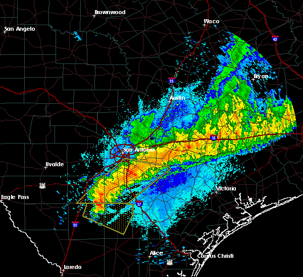 The severe thunderstorm warning for northwestern karnes, eastern frio, atascosa, wilson and southeastern bexar counties will expire at 1245 am cdt, the storms which prompted the warning have weakened below severe limits, and no longer pose an immediate threat to life or property. therefore the warning will be allowed to expire. however gusty winds to 45 mph are still possible with these thunderstorms. The severe thunderstorm warning for northwestern karnes, eastern frio, atascosa, wilson and southeastern bexar counties will expire at 1245 am cdt, the storms which prompted the warning have weakened below severe limits, and no longer pose an immediate threat to life or property. therefore the warning will be allowed to expire. however gusty winds to 45 mph are still possible with these thunderstorms.
|
| 4/14/2018 12:29 AM CDT |
 At 1229 am cdt, severe thunderstorms were located along a line extending from 12 miles north of nixon to 6 miles east of gardendale, moving east at 55 mph (radar indicated). Hazards include 60 mph wind gusts and penny size hail. Expect damage to roofs, siding, and trees. Locations impacted include, san antonio, pleasanton, floresville, jourdanton, dilley, poteet, poth, charlotte, stockdale, christine, campbellton, kosciusko, stinson municipal airport, somerset, elmendorf, falls city, goldfinch, pandora, calaveras lake and sutherland springs. At 1229 am cdt, severe thunderstorms were located along a line extending from 12 miles north of nixon to 6 miles east of gardendale, moving east at 55 mph (radar indicated). Hazards include 60 mph wind gusts and penny size hail. Expect damage to roofs, siding, and trees. Locations impacted include, san antonio, pleasanton, floresville, jourdanton, dilley, poteet, poth, charlotte, stockdale, christine, campbellton, kosciusko, stinson municipal airport, somerset, elmendorf, falls city, goldfinch, pandora, calaveras lake and sutherland springs.
|
| 4/14/2018 12:04 AM CDT |
 At 1203 am cdt, severe thunderstorms were located along a line extending from near st. hedwig to 7 miles north of light, moving east at 30 mph (radar indicated). Hazards include 60 mph wind gusts and quarter size hail. Hail damage to vehicles is expected. Expect wind damage to roofs, siding, and trees. At 1203 am cdt, severe thunderstorms were located along a line extending from near st. hedwig to 7 miles north of light, moving east at 30 mph (radar indicated). Hazards include 60 mph wind gusts and quarter size hail. Hail damage to vehicles is expected. Expect wind damage to roofs, siding, and trees.
|
| 2/25/2018 6:00 AM CST |
 At 600 am cst, a severe thunderstorm was located near jourdanton, moving east at 35 mph (radar indicated). Hazards include two inch hail and 60 mph wind gusts. People and animals outdoors will be injured. expect hail damage to roofs, siding, windows, and vehicles. expect wind damage to roofs, siding, and trees. Locations impacted include, pleasanton, jourdanton, coughran and mccoy. At 600 am cst, a severe thunderstorm was located near jourdanton, moving east at 35 mph (radar indicated). Hazards include two inch hail and 60 mph wind gusts. People and animals outdoors will be injured. expect hail damage to roofs, siding, windows, and vehicles. expect wind damage to roofs, siding, and trees. Locations impacted include, pleasanton, jourdanton, coughran and mccoy.
|
| 2/25/2018 5:56 AM CST |
 At 555 am cst, a severe thunderstorm was located near jourdanton, moving east at 45 mph (radar indicated). Hazards include ping pong ball size hail and 60 mph wind gusts. People and animals outdoors will be injured. expect hail damage to roofs, siding, windows, and vehicles. expect wind damage to roofs, siding, and trees. Locations impacted include, pleasanton, jourdanton, coughran and mccoy. At 555 am cst, a severe thunderstorm was located near jourdanton, moving east at 45 mph (radar indicated). Hazards include ping pong ball size hail and 60 mph wind gusts. People and animals outdoors will be injured. expect hail damage to roofs, siding, windows, and vehicles. expect wind damage to roofs, siding, and trees. Locations impacted include, pleasanton, jourdanton, coughran and mccoy.
|
| 2/25/2018 5:50 AM CST | Quarter sized hail reported 0.7 miles N of Jourdanton, TX |
| 2/25/2018 5:41 AM CST |
 At 541 am cst, a severe thunderstorm was located over charlotte, moving east at 35 mph (radar indicated). Hazards include up to ping pong ball size hail and 60 mph wind gusts. People and animals outdoors will be injured. expect hail damage to roofs, siding, windows, and vehicles. Expect wind damage to roofs, siding, and trees. At 541 am cst, a severe thunderstorm was located over charlotte, moving east at 35 mph (radar indicated). Hazards include up to ping pong ball size hail and 60 mph wind gusts. People and animals outdoors will be injured. expect hail damage to roofs, siding, windows, and vehicles. Expect wind damage to roofs, siding, and trees.
|
| 4/17/2016 4:45 PM CDT |
 At 444 pm cdt, a severe thunderstorm was located over charlotte, moving north at 15 mph. another severe thunderstorm is moving into far southeast frio county moving north at 15 mph as well (trained weather spotters). Hazards include 60 mph wind gusts and quarter size hail. Hail damage to vehicles is expected. Expect wind damage to roofs, siding, and trees. At 444 pm cdt, a severe thunderstorm was located over charlotte, moving north at 15 mph. another severe thunderstorm is moving into far southeast frio county moving north at 15 mph as well (trained weather spotters). Hazards include 60 mph wind gusts and quarter size hail. Hail damage to vehicles is expected. Expect wind damage to roofs, siding, and trees.
|
| 4/17/2016 4:22 PM CDT | Quarter sized hail reported 6.9 miles NE of Jourdanton, TX |
| 4/12/2016 10:26 PM CDT |
 At 1025 pm cdt, a severe thunderstorm was located over pearson, or near castroville, moving southeast at 30 mph. this storm will move across the natalia and lytle areas to between somerset and pleasanton (radar indicated). Hazards include golf ball size hail and 60 mph wind gusts. People and animals outdoors will be injured. expect hail damage to roofs, siding, windows, and vehicles. Expect wind damage to roofs, siding, and trees. At 1025 pm cdt, a severe thunderstorm was located over pearson, or near castroville, moving southeast at 30 mph. this storm will move across the natalia and lytle areas to between somerset and pleasanton (radar indicated). Hazards include golf ball size hail and 60 mph wind gusts. People and animals outdoors will be injured. expect hail damage to roofs, siding, windows, and vehicles. Expect wind damage to roofs, siding, and trees.
|
| 3/24/2016 3:50 AM CDT |
 The severe thunderstorm warning for central atascosa county will expire at 400 am cdt, the storm which prompted the warning has weakened below severe limits, and no longer pose an immediate threat to life or property. therefore the warning will be allowed to expire. The severe thunderstorm warning for central atascosa county will expire at 400 am cdt, the storm which prompted the warning has weakened below severe limits, and no longer pose an immediate threat to life or property. therefore the warning will be allowed to expire.
|
| 3/24/2016 3:36 AM CDT |
 At 335 am cdt, a severe thunderstorm was located near jourdanton, moving east at 40 mph (radar indicated). Hazards include 60 mph wind gusts. Expect damage to roofs. siding. and trees. Locations impacted include, pleasanton, jourdanton, christine, coughran and dobrowolski. At 335 am cdt, a severe thunderstorm was located near jourdanton, moving east at 40 mph (radar indicated). Hazards include 60 mph wind gusts. Expect damage to roofs. siding. and trees. Locations impacted include, pleasanton, jourdanton, christine, coughran and dobrowolski.
|
| 3/24/2016 2:54 AM CDT |
 At 254 am cdt, a severe thunderstorm was located near pearsall, moving east at 40 mph (radar indicated). Hazards include 60 mph wind gusts and quarter size hail. Hail damage to vehicles is expected. Expect wind damage to roofs, siding, and trees. At 254 am cdt, a severe thunderstorm was located near pearsall, moving east at 40 mph (radar indicated). Hazards include 60 mph wind gusts and quarter size hail. Hail damage to vehicles is expected. Expect wind damage to roofs, siding, and trees.
|
| 3/9/2016 12:36 AM CST |
 At 1236 am cst, severe thunderstorms were located along a line extending from near sea world to 6 miles northwest of leming, moving north at 40 mph (radar indicated). Hazards include 60 mph wind gusts and nickel size hail. Expect damage to roofs. siding. And trees. At 1236 am cst, severe thunderstorms were located along a line extending from near sea world to 6 miles northwest of leming, moving north at 40 mph (radar indicated). Hazards include 60 mph wind gusts and nickel size hail. Expect damage to roofs. siding. And trees.
|
| 2/23/2016 1:10 AM CST |
 At 109 am cst, severe thunderstorms were located along a line extending from 7 miles east of bigfoot to near charlotte to 10 miles west of christine to near zella, moving east at 50 mph (radar indicated). Hazards include 70 mph wind gusts and quarter size hail. Hail damage to vehicles is expected. expect considerable tree damage. wind damage is also likely to mobile homes, roofs, and outbuildings. Locations impacted include, pearsall, pleasanton, dilley, jourdanton, poteet, charlotte, christine, campbellton, moore, goldfinch, north pearsall, west pearsall, schattel, bigfoot, leming, divot, big foot, bluff, derby and rossville. At 109 am cst, severe thunderstorms were located along a line extending from 7 miles east of bigfoot to near charlotte to 10 miles west of christine to near zella, moving east at 50 mph (radar indicated). Hazards include 70 mph wind gusts and quarter size hail. Hail damage to vehicles is expected. expect considerable tree damage. wind damage is also likely to mobile homes, roofs, and outbuildings. Locations impacted include, pearsall, pleasanton, dilley, jourdanton, poteet, charlotte, christine, campbellton, moore, goldfinch, north pearsall, west pearsall, schattel, bigfoot, leming, divot, big foot, bluff, derby and rossville.
|
| 2/23/2016 12:41 AM CST |
 At 1240 am cst, severe thunderstorms were located along a line extending from near moore to near pearsall to near dilley to near divot, moving east at 55 mph (radar indicated). Hazards include 70 mph wind gusts and quarter size hail. Hail damage to vehicles is expected. expect considerable tree damage. Wind damage is also likely to mobile homes, roofs, and outbuildings. At 1240 am cst, severe thunderstorms were located along a line extending from near moore to near pearsall to near dilley to near divot, moving east at 55 mph (radar indicated). Hazards include 70 mph wind gusts and quarter size hail. Hail damage to vehicles is expected. expect considerable tree damage. Wind damage is also likely to mobile homes, roofs, and outbuildings.
|
| 10/31/2015 3:38 AM CDT |
 The severe thunderstorm warning for western wilson, northern atascosa and bexar counties will expire at 345 am cdt, the storms which prompted the warning have weakened below severe limits, and exited the warned area. therefore the warning will be allowed to expire. however gusty winds and heavy rain are still possible with these thunderstorms. to report severe weather, contact your nearest law enforcement agency. they will relay your report to the national weather service austin san antonio. The severe thunderstorm warning for western wilson, northern atascosa and bexar counties will expire at 345 am cdt, the storms which prompted the warning have weakened below severe limits, and exited the warned area. therefore the warning will be allowed to expire. however gusty winds and heavy rain are still possible with these thunderstorms. to report severe weather, contact your nearest law enforcement agency. they will relay your report to the national weather service austin san antonio.
|
| 10/31/2015 3:15 AM CDT |
 At 313 am cdt, severe thunderstorms were located along a line extending from helotes to near somerset to near poteet, moving northeast at 40 mph (radar indicated). Hazards include 60 mph wind gusts. Expect damage to roofs. siding and trees. locations impacted include, san antonio, universal city, pleasanton, jourdanton, poteet, schertz, live oak, leon valley, kirby, helotes, alamo heights, windcrest, terrell hills, hollywood park, shavano park, olmos park, st. Hedwig, somerset, elmendorf and calaveras lake. At 313 am cdt, severe thunderstorms were located along a line extending from helotes to near somerset to near poteet, moving northeast at 40 mph (radar indicated). Hazards include 60 mph wind gusts. Expect damage to roofs. siding and trees. locations impacted include, san antonio, universal city, pleasanton, jourdanton, poteet, schertz, live oak, leon valley, kirby, helotes, alamo heights, windcrest, terrell hills, hollywood park, shavano park, olmos park, st. Hedwig, somerset, elmendorf and calaveras lake.
|
| 10/31/2015 2:41 AM CDT |
 At 241 am cdt, severe thunderstorms were located along a line extending from new fountain to devine to 8 miles south of goldfinch, moving northeast at 40 mph (radar indicated). Hazards include 60 to 70 mph wind gusts. Expect considerable tree damage. Damage is likely to mobile homes, roofs and outbuildings. At 241 am cdt, severe thunderstorms were located along a line extending from new fountain to devine to 8 miles south of goldfinch, moving northeast at 40 mph (radar indicated). Hazards include 60 to 70 mph wind gusts. Expect considerable tree damage. Damage is likely to mobile homes, roofs and outbuildings.
|
| 5/29/2015 2:07 AM CDT | The severe thunderstorm warning for atascosa, frio and wilson counties will expire at 215 am cdt, the storms which prompted the warning have weakened below severe limits, and exited the warned area. therefore the warning will be allowed to expire. however gusty winds and heavy rain are still possible with these thunderstorms through the next 30 minutes. a severe thunderstorm watch remains in effect until 400 am cdt for south central texas. |
| 5/29/2015 1:34 AM CDT | At 134 am cdt, severe thunderstorms were located along a line extending from 8 miles east of la vernia to near charlotte to 6 miles west of divot, moving southeast at 35 mph (radar indicated). Hazards include 60 mph wind gusts. Expect damage to roofs. siding and trees. locations impacted include, pearsall, pleasanton, floresville, dilley, jourdanton, poteet, poth, charlotte, stockdale, christine, campbellton, kosciusko, moore, lytle, st. Hedwig, la vernia, frio town, goldfinch, north pearsall and west pearsall. |
| 5/29/2015 12:51 AM CDT | At 1248 am cdt, severe thunderstorms were located along a line extending from near new braunfels to near lytle to 9 miles west of frio town, moving south at 35 mph. * an official 61 mph wind gust was reported at lackland air force base at 1240am along with an unofficial hand held anemometer reading of 71 mph in the same vicinity from a local observer (radar indicated). Hazards include 60 mph wind gusts. Expect damage to roofs. Siding and trees. |
| 5/23/2015 8:52 PM CDT | At 851 pm cdt, severe thunderstorms were located along a line extending from zorn to near dilley, moving northeast at 60 mph (radar indicated). Hazards include 60 mph wind gusts and nickel size hail. Expect damage to roofs. siding and trees. locations impacted include, san antonio, new braunfels, seguin, universal city, pearsall, pleasanton, dilley, jourdanton, poteet, charlotte, canyon lake dam, schertz, moore, cibolo, live oak, leon valley, kirby, alamo heights, selma and windcrest. A tornado watch remains in effect until 300 am cdt for south central texas. |
| 5/23/2015 8:32 PM CDT | At 832 pm cdt, severe thunderstorms were located along a line extending from 7 miles south of san antonio to near dilley, moving southeast at 20 mph (radar indicated). Hazards include 60 mph wind gusts. Expect damage to roofs. Siding and trees. |
| 4/27/2015 2:16 AM CDT | At 215 am cdt, severe thunderstorms were located along a line extending from 7 miles southeast of rogers to near palmeto to near stockdale to near floresville to near poteet to 6 miles west of schattel to 8 miles east of dilley, and are nearly stationary (radar indicated). Hazards include 60 mph wind gusts and penny size hail. Expect damage to roofs. siding and trees. locations impacted include, san antonio, austin, new braunfels, pflugerville, san marcos, seguin, taylor, lockhart, pearsall, pleasanton, elgin, gonzales, bastrop, crystal city, floresville, luling, giddings, dilley, jourdanton and smithville. a tornado watch remains in effect until 900 am cdt for south central texas. 0. 75in. |
| 4/27/2015 1:58 AM CDT | At 157 am cdt, severe thunderstorms were located along a line extending from near cameron to 9 miles south of cedar creek to near sutherland springs to near elmendorf to near bigfoot to pearsall to dilley, moving east at 55 mph (radar indicated). Hazards include 60 mph wind gusts and penny size hail. Expect damage to roofs. siding and trees. locations impacted include, san antonio, austin, round rock, new braunfels, cedar park, georgetown, pflugerville, san marcos, seguin, universal city, taylor, lockhart, pearsall, pleasanton, elgin, gonzales, bastrop, crystal city, floresville and luling. a tornado watch remains in effect until 900 am cdt for south central texas. 0. 75in. |
| 4/27/2015 1:54 AM CDT | At 153 am cdt, a severe thunderstorm capable of producing a tornado was located 5 miles west of pearsall, moving east at 50 mph (radar indicated rotation). Hazards include tornado. Flying debris will be dangerous to those caught without shelter. mobile homes will be damaged or destroyed. damage to roofs, windows and vehicles will occur. tree damage is likely. this dangerous storm will be near, pearsall and north pearsall around 200 am cdt. goldfinch and schattel around 215 am cdt. charlotte around 230 am cdt. jourdanton around 240 am cdt. christine around 245 am cdt. other locations impacted by this tornadic thunderstorm include three oaks, coughran, hindes, davis, dobrowolski and amphion. Radar indicated. |
| 4/27/2015 1:38 AM CDT | At 137 am cdt, severe thunderstorms were located along a line extending from near bartlett to zorn to near somerset to moore to 9 miles east of batesville to near brundage, moving east at 50 mph (radar indicated). Hazards include 60 mph wind gusts and penny size hail. Expect damage to roofs. Siding and trees. |
| 4/24/2015 10:05 PM CDT | At 1005 pm cdt, a severe thunderstorm was located near pleasanton, moving east at 40 mph (radar indicated). Hazards include 60 mph wind gusts and half dollar size hail. Hail damage to vehicles is expected. expect wind damage to roofs, siding and trees. locations impacted include, pleasanton, floresville, jourdanton, kenedy, karnes city, poth, stockdale, christine, kosciusko, falls city, cestohowa, fairview, pana maria, mccoy, coy city, hobson, coughran, deweesville, paweleville and graytown. 1. 25in. |
| 4/24/2015 9:55 PM CDT | At 954 pm cdt, a severe thunderstorm was located near jourdanton, moving east at 40 mph (radar indicated). Hazards include 60 mph wind gusts and quarter size hail. Hail damage to vehicles is expected. Expect wind damage to roofs, siding and trees. |
| 4/22/2015 2:54 PM CDT | At 254 pm cdt, a severe thunderstorm was located near pleasanton, moving east at 35 mph (radar indicated). Hazards include 60 mph wind gusts and quarter size hail. Hail damage to vehicles is expected. expect wind damage to roofs, siding and trees. locations impacted include, pleasanton, jourdanton, poteet, leming, espey, coughran, mccoy and graytown. 1. 00in. |
| 4/22/2015 2:41 PM CDT | At 241 pm cdt, a severe thunderstorm was located near leming, or near poteet, moving east at 35 mph (radar indicated). Hazards include 60 mph wind gusts and quarter size hail. Hail damage to vehicles is expected. Expect wind damage to roofs, siding and trees. |
Hail Maps for Jourdanton, TX
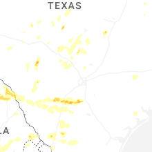
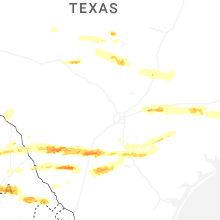
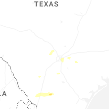
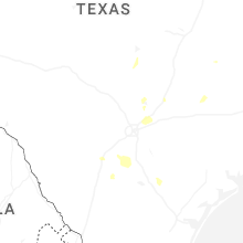
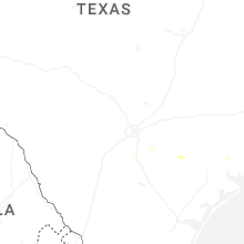
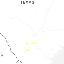
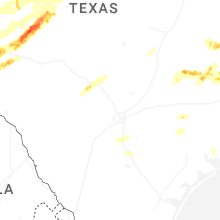
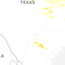


Connect with Interactive Hail Maps