

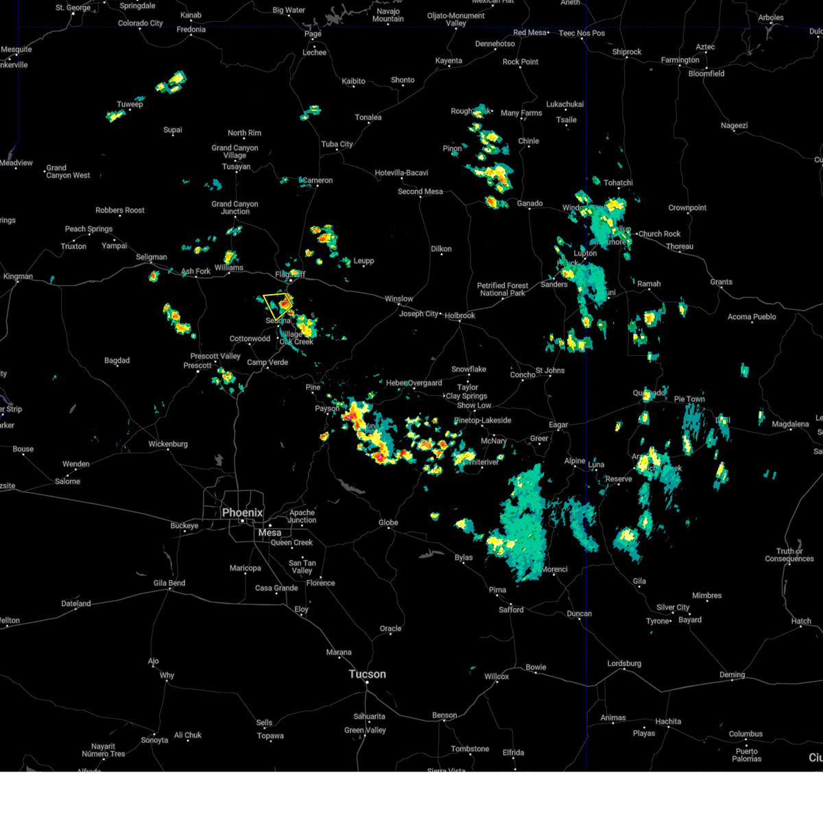
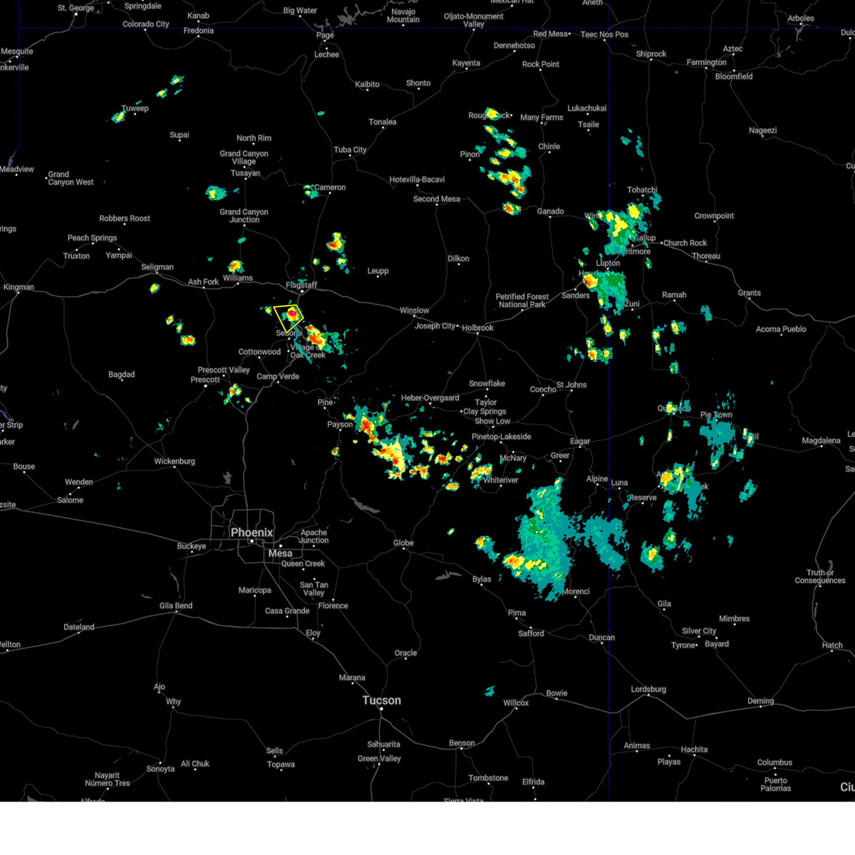
Hail Map for Kachina Village, AZ
The Kachina Village, AZ area has had 0 reports of on-the-ground hail by trained spotters, and has been under severe weather warnings 0 times during the past 12 months. Doppler radar has detected hail at or near Kachina Village, AZ on 17 occasions.
| Name: | Kachina Village, AZ |
| Where Located: | 7.4 miles SSW of Flagstaff, AZ |
| Map: | Google Map for Kachina Village, AZ |
| Population: | 2622 |
| Housing Units: | 1469 |
| More Info: | Search Google for Kachina Village, AZ |
0
The Top Recent Hail Date for Kachina Village, AZ is Friday, July 26, 2024 (11th out of 17)

Hail and Wind Damage Spotted near Kachina Village, AZ
| Date / Time | Report Details |
|---|---|
| 7/26/2024 2:03 PM MST |
 the severe thunderstorm warning has been cancelled and is no longer in effect the severe thunderstorm warning has been cancelled and is no longer in effect
|
| 7/26/2024 1:48 PM MST |
 Svrfgz the national weather service in flagstaff has issued a * severe thunderstorm warning for, yavapai county in west central arizona, coconino county in north central arizona, * until 215 pm mst/315 pm mdt. * at 147 pm mst/247 pm mdt, a severe thunderstorm was located over oak creek vista overlook, or 11 miles north of sedona, and is nearly stationary (radar indicated). Hazards include quarter size hail. damage to vehicles is expected Svrfgz the national weather service in flagstaff has issued a * severe thunderstorm warning for, yavapai county in west central arizona, coconino county in north central arizona, * until 215 pm mst/315 pm mdt. * at 147 pm mst/247 pm mdt, a severe thunderstorm was located over oak creek vista overlook, or 11 miles north of sedona, and is nearly stationary (radar indicated). Hazards include quarter size hail. damage to vehicles is expected
|
| 8/16/2021 2:51 PM MST |
 At 250 pm mst, a severe thunderstorm was located over mountainaire, or 8 miles south of flagstaff, moving southwest at 10 mph (radar indicated). Hazards include golf ball size hail. People and animals outdoors will be injured. expect damage to roofs, siding, windows, and vehicles. locations impacted include, kachina village, mountainaire and intestate-17 are in the path of this storm. find shelter now. thunderstorm damage threat, considerable hail threat, radar indicated max hail size, 1. 75 in wind threat, radar indicated max wind gust, <50 mph. At 250 pm mst, a severe thunderstorm was located over mountainaire, or 8 miles south of flagstaff, moving southwest at 10 mph (radar indicated). Hazards include golf ball size hail. People and animals outdoors will be injured. expect damage to roofs, siding, windows, and vehicles. locations impacted include, kachina village, mountainaire and intestate-17 are in the path of this storm. find shelter now. thunderstorm damage threat, considerable hail threat, radar indicated max hail size, 1. 75 in wind threat, radar indicated max wind gust, <50 mph.
|
| 8/16/2021 2:41 PM MST |
 At 241 pm mst, a severe thunderstorm was located over mountainaire, or 7 miles south of flagstaff, moving southwest at 10 mph (radar indicated). Hazards include golf ball size hail. People and animals outdoors will be injured. Expect damage to roofs, siding, windows, and vehicles. At 241 pm mst, a severe thunderstorm was located over mountainaire, or 7 miles south of flagstaff, moving southwest at 10 mph (radar indicated). Hazards include golf ball size hail. People and animals outdoors will be injured. Expect damage to roofs, siding, windows, and vehicles.
|
| 8/10/2021 11:55 AM MST |
 At 1155 am mst, a severe thunderstorm was located over mountainaire, or near flagstaff, moving southwest at 10 mph (radar indicated). Hazards include 60 mph wind gusts and quarter size hail. Hail damage to vehicles is expected. Expect wind damage to roofs, siding, and trees. At 1155 am mst, a severe thunderstorm was located over mountainaire, or near flagstaff, moving southwest at 10 mph (radar indicated). Hazards include 60 mph wind gusts and quarter size hail. Hail damage to vehicles is expected. Expect wind damage to roofs, siding, and trees.
|
| 8/4/2019 1:42 PM MST |
 At 141 pm mst, a severe thunderstorm was located over kachina village, or 9 miles southwest of flagstaff, and is nearly stationary (radar indicated). Hazards include 60 mph wind gusts and quarter size hail. Hail damage to vehicles is expected. Expect wind damage to roofs, siding, and trees. At 141 pm mst, a severe thunderstorm was located over kachina village, or 9 miles southwest of flagstaff, and is nearly stationary (radar indicated). Hazards include 60 mph wind gusts and quarter size hail. Hail damage to vehicles is expected. Expect wind damage to roofs, siding, and trees.
|
| 7/23/2019 3:42 PM MST |
 The severe thunderstorm warning for coconino county will expire at 345 pm mst, the severe thunderstorm near kachina village, which prompted the warning, has weakened below severe limits. therefore, the warning will be allowed to expire. this storm is still producing half inch diameter hail and heavy rain west of kachina village. The severe thunderstorm warning for coconino county will expire at 345 pm mst, the severe thunderstorm near kachina village, which prompted the warning, has weakened below severe limits. therefore, the warning will be allowed to expire. this storm is still producing half inch diameter hail and heavy rain west of kachina village.
|
| 7/23/2019 3:22 PM MST |
 At 320 pm mst, a severe thunderstorm was located over mountainaire, or 10 miles southwest of flagstaff, moving northwest at 15 mph (radar indicated). Hazards include quarter size hail. damage to vehicles is expected At 320 pm mst, a severe thunderstorm was located over mountainaire, or 10 miles southwest of flagstaff, moving northwest at 15 mph (radar indicated). Hazards include quarter size hail. damage to vehicles is expected
|
| 8/9/2018 3:47 PM MST |
 At 347 pm mst, a severe thunderstorm was located near parks, or 18 miles west of flagstaff, moving west at 20 mph (trained weather spotters). Hazards include 60 mph wind gusts and quarter size hail. Hail damage to vehicles is expected. expect wind damage to roofs, siding, and trees. locations impacted include, bellemont, parks, white horse lake campground, raymond boy scout camp, sterling fish hatchery, dogtown lake campground and kaibab lake campground. this includes the following highways, interstate 40 between mile markers 166 and 191. state route 64 between mile markers 186 and 193. state route 89a between mile markers 388 and 396. Highway 180 near mile marker 225. At 347 pm mst, a severe thunderstorm was located near parks, or 18 miles west of flagstaff, moving west at 20 mph (trained weather spotters). Hazards include 60 mph wind gusts and quarter size hail. Hail damage to vehicles is expected. expect wind damage to roofs, siding, and trees. locations impacted include, bellemont, parks, white horse lake campground, raymond boy scout camp, sterling fish hatchery, dogtown lake campground and kaibab lake campground. this includes the following highways, interstate 40 between mile markers 166 and 191. state route 64 between mile markers 186 and 193. state route 89a between mile markers 388 and 396. Highway 180 near mile marker 225.
|
| 8/9/2018 3:31 PM MST |
 At 330 pm mst, a severe thunderstorm was located over bellemont, or 12 miles west of flagstaff, moving west at 20 mph (trained spotter indicated). Hazards include 60 mph wind gusts and half dollar size hail. Hail damage to vehicles is expected. Expect wind damage to roofs, siding, and trees. At 330 pm mst, a severe thunderstorm was located over bellemont, or 12 miles west of flagstaff, moving west at 20 mph (trained spotter indicated). Hazards include 60 mph wind gusts and half dollar size hail. Hail damage to vehicles is expected. Expect wind damage to roofs, siding, and trees.
|
| 8/9/2018 3:12 PM MST |
 At 311 pm mst, a severe thunderstorm was located near kachina village, or near flagstaff, moving west at 10 mph (trained weather spotters). Hazards include 60 mph wind gusts and half dollar size hail. Hail damage to vehicles is expected. expect wind damage to roofs, siding, and trees. locations impacted include, flagstaff, bellemont, mountainaire, downtown flagstaff, kachina village, cave springs campground, pine flat campground, sterling fish hatchery, west fork of oak creek and canyon vista campground. this includes the following highways, route 66 between mile markers 192 and 198. interstate 40 between mile markers 183 and 199. interstate 17 between mile markers 328 and 339. state route 89a between mile markers 384 and 398. Highway 180 between mile markers 217 and 219. At 311 pm mst, a severe thunderstorm was located near kachina village, or near flagstaff, moving west at 10 mph (trained weather spotters). Hazards include 60 mph wind gusts and half dollar size hail. Hail damage to vehicles is expected. expect wind damage to roofs, siding, and trees. locations impacted include, flagstaff, bellemont, mountainaire, downtown flagstaff, kachina village, cave springs campground, pine flat campground, sterling fish hatchery, west fork of oak creek and canyon vista campground. this includes the following highways, route 66 between mile markers 192 and 198. interstate 40 between mile markers 183 and 199. interstate 17 between mile markers 328 and 339. state route 89a between mile markers 384 and 398. Highway 180 between mile markers 217 and 219.
|
| 8/9/2018 3:08 PM MST |
 At 308 pm mst, a severe thunderstorm was located near downtown flagstaff, moving west at 10 mph (radar indicated). Hazards include 60 mph wind gusts and half dollar size hail. Hail damage to vehicles is expected. Expect wind damage to roofs, siding, and trees. At 308 pm mst, a severe thunderstorm was located near downtown flagstaff, moving west at 10 mph (radar indicated). Hazards include 60 mph wind gusts and half dollar size hail. Hail damage to vehicles is expected. Expect wind damage to roofs, siding, and trees.
|
| 7/27/2018 3:39 PM MST |
 At 307 pm mst, a severe thunderstorm was located over mountainaire, or 7 miles south of flagstaff, moving south at 25 mph (radar indicated). Hazards include 60 mph wind gusts and quarter size hail. Hail damage to vehicles is expected. Expect wind damage to roofs, siding, and trees. At 307 pm mst, a severe thunderstorm was located over mountainaire, or 7 miles south of flagstaff, moving south at 25 mph (radar indicated). Hazards include 60 mph wind gusts and quarter size hail. Hail damage to vehicles is expected. Expect wind damage to roofs, siding, and trees.
|
| 7/27/2018 3:07 PM MST |
 The national weather service in flagstaff has issued a * severe thunderstorm warning for. coconino county near mountainaire in north central arizona. Until 345 pm mst * at 307 pm mst, a severe thunderstorm was located over mountainaire, or 7 miles south of flagstaff, moving south at 25 mph. The national weather service in flagstaff has issued a * severe thunderstorm warning for. coconino county near mountainaire in north central arizona. Until 345 pm mst * at 307 pm mst, a severe thunderstorm was located over mountainaire, or 7 miles south of flagstaff, moving south at 25 mph.
|
| 8/13/2017 6:18 PM MST |
 At 617 pm mst, a severe thunderstorm was located over downtown flagstaff, or over flagstaff, moving southeast at 30 mph (radar indicated). Hazards include 60 mph wind gusts and quarter size hail. Hail damage to vehicles is expected. Expect wind damage to roofs, siding, and trees. At 617 pm mst, a severe thunderstorm was located over downtown flagstaff, or over flagstaff, moving southeast at 30 mph (radar indicated). Hazards include 60 mph wind gusts and quarter size hail. Hail damage to vehicles is expected. Expect wind damage to roofs, siding, and trees.
|
Hail Maps for Kachina Village, AZ


Connect with Interactive Hail Maps