| 5/30/2020 5:32 PM PDT |
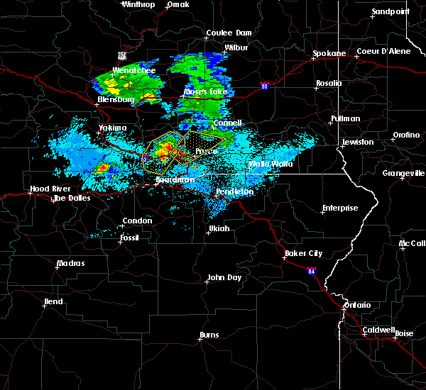
 At 531 pm pdt, severe thunderstorms were located along a line extending from near eltopia to 8 miles east of milton-freewater, moving northeast at 45 mph (radar indicated). Hazards include 70 mph wind gusts and ping pong ball size hail. People and animals outdoors will be injured. expect hail damage to roofs, siding, windows, and vehicles. expect considerable tree damage. wind damage is also likely to mobile homes, roofs, and outbuildings. Locations impacted include, kennewick, pasco, walla walla, connell, dayton, college place, waitsburg, mesa, prescott, kahlotus, starbuck, huntsville, snake river, pleasant view, touchet, ayer, dixie, umapine, wallula and delaney. At 531 pm pdt, severe thunderstorms were located along a line extending from near eltopia to 8 miles east of milton-freewater, moving northeast at 45 mph (radar indicated). Hazards include 70 mph wind gusts and ping pong ball size hail. People and animals outdoors will be injured. expect hail damage to roofs, siding, windows, and vehicles. expect considerable tree damage. wind damage is also likely to mobile homes, roofs, and outbuildings. Locations impacted include, kennewick, pasco, walla walla, connell, dayton, college place, waitsburg, mesa, prescott, kahlotus, starbuck, huntsville, snake river, pleasant view, touchet, ayer, dixie, umapine, wallula and delaney.
|
| 5/30/2020 5:32 PM PDT |
 At 531 pm pdt, severe thunderstorms were located along a line extending from near eltopia to 8 miles east of milton-freewater, moving northeast at 45 mph (radar indicated). Hazards include 70 mph wind gusts and ping pong ball size hail. People and animals outdoors will be injured. expect hail damage to roofs, siding, windows, and vehicles. expect considerable tree damage. wind damage is also likely to mobile homes, roofs, and outbuildings. Locations impacted include, kennewick, pasco, walla walla, connell, dayton, college place, waitsburg, mesa, prescott, kahlotus, starbuck, huntsville, snake river, pleasant view, touchet, ayer, dixie, umapine, wallula and delaney. At 531 pm pdt, severe thunderstorms were located along a line extending from near eltopia to 8 miles east of milton-freewater, moving northeast at 45 mph (radar indicated). Hazards include 70 mph wind gusts and ping pong ball size hail. People and animals outdoors will be injured. expect hail damage to roofs, siding, windows, and vehicles. expect considerable tree damage. wind damage is also likely to mobile homes, roofs, and outbuildings. Locations impacted include, kennewick, pasco, walla walla, connell, dayton, college place, waitsburg, mesa, prescott, kahlotus, starbuck, huntsville, snake river, pleasant view, touchet, ayer, dixie, umapine, wallula and delaney.
|
| 5/30/2020 5:10 PM PDT |
 At 508 pm pdt, severe thunderstorms were located along a line extending from island view to umatilla reservation, moving northeast at 55 mph (radar indicated). Hazards include 70 mph wind gusts and quarter size hail. Hail damage to vehicles is expected. expect considerable tree damage. Wind damage is also likely to mobile homes, roofs, and outbuildings. At 508 pm pdt, severe thunderstorms were located along a line extending from island view to umatilla reservation, moving northeast at 55 mph (radar indicated). Hazards include 70 mph wind gusts and quarter size hail. Hail damage to vehicles is expected. expect considerable tree damage. Wind damage is also likely to mobile homes, roofs, and outbuildings.
|
| 5/30/2020 5:02 PM PDT |
Large tree blocking kennewick ave near newport st. time estimated from rada in benton county WA, 0.8 miles WNW of Kennewick, WA
|
| 5/30/2020 4:48 PM PDT |
 At 447 pm pdt, a severe thunderstorm was located over burbank, or 7 miles southeast of pasco, moving north at 45 mph (radar indicated). Hazards include two inch hail and 70 mph wind gusts. People and animals outdoors will be injured. expect hail damage to roofs, siding, windows, and vehicles. expect considerable tree damage. wind damage is also likely to mobile homes, roofs, and outbuildings. blowing dust being reported with this storm and could greatly reduce visibility. Locations impacted include, kennewick, pasco, richland, hermiston, pendleton, west richland, umatilla, stanfield, echo, west pasco, plymouth, wallula, badger, burbank, holdman, island view, rieth, touchet, finley and eureka. At 447 pm pdt, a severe thunderstorm was located over burbank, or 7 miles southeast of pasco, moving north at 45 mph (radar indicated). Hazards include two inch hail and 70 mph wind gusts. People and animals outdoors will be injured. expect hail damage to roofs, siding, windows, and vehicles. expect considerable tree damage. wind damage is also likely to mobile homes, roofs, and outbuildings. blowing dust being reported with this storm and could greatly reduce visibility. Locations impacted include, kennewick, pasco, richland, hermiston, pendleton, west richland, umatilla, stanfield, echo, west pasco, plymouth, wallula, badger, burbank, holdman, island view, rieth, touchet, finley and eureka.
|
| 5/30/2020 4:10 PM PDT |
 At 408 pm pdt, a severe thunderstorm was located near echo, or 10 miles southeast of hermiston, moving north at 45 mph (radar indicated). Hazards include two inch hail and 70 mph wind gusts. People and animals outdoors will be injured. expect hail damage to roofs, siding, windows, and vehicles. expect considerable tree damage. Wind damage is also likely to mobile homes, roofs, and outbuildings. At 408 pm pdt, a severe thunderstorm was located near echo, or 10 miles southeast of hermiston, moving north at 45 mph (radar indicated). Hazards include two inch hail and 70 mph wind gusts. People and animals outdoors will be injured. expect hail damage to roofs, siding, windows, and vehicles. expect considerable tree damage. Wind damage is also likely to mobile homes, roofs, and outbuildings.
|
| 5/4/2017 9:25 PM PDT |
 At 925 pm pdt, doppler radar indicated a severe thunderstorm capable of producing quarter size hail and damaging winds in excess of 60 mph. this storm was located over richland, and moving northeast at 40 mph. At 925 pm pdt, doppler radar indicated a severe thunderstorm capable of producing quarter size hail and damaging winds in excess of 60 mph. this storm was located over richland, and moving northeast at 40 mph.
|
| 5/21/2016 4:45 PM PDT |
Large tree uprooted on 7th ave and olympia in kennewic in benton county WA, 0.8 miles WNW of Kennewick, WA
|
| 5/4/2016 8:09 PM PDT |
 At 805 pm pdt, trained weather spotters reported severe thunderstorms producing damaging winds in excess of 60 mph. these storms were located along a line extending from near plymouth to near walla walla, moving north at 30 mph. these winds will push into the tri- cities area around 830 pm. locations impacted include, kennewick, pasco, richland, walla walla, prosser, connell, dayton, west richland, grandview, college place, benton city, waitsburg, mesa, prescott, kahlotus, starbuck, turner, snake river, eltopia and garrett. At 805 pm pdt, trained weather spotters reported severe thunderstorms producing damaging winds in excess of 60 mph. these storms were located along a line extending from near plymouth to near walla walla, moving north at 30 mph. these winds will push into the tri- cities area around 830 pm. locations impacted include, kennewick, pasco, richland, walla walla, prosser, connell, dayton, west richland, grandview, college place, benton city, waitsburg, mesa, prescott, kahlotus, starbuck, turner, snake river, eltopia and garrett.
|
| 5/4/2016 7:46 PM PDT |
 At 741 pm pdt, trained weather spotters reported severe thunderstorms producing damaging winds in excess of 60 mph. these storms are located over northern umatilla and morrow counties. the winds will push across the washington border and the lower columbia basin and the foothills of washington over the next hour. locations impacted include, kennewick, pasco, richland, walla walla, hermiston, pendleton, prosser, connell, boardman, dayton, meacham, west richland, grandview, college place, milton-freewater, umatilla, benton city, stanfield, irrigon and pilot rock. At 741 pm pdt, trained weather spotters reported severe thunderstorms producing damaging winds in excess of 60 mph. these storms are located over northern umatilla and morrow counties. the winds will push across the washington border and the lower columbia basin and the foothills of washington over the next hour. locations impacted include, kennewick, pasco, richland, walla walla, hermiston, pendleton, prosser, connell, boardman, dayton, meacham, west richland, grandview, college place, milton-freewater, umatilla, benton city, stanfield, irrigon and pilot rock.
|
| 5/4/2016 7:20 PM PDT |
 At 719 pm pdt, the public reported a line of severe thunderstorms producing damaging winds in excess of 60 mph. these storms were located along a line extending from 9 miles northeast of ione to umatilla reservation, and moving north at 30 mph. At 719 pm pdt, the public reported a line of severe thunderstorms producing damaging winds in excess of 60 mph. these storms were located along a line extending from 9 miles northeast of ione to umatilla reservation, and moving north at 30 mph.
|
| 6/28/2015 10:32 PM PDT |
 At 1030 pm pdt, doppler radar indicated a severe thunderstorm capable of producing damaging winds in excess of 60 mph. this storm was located along a line from southern benton county to southern walla walla county, moving north at 45 mph. locations impacted include, kennewick, pasco, richland, walla walla, hermiston, pendleton, sunnyside, prosser, boardman, dayton, meacham, west richland, grandview, college place, milton-freewater, umatilla, benton city, mabton, stanfield and irrigon. At 1030 pm pdt, doppler radar indicated a severe thunderstorm capable of producing damaging winds in excess of 60 mph. this storm was located along a line from southern benton county to southern walla walla county, moving north at 45 mph. locations impacted include, kennewick, pasco, richland, walla walla, hermiston, pendleton, sunnyside, prosser, boardman, dayton, meacham, west richland, grandview, college place, milton-freewater, umatilla, benton city, mabton, stanfield and irrigon.
|
| 6/28/2015 9:51 PM PDT |
 At 949 pm pdt, doppler radar indicated a severe thunderstorm capable of producing damaging winds in excess of 60 mph. this storm was located 17 miles northwest of ukiah, or 18 miles east of heppner, and moving north at 40 mph. At 949 pm pdt, doppler radar indicated a severe thunderstorm capable of producing damaging winds in excess of 60 mph. this storm was located 17 miles northwest of ukiah, or 18 miles east of heppner, and moving north at 40 mph.
|
| 9/15/2013 7:18 PM PDT |
Weather station measured a wind gust of 62 mph at 718 pm. power went out at 715 pm. measured 0.52 inches of rain in 20 minutes. wind blew down tree limbs 4-5 inches in in benton county WA, 0.8 miles WNW of Kennewick, WA
|
| 9/15/2013 6:30 PM PDT |
Vista field in benton county WA, 0.8 miles WNW of Kennewick, WA
|
| 8/25/2013 6:00 PM PDT |
Tree limbs approx 4-7 inch diameter down from thunderstorm wind gusts. also reported intersection of kennewick avenue and perry street flooded with 6 inches wate in benton county WA, 0.8 miles WNW of Kennewick, WA
|
| 7/20/2012 1:00 PM PDT |
Quarter sized hail reported 7.4 miles WNW of Kennewick, WA, radio operator reported 1 inch hail. hail responsible for damaging 3 vehicles and breaking 2 windows.
|


Connect with Interactive Hail Maps