

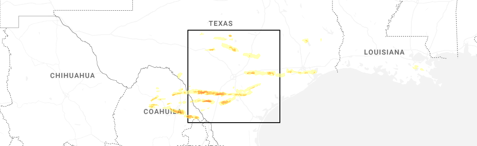
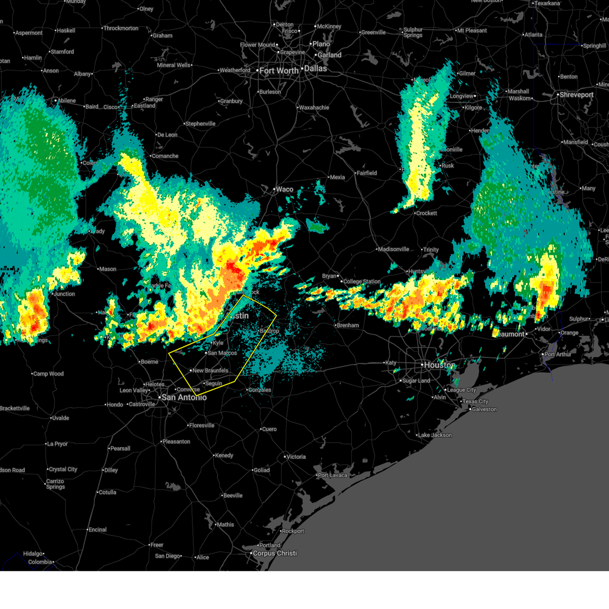
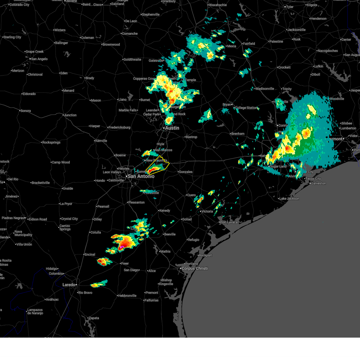
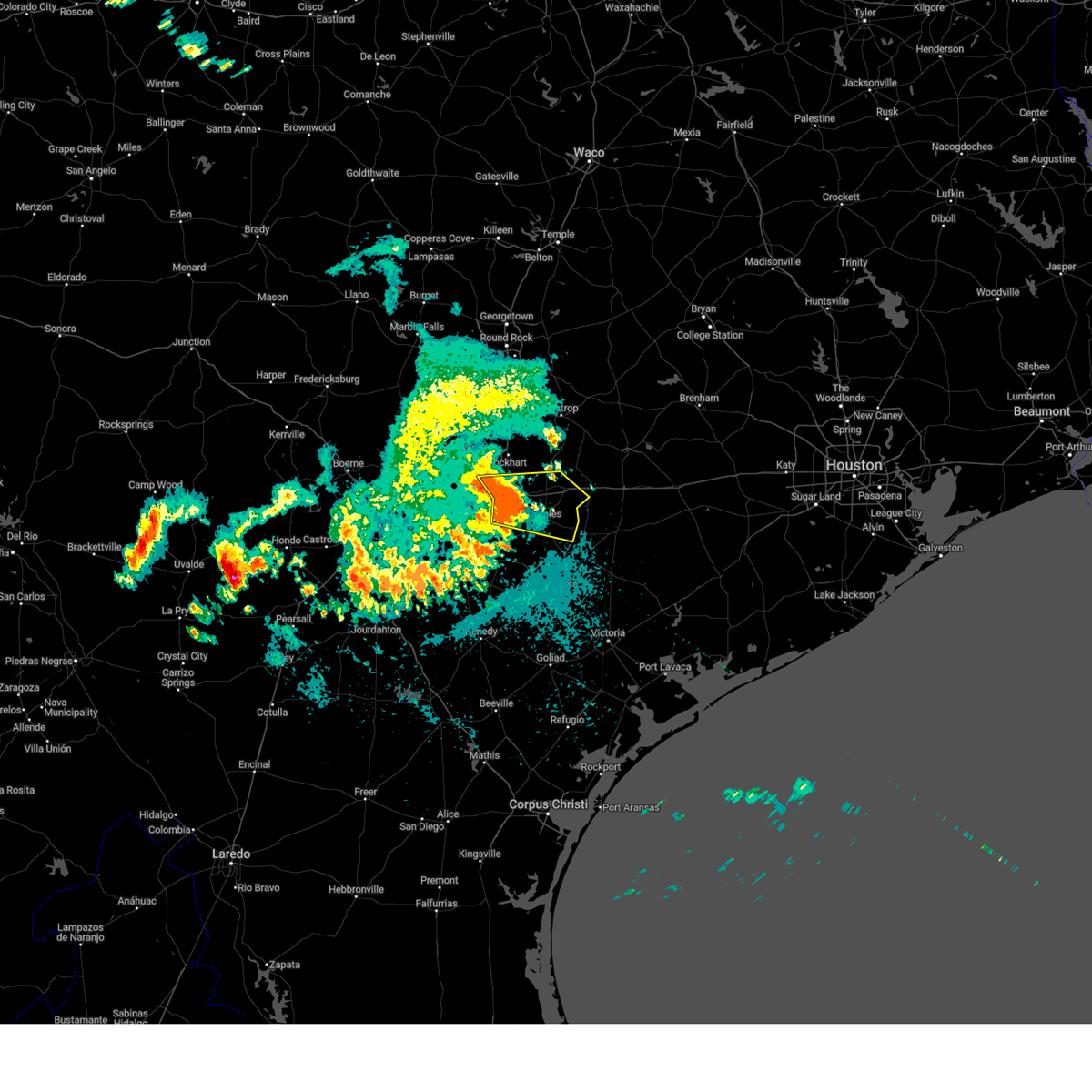
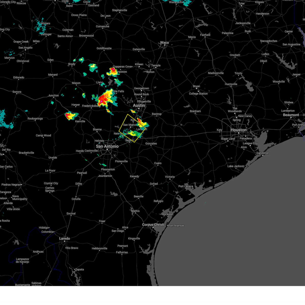
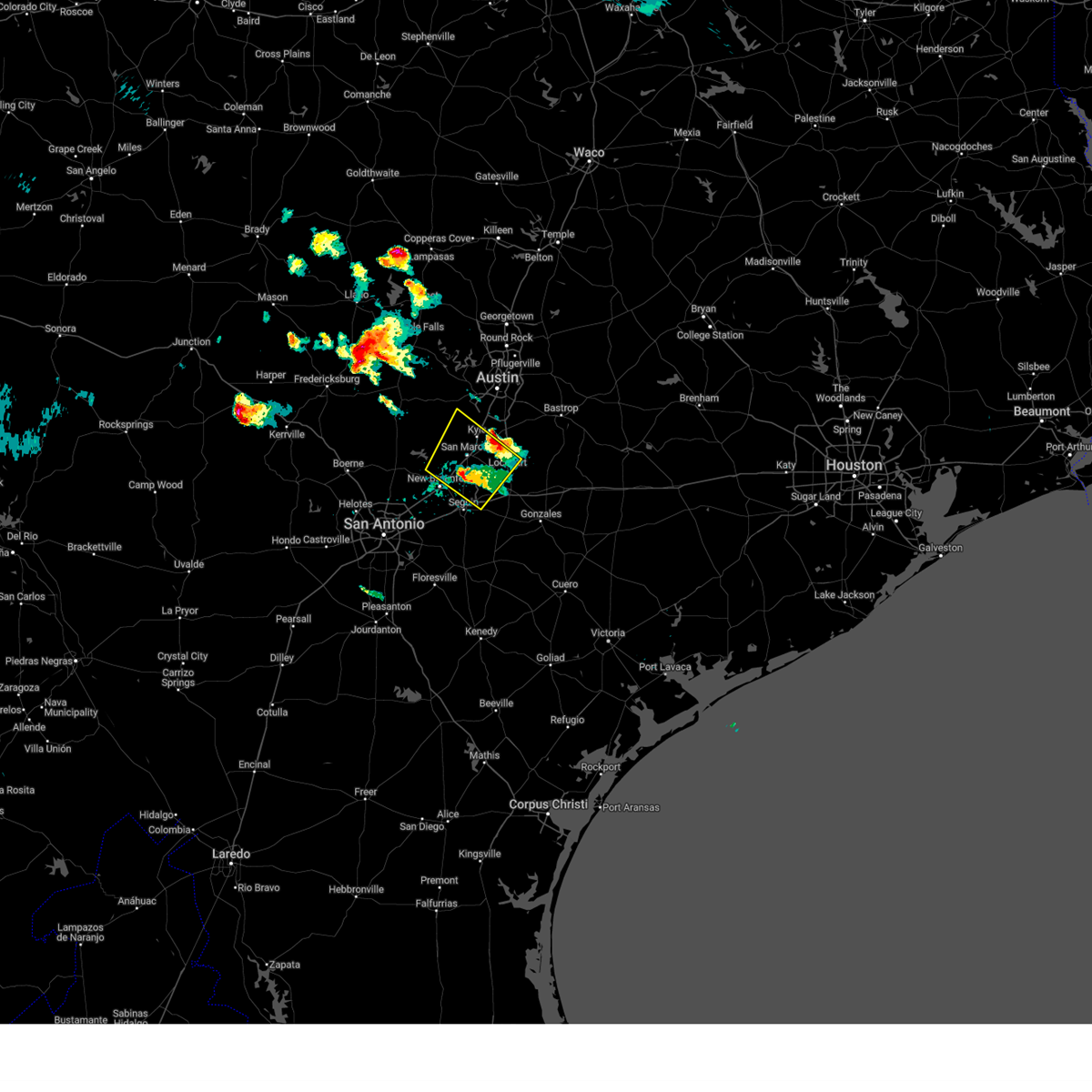
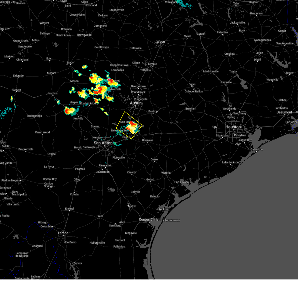
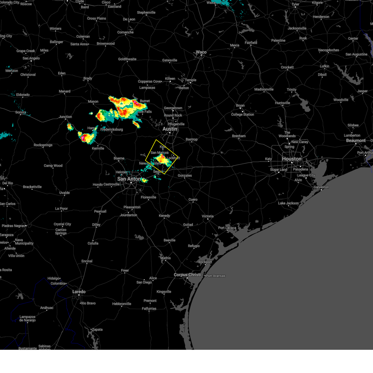
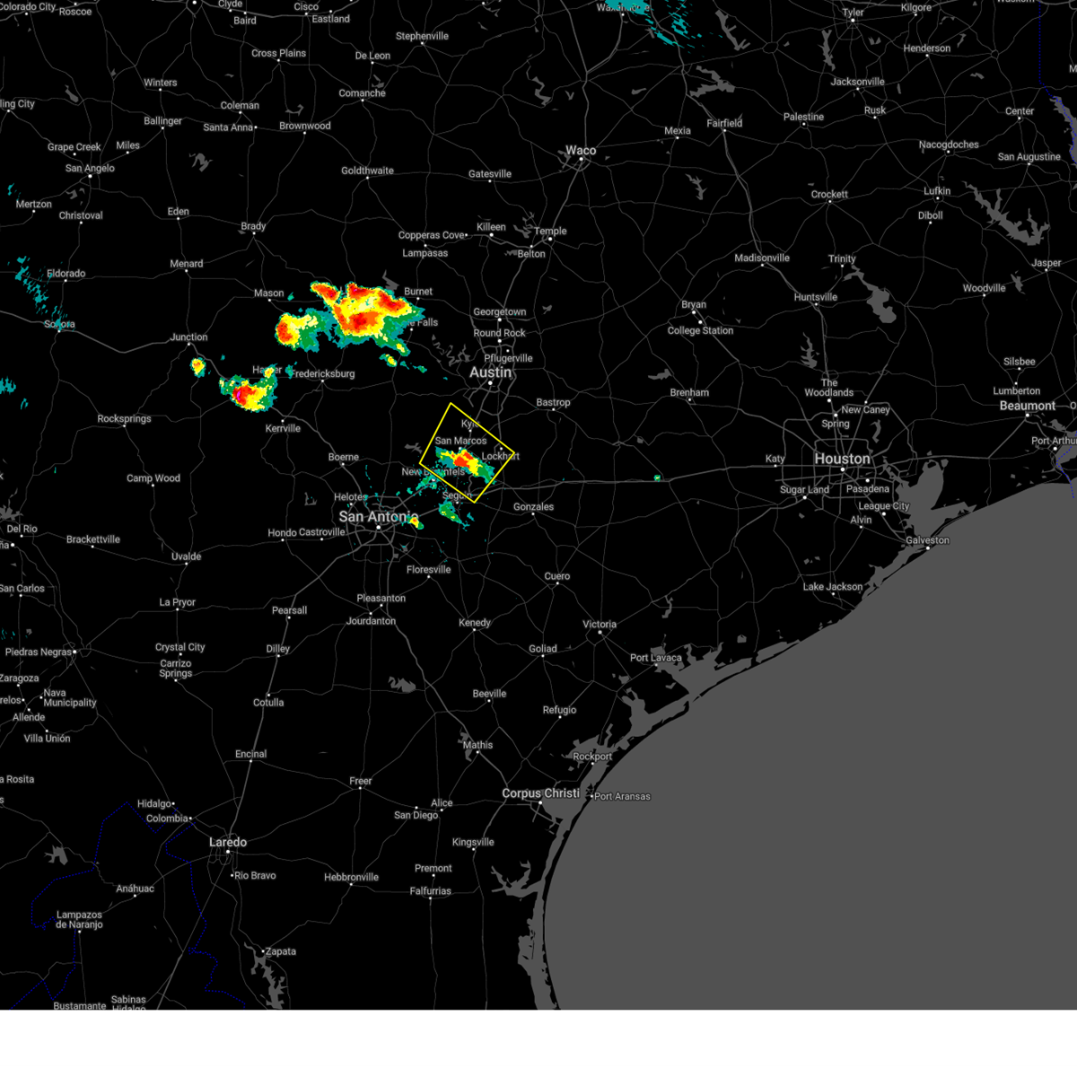
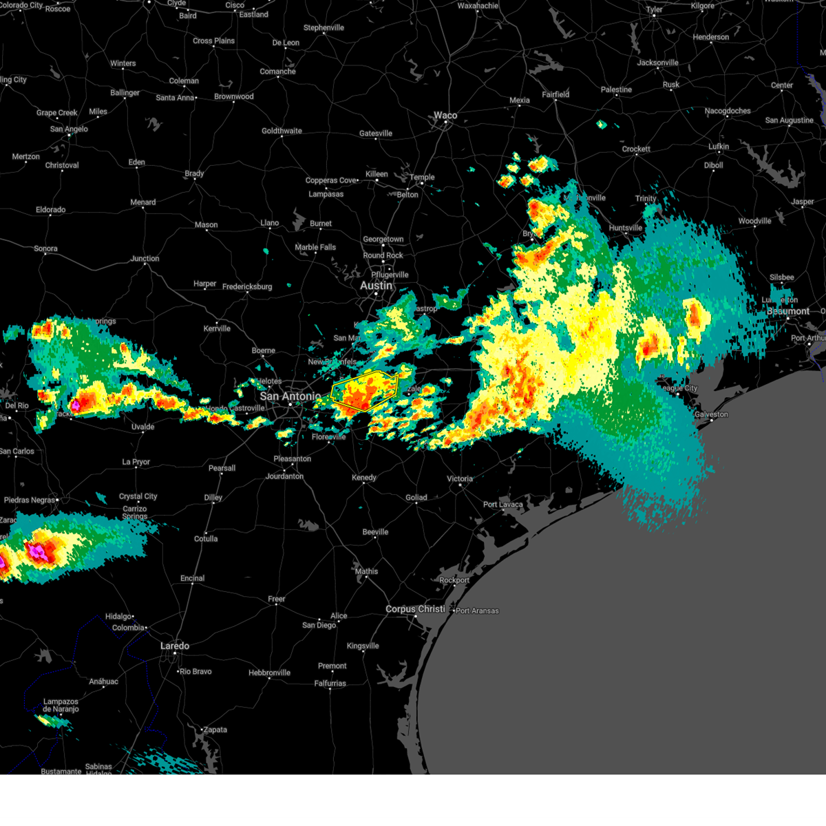
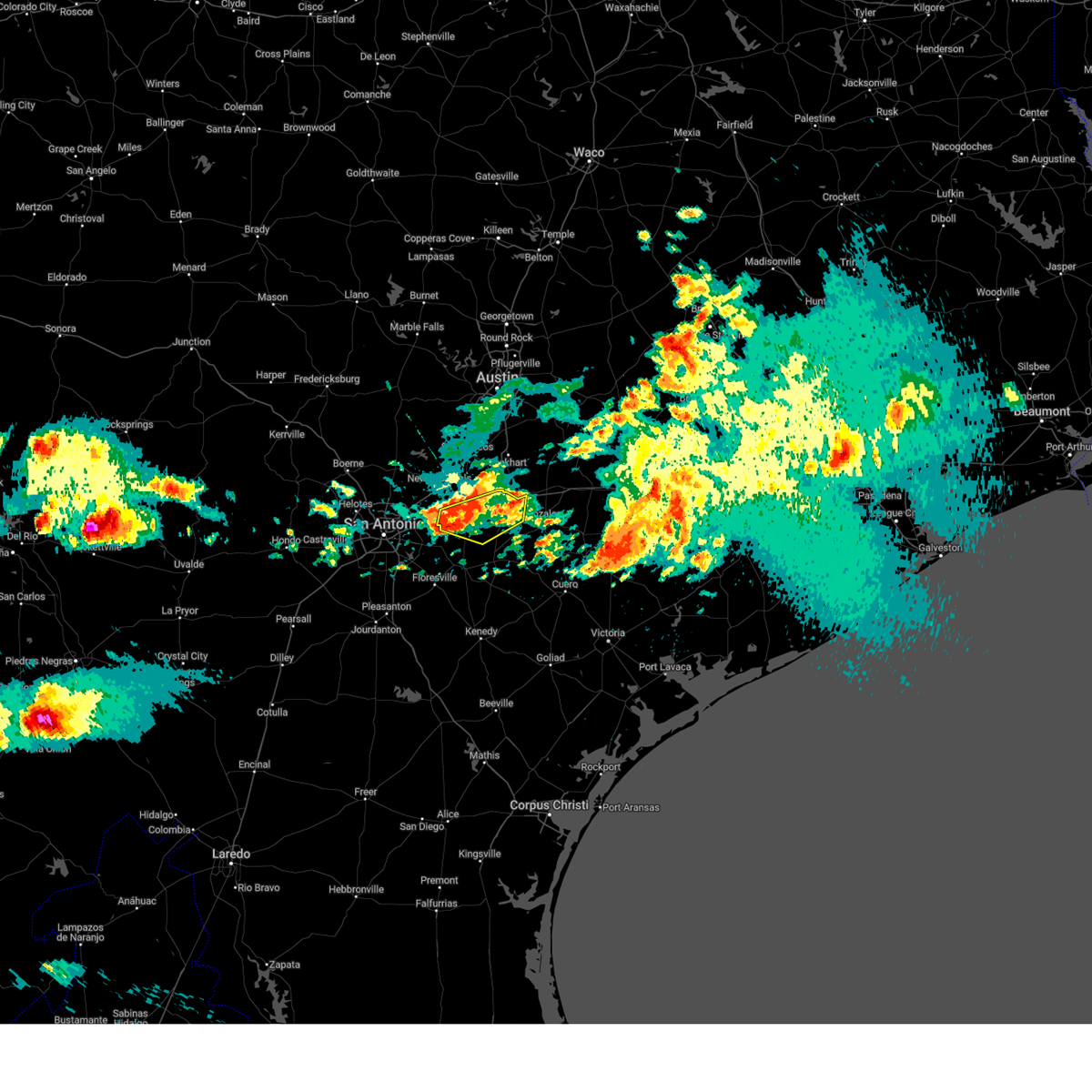
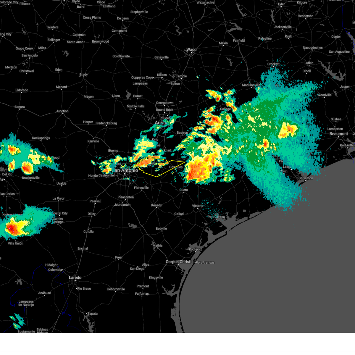
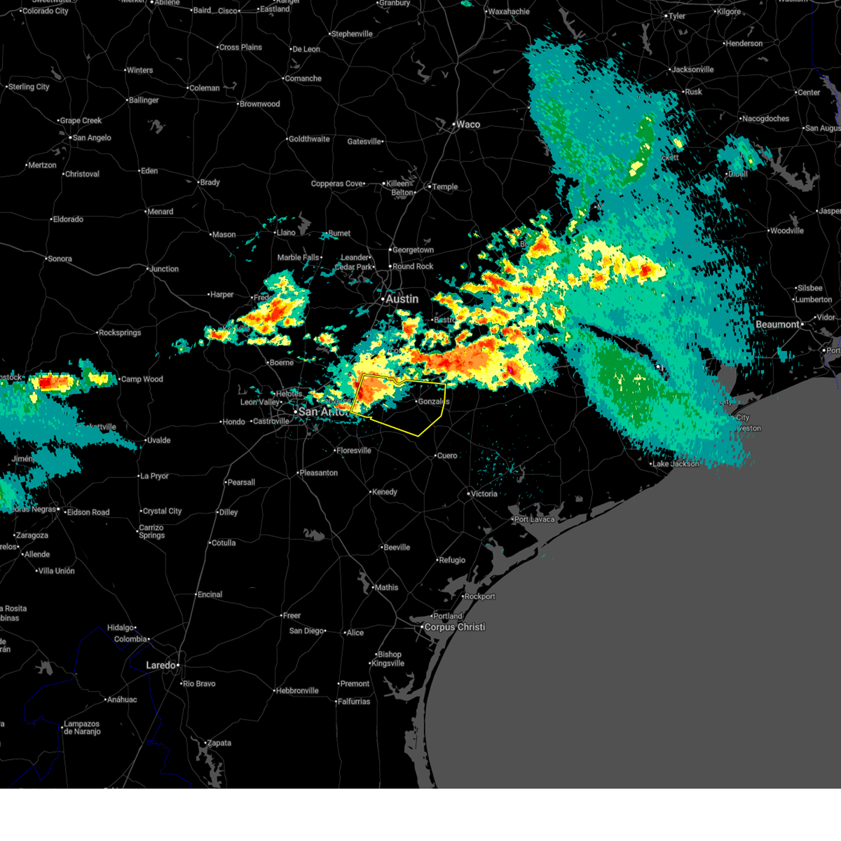
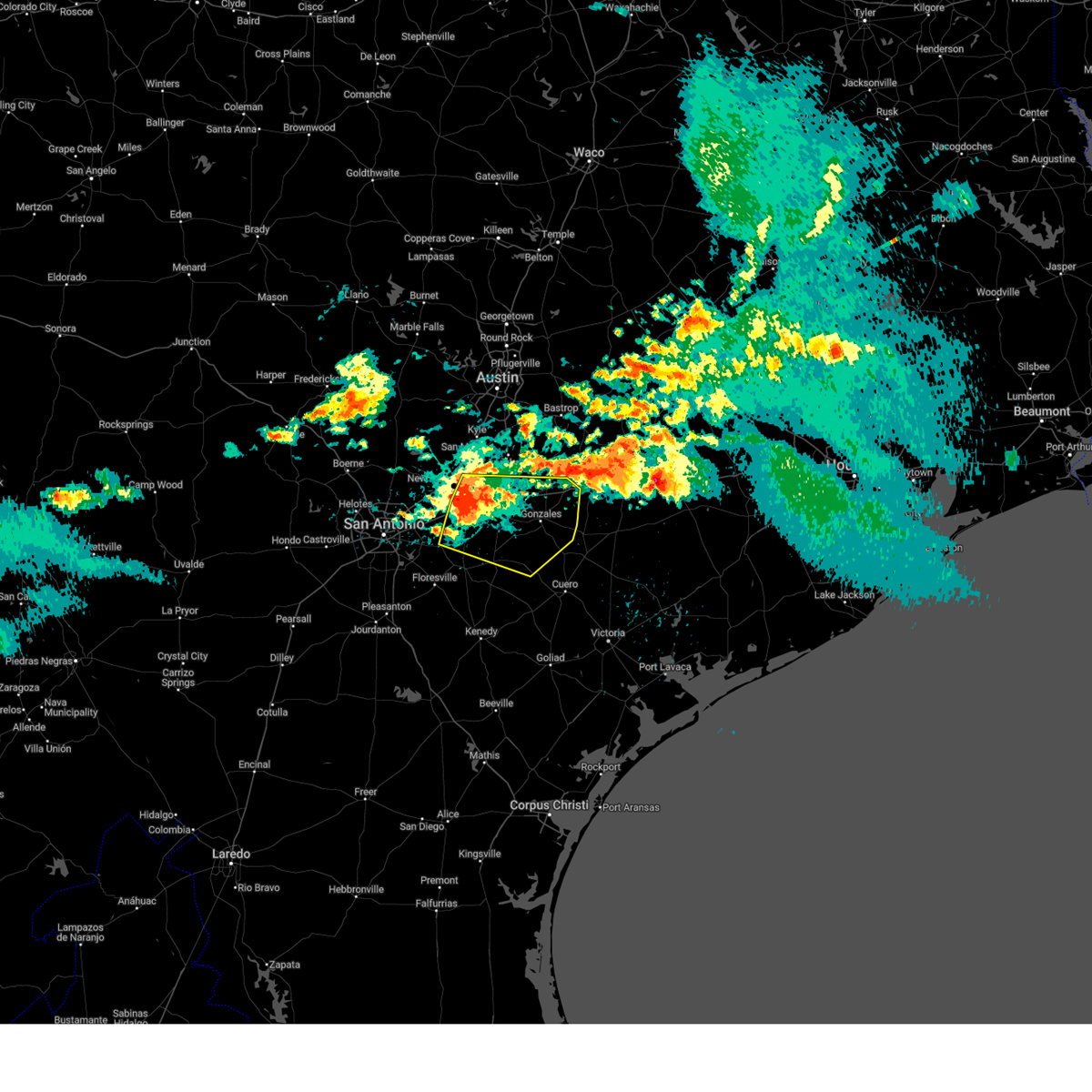
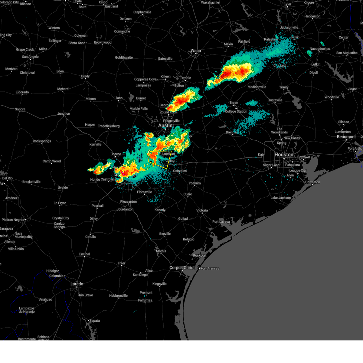
Hail Map for Kingsbury, TX
The Kingsbury, TX area has had 0 reports of on-the-ground hail by trained spotters, and has been under severe weather warnings 14 times during the past 12 months. Doppler radar has detected hail at or near Kingsbury, TX on 64 occasions, including 4 occasions during the past year.
| Name: | Kingsbury, TX |
| Where Located: | 43.4 miles ENE of San Antonio, TX |
| Map: | Google Map for Kingsbury, TX |
| Population: | 782 |
| Housing Units: | 339 |
| More Info: | Search Google for Kingsbury, TX |
2
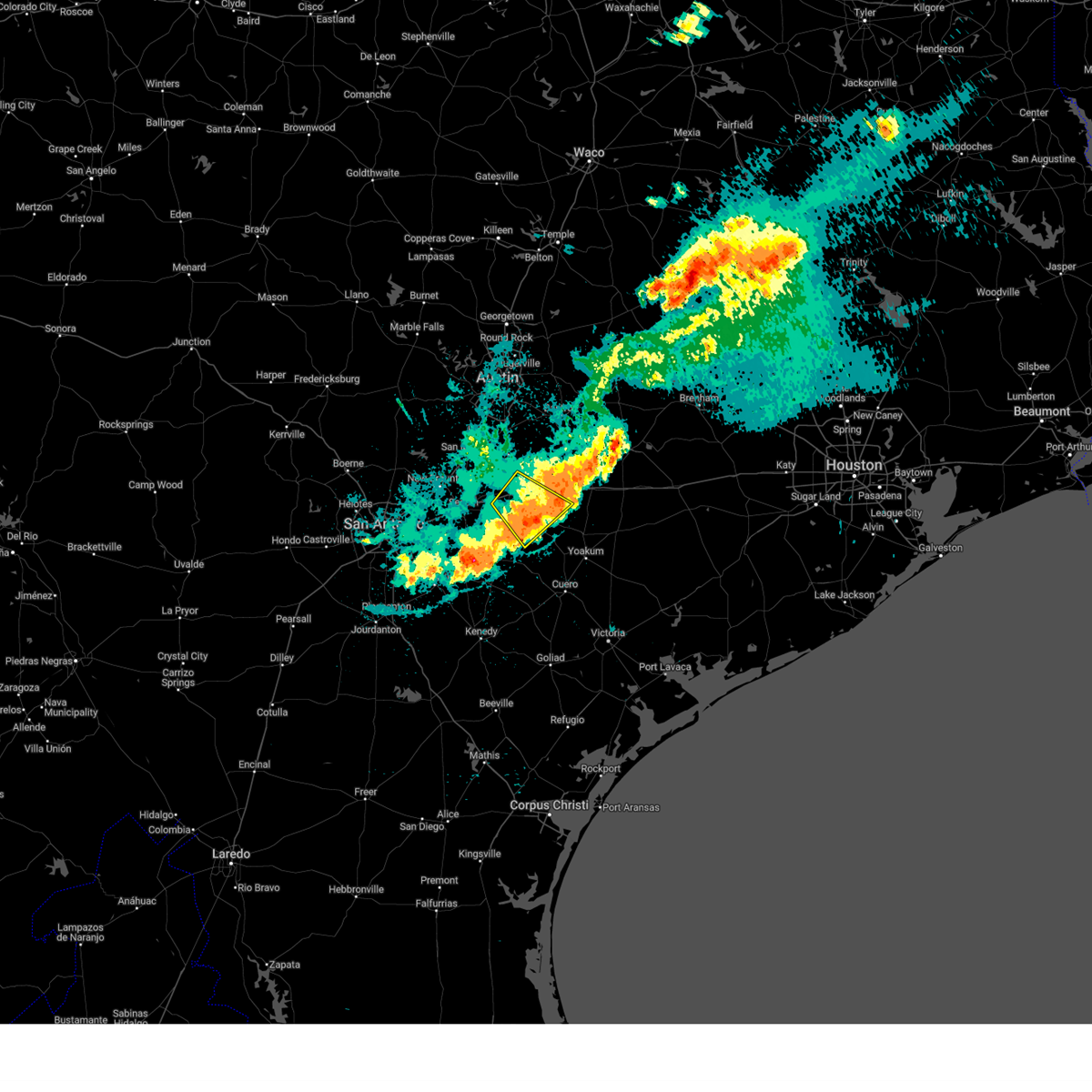
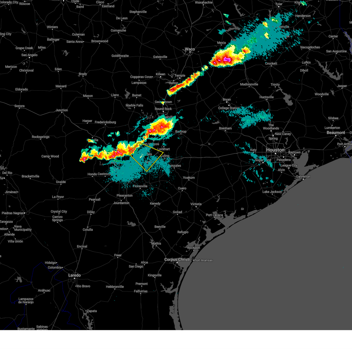
The Top Recent Hail Date for Kingsbury, TX is Thursday, April 30, 2026 (14th out of 64)
Hail and Wind Damage Spotted near Kingsbury, TX
| Date / Time | Report Details |
|---|---|
| 5/26/2026 10:49 PM CDT |
 Svrewx the national weather service in austin san antonio has issued a * severe thunderstorm warning for, southeastern caldwell county in south central texas, north central dewitt county in south central texas, southeastern guadalupe county in south central texas, gonzales county in south central texas, southwestern fayette county in south central texas, northwestern lavaca county in south central texas, * until 1145 pm cdt. * at 1048 pm cdt, severe thunderstorms were located along a line extending from near kingsbury to near smiley, moving east at 35 mph (radar indicated). Hazards include 60 mph wind gusts. expect damage to roofs, siding, and trees Svrewx the national weather service in austin san antonio has issued a * severe thunderstorm warning for, southeastern caldwell county in south central texas, north central dewitt county in south central texas, southeastern guadalupe county in south central texas, gonzales county in south central texas, southwestern fayette county in south central texas, northwestern lavaca county in south central texas, * until 1145 pm cdt. * at 1048 pm cdt, severe thunderstorms were located along a line extending from near kingsbury to near smiley, moving east at 35 mph (radar indicated). Hazards include 60 mph wind gusts. expect damage to roofs, siding, and trees
|
| 5/26/2026 10:24 PM CDT |
 At 1024 pm cdt, a confirmed tornado was located over new berlin, or 8 miles southwest of seguin, moving east at 35 mph (radar confirmed tornado). Hazards include damaging tornado. Flying debris will be dangerous to those caught without shelter. mobile homes will be damaged or destroyed. damage to roofs, windows, and vehicles will occur. tree damage is likely. this tornado will be near, seguin around 1030 pm cdt. Other locations impacted by this tornadic thunderstorm include belmont, zipp, and monthalia. At 1024 pm cdt, a confirmed tornado was located over new berlin, or 8 miles southwest of seguin, moving east at 35 mph (radar confirmed tornado). Hazards include damaging tornado. Flying debris will be dangerous to those caught without shelter. mobile homes will be damaged or destroyed. damage to roofs, windows, and vehicles will occur. tree damage is likely. this tornado will be near, seguin around 1030 pm cdt. Other locations impacted by this tornadic thunderstorm include belmont, zipp, and monthalia.
|
| 5/19/2026 10:15 PM CDT |
 At 1015 pm cdt, severe thunderstorms were located along a line extending from near circle d-kc estates to 7 miles northeast of luling to near new berlin, moving southeast at 35 mph (radar indicated). Hazards include 60 mph wind gusts and quarter size hail. Hail damage to vehicles is expected. expect wind damage to roofs, siding, and trees. Locations impacted include, new braunfels, san marcos, schertz, seguin, cibolo, lockhart, elgin, bastrop, luling, manor, mcqueeney, martindale, marion, kingsbury, santa clara, new berlin, staples, fentress, camp swift, and circle d-kc estates. At 1015 pm cdt, severe thunderstorms were located along a line extending from near circle d-kc estates to 7 miles northeast of luling to near new berlin, moving southeast at 35 mph (radar indicated). Hazards include 60 mph wind gusts and quarter size hail. Hail damage to vehicles is expected. expect wind damage to roofs, siding, and trees. Locations impacted include, new braunfels, san marcos, schertz, seguin, cibolo, lockhart, elgin, bastrop, luling, manor, mcqueeney, martindale, marion, kingsbury, santa clara, new berlin, staples, fentress, camp swift, and circle d-kc estates.
|
| 5/19/2026 9:51 PM CDT |
 At 951 pm cdt, severe thunderstorms were located along a line extending from 6 miles southwest of elgin to near staples to near new braunfels, moving southeast at 30 mph (radar indicated). Hazards include 60 mph wind gusts and quarter size hail. Hail damage to vehicles is expected. expect wind damage to roofs, siding, and trees. Locations impacted include, austin, new braunfels, san marcos, pflugerville, schertz, kyle, seguin, cibolo, buda, lockhart, elgin, bastrop, luling, wimberley, austin bergstrom int airport, canyon lake dam, canyon lake, manor, mcqueeney, and martindale. At 951 pm cdt, severe thunderstorms were located along a line extending from 6 miles southwest of elgin to near staples to near new braunfels, moving southeast at 30 mph (radar indicated). Hazards include 60 mph wind gusts and quarter size hail. Hail damage to vehicles is expected. expect wind damage to roofs, siding, and trees. Locations impacted include, austin, new braunfels, san marcos, pflugerville, schertz, kyle, seguin, cibolo, buda, lockhart, elgin, bastrop, luling, wimberley, austin bergstrom int airport, canyon lake dam, canyon lake, manor, mcqueeney, and martindale.
|
| 5/19/2026 9:26 PM CDT |
 Svrewx the national weather service in austin san antonio has issued a * severe thunderstorm warning for, caldwell county in south central texas, southern hays county in south central texas, guadalupe county in south central texas, southeastern travis county in south central texas, bastrop county in south central texas, northwestern gonzales county in south central texas, eastern comal county in south central texas, * until 1030 pm cdt. * at 925 pm cdt, severe thunderstorms were located along a line extending from near pflugerville to near san marcos to near smithson valley, moving southeast at 30 mph (radar indicated). Hazards include 70 mph wind gusts and quarter size hail. Hail damage to vehicles is expected. expect considerable tree damage. Wind damage is also likely to mobile homes, roofs, and outbuildings. Svrewx the national weather service in austin san antonio has issued a * severe thunderstorm warning for, caldwell county in south central texas, southern hays county in south central texas, guadalupe county in south central texas, southeastern travis county in south central texas, bastrop county in south central texas, northwestern gonzales county in south central texas, eastern comal county in south central texas, * until 1030 pm cdt. * at 925 pm cdt, severe thunderstorms were located along a line extending from near pflugerville to near san marcos to near smithson valley, moving southeast at 30 mph (radar indicated). Hazards include 70 mph wind gusts and quarter size hail. Hail damage to vehicles is expected. expect considerable tree damage. Wind damage is also likely to mobile homes, roofs, and outbuildings.
|
| 5/1/2026 1:22 AM CDT |
 Svrewx the national weather service in austin san antonio has issued a * severe thunderstorm warning for, south central caldwell county in south central texas, southeastern guadalupe county in south central texas, northern gonzales county in south central texas, * until 215 am cdt. * at 122 am cdt, a severe thunderstorm was located near kingsbury, or 7 miles east of seguin, moving east at 40 mph (radar indicated). Hazards include 60 mph wind gusts and quarter size hail. Hail damage to vehicles is expected. Expect wind damage to roofs, siding, and trees. Svrewx the national weather service in austin san antonio has issued a * severe thunderstorm warning for, south central caldwell county in south central texas, southeastern guadalupe county in south central texas, northern gonzales county in south central texas, * until 215 am cdt. * at 122 am cdt, a severe thunderstorm was located near kingsbury, or 7 miles east of seguin, moving east at 40 mph (radar indicated). Hazards include 60 mph wind gusts and quarter size hail. Hail damage to vehicles is expected. Expect wind damage to roofs, siding, and trees.
|
| 3/7/2026 7:47 PM CST |
 the severe thunderstorm warning has been cancelled and is no longer in effect the severe thunderstorm warning has been cancelled and is no longer in effect
|
| 3/7/2026 7:40 PM CST |
 At 740 pm cst, a severe thunderstorm was located near kingsbury, or 8 miles southwest of luling, moving east at 15 mph (radar indicated). Hazards include quarter size hail. Damage to vehicles is expected. this severe storm will be near, kingsbury around 745 pm cst. Luling around 750 pm cst. At 740 pm cst, a severe thunderstorm was located near kingsbury, or 8 miles southwest of luling, moving east at 15 mph (radar indicated). Hazards include quarter size hail. Damage to vehicles is expected. this severe storm will be near, kingsbury around 745 pm cst. Luling around 750 pm cst.
|
| 3/7/2026 7:26 PM CST |
 At 726 pm cst, a severe thunderstorm was located near kingsbury, or 9 miles east of seguin, moving east at 15 mph (radar indicated). Hazards include half dollar size hail. Damage to vehicles is expected. this severe storm will be near, kingsbury around 730 pm cst. Luling around 750 pm cst. At 726 pm cst, a severe thunderstorm was located near kingsbury, or 9 miles east of seguin, moving east at 15 mph (radar indicated). Hazards include half dollar size hail. Damage to vehicles is expected. this severe storm will be near, kingsbury around 730 pm cst. Luling around 750 pm cst.
|
| 3/7/2026 7:14 PM CST |
 At 713 pm cst, a severe thunderstorm was located near seguin, moving northeast at 20 mph (radar indicated). Hazards include quarter size hail. Damage to vehicles is expected. this severe storm will be near, seguin and kingsbury around 720 pm cst. luling around 740 pm cst. Other locations impacted by this severe thunderstorm include zipp. At 713 pm cst, a severe thunderstorm was located near seguin, moving northeast at 20 mph (radar indicated). Hazards include quarter size hail. Damage to vehicles is expected. this severe storm will be near, seguin and kingsbury around 720 pm cst. luling around 740 pm cst. Other locations impacted by this severe thunderstorm include zipp.
|
| 3/7/2026 6:54 PM CST |
 Svrewx the national weather service in austin san antonio has issued a * severe thunderstorm warning for, eastern guadalupe county in south central texas, * until 800 pm cst. * at 654 pm cst, a severe thunderstorm was located over seguin, moving northeast at 20 mph (radar indicated). Hazards include quarter size hail. Damage to vehicles is expected. this severe thunderstorm will be near, seguin around 700 pm cst. kingsbury around 705 pm cst. luling around 740 pm cst. Other locations impacted by this severe thunderstorm include zipp and nolte. Svrewx the national weather service in austin san antonio has issued a * severe thunderstorm warning for, eastern guadalupe county in south central texas, * until 800 pm cst. * at 654 pm cst, a severe thunderstorm was located over seguin, moving northeast at 20 mph (radar indicated). Hazards include quarter size hail. Damage to vehicles is expected. this severe thunderstorm will be near, seguin around 700 pm cst. kingsbury around 705 pm cst. luling around 740 pm cst. Other locations impacted by this severe thunderstorm include zipp and nolte.
|
| 11/20/2025 11:45 PM CST |
 the severe thunderstorm warning has been cancelled and is no longer in effect the severe thunderstorm warning has been cancelled and is no longer in effect
|
| 11/20/2025 11:34 PM CST |
 At 1133 pm cst, a severe thunderstorm was located over seguin, moving east at 10 mph (radar indicated). Hazards include 60 mph wind gusts and nickel size hail. Expect damage to roofs, siding, and trees. Locations impacted include, seguin, mcqueeney, kingsbury, geronimo, nolte, and zipp. At 1133 pm cst, a severe thunderstorm was located over seguin, moving east at 10 mph (radar indicated). Hazards include 60 mph wind gusts and nickel size hail. Expect damage to roofs, siding, and trees. Locations impacted include, seguin, mcqueeney, kingsbury, geronimo, nolte, and zipp.
|
| 11/20/2025 11:23 PM CST |
 Svrewx the national weather service in austin san antonio has issued a * severe thunderstorm warning for, central guadalupe county in south central texas, * until 1230 am cst. * at 1123 pm cst, a severe thunderstorm was located over mcqueeney, or near seguin, moving east at 15 mph (radar indicated). Hazards include quarter size hail. damage to vehicles is expected Svrewx the national weather service in austin san antonio has issued a * severe thunderstorm warning for, central guadalupe county in south central texas, * until 1230 am cst. * at 1123 pm cst, a severe thunderstorm was located over mcqueeney, or near seguin, moving east at 15 mph (radar indicated). Hazards include quarter size hail. damage to vehicles is expected
|
| 5/23/2025 4:26 AM CDT |
 Svrewx the national weather service in austin san antonio has issued a * severe thunderstorm warning for, southern caldwell county in south central texas, northeastern guadalupe county in south central texas, northern gonzales county in south central texas, * until 530 am cdt. * at 425 am cdt, severe thunderstorms were located along a line extending from near fentress to near palmeto state park to 7 miles west of gonzales, moving east at 25 mph (radar indicated). Hazards include 60 mph wind gusts and nickel size hail. expect damage to roofs, siding, and trees Svrewx the national weather service in austin san antonio has issued a * severe thunderstorm warning for, southern caldwell county in south central texas, northeastern guadalupe county in south central texas, northern gonzales county in south central texas, * until 530 am cdt. * at 425 am cdt, severe thunderstorms were located along a line extending from near fentress to near palmeto state park to 7 miles west of gonzales, moving east at 25 mph (radar indicated). Hazards include 60 mph wind gusts and nickel size hail. expect damage to roofs, siding, and trees
|
| 5/22/2025 7:51 PM CDT |
 The storm which prompted the warning has weakened below severe limits, and has exited the warned area. therefore, the warning will be allowed to expire. The storm which prompted the warning has weakened below severe limits, and has exited the warned area. therefore, the warning will be allowed to expire.
|
| 5/22/2025 7:41 PM CDT |
 At 740 pm cdt, a severe thunderstorm was located over zorn, or 8 miles south of san marcos, moving southwest at 5 mph (radar indicated). Hazards include 60 mph wind gusts and quarter size hail. Hail damage to vehicles is expected. expect wind damage to roofs, siding, and trees. Locations impacted include, new braunfels, san marcos, kyle, seguin, lockhart, wimberley, canyon lake, martindale, uhland, kingsbury, niederwald, staples, fentress, geronimo, zorn, mountain city, joliet, maxwell, reedville, and redwood. At 740 pm cdt, a severe thunderstorm was located over zorn, or 8 miles south of san marcos, moving southwest at 5 mph (radar indicated). Hazards include 60 mph wind gusts and quarter size hail. Hail damage to vehicles is expected. expect wind damage to roofs, siding, and trees. Locations impacted include, new braunfels, san marcos, kyle, seguin, lockhart, wimberley, canyon lake, martindale, uhland, kingsbury, niederwald, staples, fentress, geronimo, zorn, mountain city, joliet, maxwell, reedville, and redwood.
|
| 5/22/2025 7:18 PM CDT |
 At 717 pm cdt, severe thunderstorms were located near zorn and near uhland, moving northeast at 15 mph (radar indicated). Hazards include tennis ball size hail and 60 mph wind gusts. People and animals outdoors will be injured. expect hail damage to roofs, siding, windows, and vehicles. expect wind damage to roofs, siding, and trees. Locations impacted include, new braunfels, san marcos, kyle, seguin, lockhart, wimberley, canyon lake, martindale, uhland, kingsbury, niederwald, staples, fentress, geronimo, zorn, mountain city, joliet, maxwell, reedville, and redwood. At 717 pm cdt, severe thunderstorms were located near zorn and near uhland, moving northeast at 15 mph (radar indicated). Hazards include tennis ball size hail and 60 mph wind gusts. People and animals outdoors will be injured. expect hail damage to roofs, siding, windows, and vehicles. expect wind damage to roofs, siding, and trees. Locations impacted include, new braunfels, san marcos, kyle, seguin, lockhart, wimberley, canyon lake, martindale, uhland, kingsbury, niederwald, staples, fentress, geronimo, zorn, mountain city, joliet, maxwell, reedville, and redwood.
|
| 5/22/2025 7:05 PM CDT |
 At 704 pm cdt, severe thunderstorms were located near zorn and near martindale, moving east at 10 mph (radar indicated). Hazards include golf ball size hail and 60 mph wind gusts. People and animals outdoors will be injured. expect hail damage to roofs, siding, windows, and vehicles. expect wind damage to roofs, siding, and trees. Locations impacted include, new braunfels, san marcos, kyle, seguin, lockhart, wimberley, canyon lake, martindale, uhland, kingsbury, niederwald, staples, fentress, geronimo, zorn, mountain city, joliet, maxwell, reedville, and redwood. At 704 pm cdt, severe thunderstorms were located near zorn and near martindale, moving east at 10 mph (radar indicated). Hazards include golf ball size hail and 60 mph wind gusts. People and animals outdoors will be injured. expect hail damage to roofs, siding, windows, and vehicles. expect wind damage to roofs, siding, and trees. Locations impacted include, new braunfels, san marcos, kyle, seguin, lockhart, wimberley, canyon lake, martindale, uhland, kingsbury, niederwald, staples, fentress, geronimo, zorn, mountain city, joliet, maxwell, reedville, and redwood.
|
| 5/22/2025 6:57 PM CDT |
 At 657 pm cdt, a severe thunderstorm was located over san marcos, moving northwest at 5 mph (radar indicated). Hazards include golf ball size hail and 60 mph wind gusts. People and animals outdoors will be injured. expect hail damage to roofs, siding, windows, and vehicles. expect wind damage to roofs, siding, and trees. Locations impacted include, new braunfels, san marcos, kyle, seguin, lockhart, wimberley, canyon lake, martindale, uhland, kingsbury, niederwald, staples, fentress, geronimo, zorn, mountain city, joliet, maxwell, reedville, and redwood. At 657 pm cdt, a severe thunderstorm was located over san marcos, moving northwest at 5 mph (radar indicated). Hazards include golf ball size hail and 60 mph wind gusts. People and animals outdoors will be injured. expect hail damage to roofs, siding, windows, and vehicles. expect wind damage to roofs, siding, and trees. Locations impacted include, new braunfels, san marcos, kyle, seguin, lockhart, wimberley, canyon lake, martindale, uhland, kingsbury, niederwald, staples, fentress, geronimo, zorn, mountain city, joliet, maxwell, reedville, and redwood.
|
| 5/22/2025 6:55 PM CDT |
 Svrewx the national weather service in austin san antonio has issued a * severe thunderstorm warning for, western caldwell county in south central texas, southeastern hays county in south central texas, northeastern guadalupe county in south central texas, east central comal county in south central texas, * until 800 pm cdt. * at 654 pm cdt, a severe thunderstorm was located near san marcos, moving northwest at 5 mph (radar indicated). Hazards include 60 mph wind gusts and quarter size hail. Hail damage to vehicles is expected. Expect wind damage to roofs, siding, and trees. Svrewx the national weather service in austin san antonio has issued a * severe thunderstorm warning for, western caldwell county in south central texas, southeastern hays county in south central texas, northeastern guadalupe county in south central texas, east central comal county in south central texas, * until 800 pm cdt. * at 654 pm cdt, a severe thunderstorm was located near san marcos, moving northwest at 5 mph (radar indicated). Hazards include 60 mph wind gusts and quarter size hail. Hail damage to vehicles is expected. Expect wind damage to roofs, siding, and trees.
|
| 5/2/2025 7:35 PM CDT |
 the severe thunderstorm warning has been cancelled and is no longer in effect the severe thunderstorm warning has been cancelled and is no longer in effect
|
| 5/2/2025 7:20 PM CDT |
 At 720 pm cdt, a severe thunderstorm was located near new berlin, or 8 miles south of seguin, moving east at 35 mph (radar indicated). Hazards include ping pong ball size hail and 60 mph wind gusts. People and animals outdoors will be injured. expect hail damage to roofs, siding, windows, and vehicles. expect wind damage to roofs, siding, and trees. Locations impacted include, seguin, cibolo, luling, mcqueeney, kingsbury, new berlin, palmeto state park, zuehl, nolte, zipp, oak forest, belmont, ottine, and leesville. At 720 pm cdt, a severe thunderstorm was located near new berlin, or 8 miles south of seguin, moving east at 35 mph (radar indicated). Hazards include ping pong ball size hail and 60 mph wind gusts. People and animals outdoors will be injured. expect hail damage to roofs, siding, windows, and vehicles. expect wind damage to roofs, siding, and trees. Locations impacted include, seguin, cibolo, luling, mcqueeney, kingsbury, new berlin, palmeto state park, zuehl, nolte, zipp, oak forest, belmont, ottine, and leesville.
|
| 5/2/2025 7:05 PM CDT |
 Svrewx the national weather service in austin san antonio has issued a * severe thunderstorm warning for, guadalupe county in south central texas, northern gonzales county in south central texas, * until 800 pm cdt. * at 705 pm cdt, severe thunderstorms were located along a line extending from geronimo to cibolo, moving east at 25 mph (radar indicated). Hazards include 60 mph wind gusts and quarter size hail. Hail damage to vehicles is expected. Expect wind damage to roofs, siding, and trees. Svrewx the national weather service in austin san antonio has issued a * severe thunderstorm warning for, guadalupe county in south central texas, northern gonzales county in south central texas, * until 800 pm cdt. * at 705 pm cdt, severe thunderstorms were located along a line extending from geronimo to cibolo, moving east at 25 mph (radar indicated). Hazards include 60 mph wind gusts and quarter size hail. Hail damage to vehicles is expected. Expect wind damage to roofs, siding, and trees.
|
| 5/2/2025 5:41 PM CDT |
 At 541 pm cdt, severe thunderstorms were located along a line extending from near fentress to 11 miles south of kingsbury to 9 miles north of pandora, moving east at 35 mph (radar indicated). Hazards include 70 mph wind gusts and half dollar size hail. Hail damage to vehicles is expected. expect considerable tree damage. wind damage is also likely to mobile homes, roofs, and outbuildings. Locations impacted include, seguin, gonzales, luling, kingsbury, palmeto state park, cheapside, geronimo, leesville, oak forest, glaze city, belmont, nickle, wrightsboro, cost, dilworth, dreyer, little new york, ottine, hamon, and bebe. At 541 pm cdt, severe thunderstorms were located along a line extending from near fentress to 11 miles south of kingsbury to 9 miles north of pandora, moving east at 35 mph (radar indicated). Hazards include 70 mph wind gusts and half dollar size hail. Hail damage to vehicles is expected. expect considerable tree damage. wind damage is also likely to mobile homes, roofs, and outbuildings. Locations impacted include, seguin, gonzales, luling, kingsbury, palmeto state park, cheapside, geronimo, leesville, oak forest, glaze city, belmont, nickle, wrightsboro, cost, dilworth, dreyer, little new york, ottine, hamon, and bebe.
|
| 5/2/2025 5:41 PM CDT |
 the severe thunderstorm warning has been cancelled and is no longer in effect the severe thunderstorm warning has been cancelled and is no longer in effect
|
| 5/2/2025 5:31 PM CDT |
 At 531 pm cdt, severe thunderstorms were located along a line extending from near staples to 7 miles southeast of seguin to 7 miles northeast of la vernia, moving east at 30 mph (radar indicated). Hazards include 70 mph wind gusts and half dollar size hail. Hail damage to vehicles is expected. expect considerable tree damage. wind damage is also likely to mobile homes, roofs, and outbuildings. Locations impacted include, seguin, gonzales, luling, mcqueeney, nixon, waelder, kingsbury, smiley, new berlin, staples, fentress, cheapside, palmeto state park, geronimo, zorn, leesville, oak forest, belmont, cost, and mcneil. At 531 pm cdt, severe thunderstorms were located along a line extending from near staples to 7 miles southeast of seguin to 7 miles northeast of la vernia, moving east at 30 mph (radar indicated). Hazards include 70 mph wind gusts and half dollar size hail. Hail damage to vehicles is expected. expect considerable tree damage. wind damage is also likely to mobile homes, roofs, and outbuildings. Locations impacted include, seguin, gonzales, luling, mcqueeney, nixon, waelder, kingsbury, smiley, new berlin, staples, fentress, cheapside, palmeto state park, geronimo, zorn, leesville, oak forest, belmont, cost, and mcneil.
|
| 5/2/2025 5:26 PM CDT |
 Svrewx the national weather service in austin san antonio has issued a * severe thunderstorm warning for, southern caldwell county in south central texas, guadalupe county in south central texas, gonzales county in south central texas, northeastern wilson county in south central texas, * until 630 pm cdt. * at 526 pm cdt, severe thunderstorms were located along a line extending from near zorn to near seguin to 6 miles northeast of la vernia, moving east at 30 mph (radar indicated). Hazards include 60 mph wind gusts and half dollar size hail. Hail damage to vehicles is expected. Expect wind damage to roofs, siding, and trees. Svrewx the national weather service in austin san antonio has issued a * severe thunderstorm warning for, southern caldwell county in south central texas, guadalupe county in south central texas, gonzales county in south central texas, northeastern wilson county in south central texas, * until 630 pm cdt. * at 526 pm cdt, severe thunderstorms were located along a line extending from near zorn to near seguin to 6 miles northeast of la vernia, moving east at 30 mph (radar indicated). Hazards include 60 mph wind gusts and half dollar size hail. Hail damage to vehicles is expected. Expect wind damage to roofs, siding, and trees.
|
| 3/23/2025 11:47 PM CDT |
 the severe thunderstorm warning has been cancelled and is no longer in effect the severe thunderstorm warning has been cancelled and is no longer in effect
|
| 3/23/2025 11:15 PM CDT |
 Svrewx the national weather service in austin san antonio has issued a * severe thunderstorm warning for, south central caldwell county in south central texas, east central guadalupe county in south central texas, central gonzales county in south central texas, * until midnight cdt. * at 1115 pm cdt, a severe thunderstorm was located over luling, moving southeast at 20 mph (radar indicated). Hazards include 60 mph wind gusts and half dollar size hail. Hail damage to vehicles is expected. Expect wind damage to roofs, siding, and trees. Svrewx the national weather service in austin san antonio has issued a * severe thunderstorm warning for, south central caldwell county in south central texas, east central guadalupe county in south central texas, central gonzales county in south central texas, * until midnight cdt. * at 1115 pm cdt, a severe thunderstorm was located over luling, moving southeast at 20 mph (radar indicated). Hazards include 60 mph wind gusts and half dollar size hail. Hail damage to vehicles is expected. Expect wind damage to roofs, siding, and trees.
|
| 3/23/2025 10:58 PM CDT |
 Svrewx the national weather service in austin san antonio has issued a * severe thunderstorm warning for, southwestern caldwell county in south central texas, northeastern guadalupe county in south central texas, northern gonzales county in south central texas, * until 1145 pm cdt. * at 1057 pm cdt, a severe thunderstorm was located over fentress, or 7 miles northwest of luling, moving east at 15 mph (radar indicated). Hazards include golf ball size hail and 60 mph wind gusts. People and animals outdoors will be injured. expect hail damage to roofs, siding, windows, and vehicles. Expect wind damage to roofs, siding, and trees. Svrewx the national weather service in austin san antonio has issued a * severe thunderstorm warning for, southwestern caldwell county in south central texas, northeastern guadalupe county in south central texas, northern gonzales county in south central texas, * until 1145 pm cdt. * at 1057 pm cdt, a severe thunderstorm was located over fentress, or 7 miles northwest of luling, moving east at 15 mph (radar indicated). Hazards include golf ball size hail and 60 mph wind gusts. People and animals outdoors will be injured. expect hail damage to roofs, siding, windows, and vehicles. Expect wind damage to roofs, siding, and trees.
|
| 3/23/2025 10:52 PM CDT |
 At 1051 pm cdt, a severe thunderstorm was located over staples, or 8 miles southeast of san marcos, moving east at 25 mph (radar indicated). Hazards include ping pong ball size hail and 60 mph wind gusts. People and animals outdoors will be injured. expect hail damage to roofs, siding, windows, and vehicles. expect wind damage to roofs, siding, and trees. Locations impacted include, san marcos, seguin, lockhart, luling, martindale, kingsbury, staples, fentress, joliet, stairtown, maxwell, reedville, and redwood. At 1051 pm cdt, a severe thunderstorm was located over staples, or 8 miles southeast of san marcos, moving east at 25 mph (radar indicated). Hazards include ping pong ball size hail and 60 mph wind gusts. People and animals outdoors will be injured. expect hail damage to roofs, siding, windows, and vehicles. expect wind damage to roofs, siding, and trees. Locations impacted include, san marcos, seguin, lockhart, luling, martindale, kingsbury, staples, fentress, joliet, stairtown, maxwell, reedville, and redwood.
|
| 3/23/2025 10:52 PM CDT |
 the severe thunderstorm warning has been cancelled and is no longer in effect the severe thunderstorm warning has been cancelled and is no longer in effect
|
| 3/23/2025 10:34 PM CDT |
 Svrewx the national weather service in austin san antonio has issued a * severe thunderstorm warning for, southwestern caldwell county in south central texas, south central hays county in south central texas, northeastern guadalupe county in south central texas, east central comal county in south central texas, * until 1115 pm cdt. * at 1034 pm cdt, a severe thunderstorm was located over zorn, or near san marcos, moving east at 25 mph (radar indicated). Hazards include 60 mph wind gusts and quarter size hail. Hail damage to vehicles is expected. Expect wind damage to roofs, siding, and trees. Svrewx the national weather service in austin san antonio has issued a * severe thunderstorm warning for, southwestern caldwell county in south central texas, south central hays county in south central texas, northeastern guadalupe county in south central texas, east central comal county in south central texas, * until 1115 pm cdt. * at 1034 pm cdt, a severe thunderstorm was located over zorn, or near san marcos, moving east at 25 mph (radar indicated). Hazards include 60 mph wind gusts and quarter size hail. Hail damage to vehicles is expected. Expect wind damage to roofs, siding, and trees.
|
| 3/23/2025 10:00 PM CDT |
 Svrewx the national weather service in austin san antonio has issued a * severe thunderstorm warning for, southwestern caldwell county in south central texas, southwestern hays county in south central texas, central guadalupe county in south central texas, eastern comal county in south central texas, * until 1045 pm cdt. * at 1000 pm cdt, a severe thunderstorm was located near new braunfels, moving southeast at 40 mph (radar indicated). Hazards include 60 mph wind gusts and quarter size hail. Hail damage to vehicles is expected. Expect wind damage to roofs, siding, and trees. Svrewx the national weather service in austin san antonio has issued a * severe thunderstorm warning for, southwestern caldwell county in south central texas, southwestern hays county in south central texas, central guadalupe county in south central texas, eastern comal county in south central texas, * until 1045 pm cdt. * at 1000 pm cdt, a severe thunderstorm was located near new braunfels, moving southeast at 40 mph (radar indicated). Hazards include 60 mph wind gusts and quarter size hail. Hail damage to vehicles is expected. Expect wind damage to roofs, siding, and trees.
|
| 7/9/2024 4:47 PM CDT |
 the severe thunderstorm warning has been cancelled and is no longer in effect the severe thunderstorm warning has been cancelled and is no longer in effect
|
| 7/9/2024 4:18 PM CDT |
 Svrewx the national weather service in austin san antonio has issued a * severe thunderstorm warning for, southwestern caldwell county in south central texas, northeastern guadalupe county in south central texas, * until 515 pm cdt. * at 417 pm cdt, a severe thunderstorm was located near zorn, or 9 miles south of san marcos, moving east at 15 mph (radar indicated). Hazards include 60 mph wind gusts and quarter size hail. Hail damage to vehicles is expected. Expect wind damage to roofs, siding, and trees. Svrewx the national weather service in austin san antonio has issued a * severe thunderstorm warning for, southwestern caldwell county in south central texas, northeastern guadalupe county in south central texas, * until 515 pm cdt. * at 417 pm cdt, a severe thunderstorm was located near zorn, or 9 miles south of san marcos, moving east at 15 mph (radar indicated). Hazards include 60 mph wind gusts and quarter size hail. Hail damage to vehicles is expected. Expect wind damage to roofs, siding, and trees.
|
| 5/9/2024 9:11 PM CDT |
 Svrewx the national weather service in austin san antonio has issued a * severe thunderstorm warning for, southern caldwell county in south central texas, northwestern dewitt county in south central texas, southeastern guadalupe county in south central texas, northeastern karnes county in south central texas, gonzales county in south central texas, northwestern lavaca county in south central texas, northeastern wilson county in south central texas, * until 1015 pm cdt. * at 911 pm cdt, a severe thunderstorm was located near luling, moving southeast at 40 mph (radar indicated). Hazards include two inch hail and 60 mph wind gusts. People and animals outdoors will be injured. expect hail damage to roofs, siding, windows, and vehicles. Expect wind damage to roofs, siding, and trees. Svrewx the national weather service in austin san antonio has issued a * severe thunderstorm warning for, southern caldwell county in south central texas, northwestern dewitt county in south central texas, southeastern guadalupe county in south central texas, northeastern karnes county in south central texas, gonzales county in south central texas, northwestern lavaca county in south central texas, northeastern wilson county in south central texas, * until 1015 pm cdt. * at 911 pm cdt, a severe thunderstorm was located near luling, moving southeast at 40 mph (radar indicated). Hazards include two inch hail and 60 mph wind gusts. People and animals outdoors will be injured. expect hail damage to roofs, siding, windows, and vehicles. Expect wind damage to roofs, siding, and trees.
|
| 5/9/2024 9:00 PM CDT | Roof of metal outbuilding was blown off by thunderstorm wind in guadalupe county TX, 5.5 miles S of Kingsbury, TX |
| 5/9/2024 8:56 PM CDT |
 At 855 pm cdt, a severe thunderstorm was located near fentress, or near lockhart, moving southeast at 35 mph (radar indicated). Hazards include tennis ball size hail and 70 mph wind gusts. People and animals outdoors will be injured. expect hail damage to roofs, siding, windows, and vehicles. expect considerable tree damage. wind damage is also likely to mobile homes, roofs, and outbuildings. Locations impacted include, lockhart, luling, martindale, kingsbury, niederwald, staples, fentress, palmeto state park, brownsboro, delhi, joliet, tilmon, stairtown, oak forest, belmont, maxwell, mcneil, redwood, mcmahan, and thompsonville. At 855 pm cdt, a severe thunderstorm was located near fentress, or near lockhart, moving southeast at 35 mph (radar indicated). Hazards include tennis ball size hail and 70 mph wind gusts. People and animals outdoors will be injured. expect hail damage to roofs, siding, windows, and vehicles. expect considerable tree damage. wind damage is also likely to mobile homes, roofs, and outbuildings. Locations impacted include, lockhart, luling, martindale, kingsbury, niederwald, staples, fentress, palmeto state park, brownsboro, delhi, joliet, tilmon, stairtown, oak forest, belmont, maxwell, mcneil, redwood, mcmahan, and thompsonville.
|
| 5/9/2024 8:56 PM CDT |
 the severe thunderstorm warning has been cancelled and is no longer in effect the severe thunderstorm warning has been cancelled and is no longer in effect
|
| 5/9/2024 8:36 PM CDT |
 Svrewx the national weather service in austin san antonio has issued a * severe thunderstorm warning for, caldwell county in south central texas, southeastern hays county in south central texas, northeastern guadalupe county in south central texas, northwestern gonzales county in south central texas, * until 930 pm cdt. * at 836 pm cdt, a severe thunderstorm was located near san marcos, moving southeast at 35 mph (radar indicated). Hazards include tennis ball size hail and 70 mph wind gusts. People and animals outdoors will be injured. expect hail damage to roofs, siding, windows, and vehicles. expect considerable tree damage. Wind damage is also likely to mobile homes, roofs, and outbuildings. Svrewx the national weather service in austin san antonio has issued a * severe thunderstorm warning for, caldwell county in south central texas, southeastern hays county in south central texas, northeastern guadalupe county in south central texas, northwestern gonzales county in south central texas, * until 930 pm cdt. * at 836 pm cdt, a severe thunderstorm was located near san marcos, moving southeast at 35 mph (radar indicated). Hazards include tennis ball size hail and 70 mph wind gusts. People and animals outdoors will be injured. expect hail damage to roofs, siding, windows, and vehicles. expect considerable tree damage. Wind damage is also likely to mobile homes, roofs, and outbuildings.
|
| 4/28/2024 8:04 AM CDT |
 At 804 am cdt, severe thunderstorms were located along a line extending from near lakeway to near shady hollow to san marcos to mcqueeney, moving east at 25 mph (radar indicated). Hazards include 60 mph wind gusts and nickel size hail. Expect damage to roofs, siding, and trees. Locations impacted include, austin, new braunfels, san marcos, kyle, seguin, buda, lockhart, luling, dripping springs, wimberley, tanglewood forest, austin bergstrom int airport, lakeway, bee cave, west lake hills, hudson bend, the hills, mcqueeney, rollingwood, and martindale. At 804 am cdt, severe thunderstorms were located along a line extending from near lakeway to near shady hollow to san marcos to mcqueeney, moving east at 25 mph (radar indicated). Hazards include 60 mph wind gusts and nickel size hail. Expect damage to roofs, siding, and trees. Locations impacted include, austin, new braunfels, san marcos, kyle, seguin, buda, lockhart, luling, dripping springs, wimberley, tanglewood forest, austin bergstrom int airport, lakeway, bee cave, west lake hills, hudson bend, the hills, mcqueeney, rollingwood, and martindale.
|
| 4/28/2024 7:52 AM CDT |
 Svrewx the national weather service in austin san antonio has issued a * severe thunderstorm warning for, western caldwell county in south central texas, hays county in south central texas, northeastern guadalupe county in south central texas, central travis county in south central texas, eastern comal county in south central texas, * until 845 am cdt. * at 751 am cdt, severe thunderstorms were located along a line extending from 6 miles west of lakeway to near san marcos to marion, moving east at 25 mph (radar indicated). Hazards include 60 mph wind gusts and nickel size hail. expect damage to roofs, siding, and trees Svrewx the national weather service in austin san antonio has issued a * severe thunderstorm warning for, western caldwell county in south central texas, hays county in south central texas, northeastern guadalupe county in south central texas, central travis county in south central texas, eastern comal county in south central texas, * until 845 am cdt. * at 751 am cdt, severe thunderstorms were located along a line extending from 6 miles west of lakeway to near san marcos to marion, moving east at 25 mph (radar indicated). Hazards include 60 mph wind gusts and nickel size hail. expect damage to roofs, siding, and trees
|
| 4/21/2024 1:00 AM CDT |
 The storms which prompted the warning have weakened below severe limits, and no longer pose an immediate threat to life or property. therefore, the warning has been allowed to expire. however small hail, gusty winds and heavy rain are still possible with these thunderstorms. The storms which prompted the warning have weakened below severe limits, and no longer pose an immediate threat to life or property. therefore, the warning has been allowed to expire. however small hail, gusty winds and heavy rain are still possible with these thunderstorms.
|
| 4/21/2024 12:43 AM CDT |
 At 1243 am cdt, severe thunderstorms were located along a line extending from near zorn to near garden ridge, moving east at 45 mph (radar indicated). Hazards include quarter size hail. Damage to vehicles is expected. Locations impacted include, new braunfels, san marcos, schertz, seguin, canyon lake dam, canyon lake, bulverde, garden ridge, kingsbury, staples, geronimo, zorn, smithson valley, hunter, startzville, sattler, redwood, freiheit, solms, and gruene. At 1243 am cdt, severe thunderstorms were located along a line extending from near zorn to near garden ridge, moving east at 45 mph (radar indicated). Hazards include quarter size hail. Damage to vehicles is expected. Locations impacted include, new braunfels, san marcos, schertz, seguin, canyon lake dam, canyon lake, bulverde, garden ridge, kingsbury, staples, geronimo, zorn, smithson valley, hunter, startzville, sattler, redwood, freiheit, solms, and gruene.
|
| 4/21/2024 12:43 AM CDT |
 the severe thunderstorm warning has been cancelled and is no longer in effect the severe thunderstorm warning has been cancelled and is no longer in effect
|
| 4/21/2024 12:32 AM CDT |
 At 1231 am cdt, severe thunderstorms were located along a line extending from near new braunfels to near timberwood park, moving east at 30 mph (radar indicated). Hazards include ping pong ball size hail. People and animals outdoors will be injured. expect damage to roofs, siding, windows, and vehicles. Locations impacted include, san antonio, new braunfels, san marcos, schertz, seguin, cibolo, selma, canyon lake dam, canyon lake, fair oaks ranch, bulverde, garden ridge, shavano park, hollywood park, cross mountain, kingsbury, santa clara, staples, smithson valley, and the dominion. At 1231 am cdt, severe thunderstorms were located along a line extending from near new braunfels to near timberwood park, moving east at 30 mph (radar indicated). Hazards include ping pong ball size hail. People and animals outdoors will be injured. expect damage to roofs, siding, windows, and vehicles. Locations impacted include, san antonio, new braunfels, san marcos, schertz, seguin, cibolo, selma, canyon lake dam, canyon lake, fair oaks ranch, bulverde, garden ridge, shavano park, hollywood park, cross mountain, kingsbury, santa clara, staples, smithson valley, and the dominion.
|
| 4/21/2024 12:30 AM CDT |
 At 1229 am cdt, severe thunderstorms were located along a line extending from 6 miles northwest of new braunfels to timberwood park, moving east at 30 mph (radar indicated). Hazards include quarter size hail. Damage to vehicles is expected. Locations impacted include, san antonio, new braunfels, san marcos, schertz, seguin, cibolo, selma, canyon lake dam, canyon lake, fair oaks ranch, bulverde, garden ridge, shavano park, hollywood park, cross mountain, kingsbury, santa clara, staples, smithson valley, and the dominion. At 1229 am cdt, severe thunderstorms were located along a line extending from 6 miles northwest of new braunfels to timberwood park, moving east at 30 mph (radar indicated). Hazards include quarter size hail. Damage to vehicles is expected. Locations impacted include, san antonio, new braunfels, san marcos, schertz, seguin, cibolo, selma, canyon lake dam, canyon lake, fair oaks ranch, bulverde, garden ridge, shavano park, hollywood park, cross mountain, kingsbury, santa clara, staples, smithson valley, and the dominion.
|
| 4/21/2024 12:17 AM CDT |
 Svrewx the national weather service in austin san antonio has issued a * severe thunderstorm warning for, south central hays county in south central texas, northern guadalupe county in south central texas, north central bexar county in south central texas, comal county in south central texas, * until 100 am cdt. * at 1217 am cdt, severe thunderstorms were located along a line extending from near garden ridge to near the dominion, moving east at 45 mph (radar indicated). Hazards include quarter size hail. damage to vehicles is expected Svrewx the national weather service in austin san antonio has issued a * severe thunderstorm warning for, south central hays county in south central texas, northern guadalupe county in south central texas, north central bexar county in south central texas, comal county in south central texas, * until 100 am cdt. * at 1217 am cdt, severe thunderstorms were located along a line extending from near garden ridge to near the dominion, moving east at 45 mph (radar indicated). Hazards include quarter size hail. damage to vehicles is expected
|
| 4/9/2024 11:55 PM CDT |
 At 1155 pm cdt, severe thunderstorms were located along a line extending from near lockhart to 7 miles southwest of palmeto state park, moving northeast at 35 mph (radar indicated). Hazards include 60 mph wind gusts and nickel size hail. Expect damage to roofs, siding, and trees. Locations impacted include, lockhart, gonzales, luling, waelder, kingsbury, staples, fentress, palmeto state park, brownsboro, delhi, joliet, tilmon, stairtown, oak forest, belmont, mcneil, mcmahan, thompsonville, ottine, and monthalia. At 1155 pm cdt, severe thunderstorms were located along a line extending from near lockhart to 7 miles southwest of palmeto state park, moving northeast at 35 mph (radar indicated). Hazards include 60 mph wind gusts and nickel size hail. Expect damage to roofs, siding, and trees. Locations impacted include, lockhart, gonzales, luling, waelder, kingsbury, staples, fentress, palmeto state park, brownsboro, delhi, joliet, tilmon, stairtown, oak forest, belmont, mcneil, mcmahan, thompsonville, ottine, and monthalia.
|
| 4/9/2024 11:40 PM CDT |
 Svrewx the national weather service in austin san antonio has issued a * severe thunderstorm warning for, caldwell county in south central texas, eastern guadalupe county in south central texas, northern gonzales county in south central texas, * until 1230 am cdt. * at 1140 pm cdt, severe thunderstorms were located along a line extending from fentress to 12 miles south of kingsbury, moving northeast at 40 mph (radar indicated). Hazards include ping pong ball size hail and 60 mph wind gusts. People and animals outdoors will be injured. expect hail damage to roofs, siding, windows, and vehicles. Expect wind damage to roofs, siding, and trees. Svrewx the national weather service in austin san antonio has issued a * severe thunderstorm warning for, caldwell county in south central texas, eastern guadalupe county in south central texas, northern gonzales county in south central texas, * until 1230 am cdt. * at 1140 pm cdt, severe thunderstorms were located along a line extending from fentress to 12 miles south of kingsbury, moving northeast at 40 mph (radar indicated). Hazards include ping pong ball size hail and 60 mph wind gusts. People and animals outdoors will be injured. expect hail damage to roofs, siding, windows, and vehicles. Expect wind damage to roofs, siding, and trees.
|
| 4/9/2024 11:25 PM CDT |
 the severe thunderstorm warning has been cancelled and is no longer in effect the severe thunderstorm warning has been cancelled and is no longer in effect
|
| 4/9/2024 11:25 PM CDT |
 At 1125 pm cdt, severe thunderstorms were located along a line extending from geronimo to 11 miles east of new berlin, moving east at 30 mph (radar indicated). Hazards include ping pong ball size hail and 60 mph wind gusts. People and animals outdoors will be injured. expect hail damage to roofs, siding, windows, and vehicles. expect wind damage to roofs, siding, and trees. Locations impacted include, new braunfels, schertz, seguin, cibolo, luling, mcqueeney, marion, kingsbury, santa clara, new berlin, staples, geronimo, zorn, fentress, zuehl, nolte, zipp, new braunfels national airport, and redwood. At 1125 pm cdt, severe thunderstorms were located along a line extending from geronimo to 11 miles east of new berlin, moving east at 30 mph (radar indicated). Hazards include ping pong ball size hail and 60 mph wind gusts. People and animals outdoors will be injured. expect hail damage to roofs, siding, windows, and vehicles. expect wind damage to roofs, siding, and trees. Locations impacted include, new braunfels, schertz, seguin, cibolo, luling, mcqueeney, marion, kingsbury, santa clara, new berlin, staples, geronimo, zorn, fentress, zuehl, nolte, zipp, new braunfels national airport, and redwood.
|
| 4/9/2024 11:21 PM CDT |
 the severe thunderstorm warning has been cancelled and is no longer in effect the severe thunderstorm warning has been cancelled and is no longer in effect
|
| 4/9/2024 11:21 PM CDT |
 At 1120 pm cdt, a severe thunderstorm was located over mcqueeney, or near new braunfels, moving northeast at 30 mph (radar indicated). Hazards include 60 mph wind gusts and quarter size hail. Hail damage to vehicles is expected. expect wind damage to roofs, siding, and trees. Locations impacted include, new braunfels, schertz, seguin, cibolo, universal city, selma, luling, garden ridge, mcqueeney, marion, kingsbury, santa clara, new berlin, staples, zuehl, geronimo, zorn, fentress, redwood, and freiheit. At 1120 pm cdt, a severe thunderstorm was located over mcqueeney, or near new braunfels, moving northeast at 30 mph (radar indicated). Hazards include 60 mph wind gusts and quarter size hail. Hail damage to vehicles is expected. expect wind damage to roofs, siding, and trees. Locations impacted include, new braunfels, schertz, seguin, cibolo, universal city, selma, luling, garden ridge, mcqueeney, marion, kingsbury, santa clara, new berlin, staples, zuehl, geronimo, zorn, fentress, redwood, and freiheit.
|
| 4/9/2024 10:58 PM CDT |
 Svrewx the national weather service in austin san antonio has issued a * severe thunderstorm warning for, guadalupe county in south central texas, northwestern wilson county in south central texas, northeastern bexar county in south central texas, southeastern comal county in south central texas, * until 1145 pm cdt. * at 1058 pm cdt, a severe thunderstorm was located over schertz, moving northeast at 30 mph (radar indicated). Hazards include 60 mph wind gusts and quarter size hail. Hail damage to vehicles is expected. Expect wind damage to roofs, siding, and trees. Svrewx the national weather service in austin san antonio has issued a * severe thunderstorm warning for, guadalupe county in south central texas, northwestern wilson county in south central texas, northeastern bexar county in south central texas, southeastern comal county in south central texas, * until 1145 pm cdt. * at 1058 pm cdt, a severe thunderstorm was located over schertz, moving northeast at 30 mph (radar indicated). Hazards include 60 mph wind gusts and quarter size hail. Hail damage to vehicles is expected. Expect wind damage to roofs, siding, and trees.
|
| 1/8/2024 1:56 PM CST |
 At 155 pm cst, a severe thunderstorm was located 7 miles southwest of palmeto state park, or 10 miles south of luling, moving east at 40 mph (radar indicated). Hazards include two inch hail and 60 mph wind gusts. People and animals outdoors will be injured. expect hail damage to roofs, siding, windows, and vehicles. expect wind damage to roofs, siding, and trees. locations impacted include, gonzales, luling, waelder, kingsbury, staples, fentress, palmeto state park, brownsboro, delhi, leesville, joliet, oak forest, belmont, mcneil, cost, dilworth, thompsonville, ottine, monthalia, and tilmon. thunderstorm damage threat, considerable hail threat, radar indicated max hail size, 2. 00 in wind threat, radar indicated max wind gust, 60 mph. At 155 pm cst, a severe thunderstorm was located 7 miles southwest of palmeto state park, or 10 miles south of luling, moving east at 40 mph (radar indicated). Hazards include two inch hail and 60 mph wind gusts. People and animals outdoors will be injured. expect hail damage to roofs, siding, windows, and vehicles. expect wind damage to roofs, siding, and trees. locations impacted include, gonzales, luling, waelder, kingsbury, staples, fentress, palmeto state park, brownsboro, delhi, leesville, joliet, oak forest, belmont, mcneil, cost, dilworth, thompsonville, ottine, monthalia, and tilmon. thunderstorm damage threat, considerable hail threat, radar indicated max hail size, 2. 00 in wind threat, radar indicated max wind gust, 60 mph.
|
| 1/8/2024 1:51 PM CST |
 At 150 pm cst, a severe thunderstorm was located 10 miles southeast of kingsbury, or 12 miles southwest of luling, moving east at 40 mph (radar indicated). Hazards include ping pong ball size hail and 60 mph wind gusts. People and animals outdoors will be injured. expect hail damage to roofs, siding, windows, and vehicles. expect wind damage to roofs, siding, and trees. locations impacted include, seguin, gonzales, luling, waelder, kingsbury, staples, fentress, palmeto state park, brownsboro, delhi, leesville, joliet, oak forest, belmont, mcneil, cost, dilworth, thompsonville, ottine, and monthalia. hail threat, radar indicated max hail size, 1. 50 in wind threat, radar indicated max wind gust, 60 mph. At 150 pm cst, a severe thunderstorm was located 10 miles southeast of kingsbury, or 12 miles southwest of luling, moving east at 40 mph (radar indicated). Hazards include ping pong ball size hail and 60 mph wind gusts. People and animals outdoors will be injured. expect hail damage to roofs, siding, windows, and vehicles. expect wind damage to roofs, siding, and trees. locations impacted include, seguin, gonzales, luling, waelder, kingsbury, staples, fentress, palmeto state park, brownsboro, delhi, leesville, joliet, oak forest, belmont, mcneil, cost, dilworth, thompsonville, ottine, and monthalia. hail threat, radar indicated max hail size, 1. 50 in wind threat, radar indicated max wind gust, 60 mph.
|
| 1/8/2024 1:43 PM CST |
 At 142 pm cst, a severe thunderstorm was located 10 miles southeast of seguin, moving east at 40 mph (radar indicated). Hazards include 60 mph wind gusts and quarter size hail. Hail damage to vehicles is expected. Expect wind damage to roofs, siding, and trees. At 142 pm cst, a severe thunderstorm was located 10 miles southeast of seguin, moving east at 40 mph (radar indicated). Hazards include 60 mph wind gusts and quarter size hail. Hail damage to vehicles is expected. Expect wind damage to roofs, siding, and trees.
|
| 10/5/2023 5:56 AM CDT |
 At 556 am cdt, a severe thunderstorm was located over zorn, or 7 miles south of san marcos, moving east at 35 mph (radar indicated). Hazards include 60 mph wind gusts. Expect damage to roofs, siding, and trees. locations impacted include, new braunfels, san marcos, seguin, martindale, kingsbury, staples, fentress, geronimo, zorn, hunter, joliet, stairtown, redwood, freiheit, gruene, and new braunfels national airport. hail threat, radar indicated max hail size, <. 75 in wind threat, radar indicated max wind gust, 60 mph. At 556 am cdt, a severe thunderstorm was located over zorn, or 7 miles south of san marcos, moving east at 35 mph (radar indicated). Hazards include 60 mph wind gusts. Expect damage to roofs, siding, and trees. locations impacted include, new braunfels, san marcos, seguin, martindale, kingsbury, staples, fentress, geronimo, zorn, hunter, joliet, stairtown, redwood, freiheit, gruene, and new braunfels national airport. hail threat, radar indicated max hail size, <. 75 in wind threat, radar indicated max wind gust, 60 mph.
|
| 10/5/2023 5:38 AM CDT |
 At 538 am cdt, a severe thunderstorm was located near canyon lake dam, moving east at 35 mph (radar indicated). Hazards include 60 mph wind gusts. expect damage to roofs, siding, and trees At 538 am cdt, a severe thunderstorm was located near canyon lake dam, moving east at 35 mph (radar indicated). Hazards include 60 mph wind gusts. expect damage to roofs, siding, and trees
|
| 8/22/2023 2:49 PM CDT |
 At 249 pm cdt, severe thunderstorms were located along a line extending from near geronimo to 7 miles south of seguin, moving west at 45 mph (radar indicated). Hazards include 60 mph wind gusts. expect damage to roofs, siding, and trees At 249 pm cdt, severe thunderstorms were located along a line extending from near geronimo to 7 miles south of seguin, moving west at 45 mph (radar indicated). Hazards include 60 mph wind gusts. expect damage to roofs, siding, and trees
|
| 6/8/2023 3:24 PM CDT |
 At 324 pm cdt, a severe thunderstorm was located near kingsbury, or 9 miles southwest of luling, moving east at 25 mph (radar indicated). Hazards include 60 mph wind gusts and quarter size hail. Hail damage to vehicles is expected. expect wind damage to roofs, siding, and trees. locations impacted include, gonzales, luling, kingsbury, palmeto state park, oak forest, ottine, belmont, cost, mcneil and monthalia. hail threat, radar indicated max hail size, 1. 00 in wind threat, radar indicated max wind gust, 60 mph. At 324 pm cdt, a severe thunderstorm was located near kingsbury, or 9 miles southwest of luling, moving east at 25 mph (radar indicated). Hazards include 60 mph wind gusts and quarter size hail. Hail damage to vehicles is expected. expect wind damage to roofs, siding, and trees. locations impacted include, gonzales, luling, kingsbury, palmeto state park, oak forest, ottine, belmont, cost, mcneil and monthalia. hail threat, radar indicated max hail size, 1. 00 in wind threat, radar indicated max wind gust, 60 mph.
|
| 6/8/2023 3:09 PM CDT |
 At 309 pm cdt, a severe thunderstorm was located near kingsbury, or 7 miles east of seguin, moving east at 25 mph (radar indicated). Hazards include 60 mph wind gusts and quarter size hail. Hail damage to vehicles is expected. Expect wind damage to roofs, siding, and trees. At 309 pm cdt, a severe thunderstorm was located near kingsbury, or 7 miles east of seguin, moving east at 25 mph (radar indicated). Hazards include 60 mph wind gusts and quarter size hail. Hail damage to vehicles is expected. Expect wind damage to roofs, siding, and trees.
|
| 6/3/2023 12:34 AM CDT |
 At 1234 am cdt, severe thunderstorms were located along a line extending from near canyon lake dam to near mcqueeney to 8 miles northeast of leming, moving east at 45 mph (radar indicated). Hazards include 60 mph wind gusts. Expect damage to roofs, siding, and trees. locations impacted include, san antonio, new braunfels, san marcos, schertz, kyle, seguin, cibolo, universal city, live oak, selma, floresville, wimberley, randolph afb, canyon lake dam, stinson municipal airport, canyon lake, garden ridge, mcqueeney, st. hedwig and elmendorf. hail threat, radar indicated max hail size, <. 75 in wind threat, radar indicated max wind gust, 60 mph. At 1234 am cdt, severe thunderstorms were located along a line extending from near canyon lake dam to near mcqueeney to 8 miles northeast of leming, moving east at 45 mph (radar indicated). Hazards include 60 mph wind gusts. Expect damage to roofs, siding, and trees. locations impacted include, san antonio, new braunfels, san marcos, schertz, kyle, seguin, cibolo, universal city, live oak, selma, floresville, wimberley, randolph afb, canyon lake dam, stinson municipal airport, canyon lake, garden ridge, mcqueeney, st. hedwig and elmendorf. hail threat, radar indicated max hail size, <. 75 in wind threat, radar indicated max wind gust, 60 mph.
|
| 6/3/2023 12:14 AM CDT |
 At 1213 am cdt, severe thunderstorms were located along a line extending from near twin sisters to garden ridge to somerset, moving east at 45 mph (radar indicated). Hazards include 60 mph wind gusts and penny size hail. Expect damage to roofs, siding, and trees. locations impacted include, san antonio, new braunfels, san marcos, schertz, kyle, seguin, cibolo, universal city, live oak, buda, selma, floresville, wimberley, san antonio int airport, randolph afb, canyon lake dam, stinson municipal airport, canyon lake, leon valley and helotes. hail threat, radar indicated max hail size, 0. 75 in wind threat, radar indicated max wind gust, 60 mph. At 1213 am cdt, severe thunderstorms were located along a line extending from near twin sisters to garden ridge to somerset, moving east at 45 mph (radar indicated). Hazards include 60 mph wind gusts and penny size hail. Expect damage to roofs, siding, and trees. locations impacted include, san antonio, new braunfels, san marcos, schertz, kyle, seguin, cibolo, universal city, live oak, buda, selma, floresville, wimberley, san antonio int airport, randolph afb, canyon lake dam, stinson municipal airport, canyon lake, leon valley and helotes. hail threat, radar indicated max hail size, 0. 75 in wind threat, radar indicated max wind gust, 60 mph.
|
| 6/2/2023 11:53 PM CDT |
 At 1153 pm cdt, severe thunderstorms were located along a line extending from near kendalia to timberwood park to pearson, moving east at 45 mph (radar indicated). Hazards include 60 mph wind gusts and penny size hail. expect damage to roofs, siding, and trees At 1153 pm cdt, severe thunderstorms were located along a line extending from near kendalia to timberwood park to pearson, moving east at 45 mph (radar indicated). Hazards include 60 mph wind gusts and penny size hail. expect damage to roofs, siding, and trees
|
| 4/21/2023 12:17 AM CDT |
 At 1217 am cdt, severe thunderstorms were located along a line extending from near luling to near palmeto state park to 7 miles north of pandora, moving southeast at 35 mph (radar indicated). Hazards include 60 mph wind gusts and half dollar size hail. Hail damage to vehicles is expected. expect wind damage to roofs, siding, and trees. locations impacted include, gonzales, luling, nixon, kingsbury, smiley, fentress, palmeto state park, leesville, joliet, oak forest, stairtown, sample, belmont, wrightsboro, cost, mcneil, thompsonville, ottine, hamon and bebe. hail threat, radar indicated max hail size, 1. 25 in wind threat, radar indicated max wind gust, 60 mph. At 1217 am cdt, severe thunderstorms were located along a line extending from near luling to near palmeto state park to 7 miles north of pandora, moving southeast at 35 mph (radar indicated). Hazards include 60 mph wind gusts and half dollar size hail. Hail damage to vehicles is expected. expect wind damage to roofs, siding, and trees. locations impacted include, gonzales, luling, nixon, kingsbury, smiley, fentress, palmeto state park, leesville, joliet, oak forest, stairtown, sample, belmont, wrightsboro, cost, mcneil, thompsonville, ottine, hamon and bebe. hail threat, radar indicated max hail size, 1. 25 in wind threat, radar indicated max wind gust, 60 mph.
|
| 4/21/2023 12:02 AM CDT |
 At 1202 am cdt, severe thunderstorms were located along a line extending from near staples to near kingsbury to 9 miles southeast of new berlin, moving southeast at 25 mph (radar indicated). Hazards include golf ball size hail and 70 mph wind gusts. People and animals outdoors will be injured. expect hail damage to roofs, siding, windows, and vehicles. expect considerable tree damage. wind damage is also likely to mobile homes, roofs, and outbuildings. locations impacted include, san marcos, seguin, gonzales, luling, nixon, martindale, kingsbury, smiley, staples, fentress, palmeto state park, zorn, geronimo, brownsboro, leesville, joliet, oak forest, belmont, cost and mcneil. thunderstorm damage threat, considerable hail threat, radar indicated max hail size, 1. 75 in wind threat, radar indicated max wind gust, 70 mph. At 1202 am cdt, severe thunderstorms were located along a line extending from near staples to near kingsbury to 9 miles southeast of new berlin, moving southeast at 25 mph (radar indicated). Hazards include golf ball size hail and 70 mph wind gusts. People and animals outdoors will be injured. expect hail damage to roofs, siding, windows, and vehicles. expect considerable tree damage. wind damage is also likely to mobile homes, roofs, and outbuildings. locations impacted include, san marcos, seguin, gonzales, luling, nixon, martindale, kingsbury, smiley, staples, fentress, palmeto state park, zorn, geronimo, brownsboro, leesville, joliet, oak forest, belmont, cost and mcneil. thunderstorm damage threat, considerable hail threat, radar indicated max hail size, 1. 75 in wind threat, radar indicated max wind gust, 70 mph.
|
| 4/20/2023 11:53 PM CDT |
 At 1153 pm cdt, severe thunderstorms were located along a line extending from near san marcos to kingsbury to near new berlin, moving southeast at 30 mph (radar indicated). Hazards include 70 mph wind gusts and ping pong ball size hail. People and animals outdoors will be injured. expect hail damage to roofs, siding, windows, and vehicles. expect considerable tree damage. wind damage is also likely to mobile homes, roofs, and outbuildings. locations impacted include, san marcos, seguin, gonzales, luling, nixon, martindale, kingsbury, smiley, staples, fentress, palmeto state park, zorn, geronimo, brownsboro, leesville, joliet, oak forest, belmont, cost and mcneil. thunderstorm damage threat, considerable hail threat, radar indicated max hail size, 1. 50 in wind threat, radar indicated max wind gust, 70 mph. At 1153 pm cdt, severe thunderstorms were located along a line extending from near san marcos to kingsbury to near new berlin, moving southeast at 30 mph (radar indicated). Hazards include 70 mph wind gusts and ping pong ball size hail. People and animals outdoors will be injured. expect hail damage to roofs, siding, windows, and vehicles. expect considerable tree damage. wind damage is also likely to mobile homes, roofs, and outbuildings. locations impacted include, san marcos, seguin, gonzales, luling, nixon, martindale, kingsbury, smiley, staples, fentress, palmeto state park, zorn, geronimo, brownsboro, leesville, joliet, oak forest, belmont, cost and mcneil. thunderstorm damage threat, considerable hail threat, radar indicated max hail size, 1. 50 in wind threat, radar indicated max wind gust, 70 mph.
|
| 4/20/2023 11:43 PM CDT |
 At 1143 pm cdt, severe thunderstorms were located along a line extending from near san marcos to kingsbury to near new berlin, moving southeast at 30 mph (radar indicated). Hazards include 60 mph wind gusts and nickel size hail. expect damage to roofs, siding, and trees At 1143 pm cdt, severe thunderstorms were located along a line extending from near san marcos to kingsbury to near new berlin, moving southeast at 30 mph (radar indicated). Hazards include 60 mph wind gusts and nickel size hail. expect damage to roofs, siding, and trees
|
| 4/20/2023 11:34 PM CDT |
 At 1134 pm cdt, severe thunderstorms were located along a line extending from near san marcos to near geronimo to near marion, moving southeast at 35 mph (radar indicated). Hazards include 70 mph wind gusts and quarter size hail. Hail damage to vehicles is expected. expect considerable tree damage. wind damage is also likely to mobile homes, roofs, and outbuildings. these severe storms will be near, kingsbury around 1145 pm cdt. martindale around 1150 pm cdt. staples around 1155 pm cdt. lockhart and fentress around 1205 am cdt. other locations impacted by these severe thunderstorms include hunter, freiheit, san marcos regional airport, maxwell, reedville, new braunfels national airport and redwood. thunderstorm damage threat, considerable hail threat, radar indicated max hail size, 1. 00 in wind threat, radar indicated max wind gust, 70 mph. At 1134 pm cdt, severe thunderstorms were located along a line extending from near san marcos to near geronimo to near marion, moving southeast at 35 mph (radar indicated). Hazards include 70 mph wind gusts and quarter size hail. Hail damage to vehicles is expected. expect considerable tree damage. wind damage is also likely to mobile homes, roofs, and outbuildings. these severe storms will be near, kingsbury around 1145 pm cdt. martindale around 1150 pm cdt. staples around 1155 pm cdt. lockhart and fentress around 1205 am cdt. other locations impacted by these severe thunderstorms include hunter, freiheit, san marcos regional airport, maxwell, reedville, new braunfels national airport and redwood. thunderstorm damage threat, considerable hail threat, radar indicated max hail size, 1. 00 in wind threat, radar indicated max wind gust, 70 mph.
|
| 4/20/2023 11:17 PM CDT |
 At 1117 pm cdt, severe thunderstorms were located along a line extending from near wimberley to near new braunfels to near garden ridge, moving east at 30 mph (radar indicated). Hazards include 60 mph wind gusts and quarter size hail. Hail damage to vehicles is expected. expect wind damage to roofs, siding, and trees. these severe storms will be near, zorn around 1130 pm cdt. san marcos, kyle and staples around 1140 pm cdt. martindale around 1145 pm cdt. seguin, uhland, kingsbury, niederwald and fentress around 1150 pm cdt. geronimo around 1155 pm cdt. lockhart around 1205 am cdt. other locations impacted by these severe thunderstorms include hunter, freiheit, san marcos regional airport, gruene, maxwell, reedville, new braunfels national airport and redwood. hail threat, radar indicated max hail size, 1. 00 in wind threat, radar indicated max wind gust, 60 mph. At 1117 pm cdt, severe thunderstorms were located along a line extending from near wimberley to near new braunfels to near garden ridge, moving east at 30 mph (radar indicated). Hazards include 60 mph wind gusts and quarter size hail. Hail damage to vehicles is expected. expect wind damage to roofs, siding, and trees. these severe storms will be near, zorn around 1130 pm cdt. san marcos, kyle and staples around 1140 pm cdt. martindale around 1145 pm cdt. seguin, uhland, kingsbury, niederwald and fentress around 1150 pm cdt. geronimo around 1155 pm cdt. lockhart around 1205 am cdt. other locations impacted by these severe thunderstorms include hunter, freiheit, san marcos regional airport, gruene, maxwell, reedville, new braunfels national airport and redwood. hail threat, radar indicated max hail size, 1. 00 in wind threat, radar indicated max wind gust, 60 mph.
|
| 4/20/2023 11:08 PM CDT |
 At 1108 pm cdt, severe thunderstorms were located along a line extending from near woodcreek to near canyon lake dam to near smithson valley, moving east at 30 mph (radar indicated). Hazards include 60 mph wind gusts and quarter size hail. Hail damage to vehicles is expected. expect wind damage to roofs, siding, and trees. these severe storms will be near, wimberley around 1115 pm cdt. new braunfels and woodcreek around 1120 pm cdt. san marcos around 1145 pm cdt. kyle, seguin, buda and martindale around 1150 pm cdt. uhland, staples, zorn and geronimo around 1155 pm cdt. niederwald around 1200 am cdt. lockhart and kingsbury around 1210 am cdt. mustang ridge and fentress around 1215 am cdt. other locations impacted by these severe thunderstorms include mountain city, hunter, san marcos regional airport, creedmoor, maha, maxwell, reedville, sattler, redwood and freiheit. hail threat, radar indicated max hail size, 1. 00 in wind threat, radar indicated max wind gust, 60 mph. At 1108 pm cdt, severe thunderstorms were located along a line extending from near woodcreek to near canyon lake dam to near smithson valley, moving east at 30 mph (radar indicated). Hazards include 60 mph wind gusts and quarter size hail. Hail damage to vehicles is expected. expect wind damage to roofs, siding, and trees. these severe storms will be near, wimberley around 1115 pm cdt. new braunfels and woodcreek around 1120 pm cdt. san marcos around 1145 pm cdt. kyle, seguin, buda and martindale around 1150 pm cdt. uhland, staples, zorn and geronimo around 1155 pm cdt. niederwald around 1200 am cdt. lockhart and kingsbury around 1210 am cdt. mustang ridge and fentress around 1215 am cdt. other locations impacted by these severe thunderstorms include mountain city, hunter, san marcos regional airport, creedmoor, maha, maxwell, reedville, sattler, redwood and freiheit. hail threat, radar indicated max hail size, 1. 00 in wind threat, radar indicated max wind gust, 60 mph.
|
| 4/20/2023 10:55 PM CDT |
 At 1055 pm cdt, severe thunderstorms were located along a line extending from near fischer to near smithson valley to bulverde, moving east at 25 mph (radar indicated). Hazards include two inch hail and 70 mph wind gusts. People and animals outdoors will be injured. expect hail damage to roofs, siding, windows, and vehicles. expect considerable tree damage. Wind damage is also likely to mobile homes, roofs, and outbuildings. At 1055 pm cdt, severe thunderstorms were located along a line extending from near fischer to near smithson valley to bulverde, moving east at 25 mph (radar indicated). Hazards include two inch hail and 70 mph wind gusts. People and animals outdoors will be injured. expect hail damage to roofs, siding, windows, and vehicles. expect considerable tree damage. Wind damage is also likely to mobile homes, roofs, and outbuildings.
|
| 4/6/2023 12:04 AM CDT |
 At 1204 am cdt, a severe thunderstorm was located near geronimo, or near seguin, moving northeast at 35 mph (radar indicated). Hazards include 60 mph wind gusts and quarter size hail. Hail damage to vehicles is expected. expect wind damage to roofs, siding, and trees. locations impacted include, seguin, kingsbury and geronimo. hail threat, radar indicated max hail size, 1. 00 in wind threat, radar indicated max wind gust, 60 mph. At 1204 am cdt, a severe thunderstorm was located near geronimo, or near seguin, moving northeast at 35 mph (radar indicated). Hazards include 60 mph wind gusts and quarter size hail. Hail damage to vehicles is expected. expect wind damage to roofs, siding, and trees. locations impacted include, seguin, kingsbury and geronimo. hail threat, radar indicated max hail size, 1. 00 in wind threat, radar indicated max wind gust, 60 mph.
|
| 4/5/2023 11:56 PM CDT |
 At 1156 pm cdt, a severe thunderstorm was located over seguin, moving northeast at 40 mph (radar indicated). Hazards include 60 mph wind gusts and quarter size hail. Hail damage to vehicles is expected. expect wind damage to roofs, siding, and trees. locations impacted include, seguin, kingsbury, geronimo and zipp. hail threat, radar indicated max hail size, 1. 00 in wind threat, radar indicated max wind gust, 60 mph. At 1156 pm cdt, a severe thunderstorm was located over seguin, moving northeast at 40 mph (radar indicated). Hazards include 60 mph wind gusts and quarter size hail. Hail damage to vehicles is expected. expect wind damage to roofs, siding, and trees. locations impacted include, seguin, kingsbury, geronimo and zipp. hail threat, radar indicated max hail size, 1. 00 in wind threat, radar indicated max wind gust, 60 mph.
|
| 4/5/2023 11:47 PM CDT |
 At 1146 pm cdt, a severe thunderstorm was located near new berlin, or 8 miles south of seguin, moving northeast at 35 mph (radar indicated). Hazards include 60 mph wind gusts and quarter size hail. Hail damage to vehicles is expected. expect wind damage to roofs, siding, and trees. locations impacted include, seguin, kingsbury, new berlin, geronimo and zipp. hail threat, radar indicated max hail size, 1. 00 in wind threat, radar indicated max wind gust, 60 mph. At 1146 pm cdt, a severe thunderstorm was located near new berlin, or 8 miles south of seguin, moving northeast at 35 mph (radar indicated). Hazards include 60 mph wind gusts and quarter size hail. Hail damage to vehicles is expected. expect wind damage to roofs, siding, and trees. locations impacted include, seguin, kingsbury, new berlin, geronimo and zipp. hail threat, radar indicated max hail size, 1. 00 in wind threat, radar indicated max wind gust, 60 mph.
|
| 4/5/2023 11:33 PM CDT |
 At 1133 pm cdt, a severe thunderstorm was located near la vernia, or 12 miles northwest of stockdale, moving northeast at 35 mph (radar indicated). Hazards include 60 mph wind gusts and half dollar size hail. Hail damage to vehicles is expected. Expect wind damage to roofs, siding, and trees. At 1133 pm cdt, a severe thunderstorm was located near la vernia, or 12 miles northwest of stockdale, moving northeast at 35 mph (radar indicated). Hazards include 60 mph wind gusts and half dollar size hail. Hail damage to vehicles is expected. Expect wind damage to roofs, siding, and trees.
|
| 4/5/2023 10:54 PM CDT |
 At 1054 pm cdt, a severe thunderstorm was located over geronimo, or near seguin, moving northeast at 40 mph (radar indicated). Hazards include quarter size hail. damage to vehicles is expected At 1054 pm cdt, a severe thunderstorm was located over geronimo, or near seguin, moving northeast at 40 mph (radar indicated). Hazards include quarter size hail. damage to vehicles is expected
|
| 4/5/2023 10:15 PM CDT |
 At 1015 pm cdt, a severe thunderstorm was located over la vernia, or 10 miles northwest of stockdale, moving northeast at 25 mph (radar indicated). Hazards include quarter size hail. Damage to vehicles is expected. locations impacted include, seguin, mcqueeney, la vernia, kingsbury, new berlin, geronimo, sutherland springs, nolte and zipp. hail threat, radar indicated max hail size, 1. 00 in wind threat, radar indicated max wind gust, <50 mph. At 1015 pm cdt, a severe thunderstorm was located over la vernia, or 10 miles northwest of stockdale, moving northeast at 25 mph (radar indicated). Hazards include quarter size hail. Damage to vehicles is expected. locations impacted include, seguin, mcqueeney, la vernia, kingsbury, new berlin, geronimo, sutherland springs, nolte and zipp. hail threat, radar indicated max hail size, 1. 00 in wind threat, radar indicated max wind gust, <50 mph.
|
| 4/5/2023 10:07 PM CDT |
 At 1007 pm cdt, a severe thunderstorm was located near la vernia, or 10 miles northwest of stockdale, moving northeast at 25 mph (radar indicated). Hazards include quarter size hail. damage to vehicles is expected At 1007 pm cdt, a severe thunderstorm was located near la vernia, or 10 miles northwest of stockdale, moving northeast at 25 mph (radar indicated). Hazards include quarter size hail. damage to vehicles is expected
|
| 3/2/2023 8:53 PM CST |
 At 853 pm cst, severe thunderstorms were located along a line extending from luling to 6 miles southeast of kingsbury to 10 miles north of smiley, moving east at 60 mph (radar indicated). Hazards include 60 mph wind gusts and quarter size hail. Hail damage to vehicles is expected. Expect wind damage to roofs, siding, and trees. At 853 pm cst, severe thunderstorms were located along a line extending from luling to 6 miles southeast of kingsbury to 10 miles north of smiley, moving east at 60 mph (radar indicated). Hazards include 60 mph wind gusts and quarter size hail. Hail damage to vehicles is expected. Expect wind damage to roofs, siding, and trees.
|
| 3/2/2023 8:34 PM CST |
 At 834 pm cst, severe thunderstorms were located along a line extending from 7 miles northeast of lockhart to near new berlin to 7 miles north of leming, moving east at 70 mph (radar indicated). Hazards include 60 mph wind gusts and quarter size hail. Hail damage to vehicles is expected. expect wind damage to roofs, siding, and trees. locations impacted include, seguin, lockhart, gonzales, floresville, luling, poth, stockdale, kosciusko, nixon, la vernia, waelder, kingsbury, new berlin, staples, fentress, sutherland springs, palmeto state park, rosanky, pandora and cistern. hail threat, radar indicated max hail size, 1. 00 in wind threat, radar indicated max wind gust, 60 mph. At 834 pm cst, severe thunderstorms were located along a line extending from 7 miles northeast of lockhart to near new berlin to 7 miles north of leming, moving east at 70 mph (radar indicated). Hazards include 60 mph wind gusts and quarter size hail. Hail damage to vehicles is expected. expect wind damage to roofs, siding, and trees. locations impacted include, seguin, lockhart, gonzales, floresville, luling, poth, stockdale, kosciusko, nixon, la vernia, waelder, kingsbury, new berlin, staples, fentress, sutherland springs, palmeto state park, rosanky, pandora and cistern. hail threat, radar indicated max hail size, 1. 00 in wind threat, radar indicated max wind gust, 60 mph.
|
| 3/2/2023 8:17 PM CST | Union pacific railroad (upr) mesonet site knbrye measured a wind gust of 58 mp in guadalupe county TX, 4.7 miles W of Kingsbury, TX |
| 3/2/2023 8:00 PM CST |
 At 800 pm cst, severe thunderstorms were located along a line extending from near kyle to near new braunfels to near somerset, moving east at 40 mph (radar indicated). Hazards include 60 mph wind gusts and penny size hail. expect damage to roofs, siding, and trees At 800 pm cst, severe thunderstorms were located along a line extending from near kyle to near new braunfels to near somerset, moving east at 40 mph (radar indicated). Hazards include 60 mph wind gusts and penny size hail. expect damage to roofs, siding, and trees
|
| 12/11/2022 12:55 AM CST |
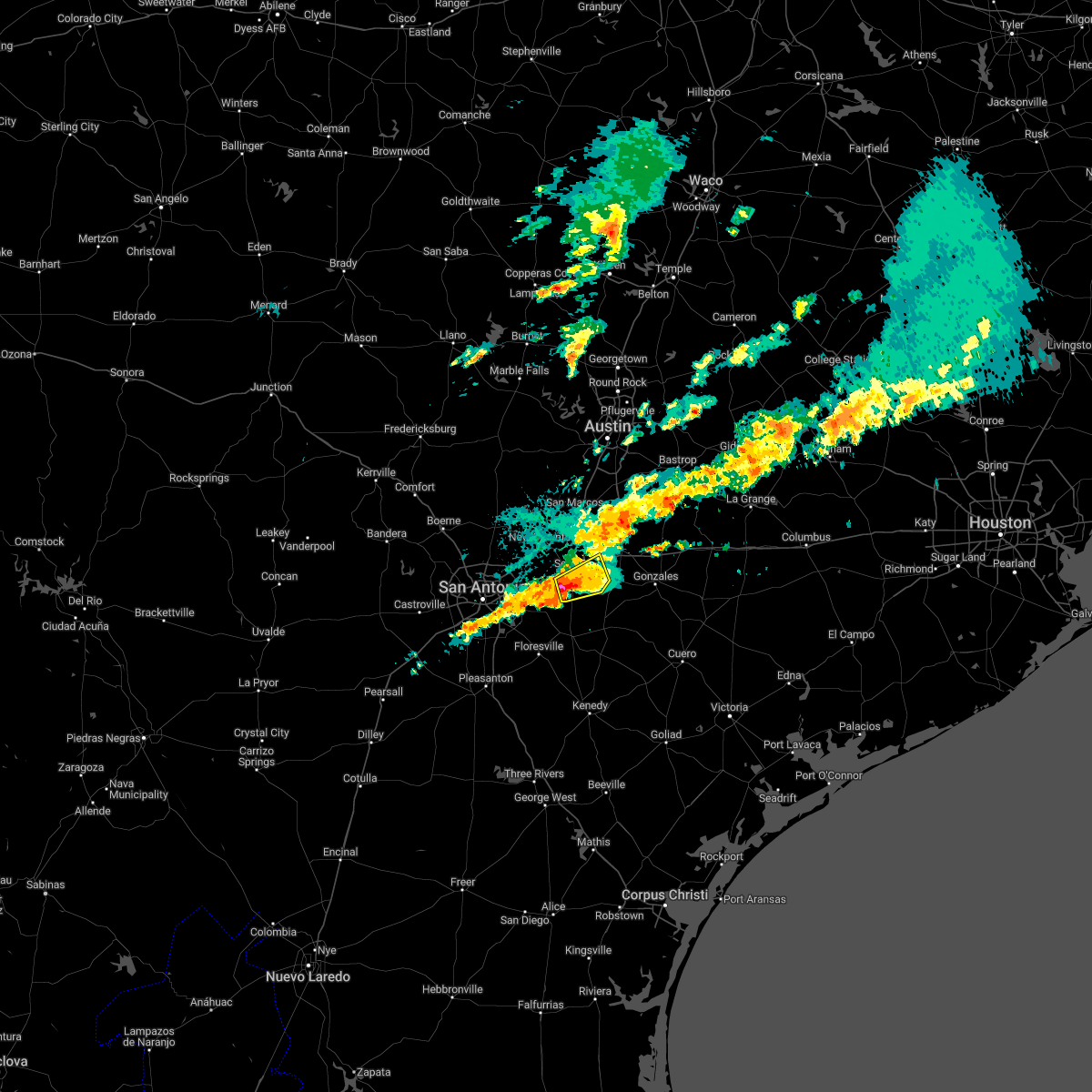 At 1255 am cst, a severe thunderstorm was located near seguin, moving east at 20 mph (radar indicated). Hazards include 60 mph wind gusts and quarter size hail. Hail damage to vehicles is expected. expect wind damage to roofs, siding, and trees. locations impacted include, seguin and kingsbury. hail threat, observed max hail size, 1. 00 in wind threat, radar indicated max wind gust, 60 mph. At 1255 am cst, a severe thunderstorm was located near seguin, moving east at 20 mph (radar indicated). Hazards include 60 mph wind gusts and quarter size hail. Hail damage to vehicles is expected. expect wind damage to roofs, siding, and trees. locations impacted include, seguin and kingsbury. hail threat, observed max hail size, 1. 00 in wind threat, radar indicated max wind gust, 60 mph.
|
| 12/11/2022 12:40 AM CST |
 At 1240 am cst, a severe thunderstorm was located near new berlin, or 8 miles southwest of seguin, moving east at 15 mph (radar indicated). Hazards include ping pong ball size hail and 60 mph wind gusts. People and animals outdoors will be injured. expect hail damage to roofs, siding, windows, and vehicles. expect wind damage to roofs, siding, and trees. locations impacted include, seguin, mcqueeney, kingsbury, new berlin and zipp. hail threat, radar indicated max hail size, 1. 50 in wind threat, radar indicated max wind gust, 60 mph. At 1240 am cst, a severe thunderstorm was located near new berlin, or 8 miles southwest of seguin, moving east at 15 mph (radar indicated). Hazards include ping pong ball size hail and 60 mph wind gusts. People and animals outdoors will be injured. expect hail damage to roofs, siding, windows, and vehicles. expect wind damage to roofs, siding, and trees. locations impacted include, seguin, mcqueeney, kingsbury, new berlin and zipp. hail threat, radar indicated max hail size, 1. 50 in wind threat, radar indicated max wind gust, 60 mph.
|
| 12/11/2022 12:29 AM CST |
 At 1229 am cst, a severe thunderstorm was located over new berlin, or 8 miles southeast of cibolo, moving east at 20 mph (radar indicated). Hazards include ping pong ball size hail. People and animals outdoors will be injured. expect damage to roofs, siding, windows, and vehicles. locations impacted include, seguin, cibolo, mcqueeney, marion, kingsbury, new berlin, zuehl, geronimo, nolte and zipp. hail threat, radar indicated max hail size, 1. 50 in wind threat, radar indicated max wind gust, <50 mph. At 1229 am cst, a severe thunderstorm was located over new berlin, or 8 miles southeast of cibolo, moving east at 20 mph (radar indicated). Hazards include ping pong ball size hail. People and animals outdoors will be injured. expect damage to roofs, siding, windows, and vehicles. locations impacted include, seguin, cibolo, mcqueeney, marion, kingsbury, new berlin, zuehl, geronimo, nolte and zipp. hail threat, radar indicated max hail size, 1. 50 in wind threat, radar indicated max wind gust, <50 mph.
|
| 12/11/2022 12:24 AM CST |
 At 1224 am cst, a severe thunderstorm was located over new berlin, or 7 miles southeast of cibolo, moving east at 20 mph (radar indicated). Hazards include quarter size hail. damage to vehicles is expected At 1224 am cst, a severe thunderstorm was located over new berlin, or 7 miles southeast of cibolo, moving east at 20 mph (radar indicated). Hazards include quarter size hail. damage to vehicles is expected
|
| 11/4/2022 9:13 PM CDT |
 At 913 pm cdt, severe thunderstorms were located along a line extending from 12 miles northwest of waelder to 11 miles southwest of palmeto state park, moving east at 35 mph (radar indicated). Hazards include 60 mph wind gusts and quarter size hail. Hail damage to vehicles is expected. expect wind damage to roofs, siding, and trees. locations impacted include, lockhart, luling, kingsbury, palmeto state park, fentress, brownsboro, tilmon, joliet, oak forest, stairtown, belmont, mcneil, mcmahan, ottine, monthalia, taylorsville and delhi. hail threat, radar indicated max hail size, 1. 00 in wind threat, radar indicated max wind gust, 60 mph. At 913 pm cdt, severe thunderstorms were located along a line extending from 12 miles northwest of waelder to 11 miles southwest of palmeto state park, moving east at 35 mph (radar indicated). Hazards include 60 mph wind gusts and quarter size hail. Hail damage to vehicles is expected. expect wind damage to roofs, siding, and trees. locations impacted include, lockhart, luling, kingsbury, palmeto state park, fentress, brownsboro, tilmon, joliet, oak forest, stairtown, belmont, mcneil, mcmahan, ottine, monthalia, taylorsville and delhi. hail threat, radar indicated max hail size, 1. 00 in wind threat, radar indicated max wind gust, 60 mph.
|
| 11/4/2022 8:57 PM CDT |
 At 857 pm cdt, severe thunderstorms were located along a line extending from near luling to 9 miles southeast of seguin, moving east at 25 mph (radar indicated). Hazards include 60 mph wind gusts and quarter size hail. Hail damage to vehicles is expected. expect wind damage to roofs, siding, and trees. locations impacted include, seguin, lockhart, luling, martindale, kingsbury, staples, fentress, palmeto state park, brownsboro, tilmon, joliet, oak forest, stairtown, belmont, mcneil, mcmahan, ottine, monthalia, taylorsville and delhi. hail threat, radar indicated max hail size, 1. 00 in wind threat, radar indicated max wind gust, 60 mph. At 857 pm cdt, severe thunderstorms were located along a line extending from near luling to 9 miles southeast of seguin, moving east at 25 mph (radar indicated). Hazards include 60 mph wind gusts and quarter size hail. Hail damage to vehicles is expected. expect wind damage to roofs, siding, and trees. locations impacted include, seguin, lockhart, luling, martindale, kingsbury, staples, fentress, palmeto state park, brownsboro, tilmon, joliet, oak forest, stairtown, belmont, mcneil, mcmahan, ottine, monthalia, taylorsville and delhi. hail threat, radar indicated max hail size, 1. 00 in wind threat, radar indicated max wind gust, 60 mph.
|
| 11/4/2022 8:40 PM CDT |
 At 840 pm cdt, severe thunderstorms were located along a line extending from near fentress to near new berlin, moving northeast at 25 mph (radar indicated). Hazards include 60 mph wind gusts and quarter size hail. Hail damage to vehicles is expected. Expect wind damage to roofs, siding, and trees. At 840 pm cdt, severe thunderstorms were located along a line extending from near fentress to near new berlin, moving northeast at 25 mph (radar indicated). Hazards include 60 mph wind gusts and quarter size hail. Hail damage to vehicles is expected. Expect wind damage to roofs, siding, and trees.
|
| 10/24/2022 10:28 PM CDT |
 At 1027 pm cdt, severe thunderstorms were located along a line extending from near dime box to near bastrop to fentress to cibolo, moving east at 30 mph (radar indicated). Hazards include 60 mph wind gusts and nickel size hail. Expect damage to roofs, siding, and trees. locations impacted include, new braunfels, schertz, seguin, cibolo, lockhart, bastrop, gonzales, luling, giddings, la grange, smithville, flatonia, mcqueeney, martindale, waelder, marion, kingsbury, santa clara, new berlin and staples. hail threat, radar indicated max hail size, 0. 88 in wind threat, radar indicated max wind gust, 60 mph. At 1027 pm cdt, severe thunderstorms were located along a line extending from near dime box to near bastrop to fentress to cibolo, moving east at 30 mph (radar indicated). Hazards include 60 mph wind gusts and nickel size hail. Expect damage to roofs, siding, and trees. locations impacted include, new braunfels, schertz, seguin, cibolo, lockhart, bastrop, gonzales, luling, giddings, la grange, smithville, flatonia, mcqueeney, martindale, waelder, marion, kingsbury, santa clara, new berlin and staples. hail threat, radar indicated max hail size, 0. 88 in wind threat, radar indicated max wind gust, 60 mph.
|
| 10/24/2022 10:08 PM CDT |
 At 1008 pm cdt, severe thunderstorms were located along a line extending from near tanglewood to cedar creek to near zorn to live oak, moving east at 30 mph (radar indicated). Hazards include 60 mph wind gusts and nickel size hail. expect damage to roofs, siding, and trees At 1008 pm cdt, severe thunderstorms were located along a line extending from near tanglewood to cedar creek to near zorn to live oak, moving east at 30 mph (radar indicated). Hazards include 60 mph wind gusts and nickel size hail. expect damage to roofs, siding, and trees
|
| 10/24/2022 9:42 PM CDT |
 At 942 pm cdt, severe thunderstorms were located along a line extending from near buda to near canyon lake dam to near garden ridge, moving east at 45 mph (radar indicated). Hazards include 60 mph wind gusts and nickel size hail. Expect damage to roofs, siding, and trees. locations impacted include, new braunfels, san marcos, schertz, kyle, seguin, cibolo, buda, lockhart, luling, wimberley, canyon lake dam, canyon lake, bulverde, garden ridge, mcqueeney, woodcreek, martindale, marion, uhland and mustang ridge. hail threat, radar indicated max hail size, 0. 88 in wind threat, radar indicated max wind gust, 60 mph. At 942 pm cdt, severe thunderstorms were located along a line extending from near buda to near canyon lake dam to near garden ridge, moving east at 45 mph (radar indicated). Hazards include 60 mph wind gusts and nickel size hail. Expect damage to roofs, siding, and trees. locations impacted include, new braunfels, san marcos, schertz, kyle, seguin, cibolo, buda, lockhart, luling, wimberley, canyon lake dam, canyon lake, bulverde, garden ridge, mcqueeney, woodcreek, martindale, marion, uhland and mustang ridge. hail threat, radar indicated max hail size, 0. 88 in wind threat, radar indicated max wind gust, 60 mph.
|
| 10/24/2022 9:14 PM CDT |
 At 913 pm cdt, severe thunderstorms were located along a line extending from henly to near spring branch to near bergheim, moving east at 55 mph (radar indicated). Hazards include 60 mph wind gusts and penny size hail. expect damage to roofs, siding, and trees At 913 pm cdt, severe thunderstorms were located along a line extending from henly to near spring branch to near bergheim, moving east at 55 mph (radar indicated). Hazards include 60 mph wind gusts and penny size hail. expect damage to roofs, siding, and trees
|
| 6/27/2022 4:06 PM CDT |
 At 405 pm cdt, a severe thunderstorm was located over san marcos, moving northwest at 15 mph (radar indicated). Hazards include 60 mph wind gusts and nickel size hail. expect damage to roofs, siding, and trees At 405 pm cdt, a severe thunderstorm was located over san marcos, moving northwest at 15 mph (radar indicated). Hazards include 60 mph wind gusts and nickel size hail. expect damage to roofs, siding, and trees
|
| 6/27/2022 3:54 PM CDT |
 At 354 pm cdt, severe thunderstorms were located along a line extending from near martindale to near kingsbury, moving west at 15 mph (radar indicated). Hazards include 60 mph wind gusts and half dollar size hail. Hail damage to vehicles is expected. expect wind damage to roofs, siding, and trees. locations impacted include, new braunfels, san marcos, seguin, mcqueeney, martindale, kingsbury, staples, fentress, geronimo, zorn, hunter, san marcos regional airport, maxwell, reedville, redwood, freiheit and new braunfels national airport. hail threat, radar indicated max hail size, 1. 25 in wind threat, radar indicated max wind gust, 60 mph. At 354 pm cdt, severe thunderstorms were located along a line extending from near martindale to near kingsbury, moving west at 15 mph (radar indicated). Hazards include 60 mph wind gusts and half dollar size hail. Hail damage to vehicles is expected. expect wind damage to roofs, siding, and trees. locations impacted include, new braunfels, san marcos, seguin, mcqueeney, martindale, kingsbury, staples, fentress, geronimo, zorn, hunter, san marcos regional airport, maxwell, reedville, redwood, freiheit and new braunfels national airport. hail threat, radar indicated max hail size, 1. 25 in wind threat, radar indicated max wind gust, 60 mph.
|
| 6/27/2022 3:36 PM CDT |
 At 336 pm cdt, severe thunderstorms were located along a line extending from martindale to near kingsbury, moving west at 15 mph (radar indicated). Hazards include 60 mph wind gusts and quarter size hail. Hail damage to vehicles is expected. Expect wind damage to roofs, siding, and trees. At 336 pm cdt, severe thunderstorms were located along a line extending from martindale to near kingsbury, moving west at 15 mph (radar indicated). Hazards include 60 mph wind gusts and quarter size hail. Hail damage to vehicles is expected. Expect wind damage to roofs, siding, and trees.
|
| 5/25/2022 12:30 AM CDT |
 At 1230 am cdt, severe thunderstorms were located along a line extending from near yoakum to 8 miles northwest of nell to 8 miles east of dilley, moving southeast at 40 mph (radar indicated). Hazards include 60 mph wind gusts. Expect damage to roofs, siding, and trees. locations impacted include, san antonio, new braunfels, san marcos, schertz, kyle, seguin, cibolo, universal city, live oak, lockhart, pleasanton, selma, pearsall, hondo, gonzales, floresville, luling, devine, jourdanton and poteet. hail threat, radar indicated max hail size, <. 75 in wind threat, radar indicated max wind gust, 60 mph. At 1230 am cdt, severe thunderstorms were located along a line extending from near yoakum to 8 miles northwest of nell to 8 miles east of dilley, moving southeast at 40 mph (radar indicated). Hazards include 60 mph wind gusts. Expect damage to roofs, siding, and trees. locations impacted include, san antonio, new braunfels, san marcos, schertz, kyle, seguin, cibolo, universal city, live oak, lockhart, pleasanton, selma, pearsall, hondo, gonzales, floresville, luling, devine, jourdanton and poteet. hail threat, radar indicated max hail size, <. 75 in wind threat, radar indicated max wind gust, 60 mph.
|
| 5/25/2022 12:11 AM CDT |
 At 1211 am cdt, severe thunderstorms were located along a line extending from 10 miles east of lockhart to stinson municipal airport to 9 miles north of frio town, moving southeast at 50 mph (radar indicated). Hazards include 60 mph wind gusts and penny size hail. Expect damage to roofs, siding, and trees. locations impacted include, san antonio, new braunfels, san marcos, schertz, kyle, seguin, cibolo, universal city, live oak, lockhart, pleasanton, selma, pearsall, hondo, gonzales, floresville, luling, devine, jourdanton and poteet. hail threat, radar indicated max hail size, 0. 75 in wind threat, radar indicated max wind gust, 60 mph. At 1211 am cdt, severe thunderstorms were located along a line extending from 10 miles east of lockhart to stinson municipal airport to 9 miles north of frio town, moving southeast at 50 mph (radar indicated). Hazards include 60 mph wind gusts and penny size hail. Expect damage to roofs, siding, and trees. locations impacted include, san antonio, new braunfels, san marcos, schertz, kyle, seguin, cibolo, universal city, live oak, lockhart, pleasanton, selma, pearsall, hondo, gonzales, floresville, luling, devine, jourdanton and poteet. hail threat, radar indicated max hail size, 0. 75 in wind threat, radar indicated max wind gust, 60 mph.
|
| 5/24/2022 11:49 PM CDT |
 At 1148 pm cdt, severe thunderstorms were located along a line extending from near martindale to rio medina to sabinal, moving southeast at 40 mph (radar indicated). Hazards include 60 mph wind gusts and nickel size hail. expect damage to roofs, siding, and trees At 1148 pm cdt, severe thunderstorms were located along a line extending from near martindale to rio medina to sabinal, moving southeast at 40 mph (radar indicated). Hazards include 60 mph wind gusts and nickel size hail. expect damage to roofs, siding, and trees
|
| 5/5/2022 7:33 PM CDT |
 At 731 pm cdt, a severe thunderstorm was located near fentress, or near luling, moving southeast at 40 mph (trained weather spotters. at 7:14 pm half dollar size hail was reported at martindale). Hazards include 60 mph wind gusts and quarter size hail. Hail damage to vehicles is expected. expect wind damage to roofs, siding, and trees. locations impacted include, lockhart, gonzales, luling, martindale, waelder, kingsbury, staples, fentress, palmeto state park, brownsboro, tilmon, joliet, oak forest, stairtown, maxwell, cost, mcneil, thompsonville, ottine, and redwood. hail threat, radar indicated max hail size, 1. 00 in wind threat, radar indicated max wind gust, 60 mph. At 731 pm cdt, a severe thunderstorm was located near fentress, or near luling, moving southeast at 40 mph (trained weather spotters. at 7:14 pm half dollar size hail was reported at martindale). Hazards include 60 mph wind gusts and quarter size hail. Hail damage to vehicles is expected. expect wind damage to roofs, siding, and trees. locations impacted include, lockhart, gonzales, luling, martindale, waelder, kingsbury, staples, fentress, palmeto state park, brownsboro, tilmon, joliet, oak forest, stairtown, maxwell, cost, mcneil, thompsonville, ottine, and redwood. hail threat, radar indicated max hail size, 1. 00 in wind threat, radar indicated max wind gust, 60 mph.
|
| 4/10/2022 11:57 PM CDT |
 The severe thunderstorm warning for southwestern caldwell, guadalupe, northwestern gonzales and southeastern comal counties will expire at midnight cdt, the storm which prompted the warning has weakened below severe limits, and no longer poses an immediate threat to life or property. therefore, the warning will be allowed to expire. however small hail, gusty winds and heavy rain are still possible with this thunderstorm. The severe thunderstorm warning for southwestern caldwell, guadalupe, northwestern gonzales and southeastern comal counties will expire at midnight cdt, the storm which prompted the warning has weakened below severe limits, and no longer poses an immediate threat to life or property. therefore, the warning will be allowed to expire. however small hail, gusty winds and heavy rain are still possible with this thunderstorm.
|
| 4/10/2022 11:35 PM CDT |
 At 1134 pm cdt, a severe thunderstorm was located over mcqueeney, or near new braunfels, moving east at 40 mph (public). Hazards include 60 mph wind gusts and quarter size hail. Hail damage to vehicles is expected. Expect wind damage to roofs, siding, and trees. At 1134 pm cdt, a severe thunderstorm was located over mcqueeney, or near new braunfels, moving east at 40 mph (public). Hazards include 60 mph wind gusts and quarter size hail. Hail damage to vehicles is expected. Expect wind damage to roofs, siding, and trees.
|
| 3/22/2022 12:48 AM CDT |
 At 1247 am cdt, severe thunderstorms were located along a line extending from near lockhart to near kingsbury, moving northeast at 15 mph (radar indicated). Hazards include 60 mph wind gusts and nickel size hail. Expect damage to roofs, siding, and trees. locations impacted include, seguin, lockhart, luling, kingsbury, staples, fentress, palmeto state park, brownsboro, joliet, tilmon, stairtown, belmont, mcneil, mcmahan, ottine and taylorsville. hail threat, radar indicated max hail size, 0. 88 in wind threat, radar indicated max wind gust, 60 mph. At 1247 am cdt, severe thunderstorms were located along a line extending from near lockhart to near kingsbury, moving northeast at 15 mph (radar indicated). Hazards include 60 mph wind gusts and nickel size hail. Expect damage to roofs, siding, and trees. locations impacted include, seguin, lockhart, luling, kingsbury, staples, fentress, palmeto state park, brownsboro, joliet, tilmon, stairtown, belmont, mcneil, mcmahan, ottine and taylorsville. hail threat, radar indicated max hail size, 0. 88 in wind threat, radar indicated max wind gust, 60 mph.
|
| 3/21/2022 11:58 PM CDT |
 At 1158 pm cdt, severe thunderstorms were located along a line extending from near lockhart to near seguin, moving northeast at 30 mph (radar indicated). Hazards include 60 mph wind gusts and quarter size hail. Hail damage to vehicles is expected. Expect wind damage to roofs, siding, and trees. At 1158 pm cdt, severe thunderstorms were located along a line extending from near lockhart to near seguin, moving northeast at 30 mph (radar indicated). Hazards include 60 mph wind gusts and quarter size hail. Hail damage to vehicles is expected. Expect wind damage to roofs, siding, and trees.
|
| 3/21/2022 7:29 PM CDT | Home and tree damage reported between kingsbury and lulin in guadalupe county TX, 5.8 miles W of Kingsbury, TX |
| 3/21/2022 7:18 PM CDT |
 At 717 pm cdt, a severe thunderstorm was located over kingsbury, or 8 miles west of luling, moving northeast at 50 mph (radar indicated). Hazards include golf ball size hail and 60 mph wind gusts. People and animals outdoors will be injured. expect hail damage to roofs, siding, windows, and vehicles. expect wind damage to roofs, siding, and trees. locations impacted include, seguin, lockhart, luling, mustang ridge, kingsbury, staples, fentress, palmeto state park, brownsboro, joliet, tilmon, stairtown, belmont, mcneil, mcmahan, lytton springs, ottine, dale, bateman and st john colony. thunderstorm damage threat, considerable hail threat, radar indicated max hail size, 1. 75 in wind threat, radar indicated max wind gust, 60 mph. At 717 pm cdt, a severe thunderstorm was located over kingsbury, or 8 miles west of luling, moving northeast at 50 mph (radar indicated). Hazards include golf ball size hail and 60 mph wind gusts. People and animals outdoors will be injured. expect hail damage to roofs, siding, windows, and vehicles. expect wind damage to roofs, siding, and trees. locations impacted include, seguin, lockhart, luling, mustang ridge, kingsbury, staples, fentress, palmeto state park, brownsboro, joliet, tilmon, stairtown, belmont, mcneil, mcmahan, lytton springs, ottine, dale, bateman and st john colony. thunderstorm damage threat, considerable hail threat, radar indicated max hail size, 1. 75 in wind threat, radar indicated max wind gust, 60 mph.
|
| 3/21/2022 7:10 PM CDT |
 At 710 pm cdt, a severe thunderstorm was located 7 miles south of kingsbury, or 9 miles east of seguin, moving northeast at 50 mph (radar indicated). Hazards include quarter size hail. damage to vehicles is expected At 710 pm cdt, a severe thunderstorm was located 7 miles south of kingsbury, or 9 miles east of seguin, moving northeast at 50 mph (radar indicated). Hazards include quarter size hail. damage to vehicles is expected
|
| 3/21/2022 5:55 PM CDT |
 At 555 pm cdt, a confirmed large and extremely dangerous tornado was located near luling, moving northeast at 40 mph. this is a particularly dangerous situation. take cover now! (radar confirmed tornado). Hazards include damaging tornado. You are in a life-threatening situation. flying debris may be deadly to those caught without shelter. mobile homes will be destroyed. considerable damage to homes, businesses, and vehicles is likely and complete destruction is possible. Locations impacted include, lockhart, luling, waelder, kingsbury, fentress, brownsboro, delhi, joliet, tilmon, stairtown, mcneil, mcmahan, thompsonville, dale and taylorsville. At 555 pm cdt, a confirmed large and extremely dangerous tornado was located near luling, moving northeast at 40 mph. this is a particularly dangerous situation. take cover now! (radar confirmed tornado). Hazards include damaging tornado. You are in a life-threatening situation. flying debris may be deadly to those caught without shelter. mobile homes will be destroyed. considerable damage to homes, businesses, and vehicles is likely and complete destruction is possible. Locations impacted include, lockhart, luling, waelder, kingsbury, fentress, brownsboro, delhi, joliet, tilmon, stairtown, mcneil, mcmahan, thompsonville, dale and taylorsville.
|
| 3/21/2022 5:49 PM CDT |
 At 549 pm cdt, a severe thunderstorm capable of producing a tornado was located near kingsbury, or 7 miles southwest of luling, moving northeast at 40 mph (radar indicated rotation). Hazards include tornado and hail up to two inches in diameter. Flying debris will be dangerous to those caught without shelter. mobile homes will be damaged or destroyed. damage to roofs, windows, and vehicles will occur. Tree damage is likely. At 549 pm cdt, a severe thunderstorm capable of producing a tornado was located near kingsbury, or 7 miles southwest of luling, moving northeast at 40 mph (radar indicated rotation). Hazards include tornado and hail up to two inches in diameter. Flying debris will be dangerous to those caught without shelter. mobile homes will be damaged or destroyed. damage to roofs, windows, and vehicles will occur. Tree damage is likely.
|
| 3/21/2022 5:45 PM CDT |
 At 545 pm cdt, a severe thunderstorm capable of producing a tornado was located over kingsbury, or 8 miles east of seguin, moving northeast at 40 mph (radar indicated rotation). Hazards include tornado and two inch hail. Flying debris will be dangerous to those caught without shelter. mobile homes will be damaged or destroyed. damage to roofs, windows, and vehicles will occur. tree damage is likely. Locations impacted include, seguin, kingsbury, staples, fentress and geronimo. At 545 pm cdt, a severe thunderstorm capable of producing a tornado was located over kingsbury, or 8 miles east of seguin, moving northeast at 40 mph (radar indicated rotation). Hazards include tornado and two inch hail. Flying debris will be dangerous to those caught without shelter. mobile homes will be damaged or destroyed. damage to roofs, windows, and vehicles will occur. tree damage is likely. Locations impacted include, seguin, kingsbury, staples, fentress and geronimo.
|
| 3/21/2022 5:37 PM CDT |
 At 537 pm cdt, a severe thunderstorm capable of producing a tornado was located near seguin, moving northeast at 40 mph (radar indicated rotation). Hazards include tornado and two inch hail. Flying debris will be dangerous to those caught without shelter. mobile homes will be damaged or destroyed. damage to roofs, windows, and vehicles will occur. tree damage is likely. Locations impacted include, seguin, kingsbury, staples, fentress and geronimo. At 537 pm cdt, a severe thunderstorm capable of producing a tornado was located near seguin, moving northeast at 40 mph (radar indicated rotation). Hazards include tornado and two inch hail. Flying debris will be dangerous to those caught without shelter. mobile homes will be damaged or destroyed. damage to roofs, windows, and vehicles will occur. tree damage is likely. Locations impacted include, seguin, kingsbury, staples, fentress and geronimo.
|
| 3/21/2022 5:35 PM CDT |
 At 535 pm cdt, a severe thunderstorm was located near geronimo, or 7 miles east of new braunfels, moving northeast at 35 mph (radar indicated). Hazards include two inch hail and 70 mph wind gusts. People and animals outdoors will be injured. expect hail damage to roofs, siding, windows, and vehicles. expect considerable tree damage. wind damage is also likely to mobile homes, roofs, and outbuildings. Locations impacted include, new braunfels, seguin, mcqueeney, kingsbury, staples, geronimo, zorn, redwood and new braunfels national airport. At 535 pm cdt, a severe thunderstorm was located near geronimo, or 7 miles east of new braunfels, moving northeast at 35 mph (radar indicated). Hazards include two inch hail and 70 mph wind gusts. People and animals outdoors will be injured. expect hail damage to roofs, siding, windows, and vehicles. expect considerable tree damage. wind damage is also likely to mobile homes, roofs, and outbuildings. Locations impacted include, new braunfels, seguin, mcqueeney, kingsbury, staples, geronimo, zorn, redwood and new braunfels national airport.
|
| 3/21/2022 5:24 PM CDT |
 At 524 pm cdt, a severe thunderstorm capable of producing a tornado was located near new berlin, or near seguin, moving northeast at 40 mph (radar indicated rotation). Hazards include tornado and hail up to two inches in diameter. Flying debris will be dangerous to those caught without shelter. mobile homes will be damaged or destroyed. damage to roofs, windows, and vehicles will occur. Tree damage is likely. At 524 pm cdt, a severe thunderstorm capable of producing a tornado was located near new berlin, or near seguin, moving northeast at 40 mph (radar indicated rotation). Hazards include tornado and hail up to two inches in diameter. Flying debris will be dangerous to those caught without shelter. mobile homes will be damaged or destroyed. damage to roofs, windows, and vehicles will occur. Tree damage is likely.
|
| 3/21/2022 5:10 PM CDT |
 At 509 pm cdt, a severe thunderstorm was located over zuehl, or near cibolo, moving northeast at 35 mph. this is a destructive storm near santa clara (radar indicated). Hazards include 80 mph wind gusts and tennis ball size hail. Flying debris will be dangerous to those caught without shelter. mobile homes will be heavily damaged. expect considerable damage to roofs, windows, and vehicles. extensive tree damage and power outages are likely. locations impacted include, new braunfels, san marcos, schertz, seguin, cibolo, mcqueeney, st. Hedwig, marion, kingsbury, santa clara, new berlin, staples, zuehl, geronimo, zorn, redwood, freiheit, solms, hunter and nolte. At 509 pm cdt, a severe thunderstorm was located over zuehl, or near cibolo, moving northeast at 35 mph. this is a destructive storm near santa clara (radar indicated). Hazards include 80 mph wind gusts and tennis ball size hail. Flying debris will be dangerous to those caught without shelter. mobile homes will be heavily damaged. expect considerable damage to roofs, windows, and vehicles. extensive tree damage and power outages are likely. locations impacted include, new braunfels, san marcos, schertz, seguin, cibolo, mcqueeney, st. Hedwig, marion, kingsbury, santa clara, new berlin, staples, zuehl, geronimo, zorn, redwood, freiheit, solms, hunter and nolte.
|
| 3/21/2022 5:03 PM CDT |
 At 502 pm cdt, a severe thunderstorm was located over zuehl, or 7 miles southeast of cibolo, moving northeast at 30 mph (radar indicated). Hazards include golf ball size hail and 60 mph wind gusts. People and animals outdoors will be injured. expect hail damage to roofs, siding, windows, and vehicles. expect wind damage to roofs, siding, and trees. locations impacted include, new braunfels, san marcos, schertz, seguin, cibolo, mcqueeney, st. Hedwig, marion, kingsbury, santa clara, new berlin, staples, zuehl, geronimo, zorn, redwood, freiheit, solms, hunter and nolte. At 502 pm cdt, a severe thunderstorm was located over zuehl, or 7 miles southeast of cibolo, moving northeast at 30 mph (radar indicated). Hazards include golf ball size hail and 60 mph wind gusts. People and animals outdoors will be injured. expect hail damage to roofs, siding, windows, and vehicles. expect wind damage to roofs, siding, and trees. locations impacted include, new braunfels, san marcos, schertz, seguin, cibolo, mcqueeney, st. Hedwig, marion, kingsbury, santa clara, new berlin, staples, zuehl, geronimo, zorn, redwood, freiheit, solms, hunter and nolte.
|
| 3/21/2022 4:43 PM CDT |
 At 443 pm cdt, a severe thunderstorm was located near randolph afb, moving northeast at 35 mph (radar indicated). Hazards include 60 mph wind gusts and quarter size hail. Hail damage to vehicles is expected. Expect wind damage to roofs, siding, and trees. At 443 pm cdt, a severe thunderstorm was located near randolph afb, moving northeast at 35 mph (radar indicated). Hazards include 60 mph wind gusts and quarter size hail. Hail damage to vehicles is expected. Expect wind damage to roofs, siding, and trees.
|
| 6/14/2021 7:21 PM CDT |
 The national weather service in austin san antonio has issued a * severe thunderstorm warning for. southwestern guadalupe county in south central texas. until 800 pm cdt. At 720 pm cdt, a severe thunderstorm was located over seguin, moving southwest at 35 mph. The national weather service in austin san antonio has issued a * severe thunderstorm warning for. southwestern guadalupe county in south central texas. until 800 pm cdt. At 720 pm cdt, a severe thunderstorm was located over seguin, moving southwest at 35 mph.
|
| 6/14/2021 7:10 PM CDT |
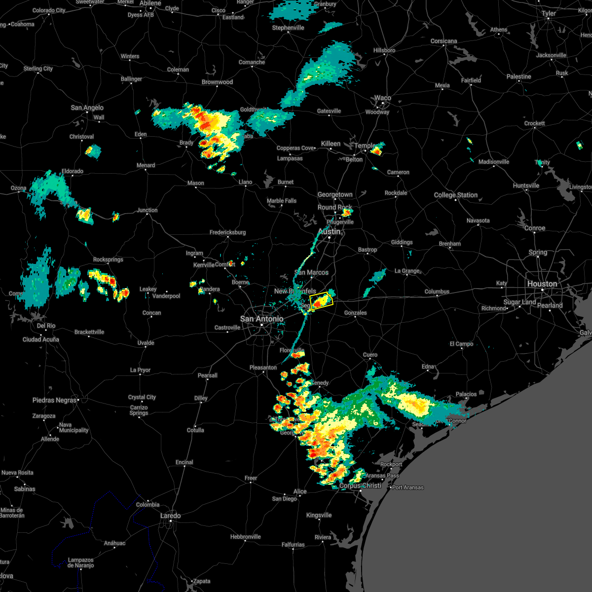 At 710 pm cdt, a severe thunderstorm was located over kingsbury, or 7 miles east of seguin, moving southwest at 15 mph (radar indicated). Hazards include 60 mph wind gusts. Expect damage to roofs, siding, and trees. Locations impacted include, seguin, kingsbury and geronimo. At 710 pm cdt, a severe thunderstorm was located over kingsbury, or 7 miles east of seguin, moving southwest at 15 mph (radar indicated). Hazards include 60 mph wind gusts. Expect damage to roofs, siding, and trees. Locations impacted include, seguin, kingsbury and geronimo.
|
| 6/14/2021 6:59 PM CDT |
 At 659 pm cdt, a severe thunderstorm was located near kingsbury, or 10 miles west of luling, moving southwest at 35 mph (radar indicated). Hazards include 60 mph wind gusts and penny size hail. Expect damage to roofs, siding, and trees. Locations impacted include, san marcos, seguin, lockhart, luling, martindale, kingsbury, staples, fentress, zorn, geronimo, joliet, stairtown and redwood. At 659 pm cdt, a severe thunderstorm was located near kingsbury, or 10 miles west of luling, moving southwest at 35 mph (radar indicated). Hazards include 60 mph wind gusts and penny size hail. Expect damage to roofs, siding, and trees. Locations impacted include, san marcos, seguin, lockhart, luling, martindale, kingsbury, staples, fentress, zorn, geronimo, joliet, stairtown and redwood.
|
| 6/14/2021 6:52 PM CDT |
 At 652 pm cdt, a severe thunderstorm was located near staples, or 11 miles northeast of seguin, moving west at 50 mph (radar indicated). Hazards include 60 mph wind gusts and penny size hail. Expect damage to roofs, siding, and trees. Locations impacted include, san marcos, seguin, lockhart, luling, martindale, kingsbury, staples, fentress, zorn, geronimo, brownsboro, joliet, stairtown, mcneil and redwood. At 652 pm cdt, a severe thunderstorm was located near staples, or 11 miles northeast of seguin, moving west at 50 mph (radar indicated). Hazards include 60 mph wind gusts and penny size hail. Expect damage to roofs, siding, and trees. Locations impacted include, san marcos, seguin, lockhart, luling, martindale, kingsbury, staples, fentress, zorn, geronimo, brownsboro, joliet, stairtown, mcneil and redwood.
|
| 6/14/2021 6:42 PM CDT |
 At 642 pm cdt, a severe thunderstorm was located near luling, moving west at 20 mph (radar indicated). Hazards include 60 mph wind gusts and penny size hail. expect damage to roofs, siding, and trees At 642 pm cdt, a severe thunderstorm was located near luling, moving west at 20 mph (radar indicated). Hazards include 60 mph wind gusts and penny size hail. expect damage to roofs, siding, and trees
|
| 5/28/2021 10:23 PM CDT |
 At 1022 pm cdt, severe thunderstorms were located along a line extending from near zorn to 8 miles southeast of seguin to near kosciusko to near pleasanton, moving east at 45 mph (radar indicated). Hazards include 60 mph wind gusts. expect damage to roofs, siding, and trees At 1022 pm cdt, severe thunderstorms were located along a line extending from near zorn to 8 miles southeast of seguin to near kosciusko to near pleasanton, moving east at 45 mph (radar indicated). Hazards include 60 mph wind gusts. expect damage to roofs, siding, and trees
|
| 5/28/2021 10:14 PM CDT |
 At 1012 pm cdt, severe thunderstorms were located along a line extending from near zorn to near seguin to near sutherland springs, moving east at 45 mph (radar indicated). Hazards include 60 mph wind gusts and penny size hail. Expect damage to roofs, siding, and trees. Locations impacted include, new braunfels, san marcos, kyle, seguin, cibolo, lockhart, luling, stockdale, mcqueeney, nixon, la vernia, martindale, uhland, kingsbury, santa clara, niederwald, new berlin, staples, pandora and fentress. At 1012 pm cdt, severe thunderstorms were located along a line extending from near zorn to near seguin to near sutherland springs, moving east at 45 mph (radar indicated). Hazards include 60 mph wind gusts and penny size hail. Expect damage to roofs, siding, and trees. Locations impacted include, new braunfels, san marcos, kyle, seguin, cibolo, lockhart, luling, stockdale, mcqueeney, nixon, la vernia, martindale, uhland, kingsbury, santa clara, niederwald, new berlin, staples, pandora and fentress.
|
| 5/28/2021 9:48 PM CDT |
 At 947 pm cdt, severe thunderstorms were located along a line extending from near spring branch to garden ridge to near china grove, moving east at 45 mph (radar indicated). Hazards include 70 mph wind gusts and penny size hail. Expect considerable tree damage. damage is likely to mobile homes, roofs, and outbuildings. Locations impacted include, san antonio, new braunfels, san marcos, schertz, kyle, seguin, cibolo, universal city, live oak, lockhart, selma, luling, wimberley, stockdale, stinson municipal airport, san antonio int airport, randolph afb, canyon lake dam, canyon lake and leon valley. At 947 pm cdt, severe thunderstorms were located along a line extending from near spring branch to garden ridge to near china grove, moving east at 45 mph (radar indicated). Hazards include 70 mph wind gusts and penny size hail. Expect considerable tree damage. damage is likely to mobile homes, roofs, and outbuildings. Locations impacted include, san antonio, new braunfels, san marcos, schertz, kyle, seguin, cibolo, universal city, live oak, lockhart, selma, luling, wimberley, stockdale, stinson municipal airport, san antonio int airport, randolph afb, canyon lake dam, canyon lake and leon valley.
|
| 5/28/2021 9:34 PM CDT |
 At 933 pm cdt, severe thunderstorms were located along a line extending from near guadalupe river state park to near timberwood park to near lackland afb, moving east at 45 mph. these are very dangerous storms (radar indicated). Hazards include 80 mph wind gusts and penny size hail. Flying debris will be dangerous to those caught without shelter. mobile homes will be heavily damaged. expect considerable damage to roofs, windows, and vehicles. Extensive tree damage and power outages are likely. At 933 pm cdt, severe thunderstorms were located along a line extending from near guadalupe river state park to near timberwood park to near lackland afb, moving east at 45 mph. these are very dangerous storms (radar indicated). Hazards include 80 mph wind gusts and penny size hail. Flying debris will be dangerous to those caught without shelter. mobile homes will be heavily damaged. expect considerable damage to roofs, windows, and vehicles. Extensive tree damage and power outages are likely.
|
| 5/28/2021 8:25 PM CDT |
 At 825 pm cdt, a severe thunderstorm was located over zorn, or 7 miles southwest of san marcos, moving east at 35 mph (radar indicated). Hazards include 60 mph wind gusts and quarter size hail. Hail damage to vehicles is expected. Expect wind damage to roofs, siding, and trees. At 825 pm cdt, a severe thunderstorm was located over zorn, or 7 miles southwest of san marcos, moving east at 35 mph (radar indicated). Hazards include 60 mph wind gusts and quarter size hail. Hail damage to vehicles is expected. Expect wind damage to roofs, siding, and trees.
|
| 5/18/2021 4:18 PM CDT |
 At 418 pm cdt, severe thunderstorms were located along a line extending from lockhart to near luling, moving east at 25 mph (radar indicated). Hazards include 60 mph wind gusts and quarter size hail. Hail damage to vehicles is expected. expect wind damage to roofs, siding, and trees. Locations impacted include, lockhart, luling, martindale, kingsbury, staples, fentress, brownsboro, joliet, stairtown and mcneil. At 418 pm cdt, severe thunderstorms were located along a line extending from lockhart to near luling, moving east at 25 mph (radar indicated). Hazards include 60 mph wind gusts and quarter size hail. Hail damage to vehicles is expected. expect wind damage to roofs, siding, and trees. Locations impacted include, lockhart, luling, martindale, kingsbury, staples, fentress, brownsboro, joliet, stairtown and mcneil.
|
| 5/18/2021 4:06 PM CDT |
 At 405 pm cdt, severe thunderstorms were located along a line extending from near martindale to near luling, moving east at 40 mph (radar indicated). Hazards include 60 mph wind gusts and quarter size hail. Hail damage to vehicles is expected. expect wind damage to roofs, siding, and trees. Locations impacted include, seguin, lockhart, luling, martindale, kingsbury, staples, fentress, zorn, geronimo, brownsboro, joliet, stairtown, mcneil and redwood. At 405 pm cdt, severe thunderstorms were located along a line extending from near martindale to near luling, moving east at 40 mph (radar indicated). Hazards include 60 mph wind gusts and quarter size hail. Hail damage to vehicles is expected. expect wind damage to roofs, siding, and trees. Locations impacted include, seguin, lockhart, luling, martindale, kingsbury, staples, fentress, zorn, geronimo, brownsboro, joliet, stairtown, mcneil and redwood.
|
| 5/18/2021 3:48 PM CDT |
 At 347 pm cdt, a severe thunderstorm was located over zorn, or 7 miles south of san marcos, moving east at 30 mph (radar indicated). Hazards include 60 mph wind gusts and half dollar size hail. Hail damage to vehicles is expected. expect wind damage to roofs, siding, and trees. Locations impacted include, new braunfels, seguin, lockhart, luling, mcqueeney, martindale, kingsbury, staples, fentress, geronimo, zorn, brownsboro, hunter, joliet, stairtown, mcneil, redwood and new braunfels regional airport. At 347 pm cdt, a severe thunderstorm was located over zorn, or 7 miles south of san marcos, moving east at 30 mph (radar indicated). Hazards include 60 mph wind gusts and half dollar size hail. Hail damage to vehicles is expected. expect wind damage to roofs, siding, and trees. Locations impacted include, new braunfels, seguin, lockhart, luling, mcqueeney, martindale, kingsbury, staples, fentress, geronimo, zorn, brownsboro, hunter, joliet, stairtown, mcneil, redwood and new braunfels regional airport.
|
| 5/18/2021 3:35 PM CDT |
 At 334 pm cdt, a severe thunderstorm was located near new braunfels, moving east at 25 mph (radar indicated). Hazards include 60 mph wind gusts and quarter size hail. Hail damage to vehicles is expected. Expect wind damage to roofs, siding, and trees. At 334 pm cdt, a severe thunderstorm was located near new braunfels, moving east at 25 mph (radar indicated). Hazards include 60 mph wind gusts and quarter size hail. Hail damage to vehicles is expected. Expect wind damage to roofs, siding, and trees.
|
| 5/3/2021 9:41 PM CDT |
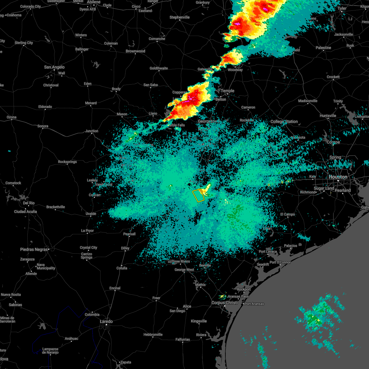 The severe thunderstorm warning for southeastern guadalupe county will expire at 945 pm cdt, the storm which prompted the warning has weakened below severe limits, and no longer poses an immediate threat to life or property. therefore, the warning will be allowed to expire. a severe thunderstorm watch remains in effect until 1100 pm cdt for south central texas. The severe thunderstorm warning for southeastern guadalupe county will expire at 945 pm cdt, the storm which prompted the warning has weakened below severe limits, and no longer poses an immediate threat to life or property. therefore, the warning will be allowed to expire. a severe thunderstorm watch remains in effect until 1100 pm cdt for south central texas.
|
| 5/3/2021 9:35 PM CDT |
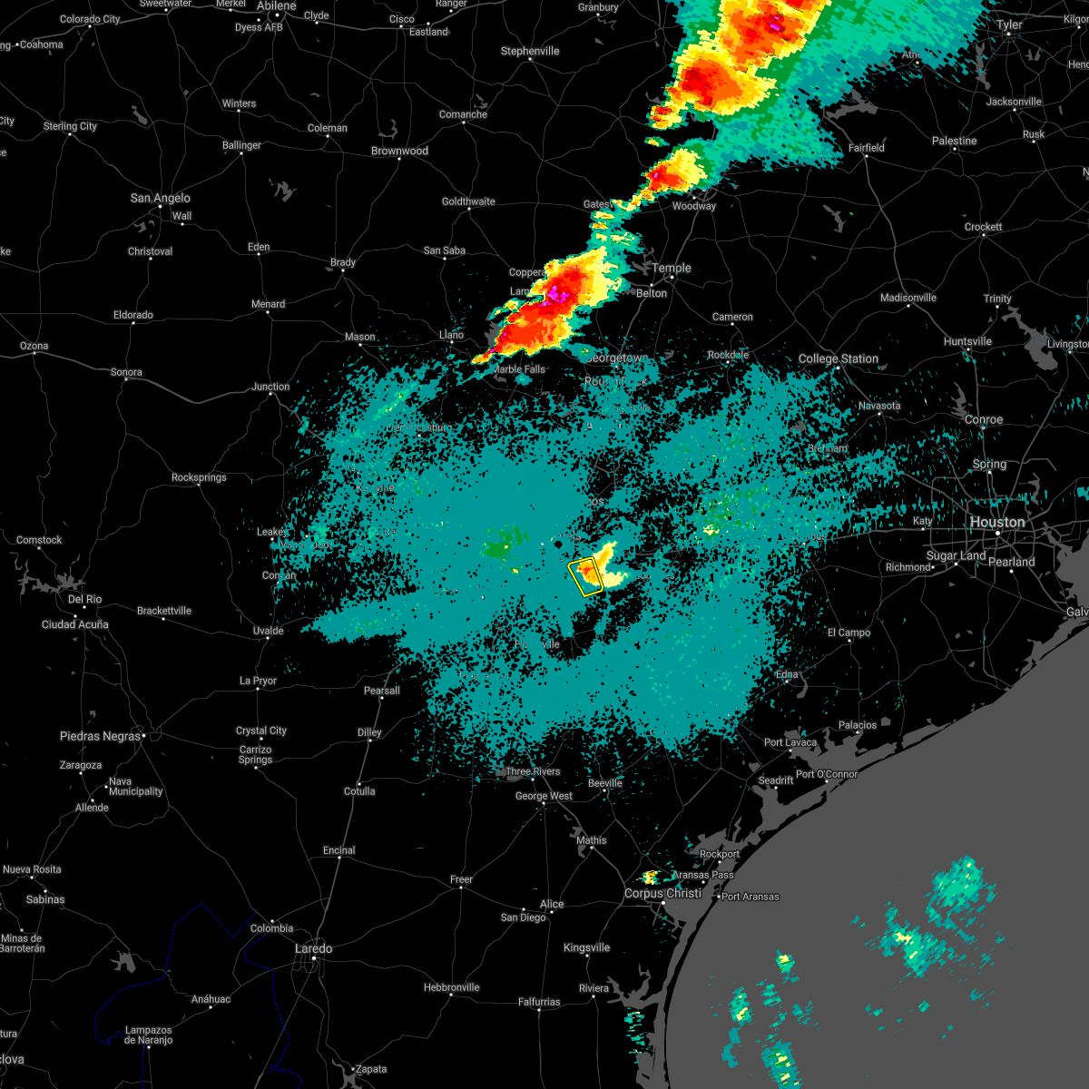 At 934 pm cdt, a severe thunderstorm was located near kingsbury, or 7 miles east of seguin, moving northeast at 40 mph (radar indicated). Hazards include quarter size hail. Damage to vehicles is expected. Locations impacted include, seguin and kingsbury. At 934 pm cdt, a severe thunderstorm was located near kingsbury, or 7 miles east of seguin, moving northeast at 40 mph (radar indicated). Hazards include quarter size hail. Damage to vehicles is expected. Locations impacted include, seguin and kingsbury.
|
| 5/3/2021 9:25 PM CDT |
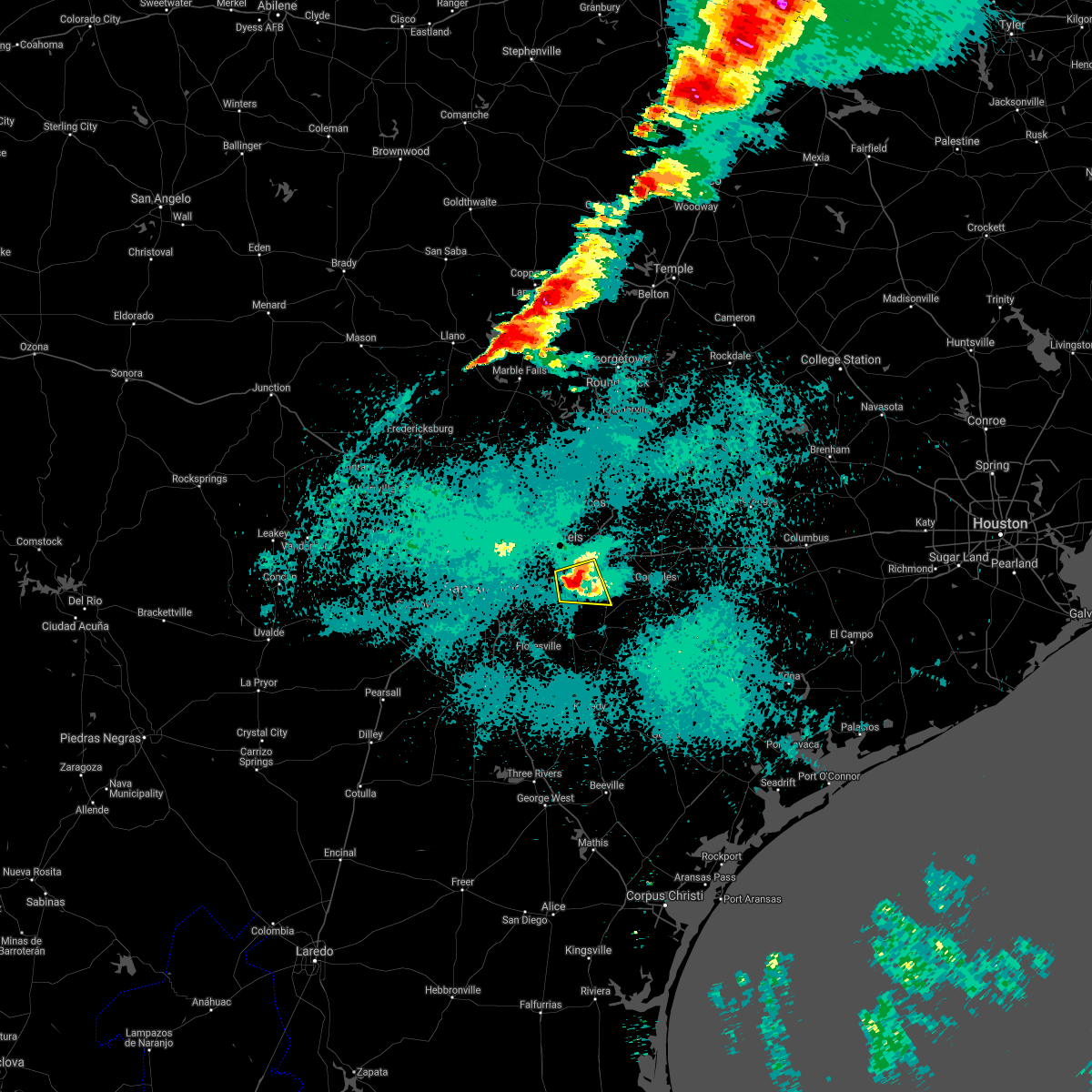 At 925 pm cdt, a severe thunderstorm was located near seguin, moving east at 40 mph (radar indicated). Hazards include golf ball size hail and 60 mph wind gusts. People and animals outdoors will be injured. expect hail damage to roofs, siding, windows, and vehicles. expect wind damage to roofs, siding, and trees. Locations impacted include, seguin, mcqueeney, kingsbury, leesville, nolte and zipp. At 925 pm cdt, a severe thunderstorm was located near seguin, moving east at 40 mph (radar indicated). Hazards include golf ball size hail and 60 mph wind gusts. People and animals outdoors will be injured. expect hail damage to roofs, siding, windows, and vehicles. expect wind damage to roofs, siding, and trees. Locations impacted include, seguin, mcqueeney, kingsbury, leesville, nolte and zipp.
|
| 5/3/2021 9:09 PM CDT |
 At 908 pm cdt, a severe thunderstorm was located near new berlin, or 10 miles southwest of seguin, moving east at 30 mph (radar indicated). Hazards include two inch hail and 60 mph wind gusts. People and animals outdoors will be injured. expect hail damage to roofs, siding, windows, and vehicles. expect wind damage to roofs, siding, and trees. Locations impacted include, seguin, cibolo, mcqueeney, la vernia, kingsbury, new berlin, zuehl, leesville, nolte and zipp. At 908 pm cdt, a severe thunderstorm was located near new berlin, or 10 miles southwest of seguin, moving east at 30 mph (radar indicated). Hazards include two inch hail and 60 mph wind gusts. People and animals outdoors will be injured. expect hail damage to roofs, siding, windows, and vehicles. expect wind damage to roofs, siding, and trees. Locations impacted include, seguin, cibolo, mcqueeney, la vernia, kingsbury, new berlin, zuehl, leesville, nolte and zipp.
|
| 5/3/2021 8:43 PM CDT |
 At 843 pm cdt, a severe thunderstorm was located over st. hedwig, or 8 miles south of randolph afb, moving east at 30 mph (public). Hazards include golf ball size hail and 60 mph wind gusts. People and animals outdoors will be injured. expect hail damage to roofs, siding, windows, and vehicles. Expect wind damage to roofs, siding, and trees. At 843 pm cdt, a severe thunderstorm was located over st. hedwig, or 8 miles south of randolph afb, moving east at 30 mph (public). Hazards include golf ball size hail and 60 mph wind gusts. People and animals outdoors will be injured. expect hail damage to roofs, siding, windows, and vehicles. Expect wind damage to roofs, siding, and trees.
|
| 4/28/2021 9:53 PM CDT |
 At 953 pm cdt, a severe thunderstorm was located 7 miles northwest of new braunfels, moving northeast at 20 mph (radar indicated). Hazards include ping pong ball size hail and 60 mph wind gusts. People and animals outdoors will be injured. expect hail damage to roofs, siding, windows, and vehicles. Expect wind damage to roofs, siding, and trees. At 953 pm cdt, a severe thunderstorm was located 7 miles northwest of new braunfels, moving northeast at 20 mph (radar indicated). Hazards include ping pong ball size hail and 60 mph wind gusts. People and animals outdoors will be injured. expect hail damage to roofs, siding, windows, and vehicles. Expect wind damage to roofs, siding, and trees.
|
| 4/23/2021 1:28 PM CDT |
 At 128 pm cdt, a severe thunderstorm was located over kingsbury, or 8 miles northeast of seguin, moving northeast at 20 mph (radar indicated). Hazards include 60 mph wind gusts and penny size hail. Expect damage to roofs, siding, and trees. Locations impacted include, san marcos, seguin, lockhart, martindale, kingsbury, staples, zorn, fentress, san marcos regional airport, maxwell, reedville and redwood. At 128 pm cdt, a severe thunderstorm was located over kingsbury, or 8 miles northeast of seguin, moving northeast at 20 mph (radar indicated). Hazards include 60 mph wind gusts and penny size hail. Expect damage to roofs, siding, and trees. Locations impacted include, san marcos, seguin, lockhart, martindale, kingsbury, staples, zorn, fentress, san marcos regional airport, maxwell, reedville and redwood.
|
| 4/23/2021 1:17 PM CDT |
 At 117 pm cdt, a severe thunderstorm was located near kingsbury, or near seguin, moving north at 20 mph (radar indicated). Hazards include 60 mph wind gusts and penny size hail. expect damage to roofs, siding, and trees At 117 pm cdt, a severe thunderstorm was located near kingsbury, or near seguin, moving north at 20 mph (radar indicated). Hazards include 60 mph wind gusts and penny size hail. expect damage to roofs, siding, and trees
|
| 3/23/2021 2:21 AM CDT |
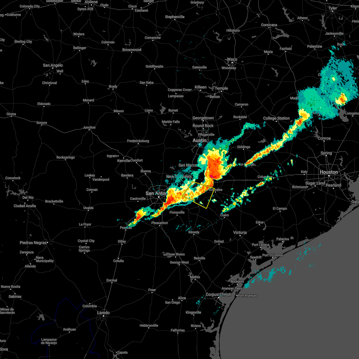 The severe thunderstorm warning for southeastern guadalupe and southwestern gonzales counties will expire at 230 am cdt, the storm which prompted the warning has weakened below severe limits, and no longer poses an immediate threat to life or property. therefore, the warning will be allowed to expire. a severe thunderstorm watch remains in effect until 400 am cdt for south central texas. The severe thunderstorm warning for southeastern guadalupe and southwestern gonzales counties will expire at 230 am cdt, the storm which prompted the warning has weakened below severe limits, and no longer poses an immediate threat to life or property. therefore, the warning will be allowed to expire. a severe thunderstorm watch remains in effect until 400 am cdt for south central texas.
|
| 3/23/2021 2:16 AM CDT |
 At 216 am cdt, a severe thunderstorm was located 8 miles northeast of luling, moving east at 35 mph (radar indicated). Hazards include ping pong ball size hail and 60 mph wind gusts. People and animals outdoors will be injured. expect hail damage to roofs, siding, windows, and vehicles. Expect wind damage to roofs, siding, and trees. At 216 am cdt, a severe thunderstorm was located 8 miles northeast of luling, moving east at 35 mph (radar indicated). Hazards include ping pong ball size hail and 60 mph wind gusts. People and animals outdoors will be injured. expect hail damage to roofs, siding, windows, and vehicles. Expect wind damage to roofs, siding, and trees.
|
| 3/23/2021 2:01 AM CDT |
 At 201 am cdt, a severe thunderstorm was located near lockhart, moving east at 40 mph (trained weather spotters). Hazards include golf ball size hail and 60 mph wind gusts. People and animals outdoors will be injured. expect hail damage to roofs, siding, windows, and vehicles. expect wind damage to roofs, siding, and trees. Locations impacted include, san marcos, kyle, buda, lockhart, bastrop, luling, martindale, uhland, mustang ridge, kingsbury, niederwald, staples, fentress, cedar creek, palmeto state park, onion creek, zorn, wyldwood, geronimo and manchaca. At 201 am cdt, a severe thunderstorm was located near lockhart, moving east at 40 mph (trained weather spotters). Hazards include golf ball size hail and 60 mph wind gusts. People and animals outdoors will be injured. expect hail damage to roofs, siding, windows, and vehicles. expect wind damage to roofs, siding, and trees. Locations impacted include, san marcos, kyle, buda, lockhart, bastrop, luling, martindale, uhland, mustang ridge, kingsbury, niederwald, staples, fentress, cedar creek, palmeto state park, onion creek, zorn, wyldwood, geronimo and manchaca.
|
| 3/23/2021 1:58 AM CDT |
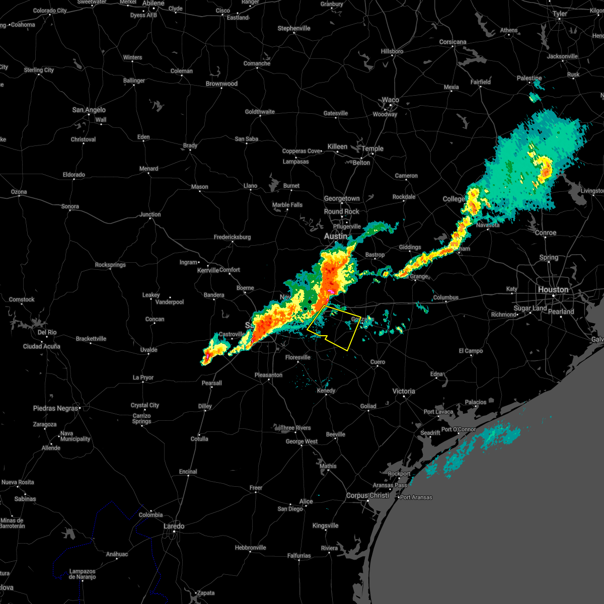 At 158 am cdt, a severe thunderstorm was located near kingsbury, or 9 miles east of seguin, moving east at 40 mph (radar indicated). Hazards include 60 mph wind gusts and quarter size hail. Hail damage to vehicles is expected. Expect wind damage to roofs, siding, and trees. At 158 am cdt, a severe thunderstorm was located near kingsbury, or 9 miles east of seguin, moving east at 40 mph (radar indicated). Hazards include 60 mph wind gusts and quarter size hail. Hail damage to vehicles is expected. Expect wind damage to roofs, siding, and trees.
|
| 3/23/2021 1:52 AM CDT |
 At 151 am cdt, a severe thunderstorm was located near martindale, or near lockhart, moving east at 40 mph (trained weather spotters). Hazards include ping pong ball size hail and 60 mph wind gusts. People and animals outdoors will be injured. expect hail damage to roofs, siding, windows, and vehicles. expect wind damage to roofs, siding, and trees. Locations impacted include, san marcos, kyle, buda, lockhart, bastrop, luling, martindale, uhland, mustang ridge, kingsbury, niederwald, staples, fentress, cedar creek, palmeto state park, onion creek, zorn, wyldwood, geronimo and manchaca. At 151 am cdt, a severe thunderstorm was located near martindale, or near lockhart, moving east at 40 mph (trained weather spotters). Hazards include ping pong ball size hail and 60 mph wind gusts. People and animals outdoors will be injured. expect hail damage to roofs, siding, windows, and vehicles. expect wind damage to roofs, siding, and trees. Locations impacted include, san marcos, kyle, buda, lockhart, bastrop, luling, martindale, uhland, mustang ridge, kingsbury, niederwald, staples, fentress, cedar creek, palmeto state park, onion creek, zorn, wyldwood, geronimo and manchaca.
|
| 3/23/2021 1:39 AM CDT |
 At 138 am cdt, a severe thunderstorm was located over leon valley, or near san antonio, moving east at 35 mph (radar indicated). Hazards include 60 mph wind gusts and quarter size hail. Hail damage to vehicles is expected. expect wind damage to roofs, siding, and trees. Locations impacted include, san antonio, new braunfels, schertz, seguin, cibolo, universal city, live oak, selma, castroville, stinson municipal airport, san antonio int airport, randolph afb, canyon lake, leon valley, helotes, kirby, alamo heights, windcrest, terrell hills and bulverde. At 138 am cdt, a severe thunderstorm was located over leon valley, or near san antonio, moving east at 35 mph (radar indicated). Hazards include 60 mph wind gusts and quarter size hail. Hail damage to vehicles is expected. expect wind damage to roofs, siding, and trees. Locations impacted include, san antonio, new braunfels, schertz, seguin, cibolo, universal city, live oak, selma, castroville, stinson municipal airport, san antonio int airport, randolph afb, canyon lake, leon valley, helotes, kirby, alamo heights, windcrest, terrell hills and bulverde.
|
| 3/23/2021 1:33 AM CDT |
 At 133 am cdt, a severe thunderstorm was located over san marcos, moving east at 40 mph (trained weather spotters). Hazards include golf ball size hail and 60 mph wind gusts. People and animals outdoors will be injured. expect hail damage to roofs, siding, windows, and vehicles. expect wind damage to roofs, siding, and trees. Locations impacted include, new braunfels, san marcos, kyle, buda, lockhart, bastrop, luling, wimberley, canyon lake, woodcreek, martindale, uhland, mustang ridge, kingsbury, niederwald, staples, fentress, cedar creek, palmeto state park and driftwood. At 133 am cdt, a severe thunderstorm was located over san marcos, moving east at 40 mph (trained weather spotters). Hazards include golf ball size hail and 60 mph wind gusts. People and animals outdoors will be injured. expect hail damage to roofs, siding, windows, and vehicles. expect wind damage to roofs, siding, and trees. Locations impacted include, new braunfels, san marcos, kyle, buda, lockhart, bastrop, luling, wimberley, canyon lake, woodcreek, martindale, uhland, mustang ridge, kingsbury, niederwald, staples, fentress, cedar creek, palmeto state park and driftwood.
|
| 3/23/2021 1:26 AM CDT |
 At 125 am cdt, a severe thunderstorm was located near san marcos, moving east at 40 mph (radar indicated). Hazards include 60 mph wind gusts and quarter size hail. Hail damage to vehicles is expected. Expect wind damage to roofs, siding, and trees. At 125 am cdt, a severe thunderstorm was located near san marcos, moving east at 40 mph (radar indicated). Hazards include 60 mph wind gusts and quarter size hail. Hail damage to vehicles is expected. Expect wind damage to roofs, siding, and trees.
|
| 3/23/2021 1:13 AM CDT |
 At 113 am cdt, a severe thunderstorm was located near cliff, or 14 miles north of castroville, moving east at 35 mph (radar indicated). Hazards include 60 mph wind gusts and quarter size hail. Hail damage to vehicles is expected. Expect wind damage to roofs, siding, and trees. At 113 am cdt, a severe thunderstorm was located near cliff, or 14 miles north of castroville, moving east at 35 mph (radar indicated). Hazards include 60 mph wind gusts and quarter size hail. Hail damage to vehicles is expected. Expect wind damage to roofs, siding, and trees.
|
| 8/22/2020 6:44 AM CDT |
 At 643 am cdt, severe thunderstorms were located along a line extending from near buda to near wimberley to fischer, moving south at 35 mph (radar indicated). Hazards include 60 mph wind gusts. expect damage to roofs, siding, and trees At 643 am cdt, severe thunderstorms were located along a line extending from near buda to near wimberley to fischer, moving south at 35 mph (radar indicated). Hazards include 60 mph wind gusts. expect damage to roofs, siding, and trees
|
| 7/31/2020 5:46 PM CDT |
 At 545 pm cdt, a severe thunderstorm was located 7 miles southeast of canyon lake dam, moving south at 35 mph (radar indicated). Hazards include 60 mph wind gusts and quarter size hail. Hail damage to vehicles is expected. Expect wind damage to roofs, siding, and trees. At 545 pm cdt, a severe thunderstorm was located 7 miles southeast of canyon lake dam, moving south at 35 mph (radar indicated). Hazards include 60 mph wind gusts and quarter size hail. Hail damage to vehicles is expected. Expect wind damage to roofs, siding, and trees.
|
| 5/24/2020 9:57 PM CDT |
 At 956 pm cdt, severe thunderstorms were located along a line extending from near kyle to near kingsbury to sutherland springs, moving east at 25 mph (radar indicated). Hazards include 60 mph wind gusts. expect damage to roofs, siding, and trees At 956 pm cdt, severe thunderstorms were located along a line extending from near kyle to near kingsbury to sutherland springs, moving east at 25 mph (radar indicated). Hazards include 60 mph wind gusts. expect damage to roofs, siding, and trees
|
| 5/24/2020 9:32 PM CDT |
 At 931 pm cdt, severe thunderstorms were located along a line extending from 7 miles southwest of the hills to near zorn to near st. hedwig, moving east at 25 mph (radar indicated). Hazards include 60 mph wind gusts and nickel size hail. Expect damage to roofs, siding, and trees. Locations impacted include, san antonio, austin, new braunfels, san marcos, schertz, kyle, seguin, cibolo, universal city, live oak, buda, lockhart, selma, luling, dripping springs, wimberley, tanglewood forest, austin bergstrom int airport, randolph afb and canyon lake dam. At 931 pm cdt, severe thunderstorms were located along a line extending from 7 miles southwest of the hills to near zorn to near st. hedwig, moving east at 25 mph (radar indicated). Hazards include 60 mph wind gusts and nickel size hail. Expect damage to roofs, siding, and trees. Locations impacted include, san antonio, austin, new braunfels, san marcos, schertz, kyle, seguin, cibolo, universal city, live oak, buda, lockhart, selma, luling, dripping springs, wimberley, tanglewood forest, austin bergstrom int airport, randolph afb and canyon lake dam.
|
| 5/24/2020 8:54 PM CDT |
 At 853 pm cdt, severe thunderstorms were located along a line extending from near johnson city to near garden ridge to stinson municipal airport, moving east at 45 mph (radar indicated). Hazards include 60 mph wind gusts and nickel size hail. expect damage to roofs, siding, and trees At 853 pm cdt, severe thunderstorms were located along a line extending from near johnson city to near garden ridge to stinson municipal airport, moving east at 45 mph (radar indicated). Hazards include 60 mph wind gusts and nickel size hail. expect damage to roofs, siding, and trees
|
| 4/25/2020 11:32 AM CDT |
 At 1131 am cdt, a severe thunderstorm was located near luling, moving east at 45 mph (radar indicated). Hazards include quarter size hail. Damage to vehicles is expected. Locations impacted include, seguin, luling, waelder, kingsbury, palmeto state park, geronimo, brownsboro, delhi, tilmon, stairtown, mcneil, thompsonville and ottine. At 1131 am cdt, a severe thunderstorm was located near luling, moving east at 45 mph (radar indicated). Hazards include quarter size hail. Damage to vehicles is expected. Locations impacted include, seguin, luling, waelder, kingsbury, palmeto state park, geronimo, brownsboro, delhi, tilmon, stairtown, mcneil, thompsonville and ottine.
|
| 4/25/2020 11:17 AM CDT |
 At 1117 am cdt, a severe thunderstorm was located near geronimo, or near seguin, moving east at 45 mph. three quarter inch hail was already observed in this storm 3 miles southeast of new braunfels (radar indicated). Hazards include quarter size hail. damage to vehicles is expected At 1117 am cdt, a severe thunderstorm was located near geronimo, or near seguin, moving east at 45 mph. three quarter inch hail was already observed in this storm 3 miles southeast of new braunfels (radar indicated). Hazards include quarter size hail. damage to vehicles is expected
|
| 1/10/2020 8:39 PM CST |
 At 838 pm cst, severe thunderstorms were located along a line extending from near mustang ridge to 6 miles southeast of kingsbury to near pandora, moving east at 40 mph (radar indicated). Hazards include 70 mph wind gusts and penny size hail. Expect considerable tree damage. damage is likely to mobile homes, roofs, and outbuildings. Locations impacted include, lockhart, bastrop, gonzales, luling, nixon, waelder, mustang ridge, kingsbury, niederwald, smiley, fentress, cedar creek, palmeto state park, rosanky, pandora, wyldwood, upton, brownsboro, hills prairie and watterson. At 838 pm cst, severe thunderstorms were located along a line extending from near mustang ridge to 6 miles southeast of kingsbury to near pandora, moving east at 40 mph (radar indicated). Hazards include 70 mph wind gusts and penny size hail. Expect considerable tree damage. damage is likely to mobile homes, roofs, and outbuildings. Locations impacted include, lockhart, bastrop, gonzales, luling, nixon, waelder, mustang ridge, kingsbury, niederwald, smiley, fentress, cedar creek, palmeto state park, rosanky, pandora, wyldwood, upton, brownsboro, hills prairie and watterson.
|
| 1/10/2020 8:38 PM CST |
 At 837 pm cst, a severe thunderstorm capable of producing a tornado was located near luling, moving east at 45 mph (radar indicated rotation). Hazards include tornado. Flying debris will be dangerous to those caught without shelter. mobile homes will be damaged or destroyed. damage to roofs, windows, and vehicles will occur. tree damage is likely. Locations impacted include, gonzales, luling, palmeto state park, thompsonville and ottine. At 837 pm cst, a severe thunderstorm capable of producing a tornado was located near luling, moving east at 45 mph (radar indicated rotation). Hazards include tornado. Flying debris will be dangerous to those caught without shelter. mobile homes will be damaged or destroyed. damage to roofs, windows, and vehicles will occur. tree damage is likely. Locations impacted include, gonzales, luling, palmeto state park, thompsonville and ottine.
|
| 1/10/2020 8:32 PM CST |
 At 831 pm cst, a severe thunderstorm capable of producing a tornado was located near kingsbury, or 8 miles southwest of luling, moving east at 45 mph (radar indicated rotation). Hazards include tornado. Flying debris will be dangerous to those caught without shelter. mobile homes will be damaged or destroyed. damage to roofs, windows, and vehicles will occur. Tree damage is likely. At 831 pm cst, a severe thunderstorm capable of producing a tornado was located near kingsbury, or 8 miles southwest of luling, moving east at 45 mph (radar indicated rotation). Hazards include tornado. Flying debris will be dangerous to those caught without shelter. mobile homes will be damaged or destroyed. damage to roofs, windows, and vehicles will occur. Tree damage is likely.
|
| 1/10/2020 8:26 PM CST |
 At 826 pm cst, severe thunderstorms were located along a line extending from near uhland to near seguin to near stockdale, moving east at 40 mph (radar indicated). Hazards include 70 mph wind gusts and penny size hail. Expect considerable tree damage. Damage is likely to mobile homes, roofs, and outbuildings. At 826 pm cst, severe thunderstorms were located along a line extending from near uhland to near seguin to near stockdale, moving east at 40 mph (radar indicated). Hazards include 70 mph wind gusts and penny size hail. Expect considerable tree damage. Damage is likely to mobile homes, roofs, and outbuildings.
|
| 1/10/2020 8:20 PM CST |
 At 820 pm cst, a severe thunderstorm was located 7 miles east of new berlin, or 8 miles south of seguin, moving east at 45 mph (radar indicated). Hazards include 60 mph wind gusts and nickel size hail. Expect damage to roofs, siding, and trees. Locations impacted include, new braunfels, schertz, seguin, cibolo, mcqueeney, nixon, la vernia, marion, kingsbury, santa clara, new berlin, staples, zuehl, sutherland springs, geronimo, zorn, pandora, redwood, freiheit and solms. At 820 pm cst, a severe thunderstorm was located 7 miles east of new berlin, or 8 miles south of seguin, moving east at 45 mph (radar indicated). Hazards include 60 mph wind gusts and nickel size hail. Expect damage to roofs, siding, and trees. Locations impacted include, new braunfels, schertz, seguin, cibolo, mcqueeney, nixon, la vernia, marion, kingsbury, santa clara, new berlin, staples, zuehl, sutherland springs, geronimo, zorn, pandora, redwood, freiheit and solms.
|
| 1/10/2020 8:00 PM CST |
 At 800 pm cst, a severe thunderstorm was located near st. hedwig, or near randolph afb, moving east at 45 mph (radar indicated). Hazards include 60 mph wind gusts and nickel size hail. Expect damage to roofs, siding, and trees. locations impacted include, san antonio, new braunfels, san marcos, schertz, seguin, cibolo, universal city, selma, floresville, stockdale, stinson municipal airport, canyon lake dam, randolph afb, canyon lake, garden ridge, mcqueeney, nixon, st. Hedwig, somerset and elmendorf. At 800 pm cst, a severe thunderstorm was located near st. hedwig, or near randolph afb, moving east at 45 mph (radar indicated). Hazards include 60 mph wind gusts and nickel size hail. Expect damage to roofs, siding, and trees. locations impacted include, san antonio, new braunfels, san marcos, schertz, seguin, cibolo, universal city, selma, floresville, stockdale, stinson municipal airport, canyon lake dam, randolph afb, canyon lake, garden ridge, mcqueeney, nixon, st. Hedwig, somerset and elmendorf.
|
| 1/10/2020 7:53 PM CST |
 At 753 pm cst, a severe thunderstorm was located near kirby, or near randolph afb, moving east at 45 mph (radar indicated). Hazards include 60 mph wind gusts and nickel size hail. expect damage to roofs, siding, and trees At 753 pm cst, a severe thunderstorm was located near kirby, or near randolph afb, moving east at 45 mph (radar indicated). Hazards include 60 mph wind gusts and nickel size hail. expect damage to roofs, siding, and trees
|
| 10/20/2019 6:56 PM CDT |
 The severe thunderstorm warning for caldwell and east central guadalupe counties will expire at 700 pm cdt, the storm which prompted the warning has weakened below severe limits, and no longer poses an immediate threat to life or property. therefore, the warning will be allowed to expire. however small hail and gusty winds are still possible with this thunderstorm. to report severe weather, contact your nearest law enforcement agency. they will relay your report to the national weather service austin san antonio. The severe thunderstorm warning for caldwell and east central guadalupe counties will expire at 700 pm cdt, the storm which prompted the warning has weakened below severe limits, and no longer poses an immediate threat to life or property. therefore, the warning will be allowed to expire. however small hail and gusty winds are still possible with this thunderstorm. to report severe weather, contact your nearest law enforcement agency. they will relay your report to the national weather service austin san antonio.
|
| 10/20/2019 6:36 PM CDT |
 At 635 pm cdt, a severe thunderstorm was located near luling, moving northeast at 25 mph (radar indicated). Hazards include 60 mph wind gusts and quarter size hail. Hail damage to vehicles is expected. expect wind damage to roofs, siding, and trees. Locations impacted include, lockhart, luling, kingsbury, fentress, brownsboro, delhi, joliet, tilmon, stairtown, mcneil, mcmahan, lytton springs, dale, st john colony, and taylorsville. At 635 pm cdt, a severe thunderstorm was located near luling, moving northeast at 25 mph (radar indicated). Hazards include 60 mph wind gusts and quarter size hail. Hail damage to vehicles is expected. expect wind damage to roofs, siding, and trees. Locations impacted include, lockhart, luling, kingsbury, fentress, brownsboro, delhi, joliet, tilmon, stairtown, mcneil, mcmahan, lytton springs, dale, st john colony, and taylorsville.
|
| 10/20/2019 6:22 PM CDT |
 At 621 pm cdt, a severe thunderstorm was located over luling, moving northeast at 25 mph (radar indicated). Hazards include 60 mph wind gusts and quarter size hail. Hail damage to vehicles is expected. Expect wind damage to roofs, siding, and trees. At 621 pm cdt, a severe thunderstorm was located over luling, moving northeast at 25 mph (radar indicated). Hazards include 60 mph wind gusts and quarter size hail. Hail damage to vehicles is expected. Expect wind damage to roofs, siding, and trees.
|
| 10/15/2019 6:30 PM CDT |
 At 630 pm cdt, a severe thunderstorm was located near new braunfels, moving east at 35 mph (radar indicated). Hazards include 60 mph wind gusts and quarter size hail. Hail damage to vehicles is expected. Expect wind damage to roofs, siding, and trees. At 630 pm cdt, a severe thunderstorm was located near new braunfels, moving east at 35 mph (radar indicated). Hazards include 60 mph wind gusts and quarter size hail. Hail damage to vehicles is expected. Expect wind damage to roofs, siding, and trees.
|
| 9/19/2019 8:37 PM CDT |
 At 836 pm cdt, severe thunderstorms were located along a line extending from garden ridge to near marion to 8 miles southeast of seguin, moving west at 5 mph (radar indicated). Hazards include 60 mph wind gusts. expect damage to roofs, siding, and trees At 836 pm cdt, severe thunderstorms were located along a line extending from garden ridge to near marion to 8 miles southeast of seguin, moving west at 5 mph (radar indicated). Hazards include 60 mph wind gusts. expect damage to roofs, siding, and trees
|
| 9/11/2019 2:50 PM CDT |
 The severe thunderstorm warning for southeastern guadalupe, southwestern gonzales and northeastern wilson counties will expire at 300 pm cdt, the storms which prompted the warning have weakened below severe limits, and no longer pose an immediate threat to life or property. therefore, the warning will be allowed to expire. however gusty winds are still possible with these thunderstorms. The severe thunderstorm warning for southeastern guadalupe, southwestern gonzales and northeastern wilson counties will expire at 300 pm cdt, the storms which prompted the warning have weakened below severe limits, and no longer pose an immediate threat to life or property. therefore, the warning will be allowed to expire. however gusty winds are still possible with these thunderstorms.
|
| 9/11/2019 2:19 PM CDT |
 At 218 pm cdt, severe thunderstorms were located along a line extending from near nixon to 6 miles north of pandora to near stockdale, moving northwest at 20 mph (radar indicated). Hazards include 60 mph wind gusts. expect damage to roofs, siding, and trees At 218 pm cdt, severe thunderstorms were located along a line extending from near nixon to 6 miles north of pandora to near stockdale, moving northwest at 20 mph (radar indicated). Hazards include 60 mph wind gusts. expect damage to roofs, siding, and trees
|
| 6/17/2019 1:46 AM CDT |
 At 146 am cdt, severe thunderstorms were located along a line extending from 6 miles southeast of kingsbury to 11 miles northwest of smiley to near nixon to near kosciusko to near elmendorf, moving southeast at 40 mph (radar indicated). Hazards include 60 mph wind gusts. Expect damage to roofs, siding, and trees. Locations impacted include, seguin, gonzales, floresville, luling, karnes city, poth, yorktown, stockdale, kosciusko, mcqueeney, nixon, la vernia, kingsbury, falls city, smiley, new berlin, nordheim, staples, cestohowa and cheapside. At 146 am cdt, severe thunderstorms were located along a line extending from 6 miles southeast of kingsbury to 11 miles northwest of smiley to near nixon to near kosciusko to near elmendorf, moving southeast at 40 mph (radar indicated). Hazards include 60 mph wind gusts. Expect damage to roofs, siding, and trees. Locations impacted include, seguin, gonzales, floresville, luling, karnes city, poth, yorktown, stockdale, kosciusko, mcqueeney, nixon, la vernia, kingsbury, falls city, smiley, new berlin, nordheim, staples, cestohowa and cheapside.
|
| 6/17/2019 1:35 AM CDT |
 At 134 am cdt, severe thunderstorms were located along a line extending from near kingsbury to 10 miles southeast of seguin to near pandora to near floresville to 6 miles west of elmendorf, moving southeast at 40 mph (radar indicated). Hazards include 60 mph wind gusts and nickel size hail. Expect damage to roofs, siding, and trees. locations impacted include, san antonio, new braunfels, schertz, seguin, cibolo, gonzales, floresville, luling, poteet, karnes city, poth, yorktown, stockdale, kosciusko, stinson municipal airport, randolph afb, lytle, mcqueeney, nixon and st. Hedwig. At 134 am cdt, severe thunderstorms were located along a line extending from near kingsbury to 10 miles southeast of seguin to near pandora to near floresville to 6 miles west of elmendorf, moving southeast at 40 mph (radar indicated). Hazards include 60 mph wind gusts and nickel size hail. Expect damage to roofs, siding, and trees. locations impacted include, san antonio, new braunfels, schertz, seguin, cibolo, gonzales, floresville, luling, poteet, karnes city, poth, yorktown, stockdale, kosciusko, stinson municipal airport, randolph afb, lytle, mcqueeney, nixon and st. Hedwig.
|
| 6/17/2019 1:15 AM CDT |
 At 115 am cdt, severe thunderstorms were located along a line extending from near new braunfels to near seguin to near la vernia to near calaveras lake to near somerset, moving southeast at 40 mph (radar indicated). Hazards include 60 mph wind gusts and nickel size hail. expect damage to roofs, siding, and trees At 115 am cdt, severe thunderstorms were located along a line extending from near new braunfels to near seguin to near la vernia to near calaveras lake to near somerset, moving southeast at 40 mph (radar indicated). Hazards include 60 mph wind gusts and nickel size hail. expect damage to roofs, siding, and trees
|
| 6/17/2019 1:01 AM CDT |
 At 101 am cdt, severe thunderstorms were located along a line extending from near new braunfels to near zuehl to near elmendorf to 11 miles south of tarpley, moving southeast at 40 mph (radar indicated). Hazards include 70 mph wind gusts and nickel size hail. Expect considerable tree damage. damage is likely to mobile homes, roofs, and outbuildings. Locations impacted include, san antonio, new braunfels, schertz, seguin, cibolo, universal city, live oak, selma, hondo, castroville, san antonio int airport, randolph afb, stinson municipal airport, canyon lake, leon valley, helotes, fair oaks ranch, kirby, alamo heights and windcrest. At 101 am cdt, severe thunderstorms were located along a line extending from near new braunfels to near zuehl to near elmendorf to 11 miles south of tarpley, moving southeast at 40 mph (radar indicated). Hazards include 70 mph wind gusts and nickel size hail. Expect considerable tree damage. damage is likely to mobile homes, roofs, and outbuildings. Locations impacted include, san antonio, new braunfels, schertz, seguin, cibolo, universal city, live oak, selma, hondo, castroville, san antonio int airport, randolph afb, stinson municipal airport, canyon lake, leon valley, helotes, fair oaks ranch, kirby, alamo heights and windcrest.
|
| 6/17/2019 12:49 AM CDT |
 At 1249 am cdt, severe thunderstorms were located along a line extending from near smithson valley to garden ridge to near kirby to rio medina, moving southeast at 35 mph (radar indicated). Hazards include 70 mph wind gusts and nickel size hail. Expect considerable tree damage. damage is likely to mobile homes, roofs, and outbuildings. Locations impacted include, san antonio, new braunfels, schertz, seguin, cibolo, universal city, live oak, selma, hondo, castroville, san antonio int airport, randolph afb, stinson municipal airport, canyon lake, leon valley, helotes, fair oaks ranch, kirby, alamo heights and windcrest. At 1249 am cdt, severe thunderstorms were located along a line extending from near smithson valley to garden ridge to near kirby to rio medina, moving southeast at 35 mph (radar indicated). Hazards include 70 mph wind gusts and nickel size hail. Expect considerable tree damage. damage is likely to mobile homes, roofs, and outbuildings. Locations impacted include, san antonio, new braunfels, schertz, seguin, cibolo, universal city, live oak, selma, hondo, castroville, san antonio int airport, randolph afb, stinson municipal airport, canyon lake, leon valley, helotes, fair oaks ranch, kirby, alamo heights and windcrest.
|
| 6/17/2019 12:27 AM CDT |
 At 1226 am cdt, severe thunderstorms were located along a line extending from near guadalupe river state park to near timberwood park to near leon valley to 7 miles southwest of tarpley, moving east at 35 mph (radar indicated). Hazards include 70 mph wind gusts and penny size hail. Expect considerable tree damage. Damage is likely to mobile homes, roofs, and outbuildings. At 1226 am cdt, severe thunderstorms were located along a line extending from near guadalupe river state park to near timberwood park to near leon valley to 7 miles southwest of tarpley, moving east at 35 mph (radar indicated). Hazards include 70 mph wind gusts and penny size hail. Expect considerable tree damage. Damage is likely to mobile homes, roofs, and outbuildings.
|
| 6/9/2019 8:53 PM CDT |
 A severe thunderstorm warning remains in effect until 915 pm cdt for southwestern caldwell. southeastern guadalupe. western gonzales and northern wilson counties. At 853 pm cdt, severe thunderstorms were located along a line extending from near la vernia to near nixon to near gonzales, moving south at 35 mph. A severe thunderstorm warning remains in effect until 915 pm cdt for southwestern caldwell. southeastern guadalupe. western gonzales and northern wilson counties. At 853 pm cdt, severe thunderstorms were located along a line extending from near la vernia to near nixon to near gonzales, moving south at 35 mph.
|
| 6/9/2019 8:25 PM CDT |
 At 824 pm cdt, severe thunderstorms were located along a line extending from near garden ridge to 6 miles southeast of seguin to near palmeto state park, moving south at 55 mph (radar indicated). Hazards include 60 mph wind gusts and quarter size hail. Hail damage to vehicles is expected. expect wind damage to roofs, siding, and trees. locations impacted include, san antonio, new braunfels, schertz, seguin, cibolo, universal city, live oak, selma, luling, stockdale, randolph afb, kirby, windcrest, bulverde, garden ridge, mcqueeney, nixon, st. Hedwig, elmendorf and la vernia. At 824 pm cdt, severe thunderstorms were located along a line extending from near garden ridge to 6 miles southeast of seguin to near palmeto state park, moving south at 55 mph (radar indicated). Hazards include 60 mph wind gusts and quarter size hail. Hail damage to vehicles is expected. expect wind damage to roofs, siding, and trees. locations impacted include, san antonio, new braunfels, schertz, seguin, cibolo, universal city, live oak, selma, luling, stockdale, randolph afb, kirby, windcrest, bulverde, garden ridge, mcqueeney, nixon, st. Hedwig, elmendorf and la vernia.
|
| 6/9/2019 8:19 PM CDT |
 At 818 pm cdt, severe thunderstorms were located along a line extending from near rosanky to near seguin to near bulverde, moving south at 45 mph (radar indicated). Hazards include golf ball size hail and 70 mph wind gusts. People and animals outdoors will be injured. expect hail damage to roofs, siding, windows, and vehicles. expect considerable tree damage. wind damage is also likely to mobile homes, roofs, and outbuildings. Locations impacted include, san antonio, new braunfels, san marcos, schertz, kyle, seguin, cibolo, universal city, live oak, lockhart, selma, luling, flatonia, canyon lake dam, san antonio int airport, canyon lake, bulverde, garden ridge, shavano park and hollywood park. At 818 pm cdt, severe thunderstorms were located along a line extending from near rosanky to near seguin to near bulverde, moving south at 45 mph (radar indicated). Hazards include golf ball size hail and 70 mph wind gusts. People and animals outdoors will be injured. expect hail damage to roofs, siding, windows, and vehicles. expect considerable tree damage. wind damage is also likely to mobile homes, roofs, and outbuildings. Locations impacted include, san antonio, new braunfels, san marcos, schertz, kyle, seguin, cibolo, universal city, live oak, lockhart, selma, luling, flatonia, canyon lake dam, san antonio int airport, canyon lake, bulverde, garden ridge, shavano park and hollywood park.
|
| 6/9/2019 8:17 PM CDT |
 At 816 pm cdt, severe thunderstorms were located along a line extending from near garden ridge to near seguin to near luling, moving south at 50 mph (radar indicated). Hazards include 70 mph wind gusts and quarter size hail. Hail damage to vehicles is expected. expect considerable tree damage. Wind damage is also likely to mobile homes, roofs, and outbuildings. At 816 pm cdt, severe thunderstorms were located along a line extending from near garden ridge to near seguin to near luling, moving south at 50 mph (radar indicated). Hazards include 70 mph wind gusts and quarter size hail. Hail damage to vehicles is expected. expect considerable tree damage. Wind damage is also likely to mobile homes, roofs, and outbuildings.
|
| 6/9/2019 8:08 PM CDT |
 At 807 pm cdt, severe thunderstorms were located along a line extending from 8 miles west of cistern to near zorn to near smithson valley, moving south at 50 mph (radar indicated). Hazards include golf ball size hail and 70 mph wind gusts. People and animals outdoors will be injured. expect hail damage to roofs, siding, windows, and vehicles. expect considerable tree damage. wind damage is also likely to mobile homes, roofs, and outbuildings. Locations impacted include, san antonio, new braunfels, san marcos, schertz, kyle, seguin, cibolo, universal city, live oak, lockhart, selma, luling, smithville, wimberley, flatonia, canyon lake dam, san antonio int airport, canyon lake, bulverde and garden ridge. At 807 pm cdt, severe thunderstorms were located along a line extending from 8 miles west of cistern to near zorn to near smithson valley, moving south at 50 mph (radar indicated). Hazards include golf ball size hail and 70 mph wind gusts. People and animals outdoors will be injured. expect hail damage to roofs, siding, windows, and vehicles. expect considerable tree damage. wind damage is also likely to mobile homes, roofs, and outbuildings. Locations impacted include, san antonio, new braunfels, san marcos, schertz, kyle, seguin, cibolo, universal city, live oak, lockhart, selma, luling, smithville, wimberley, flatonia, canyon lake dam, san antonio int airport, canyon lake, bulverde and garden ridge.
|
| 6/9/2019 7:56 PM CDT |
 At 756 pm cdt, severe thunderstorms were located along a line extending from near rosanky to near spring branch, moving south at 40 mph (radar indicated). Hazards include 60 mph wind gusts and quarter size hail. Hail damage to vehicles is expected. expect wind damage to roofs, siding, and trees. Locations impacted include, san antonio, austin, new braunfels, san marcos, schertz, kyle, seguin, cibolo, universal city, live oak, buda, lockhart, selma, bastrop, luling, smithville, dripping springs, wimberley, blanco and flatonia. At 756 pm cdt, severe thunderstorms were located along a line extending from near rosanky to near spring branch, moving south at 40 mph (radar indicated). Hazards include 60 mph wind gusts and quarter size hail. Hail damage to vehicles is expected. expect wind damage to roofs, siding, and trees. Locations impacted include, san antonio, austin, new braunfels, san marcos, schertz, kyle, seguin, cibolo, universal city, live oak, buda, lockhart, selma, bastrop, luling, smithville, dripping springs, wimberley, blanco and flatonia.
|
| 6/9/2019 7:46 PM CDT |
 At 745 pm cdt, severe thunderstorms were located along a line extending from near bastrop to twin sisters, moving south at 40 mph (radar indicated). Hazards include 60 mph wind gusts and quarter size hail. Hail damage to vehicles is expected. Expect wind damage to roofs, siding, and trees. At 745 pm cdt, severe thunderstorms were located along a line extending from near bastrop to twin sisters, moving south at 40 mph (radar indicated). Hazards include 60 mph wind gusts and quarter size hail. Hail damage to vehicles is expected. Expect wind damage to roofs, siding, and trees.
|
| 5/3/2019 8:54 PM CDT |
 The national weather service in austin san antonio has issued a * severe thunderstorm warning for. southeastern caldwell county in south central texas. central dewitt county in south central texas. southeastern guadalupe county in south central texas. Northeastern karnes county in south central texas. The national weather service in austin san antonio has issued a * severe thunderstorm warning for. southeastern caldwell county in south central texas. central dewitt county in south central texas. southeastern guadalupe county in south central texas. Northeastern karnes county in south central texas.
|
| 5/3/2019 8:39 PM CDT |
 At 839 pm cdt, a severe thunderstorm capable of producing a tornado was located over marion, or 7 miles east of cibolo, moving east at 35 mph (radar indicated rotation). Hazards include tornado. Flying debris will be dangerous to those caught without shelter. mobile homes will be damaged or destroyed. damage to roofs, windows, and vehicles will occur. Tree damage is likely. At 839 pm cdt, a severe thunderstorm capable of producing a tornado was located over marion, or 7 miles east of cibolo, moving east at 35 mph (radar indicated rotation). Hazards include tornado. Flying debris will be dangerous to those caught without shelter. mobile homes will be damaged or destroyed. damage to roofs, windows, and vehicles will occur. Tree damage is likely.
|
| 5/3/2019 8:18 PM CDT |
 At 818 pm cdt, severe thunderstorms were located along a line extending from near san marcos to near new braunfels to garden ridge, moving east at 35 mph (radar indicated). Hazards include 60 mph wind gusts and nickel size hail. expect damage to roofs, siding, and trees At 818 pm cdt, severe thunderstorms were located along a line extending from near san marcos to near new braunfels to garden ridge, moving east at 35 mph (radar indicated). Hazards include 60 mph wind gusts and nickel size hail. expect damage to roofs, siding, and trees
|
| 4/14/2018 12:20 AM CDT |
 At 1220 am cdt, a severe thunderstorm was located over la vernia, or 13 miles southeast of randolph afb, moving east at 55 mph (radar indicated). Hazards include 60 mph wind gusts and nickel size hail. Expect damage to roofs, siding, and trees. locations impacted include, san antonio, schertz, seguin, cibolo, universal city, randolph afb, mcqueeney, st. Hedwig, la vernia, china grove, marion, kingsbury, santa clara, new berlin, zuehl, converse, nolte, martinez, parita and zipp. At 1220 am cdt, a severe thunderstorm was located over la vernia, or 13 miles southeast of randolph afb, moving east at 55 mph (radar indicated). Hazards include 60 mph wind gusts and nickel size hail. Expect damage to roofs, siding, and trees. locations impacted include, san antonio, schertz, seguin, cibolo, universal city, randolph afb, mcqueeney, st. Hedwig, la vernia, china grove, marion, kingsbury, santa clara, new berlin, zuehl, converse, nolte, martinez, parita and zipp.
|
| 4/13/2018 11:51 PM CDT |
 At 1150 pm cdt, a severe thunderstorm was located near randolph afb, moving east at 20 mph (radar indicated). Hazards include 60 mph wind gusts and quarter size hail. Hail damage to vehicles is expected. Expect wind damage to roofs, siding, and trees. At 1150 pm cdt, a severe thunderstorm was located near randolph afb, moving east at 20 mph (radar indicated). Hazards include 60 mph wind gusts and quarter size hail. Hail damage to vehicles is expected. Expect wind damage to roofs, siding, and trees.
|
| 5/28/2017 8:19 PM CDT |
 At 819 pm cdt, a severe thunderstorm was located over martindale, or near san marcos, moving east at 35 mph (radar indicated). Hazards include 60 mph wind gusts and quarter size hail. Hail damage to vehicles is expected. expect wind damage to roofs, siding, and trees. Locations impacted include, san marcos, kyle, lockhart, luling, wimberley, canyon lake, martindale, uhland, staples, fentress, kingsbury, hunter, joliet, stairtown, san marcos regional airport, maxwell, reedville and redwood. At 819 pm cdt, a severe thunderstorm was located over martindale, or near san marcos, moving east at 35 mph (radar indicated). Hazards include 60 mph wind gusts and quarter size hail. Hail damage to vehicles is expected. expect wind damage to roofs, siding, and trees. Locations impacted include, san marcos, kyle, lockhart, luling, wimberley, canyon lake, martindale, uhland, staples, fentress, kingsbury, hunter, joliet, stairtown, san marcos regional airport, maxwell, reedville and redwood.
|
| 5/28/2017 8:04 PM CDT |
 At 804 pm cdt, severe thunderstorms were located along a line extending from near wimberley to 6 miles southwest of san marcos to zorn to santa clara, moving east at 40 mph (radar indicated). Hazards include 60 mph wind gusts and quarter size hail. Hail damage to vehicles is expected. expect wind damage to roofs, siding, and trees. Locations impacted include, new braunfels, san marcos, schertz, kyle, seguin, cibolo, lockhart, selma, luling, wimberley, canyon lake dam, canyon lake, bulverde, garden ridge, martindale, marion, uhland, santa clara, staples and fentress. At 804 pm cdt, severe thunderstorms were located along a line extending from near wimberley to 6 miles southwest of san marcos to zorn to santa clara, moving east at 40 mph (radar indicated). Hazards include 60 mph wind gusts and quarter size hail. Hail damage to vehicles is expected. expect wind damage to roofs, siding, and trees. Locations impacted include, new braunfels, san marcos, schertz, kyle, seguin, cibolo, lockhart, selma, luling, wimberley, canyon lake dam, canyon lake, bulverde, garden ridge, martindale, marion, uhland, santa clara, staples and fentress.
|
| 5/28/2017 7:52 PM CDT |
 At 751 pm cdt, severe thunderstorms were located along a line extending from near wimberley to 6 miles east of canyon lake dam to near new braunfels to near garden ridge, moving east at 40 mph (radar indicated). Hazards include 60 mph wind gusts and quarter size hail. Hail damage to vehicles is expected. expect wind damage to roofs, siding, and trees. Locations impacted include, new braunfels, san marcos, schertz, kyle, seguin, cibolo, lockhart, selma, luling, wimberley, canyon lake dam, canyon lake, bulverde, garden ridge, woodcreek, martindale, marion, uhland, santa clara and new berlin. At 751 pm cdt, severe thunderstorms were located along a line extending from near wimberley to 6 miles east of canyon lake dam to near new braunfels to near garden ridge, moving east at 40 mph (radar indicated). Hazards include 60 mph wind gusts and quarter size hail. Hail damage to vehicles is expected. expect wind damage to roofs, siding, and trees. Locations impacted include, new braunfels, san marcos, schertz, kyle, seguin, cibolo, lockhart, selma, luling, wimberley, canyon lake dam, canyon lake, bulverde, garden ridge, woodcreek, martindale, marion, uhland, santa clara and new berlin.
|
| 5/28/2017 7:41 PM CDT |
 The national weather service in austin san antonio has issued a * severe thunderstorm warning for. southwestern caldwell county in south central texas. southern hays county in south central texas. guadalupe county in south central texas. Comal county in south central texas. The national weather service in austin san antonio has issued a * severe thunderstorm warning for. southwestern caldwell county in south central texas. southern hays county in south central texas. guadalupe county in south central texas. Comal county in south central texas.
|
| 4/11/2017 1:15 PM CDT |
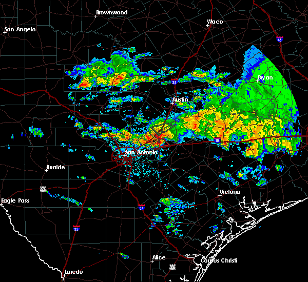 At 115 pm cdt, a severe thunderstorm capable of producing a tornado was located near geronimo, or 9 miles northeast of seguin, moving southeast at 10 mph (radar indicated rotation). Hazards include tornado and quarter size hail. Flying debris will be dangerous to those caught without shelter. mobile homes will be damaged or destroyed. damage to roofs, windows, and vehicles will occur. Tree damage is likely. At 115 pm cdt, a severe thunderstorm capable of producing a tornado was located near geronimo, or 9 miles northeast of seguin, moving southeast at 10 mph (radar indicated rotation). Hazards include tornado and quarter size hail. Flying debris will be dangerous to those caught without shelter. mobile homes will be damaged or destroyed. damage to roofs, windows, and vehicles will occur. Tree damage is likely.
|
| 2/19/2017 11:18 PM CST |
 At 1117 pm cst, severe thunderstorms were located along a line extending from wimberley to near pandora, moving east at 30 mph (radar indicated). Hazards include 60 mph wind gusts and nickel size hail. Expect damage to roofs, siding, and trees. Locations impacted include, new braunfels, san marcos, seguin, wimberley, canyon lake, woodcreek, mcqueeney, geronimo, zorn, kingsbury, hunter, nolte, zipp, redwood, freiheit, gruene, hays city and new braunfels regional airport. At 1117 pm cst, severe thunderstorms were located along a line extending from wimberley to near pandora, moving east at 30 mph (radar indicated). Hazards include 60 mph wind gusts and nickel size hail. Expect damage to roofs, siding, and trees. Locations impacted include, new braunfels, san marcos, seguin, wimberley, canyon lake, woodcreek, mcqueeney, geronimo, zorn, kingsbury, hunter, nolte, zipp, redwood, freiheit, gruene, hays city and new braunfels regional airport.
|
| 2/19/2017 10:56 PM CST |
 At 1056 pm cst, severe thunderstorms were located along a line extending from near fischer to near sutherland springs, moving east at 40 mph (radar indicated). Hazards include 60 mph wind gusts and nickel size hail. expect damage to roofs, siding, and trees At 1056 pm cst, severe thunderstorms were located along a line extending from near fischer to near sutherland springs, moving east at 40 mph (radar indicated). Hazards include 60 mph wind gusts and nickel size hail. expect damage to roofs, siding, and trees
|
| 5/31/2016 3:53 PM CDT |
 At 352 pm cdt, a severe thunderstorm was located near lockhart, moving northeast at 45 mph (radar indicated). Hazards include 60 mph wind gusts and nickel size hail. Expect damage to roofs. siding. and trees. Locations impacted include, new braunfels, san marcos, lockhart, kyle, buda, martindale, uhland, niederwald, staples, zorn, fentress, geronimo, mcqueeney, kingsbury, mountain city, hays, hays city, redwood, reedville and maxwell. At 352 pm cdt, a severe thunderstorm was located near lockhart, moving northeast at 45 mph (radar indicated). Hazards include 60 mph wind gusts and nickel size hail. Expect damage to roofs. siding. and trees. Locations impacted include, new braunfels, san marcos, lockhart, kyle, buda, martindale, uhland, niederwald, staples, zorn, fentress, geronimo, mcqueeney, kingsbury, mountain city, hays, hays city, redwood, reedville and maxwell.
|
| 5/31/2016 3:33 PM CDT |
 At 332 pm cdt, a severe thunderstorm was located near san marcos, moving east at 35 mph (radar indicated). Hazards include 60 mph wind gusts and quarter size hail. Hail damage to vehicles is expected. expect wind damage to roofs, siding, and trees. reports of 50 to 60 mph winds have been reported with this storm. please take shelter now. Locations impacted include, new braunfels, san marcos, lockhart, wimberley, canyon lake dam, schertz, kyle, cibolo, buda, canyon lake, garden ridge, woodcreek, martindale, uhland, santa clara, niederwald, staples, geronimo, northcliff and zorn. At 332 pm cdt, a severe thunderstorm was located near san marcos, moving east at 35 mph (radar indicated). Hazards include 60 mph wind gusts and quarter size hail. Hail damage to vehicles is expected. expect wind damage to roofs, siding, and trees. reports of 50 to 60 mph winds have been reported with this storm. please take shelter now. Locations impacted include, new braunfels, san marcos, lockhart, wimberley, canyon lake dam, schertz, kyle, cibolo, buda, canyon lake, garden ridge, woodcreek, martindale, uhland, santa clara, niederwald, staples, geronimo, northcliff and zorn.
|
| 5/31/2016 3:18 PM CDT |
 At 318 pm cdt, a severe thunderstorm was located near zorn, or 7 miles southwest of san marcos, moving northeast at 45 mph (radar indicated). Hazards include 60 mph wind gusts and quarter size hail. Hail damage to vehicles is expected. expect wind damage to roofs, siding, and trees. Locations impacted include, new braunfels, san marcos, lockhart, wimberley, canyon lake dam, schertz, kyle, cibolo, buda, selma, canyon lake, bulverde, garden ridge, woodcreek, martindale, uhland, santa clara, niederwald, staples and geronimo. At 318 pm cdt, a severe thunderstorm was located near zorn, or 7 miles southwest of san marcos, moving northeast at 45 mph (radar indicated). Hazards include 60 mph wind gusts and quarter size hail. Hail damage to vehicles is expected. expect wind damage to roofs, siding, and trees. Locations impacted include, new braunfels, san marcos, lockhart, wimberley, canyon lake dam, schertz, kyle, cibolo, buda, selma, canyon lake, bulverde, garden ridge, woodcreek, martindale, uhland, santa clara, niederwald, staples and geronimo.
|
| 5/31/2016 2:56 PM CDT |
 At 256 pm cdt, a severe thunderstorm was located near garden ridge, or 9 miles west of new braunfels, moving northeast at 45 mph (radar indicated). Hazards include 60 mph wind gusts and quarter size hail. Hail damage to vehicles is expected. Expect wind damage to roofs, siding, and trees. At 256 pm cdt, a severe thunderstorm was located near garden ridge, or 9 miles west of new braunfels, moving northeast at 45 mph (radar indicated). Hazards include 60 mph wind gusts and quarter size hail. Hail damage to vehicles is expected. Expect wind damage to roofs, siding, and trees.
|
| 4/27/2016 2:45 AM CDT |
 At 244 am cdt, severe thunderstorms were located along a line extending from near coupland to niederwald to near new braunfels to windcrest, moving southeast at 55 mph. wind gusts of 51 mph were reported at rusty miller lago vista airport and 46 mph at austin bergstrom and san antonio international airports (radar indicated). Hazards include 60 mph wind gusts. Expect damage to roofs. siding. and trees. Locations impacted include, san antonio, austin, round rock, new braunfels, cedar park, pflugerville, san marcos, seguin, universal city, lockhart, elgin, bastrop, luling, wimberley, dripping springs, tanglewood forest, anderson mill, canyon lake dam, windemere and austin bergstrom int ap. At 244 am cdt, severe thunderstorms were located along a line extending from near coupland to niederwald to near new braunfels to windcrest, moving southeast at 55 mph. wind gusts of 51 mph were reported at rusty miller lago vista airport and 46 mph at austin bergstrom and san antonio international airports (radar indicated). Hazards include 60 mph wind gusts. Expect damage to roofs. siding. and trees. Locations impacted include, san antonio, austin, round rock, new braunfels, cedar park, pflugerville, san marcos, seguin, universal city, lockhart, elgin, bastrop, luling, wimberley, dripping springs, tanglewood forest, anderson mill, canyon lake dam, windemere and austin bergstrom int ap.
|
| 4/27/2016 2:22 AM CDT |
 At 221 am cdt, severe thunderstorms were located along a line extending from near leander to near driftwood to near timberwood park, moving east at 60 mph. this line will cross the i-35 corridor northeast of san antonio to austin and round rock (radar indicated). Hazards include 70 mph wind gusts. Expect considerable tree damage. damage is likely to mobile homes, roofs, and outbuildings. Locations impacted include, san antonio, austin, round rock, new braunfels, cedar park, pflugerville, san marcos, seguin, universal city, lockhart, elgin, bastrop, luling, wimberley, dripping springs, tanglewood forest, anderson mill, canyon lake dam, windemere and austin bergstrom int ap. At 221 am cdt, severe thunderstorms were located along a line extending from near leander to near driftwood to near timberwood park, moving east at 60 mph. this line will cross the i-35 corridor northeast of san antonio to austin and round rock (radar indicated). Hazards include 70 mph wind gusts. Expect considerable tree damage. damage is likely to mobile homes, roofs, and outbuildings. Locations impacted include, san antonio, austin, round rock, new braunfels, cedar park, pflugerville, san marcos, seguin, universal city, lockhart, elgin, bastrop, luling, wimberley, dripping springs, tanglewood forest, anderson mill, canyon lake dam, windemere and austin bergstrom int ap.
|
| 4/27/2016 2:04 AM CDT |
 At 202 am cdt, severe thunderstorms were located along a line extending from near smithwick to near johnson city to kreutzberg, moving east at 60 mph. this line of storms will cross the i-35 corridor between san antonio and round rock, including austin (radar indicated). Hazards include 70 mph wind gusts. Expect considerable tree damage. Damage is likely to mobile homes, roofs, and outbuildings. At 202 am cdt, severe thunderstorms were located along a line extending from near smithwick to near johnson city to kreutzberg, moving east at 60 mph. this line of storms will cross the i-35 corridor between san antonio and round rock, including austin (radar indicated). Hazards include 70 mph wind gusts. Expect considerable tree damage. Damage is likely to mobile homes, roofs, and outbuildings.
|
| 4/12/2016 10:30 PM CDT |
 At 1028 pm cdt, a severe thunderstorm was located 8 miles east of new berlin, or 9 miles south of seguin, moving east at 40 mph (radar indicated). Hazards include tennis ball size hail and 60 mph wind gusts. People and animals outdoors will be injured. expect hail damage to roofs, siding, windows, and vehicles. expect wind damage to roofs, siding, and trees. Locations impacted include, seguin, stockdale, la vernia, new berlin, mcqueeney, sutherland springs, kingsbury, zuehl, zipp and nolte. At 1028 pm cdt, a severe thunderstorm was located 8 miles east of new berlin, or 9 miles south of seguin, moving east at 40 mph (radar indicated). Hazards include tennis ball size hail and 60 mph wind gusts. People and animals outdoors will be injured. expect hail damage to roofs, siding, windows, and vehicles. expect wind damage to roofs, siding, and trees. Locations impacted include, seguin, stockdale, la vernia, new berlin, mcqueeney, sutherland springs, kingsbury, zuehl, zipp and nolte.
|
| 4/12/2016 9:49 PM CDT |
 At 947 pm cdt, a severe thunderstorm was located over windcrest, or near universal city, moving east at 35 mph. this storm will cross the intersection of loop 410 and interstate 35 then move across interstate 10 near loop 1604. this is a very dangerous storm (radar indicated). Hazards include baseball size hail and 70 mph wind gusts. People and animals outdoors will be severely injured. Expect shattered windows, extensive damage to roofs, siding, and vehicles. At 947 pm cdt, a severe thunderstorm was located over windcrest, or near universal city, moving east at 35 mph. this storm will cross the intersection of loop 410 and interstate 35 then move across interstate 10 near loop 1604. this is a very dangerous storm (radar indicated). Hazards include baseball size hail and 70 mph wind gusts. People and animals outdoors will be severely injured. Expect shattered windows, extensive damage to roofs, siding, and vehicles.
|
| 3/24/2016 3:11 AM CDT |
 At 310 am cdt, severe thunderstorms were located along a line extending from near seguin to 8 miles north of nixon to near pandora, moving east at 45 mph (radar indicated). Hazards include 60 mph wind gusts. Expect damage to roofs. siding. And trees. At 310 am cdt, severe thunderstorms were located along a line extending from near seguin to 8 miles north of nixon to near pandora, moving east at 45 mph (radar indicated). Hazards include 60 mph wind gusts. Expect damage to roofs. siding. And trees.
|
| 3/18/2016 8:55 PM CDT |
 At 853 pm cdt, a severe thunderstorm was located near kingsbury, or 8 miles southwest of luling, moving southeast at 15 mph. this storm has produced half dollar sized hail near staples, but radar trends indicate the storm is starting to weaken (trained weather spotters). Hazards include 60 mph wind gusts and quarter size hail. Hail damage to vehicles is expected. expect wind damage to roofs, siding, and trees. Locations impacted include, gonzales, nixon, smiley, palmeto, kingsbury, wrightsboro, belmont, oak forest, little new york, dilworth, nickle, monthalia, ottine, cost, bebe, hamon and leesville. At 853 pm cdt, a severe thunderstorm was located near kingsbury, or 8 miles southwest of luling, moving southeast at 15 mph. this storm has produced half dollar sized hail near staples, but radar trends indicate the storm is starting to weaken (trained weather spotters). Hazards include 60 mph wind gusts and quarter size hail. Hail damage to vehicles is expected. expect wind damage to roofs, siding, and trees. Locations impacted include, gonzales, nixon, smiley, palmeto, kingsbury, wrightsboro, belmont, oak forest, little new york, dilworth, nickle, monthalia, ottine, cost, bebe, hamon and leesville.
|
| 3/18/2016 8:30 PM CDT |
 At 829 pm cdt, a severe thunderstorm was located over kingsbury, or 10 miles west of luling, moving southeast at 25 mph. this storm has a history of producing quarter size hail and damaging wind gusts. the damaging wind gusts will be with a gust front that is outrunning the storms (trained weather spotters). Hazards include 60 mph wind gusts and quarter size hail. Hail damage to vehicles is expected. Expect wind damage to roofs, siding, and trees. At 829 pm cdt, a severe thunderstorm was located over kingsbury, or 10 miles west of luling, moving southeast at 25 mph. this storm has a history of producing quarter size hail and damaging wind gusts. the damaging wind gusts will be with a gust front that is outrunning the storms (trained weather spotters). Hazards include 60 mph wind gusts and quarter size hail. Hail damage to vehicles is expected. Expect wind damage to roofs, siding, and trees.
|
| 3/18/2016 8:24 PM CDT |
 At 824 pm cdt, a severe thunderstorm was located over kingsbury, or 8 miles southwest of luling, moving southeast at 20 mph. quarter size hail has been observed east of seguin (trained weather spotters). Hazards include 60 mph wind gusts and quarter size hail. Hail damage to vehicles is expected. expect wind damage to roofs, siding, and trees. Locations impacted include, seguin, lockhart, luling, martindale, staples, fentress, geronimo, kingsbury, palmeto, mcqueeney, brownsboro, belmont, thompsonville, ottine, maxwell, tilmon, stairtown, joliet, leesville and mcneil. At 824 pm cdt, a severe thunderstorm was located over kingsbury, or 8 miles southwest of luling, moving southeast at 20 mph. quarter size hail has been observed east of seguin (trained weather spotters). Hazards include 60 mph wind gusts and quarter size hail. Hail damage to vehicles is expected. expect wind damage to roofs, siding, and trees. Locations impacted include, seguin, lockhart, luling, martindale, staples, fentress, geronimo, kingsbury, palmeto, mcqueeney, brownsboro, belmont, thompsonville, ottine, maxwell, tilmon, stairtown, joliet, leesville and mcneil.
|
| 3/18/2016 7:54 PM CDT |
 At 752 pm cdt, a severe thunderstorm was located near fentress, or 7 miles west of luling, moving southeast at 35 mph. straight-line winds of 54 mph have been observed with this storm new braunfels and power lines are down in kyle. the gust front appears to be outrunning the storm cells, so the strongest winds will be well in front of the rain from this storm. radar also indicates hail up to quarter size may be occurring south of san marcos (radar indicated). Hazards include 60 mph wind gusts and quarter size hail. Hail damage to vehicles is expected. expect wind damage to roofs, siding, and trees. Locations impacted include, new braunfels, san marcos, seguin, lockhart, luling, kyle, martindale, uhland, niederwald, staples, geronimo, kingsbury, palmeto, zorn, fentress, mcqueeney, brownsboro, belmont, thompsonville and redwood. At 752 pm cdt, a severe thunderstorm was located near fentress, or 7 miles west of luling, moving southeast at 35 mph. straight-line winds of 54 mph have been observed with this storm new braunfels and power lines are down in kyle. the gust front appears to be outrunning the storm cells, so the strongest winds will be well in front of the rain from this storm. radar also indicates hail up to quarter size may be occurring south of san marcos (radar indicated). Hazards include 60 mph wind gusts and quarter size hail. Hail damage to vehicles is expected. expect wind damage to roofs, siding, and trees. Locations impacted include, new braunfels, san marcos, seguin, lockhart, luling, kyle, martindale, uhland, niederwald, staples, geronimo, kingsbury, palmeto, zorn, fentress, mcqueeney, brownsboro, belmont, thompsonville and redwood.
|
| 3/18/2016 7:44 PM CDT |
 At 744 pm cdt, a severe thunderstorm was located over martindale, or near san marcos, moving southeast at 30 mph. this storm has a history of producing damaging straight-line winds, including power lines down in kyle (radar indicated). Hazards include 60 mph wind gusts and penny size hail. Expect damage to roofs. siding. And trees. At 744 pm cdt, a severe thunderstorm was located over martindale, or near san marcos, moving southeast at 30 mph. this storm has a history of producing damaging straight-line winds, including power lines down in kyle (radar indicated). Hazards include 60 mph wind gusts and penny size hail. Expect damage to roofs. siding. And trees.
|
| 3/18/2016 7:36 PM CDT |
 At 735 pm cdt, a severe thunderstorm was located over san marcos, moving southeast at 25 mph. wind gusts up to 50 mph have been observed in new braunfels and san marcos, but wind gusts up to 60 mph are still possible. this storm continues to transition toward a straight-line wind threat, but nickel size hail is still possible (radar indicated). Hazards include 60 mph wind gusts and nickel size hail. Expect damage to roofs. siding. and trees. Locations impacted include, new braunfels, san marcos, seguin, lockhart, wimberley, canyon lake dam, kyle, buda, canyon lake, martindale, uhland, santa clara, niederwald, staples, geronimo, mcqueeney, kingsbury, zorn, fentress and mountain city. At 735 pm cdt, a severe thunderstorm was located over san marcos, moving southeast at 25 mph. wind gusts up to 50 mph have been observed in new braunfels and san marcos, but wind gusts up to 60 mph are still possible. this storm continues to transition toward a straight-line wind threat, but nickel size hail is still possible (radar indicated). Hazards include 60 mph wind gusts and nickel size hail. Expect damage to roofs. siding. and trees. Locations impacted include, new braunfels, san marcos, seguin, lockhart, wimberley, canyon lake dam, kyle, buda, canyon lake, martindale, uhland, santa clara, niederwald, staples, geronimo, mcqueeney, kingsbury, zorn, fentress and mountain city.
|
| 3/18/2016 6:57 PM CDT |
 At 656 pm cdt, a severe thunderstorm was located near woodcreek, or near wimberley, moving southeast at 35 mph. the straight-line winds in this storm are intensifying to 70 mph as the storm heads towards wimberley (radar indicated). Hazards include 70 mph wind gusts and quarter size hail. Hail damage to vehicles is expected. expect considerable tree damage. wind damage is also likely to mobile homes, roofs, and outbuildings. Locations impacted include, new braunfels, san marcos, seguin, lockhart, wimberley, dripping springs, canyon lake dam, kyle, buda, canyon lake, woodcreek, martindale, uhland, santa clara, niederwald, bear creek, staples, geronimo, driftwood and mcqueeney. At 656 pm cdt, a severe thunderstorm was located near woodcreek, or near wimberley, moving southeast at 35 mph. the straight-line winds in this storm are intensifying to 70 mph as the storm heads towards wimberley (radar indicated). Hazards include 70 mph wind gusts and quarter size hail. Hail damage to vehicles is expected. expect considerable tree damage. wind damage is also likely to mobile homes, roofs, and outbuildings. Locations impacted include, new braunfels, san marcos, seguin, lockhart, wimberley, dripping springs, canyon lake dam, kyle, buda, canyon lake, woodcreek, martindale, uhland, santa clara, niederwald, bear creek, staples, geronimo, driftwood and mcqueeney.
|
| 3/18/2016 6:49 PM CDT |
 At 648 pm cdt, a severe thunderstorm was located near woodcreek, or near dripping springs, moving southeast at 35 mph. this storm has a history of producing quarter size hail and 60 mph wind gusts. this storm appears to be transitioning to a straight line wind threat (radar indicated). Hazards include 60 mph wind gusts and quarter size hail. Hail damage to vehicles is expected. Expect wind damage to roofs, siding, and trees. At 648 pm cdt, a severe thunderstorm was located near woodcreek, or near dripping springs, moving southeast at 35 mph. this storm has a history of producing quarter size hail and 60 mph wind gusts. this storm appears to be transitioning to a straight line wind threat (radar indicated). Hazards include 60 mph wind gusts and quarter size hail. Hail damage to vehicles is expected. Expect wind damage to roofs, siding, and trees.
|
| 10/30/2015 7:18 AM CDT |
 At 717 am cdt, a severe thunderstorm capable of producing a tornado was located over geronimo, or near seguin, moving north at 30 mph (radar indicated rotation). Hazards include tornado. Flying debris will be dangerous to those caught without shelter. mobile homes will be damaged or destroyed. damage to roofs, windows and vehicles will occur. tree damage is likely. this dangerous storm will be near, zorn around 725 am cdt. new braunfels around 730 am cdt. Other locations impacted by this tornadic thunderstorm include freiheit, hunter, redwood and gruene. At 717 am cdt, a severe thunderstorm capable of producing a tornado was located over geronimo, or near seguin, moving north at 30 mph (radar indicated rotation). Hazards include tornado. Flying debris will be dangerous to those caught without shelter. mobile homes will be damaged or destroyed. damage to roofs, windows and vehicles will occur. tree damage is likely. this dangerous storm will be near, zorn around 725 am cdt. new braunfels around 730 am cdt. Other locations impacted by this tornadic thunderstorm include freiheit, hunter, redwood and gruene.
|
| 10/30/2015 6:51 AM CDT |
 At 651 am cdt, a severe thunderstorm capable of producing a tornado was located near new berlin, or 10 miles south of seguin, moving north at 25 mph (radar indicated rotation). Hazards include tornado. Flying debris will be dangerous to those caught without shelter. mobile homes will be damaged or destroyed. damage to roofs, windows and vehicles will occur. tree damage is likely. this dangerous storm will be near, mcqueeney around 720 am cdt. seguin around 725 am cdt. geronimo around 730 am cdt. Other locations impacted by this tornadic thunderstorm include nolte and zipp. At 651 am cdt, a severe thunderstorm capable of producing a tornado was located near new berlin, or 10 miles south of seguin, moving north at 25 mph (radar indicated rotation). Hazards include tornado. Flying debris will be dangerous to those caught without shelter. mobile homes will be damaged or destroyed. damage to roofs, windows and vehicles will occur. tree damage is likely. this dangerous storm will be near, mcqueeney around 720 am cdt. seguin around 725 am cdt. geronimo around 730 am cdt. Other locations impacted by this tornadic thunderstorm include nolte and zipp.
|
| 10/30/2015 6:36 AM CDT |
 At 635 am cdt, a severe thunderstorm was located over la vernia, or 12 miles northwest of stockdale, moving north at 30 mph (radar indicated). Hazards include 60 mph wind gusts and penny size hail. Expect damage to roofs. Siding and trees. At 635 am cdt, a severe thunderstorm was located over la vernia, or 12 miles northwest of stockdale, moving north at 30 mph (radar indicated). Hazards include 60 mph wind gusts and penny size hail. Expect damage to roofs. Siding and trees.
|
| 5/30/2015 4:45 PM CDT | At 444 pm cdt, a severe thunderstorm was located 11 miles southwest of palmeto, or 14 miles southwest of luling, moving southeast at 20 mph (radar indicated). Hazards include 60 mph wind gusts and nickel size hail. Expect damage to roofs. siding and trees. Locations impacted include, kingsbury, oak forest, bebe, leesville, monthalia and belmont. |
| 5/30/2015 4:10 PM CDT | At 409 pm cdt, a severe thunderstorm was located near kingsbury, or 9 miles east of seguin, moving south at 25 mph (radar indicated). Hazards include 60 mph wind gusts and nickel size hail. Expect damage to roofs. Siding and trees. |
| 5/29/2015 1:55 AM CDT | The severe thunderstorm warning for guadalupe and caldwell counties will expire at 200 am cdt, the storms which prompted the warning have weakened below severe limits, and exited the warned area. therefore the warning will be allowed to expire. however heavy rain is still possible with these thunderstorms. a severe thunderstorm watch remains in effect until 400 am cdt for south central texas. |
| 5/29/2015 1:35 AM CDT | At 135 am cdt, severe thunderstorms were located along a line extending from near cedar creek to 6 miles southeast of lockhart to near kingsbury to near la vernia, moving east at 40 mph (radar indicated). Hazards include 60 mph wind gusts. Expect damage to roofs. siding and trees. Locations impacted include, new braunfels, san marcos, seguin, lockhart, luling, schertz, cibolo, selma, martindale, marion, uhland, mustang ridge, santa clara, niederwald, new berlin, staples, zuehl, geronimo, mcqueeney and kingsbury. |
| 5/29/2015 12:39 AM CDT | At 1239 am cdt, severe thunderstorms were located along a line extending from near driftwood to near wimberley to 6 miles southeast of canyon lake dam to near hollywood park, moving east at 40 mph (radar indicated). Hazards include 60 mph wind gusts. Expect damage to roofs. Siding and trees. |
| 5/25/2015 6:00 PM CDT | At 600 pm cdt, severe thunderstorms were located along a line extending from 6 miles north of dime box to smithville to 6 miles southeast of kingsbury to near la vernia, moving southeast at 15 mph (radar indicated). Hazards include 60 mph wind gusts. Expect damage to roofs. Siding and trees. |
| 4/27/2015 2:16 AM CDT | At 215 am cdt, severe thunderstorms were located along a line extending from 7 miles southeast of rogers to near palmeto to near stockdale to near floresville to near poteet to 6 miles west of schattel to 8 miles east of dilley, and are nearly stationary (radar indicated). Hazards include 60 mph wind gusts and penny size hail. Expect damage to roofs. siding and trees. locations impacted include, san antonio, austin, new braunfels, pflugerville, san marcos, seguin, taylor, lockhart, pearsall, pleasanton, elgin, gonzales, bastrop, crystal city, floresville, luling, giddings, dilley, jourdanton and smithville. a tornado watch remains in effect until 900 am cdt for south central texas. 0. 75in. |
| 4/27/2015 1:58 AM CDT | At 157 am cdt, severe thunderstorms were located along a line extending from near cameron to 9 miles south of cedar creek to near sutherland springs to near elmendorf to near bigfoot to pearsall to dilley, moving east at 55 mph (radar indicated). Hazards include 60 mph wind gusts and penny size hail. Expect damage to roofs. siding and trees. locations impacted include, san antonio, austin, round rock, new braunfels, cedar park, georgetown, pflugerville, san marcos, seguin, universal city, taylor, lockhart, pearsall, pleasanton, elgin, gonzales, bastrop, crystal city, floresville and luling. a tornado watch remains in effect until 900 am cdt for south central texas. 0. 75in. |
| 4/27/2015 1:38 AM CDT | At 137 am cdt, severe thunderstorms were located along a line extending from near bartlett to zorn to near somerset to moore to 9 miles east of batesville to near brundage, moving east at 50 mph (radar indicated). Hazards include 60 mph wind gusts and penny size hail. Expect damage to roofs. Siding and trees. |
| 4/25/2015 5:09 AM CDT | At 508 am cdt, a severe thunderstorm was located near geronimo, or near seguin, moving northeast at 45 mph (radar indicated). Hazards include 60 mph wind gusts and penny size hail. Expect damage to roofs. siding and trees. locations impacted include, new braunfels, seguin, marion, santa clara, new berlin, zorn, geronimo, mcqueeney, kingsbury, zuehl, zipp, nolte and redwood. 0. 75in. |
| 4/25/2015 5:00 AM CDT | At 459 am cdt, a severe thunderstorm was located over santa clara, or 7 miles south of new braunfels, moving east at 45 mph (radar indicated). Hazards include 60 mph wind gusts and penny size hail. Expect damage to roofs. Siding and trees. |
Hail Maps for Kingsbury, TX
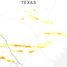
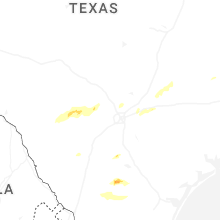
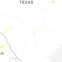
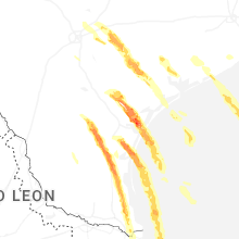


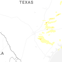


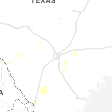


Connect with Interactive Hail Maps