

Hail Map for Kountze, TX
The Kountze, TX area has had 8 reports of on-the-ground hail by trained spotters, and has been under severe weather warnings 15 times during the past 12 months. Doppler radar has detected hail at or near Kountze, TX on 54 occasions, including 1 occasion during the past year.
| Name: | Kountze, TX |
| Where Located: | 39.8 miles WNW of Beaumont, TX |
| Map: | Google Map for Kountze, TX |
| Population: | 2123 |
| Housing Units: | 875 |
| More Info: | Search Google for Kountze, TX |
1
The Top Recent Hail Date for Kountze, TX is Tuesday, October 28, 2025 (21st out of 54)

Hail and Wind Damage Spotted near Kountze, TX
| Date / Time | Report Details |
|---|---|
| 3/15/2026 8:37 PM CDT |
 The storm which prompted the warning has weakened below severe limits, and no longer poses an immediate threat to life or property. therefore, the warning will be allowed to expire. a tornado watch remains in effect until midnight cdt for southeastern texas. The storm which prompted the warning has weakened below severe limits, and no longer poses an immediate threat to life or property. therefore, the warning will be allowed to expire. a tornado watch remains in effect until midnight cdt for southeastern texas.
|
| 3/15/2026 8:31 PM CDT |
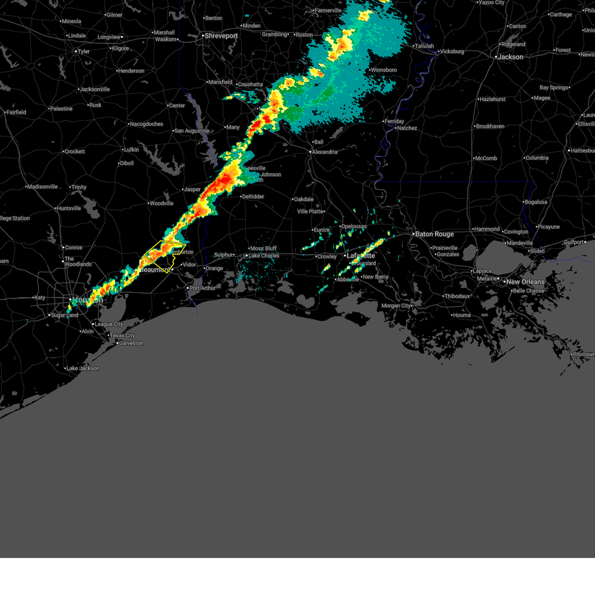
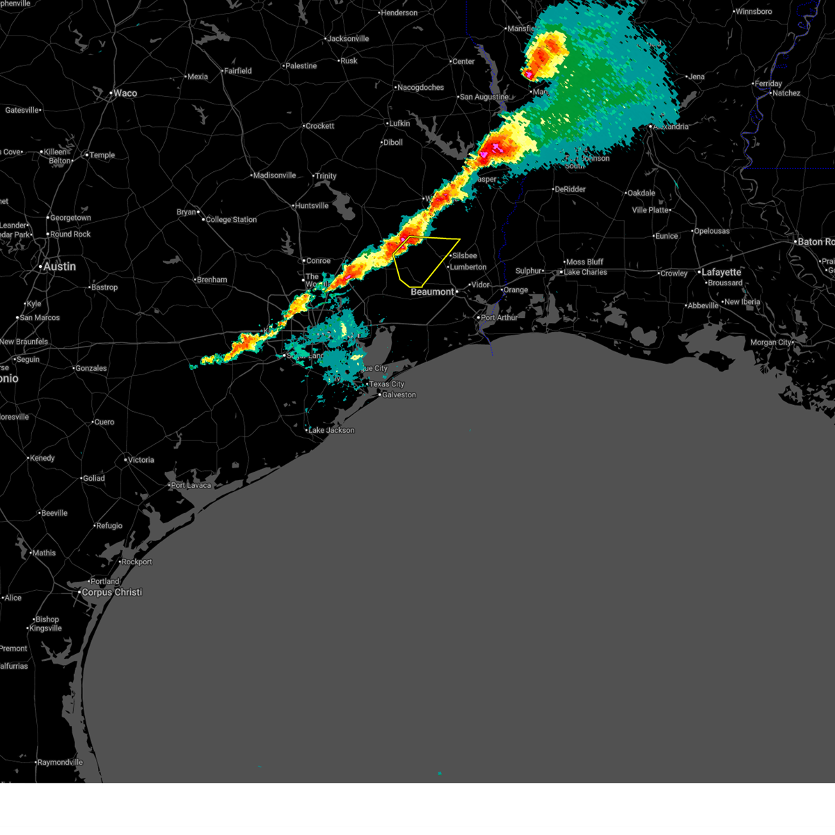
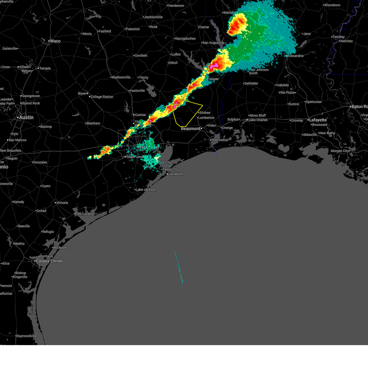
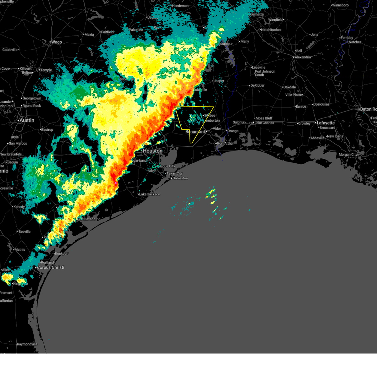
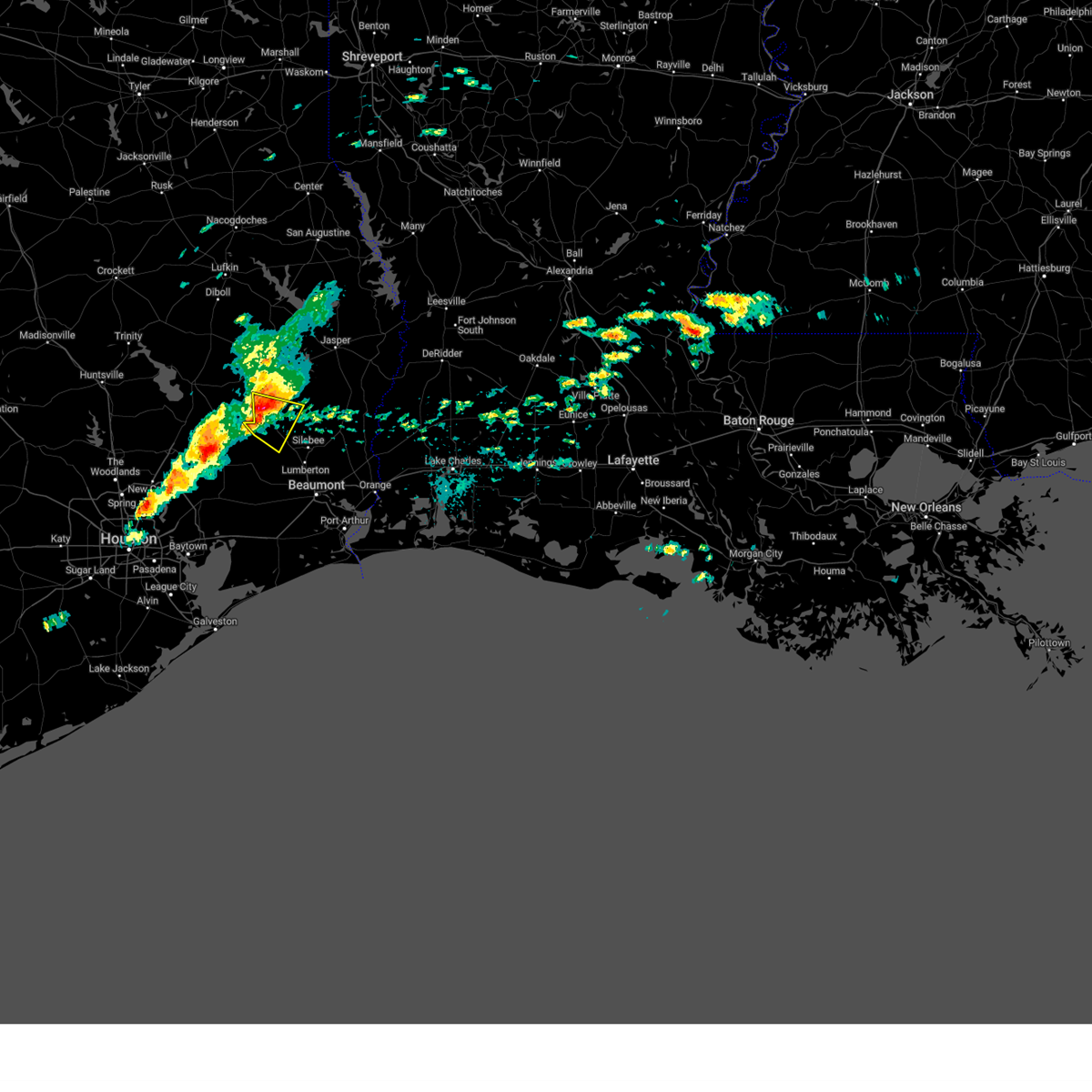
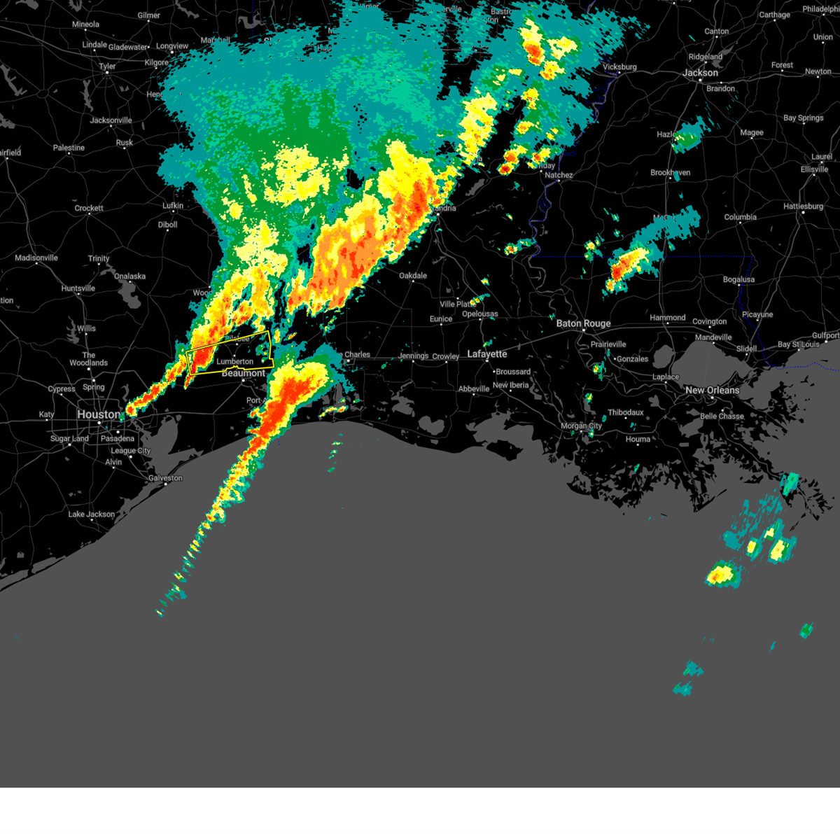
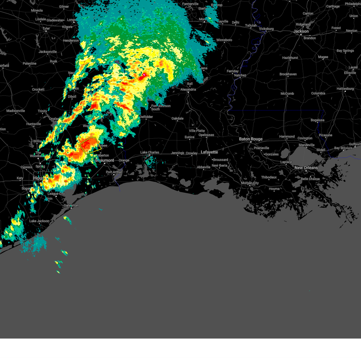
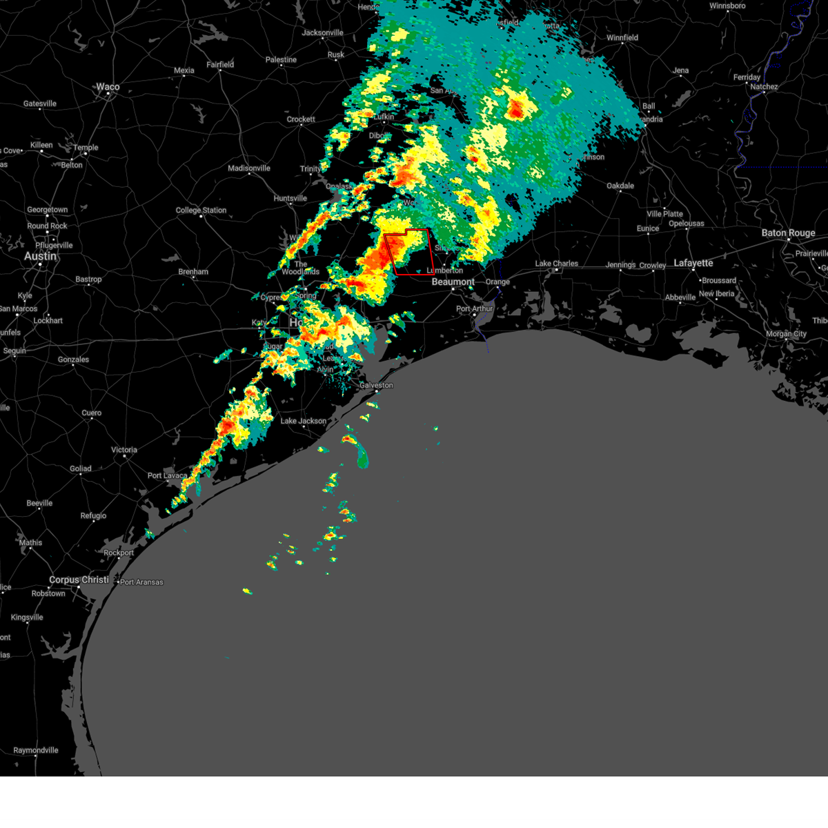
 At 831 pm cdt, a severe thunderstorm was located over lumberton, moving southeast at 40 mph (radar indicated). Hazards include quarter size hail. Damage to vehicles is expected. Locations impacted include, beaumont, lumberton, silsbee, kountze, evadale, bevil oaks, and weiss bluff. At 831 pm cdt, a severe thunderstorm was located over lumberton, moving southeast at 40 mph (radar indicated). Hazards include quarter size hail. Damage to vehicles is expected. Locations impacted include, beaumont, lumberton, silsbee, kountze, evadale, bevil oaks, and weiss bluff.
|
| 3/15/2026 8:08 PM CDT |
 Svrlch the national weather service in lake charles has issued a * severe thunderstorm warning for, north central jefferson county in southeastern texas, central hardin county in southeastern texas, south central jasper county in southeastern texas, * until 845 pm cdt. * at 808 pm cdt, a severe thunderstorm was located over honey island, or near saratoga, moving southeast at 40 mph (radar indicated). Hazards include 60 mph wind gusts and quarter size hail. Hail damage to vehicles is expected. Expect wind damage to roofs, siding, and trees. Svrlch the national weather service in lake charles has issued a * severe thunderstorm warning for, north central jefferson county in southeastern texas, central hardin county in southeastern texas, south central jasper county in southeastern texas, * until 845 pm cdt. * at 808 pm cdt, a severe thunderstorm was located over honey island, or near saratoga, moving southeast at 40 mph (radar indicated). Hazards include 60 mph wind gusts and quarter size hail. Hail damage to vehicles is expected. Expect wind damage to roofs, siding, and trees.
|
| 3/15/2026 8:03 PM CDT |
 At 803 pm cdt, a severe thunderstorm was located near honey island, or near saratoga, moving southeast at 35 mph (radar indicated). Hazards include 60 mph wind gusts and quarter size hail. Hail damage to vehicles is expected. expect wind damage to roofs, siding, and trees. Locations impacted include, silsbee, kountze, sour lake, saratoga, thicket, batson, and honey island. At 803 pm cdt, a severe thunderstorm was located near honey island, or near saratoga, moving southeast at 35 mph (radar indicated). Hazards include 60 mph wind gusts and quarter size hail. Hail damage to vehicles is expected. expect wind damage to roofs, siding, and trees. Locations impacted include, silsbee, kountze, sour lake, saratoga, thicket, batson, and honey island.
|
| 3/15/2026 8:03 PM CDT |
 the severe thunderstorm warning has been cancelled and is no longer in effect the severe thunderstorm warning has been cancelled and is no longer in effect
|
| 3/15/2026 7:51 PM CDT |
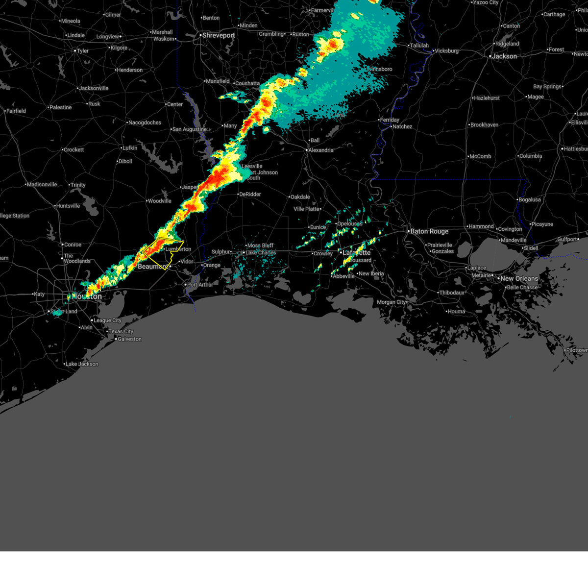
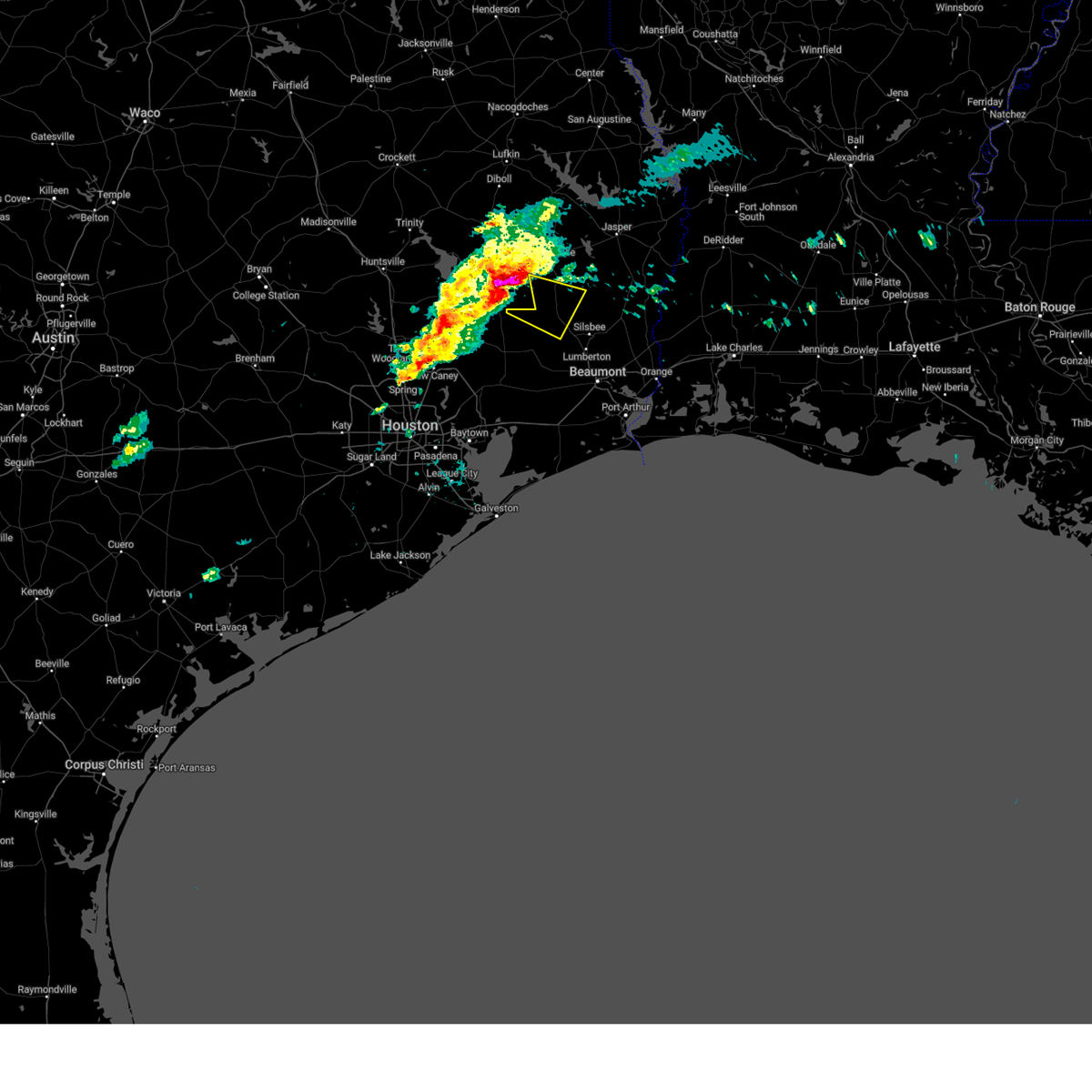
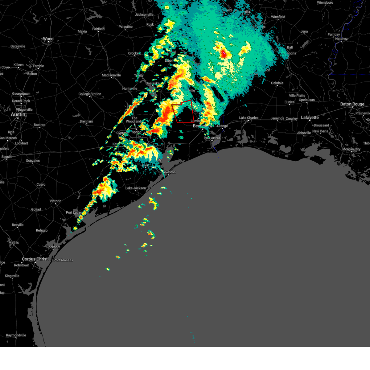
 At 751 pm cdt, a severe thunderstorm was located near thicket, moving southeast at 40 mph (radar indicated). Hazards include ping pong ball size hail and 60 mph wind gusts. People and animals outdoors will be injured. expect hail damage to roofs, siding, windows, and vehicles. expect wind damage to roofs, siding, and trees. Locations impacted include, silsbee, kountze, sour lake, saratoga, thicket, wildwood, batson, votaw, honey island, and village mills. At 751 pm cdt, a severe thunderstorm was located near thicket, moving southeast at 40 mph (radar indicated). Hazards include ping pong ball size hail and 60 mph wind gusts. People and animals outdoors will be injured. expect hail damage to roofs, siding, windows, and vehicles. expect wind damage to roofs, siding, and trees. Locations impacted include, silsbee, kountze, sour lake, saratoga, thicket, wildwood, batson, votaw, honey island, and village mills.
|
| 3/15/2026 7:34 PM CDT |
 Svrlch the national weather service in lake charles has issued a * severe thunderstorm warning for, south central tyler county in southeastern texas, hardin county in southeastern texas, * until 815 pm cdt. * at 734 pm cdt, a severe thunderstorm was located near votaw, or 10 miles northwest of thicket, moving southeast at 35 mph (radar indicated). Hazards include 60 mph wind gusts and quarter size hail. Hail damage to vehicles is expected. Expect wind damage to roofs, siding, and trees. Svrlch the national weather service in lake charles has issued a * severe thunderstorm warning for, south central tyler county in southeastern texas, hardin county in southeastern texas, * until 815 pm cdt. * at 734 pm cdt, a severe thunderstorm was located near votaw, or 10 miles northwest of thicket, moving southeast at 35 mph (radar indicated). Hazards include 60 mph wind gusts and quarter size hail. Hail damage to vehicles is expected. Expect wind damage to roofs, siding, and trees.
|
| 2/14/2026 6:52 PM CST |
 the severe thunderstorm warning has been cancelled and is no longer in effect the severe thunderstorm warning has been cancelled and is no longer in effect
|
| 2/14/2026 6:29 PM CST |
 Svrlch the national weather service in lake charles has issued a * severe thunderstorm warning for, northwestern jefferson county in southeastern texas, hardin county in southeastern texas, southeastern jasper county in southeastern texas, * until 715 pm cst. * at 629 pm cst, severe thunderstorms were located along a line extending from near votaw to near dayton lakes to near lake houston dam, moving southeast at 25 mph (radar indicated). Hazards include 60 mph wind gusts. expect damage to roofs, siding, and trees Svrlch the national weather service in lake charles has issued a * severe thunderstorm warning for, northwestern jefferson county in southeastern texas, hardin county in southeastern texas, southeastern jasper county in southeastern texas, * until 715 pm cst. * at 629 pm cst, severe thunderstorms were located along a line extending from near votaw to near dayton lakes to near lake houston dam, moving southeast at 25 mph (radar indicated). Hazards include 60 mph wind gusts. expect damage to roofs, siding, and trees
|
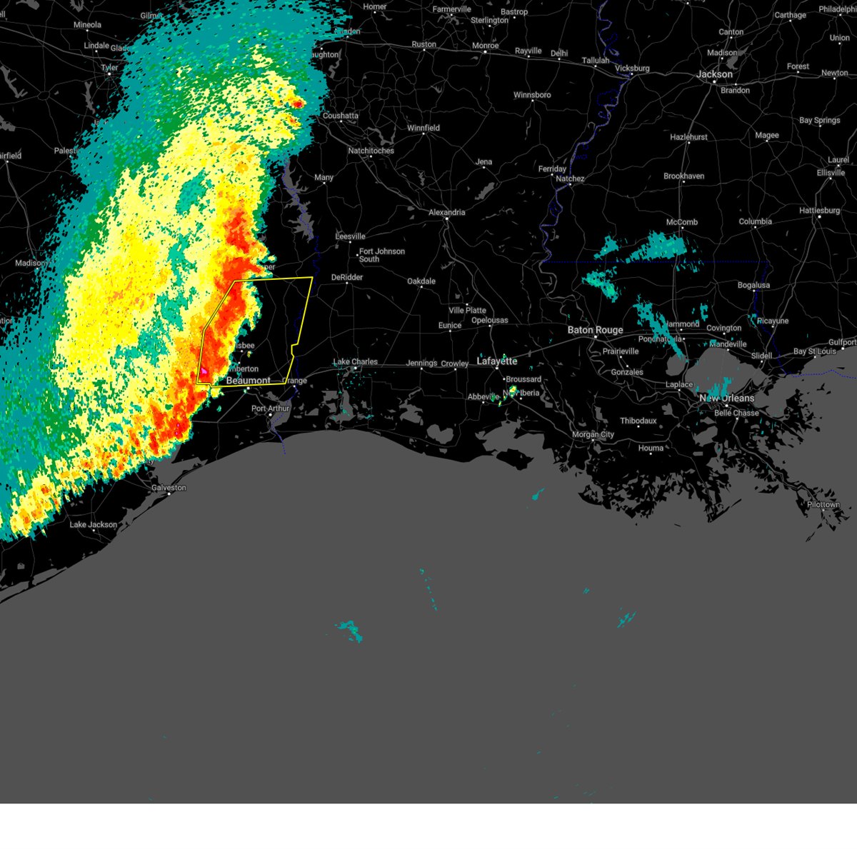
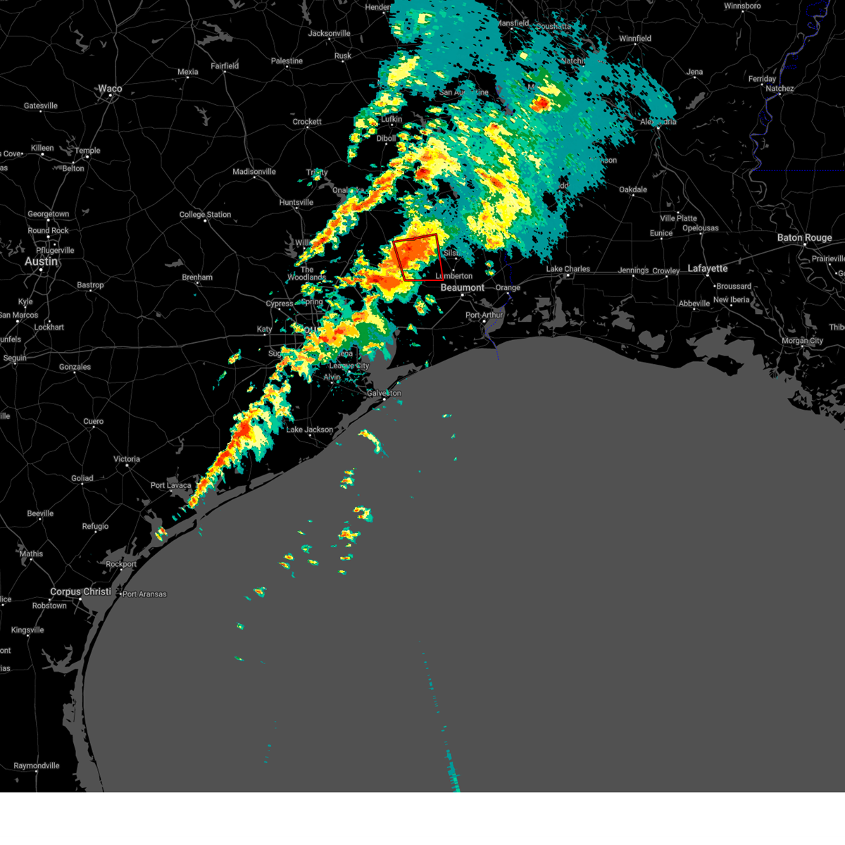
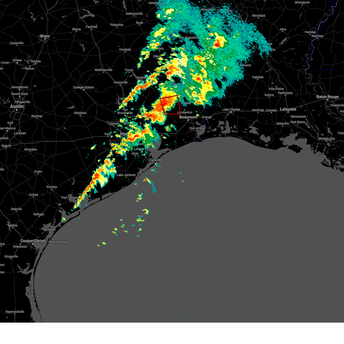
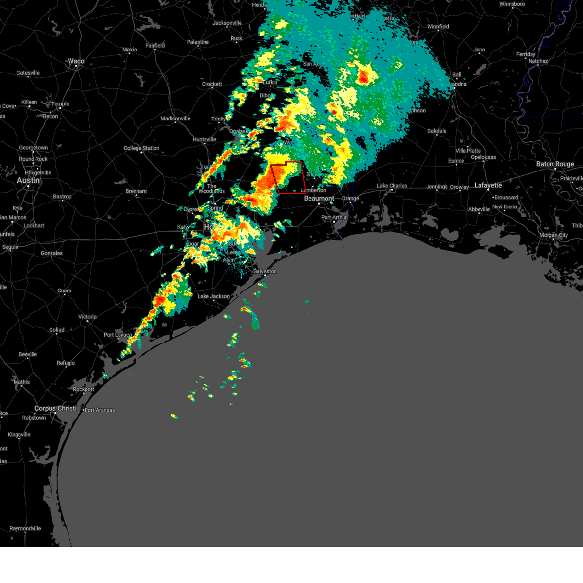
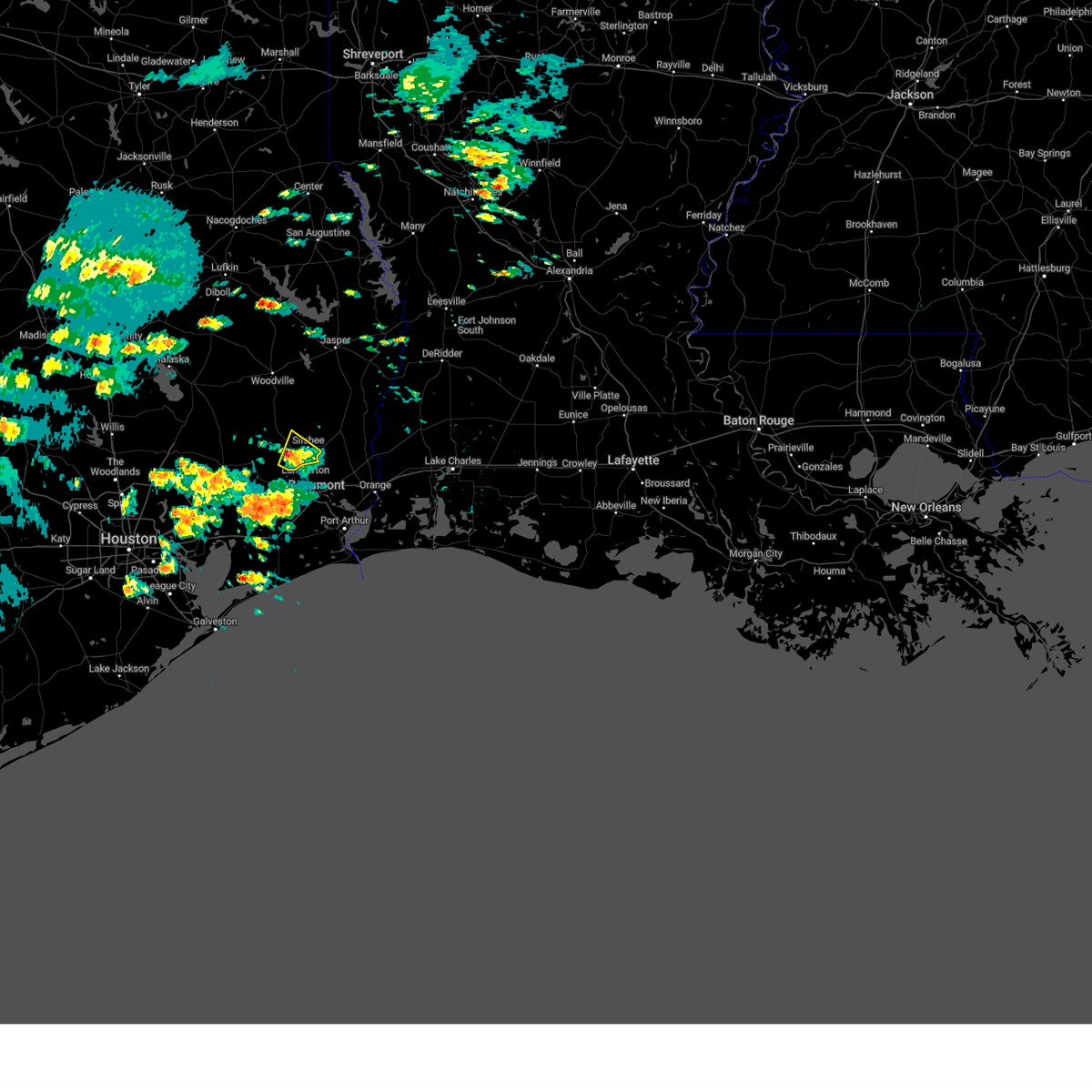
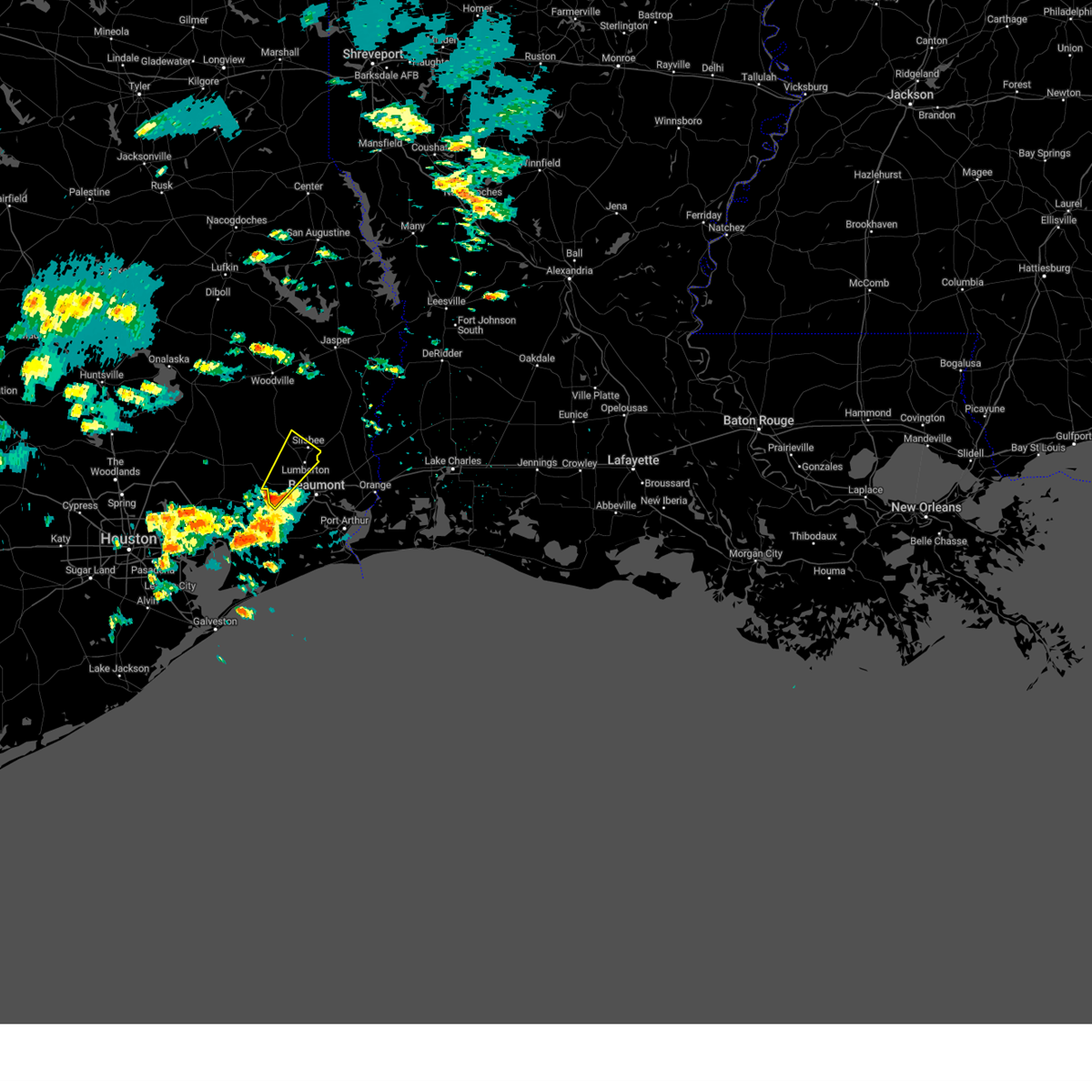
| 10/28/2025 5:33 PM CDT | At 532 pm cdt, a severe thunderstorm was located over kountze, moving southeast at 35 mph (radar indicated). Hazards include 60 mph wind gusts and quarter size hail. Hail damage to vehicles is expected. expect wind damage to roofs, siding, and trees. Locations impacted include, beaumont, lumberton, silsbee, kountze, evadale, lakeview, and weiss bluff. |
| 10/28/2025 5:23 PM CDT | Svrlch the national weather service in lake charles has issued a * severe thunderstorm warning for, eastern hardin county in southeastern texas, northwestern orange county in southeastern texas, south central jasper county in southeastern texas, * until 600 pm cdt. * at 522 pm cdt, a severe thunderstorm was located near kountze, moving southeast at 35 mph (radar indicated). Hazards include 60 mph wind gusts and quarter size hail. Hail damage to vehicles is expected. Expect wind damage to roofs, siding, and trees. |
| 10/25/2025 5:17 AM CDT | At 517 am cdt, severe thunderstorms were located along a line extending from 6 miles northeast of woodville to near caney head to near bevil oaks, moving east at 35 mph (radar indicated). Hazards include 60 mph wind gusts. Expect damage to roofs, siding, and trees. Locations impacted include, lumberton, jasper, silsbee, woodville, kirbyville, kountze, sour lake, colmesneil, chester, evadale, rockland, warren, town bluff, ebenezer, fred, buna, bevil oaks, weiss bluff, gist, and spurger. |
| 10/25/2025 4:39 AM CDT | Svrlch the national weather service in lake charles has issued a * severe thunderstorm warning for, tyler county in southeastern texas, hardin county in southeastern texas, jasper county in southeastern texas, * until 545 am cdt. * at 439 am cdt, severe thunderstorms were located along a line extending from near alabama-coushatta reservation to near honey island to near anahuac, moving east at 35 mph (radar indicated). Hazards include 60 mph wind gusts. expect damage to roofs, siding, and trees |
| 10/25/2025 4:18 AM CDT | At 417 am cdt, severe thunderstorms were located along a line extending from near livingston to 7 miles southwest of votaw to near dayton, moving east at 40 mph (radar indicated). Hazards include 60 mph wind gusts. Expect damage to roofs, siding, and trees. Locations impacted include, woodville, kountze, sour lake, colmesneil, chester, saratoga, fred, rockland, wildwood, warren, thicket, caney head, votaw, honey island, spurger, batson, village mills, ivanhoe, and hillister. |
| 10/25/2025 3:52 AM CDT | Svrlch the national weather service in lake charles has issued a * severe thunderstorm warning for, tyler county in southeastern texas, hardin county in southeastern texas, * until 445 am cdt. * at 351 am cdt, severe thunderstorms were located along a line extending from near lake livingston state park to near cleveland to atascocita, moving east at 40 mph (radar indicated). Hazards include 60 mph wind gusts. expect damage to roofs, siding, and trees |
| 6/16/2025 3:38 PM CDT |
 The storm which prompted the warning has weakened below severe limits, and no longer poses an immediate threat to life or property. therefore, the warning will be allowed to expire. however heavy rain is still occurring with this thunderstorm. The storm which prompted the warning has weakened below severe limits, and no longer poses an immediate threat to life or property. therefore, the warning will be allowed to expire. however heavy rain is still occurring with this thunderstorm.
|
| 6/16/2025 3:13 PM CDT |
 Svrlch the national weather service in lake charles has issued a * severe thunderstorm warning for, northeastern hardin county in southeastern texas, * until 345 pm cdt. * at 312 pm cdt, a severe thunderstorm was located near village mills, or near kountze, moving east at 15 mph (radar indicated). Hazards include 60 mph wind gusts and quarter size hail. Hail damage to vehicles is expected. Expect wind damage to roofs, siding, and trees. Svrlch the national weather service in lake charles has issued a * severe thunderstorm warning for, northeastern hardin county in southeastern texas, * until 345 pm cdt. * at 312 pm cdt, a severe thunderstorm was located near village mills, or near kountze, moving east at 15 mph (radar indicated). Hazards include 60 mph wind gusts and quarter size hail. Hail damage to vehicles is expected. Expect wind damage to roofs, siding, and trees.
|
| 5/27/2025 1:45 AM CDT |
 At 145 am cdt, severe thunderstorms were located along a line extending from near jamestown to near buna to near lakeview, moving east at 50 mph (radar indicated). Hazards include 60 mph wind gusts and penny size hail. Expect damage to roofs, siding, and trees. Locations impacted include, beaumont, orange, lumberton, vidor, silsbee, newton, kirbyville, kountze, sour lake, deweyville, evadale, town bluff, call, fred, bon weir, mauriceville, buna, bevil oaks, rose city, and pine forest. At 145 am cdt, severe thunderstorms were located along a line extending from near jamestown to near buna to near lakeview, moving east at 50 mph (radar indicated). Hazards include 60 mph wind gusts and penny size hail. Expect damage to roofs, siding, and trees. Locations impacted include, beaumont, orange, lumberton, vidor, silsbee, newton, kirbyville, kountze, sour lake, deweyville, evadale, town bluff, call, fred, bon weir, mauriceville, buna, bevil oaks, rose city, and pine forest.
|
| 5/27/2025 1:27 AM CDT |
 Svrlch the national weather service in lake charles has issued a * severe thunderstorm warning for, southwestern beauregard parish in southwestern louisiana, northwestern jefferson county in southeastern texas, southeastern tyler county in southeastern texas, southern newton county in southeastern texas, hardin county in southeastern texas, northern orange county in southeastern texas, jasper county in southeastern texas, * until 215 am cdt. * at 127 am cdt, severe thunderstorms were located along a line extending from 6 miles southwest of jasper to near kountze to sour lake, moving east at 50 mph (radar indicated). Hazards include 60 mph wind gusts and penny size hail. expect damage to roofs, siding, and trees Svrlch the national weather service in lake charles has issued a * severe thunderstorm warning for, southwestern beauregard parish in southwestern louisiana, northwestern jefferson county in southeastern texas, southeastern tyler county in southeastern texas, southern newton county in southeastern texas, hardin county in southeastern texas, northern orange county in southeastern texas, jasper county in southeastern texas, * until 215 am cdt. * at 127 am cdt, severe thunderstorms were located along a line extending from 6 miles southwest of jasper to near kountze to sour lake, moving east at 50 mph (radar indicated). Hazards include 60 mph wind gusts and penny size hail. expect damage to roofs, siding, and trees
|
| 5/6/2025 5:51 PM CDT |
 At 551 pm cdt, a severe thunderstorm was located near honey island, or near thicket, moving northeast at 40 mph (radar indicated). Hazards include 60 mph wind gusts and penny size hail. Expect damage to roofs, siding, and trees. Locations impacted include, warren, village mills, thicket, honey island, wildwood, and kountze. At 551 pm cdt, a severe thunderstorm was located near honey island, or near thicket, moving northeast at 40 mph (radar indicated). Hazards include 60 mph wind gusts and penny size hail. Expect damage to roofs, siding, and trees. Locations impacted include, warren, village mills, thicket, honey island, wildwood, and kountze.
|
| 5/6/2025 5:32 PM CDT |
 Svrlch the national weather service in lake charles has issued a * severe thunderstorm warning for, south central tyler county in southeastern texas, northwestern hardin county in southeastern texas, * until 615 pm cdt. * at 532 pm cdt, a severe thunderstorm was located 7 miles southwest of thicket, moving northeast at 40 mph (radar indicated). Hazards include 60 mph wind gusts and nickel size hail. expect damage to roofs, siding, and trees Svrlch the national weather service in lake charles has issued a * severe thunderstorm warning for, south central tyler county in southeastern texas, northwestern hardin county in southeastern texas, * until 615 pm cdt. * at 532 pm cdt, a severe thunderstorm was located 7 miles southwest of thicket, moving northeast at 40 mph (radar indicated). Hazards include 60 mph wind gusts and nickel size hail. expect damage to roofs, siding, and trees
|
| 3/8/2025 8:25 PM CDT |
 The severe thunderstorm which prompted the warning has weakened. therefore, the warning will be allowed to expire. The severe thunderstorm which prompted the warning has weakened. therefore, the warning will be allowed to expire.
|
| 3/8/2025 8:08 PM CDT |
 At 708 pm cst, a severe thunderstorm was located near wildwood, moving east at 30 mph (radar indicated). Hazards include 60 mph wind gusts and quarter size hail. Hail damage to vehicles is expected. expect wind damage to roofs, siding, and trees. Locations impacted include, warren, village mills, honey island, wildwood, and kountze. At 708 pm cst, a severe thunderstorm was located near wildwood, moving east at 30 mph (radar indicated). Hazards include 60 mph wind gusts and quarter size hail. Hail damage to vehicles is expected. expect wind damage to roofs, siding, and trees. Locations impacted include, warren, village mills, honey island, wildwood, and kountze.
|
| 3/8/2025 7:32 PM CDT |
 Svrlch the national weather service in lake charles has issued a * severe thunderstorm warning for, southwestern tyler county in southeastern texas, northwestern hardin county in southeastern texas, * until 730 pm cst. * at 632 pm cst, a severe thunderstorm was located 9 miles south of alabama-coushatta reservation, or 13 miles southeast of livingston, moving east at 30 mph (radar indicated). Hazards include 60 mph wind gusts and quarter size hail. Hail damage to vehicles is expected. Expect wind damage to roofs, siding, and trees. Svrlch the national weather service in lake charles has issued a * severe thunderstorm warning for, southwestern tyler county in southeastern texas, northwestern hardin county in southeastern texas, * until 730 pm cst. * at 632 pm cst, a severe thunderstorm was located 9 miles south of alabama-coushatta reservation, or 13 miles southeast of livingston, moving east at 30 mph (radar indicated). Hazards include 60 mph wind gusts and quarter size hail. Hail damage to vehicles is expected. Expect wind damage to roofs, siding, and trees.
|
| 12/28/2024 4:52 PM CST |
 the severe thunderstorm warning has been cancelled and is no longer in effect the severe thunderstorm warning has been cancelled and is no longer in effect
|
| 12/28/2024 4:34 PM CST |
 At 434 pm cst, a severe thunderstorm was located 7 miles north of sour lake, moving east at 30 mph (radar indicated). Hazards include 60 mph wind gusts and nickel size hail. Expect damage to roofs, siding, and trees. Locations impacted include, weiss bluff, gist, lakeview, mauriceville, lumberton, evadale, pine forest, silsbee, bevil oaks, and kountze. At 434 pm cst, a severe thunderstorm was located 7 miles north of sour lake, moving east at 30 mph (radar indicated). Hazards include 60 mph wind gusts and nickel size hail. Expect damage to roofs, siding, and trees. Locations impacted include, weiss bluff, gist, lakeview, mauriceville, lumberton, evadale, pine forest, silsbee, bevil oaks, and kountze.
|
| 12/28/2024 4:14 PM CST |
 Svrlch the national weather service in lake charles has issued a * severe thunderstorm warning for, southern hardin county in southeastern texas, northwestern orange county in southeastern texas, southeastern jasper county in southeastern texas, * until 515 pm cst. * at 414 pm cst, a severe thunderstorm was located near saratoga, moving east at 30 mph (radar indicated). Hazards include 70 mph wind gusts and nickel size hail. Expect considerable tree damage. Damage is likely to mobile homes, roofs, and outbuildings. Svrlch the national weather service in lake charles has issued a * severe thunderstorm warning for, southern hardin county in southeastern texas, northwestern orange county in southeastern texas, southeastern jasper county in southeastern texas, * until 515 pm cst. * at 414 pm cst, a severe thunderstorm was located near saratoga, moving east at 30 mph (radar indicated). Hazards include 70 mph wind gusts and nickel size hail. Expect considerable tree damage. Damage is likely to mobile homes, roofs, and outbuildings.
|
| 12/28/2024 3:16 PM CST |
 At 316 pm cst, severe thunderstorms were located along a line extending from 7 miles east of woodville to near honey island, moving east at 20 mph (radar indicated). Hazards include 60 mph wind gusts and nickel size hail. Expect damage to roofs, siding, and trees. locations impacted include, caney head, kountze, honey island, ivanhoe, fred, magnolia springs, mt. Union, wildwood, spurger, warren, hillister, town bluff, village mills, thicket, and silsbee. At 316 pm cst, severe thunderstorms were located along a line extending from 7 miles east of woodville to near honey island, moving east at 20 mph (radar indicated). Hazards include 60 mph wind gusts and nickel size hail. Expect damage to roofs, siding, and trees. locations impacted include, caney head, kountze, honey island, ivanhoe, fred, magnolia springs, mt. Union, wildwood, spurger, warren, hillister, town bluff, village mills, thicket, and silsbee.
|
| 12/28/2024 3:01 PM CST |
 Svrlch the national weather service in lake charles has issued a * severe thunderstorm warning for, southeastern tyler county in southeastern texas, northern hardin county in southeastern texas, southeastern jasper county in southeastern texas, * until 400 pm cst. * at 301 pm cst, severe thunderstorms were located along a line extending from near woodville to thicket, moving northeast at 60 mph (radar indicated). Hazards include 60 mph wind gusts and nickel size hail. expect damage to roofs, siding, and trees Svrlch the national weather service in lake charles has issued a * severe thunderstorm warning for, southeastern tyler county in southeastern texas, northern hardin county in southeastern texas, southeastern jasper county in southeastern texas, * until 400 pm cst. * at 301 pm cst, severe thunderstorms were located along a line extending from near woodville to thicket, moving northeast at 60 mph (radar indicated). Hazards include 60 mph wind gusts and nickel size hail. expect damage to roofs, siding, and trees
|
| 12/26/2024 4:49 PM CST |
 Torlch the national weather service in lake charles has issued a * tornado warning for, south central tyler county in southeastern texas, northeastern hardin county in southeastern texas, * until 515 pm cst. * at 449 pm cst, a severe thunderstorm capable of producing a tornado was located near village mills, or near wildwood, moving northeast at 40 mph (radar indicated rotation). Hazards include tornado. Flying debris will be dangerous to those caught without shelter. mobile homes will be damaged or destroyed. damage to roofs, windows, and vehicles will occur. tree damage is likely. This tornadic thunderstorm will remain over mainly rural areas of south central tyler and northeastern hardin counties. Torlch the national weather service in lake charles has issued a * tornado warning for, south central tyler county in southeastern texas, northeastern hardin county in southeastern texas, * until 515 pm cst. * at 449 pm cst, a severe thunderstorm capable of producing a tornado was located near village mills, or near wildwood, moving northeast at 40 mph (radar indicated rotation). Hazards include tornado. Flying debris will be dangerous to those caught without shelter. mobile homes will be damaged or destroyed. damage to roofs, windows, and vehicles will occur. tree damage is likely. This tornadic thunderstorm will remain over mainly rural areas of south central tyler and northeastern hardin counties.
|
| 12/26/2024 4:33 PM CST |
 At 432 pm cst, a severe thunderstorm was located near honey island, or near saratoga, moving northeast at 20 mph (radar indicated). Hazards include 60 mph wind gusts. Expect damage to roofs, siding, and trees. Locations impacted include, saratoga, kountze, village mills, honey island, and silsbee. At 432 pm cst, a severe thunderstorm was located near honey island, or near saratoga, moving northeast at 20 mph (radar indicated). Hazards include 60 mph wind gusts. Expect damage to roofs, siding, and trees. Locations impacted include, saratoga, kountze, village mills, honey island, and silsbee.
|
| 12/26/2024 4:25 PM CST |
 The storm which prompted the warning has weakened below severe limits, and no longer appears capable of producing a tornado. therefore, the warning will be allowed to expire. a tornado watch remains in effect until 700 pm cst for southeastern texas. remember, a severe thunderstorm warning still remains in effect for hardin county until 515 pm. The storm which prompted the warning has weakened below severe limits, and no longer appears capable of producing a tornado. therefore, the warning will be allowed to expire. a tornado watch remains in effect until 700 pm cst for southeastern texas. remember, a severe thunderstorm warning still remains in effect for hardin county until 515 pm.
|
| 12/26/2024 4:24 PM CST |
 Svrlch the national weather service in lake charles has issued a * severe thunderstorm warning for, central hardin county in southeastern texas, * until 515 pm cst. * at 423 pm cst, a severe thunderstorm was located near saratoga, moving northeast at 20 mph (radar indicated). Hazards include 60 mph wind gusts and penny size hail. expect damage to roofs, siding, and trees Svrlch the national weather service in lake charles has issued a * severe thunderstorm warning for, central hardin county in southeastern texas, * until 515 pm cst. * at 423 pm cst, a severe thunderstorm was located near saratoga, moving northeast at 20 mph (radar indicated). Hazards include 60 mph wind gusts and penny size hail. expect damage to roofs, siding, and trees
|
| 12/26/2024 4:16 PM CST |
 At 416 pm cst, a severe thunderstorm capable of producing a tornado was located near batson, or near thicket, moving northeast at 30 mph (radar indicated rotation). Hazards include tornado and quarter size hail. Flying debris will be dangerous to those caught without shelter. mobile homes will be damaged or destroyed. damage to roofs, windows, and vehicles will occur. tree damage is likely. this dangerous storm will be near, saratoga and thicket around 420 pm cst. honey island around 425 pm cst. Village mills and kountze around 440 pm cst. At 416 pm cst, a severe thunderstorm capable of producing a tornado was located near batson, or near thicket, moving northeast at 30 mph (radar indicated rotation). Hazards include tornado and quarter size hail. Flying debris will be dangerous to those caught without shelter. mobile homes will be damaged or destroyed. damage to roofs, windows, and vehicles will occur. tree damage is likely. this dangerous storm will be near, saratoga and thicket around 420 pm cst. honey island around 425 pm cst. Village mills and kountze around 440 pm cst.
|
| 12/26/2024 4:10 PM CST |
 the tornado warning has been cancelled and is no longer in effect the tornado warning has been cancelled and is no longer in effect
|
| 12/26/2024 4:10 PM CST |
 At 409 pm cst, a severe thunderstorm capable of producing a tornado was located near thicket, moving east at 20 mph (radar indicated rotation). Hazards include tornado. Flying debris will be dangerous to those caught without shelter. mobile homes will be damaged or destroyed. damage to roofs, windows, and vehicles will occur. tree damage is likely. this dangerous storm will be near, votaw, batson, and thicket around 415 pm cst. Saratoga around 420 pm cst. At 409 pm cst, a severe thunderstorm capable of producing a tornado was located near thicket, moving east at 20 mph (radar indicated rotation). Hazards include tornado. Flying debris will be dangerous to those caught without shelter. mobile homes will be damaged or destroyed. damage to roofs, windows, and vehicles will occur. tree damage is likely. this dangerous storm will be near, votaw, batson, and thicket around 415 pm cst. Saratoga around 420 pm cst.
|
| 12/26/2024 4:00 PM CST |
 At 400 pm cst, a severe thunderstorm capable of producing a tornado was located 9 miles southwest of thicket, moving east at 30 mph (radar indicated rotation). Hazards include tornado. Flying debris will be dangerous to those caught without shelter. mobile homes will be damaged or destroyed. damage to roofs, windows, and vehicles will occur. tree damage is likely. this dangerous storm will be near, votaw and thicket around 405 pm cst. batson around 410 pm cst. saratoga around 420 pm cst. honey island around 425 pm cst. Wildwood around 435 pm cst. At 400 pm cst, a severe thunderstorm capable of producing a tornado was located 9 miles southwest of thicket, moving east at 30 mph (radar indicated rotation). Hazards include tornado. Flying debris will be dangerous to those caught without shelter. mobile homes will be damaged or destroyed. damage to roofs, windows, and vehicles will occur. tree damage is likely. this dangerous storm will be near, votaw and thicket around 405 pm cst. batson around 410 pm cst. saratoga around 420 pm cst. honey island around 425 pm cst. Wildwood around 435 pm cst.
|
| 12/26/2024 3:52 PM CST |
 Torlch the national weather service in lake charles has issued a * tornado warning for, southern tyler county in southeastern texas, western hardin county in southeastern texas, * until 430 pm cst. * at 352 pm cst, a severe thunderstorm capable of producing a tornado was located 10 miles north of dayton lakes, or 14 miles east of cleveland, moving east at 30 mph (radar indicated rotation). Hazards include tornado. Flying debris will be dangerous to those caught without shelter. mobile homes will be damaged or destroyed. damage to roofs, windows, and vehicles will occur. tree damage is likely. this dangerous storm will be near, votaw and thicket around 405 pm cst. batson around 410 pm cst. Saratoga around 420 pm cst. Torlch the national weather service in lake charles has issued a * tornado warning for, southern tyler county in southeastern texas, western hardin county in southeastern texas, * until 430 pm cst. * at 352 pm cst, a severe thunderstorm capable of producing a tornado was located 10 miles north of dayton lakes, or 14 miles east of cleveland, moving east at 30 mph (radar indicated rotation). Hazards include tornado. Flying debris will be dangerous to those caught without shelter. mobile homes will be damaged or destroyed. damage to roofs, windows, and vehicles will occur. tree damage is likely. this dangerous storm will be near, votaw and thicket around 405 pm cst. batson around 410 pm cst. Saratoga around 420 pm cst.
|
| 12/26/2024 11:38 AM CST |
 the severe thunderstorm warning has been cancelled and is no longer in effect the severe thunderstorm warning has been cancelled and is no longer in effect
|
| 12/26/2024 11:32 AM CST |
 At 1131 am cst, a severe thunderstorm was located near kountze, moving north at 45 mph (radar indicated). Hazards include 60 mph wind gusts and quarter size hail. Hail damage to vehicles is expected. expect wind damage to roofs, siding, and trees. Locations impacted include, silsbee, lumberton, and kountze. At 1131 am cst, a severe thunderstorm was located near kountze, moving north at 45 mph (radar indicated). Hazards include 60 mph wind gusts and quarter size hail. Hail damage to vehicles is expected. expect wind damage to roofs, siding, and trees. Locations impacted include, silsbee, lumberton, and kountze.
|
| 12/26/2024 11:32 AM CST |
 the severe thunderstorm warning has been cancelled and is no longer in effect the severe thunderstorm warning has been cancelled and is no longer in effect
|
| 12/26/2024 11:10 AM CST |
 Svrlch the national weather service in lake charles has issued a * severe thunderstorm warning for, northwestern jefferson county in southeastern texas, eastern hardin county in southeastern texas, * until noon cst. * at 1110 am cst, a severe thunderstorm was located over nome, moving northeast at 35 mph (radar indicated). Hazards include 60 mph wind gusts and quarter size hail. Hail damage to vehicles is expected. Expect wind damage to roofs, siding, and trees. Svrlch the national weather service in lake charles has issued a * severe thunderstorm warning for, northwestern jefferson county in southeastern texas, eastern hardin county in southeastern texas, * until noon cst. * at 1110 am cst, a severe thunderstorm was located over nome, moving northeast at 35 mph (radar indicated). Hazards include 60 mph wind gusts and quarter size hail. Hail damage to vehicles is expected. Expect wind damage to roofs, siding, and trees.
|
| 7/8/2024 11:03 AM CDT |
 the tornado warning has been cancelled and is no longer in effect the tornado warning has been cancelled and is no longer in effect
|
| 7/8/2024 10:54 AM CDT |
 Torlch the national weather service in lake charles has issued a * tornado warning for, south central hardin county in southeastern texas, * until 1115 am cdt. * at 1054 am cdt, a severe thunderstorm capable of producing a tornado was located over sour lake, moving north at 60 mph (radar indicated rotation). Hazards include tornado. Flying debris will be dangerous to those caught without shelter. mobile homes will be damaged or destroyed. damage to roofs, windows, and vehicles will occur. tree damage is likely. This dangerous storm will be near, kountze around 1100 am cdt. Torlch the national weather service in lake charles has issued a * tornado warning for, south central hardin county in southeastern texas, * until 1115 am cdt. * at 1054 am cdt, a severe thunderstorm capable of producing a tornado was located over sour lake, moving north at 60 mph (radar indicated rotation). Hazards include tornado. Flying debris will be dangerous to those caught without shelter. mobile homes will be damaged or destroyed. damage to roofs, windows, and vehicles will occur. tree damage is likely. This dangerous storm will be near, kountze around 1100 am cdt.
|
| 5/30/2024 8:40 PM CDT |
 The storms which prompted the warning have weakened below severe limits, and no longer pose an immediate threat to life or property. therefore, the warning will be allowed to expire. a severe thunderstorm watch remains in effect until 1100 pm cdt for southwestern and west central louisiana, and southeastern texas. The storms which prompted the warning have weakened below severe limits, and no longer pose an immediate threat to life or property. therefore, the warning will be allowed to expire. a severe thunderstorm watch remains in effect until 1100 pm cdt for southwestern and west central louisiana, and southeastern texas.
|
| 5/30/2024 8:11 PM CDT |
 Svrlch the national weather service in lake charles has issued a * severe thunderstorm warning for, western beauregard parish in southwestern louisiana, southwestern vernon parish in west central louisiana, northwestern jefferson county in southeastern texas, southern tyler county in southeastern texas, newton county in southeastern texas, hardin county in southeastern texas, northwestern orange county in southeastern texas, jasper county in southeastern texas, * until 845 pm cdt. * at 811 pm cdt, severe thunderstorms were located along a line extending from near newton to near fred to near honey island, moving south at 45 mph (radar indicated). Hazards include 60 mph wind gusts and nickel size hail. expect damage to roofs, siding, and trees Svrlch the national weather service in lake charles has issued a * severe thunderstorm warning for, western beauregard parish in southwestern louisiana, southwestern vernon parish in west central louisiana, northwestern jefferson county in southeastern texas, southern tyler county in southeastern texas, newton county in southeastern texas, hardin county in southeastern texas, northwestern orange county in southeastern texas, jasper county in southeastern texas, * until 845 pm cdt. * at 811 pm cdt, severe thunderstorms were located along a line extending from near newton to near fred to near honey island, moving south at 45 mph (radar indicated). Hazards include 60 mph wind gusts and nickel size hail. expect damage to roofs, siding, and trees
|
| 5/28/2024 1:45 PM CDT | Kountze fire department reports roof collapse at a car wash near dollar general in kountz in hardin county TX, 0.5 miles S of Kountze, TX |
| 5/28/2024 1:45 PM CDT | Kountze fire reports powerlines and a tree across a house on holland cemetery r in hardin county TX, 8.6 miles SE of Kountze, TX |
| 5/28/2024 1:37 PM CDT |
 Svrlch the national weather service in lake charles has issued a * severe thunderstorm warning for, jefferson county in southeastern texas, southeastern tyler county in southeastern texas, southwestern newton county in southeastern texas, hardin county in southeastern texas, orange county in southeastern texas, southeastern jasper county in southeastern texas, * until 215 pm cdt. * at 136 pm cdt, severe thunderstorms were located along a line extending from 6 miles southwest of spurger to near kountze to hardin, moving southeast at 35 mph (radar indicated). Hazards include 60 mph wind gusts and quarter size hail. Hail damage to vehicles is expected. Expect wind damage to roofs, siding, and trees. Svrlch the national weather service in lake charles has issued a * severe thunderstorm warning for, jefferson county in southeastern texas, southeastern tyler county in southeastern texas, southwestern newton county in southeastern texas, hardin county in southeastern texas, orange county in southeastern texas, southeastern jasper county in southeastern texas, * until 215 pm cdt. * at 136 pm cdt, severe thunderstorms were located along a line extending from 6 miles southwest of spurger to near kountze to hardin, moving southeast at 35 mph (radar indicated). Hazards include 60 mph wind gusts and quarter size hail. Hail damage to vehicles is expected. Expect wind damage to roofs, siding, and trees.
|
| 5/28/2024 1:28 PM CDT |
 At 128 pm cdt, severe thunderstorms were located along a line extending from near colmesneil to near votaw, moving southeast at 30 mph (radar indicated). Hazards include 60 mph wind gusts and quarter size hail. Hail damage to vehicles is expected. expect wind damage to roofs, siding, and trees. Locations impacted include, woodville, kountze, saratoga, fred, wildwood, warren, town bluff, thicket, votaw, honey island, spurger, village mills, ivanhoe, and hillister. At 128 pm cdt, severe thunderstorms were located along a line extending from near colmesneil to near votaw, moving southeast at 30 mph (radar indicated). Hazards include 60 mph wind gusts and quarter size hail. Hail damage to vehicles is expected. expect wind damage to roofs, siding, and trees. Locations impacted include, woodville, kountze, saratoga, fred, wildwood, warren, town bluff, thicket, votaw, honey island, spurger, village mills, ivanhoe, and hillister.
|
| 5/28/2024 12:46 PM CDT |
 Svrlch the national weather service in lake charles has issued a * severe thunderstorm warning for, tyler county in southeastern texas, western hardin county in southeastern texas, northwestern jasper county in southeastern texas, * until 145 pm cdt. * at 1245 pm cdt, severe thunderstorms were located along a line extending from 6 miles northeast of corrigan to near goodrich, moving southeast at 30 mph (radar indicated). Hazards include 60 mph wind gusts and quarter size hail. Hail damage to vehicles is expected. Expect wind damage to roofs, siding, and trees. Svrlch the national weather service in lake charles has issued a * severe thunderstorm warning for, tyler county in southeastern texas, western hardin county in southeastern texas, northwestern jasper county in southeastern texas, * until 145 pm cdt. * at 1245 pm cdt, severe thunderstorms were located along a line extending from 6 miles northeast of corrigan to near goodrich, moving southeast at 30 mph (radar indicated). Hazards include 60 mph wind gusts and quarter size hail. Hail damage to vehicles is expected. Expect wind damage to roofs, siding, and trees.
|
| 5/16/2024 7:29 PM CDT |
 The storm which prompted the warning has moved out of the area. therefore, the warning will be allowed to expire. a tornado watch remains in effect until 1000 pm cdt for southeastern texas. The storm which prompted the warning has moved out of the area. therefore, the warning will be allowed to expire. a tornado watch remains in effect until 1000 pm cdt for southeastern texas.
|
| 5/16/2024 7:25 PM CDT | Fire dept working an area of downed power lines southwest of silsbe in hardin county TX, 6 miles NW of Kountze, TX |
| 5/16/2024 6:56 PM CDT |
 Svrlch the national weather service in lake charles has issued a * severe thunderstorm warning for, central hardin county in southeastern texas, * until 730 pm cdt. * at 656 pm cdt, a severe thunderstorm was located near lumberton, moving east at 60 mph (radar indicated). Hazards include 60 mph wind gusts and quarter size hail. Hail damage to vehicles is expected. Expect wind damage to roofs, siding, and trees. Svrlch the national weather service in lake charles has issued a * severe thunderstorm warning for, central hardin county in southeastern texas, * until 730 pm cdt. * at 656 pm cdt, a severe thunderstorm was located near lumberton, moving east at 60 mph (radar indicated). Hazards include 60 mph wind gusts and quarter size hail. Hail damage to vehicles is expected. Expect wind damage to roofs, siding, and trees.
|
| 5/13/2024 3:18 PM CDT |
 Svrlch the national weather service in lake charles has issued a * severe thunderstorm warning for, eastern hardin county in southeastern texas, northwestern orange county in southeastern texas, southeastern jasper county in southeastern texas, * until 400 pm cdt. * at 318 pm cdt, a severe thunderstorm was located over silsbee, moving northeast at 25 mph (radar indicated). Hazards include 60 mph wind gusts and quarter size hail. Hail damage to vehicles is expected. Expect wind damage to roofs, siding, and trees. Svrlch the national weather service in lake charles has issued a * severe thunderstorm warning for, eastern hardin county in southeastern texas, northwestern orange county in southeastern texas, southeastern jasper county in southeastern texas, * until 400 pm cdt. * at 318 pm cdt, a severe thunderstorm was located over silsbee, moving northeast at 25 mph (radar indicated). Hazards include 60 mph wind gusts and quarter size hail. Hail damage to vehicles is expected. Expect wind damage to roofs, siding, and trees.
|
| 5/3/2024 5:12 AM CDT | Quarter sized hail reported 0.5 miles S of Kountze, TX, hardin county em submitted photos of quarter size hail in kountze. |
| 5/3/2024 4:53 AM CDT |
 Svrlch the national weather service in lake charles has issued a * severe thunderstorm warning for, northeastern hardin county in southeastern texas, southeastern jasper county in southeastern texas, * until 530 am cdt. * at 453 am cdt, a severe thunderstorm was located near kountze, moving east at 30 mph (radar indicated). Hazards include quarter size hail. damage to vehicles is expected Svrlch the national weather service in lake charles has issued a * severe thunderstorm warning for, northeastern hardin county in southeastern texas, southeastern jasper county in southeastern texas, * until 530 am cdt. * at 453 am cdt, a severe thunderstorm was located near kountze, moving east at 30 mph (radar indicated). Hazards include quarter size hail. damage to vehicles is expected
|
| 5/3/2024 4:30 AM CDT |
 At 430 am cdt, a severe thunderstorm was located near honey island, or near saratoga, moving east at 30 mph (radar indicated). Hazards include quarter size hail. Damage to vehicles is expected. Locations impacted include, lumberton, kountze, saratoga, and honey island. At 430 am cdt, a severe thunderstorm was located near honey island, or near saratoga, moving east at 30 mph (radar indicated). Hazards include quarter size hail. Damage to vehicles is expected. Locations impacted include, lumberton, kountze, saratoga, and honey island.
|
| 5/3/2024 4:20 AM CDT |
 Svrlch the national weather service in lake charles has issued a * severe thunderstorm warning for, central hardin county in southeastern texas, * until 445 am cdt. * at 420 am cdt, a severe thunderstorm was located near saratoga, moving east at 30 mph (radar indicated). Hazards include quarter size hail. damage to vehicles is expected Svrlch the national weather service in lake charles has issued a * severe thunderstorm warning for, central hardin county in southeastern texas, * until 445 am cdt. * at 420 am cdt, a severe thunderstorm was located near saratoga, moving east at 30 mph (radar indicated). Hazards include quarter size hail. damage to vehicles is expected
|
| 5/2/2024 8:00 AM CDT | Half Dollar sized hail reported 0.6 miles WNW of Kountze, TX, half dollar size hail in kountze. observed by hardin county emergency management coordinator. |
| 5/2/2024 7:57 AM CDT |
 At 757 am cdt, a severe thunderstorm was located near kountze, moving east at 30 mph (radar indicated). Hazards include 60 mph wind gusts and half dollar size hail. Hail damage to vehicles is expected. expect wind damage to roofs, siding, and trees. Locations impacted include, beaumont, orange, lumberton, vidor, bridge city, silsbee, kountze, evadale, saratoga, wildwood, mauriceville, buna, bevil oaks, rose city, pine forest, lakeview, weiss bluff, gist, batson, and wrights settlement. At 757 am cdt, a severe thunderstorm was located near kountze, moving east at 30 mph (radar indicated). Hazards include 60 mph wind gusts and half dollar size hail. Hail damage to vehicles is expected. expect wind damage to roofs, siding, and trees. Locations impacted include, beaumont, orange, lumberton, vidor, bridge city, silsbee, kountze, evadale, saratoga, wildwood, mauriceville, buna, bevil oaks, rose city, pine forest, lakeview, weiss bluff, gist, batson, and wrights settlement.
|
| 5/2/2024 7:44 AM CDT |
 The storms which prompted the warning have moved out of the area. therefore, the warning will be allowed to expire. The storms which prompted the warning have moved out of the area. therefore, the warning will be allowed to expire.
|
| 5/2/2024 7:43 AM CDT |
 Svrlch the national weather service in lake charles has issued a * severe thunderstorm warning for, north central jefferson county in southeastern texas, southwestern newton county in southeastern texas, hardin county in southeastern texas, orange county in southeastern texas, southeastern jasper county in southeastern texas, * until 845 am cdt. * at 742 am cdt, a severe thunderstorm was located near kountze, moving east at 30 mph (radar indicated). Hazards include 60 mph wind gusts and half dollar size hail. Hail damage to vehicles is expected. Expect wind damage to roofs, siding, and trees. Svrlch the national weather service in lake charles has issued a * severe thunderstorm warning for, north central jefferson county in southeastern texas, southwestern newton county in southeastern texas, hardin county in southeastern texas, orange county in southeastern texas, southeastern jasper county in southeastern texas, * until 845 am cdt. * at 742 am cdt, a severe thunderstorm was located near kountze, moving east at 30 mph (radar indicated). Hazards include 60 mph wind gusts and half dollar size hail. Hail damage to vehicles is expected. Expect wind damage to roofs, siding, and trees.
|
| 5/2/2024 7:30 AM CDT |
 At 730 am cdt, severe thunderstorms were located along a line extending from near village mills to near saratoga to batson, moving east at 30 mph (radar indicated). Hazards include ping pong ball size hail and 60 mph wind gusts. People and animals outdoors will be injured. expect hail damage to roofs, siding, windows, and vehicles. expect wind damage to roofs, siding, and trees. Locations impacted include, lumberton, silsbee, kountze, sour lake, saratoga, fred, wildwood, warren, thicket, bevil oaks, caney head, votaw, honey island, batson, and village mills. At 730 am cdt, severe thunderstorms were located along a line extending from near village mills to near saratoga to batson, moving east at 30 mph (radar indicated). Hazards include ping pong ball size hail and 60 mph wind gusts. People and animals outdoors will be injured. expect hail damage to roofs, siding, windows, and vehicles. expect wind damage to roofs, siding, and trees. Locations impacted include, lumberton, silsbee, kountze, sour lake, saratoga, fred, wildwood, warren, thicket, bevil oaks, caney head, votaw, honey island, batson, and village mills.
|
| 5/2/2024 7:15 AM CDT |
 At 715 am cdt, severe thunderstorms were located along a line extending from near wildwood to near thicket to 7 miles north of hardin, moving east at 25 mph (radar indicated). Hazards include 60 mph wind gusts and half dollar size hail. Hail damage to vehicles is expected. expect wind damage to roofs, siding, and trees. Locations impacted include, lumberton, silsbee, kountze, sour lake, saratoga, fred, wildwood, warren, thicket, bevil oaks, caney head, votaw, honey island, batson, and village mills. At 715 am cdt, severe thunderstorms were located along a line extending from near wildwood to near thicket to 7 miles north of hardin, moving east at 25 mph (radar indicated). Hazards include 60 mph wind gusts and half dollar size hail. Hail damage to vehicles is expected. expect wind damage to roofs, siding, and trees. Locations impacted include, lumberton, silsbee, kountze, sour lake, saratoga, fred, wildwood, warren, thicket, bevil oaks, caney head, votaw, honey island, batson, and village mills.
|
| 5/2/2024 6:39 AM CDT |
 Svrlch the national weather service in lake charles has issued a * severe thunderstorm warning for, southern tyler county in southeastern texas, hardin county in southeastern texas, * until 745 am cdt. * at 638 am cdt, severe thunderstorms were located along a line extending from 6 miles south of alabama-coushatta reservation to 7 miles southwest of votaw to 8 miles northeast of plum grove, moving east at 30 mph (radar indicated). Hazards include 60 mph wind gusts and half dollar size hail. Hail damage to vehicles is expected. Expect wind damage to roofs, siding, and trees. Svrlch the national weather service in lake charles has issued a * severe thunderstorm warning for, southern tyler county in southeastern texas, hardin county in southeastern texas, * until 745 am cdt. * at 638 am cdt, severe thunderstorms were located along a line extending from 6 miles south of alabama-coushatta reservation to 7 miles southwest of votaw to 8 miles northeast of plum grove, moving east at 30 mph (radar indicated). Hazards include 60 mph wind gusts and half dollar size hail. Hail damage to vehicles is expected. Expect wind damage to roofs, siding, and trees.
|
| 5/2/2024 5:18 AM CDT |
 At 518 am cdt, a severe thunderstorm was located 7 miles southeast of batson, or 7 miles south of saratoga, moving east at 35 mph (radar indicated). Hazards include 60 mph wind gusts and half dollar size hail. Hail damage to vehicles is expected. expect wind damage to roofs, siding, and trees. Locations impacted include, lumberton, silsbee, kountze, sour lake, saratoga, bevil oaks, and caney head. At 518 am cdt, a severe thunderstorm was located 7 miles southeast of batson, or 7 miles south of saratoga, moving east at 35 mph (radar indicated). Hazards include 60 mph wind gusts and half dollar size hail. Hail damage to vehicles is expected. expect wind damage to roofs, siding, and trees. Locations impacted include, lumberton, silsbee, kountze, sour lake, saratoga, bevil oaks, and caney head.
|
| 5/2/2024 5:06 AM CDT |
 Svrlch the national weather service in lake charles has issued a * severe thunderstorm warning for, hardin county in southeastern texas, * until 600 am cdt. * at 505 am cdt, a severe thunderstorm was located near batson, or 8 miles southwest of saratoga, moving east at 45 mph (radar indicated). Hazards include ping pong ball size hail and 60 mph wind gusts. People and animals outdoors will be injured. expect hail damage to roofs, siding, windows, and vehicles. Expect wind damage to roofs, siding, and trees. Svrlch the national weather service in lake charles has issued a * severe thunderstorm warning for, hardin county in southeastern texas, * until 600 am cdt. * at 505 am cdt, a severe thunderstorm was located near batson, or 8 miles southwest of saratoga, moving east at 45 mph (radar indicated). Hazards include ping pong ball size hail and 60 mph wind gusts. People and animals outdoors will be injured. expect hail damage to roofs, siding, windows, and vehicles. Expect wind damage to roofs, siding, and trees.
|
| 4/10/2024 6:00 AM CDT |
 the severe thunderstorm warning has been cancelled and is no longer in effect the severe thunderstorm warning has been cancelled and is no longer in effect
|
| 4/10/2024 5:20 AM CDT |
 the severe thunderstorm warning has been cancelled and is no longer in effect the severe thunderstorm warning has been cancelled and is no longer in effect
|
| 4/10/2024 5:19 AM CDT |
 Svrlch the national weather service in lake charles has issued a * severe thunderstorm warning for, west central calcasieu parish in southwestern louisiana, northwestern jefferson county in southeastern texas, southeastern tyler county in southeastern texas, southwestern newton county in southeastern texas, hardin county in southeastern texas, northern orange county in southeastern texas, southeastern jasper county in southeastern texas, * until 615 am cdt. * at 518 am cdt, severe thunderstorms were located along a line extending from village mills to near kountze to near nome, moving east at 35 mph (radar indicated). Hazards include 60 mph wind gusts. expect damage to roofs, siding, and trees Svrlch the national weather service in lake charles has issued a * severe thunderstorm warning for, west central calcasieu parish in southwestern louisiana, northwestern jefferson county in southeastern texas, southeastern tyler county in southeastern texas, southwestern newton county in southeastern texas, hardin county in southeastern texas, northern orange county in southeastern texas, southeastern jasper county in southeastern texas, * until 615 am cdt. * at 518 am cdt, severe thunderstorms were located along a line extending from village mills to near kountze to near nome, moving east at 35 mph (radar indicated). Hazards include 60 mph wind gusts. expect damage to roofs, siding, and trees
|
| 4/10/2024 5:03 AM CDT |
 At 503 am cdt, severe thunderstorms were located along a line extending from near wildwood to near honey island to devers, moving east at 40 mph (radar indicated). Hazards include 60 mph wind gusts. Expect damage to roofs, siding, and trees. Locations impacted include, beaumont, lumberton, silsbee, kountze, sour lake, nome, saratoga, hamshire, wildwood, thicket, bevil oaks, china, votaw, honey island, batson, and village mills. At 503 am cdt, severe thunderstorms were located along a line extending from near wildwood to near honey island to devers, moving east at 40 mph (radar indicated). Hazards include 60 mph wind gusts. Expect damage to roofs, siding, and trees. Locations impacted include, beaumont, lumberton, silsbee, kountze, sour lake, nome, saratoga, hamshire, wildwood, thicket, bevil oaks, china, votaw, honey island, batson, and village mills.
|
| 4/10/2024 4:36 AM CDT |
 Svrlch the national weather service in lake charles has issued a * severe thunderstorm warning for, northwestern jefferson county in southeastern texas, south central tyler county in southeastern texas, hardin county in southeastern texas, * until 530 am cdt. * at 436 am cdt, severe thunderstorms were located along a line extending from 9 miles west of votaw to near hardin to near mont belvieu, moving east at 35 mph (radar indicated). Hazards include 60 mph wind gusts. expect damage to roofs, siding, and trees Svrlch the national weather service in lake charles has issued a * severe thunderstorm warning for, northwestern jefferson county in southeastern texas, south central tyler county in southeastern texas, hardin county in southeastern texas, * until 530 am cdt. * at 436 am cdt, severe thunderstorms were located along a line extending from 9 miles west of votaw to near hardin to near mont belvieu, moving east at 35 mph (radar indicated). Hazards include 60 mph wind gusts. expect damage to roofs, siding, and trees
|
| 4/9/2024 8:08 PM CDT |
 The storm which prompted the warning has weakened below severe limits, and no longer poses an immediate threat to life or property. therefore, the warning will be allowed to expire. The storm which prompted the warning has weakened below severe limits, and no longer poses an immediate threat to life or property. therefore, the warning will be allowed to expire.
|
| 4/9/2024 7:40 PM CDT |
 Svrlch the national weather service in lake charles has issued a * severe thunderstorm warning for, northwestern hardin county in southeastern texas, * until 815 pm cdt. * at 740 pm cdt, a severe thunderstorm was located near thicket, moving northeast at 25 mph (radar indicated). Hazards include 60 mph wind gusts and quarter size hail. Hail damage to vehicles is expected. Expect wind damage to roofs, siding, and trees. Svrlch the national weather service in lake charles has issued a * severe thunderstorm warning for, northwestern hardin county in southeastern texas, * until 815 pm cdt. * at 740 pm cdt, a severe thunderstorm was located near thicket, moving northeast at 25 mph (radar indicated). Hazards include 60 mph wind gusts and quarter size hail. Hail damage to vehicles is expected. Expect wind damage to roofs, siding, and trees.
|
| 3/21/2024 10:55 PM CDT |
 The storm which prompted the warning has weakened below severe limits, and has exited the warned area. therefore, the warning will be allowed to expire. remember, a severe thunderstorm warning still remains in effect for portions of hardin and jefferson counties. The storm which prompted the warning has weakened below severe limits, and has exited the warned area. therefore, the warning will be allowed to expire. remember, a severe thunderstorm warning still remains in effect for portions of hardin and jefferson counties.
|
| 3/21/2024 10:49 PM CDT |
 At 1049 pm cdt, a severe thunderstorm was located near sour lake, moving east at 30 mph (radar indicated). Hazards include quarter size hail. Damage to vehicles is expected. Locations impacted include, kountze, sour lake, nome, saratoga, bevil oaks, china, and batson. At 1049 pm cdt, a severe thunderstorm was located near sour lake, moving east at 30 mph (radar indicated). Hazards include quarter size hail. Damage to vehicles is expected. Locations impacted include, kountze, sour lake, nome, saratoga, bevil oaks, china, and batson.
|
| 3/21/2024 10:00 PM CDT |
 Svrlch the national weather service in lake charles has issued a * severe thunderstorm warning for, northwestern jefferson county in southeastern texas, western hardin county in southeastern texas, * until 1100 pm cdt. * at 959 pm cdt, a severe thunderstorm was located near dayton lakes, or 9 miles north of dayton, moving east at 30 mph (radar indicated). Hazards include ping pong ball size hail and 60 mph wind gusts. People and animals outdoors will be injured. expect hail damage to roofs, siding, windows, and vehicles. Expect wind damage to roofs, siding, and trees. Svrlch the national weather service in lake charles has issued a * severe thunderstorm warning for, northwestern jefferson county in southeastern texas, western hardin county in southeastern texas, * until 1100 pm cdt. * at 959 pm cdt, a severe thunderstorm was located near dayton lakes, or 9 miles north of dayton, moving east at 30 mph (radar indicated). Hazards include ping pong ball size hail and 60 mph wind gusts. People and animals outdoors will be injured. expect hail damage to roofs, siding, windows, and vehicles. Expect wind damage to roofs, siding, and trees.
|
| 3/15/2024 4:30 PM CDT |
 At 430 pm cdt, a severe thunderstorm was located over bevil oaks, or near sour lake, moving east at 10 mph (radar indicated). Hazards include 60 mph wind gusts and half dollar size hail. Hail damage to vehicles is expected. expect wind damage to roofs, siding, and trees. Locations impacted include, beaumont, lumberton, vidor, silsbee, kountze, sour lake, bevil oaks, pine forest, and lakeview. At 430 pm cdt, a severe thunderstorm was located over bevil oaks, or near sour lake, moving east at 10 mph (radar indicated). Hazards include 60 mph wind gusts and half dollar size hail. Hail damage to vehicles is expected. expect wind damage to roofs, siding, and trees. Locations impacted include, beaumont, lumberton, vidor, silsbee, kountze, sour lake, bevil oaks, pine forest, and lakeview.
|
| 3/15/2024 4:21 PM CDT |
 Svrlch the national weather service in lake charles has issued a * severe thunderstorm warning for, northeastern hardin county in southeastern texas, * until 445 pm cdt. * at 421 pm cdt, a severe thunderstorm was located over kountze, moving northeast at 20 mph (radar indicated). Hazards include 60 mph wind gusts and quarter size hail. Hail damage to vehicles is expected. Expect wind damage to roofs, siding, and trees. Svrlch the national weather service in lake charles has issued a * severe thunderstorm warning for, northeastern hardin county in southeastern texas, * until 445 pm cdt. * at 421 pm cdt, a severe thunderstorm was located over kountze, moving northeast at 20 mph (radar indicated). Hazards include 60 mph wind gusts and quarter size hail. Hail damage to vehicles is expected. Expect wind damage to roofs, siding, and trees.
|
| 3/15/2024 4:11 PM CDT |
 Svrlch the national weather service in lake charles has issued a * severe thunderstorm warning for, northwestern jefferson county in southeastern texas, southeastern hardin county in southeastern texas, northwestern orange county in southeastern texas, * until 500 pm cdt. * at 411 pm cdt, a severe thunderstorm was located near bevil oaks, or near sour lake, moving northeast at 20 mph (radar indicated). Hazards include 60 mph wind gusts and quarter size hail. Hail damage to vehicles is expected. Expect wind damage to roofs, siding, and trees. Svrlch the national weather service in lake charles has issued a * severe thunderstorm warning for, northwestern jefferson county in southeastern texas, southeastern hardin county in southeastern texas, northwestern orange county in southeastern texas, * until 500 pm cdt. * at 411 pm cdt, a severe thunderstorm was located near bevil oaks, or near sour lake, moving northeast at 20 mph (radar indicated). Hazards include 60 mph wind gusts and quarter size hail. Hail damage to vehicles is expected. Expect wind damage to roofs, siding, and trees.
|
| 1/25/2024 1:15 AM CST |
 At 114 am cst, a severe thunderstorm was located near kountze, moving north at 50 mph (radar indicated). Hazards include 60 mph wind gusts and quarter size hail. Hail damage to vehicles is expected. Expect wind damage to roofs, siding, and trees. At 114 am cst, a severe thunderstorm was located near kountze, moving north at 50 mph (radar indicated). Hazards include 60 mph wind gusts and quarter size hail. Hail damage to vehicles is expected. Expect wind damage to roofs, siding, and trees.
|
| 1/8/2024 4:40 PM CST |
 The severe thunderstorm warning for southeastern tyler, eastern hardin and southeastern jasper counties will expire at 445 pm cst, the storm which prompted the warning has moved out of the area. therefore, the warning will be allowed to expire. however small hail, gusty winds and heavy rain are still possible with this thunderstorm. a tornado watch remains in effect until 900 pm cst for southeastern texas. to report severe weather, contact your nearest law enforcement agency. they will relay your report to the national weather service lake charles. &&. The severe thunderstorm warning for southeastern tyler, eastern hardin and southeastern jasper counties will expire at 445 pm cst, the storm which prompted the warning has moved out of the area. therefore, the warning will be allowed to expire. however small hail, gusty winds and heavy rain are still possible with this thunderstorm. a tornado watch remains in effect until 900 pm cst for southeastern texas. to report severe weather, contact your nearest law enforcement agency. they will relay your report to the national weather service lake charles. &&.
|
| 1/8/2024 4:18 PM CST |
 At 417 pm cst, a severe thunderstorm was located over kountze, moving northeast at 55 mph (radar indicated). Hazards include 60 mph wind gusts and half dollar size hail. Hail damage to vehicles is expected. expect wind damage to roofs, siding, and trees. locations impacted include, lumberton, silsbee, kountze, buna, evadale, fred, and caney head. hail threat, radar indicated max hail size, 1. 25 in wind threat, radar indicated max wind gust, 60 mph. At 417 pm cst, a severe thunderstorm was located over kountze, moving northeast at 55 mph (radar indicated). Hazards include 60 mph wind gusts and half dollar size hail. Hail damage to vehicles is expected. expect wind damage to roofs, siding, and trees. locations impacted include, lumberton, silsbee, kountze, buna, evadale, fred, and caney head. hail threat, radar indicated max hail size, 1. 25 in wind threat, radar indicated max wind gust, 60 mph.
|
| 1/8/2024 4:04 PM CST |
 At 404 pm cst, a severe thunderstorm was located near saratoga, moving northeast at 50 mph (radar indicated). Hazards include 60 mph wind gusts and half dollar size hail. Hail damage to vehicles is expected. Expect wind damage to roofs, siding, and trees. At 404 pm cst, a severe thunderstorm was located near saratoga, moving northeast at 50 mph (radar indicated). Hazards include 60 mph wind gusts and half dollar size hail. Hail damage to vehicles is expected. Expect wind damage to roofs, siding, and trees.
|
| 9/8/2023 1:41 PM CDT |
 At 141 pm cdt, severe thunderstorms were located along a line extending from near chester to near wrights settlement, moving south at 30 mph (radar indicated). Hazards include 60 mph wind gusts and penny size hail. expect damage to roofs, siding, and trees At 141 pm cdt, severe thunderstorms were located along a line extending from near chester to near wrights settlement, moving south at 30 mph (radar indicated). Hazards include 60 mph wind gusts and penny size hail. expect damage to roofs, siding, and trees
|
| 6/10/2023 8:36 PM CDT |
 The severe thunderstorm warning for central hardin county will expire at 845 pm cdt, the storm which prompted the warning has moved out of the area. therefore, the warning will be allowed to expire. however small hail, gusty winds and heavy rain are still possible with this thunderstorm. a severe thunderstorm watch remains in effect until 100 am cdt for southeastern texas. The severe thunderstorm warning for central hardin county will expire at 845 pm cdt, the storm which prompted the warning has moved out of the area. therefore, the warning will be allowed to expire. however small hail, gusty winds and heavy rain are still possible with this thunderstorm. a severe thunderstorm watch remains in effect until 100 am cdt for southeastern texas.
|
| 6/10/2023 8:34 PM CDT |
 At 833 pm cdt, a severe thunderstorm was located near caney head, or 7 miles south of fred, moving southeast at 15 mph (radar indicated). Hazards include 70 mph wind gusts and ping pong ball size hail. People and animals outdoors will be injured. expect hail damage to roofs, siding, windows, and vehicles. expect considerable tree damage. wind damage is also likely to mobile homes, roofs, and outbuildings. locations impacted include, lumberton, silsbee, kountze, evadale, caney head and weiss bluff. thunderstorm damage threat, considerable hail threat, radar indicated max hail size, 1. 50 in wind threat, radar indicated max wind gust, 70 mph. At 833 pm cdt, a severe thunderstorm was located near caney head, or 7 miles south of fred, moving southeast at 15 mph (radar indicated). Hazards include 70 mph wind gusts and ping pong ball size hail. People and animals outdoors will be injured. expect hail damage to roofs, siding, windows, and vehicles. expect considerable tree damage. wind damage is also likely to mobile homes, roofs, and outbuildings. locations impacted include, lumberton, silsbee, kountze, evadale, caney head and weiss bluff. thunderstorm damage threat, considerable hail threat, radar indicated max hail size, 1. 50 in wind threat, radar indicated max wind gust, 70 mph.
|
| 6/10/2023 8:32 PM CDT |
 At 832 pm cdt, a severe thunderstorm was located near lumberton, moving southeast at 30 mph (radar indicated). Hazards include golf ball size hail and 60 mph wind gusts. People and animals outdoors will be injured. expect hail damage to roofs, siding, windows, and vehicles. expect wind damage to roofs, siding, and trees. locations impacted include, kountze. thunderstorm damage threat, considerable hail threat, radar indicated max hail size, 1. 75 in wind threat, radar indicated max wind gust, 60 mph. At 832 pm cdt, a severe thunderstorm was located near lumberton, moving southeast at 30 mph (radar indicated). Hazards include golf ball size hail and 60 mph wind gusts. People and animals outdoors will be injured. expect hail damage to roofs, siding, windows, and vehicles. expect wind damage to roofs, siding, and trees. locations impacted include, kountze. thunderstorm damage threat, considerable hail threat, radar indicated max hail size, 1. 75 in wind threat, radar indicated max wind gust, 60 mph.
|
| 6/10/2023 8:27 PM CDT |
 At 827 pm cdt, a severe thunderstorm was located near caney head, or near fred, moving southeast at 15 mph (radar indicated). Hazards include 70 mph wind gusts and ping pong ball size hail. People and animals outdoors will be injured. expect hail damage to roofs, siding, windows, and vehicles. expect considerable tree damage. Wind damage is also likely to mobile homes, roofs, and outbuildings. At 827 pm cdt, a severe thunderstorm was located near caney head, or near fred, moving southeast at 15 mph (radar indicated). Hazards include 70 mph wind gusts and ping pong ball size hail. People and animals outdoors will be injured. expect hail damage to roofs, siding, windows, and vehicles. expect considerable tree damage. Wind damage is also likely to mobile homes, roofs, and outbuildings.
|
| 6/10/2023 8:11 PM CDT |
 At 811 pm cdt, a severe thunderstorm was located near village mills, or near kountze, moving south at 30 mph (radar indicated). Hazards include golf ball size hail and 60 mph wind gusts. People and animals outdoors will be injured. expect hail damage to roofs, siding, windows, and vehicles. Expect wind damage to roofs, siding, and trees. At 811 pm cdt, a severe thunderstorm was located near village mills, or near kountze, moving south at 30 mph (radar indicated). Hazards include golf ball size hail and 60 mph wind gusts. People and animals outdoors will be injured. expect hail damage to roofs, siding, windows, and vehicles. Expect wind damage to roofs, siding, and trees.
|
| 5/8/2023 3:10 PM CDT | Hardin 911 reports possible tornado touched down on fm 421 between sour lake and lumberton. numerous trees were downed onto the roadway and power lines. time estimated in hardin county TX, 10.7 miles N of Kountze, TX |
| 5/8/2023 2:57 PM CDT |
 At 257 pm cdt, a severe thunderstorm capable of producing a tornado was located 7 miles north of sour lake, moving east at 15 mph (radar indicated rotation). Hazards include tornado. Flying debris will be dangerous to those caught without shelter. mobile homes will be damaged or destroyed. damage to roofs, windows, and vehicles will occur. tree damage is likely. This dangerous storm will be near, lumberton around 330 pm cdt. At 257 pm cdt, a severe thunderstorm capable of producing a tornado was located 7 miles north of sour lake, moving east at 15 mph (radar indicated rotation). Hazards include tornado. Flying debris will be dangerous to those caught without shelter. mobile homes will be damaged or destroyed. damage to roofs, windows, and vehicles will occur. tree damage is likely. This dangerous storm will be near, lumberton around 330 pm cdt.
|
| 5/6/2023 3:21 AM CDT |
 The severe thunderstorm warning for northwestern jefferson and hardin counties will expire at 330 am cdt, the storm which prompted the warning has weakened below severe limits, and no longer poses an immediate threat to life or property. therefore, the warning will be allowed to expire. however small hail and gusty winds are still possible with this thunderstorm. to report severe weather, contact your nearest law enforcement agency. they will relay your report to the national weather service lake charles. The severe thunderstorm warning for northwestern jefferson and hardin counties will expire at 330 am cdt, the storm which prompted the warning has weakened below severe limits, and no longer poses an immediate threat to life or property. therefore, the warning will be allowed to expire. however small hail and gusty winds are still possible with this thunderstorm. to report severe weather, contact your nearest law enforcement agency. they will relay your report to the national weather service lake charles.
|
| 5/6/2023 2:43 AM CDT |
 At 242 am cdt, a severe thunderstorm was located over hardin, or near liberty, moving east at 40 mph (radar indicated). Hazards include 60 mph wind gusts and quarter size hail. Hail damage to vehicles is expected. Expect wind damage to roofs, siding, and trees. At 242 am cdt, a severe thunderstorm was located over hardin, or near liberty, moving east at 40 mph (radar indicated). Hazards include 60 mph wind gusts and quarter size hail. Hail damage to vehicles is expected. Expect wind damage to roofs, siding, and trees.
|
| 4/27/2023 12:09 AM CDT |
 At 1208 am cdt, a severe thunderstorm was located near village mills, or near wildwood, moving southeast at 40 mph (radar indicated). Hazards include 70 mph wind gusts and half dollar size hail. Hail damage to vehicles is expected. expect considerable tree damage. wind damage is also likely to mobile homes, roofs, and outbuildings. locations impacted include, lumberton, silsbee, woodville, kountze, fred, wildwood, warren, caney head, mt. union, spurger, village mills, ivanhoe and hillister. thunderstorm damage threat, considerable hail threat, radar indicated max hail size, 1. 25 in wind threat, radar indicated max wind gust, 70 mph. At 1208 am cdt, a severe thunderstorm was located near village mills, or near wildwood, moving southeast at 40 mph (radar indicated). Hazards include 70 mph wind gusts and half dollar size hail. Hail damage to vehicles is expected. expect considerable tree damage. wind damage is also likely to mobile homes, roofs, and outbuildings. locations impacted include, lumberton, silsbee, woodville, kountze, fred, wildwood, warren, caney head, mt. union, spurger, village mills, ivanhoe and hillister. thunderstorm damage threat, considerable hail threat, radar indicated max hail size, 1. 25 in wind threat, radar indicated max wind gust, 70 mph.
|
| 4/26/2023 11:52 PM CDT |
 At 1151 pm cdt, a severe thunderstorm was located near warren, moving southeast at 40 mph (radar indicated). Hazards include 60 mph wind gusts and half dollar size hail. Hail damage to vehicles is expected. Expect wind damage to roofs, siding, and trees. At 1151 pm cdt, a severe thunderstorm was located near warren, moving southeast at 40 mph (radar indicated). Hazards include 60 mph wind gusts and half dollar size hail. Hail damage to vehicles is expected. Expect wind damage to roofs, siding, and trees.
|
| 4/15/2023 6:29 PM CDT |
 At 629 pm cdt, a severe thunderstorm was located near village mills, or 7 miles north of kountze, moving east at 10 mph (trained weather spotters). Hazards include 60 mph wind gusts and half dollar size hail. Hail damage to vehicles is expected. expect wind damage to roofs, siding, and trees. locations impacted include, kountze, caney head and village mills. hail threat, observed max hail size, 1. 25 in wind threat, radar indicated max wind gust, 60 mph. At 629 pm cdt, a severe thunderstorm was located near village mills, or 7 miles north of kountze, moving east at 10 mph (trained weather spotters). Hazards include 60 mph wind gusts and half dollar size hail. Hail damage to vehicles is expected. expect wind damage to roofs, siding, and trees. locations impacted include, kountze, caney head and village mills. hail threat, observed max hail size, 1. 25 in wind threat, radar indicated max wind gust, 60 mph.
|
| 4/15/2023 6:20 PM CDT | Half Dollar sized hail reported 0.2 miles N of Kountze, TX, video on facebook showing ping pong ball sized hail. |
| 4/15/2023 6:12 PM CDT |
 At 612 pm cdt, a severe thunderstorm was located near bevil oaks, or near lumberton, moving east at 10 mph (radar indicated). Hazards include 60 mph wind gusts and half dollar size hail. Hail damage to vehicles is expected. Expect wind damage to roofs, siding, and trees. At 612 pm cdt, a severe thunderstorm was located near bevil oaks, or near lumberton, moving east at 10 mph (radar indicated). Hazards include 60 mph wind gusts and half dollar size hail. Hail damage to vehicles is expected. Expect wind damage to roofs, siding, and trees.
|
| 4/15/2023 5:50 PM CDT | Hen Egg sized hail reported 0.2 miles N of Kountze, TX, hen egg sized hail stone on a facebook picture. |
| 4/15/2023 5:48 PM CDT |
 At 548 pm cdt, a severe thunderstorm was located over kountze, moving northeast at 15 mph (radar indicated). Hazards include 60 mph wind gusts and half dollar size hail. Hail damage to vehicles is expected. Expect wind damage to roofs, siding, and trees. At 548 pm cdt, a severe thunderstorm was located over kountze, moving northeast at 15 mph (radar indicated). Hazards include 60 mph wind gusts and half dollar size hail. Hail damage to vehicles is expected. Expect wind damage to roofs, siding, and trees.
|
| 4/15/2023 5:37 PM CDT |
 At 537 pm cdt, a severe thunderstorm was located 7 miles west of lumberton, moving east at 15 mph (radar indicated). Hazards include 60 mph wind gusts and half dollar size hail. Hail damage to vehicles is expected. expect wind damage to roofs, siding, and trees. locations impacted include, beaumont, lumberton, silsbee, kountze, bevil oaks and lakeview. hail threat, radar indicated max hail size, 1. 25 in wind threat, radar indicated max wind gust, 60 mph. At 537 pm cdt, a severe thunderstorm was located 7 miles west of lumberton, moving east at 15 mph (radar indicated). Hazards include 60 mph wind gusts and half dollar size hail. Hail damage to vehicles is expected. expect wind damage to roofs, siding, and trees. locations impacted include, beaumont, lumberton, silsbee, kountze, bevil oaks and lakeview. hail threat, radar indicated max hail size, 1. 25 in wind threat, radar indicated max wind gust, 60 mph.
|
| 4/15/2023 5:17 PM CDT |
 At 517 pm cdt, a severe thunderstorm was located 7 miles east of saratoga, moving east at 10 mph (radar indicated). Hazards include 60 mph wind gusts and quarter size hail. Hail damage to vehicles is expected. Expect wind damage to roofs, siding, and trees. At 517 pm cdt, a severe thunderstorm was located 7 miles east of saratoga, moving east at 10 mph (radar indicated). Hazards include 60 mph wind gusts and quarter size hail. Hail damage to vehicles is expected. Expect wind damage to roofs, siding, and trees.
|
| 3/17/2023 2:22 AM CDT |
 The severe thunderstorm warning for hardin county will expire at 230 am cdt, the storm which prompted the warning has weakened below severe limits, and no longer poses an immediate threat to life or property. therefore, the warning will be allowed to expire. however gusty winds are still possible with this thunderstorm. The severe thunderstorm warning for hardin county will expire at 230 am cdt, the storm which prompted the warning has weakened below severe limits, and no longer poses an immediate threat to life or property. therefore, the warning will be allowed to expire. however gusty winds are still possible with this thunderstorm.
|
| 3/17/2023 2:08 AM CDT |
 At 208 am cdt, a severe thunderstorm was located over saratoga, moving east at 35 mph (radar indicated). Hazards include 60 mph wind gusts. Expect damage to roofs, siding, and trees. Locations impacted include, lumberton, silsbee, kountze, saratoga, thicket, bevil oaks, batson, honey island, village mills and caney head. At 208 am cdt, a severe thunderstorm was located over saratoga, moving east at 35 mph (radar indicated). Hazards include 60 mph wind gusts. Expect damage to roofs, siding, and trees. Locations impacted include, lumberton, silsbee, kountze, saratoga, thicket, bevil oaks, batson, honey island, village mills and caney head.
|
| 3/17/2023 1:52 AM CDT |
 At 152 am cdt, a severe thunderstorm was located near thicket, moving east at 35 mph (radar indicated). Hazards include 60 mph wind gusts. expect damage to roofs, siding, and trees At 152 am cdt, a severe thunderstorm was located near thicket, moving east at 35 mph (radar indicated). Hazards include 60 mph wind gusts. expect damage to roofs, siding, and trees
|
| 5/11/2021 7:04 PM CDT |
 At 704 pm cdt, severe thunderstorms were located along a line extending from near warren to near honey island to near batson, moving east at 15 mph (radar indicated). Hazards include 60 mph wind gusts and quarter size hail. Hail damage to vehicles is expected. expect wind damage to roofs, siding, and trees. Locations impacted include, silsbee, kountze, saratoga, wildwood, batson, caney head, honey island and village mills. At 704 pm cdt, severe thunderstorms were located along a line extending from near warren to near honey island to near batson, moving east at 15 mph (radar indicated). Hazards include 60 mph wind gusts and quarter size hail. Hail damage to vehicles is expected. expect wind damage to roofs, siding, and trees. Locations impacted include, silsbee, kountze, saratoga, wildwood, batson, caney head, honey island and village mills.
|
| 5/11/2021 6:27 PM CDT |
 At 626 pm cdt, severe thunderstorms were located along a line extending from 7 miles south of alabama-coushatta reservation to 11 miles southwest of votaw to near plum grove, moving east at 35 mph (radar indicated). Hazards include 60 mph wind gusts and quarter size hail. Hail damage to vehicles is expected. Expect wind damage to roofs, siding, and trees. At 626 pm cdt, severe thunderstorms were located along a line extending from 7 miles south of alabama-coushatta reservation to 11 miles southwest of votaw to near plum grove, moving east at 35 mph (radar indicated). Hazards include 60 mph wind gusts and quarter size hail. Hail damage to vehicles is expected. Expect wind damage to roofs, siding, and trees.
|
| 5/4/2021 2:09 PM CDT | Tree blown down near the intersection of hwy 69 and fm42 in hardin county TX, 7.3 miles SE of Kountze, TX |
| 4/23/2021 7:20 PM CDT |
 At 719 pm cdt, severe thunderstorms were located along a line extending from 7 miles west of town bluff to near wildwood, moving east at 35 mph (radar indicated). Hazards include 60 mph wind gusts and nickel size hail. Expect damage to roofs, siding, and trees. locations impacted include, jasper, kirbyville, kountze, ebenezer, fred, town bluff, browndell, caney head, magnolia springs, mt. Union, spurger, roganville, harrisburg and sam rayburn dam. At 719 pm cdt, severe thunderstorms were located along a line extending from 7 miles west of town bluff to near wildwood, moving east at 35 mph (radar indicated). Hazards include 60 mph wind gusts and nickel size hail. Expect damage to roofs, siding, and trees. locations impacted include, jasper, kirbyville, kountze, ebenezer, fred, town bluff, browndell, caney head, magnolia springs, mt. Union, spurger, roganville, harrisburg and sam rayburn dam.
|
| 4/23/2021 7:03 PM CDT |
 At 703 pm cdt, severe thunderstorms were located along a line extending from woodville to near wildwood, moving east at 35 mph (radar indicated). Hazards include 60 mph wind gusts and nickel size hail. Expect damage to roofs, siding, and trees. locations impacted include, jasper, woodville, kirbyville, kountze, colmesneil, ebenezer, fred, rockland, wildwood, warren, town bluff, browndell, caney head, honey island, magnolia springs, mt. Union, spurger, roganville, harrisburg and village mills. At 703 pm cdt, severe thunderstorms were located along a line extending from woodville to near wildwood, moving east at 35 mph (radar indicated). Hazards include 60 mph wind gusts and nickel size hail. Expect damage to roofs, siding, and trees. locations impacted include, jasper, woodville, kirbyville, kountze, colmesneil, ebenezer, fred, rockland, wildwood, warren, town bluff, browndell, caney head, honey island, magnolia springs, mt. Union, spurger, roganville, harrisburg and village mills.
|
| 4/23/2021 6:42 PM CDT |
 At 642 pm cdt, severe thunderstorms were located along a line extending from near alabama-coushatta reservation to near votaw, moving east at 35 mph (radar indicated). Hazards include 60 mph wind gusts and nickel size hail. expect damage to roofs, siding, and trees At 642 pm cdt, severe thunderstorms were located along a line extending from near alabama-coushatta reservation to near votaw, moving east at 35 mph (radar indicated). Hazards include 60 mph wind gusts and nickel size hail. expect damage to roofs, siding, and trees
|
| 9/7/2020 3:50 PM CDT |
 At 349 pm cdt, a severe thunderstorm was located near lumberton, moving northwest at 20 mph (radar indicated). Hazards include golf ball size hail and 60 mph wind gusts. People and animals outdoors will be injured. expect hail damage to roofs, siding, windows, and vehicles. expect wind damage to roofs, siding, and trees. Locations impacted include, lumberton, kountze, saratoga, bevil oaks and honey island. At 349 pm cdt, a severe thunderstorm was located near lumberton, moving northwest at 20 mph (radar indicated). Hazards include golf ball size hail and 60 mph wind gusts. People and animals outdoors will be injured. expect hail damage to roofs, siding, windows, and vehicles. expect wind damage to roofs, siding, and trees. Locations impacted include, lumberton, kountze, saratoga, bevil oaks and honey island.
|
| 9/7/2020 3:42 PM CDT |
 At 341 pm cdt, a severe thunderstorm was located near bevil oaks, or near lumberton, moving northwest at 20 mph (radar indicated). Hazards include 60 mph wind gusts and quarter size hail. Hail damage to vehicles is expected. Expect wind damage to roofs, siding, and trees. At 341 pm cdt, a severe thunderstorm was located near bevil oaks, or near lumberton, moving northwest at 20 mph (radar indicated). Hazards include 60 mph wind gusts and quarter size hail. Hail damage to vehicles is expected. Expect wind damage to roofs, siding, and trees.
|
| 5/28/2020 1:17 PM CDT |
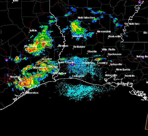 At 116 pm cdt, a severe thunderstorm was located 7 miles east of saratoga, moving northeast at 10 mph (radar indicated). Hazards include 60 mph wind gusts and quarter size hail. Hail damage to vehicles is expected. Expect wind damage to roofs, siding, and trees. At 116 pm cdt, a severe thunderstorm was located 7 miles east of saratoga, moving northeast at 10 mph (radar indicated). Hazards include 60 mph wind gusts and quarter size hail. Hail damage to vehicles is expected. Expect wind damage to roofs, siding, and trees.
|
| 5/5/2020 9:23 PM CDT |
 At 923 pm cdt, a severe thunderstorm was located over village mills, or over wildwood, moving southeast at 45 mph (radar indicated). Hazards include quarter size hail. Damage to vehicles is expected. Locations impacted include, kountze, warren, wildwood, caney head and village mills. At 923 pm cdt, a severe thunderstorm was located over village mills, or over wildwood, moving southeast at 45 mph (radar indicated). Hazards include quarter size hail. Damage to vehicles is expected. Locations impacted include, kountze, warren, wildwood, caney head and village mills.
|
| 5/5/2020 9:15 PM CDT |
 At 915 pm cdt, a severe thunderstorm was located near wildwood, moving southeast at 40 mph (radar indicated). Hazards include quarter size hail. Damage to vehicles is expected. Locations impacted include, silsbee, kountze, warren, wildwood, caney head and village mills. At 915 pm cdt, a severe thunderstorm was located near wildwood, moving southeast at 40 mph (radar indicated). Hazards include quarter size hail. Damage to vehicles is expected. Locations impacted include, silsbee, kountze, warren, wildwood, caney head and village mills.
|
| 5/5/2020 8:59 PM CDT |
 The national weather service in lake charles has issued a * severe thunderstorm warning for. southwestern tyler county in southeastern texas. northeastern hardin county in southeastern texas. until 930 pm cdt. At 859 pm cdt, a severe thunderstorm was located 7 miles southeast. The national weather service in lake charles has issued a * severe thunderstorm warning for. southwestern tyler county in southeastern texas. northeastern hardin county in southeastern texas. until 930 pm cdt. At 859 pm cdt, a severe thunderstorm was located 7 miles southeast.
|
| 1/11/2020 1:57 AM CST |
 At 155 am cst, severe thunderstorms were located along a line extending from near pineland to magnolia springs to near gilchrist, moving east at 35 mph (radar indicated. at 1:40 am cst a wind gust to 59 mph was reported by local media at pinewood, texas). Hazards include 60 mph wind gusts. Expect damage to roofs, siding, and trees. locations impacted include, beaumont, port arthur, lumberton, jasper, silsbee, kirbyville, kountze, sour lake, nome, evadale, town bluff, hamshire, fred, buna, bevil oaks, china, rose city, pine forest, browndell and lakeview. This includes interstate 10 in texas between mile markers 860 and 832. At 155 am cst, severe thunderstorms were located along a line extending from near pineland to magnolia springs to near gilchrist, moving east at 35 mph (radar indicated. at 1:40 am cst a wind gust to 59 mph was reported by local media at pinewood, texas). Hazards include 60 mph wind gusts. Expect damage to roofs, siding, and trees. locations impacted include, beaumont, port arthur, lumberton, jasper, silsbee, kirbyville, kountze, sour lake, nome, evadale, town bluff, hamshire, fred, buna, bevil oaks, china, rose city, pine forest, browndell and lakeview. This includes interstate 10 in texas between mile markers 860 and 832.
|
| 1/11/2020 1:31 AM CST |
 At 130 am cst, severe thunderstorms were located along a line extending from 9 miles west of pineland to near spurger to near crystal beach, moving east at 35 mph (radar indicated). Hazards include 60 mph wind gusts. expect damage to roofs, siding, and trees At 130 am cst, severe thunderstorms were located along a line extending from 9 miles west of pineland to near spurger to near crystal beach, moving east at 35 mph (radar indicated). Hazards include 60 mph wind gusts. expect damage to roofs, siding, and trees
|
| 1/11/2020 1:09 AM CST |
 At 109 am cst, severe thunderstorms were located along a line extending from 7 miles east of colmesneil to warren to near batson to 6 miles east of old river-winfree, moving east at 40 mph (radar indicated). Hazards include 60 mph wind gusts. expect damage to roofs, siding, and trees At 109 am cst, severe thunderstorms were located along a line extending from 7 miles east of colmesneil to warren to near batson to 6 miles east of old river-winfree, moving east at 40 mph (radar indicated). Hazards include 60 mph wind gusts. expect damage to roofs, siding, and trees
|
| 10/29/2019 4:15 PM CDT | Report of several trees blown down along hwy 326 in kountze. time estimated by rada in hardin county TX, 0.2 miles N of Kountze, TX |
| 10/29/2019 4:15 PM CDT | *** 1 inj *** public post of hardin county sheriff reporting winds blowing a small building off of hwy 327 on the road leading to hawthorne field / hardin county airpor in hardin county TX, 4.2 miles WNW of Kountze, TX |
| 10/29/2019 4:15 PM CDT | Public pictures of damage to the kountze intermediate school gym... with part of the roof peeled back... and a section of the roof peeled off. time estimated by rada in hardin county TX, 0.6 miles WNW of Kountze, TX |
| 10/21/2019 7:12 AM CDT |
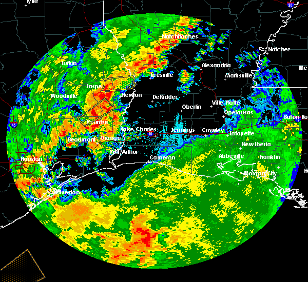 At 712 am cdt, a severe thunderstorm was located over fred, moving northeast at 45 mph (radar indicated). Hazards include 60 mph wind gusts. Expect damage to roofs, siding, and trees. locations impacted include, kirbyville, fred, caney head, magnolia springs and mt. Union. At 712 am cdt, a severe thunderstorm was located over fred, moving northeast at 45 mph (radar indicated). Hazards include 60 mph wind gusts. Expect damage to roofs, siding, and trees. locations impacted include, kirbyville, fred, caney head, magnolia springs and mt. Union.
|
| 10/21/2019 6:54 AM CDT |
 At 654 am cdt, a severe thunderstorm was located near village mills, or near wildwood, moving northeast at 45 mph (radar indicated). Hazards include 60 mph wind gusts. expect damage to roofs, siding, and trees At 654 am cdt, a severe thunderstorm was located near village mills, or near wildwood, moving northeast at 45 mph (radar indicated). Hazards include 60 mph wind gusts. expect damage to roofs, siding, and trees
|
| 5/9/2019 9:19 PM CDT | Golf Ball sized hail reported 0.2 miles N of Kountze, TX, social media picture showing golfball sized hailstones in kountze. time estimated by radar. |
| 5/9/2019 9:12 PM CDT |
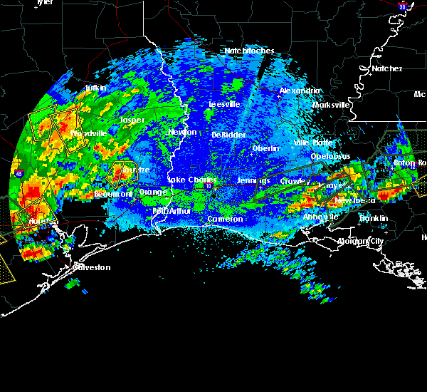 At 912 pm cdt, a severe thunderstorm was located over kountze, moving northeast at 20 mph (radar indicated). Hazards include golf ball size hail and 60 mph wind gusts. People and animals outdoors will be injured. expect hail damage to roofs, siding, windows, and vehicles. expect wind damage to roofs, siding, and trees. Locations impacted include, kountze and honey island. At 912 pm cdt, a severe thunderstorm was located over kountze, moving northeast at 20 mph (radar indicated). Hazards include golf ball size hail and 60 mph wind gusts. People and animals outdoors will be injured. expect hail damage to roofs, siding, windows, and vehicles. expect wind damage to roofs, siding, and trees. Locations impacted include, kountze and honey island.
|
| 5/9/2019 9:07 PM CDT |
 At 907 pm cdt, a severe thunderstorm was located near kountze, moving northeast at 15 mph (radar indicated). Hazards include golf ball size hail and 60 mph wind gusts. People and animals outdoors will be injured. expect hail damage to roofs, siding, windows, and vehicles. Expect wind damage to roofs, siding, and trees. At 907 pm cdt, a severe thunderstorm was located near kountze, moving northeast at 15 mph (radar indicated). Hazards include golf ball size hail and 60 mph wind gusts. People and animals outdoors will be injured. expect hail damage to roofs, siding, windows, and vehicles. Expect wind damage to roofs, siding, and trees.
|
| 5/9/2019 8:39 PM CDT |
 At 838 pm cdt, a severe thunderstorm was located near saratoga, moving northeast at 10 mph (radar indicated). Hazards include golf ball size hail and 60 mph wind gusts. People and animals outdoors will be injured. expect hail damage to roofs, siding, windows, and vehicles. expect wind damage to roofs, siding, and trees. Locations impacted include, kountze, sour lake, saratoga, thicket, wildwood, batson, votaw, honey island and village mills. At 838 pm cdt, a severe thunderstorm was located near saratoga, moving northeast at 10 mph (radar indicated). Hazards include golf ball size hail and 60 mph wind gusts. People and animals outdoors will be injured. expect hail damage to roofs, siding, windows, and vehicles. expect wind damage to roofs, siding, and trees. Locations impacted include, kountze, sour lake, saratoga, thicket, wildwood, batson, votaw, honey island and village mills.
|
| 5/9/2019 8:24 PM CDT |
 At 823 pm cdt, a severe thunderstorm was located near saratoga, moving northeast at 15 mph (radar indicated). Hazards include 60 mph wind gusts and quarter size hail. Hail damage to vehicles is expected. Expect wind damage to roofs, siding, and trees. At 823 pm cdt, a severe thunderstorm was located near saratoga, moving northeast at 15 mph (radar indicated). Hazards include 60 mph wind gusts and quarter size hail. Hail damage to vehicles is expected. Expect wind damage to roofs, siding, and trees.
|
| 4/18/2019 6:03 AM CDT |
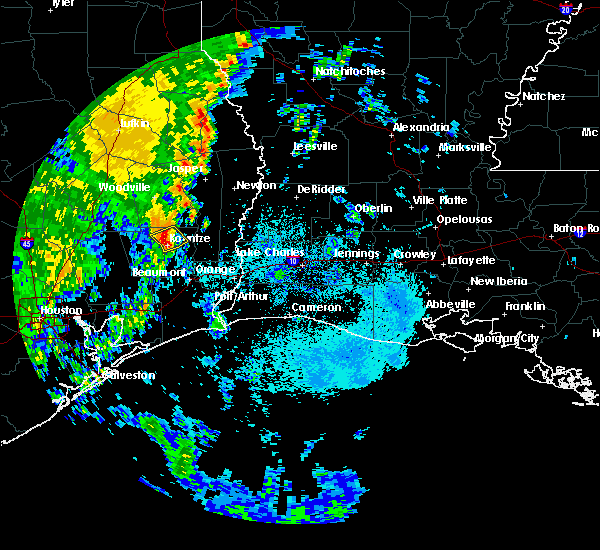 At 603 am cdt, a severe thunderstorm was located over kountze, moving northeast at 60 mph (radar indicated). Hazards include 60 mph wind gusts and quarter size hail. Hail damage to vehicles is expected. expect wind damage to roofs, siding, and trees. Locations impacted include, silsbee and kountze. At 603 am cdt, a severe thunderstorm was located over kountze, moving northeast at 60 mph (radar indicated). Hazards include 60 mph wind gusts and quarter size hail. Hail damage to vehicles is expected. expect wind damage to roofs, siding, and trees. Locations impacted include, silsbee and kountze.
|
| 4/18/2019 5:37 AM CDT |
 At 537 am cdt, a severe thunderstorm was located near batson, or 8 miles southwest of saratoga, moving northeast at 60 mph (radar indicated). Hazards include 60 mph wind gusts and quarter size hail. Hail damage to vehicles is expected. Expect wind damage to roofs, siding, and trees. At 537 am cdt, a severe thunderstorm was located near batson, or 8 miles southwest of saratoga, moving northeast at 60 mph (radar indicated). Hazards include 60 mph wind gusts and quarter size hail. Hail damage to vehicles is expected. Expect wind damage to roofs, siding, and trees.
|
| 4/7/2019 2:10 PM CDT |
 At 210 pm cdt, severe thunderstorms were located along a line extending from near wildwood to near lumberton to 19 miles south of sabine pass, moving northeast at 50 mph (radar indicated). Hazards include 60 mph wind gusts and quarter size hail. Hail damage to vehicles is expected. Expect wind damage to roofs, siding, and trees. At 210 pm cdt, severe thunderstorms were located along a line extending from near wildwood to near lumberton to 19 miles south of sabine pass, moving northeast at 50 mph (radar indicated). Hazards include 60 mph wind gusts and quarter size hail. Hail damage to vehicles is expected. Expect wind damage to roofs, siding, and trees.
|
| 4/7/2019 1:56 PM CDT |
 At 155 pm cdt, severe thunderstorms were located along a line extending from 7 miles east of shepherd to near saratoga to 11 miles east of high island, moving northeast at 55 mph (radar indicated). Hazards include 60 mph wind gusts and quarter size hail. Hail damage to vehicles is expected. expect wind damage to roofs, siding, and trees. Locations impacted include, beaumont, port arthur, nederland, groves, port neches, lumberton, vidor, bridge city, silsbee, woodville, kountze, sour lake, nome, central gardens, warren, thicket, saratoga, hamshire, fred and wildwood. At 155 pm cdt, severe thunderstorms were located along a line extending from 7 miles east of shepherd to near saratoga to 11 miles east of high island, moving northeast at 55 mph (radar indicated). Hazards include 60 mph wind gusts and quarter size hail. Hail damage to vehicles is expected. expect wind damage to roofs, siding, and trees. Locations impacted include, beaumont, port arthur, nederland, groves, port neches, lumberton, vidor, bridge city, silsbee, woodville, kountze, sour lake, nome, central gardens, warren, thicket, saratoga, hamshire, fred and wildwood.
|
| 4/7/2019 1:37 PM CDT |
 At 137 pm cdt, severe thunderstorms were located along a line extending from near cleveland to daisetta to 13 miles southeast of gilchrist, moving northeast at 55 mph (radar indicated). Hazards include 60 mph wind gusts and quarter size hail. Hail damage to vehicles is expected. Expect wind damage to roofs, siding, and trees. At 137 pm cdt, severe thunderstorms were located along a line extending from near cleveland to daisetta to 13 miles southeast of gilchrist, moving northeast at 55 mph (radar indicated). Hazards include 60 mph wind gusts and quarter size hail. Hail damage to vehicles is expected. Expect wind damage to roofs, siding, and trees.
|
| 2/26/2019 5:59 PM CST |
 At 558 pm cst, a severe thunderstorm was located over caney head, or near fred, moving east at 35 mph (radar indicated). Hazards include quarter size hail. damage to vehicles is expected At 558 pm cst, a severe thunderstorm was located over caney head, or near fred, moving east at 35 mph (radar indicated). Hazards include quarter size hail. damage to vehicles is expected
|
| 11/7/2018 8:45 PM CST |
 At 845 pm cst, a severe thunderstorm was located over saratoga, moving east at 20 mph (radar indicated). Hazards include 60 mph wind gusts and quarter size hail. Hail damage to vehicles is expected. Expect wind damage to roofs, siding, and trees. At 845 pm cst, a severe thunderstorm was located over saratoga, moving east at 20 mph (radar indicated). Hazards include 60 mph wind gusts and quarter size hail. Hail damage to vehicles is expected. Expect wind damage to roofs, siding, and trees.
|
| 10/31/2018 7:30 PM CDT |
 At 729 pm cdt, severe thunderstorms were located along a line extending from near caney head to sour lake, moving east at 25 mph (radar indicated). Hazards include 60 mph wind gusts and nickel size hail. expect damage to roofs, siding, and trees At 729 pm cdt, severe thunderstorms were located along a line extending from near caney head to sour lake, moving east at 25 mph (radar indicated). Hazards include 60 mph wind gusts and nickel size hail. expect damage to roofs, siding, and trees
|
| 5/26/2018 7:00 PM CDT |
 At 637 pm cdt, severe thunderstorms were located along a line extending from 6 miles southwest of wildwood to silsbee, moving southwest at 15 mph (radar indicated). Hazards include 60 mph wind gusts and quarter size hail. Hail damage to vehicles is expected. Expect wind damage to roofs, siding, and trees. At 637 pm cdt, severe thunderstorms were located along a line extending from 6 miles southwest of wildwood to silsbee, moving southwest at 15 mph (radar indicated). Hazards include 60 mph wind gusts and quarter size hail. Hail damage to vehicles is expected. Expect wind damage to roofs, siding, and trees.
|
| 5/26/2018 6:37 PM CDT |
 At 637 pm cdt, severe thunderstorms were located along a line extending from 6 miles southwest of wildwood to silsbee, moving southwest at 15 mph (radar indicated). Hazards include 60 mph wind gusts and quarter size hail. Hail damage to vehicles is expected. Expect wind damage to roofs, siding, and trees. At 637 pm cdt, severe thunderstorms were located along a line extending from 6 miles southwest of wildwood to silsbee, moving southwest at 15 mph (radar indicated). Hazards include 60 mph wind gusts and quarter size hail. Hail damage to vehicles is expected. Expect wind damage to roofs, siding, and trees.
|
| 3/18/2018 8:56 PM CDT |
 At 856 pm cdt, severe thunderstorms were located along a line extending from 6 miles southwest of alabama-coushatta reservation to 7 miles southeast of shepherd, moving east at 50 mph. these are very dangerous storms (radar indicated). Hazards include 80 mph wind gusts and quarter size hail. Flying debris will be dangerous to those caught without shelter. mobile homes will be heavily damaged. expect considerable damage to roofs, windows, and vehicles. Extensive tree damage and power outages are likely. At 856 pm cdt, severe thunderstorms were located along a line extending from 6 miles southwest of alabama-coushatta reservation to 7 miles southeast of shepherd, moving east at 50 mph. these are very dangerous storms (radar indicated). Hazards include 80 mph wind gusts and quarter size hail. Flying debris will be dangerous to those caught without shelter. mobile homes will be heavily damaged. expect considerable damage to roofs, windows, and vehicles. Extensive tree damage and power outages are likely.
|
| 8/27/2017 10:43 AM CDT |
 At 1043 am cdt, a severe thunderstorm capable of producing a tornado was located over silsbee, moving northwest at 20 mph (radar indicated rotation). Hazards include tornado. Flying debris will be dangerous to those caught without shelter. mobile homes will be damaged or destroyed. damage to roofs, windows, and vehicles will occur. tree damage is likely. this dangerous storm will be near, kountze around 1105 am cdt. Caney head around 1110 am cdt. At 1043 am cdt, a severe thunderstorm capable of producing a tornado was located over silsbee, moving northwest at 20 mph (radar indicated rotation). Hazards include tornado. Flying debris will be dangerous to those caught without shelter. mobile homes will be damaged or destroyed. damage to roofs, windows, and vehicles will occur. tree damage is likely. this dangerous storm will be near, kountze around 1105 am cdt. Caney head around 1110 am cdt.
|
| 8/27/2017 10:15 AM CDT |
 At 1015 am cdt, a severe thunderstorm capable of producing a tornado was located over weiss bluff, or near evadale, moving northwest at 30 mph (radar indicated rotation). Hazards include tornado. Flying debris will be dangerous to those caught without shelter. mobile homes will be damaged or destroyed. damage to roofs, windows, and vehicles will occur. tree damage is likely. this dangerous storm will be near, lumberton around 1020 am cdt. evadale around 1025 am cdt. silsbee around 1040 am cdt. Caney head around 1045 am cdt. At 1015 am cdt, a severe thunderstorm capable of producing a tornado was located over weiss bluff, or near evadale, moving northwest at 30 mph (radar indicated rotation). Hazards include tornado. Flying debris will be dangerous to those caught without shelter. mobile homes will be damaged or destroyed. damage to roofs, windows, and vehicles will occur. tree damage is likely. this dangerous storm will be near, lumberton around 1020 am cdt. evadale around 1025 am cdt. silsbee around 1040 am cdt. Caney head around 1045 am cdt.
|
| 8/27/2017 9:43 AM CDT |
 At 943 am cdt, a severe thunderstorm capable of producing a tornado was located over lakeview, or near lumberton, moving northwest at 30 mph (radar indicated rotation). Hazards include tornado. Flying debris will be dangerous to those caught without shelter. mobile homes will be damaged or destroyed. damage to roofs, windows, and vehicles will occur. tree damage is likely. this dangerous storm will be near, lumberton and evadale around 955 am cdt. silsbee and kountze around 1010 am cdt. Caney head around 1015 am cdt. At 943 am cdt, a severe thunderstorm capable of producing a tornado was located over lakeview, or near lumberton, moving northwest at 30 mph (radar indicated rotation). Hazards include tornado. Flying debris will be dangerous to those caught without shelter. mobile homes will be damaged or destroyed. damage to roofs, windows, and vehicles will occur. tree damage is likely. this dangerous storm will be near, lumberton and evadale around 955 am cdt. silsbee and kountze around 1010 am cdt. Caney head around 1015 am cdt.
|
| 8/26/2017 2:40 PM CDT |
 At 240 pm cdt, a severe thunderstorm capable of producing a tornado was located near honey island, or near kountze, moving north at 30 mph (radar indicated rotation). Hazards include tornado. Flying debris will be dangerous to those caught without shelter. mobile homes will be damaged or destroyed. damage to roofs, windows, and vehicles will occur. tree damage is likely. this dangerous storm will be near, honey island around 245 pm cdt. village mills around 255 pm cdt. Wildwood around 300 pm cdt. At 240 pm cdt, a severe thunderstorm capable of producing a tornado was located near honey island, or near kountze, moving north at 30 mph (radar indicated rotation). Hazards include tornado. Flying debris will be dangerous to those caught without shelter. mobile homes will be damaged or destroyed. damage to roofs, windows, and vehicles will occur. tree damage is likely. this dangerous storm will be near, honey island around 245 pm cdt. village mills around 255 pm cdt. Wildwood around 300 pm cdt.
|
| 5/20/2017 7:15 PM CDT |
 At 714 pm cdt, severe thunderstorms were located along a line extending from 6 miles west of fred to 6 miles southwest of wildwood, moving east at 15 mph (radar indicated). Hazards include quarter size hail. damage to vehicles is expected At 714 pm cdt, severe thunderstorms were located along a line extending from 6 miles west of fred to 6 miles southwest of wildwood, moving east at 15 mph (radar indicated). Hazards include quarter size hail. damage to vehicles is expected
|
| 5/3/2017 7:50 PM CDT |
 At 750 pm cdt, a severe thunderstorm was located over fred, moving east at 40 mph (radar indicated). Hazards include 60 mph wind gusts and quarter size hail. Hail damage to vehicles is expected. expect wind damage to roofs, siding, and trees. locations impacted include, silsbee, kirbyville, buna, fred, spurger, caney head, roganville, magnolia springs and mt. Union. At 750 pm cdt, a severe thunderstorm was located over fred, moving east at 40 mph (radar indicated). Hazards include 60 mph wind gusts and quarter size hail. Hail damage to vehicles is expected. expect wind damage to roofs, siding, and trees. locations impacted include, silsbee, kirbyville, buna, fred, spurger, caney head, roganville, magnolia springs and mt. Union.
|
| 5/3/2017 7:27 PM CDT |
 At 726 pm cdt, a severe thunderstorm was located near warren, moving east at 50 mph (radar indicated). Hazards include 60 mph wind gusts and quarter size hail. Hail damage to vehicles is expected. Expect wind damage to roofs, siding, and trees. At 726 pm cdt, a severe thunderstorm was located near warren, moving east at 50 mph (radar indicated). Hazards include 60 mph wind gusts and quarter size hail. Hail damage to vehicles is expected. Expect wind damage to roofs, siding, and trees.
|
| 5/3/2017 7:44 AM CDT |
 At 744 am cdt, a severe thunderstorm capable of producing a tornado was located near silsbee, moving east at 25 mph (radar indicated rotation). Hazards include tornado and half dollar size hail. Flying debris will be dangerous to those caught without shelter. mobile homes will be damaged or destroyed. damage to roofs, windows, and vehicles will occur. tree damage is likely. this dangerous storm will be near, caney head around 750 am cdt. evadale around 805 am cdt. Buna around 820 am cdt. At 744 am cdt, a severe thunderstorm capable of producing a tornado was located near silsbee, moving east at 25 mph (radar indicated rotation). Hazards include tornado and half dollar size hail. Flying debris will be dangerous to those caught without shelter. mobile homes will be damaged or destroyed. damage to roofs, windows, and vehicles will occur. tree damage is likely. this dangerous storm will be near, caney head around 750 am cdt. evadale around 805 am cdt. Buna around 820 am cdt.
|
| 5/3/2017 7:39 AM CDT |
 At 738 am cdt, a severe thunderstorm capable of producing a tornado was located near kountze, moving northeast at 15 mph (radar indicated rotation). Hazards include tornado and half dollar size hail. Flying debris will be dangerous to those caught without shelter. mobile homes will be damaged or destroyed. damage to roofs, windows, and vehicles will occur. tree damage is likely. This dangerous storm will be near, caney head around 800 am cdt. At 738 am cdt, a severe thunderstorm capable of producing a tornado was located near kountze, moving northeast at 15 mph (radar indicated rotation). Hazards include tornado and half dollar size hail. Flying debris will be dangerous to those caught without shelter. mobile homes will be damaged or destroyed. damage to roofs, windows, and vehicles will occur. tree damage is likely. This dangerous storm will be near, caney head around 800 am cdt.
|
| 5/3/2017 7:37 AM CDT | Dispatch relayed report of damage to carport covers behind city hal in hardin county TX, 0.2 miles N of Kountze, TX |
| 5/3/2017 7:30 AM CDT | Quarter sized hail reported 0.2 miles N of Kountze, TX, public relayed photos of estimated quarter sized hail near village mills in kountze. time estimated via radar. |
| 5/3/2017 7:29 AM CDT |
 At 729 am cdt, a severe thunderstorm capable of producing a tornado was located over kountze, moving northeast at 20 mph (radar indicated rotation). Hazards include tornado and half dollar size hail. Flying debris will be dangerous to those caught without shelter. mobile homes will be damaged or destroyed. damage to roofs, windows, and vehicles will occur. tree damage is likely. This dangerous storm will be near, caney head around 800 am cdt. At 729 am cdt, a severe thunderstorm capable of producing a tornado was located over kountze, moving northeast at 20 mph (radar indicated rotation). Hazards include tornado and half dollar size hail. Flying debris will be dangerous to those caught without shelter. mobile homes will be damaged or destroyed. damage to roofs, windows, and vehicles will occur. tree damage is likely. This dangerous storm will be near, caney head around 800 am cdt.
|
| 5/3/2017 7:14 AM CDT |
 At 714 am cdt, a severe thunderstorm was located over kountze, moving northeast at 25 mph (radar indicated). Hazards include 60 mph wind gusts and quarter size hail. Hail damage to vehicles is expected. Expect wind damage to roofs, siding, and trees. At 714 am cdt, a severe thunderstorm was located over kountze, moving northeast at 25 mph (radar indicated). Hazards include 60 mph wind gusts and quarter size hail. Hail damage to vehicles is expected. Expect wind damage to roofs, siding, and trees.
|
| 5/3/2017 6:48 AM CDT |
 At 647 am cdt, severe thunderstorms were located along a line extending from near warren to near village mills, moving north at 40 mph (radar indicated). Hazards include 60 mph wind gusts and quarter size hail. Hail damage to vehicles is expected. expect wind damage to roofs, siding, and trees. locations impacted include, silsbee, woodville, kountze, colmesneil, saratoga, fred, wildwood, warren, town bluff, caney head, honey island, mt. Union, spurger, village mills, ivanhoe and hillister. At 647 am cdt, severe thunderstorms were located along a line extending from near warren to near village mills, moving north at 40 mph (radar indicated). Hazards include 60 mph wind gusts and quarter size hail. Hail damage to vehicles is expected. expect wind damage to roofs, siding, and trees. locations impacted include, silsbee, woodville, kountze, colmesneil, saratoga, fred, wildwood, warren, town bluff, caney head, honey island, mt. Union, spurger, village mills, ivanhoe and hillister.
|
| 5/3/2017 6:26 AM CDT |
 At 625 am cdt, severe thunderstorms were located along a line extending from near thicket to near kountze, moving north at 40 mph (radar indicated). Hazards include 60 mph wind gusts and quarter size hail. Hail damage to vehicles is expected. Expect wind damage to roofs, siding, and trees. At 625 am cdt, severe thunderstorms were located along a line extending from near thicket to near kountze, moving north at 40 mph (radar indicated). Hazards include 60 mph wind gusts and quarter size hail. Hail damage to vehicles is expected. Expect wind damage to roofs, siding, and trees.
|
| 3/25/2017 12:00 AM CDT |
 At 1200 am cdt, severe thunderstorms were located along a line extending from 6 miles west of fred to 6 miles north of sour lake, moving east at 40 mph (radar indicated). Hazards include 60 mph wind gusts. Expect damage to roofs, siding, and trees. locations impacted include, beaumont, lumberton, silsbee, kountze, buna, evadale, fred, caney head, weiss bluff and village mills. A tornado watch remains in effect until 400 am cdt for southeastern texas. At 1200 am cdt, severe thunderstorms were located along a line extending from 6 miles west of fred to 6 miles north of sour lake, moving east at 40 mph (radar indicated). Hazards include 60 mph wind gusts. Expect damage to roofs, siding, and trees. locations impacted include, beaumont, lumberton, silsbee, kountze, buna, evadale, fred, caney head, weiss bluff and village mills. A tornado watch remains in effect until 400 am cdt for southeastern texas.
|
| 3/24/2017 11:40 PM CDT |
 At 1140 pm cdt, severe thunderstorms were located along a line extending from near wildwood to near daisetta, moving northeast at 40 mph (radar indicated). Hazards include 60 mph wind gusts. expect damage to roofs, siding, and trees At 1140 pm cdt, severe thunderstorms were located along a line extending from near wildwood to near daisetta, moving northeast at 40 mph (radar indicated). Hazards include 60 mph wind gusts. expect damage to roofs, siding, and trees
|
| 1/2/2017 9:57 AM CST |
 At 957 am cst, severe thunderstorms were located along a line extending from near fields to near starks to near smith point, moving east at 45 mph (radar indicated). Hazards include 70 mph wind gusts. Expect considerable tree damage. Damage is likely to mobile homes, roofs, and outbuildings. At 957 am cst, severe thunderstorms were located along a line extending from near fields to near starks to near smith point, moving east at 45 mph (radar indicated). Hazards include 70 mph wind gusts. Expect considerable tree damage. Damage is likely to mobile homes, roofs, and outbuildings.
|
| 1/2/2017 9:07 AM CST |
 At 906 am cst, severe thunderstorms were located along a line extending from near jasper to 7 miles southwest of kountze, moving east at 40 mph (radar indicated). Hazards include 70 mph wind gusts and nickel size hail. Expect considerable tree damage. Damage is likely to mobile homes, roofs, and outbuildings. At 906 am cst, severe thunderstorms were located along a line extending from near jasper to 7 miles southwest of kountze, moving east at 40 mph (radar indicated). Hazards include 70 mph wind gusts and nickel size hail. Expect considerable tree damage. Damage is likely to mobile homes, roofs, and outbuildings.
|
| 5/27/2016 4:04 PM CDT |
 At 403 pm cdt, severe thunderstorms were located along a line extending from near burkeville to near devers, moving southeast at 15 mph (radar indicated). Hazards include 60 mph wind gusts and nickel size hail. Expect damage to roofs. siding. and trees. Locations impacted include, beaumont, lumberton, vidor, jasper, silsbee, newton, kirbyville, kountze, sour lake, thicket, fred, saratoga, bon weir, buna, burkeville, evadale, call, bevil oaks, china and rose city. At 403 pm cdt, severe thunderstorms were located along a line extending from near burkeville to near devers, moving southeast at 15 mph (radar indicated). Hazards include 60 mph wind gusts and nickel size hail. Expect damage to roofs. siding. and trees. Locations impacted include, beaumont, lumberton, vidor, jasper, silsbee, newton, kirbyville, kountze, sour lake, thicket, fred, saratoga, bon weir, buna, burkeville, evadale, call, bevil oaks, china and rose city.
|
| 5/27/2016 3:23 PM CDT |
 At 323 pm cdt, severe thunderstorms were located along a line extending from near mayflower to near daisetta, moving southeast at 15 mph (radar indicated). Hazards include 60 mph wind gusts. Expect damage to roofs. siding. And trees. At 323 pm cdt, severe thunderstorms were located along a line extending from near mayflower to near daisetta, moving southeast at 15 mph (radar indicated). Hazards include 60 mph wind gusts. Expect damage to roofs. siding. And trees.
|
| 5/26/2016 7:23 PM CDT |
 At 721 pm cdt, severe thunderstorms were located along a line extending from near shepherd to 9 miles northwest of dayton lakes to 7 miles south of plum grove, moving east at 25 mph (radar indicated). Hazards include 60 mph wind gusts and quarter size hail. Hail damage to vehicles is expected. Expect wind damage to roofs, siding, and trees. At 721 pm cdt, severe thunderstorms were located along a line extending from near shepherd to 9 miles northwest of dayton lakes to 7 miles south of plum grove, moving east at 25 mph (radar indicated). Hazards include 60 mph wind gusts and quarter size hail. Hail damage to vehicles is expected. Expect wind damage to roofs, siding, and trees.
|
| 4/27/2016 6:05 AM CDT | Numerous trees damaged and widespread power outages across hardin count in hardin county TX, 0.2 miles N of Kountze, TX |
| 4/27/2016 5:49 AM CDT |
 At 547 am cdt, severe thunderstorms were located along a line extending from 9 miles north of chester to near warren to near saratoga to daisetta to near la porte, moving east at 50 mph (radar indicated). Hazards include 60 mph wind gusts and penny size hail. Expect damage to roofs. siding. and trees. Locations impacted include, beaumont, lumberton, silsbee, woodville, kountze, sour lake, colmesneil, nome, chester, thicket, fred, saratoga, ebenezer, rockland, town bluff, warren, wildwood, bevil oaks, china and lakeview. At 547 am cdt, severe thunderstorms were located along a line extending from 9 miles north of chester to near warren to near saratoga to daisetta to near la porte, moving east at 50 mph (radar indicated). Hazards include 60 mph wind gusts and penny size hail. Expect damage to roofs. siding. and trees. Locations impacted include, beaumont, lumberton, silsbee, woodville, kountze, sour lake, colmesneil, nome, chester, thicket, fred, saratoga, ebenezer, rockland, town bluff, warren, wildwood, bevil oaks, china and lakeview.
|
| 4/27/2016 5:17 AM CDT |
 At 516 am cdt, severe thunderstorms were located along a line extending from 8 miles east of groveton to near goodrich to 8 miles east of cleveland to near plum grove to brays oaks, moving east at 50 mph (radar indicated). Hazards include 60 mph wind gusts and penny size hail. Expect damage to roofs. siding. And trees. At 516 am cdt, severe thunderstorms were located along a line extending from 8 miles east of groveton to near goodrich to 8 miles east of cleveland to near plum grove to brays oaks, moving east at 50 mph (radar indicated). Hazards include 60 mph wind gusts and penny size hail. Expect damage to roofs. siding. And trees.
|
| 1/8/2016 7:02 PM CST |
 The national weather service in lake charles has issued a * severe thunderstorm warning for. northwestern jefferson county in southeastern texas. southeastern hardin county in southeastern texas. until 800 pm cst * at 702 pm cst. A severe thunderstorm was located near daisetta. The national weather service in lake charles has issued a * severe thunderstorm warning for. northwestern jefferson county in southeastern texas. southeastern hardin county in southeastern texas. until 800 pm cst * at 702 pm cst. A severe thunderstorm was located near daisetta.
|
| 1/8/2016 5:59 PM CST |
 At 558 pm cst, a severe thunderstorm was located near nome, moving north at 25 mph (radar indicated). Hazards include 60 mph wind gusts and quarter size hail. Hail damage to vehicles is expected. Expect wind damage to roofs, siding and trees. At 558 pm cst, a severe thunderstorm was located near nome, moving north at 25 mph (radar indicated). Hazards include 60 mph wind gusts and quarter size hail. Hail damage to vehicles is expected. Expect wind damage to roofs, siding and trees.
|
| 10/31/2015 6:00 AM CDT |
 The national weather service in lake charles has issued a * severe thunderstorm warning for. southeastern tyler county in southeastern texas. eastern hardin county in southeastern texas. southeastern jasper county in southeastern texas. Southwestern newton county in southeastern texas. The national weather service in lake charles has issued a * severe thunderstorm warning for. southeastern tyler county in southeastern texas. eastern hardin county in southeastern texas. southeastern jasper county in southeastern texas. Southwestern newton county in southeastern texas.
|
| 10/31/2015 5:34 AM CDT |
 At 532 am cdt, a severe thunderstorm capable of producing a tornado was located near kountze, moving northeast at 30 mph. this tornado will cross highway 69 near or just south of kountze (radar indicated rotation). Hazards include tornado. Flying debris will be dangerous to those caught without shelter. mobile homes will be damaged or destroyed. damage to roofs, windows and vehicles will occur. tree damage is likely. this dangerous storm will be near, silsbee around 540 am cdt. evadale around 550 am cdt. Buna around 600 am cdt. At 532 am cdt, a severe thunderstorm capable of producing a tornado was located near kountze, moving northeast at 30 mph. this tornado will cross highway 69 near or just south of kountze (radar indicated rotation). Hazards include tornado. Flying debris will be dangerous to those caught without shelter. mobile homes will be damaged or destroyed. damage to roofs, windows and vehicles will occur. tree damage is likely. this dangerous storm will be near, silsbee around 540 am cdt. evadale around 550 am cdt. Buna around 600 am cdt.
|
| 10/31/2015 5:27 AM CDT |
 At 527 am cdt, a severe thunderstorm capable of producing a tornado was located near kountze, moving northeast at 30 mph (radar indicated rotation). Hazards include tornado. Flying debris will be dangerous to those caught without shelter. mobile homes will be damaged or destroyed. damage to roofs, windows and vehicles will occur. tree damage is likely. this dangerous storm will be near, lumberton around 535 am cdt. silsbee around 540 am cdt. evadale around 550 am cdt. Buna around 600 am cdt. At 527 am cdt, a severe thunderstorm capable of producing a tornado was located near kountze, moving northeast at 30 mph (radar indicated rotation). Hazards include tornado. Flying debris will be dangerous to those caught without shelter. mobile homes will be damaged or destroyed. damage to roofs, windows and vehicles will occur. tree damage is likely. this dangerous storm will be near, lumberton around 535 am cdt. silsbee around 540 am cdt. evadale around 550 am cdt. Buna around 600 am cdt.
|
| 10/31/2015 5:12 AM CDT |
 At 511 am cdt, severe thunderstorms were located along a line extending from honey island to 7 miles east of saratoga to near sour lake, moving northeast at 30 mph (radar indicated). Hazards include 60 mph wind gusts and penny size hail. Expect damage to roofs. Siding and trees. At 511 am cdt, severe thunderstorms were located along a line extending from honey island to 7 miles east of saratoga to near sour lake, moving northeast at 30 mph (radar indicated). Hazards include 60 mph wind gusts and penny size hail. Expect damage to roofs. Siding and trees.
|
| 10/31/2015 4:56 AM CDT |
 At 455 am cdt, severe thunderstorms were located along a line extending from near honey island to near devers, moving northeast at 10 mph (radar indicated). Hazards include 60 mph wind gusts and penny size hail. Expect damage to roofs. siding and trees. locations impacted include, beaumont, lumberton, silsbee, kountze, sour lake, saratoga, batson, caney head and honey island. A tornado watch remains in effect until 1000 am cdt for southeastern texas. At 455 am cdt, severe thunderstorms were located along a line extending from near honey island to near devers, moving northeast at 10 mph (radar indicated). Hazards include 60 mph wind gusts and penny size hail. Expect damage to roofs. siding and trees. locations impacted include, beaumont, lumberton, silsbee, kountze, sour lake, saratoga, batson, caney head and honey island. A tornado watch remains in effect until 1000 am cdt for southeastern texas.
|
| 10/31/2015 4:32 AM CDT |
 The national weather service in lake charles has issued a * severe thunderstorm warning for. hardin county in southeastern texas. until 515 am cdt * at 431 am cdt. severe thunderstorms were located along a line extending from near saratoga to near devers. Moving northeast at. The national weather service in lake charles has issued a * severe thunderstorm warning for. hardin county in southeastern texas. until 515 am cdt * at 431 am cdt. severe thunderstorms were located along a line extending from near saratoga to near devers. Moving northeast at.
|
| 8/11/2015 4:05 PM CDT | 5 general aviation aircraft were picked up and thrown approx 150 yards at hawthorne field in kountze... tx. all five aircraft were described as totalle in hardin county TX, 0.2 miles N of Kountze, TX |
| 5/27/2015 5:44 AM CDT | At 543 am cdt, doppler radar indicated a line of severe thunderstorms capable of producing quarter size hail and damaging winds in excess of 60 mph. these storms were located along a line extending from 8 miles west of rosepine to near singer to evadale, moving southeast at 30 mph. locations impacted include, beaumont, lumberton, silsbee, newton, kirbyville, kountze, sour lake, merryville, saratoga, bon weir, buna, burkeville, evadale, call, toledo bend dam, gist, caney head, old salem, trout creek and junction. |
| 5/27/2015 5:44 AM CDT | At 543 am cdt, doppler radar indicated a line of severe thunderstorms capable of producing quarter size hail and damaging winds in excess of 60 mph. these storms were located along a line extending from 8 miles west of rosepine to near singer to evadale, moving southeast at 30 mph. locations impacted include, beaumont, lumberton, silsbee, newton, kirbyville, kountze, sour lake, merryville, saratoga, bon weir, buna, burkeville, evadale, call, toledo bend dam, gist, caney head, old salem, trout creek and junction. |
| 5/27/2015 4:53 AM CDT | At 453 am cdt, doppler radar indicated a line of severe thunderstorms capable of producing quarter size hail and damaging winds in excess of 60 mph. these storms were located along a line extending from near mayflower to near roganville to wildwood, and moving southeast at 35 mph. |
| 5/27/2015 4:53 AM CDT | At 453 am cdt, doppler radar indicated a line of severe thunderstorms capable of producing quarter size hail and damaging winds in excess of 60 mph. these storms were located along a line extending from near mayflower to near roganville to wildwood, and moving southeast at 35 mph. |
| 5/25/2015 10:19 PM CDT | At 1018 pm cdt, doppler radar indicated a line of severe thunderstorms capable of producing quarter size hail and damaging winds in excess of 60 mph. these storms were located along a line extending from near de ridder to near lunita to nome. these storms were nearly stationary. |
| 5/25/2015 10:19 PM CDT | At 1018 pm cdt, doppler radar indicated a line of severe thunderstorms capable of producing quarter size hail and damaging winds in excess of 60 mph. these storms were located along a line extending from near de ridder to near lunita to nome. these storms were nearly stationary. |
| 5/25/2015 9:37 PM CDT | At 937 pm cdt, doppler radar indicated a severe thunderstorm capable of producing quarter size hail and damaging winds in excess of 60 mph. this storm was located near warren, moving north at 15 mph. locations impacted include, silsbee, kountze, thicket, wildwood, saratoga, votaw, village mills, batson, honey island and caney head. a tornado watch remains in effect until 200 am cdt for southeastern texas. |
| 5/25/2015 9:32 PM CDT | Hardin county sheriff reports trees down along hwy 69 in kountz in hardin county TX, 0.2 miles N of Kountze, TX |
| 5/25/2015 8:55 PM CDT | At 855 pm cdt, doppler radar indicated a severe thunderstorm capable of producing quarter size hail and damaging winds in excess of 60 mph. this storm was located near honey island, or near kountze, and moving north at 15 mph. |
| 5/25/2015 8:46 PM CDT | At 846 pm cdt, doppler radar indicated a severe thunderstorm capable of producing quarter size hail and damaging winds in excess of 60 mph. this storm was located over kountze, moving northeast at 15 mph. locations impacted include, silsbee, kountze, thicket, wildwood, votaw, village mills, honey island and caney head. a tornado watch remains in effect until 200 am cdt for southeastern texas. |
| 5/25/2015 8:32 PM CDT | At 832 pm cdt, doppler radar indicated a severe thunderstorm capable of producing quarter size hail and damaging winds in excess of 60 mph. this storm was located near honey island, or near kountze, and moving northeast at 15 mph. |
| 4/27/2015 5:53 AM CDT | At 553 am cdt, doppler radar indicated a line of severe thunderstorms capable of producing quarter size hail and damaging winds in excess of 60 mph. these storms were located along a line extending from ebenezer to near kountze to 6 miles east of daisetta, and moving east at 50 mph. |
| 4/27/2015 5:27 AM CDT | At 526 am cdt, doppler radar indicated a line of severe thunderstorms capable of producing quarter size hail and damaging winds in excess of 60 mph. these storms were located along a line extending from near chester to 7 miles southeast of alabama-coushatta reservation to near batson, moving east at 45 mph. locations impacted include, jasper, silsbee, woodville, kountze, colmesneil, chester, thicket, fred, saratoga, ebenezer, rockland, town bluff, warren, wildwood, browndell, votaw, village mills, caney head, spurger and mt. union. a tornado watch remains in effect until 900 am cdt for southeastern texas. |
| 4/27/2015 4:59 AM CDT | At 458 am cdt, doppler radar indicated a line of severe thunderstorms capable of producing quarter size hail and damaging winds in excess of 60 mph. these storms were located along a line extending from lufkin to near seven oaks to near kingwood, and moving east at 35 mph. |
| 2/11/2013 10:01 AM CST | Quarter sized hail reported 12.4 miles SE of Kountze, TX, car damage and property damage with quarter to nickel sized hail per ham radio operator |
| 2/11/2013 10:00 AM CST | Quarter sized hail reported 9.4 miles SSE of Kountze, TX, user on social media send a picture showing hail on the ground ranging from pea to quarter size |
Hail Maps for Kountze, TX
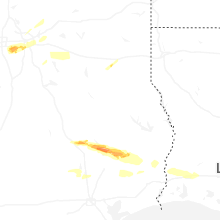


Connect with Interactive Hail Maps