

Hail Map for La Prairie, MN
The La Prairie, MN area has had 0 reports of on-the-ground hail by trained spotters, and has been under severe weather warnings 12 times during the past 12 months. Doppler radar has detected hail at or near La Prairie, MN on 44 occasions, including 3 occasions during the past year.
| Name: | La Prairie, MN |
| Where Located: | 67.4 miles ESE of Bemidji, MN |
| Map: | Google Map for La Prairie, MN |
| Population: | 665 |
| Housing Units: | 287 |
| More Info: | Search Google for La Prairie, MN |
5
The Top Recent Hail Date for La Prairie, MN is Thursday, July 2, 2026 (1st out of 44)
Hail and Wind Damage Spotted near La Prairie, MN
| Date / Time | Report Details |
|---|---|
| 7/24/2026 10:31 PM CDT |
 Svrdlh the national weather service in duluth mn has issued a * severe thunderstorm warning for, central itasca county in north central minnesota, northern cass county in north central minnesota, * until 1130 pm cdt. * at 1030 pm cdt, severe thunderstorms were located along a line extending from 6 miles southeast of blackduck to 10 miles southeast of turtle river to 6 miles southeast of bemidji, moving southeast at 55 mph (radar indicated). Hazards include 60 mph wind gusts and quarter size hail. Hail damage to vehicles is expected. expect wind damage to roofs, siding, and trees. severe thunderstorms will be near, lake winnibigoshish around 1035 pm cdt. squaw lake around 1040 pm cdt. leech lake around 1045 pm cdt. bena and inger around 1050 pm cdt. Other locations in the path of these severe thunderstorms include federal dam, ball club, deer river, zemple, boy river, cohasset, days high landing and schoolcraft state park. Svrdlh the national weather service in duluth mn has issued a * severe thunderstorm warning for, central itasca county in north central minnesota, northern cass county in north central minnesota, * until 1130 pm cdt. * at 1030 pm cdt, severe thunderstorms were located along a line extending from 6 miles southeast of blackduck to 10 miles southeast of turtle river to 6 miles southeast of bemidji, moving southeast at 55 mph (radar indicated). Hazards include 60 mph wind gusts and quarter size hail. Hail damage to vehicles is expected. expect wind damage to roofs, siding, and trees. severe thunderstorms will be near, lake winnibigoshish around 1035 pm cdt. squaw lake around 1040 pm cdt. leech lake around 1045 pm cdt. bena and inger around 1050 pm cdt. Other locations in the path of these severe thunderstorms include federal dam, ball club, deer river, zemple, boy river, cohasset, days high landing and schoolcraft state park.
|
| 7/24/2026 8:00 PM CDT |
 Svrdlh the national weather service in duluth mn has issued a * severe thunderstorm warning for, southeastern itasca county in north central minnesota, southwestern st. louis county in northeastern minnesota, * until 900 pm cdt. * at 759 pm cdt, a severe thunderstorm was located 9 miles southeast of marcell, or 19 miles north of grand rapids, moving southeast at 45 mph (radar indicated). Hazards include 60 mph wind gusts and quarter size hail. Hail damage to vehicles is expected. Expect wind damage to roofs, siding, and trees. Svrdlh the national weather service in duluth mn has issued a * severe thunderstorm warning for, southeastern itasca county in north central minnesota, southwestern st. louis county in northeastern minnesota, * until 900 pm cdt. * at 759 pm cdt, a severe thunderstorm was located 9 miles southeast of marcell, or 19 miles north of grand rapids, moving southeast at 45 mph (radar indicated). Hazards include 60 mph wind gusts and quarter size hail. Hail damage to vehicles is expected. Expect wind damage to roofs, siding, and trees.
|
| 7/3/2026 8:44 PM CDT |
 Svrdlh the national weather service in duluth mn has issued a * severe thunderstorm warning for, southeastern itasca county in north central minnesota, * until 945 pm cdt. * at 843 pm cdt, a severe thunderstorm was located near grand rapids, moving east at 25 mph (radar indicated). Hazards include 60 mph wind gusts and quarter size hail. Hail damage to vehicles is expected. expect wind damage to roofs, siding, and trees. this severe thunderstorm will be near, grand rapids and coleraine around 850 pm cdt. Other locations in the path of this severe thunderstorm include warba and swan river. Svrdlh the national weather service in duluth mn has issued a * severe thunderstorm warning for, southeastern itasca county in north central minnesota, * until 945 pm cdt. * at 843 pm cdt, a severe thunderstorm was located near grand rapids, moving east at 25 mph (radar indicated). Hazards include 60 mph wind gusts and quarter size hail. Hail damage to vehicles is expected. expect wind damage to roofs, siding, and trees. this severe thunderstorm will be near, grand rapids and coleraine around 850 pm cdt. Other locations in the path of this severe thunderstorm include warba and swan river.
|
| 7/3/2026 8:21 PM CDT |
 Svrdlh the national weather service in duluth mn has issued a * severe thunderstorm warning for, south central itasca county in north central minnesota, northwestern aitkin county in east central minnesota, east central cass county in north central minnesota, * until 845 pm cdt. * at 821 pm cdt, a severe thunderstorm was located near schoolcraft state park, or 12 miles southwest of grand rapids, moving east at 25 mph (radar indicated). Hazards include 60 mph wind gusts and quarter size hail. Hail damage to vehicles is expected. expect wind damage to roofs, siding, and trees. This severe thunderstorm will be near, pokegama lake around 835 pm cdt. Svrdlh the national weather service in duluth mn has issued a * severe thunderstorm warning for, south central itasca county in north central minnesota, northwestern aitkin county in east central minnesota, east central cass county in north central minnesota, * until 845 pm cdt. * at 821 pm cdt, a severe thunderstorm was located near schoolcraft state park, or 12 miles southwest of grand rapids, moving east at 25 mph (radar indicated). Hazards include 60 mph wind gusts and quarter size hail. Hail damage to vehicles is expected. expect wind damage to roofs, siding, and trees. This severe thunderstorm will be near, pokegama lake around 835 pm cdt.
|
| 6/29/2026 1:09 PM CDT |
 At 109 pm cdt, severe thunderstorms were located along a line extending from warba to big sandy lake to 6 miles north of malmo, moving east at 50 mph (radar indicated). Hazards include golf ball size hail and 70 mph wind gusts. People and animals outdoors will be injured. expect hail damage to roofs, siding, windows, and vehicles. expect considerable tree damage. wind damage is also likely to mobile homes, roofs, and outbuildings. Locations impacted include, hibbing, cloquet, grand rapids, big sandy lake, mille lacs lake, sandstone, cohasset, crosby, aitkin, crosslake, coleraine, emily, swan river, hill city, mahtowa, barnum, ironton, deerwood, floodwood, and cotton. At 109 pm cdt, severe thunderstorms were located along a line extending from warba to big sandy lake to 6 miles north of malmo, moving east at 50 mph (radar indicated). Hazards include golf ball size hail and 70 mph wind gusts. People and animals outdoors will be injured. expect hail damage to roofs, siding, windows, and vehicles. expect considerable tree damage. wind damage is also likely to mobile homes, roofs, and outbuildings. Locations impacted include, hibbing, cloquet, grand rapids, big sandy lake, mille lacs lake, sandstone, cohasset, crosby, aitkin, crosslake, coleraine, emily, swan river, hill city, mahtowa, barnum, ironton, deerwood, floodwood, and cotton.
|
| 6/29/2026 12:52 PM CDT |
 At 1252 pm cdt, a severe thunderstorm capable of producing a tornado was located over taconite, or 8 miles northeast of grand rapids, moving northeast at 65 mph (radar indicated rotation). Hazards include tornado. Flying debris will be dangerous to those caught without shelter. mobile homes will be damaged or destroyed. damage to roofs, windows, and vehicles will occur. tree damage is likely. Locations impacted include, nashwauk, pengilly, hibbing and keewatin. At 1252 pm cdt, a severe thunderstorm capable of producing a tornado was located over taconite, or 8 miles northeast of grand rapids, moving northeast at 65 mph (radar indicated rotation). Hazards include tornado. Flying debris will be dangerous to those caught without shelter. mobile homes will be damaged or destroyed. damage to roofs, windows, and vehicles will occur. tree damage is likely. Locations impacted include, nashwauk, pengilly, hibbing and keewatin.
|
| 6/29/2026 12:50 PM CDT |
 At 1250 pm cdt, severe thunderstorms were located along a line extending from 7 miles southwest of grand rapids to near palisade to 6 miles southeast of deerwood, moving east at 50 mph (radar indicated). Hazards include golf ball size hail and 70 mph wind gusts. People and animals outdoors will be injured. expect hail damage to roofs, siding, windows, and vehicles. expect considerable tree damage. wind damage is also likely to mobile homes, roofs, and outbuildings. Locations impacted include, mille lacs lake, aitkin, palisade, big sandy lake, libby, mcgregor, warba, jacobson, savanna portage state park, swan river, mille lacs band east lake area, tamarack, floodwood, cromwell, toivola, meadowlands, fond du lac band brookston area and fond du lac band sawyer area. At 1250 pm cdt, severe thunderstorms were located along a line extending from 7 miles southwest of grand rapids to near palisade to 6 miles southeast of deerwood, moving east at 50 mph (radar indicated). Hazards include golf ball size hail and 70 mph wind gusts. People and animals outdoors will be injured. expect hail damage to roofs, siding, windows, and vehicles. expect considerable tree damage. wind damage is also likely to mobile homes, roofs, and outbuildings. Locations impacted include, mille lacs lake, aitkin, palisade, big sandy lake, libby, mcgregor, warba, jacobson, savanna portage state park, swan river, mille lacs band east lake area, tamarack, floodwood, cromwell, toivola, meadowlands, fond du lac band brookston area and fond du lac band sawyer area.
|
| 6/29/2026 12:49 PM CDT |
 Svrdlh the national weather service in duluth mn has issued a * severe thunderstorm warning for, itasca county in north central minnesota, northeastern cass county in north central minnesota, southeastern koochiching county in north central minnesota, west central st. louis county in northeastern minnesota, * until 145 pm cdt. * at 1248 pm cdt, severe thunderstorms were located along a line extending from lake winnibigoshish to near days high landing to near schoolcraft state park, moving northeast at 60 mph (radar indicated). Hazards include ping pong ball size hail and 60 mph wind gusts. People and animals outdoors will be injured. expect hail damage to roofs, siding, windows, and vehicles. expect wind damage to roofs, siding, and trees. severe thunderstorms will be near, grand rapids, cohasset, deer river, zemple, pokegama dam, pokegama lake, and lake winnibigoshish around 1255 pm cdt. coleraine, taconite, gunn, and inger around 100 pm cdt. Other locations in the path of these severe thunderstorms include nashwauk, marcell, pengilly, hibbing, keewatin, scenic state park, chisholm, buhl and mccarthy beach state park. Svrdlh the national weather service in duluth mn has issued a * severe thunderstorm warning for, itasca county in north central minnesota, northeastern cass county in north central minnesota, southeastern koochiching county in north central minnesota, west central st. louis county in northeastern minnesota, * until 145 pm cdt. * at 1248 pm cdt, severe thunderstorms were located along a line extending from lake winnibigoshish to near days high landing to near schoolcraft state park, moving northeast at 60 mph (radar indicated). Hazards include ping pong ball size hail and 60 mph wind gusts. People and animals outdoors will be injured. expect hail damage to roofs, siding, windows, and vehicles. expect wind damage to roofs, siding, and trees. severe thunderstorms will be near, grand rapids, cohasset, deer river, zemple, pokegama dam, pokegama lake, and lake winnibigoshish around 1255 pm cdt. coleraine, taconite, gunn, and inger around 100 pm cdt. Other locations in the path of these severe thunderstorms include nashwauk, marcell, pengilly, hibbing, keewatin, scenic state park, chisholm, buhl and mccarthy beach state park.
|
| 6/29/2026 12:38 PM CDT |
 Tordlh the national weather service in duluth mn has issued a * tornado warning for, southeastern itasca county in north central minnesota, west central st. louis county in northeastern minnesota, * until 130 pm cdt. * at 1238 pm cdt, a severe thunderstorm capable of producing a tornado was located near cohasset, or 7 miles west of grand rapids, moving northeast at 65 mph (radar indicated rotation). Hazards include tornado. Flying debris will be dangerous to those caught without shelter. mobile homes will be damaged or destroyed. damage to roofs, windows, and vehicles will occur. tree damage is likely. this dangerous storm will be near, grand rapids, cohasset, coleraine, pokegama dam, and gunn around 1245 pm cdt. taconite around 1250 pm cdt. nashwauk and pengilly around 1255 pm cdt. Other locations in the path of this tornadic thunderstorm include hibbing and keewatin. Tordlh the national weather service in duluth mn has issued a * tornado warning for, southeastern itasca county in north central minnesota, west central st. louis county in northeastern minnesota, * until 130 pm cdt. * at 1238 pm cdt, a severe thunderstorm capable of producing a tornado was located near cohasset, or 7 miles west of grand rapids, moving northeast at 65 mph (radar indicated rotation). Hazards include tornado. Flying debris will be dangerous to those caught without shelter. mobile homes will be damaged or destroyed. damage to roofs, windows, and vehicles will occur. tree damage is likely. this dangerous storm will be near, grand rapids, cohasset, coleraine, pokegama dam, and gunn around 1245 pm cdt. taconite around 1250 pm cdt. nashwauk and pengilly around 1255 pm cdt. Other locations in the path of this tornadic thunderstorm include hibbing and keewatin.
|
| 6/29/2026 12:24 PM CDT |
 Svrdlh the national weather service in duluth mn has issued a * severe thunderstorm warning for, southeastern itasca county in north central minnesota, aitkin county in east central minnesota, northwestern pine county in east central minnesota, central cass county in north central minnesota, southwestern st. louis county in northeastern minnesota, carlton county in northeastern minnesota, crow wing county in east central minnesota, * until 145 pm cdt. * at 1223 pm cdt, severe thunderstorms were located along a line extending from 6 miles southeast of boy river to near crosslake to baxter, moving east at 50 mph (radar indicated). Hazards include golf ball size hail and 70 mph wind gusts. People and animals outdoors will be injured. expect hail damage to roofs, siding, windows, and vehicles. expect considerable tree damage. wind damage is also likely to mobile homes, roofs, and outbuildings. severe thunderstorms will be near, brainerd, crosby, emily, ironton, remer, cuyuna, outing, and cuyuna country state park around 1230 pm cdt. deerwood and upper south long lake around 1235 pm cdt. swatara around 1240 pm cdt. Other locations in the path of these severe thunderstorms include aitkin, hill city, palisade, mille lacs lake, big sandy lake, libby, mcgregor, warba, jacobson and savanna portage state park. Svrdlh the national weather service in duluth mn has issued a * severe thunderstorm warning for, southeastern itasca county in north central minnesota, aitkin county in east central minnesota, northwestern pine county in east central minnesota, central cass county in north central minnesota, southwestern st. louis county in northeastern minnesota, carlton county in northeastern minnesota, crow wing county in east central minnesota, * until 145 pm cdt. * at 1223 pm cdt, severe thunderstorms were located along a line extending from 6 miles southeast of boy river to near crosslake to baxter, moving east at 50 mph (radar indicated). Hazards include golf ball size hail and 70 mph wind gusts. People and animals outdoors will be injured. expect hail damage to roofs, siding, windows, and vehicles. expect considerable tree damage. wind damage is also likely to mobile homes, roofs, and outbuildings. severe thunderstorms will be near, brainerd, crosby, emily, ironton, remer, cuyuna, outing, and cuyuna country state park around 1230 pm cdt. deerwood and upper south long lake around 1235 pm cdt. swatara around 1240 pm cdt. Other locations in the path of these severe thunderstorms include aitkin, hill city, palisade, mille lacs lake, big sandy lake, libby, mcgregor, warba, jacobson and savanna portage state park.
|
| 8/9/2025 2:32 AM CDT |
 At 231 am cdt, a severe thunderstorm was located over cohasset, or 7 miles northwest of grand rapids, moving northeast at 25 mph (radar indicated). Hazards include 60 mph wind gusts and quarter size hail. Hail damage to vehicles is expected. expect wind damage to roofs, siding, and trees. Locations impacted include, grand rapids, cohasset and pokegama dam. At 231 am cdt, a severe thunderstorm was located over cohasset, or 7 miles northwest of grand rapids, moving northeast at 25 mph (radar indicated). Hazards include 60 mph wind gusts and quarter size hail. Hail damage to vehicles is expected. expect wind damage to roofs, siding, and trees. Locations impacted include, grand rapids, cohasset and pokegama dam.
|
| 8/9/2025 2:10 AM CDT |
 Svrdlh the national weather service in duluth mn has issued a * severe thunderstorm warning for, southeastern itasca county in north central minnesota, east central cass county in north central minnesota, * until 315 am cdt. * at 210 am cdt, a severe thunderstorm was located over schoolcraft state park, or 13 miles west of grand rapids, moving northeast at 25 mph (radar indicated). Hazards include 60 mph wind gusts and quarter size hail. Hail damage to vehicles is expected. expect wind damage to roofs, siding, and trees. this severe thunderstorm will be near, cohasset, days high landing, and schoolcraft state park around 215 am cdt. Grand rapids and pokegama dam around 230 am cdt. Svrdlh the national weather service in duluth mn has issued a * severe thunderstorm warning for, southeastern itasca county in north central minnesota, east central cass county in north central minnesota, * until 315 am cdt. * at 210 am cdt, a severe thunderstorm was located over schoolcraft state park, or 13 miles west of grand rapids, moving northeast at 25 mph (radar indicated). Hazards include 60 mph wind gusts and quarter size hail. Hail damage to vehicles is expected. expect wind damage to roofs, siding, and trees. this severe thunderstorm will be near, cohasset, days high landing, and schoolcraft state park around 215 am cdt. Grand rapids and pokegama dam around 230 am cdt.
|
| 7/27/2025 6:28 AM CDT |
 At 628 am cdt, a severe thunderstorm was located 7 miles northwest of coleraine, or 11 miles north of grand rapids, moving east at 45 mph (radar indicated). Hazards include 60 mph wind gusts and quarter size hail. Hail damage to vehicles is expected. expect wind damage to roofs, siding, and trees. Locations impacted include, taconite, nashwauk, keewatin, hibbing and chisholm. At 628 am cdt, a severe thunderstorm was located 7 miles northwest of coleraine, or 11 miles north of grand rapids, moving east at 45 mph (radar indicated). Hazards include 60 mph wind gusts and quarter size hail. Hail damage to vehicles is expected. expect wind damage to roofs, siding, and trees. Locations impacted include, taconite, nashwauk, keewatin, hibbing and chisholm.
|
| 7/27/2025 6:14 AM CDT |
 At 614 am cdt, a severe thunderstorm was located near deer river, or 14 miles northwest of grand rapids, moving east at 45 mph (radar indicated). Hazards include 70 mph wind gusts and quarter size hail. Hail damage to vehicles is expected. expect considerable tree damage. wind damage is also likely to mobile homes, roofs, and outbuildings. Locations impacted include, taconite, nashwauk, keewatin, hibbing and chisholm. At 614 am cdt, a severe thunderstorm was located near deer river, or 14 miles northwest of grand rapids, moving east at 45 mph (radar indicated). Hazards include 70 mph wind gusts and quarter size hail. Hail damage to vehicles is expected. expect considerable tree damage. wind damage is also likely to mobile homes, roofs, and outbuildings. Locations impacted include, taconite, nashwauk, keewatin, hibbing and chisholm.
|
| 7/27/2025 5:55 AM CDT |
 Svrdlh the national weather service in duluth mn has issued a * severe thunderstorm warning for, itasca county in north central minnesota, northeastern cass county in north central minnesota, west central st. louis county in northeastern minnesota, * until 700 am cdt. * at 554 am cdt, a severe thunderstorm was located near bena, or 28 miles west of grand rapids, moving east at 45 mph (radar indicated). Hazards include 70 mph wind gusts and half dollar size hail. Hail damage to vehicles is expected. expect considerable tree damage. wind damage is also likely to mobile homes, roofs, and outbuildings. this severe thunderstorm will be near, ball club around 600 am cdt. deer river and zemple around 610 am cdt. Other locations in the path of this severe thunderstorm include taconite, nashwauk, hibbing and keewatin. Svrdlh the national weather service in duluth mn has issued a * severe thunderstorm warning for, itasca county in north central minnesota, northeastern cass county in north central minnesota, west central st. louis county in northeastern minnesota, * until 700 am cdt. * at 554 am cdt, a severe thunderstorm was located near bena, or 28 miles west of grand rapids, moving east at 45 mph (radar indicated). Hazards include 70 mph wind gusts and half dollar size hail. Hail damage to vehicles is expected. expect considerable tree damage. wind damage is also likely to mobile homes, roofs, and outbuildings. this severe thunderstorm will be near, ball club around 600 am cdt. deer river and zemple around 610 am cdt. Other locations in the path of this severe thunderstorm include taconite, nashwauk, hibbing and keewatin.
|
| 7/22/2025 8:36 AM CDT |
 the severe thunderstorm warning has been cancelled and is no longer in effect the severe thunderstorm warning has been cancelled and is no longer in effect
|
| 7/22/2025 8:23 AM CDT |
 At 822 am cdt, severe thunderstorms were located along a line extending from 6 miles southeast of marcell to 6 miles northwest of taconite to near coleraine to 6 miles southwest of warba, moving northeast at 55 mph (radar indicated). Hazards include 60 mph wind gusts. Expect damage to roofs, siding, and trees. Locations impacted include, hibbing, grand rapids, virginia, chisholm, eveleth, mountain iron, coleraine, gilbert, keewatin, buhl, nashwauk, cherry, cook, taconite, warba, toivola, mccarthy beach state park, pengilly, hill annex mine state park, and gunn. At 822 am cdt, severe thunderstorms were located along a line extending from 6 miles southeast of marcell to 6 miles northwest of taconite to near coleraine to 6 miles southwest of warba, moving northeast at 55 mph (radar indicated). Hazards include 60 mph wind gusts. Expect damage to roofs, siding, and trees. Locations impacted include, hibbing, grand rapids, virginia, chisholm, eveleth, mountain iron, coleraine, gilbert, keewatin, buhl, nashwauk, cherry, cook, taconite, warba, toivola, mccarthy beach state park, pengilly, hill annex mine state park, and gunn.
|
| 7/22/2025 8:23 AM CDT |
 the severe thunderstorm warning has been cancelled and is no longer in effect the severe thunderstorm warning has been cancelled and is no longer in effect
|
| 7/22/2025 8:12 AM CDT |
 Svrdlh the national weather service in duluth mn has issued a * severe thunderstorm warning for, southeastern itasca county in north central minnesota, northern aitkin county in east central minnesota, eastern cass county in north central minnesota, west central st. louis county in northeastern minnesota, * until 915 am cdt. * at 811 am cdt, severe thunderstorms were located along a line extending from 7 miles south of marcell to near cohasset to near grand rapids to near hill city, moving northeast at 55 mph (radar indicated). Hazards include 60 mph wind gusts. expect damage to roofs, siding, and trees Svrdlh the national weather service in duluth mn has issued a * severe thunderstorm warning for, southeastern itasca county in north central minnesota, northern aitkin county in east central minnesota, eastern cass county in north central minnesota, west central st. louis county in northeastern minnesota, * until 915 am cdt. * at 811 am cdt, severe thunderstorms were located along a line extending from 7 miles south of marcell to near cohasset to near grand rapids to near hill city, moving northeast at 55 mph (radar indicated). Hazards include 60 mph wind gusts. expect damage to roofs, siding, and trees
|
| 7/4/2025 9:29 PM CDT |
 the severe thunderstorm warning has been cancelled and is no longer in effect the severe thunderstorm warning has been cancelled and is no longer in effect
|
| 7/4/2025 9:29 PM CDT |
 At 928 pm cdt, severe thunderstorms were located along a line extending from 11 miles southeast of marcell to coleraine to 8 miles south of gunn, moving east at 40 mph (radar indicated). Hazards include 60 mph wind gusts and penny size hail. Expect damage to roofs, siding, and trees. Locations impacted include, nashwauk, taconite, warba, hill annex mine state park, pengilly, keewatin and swan river. At 928 pm cdt, severe thunderstorms were located along a line extending from 11 miles southeast of marcell to coleraine to 8 miles south of gunn, moving east at 40 mph (radar indicated). Hazards include 60 mph wind gusts and penny size hail. Expect damage to roofs, siding, and trees. Locations impacted include, nashwauk, taconite, warba, hill annex mine state park, pengilly, keewatin and swan river.
|
| 7/4/2025 9:12 PM CDT |
 Svrdlh the national weather service in duluth mn has issued a * severe thunderstorm warning for, southeastern itasca county in north central minnesota, east central cass county in north central minnesota, * until 1000 pm cdt. * at 912 pm cdt, severe thunderstorms were located along a line extending from 7 miles south of marcell to near cohasset to 6 miles east of remer, moving east at 45 mph (radar indicated). Hazards include 60 mph wind gusts and penny size hail. Expect damage to roofs, siding, and trees. severe thunderstorms will be near, grand rapids, cohasset, coleraine, taconite, pokegama dam, and pokegama lake around 915 pm cdt. gunn around 920 pm cdt. nashwauk and hill annex mine state park around 930 pm cdt. Other locations in the path of these severe thunderstorms include pengilly, keewatin and warba. Svrdlh the national weather service in duluth mn has issued a * severe thunderstorm warning for, southeastern itasca county in north central minnesota, east central cass county in north central minnesota, * until 1000 pm cdt. * at 912 pm cdt, severe thunderstorms were located along a line extending from 7 miles south of marcell to near cohasset to 6 miles east of remer, moving east at 45 mph (radar indicated). Hazards include 60 mph wind gusts and penny size hail. Expect damage to roofs, siding, and trees. severe thunderstorms will be near, grand rapids, cohasset, coleraine, taconite, pokegama dam, and pokegama lake around 915 pm cdt. gunn around 920 pm cdt. nashwauk and hill annex mine state park around 930 pm cdt. Other locations in the path of these severe thunderstorms include pengilly, keewatin and warba.
|
| 6/23/2025 2:52 AM CDT |
 At 251 am cdt, severe thunderstorms were located along a line extending from near hill city to near libby to near tamarack, moving northeast at 55 mph (wind gusts to 62 mph in aitkin county have been observed on surface observation equipment). Hazards include 70 mph wind gusts and quarter size hail. Hail damage to vehicles is expected. expect considerable tree damage. wind damage is also likely to mobile homes, roofs, and outbuildings. Locations impacted include, grand rapids, big sandy lake, mille lacs lake, cohasset, aitkin, coleraine, emily, swan river, hill city, mcgregor, taconite, malmo, warba, palisade, tamarack, libby, outing, mille lacs band east lake area, savanna portage state park, and pokegama dam. At 251 am cdt, severe thunderstorms were located along a line extending from near hill city to near libby to near tamarack, moving northeast at 55 mph (wind gusts to 62 mph in aitkin county have been observed on surface observation equipment). Hazards include 70 mph wind gusts and quarter size hail. Hail damage to vehicles is expected. expect considerable tree damage. wind damage is also likely to mobile homes, roofs, and outbuildings. Locations impacted include, grand rapids, big sandy lake, mille lacs lake, cohasset, aitkin, coleraine, emily, swan river, hill city, mcgregor, taconite, malmo, warba, palisade, tamarack, libby, outing, mille lacs band east lake area, savanna portage state park, and pokegama dam.
|
| 6/23/2025 2:37 AM CDT |
 At 236 am cdt, severe thunderstorms were located along a line extending from near outing to 6 miles west of palisade to 10 miles east of aitkin, moving northeast at 55 mph (radar indicated. brainerd airport reported a 56 mph wind gust shortly after 2 am). Hazards include 60 mph wind gusts and quarter size hail. Hail damage to vehicles is expected. expect wind damage to roofs, siding, and trees. Locations impacted include, palisade, swatara, big sandy lake, mcgregor, mille lacs band east lake area, hill city, libby, savanna portage state park, tamarack, jacobson, swan river and warba. At 236 am cdt, severe thunderstorms were located along a line extending from near outing to 6 miles west of palisade to 10 miles east of aitkin, moving northeast at 55 mph (radar indicated. brainerd airport reported a 56 mph wind gust shortly after 2 am). Hazards include 60 mph wind gusts and quarter size hail. Hail damage to vehicles is expected. expect wind damage to roofs, siding, and trees. Locations impacted include, palisade, swatara, big sandy lake, mcgregor, mille lacs band east lake area, hill city, libby, savanna portage state park, tamarack, jacobson, swan river and warba.
|
| 6/23/2025 2:11 AM CDT |
 Svrdlh the national weather service in duluth mn has issued a * severe thunderstorm warning for, southeastern itasca county in north central minnesota, aitkin county in east central minnesota, east central cass county in north central minnesota, crow wing county in east central minnesota, * until 315 am cdt. * at 210 am cdt, severe thunderstorms were located along a line extending from near pine river to near cuyuna country state park to near garrison, moving northeast at 50 mph (brainerd airport reported a 56 mph wind gust). Hazards include 60 mph wind gusts and quarter size hail. Hail damage to vehicles is expected. expect wind damage to roofs, siding, and trees. severe thunderstorms will be near, mille lacs lake, crosby, crosslake, emily, deerwood, fifty lakes, cuyuna, and garrison around 215 am cdt. aitkin around 220 am cdt. outing around 225 am cdt. Other locations in the path of these severe thunderstorms include remer, palisade, swatara, hill city, mcgregor, big sandy lake, libby, savanna portage state park, grand rapids, cohasset, jacobson and pokegama lake. Svrdlh the national weather service in duluth mn has issued a * severe thunderstorm warning for, southeastern itasca county in north central minnesota, aitkin county in east central minnesota, east central cass county in north central minnesota, crow wing county in east central minnesota, * until 315 am cdt. * at 210 am cdt, severe thunderstorms were located along a line extending from near pine river to near cuyuna country state park to near garrison, moving northeast at 50 mph (brainerd airport reported a 56 mph wind gust). Hazards include 60 mph wind gusts and quarter size hail. Hail damage to vehicles is expected. expect wind damage to roofs, siding, and trees. severe thunderstorms will be near, mille lacs lake, crosby, crosslake, emily, deerwood, fifty lakes, cuyuna, and garrison around 215 am cdt. aitkin around 220 am cdt. outing around 225 am cdt. Other locations in the path of these severe thunderstorms include remer, palisade, swatara, hill city, mcgregor, big sandy lake, libby, savanna portage state park, grand rapids, cohasset, jacobson and pokegama lake.
|
| 6/21/2025 2:18 AM CDT |
 At 217 am cdt, severe thunderstorms were located along a line extending from near buyck to 8 miles north of biwabik to 7 miles north of toivola, moving east at 80 mph (radar indicated). Hazards include 70 mph wind gusts and penny size hail. Expect considerable tree damage. damage is likely to mobile homes, roofs, and outbuildings. Locations impacted include, lake vermilion, virginia, eveleth, hoyt lakes, gilbert, aurora, biwabik, embarrass, tower, boundary waters canoe area wilderness near trout lake, babbitt, robinson, birch lake, burntside lake, ely, white iron lake, winton, fall lake, basswood lake, snowbank lake, forest center and isabella. At 217 am cdt, severe thunderstorms were located along a line extending from near buyck to 8 miles north of biwabik to 7 miles north of toivola, moving east at 80 mph (radar indicated). Hazards include 70 mph wind gusts and penny size hail. Expect considerable tree damage. damage is likely to mobile homes, roofs, and outbuildings. Locations impacted include, lake vermilion, virginia, eveleth, hoyt lakes, gilbert, aurora, biwabik, embarrass, tower, boundary waters canoe area wilderness near trout lake, babbitt, robinson, birch lake, burntside lake, ely, white iron lake, winton, fall lake, basswood lake, snowbank lake, forest center and isabella.
|
| 6/21/2025 1:55 AM CDT |
 Svrdlh the national weather service in duluth mn has issued a * severe thunderstorm warning for, eastern itasca county in north central minnesota, north central aitkin county in east central minnesota, southeastern koochiching county in north central minnesota, st. louis county in northeastern minnesota, lake county in northeastern minnesota, * until 300 am cdt. * at 155 am cdt, severe thunderstorms were located along a line extending from 9 miles north of togo to near chisholm to near warba, moving east at 80 mph (radar indicated). Hazards include 70 mph wind gusts and penny size hail. Expect considerable tree damage. damage is likely to mobile homes, roofs, and outbuildings. severe thunderstorms will be near, hibbing, chisholm, keewatin, buhl, nashwauk, meadow brook, warba, and pelican lake around 200 am cdt. mountain iron, cook, orr, and gheen around 205 am cdt. lake vermilion, virginia, eveleth, and cherry around 210 am cdt. gilbert, biwabik, and buyck around 215 am cdt. Other locations in the path of these severe thunderstorms include embarrass, tower, boundary waters canoe area wilderness near trout lake, soudan underground mine state park, hoyt lakes, aurora, babbitt, bear head lake state park, robinson, birch lake, burntside lake, ely, winton, white iron lake and fall lake. Svrdlh the national weather service in duluth mn has issued a * severe thunderstorm warning for, eastern itasca county in north central minnesota, north central aitkin county in east central minnesota, southeastern koochiching county in north central minnesota, st. louis county in northeastern minnesota, lake county in northeastern minnesota, * until 300 am cdt. * at 155 am cdt, severe thunderstorms were located along a line extending from 9 miles north of togo to near chisholm to near warba, moving east at 80 mph (radar indicated). Hazards include 70 mph wind gusts and penny size hail. Expect considerable tree damage. damage is likely to mobile homes, roofs, and outbuildings. severe thunderstorms will be near, hibbing, chisholm, keewatin, buhl, nashwauk, meadow brook, warba, and pelican lake around 200 am cdt. mountain iron, cook, orr, and gheen around 205 am cdt. lake vermilion, virginia, eveleth, and cherry around 210 am cdt. gilbert, biwabik, and buyck around 215 am cdt. Other locations in the path of these severe thunderstorms include embarrass, tower, boundary waters canoe area wilderness near trout lake, soudan underground mine state park, hoyt lakes, aurora, babbitt, bear head lake state park, robinson, birch lake, burntside lake, ely, winton, white iron lake and fall lake.
|
| 6/21/2025 1:46 AM CDT |
 At 145 am cdt, severe thunderstorms were located along a line extending from near effie to 11 miles east of marcell to pokegama dam, moving east at 65 mph. these are destructive storms for northern cass and itasca counties (radar indicated). Hazards include 90 mph wind gusts and penny size hail. You are in a life-threatening situation. flying debris may be deadly to those caught without shelter. mobile homes will be heavily damaged or destroyed. homes and businesses will have substantial roof and window damage. expect extensive tree damage and power outages. Locations impacted include, grand rapids, walker, cohasset, coleraine, keewatin, nashwauk, deer river, marcell, bigfork, taconite, warba, effie, zemple, boy river, pengilly, scenic state park, inger, days high landing, schoolcraft state park, and hill annex mine state park. At 145 am cdt, severe thunderstorms were located along a line extending from near effie to 11 miles east of marcell to pokegama dam, moving east at 65 mph. these are destructive storms for northern cass and itasca counties (radar indicated). Hazards include 90 mph wind gusts and penny size hail. You are in a life-threatening situation. flying debris may be deadly to those caught without shelter. mobile homes will be heavily damaged or destroyed. homes and businesses will have substantial roof and window damage. expect extensive tree damage and power outages. Locations impacted include, grand rapids, walker, cohasset, coleraine, keewatin, nashwauk, deer river, marcell, bigfork, taconite, warba, effie, zemple, boy river, pengilly, scenic state park, inger, days high landing, schoolcraft state park, and hill annex mine state park.
|
| 6/21/2025 1:34 AM CDT |
 At 133 am cdt, severe thunderstorms were located along a line extending from 10 miles west of bigfork to near marcell to schoolcraft state park, moving east at 65 mph. these are destructive storms for northern cass and itasca counties (radar indicated). Hazards include 90 mph wind gusts and penny size hail. You are in a life-threatening situation. flying debris may be deadly to those caught without shelter. mobile homes will be heavily damaged or destroyed. homes and businesses will have substantial roof and window damage. expect extensive tree damage and power outages. Locations impacted include, grand rapids, cohasset, bigfork, effie, pokegama dam, scenic state park, coleraine, taconite, gunn, nashwauk, hill annex mine state park, pengilly, keewatin and togo. At 133 am cdt, severe thunderstorms were located along a line extending from 10 miles west of bigfork to near marcell to schoolcraft state park, moving east at 65 mph. these are destructive storms for northern cass and itasca counties (radar indicated). Hazards include 90 mph wind gusts and penny size hail. You are in a life-threatening situation. flying debris may be deadly to those caught without shelter. mobile homes will be heavily damaged or destroyed. homes and businesses will have substantial roof and window damage. expect extensive tree damage and power outages. Locations impacted include, grand rapids, cohasset, bigfork, effie, pokegama dam, scenic state park, coleraine, taconite, gunn, nashwauk, hill annex mine state park, pengilly, keewatin and togo.
|
| 6/21/2025 1:07 AM CDT |
 At 106 am cdt, severe thunderstorms were located along a line extending from near kelliher to 10 miles northwest of lake winnibigoshish to near laporte, moving east at 70 mph. these are destructive storms for northern cass and itasca counties (radar indicated). Hazards include 90 mph wind gusts and penny size hail. You are in a life-threatening situation. flying debris may be deadly to those caught without shelter. mobile homes will be heavily damaged or destroyed. homes and businesses will have substantial roof and window damage. expect extensive tree damage and power outages. Locations impacted include, grand rapids, walker, cohasset, coleraine, deer river, marcell, bigfork, remer, taconite, northome, longville, effie, bena, federal dam, squaw lake, zemple, mizpah, boy river, alvwood, and leech lake. At 106 am cdt, severe thunderstorms were located along a line extending from near kelliher to 10 miles northwest of lake winnibigoshish to near laporte, moving east at 70 mph. these are destructive storms for northern cass and itasca counties (radar indicated). Hazards include 90 mph wind gusts and penny size hail. You are in a life-threatening situation. flying debris may be deadly to those caught without shelter. mobile homes will be heavily damaged or destroyed. homes and businesses will have substantial roof and window damage. expect extensive tree damage and power outages. Locations impacted include, grand rapids, walker, cohasset, coleraine, deer river, marcell, bigfork, remer, taconite, northome, longville, effie, bena, federal dam, squaw lake, zemple, mizpah, boy river, alvwood, and leech lake.
|
| 6/21/2025 1:02 AM CDT |
 Svrdlh the national weather service in duluth mn has issued a * severe thunderstorm warning for, itasca county in north central minnesota, northern cass county in north central minnesota, southeastern koochiching county in north central minnesota, * until 200 am cdt. * at 101 am cdt, severe thunderstorms were located along a line extending from near blackduck to 9 miles west of lake winnibigoshish to near leech lake, moving east at 65 mph. these are destructive storms for northern cass and itasca counties (radar indicated). Hazards include 90 mph wind gusts and penny size hail. You are in a life-threatening situation. flying debris may be deadly to those caught without shelter. mobile homes will be heavily damaged or destroyed. homes and businesses will have substantial roof and window damage. expect extensive tree damage and power outages. severe thunderstorms will be near, leech lake and lake winnibigoshish around 105 am cdt. bena, federal dam, and alvwood around 110 am cdt. squaw lake and boy river around 115 am cdt. oslund, inger, and ball club around 120 am cdt. Other locations in the path of these severe thunderstorms include deer river, marcell, zemple, days high landing, schoolcraft state park, cohasset, bigfork, grand rapids, coleraine, effie, pokegama dam, pokegama lake and scenic state park. Svrdlh the national weather service in duluth mn has issued a * severe thunderstorm warning for, itasca county in north central minnesota, northern cass county in north central minnesota, southeastern koochiching county in north central minnesota, * until 200 am cdt. * at 101 am cdt, severe thunderstorms were located along a line extending from near blackduck to 9 miles west of lake winnibigoshish to near leech lake, moving east at 65 mph. these are destructive storms for northern cass and itasca counties (radar indicated). Hazards include 90 mph wind gusts and penny size hail. You are in a life-threatening situation. flying debris may be deadly to those caught without shelter. mobile homes will be heavily damaged or destroyed. homes and businesses will have substantial roof and window damage. expect extensive tree damage and power outages. severe thunderstorms will be near, leech lake and lake winnibigoshish around 105 am cdt. bena, federal dam, and alvwood around 110 am cdt. squaw lake and boy river around 115 am cdt. oslund, inger, and ball club around 120 am cdt. Other locations in the path of these severe thunderstorms include deer river, marcell, zemple, days high landing, schoolcraft state park, cohasset, bigfork, grand rapids, coleraine, effie, pokegama dam, pokegama lake and scenic state park.
|
| 6/21/2025 12:30 AM CDT |
 Svrdlh the national weather service in duluth mn has issued a * severe thunderstorm warning for, itasca county in north central minnesota, northern cass county in north central minnesota, southwestern koochiching county in north central minnesota, * until 130 am cdt. * at 1230 am cdt, severe thunderstorms were located along a line extending from 6 miles northeast of clearbrook to 11 miles southwest of wilton to near many point lake, moving east at 70 mph (radar indicated). Hazards include 70 mph wind gusts and half dollar size hail. Hail damage to vehicles is expected. expect considerable tree damage. Wind damage is also likely to mobile homes, roofs, and outbuildings. Svrdlh the national weather service in duluth mn has issued a * severe thunderstorm warning for, itasca county in north central minnesota, northern cass county in north central minnesota, southwestern koochiching county in north central minnesota, * until 130 am cdt. * at 1230 am cdt, severe thunderstorms were located along a line extending from 6 miles northeast of clearbrook to 11 miles southwest of wilton to near many point lake, moving east at 70 mph (radar indicated). Hazards include 70 mph wind gusts and half dollar size hail. Hail damage to vehicles is expected. expect considerable tree damage. Wind damage is also likely to mobile homes, roofs, and outbuildings.
|
| 6/21/2025 12:04 AM CDT |
 Svrdlh the national weather service in duluth mn has issued a * severe thunderstorm warning for, itasca county in north central minnesota, northeastern cass county in north central minnesota, southern koochiching county in north central minnesota, southern st. louis county in northeastern minnesota, * until 100 am cdt. * at 1204 am cdt, severe thunderstorms were located along a line extending from near inger to near coleraine to 8 miles northeast of swan river, moving northeast at 45 mph (radar indicated). Hazards include golf ball size hail and 60 mph wind gusts. People and animals outdoors will be injured. expect hail damage to roofs, siding, windows, and vehicles. expect wind damage to roofs, siding, and trees. severe thunderstorms will be near, hibbing, nashwauk, taconite, inger, hill annex mine state park, and pengilly around 1210 am cdt. keewatin and marcell around 1215 am cdt. Other locations in the path of these severe thunderstorms include chisholm, cherry, bigfork, scenic state park, mountain iron, buhl, virginia, eveleth, gilbert, effie, mccarthy beach state park and togo. Svrdlh the national weather service in duluth mn has issued a * severe thunderstorm warning for, itasca county in north central minnesota, northeastern cass county in north central minnesota, southern koochiching county in north central minnesota, southern st. louis county in northeastern minnesota, * until 100 am cdt. * at 1204 am cdt, severe thunderstorms were located along a line extending from near inger to near coleraine to 8 miles northeast of swan river, moving northeast at 45 mph (radar indicated). Hazards include golf ball size hail and 60 mph wind gusts. People and animals outdoors will be injured. expect hail damage to roofs, siding, windows, and vehicles. expect wind damage to roofs, siding, and trees. severe thunderstorms will be near, hibbing, nashwauk, taconite, inger, hill annex mine state park, and pengilly around 1210 am cdt. keewatin and marcell around 1215 am cdt. Other locations in the path of these severe thunderstorms include chisholm, cherry, bigfork, scenic state park, mountain iron, buhl, virginia, eveleth, gilbert, effie, mccarthy beach state park and togo.
|
| 6/20/2025 11:57 PM CDT |
 At 1157 pm cdt, severe thunderstorms were located along a line extending from ball club to grand rapids to near warba, moving northeast at 30 mph (radar indicated). Hazards include golf ball size hail and 60 mph wind gusts. People and animals outdoors will be injured. expect hail damage to roofs, siding, windows, and vehicles. expect wind damage to roofs, siding, and trees. Locations impacted include, hibbing, grand rapids, cohasset, coleraine, keewatin, nashwauk, deer river, swan river, marcell, bigfork, taconite, warba, toivola, meadowlands, bena, squaw lake, zemple, alvwood, pengilly, and lake winnibigoshish. At 1157 pm cdt, severe thunderstorms were located along a line extending from ball club to grand rapids to near warba, moving northeast at 30 mph (radar indicated). Hazards include golf ball size hail and 60 mph wind gusts. People and animals outdoors will be injured. expect hail damage to roofs, siding, windows, and vehicles. expect wind damage to roofs, siding, and trees. Locations impacted include, hibbing, grand rapids, cohasset, coleraine, keewatin, nashwauk, deer river, swan river, marcell, bigfork, taconite, warba, toivola, meadowlands, bena, squaw lake, zemple, alvwood, pengilly, and lake winnibigoshish.
|
| 6/20/2025 11:57 PM CDT |
 the severe thunderstorm warning has been cancelled and is no longer in effect the severe thunderstorm warning has been cancelled and is no longer in effect
|
| 6/20/2025 11:44 PM CDT |
 At 1144 pm cdt, severe thunderstorms were located along a line extending from near ball club to near pokegama dam to near jacobson, moving northeast at 30 mph (radar indicated). Hazards include 60 mph wind gusts and quarter size hail. Hail damage to vehicles is expected. expect wind damage to roofs, siding, and trees. Locations impacted include, grand rapids, cohasset, coleraine, deer river, warba, zemple, ball club, pokegama dam, days high landing, gunn, swan river, taconite, nashwauk, hill annex mine state park, pengilly, hibbing and keewatin. At 1144 pm cdt, severe thunderstorms were located along a line extending from near ball club to near pokegama dam to near jacobson, moving northeast at 30 mph (radar indicated). Hazards include 60 mph wind gusts and quarter size hail. Hail damage to vehicles is expected. expect wind damage to roofs, siding, and trees. Locations impacted include, grand rapids, cohasset, coleraine, deer river, warba, zemple, ball club, pokegama dam, days high landing, gunn, swan river, taconite, nashwauk, hill annex mine state park, pengilly, hibbing and keewatin.
|
| 6/20/2025 11:24 PM CDT |
 Svrdlh the national weather service in duluth mn has issued a * severe thunderstorm warning for, itasca county in north central minnesota, northeastern aitkin county in east central minnesota, northern cass county in north central minnesota, southwestern st. louis county in northeastern minnesota, * until 1230 am cdt. * at 1123 pm cdt, severe thunderstorms were located along a line extending from near boy river to 6 miles northeast of remer to near hill city, moving northeast at 30 mph (radar indicated). Hazards include 60 mph wind gusts and quarter size hail. Hail damage to vehicles is expected. expect wind damage to roofs, siding, and trees. severe thunderstorms will be near, cohasset and federal dam around 1130 pm cdt. days high landing, schoolcraft state park, and pokegama lake around 1135 pm cdt. grand rapids and ball club around 1140 pm cdt. Other locations in the path of these severe thunderstorms include coleraine, warba, zemple, pokegama dam, gunn, deer river, swan river, taconite, hill annex mine state park, nashwauk and pengilly. Svrdlh the national weather service in duluth mn has issued a * severe thunderstorm warning for, itasca county in north central minnesota, northeastern aitkin county in east central minnesota, northern cass county in north central minnesota, southwestern st. louis county in northeastern minnesota, * until 1230 am cdt. * at 1123 pm cdt, severe thunderstorms were located along a line extending from near boy river to 6 miles northeast of remer to near hill city, moving northeast at 30 mph (radar indicated). Hazards include 60 mph wind gusts and quarter size hail. Hail damage to vehicles is expected. expect wind damage to roofs, siding, and trees. severe thunderstorms will be near, cohasset and federal dam around 1130 pm cdt. days high landing, schoolcraft state park, and pokegama lake around 1135 pm cdt. grand rapids and ball club around 1140 pm cdt. Other locations in the path of these severe thunderstorms include coleraine, warba, zemple, pokegama dam, gunn, deer river, swan river, taconite, hill annex mine state park, nashwauk and pengilly.
|
| 8/3/2024 1:33 PM CDT |
 the severe thunderstorm warning has been cancelled and is no longer in effect the severe thunderstorm warning has been cancelled and is no longer in effect
|
| 8/3/2024 1:33 PM CDT |
 At 132 pm cdt, a severe thunderstorm was located over coleraine, or 7 miles northeast of grand rapids, moving southeast at 45 mph (radar indicated). Hazards include 60 mph wind gusts and quarter size hail. Hail damage to vehicles is expected. expect wind damage to roofs, siding, and trees. Locations impacted include, hibbing, grand rapids, cohasset, coleraine, keewatin, nashwauk, taconite, warba, pokegama dam, gunn, pengilly, hill annex mine state park, blackberry, bovey, marble, la prairie, hart lake, calumet, swan lake, and split hand lake. At 132 pm cdt, a severe thunderstorm was located over coleraine, or 7 miles northeast of grand rapids, moving southeast at 45 mph (radar indicated). Hazards include 60 mph wind gusts and quarter size hail. Hail damage to vehicles is expected. expect wind damage to roofs, siding, and trees. Locations impacted include, hibbing, grand rapids, cohasset, coleraine, keewatin, nashwauk, taconite, warba, pokegama dam, gunn, pengilly, hill annex mine state park, blackberry, bovey, marble, la prairie, hart lake, calumet, swan lake, and split hand lake.
|
| 8/3/2024 1:16 PM CDT |
 At 116 pm cdt, a severe thunderstorm was located 8 miles north of cohasset, or 11 miles north of grand rapids, moving southeast at 40 mph (radar indicated). Hazards include 60 mph wind gusts and quarter size hail. Hail damage to vehicles is expected. expect wind damage to roofs, siding, and trees. Locations impacted include, hibbing, grand rapids, cohasset, coleraine, keewatin, nashwauk, deer river, hill city, taconite, warba, zemple, days high landing, schoolcraft state park, hill annex mine state park, pokegama dam, gunn, pengilly, blackberry, bovey, and marble. At 116 pm cdt, a severe thunderstorm was located 8 miles north of cohasset, or 11 miles north of grand rapids, moving southeast at 40 mph (radar indicated). Hazards include 60 mph wind gusts and quarter size hail. Hail damage to vehicles is expected. expect wind damage to roofs, siding, and trees. Locations impacted include, hibbing, grand rapids, cohasset, coleraine, keewatin, nashwauk, deer river, hill city, taconite, warba, zemple, days high landing, schoolcraft state park, hill annex mine state park, pokegama dam, gunn, pengilly, blackberry, bovey, and marble.
|
| 8/3/2024 12:53 PM CDT |
 Svrdlh the national weather service in duluth mn has issued a * severe thunderstorm warning for, southeastern itasca county in north central minnesota, north central aitkin county in east central minnesota, northeastern cass county in north central minnesota, west central st. louis county in northeastern minnesota, * until 145 pm cdt. * at 1253 pm cdt, a severe thunderstorm was located near inger, or 24 miles northwest of grand rapids, moving southeast at 45 mph (radar indicated). Hazards include 60 mph wind gusts and quarter size hail. Hail damage to vehicles is expected. Expect wind damage to roofs, siding, and trees. Svrdlh the national weather service in duluth mn has issued a * severe thunderstorm warning for, southeastern itasca county in north central minnesota, north central aitkin county in east central minnesota, northeastern cass county in north central minnesota, west central st. louis county in northeastern minnesota, * until 145 pm cdt. * at 1253 pm cdt, a severe thunderstorm was located near inger, or 24 miles northwest of grand rapids, moving southeast at 45 mph (radar indicated). Hazards include 60 mph wind gusts and quarter size hail. Hail damage to vehicles is expected. Expect wind damage to roofs, siding, and trees.
|
| 6/18/2024 3:48 PM CDT |
 the severe thunderstorm warning has been cancelled and is no longer in effect the severe thunderstorm warning has been cancelled and is no longer in effect
|
| 6/18/2024 3:42 PM CDT |
 The storm which prompted the warning has weakened below severe limits, and no longer appears capable of producing a tornado. therefore, the warning will be allowed to expire. a tornado watch remains in effect until 800 pm cdt for north central minnesota. The storm which prompted the warning has weakened below severe limits, and no longer appears capable of producing a tornado. therefore, the warning will be allowed to expire. a tornado watch remains in effect until 800 pm cdt for north central minnesota.
|
| 6/18/2024 3:38 PM CDT |
 the tornado warning has been cancelled and is no longer in effect the tornado warning has been cancelled and is no longer in effect
|
| 6/18/2024 3:38 PM CDT |
 At 338 pm cdt, a severe thunderstorm capable of producing a tornado was located 7 miles east of grand rapids, moving east at 40 mph (radar indicated rotation). Hazards include tornado. Flying debris will be dangerous to those caught without shelter. mobile homes will be damaged or destroyed. damage to roofs, windows, and vehicles will occur. tree damage is likely. This tornadic thunderstorm will remain over mainly rural areas of southeastern itasca county, including the following locations, split hand lake, blackberry, calumet, bovey, marble, and la prairie. At 338 pm cdt, a severe thunderstorm capable of producing a tornado was located 7 miles east of grand rapids, moving east at 40 mph (radar indicated rotation). Hazards include tornado. Flying debris will be dangerous to those caught without shelter. mobile homes will be damaged or destroyed. damage to roofs, windows, and vehicles will occur. tree damage is likely. This tornadic thunderstorm will remain over mainly rural areas of southeastern itasca county, including the following locations, split hand lake, blackberry, calumet, bovey, marble, and la prairie.
|
| 6/18/2024 3:21 PM CDT |
 At 321 pm cdt, a severe thunderstorm capable of producing a tornado was located near grand rapids, moving east at 45 mph (radar indicated rotation). Hazards include tornado. Flying debris will be dangerous to those caught without shelter. mobile homes will be damaged or destroyed. damage to roofs, windows, and vehicles will occur. tree damage is likely. this dangerous storm will be near, grand rapids, cohasset, coleraine, pokegama dam, and gunn around 325 pm cdt. Other locations in the path of this tornadic thunderstorm include taconite. At 321 pm cdt, a severe thunderstorm capable of producing a tornado was located near grand rapids, moving east at 45 mph (radar indicated rotation). Hazards include tornado. Flying debris will be dangerous to those caught without shelter. mobile homes will be damaged or destroyed. damage to roofs, windows, and vehicles will occur. tree damage is likely. this dangerous storm will be near, grand rapids, cohasset, coleraine, pokegama dam, and gunn around 325 pm cdt. Other locations in the path of this tornadic thunderstorm include taconite.
|
| 6/18/2024 3:19 PM CDT |
 At 318 pm cdt, a severe thunderstorm was located 7 miles southwest of grand rapids, moving east at 40 mph (radar indicated). Hazards include 60 mph wind gusts. Expect damage to roofs, siding, and trees. Locations impacted include, grand rapids, cohasset, coleraine, taconite, warba, pokegama dam, gunn, blackberry, bovey, la prairie, and siseebakwet lake. At 318 pm cdt, a severe thunderstorm was located 7 miles southwest of grand rapids, moving east at 40 mph (radar indicated). Hazards include 60 mph wind gusts. Expect damage to roofs, siding, and trees. Locations impacted include, grand rapids, cohasset, coleraine, taconite, warba, pokegama dam, gunn, blackberry, bovey, la prairie, and siseebakwet lake.
|
| 6/18/2024 3:14 PM CDT |
 At 314 pm cdt, severe thunderstorms were located along a line extending from 11 miles southeast of scenic state park to 11 miles northwest of coleraine to zemple, moving east at 35 mph (radar indicated). Hazards include 60 mph wind gusts. Expect damage to roofs, siding, and trees. these severe storms will be near, cohasset around 320 pm cdt. grand rapids and taconite around 325 pm cdt. Other locations in the path of these severe thunderstorms include coleraine, hibbing, nashwauk, hill annex mine state park, keewatin and pengilly. At 314 pm cdt, severe thunderstorms were located along a line extending from 11 miles southeast of scenic state park to 11 miles northwest of coleraine to zemple, moving east at 35 mph (radar indicated). Hazards include 60 mph wind gusts. Expect damage to roofs, siding, and trees. these severe storms will be near, cohasset around 320 pm cdt. grand rapids and taconite around 325 pm cdt. Other locations in the path of these severe thunderstorms include coleraine, hibbing, nashwauk, hill annex mine state park, keewatin and pengilly.
|
| 6/18/2024 3:09 PM CDT |
 Svrdlh the national weather service in duluth mn has issued a * severe thunderstorm warning for, eastern itasca county in north central minnesota, northeastern cass county in north central minnesota, west central st. louis county in northeastern minnesota, * until 400 pm cdt. * at 309 pm cdt, severe thunderstorms were located along a line extending from 8 miles southeast of scenic state park to 10 miles south of marcell to near deer river, moving east at 35 mph (radar indicated). Hazards include 60 mph wind gusts. Expect damage to roofs, siding, and trees. severe thunderstorms will be near, cohasset, deer river, and zemple around 315 pm cdt. grand rapids around 320 pm cdt. coleraine, taconite, and pokegama dam around 325 pm cdt. Other locations in the path of these severe thunderstorms include nashwauk, hibbing, gunn, hill annex mine state park, keewatin, pengilly and chisholm. Svrdlh the national weather service in duluth mn has issued a * severe thunderstorm warning for, eastern itasca county in north central minnesota, northeastern cass county in north central minnesota, west central st. louis county in northeastern minnesota, * until 400 pm cdt. * at 309 pm cdt, severe thunderstorms were located along a line extending from 8 miles southeast of scenic state park to 10 miles south of marcell to near deer river, moving east at 35 mph (radar indicated). Hazards include 60 mph wind gusts. Expect damage to roofs, siding, and trees. severe thunderstorms will be near, cohasset, deer river, and zemple around 315 pm cdt. grand rapids around 320 pm cdt. coleraine, taconite, and pokegama dam around 325 pm cdt. Other locations in the path of these severe thunderstorms include nashwauk, hibbing, gunn, hill annex mine state park, keewatin, pengilly and chisholm.
|
| 6/18/2024 3:05 PM CDT |
 Tordlh the national weather service in duluth mn has issued a * tornado warning for, southeastern itasca county in north central minnesota, east central cass county in north central minnesota, * until 345 pm cdt. * at 305 pm cdt, a severe thunderstorm capable of producing a tornado was located near schoolcraft state park, or 16 miles west of grand rapids, moving east at 40 mph (radar indicated rotation). Hazards include tornado. Flying debris will be dangerous to those caught without shelter. mobile homes will be damaged or destroyed. damage to roofs, windows, and vehicles will occur. tree damage is likely. this dangerous storm will be near, cohasset around 310 pm cdt. grand rapids and pokegama lake around 320 pm cdt. Other locations in the path of this tornadic thunderstorm include coleraine and gunn. Tordlh the national weather service in duluth mn has issued a * tornado warning for, southeastern itasca county in north central minnesota, east central cass county in north central minnesota, * until 345 pm cdt. * at 305 pm cdt, a severe thunderstorm capable of producing a tornado was located near schoolcraft state park, or 16 miles west of grand rapids, moving east at 40 mph (radar indicated rotation). Hazards include tornado. Flying debris will be dangerous to those caught without shelter. mobile homes will be damaged or destroyed. damage to roofs, windows, and vehicles will occur. tree damage is likely. this dangerous storm will be near, cohasset around 310 pm cdt. grand rapids and pokegama lake around 320 pm cdt. Other locations in the path of this tornadic thunderstorm include coleraine and gunn.
|
| 6/18/2024 2:57 PM CDT |
 At 257 pm cdt, a severe thunderstorm was located near remer, or 20 miles southwest of grand rapids, moving east at 35 mph (radar indicated). Hazards include 60 mph wind gusts. Expect damage to roofs, siding, and trees. This severe thunderstorm will remain over mainly rural areas of southeastern itasca and east central cass counties, including the following locations, blackberry, tobique, bass lake, wabana lake, bovey, la prairie, siseebakwet lake, and goose lake. At 257 pm cdt, a severe thunderstorm was located near remer, or 20 miles southwest of grand rapids, moving east at 35 mph (radar indicated). Hazards include 60 mph wind gusts. Expect damage to roofs, siding, and trees. This severe thunderstorm will remain over mainly rural areas of southeastern itasca and east central cass counties, including the following locations, blackberry, tobique, bass lake, wabana lake, bovey, la prairie, siseebakwet lake, and goose lake.
|
| 6/18/2024 2:48 PM CDT |
 Svrdlh the national weather service in duluth mn has issued a * severe thunderstorm warning for, southeastern itasca county in north central minnesota, northeastern cass county in north central minnesota, * until 330 pm cdt. * at 248 pm cdt, a severe thunderstorm was located near boy river, or 25 miles west of grand rapids, moving northeast at 45 mph (radar indicated). Hazards include 60 mph wind gusts. Expect damage to roofs, siding, and trees. this severe thunderstorm will be near, schoolcraft state park around 300 pm cdt. cohasset and days high landing around 305 pm cdt. Other locations in the path of this severe thunderstorm include grand rapids, pokegama dam and coleraine. Svrdlh the national weather service in duluth mn has issued a * severe thunderstorm warning for, southeastern itasca county in north central minnesota, northeastern cass county in north central minnesota, * until 330 pm cdt. * at 248 pm cdt, a severe thunderstorm was located near boy river, or 25 miles west of grand rapids, moving northeast at 45 mph (radar indicated). Hazards include 60 mph wind gusts. Expect damage to roofs, siding, and trees. this severe thunderstorm will be near, schoolcraft state park around 300 pm cdt. cohasset and days high landing around 305 pm cdt. Other locations in the path of this severe thunderstorm include grand rapids, pokegama dam and coleraine.
|
| 6/18/2024 12:36 PM CDT |
 Svrdlh the national weather service in duluth mn has issued a * severe thunderstorm warning for, southeastern itasca county in north central minnesota, west central st. louis county in northeastern minnesota, * until 115 pm cdt. * at 1236 pm cdt, severe thunderstorms were located along a line extending from 6 miles south of mccarthy beach state park to nashwauk to near gunn, moving northeast at 35 mph (radar indicated). Hazards include 60 mph wind gusts and half dollar size hail. Hail damage to vehicles is expected. expect wind damage to roofs, siding, and trees. severe thunderstorms will be near, hibbing, coleraine, keewatin, nashwauk, taconite, hill annex mine state park, and pengilly around 1240 pm cdt. chisholm around 1250 pm cdt. Other locations in the path of these severe thunderstorms include cook. Svrdlh the national weather service in duluth mn has issued a * severe thunderstorm warning for, southeastern itasca county in north central minnesota, west central st. louis county in northeastern minnesota, * until 115 pm cdt. * at 1236 pm cdt, severe thunderstorms were located along a line extending from 6 miles south of mccarthy beach state park to nashwauk to near gunn, moving northeast at 35 mph (radar indicated). Hazards include 60 mph wind gusts and half dollar size hail. Hail damage to vehicles is expected. expect wind damage to roofs, siding, and trees. severe thunderstorms will be near, hibbing, coleraine, keewatin, nashwauk, taconite, hill annex mine state park, and pengilly around 1240 pm cdt. chisholm around 1250 pm cdt. Other locations in the path of these severe thunderstorms include cook.
|
| 6/12/2024 5:43 PM CDT |
 At 543 pm cdt, a severe thunderstorm was located near ball club, or 25 miles west of grand rapids, moving east at 45 mph (radar indicated). Hazards include ping pong ball size hail and 60 mph wind gusts. People and animals outdoors will be injured. expect hail damage to roofs, siding, windows, and vehicles. expect wind damage to roofs, siding, and trees. this severe storm will be near, deer river and ball club around 550 pm cdt. Other locations in the path of this severe thunderstorm include zemple and taconite. At 543 pm cdt, a severe thunderstorm was located near ball club, or 25 miles west of grand rapids, moving east at 45 mph (radar indicated). Hazards include ping pong ball size hail and 60 mph wind gusts. People and animals outdoors will be injured. expect hail damage to roofs, siding, windows, and vehicles. expect wind damage to roofs, siding, and trees. this severe storm will be near, deer river and ball club around 550 pm cdt. Other locations in the path of this severe thunderstorm include zemple and taconite.
|
| 6/12/2024 5:42 PM CDT |
 At 541 pm cdt, a severe thunderstorm was located near gunn, or near grand rapids, moving east at 40 mph (radar indicated). Hazards include ping pong ball size hail and 60 mph wind gusts. People and animals outdoors will be injured. expect hail damage to roofs, siding, windows, and vehicles. expect wind damage to roofs, siding, and trees. Locations impacted include, warba and swan river. At 541 pm cdt, a severe thunderstorm was located near gunn, or near grand rapids, moving east at 40 mph (radar indicated). Hazards include ping pong ball size hail and 60 mph wind gusts. People and animals outdoors will be injured. expect hail damage to roofs, siding, windows, and vehicles. expect wind damage to roofs, siding, and trees. Locations impacted include, warba and swan river.
|
| 6/12/2024 5:42 PM CDT |
 the severe thunderstorm warning has been cancelled and is no longer in effect the severe thunderstorm warning has been cancelled and is no longer in effect
|
| 6/12/2024 5:32 PM CDT |
 Svrdlh the national weather service in duluth mn has issued a * severe thunderstorm warning for, central itasca county in north central minnesota, northeastern cass county in north central minnesota, * until 615 pm cdt. * at 531 pm cdt, a severe thunderstorm was located over bena, or 24 miles northeast of walker, moving east at 45 mph (radar indicated). Hazards include ping pong ball size hail and 60 mph wind gusts. People and animals outdoors will be injured. expect hail damage to roofs, siding, windows, and vehicles. expect wind damage to roofs, siding, and trees. this severe thunderstorm will be near, bena and lake winnibigoshish around 535 pm cdt. ball club around 540 pm cdt. deer river around 550 pm cdt. Other locations in the path of this severe thunderstorm include zemple. Svrdlh the national weather service in duluth mn has issued a * severe thunderstorm warning for, central itasca county in north central minnesota, northeastern cass county in north central minnesota, * until 615 pm cdt. * at 531 pm cdt, a severe thunderstorm was located over bena, or 24 miles northeast of walker, moving east at 45 mph (radar indicated). Hazards include ping pong ball size hail and 60 mph wind gusts. People and animals outdoors will be injured. expect hail damage to roofs, siding, windows, and vehicles. expect wind damage to roofs, siding, and trees. this severe thunderstorm will be near, bena and lake winnibigoshish around 535 pm cdt. ball club around 540 pm cdt. deer river around 550 pm cdt. Other locations in the path of this severe thunderstorm include zemple.
|
| 6/12/2024 5:26 PM CDT |
 Svrdlh the national weather service in duluth mn has issued a * severe thunderstorm warning for, southeastern itasca county in north central minnesota, northeastern aitkin county in east central minnesota, northeastern cass county in north central minnesota, southwestern st. louis county in northeastern minnesota, * until 615 pm cdt. * at 526 pm cdt, a severe thunderstorm was located near cohasset, or 7 miles southwest of grand rapids, moving east at 40 mph (radar indicated). Hazards include ping pong ball size hail and 60 mph wind gusts. People and animals outdoors will be injured. expect hail damage to roofs, siding, windows, and vehicles. expect wind damage to roofs, siding, and trees. this severe thunderstorm will be near, grand rapids, cohasset, and pokegama lake around 530 pm cdt. coleraine around 535 pm cdt. gunn around 540 pm cdt. Other locations in the path of this severe thunderstorm include warba and swan river. Svrdlh the national weather service in duluth mn has issued a * severe thunderstorm warning for, southeastern itasca county in north central minnesota, northeastern aitkin county in east central minnesota, northeastern cass county in north central minnesota, southwestern st. louis county in northeastern minnesota, * until 615 pm cdt. * at 526 pm cdt, a severe thunderstorm was located near cohasset, or 7 miles southwest of grand rapids, moving east at 40 mph (radar indicated). Hazards include ping pong ball size hail and 60 mph wind gusts. People and animals outdoors will be injured. expect hail damage to roofs, siding, windows, and vehicles. expect wind damage to roofs, siding, and trees. this severe thunderstorm will be near, grand rapids, cohasset, and pokegama lake around 530 pm cdt. coleraine around 535 pm cdt. gunn around 540 pm cdt. Other locations in the path of this severe thunderstorm include warba and swan river.
|
| 6/12/2024 5:11 PM CDT |
 At 510 pm cdt, a severe thunderstorm was located over cohasset, or 7 miles west of grand rapids, moving east at 45 mph (radar indicated). Hazards include ping pong ball size hail and 60 mph wind gusts. People and animals outdoors will be injured. expect hail damage to roofs, siding, windows, and vehicles. expect wind damage to roofs, siding, and trees. Locations impacted include, grand rapids, cohasset, coleraine, deer river, taconite, zemple, pokegama dam, gunn, ball club, days high landing, schoolcraft state park, bovey, la prairie, ball club lake, mud lake, goose lake, split hand lake, bass lake, wabana lake, and siseebakwet lake. At 510 pm cdt, a severe thunderstorm was located over cohasset, or 7 miles west of grand rapids, moving east at 45 mph (radar indicated). Hazards include ping pong ball size hail and 60 mph wind gusts. People and animals outdoors will be injured. expect hail damage to roofs, siding, windows, and vehicles. expect wind damage to roofs, siding, and trees. Locations impacted include, grand rapids, cohasset, coleraine, deer river, taconite, zemple, pokegama dam, gunn, ball club, days high landing, schoolcraft state park, bovey, la prairie, ball club lake, mud lake, goose lake, split hand lake, bass lake, wabana lake, and siseebakwet lake.
|
| 6/12/2024 4:58 PM CDT |
 At 457 pm cdt, a severe thunderstorm was located near days high landing, or 17 miles west of grand rapids, moving east at 45 mph (radar indicated). Hazards include ping pong ball size hail and 60 mph wind gusts. People and animals outdoors will be injured. expect hail damage to roofs, siding, windows, and vehicles. expect wind damage to roofs, siding, and trees. Locations impacted include, cohasset, zemple, days high landing, schoolcraft state park, pokegama dam, grand rapids, coleraine and gunn. At 457 pm cdt, a severe thunderstorm was located near days high landing, or 17 miles west of grand rapids, moving east at 45 mph (radar indicated). Hazards include ping pong ball size hail and 60 mph wind gusts. People and animals outdoors will be injured. expect hail damage to roofs, siding, windows, and vehicles. expect wind damage to roofs, siding, and trees. Locations impacted include, cohasset, zemple, days high landing, schoolcraft state park, pokegama dam, grand rapids, coleraine and gunn.
|
| 6/12/2024 4:42 PM CDT |
 Svrdlh the national weather service in duluth mn has issued a * severe thunderstorm warning for, south central itasca county in north central minnesota, north central aitkin county in east central minnesota, northeastern cass county in north central minnesota, * until 530 pm cdt. * at 440 pm cdt, a severe thunderstorm was located near federal dam, or 24 miles northeast of walker, moving east at 45 mph (radar indicated). Hazards include ping pong ball size hail and 60 mph wind gusts. People and animals outdoors will be injured. expect hail damage to roofs, siding, windows, and vehicles. expect wind damage to roofs, siding, and trees. this severe thunderstorm will be near, ball club around 450 pm cdt. zemple, days high landing, and schoolcraft state park around 500 pm cdt. Other locations in the path of this severe thunderstorm include cohasset, grand rapids, pokegama dam, coleraine and gunn. Svrdlh the national weather service in duluth mn has issued a * severe thunderstorm warning for, south central itasca county in north central minnesota, north central aitkin county in east central minnesota, northeastern cass county in north central minnesota, * until 530 pm cdt. * at 440 pm cdt, a severe thunderstorm was located near federal dam, or 24 miles northeast of walker, moving east at 45 mph (radar indicated). Hazards include ping pong ball size hail and 60 mph wind gusts. People and animals outdoors will be injured. expect hail damage to roofs, siding, windows, and vehicles. expect wind damage to roofs, siding, and trees. this severe thunderstorm will be near, ball club around 450 pm cdt. zemple, days high landing, and schoolcraft state park around 500 pm cdt. Other locations in the path of this severe thunderstorm include cohasset, grand rapids, pokegama dam, coleraine and gunn.
|
| 7/22/2023 3:57 PM CDT |
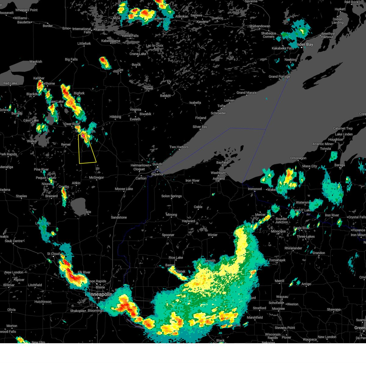 At 356 pm cdt, a severe thunderstorm was located near grand rapids, moving south at 20 mph (radar indicated). Hazards include 60 mph wind gusts and quarter size hail. Hail damage to vehicles is expected. expect wind damage to roofs, siding, and trees. this severe thunderstorm will be near, pokegama lake around 400 pm cdt. hill city around 440 pm cdt. other locations impacted by this severe thunderstorm include haypoint, split hand lake and la prairie. hail threat, radar indicated max hail size, 1. 00 in wind threat, radar indicated max wind gust, 60 mph. At 356 pm cdt, a severe thunderstorm was located near grand rapids, moving south at 20 mph (radar indicated). Hazards include 60 mph wind gusts and quarter size hail. Hail damage to vehicles is expected. expect wind damage to roofs, siding, and trees. this severe thunderstorm will be near, pokegama lake around 400 pm cdt. hill city around 440 pm cdt. other locations impacted by this severe thunderstorm include haypoint, split hand lake and la prairie. hail threat, radar indicated max hail size, 1. 00 in wind threat, radar indicated max wind gust, 60 mph.
|
| 7/22/2023 3:54 PM CDT |
 At 354 pm cdt, a severe thunderstorm was located near grand rapids, moving south at 20 mph (radar indicated). Hazards include 60 mph wind gusts and half dollar size hail. Hail damage to vehicles is expected. expect wind damage to roofs, siding, and trees. this severe storm will be near, pokegama lake around 400 pm cdt. other locations impacted by this severe thunderstorm include la prairie. hail threat, radar indicated max hail size, 1. 25 in wind threat, radar indicated max wind gust, 60 mph. At 354 pm cdt, a severe thunderstorm was located near grand rapids, moving south at 20 mph (radar indicated). Hazards include 60 mph wind gusts and half dollar size hail. Hail damage to vehicles is expected. expect wind damage to roofs, siding, and trees. this severe storm will be near, pokegama lake around 400 pm cdt. other locations impacted by this severe thunderstorm include la prairie. hail threat, radar indicated max hail size, 1. 25 in wind threat, radar indicated max wind gust, 60 mph.
|
| 7/22/2023 3:37 PM CDT |
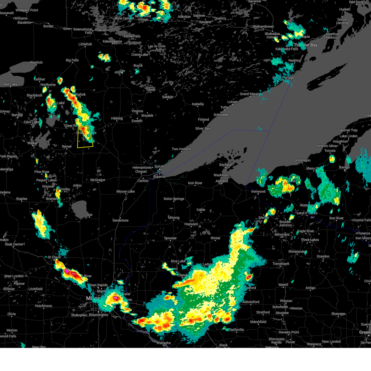 At 336 pm cdt, a severe thunderstorm was located over pokegama dam, or near grand rapids, moving south at 20 mph (radar indicated). Hazards include 60 mph wind gusts and half dollar size hail. Hail damage to vehicles is expected. expect wind damage to roofs, siding, and trees. this severe storm will be near, grand rapids around 340 pm cdt. gunn around 345 pm cdt. pokegama lake around 350 pm cdt. other locations impacted by this severe thunderstorm include la prairie, siseebakwet lake and bass lake. hail threat, radar indicated max hail size, 1. 25 in wind threat, radar indicated max wind gust, 60 mph. At 336 pm cdt, a severe thunderstorm was located over pokegama dam, or near grand rapids, moving south at 20 mph (radar indicated). Hazards include 60 mph wind gusts and half dollar size hail. Hail damage to vehicles is expected. expect wind damage to roofs, siding, and trees. this severe storm will be near, grand rapids around 340 pm cdt. gunn around 345 pm cdt. pokegama lake around 350 pm cdt. other locations impacted by this severe thunderstorm include la prairie, siseebakwet lake and bass lake. hail threat, radar indicated max hail size, 1. 25 in wind threat, radar indicated max wind gust, 60 mph.
|
| 7/22/2023 3:18 PM CDT |
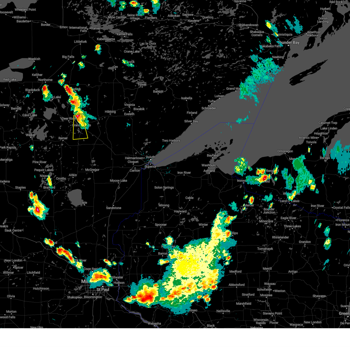 At 317 pm cdt, a severe thunderstorm was located near cohasset, or 9 miles northwest of grand rapids, moving south at 20 mph (radar indicated). Hazards include 60 mph wind gusts and half dollar size hail. Hail damage to vehicles is expected. expect wind damage to roofs, siding, and trees. this severe thunderstorm will be near, grand rapids around 335 pm cdt. pokegama dam around 340 pm cdt. cohasset, pokegama lake and gunn around 350 pm cdt. other locations impacted by this severe thunderstorm include la prairie, siseebakwet lake and bass lake. hail threat, radar indicated max hail size, 1. 25 in wind threat, radar indicated max wind gust, 60 mph. At 317 pm cdt, a severe thunderstorm was located near cohasset, or 9 miles northwest of grand rapids, moving south at 20 mph (radar indicated). Hazards include 60 mph wind gusts and half dollar size hail. Hail damage to vehicles is expected. expect wind damage to roofs, siding, and trees. this severe thunderstorm will be near, grand rapids around 335 pm cdt. pokegama dam around 340 pm cdt. cohasset, pokegama lake and gunn around 350 pm cdt. other locations impacted by this severe thunderstorm include la prairie, siseebakwet lake and bass lake. hail threat, radar indicated max hail size, 1. 25 in wind threat, radar indicated max wind gust, 60 mph.
|
| 8/28/2022 9:51 PM CDT | At 951 pm cdt, a severe thunderstorm was located over coleraine, or near grand rapids, moving east at 35 mph (radar indicated). Hazards include 60 mph wind gusts and quarter size hail. Hail damage to vehicles is expected. expect wind damage to roofs, siding, and trees. this severe thunderstorm will be near, taconite around 1005 pm cdt. other locations in the path of this severe thunderstorm include pengilly, keewatin and nashwauk. hail threat, radar indicated max hail size, 1. 00 in wind threat, radar indicated max wind gust, 60 mph. |
| 8/2/2022 12:41 PM CDT |
 At 1241 pm cdt, a severe thunderstorm was located over gunn, or near grand rapids, moving east at 25 mph (radar indicated). Hazards include quarter size hail. Damage to vehicles is expected. this severe storm will be near, pokegama lake around 1245 pm cdt. warba around 105 pm cdt. swan river around 115 pm cdt. other locations impacted by this severe thunderstorm include blackberry, hart lake, swan lake, bovey, wawina, goodland, la prairie and calumet. hail threat, radar indicated max hail size, 1. 00 in wind threat, radar indicated max wind gust, <50 mph. At 1241 pm cdt, a severe thunderstorm was located over gunn, or near grand rapids, moving east at 25 mph (radar indicated). Hazards include quarter size hail. Damage to vehicles is expected. this severe storm will be near, pokegama lake around 1245 pm cdt. warba around 105 pm cdt. swan river around 115 pm cdt. other locations impacted by this severe thunderstorm include blackberry, hart lake, swan lake, bovey, wawina, goodland, la prairie and calumet. hail threat, radar indicated max hail size, 1. 00 in wind threat, radar indicated max wind gust, <50 mph.
|
| 8/2/2022 12:33 PM CDT |
 At 1232 pm cdt, a severe thunderstorm was located near grand rapids, moving east at 30 mph (radar indicated). Hazards include quarter size hail. Damage to vehicles is expected. this severe storm will be near, gunn and pokegama lake around 1240 pm cdt. warba around 105 pm cdt. swan river around 110 pm cdt. other locations impacted by this severe thunderstorm include split hand lake, blackberry, hart lake, calumet, swan lake, bovey, wawina, goodland, marble and la prairie. hail threat, radar indicated max hail size, 1. 00 in wind threat, radar indicated max wind gust, <50 mph. At 1232 pm cdt, a severe thunderstorm was located near grand rapids, moving east at 30 mph (radar indicated). Hazards include quarter size hail. Damage to vehicles is expected. this severe storm will be near, gunn and pokegama lake around 1240 pm cdt. warba around 105 pm cdt. swan river around 110 pm cdt. other locations impacted by this severe thunderstorm include split hand lake, blackberry, hart lake, calumet, swan lake, bovey, wawina, goodland, marble and la prairie. hail threat, radar indicated max hail size, 1. 00 in wind threat, radar indicated max wind gust, <50 mph.
|
| 8/2/2022 12:20 PM CDT |
 At 1220 pm cdt, a severe thunderstorm was located 7 miles south of pokegama dam, or 7 miles southwest of grand rapids, moving east at 25 mph (radar indicated). Hazards include quarter size hail. Damage to vehicles is expected. this severe storm will be near, pokegama lake and pokegama dam around 1225 pm cdt. gunn around 1240 pm cdt. warba around 105 pm cdt. swan river around 110 pm cdt. other locations impacted by this severe thunderstorm include split hand lake, blackberry, hart lake, calumet, swan lake, bovey, wawina, goodland, marble and la prairie. hail threat, radar indicated max hail size, 1. 00 in wind threat, radar indicated max wind gust, <50 mph. At 1220 pm cdt, a severe thunderstorm was located 7 miles south of pokegama dam, or 7 miles southwest of grand rapids, moving east at 25 mph (radar indicated). Hazards include quarter size hail. Damage to vehicles is expected. this severe storm will be near, pokegama lake and pokegama dam around 1225 pm cdt. gunn around 1240 pm cdt. warba around 105 pm cdt. swan river around 110 pm cdt. other locations impacted by this severe thunderstorm include split hand lake, blackberry, hart lake, calumet, swan lake, bovey, wawina, goodland, marble and la prairie. hail threat, radar indicated max hail size, 1. 00 in wind threat, radar indicated max wind gust, <50 mph.
|
| 8/2/2022 12:09 PM CDT |
 At 1208 pm cdt, a severe thunderstorm was located 7 miles south of days high landing, or 12 miles southwest of grand rapids, moving east at 25 mph (radar indicated). Hazards include half dollar size hail. Damage to vehicles is expected. this severe thunderstorm will be near, pokegama lake around 1225 pm cdt. cohasset and pokegama dam around 1230 pm cdt. gunn around 1240 pm cdt. warba around 105 pm cdt. swan river around 110 pm cdt. other locations impacted by this severe thunderstorm include blackberry, hart lake, calumet, swan lake, bovey, wawina, goodland, marble, split hand lake and schoolcraft state park. hail threat, radar indicated max hail size, 1. 25 in wind threat, radar indicated max wind gust, <50 mph. At 1208 pm cdt, a severe thunderstorm was located 7 miles south of days high landing, or 12 miles southwest of grand rapids, moving east at 25 mph (radar indicated). Hazards include half dollar size hail. Damage to vehicles is expected. this severe thunderstorm will be near, pokegama lake around 1225 pm cdt. cohasset and pokegama dam around 1230 pm cdt. gunn around 1240 pm cdt. warba around 105 pm cdt. swan river around 110 pm cdt. other locations impacted by this severe thunderstorm include blackberry, hart lake, calumet, swan lake, bovey, wawina, goodland, marble, split hand lake and schoolcraft state park. hail threat, radar indicated max hail size, 1. 25 in wind threat, radar indicated max wind gust, <50 mph.
|
| 7/10/2022 10:54 AM CDT |
 At 1051 am cdt, severe thunderstorms were located along a line extending from near bena, to near longville, to near pequot lakes, moving east at 55 mph (radar indicated). Hazards include 60 mph wind gusts and quarter size hail. Hail damage to vehicles is expected. expect wind damage to roofs, siding, and trees. severe thunderstorms will be near, crosslake around 1100 am cdt. fifty lakes, remer and ball club around 1105 am cdt. days high landing around 1110 am cdt. other locations in the path of these severe thunderstorms include deer river, zemple, hill city, pokegama dam, grand rapids, coleraine, taconite, palisade, gunn and jacobson. hail threat, radar indicated max hail size, 1. 00 in wind threat, radar indicated max wind gust, 60 mph. At 1051 am cdt, severe thunderstorms were located along a line extending from near bena, to near longville, to near pequot lakes, moving east at 55 mph (radar indicated). Hazards include 60 mph wind gusts and quarter size hail. Hail damage to vehicles is expected. expect wind damage to roofs, siding, and trees. severe thunderstorms will be near, crosslake around 1100 am cdt. fifty lakes, remer and ball club around 1105 am cdt. days high landing around 1110 am cdt. other locations in the path of these severe thunderstorms include deer river, zemple, hill city, pokegama dam, grand rapids, coleraine, taconite, palisade, gunn and jacobson. hail threat, radar indicated max hail size, 1. 00 in wind threat, radar indicated max wind gust, 60 mph.
|
| 6/29/2022 7:25 PM CDT |
 At 725 pm cdt, a severe thunderstorm was located over gunn, or over grand rapids, moving east at 40 mph (public). Hazards include quarter size hail. Damage to vehicles is expected. this severe thunderstorm will be near, coleraine around 735 pm cdt. taconite around 740 pm cdt. other locations in the path of this severe thunderstorm include pengilly, keewatin and nashwauk. hail threat, observed max hail size, 1. 00 in wind threat, radar indicated max wind gust, <50 mph. At 725 pm cdt, a severe thunderstorm was located over gunn, or over grand rapids, moving east at 40 mph (public). Hazards include quarter size hail. Damage to vehicles is expected. this severe thunderstorm will be near, coleraine around 735 pm cdt. taconite around 740 pm cdt. other locations in the path of this severe thunderstorm include pengilly, keewatin and nashwauk. hail threat, observed max hail size, 1. 00 in wind threat, radar indicated max wind gust, <50 mph.
|
| 6/25/2022 12:06 AM CDT |
 At 1205 am cdt, severe thunderstorms were located along a line extending from 8 miles west of togo, to 7 miles northwest of keewatin, to near pengilly, to near warba, to 6 miles east of hill city, moving east at 45 mph (radar indicated). Hazards include 70 mph wind gusts and quarter size hail. Hail damage to vehicles is expected. expect considerable tree damage. wind damage is also likely to mobile homes, roofs, and outbuildings. these severe storms will be near, nashwauk around 1210 am cdt. Other locations in the path of these severe thunderstorms include togo. At 1205 am cdt, severe thunderstorms were located along a line extending from 8 miles west of togo, to 7 miles northwest of keewatin, to near pengilly, to near warba, to 6 miles east of hill city, moving east at 45 mph (radar indicated). Hazards include 70 mph wind gusts and quarter size hail. Hail damage to vehicles is expected. expect considerable tree damage. wind damage is also likely to mobile homes, roofs, and outbuildings. these severe storms will be near, nashwauk around 1210 am cdt. Other locations in the path of these severe thunderstorms include togo.
|
| 6/24/2022 11:54 PM CDT |
 At 1154 pm cdt, severe thunderstorms were located along a line extending from near effie, to 14 miles east of marcell, to coleraine, to 7 miles southwest of gunn, to near hill city, moving east at 45 mph (radar indicated). Hazards include 70 mph wind gusts and quarter size hail. Hail damage to vehicles is expected. expect considerable tree damage. wind damage is also likely to mobile homes, roofs, and outbuildings. these severe storms will be near, taconite around 1200 am cdt. Other locations in the path of these severe thunderstorms include pengilly, warba, nashwauk and togo. At 1154 pm cdt, severe thunderstorms were located along a line extending from near effie, to 14 miles east of marcell, to coleraine, to 7 miles southwest of gunn, to near hill city, moving east at 45 mph (radar indicated). Hazards include 70 mph wind gusts and quarter size hail. Hail damage to vehicles is expected. expect considerable tree damage. wind damage is also likely to mobile homes, roofs, and outbuildings. these severe storms will be near, taconite around 1200 am cdt. Other locations in the path of these severe thunderstorms include pengilly, warba, nashwauk and togo.
|
| 6/24/2022 11:43 PM CDT |
 At 1140 pm cdt, severe thunderstorms were located along a line extending from 7 miles west of effie, to near marcell, to near cohasset, to 8 miles south of days high landing, to near remer, moving east at 45 mph. these are destructive storms for deer river, cohasset, days high landing, highway 2 between deer river and cohasset, and state highway 6 between highway 2 and remer (radar indicated). Hazards include 80 mph wind gusts and quarter size hail. Flying debris will be dangerous to those caught without shelter. mobile homes will be heavily damaged. expect considerable damage to roofs, windows, and vehicles. extensive tree damage and power outages are likely. these severe storms will be near, pokegama dam around 1145 pm cdt. grand rapids, cohasset, pokegama lake and gunn around 1150 pm cdt. Other locations in the path of these severe thunderstorms include coleraine, taconite, pengilly, warba, nashwauk and togo. At 1140 pm cdt, severe thunderstorms were located along a line extending from 7 miles west of effie, to near marcell, to near cohasset, to 8 miles south of days high landing, to near remer, moving east at 45 mph. these are destructive storms for deer river, cohasset, days high landing, highway 2 between deer river and cohasset, and state highway 6 between highway 2 and remer (radar indicated). Hazards include 80 mph wind gusts and quarter size hail. Flying debris will be dangerous to those caught without shelter. mobile homes will be heavily damaged. expect considerable damage to roofs, windows, and vehicles. extensive tree damage and power outages are likely. these severe storms will be near, pokegama dam around 1145 pm cdt. grand rapids, cohasset, pokegama lake and gunn around 1150 pm cdt. Other locations in the path of these severe thunderstorms include coleraine, taconite, pengilly, warba, nashwauk and togo.
|
| 6/24/2022 11:31 PM CDT |
 At 1128 pm cdt, severe thunderstorms were located along a line extending from 8 miles southeast of gemmell, to 6 miles west of marcell, to near deer river, to 6 miles east of boy river, to 6 miles northeast of longville, moving east at 50 mph. these are destructive storms for bena, ball club, deer river, boy river, highway 2 between bena and deer river, cass county highway 4, cass county highway 65, and cass county highway 74 (radar indicated). Hazards include 80 mph wind gusts and quarter size hail. Flying debris will be dangerous to those caught without shelter. mobile homes will be heavily damaged. expect considerable damage to roofs, windows, and vehicles. extensive tree damage and power outages are likely. these severe storms will be near, deer river, marcell, zemple and days high landing around 1135 pm cdt. pokegama dam around 1145 pm cdt. grand rapids, cohasset, bigfork, effie, pokegama lake and gunn around 1150 pm cdt. coleraine around 1155 pm cdt. taconite around 1200 am cdt. pengilly around 1205 am cdt. warba around 1210 am cdt. nashwauk around 1215 am cdt. Other locations impacted by these severe thunderstorms include buck lake, blackberry, calumet, max, ball club lake, swan lake, stony brook, bovey, mud lake and bois forte band deer creek area. At 1128 pm cdt, severe thunderstorms were located along a line extending from 8 miles southeast of gemmell, to 6 miles west of marcell, to near deer river, to 6 miles east of boy river, to 6 miles northeast of longville, moving east at 50 mph. these are destructive storms for bena, ball club, deer river, boy river, highway 2 between bena and deer river, cass county highway 4, cass county highway 65, and cass county highway 74 (radar indicated). Hazards include 80 mph wind gusts and quarter size hail. Flying debris will be dangerous to those caught without shelter. mobile homes will be heavily damaged. expect considerable damage to roofs, windows, and vehicles. extensive tree damage and power outages are likely. these severe storms will be near, deer river, marcell, zemple and days high landing around 1135 pm cdt. pokegama dam around 1145 pm cdt. grand rapids, cohasset, bigfork, effie, pokegama lake and gunn around 1150 pm cdt. coleraine around 1155 pm cdt. taconite around 1200 am cdt. pengilly around 1205 am cdt. warba around 1210 am cdt. nashwauk around 1215 am cdt. Other locations impacted by these severe thunderstorms include buck lake, blackberry, calumet, max, ball club lake, swan lake, stony brook, bovey, mud lake and bois forte band deer creek area.
|
| 6/24/2022 11:20 PM CDT |
 At 1119 pm cdt, severe thunderstorms were located along a line extending from near mizpah, to inger, to ball club, to near longville, moving east at 55 mph. these are destructive storms for bena, ball club, deer river, highway 2 between deer river and bena (radar indicated). Hazards include 80 mph wind gusts and quarter size hail. Flying debris will be dangerous to those caught without shelter. mobile homes will be heavily damaged. expect considerable damage to roofs, windows, and vehicles. extensive tree damage and power outages are likely. these severe storms will be near, ball club around 1125 pm cdt. deer river, zemple and days high landing around 1130 pm cdt. marcell and remer around 1135 pm cdt. pokegama dam around 1140 pm cdt. grand rapids, bigfork, effie and gunn around 1145 pm cdt. coleraine around 1150 pm cdt. taconite around 1155 pm cdt. pengilly around 1200 am cdt. Other locations impacted by these severe thunderstorms include buck lake, calumet, swan lake, stony brook, orth, bowstring, wirt, la prairie, sugar lake and rosy. At 1119 pm cdt, severe thunderstorms were located along a line extending from near mizpah, to inger, to ball club, to near longville, moving east at 55 mph. these are destructive storms for bena, ball club, deer river, highway 2 between deer river and bena (radar indicated). Hazards include 80 mph wind gusts and quarter size hail. Flying debris will be dangerous to those caught without shelter. mobile homes will be heavily damaged. expect considerable damage to roofs, windows, and vehicles. extensive tree damage and power outages are likely. these severe storms will be near, ball club around 1125 pm cdt. deer river, zemple and days high landing around 1130 pm cdt. marcell and remer around 1135 pm cdt. pokegama dam around 1140 pm cdt. grand rapids, bigfork, effie and gunn around 1145 pm cdt. coleraine around 1150 pm cdt. taconite around 1155 pm cdt. pengilly around 1200 am cdt. Other locations impacted by these severe thunderstorms include buck lake, calumet, swan lake, stony brook, orth, bowstring, wirt, la prairie, sugar lake and rosy.
|
| 6/24/2022 11:09 PM CDT |
 At 1108 pm cdt, severe thunderstorms were located along a line extending from mizpah, to 6 miles northwest of oslund, to near lake winnibigoshish, to near leech lake, moving east at 45 mph (radar indicated). Hazards include 70 mph wind gusts and quarter size hail. Hail damage to vehicles is expected. expect considerable tree damage. wind damage is also likely to mobile homes, roofs, and outbuildings. severe thunderstorms will be near, oslund and inger around 1115 pm cdt. deer river around 1130 pm cdt. bigfork and remer around 1135 pm cdt. effie around 1145 pm cdt. coleraine around 1150 pm cdt. cohasset and pokegama lake around 1155 pm cdt. taconite and gunn around 1200 am cdt. pengilly around 1205 am cdt. Other locations impacted by these severe thunderstorms include buck lake, calumet, swan lake, stony brook, orth, bowstring, wirt, la prairie, sugar lake and rosy. At 1108 pm cdt, severe thunderstorms were located along a line extending from mizpah, to 6 miles northwest of oslund, to near lake winnibigoshish, to near leech lake, moving east at 45 mph (radar indicated). Hazards include 70 mph wind gusts and quarter size hail. Hail damage to vehicles is expected. expect considerable tree damage. wind damage is also likely to mobile homes, roofs, and outbuildings. severe thunderstorms will be near, oslund and inger around 1115 pm cdt. deer river around 1130 pm cdt. bigfork and remer around 1135 pm cdt. effie around 1145 pm cdt. coleraine around 1150 pm cdt. cohasset and pokegama lake around 1155 pm cdt. taconite and gunn around 1200 am cdt. pengilly around 1205 am cdt. Other locations impacted by these severe thunderstorms include buck lake, calumet, swan lake, stony brook, orth, bowstring, wirt, la prairie, sugar lake and rosy.
|
| 6/20/2022 9:31 PM CDT |
 At 930 pm cdt, severe thunderstorms were located along a line extending from 7 miles northwest of marcell, to near pengilly, moving northeast at 65 mph (radar indicated). Hazards include 60 mph wind gusts. Expect damage to roofs, siding, and trees. these severe storms will be near, keewatin around 935 pm cdt. bigfork around 940 pm cdt. hibbing, chisholm and effie around 945 pm cdt. other locations impacted by these severe thunderstorms include buck lake, side lake, kinney, calumet, swan lake, stony brook, bovey, perch lake, silica and bois forte band deer creek area. hail threat, radar indicated max hail size, <. 75 in wind threat, radar indicated max wind gust, 60 mph. At 930 pm cdt, severe thunderstorms were located along a line extending from 7 miles northwest of marcell, to near pengilly, moving northeast at 65 mph (radar indicated). Hazards include 60 mph wind gusts. Expect damage to roofs, siding, and trees. these severe storms will be near, keewatin around 935 pm cdt. bigfork around 940 pm cdt. hibbing, chisholm and effie around 945 pm cdt. other locations impacted by these severe thunderstorms include buck lake, side lake, kinney, calumet, swan lake, stony brook, bovey, perch lake, silica and bois forte band deer creek area. hail threat, radar indicated max hail size, <. 75 in wind threat, radar indicated max wind gust, 60 mph.
|
| 6/20/2022 9:16 PM CDT |
 At 914 pm cdt, severe thunderstorms were located along a line extending from near inger, to near warba, moving northeast at 65 mph. we have received some reports of tree and structural damage from grand rapids west towards cohasset (trained weather spotters). Hazards include 60 mph wind gusts. Expect damage to roofs, siding, and trees. severe thunderstorms will be near, marcell and pengilly around 925 pm cdt. keewatin and nashwauk around 930 pm cdt. bigfork around 935 pm cdt. hibbing, chisholm and effie around 940 pm cdt. other locations impacted by these severe thunderstorms include buck lake, side lake, kinney, calumet, swan lake, stony brook, silica, bowstring, la prairie and leetonia. hail threat, radar indicated max hail size, <. 75 in wind threat, radar indicated max wind gust, 60 mph. At 914 pm cdt, severe thunderstorms were located along a line extending from near inger, to near warba, moving northeast at 65 mph. we have received some reports of tree and structural damage from grand rapids west towards cohasset (trained weather spotters). Hazards include 60 mph wind gusts. Expect damage to roofs, siding, and trees. severe thunderstorms will be near, marcell and pengilly around 925 pm cdt. keewatin and nashwauk around 930 pm cdt. bigfork around 935 pm cdt. hibbing, chisholm and effie around 940 pm cdt. other locations impacted by these severe thunderstorms include buck lake, side lake, kinney, calumet, swan lake, stony brook, silica, bowstring, la prairie and leetonia. hail threat, radar indicated max hail size, <. 75 in wind threat, radar indicated max wind gust, 60 mph.
|
| 5/30/2022 6:52 PM CDT |
 At 651 pm cdt, severe thunderstorms were located along a line extending from 6 miles east of deer river, to 6 miles southwest of jacobson, moving northeast at 65 mph (radar indicated). Hazards include 70 mph wind gusts and quarter size hail. Hail damage to vehicles is expected. expect considerable tree damage. wind damage is also likely to mobile homes, roofs, and outbuildings. Locations impacted include, jacobson, swan river and warba. At 651 pm cdt, severe thunderstorms were located along a line extending from 6 miles east of deer river, to 6 miles southwest of jacobson, moving northeast at 65 mph (radar indicated). Hazards include 70 mph wind gusts and quarter size hail. Hail damage to vehicles is expected. expect considerable tree damage. wind damage is also likely to mobile homes, roofs, and outbuildings. Locations impacted include, jacobson, swan river and warba.
|
| 5/30/2022 6:27 PM CDT |
 At 626 pm cdt, severe thunderstorms were located along a line extending from near boy river, to 9 miles east of emily, moving northeast at 65 mph. Hazards include 70 mph wind gusts and nickel size hail. Expect considerable tree damage. damage is likely to mobile homes, roofs, and outbuildings. severe thunderstorms will be near, swatara and ball club around 635 pm cdt. hill city and days high landing around 640 pm cdt. deer river and zemple around 645 pm cdt. Other locations in the path of these severe thunderstorms include jacobson, swan river and warba. At 626 pm cdt, severe thunderstorms were located along a line extending from near boy river, to 9 miles east of emily, moving northeast at 65 mph. Hazards include 70 mph wind gusts and nickel size hail. Expect considerable tree damage. damage is likely to mobile homes, roofs, and outbuildings. severe thunderstorms will be near, swatara and ball club around 635 pm cdt. hill city and days high landing around 640 pm cdt. deer river and zemple around 645 pm cdt. Other locations in the path of these severe thunderstorms include jacobson, swan river and warba.
|
| 5/30/2022 6:03 AM CDT |
 At 603 am cdt, severe thunderstorms were located along a line extending from near hill city, to 6 miles northwest of cromwell, to near duxbury, moving east at 55 mph (radar indicated). Hazards include 60 mph wind gusts and penny size hail. Expect damage to roofs, siding, and trees. locations impacted include, fond du lac band sawyer area, swan river, fond du lac band brookston area, cloquet, fond du lac band cloquet area, scanlon, carlton, floodwood, wrenshall, thomson, superior, proctor, oliver and meadowlands. hail threat, radar indicated max hail size, 0. 75 in wind threat, radar indicated max wind gust, 60 mph. At 603 am cdt, severe thunderstorms were located along a line extending from near hill city, to 6 miles northwest of cromwell, to near duxbury, moving east at 55 mph (radar indicated). Hazards include 60 mph wind gusts and penny size hail. Expect damage to roofs, siding, and trees. locations impacted include, fond du lac band sawyer area, swan river, fond du lac band brookston area, cloquet, fond du lac band cloquet area, scanlon, carlton, floodwood, wrenshall, thomson, superior, proctor, oliver and meadowlands. hail threat, radar indicated max hail size, 0. 75 in wind threat, radar indicated max wind gust, 60 mph.
|
| 5/30/2022 5:49 AM CDT |
 At 548 am cdt, severe thunderstorms were located along a line extending from swatara, to near tamarack, to 6 miles west of mille lacs band lena lake area, moving northeast at 55 mph (radar indicated). Hazards include 60 mph wind gusts and penny size hail. Expect damage to roofs, siding, and trees. severe thunderstorms will be near, tamarack around 555 am cdt. duxbury around 600 am cdt. cromwell and cloverton around 605 am cdt. other locations in the path of these severe thunderstorms include floodwood, warba, gunn, taconite, foxboro, keewatin, nashwauk, meadowlands and pengilly. hail threat, radar indicated max hail size, 0. 75 in wind threat, radar indicated max wind gust, 60 mph. At 548 am cdt, severe thunderstorms were located along a line extending from swatara, to near tamarack, to 6 miles west of mille lacs band lena lake area, moving northeast at 55 mph (radar indicated). Hazards include 60 mph wind gusts and penny size hail. Expect damage to roofs, siding, and trees. severe thunderstorms will be near, tamarack around 555 am cdt. duxbury around 600 am cdt. cromwell and cloverton around 605 am cdt. other locations in the path of these severe thunderstorms include floodwood, warba, gunn, taconite, foxboro, keewatin, nashwauk, meadowlands and pengilly. hail threat, radar indicated max hail size, 0. 75 in wind threat, radar indicated max wind gust, 60 mph.
|
| 7/28/2021 10:07 AM CDT |
 At 1007 am cdt, a severe thunderstorm was located near days high landing, or 10 miles west of grand rapids, moving east at 50 mph (radar indicated). Hazards include quarter size hail. Damage to vehicles is expected. Locations impacted include, cohasset, pokegama lake, pokegama dam, gunn, warba, swan river and jacobson. At 1007 am cdt, a severe thunderstorm was located near days high landing, or 10 miles west of grand rapids, moving east at 50 mph (radar indicated). Hazards include quarter size hail. Damage to vehicles is expected. Locations impacted include, cohasset, pokegama lake, pokegama dam, gunn, warba, swan river and jacobson.
|
| 7/28/2021 9:53 AM CDT |
 At 953 am cdt, a severe thunderstorm was located 7 miles northeast of boy river, or 21 miles west of grand rapids, moving east at 45 mph (radar indicated). Hazards include quarter size hail. Damage to vehicles is expected. this severe thunderstorm will be near, days high landing around 1005 am cdt. Other locations in the path of this severe thunderstorm include cohasset, pokegama lake, pokegama dam, gunn, warba, swan river and jacobson. At 953 am cdt, a severe thunderstorm was located 7 miles northeast of boy river, or 21 miles west of grand rapids, moving east at 45 mph (radar indicated). Hazards include quarter size hail. Damage to vehicles is expected. this severe thunderstorm will be near, days high landing around 1005 am cdt. Other locations in the path of this severe thunderstorm include cohasset, pokegama lake, pokegama dam, gunn, warba, swan river and jacobson.
|
| 7/26/2021 7:24 PM CDT |
 At 723 pm cdt, a severe thunderstorm was located over warba, or 13 miles southeast of grand rapids, moving southeast at 30 mph (radar indicated. one inch hail was reported in blackberry and trees have been knocked down in grand rapids). Hazards include 70 mph wind gusts and ping pong ball size hail. People and animals outdoors will be injured. expect hail damage to roofs, siding, windows, and vehicles. expect considerable tree damage. wind damage is also likely to mobile homes, roofs, and outbuildings. this severe storm will be near, swan river around 735 pm cdt. jacobson around 740 pm cdt. floodwood around 810 pm cdt. Other locations impacted by this severe thunderstorm include blackberry, ball bluff, floodwood lake, savanna portage state park, wawina, goodland, island, la prairie and swan lake. At 723 pm cdt, a severe thunderstorm was located over warba, or 13 miles southeast of grand rapids, moving southeast at 30 mph (radar indicated. one inch hail was reported in blackberry and trees have been knocked down in grand rapids). Hazards include 70 mph wind gusts and ping pong ball size hail. People and animals outdoors will be injured. expect hail damage to roofs, siding, windows, and vehicles. expect considerable tree damage. wind damage is also likely to mobile homes, roofs, and outbuildings. this severe storm will be near, swan river around 735 pm cdt. jacobson around 740 pm cdt. floodwood around 810 pm cdt. Other locations impacted by this severe thunderstorm include blackberry, ball bluff, floodwood lake, savanna portage state park, wawina, goodland, island, la prairie and swan lake.
|
| 7/26/2021 7:13 PM CDT |
 At 712 pm cdt, a severe thunderstorm was located near warba, or 8 miles east of grand rapids, moving southeast at 30 mph (radar indicated). Hazards include 70 mph wind gusts and ping pong ball size hail. People and animals outdoors will be injured. expect hail damage to roofs, siding, windows, and vehicles. expect considerable tree damage. wind damage is also likely to mobile homes, roofs, and outbuildings. this severe thunderstorm will be near, warba around 725 pm cdt. swan river around 735 pm cdt. jacobson around 740 pm cdt. floodwood around 800 pm cdt. Other locations impacted by this severe thunderstorm include blackberry, ball bluff, floodwood lake, savanna portage state park, bovey, wawina, goodland, marble, island and la prairie. At 712 pm cdt, a severe thunderstorm was located near warba, or 8 miles east of grand rapids, moving southeast at 30 mph (radar indicated). Hazards include 70 mph wind gusts and ping pong ball size hail. People and animals outdoors will be injured. expect hail damage to roofs, siding, windows, and vehicles. expect considerable tree damage. wind damage is also likely to mobile homes, roofs, and outbuildings. this severe thunderstorm will be near, warba around 725 pm cdt. swan river around 735 pm cdt. jacobson around 740 pm cdt. floodwood around 800 pm cdt. Other locations impacted by this severe thunderstorm include blackberry, ball bluff, floodwood lake, savanna portage state park, bovey, wawina, goodland, marble, island and la prairie.
|
| 7/26/2021 7:05 PM CDT |
 At 704 pm cdt, a severe thunderstorm was located near grand rapids, moving southeast at 30 mph (radar indicated). Hazards include 70 mph wind gusts and ping pong ball size hail. People and animals outdoors will be injured. expect hail damage to roofs, siding, windows, and vehicles. expect considerable tree damage. wind damage is also likely to mobile homes, roofs, and outbuildings. Locations impacted include, pokegama lake. At 704 pm cdt, a severe thunderstorm was located near grand rapids, moving southeast at 30 mph (radar indicated). Hazards include 70 mph wind gusts and ping pong ball size hail. People and animals outdoors will be injured. expect hail damage to roofs, siding, windows, and vehicles. expect considerable tree damage. wind damage is also likely to mobile homes, roofs, and outbuildings. Locations impacted include, pokegama lake.
|
| 7/26/2021 6:45 PM CDT |
 At 644 pm cdt, a severe thunderstorm was located near cohasset, or 9 miles northwest of grand rapids, moving southeast at 35 mph (radar indicated). Hazards include 70 mph wind gusts and ping pong ball size hail. People and animals outdoors will be injured. expect hail damage to roofs, siding, windows, and vehicles. expect considerable tree damage. wind damage is also likely to mobile homes, roofs, and outbuildings. this severe thunderstorm will be near, grand rapids and pokegama dam around 655 pm cdt. Other locations in the path of this severe thunderstorm include cohasset, pokegama lake and gunn. At 644 pm cdt, a severe thunderstorm was located near cohasset, or 9 miles northwest of grand rapids, moving southeast at 35 mph (radar indicated). Hazards include 70 mph wind gusts and ping pong ball size hail. People and animals outdoors will be injured. expect hail damage to roofs, siding, windows, and vehicles. expect considerable tree damage. wind damage is also likely to mobile homes, roofs, and outbuildings. this severe thunderstorm will be near, grand rapids and pokegama dam around 655 pm cdt. Other locations in the path of this severe thunderstorm include cohasset, pokegama lake and gunn.
|
| 8/14/2020 6:26 PM CDT |
 At 626 pm cdt, a severe thunderstorm was located near gunn, or near grand rapids, moving northeast at 35 mph (radar indicated). Hazards include 70 mph wind gusts and quarter size hail. Hail damage to vehicles is expected. expect considerable tree damage. wind damage is also likely to mobile homes, roofs, and outbuildings. Locations impacted include, grand rapids, cohasset, coleraine, nashwauk, taconite, warba, pokegama dam, gunn, pengilly, blackberry, bovey, marble, la prairie, hart lake, calumet, swan lake, lawrence lake, and hill annex mine state park. At 626 pm cdt, a severe thunderstorm was located near gunn, or near grand rapids, moving northeast at 35 mph (radar indicated). Hazards include 70 mph wind gusts and quarter size hail. Hail damage to vehicles is expected. expect considerable tree damage. wind damage is also likely to mobile homes, roofs, and outbuildings. Locations impacted include, grand rapids, cohasset, coleraine, nashwauk, taconite, warba, pokegama dam, gunn, pengilly, blackberry, bovey, marble, la prairie, hart lake, calumet, swan lake, lawrence lake, and hill annex mine state park.
|
| 8/14/2020 6:22 PM CDT |
 At 622 pm cdt, a severe thunderstorm was located near gunn, or near grand rapids, moving northeast at 35 mph (radar indicated). Hazards include 60 mph wind gusts and quarter size hail. Hail damage to vehicles is expected. expect wind damage to roofs, siding, and trees. Locations impacted include, grand rapids, cohasset, coleraine, nashwauk, taconite, warba, pokegama dam, gunn, pengilly, blackberry, bovey, marble, la prairie, hart lake, calumet, swan lake, split hand lake, lawrence lake, and hill annex mine state park. At 622 pm cdt, a severe thunderstorm was located near gunn, or near grand rapids, moving northeast at 35 mph (radar indicated). Hazards include 60 mph wind gusts and quarter size hail. Hail damage to vehicles is expected. expect wind damage to roofs, siding, and trees. Locations impacted include, grand rapids, cohasset, coleraine, nashwauk, taconite, warba, pokegama dam, gunn, pengilly, blackberry, bovey, marble, la prairie, hart lake, calumet, swan lake, split hand lake, lawrence lake, and hill annex mine state park.
|
| 8/14/2020 6:13 PM CDT |
 At 613 pm cdt, a severe thunderstorm was located near gunn, or 7 miles south of grand rapids, moving northeast at 35 mph (radar indicated). Hazards include 60 mph wind gusts and quarter size hail. Hail damage to vehicles is expected. Expect wind damage to roofs, siding, and trees. At 613 pm cdt, a severe thunderstorm was located near gunn, or 7 miles south of grand rapids, moving northeast at 35 mph (radar indicated). Hazards include 60 mph wind gusts and quarter size hail. Hail damage to vehicles is expected. Expect wind damage to roofs, siding, and trees.
|
| 8/7/2020 9:29 PM CDT |
 At 929 pm cdt, severe thunderstorms were located along a line extending from pengilly, to 6 miles west of warba, to 6 miles northwest of hill city, moving east at 35 mph (radar indicated). Hazards include 60 mph wind gusts. expect damage to roofs, siding, and trees At 929 pm cdt, severe thunderstorms were located along a line extending from pengilly, to 6 miles west of warba, to 6 miles northwest of hill city, moving east at 35 mph (radar indicated). Hazards include 60 mph wind gusts. expect damage to roofs, siding, and trees
|
| 7/17/2020 10:35 PM CDT |
 At 1034 pm cdt, severe thunderstorms were located along a line extending from 7 miles northeast of remer, to near hill city, to near swatara, to 6 miles north of cuyuna, to near pillager, moving east at 30 mph. these are very dangerous storms (radar indicated). Hazards include 80 mph wind gusts and nickel size hail. Flying debris will be dangerous to those caught without shelter. mobile homes will be heavily damaged. expect considerable damage to roofs, windows, and vehicles. extensive tree damage and power outages are likely. Locations impacted include, brainerd, grand rapids, big sandy lake, mille lacs lake, baxter, cohasset, crosby, breezy point, aitkin, pequot lakes, crosslake, nisswa, coleraine, emily, swan river, hill city, ironton, deerwood, pillager, and fifty lakes. At 1034 pm cdt, severe thunderstorms were located along a line extending from 7 miles northeast of remer, to near hill city, to near swatara, to 6 miles north of cuyuna, to near pillager, moving east at 30 mph. these are very dangerous storms (radar indicated). Hazards include 80 mph wind gusts and nickel size hail. Flying debris will be dangerous to those caught without shelter. mobile homes will be heavily damaged. expect considerable damage to roofs, windows, and vehicles. extensive tree damage and power outages are likely. Locations impacted include, brainerd, grand rapids, big sandy lake, mille lacs lake, baxter, cohasset, crosby, breezy point, aitkin, pequot lakes, crosslake, nisswa, coleraine, emily, swan river, hill city, ironton, deerwood, pillager, and fifty lakes.
|
| 7/17/2020 10:09 PM CDT |
 At 1008 pm cdt, severe thunderstorms were located along a line extending from near boy river, to near remer, to near outing, to breezy point, to near staples, moving east at 30 mph. these are very dangerous storms (radar indicated). Hazards include 80 mph wind gusts and nickel size hail. Flying debris will be dangerous to those caught without shelter. mobile homes will be heavily damaged. expect considerable damage to roofs, windows, and vehicles. Extensive tree damage and power outages are likely. At 1008 pm cdt, severe thunderstorms were located along a line extending from near boy river, to near remer, to near outing, to breezy point, to near staples, moving east at 30 mph. these are very dangerous storms (radar indicated). Hazards include 80 mph wind gusts and nickel size hail. Flying debris will be dangerous to those caught without shelter. mobile homes will be heavily damaged. expect considerable damage to roofs, windows, and vehicles. Extensive tree damage and power outages are likely.
|
| 7/17/2020 9:52 PM CDT |
 At 952 pm cdt, severe thunderstorms were located along a line extending from 7 miles east of boy river, to near remer, to near outing, to near nisswa, moving east at 35 mph. some branches two miles west of jenkins were reported down. these are very dangerous storms (law enforcement). Hazards include 80 mph wind gusts and quarter size hail. Flying debris will be dangerous to those caught without shelter. mobile homes will be heavily damaged. expect considerable damage to roofs, windows, and vehicles. extensive tree damage and power outages are likely. Locations impacted include, grand rapids, big sandy lake, cohasset, crosby, breezy point, aitkin, pequot lakes, crosslake, nisswa, coleraine, pine river, emily, hill city, ironton, deerwood, fifty lakes, remer, wabedo, cuyuna, and hackensack. At 952 pm cdt, severe thunderstorms were located along a line extending from 7 miles east of boy river, to near remer, to near outing, to near nisswa, moving east at 35 mph. some branches two miles west of jenkins were reported down. these are very dangerous storms (law enforcement). Hazards include 80 mph wind gusts and quarter size hail. Flying debris will be dangerous to those caught without shelter. mobile homes will be heavily damaged. expect considerable damage to roofs, windows, and vehicles. extensive tree damage and power outages are likely. Locations impacted include, grand rapids, big sandy lake, cohasset, crosby, breezy point, aitkin, pequot lakes, crosslake, nisswa, coleraine, pine river, emily, hill city, ironton, deerwood, fifty lakes, remer, wabedo, cuyuna, and hackensack.
|
| 7/17/2020 9:50 PM CDT |
 At 949 pm cdt, severe thunderstorms were located along a line extending from 6 miles east of boy river, to near remer, to near outing, to near nisswa, moving east at 35 mph. some branches two miles west of jenkins were reported down (law enforcement). Hazards include 70 mph wind gusts and quarter size hail. Hail damage to vehicles is expected. expect considerable tree damage. wind damage is also likely to mobile homes, roofs, and outbuildings. Locations impacted include, grand rapids, big sandy lake, cohasset, crosby, breezy point, aitkin, pequot lakes, crosslake, nisswa, coleraine, pine river, emily, hill city, ironton, deerwood, fifty lakes, remer, wabedo, cuyuna, and hackensack. At 949 pm cdt, severe thunderstorms were located along a line extending from 6 miles east of boy river, to near remer, to near outing, to near nisswa, moving east at 35 mph. some branches two miles west of jenkins were reported down (law enforcement). Hazards include 70 mph wind gusts and quarter size hail. Hail damage to vehicles is expected. expect considerable tree damage. wind damage is also likely to mobile homes, roofs, and outbuildings. Locations impacted include, grand rapids, big sandy lake, cohasset, crosby, breezy point, aitkin, pequot lakes, crosslake, nisswa, coleraine, pine river, emily, hill city, ironton, deerwood, fifty lakes, remer, wabedo, cuyuna, and hackensack.
|
| 7/17/2020 9:21 PM CDT |
 The national weather service in duluth mn has issued a * severe thunderstorm warning for. south central itasca county in north central minnesota. northwestern aitkin county in east central minnesota. cass county in north central minnesota. Crow wing county in east central minnesota. The national weather service in duluth mn has issued a * severe thunderstorm warning for. south central itasca county in north central minnesota. northwestern aitkin county in east central minnesota. cass county in north central minnesota. Crow wing county in east central minnesota.
|
| 7/9/2020 2:26 AM CDT |
 The severe thunderstorm warning for southeastern itasca county will expire at 230 am cdt, the storm which prompted the warning has weakened below severe limits, and no longer poses an immediate threat to life or property. therefore, the warning will be allowed to expire. however small hail and gusty winds are still possible with this and other thunderstorms nearby. The severe thunderstorm warning for southeastern itasca county will expire at 230 am cdt, the storm which prompted the warning has weakened below severe limits, and no longer poses an immediate threat to life or property. therefore, the warning will be allowed to expire. however small hail and gusty winds are still possible with this and other thunderstorms nearby.
|
| 7/9/2020 2:13 AM CDT |
 At 213 am cdt, a severe thunderstorm was located 7 miles southwest of grand rapids, moving east at 35 mph (radar indicated). Hazards include 60 mph wind gusts and quarter size hail. Hail damage to vehicles is expected. expect wind damage to roofs, siding, and trees. Locations impacted include, grand rapids, cohasset, coleraine, taconite, pokegama dam, gunn, blackberry, bovey, marble, la prairie, siseebakwet lake, and bass lake. At 213 am cdt, a severe thunderstorm was located 7 miles southwest of grand rapids, moving east at 35 mph (radar indicated). Hazards include 60 mph wind gusts and quarter size hail. Hail damage to vehicles is expected. expect wind damage to roofs, siding, and trees. Locations impacted include, grand rapids, cohasset, coleraine, taconite, pokegama dam, gunn, blackberry, bovey, marble, la prairie, siseebakwet lake, and bass lake.
|
| 7/9/2020 2:03 AM CDT |
 At 202 am cdt, a severe thunderstorm was located near hill city, or 12 miles southwest of grand rapids, moving northeast at 35 mph (radar indicated). Hazards include 60 mph wind gusts and quarter size hail. Hail damage to vehicles is expected. Expect wind damage to roofs, siding, and trees. At 202 am cdt, a severe thunderstorm was located near hill city, or 12 miles southwest of grand rapids, moving northeast at 35 mph (radar indicated). Hazards include 60 mph wind gusts and quarter size hail. Hail damage to vehicles is expected. Expect wind damage to roofs, siding, and trees.
|
| 8/5/2019 8:22 AM CDT |
 At 822 am cdt, severe thunderstorms were located along a line extending from near nashwauk, to near pengilly, to near swan river, moving east at 40 mph (radar indicated). Hazards include 60 mph wind gusts and penny size hail. expect damage to roofs, siding, and trees At 822 am cdt, severe thunderstorms were located along a line extending from near nashwauk, to near pengilly, to near swan river, moving east at 40 mph (radar indicated). Hazards include 60 mph wind gusts and penny size hail. expect damage to roofs, siding, and trees
|
| 8/5/2019 8:13 AM CDT |
 At 813 am cdt, severe thunderstorms were located along a line extending from near taconite, to near pengilly, to near swan river, moving northeast at 40 mph (radar indicated). Hazards include 60 mph wind gusts and penny size hail. Expect damage to roofs, siding, and trees. Locations impacted include, hibbing, grand rapids, chisholm, cohasset, coleraine, keewatin, buhl, nashwauk, deer river, swan river, hill city, taconite, warba, toivola, meadowlands, zemple, pokegama dam, gunn, pengilly, and jacobson. At 813 am cdt, severe thunderstorms were located along a line extending from near taconite, to near pengilly, to near swan river, moving northeast at 40 mph (radar indicated). Hazards include 60 mph wind gusts and penny size hail. Expect damage to roofs, siding, and trees. Locations impacted include, hibbing, grand rapids, chisholm, cohasset, coleraine, keewatin, buhl, nashwauk, deer river, swan river, hill city, taconite, warba, toivola, meadowlands, zemple, pokegama dam, gunn, pengilly, and jacobson.
|
| 8/5/2019 7:57 AM CDT |
 At 753 am cdt, severe thunderstorms were located along a line extending from near cohasset, to near gunn, to near hill city, moving east at 50 mph (radar indicated). Hazards include 60 mph wind gusts and penny size hail. expect damage to roofs, siding, and trees At 753 am cdt, severe thunderstorms were located along a line extending from near cohasset, to near gunn, to near hill city, moving east at 50 mph (radar indicated). Hazards include 60 mph wind gusts and penny size hail. expect damage to roofs, siding, and trees
|
| 8/5/2019 7:53 AM CDT |
 At 753 am cdt, severe thunderstorms were located along a line extending from near cohasset, to near gunn, to near hill city, moving east at 50 mph (radar indicated). Hazards include 60 mph wind gusts and penny size hail. expect damage to roofs, siding, and trees At 753 am cdt, severe thunderstorms were located along a line extending from near cohasset, to near gunn, to near hill city, moving east at 50 mph (radar indicated). Hazards include 60 mph wind gusts and penny size hail. expect damage to roofs, siding, and trees
|
| 8/5/2019 7:44 AM CDT |
 At 744 am cdt, severe thunderstorms were located along a line extending from near cohasset, to 6 miles southwest of grand rapids, to near hill city, moving east at 50 mph (radar indicated). Hazards include 60 mph wind gusts and quarter size hail. Hail damage to vehicles is expected. expect wind damage to roofs, siding, and trees. Locations impacted include, grand rapids, cohasset, coleraine, hill city, remer, taconite, warba, zemple, days high landing, pokegama dam, gunn, blackberry, bovey, marble, la prairie, thunder lake, mud lake, split hand lake, tobique, and laura lake. At 744 am cdt, severe thunderstorms were located along a line extending from near cohasset, to 6 miles southwest of grand rapids, to near hill city, moving east at 50 mph (radar indicated). Hazards include 60 mph wind gusts and quarter size hail. Hail damage to vehicles is expected. expect wind damage to roofs, siding, and trees. Locations impacted include, grand rapids, cohasset, coleraine, hill city, remer, taconite, warba, zemple, days high landing, pokegama dam, gunn, blackberry, bovey, marble, la prairie, thunder lake, mud lake, split hand lake, tobique, and laura lake.
|
| 8/5/2019 7:33 AM CDT |
 At 732 am cdt, severe thunderstorms were located along a line extending from near days high landing, to near remer, to 9 miles northwest of swatara, moving east at 45 mph. another area of severe thunderstorms was located near boy river and was moving east at 45 mph (radar indicated). Hazards include 60 mph wind gusts and quarter size hail. Hail damage to vehicles is expected. expect wind damage to roofs, siding, and trees. Locations impacted include, grand rapids, cohasset, coleraine, deer river, hill city, remer, taconite, warba, zemple, boy river, days high landing, pokegama dam, gunn, swatara, blackberry, bovey, marble, la prairie, thunder lake, and boy lake. At 732 am cdt, severe thunderstorms were located along a line extending from near days high landing, to near remer, to 9 miles northwest of swatara, moving east at 45 mph. another area of severe thunderstorms was located near boy river and was moving east at 45 mph (radar indicated). Hazards include 60 mph wind gusts and quarter size hail. Hail damage to vehicles is expected. expect wind damage to roofs, siding, and trees. Locations impacted include, grand rapids, cohasset, coleraine, deer river, hill city, remer, taconite, warba, zemple, boy river, days high landing, pokegama dam, gunn, swatara, blackberry, bovey, marble, la prairie, thunder lake, and boy lake.
|
| 8/5/2019 7:16 AM CDT |
 At 716 am cdt, severe thunderstorms were located along a line extending from near boy river, to near remer, to 7 miles northeast of wabedo, moving east at 50 mph (radar indicated). Hazards include 70 mph wind gusts and quarter size hail. Hail damage to vehicles is expected. expect considerable tree damage. wind damage is also likely to mobile homes, roofs, and outbuildings. severe thunderstorms will be near, remer around 720 am cdt. zemple and days high landing around 735 am cdt. hill city around 740 am cdt. cohasset, pokegama dam and pokegama lake around 745 am cdt. grand rapids and gunn around 750 am cdt. coleraine around 755 am cdt. taconite and warba around 800 am cdt. Other locations impacted by these severe thunderstorms include boy lake, blackberry, bovey, mud lake, goose lake, thunder lake, split hand lake, tobique, bass lake and laura lake. At 716 am cdt, severe thunderstorms were located along a line extending from near boy river, to near remer, to 7 miles northeast of wabedo, moving east at 50 mph (radar indicated). Hazards include 70 mph wind gusts and quarter size hail. Hail damage to vehicles is expected. expect considerable tree damage. wind damage is also likely to mobile homes, roofs, and outbuildings. severe thunderstorms will be near, remer around 720 am cdt. zemple and days high landing around 735 am cdt. hill city around 740 am cdt. cohasset, pokegama dam and pokegama lake around 745 am cdt. grand rapids and gunn around 750 am cdt. coleraine around 755 am cdt. taconite and warba around 800 am cdt. Other locations impacted by these severe thunderstorms include boy lake, blackberry, bovey, mud lake, goose lake, thunder lake, split hand lake, tobique, bass lake and laura lake.
|
| 6/30/2019 7:22 AM CDT |
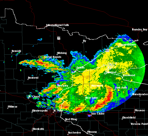 The severe thunderstorm warning for south central itasca county will expire at 730 am cdt, the storm which prompted the warning has weakened below severe limits, and has exited the warned area. therefore, the warning will be allowed to expire. The severe thunderstorm warning for south central itasca county will expire at 730 am cdt, the storm which prompted the warning has weakened below severe limits, and has exited the warned area. therefore, the warning will be allowed to expire.
|
| 6/30/2019 7:16 AM CDT |
 At 716 am cdt, a severe thunderstorm was located near cohasset, or near grand rapids, moving east at 40 mph (radar indicated). Hazards include 60 mph wind gusts and quarter size hail. Hail damage to vehicles is expected. expect wind damage to roofs, siding, and trees. this severe storm will be near, grand rapids around 720 am cdt. Other locations impacted by this severe thunderstorm include bass lake and la prairie. At 716 am cdt, a severe thunderstorm was located near cohasset, or near grand rapids, moving east at 40 mph (radar indicated). Hazards include 60 mph wind gusts and quarter size hail. Hail damage to vehicles is expected. expect wind damage to roofs, siding, and trees. this severe storm will be near, grand rapids around 720 am cdt. Other locations impacted by this severe thunderstorm include bass lake and la prairie.
|
| 6/30/2019 7:05 AM CDT |
 At 704 am cdt, a severe thunderstorm was located over zemple, or 11 miles northwest of grand rapids, moving east at 40 mph (radar indicated). Hazards include ping pong ball size hail and 60 mph wind gusts. People and animals outdoors will be injured. expect hail damage to roofs, siding, windows, and vehicles. expect wind damage to roofs, siding, and trees. this severe storm will be near, pokegama dam around 715 am cdt. grand rapids around 720 am cdt. Other locations impacted by this severe thunderstorm include bass lake and la prairie. At 704 am cdt, a severe thunderstorm was located over zemple, or 11 miles northwest of grand rapids, moving east at 40 mph (radar indicated). Hazards include ping pong ball size hail and 60 mph wind gusts. People and animals outdoors will be injured. expect hail damage to roofs, siding, windows, and vehicles. expect wind damage to roofs, siding, and trees. this severe storm will be near, pokegama dam around 715 am cdt. grand rapids around 720 am cdt. Other locations impacted by this severe thunderstorm include bass lake and la prairie.
|
| 6/30/2019 6:53 AM CDT |
 At 653 am cdt, a severe thunderstorm was located over ball club, or 18 miles west of grand rapids, moving east at 35 mph (radar indicated). Hazards include ping pong ball size hail and 60 mph wind gusts. People and animals outdoors will be injured. expect hail damage to roofs, siding, windows, and vehicles. expect wind damage to roofs, siding, and trees. this severe thunderstorm will be near, deer river and days high landing around 700 am cdt. zemple around 705 am cdt. pokegama dam around 720 am cdt. grand rapids around 725 am cdt. Other locations impacted by this severe thunderstorm include ball club lake, bass lake and la prairie. At 653 am cdt, a severe thunderstorm was located over ball club, or 18 miles west of grand rapids, moving east at 35 mph (radar indicated). Hazards include ping pong ball size hail and 60 mph wind gusts. People and animals outdoors will be injured. expect hail damage to roofs, siding, windows, and vehicles. expect wind damage to roofs, siding, and trees. this severe thunderstorm will be near, deer river and days high landing around 700 am cdt. zemple around 705 am cdt. pokegama dam around 720 am cdt. grand rapids around 725 am cdt. Other locations impacted by this severe thunderstorm include ball club lake, bass lake and la prairie.
|
| 6/30/2019 3:18 AM CDT |
 At 318 am cdt, severe thunderstorms were located along a line extending from cherry, to 6 miles north of toivola, to 8 miles northeast of swan river, to near jacobson, moving southeast at 50 mph (radar indicated). Hazards include ping pong ball size hail and 60 mph wind gusts. People and animals outdoors will be injured. expect hail damage to roofs, siding, windows, and vehicles. expect wind damage to roofs, siding, and trees. Locations impacted include, hibbing, grand rapids, chisholm, eveleth, mountain iron, cohasset, coleraine, keewatin, buhl, nashwauk, cherry, swan river, cotton, taconite, warba, toivola, meadowlands, pokegama dam, gunn, and pengilly. At 318 am cdt, severe thunderstorms were located along a line extending from cherry, to 6 miles north of toivola, to 8 miles northeast of swan river, to near jacobson, moving southeast at 50 mph (radar indicated). Hazards include ping pong ball size hail and 60 mph wind gusts. People and animals outdoors will be injured. expect hail damage to roofs, siding, windows, and vehicles. expect wind damage to roofs, siding, and trees. Locations impacted include, hibbing, grand rapids, chisholm, eveleth, mountain iron, cohasset, coleraine, keewatin, buhl, nashwauk, cherry, swan river, cotton, taconite, warba, toivola, meadowlands, pokegama dam, gunn, and pengilly.
|
| 6/30/2019 2:57 AM CDT |
 At 257 am cdt, severe thunderstorms were located along a line extending from near chisholm, to near keewatin, to near taconite, to near grand rapids, moving southeast at 45 mph (radar indicated). Hazards include ping pong ball size hail and 60 mph wind gusts. People and animals outdoors will be injured. expect hail damage to roofs, siding, windows, and vehicles. expect wind damage to roofs, siding, and trees. Locations impacted include, hibbing, grand rapids, chisholm, eveleth, mountain iron, cohasset, coleraine, keewatin, buhl, nashwauk, deer river, cherry, swan river, cotton, taconite, warba, toivola, meadowlands, zemple, and pengilly. At 257 am cdt, severe thunderstorms were located along a line extending from near chisholm, to near keewatin, to near taconite, to near grand rapids, moving southeast at 45 mph (radar indicated). Hazards include ping pong ball size hail and 60 mph wind gusts. People and animals outdoors will be injured. expect hail damage to roofs, siding, windows, and vehicles. expect wind damage to roofs, siding, and trees. Locations impacted include, hibbing, grand rapids, chisholm, eveleth, mountain iron, cohasset, coleraine, keewatin, buhl, nashwauk, deer river, cherry, swan river, cotton, taconite, warba, toivola, meadowlands, zemple, and pengilly.
|
| 6/30/2019 2:39 AM CDT |
 The national weather service in duluth mn has issued a * severe thunderstorm warning for. eastern itasca county in north central minnesota. northeastern aitkin county in east central minnesota. northeastern cass county in north central minnesota. southwestern st. Louis county in northeastern minnesota. The national weather service in duluth mn has issued a * severe thunderstorm warning for. eastern itasca county in north central minnesota. northeastern aitkin county in east central minnesota. northeastern cass county in north central minnesota. southwestern st. Louis county in northeastern minnesota.
|
| 6/30/2019 2:30 AM CDT |
 At 230 am cdt, severe thunderstorms were located along a line extending from 15 miles northwest of nashwauk, to 9 miles northwest of coleraine, to zemple, moving southeast at 40 mph (radar indicated). Hazards include golf ball size hail and 60 mph wind gusts. People and animals outdoors will be injured. expect hail damage to roofs, siding, windows, and vehicles. expect wind damage to roofs, siding, and trees. Locations impacted include, grand rapids, cohasset, coleraine, deer river, marcell, bigfork, taconite, zemple, days high landing, pokegama dam, gunn, ball club, lake winnibigoshish, blackberry, bovey, marble, la prairie, calumet, bowstring, and buck lake. At 230 am cdt, severe thunderstorms were located along a line extending from 15 miles northwest of nashwauk, to 9 miles northwest of coleraine, to zemple, moving southeast at 40 mph (radar indicated). Hazards include golf ball size hail and 60 mph wind gusts. People and animals outdoors will be injured. expect hail damage to roofs, siding, windows, and vehicles. expect wind damage to roofs, siding, and trees. Locations impacted include, grand rapids, cohasset, coleraine, deer river, marcell, bigfork, taconite, zemple, days high landing, pokegama dam, gunn, ball club, lake winnibigoshish, blackberry, bovey, marble, la prairie, calumet, bowstring, and buck lake.
|
| 6/30/2019 2:09 AM CDT |
 At 209 am cdt, severe thunderstorms were located along a line extending from near bigfork, to 6 miles southwest of marcell, to 6 miles east of lake winnibigoshish, moving southeast at 45 mph (radar indicated). Hazards include golf ball size hail and 60 mph wind gusts. People and animals outdoors will be injured. expect hail damage to roofs, siding, windows, and vehicles. expect wind damage to roofs, siding, and trees. Locations impacted include, grand rapids, cohasset, coleraine, nashwauk, deer river, marcell, bigfork, taconite, squaw lake, zemple, oslund, inger, days high landing, pokegama dam, gunn, ball club, lake winnibigoshish, spring lake, blackberry, and bovey. At 209 am cdt, severe thunderstorms were located along a line extending from near bigfork, to 6 miles southwest of marcell, to 6 miles east of lake winnibigoshish, moving southeast at 45 mph (radar indicated). Hazards include golf ball size hail and 60 mph wind gusts. People and animals outdoors will be injured. expect hail damage to roofs, siding, windows, and vehicles. expect wind damage to roofs, siding, and trees. Locations impacted include, grand rapids, cohasset, coleraine, nashwauk, deer river, marcell, bigfork, taconite, squaw lake, zemple, oslund, inger, days high landing, pokegama dam, gunn, ball club, lake winnibigoshish, spring lake, blackberry, and bovey.
|
| 6/30/2019 1:44 AM CDT |
 At 144 am cdt, severe thunderstorms were located along a line extending from 6 miles northeast of oslund, to near inger, to near lake winnibigoshish, moving southeast at 35 mph (radar indicated). Hazards include ping pong ball size hail and 60 mph wind gusts. People and animals outdoors will be injured. expect hail damage to roofs, siding, windows, and vehicles. Expect wind damage to roofs, siding, and trees. At 144 am cdt, severe thunderstorms were located along a line extending from 6 miles northeast of oslund, to near inger, to near lake winnibigoshish, moving southeast at 35 mph (radar indicated). Hazards include ping pong ball size hail and 60 mph wind gusts. People and animals outdoors will be injured. expect hail damage to roofs, siding, windows, and vehicles. Expect wind damage to roofs, siding, and trees.
|
| 9/14/2018 11:49 PM CDT |
 At 1149 pm cdt, a severe thunderstorm was located over grand rapids, moving southeast at 30 mph (radar indicated). Hazards include 60 mph wind gusts and quarter size hail. Hail damage to vehicles is expected. expect wind damage to roofs, siding, and trees. Locations impacted include, grand rapids, cohasset, coleraine, taconite, pokegama dam, gunn, bovey, marble, and la prairie. At 1149 pm cdt, a severe thunderstorm was located over grand rapids, moving southeast at 30 mph (radar indicated). Hazards include 60 mph wind gusts and quarter size hail. Hail damage to vehicles is expected. expect wind damage to roofs, siding, and trees. Locations impacted include, grand rapids, cohasset, coleraine, taconite, pokegama dam, gunn, bovey, marble, and la prairie.
|
| 9/14/2018 11:35 PM CDT |
 At 1134 pm cdt, a severe thunderstorm was located near cohasset, or 8 miles northwest of grand rapids, moving east at 30 mph (radar indicated). Hazards include 60 mph wind gusts and quarter size hail. Hail damage to vehicles is expected. expect wind damage to roofs, siding, and trees. Locations impacted include, grand rapids, cohasset, coleraine, deer river, taconite, zemple, pokegama dam, gunn, bovey, marble, la prairie, and bass lake. At 1134 pm cdt, a severe thunderstorm was located near cohasset, or 8 miles northwest of grand rapids, moving east at 30 mph (radar indicated). Hazards include 60 mph wind gusts and quarter size hail. Hail damage to vehicles is expected. expect wind damage to roofs, siding, and trees. Locations impacted include, grand rapids, cohasset, coleraine, deer river, taconite, zemple, pokegama dam, gunn, bovey, marble, la prairie, and bass lake.
|
| 9/14/2018 11:18 PM CDT |
 At 1117 pm cdt, a severe thunderstorm was located near ball club, or 17 miles west of grand rapids, moving east at 30 mph (radar indicated). Hazards include 60 mph wind gusts and quarter size hail. Hail damage to vehicles is expected. expect wind damage to roofs, siding, and trees. this severe thunderstorm will be near, deer river, zemple and days high landing around 1125 pm cdt. cohasset and pokegama dam around 1145 pm cdt. grand rapids around 1150 pm cdt. gunn around 1155 pm cdt. coleraine and taconite around 1200 am cdt. Other locations impacted by this severe thunderstorm include bass lake, schoolcraft state park, bovey, mud lake, goose lake, la prairie, ball club lake, and marble. At 1117 pm cdt, a severe thunderstorm was located near ball club, or 17 miles west of grand rapids, moving east at 30 mph (radar indicated). Hazards include 60 mph wind gusts and quarter size hail. Hail damage to vehicles is expected. expect wind damage to roofs, siding, and trees. this severe thunderstorm will be near, deer river, zemple and days high landing around 1125 pm cdt. cohasset and pokegama dam around 1145 pm cdt. grand rapids around 1150 pm cdt. gunn around 1155 pm cdt. coleraine and taconite around 1200 am cdt. Other locations impacted by this severe thunderstorm include bass lake, schoolcraft state park, bovey, mud lake, goose lake, la prairie, ball club lake, and marble.
|
| 7/12/2018 1:04 AM CDT |
 At 104 am cdt, severe thunderstorms were located along a line extending from coleraine, to near gunn, to 9 miles south of grand rapids, to near hill city, moving east at 30 mph (radar indicated). Hazards include 60 mph wind gusts. Expect damage to roofs, siding, and trees. Locations impacted include, hibbing, grand rapids, cohasset, coleraine, nashwauk, swan river, hill city, floodwood, remer, taconite, warba, pokegama dam, gunn, pengilly, jacobson, blackberry, bovey, marble, la prairie, and hart lake. At 104 am cdt, severe thunderstorms were located along a line extending from coleraine, to near gunn, to 9 miles south of grand rapids, to near hill city, moving east at 30 mph (radar indicated). Hazards include 60 mph wind gusts. Expect damage to roofs, siding, and trees. Locations impacted include, hibbing, grand rapids, cohasset, coleraine, nashwauk, swan river, hill city, floodwood, remer, taconite, warba, pokegama dam, gunn, pengilly, jacobson, blackberry, bovey, marble, la prairie, and hart lake.
|
| 7/12/2018 12:42 AM CDT |
 At 1242 am cdt, severe thunderstorms were located along a line extending from near cohasset, to pokegama dam, to 6 miles southwest of grand rapids, to 9 miles northwest of hill city, to 6 miles east of remer, moving east at 40 mph (radar indicated). Hazards include 60 mph wind gusts. expect damage to roofs, siding, and trees At 1242 am cdt, severe thunderstorms were located along a line extending from near cohasset, to pokegama dam, to 6 miles southwest of grand rapids, to 9 miles northwest of hill city, to 6 miles east of remer, moving east at 40 mph (radar indicated). Hazards include 60 mph wind gusts. expect damage to roofs, siding, and trees
|
| 7/12/2018 12:29 AM CDT |
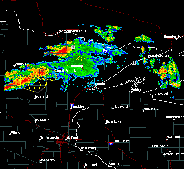 At 1229 am cdt, severe thunderstorms were located along a line extending from near deer river, to days high landing, to 9 miles south of zemple, to near remer, moving east at 40 mph (radar indicated). Hazards include 60 mph wind gusts. Expect damage to roofs, siding, and trees. these severe storms will be near, grand rapids, cohasset, hill city, pokegama dam, pokegama lake and gunn around 1245 am cdt. other locations impacted by these severe thunderstorms include split hand lake, tobique, bass lake, ball club lake, schoolcraft state park, mud lake, goose lake, la prairie, and siseebakwet lake. A tornado watch remains in effect until 100 am cdt for north central and east central minnesota. At 1229 am cdt, severe thunderstorms were located along a line extending from near deer river, to days high landing, to 9 miles south of zemple, to near remer, moving east at 40 mph (radar indicated). Hazards include 60 mph wind gusts. Expect damage to roofs, siding, and trees. these severe storms will be near, grand rapids, cohasset, hill city, pokegama dam, pokegama lake and gunn around 1245 am cdt. other locations impacted by these severe thunderstorms include split hand lake, tobique, bass lake, ball club lake, schoolcraft state park, mud lake, goose lake, la prairie, and siseebakwet lake. A tornado watch remains in effect until 100 am cdt for north central and east central minnesota.
|
| 7/12/2018 12:12 AM CDT |
 At 1212 am cdt, severe thunderstorms were located along a line extending from near bena, to 6 miles southwest of ball club, to 7 miles east of federal dam, to boy river, moving east at 45 mph (radar indicated). Hazards include 70 mph wind gusts. Expect considerable tree damage. damage is likely to mobile homes, roofs, and outbuildings. these severe storms will be near, ball club around 1220 am cdt. deer river, remer, zemple and days high landing around 1230 am cdt. cohasset, pokegama dam and pokegama lake around 1240 am cdt. grand rapids, coleraine, hill city and gunn around 1245 am cdt. other locations impacted by these severe thunderstorms include boy lake, ball club lake, mud lake, goose lake, thunder lake, six mile lake, split hand lake, tobique, brevik, and bass lake. A tornado watch remains in effect until 100 am cdt for north central and east central minnesota. At 1212 am cdt, severe thunderstorms were located along a line extending from near bena, to 6 miles southwest of ball club, to 7 miles east of federal dam, to boy river, moving east at 45 mph (radar indicated). Hazards include 70 mph wind gusts. Expect considerable tree damage. damage is likely to mobile homes, roofs, and outbuildings. these severe storms will be near, ball club around 1220 am cdt. deer river, remer, zemple and days high landing around 1230 am cdt. cohasset, pokegama dam and pokegama lake around 1240 am cdt. grand rapids, coleraine, hill city and gunn around 1245 am cdt. other locations impacted by these severe thunderstorms include boy lake, ball club lake, mud lake, goose lake, thunder lake, six mile lake, split hand lake, tobique, brevik, and bass lake. A tornado watch remains in effect until 100 am cdt for north central and east central minnesota.
|
| 7/11/2018 11:59 PM CDT |
 At 1159 pm cdt, severe thunderstorms were located along a line extending from near bena, to federal dam, to near leech lake, moving east at 50 mph (radar indicated). Hazards include 70 mph wind gusts. Expect considerable tree damage. Damage is likely to mobile homes, roofs, and outbuildings. At 1159 pm cdt, severe thunderstorms were located along a line extending from near bena, to federal dam, to near leech lake, moving east at 50 mph (radar indicated). Hazards include 70 mph wind gusts. Expect considerable tree damage. Damage is likely to mobile homes, roofs, and outbuildings.
|
| 7/2/2018 11:04 PM CDT |
 At 1104 pm cdt, a severe thunderstorm was located near cohasset, or near grand rapids, moving east at 60 mph (radar indicated). Hazards include 60 mph wind gusts. Expect damage to roofs, siding, and trees. Locations impacted include, grand rapids, cohasset, coleraine, taconite, warba, pokegama dam, gunn, days high landing, blackberry, bovey, la prairie, hart lake, goodland, swan lake, mud lake, goose lake, schoolcraft state park, and siseebakwet lake. At 1104 pm cdt, a severe thunderstorm was located near cohasset, or near grand rapids, moving east at 60 mph (radar indicated). Hazards include 60 mph wind gusts. Expect damage to roofs, siding, and trees. Locations impacted include, grand rapids, cohasset, coleraine, taconite, warba, pokegama dam, gunn, days high landing, blackberry, bovey, la prairie, hart lake, goodland, swan lake, mud lake, goose lake, schoolcraft state park, and siseebakwet lake.
|
| 7/2/2018 10:50 PM CDT |
 At 1050 pm cdt, a severe thunderstorm was located near days high landing, or 18 miles west of grand rapids, moving east at 60 mph (radar indicated). Hazards include 70 mph wind gusts. Expect considerable tree damage. Damage is likely to mobile homes, roofs, and outbuildings. At 1050 pm cdt, a severe thunderstorm was located near days high landing, or 18 miles west of grand rapids, moving east at 60 mph (radar indicated). Hazards include 70 mph wind gusts. Expect considerable tree damage. Damage is likely to mobile homes, roofs, and outbuildings.
|
| 6/29/2018 6:51 AM CDT |
 At 651 am cdt, severe thunderstorms were located along a line extending from 13 miles north of nashwauk, to near coleraine, to 6 miles south of days high landing, moving east at 70 mph (radar indicated). Hazards include 70 mph wind gusts. Expect considerable tree damage. damage is likely to mobile homes, roofs, and outbuildings. Locations impacted include, hibbing, grand rapids, virginia, chisholm, eveleth, mountain iron, cohasset, coleraine, gilbert, aurora, keewatin, buhl, nashwauk, biwabik, deer river, cherry, swan river, taconite, warba, and toivola. At 651 am cdt, severe thunderstorms were located along a line extending from 13 miles north of nashwauk, to near coleraine, to 6 miles south of days high landing, moving east at 70 mph (radar indicated). Hazards include 70 mph wind gusts. Expect considerable tree damage. damage is likely to mobile homes, roofs, and outbuildings. Locations impacted include, hibbing, grand rapids, virginia, chisholm, eveleth, mountain iron, cohasset, coleraine, gilbert, aurora, keewatin, buhl, nashwauk, biwabik, deer river, cherry, swan river, taconite, warba, and toivola.
|
| 6/29/2018 6:39 AM CDT |
 At 639 am cdt, severe thunderstorms were located along a line extending from near marcell, to near deer river, to near boy river, moving east at 65 mph (radar indicated). Hazards include 70 mph wind gusts. Expect considerable tree damage. damage is likely to mobile homes, roofs, and outbuildings. Locations impacted include, hibbing, grand rapids, virginia, chisholm, eveleth, mountain iron, cohasset, coleraine, gilbert, aurora, keewatin, buhl, nashwauk, biwabik, deer river, cherry, swan river, hill city, floodwood, and remer. At 639 am cdt, severe thunderstorms were located along a line extending from near marcell, to near deer river, to near boy river, moving east at 65 mph (radar indicated). Hazards include 70 mph wind gusts. Expect considerable tree damage. damage is likely to mobile homes, roofs, and outbuildings. Locations impacted include, hibbing, grand rapids, virginia, chisholm, eveleth, mountain iron, cohasset, coleraine, gilbert, aurora, keewatin, buhl, nashwauk, biwabik, deer river, cherry, swan river, hill city, floodwood, and remer.
|
| 6/29/2018 6:22 AM CDT |
 At 621 am cdt, severe thunderstorms were located along a line extending from near oslund, to near bena, to near walker, moving east at 70 mph (radar indicated. storm spotters northwest of bemidji reported numerous trees down with these storms). Hazards include 70 mph wind gusts. Expect considerable tree damage. Damage is likely to mobile homes, roofs, and outbuildings. At 621 am cdt, severe thunderstorms were located along a line extending from near oslund, to near bena, to near walker, moving east at 70 mph (radar indicated. storm spotters northwest of bemidji reported numerous trees down with these storms). Hazards include 70 mph wind gusts. Expect considerable tree damage. Damage is likely to mobile homes, roofs, and outbuildings.
|
| 6/29/2018 6:02 AM CDT |
 At 601 am cdt, severe thunderstorms were located along a line extending from near turtle river, to 12 miles northeast of laporte, to near park rapids, moving east at 60 mph (trained weather spotters reported numerous trees down 10 miles north of bemidji). Hazards include 60 mph wind gusts and nickel size hail. Expect damage to roofs, siding, and trees. Locations impacted include, grand rapids, walker, cohasset, coleraine, deer river, remer, wabedo, hackensack, longville, bena, federal dam, zemple, boy river, leech lake, lake winnibigoshish, days high landing, pokegama dam, ball club, woman lake, and cass lake. At 601 am cdt, severe thunderstorms were located along a line extending from near turtle river, to 12 miles northeast of laporte, to near park rapids, moving east at 60 mph (trained weather spotters reported numerous trees down 10 miles north of bemidji). Hazards include 60 mph wind gusts and nickel size hail. Expect damage to roofs, siding, and trees. Locations impacted include, grand rapids, walker, cohasset, coleraine, deer river, remer, wabedo, hackensack, longville, bena, federal dam, zemple, boy river, leech lake, lake winnibigoshish, days high landing, pokegama dam, ball club, woman lake, and cass lake.
|
| 6/29/2018 5:50 AM CDT |
 At 550 am cdt, severe thunderstorms were located along a line extending from wilton, to 9 miles south of bemidji, to near osage, moving east at 60 mph (radar indicated). Hazards include 60 mph wind gusts. expect damage to roofs, siding, and trees At 550 am cdt, severe thunderstorms were located along a line extending from wilton, to 9 miles south of bemidji, to near osage, moving east at 60 mph (radar indicated). Hazards include 60 mph wind gusts. expect damage to roofs, siding, and trees
|
| 6/28/2018 3:40 PM CDT |
 At 339 pm cdt, a severe thunderstorm was located near days high landing, or 15 miles west of grand rapids, moving southeast at 30 mph. trained weather spotters reported golf ball size hail in bena as the storm passed (trained weather spotters). Hazards include golf ball size hail and 60 mph wind gusts. People and animals outdoors will be injured. expect hail damage to roofs, siding, windows, and vehicles. expect wind damage to roofs, siding, and trees. this severe storm will be near, cohasset and pokegama lake around 355 pm cdt. Other locations impacted by this severe thunderstorm include schoolcraft state park, mud lake, goose lake, la prairie, and siseebakwet lake. At 339 pm cdt, a severe thunderstorm was located near days high landing, or 15 miles west of grand rapids, moving southeast at 30 mph. trained weather spotters reported golf ball size hail in bena as the storm passed (trained weather spotters). Hazards include golf ball size hail and 60 mph wind gusts. People and animals outdoors will be injured. expect hail damage to roofs, siding, windows, and vehicles. expect wind damage to roofs, siding, and trees. this severe storm will be near, cohasset and pokegama lake around 355 pm cdt. Other locations impacted by this severe thunderstorm include schoolcraft state park, mud lake, goose lake, la prairie, and siseebakwet lake.
|
| 6/28/2018 3:25 PM CDT |
 At 325 pm cdt, a severe thunderstorm was located 7 miles south of ball club, or 21 miles west of grand rapids, moving southeast at 35 mph (radar indicated). Hazards include ping pong ball size hail and 60 mph wind gusts. People and animals outdoors will be injured. expect hail damage to roofs, siding, windows, and vehicles. expect wind damage to roofs, siding, and trees. this severe thunderstorm will be near, days high landing around 335 pm cdt. cohasset and pokegama lake around 355 pm cdt. Other locations impacted by this severe thunderstorm include schoolcraft state park, mud lake, goose lake, la prairie, and siseebakwet lake. At 325 pm cdt, a severe thunderstorm was located 7 miles south of ball club, or 21 miles west of grand rapids, moving southeast at 35 mph (radar indicated). Hazards include ping pong ball size hail and 60 mph wind gusts. People and animals outdoors will be injured. expect hail damage to roofs, siding, windows, and vehicles. expect wind damage to roofs, siding, and trees. this severe thunderstorm will be near, days high landing around 335 pm cdt. cohasset and pokegama lake around 355 pm cdt. Other locations impacted by this severe thunderstorm include schoolcraft state park, mud lake, goose lake, la prairie, and siseebakwet lake.
|
| 6/28/2018 10:45 AM CDT |
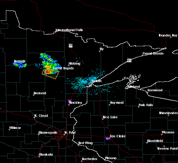 At 1044 am cdt, a severe thunderstorm was located 7 miles southeast of days high landing, or 11 miles southwest of grand rapids, moving east at 30 mph (radar indicated). Hazards include half dollar size hail. Damage to vehicles is expected. this severe thunderstorm will be near, cohasset and pokegama lake around 1100 am cdt. gunn around 1110 am cdt. Other locations impacted by this severe thunderstorm include schoolcraft state park, split hand lake, blackberry, siseebakwet lake, and la prairie. At 1044 am cdt, a severe thunderstorm was located 7 miles southeast of days high landing, or 11 miles southwest of grand rapids, moving east at 30 mph (radar indicated). Hazards include half dollar size hail. Damage to vehicles is expected. this severe thunderstorm will be near, cohasset and pokegama lake around 1100 am cdt. gunn around 1110 am cdt. Other locations impacted by this severe thunderstorm include schoolcraft state park, split hand lake, blackberry, siseebakwet lake, and la prairie.
|
| 9/22/2017 3:24 AM CDT |
 At 324 am cdt, a severe thunderstorm was located near grand rapids, moving northeast at 40 mph (radar indicated). Hazards include ping pong ball size hail and 60 mph wind gusts. People and animals outdoors will be injured. expect hail damage to roofs, siding, windows, and vehicles. expect wind damage to roofs, siding, and trees. Locations impacted include, grand rapids, coleraine, nashwauk, taconite, gunn, pengilly, bovey, marble, la prairie, calumet, swan lake, lawrence lake, and hill annex mine state park. At 324 am cdt, a severe thunderstorm was located near grand rapids, moving northeast at 40 mph (radar indicated). Hazards include ping pong ball size hail and 60 mph wind gusts. People and animals outdoors will be injured. expect hail damage to roofs, siding, windows, and vehicles. expect wind damage to roofs, siding, and trees. Locations impacted include, grand rapids, coleraine, nashwauk, taconite, gunn, pengilly, bovey, marble, la prairie, calumet, swan lake, lawrence lake, and hill annex mine state park.
|
| 9/22/2017 3:17 AM CDT |
 At 317 am cdt, a severe thunderstorm was located over grand rapids, moving northeast at 45 mph (radar indicated). Hazards include 60 mph wind gusts and half dollar size hail. Hail damage to vehicles is expected. Expect wind damage to roofs, siding, and trees. At 317 am cdt, a severe thunderstorm was located over grand rapids, moving northeast at 45 mph (radar indicated). Hazards include 60 mph wind gusts and half dollar size hail. Hail damage to vehicles is expected. Expect wind damage to roofs, siding, and trees.
|
| 9/20/2017 2:23 AM CDT |
 At 221 am cdt, severe thunderstorms were located along a line extending from near oslund, to near coleraine, moving northeast at 70 mph (radar indicated). Hazards include 60 mph wind gusts. Expect damage to roofs, siding, and trees. Locations impacted include, cohasset, coleraine, deer river, marcell, bigfork, taconite, zemple, oslund, inger, pokegama dam, spring lake, bovey, la prairie, bowstring, sand lake, max, wirt, buck lake, and balsam lake. At 221 am cdt, severe thunderstorms were located along a line extending from near oslund, to near coleraine, moving northeast at 70 mph (radar indicated). Hazards include 60 mph wind gusts. Expect damage to roofs, siding, and trees. Locations impacted include, cohasset, coleraine, deer river, marcell, bigfork, taconite, zemple, oslund, inger, pokegama dam, spring lake, bovey, la prairie, bowstring, sand lake, max, wirt, buck lake, and balsam lake.
|
| 9/20/2017 2:10 AM CDT |
 At 210 am cdt, severe thunderstorms were located along a line extending from near lake winnibigoshish, to near days high landing, moving northeast at 65 mph (radar indicated). Hazards include 60 mph wind gusts and nickel size hail. expect damage to roofs, siding, and trees At 210 am cdt, severe thunderstorms were located along a line extending from near lake winnibigoshish, to near days high landing, moving northeast at 65 mph (radar indicated). Hazards include 60 mph wind gusts and nickel size hail. expect damage to roofs, siding, and trees
|
| 7/21/2017 7:18 PM CDT |
 At 718 pm cdt, a severe thunderstorm was located over jacobson, or 14 miles north of big sandy lake, moving east at 40 mph (radar indicated). Hazards include 70 mph wind gusts and quarter size hail. Hail damage to vehicles is expected. expect considerable tree damage. wind damage is also likely to mobile homes, roofs, and outbuildings. This severe thunderstorm will remain over mainly rural areas of southeastern itasca, northwestern aitkin, east central cass and northeastern crow wing counties, including the following locations: lake roosevelt, split hand lake, waukenabo, blackberry, flowage lake, esquagomah lake, ball bluff, haypoint, bain and white elk lake. At 718 pm cdt, a severe thunderstorm was located over jacobson, or 14 miles north of big sandy lake, moving east at 40 mph (radar indicated). Hazards include 70 mph wind gusts and quarter size hail. Hail damage to vehicles is expected. expect considerable tree damage. wind damage is also likely to mobile homes, roofs, and outbuildings. This severe thunderstorm will remain over mainly rural areas of southeastern itasca, northwestern aitkin, east central cass and northeastern crow wing counties, including the following locations: lake roosevelt, split hand lake, waukenabo, blackberry, flowage lake, esquagomah lake, ball bluff, haypoint, bain and white elk lake.
|
| 7/21/2017 7:02 PM CDT |
 At 702 pm cdt, a severe thunderstorm was located near hill city, or 15 miles south of grand rapids, moving east at 40 mph (radar indicated). Hazards include 70 mph wind gusts, quarter size hail, and localized flooding is possible. Hail damage to vehicles is expected. expect considerable tree damage. wind damage is also likely to mobile homes, roofs, and outbuildings. this severe storm will be near, jacobson around 715 pm cdt. Other locations impacted by this severe thunderstorm include lake roosevelt, waukenabo, blackberry, calumet, bovey, mud lake, split hand lake, flowage lake, laura lake, and schoolcraft state park. At 702 pm cdt, a severe thunderstorm was located near hill city, or 15 miles south of grand rapids, moving east at 40 mph (radar indicated). Hazards include 70 mph wind gusts, quarter size hail, and localized flooding is possible. Hail damage to vehicles is expected. expect considerable tree damage. wind damage is also likely to mobile homes, roofs, and outbuildings. this severe storm will be near, jacobson around 715 pm cdt. Other locations impacted by this severe thunderstorm include lake roosevelt, waukenabo, blackberry, calumet, bovey, mud lake, split hand lake, flowage lake, laura lake, and schoolcraft state park.
|
| 7/21/2017 6:53 PM CDT |
 At 653 pm cdt, a severe thunderstorm was located near hill city, or 12 miles south of grand rapids, moving east at 40 mph (radar indicated). Hazards include 70 mph wind gusts, quarter size hail, and localized flooding is possible. Hail damage to vehicles is expected. expect considerable tree damage. wind damage is also likely to mobile homes, roofs, and outbuildings. this severe thunderstorm will be near, jacobson around 715 pm cdt. Other locations impacted by this severe thunderstorm include lake roosevelt, waukenabo, blackberry, calumet, bovey, mud lake, split hand lake, flowage lake, wabana lake, and laura lake. At 653 pm cdt, a severe thunderstorm was located near hill city, or 12 miles south of grand rapids, moving east at 40 mph (radar indicated). Hazards include 70 mph wind gusts, quarter size hail, and localized flooding is possible. Hail damage to vehicles is expected. expect considerable tree damage. wind damage is also likely to mobile homes, roofs, and outbuildings. this severe thunderstorm will be near, jacobson around 715 pm cdt. Other locations impacted by this severe thunderstorm include lake roosevelt, waukenabo, blackberry, calumet, bovey, mud lake, split hand lake, flowage lake, wabana lake, and laura lake.
|
| 7/21/2017 6:21 PM CDT |
 At 620 pm cdt, a severe thunderstorm was located near boy river, or 22 miles east of walker, moving east at 45 mph (radar indicated). Hazards include 70 mph wind gusts and quarter size hail. Hail damage to vehicles is expected. expect considerable tree damage. wind damage is also likely to mobile homes, roofs, and outbuildings. this severe thunderstorm will be near, remer around 635 pm cdt. swatara around 650 pm cdt. hill city around 655 pm cdt. Other locations impacted by this severe thunderstorm include lake roosevelt, waukenabo, blackberry, calumet, bovey, mud lake, split hand lake, flowage lake, wabana lake, and laura lake. At 620 pm cdt, a severe thunderstorm was located near boy river, or 22 miles east of walker, moving east at 45 mph (radar indicated). Hazards include 70 mph wind gusts and quarter size hail. Hail damage to vehicles is expected. expect considerable tree damage. wind damage is also likely to mobile homes, roofs, and outbuildings. this severe thunderstorm will be near, remer around 635 pm cdt. swatara around 650 pm cdt. hill city around 655 pm cdt. Other locations impacted by this severe thunderstorm include lake roosevelt, waukenabo, blackberry, calumet, bovey, mud lake, split hand lake, flowage lake, wabana lake, and laura lake.
|
| 7/6/2017 4:37 AM CDT |
 At 437 am cdt, severe thunderstorms were located along a line extending from 8 miles south of marcell, to 8 miles northeast of hill city, moving east at 50 mph (radar indicated). Hazards include 70 mph wind gusts and penny size hail. Expect considerable tree damage. damage is likely to mobile homes, roofs, and outbuildings. locations impacted include, grand rapids, cohasset, coleraine, keewatin, nashwauk, deer river, swan river, taconite, warba, zemple, inger, days high landing, pokegama dam, gunn, pengilly, blackberry, bovey, marble, la prairie, and hart lake. This also includes highway 2 between grand rapids and warba. At 437 am cdt, severe thunderstorms were located along a line extending from 8 miles south of marcell, to 8 miles northeast of hill city, moving east at 50 mph (radar indicated). Hazards include 70 mph wind gusts and penny size hail. Expect considerable tree damage. damage is likely to mobile homes, roofs, and outbuildings. locations impacted include, grand rapids, cohasset, coleraine, keewatin, nashwauk, deer river, swan river, taconite, warba, zemple, inger, days high landing, pokegama dam, gunn, pengilly, blackberry, bovey, marble, la prairie, and hart lake. This also includes highway 2 between grand rapids and warba.
|
| 7/6/2017 4:20 AM CDT |
 At 420 am cdt, severe thunderstorms were located along a line extending from 8 miles southeast of inger, to near hill city, moving east at 45 mph (radar indicated). Hazards include 70 mph wind gusts and nickel size hail. Expect considerable tree damage. damage is likely to mobile homes, roofs, and outbuildings. locations impacted include, grand rapids, cohasset, coleraine, keewatin, nashwauk, deer river, swan river, remer, taconite, warba, zemple, pengilly, inger, days high landing, pokegama dam, gunn, ball club, lake winnibigoshish, blackberry, and bovey. This also includes highway 2 between ball club and warba. At 420 am cdt, severe thunderstorms were located along a line extending from 8 miles southeast of inger, to near hill city, moving east at 45 mph (radar indicated). Hazards include 70 mph wind gusts and nickel size hail. Expect considerable tree damage. damage is likely to mobile homes, roofs, and outbuildings. locations impacted include, grand rapids, cohasset, coleraine, keewatin, nashwauk, deer river, swan river, remer, taconite, warba, zemple, pengilly, inger, days high landing, pokegama dam, gunn, ball club, lake winnibigoshish, blackberry, and bovey. This also includes highway 2 between ball club and warba.
|
| 7/6/2017 3:57 AM CDT |
 At 356 am cdt, severe thunderstorms were located along a line extending from near lake winnibigoshish, to near remer, moving east at 45 mph (radar indicated). Hazards include 70 mph wind gusts and half dollar size hail. Hail damage to vehicles is expected. expect considerable tree damage. Wind damage is also likely to mobile homes, roofs, and outbuildings. At 356 am cdt, severe thunderstorms were located along a line extending from near lake winnibigoshish, to near remer, moving east at 45 mph (radar indicated). Hazards include 70 mph wind gusts and half dollar size hail. Hail damage to vehicles is expected. expect considerable tree damage. Wind damage is also likely to mobile homes, roofs, and outbuildings.
|
| 6/10/2017 3:33 AM CDT |
 At 332 am cdt, severe thunderstorms were located along a line extending from grand rapids, to 8 miles north of hill city, moving east at 45 mph (radar indicated). Hazards include 60 mph wind gusts and half dollar size hail. Hail damage to vehicles is expected. expect wind damage to roofs, siding, and trees. these severe storms will be near, coleraine and pokegama lake around 340 am cdt. warba and jacobson around 345 am cdt. Other locations impacted by these severe thunderstorms include split hand lake, blackberry, la prairie, and siseebakwet lake. At 332 am cdt, severe thunderstorms were located along a line extending from grand rapids, to 8 miles north of hill city, moving east at 45 mph (radar indicated). Hazards include 60 mph wind gusts and half dollar size hail. Hail damage to vehicles is expected. expect wind damage to roofs, siding, and trees. these severe storms will be near, coleraine and pokegama lake around 340 am cdt. warba and jacobson around 345 am cdt. Other locations impacted by these severe thunderstorms include split hand lake, blackberry, la prairie, and siseebakwet lake.
|
| 6/10/2017 3:24 AM CDT |
 At 324 am cdt, severe thunderstorms were located along a line extending from near pokegama dam, to 7 miles north of hill city, moving east at 45 mph (radar indicated). Hazards include 60 mph wind gusts and half dollar size hail. Hail damage to vehicles is expected. expect wind damage to roofs, siding, and trees. these severe storms will be near, grand rapids and pokegama lake around 330 am cdt. gunn around 335 am cdt. coleraine around 340 am cdt. warba and jacobson around 345 am cdt. Other locations impacted by these severe thunderstorms include split hand lake, blackberry, la prairie, and siseebakwet lake. At 324 am cdt, severe thunderstorms were located along a line extending from near pokegama dam, to 7 miles north of hill city, moving east at 45 mph (radar indicated). Hazards include 60 mph wind gusts and half dollar size hail. Hail damage to vehicles is expected. expect wind damage to roofs, siding, and trees. these severe storms will be near, grand rapids and pokegama lake around 330 am cdt. gunn around 335 am cdt. coleraine around 340 am cdt. warba and jacobson around 345 am cdt. Other locations impacted by these severe thunderstorms include split hand lake, blackberry, la prairie, and siseebakwet lake.
|
| 6/10/2017 3:17 AM CDT |
 At 316 am cdt, severe thunderstorms were located along a line extending from near days high landing, to 8 miles east of remer, moving east at 45 mph (radar indicated). Hazards include 60 mph wind gusts and half dollar size hail. Hail damage to vehicles is expected. expect wind damage to roofs, siding, and trees. these severe storms will be near, cohasset, hill city, pokegama lake and pokegama dam around 325 am cdt. grand rapids and gunn around 330 am cdt. coleraine around 335 am cdt. warba and jacobson around 345 am cdt. Other locations impacted by these severe thunderstorms include split hand lake, blackberry, calumet, bovey, marble, la prairie, hill annex mine state park, and siseebakwet lake. At 316 am cdt, severe thunderstorms were located along a line extending from near days high landing, to 8 miles east of remer, moving east at 45 mph (radar indicated). Hazards include 60 mph wind gusts and half dollar size hail. Hail damage to vehicles is expected. expect wind damage to roofs, siding, and trees. these severe storms will be near, cohasset, hill city, pokegama lake and pokegama dam around 325 am cdt. grand rapids and gunn around 330 am cdt. coleraine around 335 am cdt. warba and jacobson around 345 am cdt. Other locations impacted by these severe thunderstorms include split hand lake, blackberry, calumet, bovey, marble, la prairie, hill annex mine state park, and siseebakwet lake.
|
| 6/10/2017 3:04 AM CDT |
 At 303 am cdt, severe thunderstorms were located along a line extending from near days high landing, to remer, moving east at 45 mph (radar indicated). Hazards include ping pong ball size hail and 60 mph wind gusts. People and animals outdoors will be injured. expect hail damage to roofs, siding, windows, and vehicles. expect wind damage to roofs, siding, and trees. severe thunderstorms will be near, days high landing around 310 am cdt. cohasset, hill city, pokegama dam and pokegama lake around 325 am cdt. grand rapids and gunn around 330 am cdt. coleraine around 335 am cdt. taconite, warba and jacobson around 345 am cdt. Other locations impacted by these severe thunderstorms include blackberry, calumet, bovey, marble, mud lake, goose lake, split hand lake, tobique, schoolcraft state park, and la prairie. At 303 am cdt, severe thunderstorms were located along a line extending from near days high landing, to remer, moving east at 45 mph (radar indicated). Hazards include ping pong ball size hail and 60 mph wind gusts. People and animals outdoors will be injured. expect hail damage to roofs, siding, windows, and vehicles. expect wind damage to roofs, siding, and trees. severe thunderstorms will be near, days high landing around 310 am cdt. cohasset, hill city, pokegama dam and pokegama lake around 325 am cdt. grand rapids and gunn around 330 am cdt. coleraine around 335 am cdt. taconite, warba and jacobson around 345 am cdt. Other locations impacted by these severe thunderstorms include blackberry, calumet, bovey, marble, mud lake, goose lake, split hand lake, tobique, schoolcraft state park, and la prairie.
|
| 9/6/2016 12:36 AM CDT |
 At 1236 am cdt, severe thunderstorms were located along a line extending from coleraine, to near hill city, moving east at 50 mph (radar indicated). Hazards include 60 mph wind gusts and quarter size hail. Expect wind damage to trees. siding. and roofs. hail damage to vehicles is possible. severe thunderstorms will be near, coleraine around 1240 am cdt. taconite around 1245 am cdt. jacobson around 1250 am cdt. swan river and warba around 1255 am cdt. hibbing around 100 am cdt. Other locations impacted by these severe thunderstorms include split hand lake, hart lake, island, blackberry, la prairie, silica, swan lake, wawina, floodwood lake and ball bluff. At 1236 am cdt, severe thunderstorms were located along a line extending from coleraine, to near hill city, moving east at 50 mph (radar indicated). Hazards include 60 mph wind gusts and quarter size hail. Expect wind damage to trees. siding. and roofs. hail damage to vehicles is possible. severe thunderstorms will be near, coleraine around 1240 am cdt. taconite around 1245 am cdt. jacobson around 1250 am cdt. swan river and warba around 1255 am cdt. hibbing around 100 am cdt. Other locations impacted by these severe thunderstorms include split hand lake, hart lake, island, blackberry, la prairie, silica, swan lake, wawina, floodwood lake and ball bluff.
|
| 7/21/2016 2:46 AM CDT |
 At 245 am cdt, severe thunderstorms were located along a line extending from near togo, to 6 miles east of big sandy lake, moving east at 60 mph. these are very dangerous storms (trained weather spotters). Hazards include 80 mph wind gusts and quarter size hail. Flying debris will be dangerous to those caught without shelter. mobile homes will be heavily damaged. expect considerable damage to roofs, windows, and vehicles. extensive tree damage and power outages are likely. these severe storms will be near, meadow brook around 250 am cdt. floodwood around 255 am cdt. cook around 300 am cdt. Other locations impacted by these severe thunderstorms include side lake, angora, celina, savanna portage state park, perch lake, split hand lake, hart lake, island, gowan and ball bluff. At 245 am cdt, severe thunderstorms were located along a line extending from near togo, to 6 miles east of big sandy lake, moving east at 60 mph. these are very dangerous storms (trained weather spotters). Hazards include 80 mph wind gusts and quarter size hail. Flying debris will be dangerous to those caught without shelter. mobile homes will be heavily damaged. expect considerable damage to roofs, windows, and vehicles. extensive tree damage and power outages are likely. these severe storms will be near, meadow brook around 250 am cdt. floodwood around 255 am cdt. cook around 300 am cdt. Other locations impacted by these severe thunderstorms include side lake, angora, celina, savanna portage state park, perch lake, split hand lake, hart lake, island, gowan and ball bluff.
|
| 7/21/2016 2:36 AM CDT |
 At 235 am cdt, severe thunderstorms were located along a line extending from near togo, to libby, moving east at 55 mph. these are very dangerous storms (trained weather spotters reported numerous trees down and winds of 70 mph or greater). Hazards include 80 mph wind gusts and quarter size hail. Flying debris will be dangerous to those caught without shelter. mobile homes will be heavily damaged. expect considerable damage to roofs, windows, and vehicles. extensive tree damage and power outages are likely. these severe storms will be near, togo around 240 am cdt. meadow brook around 250 am cdt. floodwood around 255 am cdt. cook around 300 am cdt. Other locations impacted by these severe thunderstorms include savanna portage state park, perch lake, deer lake northern itasca county, scenic state park, hart lake, gowan, bowstring, ball bluff, little swan and leetonia. At 235 am cdt, severe thunderstorms were located along a line extending from near togo, to libby, moving east at 55 mph. these are very dangerous storms (trained weather spotters reported numerous trees down and winds of 70 mph or greater). Hazards include 80 mph wind gusts and quarter size hail. Flying debris will be dangerous to those caught without shelter. mobile homes will be heavily damaged. expect considerable damage to roofs, windows, and vehicles. extensive tree damage and power outages are likely. these severe storms will be near, togo around 240 am cdt. meadow brook around 250 am cdt. floodwood around 255 am cdt. cook around 300 am cdt. Other locations impacted by these severe thunderstorms include savanna portage state park, perch lake, deer lake northern itasca county, scenic state park, hart lake, gowan, bowstring, ball bluff, little swan and leetonia.
|
| 7/21/2016 2:23 AM CDT |
 At 221 am cdt, severe thunderstorms were located along a line extending from 7 miles southeast of effie, to 7 miles southeast of swatara, moving east at 60 mph. these are very dangerous storms (trained weather spotters reported winds to 70 mph and many downed trees as these storms moved through). Hazards include 80 mph wind gusts and quarter size hail. Flying debris will be dangerous to those caught without shelter. mobile homes will be heavily damaged. expect considerable damage to roofs, windows, and vehicles. extensive tree damage and power outages are likely. these severe storms will be near, grand rapids around 230 am cdt. togo around 235 am cdt. meadow brook around 245 am cdt. floodwood around 255 am cdt. cook around 300 am cdt. Other locations impacted by these severe thunderstorms include savanna portage state park, perch lake, washburn lake, deer lake northern itasca county, scenic state park, wirt, hart lake, gowan, bowstring and ball bluff. At 221 am cdt, severe thunderstorms were located along a line extending from 7 miles southeast of effie, to 7 miles southeast of swatara, moving east at 60 mph. these are very dangerous storms (trained weather spotters reported winds to 70 mph and many downed trees as these storms moved through). Hazards include 80 mph wind gusts and quarter size hail. Flying debris will be dangerous to those caught without shelter. mobile homes will be heavily damaged. expect considerable damage to roofs, windows, and vehicles. extensive tree damage and power outages are likely. these severe storms will be near, grand rapids around 230 am cdt. togo around 235 am cdt. meadow brook around 245 am cdt. floodwood around 255 am cdt. cook around 300 am cdt. Other locations impacted by these severe thunderstorms include savanna portage state park, perch lake, washburn lake, deer lake northern itasca county, scenic state park, wirt, hart lake, gowan, bowstring and ball bluff.
|
| 7/21/2016 2:01 AM CDT |
 At 158 am cdt, severe thunderstorms were located along a line extending from 10 miles northeast of oslund, to near outing, moving east at 60 mph (emergency management. spotters reported winds up to 70 mph at moondance jam). Hazards include 70 mph wind gusts and quarter size hail. Hail damage to vehicles is expected. expect considerable tree damage. wind damage is also likely to mobile homes, roofs, and outbuildings. severe thunderstorms will be near, bigfork around 210 am cdt. effie and grand rapids around 215 am cdt. togo around 235 am cdt. floodwood around 250 am cdt. cook around 255 am cdt. mountain iron around 300 am cdt. Other locations impacted by these severe thunderstorms include savanna portage state park, perch lake, cut foot sioux lake, washburn lake, deer lake northern itasca county, scenic state park, wirt, hart lake, gowan and bowstring. At 158 am cdt, severe thunderstorms were located along a line extending from 10 miles northeast of oslund, to near outing, moving east at 60 mph (emergency management. spotters reported winds up to 70 mph at moondance jam). Hazards include 70 mph wind gusts and quarter size hail. Hail damage to vehicles is expected. expect considerable tree damage. wind damage is also likely to mobile homes, roofs, and outbuildings. severe thunderstorms will be near, bigfork around 210 am cdt. effie and grand rapids around 215 am cdt. togo around 235 am cdt. floodwood around 250 am cdt. cook around 255 am cdt. mountain iron around 300 am cdt. Other locations impacted by these severe thunderstorms include savanna portage state park, perch lake, cut foot sioux lake, washburn lake, deer lake northern itasca county, scenic state park, wirt, hart lake, gowan and bowstring.
|
| 7/11/2016 4:20 AM CDT |
 At 419 am cdt, severe thunderstorms were located along a line extending from 9 miles northeast of deer river, to near jacobson, moving east at 50 mph. these are very dangerous storms (radar indicated). Hazards include 80 mph wind gusts and half dollar size hail. Flying debris will be dangerous to those caught without shelter. mobile homes will be heavily damaged. expect considerable damage to roofs, windows, and vehicles. extensive tree damage and power outages are likely. Locations impacted include, grand rapids, cohasset, coleraine, deer river, remer, taconite, ball club, pokegama dam, blackberry, bovey, la prairie and schoolcraft state park. At 419 am cdt, severe thunderstorms were located along a line extending from 9 miles northeast of deer river, to near jacobson, moving east at 50 mph. these are very dangerous storms (radar indicated). Hazards include 80 mph wind gusts and half dollar size hail. Flying debris will be dangerous to those caught without shelter. mobile homes will be heavily damaged. expect considerable damage to roofs, windows, and vehicles. extensive tree damage and power outages are likely. Locations impacted include, grand rapids, cohasset, coleraine, deer river, remer, taconite, ball club, pokegama dam, blackberry, bovey, la prairie and schoolcraft state park.
|
| 7/11/2016 4:02 AM CDT |
 At 401 am cdt, severe thunderstorms were located along a line extending from 7 miles north of ball club to near hill city, moving east at 50 mph. these are very dangerous storms (radar indicated). Hazards include 80 mph wind gusts and half dollar size hail. Flying debris will be dangerous to those caught without shelter. mobile homes will be heavily damaged. expect considerable damage to roofs, windows, and vehicles. extensive tree damage and power outages are likely. Locations impacted include, grand rapids, cohasset, coleraine, deer river, remer, taconite, pokegama dam, ball club, lake winnibigoshish, blackberry, bovey, schoolcraft state park and six mile lake. At 401 am cdt, severe thunderstorms were located along a line extending from 7 miles north of ball club to near hill city, moving east at 50 mph. these are very dangerous storms (radar indicated). Hazards include 80 mph wind gusts and half dollar size hail. Flying debris will be dangerous to those caught without shelter. mobile homes will be heavily damaged. expect considerable damage to roofs, windows, and vehicles. extensive tree damage and power outages are likely. Locations impacted include, grand rapids, cohasset, coleraine, deer river, remer, taconite, pokegama dam, ball club, lake winnibigoshish, blackberry, bovey, schoolcraft state park and six mile lake.
|
| 7/11/2016 3:44 AM CDT |
 At 343 am cdt, severe thunderstorms were located along a line extending from near lake winnibigoshish to remer, moving east at 45 mph. these are very dangerous storms (radar indicated). Hazards include 80 mph wind gusts and nickel size hail. Flying debris will be dangerous to those caught without shelter. mobile homes will be heavily damaged. expect considerable damage to roofs, windows, and vehicles. extensive tree damage and power outages are likely. severe thunderstorms will be near, remer around 350 am cdt. deer river, 410 am cdt. cohasset, pokegama dam and pokegama lake around 425 am cdt. grand rapids, coleraine and gunn around 430 am cdt. Other locations impacted by these severe thunderstorms include ball club lake, split hand lake, schoolcraft state park, blackberry, bovey, goose lake and mud lake. At 343 am cdt, severe thunderstorms were located along a line extending from near lake winnibigoshish to remer, moving east at 45 mph. these are very dangerous storms (radar indicated). Hazards include 80 mph wind gusts and nickel size hail. Flying debris will be dangerous to those caught without shelter. mobile homes will be heavily damaged. expect considerable damage to roofs, windows, and vehicles. extensive tree damage and power outages are likely. severe thunderstorms will be near, remer around 350 am cdt. deer river, 410 am cdt. cohasset, pokegama dam and pokegama lake around 425 am cdt. grand rapids, coleraine and gunn around 430 am cdt. Other locations impacted by these severe thunderstorms include ball club lake, split hand lake, schoolcraft state park, blackberry, bovey, goose lake and mud lake.
|
| 7/5/2016 6:15 PM CDT |
 At 615 pm cdt, severe thunderstorms were located along a line extending from near togo to near nashwauk to 7 miles west of warba, moving east at 40 mph (radar indicated). Hazards include 60 mph wind gusts and penny size hail. Expect damage to roofs. siding. And trees. At 615 pm cdt, severe thunderstorms were located along a line extending from near togo to near nashwauk to 7 miles west of warba, moving east at 40 mph (radar indicated). Hazards include 60 mph wind gusts and penny size hail. Expect damage to roofs. siding. And trees.
|
| 7/5/2016 6:03 PM CDT |
 At 603 pm cdt, severe thunderstorms were located along a line extending from togo to 6 miles northwest of nashwauk to 8 miles southwest of grand rapids, moving east at 55 mph (radar indicated). Hazards include 60 mph wind gusts and penny size hail. Expect damage to roofs. siding. and trees. Locations impacted include, hibbing, grand rapids, chisholm, mountain iron, cohasset, coleraine, keewatin, buhl, nashwauk, swan river, cook, taconite, meadow brook, warba, pengilly, pokegama dam, gunn, togo, and perch lake. At 603 pm cdt, severe thunderstorms were located along a line extending from togo to 6 miles northwest of nashwauk to 8 miles southwest of grand rapids, moving east at 55 mph (radar indicated). Hazards include 60 mph wind gusts and penny size hail. Expect damage to roofs. siding. and trees. Locations impacted include, hibbing, grand rapids, chisholm, mountain iron, cohasset, coleraine, keewatin, buhl, nashwauk, swan river, cook, taconite, meadow brook, warba, pengilly, pokegama dam, gunn, togo, and perch lake.
|
| 7/5/2016 5:51 PM CDT |
 At 550 pm cdt, severe thunderstorms were located along a line extending from 9 miles west of togo to 8 miles northwest of coleraine to near remer, moving east at 60 mph (radar indicated. trees were reported blown down along with nickel size hail northwest of ball club with these storms). Hazards include 60 mph wind gusts and nickel size hail. Expect damage to roofs. siding. and trees. Locations impacted include, hibbing, grand rapids, chisholm, mountain iron, cohasset, coleraine, keewatin, buhl, nashwauk, deer river, swan river, cook, marcell, bigfork, taconite, meadow brook, warba, effie, and pengilly. At 550 pm cdt, severe thunderstorms were located along a line extending from 9 miles west of togo to 8 miles northwest of coleraine to near remer, moving east at 60 mph (radar indicated. trees were reported blown down along with nickel size hail northwest of ball club with these storms). Hazards include 60 mph wind gusts and nickel size hail. Expect damage to roofs. siding. and trees. Locations impacted include, hibbing, grand rapids, chisholm, mountain iron, cohasset, coleraine, keewatin, buhl, nashwauk, deer river, swan river, cook, marcell, bigfork, taconite, meadow brook, warba, effie, and pengilly.
|
| 7/5/2016 5:37 PM CDT |
 At 536 pm cdt, severe thunderstorms were located along a line extending from near effie to 6 miles northeast of deer river to near boy river, moving east at 55 mph (radar indicated). Hazards include 60 mph wind gusts and nickel size hail. Expect damage to roofs. siding. And trees. At 536 pm cdt, severe thunderstorms were located along a line extending from near effie to 6 miles northeast of deer river to near boy river, moving east at 55 mph (radar indicated). Hazards include 60 mph wind gusts and nickel size hail. Expect damage to roofs. siding. And trees.
|
| 6/25/2016 3:31 PM CDT |
 At 331 pm cdt, severe thunderstorms were located along a line extending from near grand rapids to near floodwood, moving northeast at 45 mph (radar indicated). Hazards include 60 mph wind gusts and quarter size hail. Hail damage to vehicles is expected. expect wind damage to roofs, siding, and trees. locations impacted include, hibbing, grand rapids, cohasset, coleraine, nashwauk, swan river, hill city, floodwood, cotton, taconite, warba, toivola, meadowlands, pengilly, jacobson, pokegama dam, swatara, gunn, blackberry and bovey. A tornado watch remains in effect until 900 pm cdt for northeastern minnesota. At 331 pm cdt, severe thunderstorms were located along a line extending from near grand rapids to near floodwood, moving northeast at 45 mph (radar indicated). Hazards include 60 mph wind gusts and quarter size hail. Hail damage to vehicles is expected. expect wind damage to roofs, siding, and trees. locations impacted include, hibbing, grand rapids, cohasset, coleraine, nashwauk, swan river, hill city, floodwood, cotton, taconite, warba, toivola, meadowlands, pengilly, jacobson, pokegama dam, swatara, gunn, blackberry and bovey. A tornado watch remains in effect until 900 pm cdt for northeastern minnesota.
|
| 6/25/2016 3:16 PM CDT |
 At 315 pm cdt, severe thunderstorms were located along a line extending from near hill city to 8 miles southwest of floodwood, moving northeast at 45 mph (radar indicated). Hazards include 60 mph wind gusts and half dollar size hail. Hail damage to vehicles is expected. Expect wind damage to roofs, siding, and trees. At 315 pm cdt, severe thunderstorms were located along a line extending from near hill city to 8 miles southwest of floodwood, moving northeast at 45 mph (radar indicated). Hazards include 60 mph wind gusts and half dollar size hail. Hail damage to vehicles is expected. Expect wind damage to roofs, siding, and trees.
|
| 6/19/2016 6:00 PM CDT |
 At 600 pm cdt, a severe thunderstorm was located over coleraine, or 7 miles northeast of grand rapids, moving east at 50 mph (radar indicated). Hazards include 60 mph wind gusts and quarter size hail. Hail damage to vehicles is expected. Expect wind damage to roofs, siding, and trees. At 600 pm cdt, a severe thunderstorm was located over coleraine, or 7 miles northeast of grand rapids, moving east at 50 mph (radar indicated). Hazards include 60 mph wind gusts and quarter size hail. Hail damage to vehicles is expected. Expect wind damage to roofs, siding, and trees.
|
| 7/5/2015 8:46 PM CDT |
 At 844 pm cdt, severe thunderstorms were located along a line extending from near hill annex mine state park to near warba to 8 miles south of gunn, moving east at 45 mph (radar indicated). Hazards include 70 mph wind gusts and quarter size hail. Hail damage to vehicles is expected. expect considerable tree damage. wind damage is also likely to mobile homes, roofs and outbuildings. these severe storms will be near, jacobson around 855 pm cdt. swan river around 900 pm cdt. Other locations impacted by these severe thunderstorms include bovey, wawina, floodwood lake, ball bluff, split hand lake, hart lake, goodland, blackberry and la prairie. At 844 pm cdt, severe thunderstorms were located along a line extending from near hill annex mine state park to near warba to 8 miles south of gunn, moving east at 45 mph (radar indicated). Hazards include 70 mph wind gusts and quarter size hail. Hail damage to vehicles is expected. expect considerable tree damage. wind damage is also likely to mobile homes, roofs and outbuildings. these severe storms will be near, jacobson around 855 pm cdt. swan river around 900 pm cdt. Other locations impacted by these severe thunderstorms include bovey, wawina, floodwood lake, ball bluff, split hand lake, hart lake, goodland, blackberry and la prairie.
|
| 7/5/2015 8:29 PM CDT |
 At 828 pm cdt, severe thunderstorms were located along a line extending from near pokegama dam to near grand rapids to 8 miles southeast of schoolcraft state park, moving east at 40 mph (radar indicated). Hazards include 70 mph wind gusts and quarter size hail. Hail damage to vehicles is expected. expect considerable tree damage. wind damage is also likely to mobile homes, roofs and outbuildings. severe thunderstorms will be near, coleraine, gunn and pokegama lake around 835 pm cdt. taconite around 840 pm cdt. warba around 850 pm cdt. swan river and jacobson around 900 pm cdt. Other locations impacted by these severe thunderstorms include bovey, wawina, floodwood lake, ball bluff, split hand lake, hart lake, goodland, blackberry, siseebakwet lake and la prairie. At 828 pm cdt, severe thunderstorms were located along a line extending from near pokegama dam to near grand rapids to 8 miles southeast of schoolcraft state park, moving east at 40 mph (radar indicated). Hazards include 70 mph wind gusts and quarter size hail. Hail damage to vehicles is expected. expect considerable tree damage. wind damage is also likely to mobile homes, roofs and outbuildings. severe thunderstorms will be near, coleraine, gunn and pokegama lake around 835 pm cdt. taconite around 840 pm cdt. warba around 850 pm cdt. swan river and jacobson around 900 pm cdt. Other locations impacted by these severe thunderstorms include bovey, wawina, floodwood lake, ball bluff, split hand lake, hart lake, goodland, blackberry, siseebakwet lake and la prairie.
|
Hail Maps for La Prairie, MN


Connect with Interactive Hail Maps