

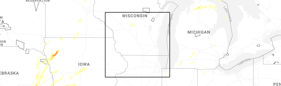
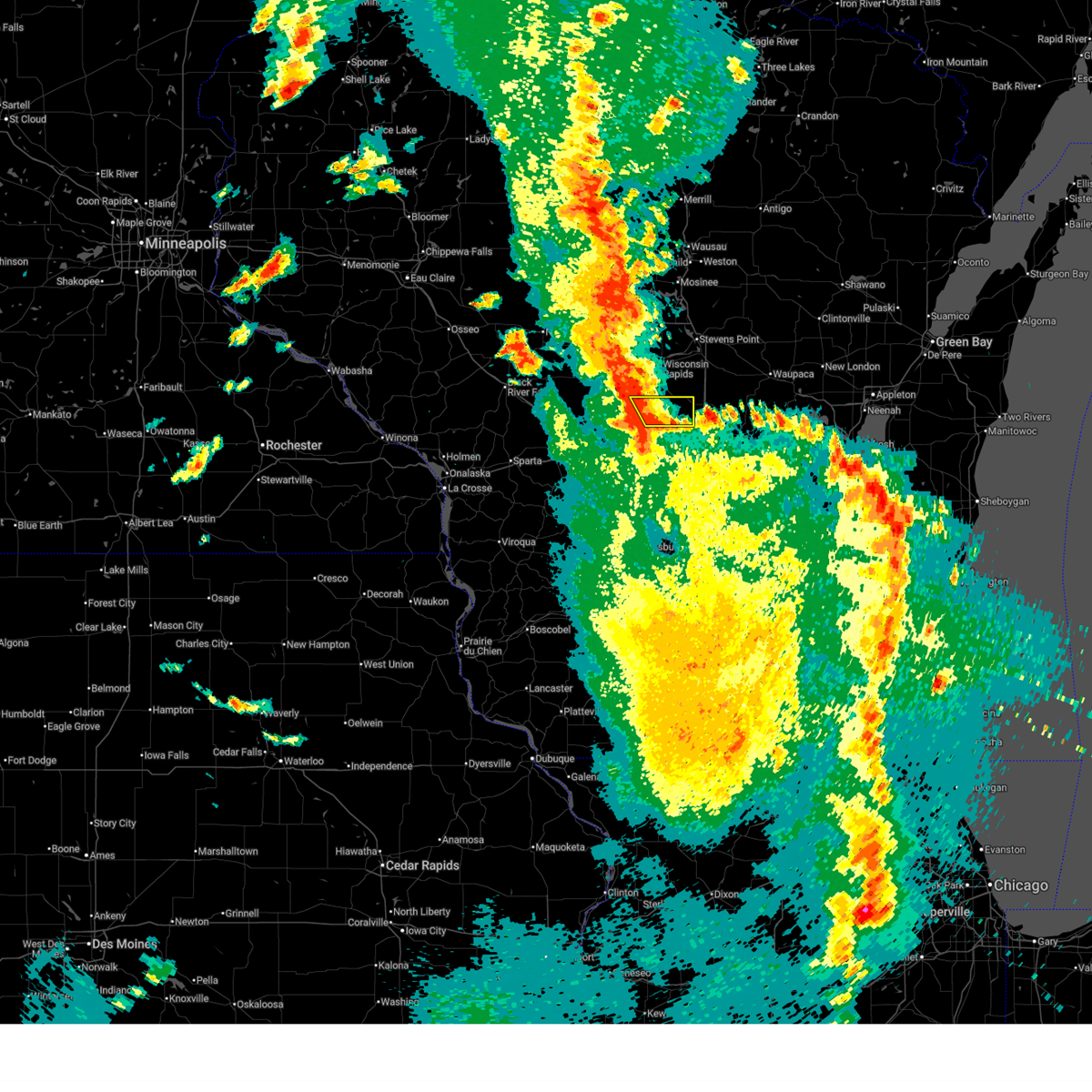
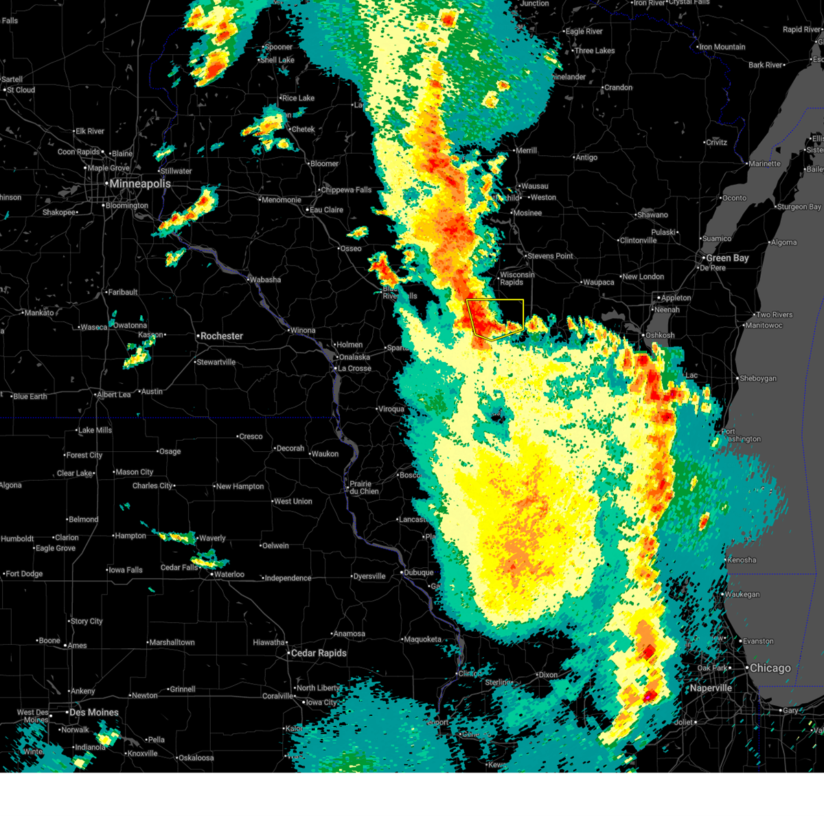
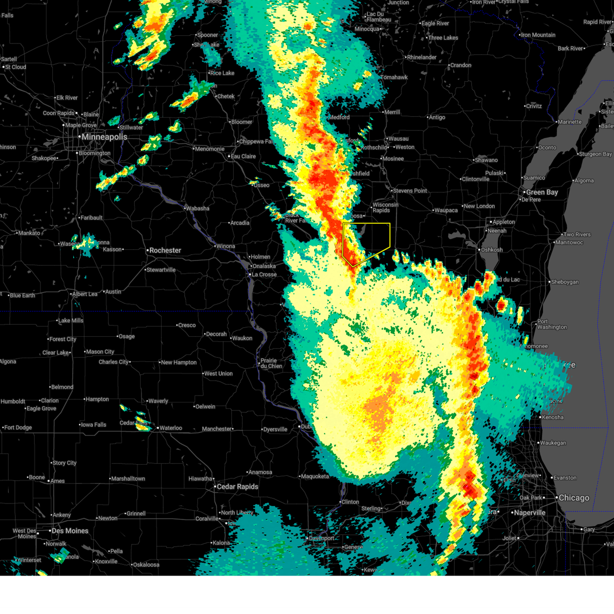
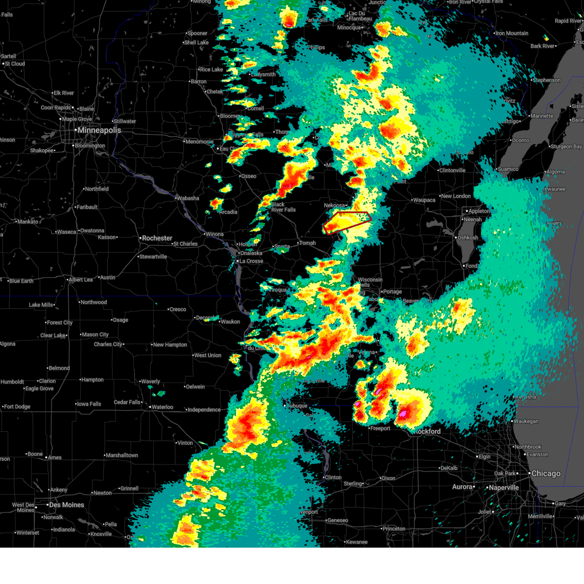
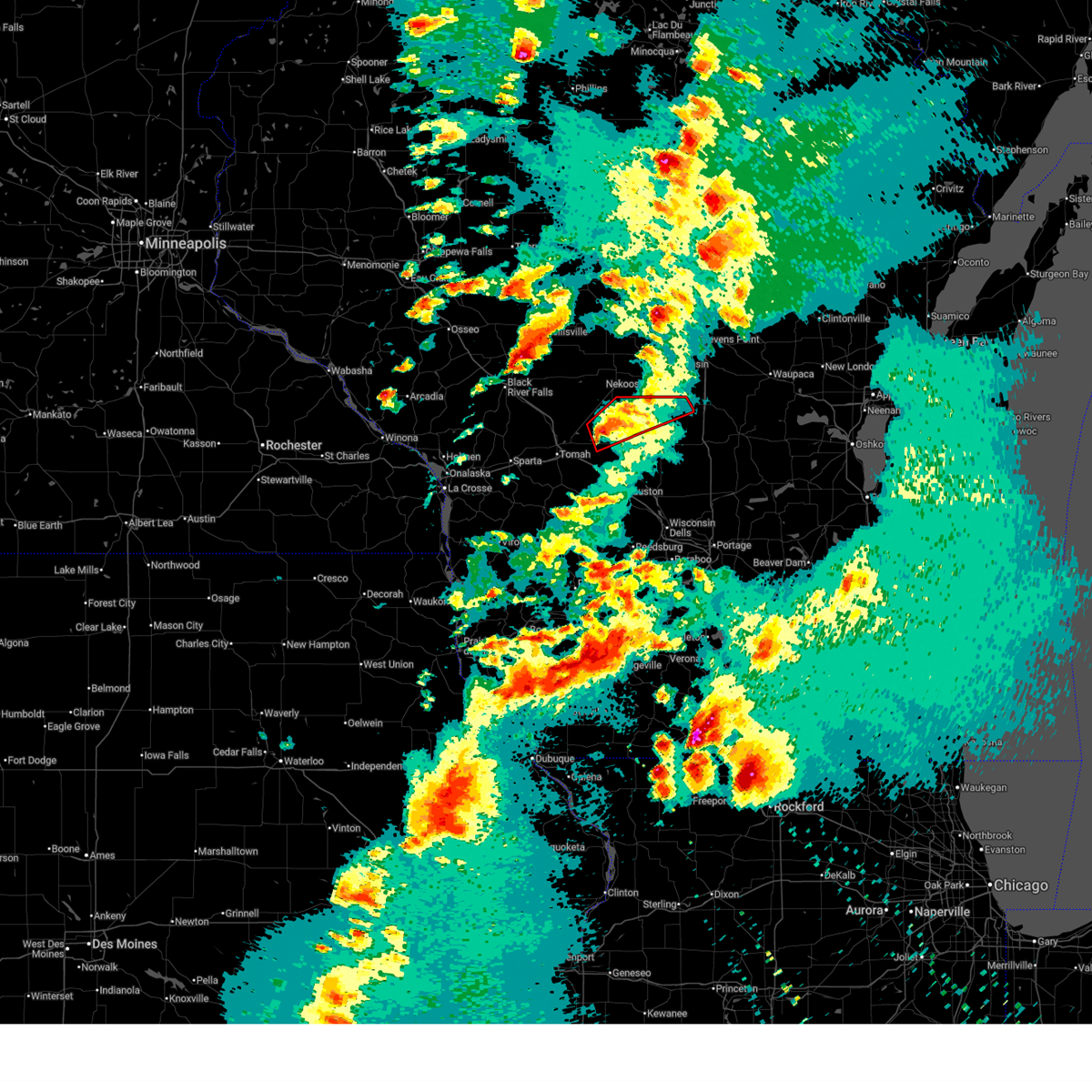
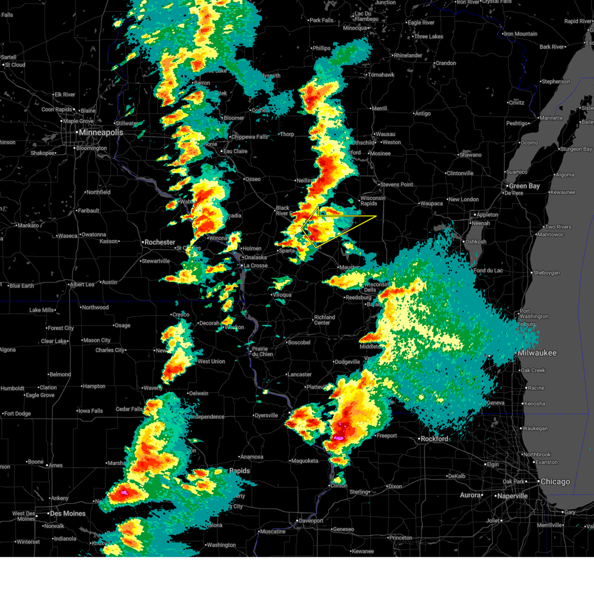
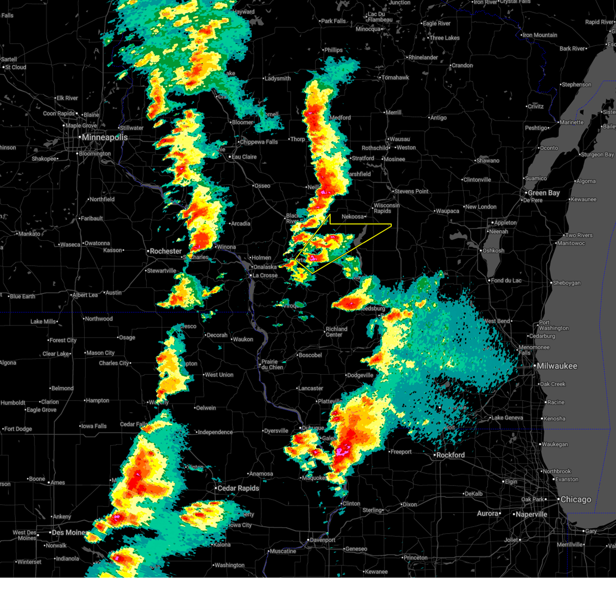
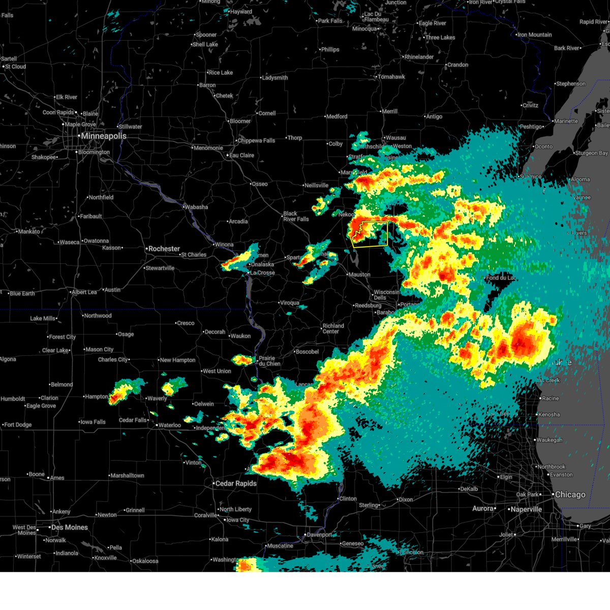
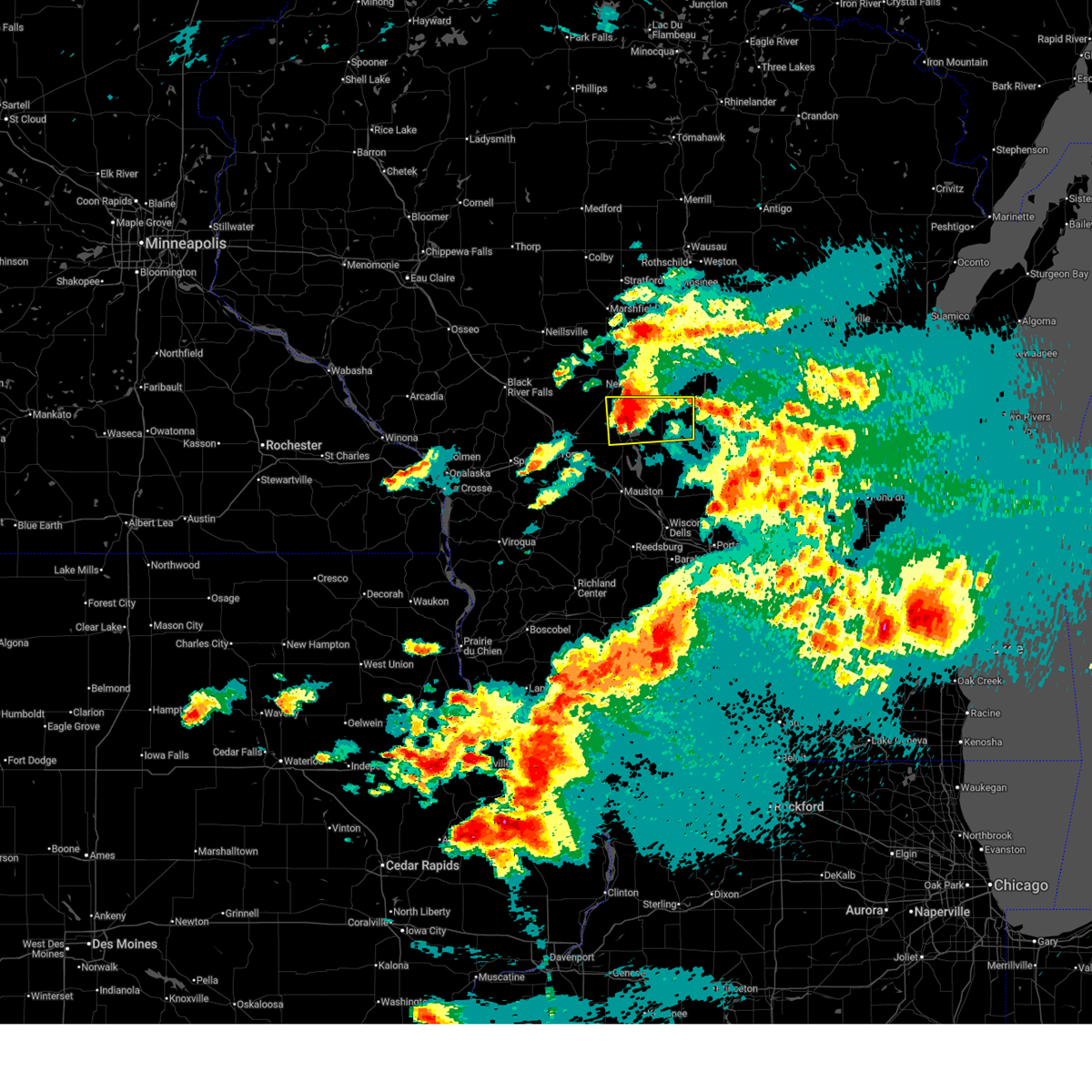
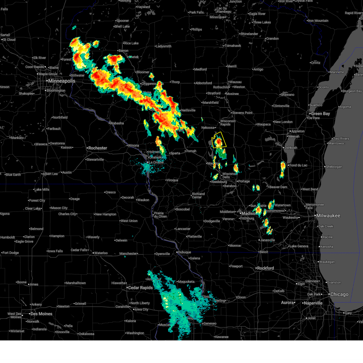
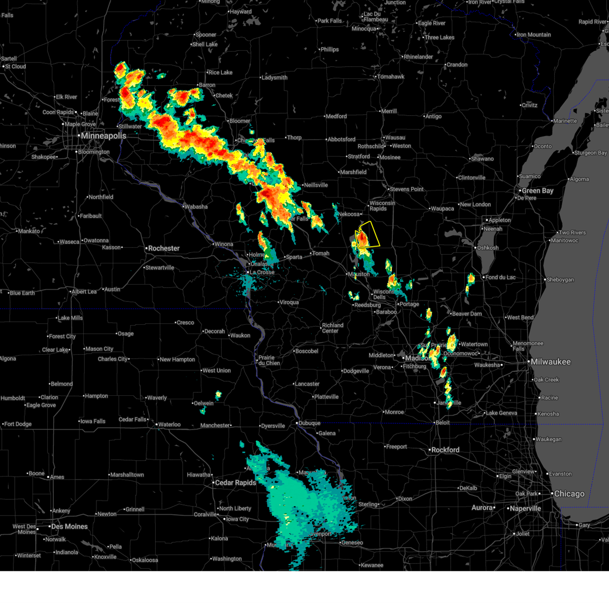
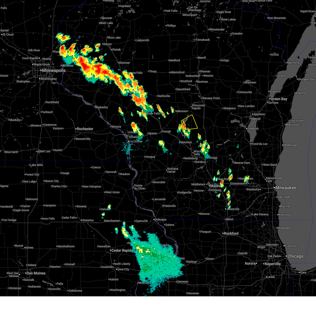
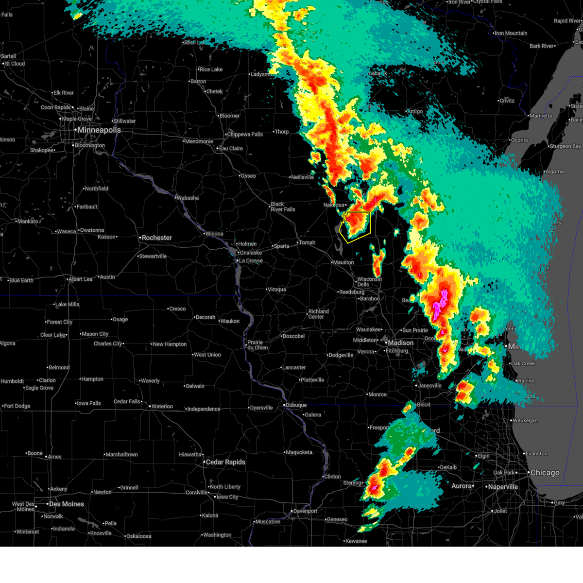
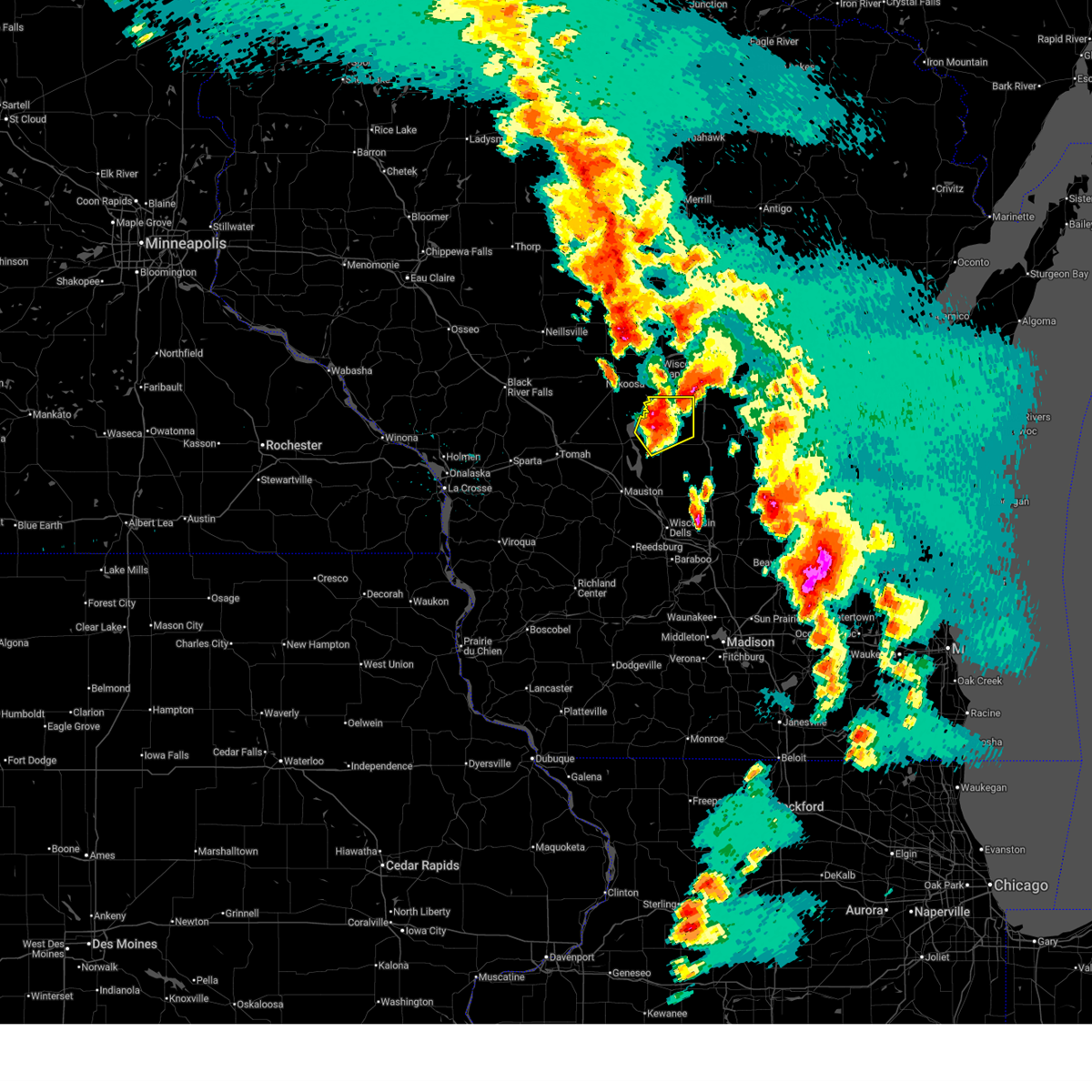
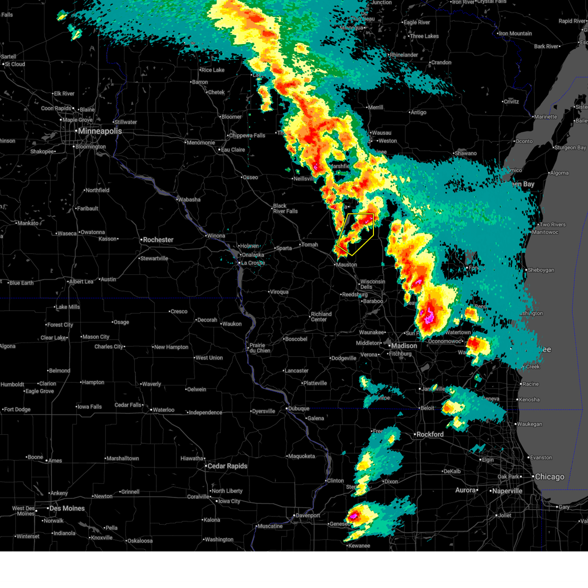
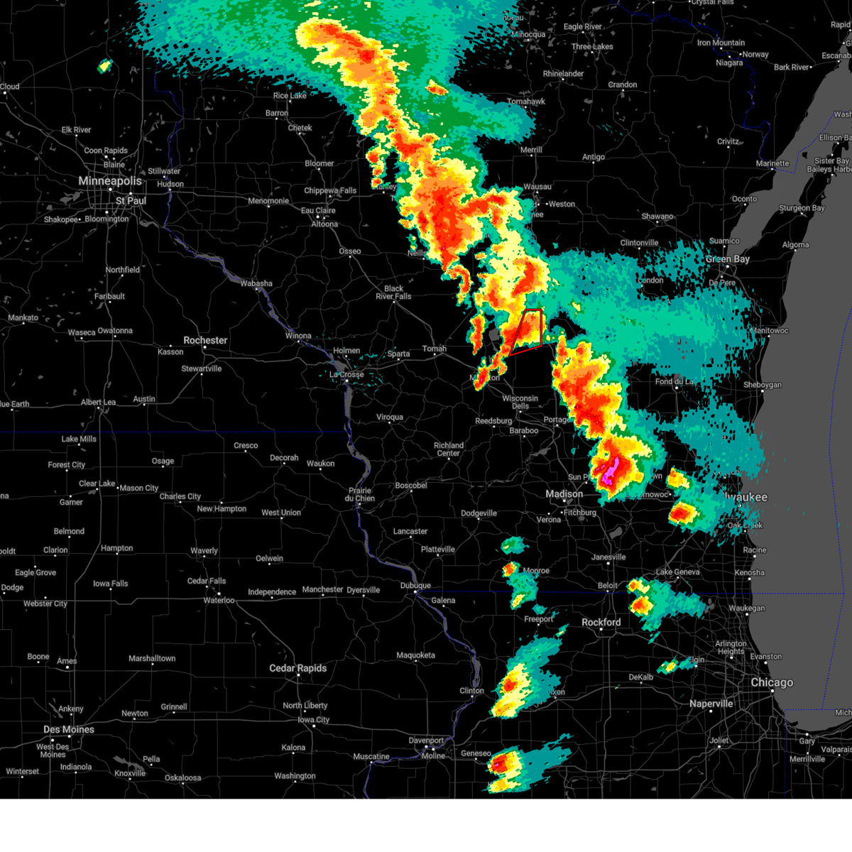
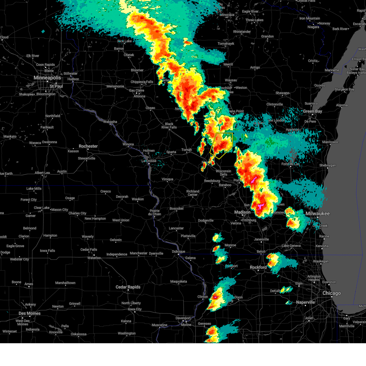
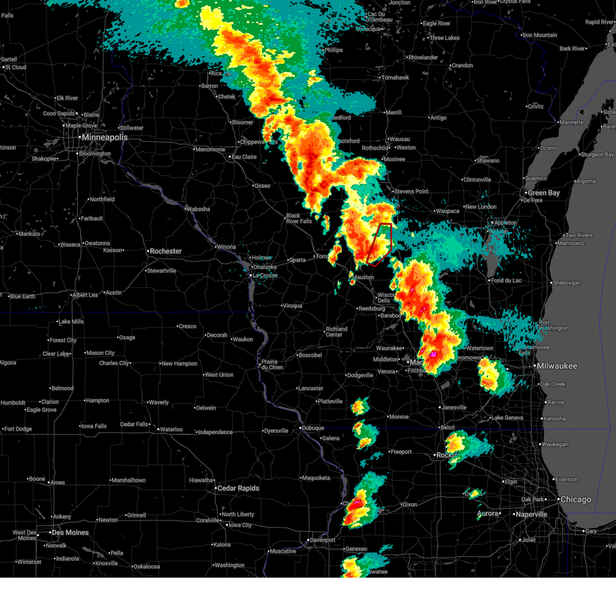
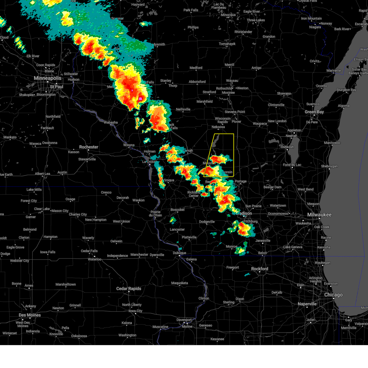
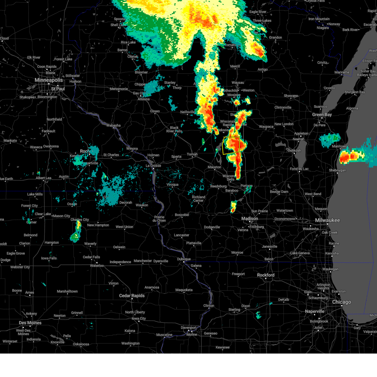
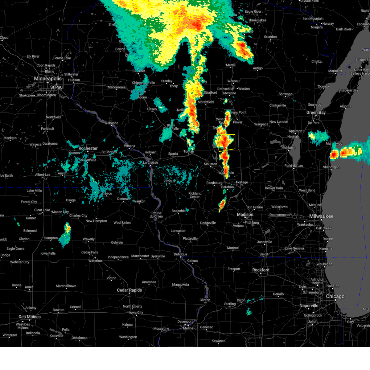
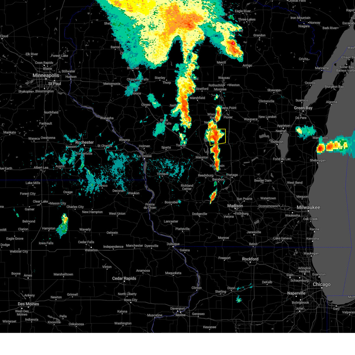
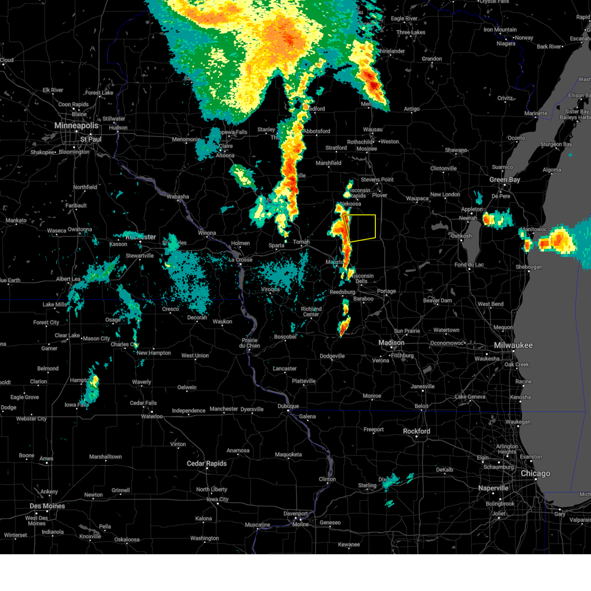
Hail Map for Lake Camelot, WI
The Lake Camelot, WI area has had 0 reports of on-the-ground hail by trained spotters, and has been under severe weather warnings 16 times during the past 12 months. Doppler radar has detected hail at or near Lake Camelot, WI on 66 occasions, including 6 occasions during the past year.
| Name: | Lake Camelot, WI |
| Where Located: | 78.7 miles ENE of La Crosse, WI |
| Map: | Google Map for Lake Camelot, WI |
| Population: | 826 |
| Housing Units: | 1237 |
| More Info: | Search Google for Lake Camelot, WI |
3
The Top Recent Hail Date for Lake Camelot, WI is Monday, May 18, 2026 (9th out of 66)
Hail and Wind Damage Spotted near Lake Camelot, WI
| Date / Time | Report Details |
|---|---|
| 7/1/2026 5:47 AM CDT |
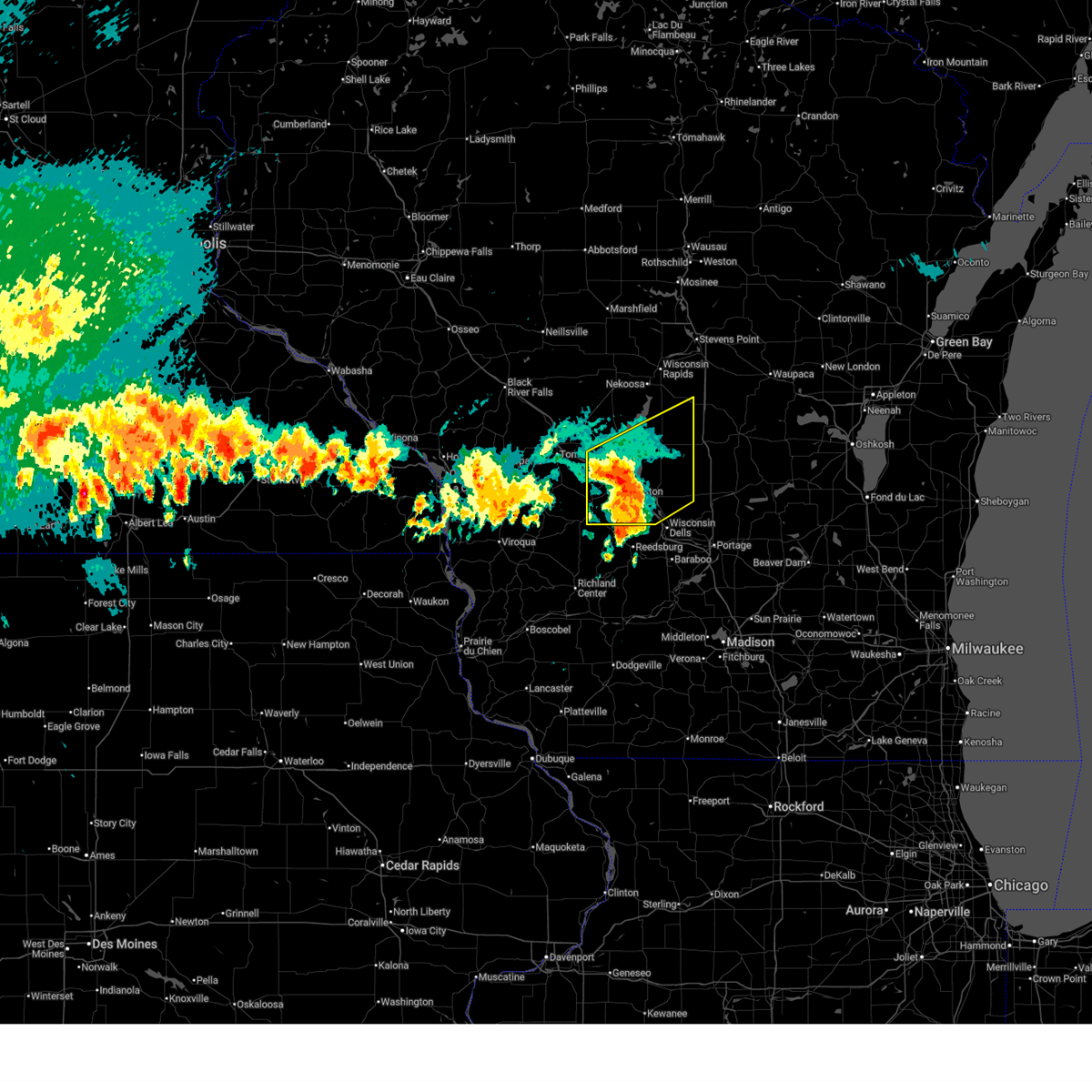 At 547 am cdt, severe thunderstorms were located along a line extending from near new lisbon to 6 miles east of mauston to near reedsburg, moving northeast at 40 mph (radar indicated). Hazards include 60 mph wind gusts and quarter size hail. Hail damage to vehicles is expected. expect wind damage to roofs, siding, and trees. these severe storms will be near, dellwood around 555 am cdt. friendship and adams around 600 am cdt. other locations impacted by these severe thunderstorms include highways 13 and 21, county roads g and o, county roads g and m, johnson hill, highway 13 and county e, county roads c and g, and lemonweir. This includes interstate 90/94 between mile markers 53 and 85. At 547 am cdt, severe thunderstorms were located along a line extending from near new lisbon to 6 miles east of mauston to near reedsburg, moving northeast at 40 mph (radar indicated). Hazards include 60 mph wind gusts and quarter size hail. Hail damage to vehicles is expected. expect wind damage to roofs, siding, and trees. these severe storms will be near, dellwood around 555 am cdt. friendship and adams around 600 am cdt. other locations impacted by these severe thunderstorms include highways 13 and 21, county roads g and o, county roads g and m, johnson hill, highway 13 and county e, county roads c and g, and lemonweir. This includes interstate 90/94 between mile markers 53 and 85.
|
| 7/1/2026 5:28 AM CDT |
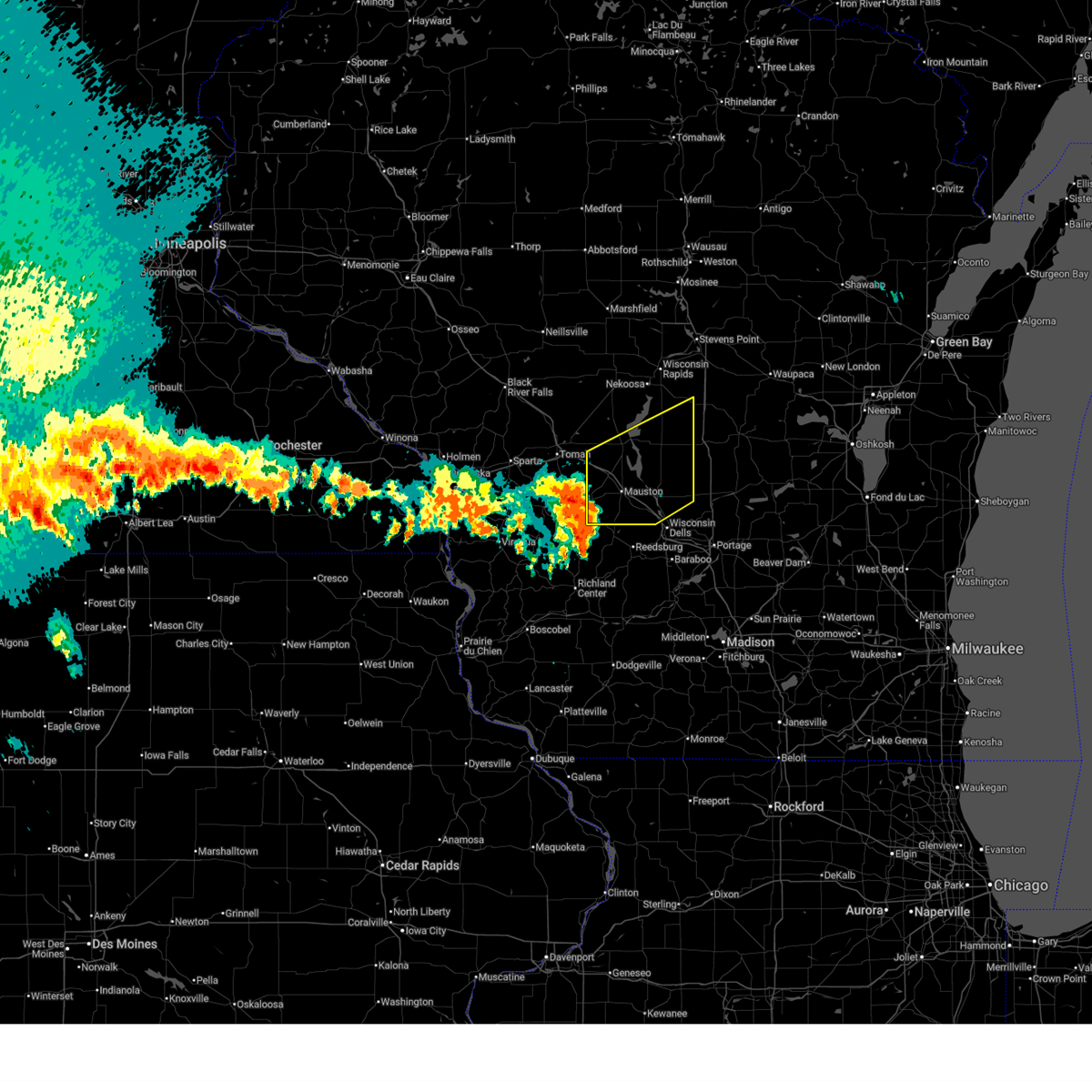 Svrarx the national weather service in la crosse has issued a * severe thunderstorm warning for, juneau county in central wisconsin, adams county in central wisconsin, * until 630 am cdt. * at 528 am cdt, severe thunderstorms were located along a line extending from 9 miles west of new lisbon to near elroy to 6 miles south of wonewoc, moving northeast at 45 mph (radar indicated). Hazards include 60 mph wind gusts and quarter size hail. Hail damage to vehicles is expected. expect wind damage to roofs, siding, and trees. severe thunderstorms will be near, mauston and new lisbon around 535 am cdt. necedah and dellwood around 545 am cdt. friendship and adams around 550 am cdt. other locations impacted by these severe thunderstorms include highways 13 and 21, county roads g and o, county roads g and m, johnson hill, highway 13 and county e, county roads c and g, and lemonweir. This includes interstate 90/94 between mile markers 53 and 85. Svrarx the national weather service in la crosse has issued a * severe thunderstorm warning for, juneau county in central wisconsin, adams county in central wisconsin, * until 630 am cdt. * at 528 am cdt, severe thunderstorms were located along a line extending from 9 miles west of new lisbon to near elroy to 6 miles south of wonewoc, moving northeast at 45 mph (radar indicated). Hazards include 60 mph wind gusts and quarter size hail. Hail damage to vehicles is expected. expect wind damage to roofs, siding, and trees. severe thunderstorms will be near, mauston and new lisbon around 535 am cdt. necedah and dellwood around 545 am cdt. friendship and adams around 550 am cdt. other locations impacted by these severe thunderstorms include highways 13 and 21, county roads g and o, county roads g and m, johnson hill, highway 13 and county e, county roads c and g, and lemonweir. This includes interstate 90/94 between mile markers 53 and 85.
|
| 6/24/2026 4:00 PM CDT |
 Svrarx the national weather service in la crosse has issued a * severe thunderstorm warning for, north central juneau county in central wisconsin, northern adams county in central wisconsin, * until 500 pm cdt. * at 400 pm cdt, a severe thunderstorm was located 7 miles southwest of new rome, or 14 miles northwest of friendship, moving east at 25 mph (radar indicated). Hazards include 60 mph wind gusts and quarter size hail. Hail damage to vehicles is expected. expect wind damage to roofs, siding, and trees. This severe thunderstorm will remain over mainly rural areas of north central juneau and northern adams counties, including the following locations, new miner, lake arrowhead, colburn, highways 13 and 21, county roads g and o, county roads g and m, and the colburn wildlife area. Svrarx the national weather service in la crosse has issued a * severe thunderstorm warning for, north central juneau county in central wisconsin, northern adams county in central wisconsin, * until 500 pm cdt. * at 400 pm cdt, a severe thunderstorm was located 7 miles southwest of new rome, or 14 miles northwest of friendship, moving east at 25 mph (radar indicated). Hazards include 60 mph wind gusts and quarter size hail. Hail damage to vehicles is expected. expect wind damage to roofs, siding, and trees. This severe thunderstorm will remain over mainly rural areas of north central juneau and northern adams counties, including the following locations, new miner, lake arrowhead, colburn, highways 13 and 21, county roads g and o, county roads g and m, and the colburn wildlife area.
|
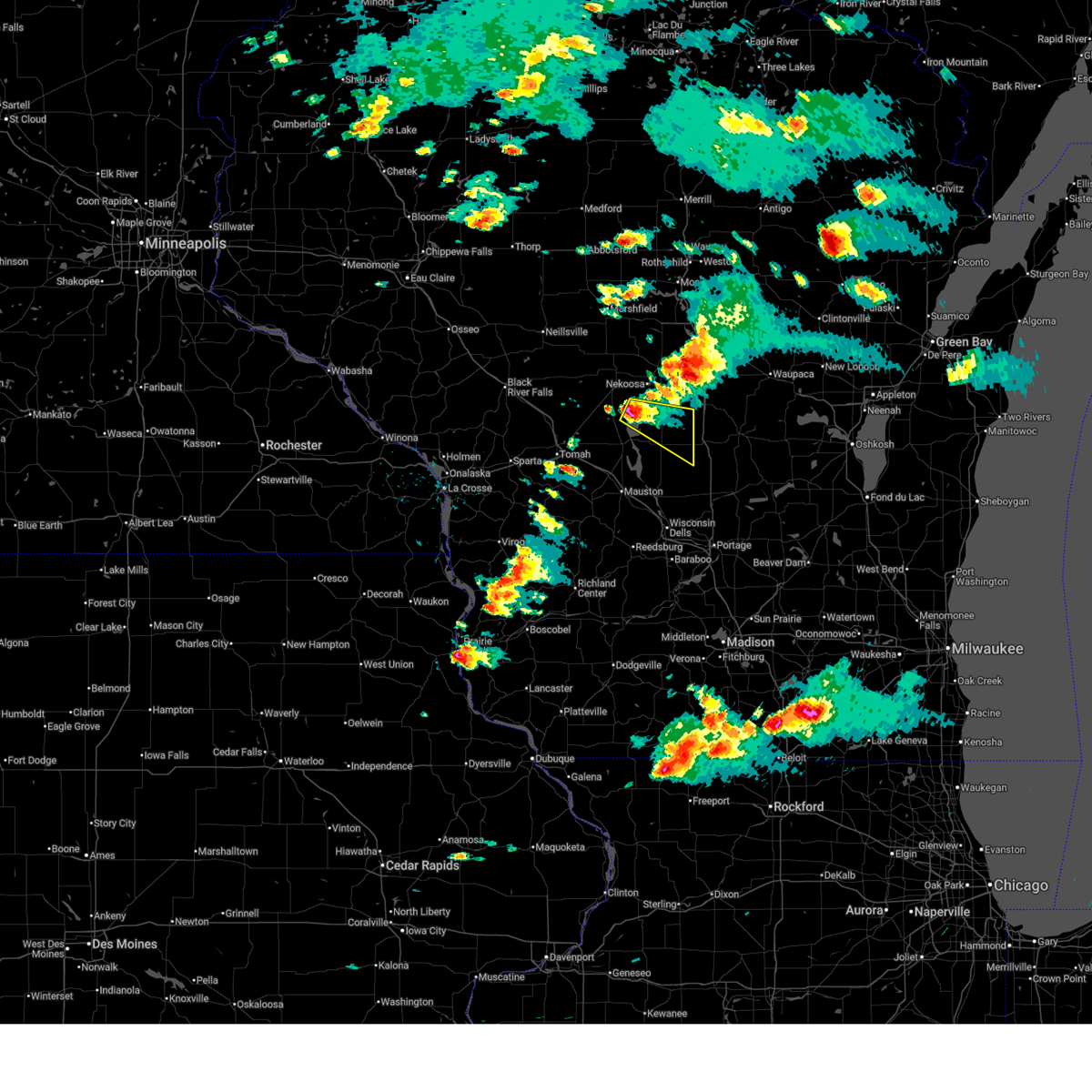
| 6/10/2026 3:22 PM CDT |
 At 322 pm cdt, a severe thunderstorm was located over new rome, or 12 miles south of wisconsin rapids, moving northeast at 40 mph (radar indicated). Hazards include 60 mph wind gusts. Expect damage to roofs, siding, and trees. Locations impacted include, new rome, big flats, colburn, the leola marsh wildlife area, lake arrowhead, lake sherwood, county roads g and o, lake camelot, county roads d and g, county roads o and w, county roads d and w, and county roads c and g. At 322 pm cdt, a severe thunderstorm was located over new rome, or 12 miles south of wisconsin rapids, moving northeast at 40 mph (radar indicated). Hazards include 60 mph wind gusts. Expect damage to roofs, siding, and trees. Locations impacted include, new rome, big flats, colburn, the leola marsh wildlife area, lake arrowhead, lake sherwood, county roads g and o, lake camelot, county roads d and g, county roads o and w, county roads d and w, and county roads c and g.
|
| 6/10/2026 3:08 PM CDT |
 At 308 pm cdt, a severe thunderstorm was located 7 miles north of dellwood, or 9 miles northwest of friendship, moving northeast at 35 mph (radar indicated). Hazards include 60 mph wind gusts. Expect damage to roofs, siding, and trees. Locations impacted include, new rome, strongs prairie, big flats, colburn, arkdale, new miner, lake arrowhead, highways 13 and 21, county roads g and o, the colburn wildlife area, county roads d and g, county roads o and w, the leola marsh wildlife area, cottonville, monroe center, county roads c and g, lake sherwood, lake camelot, petenwell dam, and county roads d and w. At 308 pm cdt, a severe thunderstorm was located 7 miles north of dellwood, or 9 miles northwest of friendship, moving northeast at 35 mph (radar indicated). Hazards include 60 mph wind gusts. Expect damage to roofs, siding, and trees. Locations impacted include, new rome, strongs prairie, big flats, colburn, arkdale, new miner, lake arrowhead, highways 13 and 21, county roads g and o, the colburn wildlife area, county roads d and g, county roads o and w, the leola marsh wildlife area, cottonville, monroe center, county roads c and g, lake sherwood, lake camelot, petenwell dam, and county roads d and w.
|
| 6/10/2026 2:58 PM CDT |
 Svrarx the national weather service in la crosse has issued a * severe thunderstorm warning for, north central juneau county in central wisconsin, northern adams county in central wisconsin, * until 345 pm cdt. * at 257 pm cdt, a severe thunderstorm was located near necedah, or 10 miles west of friendship, moving northeast at 35 mph (radar indicated). Hazards include 60 mph wind gusts. Expect damage to roofs, siding, and trees. This severe thunderstorm will remain over mainly rural areas of north central juneau and northern adams counties, including the following locations, new miner, highways 13 and 21, county roads g and o, county roads c and g, lake sherwood, buckhorn state park, and roche a cri state park. Svrarx the national weather service in la crosse has issued a * severe thunderstorm warning for, north central juneau county in central wisconsin, northern adams county in central wisconsin, * until 345 pm cdt. * at 257 pm cdt, a severe thunderstorm was located near necedah, or 10 miles west of friendship, moving northeast at 35 mph (radar indicated). Hazards include 60 mph wind gusts. Expect damage to roofs, siding, and trees. This severe thunderstorm will remain over mainly rural areas of north central juneau and northern adams counties, including the following locations, new miner, highways 13 and 21, county roads g and o, county roads c and g, lake sherwood, buckhorn state park, and roche a cri state park.
|
| 4/17/2026 5:04 PM CDT |
 At 504 pm cdt, a severe thunderstorm capable of producing a tornado was located near necedah, or 16 miles northwest of friendship, moving northeast at 30 mph (radar indicated rotation). Hazards include tornado. Flying debris will be dangerous to those caught without shelter. mobile homes will be damaged or destroyed. damage to roofs, windows, and vehicles will occur. tree damage is likely. Locations impacted include, new rome, new miner, the leola marsh wildlife area, lake arrowhead, sprague, monroe center, lake sherwood, lake camelot, county roads d and g, and county roads d and w. At 504 pm cdt, a severe thunderstorm capable of producing a tornado was located near necedah, or 16 miles northwest of friendship, moving northeast at 30 mph (radar indicated rotation). Hazards include tornado. Flying debris will be dangerous to those caught without shelter. mobile homes will be damaged or destroyed. damage to roofs, windows, and vehicles will occur. tree damage is likely. Locations impacted include, new rome, new miner, the leola marsh wildlife area, lake arrowhead, sprague, monroe center, lake sherwood, lake camelot, county roads d and g, and county roads d and w.
|
| 4/17/2026 4:54 PM CDT |
 Torarx the national weather service in la crosse has issued a * tornado warning for, northwestern juneau county in central wisconsin, northern adams county in central wisconsin, * until 530 pm cdt. * at 453 pm cdt, a severe thunderstorm capable of producing a tornado was located near necedah, or 16 miles east of tomah, moving northeast at 30 mph (radar indicated rotation). Hazards include tornado. Flying debris will be dangerous to those caught without shelter. mobile homes will be damaged or destroyed. damage to roofs, windows, and vehicles will occur. tree damage is likely. This tornadic thunderstorm will remain over mainly rural areas of northwestern juneau and northern adams counties, including the following locations, new miner, lake arrowhead, the necedah wildlife refuge, the sprague mather flowage, cutler, county roads d and g, and the leola marsh wildlife area. Torarx the national weather service in la crosse has issued a * tornado warning for, northwestern juneau county in central wisconsin, northern adams county in central wisconsin, * until 530 pm cdt. * at 453 pm cdt, a severe thunderstorm capable of producing a tornado was located near necedah, or 16 miles east of tomah, moving northeast at 30 mph (radar indicated rotation). Hazards include tornado. Flying debris will be dangerous to those caught without shelter. mobile homes will be damaged or destroyed. damage to roofs, windows, and vehicles will occur. tree damage is likely. This tornadic thunderstorm will remain over mainly rural areas of northwestern juneau and northern adams counties, including the following locations, new miner, lake arrowhead, the necedah wildlife refuge, the sprague mather flowage, cutler, county roads d and g, and the leola marsh wildlife area.
|
| 4/17/2026 3:29 PM CDT |
 At 329 pm cdt, a severe thunderstorm was located 11 miles northeast of tomah, moving northeast at 55 mph (radar indicated). Hazards include 60 mph wind gusts and quarter size hail. Hail damage to vehicles is expected. expect wind damage to roofs, siding, and trees. Locations impacted include, new rome, warrens, cutler, wyeville, finley, new miner, lake arrowhead, mather, the necedah wildlife refuge, the sprague mather flowage, normay ridge, valley junction, the meadow valley flowage, sprague, bear bluff township, shennington, lake sherwood, the rezin landing strip, lake camelot, and meadow valley. At 329 pm cdt, a severe thunderstorm was located 11 miles northeast of tomah, moving northeast at 55 mph (radar indicated). Hazards include 60 mph wind gusts and quarter size hail. Hail damage to vehicles is expected. expect wind damage to roofs, siding, and trees. Locations impacted include, new rome, warrens, cutler, wyeville, finley, new miner, lake arrowhead, mather, the necedah wildlife refuge, the sprague mather flowage, normay ridge, valley junction, the meadow valley flowage, sprague, bear bluff township, shennington, lake sherwood, the rezin landing strip, lake camelot, and meadow valley.
|
| 4/17/2026 3:18 PM CDT |
 At 318 pm cdt, a severe thunderstorm was located near tomah, moving northeast at 65 mph (radar indicated. at 318 pm cdt, half dollar size hail was reported in tomah). Hazards include two inch hail and 60 mph wind gusts. People and animals outdoors will be injured. expect hail damage to roofs, siding, windows, and vehicles. expect wind damage to roofs, siding, and trees. this severe thunderstorm will remain over mainly rural areas of southeastern jackson, northwestern juneau, northern adams and northeastern monroe counties, including the following locations, warrens, new miner, the necedah wildlife refuge, oakdale, cutler, valley junction, and jellystone park near warrens. this includes the following highways, interstate 94 between mile markers 136 and 147. interstate 90/94 between mile markers 46 and 53. Interstate 90 in wisconsin between mile markers 31 and 45. At 318 pm cdt, a severe thunderstorm was located near tomah, moving northeast at 65 mph (radar indicated. at 318 pm cdt, half dollar size hail was reported in tomah). Hazards include two inch hail and 60 mph wind gusts. People and animals outdoors will be injured. expect hail damage to roofs, siding, windows, and vehicles. expect wind damage to roofs, siding, and trees. this severe thunderstorm will remain over mainly rural areas of southeastern jackson, northwestern juneau, northern adams and northeastern monroe counties, including the following locations, warrens, new miner, the necedah wildlife refuge, oakdale, cutler, valley junction, and jellystone park near warrens. this includes the following highways, interstate 94 between mile markers 136 and 147. interstate 90/94 between mile markers 46 and 53. Interstate 90 in wisconsin between mile markers 31 and 45.
|
| 4/14/2026 7:01 PM CDT |
 At 700 pm cdt, a severe thunderstorm was located near new rome, or 12 miles north of friendship, moving east at 30 mph (radar indicated). Hazards include 60 mph wind gusts and penny size hail. Expect damage to roofs, siding, and trees. Locations impacted include, new rome, strongs prairie, big flats, colburn, lake arrowhead, county roads g and o, the colburn wildlife area, county roads o and w, county roads d and g, the leola marsh wildlife area, cottonville, monroe center, county roads c and g, lake sherwood, lake camelot, and county roads d and w. At 700 pm cdt, a severe thunderstorm was located near new rome, or 12 miles north of friendship, moving east at 30 mph (radar indicated). Hazards include 60 mph wind gusts and penny size hail. Expect damage to roofs, siding, and trees. Locations impacted include, new rome, strongs prairie, big flats, colburn, lake arrowhead, county roads g and o, the colburn wildlife area, county roads o and w, county roads d and g, the leola marsh wildlife area, cottonville, monroe center, county roads c and g, lake sherwood, lake camelot, and county roads d and w.
|
| 4/14/2026 6:43 PM CDT |
 Svrarx the national weather service in la crosse has issued a * severe thunderstorm warning for, north central juneau county in central wisconsin, northern adams county in central wisconsin, * until 730 pm cdt. * at 643 pm cdt, a severe thunderstorm was located 8 miles north of necedah, or 14 miles northwest of friendship, moving east at 30 mph (radar indicated). Hazards include 60 mph wind gusts and quarter size hail. Hail damage to vehicles is expected. expect wind damage to roofs, siding, and trees. This severe thunderstorm will remain over mainly rural areas of north central juneau and northern adams counties, including the following locations, new miner, lake arrowhead, colburn, the sprague mather flowage, county roads g and o, the colburn wildlife area, and county roads o and w. Svrarx the national weather service in la crosse has issued a * severe thunderstorm warning for, north central juneau county in central wisconsin, northern adams county in central wisconsin, * until 730 pm cdt. * at 643 pm cdt, a severe thunderstorm was located 8 miles north of necedah, or 14 miles northwest of friendship, moving east at 30 mph (radar indicated). Hazards include 60 mph wind gusts and quarter size hail. Hail damage to vehicles is expected. expect wind damage to roofs, siding, and trees. This severe thunderstorm will remain over mainly rural areas of north central juneau and northern adams counties, including the following locations, new miner, lake arrowhead, colburn, the sprague mather flowage, county roads g and o, the colburn wildlife area, and county roads o and w.
|
| 7/3/2025 10:59 PM CDT |
 the severe thunderstorm warning has been cancelled and is no longer in effect the severe thunderstorm warning has been cancelled and is no longer in effect
|
| 7/3/2025 10:42 PM CDT |
 At 1042 pm cdt, a severe thunderstorm was located 7 miles south of new rome, or 11 miles north of friendship, moving east at 25 mph (radar indicated). Hazards include 60 mph wind gusts and penny size hail. Expect damage to roofs, siding, and trees. Locations impacted include, big flats, arkdale, cottonville, lake arrowhead, monroe center, lake sherwood, lake camelot, and highways 13 and 21. At 1042 pm cdt, a severe thunderstorm was located 7 miles south of new rome, or 11 miles north of friendship, moving east at 25 mph (radar indicated). Hazards include 60 mph wind gusts and penny size hail. Expect damage to roofs, siding, and trees. Locations impacted include, big flats, arkdale, cottonville, lake arrowhead, monroe center, lake sherwood, lake camelot, and highways 13 and 21.
|
| 7/3/2025 10:42 PM CDT |
 the severe thunderstorm warning has been cancelled and is no longer in effect the severe thunderstorm warning has been cancelled and is no longer in effect
|
| 7/3/2025 10:27 PM CDT |
 Svrarx the national weather service in la crosse has issued a * severe thunderstorm warning for, north central juneau county in central wisconsin, northern adams county in central wisconsin, * until 1115 pm cdt. * at 1027 pm cdt, a severe thunderstorm was located 7 miles northeast of necedah, or 10 miles northwest of friendship, moving east at 20 mph (radar indicated). Hazards include 60 mph wind gusts and quarter size hail. Hail damage to vehicles is expected. expect wind damage to roofs, siding, and trees. This severe thunderstorm will remain over mainly rural areas of north central juneau and northern adams counties, including the following locations, arkdale, cottonville, lake arrowhead, monroe center, big flats, lake sherwood, and highways 13 and 21. Svrarx the national weather service in la crosse has issued a * severe thunderstorm warning for, north central juneau county in central wisconsin, northern adams county in central wisconsin, * until 1115 pm cdt. * at 1027 pm cdt, a severe thunderstorm was located 7 miles northeast of necedah, or 10 miles northwest of friendship, moving east at 20 mph (radar indicated). Hazards include 60 mph wind gusts and quarter size hail. Hail damage to vehicles is expected. expect wind damage to roofs, siding, and trees. This severe thunderstorm will remain over mainly rural areas of north central juneau and northern adams counties, including the following locations, arkdale, cottonville, lake arrowhead, monroe center, big flats, lake sherwood, and highways 13 and 21.
|
| 5/15/2025 5:54 PM CDT |
 The storm which prompted the warning has weakened below severe limits, and no longer poses an immediate threat to life or property. therefore, the warning will be allowed to expire. a tornado watch remains in effect until 1000 pm cdt for central wisconsin. The storm which prompted the warning has weakened below severe limits, and no longer poses an immediate threat to life or property. therefore, the warning will be allowed to expire. a tornado watch remains in effect until 1000 pm cdt for central wisconsin.
|
| 5/15/2025 5:49 PM CDT |
 At 549 pm cdt, a severe thunderstorm was located 8 miles southeast of new rome, or 14 miles north of friendship, moving northeast at 55 mph (radar indicated). Hazards include 60 mph wind gusts and nickel size hail. Expect damage to roofs, siding, and trees. Locations impacted include, new rome, big flats, colburn, arkdale, lake arrowhead, highways 13 and 21, county roads g and o, the colburn wildlife area, county roads o and w, county roads d and g, the leola marsh wildlife area, cottonville, monroe center, county roads c and g, lake sherwood, lake camelot, roche a cri state park, and county roads d and w. At 549 pm cdt, a severe thunderstorm was located 8 miles southeast of new rome, or 14 miles north of friendship, moving northeast at 55 mph (radar indicated). Hazards include 60 mph wind gusts and nickel size hail. Expect damage to roofs, siding, and trees. Locations impacted include, new rome, big flats, colburn, arkdale, lake arrowhead, highways 13 and 21, county roads g and o, the colburn wildlife area, county roads o and w, county roads d and g, the leola marsh wildlife area, cottonville, monroe center, county roads c and g, lake sherwood, lake camelot, roche a cri state park, and county roads d and w.
|
| 5/15/2025 5:49 PM CDT |
 the severe thunderstorm warning has been cancelled and is no longer in effect the severe thunderstorm warning has been cancelled and is no longer in effect
|
| 5/15/2025 5:31 PM CDT |
 At 530 pm cdt, a severe thunderstorm was located over dellwood, or near friendship, moving northeast at 45 mph (radar indicated). Hazards include 60 mph wind gusts and quarter size hail. Hail damage to vehicles is expected. expect wind damage to roofs, siding, and trees. Locations impacted include, friendship, adams, dellwood, new rome, strongs prairie, big flats, colburn, highways 13 and 21, county roads g and o, county roads c and g, lake sherwood, the preston cliffs, roche a cri state park, county roads d and w, arkdale, kens marina and campground, lake arrowhead, the colburn wildlife area, county roads o and w, and county roads d and g. At 530 pm cdt, a severe thunderstorm was located over dellwood, or near friendship, moving northeast at 45 mph (radar indicated). Hazards include 60 mph wind gusts and quarter size hail. Hail damage to vehicles is expected. expect wind damage to roofs, siding, and trees. Locations impacted include, friendship, adams, dellwood, new rome, strongs prairie, big flats, colburn, highways 13 and 21, county roads g and o, county roads c and g, lake sherwood, the preston cliffs, roche a cri state park, county roads d and w, arkdale, kens marina and campground, lake arrowhead, the colburn wildlife area, county roads o and w, and county roads d and g.
|
| 5/15/2025 5:18 PM CDT |
 At 518 pm cdt, a severe thunderstorm capable of producing a tornado was located near friendship, moving northeast at 25 mph (radar indicated rotation). Hazards include tornado and quarter size hail. Flying debris will be dangerous to those caught without shelter. mobile homes will be damaged or destroyed. damage to roofs, windows, and vehicles will occur. tree damage is likely. This tornadic thunderstorm will remain over mainly rural areas of northeastern adams county, including the following locations, the leola marsh wildlife area, cottonville, colburn, county roads c and g, highways 13 and 21, county roads g and o, and the ship rock wayside. At 518 pm cdt, a severe thunderstorm capable of producing a tornado was located near friendship, moving northeast at 25 mph (radar indicated rotation). Hazards include tornado and quarter size hail. Flying debris will be dangerous to those caught without shelter. mobile homes will be damaged or destroyed. damage to roofs, windows, and vehicles will occur. tree damage is likely. This tornadic thunderstorm will remain over mainly rural areas of northeastern adams county, including the following locations, the leola marsh wildlife area, cottonville, colburn, county roads c and g, highways 13 and 21, county roads g and o, and the ship rock wayside.
|
| 5/15/2025 5:14 PM CDT |
 Svrarx the national weather service in la crosse has issued a * severe thunderstorm warning for, north central juneau county in central wisconsin, northern adams county in central wisconsin, * until 600 pm cdt. * at 513 pm cdt, a severe thunderstorm was located over dellwood, or near friendship, moving northeast at 45 mph (radar indicated). Hazards include ping pong ball size hail and 60 mph wind gusts. People and animals outdoors will be injured. expect hail damage to roofs, siding, windows, and vehicles. expect wind damage to roofs, siding, and trees. This severe thunderstorm will remain over mainly rural areas of north central juneau and northern adams counties, including the following locations, arkdale, kens marina and campground, lake arrowhead, colburn, highways 13 and 21, county roads g and o, and the colburn wildlife area. Svrarx the national weather service in la crosse has issued a * severe thunderstorm warning for, north central juneau county in central wisconsin, northern adams county in central wisconsin, * until 600 pm cdt. * at 513 pm cdt, a severe thunderstorm was located over dellwood, or near friendship, moving northeast at 45 mph (radar indicated). Hazards include ping pong ball size hail and 60 mph wind gusts. People and animals outdoors will be injured. expect hail damage to roofs, siding, windows, and vehicles. expect wind damage to roofs, siding, and trees. This severe thunderstorm will remain over mainly rural areas of north central juneau and northern adams counties, including the following locations, arkdale, kens marina and campground, lake arrowhead, colburn, highways 13 and 21, county roads g and o, and the colburn wildlife area.
|
| 5/15/2025 5:06 PM CDT |
 Torarx the national weather service in la crosse has issued a * tornado warning for, northeastern adams county in central wisconsin, * until 530 pm cdt. * at 506 pm cdt, a severe thunderstorm capable of producing a tornado was located over adams, or over friendship, moving northeast at 45 mph (radar indicated rotation). Hazards include tornado and quarter size hail. Flying debris will be dangerous to those caught without shelter. mobile homes will be damaged or destroyed. damage to roofs, windows, and vehicles will occur. tree damage is likely. this dangerous storm will be near, friendship and adams around 510 pm cdt. Other locations impacted by this tornadic thunderstorm include colburn, highways 13 and 21, county roads g and o, the colburn wildlife area, county roads o and w, county roads d and g, and the leola marsh wildlife area. Torarx the national weather service in la crosse has issued a * tornado warning for, northeastern adams county in central wisconsin, * until 530 pm cdt. * at 506 pm cdt, a severe thunderstorm capable of producing a tornado was located over adams, or over friendship, moving northeast at 45 mph (radar indicated rotation). Hazards include tornado and quarter size hail. Flying debris will be dangerous to those caught without shelter. mobile homes will be damaged or destroyed. damage to roofs, windows, and vehicles will occur. tree damage is likely. this dangerous storm will be near, friendship and adams around 510 pm cdt. Other locations impacted by this tornadic thunderstorm include colburn, highways 13 and 21, county roads g and o, the colburn wildlife area, county roads o and w, county roads d and g, and the leola marsh wildlife area.
|
| 5/15/2025 4:07 PM CDT |
 Svrarx the national weather service in la crosse has issued a * severe thunderstorm warning for, eastern juneau county in central wisconsin, adams county in central wisconsin, * until 515 pm cdt. * at 407 pm cdt, a severe thunderstorm was located near mauston, moving northeast at 45 mph (radar indicated). Hazards include 60 mph wind gusts and quarter size hail. Hail damage to vehicles is expected. expect wind damage to roofs, siding, and trees. this severe thunderstorm will be near, dellwood around 415 pm cdt. other locations impacted by this severe thunderstorm include highways 13 and 21, county roads g and o, county roads g and m, big spring, highway 13 and county e, county roads c and g, and lemonweir. This includes interstate 90/94 between mile markers 65 and 86. Svrarx the national weather service in la crosse has issued a * severe thunderstorm warning for, eastern juneau county in central wisconsin, adams county in central wisconsin, * until 515 pm cdt. * at 407 pm cdt, a severe thunderstorm was located near mauston, moving northeast at 45 mph (radar indicated). Hazards include 60 mph wind gusts and quarter size hail. Hail damage to vehicles is expected. expect wind damage to roofs, siding, and trees. this severe thunderstorm will be near, dellwood around 415 pm cdt. other locations impacted by this severe thunderstorm include highways 13 and 21, county roads g and o, county roads g and m, big spring, highway 13 and county e, county roads c and g, and lemonweir. This includes interstate 90/94 between mile markers 65 and 86.
|
| 8/27/2024 9:45 AM CDT |
 The storm which prompted the warning has moved out of the area. therefore, the warning has been allowed to expire. The storm which prompted the warning has moved out of the area. therefore, the warning has been allowed to expire.
|
| 8/27/2024 9:31 AM CDT |
 At 930 am cdt, a severe thunderstorm was located 8 miles southeast of new rome, or 15 miles south of wisconsin rapids, moving east at 35 mph (radar indicated). Hazards include 60 mph wind gusts. Expect damage to roofs, siding, and trees. Locations impacted include, new rome, big flats, colburn, arkdale, lake arrowhead, the colburn wildlife area, and the leola marsh wildlife area. At 930 am cdt, a severe thunderstorm was located 8 miles southeast of new rome, or 15 miles south of wisconsin rapids, moving east at 35 mph (radar indicated). Hazards include 60 mph wind gusts. Expect damage to roofs, siding, and trees. Locations impacted include, new rome, big flats, colburn, arkdale, lake arrowhead, the colburn wildlife area, and the leola marsh wildlife area.
|
| 8/27/2024 9:31 AM CDT |
 the severe thunderstorm warning has been cancelled and is no longer in effect the severe thunderstorm warning has been cancelled and is no longer in effect
|
| 8/27/2024 9:20 AM CDT |
 Svrarx the national weather service in la crosse has issued a * severe thunderstorm warning for, north central juneau county in central wisconsin, northern adams county in central wisconsin, * until 945 am cdt. * at 920 am cdt, a severe thunderstorm was located near new rome, or 13 miles north of friendship, moving east at 35 mph (radar indicated). Hazards include 60 mph wind gusts. Expect damage to roofs, siding, and trees. This severe thunderstorm will remain over mainly rural areas of north central juneau and northern adams counties, including the following locations, arkdale, lake arrowhead, colburn, highways 13 and 21, county roads g and o, the colburn wildlife area, and county roads o and w. Svrarx the national weather service in la crosse has issued a * severe thunderstorm warning for, north central juneau county in central wisconsin, northern adams county in central wisconsin, * until 945 am cdt. * at 920 am cdt, a severe thunderstorm was located near new rome, or 13 miles north of friendship, moving east at 35 mph (radar indicated). Hazards include 60 mph wind gusts. Expect damage to roofs, siding, and trees. This severe thunderstorm will remain over mainly rural areas of north central juneau and northern adams counties, including the following locations, arkdale, lake arrowhead, colburn, highways 13 and 21, county roads g and o, the colburn wildlife area, and county roads o and w.
|
| 7/13/2024 6:20 PM CDT |
 The storm which prompted the warning has moved out of the area. therefore, the warning will be allowed to expire. however, gusty winds are still possible with this thunderstorm. a severe thunderstorm watch remains in effect until 1000 pm cdt for central wisconsin. The storm which prompted the warning has moved out of the area. therefore, the warning will be allowed to expire. however, gusty winds are still possible with this thunderstorm. a severe thunderstorm watch remains in effect until 1000 pm cdt for central wisconsin.
|
| 7/13/2024 5:30 PM CDT |
 Svrarx the national weather service in la crosse has issued a * severe thunderstorm warning for, northwestern juneau county in central wisconsin, northern adams county in central wisconsin, * until 630 pm cdt. * at 529 pm cdt, a severe thunderstorm was located near babcock, or 19 miles southwest of wisconsin rapids, moving east at 30 mph (radar indicated). Hazards include 60 mph wind gusts. Expect damage to roofs, siding, and trees. this severe thunderstorm will be near, new rome around 545 pm cdt. Other locations impacted by this severe thunderstorm include new miner, lake arrowhead, colburn, county roads g and o, the sprague mather flowage, the colburn wildlife area, and county roads o and w. Svrarx the national weather service in la crosse has issued a * severe thunderstorm warning for, northwestern juneau county in central wisconsin, northern adams county in central wisconsin, * until 630 pm cdt. * at 529 pm cdt, a severe thunderstorm was located near babcock, or 19 miles southwest of wisconsin rapids, moving east at 30 mph (radar indicated). Hazards include 60 mph wind gusts. Expect damage to roofs, siding, and trees. this severe thunderstorm will be near, new rome around 545 pm cdt. Other locations impacted by this severe thunderstorm include new miner, lake arrowhead, colburn, county roads g and o, the sprague mather flowage, the colburn wildlife area, and county roads o and w.
|
| 5/21/2024 8:30 PM CDT |
 The storms which prompted the warning have weakened below severe limits, and no longer pose an immediate threat to life or property. therefore, the warning has been allowed to expire. however, gusty winds are still possible with these thunderstorms and additional severe storms remain possible. a tornado watch remains in effect until midnight cdt for central wisconsin. The storms which prompted the warning have weakened below severe limits, and no longer pose an immediate threat to life or property. therefore, the warning has been allowed to expire. however, gusty winds are still possible with these thunderstorms and additional severe storms remain possible. a tornado watch remains in effect until midnight cdt for central wisconsin.
|
| 5/21/2024 7:29 PM CDT |
 Svrarx the national weather service in la crosse has issued a * severe thunderstorm warning for, juneau county in central wisconsin, adams county in central wisconsin, * until 830 pm cdt. * at 729 pm cdt, severe thunderstorms were located along a line extending from 10 miles west of babcock to 11 miles northwest of necedah to 10 miles northwest of elroy, moving east at 55 mph (radar indicated). Hazards include 70 mph wind gusts and penny size hail. Expect considerable tree damage. damage is likely to mobile homes, roofs, and outbuildings. severe thunderstorms will be near, new lisbon and necedah around 740 pm cdt. new rome and dellwood around 750 pm cdt. friendship and adams around 800 pm cdt. This includes interstate 90/94 between mile markers 53 and 86. Svrarx the national weather service in la crosse has issued a * severe thunderstorm warning for, juneau county in central wisconsin, adams county in central wisconsin, * until 830 pm cdt. * at 729 pm cdt, severe thunderstorms were located along a line extending from 10 miles west of babcock to 11 miles northwest of necedah to 10 miles northwest of elroy, moving east at 55 mph (radar indicated). Hazards include 70 mph wind gusts and penny size hail. Expect considerable tree damage. damage is likely to mobile homes, roofs, and outbuildings. severe thunderstorms will be near, new lisbon and necedah around 740 pm cdt. new rome and dellwood around 750 pm cdt. friendship and adams around 800 pm cdt. This includes interstate 90/94 between mile markers 53 and 86.
|
| 7/28/2023 8:41 PM CDT |
 At 840 pm cdt, severe thunderstorms were located along a line extending from near new rome to friendship to 8 miles north of reedsburg, moving east at 60 mph (emergency management reported trees down and power outages near necedah and mauston). Hazards include 70 mph wind gusts and half dollar size hail. Hail damage to vehicles is expected. expect considerable tree damage. wind damage is also likely to mobile homes, roofs, and outbuildings. these severe thunderstorms will remain over mainly rural areas of adams county, including the following locations, county roads b and p, county roads b and k, the town of quincy, highways 13 and 21, county roads g and o, county roads g and m and big spring. thunderstorm damage threat, considerable hail threat, radar indicated max hail size, 1. 25 in wind threat, radar indicated max wind gust, 70 mph. At 840 pm cdt, severe thunderstorms were located along a line extending from near new rome to friendship to 8 miles north of reedsburg, moving east at 60 mph (emergency management reported trees down and power outages near necedah and mauston). Hazards include 70 mph wind gusts and half dollar size hail. Hail damage to vehicles is expected. expect considerable tree damage. wind damage is also likely to mobile homes, roofs, and outbuildings. these severe thunderstorms will remain over mainly rural areas of adams county, including the following locations, county roads b and p, county roads b and k, the town of quincy, highways 13 and 21, county roads g and o, county roads g and m and big spring. thunderstorm damage threat, considerable hail threat, radar indicated max hail size, 1. 25 in wind threat, radar indicated max wind gust, 70 mph.
|
| 7/28/2023 8:32 PM CDT |
 At 831 pm cdt, severe thunderstorms were located along a line extending from 7 miles southwest of new rome to near dellwood to near wonewoc, moving east at 55 mph (radar indicated). Hazards include 60 mph wind gusts and half dollar size hail. Hail damage to vehicles is expected. expect wind damage to roofs, siding, and trees. severe thunderstorms will be near, dellwood around 835 pm cdt. friendship and new rome around 840 pm cdt. adams around 845 pm cdt. other locations impacted by these severe thunderstorms include county roads b and p, county roads b and k, the town of quincy, highways 13 and 21, county roads g and o, county roads g and m and big spring. hail threat, radar indicated max hail size, 1. 25 in wind threat, radar indicated max wind gust, 60 mph. At 831 pm cdt, severe thunderstorms were located along a line extending from 7 miles southwest of new rome to near dellwood to near wonewoc, moving east at 55 mph (radar indicated). Hazards include 60 mph wind gusts and half dollar size hail. Hail damage to vehicles is expected. expect wind damage to roofs, siding, and trees. severe thunderstorms will be near, dellwood around 835 pm cdt. friendship and new rome around 840 pm cdt. adams around 845 pm cdt. other locations impacted by these severe thunderstorms include county roads b and p, county roads b and k, the town of quincy, highways 13 and 21, county roads g and o, county roads g and m and big spring. hail threat, radar indicated max hail size, 1. 25 in wind threat, radar indicated max wind gust, 60 mph.
|
| 9/21/2022 12:53 AM CDT |
 The severe thunderstorm warning for northeastern adams county will expire at 100 am cdt, the storm which prompted the warning has weakened below severe limits, and has exited the warned area. therefore, the warning will be allowed to expire. The severe thunderstorm warning for northeastern adams county will expire at 100 am cdt, the storm which prompted the warning has weakened below severe limits, and has exited the warned area. therefore, the warning will be allowed to expire.
|
| 9/21/2022 12:42 AM CDT |
 At 1242 am cdt, a severe thunderstorm was located 8 miles west of plainfield, or 16 miles northeast of friendship, moving east at 35 mph (radar indicated). Hazards include quarter size hail. Damage to vehicles is expected. locations impacted include, the leola marsh wildlife area, county roads c and g, county roads g and o, lake camelot, county roads o and w, county roads d and g and county roads d and w. hail threat, radar indicated max hail size, 1. 00 in wind threat, radar indicated max wind gust, <50 mph. At 1242 am cdt, a severe thunderstorm was located 8 miles west of plainfield, or 16 miles northeast of friendship, moving east at 35 mph (radar indicated). Hazards include quarter size hail. Damage to vehicles is expected. locations impacted include, the leola marsh wildlife area, county roads c and g, county roads g and o, lake camelot, county roads o and w, county roads d and g and county roads d and w. hail threat, radar indicated max hail size, 1. 00 in wind threat, radar indicated max wind gust, <50 mph.
|
| 9/21/2022 12:29 AM CDT |
 At 1228 am cdt, a severe thunderstorm was located near new rome, or 13 miles south of wisconsin rapids, moving east at 40 mph (radar indicated). Hazards include quarter size hail. Damage to vehicles is expected. locations impacted include, new rome, colburn, the leola marsh wildlife area, lake arrowhead, county roads c and g, lake sherwood, county roads g and o, lake camelot, the colburn wildlife area, county roads o and w, county roads d and g and county roads d and w. hail threat, radar indicated max hail size, 1. 00 in wind threat, radar indicated max wind gust, <50 mph. At 1228 am cdt, a severe thunderstorm was located near new rome, or 13 miles south of wisconsin rapids, moving east at 40 mph (radar indicated). Hazards include quarter size hail. Damage to vehicles is expected. locations impacted include, new rome, colburn, the leola marsh wildlife area, lake arrowhead, county roads c and g, lake sherwood, county roads g and o, lake camelot, the colburn wildlife area, county roads o and w, county roads d and g and county roads d and w. hail threat, radar indicated max hail size, 1. 00 in wind threat, radar indicated max wind gust, <50 mph.
|
| 9/21/2022 12:20 AM CDT |
 At 1220 am cdt, a severe thunderstorm was located over new rome, or 12 miles south of wisconsin rapids, moving east at 40 mph (radar indicated). Hazards include quarter size hail. Damage to vehicles is expected. this severe thunderstorm will remain over mainly rural areas of northeastern juneau and northern adams counties, including the following locations, lake arrowhead, colburn, county roads g and o, the colburn wildlife area, county roads o and w, county roads d and g and the leola marsh wildlife area. hail threat, radar indicated max hail size, 1. 00 in wind threat, radar indicated max wind gust, <50 mph. At 1220 am cdt, a severe thunderstorm was located over new rome, or 12 miles south of wisconsin rapids, moving east at 40 mph (radar indicated). Hazards include quarter size hail. Damage to vehicles is expected. this severe thunderstorm will remain over mainly rural areas of northeastern juneau and northern adams counties, including the following locations, lake arrowhead, colburn, county roads g and o, the colburn wildlife area, county roads o and w, county roads d and g and the leola marsh wildlife area. hail threat, radar indicated max hail size, 1. 00 in wind threat, radar indicated max wind gust, <50 mph.
|
| 9/21/2022 12:10 AM CDT |
 At 1210 am cdt, a severe thunderstorm was located near new rome, or 13 miles southwest of wisconsin rapids, moving east at 40 mph (radar indicated). Hazards include quarter size hail. Damage to vehicles is expected. this severe thunderstorm will be near, new rome around 1220 am cdt. other locations impacted by this severe thunderstorm include new miner, lake arrowhead, colburn, county roads g and o, the colburn wildlife area, county roads o and w and county roads d and g. hail threat, radar indicated max hail size, 1. 00 in wind threat, radar indicated max wind gust, <50 mph. At 1210 am cdt, a severe thunderstorm was located near new rome, or 13 miles southwest of wisconsin rapids, moving east at 40 mph (radar indicated). Hazards include quarter size hail. Damage to vehicles is expected. this severe thunderstorm will be near, new rome around 1220 am cdt. other locations impacted by this severe thunderstorm include new miner, lake arrowhead, colburn, county roads g and o, the colburn wildlife area, county roads o and w and county roads d and g. hail threat, radar indicated max hail size, 1. 00 in wind threat, radar indicated max wind gust, <50 mph.
|
| 6/15/2022 4:56 PM CDT |
 At 456 pm cdt, a severe thunderstorm was located near new rome, or 12 miles south of wisconsin rapids, moving northeast at 45 mph (radar indicated). Hazards include 60 mph wind gusts. Expect damage to roofs, siding, and trees. This severe thunderstorm will remain over mainly rural areas of northeastern adams county, including the following locations, the leola marsh wildlife area, lake arrowhead, lake sherwood, county roads g and o, lake camelot, county roads o and w and county roads d and g. At 456 pm cdt, a severe thunderstorm was located near new rome, or 12 miles south of wisconsin rapids, moving northeast at 45 mph (radar indicated). Hazards include 60 mph wind gusts. Expect damage to roofs, siding, and trees. This severe thunderstorm will remain over mainly rural areas of northeastern adams county, including the following locations, the leola marsh wildlife area, lake arrowhead, lake sherwood, county roads g and o, lake camelot, county roads o and w and county roads d and g.
|
| 5/9/2022 11:44 PM CDT |
 At 1144 pm cdt, a severe thunderstorm was located 7 miles east of new rome, or 11 miles southeast of wisconsin rapids, moving northeast at 45 mph (law enforcement). Hazards include quarter size hail. Damage to vehicles is expected. hail threat, observed max hail size, 1. 00 in wind threat, radar indicated max wind gust, <50 mph. At 1144 pm cdt, a severe thunderstorm was located 7 miles east of new rome, or 11 miles southeast of wisconsin rapids, moving northeast at 45 mph (law enforcement). Hazards include quarter size hail. Damage to vehicles is expected. hail threat, observed max hail size, 1. 00 in wind threat, radar indicated max wind gust, <50 mph.
|
| 5/9/2022 11:34 PM CDT |
 At 1132 pm cdt, a severe thunderstorm was located near new rome, or 11 miles south of wisconsin rapids, moving east at 45 mph (law enforcement). Hazards include quarter size hail. Damage to vehicles is expected. locations impacted include, new rome, big flats, the leola marsh wildlife area, lake arrowhead, lake sherwood, county roads g and o, lake camelot, county roads o and w, county roads d and g and county roads d and w. hail threat, observed max hail size, 1. 00 in wind threat, radar indicated max wind gust, <50 mph. At 1132 pm cdt, a severe thunderstorm was located near new rome, or 11 miles south of wisconsin rapids, moving east at 45 mph (law enforcement). Hazards include quarter size hail. Damage to vehicles is expected. locations impacted include, new rome, big flats, the leola marsh wildlife area, lake arrowhead, lake sherwood, county roads g and o, lake camelot, county roads o and w, county roads d and g and county roads d and w. hail threat, observed max hail size, 1. 00 in wind threat, radar indicated max wind gust, <50 mph.
|
| 5/9/2022 11:28 PM CDT |
 At 1127 pm cdt, a severe thunderstorm was located over new rome, or 12 miles south of wisconsin rapids, moving east at 45 mph (law enforcement). Hazards include quarter size hail. Damage to vehicles is expected. this severe thunderstorm will remain over mainly rural areas of northeastern adams county, including the following locations, the leola marsh wildlife area, lake arrowhead, big flats, lake sherwood, county roads g and o, lake camelot and county roads o and w. hail threat, observed max hail size, 1. 00 in wind threat, radar indicated max wind gust, <50 mph. At 1127 pm cdt, a severe thunderstorm was located over new rome, or 12 miles south of wisconsin rapids, moving east at 45 mph (law enforcement). Hazards include quarter size hail. Damage to vehicles is expected. this severe thunderstorm will remain over mainly rural areas of northeastern adams county, including the following locations, the leola marsh wildlife area, lake arrowhead, big flats, lake sherwood, county roads g and o, lake camelot and county roads o and w. hail threat, observed max hail size, 1. 00 in wind threat, radar indicated max wind gust, <50 mph.
|
| 4/12/2022 4:45 PM CDT |
 At 443 pm cdt, a severe thunderstorm was located 9 miles east of new rome, or 13 miles southeast of wisconsin rapids, moving east at 50 mph (public reported 1 inch hail in new rome at 441 pm). Hazards include 60 mph wind gusts and quarter size hail. Hail damage to vehicles is expected. expect wind damage to roofs, siding, and trees. this severe thunderstorm will remain over mainly rural areas of northeastern adams county. hail threat, radar indicated max hail size, 1. 00 in wind threat, radar indicated max wind gust, 60 mph. At 443 pm cdt, a severe thunderstorm was located 9 miles east of new rome, or 13 miles southeast of wisconsin rapids, moving east at 50 mph (public reported 1 inch hail in new rome at 441 pm). Hazards include 60 mph wind gusts and quarter size hail. Hail damage to vehicles is expected. expect wind damage to roofs, siding, and trees. this severe thunderstorm will remain over mainly rural areas of northeastern adams county. hail threat, radar indicated max hail size, 1. 00 in wind threat, radar indicated max wind gust, 60 mph.
|
| 4/12/2022 4:27 PM CDT |
 At 426 pm cdt, a severe thunderstorm was located near babcock, or 12 miles southwest of wisconsin rapids, moving east at 55 mph (public reported penny sized hail north of warrens at 410 pm). Hazards include 60 mph wind gusts and quarter size hail. Hail damage to vehicles is expected. expect wind damage to roofs, siding, and trees. this severe storm will be near, new rome around 435 pm cdt. other locations impacted by this severe thunderstorm include new miner, lake arrowhead, mather, county roads g and o, the sprague mather flowage, county roads o and w and county roads d and g. hail threat, radar indicated max hail size, 1. 00 in wind threat, radar indicated max wind gust, 60 mph. At 426 pm cdt, a severe thunderstorm was located near babcock, or 12 miles southwest of wisconsin rapids, moving east at 55 mph (public reported penny sized hail north of warrens at 410 pm). Hazards include 60 mph wind gusts and quarter size hail. Hail damage to vehicles is expected. expect wind damage to roofs, siding, and trees. this severe storm will be near, new rome around 435 pm cdt. other locations impacted by this severe thunderstorm include new miner, lake arrowhead, mather, county roads g and o, the sprague mather flowage, county roads o and w and county roads d and g. hail threat, radar indicated max hail size, 1. 00 in wind threat, radar indicated max wind gust, 60 mph.
|
| 4/12/2022 4:07 PM CDT |
 At 407 pm cdt, a severe thunderstorm was located 12 miles east of millston, or 18 miles north of tomah, moving east at 55 mph (public reported 1 inch hail 3 miles northeast of cataract at 352 pm). Hazards include 60 mph wind gusts and quarter size hail. Hail damage to vehicles is expected. expect wind damage to roofs, siding, and trees. this severe thunderstorm will be near, new rome around 435 pm cdt. other locations impacted by this severe thunderstorm include new miner, city point, lake arrowhead, mather, potters flowage, county roads g and o and the sprague mather flowage. hail threat, radar indicated max hail size, 1. 00 in wind threat, radar indicated max wind gust, 60 mph. At 407 pm cdt, a severe thunderstorm was located 12 miles east of millston, or 18 miles north of tomah, moving east at 55 mph (public reported 1 inch hail 3 miles northeast of cataract at 352 pm). Hazards include 60 mph wind gusts and quarter size hail. Hail damage to vehicles is expected. expect wind damage to roofs, siding, and trees. this severe thunderstorm will be near, new rome around 435 pm cdt. other locations impacted by this severe thunderstorm include new miner, city point, lake arrowhead, mather, potters flowage, county roads g and o and the sprague mather flowage. hail threat, radar indicated max hail size, 1. 00 in wind threat, radar indicated max wind gust, 60 mph.
|
| 8/25/2020 2:47 AM CDT |
 At 247 am cdt, a severe thunderstorm was located over babcock, or 15 miles southwest of wisconsin rapids, moving southeast at 40 mph (radar indicated). Hazards include 60 mph wind gusts and quarter size hail. Hail damage to vehicles is expected. expect wind damage to roofs, siding, and trees. this severe thunderstorm will be near, new rome around 305 am cdt. Other locations impacted by this severe thunderstorm include new miner, lake arrowhead, colburn, highways 13 and 21, county roads g and o, county roads g and m and the colburn wildlife area. At 247 am cdt, a severe thunderstorm was located over babcock, or 15 miles southwest of wisconsin rapids, moving southeast at 40 mph (radar indicated). Hazards include 60 mph wind gusts and quarter size hail. Hail damage to vehicles is expected. expect wind damage to roofs, siding, and trees. this severe thunderstorm will be near, new rome around 305 am cdt. Other locations impacted by this severe thunderstorm include new miner, lake arrowhead, colburn, highways 13 and 21, county roads g and o, county roads g and m and the colburn wildlife area.
|
| 8/24/2020 11:52 PM CDT |
 The severe thunderstorm warning for northeastern adams county will expire at midnight cdt, the severe thunderstorm which prompted the warning has weakened and moved out of the warned area. therefore, the warning will be allowed to expire. The severe thunderstorm warning for northeastern adams county will expire at midnight cdt, the severe thunderstorm which prompted the warning has weakened and moved out of the warned area. therefore, the warning will be allowed to expire.
|
| 8/24/2020 11:29 PM CDT |
 At 1128 pm cdt, a severe thunderstorm was located 11 miles southwest of plainfield, or 12 miles northeast of friendship, moving southeast at 25 mph (radar indicated). Hazards include quarter size hail. Damage to vehicles is expected. Locations impacted include, new rome, big flats, colburn, lake arrowhead, the colburn wildlife area, the leola marsh wildlife area, lake sherwood, and lake camelot. At 1128 pm cdt, a severe thunderstorm was located 11 miles southwest of plainfield, or 12 miles northeast of friendship, moving southeast at 25 mph (radar indicated). Hazards include quarter size hail. Damage to vehicles is expected. Locations impacted include, new rome, big flats, colburn, lake arrowhead, the colburn wildlife area, the leola marsh wildlife area, lake sherwood, and lake camelot.
|
| 8/24/2020 11:13 PM CDT |
 At 1112 pm cdt, a severe thunderstorm was located 9 miles southeast of new rome, or 14 miles north of friendship, moving southeast at 25 mph (radar indicated). Hazards include quarter size hail. Damage to vehicles is expected. This severe thunderstorm will remain over mainly rural areas of northeastern adams county, including the following locations, lake arrowhead, colburn, the colburn wildlife area, and the leola marsh wildlife area. At 1112 pm cdt, a severe thunderstorm was located 9 miles southeast of new rome, or 14 miles north of friendship, moving southeast at 25 mph (radar indicated). Hazards include quarter size hail. Damage to vehicles is expected. This severe thunderstorm will remain over mainly rural areas of northeastern adams county, including the following locations, lake arrowhead, colburn, the colburn wildlife area, and the leola marsh wildlife area.
|
| 8/24/2020 11:03 PM CDT |
 At 1102 pm cdt, a severe thunderstorm was located over westfield, or 16 miles southwest of wautoma, moving southeast at 35 mph (radar indicated). Hazards include 60 mph wind gusts and quarter size hail. Hail damage to vehicles is expected. expect wind damage to roofs, siding, and trees. Locations impacted include, new rome, big flats, colburn, lake arrowhead, the colburn wildlife area, the leola marsh wildlife area, cottonville, lake sherwood, the preston cliffs, lake camelot and the ship rock wayside. At 1102 pm cdt, a severe thunderstorm was located over westfield, or 16 miles southwest of wautoma, moving southeast at 35 mph (radar indicated). Hazards include 60 mph wind gusts and quarter size hail. Hail damage to vehicles is expected. expect wind damage to roofs, siding, and trees. Locations impacted include, new rome, big flats, colburn, lake arrowhead, the colburn wildlife area, the leola marsh wildlife area, cottonville, lake sherwood, the preston cliffs, lake camelot and the ship rock wayside.
|
| 8/24/2020 10:51 PM CDT |
 At 1049 pm cdt, a severe thunderstorm was located near westfield, or 12 miles east of friendship, moving southeast at 35 mph (radar indicated). Hazards include 60 mph wind gusts and quarter size hail. Hail damage to vehicles is expected. expect wind damage to roofs, siding, and trees. Locations impacted include, friendship, adams, new rome, big flats, colburn, lake arrowhead, the colburn wildlife area, the leola marsh wildlife area, cottonville, lake sherwood, the preston cliffs, grand marsh, and lake camelot. At 1049 pm cdt, a severe thunderstorm was located near westfield, or 12 miles east of friendship, moving southeast at 35 mph (radar indicated). Hazards include 60 mph wind gusts and quarter size hail. Hail damage to vehicles is expected. expect wind damage to roofs, siding, and trees. Locations impacted include, friendship, adams, new rome, big flats, colburn, lake arrowhead, the colburn wildlife area, the leola marsh wildlife area, cottonville, lake sherwood, the preston cliffs, grand marsh, and lake camelot.
|
| 8/24/2020 10:28 PM CDT |
 The national weather service in la crosse has issued a * severe thunderstorm warning for. northeastern juneau county in central wisconsin. northern adams county in central wisconsin. until 1115 pm cdt. At 1028 pm cdt, a severe thunderstorm was located 7 miles northeast. The national weather service in la crosse has issued a * severe thunderstorm warning for. northeastern juneau county in central wisconsin. northern adams county in central wisconsin. until 1115 pm cdt. At 1028 pm cdt, a severe thunderstorm was located 7 miles northeast.
|
| 8/24/2020 10:09 PM CDT |
 At 1008 pm cdt, a severe thunderstorm was located 10 miles southwest of plainfield, or 14 miles northeast of friendship, moving southeast at 30 mph (radar indicated). Hazards include 60 mph wind gusts and quarter size hail. Hail damage to vehicles is expected. expect wind damage to roofs, siding, and trees. Locations impacted include, new rome, big flats, colburn, finley, new miner, lake arrowhead, the colburn wildlife area, the leola marsh wildlife area, cottonville, monroe center, lake sherwood, and lake camelot. At 1008 pm cdt, a severe thunderstorm was located 10 miles southwest of plainfield, or 14 miles northeast of friendship, moving southeast at 30 mph (radar indicated). Hazards include 60 mph wind gusts and quarter size hail. Hail damage to vehicles is expected. expect wind damage to roofs, siding, and trees. Locations impacted include, new rome, big flats, colburn, finley, new miner, lake arrowhead, the colburn wildlife area, the leola marsh wildlife area, cottonville, monroe center, lake sherwood, and lake camelot.
|
| 8/24/2020 9:46 PM CDT |
 At 944 pm cdt, a severe thunderstorm was located 7 miles southeast of new rome, or 14 miles north of friendship, moving southeast at 25 mph (public reported 1 inch hail near nekoosa). Hazards include 60 mph wind gusts and quarter size hail. Hail damage to vehicles is expected. expect wind damage to roofs, siding, and trees. This severe thunderstorm will remain over mainly rural areas of north central juneau and northern adams counties, including the following locations, new miner, lake arrowhead, colburn, and the colburn wildlife area. At 944 pm cdt, a severe thunderstorm was located 7 miles southeast of new rome, or 14 miles north of friendship, moving southeast at 25 mph (public reported 1 inch hail near nekoosa). Hazards include 60 mph wind gusts and quarter size hail. Hail damage to vehicles is expected. expect wind damage to roofs, siding, and trees. This severe thunderstorm will remain over mainly rural areas of north central juneau and northern adams counties, including the following locations, new miner, lake arrowhead, colburn, and the colburn wildlife area.
|
| 8/10/2020 8:28 AM CDT |
 The severe thunderstorm warning for northeastern adams county will expire at 830 am cdt, the storms which prompted the warning have moved out of the area. therefore, the warning will be allowed to expire. The severe thunderstorm warning for northeastern adams county will expire at 830 am cdt, the storms which prompted the warning have moved out of the area. therefore, the warning will be allowed to expire.
|
| 8/10/2020 8:20 AM CDT |
 At 819 am cdt, severe thunderstorms were located along a line extending from 7 miles north of plainfield to 11 miles west of wautoma to near westfield, moving east at 45 mph (law enforcement. these storms have a history of blowing down trees in juneau county). Hazards include 60 mph wind gusts and quarter size hail. Hail damage to vehicles is expected. expect wind damage to roofs, siding, and trees. Locations impacted include, big flats, colburn, brooks, the colburn wildlife area, the leola marsh wildlife area, lake sherwood, the preston cliffs, grand marsh, lake camelot, and the ship rock wayside. At 819 am cdt, severe thunderstorms were located along a line extending from 7 miles north of plainfield to 11 miles west of wautoma to near westfield, moving east at 45 mph (law enforcement. these storms have a history of blowing down trees in juneau county). Hazards include 60 mph wind gusts and quarter size hail. Hail damage to vehicles is expected. expect wind damage to roofs, siding, and trees. Locations impacted include, big flats, colburn, brooks, the colburn wildlife area, the leola marsh wildlife area, lake sherwood, the preston cliffs, grand marsh, lake camelot, and the ship rock wayside.
|
| 8/10/2020 8:02 AM CDT |
 At 759 am cdt, severe thunderstorms were located along a line extending from 6 miles north of new rome to near friendship to 6 miles southwest of adams, moving east at 40 mph (radar indicated. these storms have a history of producing wind gusts near 60 mph). Hazards include 60 mph wind gusts and quarter size hail. Hail damage to vehicles is expected. expect wind damage to roofs, siding, and trees. These severe thunderstorms will remain over mainly rural areas of adams county, including the following locations, the town of quincy, highways 13 and 21, county roads g and o, county roads g and m, highway 13 and county e, county roads c and g and lake sherwood. At 759 am cdt, severe thunderstorms were located along a line extending from 6 miles north of new rome to near friendship to 6 miles southwest of adams, moving east at 40 mph (radar indicated. these storms have a history of producing wind gusts near 60 mph). Hazards include 60 mph wind gusts and quarter size hail. Hail damage to vehicles is expected. expect wind damage to roofs, siding, and trees. These severe thunderstorms will remain over mainly rural areas of adams county, including the following locations, the town of quincy, highways 13 and 21, county roads g and o, county roads g and m, highway 13 and county e, county roads c and g and lake sherwood.
|
| 8/10/2020 7:39 AM CDT |
 At 720 am cdt, severe thunderstorms were located along a line extending from 11 miles south of shortville to 15 miles northwest of necedah to 6 miles southeast of tomah, moving east at 50 mph (radar indicated). Hazards include 60 mph wind gusts and quarter size hail. Hail damage to vehicles is expected. expect wind damage to roofs, siding, and trees. severe thunderstorms will be near, new lisbon around 735 am cdt. necedah around 740 am cdt. dellwood around 745 am cdt. friendship, adams and new rome around 755 am cdt. Other locations impacted by these severe thunderstorms include new miner, highways 13 and 21, county roads g and o, county roads g and m, highway 13 and county e, county roads c and g and buckhorn state park. At 720 am cdt, severe thunderstorms were located along a line extending from 11 miles south of shortville to 15 miles northwest of necedah to 6 miles southeast of tomah, moving east at 50 mph (radar indicated). Hazards include 60 mph wind gusts and quarter size hail. Hail damage to vehicles is expected. expect wind damage to roofs, siding, and trees. severe thunderstorms will be near, new lisbon around 735 am cdt. necedah around 740 am cdt. dellwood around 745 am cdt. friendship, adams and new rome around 755 am cdt. Other locations impacted by these severe thunderstorms include new miner, highways 13 and 21, county roads g and o, county roads g and m, highway 13 and county e, county roads c and g and buckhorn state park.
|
| 8/10/2020 7:20 AM CDT |
 At 720 am cdt, severe thunderstorms were located along a line extending from 11 miles south of shortville to 15 miles northwest of necedah to 6 miles southeast of tomah, moving east at 50 mph (radar indicated). Hazards include 60 mph wind gusts and quarter size hail. Hail damage to vehicles is expected. expect wind damage to roofs, siding, and trees. severe thunderstorms will be near, new lisbon around 735 am cdt. necedah around 740 am cdt. dellwood around 745 am cdt. friendship, adams and new rome around 755 am cdt. Other locations impacted by these severe thunderstorms include new miner, highways 13 and 21, county roads g and o, county roads g and m, highway 13 and county e, county roads c and g and buckhorn state park. At 720 am cdt, severe thunderstorms were located along a line extending from 11 miles south of shortville to 15 miles northwest of necedah to 6 miles southeast of tomah, moving east at 50 mph (radar indicated). Hazards include 60 mph wind gusts and quarter size hail. Hail damage to vehicles is expected. expect wind damage to roofs, siding, and trees. severe thunderstorms will be near, new lisbon around 735 am cdt. necedah around 740 am cdt. dellwood around 745 am cdt. friendship, adams and new rome around 755 am cdt. Other locations impacted by these severe thunderstorms include new miner, highways 13 and 21, county roads g and o, county roads g and m, highway 13 and county e, county roads c and g and buckhorn state park.
|
| 8/8/2020 9:09 PM CDT |
 The severe thunderstorm warning for northwestern juneau and northern adams counties will expire at 915 pm cdt, the storm which prompted the warning has moved out of the area. therefore, the warning will be allowed to expire. however heavy rain and lightning are still possible with this thunderstorm. The severe thunderstorm warning for northwestern juneau and northern adams counties will expire at 915 pm cdt, the storm which prompted the warning has moved out of the area. therefore, the warning will be allowed to expire. however heavy rain and lightning are still possible with this thunderstorm.
|
| 8/8/2020 8:58 PM CDT |
 At 857 pm cdt, a severe thunderstorm was located 7 miles south of new rome, or 11 miles north of friendship, moving east at 40 mph (radar indicated). Hazards include 60 mph wind gusts and nickel size hail. Expect damage to roofs, siding, and trees. This severe thunderstorm will remain over mainly rural areas of northwestern juneau and northern adams counties, including the following locations, new miner, lake arrowhead, colburn, mather, and the colburn wildlife area. At 857 pm cdt, a severe thunderstorm was located 7 miles south of new rome, or 11 miles north of friendship, moving east at 40 mph (radar indicated). Hazards include 60 mph wind gusts and nickel size hail. Expect damage to roofs, siding, and trees. This severe thunderstorm will remain over mainly rural areas of northwestern juneau and northern adams counties, including the following locations, new miner, lake arrowhead, colburn, mather, and the colburn wildlife area.
|
| 8/8/2020 8:47 PM CDT |
 At 846 pm cdt, a severe thunderstorm was located 8 miles northeast of necedah, or 13 miles northwest of friendship, moving east at 40 mph (radar indicated). Hazards include 60 mph wind gusts and nickel size hail. Expect damage to roofs, siding, and trees. this severe storm will be near, new rome around 855 pm cdt. Other locations impacted by this severe thunderstorm include new miner, the necedah wildlife refuge, the meadow valley flowage, and lake sherwood. At 846 pm cdt, a severe thunderstorm was located 8 miles northeast of necedah, or 13 miles northwest of friendship, moving east at 40 mph (radar indicated). Hazards include 60 mph wind gusts and nickel size hail. Expect damage to roofs, siding, and trees. this severe storm will be near, new rome around 855 pm cdt. Other locations impacted by this severe thunderstorm include new miner, the necedah wildlife refuge, the meadow valley flowage, and lake sherwood.
|
| 8/8/2020 8:22 PM CDT |
 At 821 pm cdt, a severe thunderstorm was located 13 miles northwest of necedah, or 14 miles northeast of tomah, moving east at 45 mph (radar indicated). Hazards include 60 mph wind gusts and nickel size hail. Expect damage to roofs, siding, and trees. this severe thunderstorm will be near, new rome around 850 pm cdt. Other locations impacted by this severe thunderstorm include new miner, highways 13 and 21, the necedah wildlife refuge, county roads g and o, cutler, the meadow valley flowage and county roads c and g. At 821 pm cdt, a severe thunderstorm was located 13 miles northwest of necedah, or 14 miles northeast of tomah, moving east at 45 mph (radar indicated). Hazards include 60 mph wind gusts and nickel size hail. Expect damage to roofs, siding, and trees. this severe thunderstorm will be near, new rome around 850 pm cdt. Other locations impacted by this severe thunderstorm include new miner, highways 13 and 21, the necedah wildlife refuge, county roads g and o, cutler, the meadow valley flowage and county roads c and g.
|
| 6/2/2020 6:44 PM CDT |
 At 644 pm cdt, a severe thunderstorm was located 7 miles north of dellwood, or 9 miles northwest of friendship, moving east at 35 mph (radar indicated). Hazards include 60 mph wind gusts and quarter size hail. Hail damage to vehicles is expected. expect wind damage to roofs, siding, and trees. this severe thunderstorm will be near, friendship and adams around 700 pm cdt. Other locations impacted by this severe thunderstorm include highways 13 and 21, county roads g and o, county roads g and m, county roads c and g, lake sherwood, the preston cliffs and grand marsh. At 644 pm cdt, a severe thunderstorm was located 7 miles north of dellwood, or 9 miles northwest of friendship, moving east at 35 mph (radar indicated). Hazards include 60 mph wind gusts and quarter size hail. Hail damage to vehicles is expected. expect wind damage to roofs, siding, and trees. this severe thunderstorm will be near, friendship and adams around 700 pm cdt. Other locations impacted by this severe thunderstorm include highways 13 and 21, county roads g and o, county roads g and m, county roads c and g, lake sherwood, the preston cliffs and grand marsh.
|
| 8/7/2019 8:04 PM CDT |
 At 803 pm cdt, a severe thunderstorm was located 10 miles north of westfield, or 10 miles west of wautoma, moving east at 40 mph (radar indicated). Hazards include 60 mph wind gusts and quarter size hail. Hail damage to vehicles is expected. expect wind damage to roofs, siding, and trees. Locations impacted include, friendship, adams, strongs prairie, big flats, colburn, lake sherwood, and roche a cri state park. At 803 pm cdt, a severe thunderstorm was located 10 miles north of westfield, or 10 miles west of wautoma, moving east at 40 mph (radar indicated). Hazards include 60 mph wind gusts and quarter size hail. Hail damage to vehicles is expected. expect wind damage to roofs, siding, and trees. Locations impacted include, friendship, adams, strongs prairie, big flats, colburn, lake sherwood, and roche a cri state park.
|
| 8/7/2019 7:42 PM CDT |
 At 742 pm cdt, a severe thunderstorm was located 9 miles north of friendship, moving east at 40 mph (radar indicated). Hazards include 60 mph wind gusts and quarter size hail. Hail damage to vehicles is expected. expect wind damage to roofs, siding, and trees. This severe thunderstorm will remain over mainly rural areas of northern adams county, including the following locations, arkdale, lake arrowhead, colburn, highways 13 and 21, county roads g and o, county roads g and m and the colburn wildlife area. At 742 pm cdt, a severe thunderstorm was located 9 miles north of friendship, moving east at 40 mph (radar indicated). Hazards include 60 mph wind gusts and quarter size hail. Hail damage to vehicles is expected. expect wind damage to roofs, siding, and trees. This severe thunderstorm will remain over mainly rural areas of northern adams county, including the following locations, arkdale, lake arrowhead, colburn, highways 13 and 21, county roads g and o, county roads g and m and the colburn wildlife area.
|
| 7/20/2019 11:08 AM CDT |
 At 1105 am cdt, severe thunderstorms were located along a line extending from near necedah to mauston, moving northeast at 40 mph. at 1101 am, the juneau sheriff department reported a couple of trees were blown down in armenia and finley areas (law enforcement). Hazards include 60 mph wind gusts. expect damage to roofs, siding, and trees At 1105 am cdt, severe thunderstorms were located along a line extending from near necedah to mauston, moving northeast at 40 mph. at 1101 am, the juneau sheriff department reported a couple of trees were blown down in armenia and finley areas (law enforcement). Hazards include 60 mph wind gusts. expect damage to roofs, siding, and trees
|
| 7/20/2019 10:40 AM CDT |
 At 1040 am cdt, severe thunderstorms were located along a line extending from 6 miles north of plainfield to 11 miles northeast of friendship to new lisbon, moving east at 50 mph (radar indicated). Hazards include 70 mph wind gusts and penny size hail. Expect considerable tree damage. damage is likely to mobile homes, roofs, and outbuildings. These severe thunderstorms will remain over mainly rural areas of juneau and adams counties, including the following locations, new miner, highways 13 and 21, county roads g and o, county roads g and m, johnson hill, highway 13 and county e and county roads c and g. At 1040 am cdt, severe thunderstorms were located along a line extending from 6 miles north of plainfield to 11 miles northeast of friendship to new lisbon, moving east at 50 mph (radar indicated). Hazards include 70 mph wind gusts and penny size hail. Expect considerable tree damage. damage is likely to mobile homes, roofs, and outbuildings. These severe thunderstorms will remain over mainly rural areas of juneau and adams counties, including the following locations, new miner, highways 13 and 21, county roads g and o, county roads g and m, johnson hill, highway 13 and county e and county roads c and g.
|
| 7/20/2019 10:22 AM CDT |
 At 1021 am cdt, severe thunderstorms were located along a line extending from near lake wazeecha to 8 miles south of new rome to near new lisbon, moving east at 50 mph (radar indicated). Hazards include 70 mph wind gusts and penny size hail. Expect considerable tree damage. damage is likely to mobile homes, roofs, and outbuildings. severe thunderstorms will be near, new rome around 1025 am cdt. dellwood around 1035 am cdt. friendship and adams around 1045 am cdt. Other locations impacted by these severe thunderstorms include new miner, highways 13 and 21, county roads g and o, county roads g and m, johnson hill, jellystone park near warrens and highway 13 and county e. At 1021 am cdt, severe thunderstorms were located along a line extending from near lake wazeecha to 8 miles south of new rome to near new lisbon, moving east at 50 mph (radar indicated). Hazards include 70 mph wind gusts and penny size hail. Expect considerable tree damage. damage is likely to mobile homes, roofs, and outbuildings. severe thunderstorms will be near, new rome around 1025 am cdt. dellwood around 1035 am cdt. friendship and adams around 1045 am cdt. Other locations impacted by these severe thunderstorms include new miner, highways 13 and 21, county roads g and o, county roads g and m, johnson hill, jellystone park near warrens and highway 13 and county e.
|
| 8/27/2018 9:25 PM CDT |
 The severe thunderstorm warning for adams county will expire at 930 pm cdt, the storms which prompted the warning have weakened below severe limits, and no longer pose an immediate threat to life or property. therefore the warning will be allowed to expire. however gusty winds are still possible with thunderstorms that remain in the area. The severe thunderstorm warning for adams county will expire at 930 pm cdt, the storms which prompted the warning have weakened below severe limits, and no longer pose an immediate threat to life or property. therefore the warning will be allowed to expire. however gusty winds are still possible with thunderstorms that remain in the area.
|
| 8/27/2018 9:18 PM CDT |
 At 917 pm cdt, severe thunderstorms were located along a line extending from near plainfield to near westfield to 8 miles north of reedsburg, moving east at 50 mph (radar indicated). Hazards include 60 mph wind gusts. Expect damage to roofs, siding, and trees. These severe thunderstorms will remain over mainly rural areas of adams county, including the following locations, colburn, county roads b and p, county roads b and k, county roads g and o and county roads g and m. At 917 pm cdt, severe thunderstorms were located along a line extending from near plainfield to near westfield to 8 miles north of reedsburg, moving east at 50 mph (radar indicated). Hazards include 60 mph wind gusts. Expect damage to roofs, siding, and trees. These severe thunderstorms will remain over mainly rural areas of adams county, including the following locations, colburn, county roads b and p, county roads b and k, county roads g and o and county roads g and m.
|
| 8/27/2018 9:06 PM CDT |
 At 905 pm cdt, severe thunderstorms were located along a line extending from 7 miles south of lake wazeecha to near adams to wonewoc, moving east at 55 mph (radar indicated). Hazards include 60 mph wind gusts. Expect damage to roofs, siding, and trees. these severe storms will be near, friendship and adams around 910 pm cdt. Other locations impacted by these severe thunderstorms include lemonweir, big flats, lindina, lyndon station and colburn. At 905 pm cdt, severe thunderstorms were located along a line extending from 7 miles south of lake wazeecha to near adams to wonewoc, moving east at 55 mph (radar indicated). Hazards include 60 mph wind gusts. Expect damage to roofs, siding, and trees. these severe storms will be near, friendship and adams around 910 pm cdt. Other locations impacted by these severe thunderstorms include lemonweir, big flats, lindina, lyndon station and colburn.
|
| 8/27/2018 8:57 PM CDT |
 The national weather service in la crosse has issued a * severe thunderstorm warning for. southeastern juneau county in central wisconsin. adams county in central wisconsin. until 930 pm cdt. At 856 pm cdt, severe thunderstorms were located along a line. The national weather service in la crosse has issued a * severe thunderstorm warning for. southeastern juneau county in central wisconsin. adams county in central wisconsin. until 930 pm cdt. At 856 pm cdt, severe thunderstorms were located along a line.
|
| 9/20/2017 5:23 PM CDT |
 The severe thunderstorm warning for north central adams county will expire at 530 pm cdt, the storm which prompted the warning has moved out of the area. therefore the warning will be allowed to expire. to report severe weather, contact your nearest law enforcement agency. they will relay your report to the national weather service la crosse. The severe thunderstorm warning for north central adams county will expire at 530 pm cdt, the storm which prompted the warning has moved out of the area. therefore the warning will be allowed to expire. to report severe weather, contact your nearest law enforcement agency. they will relay your report to the national weather service la crosse.
|
| 9/20/2017 5:16 PM CDT |
 At 515 pm cdt, a severe thunderstorm was located near lake wazeecha, or 8 miles southeast of wisconsin rapids, moving northeast at 45 mph (radar indicated). Hazards include 60 mph wind gusts and half dollar size hail. Hail damage to vehicles is expected. expect wind damage to roofs, siding, and trees. This severe thunderstorm will remain over mainly rural areas of north central adams county, including the following locations: lake arrowhead and lake sherwood. At 515 pm cdt, a severe thunderstorm was located near lake wazeecha, or 8 miles southeast of wisconsin rapids, moving northeast at 45 mph (radar indicated). Hazards include 60 mph wind gusts and half dollar size hail. Hail damage to vehicles is expected. expect wind damage to roofs, siding, and trees. This severe thunderstorm will remain over mainly rural areas of north central adams county, including the following locations: lake arrowhead and lake sherwood.
|
| 9/20/2017 5:11 PM CDT |
 At 510 pm cdt, a severe thunderstorm was located near new rome, or 9 miles south of wisconsin rapids, moving northeast at 45 mph (radar indicated). Hazards include ping pong ball size hail and 60 mph wind gusts. People and animals outdoors will be injured. expect hail damage to roofs, siding, windows, and vehicles. expect wind damage to roofs, siding, and trees. This severe thunderstorm will remain over mainly rural areas of north central juneau and north central adams counties, including the following locations: lake arrowhead and lake sherwood. At 510 pm cdt, a severe thunderstorm was located near new rome, or 9 miles south of wisconsin rapids, moving northeast at 45 mph (radar indicated). Hazards include ping pong ball size hail and 60 mph wind gusts. People and animals outdoors will be injured. expect hail damage to roofs, siding, windows, and vehicles. expect wind damage to roofs, siding, and trees. This severe thunderstorm will remain over mainly rural areas of north central juneau and north central adams counties, including the following locations: lake arrowhead and lake sherwood.
|
| 9/20/2017 4:58 PM CDT |
 At 457 pm cdt, a severe thunderstorm was located near new rome, or 15 miles southwest of wisconsin rapids, moving northeast at 35 mph (radar indicated). Hazards include ping pong ball size hail and 60 mph wind gusts. People and animals outdoors will be injured. expect hail damage to roofs, siding, windows, and vehicles. expect wind damage to roofs, siding, and trees. this severe thunderstorm will be near, new rome around 510 pm cdt. Other locations impacted by this severe thunderstorm include new miner, lake arrowhead, sprague and lake sherwood. At 457 pm cdt, a severe thunderstorm was located near new rome, or 15 miles southwest of wisconsin rapids, moving northeast at 35 mph (radar indicated). Hazards include ping pong ball size hail and 60 mph wind gusts. People and animals outdoors will be injured. expect hail damage to roofs, siding, windows, and vehicles. expect wind damage to roofs, siding, and trees. this severe thunderstorm will be near, new rome around 510 pm cdt. Other locations impacted by this severe thunderstorm include new miner, lake arrowhead, sprague and lake sherwood.
|
| 9/20/2017 4:21 PM CDT |
 The severe thunderstorm warning for north central juneau and northern adams counties will expire at 430 pm cdt, the storm which prompted the warning has weakened below severe limits, and no longer poses an immediate threat to life or property. therefore the warning will be allowed to expire. The severe thunderstorm warning for north central juneau and northern adams counties will expire at 430 pm cdt, the storm which prompted the warning has weakened below severe limits, and no longer poses an immediate threat to life or property. therefore the warning will be allowed to expire.
|
| 9/20/2017 4:14 PM CDT |
 At 414 pm cdt, a severe thunderstorm was located near new rome, or 14 miles south of wisconsin rapids, moving northeast at 35 mph (public). Hazards include 60 mph wind gusts and quarter size hail. Hail damage to vehicles is expected. expect wind damage to roofs, siding, and trees. This severe thunderstorm will remain over mainly rural areas of north central juneau and northern adams counties, including the following locations: big flats, county roads g and o, lake sherwood, county roads d and w and lake arrowhead. At 414 pm cdt, a severe thunderstorm was located near new rome, or 14 miles south of wisconsin rapids, moving northeast at 35 mph (public). Hazards include 60 mph wind gusts and quarter size hail. Hail damage to vehicles is expected. expect wind damage to roofs, siding, and trees. This severe thunderstorm will remain over mainly rural areas of north central juneau and northern adams counties, including the following locations: big flats, county roads g and o, lake sherwood, county roads d and w and lake arrowhead.
|
| 9/20/2017 4:05 PM CDT |
 At 404 pm cdt, a severe thunderstorm was located near new rome, or 13 miles north of friendship, moving northeast at 40 mph (public. quarter size hail was reported at the necedah wildlife refuge around 345 pm). Hazards include 60 mph wind gusts and quarter size hail. Hail damage to vehicles is expected. expect wind damage to roofs, siding, and trees. This severe thunderstorm will remain over mainly rural areas of north central juneau and northern adams counties, including the following locations: strongs prairie, big flats, colburn, new miner and county roads g and o. At 404 pm cdt, a severe thunderstorm was located near new rome, or 13 miles north of friendship, moving northeast at 40 mph (public. quarter size hail was reported at the necedah wildlife refuge around 345 pm). Hazards include 60 mph wind gusts and quarter size hail. Hail damage to vehicles is expected. expect wind damage to roofs, siding, and trees. This severe thunderstorm will remain over mainly rural areas of north central juneau and northern adams counties, including the following locations: strongs prairie, big flats, colburn, new miner and county roads g and o.
|
| 9/20/2017 3:53 PM CDT |
 At 343 pm cdt, a severe thunderstorm was located near necedah, or 16 miles east of tomah, moving northeast at 40 mph (radar indicated). Hazards include 60 mph wind gusts and quarter size hail. Hail damage to vehicles is expected. expect wind damage to roofs, siding, and trees. this severe thunderstorm will be near, new rome around 410 pm cdt. Other locations impacted by this severe thunderstorm include strongs prairie, big flats, cutler, colburn and new miner. At 343 pm cdt, a severe thunderstorm was located near necedah, or 16 miles east of tomah, moving northeast at 40 mph (radar indicated). Hazards include 60 mph wind gusts and quarter size hail. Hail damage to vehicles is expected. expect wind damage to roofs, siding, and trees. this severe thunderstorm will be near, new rome around 410 pm cdt. Other locations impacted by this severe thunderstorm include strongs prairie, big flats, cutler, colburn and new miner.
|
| 9/20/2017 3:44 PM CDT |
 At 343 pm cdt, a severe thunderstorm was located near necedah, or 16 miles east of tomah, moving northeast at 40 mph (radar indicated). Hazards include 60 mph wind gusts and quarter size hail. Hail damage to vehicles is expected. expect wind damage to roofs, siding, and trees. this severe thunderstorm will be near, new rome around 410 pm cdt. Other locations impacted by this severe thunderstorm include strongs prairie, big flats, cutler, colburn and new miner. At 343 pm cdt, a severe thunderstorm was located near necedah, or 16 miles east of tomah, moving northeast at 40 mph (radar indicated). Hazards include 60 mph wind gusts and quarter size hail. Hail damage to vehicles is expected. expect wind damage to roofs, siding, and trees. this severe thunderstorm will be near, new rome around 410 pm cdt. Other locations impacted by this severe thunderstorm include strongs prairie, big flats, cutler, colburn and new miner.
|
| 7/12/2017 7:51 PM CDT |
 At 751 pm cdt, severe thunderstorms were located along a line extending from 8 miles west of babcock to near friendship to near westfield, moving east at 40 mph (radar indicated). Hazards include 60 mph wind gusts. Expect damage to roofs, siding, and trees. these severe storms will be near, friendship and adams around 755 pm cdt. new rome around 815 pm cdt. Other locations impacted by these severe thunderstorms include strongs prairie, big flats, kelly, cutler and colburn. At 751 pm cdt, severe thunderstorms were located along a line extending from 8 miles west of babcock to near friendship to near westfield, moving east at 40 mph (radar indicated). Hazards include 60 mph wind gusts. Expect damage to roofs, siding, and trees. these severe storms will be near, friendship and adams around 755 pm cdt. new rome around 815 pm cdt. Other locations impacted by these severe thunderstorms include strongs prairie, big flats, kelly, cutler and colburn.
|
| 7/12/2017 7:45 PM CDT |
 At 744 pm cdt, severe thunderstorms were located along a line extending from 6 miles northwest of necedah to near friendship to 8 miles southwest of westfield, moving east at 40 mph (radar indicated). Hazards include 60 mph wind gusts. Expect damage to roofs, siding, and trees. These severe thunderstorms will remain over mainly rural areas of juneau and adams counties, including the following locations: strongs prairie, big flats, lyndon station, kelly and cutler. At 744 pm cdt, severe thunderstorms were located along a line extending from 6 miles northwest of necedah to near friendship to 8 miles southwest of westfield, moving east at 40 mph (radar indicated). Hazards include 60 mph wind gusts. Expect damage to roofs, siding, and trees. These severe thunderstorms will remain over mainly rural areas of juneau and adams counties, including the following locations: strongs prairie, big flats, lyndon station, kelly and cutler.
|
| 7/12/2017 7:32 PM CDT |
 At 731 pm cdt, severe thunderstorms were located along a line extending from 10 miles west of necedah to near dellwood to 9 miles north of wisconsin dells, moving east at 50 mph (radar indicated). Hazards include 60 mph wind gusts and quarter size hail. Hail damage to vehicles is expected. expect wind damage to roofs, siding, and trees. these severe storms will be near, friendship and adams around 740 pm cdt. new rome around 755 pm cdt. Other locations impacted by these severe thunderstorms include strongs prairie, big flats, lyndon station, kelly and cutler. At 731 pm cdt, severe thunderstorms were located along a line extending from 10 miles west of necedah to near dellwood to 9 miles north of wisconsin dells, moving east at 50 mph (radar indicated). Hazards include 60 mph wind gusts and quarter size hail. Hail damage to vehicles is expected. expect wind damage to roofs, siding, and trees. these severe storms will be near, friendship and adams around 740 pm cdt. new rome around 755 pm cdt. Other locations impacted by these severe thunderstorms include strongs prairie, big flats, lyndon station, kelly and cutler.
|
| 7/12/2017 7:27 PM CDT |
 At 726 pm cdt, severe thunderstorms were located along a line extending from 6 miles west of necedah to 10 miles north of wisconsin dells, moving east at 45 mph (radar indicated). Hazards include 60 mph wind gusts and quarter size hail. Hail damage to vehicles is expected. expect wind damage to roofs, siding, and trees. these severe storms will be near, dellwood around 740 pm cdt. friendship, adams and new rome around 750 pm cdt. Other locations impacted by these severe thunderstorms include lemonweir, strongs prairie, big flats, lyndon station and kelly. At 726 pm cdt, severe thunderstorms were located along a line extending from 6 miles west of necedah to 10 miles north of wisconsin dells, moving east at 45 mph (radar indicated). Hazards include 60 mph wind gusts and quarter size hail. Hail damage to vehicles is expected. expect wind damage to roofs, siding, and trees. these severe storms will be near, dellwood around 740 pm cdt. friendship, adams and new rome around 750 pm cdt. Other locations impacted by these severe thunderstorms include lemonweir, strongs prairie, big flats, lyndon station and kelly.
|
| 7/12/2017 7:20 PM CDT |
 At 719 pm cdt, severe thunderstorms were located along a line extending from 10 miles east of tomah to 6 miles southeast of mauston, moving east at 45 mph (radar indicated). Hazards include 60 mph wind gusts and quarter size hail. Hail damage to vehicles is expected. expect wind damage to roofs, siding, and trees. these severe storms will be near, necedah around 735 pm cdt. dellwood around 740 pm cdt. friendship and new rome around 750 pm cdt. adams around 755 pm cdt. Other locations impacted by these severe thunderstorms include lemonweir, strongs prairie, big flats, lindina and camp douglas. At 719 pm cdt, severe thunderstorms were located along a line extending from 10 miles east of tomah to 6 miles southeast of mauston, moving east at 45 mph (radar indicated). Hazards include 60 mph wind gusts and quarter size hail. Hail damage to vehicles is expected. expect wind damage to roofs, siding, and trees. these severe storms will be near, necedah around 735 pm cdt. dellwood around 740 pm cdt. friendship and new rome around 750 pm cdt. adams around 755 pm cdt. Other locations impacted by these severe thunderstorms include lemonweir, strongs prairie, big flats, lindina and camp douglas.
|
| 7/12/2017 7:10 PM CDT |
 At 710 pm cdt, severe thunderstorms were located along a line extending from 9 miles east of tomah to near mauston, moving east at 45 mph (radar indicated). Hazards include 60 mph wind gusts and quarter size hail. Hail damage to vehicles is expected. expect wind damage to roofs, siding, and trees. severe thunderstorms will be near, mauston around 715 pm cdt. necedah around 725 pm cdt. dellwood around 735 pm cdt. new rome around 740 pm cdt. friendship and adams around 745 pm cdt. Other locations impacted by these severe thunderstorms include lemonweir, strongs prairie, big flats, lindina and camp douglas. At 710 pm cdt, severe thunderstorms were located along a line extending from 9 miles east of tomah to near mauston, moving east at 45 mph (radar indicated). Hazards include 60 mph wind gusts and quarter size hail. Hail damage to vehicles is expected. expect wind damage to roofs, siding, and trees. severe thunderstorms will be near, mauston around 715 pm cdt. necedah around 725 pm cdt. dellwood around 735 pm cdt. new rome around 740 pm cdt. friendship and adams around 745 pm cdt. Other locations impacted by these severe thunderstorms include lemonweir, strongs prairie, big flats, lindina and camp douglas.
|
| 7/6/2017 7:40 PM CDT |
 At 739 pm cdt, a severe thunderstorm was located 10 miles northeast of friendship, moving east at 20 mph (radar indicated. hail up to the size of nickels has recently been reported in big flats). Hazards include half dollar size hail. damage to vehicles is expected At 739 pm cdt, a severe thunderstorm was located 10 miles northeast of friendship, moving east at 20 mph (radar indicated. hail up to the size of nickels has recently been reported in big flats). Hazards include half dollar size hail. damage to vehicles is expected
|
| 5/17/2017 8:49 PM CDT |
 At 848 pm cdt, severe thunderstorms were located along a line extending from 8 miles northeast of millston to adams to 11 miles southwest of westfield, moving northeast at 65 mph (law enforcement. power lines and trees have been reported down near mauston at 835 pm. 50 mph wind gusts were reported near tomah at 835 pm). Hazards include 70 mph wind gusts. Expect considerable tree damage. damage is likely to mobile homes, roofs, and outbuildings. these severe thunderstorms will remain over mainly rural areas of southeastern jackson, juneau, adams and northeastern monroe counties, including the following locations: strongs prairie, big flats, lyndon station, kelly and warrens. A tornado watch remains in effect until 100 am cdt for central and west central wisconsin. At 848 pm cdt, severe thunderstorms were located along a line extending from 8 miles northeast of millston to adams to 11 miles southwest of westfield, moving northeast at 65 mph (law enforcement. power lines and trees have been reported down near mauston at 835 pm. 50 mph wind gusts were reported near tomah at 835 pm). Hazards include 70 mph wind gusts. Expect considerable tree damage. damage is likely to mobile homes, roofs, and outbuildings. these severe thunderstorms will remain over mainly rural areas of southeastern jackson, juneau, adams and northeastern monroe counties, including the following locations: strongs prairie, big flats, lyndon station, kelly and warrens. A tornado watch remains in effect until 100 am cdt for central and west central wisconsin.
|
| 5/17/2017 8:39 PM CDT |
 At 835 pm cdt, severe thunderstorms were located along a line extending from near millston to near mauston to wisconsin dells, moving northeast at 65 mph (law enforcement. power lines and trees have been reported down near mauston at 835 pm. 50 mph wind gusts were reported near tomah at 835 pm). Hazards include 70 mph wind gusts. Expect considerable tree damage. damage is likely to mobile homes, roofs, and outbuildings. these severe storms will be near, dellwood and necedah around 845 pm cdt. friendship and adams around 850 pm cdt. other locations impacted by these severe thunderstorms include lemonweir, strongs prairie, big flats, lindina and camp douglas. A tornado watch remains in effect until 1100 pm cdt for central and west central wisconsin. At 835 pm cdt, severe thunderstorms were located along a line extending from near millston to near mauston to wisconsin dells, moving northeast at 65 mph (law enforcement. power lines and trees have been reported down near mauston at 835 pm. 50 mph wind gusts were reported near tomah at 835 pm). Hazards include 70 mph wind gusts. Expect considerable tree damage. damage is likely to mobile homes, roofs, and outbuildings. these severe storms will be near, dellwood and necedah around 845 pm cdt. friendship and adams around 850 pm cdt. other locations impacted by these severe thunderstorms include lemonweir, strongs prairie, big flats, lindina and camp douglas. A tornado watch remains in effect until 1100 pm cdt for central and west central wisconsin.
|
| 5/17/2017 8:22 PM CDT |
 At 818 pm cdt, severe thunderstorms were located along a line extending from la crosse, to reedsburg, moving northeast at 60 mph (law enforcement. trees damage has been reported in hillsboro and winds estimated at 50 to 60 mph in melvina in monroe county). Hazards include 70 mph wind gusts. Expect considerable tree damage. damage is likely to mobile homes, roofs, and outbuildings. these severe storms will be near, elroy around 825 pm cdt. fort mc coy around 830 pm cdt. tomah, mauston and new lisbon around 835 pm cdt. dellwood and necedah around 845 pm cdt. friendship and adams around 850 pm cdt. new rome around 900 pm cdt. other locations impacted by these severe thunderstorms include glendale, lemonweir, strongs prairie, big flats and lindina. A tornado watch remains in effect until 1100 pm cdt for central, southwestern and west central wisconsin. At 818 pm cdt, severe thunderstorms were located along a line extending from la crosse, to reedsburg, moving northeast at 60 mph (law enforcement. trees damage has been reported in hillsboro and winds estimated at 50 to 60 mph in melvina in monroe county). Hazards include 70 mph wind gusts. Expect considerable tree damage. damage is likely to mobile homes, roofs, and outbuildings. these severe storms will be near, elroy around 825 pm cdt. fort mc coy around 830 pm cdt. tomah, mauston and new lisbon around 835 pm cdt. dellwood and necedah around 845 pm cdt. friendship and adams around 850 pm cdt. new rome around 900 pm cdt. other locations impacted by these severe thunderstorms include glendale, lemonweir, strongs prairie, big flats and lindina. A tornado watch remains in effect until 1100 pm cdt for central, southwestern and west central wisconsin.
|
| 5/17/2017 8:06 PM CDT |
 At 806 pm cdt, severe thunderstorms were located along a line extending from near cashton to 7 miles southwest of hillsboro to spring green, moving north at 80 mph (law enforcement. many power lines and trees are downed in richland county in southwest wisconsin). Hazards include 70 mph wind gusts. Expect considerable tree damage. damage is likely to mobile homes, roofs, and outbuildings. severe thunderstorms will be near, elroy and wonewoc around 815 pm cdt. fort mc coy around 820 pm cdt. mauston, tomah and new lisbon around 825 pm cdt. millston and dellwood around 830 pm cdt. necedah around 835 pm cdt. new rome around 845 pm cdt. friendship and adams around 850 pm cdt. other locations impacted by these severe thunderstorms include glendale, lemonweir, strongs prairie, big flats and lindina. A tornado watch remains in effect until 1100 pm cdt for central, southwestern and west central wisconsin. At 806 pm cdt, severe thunderstorms were located along a line extending from near cashton to 7 miles southwest of hillsboro to spring green, moving north at 80 mph (law enforcement. many power lines and trees are downed in richland county in southwest wisconsin). Hazards include 70 mph wind gusts. Expect considerable tree damage. damage is likely to mobile homes, roofs, and outbuildings. severe thunderstorms will be near, elroy and wonewoc around 815 pm cdt. fort mc coy around 820 pm cdt. mauston, tomah and new lisbon around 825 pm cdt. millston and dellwood around 830 pm cdt. necedah around 835 pm cdt. new rome around 845 pm cdt. friendship and adams around 850 pm cdt. other locations impacted by these severe thunderstorms include glendale, lemonweir, strongs prairie, big flats and lindina. A tornado watch remains in effect until 1100 pm cdt for central, southwestern and west central wisconsin.
|
| 5/17/2017 7:05 PM CDT |
 At 705 pm cdt, a severe thunderstorm was located near new rome, or 12 miles south of wisconsin rapids, moving northeast at 35 mph (radar indicated). Hazards include 60 mph wind gusts and quarter size hail. Hail damage to vehicles is expected. expect wind damage to roofs, siding, and trees. A tornado watch remains in effect until 1100 pm cdt for central wisconsin. At 705 pm cdt, a severe thunderstorm was located near new rome, or 12 miles south of wisconsin rapids, moving northeast at 35 mph (radar indicated). Hazards include 60 mph wind gusts and quarter size hail. Hail damage to vehicles is expected. expect wind damage to roofs, siding, and trees. A tornado watch remains in effect until 1100 pm cdt for central wisconsin.
|
| 5/17/2017 6:56 PM CDT |
 At 655 pm cdt, a severe thunderstorm was located near new rome, or 14 miles south of wisconsin rapids, moving northeast at 45 mph (radar indicated). Hazards include 60 mph wind gusts and quarter size hail. Hail damage to vehicles is expected. expect wind damage to roofs, siding, and trees. A tornado watch remains in effect until 1100 pm cdt for central wisconsin. At 655 pm cdt, a severe thunderstorm was located near new rome, or 14 miles south of wisconsin rapids, moving northeast at 45 mph (radar indicated). Hazards include 60 mph wind gusts and quarter size hail. Hail damage to vehicles is expected. expect wind damage to roofs, siding, and trees. A tornado watch remains in effect until 1100 pm cdt for central wisconsin.
|
| 5/17/2017 6:48 PM CDT |
 At 648 pm cdt, severe thunderstorms were located along a line extending from new rome to near friendship, moving northeast at 60 mph (radar indicated). Hazards include 60 mph wind gusts and half dollar size hail. Hail damage to vehicles is expected. expect wind damage to roofs, siding, and trees. these severe thunderstorms will remain over mainly rural areas of northern adams county, including the following locations: big flats, colburn, highways 13 and 21, county roads g and o and county roads c and g. A tornado watch remains in effect until 1100 pm cdt for central wisconsin. At 648 pm cdt, severe thunderstorms were located along a line extending from new rome to near friendship, moving northeast at 60 mph (radar indicated). Hazards include 60 mph wind gusts and half dollar size hail. Hail damage to vehicles is expected. expect wind damage to roofs, siding, and trees. these severe thunderstorms will remain over mainly rural areas of northern adams county, including the following locations: big flats, colburn, highways 13 and 21, county roads g and o and county roads c and g. A tornado watch remains in effect until 1100 pm cdt for central wisconsin.
|
| 5/17/2017 6:26 PM CDT |
 At 626 pm cdt, severe thunderstorms were located along a line extending from near dellwood to 8 miles northeast of friendship, moving north at 55 mph (radar indicated). Hazards include 60 mph wind gusts and half dollar size hail. Hail damage to vehicles is expected. expect wind damage to roofs, siding, and trees. severe thunderstorms will be near, new rome around 640 pm cdt. other locations impacted by these severe thunderstorms include strongs prairie, big flats, colburn, highways 13 and 21 and county roads g and o. A tornado watch remains in effect until 1100 pm cdt for central wisconsin. At 626 pm cdt, severe thunderstorms were located along a line extending from near dellwood to 8 miles northeast of friendship, moving north at 55 mph (radar indicated). Hazards include 60 mph wind gusts and half dollar size hail. Hail damage to vehicles is expected. expect wind damage to roofs, siding, and trees. severe thunderstorms will be near, new rome around 640 pm cdt. other locations impacted by these severe thunderstorms include strongs prairie, big flats, colburn, highways 13 and 21 and county roads g and o. A tornado watch remains in effect until 1100 pm cdt for central wisconsin.
|
| 3/6/2017 10:37 PM CST |
 At 1037 pm cst, severe thunderstorms were located along a line extending from 8 miles southwest of plainfield to near wisconsin dells, moving east at 45 mph (radar indicated). Hazards include 60 mph wind gusts. Expect damage to roofs, siding, and trees. These severe thunderstorms will remain over mainly rural areas of southeastern juneau and adams counties, including the following locations: big flats, lyndon station, colburn, county roads g and o and county roads g and m. At 1037 pm cst, severe thunderstorms were located along a line extending from 8 miles southwest of plainfield to near wisconsin dells, moving east at 45 mph (radar indicated). Hazards include 60 mph wind gusts. Expect damage to roofs, siding, and trees. These severe thunderstorms will remain over mainly rural areas of southeastern juneau and adams counties, including the following locations: big flats, lyndon station, colburn, county roads g and o and county roads g and m.
|
| 3/6/2017 10:30 PM CST |
 At 1030 pm cst, severe thunderstorms were located along a line extending from near plainfield to near wisconsin dells, moving east at 45 mph (radar indicated). Hazards include 60 mph wind gusts. Expect damage to roofs, siding, and trees. These severe thunderstorms will remain over mainly rural areas of southeastern juneau and adams counties, including the following locations: lemonweir, big flats, lyndon station, colburn and county roads g and o. At 1030 pm cst, severe thunderstorms were located along a line extending from near plainfield to near wisconsin dells, moving east at 45 mph (radar indicated). Hazards include 60 mph wind gusts. Expect damage to roofs, siding, and trees. These severe thunderstorms will remain over mainly rural areas of southeastern juneau and adams counties, including the following locations: lemonweir, big flats, lyndon station, colburn and county roads g and o.
|
| 3/6/2017 10:12 PM CST |
 At 1011 pm cst, severe thunderstorms were located along a line extending from 7 miles west of plainfield to 7 miles north of reedsburg, moving east at 50 mph (radar indicated). Hazards include 60 mph wind gusts. Expect damage to roofs, siding, and trees. These severe thunderstorms will remain over mainly rural areas of southern juneau and adams counties, including the following locations: lemonweir, big flats, lindina, lyndon station and colburn. At 1011 pm cst, severe thunderstorms were located along a line extending from 7 miles west of plainfield to 7 miles north of reedsburg, moving east at 50 mph (radar indicated). Hazards include 60 mph wind gusts. Expect damage to roofs, siding, and trees. These severe thunderstorms will remain over mainly rural areas of southern juneau and adams counties, including the following locations: lemonweir, big flats, lindina, lyndon station and colburn.
|
| 3/6/2017 9:47 PM CST |
 At 947 pm cst, severe thunderstorms were located along a line extending from near new rome to near dellwood to near elroy, moving east at 60 mph (radar indicated). Hazards include 60 mph wind gusts and penny size hail. Expect damage to roofs, siding, and trees. these severe storms will be near, new rome and dellwood around 950 pm cst. friendship and adams around 955 pm cst. Other locations impacted by these severe thunderstorms include lemonweir, strongs prairie, big flats, lindina and camp douglas. At 947 pm cst, severe thunderstorms were located along a line extending from near new rome to near dellwood to near elroy, moving east at 60 mph (radar indicated). Hazards include 60 mph wind gusts and penny size hail. Expect damage to roofs, siding, and trees. these severe storms will be near, new rome and dellwood around 950 pm cst. friendship and adams around 955 pm cst. Other locations impacted by these severe thunderstorms include lemonweir, strongs prairie, big flats, lindina and camp douglas.
|
| 3/6/2017 9:30 PM CST |
 At 929 pm cst, severe thunderstorms were located along a line extending from 8 miles southwest of babcock to 8 miles northwest of new lisbon to near elroy, moving northeast at 60 mph (radar indicated). Hazards include 60 mph wind gusts. Expect damage to roofs, siding, and trees. severe thunderstorms will be near, necedah around 940 pm cst. dellwood and new rome around 955 pm cst. friendship around 1000 pm cst. adams around 1005 pm cst. Other locations impacted by these severe thunderstorms include lemonweir, strongs prairie, big flats, lindina and camp douglas. At 929 pm cst, severe thunderstorms were located along a line extending from 8 miles southwest of babcock to 8 miles northwest of new lisbon to near elroy, moving northeast at 60 mph (radar indicated). Hazards include 60 mph wind gusts. Expect damage to roofs, siding, and trees. severe thunderstorms will be near, necedah around 940 pm cst. dellwood and new rome around 955 pm cst. friendship around 1000 pm cst. adams around 1005 pm cst. Other locations impacted by these severe thunderstorms include lemonweir, strongs prairie, big flats, lindina and camp douglas.
|
| 9/6/2016 5:33 PM CDT |
 At 530 pm cdt, a severe thunderstorm was located 8 miles southeast of new rome, or 14 miles north of friendship, moving east at 35 mph (radar indicated). Hazards include ping pong ball size hail and 60 mph wind gusts. trained spotter reported quarter size hail in big flats at 531 pm. People and animals outdoors will be injured. expect hail damage to roofs, siding, windows, and vehicles. expect wind damage to roofs, siding, and trees. Locations impacted include, new rome, big flats, colburn, cottonville, lake camelot, lake sherwood, the colburn wildlife area and lake arrowhead. At 530 pm cdt, a severe thunderstorm was located 8 miles southeast of new rome, or 14 miles north of friendship, moving east at 35 mph (radar indicated). Hazards include ping pong ball size hail and 60 mph wind gusts. trained spotter reported quarter size hail in big flats at 531 pm. People and animals outdoors will be injured. expect hail damage to roofs, siding, windows, and vehicles. expect wind damage to roofs, siding, and trees. Locations impacted include, new rome, big flats, colburn, cottonville, lake camelot, lake sherwood, the colburn wildlife area and lake arrowhead.
|
| 9/6/2016 5:18 PM CDT |
 At 517 pm cdt, a severe thunderstorm was located near new rome, or 14 miles north of friendship, moving east at 35 mph (radar indicated). Hazards include ping pong ball size hail and 60 mph wind gusts. People and animals outdoors will be injured. expect hail damage to roofs, siding, windows, and vehicles. expect wind damage to roofs, siding, and trees. This severe thunderstorm will remain over mainly rural areas of north central juneau and northern adams counties, including the following locations: strongs prairie, big flats, colburn, cottonville and lake camelot. At 517 pm cdt, a severe thunderstorm was located near new rome, or 14 miles north of friendship, moving east at 35 mph (radar indicated). Hazards include ping pong ball size hail and 60 mph wind gusts. People and animals outdoors will be injured. expect hail damage to roofs, siding, windows, and vehicles. expect wind damage to roofs, siding, and trees. This severe thunderstorm will remain over mainly rural areas of north central juneau and northern adams counties, including the following locations: strongs prairie, big flats, colburn, cottonville and lake camelot.
|
| 9/6/2016 5:00 PM CDT |
 At 439 pm cdt, a severe thunderstorm was located 13 miles southwest of babcock, or 14 miles northeast of tomah, moving east at 35 mph (radar indicated). Hazards include ping pong ball size hail and 60 mph wind gusts. People and animals outdoors will be injured. expect hail damage to roofs, siding, windows, and vehicles. expect wind damage to roofs, siding, and trees. this severe thunderstorm will be near, new rome around 520 pm cdt. Other locations impacted by this severe thunderstorm include strongs prairie, big flats, colburn, finley and cottonville. At 439 pm cdt, a severe thunderstorm was located 13 miles southwest of babcock, or 14 miles northeast of tomah, moving east at 35 mph (radar indicated). Hazards include ping pong ball size hail and 60 mph wind gusts. People and animals outdoors will be injured. expect hail damage to roofs, siding, windows, and vehicles. expect wind damage to roofs, siding, and trees. this severe thunderstorm will be near, new rome around 520 pm cdt. Other locations impacted by this severe thunderstorm include strongs prairie, big flats, colburn, finley and cottonville.
|
| 9/6/2016 4:39 PM CDT |
 At 439 pm cdt, a severe thunderstorm was located 13 miles southwest of babcock, or 14 miles northeast of tomah, moving east at 35 mph (radar indicated). Hazards include ping pong ball size hail and 60 mph wind gusts. People and animals outdoors will be injured. expect hail damage to roofs, siding, windows, and vehicles. expect wind damage to roofs, siding, and trees. this severe thunderstorm will be near, new rome around 520 pm cdt. Other locations impacted by this severe thunderstorm include strongs prairie, big flats, colburn, finley and cottonville. At 439 pm cdt, a severe thunderstorm was located 13 miles southwest of babcock, or 14 miles northeast of tomah, moving east at 35 mph (radar indicated). Hazards include ping pong ball size hail and 60 mph wind gusts. People and animals outdoors will be injured. expect hail damage to roofs, siding, windows, and vehicles. expect wind damage to roofs, siding, and trees. this severe thunderstorm will be near, new rome around 520 pm cdt. Other locations impacted by this severe thunderstorm include strongs prairie, big flats, colburn, finley and cottonville.
|
| 7/21/2016 4:03 PM CDT |
 At 401 pm, severe thunderstorms were located along a line extending from 8 miles north of friendship to near necedah, moving southeast at 40 mph (radar indicated). Hazards include 60 mph wind gusts and penny size hail. Expect damage to roofs. siding. and trees. these severe storms will be near, friendship around 410 pm cdt. dellwood and adams around 415 pm cdt. Other locations impacted by these severe thunderstorms include strongs prairie, big flats, kelly, colburn and finley. At 401 pm, severe thunderstorms were located along a line extending from 8 miles north of friendship to near necedah, moving southeast at 40 mph (radar indicated). Hazards include 60 mph wind gusts and penny size hail. Expect damage to roofs. siding. and trees. these severe storms will be near, friendship around 410 pm cdt. dellwood and adams around 415 pm cdt. Other locations impacted by these severe thunderstorms include strongs prairie, big flats, kelly, colburn and finley.
|
| 7/21/2016 3:50 PM CDT |
 At 349 pm cdt, severe thunderstorms were located along a line extending from near new rome to 7 miles southeast of babcock, moving southeast at 45 mph. a wind gust over 50 mph was reported at wisconsin rapids (radar indicated). Hazards include 60 mph wind gusts and nickel size hail. Expect damage to roofs. siding. and trees. these severe storms will be near, dellwood around 410 pm cdt. friendship and adams around 415 pm cdt. Other locations impacted by these severe thunderstorms include strongs prairie, big flats, kelly, colburn and finley. At 349 pm cdt, severe thunderstorms were located along a line extending from near new rome to 7 miles southeast of babcock, moving southeast at 45 mph. a wind gust over 50 mph was reported at wisconsin rapids (radar indicated). Hazards include 60 mph wind gusts and nickel size hail. Expect damage to roofs. siding. and trees. these severe storms will be near, dellwood around 410 pm cdt. friendship and adams around 415 pm cdt. Other locations impacted by these severe thunderstorms include strongs prairie, big flats, kelly, colburn and finley.
|
| 7/21/2016 3:38 PM CDT |
 At 336 pm cdt, severe thunderstorms were moving through wood county, west of wisconsin rapids. they were moving southeast at 40 mph (radar indicated). Hazards include 60 mph wind gusts and quarter size hail. Expect wind damage to roofs. siding. and trees. severe thunderstorms will be near, new rome around 350 pm cdt. necedah around 400 pm cdt. dellwood around 410 pm cdt. friendship and adams around 415 pm cdt. Other locations impacted by these severe thunderstorms include strongs prairie, big flats, kelly, colburn and finley. At 336 pm cdt, severe thunderstorms were moving through wood county, west of wisconsin rapids. they were moving southeast at 40 mph (radar indicated). Hazards include 60 mph wind gusts and quarter size hail. Expect wind damage to roofs. siding. and trees. severe thunderstorms will be near, new rome around 350 pm cdt. necedah around 400 pm cdt. dellwood around 410 pm cdt. friendship and adams around 415 pm cdt. Other locations impacted by these severe thunderstorms include strongs prairie, big flats, kelly, colburn and finley.
|
| 6/15/2016 4:42 PM CDT |
 At 441 pm cdt, a severe thunderstorm was located 7 miles south of new rome, or 10 miles north of friendship, moving east at 35 mph (public. at 438 pm...quarter sized hail was reported at papas bait shop, north of petenwell park, just across the wisconsin river in juneau county). Hazards include ping pong ball size hail and 60 mph wind gusts. People and animals outdoors will be injured. expect hail damage to roofs, siding, windows, and vehicles. expect wind damage to roofs, siding, and trees. this severe thunderstorm will affect the following locations: strongs prairie, big flats, colburn, cottonville and lake camelot. A tornado watch remains in effect until 800 pm cdt for central wisconsin. At 441 pm cdt, a severe thunderstorm was located 7 miles south of new rome, or 10 miles north of friendship, moving east at 35 mph (public. at 438 pm...quarter sized hail was reported at papas bait shop, north of petenwell park, just across the wisconsin river in juneau county). Hazards include ping pong ball size hail and 60 mph wind gusts. People and animals outdoors will be injured. expect hail damage to roofs, siding, windows, and vehicles. expect wind damage to roofs, siding, and trees. this severe thunderstorm will affect the following locations: strongs prairie, big flats, colburn, cottonville and lake camelot. A tornado watch remains in effect until 800 pm cdt for central wisconsin.
|
| 6/15/2016 4:24 PM CDT |
 At 423 pm cdt, a severe thunderstorm was located 7 miles south of babcock, or 19 miles southwest of wisconsin rapids, moving east at 30 mph (radar indicated). Hazards include ping pong ball size hail and 60 mph wind gusts. People and animals outdoors will be injured. expect hail damage to roofs, siding, windows, and vehicles. expect wind damage to roofs, siding, and trees. this severe thunderstorm will be near, new rome and monroe center around 440 pm cdt, big flats around 5 pm. other locations impacted by this severe thunderstorm include strongs prairie, big flats, colburn, cottonville and lake camelot. A tornado watch remains in effect until 800 pm cdt for central wisconsin. At 423 pm cdt, a severe thunderstorm was located 7 miles south of babcock, or 19 miles southwest of wisconsin rapids, moving east at 30 mph (radar indicated). Hazards include ping pong ball size hail and 60 mph wind gusts. People and animals outdoors will be injured. expect hail damage to roofs, siding, windows, and vehicles. expect wind damage to roofs, siding, and trees. this severe thunderstorm will be near, new rome and monroe center around 440 pm cdt, big flats around 5 pm. other locations impacted by this severe thunderstorm include strongs prairie, big flats, colburn, cottonville and lake camelot. A tornado watch remains in effect until 800 pm cdt for central wisconsin.
|
| 5/25/2016 4:01 PM CDT |
 At 400 pm cdt, severe thunderstorms were located along a line extending from 11 miles southeast of new rome to 6 miles northeast of friendship to 6 miles east of adams, moving northeast at 25 mph (radar indicated). Hazards include 60 mph wind gusts and half dollar size hail. Hail damage to vehicles is expected. expect wind damage to roofs, siding, and trees. These severe thunderstorms will remain over mainly rural areas of northeastern adams county, including the following locations: big flats, colburn, cottonville, lake camelot and highways 13 and 21. At 400 pm cdt, severe thunderstorms were located along a line extending from 11 miles southeast of new rome to 6 miles northeast of friendship to 6 miles east of adams, moving northeast at 25 mph (radar indicated). Hazards include 60 mph wind gusts and half dollar size hail. Hail damage to vehicles is expected. expect wind damage to roofs, siding, and trees. These severe thunderstorms will remain over mainly rural areas of northeastern adams county, including the following locations: big flats, colburn, cottonville, lake camelot and highways 13 and 21.
|
| 5/25/2016 3:52 PM CDT |
 At 351 pm cdt, severe thunderstorms were located along a line extending from near new rome to 6 miles north of friendship to near adams, moving northeast at 30 mph (radar indicated). Hazards include 60 mph wind gusts and half dollar size hail. Hail damage to vehicles is expected. expect wind damage to roofs, siding, and trees. these severe storms will be near, new rome around 400 pm cdt. Other locations impacted by these severe thunderstorms include big flats, colburn, cottonville, lake camelot and highways 13 and 21. At 351 pm cdt, severe thunderstorms were located along a line extending from near new rome to 6 miles north of friendship to near adams, moving northeast at 30 mph (radar indicated). Hazards include 60 mph wind gusts and half dollar size hail. Hail damage to vehicles is expected. expect wind damage to roofs, siding, and trees. these severe storms will be near, new rome around 400 pm cdt. Other locations impacted by these severe thunderstorms include big flats, colburn, cottonville, lake camelot and highways 13 and 21.
|
| 5/25/2016 3:44 PM CDT |
 At 343 pm cdt, severe thunderstorms were located along a line extending from 7 miles south of new rome to near friendship to near adams, moving northeast at 35 mph (radar indicated). Hazards include 60 mph wind gusts and quarter size hail. Hail damage to vehicles is expected. expect wind damage to roofs, siding, and trees. these severe storms will be near, new rome around 355 pm cdt. Other locations impacted by these severe thunderstorms include strongs prairie, big flats, colburn, cottonville and lake camelot. At 343 pm cdt, severe thunderstorms were located along a line extending from 7 miles south of new rome to near friendship to near adams, moving northeast at 35 mph (radar indicated). Hazards include 60 mph wind gusts and quarter size hail. Hail damage to vehicles is expected. expect wind damage to roofs, siding, and trees. these severe storms will be near, new rome around 355 pm cdt. Other locations impacted by these severe thunderstorms include strongs prairie, big flats, colburn, cottonville and lake camelot.
|
| 5/25/2016 3:38 PM CDT |
 At 337 pm cdt, severe thunderstorms were located along a line extending from 9 miles northeast of necedah to near friendship to 7 miles south of adams, moving northeast at 35 mph (radar indicated). Hazards include 60 mph wind gusts and quarter size hail. Hail damage to vehicles is expected. expect wind damage to roofs, siding, and trees. these severe storms will be near, friendship, adams and new rome around 350 pm cdt. Other locations impacted by these severe thunderstorms include strongs prairie, big flats, colburn, cottonville and lake camelot. At 337 pm cdt, severe thunderstorms were located along a line extending from 9 miles northeast of necedah to near friendship to 7 miles south of adams, moving northeast at 35 mph (radar indicated). Hazards include 60 mph wind gusts and quarter size hail. Hail damage to vehicles is expected. expect wind damage to roofs, siding, and trees. these severe storms will be near, friendship, adams and new rome around 350 pm cdt. Other locations impacted by these severe thunderstorms include strongs prairie, big flats, colburn, cottonville and lake camelot.
|
| 5/25/2016 3:30 PM CDT |
 At 329 pm cdt, severe thunderstorms were located along a line extending from near necedah to dellwood to 9 miles southwest of adams, moving northeast at 30 mph (public reported quarter size hail in mauston at 325 pm). Hazards include 60 mph wind gusts and quarter size hail. Hail damage to vehicles is expected. expect wind damage to roofs, siding, and trees. these severe storms will be near, friendship and adams around 350 pm cdt. new rome around 355 pm cdt. Other locations impacted by these severe thunderstorms include lemonweir, strongs prairie, big flats, kelly and colburn. At 329 pm cdt, severe thunderstorms were located along a line extending from near necedah to dellwood to 9 miles southwest of adams, moving northeast at 30 mph (public reported quarter size hail in mauston at 325 pm). Hazards include 60 mph wind gusts and quarter size hail. Hail damage to vehicles is expected. expect wind damage to roofs, siding, and trees. these severe storms will be near, friendship and adams around 350 pm cdt. new rome around 355 pm cdt. Other locations impacted by these severe thunderstorms include lemonweir, strongs prairie, big flats, kelly and colburn.
|
| 5/25/2016 3:26 PM CDT |
 At 325 pm cdt, severe thunderstorms were located along a line extending from necedah to near dellwood to near mauston, moving northeast at 30 mph (quarter size hail hail was reported near mauston at 325 pm). Hazards include 60 mph wind gusts and quarter size hail. Hail damage to vehicles is expected. expect wind damage to roofs, siding, and trees. severe thunderstorms will be near, dellwood around 335 pm cdt. friendship and adams around 355 pm cdt. new rome around 400 pm cdt. Other locations impacted by these severe thunderstorms include lemonweir, strongs prairie, big flats, kelly and colburn. At 325 pm cdt, severe thunderstorms were located along a line extending from necedah to near dellwood to near mauston, moving northeast at 30 mph (quarter size hail hail was reported near mauston at 325 pm). Hazards include 60 mph wind gusts and quarter size hail. Hail damage to vehicles is expected. expect wind damage to roofs, siding, and trees. severe thunderstorms will be near, dellwood around 335 pm cdt. friendship and adams around 355 pm cdt. new rome around 400 pm cdt. Other locations impacted by these severe thunderstorms include lemonweir, strongs prairie, big flats, kelly and colburn.
|
| 5/25/2016 3:09 PM CDT |
 At 309 pm cdt, a severe thunderstorm was located 7 miles north of friendship, moving northeast at 35 mph (radar indicated). Hazards include 60 mph wind gusts and half dollar size hail. Hail damage to vehicles is expected. expect wind damage to roofs, siding, and trees. This severe thunderstorm will remain over mainly rural areas of northern adams county, including the following locations: big flats, colburn, cottonville, lake camelot and highways 13 and 21. At 309 pm cdt, a severe thunderstorm was located 7 miles north of friendship, moving northeast at 35 mph (radar indicated). Hazards include 60 mph wind gusts and half dollar size hail. Hail damage to vehicles is expected. expect wind damage to roofs, siding, and trees. This severe thunderstorm will remain over mainly rural areas of northern adams county, including the following locations: big flats, colburn, cottonville, lake camelot and highways 13 and 21.
|
| 7/18/2015 4:35 AM CDT |
 At 435 am cdt, severe thunderstorms were located along a line extending from near plainfield to 8 miles west of wisconsin dells, moving east at 50 mph (radar indicated). Hazards include 60 mph wind gusts. Expect damage to roofs. siding and trees. These severe thunderstorms will remain over mainly rural areas of southern juneau and adams counties, including the following locations, lemonweir, big flats, lindina, lyndon station and colburn. At 435 am cdt, severe thunderstorms were located along a line extending from near plainfield to 8 miles west of wisconsin dells, moving east at 50 mph (radar indicated). Hazards include 60 mph wind gusts. Expect damage to roofs. siding and trees. These severe thunderstorms will remain over mainly rural areas of southern juneau and adams counties, including the following locations, lemonweir, big flats, lindina, lyndon station and colburn.
|
| 7/18/2015 4:21 AM CDT |
 At 420 am cdt, severe thunderstorms were located along a line extending from 6 miles east of new rome to near wonewoc, moving east at 50 mph (radar indicated. there was also a 49 mph wind gust reported at the volk field airport). Hazards include 60 mph wind gusts. Expect damage to roofs. siding and trees. these severe storms will be near, wisconsin dells around 440 am cdt. Other locations impacted by these severe thunderstorms include lemonweir, strongs prairie, big flats, lindina and camp douglas. At 420 am cdt, severe thunderstorms were located along a line extending from 6 miles east of new rome to near wonewoc, moving east at 50 mph (radar indicated. there was also a 49 mph wind gust reported at the volk field airport). Hazards include 60 mph wind gusts. Expect damage to roofs. siding and trees. these severe storms will be near, wisconsin dells around 440 am cdt. Other locations impacted by these severe thunderstorms include lemonweir, strongs prairie, big flats, lindina and camp douglas.
|
| 7/18/2015 4:07 AM CDT |
 At 407 am cdt, severe thunderstorms were located along a line extending from 6 miles east of babcock to near elroy, moving east at 50 mph (law enforcement. these storms have had a history of knocking trees down to the west in trempealeau and jackson counties). Hazards include 60 mph wind gusts. Expect damage to roofs. siding and trees. these severe storms will be near, new rome around 415 am cdt. mauston around 420 am cdt. wisconsin dells around 440 am cdt. Other locations impacted by these severe thunderstorms include lemonweir, strongs prairie, big flats, lindina and camp douglas. At 407 am cdt, severe thunderstorms were located along a line extending from 6 miles east of babcock to near elroy, moving east at 50 mph (law enforcement. these storms have had a history of knocking trees down to the west in trempealeau and jackson counties). Hazards include 60 mph wind gusts. Expect damage to roofs. siding and trees. these severe storms will be near, new rome around 415 am cdt. mauston around 420 am cdt. wisconsin dells around 440 am cdt. Other locations impacted by these severe thunderstorms include lemonweir, strongs prairie, big flats, lindina and camp douglas.
|
| 7/18/2015 3:57 AM CDT |
 At 356 am cdt, severe thunderstorms were located along a line extending from near pittsville to 10 miles south of tomah, moving east at 50 mph (law enforcement. these storms have had a history of knocking trees down). Hazards include 60 mph wind gusts. Expect damage to roofs. siding and trees. these severe storms will be near, new lisbon and new rome around 415 am cdt. mauston and necedah around 420 am cdt. dellwood around 425 am cdt. friendship and adams around 435 am cdt. Other locations impacted by these severe thunderstorms include lemonweir, strongs prairie, big flats, lindina and camp douglas. At 356 am cdt, severe thunderstorms were located along a line extending from near pittsville to 10 miles south of tomah, moving east at 50 mph (law enforcement. these storms have had a history of knocking trees down). Hazards include 60 mph wind gusts. Expect damage to roofs. siding and trees. these severe storms will be near, new lisbon and new rome around 415 am cdt. mauston and necedah around 420 am cdt. dellwood around 425 am cdt. friendship and adams around 435 am cdt. Other locations impacted by these severe thunderstorms include lemonweir, strongs prairie, big flats, lindina and camp douglas.
|
| 7/18/2015 3:37 AM CDT |
 At 336 am cdt, severe thunderstorms were located along a line extending from 9 miles southeast of sherwood to warrens and norwalk, moving east at 50 mph (law enforcement. tree was down on a power line in sparta). Hazards include 60 mph wind gusts. Expect damage to roofs. siding and trees. severe thunderstorms will be near, elroy around 400 am cdt. new lisbon and new rome around 410 am cdt. mauston around 415 am cdt. dellwood around 420 am cdt. friendship and adams around 430 am cdt. Other locations impacted by these severe thunderstorms include lemonweir, strongs prairie, big flats, lindina and camp douglas. At 336 am cdt, severe thunderstorms were located along a line extending from 9 miles southeast of sherwood to warrens and norwalk, moving east at 50 mph (law enforcement. tree was down on a power line in sparta). Hazards include 60 mph wind gusts. Expect damage to roofs. siding and trees. severe thunderstorms will be near, elroy around 400 am cdt. new lisbon and new rome around 410 am cdt. mauston around 415 am cdt. dellwood around 420 am cdt. friendship and adams around 430 am cdt. Other locations impacted by these severe thunderstorms include lemonweir, strongs prairie, big flats, lindina and camp douglas.
|
| 7/13/2015 3:04 AM CDT |
 At 304 am cdt, severe thunderstorms were located along a line extending from 7 miles south of plainfield to near wisconsin dells, moving east at 45 mph (automated observations of around 60 mph at volk field and necedah). Hazards include 60 mph wind gusts. Expect damage to roofs. siding and trees. These severe thunderstorms will remain over mainly rural areas of southern juneau and adams counties, including the following locations, lemonweir, big flats, lindina, lyndon station and colburn. At 304 am cdt, severe thunderstorms were located along a line extending from 7 miles south of plainfield to near wisconsin dells, moving east at 45 mph (automated observations of around 60 mph at volk field and necedah). Hazards include 60 mph wind gusts. Expect damage to roofs. siding and trees. These severe thunderstorms will remain over mainly rural areas of southern juneau and adams counties, including the following locations, lemonweir, big flats, lindina, lyndon station and colburn.
|
| 7/13/2015 2:50 AM CDT |
 At 250 am cdt, severe thunderstorms were located along a line extending from 7 miles southwest of plainfield to 9 miles south of mauston, moving east at 60 mph (automated observation of 58 mph at volk field). Hazards include 60 mph wind gusts. Expect damage to roofs. siding and trees. these severe storms will be near, wisconsin dells around 305 am cdt. Other locations impacted by these severe thunderstorms include lemonweir, strongs prairie, big flats, lindina and lyndon station. At 250 am cdt, severe thunderstorms were located along a line extending from 7 miles southwest of plainfield to 9 miles south of mauston, moving east at 60 mph (automated observation of 58 mph at volk field). Hazards include 60 mph wind gusts. Expect damage to roofs. siding and trees. these severe storms will be near, wisconsin dells around 305 am cdt. Other locations impacted by these severe thunderstorms include lemonweir, strongs prairie, big flats, lindina and lyndon station.
|
| 7/13/2015 2:39 AM CDT |
 At 238 am cdt, severe thunderstorms were located along a line extending from near new rome to elroy, moving east at 45 mph (automated observation at volk field which reported a gust to 58 mph). Hazards include 60 mph wind gusts. Expect damage to roofs. siding and trees. severe thunderstorms will be near, new rome around 245 am cdt. wisconsin dells around 315 am cdt. Other locations impacted by these severe thunderstorms include lemonweir, strongs prairie, big flats, lindina and camp douglas. At 238 am cdt, severe thunderstorms were located along a line extending from near new rome to elroy, moving east at 45 mph (automated observation at volk field which reported a gust to 58 mph). Hazards include 60 mph wind gusts. Expect damage to roofs. siding and trees. severe thunderstorms will be near, new rome around 245 am cdt. wisconsin dells around 315 am cdt. Other locations impacted by these severe thunderstorms include lemonweir, strongs prairie, big flats, lindina and camp douglas.
|
Hail Maps for Lake Camelot, WI
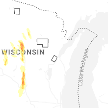
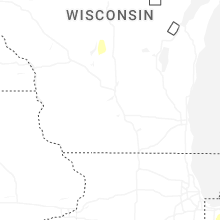

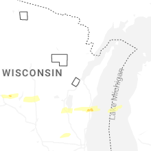
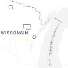

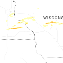


Connect with Interactive Hail Maps