

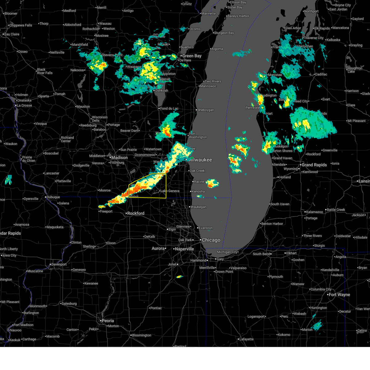
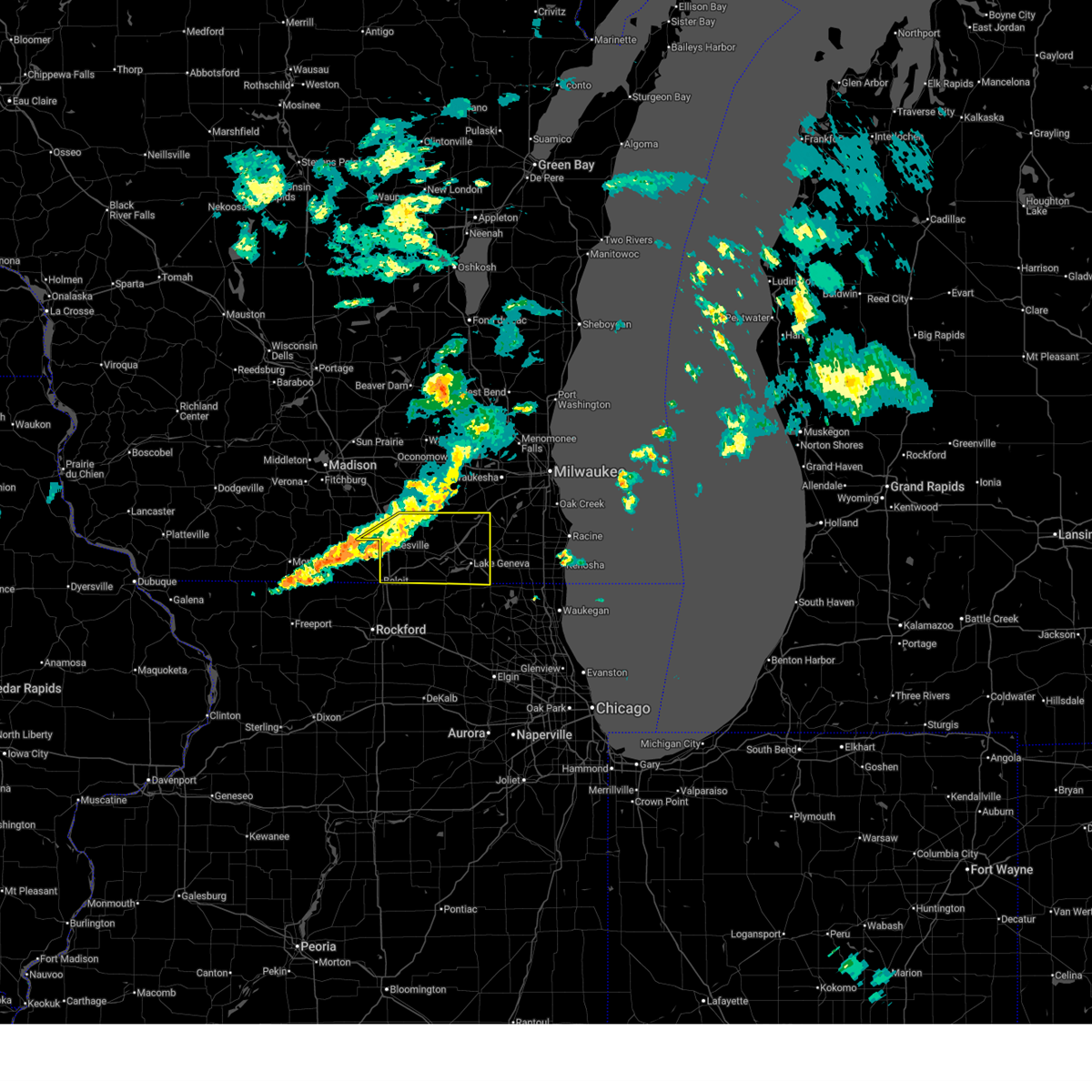
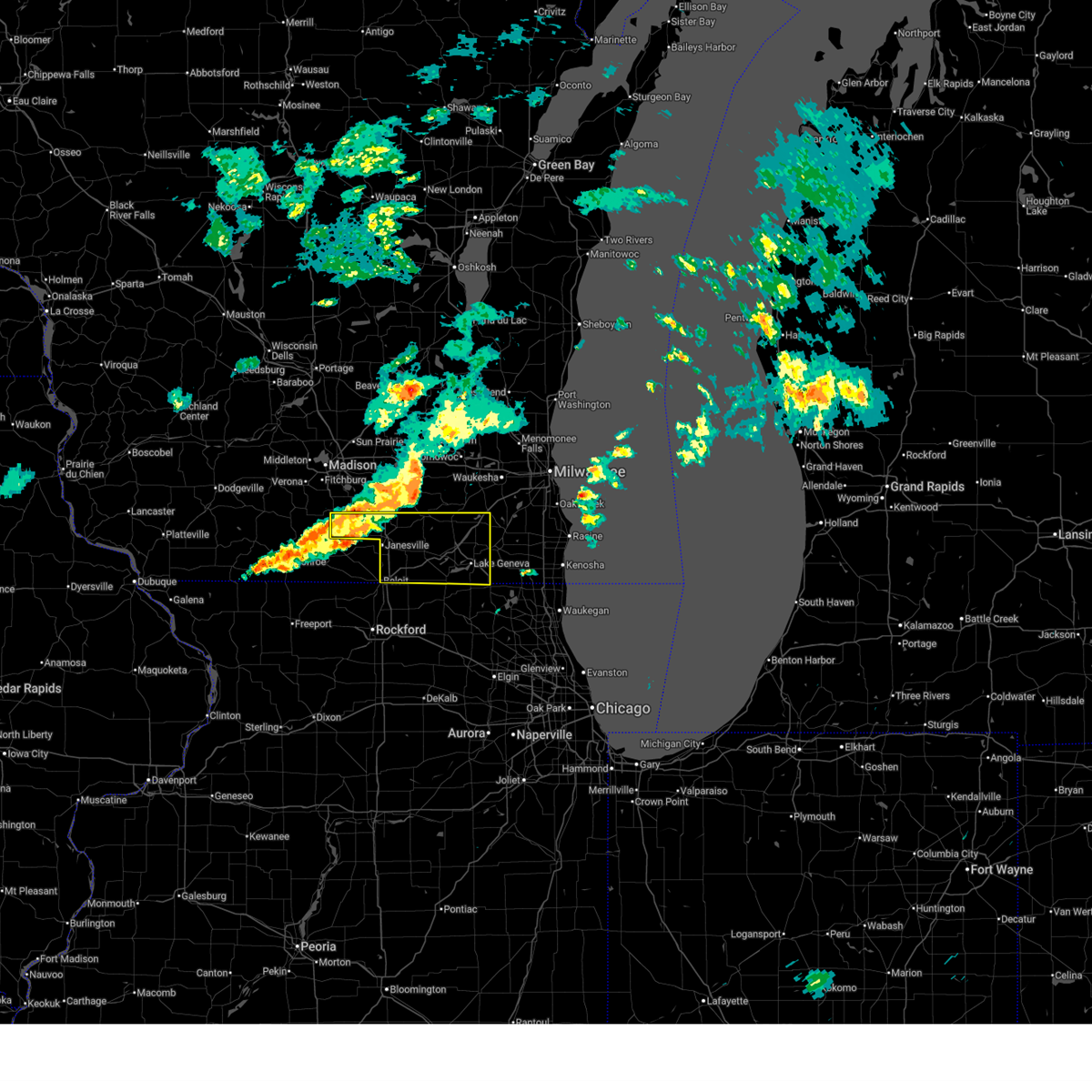
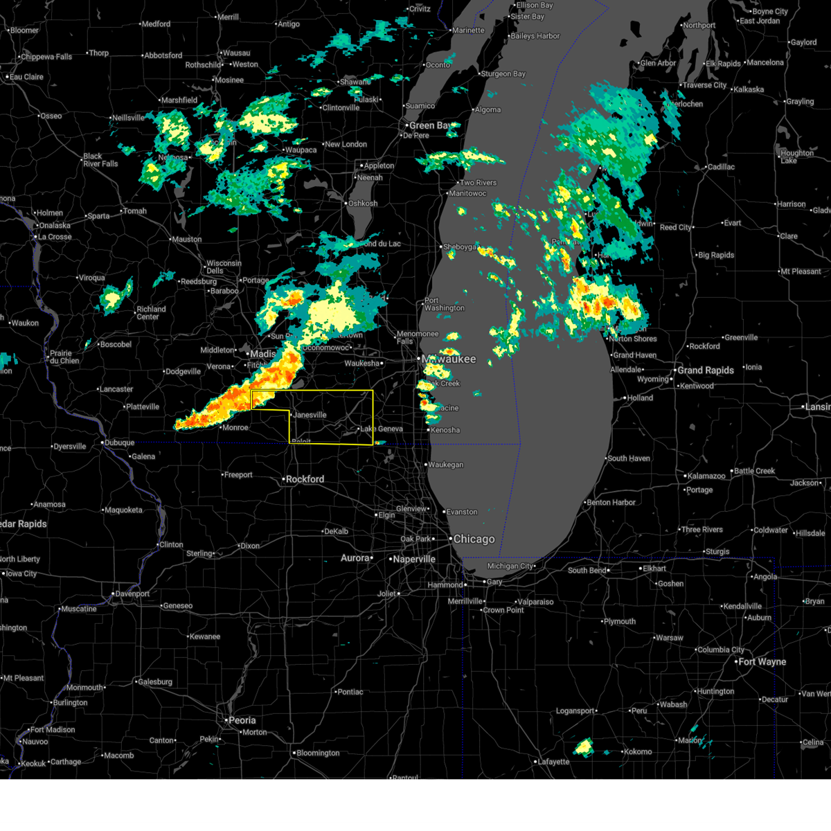
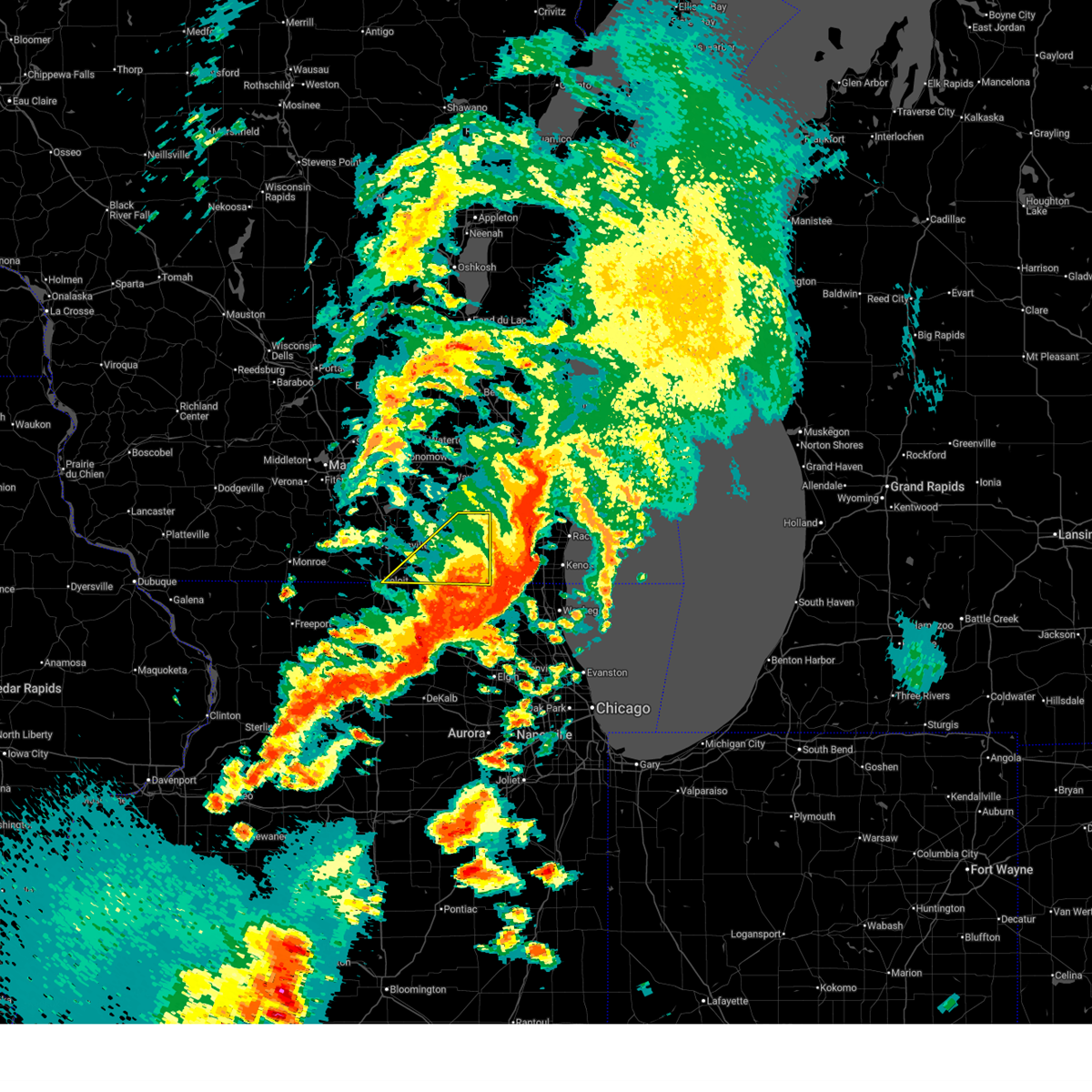
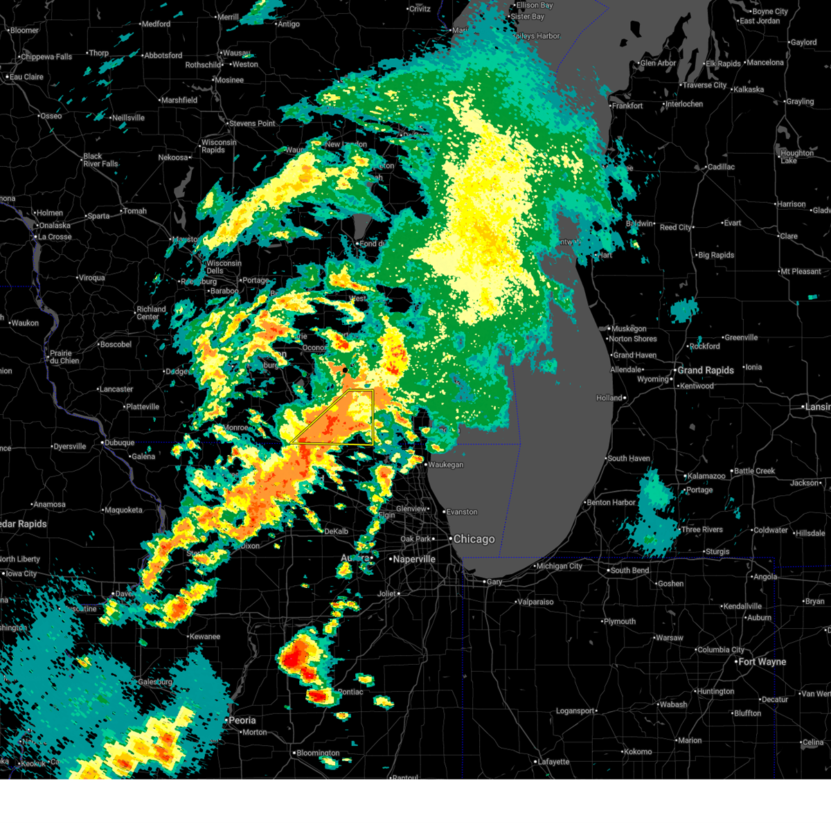
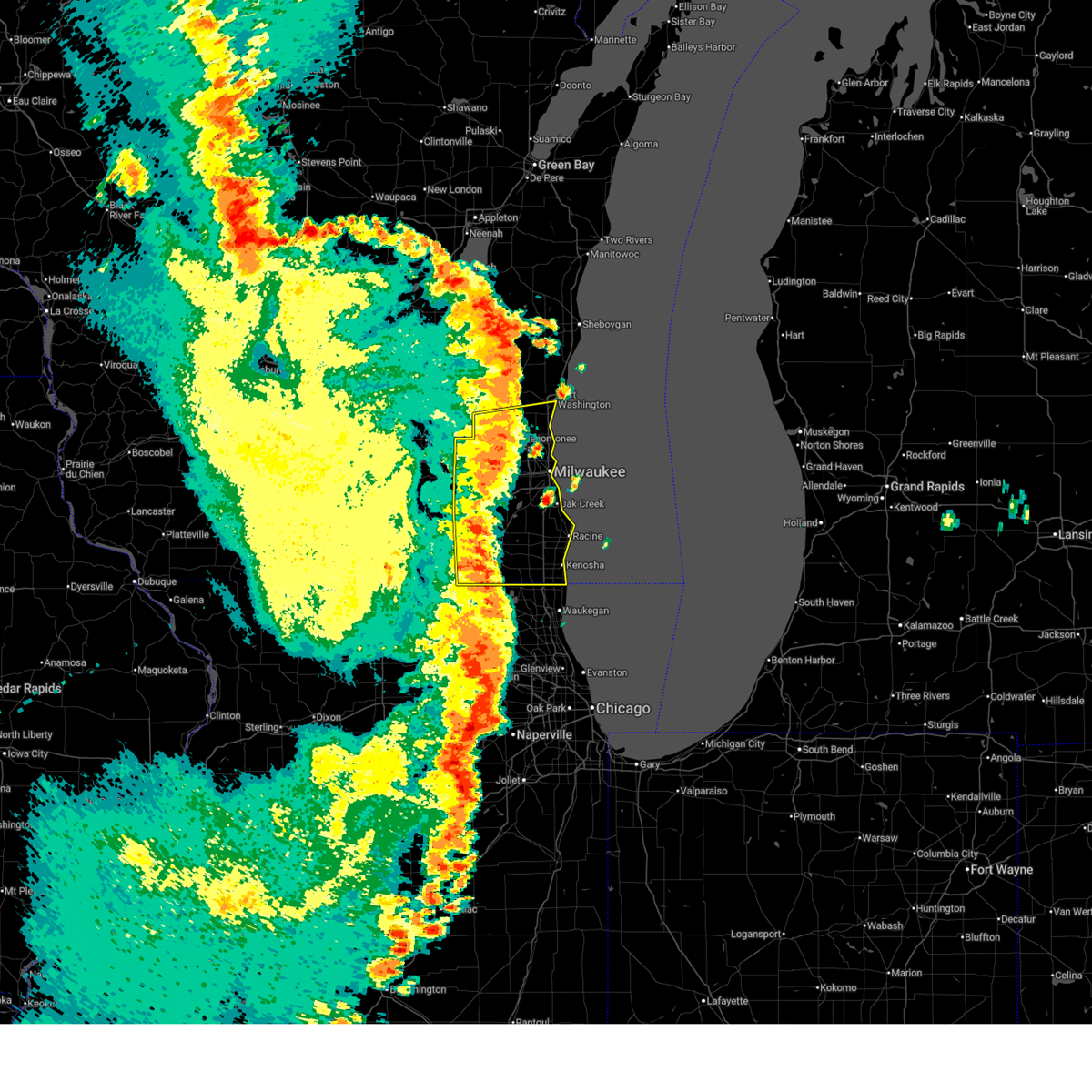
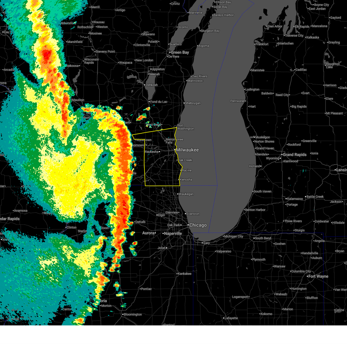
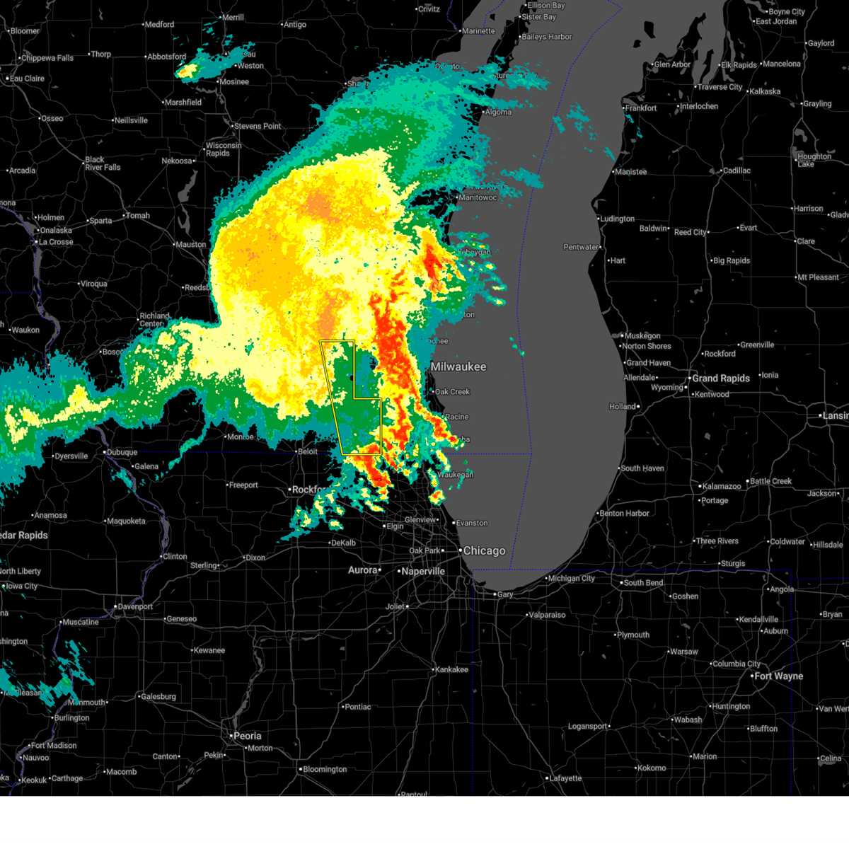
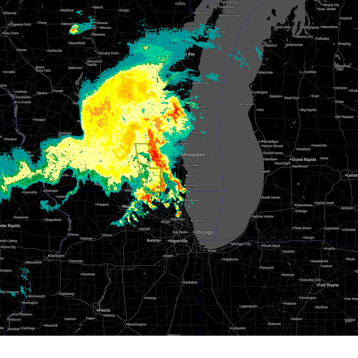
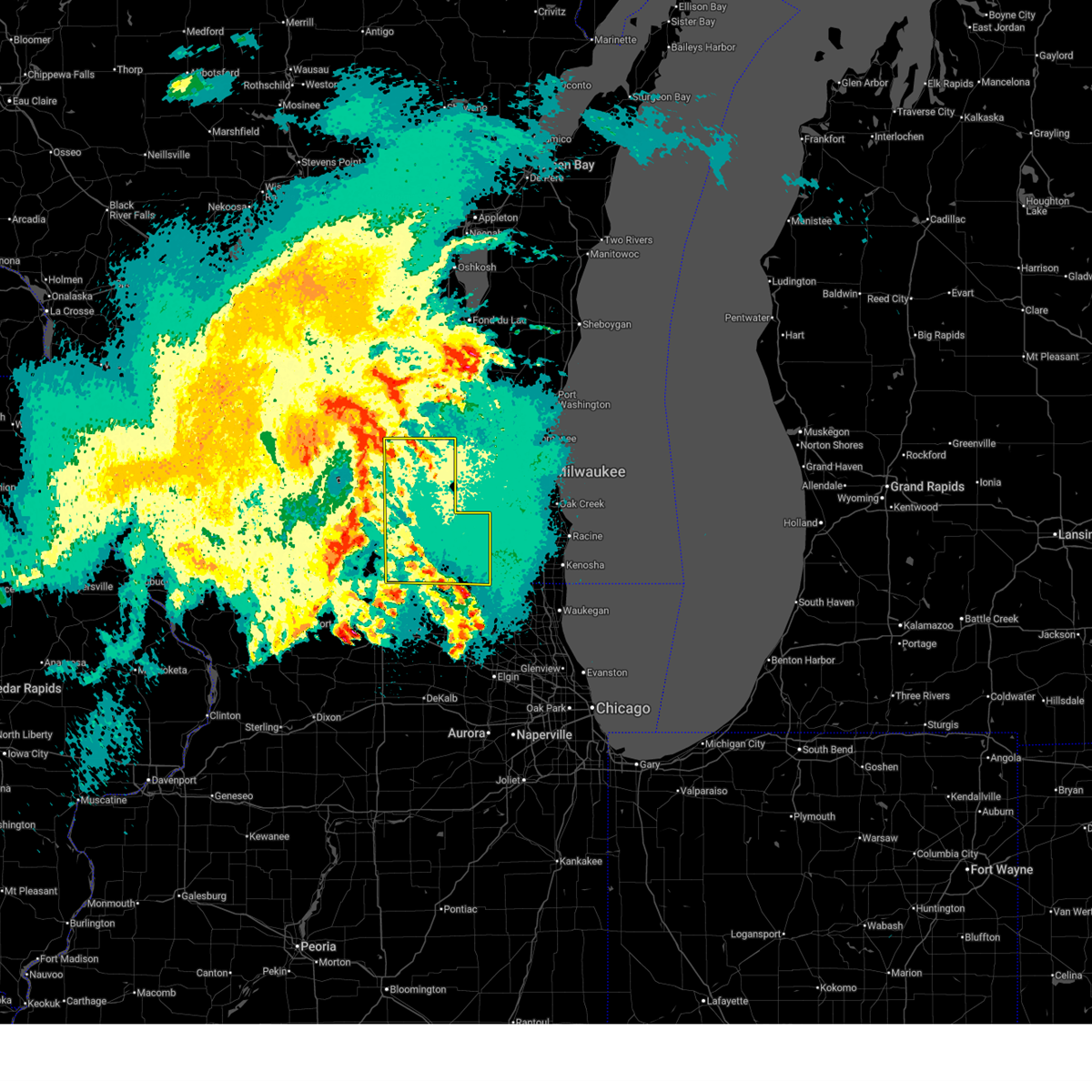
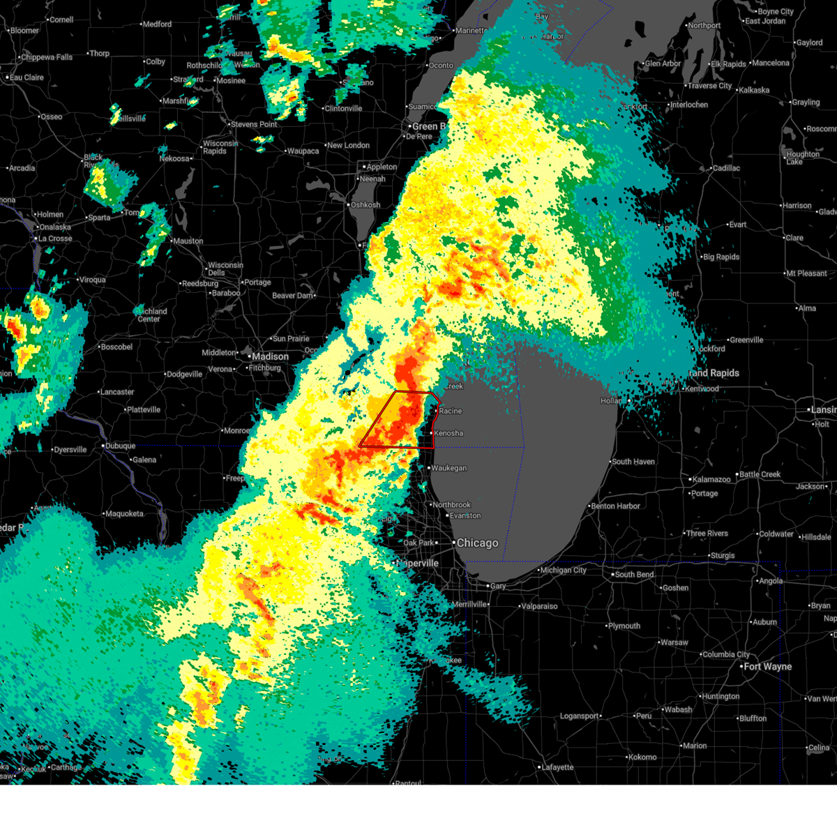
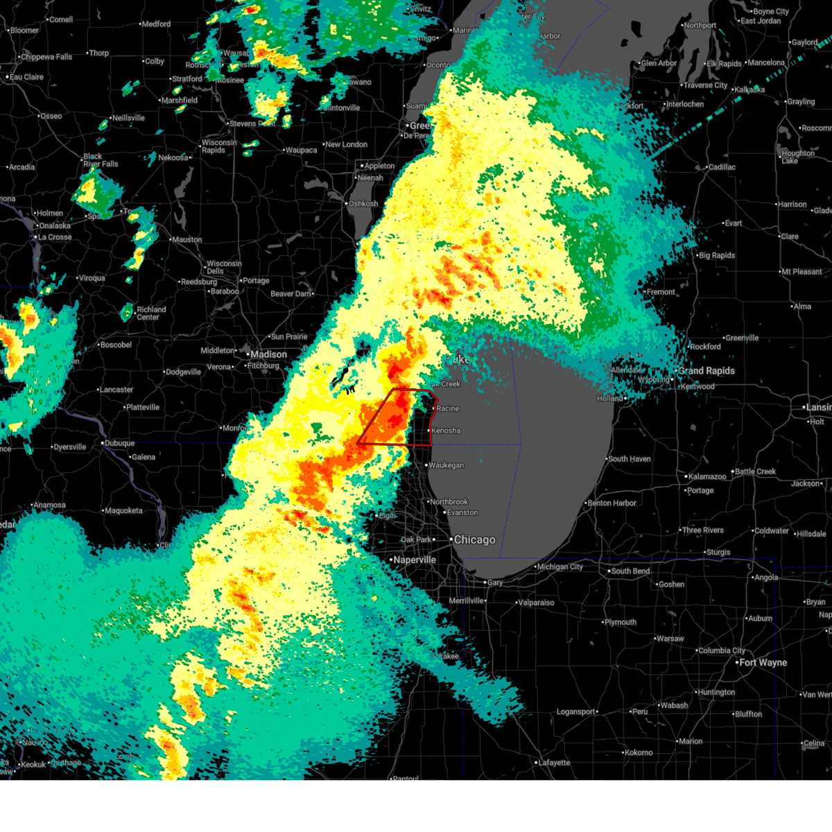
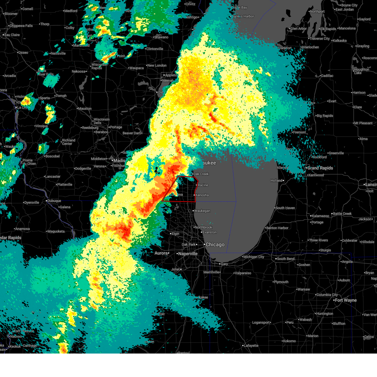
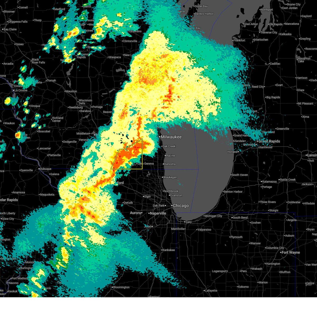
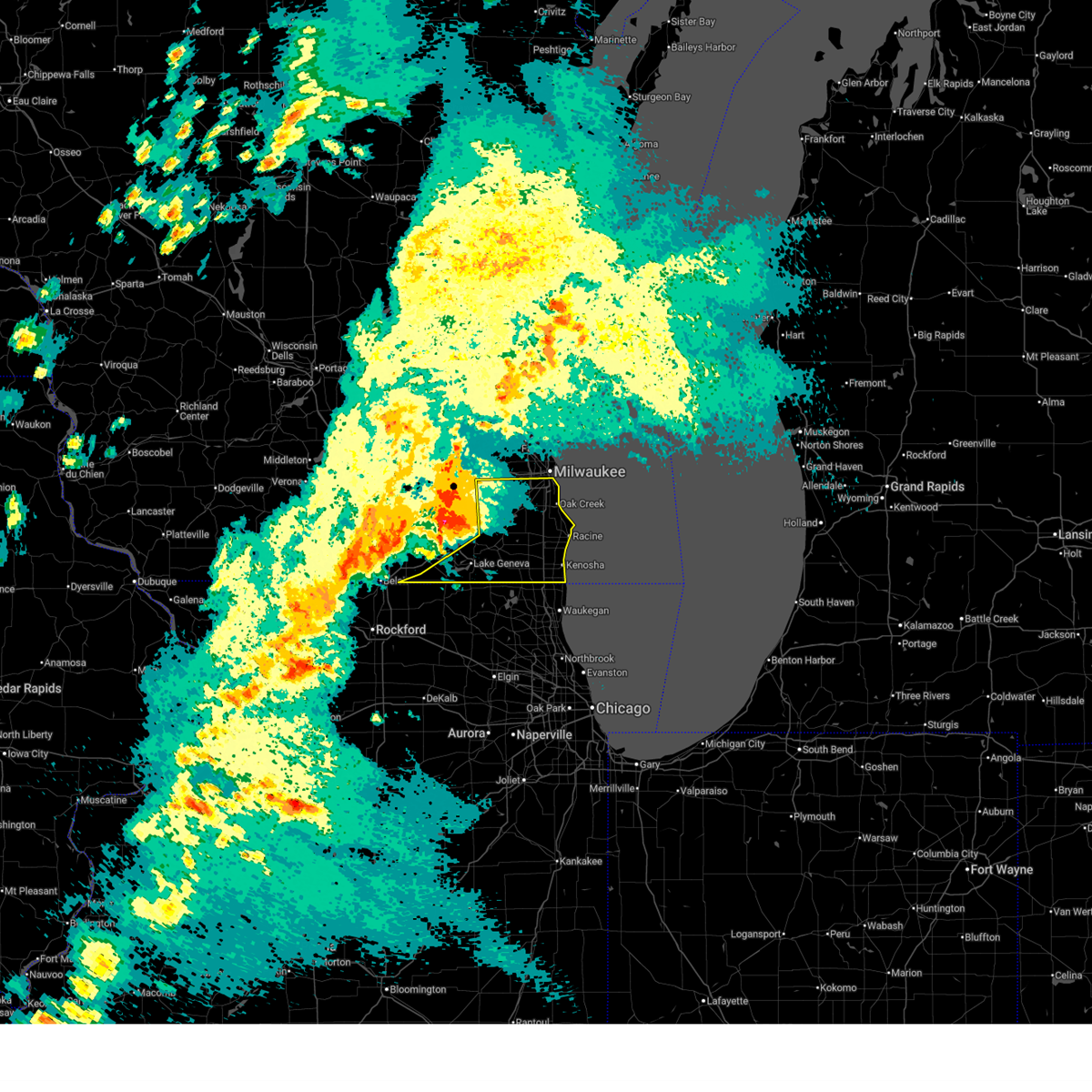
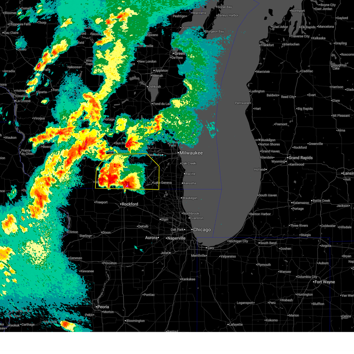
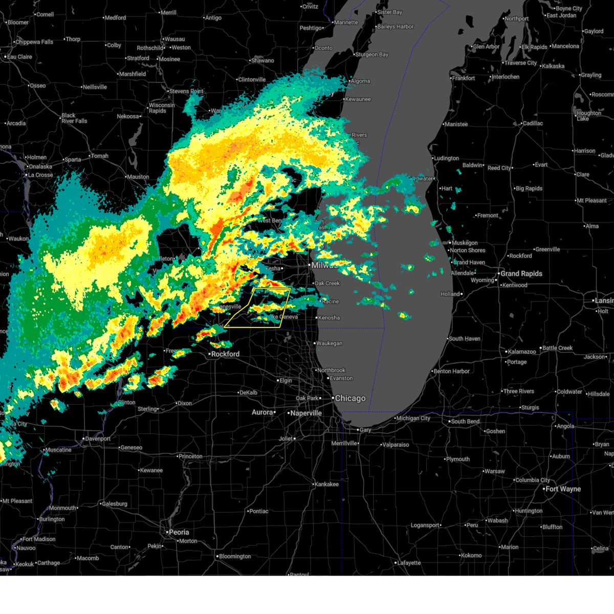
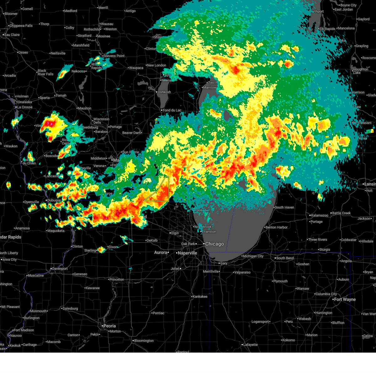
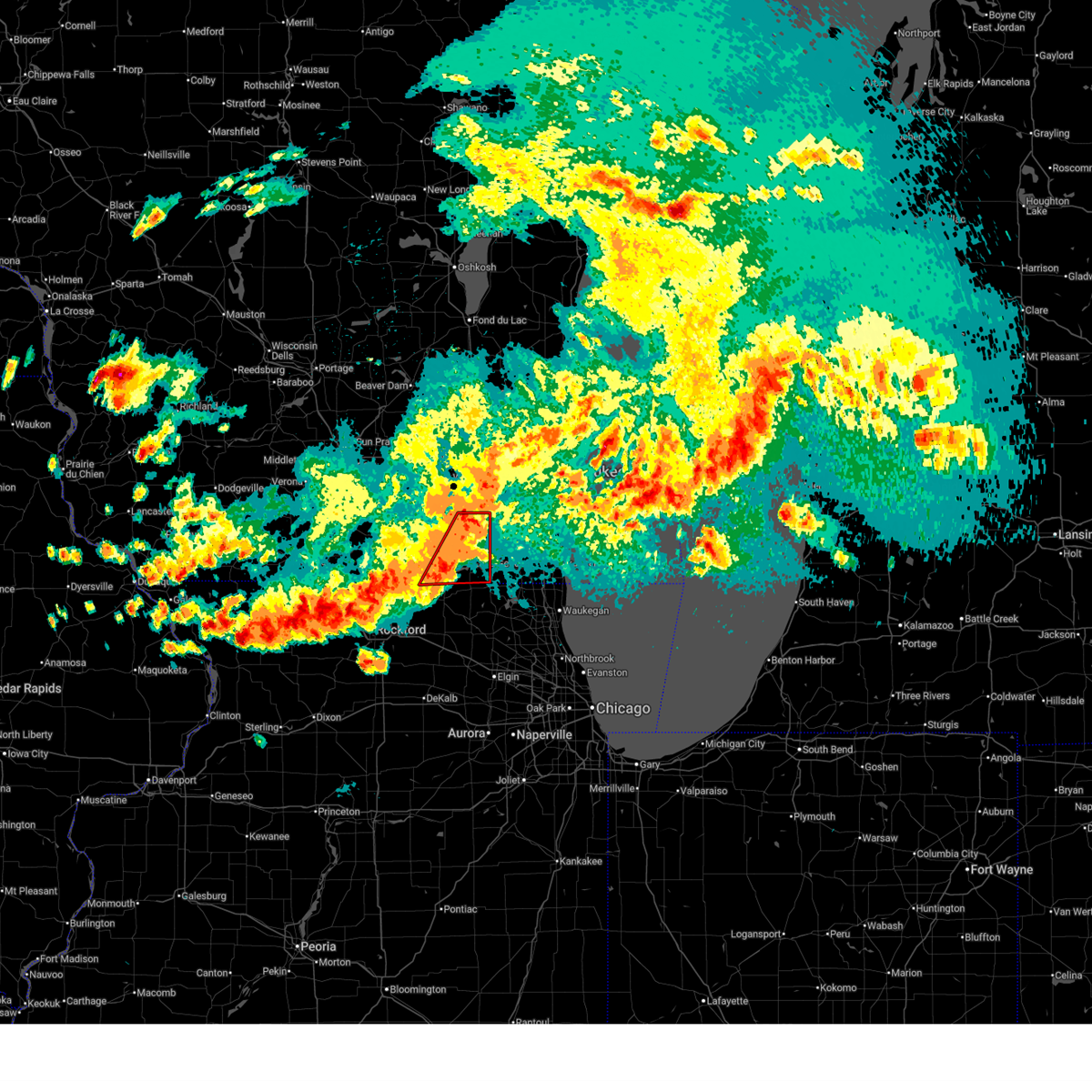
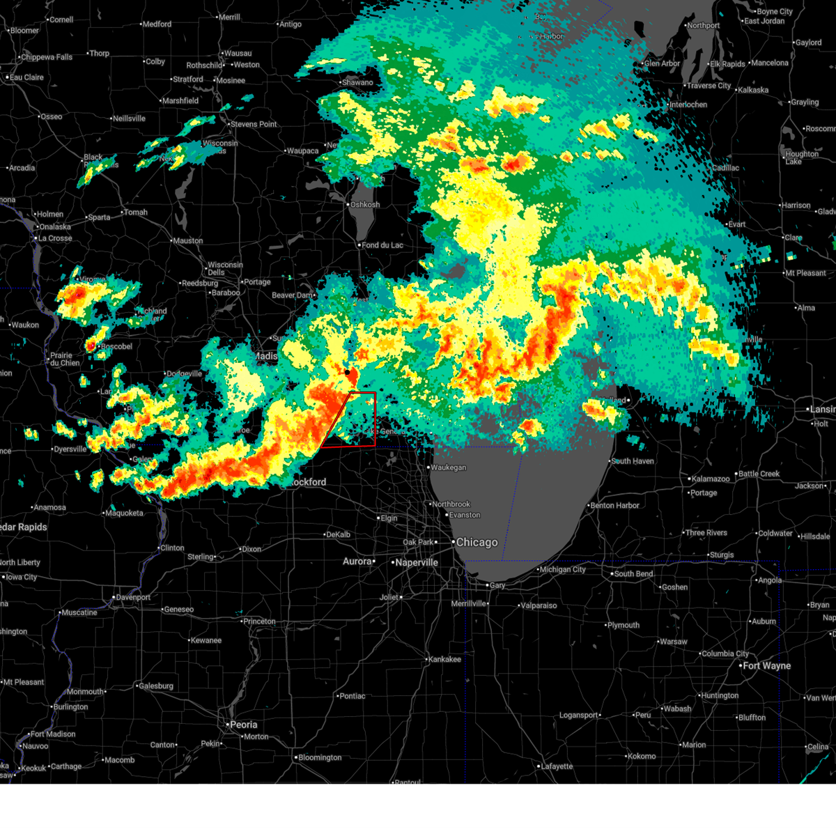
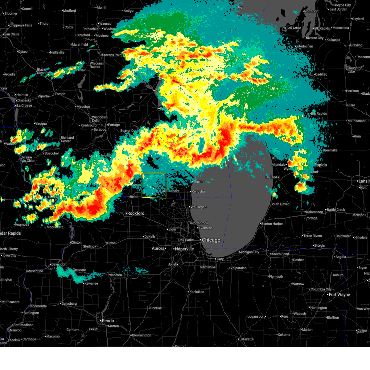
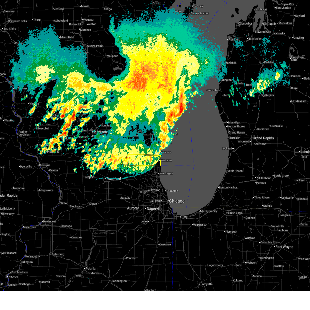
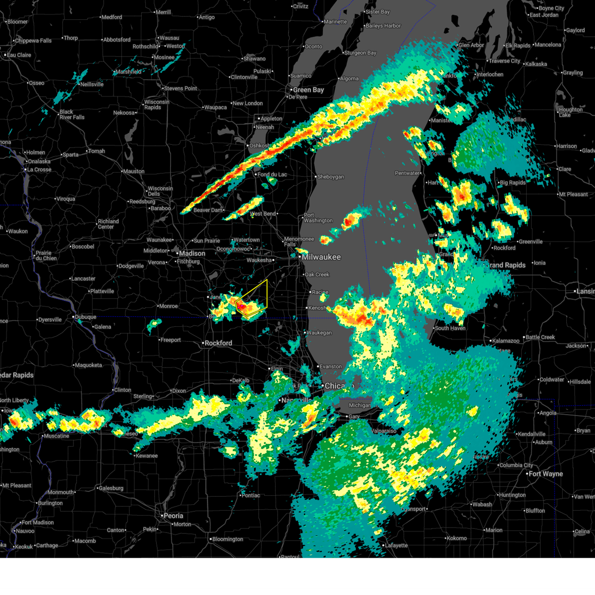
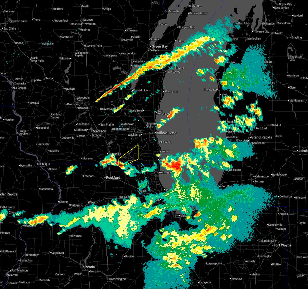
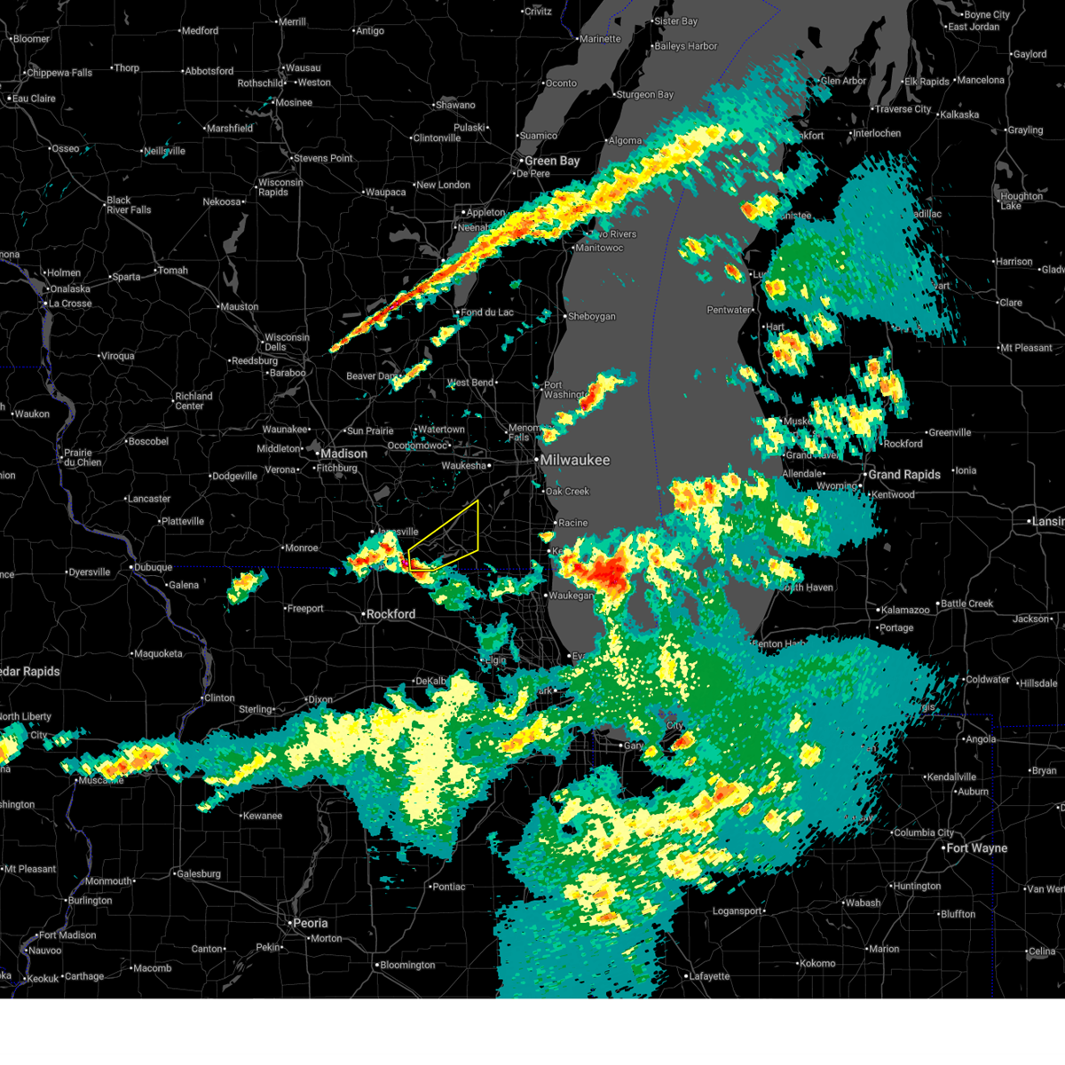
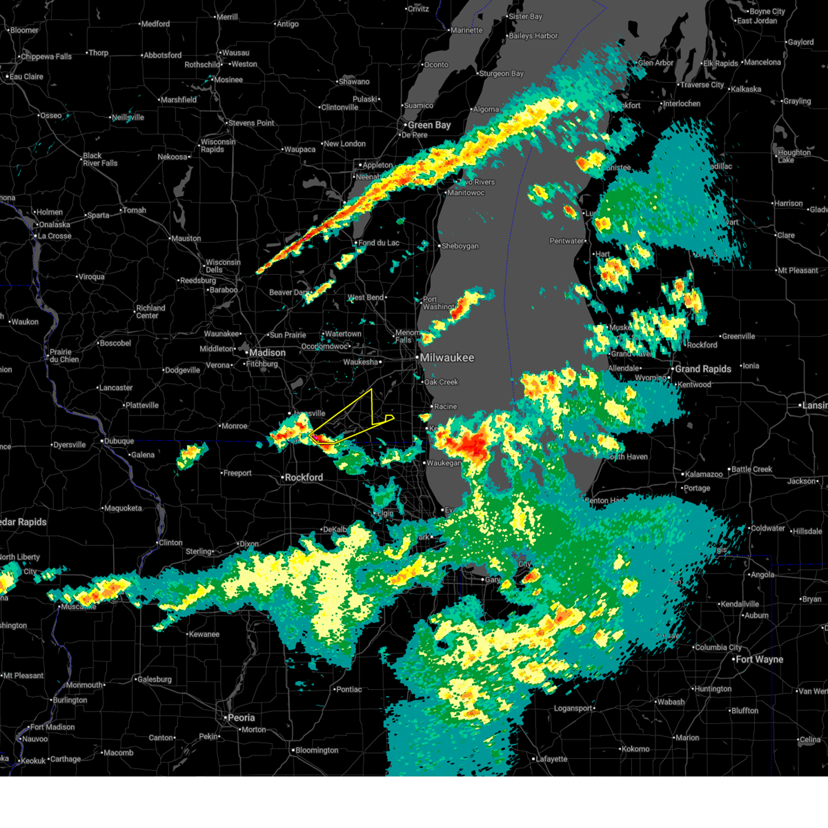
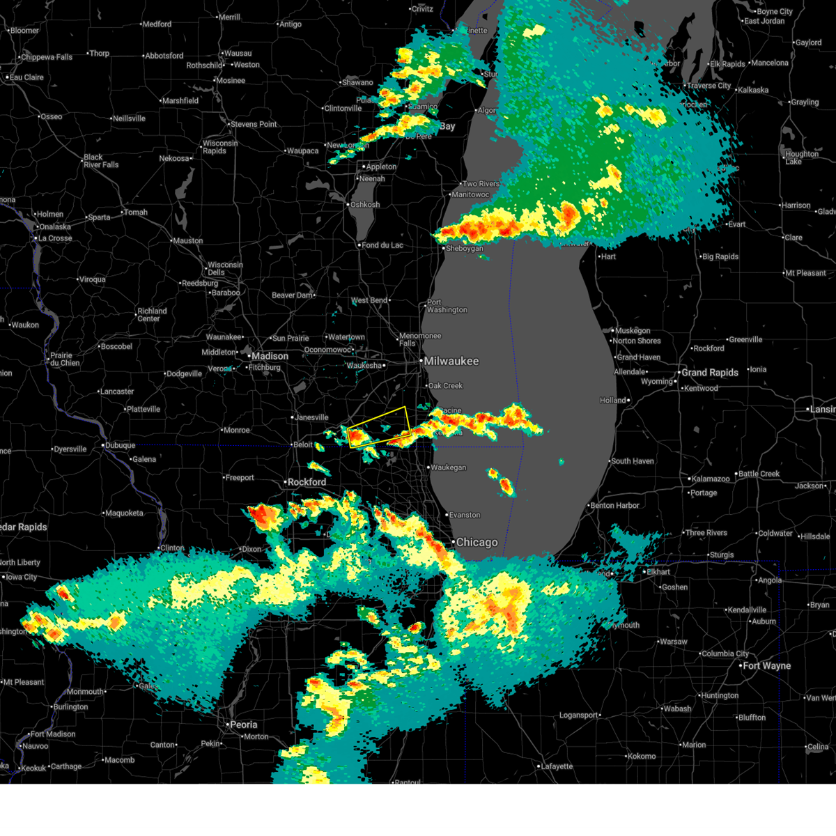
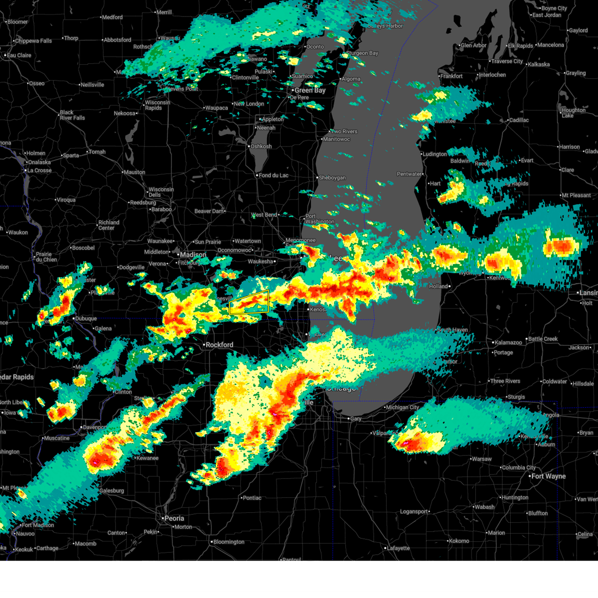
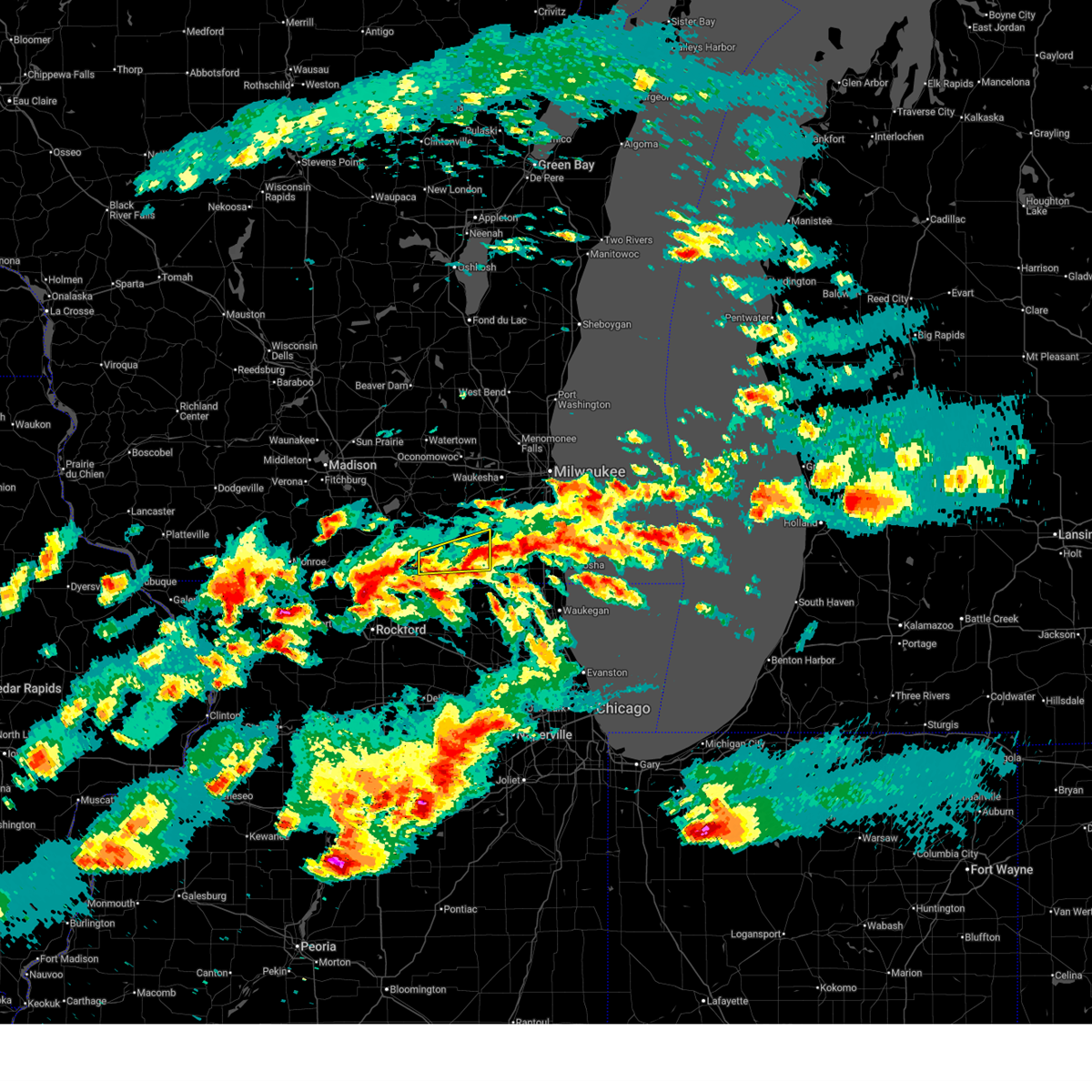
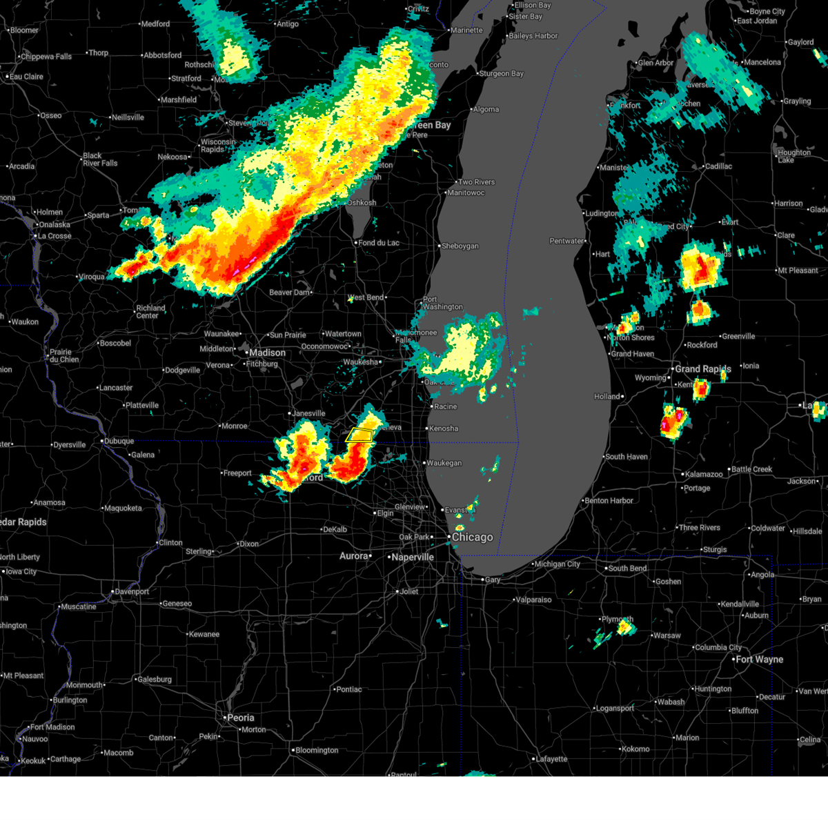
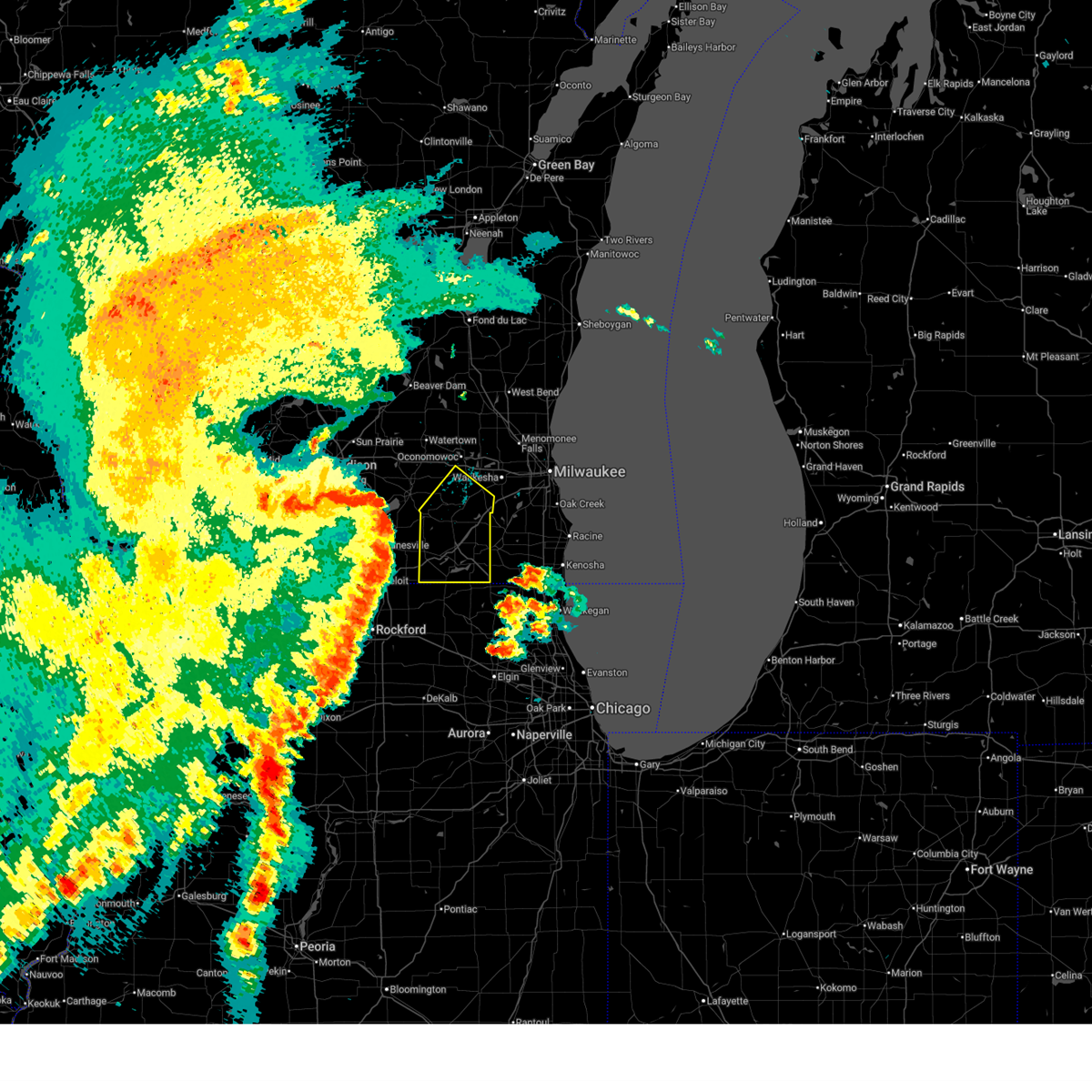
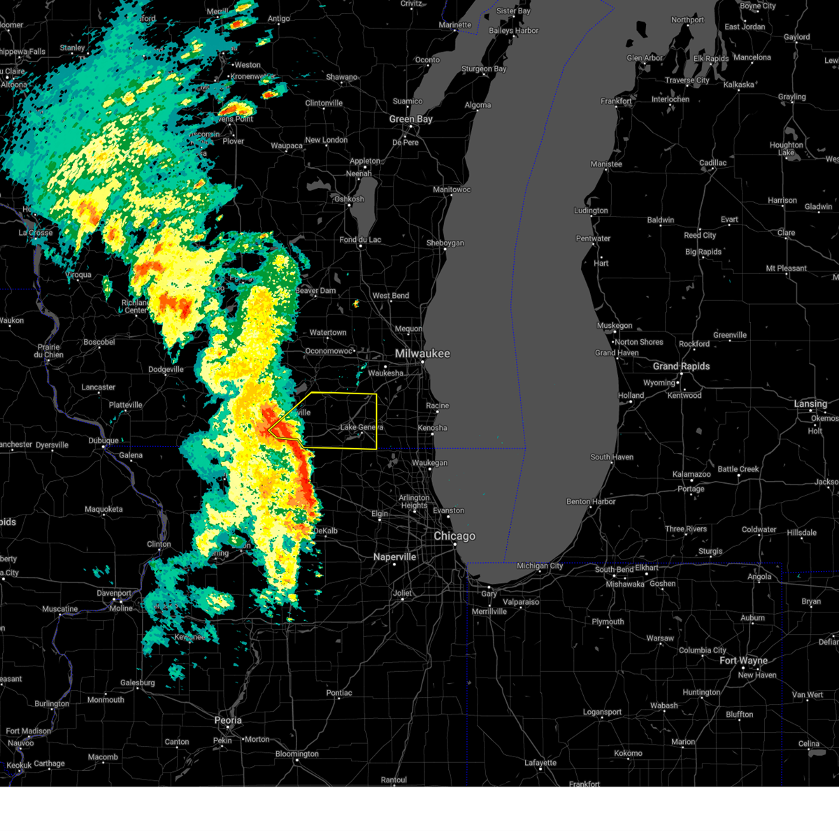
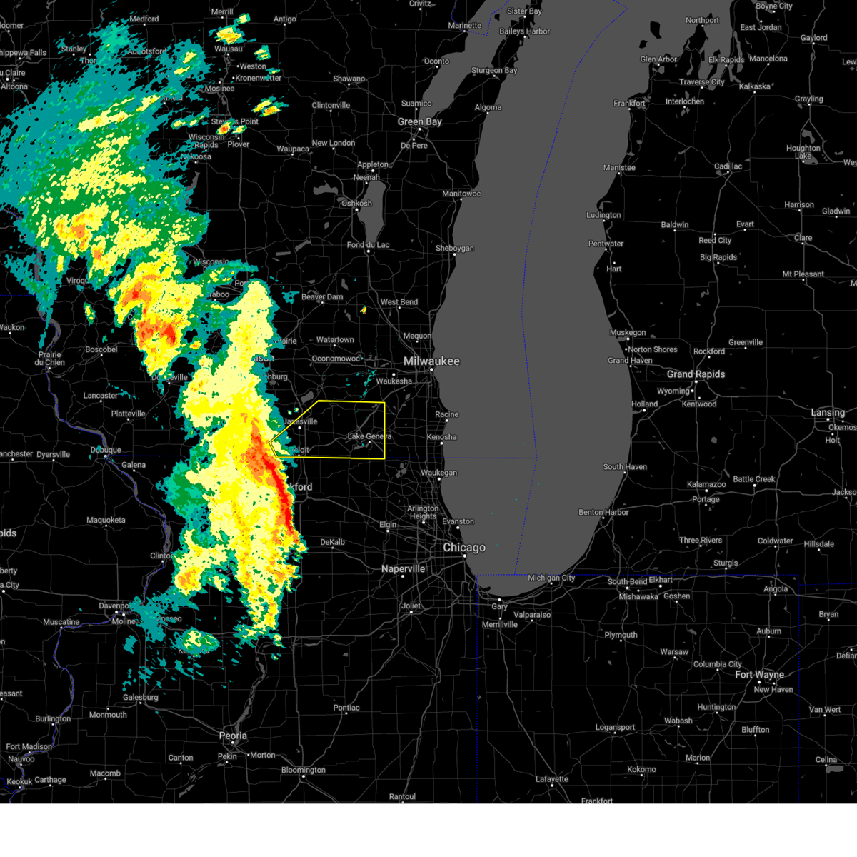
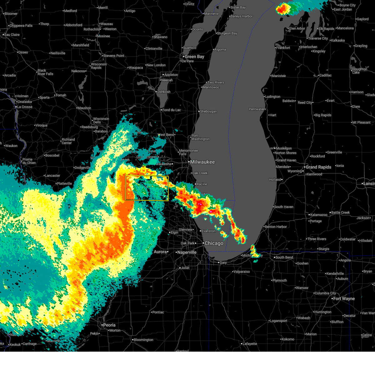
Hail Map for Lake Ivanhoe, WI
The Lake Ivanhoe, WI area has had 0 reports of on-the-ground hail by trained spotters, and has been under severe weather warnings 55 times during the past 12 months. Doppler radar has detected hail at or near Lake Ivanhoe, WI on 43 occasions, including 2 occasions during the past year.
| Name: | Lake Ivanhoe, WI |
| Where Located: | 60.4 miles NW of Chicago, IL |
| Map: | Google Map for Lake Ivanhoe, WI |
| Population: | 435 |
| Housing Units: | 157 |
| More Info: | Search Google for Lake Ivanhoe, WI |
2
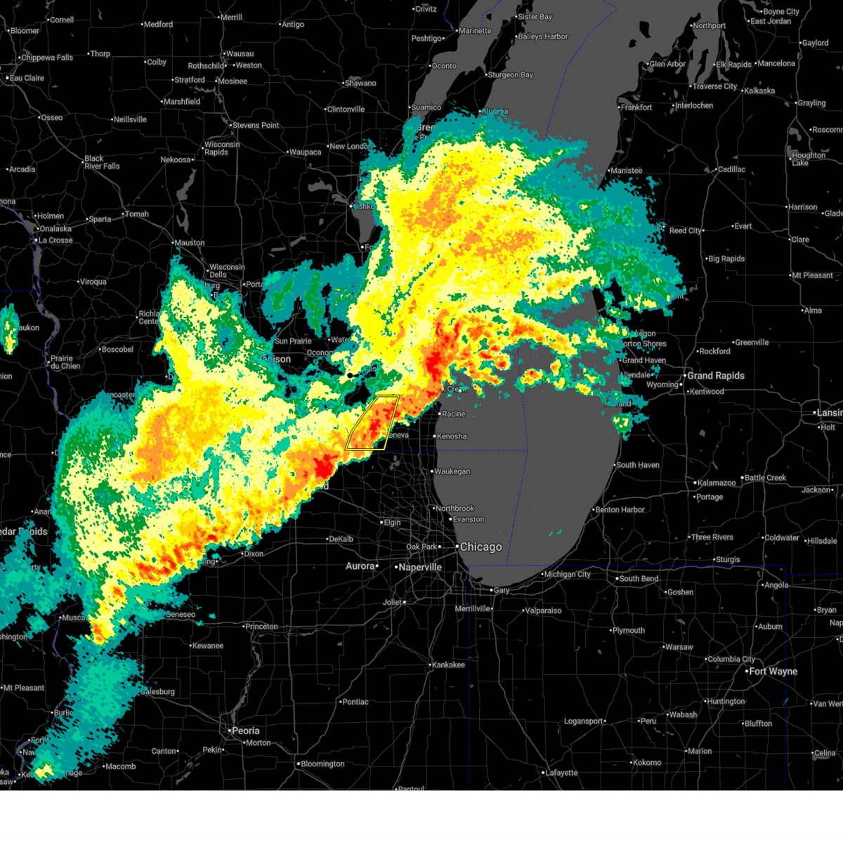
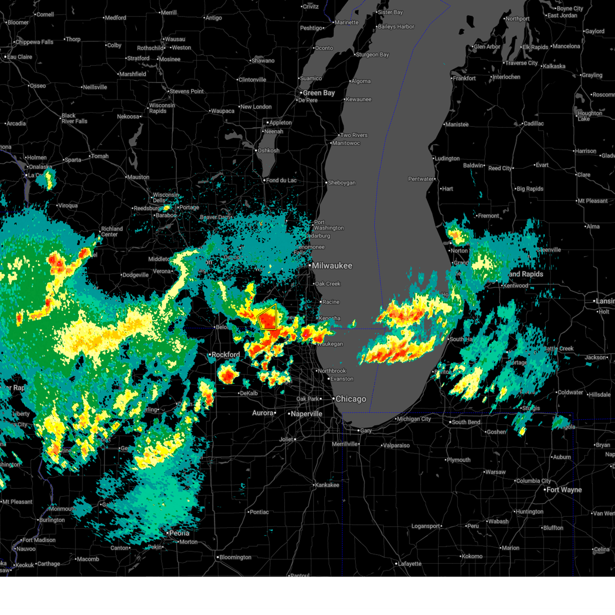
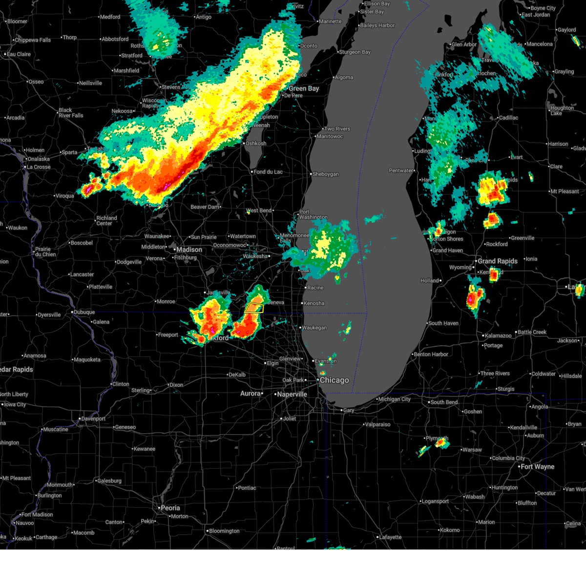
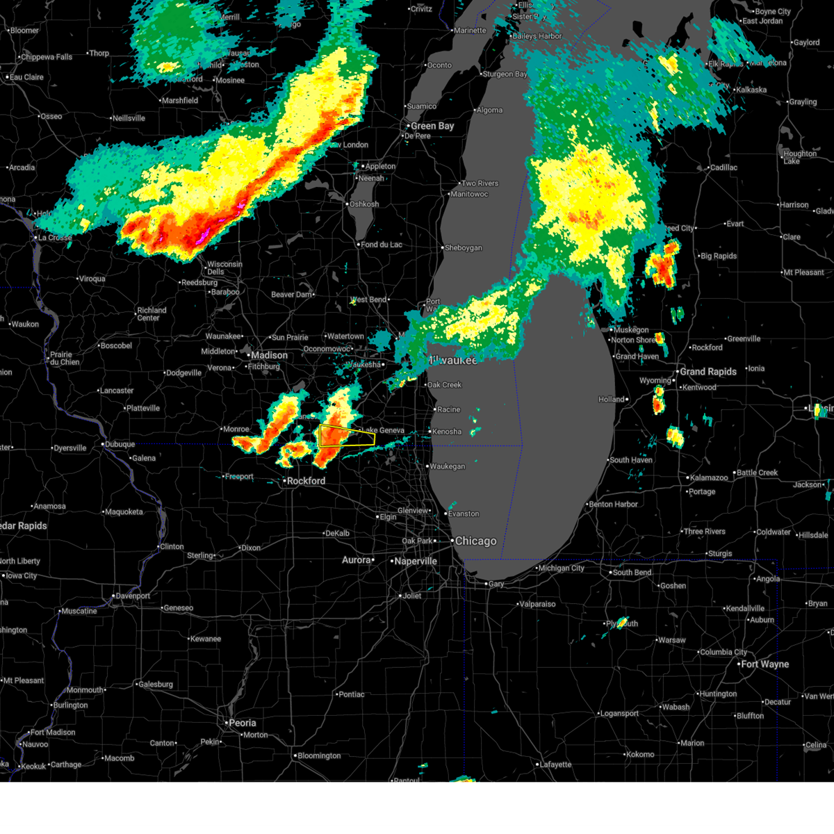
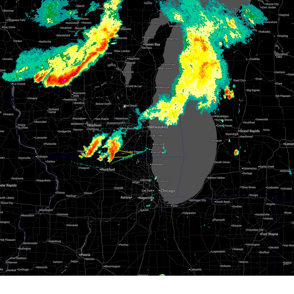
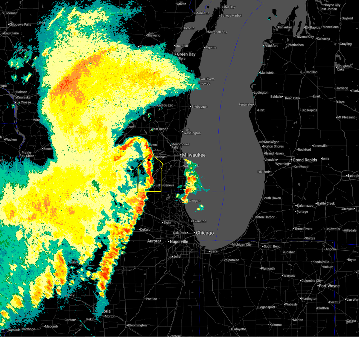
The Top Recent Hail Date for Lake Ivanhoe, WI is Saturday, September 20, 2025 (12th out of 43)
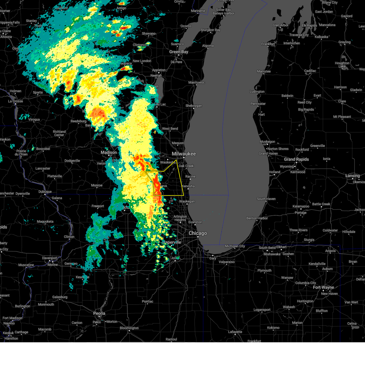
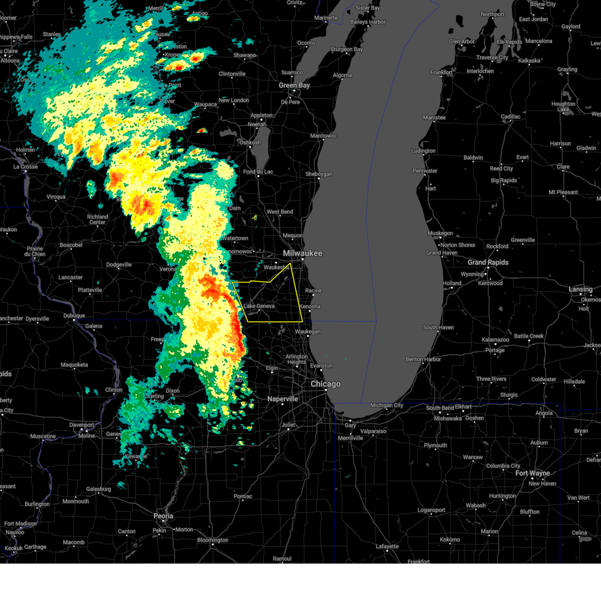
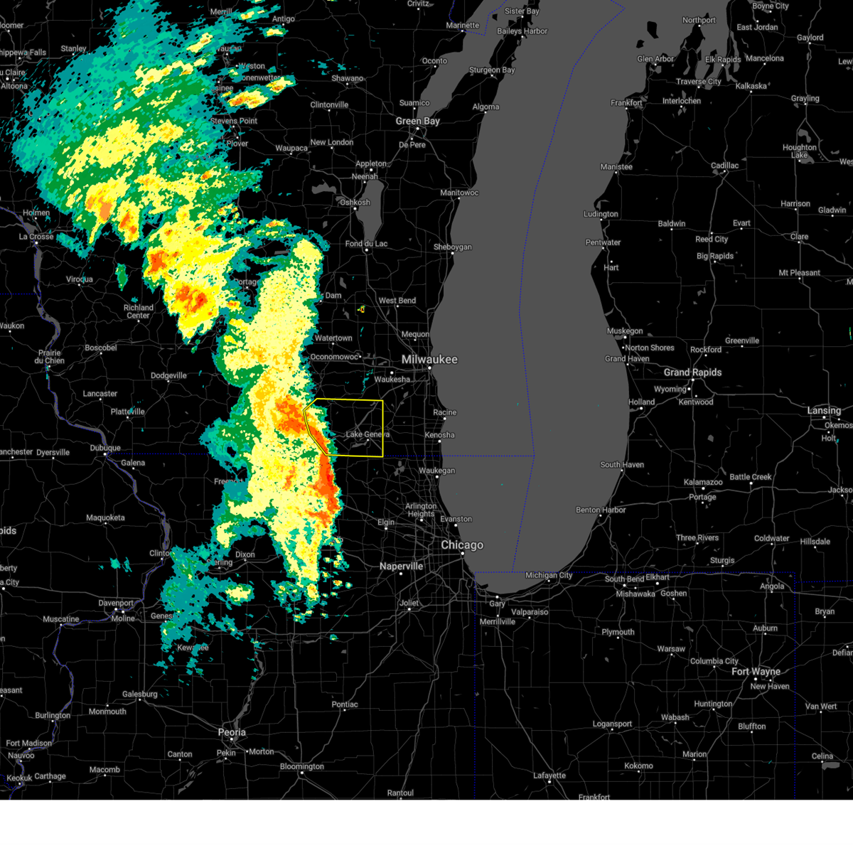
Hail and Wind Damage Spotted near Lake Ivanhoe, WI
| Date / Time | Report Details |
|---|---|
| 6/17/2026 8:54 PM CDT |
 At 853 pm cdt, severe thunderstorms were located along a line extending from near bohners lake to pell lake to near fontana-on-geneva lake, moving east at 45 mph (radar indicated). Hazards include 60 mph wind gusts. Expect damage to roofs, siding, and trees. Locations impacted include, lake geneva, camp lake, twin lakes, genoa city, silver lake, powers lake, pell lake, bohners lake, new munster, bassett, and slades corners. At 853 pm cdt, severe thunderstorms were located along a line extending from near bohners lake to pell lake to near fontana-on-geneva lake, moving east at 45 mph (radar indicated). Hazards include 60 mph wind gusts. Expect damage to roofs, siding, and trees. Locations impacted include, lake geneva, camp lake, twin lakes, genoa city, silver lake, powers lake, pell lake, bohners lake, new munster, bassett, and slades corners.
|
| 6/17/2026 8:41 PM CDT |
 Svrmkx the national weather service in milwaukee/sullivan has issued a * severe thunderstorm warning for, southern walworth county in southeastern wisconsin, southwestern kenosha county in southeastern wisconsin, * until 930 pm cdt. * at 841 pm cdt, severe thunderstorms were located along a line extending from near lake geneva to fontana-on-geneva lake to sharon, moving east at 45 mph (radar indicated). Hazards include 60 mph wind gusts. expect damage to roofs, siding, and trees Svrmkx the national weather service in milwaukee/sullivan has issued a * severe thunderstorm warning for, southern walworth county in southeastern wisconsin, southwestern kenosha county in southeastern wisconsin, * until 930 pm cdt. * at 841 pm cdt, severe thunderstorms were located along a line extending from near lake geneva to fontana-on-geneva lake to sharon, moving east at 45 mph (radar indicated). Hazards include 60 mph wind gusts. expect damage to roofs, siding, and trees
|
| 6/17/2026 8:30 PM CDT |
 At 830 pm cdt, severe thunderstorms were located along a line extending from wind lake to elkhorn to near clinton, moving east at 50 mph (radar indicated). Hazards include 60 mph wind gusts. Expect damage to roofs, siding, and trees. Locations impacted include, beloit, elkhorn, delavan, lake geneva, east troy, williams bay, genoa city, walworth, clinton, richmond, fontana-on-geneva lake, sharon, darien, como, pell lake, powers lake, burlington, springfield, tiffany, and avalon. At 830 pm cdt, severe thunderstorms were located along a line extending from wind lake to elkhorn to near clinton, moving east at 50 mph (radar indicated). Hazards include 60 mph wind gusts. Expect damage to roofs, siding, and trees. Locations impacted include, beloit, elkhorn, delavan, lake geneva, east troy, williams bay, genoa city, walworth, clinton, richmond, fontana-on-geneva lake, sharon, darien, como, pell lake, powers lake, burlington, springfield, tiffany, and avalon.
|
| 6/17/2026 8:17 PM CDT |
 At 817 pm cdt, severe thunderstorms were located along a line extending from potter lake to near delavan to near beloit, moving east at 55 mph (radar indicated). Hazards include 60 mph wind gusts. Expect damage to roofs, siding, and trees. Locations impacted include, janesville, beloit, elkhorn, delavan, lake geneva, east troy, williams bay, genoa city, walworth, clinton, fontana-on-geneva lake, sharon, darien, como, pell lake, potter lake, powers lake, burlington, richmond, and springfield. At 817 pm cdt, severe thunderstorms were located along a line extending from potter lake to near delavan to near beloit, moving east at 55 mph (radar indicated). Hazards include 60 mph wind gusts. Expect damage to roofs, siding, and trees. Locations impacted include, janesville, beloit, elkhorn, delavan, lake geneva, east troy, williams bay, genoa city, walworth, clinton, fontana-on-geneva lake, sharon, darien, como, pell lake, potter lake, powers lake, burlington, richmond, and springfield.
|
| 6/17/2026 8:01 PM CDT |
 At 801 pm cdt, severe thunderstorms were located along a line extending from near palmyra to 7 miles south of whitewater to near janesville, moving east at 55 mph (radar indicated). Hazards include 60 mph wind gusts. Expect damage to roofs, siding, and trees. Locations impacted include, janesville, beloit, whitewater, elkhorn, delavan, lake geneva, milton, east troy, williams bay, genoa city, walworth, clinton, fontana-on-geneva lake, sharon, darien, como, pell lake, potter lake, powers lake, and burlington. At 801 pm cdt, severe thunderstorms were located along a line extending from near palmyra to 7 miles south of whitewater to near janesville, moving east at 55 mph (radar indicated). Hazards include 60 mph wind gusts. Expect damage to roofs, siding, and trees. Locations impacted include, janesville, beloit, whitewater, elkhorn, delavan, lake geneva, milton, east troy, williams bay, genoa city, walworth, clinton, fontana-on-geneva lake, sharon, darien, como, pell lake, potter lake, powers lake, and burlington.
|
| 6/17/2026 7:36 PM CDT |
 At 736 pm cdt, severe thunderstorms were located along a line extending from near lake koshkonong to near footville to near brodhead, moving east at 55 mph (radar indicated). Hazards include 60 mph wind gusts. Expect damage to roofs, siding, and trees. Locations impacted include, janesville, beloit, whitewater, elkhorn, delavan, lake geneva, milton, edgerton, evansville, east troy, williams bay, genoa city, walworth, clinton, fontana-on-geneva lake, sharon, darien, como, pell lake, and potter lake. At 736 pm cdt, severe thunderstorms were located along a line extending from near lake koshkonong to near footville to near brodhead, moving east at 55 mph (radar indicated). Hazards include 60 mph wind gusts. Expect damage to roofs, siding, and trees. Locations impacted include, janesville, beloit, whitewater, elkhorn, delavan, lake geneva, milton, edgerton, evansville, east troy, williams bay, genoa city, walworth, clinton, fontana-on-geneva lake, sharon, darien, como, pell lake, and potter lake.
|
| 6/17/2026 7:32 PM CDT |
 Svrmkx the national weather service in milwaukee/sullivan has issued a * severe thunderstorm warning for, walworth county in southeastern wisconsin, rock county in south central wisconsin, * until 845 pm cdt. * at 732 pm cdt, severe thunderstorms were located along a line extending from near lake koshkonong to near edgerton to near albany, moving east at 80 mph (radar indicated). Hazards include 60 mph wind gusts. expect damage to roofs, siding, and trees Svrmkx the national weather service in milwaukee/sullivan has issued a * severe thunderstorm warning for, walworth county in southeastern wisconsin, rock county in south central wisconsin, * until 845 pm cdt. * at 732 pm cdt, severe thunderstorms were located along a line extending from near lake koshkonong to near edgerton to near albany, moving east at 80 mph (radar indicated). Hazards include 60 mph wind gusts. expect damage to roofs, siding, and trees
|
| 6/11/2026 6:06 PM CDT |
 The storm which prompted the warning has moved out of the area. therefore, the warning will be allowed to expire. a tornado watch remains in effect until 900 pm cdt for south central and southeastern wisconsin. The storm which prompted the warning has moved out of the area. therefore, the warning will be allowed to expire. a tornado watch remains in effect until 900 pm cdt for south central and southeastern wisconsin.
|
| 6/11/2026 5:31 PM CDT |
 Svrmkx the national weather service in milwaukee/sullivan has issued a * severe thunderstorm warning for, walworth county in southeastern wisconsin, southeastern rock county in south central wisconsin, * until 615 pm cdt. * at 531 pm cdt, a severe thunderstorm was located over clinton, or 8 miles east of beloit, moving northeast at 55 mph (radar indicated). Hazards include 60 mph wind gusts. expect damage to roofs, siding, and trees Svrmkx the national weather service in milwaukee/sullivan has issued a * severe thunderstorm warning for, walworth county in southeastern wisconsin, southeastern rock county in south central wisconsin, * until 615 pm cdt. * at 531 pm cdt, a severe thunderstorm was located over clinton, or 8 miles east of beloit, moving northeast at 55 mph (radar indicated). Hazards include 60 mph wind gusts. expect damage to roofs, siding, and trees
|
| 6/10/2026 3:27 PM CDT |
 the severe thunderstorm warning has been cancelled and is no longer in effect the severe thunderstorm warning has been cancelled and is no longer in effect
|
| 6/10/2026 3:27 PM CDT |
 At 327 pm cdt, severe thunderstorms were located along a line extending from mequon to grayslake, moving east at 45 mph (radar indicated). Hazards include 70 mph wind gusts and penny size hail. Expect considerable tree damage. damage is likely to mobile homes, roofs, and outbuildings. locations impacted include, milwaukee, kenosha, racine, waukesha, west allis, wauwatosa, new berlin, brookfield, greenfield, menomonee falls, oak creek, mount pleasant, muskego, mequon, south milwaukee, pleasant prairie, cudahy, antioch, hartford, and whitefish bay. People attending wednesday night live at state fair , and glendale live at the oasis should seek safe shelter immediately!. At 327 pm cdt, severe thunderstorms were located along a line extending from mequon to grayslake, moving east at 45 mph (radar indicated). Hazards include 70 mph wind gusts and penny size hail. Expect considerable tree damage. damage is likely to mobile homes, roofs, and outbuildings. locations impacted include, milwaukee, kenosha, racine, waukesha, west allis, wauwatosa, new berlin, brookfield, greenfield, menomonee falls, oak creek, mount pleasant, muskego, mequon, south milwaukee, pleasant prairie, cudahy, antioch, hartford, and whitefish bay. People attending wednesday night live at state fair , and glendale live at the oasis should seek safe shelter immediately!.
|
| 6/10/2026 2:40 PM CDT |
 Svrmkx the national weather service in milwaukee/sullivan has issued a * severe thunderstorm warning for, southwestern ozaukee county in southeastern wisconsin, milwaukee county in southeastern wisconsin, eastern walworth county in southeastern wisconsin, racine county in southeastern wisconsin, waukesha county in southeastern wisconsin, southern washington county in southeastern wisconsin, southeastern dodge county in southeastern wisconsin, kenosha county in southeastern wisconsin, * until 400 pm cdt. * at 239 pm cdt, severe thunderstorms were located along a line extending from near watertown to near capron, moving east at 45 mph (radar indicated). Hazards include 70 mph wind gusts and penny size hail. Expect considerable tree damage. Damage is likely to mobile homes, roofs, and outbuildings. Svrmkx the national weather service in milwaukee/sullivan has issued a * severe thunderstorm warning for, southwestern ozaukee county in southeastern wisconsin, milwaukee county in southeastern wisconsin, eastern walworth county in southeastern wisconsin, racine county in southeastern wisconsin, waukesha county in southeastern wisconsin, southern washington county in southeastern wisconsin, southeastern dodge county in southeastern wisconsin, kenosha county in southeastern wisconsin, * until 400 pm cdt. * at 239 pm cdt, severe thunderstorms were located along a line extending from near watertown to near capron, moving east at 45 mph (radar indicated). Hazards include 70 mph wind gusts and penny size hail. Expect considerable tree damage. Damage is likely to mobile homes, roofs, and outbuildings.
|
| 5/16/2026 1:51 AM CDT |
 The storms which prompted the warning have weakened below severe limits, and have exited the warned area. therefore, the warning will be allowed to expire. a severe thunderstorm watch remains in effect until 500 am cdt for southeastern wisconsin. The storms which prompted the warning have weakened below severe limits, and have exited the warned area. therefore, the warning will be allowed to expire. a severe thunderstorm watch remains in effect until 500 am cdt for southeastern wisconsin.
|
| 5/16/2026 1:41 AM CDT |
 At 140 am cdt, severe thunderstorms were located along a line extending from near lac la belle to near elkhorn to near hebron, moving east at 45 mph (radar indicated). Hazards include 60 mph wind gusts. Expect damage to roofs, siding, and trees. Locations impacted include, watertown, whitewater, elkhorn, delavan, lake geneva, east troy, williams bay, genoa city, walworth, johnson creek, richmond, palmyra, fontana-on-geneva lake, como, pell lake, potter lake, powers lake, burlington, ixonia, and springfield. At 140 am cdt, severe thunderstorms were located along a line extending from near lac la belle to near elkhorn to near hebron, moving east at 45 mph (radar indicated). Hazards include 60 mph wind gusts. Expect damage to roofs, siding, and trees. Locations impacted include, watertown, whitewater, elkhorn, delavan, lake geneva, east troy, williams bay, genoa city, walworth, johnson creek, richmond, palmyra, fontana-on-geneva lake, como, pell lake, potter lake, powers lake, burlington, ixonia, and springfield.
|
| 5/16/2026 1:06 AM CDT |
 Svrmkx the national weather service in milwaukee/sullivan has issued a * severe thunderstorm warning for, walworth county in southeastern wisconsin, eastern rock county in south central wisconsin, jefferson county in southeastern wisconsin, * until 200 am cdt. * at 106 am cdt, severe thunderstorms were located along a line extending from near marshall to near footville to near lake summerset, moving east at 55 mph (radar indicated). Hazards include 60 mph wind gusts. expect damage to roofs, siding, and trees Svrmkx the national weather service in milwaukee/sullivan has issued a * severe thunderstorm warning for, walworth county in southeastern wisconsin, eastern rock county in south central wisconsin, jefferson county in southeastern wisconsin, * until 200 am cdt. * at 106 am cdt, severe thunderstorms were located along a line extending from near marshall to near footville to near lake summerset, moving east at 55 mph (radar indicated). Hazards include 60 mph wind gusts. expect damage to roofs, siding, and trees
|
| 4/17/2026 8:13 PM CDT |
 At 812 pm cdt, tornado producing storms were located along a line extending from near raymond to near kenosha, moving east at 30 mph (radar confirmed tornado). Hazards include damaging tornadoes and 70 mph winds. Flying debris will be dangerous to those caught without shelter. mobile homes will be damaged or destroyed. damage to roofs, windows, and vehicles will occur. tree damage is likely. these tornadic storms will be near, kenosha, racine, mount pleasant, pleasant prairie, sturtevant, and wind point around 820 pm cdt. Other locations impacted by these tornadic storms include north bay, elmwood park, brighton, somers, franksville, kansasville, bassett, north cape, caledonia, and burlington. At 812 pm cdt, tornado producing storms were located along a line extending from near raymond to near kenosha, moving east at 30 mph (radar confirmed tornado). Hazards include damaging tornadoes and 70 mph winds. Flying debris will be dangerous to those caught without shelter. mobile homes will be damaged or destroyed. damage to roofs, windows, and vehicles will occur. tree damage is likely. these tornadic storms will be near, kenosha, racine, mount pleasant, pleasant prairie, sturtevant, and wind point around 820 pm cdt. Other locations impacted by these tornadic storms include north bay, elmwood park, brighton, somers, franksville, kansasville, bassett, north cape, caledonia, and burlington.
|
| 4/17/2026 8:02 PM CDT |
 At 802 pm cdt, tornado producing storms were located along a line extending from raymond to near paddock lake, moving east at 35 mph (radar confirmed tornado). Hazards include damaging tornado. Flying debris will be dangerous to those caught without shelter. mobile homes will be damaged or destroyed. damage to roofs, windows, and vehicles will occur. tree damage is likely. these tornadic storms will be near, kenosha, racine, mount pleasant, pleasant prairie, sturtevant, union grove, franklin, raymond, and yorkville around 805 pm cdt. wind point around 810 pm cdt. Other locations impacted by these tornadic storms include north bay, elmwood park, brighton, somers, franksville, kansasville, bassett, north cape, caledonia, and burlington. At 802 pm cdt, tornado producing storms were located along a line extending from raymond to near paddock lake, moving east at 35 mph (radar confirmed tornado). Hazards include damaging tornado. Flying debris will be dangerous to those caught without shelter. mobile homes will be damaged or destroyed. damage to roofs, windows, and vehicles will occur. tree damage is likely. these tornadic storms will be near, kenosha, racine, mount pleasant, pleasant prairie, sturtevant, union grove, franklin, raymond, and yorkville around 805 pm cdt. wind point around 810 pm cdt. Other locations impacted by these tornadic storms include north bay, elmwood park, brighton, somers, franksville, kansasville, bassett, north cape, caledonia, and burlington.
|
| 4/17/2026 7:46 PM CDT |
 Tormkx the national weather service in milwaukee/sullivan has issued a * tornado warning for, southeastern walworth county in southeastern wisconsin, racine county in southeastern wisconsin, kenosha county in southeastern wisconsin, * until 845 pm cdt. * at 746 pm cdt, severe thunderstorms capable of producing a tornado were located along a line extending from wind lake to near hebron, moving east at 30 mph (radar indicated rotation). Hazards include tornado. Flying debris will be dangerous to those caught without shelter. mobile homes will be damaged or destroyed. damage to roofs, windows, and vehicles will occur. tree damage is likely. these dangerous storms will be near, muskego, union grove, paddock lake, wind lake, franklin, camp lake, twin lakes, raymond, wheatland, and yorkville around 750 pm cdt. antioch, sturtevant, and lake catherine around 755 pm cdt. racine around 800 pm cdt. kenosha, mount pleasant, pleasant prairie, and wind point around 805 pm cdt. winthrop harbor around 820 pm cdt. Other locations impacted by these tornadic storms include north bay, elmwood park, brighton, somers, franksville, kansasville, bassett, north cape, caledonia, and burlington. Tormkx the national weather service in milwaukee/sullivan has issued a * tornado warning for, southeastern walworth county in southeastern wisconsin, racine county in southeastern wisconsin, kenosha county in southeastern wisconsin, * until 845 pm cdt. * at 746 pm cdt, severe thunderstorms capable of producing a tornado were located along a line extending from wind lake to near hebron, moving east at 30 mph (radar indicated rotation). Hazards include tornado. Flying debris will be dangerous to those caught without shelter. mobile homes will be damaged or destroyed. damage to roofs, windows, and vehicles will occur. tree damage is likely. these dangerous storms will be near, muskego, union grove, paddock lake, wind lake, franklin, camp lake, twin lakes, raymond, wheatland, and yorkville around 750 pm cdt. antioch, sturtevant, and lake catherine around 755 pm cdt. racine around 800 pm cdt. kenosha, mount pleasant, pleasant prairie, and wind point around 805 pm cdt. winthrop harbor around 820 pm cdt. Other locations impacted by these tornadic storms include north bay, elmwood park, brighton, somers, franksville, kansasville, bassett, north cape, caledonia, and burlington.
|
| 4/17/2026 7:46 PM CDT |
 At 745 pm cdt, severe thunderstorms were located along a line extending from milwaukee to near south milwaukee to raymond to delavan, moving east at 30 mph (radar indicated). Hazards include 70 mph wind gusts and half dollar size hail. Hail damage to vehicles is expected. expect considerable tree damage. wind damage is also likely to mobile homes, roofs, and outbuildings. locations impacted include, milwaukee, kenosha, racine, waukesha, west allis, new berlin, greenfield, oak creek, mount pleasant, muskego, south milwaukee, pleasant prairie, cudahy, greendale, st. Francis, hales corners, lake geneva, mukwonago, sturtevant, and union grove. At 745 pm cdt, severe thunderstorms were located along a line extending from milwaukee to near south milwaukee to raymond to delavan, moving east at 30 mph (radar indicated). Hazards include 70 mph wind gusts and half dollar size hail. Hail damage to vehicles is expected. expect considerable tree damage. wind damage is also likely to mobile homes, roofs, and outbuildings. locations impacted include, milwaukee, kenosha, racine, waukesha, west allis, new berlin, greenfield, oak creek, mount pleasant, muskego, south milwaukee, pleasant prairie, cudahy, greendale, st. Francis, hales corners, lake geneva, mukwonago, sturtevant, and union grove.
|
| 4/17/2026 7:23 PM CDT |
 Svrmkx the national weather service in milwaukee/sullivan has issued a * severe thunderstorm warning for, walworth county in southeastern wisconsin, eastern rock county in south central wisconsin, southwestern waukesha county in southeastern wisconsin, southeastern jefferson county in southeastern wisconsin, * until 815 pm cdt. * at 722 pm cdt, severe thunderstorms were located along a line extending from near north prairie to near clinton, moving east at 30 mph (radar indicated). Hazards include 70 mph wind gusts and ping pong ball size hail. People and animals outdoors will be injured. expect hail damage to roofs, siding, windows, and vehicles. expect considerable tree damage. Wind damage is also likely to mobile homes, roofs, and outbuildings. Svrmkx the national weather service in milwaukee/sullivan has issued a * severe thunderstorm warning for, walworth county in southeastern wisconsin, eastern rock county in south central wisconsin, southwestern waukesha county in southeastern wisconsin, southeastern jefferson county in southeastern wisconsin, * until 815 pm cdt. * at 722 pm cdt, severe thunderstorms were located along a line extending from near north prairie to near clinton, moving east at 30 mph (radar indicated). Hazards include 70 mph wind gusts and ping pong ball size hail. People and animals outdoors will be injured. expect hail damage to roofs, siding, windows, and vehicles. expect considerable tree damage. Wind damage is also likely to mobile homes, roofs, and outbuildings.
|
| 4/17/2026 7:04 PM CDT |
 Svrmkx the national weather service in milwaukee/sullivan has issued a * severe thunderstorm warning for, southern milwaukee county in southeastern wisconsin, southeastern walworth county in southeastern wisconsin, southeastern rock county in south central wisconsin, racine county in southeastern wisconsin, southeastern waukesha county in southeastern wisconsin, kenosha county in southeastern wisconsin, * until 815 pm cdt. * at 704 pm cdt, severe thunderstorms were located along a line extending from near wales to near mukwonago to near east troy to near beloit, moving east at 30 mph (radar indicated). Hazards include 60 mph wind gusts and half dollar size hail. Hail damage to vehicles is expected. Expect wind damage to roofs, siding, and trees. Svrmkx the national weather service in milwaukee/sullivan has issued a * severe thunderstorm warning for, southern milwaukee county in southeastern wisconsin, southeastern walworth county in southeastern wisconsin, southeastern rock county in south central wisconsin, racine county in southeastern wisconsin, southeastern waukesha county in southeastern wisconsin, kenosha county in southeastern wisconsin, * until 815 pm cdt. * at 704 pm cdt, severe thunderstorms were located along a line extending from near wales to near mukwonago to near east troy to near beloit, moving east at 30 mph (radar indicated). Hazards include 60 mph wind gusts and half dollar size hail. Hail damage to vehicles is expected. Expect wind damage to roofs, siding, and trees.
|
| 4/17/2026 5:41 PM CDT |
 At 540 pm cdt, severe thunderstorms were located along a line extending from 6 miles southeast of whitewater to near lake koshkonong to near evansville, moving northeast at 55 mph (public). Hazards include 70 mph wind gusts and ping pong ball size hail. People and animals outdoors will be injured. expect hail damage to roofs, siding, windows, and vehicles. expect considerable tree damage. wind damage is also likely to mobile homes, roofs, and outbuildings. Locations impacted include, janesville, beloit, whitewater, stoughton, fort atkinson, elkhorn, delavan, lake geneva, mukwonago, milton, edgerton, evansville, east troy, williams bay, genoa city, walworth, clinton, north prairie, palmyra, and fontana-on-geneva lake. At 540 pm cdt, severe thunderstorms were located along a line extending from 6 miles southeast of whitewater to near lake koshkonong to near evansville, moving northeast at 55 mph (public). Hazards include 70 mph wind gusts and ping pong ball size hail. People and animals outdoors will be injured. expect hail damage to roofs, siding, windows, and vehicles. expect considerable tree damage. wind damage is also likely to mobile homes, roofs, and outbuildings. Locations impacted include, janesville, beloit, whitewater, stoughton, fort atkinson, elkhorn, delavan, lake geneva, mukwonago, milton, edgerton, evansville, east troy, williams bay, genoa city, walworth, clinton, north prairie, palmyra, and fontana-on-geneva lake.
|
| 4/17/2026 5:25 PM CDT |
 Svrmkx the national weather service in milwaukee/sullivan has issued a * severe thunderstorm warning for, eastern green county in south central wisconsin, walworth county in southeastern wisconsin, rock county in south central wisconsin, southwestern waukesha county in southeastern wisconsin, southeastern dane county in south central wisconsin, southern jefferson county in southeastern wisconsin, * until 630 pm cdt. * at 525 pm cdt, severe thunderstorms were located along a line extending from near clinton to near footville to albany, moving northeast at 55 mph (public. ping-pong sized hail reported in monroe). Hazards include 70 mph wind gusts and ping pong ball size hail. People and animals outdoors will be injured. expect hail damage to roofs, siding, windows, and vehicles. expect considerable tree damage. Wind damage is also likely to mobile homes, roofs, and outbuildings. Svrmkx the national weather service in milwaukee/sullivan has issued a * severe thunderstorm warning for, eastern green county in south central wisconsin, walworth county in southeastern wisconsin, rock county in south central wisconsin, southwestern waukesha county in southeastern wisconsin, southeastern dane county in south central wisconsin, southern jefferson county in southeastern wisconsin, * until 630 pm cdt. * at 525 pm cdt, severe thunderstorms were located along a line extending from near clinton to near footville to albany, moving northeast at 55 mph (public. ping-pong sized hail reported in monroe). Hazards include 70 mph wind gusts and ping pong ball size hail. People and animals outdoors will be injured. expect hail damage to roofs, siding, windows, and vehicles. expect considerable tree damage. Wind damage is also likely to mobile homes, roofs, and outbuildings.
|
| 4/15/2026 8:48 PM CDT |
 At 848 pm cdt, severe thunderstorms were located along a line extending from waterford north to near lake geneva to near harvard, moving east at 20 mph (radar indicated). Hazards include 60 mph wind gusts and penny size hail. Expect damage to roofs, siding, and trees. Locations impacted include, lake geneva, williams bay, wind lake, twin lakes, rochester, genoa city, fontana-on-geneva lake, powers lake, browns lake, bohners lake, como, waterford north, pell lake, burlington, waterford, springfield, honey creek, and slades corners. At 848 pm cdt, severe thunderstorms were located along a line extending from waterford north to near lake geneva to near harvard, moving east at 20 mph (radar indicated). Hazards include 60 mph wind gusts and penny size hail. Expect damage to roofs, siding, and trees. Locations impacted include, lake geneva, williams bay, wind lake, twin lakes, rochester, genoa city, fontana-on-geneva lake, powers lake, browns lake, bohners lake, como, waterford north, pell lake, burlington, waterford, springfield, honey creek, and slades corners.
|
| 4/15/2026 8:31 PM CDT |
 the severe thunderstorm warning has been cancelled and is no longer in effect the severe thunderstorm warning has been cancelled and is no longer in effect
|
| 4/15/2026 8:31 PM CDT |
 At 830 pm cdt, severe thunderstorms were located along a line extending from potter lake to como to near sharon, moving east at 20 mph (radar indicated). Hazards include 60 mph wind gusts and penny size hail. Expect damage to roofs, siding, and trees. Locations impacted include, elkhorn, delavan, lake geneva, east troy, williams bay, wind lake, twin lakes, rochester, genoa city, walworth, fontana-on-geneva lake, sharon, powers lake, browns lake, como, waterford north, pell lake, potter lake, bohners lake, and burlington. At 830 pm cdt, severe thunderstorms were located along a line extending from potter lake to como to near sharon, moving east at 20 mph (radar indicated). Hazards include 60 mph wind gusts and penny size hail. Expect damage to roofs, siding, and trees. Locations impacted include, elkhorn, delavan, lake geneva, east troy, williams bay, wind lake, twin lakes, rochester, genoa city, walworth, fontana-on-geneva lake, sharon, powers lake, browns lake, como, waterford north, pell lake, potter lake, bohners lake, and burlington.
|
| 4/15/2026 8:07 PM CDT |
 Svrmkx the national weather service in milwaukee/sullivan has issued a * severe thunderstorm warning for, walworth county in southeastern wisconsin, southeastern rock county in south central wisconsin, western racine county in southeastern wisconsin, southwestern kenosha county in southeastern wisconsin, * until 900 pm cdt. * at 807 pm cdt, severe thunderstorms were located along a line extending from near palmyra to delavan to near clinton, moving east at 20 mph (radar indicated). Hazards include 60 mph wind gusts and penny size hail. expect damage to roofs, siding, and trees Svrmkx the national weather service in milwaukee/sullivan has issued a * severe thunderstorm warning for, walworth county in southeastern wisconsin, southeastern rock county in south central wisconsin, western racine county in southeastern wisconsin, southwestern kenosha county in southeastern wisconsin, * until 900 pm cdt. * at 807 pm cdt, severe thunderstorms were located along a line extending from near palmyra to delavan to near clinton, moving east at 20 mph (radar indicated). Hazards include 60 mph wind gusts and penny size hail. expect damage to roofs, siding, and trees
|
| 4/15/2026 3:18 AM CDT |
 At 317 am cdt, a severe thunderstorm was located over pell lake, or near lake geneva, moving east at 45 mph (radar indicated). Hazards include 60 mph wind gusts and quarter size hail. Hail damage to vehicles is expected. expect wind damage to roofs, siding, and trees. Locations impacted include, lake geneva, genoa city, richmond, pell lake, como, powers lake, burlington, and springfield. At 317 am cdt, a severe thunderstorm was located over pell lake, or near lake geneva, moving east at 45 mph (radar indicated). Hazards include 60 mph wind gusts and quarter size hail. Hail damage to vehicles is expected. expect wind damage to roofs, siding, and trees. Locations impacted include, lake geneva, genoa city, richmond, pell lake, como, powers lake, burlington, and springfield.
|
| 4/15/2026 3:08 AM CDT |
 At 308 am cdt, a severe thunderstorm was located near fontana-on-geneva lake, or near williams bay, moving east at 45 mph (radar indicated). Hazards include 60 mph wind gusts and quarter size hail. Hail damage to vehicles is expected. expect wind damage to roofs, siding, and trees. Locations impacted include, lake geneva, williams bay, genoa city, walworth, richmond, fontana-on-geneva lake, pell lake, como, powers lake, burlington, springfield, and delavan lake. At 308 am cdt, a severe thunderstorm was located near fontana-on-geneva lake, or near williams bay, moving east at 45 mph (radar indicated). Hazards include 60 mph wind gusts and quarter size hail. Hail damage to vehicles is expected. expect wind damage to roofs, siding, and trees. Locations impacted include, lake geneva, williams bay, genoa city, walworth, richmond, fontana-on-geneva lake, pell lake, como, powers lake, burlington, springfield, and delavan lake.
|
| 4/15/2026 3:00 AM CDT |
 Svrmkx the national weather service in milwaukee/sullivan has issued a * severe thunderstorm warning for, southern walworth county in southeastern wisconsin, * until 330 am cdt. * at 259 am cdt, a severe thunderstorm was located near sharon, or near harvard, moving east at 45 mph (radar indicated). Hazards include quarter size hail. damage to vehicles is expected Svrmkx the national weather service in milwaukee/sullivan has issued a * severe thunderstorm warning for, southern walworth county in southeastern wisconsin, * until 330 am cdt. * at 259 am cdt, a severe thunderstorm was located near sharon, or near harvard, moving east at 45 mph (radar indicated). Hazards include quarter size hail. damage to vehicles is expected
|
| 4/14/2026 8:48 PM CDT |
 At 848 pm cdt, severe thunderstorms were located along a line extending from near greendale to near eagle lake to hebron, moving east at 55 mph (radar indicated). Hazards include 60 mph wind gusts and quarter size hail. Hail damage to vehicles is expected. expect wind damage to roofs, siding, and trees. Locations impacted include, elkhorn, lake geneva, east troy, williams bay, genoa city, walworth, richmond, fontana-on-geneva lake, sharon, como, pell lake, potter lake, powers lake, burlington, springfield, and delavan lake. At 848 pm cdt, severe thunderstorms were located along a line extending from near greendale to near eagle lake to hebron, moving east at 55 mph (radar indicated). Hazards include 60 mph wind gusts and quarter size hail. Hail damage to vehicles is expected. expect wind damage to roofs, siding, and trees. Locations impacted include, elkhorn, lake geneva, east troy, williams bay, genoa city, walworth, richmond, fontana-on-geneva lake, sharon, como, pell lake, potter lake, powers lake, burlington, springfield, and delavan lake.
|
| 4/14/2026 8:37 PM CDT |
 At 837 pm cdt, tornado producing storms were located along a line extending from near mukwonago to 6 miles north of lake geneva to near williams bay, moving east at 45 mph (radar confirmed tornado southeast of east troy). Hazards include damaging tornado. Flying debris will be dangerous to those caught without shelter. mobile homes will be damaged or destroyed. damage to roofs, windows, and vehicles will occur. tree damage is likely. these tornadic storms will be near, lake geneva, genoa city, como, powers lake, and pell lake around 840 pm cdt. Other locations impacted by these tornadic storms include abells corners, tibbets, troy center, delavan lake, springfield, and burlington. At 837 pm cdt, tornado producing storms were located along a line extending from near mukwonago to 6 miles north of lake geneva to near williams bay, moving east at 45 mph (radar confirmed tornado southeast of east troy). Hazards include damaging tornado. Flying debris will be dangerous to those caught without shelter. mobile homes will be damaged or destroyed. damage to roofs, windows, and vehicles will occur. tree damage is likely. these tornadic storms will be near, lake geneva, genoa city, como, powers lake, and pell lake around 840 pm cdt. Other locations impacted by these tornadic storms include abells corners, tibbets, troy center, delavan lake, springfield, and burlington.
|
| 4/14/2026 8:24 PM CDT |
 Tormkx the national weather service in milwaukee/sullivan has issued a * tornado warning for, walworth county in southeastern wisconsin, * until 915 pm cdt. * at 824 pm cdt, severe thunderstorms capable of producing a tornado were located along a line extending from near east troy to elkhorn to near walworth, moving east at 45 mph (radar indicated rotation). Hazards include tornado. Flying debris will be dangerous to those caught without shelter. mobile homes will be damaged or destroyed. damage to roofs, windows, and vehicles will occur. tree damage is likely. these dangerous storms will be near, elkhorn, lake geneva, east troy, williams bay, walworth, fontana-on-geneva lake, potter lake, como, and pell lake around 830 pm cdt. genoa city and powers lake around 835 pm cdt. Other locations impacted by these tornadic storms include abells corners, tibbets, troy center, delavan lake, springfield, and burlington. Tormkx the national weather service in milwaukee/sullivan has issued a * tornado warning for, walworth county in southeastern wisconsin, * until 915 pm cdt. * at 824 pm cdt, severe thunderstorms capable of producing a tornado were located along a line extending from near east troy to elkhorn to near walworth, moving east at 45 mph (radar indicated rotation). Hazards include tornado. Flying debris will be dangerous to those caught without shelter. mobile homes will be damaged or destroyed. damage to roofs, windows, and vehicles will occur. tree damage is likely. these dangerous storms will be near, elkhorn, lake geneva, east troy, williams bay, walworth, fontana-on-geneva lake, potter lake, como, and pell lake around 830 pm cdt. genoa city and powers lake around 835 pm cdt. Other locations impacted by these tornadic storms include abells corners, tibbets, troy center, delavan lake, springfield, and burlington.
|
| 4/14/2026 7:59 PM CDT |
 Svrmkx the national weather service in milwaukee/sullivan has issued a * severe thunderstorm warning for, walworth county in southeastern wisconsin, * until 900 pm cdt. * at 759 pm cdt, severe thunderstorms were located along a line extending from near fort atkinson to near janesville to 6 miles northeast of durand, moving east at 40 mph (radar indicated). Hazards include 60 mph wind gusts and quarter size hail. Hail damage to vehicles is expected. Expect wind damage to roofs, siding, and trees. Svrmkx the national weather service in milwaukee/sullivan has issued a * severe thunderstorm warning for, walworth county in southeastern wisconsin, * until 900 pm cdt. * at 759 pm cdt, severe thunderstorms were located along a line extending from near fort atkinson to near janesville to 6 miles northeast of durand, moving east at 40 mph (radar indicated). Hazards include 60 mph wind gusts and quarter size hail. Hail damage to vehicles is expected. Expect wind damage to roofs, siding, and trees.
|
| 4/14/2026 2:14 AM CDT |
 The severe thunderstorm which prompted the warning has moved out of the warned area. therefore, the warning will be allowed to expire. a severe thunderstorm watch remains in effect until 400 am cdt for southeastern wisconsin. The severe thunderstorm which prompted the warning has moved out of the warned area. therefore, the warning will be allowed to expire. a severe thunderstorm watch remains in effect until 400 am cdt for southeastern wisconsin.
|
| 4/14/2026 1:52 AM CDT |
 At 152 am cdt, a severe thunderstorm was located over paddock lake, moving east at 45 mph (radar indicated). Hazards include 70 mph wind gusts. Expect considerable tree damage. damage is likely to mobile homes, roofs, and outbuildings. Locations impacted include, kenosha, pleasant prairie, elkhorn, delavan, lake geneva, union grove, paddock lake, williams bay, camp lake, winthrop harbor, twin lakes, wheatland, genoa city, walworth, silver lake, fontana-on-geneva lake, powers lake, como, pell lake, and bohners lake. At 152 am cdt, a severe thunderstorm was located over paddock lake, moving east at 45 mph (radar indicated). Hazards include 70 mph wind gusts. Expect considerable tree damage. damage is likely to mobile homes, roofs, and outbuildings. Locations impacted include, kenosha, pleasant prairie, elkhorn, delavan, lake geneva, union grove, paddock lake, williams bay, camp lake, winthrop harbor, twin lakes, wheatland, genoa city, walworth, silver lake, fontana-on-geneva lake, powers lake, como, pell lake, and bohners lake.
|
| 4/14/2026 1:30 AM CDT |
 Svrmkx the national weather service in milwaukee/sullivan has issued a * severe thunderstorm warning for, southern walworth county in southeastern wisconsin, southern racine county in southeastern wisconsin, kenosha county in southeastern wisconsin, * until 215 am cdt. * at 129 am cdt, a severe thunderstorm was located over como, or near elkhorn, moving east at 45 mph (radar indicated). Hazards include 70 mph wind gusts. Expect considerable tree damage. Damage is likely to mobile homes, roofs, and outbuildings. Svrmkx the national weather service in milwaukee/sullivan has issued a * severe thunderstorm warning for, southern walworth county in southeastern wisconsin, southern racine county in southeastern wisconsin, kenosha county in southeastern wisconsin, * until 215 am cdt. * at 129 am cdt, a severe thunderstorm was located over como, or near elkhorn, moving east at 45 mph (radar indicated). Hazards include 70 mph wind gusts. Expect considerable tree damage. Damage is likely to mobile homes, roofs, and outbuildings.
|
| 4/3/2026 8:58 PM CDT |
 Svrmkx the national weather service in milwaukee/sullivan has issued a * severe thunderstorm warning for, southeastern walworth county in southeastern wisconsin, southwestern racine county in southeastern wisconsin, * until 930 pm cdt. * at 858 pm cdt, a severe thunderstorm was located near lake geneva, moving northeast at 25 mph (radar indicated). Hazards include quarter size hail. damage to vehicles is expected Svrmkx the national weather service in milwaukee/sullivan has issued a * severe thunderstorm warning for, southeastern walworth county in southeastern wisconsin, southwestern racine county in southeastern wisconsin, * until 930 pm cdt. * at 858 pm cdt, a severe thunderstorm was located near lake geneva, moving northeast at 25 mph (radar indicated). Hazards include quarter size hail. damage to vehicles is expected
|
| 3/31/2026 12:15 PM CDT |
 At 1214 pm cdt, a severe thunderstorm was located over williams bay, moving northeast at 35 mph (radar indicated). Hazards include quarter size hail. Damage to vehicles is expected. Locations impacted include, elkhorn, delavan, lake geneva, east troy, williams bay, walworth, fontana-on-geneva lake, como, potter lake, burlington, springfield, and delavan lake. At 1214 pm cdt, a severe thunderstorm was located over williams bay, moving northeast at 35 mph (radar indicated). Hazards include quarter size hail. Damage to vehicles is expected. Locations impacted include, elkhorn, delavan, lake geneva, east troy, williams bay, walworth, fontana-on-geneva lake, como, potter lake, burlington, springfield, and delavan lake.
|
| 3/31/2026 12:01 PM CDT |
 At 1201 pm cdt, a severe thunderstorm was located near sharon, or near delavan, moving northeast at 35 mph (radar indicated). Hazards include quarter size hail. Damage to vehicles is expected. Locations impacted include, elkhorn, delavan, lake geneva, east troy, williams bay, walworth, fontana-on-geneva lake, sharon, darien, como, potter lake, burlington, springfield, allens grove, and delavan lake. At 1201 pm cdt, a severe thunderstorm was located near sharon, or near delavan, moving northeast at 35 mph (radar indicated). Hazards include quarter size hail. Damage to vehicles is expected. Locations impacted include, elkhorn, delavan, lake geneva, east troy, williams bay, walworth, fontana-on-geneva lake, sharon, darien, como, potter lake, burlington, springfield, allens grove, and delavan lake.
|
| 3/31/2026 12:01 PM CDT |
 the severe thunderstorm warning has been cancelled and is no longer in effect the severe thunderstorm warning has been cancelled and is no longer in effect
|
| 3/31/2026 11:56 AM CDT |
 the severe thunderstorm warning has been cancelled and is no longer in effect the severe thunderstorm warning has been cancelled and is no longer in effect
|
| 3/31/2026 11:56 AM CDT |
 At 1156 am cdt, a severe thunderstorm was located over sharon, or 9 miles southwest of delavan, moving northeast at 35 mph (radar indicated). Hazards include quarter size hail. Damage to vehicles is expected. Locations impacted include, elkhorn, delavan, lake geneva, east troy, williams bay, walworth, fontana-on-geneva lake, sharon, darien, como, potter lake, burlington, springfield, allens grove, and delavan lake. At 1156 am cdt, a severe thunderstorm was located over sharon, or 9 miles southwest of delavan, moving northeast at 35 mph (radar indicated). Hazards include quarter size hail. Damage to vehicles is expected. Locations impacted include, elkhorn, delavan, lake geneva, east troy, williams bay, walworth, fontana-on-geneva lake, sharon, darien, como, potter lake, burlington, springfield, allens grove, and delavan lake.
|
| 3/31/2026 11:55 AM CDT |
 Svrmkx the national weather service in milwaukee/sullivan has issued a * severe thunderstorm warning for, central walworth county in southeastern wisconsin, southeastern rock county in south central wisconsin, northwestern kenosha county in southeastern wisconsin, * until 1245 pm cdt. * at 1155 am cdt, a severe thunderstorm was located over sharon, or 9 miles northwest of harvard, moving northeast at 35 mph (radar indicated). Hazards include quarter size hail. damage to vehicles is expected Svrmkx the national weather service in milwaukee/sullivan has issued a * severe thunderstorm warning for, central walworth county in southeastern wisconsin, southeastern rock county in south central wisconsin, northwestern kenosha county in southeastern wisconsin, * until 1245 pm cdt. * at 1155 am cdt, a severe thunderstorm was located over sharon, or 9 miles northwest of harvard, moving northeast at 35 mph (radar indicated). Hazards include quarter size hail. damage to vehicles is expected
|
| 3/31/2026 10:45 AM CDT |
 Svrmkx the national weather service in milwaukee/sullivan has issued a * severe thunderstorm warning for, southeastern walworth county in southeastern wisconsin, southwestern racine county in southeastern wisconsin, northwestern kenosha county in southeastern wisconsin, * until 1130 am cdt. * at 1045 am cdt, a severe thunderstorm was located over lake geneva, moving east at 35 mph (radar indicated). Hazards include 60 mph wind gusts and quarter size hail. Hail damage to vehicles is expected. Expect wind damage to roofs, siding, and trees. Svrmkx the national weather service in milwaukee/sullivan has issued a * severe thunderstorm warning for, southeastern walworth county in southeastern wisconsin, southwestern racine county in southeastern wisconsin, northwestern kenosha county in southeastern wisconsin, * until 1130 am cdt. * at 1045 am cdt, a severe thunderstorm was located over lake geneva, moving east at 35 mph (radar indicated). Hazards include 60 mph wind gusts and quarter size hail. Hail damage to vehicles is expected. Expect wind damage to roofs, siding, and trees.
|
| 3/10/2026 8:49 PM CDT |
 the severe thunderstorm warning has been cancelled and is no longer in effect the severe thunderstorm warning has been cancelled and is no longer in effect
|
| 3/10/2026 8:21 PM CDT |
 Svrmkx the national weather service in milwaukee/sullivan has issued a * severe thunderstorm warning for, central walworth county in southeastern wisconsin, * until 915 pm cdt. * at 821 pm cdt, a severe thunderstorm was located near clinton, or 9 miles west of delavan, moving east at 35 mph (radar indicated). Hazards include 60 mph wind gusts and quarter size hail. Hail damage to vehicles is expected. Expect wind damage to roofs, siding, and trees. Svrmkx the national weather service in milwaukee/sullivan has issued a * severe thunderstorm warning for, central walworth county in southeastern wisconsin, * until 915 pm cdt. * at 821 pm cdt, a severe thunderstorm was located near clinton, or 9 miles west of delavan, moving east at 35 mph (radar indicated). Hazards include 60 mph wind gusts and quarter size hail. Hail damage to vehicles is expected. Expect wind damage to roofs, siding, and trees.
|
| 9/20/2025 5:31 PM CDT | Svrmkx the national weather service in milwaukee/sullivan has issued a * severe thunderstorm warning for, east central walworth county in southeastern wisconsin, southwestern racine county in southeastern wisconsin, northwestern kenosha county in southeastern wisconsin, * until 600 pm cdt. * at 530 pm cdt, a severe thunderstorm was located over bohners lake, or near lake geneva, moving northeast at 20 mph (radar indicated). Hazards include quarter size hail. damage to vehicles is expected |
| 8/16/2025 3:40 PM CDT |
 The storms which prompted the warning have moved out of the area. therefore, the warning will be allowed to expire. a severe thunderstorm watch remains in effect until 700 pm cdt for southeastern wisconsin. The storms which prompted the warning have moved out of the area. therefore, the warning will be allowed to expire. a severe thunderstorm watch remains in effect until 700 pm cdt for southeastern wisconsin.
|
| 8/16/2025 3:34 PM CDT |
 At 334 pm cdt, severe thunderstorms were located along a line extending from near fontana-on-geneva lake to near woodstock to near marengo, moving southeast at 30 mph (radar indicated). Hazards include 60 mph wind gusts and quarter size hail. Hail damage to vehicles is expected. expect wind damage to roofs, siding, and trees. Locations impacted include, lake geneva, genoa city, pell lake, and powers lake. At 334 pm cdt, severe thunderstorms were located along a line extending from near fontana-on-geneva lake to near woodstock to near marengo, moving southeast at 30 mph (radar indicated). Hazards include 60 mph wind gusts and quarter size hail. Hail damage to vehicles is expected. expect wind damage to roofs, siding, and trees. Locations impacted include, lake geneva, genoa city, pell lake, and powers lake.
|
| 8/16/2025 3:11 PM CDT |
 the severe thunderstorm warning has been cancelled and is no longer in effect the severe thunderstorm warning has been cancelled and is no longer in effect
|
| 8/16/2025 3:11 PM CDT |
 At 311 pm cdt, severe thunderstorms were located along a line extending from near darien to harvard to near capron, moving southeast at 30 mph (radar indicated). Hazards include 60 mph wind gusts and quarter size hail. Hail damage to vehicles is expected. expect wind damage to roofs, siding, and trees. Locations impacted include, delavan, lake geneva, williams bay, genoa city, walworth, fontana-on-geneva lake, sharon, darien, pell lake, powers lake, allens grove, and delavan lake. At 311 pm cdt, severe thunderstorms were located along a line extending from near darien to harvard to near capron, moving southeast at 30 mph (radar indicated). Hazards include 60 mph wind gusts and quarter size hail. Hail damage to vehicles is expected. expect wind damage to roofs, siding, and trees. Locations impacted include, delavan, lake geneva, williams bay, genoa city, walworth, fontana-on-geneva lake, sharon, darien, pell lake, powers lake, allens grove, and delavan lake.
|
| 8/16/2025 2:53 PM CDT |
 Svrmkx the national weather service in milwaukee/sullivan has issued a * severe thunderstorm warning for, southern walworth county in southeastern wisconsin, southeastern rock county in south central wisconsin, * until 345 pm cdt. * at 253 pm cdt, severe thunderstorms were located along a line extending from near darien to sharon to near poplar grove, moving southeast at 30 mph (radar indicated). Hazards include 60 mph wind gusts and quarter size hail. Hail damage to vehicles is expected. Expect wind damage to roofs, siding, and trees. Svrmkx the national weather service in milwaukee/sullivan has issued a * severe thunderstorm warning for, southern walworth county in southeastern wisconsin, southeastern rock county in south central wisconsin, * until 345 pm cdt. * at 253 pm cdt, severe thunderstorms were located along a line extending from near darien to sharon to near poplar grove, moving southeast at 30 mph (radar indicated). Hazards include 60 mph wind gusts and quarter size hail. Hail damage to vehicles is expected. Expect wind damage to roofs, siding, and trees.
|
| 7/11/2025 7:40 PM CDT |
 The storms which prompted the warning have weakened below severe limits, and no longer pose an immediate threat to life or property. therefore, the warning will be allowed to expire. however, gusty winds are still expected with these thunderstorms. a tornado watch remains in effect until 1100 pm cdt for south central and southeastern wisconsin. The storms which prompted the warning have weakened below severe limits, and no longer pose an immediate threat to life or property. therefore, the warning will be allowed to expire. however, gusty winds are still expected with these thunderstorms. a tornado watch remains in effect until 1100 pm cdt for south central and southeastern wisconsin.
|
| 7/11/2025 7:00 PM CDT |
 Svrmkx the national weather service in milwaukee/sullivan has issued a * severe thunderstorm warning for, walworth county in southeastern wisconsin, southwestern waukesha county in southeastern wisconsin, southeastern jefferson county in southeastern wisconsin, * until 745 pm cdt. * at 659 pm cdt, severe thunderstorms were located along a line extending from near lake koshkonong to near clinton to 6 miles northeast of roscoe, moving east at 45 mph (radar indicated). Hazards include 70 mph wind gusts and nickel size hail. Expect considerable tree damage. Damage is likely to mobile homes, roofs, and outbuildings. Svrmkx the national weather service in milwaukee/sullivan has issued a * severe thunderstorm warning for, walworth county in southeastern wisconsin, southwestern waukesha county in southeastern wisconsin, southeastern jefferson county in southeastern wisconsin, * until 745 pm cdt. * at 659 pm cdt, severe thunderstorms were located along a line extending from near lake koshkonong to near clinton to 6 miles northeast of roscoe, moving east at 45 mph (radar indicated). Hazards include 70 mph wind gusts and nickel size hail. Expect considerable tree damage. Damage is likely to mobile homes, roofs, and outbuildings.
|
| 6/3/2025 1:55 PM CDT |
 At 155 pm cdt, severe thunderstorms were located along a line extending from near east troy to spring grove, moving east at 50 mph (radar indicated). Hazards include 60 mph wind gusts. Expect damage to roofs, siding, and trees. Locations impacted include, kenosha, west allis, new berlin, greenfield, muskego, pleasant prairie, antioch, elkhorn, hales corners, lake geneva, union grove, east troy, paddock lake, camp lake, wind lake, franklin, twin lakes, spring grove, rochester, and raymond. At 155 pm cdt, severe thunderstorms were located along a line extending from near east troy to spring grove, moving east at 50 mph (radar indicated). Hazards include 60 mph wind gusts. Expect damage to roofs, siding, and trees. Locations impacted include, kenosha, west allis, new berlin, greenfield, muskego, pleasant prairie, antioch, elkhorn, hales corners, lake geneva, union grove, east troy, paddock lake, camp lake, wind lake, franklin, twin lakes, spring grove, rochester, and raymond.
|
| 6/3/2025 1:39 PM CDT |
 Svrmkx the national weather service in milwaukee/sullivan has issued a * severe thunderstorm warning for, southwestern milwaukee county in southeastern wisconsin, walworth county in southeastern wisconsin, racine county in southeastern wisconsin, southern waukesha county in southeastern wisconsin, kenosha county in southeastern wisconsin, * until 230 pm cdt. * at 138 pm cdt, severe thunderstorms were located along a line extending from near whitewater to near hebron, moving east at 50 mph (radar indicated). Hazards include 60 mph wind gusts. expect damage to roofs, siding, and trees Svrmkx the national weather service in milwaukee/sullivan has issued a * severe thunderstorm warning for, southwestern milwaukee county in southeastern wisconsin, walworth county in southeastern wisconsin, racine county in southeastern wisconsin, southern waukesha county in southeastern wisconsin, kenosha county in southeastern wisconsin, * until 230 pm cdt. * at 138 pm cdt, severe thunderstorms were located along a line extending from near whitewater to near hebron, moving east at 50 mph (radar indicated). Hazards include 60 mph wind gusts. expect damage to roofs, siding, and trees
|
| 6/3/2025 1:33 PM CDT |
 At 133 pm cdt, severe thunderstorms were located along a line extending from near whitewater to near harvard, moving northeast at 50 mph (radar indicated). Hazards include 60 mph wind gusts. Expect damage to roofs, siding, and trees. Locations impacted include, whitewater, elkhorn, delavan, lake geneva, milton, east troy, williams bay, genoa city, walworth, clinton, fontana-on-geneva lake, sharon, darien, como, pell lake, potter lake, powers lake, burlington, richmond, and springfield. At 133 pm cdt, severe thunderstorms were located along a line extending from near whitewater to near harvard, moving northeast at 50 mph (radar indicated). Hazards include 60 mph wind gusts. Expect damage to roofs, siding, and trees. Locations impacted include, whitewater, elkhorn, delavan, lake geneva, milton, east troy, williams bay, genoa city, walworth, clinton, fontana-on-geneva lake, sharon, darien, como, pell lake, potter lake, powers lake, burlington, richmond, and springfield.
|
| 6/3/2025 1:20 PM CDT |
 At 119 pm cdt, severe thunderstorms were located along a line extending from near janesville to near poplar grove, moving east at 50 mph (radar indicated). Hazards include 60 mph wind gusts. Expect damage to roofs, siding, and trees. locations impacted include, janesville, beloit, whitewater, elkhorn, delavan, lake geneva, milton, east troy, williams bay, genoa city, walworth, clinton, fontana-on-geneva lake, sharon, darien, como, pell lake, potter lake, powers lake, and burlington. People attending music at the marv in janesville should seek safe shelter immediately!. At 119 pm cdt, severe thunderstorms were located along a line extending from near janesville to near poplar grove, moving east at 50 mph (radar indicated). Hazards include 60 mph wind gusts. Expect damage to roofs, siding, and trees. locations impacted include, janesville, beloit, whitewater, elkhorn, delavan, lake geneva, milton, east troy, williams bay, genoa city, walworth, clinton, fontana-on-geneva lake, sharon, darien, como, pell lake, potter lake, powers lake, and burlington. People attending music at the marv in janesville should seek safe shelter immediately!.
|
| 6/3/2025 1:03 PM CDT |
 Svrmkx the national weather service in milwaukee/sullivan has issued a * severe thunderstorm warning for, walworth county in southeastern wisconsin, southeastern rock county in south central wisconsin, * until 145 pm cdt. * at 103 pm cdt, severe thunderstorms were located along a line extending from 6 miles southeast of orfordville to cherry valley, moving northeast at 50 mph (radar indicated). Hazards include 60 mph wind gusts. expect damage to roofs, siding, and trees Svrmkx the national weather service in milwaukee/sullivan has issued a * severe thunderstorm warning for, walworth county in southeastern wisconsin, southeastern rock county in south central wisconsin, * until 145 pm cdt. * at 103 pm cdt, severe thunderstorms were located along a line extending from 6 miles southeast of orfordville to cherry valley, moving northeast at 50 mph (radar indicated). Hazards include 60 mph wind gusts. expect damage to roofs, siding, and trees
|
| 3/14/2025 11:50 PM CDT |
 Svrmkx the national weather service in milwaukee/sullivan has issued a * severe thunderstorm warning for, walworth county in southeastern wisconsin, southeastern rock county in south central wisconsin, southwestern waukesha county in southeastern wisconsin, southeastern jefferson county in southeastern wisconsin, * until 1245 am cdt. * at 1148 pm cdt, severe thunderstorms were located along a line extending from near janesville to near clinton to near capron, moving northeast at 45 mph (radar indicated). Hazards include 60 mph wind gusts. expect damage to roofs, siding, and trees Svrmkx the national weather service in milwaukee/sullivan has issued a * severe thunderstorm warning for, walworth county in southeastern wisconsin, southeastern rock county in south central wisconsin, southwestern waukesha county in southeastern wisconsin, southeastern jefferson county in southeastern wisconsin, * until 1245 am cdt. * at 1148 pm cdt, severe thunderstorms were located along a line extending from near janesville to near clinton to near capron, moving northeast at 45 mph (radar indicated). Hazards include 60 mph wind gusts. expect damage to roofs, siding, and trees
|
| 7/15/2024 8:56 PM CDT |
 the severe thunderstorm warning has been cancelled and is no longer in effect the severe thunderstorm warning has been cancelled and is no longer in effect
|
| 7/15/2024 8:56 PM CDT |
 At 856 pm cdt, severe thunderstorms were located along a line extending from 6 miles north of lake geneva to mccullom lake to near huntley, moving east at 40 mph (radar indicated). Hazards include 60 mph wind gusts. Expect damage to roofs, siding, and trees. Locations impacted include, whitewater, elkhorn, delavan, lake geneva, east troy, williams bay, genoa city, walworth, fontana-on-geneva lake, sharon, darien, como, pell lake, potter lake, powers lake, burlington, richmond, springfield, la grange, and millard. At 856 pm cdt, severe thunderstorms were located along a line extending from 6 miles north of lake geneva to mccullom lake to near huntley, moving east at 40 mph (radar indicated). Hazards include 60 mph wind gusts. Expect damage to roofs, siding, and trees. Locations impacted include, whitewater, elkhorn, delavan, lake geneva, east troy, williams bay, genoa city, walworth, fontana-on-geneva lake, sharon, darien, como, pell lake, potter lake, powers lake, burlington, richmond, springfield, la grange, and millard.
|
| 7/15/2024 8:10 PM CDT |
 Svrmkx the national weather service in milwaukee/sullivan has issued a * severe thunderstorm warning for, walworth county in southeastern wisconsin, rock county in south central wisconsin, * until 915 pm cdt. * at 810 pm cdt, severe thunderstorms were located along a line extending from near milton to near clinton to near rockford, moving east at 40 mph (radar indicated). Hazards include 60 mph wind gusts. expect damage to roofs, siding, and trees Svrmkx the national weather service in milwaukee/sullivan has issued a * severe thunderstorm warning for, walworth county in southeastern wisconsin, rock county in south central wisconsin, * until 915 pm cdt. * at 810 pm cdt, severe thunderstorms were located along a line extending from near milton to near clinton to near rockford, moving east at 40 mph (radar indicated). Hazards include 60 mph wind gusts. expect damage to roofs, siding, and trees
|
| 7/14/2024 9:07 PM CDT |
 At 906 pm cdt, a severe thunderstorm was located over elkhorn, moving east at 40 mph (radar indicated). Hazards include 70 mph wind gusts and penny size hail. Expect considerable tree damage. damage is likely to mobile homes, roofs, and outbuildings. Locations impacted include, janesville, elkhorn, delavan, lake geneva, milton, williams bay, genoa city, walworth, clinton, fontana-on-geneva lake, sharon, darien, como, pell lake, powers lake, richmond, tiffany, allens grove, avalon, and emerald grove. At 906 pm cdt, a severe thunderstorm was located over elkhorn, moving east at 40 mph (radar indicated). Hazards include 70 mph wind gusts and penny size hail. Expect considerable tree damage. damage is likely to mobile homes, roofs, and outbuildings. Locations impacted include, janesville, elkhorn, delavan, lake geneva, milton, williams bay, genoa city, walworth, clinton, fontana-on-geneva lake, sharon, darien, como, pell lake, powers lake, richmond, tiffany, allens grove, avalon, and emerald grove.
|
| 7/14/2024 8:53 PM CDT |
 At 853 pm cdt, a severe thunderstorm was located near darien, or 7 miles west of delavan, moving southeast at 60 mph (radar indicated). Hazards include 70 mph wind gusts and penny size hail. Expect considerable tree damage. damage is likely to mobile homes, roofs, and outbuildings. Locations impacted include, janesville, beloit, elkhorn, delavan, lake geneva, milton, edgerton, williams bay, genoa city, walworth, clinton, fontana-on-geneva lake, sharon, darien, como, pell lake, powers lake, richmond, tiffany, and hanover. At 853 pm cdt, a severe thunderstorm was located near darien, or 7 miles west of delavan, moving southeast at 60 mph (radar indicated). Hazards include 70 mph wind gusts and penny size hail. Expect considerable tree damage. damage is likely to mobile homes, roofs, and outbuildings. Locations impacted include, janesville, beloit, elkhorn, delavan, lake geneva, milton, edgerton, williams bay, genoa city, walworth, clinton, fontana-on-geneva lake, sharon, darien, como, pell lake, powers lake, richmond, tiffany, and hanover.
|
| 7/14/2024 8:41 PM CDT |
 Svrmkx the national weather service in milwaukee/sullivan has issued a * severe thunderstorm warning for, southern walworth county in southeastern wisconsin, rock county in south central wisconsin, * until 915 pm cdt. * at 841 pm cdt, a severe thunderstorm was located over janesville, moving southeast at 55 mph (radar indicated). Hazards include 60 mph wind gusts and penny size hail. expect damage to roofs, siding, and trees Svrmkx the national weather service in milwaukee/sullivan has issued a * severe thunderstorm warning for, southern walworth county in southeastern wisconsin, rock county in south central wisconsin, * until 915 pm cdt. * at 841 pm cdt, a severe thunderstorm was located over janesville, moving southeast at 55 mph (radar indicated). Hazards include 60 mph wind gusts and penny size hail. expect damage to roofs, siding, and trees
|
| 6/25/2024 8:02 PM CDT |
 At 802 pm cdt, a severe thunderstorm was located near darien, or near delavan, moving east at 35 mph (trained weather spotters). Hazards include 60 mph wind gusts and half dollar size hail. Hail damage to vehicles is expected. expect wind damage to roofs, siding, and trees. Locations impacted include, elkhorn, delavan, lake geneva, williams bay, genoa city, walworth, clinton, fontana-on-geneva lake, sharon, darien, como, pell lake, powers lake, richmond, springfield, allens grove, avalon, emerald grove, johnstown center, and delavan lake. At 802 pm cdt, a severe thunderstorm was located near darien, or near delavan, moving east at 35 mph (trained weather spotters). Hazards include 60 mph wind gusts and half dollar size hail. Hail damage to vehicles is expected. expect wind damage to roofs, siding, and trees. Locations impacted include, elkhorn, delavan, lake geneva, williams bay, genoa city, walworth, clinton, fontana-on-geneva lake, sharon, darien, como, pell lake, powers lake, richmond, springfield, allens grove, avalon, emerald grove, johnstown center, and delavan lake.
|
| 6/25/2024 7:57 PM CDT |
 At 757 pm cdt, a severe thunderstorm was located near darien, or 7 miles west of delavan, moving east at 40 mph (trained weather spotters). Hazards include 60 mph wind gusts and quarter size hail. Hail damage to vehicles is expected. expect wind damage to roofs, siding, and trees. Locations impacted include, janesville, elkhorn, delavan, lake geneva, milton, williams bay, genoa city, walworth, clinton, fontana-on-geneva lake, sharon, darien, como, pell lake, powers lake, richmond, springfield, tiffany, avalon, and delavan lake. At 757 pm cdt, a severe thunderstorm was located near darien, or 7 miles west of delavan, moving east at 40 mph (trained weather spotters). Hazards include 60 mph wind gusts and quarter size hail. Hail damage to vehicles is expected. expect wind damage to roofs, siding, and trees. Locations impacted include, janesville, elkhorn, delavan, lake geneva, milton, williams bay, genoa city, walworth, clinton, fontana-on-geneva lake, sharon, darien, como, pell lake, powers lake, richmond, springfield, tiffany, avalon, and delavan lake.
|
| 6/25/2024 7:42 PM CDT |
 Svrmkx the national weather service in milwaukee/sullivan has issued a * severe thunderstorm warning for, southern walworth county in southeastern wisconsin, eastern rock county in south central wisconsin, * until 815 pm cdt. * at 742 pm cdt, a severe thunderstorm was located near janesville, moving east at 40 mph (radar indicated). Hazards include 60 mph wind gusts and quarter size hail. Hail damage to vehicles is expected. Expect wind damage to roofs, siding, and trees. Svrmkx the national weather service in milwaukee/sullivan has issued a * severe thunderstorm warning for, southern walworth county in southeastern wisconsin, eastern rock county in south central wisconsin, * until 815 pm cdt. * at 742 pm cdt, a severe thunderstorm was located near janesville, moving east at 40 mph (radar indicated). Hazards include 60 mph wind gusts and quarter size hail. Hail damage to vehicles is expected. Expect wind damage to roofs, siding, and trees.
|
| 6/22/2024 8:32 PM CDT |
 At 831 pm cdt, tornado producing storms were located along a line extending from como to near lake geneva to near hebron, moving east at 40 mph (radar confirmed tornado). Hazards include damaging tornado and quarter size hail. Flying debris will be dangerous to those caught without shelter. mobile homes will be damaged or destroyed. damage to roofs, windows, and vehicles will occur. tree damage is likely. Locations impacted include, antioch, lake geneva, paddock lake, camp lake, twin lakes, spring grove, wheatland, genoa city, silver lake, richmond, channel lake, lake catherine, powers lake, como, pell lake, bohners lake, salem, bristol, bassett, and new munster. At 831 pm cdt, tornado producing storms were located along a line extending from como to near lake geneva to near hebron, moving east at 40 mph (radar confirmed tornado). Hazards include damaging tornado and quarter size hail. Flying debris will be dangerous to those caught without shelter. mobile homes will be damaged or destroyed. damage to roofs, windows, and vehicles will occur. tree damage is likely. Locations impacted include, antioch, lake geneva, paddock lake, camp lake, twin lakes, spring grove, wheatland, genoa city, silver lake, richmond, channel lake, lake catherine, powers lake, como, pell lake, bohners lake, salem, bristol, bassett, and new munster.
|
| 6/22/2024 8:29 PM CDT |
 Tormkx the national weather service in milwaukee/sullivan has issued a * tornado warning for, southeastern walworth county in southeastern wisconsin, southwestern kenosha county in southeastern wisconsin, * until 915 pm cdt. * at 829 pm cdt, severe thunderstorms capable of producing a tornado were located along a line extending from como to near lake geneva to near hebron, moving east at 45 mph (radar indicated rotation). Hazards include tornado and quarter size hail. Flying debris will be dangerous to those caught without shelter. mobile homes will be damaged or destroyed. damage to roofs, windows, and vehicles will occur. Tree damage is likely. Tormkx the national weather service in milwaukee/sullivan has issued a * tornado warning for, southeastern walworth county in southeastern wisconsin, southwestern kenosha county in southeastern wisconsin, * until 915 pm cdt. * at 829 pm cdt, severe thunderstorms capable of producing a tornado were located along a line extending from como to near lake geneva to near hebron, moving east at 45 mph (radar indicated rotation). Hazards include tornado and quarter size hail. Flying debris will be dangerous to those caught without shelter. mobile homes will be damaged or destroyed. damage to roofs, windows, and vehicles will occur. Tree damage is likely.
|
| 6/22/2024 8:18 PM CDT |
 Svrmkx the national weather service in milwaukee/sullivan has issued a * severe thunderstorm warning for, eastern walworth county in southeastern wisconsin, racine county in southeastern wisconsin, kenosha county in southeastern wisconsin, * until 930 pm cdt. * at 817 pm cdt, severe thunderstorms were located along a line extending from near east troy to elkhorn to near sharon, moving east at 35 mph (radar indicated). Hazards include 60 mph wind gusts and quarter size hail. Hail damage to vehicles is expected. Expect wind damage to roofs, siding, and trees. Svrmkx the national weather service in milwaukee/sullivan has issued a * severe thunderstorm warning for, eastern walworth county in southeastern wisconsin, racine county in southeastern wisconsin, kenosha county in southeastern wisconsin, * until 930 pm cdt. * at 817 pm cdt, severe thunderstorms were located along a line extending from near east troy to elkhorn to near sharon, moving east at 35 mph (radar indicated). Hazards include 60 mph wind gusts and quarter size hail. Hail damage to vehicles is expected. Expect wind damage to roofs, siding, and trees.
|
| 6/22/2024 8:18 PM CDT |
 At 818 pm cdt, severe thunderstorms were located along a line extending from east troy to walworth to near clinton, moving east at 50 mph (radar indicated). Hazards include 70 mph wind gusts and quarter size hail. Hail damage to vehicles is expected. expect considerable tree damage. wind damage is also likely to mobile homes, roofs, and outbuildings. locations impacted include, elkhorn, delavan, lake geneva, east troy, williams bay, genoa city, walworth, fontana-on-geneva lake, sharon, darien, como, pell lake, potter lake, powers lake, burlington, richmond, springfield, la grange, abells corners, and tibbets. People attending dave matthews band at alpine valley, and neil diamond tribute should seek safe shelter immediately!. At 818 pm cdt, severe thunderstorms were located along a line extending from east troy to walworth to near clinton, moving east at 50 mph (radar indicated). Hazards include 70 mph wind gusts and quarter size hail. Hail damage to vehicles is expected. expect considerable tree damage. wind damage is also likely to mobile homes, roofs, and outbuildings. locations impacted include, elkhorn, delavan, lake geneva, east troy, williams bay, genoa city, walworth, fontana-on-geneva lake, sharon, darien, como, pell lake, potter lake, powers lake, burlington, richmond, springfield, la grange, abells corners, and tibbets. People attending dave matthews band at alpine valley, and neil diamond tribute should seek safe shelter immediately!.
|
| 6/22/2024 8:02 PM CDT |
 Svrmkx the national weather service in milwaukee/sullivan has issued a * severe thunderstorm warning for, walworth county in southeastern wisconsin, * until 845 pm cdt. * at 802 pm cdt, severe thunderstorms were located along a line extending from near palmyra to near clinton to near beloit, moving east at 50 mph (radar indicated). Hazards include 60 mph wind gusts and quarter size hail. Hail damage to vehicles is expected. Expect wind damage to roofs, siding, and trees. Svrmkx the national weather service in milwaukee/sullivan has issued a * severe thunderstorm warning for, walworth county in southeastern wisconsin, * until 845 pm cdt. * at 802 pm cdt, severe thunderstorms were located along a line extending from near palmyra to near clinton to near beloit, moving east at 50 mph (radar indicated). Hazards include 60 mph wind gusts and quarter size hail. Hail damage to vehicles is expected. Expect wind damage to roofs, siding, and trees.
|
| 5/26/2024 6:17 PM CDT |
 At 617 pm cdt, a severe thunderstorm capable of producing a tornado was located over genoa city, or 7 miles southeast of lake geneva, moving east at 30 mph (radar indicated rotation). Hazards include tornado. Flying debris will be dangerous to those caught without shelter. mobile homes will be damaged or destroyed. damage to roofs, windows, and vehicles will occur. tree damage is likely. Locations impacted include, camp lake, twin lakes, wheatland, genoa city, silver lake, powers lake, pell lake, bohners lake, new munster, bassett, and slades corners. At 617 pm cdt, a severe thunderstorm capable of producing a tornado was located over genoa city, or 7 miles southeast of lake geneva, moving east at 30 mph (radar indicated rotation). Hazards include tornado. Flying debris will be dangerous to those caught without shelter. mobile homes will be damaged or destroyed. damage to roofs, windows, and vehicles will occur. tree damage is likely. Locations impacted include, camp lake, twin lakes, wheatland, genoa city, silver lake, powers lake, pell lake, bohners lake, new munster, bassett, and slades corners.
|
| 5/26/2024 6:16 PM CDT |
 the tornado warning has been cancelled and is no longer in effect the tornado warning has been cancelled and is no longer in effect
|
| 5/26/2024 6:16 PM CDT |
 At 616 pm cdt, severe thunderstorms capable of producing tornadoes were located along a line extending from potter lake to near bohners lake, moving east at 25 mph (radar indicated rotation). Hazards include tornado. Flying debris will be dangerous to those caught without shelter. mobile homes will be damaged or destroyed. damage to roofs, windows, and vehicles will occur. tree damage is likely. locations impacted include, east troy, rochester, browns lake, bohners lake, potter lake, waterford north, burlington, waterford, and honey creek. People attending the burlington jamboree should seek safe shelter immediately!. At 616 pm cdt, severe thunderstorms capable of producing tornadoes were located along a line extending from potter lake to near bohners lake, moving east at 25 mph (radar indicated rotation). Hazards include tornado. Flying debris will be dangerous to those caught without shelter. mobile homes will be damaged or destroyed. damage to roofs, windows, and vehicles will occur. tree damage is likely. locations impacted include, east troy, rochester, browns lake, bohners lake, potter lake, waterford north, burlington, waterford, and honey creek. People attending the burlington jamboree should seek safe shelter immediately!.
|
| 5/26/2024 6:01 PM CDT |
 Tormkx the national weather service in milwaukee/sullivan has issued a * tornado warning for, southeastern walworth county in southeastern wisconsin, southwestern racine county in southeastern wisconsin, western kenosha county in southeastern wisconsin, * until 630 pm cdt. * at 601 pm cdt, a severe thunderstorm capable of producing a tornado was located over hebron, or 7 miles southeast of williams bay, moving east at 30 mph (radar indicated rotation). Hazards include tornado. Flying debris will be dangerous to those caught without shelter. mobile homes will be damaged or destroyed. damage to roofs, windows, and vehicles will occur. Tree damage is likely. Tormkx the national weather service in milwaukee/sullivan has issued a * tornado warning for, southeastern walworth county in southeastern wisconsin, southwestern racine county in southeastern wisconsin, western kenosha county in southeastern wisconsin, * until 630 pm cdt. * at 601 pm cdt, a severe thunderstorm capable of producing a tornado was located over hebron, or 7 miles southeast of williams bay, moving east at 30 mph (radar indicated rotation). Hazards include tornado. Flying debris will be dangerous to those caught without shelter. mobile homes will be damaged or destroyed. damage to roofs, windows, and vehicles will occur. Tree damage is likely.
|
| 5/26/2024 5:58 PM CDT |
 Tormkx the national weather service in milwaukee/sullivan has issued a * tornado warning for, eastern walworth county in southeastern wisconsin, western racine county in southeastern wisconsin, southwestern waukesha county in southeastern wisconsin, * until 630 pm cdt. * at 557 pm cdt, severe thunderstorms capable of producing a tornado were located along a line extending from near palmyra to como, moving northeast at 25 mph (radar indicated rotation). Hazards include tornado. Flying debris will be dangerous to those caught without shelter. mobile homes will be damaged or destroyed. damage to roofs, windows, and vehicles will occur. Tree damage is likely. Tormkx the national weather service in milwaukee/sullivan has issued a * tornado warning for, eastern walworth county in southeastern wisconsin, western racine county in southeastern wisconsin, southwestern waukesha county in southeastern wisconsin, * until 630 pm cdt. * at 557 pm cdt, severe thunderstorms capable of producing a tornado were located along a line extending from near palmyra to como, moving northeast at 25 mph (radar indicated rotation). Hazards include tornado. Flying debris will be dangerous to those caught without shelter. mobile homes will be damaged or destroyed. damage to roofs, windows, and vehicles will occur. Tree damage is likely.
|
| 5/7/2024 2:48 PM CDT |
 Svrmkx the national weather service in milwaukee/sullivan has issued a * severe thunderstorm warning for, southeastern walworth county in southeastern wisconsin, racine county in southeastern wisconsin, kenosha county in southeastern wisconsin, * until 330 pm cdt. * at 248 pm cdt, a severe thunderstorm was located over bohners lake, or 8 miles east of lake geneva, moving northeast at 40 mph (radar indicated). Hazards include 60 mph wind gusts and penny size hail. expect damage to roofs, siding, and trees Svrmkx the national weather service in milwaukee/sullivan has issued a * severe thunderstorm warning for, southeastern walworth county in southeastern wisconsin, racine county in southeastern wisconsin, kenosha county in southeastern wisconsin, * until 330 pm cdt. * at 248 pm cdt, a severe thunderstorm was located over bohners lake, or 8 miles east of lake geneva, moving northeast at 40 mph (radar indicated). Hazards include 60 mph wind gusts and penny size hail. expect damage to roofs, siding, and trees
|
| 4/16/2024 10:10 PM CDT |
 the severe thunderstorm warning has been cancelled and is no longer in effect the severe thunderstorm warning has been cancelled and is no longer in effect
|
| 4/16/2024 9:56 PM CDT |
 the severe thunderstorm warning has been cancelled and is no longer in effect the severe thunderstorm warning has been cancelled and is no longer in effect
|
| 4/16/2024 9:56 PM CDT |
 At 954 pm cdt, severe thunderstorms were located along a line extending from near palmyra to near hebron, moving northeast at 40 mph (radar indicated). Hazards include 60 mph wind gusts. Expect damage to roofs, siding, and trees. Locations impacted include, whitewater, elkhorn, delavan, lake geneva, east troy, williams bay, genoa city, walworth, fontana-on-geneva lake, sharon, darien, como, pell lake, potter lake, powers lake, burlington, richmond, springfield, la grange, and millard. At 954 pm cdt, severe thunderstorms were located along a line extending from near palmyra to near hebron, moving northeast at 40 mph (radar indicated). Hazards include 60 mph wind gusts. Expect damage to roofs, siding, and trees. Locations impacted include, whitewater, elkhorn, delavan, lake geneva, east troy, williams bay, genoa city, walworth, fontana-on-geneva lake, sharon, darien, como, pell lake, potter lake, powers lake, burlington, richmond, springfield, la grange, and millard.
|
| 4/16/2024 9:25 PM CDT |
 Svrmkx the national weather service in milwaukee/sullivan has issued a * severe thunderstorm warning for, walworth county in southeastern wisconsin, eastern rock county in south central wisconsin, * until 1030 pm cdt. * at 924 pm cdt, severe thunderstorms were located along a line extending from near edgerton to near poplar grove, moving east at 35 mph (radar indicated). Hazards include 60 mph wind gusts. expect damage to roofs, siding, and trees Svrmkx the national weather service in milwaukee/sullivan has issued a * severe thunderstorm warning for, walworth county in southeastern wisconsin, eastern rock county in south central wisconsin, * until 1030 pm cdt. * at 924 pm cdt, severe thunderstorms were located along a line extending from near edgerton to near poplar grove, moving east at 35 mph (radar indicated). Hazards include 60 mph wind gusts. expect damage to roofs, siding, and trees
|
| 8/17/2023 5:55 AM CDT |
 The severe thunderstorm warning for southern walworth county will expire at 600 am cdt, the storm which prompted the warning has weakened below severe limits, and no longer poses an immediate threat to life or property. therefore, the warning will be allowed to expire. The severe thunderstorm warning for southern walworth county will expire at 600 am cdt, the storm which prompted the warning has weakened below severe limits, and no longer poses an immediate threat to life or property. therefore, the warning will be allowed to expire.
|
| 8/17/2023 5:46 AM CDT |
 At 545 am cdt, a severe thunderstorm was located over walworth, or near williams bay, moving east at 50 mph (radar indicated). Hazards include quarter size hail. Damage to vehicles is expected. locations impacted include, delavan, lake geneva, williams bay, genoa city, walworth, fontana-on-geneva lake, sharon, darien, como, pell lake, powers lake, bohners lake, burlington, springfield, allens grove, and delavan lake. hail threat, radar indicated max hail size, 1. 00 in wind threat, radar indicated max wind gust, <50 mph. At 545 am cdt, a severe thunderstorm was located over walworth, or near williams bay, moving east at 50 mph (radar indicated). Hazards include quarter size hail. Damage to vehicles is expected. locations impacted include, delavan, lake geneva, williams bay, genoa city, walworth, fontana-on-geneva lake, sharon, darien, como, pell lake, powers lake, bohners lake, burlington, springfield, allens grove, and delavan lake. hail threat, radar indicated max hail size, 1. 00 in wind threat, radar indicated max wind gust, <50 mph.
|
| 8/17/2023 5:26 AM CDT |
 At 525 am cdt, a severe thunderstorm was located near beloit, moving east at 60 mph (radar indicated). Hazards include quarter size hail. damage to vehicles is expected At 525 am cdt, a severe thunderstorm was located near beloit, moving east at 60 mph (radar indicated). Hazards include quarter size hail. damage to vehicles is expected
|
| 7/28/2023 10:39 PM CDT |
 At 1038 pm cdt, severe thunderstorms were located along a line extending from near north prairie to east troy to 6 miles north of clinton, moving east at 70 mph (radar indicated). Hazards include 70 mph wind gusts and penny size hail. Expect considerable tree damage. Damage is likely to mobile homes, roofs, and outbuildings. At 1038 pm cdt, severe thunderstorms were located along a line extending from near north prairie to east troy to 6 miles north of clinton, moving east at 70 mph (radar indicated). Hazards include 70 mph wind gusts and penny size hail. Expect considerable tree damage. Damage is likely to mobile homes, roofs, and outbuildings.
|
| 7/28/2023 8:44 PM CDT |
 At 843 pm cdt, a severe thunderstorm was located over elkhorn, moving southeast at 15 mph (radar indicated). Hazards include 60 mph wind gusts and penny size hail. Expect damage to roofs, siding, and trees. locations impacted include, elkhorn, delavan, lake geneva, williams bay, genoa city, richmond, fontana-on-geneva lake, pell lake, como, powers lake, springfield, and delavan lake. hail threat, radar indicated max hail size, 0. 75 in wind threat, radar indicated max wind gust, 60 mph. At 843 pm cdt, a severe thunderstorm was located over elkhorn, moving southeast at 15 mph (radar indicated). Hazards include 60 mph wind gusts and penny size hail. Expect damage to roofs, siding, and trees. locations impacted include, elkhorn, delavan, lake geneva, williams bay, genoa city, richmond, fontana-on-geneva lake, pell lake, como, powers lake, springfield, and delavan lake. hail threat, radar indicated max hail size, 0. 75 in wind threat, radar indicated max wind gust, 60 mph.
|
| 7/28/2023 8:14 PM CDT |
 At 814 pm cdt, a severe thunderstorm was located over elkhorn, moving southeast at 20 mph (radar indicated). Hazards include 60 mph wind gusts and quarter size hail. Hail damage to vehicles is expected. Expect wind damage to roofs, siding, and trees. At 814 pm cdt, a severe thunderstorm was located over elkhorn, moving southeast at 20 mph (radar indicated). Hazards include 60 mph wind gusts and quarter size hail. Hail damage to vehicles is expected. Expect wind damage to roofs, siding, and trees.
|
| 7/26/2023 8:53 AM CDT |
 At 852 am cdt, severe thunderstorms were located along a line extending from near potter lake to fox lake to prairie grove to huntley, moving east at 55 mph (radar indicated). Hazards include 60 mph wind gusts. Expect damage to roofs, siding, and trees. locations impacted include, kenosha, racine, mount pleasant, pleasant prairie, antioch, lake geneva, sturtevant, union grove, east troy, paddock lake, camp lake, wind lake, winthrop harbor, twin lakes, spring grove, rochester, raymond, wheatland, yorkville, and genoa city. People attending the racine county fair should seek safe shelter immediately!. At 852 am cdt, severe thunderstorms were located along a line extending from near potter lake to fox lake to prairie grove to huntley, moving east at 55 mph (radar indicated). Hazards include 60 mph wind gusts. Expect damage to roofs, siding, and trees. locations impacted include, kenosha, racine, mount pleasant, pleasant prairie, antioch, lake geneva, sturtevant, union grove, east troy, paddock lake, camp lake, wind lake, winthrop harbor, twin lakes, spring grove, rochester, raymond, wheatland, yorkville, and genoa city. People attending the racine county fair should seek safe shelter immediately!.
|
| 7/26/2023 8:41 AM CDT |
 At 841 am cdt, severe thunderstorms were located along a line extending from 6 miles north of elkhorn to near wonder lake to near woodstock to near marengo, moving east at 50 mph (radar indicated). Hazards include 60 mph wind gusts. expect damage to roofs, siding, and trees At 841 am cdt, severe thunderstorms were located along a line extending from 6 miles north of elkhorn to near wonder lake to near woodstock to near marengo, moving east at 50 mph (radar indicated). Hazards include 60 mph wind gusts. expect damage to roofs, siding, and trees
|
| 7/26/2023 8:03 AM CDT |
 At 803 am cdt, severe thunderstorms were located along a line extending from near footville to beloit to near byron, moving east at 50 mph (radar indicated). Hazards include 60 mph wind gusts. expect damage to roofs, siding, and trees At 803 am cdt, severe thunderstorms were located along a line extending from near footville to beloit to near byron, moving east at 50 mph (radar indicated). Hazards include 60 mph wind gusts. expect damage to roofs, siding, and trees
|
| 4/20/2023 5:17 PM CDT |
 At 517 pm cdt, a severe thunderstorm was located near poplar grove, moving northeast at 50 mph (radar indicated). Hazards include 60 mph wind gusts and half dollar size hail. Hail damage to vehicles is expected. Expect wind damage to roofs, siding, and trees. At 517 pm cdt, a severe thunderstorm was located near poplar grove, moving northeast at 50 mph (radar indicated). Hazards include 60 mph wind gusts and half dollar size hail. Hail damage to vehicles is expected. Expect wind damage to roofs, siding, and trees.
|
| 4/15/2023 10:39 PM CDT |
 At 1038 pm cdt, severe thunderstorms were located along a line extending from near sharon to near woodstock, moving northeast at 35 mph (radar indicated). Hazards include 60 mph wind gusts. expect damage to roofs, siding, and trees At 1038 pm cdt, severe thunderstorms were located along a line extending from near sharon to near woodstock, moving northeast at 35 mph (radar indicated). Hazards include 60 mph wind gusts. expect damage to roofs, siding, and trees
|
| 4/5/2023 6:28 AM CDT |
 At 627 am cdt, severe thunderstorms were located along a line extending from near whitewater to near sharon, moving east at 50 mph (radar indicated). Hazards include 60 mph wind gusts and penny size hail. expect damage to roofs, siding, and trees At 627 am cdt, severe thunderstorms were located along a line extending from near whitewater to near sharon, moving east at 50 mph (radar indicated). Hazards include 60 mph wind gusts and penny size hail. expect damage to roofs, siding, and trees
|
| 4/4/2023 2:04 PM CDT |
 At 203 pm cdt, a severe thunderstorm was located over walworth, or near williams bay, moving east at 40 mph (radar indicated). Hazards include 60 mph wind gusts and quarter size hail. Hail damage to vehicles is expected. Expect wind damage to roofs, siding, and trees. At 203 pm cdt, a severe thunderstorm was located over walworth, or near williams bay, moving east at 40 mph (radar indicated). Hazards include 60 mph wind gusts and quarter size hail. Hail damage to vehicles is expected. Expect wind damage to roofs, siding, and trees.
|
| 11/5/2022 11:49 AM CDT |
 At 1147 am cdt, severe thunderstorms were located along a line extending from 7 miles west of dousman to bull valley, moving northeast at 45 mph (law enforcement reported trees down across western portions of walworth county). Hazards include 60 mph wind gusts. expect damage to roofs, siding, and trees At 1147 am cdt, severe thunderstorms were located along a line extending from 7 miles west of dousman to bull valley, moving northeast at 45 mph (law enforcement reported trees down across western portions of walworth county). Hazards include 60 mph wind gusts. expect damage to roofs, siding, and trees
|
| 11/5/2022 11:34 AM CDT |
 At 1134 am cdt, severe thunderstorms were located along a line extending from near jefferson to near whitewater to near delavan, moving northeast at 50 mph (radar indicated). Hazards include 60 mph wind gusts. Expect damage to roofs, siding, and trees. locations impacted include, whitewater, fort atkinson, elkhorn, delavan, lake geneva, east troy, williams bay, genoa city, walworth, palmyra, fontana-on-geneva lake, sharon, darien, como, pell lake, potter lake, powers lake, richmond, springfield and la grange. hail threat, radar indicated max hail size, <. 75 in wind threat, radar indicated max wind gust, 60 mph. At 1134 am cdt, severe thunderstorms were located along a line extending from near jefferson to near whitewater to near delavan, moving northeast at 50 mph (radar indicated). Hazards include 60 mph wind gusts. Expect damage to roofs, siding, and trees. locations impacted include, whitewater, fort atkinson, elkhorn, delavan, lake geneva, east troy, williams bay, genoa city, walworth, palmyra, fontana-on-geneva lake, sharon, darien, como, pell lake, potter lake, powers lake, richmond, springfield and la grange. hail threat, radar indicated max hail size, <. 75 in wind threat, radar indicated max wind gust, 60 mph.
|
| 11/5/2022 11:20 AM CDT |
 At 1119 am cdt, severe thunderstorms were located along a line extending from lake koshkonong to 6 miles southeast of milton to sharon, moving northeast at 50 mph (radar indicated). Hazards include 60 mph wind gusts. expect damage to roofs, siding, and trees At 1119 am cdt, severe thunderstorms were located along a line extending from lake koshkonong to 6 miles southeast of milton to sharon, moving northeast at 50 mph (radar indicated). Hazards include 60 mph wind gusts. expect damage to roofs, siding, and trees
|
| 10/12/2022 12:31 PM CDT |
 At 1231 pm cdt, severe thunderstorms were located along a line extending from near raymond to near browns lake to near richmond, moving east at 40 mph (radar indicated). Hazards include 60 mph wind gusts. Expect damage to roofs, siding, and trees. Locations impacted include, kenosha, racine, mount pleasant, pleasant prairie, sturtevant, union grove, paddock lake, camp lake, twin lakes, raymond, wheatland, yorkville, genoa city, silver lake, wind point, powers lake, browns lake, pell lake, eagle lake and bohners lake. At 1231 pm cdt, severe thunderstorms were located along a line extending from near raymond to near browns lake to near richmond, moving east at 40 mph (radar indicated). Hazards include 60 mph wind gusts. Expect damage to roofs, siding, and trees. Locations impacted include, kenosha, racine, mount pleasant, pleasant prairie, sturtevant, union grove, paddock lake, camp lake, twin lakes, raymond, wheatland, yorkville, genoa city, silver lake, wind point, powers lake, browns lake, pell lake, eagle lake and bohners lake.
|
| 10/12/2022 12:29 PM CDT |
 At 1228 pm cdt, tornado producing storms were located along a line extending from hales corners to near raymond to near hebron, moving east at 45 mph (radar confirmed tornado near new munster and southeast of burlington). Hazards include damaging tornado. Flying debris will be dangerous to those caught without shelter. mobile homes will be damaged or destroyed. damage to roofs, windows, and vehicles will occur. tree damage is likely. Locations impacted include, kenosha, racine, mount pleasant, pleasant prairie, sturtevant, union grove, paddock lake, camp lake, twin lakes, raymond, wheatland, yorkville, genoa city, silver lake, wind point, powers lake, browns lake, pell lake, eagle lake and bohners lake. At 1228 pm cdt, tornado producing storms were located along a line extending from hales corners to near raymond to near hebron, moving east at 45 mph (radar confirmed tornado near new munster and southeast of burlington). Hazards include damaging tornado. Flying debris will be dangerous to those caught without shelter. mobile homes will be damaged or destroyed. damage to roofs, windows, and vehicles will occur. tree damage is likely. Locations impacted include, kenosha, racine, mount pleasant, pleasant prairie, sturtevant, union grove, paddock lake, camp lake, twin lakes, raymond, wheatland, yorkville, genoa city, silver lake, wind point, powers lake, browns lake, pell lake, eagle lake and bohners lake.
|
| 10/12/2022 12:16 PM CDT |
 At 1215 pm cdt, tornado producing storms were located along a line extending from near big bend to waterford north to near walworth, moving east at 50 mph (radar confirmed tornadoes near new berlin, burlington, and lake geneva). Hazards include damaging tornado. Flying debris will be dangerous to those caught without shelter. mobile homes will be damaged or destroyed. damage to roofs, windows, and vehicles will occur. tree damage is likely. Locations impacted include, kenosha, racine, waukesha, new berlin, mount pleasant, muskego, pleasant prairie, lake geneva, sturtevant, union grove, paddock lake, williams bay, camp lake, wind lake, vernon, twin lakes, rochester, raymond, wheatland and yorkville. At 1215 pm cdt, tornado producing storms were located along a line extending from near big bend to waterford north to near walworth, moving east at 50 mph (radar confirmed tornadoes near new berlin, burlington, and lake geneva). Hazards include damaging tornado. Flying debris will be dangerous to those caught without shelter. mobile homes will be damaged or destroyed. damage to roofs, windows, and vehicles will occur. tree damage is likely. Locations impacted include, kenosha, racine, waukesha, new berlin, mount pleasant, muskego, pleasant prairie, lake geneva, sturtevant, union grove, paddock lake, williams bay, camp lake, wind lake, vernon, twin lakes, rochester, raymond, wheatland and yorkville.
|
| 10/12/2022 12:13 PM CDT |
 At 1213 pm cdt, severe thunderstorms capable of producing a tornado were located along a line extending from near vernon to near waterford north to near walworth, moving east at 45 mph (radar indicated rotation). Hazards include tornado. Flying debris will be dangerous to those caught without shelter. mobile homes will be damaged or destroyed. damage to roofs, windows, and vehicles will occur. Tree damage is likely. At 1213 pm cdt, severe thunderstorms capable of producing a tornado were located along a line extending from near vernon to near waterford north to near walworth, moving east at 45 mph (radar indicated rotation). Hazards include tornado. Flying debris will be dangerous to those caught without shelter. mobile homes will be damaged or destroyed. damage to roofs, windows, and vehicles will occur. Tree damage is likely.
|
| 10/12/2022 12:08 PM CDT |
 At 1207 pm cdt, severe thunderstorms were located along a line extending from near potter lake to near elkhorn to near walworth, moving east at 40 mph (radar indicated). Hazards include 60 mph wind gusts. expect damage to roofs, siding, and trees At 1207 pm cdt, severe thunderstorms were located along a line extending from near potter lake to near elkhorn to near walworth, moving east at 40 mph (radar indicated). Hazards include 60 mph wind gusts. expect damage to roofs, siding, and trees
|
| 10/12/2022 12:02 PM CDT |
 At 1201 pm cdt, a severe thunderstorm capable of producing a tornado was located near elkhorn, moving southeast at 40 mph (radar indicated rotation). Hazards include tornado. Flying debris will be dangerous to those caught without shelter. mobile homes will be damaged or destroyed. damage to roofs, windows, and vehicles will occur. tree damage is likely. locations impacted include, elkhorn, delavan, lake geneva, mukwonago, east troy, como, pell lake, potter lake, powers lake, burlington, springfield, honey creek, abells corners and troy center. People attending wambold dam construction should seek safe shelter immediately!. At 1201 pm cdt, a severe thunderstorm capable of producing a tornado was located near elkhorn, moving southeast at 40 mph (radar indicated rotation). Hazards include tornado. Flying debris will be dangerous to those caught without shelter. mobile homes will be damaged or destroyed. damage to roofs, windows, and vehicles will occur. tree damage is likely. locations impacted include, elkhorn, delavan, lake geneva, mukwonago, east troy, como, pell lake, potter lake, powers lake, burlington, springfield, honey creek, abells corners and troy center. People attending wambold dam construction should seek safe shelter immediately!.
|
| 10/12/2022 11:46 AM CDT |
 At 1146 am cdt, a severe thunderstorm capable of producing a tornado was located near whitewater, moving southeast at 40 mph (radar indicated rotation). Hazards include tornado. Flying debris will be dangerous to those caught without shelter. mobile homes will be damaged or destroyed. damage to roofs, windows, and vehicles will occur. Tree damage is likely. At 1146 am cdt, a severe thunderstorm capable of producing a tornado was located near whitewater, moving southeast at 40 mph (radar indicated rotation). Hazards include tornado. Flying debris will be dangerous to those caught without shelter. mobile homes will be damaged or destroyed. damage to roofs, windows, and vehicles will occur. Tree damage is likely.
|
| 9/25/2022 6:51 PM CDT |
 At 651 pm cdt, severe thunderstorms were located along a line extending from near wind point to near pell lake, moving southeast at 40 mph (radar indicated). Hazards include 60 mph wind gusts and nickel size hail. Expect damage to roofs, siding, and trees. locations impacted include, kenosha, racine, mount pleasant, pleasant prairie, antioch, lake geneva, sturtevant, union grove, paddock lake, camp lake, winthrop harbor, twin lakes, rochester, raymond, wheatland, yorkville, genoa city, silver lake, richmond and wind point. hail threat, radar indicated max hail size, 0. 88 in wind threat, radar indicated max wind gust, 60 mph. At 651 pm cdt, severe thunderstorms were located along a line extending from near wind point to near pell lake, moving southeast at 40 mph (radar indicated). Hazards include 60 mph wind gusts and nickel size hail. Expect damage to roofs, siding, and trees. locations impacted include, kenosha, racine, mount pleasant, pleasant prairie, antioch, lake geneva, sturtevant, union grove, paddock lake, camp lake, winthrop harbor, twin lakes, rochester, raymond, wheatland, yorkville, genoa city, silver lake, richmond and wind point. hail threat, radar indicated max hail size, 0. 88 in wind threat, radar indicated max wind gust, 60 mph.
|
| 9/25/2022 6:40 PM CDT |
 At 640 pm cdt, severe thunderstorms were located along a line extending from near south milwaukee to como, moving southeast at 40 mph (radar indicated). Hazards include 60 mph wind gusts and nickel size hail. expect damage to roofs, siding, and trees At 640 pm cdt, severe thunderstorms were located along a line extending from near south milwaukee to como, moving southeast at 40 mph (radar indicated). Hazards include 60 mph wind gusts and nickel size hail. expect damage to roofs, siding, and trees
|
| 9/25/2022 6:33 PM CDT |
 At 631 pm cdt, severe thunderstorms were located along a line extending from 11 miles east of st. francis to near franklin to near east troy, moving southeast at 65 mph (public reports of trees down in northeastern walworth county). Hazards include 60 mph wind gusts and nickel size hail. Expect damage to roofs, siding, and trees. locations impacted include, milwaukee, racine, waukesha, west allis, wauwatosa, new berlin, brookfield, greenfield, oak creek, mount pleasant, muskego, south milwaukee, cudahy, whitefish bay, greendale, elkhorn, st. francis, hales corners, mukwonago and sturtevant. people attending harvest fest at state fair should seek safe shelter immediately! hail threat, radar indicated max hail size, 0. 88 in wind threat, radar indicated max wind gust, 60 mph. At 631 pm cdt, severe thunderstorms were located along a line extending from 11 miles east of st. francis to near franklin to near east troy, moving southeast at 65 mph (public reports of trees down in northeastern walworth county). Hazards include 60 mph wind gusts and nickel size hail. Expect damage to roofs, siding, and trees. locations impacted include, milwaukee, racine, waukesha, west allis, wauwatosa, new berlin, brookfield, greenfield, oak creek, mount pleasant, muskego, south milwaukee, cudahy, whitefish bay, greendale, elkhorn, st. francis, hales corners, mukwonago and sturtevant. people attending harvest fest at state fair should seek safe shelter immediately! hail threat, radar indicated max hail size, 0. 88 in wind threat, radar indicated max wind gust, 60 mph.
|
| 9/25/2022 6:18 PM CDT |
 At 617 pm cdt, severe thunderstorms were located along a line extending from near whitefish bay to near waukesha to near palmyra, moving southeast at 60 mph (trained weather spotters reports trees down across jefferson and waukesha counites). Hazards include 60 mph wind gusts and nickel size hail. Expect damage to roofs, siding, and trees. locations impacted include, milwaukee, racine, waukesha, west allis, wauwatosa, new berlin, brookfield, greenfield, menomonee falls, oak creek, mount pleasant, muskego, south milwaukee, cudahy, whitewater, whitefish bay, greendale, pewaukee, brown deer and sussex. people attending harvest fest at state fair should seek safe shelter immediately! hail threat, radar indicated max hail size, 0. 88 in wind threat, radar indicated max wind gust, 60 mph. At 617 pm cdt, severe thunderstorms were located along a line extending from near whitefish bay to near waukesha to near palmyra, moving southeast at 60 mph (trained weather spotters reports trees down across jefferson and waukesha counites). Hazards include 60 mph wind gusts and nickel size hail. Expect damage to roofs, siding, and trees. locations impacted include, milwaukee, racine, waukesha, west allis, wauwatosa, new berlin, brookfield, greenfield, menomonee falls, oak creek, mount pleasant, muskego, south milwaukee, cudahy, whitewater, whitefish bay, greendale, pewaukee, brown deer and sussex. people attending harvest fest at state fair should seek safe shelter immediately! hail threat, radar indicated max hail size, 0. 88 in wind threat, radar indicated max wind gust, 60 mph.
|
| 9/25/2022 5:59 PM CDT |
 At 559 pm cdt, severe thunderstorms were located along a line extending from germantown to oconomowoc to fort atkinson, moving southeast at 65 mph (emergency management). Hazards include 60 mph wind gusts and nickel size hail. expect damage to roofs, siding, and trees At 559 pm cdt, severe thunderstorms were located along a line extending from germantown to oconomowoc to fort atkinson, moving southeast at 65 mph (emergency management). Hazards include 60 mph wind gusts and nickel size hail. expect damage to roofs, siding, and trees
|
| 8/28/2022 5:09 PM CDT | The severe thunderstorm warning for eastern walworth, western racine, waukesha and western kenosha counties will expire at 515 pm cdt, the storms which prompted the warning have weakened below severe limits, and no longer pose an immediate threat to life or property. therefore, the warning will be allowed to expire. a severe thunderstorm watch remains in effect until 700 pm cdt for southeastern wisconsin. |
| 8/28/2022 5:02 PM CDT | At 502 pm cdt, severe thunderstorms were located along a line extending from near germantown to near antioch, moving east at 40 mph (radar indicated). Hazards include 60 mph wind gusts and nickel size hail. Expect damage to roofs, siding, and trees. locations impacted include, waukesha, new berlin, brookfield, menomonee falls, muskego, antioch, pewaukee, sussex, hartland, mukwonago, delafield, elm grove, union grove, paddock lake, wales, camp lake, wind lake, lisbon, vernon and twin lakes. hail threat, radar indicated max hail size, 0. 88 in wind threat, radar indicated max wind gust, 60 mph. |
| 8/28/2022 4:41 PM CDT | At 440 pm cdt, severe thunderstorms were located along a line extending from near okauchee lake to twin lakes, moving east at 40 mph (radar indicated). Hazards include 60 mph wind gusts and nickel size hail. Expect damage to roofs, siding, and trees. Locations impacted include, waukesha, new berlin, brookfield, menomonee falls, muskego, antioch, pewaukee, sussex, elkhorn, hartland, lake geneva, mukwonago, delafield, elm grove, union grove, east troy, paddock lake, wales, camp lake and okauchee lake. |
| 8/28/2022 4:13 PM CDT | At 413 pm cdt, severe thunderstorms were located along a line extending from watertown to near harvard, moving east at 55 mph (radar indicated). Hazards include 60 mph wind gusts and nickel size hail. expect damage to roofs, siding, and trees |
| 7/24/2022 3:19 AM CDT |
 At 319 am cdt, severe thunderstorms were located along a line extending from near wind lake to genoa city, moving east at 40 mph (public). Hazards include 60 mph wind gusts. Expect damage to roofs, siding, and trees. locations impacted include, kenosha, racine, mount pleasant, pleasant prairie, lake geneva, sturtevant, union grove, paddock lake, williams bay, camp lake, wind lake, twin lakes, rochester, raymond, wheatland, yorkville, genoa city, walworth, silver lake and wind point. people attending country thunder in twin lakes should seek safe shelter immediately! hail threat, radar indicated max hail size, <. 75 in wind threat, radar indicated max wind gust, 60 mph. At 319 am cdt, severe thunderstorms were located along a line extending from near wind lake to genoa city, moving east at 40 mph (public). Hazards include 60 mph wind gusts. Expect damage to roofs, siding, and trees. locations impacted include, kenosha, racine, mount pleasant, pleasant prairie, lake geneva, sturtevant, union grove, paddock lake, williams bay, camp lake, wind lake, twin lakes, rochester, raymond, wheatland, yorkville, genoa city, walworth, silver lake and wind point. people attending country thunder in twin lakes should seek safe shelter immediately! hail threat, radar indicated max hail size, <. 75 in wind threat, radar indicated max wind gust, 60 mph.
|
| 7/24/2022 3:04 AM CDT |
 At 304 am cdt, severe thunderstorms were located along a line extending from near vernon to near rochester to near hebron, moving east at 45 mph (public). Hazards include 60 mph wind gusts. Expect damage to roofs, siding, and trees. locations impacted include, milwaukee, kenosha, racine, waukesha, west allis, new berlin, greenfield, oak creek, mount pleasant, muskego, south milwaukee, pleasant prairie, cudahy, greendale, elkhorn, st. francis, delavan, hales corners, lake geneva and mukwonago. people attending country thunder in twin lakes , sa: wisconsin state fair park , konkel park , and the milwaukee air and water show should seek safe shelter immediately! hail threat, radar indicated max hail size, <. 75 in wind threat, radar indicated max wind gust, 60 mph. At 304 am cdt, severe thunderstorms were located along a line extending from near vernon to near rochester to near hebron, moving east at 45 mph (public). Hazards include 60 mph wind gusts. Expect damage to roofs, siding, and trees. locations impacted include, milwaukee, kenosha, racine, waukesha, west allis, new berlin, greenfield, oak creek, mount pleasant, muskego, south milwaukee, pleasant prairie, cudahy, greendale, elkhorn, st. francis, delavan, hales corners, lake geneva and mukwonago. people attending country thunder in twin lakes , sa: wisconsin state fair park , konkel park , and the milwaukee air and water show should seek safe shelter immediately! hail threat, radar indicated max hail size, <. 75 in wind threat, radar indicated max wind gust, 60 mph.
|
| 7/24/2022 2:41 AM CDT |
 At 241 am cdt, severe thunderstorms were located along a line extending from near lac la belle to near elkhorn to near clinton, moving east at 45 mph (public). Hazards include 60 mph wind gusts. expect damage to roofs, siding, and trees At 241 am cdt, severe thunderstorms were located along a line extending from near lac la belle to near elkhorn to near clinton, moving east at 45 mph (public). Hazards include 60 mph wind gusts. expect damage to roofs, siding, and trees
|
| 7/24/2022 2:32 AM CDT |
 At 231 am cdt, severe thunderstorms were located along a line extending from watertown to 7 miles east of janesville, moving northeast at 55 mph (radar indicated). Hazards include 60 mph wind gusts. Expect damage to roofs, siding, and trees. locations impacted include, janesville, beloit, watertown, whitewater, fort atkinson, elkhorn, hartland, delavan, jefferson, lake geneva, mukwonago, delafield, lake mills, milton, east troy, williams bay, wales, okauchee lake, oconomowoc and ottawa. hail threat, radar indicated max hail size, <. 75 in wind threat, radar indicated max wind gust, 60 mph. At 231 am cdt, severe thunderstorms were located along a line extending from watertown to 7 miles east of janesville, moving northeast at 55 mph (radar indicated). Hazards include 60 mph wind gusts. Expect damage to roofs, siding, and trees. locations impacted include, janesville, beloit, watertown, whitewater, fort atkinson, elkhorn, hartland, delavan, jefferson, lake geneva, mukwonago, delafield, lake mills, milton, east troy, williams bay, wales, okauchee lake, oconomowoc and ottawa. hail threat, radar indicated max hail size, <. 75 in wind threat, radar indicated max wind gust, 60 mph.
|
| 7/24/2022 2:03 AM CDT |
 At 203 am cdt, severe thunderstorms were located along a line extending from near cottage grove to near durand, moving northeast at 55 mph (radar indicated). Hazards include 60 mph wind gusts. expect damage to roofs, siding, and trees At 203 am cdt, severe thunderstorms were located along a line extending from near cottage grove to near durand, moving northeast at 55 mph (radar indicated). Hazards include 60 mph wind gusts. expect damage to roofs, siding, and trees
|
| 3/5/2022 11:10 PM CST |
 The severe thunderstorm warning for southeastern walworth county will expire at 1115 pm cst, the storms which prompted the warning have moved out of the area. therefore, the warning will be allowed to expire. a severe thunderstorm watch remains in effect until 200 am cst for southeastern wisconsin. The severe thunderstorm warning for southeastern walworth county will expire at 1115 pm cst, the storms which prompted the warning have moved out of the area. therefore, the warning will be allowed to expire. a severe thunderstorm watch remains in effect until 200 am cst for southeastern wisconsin.
|
| 3/5/2022 11:05 PM CST |
 At 1105 pm cst, severe thunderstorms were located along a line extending from near st anna to port washington to near pleasant prairie, moving east at 45 mph (radar indicated). Hazards include 60 mph wind gusts. Expect damage to roofs, siding, and trees. locations impacted include, milwaukee, kenosha, racine, west allis, sheboygan, wauwatosa, greenfield, oak creek, mount pleasant, mequon, south milwaukee, pleasant prairie, cudahy, whitefish bay, greendale, brown deer, grafton, cedarburg, port washington and st. francis. hail threat, radar indicated max hail size, <. 75 in wind threat, radar indicated max wind gust, 60 mph. At 1105 pm cst, severe thunderstorms were located along a line extending from near st anna to port washington to near pleasant prairie, moving east at 45 mph (radar indicated). Hazards include 60 mph wind gusts. Expect damage to roofs, siding, and trees. locations impacted include, milwaukee, kenosha, racine, west allis, sheboygan, wauwatosa, greenfield, oak creek, mount pleasant, mequon, south milwaukee, pleasant prairie, cudahy, whitefish bay, greendale, brown deer, grafton, cedarburg, port washington and st. francis. hail threat, radar indicated max hail size, <. 75 in wind threat, radar indicated max wind gust, 60 mph.
|
| 3/5/2022 11:02 PM CST |
 At 1102 pm cst, severe thunderstorms were located along a line extending from greendale to near pell lake, moving east at 55 mph (radar indicated). Hazards include 60 mph wind gusts. Expect damage to roofs, siding, and trees. locations impacted include, lake geneva, genoa city, richmond, pell lake, como, powers lake and springfield. hail threat, radar indicated max hail size, <. 75 in wind threat, radar indicated max wind gust, 60 mph. At 1102 pm cst, severe thunderstorms were located along a line extending from greendale to near pell lake, moving east at 55 mph (radar indicated). Hazards include 60 mph wind gusts. Expect damage to roofs, siding, and trees. locations impacted include, lake geneva, genoa city, richmond, pell lake, como, powers lake and springfield. hail threat, radar indicated max hail size, <. 75 in wind threat, radar indicated max wind gust, 60 mph.
|
| 3/5/2022 10:59 PM CST |
 At 1058 pm cst, severe thunderstorms were located along a line extending from hales corners to near lake geneva, moving east at 55 mph (radar indicated). Hazards include 60 mph wind gusts. Expect damage to roofs, siding, and trees. locations impacted include, elkhorn, delavan, lake geneva, williams bay, genoa city, walworth, richmond, fontana-on-geneva lake, sharon, como, pell lake, powers lake, springfield and delavan lake. hail threat, radar indicated max hail size, <. 75 in wind threat, radar indicated max wind gust, 60 mph. At 1058 pm cst, severe thunderstorms were located along a line extending from hales corners to near lake geneva, moving east at 55 mph (radar indicated). Hazards include 60 mph wind gusts. Expect damage to roofs, siding, and trees. locations impacted include, elkhorn, delavan, lake geneva, williams bay, genoa city, walworth, richmond, fontana-on-geneva lake, sharon, como, pell lake, powers lake, springfield and delavan lake. hail threat, radar indicated max hail size, <. 75 in wind threat, radar indicated max wind gust, 60 mph.
|
| 3/5/2022 10:46 PM CST |
 At 1046 pm cst, severe thunderstorms were located along a line extending from near southern lake winnebago to near west bend to channel lake, moving east at 45 mph (radar indicated). Hazards include 60 mph wind gusts. Expect damage to roofs, siding, and trees. locations impacted include, milwaukee, kenosha, racine, waukesha, west allis, sheboygan, wauwatosa, new berlin, brookfield, greenfield, menomonee falls, oak creek, west bend, mount pleasant, muskego, mequon, south milwaukee, pleasant prairie, cudahy and whitefish bay. hail threat, radar indicated max hail size, <. 75 in wind threat, radar indicated max wind gust, 60 mph. At 1046 pm cst, severe thunderstorms were located along a line extending from near southern lake winnebago to near west bend to channel lake, moving east at 45 mph (radar indicated). Hazards include 60 mph wind gusts. Expect damage to roofs, siding, and trees. locations impacted include, milwaukee, kenosha, racine, waukesha, west allis, sheboygan, wauwatosa, new berlin, brookfield, greenfield, menomonee falls, oak creek, west bend, mount pleasant, muskego, mequon, south milwaukee, pleasant prairie, cudahy and whitefish bay. hail threat, radar indicated max hail size, <. 75 in wind threat, radar indicated max wind gust, 60 mph.
|
| 3/5/2022 10:40 PM CST |
 At 1040 pm cst, severe thunderstorms were located along a line extending from near north prairie to sharon, moving east at 55 mph (radar indicated). Hazards include 60 mph wind gusts. Expect damage to roofs, siding, and trees. locations impacted include, elkhorn, delavan, lake geneva, mukwonago, east troy, williams bay, genoa city, walworth, north prairie, richmond, fontana-on-geneva lake, sharon, darien, como, pell lake, potter lake, powers lake, springfield, la grange and eagle. hail threat, radar indicated max hail size, <. 75 in wind threat, radar indicated max wind gust, 60 mph. At 1040 pm cst, severe thunderstorms were located along a line extending from near north prairie to sharon, moving east at 55 mph (radar indicated). Hazards include 60 mph wind gusts. Expect damage to roofs, siding, and trees. locations impacted include, elkhorn, delavan, lake geneva, mukwonago, east troy, williams bay, genoa city, walworth, north prairie, richmond, fontana-on-geneva lake, sharon, darien, como, pell lake, potter lake, powers lake, springfield, la grange and eagle. hail threat, radar indicated max hail size, <. 75 in wind threat, radar indicated max wind gust, 60 mph.
|
| 3/5/2022 10:35 PM CST |
 At 1035 pm cst, severe thunderstorms were located along a line extending from near southern lake winnebago to near slinger to richmond, moving east at 45 mph (radar indicated). Hazards include 60 mph wind gusts. expect damage to roofs, siding, and trees At 1035 pm cst, severe thunderstorms were located along a line extending from near southern lake winnebago to near slinger to richmond, moving east at 45 mph (radar indicated). Hazards include 60 mph wind gusts. expect damage to roofs, siding, and trees
|
| 3/5/2022 10:25 PM CST |
 At 1025 pm cst, severe thunderstorms were located along a line extending from palmyra to near beloit, moving east at 55 mph (radar indicated). Hazards include 60 mph wind gusts. expect damage to roofs, siding, and trees At 1025 pm cst, severe thunderstorms were located along a line extending from palmyra to near beloit, moving east at 55 mph (radar indicated). Hazards include 60 mph wind gusts. expect damage to roofs, siding, and trees
|
| 9/7/2021 12:54 PM CDT |
 At 1253 pm cdt, severe thunderstorms were located along a line extending from eagle lake to near walworth, moving east at 55 mph. quarter size was reported in lake geneva (trained weather spotters). Hazards include quarter size hail. Damage to vehicles is expected. locations impacted include, kenosha, racine, mount pleasant, pleasant prairie, lake geneva, sturtevant, union grove, paddock lake, williams bay, camp lake, wheatland, genoa city, walworth, silver lake, fontana-on-geneva lake, channel lake, sharon, lake catherine, powers lake and browns lake. hail threat, observed max hail size, 1. 00 in wind threat, radar indicated max wind gust, <50 mph. At 1253 pm cdt, severe thunderstorms were located along a line extending from eagle lake to near walworth, moving east at 55 mph. quarter size was reported in lake geneva (trained weather spotters). Hazards include quarter size hail. Damage to vehicles is expected. locations impacted include, kenosha, racine, mount pleasant, pleasant prairie, lake geneva, sturtevant, union grove, paddock lake, williams bay, camp lake, wheatland, genoa city, walworth, silver lake, fontana-on-geneva lake, channel lake, sharon, lake catherine, powers lake and browns lake. hail threat, observed max hail size, 1. 00 in wind threat, radar indicated max wind gust, <50 mph.
|
| 9/7/2021 12:39 PM CDT |
 At 1238 pm cdt, severe thunderstorms were located along a line extending from near bohners lake to near south beloit, moving east at 60 mph. quarter size hail was reported in delavan with this storm (trained weather spotters). Hazards include quarter size hail. Damage to vehicles is expected. locations impacted include, kenosha, racine, beloit, mount pleasant, pleasant prairie, elkhorn, delavan, lake geneva, sturtevant, union grove, paddock lake, williams bay, camp lake, winthrop harbor, wheatland, genoa city, walworth, silver lake, clinton and fontana-on-geneva lake. hail threat, observed max hail size, 1. 00 in wind threat, radar indicated max wind gust, <50 mph. At 1238 pm cdt, severe thunderstorms were located along a line extending from near bohners lake to near south beloit, moving east at 60 mph. quarter size hail was reported in delavan with this storm (trained weather spotters). Hazards include quarter size hail. Damage to vehicles is expected. locations impacted include, kenosha, racine, beloit, mount pleasant, pleasant prairie, elkhorn, delavan, lake geneva, sturtevant, union grove, paddock lake, williams bay, camp lake, winthrop harbor, wheatland, genoa city, walworth, silver lake, clinton and fontana-on-geneva lake. hail threat, observed max hail size, 1. 00 in wind threat, radar indicated max wind gust, <50 mph.
|
| 9/7/2021 12:30 PM CDT |
 At 1229 pm cdt, severe thunderstorms were located along a line extending from near elkhorn to near south beloit, moving east at 60 mph (radar indicated). Hazards include quarter size hail. damage to vehicles is expected At 1229 pm cdt, severe thunderstorms were located along a line extending from near elkhorn to near south beloit, moving east at 60 mph (radar indicated). Hazards include quarter size hail. damage to vehicles is expected
|
| 8/11/2021 6:24 PM CDT |
 At 624 pm cdt, a severe thunderstorm was located near elkhorn, moving east at 40 mph (radar indicated). Hazards include 60 mph wind gusts and penny size hail. expect damage to roofs, siding, and trees At 624 pm cdt, a severe thunderstorm was located near elkhorn, moving east at 40 mph (radar indicated). Hazards include 60 mph wind gusts and penny size hail. expect damage to roofs, siding, and trees
|
| 8/10/2021 7:29 PM CDT |
 At 727 pm cdt, severe thunderstorms were located along a line extending from near random lake to near pleasant prairie, moving east at 40 mph (trained weather spotters reported trees down in waukesha county). Hazards include 70 mph wind gusts. Expect considerable tree damage. damage is likely to mobile homes, roofs, and outbuildings. locations impacted include, waukesha, west allis, wauwatosa, new berlin, brookfield, menomonee falls, west bend, muskego, hartford, pewaukee, sussex, elkhorn, hartland, hales corners, lake geneva, mukwonago, delafield, jackson, elm grove and slinger. thunderstorm damage threat, considerable hail threat, radar indicated max hail size, <. 75 in wind threat, radar indicated max wind gust, 70 mph. At 727 pm cdt, severe thunderstorms were located along a line extending from near random lake to near pleasant prairie, moving east at 40 mph (trained weather spotters reported trees down in waukesha county). Hazards include 70 mph wind gusts. Expect considerable tree damage. damage is likely to mobile homes, roofs, and outbuildings. locations impacted include, waukesha, west allis, wauwatosa, new berlin, brookfield, menomonee falls, west bend, muskego, hartford, pewaukee, sussex, elkhorn, hartland, hales corners, lake geneva, mukwonago, delafield, jackson, elm grove and slinger. thunderstorm damage threat, considerable hail threat, radar indicated max hail size, <. 75 in wind threat, radar indicated max wind gust, 70 mph.
|
| 8/10/2021 7:14 PM CDT |
 At 713 pm cdt, severe thunderstorms were located along a line extending from near kewaskum to camp lake, moving east at 40 mph (trained weather spotters. several reports of wind gusts between 60 and 75mph. trees and limbs downed). Hazards include 70 mph wind gusts. Expect considerable tree damage. damage is likely to mobile homes, roofs, and outbuildings. locations impacted include, waukesha, west allis, wauwatosa, new berlin, brookfield, menomonee falls, west bend, muskego, whitewater, hartford, pewaukee, sussex, elkhorn, hartland, delavan, hales corners, lake geneva, mukwonago, delafield and jackson. thunderstorm damage threat, considerable hail threat, radar indicated max hail size, <. 75 in wind threat, radar indicated max wind gust, 70 mph. At 713 pm cdt, severe thunderstorms were located along a line extending from near kewaskum to camp lake, moving east at 40 mph (trained weather spotters. several reports of wind gusts between 60 and 75mph. trees and limbs downed). Hazards include 70 mph wind gusts. Expect considerable tree damage. damage is likely to mobile homes, roofs, and outbuildings. locations impacted include, waukesha, west allis, wauwatosa, new berlin, brookfield, menomonee falls, west bend, muskego, whitewater, hartford, pewaukee, sussex, elkhorn, hartland, delavan, hales corners, lake geneva, mukwonago, delafield and jackson. thunderstorm damage threat, considerable hail threat, radar indicated max hail size, <. 75 in wind threat, radar indicated max wind gust, 70 mph.
|
| 8/10/2021 7:03 PM CDT |
 At 702 pm cdt, severe thunderstorms were located along a line extending from near campbellsport to twin lakes, moving east at 50 mph (trained weather spotters reported a localized wind gust to 77 mph near eagle). Hazards include 60 mph wind gusts. Expect damage to roofs, siding, and trees. locations impacted include, waukesha, west allis, wauwatosa, new berlin, brookfield, menomonee falls, west bend, muskego, whitewater, hartford, pewaukee, sussex, elkhorn, hartland, delavan, hales corners, lake geneva, mukwonago, delafield and jackson. hail threat, radar indicated max hail size, <. 75 in wind threat, radar indicated max wind gust, 60 mph. At 702 pm cdt, severe thunderstorms were located along a line extending from near campbellsport to twin lakes, moving east at 50 mph (trained weather spotters reported a localized wind gust to 77 mph near eagle). Hazards include 60 mph wind gusts. Expect damage to roofs, siding, and trees. locations impacted include, waukesha, west allis, wauwatosa, new berlin, brookfield, menomonee falls, west bend, muskego, whitewater, hartford, pewaukee, sussex, elkhorn, hartland, delavan, hales corners, lake geneva, mukwonago, delafield and jackson. hail threat, radar indicated max hail size, <. 75 in wind threat, radar indicated max wind gust, 60 mph.
|
| 8/10/2021 6:08 PM CDT |
 At 608 pm cdt, severe thunderstorms were located along a line extending from randolph to near beloit, moving east at 40 mph (radar indicated). Hazards include 60 mph wind gusts. expect damage to roofs, siding, and trees At 608 pm cdt, severe thunderstorms were located along a line extending from randolph to near beloit, moving east at 40 mph (radar indicated). Hazards include 60 mph wind gusts. expect damage to roofs, siding, and trees
|
| 7/29/2021 1:57 AM CDT |
 A severe thunderstorm warning remains in effect until 245 am cdt for milwaukee. walworth. rock. racine. waukesha and kenosha counties. At 156 am cdt, severe thunderstorms were located along a line extending from milwaukee to near browns lake to near clinton, moving east at 45 mph. A severe thunderstorm warning remains in effect until 245 am cdt for milwaukee. walworth. rock. racine. waukesha and kenosha counties. At 156 am cdt, severe thunderstorms were located along a line extending from milwaukee to near browns lake to near clinton, moving east at 45 mph.
|
| 7/29/2021 1:32 AM CDT |
 At 131 am cdt, severe thunderstorms were located along a line extending from near germantown to palmyra to near footville, moving southeast at 45 mph (trained weather spotter reports winds of 60 mph in oconomowoc). Hazards include 70 mph wind gusts. Expect considerable tree damage. damage is likely to mobile homes, roofs, and outbuildings. locations impacted include, milwaukee, kenosha, racine, waukesha, janesville, west allis, wauwatosa, new berlin, brookfield, beloit, greenfield, menomonee falls, oak creek, mount pleasant, muskego, south milwaukee, pleasant prairie, cudahy, whitewater and whitefish bay. People attending the waukesha kennel club dog show, the rock county 4h fair in janesville, and the racine county fair in union grove should seek safe shelter immediately!. At 131 am cdt, severe thunderstorms were located along a line extending from near germantown to palmyra to near footville, moving southeast at 45 mph (trained weather spotter reports winds of 60 mph in oconomowoc). Hazards include 70 mph wind gusts. Expect considerable tree damage. damage is likely to mobile homes, roofs, and outbuildings. locations impacted include, milwaukee, kenosha, racine, waukesha, janesville, west allis, wauwatosa, new berlin, brookfield, beloit, greenfield, menomonee falls, oak creek, mount pleasant, muskego, south milwaukee, pleasant prairie, cudahy, whitewater and whitefish bay. People attending the waukesha kennel club dog show, the rock county 4h fair in janesville, and the racine county fair in union grove should seek safe shelter immediately!.
|
| 7/29/2021 1:17 AM CDT |
 At 116 am cdt, severe thunderstorms were located along a line extending from slinger to near jefferson to near brooklyn, moving southeast at 45 mph (trained weather spotter estimated 70 mph winds in johnson creek ). Hazards include 70 mph wind gusts. Expect considerable tree damage. Damage is likely to mobile homes, roofs, and outbuildings. At 116 am cdt, severe thunderstorms were located along a line extending from slinger to near jefferson to near brooklyn, moving southeast at 45 mph (trained weather spotter estimated 70 mph winds in johnson creek ). Hazards include 70 mph wind gusts. Expect considerable tree damage. Damage is likely to mobile homes, roofs, and outbuildings.
|
| 11/10/2020 4:52 PM CST |
 The severe thunderstorm warning for walworth county will expire at 500 pm cst, the storms which prompted the warning have moved out of the area. therefore, the warning will be allowed to expire. however gusty winds are still possible behind these thunderstorms. a tornado watch remains in effect until 800 pm cst for southeastern wisconsin. The severe thunderstorm warning for walworth county will expire at 500 pm cst, the storms which prompted the warning have moved out of the area. therefore, the warning will be allowed to expire. however gusty winds are still possible behind these thunderstorms. a tornado watch remains in effect until 800 pm cst for southeastern wisconsin.
|
| 11/10/2020 4:40 PM CST |
 At 439 pm cst, severe thunderstorms were located along a line extending from near dousman to near delafield to big bend to waterford north, moving east at 65 mph (radar indicated). Hazards include 70 mph wind gusts. Expect considerable tree damage. damage is likely to mobile homes, roofs, and outbuildings. Locations impacted include, elkhorn, delavan, lake geneva, east troy, williams bay, genoa city, walworth, fontana-on-geneva lake, como, pell lake, potter lake, powers lake, springfield, la grange, abells corners, tibbets, millard, troy center and delavan lake. At 439 pm cst, severe thunderstorms were located along a line extending from near dousman to near delafield to big bend to waterford north, moving east at 65 mph (radar indicated). Hazards include 70 mph wind gusts. Expect considerable tree damage. damage is likely to mobile homes, roofs, and outbuildings. Locations impacted include, elkhorn, delavan, lake geneva, east troy, williams bay, genoa city, walworth, fontana-on-geneva lake, como, pell lake, potter lake, powers lake, springfield, la grange, abells corners, tibbets, millard, troy center and delavan lake.
|
| 11/10/2020 4:11 PM CST |
 At 356 pm cst, severe thunderstorms were located along a line extending from 6 miles southwest of janesville to near clinton to near capron to near poplar grove, moving northeast at 65 mph (trained weather spotters). Hazards include 70 mph wind gusts and quarter size hail. Hail damage to vehicles is expected. expect considerable tree damage. wind damage is also likely to mobile homes, roofs, and outbuildings. Locations impacted include, janesville, beloit, whitewater, elkhorn, delavan, lake geneva, milton, east troy, williams bay, genoa city, walworth, clinton, fontana-on-geneva lake, sharon, darien, orfordville, footville, como, pell lake and potter lake. At 356 pm cst, severe thunderstorms were located along a line extending from 6 miles southwest of janesville to near clinton to near capron to near poplar grove, moving northeast at 65 mph (trained weather spotters). Hazards include 70 mph wind gusts and quarter size hail. Hail damage to vehicles is expected. expect considerable tree damage. wind damage is also likely to mobile homes, roofs, and outbuildings. Locations impacted include, janesville, beloit, whitewater, elkhorn, delavan, lake geneva, milton, east troy, williams bay, genoa city, walworth, clinton, fontana-on-geneva lake, sharon, darien, orfordville, footville, como, pell lake and potter lake.
|
| 11/10/2020 3:57 PM CST |
 At 356 pm cst, severe thunderstorms were located along a line extending from 6 miles southwest of janesville to near clinton to near capron to near poplar grove, moving northeast at 65 mph (trained weather spotters). Hazards include 70 mph wind gusts and quarter size hail. Hail damage to vehicles is expected. expect considerable tree damage. wind damage is also likely to mobile homes, roofs, and outbuildings. Locations impacted include, janesville, beloit, whitewater, elkhorn, delavan, lake geneva, milton, east troy, williams bay, genoa city, walworth, clinton, fontana-on-geneva lake, sharon, darien, orfordville, footville, como, pell lake and potter lake. At 356 pm cst, severe thunderstorms were located along a line extending from 6 miles southwest of janesville to near clinton to near capron to near poplar grove, moving northeast at 65 mph (trained weather spotters). Hazards include 70 mph wind gusts and quarter size hail. Hail damage to vehicles is expected. expect considerable tree damage. wind damage is also likely to mobile homes, roofs, and outbuildings. Locations impacted include, janesville, beloit, whitewater, elkhorn, delavan, lake geneva, milton, east troy, williams bay, genoa city, walworth, clinton, fontana-on-geneva lake, sharon, darien, orfordville, footville, como, pell lake and potter lake.
|
| 11/10/2020 3:38 PM CST |
 At 337 pm cst, severe thunderstorms were located along a line extending from near davis to 6 miles southeast of durand to rockford airport to near davis junction, moving northeast at 65 mph (trained weather spotters). Hazards include 70 mph wind gusts. Expect considerable tree damage. Damage is likely to mobile homes, roofs, and outbuildings. At 337 pm cst, severe thunderstorms were located along a line extending from near davis to 6 miles southeast of durand to rockford airport to near davis junction, moving northeast at 65 mph (trained weather spotters). Hazards include 70 mph wind gusts. Expect considerable tree damage. Damage is likely to mobile homes, roofs, and outbuildings.
|
| 8/10/2020 3:24 PM CDT |
 At 323 pm cdt, severe thunderstorms were located along a line extending from near clinton to near hebron, moving northeast at 40 mph (radar indicated). Hazards include 60 mph wind gusts and nickel size hail. Expect damage to roofs, siding, and trees. Locations impacted include, elkhorn, delavan, lake geneva, williams bay, camp lake, rochester, wheatland, genoa city, walworth, silver lake, clinton, fontana-on-geneva lake, sharon, darien, powers lake, browns lake, como, pell lake, twin lakes and bohners lake. At 323 pm cdt, severe thunderstorms were located along a line extending from near clinton to near hebron, moving northeast at 40 mph (radar indicated). Hazards include 60 mph wind gusts and nickel size hail. Expect damage to roofs, siding, and trees. Locations impacted include, elkhorn, delavan, lake geneva, williams bay, camp lake, rochester, wheatland, genoa city, walworth, silver lake, clinton, fontana-on-geneva lake, sharon, darien, powers lake, browns lake, como, pell lake, twin lakes and bohners lake.
|
| 8/10/2020 3:13 PM CDT |
 At 312 pm cdt, severe thunderstorms were located along a line extending from near clinton to near marengo, moving east at 40 mph (radar indicated). Hazards include 60 mph wind gusts and nickel size hail. expect damage to roofs, siding, and trees At 312 pm cdt, severe thunderstorms were located along a line extending from near clinton to near marengo, moving east at 40 mph (radar indicated). Hazards include 60 mph wind gusts and nickel size hail. expect damage to roofs, siding, and trees
|
| 8/9/2020 5:56 PM CDT |
 The severe thunderstorm warning for eastern walworth county will expire at 600 pm cdt, the storm which prompted the warning has weakened below severe limits, and no longer poses an immediate threat to life or property. therefore, the warning will be allowed to expire. however gusty winds are still possible with this thunderstorm. The severe thunderstorm warning for eastern walworth county will expire at 600 pm cdt, the storm which prompted the warning has weakened below severe limits, and no longer poses an immediate threat to life or property. therefore, the warning will be allowed to expire. however gusty winds are still possible with this thunderstorm.
|
| 8/9/2020 5:52 PM CDT |
 At 552 pm cdt, a severe thunderstorm was located over east troy, moving east at 35 mph (radar indicated). Hazards include 60 mph wind gusts and quarter size hail. Hail damage to vehicles is expected. expect wind damage to roofs, siding, and trees. Locations impacted include, elkhorn, lake geneva, east troy, williams bay, potter lake, como, pell lake, springfield and troy center. At 552 pm cdt, a severe thunderstorm was located over east troy, moving east at 35 mph (radar indicated). Hazards include 60 mph wind gusts and quarter size hail. Hail damage to vehicles is expected. expect wind damage to roofs, siding, and trees. Locations impacted include, elkhorn, lake geneva, east troy, williams bay, potter lake, como, pell lake, springfield and troy center.
|
| 8/9/2020 5:34 PM CDT |
 At 533 pm cdt, a severe thunderstorm was located near elkhorn, moving east at 35 mph (radar indicated). Hazards include 60 mph wind gusts and quarter size hail. Hail damage to vehicles is expected. Expect wind damage to roofs, siding, and trees. At 533 pm cdt, a severe thunderstorm was located near elkhorn, moving east at 35 mph (radar indicated). Hazards include 60 mph wind gusts and quarter size hail. Hail damage to vehicles is expected. Expect wind damage to roofs, siding, and trees.
|
| 6/30/2019 1:11 PM CDT |
 The severe thunderstorm warning for walworth, southeastern rock, western racine and kenosha counties will expire at 115 pm cdt, the storms which prompted the warning have weakened below severe limits, and no longer pose an immediate threat to life or property. therefore, the warning will be allowed to expire. a severe thunderstorm watch remains in effect until 600 pm cdt for south central and southeastern wisconsin. The severe thunderstorm warning for walworth, southeastern rock, western racine and kenosha counties will expire at 115 pm cdt, the storms which prompted the warning have weakened below severe limits, and no longer pose an immediate threat to life or property. therefore, the warning will be allowed to expire. a severe thunderstorm watch remains in effect until 600 pm cdt for south central and southeastern wisconsin.
|
| 6/30/2019 12:51 PM CDT |
 At 1248 pm cdt, severe thunderstorms were located along a line extending from near union grove to near greenwood, moving southeast at 35 mph (law enforcement. there were numerous reports of tree damage with these storms when then tracked through jefferson and waukesha counties). Hazards include 60 mph wind gusts. Expect damage to roofs, siding, and trees. public reported large tree limbs down near pell lake at 12:40 pm. Locations impacted include, kenosha, janesville, pleasant prairie, elkhorn, delavan, lake geneva, twin lakes, union grove, east troy, paddock lake, williams bay, camp lake, wind lake, rochester, genoa city, walworth, silver lake, clinton, fontana-on-geneva lake and sharon. At 1248 pm cdt, severe thunderstorms were located along a line extending from near union grove to near greenwood, moving southeast at 35 mph (law enforcement. there were numerous reports of tree damage with these storms when then tracked through jefferson and waukesha counties). Hazards include 60 mph wind gusts. Expect damage to roofs, siding, and trees. public reported large tree limbs down near pell lake at 12:40 pm. Locations impacted include, kenosha, janesville, pleasant prairie, elkhorn, delavan, lake geneva, twin lakes, union grove, east troy, paddock lake, williams bay, camp lake, wind lake, rochester, genoa city, walworth, silver lake, clinton, fontana-on-geneva lake and sharon.
|
| 6/30/2019 12:40 PM CDT |
 At 1238 pm cdt, severe thunderstorms were located along a line extending from near wind lake to near hebron, moving southeast at 35 mph (law enforcement. there have been numerous reports of tree damage and power outages). Hazards include 60 mph wind gusts. Expect damage to roofs, siding, and trees. Locations impacted include, kenosha, janesville, pleasant prairie, whitewater, elkhorn, delavan, lake geneva, twin lakes, milton, union grove, east troy, paddock lake, williams bay, camp lake, wind lake, rochester, genoa city, walworth, silver lake and clinton. At 1238 pm cdt, severe thunderstorms were located along a line extending from near wind lake to near hebron, moving southeast at 35 mph (law enforcement. there have been numerous reports of tree damage and power outages). Hazards include 60 mph wind gusts. Expect damage to roofs, siding, and trees. Locations impacted include, kenosha, janesville, pleasant prairie, whitewater, elkhorn, delavan, lake geneva, twin lakes, milton, union grove, east troy, paddock lake, williams bay, camp lake, wind lake, rochester, genoa city, walworth, silver lake and clinton.
|
| 6/30/2019 12:31 PM CDT |
 At 1230 pm cdt, severe thunderstorms were located along a line extending from near eagle lake to near sharon, moving southeast at 35 mph (law enforcement. there have been numerous reports of tree damage and power outages). Hazards include 60 mph wind gusts. Expect damage to roofs, siding, and trees. Locations impacted include, kenosha, waukesha, janesville, new berlin, muskego, pleasant prairie, whitewater, elkhorn, delavan, lake geneva, mukwonago, twin lakes, milton, union grove, east troy, paddock lake, williams bay, camp lake, wind lake and rochester. At 1230 pm cdt, severe thunderstorms were located along a line extending from near eagle lake to near sharon, moving southeast at 35 mph (law enforcement. there have been numerous reports of tree damage and power outages). Hazards include 60 mph wind gusts. Expect damage to roofs, siding, and trees. Locations impacted include, kenosha, waukesha, janesville, new berlin, muskego, pleasant prairie, whitewater, elkhorn, delavan, lake geneva, mukwonago, twin lakes, milton, union grove, east troy, paddock lake, williams bay, camp lake, wind lake and rochester.
|
| 6/30/2019 12:19 PM CDT |
 At 1218 pm cdt, severe thunderstorms were located along a line extending from near waterford north to near clinton, moving southeast at 35 mph (law enforcement. there have been numerous reports of tree damage and power outages). Hazards include 60 mph wind gusts. Expect damage to roofs, siding, and trees. locations impacted include, kenosha, waukesha, janesville, new berlin, brookfield, muskego, pleasant prairie, whitewater, pewaukee, sussex, elkhorn, hartland, delavan, lake geneva, mukwonago, delafield, twin lakes, milton, union grove and east troy. People attending hometown celebration in hartland should seek safe shelter immediately!. At 1218 pm cdt, severe thunderstorms were located along a line extending from near waterford north to near clinton, moving southeast at 35 mph (law enforcement. there have been numerous reports of tree damage and power outages). Hazards include 60 mph wind gusts. Expect damage to roofs, siding, and trees. locations impacted include, kenosha, waukesha, janesville, new berlin, brookfield, muskego, pleasant prairie, whitewater, pewaukee, sussex, elkhorn, hartland, delavan, lake geneva, mukwonago, delafield, twin lakes, milton, union grove and east troy. People attending hometown celebration in hartland should seek safe shelter immediately!.
|
| 6/30/2019 11:59 AM CDT |
 At 1157 am cdt, severe thunderstorms were located along a line extending from near wales to milton, moving southeast at 35 mph (law enforcement. there have been numerous reports of tree damage and power outages). Hazards include 60 mph wind gusts. expect damage to roofs, siding, and trees At 1157 am cdt, severe thunderstorms were located along a line extending from near wales to milton, moving southeast at 35 mph (law enforcement. there have been numerous reports of tree damage and power outages). Hazards include 60 mph wind gusts. expect damage to roofs, siding, and trees
|
| 6/27/2019 5:43 PM CDT |
 At 542 pm cdt, severe thunderstorms were located along a line extending from near oak creek to near hebron, moving east at 45 mph (trained weather spotters. wind gusts in excess of 60 mph and tree damage have been reported in the pell lake and lake geneva areas). Hazards include 60 mph wind gusts and quarter size hail. Hail damage to vehicles is expected. expect wind damage to roofs, siding, and trees. Locations impacted include, kenosha, racine, mount pleasant, pleasant prairie, lake geneva, sturtevant, twin lakes, union grove, east troy, paddock lake, williams bay, camp lake, wind lake, rochester, genoa city, walworth, silver lake, wind point, fontana-on-geneva lake and powers lake. At 542 pm cdt, severe thunderstorms were located along a line extending from near oak creek to near hebron, moving east at 45 mph (trained weather spotters. wind gusts in excess of 60 mph and tree damage have been reported in the pell lake and lake geneva areas). Hazards include 60 mph wind gusts and quarter size hail. Hail damage to vehicles is expected. expect wind damage to roofs, siding, and trees. Locations impacted include, kenosha, racine, mount pleasant, pleasant prairie, lake geneva, sturtevant, twin lakes, union grove, east troy, paddock lake, williams bay, camp lake, wind lake, rochester, genoa city, walworth, silver lake, wind point, fontana-on-geneva lake and powers lake.
|
| 6/27/2019 5:35 PM CDT |
 At 534 pm cdt, severe thunderstorms were located along a line extending from near muskego to harvard, moving east at 35 mph (trained weather spotters. several large trees have been reported down in williams bay. winds were estimated to be around 60 mph in pell lake). Hazards include 60 mph wind gusts and quarter size hail. Hail damage to vehicles is expected. expect wind damage to roofs, siding, and trees. Locations impacted include, kenosha, racine, mount pleasant, pleasant prairie, elkhorn, delavan, lake geneva, sturtevant, twin lakes, union grove, east troy, paddock lake, williams bay, camp lake, wind lake, rochester, genoa city, walworth, silver lake and wind point. At 534 pm cdt, severe thunderstorms were located along a line extending from near muskego to harvard, moving east at 35 mph (trained weather spotters. several large trees have been reported down in williams bay. winds were estimated to be around 60 mph in pell lake). Hazards include 60 mph wind gusts and quarter size hail. Hail damage to vehicles is expected. expect wind damage to roofs, siding, and trees. Locations impacted include, kenosha, racine, mount pleasant, pleasant prairie, elkhorn, delavan, lake geneva, sturtevant, twin lakes, union grove, east troy, paddock lake, williams bay, camp lake, wind lake, rochester, genoa city, walworth, silver lake and wind point.
|
| 6/27/2019 5:18 PM CDT |
 At 517 pm cdt, severe thunderstorms were located along a line extending from near mukwonago to near harvard, moving east at 50 mph (trained weather spotters. these storms have a history of producing wind damage across rock county). Hazards include 60 mph wind gusts and quarter size hail. Hail damage to vehicles is expected. expect wind damage to roofs, siding, and trees. Locations impacted include, kenosha, racine, mount pleasant, pleasant prairie, elkhorn, delavan, lake geneva, sturtevant, twin lakes, union grove, east troy, paddock lake, williams bay, camp lake, wind lake, rochester, genoa city, walworth, silver lake and wind point. At 517 pm cdt, severe thunderstorms were located along a line extending from near mukwonago to near harvard, moving east at 50 mph (trained weather spotters. these storms have a history of producing wind damage across rock county). Hazards include 60 mph wind gusts and quarter size hail. Hail damage to vehicles is expected. expect wind damage to roofs, siding, and trees. Locations impacted include, kenosha, racine, mount pleasant, pleasant prairie, elkhorn, delavan, lake geneva, sturtevant, twin lakes, union grove, east troy, paddock lake, williams bay, camp lake, wind lake, rochester, genoa city, walworth, silver lake and wind point.
|
| 6/27/2019 5:04 PM CDT |
 At 503 pm cdt, severe thunderstorms were located along a line extending from near palmyra to near caledonia, moving east at 45 mph (trained weather spotters. these storms have a widespread history of producing wind gusts in excess of 60 mph, as well as confirmed wind damage. the gusty winds will proceed the heavy rain). Hazards include 60 mph wind gusts and penny size hail. expect damage to roofs, siding, and trees At 503 pm cdt, severe thunderstorms were located along a line extending from near palmyra to near caledonia, moving east at 45 mph (trained weather spotters. these storms have a widespread history of producing wind gusts in excess of 60 mph, as well as confirmed wind damage. the gusty winds will proceed the heavy rain). Hazards include 60 mph wind gusts and penny size hail. expect damage to roofs, siding, and trees
|
| 6/1/2019 4:00 PM CDT |
 At 400 pm cdt, a severe thunderstorm was located over browns lake, or near union grove, moving east at 30 mph (radar indicated). Hazards include 60 mph wind gusts and quarter size hail. Hail damage to vehicles is expected. expect wind damage to roofs, siding, and trees. Locations impacted include, rochester, browns lake, bohners lake, eagle lake, burlington, waterford and kansasville. At 400 pm cdt, a severe thunderstorm was located over browns lake, or near union grove, moving east at 30 mph (radar indicated). Hazards include 60 mph wind gusts and quarter size hail. Hail damage to vehicles is expected. expect wind damage to roofs, siding, and trees. Locations impacted include, rochester, browns lake, bohners lake, eagle lake, burlington, waterford and kansasville.
|
| 6/1/2019 3:46 PM CDT |
 At 346 pm cdt, a severe thunderstorm was located over browns lake, or 10 miles northeast of lake geneva, moving east at 35 mph (radar indicated). Hazards include 60 mph wind gusts and quarter size hail. Hail damage to vehicles is expected. expect wind damage to roofs, siding, and trees. Locations impacted include, rochester, browns lake, bohners lake, eagle lake, burlington, waterford and kansasville. At 346 pm cdt, a severe thunderstorm was located over browns lake, or 10 miles northeast of lake geneva, moving east at 35 mph (radar indicated). Hazards include 60 mph wind gusts and quarter size hail. Hail damage to vehicles is expected. expect wind damage to roofs, siding, and trees. Locations impacted include, rochester, browns lake, bohners lake, eagle lake, burlington, waterford and kansasville.
|
| 6/1/2019 3:31 PM CDT |
 At 330 pm cdt, a severe thunderstorm was located over lake geneva, moving east at 35 mph (radar indicated). Hazards include 60 mph wind gusts and quarter size hail. Hail damage to vehicles is expected. Expect wind damage to roofs, siding, and trees. At 330 pm cdt, a severe thunderstorm was located over lake geneva, moving east at 35 mph (radar indicated). Hazards include 60 mph wind gusts and quarter size hail. Hail damage to vehicles is expected. Expect wind damage to roofs, siding, and trees.
|
| 8/26/2018 11:42 PM CDT |
 At 1142 pm cdt, a severe thunderstorm was located over south beloit, moving northeast at 50 mph (radar indicated). Hazards include 60 mph wind gusts. expect damage to roofs, siding, and trees At 1142 pm cdt, a severe thunderstorm was located over south beloit, moving northeast at 50 mph (radar indicated). Hazards include 60 mph wind gusts. expect damage to roofs, siding, and trees
|
| 8/26/2018 10:07 PM CDT |
 At 1007 pm cdt, a severe thunderstorm was located over elkhorn, moving east at 30 mph (radar indicated). Hazards include ping pong ball size hail and 60 mph wind gusts. People and animals outdoors will be injured. expect hail damage to roofs, siding, windows, and vehicles. expect wind damage to roofs, siding, and trees. Locations impacted include, elkhorn, delavan, lake geneva, east troy, williams bay, fontana-on-geneva lake, como, pell lake, powers lake, springfield, abells corners, tibbets, millard and delavan lake. At 1007 pm cdt, a severe thunderstorm was located over elkhorn, moving east at 30 mph (radar indicated). Hazards include ping pong ball size hail and 60 mph wind gusts. People and animals outdoors will be injured. expect hail damage to roofs, siding, windows, and vehicles. expect wind damage to roofs, siding, and trees. Locations impacted include, elkhorn, delavan, lake geneva, east troy, williams bay, fontana-on-geneva lake, como, pell lake, powers lake, springfield, abells corners, tibbets, millard and delavan lake.
|
| 8/26/2018 9:53 PM CDT |
 At 953 pm cdt, a severe thunderstorm was located over darien, or over delavan, moving east at 30 mph (radar indicated). Hazards include ping pong ball size hail and 60 mph wind gusts. People and animals outdoors will be injured. expect hail damage to roofs, siding, windows, and vehicles. Expect wind damage to roofs, siding, and trees. At 953 pm cdt, a severe thunderstorm was located over darien, or over delavan, moving east at 30 mph (radar indicated). Hazards include ping pong ball size hail and 60 mph wind gusts. People and animals outdoors will be injured. expect hail damage to roofs, siding, windows, and vehicles. Expect wind damage to roofs, siding, and trees.
|
| 6/18/2018 4:17 PM CDT |
 At 417 pm cdt, a severe thunderstorm was located over lake geneva, moving southeast at 25 mph (radar indicated). Hazards include 60 mph wind gusts. expect damage to roofs, siding, and trees At 417 pm cdt, a severe thunderstorm was located over lake geneva, moving southeast at 25 mph (radar indicated). Hazards include 60 mph wind gusts. expect damage to roofs, siding, and trees
|
| 5/2/2018 9:12 PM CDT |
 At 911 pm cdt, a severe thunderstorm was located over elkhorn, moving east at 30 mph (public). Hazards include 60 mph wind gusts and half dollar size hail. Hail damage to vehicles is expected. expect wind damage to roofs, siding, and trees. Locations impacted include, lake geneva, genoa city, richmond, pell lake, powers lake and springfield. At 911 pm cdt, a severe thunderstorm was located over elkhorn, moving east at 30 mph (public). Hazards include 60 mph wind gusts and half dollar size hail. Hail damage to vehicles is expected. expect wind damage to roofs, siding, and trees. Locations impacted include, lake geneva, genoa city, richmond, pell lake, powers lake and springfield.
|
| 5/2/2018 8:56 PM CDT |
 At 856 pm cdt, a severe thunderstorm was located near delavan, moving east at 30 mph. this storm has a history of producing large hail! seek safe shelter indoors as this storm approaches (public reported). Hazards include 60 mph wind gusts and half dollar size hail. Hail damage to vehicles is expected. expect wind damage to roofs, siding, and trees. Locations impacted include, elkhorn, delavan, lake geneva, east troy, williams bay, genoa city, walworth, richmond, fontana-on-geneva lake, sharon, como, pell lake, potter lake, powers lake, springfield and delavan lake. At 856 pm cdt, a severe thunderstorm was located near delavan, moving east at 30 mph. this storm has a history of producing large hail! seek safe shelter indoors as this storm approaches (public reported). Hazards include 60 mph wind gusts and half dollar size hail. Hail damage to vehicles is expected. expect wind damage to roofs, siding, and trees. Locations impacted include, elkhorn, delavan, lake geneva, east troy, williams bay, genoa city, walworth, richmond, fontana-on-geneva lake, sharon, como, pell lake, potter lake, powers lake, springfield and delavan lake.
|
| 5/2/2018 8:23 PM CDT |
 At 822 pm cdt, a severe thunderstorm was located over janesville, moving east at 30 mph (radar indicated). Hazards include two inch hail and 60 mph wind gusts. People and animals outdoors will be injured. expect hail damage to roofs, siding, windows, and vehicles. Expect wind damage to roofs, siding, and trees. At 822 pm cdt, a severe thunderstorm was located over janesville, moving east at 30 mph (radar indicated). Hazards include two inch hail and 60 mph wind gusts. People and animals outdoors will be injured. expect hail damage to roofs, siding, windows, and vehicles. Expect wind damage to roofs, siding, and trees.
|
| 7/23/2017 1:24 PM CDT |
 At 124 pm cdt, a severe thunderstorm was located near pell lake, or near lake geneva, moving southeast at 25 mph. the storm has weakened, but may reintensify (radar indicated). Hazards include 60 mph wind gusts and quarter size hail. Hail damage to vehicles is expected. expect wind damage to roofs, siding, and trees. locations impacted include, lake geneva, twin lakes, paddock lake, camp lake, genoa city, silver lake, richmond, lake catherine, powers lake, bohners lake, pell lake, salem, burlington, bristol, bassett, new munster and slades corners. People attending the country thunder music festival should seek safe shelter immediately!. At 124 pm cdt, a severe thunderstorm was located near pell lake, or near lake geneva, moving southeast at 25 mph. the storm has weakened, but may reintensify (radar indicated). Hazards include 60 mph wind gusts and quarter size hail. Hail damage to vehicles is expected. expect wind damage to roofs, siding, and trees. locations impacted include, lake geneva, twin lakes, paddock lake, camp lake, genoa city, silver lake, richmond, lake catherine, powers lake, bohners lake, pell lake, salem, burlington, bristol, bassett, new munster and slades corners. People attending the country thunder music festival should seek safe shelter immediately!.
|
| 7/23/2017 1:06 PM CDT |
 At 105 pm cdt, a severe thunderstorm was located over como, or near elkhorn, moving southeast at 30 mph (radar indicated). Hazards include 60 mph wind gusts and quarter size hail. Hail damage to vehicles is expected. Expect wind damage to roofs, siding, and trees. At 105 pm cdt, a severe thunderstorm was located over como, or near elkhorn, moving southeast at 30 mph (radar indicated). Hazards include 60 mph wind gusts and quarter size hail. Hail damage to vehicles is expected. Expect wind damage to roofs, siding, and trees.
|
| 7/19/2017 8:37 PM CDT |
 The national weather service in milwaukee/sullivan has issued a * severe thunderstorm warning for. eastern walworth county in southeastern wisconsin. racine county in southeastern wisconsin. kenosha county in southeastern wisconsin. Until 1000 pm cdt. The national weather service in milwaukee/sullivan has issued a * severe thunderstorm warning for. eastern walworth county in southeastern wisconsin. racine county in southeastern wisconsin. kenosha county in southeastern wisconsin. Until 1000 pm cdt.
|
| 7/7/2017 12:36 AM CDT |
 At 1235 am cdt, a severe thunderstorm was located near paddock lake, moving southeast at 50 mph (radar indicated). Hazards include 60 mph wind gusts. Expect damage to roofs, siding, and trees. Locations impacted include, lake geneva, twin lakes, union grove, paddock lake, camp lake, genoa city, silver lake, richmond, lake catherine, powers lake, browns lake, bohners lake, pell lake, eagle lake, salem, burlington, springfield, bristol, kansasville and bassett. At 1235 am cdt, a severe thunderstorm was located near paddock lake, moving southeast at 50 mph (radar indicated). Hazards include 60 mph wind gusts. Expect damage to roofs, siding, and trees. Locations impacted include, lake geneva, twin lakes, union grove, paddock lake, camp lake, genoa city, silver lake, richmond, lake catherine, powers lake, browns lake, bohners lake, pell lake, eagle lake, salem, burlington, springfield, bristol, kansasville and bassett.
|
| 7/7/2017 12:14 AM CDT |
 At 1213 am cdt, a severe thunderstorm was located over east troy, moving southeast at 40 mph (radar indicated). Hazards include 60 mph wind gusts. expect damage to roofs, siding, and trees At 1213 am cdt, a severe thunderstorm was located over east troy, moving southeast at 40 mph (radar indicated). Hazards include 60 mph wind gusts. expect damage to roofs, siding, and trees
|
| 6/28/2017 8:39 PM CDT |
 At 138 am cdt, a severe thunderstorm was located over eagle lake, or near wind lake, moving east at 55 mph (radar indicated). Hazards include 60 mph wind gusts. expect damage to roofs, siding, and trees At 138 am cdt, a severe thunderstorm was located over eagle lake, or near wind lake, moving east at 55 mph (radar indicated). Hazards include 60 mph wind gusts. expect damage to roofs, siding, and trees
|
| 6/28/2017 3:18 PM CDT |
 At 818 pm cdt, severe thunderstorms were located along a line extending from east troy to 6 miles northwest of bohners lake to near hebron, moving east at 50 mph (radar indicated). Hazards include 60 mph wind gusts and penny size hail. Expect damage to roofs, siding, and trees. locations impacted include, elkhorn, lake geneva, east troy, williams bay, genoa city, walworth, fontana-on-geneva lake, sharon, como, pell lake, potter lake, powers lake, springfield, abells corners, troy center and delavan lake. A tornado watch remains in effect until 1000 pm cdt for southeastern wisconsin. At 818 pm cdt, severe thunderstorms were located along a line extending from east troy to 6 miles northwest of bohners lake to near hebron, moving east at 50 mph (radar indicated). Hazards include 60 mph wind gusts and penny size hail. Expect damage to roofs, siding, and trees. locations impacted include, elkhorn, lake geneva, east troy, williams bay, genoa city, walworth, fontana-on-geneva lake, sharon, como, pell lake, potter lake, powers lake, springfield, abells corners, troy center and delavan lake. A tornado watch remains in effect until 1000 pm cdt for southeastern wisconsin.
|
| 6/28/2017 3:08 PM CDT |
 At 807 pm cdt, severe thunderstorms were located along a line extending from 6 miles south of palmyra to elkhorn to walworth, moving east at 40 mph (radar indicated). Hazards include 60 mph wind gusts and penny size hail. Expect damage to roofs, siding, and trees. locations impacted include, whitewater, elkhorn, delavan, lake geneva, east troy, williams bay, genoa city, walworth, fontana-on-geneva lake, sharon, darien, como, pell lake, potter lake, powers lake, richmond, springfield, la grange, abells corners and tibbets. A tornado watch remains in effect until 1000 pm cdt for southeastern wisconsin. At 807 pm cdt, severe thunderstorms were located along a line extending from 6 miles south of palmyra to elkhorn to walworth, moving east at 40 mph (radar indicated). Hazards include 60 mph wind gusts and penny size hail. Expect damage to roofs, siding, and trees. locations impacted include, whitewater, elkhorn, delavan, lake geneva, east troy, williams bay, genoa city, walworth, fontana-on-geneva lake, sharon, darien, como, pell lake, potter lake, powers lake, richmond, springfield, la grange, abells corners and tibbets. A tornado watch remains in effect until 1000 pm cdt for southeastern wisconsin.
|
| 6/28/2017 2:47 PM CDT |
 At 746 pm cdt, severe thunderstorms were located along a line extending from near fort atkinson to near clinton, moving east at 65 mph (radar indicated). Hazards include 60 mph wind gusts and penny size hail. expect damage to roofs, siding, and trees At 746 pm cdt, severe thunderstorms were located along a line extending from near fort atkinson to near clinton, moving east at 65 mph (radar indicated). Hazards include 60 mph wind gusts and penny size hail. expect damage to roofs, siding, and trees
|
| 5/17/2017 10:55 PM CDT |
 At 1055 pm cdt, a severe thunderstorm was located over bohners lake, or near lake geneva, moving northeast at 65 mph (radar indicated). Hazards include 60 mph wind gusts and penny size hail. expect damage to roofs, siding, and trees At 1055 pm cdt, a severe thunderstorm was located over bohners lake, or near lake geneva, moving northeast at 65 mph (radar indicated). Hazards include 60 mph wind gusts and penny size hail. expect damage to roofs, siding, and trees
|
| 5/17/2017 10:44 PM CDT |
 At 1044 pm cdt, a severe thunderstorm capable of producing a tornado was located over williams bay, moving northeast at 50 mph (radar indicated rotation). Hazards include tornado and golf ball size hail. Flying debris will be dangerous to those caught without shelter. mobile homes will be damaged or destroyed. damage to roofs, windows, and vehicles will occur. tree damage is likely. this dangerous storm will be near, lake geneva and pell lake around 1050 pm cdt. Other locations impacted by this tornadic thunderstorm include springfield and burlington. At 1044 pm cdt, a severe thunderstorm capable of producing a tornado was located over williams bay, moving northeast at 50 mph (radar indicated rotation). Hazards include tornado and golf ball size hail. Flying debris will be dangerous to those caught without shelter. mobile homes will be damaged or destroyed. damage to roofs, windows, and vehicles will occur. tree damage is likely. this dangerous storm will be near, lake geneva and pell lake around 1050 pm cdt. Other locations impacted by this tornadic thunderstorm include springfield and burlington.
|
| 5/17/2017 10:42 PM CDT |
 At 1033 pm cdt, a severe thunderstorm was located near sharon, or near harvard, moving northeast at 50 mph (trained weather spotters. golf ball sized hail was reported in poplar grove). Hazards include golf ball size hail and 60 mph wind gusts. People and animals outdoors will be injured. expect hail damage to roofs, siding, windows, and vehicles. expect wind damage to roofs, siding, and trees. locations impacted include, elkhorn, delavan, lake geneva, east troy, williams bay, genoa city, walworth, fontana-on-geneva lake, sharon, como, pell lake, powers lake, springfield, abells corners and delavan lake. A tornado watch remains in effect until 100 am cdt for south central and southeastern wisconsin. At 1033 pm cdt, a severe thunderstorm was located near sharon, or near harvard, moving northeast at 50 mph (trained weather spotters. golf ball sized hail was reported in poplar grove). Hazards include golf ball size hail and 60 mph wind gusts. People and animals outdoors will be injured. expect hail damage to roofs, siding, windows, and vehicles. expect wind damage to roofs, siding, and trees. locations impacted include, elkhorn, delavan, lake geneva, east troy, williams bay, genoa city, walworth, fontana-on-geneva lake, sharon, como, pell lake, powers lake, springfield, abells corners and delavan lake. A tornado watch remains in effect until 100 am cdt for south central and southeastern wisconsin.
|
| 5/17/2017 10:33 PM CDT |
 At 1033 pm cdt, a severe thunderstorm capable of producing a tornado was located over capron, or near harvard, moving northeast at 50 mph (radar indicated rotation). Hazards include tornado and golf ball size hail. Flying debris will be dangerous to those caught without shelter. mobile homes will be damaged or destroyed. damage to roofs, windows, and vehicles will occur. tree damage is likely. this dangerous storm will be near, walworth and fontana-on-geneva lake around 1045 pm cdt. williams bay around 1050 pm cdt. lake geneva, como and pell lake around 1055 pm cdt. powers lake around 1100 pm cdt. Other locations impacted by this tornadic thunderstorm include springfield and burlington. At 1033 pm cdt, a severe thunderstorm capable of producing a tornado was located over capron, or near harvard, moving northeast at 50 mph (radar indicated rotation). Hazards include tornado and golf ball size hail. Flying debris will be dangerous to those caught without shelter. mobile homes will be damaged or destroyed. damage to roofs, windows, and vehicles will occur. tree damage is likely. this dangerous storm will be near, walworth and fontana-on-geneva lake around 1045 pm cdt. williams bay around 1050 pm cdt. lake geneva, como and pell lake around 1055 pm cdt. powers lake around 1100 pm cdt. Other locations impacted by this tornadic thunderstorm include springfield and burlington.
|
| 5/17/2017 10:28 PM CDT |
 At 1028 pm cdt, a severe thunderstorm was located over capron, or near harvard, moving northeast at 50 mph (radar indicated). Hazards include 60 mph wind gusts and quarter size hail. Hail damage to vehicles is expected. Expect wind damage to roofs, siding, and trees. At 1028 pm cdt, a severe thunderstorm was located over capron, or near harvard, moving northeast at 50 mph (radar indicated). Hazards include 60 mph wind gusts and quarter size hail. Hail damage to vehicles is expected. Expect wind damage to roofs, siding, and trees.
|
| 5/15/2017 10:39 PM CDT |
 The severe thunderstorm warning for walworth, western waukesha and jefferson counties will expire at 1045 pm cdt, the storms which prompted the warning are moving out of the area. therefore the warning will be allowed to expire. a severe thunderstorm watch remains in effect until 200 am cdt for south central and southeastern wisconsin. The severe thunderstorm warning for walworth, western waukesha and jefferson counties will expire at 1045 pm cdt, the storms which prompted the warning are moving out of the area. therefore the warning will be allowed to expire. a severe thunderstorm watch remains in effect until 200 am cdt for south central and southeastern wisconsin.
|
| 5/15/2017 10:26 PM CDT |
 At 1026 pm cdt, severe thunderstorms were located along a line extending from near lac la belle to near dousman to near fontana-on-geneva lake, moving east at 50 mph (trained weather spotters. a wind gust of 57 mph was measured at the national weather service in sullivan). Hazards include 60 mph wind gusts. Expect damage to roofs, siding, and trees. Locations impacted include, watertown, whitewater, fort atkinson, elkhorn, hartland, delavan, jefferson, lake geneva, mukwonago, delafield, lake mills, east troy, waterloo, williams bay, wales, okauchee lake, oconomowoc, merton, genoa city and walworth. At 1026 pm cdt, severe thunderstorms were located along a line extending from near lac la belle to near dousman to near fontana-on-geneva lake, moving east at 50 mph (trained weather spotters. a wind gust of 57 mph was measured at the national weather service in sullivan). Hazards include 60 mph wind gusts. Expect damage to roofs, siding, and trees. Locations impacted include, watertown, whitewater, fort atkinson, elkhorn, hartland, delavan, jefferson, lake geneva, mukwonago, delafield, lake mills, east troy, waterloo, williams bay, wales, okauchee lake, oconomowoc, merton, genoa city and walworth.
|
| 5/15/2017 10:07 PM CDT |
 At 1007 pm cdt, severe thunderstorms were located along a line extending from near waterloo to near sharon, moving east at 55 mph (radar indicated). Hazards include 60 mph wind gusts. expect damage to roofs, siding, and trees At 1007 pm cdt, severe thunderstorms were located along a line extending from near waterloo to near sharon, moving east at 55 mph (radar indicated). Hazards include 60 mph wind gusts. expect damage to roofs, siding, and trees
|
| 4/20/2017 1:59 AM CDT |
 At 158 am cdt, severe thunderstorms were located along a line extending from near whitefish bay to near richmond, moving east at 55 mph (radar indicated). Hazards include 60 mph wind gusts. Expect damage to roofs, siding, and trees. Locations impacted include, milwaukee, kenosha, racine, waukesha, west allis, wauwatosa, new berlin, brookfield, greenfield, menomonee falls, oak creek, mount pleasant, muskego, south milwaukee, pleasant prairie, cudahy, whitefish bay, greendale, pewaukee and brown deer. At 158 am cdt, severe thunderstorms were located along a line extending from near whitefish bay to near richmond, moving east at 55 mph (radar indicated). Hazards include 60 mph wind gusts. Expect damage to roofs, siding, and trees. Locations impacted include, milwaukee, kenosha, racine, waukesha, west allis, wauwatosa, new berlin, brookfield, greenfield, menomonee falls, oak creek, mount pleasant, muskego, south milwaukee, pleasant prairie, cudahy, whitefish bay, greendale, pewaukee and brown deer.
|
| 4/20/2017 1:42 AM CDT |
 At 142 am cdt, severe thunderstorms were located along a line extending from menomonee falls to near sharon, moving east at 55 mph (radar indicated). Hazards include 60 mph wind gusts. expect damage to roofs, siding, and trees At 142 am cdt, severe thunderstorms were located along a line extending from menomonee falls to near sharon, moving east at 55 mph (radar indicated). Hazards include 60 mph wind gusts. expect damage to roofs, siding, and trees
|
| 3/7/2017 12:38 AM CST |
 At 1237 am cst, severe thunderstorms were located along a line extending from near sussex to richmond, moving east at 55 mph. at 1238 pm, trees and power lines were reported down near lake geneva (radar indicated). Hazards include 60 mph wind gusts and penny size hail. Expect damage to roofs, siding, and trees. Locations impacted include, milwaukee, kenosha, racine, waukesha, west allis, wauwatosa, new berlin, brookfield, greenfield, menomonee falls, oak creek, mount pleasant, muskego, south milwaukee, pleasant prairie, cudahy, whitefish bay, greendale, pewaukee and brown deer. At 1237 am cst, severe thunderstorms were located along a line extending from near sussex to richmond, moving east at 55 mph. at 1238 pm, trees and power lines were reported down near lake geneva (radar indicated). Hazards include 60 mph wind gusts and penny size hail. Expect damage to roofs, siding, and trees. Locations impacted include, milwaukee, kenosha, racine, waukesha, west allis, wauwatosa, new berlin, brookfield, greenfield, menomonee falls, oak creek, mount pleasant, muskego, south milwaukee, pleasant prairie, cudahy, whitefish bay, greendale, pewaukee and brown deer.
|
| 3/7/2017 12:28 AM CST |
 At 1227 am cst, severe thunderstorms were located along a line extending from near merton to near hebron, moving east at 55 mph (radar indicated). Hazards include 60 mph wind gusts and penny size hail. expect damage to roofs, siding, and trees At 1227 am cst, severe thunderstorms were located along a line extending from near merton to near hebron, moving east at 55 mph (radar indicated). Hazards include 60 mph wind gusts and penny size hail. expect damage to roofs, siding, and trees
|
| 7/28/2016 2:57 PM CDT |
 At 256 pm cdt, a severe thunderstorm was located near bohners lake, or near lake geneva, moving east at 35 mph (radar indicated). Hazards include quarter size hail. damage to vehicles is expected At 256 pm cdt, a severe thunderstorm was located near bohners lake, or near lake geneva, moving east at 35 mph (radar indicated). Hazards include quarter size hail. damage to vehicles is expected
|
| 7/21/2016 7:27 PM CDT | The severe thunderstorm warning for southern walworth, western racine, southeastern rock and western kenosha counties will expire at 730 pm cdt, the storm which prompted the warning has moved out of the area. therefore the warning will be allowed to expire. however gusty winds up to 50 mph are still possible with this thunderstorm. a severe thunderstorm watch remains in effect until 900 pm cdt for south central and southeastern wisconsin. |
| 7/21/2016 7:00 PM CDT |
 At 658 pm cdt, a severe thunderstorm was located over richmond, or over twin lakes, moving southeast at 45 mph (radar indicated). Hazards include 60 mph wind gusts. Expect damage to roofs. siding. and trees. locations impacted include, delavan, lake geneva, twin lakes, union grove, paddock lake, williams bay, camp lake, genoa city, walworth, silver lake, clinton, richmond, fontana-on-geneva lake, sharon, darien, browns lake, eagle lake, powers lake, pell lake and bohners lake. People attending country thunder should seek safe shelter immediately!. At 658 pm cdt, a severe thunderstorm was located over richmond, or over twin lakes, moving southeast at 45 mph (radar indicated). Hazards include 60 mph wind gusts. Expect damage to roofs. siding. and trees. locations impacted include, delavan, lake geneva, twin lakes, union grove, paddock lake, williams bay, camp lake, genoa city, walworth, silver lake, clinton, richmond, fontana-on-geneva lake, sharon, darien, browns lake, eagle lake, powers lake, pell lake and bohners lake. People attending country thunder should seek safe shelter immediately!.
|
| 7/21/2016 6:36 PM CDT |
 At 636 pm cdt, a severe thunderstorm was located over elkhorn, moving southeast at 45 mph (radar indicated). Hazards include 60 mph wind gusts. Expect damage to roofs. siding. And trees. At 636 pm cdt, a severe thunderstorm was located over elkhorn, moving southeast at 45 mph (radar indicated). Hazards include 60 mph wind gusts. Expect damage to roofs. siding. And trees.
|
| 7/6/2016 1:47 AM CDT |
 At 146 am cdt, severe thunderstorms were located along a line extending from south of oak creek to hebron, moving southeast at 45 mph (radar indicated). Hazards include 60 mph wind gusts. Expect damage to roofs. siding. and trees. Locations impacted include, lake geneva, williams bay, walworth, fontana-on-geneva lake, pell lake, como, powers lake, burlington, waterford, springfield and honey creek. At 146 am cdt, severe thunderstorms were located along a line extending from south of oak creek to hebron, moving southeast at 45 mph (radar indicated). Hazards include 60 mph wind gusts. Expect damage to roofs. siding. and trees. Locations impacted include, lake geneva, williams bay, walworth, fontana-on-geneva lake, pell lake, como, powers lake, burlington, waterford, springfield and honey creek.
|
| 7/6/2016 1:38 AM CDT |
 At 136 am cdt, severe thunderstorms were located along a line extending from near muskego to near walworth, moving southeast at 45 mph (radar indicated). Hazards include 60 mph wind gusts. Expect damage to roofs. siding. and trees. Locations impacted include, muskego, elkhorn, lake geneva, mukwonago, east troy, wind lake, rochester, walworth, pell lake, browns lake, como, powers lake, burlington and waterford. At 136 am cdt, severe thunderstorms were located along a line extending from near muskego to near walworth, moving southeast at 45 mph (radar indicated). Hazards include 60 mph wind gusts. Expect damage to roofs. siding. and trees. Locations impacted include, muskego, elkhorn, lake geneva, mukwonago, east troy, wind lake, rochester, walworth, pell lake, browns lake, como, powers lake, burlington and waterford.
|
| 7/6/2016 1:22 AM CDT |
 At 120 am cdt, severe thunderstorms were located along a line extending from near waukesha to near clinton, moving east at 45 mph (radar indicated). Hazards include 60 mph wind gusts. Expect damage to roofs. siding. and trees. Locations impacted include, muskego, elkhorn, delavan, lake geneva, mukwonago, east troy, wind lake, rochester, walworth, clinton, sharon, darien, pell lake, potter lake, bohners lake, waterford north and como. At 120 am cdt, severe thunderstorms were located along a line extending from near waukesha to near clinton, moving east at 45 mph (radar indicated). Hazards include 60 mph wind gusts. Expect damage to roofs. siding. and trees. Locations impacted include, muskego, elkhorn, delavan, lake geneva, mukwonago, east troy, wind lake, rochester, walworth, clinton, sharon, darien, pell lake, potter lake, bohners lake, waterford north and como.
|
| 7/6/2016 1:13 AM CDT |
 At 113 am cdt, a severe thunderstorm was located 7 miles north of elkhorn, moving southeast at 45 mph (radar indicated). Hazards include 60 mph wind gusts. Expect damage to roofs. siding. And trees. At 113 am cdt, a severe thunderstorm was located 7 miles north of elkhorn, moving southeast at 45 mph (radar indicated). Hazards include 60 mph wind gusts. Expect damage to roofs. siding. And trees.
|
| 6/5/2016 7:32 PM CDT |
 At 729 pm cdt, severe thunderstorms were located along a line extending from near south milwaukee to near rochester, moving southeast at 55 mph. at 716 pm cdt a 66 mph wind gust was reported in ottawa. this storm has a history of producing widespread wind damage. seek shelter now!! (public reported and radar indicated). Hazards include 70 mph wind gusts. Expect considerable tree damage. damage is likely to mobile homes, roofs, and outbuildings. locations impacted include, milwaukee, kenosha, racine, new berlin, greenfield, oak creek, mount pleasant, muskego, south milwaukee, pleasant prairie, cudahy, greendale, st. Francis, hales corners, mukwonago, sturtevant, twin lakes, union grove, east troy and paddock lake. At 729 pm cdt, severe thunderstorms were located along a line extending from near south milwaukee to near rochester, moving southeast at 55 mph. at 716 pm cdt a 66 mph wind gust was reported in ottawa. this storm has a history of producing widespread wind damage. seek shelter now!! (public reported and radar indicated). Hazards include 70 mph wind gusts. Expect considerable tree damage. damage is likely to mobile homes, roofs, and outbuildings. locations impacted include, milwaukee, kenosha, racine, new berlin, greenfield, oak creek, mount pleasant, muskego, south milwaukee, pleasant prairie, cudahy, greendale, st. Francis, hales corners, mukwonago, sturtevant, twin lakes, union grove, east troy and paddock lake.
|
| 6/5/2016 7:20 PM CDT |
 At 718 pm cdt, severe thunderstorms were located along a line extending from near greenfield to near east troy, moving southeast at 55 mph. widespread wind damage is expected with these storms. seek shelter now! (radar indicated). Hazards include 70 mph wind gusts. Expect considerable tree damage. damage is likely to mobile homes, roofs, and outbuildings. locations impacted include, milwaukee, kenosha, racine, waukesha, west allis, new berlin, greenfield, oak creek, mount pleasant, muskego, south milwaukee, pleasant prairie, cudahy, greendale, elkhorn, st. Francis, delavan, hales corners, lake geneva and mukwonago. At 718 pm cdt, severe thunderstorms were located along a line extending from near greenfield to near east troy, moving southeast at 55 mph. widespread wind damage is expected with these storms. seek shelter now! (radar indicated). Hazards include 70 mph wind gusts. Expect considerable tree damage. damage is likely to mobile homes, roofs, and outbuildings. locations impacted include, milwaukee, kenosha, racine, waukesha, west allis, new berlin, greenfield, oak creek, mount pleasant, muskego, south milwaukee, pleasant prairie, cudahy, greendale, elkhorn, st. Francis, delavan, hales corners, lake geneva and mukwonago.
|
| 6/5/2016 7:10 PM CDT |
 At 708 pm cdt, severe thunderstorms were located along a line extending from elm grove to palmyra, moving southeast at 55 mph (radar indicated). Hazards include 70 mph wind gusts. Expect considerable tree damage. damage is likely to mobile homes, roofs, and outbuildings. severe thunderstorms will be near, west allis, greenfield, muskego, greendale, hales corners, elm grove and west milwaukee around 715 pm cdt. oak creek, cudahy and st. francis around 720 pm cdt. south milwaukee around 725 pm cdt. racine, rochester, wind point and browns lake around 730 pm cdt. eagle lake and bohners lake around 735 pm cdt. union grove and silver lake around 740 pm cdt. paddock lake and camp lake around 745 pm cdt. kenosha around 750 pm cdt. Other locations impacted by these severe thunderstorms include millard, delavan lake, springfield, waterford, salem, tibbets, north bay, honey creek, elmwood park and north cape. At 708 pm cdt, severe thunderstorms were located along a line extending from elm grove to palmyra, moving southeast at 55 mph (radar indicated). Hazards include 70 mph wind gusts. Expect considerable tree damage. damage is likely to mobile homes, roofs, and outbuildings. severe thunderstorms will be near, west allis, greenfield, muskego, greendale, hales corners, elm grove and west milwaukee around 715 pm cdt. oak creek, cudahy and st. francis around 720 pm cdt. south milwaukee around 725 pm cdt. racine, rochester, wind point and browns lake around 730 pm cdt. eagle lake and bohners lake around 735 pm cdt. union grove and silver lake around 740 pm cdt. paddock lake and camp lake around 745 pm cdt. kenosha around 750 pm cdt. Other locations impacted by these severe thunderstorms include millard, delavan lake, springfield, waterford, salem, tibbets, north bay, honey creek, elmwood park and north cape.
|
| 8/2/2015 9:09 PM CDT |
 At 909 pm cdt, severe thunderstorms were located along a line extending from 7 miles southeast of kenosha to lake geneva, moving southeast at 45 mph (radar indicated). Hazards include 60 mph wind gusts and half dollar size hail. Hail damage to vehicles is expected. expect wind damage to roofs, siding and trees. Locations impacted include, kenosha, racine, pleasant prairie, elkhorn, lake geneva, sturtevant, twin lakes, union grove, paddock lake, camp lake, genoa city, silver lake, richmond, bohners lake, como, lake catherine, pell lake, powers lake, salem and burlington. At 909 pm cdt, severe thunderstorms were located along a line extending from 7 miles southeast of kenosha to lake geneva, moving southeast at 45 mph (radar indicated). Hazards include 60 mph wind gusts and half dollar size hail. Hail damage to vehicles is expected. expect wind damage to roofs, siding and trees. Locations impacted include, kenosha, racine, pleasant prairie, elkhorn, lake geneva, sturtevant, twin lakes, union grove, paddock lake, camp lake, genoa city, silver lake, richmond, bohners lake, como, lake catherine, pell lake, powers lake, salem and burlington.
|
| 8/2/2015 8:57 PM CDT |
 At 857 pm cdt, severe thunderstorms were located along a line extending from 6 miles southeast of racine to lake geneva, and are nearly stationary (radar indicated). Hazards include golf ball size hail and 60 mph wind gusts. People and animals outdoors will be injured. expect hail damage to roofs, siding, windows and vehicles. expect wind damage to roofs, siding and trees. Locations impacted include, kenosha, racine, pleasant prairie, elkhorn, lake geneva, sturtevant, twin lakes, union grove, paddock lake, camp lake, genoa city, silver lake, richmond, bohners lake, como, lake catherine, pell lake, powers lake, salem and burlington. At 857 pm cdt, severe thunderstorms were located along a line extending from 6 miles southeast of racine to lake geneva, and are nearly stationary (radar indicated). Hazards include golf ball size hail and 60 mph wind gusts. People and animals outdoors will be injured. expect hail damage to roofs, siding, windows and vehicles. expect wind damage to roofs, siding and trees. Locations impacted include, kenosha, racine, pleasant prairie, elkhorn, lake geneva, sturtevant, twin lakes, union grove, paddock lake, camp lake, genoa city, silver lake, richmond, bohners lake, como, lake catherine, pell lake, powers lake, salem and burlington.
|
| 8/2/2015 8:49 PM CDT |
 At 849 pm cdt, severe thunderstorms were located along a line extending from 6 miles southeast of racine to lake geneva, moving southeast at 50 mph (radar indicated). Hazards include golf ball size hail and 60 mph wind gusts. People and animals outdoors will be injured. expect hail damage to roofs, siding, windows and vehicles. Expect wind damage to roofs, siding and trees. At 849 pm cdt, severe thunderstorms were located along a line extending from 6 miles southeast of racine to lake geneva, moving southeast at 50 mph (radar indicated). Hazards include golf ball size hail and 60 mph wind gusts. People and animals outdoors will be injured. expect hail damage to roofs, siding, windows and vehicles. Expect wind damage to roofs, siding and trees.
|
| 7/18/2015 2:55 PM CDT |
 At 254 pm cdt, a line of severe thunderstorm extended from menomenee falls to near clinton, moving southeast at 50 mph (radar indicated). Hazards include 60 mph wind gusts and quarter size hail. Hail damage to vehicles is expected. Expect wind damage to roofs, siding and trees. At 254 pm cdt, a line of severe thunderstorm extended from menomenee falls to near clinton, moving southeast at 50 mph (radar indicated). Hazards include 60 mph wind gusts and quarter size hail. Hail damage to vehicles is expected. Expect wind damage to roofs, siding and trees.
|
| 7/18/2015 2:09 PM CDT |
 At 209 pm cdt, a severe thunderstorm was located over fontana-on-geneva lake, or near williams bay, moving northeast at 35 mph (radar indicated). Hazards include 60 mph wind gusts and quarter size hail. Hail damage to vehicles is expected. Expect wind damage to roofs, siding and trees. At 209 pm cdt, a severe thunderstorm was located over fontana-on-geneva lake, or near williams bay, moving northeast at 35 mph (radar indicated). Hazards include 60 mph wind gusts and quarter size hail. Hail damage to vehicles is expected. Expect wind damage to roofs, siding and trees.
|
| 7/13/2015 5:28 AM CDT | The severe thunderstorm warning for walworth, lafayette, rock and green counties will expire at 530 am cdt, the storms which prompted the warning have moved out of the area. therefore the warning will be allowed to expire. a severe thunderstorm watch remains in effect until 1000 am cdt for southeastern wisconsin. |
| 7/13/2015 5:24 AM CDT |
 At 524 am cdt, severe thunderstorms were located along a line extending from fox river valley gardens to near fairhaven, moving southeast at 70 mph. these storms have a history of producing widespread wind damage. this is a dangerous situation, take cover now! (law enforcement). Hazards include 70 mph wind gusts. Expect considerable tree damage. damage is likely to mobile homes, roofs and outbuildings. Locations impacted include, janesville, beloit, whitewater, monroe, elkhorn, lake geneva, milton, evansville, east troy, brodhead, williams bay, darlington, delavan lake, walworth, clinton, fontana-on-geneva lake, darien, orfordville, shullsburg and monticello. At 524 am cdt, severe thunderstorms were located along a line extending from fox river valley gardens to near fairhaven, moving southeast at 70 mph. these storms have a history of producing widespread wind damage. this is a dangerous situation, take cover now! (law enforcement). Hazards include 70 mph wind gusts. Expect considerable tree damage. damage is likely to mobile homes, roofs and outbuildings. Locations impacted include, janesville, beloit, whitewater, monroe, elkhorn, lake geneva, milton, evansville, east troy, brodhead, williams bay, darlington, delavan lake, walworth, clinton, fontana-on-geneva lake, darien, orfordville, shullsburg and monticello.
|
| 7/13/2015 4:58 AM CDT |
 At 457 am cdt, severe thunderstorms were located along a line extending from near como to woodbine, moving southeast at 70 mph. there have been multiple reports of trees down with these storms (law enforcement). Hazards include 60 mph wind gusts. Expect damage to roofs. siding and trees. Locations impacted include, janesville, beloit, whitewater, monroe, elkhorn, lake geneva, milton, evansville, east troy, brodhead, williams bay, darlington, delavan lake, walworth, clinton, fontana-on-geneva lake, darien, orfordville, shullsburg and monticello. At 457 am cdt, severe thunderstorms were located along a line extending from near como to woodbine, moving southeast at 70 mph. there have been multiple reports of trees down with these storms (law enforcement). Hazards include 60 mph wind gusts. Expect damage to roofs. siding and trees. Locations impacted include, janesville, beloit, whitewater, monroe, elkhorn, lake geneva, milton, evansville, east troy, brodhead, williams bay, darlington, delavan lake, walworth, clinton, fontana-on-geneva lake, darien, orfordville, shullsburg and monticello.
|
| 7/13/2015 4:45 AM CDT |
 At 444 am cdt, severe thunderstorms were located along a line extending from near palmyra to near scales mound, moving southeast at 70 mph (law enforcement). Hazards include 60 mph wind gusts. Expect damage to roofs. Siding and trees. At 444 am cdt, severe thunderstorms were located along a line extending from near palmyra to near scales mound, moving southeast at 70 mph (law enforcement). Hazards include 60 mph wind gusts. Expect damage to roofs. Siding and trees.
|
| 6/22/2015 11:13 AM CDT |
 At 1111 am cdt, severe thunderstorms were located along a line extending from cedarburg to cudahy to near union grove to hebron, moving east at 65 mph. these storms have a history of producing tree and power line damage, including in fort atkinson (radar indicated). Hazards include 60 mph wind gusts. Expect damage to roofs. siding and trees. locations impacted include, milwaukee, brown deer, burlington, kenosha, racine, waukesha. People attending cycling classic in waukesha should seek safe shelter immediately!. At 1111 am cdt, severe thunderstorms were located along a line extending from cedarburg to cudahy to near union grove to hebron, moving east at 65 mph. these storms have a history of producing tree and power line damage, including in fort atkinson (radar indicated). Hazards include 60 mph wind gusts. Expect damage to roofs. siding and trees. locations impacted include, milwaukee, brown deer, burlington, kenosha, racine, waukesha. People attending cycling classic in waukesha should seek safe shelter immediately!.
|
| 6/22/2015 11:02 AM CDT |
 At 1101 am cdt, severe thunderstorms were located along a line extending from near west bend to hales corners to near browns lake to harvard, moving east at 60 mph (radar indicated). Hazards include 60 mph wind gusts. Expect damage to roofs. siding and trees. locations impacted include, waukesha, milwaukee, burlington, racine, kenosha, brookfield. People attending cycling classic in waukesha should seek safe shelter immediately!. At 1101 am cdt, severe thunderstorms were located along a line extending from near west bend to hales corners to near browns lake to harvard, moving east at 60 mph (radar indicated). Hazards include 60 mph wind gusts. Expect damage to roofs. siding and trees. locations impacted include, waukesha, milwaukee, burlington, racine, kenosha, brookfield. People attending cycling classic in waukesha should seek safe shelter immediately!.
|
| 6/22/2015 10:38 AM CDT |
 At 1037 am cdt, severe thunderstorms were located along a line extending from near markesan to near jefferson to near rockton, moving east at 55 mph (radar indicated). Hazards include 70 mph wind gusts. Expect considerable tree damage. damage is likely to mobile homes, roofs and outbuildings. severe thunderstorms will be near, whitewater and jefferson around 1040 am cdt. palmyra around 1045 am cdt. dousman around 1050 am cdt. wales and north prairie around 1055 am cdt. waukesha, pewaukee, mukwonago, sharon and darien around 1100 am cdt. new berlin, delavan lake, walworth, fontana-on-geneva lake and big bend around 1105 am cdt. muskego, elm grove, williams bay and como around 1110 am cdt. west allis, greenfield, greendale, hales corners and lake geneva around 1115 am cdt. other locations impacted by these severe thunderstorms include kansasville, franklin, waterford, millard, lake lac la belle, franksville, burlington, mapleton, honey creek and genesee. People attending cyling classic in waukesha should seek safe shelter immediately!. At 1037 am cdt, severe thunderstorms were located along a line extending from near markesan to near jefferson to near rockton, moving east at 55 mph (radar indicated). Hazards include 70 mph wind gusts. Expect considerable tree damage. damage is likely to mobile homes, roofs and outbuildings. severe thunderstorms will be near, whitewater and jefferson around 1040 am cdt. palmyra around 1045 am cdt. dousman around 1050 am cdt. wales and north prairie around 1055 am cdt. waukesha, pewaukee, mukwonago, sharon and darien around 1100 am cdt. new berlin, delavan lake, walworth, fontana-on-geneva lake and big bend around 1105 am cdt. muskego, elm grove, williams bay and como around 1110 am cdt. west allis, greenfield, greendale, hales corners and lake geneva around 1115 am cdt. other locations impacted by these severe thunderstorms include kansasville, franklin, waterford, millard, lake lac la belle, franksville, burlington, mapleton, honey creek and genesee. People attending cyling classic in waukesha should seek safe shelter immediately!.
|
| 4/9/2015 8:15 PM CDT | A tornado warning remains in effect until 830 pm cdt for southwestern racine. western kenosha and southeastern walworth counties. at 815 pm cdt. a severe thunderstorm capable of producing a tornado was located near eagle lake. or near union grove. Moving northeast at 65 mph. |
| 4/9/2015 8:06 PM CDT | A tornado warning remains in effect until 830 pm cdt for southwestern racine. western kenosha and southeastern walworth counties. at 805 pm cdt. a severe thunderstorm capable of producing a tornado was located over powers lake. or near twin lakes. Moving northeast at 65 mph. |
| 4/9/2015 7:58 PM CDT | The national weather service in milwaukee/sullivan has issued a * tornado warning for. southwestern racine county in southeastern wisconsin. western kenosha county in southeastern wisconsin. southeastern walworth county in southeastern wisconsin. Until 830 pm cdt. |
| 4/9/2015 7:43 PM CDT | The national weather service in milwaukee/sullivan has issued a * severe thunderstorm warning for. southern milwaukee county in southeastern wisconsin. racine county in southeastern wisconsin. northwestern kenosha county in southeastern wisconsin. Southeastern waukesha county in southeastern wisconsin. |
| 4/9/2015 7:26 PM CDT | A severe thunderstorm warning remains in effect until 745 pm cdt for southwestern racine. northwestern kenosha and southeastern walworth counties. at 726 pm cdt. a severe thunderstorm was located over como. or over lake geneva. moving northeast at 50 mph. hazard. 60 mph wind gusts and quarter size hail. |
| 4/9/2015 7:09 PM CDT | The national weather service in milwaukee/sullivan has issued a * severe thunderstorm warning for. southwestern racine county in southeastern wisconsin. northwestern kenosha county in southeastern wisconsin. southeastern walworth county in southeastern wisconsin. Until 745 pm cdt. |
Hail Maps for Lake Ivanhoe, WI
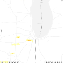
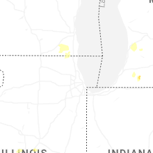


Connect with Interactive Hail Maps