

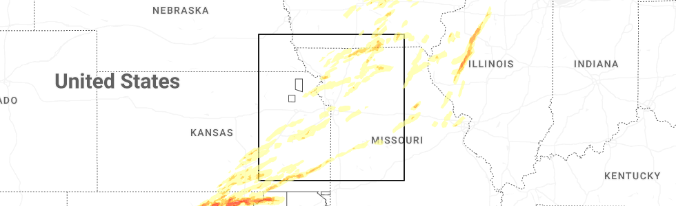
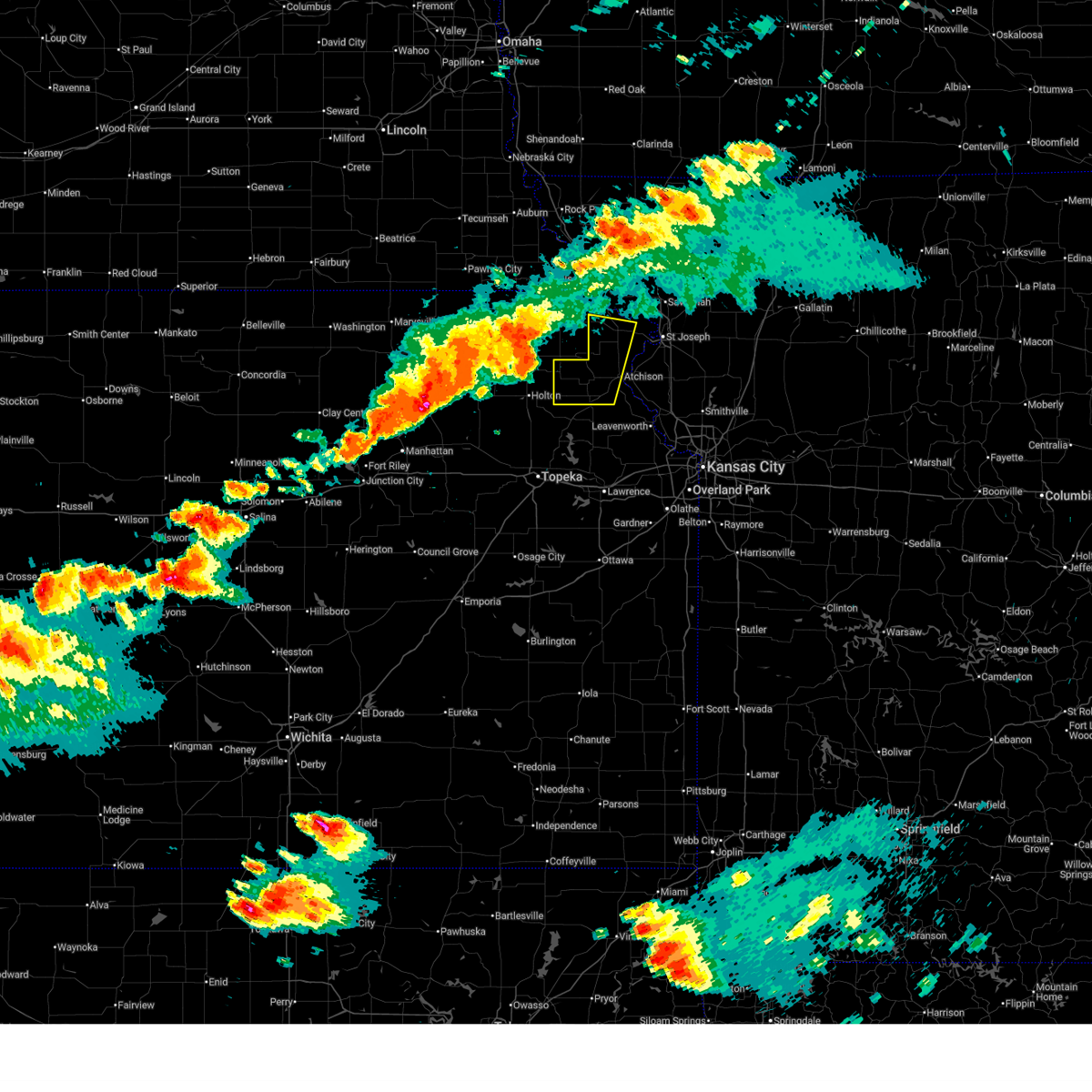
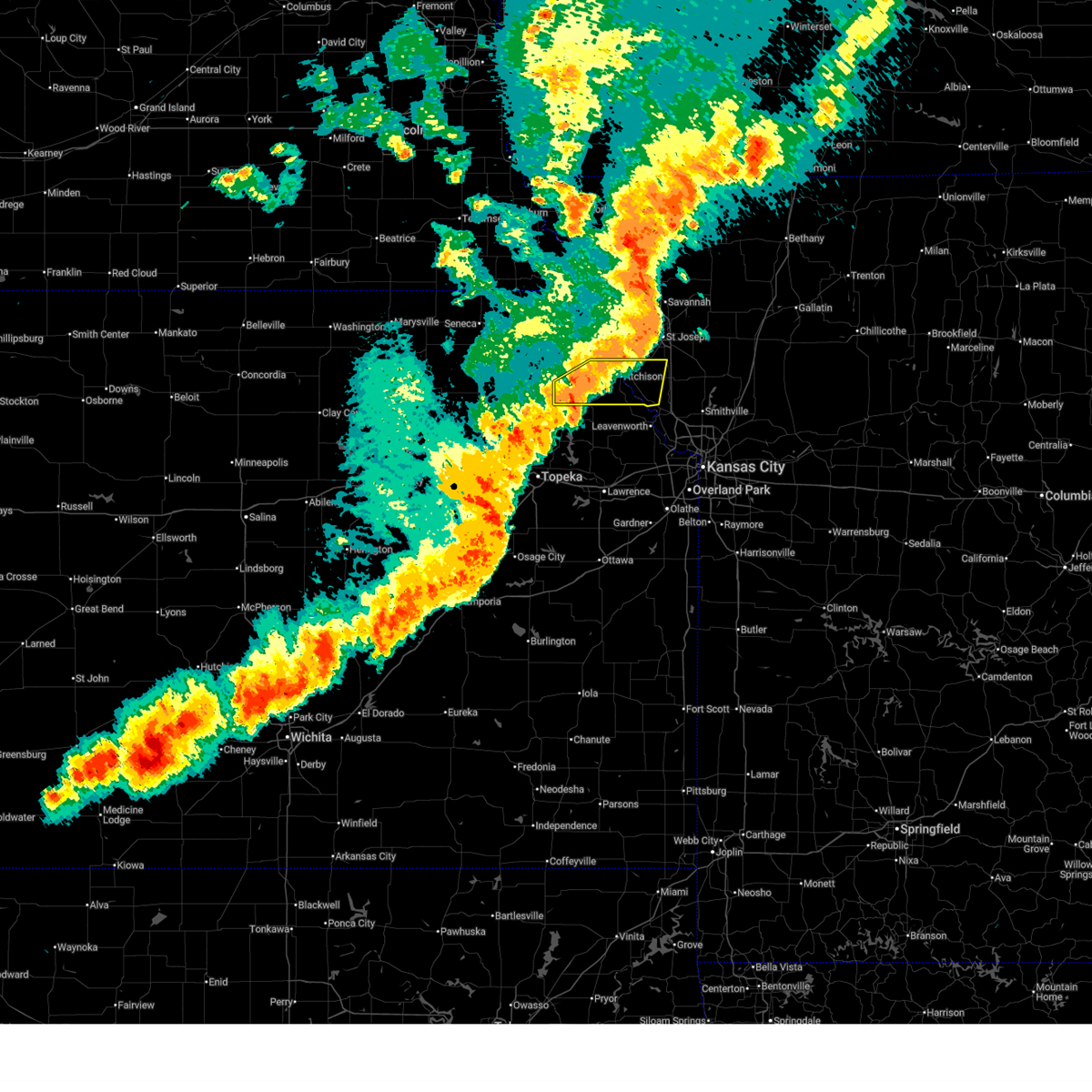
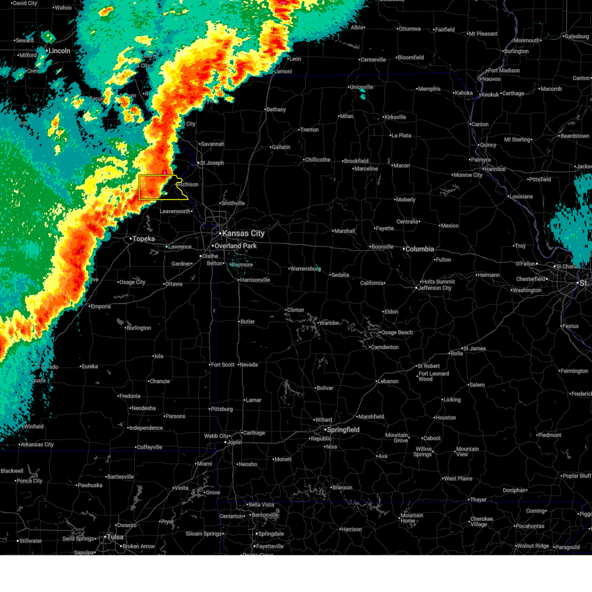
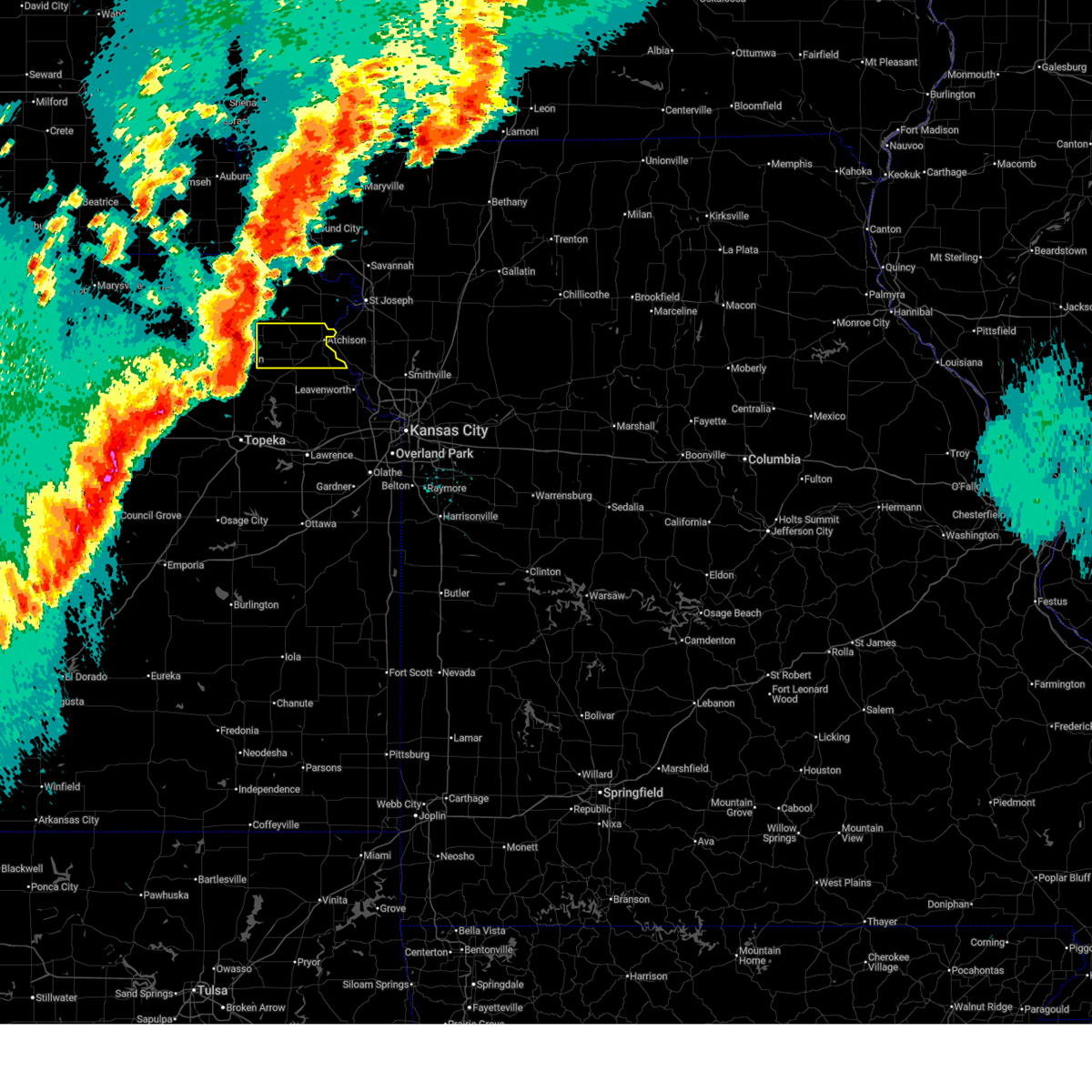
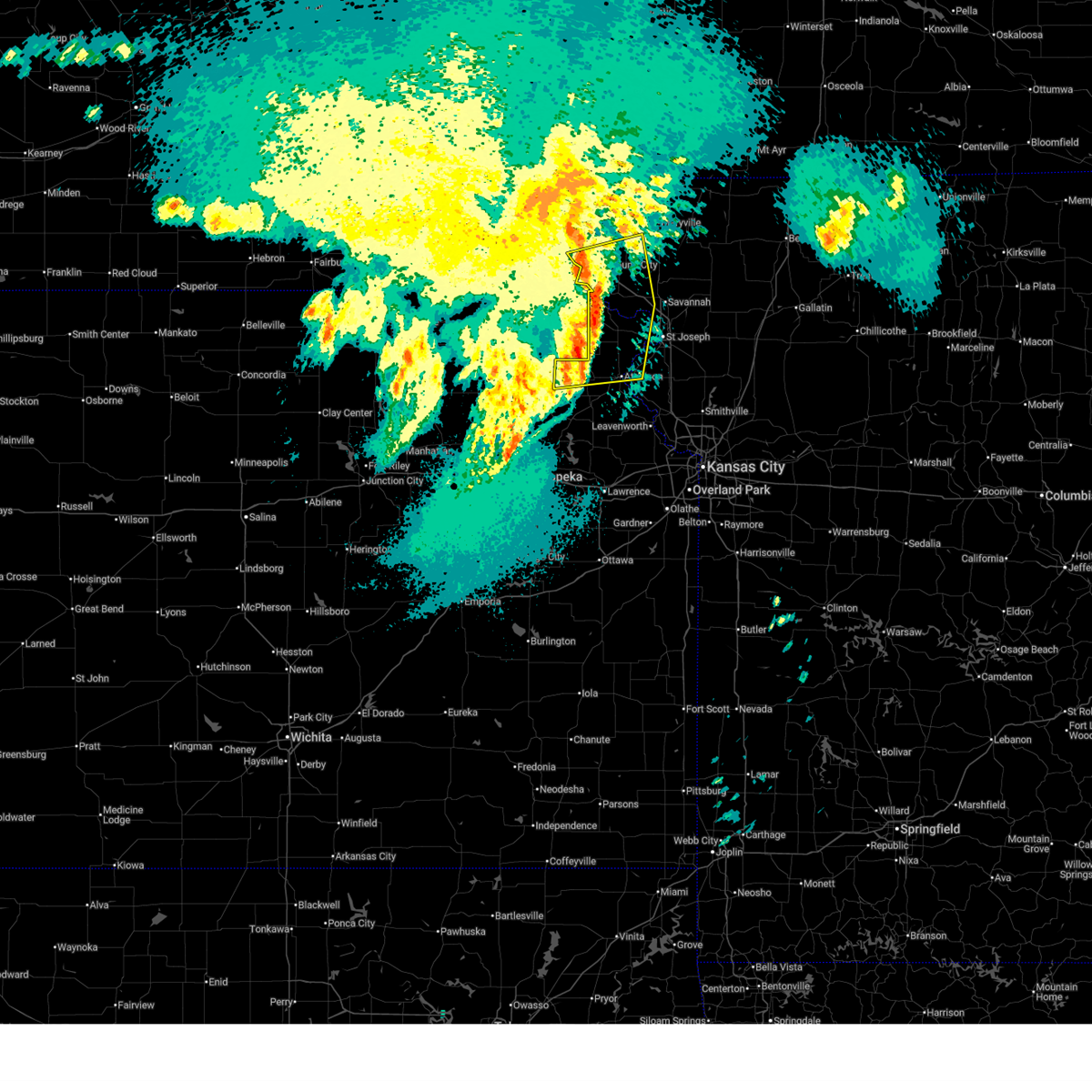
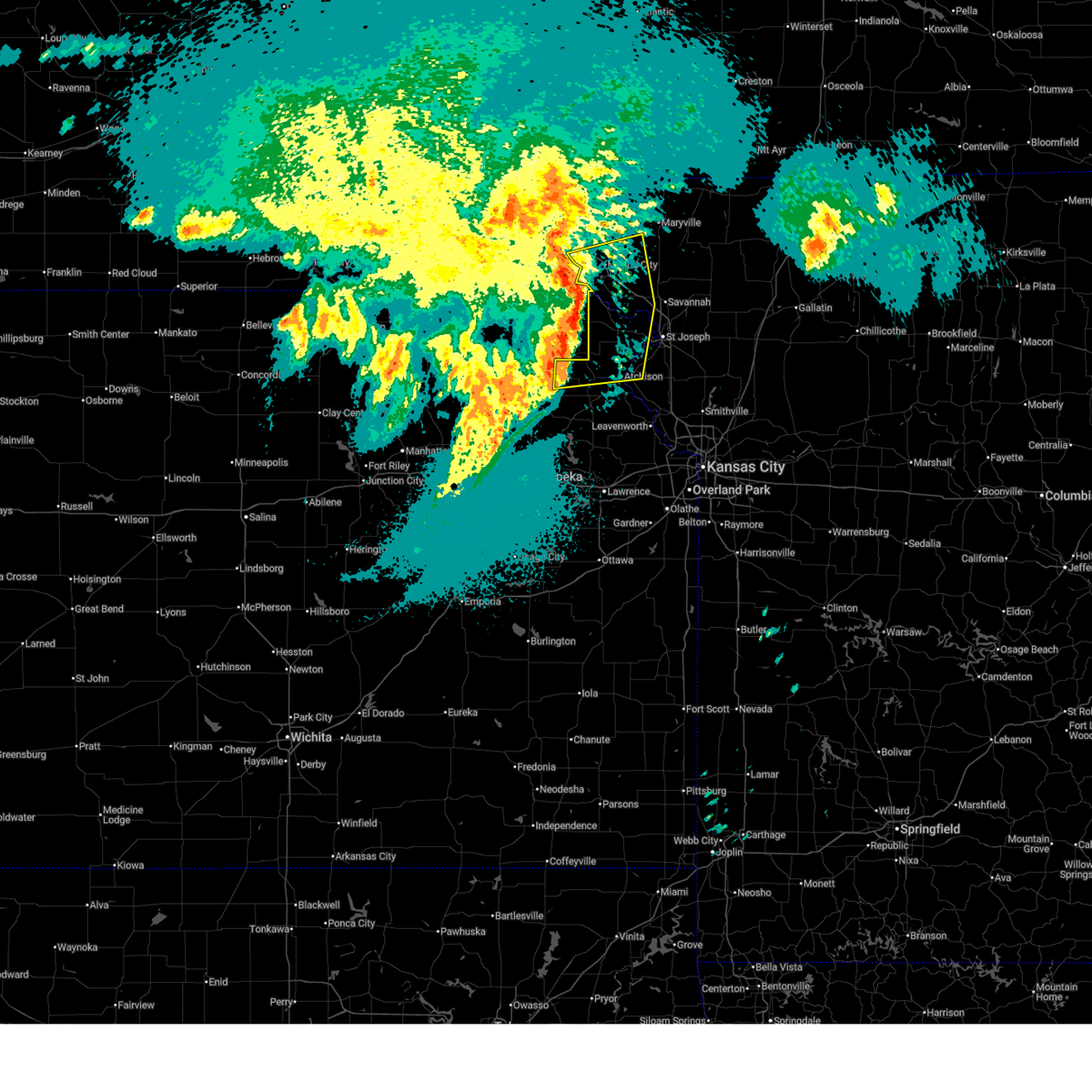
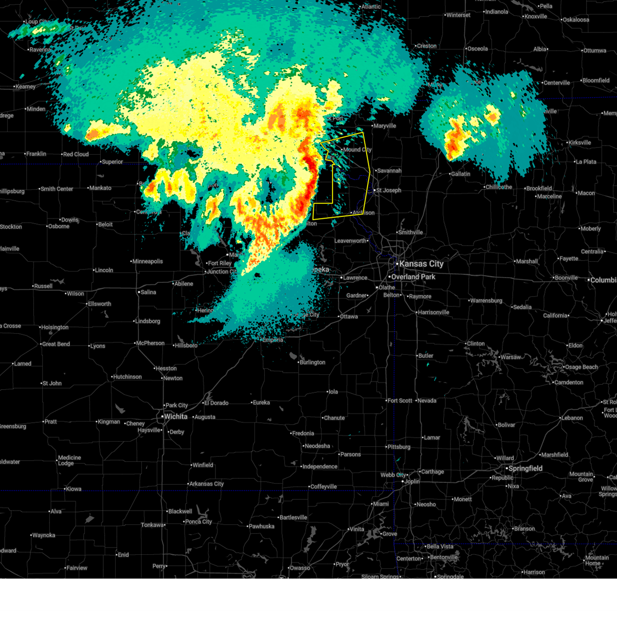
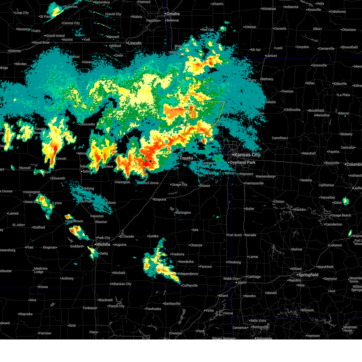
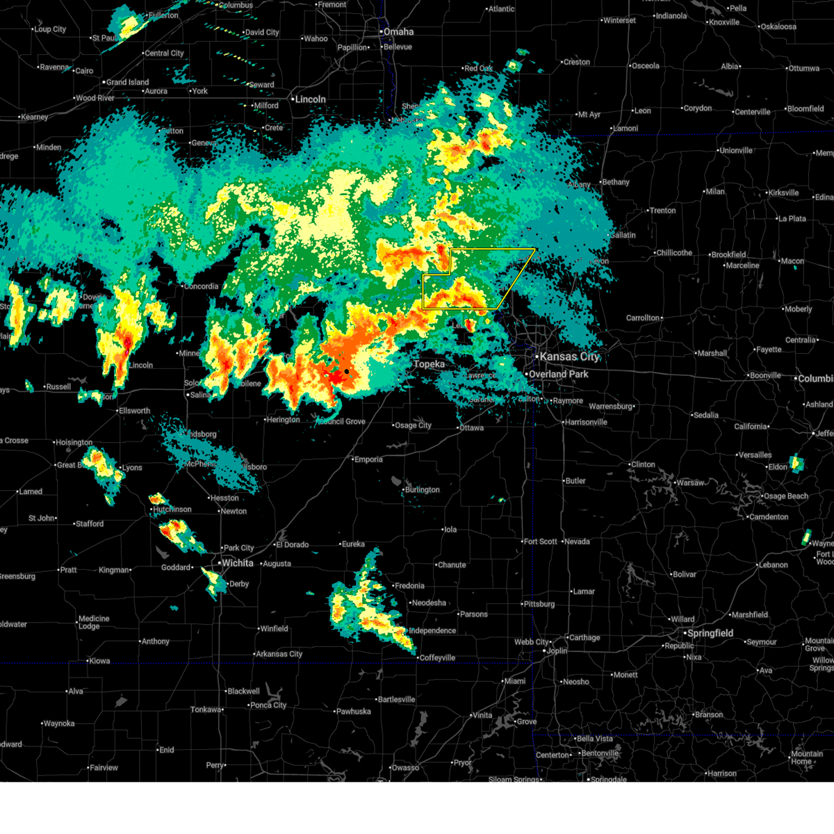
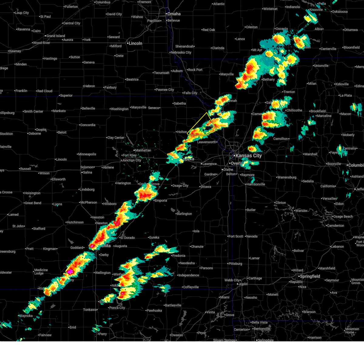
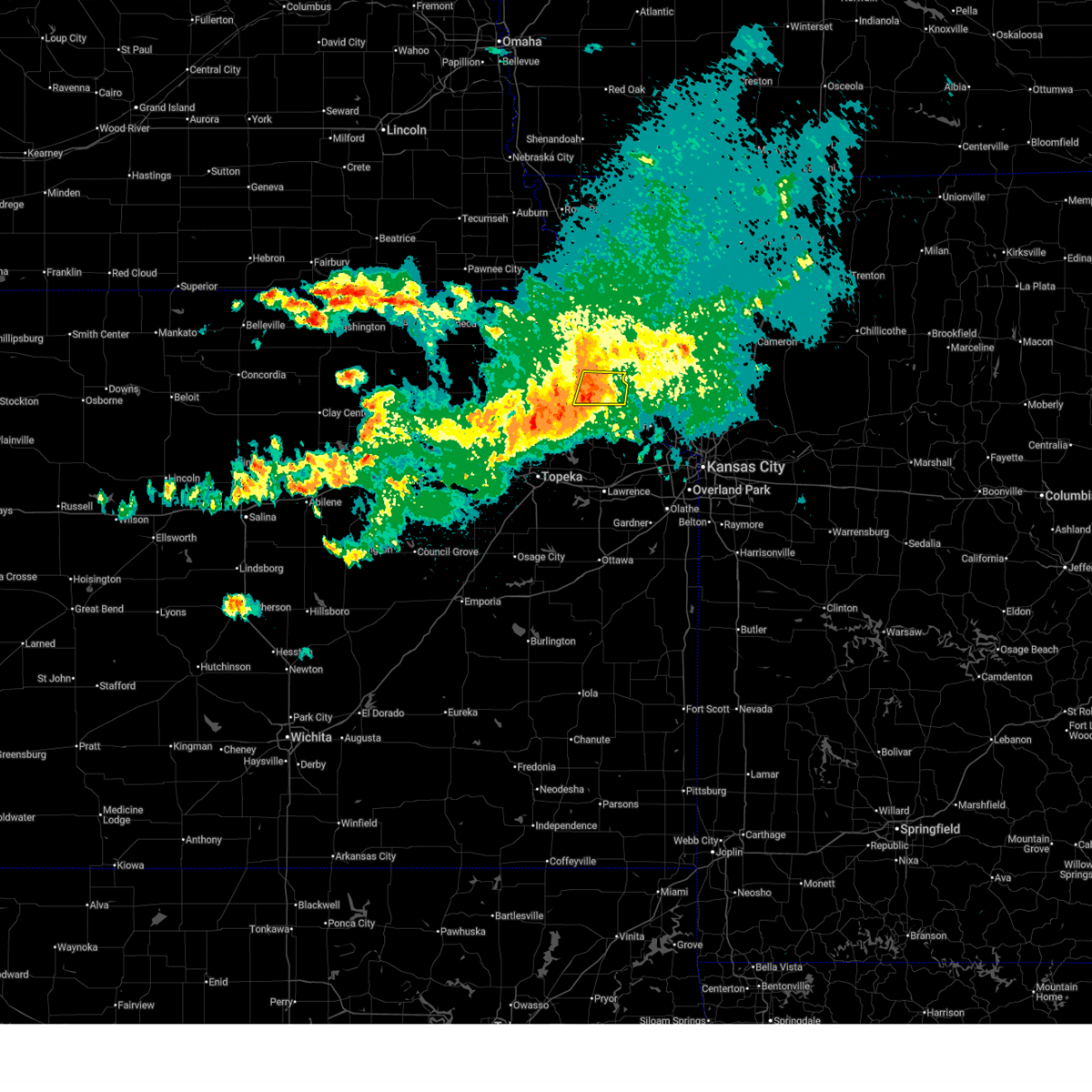
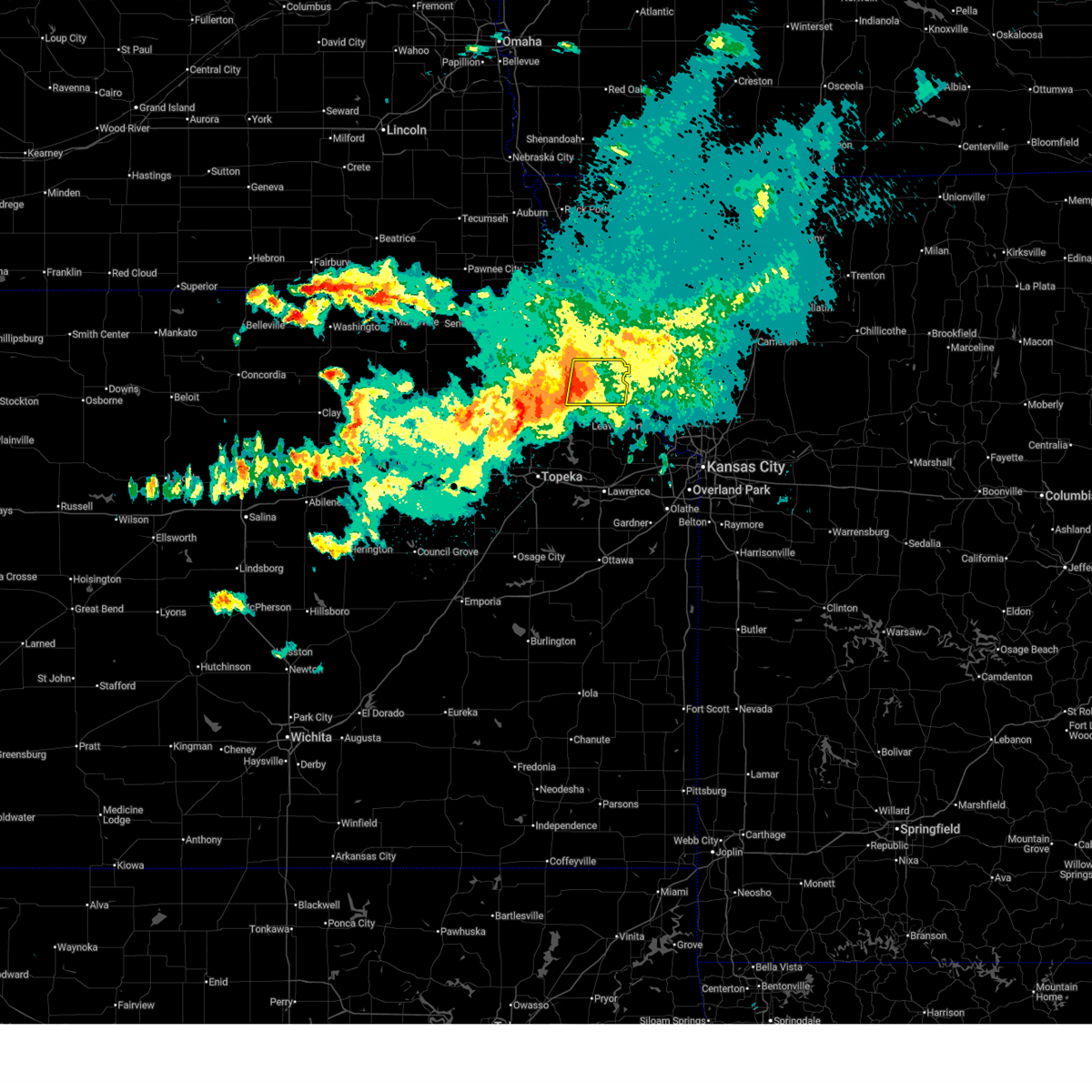
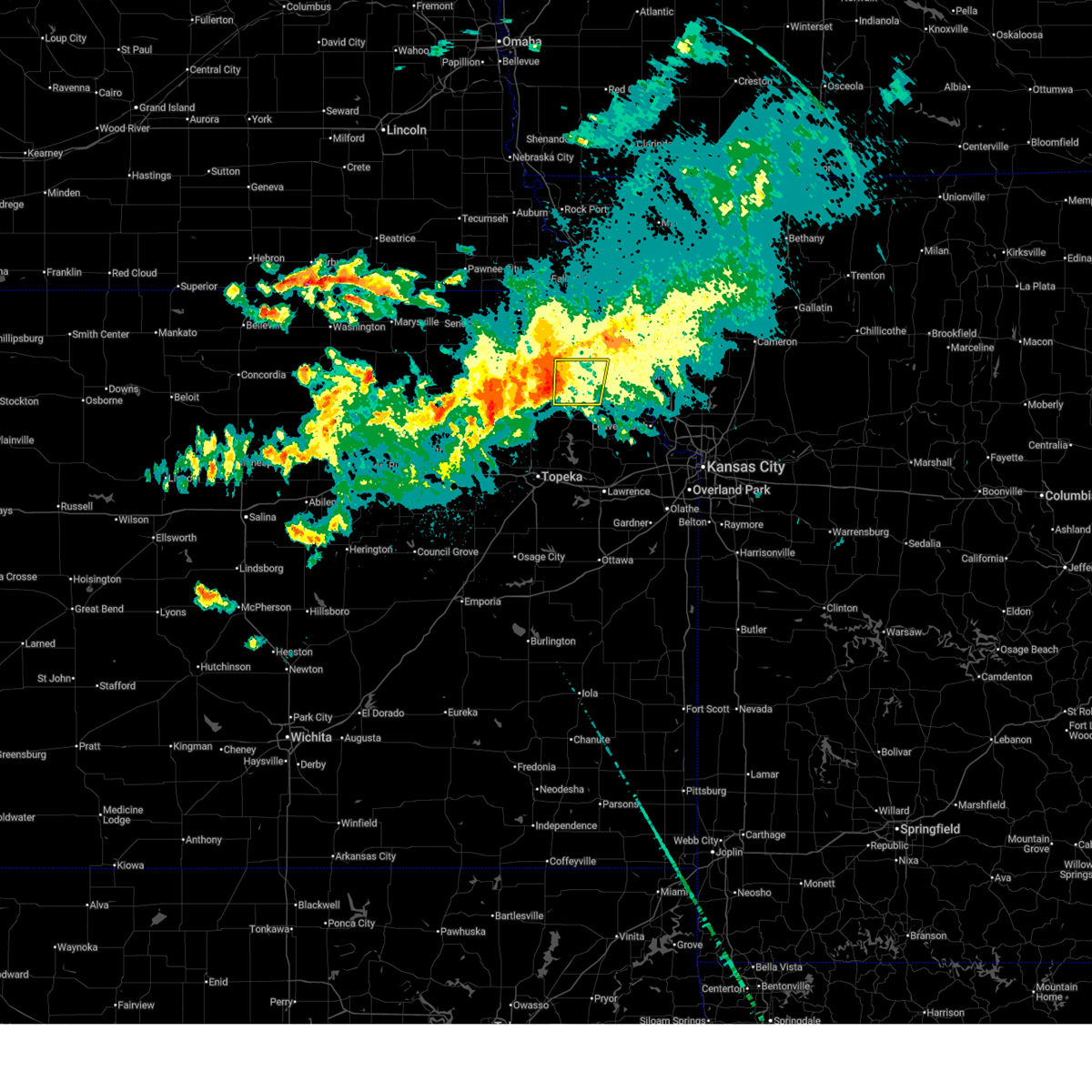
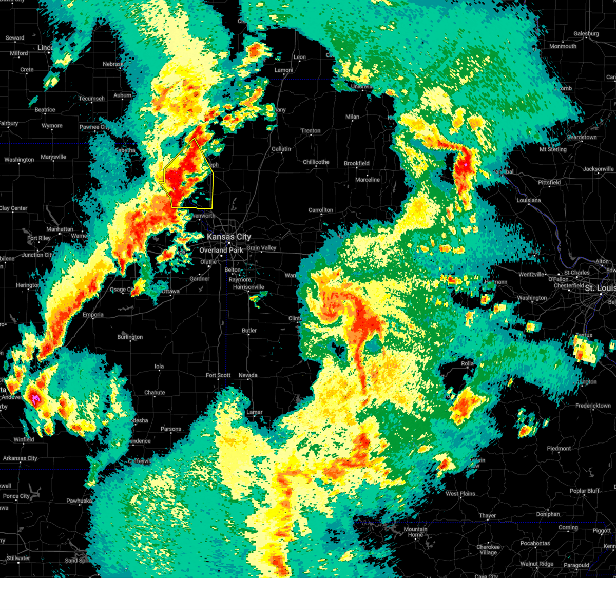
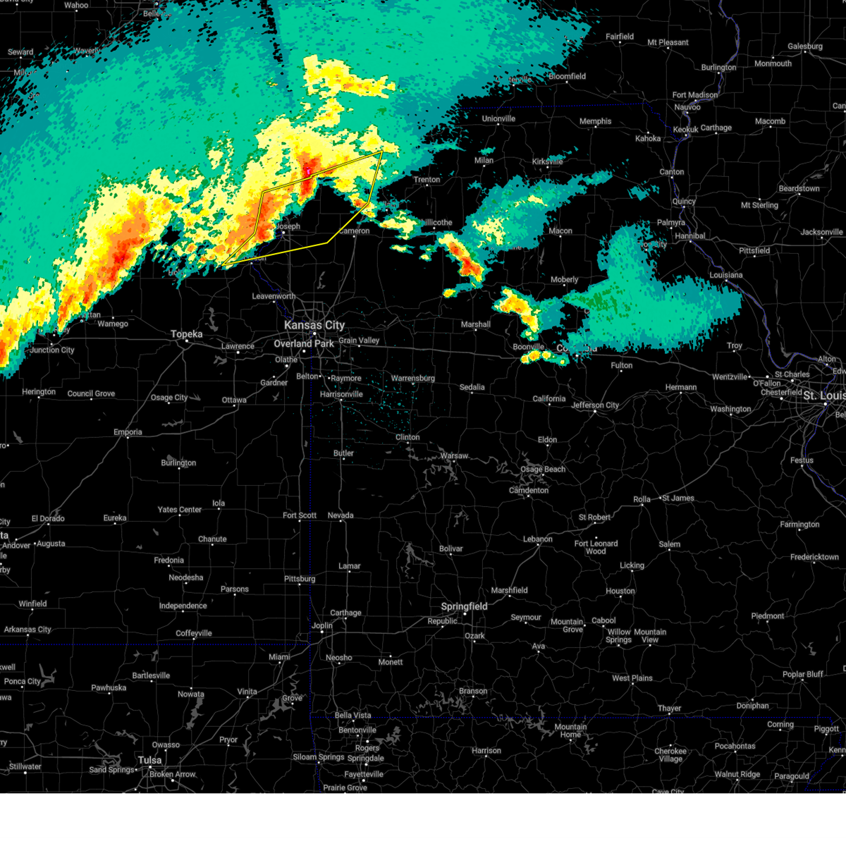
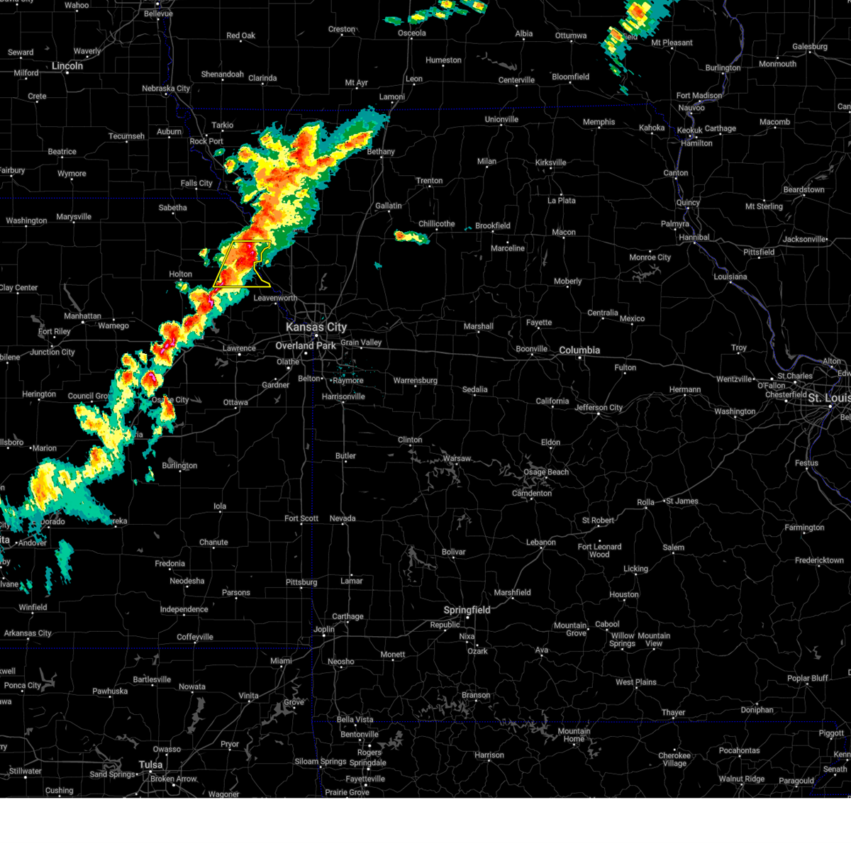
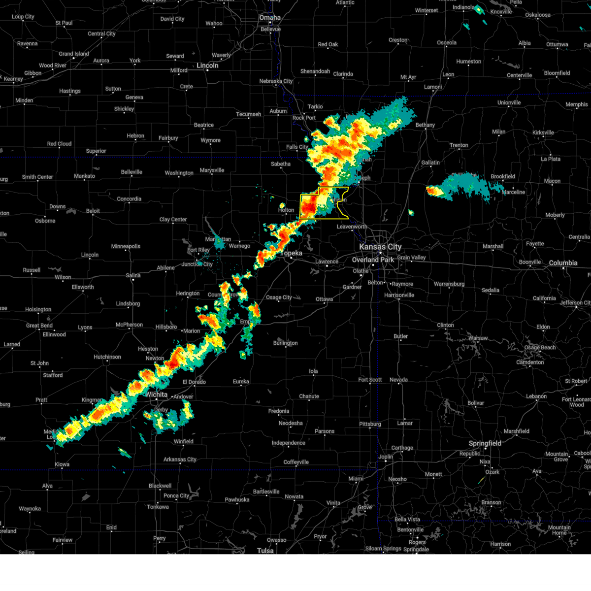
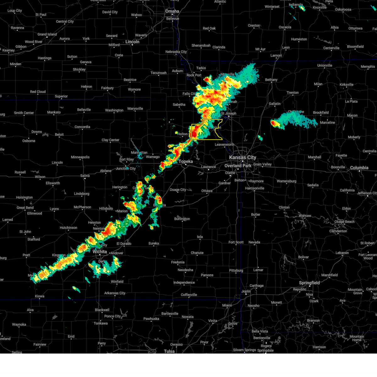
Hail Map for Lancaster, KS
The Lancaster, KS area has had 8 reports of on-the-ground hail by trained spotters, and has been under severe weather warnings 20 times during the past 12 months. Doppler radar has detected hail at or near Lancaster, KS on 78 occasions, including 1 occasion during the past year.
| Name: | Lancaster, KS |
| Where Located: | 50.4 miles NW of Kansas City, MO |
| Map: | Google Map for Lancaster, KS |
| Population: | 298 |
| Housing Units: | 117 |
| More Info: | Search Google for Lancaster, KS |
0
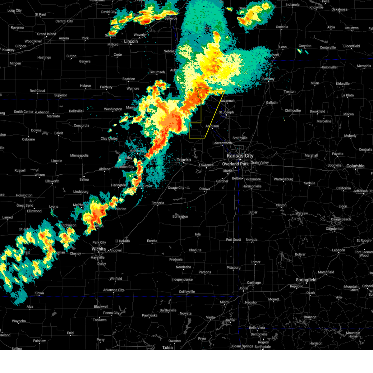
The Top Recent Hail Date for Lancaster, KS is Friday, April 17, 2026 (49th out of 78)
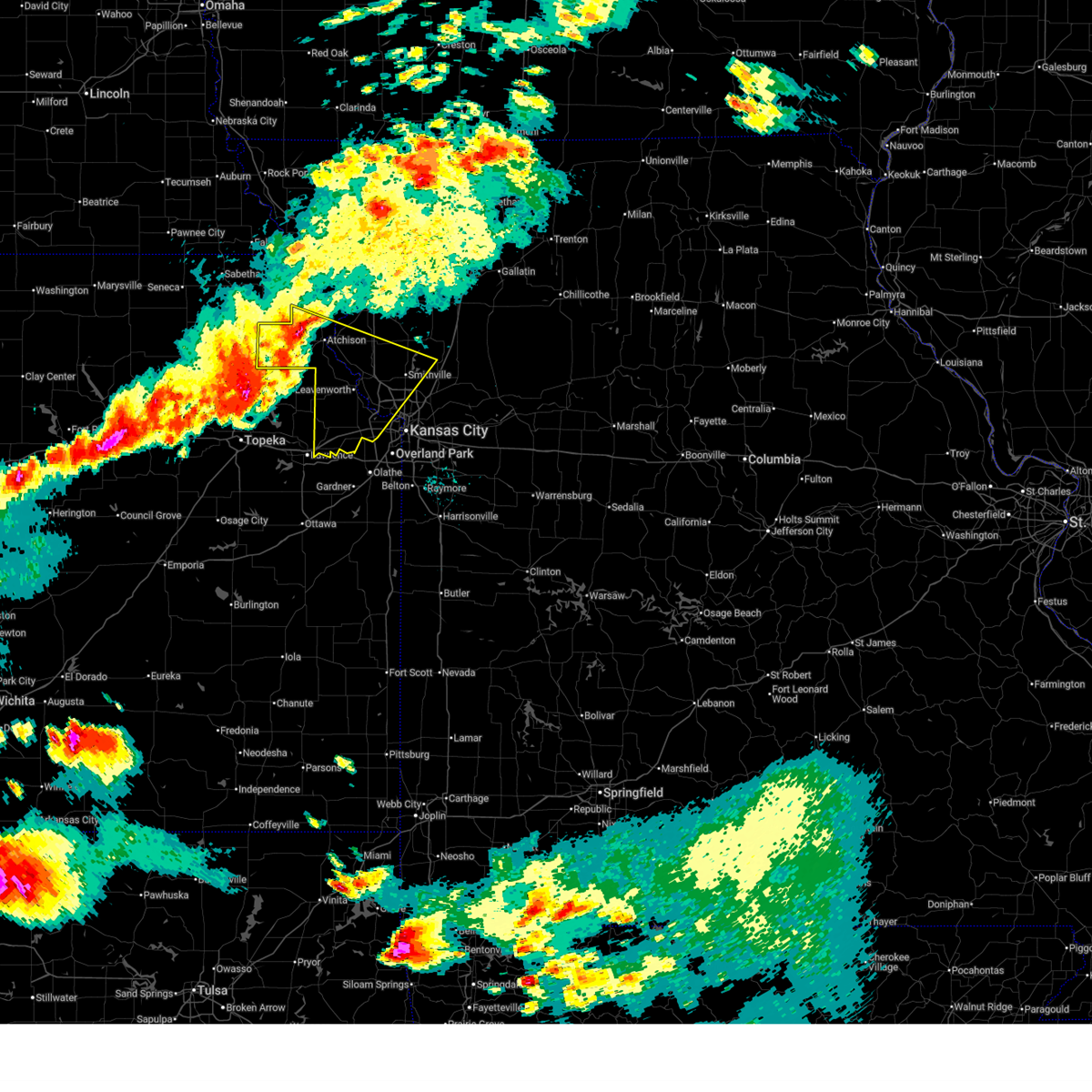
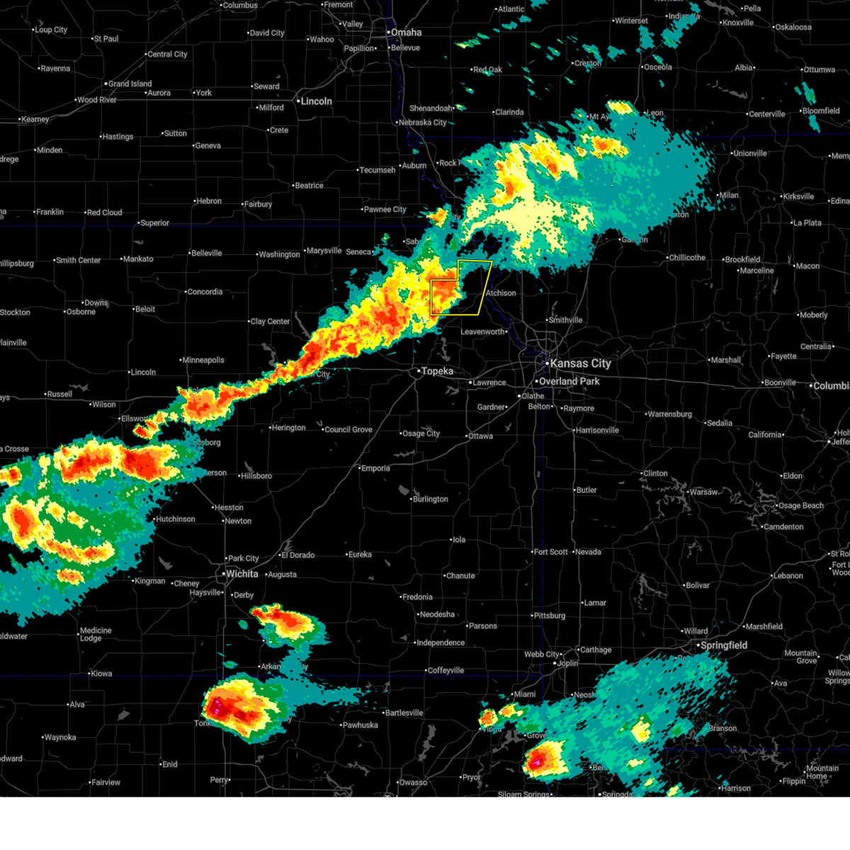
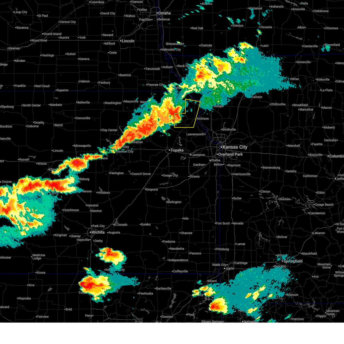
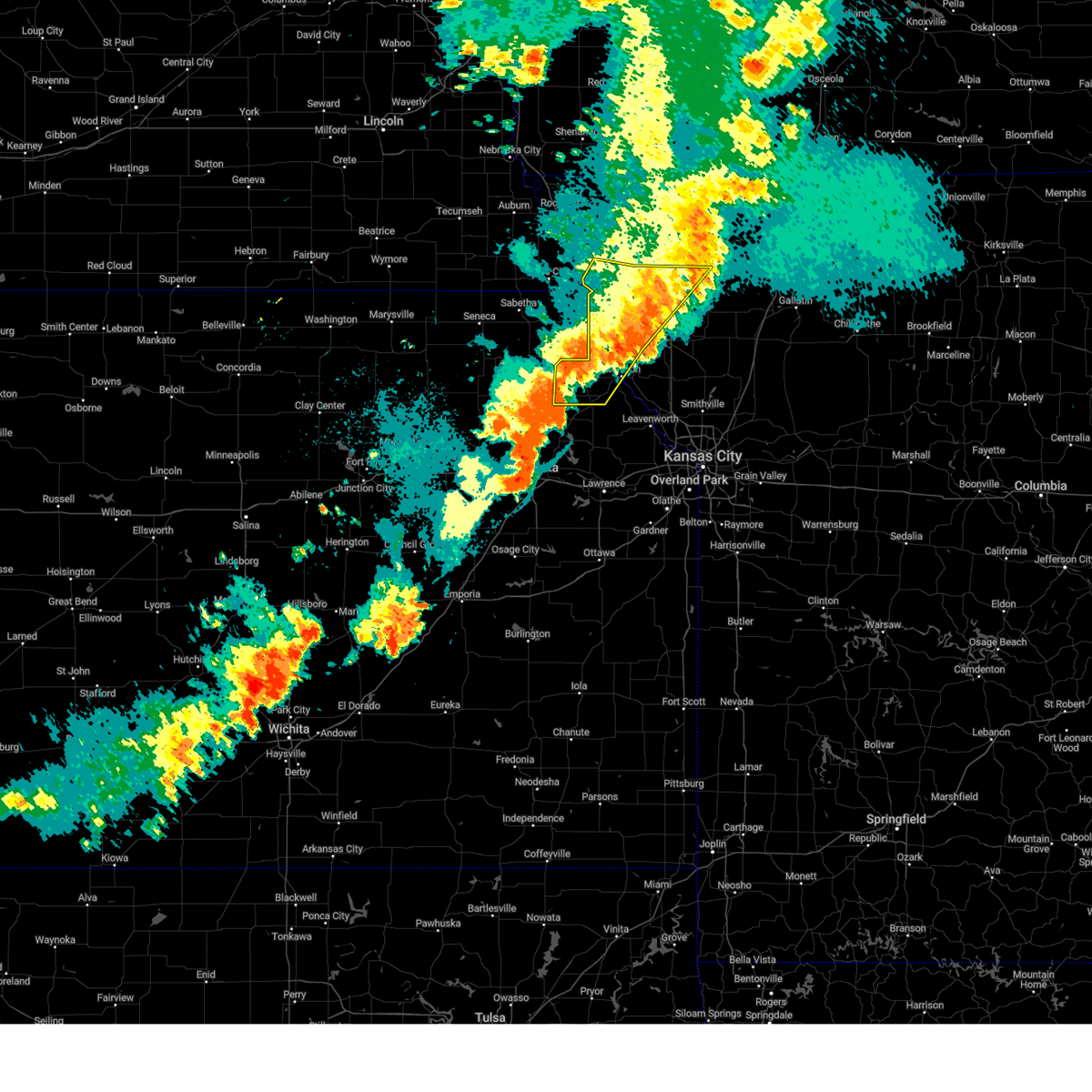
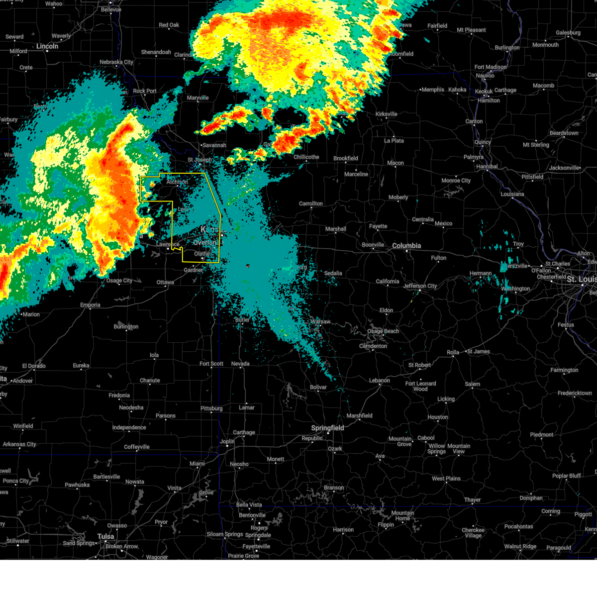
Hail and Wind Damage Spotted near Lancaster, KS
| Date / Time | Report Details |
|---|---|
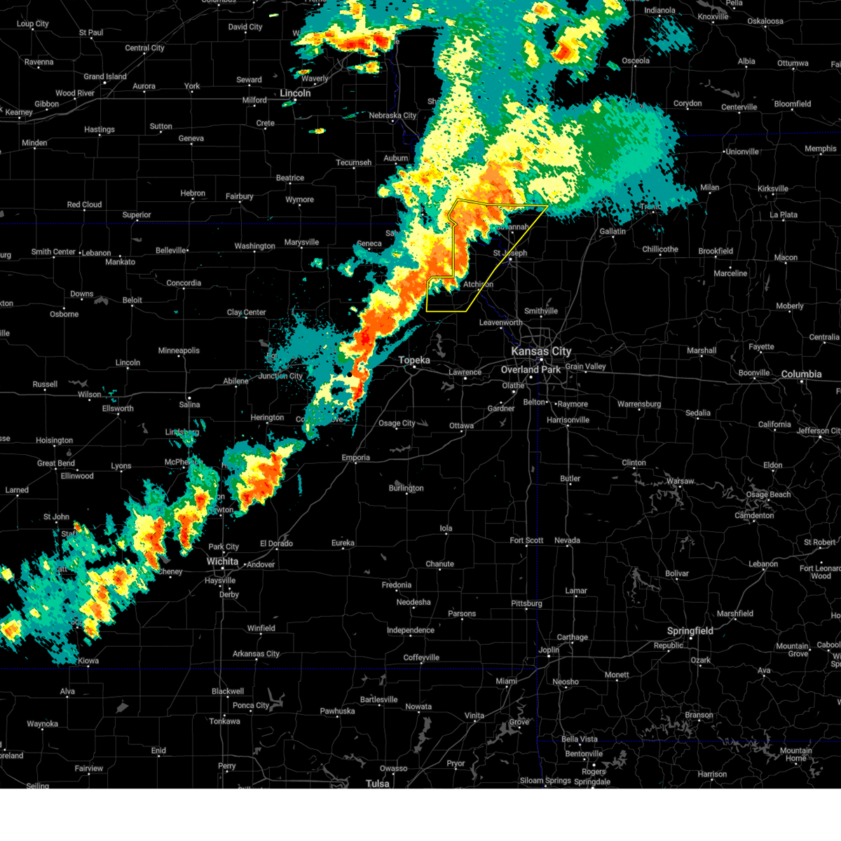
| 6/13/2026 7:36 PM CDT | Downed tree and wires on kingman road. time estimated from rada in atchison county KS, 2.3 miles SSW of Lancaster, KS |
| 6/13/2026 7:31 PM CDT |
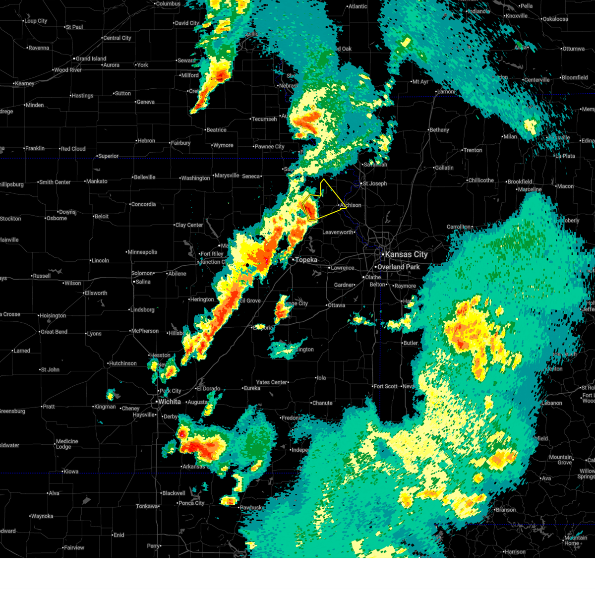
 Svreax the national weather service in pleasant hill has issued a * severe thunderstorm warning for, wyandotte county in northeastern kansas, southwestern doniphan county in northeastern kansas, leavenworth county in northeastern kansas, atchison county in northeastern kansas, southwestern buchanan county in northwestern missouri, southwestern clinton county in northwestern missouri, northwestern clay county in west central missouri, platte county in west central missouri, * until 830 pm cdt. * at 731 pm cdt, severe thunderstorms were located along a line extending from near atchison to near nortonville to near hoyt, moving southeast at 30 mph (radar indicated). Hazards include 70 mph wind gusts and quarter size hail. Hail damage to vehicles is expected. expect considerable tree damage. Wind damage is also likely to mobile homes, roofs, and outbuildings. Svreax the national weather service in pleasant hill has issued a * severe thunderstorm warning for, wyandotte county in northeastern kansas, southwestern doniphan county in northeastern kansas, leavenworth county in northeastern kansas, atchison county in northeastern kansas, southwestern buchanan county in northwestern missouri, southwestern clinton county in northwestern missouri, northwestern clay county in west central missouri, platte county in west central missouri, * until 830 pm cdt. * at 731 pm cdt, severe thunderstorms were located along a line extending from near atchison to near nortonville to near hoyt, moving southeast at 30 mph (radar indicated). Hazards include 70 mph wind gusts and quarter size hail. Hail damage to vehicles is expected. expect considerable tree damage. Wind damage is also likely to mobile homes, roofs, and outbuildings.
|
| 6/13/2026 7:29 PM CDT | Storm damage reported in atchison county KS, 0.2 miles NW of Lancaster, KS |
| 6/13/2026 7:27 PM CDT | Storm damage reported in atchison county KS, 0.2 miles NW of Lancaster, KS |
| 6/13/2026 7:20 PM CDT | Downed trees near 286th road and graham road.. time estimated from rada in atchison county KS, 3 miles E of Lancaster, KS |
| 6/13/2026 7:17 PM CDT |
 At 717 pm cdt, severe thunderstorms were located along a line extending from denton to near lancaster to near valley falls, moving east at 45 mph (radar indicated). Hazards include 70 mph wind gusts and quarter size hail. Hail damage to vehicles is expected. expect considerable tree damage. wind damage is also likely to mobile homes, roofs, and outbuildings. Locations impacted include, atchison, effingham, lancaster, muscotah, denton, severance, farmington, huron, cummings, arrington, and bendena. At 717 pm cdt, severe thunderstorms were located along a line extending from denton to near lancaster to near valley falls, moving east at 45 mph (radar indicated). Hazards include 70 mph wind gusts and quarter size hail. Hail damage to vehicles is expected. expect considerable tree damage. wind damage is also likely to mobile homes, roofs, and outbuildings. Locations impacted include, atchison, effingham, lancaster, muscotah, denton, severance, farmington, huron, cummings, arrington, and bendena.
|
| 6/13/2026 7:08 PM CDT |
 At 707 pm cdt, severe thunderstorms were located along a line extending from robinson to near effingham to near denison, moving southeast at 45 mph (radar indicated. additionally, a 67 mph wind gust was measured in holton, ks). Hazards include 70 mph wind gusts and quarter size hail. Hail damage to vehicles is expected. expect considerable tree damage. wind damage is also likely to mobile homes, roofs, and outbuildings. Locations impacted include, atchison, highland, troy, effingham, lancaster, muscotah, denton, severance, farmington, huron, leona, arrington, bendena, cummings, and fanning. At 707 pm cdt, severe thunderstorms were located along a line extending from robinson to near effingham to near denison, moving southeast at 45 mph (radar indicated. additionally, a 67 mph wind gust was measured in holton, ks). Hazards include 70 mph wind gusts and quarter size hail. Hail damage to vehicles is expected. expect considerable tree damage. wind damage is also likely to mobile homes, roofs, and outbuildings. Locations impacted include, atchison, highland, troy, effingham, lancaster, muscotah, denton, severance, farmington, huron, leona, arrington, bendena, cummings, and fanning.
|
| 6/13/2026 6:50 PM CDT |
 Svreax the national weather service in pleasant hill has issued a * severe thunderstorm warning for, southwestern doniphan county in northeastern kansas, atchison county in northeastern kansas, * until 730 pm cdt. * at 650 pm cdt, severe thunderstorms were located along a line extending from near hamlin to near netawaka to near circleville, moving southeast at 40 mph (radar indicated). Hazards include 60 mph wind gusts and quarter size hail. Hail damage to vehicles is expected. Expect wind damage to roofs, siding, and trees. Svreax the national weather service in pleasant hill has issued a * severe thunderstorm warning for, southwestern doniphan county in northeastern kansas, atchison county in northeastern kansas, * until 730 pm cdt. * at 650 pm cdt, severe thunderstorms were located along a line extending from near hamlin to near netawaka to near circleville, moving southeast at 40 mph (radar indicated). Hazards include 60 mph wind gusts and quarter size hail. Hail damage to vehicles is expected. Expect wind damage to roofs, siding, and trees.
|
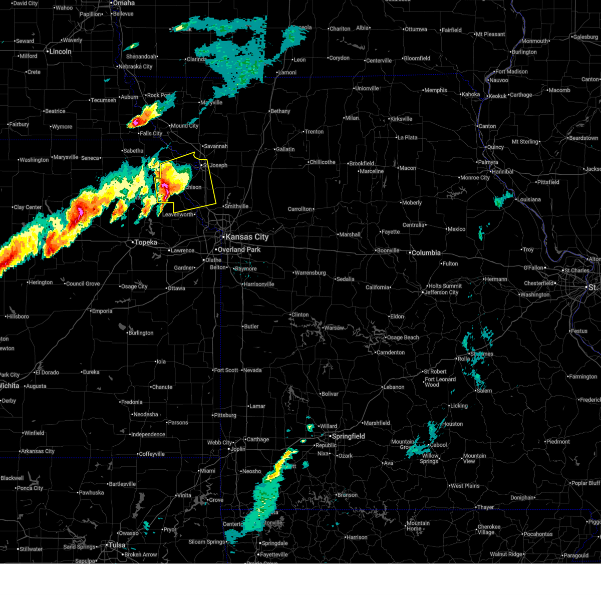
| 5/18/2026 8:15 PM CDT |
 Svreax the national weather service in pleasant hill has issued a * severe thunderstorm warning for, south central doniphan county in northeastern kansas, atchison county in northeastern kansas, southwestern buchanan county in northwestern missouri, northwestern platte county in west central missouri, * until 900 pm cdt. * at 815 pm cdt, a severe thunderstorm was located near nortonville, or 7 miles north of valley falls, moving east at 30 mph (radar indicated). Hazards include 60 mph wind gusts and quarter size hail. Hail damage to vehicles is expected. Expect wind damage to roofs, siding, and trees. Svreax the national weather service in pleasant hill has issued a * severe thunderstorm warning for, south central doniphan county in northeastern kansas, atchison county in northeastern kansas, southwestern buchanan county in northwestern missouri, northwestern platte county in west central missouri, * until 900 pm cdt. * at 815 pm cdt, a severe thunderstorm was located near nortonville, or 7 miles north of valley falls, moving east at 30 mph (radar indicated). Hazards include 60 mph wind gusts and quarter size hail. Hail damage to vehicles is expected. Expect wind damage to roofs, siding, and trees.
|
| 5/18/2026 7:55 PM CDT |
 At 755 pm cdt, a severe thunderstorm was located over lancaster, or near atchison, moving east at 45 mph (radar indicated). Hazards include 70 mph wind gusts and quarter size hail. Hail damage to vehicles is expected. expect considerable tree damage. wind damage is also likely to mobile homes, roofs, and outbuildings. Locations impacted include, atchison, effingham, lancaster, muscotah, farmington, huron, potter, cummings, and arrington. At 755 pm cdt, a severe thunderstorm was located over lancaster, or near atchison, moving east at 45 mph (radar indicated). Hazards include 70 mph wind gusts and quarter size hail. Hail damage to vehicles is expected. expect considerable tree damage. wind damage is also likely to mobile homes, roofs, and outbuildings. Locations impacted include, atchison, effingham, lancaster, muscotah, farmington, huron, potter, cummings, and arrington.
|
| 5/18/2026 7:30 PM CDT |
 Svreax the national weather service in pleasant hill has issued a * severe thunderstorm warning for, atchison county in northeastern kansas, * until 815 pm cdt. * at 729 pm cdt, a severe thunderstorm was located near holton, moving east at 60 mph (radar indicated). Hazards include 70 mph wind gusts and quarter size hail. Hail damage to vehicles is expected. expect considerable tree damage. Wind damage is also likely to mobile homes, roofs, and outbuildings. Svreax the national weather service in pleasant hill has issued a * severe thunderstorm warning for, atchison county in northeastern kansas, * until 815 pm cdt. * at 729 pm cdt, a severe thunderstorm was located near holton, moving east at 60 mph (radar indicated). Hazards include 70 mph wind gusts and quarter size hail. Hail damage to vehicles is expected. expect considerable tree damage. Wind damage is also likely to mobile homes, roofs, and outbuildings.
|
| 5/17/2026 1:52 AM CDT |
 At 151 am cdt, severe thunderstorms were located along a line extending from near craig to near highland to near lancaster, moving east at 45 mph (radar indicated). Hazards include 60 mph wind gusts and nickel size hail. Expect damage to roofs, siding, and trees. locations impacted include, atchison, wathena, mound city, highland, troy, oregon, effingham, maitland, rushville, lancaster, forest city, craig, fillmore, white cloud, muscotah, denton, doniphan, graham, big lake, and severance. This includes interstate 29 between mile markers 60 and 93. At 151 am cdt, severe thunderstorms were located along a line extending from near craig to near highland to near lancaster, moving east at 45 mph (radar indicated). Hazards include 60 mph wind gusts and nickel size hail. Expect damage to roofs, siding, and trees. locations impacted include, atchison, wathena, mound city, highland, troy, oregon, effingham, maitland, rushville, lancaster, forest city, craig, fillmore, white cloud, muscotah, denton, doniphan, graham, big lake, and severance. This includes interstate 29 between mile markers 60 and 93.
|
| 5/17/2026 1:39 AM CDT |
 At 138 am cdt, severe thunderstorms were located along a line extending from near fairfax to near white cloud to near effingham, moving east at 45 mph (automated weather station. a 61 mph wind gust was measured at falls city, nebraska). Hazards include 60 mph wind gusts and nickel size hail. Expect damage to roofs, siding, and trees. locations impacted include, atchison, wathena, mound city, highland, troy, oregon, effingham, maitland, rushville, lancaster, forest city, craig, fillmore, white cloud, muscotah, denton, doniphan, graham, big lake, and severance. This includes interstate 29 between mile markers 60 and 93. At 138 am cdt, severe thunderstorms were located along a line extending from near fairfax to near white cloud to near effingham, moving east at 45 mph (automated weather station. a 61 mph wind gust was measured at falls city, nebraska). Hazards include 60 mph wind gusts and nickel size hail. Expect damage to roofs, siding, and trees. locations impacted include, atchison, wathena, mound city, highland, troy, oregon, effingham, maitland, rushville, lancaster, forest city, craig, fillmore, white cloud, muscotah, denton, doniphan, graham, big lake, and severance. This includes interstate 29 between mile markers 60 and 93.
|
| 5/17/2026 1:25 AM CDT |
 Svreax the national weather service in pleasant hill has issued a * severe thunderstorm warning for, doniphan county in northeastern kansas, northern atchison county in northeastern kansas, western buchanan county in northwestern missouri, holt county in northwestern missouri, southwestern nodaway county in northwestern missouri, western andrew county in northwestern missouri, * until 215 am cdt. * at 125 am cdt, severe thunderstorms were located along a line extending from near shubert to near reserve to near whiting, moving east at 45 mph (radar indicated). Hazards include 60 mph wind gusts and nickel size hail. expect damage to roofs, siding, and trees Svreax the national weather service in pleasant hill has issued a * severe thunderstorm warning for, doniphan county in northeastern kansas, northern atchison county in northeastern kansas, western buchanan county in northwestern missouri, holt county in northwestern missouri, southwestern nodaway county in northwestern missouri, western andrew county in northwestern missouri, * until 215 am cdt. * at 125 am cdt, severe thunderstorms were located along a line extending from near shubert to near reserve to near whiting, moving east at 45 mph (radar indicated). Hazards include 60 mph wind gusts and nickel size hail. expect damage to roofs, siding, and trees
|
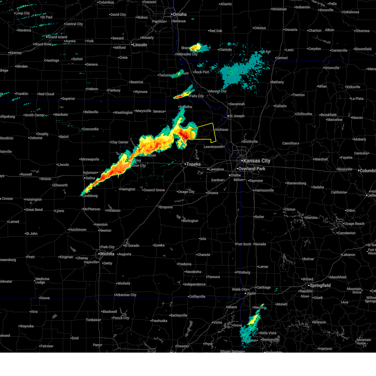
| 4/27/2026 2:49 AM CDT |
 At 249 am cdt, severe thunderstorms were located along a line extending from elwood to near nortonville, moving east at 45 mph (radar indicated). Hazards include 60 mph wind gusts and quarter size hail. Hail damage to vehicles is expected. expect wind damage to roofs, siding, and trees. locations impacted include, st. joseph, atchison, wathena, elwood, troy, country club villa, country club, effingham, amazonia, rushville, lancaster, denton, lewis and clark village, doniphan, de kalb, farmington, huron, st. joseph airport, bendena, and cummings. this includes the following highways, interstate 29 between mile markers 50 and 60. Interstate 229 between mile markers 3 and 14. At 249 am cdt, severe thunderstorms were located along a line extending from elwood to near nortonville, moving east at 45 mph (radar indicated). Hazards include 60 mph wind gusts and quarter size hail. Hail damage to vehicles is expected. expect wind damage to roofs, siding, and trees. locations impacted include, st. joseph, atchison, wathena, elwood, troy, country club villa, country club, effingham, amazonia, rushville, lancaster, denton, lewis and clark village, doniphan, de kalb, farmington, huron, st. joseph airport, bendena, and cummings. this includes the following highways, interstate 29 between mile markers 50 and 60. Interstate 229 between mile markers 3 and 14.
|
| 4/27/2026 2:29 AM CDT |
 Svreax the national weather service in pleasant hill has issued a * severe thunderstorm warning for, doniphan county in northeastern kansas, atchison county in northeastern kansas, western buchanan county in northwestern missouri, southeastern holt county in northwestern missouri, northwestern platte county in west central missouri, southwestern andrew county in northwestern missouri, * until 315 am cdt. * at 229 am cdt, severe thunderstorms were located along a line extending from near wathena to near effingham, moving northeast at 40 mph (radar indicated). Hazards include 60 mph wind gusts and quarter size hail. Hail damage to vehicles is expected. Expect wind damage to roofs, siding, and trees. Svreax the national weather service in pleasant hill has issued a * severe thunderstorm warning for, doniphan county in northeastern kansas, atchison county in northeastern kansas, western buchanan county in northwestern missouri, southeastern holt county in northwestern missouri, northwestern platte county in west central missouri, southwestern andrew county in northwestern missouri, * until 315 am cdt. * at 229 am cdt, severe thunderstorms were located along a line extending from near wathena to near effingham, moving northeast at 40 mph (radar indicated). Hazards include 60 mph wind gusts and quarter size hail. Hail damage to vehicles is expected. Expect wind damage to roofs, siding, and trees.
|
| 4/27/2026 2:15 AM CDT |
 At 215 am cdt, severe thunderstorms were located along a line extending from near lancaster to 7 miles east of rushville, moving northeast at 35 mph (radar indicated). Hazards include 60 mph wind gusts and quarter size hail. Hail damage to vehicles is expected. expect wind damage to roofs, siding, and trees. locations impacted include, st. joseph, atchison, wathena, elwood, troy, agency, effingham, rushville, lancaster, muscotah, denton, lewis and clark village, doniphan, de kalb, severance, farmington, huron, leona, iatan, and faucett. this includes the following highways, interstate 29 between mile markers 35 and 51. Interstate 229 between mile markers 0 and 9. At 215 am cdt, severe thunderstorms were located along a line extending from near lancaster to 7 miles east of rushville, moving northeast at 35 mph (radar indicated). Hazards include 60 mph wind gusts and quarter size hail. Hail damage to vehicles is expected. expect wind damage to roofs, siding, and trees. locations impacted include, st. joseph, atchison, wathena, elwood, troy, agency, effingham, rushville, lancaster, muscotah, denton, lewis and clark village, doniphan, de kalb, severance, farmington, huron, leona, iatan, and faucett. this includes the following highways, interstate 29 between mile markers 35 and 51. Interstate 229 between mile markers 0 and 9.
|
| 4/27/2026 2:05 AM CDT |
 At 205 am cdt, severe thunderstorms were located along a line extending from lancaster to near rushville, moving northeast at 50 mph (radar indicated). Hazards include 60 mph wind gusts and quarter size hail. Hail damage to vehicles is expected. expect wind damage to roofs, siding, and trees. locations impacted include, st. joseph, atchison, wathena, elwood, troy, agency, effingham, rushville, lancaster, muscotah, denton, lewis and clark village, doniphan, de kalb, severance, farmington, huron, leona, iatan, and faucett. this includes the following highways, interstate 29 between mile markers 35 and 51. Interstate 229 between mile markers 0 and 9. At 205 am cdt, severe thunderstorms were located along a line extending from lancaster to near rushville, moving northeast at 50 mph (radar indicated). Hazards include 60 mph wind gusts and quarter size hail. Hail damage to vehicles is expected. expect wind damage to roofs, siding, and trees. locations impacted include, st. joseph, atchison, wathena, elwood, troy, agency, effingham, rushville, lancaster, muscotah, denton, lewis and clark village, doniphan, de kalb, severance, farmington, huron, leona, iatan, and faucett. this includes the following highways, interstate 29 between mile markers 35 and 51. Interstate 229 between mile markers 0 and 9.
|
| 4/27/2026 1:51 AM CDT |
 Svreax the national weather service in pleasant hill has issued a * severe thunderstorm warning for, doniphan county in northeastern kansas, atchison county in northeastern kansas, buchanan county in northwestern missouri, northwestern platte county in west central missouri, * until 230 am cdt. * at 151 am cdt, severe thunderstorms were located along a line extending from near effingham to near atchison, moving northeast at 35 mph (radar indicated). Hazards include 60 mph wind gusts and quarter size hail. Hail damage to vehicles is expected. Expect wind damage to roofs, siding, and trees. Svreax the national weather service in pleasant hill has issued a * severe thunderstorm warning for, doniphan county in northeastern kansas, atchison county in northeastern kansas, buchanan county in northwestern missouri, northwestern platte county in west central missouri, * until 230 am cdt. * at 151 am cdt, severe thunderstorms were located along a line extending from near effingham to near atchison, moving northeast at 35 mph (radar indicated). Hazards include 60 mph wind gusts and quarter size hail. Hail damage to vehicles is expected. Expect wind damage to roofs, siding, and trees.
|
| 4/17/2026 2:38 PM CDT |
 Svreax the national weather service in pleasant hill has issued a * severe thunderstorm warning for, south central doniphan county in northeastern kansas, atchison county in northeastern kansas, southwestern buchanan county in northwestern missouri, northwestern platte county in west central missouri, * until 315 pm cdt. * at 237 pm cdt, a severe thunderstorm was located near nortonville, or near valley falls, moving northeast at 45 mph (radar indicated). Hazards include 60 mph wind gusts and quarter size hail. Hail damage to vehicles is expected. Expect wind damage to roofs, siding, and trees. Svreax the national weather service in pleasant hill has issued a * severe thunderstorm warning for, south central doniphan county in northeastern kansas, atchison county in northeastern kansas, southwestern buchanan county in northwestern missouri, northwestern platte county in west central missouri, * until 315 pm cdt. * at 237 pm cdt, a severe thunderstorm was located near nortonville, or near valley falls, moving northeast at 45 mph (radar indicated). Hazards include 60 mph wind gusts and quarter size hail. Hail damage to vehicles is expected. Expect wind damage to roofs, siding, and trees.
|
| 4/9/2026 10:10 PM CDT |
 At 1010 pm cdt, a severe thunderstorm was located near lancaster, or near atchison, moving east at 30 mph (radar indicated). Hazards include 60 mph wind gusts. Expect damage to roofs, siding, and trees. Locations impacted include, atchison, effingham, lancaster, farmington, potter, and cummings. At 1010 pm cdt, a severe thunderstorm was located near lancaster, or near atchison, moving east at 30 mph (radar indicated). Hazards include 60 mph wind gusts. Expect damage to roofs, siding, and trees. Locations impacted include, atchison, effingham, lancaster, farmington, potter, and cummings.
|
| 4/9/2026 9:58 PM CDT |
 Svreax the national weather service in pleasant hill has issued a * severe thunderstorm warning for, atchison county in northeastern kansas, * until 1030 pm cdt. * at 957 pm cdt, a severe thunderstorm was located over effingham, or 11 miles west of atchison, moving east at 35 mph (radar indicated). Hazards include 60 mph wind gusts. expect damage to roofs, siding, and trees Svreax the national weather service in pleasant hill has issued a * severe thunderstorm warning for, atchison county in northeastern kansas, * until 1030 pm cdt. * at 957 pm cdt, a severe thunderstorm was located over effingham, or 11 miles west of atchison, moving east at 35 mph (radar indicated). Hazards include 60 mph wind gusts. expect damage to roofs, siding, and trees
|
| 4/9/2026 9:45 PM CDT |
 At 944 pm cdt, a severe thunderstorm was located over effingham, or 9 miles southeast of horton, moving east at 40 mph (radar indicated). Hazards include 60 mph wind gusts and quarter size hail. Hail damage to vehicles is expected. expect wind damage to roofs, siding, and trees. Locations impacted include, atchison, effingham, lancaster, muscotah, farmington, huron, and arrington. At 944 pm cdt, a severe thunderstorm was located over effingham, or 9 miles southeast of horton, moving east at 40 mph (radar indicated). Hazards include 60 mph wind gusts and quarter size hail. Hail damage to vehicles is expected. expect wind damage to roofs, siding, and trees. Locations impacted include, atchison, effingham, lancaster, muscotah, farmington, huron, and arrington.
|
| 4/9/2026 9:22 PM CDT |
 Svreax the national weather service in pleasant hill has issued a * severe thunderstorm warning for, atchison county in northeastern kansas, * until 1000 pm cdt. * at 921 pm cdt, a severe thunderstorm was located over netawaka, or 8 miles north of holton, moving east at 40 mph (radar indicated). Hazards include 60 mph wind gusts and quarter size hail. Hail damage to vehicles is expected. Expect wind damage to roofs, siding, and trees. Svreax the national weather service in pleasant hill has issued a * severe thunderstorm warning for, atchison county in northeastern kansas, * until 1000 pm cdt. * at 921 pm cdt, a severe thunderstorm was located over netawaka, or 8 miles north of holton, moving east at 40 mph (radar indicated). Hazards include 60 mph wind gusts and quarter size hail. Hail damage to vehicles is expected. Expect wind damage to roofs, siding, and trees.
|
| 5/19/2025 7:49 PM CDT |
 Svreax the national weather service in pleasant hill has issued a * severe thunderstorm warning for, doniphan county in northeastern kansas, eastern atchison county in northeastern kansas, central buchanan county in northwestern missouri, southeastern holt county in northwestern missouri, northwestern platte county in west central missouri, southwestern andrew county in northwestern missouri, * until 830 pm cdt. * at 749 pm cdt, severe thunderstorms were located along a line extending from near denton to near atchison to 7 miles northwest of easton, moving northeast at 30 mph (radar indicated). Hazards include 60 mph wind gusts and penny size hail. expect damage to roofs, siding, and trees Svreax the national weather service in pleasant hill has issued a * severe thunderstorm warning for, doniphan county in northeastern kansas, eastern atchison county in northeastern kansas, central buchanan county in northwestern missouri, southeastern holt county in northwestern missouri, northwestern platte county in west central missouri, southwestern andrew county in northwestern missouri, * until 830 pm cdt. * at 749 pm cdt, severe thunderstorms were located along a line extending from near denton to near atchison to 7 miles northwest of easton, moving northeast at 30 mph (radar indicated). Hazards include 60 mph wind gusts and penny size hail. expect damage to roofs, siding, and trees
|
| 5/19/2025 7:35 PM CDT |
 At 735 pm cdt, a severe thunderstorm was located over lancaster, or 10 miles east of horton, moving northeast at 35 mph (radar indicated). Hazards include 60 mph wind gusts and penny size hail. Expect damage to roofs, siding, and trees. Locations impacted include, atchison, effingham, lancaster, denton, lewis and clark village, severance, farmington, huron, and lewis and clark vi. At 735 pm cdt, a severe thunderstorm was located over lancaster, or 10 miles east of horton, moving northeast at 35 mph (radar indicated). Hazards include 60 mph wind gusts and penny size hail. Expect damage to roofs, siding, and trees. Locations impacted include, atchison, effingham, lancaster, denton, lewis and clark village, severance, farmington, huron, and lewis and clark vi.
|
| 5/19/2025 7:24 PM CDT |
 Svreax the national weather service in pleasant hill has issued a * severe thunderstorm warning for, southwestern doniphan county in northeastern kansas, atchison county in northeastern kansas, southwestern buchanan county in northwestern missouri, * until 800 pm cdt. * at 723 pm cdt, a severe thunderstorm was located over effingham, or 9 miles southeast of horton, moving northeast at 35 mph (radar indicated). Hazards include 60 mph wind gusts and penny size hail. expect damage to roofs, siding, and trees Svreax the national weather service in pleasant hill has issued a * severe thunderstorm warning for, southwestern doniphan county in northeastern kansas, atchison county in northeastern kansas, southwestern buchanan county in northwestern missouri, * until 800 pm cdt. * at 723 pm cdt, a severe thunderstorm was located over effingham, or 9 miles southeast of horton, moving northeast at 35 mph (radar indicated). Hazards include 60 mph wind gusts and penny size hail. expect damage to roofs, siding, and trees
|
| 4/28/2025 7:42 PM CDT |
 Svreax the national weather service in pleasant hill has issued a * severe thunderstorm warning for, doniphan county in northeastern kansas, northwestern leavenworth county in northeastern kansas, atchison county in northeastern kansas, buchanan county in northwestern missouri, northern platte county in west central missouri, * until 815 pm cdt. * at 742 pm cdt, a severe thunderstorm was located near atchison, moving east at 55 mph (radar indicated). Hazards include two inch hail and 70 mph wind gusts. People and animals outdoors will be injured. expect hail damage to roofs, siding, windows, and vehicles. expect considerable tree damage. Wind damage is also likely to mobile homes, roofs, and outbuildings. Svreax the national weather service in pleasant hill has issued a * severe thunderstorm warning for, doniphan county in northeastern kansas, northwestern leavenworth county in northeastern kansas, atchison county in northeastern kansas, buchanan county in northwestern missouri, northern platte county in west central missouri, * until 815 pm cdt. * at 742 pm cdt, a severe thunderstorm was located near atchison, moving east at 55 mph (radar indicated). Hazards include two inch hail and 70 mph wind gusts. People and animals outdoors will be injured. expect hail damage to roofs, siding, windows, and vehicles. expect considerable tree damage. Wind damage is also likely to mobile homes, roofs, and outbuildings.
|
| 4/28/2025 7:41 PM CDT | Reported via private weather sensor. time confirmed from rada in atchison county KS, 0.2 miles NW of Lancaster, KS |
| 4/28/2025 7:13 PM CDT |
 Svreax the national weather service in pleasant hill has issued a * severe thunderstorm warning for, northwestern leavenworth county in northeastern kansas, atchison county in northeastern kansas, * until 745 pm cdt. * at 713 pm cdt, a severe thunderstorm was located over denison, or near holton, moving east at 55 mph (radar indicated). Hazards include two inch hail and 70 mph wind gusts. People and animals outdoors will be injured. expect hail damage to roofs, siding, windows, and vehicles. expect considerable tree damage. Wind damage is also likely to mobile homes, roofs, and outbuildings. Svreax the national weather service in pleasant hill has issued a * severe thunderstorm warning for, northwestern leavenworth county in northeastern kansas, atchison county in northeastern kansas, * until 745 pm cdt. * at 713 pm cdt, a severe thunderstorm was located over denison, or near holton, moving east at 55 mph (radar indicated). Hazards include two inch hail and 70 mph wind gusts. People and animals outdoors will be injured. expect hail damage to roofs, siding, windows, and vehicles. expect considerable tree damage. Wind damage is also likely to mobile homes, roofs, and outbuildings.
|
| 4/2/2025 3:18 AM CDT |
 Svreax the national weather service in pleasant hill has issued a * severe thunderstorm warning for, southwestern doniphan county in northeastern kansas, leavenworth county in northeastern kansas, atchison county in northeastern kansas, buchanan county in northwestern missouri, northern platte county in west central missouri, * until 345 am cdt. * at 317 am cdt, severe thunderstorms were located along a line extending from lewis and clark village to easton to carbondale, moving east at 60 mph (radar indicated). Hazards include 60 mph wind gusts. expect damage to roofs, siding, and trees Svreax the national weather service in pleasant hill has issued a * severe thunderstorm warning for, southwestern doniphan county in northeastern kansas, leavenworth county in northeastern kansas, atchison county in northeastern kansas, buchanan county in northwestern missouri, northern platte county in west central missouri, * until 345 am cdt. * at 317 am cdt, severe thunderstorms were located along a line extending from lewis and clark village to easton to carbondale, moving east at 60 mph (radar indicated). Hazards include 60 mph wind gusts. expect damage to roofs, siding, and trees
|
| 4/2/2025 12:56 AM CDT |
 Svreax the national weather service in pleasant hill has issued a * severe thunderstorm warning for, southeastern doniphan county in northeastern kansas, northeastern atchison county in northeastern kansas, northern buchanan county in northwestern missouri, northwestern daviess county in north central missouri, northwestern clinton county in northwestern missouri, southern gentry county in northwestern missouri, southwestern harrison county in north central missouri, southeastern holt county in northwestern missouri, andrew county in northwestern missouri, dekalb county in northwestern missouri, * until 145 am cdt. * at 1255 am cdt, severe thunderstorms were located along a line extending from fillmore to near troy to near lancaster, moving east at 50 mph (radar indicated). Hazards include 60 mph wind gusts and penny size hail. expect damage to roofs, siding, and trees Svreax the national weather service in pleasant hill has issued a * severe thunderstorm warning for, southeastern doniphan county in northeastern kansas, northeastern atchison county in northeastern kansas, northern buchanan county in northwestern missouri, northwestern daviess county in north central missouri, northwestern clinton county in northwestern missouri, southern gentry county in northwestern missouri, southwestern harrison county in north central missouri, southeastern holt county in northwestern missouri, andrew county in northwestern missouri, dekalb county in northwestern missouri, * until 145 am cdt. * at 1255 am cdt, severe thunderstorms were located along a line extending from fillmore to near troy to near lancaster, moving east at 50 mph (radar indicated). Hazards include 60 mph wind gusts and penny size hail. expect damage to roofs, siding, and trees
|
| 10/24/2024 7:51 PM CDT |
 At 751 pm cdt, a severe thunderstorm was located near atchison, moving east at 50 mph (emergency management). Hazards include 70 mph wind gusts and quarter size hail. Hail damage to vehicles is expected. expect considerable tree damage. wind damage is also likely to mobile homes, roofs, and outbuildings. Locations impacted include, atchison, effingham, lancaster, doniphan, farmington, cummings, and potter. At 751 pm cdt, a severe thunderstorm was located near atchison, moving east at 50 mph (emergency management). Hazards include 70 mph wind gusts and quarter size hail. Hail damage to vehicles is expected. expect considerable tree damage. wind damage is also likely to mobile homes, roofs, and outbuildings. Locations impacted include, atchison, effingham, lancaster, doniphan, farmington, cummings, and potter.
|
| 10/24/2024 7:45 PM CDT | Downed tree limbs and wires reported in lancaster. time estimated from rada in atchison county KS, 0.4 miles ENE of Lancaster, KS |
| 10/24/2024 7:43 PM CDT | Quarter sized hail reported 0.2 miles NW of Lancaster, KS |
| 10/24/2024 7:40 PM CDT | Storm damage reported in atchison county KS, 0.2 miles NW of Lancaster, KS |
| 10/24/2024 7:40 PM CDT |
 At 740 pm cdt, a severe thunderstorm was located near effingham, or 11 miles southwest of atchison, moving east at 50 mph (automated weather station). Hazards include 70 mph wind gusts and quarter size hail. Hail damage to vehicles is expected. expect considerable tree damage. wind damage is also likely to mobile homes, roofs, and outbuildings. Locations impacted include, atchison, effingham, lancaster, muscotah, doniphan, farmington, huron, cummings, arrington, and potter. At 740 pm cdt, a severe thunderstorm was located near effingham, or 11 miles southwest of atchison, moving east at 50 mph (automated weather station). Hazards include 70 mph wind gusts and quarter size hail. Hail damage to vehicles is expected. expect considerable tree damage. wind damage is also likely to mobile homes, roofs, and outbuildings. Locations impacted include, atchison, effingham, lancaster, muscotah, doniphan, farmington, huron, cummings, arrington, and potter.
|
| 10/24/2024 7:39 PM CDT | Measured from private weather statio in atchison county KS, 1.5 miles N of Lancaster, KS |
| 10/24/2024 7:29 PM CDT |
 Svreax the national weather service in pleasant hill has issued a * severe thunderstorm warning for, southwestern doniphan county in northeastern kansas, atchison county in northeastern kansas, * until 800 pm cdt. * at 729 pm cdt, a severe thunderstorm was located near muscotah, or 8 miles north of valley falls, moving east at 50 mph (radar indicated). Hazards include 60 mph wind gusts and quarter size hail. Hail damage to vehicles is expected. Expect wind damage to roofs, siding, and trees. Svreax the national weather service in pleasant hill has issued a * severe thunderstorm warning for, southwestern doniphan county in northeastern kansas, atchison county in northeastern kansas, * until 800 pm cdt. * at 729 pm cdt, a severe thunderstorm was located near muscotah, or 8 miles north of valley falls, moving east at 50 mph (radar indicated). Hazards include 60 mph wind gusts and quarter size hail. Hail damage to vehicles is expected. Expect wind damage to roofs, siding, and trees.
|
| 8/14/2024 10:46 PM CDT | Svreax the national weather service in pleasant hill has issued a * severe thunderstorm warning for, northwestern leavenworth county in northeastern kansas, atchison county in northeastern kansas, * until 1115 pm cdt. * at 1045 pm cdt, severe thunderstorms were located along a line extending from near lancaster to near winchester to topeka, moving east at 30 mph (radar indicated). Hazards include 60 mph wind gusts. expect damage to roofs, siding, and trees |
| 8/14/2024 10:24 PM CDT |
 The storms which prompted the warning have weakened below severe limits, and no longer pose an immediate threat to life or property. therefore, the warning will be allowed to expire. however, gusty winds and heavy rain are still possible with these thunderstorms. a severe thunderstorm watch remains in effect until 100 am cdt for northeastern kansas, and northwestern missouri. The storms which prompted the warning have weakened below severe limits, and no longer pose an immediate threat to life or property. therefore, the warning will be allowed to expire. however, gusty winds and heavy rain are still possible with these thunderstorms. a severe thunderstorm watch remains in effect until 100 am cdt for northeastern kansas, and northwestern missouri.
|
| 8/14/2024 9:53 PM CDT |
 Svreax the national weather service in pleasant hill has issued a * severe thunderstorm warning for, doniphan county in northeastern kansas, atchison county in northeastern kansas, northwestern buchanan county in northwestern missouri, western gentry county in northwestern missouri, southeastern holt county in northwestern missouri, andrew county in northwestern missouri, * until 1030 pm cdt. * at 953 pm cdt, severe thunderstorms were located along a line extending from 6 miles northeast of fillmore to 6 miles east of highland to near denton to 3 miles south of potawatomi reservation, moving east at 35 mph (radar indicated). Hazards include 60 mph wind gusts. expect damage to roofs, siding, and trees Svreax the national weather service in pleasant hill has issued a * severe thunderstorm warning for, doniphan county in northeastern kansas, atchison county in northeastern kansas, northwestern buchanan county in northwestern missouri, western gentry county in northwestern missouri, southeastern holt county in northwestern missouri, andrew county in northwestern missouri, * until 1030 pm cdt. * at 953 pm cdt, severe thunderstorms were located along a line extending from 6 miles northeast of fillmore to 6 miles east of highland to near denton to 3 miles south of potawatomi reservation, moving east at 35 mph (radar indicated). Hazards include 60 mph wind gusts. expect damage to roofs, siding, and trees
|
| 8/14/2024 9:22 PM CDT |
 Svreax the national weather service in pleasant hill has issued a * severe thunderstorm warning for, doniphan county in northeastern kansas, atchison county in northeastern kansas, holt county in northwestern missouri, northwestern andrew county in northwestern missouri, * until 1000 pm cdt. * at 921 pm cdt, severe thunderstorms were located along a line extending from 5 miles south of maitland to near hiawatha to near holton, moving east at 35 mph (radar indicated). Hazards include 60 mph wind gusts and penny size hail. expect damage to roofs, siding, and trees Svreax the national weather service in pleasant hill has issued a * severe thunderstorm warning for, doniphan county in northeastern kansas, atchison county in northeastern kansas, holt county in northwestern missouri, northwestern andrew county in northwestern missouri, * until 1000 pm cdt. * at 921 pm cdt, severe thunderstorms were located along a line extending from 5 miles south of maitland to near hiawatha to near holton, moving east at 35 mph (radar indicated). Hazards include 60 mph wind gusts and penny size hail. expect damage to roofs, siding, and trees
|
| 7/31/2024 10:22 PM CDT |
 Svreax the national weather service in pleasant hill has issued a * severe thunderstorm warning for, leavenworth county in northeastern kansas, central atchison county in northeastern kansas, wyandotte county in northeastern kansas, northeastern miami county in east central kansas, doniphan county in northeastern kansas, johnson county in east central kansas, buchanan county in northwestern missouri, southeastern holt county in northwestern missouri, southern andrew county in northwestern missouri, western jackson county in west central missouri, northwestern cass county in west central missouri, clinton county in northwestern missouri, clay county in west central missouri, west central ray county in west central missouri, platte county in west central missouri, western dekalb county in northwestern missouri, * until 1115 pm cdt. * at 1022 pm cdt, severe thunderstorms were located along a line extending from 7 miles northwest of rushville to near lansing to near lawrence, moving east at 55 mph (radar indicated). Hazards include 70 mph wind gusts. Expect considerable tree damage. Damage is likely to mobile homes, roofs, and outbuildings. Svreax the national weather service in pleasant hill has issued a * severe thunderstorm warning for, leavenworth county in northeastern kansas, central atchison county in northeastern kansas, wyandotte county in northeastern kansas, northeastern miami county in east central kansas, doniphan county in northeastern kansas, johnson county in east central kansas, buchanan county in northwestern missouri, southeastern holt county in northwestern missouri, southern andrew county in northwestern missouri, western jackson county in west central missouri, northwestern cass county in west central missouri, clinton county in northwestern missouri, clay county in west central missouri, west central ray county in west central missouri, platte county in west central missouri, western dekalb county in northwestern missouri, * until 1115 pm cdt. * at 1022 pm cdt, severe thunderstorms were located along a line extending from 7 miles northwest of rushville to near lansing to near lawrence, moving east at 55 mph (radar indicated). Hazards include 70 mph wind gusts. Expect considerable tree damage. Damage is likely to mobile homes, roofs, and outbuildings.
|
| 7/31/2024 10:10 PM CDT |
 At 1010 pm cdt, a severe thunderstorm was located near lewis and clark village, or 7 miles west of weston, moving east at 55 mph (radar indicated). Hazards include 70 mph wind gusts. Expect considerable tree damage. damage is likely to mobile homes, roofs, and outbuildings. locations impacted include, overland park, olathe, shawnee, lenexa, leavenworth, leawood, prairie village, lansing, atchison, merriam, mission, bonner springs, de soto, parkville, tonganoxie, platte city, basehor, edwardsville, fairway, and mission hills. this includes the following highways, interstate 70 in missouri near mile marker 0. interstate 70 in kansas between mile markers 410 and 423. interstate 35 in kansas between mile markers 215 and 234. interstate 29 between mile markers 4 and 40. interstate 635 between mile markers 0 and 12. interstate 435 between mile markers 0 and 38, and between mile markers 76 and 83. Kansas turnpike between mile markers 206 and 226. At 1010 pm cdt, a severe thunderstorm was located near lewis and clark village, or 7 miles west of weston, moving east at 55 mph (radar indicated). Hazards include 70 mph wind gusts. Expect considerable tree damage. damage is likely to mobile homes, roofs, and outbuildings. locations impacted include, overland park, olathe, shawnee, lenexa, leavenworth, leawood, prairie village, lansing, atchison, merriam, mission, bonner springs, de soto, parkville, tonganoxie, platte city, basehor, edwardsville, fairway, and mission hills. this includes the following highways, interstate 70 in missouri near mile marker 0. interstate 70 in kansas between mile markers 410 and 423. interstate 35 in kansas between mile markers 215 and 234. interstate 29 between mile markers 4 and 40. interstate 635 between mile markers 0 and 12. interstate 435 between mile markers 0 and 38, and between mile markers 76 and 83. Kansas turnpike between mile markers 206 and 226.
|
| 7/31/2024 9:41 PM CDT |
 Svreax the national weather service in pleasant hill has issued a * severe thunderstorm warning for, wyandotte county in northeastern kansas, southwestern doniphan county in northeastern kansas, leavenworth county in northeastern kansas, johnson county in east central kansas, atchison county in northeastern kansas, southwestern buchanan county in northwestern missouri, platte county in west central missouri, * until 1030 pm cdt. * at 941 pm cdt, a severe thunderstorm was located near denison, or 7 miles northwest of valley falls, moving east at 55 mph (radar indicated). Hazards include 60 mph wind gusts. expect damage to roofs, siding, and trees Svreax the national weather service in pleasant hill has issued a * severe thunderstorm warning for, wyandotte county in northeastern kansas, southwestern doniphan county in northeastern kansas, leavenworth county in northeastern kansas, johnson county in east central kansas, atchison county in northeastern kansas, southwestern buchanan county in northwestern missouri, platte county in west central missouri, * until 1030 pm cdt. * at 941 pm cdt, a severe thunderstorm was located near denison, or 7 miles northwest of valley falls, moving east at 55 mph (radar indicated). Hazards include 60 mph wind gusts. expect damage to roofs, siding, and trees
|
| 7/16/2024 5:58 AM CDT |
 Svreax the national weather service in pleasant hill has issued a * severe thunderstorm warning for, southern doniphan county in northeastern kansas, northeastern atchison county in northeastern kansas, southwestern buchanan county in northwestern missouri, northwestern platte county in west central missouri, * until 645 am cdt. * at 557 am cdt, a severe thunderstorm was located near lancaster, or near atchison, moving east at 30 mph (radar indicated). Hazards include 60 mph wind gusts and quarter size hail. Hail damage to vehicles is expected. Expect wind damage to roofs, siding, and trees. Svreax the national weather service in pleasant hill has issued a * severe thunderstorm warning for, southern doniphan county in northeastern kansas, northeastern atchison county in northeastern kansas, southwestern buchanan county in northwestern missouri, northwestern platte county in west central missouri, * until 645 am cdt. * at 557 am cdt, a severe thunderstorm was located near lancaster, or near atchison, moving east at 30 mph (radar indicated). Hazards include 60 mph wind gusts and quarter size hail. Hail damage to vehicles is expected. Expect wind damage to roofs, siding, and trees.
|
| 5/25/2024 11:36 PM CDT | 60 mph wind gusts estimated in huro in atchison county KS, 5.3 miles SSE of Lancaster, KS |
| 5/25/2024 11:18 PM CDT |
 Svreax the national weather service in pleasant hill has issued a * severe thunderstorm warning for, doniphan county in northeastern kansas, northern atchison county in northeastern kansas, central buchanan county in northwestern missouri, southeastern atchison county in northwestern missouri, holt county in northwestern missouri, southwestern nodaway county in northwestern missouri, andrew county in northwestern missouri, * until 1215 am cdt. * at 1117 pm cdt, severe thunderstorms were located along a line extending from 6 miles southeast of nemaha to near hiawatha to near muscotah, moving east at 50 mph (radar indicated). Hazards include 60 mph wind gusts and penny size hail. expect damage to roofs, siding, and trees Svreax the national weather service in pleasant hill has issued a * severe thunderstorm warning for, doniphan county in northeastern kansas, northern atchison county in northeastern kansas, central buchanan county in northwestern missouri, southeastern atchison county in northwestern missouri, holt county in northwestern missouri, southwestern nodaway county in northwestern missouri, andrew county in northwestern missouri, * until 1215 am cdt. * at 1117 pm cdt, severe thunderstorms were located along a line extending from 6 miles southeast of nemaha to near hiawatha to near muscotah, moving east at 50 mph (radar indicated). Hazards include 60 mph wind gusts and penny size hail. expect damage to roofs, siding, and trees
|
| 5/19/2024 11:01 PM CDT |
 At 1100 pm cdt, severe thunderstorms were located along a line extending from near effingham to near weston to riverside, moving north at 50 mph (trained weather spotters). Hazards include 60 mph wind gusts. Expect damage to roofs, siding, and trees. locations impacted include, kansas city, leavenworth, liberty, gladstone, lansing, excelsior springs, atchison, smithville, kearney, parkville, platte city, north kansas city, sugar creek, riverside, weatherby lake, weston, claycomo, pleasant valley, lake waukomis, and effingham. this includes the following highways, interstate 35 in missouri between mile markers 5 and 26. interstate 29 between mile markers 0 and 27. interstate 635 between mile markers 9 and 12. Interstate 435 between mile markers 20 and 56. At 1100 pm cdt, severe thunderstorms were located along a line extending from near effingham to near weston to riverside, moving north at 50 mph (trained weather spotters). Hazards include 60 mph wind gusts. Expect damage to roofs, siding, and trees. locations impacted include, kansas city, leavenworth, liberty, gladstone, lansing, excelsior springs, atchison, smithville, kearney, parkville, platte city, north kansas city, sugar creek, riverside, weatherby lake, weston, claycomo, pleasant valley, lake waukomis, and effingham. this includes the following highways, interstate 35 in missouri between mile markers 5 and 26. interstate 29 between mile markers 0 and 27. interstate 635 between mile markers 9 and 12. Interstate 435 between mile markers 20 and 56.
|
| 5/19/2024 10:44 PM CDT |
 Svreax the national weather service in pleasant hill has issued a * severe thunderstorm warning for, northern leavenworth county in northeastern kansas, central atchison county in northeastern kansas, clay county in west central missouri, platte county in west central missouri, * until 1130 pm cdt. * at 1044 pm cdt, severe thunderstorms were located along a line extending from near valley falls to near basehor to near merriam, moving north at 50 mph (radar indicated). Hazards include 60 mph wind gusts. expect damage to roofs, siding, and trees Svreax the national weather service in pleasant hill has issued a * severe thunderstorm warning for, northern leavenworth county in northeastern kansas, central atchison county in northeastern kansas, clay county in west central missouri, platte county in west central missouri, * until 1130 pm cdt. * at 1044 pm cdt, severe thunderstorms were located along a line extending from near valley falls to near basehor to near merriam, moving north at 50 mph (radar indicated). Hazards include 60 mph wind gusts. expect damage to roofs, siding, and trees
|
| 4/30/2024 6:48 PM CDT |
 the severe thunderstorm warning has been cancelled and is no longer in effect the severe thunderstorm warning has been cancelled and is no longer in effect
|
| 4/30/2024 6:25 PM CDT |
 At 625 pm cdt, a severe thunderstorm was located over muscotah, or 7 miles south of horton, moving east at 35 mph (radar indicated). Hazards include 60 mph wind gusts and quarter size hail. Hail damage to vehicles is expected. expect wind damage to roofs, siding, and trees. Locations impacted include, effingham, lancaster, muscotah, farmington, and huron. At 625 pm cdt, a severe thunderstorm was located over muscotah, or 7 miles south of horton, moving east at 35 mph (radar indicated). Hazards include 60 mph wind gusts and quarter size hail. Hail damage to vehicles is expected. expect wind damage to roofs, siding, and trees. Locations impacted include, effingham, lancaster, muscotah, farmington, and huron.
|
| 4/30/2024 6:06 PM CDT |
 Svreax the national weather service in pleasant hill has issued a * severe thunderstorm warning for, western atchison county in northeastern kansas, * until 700 pm cdt. * at 606 pm cdt, a severe thunderstorm was located over whiting, or 7 miles southwest of horton, moving east at 20 mph (radar indicated). Hazards include 60 mph wind gusts and quarter size hail. Hail damage to vehicles is expected. Expect wind damage to roofs, siding, and trees. Svreax the national weather service in pleasant hill has issued a * severe thunderstorm warning for, western atchison county in northeastern kansas, * until 700 pm cdt. * at 606 pm cdt, a severe thunderstorm was located over whiting, or 7 miles southwest of horton, moving east at 20 mph (radar indicated). Hazards include 60 mph wind gusts and quarter size hail. Hail damage to vehicles is expected. Expect wind damage to roofs, siding, and trees.
|
| 4/18/2024 2:38 AM CDT |
 At 238 am cdt, a severe thunderstorm was located near nortonville, or 11 miles southwest of atchison, moving east at 45 mph (radar indicated). Hazards include 60 mph wind gusts and penny size hail. Expect damage to roofs, siding, and trees. Locations impacted include, atchison, effingham, lancaster, farmington, and cummings. At 238 am cdt, a severe thunderstorm was located near nortonville, or 11 miles southwest of atchison, moving east at 45 mph (radar indicated). Hazards include 60 mph wind gusts and penny size hail. Expect damage to roofs, siding, and trees. Locations impacted include, atchison, effingham, lancaster, farmington, and cummings.
|
| 4/18/2024 2:27 AM CDT |
 Svreax the national weather service in pleasant hill has issued a * severe thunderstorm warning for, southwestern atchison county in northeastern kansas, * until 300 am cdt. * at 227 am cdt, a severe thunderstorm was located near effingham, or 8 miles north of valley falls, moving east at 45 mph (radar indicated). Hazards include 60 mph wind gusts and penny size hail. expect damage to roofs, siding, and trees Svreax the national weather service in pleasant hill has issued a * severe thunderstorm warning for, southwestern atchison county in northeastern kansas, * until 300 am cdt. * at 227 am cdt, a severe thunderstorm was located near effingham, or 8 miles north of valley falls, moving east at 45 mph (radar indicated). Hazards include 60 mph wind gusts and penny size hail. expect damage to roofs, siding, and trees
|
| 4/16/2024 8:37 AM CDT |
 At 837 am cdt, severe thunderstorms were located along a line extending from near skidmore to near fillmore, moving northeast at 55 mph (radar indicated). Hazards include 60 mph wind gusts. Expect damage to roofs, siding, and trees. locations impacted include, maryville, atchison, mound city, highland, troy, oregon, effingham, burlington junction, hopkins, maitland, lancaster, skidmore, forest city, fillmore, white cloud, muscotah, braddyville, denton, blanchard, and barnard. This includes interstate 29 between mile markers 62 and 90. At 837 am cdt, severe thunderstorms were located along a line extending from near skidmore to near fillmore, moving northeast at 55 mph (radar indicated). Hazards include 60 mph wind gusts. Expect damage to roofs, siding, and trees. locations impacted include, maryville, atchison, mound city, highland, troy, oregon, effingham, burlington junction, hopkins, maitland, lancaster, skidmore, forest city, fillmore, white cloud, muscotah, braddyville, denton, blanchard, and barnard. This includes interstate 29 between mile markers 62 and 90.
|
| 4/16/2024 8:13 AM CDT |
 Svreax the national weather service in pleasant hill has issued a * severe thunderstorm warning for, doniphan county in northeastern kansas, atchison county in northeastern kansas, eastern atchison county in northwestern missouri, holt county in northwestern missouri, nodaway county in northwestern missouri, northwestern andrew county in northwestern missouri, * until 900 am cdt. * at 813 am cdt, severe thunderstorms were located along a line extending from rulo to highland, moving northeast at 55 mph (radar indicated). Hazards include 60 mph wind gusts. expect damage to roofs, siding, and trees Svreax the national weather service in pleasant hill has issued a * severe thunderstorm warning for, doniphan county in northeastern kansas, atchison county in northeastern kansas, eastern atchison county in northwestern missouri, holt county in northwestern missouri, nodaway county in northwestern missouri, northwestern andrew county in northwestern missouri, * until 900 am cdt. * at 813 am cdt, severe thunderstorms were located along a line extending from rulo to highland, moving northeast at 55 mph (radar indicated). Hazards include 60 mph wind gusts. expect damage to roofs, siding, and trees
|
| 4/16/2024 7:31 AM CDT |
 Svreax the national weather service in pleasant hill has issued a * severe thunderstorm warning for, doniphan county in northeastern kansas, northeastern atchison county in northeastern kansas, western buchanan county in northwestern missouri, southwestern gentry county in northwestern missouri, eastern holt county in northwestern missouri, southeastern nodaway county in northwestern missouri, andrew county in northwestern missouri, * until 815 am cdt. * at 731 am cdt, a severe thunderstorm was located near troy, moving northeast at 55 mph (radar indicated). Hazards include 60 mph wind gusts and penny size hail. expect damage to roofs, siding, and trees Svreax the national weather service in pleasant hill has issued a * severe thunderstorm warning for, doniphan county in northeastern kansas, northeastern atchison county in northeastern kansas, western buchanan county in northwestern missouri, southwestern gentry county in northwestern missouri, eastern holt county in northwestern missouri, southeastern nodaway county in northwestern missouri, andrew county in northwestern missouri, * until 815 am cdt. * at 731 am cdt, a severe thunderstorm was located near troy, moving northeast at 55 mph (radar indicated). Hazards include 60 mph wind gusts and penny size hail. expect damage to roofs, siding, and trees
|
| 3/13/2024 9:44 PM CDT |
 Svreax the national weather service in pleasant hill has issued a * severe thunderstorm warning for, atchison county in northeastern kansas, * until 1030 pm cdt. * at 943 pm cdt, a severe thunderstorm was located near denison, or near valley falls, moving east at 30 mph (radar indicated). Hazards include ping pong ball size hail and 60 mph wind gusts. People and animals outdoors will be injured. expect hail damage to roofs, siding, windows, and vehicles. Expect wind damage to roofs, siding, and trees. Svreax the national weather service in pleasant hill has issued a * severe thunderstorm warning for, atchison county in northeastern kansas, * until 1030 pm cdt. * at 943 pm cdt, a severe thunderstorm was located near denison, or near valley falls, moving east at 30 mph (radar indicated). Hazards include ping pong ball size hail and 60 mph wind gusts. People and animals outdoors will be injured. expect hail damage to roofs, siding, windows, and vehicles. Expect wind damage to roofs, siding, and trees.
|
| 7/30/2023 7:24 PM CDT |
 At 723 pm cdt, severe thunderstorms were located along a line extending from near clarksdale to near rushville to near lancaster, moving southeast at 55 mph (radar indicated). Hazards include 70 mph wind gusts and penny size hail. Expect considerable tree damage. Damage is likely to mobile homes, roofs, and outbuildings. At 723 pm cdt, severe thunderstorms were located along a line extending from near clarksdale to near rushville to near lancaster, moving southeast at 55 mph (radar indicated). Hazards include 70 mph wind gusts and penny size hail. Expect considerable tree damage. Damage is likely to mobile homes, roofs, and outbuildings.
|
| 7/30/2023 7:20 PM CDT |
 At 719 pm cdt, a severe thunderstorm was located 7 miles southwest of wathena, moving southeast at 45 mph (law enforcement). Hazards include 60 mph wind gusts and penny size hail. Expect damage to roofs, siding, and trees. locations impacted include, st. joseph, atchison, savannah, wathena, elwood, highland, troy, country club villa, country club, oregon, effingham, amazonia, rushville, lancaster, forest city, fillmore, white cloud, muscotah, denton and lewis and clark village. this includes the following highways, interstate 29 between mile markers 40 and 72. interstate 229 between mile markers 0 and 14. hail threat, radar indicated max hail size, 0. 75 in wind threat, radar indicated max wind gust, 60 mph. At 719 pm cdt, a severe thunderstorm was located 7 miles southwest of wathena, moving southeast at 45 mph (law enforcement). Hazards include 60 mph wind gusts and penny size hail. Expect damage to roofs, siding, and trees. locations impacted include, st. joseph, atchison, savannah, wathena, elwood, highland, troy, country club villa, country club, oregon, effingham, amazonia, rushville, lancaster, forest city, fillmore, white cloud, muscotah, denton and lewis and clark village. this includes the following highways, interstate 29 between mile markers 40 and 72. interstate 229 between mile markers 0 and 14. hail threat, radar indicated max hail size, 0. 75 in wind threat, radar indicated max wind gust, 60 mph.
|
| 7/30/2023 7:10 PM CDT |
 At 709 pm cdt, a severe thunderstorm was located over troy, moving southeast at 45 mph (law enforcement reported several trees down across roads in oregon missouri). Hazards include 60 mph wind gusts and penny size hail. Expect damage to roofs, siding, and trees. locations impacted include, st. joseph, atchison, savannah, wathena, elwood, mound city, highland, troy, country club villa, country club, oregon, effingham, amazonia, rushville, lancaster, forest city, fillmore, white cloud, muscotah and denton. this includes the following highways, interstate 29 between mile markers 40 and 88. interstate 229 between mile markers 0 and 14. hail threat, radar indicated max hail size, 0. 75 in wind threat, radar indicated max wind gust, 60 mph. At 709 pm cdt, a severe thunderstorm was located over troy, moving southeast at 45 mph (law enforcement reported several trees down across roads in oregon missouri). Hazards include 60 mph wind gusts and penny size hail. Expect damage to roofs, siding, and trees. locations impacted include, st. joseph, atchison, savannah, wathena, elwood, mound city, highland, troy, country club villa, country club, oregon, effingham, amazonia, rushville, lancaster, forest city, fillmore, white cloud, muscotah and denton. this includes the following highways, interstate 29 between mile markers 40 and 88. interstate 229 between mile markers 0 and 14. hail threat, radar indicated max hail size, 0. 75 in wind threat, radar indicated max wind gust, 60 mph.
|
| 7/30/2023 6:52 PM CDT |
 At 652 pm cdt, a severe thunderstorm was located over white cloud, or near highland, moving southeast at 45 mph (radar indicated). Hazards include 60 mph wind gusts and penny size hail. expect damage to roofs, siding, and trees At 652 pm cdt, a severe thunderstorm was located over white cloud, or near highland, moving southeast at 45 mph (radar indicated). Hazards include 60 mph wind gusts and penny size hail. expect damage to roofs, siding, and trees
|
| 7/28/2023 10:51 PM CDT |
 The severe thunderstorm warning for southwestern doniphan and northwestern atchison counties will expire at 1100 pm cdt, the storm which prompted the warning has weakened below severe limits, and no longer poses an immediate threat to life or property. therefore, the warning will be allowed to expire. however gusty winds are still possible with this thunderstorm. The severe thunderstorm warning for southwestern doniphan and northwestern atchison counties will expire at 1100 pm cdt, the storm which prompted the warning has weakened below severe limits, and no longer poses an immediate threat to life or property. therefore, the warning will be allowed to expire. however gusty winds are still possible with this thunderstorm.
|
| 7/28/2023 10:43 PM CDT |
 At 1042 pm cdt, a severe thunderstorm was located near denton, or 10 miles northwest of atchison, moving east at 25 mph (radar indicated). Hazards include 60 mph wind gusts and penny size hail. Expect damage to roofs, siding, and trees. locations impacted include, atchison, troy, lancaster, denton, severance, huron, leona and bendena. hail threat, radar indicated max hail size, 0. 75 in wind threat, radar indicated max wind gust, 60 mph. At 1042 pm cdt, a severe thunderstorm was located near denton, or 10 miles northwest of atchison, moving east at 25 mph (radar indicated). Hazards include 60 mph wind gusts and penny size hail. Expect damage to roofs, siding, and trees. locations impacted include, atchison, troy, lancaster, denton, severance, huron, leona and bendena. hail threat, radar indicated max hail size, 0. 75 in wind threat, radar indicated max wind gust, 60 mph.
|
| 7/28/2023 10:31 PM CDT |
 At 1031 pm cdt, a severe thunderstorm was located over everest, or 8 miles east of horton, moving east at 20 mph (radar indicated). Hazards include 70 mph wind gusts and quarter size hail. Hail damage to vehicles is expected. expect considerable tree damage. wind damage is also likely to mobile homes, roofs, and outbuildings. locations impacted include, atchison, troy, lancaster, denton, severance, huron, leona and bendena. thunderstorm damage threat, considerable hail threat, radar indicated max hail size, 1. 00 in wind threat, radar indicated max wind gust, 70 mph. At 1031 pm cdt, a severe thunderstorm was located over everest, or 8 miles east of horton, moving east at 20 mph (radar indicated). Hazards include 70 mph wind gusts and quarter size hail. Hail damage to vehicles is expected. expect considerable tree damage. wind damage is also likely to mobile homes, roofs, and outbuildings. locations impacted include, atchison, troy, lancaster, denton, severance, huron, leona and bendena. thunderstorm damage threat, considerable hail threat, radar indicated max hail size, 1. 00 in wind threat, radar indicated max wind gust, 70 mph.
|
| 7/28/2023 10:22 PM CDT |
 At 1022 pm cdt, a severe thunderstorm was located over everest, or near horton, moving east at 20 mph (radar indicated). Hazards include 70 mph wind gusts and quarter size hail. Hail damage to vehicles is expected. expect considerable tree damage. Wind damage is also likely to mobile homes, roofs, and outbuildings. At 1022 pm cdt, a severe thunderstorm was located over everest, or near horton, moving east at 20 mph (radar indicated). Hazards include 70 mph wind gusts and quarter size hail. Hail damage to vehicles is expected. expect considerable tree damage. Wind damage is also likely to mobile homes, roofs, and outbuildings.
|
| 7/4/2023 11:20 PM CDT |
 At 1120 pm cdt, severe thunderstorms were located along a line extending from denton to near nortonville to near meriden, moving east at 25 mph (radar indicated). Hazards include 60 mph wind gusts. expect damage to roofs, siding, and trees At 1120 pm cdt, severe thunderstorms were located along a line extending from denton to near nortonville to near meriden, moving east at 25 mph (radar indicated). Hazards include 60 mph wind gusts. expect damage to roofs, siding, and trees
|
| 7/4/2023 10:31 PM CDT |
 At 1030 pm cdt, severe thunderstorms were located along a line extending from near white cloud to whiting to 7 miles southeast of havensville, moving southeast at 35 mph (trained weather spotters reported 60 to 70 mph wind in corning kansas at 1010 pm). Hazards include 60 mph wind gusts. expect damage to roofs, siding, and trees At 1030 pm cdt, severe thunderstorms were located along a line extending from near white cloud to whiting to 7 miles southeast of havensville, moving southeast at 35 mph (trained weather spotters reported 60 to 70 mph wind in corning kansas at 1010 pm). Hazards include 60 mph wind gusts. expect damage to roofs, siding, and trees
|
| 6/29/2023 8:17 AM CDT |
 At 816 am cdt, severe thunderstorms were located along a line extending from forest city to near troy to near atchison, moving east at 60 mph (trained weather spotters). Hazards include 70 mph wind gusts. Expect considerable tree damage. damage is likely to mobile homes, roofs, and outbuildings. locations impacted include, st. joseph, atchison, savannah, wathena, elwood, highland, troy, country club villa, country club, oregon, agency, dearborn, amazonia, rushville, lancaster, forest city, fillmore, white cloud, denton and lewis and clark village. this includes the following highways, interstate 29 between mile markers 28 and 82. interstate 229 between mile markers 0 and 14. thunderstorm damage threat, considerable hail threat, radar indicated max hail size, <. 75 in wind threat, observed max wind gust, 70 mph. At 816 am cdt, severe thunderstorms were located along a line extending from forest city to near troy to near atchison, moving east at 60 mph (trained weather spotters). Hazards include 70 mph wind gusts. Expect considerable tree damage. damage is likely to mobile homes, roofs, and outbuildings. locations impacted include, st. joseph, atchison, savannah, wathena, elwood, highland, troy, country club villa, country club, oregon, agency, dearborn, amazonia, rushville, lancaster, forest city, fillmore, white cloud, denton and lewis and clark village. this includes the following highways, interstate 29 between mile markers 28 and 82. interstate 229 between mile markers 0 and 14. thunderstorm damage threat, considerable hail threat, radar indicated max hail size, <. 75 in wind threat, observed max wind gust, 70 mph.
|
| 6/29/2023 7:52 AM CDT |
 At 750 am cdt, severe thunderstorms were located along a line extending from near morrill to near powhattan to near holton, moving east at 55 mph (trained weather spotters). Hazards include 70 mph wind gusts and quarter size hail. Hail damage to vehicles is expected. expect considerable tree damage. Wind damage is also likely to mobile homes, roofs, and outbuildings. At 750 am cdt, severe thunderstorms were located along a line extending from near morrill to near powhattan to near holton, moving east at 55 mph (trained weather spotters). Hazards include 70 mph wind gusts and quarter size hail. Hail damage to vehicles is expected. expect considerable tree damage. Wind damage is also likely to mobile homes, roofs, and outbuildings.
|
| 4/4/2023 8:42 PM CDT |
 At 842 pm cdt, severe thunderstorms were located along a line extending from near fillmore to near ozawkie, moving northeast at 45 mph (radar indicated). Hazards include 60 mph wind gusts and quarter size hail. Hail damage to vehicles is expected. expect wind damage to roofs, siding, and trees. locations impacted include, st. joseph, atchison, savannah, wathena, elwood, highland, troy, country club villa, country club, effingham, amazonia, rushville, lancaster, denton, lewis and clark village, doniphan, de kalb, severance, farmington and huron. this includes the following highways, interstate 29 between mile markers 40 and 69. interstate 229 between mile markers 0 and 14. hail threat, radar indicated max hail size, 1. 00 in wind threat, radar indicated max wind gust, 60 mph. At 842 pm cdt, severe thunderstorms were located along a line extending from near fillmore to near ozawkie, moving northeast at 45 mph (radar indicated). Hazards include 60 mph wind gusts and quarter size hail. Hail damage to vehicles is expected. expect wind damage to roofs, siding, and trees. locations impacted include, st. joseph, atchison, savannah, wathena, elwood, highland, troy, country club villa, country club, effingham, amazonia, rushville, lancaster, denton, lewis and clark village, doniphan, de kalb, severance, farmington and huron. this includes the following highways, interstate 29 between mile markers 40 and 69. interstate 229 between mile markers 0 and 14. hail threat, radar indicated max hail size, 1. 00 in wind threat, radar indicated max wind gust, 60 mph.
|
| 4/4/2023 8:17 PM CDT |
 At 817 pm cdt, severe thunderstorms were located along a line extending from highland to near silver lake, moving east at 50 mph (radar indicated). Hazards include 60 mph wind gusts and quarter size hail. Hail damage to vehicles is expected. Expect wind damage to roofs, siding, and trees. At 817 pm cdt, severe thunderstorms were located along a line extending from highland to near silver lake, moving east at 50 mph (radar indicated). Hazards include 60 mph wind gusts and quarter size hail. Hail damage to vehicles is expected. Expect wind damage to roofs, siding, and trees.
|
| 2/27/2023 12:50 AM CST |
 At 1250 am cst, severe thunderstorms were located along a line extending from near lancaster to near nortonville to near oskaloosa, moving northeast at 60 mph (radar indicated). Hazards include 60 mph wind gusts. Expect damage to roofs, siding, and trees. locations impacted include, atchison, highland, effingham, rushville, lancaster, easton, muscotah, denton, lewis and clark village, doniphan, severance, farmington, huron, leona, iatan, arrington, bean lake, lewis and clark vi, bendena and lowemont. hail threat, radar indicated max hail size, <. 75 in wind threat, radar indicated max wind gust, 60 mph. At 1250 am cst, severe thunderstorms were located along a line extending from near lancaster to near nortonville to near oskaloosa, moving northeast at 60 mph (radar indicated). Hazards include 60 mph wind gusts. Expect damage to roofs, siding, and trees. locations impacted include, atchison, highland, effingham, rushville, lancaster, easton, muscotah, denton, lewis and clark village, doniphan, severance, farmington, huron, leona, iatan, arrington, bean lake, lewis and clark vi, bendena and lowemont. hail threat, radar indicated max hail size, <. 75 in wind threat, radar indicated max wind gust, 60 mph.
|
| 2/27/2023 12:26 AM CST |
 At 1226 am cst, severe thunderstorms were located along a line extending from near hoyt to meriden to near berryton, moving northeast at 60 mph (radar indicated). Hazards include 60 mph wind gusts. expect damage to roofs, siding, and trees At 1226 am cst, severe thunderstorms were located along a line extending from near hoyt to meriden to near berryton, moving northeast at 60 mph (radar indicated). Hazards include 60 mph wind gusts. expect damage to roofs, siding, and trees
|
| 8/29/2022 5:47 PM CDT |
 At 547 pm cdt, a severe thunderstorm was located over lancaster, or 9 miles west of atchison, moving east at 15 mph (radar indicated). Hazards include 60 mph wind gusts and quarter size hail. Hail damage to vehicles is expected. expect wind damage to roofs, siding, and trees. locations impacted include, atchison, effingham, lancaster and farmington. hail threat, radar indicated max hail size, 1. 00 in wind threat, radar indicated max wind gust, 60 mph. At 547 pm cdt, a severe thunderstorm was located over lancaster, or 9 miles west of atchison, moving east at 15 mph (radar indicated). Hazards include 60 mph wind gusts and quarter size hail. Hail damage to vehicles is expected. expect wind damage to roofs, siding, and trees. locations impacted include, atchison, effingham, lancaster and farmington. hail threat, radar indicated max hail size, 1. 00 in wind threat, radar indicated max wind gust, 60 mph.
|
| 8/29/2022 5:22 PM CDT |
 At 522 pm cdt, a severe thunderstorm was located over lancaster, or 10 miles southeast of horton, moving east at 15 mph (radar indicated). Hazards include 60 mph wind gusts and quarter size hail. Hail damage to vehicles is expected. Expect wind damage to roofs, siding, and trees. At 522 pm cdt, a severe thunderstorm was located over lancaster, or 10 miles southeast of horton, moving east at 15 mph (radar indicated). Hazards include 60 mph wind gusts and quarter size hail. Hail damage to vehicles is expected. Expect wind damage to roofs, siding, and trees.
|
| 6/21/2022 8:25 PM CDT |
 The severe thunderstorm warning for western atchison county will expire at 830 pm cdt, the storm which prompted the warning has moved out of western atchison couty ks. therefore, the warning will be allowed to expire in western atchison county ks. a severe thunderstorm watch remains in effect until midnight cdt for northeastern kansas. remember, a severe thunderstorm warning still remains in effect for eastern atchison county ks and southern doniphan county ks until 900 pm. The severe thunderstorm warning for western atchison county will expire at 830 pm cdt, the storm which prompted the warning has moved out of western atchison couty ks. therefore, the warning will be allowed to expire in western atchison county ks. a severe thunderstorm watch remains in effect until midnight cdt for northeastern kansas. remember, a severe thunderstorm warning still remains in effect for eastern atchison county ks and southern doniphan county ks until 900 pm.
|
| 6/21/2022 8:23 PM CDT |
 At 823 pm cdt, a severe thunderstorm was located over lancaster, or 8 miles west of atchison, moving east at 25 mph (radar indicated). Hazards include 60 mph wind gusts and penny size hail. expect damage to roofs, siding, and trees At 823 pm cdt, a severe thunderstorm was located over lancaster, or 8 miles west of atchison, moving east at 25 mph (radar indicated). Hazards include 60 mph wind gusts and penny size hail. expect damage to roofs, siding, and trees
|
| 6/21/2022 8:16 PM CDT |
 At 816 pm cdt, a severe thunderstorm was located near everest, or 7 miles east of horton, moving east at 20 mph (radar indicated). Hazards include 60 mph wind gusts and penny size hail. Expect damage to roofs, siding, and trees. locations impacted include, effingham, lancaster, farmington and huron. hail threat, radar indicated max hail size, 0. 75 in wind threat, radar indicated max wind gust, 60 mph. At 816 pm cdt, a severe thunderstorm was located near everest, or 7 miles east of horton, moving east at 20 mph (radar indicated). Hazards include 60 mph wind gusts and penny size hail. Expect damage to roofs, siding, and trees. locations impacted include, effingham, lancaster, farmington and huron. hail threat, radar indicated max hail size, 0. 75 in wind threat, radar indicated max wind gust, 60 mph.
|
| 6/21/2022 7:59 PM CDT |
 At 758 pm cdt, a severe thunderstorm was located near horton, moving east at 20 mph (radar indicated). Hazards include 60 mph wind gusts and penny size hail. expect damage to roofs, siding, and trees At 758 pm cdt, a severe thunderstorm was located near horton, moving east at 20 mph (radar indicated). Hazards include 60 mph wind gusts and penny size hail. expect damage to roofs, siding, and trees
|
| 6/12/2022 10:11 AM CDT |
 At 1010 am cdt, a severe thunderstorm was located near lancaster, or near atchison, moving east at 40 mph (radar indicated). Hazards include 60 mph wind gusts and quarter size hail. Hail damage to vehicles is expected. expect wind damage to roofs, siding, and trees. locations impacted include, atchison, rushville, lancaster, denton, lewis and clark village, doniphan, de kalb, severance, farmington, huron, iatan, bean lake, lewis and clark vi, bendena, lowemont, cummings and potter. hail threat, radar indicated max hail size, 1. 00 in wind threat, radar indicated max wind gust, 60 mph. At 1010 am cdt, a severe thunderstorm was located near lancaster, or near atchison, moving east at 40 mph (radar indicated). Hazards include 60 mph wind gusts and quarter size hail. Hail damage to vehicles is expected. expect wind damage to roofs, siding, and trees. locations impacted include, atchison, rushville, lancaster, denton, lewis and clark village, doniphan, de kalb, severance, farmington, huron, iatan, bean lake, lewis and clark vi, bendena, lowemont, cummings and potter. hail threat, radar indicated max hail size, 1. 00 in wind threat, radar indicated max wind gust, 60 mph.
|
| 6/12/2022 9:59 AM CDT |
 At 959 am cdt, a severe thunderstorm was located near lancaster, or 9 miles east of horton, moving east at 40 mph (radar indicated). Hazards include 60 mph wind gusts and quarter size hail. Hail damage to vehicles is expected. Expect wind damage to roofs, siding, and trees. At 959 am cdt, a severe thunderstorm was located near lancaster, or 9 miles east of horton, moving east at 40 mph (radar indicated). Hazards include 60 mph wind gusts and quarter size hail. Hail damage to vehicles is expected. Expect wind damage to roofs, siding, and trees.
|
| 6/12/2022 9:36 AM CDT |
 At 935 am cdt, a severe thunderstorm was located over kickapoo reservation, or near horton, moving east at 45 mph (radar indicated). Hazards include 60 mph wind gusts and quarter size hail. Hail damage to vehicles is expected. Expect wind damage to roofs, siding, and trees. At 935 am cdt, a severe thunderstorm was located over kickapoo reservation, or near horton, moving east at 45 mph (radar indicated). Hazards include 60 mph wind gusts and quarter size hail. Hail damage to vehicles is expected. Expect wind damage to roofs, siding, and trees.
|
| 6/8/2022 12:39 AM CDT |
 The severe thunderstorm warning for southwestern doniphan and atchison counties will expire at 1245 am cdt, this warning has been replaced. storms moving through atchison county, ks and southern doniphan are still capable of producing 60 mph winds and penny size hail. please refer to the most recent warning for those areas. a severe thunderstorm watch remains in effect until 300 am cdt for northeastern kansas. a severe thunderstorm watch also remains in effect until 500 am cdt for northeastern kansas. The severe thunderstorm warning for southwestern doniphan and atchison counties will expire at 1245 am cdt, this warning has been replaced. storms moving through atchison county, ks and southern doniphan are still capable of producing 60 mph winds and penny size hail. please refer to the most recent warning for those areas. a severe thunderstorm watch remains in effect until 300 am cdt for northeastern kansas. a severe thunderstorm watch also remains in effect until 500 am cdt for northeastern kansas.
|
| 6/8/2022 12:30 AM CDT |
 At 1230 am cdt, severe thunderstorms were located along a line extending from near lancaster to near winchester to near perry lake, moving east at 45 mph (radar indicated). Hazards include 60 mph wind gusts and penny size hail. expect damage to roofs, siding, and trees At 1230 am cdt, severe thunderstorms were located along a line extending from near lancaster to near winchester to near perry lake, moving east at 45 mph (radar indicated). Hazards include 60 mph wind gusts and penny size hail. expect damage to roofs, siding, and trees
|
| 6/8/2022 12:25 AM CDT |
 At 1225 am cdt, severe thunderstorms were located along a line extending from willis to near effingham to perry lake, moving east at 45 mph (radar indicated). Hazards include 60 mph wind gusts and penny size hail. Expect damage to roofs, siding, and trees. locations impacted include, atchison, effingham, lancaster, muscotah, denton, severance, farmington, huron, leona, arrington, bendena, cummings and fanning. hail threat, radar indicated max hail size, 0. 75 in wind threat, radar indicated max wind gust, 60 mph. At 1225 am cdt, severe thunderstorms were located along a line extending from willis to near effingham to perry lake, moving east at 45 mph (radar indicated). Hazards include 60 mph wind gusts and penny size hail. Expect damage to roofs, siding, and trees. locations impacted include, atchison, effingham, lancaster, muscotah, denton, severance, farmington, huron, leona, arrington, bendena, cummings and fanning. hail threat, radar indicated max hail size, 0. 75 in wind threat, radar indicated max wind gust, 60 mph.
|
| 6/8/2022 12:16 AM CDT |
 At 1216 am cdt, severe thunderstorms were located along a line extending from near savannah to near wathena to near denton, moving southeast at 30 mph (radar indicated). Hazards include 60 mph wind gusts and penny size hail. Expect damage to roofs, siding, and trees. locations impacted include, st. joseph, atchison, wathena, elwood, troy, country club villa, country club, amazonia, lancaster, denton, doniphan, severance, farmington, leona, st. joseph airport, bendena and fanning. this includes the following highways, interstate 29 between mile markers 43 and 55. interstate 229 between mile markers 0 and 14. hail threat, radar indicated max hail size, 0. 75 in wind threat, radar indicated max wind gust, 60 mph. At 1216 am cdt, severe thunderstorms were located along a line extending from near savannah to near wathena to near denton, moving southeast at 30 mph (radar indicated). Hazards include 60 mph wind gusts and penny size hail. Expect damage to roofs, siding, and trees. locations impacted include, st. joseph, atchison, wathena, elwood, troy, country club villa, country club, amazonia, lancaster, denton, doniphan, severance, farmington, leona, st. joseph airport, bendena and fanning. this includes the following highways, interstate 29 between mile markers 43 and 55. interstate 229 between mile markers 0 and 14. hail threat, radar indicated max hail size, 0. 75 in wind threat, radar indicated max wind gust, 60 mph.
|
| 6/7/2022 11:59 PM CDT |
 At 1159 pm cdt, severe thunderstorms were located along a line extending from near woodlawn to near holton to near st. marys, moving east at 50 mph (radar indicated). Hazards include 60 mph wind gusts and penny size hail. expect damage to roofs, siding, and trees At 1159 pm cdt, severe thunderstorms were located along a line extending from near woodlawn to near holton to near st. marys, moving east at 50 mph (radar indicated). Hazards include 60 mph wind gusts and penny size hail. expect damage to roofs, siding, and trees
|
| 6/7/2022 11:48 PM CDT |
 At 1148 pm cdt, severe thunderstorms were located along a line extending from near fillmore to near highland, moving southeast at 35 mph (radar indicated). Hazards include 60 mph wind gusts and penny size hail. expect damage to roofs, siding, and trees At 1148 pm cdt, severe thunderstorms were located along a line extending from near fillmore to near highland, moving southeast at 35 mph (radar indicated). Hazards include 60 mph wind gusts and penny size hail. expect damage to roofs, siding, and trees
|
| 6/6/2022 4:52 PM CDT |
 At 451 pm cdt, a severe thunderstorm was located near denton, or 7 miles southwest of troy, moving southeast at 25 mph (radar indicated). Hazards include 60 mph wind gusts and quarter size hail. Hail damage to vehicles is expected. Expect wind damage to roofs, siding, and trees. At 451 pm cdt, a severe thunderstorm was located near denton, or 7 miles southwest of troy, moving southeast at 25 mph (radar indicated). Hazards include 60 mph wind gusts and quarter size hail. Hail damage to vehicles is expected. Expect wind damage to roofs, siding, and trees.
|
| 5/30/2022 6:41 PM CDT |
 At 640 pm cdt, a severe thunderstorm was located over lancaster, or 10 miles east of horton, moving northeast at 50 mph (trained weather spotters). Hazards include 60 mph wind gusts and half dollar size hail. Hail damage to vehicles is expected. expect wind damage to roofs, siding, and trees. locations impacted include, effingham, lancaster, muscotah, farmington, huron and arrington. hail threat, observed max hail size, 1. 25 in wind threat, radar indicated max wind gust, 60 mph. At 640 pm cdt, a severe thunderstorm was located over lancaster, or 10 miles east of horton, moving northeast at 50 mph (trained weather spotters). Hazards include 60 mph wind gusts and half dollar size hail. Hail damage to vehicles is expected. expect wind damage to roofs, siding, and trees. locations impacted include, effingham, lancaster, muscotah, farmington, huron and arrington. hail threat, observed max hail size, 1. 25 in wind threat, radar indicated max wind gust, 60 mph.
|
| 5/30/2022 6:26 PM CDT |
 At 626 pm cdt, a severe thunderstorm was located near muscotah, or 10 miles south of horton, moving northeast at 50 mph (radar indicated). Hazards include 60 mph wind gusts and half dollar size hail. Hail damage to vehicles is expected. Expect wind damage to roofs, siding, and trees. At 626 pm cdt, a severe thunderstorm was located near muscotah, or 10 miles south of horton, moving northeast at 50 mph (radar indicated). Hazards include 60 mph wind gusts and half dollar size hail. Hail damage to vehicles is expected. Expect wind damage to roofs, siding, and trees.
|
| 5/30/2022 6:06 PM CDT |
 At 606 pm cdt, a severe thunderstorm was located over potawatomi reservation, or 8 miles southwest of holton, moving northeast at 50 mph (radar indicated). Hazards include 60 mph wind gusts and quarter size hail. Hail damage to vehicles is expected. Expect wind damage to roofs, siding, and trees. At 606 pm cdt, a severe thunderstorm was located over potawatomi reservation, or 8 miles southwest of holton, moving northeast at 50 mph (radar indicated). Hazards include 60 mph wind gusts and quarter size hail. Hail damage to vehicles is expected. Expect wind damage to roofs, siding, and trees.
|
| 5/15/2022 6:41 AM CDT |
 At 640 am cdt, severe thunderstorms were located along a line extending from near atchison to near lancaster, moving east at 20 mph (radar indicated). Hazards include half dollar size hail. Damage to vehicles is expected. locations impacted include, atchison, rushville, lancaster, lewis and clark village, doniphan, de kalb, farmington, iatan, faucett, bean lake, lewis and clark vi, lowemont, cummings and potter. hail threat, radar indicated max hail size, 1. 25 in wind threat, radar indicated max wind gust, <50 mph. At 640 am cdt, severe thunderstorms were located along a line extending from near atchison to near lancaster, moving east at 20 mph (radar indicated). Hazards include half dollar size hail. Damage to vehicles is expected. locations impacted include, atchison, rushville, lancaster, lewis and clark village, doniphan, de kalb, farmington, iatan, faucett, bean lake, lewis and clark vi, lowemont, cummings and potter. hail threat, radar indicated max hail size, 1. 25 in wind threat, radar indicated max wind gust, <50 mph.
|
| 5/15/2022 6:24 AM CDT |
 At 623 am cdt, severe thunderstorms were located along a line extending from near atchison to near effingham, moving east at 20 mph (radar indicated). Hazards include quarter size hail. damage to vehicles is expected At 623 am cdt, severe thunderstorms were located along a line extending from near atchison to near effingham, moving east at 20 mph (radar indicated). Hazards include quarter size hail. damage to vehicles is expected
|
| 5/15/2022 5:49 AM CDT |
 At 549 am cdt, a severe thunderstorm was located near effingham, or 9 miles southeast of horton, moving southeast at 25 mph (radar indicated). Hazards include quarter size hail. Damage to vehicles is expected. locations impacted include, effingham, lancaster, muscotah and huron. hail threat, radar indicated max hail size, 1. 00 in wind threat, radar indicated max wind gust, <50 mph. At 549 am cdt, a severe thunderstorm was located near effingham, or 9 miles southeast of horton, moving southeast at 25 mph (radar indicated). Hazards include quarter size hail. Damage to vehicles is expected. locations impacted include, effingham, lancaster, muscotah and huron. hail threat, radar indicated max hail size, 1. 00 in wind threat, radar indicated max wind gust, <50 mph.
|
| 5/15/2022 5:21 AM CDT |
 At 521 am cdt, a severe thunderstorm was located near horton, moving southeast at 30 mph (radar indicated). Hazards include quarter size hail. damage to vehicles is expected At 521 am cdt, a severe thunderstorm was located near horton, moving southeast at 30 mph (radar indicated). Hazards include quarter size hail. damage to vehicles is expected
|
| 4/29/2022 9:24 PM CDT |
 At 923 pm cdt, severe thunderstorms were located along a line extending from near white cloud to near denton to near nortonville, moving east at 35 mph (radar indicated). Hazards include 60 mph wind gusts and quarter size hail. Hail damage to vehicles is expected. Expect wind damage to roofs, siding, and trees. At 923 pm cdt, severe thunderstorms were located along a line extending from near white cloud to near denton to near nortonville, moving east at 35 mph (radar indicated). Hazards include 60 mph wind gusts and quarter size hail. Hail damage to vehicles is expected. Expect wind damage to roofs, siding, and trees.
|
| 4/29/2022 9:13 PM CDT |
 At 912 pm cdt, a severe thunderstorm capable of producing a tornado was located near effingham, or 9 miles north of valley falls, moving northeast at 45 mph (radar indicated rotation). Hazards include tornado and quarter size hail. Flying debris will be dangerous to those caught without shelter. mobile homes will be damaged or destroyed. damage to roofs, windows, and vehicles will occur. tree damage is likely. Locations impacted include, atchison, effingham, lancaster, farmington, cummings and potter. At 912 pm cdt, a severe thunderstorm capable of producing a tornado was located near effingham, or 9 miles north of valley falls, moving northeast at 45 mph (radar indicated rotation). Hazards include tornado and quarter size hail. Flying debris will be dangerous to those caught without shelter. mobile homes will be damaged or destroyed. damage to roofs, windows, and vehicles will occur. tree damage is likely. Locations impacted include, atchison, effingham, lancaster, farmington, cummings and potter.
|
| 4/29/2022 9:01 PM CDT |
 At 901 pm cdt, a severe thunderstorm capable of producing a tornado was located near denison, or 7 miles northwest of valley falls, moving northeast at 45 mph (radar indicated rotation). Hazards include tornado and half dollar size hail. Flying debris will be dangerous to those caught without shelter. mobile homes will be damaged or destroyed. damage to roofs, windows, and vehicles will occur. Tree damage is likely. At 901 pm cdt, a severe thunderstorm capable of producing a tornado was located near denison, or 7 miles northwest of valley falls, moving northeast at 45 mph (radar indicated rotation). Hazards include tornado and half dollar size hail. Flying debris will be dangerous to those caught without shelter. mobile homes will be damaged or destroyed. damage to roofs, windows, and vehicles will occur. Tree damage is likely.
|
| 4/29/2022 8:45 PM CDT |
 At 845 pm cdt, severe thunderstorms were located along a line extending from near reserve to near willis to near potawatomi reservation, moving northeast at 35 mph (radar indicated). Hazards include 60 mph wind gusts and quarter size hail. Hail damage to vehicles is expected. Expect wind damage to roofs, siding, and trees. At 845 pm cdt, severe thunderstorms were located along a line extending from near reserve to near willis to near potawatomi reservation, moving northeast at 35 mph (radar indicated). Hazards include 60 mph wind gusts and quarter size hail. Hail damage to vehicles is expected. Expect wind damage to roofs, siding, and trees.
|
| 4/23/2022 7:31 PM CDT |
 At 730 pm cdt, a severe thunderstorm was located over atchison, moving east at 50 mph. higher wind around 70 mph possible in the city of atchison, kansas in the next 5 to 10 minutes (radar indicated). Hazards include 60 mph wind gusts and penny size hail. Expect damage to roofs, siding, and trees. locations impacted include, st. joseph, leavenworth, atchison, weston, wathena, elwood, effingham, rushville, lancaster, easton, tracy, lewis and clark village, doniphan, de kalb, farmington, iatan, fort leavenworth, faucett, beverly and lowemont. This includes interstate 229 between mile markers 3 and 4. At 730 pm cdt, a severe thunderstorm was located over atchison, moving east at 50 mph. higher wind around 70 mph possible in the city of atchison, kansas in the next 5 to 10 minutes (radar indicated). Hazards include 60 mph wind gusts and penny size hail. Expect damage to roofs, siding, and trees. locations impacted include, st. joseph, leavenworth, atchison, weston, wathena, elwood, effingham, rushville, lancaster, easton, tracy, lewis and clark village, doniphan, de kalb, farmington, iatan, fort leavenworth, faucett, beverly and lowemont. This includes interstate 229 between mile markers 3 and 4.
|
| 4/23/2022 7:16 PM CDT |
 At 716 pm cdt, severe thunderstorms were located along a line extending from near effingham to near oskaloosa, moving northeast at 55 mph (radar indicated). Hazards include 60 mph wind gusts and penny size hail. expect damage to roofs, siding, and trees At 716 pm cdt, severe thunderstorms were located along a line extending from near effingham to near oskaloosa, moving northeast at 55 mph (radar indicated). Hazards include 60 mph wind gusts and penny size hail. expect damage to roofs, siding, and trees
|
| 3/29/2022 8:21 PM CDT |
 At 821 pm cdt, severe thunderstorms were located along a line extending from oregon to near atchison, moving northeast at 35 mph (radar indicated). Hazards include 60 mph wind gusts and nickel size hail. expect damage to roofs, siding, and trees At 821 pm cdt, severe thunderstorms were located along a line extending from oregon to near atchison, moving northeast at 35 mph (radar indicated). Hazards include 60 mph wind gusts and nickel size hail. expect damage to roofs, siding, and trees
|
| 3/29/2022 7:44 PM CDT |
 At 743 pm cdt, a severe thunderstorm was located over muscotah, or 9 miles south of horton, moving east at 45 mph (radar indicated). Hazards include 60 mph wind gusts and penny size hail. expect damage to roofs, siding, and trees At 743 pm cdt, a severe thunderstorm was located over muscotah, or 9 miles south of horton, moving east at 45 mph (radar indicated). Hazards include 60 mph wind gusts and penny size hail. expect damage to roofs, siding, and trees
|
| 12/15/2021 5:15 PM CST | Roof damage to building at 294th and kingma in atchison county KS, 1.4 miles WSW of Lancaster, KS |
| 11/10/2021 1:53 PM CST |
 At 152 pm cst, a severe thunderstorm was located over mayetta, or near holton, moving northeast at 35 mph (radar indicated). Hazards include 60 mph wind gusts. expect damage to roofs, siding, and trees At 152 pm cst, a severe thunderstorm was located over mayetta, or near holton, moving northeast at 35 mph (radar indicated). Hazards include 60 mph wind gusts. expect damage to roofs, siding, and trees
|
| 10/24/2021 1:27 AM CDT |
 The severe thunderstorm warning for western atchison county will expire at 130 am cdt, the storm which prompted the warning has weakened below severe limits, and no longer poses an immediate threat to life or property. therefore, the warning will be allowed to expire. however small hail to penny size is still possible with this thunderstorm. a severe thunderstorm watch remains in effect until 500 am cdt for northeastern kansas and northern missouri. The severe thunderstorm warning for western atchison county will expire at 130 am cdt, the storm which prompted the warning has weakened below severe limits, and no longer poses an immediate threat to life or property. therefore, the warning will be allowed to expire. however small hail to penny size is still possible with this thunderstorm. a severe thunderstorm watch remains in effect until 500 am cdt for northeastern kansas and northern missouri.
|
| 10/24/2021 1:04 AM CDT |
 At 103 am cdt, a severe thunderstorm was located near muscotah, or 9 miles east of holton, moving northeast at 40 mph (radar indicated). Hazards include quarter size hail. damage to vehicles is expected At 103 am cdt, a severe thunderstorm was located near muscotah, or 9 miles east of holton, moving northeast at 40 mph (radar indicated). Hazards include quarter size hail. damage to vehicles is expected
|
| 8/31/2021 8:47 AM CDT |
 At 846 am cdt, severe thunderstorms were located along a line extending from near rushville to near nortonville to near mayetta, moving southeast at 45 mph (radar indicated). Hazards include 60 mph wind gusts. Expect damage to roofs, siding, and trees. locations impacted include, atchison, effingham, lancaster, farmington, cummings and arrington. hail threat, radar indicated max hail size, <. 75 in wind threat, radar indicated max wind gust, 60 mph. At 846 am cdt, severe thunderstorms were located along a line extending from near rushville to near nortonville to near mayetta, moving southeast at 45 mph (radar indicated). Hazards include 60 mph wind gusts. Expect damage to roofs, siding, and trees. locations impacted include, atchison, effingham, lancaster, farmington, cummings and arrington. hail threat, radar indicated max hail size, <. 75 in wind threat, radar indicated max wind gust, 60 mph.
|
| 8/31/2021 8:40 AM CDT |
 At 839 am cdt, severe thunderstorms were located along a line extending from near troy to near effingham to near circleville, moving southeast at 40 mph (radar indicated). Hazards include 60 mph wind gusts. Expect damage to roofs, siding, and trees. locations impacted include, atchison, effingham, lancaster, muscotah, farmington, huron, cummings, arrington and bendena. hail threat, radar indicated max hail size, <. 75 in wind threat, radar indicated max wind gust, 60 mph. At 839 am cdt, severe thunderstorms were located along a line extending from near troy to near effingham to near circleville, moving southeast at 40 mph (radar indicated). Hazards include 60 mph wind gusts. Expect damage to roofs, siding, and trees. locations impacted include, atchison, effingham, lancaster, muscotah, farmington, huron, cummings, arrington and bendena. hail threat, radar indicated max hail size, <. 75 in wind threat, radar indicated max wind gust, 60 mph.
|
| 8/31/2021 8:30 AM CDT |
 At 829 am cdt, severe thunderstorms were located along a line extending from near highland to near everest to near wetmore, moving southeast at 45 mph (radar indicated). Hazards include 60 mph wind gusts. Expect damage to roofs, siding, and trees. locations impacted include, atchison, highland, effingham, lancaster, muscotah, denton, severance, farmington, huron, leona, arrington, bendena and cummings. hail threat, radar indicated max hail size, <. 75 in wind threat, radar indicated max wind gust, 60 mph. At 829 am cdt, severe thunderstorms were located along a line extending from near highland to near everest to near wetmore, moving southeast at 45 mph (radar indicated). Hazards include 60 mph wind gusts. Expect damage to roofs, siding, and trees. locations impacted include, atchison, highland, effingham, lancaster, muscotah, denton, severance, farmington, huron, leona, arrington, bendena and cummings. hail threat, radar indicated max hail size, <. 75 in wind threat, radar indicated max wind gust, 60 mph.
|
| 8/31/2021 8:17 AM CDT |
 At 816 am cdt, severe thunderstorms were located along a line extending from near white cloud to goff, moving southeast at 40 mph (radar indicated). Hazards include 60 mph wind gusts. expect damage to roofs, siding, and trees At 816 am cdt, severe thunderstorms were located along a line extending from near white cloud to goff, moving southeast at 40 mph (radar indicated). Hazards include 60 mph wind gusts. expect damage to roofs, siding, and trees
|
| 7/10/2021 1:44 AM CDT |
 At 143 am cdt, severe thunderstorms were located along a line extending from near white cloud to near denison, moving east at 65 mph. automated weather station in falls city nebraska reported a 75 mph wind gust (trained weather spotters). Hazards include 70 mph wind gusts. Expect considerable tree damage. Damage is likely to mobile homes, roofs, and outbuildings. At 143 am cdt, severe thunderstorms were located along a line extending from near white cloud to near denison, moving east at 65 mph. automated weather station in falls city nebraska reported a 75 mph wind gust (trained weather spotters). Hazards include 70 mph wind gusts. Expect considerable tree damage. Damage is likely to mobile homes, roofs, and outbuildings.
|
| 6/24/2021 9:00 PM CDT |
 At 900 pm cdt, severe thunderstorms were located along a line extending from near stewartsville to near agency to 6 miles east of rushville to near atchison to near muscotah, moving southeast at 30 mph (radar indicated). Hazards include 60 mph wind gusts and penny size hail. expect damage to roofs, siding, and trees At 900 pm cdt, severe thunderstorms were located along a line extending from near stewartsville to near agency to 6 miles east of rushville to near atchison to near muscotah, moving southeast at 30 mph (radar indicated). Hazards include 60 mph wind gusts and penny size hail. expect damage to roofs, siding, and trees
|
| 6/24/2021 8:37 PM CDT |
 At 837 pm cdt, severe thunderstorms were located along a line extending from near clarksdale to near st. joseph to near troy to near denton, moving southeast at 20 mph (radar indicated). Hazards include 60 mph wind gusts and penny size hail. expect damage to roofs, siding, and trees At 837 pm cdt, severe thunderstorms were located along a line extending from near clarksdale to near st. joseph to near troy to near denton, moving southeast at 20 mph (radar indicated). Hazards include 60 mph wind gusts and penny size hail. expect damage to roofs, siding, and trees
|
| 6/11/2021 2:40 PM CDT |
 At 240 pm cdt, severe thunderstorms were located along a line extending from 7 miles northwest of clarksdale to near weston to mclouth, moving east at 25 mph (trained weather spotters). Hazards include two inch hail and 70 mph wind gusts. People and animals outdoors will be injured. expect hail damage to roofs, siding, windows, and vehicles. expect considerable tree damage. wind damage is also likely to mobile homes, roofs, and outbuildings. Locations impacted include, dearborn, tracy, camden point, leavenworth and lansing. At 240 pm cdt, severe thunderstorms were located along a line extending from 7 miles northwest of clarksdale to near weston to mclouth, moving east at 25 mph (trained weather spotters). Hazards include two inch hail and 70 mph wind gusts. People and animals outdoors will be injured. expect hail damage to roofs, siding, windows, and vehicles. expect considerable tree damage. wind damage is also likely to mobile homes, roofs, and outbuildings. Locations impacted include, dearborn, tracy, camden point, leavenworth and lansing.
|
| 6/11/2021 2:12 PM CDT |
 At 212 pm cdt, severe thunderstorms were located along a line extending from near savannah to lewis and clark village to near ozawkie, moving southeast at 25 mph (radar indicated). Hazards include 70 mph wind gusts and quarter size hail. Hail damage to vehicles is expected. expect considerable tree damage. wind damage is also likely to mobile homes, roofs, and outbuildings. severe thunderstorms will be near, amazonia and rushville around 215 pm cdt. savannah and lewis and clark village around 220 pm cdt. st. joseph, country club villa and country club around 225 pm cdt. other locations in the path of these severe thunderstorms include weston, dearborn, tonganoxie, camden point and tracy. this includes the following highways, interstate 29 between mile markers 21 and 69. interstate 229 between mile markers 0 and 14. Kansas turnpike between mile markers 206 and 209. At 212 pm cdt, severe thunderstorms were located along a line extending from near savannah to lewis and clark village to near ozawkie, moving southeast at 25 mph (radar indicated). Hazards include 70 mph wind gusts and quarter size hail. Hail damage to vehicles is expected. expect considerable tree damage. wind damage is also likely to mobile homes, roofs, and outbuildings. severe thunderstorms will be near, amazonia and rushville around 215 pm cdt. savannah and lewis and clark village around 220 pm cdt. st. joseph, country club villa and country club around 225 pm cdt. other locations in the path of these severe thunderstorms include weston, dearborn, tonganoxie, camden point and tracy. this includes the following highways, interstate 29 between mile markers 21 and 69. interstate 229 between mile markers 0 and 14. Kansas turnpike between mile markers 206 and 209.
|
| 6/11/2021 1:41 PM CDT |
 At 140 pm cdt, severe thunderstorms were located along a line extending from oregon to near lancaster to near denison, moving east at 30 mph (radar indicated). Hazards include 70 mph wind gusts and quarter size hail. Hail damage to vehicles is expected. expect considerable tree damage. wind damage is also likely to mobile homes, roofs, and outbuildings. severe thunderstorms will be near, oregon, forest city and denton around 145 pm cdt. fillmore around 155 pm cdt. atchison around 200 pm cdt. other locations in the path of these severe thunderstorms include amazonia, rushville, lewis and clark village and savannah. this includes the following highways, interstate 29 between mile markers 56 and 89. Interstate 229 between mile markers 4 and 14. At 140 pm cdt, severe thunderstorms were located along a line extending from oregon to near lancaster to near denison, moving east at 30 mph (radar indicated). Hazards include 70 mph wind gusts and quarter size hail. Hail damage to vehicles is expected. expect considerable tree damage. wind damage is also likely to mobile homes, roofs, and outbuildings. severe thunderstorms will be near, oregon, forest city and denton around 145 pm cdt. fillmore around 155 pm cdt. atchison around 200 pm cdt. other locations in the path of these severe thunderstorms include amazonia, rushville, lewis and clark village and savannah. this includes the following highways, interstate 29 between mile markers 56 and 89. Interstate 229 between mile markers 4 and 14.
|
| 6/11/2021 1:16 PM CDT |
 At 115 pm cdt, severe thunderstorms were located along a line extending from near mound city to near willis to near holton, moving southeast at 30 mph (radar indicated). Hazards include 60 mph wind gusts and quarter size hail. Hail damage to vehicles is expected. expect wind damage to roofs, siding, and trees. severe thunderstorms will be near, oregon, forest city and denton around 135 pm cdt. other locations in the path of these severe thunderstorms include effingham and lancaster. This includes interstate 29 between mile markers 67 and 93. At 115 pm cdt, severe thunderstorms were located along a line extending from near mound city to near willis to near holton, moving southeast at 30 mph (radar indicated). Hazards include 60 mph wind gusts and quarter size hail. Hail damage to vehicles is expected. expect wind damage to roofs, siding, and trees. severe thunderstorms will be near, oregon, forest city and denton around 135 pm cdt. other locations in the path of these severe thunderstorms include effingham and lancaster. This includes interstate 29 between mile markers 67 and 93.
|
| 7/9/2020 3:07 AM CDT |
 The severe thunderstorm warning for northwestern wyandotte, doniphan, leavenworth, northwestern johnson, atchison, buchanan and platte counties will expire at 315 am cdt, the storms which prompted the warning have weakened below severe limits, and no longer pose an immediate threat to life or property. therefore, the warning will be allowed to expire. however gusty winds are still possible with these thunderstorms. a severe thunderstorm watch remains in effect until 1000 am cdt for northeastern and east central kansas, and northwestern and west central missouri. The severe thunderstorm warning for northwestern wyandotte, doniphan, leavenworth, northwestern johnson, atchison, buchanan and platte counties will expire at 315 am cdt, the storms which prompted the warning have weakened below severe limits, and no longer pose an immediate threat to life or property. therefore, the warning will be allowed to expire. however gusty winds are still possible with these thunderstorms. a severe thunderstorm watch remains in effect until 1000 am cdt for northeastern and east central kansas, and northwestern and west central missouri.
|
| 7/9/2020 2:30 AM CDT |
 At 230 am cdt, severe thunderstorms were located along a line extending from near falls city to near maple hill, moving east at 50 mph (radar indicated). Hazards include 60 mph wind gusts. expect damage to roofs, siding, and trees At 230 am cdt, severe thunderstorms were located along a line extending from near falls city to near maple hill, moving east at 50 mph (radar indicated). Hazards include 60 mph wind gusts. expect damage to roofs, siding, and trees
|
| 7/1/2020 3:54 AM CDT |
 At 353 am cdt, severe thunderstorms were located along a line extending from 6 miles west of amazonia to near troy to near denton, moving southeast at 40 mph (radar indicated). Hazards include 60 mph wind gusts and quarter size hail. Hail damage to vehicles is expected. Expect wind damage to roofs, siding, and trees. At 353 am cdt, severe thunderstorms were located along a line extending from 6 miles west of amazonia to near troy to near denton, moving southeast at 40 mph (radar indicated). Hazards include 60 mph wind gusts and quarter size hail. Hail damage to vehicles is expected. Expect wind damage to roofs, siding, and trees.
|
| 6/28/2020 5:45 AM CDT |
 The severe thunderstorm warning for doniphan, central atchison, buchanan, southeastern holt, northwestern platte and southern andrew counties has expired, the storms which prompted the warning have weakened below severe limits, and no longer pose an immediate threat to life or property. therefore, the warning has been allowed to expire. however gusty winds are still possible with these thunderstorms. The severe thunderstorm warning for doniphan, central atchison, buchanan, southeastern holt, northwestern platte and southern andrew counties has expired, the storms which prompted the warning have weakened below severe limits, and no longer pose an immediate threat to life or property. therefore, the warning has been allowed to expire. however gusty winds are still possible with these thunderstorms.
|
| 6/28/2020 5:30 AM CDT |
 At 529 am cdt, severe thunderstorms were located along a line extending from country club to near elwood to near rushville to near lewis and clark village, moving southeast at 35 mph (radar indicated). Hazards include 60 mph wind gusts. Expect damage to roofs, siding, and trees. locations impacted include, st. Joseph, atchison, wathena, elwood, troy, country club villa, country club, agency, effingham, dearborn, amazonia, rushville, lancaster, lewis and clark village, doniphan, easton, de kalb, cosby, farmington and iatan. At 529 am cdt, severe thunderstorms were located along a line extending from country club to near elwood to near rushville to near lewis and clark village, moving southeast at 35 mph (radar indicated). Hazards include 60 mph wind gusts. Expect damage to roofs, siding, and trees. locations impacted include, st. Joseph, atchison, wathena, elwood, troy, country club villa, country club, agency, effingham, dearborn, amazonia, rushville, lancaster, lewis and clark village, doniphan, easton, de kalb, cosby, farmington and iatan.
|
| 6/28/2020 4:57 AM CDT |
 At 456 am cdt, severe thunderstorms were located along a line extending from near white cloud to near highland to everest to near whiting, moving east at 40 mph (radar indicated). Hazards include 60 mph wind gusts and penny size hail. expect damage to roofs, siding, and trees At 456 am cdt, severe thunderstorms were located along a line extending from near white cloud to near highland to everest to near whiting, moving east at 40 mph (radar indicated). Hazards include 60 mph wind gusts and penny size hail. expect damage to roofs, siding, and trees
|
| 6/28/2020 4:57 AM CDT |
 The national weather service in pleasant hill has issued a * severe thunderstorm warning for. doniphan county in northeastern kansas. atchison county in northeastern kansas. buchanan county in northwestern missouri. Southeastern holt county in northwestern missouri. The national weather service in pleasant hill has issued a * severe thunderstorm warning for. doniphan county in northeastern kansas. atchison county in northeastern kansas. buchanan county in northwestern missouri. Southeastern holt county in northwestern missouri.
|
| 6/5/2020 3:00 AM CDT |
 At 259 am cdt, severe thunderstorms were located along a line extending from near stanberry to near amazonia to near denton, moving east at 30 mph (radar indicated). Hazards include 70 mph wind gusts and quarter size hail. Hail damage to vehicles is expected. expect considerable tree damage. wind damage is also likely to mobile homes, roofs, and outbuildings. locations impacted include, st. Joseph, atchison, savannah, albany, wathena, elwood, stanberry, troy, country club villa, country club, king city, agency, ravenwood, union star, amazonia, rushville, lancaster, clarksdale, fillmore and lewis and clark village. At 259 am cdt, severe thunderstorms were located along a line extending from near stanberry to near amazonia to near denton, moving east at 30 mph (radar indicated). Hazards include 70 mph wind gusts and quarter size hail. Hail damage to vehicles is expected. expect considerable tree damage. wind damage is also likely to mobile homes, roofs, and outbuildings. locations impacted include, st. Joseph, atchison, savannah, albany, wathena, elwood, stanberry, troy, country club villa, country club, king city, agency, ravenwood, union star, amazonia, rushville, lancaster, clarksdale, fillmore and lewis and clark village.
|
| 6/5/2020 2:30 AM CDT |
 At 229 am cdt, severe thunderstorms were located along a line extending from near maryville to near oregon to robinson, moving southeast at 30 mph (radar indicated). Hazards include 70 mph wind gusts and quarter size hail. Hail damage to vehicles is expected. expect considerable tree damage. Wind damage is also likely to mobile homes, roofs, and outbuildings. At 229 am cdt, severe thunderstorms were located along a line extending from near maryville to near oregon to robinson, moving southeast at 30 mph (radar indicated). Hazards include 70 mph wind gusts and quarter size hail. Hail damage to vehicles is expected. expect considerable tree damage. Wind damage is also likely to mobile homes, roofs, and outbuildings.
|
| 6/4/2020 1:06 AM CDT |
 At 106 am cdt, severe thunderstorms were located along a line extending from near mound city to near everest to near potawatomi reservation, moving east at 45 mph (radar indicated). Hazards include 60 mph wind gusts and half dollar size hail. Hail damage to vehicles is expected. expect wind damage to roofs, siding, and trees. locations impacted include, st. Joseph, atchison, savannah, wathena, elwood, mound city, highland, troy, country club villa, country club, oregon, effingham, amazonia, rushville, lancaster, forest city, fillmore, white cloud, muscotah and denton. At 106 am cdt, severe thunderstorms were located along a line extending from near mound city to near everest to near potawatomi reservation, moving east at 45 mph (radar indicated). Hazards include 60 mph wind gusts and half dollar size hail. Hail damage to vehicles is expected. expect wind damage to roofs, siding, and trees. locations impacted include, st. Joseph, atchison, savannah, wathena, elwood, mound city, highland, troy, country club villa, country club, oregon, effingham, amazonia, rushville, lancaster, forest city, fillmore, white cloud, muscotah and denton.
|
| 6/4/2020 12:46 AM CDT |
 At 1246 am cdt, severe thunderstorms were located along a line extending from near white cloud to kickapoo reservation to near onaga, moving east at 45 mph (radar indicated). Hazards include 60 mph wind gusts and quarter size hail. Hail damage to vehicles is expected. Expect wind damage to roofs, siding, and trees. At 1246 am cdt, severe thunderstorms were located along a line extending from near white cloud to kickapoo reservation to near onaga, moving east at 45 mph (radar indicated). Hazards include 60 mph wind gusts and quarter size hail. Hail damage to vehicles is expected. Expect wind damage to roofs, siding, and trees.
|
| 5/14/2020 8:59 PM CDT |
 At 859 pm cdt, a severe thunderstorm was located near lancaster, or 10 miles west of atchison, moving east at 40 mph (radar indicated). Hazards include 60 mph wind gusts and quarter size hail. Hail damage to vehicles is expected. Expect wind damage to roofs, siding, and trees. At 859 pm cdt, a severe thunderstorm was located near lancaster, or 10 miles west of atchison, moving east at 40 mph (radar indicated). Hazards include 60 mph wind gusts and quarter size hail. Hail damage to vehicles is expected. Expect wind damage to roofs, siding, and trees.
|
| 4/11/2020 10:17 PM CDT |
 At 1017 pm cdt, a severe thunderstorm was located near denison, or 9 miles northwest of valley falls, moving northeast at 30 mph (radar indicated). Hazards include 60 mph wind gusts and quarter size hail. Hail damage to vehicles is expected. Expect wind damage to roofs, siding, and trees. At 1017 pm cdt, a severe thunderstorm was located near denison, or 9 miles northwest of valley falls, moving northeast at 30 mph (radar indicated). Hazards include 60 mph wind gusts and quarter size hail. Hail damage to vehicles is expected. Expect wind damage to roofs, siding, and trees.
|
| 4/11/2020 8:52 PM CDT |
 At 852 pm cdt, a severe thunderstorm was located near lancaster, or near atchison, moving east at 30 mph (radar indicated). Hazards include golf ball size hail and 60 mph wind gusts. People and animals outdoors will be injured. expect hail damage to roofs, siding, windows, and vehicles. expect wind damage to roofs, siding, and trees. Locations impacted include, lancaster, farmington, huron and cummings. At 852 pm cdt, a severe thunderstorm was located near lancaster, or near atchison, moving east at 30 mph (radar indicated). Hazards include golf ball size hail and 60 mph wind gusts. People and animals outdoors will be injured. expect hail damage to roofs, siding, windows, and vehicles. expect wind damage to roofs, siding, and trees. Locations impacted include, lancaster, farmington, huron and cummings.
|
| 4/11/2020 8:44 PM CDT |
 At 844 pm cdt, a severe thunderstorm was located near lancaster, or 10 miles west of atchison, moving northeast at 35 mph (radar indicated). Hazards include golf ball size hail and 60 mph wind gusts. People and animals outdoors will be injured. expect hail damage to roofs, siding, windows, and vehicles. Expect wind damage to roofs, siding, and trees. At 844 pm cdt, a severe thunderstorm was located near lancaster, or 10 miles west of atchison, moving northeast at 35 mph (radar indicated). Hazards include golf ball size hail and 60 mph wind gusts. People and animals outdoors will be injured. expect hail damage to roofs, siding, windows, and vehicles. Expect wind damage to roofs, siding, and trees.
|
| 4/11/2020 8:21 PM CDT |
 At 821 pm cdt, a severe thunderstorm was located near muscotah, or 9 miles north of valley falls, moving east at 35 mph (radar indicated). Hazards include two inch hail and 60 mph wind gusts. People and animals outdoors will be injured. expect hail damage to roofs, siding, windows, and vehicles. expect wind damage to roofs, siding, and trees. Locations impacted include, atchison, effingham, lancaster, muscotah, farmington, huron, arrington and cummings. At 821 pm cdt, a severe thunderstorm was located near muscotah, or 9 miles north of valley falls, moving east at 35 mph (radar indicated). Hazards include two inch hail and 60 mph wind gusts. People and animals outdoors will be injured. expect hail damage to roofs, siding, windows, and vehicles. expect wind damage to roofs, siding, and trees. Locations impacted include, atchison, effingham, lancaster, muscotah, farmington, huron, arrington and cummings.
|
| 4/11/2020 8:11 PM CDT |
 At 811 pm cdt, a severe thunderstorm was located near denison, or near holton, moving east at 30 mph (radar indicated). Hazards include ping pong ball size hail and 60 mph wind gusts. People and animals outdoors will be injured. expect hail damage to roofs, siding, windows, and vehicles. Expect wind damage to roofs, siding, and trees. At 811 pm cdt, a severe thunderstorm was located near denison, or near holton, moving east at 30 mph (radar indicated). Hazards include ping pong ball size hail and 60 mph wind gusts. People and animals outdoors will be injured. expect hail damage to roofs, siding, windows, and vehicles. Expect wind damage to roofs, siding, and trees.
|
| 8/17/2019 1:03 AM CDT |
 The national weather service in pleasant hill has issued a * severe thunderstorm warning for. southern doniphan county in northeastern kansas. central atchison county in northeastern kansas. buchanan county in northwestern missouri. Until 145 am cdt. The national weather service in pleasant hill has issued a * severe thunderstorm warning for. southern doniphan county in northeastern kansas. central atchison county in northeastern kansas. buchanan county in northwestern missouri. Until 145 am cdt.
|
| 8/15/2019 8:00 PM CDT |
 At 759 pm cdt, a severe thunderstorm was located near denton, or near highland, moving southeast at 30 mph (radar indicated). Hazards include golf ball size hail and 60 mph wind gusts. People and animals outdoors will be injured. expect hail damage to roofs, siding, windows, and vehicles. expect wind damage to roofs, siding, and trees. Locations impacted include, highland, troy, lancaster, denton, doniphan, severance, huron, leona, fanning and bendena. At 759 pm cdt, a severe thunderstorm was located near denton, or near highland, moving southeast at 30 mph (radar indicated). Hazards include golf ball size hail and 60 mph wind gusts. People and animals outdoors will be injured. expect hail damage to roofs, siding, windows, and vehicles. expect wind damage to roofs, siding, and trees. Locations impacted include, highland, troy, lancaster, denton, doniphan, severance, huron, leona, fanning and bendena.
|
| 8/15/2019 7:46 PM CDT |
 The national weather service in pleasant hill has issued a * severe thunderstorm warning for. doniphan county in northeastern kansas. north central atchison county in northeastern kansas. until 830 pm cdt. At 746 pm cdt, a severe thunderstorm was located near robinson, or. The national weather service in pleasant hill has issued a * severe thunderstorm warning for. doniphan county in northeastern kansas. north central atchison county in northeastern kansas. until 830 pm cdt. At 746 pm cdt, a severe thunderstorm was located near robinson, or.
|
| 7/10/2019 8:32 AM CDT |
 At 832 am cdt, severe thunderstorms were located along a line extending from near atchison to 7 miles southwest of leavenworth to near lawrence, moving east at 50 mph (radar indicated). Hazards include 60 mph wind gusts and quarter size hail. Hail damage to vehicles is expected. expect wind damage to roofs, siding, and trees. Locations impacted include, olathe, shawnee, lenexa, leavenworth, lansing, atchison, bonner springs, de soto, tonganoxie, platte city, basehor, edwardsville, weston, kansas city, effingham, linwood, rushville, lancaster, easton and tracy. At 832 am cdt, severe thunderstorms were located along a line extending from near atchison to 7 miles southwest of leavenworth to near lawrence, moving east at 50 mph (radar indicated). Hazards include 60 mph wind gusts and quarter size hail. Hail damage to vehicles is expected. expect wind damage to roofs, siding, and trees. Locations impacted include, olathe, shawnee, lenexa, leavenworth, lansing, atchison, bonner springs, de soto, tonganoxie, platte city, basehor, edwardsville, weston, kansas city, effingham, linwood, rushville, lancaster, easton and tracy.
|
| 7/10/2019 8:11 AM CDT |
 At 810 am cdt, severe thunderstorms were located along a line extending from near everest to near winchester to near perry, moving east at 40 mph (radar indicated). Hazards include 60 mph wind gusts and quarter size hail. Hail damage to vehicles is expected. Expect wind damage to roofs, siding, and trees. At 810 am cdt, severe thunderstorms were located along a line extending from near everest to near winchester to near perry, moving east at 40 mph (radar indicated). Hazards include 60 mph wind gusts and quarter size hail. Hail damage to vehicles is expected. Expect wind damage to roofs, siding, and trees.
|
| 7/10/2019 7:27 AM CDT |
 At 726 am cdt, severe thunderstorms were located along a line extending from near wetmore to near potawatomi reservation to near rossville, moving east at 45 mph (radar indicated). Hazards include 70 mph wind gusts and quarter size hail. Hail damage to vehicles is expected. expect considerable tree damage. Wind damage is also likely to mobile homes, roofs, and outbuildings. At 726 am cdt, severe thunderstorms were located along a line extending from near wetmore to near potawatomi reservation to near rossville, moving east at 45 mph (radar indicated). Hazards include 70 mph wind gusts and quarter size hail. Hail damage to vehicles is expected. expect considerable tree damage. Wind damage is also likely to mobile homes, roofs, and outbuildings.
|
| 6/22/2019 8:10 PM CDT |
 At 810 pm cdt, a severe thunderstorm was located near denison, or 8 miles east of holton, moving east at 45 mph (radar indicated). Hazards include 70 mph wind gusts and quarter size hail. Hail damage to vehicles is expected. expect considerable tree damage. Wind damage is also likely to mobile homes, roofs, and outbuildings. At 810 pm cdt, a severe thunderstorm was located near denison, or 8 miles east of holton, moving east at 45 mph (radar indicated). Hazards include 70 mph wind gusts and quarter size hail. Hail damage to vehicles is expected. expect considerable tree damage. Wind damage is also likely to mobile homes, roofs, and outbuildings.
|
| 6/22/2019 7:37 PM CDT |
 The severe thunderstorm warning for doniphan, northwestern leavenworth, atchison and southeastern holt counties will expire at 745 pm cdt, the storms which prompted the warning have weakened below severe limits, and no longer pose an immediate threat to life or property. therefore, the warning will be allowed to expire. however gusty winds are still possible with these thunderstorms. a severe thunderstorm watch remains in effect until 1000 pm cdt for northeastern kansas, and northwestern and west central missouri. The severe thunderstorm warning for doniphan, northwestern leavenworth, atchison and southeastern holt counties will expire at 745 pm cdt, the storms which prompted the warning have weakened below severe limits, and no longer pose an immediate threat to life or property. therefore, the warning will be allowed to expire. however gusty winds are still possible with these thunderstorms. a severe thunderstorm watch remains in effect until 1000 pm cdt for northeastern kansas, and northwestern and west central missouri.
|
| 6/22/2019 7:15 PM CDT |
 At 715 pm cdt, severe thunderstorms were located along a line extending from near hiawatha to near muscotah to near hoyt, moving northeast at 40 mph (radar indicated). Hazards include 70 mph wind gusts and quarter size hail. Hail damage to vehicles is expected. expect considerable tree damage. Wind damage is also likely to mobile homes, roofs, and outbuildings. At 715 pm cdt, severe thunderstorms were located along a line extending from near hiawatha to near muscotah to near hoyt, moving northeast at 40 mph (radar indicated). Hazards include 70 mph wind gusts and quarter size hail. Hail damage to vehicles is expected. expect considerable tree damage. Wind damage is also likely to mobile homes, roofs, and outbuildings.
|
| 6/22/2019 6:42 PM CDT |
 At 642 pm cdt, a severe thunderstorm was located over holton, moving east at 40 mph (radar indicated). Hazards include 70 mph wind gusts and quarter size hail. Hail damage to vehicles is expected. expect considerable tree damage. Wind damage is also likely to mobile homes, roofs, and outbuildings. At 642 pm cdt, a severe thunderstorm was located over holton, moving east at 40 mph (radar indicated). Hazards include 70 mph wind gusts and quarter size hail. Hail damage to vehicles is expected. expect considerable tree damage. Wind damage is also likely to mobile homes, roofs, and outbuildings.
|
| 6/22/2019 5:13 PM CDT |
 At 513 pm cdt, a severe thunderstorm was located near nortonville, or 8 miles east of valley falls, moving northeast at 35 mph (radar indicated). Hazards include 60 mph wind gusts and quarter size hail. Hail damage to vehicles is expected. Expect wind damage to roofs, siding, and trees. At 513 pm cdt, a severe thunderstorm was located near nortonville, or 8 miles east of valley falls, moving northeast at 35 mph (radar indicated). Hazards include 60 mph wind gusts and quarter size hail. Hail damage to vehicles is expected. Expect wind damage to roofs, siding, and trees.
|
| 6/21/2019 8:59 AM CDT |
 At 859 am cdt, a severe thunderstorm was located near denton, or 8 miles north of atchison, moving east at 60 mph (radar indicated). Hazards include 60 mph wind gusts. expect damage to roofs, siding, and trees At 859 am cdt, a severe thunderstorm was located near denton, or 8 miles north of atchison, moving east at 60 mph (radar indicated). Hazards include 60 mph wind gusts. expect damage to roofs, siding, and trees
|
| 6/21/2019 8:59 AM CDT |
 The national weather service in pleasant hill has issued a * severe thunderstorm warning for. southern doniphan county in northeastern kansas. atchison county in northeastern kansas. western buchanan county in northwestern missouri. Northwestern platte county in west central missouri. The national weather service in pleasant hill has issued a * severe thunderstorm warning for. southern doniphan county in northeastern kansas. atchison county in northeastern kansas. western buchanan county in northwestern missouri. Northwestern platte county in west central missouri.
|
| 6/21/2019 8:33 AM CDT |
 At 833 am cdt, a severe thunderstorm was located near netawaka, or 8 miles west of horton, moving northeast at 60 mph (radar indicated). Hazards include 60 mph wind gusts. expect damage to roofs, siding, and trees At 833 am cdt, a severe thunderstorm was located near netawaka, or 8 miles west of horton, moving northeast at 60 mph (radar indicated). Hazards include 60 mph wind gusts. expect damage to roofs, siding, and trees
|
| 5/28/2019 5:54 PM CDT |
 The severe thunderstorm warning for western atchison county will expire at 600 pm cdt, the storm which prompted the warning has weakened below severe limits, and has exited the warned area. therefore, the warning will be allowed to expire. a tornado watch remains in effect until 1000 pm cdt for northeastern kansas. to report severe weather, contact your nearest law enforcement agency. they will relay your report to the national weather service pleasant hill. The severe thunderstorm warning for western atchison county will expire at 600 pm cdt, the storm which prompted the warning has weakened below severe limits, and has exited the warned area. therefore, the warning will be allowed to expire. a tornado watch remains in effect until 1000 pm cdt for northeastern kansas. to report severe weather, contact your nearest law enforcement agency. they will relay your report to the national weather service pleasant hill.
|
| 5/28/2019 5:36 PM CDT |
 At 536 pm cdt, a severe thunderstorm was located near muscotah, or 8 miles north of valley falls, moving northeast at 45 mph (radar indicated). Hazards include 60 mph wind gusts and quarter size hail. Hail damage to vehicles is expected. expect wind damage to roofs, siding, and trees. Locations impacted include, effingham, lancaster, muscotah, huron and arrington. At 536 pm cdt, a severe thunderstorm was located near muscotah, or 8 miles north of valley falls, moving northeast at 45 mph (radar indicated). Hazards include 60 mph wind gusts and quarter size hail. Hail damage to vehicles is expected. expect wind damage to roofs, siding, and trees. Locations impacted include, effingham, lancaster, muscotah, huron and arrington.
|
| 5/28/2019 5:26 PM CDT |
 At 526 pm cdt, a severe thunderstorm was located near denison, or near valley falls, moving northeast at 45 mph (radar indicated). Hazards include 60 mph wind gusts and quarter size hail. Hail damage to vehicles is expected. Expect wind damage to roofs, siding, and trees. At 526 pm cdt, a severe thunderstorm was located near denison, or near valley falls, moving northeast at 45 mph (radar indicated). Hazards include 60 mph wind gusts and quarter size hail. Hail damage to vehicles is expected. Expect wind damage to roofs, siding, and trees.
|
| 5/21/2019 1:50 PM CDT |
 At 650 pm cdt, a severe thunderstorm capable of producing a tornado was located near muscotah, or 9 miles northwest of valley falls, moving north at 70 mph (radar indicated rotation). Hazards include tornado and quarter size hail. Flying debris will be dangerous to those caught without shelter. mobile homes will be damaged or destroyed. damage to roofs, windows, and vehicles will occur. Tree damage is likely. At 650 pm cdt, a severe thunderstorm capable of producing a tornado was located near muscotah, or 9 miles northwest of valley falls, moving north at 70 mph (radar indicated rotation). Hazards include tornado and quarter size hail. Flying debris will be dangerous to those caught without shelter. mobile homes will be damaged or destroyed. damage to roofs, windows, and vehicles will occur. Tree damage is likely.
|
| 8/31/2018 2:30 AM CDT | Quarter sized hail reported 0.2 miles NW of Lancaster, KS, delayed report: report on twitter of a lot of quarter or greater sized hail in lancaster. |
| 6/30/2018 6:19 PM CDT |
 At 619 pm cdt, severe thunderstorms were located along a line extending from near fairview to muscotah to meriden, moving northeast at 35 mph (radar indicated). Hazards include 60 mph wind gusts and nickel size hail. expect damage to roofs, siding, and trees At 619 pm cdt, severe thunderstorms were located along a line extending from near fairview to muscotah to meriden, moving northeast at 35 mph (radar indicated). Hazards include 60 mph wind gusts and nickel size hail. expect damage to roofs, siding, and trees
|
| 6/11/2018 10:12 PM CDT |
 At 1012 pm cdt, severe thunderstorms were located along a line extending from near savannah to near fairview, moving southeast at 30 mph (radar indicated). Hazards include ping pong ball size hail and 60 mph wind gusts. People and animals outdoors will be injured. expect hail damage to roofs, siding, windows, and vehicles. Expect wind damage to roofs, siding, and trees. At 1012 pm cdt, severe thunderstorms were located along a line extending from near savannah to near fairview, moving southeast at 30 mph (radar indicated). Hazards include ping pong ball size hail and 60 mph wind gusts. People and animals outdoors will be injured. expect hail damage to roofs, siding, windows, and vehicles. Expect wind damage to roofs, siding, and trees.
|
| 6/11/2018 9:51 PM CDT |
 At 950 pm cdt, severe thunderstorms were located along a line extending from 6 miles north of pattonsburg to robinson, moving southeast at 30 mph (radar indicated). Hazards include 60 mph wind gusts and nickel size hail. expect damage to roofs, siding, and trees At 950 pm cdt, severe thunderstorms were located along a line extending from 6 miles north of pattonsburg to robinson, moving southeast at 30 mph (radar indicated). Hazards include 60 mph wind gusts and nickel size hail. expect damage to roofs, siding, and trees
|
| 5/2/2018 7:50 PM CDT |
 At 749 pm cdt, severe thunderstorms were located along a line extending from near burlington junction to near skidmore to near maitland to 6 miles south of fillmore to 7 miles north of atchison to 7 miles northeast of nortonville, moving northeast at 50 mph (trained weather spotters reported 65 mph winds west of st. joseph). Hazards include 70 mph wind gusts and quarter size hail. Hail damage to vehicles is expected. expect considerable tree damage. wind damage is also likely to mobile homes, roofs, and outbuildings. locations impacted include, st. joseph, maryville, atchison, savannah, tarkio, wathena, elwood, mound city, highland, troy, country club, oregon, fairfax, effingham, burlington junction, hopkins, maitland, amazonia, rushville and lancaster. this includes the following highways, interstate 29 between mile markers 54 and 94. interstate 229 between mile markers 5 and 14. A tornado watch remains in effect until 100 am cdt for northeastern kansas, and northwestern and west central missouri. At 749 pm cdt, severe thunderstorms were located along a line extending from near burlington junction to near skidmore to near maitland to 6 miles south of fillmore to 7 miles north of atchison to 7 miles northeast of nortonville, moving northeast at 50 mph (trained weather spotters reported 65 mph winds west of st. joseph). Hazards include 70 mph wind gusts and quarter size hail. Hail damage to vehicles is expected. expect considerable tree damage. wind damage is also likely to mobile homes, roofs, and outbuildings. locations impacted include, st. joseph, maryville, atchison, savannah, tarkio, wathena, elwood, mound city, highland, troy, country club, oregon, fairfax, effingham, burlington junction, hopkins, maitland, amazonia, rushville and lancaster. this includes the following highways, interstate 29 between mile markers 54 and 94. interstate 229 between mile markers 5 and 14. A tornado watch remains in effect until 100 am cdt for northeastern kansas, and northwestern and west central missouri.
|
| 5/2/2018 7:27 PM CDT |
 At 727 pm cdt, severe thunderstorms were located along a line extending from near fairfax to mound city to near forest city to near denton to near effingham, moving northeast at 50 mph (radar indicated). Hazards include 70 mph wind gusts and quarter size hail. Hail damage to vehicles is expected. expect considerable tree damage. Wind damage is also likely to mobile homes, roofs, and outbuildings. At 727 pm cdt, severe thunderstorms were located along a line extending from near fairfax to mound city to near forest city to near denton to near effingham, moving northeast at 50 mph (radar indicated). Hazards include 70 mph wind gusts and quarter size hail. Hail damage to vehicles is expected. expect considerable tree damage. Wind damage is also likely to mobile homes, roofs, and outbuildings.
|
| 5/2/2018 7:27 PM CDT |
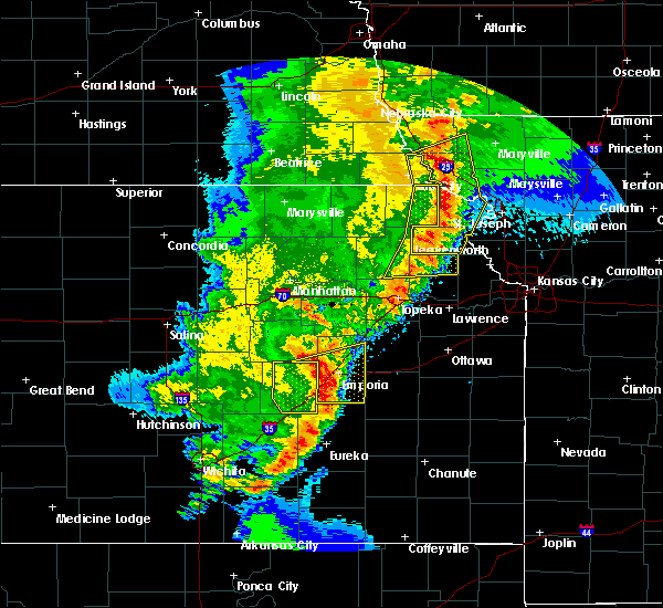 At 727 pm cdt, severe thunderstorms were located along a line extending from near fairfax to mound city to near forest city to near denton to near effingham, moving northeast at 50 mph (radar indicated). Hazards include 70 mph wind gusts and quarter size hail. Hail damage to vehicles is expected. expect considerable tree damage. Wind damage is also likely to mobile homes, roofs, and outbuildings. At 727 pm cdt, severe thunderstorms were located along a line extending from near fairfax to mound city to near forest city to near denton to near effingham, moving northeast at 50 mph (radar indicated). Hazards include 70 mph wind gusts and quarter size hail. Hail damage to vehicles is expected. expect considerable tree damage. Wind damage is also likely to mobile homes, roofs, and outbuildings.
|
| 5/2/2018 7:07 PM CDT |
 At 706 pm cdt, severe thunderstorms were located along a line extending from 7 miles southwest of craig to near hiawatha to everest to 6 miles north of valley falls to near denison to near hoyt, moving northeast at 45 mph (radar indicated). Hazards include 60 mph wind gusts and quarter size hail. Hail damage to vehicles is expected. expect wind damage to roofs, siding, and trees. locations impacted include, atchison, mound city, highland, troy, oregon, effingham, maitland, lancaster, skidmore, forest city, craig, white cloud, muscotah, denton, doniphan, big lake, severance, farmington, huron and leona. this includes interstate 29 between mile markers 67 and 102. A tornado watch remains in effect until 100 am cdt for northeastern kansas, and northwestern and west central missouri. At 706 pm cdt, severe thunderstorms were located along a line extending from 7 miles southwest of craig to near hiawatha to everest to 6 miles north of valley falls to near denison to near hoyt, moving northeast at 45 mph (radar indicated). Hazards include 60 mph wind gusts and quarter size hail. Hail damage to vehicles is expected. expect wind damage to roofs, siding, and trees. locations impacted include, atchison, mound city, highland, troy, oregon, effingham, maitland, lancaster, skidmore, forest city, craig, white cloud, muscotah, denton, doniphan, big lake, severance, farmington, huron and leona. this includes interstate 29 between mile markers 67 and 102. A tornado watch remains in effect until 100 am cdt for northeastern kansas, and northwestern and west central missouri.
|
| 5/2/2018 6:49 PM CDT |
 At 648 pm cdt, severe thunderstorms were located along a line extending from near falls city to near powhattan to near netawaka to mayetta to near potawatomi reservation to near willard, moving northeast at 45 mph (radar indicated). Hazards include 60 mph wind gusts and quarter size hail. Hail damage to vehicles is expected. Expect wind damage to roofs, siding, and trees. At 648 pm cdt, severe thunderstorms were located along a line extending from near falls city to near powhattan to near netawaka to mayetta to near potawatomi reservation to near willard, moving northeast at 45 mph (radar indicated). Hazards include 60 mph wind gusts and quarter size hail. Hail damage to vehicles is expected. Expect wind damage to roofs, siding, and trees.
|
| 10/21/2017 5:07 PM CDT |
 At 506 pm cdt, a severe thunderstorm was located near lancaster, or near atchison, moving northeast at 45 mph (radar indicated). Hazards include 60 mph wind gusts and nickel size hail. Expect damage to roofs, siding, and trees. Locations impacted include, atchison, rushville, lancaster, doniphan, farmington and bendena. At 506 pm cdt, a severe thunderstorm was located near lancaster, or near atchison, moving northeast at 45 mph (radar indicated). Hazards include 60 mph wind gusts and nickel size hail. Expect damage to roofs, siding, and trees. Locations impacted include, atchison, rushville, lancaster, doniphan, farmington and bendena.
|
| 10/21/2017 4:57 PM CDT |
 At 457 pm cdt, a severe thunderstorm was located near effingham, or 11 miles southwest of atchison, moving northeast at 45 mph (radar indicated). Hazards include 60 mph wind gusts and quarter size hail. Hail damage to vehicles is expected. Expect wind damage to roofs, siding, and trees. At 457 pm cdt, a severe thunderstorm was located near effingham, or 11 miles southwest of atchison, moving northeast at 45 mph (radar indicated). Hazards include 60 mph wind gusts and quarter size hail. Hail damage to vehicles is expected. Expect wind damage to roofs, siding, and trees.
|
| 10/21/2017 3:44 PM CDT |
 At 343 pm cdt, a severe thunderstorm was located near whiting, or near holton, moving northeast at 60 mph (radar indicated). Hazards include 60 mph wind gusts and quarter size hail. Hail damage to vehicles is expected. Expect wind damage to roofs, siding, and trees. At 343 pm cdt, a severe thunderstorm was located near whiting, or near holton, moving northeast at 60 mph (radar indicated). Hazards include 60 mph wind gusts and quarter size hail. Hail damage to vehicles is expected. Expect wind damage to roofs, siding, and trees.
|
| 6/16/2017 11:24 PM CDT | Windows blown out of storm spotter's truck at kingman and 286th rd in atchison county KS, 1.3 miles W of Lancaster, KS |
| 6/16/2017 11:23 PM CDT | Via e in atchison county KS, 0.2 miles NW of Lancaster, KS |
| 6/16/2017 11:21 PM CDT |
 The tornado warning for southwestern doniphan and central atchison counties will expire at 1130 pm cdt, the tornado threat has diminished and the tornado warning has been cancelled. however, damaging winds to 70 mph remain likely and a severe thunderstorm warning remains in effect for the area. The tornado warning for southwestern doniphan and central atchison counties will expire at 1130 pm cdt, the tornado threat has diminished and the tornado warning has been cancelled. however, damaging winds to 70 mph remain likely and a severe thunderstorm warning remains in effect for the area.
|
| 6/16/2017 11:17 PM CDT | Trees and power lines down in lancaste in atchison county KS, 0.2 miles NW of Lancaster, KS |
| 6/16/2017 11:05 PM CDT |
 At 1105 pm cdt, a severe thunderstorm capable of producing a tornado was located near everest, or 9 miles east of horton, moving southeast at 45 mph (radar indicated rotation). Hazards include tornado. Flying debris will be dangerous to those caught without shelter. mobile homes will be damaged or destroyed. damage to roofs, windows, and vehicles will occur. Tree damage is likely. At 1105 pm cdt, a severe thunderstorm capable of producing a tornado was located near everest, or 9 miles east of horton, moving southeast at 45 mph (radar indicated rotation). Hazards include tornado. Flying debris will be dangerous to those caught without shelter. mobile homes will be damaged or destroyed. damage to roofs, windows, and vehicles will occur. Tree damage is likely.
|
| 6/16/2017 11:04 PM CDT |
 At 1104 pm cdt, severe thunderstorms were located along a line extending from horton to 7 miles southeast of denton, moving southeast at 45 mph (radar indicated). Hazards include 70 mph wind gusts. Expect considerable tree damage. Damage is likely to mobile homes, roofs, and outbuildings. At 1104 pm cdt, severe thunderstorms were located along a line extending from horton to 7 miles southeast of denton, moving southeast at 45 mph (radar indicated). Hazards include 70 mph wind gusts. Expect considerable tree damage. Damage is likely to mobile homes, roofs, and outbuildings.
|
| 5/18/2017 8:37 PM CDT |
 At 837 pm cdt, severe thunderstorms were located along a line extending from lancaster to 7 miles southwest of atchison to easton, moving northeast at 25 mph (radar indicated). Hazards include 60 mph wind gusts and half dollar size hail. Hail damage to vehicles is expected. expect wind damage to roofs, siding, and trees. locations impacted include, leavenworth, atchison, effingham, lancaster, easton, farmington, huron, lowemont, cummings and potter. A tornado watch remains in effect until 1000 pm cdt for northeastern kansas, and northwestern and west central missouri. At 837 pm cdt, severe thunderstorms were located along a line extending from lancaster to 7 miles southwest of atchison to easton, moving northeast at 25 mph (radar indicated). Hazards include 60 mph wind gusts and half dollar size hail. Hail damage to vehicles is expected. expect wind damage to roofs, siding, and trees. locations impacted include, leavenworth, atchison, effingham, lancaster, easton, farmington, huron, lowemont, cummings and potter. A tornado watch remains in effect until 1000 pm cdt for northeastern kansas, and northwestern and west central missouri.
|
| 5/18/2017 8:15 PM CDT |
 At 815 pm cdt, a severe thunderstorm was located near effingham, or 7 miles north of valley falls, moving northeast at 45 mph (radar indicated). Hazards include 70 mph wind gusts and ping pong ball size hail. People and animals outdoors will be injured. expect hail damage to roofs, siding, windows, and vehicles. expect considerable tree damage. wind damage is also likely to mobile homes, roofs, and outbuildings. locations impacted include, leavenworth, atchison, effingham, lancaster, easton, muscotah, farmington, huron, lowemont, cummings, arrington and potter. A tornado watch remains in effect until 1000 pm cdt for northeastern kansas, and northwestern and west central missouri. At 815 pm cdt, a severe thunderstorm was located near effingham, or 7 miles north of valley falls, moving northeast at 45 mph (radar indicated). Hazards include 70 mph wind gusts and ping pong ball size hail. People and animals outdoors will be injured. expect hail damage to roofs, siding, windows, and vehicles. expect considerable tree damage. wind damage is also likely to mobile homes, roofs, and outbuildings. locations impacted include, leavenworth, atchison, effingham, lancaster, easton, muscotah, farmington, huron, lowemont, cummings, arrington and potter. A tornado watch remains in effect until 1000 pm cdt for northeastern kansas, and northwestern and west central missouri.
|
| 5/18/2017 8:06 PM CDT |
 At 806 pm cdt, a severe thunderstorm was located near valley falls, moving northeast at 45 mph (radar indicated). Hazards include ping pong ball size hail and 60 mph wind gusts. People and animals outdoors will be injured. expect hail damage to roofs, siding, windows, and vehicles. Expect wind damage to roofs, siding, and trees. At 806 pm cdt, a severe thunderstorm was located near valley falls, moving northeast at 45 mph (radar indicated). Hazards include ping pong ball size hail and 60 mph wind gusts. People and animals outdoors will be injured. expect hail damage to roofs, siding, windows, and vehicles. Expect wind damage to roofs, siding, and trees.
|
| 7/13/2016 9:39 AM CDT |
 At 938 am cdt, severe thunderstorms were located along a line extending from fairview to near whiting to near hoyt, moving northeast at 40 mph (radar indicated). Hazards include 70 mph wind gusts and nickel size hail. Expect considerable tree damage. Damage is likely to mobile homes, roofs, and outbuildings. At 938 am cdt, severe thunderstorms were located along a line extending from fairview to near whiting to near hoyt, moving northeast at 40 mph (radar indicated). Hazards include 70 mph wind gusts and nickel size hail. Expect considerable tree damage. Damage is likely to mobile homes, roofs, and outbuildings.
|
| 7/7/2016 4:10 AM CDT |
 The severe thunderstorm warning for doniphan, atchison, southwestern andrew and southeastern holt counties will expire at 415 am cdt, the storms which prompted the warning have weakened below severe limits, and no longer pose an immediate threat to life or property. therefore the warning will be allowed to expire. a severe thunderstorm watch remains in effect until 900 am cdt for northeastern kansas, and northwestern missouri. The severe thunderstorm warning for doniphan, atchison, southwestern andrew and southeastern holt counties will expire at 415 am cdt, the storms which prompted the warning have weakened below severe limits, and no longer pose an immediate threat to life or property. therefore the warning will be allowed to expire. a severe thunderstorm watch remains in effect until 900 am cdt for northeastern kansas, and northwestern missouri.
|
| 7/7/2016 3:45 AM CDT |
 At 344 am cdt, severe thunderstorms were located along a line extending from near oregon to near robinson to near netawaka, moving southeast at 55 mph (radar indicated). Hazards include 60 mph wind gusts. Expect damage to roofs. siding. and trees. locations impacted include, atchison, savannah, wathena, highland, troy, oregon, effingham, amazonia, lancaster, forest city, white cloud, muscotah, denton, doniphan, severance, farmington, huron, leona, bendena and fanning. This includes interstate 29 between mile markers 57 and 64. At 344 am cdt, severe thunderstorms were located along a line extending from near oregon to near robinson to near netawaka, moving southeast at 55 mph (radar indicated). Hazards include 60 mph wind gusts. Expect damage to roofs. siding. and trees. locations impacted include, atchison, savannah, wathena, highland, troy, oregon, effingham, amazonia, lancaster, forest city, white cloud, muscotah, denton, doniphan, severance, farmington, huron, leona, bendena and fanning. This includes interstate 29 between mile markers 57 and 64.
|
| 7/7/2016 3:26 AM CDT |
 At 325 am cdt, severe thunderstorms were located along a line extending from 7 miles northwest of white cloud to near hamlin to near woodlawn, moving southeast at 50 mph. a 68 mph wind gust was observed at falls city nebraska with this line of storms (radar indicated). Hazards include 70 mph wind gusts. Expect considerable tree damage. Damage is likely to mobile homes, roofs, and outbuildings. At 325 am cdt, severe thunderstorms were located along a line extending from 7 miles northwest of white cloud to near hamlin to near woodlawn, moving southeast at 50 mph. a 68 mph wind gust was observed at falls city nebraska with this line of storms (radar indicated). Hazards include 70 mph wind gusts. Expect considerable tree damage. Damage is likely to mobile homes, roofs, and outbuildings.
|
| 5/26/2016 10:47 AM CDT | Golf Ball sized hail reported 2.3 miles W of Lancaster, KS |
| 4/27/2016 2:57 PM CDT |
 At 257 pm cdt, a severe thunderstorm was located near lancaster, or 9 miles southeast of horton, moving northeast at 30 mph (radar indicated). Hazards include 60 mph wind gusts and half dollar size hail. Hail damage to vehicles is expected. Expect wind damage to roofs, siding, and trees. At 257 pm cdt, a severe thunderstorm was located near lancaster, or 9 miles southeast of horton, moving northeast at 30 mph (radar indicated). Hazards include 60 mph wind gusts and half dollar size hail. Hail damage to vehicles is expected. Expect wind damage to roofs, siding, and trees.
|
| 4/27/2016 2:13 PM CDT |
 At 213 pm cdt, a severe thunderstorm was located near denison, or 7 miles east of holton, moving northeast at 30 mph (radar indicated). Hazards include 60 mph wind gusts and quarter size hail. Hail damage to vehicles is expected. expect wind damage to roofs, siding, and trees. Locations impacted include, atchison, horton, effingham, lancaster, muscotah, farmington, huron and arrington. At 213 pm cdt, a severe thunderstorm was located near denison, or 7 miles east of holton, moving northeast at 30 mph (radar indicated). Hazards include 60 mph wind gusts and quarter size hail. Hail damage to vehicles is expected. expect wind damage to roofs, siding, and trees. Locations impacted include, atchison, horton, effingham, lancaster, muscotah, farmington, huron and arrington.
|
| 4/27/2016 1:54 PM CDT |
 At 154 pm cdt, a severe thunderstorm was located over mayetta, or 8 miles south of holton, moving northeast at 25 mph (radar indicated). Hazards include quarter size hail. damage to vehicles is expected At 154 pm cdt, a severe thunderstorm was located over mayetta, or 8 miles south of holton, moving northeast at 25 mph (radar indicated). Hazards include quarter size hail. damage to vehicles is expected
|
| 4/26/2016 7:44 AM CDT |
 At 744 am cdt, severe thunderstorms were located along a line extending from fillmore to near lancaster, moving east at 45 mph (trained weather spotters). Hazards include tennis ball size hail and 70 mph wind gusts. People and animals outdoors will be injured. expect hail damage to roofs, siding, windows, and vehicles. expect considerable tree damage. wind damage is also likely to mobile homes, roofs, and outbuildings. locations impacted include, atchison, wathena, highland, troy, oregon, effingham, amazonia, rushville, lancaster, forest city, fillmore, denton, lewis and clark village, doniphan, severance, farmington, huron, leona, bendena and fanning. This includes interstate 29 between mile markers 59 and 75. At 744 am cdt, severe thunderstorms were located along a line extending from fillmore to near lancaster, moving east at 45 mph (trained weather spotters). Hazards include tennis ball size hail and 70 mph wind gusts. People and animals outdoors will be injured. expect hail damage to roofs, siding, windows, and vehicles. expect considerable tree damage. wind damage is also likely to mobile homes, roofs, and outbuildings. locations impacted include, atchison, wathena, highland, troy, oregon, effingham, amazonia, rushville, lancaster, forest city, fillmore, denton, lewis and clark village, doniphan, severance, farmington, huron, leona, bendena and fanning. This includes interstate 29 between mile markers 59 and 75.
|
| 4/26/2016 7:19 AM CDT |
 At 718 am cdt, severe thunderstorms were located along a line extending from near oregon to near nortonville, moving east at 30 mph (trained weather spotters). Hazards include tennis ball size hail and 70 mph wind gusts. People and animals outdoors will be injured. expect hail damage to roofs, siding, windows, and vehicles. expect considerable tree damage. wind damage is also likely to mobile homes, roofs, and outbuildings. locations impacted include, atchison, wathena, highland, troy, oregon, effingham, amazonia, rushville, lancaster, forest city, fillmore, white cloud, muscotah, denton, lewis and clark village, doniphan, severance, farmington, huron and leona. This includes interstate 29 between mile markers 59 and 78. At 718 am cdt, severe thunderstorms were located along a line extending from near oregon to near nortonville, moving east at 30 mph (trained weather spotters). Hazards include tennis ball size hail and 70 mph wind gusts. People and animals outdoors will be injured. expect hail damage to roofs, siding, windows, and vehicles. expect considerable tree damage. wind damage is also likely to mobile homes, roofs, and outbuildings. locations impacted include, atchison, wathena, highland, troy, oregon, effingham, amazonia, rushville, lancaster, forest city, fillmore, white cloud, muscotah, denton, lewis and clark village, doniphan, severance, farmington, huron and leona. This includes interstate 29 between mile markers 59 and 78.
|
| 4/26/2016 7:11 AM CDT |
 At 710 am cdt, severe thunderstorms were located along a line extending from near forest city to near nortonville, moving east at 30 mph (radar indicated). Hazards include 70 mph wind gusts and half dollar size hail. Hail damage to vehicles is expected. expect considerable tree damage. Wind damage is also likely to mobile homes, roofs, and outbuildings. At 710 am cdt, severe thunderstorms were located along a line extending from near forest city to near nortonville, moving east at 30 mph (radar indicated). Hazards include 70 mph wind gusts and half dollar size hail. Hail damage to vehicles is expected. expect considerable tree damage. Wind damage is also likely to mobile homes, roofs, and outbuildings.
|
| 4/26/2016 7:10 AM CDT | Hen Egg sized hail reported 0.2 miles NW of Lancaster, KS, 2.25 inch hail reported. |
| 4/26/2016 7:03 AM CDT | Golf Ball sized hail reported 0.2 miles NW of Lancaster, KS, pea to golf ball size hail reported |
| 4/26/2016 7:02 AM CDT |
 At 701 am cdt, a severe thunderstorm was located over lancaster, or 9 miles west of atchison, moving north at 50 mph (radar indicated). Hazards include 60 mph wind gusts and half dollar size hail. Hail damage to vehicles is expected. expect wind damage to roofs, siding, and trees. Locations impacted include, atchison, effingham, lancaster, denton, doniphan, severance, farmington, huron, leona and bendena. At 701 am cdt, a severe thunderstorm was located over lancaster, or 9 miles west of atchison, moving north at 50 mph (radar indicated). Hazards include 60 mph wind gusts and half dollar size hail. Hail damage to vehicles is expected. expect wind damage to roofs, siding, and trees. Locations impacted include, atchison, effingham, lancaster, denton, doniphan, severance, farmington, huron, leona and bendena.
|
| 4/26/2016 6:51 AM CDT |
 At 651 am cdt, a severe thunderstorm was located near effingham, or 10 miles northeast of valley falls, moving north at 55 mph (radar indicated). Hazards include 60 mph wind gusts and half dollar size hail. Hail damage to vehicles is expected. Expect wind damage to roofs, siding, and trees. At 651 am cdt, a severe thunderstorm was located near effingham, or 10 miles northeast of valley falls, moving north at 55 mph (radar indicated). Hazards include 60 mph wind gusts and half dollar size hail. Hail damage to vehicles is expected. Expect wind damage to roofs, siding, and trees.
|
| 9/17/2015 9:49 PM CDT |
 At 949 pm cdt, a severe thunderstorm was located over lancaster, or 9 miles west of atchison, moving east at 35 mph (radar indicated). Hazards include 60 mph wind gusts and half dollar size hail. Hail damage to vehicles is expected. expect wind damage to roofs, siding and trees. Locations impacted include, atchison, effingham, lancaster, doniphan, farmington, huron, potter and cummings. At 949 pm cdt, a severe thunderstorm was located over lancaster, or 9 miles west of atchison, moving east at 35 mph (radar indicated). Hazards include 60 mph wind gusts and half dollar size hail. Hail damage to vehicles is expected. expect wind damage to roofs, siding and trees. Locations impacted include, atchison, effingham, lancaster, doniphan, farmington, huron, potter and cummings.
|
| 9/17/2015 9:33 PM CDT |
 At 933 pm cdt, a severe thunderstorm was located near muscotah, or near horton, moving east at 40 mph (radar indicated). Hazards include 60 mph wind gusts and half dollar size hail. Hail damage to vehicles is expected. Expect wind damage to roofs, siding and trees. At 933 pm cdt, a severe thunderstorm was located near muscotah, or near horton, moving east at 40 mph (radar indicated). Hazards include 60 mph wind gusts and half dollar size hail. Hail damage to vehicles is expected. Expect wind damage to roofs, siding and trees.
|
| 9/17/2015 9:21 PM CDT |
 At 920 pm cdt, a severe thunderstorm was located near lancaster, or 9 miles southeast of horton, moving east at 20 mph (radar indicated). Hazards include 60 mph wind gusts and half dollar size hail. Hail damage to vehicles is expected. expect wind damage to roofs, siding and trees. Locations impacted include, atchison, lancaster, muscotah and huron. At 920 pm cdt, a severe thunderstorm was located near lancaster, or 9 miles southeast of horton, moving east at 20 mph (radar indicated). Hazards include 60 mph wind gusts and half dollar size hail. Hail damage to vehicles is expected. expect wind damage to roofs, siding and trees. Locations impacted include, atchison, lancaster, muscotah and huron.
|
| 9/17/2015 9:01 PM CDT |
 At 901 pm cdt, severe thunderstorms were located along a line extending from near country club to near rushville, moving east at 30 mph (radar indicated). Hazards include 60 mph wind gusts and half dollar size hail. Hail damage to vehicles is expected. expect wind damage to roofs, siding and trees. Locations impacted include, atchison, lancaster, muscotah, denton, huron and bendena. At 901 pm cdt, severe thunderstorms were located along a line extending from near country club to near rushville, moving east at 30 mph (radar indicated). Hazards include 60 mph wind gusts and half dollar size hail. Hail damage to vehicles is expected. expect wind damage to roofs, siding and trees. Locations impacted include, atchison, lancaster, muscotah, denton, huron and bendena.
|
| 9/17/2015 8:33 PM CDT |
 At 832 pm cdt, severe thunderstorms were located along a line extending from robinson to near whiting, moving east at 25 mph (radar indicated). Hazards include ping pong ball size hail and 60 mph wind gusts. People and animals outdoors will be injured. expect hail damage to roofs, siding, windows and vehicles. Expect wind damage to roofs, siding and trees. At 832 pm cdt, severe thunderstorms were located along a line extending from robinson to near whiting, moving east at 25 mph (radar indicated). Hazards include ping pong ball size hail and 60 mph wind gusts. People and animals outdoors will be injured. expect hail damage to roofs, siding, windows and vehicles. Expect wind damage to roofs, siding and trees.
|
| 6/11/2015 8:34 PM CDT |
 At 832 pm cdt, a severe thunderstorm was located near effingham, and moving east at 35 mph (radar indicated). Hazards include 70 mph wind gusts and nickel size hail. Expect considerable tree damage. Damage is likely to mobile homes, roofs and outbuildings. At 832 pm cdt, a severe thunderstorm was located near effingham, and moving east at 35 mph (radar indicated). Hazards include 70 mph wind gusts and nickel size hail. Expect considerable tree damage. Damage is likely to mobile homes, roofs and outbuildings.
|
| 6/11/2015 7:45 PM CDT |
 At 742 pm cdt, a severe thunderstorm was located near atchison, and moving northeast at 35 mph. a second severe thunderstorms was noted just north of nortonville and moving northeast at 30 mph (radar indicated). Hazards include 60 mph wind gusts and half dollar size hail. Hail damage to vehicles is expected. expect wind damage to roofs, siding and trees. Locations impacted include, rushville, lewis and clark vi and de kalb. At 742 pm cdt, a severe thunderstorm was located near atchison, and moving northeast at 35 mph. a second severe thunderstorms was noted just north of nortonville and moving northeast at 30 mph (radar indicated). Hazards include 60 mph wind gusts and half dollar size hail. Hail damage to vehicles is expected. expect wind damage to roofs, siding and trees. Locations impacted include, rushville, lewis and clark vi and de kalb.
|
| 6/11/2015 7:38 PM CDT | Two barns heavily damaged along 260th roa in atchison county KS, 3.6 miles N of Lancaster, KS |
| 6/11/2015 7:24 PM CDT |
 At 721 pm cdt, a severe thunderstorm was located near effingham, and moving northeast at 40 mph (radar indicated). Hazards include 60 mph wind gusts and half dollar size hail. Hail damage to vehicles is expected. Expect wind damage to roofs, siding and trees. At 721 pm cdt, a severe thunderstorm was located near effingham, and moving northeast at 40 mph (radar indicated). Hazards include 60 mph wind gusts and half dollar size hail. Hail damage to vehicles is expected. Expect wind damage to roofs, siding and trees.
|
| 5/4/2015 4:37 PM CDT | At 435 pm cdt, severe thunderstorms were located along a line extending from robinson to 5 miles southwest of denton to effingham, and moving east at 25 mph (radar indicated). Hazards include 60 mph wind gusts and penny size hail. Expect damage to roofs. Siding and trees. |
| 4/8/2015 5:50 AM CDT | The national weather service in pleasant hill has issued a * severe thunderstorm warning for. northeastern atchison county in northeast kansas. southeastern doniphan county in northeast kansas. southwestern andrew county in northwest missouri. Buchanan county in northwest missouri. |
| 4/8/2015 5:50 AM CDT | The national weather service in pleasant hill has issued a * severe thunderstorm warning for. northeastern atchison county in northeast kansas. southeastern doniphan county in northeast kansas. southwestern andrew county in northwest missouri. Buchanan county in northwest missouri. |
| 7/7/2014 9:48 PM CDT | Storm damage reported in atchison county KS, 0.2 miles NW of Lancaster, KS |
| 5/10/2014 4:52 PM CDT | Quarter sized hail reported 0.2 miles NW of Lancaster, KS |
| 1/1/0001 12:00 AM | Golf Ball sized hail reported 0.2 miles NW of Lancaster, KS |
| 1/1/0001 12:00 AM | Golf Ball sized hail reported 0.2 miles NW of Lancaster, KS |
Hail Maps for Lancaster, KS


Connect with Interactive Hail Maps