

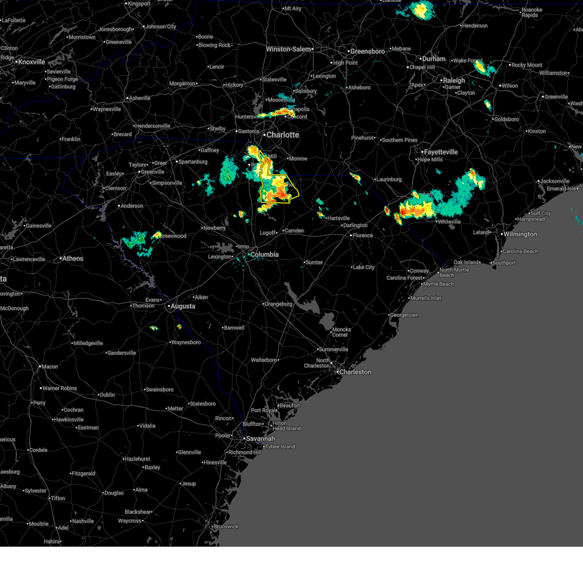
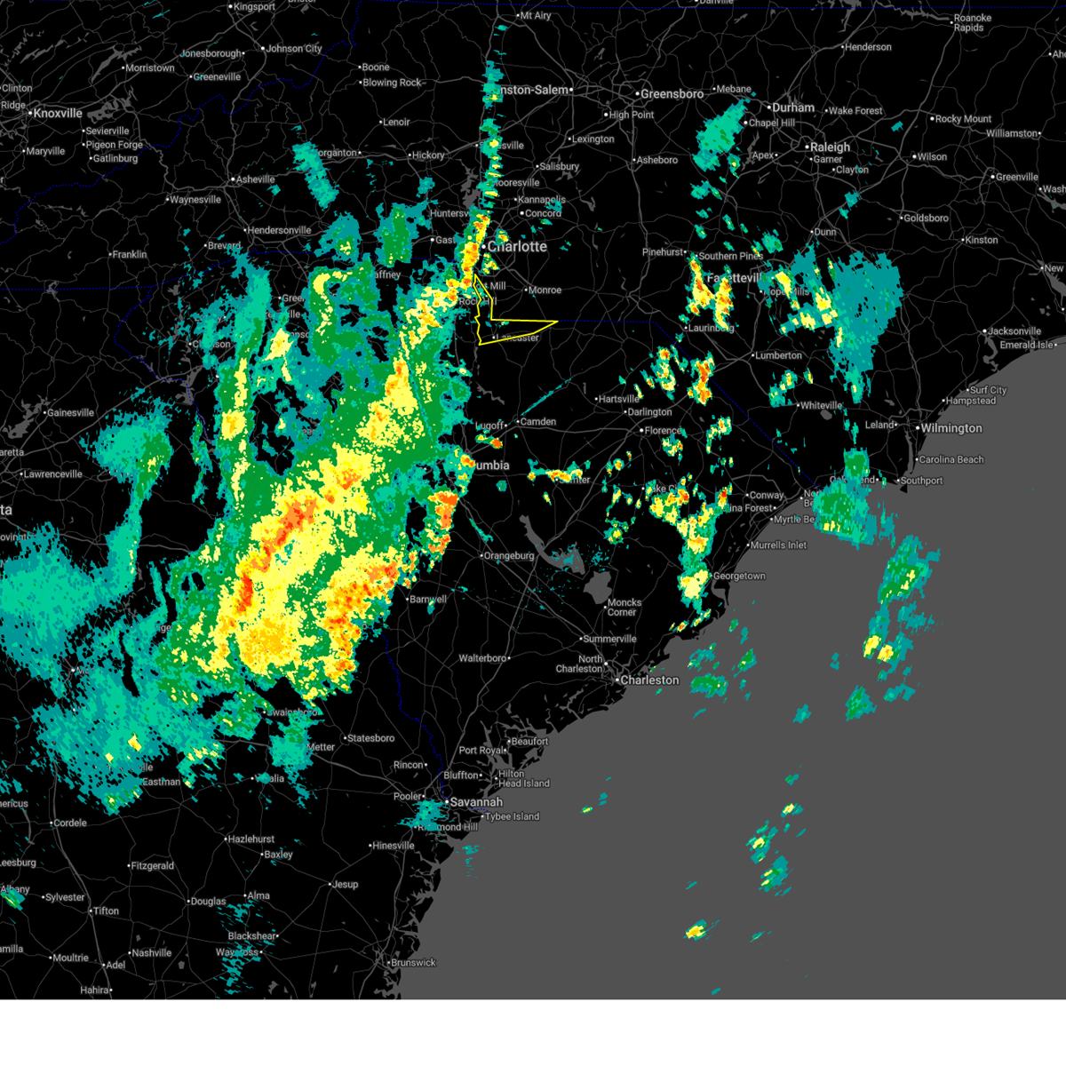
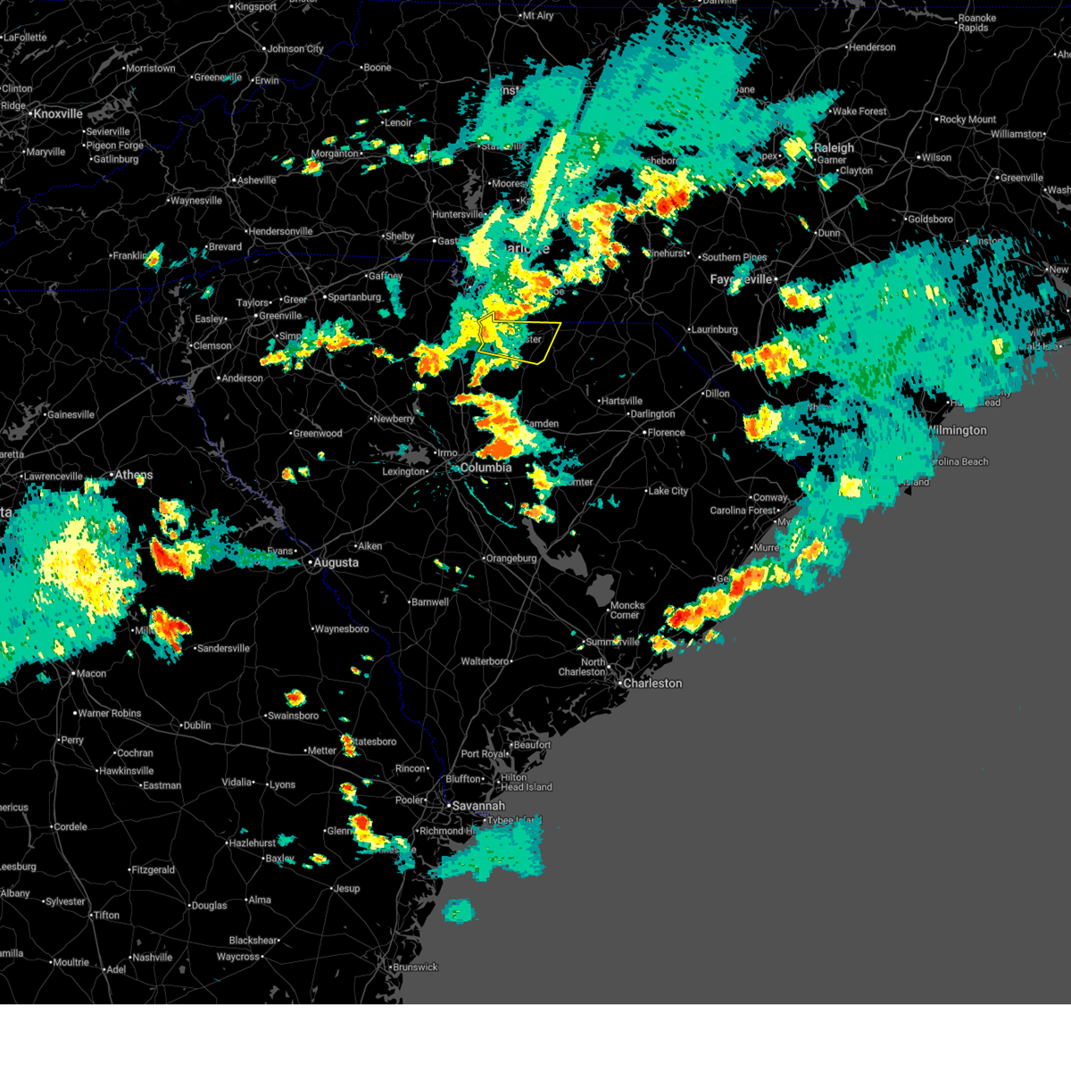
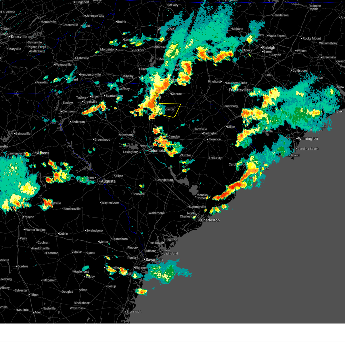
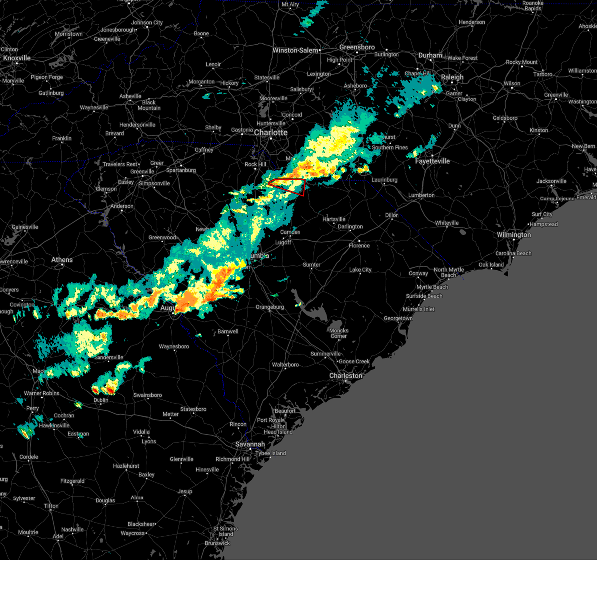
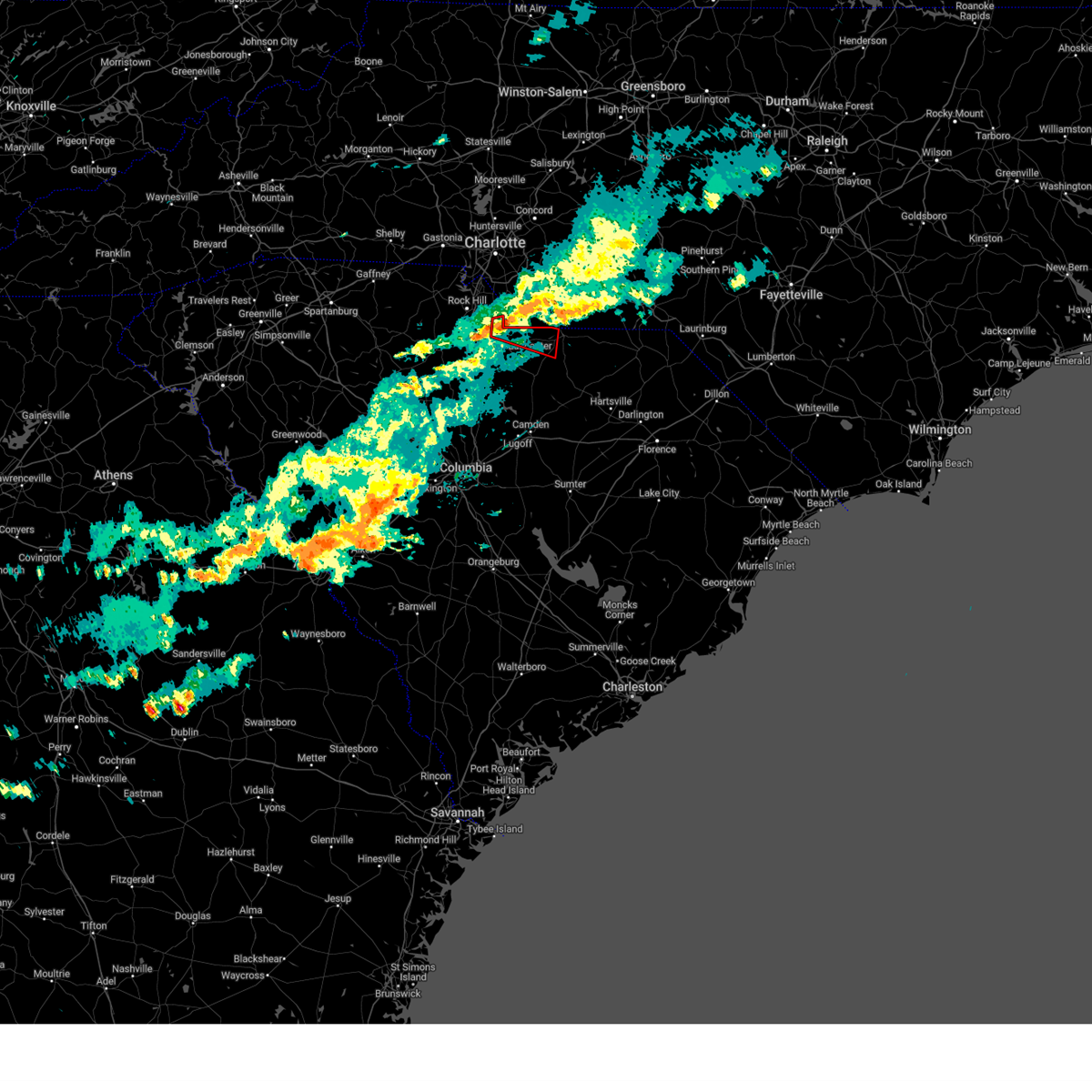
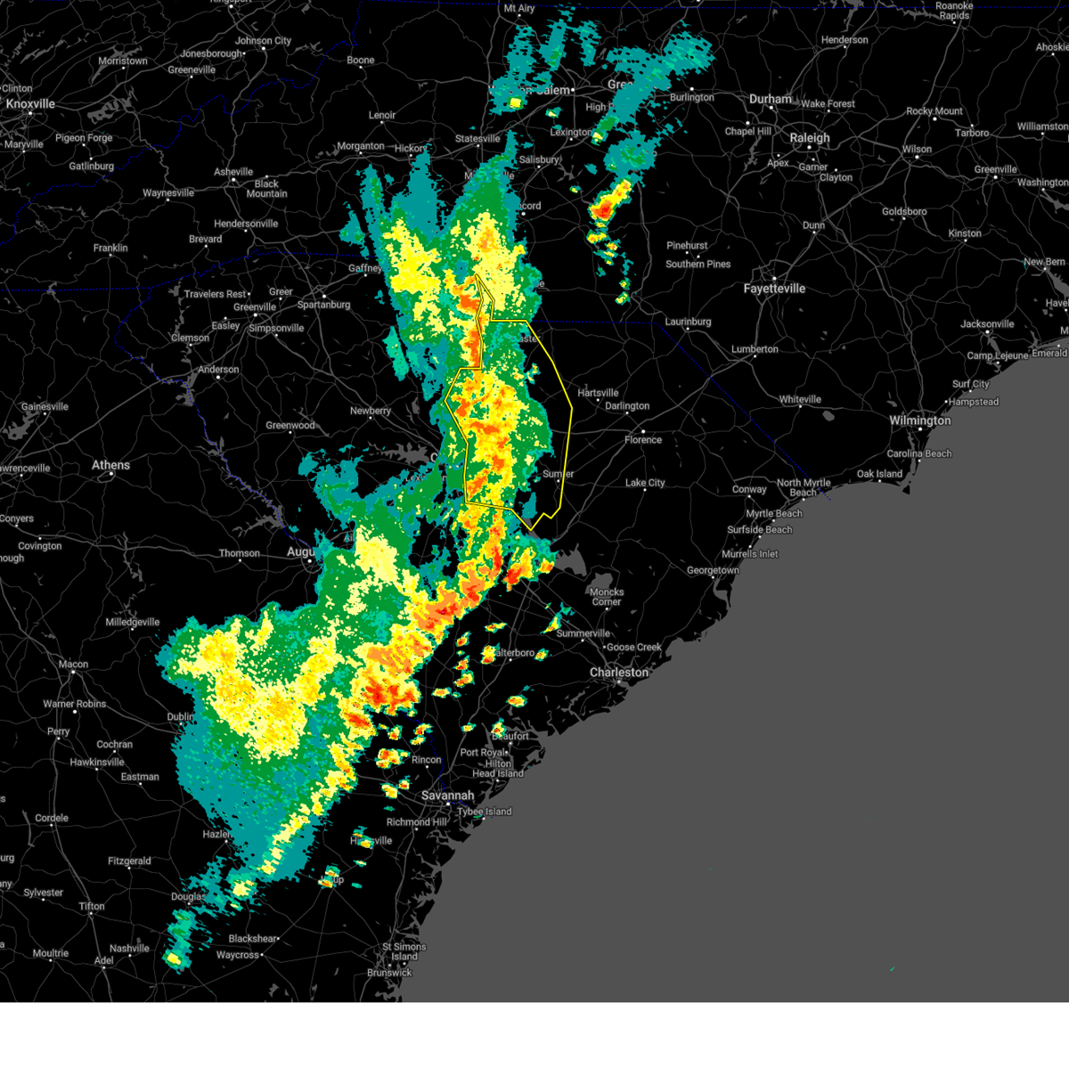
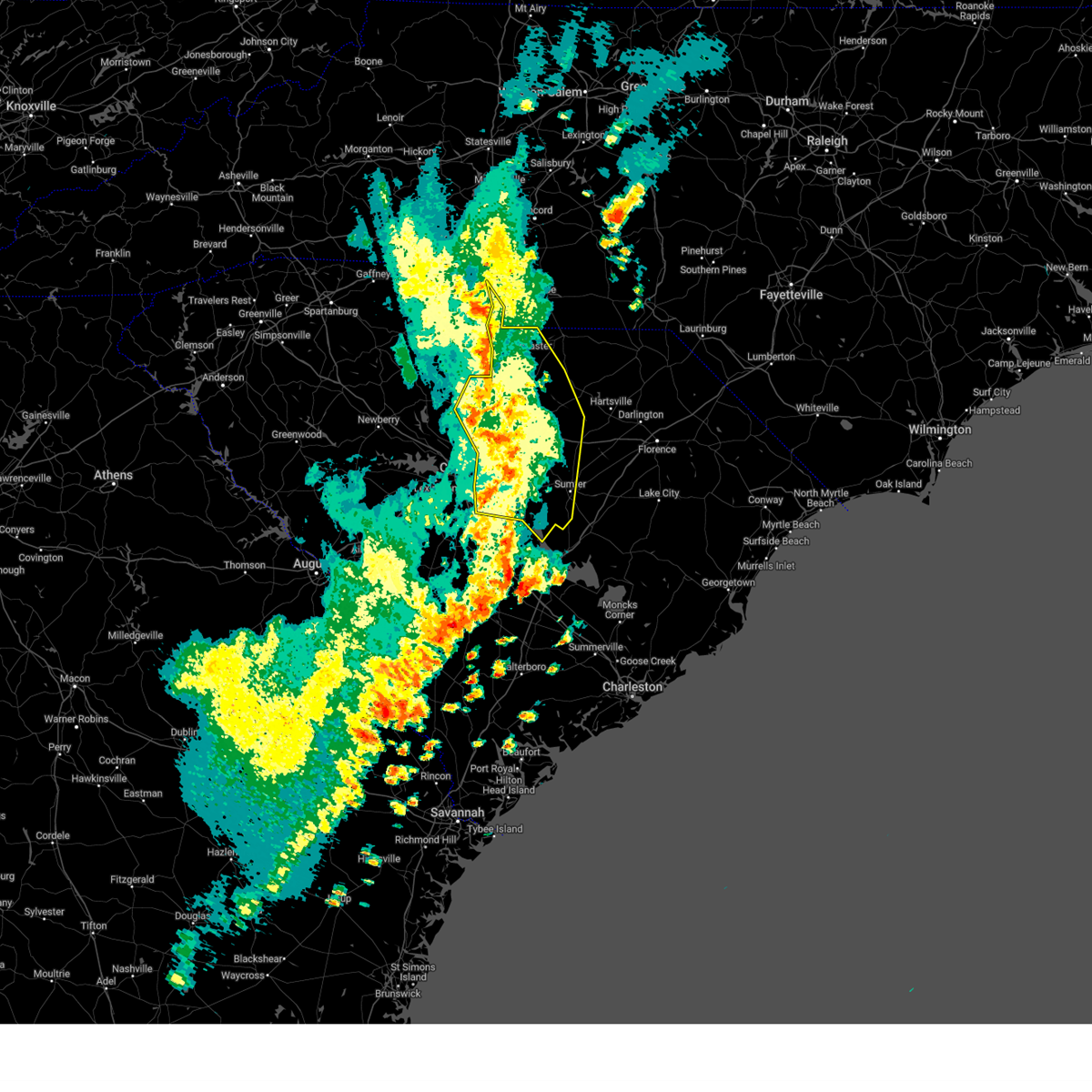
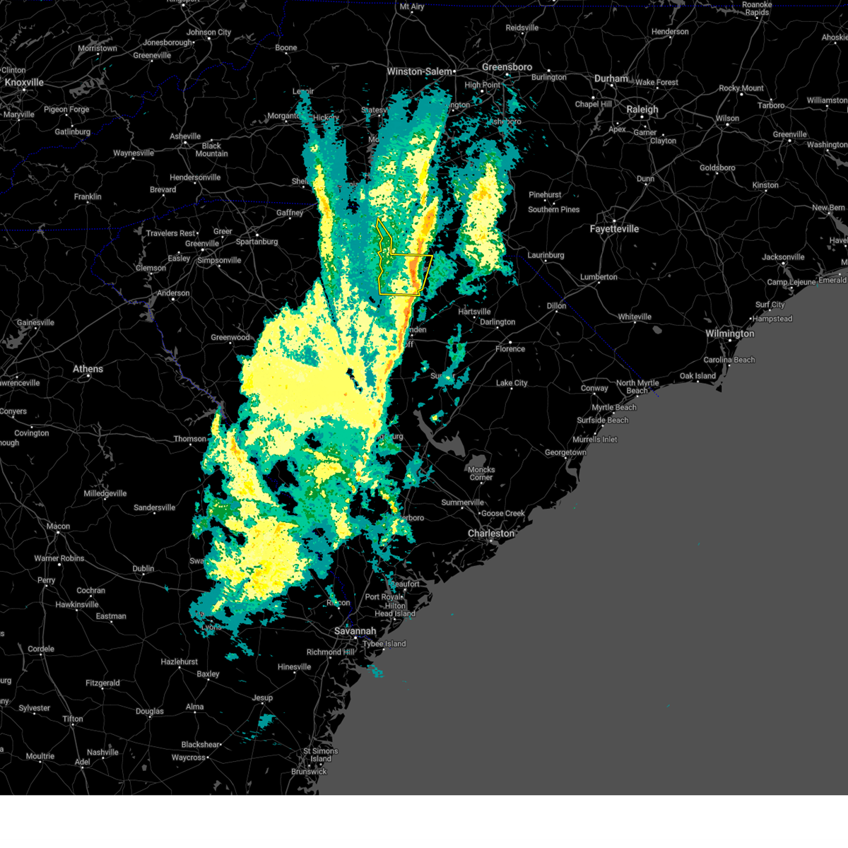
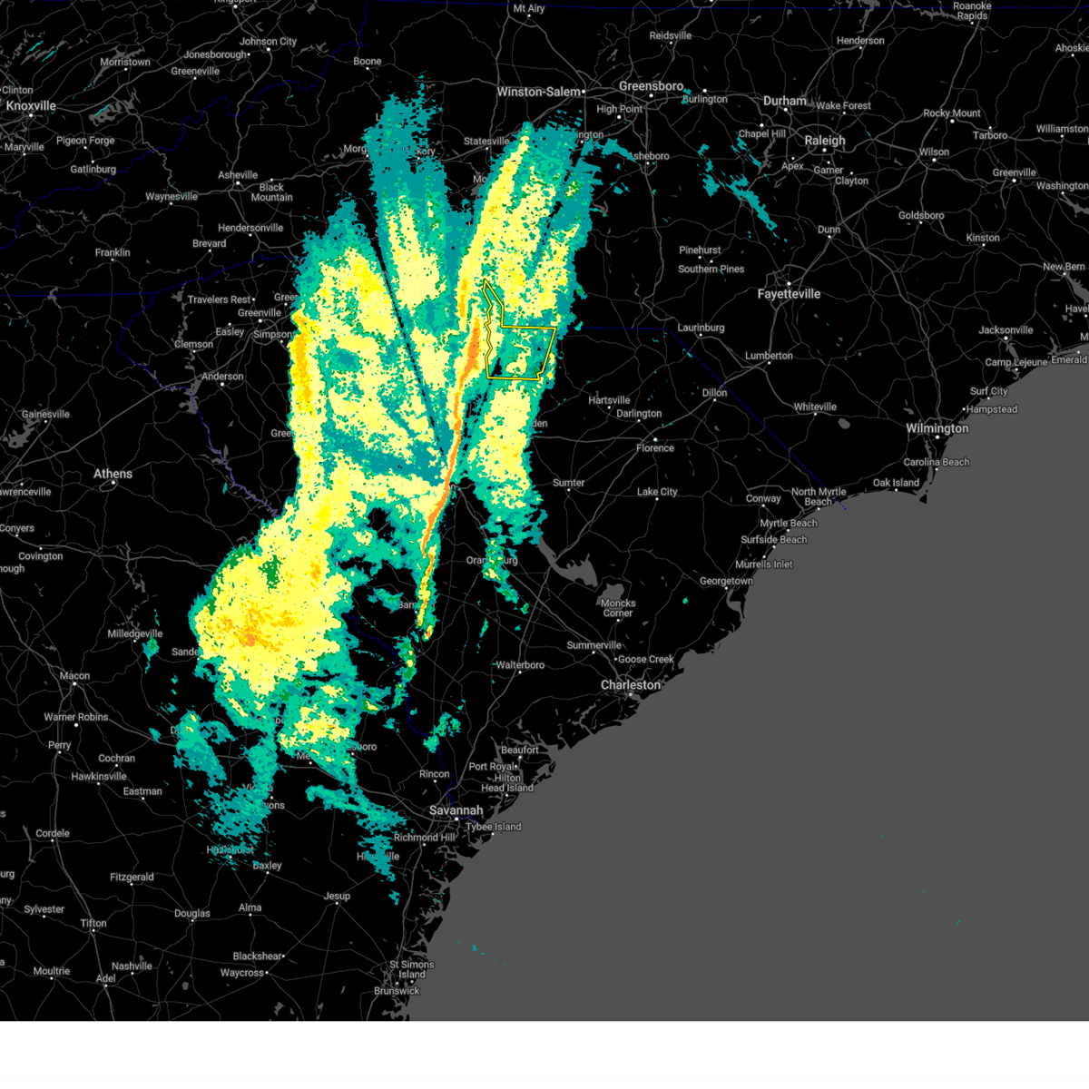
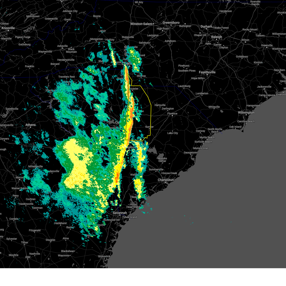
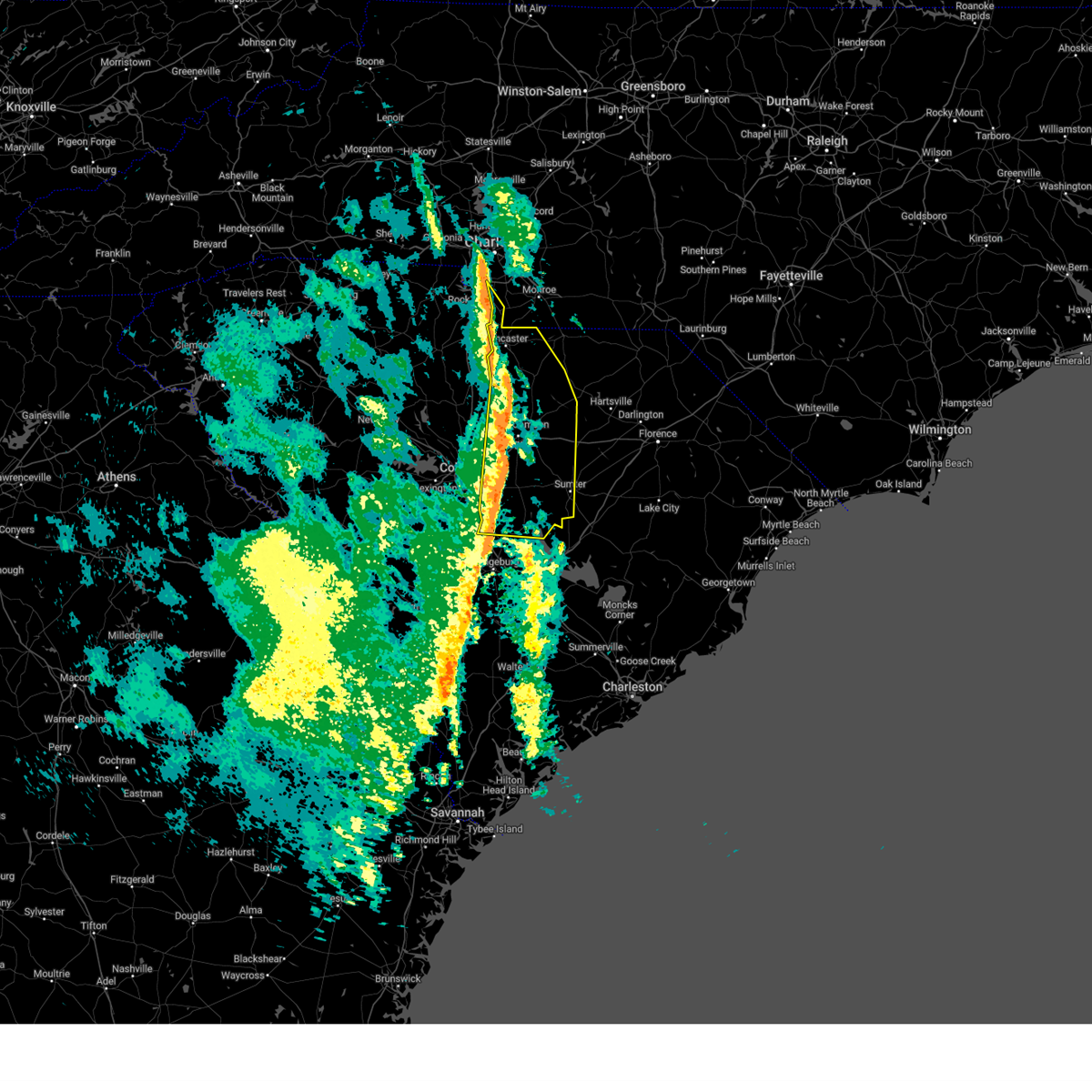
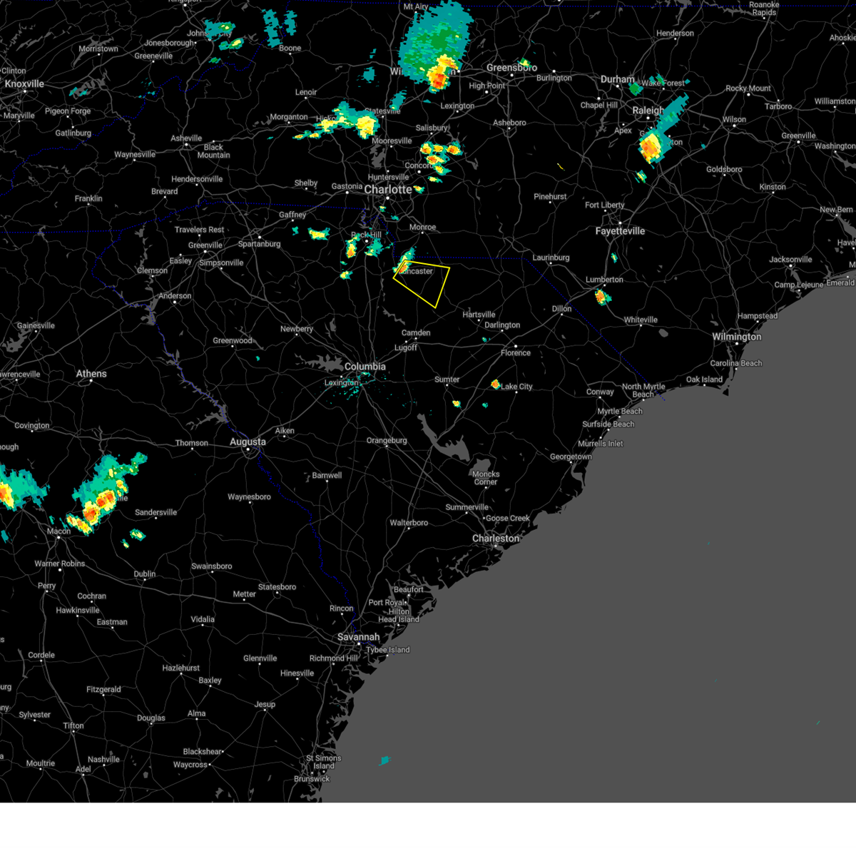
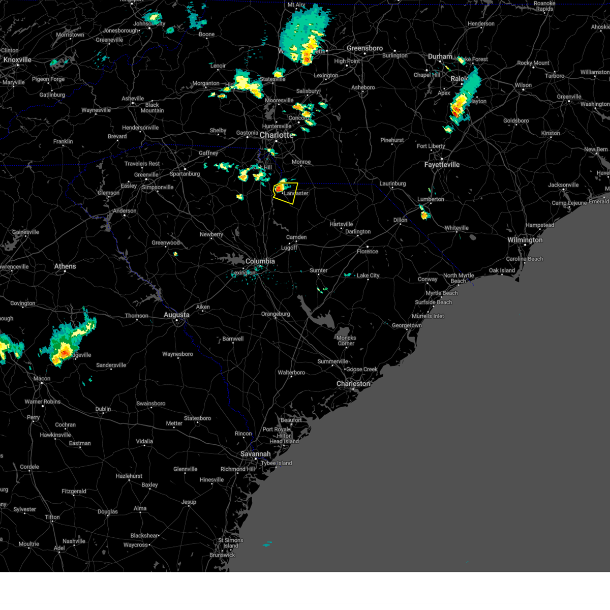
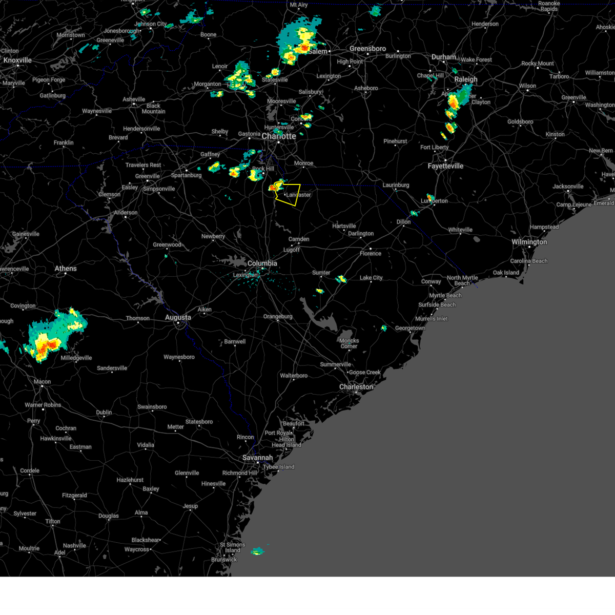
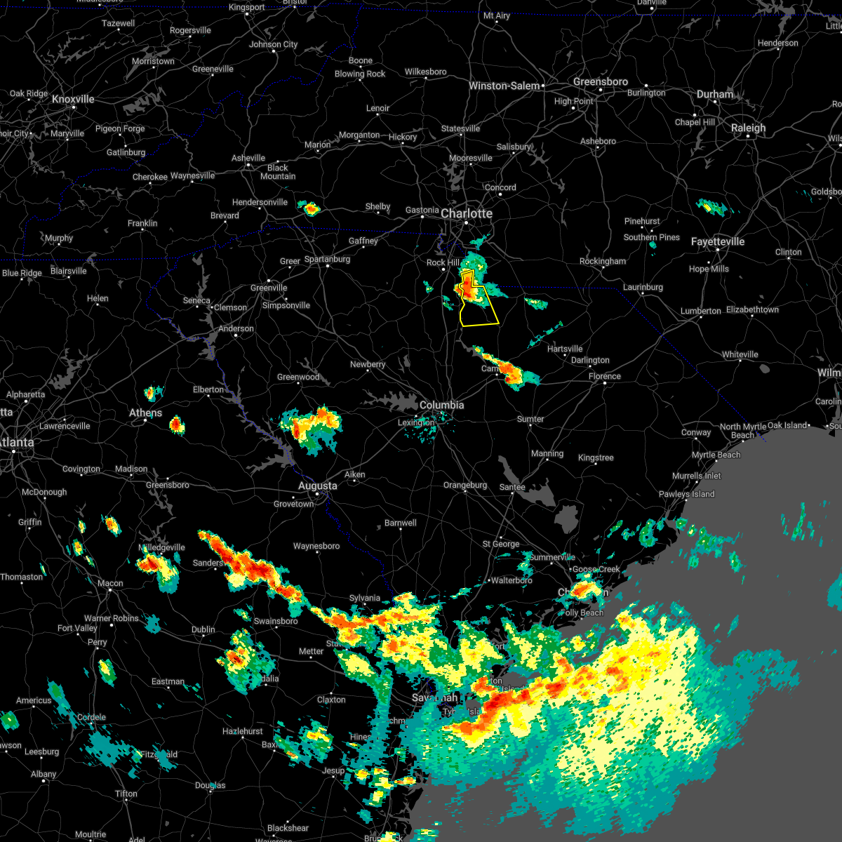
Hail Map for Lancaster, SC
The Lancaster, SC area has had 28 reports of on-the-ground hail by trained spotters, and has been under severe weather warnings 8 times during the past 12 months. Doppler radar has detected hail at or near Lancaster, SC on 40 occasions.
| Name: | Lancaster, SC |
| Where Located: | 34.7 miles S of Charlotte, NC |
| Map: | Google Map for Lancaster, SC |
| Population: | 8526 |
| Housing Units: | 3981 |
| More Info: | Search Google for Lancaster, SC |
1
The Top Recent Hail Date for Lancaster, SC is Sunday, August 18, 2024 (8th out of 40)

Hail and Wind Damage Spotted near Lancaster, SC
| Date / Time | Report Details |
|---|---|
| 6/28/2026 4:25 PM EDT |
 The storm which prompted the warning has weakened below severe limits, and no longer poses an immediate threat to life or property. therefore, the warning will be allowed to expire. however, heavy rain is still possible with this thunderstorm. The storm which prompted the warning has weakened below severe limits, and no longer poses an immediate threat to life or property. therefore, the warning will be allowed to expire. however, heavy rain is still possible with this thunderstorm.
|
| 6/28/2026 4:22 PM EDT |
 At 421 pm edt, a severe thunderstorm was located near buford, or 11 miles east of lancaster, moving east at 30 mph. lancaster county dispatch reports trees down in lancaster from thunderstorm winds (law enforcement). Hazards include 60 mph wind gusts. Expect damage to trees and powerlines. Locations impacted include, lancaster, indian land, kershaw, elgin, heath springs, usc lancaster, irwin, andrew jackson state park, van wyck, buford, arrowood estates, bell town fire station, community of almond glen, faith christian school, carolina commons shopping center, bear creek park, mcdonald green elementary school, tradesville, camp creek fire station, and antioch. At 421 pm edt, a severe thunderstorm was located near buford, or 11 miles east of lancaster, moving east at 30 mph. lancaster county dispatch reports trees down in lancaster from thunderstorm winds (law enforcement). Hazards include 60 mph wind gusts. Expect damage to trees and powerlines. Locations impacted include, lancaster, indian land, kershaw, elgin, heath springs, usc lancaster, irwin, andrew jackson state park, van wyck, buford, arrowood estates, bell town fire station, community of almond glen, faith christian school, carolina commons shopping center, bear creek park, mcdonald green elementary school, tradesville, camp creek fire station, and antioch.
|
| 6/28/2026 4:21 PM EDT | Tree down on king s in lancaster county SC, 1.4 miles N of Lancaster, SC |
| 6/28/2026 4:13 PM EDT |
 At 413 pm edt, a severe thunderstorm was located near near lancaster, moving east at 35 mph (radar indicated). Hazards include 60 mph wind gusts. Expect damage to trees and powerlines. Locations impacted include, lancaster, indian land, kershaw, elgin, heath springs, usc lancaster, irwin, andrew jackson state park, van wyck, buford, arrowood estates, bell town fire station, community of almond glen, faith christian school, carolina commons shopping center, bear creek park, mcdonald green elementary school, tradesville, camp creek fire station, and antioch. At 413 pm edt, a severe thunderstorm was located near near lancaster, moving east at 35 mph (radar indicated). Hazards include 60 mph wind gusts. Expect damage to trees and powerlines. Locations impacted include, lancaster, indian land, kershaw, elgin, heath springs, usc lancaster, irwin, andrew jackson state park, van wyck, buford, arrowood estates, bell town fire station, community of almond glen, faith christian school, carolina commons shopping center, bear creek park, mcdonald green elementary school, tradesville, camp creek fire station, and antioch.
|
| 6/28/2026 4:08 PM EDT | Corrects previous tstm wnd dmg report and time estimated from radar for 1 ne springdale. tree down on king circl in lancaster county SC, 1.4 miles N of Lancaster, SC |
| 6/28/2026 4:08 PM EDT | Lancaster county sheriffs office reports numerous trees down in and around the city of lancaster... sc. time estimated from rada in lancaster county SC, 0.6 miles W of Lancaster, SC |
| 6/28/2026 3:34 PM EDT |
 Svrcae the national weather service in columbia has issued a * severe thunderstorm warning for, lancaster county in central south carolina, * until 430 pm edt. * at 333 pm edt, a severe thunderstorm was located near lowrys, or 7 miles northeast of chester, moving east at 35 mph (radar indicated). Hazards include 60 mph wind gusts. expect damage to trees and powerlines Svrcae the national weather service in columbia has issued a * severe thunderstorm warning for, lancaster county in central south carolina, * until 430 pm edt. * at 333 pm edt, a severe thunderstorm was located near lowrys, or 7 miles northeast of chester, moving east at 35 mph (radar indicated). Hazards include 60 mph wind gusts. expect damage to trees and powerlines
|
| 3/16/2026 10:16 AM EDT |
 the severe thunderstorm warning has been cancelled and is no longer in effect the severe thunderstorm warning has been cancelled and is no longer in effect
|
| 3/16/2026 9:38 AM EDT |
 Svrcae the national weather service in columbia has issued a * severe thunderstorm warning for, northern lancaster county in central south carolina, northwestern chesterfield county in central south carolina, * until 1045 am edt. * at 937 am edt, severe thunderstorms were located along a line extending from near hidden valley to near chester, moving east at 60 mph (radar indicated). Hazards include 60 mph wind gusts. expect damage to trees and powerlines Svrcae the national weather service in columbia has issued a * severe thunderstorm warning for, northern lancaster county in central south carolina, northwestern chesterfield county in central south carolina, * until 1045 am edt. * at 937 am edt, severe thunderstorms were located along a line extending from near hidden valley to near chester, moving east at 60 mph (radar indicated). Hazards include 60 mph wind gusts. expect damage to trees and powerlines
|
| 8/1/2025 6:40 PM EDT | Lancaster county dispatch reported a tree down on power lines on great falls hwy at douglas rd. time estimated by rada in lancaster county SC, 4.5 miles NNE of Lancaster, SC |
| 8/1/2025 6:33 PM EDT |
 At 633 pm edt, severe thunderstorms were located along a line extending from near mineral springs to fishing creek reservoir, moving east at 20 mph (radar indicated). Hazards include 60 mph wind gusts. Expect damage to trees and powerlines. Locations impacted include, lancaster, pageland, elgin, andrew jackson state park, usc lancaster, irwin, buford, high point fire station, arrowood estates, tradesville, camp creek fire station, antioch, kirk air base, forty acre rock preserve, taxahaw, pleasant hill, unity fire station, kershaw correctional institution, lancaster mill, and mcwhirter airfield. At 633 pm edt, severe thunderstorms were located along a line extending from near mineral springs to fishing creek reservoir, moving east at 20 mph (radar indicated). Hazards include 60 mph wind gusts. Expect damage to trees and powerlines. Locations impacted include, lancaster, pageland, elgin, andrew jackson state park, usc lancaster, irwin, buford, high point fire station, arrowood estates, tradesville, camp creek fire station, antioch, kirk air base, forty acre rock preserve, taxahaw, pleasant hill, unity fire station, kershaw correctional institution, lancaster mill, and mcwhirter airfield.
|
| 8/1/2025 6:10 PM EDT |
 Svrcae the national weather service in columbia has issued a * severe thunderstorm warning for, lancaster county in central south carolina, northwestern chesterfield county in central south carolina, * until 715 pm edt. * at 610 pm edt, severe thunderstorms were located along a line extending from marvin to near fort lawn, moving east at 20 mph (radar indicated). Hazards include 60 mph wind gusts. expect damage to trees and powerlines Svrcae the national weather service in columbia has issued a * severe thunderstorm warning for, lancaster county in central south carolina, northwestern chesterfield county in central south carolina, * until 715 pm edt. * at 610 pm edt, severe thunderstorms were located along a line extending from marvin to near fort lawn, moving east at 20 mph (radar indicated). Hazards include 60 mph wind gusts. expect damage to trees and powerlines
|
| 6/25/2025 6:55 PM EDT | Lancaster county dispatch reported trees down on camp creek rd at mockingbird rd. time estimated by rada in lancaster county SC, 13.5 miles WSW of Lancaster, SC |
| 5/30/2025 3:59 PM EDT |
 At 359 pm edt, a severe thunderstorm capable of producing a tornado was located near buford, or 8 miles northeast of lancaster, moving east at 35 mph (radar indicated rotation). Hazards include tornado. Flying debris will be dangerous to those caught without shelter. mobile homes will be damaged or destroyed. damage to roofs, windows, and vehicles will occur. tree damage is likely. this dangerous storm will be near, buford around 405 pm edt. Other locations impacted by this tornadic thunderstorm include camp creek fire station, taxahaw, unity fire station, arrowood estates, tradesville, and high point fire station. At 359 pm edt, a severe thunderstorm capable of producing a tornado was located near buford, or 8 miles northeast of lancaster, moving east at 35 mph (radar indicated rotation). Hazards include tornado. Flying debris will be dangerous to those caught without shelter. mobile homes will be damaged or destroyed. damage to roofs, windows, and vehicles will occur. tree damage is likely. this dangerous storm will be near, buford around 405 pm edt. Other locations impacted by this tornadic thunderstorm include camp creek fire station, taxahaw, unity fire station, arrowood estates, tradesville, and high point fire station.
|
| 5/30/2025 3:45 PM EDT |
 Torcae the national weather service in columbia has issued a * tornado warning for, central lancaster county in central south carolina, northwestern chesterfield county in central south carolina, * until 415 pm edt. * at 344 pm edt, a severe thunderstorm capable of producing a tornado was located over andrew jackson state park, or near lancaster, moving east at 35 mph (radar indicated rotation). Hazards include tornado. Flying debris will be dangerous to those caught without shelter. mobile homes will be damaged or destroyed. damage to roofs, windows, and vehicles will occur. tree damage is likely. this dangerous storm will be near, buford around 350 pm edt. Other locations impacted by this tornadic thunderstorm include camp creek fire station, taxahaw, unity fire station, arrowood estates, tradesville, and high point fire station. Torcae the national weather service in columbia has issued a * tornado warning for, central lancaster county in central south carolina, northwestern chesterfield county in central south carolina, * until 415 pm edt. * at 344 pm edt, a severe thunderstorm capable of producing a tornado was located over andrew jackson state park, or near lancaster, moving east at 35 mph (radar indicated rotation). Hazards include tornado. Flying debris will be dangerous to those caught without shelter. mobile homes will be damaged or destroyed. damage to roofs, windows, and vehicles will occur. tree damage is likely. this dangerous storm will be near, buford around 350 pm edt. Other locations impacted by this tornadic thunderstorm include camp creek fire station, taxahaw, unity fire station, arrowood estates, tradesville, and high point fire station.
|
| 4/22/2025 5:45 PM EDT | Lancaster county em reports trees and power poles down via images on slack along sunset cir near grace ave... including one that fell on a hous in lancaster county SC, 3.4 miles ENE of Lancaster, SC |
| 3/31/2025 5:08 PM EDT |
 At 508 pm edt, severe thunderstorms were located along a line extending from near irwin to near lake wateree dam to horrel hill, moving east at 65 mph (radar indicated). Hazards include 60 mph wind gusts. Expect damage to trees and powerlines. locations impacted include, dalzell, manville, bell town fire station, community of almond glen, mitford, faith christian school, midway elementary school, heath springs, wateree river correctional institution, woodrow, camden, mulberry, dentsville, forty acre rock preserve, south sumter, kershaw correctional institution, shaw air base, mcwhirter airfield, bethune, and north towne square shopping center. this includes the following highways, interstate 20 in south carolina between mile markers 74 and 116. Interstate 77 between mile markers 6 and 19, and between mile markers 22 and 51. At 508 pm edt, severe thunderstorms were located along a line extending from near irwin to near lake wateree dam to horrel hill, moving east at 65 mph (radar indicated). Hazards include 60 mph wind gusts. Expect damage to trees and powerlines. locations impacted include, dalzell, manville, bell town fire station, community of almond glen, mitford, faith christian school, midway elementary school, heath springs, wateree river correctional institution, woodrow, camden, mulberry, dentsville, forty acre rock preserve, south sumter, kershaw correctional institution, shaw air base, mcwhirter airfield, bethune, and north towne square shopping center. this includes the following highways, interstate 20 in south carolina between mile markers 74 and 116. Interstate 77 between mile markers 6 and 19, and between mile markers 22 and 51.
|
| 3/31/2025 5:08 PM EDT |
 the severe thunderstorm warning has been cancelled and is no longer in effect the severe thunderstorm warning has been cancelled and is no longer in effect
|
| 3/31/2025 4:55 PM EDT |
 the severe thunderstorm warning has been cancelled and is no longer in effect the severe thunderstorm warning has been cancelled and is no longer in effect
|
| 3/31/2025 4:55 PM EDT |
 At 454 pm edt, severe thunderstorms were located along a line extending from near blackstock to near springdale to near pine ridge, moving northeast at 50 mph (radar indicated). Hazards include 60 mph wind gusts. Expect damage to trees and powerlines. locations impacted include, dalzell, lebanon fire station, manville, bell town fire station, community of almond glen, mitford, faith christian school, cayce riverwalk, columbia international university, midway elementary school, pine ridge, heath springs, wateree river correctional institution, woodrow, camden, mulberry, seven oaks, olympia, dentsville, and lake murray marina. this includes the following highways, interstate 126 between mile markers 0 and 3. interstate 20 in south carolina between mile markers 55 and 116. interstate 26 between mile markers 95 and 126. Interstate 77 between mile markers 0 and 51. At 454 pm edt, severe thunderstorms were located along a line extending from near blackstock to near springdale to near pine ridge, moving northeast at 50 mph (radar indicated). Hazards include 60 mph wind gusts. Expect damage to trees and powerlines. locations impacted include, dalzell, lebanon fire station, manville, bell town fire station, community of almond glen, mitford, faith christian school, cayce riverwalk, columbia international university, midway elementary school, pine ridge, heath springs, wateree river correctional institution, woodrow, camden, mulberry, seven oaks, olympia, dentsville, and lake murray marina. this includes the following highways, interstate 126 between mile markers 0 and 3. interstate 20 in south carolina between mile markers 55 and 116. interstate 26 between mile markers 95 and 126. Interstate 77 between mile markers 0 and 51.
|
| 3/31/2025 4:32 PM EDT |
 Svrcae the national weather service in columbia has issued a * severe thunderstorm warning for, fairfield county in central south carolina, lancaster county in central south carolina, western lee county in central south carolina, eastern newberry county in central south carolina, northern calhoun county in central south carolina, west central clarendon county in central south carolina, lexington county in central south carolina, sumter county in central south carolina, northeastern aiken county in central south carolina, richland county in central south carolina, kershaw county in central south carolina, * until 530 pm edt. * at 432 pm edt, severe thunderstorms were located along a line extending from 6 miles west of chester state park to near jenkinsville to 13 miles southwest of red bank, moving northeast at 55 mph (radar indicated). Hazards include 60 mph wind gusts. expect damage to trees and powerlines Svrcae the national weather service in columbia has issued a * severe thunderstorm warning for, fairfield county in central south carolina, lancaster county in central south carolina, western lee county in central south carolina, eastern newberry county in central south carolina, northern calhoun county in central south carolina, west central clarendon county in central south carolina, lexington county in central south carolina, sumter county in central south carolina, northeastern aiken county in central south carolina, richland county in central south carolina, kershaw county in central south carolina, * until 530 pm edt. * at 432 pm edt, severe thunderstorms were located along a line extending from 6 miles west of chester state park to near jenkinsville to 13 miles southwest of red bank, moving northeast at 55 mph (radar indicated). Hazards include 60 mph wind gusts. expect damage to trees and powerlines
|
| 3/5/2025 8:41 AM EST |
 The storm which prompted the warning has weakened below severe limits, and no longer poses an immediate threat to life or property. therefore, the warning will be allowed to expire. a tornado watch remains in effect until 100 pm est for central south carolina. The storm which prompted the warning has weakened below severe limits, and no longer poses an immediate threat to life or property. therefore, the warning will be allowed to expire. a tornado watch remains in effect until 100 pm est for central south carolina.
|
| 3/5/2025 7:58 AM EST |
 Svrcae the national weather service in columbia has issued a * severe thunderstorm warning for, lancaster county in central south carolina, northwestern chesterfield county in central south carolina, * until 845 am est. * at 757 am est, a severe thunderstorm was located near fort lawn, or near lancaster, moving northeast at 45 mph (radar indicated). Hazards include 60 mph wind gusts. expect damage to trees and powerlines Svrcae the national weather service in columbia has issued a * severe thunderstorm warning for, lancaster county in central south carolina, northwestern chesterfield county in central south carolina, * until 845 am est. * at 757 am est, a severe thunderstorm was located near fort lawn, or near lancaster, moving northeast at 45 mph (radar indicated). Hazards include 60 mph wind gusts. expect damage to trees and powerlines
|
| 12/29/2024 9:21 AM EST |
 the severe thunderstorm warning has been cancelled and is no longer in effect the severe thunderstorm warning has been cancelled and is no longer in effect
|
| 12/29/2024 9:21 AM EST |
 At 921 am est, severe thunderstorms were located along a line extending from near heath springs to near poinsett state park, moving east at 60 mph (radar indicated). Hazards include 60 mph wind gusts. Expect damage to trees and powerlines. locations impacted include, columbia, sumter, lancaster, camden, springdale, south sumter, shaw air base, mcentire air base, lake wateree dam, indian land, dentsville, kershaw, elgin, eastover, heath springs, lugoff, oakland, liberty hill, mulberry, and andrew jackson state park. this includes the following highways, interstate 20 in south carolina between mile markers 76 and 114. interstate 26 between mile markers 132 and 135. Interstate 77 near mile marker 15. At 921 am est, severe thunderstorms were located along a line extending from near heath springs to near poinsett state park, moving east at 60 mph (radar indicated). Hazards include 60 mph wind gusts. Expect damage to trees and powerlines. locations impacted include, columbia, sumter, lancaster, camden, springdale, south sumter, shaw air base, mcentire air base, lake wateree dam, indian land, dentsville, kershaw, elgin, eastover, heath springs, lugoff, oakland, liberty hill, mulberry, and andrew jackson state park. this includes the following highways, interstate 20 in south carolina between mile markers 76 and 114. interstate 26 between mile markers 132 and 135. Interstate 77 near mile marker 15.
|
| 12/29/2024 8:39 AM EST |
 Svrcae the national weather service in columbia has issued a * severe thunderstorm warning for, fairfield county in central south carolina, lancaster county in central south carolina, northwestern lee county in central south carolina, northern calhoun county in central south carolina, eastern lexington county in central south carolina, sumter county in central south carolina, richland county in central south carolina, kershaw county in central south carolina, * until 945 am est. * at 839 am est, severe thunderstorms were located along a line extending from 7 miles northeast of blair to 13 miles southwest of gaston, moving east at 55 mph (radar indicated). Hazards include 60 mph wind gusts. expect damage to trees and powerlines Svrcae the national weather service in columbia has issued a * severe thunderstorm warning for, fairfield county in central south carolina, lancaster county in central south carolina, northwestern lee county in central south carolina, northern calhoun county in central south carolina, eastern lexington county in central south carolina, sumter county in central south carolina, richland county in central south carolina, kershaw county in central south carolina, * until 945 am est. * at 839 am est, severe thunderstorms were located along a line extending from 7 miles northeast of blair to 13 miles southwest of gaston, moving east at 55 mph (radar indicated). Hazards include 60 mph wind gusts. expect damage to trees and powerlines
|
| 8/18/2024 6:17 PM EDT | Lancaster county 911 reported multiple trees down on powerlines along flat creek rd. time estimated by rada in lancaster county SC, 7.2 miles WNW of Lancaster, SC |
| 8/18/2024 6:10 PM EDT |
 Svrcae the national weather service in columbia has issued a * severe thunderstorm warning for, southern lancaster county in central south carolina, northwestern chesterfield county in central south carolina, north central kershaw county in central south carolina, * until 700 pm edt. * at 610 pm edt, a severe thunderstorm was located near lancaster, moving east at 20 mph (radar indicated). Hazards include 60 mph wind gusts and quarter size hail. Hail damage to vehicles is expected. Expect wind damage to trees and powerlines. Svrcae the national weather service in columbia has issued a * severe thunderstorm warning for, southern lancaster county in central south carolina, northwestern chesterfield county in central south carolina, north central kershaw county in central south carolina, * until 700 pm edt. * at 610 pm edt, a severe thunderstorm was located near lancaster, moving east at 20 mph (radar indicated). Hazards include 60 mph wind gusts and quarter size hail. Hail damage to vehicles is expected. Expect wind damage to trees and powerlines.
|
| 8/18/2024 5:59 PM EDT | Quarter sized hail reported 0.6 miles W of Lancaster, SC, lancaster county 911 reported 1 hail at the building. time estimated by radar. |
| 8/18/2024 5:54 PM EDT |
 At 553 pm edt, a severe thunderstorm was located near usc lancaster, or near lancaster, moving east at 15 mph (radar indicated). Hazards include 60 mph wind gusts and quarter size hail. Hail damage to vehicles is expected. expect wind damage to trees and powerlines. Locations impacted include, lancaster, elgin, usc lancaster, irwin, buford, arrowood estates, camp creek fire station, antioch, kirk air base, unity fire station, lancaster mill, mcwhirter airfield, bear creek park, mcdonald green elementary school, and pleasant hill. At 553 pm edt, a severe thunderstorm was located near usc lancaster, or near lancaster, moving east at 15 mph (radar indicated). Hazards include 60 mph wind gusts and quarter size hail. Hail damage to vehicles is expected. expect wind damage to trees and powerlines. Locations impacted include, lancaster, elgin, usc lancaster, irwin, buford, arrowood estates, camp creek fire station, antioch, kirk air base, unity fire station, lancaster mill, mcwhirter airfield, bear creek park, mcdonald green elementary school, and pleasant hill.
|
| 8/18/2024 5:52 PM EDT | Lancaster county dispatch reported trees down within the city limit in lancaster county SC, 1.3 miles ESE of Lancaster, SC |
| 8/18/2024 5:35 PM EDT |
 Svrcae the national weather service in columbia has issued a * severe thunderstorm warning for, west central lancaster county in central south carolina, * until 615 pm edt. * at 535 pm edt, a severe thunderstorm was located near fort lawn, or 8 miles northwest of lancaster, moving east at 15 mph (radar indicated). Hazards include 60 mph wind gusts and penny size hail. expect damage to trees and powerlines Svrcae the national weather service in columbia has issued a * severe thunderstorm warning for, west central lancaster county in central south carolina, * until 615 pm edt. * at 535 pm edt, a severe thunderstorm was located near fort lawn, or 8 miles northwest of lancaster, moving east at 15 mph (radar indicated). Hazards include 60 mph wind gusts and penny size hail. expect damage to trees and powerlines
|
| 6/9/2024 9:22 PM EDT |
 At 921 pm edt, severe thunderstorms were located along a line extending from near wingate to near richburg, moving east at 40 mph (radar indicated). Hazards include 60 mph wind gusts and quarter size hail. Hail damage to vehicles is expected. expect wind damage to trees and powerlines. locations impacted include, lancaster, springdale, lake wateree dam, kershaw, elgin, heath springs, westville, usc lancaster, irwin, liberty hill, mt pisgah, longtown, buford, lake wateree state park, mcbee, bethune, ridgeway, north central high school, arrowood estates, and bell town fire station. This includes interstate 77 between mile markers 37 and 49. At 921 pm edt, severe thunderstorms were located along a line extending from near wingate to near richburg, moving east at 40 mph (radar indicated). Hazards include 60 mph wind gusts and quarter size hail. Hail damage to vehicles is expected. expect wind damage to trees and powerlines. locations impacted include, lancaster, springdale, lake wateree dam, kershaw, elgin, heath springs, westville, usc lancaster, irwin, liberty hill, mt pisgah, longtown, buford, lake wateree state park, mcbee, bethune, ridgeway, north central high school, arrowood estates, and bell town fire station. This includes interstate 77 between mile markers 37 and 49.
|
| 6/9/2024 9:10 PM EDT | Sc highway patrol reported several trees down in the roadway along new hope and jb denton roads. time estimated by rada in lancaster county SC, 8.4 miles N of Lancaster, SC |
| 6/9/2024 9:06 PM EDT | Lancaster county dispatch reported numerous trees down across roadways south of the city of lancaster... extending towards great falls. time estimated by rada in lancaster county SC, 8 miles NNE of Lancaster, SC |
| 6/9/2024 8:51 PM EDT |
 Svrcae the national weather service in columbia has issued a * severe thunderstorm warning for, fairfield county in central south carolina, lancaster county in central south carolina, southwestern chesterfield county in central south carolina, northern kershaw county in central south carolina, * until 945 pm edt. * at 850 pm edt, severe thunderstorms were located along a line extending from near andrew jackson state park to near carlisle, moving southeast at 40 mph (radar indicated). Hazards include 60 mph wind gusts and quarter size hail. Hail damage to vehicles is expected. Expect wind damage to trees and powerlines. Svrcae the national weather service in columbia has issued a * severe thunderstorm warning for, fairfield county in central south carolina, lancaster county in central south carolina, southwestern chesterfield county in central south carolina, northern kershaw county in central south carolina, * until 945 pm edt. * at 850 pm edt, severe thunderstorms were located along a line extending from near andrew jackson state park to near carlisle, moving southeast at 40 mph (radar indicated). Hazards include 60 mph wind gusts and quarter size hail. Hail damage to vehicles is expected. Expect wind damage to trees and powerlines.
|
| 5/15/2024 5:15 PM EDT |
 Svrcae the national weather service in columbia has issued a * severe thunderstorm warning for, lancaster county in central south carolina, northwestern chesterfield county in central south carolina, * until 600 pm edt. * at 515 pm edt, a severe thunderstorm was located near usc lancaster, or near lancaster, moving east at 35 mph (radar indicated). Hazards include 60 mph wind gusts and quarter size hail. Hail damage to vehicles is expected. Expect wind damage to trees and powerlines. Svrcae the national weather service in columbia has issued a * severe thunderstorm warning for, lancaster county in central south carolina, northwestern chesterfield county in central south carolina, * until 600 pm edt. * at 515 pm edt, a severe thunderstorm was located near usc lancaster, or near lancaster, moving east at 35 mph (radar indicated). Hazards include 60 mph wind gusts and quarter size hail. Hail damage to vehicles is expected. Expect wind damage to trees and powerlines.
|
| 5/10/2024 3:32 PM EDT | Quarter sized hail reported 2.2 miles NNE of Lancaster, SC, public report with photos of quarter sized hail just south of lancaster. time estimated. |
| 5/10/2024 3:32 PM EDT | Quarter sized hail reported 2.9 miles N of Lancaster, SC, public report of dime and quarter sized hail near lancaster golf course. time estimated. |
| 5/10/2024 3:11 PM EDT |
 Svrcae the national weather service in columbia has issued a * severe thunderstorm warning for, lancaster county in central south carolina, northern kershaw county in central south carolina, * until 430 pm edt. * at 310 pm edt, a severe thunderstorm was located over richburg, or 11 miles east of chester, moving east at 40 mph (radar indicated). Hazards include golf ball size hail and 60 mph wind gusts. People and animals outdoors will be injured. expect hail damage to roofs, siding, windows, and vehicles. Expect wind damage to trees and powerlines. Svrcae the national weather service in columbia has issued a * severe thunderstorm warning for, lancaster county in central south carolina, northern kershaw county in central south carolina, * until 430 pm edt. * at 310 pm edt, a severe thunderstorm was located over richburg, or 11 miles east of chester, moving east at 40 mph (radar indicated). Hazards include golf ball size hail and 60 mph wind gusts. People and animals outdoors will be injured. expect hail damage to roofs, siding, windows, and vehicles. Expect wind damage to trees and powerlines.
|
| 5/10/2024 2:48 PM EDT |
 At 247 pm edt, severe thunderstorms were located along a line extending from near chesterfield to near pageland, moving east at 30 mph (radar indicated). Hazards include ping pong ball size hail and 60 mph wind gusts. People and animals outdoors will be injured. expect hail damage to roofs, siding, windows, and vehicles. expect wind damage to trees and powerlines. locations impacted include, lancaster, cheraw, pageland, kershaw, chesterfield, elgin, heath springs, cheraw state park, usc lancaster, irwin, northeastern technical college, cheraw municipal airport, carolina sandhills wildlife refuge, mt pisgah, buford, jefferson, ruby, patrick, mount croghan, and chesterfield ruby middle school. Hail up to ping pong ball size is expected near ruby and chesterfield and vicinities. At 247 pm edt, severe thunderstorms were located along a line extending from near chesterfield to near pageland, moving east at 30 mph (radar indicated). Hazards include ping pong ball size hail and 60 mph wind gusts. People and animals outdoors will be injured. expect hail damage to roofs, siding, windows, and vehicles. expect wind damage to trees and powerlines. locations impacted include, lancaster, cheraw, pageland, kershaw, chesterfield, elgin, heath springs, cheraw state park, usc lancaster, irwin, northeastern technical college, cheraw municipal airport, carolina sandhills wildlife refuge, mt pisgah, buford, jefferson, ruby, patrick, mount croghan, and chesterfield ruby middle school. Hail up to ping pong ball size is expected near ruby and chesterfield and vicinities.
|
| 5/10/2024 2:31 PM EDT |
 At 230 pm edt, severe thunderstorms were located along a line extending from 6 miles east of pageland to near buford, moving east at 30 mph (radar indicated). Hazards include 60 mph wind gusts and half dollar size hail. Hail damage to vehicles is expected. expect wind damage to trees and powerlines. locations impacted include, lancaster, cheraw, pageland, kershaw, chesterfield, elgin, heath springs, cheraw state park, usc lancaster, irwin, northeastern technical college, cheraw municipal airport, carolina sandhills wildlife refuge, mt pisgah, buford, jefferson, ruby, patrick, mount croghan, and chesterfield ruby middle school. quarter sized hail was reported with this storm north of pageland. hail up to half dollar sized will be possible with this storm from near pageland to mt. Croghan and vicinities. At 230 pm edt, severe thunderstorms were located along a line extending from 6 miles east of pageland to near buford, moving east at 30 mph (radar indicated). Hazards include 60 mph wind gusts and half dollar size hail. Hail damage to vehicles is expected. expect wind damage to trees and powerlines. locations impacted include, lancaster, cheraw, pageland, kershaw, chesterfield, elgin, heath springs, cheraw state park, usc lancaster, irwin, northeastern technical college, cheraw municipal airport, carolina sandhills wildlife refuge, mt pisgah, buford, jefferson, ruby, patrick, mount croghan, and chesterfield ruby middle school. quarter sized hail was reported with this storm north of pageland. hail up to half dollar sized will be possible with this storm from near pageland to mt. Croghan and vicinities.
|
| 5/10/2024 2:04 PM EDT |
 Svrcae the national weather service in columbia has issued a * severe thunderstorm warning for, lancaster county in central south carolina, chesterfield county in central south carolina, northeastern kershaw county in central south carolina, * until 300 pm edt. * at 203 pm edt, severe thunderstorms were located along a line extending from 6 miles northwest of pageland to near andrew jackson state park, moving east at 30 mph (radar indicated). Hazards include 60 mph wind gusts and half dollar size hail. Hail damage to vehicles is expected. Expect wind damage to trees and powerlines. Svrcae the national weather service in columbia has issued a * severe thunderstorm warning for, lancaster county in central south carolina, chesterfield county in central south carolina, northeastern kershaw county in central south carolina, * until 300 pm edt. * at 203 pm edt, severe thunderstorms were located along a line extending from 6 miles northwest of pageland to near andrew jackson state park, moving east at 30 mph (radar indicated). Hazards include 60 mph wind gusts and half dollar size hail. Hail damage to vehicles is expected. Expect wind damage to trees and powerlines.
|
| 5/8/2024 5:43 PM EDT |
 At 542 pm edt, severe thunderstorms were located along a line extending from near pageland to 7 miles northeast of blair, moving east at 35 mph (radar indicated). Hazards include 60 mph wind gusts and quarter size hail. Hail damage to vehicles is expected. expect wind damage to trees and powerlines. locations impacted include, lancaster, winnsboro, springdale, lake wateree dam, pageland, kershaw, elgin, heath springs, westville, liberty hill, blackstock, longtown, lake wateree state park, lebanon fire station, bell town fire station, mitford, faith christian school, pine grove fire station, white oak, and bear creek park. This includes interstate 77 between mile markers 36 and 51. At 542 pm edt, severe thunderstorms were located along a line extending from near pageland to 7 miles northeast of blair, moving east at 35 mph (radar indicated). Hazards include 60 mph wind gusts and quarter size hail. Hail damage to vehicles is expected. expect wind damage to trees and powerlines. locations impacted include, lancaster, winnsboro, springdale, lake wateree dam, pageland, kershaw, elgin, heath springs, westville, liberty hill, blackstock, longtown, lake wateree state park, lebanon fire station, bell town fire station, mitford, faith christian school, pine grove fire station, white oak, and bear creek park. This includes interstate 77 between mile markers 36 and 51.
|
| 5/8/2024 5:20 PM EDT | Trees and limbs down on power lines on south lake driv in lancaster county SC, 3.1 miles ESE of Lancaster, SC |
| 5/8/2024 5:12 PM EDT | Sc highway patrol reported a tree in roadway at flat creek road and mccowan lane. time estimated by rada in lancaster county SC, 2.4 miles WNW of Lancaster, SC |
| 5/8/2024 5:05 PM EDT |
 At 505 pm edt, severe thunderstorms were located along a line extending from near andrew jackson state park to 7 miles east of carlisle, moving east at 30 mph (radar indicated). Hazards include 60 mph wind gusts and half dollar size hail. Hail damage to vehicles is expected. expect wind damage to trees and powerlines. locations impacted include, lancaster, winnsboro, springdale, lake wateree dam, pageland, kershaw, elgin, heath springs, westville, usc lancaster, irwin, liberty hill, blackstock, andrew jackson state park, longtown, buford, lake wateree state park, lebanon fire station, arrowood estates, and bell town fire station. This includes interstate 77 between mile markers 36 and 51. At 505 pm edt, severe thunderstorms were located along a line extending from near andrew jackson state park to 7 miles east of carlisle, moving east at 30 mph (radar indicated). Hazards include 60 mph wind gusts and half dollar size hail. Hail damage to vehicles is expected. expect wind damage to trees and powerlines. locations impacted include, lancaster, winnsboro, springdale, lake wateree dam, pageland, kershaw, elgin, heath springs, westville, usc lancaster, irwin, liberty hill, blackstock, andrew jackson state park, longtown, buford, lake wateree state park, lebanon fire station, arrowood estates, and bell town fire station. This includes interstate 77 between mile markers 36 and 51.
|
| 5/8/2024 4:31 PM EDT |
 Svrcae the national weather service in columbia has issued a * severe thunderstorm warning for, northern fairfield county in central south carolina, lancaster county in central south carolina, northwestern chesterfield county in central south carolina, northwestern kershaw county in central south carolina, * until 600 pm edt. * at 430 pm edt, severe thunderstorms were located along a line extending from near lake wylie to near carlisle, moving east at 30 mph (radar indicated). Hazards include golf ball size hail and 60 mph wind gusts. People and animals outdoors will be injured. expect hail damage to roofs, siding, windows, and vehicles. Expect wind damage to trees and powerlines. Svrcae the national weather service in columbia has issued a * severe thunderstorm warning for, northern fairfield county in central south carolina, lancaster county in central south carolina, northwestern chesterfield county in central south carolina, northwestern kershaw county in central south carolina, * until 600 pm edt. * at 430 pm edt, severe thunderstorms were located along a line extending from near lake wylie to near carlisle, moving east at 30 mph (radar indicated). Hazards include golf ball size hail and 60 mph wind gusts. People and animals outdoors will be injured. expect hail damage to roofs, siding, windows, and vehicles. Expect wind damage to trees and powerlines.
|
| 4/20/2024 5:10 PM EDT | Ping Pong Ball sized hail reported 5.9 miles WNW of Lancaster, SC, public reported quarter sized to ping pong sized hail near the intersection of potter rd and beacon rd. |
| 4/20/2024 4:57 PM EDT | Hen Egg sized hail reported 3.5 miles SW of Lancaster, SC, trained spotter relayed 2 inch hail report via twitter. hail lasted about 10 minutes. |
| 4/20/2024 4:54 PM EDT | Quarter sized hail reported 4.1 miles S of Lancaster, SC, report from mping of quarter sized hail north of lancaster. |
| 4/20/2024 4:53 PM EDT |
 At 453 pm edt, a severe thunderstorm was located near andrew jackson state park, or near lancaster, moving southeast at 30 mph (radar indicated). Hazards include two inch hail and 60 mph wind gusts. People and animals outdoors will be injured. expect hail damage to roofs, siding, windows, and vehicles. expect wind damage to trees and powerlines. Locations impacted include, lancaster, elgin, andrew jackson state park, usc lancaster, van wyck, irwin, buford, arrowood estates, camp creek fire station, antioch, kirk air base, unity fire station, lancaster mill, mcwhirter airfield, and bear creek park. At 453 pm edt, a severe thunderstorm was located near andrew jackson state park, or near lancaster, moving southeast at 30 mph (radar indicated). Hazards include two inch hail and 60 mph wind gusts. People and animals outdoors will be injured. expect hail damage to roofs, siding, windows, and vehicles. expect wind damage to trees and powerlines. Locations impacted include, lancaster, elgin, andrew jackson state park, usc lancaster, van wyck, irwin, buford, arrowood estates, camp creek fire station, antioch, kirk air base, unity fire station, lancaster mill, mcwhirter airfield, and bear creek park.
|
| 4/20/2024 4:40 PM EDT |
 At 439 pm edt, a severe thunderstorm was located over catawba, or 9 miles southeast of rock hill, moving southeast at 35 mph (radar indicated). Hazards include two inch hail and 60 mph wind gusts. People and animals outdoors will be injured. expect hail damage to roofs, siding, windows, and vehicles. expect wind damage to trees and powerlines. Locations impacted include, lancaster, elgin, andrew jackson state park, usc lancaster, van wyck, irwin, buford, arrowood estates, camp creek fire station, antioch, kirk air base, unity fire station, lancaster mill, carolina commons shopping center, mcwhirter airfield, and bear creek park. At 439 pm edt, a severe thunderstorm was located over catawba, or 9 miles southeast of rock hill, moving southeast at 35 mph (radar indicated). Hazards include two inch hail and 60 mph wind gusts. People and animals outdoors will be injured. expect hail damage to roofs, siding, windows, and vehicles. expect wind damage to trees and powerlines. Locations impacted include, lancaster, elgin, andrew jackson state park, usc lancaster, van wyck, irwin, buford, arrowood estates, camp creek fire station, antioch, kirk air base, unity fire station, lancaster mill, carolina commons shopping center, mcwhirter airfield, and bear creek park.
|
| 4/20/2024 4:24 PM EDT |
 Svrcae the national weather service in columbia has issued a * severe thunderstorm warning for, northwestern lancaster county in central south carolina, * until 530 pm edt. * at 424 pm edt, a severe thunderstorm was located over rock hill, moving southeast at 30 mph (radar indicated). Hazards include golf ball size hail and 60 mph wind gusts. People and animals outdoors will be injured. expect hail damage to roofs, siding, windows, and vehicles. Expect wind damage to trees and powerlines. Svrcae the national weather service in columbia has issued a * severe thunderstorm warning for, northwestern lancaster county in central south carolina, * until 530 pm edt. * at 424 pm edt, a severe thunderstorm was located over rock hill, moving southeast at 30 mph (radar indicated). Hazards include golf ball size hail and 60 mph wind gusts. People and animals outdoors will be injured. expect hail damage to roofs, siding, windows, and vehicles. Expect wind damage to trees and powerlines.
|
| 2/28/2024 5:30 PM EST | At 530 pm est, severe thunderstorms were located along a line extending from 8 miles south of monroe to 7 miles southwest of great falls to near newberry, moving east at 35 mph (radar indicated). Hazards include 60 mph wind gusts. Expect damage to trees and powerlines. locations impacted include, newberry, lancaster, winnsboro, springdale, vc summer nuclear station, kershaw, elgin, prosperity, heath springs, jenkinsville, liberty hill, monticello, dreher island state park, lake wateree state park, fairfield county airport, westville, usc lancaster, irwin, newberry college, and blackstock. this includes the following highways, interstate 26 between mile markers 68 and 88. Interstate 77 between mile markers 29 and 51. |
| 2/28/2024 4:36 PM EST | Svrcae the national weather service in columbia has issued a * severe thunderstorm warning for, fairfield county in central south carolina, lancaster county in central south carolina, newberry county in central south carolina, northwestern kershaw county in central south carolina, * until 545 pm est. * at 436 pm est, severe thunderstorms were located along a line extending from newport to near carlisle to near waterloo, moving east at 35 mph (radar indicated). Hazards include 60 mph wind gusts. expect damage to trees and powerlines |
| 1/9/2024 3:15 PM EST | Power lines dow in lancaster county SC, 11.1 miles WSW of Lancaster, SC |
| 1/9/2024 3:00 PM EST | Power lines dow in lancaster county SC, 8.7 miles W of Lancaster, SC |
| 1/9/2024 2:50 PM EST | Lancaster em reported trees down on colonial ave gillsbrook rd. time estimated by rada in lancaster county SC, 0.8 miles SE of Lancaster, SC |
| 1/9/2024 2:50 PM EST | Lancaster em reported trees down on lynwood dr. at kirkover dr. time estimated by rada in lancaster county SC, 4.4 miles NNW of Lancaster, SC |
| 1/9/2024 2:45 PM EST | Trees down at cedar creek road and great falls highwa in lancaster county SC, 10.1 miles NE of Lancaster, SC |
| 1/9/2024 1:57 PM EST |
 At 157 pm est, severe thunderstorms were located along a line extending from near indian land to 6 miles northwest of aiken state park, moving northeast at 65 mph (radar indicated). Hazards include 60 mph wind gusts. Expect damage to trees and powerlines. locations impacted include, columbia, lexington, west columbia, cayce, irmo, forest acres, lancaster, camden, batesburg-leesville, winnsboro, springdale, dentsville, oak grove, lake wateree dam, st. andrews, vc summer nuclear station, highway 6 at lake murray dam, red bank, indian land, and pageland. this includes the following highways, interstate 126 between mile markers 0 and 3. interstate 20 in south carolina between mile markers 29 and 96. interstate 26 between mile markers 85 and 120. Interstate 77 between mile markers 0 and 51. At 157 pm est, severe thunderstorms were located along a line extending from near indian land to 6 miles northwest of aiken state park, moving northeast at 65 mph (radar indicated). Hazards include 60 mph wind gusts. Expect damage to trees and powerlines. locations impacted include, columbia, lexington, west columbia, cayce, irmo, forest acres, lancaster, camden, batesburg-leesville, winnsboro, springdale, dentsville, oak grove, lake wateree dam, st. andrews, vc summer nuclear station, highway 6 at lake murray dam, red bank, indian land, and pageland. this includes the following highways, interstate 126 between mile markers 0 and 3. interstate 20 in south carolina between mile markers 29 and 96. interstate 26 between mile markers 85 and 120. Interstate 77 between mile markers 0 and 51.
|
| 1/9/2024 1:55 PM EST |
 At 155 pm est, severe thunderstorms were located along a line extending from stallings to 12 miles southwest of red bank, moving northeast at 105 mph (radar indicated). Hazards include 60 mph wind gusts. expect damage to trees and powerlines At 155 pm est, severe thunderstorms were located along a line extending from stallings to 12 miles southwest of red bank, moving northeast at 105 mph (radar indicated). Hazards include 60 mph wind gusts. expect damage to trees and powerlines
|
| 9/7/2023 7:07 PM EDT | Lancaster county dispatch reported a tree down at pleasant rd and rocky river rd. time estimated based on rada in lancaster county SC, 8.8 miles WNW of Lancaster, SC |
| 9/7/2023 6:55 PM EDT |
 The severe thunderstorm warning for northeastern fairfield and southwestern lancaster counties will expire at 700 pm edt, the storm which prompted the warning has weakened below severe limits, and no longer poses an immediate threat to life or property. therefore, the warning will be allowed to expire. however, heavy rain is still possible with this thunderstorm. The severe thunderstorm warning for northeastern fairfield and southwestern lancaster counties will expire at 700 pm edt, the storm which prompted the warning has weakened below severe limits, and no longer poses an immediate threat to life or property. therefore, the warning will be allowed to expire. however, heavy rain is still possible with this thunderstorm.
|
| 9/7/2023 6:53 PM EDT | Lancaster county dispatch reported trees down at riverside rd and university dr. time estimated base on rada in lancaster county SC, 4.3 miles SE of Lancaster, SC |
| 9/7/2023 6:19 PM EDT |
 At 619 pm edt, a severe thunderstorm was located 7 miles east of blackstock, or 11 miles north of winnsboro, moving northeast at 15 mph (radar indicated). Hazards include 60 mph wind gusts and quarter size hail. Hail damage to vehicles is expected. Expect wind damage to trees and powerlines. At 619 pm edt, a severe thunderstorm was located 7 miles east of blackstock, or 11 miles north of winnsboro, moving northeast at 15 mph (radar indicated). Hazards include 60 mph wind gusts and quarter size hail. Hail damage to vehicles is expected. Expect wind damage to trees and powerlines.
|
| 8/15/2023 5:04 PM EDT |
 At 504 pm edt, severe thunderstorms were located along a line extending from near buford to near liberty hill, moving east at 35 mph (radar indicated). Hazards include 60 mph wind gusts. Expect damage to trees and powerlines. locations impacted include, lancaster, pageland, kershaw, elgin, heath springs, westville, usc lancaster, irwin, liberty hill, mt pisgah, buford, jefferson, arrowood estates, faith christian school, bear creek park, central high school, mcdonald green elementary school, high point fire station, tradesville, and camp creek fire station. hail threat, radar indicated max hail size, <. 75 in wind threat, radar indicated max wind gust, 60 mph. At 504 pm edt, severe thunderstorms were located along a line extending from near buford to near liberty hill, moving east at 35 mph (radar indicated). Hazards include 60 mph wind gusts. Expect damage to trees and powerlines. locations impacted include, lancaster, pageland, kershaw, elgin, heath springs, westville, usc lancaster, irwin, liberty hill, mt pisgah, buford, jefferson, arrowood estates, faith christian school, bear creek park, central high school, mcdonald green elementary school, high point fire station, tradesville, and camp creek fire station. hail threat, radar indicated max hail size, <. 75 in wind threat, radar indicated max wind gust, 60 mph.
|
| 8/15/2023 5:02 PM EDT | Lancaster co dispatch reported trees down blocking the road at 672 w doc garris rd. time estimate in lancaster county SC, 5.7 miles NNW of Lancaster, SC |
| 8/15/2023 4:58 PM EDT | Lancaster co dispatch reported trees down blocking the road at 2893 bethel rd. time estimate in lancaster county SC, 5 miles NNE of Lancaster, SC |
| 8/15/2023 4:47 PM EDT |
 At 447 pm edt, severe thunderstorms were located along a line extending from near usc lancaster to near springdale, moving east at 35 mph (radar indicated). Hazards include 60 mph wind gusts. expect damage to trees and powerlines At 447 pm edt, severe thunderstorms were located along a line extending from near usc lancaster to near springdale, moving east at 35 mph (radar indicated). Hazards include 60 mph wind gusts. expect damage to trees and powerlines
|
| 8/7/2023 6:25 PM EDT | Local fd reported tree on power line at 4310 camp creek road in lancaster count in lancaster county SC, 8 miles WSW of Lancaster, SC |
| 8/7/2023 6:25 PM EDT |
 At 625 pm edt, severe thunderstorms were located along a line extending from matthews to chester state park, moving east at 45 mph (radar indicated). Hazards include 60 mph wind gusts and quarter size hail. Hail damage to vehicles is expected. Expect wind damage to trees and powerlines. At 625 pm edt, severe thunderstorms were located along a line extending from matthews to chester state park, moving east at 45 mph (radar indicated). Hazards include 60 mph wind gusts and quarter size hail. Hail damage to vehicles is expected. Expect wind damage to trees and powerlines.
|
| 8/7/2023 5:46 PM EDT |
 At 546 pm edt, severe thunderstorms were located along a line extending from near harrisburg to near hickory grove, moving southeast at 55 mph (radar indicated). Hazards include 60 mph wind gusts and nickel size hail. expect damage to trees and powerlines At 546 pm edt, severe thunderstorms were located along a line extending from near harrisburg to near hickory grove, moving southeast at 55 mph (radar indicated). Hazards include 60 mph wind gusts and nickel size hail. expect damage to trees and powerlines
|
| 8/12/2022 7:22 PM EDT |
 The severe thunderstorm warning for southwestern lancaster county will expire at 730 pm edt, the storm which prompted the warning has weakened below severe limits, and no longer poses an immediate threat to life or property. therefore, the warning will be allowed to expire. The severe thunderstorm warning for southwestern lancaster county will expire at 730 pm edt, the storm which prompted the warning has weakened below severe limits, and no longer poses an immediate threat to life or property. therefore, the warning will be allowed to expire.
|
| 8/12/2022 6:45 PM EDT |
 At 644 pm edt, a severe thunderstorm was located near fort mill, or near indian land, moving south at 30 mph (radar indicated). Hazards include 60 mph wind gusts and quarter size hail. Hail damage to vehicles is expected. Expect wind damage to trees and powerlines. At 644 pm edt, a severe thunderstorm was located near fort mill, or near indian land, moving south at 30 mph (radar indicated). Hazards include 60 mph wind gusts and quarter size hail. Hail damage to vehicles is expected. Expect wind damage to trees and powerlines.
|
| 6/17/2022 6:48 PM EDT | Tree reported down at tabernacle and wisdom road in lancaster county SC, 10.1 miles WSW of Lancaster, SC |
| 6/17/2022 6:35 PM EDT | Schp reported tree in roadway on sc-9 at deerwood roa in lancaster county SC, 10.5 miles W of Lancaster, SC |
| 6/17/2022 6:32 PM EDT | Social media photo of a tree down near 407 pine st. blocking the road. time estimated by rada in lancaster county SC, 0.5 miles E of Lancaster, SC |
| 6/17/2022 6:31 PM EDT | Social media photo of a large tree branch down on the usc lancaster campus at the intersection of hubbard dr. and brook dr. damaging adjacent metal fencing. time estima in lancaster county SC, 1.4 miles SSE of Lancaster, SC |
| 6/17/2022 6:30 PM EDT | Sc highway patrol reported trees down at massey road and north corner road. time estimated by rada in lancaster county SC, 6.4 miles SSE of Lancaster, SC |
| 6/17/2022 6:30 PM EDT | Social media photo of a large tree down at a residence on highway 522 in buford. time estimated by rada in lancaster county SC, 8.8 miles WSW of Lancaster, SC |
| 6/17/2022 6:25 PM EDT |
 At 625 pm edt, a severe thunderstorm was located over van wyck, or 8 miles northwest of lancaster, moving southeast at 30 mph (law enforcement). Hazards include 70 mph wind gusts and quarter size hail. Hail damage to vehicles is expected. expect considerable tree damage. wind damage is also likely to mobile homes, roofs, and outbuildings. locations impacted include, lancaster, indian land, pageland, elgin, andrew jackson state park, usc lancaster, van wyck, irwin, buford, high point fire station, arrowood estates, tradesville, camp creek fire station, antioch, kirk air base, taxahaw, unity fire station, lancaster mill, carolina commons shopping center and mcwhirter airfield. thunderstorm damage threat, considerable hail threat, radar indicated max hail size, 1. 00 in wind threat, observed max wind gust, 70 mph. At 625 pm edt, a severe thunderstorm was located over van wyck, or 8 miles northwest of lancaster, moving southeast at 30 mph (law enforcement). Hazards include 70 mph wind gusts and quarter size hail. Hail damage to vehicles is expected. expect considerable tree damage. wind damage is also likely to mobile homes, roofs, and outbuildings. locations impacted include, lancaster, indian land, pageland, elgin, andrew jackson state park, usc lancaster, van wyck, irwin, buford, high point fire station, arrowood estates, tradesville, camp creek fire station, antioch, kirk air base, taxahaw, unity fire station, lancaster mill, carolina commons shopping center and mcwhirter airfield. thunderstorm damage threat, considerable hail threat, radar indicated max hail size, 1. 00 in wind threat, observed max wind gust, 70 mph.
|
| 6/17/2022 6:23 PM EDT | Trained spotter estimates 60-70mph wind in lancaster county SC, 9.8 miles W of Lancaster, SC |
| 6/17/2022 6:10 PM EDT |
 At 610 pm edt, a severe thunderstorm was located over lesslie, or near rock hill, moving southeast at 30 mph (radar indicated). Hazards include 60 mph wind gusts and quarter size hail. Hail damage to vehicles is expected. Expect wind damage to trees and powerlines. At 610 pm edt, a severe thunderstorm was located over lesslie, or near rock hill, moving southeast at 30 mph (radar indicated). Hazards include 60 mph wind gusts and quarter size hail. Hail damage to vehicles is expected. Expect wind damage to trees and powerlines.
|
| 6/16/2022 5:33 PM EDT | Sc highway patrol reported tree in roadway at the intersection of craig farm rd. and montgomery rd. time estimated by rada in lancaster county SC, 2.8 miles SSW of Lancaster, SC |
| 6/16/2022 5:32 PM EDT |
 At 532 pm edt, severe thunderstorms were located along a line extending from near mineral springs to near liberty hill, moving east at 35 mph (radar indicated). Hazards include 60 mph wind gusts and penny size hail. expect damage to trees and powerlines At 532 pm edt, severe thunderstorms were located along a line extending from near mineral springs to near liberty hill, moving east at 35 mph (radar indicated). Hazards include 60 mph wind gusts and penny size hail. expect damage to trees and powerlines
|
| 6/16/2022 4:31 PM EDT |
 At 430 pm edt, severe thunderstorms were located along a line extending from southwest charlotte to near richburg, moving east at 25 mph (radar indicated). Hazards include 60 mph wind gusts and penny size hail. expect damage to trees and powerlines At 430 pm edt, severe thunderstorms were located along a line extending from southwest charlotte to near richburg, moving east at 25 mph (radar indicated). Hazards include 60 mph wind gusts and penny size hail. expect damage to trees and powerlines
|
| 6/14/2022 9:48 AM EDT | Lancaster 911 dispatch reported trees down on langley rd and heyward hough r in lancaster county SC, 7.6 miles W of Lancaster, SC |
| 6/14/2022 9:47 AM EDT |
 At 947 am edt, a severe thunderstorm was located near elgin, or 7 miles southeast of lancaster, moving south at 10 mph (radar indicated). Hazards include 60 mph wind gusts. Expect damage to trees and powerlines. locations impacted include, lancaster, elgin, heath springs, buford, pleasant hill, kershaw correctional institution, tradesville, camp creek fire station, antioch, bear creek park, kirk air base and mcdonald green elementary school. hail threat, radar indicated max hail size, <. 75 in wind threat, radar indicated max wind gust, 60 mph. At 947 am edt, a severe thunderstorm was located near elgin, or 7 miles southeast of lancaster, moving south at 10 mph (radar indicated). Hazards include 60 mph wind gusts. Expect damage to trees and powerlines. locations impacted include, lancaster, elgin, heath springs, buford, pleasant hill, kershaw correctional institution, tradesville, camp creek fire station, antioch, bear creek park, kirk air base and mcdonald green elementary school. hail threat, radar indicated max hail size, <. 75 in wind threat, radar indicated max wind gust, 60 mph.
|
| 6/14/2022 9:43 AM EDT | Lancaster dispatch reports trees down on beacon r in lancaster county SC, 6.9 miles WNW of Lancaster, SC |
| 6/14/2022 9:23 AM EDT |
 At 922 am edt, a severe thunderstorm was located over buford, or near lancaster, moving south at 10 mph (radar indicated). Hazards include 60 mph wind gusts. expect damage to trees and powerlines At 922 am edt, a severe thunderstorm was located over buford, or near lancaster, moving south at 10 mph (radar indicated). Hazards include 60 mph wind gusts. expect damage to trees and powerlines
|
| 6/3/2022 4:56 PM EDT |
 The severe thunderstorm warning for central lancaster county will expire at 500 pm edt, the storm which prompted the warning has weakened below severe limits, and no longer poses an immediate threat to life or property. therefore, the warning will be allowed to expire. however small hail and gusty winds are still possible with this thunderstorm. The severe thunderstorm warning for central lancaster county will expire at 500 pm edt, the storm which prompted the warning has weakened below severe limits, and no longer poses an immediate threat to life or property. therefore, the warning will be allowed to expire. however small hail and gusty winds are still possible with this thunderstorm.
|
| 6/3/2022 4:46 PM EDT | Large number of trees down in many portions of northern lancaster count in lancaster county SC, 1.3 miles WSW of Lancaster, SC |
| 6/3/2022 4:44 PM EDT |
 At 443 pm edt, a severe thunderstorm was located near buford, or 12 miles east of lancaster, moving east at 20 mph (radar indicated). Hazards include 60 mph wind gusts and quarter size hail. Hail damage to vehicles is expected. expect wind damage to trees and powerlines. locations impacted include, lancaster, elgin, buford, taxahaw, unity fire station, tradesville, camp creek fire station, antioch, bear creek park, kirk air base, forty acre rock preserve and lancaster mill. hail threat, radar indicated max hail size, 1. 00 in wind threat, radar indicated max wind gust, 60 mph. At 443 pm edt, a severe thunderstorm was located near buford, or 12 miles east of lancaster, moving east at 20 mph (radar indicated). Hazards include 60 mph wind gusts and quarter size hail. Hail damage to vehicles is expected. expect wind damage to trees and powerlines. locations impacted include, lancaster, elgin, buford, taxahaw, unity fire station, tradesville, camp creek fire station, antioch, bear creek park, kirk air base, forty acre rock preserve and lancaster mill. hail threat, radar indicated max hail size, 1. 00 in wind threat, radar indicated max wind gust, 60 mph.
|
| 6/3/2022 4:40 PM EDT | Estimated 60 mph wind gus in lancaster county SC, 8.8 miles WSW of Lancaster, SC |
| 6/3/2022 4:34 PM EDT | Quarter sized hail reported 5.5 miles S of Lancaster, SC |
| 6/3/2022 4:33 PM EDT |
 At 432 pm edt, a severe thunderstorm was located near buford, or 8 miles northeast of lancaster, moving east at 25 mph (public reported golf ball sized hail at andrew jackson state park). Hazards include golf ball size hail and 60 mph wind gusts. People and animals outdoors will be injured. expect hail damage to roofs, siding, windows, and vehicles. expect wind damage to trees and powerlines. locations impacted include, lancaster, elgin, andrew jackson state park, usc lancaster, van wyck, irwin, buford, arrowood estates, tradesville, camp creek fire station, antioch, kirk air base, forty acre rock preserve, taxahaw, unity fire station, lancaster mill, mcwhirter airfield and bear creek park. thunderstorm damage threat, considerable hail threat, radar indicated max hail size, 1. 75 in wind threat, radar indicated max wind gust, 60 mph. At 432 pm edt, a severe thunderstorm was located near buford, or 8 miles northeast of lancaster, moving east at 25 mph (public reported golf ball sized hail at andrew jackson state park). Hazards include golf ball size hail and 60 mph wind gusts. People and animals outdoors will be injured. expect hail damage to roofs, siding, windows, and vehicles. expect wind damage to trees and powerlines. locations impacted include, lancaster, elgin, andrew jackson state park, usc lancaster, van wyck, irwin, buford, arrowood estates, tradesville, camp creek fire station, antioch, kirk air base, forty acre rock preserve, taxahaw, unity fire station, lancaster mill, mcwhirter airfield and bear creek park. thunderstorm damage threat, considerable hail threat, radar indicated max hail size, 1. 75 in wind threat, radar indicated max wind gust, 60 mph.
|
| 6/3/2022 4:30 PM EDT | Golf Ball sized hail reported 4.1 miles SW of Lancaster, SC, half dollar to golf ball sized hail. lots of trees down and power poles snapped in the vicinity as well. pictures forwarded on social media. time estimated from radar. |
| 6/3/2022 4:27 PM EDT | Golf Ball sized hail reported 8.4 miles SSE of Lancaster, SC, also very strong winds... but no estimate on speed. |
| 6/3/2022 4:25 PM EDT | Several trees down by highway 5 and riverside roa in lancaster county SC, 9.7 miles SSE of Lancaster, SC |
| 6/3/2022 4:13 PM EDT |
 At 413 pm edt, severe thunderstorms were located along a line extending from near marvin to near andrew jackson state park, moving east at 15 mph (radar indicated). Hazards include 60 mph wind gusts and half dollar size hail. Hail damage to vehicles is expected. expect wind damage to trees and powerlines. locations impacted include, lancaster, elgin, andrew jackson state park, usc lancaster, van wyck, irwin, buford, arrowood estates, tradesville, camp creek fire station, antioch, kirk air base, forty acre rock preserve, taxahaw, unity fire station, lancaster mill, carolina commons shopping center, mcwhirter airfield and bear creek park. hail threat, radar indicated max hail size, 1. 25 in wind threat, radar indicated max wind gust, 60 mph. At 413 pm edt, severe thunderstorms were located along a line extending from near marvin to near andrew jackson state park, moving east at 15 mph (radar indicated). Hazards include 60 mph wind gusts and half dollar size hail. Hail damage to vehicles is expected. expect wind damage to trees and powerlines. locations impacted include, lancaster, elgin, andrew jackson state park, usc lancaster, van wyck, irwin, buford, arrowood estates, tradesville, camp creek fire station, antioch, kirk air base, forty acre rock preserve, taxahaw, unity fire station, lancaster mill, carolina commons shopping center, mcwhirter airfield and bear creek park. hail threat, radar indicated max hail size, 1. 25 in wind threat, radar indicated max wind gust, 60 mph.
|
| 6/3/2022 4:01 PM EDT |
 At 401 pm edt, severe thunderstorms were located along a line extending from near indian land to near fort lawn, moving east at 15 mph (radar indicated). Hazards include 60 mph wind gusts and quarter size hail. Hail damage to vehicles is expected. Expect wind damage to trees and powerlines. At 401 pm edt, severe thunderstorms were located along a line extending from near indian land to near fort lawn, moving east at 15 mph (radar indicated). Hazards include 60 mph wind gusts and quarter size hail. Hail damage to vehicles is expected. Expect wind damage to trees and powerlines.
|
| 5/23/2022 6:45 PM EDT | 911 call center reported trees down on catawba river rd in chester county SC, 10.4 miles NE of Lancaster, SC |
| 5/6/2022 7:32 PM EDT | Lancaster assistant fire chief sent a picture of a tree down. time estimated from rada in lancaster county SC, 10.9 miles W of Lancaster, SC |
| 5/6/2022 6:54 PM EDT |
 The severe thunderstorm warning for central lancaster and northwestern chesterfield counties will expire at 700 pm edt, the storm which prompted the warning has moved out of the area. therefore, the warning will be allowed to expire. however gusty winds are still possible with this thunderstorm. a tornado watch remains in effect until 800 pm edt for central south carolina. a severe thunderstorm watch remains in effect until 1000 pm edt for central south carolina. The severe thunderstorm warning for central lancaster and northwestern chesterfield counties will expire at 700 pm edt, the storm which prompted the warning has moved out of the area. therefore, the warning will be allowed to expire. however gusty winds are still possible with this thunderstorm. a tornado watch remains in effect until 800 pm edt for central south carolina. a severe thunderstorm watch remains in effect until 1000 pm edt for central south carolina.
|
| 5/6/2022 6:49 PM EDT |
 At 649 pm edt, a severe thunderstorm was located near sturdivants, or 15 miles southwest of wadesboro, moving northeast at 70 mph (radar indicated). Hazards include ping pong ball size hail and 60 mph wind gusts. People and animals outdoors will be injured. expect hail damage to roofs, siding, windows, and vehicles. expect wind damage to trees and powerlines. locations impacted include, lancaster, pageland, elgin, usc lancaster, buford, jefferson, high point fire station, arrowood estates, tradesville, camp creek fire station, antioch, kirk air base, forty acre rock preserve, taxahaw, unity fire station, bear creek park, central high school and lancaster mill. hail threat, observed max hail size, 1. 50 in wind threat, observed max wind gust, 60 mph. At 649 pm edt, a severe thunderstorm was located near sturdivants, or 15 miles southwest of wadesboro, moving northeast at 70 mph (radar indicated). Hazards include ping pong ball size hail and 60 mph wind gusts. People and animals outdoors will be injured. expect hail damage to roofs, siding, windows, and vehicles. expect wind damage to trees and powerlines. locations impacted include, lancaster, pageland, elgin, usc lancaster, buford, jefferson, high point fire station, arrowood estates, tradesville, camp creek fire station, antioch, kirk air base, forty acre rock preserve, taxahaw, unity fire station, bear creek park, central high school and lancaster mill. hail threat, observed max hail size, 1. 50 in wind threat, observed max wind gust, 60 mph.
|
| 5/6/2022 6:41 PM EDT |
 At 641 pm edt, a severe thunderstorm was located over pageland, or 17 miles southeast of monroe, moving northeast at 70 mph (radar indicated). Hazards include ping pong ball size hail and 60 mph wind gusts. People and animals outdoors will be injured. expect hail damage to roofs, siding, windows, and vehicles. expect wind damage to trees and powerlines. locations impacted include, lancaster, pageland, kershaw, elgin, heath springs, usc lancaster, irwin, buford, jefferson, bell town fire station, arrowood estates, bear creek park, central high school, mcdonald green elementary school, high point fire station, tradesville, camp creek fire station, antioch, kirk air base and forty acre rock preserve. hail threat, radar indicated max hail size, 1. 50 in wind threat, radar indicated max wind gust, 60 mph. At 641 pm edt, a severe thunderstorm was located over pageland, or 17 miles southeast of monroe, moving northeast at 70 mph (radar indicated). Hazards include ping pong ball size hail and 60 mph wind gusts. People and animals outdoors will be injured. expect hail damage to roofs, siding, windows, and vehicles. expect wind damage to trees and powerlines. locations impacted include, lancaster, pageland, kershaw, elgin, heath springs, usc lancaster, irwin, buford, jefferson, bell town fire station, arrowood estates, bear creek park, central high school, mcdonald green elementary school, high point fire station, tradesville, camp creek fire station, antioch, kirk air base and forty acre rock preserve. hail threat, radar indicated max hail size, 1. 50 in wind threat, radar indicated max wind gust, 60 mph.
|
| 5/6/2022 6:35 PM EDT | Fire department reported trees down on deerwood rd near doster r in lancaster county SC, 10.9 miles W of Lancaster, SC |
| 5/6/2022 6:29 PM EDT |
 At 629 pm edt, a severe thunderstorm was located near heath springs, or 11 miles southeast of lancaster, moving northeast at 70 mph (radar indicated). Hazards include ping pong ball size hail and 60 mph wind gusts. People and animals outdoors will be injured. expect hail damage to roofs, siding, windows, and vehicles. Expect wind damage to trees and powerlines. At 629 pm edt, a severe thunderstorm was located near heath springs, or 11 miles southeast of lancaster, moving northeast at 70 mph (radar indicated). Hazards include ping pong ball size hail and 60 mph wind gusts. People and animals outdoors will be injured. expect hail damage to roofs, siding, windows, and vehicles. Expect wind damage to trees and powerlines.
|
| 5/6/2022 6:08 PM EDT |
 The severe thunderstorm warning for central lancaster and northwestern chesterfield counties will expire at 615 pm edt, the storm which prompted the warning has moved out of the area. therefore, the warning will be allowed to expire. a tornado watch remains in effect until 800 pm edt for central south carolina. a severe thunderstorm watch remains in effect until 1000 pm edt for central south carolina. The severe thunderstorm warning for central lancaster and northwestern chesterfield counties will expire at 615 pm edt, the storm which prompted the warning has moved out of the area. therefore, the warning will be allowed to expire. a tornado watch remains in effect until 800 pm edt for central south carolina. a severe thunderstorm watch remains in effect until 1000 pm edt for central south carolina.
|
| 5/6/2022 5:53 PM EDT |
 At 552 pm edt, a severe thunderstorm was located near buford, or 12 miles northeast of lancaster, moving northeast at 50 mph (radar indicated). Hazards include ping pong ball size hail and 60 mph wind gusts. People and animals outdoors will be injured. expect hail damage to roofs, siding, windows, and vehicles. expect wind damage to trees and powerlines. locations impacted include, lancaster, buford, usc lancaster, unity fire station, arrowood estates, camp creek fire station and lancaster mill. hail threat, radar indicated max hail size, 1. 50 in wind threat, radar indicated max wind gust, 60 mph. At 552 pm edt, a severe thunderstorm was located near buford, or 12 miles northeast of lancaster, moving northeast at 50 mph (radar indicated). Hazards include ping pong ball size hail and 60 mph wind gusts. People and animals outdoors will be injured. expect hail damage to roofs, siding, windows, and vehicles. expect wind damage to trees and powerlines. locations impacted include, lancaster, buford, usc lancaster, unity fire station, arrowood estates, camp creek fire station and lancaster mill. hail threat, radar indicated max hail size, 1. 50 in wind threat, radar indicated max wind gust, 60 mph.
|
| 5/6/2022 5:46 PM EDT | Lancaster county dispatch reported trees down aound zion rd and shiloh unity rd. time estimated from rada in lancaster county SC, 7 miles SW of Lancaster, SC |
| 5/6/2022 5:39 PM EDT |
 At 539 pm edt, a severe thunderstorm was located over lancaster, moving northeast at 50 mph (radar indicated). Hazards include ping pong ball size hail and 60 mph wind gusts. People and animals outdoors will be injured. expect hail damage to roofs, siding, windows, and vehicles. Expect wind damage to trees and powerlines. At 539 pm edt, a severe thunderstorm was located over lancaster, moving northeast at 50 mph (radar indicated). Hazards include ping pong ball size hail and 60 mph wind gusts. People and animals outdoors will be injured. expect hail damage to roofs, siding, windows, and vehicles. Expect wind damage to trees and powerlines.
|
| 5/3/2022 4:58 PM EDT | Quarter sized hail reported 9.2 miles W of Lancaster, SC, nickel and quarter sized hail occurring on taxahaw rd at hwy 522. |
| 5/3/2022 4:51 PM EDT |
 At 450 pm edt, a severe thunderstorm was located near elgin, or 7 miles east of lancaster, moving northeast at 15 mph (radar indicated). Hazards include 60 mph wind gusts and quarter size hail. Hail damage to vehicles is expected. Expect wind damage to trees and powerlines. At 450 pm edt, a severe thunderstorm was located near elgin, or 7 miles east of lancaster, moving northeast at 15 mph (radar indicated). Hazards include 60 mph wind gusts and quarter size hail. Hail damage to vehicles is expected. Expect wind damage to trees and powerlines.
|
| 9/8/2021 2:30 PM EDT | Quarter sized hail reported 6.3 miles NNW of Lancaster, SC, public reported quarter sized hail near mcilwain rd and sentry rd. time estimated. |
| 9/8/2021 2:10 PM EDT |
 At 210 pm edt, a severe thunderstorm was located near elgin, or near lancaster, moving northeast at 10 mph (radar indicated). Hazards include 60 mph wind gusts and quarter size hail. Hail damage to vehicles is expected. Expect wind damage to roofs, siding, and trees. At 210 pm edt, a severe thunderstorm was located near elgin, or near lancaster, moving northeast at 10 mph (radar indicated). Hazards include 60 mph wind gusts and quarter size hail. Hail damage to vehicles is expected. Expect wind damage to roofs, siding, and trees.
|
| 7/28/2021 7:30 PM EDT | Trained spotter with buford fd reported a tree down on a house at 3396 cimmeron rd. extensive damage to the home. no injuries. time estimate in lancaster county SC, 7.4 miles W of Lancaster, SC |
| 7/28/2021 7:24 PM EDT | Trained spotter with buford fd reported a tree down on cimmeron rd. time estimate in lancaster county SC, 7.4 miles W of Lancaster, SC |
| 7/28/2021 7:23 PM EDT | Trained spotter with buford fd reported a tree down on wadell stinson rd. time estimate in lancaster county SC, 7.7 miles WSW of Lancaster, SC |
| 5/4/2021 4:22 PM EDT |
 At 421 pm edt, a severe thunderstorm was located near fishing creek reservoir, or near lancaster, moving east at 30 mph (radar indicated). Hazards include 60 mph wind gusts and quarter size hail. Hail damage to vehicles is expected. Expect wind damage to roofs, siding, and trees. At 421 pm edt, a severe thunderstorm was located near fishing creek reservoir, or near lancaster, moving east at 30 mph (radar indicated). Hazards include 60 mph wind gusts and quarter size hail. Hail damage to vehicles is expected. Expect wind damage to roofs, siding, and trees.
|
| 3/25/2021 6:06 PM EDT |
 At 605 pm edt, a severe thunderstorm was located over elgin, or 7 miles southeast of lancaster, moving east at 50 mph (radar indicated). Hazards include ping pong ball size hail and 60 mph wind gusts. People and animals outdoors will be injured. expect hail damage to roofs, siding, windows, and vehicles. expect wind damage to roofs, siding, and trees. Locations impacted include, lancaster, pageland, kershaw, elgin, heath springs, usc lancaster, irwin, carolina sandhills wildlife refuge, mt pisgah, buford, jefferson, ruby, mount croghan, chesterfield ruby middle school, bell town fire station, arrowood estates, faith christian school, bear creek park, central high school and mcdonald green elementary school. At 605 pm edt, a severe thunderstorm was located over elgin, or 7 miles southeast of lancaster, moving east at 50 mph (radar indicated). Hazards include ping pong ball size hail and 60 mph wind gusts. People and animals outdoors will be injured. expect hail damage to roofs, siding, windows, and vehicles. expect wind damage to roofs, siding, and trees. Locations impacted include, lancaster, pageland, kershaw, elgin, heath springs, usc lancaster, irwin, carolina sandhills wildlife refuge, mt pisgah, buford, jefferson, ruby, mount croghan, chesterfield ruby middle school, bell town fire station, arrowood estates, faith christian school, bear creek park, central high school and mcdonald green elementary school.
|
| 3/25/2021 6:00 PM EDT | Emergency manager reports numerous trees down along green road. time estimated based on rada in lancaster county SC, 9.8 miles NNE of Lancaster, SC |
| 3/25/2021 5:48 PM EDT |
 At 547 pm edt, a severe thunderstorm was located over fishing creek reservoir, or 9 miles southwest of lancaster, moving east at 55 mph (radar indicated). Hazards include ping pong ball size hail and 60 mph wind gusts. People and animals outdoors will be injured. expect hail damage to roofs, siding, windows, and vehicles. Expect wind damage to roofs, siding, and trees. At 547 pm edt, a severe thunderstorm was located over fishing creek reservoir, or 9 miles southwest of lancaster, moving east at 55 mph (radar indicated). Hazards include ping pong ball size hail and 60 mph wind gusts. People and animals outdoors will be injured. expect hail damage to roofs, siding, windows, and vehicles. Expect wind damage to roofs, siding, and trees.
|
| 3/18/2021 5:56 PM EDT |
 The severe thunderstorm warning for central lancaster county will expire at 600 pm edt, the storms which prompted the warning have moved out of the area. therefore, the warning will be allowed to expire. a tornado watch remains in effect until 600 pm edt for central south carolina. to report severe weather, contact your nearest law enforcement agency. they will relay your report to the national weather service columbia. The severe thunderstorm warning for central lancaster county will expire at 600 pm edt, the storms which prompted the warning have moved out of the area. therefore, the warning will be allowed to expire. a tornado watch remains in effect until 600 pm edt for central south carolina. to report severe weather, contact your nearest law enforcement agency. they will relay your report to the national weather service columbia.
|
| 3/18/2021 5:38 PM EDT |
 At 538 pm edt, severe thunderstorms were located along a line extending from near buford to near elgin, moving northeast at 30 mph (radar indicated). Hazards include 60 mph wind gusts. Expect damage to roofs, siding, and trees. Locations impacted include, lancaster, elgin, heath springs, buford, tradesville, camp creek fire station, antioch, kirk air base, pleasant hill, unity fire station, bear creek park, mcdonald green elementary school and lancaster mill. At 538 pm edt, severe thunderstorms were located along a line extending from near buford to near elgin, moving northeast at 30 mph (radar indicated). Hazards include 60 mph wind gusts. Expect damage to roofs, siding, and trees. Locations impacted include, lancaster, elgin, heath springs, buford, tradesville, camp creek fire station, antioch, kirk air base, pleasant hill, unity fire station, bear creek park, mcdonald green elementary school and lancaster mill.
|
| 3/18/2021 5:24 PM EDT |
 At 523 pm edt, severe thunderstorms were located along a line extending from usc lancaster to near great falls, moving northeast at 30 mph (radar indicated). Hazards include 60 mph wind gusts. expect damage to roofs, siding, and trees At 523 pm edt, severe thunderstorms were located along a line extending from usc lancaster to near great falls, moving northeast at 30 mph (radar indicated). Hazards include 60 mph wind gusts. expect damage to roofs, siding, and trees
|
| 8/6/2020 3:57 PM EDT |
 The severe thunderstorm warning for northeastern fairfield, southern lancaster and kershaw counties will expire at 400 pm edt, the storm which prompted the warning has weakened below severe limits, and no longer poses an immediate threat to life or property. therefore, the warning will be allowed to expire. to report severe weather, contact your nearest law enforcement agency. they will relay your report to the national weather service columbia. The severe thunderstorm warning for northeastern fairfield, southern lancaster and kershaw counties will expire at 400 pm edt, the storm which prompted the warning has weakened below severe limits, and no longer poses an immediate threat to life or property. therefore, the warning will be allowed to expire. to report severe weather, contact your nearest law enforcement agency. they will relay your report to the national weather service columbia.
|
| 8/6/2020 3:43 PM EDT |
 At 343 pm edt, a severe thunderstorm was located over heath springs, or 8 miles southeast of lancaster, moving northeast at 25 mph (radar indicated). Hazards include 60 mph wind gusts. Expect damage to roofs, siding, and trees. locations impacted include, lancaster, camden, lake wateree dam, kershaw, elgin, heath springs, lugoff, westville, cassatt, liberty hill, goodale state park, lake wateree state park, bethune, north central high school, bell town fire station, north towne square shopping center, mitford, faith christian school, midway elementary school and pine grove fire station. This includes interstate 20 in south carolina between mile markers 93 and 98. At 343 pm edt, a severe thunderstorm was located over heath springs, or 8 miles southeast of lancaster, moving northeast at 25 mph (radar indicated). Hazards include 60 mph wind gusts. Expect damage to roofs, siding, and trees. locations impacted include, lancaster, camden, lake wateree dam, kershaw, elgin, heath springs, lugoff, westville, cassatt, liberty hill, goodale state park, lake wateree state park, bethune, north central high school, bell town fire station, north towne square shopping center, mitford, faith christian school, midway elementary school and pine grove fire station. This includes interstate 20 in south carolina between mile markers 93 and 98.
|
| 8/6/2020 3:31 PM EDT | Sc highway patrol reported trees down on great falls hwy at spring park rd. time estimated by rada in lancaster county SC, 10.1 miles NE of Lancaster, SC |
| 8/6/2020 3:31 PM EDT | Sc highway patrol reported a tree down on highway 200 at highway 97. time estimated by rada in lancaster county SC, 10.4 miles NE of Lancaster, SC |
| 8/6/2020 3:22 PM EDT |
 At 322 pm edt, a severe thunderstorm was located near liberty hill, or 13 miles south of lancaster, moving northeast at 25 mph (radar indicated). Hazards include 60 mph wind gusts and quarter size hail. Hail damage to vehicles is expected. Expect wind damage to roofs, siding, and trees. At 322 pm edt, a severe thunderstorm was located near liberty hill, or 13 miles south of lancaster, moving northeast at 25 mph (radar indicated). Hazards include 60 mph wind gusts and quarter size hail. Hail damage to vehicles is expected. Expect wind damage to roofs, siding, and trees.
|
| 6/28/2020 6:06 PM EDT | Trees down on mctown road. time estimated from rada in lancaster county SC, 14.3 miles WSW of Lancaster, SC |
| 6/28/2020 5:55 PM EDT | Power poles and tree limbs down. report from mping. time estimated from rada in lancaster county SC, 13 miles WSW of Lancaster, SC |
| 6/28/2020 5:51 PM EDT | Power lines down on taxahaw road. time estimated from rada in lancaster county SC, 11.4 miles W of Lancaster, SC |
| 6/28/2020 5:50 PM EDT | Tree in roadway on north rocky river road. time estimated from rada in lancaster county SC, 9.5 miles WSW of Lancaster, SC |
| 6/28/2020 5:49 PM EDT | Tree in roadway on camp creek road. time estimated from rada in lancaster county SC, 7.5 miles WSW of Lancaster, SC |
| 6/28/2020 5:49 PM EDT | Trees down on thompson road. time estimated from rada in lancaster county SC, 8.2 miles WSW of Lancaster, SC |
| 6/28/2020 5:48 PM EDT | Trees down on shiloh unity road. time estimated from rada in lancaster county SC, 6.6 miles SW of Lancaster, SC |
| 6/28/2020 5:33 PM EDT |
 At 531 pm edt, severe thunderstorms were located along a line extending from near buford to near van wyck, moving east at 25 mph. additional strong thunderstorms over central york county may intensify and impact northern lancaster county through 615 pm edt (radar indicated). Hazards include 60 mph wind gusts and quarter size hail. Hail damage to vehicles is expected. expect wind damage to roofs, siding, and trees. Locations impacted include, lancaster, indian land, pageland, elgin, andrew jackson state park, usc lancaster, van wyck, buford, jefferson, high point fire station, arrowood estates, tradesville, camp creek fire station, community of almond glen, antioch, kirk air base, forty acre rock preserve, taxahaw, kershaw correctional institution and unity fire station. At 531 pm edt, severe thunderstorms were located along a line extending from near buford to near van wyck, moving east at 25 mph. additional strong thunderstorms over central york county may intensify and impact northern lancaster county through 615 pm edt (radar indicated). Hazards include 60 mph wind gusts and quarter size hail. Hail damage to vehicles is expected. expect wind damage to roofs, siding, and trees. Locations impacted include, lancaster, indian land, pageland, elgin, andrew jackson state park, usc lancaster, van wyck, buford, jefferson, high point fire station, arrowood estates, tradesville, camp creek fire station, community of almond glen, antioch, kirk air base, forty acre rock preserve, taxahaw, kershaw correctional institution and unity fire station.
|
| 6/28/2020 5:20 PM EDT | 911 call center reported tree down on roadway. time estimated by rada in lancaster county SC, 11 miles S of Lancaster, SC |
| 6/28/2020 5:07 PM EDT |
 At 507 pm edt, a severe thunderstorm was located over andrew jackson state park, or 8 miles north of lancaster, moving southeast at 20 mph (radar indicated). Hazards include 60 mph wind gusts and quarter size hail. Hail damage to vehicles is expected. Expect wind damage to roofs, siding, and trees. At 507 pm edt, a severe thunderstorm was located over andrew jackson state park, or 8 miles north of lancaster, moving southeast at 20 mph (radar indicated). Hazards include 60 mph wind gusts and quarter size hail. Hail damage to vehicles is expected. Expect wind damage to roofs, siding, and trees.
|
| 5/24/2020 4:10 PM EDT | Social media report with a photo showing downed trees in the backyard of the residence. time estimated by rada in lancaster county SC, 8.1 miles W of Lancaster, SC |
| 5/24/2020 4:05 PM EDT |
 At 404 pm edt, a severe thunderstorm was located near andrew jackson state park, or near lancaster, moving east at 5 mph (radar indicated). Hazards include 60 mph wind gusts and quarter size hail. Hail damage to vehicles is expected. Expect wind damage to roofs, siding, and trees. At 404 pm edt, a severe thunderstorm was located near andrew jackson state park, or near lancaster, moving east at 5 mph (radar indicated). Hazards include 60 mph wind gusts and quarter size hail. Hail damage to vehicles is expected. Expect wind damage to roofs, siding, and trees.
|
| 5/24/2020 4:05 PM EDT |
 At 404 pm edt, a severe thunderstorm was located over elgin, or 7 miles southeast of lancaster, moving north at 10 mph (radar indicated). Hazards include 60 mph wind gusts and quarter size hail. Hail damage to vehicles is expected. expect wind damage to roofs, siding, and trees. this storm has produced half inch hail near elgin. Locations impacted include, lancaster, elgin, irwin, lancaster mill, camp creek fire station, antioch, bear creek park, kirk air base and mcdonald green elementary school. At 404 pm edt, a severe thunderstorm was located over elgin, or 7 miles southeast of lancaster, moving north at 10 mph (radar indicated). Hazards include 60 mph wind gusts and quarter size hail. Hail damage to vehicles is expected. expect wind damage to roofs, siding, and trees. this storm has produced half inch hail near elgin. Locations impacted include, lancaster, elgin, irwin, lancaster mill, camp creek fire station, antioch, bear creek park, kirk air base and mcdonald green elementary school.
|
| 5/24/2020 3:55 PM EDT | Lancaster co dispatch reported trees down in the town of lancaster... including 6th st and springdale rd. time estimate in lancaster county SC, 0.8 miles N of Lancaster, SC |
| 5/24/2020 3:55 PM EDT | Quarter sized hail reported 4.5 miles NW of Lancaster, SC, public provided video via social media of hail and he indicated that the hail was up to quarter size. cane mill rd and providence rd. time estimated. |
| 5/24/2020 3:50 PM EDT |
 At 350 pm edt, a severe thunderstorm was located over elgin, or near lancaster, and is nearly stationary (radar indicated). Hazards include 60 mph wind gusts and quarter size hail. Hail damage to vehicles is expected. expect wind damage to roofs, siding, and trees. Locations impacted include, lancaster, elgin, irwin, lancaster mill, camp creek fire station, antioch, bear creek park, kirk air base and mcdonald green elementary school. At 350 pm edt, a severe thunderstorm was located over elgin, or near lancaster, and is nearly stationary (radar indicated). Hazards include 60 mph wind gusts and quarter size hail. Hail damage to vehicles is expected. expect wind damage to roofs, siding, and trees. Locations impacted include, lancaster, elgin, irwin, lancaster mill, camp creek fire station, antioch, bear creek park, kirk air base and mcdonald green elementary school.
|
| 5/24/2020 3:38 PM EDT |
 At 338 pm edt, a severe thunderstorm was located over elgin, or near lancaster, and is nearly stationary (radar indicated). Hazards include 60 mph wind gusts and quarter size hail. Hail damage to vehicles is expected. Expect wind damage to roofs, siding, and trees. At 338 pm edt, a severe thunderstorm was located over elgin, or near lancaster, and is nearly stationary (radar indicated). Hazards include 60 mph wind gusts and quarter size hail. Hail damage to vehicles is expected. Expect wind damage to roofs, siding, and trees.
|
| 5/22/2020 4:42 PM EDT | Trained spotter and assistant fire chief reported trees down at willie usher rd and robert usher rd... with estimated wind gusts around 60 mph. time estimate in lancaster county SC, 10.3 miles WSW of Lancaster, SC |
| 5/22/2020 4:36 PM EDT | County dispatch reported trees and power lines down all over the count in lancaster county SC, 0.6 miles W of Lancaster, SC |
| 5/22/2020 4:36 PM EDT | Power pole and lines down on us hwy 521 just south of lancaster. photo provided via social media. time estimate in lancaster county SC, 3.2 miles NW of Lancaster, SC |
| 5/22/2020 4:30 PM EDT | *** 1 fatal *** corrects previous tstm wnd dmg report from springdale. charlotte media informed us that a fatality occurred when a tree and power pole fell on a motor v in lancaster county SC, 2.2 miles NNE of Lancaster, SC |
| 5/22/2020 4:27 PM EDT |
 At 427 pm edt, severe thunderstorms were located along a line extending from near waxhaw to 6 miles west of great falls, moving east at 45 mph (radar indicated). Hazards include 60 mph wind gusts and penny size hail. Expect damage to roofs, siding, and trees. Locations impacted include, lancaster, elgin, andrew jackson state park, usc lancaster, van wyck, irwin, bell town fire station, arrowood estates, camp creek fire station, unity fire station, lancaster mill, carolina commons shopping center, mcwhirter airfield and mcdonald green elementary school. At 427 pm edt, severe thunderstorms were located along a line extending from near waxhaw to 6 miles west of great falls, moving east at 45 mph (radar indicated). Hazards include 60 mph wind gusts and penny size hail. Expect damage to roofs, siding, and trees. Locations impacted include, lancaster, elgin, andrew jackson state park, usc lancaster, van wyck, irwin, bell town fire station, arrowood estates, camp creek fire station, unity fire station, lancaster mill, carolina commons shopping center, mcwhirter airfield and mcdonald green elementary school.
|
| 5/22/2020 4:01 PM EDT |
 At 400 pm edt, severe thunderstorms were located along a line extending from near fort mill to 6 miles southwest of chester state park, moving east at 60 mph (radar indicated). Hazards include 60 mph wind gusts and penny size hail. expect damage to roofs, siding, and trees At 400 pm edt, severe thunderstorms were located along a line extending from near fort mill to 6 miles southwest of chester state park, moving east at 60 mph (radar indicated). Hazards include 60 mph wind gusts and penny size hail. expect damage to roofs, siding, and trees
|
| 5/5/2020 8:12 PM EDT |
 At 812 pm edt, a severe thunderstorm was located over heath springs, or 9 miles southeast of lancaster, moving east at 45 mph (radar indicated). Hazards include 60 mph wind gusts and quarter size hail. Hail damage to vehicles is expected. expect wind damage to roofs, siding, and trees. Locations impacted include, lancaster, kershaw, elgin, heath springs, irwin, kirk air base, faith christian school, forty acre rock preserve, pleasant hill, kershaw correctional institution, bear creek park, mcdonald green elementary school and lancaster mill. At 812 pm edt, a severe thunderstorm was located over heath springs, or 9 miles southeast of lancaster, moving east at 45 mph (radar indicated). Hazards include 60 mph wind gusts and quarter size hail. Hail damage to vehicles is expected. expect wind damage to roofs, siding, and trees. Locations impacted include, lancaster, kershaw, elgin, heath springs, irwin, kirk air base, faith christian school, forty acre rock preserve, pleasant hill, kershaw correctional institution, bear creek park, mcdonald green elementary school and lancaster mill.
|
| 5/5/2020 7:52 PM EDT |
 At 751 pm edt, a severe thunderstorm was located near richburg, or 12 miles east of chester, moving east at 45 mph (radar indicated). Hazards include 60 mph wind gusts and quarter size hail. Hail damage to vehicles is expected. Expect wind damage to roofs, siding, and trees. At 751 pm edt, a severe thunderstorm was located near richburg, or 12 miles east of chester, moving east at 45 mph (radar indicated). Hazards include 60 mph wind gusts and quarter size hail. Hail damage to vehicles is expected. Expect wind damage to roofs, siding, and trees.
|
| 5/5/2020 7:01 PM EDT | Trained spotter reported a large swath of trees down on green rd. at cedar creek rd. survey team will need to investigate tomorro in lancaster county SC, 9.8 miles NNE of Lancaster, SC |
| 5/5/2020 6:57 PM EDT | Ping Pong Ball sized hail reported 7.5 miles NE of Lancaster, SC, public reported ping pong ball size hail in the edgewater community in lancaster county. report via twitter with video. |
| 5/5/2020 6:45 PM EDT |
 At 644 pm edt, a severe thunderstorm was located near fishing creek reservoir, or 10 miles southwest of lancaster, moving east at 50 mph (radar indicated). Hazards include golf ball size hail and 60 mph wind gusts. People and animals outdoors will be injured. expect hail damage to roofs, siding, windows, and vehicles. expect wind damage to roofs, siding, and trees. Locations impacted include, lancaster, kershaw, elgin, heath springs, westville, usc lancaster, irwin, buford, bell town fire station, arrowood estates, camp creek fire station, antioch, kirk air base, faith christian school, forty acre rock preserve, taxahaw, pleasant hill, kershaw correctional institution, lancaster mill and mcwhirter airfield. At 644 pm edt, a severe thunderstorm was located near fishing creek reservoir, or 10 miles southwest of lancaster, moving east at 50 mph (radar indicated). Hazards include golf ball size hail and 60 mph wind gusts. People and animals outdoors will be injured. expect hail damage to roofs, siding, windows, and vehicles. expect wind damage to roofs, siding, and trees. Locations impacted include, lancaster, kershaw, elgin, heath springs, westville, usc lancaster, irwin, buford, bell town fire station, arrowood estates, camp creek fire station, antioch, kirk air base, faith christian school, forty acre rock preserve, taxahaw, pleasant hill, kershaw correctional institution, lancaster mill and mcwhirter airfield.
|
| 5/5/2020 6:33 PM EDT |
 At 632 pm edt, a severe thunderstorm was located near chester, moving east at 50 mph (radar indicated). Hazards include 60 mph wind gusts and half dollar size hail. Hail damage to vehicles is expected. Expect wind damage to roofs, siding, and trees. At 632 pm edt, a severe thunderstorm was located near chester, moving east at 50 mph (radar indicated). Hazards include 60 mph wind gusts and half dollar size hail. Hail damage to vehicles is expected. Expect wind damage to roofs, siding, and trees.
|
| 5/5/2020 4:07 AM EDT |
 At 407 am edt, severe thunderstorms were located along a line extending from tega cay to near richburg to 7 miles northeast of prosperity, moving east at 55 mph (radar indicated). Hazards include 60 mph wind gusts and penny size hail. expect damage to roofs, siding, and trees At 407 am edt, severe thunderstorms were located along a line extending from tega cay to near richburg to 7 miles northeast of prosperity, moving east at 55 mph (radar indicated). Hazards include 60 mph wind gusts and penny size hail. expect damage to roofs, siding, and trees
|
| 4/13/2020 5:55 AM EDT |
 At 554 am edt, severe thunderstorms were located along a line extending from near fishing creek reservoir to near longtown, moving northeast at 50 mph (radar indicated). Hazards include 70 mph wind gusts and penny size hail. Expect considerable tree damage. Damage is likely to mobile homes, roofs, and outbuildings. At 554 am edt, severe thunderstorms were located along a line extending from near fishing creek reservoir to near longtown, moving northeast at 50 mph (radar indicated). Hazards include 70 mph wind gusts and penny size hail. Expect considerable tree damage. Damage is likely to mobile homes, roofs, and outbuildings.
|
| 4/13/2020 5:16 AM EDT |
 At 516 am edt, severe thunderstorms were located along a line extending from near indian land to near winnsboro, moving northeast at 50 mph (radar indicated). Hazards include 70 mph wind gusts and nickel size hail. Expect considerable tree damage. Damage is likely to mobile homes, roofs, and outbuildings. At 516 am edt, severe thunderstorms were located along a line extending from near indian land to near winnsboro, moving northeast at 50 mph (radar indicated). Hazards include 70 mph wind gusts and nickel size hail. Expect considerable tree damage. Damage is likely to mobile homes, roofs, and outbuildings.
|
| 2/6/2020 3:10 PM EST |
 At 309 pm est, severe thunderstorms were located along a line extending from 7 miles northwest of pageland to near jenkinsville, moving east at 60 mph (radar indicated). Hazards include 60 mph wind gusts. expect damage to roofs, siding, and trees At 309 pm est, severe thunderstorms were located along a line extending from 7 miles northwest of pageland to near jenkinsville, moving east at 60 mph (radar indicated). Hazards include 60 mph wind gusts. expect damage to roofs, siding, and trees
|
| 2/6/2020 2:33 PM EST |
 At 233 pm est, severe thunderstorms were located along a line extending from weddington to near monticello, moving east at 35 mph (radar indicated). Hazards include 60 mph wind gusts. Expect damage to roofs, siding, and trees. severe thunderstorms will be near, waxhaw around 240 pm est. fishing creek reservoir, liberty hill and lake wateree state park around 315 pm est. other locations impacted by these severe thunderstorms include lebanon fire station, bell town fire station, arrowood estates, henderson island, mitford, faith christian school, rion, carolina commons shopping center, white oak and bear creek park. This includes interstate 77 between mile markers 38 and 50. At 233 pm est, severe thunderstorms were located along a line extending from weddington to near monticello, moving east at 35 mph (radar indicated). Hazards include 60 mph wind gusts. Expect damage to roofs, siding, and trees. severe thunderstorms will be near, waxhaw around 240 pm est. fishing creek reservoir, liberty hill and lake wateree state park around 315 pm est. other locations impacted by these severe thunderstorms include lebanon fire station, bell town fire station, arrowood estates, henderson island, mitford, faith christian school, rion, carolina commons shopping center, white oak and bear creek park. This includes interstate 77 between mile markers 38 and 50.
|
| 1/11/2020 9:58 PM EST |
 At 957 pm est, severe thunderstorms were located along a line extending through central fairfield county southward through the columbia area. movement was east-northeast near 60 mph (radar indicated). Hazards include 60 mph wind gusts. expect damage to roofs, siding, and trees At 957 pm est, severe thunderstorms were located along a line extending through central fairfield county southward through the columbia area. movement was east-northeast near 60 mph (radar indicated). Hazards include 60 mph wind gusts. expect damage to roofs, siding, and trees
|
| 9/13/2019 3:25 PM EDT | Power lines reported down on 8th street and brooklyn avenue. time estimated by rada in lancaster county SC, 0.8 miles N of Lancaster, SC |
| 9/13/2019 3:19 PM EDT |
 At 308 pm edt, a severe thunderstorm was located near lancaster, moving south at 20 mph (radar indicated). Hazards include 60 mph wind gusts and penny size hail. expect damage to roofs, siding, and trees At 308 pm edt, a severe thunderstorm was located near lancaster, moving south at 20 mph (radar indicated). Hazards include 60 mph wind gusts and penny size hail. expect damage to roofs, siding, and trees
|
| 9/13/2019 3:15 PM EDT | Quarter sized hail reported 5.2 miles W of Lancaster, SC, hail ranging from quarter-to pea-size reported at sc9 and potter rd. hail event lasted approximately 5 minutes. time estimated by radar. |
| 9/13/2019 3:09 PM EDT |
 At 308 pm edt, a severe thunderstorm was located near lancaster, moving south at 20 mph (radar indicated). Hazards include 60 mph wind gusts and penny size hail. expect damage to roofs, siding, and trees At 308 pm edt, a severe thunderstorm was located near lancaster, moving south at 20 mph (radar indicated). Hazards include 60 mph wind gusts and penny size hail. expect damage to roofs, siding, and trees
|
| 7/4/2019 2:32 PM EDT |
 At 231 pm edt, a severe thunderstorm was located near andrew jackson state park, or near lancaster, moving northeast at 10 mph (radar indicated). Hazards include 60 mph wind gusts. Expect damage to roofs, siding, and trees. Locations impacted include, buford, unity fire station and arrowood estates. At 231 pm edt, a severe thunderstorm was located near andrew jackson state park, or near lancaster, moving northeast at 10 mph (radar indicated). Hazards include 60 mph wind gusts. Expect damage to roofs, siding, and trees. Locations impacted include, buford, unity fire station and arrowood estates.
|
| 7/4/2019 1:56 PM EDT |
 At 155 pm edt, a severe thunderstorm was located over irwin, or over lancaster, moving east at 10 mph (radar indicated). Hazards include 60 mph wind gusts and penny size hail. expect damage to roofs, siding, and trees At 155 pm edt, a severe thunderstorm was located over irwin, or over lancaster, moving east at 10 mph (radar indicated). Hazards include 60 mph wind gusts and penny size hail. expect damage to roofs, siding, and trees
|
| 6/22/2019 4:53 PM EDT |
 At 453 pm edt, severe thunderstorms were located along a line extending from marshville to near great falls to near blair, moving southeast at 45 mph (radar indicated). Hazards include 60 mph wind gusts and quarter size hail. Hail damage to vehicles is expected. expect wind damage to roofs, siding, and trees. locations impacted include, newberry, lancaster, winnsboro, vc summer nuclear station, lake wateree dam, pageland, kershaw, whitmire, elgin, prosperity, heath springs, jenkinsville, liberty hill, monticello, lake wateree state park, fairfield county airport, westville, usc lancaster, irwin and newberry college. This includes interstate 77 between mile markers 30 and 50. At 453 pm edt, severe thunderstorms were located along a line extending from marshville to near great falls to near blair, moving southeast at 45 mph (radar indicated). Hazards include 60 mph wind gusts and quarter size hail. Hail damage to vehicles is expected. expect wind damage to roofs, siding, and trees. locations impacted include, newberry, lancaster, winnsboro, vc summer nuclear station, lake wateree dam, pageland, kershaw, whitmire, elgin, prosperity, heath springs, jenkinsville, liberty hill, monticello, lake wateree state park, fairfield county airport, westville, usc lancaster, irwin and newberry college. This includes interstate 77 between mile markers 30 and 50.
|
| 6/22/2019 4:32 PM EDT |
 At 431 pm edt, severe thunderstorms were located along a line extending from fairview in union county to near richburg to whitmire, moving southeast at 45 mph (radar indicated). Hazards include 70 mph wind gusts and quarter size hail. Hail damage to vehicles is expected. expect considerable tree damage. Wind damage is also likely to mobile homes, roofs, and outbuildings. At 431 pm edt, severe thunderstorms were located along a line extending from fairview in union county to near richburg to whitmire, moving southeast at 45 mph (radar indicated). Hazards include 70 mph wind gusts and quarter size hail. Hail damage to vehicles is expected. expect considerable tree damage. Wind damage is also likely to mobile homes, roofs, and outbuildings.
|
| 6/17/2019 4:09 PM EDT | Tree down blocking roadway on old camden highway at west doc garris roa in lancaster county SC, 5.8 miles NW of Lancaster, SC |
| 4/19/2019 3:21 PM EDT |
 The severe thunderstorm warning for lancaster, western chesterfield and kershaw counties will expire at 330 pm edt, the storms which prompted the warning have moved out of the area. therefore, the warning will be allowed to expire. a tornado watch remains in effect until 600 pm edt for central south carolina. The severe thunderstorm warning for lancaster, western chesterfield and kershaw counties will expire at 330 pm edt, the storms which prompted the warning have moved out of the area. therefore, the warning will be allowed to expire. a tornado watch remains in effect until 600 pm edt for central south carolina.
|
| 4/19/2019 2:50 PM EDT |
 At 250 pm edt, severe thunderstorms were located along a line extending from weddington to near westville, moving northeast at 50 mph (radar indicated). Hazards include 70 mph wind gusts. Expect considerable tree damage. damage is likely to mobile homes, roofs, and outbuildings. Locations impacted include, lancaster, camden, lake wateree dam, pageland, kershaw, elgin, heath springs, lugoff, westville, cassatt, mt pisgah, buford, goodale state park, mcbee, jefferson, bethune, north central high school, north towne square shopping center, midway elementary school and pine grove fire station. At 250 pm edt, severe thunderstorms were located along a line extending from weddington to near westville, moving northeast at 50 mph (radar indicated). Hazards include 70 mph wind gusts. Expect considerable tree damage. damage is likely to mobile homes, roofs, and outbuildings. Locations impacted include, lancaster, camden, lake wateree dam, pageland, kershaw, elgin, heath springs, lugoff, westville, cassatt, mt pisgah, buford, goodale state park, mcbee, jefferson, bethune, north central high school, north towne square shopping center, midway elementary school and pine grove fire station.
|
| 4/19/2019 2:33 PM EDT |
 At 233 pm edt, severe thunderstorms were located along a line extending from van wyck to near camden, moving northeast at 50 mph (radar indicated). Hazards include 70 mph wind gusts. Expect considerable tree damage. Damage is likely to mobile homes, roofs, and outbuildings. At 233 pm edt, severe thunderstorms were located along a line extending from van wyck to near camden, moving northeast at 50 mph (radar indicated). Hazards include 70 mph wind gusts. Expect considerable tree damage. Damage is likely to mobile homes, roofs, and outbuildings.
|
| 4/19/2019 1:15 PM EDT | Tree reported down on a house on stinson estimated by rada in lancaster county SC, 5.5 miles WSW of Lancaster, SC |
| 4/19/2019 1:15 PM EDT | Wind damage reported to front of brick n brooklyn ave. time estimated b in lancaster county SC, 1 miles NW of Lancaster, SC |
| 4/19/2019 1:15 PM EDT | 3 trees down reported on thompson road. time estimated by rada in lancaster county SC, 8.2 miles WSW of Lancaster, SC |
| 4/19/2019 1:15 PM EDT | 3 trees down reported on thompson road. time estimated by rada in lancaster county SC, 8.2 miles WSW of Lancaster, SC |
| 4/19/2019 1:12 PM EDT | Trees down at hwy 9 and shepard lane... and hwy 9 and sunshine roa in lancaster county SC, 3.5 miles W of Lancaster, SC |
| 2/12/2019 5:31 PM EST |
 At 531 pm est, a severe thunderstorm was located near elgin, or 8 miles east of lancaster, moving northeast at 55 mph (radar indicated). Hazards include 60 mph wind gusts. Expect damage to roofs, siding, and trees. Locations impacted include, elgin and heath springs. At 531 pm est, a severe thunderstorm was located near elgin, or 8 miles east of lancaster, moving northeast at 55 mph (radar indicated). Hazards include 60 mph wind gusts. Expect damage to roofs, siding, and trees. Locations impacted include, elgin and heath springs.
|
| 2/12/2019 5:17 PM EST |
 At 517 pm est, a severe thunderstorm was located near great falls, or 10 miles south of lancaster, moving northeast at 55 mph (radar indicated). Hazards include 60 mph wind gusts. expect damage to roofs, siding, and trees At 517 pm est, a severe thunderstorm was located near great falls, or 10 miles south of lancaster, moving northeast at 55 mph (radar indicated). Hazards include 60 mph wind gusts. expect damage to roofs, siding, and trees
|
| 6/27/2018 6:55 PM EDT |
 At 655 pm edt, severe thunderstorms were located along a line extending from 6 miles north of lancaster to near kershaw to 8 miles northwest of camden, moving east at 35 mph (radar indicated). Hazards include 60 mph wind gusts and penny size hail. expect damage to roofs, siding, and trees At 655 pm edt, severe thunderstorms were located along a line extending from 6 miles north of lancaster to near kershaw to 8 miles northwest of camden, moving east at 35 mph (radar indicated). Hazards include 60 mph wind gusts and penny size hail. expect damage to roofs, siding, and trees
|
| 6/27/2018 6:30 PM EDT | Reported trees down near great falls highway and douglas heights lan in lancaster county SC, 5 miles NNE of Lancaster, SC |
| 6/27/2018 6:30 PM EDT | Trees down near the intersection of highway 200 and bethel roa in lancaster county SC, 5.9 miles NE of Lancaster, SC |
| 6/27/2018 6:28 PM EDT |
 At 628 pm edt, severe thunderstorms were located along a line extending from 6 miles north of lancaster to near great falls, moving east at 40 mph (radar indicated). Hazards include 60 mph wind gusts and quarter size hail. Hail damage to vehicles is expected. Expect wind damage to roofs, siding, and trees. At 628 pm edt, severe thunderstorms were located along a line extending from 6 miles north of lancaster to near great falls, moving east at 40 mph (radar indicated). Hazards include 60 mph wind gusts and quarter size hail. Hail damage to vehicles is expected. Expect wind damage to roofs, siding, and trees.
|
| 6/27/2018 6:14 PM EDT |
 At 614 pm edt, severe thunderstorms were located along a line extending from near waxhaw to near blackstock, moving east at 20 mph (radar indicated). Hazards include 60 mph wind gusts and quarter size hail. Hail damage to vehicles is expected. expect wind damage to roofs, siding, and trees. Locations impacted include, lancaster, elgin, irwin and lancaster mill. At 614 pm edt, severe thunderstorms were located along a line extending from near waxhaw to near blackstock, moving east at 20 mph (radar indicated). Hazards include 60 mph wind gusts and quarter size hail. Hail damage to vehicles is expected. expect wind damage to roofs, siding, and trees. Locations impacted include, lancaster, elgin, irwin and lancaster mill.
|
| 6/27/2018 5:58 PM EDT |
 At 557 pm edt, severe thunderstorms were located along a line extending from near lesslie to near blackstock, moving east at 20 mph (radar indicated). Hazards include 60 mph wind gusts and quarter size hail. Hail damage to vehicles is expected. expect wind damage to roofs, siding, and trees. Locations impacted include, lancaster, elgin, irwin and lancaster mill. At 557 pm edt, severe thunderstorms were located along a line extending from near lesslie to near blackstock, moving east at 20 mph (radar indicated). Hazards include 60 mph wind gusts and quarter size hail. Hail damage to vehicles is expected. expect wind damage to roofs, siding, and trees. Locations impacted include, lancaster, elgin, irwin and lancaster mill.
|
| 6/27/2018 5:35 PM EDT |
 At 534 pm edt, severe thunderstorms were located along a line extending from near rock hill to chester, moving east at 20 mph (radar indicated). Hazards include 60 mph wind gusts and quarter size hail. Hail damage to vehicles is expected. Expect wind damage to roofs, siding, and trees. At 534 pm edt, severe thunderstorms were located along a line extending from near rock hill to chester, moving east at 20 mph (radar indicated). Hazards include 60 mph wind gusts and quarter size hail. Hail damage to vehicles is expected. Expect wind damage to roofs, siding, and trees.
|
| 6/25/2018 8:05 PM EDT |
 At 804 pm edt, severe thunderstorms were located along a line extending from near mineral springs to 7 miles northeast of irmo, moving southeast at 50 mph (radar indicated). Hazards include 60 mph wind gusts and penny size hail. expect damage to roofs, siding, and trees At 804 pm edt, severe thunderstorms were located along a line extending from near mineral springs to 7 miles northeast of irmo, moving southeast at 50 mph (radar indicated). Hazards include 60 mph wind gusts and penny size hail. expect damage to roofs, siding, and trees
|
| 6/1/2018 8:27 PM EDT |
 At 826 pm edt, severe thunderstorms were located along a line extending from near marvin to 10 miles east of winnsboro, moving east at 20 mph (radar indicated). Hazards include 60 mph wind gusts. Expect damage to roofs, siding, and trees. Locations impacted include, lancaster, kershaw, elgin, heath springs, irwin and lancaster mill. At 826 pm edt, severe thunderstorms were located along a line extending from near marvin to 10 miles east of winnsboro, moving east at 20 mph (radar indicated). Hazards include 60 mph wind gusts. Expect damage to roofs, siding, and trees. Locations impacted include, lancaster, kershaw, elgin, heath springs, irwin and lancaster mill.
|
| 6/1/2018 8:17 PM EDT | Schp reported tree in roadway us 521s 2 miles south of sc75 intersection. time estimated by rada in lancaster county SC, 12.5 miles S of Lancaster, SC |
| 6/1/2018 7:54 PM EDT |
 At 753 pm edt, severe thunderstorms were located along a line extending from rock hill to winnsboro, moving east at 20 mph (radar indicated). Hazards include 60 mph wind gusts. expect damage to roofs, siding, and trees At 753 pm edt, severe thunderstorms were located along a line extending from rock hill to winnsboro, moving east at 20 mph (radar indicated). Hazards include 60 mph wind gusts. expect damage to roofs, siding, and trees
|
| 4/15/2018 3:33 PM EDT |
 At 332 pm edt, severe thunderstorms were located along a line extending from 9 miles northwest of clyde to near sardis, moving east at 50 mph (this storm has had a history of widespread wind damage). Hazards include 70 mph wind gusts. Expect considerable tree damage. damage is likely to mobile homes, roofs, and outbuildings. locations impacted include, lancaster, camden, lugoff, irwin and lancaster mill. this includes interstate 20 in south carolina between mile markers 88 and 99. A tornado watch remains in effect until 700 pm edt for central south carolina. At 332 pm edt, severe thunderstorms were located along a line extending from 9 miles northwest of clyde to near sardis, moving east at 50 mph (this storm has had a history of widespread wind damage). Hazards include 70 mph wind gusts. Expect considerable tree damage. damage is likely to mobile homes, roofs, and outbuildings. locations impacted include, lancaster, camden, lugoff, irwin and lancaster mill. this includes interstate 20 in south carolina between mile markers 88 and 99. A tornado watch remains in effect until 700 pm edt for central south carolina.
|
| 4/15/2018 3:16 PM EDT | Lancaster sheriff reported trees and power lines down across the are in lancaster county SC, 0.1 miles NW of Lancaster, SC |
| 4/15/2018 3:13 PM EDT | Power lines down on sc-9 at potter road. time estimated by rada in lancaster county SC, 5.2 miles W of Lancaster, SC |
| 4/15/2018 3:13 PM EDT | Em reported several trees and powerlines down on cimmeron roa in lancaster county SC, 7.4 miles W of Lancaster, SC |
| 4/15/2018 3:13 PM EDT |
 The tornado warning for west central lancaster county will expire at 315 pm edt. the storm which prompted the warning has moved out of the area. therefore the warning will be allowed to expire. however gusty winds are still possible with this thunderstorm. A tornado watch remains in effect until 700 pm edt for central south. The tornado warning for west central lancaster county will expire at 315 pm edt. the storm which prompted the warning has moved out of the area. therefore the warning will be allowed to expire. however gusty winds are still possible with this thunderstorm. A tornado watch remains in effect until 700 pm edt for central south.
|
| 4/15/2018 3:08 PM EDT | Several houses damaged on doc holliday circle. trees twisted to the north across highway 9 to potter road. public reported funnel clou in lancaster county SC, 4.6 miles W of Lancaster, SC |
| 4/15/2018 3:08 PM EDT | Em reported house with roof damage on doc holliday circl in lancaster county SC, 4.6 miles W of Lancaster, SC |
| 4/15/2018 3:01 PM EDT |
 The national weather service in columbia has issued a * severe thunderstorm warning for. lancaster county in central south carolina. eastern kershaw county in central south carolina. until 400 pm edt. At 259 pm edt, severe thunderstorms were along the. The national weather service in columbia has issued a * severe thunderstorm warning for. lancaster county in central south carolina. eastern kershaw county in central south carolina. until 400 pm edt. At 259 pm edt, severe thunderstorms were along the.
|
| 4/15/2018 3:00 PM EDT |
 At 300 pm edt, a severe thunderstorm capable of producing a tornado was located near fishing creek reservoir, or 8 miles southwest of lancaster, moving north at 60 mph (radar indicated rotation). Hazards include tornado. Flying debris will be dangerous to those caught without shelter. mobile homes will be damaged or destroyed. damage to roofs, windows, and vehicles will occur. tree damage is likely. Locations impacted include, lancaster, elgin, irwin and lancaster mill. At 300 pm edt, a severe thunderstorm capable of producing a tornado was located near fishing creek reservoir, or 8 miles southwest of lancaster, moving north at 60 mph (radar indicated rotation). Hazards include tornado. Flying debris will be dangerous to those caught without shelter. mobile homes will be damaged or destroyed. damage to roofs, windows, and vehicles will occur. tree damage is likely. Locations impacted include, lancaster, elgin, irwin and lancaster mill.
|
| 4/15/2018 2:51 PM EDT |
 At 251 pm edt, a severe thunderstorm capable of producing a tornado was located 7 miles south of great falls, or 12 miles northeast of winnsboro, moving north at 55 mph (radar indicated rotation). Hazards include tornado. Flying debris will be dangerous to those caught without shelter. mobile homes will be damaged or destroyed. damage to roofs, windows, and vehicles will occur. Tree damage is likely. At 251 pm edt, a severe thunderstorm capable of producing a tornado was located 7 miles south of great falls, or 12 miles northeast of winnsboro, moving north at 55 mph (radar indicated rotation). Hazards include tornado. Flying debris will be dangerous to those caught without shelter. mobile homes will be damaged or destroyed. damage to roofs, windows, and vehicles will occur. Tree damage is likely.
|
| 4/15/2018 2:40 PM EDT |
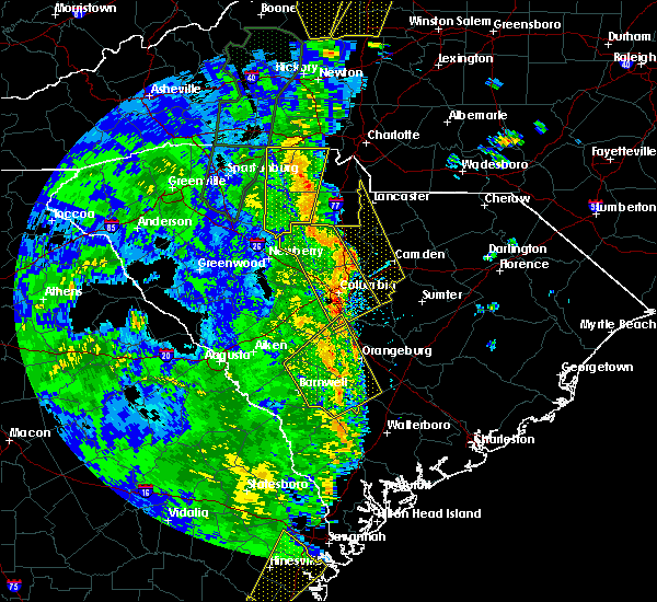 At 239 pm edt, severe thunderstorms extended from central fairfield county southward into central richland county. movement was northeast near 50 mph (radar indicated). Hazards include 70 mph wind gusts. Expect considerable tree damage. Damage is likely to mobile homes, roofs, and outbuildings. At 239 pm edt, severe thunderstorms extended from central fairfield county southward into central richland county. movement was northeast near 50 mph (radar indicated). Hazards include 70 mph wind gusts. Expect considerable tree damage. Damage is likely to mobile homes, roofs, and outbuildings.
|
| 3/1/2018 3:32 PM EST | Lancaster dispatch reported trees and powerlines down in the elgin communit in lancaster county SC, 4.9 miles NW of Lancaster, SC |
| 9/1/2017 2:54 PM EDT |
 At 252 pm edt, a severe thunderstorm was located 10 miles southwest of heath springs, or 15 miles northwest of camden, moving northeast at 40 mph (radar indicated). Hazards include 70 mph wind gusts and half dollar size hail. Hail damage to vehicles is expected. expect considerable tree damage. wind damage is also likely to mobile homes, roofs, and outbuildings. locations impacted include, lancaster, pageland, kershaw, elgin, heath springs, irwin, jefferson, mount croghan and lancaster mill. A tornado watch remains in effect until 1000 pm edt for central south carolina. At 252 pm edt, a severe thunderstorm was located 10 miles southwest of heath springs, or 15 miles northwest of camden, moving northeast at 40 mph (radar indicated). Hazards include 70 mph wind gusts and half dollar size hail. Hail damage to vehicles is expected. expect considerable tree damage. wind damage is also likely to mobile homes, roofs, and outbuildings. locations impacted include, lancaster, pageland, kershaw, elgin, heath springs, irwin, jefferson, mount croghan and lancaster mill. A tornado watch remains in effect until 1000 pm edt for central south carolina.
|
| 9/1/2017 2:33 PM EDT |
 At 233 pm edt, a severe thunderstorm was located 8 miles east of winnsboro, moving northeast at 40 mph (radar indicated). Hazards include 70 mph wind gusts and half dollar size hail. Hail damage to vehicles is expected. expect considerable tree damage. Wind damage is also likely to mobile homes, roofs, and outbuildings. At 233 pm edt, a severe thunderstorm was located 8 miles east of winnsboro, moving northeast at 40 mph (radar indicated). Hazards include 70 mph wind gusts and half dollar size hail. Hail damage to vehicles is expected. expect considerable tree damage. Wind damage is also likely to mobile homes, roofs, and outbuildings.
|
| 7/28/2017 5:04 PM EDT |
 At 504 pm edt, severe thunderstorms were located along a line extending from indian trail to 6 miles east of elgin, moving east at 45 mph (radar indicated). Hazards include 60 mph wind gusts. Expect damage to roofs, siding, and trees. Locations impacted include, elgin and heath springs. At 504 pm edt, severe thunderstorms were located along a line extending from indian trail to 6 miles east of elgin, moving east at 45 mph (radar indicated). Hazards include 60 mph wind gusts. Expect damage to roofs, siding, and trees. Locations impacted include, elgin and heath springs.
|
| 7/28/2017 4:41 PM EDT | Sheriff dispatch reported a couple of trees down on the north side of lancaster. one area was along hwy. 200 and robin driv in lancaster county SC, 2.9 miles SSW of Lancaster, SC |
| 7/28/2017 4:27 PM EDT |
 At 426 pm edt, severe thunderstorms were located along a line extending from town of lake wylie to near great falls, moving east at 45 mph (radar indicated). Hazards include 60 mph wind gusts. expect damage to roofs, siding, and trees At 426 pm edt, severe thunderstorms were located along a line extending from town of lake wylie to near great falls, moving east at 45 mph (radar indicated). Hazards include 60 mph wind gusts. expect damage to roofs, siding, and trees
|
| 7/1/2017 7:26 PM EDT | Lancaster county emergency dispatch reports trees down blocking the roadway near the intersection of north rocky river road and camp creek roa in lancaster county SC, 10.2 miles WSW of Lancaster, SC |
| 7/1/2017 7:02 PM EDT |
 At 702 pm edt, a severe thunderstorm was located near waxhaw, or 9 miles northeast of lancaster, moving southeast at 15 mph (radar indicated). Hazards include 60 mph wind gusts. expect damage to roofs, siding, and trees At 702 pm edt, a severe thunderstorm was located near waxhaw, or 9 miles northeast of lancaster, moving southeast at 15 mph (radar indicated). Hazards include 60 mph wind gusts. expect damage to roofs, siding, and trees
|
| 5/24/2017 4:19 PM EDT | Trees in roadway camp creek and george carnes roa in lancaster county SC, 12 miles WSW of Lancaster, SC |
| 5/24/2017 4:13 PM EDT | Trees in roadway monroe highway and capricorn roa in lancaster county SC, 5.9 miles SSW of Lancaster, SC |
| 5/24/2017 4:09 PM EDT |
 At 407 pm edt, a severe thunderstorm capable of producing a tornado was located over lancaster, moving northeast at 30 mph (radar indicated rotation). Hazards include tornado. Flying debris will be dangerous to those caught without shelter. mobile homes will be damaged or destroyed. damage to roofs, windows, and vehicles will occur. tree damage is likely. Locations impacted include, lancaster and northeast of the town of lancaster. At 407 pm edt, a severe thunderstorm capable of producing a tornado was located over lancaster, moving northeast at 30 mph (radar indicated rotation). Hazards include tornado. Flying debris will be dangerous to those caught without shelter. mobile homes will be damaged or destroyed. damage to roofs, windows, and vehicles will occur. tree damage is likely. Locations impacted include, lancaster and northeast of the town of lancaster.
|
| 5/24/2017 4:00 PM EDT |
 At 358 pm edt, a severe thunderstorm capable of producing a tornado was located over irwin, or near lancaster, moving northeast at 35 mph (radar indicated rotation). Hazards include tornado. Flying debris will be dangerous to those caught without shelter. mobile homes will be damaged or destroyed. damage to roofs, windows, and vehicles will occur. tree damage is likely. the town of lancaster is in the path of this storm. If you live in the town of lancaster take shelter immediately. At 358 pm edt, a severe thunderstorm capable of producing a tornado was located over irwin, or near lancaster, moving northeast at 35 mph (radar indicated rotation). Hazards include tornado. Flying debris will be dangerous to those caught without shelter. mobile homes will be damaged or destroyed. damage to roofs, windows, and vehicles will occur. tree damage is likely. the town of lancaster is in the path of this storm. If you live in the town of lancaster take shelter immediately.
|
| 5/24/2017 3:54 PM EDT |
 At 353 pm edt, a severe thunderstorm capable of producing a tornado was located near irwin, or near lancaster, moving northeast at 35 mph (radar indicated rotation). Hazards include tornado. Flying debris will be dangerous to those caught without shelter. mobile homes will be damaged or destroyed. damage to roofs, windows, and vehicles will occur. tree damage is likely. this dangerous storm will be near, lancaster and elgin around 405 pm edt. Other locations impacted by this tornadic thunderstorm include lancaster mill. At 353 pm edt, a severe thunderstorm capable of producing a tornado was located near irwin, or near lancaster, moving northeast at 35 mph (radar indicated rotation). Hazards include tornado. Flying debris will be dangerous to those caught without shelter. mobile homes will be damaged or destroyed. damage to roofs, windows, and vehicles will occur. tree damage is likely. this dangerous storm will be near, lancaster and elgin around 405 pm edt. Other locations impacted by this tornadic thunderstorm include lancaster mill.
|
| 5/24/2017 3:48 PM EDT |
 At 348 pm edt, a severe thunderstorm was located near fishing creek reservoir, or 8 miles south-southwest of lancaster, moving northeast at 40 mph (radar indicated). Hazards include 60 mph wind gusts and quarter size hail. Hail damage to vehicles is expected. Expect wind damage to roofs, siding, and trees. At 348 pm edt, a severe thunderstorm was located near fishing creek reservoir, or 8 miles south-southwest of lancaster, moving northeast at 40 mph (radar indicated). Hazards include 60 mph wind gusts and quarter size hail. Hail damage to vehicles is expected. Expect wind damage to roofs, siding, and trees.
|
| 4/3/2017 5:09 PM EDT |
 The severe thunderstorm warning for fairfield, lancaster and northwestern kershaw counties will expire at 515 pm edt, the storms which prompted the warning have moved out of the area. therefore the warning will be allowed to expire. however gusty winds are still possible with these thunderstorms. a tornado watch remains in effect until 900 pm edt for central south carolina. The severe thunderstorm warning for fairfield, lancaster and northwestern kershaw counties will expire at 515 pm edt, the storms which prompted the warning have moved out of the area. therefore the warning will be allowed to expire. however gusty winds are still possible with these thunderstorms. a tornado watch remains in effect until 900 pm edt for central south carolina.
|
| 4/3/2017 4:32 PM EDT | Trees down near john everall road and john truesdale roa in lancaster county SC, 4 miles WSW of Lancaster, SC |
| 4/3/2017 4:30 PM EDT | Trees in roadway at old pardue road and zion road. time estimated from rada in lancaster county SC, 4.1 miles SW of Lancaster, SC |
| 4/3/2017 4:10 PM EDT |
 At 410 pm edt, severe thunderstorms were located along a line extending from southpark mall to 13 miles west of winnsboro, moving northeast at 60 mph (radar indicated). Hazards include 60 mph wind gusts and penny size hail. expect damage to roofs, siding, and trees At 410 pm edt, severe thunderstorms were located along a line extending from southpark mall to 13 miles west of winnsboro, moving northeast at 60 mph (radar indicated). Hazards include 60 mph wind gusts and penny size hail. expect damage to roofs, siding, and trees
|
| 3/1/2017 8:47 PM EST |
 At 846 pm est, a severe thunderstorm was located near kershaw, or 13 miles southeast of lancaster, moving east at 50 mph (radar indicated). Hazards include 60 mph wind gusts and quarter size hail. Hail damage to vehicles is expected. expect wind damage to roofs, siding, and trees. Locations impacted include, kershaw, elgin, heath springs and irwin. At 846 pm est, a severe thunderstorm was located near kershaw, or 13 miles southeast of lancaster, moving east at 50 mph (radar indicated). Hazards include 60 mph wind gusts and quarter size hail. Hail damage to vehicles is expected. expect wind damage to roofs, siding, and trees. Locations impacted include, kershaw, elgin, heath springs and irwin.
|
| 3/1/2017 8:34 PM EST |
 At 833 pm est, a severe thunderstorm was located near great falls, or 10 miles south of lancaster, moving east at 50 mph (radar indicated). Hazards include 60 mph wind gusts and quarter size hail. Hail damage to vehicles is expected. expect wind damage to roofs, siding, and trees. Locations impacted include, kershaw, elgin, heath springs and irwin. At 833 pm est, a severe thunderstorm was located near great falls, or 10 miles south of lancaster, moving east at 50 mph (radar indicated). Hazards include 60 mph wind gusts and quarter size hail. Hail damage to vehicles is expected. expect wind damage to roofs, siding, and trees. Locations impacted include, kershaw, elgin, heath springs and irwin.
|
| 3/1/2017 8:15 PM EST |
 At 814 pm est, a severe thunderstorm was located near blackstock, or 11 miles north of winnsboro, moving east at 50 mph (radar indicated). Hazards include 60 mph wind gusts and quarter size hail. Hail damage to vehicles is expected. Expect wind damage to roofs, siding, and trees. At 814 pm est, a severe thunderstorm was located near blackstock, or 11 miles north of winnsboro, moving east at 50 mph (radar indicated). Hazards include 60 mph wind gusts and quarter size hail. Hail damage to vehicles is expected. Expect wind damage to roofs, siding, and trees.
|
| 11/30/2016 6:55 PM EST |
 The tornado warning for lancaster county will expire at 700 pm est, the tornado threat has diminished and the tornado warning has been cancelled. however, damaging winds remain likely and a severe thunderstorm warning remains in effect for the area. The tornado warning for lancaster county will expire at 700 pm est, the tornado threat has diminished and the tornado warning has been cancelled. however, damaging winds remain likely and a severe thunderstorm warning remains in effect for the area.
|
| 11/30/2016 6:44 PM EST |
 At 644 pm est, a severe thunderstorm capable of producing a tornado was located near elgin, or 7 miles south of lancaster, moving east at 70 mph (radar indicated rotation). Hazards include tornado. Flying debris will be dangerous to those caught without shelter. mobile homes will be damaged or destroyed. damage to roofs, windows, and vehicles will occur. tree damage is likely. This tornadic thunderstorm will remain over mainly rural areas of lancaster county, including the following locations: lancaster mill. At 644 pm est, a severe thunderstorm capable of producing a tornado was located near elgin, or 7 miles south of lancaster, moving east at 70 mph (radar indicated rotation). Hazards include tornado. Flying debris will be dangerous to those caught without shelter. mobile homes will be damaged or destroyed. damage to roofs, windows, and vehicles will occur. tree damage is likely. This tornadic thunderstorm will remain over mainly rural areas of lancaster county, including the following locations: lancaster mill.
|
| 11/30/2016 6:38 PM EST |
 At 637 pm est, severe thunderstorms were located along a line extending from coddle creek reservoir to 6 miles north of lancaster to 6 miles south of great falls, moving northeast at 60 mph (radar indicated). Hazards include 60 mph wind gusts. Expect damage to roofs. siding. and trees. Locations impacted include, lancaster, kershaw, elgin, heath springs, irwin, ridgeway, lancaster mill and winnsboro mills. At 637 pm est, severe thunderstorms were located along a line extending from coddle creek reservoir to 6 miles north of lancaster to 6 miles south of great falls, moving northeast at 60 mph (radar indicated). Hazards include 60 mph wind gusts. Expect damage to roofs. siding. and trees. Locations impacted include, lancaster, kershaw, elgin, heath springs, irwin, ridgeway, lancaster mill and winnsboro mills.
|
| 11/30/2016 6:33 PM EST |
 At 633 pm est, a severe thunderstorm capable of producing a tornado was located near great falls, or 14 miles southwest of lancaster, moving east at 45 mph (radar indicated rotation). Hazards include tornado. Flying debris will be dangerous to those caught without shelter. mobile homes will be damaged or destroyed. damage to roofs, windows, and vehicles will occur. tree damage is likely. this dangerous storm will be near, springdale and irwin around 645 pm est. lancaster, elgin and heath springs around 650 pm est. Other locations impacted by this tornadic thunderstorm include lancaster mill. At 633 pm est, a severe thunderstorm capable of producing a tornado was located near great falls, or 14 miles southwest of lancaster, moving east at 45 mph (radar indicated rotation). Hazards include tornado. Flying debris will be dangerous to those caught without shelter. mobile homes will be damaged or destroyed. damage to roofs, windows, and vehicles will occur. tree damage is likely. this dangerous storm will be near, springdale and irwin around 645 pm est. lancaster, elgin and heath springs around 650 pm est. Other locations impacted by this tornadic thunderstorm include lancaster mill.
|
| 11/30/2016 6:06 PM EST |
 At 605 pm est, severe thunderstorms were located along a line extending from gastonia to near chester state park to 12 miles east of prosperity, moving northeast at 45 mph (radar indicated). Hazards include 60 mph wind gusts. Expect damage to roofs. siding. And trees. At 605 pm est, severe thunderstorms were located along a line extending from gastonia to near chester state park to 12 miles east of prosperity, moving northeast at 45 mph (radar indicated). Hazards include 60 mph wind gusts. Expect damage to roofs. siding. And trees.
|
| 7/16/2016 7:19 PM EDT |
 At 718 pm edt, severe thunderstorms were located along a line extending from 9 miles northeast of elgin to 9 miles north of clyde to 8 miles southwest of bishopville, moving east at 45 mph (radar indicated). Hazards include 60 mph wind gusts. Expect damage to roofs. siding. and trees. Locations impacted include, lancaster, bishopville, pageland, kershaw, elgin, heath springs, irwin, mcbee, jefferson, ruby, patrick, bethune, mount croghan and lancaster mill. At 718 pm edt, severe thunderstorms were located along a line extending from 9 miles northeast of elgin to 9 miles north of clyde to 8 miles southwest of bishopville, moving east at 45 mph (radar indicated). Hazards include 60 mph wind gusts. Expect damage to roofs. siding. and trees. Locations impacted include, lancaster, bishopville, pageland, kershaw, elgin, heath springs, irwin, mcbee, jefferson, ruby, patrick, bethune, mount croghan and lancaster mill.
|
| 7/16/2016 7:04 PM EDT |
 At 703 pm edt, severe thunderstorms were located along a line extending from near lancaster to 9 miles east of kershaw to 8 miles southeast of lugoff, moving east at 45 mph (radar indicated). Hazards include 60 mph wind gusts. Expect damage to roofs. siding. And trees. At 703 pm edt, severe thunderstorms were located along a line extending from near lancaster to 9 miles east of kershaw to 8 miles southeast of lugoff, moving east at 45 mph (radar indicated). Hazards include 60 mph wind gusts. Expect damage to roofs. siding. And trees.
|
| 7/15/2016 6:11 PM EDT |
 At 610 pm edt, severe thunderstorms were located along a line extending from pineville to near lesslie, moving east at 35 mph (radar indicated). Hazards include 60 mph wind gusts. Expect damage to roofs. siding. And trees. At 610 pm edt, severe thunderstorms were located along a line extending from pineville to near lesslie, moving east at 35 mph (radar indicated). Hazards include 60 mph wind gusts. Expect damage to roofs. siding. And trees.
|
| 7/8/2016 11:07 PM EDT |
 At 1107 pm edt, a severe thunderstorm was located near great falls, or 12 miles south of lancaster, moving southeast at 45 mph (radar indicated). Hazards include 60 mph wind gusts. Expect damage to roofs. siding. And trees. At 1107 pm edt, a severe thunderstorm was located near great falls, or 12 miles south of lancaster, moving southeast at 45 mph (radar indicated). Hazards include 60 mph wind gusts. Expect damage to roofs. siding. And trees.
|
| 7/8/2016 9:41 PM EDT |
 At 940 pm edt, severe thunderstorms were located along a line extending from near cheraw to near irwin, moving southeast at 40 mph (radar indicated). Hazards include 60 mph wind gusts. Expect damage to roofs. siding. And trees. At 940 pm edt, severe thunderstorms were located along a line extending from near cheraw to near irwin, moving southeast at 40 mph (radar indicated). Hazards include 60 mph wind gusts. Expect damage to roofs. siding. And trees.
|
| 7/8/2016 8:10 PM EDT |
 At 809 pm edt, a severe thunderstorm was located near lesslie, or 8 miles east of rock hill, moving east at 35 mph (radar indicated). Hazards include 60 mph wind gusts. Expect damage to roofs. siding. And trees. At 809 pm edt, a severe thunderstorm was located near lesslie, or 8 miles east of rock hill, moving east at 35 mph (radar indicated). Hazards include 60 mph wind gusts. Expect damage to roofs. siding. And trees.
|
| 7/7/2016 7:34 PM EDT | Dispatch reported 3 trees down near the intersection of hwy. 200 and hwy. 97 near great falls. in lancaster county SC, 10.1 miles NE of Lancaster, SC |
| 7/7/2016 4:15 PM EDT |
 At 415 pm edt, a severe thunderstorm was located over heath springs, or 9 miles southeast of lancaster, moving east at 25 mph (radar indicated). Hazards include 60 mph wind gusts and penny size hail. Expect damage to roofs. siding. and trees. Locations impacted include, lancaster, kershaw, elgin, heath springs and lancaster mill. At 415 pm edt, a severe thunderstorm was located over heath springs, or 9 miles southeast of lancaster, moving east at 25 mph (radar indicated). Hazards include 60 mph wind gusts and penny size hail. Expect damage to roofs. siding. and trees. Locations impacted include, lancaster, kershaw, elgin, heath springs and lancaster mill.
|
| 7/7/2016 3:52 PM EDT |
 At 352 pm edt, a severe thunderstorm was located over fishing creek reservoir, or 8 miles southwest of lancaster, moving east at 30 mph (radar indicated). Hazards include 60 mph wind gusts and penny size hail. Expect damage to roofs. siding. And trees. At 352 pm edt, a severe thunderstorm was located over fishing creek reservoir, or 8 miles southwest of lancaster, moving east at 30 mph (radar indicated). Hazards include 60 mph wind gusts and penny size hail. Expect damage to roofs. siding. And trees.
|
| 7/5/2016 5:17 PM EDT |
 At 515 pm edt, a line of thunderstorms extended from lancaster county southward through columbia and swansea. movement was east northeastward near 35 mph. some of the storms likely contained wind gusts of 40 to 60 mph (radar indicated). Hazards include 60 mph wind gusts. Expect damage to roofs. siding. and trees. locations impacted include, columbia, orangeburg, cayce, forest acres, lancaster, camden, springdale, st. andrews, dentsville, oak grove, woodfields, brookdale, pageland, south congaree, pine ridge, st. Matthews, kershaw, gaston and elgin. At 515 pm edt, a line of thunderstorms extended from lancaster county southward through columbia and swansea. movement was east northeastward near 35 mph. some of the storms likely contained wind gusts of 40 to 60 mph (radar indicated). Hazards include 60 mph wind gusts. Expect damage to roofs. siding. and trees. locations impacted include, columbia, orangeburg, cayce, forest acres, lancaster, camden, springdale, st. andrews, dentsville, oak grove, woodfields, brookdale, pageland, south congaree, pine ridge, st. Matthews, kershaw, gaston and elgin.
|
| 7/5/2016 5:05 PM EDT |
 At 504 pm edt, severe thunderstorms were located along a line extending from 8 miles northeast of winnsboro to 15 miles southeast of batesburg-leesville, moving northeast at 75 mph (radar indicated). Hazards include 60 mph wind gusts. Expect damage to roofs. siding. And trees. At 504 pm edt, severe thunderstorms were located along a line extending from 8 miles northeast of winnsboro to 15 miles southeast of batesburg-leesville, moving northeast at 75 mph (radar indicated). Hazards include 60 mph wind gusts. Expect damage to roofs. siding. And trees.
|
| 5/2/2016 4:57 PM EDT | The severe thunderstorm warning for southwestern lancaster county will expire at 500 pm edt. the storm which prompted the warning has weakened below severe limits. and no longer poses an immediate threat to life or property. therefore the warning will be allowed to expire. However small hail and heavy rain are still possible with this thunderstorm. |
| 5/2/2016 4:42 PM EDT | 2-3 trees down on smokey starnes rd... reported via social media and verified with phot in lancaster county SC, 9.4 miles WSW of Lancaster, SC |
| 5/2/2016 4:42 PM EDT |
 At 439 pm edt, a severe thunderstorm was located near elgin, or just east of lancaster, moving northeast at 20 mph (radar indicated). Hazards include 60 mph wind gusts and quarter size hail. Hail damage to vehicles is expected. expect wind damage to roofs, siding, and trees. Locations impacted include, lancaster, elgin, irwin, fishing creek reservoir and lancaster mill. At 439 pm edt, a severe thunderstorm was located near elgin, or just east of lancaster, moving northeast at 20 mph (radar indicated). Hazards include 60 mph wind gusts and quarter size hail. Hail damage to vehicles is expected. expect wind damage to roofs, siding, and trees. Locations impacted include, lancaster, elgin, irwin, fishing creek reservoir and lancaster mill.
|
| 5/2/2016 4:34 PM EDT | Multiple trees down in lancaster. woodland drive and other location in lancaster county SC, 0.6 miles S of Lancaster, SC |
| 5/2/2016 4:21 PM EDT |
 At 419 pm edt, severe thunderstorms were located along a line extending from 6 miles south of waxhaw to near great falls, moving east at 20 mph (radar indicated. these storms have a history of producing damaging winds and large hail in fairfield county). Hazards include 60 mph wind gusts and quarter size hail. Hail damage to vehicles is expected. expect wind damage to roofs, siding, and trees. Locations impacted include, lancaster, elgin, heath springs, irwin, fishing creek reservoir and lancaster mill. At 419 pm edt, severe thunderstorms were located along a line extending from 6 miles south of waxhaw to near great falls, moving east at 20 mph (radar indicated. these storms have a history of producing damaging winds and large hail in fairfield county). Hazards include 60 mph wind gusts and quarter size hail. Hail damage to vehicles is expected. expect wind damage to roofs, siding, and trees. Locations impacted include, lancaster, elgin, heath springs, irwin, fishing creek reservoir and lancaster mill.
|
| 5/2/2016 3:58 PM EDT |
 At 357 pm edt, a severe thunderstorm was located 8 miles south of great falls, or 11 miles northeast of winnsboro. another severe thunderstorm was located near van wyck and andrew jackson state park. these thunderstorms were moving northeast at 25 mph (radar indicated). Hazards include 60 mph wind gusts and quarter size hail. Hail damage to vehicles is expected. Expect wind damage to roofs, siding, and trees. At 357 pm edt, a severe thunderstorm was located 8 miles south of great falls, or 11 miles northeast of winnsboro. another severe thunderstorm was located near van wyck and andrew jackson state park. these thunderstorms were moving northeast at 25 mph (radar indicated). Hazards include 60 mph wind gusts and quarter size hail. Hail damage to vehicles is expected. Expect wind damage to roofs, siding, and trees.
|
| 3/14/2016 9:12 PM EDT |
 At 910 pm edt, doppler radar indicated and area of thunderstorms some of which likely contained wind gusts in excess of 60 mph and damaging hail. these storms were located near a line extending from near lesslie to near richburg to near clinton, and moving east at 30 mph. At 910 pm edt, doppler radar indicated and area of thunderstorms some of which likely contained wind gusts in excess of 60 mph and damaging hail. these storms were located near a line extending from near lesslie to near richburg to near clinton, and moving east at 30 mph.
|
| 2/24/2016 1:15 PM EST | Ranger at andrew jackson state park reported numerous large to small limbs down in the par in lancaster county SC, 8.4 miles SSE of Lancaster, SC |
| 2/24/2016 1:08 PM EST |
 At 107 pm est, doppler radar indicated a line of severe thunderstorms capable of producing damaging winds in excess of 60 mph. these storms were located along a line extending from 7 miles northwest of lancaster to near great falls, and moving northeast at 60 mph. At 107 pm est, doppler radar indicated a line of severe thunderstorms capable of producing damaging winds in excess of 60 mph. these storms were located along a line extending from 7 miles northwest of lancaster to near great falls, and moving northeast at 60 mph.
|
| 2/24/2016 12:17 PM EST |
 At 1216 pm est, doppler radar indicated a line of severe thunderstorms capable of producing damaging winds in excess of 60 mph. these storms were located along a line extending from newport to near chester state park, and moving northeast at 75 mph. At 1216 pm est, doppler radar indicated a line of severe thunderstorms capable of producing damaging winds in excess of 60 mph. these storms were located along a line extending from newport to near chester state park, and moving northeast at 75 mph.
|
| 12/30/2015 12:51 PM EST | Trees in roadway sc hwy 97 in lancaster county SC, 0.9 miles SW of Lancaster, SC |
| 12/30/2015 12:30 PM EST |
 At 1229 pm est, doppler radar indicated a severe thunderstorm capable of producing damaging winds in excess of 60 mph. this storm was located near fishing creek reservoir, or 12 miles southwest of lancaster, and moving east at 35 mph. At 1229 pm est, doppler radar indicated a severe thunderstorm capable of producing damaging winds in excess of 60 mph. this storm was located near fishing creek reservoir, or 12 miles southwest of lancaster, and moving east at 35 mph.
|
| 9/10/2015 5:38 PM EDT | Lancaster county 911 reported a large car port-shed blown down on pageland hwy... and a tree fallen onto a house on fairfield street in the city of lancaste in lancaster county SC, 1.8 miles W of Lancaster, SC |
| 9/10/2015 5:28 PM EDT | Lancaster county 911 reported a large car port-shed blown down on fairfield street in the city of lancaste in lancaster county SC, 1.8 miles W of Lancaster, SC |
| 7/13/2015 10:17 PM EDT |
 At 1016 pm edt, doppler radar indicated a severe thunderstorm capable of producing damaging winds in excess of 60 mph. this storm was located over heath springs, or 11 miles southeast of lancaster, and moving southeast at 35 mph. At 1016 pm edt, doppler radar indicated a severe thunderstorm capable of producing damaging winds in excess of 60 mph. this storm was located over heath springs, or 11 miles southeast of lancaster, and moving southeast at 35 mph.
|
| 7/13/2015 10:03 PM EDT | Sc highway patrol reported trees down on woodland drive at gillsbrook driv in lancaster county SC, 0.5 miles E of Lancaster, SC |
| 7/13/2015 9:29 PM EDT |
 At 929 pm edt, doppler radar indicated a severe thunderstorm capable of producing quarter size hail and damaging winds in excess of 60 mph. this storm was located near waxhaw, or 12 miles north of lancaster, and moving southeast at 25 mph. At 929 pm edt, doppler radar indicated a severe thunderstorm capable of producing quarter size hail and damaging winds in excess of 60 mph. this storm was located near waxhaw, or 12 miles north of lancaster, and moving southeast at 25 mph.
|
| 7/13/2015 8:12 PM EDT |
 At 811 pm edt, doppler radar indicated a severe thunderstorm capable of producing quarter size hail and damaging winds in excess of 60 mph. this storm was located near lesslie, or near rock hill, and moving southeast at 15 mph. At 811 pm edt, doppler radar indicated a severe thunderstorm capable of producing quarter size hail and damaging winds in excess of 60 mph. this storm was located near lesslie, or near rock hill, and moving southeast at 15 mph.
|
| 6/1/2015 3:08 PM EDT | At 305 pm edt, doppler radar indicated thunderstorms in lancaster county. some of there storms likely contained wind gusts of 40 to 60 mph and penny- to quarter-size hail. the strongest storms extended from the hanging rock battlefield property to around kershaw. movement was northeast near 15 mph. |
| 6/1/2015 2:57 PM EDT | At 255 pm edt, doppler radar indicated a severe thunderstorm near the lancaster and chester county line near great falls. moving northeast near 15 mph. expect damaging wind and hail with this storm. |
| 7/9/2014 2:22 PM EDT | Lancaster county sheriff reported several trees and power lines down on shallow unity road... university drive and zion roa in lancaster county SC, 0.6 miles W of Lancaster, SC |
| 6/16/2014 6:55 PM EDT | Quarter sized hail reported 7.1 miles NW of Lancaster, SC, hail up to quarter sized...in addition to a tree down...on e doc garris rd near elgin. |
| 5/23/2014 6:58 PM EDT | Quarter sized hail reported 5.2 miles NNW of Lancaster, SC, quarter sized hail reported at a convenience store |
| 7/28/2012 11:30 PM EDT | Several trees and power lines down just outside of lancaster in lancaster county SC, 1.1 miles E of Lancaster, SC |
| 7/28/2012 9:20 PM EDT | Tree down on power lines and blocking part of continental roa in lancaster county SC, 1.2 miles W of Lancaster, SC |
| 1/1/0001 12:00 AM | Golf Ball sized hail reported 4.9 miles NW of Lancaster, SC, public report of golf ball size hail |
| 1/1/0001 12:00 AM | Numerous trees and power lines down on laurel ave...some trees fell on homes. no injurie in lancaster county SC, 0.1 miles NW of Lancaster, SC |
| 1/1/0001 12:00 AM | County sherriff reports numerous trees and powerlines down between hwy 5 south to the city of lancaster in lancaster county SC, 0.1 miles NW of Lancaster, SC |
| 1/1/0001 12:00 AM | Sheriff reported trees down in the van wyck are in lancaster county SC, 2.9 miles SSE of Lancaster, SC |
| 1/1/0001 12:00 AM | Dot reported several trees down on riverside road just off hwy 9 west of lancaste in lancaster county SC, 2.9 miles ESE of Lancaster, SC |
| 4/9/2011 9:05 PM EDT | Golf Ball sized hail reported 8 miles NNE of Lancaster, SC, public reported golf ball size hail near highway 200 and lloyd reid road. |
| 4/9/2011 7:15 PM EDT | Half Dollar sized hail reported 4 miles WSW of Lancaster, SC |
| 1/1/0001 12:00 AM | Golf Ball sized hail reported 6.9 miles S of Lancaster, SC, county em measured golf ball sized hail with dents covering his vehicle and others. |
| 1/1/0001 12:00 AM | Golf Ball sized hail reported 0.1 miles NW of Lancaster, SC, spotter reports golf ball sized hail in lancaster |
| 4/9/2011 6:53 PM EDT | Half Dollar sized hail reported 4 miles WSW of Lancaster, SC |
| 1/1/0001 12:00 AM | Quarter sized hail reported 0.1 miles NW of Lancaster, SC |
| 4/9/2011 6:27 PM EDT | Ping Pong Ball sized hail reported 9.4 miles WSW of Lancaster, SC, public reported 1.50 inch hail that covered the ground at the express mart. |
| 1/1/0001 12:00 AM | Golf Ball sized hail reported 0.1 miles NW of Lancaster, SC, lancaster ema reported 3 separate episodes of hail. golf ball sized hail occurred 615-630 pm. 1.5 to 2.0 inch hail occurred 710-720 pm. pea to marble sized occurred 730 |
| 4/9/2011 6:15 PM EDT | Golf Ball sized hail reported 12.9 miles WSW of Lancaster, SC, golf ball size hail covering the ground reported at the m and r mini mart. |
| 1/1/0001 12:00 AM | Hen Egg sized hail reported 8.4 miles SSE of Lancaster, SC, hail measuring 2.00 inches reported at andrew jackson state park. |
| 4/9/2011 6:15 PM EDT | Tennis Ball sized hail reported 8.5 miles SSE of Lancaster, SC, ham radio operator reported tennis ball size hail 1 mile south of the intersection of state route 5 and state route 75 near van wyck. |
Hail Maps for Lancaster, SC


Connect with Interactive Hail Maps