

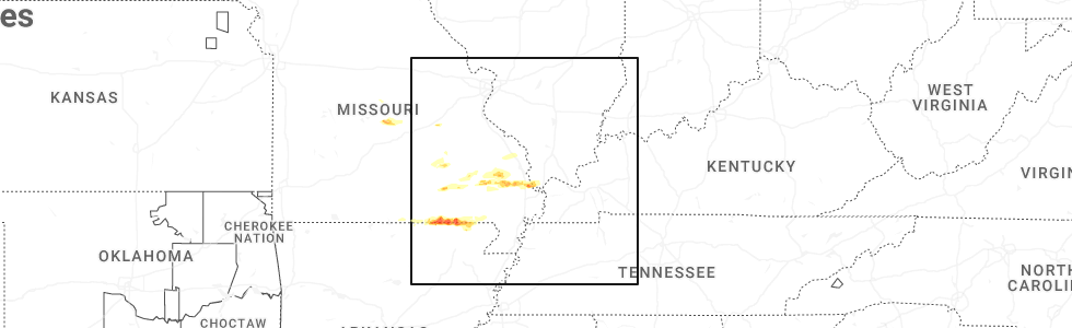
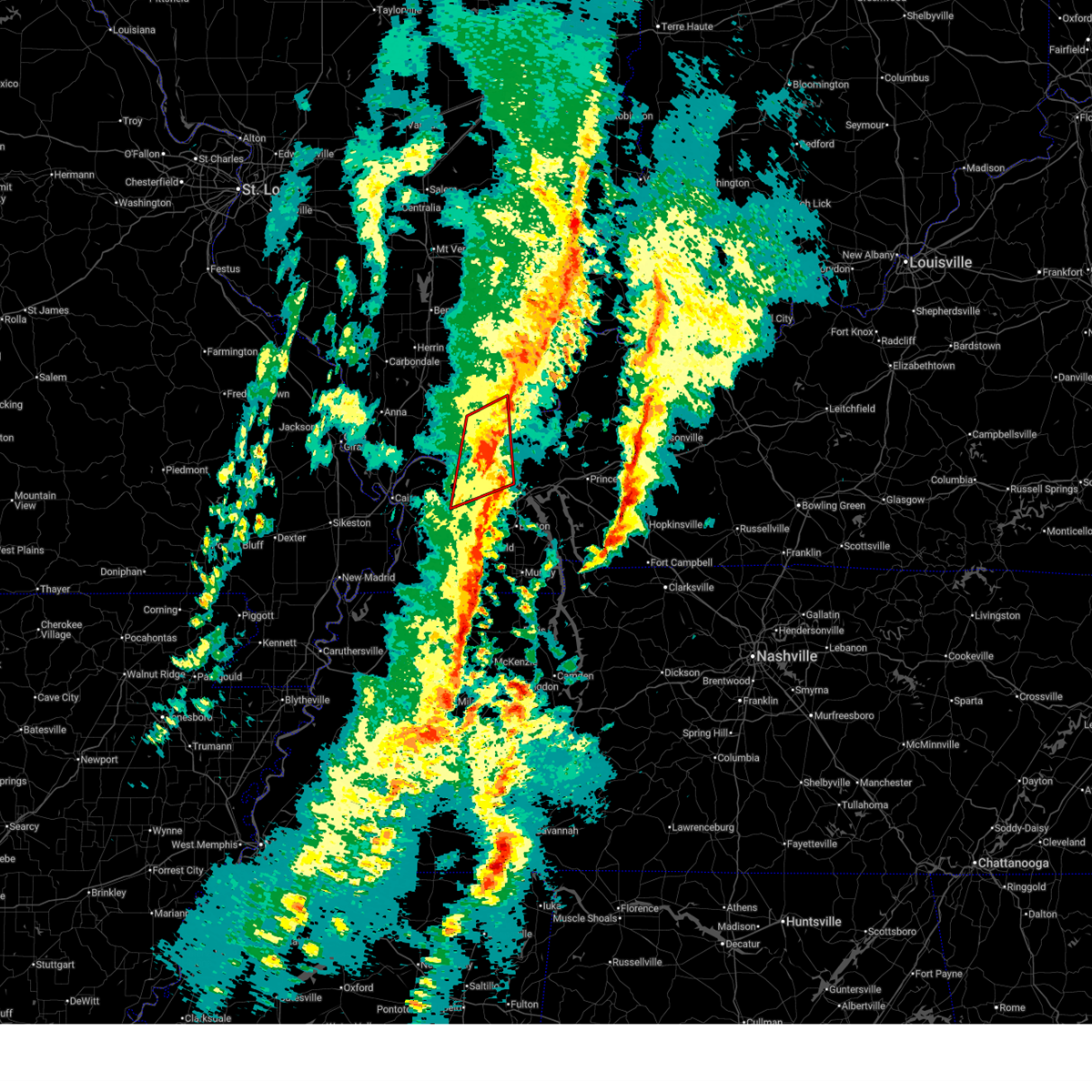
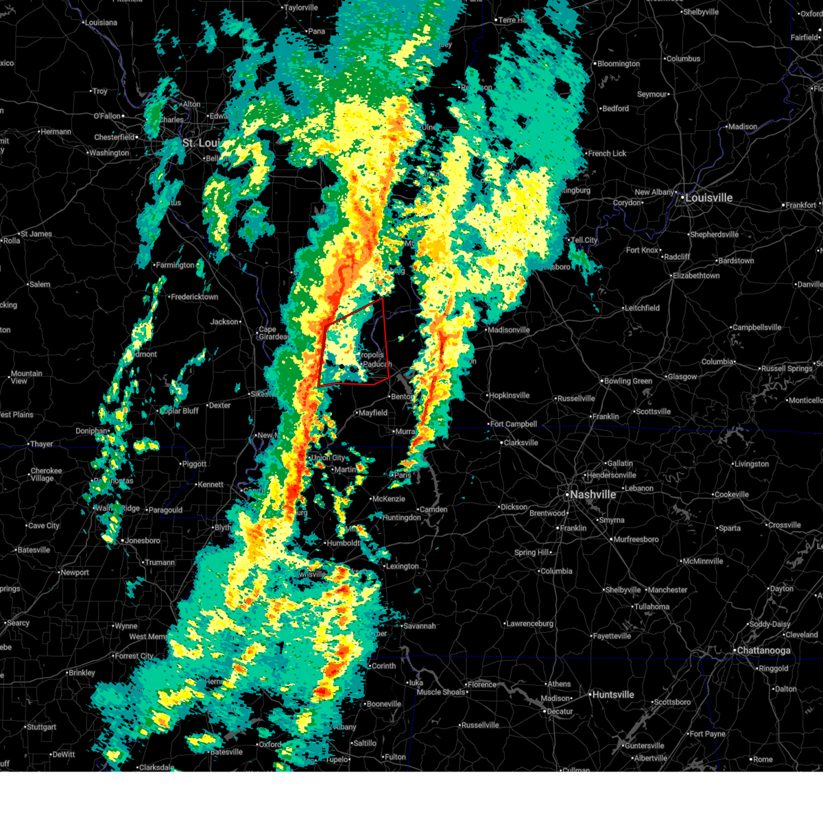
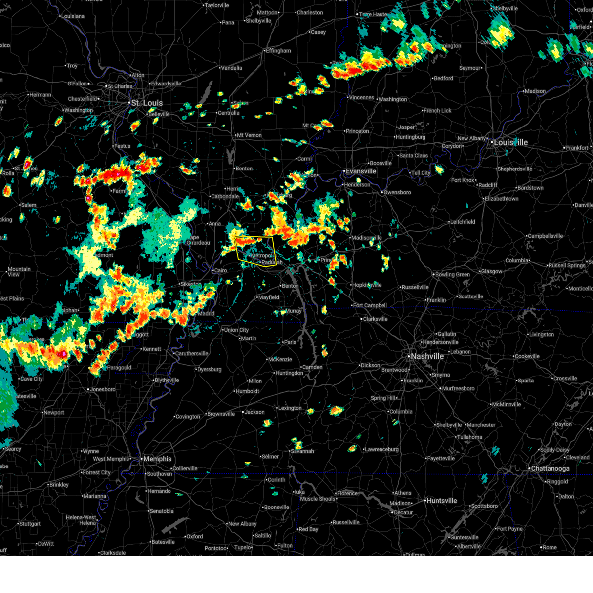
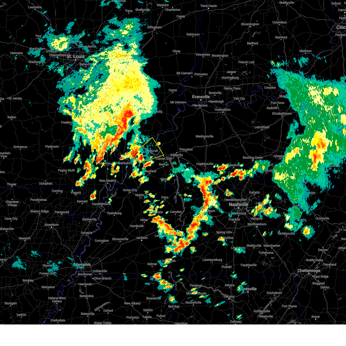
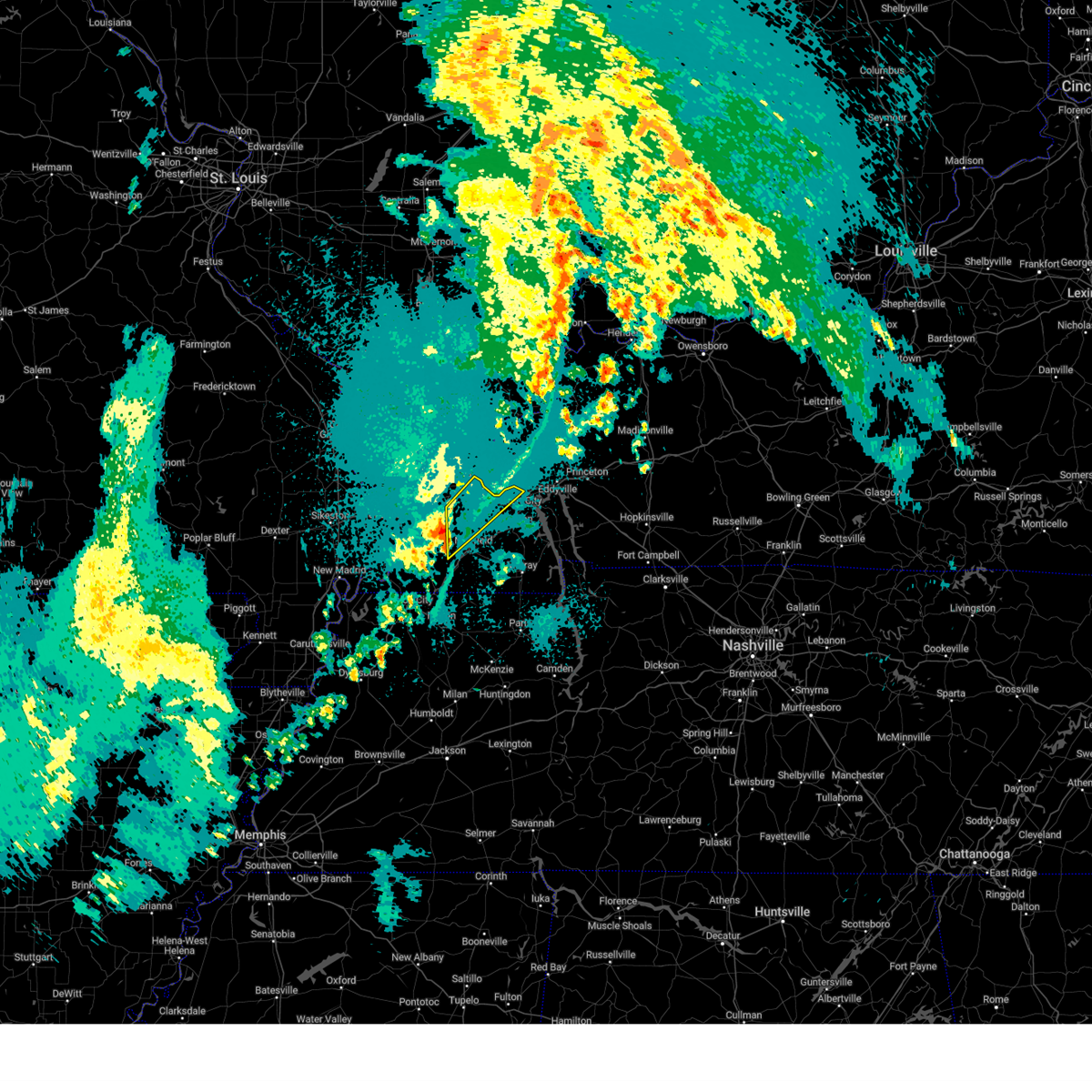
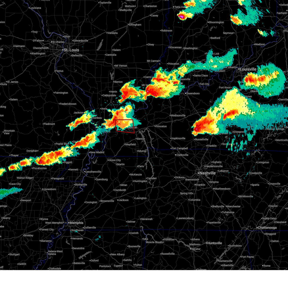
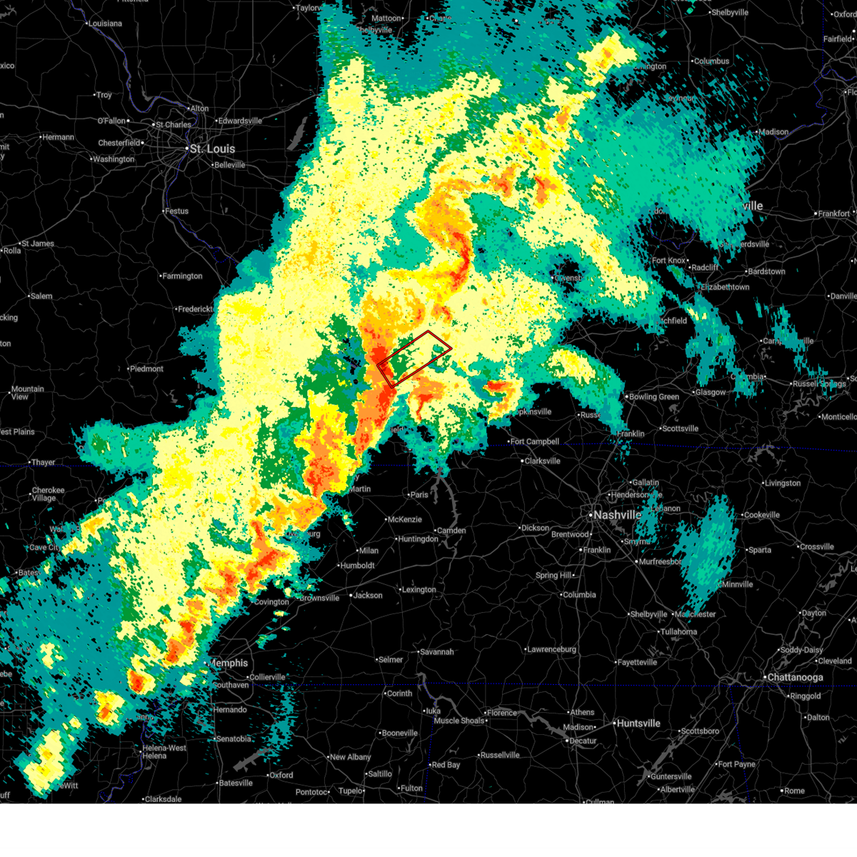
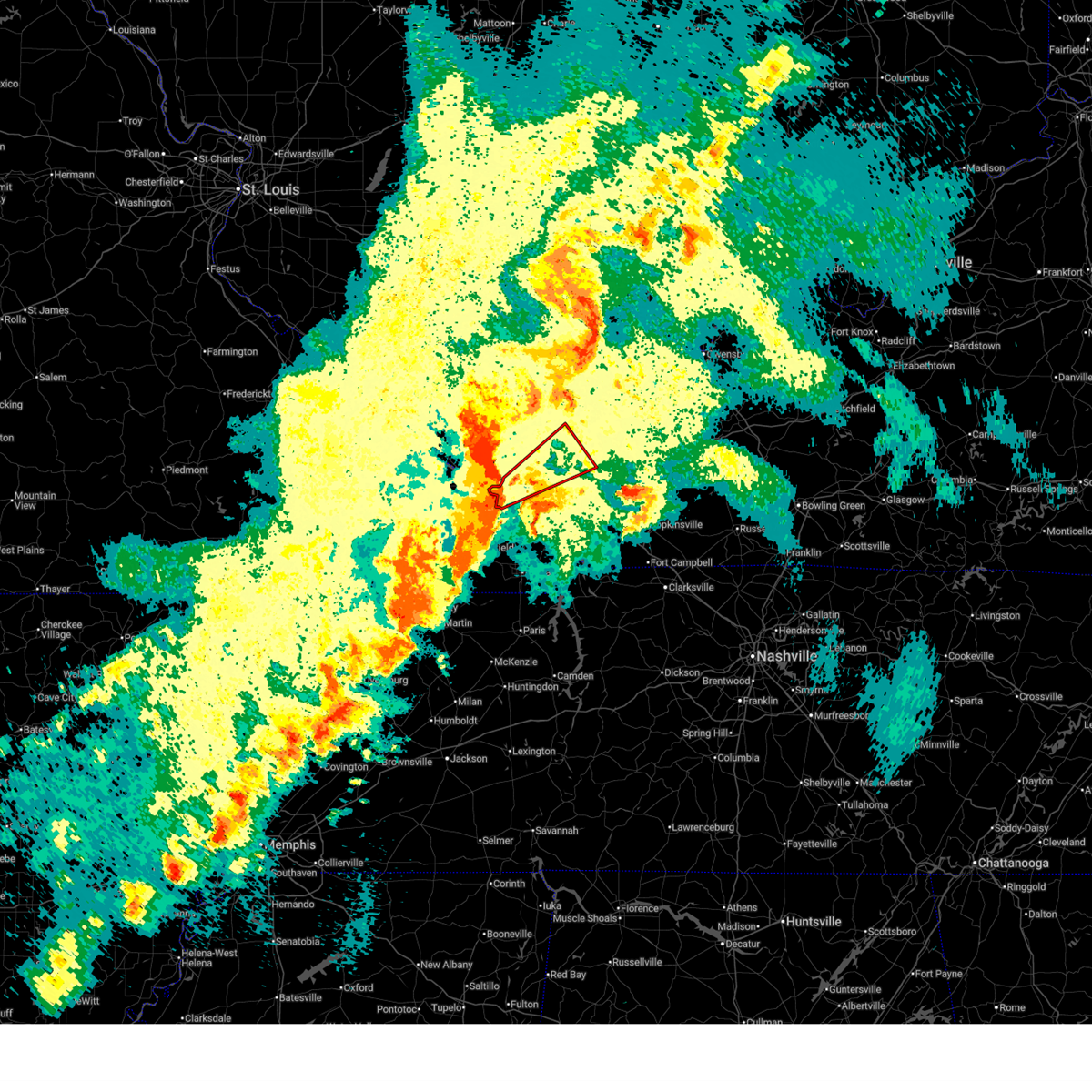
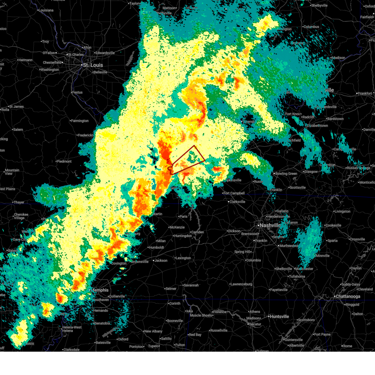
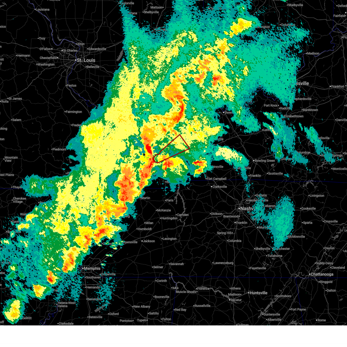
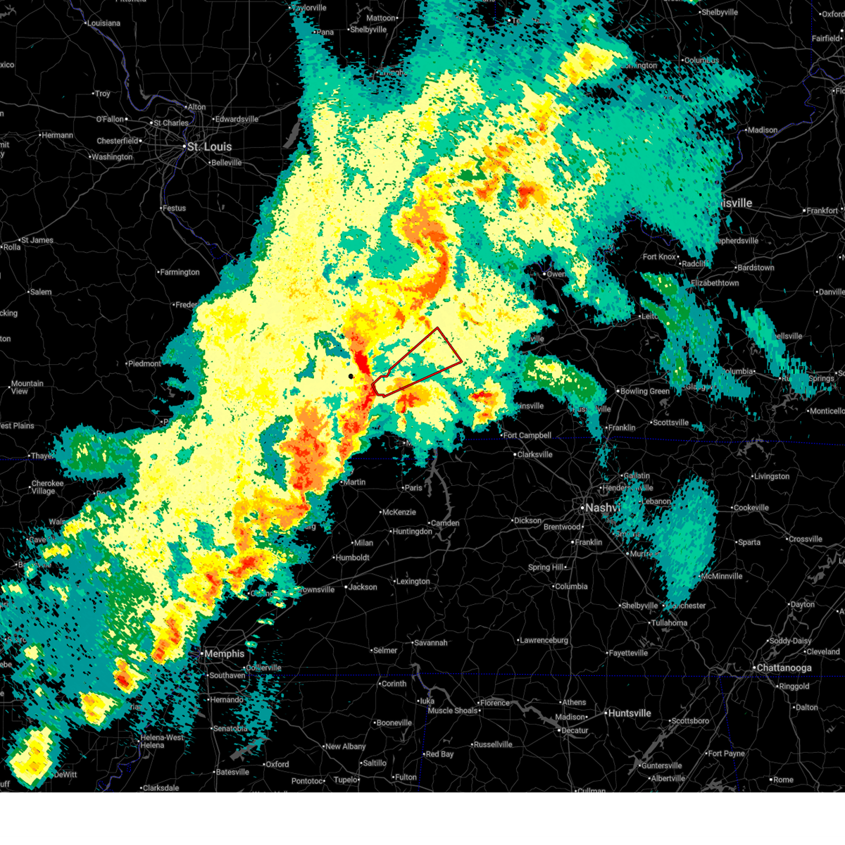
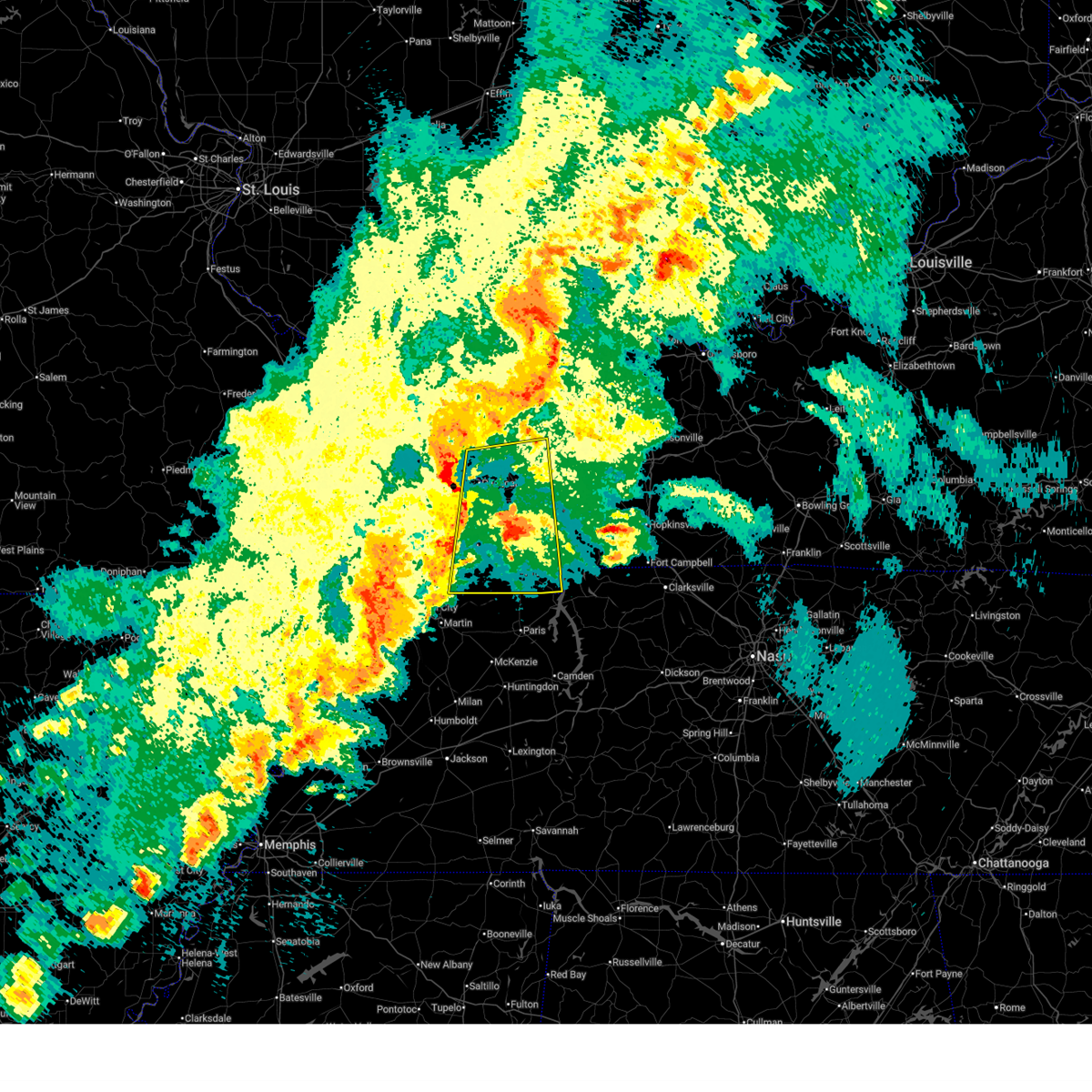
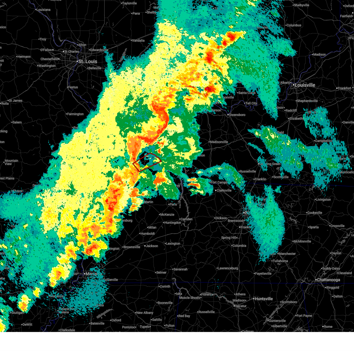
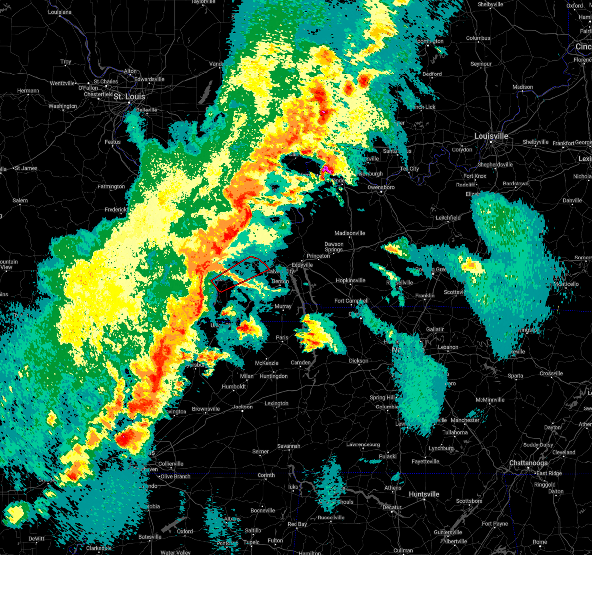
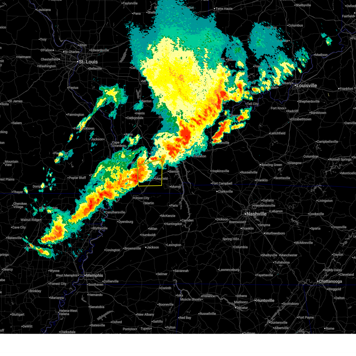
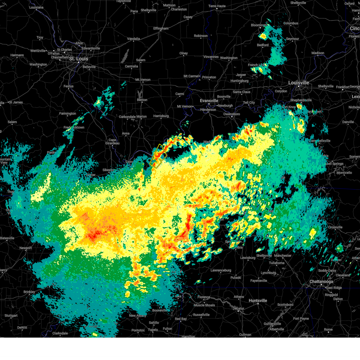
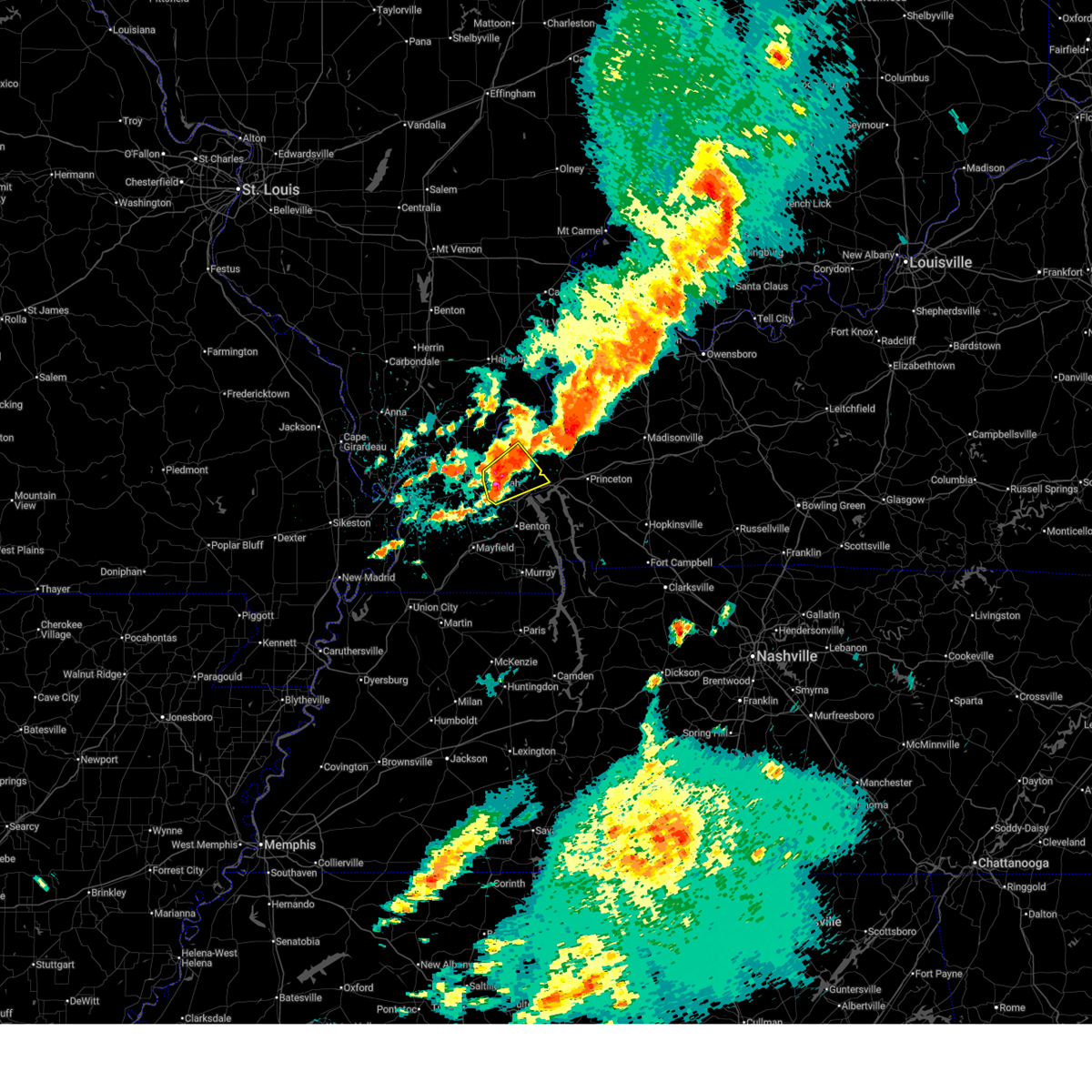
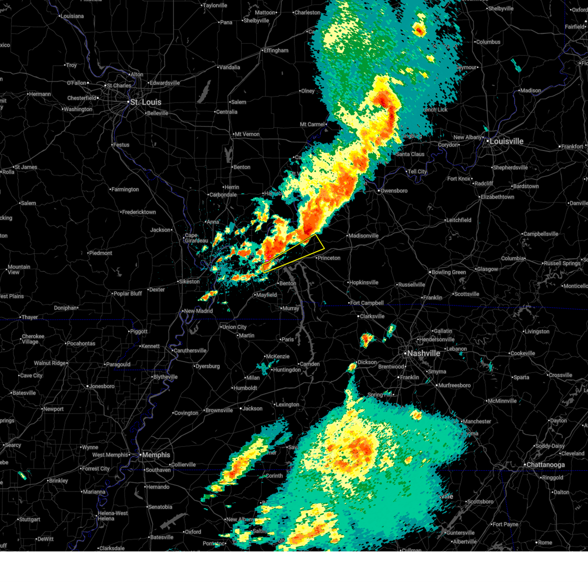
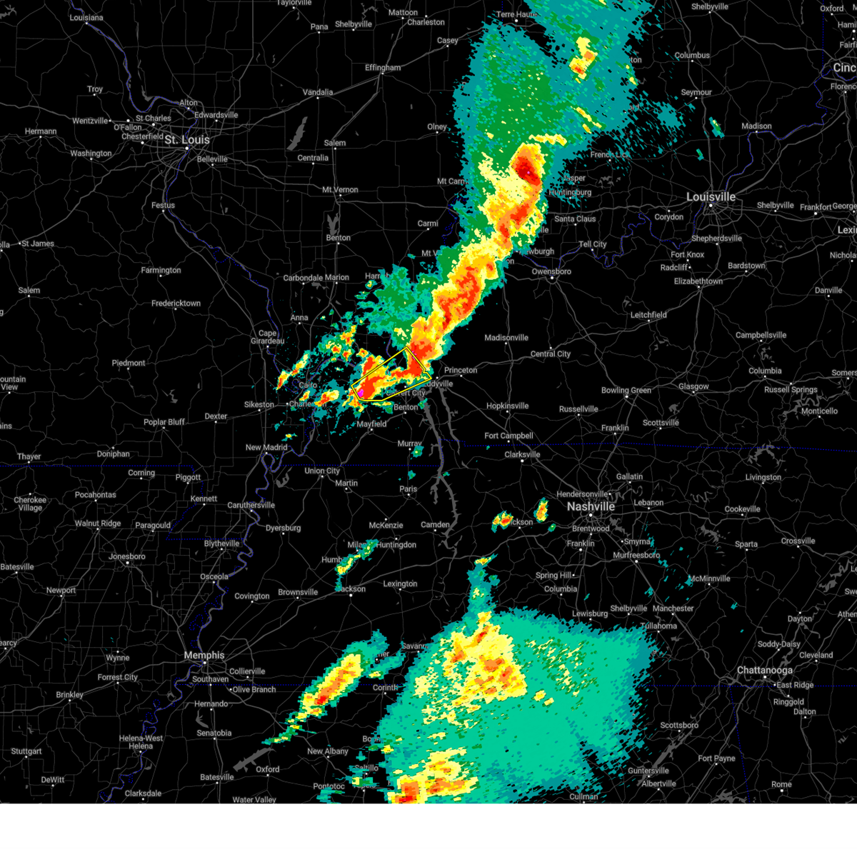
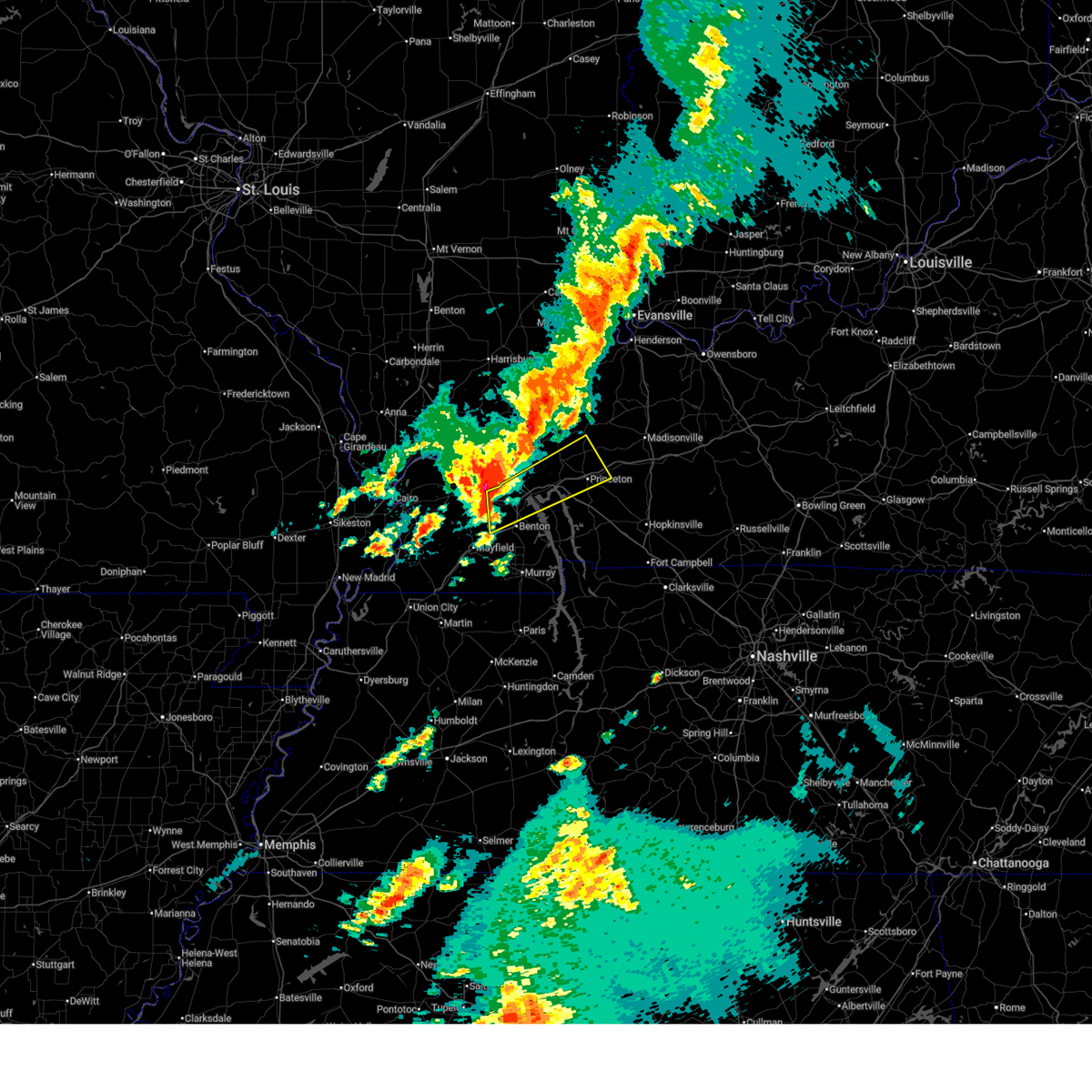
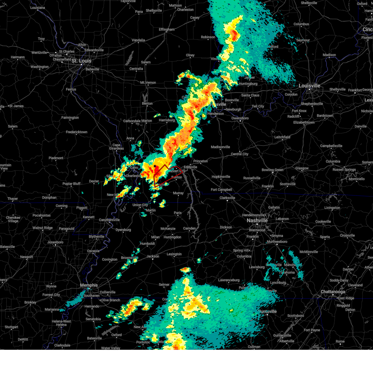
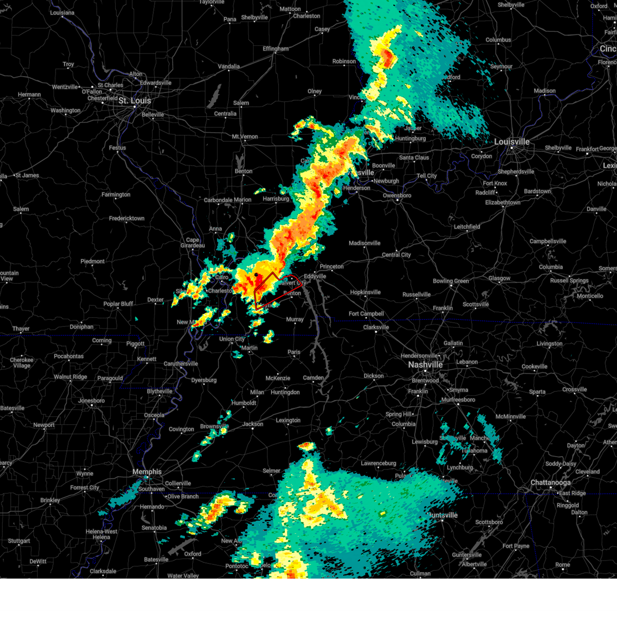
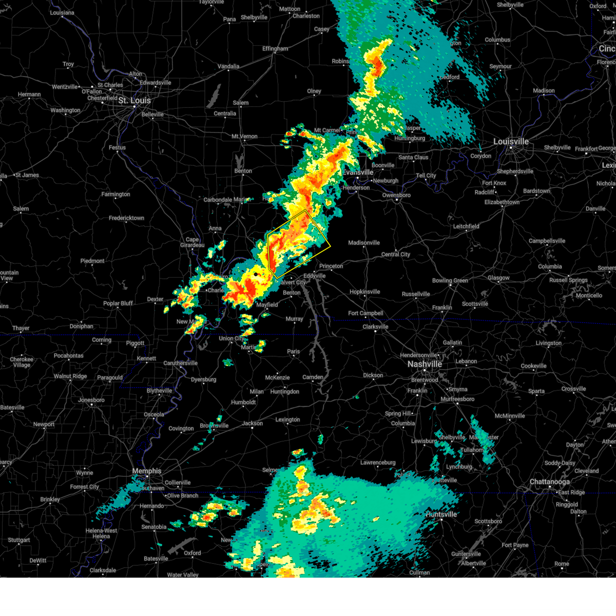
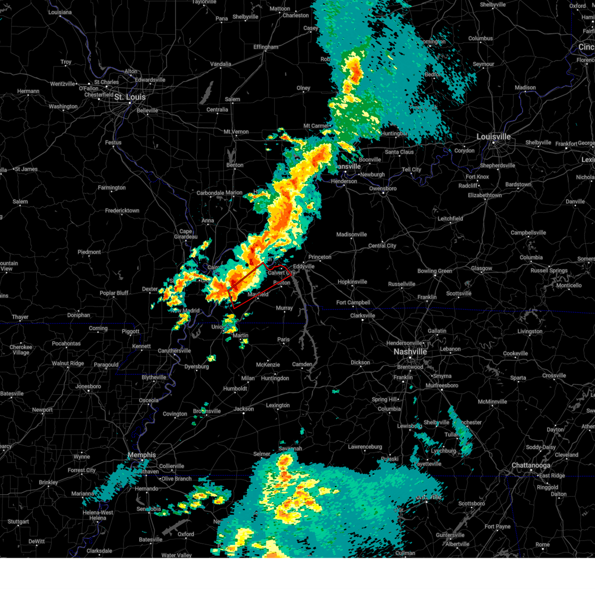
Hail Map for Ledbetter, KY
The Ledbetter, KY area has had 4 reports of on-the-ground hail by trained spotters, and has been under severe weather warnings 15 times during the past 12 months. Doppler radar has detected hail at or near Ledbetter, KY on 90 occasions, including 4 occasions during the past year.
| Name: | Ledbetter, KY |
| Where Located: | 60.5 miles ESE of Cape Girardeau, MO |
| Map: | Google Map for Ledbetter, KY |
| Population: | 1683 |
| Housing Units: | 754 |
| More Info: | Search Google for Ledbetter, KY |
2
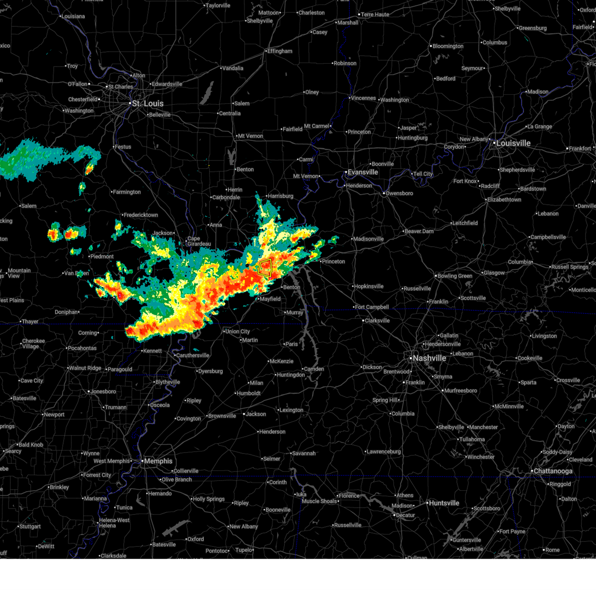
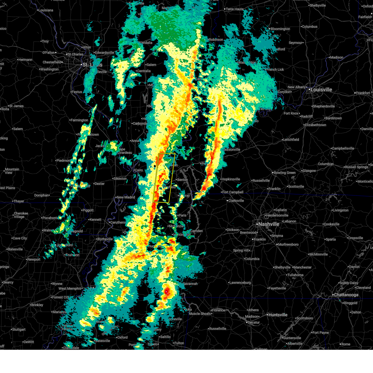
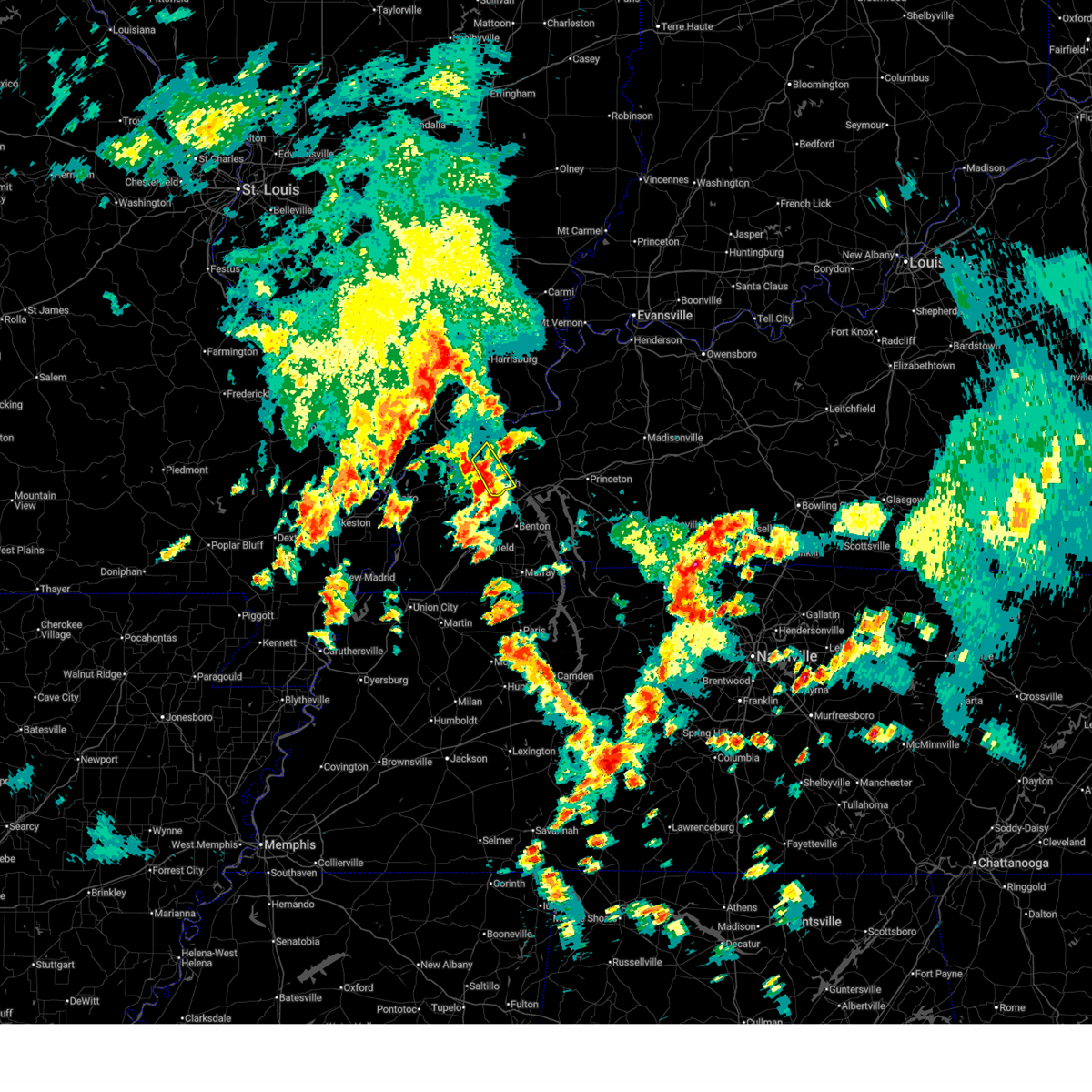
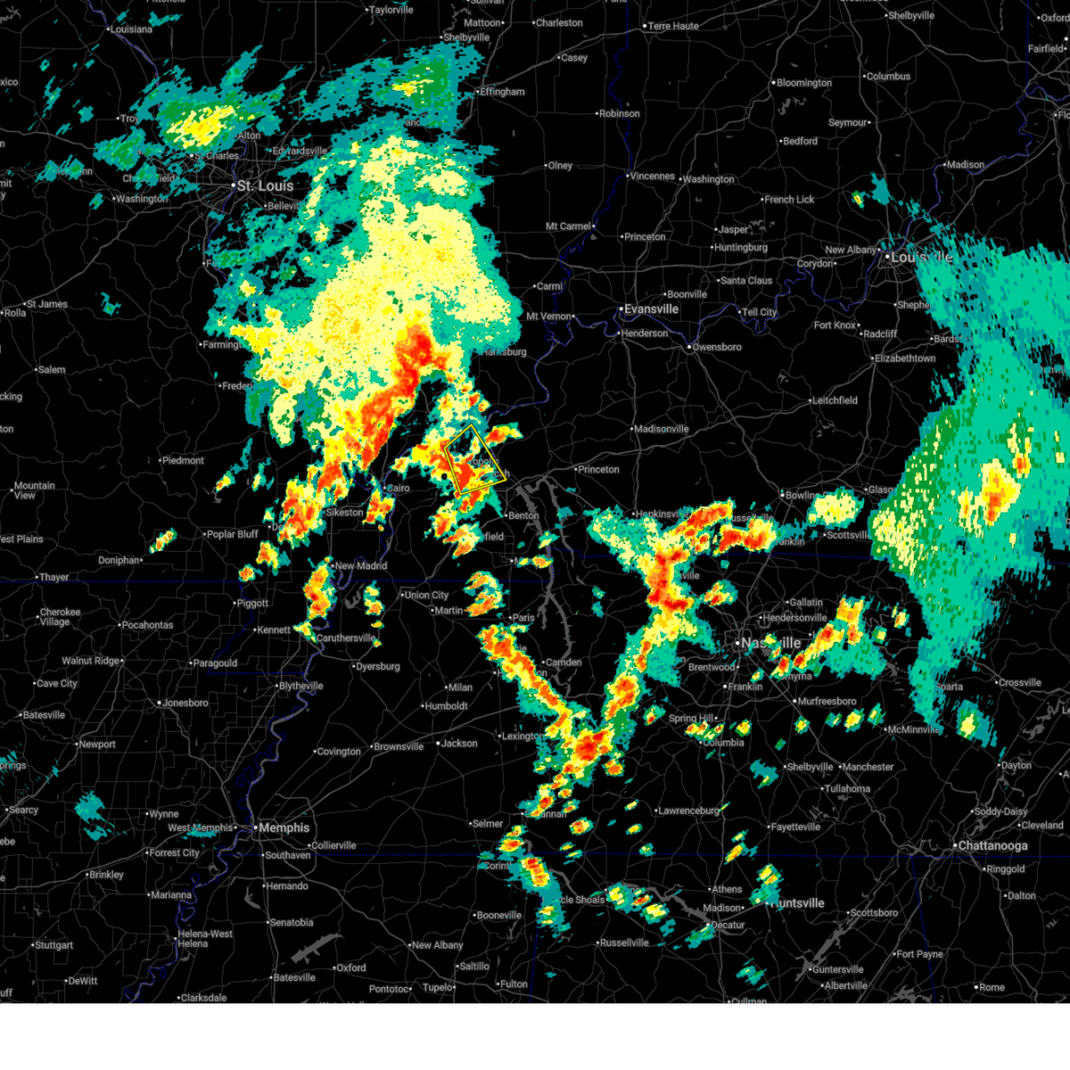
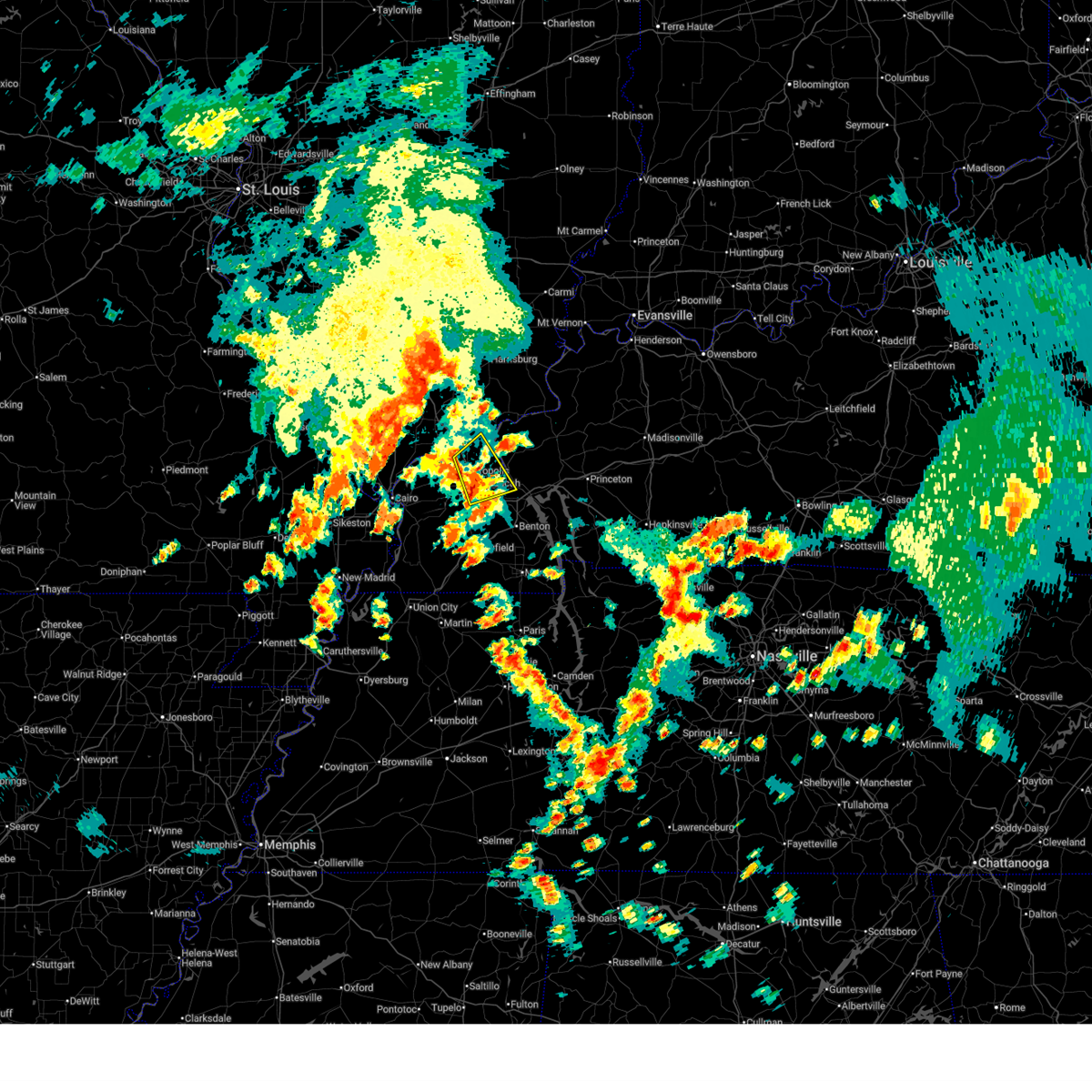
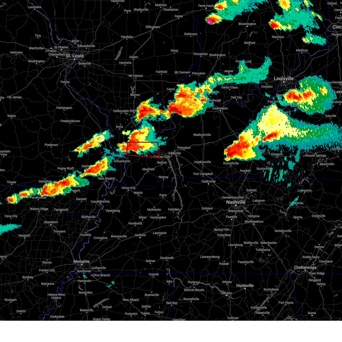
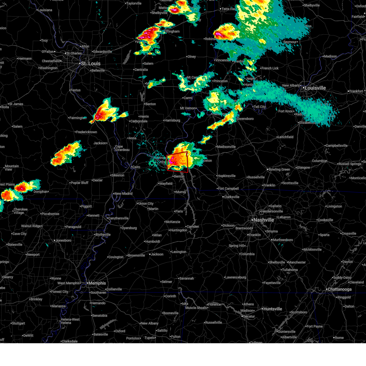
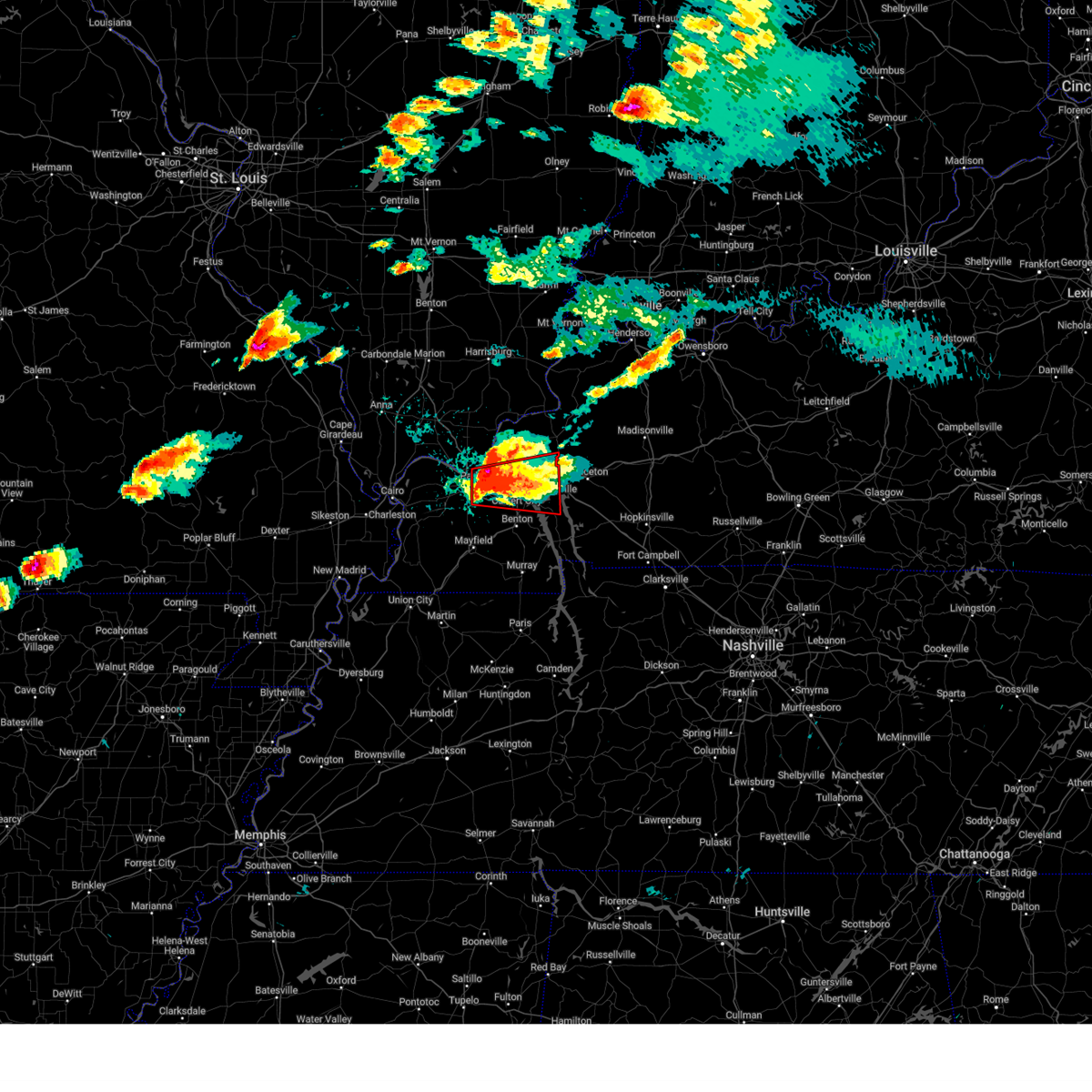
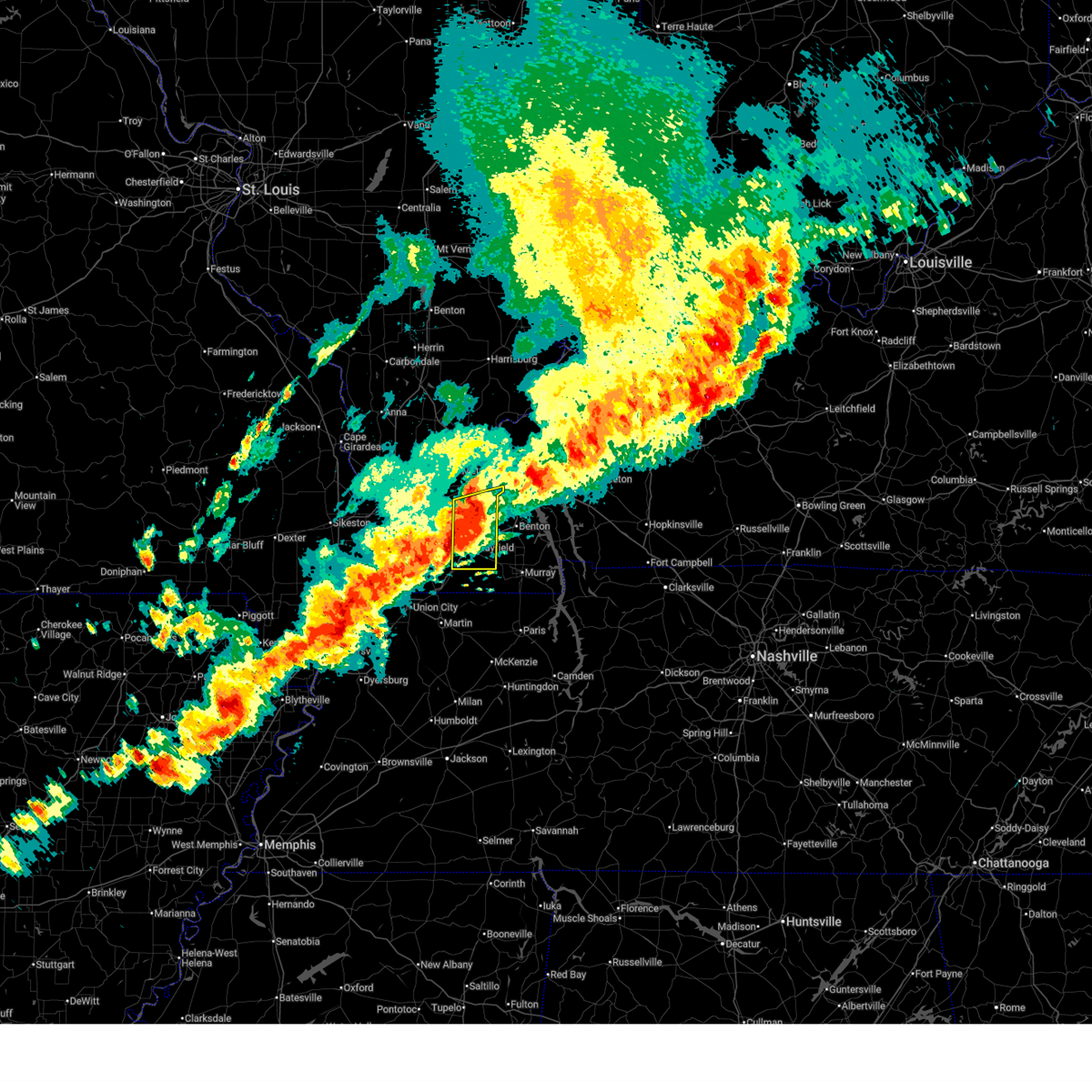
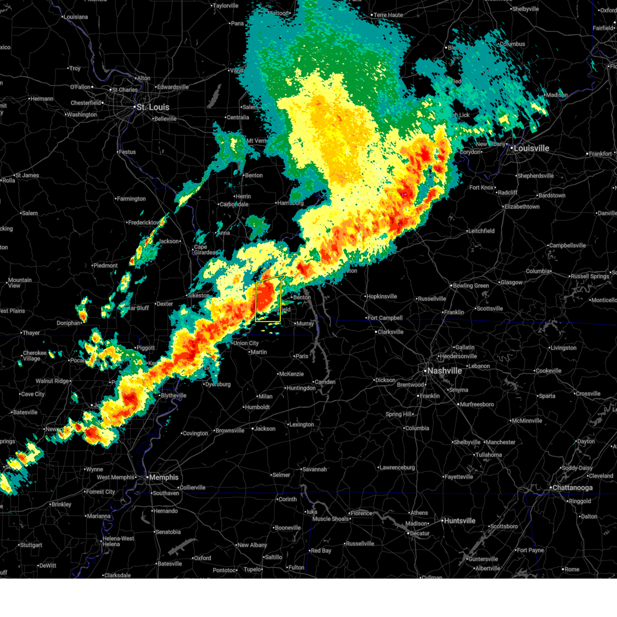
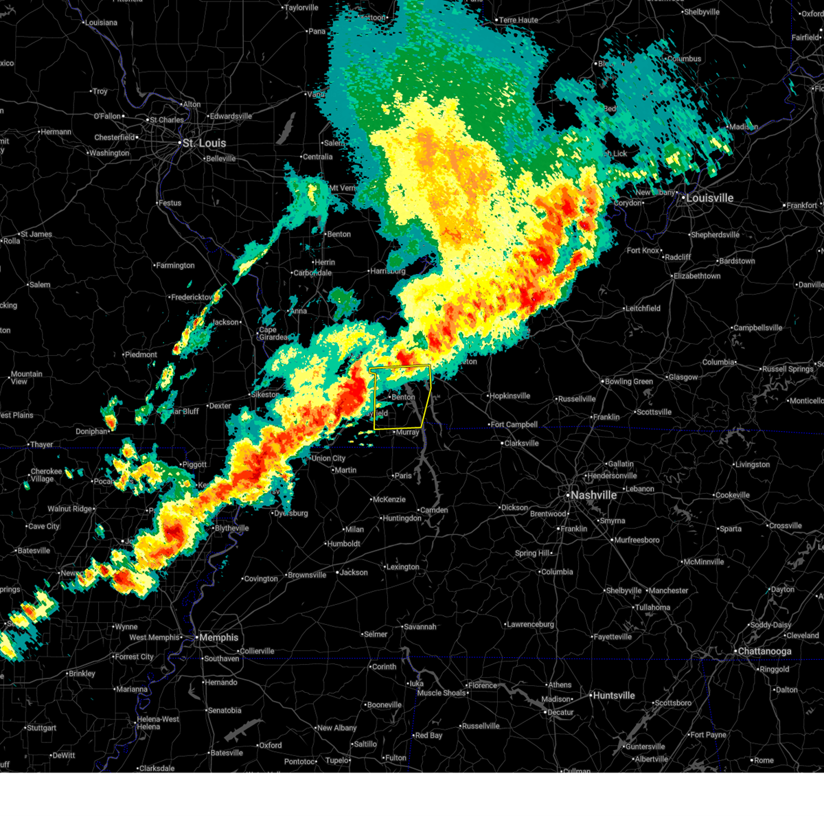
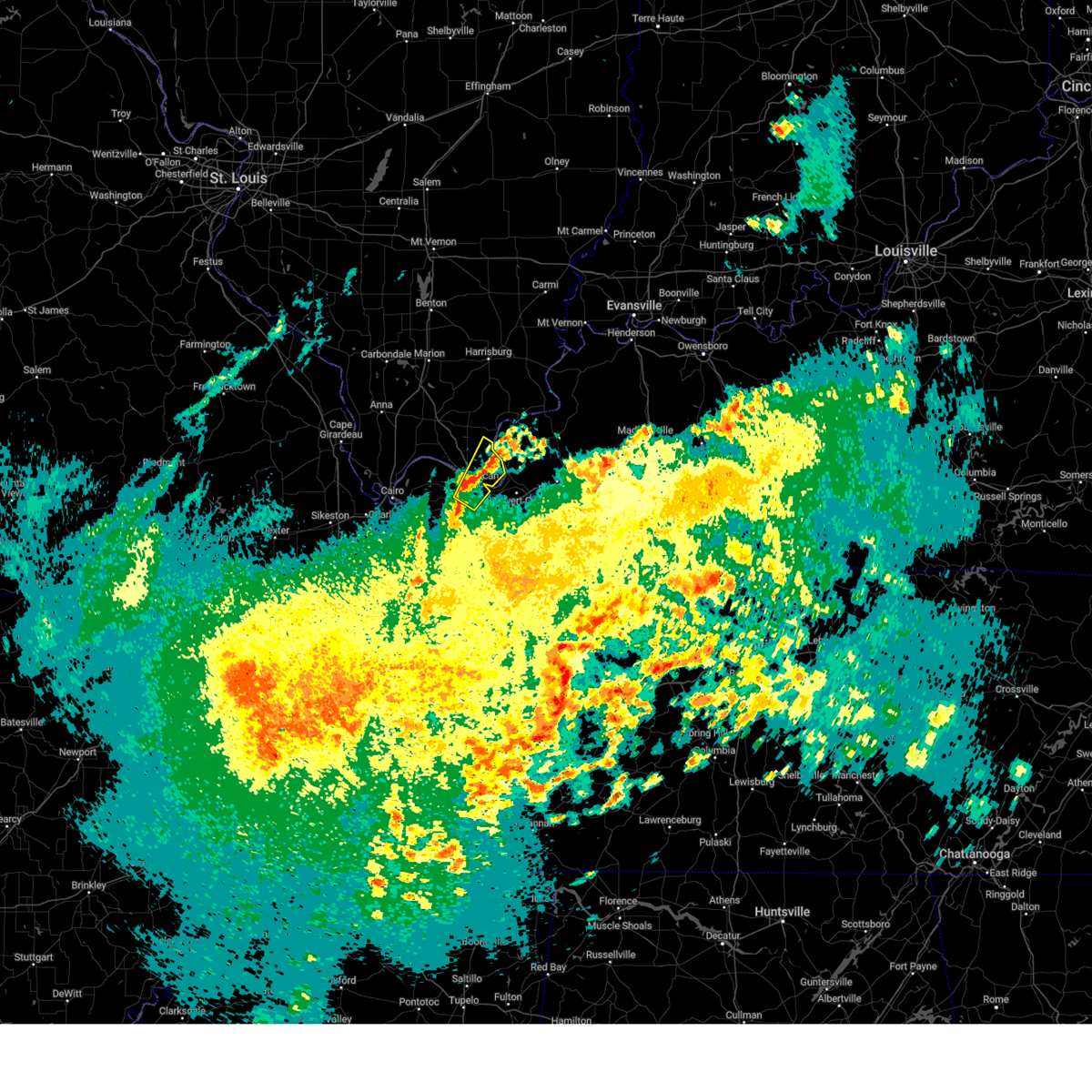
The Top Recent Hail Date for Ledbetter, KY is Thursday, April 16, 2026 (18th out of 90)
Hail and Wind Damage Spotted near Ledbetter, KY
| Date / Time | Report Details |
|---|---|
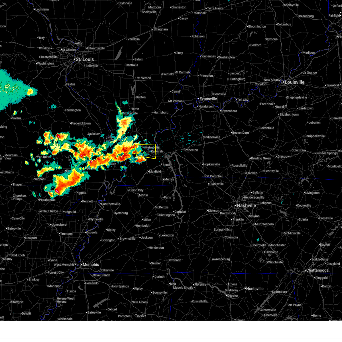
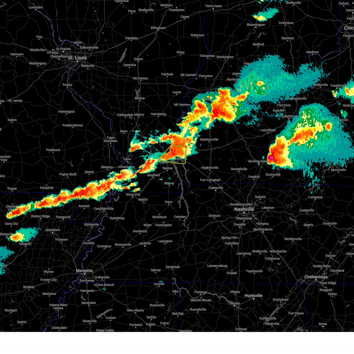
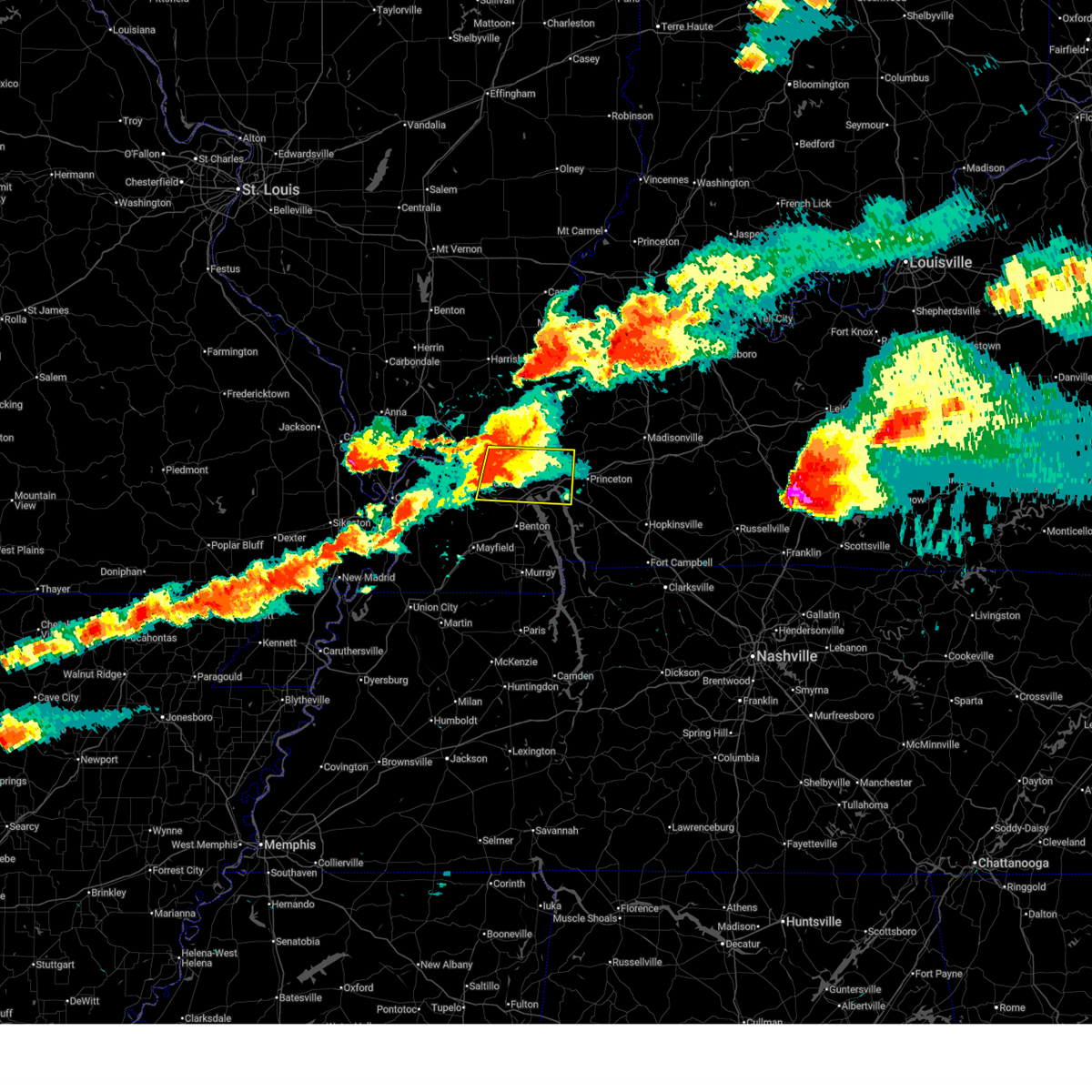
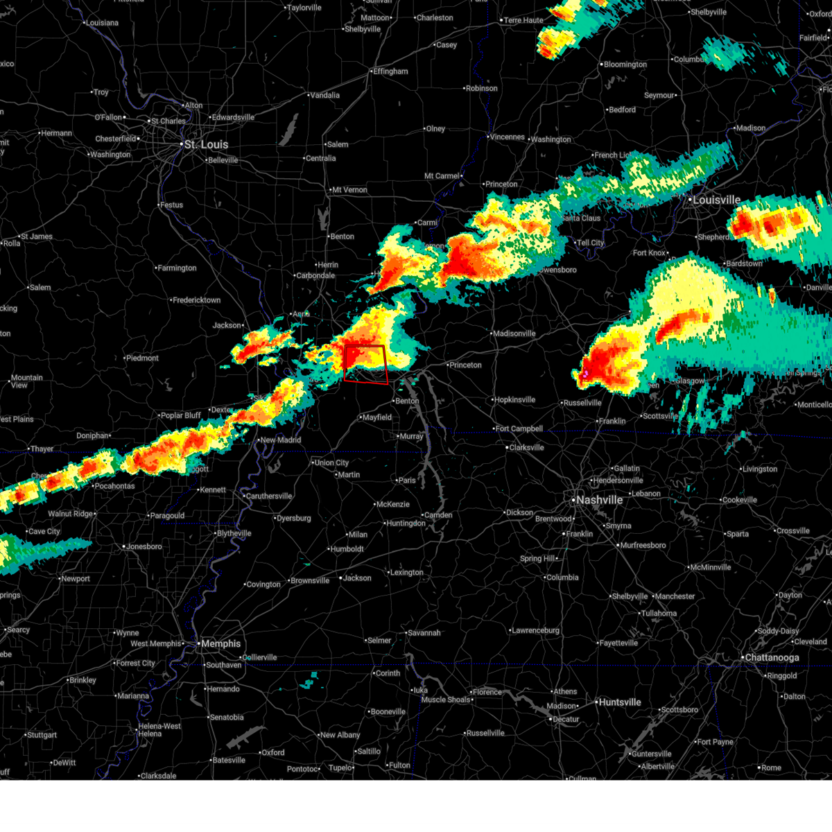
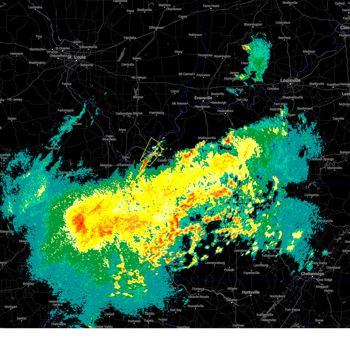
| 4/16/2026 4:44 PM CDT |
 At 444 pm cdt, a severe thunderstorm was located over ledbetter, or near reidland, moving east at 35 mph (radar indicated). Hazards include 60 mph wind gusts and quarter size hail. Hail damage to vehicles is expected. expect wind damage to roofs, siding, and trees. locations impacted include, paducah, reidland, and ledbetter. This includes interstate 24 in kentucky between mile markers 9 and 17. At 444 pm cdt, a severe thunderstorm was located over ledbetter, or near reidland, moving east at 35 mph (radar indicated). Hazards include 60 mph wind gusts and quarter size hail. Hail damage to vehicles is expected. expect wind damage to roofs, siding, and trees. locations impacted include, paducah, reidland, and ledbetter. This includes interstate 24 in kentucky between mile markers 9 and 17.
|
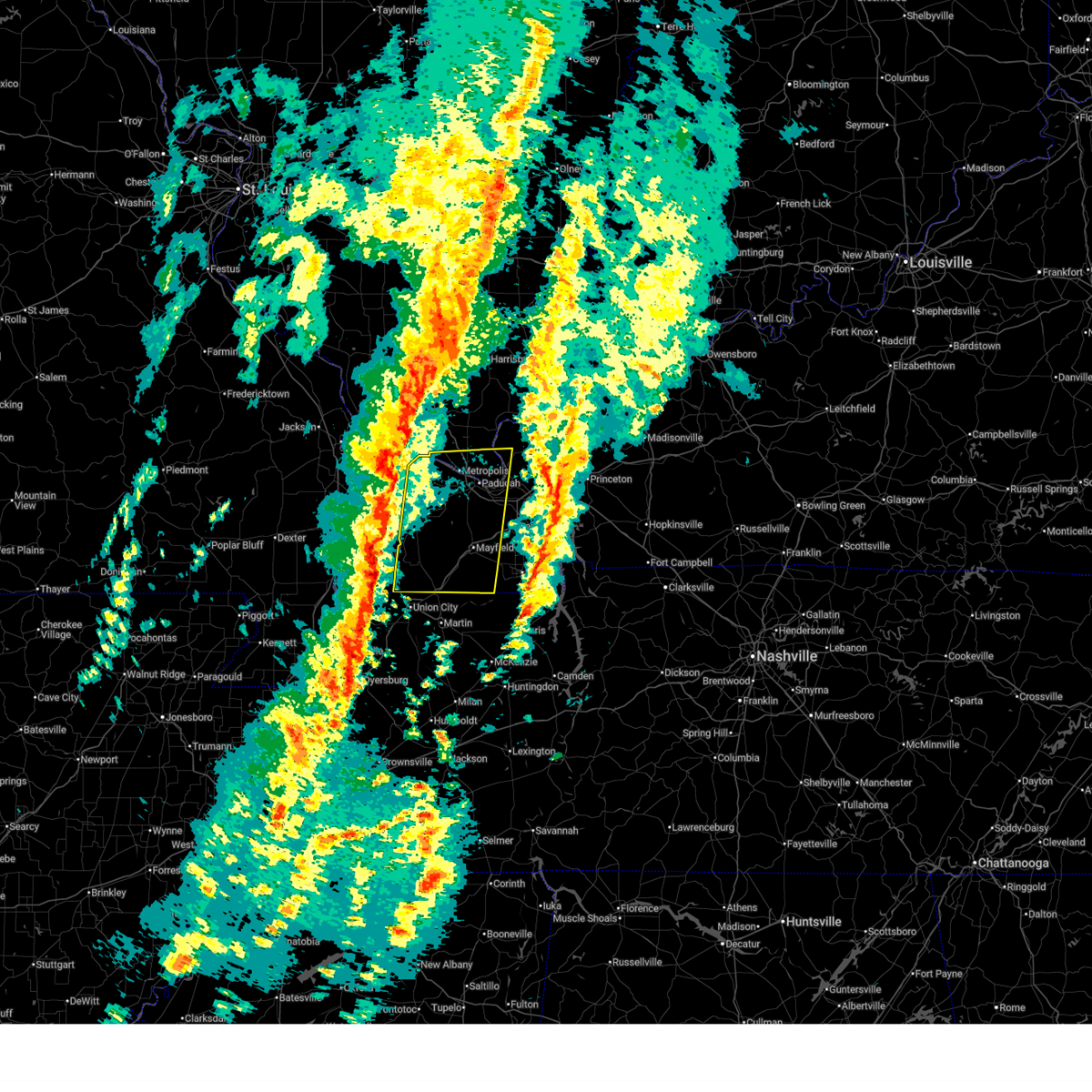
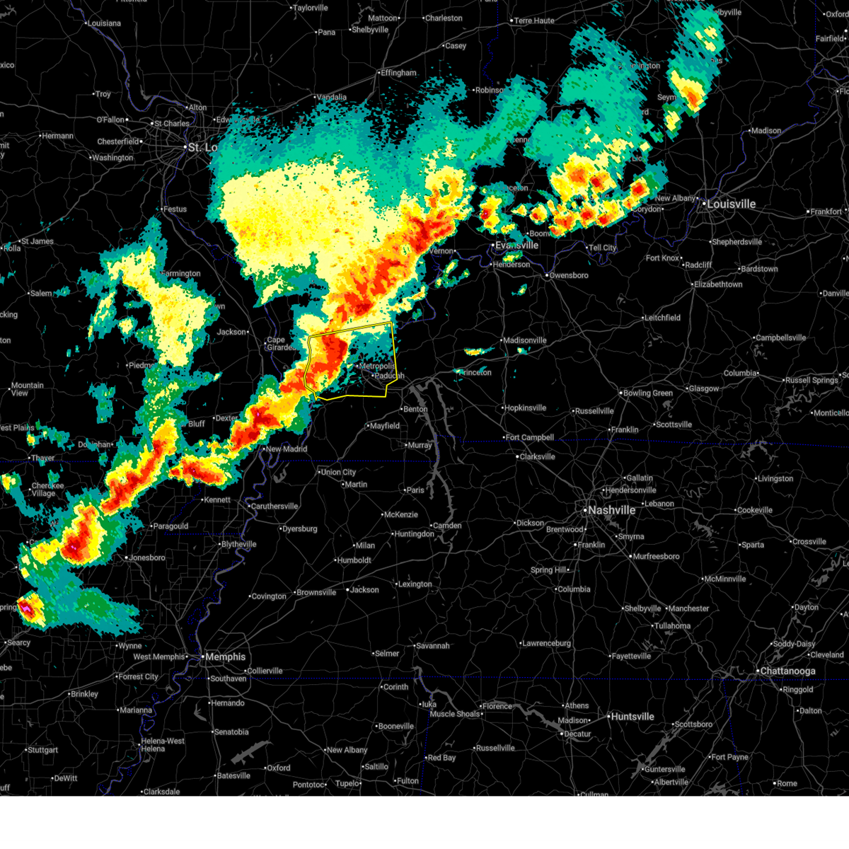
| 4/16/2026 4:34 PM CDT |
 At 434 pm cdt, a severe thunderstorm was located near paducah, moving east at 40 mph (radar indicated). Hazards include 60 mph wind gusts and quarter size hail. Hail damage to vehicles is expected. expect wind damage to roofs, siding, and trees. locations impacted include, paducah, lone oak, reidland, brookport, barkley regional airport, west paducah, and ledbetter. This includes interstate 24 in kentucky between mile markers 1 and 17. At 434 pm cdt, a severe thunderstorm was located near paducah, moving east at 40 mph (radar indicated). Hazards include 60 mph wind gusts and quarter size hail. Hail damage to vehicles is expected. expect wind damage to roofs, siding, and trees. locations impacted include, paducah, lone oak, reidland, brookport, barkley regional airport, west paducah, and ledbetter. This includes interstate 24 in kentucky between mile markers 1 and 17.
|
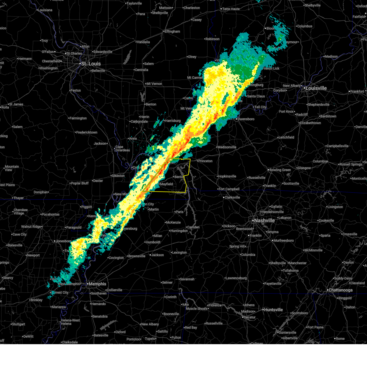
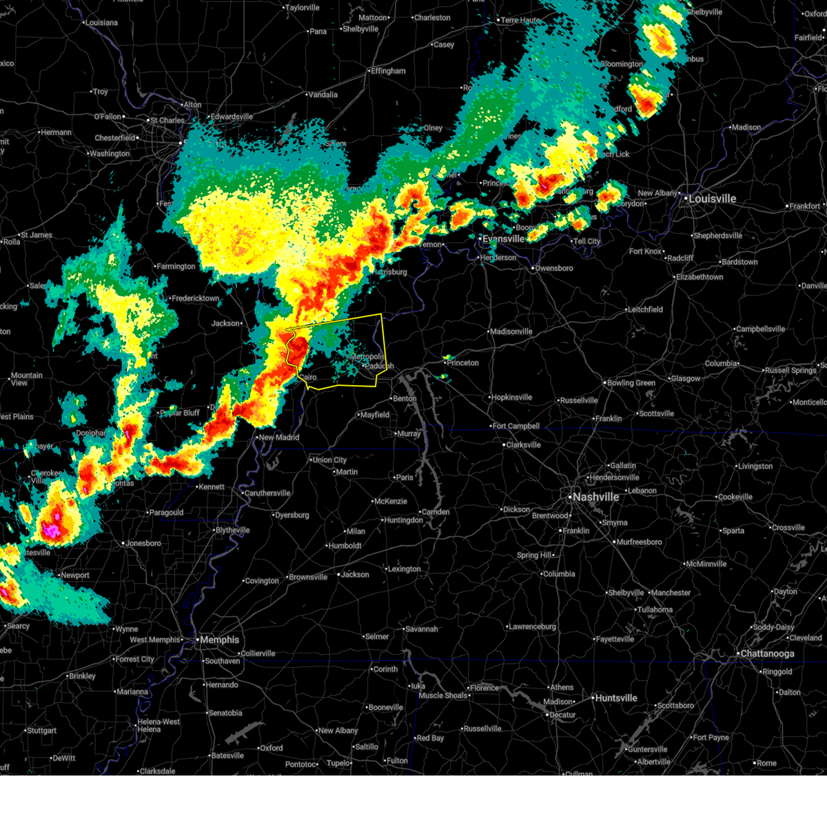
| 4/16/2026 4:04 PM CDT |
 Svrpah the national weather service in paducah has issued a * severe thunderstorm warning for, southern massac county in southern illinois, south central pope county in southern illinois, southwestern livingston county in western kentucky, northeastern ballard county in western kentucky, mccracken county in western kentucky, * until 500 pm cdt. * at 404 pm cdt, a severe thunderstorm was located over la center, moving east at 40 mph (radar indicated). Hazards include 60 mph wind gusts and half dollar size hail. Hail damage to vehicles is expected. Expect wind damage to roofs, siding, and trees. Svrpah the national weather service in paducah has issued a * severe thunderstorm warning for, southern massac county in southern illinois, south central pope county in southern illinois, southwestern livingston county in western kentucky, northeastern ballard county in western kentucky, mccracken county in western kentucky, * until 500 pm cdt. * at 404 pm cdt, a severe thunderstorm was located over la center, moving east at 40 mph (radar indicated). Hazards include 60 mph wind gusts and half dollar size hail. Hail damage to vehicles is expected. Expect wind damage to roofs, siding, and trees.
|
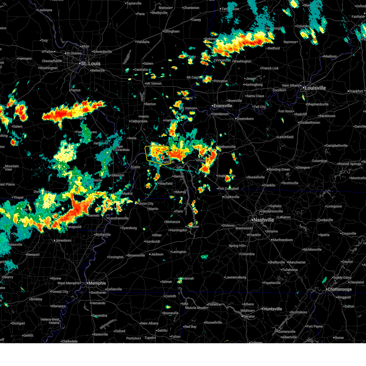
| 3/15/2026 8:27 PM CDT |
 The storms which prompted the warning have moved out of the area. therefore, the warning will be allowed to expire. a tornado watch remains in effect until 1100 pm cdt for southern illinois, and western kentucky. The storms which prompted the warning have moved out of the area. therefore, the warning will be allowed to expire. a tornado watch remains in effect until 1100 pm cdt for southern illinois, and western kentucky.
|
| 3/15/2026 8:24 PM CDT |
 the tornado warning has been cancelled and is no longer in effect the tornado warning has been cancelled and is no longer in effect
|
| 3/15/2026 8:17 PM CDT |
 At 816 pm cdt, severe thunderstorms were located along a line extending from near brookport to near latham, moving east at 50 mph (radar indicated). Hazards include 60 mph wind gusts. Expect damage to roofs, siding, and trees. locations impacted include, paducah, mayfield, reidland, lone oak, brookport, burna, ledbetter, lynnville, sedalia, wingo, smithland, hamletsburg, and symsonia. this includes the following highways, interstate 24 in kentucky between mile markers 1 and 20. interstate 24 in illinois between mile markers 34 and 38. Interstate 69 in kentucky between mile markers 11 and 36. At 816 pm cdt, severe thunderstorms were located along a line extending from near brookport to near latham, moving east at 50 mph (radar indicated). Hazards include 60 mph wind gusts. Expect damage to roofs, siding, and trees. locations impacted include, paducah, mayfield, reidland, lone oak, brookport, burna, ledbetter, lynnville, sedalia, wingo, smithland, hamletsburg, and symsonia. this includes the following highways, interstate 24 in kentucky between mile markers 1 and 20. interstate 24 in illinois between mile markers 34 and 38. Interstate 69 in kentucky between mile markers 11 and 36.
|
| 3/15/2026 8:17 PM CDT |
 the severe thunderstorm warning has been cancelled and is no longer in effect the severe thunderstorm warning has been cancelled and is no longer in effect
|
| 3/15/2026 8:14 PM CDT |
 the tornado warning has been cancelled and is no longer in effect the tornado warning has been cancelled and is no longer in effect
|
| 3/15/2026 8:14 PM CDT |
 At 814 pm cdt, a severe squall line capable of producing both tornadoes and extensive straight line wind damage was located along a line extending from 6 miles northeast of dixon springs to near lovelaceville, moving northeast at 60 mph (radar indicated rotation). Hazards include tornado. Flying debris will be dangerous to those caught without shelter. mobile homes will be damaged or destroyed. damage to roofs, windows, and vehicles will occur. tree damage is likely. these dangerous storms will be near, paducah, reidland, lone oak, brookport, golconda, and ledbetter around 820 pm cdt. burna around 825 pm cdt. other locations impacted by these tornadic storms include smithland and hamletsburg. this includes the following highways, interstate 24 in kentucky between mile markers 1 and 11. Interstate 24 in illinois between mile markers 31 and 38. At 814 pm cdt, a severe squall line capable of producing both tornadoes and extensive straight line wind damage was located along a line extending from 6 miles northeast of dixon springs to near lovelaceville, moving northeast at 60 mph (radar indicated rotation). Hazards include tornado. Flying debris will be dangerous to those caught without shelter. mobile homes will be damaged or destroyed. damage to roofs, windows, and vehicles will occur. tree damage is likely. these dangerous storms will be near, paducah, reidland, lone oak, brookport, golconda, and ledbetter around 820 pm cdt. burna around 825 pm cdt. other locations impacted by these tornadic storms include smithland and hamletsburg. this includes the following highways, interstate 24 in kentucky between mile markers 1 and 11. Interstate 24 in illinois between mile markers 31 and 38.
|
| 3/15/2026 8:06 PM CDT |
 At 806 pm cdt, severe thunderstorms were located along a line extending from metropolis to near martin, moving east at 50 mph (radar indicated). Hazards include 60 mph wind gusts. Expect damage to roofs, siding, and trees. locations impacted include, paducah, mayfield, metropolis, fulton, clinton, reidland, lone oak, brookport, barkley regional airport, burna, ledbetter, lynnville, fulgham, sedalia, lovelaceville, west paducah, wingo, kevil, joppa, and smithland. this includes the following highways, interstate 24 in kentucky between mile markers 1 and 20. interstate 24 in illinois between mile markers 30 and 38. Interstate 69 in kentucky between mile markers 1 and 36. At 806 pm cdt, severe thunderstorms were located along a line extending from metropolis to near martin, moving east at 50 mph (radar indicated). Hazards include 60 mph wind gusts. Expect damage to roofs, siding, and trees. locations impacted include, paducah, mayfield, metropolis, fulton, clinton, reidland, lone oak, brookport, barkley regional airport, burna, ledbetter, lynnville, fulgham, sedalia, lovelaceville, west paducah, wingo, kevil, joppa, and smithland. this includes the following highways, interstate 24 in kentucky between mile markers 1 and 20. interstate 24 in illinois between mile markers 30 and 38. Interstate 69 in kentucky between mile markers 1 and 36.
|
| 3/15/2026 7:56 PM CDT |
 Torpah the national weather service in paducah has issued a * tornado warning for, massac county in southern illinois, pope county in southern illinois, southeastern johnson county in southern illinois, western livingston county in western kentucky, northwestern marshall county in western kentucky, eastern ballard county in western kentucky, mccracken county in western kentucky, * until 845 pm cdt. * at 756 pm cdt, severe thunderstorms capable of producing both tornadoes and extensive straight line wind damage were located along a line extending from near karnak to near bardwell, moving northeast at 50 mph (radar indicated rotation). Hazards include tornado. Flying debris will be dangerous to those caught without shelter. mobile homes will be damaged or destroyed. damage to roofs, windows, and vehicles will occur. tree damage is likely. these dangerous storms will be near, new columbia, barkley regional airport, and lovelaceville around 800 pm cdt. paducah, metropolis, dixon springs, and west paducah around 805 pm cdt. lone oak and brookport around 810 pm cdt. reidland, golconda, and ledbetter around 820 pm cdt. burna around 830 pm cdt. calvert city around 835 pm cdt. other locations impacted by these tornadic storms include smithland, joppa, hamletsburg, kevil, and blandville. this includes the following highways, interstate 24 in kentucky between mile markers 1 and 24. Interstate 24 in illinois between mile markers 20 and 38. Torpah the national weather service in paducah has issued a * tornado warning for, massac county in southern illinois, pope county in southern illinois, southeastern johnson county in southern illinois, western livingston county in western kentucky, northwestern marshall county in western kentucky, eastern ballard county in western kentucky, mccracken county in western kentucky, * until 845 pm cdt. * at 756 pm cdt, severe thunderstorms capable of producing both tornadoes and extensive straight line wind damage were located along a line extending from near karnak to near bardwell, moving northeast at 50 mph (radar indicated rotation). Hazards include tornado. Flying debris will be dangerous to those caught without shelter. mobile homes will be damaged or destroyed. damage to roofs, windows, and vehicles will occur. tree damage is likely. these dangerous storms will be near, new columbia, barkley regional airport, and lovelaceville around 800 pm cdt. paducah, metropolis, dixon springs, and west paducah around 805 pm cdt. lone oak and brookport around 810 pm cdt. reidland, golconda, and ledbetter around 820 pm cdt. burna around 830 pm cdt. calvert city around 835 pm cdt. other locations impacted by these tornadic storms include smithland, joppa, hamletsburg, kevil, and blandville. this includes the following highways, interstate 24 in kentucky between mile markers 1 and 24. Interstate 24 in illinois between mile markers 20 and 38.
|
| 3/15/2026 7:43 PM CDT |
 Svrpah the national weather service in paducah has issued a * severe thunderstorm warning for, massac county in southern illinois, southeastern pope county in southern illinois, eastern fulton county in western kentucky, northwestern calloway county in western kentucky, southwestern livingston county in western kentucky, western marshall county in western kentucky, carlisle county in western kentucky, hickman county in western kentucky, ballard county in western kentucky, mccracken county in western kentucky, graves county in western kentucky, * until 830 pm cdt. * at 743 pm cdt, severe thunderstorms were located along a line extending from 8 miles northwest of la center to near troy, moving east at 50 mph (radar indicated). Hazards include 70 mph wind gusts. Expect considerable tree damage. Damage is likely to mobile homes, roofs, and outbuildings. Svrpah the national weather service in paducah has issued a * severe thunderstorm warning for, massac county in southern illinois, southeastern pope county in southern illinois, eastern fulton county in western kentucky, northwestern calloway county in western kentucky, southwestern livingston county in western kentucky, western marshall county in western kentucky, carlisle county in western kentucky, hickman county in western kentucky, ballard county in western kentucky, mccracken county in western kentucky, graves county in western kentucky, * until 830 pm cdt. * at 743 pm cdt, severe thunderstorms were located along a line extending from 8 miles northwest of la center to near troy, moving east at 50 mph (radar indicated). Hazards include 70 mph wind gusts. Expect considerable tree damage. Damage is likely to mobile homes, roofs, and outbuildings.
|
| 12/28/2025 7:20 PM CST |
 Svrpah the national weather service in paducah has issued a * severe thunderstorm warning for, southeastern pope county in southern illinois, northern calloway county in western kentucky, southern livingston county in western kentucky, marshall county in western kentucky, east central hickman county in western kentucky, southeastern mccracken county in western kentucky, graves county in western kentucky, lyon county in western kentucky, * until 800 pm cst. * at 720 pm cst, severe thunderstorms were located along a line extending from near ledbetter to near fulgham, moving east at 55 mph (trained weather spotters). Hazards include 70 mph wind gusts. Expect considerable tree damage. Damage is likely to mobile homes, roofs, and outbuildings. Svrpah the national weather service in paducah has issued a * severe thunderstorm warning for, southeastern pope county in southern illinois, northern calloway county in western kentucky, southern livingston county in western kentucky, marshall county in western kentucky, east central hickman county in western kentucky, southeastern mccracken county in western kentucky, graves county in western kentucky, lyon county in western kentucky, * until 800 pm cst. * at 720 pm cst, severe thunderstorms were located along a line extending from near ledbetter to near fulgham, moving east at 55 mph (trained weather spotters). Hazards include 70 mph wind gusts. Expect considerable tree damage. Damage is likely to mobile homes, roofs, and outbuildings.
|
| 8/19/2025 4:39 PM CDT |
 The storms which prompted the warning have weakened below severe limits, and have exited the warned area. therefore, the warning will be allowed to expire. The storms which prompted the warning have weakened below severe limits, and have exited the warned area. therefore, the warning will be allowed to expire.
|
| 8/19/2025 3:53 PM CDT |
 Svrpah the national weather service in paducah has issued a * severe thunderstorm warning for, massac county in southern illinois, southern pope county in southern illinois, western livingston county in western kentucky, central mccracken county in western kentucky, * until 445 pm cdt. * at 353 pm cdt, severe thunderstorms were located along a line extending from near new columbia to 7 miles southwest of golconda, moving south at 10 mph (radar indicated). Hazards include 60 mph wind gusts. expect damage to roofs, siding, and trees Svrpah the national weather service in paducah has issued a * severe thunderstorm warning for, massac county in southern illinois, southern pope county in southern illinois, western livingston county in western kentucky, central mccracken county in western kentucky, * until 445 pm cdt. * at 353 pm cdt, severe thunderstorms were located along a line extending from near new columbia to 7 miles southwest of golconda, moving south at 10 mph (radar indicated). Hazards include 60 mph wind gusts. expect damage to roofs, siding, and trees
|
| 6/6/2025 2:23 PM CDT |
 At 223 pm cdt, a severe thunderstorm was located 7 miles east of brookport, or 10 miles north of reidland, moving northeast at 35 mph (radar indicated). Hazards include 60 mph wind gusts and quarter size hail. Hail damage to vehicles is expected. expect wind damage to roofs, siding, and trees. Locations impacted include, reidland, ledbetter, and hamletsburg. At 223 pm cdt, a severe thunderstorm was located 7 miles east of brookport, or 10 miles north of reidland, moving northeast at 35 mph (radar indicated). Hazards include 60 mph wind gusts and quarter size hail. Hail damage to vehicles is expected. expect wind damage to roofs, siding, and trees. Locations impacted include, reidland, ledbetter, and hamletsburg.
|
| 6/6/2025 2:23 PM CDT |
 the severe thunderstorm warning has been cancelled and is no longer in effect the severe thunderstorm warning has been cancelled and is no longer in effect
|
| 6/6/2025 2:10 PM CDT |
 the severe thunderstorm warning has been cancelled and is no longer in effect the severe thunderstorm warning has been cancelled and is no longer in effect
|
| 6/6/2025 2:10 PM CDT |
 At 209 pm cdt, a severe thunderstorm was located over brookport, or near paducah, moving northeast at 35 mph (radar indicated). Hazards include 60 mph wind gusts and quarter size hail. Hail damage to vehicles is expected. expect wind damage to roofs, siding, and trees. locations impacted include, paducah, metropolis, calvert city, lone oak, reidland, brookport, ledbetter, and hamletsburg. this includes the following highways, interstate 24 in kentucky between mile markers 1 and 13. Interstate 24 in illinois between mile markers 31 and 38. At 209 pm cdt, a severe thunderstorm was located over brookport, or near paducah, moving northeast at 35 mph (radar indicated). Hazards include 60 mph wind gusts and quarter size hail. Hail damage to vehicles is expected. expect wind damage to roofs, siding, and trees. locations impacted include, paducah, metropolis, calvert city, lone oak, reidland, brookport, ledbetter, and hamletsburg. this includes the following highways, interstate 24 in kentucky between mile markers 1 and 13. Interstate 24 in illinois between mile markers 31 and 38.
|
| 6/6/2025 1:47 PM CDT |
 Svrpah the national weather service in paducah has issued a * severe thunderstorm warning for, eastern massac county in southern illinois, southern pope county in southern illinois, southwestern livingston county in western kentucky, northwestern marshall county in western kentucky, northeastern carlisle county in western kentucky, southeastern ballard county in western kentucky, mccracken county in western kentucky, * until 230 pm cdt. * at 146 pm cdt, a severe thunderstorm was located over lovelaceville, or 9 miles west of lone oak, moving northeast at 35 mph (radar indicated). Hazards include 60 mph wind gusts and quarter size hail. Hail damage to vehicles is expected. Expect wind damage to roofs, siding, and trees. Svrpah the national weather service in paducah has issued a * severe thunderstorm warning for, eastern massac county in southern illinois, southern pope county in southern illinois, southwestern livingston county in western kentucky, northwestern marshall county in western kentucky, northeastern carlisle county in western kentucky, southeastern ballard county in western kentucky, mccracken county in western kentucky, * until 230 pm cdt. * at 146 pm cdt, a severe thunderstorm was located over lovelaceville, or 9 miles west of lone oak, moving northeast at 35 mph (radar indicated). Hazards include 60 mph wind gusts and quarter size hail. Hail damage to vehicles is expected. Expect wind damage to roofs, siding, and trees.
|
| 5/20/2025 3:46 PM CDT |
 At 346 pm cdt, severe thunderstorms were located along a line extending from near joy to 8 miles southeast of burna to reidland, moving east at 60 mph (radar indicated). Hazards include 60 mph wind gusts. Expect damage to roofs, siding, and trees. locations impacted include, paducah, providence, marion, calvert city, eddyville, reidland, salem, burna, ledbetter, creswell, farmersville, kuttawa, fredonia, grand rivers, smithland, hamletsburg, fryer, and dycusburg. this includes the following highways, interstate 24 in kentucky between mile markers 9 and 23, and between mile markers 26 and 45. Interstate 69 in kentucky between mile markers 68 and 78. At 346 pm cdt, severe thunderstorms were located along a line extending from near joy to 8 miles southeast of burna to reidland, moving east at 60 mph (radar indicated). Hazards include 60 mph wind gusts. Expect damage to roofs, siding, and trees. locations impacted include, paducah, providence, marion, calvert city, eddyville, reidland, salem, burna, ledbetter, creswell, farmersville, kuttawa, fredonia, grand rivers, smithland, hamletsburg, fryer, and dycusburg. this includes the following highways, interstate 24 in kentucky between mile markers 9 and 23, and between mile markers 26 and 45. Interstate 69 in kentucky between mile markers 68 and 78.
|
| 5/20/2025 3:46 PM CDT |
 the severe thunderstorm warning has been cancelled and is no longer in effect the severe thunderstorm warning has been cancelled and is no longer in effect
|
| 5/20/2025 3:34 PM CDT |
 Svrpah the national weather service in paducah has issued a * severe thunderstorm warning for, eastern massac county in southern illinois, southeastern pope county in southern illinois, crittenden county in western kentucky, livingston county in western kentucky, central caldwell county in western kentucky, northwestern marshall county in western kentucky, northeastern carlisle county in western kentucky, mccracken county in western kentucky, west central hopkins county in northwestern kentucky, southwestern webster county in northwestern kentucky, northwestern graves county in western kentucky, northwestern lyon county in western kentucky, * until 415 pm cdt. * at 334 pm cdt, severe thunderstorms were located along a line extending from near golconda to near ledbetter to near lovelaceville, moving east at 60 mph (radar indicated). Hazards include 60 mph wind gusts. expect damage to roofs, siding, and trees Svrpah the national weather service in paducah has issued a * severe thunderstorm warning for, eastern massac county in southern illinois, southeastern pope county in southern illinois, crittenden county in western kentucky, livingston county in western kentucky, central caldwell county in western kentucky, northwestern marshall county in western kentucky, northeastern carlisle county in western kentucky, mccracken county in western kentucky, west central hopkins county in northwestern kentucky, southwestern webster county in northwestern kentucky, northwestern graves county in western kentucky, northwestern lyon county in western kentucky, * until 415 pm cdt. * at 334 pm cdt, severe thunderstorms were located along a line extending from near golconda to near ledbetter to near lovelaceville, moving east at 60 mph (radar indicated). Hazards include 60 mph wind gusts. expect damage to roofs, siding, and trees
|
| 5/20/2025 3:37 AM CDT |
 the severe thunderstorm warning has been cancelled and is no longer in effect the severe thunderstorm warning has been cancelled and is no longer in effect
|
| 5/20/2025 3:15 AM CDT |
 At 315 am cdt, a severe thunderstorm was located 9 miles northwest of mayfield, moving northeast at 50 mph (radar indicated). Hazards include 60 mph wind gusts and half dollar size hail. Hail damage to vehicles is expected. expect wind damage to roofs, siding, and trees. locations impacted include, paducah, calvert city, lone oak, reidland, lowes, fancy farm, and symsonia. This includes interstate 24 in kentucky between mile markers 5 and 23. At 315 am cdt, a severe thunderstorm was located 9 miles northwest of mayfield, moving northeast at 50 mph (radar indicated). Hazards include 60 mph wind gusts and half dollar size hail. Hail damage to vehicles is expected. expect wind damage to roofs, siding, and trees. locations impacted include, paducah, calvert city, lone oak, reidland, lowes, fancy farm, and symsonia. This includes interstate 24 in kentucky between mile markers 5 and 23.
|
| 5/20/2025 3:15 AM CDT |
 the severe thunderstorm warning has been cancelled and is no longer in effect the severe thunderstorm warning has been cancelled and is no longer in effect
|
| 5/16/2025 7:59 PM CDT |
 At 758 pm cdt, a severe thunderstorm was located 8 miles northeast of calvert city, moving east at 50 mph (radar indicated). Hazards include 70 mph wind gusts and nickel size hail. Expect considerable tree damage. damage is likely to mobile homes, roofs, and outbuildings. locations impacted include, calvert city, eddyville, demumbers bay campground, land between the lakes area, salem, ledbetter, kuttawa, fredonia, grand rivers, smithland, and dycusburg. this includes the following highways, interstate 24 in kentucky between mile markers 27 and 48. Interstate 69 in kentucky between mile markers 68 and 74. At 758 pm cdt, a severe thunderstorm was located 8 miles northeast of calvert city, moving east at 50 mph (radar indicated). Hazards include 70 mph wind gusts and nickel size hail. Expect considerable tree damage. damage is likely to mobile homes, roofs, and outbuildings. locations impacted include, calvert city, eddyville, demumbers bay campground, land between the lakes area, salem, ledbetter, kuttawa, fredonia, grand rivers, smithland, and dycusburg. this includes the following highways, interstate 24 in kentucky between mile markers 27 and 48. Interstate 69 in kentucky between mile markers 68 and 74.
|
| 5/16/2025 7:59 PM CDT |
 the severe thunderstorm warning has been cancelled and is no longer in effect the severe thunderstorm warning has been cancelled and is no longer in effect
|
| 5/16/2025 7:43 PM CDT |
 At 743 pm cdt, a severe thunderstorm was located near ledbetter, or 9 miles north of reidland, moving east at 50 mph (radar indicated). Hazards include 60 mph wind gusts and quarter size hail. Hail damage to vehicles is expected. expect wind damage to roofs, siding, and trees. locations impacted include, paducah, calvert city, eddyville, reidland, land between the lakes area, salem, burna, ledbetter, kuttawa, fredonia, grand rivers, smithland, hamletsburg, and dycusburg. this includes the following highways, interstate 24 in kentucky between mile markers 10 and 14, and between mile markers 17 and 48. Interstate 69 in kentucky between mile markers 68 and 74. At 743 pm cdt, a severe thunderstorm was located near ledbetter, or 9 miles north of reidland, moving east at 50 mph (radar indicated). Hazards include 60 mph wind gusts and quarter size hail. Hail damage to vehicles is expected. expect wind damage to roofs, siding, and trees. locations impacted include, paducah, calvert city, eddyville, reidland, land between the lakes area, salem, burna, ledbetter, kuttawa, fredonia, grand rivers, smithland, hamletsburg, and dycusburg. this includes the following highways, interstate 24 in kentucky between mile markers 10 and 14, and between mile markers 17 and 48. Interstate 69 in kentucky between mile markers 68 and 74.
|
| 5/16/2025 7:35 PM CDT |
 the tornado warning has been cancelled and is no longer in effect the tornado warning has been cancelled and is no longer in effect
|
| 5/16/2025 7:34 PM CDT |
 Svrpah the national weather service in paducah has issued a * severe thunderstorm warning for, eastern massac county in southern illinois, southeastern pope county in southern illinois, south central crittenden county in western kentucky, livingston county in western kentucky, west central caldwell county in western kentucky, northwestern marshall county in western kentucky, southeastern mccracken county in western kentucky, lyon county in western kentucky, * until 815 pm cdt. * at 734 pm cdt, a severe thunderstorm was located over brookport, or near metropolis, moving east at 50 mph (radar indicated). Hazards include 60 mph wind gusts and quarter size hail. Hail damage to vehicles is expected. Expect wind damage to roofs, siding, and trees. Svrpah the national weather service in paducah has issued a * severe thunderstorm warning for, eastern massac county in southern illinois, southeastern pope county in southern illinois, south central crittenden county in western kentucky, livingston county in western kentucky, west central caldwell county in western kentucky, northwestern marshall county in western kentucky, southeastern mccracken county in western kentucky, lyon county in western kentucky, * until 815 pm cdt. * at 734 pm cdt, a severe thunderstorm was located over brookport, or near metropolis, moving east at 50 mph (radar indicated). Hazards include 60 mph wind gusts and quarter size hail. Hail damage to vehicles is expected. Expect wind damage to roofs, siding, and trees.
|
| 5/16/2025 7:30 PM CDT |
 At 730 pm cdt, a severe thunderstorm capable of producing a tornado was located over brookport, or near paducah, moving east at 45 mph (radar indicated rotation). Hazards include tornado and half dollar size hail. Flying debris will be dangerous to those caught without shelter. mobile homes will be damaged or destroyed. damage to roofs, windows, and vehicles will occur. tree damage is likely. this dangerous storm will be near, paducah, reidland, and ledbetter around 735 pm cdt. other locations impacted by this tornadic thunderstorm include hamletsburg. this includes the following highways, interstate 24 in kentucky between mile markers 1 and 21. Interstate 24 in illinois between mile markers 32 and 38. At 730 pm cdt, a severe thunderstorm capable of producing a tornado was located over brookport, or near paducah, moving east at 45 mph (radar indicated rotation). Hazards include tornado and half dollar size hail. Flying debris will be dangerous to those caught without shelter. mobile homes will be damaged or destroyed. damage to roofs, windows, and vehicles will occur. tree damage is likely. this dangerous storm will be near, paducah, reidland, and ledbetter around 735 pm cdt. other locations impacted by this tornadic thunderstorm include hamletsburg. this includes the following highways, interstate 24 in kentucky between mile markers 1 and 21. Interstate 24 in illinois between mile markers 32 and 38.
|
| 5/16/2025 7:21 PM CDT |
 the tornado warning has been cancelled and is no longer in effect the tornado warning has been cancelled and is no longer in effect
|
| 5/16/2025 7:21 PM CDT |
 At 721 pm cdt, a severe thunderstorm capable of producing a tornado was located over west paducah, or near metropolis, moving east at 60 mph (radar indicated rotation). Hazards include tornado and two inch hail. Flying debris will be dangerous to those caught without shelter. mobile homes will be damaged or destroyed. damage to roofs, windows, and vehicles will occur. tree damage is likely. this dangerous storm will be near, paducah, metropolis, lone oak, brookport, and west paducah around 725 pm cdt. reidland and ledbetter around 730 pm cdt. other locations impacted by this tornadic thunderstorm include joppa and hamletsburg. this includes the following highways, interstate 24 in kentucky between mile markers 1 and 21. Interstate 24 in illinois between mile markers 32 and 38. At 721 pm cdt, a severe thunderstorm capable of producing a tornado was located over west paducah, or near metropolis, moving east at 60 mph (radar indicated rotation). Hazards include tornado and two inch hail. Flying debris will be dangerous to those caught without shelter. mobile homes will be damaged or destroyed. damage to roofs, windows, and vehicles will occur. tree damage is likely. this dangerous storm will be near, paducah, metropolis, lone oak, brookport, and west paducah around 725 pm cdt. reidland and ledbetter around 730 pm cdt. other locations impacted by this tornadic thunderstorm include joppa and hamletsburg. this includes the following highways, interstate 24 in kentucky between mile markers 1 and 21. Interstate 24 in illinois between mile markers 32 and 38.
|
| 5/16/2025 7:09 PM CDT |
 Torpah the national weather service in paducah has issued a * tornado warning for, east central pulaski county in southern illinois, central massac county in southern illinois, southeastern pope county in southern illinois, southwestern livingston county in western kentucky, northwestern marshall county in western kentucky, central ballard county in western kentucky, mccracken county in western kentucky, * until 800 pm cdt. * at 708 pm cdt, a severe thunderstorm capable of producing a tornado was located over la center, moving east at 45 mph (radar indicated rotation). Hazards include tornado and baseball size hail. Flying debris will be dangerous to those caught without shelter. mobile homes will be damaged or destroyed. damage to roofs, windows, and vehicles will occur. tree damage is likely. this dangerous storm will be near, west paducah and barkley regional airport around 715 pm cdt. paducah and metropolis around 720 pm cdt. lone oak and brookport around 725 pm cdt. reidland around 730 pm cdt. ledbetter around 735 pm cdt. other locations impacted by this tornadic thunderstorm include joppa, hamletsburg, kevil, and olmsted. this includes the following highways, interstate 24 in kentucky between mile markers 1 and 21. Interstate 24 in illinois between mile markers 32 and 38. Torpah the national weather service in paducah has issued a * tornado warning for, east central pulaski county in southern illinois, central massac county in southern illinois, southeastern pope county in southern illinois, southwestern livingston county in western kentucky, northwestern marshall county in western kentucky, central ballard county in western kentucky, mccracken county in western kentucky, * until 800 pm cdt. * at 708 pm cdt, a severe thunderstorm capable of producing a tornado was located over la center, moving east at 45 mph (radar indicated rotation). Hazards include tornado and baseball size hail. Flying debris will be dangerous to those caught without shelter. mobile homes will be damaged or destroyed. damage to roofs, windows, and vehicles will occur. tree damage is likely. this dangerous storm will be near, west paducah and barkley regional airport around 715 pm cdt. paducah and metropolis around 720 pm cdt. lone oak and brookport around 725 pm cdt. reidland around 730 pm cdt. ledbetter around 735 pm cdt. other locations impacted by this tornadic thunderstorm include joppa, hamletsburg, kevil, and olmsted. this includes the following highways, interstate 24 in kentucky between mile markers 1 and 21. Interstate 24 in illinois between mile markers 32 and 38.
|
| 5/16/2025 5:29 PM CDT |
 At 528 pm cdt, a severe thunderstorm capable of producing a tornado was located over calvert city, moving east at 55 mph (radar indicated rotation). Hazards include tornado and baseball size hail. Flying debris will be dangerous to those caught without shelter. mobile homes will be damaged or destroyed. damage to roofs, windows, and vehicles will occur. tree damage is likely. this dangerous storm will be near, eddyville, demumbers bay campground, land between the lakes area, and hillman ferry campground around 535 pm cdt. other locations impacted by this tornadic thunderstorm include smithland, dycusburg, grand rivers, kuttawa, and hamletsburg. this includes the following highways, interstate 24 in kentucky between mile markers 19 and 42. Interstate 69 in kentucky between mile markers 48 and 69. At 528 pm cdt, a severe thunderstorm capable of producing a tornado was located over calvert city, moving east at 55 mph (radar indicated rotation). Hazards include tornado and baseball size hail. Flying debris will be dangerous to those caught without shelter. mobile homes will be damaged or destroyed. damage to roofs, windows, and vehicles will occur. tree damage is likely. this dangerous storm will be near, eddyville, demumbers bay campground, land between the lakes area, and hillman ferry campground around 535 pm cdt. other locations impacted by this tornadic thunderstorm include smithland, dycusburg, grand rivers, kuttawa, and hamletsburg. this includes the following highways, interstate 24 in kentucky between mile markers 19 and 42. Interstate 69 in kentucky between mile markers 48 and 69.
|
| 5/16/2025 5:29 PM CDT |
 the tornado warning has been cancelled and is no longer in effect the tornado warning has been cancelled and is no longer in effect
|
| 5/16/2025 5:16 PM CDT |
 At 515 pm cdt, a severe thunderstorm capable of producing a tornado was located over reidland, moving east at 55 mph (radar indicated rotation). Hazards include tornado and baseball size hail. golf ball sized hail was reported in paducah. Flying debris will be dangerous to those caught without shelter. mobile homes will be damaged or destroyed. damage to roofs, windows, and vehicles will occur. tree damage is likely. this dangerous storm will be near, calvert city, reidland, and ledbetter around 520 pm cdt. land between the lakes area, hillman ferry campground, and demumbers bay campground around 530 pm cdt. eddyville and birmingham ferry recreation area around 535 pm cdt. other locations impacted by this tornadic thunderstorm include smithland, dycusburg, grand rivers, kuttawa, and hamletsburg. this includes the following highways, interstate 24 in kentucky between mile markers 7 and 42. Interstate 69 in kentucky between mile markers 49 and 69. At 515 pm cdt, a severe thunderstorm capable of producing a tornado was located over reidland, moving east at 55 mph (radar indicated rotation). Hazards include tornado and baseball size hail. golf ball sized hail was reported in paducah. Flying debris will be dangerous to those caught without shelter. mobile homes will be damaged or destroyed. damage to roofs, windows, and vehicles will occur. tree damage is likely. this dangerous storm will be near, calvert city, reidland, and ledbetter around 520 pm cdt. land between the lakes area, hillman ferry campground, and demumbers bay campground around 530 pm cdt. eddyville and birmingham ferry recreation area around 535 pm cdt. other locations impacted by this tornadic thunderstorm include smithland, dycusburg, grand rivers, kuttawa, and hamletsburg. this includes the following highways, interstate 24 in kentucky between mile markers 7 and 42. Interstate 69 in kentucky between mile markers 49 and 69.
|
| 5/16/2025 5:02 PM CDT |
 Torpah the national weather service in paducah has issued a * tornado warning for, southeastern massac county in southern illinois, southeastern pope county in southern illinois, south central crittenden county in western kentucky, southern livingston county in western kentucky, northern marshall county in western kentucky, southeastern mccracken county in western kentucky, western lyon county in western kentucky, * until 545 pm cdt. * at 502 pm cdt, a severe thunderstorm capable of producing a tornado was located over barkley regional airport, or near lone oak, moving east at 55 mph (radar indicated rotation). Hazards include tornado and hail up to three inches in diameter. Flying debris will be dangerous to those caught without shelter. mobile homes will be damaged or destroyed. damage to roofs, windows, and vehicles will occur. tree damage is likely. this dangerous storm will be near, paducah, reidland, lone oak, brookport, and ledbetter around 505 pm cdt. calvert city around 515 pm cdt. land between the lakes area around 525 pm cdt. eddyville and demumbers bay campground around 530 pm cdt. other locations impacted by this tornadic thunderstorm include smithland, dycusburg, grand rivers, kuttawa, and hamletsburg. this includes the following highways, interstate 24 in kentucky between mile markers 5 and 42. Interstate 69 in kentucky between mile markers 49 and 69. Torpah the national weather service in paducah has issued a * tornado warning for, southeastern massac county in southern illinois, southeastern pope county in southern illinois, south central crittenden county in western kentucky, southern livingston county in western kentucky, northern marshall county in western kentucky, southeastern mccracken county in western kentucky, western lyon county in western kentucky, * until 545 pm cdt. * at 502 pm cdt, a severe thunderstorm capable of producing a tornado was located over barkley regional airport, or near lone oak, moving east at 55 mph (radar indicated rotation). Hazards include tornado and hail up to three inches in diameter. Flying debris will be dangerous to those caught without shelter. mobile homes will be damaged or destroyed. damage to roofs, windows, and vehicles will occur. tree damage is likely. this dangerous storm will be near, paducah, reidland, lone oak, brookport, and ledbetter around 505 pm cdt. calvert city around 515 pm cdt. land between the lakes area around 525 pm cdt. eddyville and demumbers bay campground around 530 pm cdt. other locations impacted by this tornadic thunderstorm include smithland, dycusburg, grand rivers, kuttawa, and hamletsburg. this includes the following highways, interstate 24 in kentucky between mile markers 5 and 42. Interstate 69 in kentucky between mile markers 49 and 69.
|
| 4/2/2025 8:51 PM CDT |
 At 851 pm cdt, severe thunderstorms were located along a line extending from joy to near calvert city to near latham, moving northeast at 60 mph (radar indicated). Hazards include 70 mph wind gusts. Expect considerable tree damage. damage is likely to mobile homes, roofs, and outbuildings. locations impacted include, kirksey, burna, murray, hazel, ledbetter, hillman ferry campground, reidland, aurora, smithland, kuttawa, lynnville, sedalia, hardin, salem, demumbers bay campground, harris grove, new concord, hamletsburg, benton, and mayfield. this includes the following highways, interstate 24 in kentucky between mile markers 12 and 39. Interstate 69 in kentucky between mile markers 21 and 51. At 851 pm cdt, severe thunderstorms were located along a line extending from joy to near calvert city to near latham, moving northeast at 60 mph (radar indicated). Hazards include 70 mph wind gusts. Expect considerable tree damage. damage is likely to mobile homes, roofs, and outbuildings. locations impacted include, kirksey, burna, murray, hazel, ledbetter, hillman ferry campground, reidland, aurora, smithland, kuttawa, lynnville, sedalia, hardin, salem, demumbers bay campground, harris grove, new concord, hamletsburg, benton, and mayfield. this includes the following highways, interstate 24 in kentucky between mile markers 12 and 39. Interstate 69 in kentucky between mile markers 21 and 51.
|
| 4/2/2025 8:47 PM CDT |
 Torpah the national weather service in paducah has issued a * tornado warning for, southeastern massac county in southern illinois, southeastern pope county in southern illinois, central crittenden county in western kentucky, central livingston county in western kentucky, * until 915 pm cdt. * at 847 pm cdt, a severe thunderstorm capable of producing a tornado was located 7 miles north of ledbetter, or 10 miles north of reidland, moving northeast at 60 mph (radar indicated rotation). Hazards include tornado. Flying debris will be dangerous to those caught without shelter. mobile homes will be damaged or destroyed. damage to roofs, windows, and vehicles will occur. tree damage is likely. this dangerous storm will be near, burna around 850 pm cdt. salem around 855 pm cdt. marion around 905 pm cdt. Other locations impacted by this tornadic thunderstorm include smithland and hamletsburg. Torpah the national weather service in paducah has issued a * tornado warning for, southeastern massac county in southern illinois, southeastern pope county in southern illinois, central crittenden county in western kentucky, central livingston county in western kentucky, * until 915 pm cdt. * at 847 pm cdt, a severe thunderstorm capable of producing a tornado was located 7 miles north of ledbetter, or 10 miles north of reidland, moving northeast at 60 mph (radar indicated rotation). Hazards include tornado. Flying debris will be dangerous to those caught without shelter. mobile homes will be damaged or destroyed. damage to roofs, windows, and vehicles will occur. tree damage is likely. this dangerous storm will be near, burna around 850 pm cdt. salem around 855 pm cdt. marion around 905 pm cdt. Other locations impacted by this tornadic thunderstorm include smithland and hamletsburg.
|
| 4/2/2025 8:45 PM CDT |
 At 845 pm cdt, a confirmed tornado was located over calvert city, moving northeast at 65 mph (weather spotters confirmed tornado). Hazards include damaging tornado. Flying debris will be dangerous to those caught without shelter. mobile homes will be damaged or destroyed. damage to roofs, windows, and vehicles will occur. tree damage is likely. this tornado will be near, calvert city around 850 pm cdt. eddyville around 855 pm cdt. creswell and farmersville around 905 pm cdt. other locations impacted by this tornadic thunderstorm include dycusburg, fredonia, smithland, and kuttawa. this includes the following highways, interstate 24 in kentucky between mile markers 18 and 40. Interstate 69 in kentucky between mile markers 70 and 73. At 845 pm cdt, a confirmed tornado was located over calvert city, moving northeast at 65 mph (weather spotters confirmed tornado). Hazards include damaging tornado. Flying debris will be dangerous to those caught without shelter. mobile homes will be damaged or destroyed. damage to roofs, windows, and vehicles will occur. tree damage is likely. this tornado will be near, calvert city around 850 pm cdt. eddyville around 855 pm cdt. creswell and farmersville around 905 pm cdt. other locations impacted by this tornadic thunderstorm include dycusburg, fredonia, smithland, and kuttawa. this includes the following highways, interstate 24 in kentucky between mile markers 18 and 40. Interstate 69 in kentucky between mile markers 70 and 73.
|
| 4/2/2025 8:45 PM CDT |
 the tornado warning has been cancelled and is no longer in effect the tornado warning has been cancelled and is no longer in effect
|
| 4/2/2025 8:40 PM CDT |
 At 840 pm cdt, a confirmed tornado was located over reidland, moving northeast at 65 mph (weather spotters confirmed tornado). Hazards include damaging tornado. Flying debris will be dangerous to those caught without shelter. mobile homes will be damaged or destroyed. damage to roofs, windows, and vehicles will occur. tree damage is likely. this tornado will be near, calvert city and ledbetter around 845 pm cdt. eddyville around 855 pm cdt. creswell and marion around 905 pm cdt. farmersville around 910 pm cdt. other locations impacted by this tornadic thunderstorm include dycusburg, fredonia, kuttawa, and smithland. this includes the following highways, interstate 24 in kentucky between mile markers 12 and 41. Interstate 69 in kentucky near mile marker 51, and between mile markers 69 and 74. At 840 pm cdt, a confirmed tornado was located over reidland, moving northeast at 65 mph (weather spotters confirmed tornado). Hazards include damaging tornado. Flying debris will be dangerous to those caught without shelter. mobile homes will be damaged or destroyed. damage to roofs, windows, and vehicles will occur. tree damage is likely. this tornado will be near, calvert city and ledbetter around 845 pm cdt. eddyville around 855 pm cdt. creswell and marion around 905 pm cdt. farmersville around 910 pm cdt. other locations impacted by this tornadic thunderstorm include dycusburg, fredonia, kuttawa, and smithland. this includes the following highways, interstate 24 in kentucky between mile markers 12 and 41. Interstate 69 in kentucky near mile marker 51, and between mile markers 69 and 74.
|
| 4/2/2025 8:38 PM CDT |
 Torpah the national weather service in paducah has issued a * tornado warning for, south central crittenden county in western kentucky, southern livingston county in western kentucky, northwestern caldwell county in western kentucky, northwestern marshall county in western kentucky, southeastern mccracken county in western kentucky, northwestern lyon county in western kentucky, * until 930 pm cdt. * at 838 pm cdt, a severe thunderstorm capable of producing a tornado was located over reidland, moving northeast at 65 mph (radar indicated rotation). Hazards include tornado. Flying debris will be dangerous to those caught without shelter. mobile homes will be damaged or destroyed. damage to roofs, windows, and vehicles will occur. tree damage is likely. this dangerous storm will be near, calvert city and ledbetter around 845 pm cdt. eddyville around 855 pm cdt. marion around 900 pm cdt. creswell and farmersville around 905 pm cdt. other locations impacted by this tornadic thunderstorm include dycusburg, fredonia, kuttawa, and smithland. this includes the following highways, interstate 24 in kentucky between mile markers 12 and 41. Interstate 69 in kentucky near mile marker 51, and between mile markers 69 and 74. Torpah the national weather service in paducah has issued a * tornado warning for, south central crittenden county in western kentucky, southern livingston county in western kentucky, northwestern caldwell county in western kentucky, northwestern marshall county in western kentucky, southeastern mccracken county in western kentucky, northwestern lyon county in western kentucky, * until 930 pm cdt. * at 838 pm cdt, a severe thunderstorm capable of producing a tornado was located over reidland, moving northeast at 65 mph (radar indicated rotation). Hazards include tornado. Flying debris will be dangerous to those caught without shelter. mobile homes will be damaged or destroyed. damage to roofs, windows, and vehicles will occur. tree damage is likely. this dangerous storm will be near, calvert city and ledbetter around 845 pm cdt. eddyville around 855 pm cdt. marion around 900 pm cdt. creswell and farmersville around 905 pm cdt. other locations impacted by this tornadic thunderstorm include dycusburg, fredonia, kuttawa, and smithland. this includes the following highways, interstate 24 in kentucky between mile markers 12 and 41. Interstate 69 in kentucky near mile marker 51, and between mile markers 69 and 74.
|
| 4/2/2025 8:32 PM CDT |
 Svrpah the national weather service in paducah has issued a * severe thunderstorm warning for, southeastern massac county in southern illinois, southeastern pope county in southern illinois, calloway county in western kentucky, southwestern crittenden county in western kentucky, livingston county in western kentucky, marshall county in western kentucky, west central trigg county in western kentucky, southeastern mccracken county in western kentucky, graves county in western kentucky, western lyon county in western kentucky, * until 915 pm cdt. * at 832 pm cdt, severe thunderstorms were located along a line extending from 6 miles north of brookport to 7 miles west of lynnville, moving northeast at 90 mph (radar indicated). Hazards include 70 mph wind gusts. Expect considerable tree damage. Damage is likely to mobile homes, roofs, and outbuildings. Svrpah the national weather service in paducah has issued a * severe thunderstorm warning for, southeastern massac county in southern illinois, southeastern pope county in southern illinois, calloway county in western kentucky, southwestern crittenden county in western kentucky, livingston county in western kentucky, marshall county in western kentucky, west central trigg county in western kentucky, southeastern mccracken county in western kentucky, graves county in western kentucky, western lyon county in western kentucky, * until 915 pm cdt. * at 832 pm cdt, severe thunderstorms were located along a line extending from 6 miles north of brookport to 7 miles west of lynnville, moving northeast at 90 mph (radar indicated). Hazards include 70 mph wind gusts. Expect considerable tree damage. Damage is likely to mobile homes, roofs, and outbuildings.
|
| 4/2/2025 8:15 PM CDT |
 At 815 pm cdt, a severe thunderstorm capable of producing a tornado was located near lovelaceville, or near bardwell, moving northeast at 45 mph (radar indicated rotation). Hazards include tornado. Flying debris will be dangerous to those caught without shelter. mobile homes will be damaged or destroyed. damage to roofs, windows, and vehicles will occur. tree damage is likely. this dangerous storm will be near, lovelaceville and barkley regional airport around 820 pm cdt. paducah, west paducah, and lone oak around 825 pm cdt. reidland around 835 pm cdt. other locations impacted by this tornadic thunderstorm include blandville. This includes interstate 24 in kentucky between mile markers 1 and 15. At 815 pm cdt, a severe thunderstorm capable of producing a tornado was located near lovelaceville, or near bardwell, moving northeast at 45 mph (radar indicated rotation). Hazards include tornado. Flying debris will be dangerous to those caught without shelter. mobile homes will be damaged or destroyed. damage to roofs, windows, and vehicles will occur. tree damage is likely. this dangerous storm will be near, lovelaceville and barkley regional airport around 820 pm cdt. paducah, west paducah, and lone oak around 825 pm cdt. reidland around 835 pm cdt. other locations impacted by this tornadic thunderstorm include blandville. This includes interstate 24 in kentucky between mile markers 1 and 15.
|
| 4/2/2025 8:15 PM CDT |
 the tornado warning has been cancelled and is no longer in effect the tornado warning has been cancelled and is no longer in effect
|
| 4/2/2025 8:04 PM CDT |
 Torpah the national weather service in paducah has issued a * tornado warning for, southwestern livingston county in western kentucky, carlisle county in western kentucky, southeastern ballard county in western kentucky, mccracken county in western kentucky, northwestern graves county in western kentucky, east central mississippi county in southeastern missouri, * until 830 pm cdt. * at 804 pm cdt, a severe thunderstorm capable of producing a tornado was located near bardwell, moving northeast at 60 mph (radar indicated rotation). Hazards include tornado. Flying debris will be dangerous to those caught without shelter. mobile homes will be damaged or destroyed. damage to roofs, windows, and vehicles will occur. tree damage is likely. this dangerous storm will be near, wickliffe, bardwell, and lovelaceville around 810 pm cdt. paducah, west paducah, lone oak, and barkley regional airport around 820 pm cdt. other locations impacted by this tornadic thunderstorm include blandville. This includes interstate 24 in kentucky between mile markers 1 and 15. Torpah the national weather service in paducah has issued a * tornado warning for, southwestern livingston county in western kentucky, carlisle county in western kentucky, southeastern ballard county in western kentucky, mccracken county in western kentucky, northwestern graves county in western kentucky, east central mississippi county in southeastern missouri, * until 830 pm cdt. * at 804 pm cdt, a severe thunderstorm capable of producing a tornado was located near bardwell, moving northeast at 60 mph (radar indicated rotation). Hazards include tornado. Flying debris will be dangerous to those caught without shelter. mobile homes will be damaged or destroyed. damage to roofs, windows, and vehicles will occur. tree damage is likely. this dangerous storm will be near, wickliffe, bardwell, and lovelaceville around 810 pm cdt. paducah, west paducah, lone oak, and barkley regional airport around 820 pm cdt. other locations impacted by this tornadic thunderstorm include blandville. This includes interstate 24 in kentucky between mile markers 1 and 15.
|
| 3/30/2025 8:00 PM CDT |
 the severe thunderstorm warning has been cancelled and is no longer in effect the severe thunderstorm warning has been cancelled and is no longer in effect
|
| 3/30/2025 8:00 PM CDT |
 At 800 pm cdt, a severe thunderstorm was located near mayfield, moving east at 35 mph (radar indicated). Hazards include 60 mph wind gusts and quarter size hail. Hail damage to vehicles is expected. expect wind damage to roofs, siding, and trees. locations impacted include, sedalia, mayfield, ledbetter, symsonia, reidland, wingo, lowes, and paducah. this includes the following highways, interstate 24 in kentucky between mile markers 10 and 17. Interstate 69 in kentucky between mile markers 13 and 34. At 800 pm cdt, a severe thunderstorm was located near mayfield, moving east at 35 mph (radar indicated). Hazards include 60 mph wind gusts and quarter size hail. Hail damage to vehicles is expected. expect wind damage to roofs, siding, and trees. locations impacted include, sedalia, mayfield, ledbetter, symsonia, reidland, wingo, lowes, and paducah. this includes the following highways, interstate 24 in kentucky between mile markers 10 and 17. Interstate 69 in kentucky between mile markers 13 and 34.
|
| 3/30/2025 7:59 PM CDT |
 Svrpah the national weather service in paducah has issued a * severe thunderstorm warning for, northern calloway county in western kentucky, southern livingston county in western kentucky, marshall county in western kentucky, southwestern trigg county in western kentucky, southwestern lyon county in western kentucky, * until 845 pm cdt. * at 758 pm cdt, severe thunderstorms were located along a line extending from reidland to 8 miles west of benton to mayfield, moving east at 40 mph (radar indicated). Hazards include 60 mph wind gusts and quarter size hail. Hail damage to vehicles is expected. Expect wind damage to roofs, siding, and trees. Svrpah the national weather service in paducah has issued a * severe thunderstorm warning for, northern calloway county in western kentucky, southern livingston county in western kentucky, marshall county in western kentucky, southwestern trigg county in western kentucky, southwestern lyon county in western kentucky, * until 845 pm cdt. * at 758 pm cdt, severe thunderstorms were located along a line extending from reidland to 8 miles west of benton to mayfield, moving east at 40 mph (radar indicated). Hazards include 60 mph wind gusts and quarter size hail. Hail damage to vehicles is expected. Expect wind damage to roofs, siding, and trees.
|
| 3/30/2025 7:36 PM CDT |
 Svrpah the national weather service in paducah has issued a * severe thunderstorm warning for, southwestern livingston county in western kentucky, eastern carlisle county in western kentucky, northeastern hickman county in western kentucky, southeastern ballard county in western kentucky, southeastern mccracken county in western kentucky, graves county in western kentucky, * until 815 pm cdt. * at 736 pm cdt, a severe thunderstorm was located 7 miles northeast of clinton, moving east at 35 mph (radar indicated). Hazards include 60 mph wind gusts and quarter size hail. Hail damage to vehicles is expected. Expect wind damage to roofs, siding, and trees. Svrpah the national weather service in paducah has issued a * severe thunderstorm warning for, southwestern livingston county in western kentucky, eastern carlisle county in western kentucky, northeastern hickman county in western kentucky, southeastern ballard county in western kentucky, southeastern mccracken county in western kentucky, graves county in western kentucky, * until 815 pm cdt. * at 736 pm cdt, a severe thunderstorm was located 7 miles northeast of clinton, moving east at 35 mph (radar indicated). Hazards include 60 mph wind gusts and quarter size hail. Hail damage to vehicles is expected. Expect wind damage to roofs, siding, and trees.
|
| 3/30/2025 6:46 PM CDT |
 At 645 pm cdt, severe thunderstorms were located along a line extending from near new columbia to la center, moving east at 55 mph (radar indicated). Hazards include 70 mph wind gusts. Expect considerable tree damage. damage is likely to mobile homes, roofs, and outbuildings. locations impacted include, barkley regional airport, mound city, ledbetter, kevil, reidland, smithland, paducah, joppa, karnak, brookport, lovelaceville, olmsted, new columbia, golconda, la center, belknap, hamletsburg, dixon springs, blandville, and barlow. this includes the following highways, interstate 24 in kentucky between mile markers 1 and 17. Interstate 24 in illinois between mile markers 19 and 38. At 645 pm cdt, severe thunderstorms were located along a line extending from near new columbia to la center, moving east at 55 mph (radar indicated). Hazards include 70 mph wind gusts. Expect considerable tree damage. damage is likely to mobile homes, roofs, and outbuildings. locations impacted include, barkley regional airport, mound city, ledbetter, kevil, reidland, smithland, paducah, joppa, karnak, brookport, lovelaceville, olmsted, new columbia, golconda, la center, belknap, hamletsburg, dixon springs, blandville, and barlow. this includes the following highways, interstate 24 in kentucky between mile markers 1 and 17. Interstate 24 in illinois between mile markers 19 and 38.
|
| 3/30/2025 6:22 PM CDT |
 Svrpah the national weather service in paducah has issued a * severe thunderstorm warning for, southeastern union county in southern illinois, pulaski county in southern illinois, massac county in southern illinois, central pope county in southern illinois, southern johnson county in southern illinois, western livingston county in western kentucky, ballard county in western kentucky, mccracken county in western kentucky, * until 700 pm cdt. * at 622 pm cdt, severe thunderstorms were located along a line extending from near tamms to near cairo, moving east at 55 mph (radar indicated). Hazards include 70 mph wind gusts. Expect considerable tree damage. Damage is likely to mobile homes, roofs, and outbuildings. Svrpah the national weather service in paducah has issued a * severe thunderstorm warning for, southeastern union county in southern illinois, pulaski county in southern illinois, massac county in southern illinois, central pope county in southern illinois, southern johnson county in southern illinois, western livingston county in western kentucky, ballard county in western kentucky, mccracken county in western kentucky, * until 700 pm cdt. * at 622 pm cdt, severe thunderstorms were located along a line extending from near tamms to near cairo, moving east at 55 mph (radar indicated). Hazards include 70 mph wind gusts. Expect considerable tree damage. Damage is likely to mobile homes, roofs, and outbuildings.
|
| 3/23/2025 6:05 PM CDT |
 Svrpah the national weather service in paducah has issued a * severe thunderstorm warning for, south central crittenden county in western kentucky, southeastern livingston county in western kentucky, northwestern marshall county in western kentucky, northwestern lyon county in western kentucky, * until 630 pm cdt. * at 604 pm cdt, a severe thunderstorm was located near calvert city, moving east at 50 mph (radar indicated). Hazards include 60 mph wind gusts and quarter size hail. Hail damage to vehicles is expected. Expect wind damage to roofs, siding, and trees. Svrpah the national weather service in paducah has issued a * severe thunderstorm warning for, south central crittenden county in western kentucky, southeastern livingston county in western kentucky, northwestern marshall county in western kentucky, northwestern lyon county in western kentucky, * until 630 pm cdt. * at 604 pm cdt, a severe thunderstorm was located near calvert city, moving east at 50 mph (radar indicated). Hazards include 60 mph wind gusts and quarter size hail. Hail damage to vehicles is expected. Expect wind damage to roofs, siding, and trees.
|
| 3/15/2025 10:50 AM CDT |
 the severe thunderstorm warning has been cancelled and is no longer in effect the severe thunderstorm warning has been cancelled and is no longer in effect
|
| 3/15/2025 10:44 AM CDT |
 At 1044 am cdt, a severe thunderstorm was located over brookport, or near paducah, moving northeast at 45 mph (radar indicated). Hazards include 60 mph wind gusts and quarter size hail. Hail damage to vehicles is expected. expect wind damage to roofs, siding, and trees. locations impacted include, paducah, lone oak, brookport, hamletsburg, and reidland. this includes the following highways, interstate 24 in kentucky between mile markers 1 and 12. Interstate 24 in illinois near mile marker 38. At 1044 am cdt, a severe thunderstorm was located over brookport, or near paducah, moving northeast at 45 mph (radar indicated). Hazards include 60 mph wind gusts and quarter size hail. Hail damage to vehicles is expected. expect wind damage to roofs, siding, and trees. locations impacted include, paducah, lone oak, brookport, hamletsburg, and reidland. this includes the following highways, interstate 24 in kentucky between mile markers 1 and 12. Interstate 24 in illinois near mile marker 38.
|
| 3/15/2025 10:44 AM CDT |
 the severe thunderstorm warning has been cancelled and is no longer in effect the severe thunderstorm warning has been cancelled and is no longer in effect
|
| 3/15/2025 10:33 AM CDT |
 Svrpah the national weather service in paducah has issued a * severe thunderstorm warning for, eastern massac county in southern illinois, southern pope county in southern illinois, southeastern ballard county in western kentucky, mccracken county in western kentucky, north central graves county in western kentucky, * until 1115 am cdt. * at 1032 am cdt, a severe thunderstorm was located near barkley regional airport, or near lone oak, moving northeast at 45 mph (public). Hazards include 60 mph wind gusts and quarter size hail. Hail damage to vehicles is expected. Expect wind damage to roofs, siding, and trees. Svrpah the national weather service in paducah has issued a * severe thunderstorm warning for, eastern massac county in southern illinois, southern pope county in southern illinois, southeastern ballard county in western kentucky, mccracken county in western kentucky, north central graves county in western kentucky, * until 1115 am cdt. * at 1032 am cdt, a severe thunderstorm was located near barkley regional airport, or near lone oak, moving northeast at 45 mph (public). Hazards include 60 mph wind gusts and quarter size hail. Hail damage to vehicles is expected. Expect wind damage to roofs, siding, and trees.
|
| 3/15/2025 3:32 AM CDT |
 At 332 am cdt, a severe thunderstorm was located near ledbetter, or 8 miles northwest of calvert city, moving northeast at 50 mph (radar indicated). Hazards include 60 mph wind gusts and quarter size hail. Hail damage to vehicles is expected. expect wind damage to roofs, siding, and trees. locations impacted include, smithland, calvert city, hamletsburg, burna, ledbetter, reidland, and paducah. This includes interstate 24 in kentucky between mile markers 15 and 20, and near mile marker 33. At 332 am cdt, a severe thunderstorm was located near ledbetter, or 8 miles northwest of calvert city, moving northeast at 50 mph (radar indicated). Hazards include 60 mph wind gusts and quarter size hail. Hail damage to vehicles is expected. expect wind damage to roofs, siding, and trees. locations impacted include, smithland, calvert city, hamletsburg, burna, ledbetter, reidland, and paducah. This includes interstate 24 in kentucky between mile markers 15 and 20, and near mile marker 33.
|
| 3/15/2025 3:29 AM CDT |
 the severe thunderstorm warning has been cancelled and is no longer in effect the severe thunderstorm warning has been cancelled and is no longer in effect
|
| 3/15/2025 3:29 AM CDT |
 At 328 am cdt, severe thunderstorms were located along a line extending from 6 miles northwest of calvert city to near ledbetter, moving northeast at 45 mph (trained weather spotters). Hazards include 70 mph wind gusts. Expect considerable tree damage. damage is likely to mobile homes, roofs, and outbuildings. locations impacted include, creswell, calvert city, fredonia, dycusburg, ledbetter, reidland, and farmersville. This includes interstate 24 in kentucky between mile markers 15 and 20, and near mile marker 33. At 328 am cdt, severe thunderstorms were located along a line extending from 6 miles northwest of calvert city to near ledbetter, moving northeast at 45 mph (trained weather spotters). Hazards include 70 mph wind gusts. Expect considerable tree damage. damage is likely to mobile homes, roofs, and outbuildings. locations impacted include, creswell, calvert city, fredonia, dycusburg, ledbetter, reidland, and farmersville. This includes interstate 24 in kentucky between mile markers 15 and 20, and near mile marker 33.
|
| 3/15/2025 3:15 AM CDT |
 Svrpah the national weather service in paducah has issued a * severe thunderstorm warning for, southeastern massac county in southern illinois, southeastern pope county in southern illinois, southern livingston county in western kentucky, northwestern marshall county in western kentucky, southeastern mccracken county in western kentucky, northwestern lyon county in western kentucky, * until 400 am cdt. * at 315 am cdt, a severe thunderstorm was located over lone oak, moving northeast at 50 mph (radar indicated). Hazards include ping pong ball size hail and 60 mph wind gusts. People and animals outdoors will be injured. expect hail damage to roofs, siding, windows, and vehicles. Expect wind damage to roofs, siding, and trees. Svrpah the national weather service in paducah has issued a * severe thunderstorm warning for, southeastern massac county in southern illinois, southeastern pope county in southern illinois, southern livingston county in western kentucky, northwestern marshall county in western kentucky, southeastern mccracken county in western kentucky, northwestern lyon county in western kentucky, * until 400 am cdt. * at 315 am cdt, a severe thunderstorm was located over lone oak, moving northeast at 50 mph (radar indicated). Hazards include ping pong ball size hail and 60 mph wind gusts. People and animals outdoors will be injured. expect hail damage to roofs, siding, windows, and vehicles. Expect wind damage to roofs, siding, and trees.
|
| 3/15/2025 2:57 AM CDT |
 the tornado warning has been cancelled and is no longer in effect the tornado warning has been cancelled and is no longer in effect
|
| 3/15/2025 2:55 AM CDT |
 Svrpah the national weather service in paducah has issued a * severe thunderstorm warning for, southeastern crittenden county in western kentucky, southern livingston county in western kentucky, caldwell county in western kentucky, northern marshall county in western kentucky, southeastern mccracken county in western kentucky, northeastern graves county in western kentucky, lyon county in western kentucky, * until 345 am cdt. * at 254 am cdt, severe thunderstorms were located along a line extending from reidland to 8 miles northwest of benton, moving northeast at 75 mph (trained weather spotters). Hazards include 70 mph wind gusts. Expect considerable tree damage. Damage is likely to mobile homes, roofs, and outbuildings. Svrpah the national weather service in paducah has issued a * severe thunderstorm warning for, southeastern crittenden county in western kentucky, southern livingston county in western kentucky, caldwell county in western kentucky, northern marshall county in western kentucky, southeastern mccracken county in western kentucky, northeastern graves county in western kentucky, lyon county in western kentucky, * until 345 am cdt. * at 254 am cdt, severe thunderstorms were located along a line extending from reidland to 8 miles northwest of benton, moving northeast at 75 mph (trained weather spotters). Hazards include 70 mph wind gusts. Expect considerable tree damage. Damage is likely to mobile homes, roofs, and outbuildings.
|
| 3/15/2025 2:43 AM CDT |
 At 242 am cdt, a severe thunderstorm capable of producing a tornado was located 9 miles north of mayfield, moving northeast at 60 mph (radar indicated rotation). Hazards include tornado. Flying debris will be dangerous to those caught without shelter. mobile homes will be damaged or destroyed. damage to roofs, windows, and vehicles will occur. tree damage is likely. this dangerous storm will be near, paducah and reidland around 250 am cdt. calvert city around 255 am cdt. other locations impacted by this tornadic thunderstorm include lowes and symsonia. this includes the following highways, interstate 24 in kentucky between mile markers 8 and 29. Interstate 69 in kentucky between mile markers 47 and 51. At 242 am cdt, a severe thunderstorm capable of producing a tornado was located 9 miles north of mayfield, moving northeast at 60 mph (radar indicated rotation). Hazards include tornado. Flying debris will be dangerous to those caught without shelter. mobile homes will be damaged or destroyed. damage to roofs, windows, and vehicles will occur. tree damage is likely. this dangerous storm will be near, paducah and reidland around 250 am cdt. calvert city around 255 am cdt. other locations impacted by this tornadic thunderstorm include lowes and symsonia. this includes the following highways, interstate 24 in kentucky between mile markers 8 and 29. Interstate 69 in kentucky between mile markers 47 and 51.
|
| 3/15/2025 2:43 AM CDT |
 the tornado warning has been cancelled and is no longer in effect the tornado warning has been cancelled and is no longer in effect
|
| 3/15/2025 2:36 AM CDT |
 Svrpah the national weather service in paducah has issued a * severe thunderstorm warning for, hardin county in southern illinois, southeastern massac county in southern illinois, eastern pope county in southern illinois, south central gallatin county in southern illinois, crittenden county in western kentucky, livingston county in western kentucky, southwestern union county in northwestern kentucky, * until 315 am cdt. * at 236 am cdt, severe thunderstorms were located along a line extending from near golconda to near brookport, moving northeast at 70 mph (trained weather spotters). Hazards include 70 mph wind gusts. Expect considerable tree damage. Damage is likely to mobile homes, roofs, and outbuildings. Svrpah the national weather service in paducah has issued a * severe thunderstorm warning for, hardin county in southern illinois, southeastern massac county in southern illinois, eastern pope county in southern illinois, south central gallatin county in southern illinois, crittenden county in western kentucky, livingston county in western kentucky, southwestern union county in northwestern kentucky, * until 315 am cdt. * at 236 am cdt, severe thunderstorms were located along a line extending from near golconda to near brookport, moving northeast at 70 mph (trained weather spotters). Hazards include 70 mph wind gusts. Expect considerable tree damage. Damage is likely to mobile homes, roofs, and outbuildings.
|
| 3/15/2025 2:31 AM CDT |
 At 231 am cdt, a severe thunderstorm capable of producing a tornado was located 9 miles north of fulgham, or 10 miles west of mayfield, moving northeast at 60 mph (radar indicated rotation). Hazards include tornado. Flying debris will be dangerous to those caught without shelter. mobile homes will be damaged or destroyed. damage to roofs, windows, and vehicles will occur. tree damage is likely. this dangerous storm will be near, mayfield around 235 am cdt. reidland around 245 am cdt. calvert city around 255 am cdt. other locations impacted by this tornadic thunderstorm include lowes, fancy farm, and symsonia. this includes the following highways, interstate 24 in kentucky between mile markers 8 and 29. Interstate 69 in kentucky between mile markers 46 and 51. At 231 am cdt, a severe thunderstorm capable of producing a tornado was located 9 miles north of fulgham, or 10 miles west of mayfield, moving northeast at 60 mph (radar indicated rotation). Hazards include tornado. Flying debris will be dangerous to those caught without shelter. mobile homes will be damaged or destroyed. damage to roofs, windows, and vehicles will occur. tree damage is likely. this dangerous storm will be near, mayfield around 235 am cdt. reidland around 245 am cdt. calvert city around 255 am cdt. other locations impacted by this tornadic thunderstorm include lowes, fancy farm, and symsonia. this includes the following highways, interstate 24 in kentucky between mile markers 8 and 29. Interstate 69 in kentucky between mile markers 46 and 51.
|
| 3/15/2025 2:24 AM CDT |
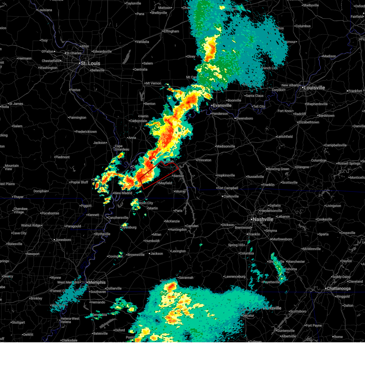 Torpah the national weather service in paducah has issued a * tornado warning for, northwestern marshall county in western kentucky, southeastern carlisle county in western kentucky, northeastern hickman county in western kentucky, southeastern mccracken county in western kentucky, northern graves county in western kentucky, * until 315 am cdt. * at 223 am cdt, a severe thunderstorm capable of producing a tornado was located near clinton, moving northeast at 60 mph (radar indicated rotation). Hazards include tornado. Flying debris will be dangerous to those caught without shelter. mobile homes will be damaged or destroyed. damage to roofs, windows, and vehicles will occur. tree damage is likely. this dangerous storm will be near, mayfield around 235 am cdt. reidland around 245 am cdt. paducah around 250 am cdt. calvert city around 255 am cdt. other locations impacted by this tornadic thunderstorm include lowes, fancy farm, and symsonia. this includes the following highways, interstate 24 in kentucky between mile markers 8 and 29. Interstate 69 in kentucky between mile markers 46 and 51. Torpah the national weather service in paducah has issued a * tornado warning for, northwestern marshall county in western kentucky, southeastern carlisle county in western kentucky, northeastern hickman county in western kentucky, southeastern mccracken county in western kentucky, northern graves county in western kentucky, * until 315 am cdt. * at 223 am cdt, a severe thunderstorm capable of producing a tornado was located near clinton, moving northeast at 60 mph (radar indicated rotation). Hazards include tornado. Flying debris will be dangerous to those caught without shelter. mobile homes will be damaged or destroyed. damage to roofs, windows, and vehicles will occur. tree damage is likely. this dangerous storm will be near, mayfield around 235 am cdt. reidland around 245 am cdt. paducah around 250 am cdt. calvert city around 255 am cdt. other locations impacted by this tornadic thunderstorm include lowes, fancy farm, and symsonia. this includes the following highways, interstate 24 in kentucky between mile markers 8 and 29. Interstate 69 in kentucky between mile markers 46 and 51.
|
| 3/15/2025 2:15 AM CDT |
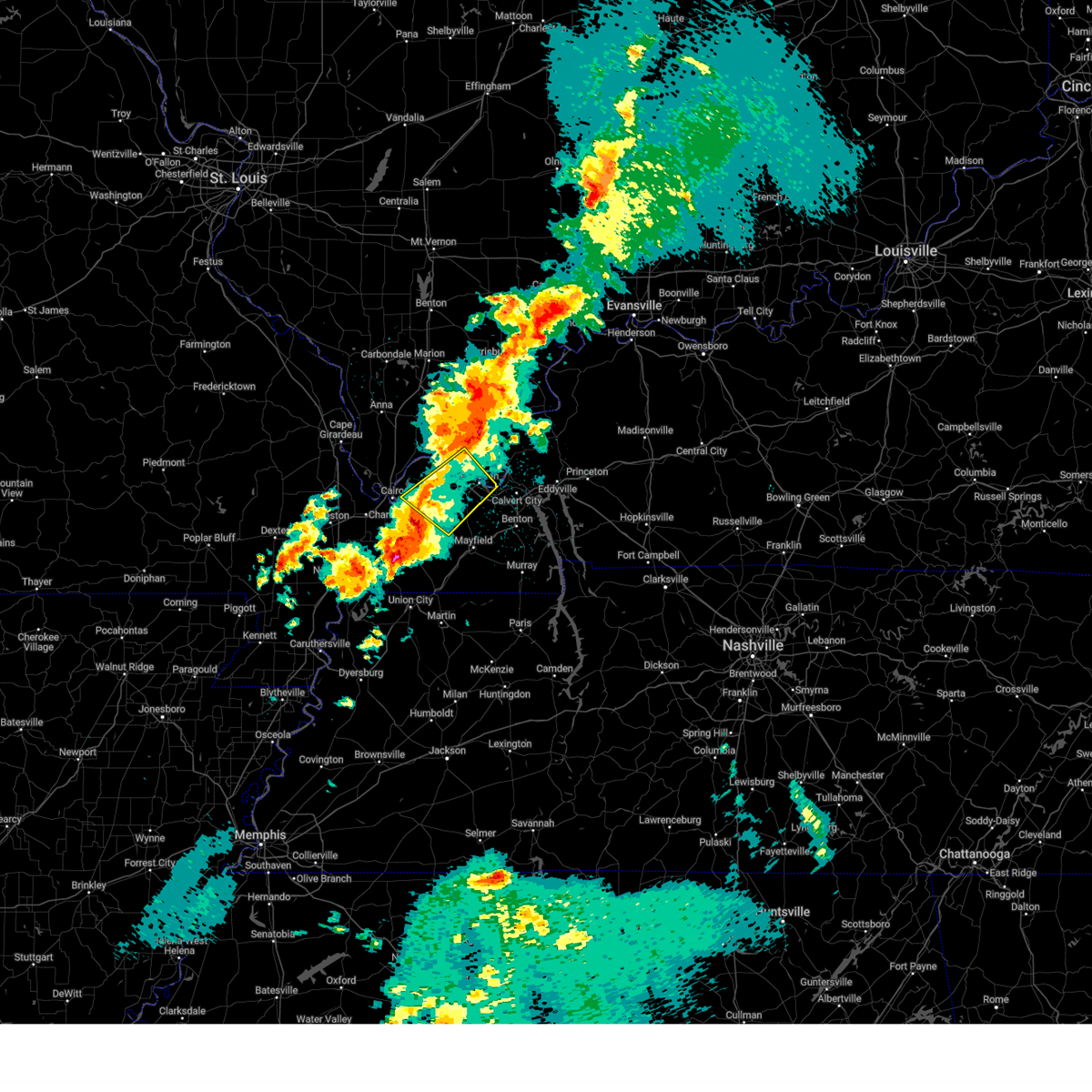 Svrpah the national weather service in paducah has issued a * severe thunderstorm warning for, central massac county in southern illinois, southwestern livingston county in western kentucky, northeastern carlisle county in western kentucky, southern ballard county in western kentucky, mccracken county in western kentucky, northwestern graves county in western kentucky, * until 300 am cdt. * at 215 am cdt, a severe thunderstorm was located near lovelaceville, or near bardwell, moving northeast at 70 mph (radar indicated). Hazards include 70 mph wind gusts. Expect considerable tree damage. Damage is likely to mobile homes, roofs, and outbuildings. Svrpah the national weather service in paducah has issued a * severe thunderstorm warning for, central massac county in southern illinois, southwestern livingston county in western kentucky, northeastern carlisle county in western kentucky, southern ballard county in western kentucky, mccracken county in western kentucky, northwestern graves county in western kentucky, * until 300 am cdt. * at 215 am cdt, a severe thunderstorm was located near lovelaceville, or near bardwell, moving northeast at 70 mph (radar indicated). Hazards include 70 mph wind gusts. Expect considerable tree damage. Damage is likely to mobile homes, roofs, and outbuildings.
|
| 3/15/2025 1:30 AM CDT | Golf Ball sized hail reported 0.6 miles NE of Ledbetter, KY, public photo of hail 1.75 inches near ledbetter. |
| 8/15/2024 9:27 PM CDT |
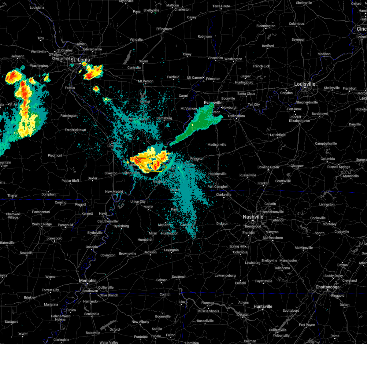 The storms which prompted the warning have weakened below severe limits, and no longer pose an immediate threat to life or property. therefore, the warning will be allowed to expire. however, gusty winds and heavy rain are still possible with these thunderstorms. a severe thunderstorm watch remains in effect until midnight cdt for southern illinois, and western kentucky. The storms which prompted the warning have weakened below severe limits, and no longer pose an immediate threat to life or property. therefore, the warning will be allowed to expire. however, gusty winds and heavy rain are still possible with these thunderstorms. a severe thunderstorm watch remains in effect until midnight cdt for southern illinois, and western kentucky.
|
| 8/15/2024 9:10 PM CDT |
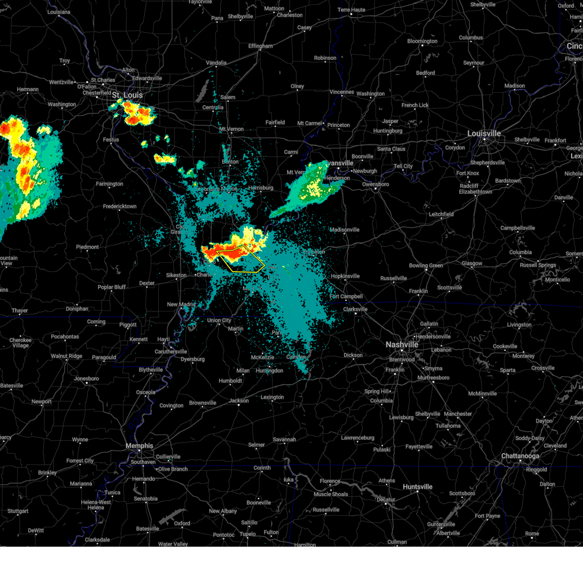 the severe thunderstorm warning has been cancelled and is no longer in effect the severe thunderstorm warning has been cancelled and is no longer in effect
|
| 8/15/2024 9:10 PM CDT |
 At 909 pm cdt, severe thunderstorms were located along a line extending from metropolis to near barkley regional airport to near la center, moving southeast at 20 mph (radar indicated). Hazards include 60 mph wind gusts. Expect damage to roofs, siding, and trees. locations impacted include, paducah, metropolis, la center, lone oak, reidland, barkley regional airport, west paducah, lovelaceville, and kevil. this includes the following highways, interstate 24 in kentucky between mile markers 1 and 15. Interstate 24 in illinois near mile marker 38. At 909 pm cdt, severe thunderstorms were located along a line extending from metropolis to near barkley regional airport to near la center, moving southeast at 20 mph (radar indicated). Hazards include 60 mph wind gusts. Expect damage to roofs, siding, and trees. locations impacted include, paducah, metropolis, la center, lone oak, reidland, barkley regional airport, west paducah, lovelaceville, and kevil. this includes the following highways, interstate 24 in kentucky between mile markers 1 and 15. Interstate 24 in illinois near mile marker 38.
|
| 8/15/2024 8:45 PM CDT |
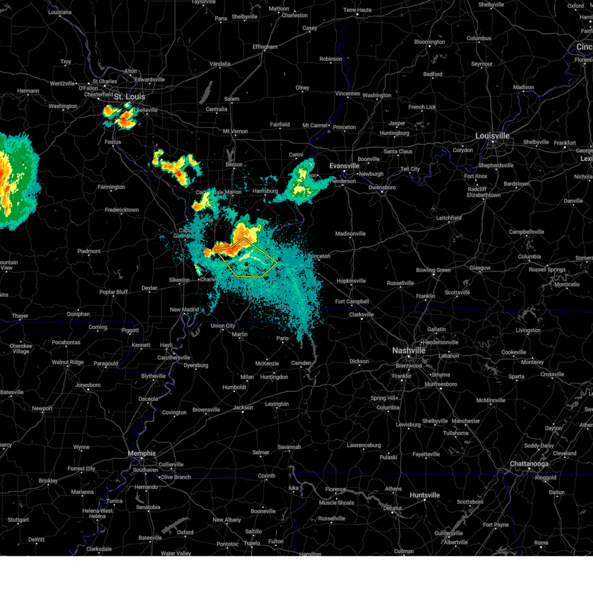 Svrpah the national weather service in paducah has issued a * severe thunderstorm warning for, central pulaski county in southern illinois, massac county in southern illinois, southern pope county in southern illinois, southwestern livingston county in western kentucky, central ballard county in western kentucky, mccracken county in western kentucky, * until 930 pm cdt. * at 844 pm cdt, severe thunderstorms were located along a line extending from near metropolis to 7 miles northwest of barkley regional airport to near la center, moving southeast at 20 mph (law enforcement). Hazards include 70 mph wind gusts and quarter size hail. Hail damage to vehicles is expected. expect considerable tree damage. Wind damage is also likely to mobile homes, roofs, and outbuildings. Svrpah the national weather service in paducah has issued a * severe thunderstorm warning for, central pulaski county in southern illinois, massac county in southern illinois, southern pope county in southern illinois, southwestern livingston county in western kentucky, central ballard county in western kentucky, mccracken county in western kentucky, * until 930 pm cdt. * at 844 pm cdt, severe thunderstorms were located along a line extending from near metropolis to 7 miles northwest of barkley regional airport to near la center, moving southeast at 20 mph (law enforcement). Hazards include 70 mph wind gusts and quarter size hail. Hail damage to vehicles is expected. expect considerable tree damage. Wind damage is also likely to mobile homes, roofs, and outbuildings.
|
| 7/30/2024 8:07 PM CDT |
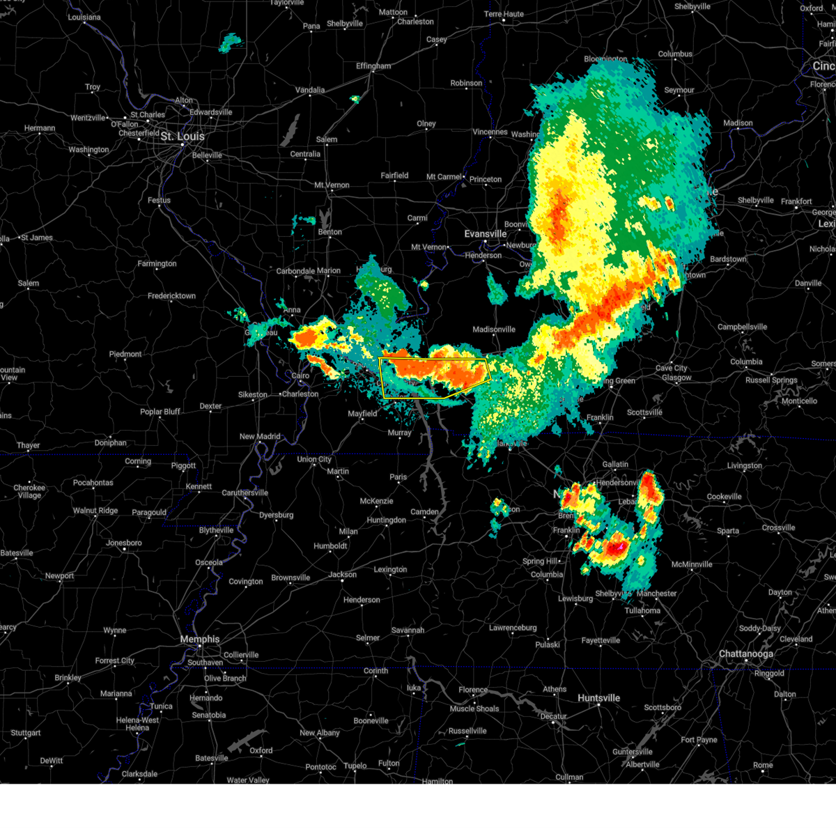 At 807 pm cdt, severe thunderstorms were located along a line extending from 7 miles west of crofton to 6 miles northeast of woodlands nature station to near calvert city, moving south at 30 mph (radar indicated). Hazards include 60 mph wind gusts and penny size hail. Expect damage to roofs, siding, and trees. locations impacted include, princeton, dawson springs, calvert city, eddyville, hillman ferry campground, woodlands nature station, birmingham ferry recreation area, demumbers bay campground, cravens bay campground, land between the lakes area, cobb, ledbetter, rockcastle, kuttawa, grand rivers, smithland, hawkins, hamletsburg, and dycusburg. this includes the following highways, interstate 24 in kentucky between mile markers 19 and 60. Interstate 69 in kentucky between mile markers 45 and 87. At 807 pm cdt, severe thunderstorms were located along a line extending from 7 miles west of crofton to 6 miles northeast of woodlands nature station to near calvert city, moving south at 30 mph (radar indicated). Hazards include 60 mph wind gusts and penny size hail. Expect damage to roofs, siding, and trees. locations impacted include, princeton, dawson springs, calvert city, eddyville, hillman ferry campground, woodlands nature station, birmingham ferry recreation area, demumbers bay campground, cravens bay campground, land between the lakes area, cobb, ledbetter, rockcastle, kuttawa, grand rivers, smithland, hawkins, hamletsburg, and dycusburg. this includes the following highways, interstate 24 in kentucky between mile markers 19 and 60. Interstate 69 in kentucky between mile markers 45 and 87.
|
| 7/30/2024 7:48 PM CDT |
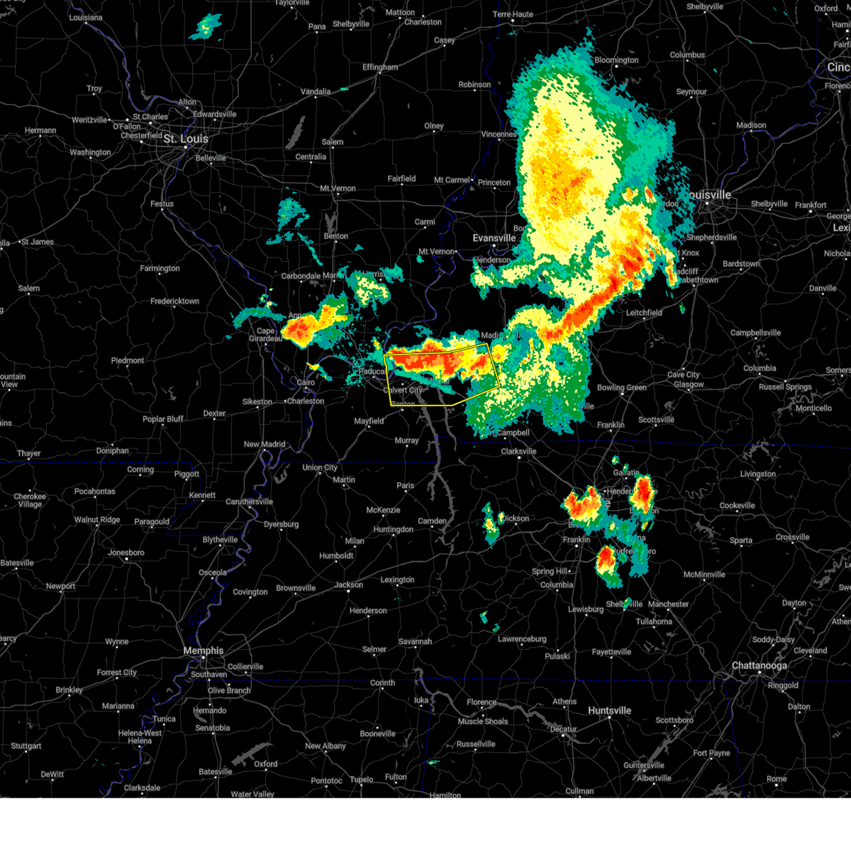 At 748 pm cdt, severe thunderstorms were located along a line extending from near dawson springs to near princeton to near calvert city, moving south at 30 mph (radar indicated). Hazards include 60 mph wind gusts and penny size hail. Expect damage to roofs, siding, and trees. locations impacted include, princeton, dawson springs, calvert city, eddyville, hillman ferry campground, woodlands nature station, birmingham ferry recreation area, demumbers bay campground, cravens bay campground, land between the lakes area, olney, cobb, farmersville, ledbetter, rockcastle, kuttawa, fredonia, grand rivers, smithland, and hawkins. this includes the following highways, interstate 24 in kentucky between mile markers 19 and 60. Interstate 69 in kentucky between mile markers 45 and 98. At 748 pm cdt, severe thunderstorms were located along a line extending from near dawson springs to near princeton to near calvert city, moving south at 30 mph (radar indicated). Hazards include 60 mph wind gusts and penny size hail. Expect damage to roofs, siding, and trees. locations impacted include, princeton, dawson springs, calvert city, eddyville, hillman ferry campground, woodlands nature station, birmingham ferry recreation area, demumbers bay campground, cravens bay campground, land between the lakes area, olney, cobb, farmersville, ledbetter, rockcastle, kuttawa, fredonia, grand rivers, smithland, and hawkins. this includes the following highways, interstate 24 in kentucky between mile markers 19 and 60. Interstate 69 in kentucky between mile markers 45 and 98.
|
| 7/30/2024 7:28 PM CDT |
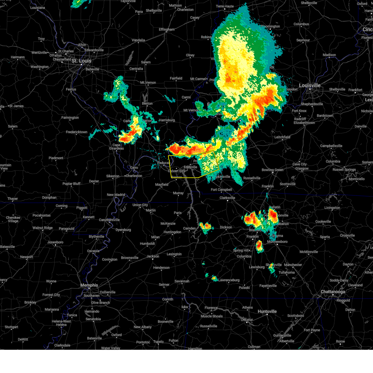 Svrpah the national weather service in paducah has issued a * severe thunderstorm warning for, southeastern pope county in southern illinois, south central crittenden county in western kentucky, southeastern livingston county in western kentucky, northwestern christian county in south central kentucky, caldwell county in western kentucky, northern marshall county in western kentucky, northern trigg county in western kentucky, southwestern hopkins county in northwestern kentucky, lyon county in western kentucky, * until 815 pm cdt. * at 728 pm cdt, severe thunderstorms were located along a line extending from 8 miles northeast of olney to near farmersville to near burna, moving south at 30 mph (radar indicated). Hazards include 60 mph wind gusts. expect damage to roofs, siding, and trees Svrpah the national weather service in paducah has issued a * severe thunderstorm warning for, southeastern pope county in southern illinois, south central crittenden county in western kentucky, southeastern livingston county in western kentucky, northwestern christian county in south central kentucky, caldwell county in western kentucky, northern marshall county in western kentucky, northern trigg county in western kentucky, southwestern hopkins county in northwestern kentucky, lyon county in western kentucky, * until 815 pm cdt. * at 728 pm cdt, severe thunderstorms were located along a line extending from 8 miles northeast of olney to near farmersville to near burna, moving south at 30 mph (radar indicated). Hazards include 60 mph wind gusts. expect damage to roofs, siding, and trees
|
| 5/26/2024 9:59 PM CDT |
 The storms which prompted the warning have weakened below severe limits, and have exited the warned area. therefore, the warning will be allowed to expire. The storms which prompted the warning have weakened below severe limits, and have exited the warned area. therefore, the warning will be allowed to expire.
|
| 5/26/2024 9:14 PM CDT |
 Svrpah the national weather service in paducah has issued a * severe thunderstorm warning for, fulton county in western kentucky, northwestern calloway county in western kentucky, southwestern livingston county in western kentucky, marshall county in western kentucky, southeastern carlisle county in western kentucky, hickman county in western kentucky, graves county in western kentucky, southeastern mississippi county in southeastern missouri, southeastern stoddard county in southeastern missouri, * until 1000 pm cdt. * at 914 pm cdt, severe thunderstorms were located along a line extending from near marion to near lone oak to near farrenburg, moving southeast at 50 mph (radar indicated). Hazards include 60 mph wind gusts and quarter size hail. Hail damage to vehicles is expected. Expect wind damage to roofs, siding, and trees. Svrpah the national weather service in paducah has issued a * severe thunderstorm warning for, fulton county in western kentucky, northwestern calloway county in western kentucky, southwestern livingston county in western kentucky, marshall county in western kentucky, southeastern carlisle county in western kentucky, hickman county in western kentucky, graves county in western kentucky, southeastern mississippi county in southeastern missouri, southeastern stoddard county in southeastern missouri, * until 1000 pm cdt. * at 914 pm cdt, severe thunderstorms were located along a line extending from near marion to near lone oak to near farrenburg, moving southeast at 50 mph (radar indicated). Hazards include 60 mph wind gusts and quarter size hail. Hail damage to vehicles is expected. Expect wind damage to roofs, siding, and trees.
|
| 5/26/2024 8:41 PM CDT |
 Svrpah the national weather service in paducah has issued a * severe thunderstorm warning for, central pulaski county in southern illinois, southern massac county in southern illinois, southeastern alexander county in southern illinois, carlisle county in western kentucky, northwestern hickman county in western kentucky, ballard county in western kentucky, mccracken county in western kentucky, northwestern graves county in western kentucky, mississippi county in southeastern missouri, northeastern new madrid county in southeastern missouri, * until 945 pm cdt. * at 841 pm cdt, severe thunderstorms were located along a line extending from near karnak to near charleston to near bernie, moving southeast at 40 mph (radar indicated). Hazards include 60 mph wind gusts and quarter size hail. Hail damage to vehicles is expected. Expect wind damage to roofs, siding, and trees. Svrpah the national weather service in paducah has issued a * severe thunderstorm warning for, central pulaski county in southern illinois, southern massac county in southern illinois, southeastern alexander county in southern illinois, carlisle county in western kentucky, northwestern hickman county in western kentucky, ballard county in western kentucky, mccracken county in western kentucky, northwestern graves county in western kentucky, mississippi county in southeastern missouri, northeastern new madrid county in southeastern missouri, * until 945 pm cdt. * at 841 pm cdt, severe thunderstorms were located along a line extending from near karnak to near charleston to near bernie, moving southeast at 40 mph (radar indicated). Hazards include 60 mph wind gusts and quarter size hail. Hail damage to vehicles is expected. Expect wind damage to roofs, siding, and trees.
|
| 5/26/2024 7:16 PM CDT |
 Torpah the national weather service in paducah has issued a * tornado warning for, southeastern livingston county in western kentucky, northwestern marshall county in western kentucky, northwestern lyon county in western kentucky, * until 800 pm cdt. * at 716 pm cdt, a severe thunderstorm capable of producing a tornado was located over ledbetter, or over reidland, moving east at 30 mph (radar indicated rotation). Hazards include tornado. Flying debris will be dangerous to those caught without shelter. mobile homes will be damaged or destroyed. damage to roofs, windows, and vehicles will occur. tree damage is likely. this dangerous storm will be near, calvert city and ledbetter around 720 pm cdt. land between the lakes area around 740 pm cdt. other locations impacted by this tornadic thunderstorm include grand rivers and kuttawa. this includes the following highways, interstate 24 in kentucky between mile markers 18 and 39. Interstate 69 in kentucky near mile marker 51. Torpah the national weather service in paducah has issued a * tornado warning for, southeastern livingston county in western kentucky, northwestern marshall county in western kentucky, northwestern lyon county in western kentucky, * until 800 pm cdt. * at 716 pm cdt, a severe thunderstorm capable of producing a tornado was located over ledbetter, or over reidland, moving east at 30 mph (radar indicated rotation). Hazards include tornado. Flying debris will be dangerous to those caught without shelter. mobile homes will be damaged or destroyed. damage to roofs, windows, and vehicles will occur. tree damage is likely. this dangerous storm will be near, calvert city and ledbetter around 720 pm cdt. land between the lakes area around 740 pm cdt. other locations impacted by this tornadic thunderstorm include grand rivers and kuttawa. this includes the following highways, interstate 24 in kentucky between mile markers 18 and 39. Interstate 69 in kentucky near mile marker 51.
|
| 5/26/2024 7:15 PM CDT | Quarter sized hail reported 0.8 miles WNW of Ledbetter, KY |
| 5/26/2024 7:06 PM CDT |
 Svrpah the national weather service in paducah has issued a * severe thunderstorm warning for, south central crittenden county in western kentucky, southern livingston county in western kentucky, northwestern marshall county in western kentucky, southeastern mccracken county in western kentucky, northwestern lyon county in western kentucky, * until 745 pm cdt. * at 706 pm cdt, a severe thunderstorm was located over ledbetter, or near reidland, moving east at 30 mph (radar indicated). Hazards include 70 mph wind gusts and half dollar size hail. Hail damage to vehicles is expected. expect considerable tree damage. Wind damage is also likely to mobile homes, roofs, and outbuildings. Svrpah the national weather service in paducah has issued a * severe thunderstorm warning for, south central crittenden county in western kentucky, southern livingston county in western kentucky, northwestern marshall county in western kentucky, southeastern mccracken county in western kentucky, northwestern lyon county in western kentucky, * until 745 pm cdt. * at 706 pm cdt, a severe thunderstorm was located over ledbetter, or near reidland, moving east at 30 mph (radar indicated). Hazards include 70 mph wind gusts and half dollar size hail. Hail damage to vehicles is expected. expect considerable tree damage. Wind damage is also likely to mobile homes, roofs, and outbuildings.
|
| 5/26/2024 8:20 AM CDT |
 Svrpah the national weather service in paducah has issued a * severe thunderstorm warning for, eastern massac county in southern illinois, southern pope county in southern illinois, calloway county in western kentucky, crittenden county in western kentucky, livingston county in western kentucky, caldwell county in western kentucky, marshall county in western kentucky, trigg county in western kentucky, southeastern mccracken county in western kentucky, graves county in western kentucky, lyon county in western kentucky, * until 900 am cdt. * at 819 am cdt, severe thunderstorms were located along a line extending from 8 miles southwest of golconda to near reidland to near latham, moving east at 70 mph (radar indicated). Hazards include 70 mph wind gusts. Expect considerable tree damage. Damage is likely to mobile homes, roofs, and outbuildings. Svrpah the national weather service in paducah has issued a * severe thunderstorm warning for, eastern massac county in southern illinois, southern pope county in southern illinois, calloway county in western kentucky, crittenden county in western kentucky, livingston county in western kentucky, caldwell county in western kentucky, marshall county in western kentucky, trigg county in western kentucky, southeastern mccracken county in western kentucky, graves county in western kentucky, lyon county in western kentucky, * until 900 am cdt. * at 819 am cdt, severe thunderstorms were located along a line extending from 8 miles southwest of golconda to near reidland to near latham, moving east at 70 mph (radar indicated). Hazards include 70 mph wind gusts. Expect considerable tree damage. Damage is likely to mobile homes, roofs, and outbuildings.
|
| 5/26/2024 8:02 AM CDT |
 the severe thunderstorm warning has been cancelled and is no longer in effect the severe thunderstorm warning has been cancelled and is no longer in effect
|
| 5/26/2024 8:02 AM CDT |
 At 802 am cdt, severe thunderstorms were located along a line extending from 6 miles east of anna to 6 miles northeast of la center to 6 miles south of bardwell to near hickman, moving northeast at 75 mph (radar indicated). Hazards include 70 mph wind gusts and penny size hail. Expect considerable tree damage. damage is likely to mobile homes, roofs, and outbuildings. locations impacted include, paducah, mayfield, metropolis, anna, fulton, hickman, jonesboro, vienna, clinton, la center, bardwell, wickliffe, lone oak, reidland, cobden, goreville, brookport, mounds, dongola, and barlow. this includes the following highways, interstate 24 in kentucky between mile markers 1 and 16. interstate 24 in illinois between mile markers 1 and 38. interstate 57 in illinois between mile markers 5 and 43. Interstate 69 in kentucky between mile markers 1 and 28. At 802 am cdt, severe thunderstorms were located along a line extending from 6 miles east of anna to 6 miles northeast of la center to 6 miles south of bardwell to near hickman, moving northeast at 75 mph (radar indicated). Hazards include 70 mph wind gusts and penny size hail. Expect considerable tree damage. damage is likely to mobile homes, roofs, and outbuildings. locations impacted include, paducah, mayfield, metropolis, anna, fulton, hickman, jonesboro, vienna, clinton, la center, bardwell, wickliffe, lone oak, reidland, cobden, goreville, brookport, mounds, dongola, and barlow. this includes the following highways, interstate 24 in kentucky between mile markers 1 and 16. interstate 24 in illinois between mile markers 1 and 38. interstate 57 in illinois between mile markers 5 and 43. Interstate 69 in kentucky between mile markers 1 and 28.
|
| 5/26/2024 7:42 AM CDT |
 Svrpah the national weather service in paducah has issued a * severe thunderstorm warning for, union county in southern illinois, pulaski county in southern illinois, southern pope county in southern illinois, johnson county in southern illinois, alexander county in southern illinois, massac county in southern illinois, south central williamson county in southern illinois, ballard county in western kentucky, mccracken county in western kentucky, fulton county in western kentucky, southwestern livingston county in western kentucky, carlisle county in western kentucky, hickman county in western kentucky, graves county in western kentucky, mississippi county in southeastern missouri, southeastern new madrid county in southeastern missouri, east central cape girardeau county in southeastern missouri, * until 830 am cdt. * at 741 am cdt, severe thunderstorms were located along a line extending from near cape girardeau to near cairo to near big oak tree state park to near tiptonville, moving northeast at 75 mph (radar indicated). Hazards include 70 mph wind gusts and penny size hail. Expect considerable tree damage. Damage is likely to mobile homes, roofs, and outbuildings. Svrpah the national weather service in paducah has issued a * severe thunderstorm warning for, union county in southern illinois, pulaski county in southern illinois, southern pope county in southern illinois, johnson county in southern illinois, alexander county in southern illinois, massac county in southern illinois, south central williamson county in southern illinois, ballard county in western kentucky, mccracken county in western kentucky, fulton county in western kentucky, southwestern livingston county in western kentucky, carlisle county in western kentucky, hickman county in western kentucky, graves county in western kentucky, mississippi county in southeastern missouri, southeastern new madrid county in southeastern missouri, east central cape girardeau county in southeastern missouri, * until 830 am cdt. * at 741 am cdt, severe thunderstorms were located along a line extending from near cape girardeau to near cairo to near big oak tree state park to near tiptonville, moving northeast at 75 mph (radar indicated). Hazards include 70 mph wind gusts and penny size hail. Expect considerable tree damage. Damage is likely to mobile homes, roofs, and outbuildings.
|
| 5/8/2024 7:49 PM CDT |
 the severe thunderstorm warning has been cancelled and is no longer in effect the severe thunderstorm warning has been cancelled and is no longer in effect
|
| 5/8/2024 7:40 PM CDT |
 At 740 pm cdt, a severe thunderstorm was located near ledbetter, or near paducah, moving northeast at 30 mph (trained weather spotters). Hazards include 60 mph wind gusts and quarter size hail. Hail damage to vehicles is expected. expect wind damage to roofs, siding, and trees. Locations impacted include, paducah, reidland, brookport, and ledbetter. At 740 pm cdt, a severe thunderstorm was located near ledbetter, or near paducah, moving northeast at 30 mph (trained weather spotters). Hazards include 60 mph wind gusts and quarter size hail. Hail damage to vehicles is expected. expect wind damage to roofs, siding, and trees. Locations impacted include, paducah, reidland, brookport, and ledbetter.
|
| 5/8/2024 7:40 PM CDT |
 the severe thunderstorm warning has been cancelled and is no longer in effect the severe thunderstorm warning has been cancelled and is no longer in effect
|
| 5/8/2024 7:23 PM CDT |
 Svrpah the national weather service in paducah has issued a * severe thunderstorm warning for, southeastern massac county in southern illinois, southeastern pope county in southern illinois, southwestern livingston county in western kentucky, northwestern marshall county in western kentucky, southeastern mccracken county in western kentucky, * until 800 pm cdt. * at 723 pm cdt, a severe thunderstorm was located over lone oak, moving northeast at 25 mph (radar indicated). Hazards include 60 mph wind gusts and quarter size hail. Hail damage to vehicles is expected. Expect wind damage to roofs, siding, and trees. Svrpah the national weather service in paducah has issued a * severe thunderstorm warning for, southeastern massac county in southern illinois, southeastern pope county in southern illinois, southwestern livingston county in western kentucky, northwestern marshall county in western kentucky, southeastern mccracken county in western kentucky, * until 800 pm cdt. * at 723 pm cdt, a severe thunderstorm was located over lone oak, moving northeast at 25 mph (radar indicated). Hazards include 60 mph wind gusts and quarter size hail. Hail damage to vehicles is expected. Expect wind damage to roofs, siding, and trees.
|
| 5/8/2024 3:22 PM CDT |
 The storm which prompted the warning has weakened below severe limits, and no longer poses an immediate threat to life or property. therefore, the warning will be allowed to expire. a tornado watch remains in effect until 500 pm cdt for southern illinois, and western kentucky. The storm which prompted the warning has weakened below severe limits, and no longer poses an immediate threat to life or property. therefore, the warning will be allowed to expire. a tornado watch remains in effect until 500 pm cdt for southern illinois, and western kentucky.
|
| 5/8/2024 2:55 PM CDT |
 At 255 pm cdt, a severe thunderstorm was located over reidland, moving northeast at 35 mph (radar indicated). Hazards include 60 mph wind gusts and quarter size hail. Hail damage to vehicles is expected. expect wind damage to roofs, siding, and trees. locations impacted include, paducah, calvert city, reidland, burna, ledbetter, smithland, and hamletsburg. This includes interstate 24 in kentucky between mile markers 5 and 23, and between mile markers 26 and 28. At 255 pm cdt, a severe thunderstorm was located over reidland, moving northeast at 35 mph (radar indicated). Hazards include 60 mph wind gusts and quarter size hail. Hail damage to vehicles is expected. expect wind damage to roofs, siding, and trees. locations impacted include, paducah, calvert city, reidland, burna, ledbetter, smithland, and hamletsburg. This includes interstate 24 in kentucky between mile markers 5 and 23, and between mile markers 26 and 28.
|
| 5/8/2024 2:55 PM CDT |
 the severe thunderstorm warning has been cancelled and is no longer in effect the severe thunderstorm warning has been cancelled and is no longer in effect
|
| 5/8/2024 2:39 PM CDT |
 Svrpah the national weather service in paducah has issued a * severe thunderstorm warning for, southeastern massac county in southern illinois, southeastern pope county in southern illinois, southwestern livingston county in western kentucky, northwestern marshall county in western kentucky, southeastern mccracken county in western kentucky, north central graves county in western kentucky, * until 330 pm cdt. * at 238 pm cdt, a severe thunderstorm was located near lovelaceville, or southwest of lone oak, moving northeast at 30 mph (radar indicated). Hazards include 60 mph wind gusts and quarter size hail. Hail damage to vehicles is expected. Expect wind damage to roofs, siding, and trees. Svrpah the national weather service in paducah has issued a * severe thunderstorm warning for, southeastern massac county in southern illinois, southeastern pope county in southern illinois, southwestern livingston county in western kentucky, northwestern marshall county in western kentucky, southeastern mccracken county in western kentucky, north central graves county in western kentucky, * until 330 pm cdt. * at 238 pm cdt, a severe thunderstorm was located near lovelaceville, or southwest of lone oak, moving northeast at 30 mph (radar indicated). Hazards include 60 mph wind gusts and quarter size hail. Hail damage to vehicles is expected. Expect wind damage to roofs, siding, and trees.
|
| 5/8/2024 1:44 PM CDT |
 the severe thunderstorm warning has been cancelled and is no longer in effect the severe thunderstorm warning has been cancelled and is no longer in effect
|
| 5/8/2024 1:34 PM CDT |
 the tornado warning has been cancelled and is no longer in effect the tornado warning has been cancelled and is no longer in effect
|
| 5/8/2024 1:30 PM CDT |
 At 130 pm cdt, a severe thunderstorm was located over calvert city, moving northeast at 35 mph (radar indicated). Hazards include 60 mph wind gusts and quarter size hail. Hail damage to vehicles is expected. expect wind damage to roofs, siding, and trees. locations impacted include, calvert city, eddyville, salem, ledbetter, kuttawa, grand rivers, and smithland. this includes the following highways, interstate 24 in kentucky between mile markers 18 and 39. Interstate 69 in kentucky between mile markers 49 and 51. At 130 pm cdt, a severe thunderstorm was located over calvert city, moving northeast at 35 mph (radar indicated). Hazards include 60 mph wind gusts and quarter size hail. Hail damage to vehicles is expected. expect wind damage to roofs, siding, and trees. locations impacted include, calvert city, eddyville, salem, ledbetter, kuttawa, grand rivers, and smithland. this includes the following highways, interstate 24 in kentucky between mile markers 18 and 39. Interstate 69 in kentucky between mile markers 49 and 51.
|
| 5/8/2024 1:30 PM CDT |
 the severe thunderstorm warning has been cancelled and is no longer in effect the severe thunderstorm warning has been cancelled and is no longer in effect
|
| 5/8/2024 1:29 PM CDT |
 At 128 pm cdt, a severe thunderstorm capable of producing a tornado was located just south of i-24 near the mccracken and marshall county line, moving northeast at 25 mph (radar indicated rotation). Hazards include tornado. Flying debris will be dangerous to those caught without shelter. mobile homes will be damaged or destroyed. damage to roofs, windows, and vehicles will occur. tree damage is likely. this dangerous storm will be near, calvert city and ledbetter around 135 pm cdt. this includes the following highways, interstate 24 in kentucky between mile markers 18 and 29. Interstate 69 in kentucky between mile markers 49 and 51. At 128 pm cdt, a severe thunderstorm capable of producing a tornado was located just south of i-24 near the mccracken and marshall county line, moving northeast at 25 mph (radar indicated rotation). Hazards include tornado. Flying debris will be dangerous to those caught without shelter. mobile homes will be damaged or destroyed. damage to roofs, windows, and vehicles will occur. tree damage is likely. this dangerous storm will be near, calvert city and ledbetter around 135 pm cdt. this includes the following highways, interstate 24 in kentucky between mile markers 18 and 29. Interstate 69 in kentucky between mile markers 49 and 51.
|
| 5/8/2024 1:29 PM CDT |
 the tornado warning has been cancelled and is no longer in effect the tornado warning has been cancelled and is no longer in effect
|
| 5/8/2024 1:18 PM CDT |
 Torpah the national weather service in paducah has issued a * tornado warning for, south central livingston county in western kentucky, northwestern marshall county in western kentucky, southeastern mccracken county in western kentucky, northeastern graves county in western kentucky, * until 145 pm cdt. * at 118 pm cdt, a severe thunderstorm capable of producing a tornado was located near reidland, moving northeast at 25 mph (radar indicated rotation). Hazards include tornado. Flying debris will be dangerous to those caught without shelter. mobile homes will be damaged or destroyed. damage to roofs, windows, and vehicles will occur. tree damage is likely. this dangerous storm will be near, reidland and ledbetter around 125 pm cdt. other locations impacted by this tornadic thunderstorm include symsonia. this includes the following highways, interstate 24 in kentucky between mile markers 14 and 29. Interstate 69 in kentucky between mile markers 49 and 51. Torpah the national weather service in paducah has issued a * tornado warning for, south central livingston county in western kentucky, northwestern marshall county in western kentucky, southeastern mccracken county in western kentucky, northeastern graves county in western kentucky, * until 145 pm cdt. * at 118 pm cdt, a severe thunderstorm capable of producing a tornado was located near reidland, moving northeast at 25 mph (radar indicated rotation). Hazards include tornado. Flying debris will be dangerous to those caught without shelter. mobile homes will be damaged or destroyed. damage to roofs, windows, and vehicles will occur. tree damage is likely. this dangerous storm will be near, reidland and ledbetter around 125 pm cdt. other locations impacted by this tornadic thunderstorm include symsonia. this includes the following highways, interstate 24 in kentucky between mile markers 14 and 29. Interstate 69 in kentucky between mile markers 49 and 51.
|
| 5/8/2024 1:10 PM CDT |
 Svrpah the national weather service in paducah has issued a * severe thunderstorm warning for, southern livingston county in western kentucky, northwestern marshall county in western kentucky, southeastern mccracken county in western kentucky, northeastern graves county in western kentucky, northwestern lyon county in western kentucky, * until 200 pm cdt. * at 110 pm cdt, a severe thunderstorm was located near reidland, moving northeast at 35 mph (radar indicated). Hazards include 60 mph wind gusts and quarter size hail. Hail damage to vehicles is expected. Expect wind damage to roofs, siding, and trees. Svrpah the national weather service in paducah has issued a * severe thunderstorm warning for, southern livingston county in western kentucky, northwestern marshall county in western kentucky, southeastern mccracken county in western kentucky, northeastern graves county in western kentucky, northwestern lyon county in western kentucky, * until 200 pm cdt. * at 110 pm cdt, a severe thunderstorm was located near reidland, moving northeast at 35 mph (radar indicated). Hazards include 60 mph wind gusts and quarter size hail. Hail damage to vehicles is expected. Expect wind damage to roofs, siding, and trees.
|
| 5/8/2024 8:37 AM CDT |
 The storm which prompted the warning has moved out of the area. therefore, the warning will be allowed to expire. The storm which prompted the warning has moved out of the area. therefore, the warning will be allowed to expire.
|
| 5/8/2024 8:15 AM CDT |
 At 815 am cdt, a severe thunderstorm was located near calvert city, moving northeast at 30 mph (radar indicated). Hazards include 60 mph wind gusts and nickel size hail. Expect damage to roofs, siding, and trees. locations impacted include, calvert city, eddyville, ledbetter, kuttawa, grand rivers, and smithland. This includes interstate 24 in kentucky between mile markers 26 and 39. At 815 am cdt, a severe thunderstorm was located near calvert city, moving northeast at 30 mph (radar indicated). Hazards include 60 mph wind gusts and nickel size hail. Expect damage to roofs, siding, and trees. locations impacted include, calvert city, eddyville, ledbetter, kuttawa, grand rivers, and smithland. This includes interstate 24 in kentucky between mile markers 26 and 39.
|
| 5/8/2024 7:58 AM CDT |
 Svrpah the national weather service in paducah has issued a * severe thunderstorm warning for, southeastern livingston county in western kentucky, northwestern marshall county in western kentucky, northwestern lyon county in western kentucky, * until 845 am cdt. * at 757 am cdt, a severe thunderstorm was located near calvert city, moving northeast at 35 mph (radar indicated). Hazards include 60 mph wind gusts and nickel size hail. expect damage to roofs, siding, and trees Svrpah the national weather service in paducah has issued a * severe thunderstorm warning for, southeastern livingston county in western kentucky, northwestern marshall county in western kentucky, northwestern lyon county in western kentucky, * until 845 am cdt. * at 757 am cdt, a severe thunderstorm was located near calvert city, moving northeast at 35 mph (radar indicated). Hazards include 60 mph wind gusts and nickel size hail. expect damage to roofs, siding, and trees
|
| 4/2/2024 5:28 AM CDT |
 the severe thunderstorm warning has been cancelled and is no longer in effect the severe thunderstorm warning has been cancelled and is no longer in effect
|
| 4/2/2024 5:28 AM CDT |
 At 528 am cdt, severe thunderstorms were located along a line extending from near ridgway to 7 miles north of ledbetter, moving east at 65 mph (radar indicated). Hazards include 70 mph wind gusts. Expect considerable tree damage. damage is likely to mobile homes, roofs, and outbuildings. locations impacted include, evansville, henderson, paducah, mount vernon, princeton, morganfield, providence, marion, dawson springs, calvert city, eddyville, sturgis, shawneetown, breckinridge center, reidland, sebree, clay, rosiclare, uniontown, and ridgway. this includes the following highways, interstate 24 in kentucky between mile markers 10 and 46. interstate 69 in kentucky between mile markers 68 and 95, and between mile markers 129 and 148. Audubon parkway between mile markers 1 and 11. At 528 am cdt, severe thunderstorms were located along a line extending from near ridgway to 7 miles north of ledbetter, moving east at 65 mph (radar indicated). Hazards include 70 mph wind gusts. Expect considerable tree damage. damage is likely to mobile homes, roofs, and outbuildings. locations impacted include, evansville, henderson, paducah, mount vernon, princeton, morganfield, providence, marion, dawson springs, calvert city, eddyville, sturgis, shawneetown, breckinridge center, reidland, sebree, clay, rosiclare, uniontown, and ridgway. this includes the following highways, interstate 24 in kentucky between mile markers 10 and 46. interstate 69 in kentucky between mile markers 68 and 95, and between mile markers 129 and 148. Audubon parkway between mile markers 1 and 11.
|
| 4/2/2024 5:11 AM CDT |
 Svrpah the national weather service in paducah has issued a * severe thunderstorm warning for, east central johnson county in southern illinois, southwestern white county in southeastern illinois, massac county in southern illinois, southeastern hamilton county in south central illinois, gallatin county in southern illinois, pope county in southern illinois, saline county in southern illinois, hardin county in southern illinois, southern vanderburgh county in southwestern indiana, southwestern posey county in southwestern indiana, henderson county in northwestern kentucky, western hopkins county in northwestern kentucky, northern lyon county in western kentucky, livingston county in western kentucky, northwestern christian county in south central kentucky, northwestern mclean county in northwestern kentucky, northwestern graves county in western kentucky, caldwell county in western kentucky, northwestern marshall county in western kentucky, southeastern ballard county in western kentucky, mccracken county in western kentucky, crittenden county in western kentucky, northeastern carlisle county in western kentucky, union county in northwestern kentucky, webster county in northwestern kentucky, * until 615 am cdt. * at 511 am cdt, severe thunderstorms were located along a line extending from near harrisburg to near west paducah, moving east at 65 mph (radar indicated). Hazards include 70 mph wind gusts. Expect considerable tree damage. Damage is likely to mobile homes, roofs, and outbuildings. Svrpah the national weather service in paducah has issued a * severe thunderstorm warning for, east central johnson county in southern illinois, southwestern white county in southeastern illinois, massac county in southern illinois, southeastern hamilton county in south central illinois, gallatin county in southern illinois, pope county in southern illinois, saline county in southern illinois, hardin county in southern illinois, southern vanderburgh county in southwestern indiana, southwestern posey county in southwestern indiana, henderson county in northwestern kentucky, western hopkins county in northwestern kentucky, northern lyon county in western kentucky, livingston county in western kentucky, northwestern christian county in south central kentucky, northwestern mclean county in northwestern kentucky, northwestern graves county in western kentucky, caldwell county in western kentucky, northwestern marshall county in western kentucky, southeastern ballard county in western kentucky, mccracken county in western kentucky, crittenden county in western kentucky, northeastern carlisle county in western kentucky, union county in northwestern kentucky, webster county in northwestern kentucky, * until 615 am cdt. * at 511 am cdt, severe thunderstorms were located along a line extending from near harrisburg to near west paducah, moving east at 65 mph (radar indicated). Hazards include 70 mph wind gusts. Expect considerable tree damage. Damage is likely to mobile homes, roofs, and outbuildings.
|
| 3/14/2024 8:29 PM CDT |
 Svrpah the national weather service in paducah has issued a * severe thunderstorm warning for, massac county in southern illinois, pope county in southern illinois, southeastern johnson county in southern illinois, fulton county in western kentucky, eastern carlisle county in western kentucky, hickman county in western kentucky, southeastern ballard county in western kentucky, mccracken county in western kentucky, graves county in western kentucky, * until 915 pm cdt. * at 829 pm cdt, severe thunderstorms were located along a line extending from near vienna to bardwell to near clayton, moving east at 45 mph (radar indicated). Hazards include 60 mph wind gusts. expect damage to roofs, siding, and trees Svrpah the national weather service in paducah has issued a * severe thunderstorm warning for, massac county in southern illinois, pope county in southern illinois, southeastern johnson county in southern illinois, fulton county in western kentucky, eastern carlisle county in western kentucky, hickman county in western kentucky, southeastern ballard county in western kentucky, mccracken county in western kentucky, graves county in western kentucky, * until 915 pm cdt. * at 829 pm cdt, severe thunderstorms were located along a line extending from near vienna to bardwell to near clayton, moving east at 45 mph (radar indicated). Hazards include 60 mph wind gusts. expect damage to roofs, siding, and trees
|
| 3/6/2024 9:05 AM CST |
 Torpah the national weather service in paducah has issued a * this is a test message. tornado warning for, henderson county in northwestern kentucky, caldwell county in western kentucky, marshall county in western kentucky, trigg county in western kentucky, ballard county in western kentucky, mccracken county in western kentucky, hopkins county in northwestern kentucky, lyon county in western kentucky, fulton county in western kentucky, calloway county in western kentucky, daviess county in northwestern kentucky, muhlenberg county in south central kentucky, crittenden county in western kentucky, livingston county in western kentucky, christian county in south central kentucky, carlisle county in western kentucky, hickman county in western kentucky, mclean county in northwestern kentucky, todd county in south central kentucky, union county in northwestern kentucky, webster county in northwestern kentucky, graves county in western kentucky, * this is a test message. until 915 am cst. * this is a test message. this is a test tornado warning message. there is no severe weather occurring at this time. this test warning message is part of the annual kentucky tornado drill. if this were an actual severe weather event, you would be given information about the hazard. the national weather service, kentucky emergency management agency and the kentucky weather preparedness committee encourages the use of this time to activate and review your severe weather safety plans. repeating, this has been a test tornado warning message for the 2024 kentucky tornado drill. this concludes the test (test radar indicated rotation). Hazards include test tornado. There are no impacts. this is a test tornado warning. this is a test message. Locations include, all counties in western kentucky. Torpah the national weather service in paducah has issued a * this is a test message. tornado warning for, henderson county in northwestern kentucky, caldwell county in western kentucky, marshall county in western kentucky, trigg county in western kentucky, ballard county in western kentucky, mccracken county in western kentucky, hopkins county in northwestern kentucky, lyon county in western kentucky, fulton county in western kentucky, calloway county in western kentucky, daviess county in northwestern kentucky, muhlenberg county in south central kentucky, crittenden county in western kentucky, livingston county in western kentucky, christian county in south central kentucky, carlisle county in western kentucky, hickman county in western kentucky, mclean county in northwestern kentucky, todd county in south central kentucky, union county in northwestern kentucky, webster county in northwestern kentucky, graves county in western kentucky, * this is a test message. until 915 am cst. * this is a test message. this is a test tornado warning message. there is no severe weather occurring at this time. this test warning message is part of the annual kentucky tornado drill. if this were an actual severe weather event, you would be given information about the hazard. the national weather service, kentucky emergency management agency and the kentucky weather preparedness committee encourages the use of this time to activate and review your severe weather safety plans. repeating, this has been a test tornado warning message for the 2024 kentucky tornado drill. this concludes the test (test radar indicated rotation). Hazards include test tornado. There are no impacts. this is a test tornado warning. this is a test message. Locations include, all counties in western kentucky.
|
| 8/14/2023 4:25 AM CDT |
 At 425 am cdt, a severe thunderstorm capable of producing a tornado was located near reidland, moving east at 55 mph (radar indicated rotation). Hazards include tornado. Flying debris will be dangerous to those caught without shelter. mobile homes will be damaged or destroyed. damage to roofs, windows, and vehicles will occur. tree damage is likely. this dangerous storm will be near, reidland around 430 am cdt. other locations in the path of this tornadic thunderstorm include ledbetter and calvert city. this includes the following highways, interstate 24 in kentucky between mile markers 12 and 27. Interstate 69 in kentucky between mile markers 44 and 51. At 425 am cdt, a severe thunderstorm capable of producing a tornado was located near reidland, moving east at 55 mph (radar indicated rotation). Hazards include tornado. Flying debris will be dangerous to those caught without shelter. mobile homes will be damaged or destroyed. damage to roofs, windows, and vehicles will occur. tree damage is likely. this dangerous storm will be near, reidland around 430 am cdt. other locations in the path of this tornadic thunderstorm include ledbetter and calvert city. this includes the following highways, interstate 24 in kentucky between mile markers 12 and 27. Interstate 69 in kentucky between mile markers 44 and 51.
|
| 8/14/2023 4:14 AM CDT |
 At 414 am cdt, a severe thunderstorm capable of producing a tornado was located 7 miles east of lovelaceville, or 7 miles south of lone oak, moving east at 60 mph (radar indicated rotation). Hazards include tornado. Flying debris will be dangerous to those caught without shelter. mobile homes will be damaged or destroyed. damage to roofs, windows, and vehicles will occur. tree damage is likely. this dangerous storm will be near, paducah around 420 am cdt. reidland around 425 am cdt. ledbetter around 430 am cdt. other locations in the path of this tornadic thunderstorm include calvert city. this includes the following highways, interstate 24 in kentucky between mile markers 10 and 27. Interstate 69 in kentucky between mile markers 42 and 51. At 414 am cdt, a severe thunderstorm capable of producing a tornado was located 7 miles east of lovelaceville, or 7 miles south of lone oak, moving east at 60 mph (radar indicated rotation). Hazards include tornado. Flying debris will be dangerous to those caught without shelter. mobile homes will be damaged or destroyed. damage to roofs, windows, and vehicles will occur. tree damage is likely. this dangerous storm will be near, paducah around 420 am cdt. reidland around 425 am cdt. ledbetter around 430 am cdt. other locations in the path of this tornadic thunderstorm include calvert city. this includes the following highways, interstate 24 in kentucky between mile markers 10 and 27. Interstate 69 in kentucky between mile markers 42 and 51.
|
| 7/24/2023 3:33 PM CDT |
 At 333 pm cdt, a severe thunderstorm was located near calvert city, moving northeast at 25 mph (radar indicated). Hazards include 60 mph wind gusts and half dollar size hail. Hail damage to vehicles is expected. expect wind damage to roofs, siding, and trees. locations impacted include, ledbetter and smithland. hail threat, radar indicated max hail size, 1. 25 in wind threat, radar indicated max wind gust, 60 mph. At 333 pm cdt, a severe thunderstorm was located near calvert city, moving northeast at 25 mph (radar indicated). Hazards include 60 mph wind gusts and half dollar size hail. Hail damage to vehicles is expected. expect wind damage to roofs, siding, and trees. locations impacted include, ledbetter and smithland. hail threat, radar indicated max hail size, 1. 25 in wind threat, radar indicated max wind gust, 60 mph.
|
| 7/24/2023 3:26 PM CDT |
 At 326 pm cdt, a severe thunderstorm was located near ledbetter, or near calvert city, moving east at 25 mph (radar indicated). Hazards include 60 mph wind gusts and quarter size hail. Hail damage to vehicles is expected. expect wind damage to roofs, siding, and trees. locations impacted include, ledbetter, smithland and hamletsburg. hail threat, radar indicated max hail size, 1. 00 in wind threat, radar indicated max wind gust, 60 mph. At 326 pm cdt, a severe thunderstorm was located near ledbetter, or near calvert city, moving east at 25 mph (radar indicated). Hazards include 60 mph wind gusts and quarter size hail. Hail damage to vehicles is expected. expect wind damage to roofs, siding, and trees. locations impacted include, ledbetter, smithland and hamletsburg. hail threat, radar indicated max hail size, 1. 00 in wind threat, radar indicated max wind gust, 60 mph.
|
| 7/24/2023 3:20 PM CDT |
 At 320 pm cdt, a severe thunderstorm was located near ledbetter, or near paducah, moving east at 15 mph (radar indicated). Hazards include 60 mph wind gusts and half dollar size hail. Hail damage to vehicles is expected. expect wind damage to roofs, siding, and trees. locations impacted include, paducah and ledbetter. hail threat, radar indicated max hail size, 1. 25 in wind threat, radar indicated max wind gust, 60 mph. At 320 pm cdt, a severe thunderstorm was located near ledbetter, or near paducah, moving east at 15 mph (radar indicated). Hazards include 60 mph wind gusts and half dollar size hail. Hail damage to vehicles is expected. expect wind damage to roofs, siding, and trees. locations impacted include, paducah and ledbetter. hail threat, radar indicated max hail size, 1. 25 in wind threat, radar indicated max wind gust, 60 mph.
|
| 7/24/2023 3:18 PM CDT | Ping Pong Ball sized hail reported 0.6 miles NE of Ledbetter, KY, trained spotter report of 1.5 inch hail. |
| 7/24/2023 3:18 PM CDT | Trained spotter reported 60 mph wind gus in livingston county KY, 0.6 miles NE of Ledbetter, KY |
| 7/24/2023 3:15 PM CDT |
 At 314 pm cdt, a severe thunderstorm was located near ledbetter, or near reidland, moving northeast at 25 mph (radar indicated). Hazards include ping pong ball size hail and 60 mph wind gusts. People and animals outdoors will be injured. expect hail damage to roofs, siding, windows, and vehicles. Expect wind damage to roofs, siding, and trees. At 314 pm cdt, a severe thunderstorm was located near ledbetter, or near reidland, moving northeast at 25 mph (radar indicated). Hazards include ping pong ball size hail and 60 mph wind gusts. People and animals outdoors will be injured. expect hail damage to roofs, siding, windows, and vehicles. Expect wind damage to roofs, siding, and trees.
|
| 7/24/2023 3:03 PM CDT |
 At 303 pm cdt, a severe thunderstorm was located over paducah, moving east at 15 mph (radar indicated). Hazards include 60 mph wind gusts and quarter size hail. Hail damage to vehicles is expected. Expect wind damage to roofs, siding, and trees. At 303 pm cdt, a severe thunderstorm was located over paducah, moving east at 15 mph (radar indicated). Hazards include 60 mph wind gusts and quarter size hail. Hail damage to vehicles is expected. Expect wind damage to roofs, siding, and trees.
|
| 7/20/2023 10:43 AM CDT |
 At 1043 am cdt, a severe thunderstorm was located near ledbetter, or near calvert city, moving southeast at 45 mph (trained weather spotters. wind damage was observed in downtown paducah). Hazards include 70 mph wind gusts and penny size hail. Expect considerable tree damage. damage is likely to mobile homes, roofs, and outbuildings. locations impacted include, benton, calvert city, eddyville, hillman ferry campground, reidland, energy lake campground, woodlands nature station, birmingham ferry recreation area, demumbers bay campground, land between the lakes area, cravens bay campground, golden pond visitors center, ledbetter, canton, rockcastle, kuttawa, grand rivers, smithland, hamletsburg and symsonia. this includes the following highways, interstate 24 in kentucky between mile markers 15 and 55. interstate 69 in kentucky between mile markers 43 and 68. thunderstorm damage threat, considerable hail threat, radar indicated max hail size, 0. 75 in wind threat, observed max wind gust, 70 mph. At 1043 am cdt, a severe thunderstorm was located near ledbetter, or near calvert city, moving southeast at 45 mph (trained weather spotters. wind damage was observed in downtown paducah). Hazards include 70 mph wind gusts and penny size hail. Expect considerable tree damage. damage is likely to mobile homes, roofs, and outbuildings. locations impacted include, benton, calvert city, eddyville, hillman ferry campground, reidland, energy lake campground, woodlands nature station, birmingham ferry recreation area, demumbers bay campground, land between the lakes area, cravens bay campground, golden pond visitors center, ledbetter, canton, rockcastle, kuttawa, grand rivers, smithland, hamletsburg and symsonia. this includes the following highways, interstate 24 in kentucky between mile markers 15 and 55. interstate 69 in kentucky between mile markers 43 and 68. thunderstorm damage threat, considerable hail threat, radar indicated max hail size, 0. 75 in wind threat, observed max wind gust, 70 mph.
|
| 7/20/2023 10:42 AM CDT |
 At 1041 am cdt, a severe thunderstorm was located near ledbetter, or near calvert city, moving southeast at 40 mph (trained weather spotters. wind damage observed in downtown paducah). Hazards include 60 mph wind gusts and penny size hail. Expect damage to roofs, siding, and trees. locations impacted include, benton, calvert city, eddyville, hillman ferry campground, reidland, energy lake campground, woodlands nature station, birmingham ferry recreation area, demumbers bay campground, land between the lakes area, cravens bay campground, golden pond visitors center, ledbetter, canton, rockcastle, kuttawa, grand rivers, smithland, hamletsburg and symsonia. this includes the following highways, interstate 24 in kentucky between mile markers 15 and 55. interstate 69 in kentucky between mile markers 43 and 68. hail threat, radar indicated max hail size, 0. 75 in wind threat, observed max wind gust, 60 mph. At 1041 am cdt, a severe thunderstorm was located near ledbetter, or near calvert city, moving southeast at 40 mph (trained weather spotters. wind damage observed in downtown paducah). Hazards include 60 mph wind gusts and penny size hail. Expect damage to roofs, siding, and trees. locations impacted include, benton, calvert city, eddyville, hillman ferry campground, reidland, energy lake campground, woodlands nature station, birmingham ferry recreation area, demumbers bay campground, land between the lakes area, cravens bay campground, golden pond visitors center, ledbetter, canton, rockcastle, kuttawa, grand rivers, smithland, hamletsburg and symsonia. this includes the following highways, interstate 24 in kentucky between mile markers 15 and 55. interstate 69 in kentucky between mile markers 43 and 68. hail threat, radar indicated max hail size, 0. 75 in wind threat, observed max wind gust, 60 mph.
|
| 7/20/2023 10:36 AM CDT |
 At 1036 am cdt, a severe thunderstorm was located over ledbetter, or near reidland, moving southeast at 45 mph (radar indicated). Hazards include 60 mph wind gusts and penny size hail. expect damage to roofs, siding, and trees At 1036 am cdt, a severe thunderstorm was located over ledbetter, or near reidland, moving southeast at 45 mph (radar indicated). Hazards include 60 mph wind gusts and penny size hail. expect damage to roofs, siding, and trees
|
| 7/20/2023 10:32 AM CDT |
 At 1031 am cdt, a severe thunderstorm was located over paducah, moving southeast at 45 mph (trained weather spotters). Hazards include 70 mph wind gusts and quarter size hail. Hail damage to vehicles is expected. expect considerable tree damage. wind damage is also likely to mobile homes, roofs, and outbuildings. locations impacted include, paducah, lone oak, reidland, brookport, ledbetter, hamletsburg and symsonia. this includes interstate 24 in kentucky between mile markers 4 and 19. thunderstorm damage threat, considerable hail threat, observed max hail size, 1. 00 in wind threat, radar indicated max wind gust, 70 mph. At 1031 am cdt, a severe thunderstorm was located over paducah, moving southeast at 45 mph (trained weather spotters). Hazards include 70 mph wind gusts and quarter size hail. Hail damage to vehicles is expected. expect considerable tree damage. wind damage is also likely to mobile homes, roofs, and outbuildings. locations impacted include, paducah, lone oak, reidland, brookport, ledbetter, hamletsburg and symsonia. this includes interstate 24 in kentucky between mile markers 4 and 19. thunderstorm damage threat, considerable hail threat, observed max hail size, 1. 00 in wind threat, radar indicated max wind gust, 70 mph.
|
| 7/20/2023 10:21 AM CDT |
 At 1021 am cdt, a severe thunderstorm was located over metropolis, moving southeast at 45 mph (trained weather spotters). Hazards include 60 mph wind gusts and quarter size hail. Hail damage to vehicles is expected. expect wind damage to roofs, siding, and trees. locations impacted include, paducah, metropolis, la center, reidland, lone oak, brookport, barkley regional airport, ledbetter, west paducah, kevil, joppa, hamletsburg and symsonia. this includes the following highways, interstate 24 in kentucky between mile markers 1 and 19. interstate 24 in illinois between mile markers 30 and 38. hail threat, observed max hail size, 1. 00 in wind threat, radar indicated max wind gust, 60 mph. At 1021 am cdt, a severe thunderstorm was located over metropolis, moving southeast at 45 mph (trained weather spotters). Hazards include 60 mph wind gusts and quarter size hail. Hail damage to vehicles is expected. expect wind damage to roofs, siding, and trees. locations impacted include, paducah, metropolis, la center, reidland, lone oak, brookport, barkley regional airport, ledbetter, west paducah, kevil, joppa, hamletsburg and symsonia. this includes the following highways, interstate 24 in kentucky between mile markers 1 and 19. interstate 24 in illinois between mile markers 30 and 38. hail threat, observed max hail size, 1. 00 in wind threat, radar indicated max wind gust, 60 mph.
|
| 7/20/2023 10:04 AM CDT |
 At 1004 am cdt, a severe thunderstorm was located near karnak, or 8 miles north of la center, moving southeast at 45 mph (radar indicated). Hazards include 70 mph wind gusts and quarter size hail. Hail damage to vehicles is expected. expect considerable tree damage. Wind damage is also likely to mobile homes, roofs, and outbuildings. At 1004 am cdt, a severe thunderstorm was located near karnak, or 8 miles north of la center, moving southeast at 45 mph (radar indicated). Hazards include 70 mph wind gusts and quarter size hail. Hail damage to vehicles is expected. expect considerable tree damage. Wind damage is also likely to mobile homes, roofs, and outbuildings.
|
| 7/19/2023 5:40 AM CDT |
 At 540 am cdt, severe thunderstorms were located along a line extending from near salem to 6 miles north of calvert city to near ledbetter, moving southeast at 40 mph (radar indicated). Hazards include 60 mph wind gusts and quarter size hail. Hail damage to vehicles is expected. expect wind damage to roofs, siding, and trees. locations impacted include, calvert city, eddyville, demumbers bay campground, land between the lakes area, salem, ledbetter, kuttawa, grand rivers, smithland and dycusburg. this includes the following highways, interstate 24 in kentucky between mile markers 18 and 43. interstate 69 in kentucky between mile markers 50 and 73. hail threat, radar indicated max hail size, 1. 00 in wind threat, radar indicated max wind gust, 60 mph. At 540 am cdt, severe thunderstorms were located along a line extending from near salem to 6 miles north of calvert city to near ledbetter, moving southeast at 40 mph (radar indicated). Hazards include 60 mph wind gusts and quarter size hail. Hail damage to vehicles is expected. expect wind damage to roofs, siding, and trees. locations impacted include, calvert city, eddyville, demumbers bay campground, land between the lakes area, salem, ledbetter, kuttawa, grand rivers, smithland and dycusburg. this includes the following highways, interstate 24 in kentucky between mile markers 18 and 43. interstate 69 in kentucky between mile markers 50 and 73. hail threat, radar indicated max hail size, 1. 00 in wind threat, radar indicated max wind gust, 60 mph.
|
| 7/19/2023 5:27 AM CDT |
 At 527 am cdt, severe thunderstorms were located along a line extending from near burna to 9 miles north of ledbetter to near brookport, moving southeast at 40 mph (radar indicated). Hazards include 60 mph wind gusts and nickel size hail. expect damage to roofs, siding, and trees At 527 am cdt, severe thunderstorms were located along a line extending from near burna to 9 miles north of ledbetter to near brookport, moving southeast at 40 mph (radar indicated). Hazards include 60 mph wind gusts and nickel size hail. expect damage to roofs, siding, and trees
|
| 7/18/2023 1:39 PM CDT |
 At 139 pm cdt, severe thunderstorms were located along a line extending from near rosiclare to 7 miles northeast of calvert city to 7 miles north of murray to near latham, moving east at 50 mph (radar indicated). Hazards include 60 mph wind gusts. Expect damage to roofs, siding, and trees. locations impacted include, murray, benton, marion, calvert city, eddyville, hillman ferry campground, energy lake campground, woodlands nature station, turkey bay, demumbers bay campground, cravens bay campground, golden pond visitors center, birmingham ferry recreation area, land between the lakes area, rosiclare, salem, burna, joy, ledbetter and rockcastle. this includes the following highways, interstate 24 in kentucky between mile markers 18 and 48. interstate 69 in kentucky between mile markers 34 and 73. hail threat, radar indicated max hail size, <. 75 in wind threat, radar indicated max wind gust, 60 mph. At 139 pm cdt, severe thunderstorms were located along a line extending from near rosiclare to 7 miles northeast of calvert city to 7 miles north of murray to near latham, moving east at 50 mph (radar indicated). Hazards include 60 mph wind gusts. Expect damage to roofs, siding, and trees. locations impacted include, murray, benton, marion, calvert city, eddyville, hillman ferry campground, energy lake campground, woodlands nature station, turkey bay, demumbers bay campground, cravens bay campground, golden pond visitors center, birmingham ferry recreation area, land between the lakes area, rosiclare, salem, burna, joy, ledbetter and rockcastle. this includes the following highways, interstate 24 in kentucky between mile markers 18 and 48. interstate 69 in kentucky between mile markers 34 and 73. hail threat, radar indicated max hail size, <. 75 in wind threat, radar indicated max wind gust, 60 mph.
|
| 7/18/2023 1:17 PM CDT |
 At 116 pm cdt, severe thunderstorms were located along a line extending from 7 miles southeast of creal springs to near lone oak to 7 miles west of mayfield to near clayton, moving east at 50 mph (radar indicated). Hazards include 60 mph wind gusts. expect damage to roofs, siding, and trees At 116 pm cdt, severe thunderstorms were located along a line extending from 7 miles southeast of creal springs to near lone oak to 7 miles west of mayfield to near clayton, moving east at 50 mph (radar indicated). Hazards include 60 mph wind gusts. expect damage to roofs, siding, and trees
|
| 7/18/2023 12:41 PM CDT |
 At 1240 pm cdt, severe thunderstorms were located along a line extending from 7 miles east of cobden to 6 miles east of tamms to cairo to near anniston, moving east at 50 mph (radar indicated). Hazards include 70 mph wind gusts and penny size hail. Expect considerable tree damage. Damage is likely to mobile homes, roofs, and outbuildings. At 1240 pm cdt, severe thunderstorms were located along a line extending from 7 miles east of cobden to 6 miles east of tamms to cairo to near anniston, moving east at 50 mph (radar indicated). Hazards include 70 mph wind gusts and penny size hail. Expect considerable tree damage. Damage is likely to mobile homes, roofs, and outbuildings.
|
| 7/17/2023 8:38 PM CDT |
 At 837 pm cdt, severe thunderstorms were located along a line extending from 7 miles south of burna to near benton, moving east at 45 mph (radar indicated). Hazards include 60 mph wind gusts and penny size hail. Expect damage to roofs, siding, and trees. locations impacted include, benton, calvert city, birmingham ferry recreation area, demumbers bay campground, hillman ferry campground, land between the lakes area, ledbetter, kuttawa, grand rivers, smithland and hamletsburg. this includes the following highways, interstate 24 in kentucky between mile markers 18 and 39. interstate 69 in kentucky between mile markers 38 and 51. hail threat, radar indicated max hail size, 0. 75 in wind threat, radar indicated max wind gust, 60 mph. At 837 pm cdt, severe thunderstorms were located along a line extending from 7 miles south of burna to near benton, moving east at 45 mph (radar indicated). Hazards include 60 mph wind gusts and penny size hail. Expect damage to roofs, siding, and trees. locations impacted include, benton, calvert city, birmingham ferry recreation area, demumbers bay campground, hillman ferry campground, land between the lakes area, ledbetter, kuttawa, grand rivers, smithland and hamletsburg. this includes the following highways, interstate 24 in kentucky between mile markers 18 and 39. interstate 69 in kentucky between mile markers 38 and 51. hail threat, radar indicated max hail size, 0. 75 in wind threat, radar indicated max wind gust, 60 mph.
|
| 7/17/2023 8:30 PM CDT |
 At 830 pm cdt, severe thunderstorms were located along a line extending from 6 miles north of ledbetter to 8 miles south of reidland, moving east at 40 mph (radar indicated). Hazards include 60 mph wind gusts. expect damage to roofs, siding, and trees At 830 pm cdt, severe thunderstorms were located along a line extending from 6 miles north of ledbetter to 8 miles south of reidland, moving east at 40 mph (radar indicated). Hazards include 60 mph wind gusts. expect damage to roofs, siding, and trees
|
| 7/2/2023 5:21 PM CDT |
 At 521 pm cdt, severe thunderstorms were located along a line extending from 6 miles northeast of brookport to near calvert city to near mayfield, moving east at 50 mph (radar indicated). Hazards include 60 mph wind gusts and penny size hail. Expect damage to roofs, siding, and trees. locations impacted include, paducah, mayfield, benton, calvert city, reidland, ledbetter, grand rivers, smithland, hamletsburg and symsonia. this includes the following highways, interstate 24 in kentucky between mile markers 13 and 33. interstate 69 in kentucky between mile markers 28 and 51. hail threat, radar indicated max hail size, 0. 75 in wind threat, radar indicated max wind gust, 60 mph. At 521 pm cdt, severe thunderstorms were located along a line extending from 6 miles northeast of brookport to near calvert city to near mayfield, moving east at 50 mph (radar indicated). Hazards include 60 mph wind gusts and penny size hail. Expect damage to roofs, siding, and trees. locations impacted include, paducah, mayfield, benton, calvert city, reidland, ledbetter, grand rivers, smithland, hamletsburg and symsonia. this includes the following highways, interstate 24 in kentucky between mile markers 13 and 33. interstate 69 in kentucky between mile markers 28 and 51. hail threat, radar indicated max hail size, 0. 75 in wind threat, radar indicated max wind gust, 60 mph.
|
| 7/2/2023 5:12 PM CDT |
 At 512 pm cdt, severe thunderstorms were located along a line extending from near brookport to ledbetter to 6 miles northwest of mayfield, moving east at 50 mph (radar indicated). Hazards include 60 mph wind gusts and penny size hail. Expect damage to roofs, siding, and trees. locations impacted include, paducah, mayfield, metropolis, benton, calvert city, reidland, lone oak, brookport, barkley regional airport, ledbetter, west paducah, grand rivers, smithland, lowes, fancy farm, hamletsburg and symsonia. this includes the following highways, interstate 24 in kentucky between mile markers 1 and 33. interstate 24 in illinois between mile markers 33 and 38. interstate 69 in kentucky between mile markers 29 and 51. hail threat, radar indicated max hail size, 0. 75 in wind threat, radar indicated max wind gust, 60 mph. At 512 pm cdt, severe thunderstorms were located along a line extending from near brookport to ledbetter to 6 miles northwest of mayfield, moving east at 50 mph (radar indicated). Hazards include 60 mph wind gusts and penny size hail. Expect damage to roofs, siding, and trees. locations impacted include, paducah, mayfield, metropolis, benton, calvert city, reidland, lone oak, brookport, barkley regional airport, ledbetter, west paducah, grand rivers, smithland, lowes, fancy farm, hamletsburg and symsonia. this includes the following highways, interstate 24 in kentucky between mile markers 1 and 33. interstate 24 in illinois between mile markers 33 and 38. interstate 69 in kentucky between mile markers 29 and 51. hail threat, radar indicated max hail size, 0. 75 in wind threat, radar indicated max wind gust, 60 mph.
|
| 7/2/2023 5:05 PM CDT |
 At 504 pm cdt, severe thunderstorms were located along a line extending from near metropolis to paducah to 10 miles southeast of bardwell, moving east at 50 mph (radar indicated). Hazards include 60 mph wind gusts and nickel size hail. Expect damage to roofs, siding, and trees. locations impacted include, paducah, mayfield, metropolis, benton, calvert city, reidland, lone oak, brookport, barkley regional airport, ledbetter, west paducah, lovelaceville, grand rivers, kevil, joppa, smithland, lowes, fancy farm, hamletsburg and symsonia. this includes the following highways, interstate 24 in kentucky between mile markers 1 and 33. interstate 24 in illinois between mile markers 32 and 38. interstate 69 in kentucky between mile markers 28 and 51. hail threat, radar indicated max hail size, 0. 88 in wind threat, radar indicated max wind gust, 60 mph. At 504 pm cdt, severe thunderstorms were located along a line extending from near metropolis to paducah to 10 miles southeast of bardwell, moving east at 50 mph (radar indicated). Hazards include 60 mph wind gusts and nickel size hail. Expect damage to roofs, siding, and trees. locations impacted include, paducah, mayfield, metropolis, benton, calvert city, reidland, lone oak, brookport, barkley regional airport, ledbetter, west paducah, lovelaceville, grand rivers, kevil, joppa, smithland, lowes, fancy farm, hamletsburg and symsonia. this includes the following highways, interstate 24 in kentucky between mile markers 1 and 33. interstate 24 in illinois between mile markers 32 and 38. interstate 69 in kentucky between mile markers 28 and 51. hail threat, radar indicated max hail size, 0. 88 in wind threat, radar indicated max wind gust, 60 mph.
|
| 7/2/2023 4:51 PM CDT |
 At 451 pm cdt, severe thunderstorms were located along a line extending from 6 miles south of karnak to near barkley regional airport to near bardwell, moving east at 50 mph (radar indicated). Hazards include 60 mph wind gusts and half dollar size hail. Hail damage to vehicles is expected. Expect wind damage to roofs, siding, and trees. At 451 pm cdt, severe thunderstorms were located along a line extending from 6 miles south of karnak to near barkley regional airport to near bardwell, moving east at 50 mph (radar indicated). Hazards include 60 mph wind gusts and half dollar size hail. Hail damage to vehicles is expected. Expect wind damage to roofs, siding, and trees.
|
| 7/1/2023 9:39 PM CDT |
 At 939 pm cdt, severe thunderstorms were located along a line extending from near west paducah to near mayfield, moving northeast at 45 mph (radar indicated). Hazards include 60 mph wind gusts. Expect damage to roofs, siding, and trees. locations impacted include, paducah, mayfield, metropolis, benton, calvert city, lone oak, reidland, brookport, barkley regional airport, west paducah and symsonia. this includes the following highways, interstate 24 in kentucky between mile markers 1 and 29. interstate 24 in illinois between mile markers 31 and 38. interstate 69 in kentucky between mile markers 20 and 51. hail threat, radar indicated max hail size, <. 75 in wind threat, radar indicated max wind gust, 60 mph. At 939 pm cdt, severe thunderstorms were located along a line extending from near west paducah to near mayfield, moving northeast at 45 mph (radar indicated). Hazards include 60 mph wind gusts. Expect damage to roofs, siding, and trees. locations impacted include, paducah, mayfield, metropolis, benton, calvert city, lone oak, reidland, brookport, barkley regional airport, west paducah and symsonia. this includes the following highways, interstate 24 in kentucky between mile markers 1 and 29. interstate 24 in illinois between mile markers 31 and 38. interstate 69 in kentucky between mile markers 20 and 51. hail threat, radar indicated max hail size, <. 75 in wind threat, radar indicated max wind gust, 60 mph.
|
| 7/1/2023 9:32 PM CDT |
 At 932 pm cdt, severe thunderstorms were located along a line extending from near la center to 8 miles west of mayfield, moving northeast at 45 mph (nws forecasters. wind estimated at 60 mph as it passed through barkley airport at 929 pm). Hazards include 60 mph wind gusts. Expect damage to roofs, siding, and trees. locations impacted include, paducah, mayfield, metropolis, benton, calvert city, la center, reidland, lone oak, brookport, barkley regional airport, west paducah, lovelaceville, kevil, lowes, fancy farm, blandville and symsonia. this includes the following highways, interstate 24 in kentucky between mile markers 1 and 29. interstate 24 in illinois between mile markers 30 and 38. interstate 69 in kentucky between mile markers 20 and 51. hail threat, radar indicated max hail size, <. 75 in wind threat, radar indicated max wind gust, 60 mph. At 932 pm cdt, severe thunderstorms were located along a line extending from near la center to 8 miles west of mayfield, moving northeast at 45 mph (nws forecasters. wind estimated at 60 mph as it passed through barkley airport at 929 pm). Hazards include 60 mph wind gusts. Expect damage to roofs, siding, and trees. locations impacted include, paducah, mayfield, metropolis, benton, calvert city, la center, reidland, lone oak, brookport, barkley regional airport, west paducah, lovelaceville, kevil, lowes, fancy farm, blandville and symsonia. this includes the following highways, interstate 24 in kentucky between mile markers 1 and 29. interstate 24 in illinois between mile markers 30 and 38. interstate 69 in kentucky between mile markers 20 and 51. hail threat, radar indicated max hail size, <. 75 in wind threat, radar indicated max wind gust, 60 mph.
|
| 7/1/2023 9:28 PM CDT |
 At 928 pm cdt, severe thunderstorms were located along a line extending from near la center to 8 miles west of mayfield, moving northeast at 45 mph (radar indicated). Hazards include 60 mph wind gusts. expect damage to roofs, siding, and trees At 928 pm cdt, severe thunderstorms were located along a line extending from near la center to 8 miles west of mayfield, moving northeast at 45 mph (radar indicated). Hazards include 60 mph wind gusts. expect damage to roofs, siding, and trees
|
| 5/8/2023 11:51 PM CDT |
 The severe thunderstorm warning for mccracken county will expire at midnight cdt, the storms which prompted the warning have weakened below severe limits, and no longer pose an immediate threat to life or property. therefore, the warning will be allowed to expire. however gusty winds are still possible with these thunderstorms. a severe thunderstorm watch remains in effect until 200 am cdt for southern illinois, and western kentucky. to report severe weather, contact your nearest law enforcement agency. they will relay your report to the national weather service paducah. The severe thunderstorm warning for mccracken county will expire at midnight cdt, the storms which prompted the warning have weakened below severe limits, and no longer pose an immediate threat to life or property. therefore, the warning will be allowed to expire. however gusty winds are still possible with these thunderstorms. a severe thunderstorm watch remains in effect until 200 am cdt for southern illinois, and western kentucky. to report severe weather, contact your nearest law enforcement agency. they will relay your report to the national weather service paducah.
|
| 5/8/2023 11:34 PM CDT |
 At 1134 pm cdt, severe thunderstorms were located along a line extending from near metropolis to west paducah to near lovelaceville, moving east at 40 mph (radar indicated). Hazards include 60 mph wind gusts. Expect damage to roofs, siding, and trees. locations impacted include, paducah, lone oak, reidland, west paducah and barkley regional airport. this includes interstate 24 in kentucky between mile markers 1 and 17. hail threat, radar indicated max hail size, <. 75 in wind threat, radar indicated max wind gust, 60 mph. At 1134 pm cdt, severe thunderstorms were located along a line extending from near metropolis to west paducah to near lovelaceville, moving east at 40 mph (radar indicated). Hazards include 60 mph wind gusts. Expect damage to roofs, siding, and trees. locations impacted include, paducah, lone oak, reidland, west paducah and barkley regional airport. this includes interstate 24 in kentucky between mile markers 1 and 17. hail threat, radar indicated max hail size, <. 75 in wind threat, radar indicated max wind gust, 60 mph.
|
| 5/7/2023 5:12 PM CDT |
 At 512 pm cdt, a severe thunderstorm was located near lovelaceville, or 8 miles southeast of la center, moving northeast at 20 mph (radar indicated). Hazards include 60 mph wind gusts and quarter size hail. Hail damage to vehicles is expected. expect wind damage to roofs, siding, and trees. locations impacted include, paducah, la center, lone oak, reidland, barkley regional airport, west paducah, lovelaceville and kevil. this includes interstate 24 in kentucky between mile markers 1 and 13. hail threat, radar indicated max hail size, 1. 00 in wind threat, radar indicated max wind gust, 60 mph. At 512 pm cdt, a severe thunderstorm was located near lovelaceville, or 8 miles southeast of la center, moving northeast at 20 mph (radar indicated). Hazards include 60 mph wind gusts and quarter size hail. Hail damage to vehicles is expected. expect wind damage to roofs, siding, and trees. locations impacted include, paducah, la center, lone oak, reidland, barkley regional airport, west paducah, lovelaceville and kevil. this includes interstate 24 in kentucky between mile markers 1 and 13. hail threat, radar indicated max hail size, 1. 00 in wind threat, radar indicated max wind gust, 60 mph.
|
| 5/7/2023 4:53 PM CDT |
 At 452 pm cdt, a severe thunderstorm was located near blandville, moving northeast at 20 mph (radar indicated). Hazards include 60 mph wind gusts and half dollar size hail. Hail damage to vehicles is expected. Expect wind damage to roofs, siding, and trees. At 452 pm cdt, a severe thunderstorm was located near blandville, moving northeast at 20 mph (radar indicated). Hazards include 60 mph wind gusts and half dollar size hail. Hail damage to vehicles is expected. Expect wind damage to roofs, siding, and trees.
|
| 4/5/2023 1:35 PM CDT |
 At 135 pm cdt, severe thunderstorms were located along a line extending from near metropolis to 9 miles southeast of lovelaceville to near south fulton, moving northeast at 55 mph (radar indicated). Hazards include 60 mph wind gusts. expect damage to roofs, siding, and trees At 135 pm cdt, severe thunderstorms were located along a line extending from near metropolis to 9 miles southeast of lovelaceville to near south fulton, moving northeast at 55 mph (radar indicated). Hazards include 60 mph wind gusts. expect damage to roofs, siding, and trees
|
| 3/3/2023 11:38 AM CST |
 The severe thunderstorm warning for eastern massac, calloway, western marshall, eastern mccracken and eastern graves counties will expire at 1145 am cst, the storms which prompted the warning have moved out of the area. therefore, the warning will be allowed to expire. a warning continues for the easternmost parts of calloway and marshall counties. a tornado watch remains in effect until 100 pm cst for southern illinois, and western kentucky. The severe thunderstorm warning for eastern massac, calloway, western marshall, eastern mccracken and eastern graves counties will expire at 1145 am cst, the storms which prompted the warning have moved out of the area. therefore, the warning will be allowed to expire. a warning continues for the easternmost parts of calloway and marshall counties. a tornado watch remains in effect until 100 pm cst for southern illinois, and western kentucky.
|
| 3/3/2023 11:19 AM CST |
 At 1119 am cst, severe thunderstorms were located over mainly rural from about 6 miles south of murray to just east of metropolis, moving east at 60 mph (trained weather spotters). Hazards include 70 mph wind gusts. Expect considerable tree damage. damage is likely to mobile homes, roofs, and outbuildings. locations impacted include, paducah, murray, mayfield, metropolis, benton, reidland, lone oak, brookport, lynnville, hardin, hazel, new concord, kirksey, brewers, harris grove and symsonia. this includes the following highways, interstate 24 in kentucky between mile markers 1 and 24. interstate 24 in illinois between mile markers 32 and 38. interstate 69 in kentucky between mile markers 27 and 49. thunderstorm damage threat, considerable hail threat, radar indicated max hail size, <. 75 in wind threat, radar indicated max wind gust, 70 mph. At 1119 am cst, severe thunderstorms were located over mainly rural from about 6 miles south of murray to just east of metropolis, moving east at 60 mph (trained weather spotters). Hazards include 70 mph wind gusts. Expect considerable tree damage. damage is likely to mobile homes, roofs, and outbuildings. locations impacted include, paducah, murray, mayfield, metropolis, benton, reidland, lone oak, brookport, lynnville, hardin, hazel, new concord, kirksey, brewers, harris grove and symsonia. this includes the following highways, interstate 24 in kentucky between mile markers 1 and 24. interstate 24 in illinois between mile markers 32 and 38. interstate 69 in kentucky between mile markers 27 and 49. thunderstorm damage threat, considerable hail threat, radar indicated max hail size, <. 75 in wind threat, radar indicated max wind gust, 70 mph.
|
| 3/3/2023 11:16 AM CST |
 At 1116 am cst, a severe thunderstorm capable of producing a tornado was located over reidland, moving northeast at 60 mph (radar indicated rotation). Hazards include tornado. Flying debris will be dangerous to those caught without shelter. mobile homes will be damaged or destroyed. damage to roofs, windows, and vehicles will occur. tree damage is likely. this dangerous storm will be near, ledbetter around 1120 am cst. This includes interstate 24 in kentucky between mile markers 8 and 19. At 1116 am cst, a severe thunderstorm capable of producing a tornado was located over reidland, moving northeast at 60 mph (radar indicated rotation). Hazards include tornado. Flying debris will be dangerous to those caught without shelter. mobile homes will be damaged or destroyed. damage to roofs, windows, and vehicles will occur. tree damage is likely. this dangerous storm will be near, ledbetter around 1120 am cst. This includes interstate 24 in kentucky between mile markers 8 and 19.
|
| 3/3/2023 11:15 AM CST |
 At 1115 am cst, severe thunderstorms were located along a line extending from 7 miles north of brookport to 6 miles west of benton to near murray, moving northeast at 65 mph (radar indicated). Hazards include 70 mph wind gusts. Expect considerable tree damage. Damage is likely to mobile homes, roofs, and outbuildings. At 1115 am cst, severe thunderstorms were located along a line extending from 7 miles north of brookport to 6 miles west of benton to near murray, moving northeast at 65 mph (radar indicated). Hazards include 70 mph wind gusts. Expect considerable tree damage. Damage is likely to mobile homes, roofs, and outbuildings.
|
| 3/3/2023 11:12 AM CST |
 At 1112 am cst, a confirmed tornado was located just south of reidland, moving northeast at 55 mph. this tornado will cross i-24 near exit 11 (radar confirmed tornado). Hazards include damaging tornado. Flying debris will be dangerous to those caught without shelter. mobile homes will be damaged or destroyed. damage to roofs, windows, and vehicles will occur. tree damage is likely. this tornado will be near, paducah around 1115 am cst. reidland around 1120 am cst. ledbetter around 1125 am cst. This includes interstate 24 in kentucky between mile markers 8 and 20. At 1112 am cst, a confirmed tornado was located just south of reidland, moving northeast at 55 mph. this tornado will cross i-24 near exit 11 (radar confirmed tornado). Hazards include damaging tornado. Flying debris will be dangerous to those caught without shelter. mobile homes will be damaged or destroyed. damage to roofs, windows, and vehicles will occur. tree damage is likely. this tornado will be near, paducah around 1115 am cst. reidland around 1120 am cst. ledbetter around 1125 am cst. This includes interstate 24 in kentucky between mile markers 8 and 20.
|
| 3/3/2023 11:09 AM CST |
 At 1109 am cst, a severe thunderstorm capable of producing a tornado was located near reidland, moving northeast at 60 mph (radar indicated rotation). Hazards include tornado. Flying debris will be dangerous to those caught without shelter. mobile homes will be damaged or destroyed. damage to roofs, windows, and vehicles will occur. tree damage is likely. this dangerous storm will be near, reidland around 1115 am cst. ledbetter around 1120 am cst. This includes interstate 24 in kentucky between mile markers 8 and 20. At 1109 am cst, a severe thunderstorm capable of producing a tornado was located near reidland, moving northeast at 60 mph (radar indicated rotation). Hazards include tornado. Flying debris will be dangerous to those caught without shelter. mobile homes will be damaged or destroyed. damage to roofs, windows, and vehicles will occur. tree damage is likely. this dangerous storm will be near, reidland around 1115 am cst. ledbetter around 1120 am cst. This includes interstate 24 in kentucky between mile markers 8 and 20.
|
| 3/3/2023 11:04 AM CST |
 At 1103 am cst, severe thunderstorms were located from near kevil to just west of mayfield to near cuba, kentucky, moving northeast at 65 mph. multiple reports of wind gusts of 60 to 75 mph have been received with this line (trained weather spotters). Hazards include 70 mph wind gusts. Expect considerable tree damage. damage is likely to mobile homes, roofs, and outbuildings. locations impacted include, paducah, murray, mayfield, metropolis, benton, la center, wickliffe, reidland, lone oak, brookport, barlow, barkley regional airport, lynnville, sedalia, lovelaceville, west paducah, wingo, hardin, hazel and kevil. this includes the following highways, interstate 24 in kentucky between mile markers 1 and 24. interstate 24 in illinois between mile markers 31 and 38. interstate 69 in kentucky between mile markers 9 and 49. thunderstorm damage threat, considerable hail threat, radar indicated max hail size, <. 75 in wind threat, radar indicated max wind gust, 70 mph. At 1103 am cst, severe thunderstorms were located from near kevil to just west of mayfield to near cuba, kentucky, moving northeast at 65 mph. multiple reports of wind gusts of 60 to 75 mph have been received with this line (trained weather spotters). Hazards include 70 mph wind gusts. Expect considerable tree damage. damage is likely to mobile homes, roofs, and outbuildings. locations impacted include, paducah, murray, mayfield, metropolis, benton, la center, wickliffe, reidland, lone oak, brookport, barlow, barkley regional airport, lynnville, sedalia, lovelaceville, west paducah, wingo, hardin, hazel and kevil. this includes the following highways, interstate 24 in kentucky between mile markers 1 and 24. interstate 24 in illinois between mile markers 31 and 38. interstate 69 in kentucky between mile markers 9 and 49. thunderstorm damage threat, considerable hail threat, radar indicated max hail size, <. 75 in wind threat, radar indicated max wind gust, 70 mph.
|
| 3/3/2023 10:44 AM CST |
 At 1044 am cst, severe thunderstorms were located along a line extending from wickliffe to fulton, moving east at 60 mph (trained weather spotters. mesonet reported a 74 mph wind gust at fulton). Hazards include 70 mph wind gusts. Expect considerable tree damage. Damage is likely to mobile homes, roofs, and outbuildings. At 1044 am cst, severe thunderstorms were located along a line extending from wickliffe to fulton, moving east at 60 mph (trained weather spotters. mesonet reported a 74 mph wind gust at fulton). Hazards include 70 mph wind gusts. Expect considerable tree damage. Damage is likely to mobile homes, roofs, and outbuildings.
|
| 1/12/2023 3:50 AM CST |
 At 350 am cst, a severe thunderstorm was located near calvert city, moving northeast at 50 mph (trained weather spotters. golfball sized hail was reported in reidland with this storm, and numerous other large hail reports are being recieved). Hazards include two inch hail and 70 mph wind gusts. People and animals outdoors will be injured. expect hail damage to roofs, siding, windows, and vehicles. expect considerable tree damage. wind damage is also likely to mobile homes, roofs, and outbuildings. locations impacted include, calvert city, ledbetter, grand rivers and smithland. this includes the following highways, interstate 24 in kentucky between mile markers 18 and 33. interstate 69 in kentucky between mile markers 48 and 51. thunderstorm damage threat, considerable hail threat, radar indicated max hail size, 2. 00 in wind threat, radar indicated max wind gust, 70 mph. At 350 am cst, a severe thunderstorm was located near calvert city, moving northeast at 50 mph (trained weather spotters. golfball sized hail was reported in reidland with this storm, and numerous other large hail reports are being recieved). Hazards include two inch hail and 70 mph wind gusts. People and animals outdoors will be injured. expect hail damage to roofs, siding, windows, and vehicles. expect considerable tree damage. wind damage is also likely to mobile homes, roofs, and outbuildings. locations impacted include, calvert city, ledbetter, grand rivers and smithland. this includes the following highways, interstate 24 in kentucky between mile markers 18 and 33. interstate 69 in kentucky between mile markers 48 and 51. thunderstorm damage threat, considerable hail threat, radar indicated max hail size, 2. 00 in wind threat, radar indicated max wind gust, 70 mph.
|
| 1/12/2023 3:41 AM CST |
 At 341 am cst, a severe thunderstorm was located over calvert city, moving east at 70 mph (radar indicated). Hazards include two inch hail and 60 mph wind gusts. significant hail accumulation is possible on roadways. People and animals outdoors will be injured. expect hail damage to roofs, siding, windows, and vehicles. expect wind damage to roofs, siding, and trees. locations impacted include, calvert city, ledbetter, grand rivers and smithland. this includes the following highways, interstate 24 in kentucky between mile markers 18 and 33. interstate 69 in kentucky between mile markers 48 and 51. thunderstorm damage threat, considerable hail threat, radar indicated max hail size, 2. 00 in wind threat, radar indicated max wind gust, 60 mph. At 341 am cst, a severe thunderstorm was located over calvert city, moving east at 70 mph (radar indicated). Hazards include two inch hail and 60 mph wind gusts. significant hail accumulation is possible on roadways. People and animals outdoors will be injured. expect hail damage to roofs, siding, windows, and vehicles. expect wind damage to roofs, siding, and trees. locations impacted include, calvert city, ledbetter, grand rivers and smithland. this includes the following highways, interstate 24 in kentucky between mile markers 18 and 33. interstate 69 in kentucky between mile markers 48 and 51. thunderstorm damage threat, considerable hail threat, radar indicated max hail size, 2. 00 in wind threat, radar indicated max wind gust, 60 mph.
|
| 1/12/2023 3:37 AM CST |
 At 337 am cst, a severe thunderstorm was located over reidland, moving northeast at 50 mph (radar indicated). Hazards include golf ball size hail and 60 mph wind gusts. significant amounts of hail may accumulate on area roadways including interstate 24 in northern marshall county. People and animals outdoors will be injured. expect hail damage to roofs, siding, windows, and vehicles. expect wind damage to roofs, siding, and trees. locations impacted include, calvert city, ledbetter, grand rivers and smithland. this includes the following highways, interstate 24 in kentucky between mile markers 18 and 33. interstate 69 in kentucky between mile markers 48 and 51. thunderstorm damage threat, considerable hail threat, radar indicated max hail size, 1. 75 in wind threat, radar indicated max wind gust, 60 mph. At 337 am cst, a severe thunderstorm was located over reidland, moving northeast at 50 mph (radar indicated). Hazards include golf ball size hail and 60 mph wind gusts. significant amounts of hail may accumulate on area roadways including interstate 24 in northern marshall county. People and animals outdoors will be injured. expect hail damage to roofs, siding, windows, and vehicles. expect wind damage to roofs, siding, and trees. locations impacted include, calvert city, ledbetter, grand rivers and smithland. this includes the following highways, interstate 24 in kentucky between mile markers 18 and 33. interstate 69 in kentucky between mile markers 48 and 51. thunderstorm damage threat, considerable hail threat, radar indicated max hail size, 1. 75 in wind threat, radar indicated max wind gust, 60 mph.
|
| 1/12/2023 3:30 AM CST |
 At 330 am cst, a severe thunderstorm was located near reidland, moving northeast at 50 mph (radar indicated). Hazards include golf ball size hail and 60 mph wind gusts. People and animals outdoors will be injured. expect hail damage to roofs, siding, windows, and vehicles. expect wind damage to roofs, siding, and trees. locations impacted include, calvert city, ledbetter, grand rivers and smithland. this includes the following highways, interstate 24 in kentucky between mile markers 18 and 33. interstate 69 in kentucky between mile markers 48 and 51. thunderstorm damage threat, considerable hail threat, radar indicated max hail size, 1. 75 in wind threat, radar indicated max wind gust, 60 mph. At 330 am cst, a severe thunderstorm was located near reidland, moving northeast at 50 mph (radar indicated). Hazards include golf ball size hail and 60 mph wind gusts. People and animals outdoors will be injured. expect hail damage to roofs, siding, windows, and vehicles. expect wind damage to roofs, siding, and trees. locations impacted include, calvert city, ledbetter, grand rivers and smithland. this includes the following highways, interstate 24 in kentucky between mile markers 18 and 33. interstate 69 in kentucky between mile markers 48 and 51. thunderstorm damage threat, considerable hail threat, radar indicated max hail size, 1. 75 in wind threat, radar indicated max wind gust, 60 mph.
|
| 1/12/2023 3:24 AM CST |
 At 324 am cst, a severe thunderstorm was located 7 miles south of lone oak, moving northeast at 50 mph (radar indicated). Hazards include ping pong ball size hail and 60 mph wind gusts. People and animals outdoors will be injured. expect hail damage to roofs, siding, windows, and vehicles. Expect wind damage to roofs, siding, and trees. At 324 am cst, a severe thunderstorm was located 7 miles south of lone oak, moving northeast at 50 mph (radar indicated). Hazards include ping pong ball size hail and 60 mph wind gusts. People and animals outdoors will be injured. expect hail damage to roofs, siding, windows, and vehicles. Expect wind damage to roofs, siding, and trees.
|
| 1/2/2023 9:22 PM CST |
 At 921 pm cst, a severe thunderstorm capable of producing a tornado was located over ledbetter, or near reidland, moving east at 40 mph (radar indicated rotation). Hazards include tornado. Flying debris will be dangerous to those caught without shelter. mobile homes will be damaged or destroyed. damage to roofs, windows, and vehicles will occur. tree damage is likely. This dangerous storm will be near, calvert city around 930 pm cst. At 921 pm cst, a severe thunderstorm capable of producing a tornado was located over ledbetter, or near reidland, moving east at 40 mph (radar indicated rotation). Hazards include tornado. Flying debris will be dangerous to those caught without shelter. mobile homes will be damaged or destroyed. damage to roofs, windows, and vehicles will occur. tree damage is likely. This dangerous storm will be near, calvert city around 930 pm cst.
|
| 1/2/2023 9:16 PM CST |
 At 915 pm cst, severe thunderstorms were located over mainly rural from just east of brookport to about 4 miles south of reidland , moving northeast at 50 mph (radar indicated). Hazards include 60 mph wind gusts. Expect damage to roofs, siding, and trees. locations impacted include, ledbetter. this includes interstate 24 in kentucky between mile markers 10 and 23. hail threat, radar indicated max hail size, <. 75 in wind threat, radar indicated max wind gust, 60 mph. At 915 pm cst, severe thunderstorms were located over mainly rural from just east of brookport to about 4 miles south of reidland , moving northeast at 50 mph (radar indicated). Hazards include 60 mph wind gusts. Expect damage to roofs, siding, and trees. locations impacted include, ledbetter. this includes interstate 24 in kentucky between mile markers 10 and 23. hail threat, radar indicated max hail size, <. 75 in wind threat, radar indicated max wind gust, 60 mph.
|
| 1/2/2023 9:12 PM CST |
 At 912 pm cst, a severe thunderstorm capable of producing a tornado was located near reidland, moving east at 40 mph (radar indicated rotation). Hazards include tornado. Flying debris will be dangerous to those caught without shelter. mobile homes will be damaged or destroyed. damage to roofs, windows, and vehicles will occur. tree damage is likely. this dangerous storm will be near, reidland around 915 pm cst. ledbetter around 920 pm cst. calvert city around 930 pm cst. This includes interstate 24 in kentucky between mile markers 9 and 14. At 912 pm cst, a severe thunderstorm capable of producing a tornado was located near reidland, moving east at 40 mph (radar indicated rotation). Hazards include tornado. Flying debris will be dangerous to those caught without shelter. mobile homes will be damaged or destroyed. damage to roofs, windows, and vehicles will occur. tree damage is likely. this dangerous storm will be near, reidland around 915 pm cst. ledbetter around 920 pm cst. calvert city around 930 pm cst. This includes interstate 24 in kentucky between mile markers 9 and 14.
|
| 1/2/2023 9:03 PM CST |
 At 903 pm cst, severe thunderstorms were located about 5 miles south of paducah moving northeast at 45 mph (radar indicated). Hazards include 60 mph wind gusts. Expect damage to roofs, siding, and trees. severe thunderstorms will be near, brookport around 910 pm cst. reidland around 920 pm cst. other locations in the path of these severe thunderstorms include ledbetter. this includes interstate 24 in kentucky between mile markers 2 and 23. hail threat, radar indicated max hail size, <. 75 in wind threat, radar indicated max wind gust, 60 mph. At 903 pm cst, severe thunderstorms were located about 5 miles south of paducah moving northeast at 45 mph (radar indicated). Hazards include 60 mph wind gusts. Expect damage to roofs, siding, and trees. severe thunderstorms will be near, brookport around 910 pm cst. reidland around 920 pm cst. other locations in the path of these severe thunderstorms include ledbetter. this includes interstate 24 in kentucky between mile markers 2 and 23. hail threat, radar indicated max hail size, <. 75 in wind threat, radar indicated max wind gust, 60 mph.
|
| 7/17/2022 10:23 PM CDT |
 At 1023 pm cdt, severe thunderstorms were located along a line extending from near dixon springs to near ledbetter to 6 miles northwest of mayfield to near clinton to near cayce, moving east at 30 mph (radar indicated). Hazards include 60 mph wind gusts and penny size hail. Expect damage to roofs, siding, and trees. locations impacted include, reidland, ledbetter and mayfield. this includes the following highways, interstate 24 in kentucky between mile markers 1 and 16. interstate 24 in illinois between mile markers 25 and 38. interstate 69 in kentucky between mile markers 16 and 33. hail threat, radar indicated max hail size, 0. 75 in wind threat, radar indicated max wind gust, 60 mph. At 1023 pm cdt, severe thunderstorms were located along a line extending from near dixon springs to near ledbetter to 6 miles northwest of mayfield to near clinton to near cayce, moving east at 30 mph (radar indicated). Hazards include 60 mph wind gusts and penny size hail. Expect damage to roofs, siding, and trees. locations impacted include, reidland, ledbetter and mayfield. this includes the following highways, interstate 24 in kentucky between mile markers 1 and 16. interstate 24 in illinois between mile markers 25 and 38. interstate 69 in kentucky between mile markers 16 and 33. hail threat, radar indicated max hail size, 0. 75 in wind threat, radar indicated max wind gust, 60 mph.
|
| 7/17/2022 9:47 PM CDT |
 At 947 pm cdt, severe thunderstorms were located along a line extending from near karnak to near barkley regional airport to near bardwell to near anniston to near big oak tree state park, moving southeast at 45 mph (radar indicated). Hazards include 70 mph wind gusts and penny size hail. Expect considerable tree damage. damage is likely to mobile homes, roofs, and outbuildings. severe thunderstorms will be near, bardwell, barkley regional airport, west paducah and lovelaceville around 955 pm cdt. paducah and lone oak around 1000 pm cdt. other locations in the path of these severe thunderstorms include metropolis, clinton, mayfield, brookport, reidland and ledbetter. this includes the following highways, interstate 24 in kentucky between mile markers 1 and 16. interstate 24 in illinois between mile markers 24 and 38. interstate 69 in kentucky between mile markers 16 and 33. thunderstorm damage threat, considerable hail threat, radar indicated max hail size, 0. 75 in wind threat, radar indicated max wind gust, 70 mph. At 947 pm cdt, severe thunderstorms were located along a line extending from near karnak to near barkley regional airport to near bardwell to near anniston to near big oak tree state park, moving southeast at 45 mph (radar indicated). Hazards include 70 mph wind gusts and penny size hail. Expect considerable tree damage. damage is likely to mobile homes, roofs, and outbuildings. severe thunderstorms will be near, bardwell, barkley regional airport, west paducah and lovelaceville around 955 pm cdt. paducah and lone oak around 1000 pm cdt. other locations in the path of these severe thunderstorms include metropolis, clinton, mayfield, brookport, reidland and ledbetter. this includes the following highways, interstate 24 in kentucky between mile markers 1 and 16. interstate 24 in illinois between mile markers 24 and 38. interstate 69 in kentucky between mile markers 16 and 33. thunderstorm damage threat, considerable hail threat, radar indicated max hail size, 0. 75 in wind threat, radar indicated max wind gust, 70 mph.
|
| 6/17/2022 7:49 AM CDT |
 At 749 am cdt, severe thunderstorms were located along a line extending from near sturgis to golconda to near mound city, moving southeast at 40 mph (radar indicated). Hazards include 60 mph wind gusts. Expect damage to roofs, siding, and trees. severe thunderstorms will be near, joy around 755 am cdt. wickliffe and burna around 800 am cdt. other locations in the path of these severe thunderstorms include salem, lovelaceville and eddyville. this includes interstate 24 in kentucky between mile markers 1 and 24, and between mile markers 27 and 41. hail threat, radar indicated max hail size, <. 75 in wind threat, radar indicated max wind gust, 60 mph. At 749 am cdt, severe thunderstorms were located along a line extending from near sturgis to golconda to near mound city, moving southeast at 40 mph (radar indicated). Hazards include 60 mph wind gusts. Expect damage to roofs, siding, and trees. severe thunderstorms will be near, joy around 755 am cdt. wickliffe and burna around 800 am cdt. other locations in the path of these severe thunderstorms include salem, lovelaceville and eddyville. this includes interstate 24 in kentucky between mile markers 1 and 24, and between mile markers 27 and 41. hail threat, radar indicated max hail size, <. 75 in wind threat, radar indicated max wind gust, 60 mph.
|
| 5/21/2022 3:01 PM CDT |
 At 300 pm cdt, a severe thunderstorm was located 7 miles southwest of reidland, moving northeast at 25 mph (radar indicated). Hazards include quarter size hail. Damage to vehicles is expected. this severe storm will be near, paducah around 305 pm cdt. other locations in the path of this severe thunderstorm include reidland and calvert city. this includes the following highways, interstate 24 in kentucky between mile markers 9 and 29. interstate 69 in kentucky between mile markers 48 and 51. hail threat, radar indicated max hail size, 1. 00 in wind threat, radar indicated max wind gust, <50 mph. At 300 pm cdt, a severe thunderstorm was located 7 miles southwest of reidland, moving northeast at 25 mph (radar indicated). Hazards include quarter size hail. Damage to vehicles is expected. this severe storm will be near, paducah around 305 pm cdt. other locations in the path of this severe thunderstorm include reidland and calvert city. this includes the following highways, interstate 24 in kentucky between mile markers 9 and 29. interstate 69 in kentucky between mile markers 48 and 51. hail threat, radar indicated max hail size, 1. 00 in wind threat, radar indicated max wind gust, <50 mph.
|
| 5/21/2022 2:50 PM CDT |
 At 250 pm cdt, a severe thunderstorm was located 8 miles south of lone oak, moving northeast at 30 mph (radar indicated). Hazards include quarter size hail. Damage to vehicles is expected. this severe thunderstorm will be near, paducah around 255 pm cdt. reidland around 310 pm cdt. other locations in the path of this severe thunderstorm include calvert city. this includes the following highways, interstate 24 in kentucky between mile markers 9 and 29. interstate 69 in kentucky between mile markers 48 and 51. hail threat, radar indicated max hail size, 1. 00 in wind threat, radar indicated max wind gust, <50 mph. At 250 pm cdt, a severe thunderstorm was located 8 miles south of lone oak, moving northeast at 30 mph (radar indicated). Hazards include quarter size hail. Damage to vehicles is expected. this severe thunderstorm will be near, paducah around 255 pm cdt. reidland around 310 pm cdt. other locations in the path of this severe thunderstorm include calvert city. this includes the following highways, interstate 24 in kentucky between mile markers 9 and 29. interstate 69 in kentucky between mile markers 48 and 51. hail threat, radar indicated max hail size, 1. 00 in wind threat, radar indicated max wind gust, <50 mph.
|
| 5/21/2022 2:35 PM CDT |
 The severe thunderstorm warning for southeastern massac, southeastern pope and livingston counties will expire at 245 pm cdt, the storm which prompted the warning has weakened below severe limits, and no longer poses an immediate threat to life or property. therefore, the warning will be allowed to expire. however small hail is still possible with this thunderstorm. a severe thunderstorm watch remains in effect until 600 pm cdt for southern illinois, and western kentucky. The severe thunderstorm warning for southeastern massac, southeastern pope and livingston counties will expire at 245 pm cdt, the storm which prompted the warning has weakened below severe limits, and no longer poses an immediate threat to life or property. therefore, the warning will be allowed to expire. however small hail is still possible with this thunderstorm. a severe thunderstorm watch remains in effect until 600 pm cdt for southern illinois, and western kentucky.
|
| 5/21/2022 2:26 PM CDT |
 At 225 pm cdt, a severe thunderstorm was located over burna, or 14 miles north of calvert city, moving northeast at 30 mph (radar indicated). Hazards include quarter size hail. Damage to vehicles is expected. locations impacted include, joy. this includes interstate 24 in illinois between mile markers 35 and 38. hail threat, radar indicated max hail size, 1. 00 in wind threat, radar indicated max wind gust, <50 mph. At 225 pm cdt, a severe thunderstorm was located over burna, or 14 miles north of calvert city, moving northeast at 30 mph (radar indicated). Hazards include quarter size hail. Damage to vehicles is expected. locations impacted include, joy. this includes interstate 24 in illinois between mile markers 35 and 38. hail threat, radar indicated max hail size, 1. 00 in wind threat, radar indicated max wind gust, <50 mph.
|
| 5/21/2022 2:11 PM CDT |
 At 210 pm cdt, a severe thunderstorm was located near brookport, or 9 miles northeast of paducah, moving northeast at 30 mph. other strong storms extended back to west paducah (radar indicated). Hazards include quarter size hail. Damage to vehicles is expected. locations impacted include, burna and joy. this includes the following highways, interstate 24 in kentucky between mile markers 1 and 12. interstate 24 in illinois between mile markers 34 and 38. hail threat, radar indicated max hail size, 1. 00 in wind threat, radar indicated max wind gust, <50 mph. At 210 pm cdt, a severe thunderstorm was located near brookport, or 9 miles northeast of paducah, moving northeast at 30 mph. other strong storms extended back to west paducah (radar indicated). Hazards include quarter size hail. Damage to vehicles is expected. locations impacted include, burna and joy. this includes the following highways, interstate 24 in kentucky between mile markers 1 and 12. interstate 24 in illinois between mile markers 34 and 38. hail threat, radar indicated max hail size, 1. 00 in wind threat, radar indicated max wind gust, <50 mph.
|
| 5/21/2022 1:56 PM CDT |
 At 155 pm cdt, a severe thunderstorm was located over brookport, or near paducah, moving northeast at 30 mph (radar indicated). Hazards include quarter size hail. Damage to vehicles is expected. this severe thunderstorm will be near, brookport around 205 pm cdt. other locations in the path of this severe thunderstorm include burna and joy. this includes the following highways, interstate 24 in kentucky between mile markers 1 and 12. interstate 24 in illinois between mile markers 34 and 38. hail threat, radar indicated max hail size, 1. 00 in wind threat, radar indicated max wind gust, <50 mph. At 155 pm cdt, a severe thunderstorm was located over brookport, or near paducah, moving northeast at 30 mph (radar indicated). Hazards include quarter size hail. Damage to vehicles is expected. this severe thunderstorm will be near, brookport around 205 pm cdt. other locations in the path of this severe thunderstorm include burna and joy. this includes the following highways, interstate 24 in kentucky between mile markers 1 and 12. interstate 24 in illinois between mile markers 34 and 38. hail threat, radar indicated max hail size, 1. 00 in wind threat, radar indicated max wind gust, <50 mph.
|
| 5/15/2022 6:22 PM CDT |
 The severe thunderstorm warning for mccracken county will expire at 630 pm cdt, the storm which prompted the warning has weakened below severe limits, and no longer poses an immediate threat to life or property. therefore, the warning will be allowed to expire. however gusty winds are still possible with this thunderstorm. a severe thunderstorm watch remains in effect until 800 pm cdt for southern illinois, and western kentucky. The severe thunderstorm warning for mccracken county will expire at 630 pm cdt, the storm which prompted the warning has weakened below severe limits, and no longer poses an immediate threat to life or property. therefore, the warning will be allowed to expire. however gusty winds are still possible with this thunderstorm. a severe thunderstorm watch remains in effect until 800 pm cdt for southern illinois, and western kentucky.
|
| 5/15/2022 6:03 PM CDT |
 At 602 pm cdt, a severe thunderstorm was located over lovelaceville, or 9 miles west of lone oak, moving northeast at 35 mph (radar indicated). Hazards include 60 mph wind gusts. Expect damage to roofs, siding, and trees. this severe thunderstorm will be near, barkley regional airport around 610 pm cdt. paducah, lone oak and west paducah around 615 pm cdt. other locations in the path of this severe thunderstorm include reidland. this includes interstate 24 in kentucky between mile markers 1 and 17. hail threat, radar indicated max hail size, <. 75 in wind threat, radar indicated max wind gust, 60 mph. At 602 pm cdt, a severe thunderstorm was located over lovelaceville, or 9 miles west of lone oak, moving northeast at 35 mph (radar indicated). Hazards include 60 mph wind gusts. Expect damage to roofs, siding, and trees. this severe thunderstorm will be near, barkley regional airport around 610 pm cdt. paducah, lone oak and west paducah around 615 pm cdt. other locations in the path of this severe thunderstorm include reidland. this includes interstate 24 in kentucky between mile markers 1 and 17. hail threat, radar indicated max hail size, <. 75 in wind threat, radar indicated max wind gust, 60 mph.
|
| 5/2/2022 11:06 PM CDT |
 At 1106 pm cdt, severe thunderstorms were located along a line extending from west paducah to lone oak, moving northeast at 30 mph (radar indicated). Hazards include 60 mph wind gusts and penny size hail. Expect damage to roofs, siding, and trees. severe thunderstorms will be near, paducah around 1110 pm cdt. metropolis around 1115 pm cdt. brookport around 1125 pm cdt. other locations in the path of these severe thunderstorms include ledbetter. this includes the following highways, interstate 24 in kentucky between mile markers 1 and 11. interstate 24 in illinois between mile markers 35 and 38. hail threat, radar indicated max hail size, 0. 75 in wind threat, radar indicated max wind gust, 60 mph. At 1106 pm cdt, severe thunderstorms were located along a line extending from west paducah to lone oak, moving northeast at 30 mph (radar indicated). Hazards include 60 mph wind gusts and penny size hail. Expect damage to roofs, siding, and trees. severe thunderstorms will be near, paducah around 1110 pm cdt. metropolis around 1115 pm cdt. brookport around 1125 pm cdt. other locations in the path of these severe thunderstorms include ledbetter. this includes the following highways, interstate 24 in kentucky between mile markers 1 and 11. interstate 24 in illinois between mile markers 35 and 38. hail threat, radar indicated max hail size, 0. 75 in wind threat, radar indicated max wind gust, 60 mph.
|
| 3/30/2022 5:39 PM CDT |
 The severe thunderstorm warning for northeastern pulaski, massac, southern pope, southeastern fulton, hickman, carlisle, mccracken, ballard and western graves counties will expire at 545 pm cdt, the storms which prompted the warning have moved out of the area. therefore, the warning will be allowed to expire. a tornado watch remains in effect until 1000 pm cdt for southern illinois, and western kentucky. The severe thunderstorm warning for northeastern pulaski, massac, southern pope, southeastern fulton, hickman, carlisle, mccracken, ballard and western graves counties will expire at 545 pm cdt, the storms which prompted the warning have moved out of the area. therefore, the warning will be allowed to expire. a tornado watch remains in effect until 1000 pm cdt for southern illinois, and western kentucky.
|
| 3/30/2022 5:30 PM CDT |
 At 530 pm cdt, severe thunderstorms were located along a line extending from near dixon springs to 8 miles southwest of reidland to near lynnville, moving northeast at 55 mph (radar indicated). Hazards include 60 mph wind gusts. Expect damage to roofs, siding, and trees. severe thunderstorms will be near, reidland around 540 pm cdt. calvert city and ledbetter around 545 pm cdt. murray around 550 pm cdt. other locations in the path of these severe thunderstorms include benton and salem. this includes the following highways, interstate 24 in kentucky between mile markers 13 and 33. Interstate 69 in kentucky between mile markers 24 and 51. At 530 pm cdt, severe thunderstorms were located along a line extending from near dixon springs to 8 miles southwest of reidland to near lynnville, moving northeast at 55 mph (radar indicated). Hazards include 60 mph wind gusts. Expect damage to roofs, siding, and trees. severe thunderstorms will be near, reidland around 540 pm cdt. calvert city and ledbetter around 545 pm cdt. murray around 550 pm cdt. other locations in the path of these severe thunderstorms include benton and salem. this includes the following highways, interstate 24 in kentucky between mile markers 13 and 33. Interstate 69 in kentucky between mile markers 24 and 51.
|
| 3/30/2022 4:58 PM CDT |
 At 458 pm cdt, severe thunderstorms were located along a line extending from 6 miles west of karnak to near union city, moving northeast at 45 mph (radar indicated). Hazards include 60 mph wind gusts. Expect damage to roofs, siding, and trees. severe thunderstorms will be near, karnak around 505 pm cdt. clinton around 515 pm cdt. other locations in the path of these severe thunderstorms include fulgham and mayfield. this includes the following highways, interstate 24 in kentucky between mile markers 1 and 12. interstate 24 in illinois between mile markers 24 and 38. Interstate 69 in kentucky between mile markers 1 and 23. At 458 pm cdt, severe thunderstorms were located along a line extending from 6 miles west of karnak to near union city, moving northeast at 45 mph (radar indicated). Hazards include 60 mph wind gusts. Expect damage to roofs, siding, and trees. severe thunderstorms will be near, karnak around 505 pm cdt. clinton around 515 pm cdt. other locations in the path of these severe thunderstorms include fulgham and mayfield. this includes the following highways, interstate 24 in kentucky between mile markers 1 and 12. interstate 24 in illinois between mile markers 24 and 38. Interstate 69 in kentucky between mile markers 1 and 23.
|
| 3/30/2022 4:48 PM CDT |
 At 447 pm cdt, severe thunderstorms were located along a line extending from 8 miles north of mayfield to near palmersville, moving northeast at 60 mph (radar indicated). Hazards include 70 mph wind gusts. Expect considerable tree damage. damage is likely to mobile homes, roofs, and outbuildings. severe thunderstorms will be near, paducah around 455 pm cdt. reidland around 500 pm cdt. ledbetter around 505 pm cdt. other locations in the path of these severe thunderstorms include murray, salem, burna, benton and joy. this includes the following highways, interstate 24 in kentucky between mile markers 13 and 33. Interstate 69 in kentucky between mile markers 24 and 51. At 447 pm cdt, severe thunderstorms were located along a line extending from 8 miles north of mayfield to near palmersville, moving northeast at 60 mph (radar indicated). Hazards include 70 mph wind gusts. Expect considerable tree damage. damage is likely to mobile homes, roofs, and outbuildings. severe thunderstorms will be near, paducah around 455 pm cdt. reidland around 500 pm cdt. ledbetter around 505 pm cdt. other locations in the path of these severe thunderstorms include murray, salem, burna, benton and joy. this includes the following highways, interstate 24 in kentucky between mile markers 13 and 33. Interstate 69 in kentucky between mile markers 24 and 51.
|
| 12/5/2021 8:31 PM CST |
 At 831 pm cst, a severe thunderstorm capable of producing a tornado was located over ledbetter, or near reidland, moving east at 45 mph (radar indicated rotation). Hazards include tornado. Flying debris will be dangerous to those caught without shelter. mobile homes will be damaged or destroyed. damage to roofs, windows, and vehicles will occur. tree damage is likely. This tornadic thunderstorm will remain over mainly rural areas of southeastern massac, southeastern pope, southern livingston, south central crittenden and northwestern lyon counties, including the following locations, dycusburg, smithland and hamletsburg. At 831 pm cst, a severe thunderstorm capable of producing a tornado was located over ledbetter, or near reidland, moving east at 45 mph (radar indicated rotation). Hazards include tornado. Flying debris will be dangerous to those caught without shelter. mobile homes will be damaged or destroyed. damage to roofs, windows, and vehicles will occur. tree damage is likely. This tornadic thunderstorm will remain over mainly rural areas of southeastern massac, southeastern pope, southern livingston, south central crittenden and northwestern lyon counties, including the following locations, dycusburg, smithland and hamletsburg.
|
| 12/5/2021 7:24 PM CST |
 At 723 pm cst, severe thunderstorms were located along a line extending from near barkley regional airport to near lovelaceville, moving northeast at 60 mph (radar indicated). Hazards include 60 mph wind gusts and penny size hail. Expect damage to roofs, siding, and trees. these severe storms will be near, paducah, metropolis and lone oak around 730 pm cst. other locations in the path of these severe thunderstorms include brookport, reidland and ledbetter. this includes the following highways, interstate 24 in kentucky between mile markers 1 and 17. interstate 24 in illinois between mile markers 35 and 38. hail threat, radar indicated max hail size, 0. 75 in wind threat, radar indicated max wind gust, 60 mph. At 723 pm cst, severe thunderstorms were located along a line extending from near barkley regional airport to near lovelaceville, moving northeast at 60 mph (radar indicated). Hazards include 60 mph wind gusts and penny size hail. Expect damage to roofs, siding, and trees. these severe storms will be near, paducah, metropolis and lone oak around 730 pm cst. other locations in the path of these severe thunderstorms include brookport, reidland and ledbetter. this includes the following highways, interstate 24 in kentucky between mile markers 1 and 17. interstate 24 in illinois between mile markers 35 and 38. hail threat, radar indicated max hail size, 0. 75 in wind threat, radar indicated max wind gust, 60 mph.
|
| 12/5/2021 7:11 PM CST |
 At 711 pm cst, severe thunderstorms were located along a line extending from near barlow to 7 miles southwest of lovelaceville to near bardwell, moving northeast at 60 mph (radar indicated). Hazards include 60 mph wind gusts and penny size hail. Expect damage to roofs, siding, and trees. severe thunderstorms will be near, lovelaceville around 720 pm cst. west paducah and barkley regional airport around 725 pm cst. paducah, metropolis and lone oak around 730 pm cst. other locations in the path of these severe thunderstorms include brookport, reidland and ledbetter. this includes the following highways, interstate 24 in kentucky between mile markers 1 and 17. interstate 24 in illinois between mile markers 35 and 38. hail threat, radar indicated max hail size, 0. 75 in wind threat, radar indicated max wind gust, 60 mph. At 711 pm cst, severe thunderstorms were located along a line extending from near barlow to 7 miles southwest of lovelaceville to near bardwell, moving northeast at 60 mph (radar indicated). Hazards include 60 mph wind gusts and penny size hail. Expect damage to roofs, siding, and trees. severe thunderstorms will be near, lovelaceville around 720 pm cst. west paducah and barkley regional airport around 725 pm cst. paducah, metropolis and lone oak around 730 pm cst. other locations in the path of these severe thunderstorms include brookport, reidland and ledbetter. this includes the following highways, interstate 24 in kentucky between mile markers 1 and 17. interstate 24 in illinois between mile markers 35 and 38. hail threat, radar indicated max hail size, 0. 75 in wind threat, radar indicated max wind gust, 60 mph.
|
| 6/13/2021 12:43 AM CDT |
 At 1226 am cdt, a severe thunderstorm was located near brookport, or near paducah, moving south at 25 mph (radar indicated). Hazards include 60 mph wind gusts and quarter size hail. Hail damage to vehicles is expected. expect wind damage to roofs, siding, and trees. Locations impacted include, reidland, lone oak and paducah. At 1226 am cdt, a severe thunderstorm was located near brookport, or near paducah, moving south at 25 mph (radar indicated). Hazards include 60 mph wind gusts and quarter size hail. Hail damage to vehicles is expected. expect wind damage to roofs, siding, and trees. Locations impacted include, reidland, lone oak and paducah.
|
| 6/13/2021 12:43 AM CDT |
 The severe thunderstorm warning for southeastern massac, southeastern pope, southwestern livingston, northwestern marshall and southeastern mccracken counties will expire at 1245 am cdt, the storm which prompted the warning has weakened below severe limits, and no longer poses an immediate threat to life or property. therefore, the warning will be allowed to expire. however small hail, gusty winds and heavy rain are still possible with this thunderstorm. The severe thunderstorm warning for southeastern massac, southeastern pope, southwestern livingston, northwestern marshall and southeastern mccracken counties will expire at 1245 am cdt, the storm which prompted the warning has weakened below severe limits, and no longer poses an immediate threat to life or property. therefore, the warning will be allowed to expire. however small hail, gusty winds and heavy rain are still possible with this thunderstorm.
|
| 6/13/2021 12:26 AM CDT |
 At 1226 am cdt, a severe thunderstorm was located near brookport, or near paducah, moving south at 25 mph (radar indicated). Hazards include 60 mph wind gusts and quarter size hail. Hail damage to vehicles is expected. expect wind damage to roofs, siding, and trees. Locations impacted include, reidland, lone oak and paducah. At 1226 am cdt, a severe thunderstorm was located near brookport, or near paducah, moving south at 25 mph (radar indicated). Hazards include 60 mph wind gusts and quarter size hail. Hail damage to vehicles is expected. expect wind damage to roofs, siding, and trees. Locations impacted include, reidland, lone oak and paducah.
|
| 6/13/2021 12:02 AM CDT |
 At 1201 am cdt, a severe thunderstorm was located near burna, or 13 miles east of metropolis, moving south at 25 mph (radar indicated). Hazards include 60 mph wind gusts and half dollar size hail. Hail damage to vehicles is expected. expect wind damage to roofs, siding, and trees. this severe thunderstorm will be near, brookport around 1220 am cdt. Other locations in the path of this severe thunderstorm include ledbetter, reidland, lone oak and paducah. At 1201 am cdt, a severe thunderstorm was located near burna, or 13 miles east of metropolis, moving south at 25 mph (radar indicated). Hazards include 60 mph wind gusts and half dollar size hail. Hail damage to vehicles is expected. expect wind damage to roofs, siding, and trees. this severe thunderstorm will be near, brookport around 1220 am cdt. Other locations in the path of this severe thunderstorm include ledbetter, reidland, lone oak and paducah.
|
| 6/12/2021 11:52 PM CDT |
 At 1151 pm cdt, a severe thunderstorm was located near burna, or 14 miles northeast of metropolis, moving southwest at 15 mph (radar indicated). Hazards include 60 mph wind gusts and quarter size hail. Hail damage to vehicles is expected. expect wind damage to roofs, siding, and trees. Locations impacted include, brookport. At 1151 pm cdt, a severe thunderstorm was located near burna, or 14 miles northeast of metropolis, moving southwest at 15 mph (radar indicated). Hazards include 60 mph wind gusts and quarter size hail. Hail damage to vehicles is expected. expect wind damage to roofs, siding, and trees. Locations impacted include, brookport.
|
| 6/12/2021 11:22 PM CDT |
 At 1120 pm cdt, a severe thunderstorm was located over joy, or 18 miles west of marion kentucky, moving southwest at 20 mph (radar indicated). Hazards include ping pong ball size hail and 60 mph wind gusts. People and animals outdoors will be injured. expect hail damage to roofs, siding, windows, and vehicles. expect wind damage to roofs, siding, and trees. this severe thunderstorm will be near, burna around 1135 pm cdt. Other locations in the path of this severe thunderstorm include brookport. At 1120 pm cdt, a severe thunderstorm was located over joy, or 18 miles west of marion kentucky, moving southwest at 20 mph (radar indicated). Hazards include ping pong ball size hail and 60 mph wind gusts. People and animals outdoors will be injured. expect hail damage to roofs, siding, windows, and vehicles. expect wind damage to roofs, siding, and trees. this severe thunderstorm will be near, burna around 1135 pm cdt. Other locations in the path of this severe thunderstorm include brookport.
|
| 10/23/2020 4:05 PM CDT |
 The severe thunderstorm warning for south central livingston and northwestern marshall counties will expire at 415 pm cdt, the storm which prompted the warning has moved out of the area. therefore, the warning will be allowed to expire. The severe thunderstorm warning for south central livingston and northwestern marshall counties will expire at 415 pm cdt, the storm which prompted the warning has moved out of the area. therefore, the warning will be allowed to expire.
|
| 10/23/2020 3:51 PM CDT |
 At 351 pm cdt, a severe thunderstorm was located near calvert city, moving east at 40 mph (radar indicated). Hazards include 60 mph wind gusts and nickel size hail. Expect damage to roofs, siding, and trees. Locations impacted include, calvert city and ledbetter. At 351 pm cdt, a severe thunderstorm was located near calvert city, moving east at 40 mph (radar indicated). Hazards include 60 mph wind gusts and nickel size hail. Expect damage to roofs, siding, and trees. Locations impacted include, calvert city and ledbetter.
|
| 10/23/2020 3:32 PM CDT |
 At 332 pm cdt, a severe thunderstorm was located near lone oak, moving east at 40 mph (radar indicated). Hazards include 60 mph wind gusts and nickel size hail. expect damage to roofs, siding, and trees At 332 pm cdt, a severe thunderstorm was located near lone oak, moving east at 40 mph (radar indicated). Hazards include 60 mph wind gusts and nickel size hail. expect damage to roofs, siding, and trees
|
| 3/28/2020 7:46 PM CDT |
 At 745 pm cdt, severe thunderstorms were located along a line extending from near paducah to 6 miles southeast of bardwell, moving east at 50 mph (radar indicated). Hazards include 60 mph wind gusts and quarter size hail. Hail damage to vehicles is expected. Expect wind damage to roofs, siding, and trees. At 745 pm cdt, severe thunderstorms were located along a line extending from near paducah to 6 miles southeast of bardwell, moving east at 50 mph (radar indicated). Hazards include 60 mph wind gusts and quarter size hail. Hail damage to vehicles is expected. Expect wind damage to roofs, siding, and trees.
|
| 3/2/2020 10:04 PM CST |
 At 1004 pm cst, severe thunderstorms were located along a line extending from near burna to reidland to 7 miles south of lone oak, moving east at 45 mph (radar indicated). Hazards include 60 mph wind gusts and quarter size hail. Hail damage to vehicles is expected. expect wind damage to roofs, siding, and trees. Locations impacted include, paducah, calvert city, reidland, ledbetter, smithland, hamletsburg and symsonia. At 1004 pm cst, severe thunderstorms were located along a line extending from near burna to reidland to 7 miles south of lone oak, moving east at 45 mph (radar indicated). Hazards include 60 mph wind gusts and quarter size hail. Hail damage to vehicles is expected. expect wind damage to roofs, siding, and trees. Locations impacted include, paducah, calvert city, reidland, ledbetter, smithland, hamletsburg and symsonia.
|
| 3/2/2020 9:53 PM CST |
 At 953 pm cst, severe thunderstorms were located along a line extending from 8 miles southwest of golconda to 7 miles south of lone oak to near bardwell, moving east at 50 mph (radar indicated). Hazards include 60 mph wind gusts and quarter size hail. Hail damage to vehicles is expected. expect wind damage to roofs, siding, and trees. Locations impacted include, paducah, metropolis, calvert city, lone oak, reidland, brookport, west paducah, ledbetter, barkley regional airport, smithland, hamletsburg and symsonia. At 953 pm cst, severe thunderstorms were located along a line extending from 8 miles southwest of golconda to 7 miles south of lone oak to near bardwell, moving east at 50 mph (radar indicated). Hazards include 60 mph wind gusts and quarter size hail. Hail damage to vehicles is expected. expect wind damage to roofs, siding, and trees. Locations impacted include, paducah, metropolis, calvert city, lone oak, reidland, brookport, west paducah, ledbetter, barkley regional airport, smithland, hamletsburg and symsonia.
|
| 3/2/2020 9:32 PM CST |
 At 932 pm cst, severe thunderstorms were located along a line extending from 6 miles southeast of karnak to near bardwell to near wyatt, moving east at 45 mph (radar indicated). Hazards include 60 mph wind gusts and quarter size hail. Hail damage to vehicles is expected. Expect wind damage to roofs, siding, and trees. At 932 pm cst, severe thunderstorms were located along a line extending from 6 miles southeast of karnak to near bardwell to near wyatt, moving east at 45 mph (radar indicated). Hazards include 60 mph wind gusts and quarter size hail. Hail damage to vehicles is expected. Expect wind damage to roofs, siding, and trees.
|
| 7/17/2019 9:07 PM CDT |
 The severe thunderstorm warning for western marshall, southeastern mccracken and northern graves counties will expire at 915 pm cdt, the storm which prompted the warning continues moving out of the area. therefore, the warning will be allowed to expire. The severe thunderstorm warning for western marshall, southeastern mccracken and northern graves counties will expire at 915 pm cdt, the storm which prompted the warning continues moving out of the area. therefore, the warning will be allowed to expire.
|
| 7/17/2019 8:26 PM CDT |
 At 826 pm cdt, a severe thunderstorm was located 7 miles south of lone oak, moving east at 30 mph (radar indicated). Hazards include 60 mph wind gusts. expect damage to roofs, siding, and trees At 826 pm cdt, a severe thunderstorm was located 7 miles south of lone oak, moving east at 30 mph (radar indicated). Hazards include 60 mph wind gusts. expect damage to roofs, siding, and trees
|
| 6/26/2019 6:46 PM CDT |
 At 644 pm cdt, an outflow boundary ahead of approaching thunderstorms is producing winds up to 60 mph. this boundary extended from 9 miles north of rosiclare to near barkley regional airport, moving east at 50 mph (radar indicated). Hazards include 60 mph wind gusts. Expect damage to roofs, siding, and trees. severe thunderstorms will be near, reidland around 700 pm cdt. ledbetter around 705 pm cdt. burna around 715 pm cdt. Other locations impacted by these severe thunderstorms include carrsville, smithland and hamletsburg. At 644 pm cdt, an outflow boundary ahead of approaching thunderstorms is producing winds up to 60 mph. this boundary extended from 9 miles north of rosiclare to near barkley regional airport, moving east at 50 mph (radar indicated). Hazards include 60 mph wind gusts. Expect damage to roofs, siding, and trees. severe thunderstorms will be near, reidland around 700 pm cdt. ledbetter around 705 pm cdt. burna around 715 pm cdt. Other locations impacted by these severe thunderstorms include carrsville, smithland and hamletsburg.
|
| 6/23/2019 5:06 PM CDT |
 The tornado warning for southeastern massac, southwestern livingston and southeastern mccracken counties will expire at 515 pm cdt, the storm which prompted the warning has moved out of the area. therefore, the warning will be allowed to expire. a severe thunderstorm watch remains in effect until 800 pm cdt for southern illinois, and western kentucky. to report severe weather, contact your nearest law enforcement agency. they will relay your report to the national weather service paducah. The tornado warning for southeastern massac, southwestern livingston and southeastern mccracken counties will expire at 515 pm cdt, the storm which prompted the warning has moved out of the area. therefore, the warning will be allowed to expire. a severe thunderstorm watch remains in effect until 800 pm cdt for southern illinois, and western kentucky. to report severe weather, contact your nearest law enforcement agency. they will relay your report to the national weather service paducah.
|
| 6/23/2019 5:00 PM CDT |
 The national weather service in paducah has issued a * tornado warning for. southeastern massac county in southern illinois. southeastern pope county in southern illinois. central livingston county in western kentucky. Northwestern marshall county in western kentucky. The national weather service in paducah has issued a * tornado warning for. southeastern massac county in southern illinois. southeastern pope county in southern illinois. central livingston county in western kentucky. Northwestern marshall county in western kentucky.
|
| 6/23/2019 4:52 PM CDT |
 At 452 pm cdt, a severe thunderstorm capable of producing a tornado was located over paducah, moving northeast at 50 mph (radar indicated rotation). Hazards include tornado. Flying debris will be dangerous to those caught without shelter. mobile homes will be damaged or destroyed. damage to roofs, windows, and vehicles will occur. tree damage is likely. this dangerous storm will be near, reidland around 455 pm cdt. Ledbetter around 500 pm cdt. At 452 pm cdt, a severe thunderstorm capable of producing a tornado was located over paducah, moving northeast at 50 mph (radar indicated rotation). Hazards include tornado. Flying debris will be dangerous to those caught without shelter. mobile homes will be damaged or destroyed. damage to roofs, windows, and vehicles will occur. tree damage is likely. this dangerous storm will be near, reidland around 455 pm cdt. Ledbetter around 500 pm cdt.
|
| 6/23/2019 4:51 PM CDT |
 At 450 pm cdt, severe thunderstorms were located along a line extending from 6 miles northeast of vienna to near metropolis to near lone oak to near mayfield to near fulgham, moving east at 40 mph (radar indicated). Hazards include 70 mph wind gusts and quarter size hail. Hail damage to vehicles is expected. expect considerable tree damage. wind damage is also likely to mobile homes, roofs, and outbuildings. Locations impacted include, paducah, murray, mayfield, metropolis, benton, calvert city, vienna, reidland, lone oak, rosiclare, brookport, salem, golconda, barkley regional airport, burna, ledbetter, sedalia, new columbia, dixon springs and joy. At 450 pm cdt, severe thunderstorms were located along a line extending from 6 miles northeast of vienna to near metropolis to near lone oak to near mayfield to near fulgham, moving east at 40 mph (radar indicated). Hazards include 70 mph wind gusts and quarter size hail. Hail damage to vehicles is expected. expect considerable tree damage. wind damage is also likely to mobile homes, roofs, and outbuildings. Locations impacted include, paducah, murray, mayfield, metropolis, benton, calvert city, vienna, reidland, lone oak, rosiclare, brookport, salem, golconda, barkley regional airport, burna, ledbetter, sedalia, new columbia, dixon springs and joy.
|
| 6/23/2019 4:42 PM CDT |
 At 442 pm cdt, a severe thunderstorm capable of producing a tornado was located near lone oak, moving northeast at 50 mph (radar indicated rotation). Hazards include tornado. Flying debris will be dangerous to those caught without shelter. mobile homes will be damaged or destroyed. damage to roofs, windows, and vehicles will occur. tree damage is likely. this dangerous storm will be near, paducah around 450 pm cdt. reidland and brookport around 455 pm cdt. Ledbetter around 500 pm cdt. At 442 pm cdt, a severe thunderstorm capable of producing a tornado was located near lone oak, moving northeast at 50 mph (radar indicated rotation). Hazards include tornado. Flying debris will be dangerous to those caught without shelter. mobile homes will be damaged or destroyed. damage to roofs, windows, and vehicles will occur. tree damage is likely. this dangerous storm will be near, paducah around 450 pm cdt. reidland and brookport around 455 pm cdt. Ledbetter around 500 pm cdt.
|
| 6/23/2019 4:37 PM CDT |
 At 436 pm cdt, severe thunderstorms were located along a line extending from near vienna to 7 miles west of metropolis to near lovelaceville to near fulgham, moving east at 40 mph (radar indicated). Hazards include 60 mph wind gusts and half dollar size hail. Hail damage to vehicles is expected. Expect wind damage to roofs, siding, and trees. At 436 pm cdt, severe thunderstorms were located along a line extending from near vienna to 7 miles west of metropolis to near lovelaceville to near fulgham, moving east at 40 mph (radar indicated). Hazards include 60 mph wind gusts and half dollar size hail. Hail damage to vehicles is expected. Expect wind damage to roofs, siding, and trees.
|
| 6/21/2019 5:11 PM CDT |
 At 509 pm cdt, severe thunderstorms were located along a line extending from near thompsonville to 9 miles southeast of carrier mills to west paducah, moving east at 50 mph (trained weather spotters). Hazards include 70 mph wind gusts and penny size hail. numerous reports of trees down and reports of damaging winds. Expect considerable tree damage. damage is likely to mobile homes, roofs, and outbuildings. Locations impacted include, harrisburg, eldorado, shawneetown, rosiclare, brookport, galatia, ridgway, salem, golconda, equality, burna, ledbetter, dixon springs, carrier mills, joy, new haven, grand rivers, raleigh, cave-in-rock and smithland. At 509 pm cdt, severe thunderstorms were located along a line extending from near thompsonville to 9 miles southeast of carrier mills to west paducah, moving east at 50 mph (trained weather spotters). Hazards include 70 mph wind gusts and penny size hail. numerous reports of trees down and reports of damaging winds. Expect considerable tree damage. damage is likely to mobile homes, roofs, and outbuildings. Locations impacted include, harrisburg, eldorado, shawneetown, rosiclare, brookport, galatia, ridgway, salem, golconda, equality, burna, ledbetter, dixon springs, carrier mills, joy, new haven, grand rivers, raleigh, cave-in-rock and smithland.
|
| 6/21/2019 5:04 PM CDT |
 The national weather service in paducah has issued a * severe thunderstorm warning for. hardin county in southern illinois. eastern massac county in southern illinois. pope county in southern illinois. Saline county in southern illinois. The national weather service in paducah has issued a * severe thunderstorm warning for. hardin county in southern illinois. eastern massac county in southern illinois. pope county in southern illinois. Saline county in southern illinois.
|
| 6/21/2019 5:04 PM CDT |
 At 504 pm cdt, severe thunderstorms were located along a line extending from near thompsonville to 8 miles southeast of carrier mills to near west paducah, moving east at 50 mph (radar indicated). Hazards include 60 mph wind gusts and penny size hail. expect damage to roofs, siding, and trees At 504 pm cdt, severe thunderstorms were located along a line extending from near thompsonville to 8 miles southeast of carrier mills to near west paducah, moving east at 50 mph (radar indicated). Hazards include 60 mph wind gusts and penny size hail. expect damage to roofs, siding, and trees
|
| 6/19/2019 3:54 PM CDT |
 At 353 pm cdt, a severe thunderstorm was located near sharpe, moving northeast at 35 mph (radar indicated). Hazards include 60 mph wind gusts. Expect damage to roofs, siding, and trees. Locations impacted include, reidland, ledbetter and symsonia. At 353 pm cdt, a severe thunderstorm was located near sharpe, moving northeast at 35 mph (radar indicated). Hazards include 60 mph wind gusts. Expect damage to roofs, siding, and trees. Locations impacted include, reidland, ledbetter and symsonia.
|
| 6/19/2019 3:40 PM CDT |
 At 340 pm cdt, a severe thunderstorm was located near reidland, moving northeast at 35 mph (radar indicated). Hazards include 60 mph wind gusts and penny size hail. expect damage to roofs, siding, and trees At 340 pm cdt, a severe thunderstorm was located near reidland, moving northeast at 35 mph (radar indicated). Hazards include 60 mph wind gusts and penny size hail. expect damage to roofs, siding, and trees
|
| 3/14/2019 9:27 AM CDT |
 At 926 am cdt, a confirmed tornado was located near lovelaceville, or 7 miles southwest of lone oak, moving northeast at 55 mph (weather spotters confirmed tornado). Hazards include damaging tornado. Flying debris will be dangerous to those caught without shelter. mobile homes will be damaged or destroyed. damage to roofs, windows, and vehicles will occur. tree damage is likely. the tornado will be near, paducah around 930 am cdt. lone oak and west paducah around 935 am cdt. brookport around 940 am cdt. ledbetter around 945 am cdt. Other locations impacted by this tornadic thunderstorm include smithland and hamletsburg. At 926 am cdt, a confirmed tornado was located near lovelaceville, or 7 miles southwest of lone oak, moving northeast at 55 mph (weather spotters confirmed tornado). Hazards include damaging tornado. Flying debris will be dangerous to those caught without shelter. mobile homes will be damaged or destroyed. damage to roofs, windows, and vehicles will occur. tree damage is likely. the tornado will be near, paducah around 930 am cdt. lone oak and west paducah around 935 am cdt. brookport around 940 am cdt. ledbetter around 945 am cdt. Other locations impacted by this tornadic thunderstorm include smithland and hamletsburg.
|
| 12/31/2018 12:05 PM CST |
 At 1204 pm cst, a severe thunderstorm capable of producing a tornado was located near calvert city, moving northeast at 65 mph (radar indicated rotation). Hazards include tornado. Flying debris will be dangerous to those caught without shelter. mobile homes will be damaged or destroyed. damage to roofs, windows, and vehicles will occur. tree damage is likely. This potentially tornadic activity will remain over mainly rural areas of southeastern massac, southeastern pope and southern livingston counties, including the following locations, smithland and hamletsburg. At 1204 pm cst, a severe thunderstorm capable of producing a tornado was located near calvert city, moving northeast at 65 mph (radar indicated rotation). Hazards include tornado. Flying debris will be dangerous to those caught without shelter. mobile homes will be damaged or destroyed. damage to roofs, windows, and vehicles will occur. tree damage is likely. This potentially tornadic activity will remain over mainly rural areas of southeastern massac, southeastern pope and southern livingston counties, including the following locations, smithland and hamletsburg.
|
| 12/31/2018 11:56 AM CST |
 At 1156 am cst, a severe thunderstorm capable of producing a tornado was located near reidland, moving northeast at 65 mph (radar indicated rotation). Hazards include tornado. Flying debris will be dangerous to those caught without shelter. mobile homes will be damaged or destroyed. damage to roofs, windows, and vehicles will occur. tree damage is likely. this dangerous storm will be near, ledbetter around 1205 pm cst. calvert city around 1210 pm cst. Other locations impacted by this tornadic thunderstorm include smithland and hamletsburg. At 1156 am cst, a severe thunderstorm capable of producing a tornado was located near reidland, moving northeast at 65 mph (radar indicated rotation). Hazards include tornado. Flying debris will be dangerous to those caught without shelter. mobile homes will be damaged or destroyed. damage to roofs, windows, and vehicles will occur. tree damage is likely. this dangerous storm will be near, ledbetter around 1205 pm cst. calvert city around 1210 pm cst. Other locations impacted by this tornadic thunderstorm include smithland and hamletsburg.
|
| 8/20/2018 7:16 PM CDT |
 At 715 pm cdt, a severe thunderstorm was located near ledbetter, or near reidland, moving east at 30 mph (radar indicated). Hazards include 60 mph wind gusts. Expect damage to roofs, siding, and trees. Locations impacted include, ledbetter and hamletsburg. At 715 pm cdt, a severe thunderstorm was located near ledbetter, or near reidland, moving east at 30 mph (radar indicated). Hazards include 60 mph wind gusts. Expect damage to roofs, siding, and trees. Locations impacted include, ledbetter and hamletsburg.
|
| 8/20/2018 7:02 PM CDT |
 The national weather service in paducah has issued a * severe thunderstorm warning for. southeastern massac county in southern illinois. southeastern pope county in southern illinois. southwestern livingston county in western kentucky. East central mccracken county in western kentucky. The national weather service in paducah has issued a * severe thunderstorm warning for. southeastern massac county in southern illinois. southeastern pope county in southern illinois. southwestern livingston county in western kentucky. East central mccracken county in western kentucky.
|
| 7/15/2018 12:27 PM CDT |
 At 1226 pm cdt, a severe thunderstorm was located over ledbetter, or over reidland, moving east at 30 mph (radar indicated). Hazards include 60 mph wind gusts and quarter size hail. Hail damage to vehicles is expected. Expect wind damage to roofs, siding, and trees. At 1226 pm cdt, a severe thunderstorm was located over ledbetter, or over reidland, moving east at 30 mph (radar indicated). Hazards include 60 mph wind gusts and quarter size hail. Hail damage to vehicles is expected. Expect wind damage to roofs, siding, and trees.
|
| 6/28/2018 8:14 PM CDT |
 At 814 pm cdt, severe thunderstorms were located along a line extending from near eddyville to 6 miles south of lone oak to near mound city, moving southeast at 70 mph (radar indicated). Hazards include 60 mph wind gusts. expect damage to roofs, siding, and trees At 814 pm cdt, severe thunderstorms were located along a line extending from near eddyville to 6 miles south of lone oak to near mound city, moving southeast at 70 mph (radar indicated). Hazards include 60 mph wind gusts. expect damage to roofs, siding, and trees
|
| 6/28/2018 7:35 PM CDT |
 At 734 pm cdt, severe thunderstorms were located along a line extending from near equality to 10 miles north of dixon springs to near goreville to near cobden, moving southeast at 70 mph (trained weather spotters). Hazards include 70 mph wind gusts and quarter size hail. Hail damage to vehicles is expected. expect considerable tree damage. Wind damage is also likely to mobile homes, roofs, and outbuildings. At 734 pm cdt, severe thunderstorms were located along a line extending from near equality to 10 miles north of dixon springs to near goreville to near cobden, moving southeast at 70 mph (trained weather spotters). Hazards include 70 mph wind gusts and quarter size hail. Hail damage to vehicles is expected. expect considerable tree damage. Wind damage is also likely to mobile homes, roofs, and outbuildings.
|
| 6/23/2018 8:57 PM CDT |
 The national weather service in paducah has issued a * tornado warning for. southeastern massac county in southern illinois. southeastern pope county in southern illinois. southwestern livingston county in western kentucky. Northwestern marshall county in western kentucky. The national weather service in paducah has issued a * tornado warning for. southeastern massac county in southern illinois. southeastern pope county in southern illinois. southwestern livingston county in western kentucky. Northwestern marshall county in western kentucky.
|
| 6/23/2018 8:57 PM CDT |
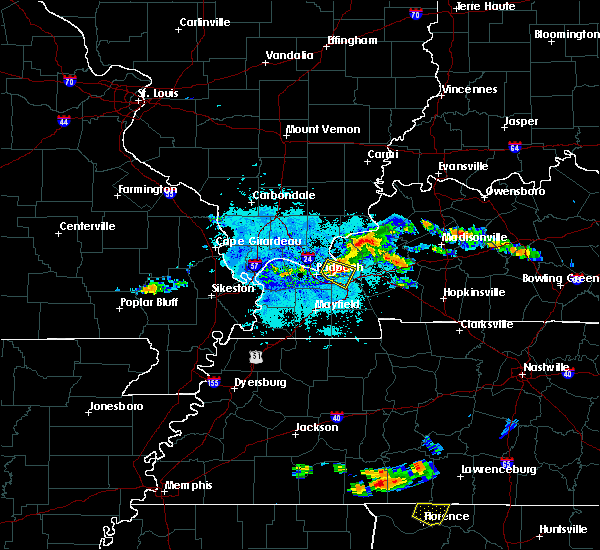 At 857 pm cdt, a severe thunderstorm capable of producing a tornado was located near ledbetter, or near calvert city, moving southeast at 25 mph (radar indicated rotation). Hazards include tornado and quarter size hail. Flying debris will be dangerous to those caught without shelter. mobile homes will be damaged or destroyed. damage to roofs, windows, and vehicles will occur. tree damage is likely. this dangerous storm will be near, calvert city around 915 pm cdt. Other locations impacted by this tornadic thunderstorm include hamletsburg. At 857 pm cdt, a severe thunderstorm capable of producing a tornado was located near ledbetter, or near calvert city, moving southeast at 25 mph (radar indicated rotation). Hazards include tornado and quarter size hail. Flying debris will be dangerous to those caught without shelter. mobile homes will be damaged or destroyed. damage to roofs, windows, and vehicles will occur. tree damage is likely. this dangerous storm will be near, calvert city around 915 pm cdt. Other locations impacted by this tornadic thunderstorm include hamletsburg.
|
| 6/23/2018 8:46 PM CDT |
 At 846 pm cdt, a severe thunderstorm was located near ledbetter, or near reidland, moving southeast at 30 mph (radar indicated). Hazards include 60 mph wind gusts and penny size hail. expect damage to roofs, siding, and trees At 846 pm cdt, a severe thunderstorm was located near ledbetter, or near reidland, moving southeast at 30 mph (radar indicated). Hazards include 60 mph wind gusts and penny size hail. expect damage to roofs, siding, and trees
|
| 5/31/2018 4:05 PM CDT |
 At 404 pm cdt, a severe thunderstorm was located over brookport, or near paducah, moving east at 30 to 35 mph. this storm has a history of producing quarter sized hail and winds gusting to 40 to 60 mph. with how wet the grounds are, even sub severe wind speeds could down trees (radar indicated). Hazards include 60 mph wind gusts and quarter size hail. Hail damage to vehicles is expected. Expect wind damage to roofs, siding, and trees. At 404 pm cdt, a severe thunderstorm was located over brookport, or near paducah, moving east at 30 to 35 mph. this storm has a history of producing quarter sized hail and winds gusting to 40 to 60 mph. with how wet the grounds are, even sub severe wind speeds could down trees (radar indicated). Hazards include 60 mph wind gusts and quarter size hail. Hail damage to vehicles is expected. Expect wind damage to roofs, siding, and trees.
|
| 5/31/2018 3:45 PM CDT |
 At 344 pm cdt, a severe thunderstorm was located near west paducah, or 8 miles east of la center, moving east at 35 mph (radar indicated). Hazards include 60 mph wind gusts and quarter size hail. Hail damage to vehicles is expected. Expect wind damage to roofs, siding, and trees. At 344 pm cdt, a severe thunderstorm was located near west paducah, or 8 miles east of la center, moving east at 35 mph (radar indicated). Hazards include 60 mph wind gusts and quarter size hail. Hail damage to vehicles is expected. Expect wind damage to roofs, siding, and trees.
|
| 5/6/2018 3:26 PM CDT |
 The severe thunderstorm warning for southeastern massac, southern pope, southwestern livingston, northwestern marshall and southeastern mccracken counties will expire at 330 pm cdt, the storm which prompted the warning has weakened below severe limits, and no longer poses an immediate threat to life or property. therefore the warning will be allowed to expire. The severe thunderstorm warning for southeastern massac, southern pope, southwestern livingston, northwestern marshall and southeastern mccracken counties will expire at 330 pm cdt, the storm which prompted the warning has weakened below severe limits, and no longer poses an immediate threat to life or property. therefore the warning will be allowed to expire.
|
| 5/6/2018 3:17 PM CDT |
 At 317 pm cdt, a severe thunderstorm was located over ledbetter, or near reidland, moving southeast at 25 mph (radar indicated). Hazards include 60 mph wind gusts and quarter size hail. Hail damage to vehicles is expected. expect wind damage to roofs, siding, and trees. Locations impacted include, paducah, reidland and ledbetter. At 317 pm cdt, a severe thunderstorm was located over ledbetter, or near reidland, moving southeast at 25 mph (radar indicated). Hazards include 60 mph wind gusts and quarter size hail. Hail damage to vehicles is expected. expect wind damage to roofs, siding, and trees. Locations impacted include, paducah, reidland and ledbetter.
|
| 5/6/2018 2:54 PM CDT |
 At 254 pm cdt, a severe thunderstorm was located over paducah, moving east at 25 mph (radar indicated). Hazards include 60 mph wind gusts and quarter size hail. Hail damage to vehicles is expected. Expect wind damage to roofs, siding, and trees. At 254 pm cdt, a severe thunderstorm was located over paducah, moving east at 25 mph (radar indicated). Hazards include 60 mph wind gusts and quarter size hail. Hail damage to vehicles is expected. Expect wind damage to roofs, siding, and trees.
|
| 11/18/2017 2:04 PM CST |
 At 203 pm cst, severe thunderstorms were located along a line extending from 7 miles southwest of burna to near massac to near bardwell, moving east at 45 mph (radar indicated). Hazards include 60 mph wind gusts. Expect damage to roofs, siding, and trees. Locations impacted include, paducah, lone oak, brookport, massac, woodlawn-oakdale, hendron and lovelaceville. At 203 pm cst, severe thunderstorms were located along a line extending from 7 miles southwest of burna to near massac to near bardwell, moving east at 45 mph (radar indicated). Hazards include 60 mph wind gusts. Expect damage to roofs, siding, and trees. Locations impacted include, paducah, lone oak, brookport, massac, woodlawn-oakdale, hendron and lovelaceville.
|
| 11/18/2017 1:44 PM CST |
 At 143 pm cst, severe thunderstorms were located along a line extending from near new columbia to near barlow to wyatt, moving east at 35 mph (radar indicated). Hazards include 60 mph wind gusts. expect damage to roofs, siding, and trees At 143 pm cst, severe thunderstorms were located along a line extending from near new columbia to near barlow to wyatt, moving east at 35 mph (radar indicated). Hazards include 60 mph wind gusts. expect damage to roofs, siding, and trees
|
| 5/27/2017 6:53 PM CDT |
 At 652 pm cdt, severe thunderstorms were located along a line extending from 7 miles northwest of marion to 8 miles east of benton to near sedalia, moving east at 65 mph (radar indicated). Hazards include 70 mph wind gusts and nickel size hail. Expect considerable tree damage. damage is likely to mobile homes, roofs, and outbuildings. Locations impacted include, murray, mayfield, benton, calvert city, salem, golconda, burna, lynnville, sedalia, joy, ledbetter, wingo, hardin, hazel, grand rivers, smithland, water valley, carrsville, lowes and fancy farm. At 652 pm cdt, severe thunderstorms were located along a line extending from 7 miles northwest of marion to 8 miles east of benton to near sedalia, moving east at 65 mph (radar indicated). Hazards include 70 mph wind gusts and nickel size hail. Expect considerable tree damage. damage is likely to mobile homes, roofs, and outbuildings. Locations impacted include, murray, mayfield, benton, calvert city, salem, golconda, burna, lynnville, sedalia, joy, ledbetter, wingo, hardin, hazel, grand rivers, smithland, water valley, carrsville, lowes and fancy farm.
|
| 5/27/2017 6:10 PM CDT |
 At 608 pm cdt, severe thunderstorms were located along a line extending from goreville to near barlow to near east prairie, moving east at 65 mph. these are very dangerous storms (law enforcement. structural damage has been reported in stoddard county with 80 mph winds reported near sikeston missouri). Hazards include 80 mph wind gusts and nickel size hail. Flying debris will be dangerous to those caught without shelter. mobile homes will be heavily damaged. expect considerable damage to roofs, windows, and vehicles. Extensive tree damage and power outages are likely. At 608 pm cdt, severe thunderstorms were located along a line extending from goreville to near barlow to near east prairie, moving east at 65 mph. these are very dangerous storms (law enforcement. structural damage has been reported in stoddard county with 80 mph winds reported near sikeston missouri). Hazards include 80 mph wind gusts and nickel size hail. Flying debris will be dangerous to those caught without shelter. mobile homes will be heavily damaged. expect considerable damage to roofs, windows, and vehicles. Extensive tree damage and power outages are likely.
|
| 5/27/2017 4:36 PM CDT |
 At 435 pm cdt, a severe thunderstorm was located over golconda, or 17 miles northeast of metropolis, moving east at 50 mph (law enforcement. trees were reported down across johnson county illinois as these storms moved through). Hazards include 60 mph wind gusts and quarter size hail. Hail damage to vehicles is expected. Expect wind damage to roofs, siding, and trees. At 435 pm cdt, a severe thunderstorm was located over golconda, or 17 miles northeast of metropolis, moving east at 50 mph (law enforcement. trees were reported down across johnson county illinois as these storms moved through). Hazards include 60 mph wind gusts and quarter size hail. Hail damage to vehicles is expected. Expect wind damage to roofs, siding, and trees.
|
| 4/30/2017 3:34 AM CDT |
 At 331 am cdt, severe thunderstorms were located along a line extending from near wickliffe to near lovelaceville, moving northeast at 80 mph (radar indicated). Hazards include 60 mph wind gusts. expect damage to roofs, siding, and trees At 331 am cdt, severe thunderstorms were located along a line extending from near wickliffe to near lovelaceville, moving northeast at 80 mph (radar indicated). Hazards include 60 mph wind gusts. expect damage to roofs, siding, and trees
|
| 4/26/2017 7:57 PM CDT |
 At 756 pm cdt, severe thunderstorms were located along a line extending from near golconda to near calvert city to near benton, moving northeast at 60 mph (trained weather spotters). Hazards include 70 mph wind gusts. Expect considerable tree damage. damage is likely to mobile homes, roofs, and outbuildings. Locations impacted include, benton, calvert city, eddyville, land between the lakes area, salem, golconda, burna, energy, joy, ledbetter, rockcastle, kuttawa, hardin, grand rivers, smithland, carrsville, hamletsburg and dycusburg. At 756 pm cdt, severe thunderstorms were located along a line extending from near golconda to near calvert city to near benton, moving northeast at 60 mph (trained weather spotters). Hazards include 70 mph wind gusts. Expect considerable tree damage. damage is likely to mobile homes, roofs, and outbuildings. Locations impacted include, benton, calvert city, eddyville, land between the lakes area, salem, golconda, burna, energy, joy, ledbetter, rockcastle, kuttawa, hardin, grand rivers, smithland, carrsville, hamletsburg and dycusburg.
|
| 4/26/2017 7:44 PM CDT |
 At 743 pm cdt, severe thunderstorms were located along a line extending from near metropolis to 7 miles northeast of sedalia, moving east at 65 mph (radar indicated). Hazards include 60 mph wind gusts. expect damage to roofs, siding, and trees At 743 pm cdt, severe thunderstorms were located along a line extending from near metropolis to 7 miles northeast of sedalia, moving east at 65 mph (radar indicated). Hazards include 60 mph wind gusts. expect damage to roofs, siding, and trees
|
| 4/26/2017 7:30 PM CDT |
 At 729 pm cdt, severe thunderstorms were located along a line extending from near la center to 9 miles south of lovelaceville, moving northeast at 65 mph (radar indicated). Hazards include 60 mph wind gusts and quarter size hail. Hail damage to vehicles is expected. expect wind damage to roofs, siding, and trees. Locations impacted include, paducah, metropolis, reidland, lone oak, brookport, massac, hendron, woodlawn-oakdale, west paducah, lovelaceville, kevil, lowes, fancy farm, blandville and symsonia. At 729 pm cdt, severe thunderstorms were located along a line extending from near la center to 9 miles south of lovelaceville, moving northeast at 65 mph (radar indicated). Hazards include 60 mph wind gusts and quarter size hail. Hail damage to vehicles is expected. expect wind damage to roofs, siding, and trees. Locations impacted include, paducah, metropolis, reidland, lone oak, brookport, massac, hendron, woodlawn-oakdale, west paducah, lovelaceville, kevil, lowes, fancy farm, blandville and symsonia.
|
| 4/26/2017 7:11 PM CDT |
 At 710 pm cdt, severe thunderstorms were located along a line extending from near wyatt to near clinton, moving northeast at 65 mph (radar indicated). Hazards include 60 mph wind gusts and quarter size hail. Hail damage to vehicles is expected. Expect wind damage to roofs, siding, and trees. At 710 pm cdt, severe thunderstorms were located along a line extending from near wyatt to near clinton, moving northeast at 65 mph (radar indicated). Hazards include 60 mph wind gusts and quarter size hail. Hail damage to vehicles is expected. Expect wind damage to roofs, siding, and trees.
|
| 3/1/2017 5:27 AM CST |
 At 527 am cst, severe thunderstorms were located along a line extending from near golconda to near reidland, moving east at 80 mph (trained weather spotters). Hazards include 70 mph wind gusts and penny size hail. Expect considerable tree damage. Damage is likely to mobile homes, roofs, and outbuildings. At 527 am cst, severe thunderstorms were located along a line extending from near golconda to near reidland, moving east at 80 mph (trained weather spotters). Hazards include 70 mph wind gusts and penny size hail. Expect considerable tree damage. Damage is likely to mobile homes, roofs, and outbuildings.
|
| 3/1/2017 5:06 AM CST |
 At 506 am cst, severe thunderstorms were located along a line extending from near dongola to near wickliffe, moving east at 110 mph. these are very dangerous storms (radar indicated). Hazards include 80 mph wind gusts and penny size hail. Flying debris will be dangerous to those caught without shelter. mobile homes will be heavily damaged. expect considerable damage to roofs, windows, and vehicles. Extensive tree damage and power outages are likely. At 506 am cst, severe thunderstorms were located along a line extending from near dongola to near wickliffe, moving east at 110 mph. these are very dangerous storms (radar indicated). Hazards include 80 mph wind gusts and penny size hail. Flying debris will be dangerous to those caught without shelter. mobile homes will be heavily damaged. expect considerable damage to roofs, windows, and vehicles. Extensive tree damage and power outages are likely.
|
| 12/17/2016 3:10 PM CST |
 At 310 pm cst, a severe thunderstorm was located over woodlawn-oakdale, or over reidland, moving northeast at 55 mph (trained weather spotters). Hazards include quarter size hail. damage to vehicles is expected At 310 pm cst, a severe thunderstorm was located over woodlawn-oakdale, or over reidland, moving northeast at 55 mph (trained weather spotters). Hazards include quarter size hail. damage to vehicles is expected
|
| 8/5/2016 4:56 PM CDT |
 At 455 pm cdt, a severe thunderstorm was located near la center, moving south at 15 mph (radar indicated). Hazards include 60 mph wind gusts. Expect damage to roofs. siding. And trees. At 455 pm cdt, a severe thunderstorm was located near la center, moving south at 15 mph (radar indicated). Hazards include 60 mph wind gusts. Expect damage to roofs. siding. And trees.
|
| 8/1/2016 2:39 PM CDT | Several trees down. one tree fell on and damaged part of a churc in livingston county KY, 0.6 miles NE of Ledbetter, KY |
| 7/8/2016 6:11 PM CDT |
 At 610 pm cdt, severe thunderstorms were located along a line extending from barlow to 6 miles southeast of bardwell, moving northeast at 50 mph (radar indicated). Hazards include 60 mph wind gusts. Expect damage to roofs. siding. And trees. At 610 pm cdt, severe thunderstorms were located along a line extending from barlow to 6 miles southeast of bardwell, moving northeast at 50 mph (radar indicated). Hazards include 60 mph wind gusts. Expect damage to roofs. siding. And trees.
|
| 7/7/2016 1:00 PM CDT |
 At 1259 pm cdt, severe thunderstorms were located along a line extending from 7 miles southeast of new columbia to 9 miles northwest of mayfield, moving east at 50 mph (radar indicated). Hazards include 60 mph wind gusts. Expect damage to roofs. siding. and trees. Locations impacted include, paducah, metropolis, reidland, lone oak, brookport, golconda, hendron, lovelaceville, dixon springs, massac, west paducah, woodlawn-oakdale, kevil, joppa, lowes and symsonia. At 1259 pm cdt, severe thunderstorms were located along a line extending from 7 miles southeast of new columbia to 9 miles northwest of mayfield, moving east at 50 mph (radar indicated). Hazards include 60 mph wind gusts. Expect damage to roofs. siding. and trees. Locations impacted include, paducah, metropolis, reidland, lone oak, brookport, golconda, hendron, lovelaceville, dixon springs, massac, west paducah, woodlawn-oakdale, kevil, joppa, lowes and symsonia.
|
| 7/7/2016 12:40 PM CDT |
 At 1240 pm cdt, severe thunderstorms were located along a line extending from near karnak to bardwell, moving east at 50 mph (radar indicated). Hazards include 60 mph wind gusts. Expect damage to roofs. siding. And trees. At 1240 pm cdt, severe thunderstorms were located along a line extending from near karnak to bardwell, moving east at 50 mph (radar indicated). Hazards include 60 mph wind gusts. Expect damage to roofs. siding. And trees.
|
| 7/6/2016 2:04 PM CDT |
 At 203 pm cdt, severe thunderstorms were located along a line extending from joy to near benton to near palmersville, moving east at 55 mph (trained weather spotters). Hazards include 70 mph wind gusts and penny size hail. Expect considerable tree damage. damage is likely to mobile homes, roofs, and outbuildings. Locations impacted include, paducah, mayfield, calvert city, reidland, golconda, lynnville, sedalia, woodlawn-oakdale, burna, joy, ledbetter, wingo, smithland, hamletsburg and symsonia. At 203 pm cdt, severe thunderstorms were located along a line extending from joy to near benton to near palmersville, moving east at 55 mph (trained weather spotters). Hazards include 70 mph wind gusts and penny size hail. Expect considerable tree damage. damage is likely to mobile homes, roofs, and outbuildings. Locations impacted include, paducah, mayfield, calvert city, reidland, golconda, lynnville, sedalia, woodlawn-oakdale, burna, joy, ledbetter, wingo, smithland, hamletsburg and symsonia.
|
| 7/6/2016 1:45 PM CDT |
 At 144 pm cdt, severe thunderstorms were located along a line extending from dixon springs to 7 miles southeast of lovelaceville to south fulton, moving east at 60 mph (trained weather spotters). Hazards include 70 mph wind gusts and penny size hail. Expect considerable tree damage. damage is likely to mobile homes, roofs, and outbuildings. Locations impacted include, paducah, mayfield, metropolis, calvert city, fulton, reidland, lone oak, brookport, golconda, west paducah, woodlawn-oakdale, joy, fulgham, hendron, massac, lynnville, sedalia, burna, ledbetter and wingo. At 144 pm cdt, severe thunderstorms were located along a line extending from dixon springs to 7 miles southeast of lovelaceville to south fulton, moving east at 60 mph (trained weather spotters). Hazards include 70 mph wind gusts and penny size hail. Expect considerable tree damage. damage is likely to mobile homes, roofs, and outbuildings. Locations impacted include, paducah, mayfield, metropolis, calvert city, fulton, reidland, lone oak, brookport, golconda, west paducah, woodlawn-oakdale, joy, fulgham, hendron, massac, lynnville, sedalia, burna, ledbetter and wingo.
|
| 7/6/2016 1:28 PM CDT |
 At 127 pm cdt, severe thunderstorms were located along a line extending from near vienna to near wickliffe to near hickman, moving east at 55 mph (trained weather spotters). Hazards include 60 mph wind gusts and nickel size hail. Expect damage to roofs. siding. And trees. At 127 pm cdt, severe thunderstorms were located along a line extending from near vienna to near wickliffe to near hickman, moving east at 55 mph (trained weather spotters). Hazards include 60 mph wind gusts and nickel size hail. Expect damage to roofs. siding. And trees.
|
| 12/23/2015 3:18 PM CST | At 318 pm cst, severe thunderstorms were located along a line extending from near golconda to 6 miles southwest of reidland, moving northeast at 60 mph (radar indicated). Hazards include 60 mph wind gusts. Expect damage to roofs. Siding and trees. |
| 12/23/2015 3:18 PM CST | At 318 pm cst, severe thunderstorms were located along a line extending from near golconda to 6 miles southwest of reidland, moving northeast at 60 mph (radar indicated). Hazards include 60 mph wind gusts. Expect damage to roofs. Siding and trees. |
| 7/7/2015 4:50 AM CDT |
 At 450 am cdt, a severe thunderstorm was located near west paducah, or 7 miles southwest of metropolis, moving east at 35 mph (radar indicated). Hazards include 60 mph wind gusts. Expect damage to roofs. Siding and trees. At 450 am cdt, a severe thunderstorm was located near west paducah, or 7 miles southwest of metropolis, moving east at 35 mph (radar indicated). Hazards include 60 mph wind gusts. Expect damage to roofs. Siding and trees.
|
| 4/3/2015 8:49 AM CDT | The national weather service in paducah has issued a * severe thunderstorm warning for. southeastern mccracken county in western kentucky. northern marshall county in western kentucky. southern livingston county in western kentucky. Until 915 am cdt. |
| 2/20/2014 5:54 PM CST | Widespread power outages reporte in livingston county KY, 0.6 miles NE of Ledbetter, KY |
| 1/1/0001 12:00 AM | Golf Ball sized hail reported 2.5 miles WSW of Ledbetter, KY |
Hail Maps for Ledbetter, KY


Connect with Interactive Hail Maps