

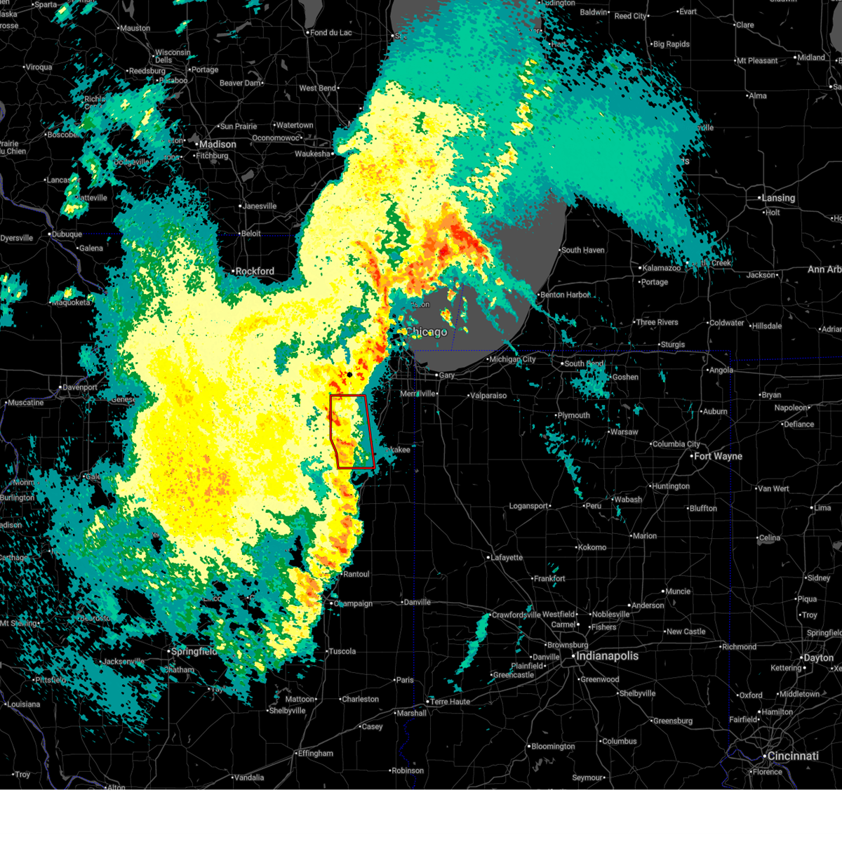
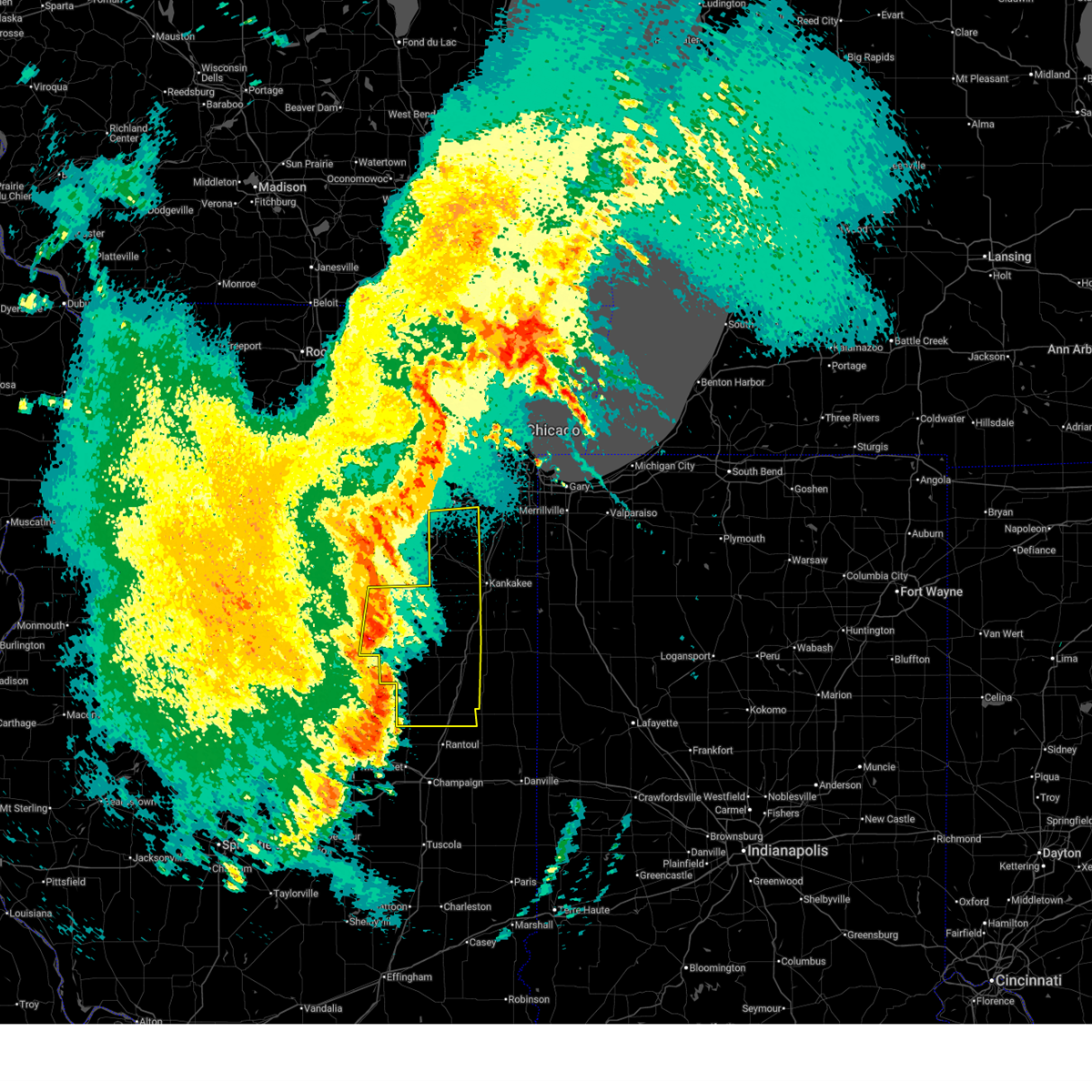
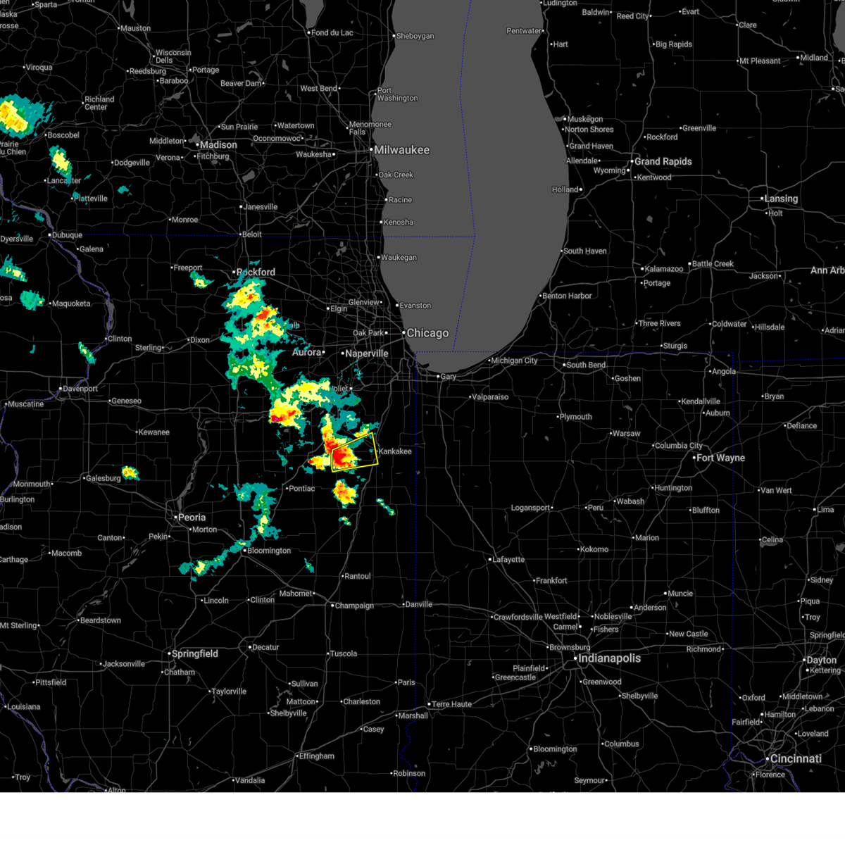
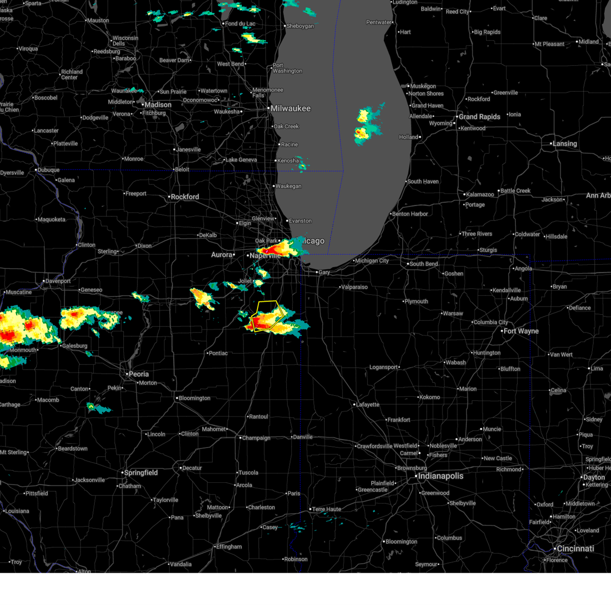
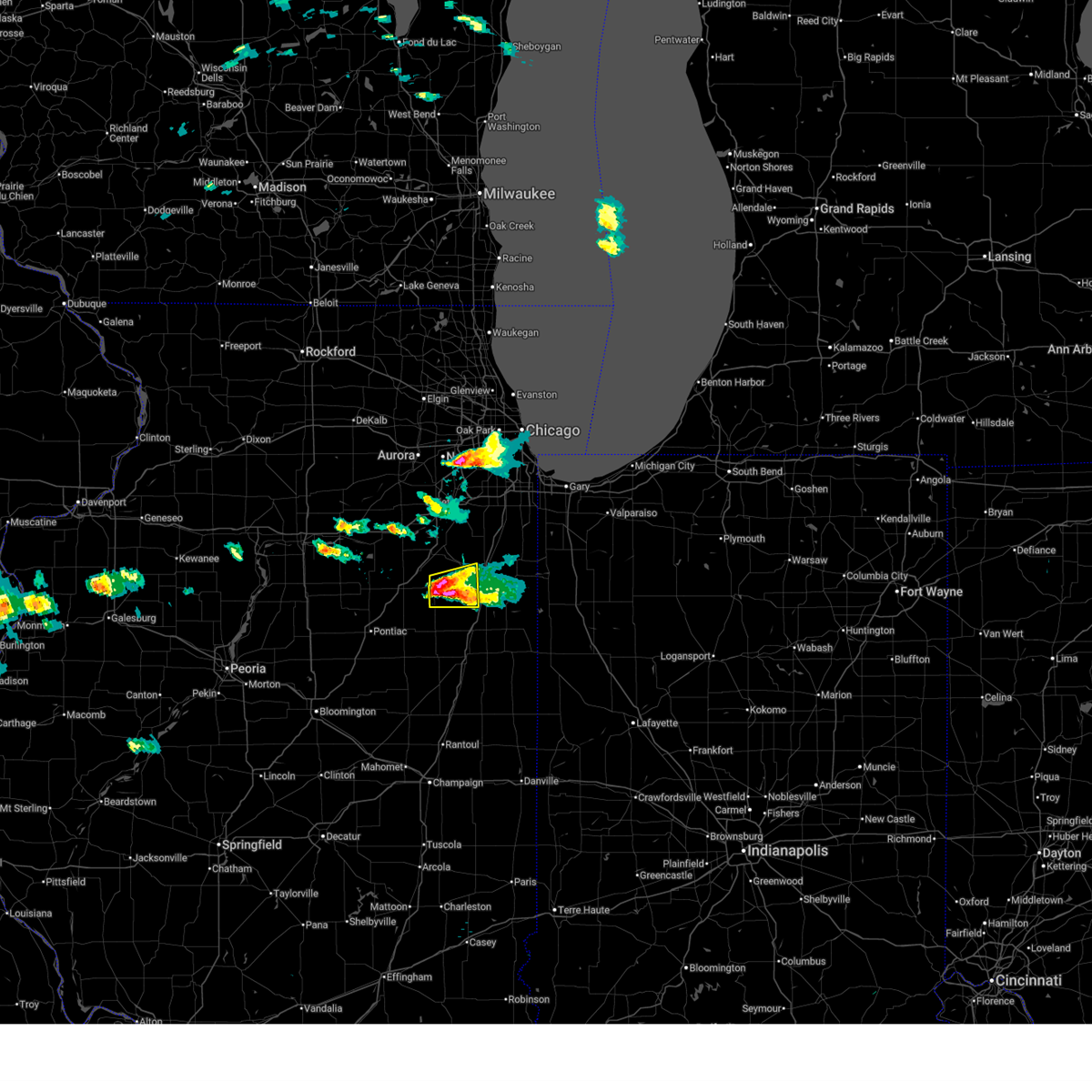
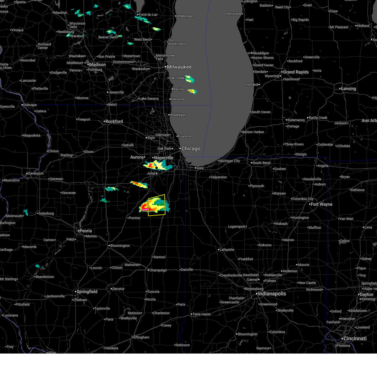
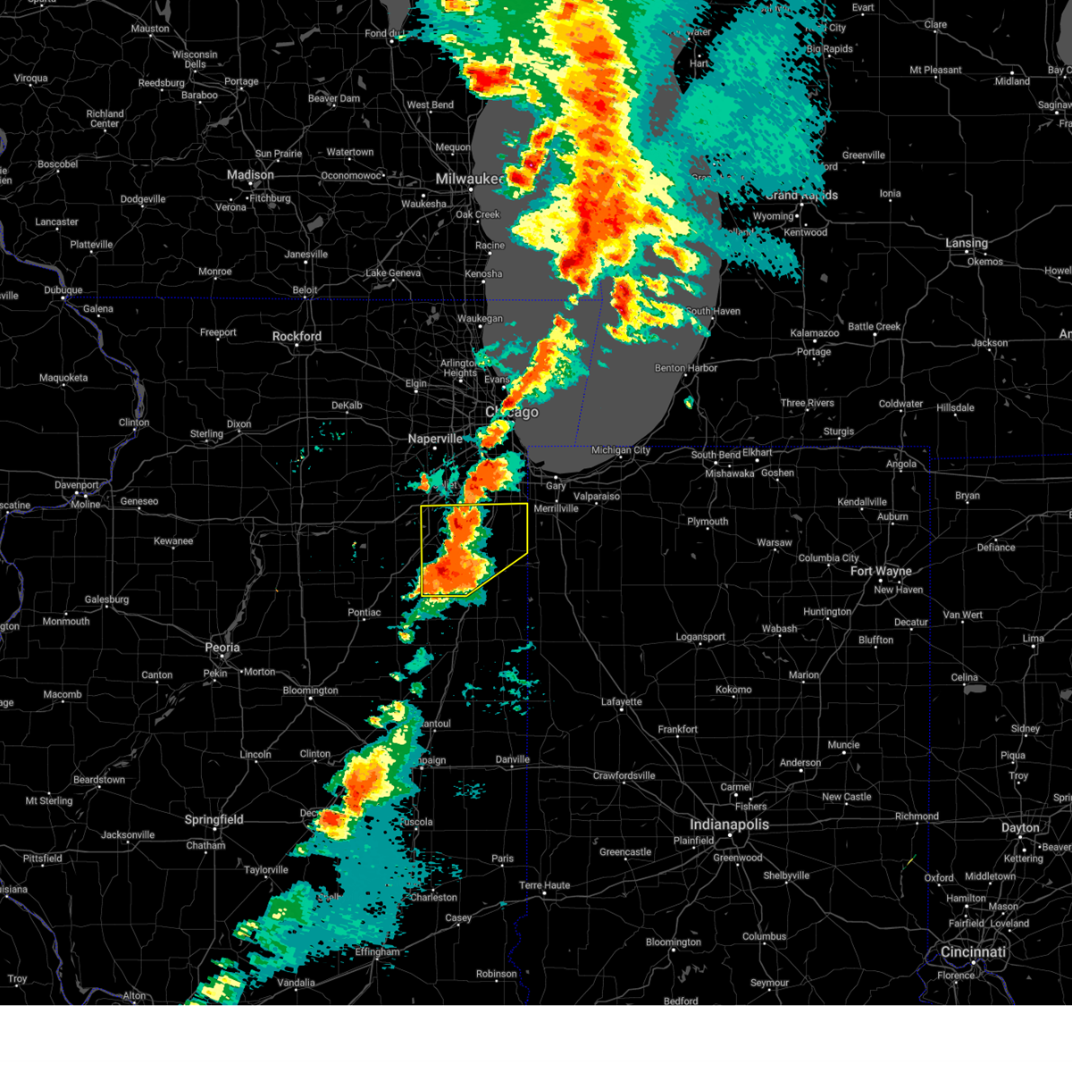
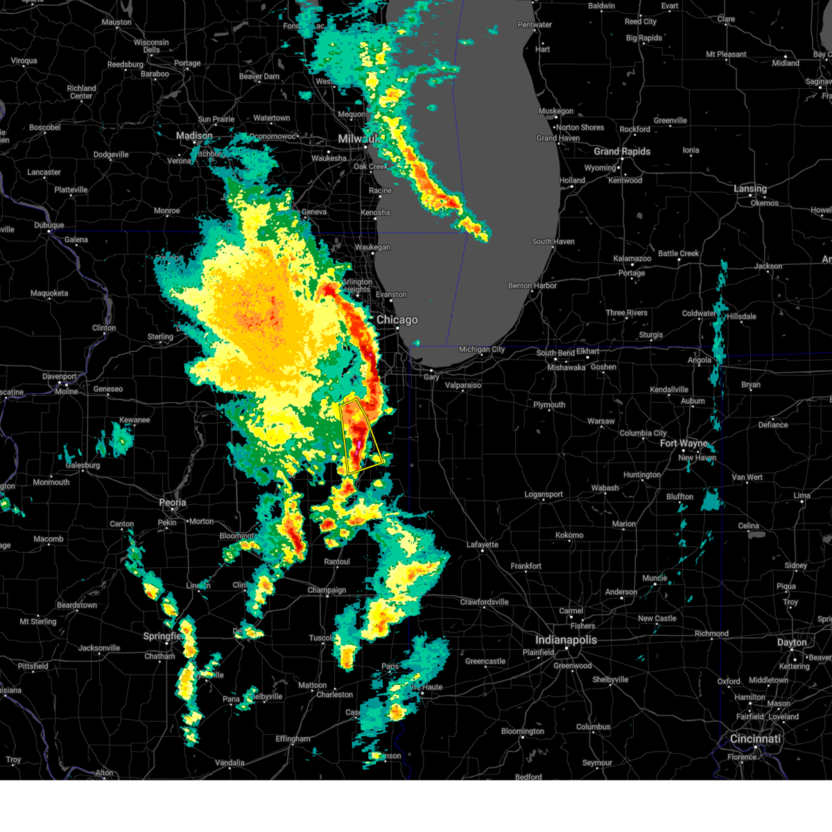
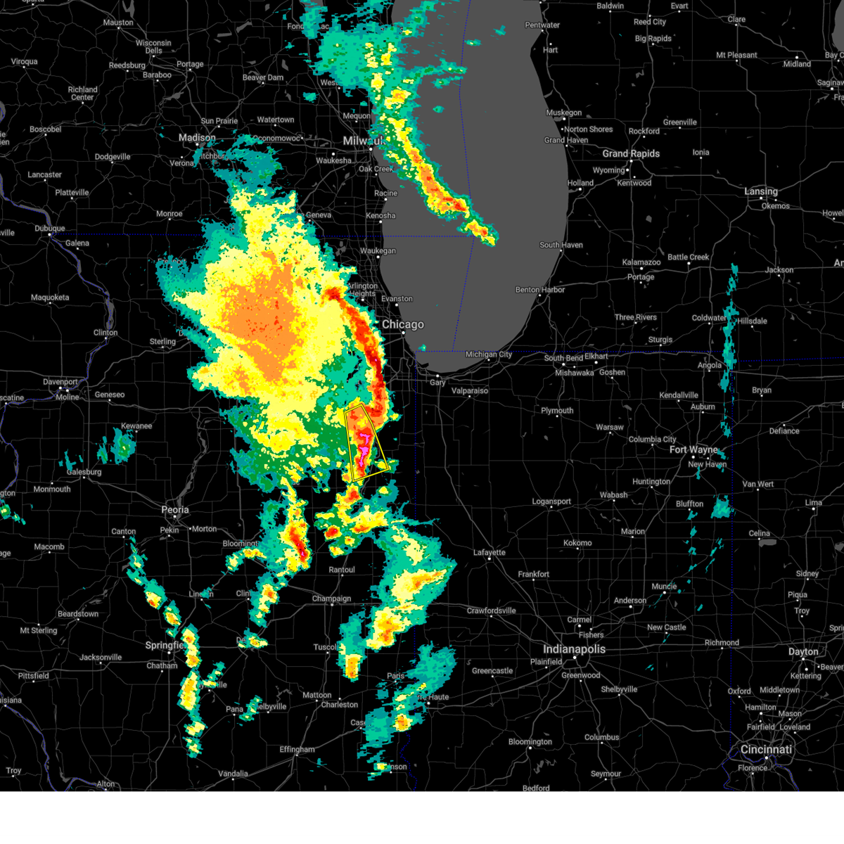
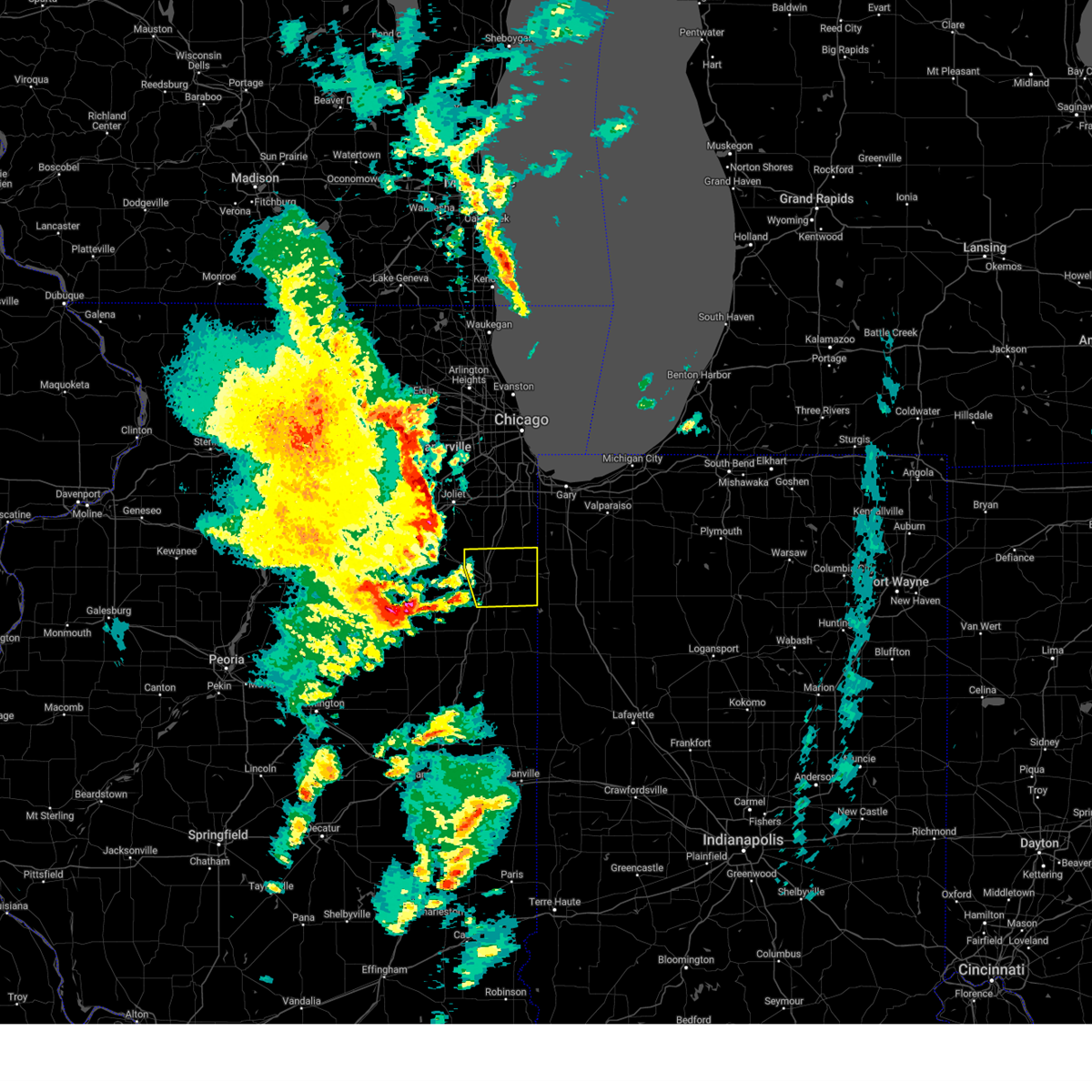
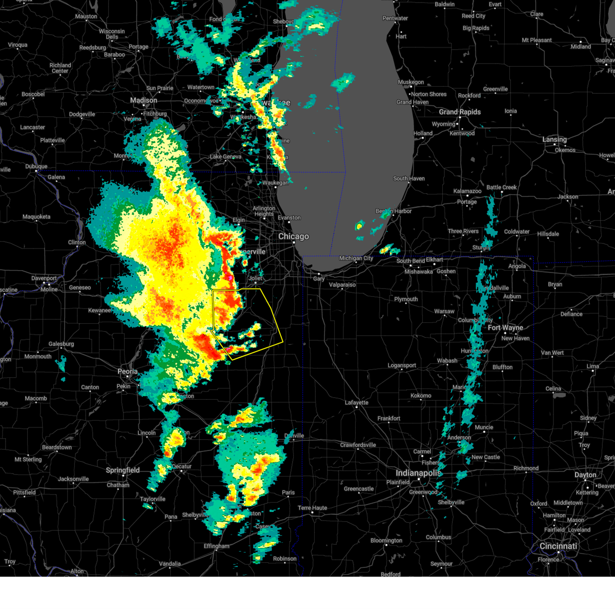
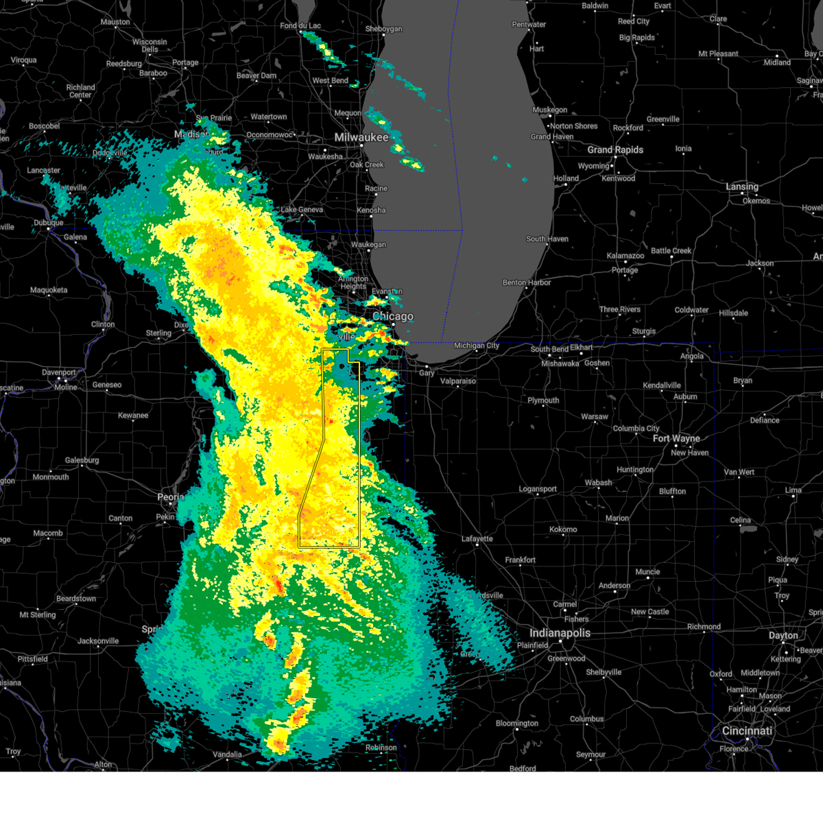
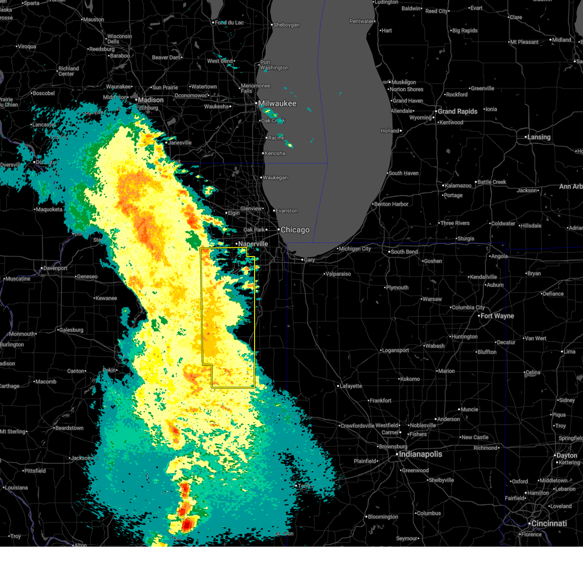
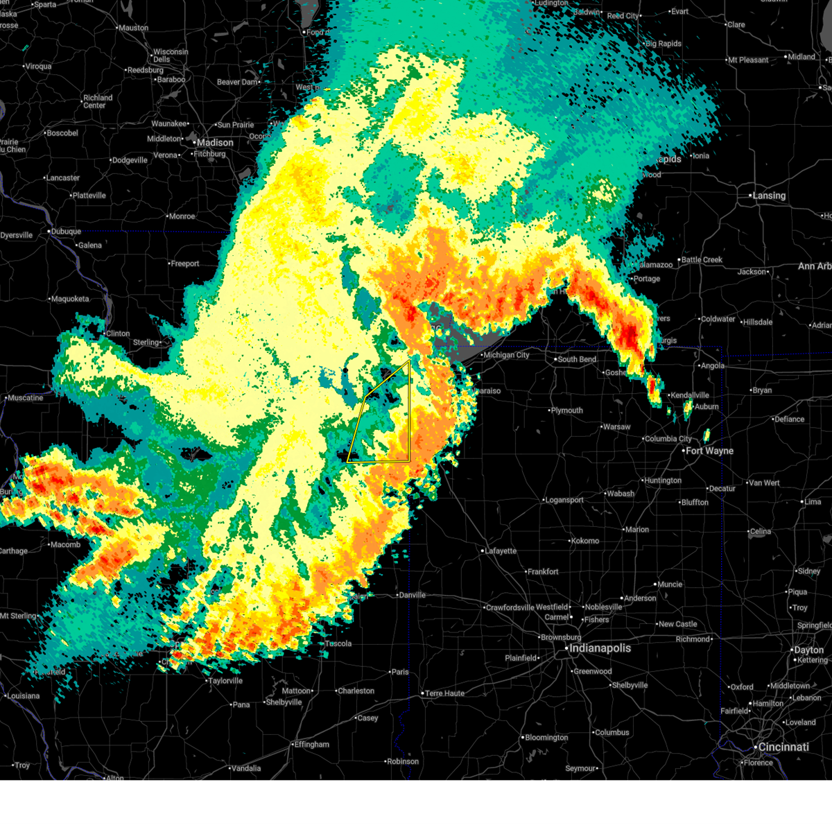
Hail Map for Limestone, IL
The Limestone, IL area has had 0 reports of on-the-ground hail by trained spotters, and has been under severe weather warnings 28 times during the past 12 months. Doppler radar has detected hail at or near Limestone, IL on 65 occasions, including 5 occasions during the past year.
| Name: | Limestone, IL |
| Where Located: | 54.7 miles SSW of Chicago, IL |
| Map: | Google Map for Limestone, IL |
| Population: | 1598 |
| Housing Units: | 598 |
| More Info: | Search Google for Limestone, IL |
5
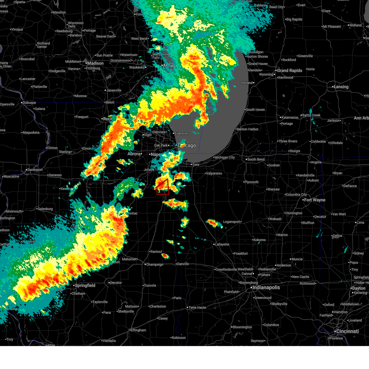
The Top Recent Hail Date for Limestone, IL is Tuesday, March 10, 2026 (1st out of 65)
Hail and Wind Damage Spotted near Limestone, IL
| Date / Time | Report Details |
|---|---|
| 6/11/2026 6:54 PM CDT |
 At 653 pm cdt, a severe thunderstorm capable of producing a tornado was located near limestone, or near bourbonnais, moving east at 30 mph (radar indicated rotation). Hazards include tornado. Flying debris will be dangerous to those caught without shelter. mobile homes will be damaged or destroyed. damage to roofs, windows, and vehicles will occur. tree damage is likely. This dangerous storm will be near, bourbonnais, bradley, and manteno around 700 pm cdt. At 653 pm cdt, a severe thunderstorm capable of producing a tornado was located near limestone, or near bourbonnais, moving east at 30 mph (radar indicated rotation). Hazards include tornado. Flying debris will be dangerous to those caught without shelter. mobile homes will be damaged or destroyed. damage to roofs, windows, and vehicles will occur. tree damage is likely. This dangerous storm will be near, bourbonnais, bradley, and manteno around 700 pm cdt.
|
| 6/11/2026 6:42 PM CDT |
 Torlot the national weather service in chicago has issued a * tornado warning for, south central will county in northeastern illinois, northwestern kankakee county in northeastern illinois, * until 730 pm cdt. * at 642 pm cdt, a severe thunderstorm capable of producing a tornado was located near lakewood shores, or 8 miles southeast of braidwood, moving northeast at 30 mph (radar indicated rotation). Hazards include tornado. Flying debris will be dangerous to those caught without shelter. mobile homes will be damaged or destroyed. damage to roofs, windows, and vehicles will occur. tree damage is likely. this dangerous storm will be near, manteno around 700 pm cdt. peotone around 710 pm cdt. Other locations impacted by this tornadic thunderstorm include bonfield. Torlot the national weather service in chicago has issued a * tornado warning for, south central will county in northeastern illinois, northwestern kankakee county in northeastern illinois, * until 730 pm cdt. * at 642 pm cdt, a severe thunderstorm capable of producing a tornado was located near lakewood shores, or 8 miles southeast of braidwood, moving northeast at 30 mph (radar indicated rotation). Hazards include tornado. Flying debris will be dangerous to those caught without shelter. mobile homes will be damaged or destroyed. damage to roofs, windows, and vehicles will occur. tree damage is likely. this dangerous storm will be near, manteno around 700 pm cdt. peotone around 710 pm cdt. Other locations impacted by this tornadic thunderstorm include bonfield.
|
| 6/11/2026 2:10 PM CDT |
 Svrlot the national weather service in chicago has issued a * severe thunderstorm warning for, southeastern will county in northeastern illinois, eastern kankakee county in northeastern illinois, northern newton county in northwestern indiana, lake county in northwestern indiana, * until 315 pm cdt. * at 209 pm cdt, severe thunderstorms were located along a line extending from near monee to near chebanse, moving east at 45 mph (radar indicated). Hazards include 60 mph wind gusts. expect damage to roofs, siding, and trees Svrlot the national weather service in chicago has issued a * severe thunderstorm warning for, southeastern will county in northeastern illinois, eastern kankakee county in northeastern illinois, northern newton county in northwestern indiana, lake county in northwestern indiana, * until 315 pm cdt. * at 209 pm cdt, severe thunderstorms were located along a line extending from near monee to near chebanse, moving east at 45 mph (radar indicated). Hazards include 60 mph wind gusts. expect damage to roofs, siding, and trees
|
| 4/17/2026 9:59 PM CDT |
 At 958 pm cdt, a severe squall line capable of producing both tornadoes and extensive straight line wind damage was located along a line extending from channahon to 6 miles south of lakewood shores to near herscher, moving east at 55 mph (radar indicated rotation). Hazards include tornado. Flying debris will be dangerous to those caught without shelter. mobile homes will be damaged or destroyed. damage to roofs, windows, and vehicles will occur. tree damage is likely. Locations impacted include, joliet, kankakee, bourbonnais, channahon, minooka, braidwood, wilmington, coal city, herscher, manhattan, diamond, elwood, limestone, lakewood shores, chebanse, essex, godley, bonfield, buckingham, wilton center, symerton, irwin, and union hill. At 958 pm cdt, a severe squall line capable of producing both tornadoes and extensive straight line wind damage was located along a line extending from channahon to 6 miles south of lakewood shores to near herscher, moving east at 55 mph (radar indicated rotation). Hazards include tornado. Flying debris will be dangerous to those caught without shelter. mobile homes will be damaged or destroyed. damage to roofs, windows, and vehicles will occur. tree damage is likely. Locations impacted include, joliet, kankakee, bourbonnais, channahon, minooka, braidwood, wilmington, coal city, herscher, manhattan, diamond, elwood, limestone, lakewood shores, chebanse, essex, godley, bonfield, buckingham, wilton center, symerton, irwin, and union hill.
|
| 4/17/2026 9:56 PM CDT |
 the tornado warning has been cancelled and is no longer in effect the tornado warning has been cancelled and is no longer in effect
|
| 4/17/2026 9:56 PM CDT |
 At 955 pm cdt, a severe squall line capable of producing both tornadoes and extensive straight line wind damage was located along a line extending from minooka to 7 miles southeast of braceville to 6 miles southwest of herscher, moving east at 55 mph (radar indicated rotation). Hazards include tornado. Flying debris will be dangerous to those caught without shelter. mobile homes will be damaged or destroyed. damage to roofs, windows, and vehicles will occur. tree damage is likely. Locations impacted include, joliet, channahon, wilmington, herscher, elwood, limestone, lakewood shores, kankakee, bourbonnais, manhattan and chebanse. At 955 pm cdt, a severe squall line capable of producing both tornadoes and extensive straight line wind damage was located along a line extending from minooka to 7 miles southeast of braceville to 6 miles southwest of herscher, moving east at 55 mph (radar indicated rotation). Hazards include tornado. Flying debris will be dangerous to those caught without shelter. mobile homes will be damaged or destroyed. damage to roofs, windows, and vehicles will occur. tree damage is likely. Locations impacted include, joliet, channahon, wilmington, herscher, elwood, limestone, lakewood shores, kankakee, bourbonnais, manhattan and chebanse.
|
| 4/17/2026 9:53 PM CDT |
 At 952 pm cdt, severe thunderstorms were located along a line extending from near wilmington to near herscher to near piper city to near paxton, moving east at 55 mph (radar indicated). Hazards include 70 mph wind gusts. Expect considerable tree damage. damage is likely to mobile homes, roofs, and outbuildings. Locations impacted include, joliet, new lenox, channahon, minooka, braidwood, wilmington, paxton, gilman, herscher, clifton, manhattan, diamond, elwood, limestone, onarga, lakewood shores, chebanse, ashkum, buckley, preston heights, essex, danforth, godley, loda, and bonfield. At 952 pm cdt, severe thunderstorms were located along a line extending from near wilmington to near herscher to near piper city to near paxton, moving east at 55 mph (radar indicated). Hazards include 70 mph wind gusts. Expect considerable tree damage. damage is likely to mobile homes, roofs, and outbuildings. Locations impacted include, joliet, new lenox, channahon, minooka, braidwood, wilmington, paxton, gilman, herscher, clifton, manhattan, diamond, elwood, limestone, onarga, lakewood shores, chebanse, ashkum, buckley, preston heights, essex, danforth, godley, loda, and bonfield.
|
| 4/17/2026 9:53 PM CDT |
 the severe thunderstorm warning has been cancelled and is no longer in effect the severe thunderstorm warning has been cancelled and is no longer in effect
|
| 4/17/2026 9:46 PM CDT |
 Svrlot the national weather service in chicago has issued a * severe thunderstorm warning for, kankakee county in northeastern illinois, iroquois county in east central illinois, * until 1045 pm cdt. * at 945 pm cdt, severe thunderstorms were located along a line extending from near morris to near chatsworth to fisher, moving east at 55 mph (trained weather spotters). Hazards include 70 mph wind gusts. Expect considerable tree damage. Damage is likely to mobile homes, roofs, and outbuildings. Svrlot the national weather service in chicago has issued a * severe thunderstorm warning for, kankakee county in northeastern illinois, iroquois county in east central illinois, * until 1045 pm cdt. * at 945 pm cdt, severe thunderstorms were located along a line extending from near morris to near chatsworth to fisher, moving east at 55 mph (trained weather spotters). Hazards include 70 mph wind gusts. Expect considerable tree damage. Damage is likely to mobile homes, roofs, and outbuildings.
|
| 4/17/2026 9:37 PM CDT |
 At 937 pm cdt, a severe squall line capable of producing both tornadoes and extensive straight line wind damage was located along a line extending from near seneca to dwight to saunemin, moving east at 55 mph (radar indicated rotation). Hazards include tornado. Flying debris will be dangerous to those caught without shelter. mobile homes will be damaged or destroyed. damage to roofs, windows, and vehicles will occur. tree damage is likely. these dangerous storms will be near, morris, gardner, and mazon around 940 pm cdt. Other locations in the path of these tornadic storms include braidwood, coal city, diamond, braceville, channahon, minooka, wilmington, herscher, lakewood shores, joliet, elwood, limestone, chebanse, kankakee, bourbonnais and manhattan. At 937 pm cdt, a severe squall line capable of producing both tornadoes and extensive straight line wind damage was located along a line extending from near seneca to dwight to saunemin, moving east at 55 mph (radar indicated rotation). Hazards include tornado. Flying debris will be dangerous to those caught without shelter. mobile homes will be damaged or destroyed. damage to roofs, windows, and vehicles will occur. tree damage is likely. these dangerous storms will be near, morris, gardner, and mazon around 940 pm cdt. Other locations in the path of these tornadic storms include braidwood, coal city, diamond, braceville, channahon, minooka, wilmington, herscher, lakewood shores, joliet, elwood, limestone, chebanse, kankakee, bourbonnais and manhattan.
|
| 4/17/2026 9:28 PM CDT |
 At 928 pm cdt, severe thunderstorms were located along a line extending from near seneca to near odell to fairbury to saybrook, moving east at 55 mph (radar indicated). Hazards include 70 mph wind gusts. Expect considerable tree damage. damage is likely to mobile homes, roofs, and outbuildings. Locations impacted include, joliet, new lenox, channahon, pontiac, minooka, braidwood, wilmington, paxton, dwight, fairbury, gibson city, gilman, herscher, clifton, chatsworth, manhattan, diamond, elwood, limestone, onarga, lakewood shores, forrest, chebanse, odell, and piper city. At 928 pm cdt, severe thunderstorms were located along a line extending from near seneca to near odell to fairbury to saybrook, moving east at 55 mph (radar indicated). Hazards include 70 mph wind gusts. Expect considerable tree damage. damage is likely to mobile homes, roofs, and outbuildings. Locations impacted include, joliet, new lenox, channahon, pontiac, minooka, braidwood, wilmington, paxton, dwight, fairbury, gibson city, gilman, herscher, clifton, chatsworth, manhattan, diamond, elwood, limestone, onarga, lakewood shores, forrest, chebanse, odell, and piper city.
|
| 4/17/2026 9:23 PM CDT |
 Torlot the national weather service in chicago has issued a * tornado warning for, southeastern kendall county in northeastern illinois, northeastern livingston county in central illinois, southwestern will county in northeastern illinois, grundy county in northeastern illinois, western kankakee county in northeastern illinois, * until 1015 pm cdt. * at 923 pm cdt, severe thunderstorms capable of producing tornadoes were located along a line extending from near seneca to near odell to near pontiac, moving east at 55 mph (radar indicated rotation). Hazards include tornado. Flying debris will be dangerous to those caught without shelter. mobile homes will be damaged or destroyed. damage to roofs, windows, and vehicles will occur. tree damage is likely. these dangerous storms will be near, dwight, odell, and mazon around 930 pm cdt. gardner around 935 pm cdt. morris, coal city, diamond, and braceville around 940 pm cdt. Other locations in the path of these tornadic storms include channahon, braidwood, wilmington, herscher, lakewood shores, elwood, limestone, kankakee, bourbonnais, manhattan and chebanse. Torlot the national weather service in chicago has issued a * tornado warning for, southeastern kendall county in northeastern illinois, northeastern livingston county in central illinois, southwestern will county in northeastern illinois, grundy county in northeastern illinois, western kankakee county in northeastern illinois, * until 1015 pm cdt. * at 923 pm cdt, severe thunderstorms capable of producing tornadoes were located along a line extending from near seneca to near odell to near pontiac, moving east at 55 mph (radar indicated rotation). Hazards include tornado. Flying debris will be dangerous to those caught without shelter. mobile homes will be damaged or destroyed. damage to roofs, windows, and vehicles will occur. tree damage is likely. these dangerous storms will be near, dwight, odell, and mazon around 930 pm cdt. gardner around 935 pm cdt. morris, coal city, diamond, and braceville around 940 pm cdt. Other locations in the path of these tornadic storms include channahon, braidwood, wilmington, herscher, lakewood shores, elwood, limestone, kankakee, bourbonnais, manhattan and chebanse.
|
| 4/17/2026 9:05 PM CDT |
 Svrlot the national weather service in chicago has issued a * severe thunderstorm warning for, livingston county in central illinois, southwestern will county in northeastern illinois, western kankakee county in northeastern illinois, ford county in east central illinois, western iroquois county in east central illinois, * until 1015 pm cdt. * at 904 pm cdt, severe thunderstorms were located along a line extending from 6 miles northeast of wenona to near hudson to near bloomington, moving east at 55 mph (radar indicated). Hazards include 70 mph wind gusts. Expect considerable tree damage. Damage is likely to mobile homes, roofs, and outbuildings. Svrlot the national weather service in chicago has issued a * severe thunderstorm warning for, livingston county in central illinois, southwestern will county in northeastern illinois, western kankakee county in northeastern illinois, ford county in east central illinois, western iroquois county in east central illinois, * until 1015 pm cdt. * at 904 pm cdt, severe thunderstorms were located along a line extending from 6 miles northeast of wenona to near hudson to near bloomington, moving east at 55 mph (radar indicated). Hazards include 70 mph wind gusts. Expect considerable tree damage. Damage is likely to mobile homes, roofs, and outbuildings.
|
| 4/13/2026 2:11 PM CDT |
 At 211 pm cdt, a severe thunderstorm was located over limestone, or near kankakee, moving east at 35 mph (radar indicated). Hazards include 60 mph wind gusts and quarter size hail. Hail damage to vehicles is expected. expect wind damage to roofs, siding, and trees. Locations impacted include, kankakee, bourbonnais, bradley, herscher, limestone, bonfield, and irwin. At 211 pm cdt, a severe thunderstorm was located over limestone, or near kankakee, moving east at 35 mph (radar indicated). Hazards include 60 mph wind gusts and quarter size hail. Hail damage to vehicles is expected. expect wind damage to roofs, siding, and trees. Locations impacted include, kankakee, bourbonnais, bradley, herscher, limestone, bonfield, and irwin.
|
| 4/13/2026 1:54 PM CDT |
 At 153 pm cdt, a severe thunderstorm was located over herscher, moving east at 40 mph (radar indicated). Hazards include 60 mph wind gusts and quarter size hail. Hail damage to vehicles is expected. expect wind damage to roofs, siding, and trees. Locations impacted include, kankakee, bourbonnais, bradley, herscher, limestone, bonfield, buckingham, cabery, reddick, irwin, and union hill. At 153 pm cdt, a severe thunderstorm was located over herscher, moving east at 40 mph (radar indicated). Hazards include 60 mph wind gusts and quarter size hail. Hail damage to vehicles is expected. expect wind damage to roofs, siding, and trees. Locations impacted include, kankakee, bourbonnais, bradley, herscher, limestone, bonfield, buckingham, cabery, reddick, irwin, and union hill.
|
| 4/13/2026 1:39 PM CDT |
 Svrlot the national weather service in chicago has issued a * severe thunderstorm warning for, northeastern livingston county in central illinois, western kankakee county in northeastern illinois, * until 230 pm cdt. * at 139 pm cdt, a severe thunderstorm was located 7 miles southeast of dwight, moving east at 40 mph (radar indicated). Hazards include 60 mph wind gusts and quarter size hail. Hail damage to vehicles is expected. Expect wind damage to roofs, siding, and trees. Svrlot the national weather service in chicago has issued a * severe thunderstorm warning for, northeastern livingston county in central illinois, western kankakee county in northeastern illinois, * until 230 pm cdt. * at 139 pm cdt, a severe thunderstorm was located 7 miles southeast of dwight, moving east at 40 mph (radar indicated). Hazards include 60 mph wind gusts and quarter size hail. Hail damage to vehicles is expected. Expect wind damage to roofs, siding, and trees.
|
| 3/31/2026 9:42 AM CDT |
 At 942 am cdt, severe thunderstorms were located from coal city to shorewood to joliet to new lenox, moving east at 40 to 60 mph (trained weather spotters. there have been multiple reports of quarter size hail with these storms). Hazards include 60 mph wind gusts and quarter size hail. Hail damage to vehicles is expected. expect wind damage to roofs, siding, and trees. Locations impacted include, joliet, orland park, romeoville, plainfield, lockport, new lenox, homer glen, mokena, bourbonnais, channahon, minooka, braidwood, wilmington, coal city, crest hill, shorewood, manhattan, ingalls park, diamond, elwood, gardner, lakewood shores, braceville, preston heights, and fairmont. At 942 am cdt, severe thunderstorms were located from coal city to shorewood to joliet to new lenox, moving east at 40 to 60 mph (trained weather spotters. there have been multiple reports of quarter size hail with these storms). Hazards include 60 mph wind gusts and quarter size hail. Hail damage to vehicles is expected. expect wind damage to roofs, siding, and trees. Locations impacted include, joliet, orland park, romeoville, plainfield, lockport, new lenox, homer glen, mokena, bourbonnais, channahon, minooka, braidwood, wilmington, coal city, crest hill, shorewood, manhattan, ingalls park, diamond, elwood, gardner, lakewood shores, braceville, preston heights, and fairmont.
|
| 3/31/2026 9:29 AM CDT |
 At 929 am cdt, multiple severe thunderstorms were located from morris to shorewood to new lenox. all were moving east at 40 to 60 mph (trained weather spotters. golfball size hail was reported in joliet with this storm). Hazards include golf ball size hail and 60 mph wind gusts. the largest hail will fall in new lenox. People and animals outdoors will be injured. expect hail damage to roofs, siding, windows, and vehicles. expect wind damage to roofs, siding, and trees. Locations impacted include, joliet, orland park, romeoville, plainfield, lockport, new lenox, homer glen, mokena, bourbonnais, morris, channahon, minooka, braidwood, wilmington, coal city, dwight, crest hill, shorewood, manhattan, ingalls park, diamond, seneca, elwood, gardner, and lakewood shores. At 929 am cdt, multiple severe thunderstorms were located from morris to shorewood to new lenox. all were moving east at 40 to 60 mph (trained weather spotters. golfball size hail was reported in joliet with this storm). Hazards include golf ball size hail and 60 mph wind gusts. the largest hail will fall in new lenox. People and animals outdoors will be injured. expect hail damage to roofs, siding, windows, and vehicles. expect wind damage to roofs, siding, and trees. Locations impacted include, joliet, orland park, romeoville, plainfield, lockport, new lenox, homer glen, mokena, bourbonnais, morris, channahon, minooka, braidwood, wilmington, coal city, dwight, crest hill, shorewood, manhattan, ingalls park, diamond, seneca, elwood, gardner, and lakewood shores.
|
| 3/31/2026 9:20 AM CDT |
 At 919 am cdt, a severe thunderstorm was located over seneca, or near marseilles, moving east at 50 mph. a second severe thunderstorm was located over shorewood, moving northeast at 35 mph (radar indicated). Hazards include golf ball size hail and 60 mph wind gusts. the largest hail will impact will county. People and animals outdoors will be injured. expect hail damage to roofs, siding, windows, and vehicles. expect wind damage to roofs, siding, and trees. Locations impacted include, joliet, orland park, romeoville, plainfield, lockport, new lenox, homer glen, mokena, bourbonnais, morris, channahon, minooka, braidwood, wilmington, coal city, dwight, crest hill, shorewood, manhattan, ingalls park, diamond, seneca, elwood, gardner, and lakewood shores. At 919 am cdt, a severe thunderstorm was located over seneca, or near marseilles, moving east at 50 mph. a second severe thunderstorm was located over shorewood, moving northeast at 35 mph (radar indicated). Hazards include golf ball size hail and 60 mph wind gusts. the largest hail will impact will county. People and animals outdoors will be injured. expect hail damage to roofs, siding, windows, and vehicles. expect wind damage to roofs, siding, and trees. Locations impacted include, joliet, orland park, romeoville, plainfield, lockport, new lenox, homer glen, mokena, bourbonnais, morris, channahon, minooka, braidwood, wilmington, coal city, dwight, crest hill, shorewood, manhattan, ingalls park, diamond, seneca, elwood, gardner, and lakewood shores.
|
| 3/31/2026 9:09 AM CDT |
 Svrlot the national weather service in chicago has issued a * severe thunderstorm warning for, southern kendall county in northeastern illinois, western will county in northeastern illinois, grundy county in northeastern illinois, northwestern kankakee county in northeastern illinois, * until 1030 am cdt. * at 909 am cdt, a severe thunderstorm was located near ottawa, moving east at 50 mph. a second severe thunderstorm was located near shorewood, and was moving northeast at 35 mph (radar indicated). Hazards include 60 mph wind gusts and quarter size hail. Hail damage to vehicles is expected. Expect wind damage to roofs, siding, and trees. Svrlot the national weather service in chicago has issued a * severe thunderstorm warning for, southern kendall county in northeastern illinois, western will county in northeastern illinois, grundy county in northeastern illinois, northwestern kankakee county in northeastern illinois, * until 1030 am cdt. * at 909 am cdt, a severe thunderstorm was located near ottawa, moving east at 50 mph. a second severe thunderstorm was located near shorewood, and was moving northeast at 35 mph (radar indicated). Hazards include 60 mph wind gusts and quarter size hail. Hail damage to vehicles is expected. Expect wind damage to roofs, siding, and trees.
|
| 3/10/2026 6:16 PM CDT |
 Torlot the national weather service in chicago has issued a * tornado warning for, southeastern kankakee county in northeastern illinois, * until 700 pm cdt. * at 615 pm cdt, a severe thunderstorm capable of producing a tornado was located near kankakee, moving east at 35 mph (radar indicated rotation). Hazards include tornado. Flying debris will be dangerous to those caught without shelter. mobile homes will be damaged or destroyed. damage to roofs, windows, and vehicles will occur. tree damage is likely. this dangerous storm will be near, kankakee, bradley, and aroma park around 620 pm cdt. st. anne around 630 pm cdt. Hopkins park around 635 pm cdt. Torlot the national weather service in chicago has issued a * tornado warning for, southeastern kankakee county in northeastern illinois, * until 700 pm cdt. * at 615 pm cdt, a severe thunderstorm capable of producing a tornado was located near kankakee, moving east at 35 mph (radar indicated rotation). Hazards include tornado. Flying debris will be dangerous to those caught without shelter. mobile homes will be damaged or destroyed. damage to roofs, windows, and vehicles will occur. tree damage is likely. this dangerous storm will be near, kankakee, bradley, and aroma park around 620 pm cdt. st. anne around 630 pm cdt. Hopkins park around 635 pm cdt.
|
| 3/10/2026 6:14 PM CDT |
 At 614 pm cdt, a severe thunderstorm was located over bourbonnais, moving northeast at 25 mph. this is a destructive storm for northwest kankakee county (radar indicated). Hazards include three inch hail. People and animals outdoors will be severely injured. expect shattered windows, extensive damage to roofs, siding, and vehicles. Locations impacted include, kankakee, bourbonnais, bradley, manteno, and limestone. At 614 pm cdt, a severe thunderstorm was located over bourbonnais, moving northeast at 25 mph. this is a destructive storm for northwest kankakee county (radar indicated). Hazards include three inch hail. People and animals outdoors will be severely injured. expect shattered windows, extensive damage to roofs, siding, and vehicles. Locations impacted include, kankakee, bourbonnais, bradley, manteno, and limestone.
|
| 3/10/2026 6:14 PM CDT |
 the severe thunderstorm warning has been cancelled and is no longer in effect the severe thunderstorm warning has been cancelled and is no longer in effect
|
| 3/10/2026 6:09 PM CDT |
 Svrlot the national weather service in chicago has issued a * severe thunderstorm warning for, southeastern kankakee county in northeastern illinois, * until 715 pm cdt. * at 609 pm cdt, a severe thunderstorm was located over limestone, or near kankakee, moving east at 30 mph. this is a destructive storm for kankakee (radar indicated). Hazards include softball size hail. People and animals outdoors will be severely injured. Expect shattered windows, extensive damage to roofs, siding, and vehicles. Svrlot the national weather service in chicago has issued a * severe thunderstorm warning for, southeastern kankakee county in northeastern illinois, * until 715 pm cdt. * at 609 pm cdt, a severe thunderstorm was located over limestone, or near kankakee, moving east at 30 mph. this is a destructive storm for kankakee (radar indicated). Hazards include softball size hail. People and animals outdoors will be severely injured. Expect shattered windows, extensive damage to roofs, siding, and vehicles.
|
| 3/10/2026 6:02 PM CDT |
 Svrlot the national weather service in chicago has issued a * severe thunderstorm warning for, south central will county in northeastern illinois, central kankakee county in northeastern illinois, * until 700 pm cdt. * at 601 pm cdt, a severe thunderstorm was located near limestone, or near herscher, moving northeast at 25 mph. this is a destructive storm for northwest kankakeee county (trained weather spotters). Hazards include three inch hail. People and animals outdoors will be severely injured. Expect shattered windows, extensive damage to roofs, siding, and vehicles. Svrlot the national weather service in chicago has issued a * severe thunderstorm warning for, south central will county in northeastern illinois, central kankakee county in northeastern illinois, * until 700 pm cdt. * at 601 pm cdt, a severe thunderstorm was located near limestone, or near herscher, moving northeast at 25 mph. this is a destructive storm for northwest kankakeee county (trained weather spotters). Hazards include three inch hail. People and animals outdoors will be severely injured. Expect shattered windows, extensive damage to roofs, siding, and vehicles.
|
| 3/10/2026 5:42 PM CDT |
 the severe thunderstorm warning has been cancelled and is no longer in effect the severe thunderstorm warning has been cancelled and is no longer in effect
|
| 3/10/2026 5:42 PM CDT |
 At 541 pm cdt, a severe thunderstorm was located near herscher, moving northeast at 30 mph. this is a destructive storm for northwest kankakee county including union hill (trained spotters reported 3 inch hail in campus). Hazards include three inch hail and 60 mph wind gusts. People and animals outdoors will be severely injured. expect shattered windows, extensive damage to roofs, siding, and vehicles. Locations impacted include, herscher, limestone, chebanse, bonfield, buckingham, reddick, irwin, and union hill. At 541 pm cdt, a severe thunderstorm was located near herscher, moving northeast at 30 mph. this is a destructive storm for northwest kankakee county including union hill (trained spotters reported 3 inch hail in campus). Hazards include three inch hail and 60 mph wind gusts. People and animals outdoors will be severely injured. expect shattered windows, extensive damage to roofs, siding, and vehicles. Locations impacted include, herscher, limestone, chebanse, bonfield, buckingham, reddick, irwin, and union hill.
|
| 3/10/2026 5:19 PM CDT |
 Svrlot the national weather service in chicago has issued a * severe thunderstorm warning for, southwestern kankakee county in northeastern illinois, north central ford county in east central illinois, northwestern iroquois county in east central illinois, * until 600 pm cdt. * at 519 pm cdt, a severe thunderstorm was located 8 miles north of cullom, or 9 miles southeast of dwight, moving east at 30 mph (radar indicated). Hazards include tennis ball size hail and 60 mph wind gusts. People and animals outdoors will be injured. expect hail damage to roofs, siding, windows, and vehicles. Expect wind damage to roofs, siding, and trees. Svrlot the national weather service in chicago has issued a * severe thunderstorm warning for, southwestern kankakee county in northeastern illinois, north central ford county in east central illinois, northwestern iroquois county in east central illinois, * until 600 pm cdt. * at 519 pm cdt, a severe thunderstorm was located 8 miles north of cullom, or 9 miles southeast of dwight, moving east at 30 mph (radar indicated). Hazards include tennis ball size hail and 60 mph wind gusts. People and animals outdoors will be injured. expect hail damage to roofs, siding, windows, and vehicles. Expect wind damage to roofs, siding, and trees.
|
| 5/15/2025 8:08 PM CDT |
 At 808 pm cdt, a severe thunderstorm was located near manteno, moving northeast at 60 mph (radar indicated). Hazards include 70 mph wind gusts and quarter size hail. Hail damage to vehicles is expected. expect considerable tree damage. wind damage is also likely to mobile homes, roofs, and outbuildings. Locations impacted include, crete, bradley, steger, herscher, beecher, manteno, kankakee, limestone, irwin, wilton center, momence, aroma park, peotone, university park, manhattan, grant park, sun river terrace, bonfield, bourbonnais, monee, and park forest. At 808 pm cdt, a severe thunderstorm was located near manteno, moving northeast at 60 mph (radar indicated). Hazards include 70 mph wind gusts and quarter size hail. Hail damage to vehicles is expected. expect considerable tree damage. wind damage is also likely to mobile homes, roofs, and outbuildings. Locations impacted include, crete, bradley, steger, herscher, beecher, manteno, kankakee, limestone, irwin, wilton center, momence, aroma park, peotone, university park, manhattan, grant park, sun river terrace, bonfield, bourbonnais, monee, and park forest.
|
| 5/15/2025 8:05 PM CDT |
 the severe thunderstorm warning has been cancelled and is no longer in effect the severe thunderstorm warning has been cancelled and is no longer in effect
|
| 5/15/2025 8:05 PM CDT |
 At 804 pm cdt, a severe thunderstorm was located near limestone, or near bourbonnais, moving northeast at 60 mph (radar indicated). Hazards include two inch hail and 70 mph wind gusts. People and animals outdoors will be injured. expect hail damage to roofs, siding, windows, and vehicles. expect considerable tree damage. wind damage is also likely to mobile homes, roofs, and outbuildings. Locations impacted include, crete, bradley, herscher, beecher, kankakee, limestone, irwin, channahon, essex, elwood, wilmington, grant park, sun river terrace, bonfield, union hill, steger, manteno, symerton, lakewood shores, wilton center, momence, aroma park, peotone, braidwood, and university park. At 804 pm cdt, a severe thunderstorm was located near limestone, or near bourbonnais, moving northeast at 60 mph (radar indicated). Hazards include two inch hail and 70 mph wind gusts. People and animals outdoors will be injured. expect hail damage to roofs, siding, windows, and vehicles. expect considerable tree damage. wind damage is also likely to mobile homes, roofs, and outbuildings. Locations impacted include, crete, bradley, herscher, beecher, kankakee, limestone, irwin, channahon, essex, elwood, wilmington, grant park, sun river terrace, bonfield, union hill, steger, manteno, symerton, lakewood shores, wilton center, momence, aroma park, peotone, braidwood, and university park.
|
| 5/15/2025 8:01 PM CDT |
 At 800 pm cdt, a severe thunderstorm was located near limestone, or 7 miles north of herscher, moving northeast at 60 mph (radar indicated). Hazards include two inch hail and 70 mph wind gusts. People and animals outdoors will be injured. expect hail damage to roofs, siding, windows, and vehicles. expect considerable tree damage. wind damage is also likely to mobile homes, roofs, and outbuildings. Locations impacted include, crete, bradley, herscher, beecher, kankakee, limestone, irwin, cabery, channahon, reddick, essex, elwood, wilmington, grant park, sun river terrace, bonfield, union hill, campus, steger, manteno, symerton, lakewood shores, wilton center, momence, and aroma park. At 800 pm cdt, a severe thunderstorm was located near limestone, or 7 miles north of herscher, moving northeast at 60 mph (radar indicated). Hazards include two inch hail and 70 mph wind gusts. People and animals outdoors will be injured. expect hail damage to roofs, siding, windows, and vehicles. expect considerable tree damage. wind damage is also likely to mobile homes, roofs, and outbuildings. Locations impacted include, crete, bradley, herscher, beecher, kankakee, limestone, irwin, cabery, channahon, reddick, essex, elwood, wilmington, grant park, sun river terrace, bonfield, union hill, campus, steger, manteno, symerton, lakewood shores, wilton center, momence, and aroma park.
|
| 5/15/2025 8:01 PM CDT |
 the severe thunderstorm warning has been cancelled and is no longer in effect the severe thunderstorm warning has been cancelled and is no longer in effect
|
| 5/15/2025 7:45 PM CDT |
 Svrlot the national weather service in chicago has issued a * severe thunderstorm warning for, northeastern livingston county in central illinois, will county in northeastern illinois, southeastern grundy county in northeastern illinois, kankakee county in northeastern illinois, north central ford county in east central illinois, * until 845 pm cdt. * at 744 pm cdt, a severe thunderstorm was located near saunemin, or 9 miles southeast of dwight, moving northeast at 60 mph (radar indicated). Hazards include two inch hail and 70 mph wind gusts largest hail is expectd over western kankakee and southern will counties. People and animals outdoors will be injured. expect hail damage to roofs, siding, windows, and vehicles. expect considerable tree damage. Wind damage is also likely to mobile homes, roofs, and outbuildings. Svrlot the national weather service in chicago has issued a * severe thunderstorm warning for, northeastern livingston county in central illinois, will county in northeastern illinois, southeastern grundy county in northeastern illinois, kankakee county in northeastern illinois, north central ford county in east central illinois, * until 845 pm cdt. * at 744 pm cdt, a severe thunderstorm was located near saunemin, or 9 miles southeast of dwight, moving northeast at 60 mph (radar indicated). Hazards include two inch hail and 70 mph wind gusts largest hail is expectd over western kankakee and southern will counties. People and animals outdoors will be injured. expect hail damage to roofs, siding, windows, and vehicles. expect considerable tree damage. Wind damage is also likely to mobile homes, roofs, and outbuildings.
|
| 3/19/2025 5:31 PM CDT |
 The storms which prompted the warning have moved out of part of the area. therefore, the warning has been allowed to expire. a tornado watch remains in effect until 900 pm cdt for northeastern and east central illinois. remember, a severe thunderstorm warning still remains in effect for portions of will and kankakee counties!. The storms which prompted the warning have moved out of part of the area. therefore, the warning has been allowed to expire. a tornado watch remains in effect until 900 pm cdt for northeastern and east central illinois. remember, a severe thunderstorm warning still remains in effect for portions of will and kankakee counties!.
|
| 3/19/2025 5:19 PM CDT |
 the severe thunderstorm warning has been cancelled and is no longer in effect the severe thunderstorm warning has been cancelled and is no longer in effect
|
| 3/19/2025 5:19 PM CDT |
 At 519 pm cdt, severe thunderstorms were located along a line extending from 6 miles west of manteno to chebanse, moving east at 50 mph (radar indicated). Hazards include 60 mph wind gusts and quarter size hail. Hail damage to vehicles is expected. expect wind damage to roofs, siding, and trees. Locations impacted include, chebanse, bradley, kankakee, symerton, limestone, irwin, wilton center, aroma park, sammons point, bourbonnais, bonfield, manhattan, and herscher. At 519 pm cdt, severe thunderstorms were located along a line extending from 6 miles west of manteno to chebanse, moving east at 50 mph (radar indicated). Hazards include 60 mph wind gusts and quarter size hail. Hail damage to vehicles is expected. expect wind damage to roofs, siding, and trees. Locations impacted include, chebanse, bradley, kankakee, symerton, limestone, irwin, wilton center, aroma park, sammons point, bourbonnais, bonfield, manhattan, and herscher.
|
| 3/19/2025 5:15 PM CDT |
 Svrlot the national weather service in chicago has issued a * severe thunderstorm warning for, kankakee county in northeastern illinois, * until 600 pm cdt. * at 514 pm cdt, severe thunderstorms were located along a line extending from near lakewood shores to near herscher, moving east at 50 mph (radar indicated). Hazards include 60 mph wind gusts and quarter size hail. Hail damage to vehicles is expected. Expect wind damage to roofs, siding, and trees. Svrlot the national weather service in chicago has issued a * severe thunderstorm warning for, kankakee county in northeastern illinois, * until 600 pm cdt. * at 514 pm cdt, severe thunderstorms were located along a line extending from near lakewood shores to near herscher, moving east at 50 mph (radar indicated). Hazards include 60 mph wind gusts and quarter size hail. Hail damage to vehicles is expected. Expect wind damage to roofs, siding, and trees.
|
| 3/19/2025 4:51 PM CDT |
 Svrlot the national weather service in chicago has issued a * severe thunderstorm warning for, northeastern livingston county in central illinois, southwestern will county in northeastern illinois, grundy county in northeastern illinois, western kankakee county in northeastern illinois, north central ford county in east central illinois, northwestern iroquois county in east central illinois, * until 530 pm cdt. * at 450 pm cdt, severe thunderstorms were located along a line extending from 6 miles east of south streator to near saunemin, moving northeast at 55 mph (radar indicated). Hazards include 60 mph wind gusts. expect damage to roofs, siding, and trees Svrlot the national weather service in chicago has issued a * severe thunderstorm warning for, northeastern livingston county in central illinois, southwestern will county in northeastern illinois, grundy county in northeastern illinois, western kankakee county in northeastern illinois, north central ford county in east central illinois, northwestern iroquois county in east central illinois, * until 530 pm cdt. * at 450 pm cdt, severe thunderstorms were located along a line extending from 6 miles east of south streator to near saunemin, moving northeast at 55 mph (radar indicated). Hazards include 60 mph wind gusts. expect damage to roofs, siding, and trees
|
| 3/15/2025 12:07 AM CDT |
 the severe thunderstorm warning has been cancelled and is no longer in effect the severe thunderstorm warning has been cancelled and is no longer in effect
|
| 3/15/2025 12:07 AM CDT |
 At 1206 am cdt, severe thunderstorms were located along a line extending from lisle to romeoville to manhattan to 7 miles northwest of buckley, moving east at 40 mph (radar indicated). Hazards include 70 mph wind gusts. Expect considerable tree damage. damage is likely to mobile homes, roofs, and outbuildings. Locations impacted include, buckley, preston heights, plainfield, crest hill, limestone, cullom, piper city, cabery, channahon, kempton, wilmington, elwood, bonfield, union hill, thawville, symerton, clifton, gibson city, roberts, lakewood shores, shorewood, romeoville, manhattan, buckingham, and danforth. At 1206 am cdt, severe thunderstorms were located along a line extending from lisle to romeoville to manhattan to 7 miles northwest of buckley, moving east at 40 mph (radar indicated). Hazards include 70 mph wind gusts. Expect considerable tree damage. damage is likely to mobile homes, roofs, and outbuildings. Locations impacted include, buckley, preston heights, plainfield, crest hill, limestone, cullom, piper city, cabery, channahon, kempton, wilmington, elwood, bonfield, union hill, thawville, symerton, clifton, gibson city, roberts, lakewood shores, shorewood, romeoville, manhattan, buckingham, and danforth.
|
| 3/14/2025 11:59 PM CDT |
 Svrlot the national weather service in chicago has issued a * severe thunderstorm warning for, southeastern will county in northeastern illinois, kankakee county in northeastern illinois, iroquois county in east central illinois, * until 115 am cdt. * at 1158 pm cdt, severe thunderstorms were located along a line extending from near plainfield to near herscher to 6 miles northwest of fisher, moving east at 35 mph (radar indicated). Hazards include 60 mph wind gusts. expect damage to roofs, siding, and trees Svrlot the national weather service in chicago has issued a * severe thunderstorm warning for, southeastern will county in northeastern illinois, kankakee county in northeastern illinois, iroquois county in east central illinois, * until 115 am cdt. * at 1158 pm cdt, severe thunderstorms were located along a line extending from near plainfield to near herscher to 6 miles northwest of fisher, moving east at 35 mph (radar indicated). Hazards include 60 mph wind gusts. expect damage to roofs, siding, and trees
|
| 3/14/2025 11:39 PM CDT |
 At 1139 pm cdt, severe thunderstorms were located along a line extending from near sugar grove to 6 miles south of yorkville to near morris to 6 miles east of colfax, moving east at 50 mph (radar indicated). Hazards include 70 mph wind gusts. Expect considerable tree damage. damage is likely to mobile homes, roofs, and outbuildings. Locations impacted include, buckley, preston heights, plainfield, crest hill, millbrook, limestone, cullom, piper city, cabery, channahon, bristol, kempton, odell, dwight, morris, wilmington, elwood, bonfield, union hill, campus, coal city, thawville, forrest, lisbon, and symerton. At 1139 pm cdt, severe thunderstorms were located along a line extending from near sugar grove to 6 miles south of yorkville to near morris to 6 miles east of colfax, moving east at 50 mph (radar indicated). Hazards include 70 mph wind gusts. Expect considerable tree damage. damage is likely to mobile homes, roofs, and outbuildings. Locations impacted include, buckley, preston heights, plainfield, crest hill, millbrook, limestone, cullom, piper city, cabery, channahon, bristol, kempton, odell, dwight, morris, wilmington, elwood, bonfield, union hill, campus, coal city, thawville, forrest, lisbon, and symerton.
|
| 3/14/2025 11:13 PM CDT |
 Svrlot the national weather service in chicago has issued a * severe thunderstorm warning for, eastern livingston county in central illinois, kendall county in northeastern illinois, will county in northeastern illinois, grundy county in northeastern illinois, western kankakee county in northeastern illinois, ford county in east central illinois, western iroquois county in east central illinois, * until 1230 am cdt. * at 1111 pm cdt, severe thunderstorms were located along a line extending from near leland to near grand ridge to near downs, moving east at 40 mph. a 70 mph wind gust was reported with this line of storms at streator 1105 pm cdt (radar indicated). Hazards include 70 mph wind gusts. Expect considerable tree damage. Damage is likely to mobile homes, roofs, and outbuildings. Svrlot the national weather service in chicago has issued a * severe thunderstorm warning for, eastern livingston county in central illinois, kendall county in northeastern illinois, will county in northeastern illinois, grundy county in northeastern illinois, western kankakee county in northeastern illinois, ford county in east central illinois, western iroquois county in east central illinois, * until 1230 am cdt. * at 1111 pm cdt, severe thunderstorms were located along a line extending from near leland to near grand ridge to near downs, moving east at 40 mph. a 70 mph wind gust was reported with this line of storms at streator 1105 pm cdt (radar indicated). Hazards include 70 mph wind gusts. Expect considerable tree damage. Damage is likely to mobile homes, roofs, and outbuildings.
|
| 7/15/2024 10:16 PM CDT |
 The storms which prompted the warning have moved out of the area. therefore, the warning has been allowed to expire. a tornado watch remains in effect until 100 am cdt for northeastern and east central illinois. The storms which prompted the warning have moved out of the area. therefore, the warning has been allowed to expire. a tornado watch remains in effect until 100 am cdt for northeastern and east central illinois.
|
| 7/15/2024 10:06 PM CDT |
 At 1006 pm cdt, severe thunderstorms were located along a line extending from lakes of the four seasons to near shelby to near st. anne, moving east at 80 mph (radar indicated). Hazards include 60 mph wind gusts. Expect damage to roofs, siding, and trees. Locations impacted include, calumet city, chicago heights, lansing, kankakee, harvey, dolton, park forest, homewood, matteson, bourbonnais, frankfort, bradley, steger, manteno, peotone, momence, south holland, country club hills, hazel crest, richton park, markham, sauk village, flossmoor, lynwood, and glenwood. At 1006 pm cdt, severe thunderstorms were located along a line extending from lakes of the four seasons to near shelby to near st. anne, moving east at 80 mph (radar indicated). Hazards include 60 mph wind gusts. Expect damage to roofs, siding, and trees. Locations impacted include, calumet city, chicago heights, lansing, kankakee, harvey, dolton, park forest, homewood, matteson, bourbonnais, frankfort, bradley, steger, manteno, peotone, momence, south holland, country club hills, hazel crest, richton park, markham, sauk village, flossmoor, lynwood, and glenwood.
|
| 7/15/2024 9:37 PM CDT |
 Torlot the national weather service in chicago has issued a * tornado warning for, kankakee county in northeastern illinois, * until 1015 pm cdt. * at 937 pm cdt, severe thunderstorms capable of producing both tornadoes and extensive straight line wind damage were located along a line extending from near manteno to near limestone to herscher, moving east at 60 mph (radar indicated rotation). Hazards include tornado. Flying debris will be dangerous to those caught without shelter. mobile homes will be damaged or destroyed. damage to roofs, windows, and vehicles will occur. tree damage is likely. these dangerous storms will be near, kankakee, bourbonnais, bradley, manteno, herscher, and limestone around 940 pm cdt. momence, grant park, chebanse, and aroma park around 945 pm cdt. st. Anne and hopkins park around 950 pm cdt. Torlot the national weather service in chicago has issued a * tornado warning for, kankakee county in northeastern illinois, * until 1015 pm cdt. * at 937 pm cdt, severe thunderstorms capable of producing both tornadoes and extensive straight line wind damage were located along a line extending from near manteno to near limestone to herscher, moving east at 60 mph (radar indicated rotation). Hazards include tornado. Flying debris will be dangerous to those caught without shelter. mobile homes will be damaged or destroyed. damage to roofs, windows, and vehicles will occur. tree damage is likely. these dangerous storms will be near, kankakee, bourbonnais, bradley, manteno, herscher, and limestone around 940 pm cdt. momence, grant park, chebanse, and aroma park around 945 pm cdt. st. Anne and hopkins park around 950 pm cdt.
|
| 7/15/2024 9:08 PM CDT |
 At 908 pm cdt, severe thunderstorms were located along a line extending from near oswego to 6 miles north of morris to near seneca, moving east at 45 mph (radar indicated). Hazards include 60 mph wind gusts. Expect damage to roofs, siding, and trees. Locations impacted include, aurora, joliet, naperville, bolingbrook, orland park, tinley park, romeoville, plainfield, calumet city, woodridge, chicago heights, lansing, oak forest, kankakee, harvey, lockport, new lenox, homer glen, blue island, dolton, park forest, homewood, alsip, matteson, and mokena. At 908 pm cdt, severe thunderstorms were located along a line extending from near oswego to 6 miles north of morris to near seneca, moving east at 45 mph (radar indicated). Hazards include 60 mph wind gusts. Expect damage to roofs, siding, and trees. Locations impacted include, aurora, joliet, naperville, bolingbrook, orland park, tinley park, romeoville, plainfield, calumet city, woodridge, chicago heights, lansing, oak forest, kankakee, harvey, lockport, new lenox, homer glen, blue island, dolton, park forest, homewood, alsip, matteson, and mokena.
|
| 7/15/2024 9:01 PM CDT |
 Svrlot the national weather service in chicago has issued a * severe thunderstorm warning for, will county in northeastern illinois, kankakee county in northeastern illinois, southeastern cook county in northeastern illinois, * until 1015 pm cdt. * at 901 pm cdt, severe thunderstorms were located along a line extending from oswego to 6 miles southeast of newark to near marseilles, moving east at 45 mph (radar indicated). Hazards include 60 mph wind gusts. expect damage to roofs, siding, and trees Svrlot the national weather service in chicago has issued a * severe thunderstorm warning for, will county in northeastern illinois, kankakee county in northeastern illinois, southeastern cook county in northeastern illinois, * until 1015 pm cdt. * at 901 pm cdt, severe thunderstorms were located along a line extending from oswego to 6 miles southeast of newark to near marseilles, moving east at 45 mph (radar indicated). Hazards include 60 mph wind gusts. expect damage to roofs, siding, and trees
|
| 7/15/2024 12:50 AM CDT |
 At 1248 am cdt, severe thunderstorms were located along a line extending from near cullom to near chatsworth to 7 miles south of fairbury, moving east southeast at 50 mph (radar indicated). Hazards include 60 mph wind gusts. Expect damage to roofs, siding, and trees. locations impacted include, kankakee, bourbonnais, bradley, watseka, paxton, fairbury, gibson city, momence, gilman, herscher, clifton, chatsworth, limestone, onarga, st. Anne, forrest, chebanse, cissna park, piper city, ashkum, aroma park, hopkins park, buckley, cullom, and martinton. At 1248 am cdt, severe thunderstorms were located along a line extending from near cullom to near chatsworth to 7 miles south of fairbury, moving east southeast at 50 mph (radar indicated). Hazards include 60 mph wind gusts. Expect damage to roofs, siding, and trees. locations impacted include, kankakee, bourbonnais, bradley, watseka, paxton, fairbury, gibson city, momence, gilman, herscher, clifton, chatsworth, limestone, onarga, st. Anne, forrest, chebanse, cissna park, piper city, ashkum, aroma park, hopkins park, buckley, cullom, and martinton.
|
| 7/15/2024 12:50 AM CDT |
 the severe thunderstorm warning has been cancelled and is no longer in effect the severe thunderstorm warning has been cancelled and is no longer in effect
|
| 7/15/2024 12:35 AM CDT |
 the severe thunderstorm warning has been cancelled and is no longer in effect the severe thunderstorm warning has been cancelled and is no longer in effect
|
| 7/15/2024 12:35 AM CDT |
 At 1234 am cdt, severe thunderstorms were located along a line extending from gardner to near fairbury, moving southeast at 45 mph (automated weather observation). Hazards include 60 mph wind gusts. Expect damage to roofs, siding, and trees. locations impacted include, kankakee, bourbonnais, bradley, pontiac, manteno, braidwood, coal city, watseka, paxton, dwight, fairbury, gibson city, momence, gilman, herscher, clifton, chatsworth, diamond, limestone, gardner, onarga, lakewood shores, grant park, st. Anne, and forrest. At 1234 am cdt, severe thunderstorms were located along a line extending from gardner to near fairbury, moving southeast at 45 mph (automated weather observation). Hazards include 60 mph wind gusts. Expect damage to roofs, siding, and trees. locations impacted include, kankakee, bourbonnais, bradley, pontiac, manteno, braidwood, coal city, watseka, paxton, dwight, fairbury, gibson city, momence, gilman, herscher, clifton, chatsworth, diamond, limestone, gardner, onarga, lakewood shores, grant park, st. Anne, and forrest.
|
| 7/15/2024 12:28 AM CDT |
 Svrlot the national weather service in chicago has issued a * severe thunderstorm warning for, livingston county in central illinois, east central la salle county in north central illinois, southern will county in northeastern illinois, grundy county in northeastern illinois, kankakee county in northeastern illinois, ford county in east central illinois, iroquois county in east central illinois, * until 145 am cdt. * at 1227 am cdt, severe thunderstorms were located along a line extending from near gardner to near pontiac, moving southeast at 45 mph (radar indicated). Hazards include 60 mph wind gusts. expect damage to roofs, siding, and trees Svrlot the national weather service in chicago has issued a * severe thunderstorm warning for, livingston county in central illinois, east central la salle county in north central illinois, southern will county in northeastern illinois, grundy county in northeastern illinois, kankakee county in northeastern illinois, ford county in east central illinois, iroquois county in east central illinois, * until 145 am cdt. * at 1227 am cdt, severe thunderstorms were located along a line extending from near gardner to near pontiac, moving southeast at 45 mph (radar indicated). Hazards include 60 mph wind gusts. expect damage to roofs, siding, and trees
|
| 6/13/2024 10:17 PM CDT |
 The storms which prompted the warning have weakened below severe limits, and no longer pose an immediate threat to life or property. therefore, the warning has been allowed to expire. however, small hail and heavy rain are still possible with these thunderstorms. The storms which prompted the warning have weakened below severe limits, and no longer pose an immediate threat to life or property. therefore, the warning has been allowed to expire. however, small hail and heavy rain are still possible with these thunderstorms.
|
| 6/13/2024 9:44 PM CDT |
 Svrlot the national weather service in chicago has issued a * severe thunderstorm warning for, southwestern will county in northeastern illinois, northwestern kankakee county in northeastern illinois, * until 1015 pm cdt. * at 944 pm cdt, severe thunderstorms were located along a line extending from lakewood shores to 7 miles southeast of wilmington to near herscher, moving east at 40 mph (radar indicated). Hazards include 60 mph wind gusts and quarter size hail. Hail damage to vehicles is expected. expect wind damage to roofs, siding, and trees. severe thunderstorms will be near, limestone around 950 pm cdt. kankakee, bourbonnais, bradley, and manteno around 955 pm cdt. Other locations impacted by these severe thunderstorms include bonfield. Svrlot the national weather service in chicago has issued a * severe thunderstorm warning for, southwestern will county in northeastern illinois, northwestern kankakee county in northeastern illinois, * until 1015 pm cdt. * at 944 pm cdt, severe thunderstorms were located along a line extending from lakewood shores to 7 miles southeast of wilmington to near herscher, moving east at 40 mph (radar indicated). Hazards include 60 mph wind gusts and quarter size hail. Hail damage to vehicles is expected. expect wind damage to roofs, siding, and trees. severe thunderstorms will be near, limestone around 950 pm cdt. kankakee, bourbonnais, bradley, and manteno around 955 pm cdt. Other locations impacted by these severe thunderstorms include bonfield.
|
| 3/14/2024 7:22 AM CDT |
 Svrlot the national weather service in chicago has issued a * severe thunderstorm warning for, central kankakee county in northeastern illinois, * until 800 am cdt. * at 722 am cdt, a severe thunderstorm was located over limestone, or near herscher, moving northeast at 45 mph (radar indicated). Hazards include quarter size hail. damage to vehicles is expected Svrlot the national weather service in chicago has issued a * severe thunderstorm warning for, central kankakee county in northeastern illinois, * until 800 am cdt. * at 722 am cdt, a severe thunderstorm was located over limestone, or near herscher, moving northeast at 45 mph (radar indicated). Hazards include quarter size hail. damage to vehicles is expected
|
| 7/28/2023 11:35 PM CDT |
 At 1135 pm cdt, severe thunderstorms were located along a line extending from university park to near momence to near chebanse, moving east at 60 mph (radar indicated). Hazards include 70 mph wind gusts. Expect considerable tree damage. damage is likely to mobile homes, roofs, and outbuildings. locations impacted include, kankakee, bourbonnais, bradley, manteno, momence, limestone, grant park, st. anne, chebanse, aroma park, hopkins park, sun river terrace, sammons point and irwin. this includes, kankakee community college, kankakee county fairgrounds and speedway, and olivet nazarine university. Including the following interstate, i-57 between mile markers 302 and 324. At 1135 pm cdt, severe thunderstorms were located along a line extending from university park to near momence to near chebanse, moving east at 60 mph (radar indicated). Hazards include 70 mph wind gusts. Expect considerable tree damage. damage is likely to mobile homes, roofs, and outbuildings. locations impacted include, kankakee, bourbonnais, bradley, manteno, momence, limestone, grant park, st. anne, chebanse, aroma park, hopkins park, sun river terrace, sammons point and irwin. this includes, kankakee community college, kankakee county fairgrounds and speedway, and olivet nazarine university. Including the following interstate, i-57 between mile markers 302 and 324.
|
| 7/28/2023 11:26 PM CDT |
 At 1126 pm cdt, severe thunderstorms were located along a line extending from near monee to bradley to near chebanse, moving east at 60 mph (radar indicated). Hazards include 70 mph wind gusts. Expect considerable tree damage. damage is likely to mobile homes, roofs, and outbuildings. locations impacted include, kankakee, bourbonnais, bradley, manteno, momence, herscher, limestone, grant park, st. anne, chebanse, aroma park, hopkins park, essex, sun river terrace, bonfield, buckingham, sammons point, cabery, reddick and irwin. this includes, kankakee community college, kankakee county fairgrounds and speedway, kankakee river state park, and olivet nazarine university. Including the following interstate, i-57 between mile markers 302 and 324. At 1126 pm cdt, severe thunderstorms were located along a line extending from near monee to bradley to near chebanse, moving east at 60 mph (radar indicated). Hazards include 70 mph wind gusts. Expect considerable tree damage. damage is likely to mobile homes, roofs, and outbuildings. locations impacted include, kankakee, bourbonnais, bradley, manteno, momence, herscher, limestone, grant park, st. anne, chebanse, aroma park, hopkins park, essex, sun river terrace, bonfield, buckingham, sammons point, cabery, reddick and irwin. this includes, kankakee community college, kankakee county fairgrounds and speedway, kankakee river state park, and olivet nazarine university. Including the following interstate, i-57 between mile markers 302 and 324.
|
| 7/28/2023 11:06 PM CDT |
 At 1106 pm cdt, severe thunderstorms were located along a line extending from near shorewood to near braceville to near streator, moving east at 60 mph (radar indicated). Hazards include 60 mph wind gusts. expect damage to roofs, siding, and trees At 1106 pm cdt, severe thunderstorms were located along a line extending from near shorewood to near braceville to near streator, moving east at 60 mph (radar indicated). Hazards include 60 mph wind gusts. expect damage to roofs, siding, and trees
|
| 6/29/2023 2:26 PM CDT |
 The severe thunderstorm warning for southeastern kankakee and iroquois counties will expire at 230 pm cdt, the storms which prompted the warning have weakened, and the strongest winds are exiting the warned area. therefore, the warning will be allowed to expire. however gusty winds, heavy rain, and lightning will still occur with the thunderstorms over the area. to report severe weather, contact your nearest law enforcement agency. they will relay your report to the national weather service chicago. a severe thunderstorm watch remains in effect until 500 pm cdt for northeastern and east central illinois. The severe thunderstorm warning for southeastern kankakee and iroquois counties will expire at 230 pm cdt, the storms which prompted the warning have weakened, and the strongest winds are exiting the warned area. therefore, the warning will be allowed to expire. however gusty winds, heavy rain, and lightning will still occur with the thunderstorms over the area. to report severe weather, contact your nearest law enforcement agency. they will relay your report to the national weather service chicago. a severe thunderstorm watch remains in effect until 500 pm cdt for northeastern and east central illinois.
|
| 6/29/2023 2:05 PM CDT |
 At 205 pm cdt, severe thunderstorms were located along a line extending from bourbonnais to near martinton to near watseka to near stockland to 6 miles west of boswell, moving east northeast at 55 mph (radar indicated). Hazards include 60 mph wind gusts. Expect damage to roofs, siding, and trees. locations impacted include, kankakee, bourbonnais, bradley, watseka, momence, clifton, milford, limestone, st. anne, sheldon, chebanse, ashkum, aroma park, hopkins park, martinton, stockland, crescent city, sun river terrace, bonfield and beaverville. this includes, kankakee community college, kankakee county fairgrounds and speedway, and olivet nazarine university. Including the following interstate, i-57 between mile markers 293 and 318. At 205 pm cdt, severe thunderstorms were located along a line extending from bourbonnais to near martinton to near watseka to near stockland to 6 miles west of boswell, moving east northeast at 55 mph (radar indicated). Hazards include 60 mph wind gusts. Expect damage to roofs, siding, and trees. locations impacted include, kankakee, bourbonnais, bradley, watseka, momence, clifton, milford, limestone, st. anne, sheldon, chebanse, ashkum, aroma park, hopkins park, martinton, stockland, crescent city, sun river terrace, bonfield and beaverville. this includes, kankakee community college, kankakee county fairgrounds and speedway, and olivet nazarine university. Including the following interstate, i-57 between mile markers 293 and 318.
|
| 6/29/2023 1:44 PM CDT |
 At 143 pm cdt, severe thunderstorms were located along a line extending from herscher to near gilman to cissna park to near hoopeston, moving east northeast at 55 mph (radar indicated). Hazards include 60 mph wind gusts. Expect damage to roofs, siding, and trees. locations impacted include, kankakee, bourbonnais, bradley, watseka, momence, gilman, herscher, clifton, milford, limestone, onarga, st. anne, sheldon, chebanse, cissna park, ashkum, aroma park, hopkins park, buckley and martinton. this includes, kankakee community college, kankakee county fairgrounds and speedway, and olivet nazarine university. Including the following interstate, i-57 between mile markers 264 and 318. At 143 pm cdt, severe thunderstorms were located along a line extending from herscher to near gilman to cissna park to near hoopeston, moving east northeast at 55 mph (radar indicated). Hazards include 60 mph wind gusts. Expect damage to roofs, siding, and trees. locations impacted include, kankakee, bourbonnais, bradley, watseka, momence, gilman, herscher, clifton, milford, limestone, onarga, st. anne, sheldon, chebanse, cissna park, ashkum, aroma park, hopkins park, buckley and martinton. this includes, kankakee community college, kankakee county fairgrounds and speedway, and olivet nazarine university. Including the following interstate, i-57 between mile markers 264 and 318.
|
| 6/29/2023 1:24 PM CDT | At 123 pm cdt, severe thunderstorms were located along a line extending from near saunemin to 9 miles northwest of paxton to near urbana, moving east at 45 mph (radar indicated). Hazards include 60 mph wind gusts. expect damage to roofs, siding, and trees |
| 5/7/2023 9:42 PM CDT |
 At 941 pm cdt, severe thunderstorms were located along a line extending from near bourbonnais to near piper city to 6 miles southeast of colfax, moving east at 40 mph (radar indicated). Hazards include 60 mph wind gusts. Expect damage to roofs, siding, and trees. these severe storms will be near, bourbonnais, bradley and limestone around 945 pm cdt. kankakee, gilman and aroma park around 950 pm cdt. onarga and ashkum around 955 pm cdt. momence and st. anne around 1000 pm cdt. hopkins park around 1005 pm cdt. watseka around 1010 pm cdt. paxton around 1015 pm cdt. sheldon around 1025 pm cdt. other locations impacted by these severe thunderstorms include melvin, papineau, loda, claytonville, crescent city, irwin, clarence, woodland, cabery and south wilmington. including the following interstate, i-57 between mile markers 258 and 318. hail threat, radar indicated max hail size, <. 75 in wind threat, radar indicated max wind gust, 60 mph. At 941 pm cdt, severe thunderstorms were located along a line extending from near bourbonnais to near piper city to 6 miles southeast of colfax, moving east at 40 mph (radar indicated). Hazards include 60 mph wind gusts. Expect damage to roofs, siding, and trees. these severe storms will be near, bourbonnais, bradley and limestone around 945 pm cdt. kankakee, gilman and aroma park around 950 pm cdt. onarga and ashkum around 955 pm cdt. momence and st. anne around 1000 pm cdt. hopkins park around 1005 pm cdt. watseka around 1010 pm cdt. paxton around 1015 pm cdt. sheldon around 1025 pm cdt. other locations impacted by these severe thunderstorms include melvin, papineau, loda, claytonville, crescent city, irwin, clarence, woodland, cabery and south wilmington. including the following interstate, i-57 between mile markers 258 and 318. hail threat, radar indicated max hail size, <. 75 in wind threat, radar indicated max wind gust, 60 mph.
|
| 5/7/2023 9:16 PM CDT |
 At 914 pm cdt, severe thunderstorms were located along a line extending from near braceville to saunemin to near lexington, moving east at 40 mph. another, nearly stationary severe thunderstorm was located near st. anne and hopkins park (radar indicated). Hazards include 60 mph wind gusts and quarter size hail. Hail damage to vehicles is expected. expect wind damage to roofs, siding, and trees. severe thunderstorms will be near, chatsworth and cullom around 925 pm cdt. limestone and piper city around 935 pm cdt. kankakee, bourbonnais, bradley and gibson city around 945 pm cdt. gilman, onarga, ashkum and aroma park around 950 pm cdt. momence and st. anne around 1000 pm cdt. hopkins park around 1005 pm cdt. watseka, paxton and buckley around 1010 pm cdt. milford around 1015 pm cdt. including the following interstate, i-57 between mile markers 258 and 318. hail threat, radar indicated max hail size, 1. 00 in wind threat, radar indicated max wind gust, 60 mph. At 914 pm cdt, severe thunderstorms were located along a line extending from near braceville to saunemin to near lexington, moving east at 40 mph. another, nearly stationary severe thunderstorm was located near st. anne and hopkins park (radar indicated). Hazards include 60 mph wind gusts and quarter size hail. Hail damage to vehicles is expected. expect wind damage to roofs, siding, and trees. severe thunderstorms will be near, chatsworth and cullom around 925 pm cdt. limestone and piper city around 935 pm cdt. kankakee, bourbonnais, bradley and gibson city around 945 pm cdt. gilman, onarga, ashkum and aroma park around 950 pm cdt. momence and st. anne around 1000 pm cdt. hopkins park around 1005 pm cdt. watseka, paxton and buckley around 1010 pm cdt. milford around 1015 pm cdt. including the following interstate, i-57 between mile markers 258 and 318. hail threat, radar indicated max hail size, 1. 00 in wind threat, radar indicated max wind gust, 60 mph.
|
| 4/20/2023 7:04 PM CDT |
 At 703 pm cdt, a severe thunderstorm was located over manteno, moving northeast at 55 mph (radar indicated). Hazards include 60 mph wind gusts and half dollar size hail. Hail damage to vehicles is expected. expect wind damage to roofs, siding, and trees. locations impacted include, kankakee, park forest, bourbonnais, frankfort, bradley, steger, manteno, peotone, momence, frankfort square, crete, university park, monee, beecher, limestone and grant park. this includes, governors state university, olivet nazarine university, and will county fairgrounds. including the following interstate, i-57 between mile markers 313 and 338. hail threat, radar indicated max hail size, 1. 25 in wind threat, radar indicated max wind gust, 60 mph. At 703 pm cdt, a severe thunderstorm was located over manteno, moving northeast at 55 mph (radar indicated). Hazards include 60 mph wind gusts and half dollar size hail. Hail damage to vehicles is expected. expect wind damage to roofs, siding, and trees. locations impacted include, kankakee, park forest, bourbonnais, frankfort, bradley, steger, manteno, peotone, momence, frankfort square, crete, university park, monee, beecher, limestone and grant park. this includes, governors state university, olivet nazarine university, and will county fairgrounds. including the following interstate, i-57 between mile markers 313 and 338. hail threat, radar indicated max hail size, 1. 25 in wind threat, radar indicated max wind gust, 60 mph.
|
| 4/20/2023 6:47 PM CDT |
 At 647 pm cdt, a severe thunderstorm was located 7 miles west of limestone, or 8 miles north of herscher, moving northeast at 55 mph (radar indicated). Hazards include ping pong ball size hail and 60 mph wind gusts. People and animals outdoors will be injured. expect hail damage to roofs, siding, windows, and vehicles. Expect wind damage to roofs, siding, and trees. At 647 pm cdt, a severe thunderstorm was located 7 miles west of limestone, or 8 miles north of herscher, moving northeast at 55 mph (radar indicated). Hazards include ping pong ball size hail and 60 mph wind gusts. People and animals outdoors will be injured. expect hail damage to roofs, siding, windows, and vehicles. Expect wind damage to roofs, siding, and trees.
|
| 4/19/2023 7:11 PM CDT |
 At 710 pm cdt, a severe thunderstorm was located over manteno, moving east at 35 mph (radar indicated). Hazards include quarter size hail. damage to vehicles is expected At 710 pm cdt, a severe thunderstorm was located over manteno, moving east at 35 mph (radar indicated). Hazards include quarter size hail. damage to vehicles is expected
|
| 11/5/2022 11:35 AM CDT |
 At 1133 am cdt, severe thunderstorms were located along a line extending from near woodstock to west chicago to near lakewood shores, moving east at 55 mph. a wind gust of 77 mph was recently recorded at dupage airport (trained weather spotters). Hazards include 70 mph wind gusts. Expect considerable tree damage. damage is likely to mobile homes, roofs, and outbuildings. locations impacted include, chicago, aurora, joliet, naperville, elgin, waukegan, cicero, hammond, arlington heights, evanston, schaumburg, bolingbrook, palatine, skokie, des plaines, orland park, tinley park, oak lawn, berwyn and mount prospect. including the following interstates, i-55 between mile markers 235 and 294. i-57 between mile markers 315 and 358. i-80 between mile markers 124 and 155. i-88 between mile markers 121 and 140. i-90 between mile markers 57 and 107. i-94 between mile markers 1 and 74. i-290 between mile markers 1 and 29. i-294 between mile markers 1 and 74. i-355 between mile markers 1 and 30. Indiana i-90 between mile markers 1 and 2. At 1133 am cdt, severe thunderstorms were located along a line extending from near woodstock to west chicago to near lakewood shores, moving east at 55 mph. a wind gust of 77 mph was recently recorded at dupage airport (trained weather spotters). Hazards include 70 mph wind gusts. Expect considerable tree damage. damage is likely to mobile homes, roofs, and outbuildings. locations impacted include, chicago, aurora, joliet, naperville, elgin, waukegan, cicero, hammond, arlington heights, evanston, schaumburg, bolingbrook, palatine, skokie, des plaines, orland park, tinley park, oak lawn, berwyn and mount prospect. including the following interstates, i-55 between mile markers 235 and 294. i-57 between mile markers 315 and 358. i-80 between mile markers 124 and 155. i-88 between mile markers 121 and 140. i-90 between mile markers 57 and 107. i-94 between mile markers 1 and 74. i-290 between mile markers 1 and 29. i-294 between mile markers 1 and 74. i-355 between mile markers 1 and 30. Indiana i-90 between mile markers 1 and 2.
|
| 11/5/2022 11:29 AM CDT |
 At 1128 am cdt, severe thunderstorms were located along a line extending from near marengo to batavia to lakewood shores, moving east at 55 mph. pockets of enhanced wind damage are possible along this line (radar indicated). Hazards include 60 mph wind gusts. expect damage to roofs, siding, and trees At 1128 am cdt, severe thunderstorms were located along a line extending from near marengo to batavia to lakewood shores, moving east at 55 mph. pockets of enhanced wind damage are possible along this line (radar indicated). Hazards include 60 mph wind gusts. expect damage to roofs, siding, and trees
|
| 8/29/2022 1:33 PM CDT | At 132 pm cdt, severe thunderstorms were located along a line extending from ford heights to near ashkum, moving east at 45 mph (radar indicated). Hazards include 70 mph wind gusts and nickel size hail. Expect considerable tree damage. damage is likely to mobile homes, roofs, and outbuildings. locations impacted include, orland park, tinley park, calumet city, chicago heights, lansing, oak forest, kankakee, harvey, new lenox, dolton, park forest, homewood, matteson, mokena, bourbonnais, frankfort, bradley, steger, manteno and peotone. this includes, first midwest bank amphitheatre, governors state university, kankakee community college, kankakee county fairgrounds and speedway, kankakee river state park, olivet nazarine university, prairie state college, south suburban college, and will county fairgrounds. including the following interstates, i-57 near mile marker 295, and between mile markers 298 and 349. i-80 between mile markers 145 and 155. i-94 between mile markers 73 and 74. i-294 between mile markers 73 and 74. thunderstorm damage threat, considerable hail threat, radar indicated max hail size, 0. 88 in wind threat, radar indicated max wind gust, 70 mph. |
| 8/29/2022 1:18 PM CDT | At 118 pm cdt, severe thunderstorms were located along a line extending from frankfort square to near cullom, moving east at 55 mph (radar indicated). Hazards include 70 mph wind gusts and nickel size hail. Expect considerable tree damage. damage is likely to mobile homes, roofs, and outbuildings. locations impacted include, joliet, orland park, tinley park, romeoville, calumet city, chicago heights, lansing, oak forest, kankakee, harvey, lockport, new lenox, homer glen, dolton, park forest, homewood, matteson, mokena, bourbonnais and frankfort. this includes, university of st. Francis, chicagoland speedway route 66 raceway, first midwest bank amphitheatre, governors state university, joliet junior college, joliet slammers baseball, kankakee community college, kankakee county fairgrounds and speedway, kankakee river state park, lewis university, olivet nazarine university, prairie state college, south suburban college, will county fairgrounds, and north central college. |
| 8/29/2022 1:10 PM CDT | At 110 pm cdt, severe thunderstorms were located along a line extending from near new lenox to near saunemin, moving east at 50 mph (radar indicated). Hazards include 60 mph wind gusts and nickel size hail. Expect damage to roofs, siding, and trees. locations impacted include, joliet, orland park, tinley park, romeoville, plainfield, calumet city, chicago heights, lansing, oak forest, kankakee, harvey, lockport, new lenox, homer glen, dolton, park forest, homewood, matteson, mokena and bourbonnais. this includes, university of st. Francis, channahon state park, chicagoland speedway route 66 raceway, first midwest bank amphitheatre, governors state university, joliet junior college, joliet slammers baseball, kankakee community college, kankakee county fairgrounds and speedway, kankakee river state park, lewis university, olivet nazarine university, prairie state college, south suburban college, will county fairgrounds, and north central college. |
| 8/29/2022 12:59 PM CDT | At 1259 pm cdt, severe thunderstorms were located along a line extending from near shorewood to near odell, moving east at 50 mph (radar indicated). Hazards include 60 mph wind gusts and nickel size hail. Expect damage to roofs, siding, and trees. locations impacted include, joliet, orland park, tinley park, romeoville, plainfield, calumet city, chicago heights, lansing, oak forest, kankakee, harvey, lockport, new lenox, homer glen, dolton, park forest, homewood, matteson, mokena and bourbonnais. this includes, university of st. Francis, channahon state park, chicagoland speedway route 66 raceway, first midwest bank amphitheatre, governors state university, joliet junior college, joliet slammers baseball, kankakee community college, kankakee county fairgrounds and speedway, kankakee river state park, lewis university, olivet nazarine university, prairie state college, south suburban college, will county fairgrounds, and north central college. |
| 8/29/2022 12:44 PM CDT | At 1243 pm cdt, severe thunderstorms were located along a line extending from near yorkville to near cornell, moving east at 50 mph (radar indicated). Hazards include 60 mph wind gusts and nickel size hail. expect damage to roofs, siding, and trees |
| 8/3/2022 1:56 PM CDT |
 At 155 pm cdt, severe thunderstorms were located along a line extending from near manteno to 8 miles west of ashkum to near saybrook, moving east at 20 mph (radar indicated). Hazards include 60 mph wind gusts and quarter size hail. Hail damage to vehicles is expected. Expect wind damage to roofs, siding, and trees. At 155 pm cdt, severe thunderstorms were located along a line extending from near manteno to 8 miles west of ashkum to near saybrook, moving east at 20 mph (radar indicated). Hazards include 60 mph wind gusts and quarter size hail. Hail damage to vehicles is expected. Expect wind damage to roofs, siding, and trees.
|
| 7/23/2022 7:08 AM CDT |
 The severe thunderstorm warning for southern kankakee, northern newton and southern lake counties will expire at 715 am cdt, the storms which prompted the warning have moved out of the area. therefore, the warning will be allowed to expire. however gusty winds and heavy rain are still possible with these thunderstorms. a severe thunderstorm watch remains in effect until 1000 am cdt for central and northeastern illinois, and northwestern indiana. The severe thunderstorm warning for southern kankakee, northern newton and southern lake counties will expire at 715 am cdt, the storms which prompted the warning have moved out of the area. therefore, the warning will be allowed to expire. however gusty winds and heavy rain are still possible with these thunderstorms. a severe thunderstorm watch remains in effect until 1000 am cdt for central and northeastern illinois, and northwestern indiana.
|
| 7/23/2022 6:55 AM CDT |
 At 654 am cdt, severe thunderstorms were located along a line extending from near la crosse to 6 miles south of roselawn to near martinton, moving southeast at 40 mph (radar indicated). Hazards include 60 mph wind gusts. Expect damage to roofs, siding, and trees. locations impacted include, kankakee, bradley, momence, herscher, lake village, roselawn, st. anne, chebanse, aroma park, hopkins park, shelby, sun river terrace, buckingham, sammons point, schneider, irwin, sumava resorts and thayer. this includes, kankakee community college and kankakee county fairgrounds and speedway. including the following interstates, i-57 between mile markers 303 and 313. Indiana i-65 between mile markers 233 and 240. At 654 am cdt, severe thunderstorms were located along a line extending from near la crosse to 6 miles south of roselawn to near martinton, moving southeast at 40 mph (radar indicated). Hazards include 60 mph wind gusts. Expect damage to roofs, siding, and trees. locations impacted include, kankakee, bradley, momence, herscher, lake village, roselawn, st. anne, chebanse, aroma park, hopkins park, shelby, sun river terrace, buckingham, sammons point, schneider, irwin, sumava resorts and thayer. this includes, kankakee community college and kankakee county fairgrounds and speedway. including the following interstates, i-57 between mile markers 303 and 313. Indiana i-65 between mile markers 233 and 240.
|
| 7/23/2022 6:20 AM CDT |
 At 620 am cdt, severe thunderstorms were located along a line extending from portage to near beecher to 6 miles south of lakewood shores, moving southeast at 55 mph. these storms have a history of producing wind damage (radar indicated). Hazards include 60 mph wind gusts. expect damage to roofs, siding, and trees At 620 am cdt, severe thunderstorms were located along a line extending from portage to near beecher to 6 miles south of lakewood shores, moving southeast at 55 mph. these storms have a history of producing wind damage (radar indicated). Hazards include 60 mph wind gusts. expect damage to roofs, siding, and trees
|
| 4/30/2022 7:08 PM CDT |
 At 708 pm cdt, a severe thunderstorm was located 7 miles east of dwight, moving northeast at 40 mph (radar indicated). Hazards include 60 mph wind gusts. expect damage to roofs, siding, and trees At 708 pm cdt, a severe thunderstorm was located 7 miles east of dwight, moving northeast at 40 mph (radar indicated). Hazards include 60 mph wind gusts. expect damage to roofs, siding, and trees
|
| 9/7/2021 6:19 PM CDT |
 At 619 pm cdt, a severe thunderstorm was located near herscher, moving southeast at 35 mph (radar indicated). Hazards include two inch hail and 60 mph wind gusts. People and animals outdoors will be injured. expect hail damage to roofs, siding, windows, and vehicles. expect wind damage to roofs, siding, and trees. locations impacted include, kankakee, bourbonnais, bradley, manteno, braidwood, wilmington, dwight, herscher, limestone, lakewood shores, essex, bonfield, buckingham, cabery, campus, reddick, emington, irwin and union hill. thunderstorm damage threat, considerable hail threat, radar indicated max hail size, 2. 00 in wind threat, radar indicated max wind gust, 60 mph. At 619 pm cdt, a severe thunderstorm was located near herscher, moving southeast at 35 mph (radar indicated). Hazards include two inch hail and 60 mph wind gusts. People and animals outdoors will be injured. expect hail damage to roofs, siding, windows, and vehicles. expect wind damage to roofs, siding, and trees. locations impacted include, kankakee, bourbonnais, bradley, manteno, braidwood, wilmington, dwight, herscher, limestone, lakewood shores, essex, bonfield, buckingham, cabery, campus, reddick, emington, irwin and union hill. thunderstorm damage threat, considerable hail threat, radar indicated max hail size, 2. 00 in wind threat, radar indicated max wind gust, 60 mph.
|
| 9/7/2021 6:06 PM CDT |
 At 605 pm cdt, a severe thunderstorm was located 3 miles southwest of essex, or 8 miles south of braidwood, moving southeast at 35 mph. this storm continues to intensify (radar indicated). Hazards include two inch hail and 60 mph wind gusts. People and animals outdoors will be injured. expect hail damage to roofs, siding, windows, and vehicles. expect wind damage to roofs, siding, and trees. Locations impacted include, kankakee, bourbonnais, bradley, manteno, braidwood, wilmington, dwight, herscher, diamond, limestone, gardner, lakewood shores, braceville, essex, south wilmington, godley, bonfield, buckingham, cabery and campus. At 605 pm cdt, a severe thunderstorm was located 3 miles southwest of essex, or 8 miles south of braidwood, moving southeast at 35 mph. this storm continues to intensify (radar indicated). Hazards include two inch hail and 60 mph wind gusts. People and animals outdoors will be injured. expect hail damage to roofs, siding, windows, and vehicles. expect wind damage to roofs, siding, and trees. Locations impacted include, kankakee, bourbonnais, bradley, manteno, braidwood, wilmington, dwight, herscher, diamond, limestone, gardner, lakewood shores, braceville, essex, south wilmington, godley, bonfield, buckingham, cabery and campus.
|
| 9/7/2021 6:00 PM CDT |
 At 559 pm cdt, a severe thunderstorm was located over gardner, or near braidwood and interstate 55, moving southeast at 35 mph. this storm has further intensified (radar indicated). Hazards include golf ball size hail and 60 mph wind gusts. People and animals outdoors will be injured. expect hail damage to roofs, siding, windows, and vehicles. expect wind damage to roofs, siding, and trees. locations impacted include, kankakee, bourbonnais, bradley, manteno, braidwood, wilmington, coal city, dwight, herscher, diamond, limestone, gardner, lakewood shores, braceville, essex, south wilmington, godley, bonfield, buckingham and cabery. thunderstorm damage threat, considerable hail threat, radar indicated max hail size, 1. 75 in wind threat, radar indicated max wind gust, 60 mph. At 559 pm cdt, a severe thunderstorm was located over gardner, or near braidwood and interstate 55, moving southeast at 35 mph. this storm has further intensified (radar indicated). Hazards include golf ball size hail and 60 mph wind gusts. People and animals outdoors will be injured. expect hail damage to roofs, siding, windows, and vehicles. expect wind damage to roofs, siding, and trees. locations impacted include, kankakee, bourbonnais, bradley, manteno, braidwood, wilmington, coal city, dwight, herscher, diamond, limestone, gardner, lakewood shores, braceville, essex, south wilmington, godley, bonfield, buckingham and cabery. thunderstorm damage threat, considerable hail threat, radar indicated max hail size, 1. 75 in wind threat, radar indicated max wind gust, 60 mph.
|
| 9/7/2021 5:46 PM CDT |
 At 546 pm cdt, a severe thunderstorm was located over mazon, or 7 miles southwest of coal city, moving southeast at 35 mph (radar indicated). Hazards include 60 mph wind gusts and half dollar size hail. Hail damage to vehicles is expected. Expect wind damage to roofs, siding, and trees. At 546 pm cdt, a severe thunderstorm was located over mazon, or 7 miles southwest of coal city, moving southeast at 35 mph (radar indicated). Hazards include 60 mph wind gusts and half dollar size hail. Hail damage to vehicles is expected. Expect wind damage to roofs, siding, and trees.
|
| 9/7/2021 4:27 PM CDT |
 The severe thunderstorm warning for kankakee, northern newton and southern lake counties will expire at 430 pm cdt, the storms which prompted the warning have weakened below severe limits, and no longer pose an immediate threat to life or property. therefore, the warning will be allowed to expire. however small hail, gusty winds and heavy rain are still possible with these thunderstorms. a severe thunderstorm watch remains in effect until 900 pm cdt for northeastern and east central illinois, and northwestern indiana. The severe thunderstorm warning for kankakee, northern newton and southern lake counties will expire at 430 pm cdt, the storms which prompted the warning have weakened below severe limits, and no longer pose an immediate threat to life or property. therefore, the warning will be allowed to expire. however small hail, gusty winds and heavy rain are still possible with these thunderstorms. a severe thunderstorm watch remains in effect until 900 pm cdt for northeastern and east central illinois, and northwestern indiana.
|
| 9/7/2021 4:19 PM CDT |
 At 418 pm cdt, severe thunderstorms were located along a line extending from shelby to near hopkins park, moving east at 35 mph (trained weather spotters). Hazards include 70 mph wind gusts and quarter size hail. Hail damage to vehicles is expected. expect considerable tree damage. wind damage is also likely to mobile homes, roofs, and outbuildings. locations impacted include, kankakee, bourbonnais, bradley, lowell, manteno, momence, lake village, roselawn, limestone, grant park, st. anne, chebanse, aroma park, hopkins park, shelby, sun river terrace, bonfield, sammons point, schneider and irwin. thunderstorm damage threat, considerable hail threat, radar indicated max hail size, 1. 00 in wind threat, observed max wind gust, 70 mph. At 418 pm cdt, severe thunderstorms were located along a line extending from shelby to near hopkins park, moving east at 35 mph (trained weather spotters). Hazards include 70 mph wind gusts and quarter size hail. Hail damage to vehicles is expected. expect considerable tree damage. wind damage is also likely to mobile homes, roofs, and outbuildings. locations impacted include, kankakee, bourbonnais, bradley, lowell, manteno, momence, lake village, roselawn, limestone, grant park, st. anne, chebanse, aroma park, hopkins park, shelby, sun river terrace, bonfield, sammons point, schneider and irwin. thunderstorm damage threat, considerable hail threat, radar indicated max hail size, 1. 00 in wind threat, observed max wind gust, 70 mph.
|
| 9/7/2021 4:03 PM CDT |
 At 359 pm cdt, severe thunderstorms were located along a line extending from near lake dalecarlia to near shelby to near hopkins park, moving east at 50 mph (trained weather spotters reported large tree limbs down in peotone, illinois around 345 pm cdt). Hazards include 70 mph wind gusts and quarter size hail. Hail damage to vehicles is expected. expect considerable tree damage. wind damage is also likely to mobile homes, roofs, and outbuildings. locations impacted include, merrillville, kankakee, crown point, bourbonnais, bradley, cedar lake, lowell, manteno, momence, lake village, st. john, lakes of the four seasons, winfield, beecher, roselawn, limestone, lake dalecarlia, grant park, st. Anne and chebanse. At 359 pm cdt, severe thunderstorms were located along a line extending from near lake dalecarlia to near shelby to near hopkins park, moving east at 50 mph (trained weather spotters reported large tree limbs down in peotone, illinois around 345 pm cdt). Hazards include 70 mph wind gusts and quarter size hail. Hail damage to vehicles is expected. expect considerable tree damage. wind damage is also likely to mobile homes, roofs, and outbuildings. locations impacted include, merrillville, kankakee, crown point, bourbonnais, bradley, cedar lake, lowell, manteno, momence, lake village, st. john, lakes of the four seasons, winfield, beecher, roselawn, limestone, lake dalecarlia, grant park, st. Anne and chebanse.
|
| 9/7/2021 3:45 PM CDT |
 At 343 pm cdt, severe thunderstorms were located along a line extending from near beecher to near grant park to aroma park, moving east at 55 mph. the most intense part of these storms are moving toward cedar lake and lowell, indiana (trained weather spotters reported powerlines down near manhattan, illinois). Hazards include 70 mph wind gusts and quarter size hail. Hail damage to vehicles is expected. expect considerable tree damage. wind damage is also likely to mobile homes, roofs, and outbuildings. Locations impacted include, gary, merrillville, chicago heights, schererville, hobart, kankakee, crown point, highland, munster, park forest, matteson, bourbonnais, frankfort, bradley, cedar lake, steger, lowell, manteno, peotone and momence. At 343 pm cdt, severe thunderstorms were located along a line extending from near beecher to near grant park to aroma park, moving east at 55 mph. the most intense part of these storms are moving toward cedar lake and lowell, indiana (trained weather spotters reported powerlines down near manhattan, illinois). Hazards include 70 mph wind gusts and quarter size hail. Hail damage to vehicles is expected. expect considerable tree damage. wind damage is also likely to mobile homes, roofs, and outbuildings. Locations impacted include, gary, merrillville, chicago heights, schererville, hobart, kankakee, crown point, highland, munster, park forest, matteson, bourbonnais, frankfort, bradley, cedar lake, steger, lowell, manteno, peotone and momence.
|
| 9/7/2021 3:40 PM CDT |
 At 340 pm cdt, severe thunderstorms were located along a line extending from frankfort to near peotone to lakewood shores to near mazon, moving east at 40 mph (radar indicated). Hazards include 60 mph wind gusts and quarter size hail. Hail damage to vehicles is expected. expect wind damage to roofs, siding, and trees. locations impacted include, joliet, orland park, tinley park, kankakee, new lenox, homer glen, park forest, mokena, bourbonnais, frankfort, bradley, morris, channahon, minooka, manteno, braidwood, wilmington, coal city, peotone and frankfort square. hail threat, radar indicated max hail size, 1. 00 in wind threat, radar indicated max wind gust, 60 mph. At 340 pm cdt, severe thunderstorms were located along a line extending from frankfort to near peotone to lakewood shores to near mazon, moving east at 40 mph (radar indicated). Hazards include 60 mph wind gusts and quarter size hail. Hail damage to vehicles is expected. expect wind damage to roofs, siding, and trees. locations impacted include, joliet, orland park, tinley park, kankakee, new lenox, homer glen, park forest, mokena, bourbonnais, frankfort, bradley, morris, channahon, minooka, manteno, braidwood, wilmington, coal city, peotone and frankfort square. hail threat, radar indicated max hail size, 1. 00 in wind threat, radar indicated max wind gust, 60 mph.
|
| 9/7/2021 3:28 PM CDT |
 At 328 pm cdt, severe thunderstorms were located along a line extending from near frankfort to near manteno to near limestone, moving east at 50 mph (radar indicated). Hazards include 70 mph wind gusts and quarter size hail. Hail damage to vehicles is expected. expect considerable tree damage. Wind damage is also likely to mobile homes, roofs, and outbuildings. At 328 pm cdt, severe thunderstorms were located along a line extending from near frankfort to near manteno to near limestone, moving east at 50 mph (radar indicated). Hazards include 70 mph wind gusts and quarter size hail. Hail damage to vehicles is expected. expect considerable tree damage. Wind damage is also likely to mobile homes, roofs, and outbuildings.
|
| 9/7/2021 3:20 PM CDT |
 At 319 pm cdt, severe thunderstorms were located along a line extending from near manhattan to near lakewood shores to near gardner, moving east at 55 mph (trained weather spotters). Hazards include 70 mph wind gusts and quarter size hail. Hail damage to vehicles is expected. expect considerable tree damage. wind damage is also likely to mobile homes, roofs, and outbuildings. Locations impacted include, joliet, orland park, tinley park, plainfield, kankakee, lockport, new lenox, homer glen, park forest, mokena, bourbonnais, frankfort, bradley, morris, channahon, minooka, manteno, braidwood, wilmington and coal city. At 319 pm cdt, severe thunderstorms were located along a line extending from near manhattan to near lakewood shores to near gardner, moving east at 55 mph (trained weather spotters). Hazards include 70 mph wind gusts and quarter size hail. Hail damage to vehicles is expected. expect considerable tree damage. wind damage is also likely to mobile homes, roofs, and outbuildings. Locations impacted include, joliet, orland park, tinley park, plainfield, kankakee, lockport, new lenox, homer glen, park forest, mokena, bourbonnais, frankfort, bradley, morris, channahon, minooka, manteno, braidwood, wilmington and coal city.
|
| 9/7/2021 3:00 PM CDT |
 At 259 pm cdt, severe thunderstorms were located along a line extending from near minooka to near morris to near seneca, moving southeast at 55 mph (trained weather spotters). Hazards include 70 mph wind gusts and ping pong ball size hail. People and animals outdoors will be injured. expect hail damage to roofs, siding, windows, and vehicles. expect considerable tree damage. wind damage is also likely to mobile homes, roofs, and outbuildings. locations impacted include, joliet, orland park, tinley park, plainfield, kankakee, lockport, new lenox, homer glen, park forest, mokena, bourbonnais, frankfort, bradley, morris, channahon, minooka, manteno, braidwood, wilmington and coal city. including the following interstates, i-55 between mile markers 226 and 256. i-57 near mile marker 307, and between mile markers 311 and 338. I-80 between mile markers 96 and 149. At 259 pm cdt, severe thunderstorms were located along a line extending from near minooka to near morris to near seneca, moving southeast at 55 mph (trained weather spotters). Hazards include 70 mph wind gusts and ping pong ball size hail. People and animals outdoors will be injured. expect hail damage to roofs, siding, windows, and vehicles. expect considerable tree damage. wind damage is also likely to mobile homes, roofs, and outbuildings. locations impacted include, joliet, orland park, tinley park, plainfield, kankakee, lockport, new lenox, homer glen, park forest, mokena, bourbonnais, frankfort, bradley, morris, channahon, minooka, manteno, braidwood, wilmington and coal city. including the following interstates, i-55 between mile markers 226 and 256. i-57 near mile marker 307, and between mile markers 311 and 338. I-80 between mile markers 96 and 149.
|
| 9/7/2021 2:57 PM CDT |
 The national weather service in chicago has issued a * severe thunderstorm warning for. southeastern kendall county in northeastern illinois. east central la salle county in north central illinois. will county in northeastern illinois. Grundy county in northeastern illinois. The national weather service in chicago has issued a * severe thunderstorm warning for. southeastern kendall county in northeastern illinois. east central la salle county in north central illinois. will county in northeastern illinois. Grundy county in northeastern illinois.
|
| 8/12/2021 2:13 AM CDT |
 At 212 am cdt, severe thunderstorms were located along a line extending from braidwood to near herscher to near pontiac, moving east at 40 mph (radar indicated). Hazards include 60 mph wind gusts and nickel size hail. expect damage to roofs, siding, and trees At 212 am cdt, severe thunderstorms were located along a line extending from braidwood to near herscher to near pontiac, moving east at 40 mph (radar indicated). Hazards include 60 mph wind gusts and nickel size hail. expect damage to roofs, siding, and trees
|
| 7/29/2021 4:42 AM CDT |
 The severe thunderstorm warning for kankakee, northern newton, southern porter, southern lake and northern jasper counties will expire at 445 am cdt, the storms which prompted the warning have weakened below severe limits, and no longer pose an immediate threat to life or property. therefore, the warning will be allowed to expire. however gusty winds and heavy rain are still possible with these storms through 530 am. to report severe weather, contact your nearest law enforcement agency. they will relay your report to the national weather service chicago. The severe thunderstorm warning for kankakee, northern newton, southern porter, southern lake and northern jasper counties will expire at 445 am cdt, the storms which prompted the warning have weakened below severe limits, and no longer pose an immediate threat to life or property. therefore, the warning will be allowed to expire. however gusty winds and heavy rain are still possible with these storms through 530 am. to report severe weather, contact your nearest law enforcement agency. they will relay your report to the national weather service chicago.
|
| 7/29/2021 4:30 AM CDT |
 At 429 am cdt, severe thunderstorms were located along a line extending from near kouts to lake village to near herscher illinois, moving south at 40 mph (radar indicated). Hazards include 60 mph wind gusts. Expect damage to roofs, siding, and trees. locations impacted include, kankakee, bourbonnais, bradley, demotte, hebron, momence, herscher, wheatfield, lake village, roselawn, kouts, limestone, st. Anne, chebanse, aroma park, hopkins park, shelby, essex, sun river terrace and bonfield. At 429 am cdt, severe thunderstorms were located along a line extending from near kouts to lake village to near herscher illinois, moving south at 40 mph (radar indicated). Hazards include 60 mph wind gusts. Expect damage to roofs, siding, and trees. locations impacted include, kankakee, bourbonnais, bradley, demotte, hebron, momence, herscher, wheatfield, lake village, roselawn, kouts, limestone, st. Anne, chebanse, aroma park, hopkins park, shelby, essex, sun river terrace and bonfield.
|
| 7/29/2021 4:18 AM CDT |
 At 417 am cdt, severe thunderstorms were located along a line extending from near wanatah to near shelby to near herscher, moving south at 40 mph. these storms have a history of producing scattered wind damage in the chicago metro (emergency management). Hazards include 60 mph wind gusts. Expect damage to roofs, siding, and trees. Locations impacted include, merrillville, valparaiso, kankakee, crown point, bourbonnais, bradley, chesterton, cedar lake, lowell, manteno, demotte, hebron, momence, herscher, wheatfield, lake village, lakes of the four seasons, winfield, roselawn and kouts. At 417 am cdt, severe thunderstorms were located along a line extending from near wanatah to near shelby to near herscher, moving south at 40 mph. these storms have a history of producing scattered wind damage in the chicago metro (emergency management). Hazards include 60 mph wind gusts. Expect damage to roofs, siding, and trees. Locations impacted include, merrillville, valparaiso, kankakee, crown point, bourbonnais, bradley, chesterton, cedar lake, lowell, manteno, demotte, hebron, momence, herscher, wheatfield, lake village, lakes of the four seasons, winfield, roselawn and kouts.
|
| 7/29/2021 4:02 AM CDT |
 At 401 am cdt, severe thunderstorms were located along a line extending from near valparaiso to lowell to near wilmington, illinois, moving southeast at 45 mph. these storms have a history of producing scattered severe wind damage in the chicago metro (emergency management). Hazards include 70 mph wind gusts. Expect considerable tree damage. damage is likely to mobile homes, roofs, and outbuildings. Locations impacted include, gary, portage, merrillville, valparaiso, hobart, kankakee, crown point, bourbonnais, bradley, chesterton, cedar lake, lowell, manteno, demotte, hebron, momence, herscher, wheatfield, lake village and lake station. At 401 am cdt, severe thunderstorms were located along a line extending from near valparaiso to lowell to near wilmington, illinois, moving southeast at 45 mph. these storms have a history of producing scattered severe wind damage in the chicago metro (emergency management). Hazards include 70 mph wind gusts. Expect considerable tree damage. damage is likely to mobile homes, roofs, and outbuildings. Locations impacted include, gary, portage, merrillville, valparaiso, hobart, kankakee, crown point, bourbonnais, bradley, chesterton, cedar lake, lowell, manteno, demotte, hebron, momence, herscher, wheatfield, lake village and lake station.
|
| 7/29/2021 3:45 AM CDT |
 At 344 am cdt, severe thunderstorms were located along a line extending from ogden dunes to crete to channahon, moving southeast at 55 mph (emergency management. multiple reports of wind damage across the chicago metro). Hazards include 70 mph wind gusts. Expect considerable tree damage. Damage is likely to mobile homes, roofs, and outbuildings. At 344 am cdt, severe thunderstorms were located along a line extending from ogden dunes to crete to channahon, moving southeast at 55 mph (emergency management. multiple reports of wind damage across the chicago metro). Hazards include 70 mph wind gusts. Expect considerable tree damage. Damage is likely to mobile homes, roofs, and outbuildings.
|
| 6/26/2021 5:12 PM CDT |
 At 512 pm cdt, severe thunderstorms were located along a line extending from near beecher to near grant park to near aroma park to martinton to near gibson city, moving northeast at 55 mph (radar indicated). Hazards include 70 mph wind gusts. Expect considerable tree damage. damage is likely to mobile homes, roofs, and outbuildings. Locations impacted include, kankakee, park forest, bourbonnais, bradley, steger, manteno, watseka, paxton, peotone, gibson city, momence, gilman, clifton, milford, crete, university park, monee, beecher, limestone and onarga. At 512 pm cdt, severe thunderstorms were located along a line extending from near beecher to near grant park to near aroma park to martinton to near gibson city, moving northeast at 55 mph (radar indicated). Hazards include 70 mph wind gusts. Expect considerable tree damage. damage is likely to mobile homes, roofs, and outbuildings. Locations impacted include, kankakee, park forest, bourbonnais, bradley, steger, manteno, watseka, paxton, peotone, gibson city, momence, gilman, clifton, milford, crete, university park, monee, beecher, limestone and onarga.
|
| 6/26/2021 5:08 PM CDT |
 The tornado warning for northeastern kankakee county will expire at 515 pm cdt, the storm which prompted the warning has weakened below severe limits, and no longer appears capable of producing a tornado. therefore, the warning will be allowed to expire. however gusty winds and heavy rain are still possible with this thunderstorm. a tornado watch remains in effect until 700 pm cdt for northeastern illinois. The tornado warning for northeastern kankakee county will expire at 515 pm cdt, the storm which prompted the warning has weakened below severe limits, and no longer appears capable of producing a tornado. therefore, the warning will be allowed to expire. however gusty winds and heavy rain are still possible with this thunderstorm. a tornado watch remains in effect until 700 pm cdt for northeastern illinois.
|
| 6/26/2021 4:52 PM CDT |
 At 452 pm cdt, a severe squall line capable of producing both tornadoes and extensive straight line wind damage was located over bourbonnais, moving northeast at 45 mph (radar indicated rotation). Hazards include tornado. Flying debris will be dangerous to those caught without shelter. mobile homes will be damaged or destroyed. damage to roofs, windows, and vehicles will occur. tree damage is likely. Locations impacted include, grant park. At 452 pm cdt, a severe squall line capable of producing both tornadoes and extensive straight line wind damage was located over bourbonnais, moving northeast at 45 mph (radar indicated rotation). Hazards include tornado. Flying debris will be dangerous to those caught without shelter. mobile homes will be damaged or destroyed. damage to roofs, windows, and vehicles will occur. tree damage is likely. Locations impacted include, grant park.
|
| 6/26/2021 4:49 PM CDT |
 At 449 pm cdt, severe thunderstorms were located along a line extending from manteno to 7 miles east of cullom to near piper city to farmer city, moving northeast at 45 mph (radar indicated). Hazards include 70 mph wind gusts. Expect considerable tree damage. Damage is likely to mobile homes, roofs, and outbuildings. At 449 pm cdt, severe thunderstorms were located along a line extending from manteno to 7 miles east of cullom to near piper city to farmer city, moving northeast at 45 mph (radar indicated). Hazards include 70 mph wind gusts. Expect considerable tree damage. Damage is likely to mobile homes, roofs, and outbuildings.
|
| 6/26/2021 4:41 PM CDT |
 The national weather service in chicago has issued a * tornado warning for. northwestern kankakee county in northeastern illinois. until 515 pm cdt. At 441 pm cdt, severe thunderstorms capable of producing both tornadoes and extensive straight line wind damage were located over. The national weather service in chicago has issued a * tornado warning for. northwestern kankakee county in northeastern illinois. until 515 pm cdt. At 441 pm cdt, severe thunderstorms capable of producing both tornadoes and extensive straight line wind damage were located over.
|
| 6/26/2021 4:19 PM CDT |
 At 418 pm cdt, two severe thunderstorms capable of producing a tornado were located near emington and near buckingham, moving northeast at 30 mph (radar indicated rotation). Hazards include tornado. Flying debris will be dangerous to those caught without shelter. mobile homes will be damaged or destroyed. damage to roofs, windows, and vehicles will occur. tree damage is likely. Locations impacted include, herscher, essex, buckingham, cabery, campus, reddick, emington and union hill. At 418 pm cdt, two severe thunderstorms capable of producing a tornado were located near emington and near buckingham, moving northeast at 30 mph (radar indicated rotation). Hazards include tornado. Flying debris will be dangerous to those caught without shelter. mobile homes will be damaged or destroyed. damage to roofs, windows, and vehicles will occur. tree damage is likely. Locations impacted include, herscher, essex, buckingham, cabery, campus, reddick, emington and union hill.
|
| 6/26/2021 4:10 PM CDT |
 At 409 pm cdt, a severe thunderstorm capable of producing a tornado was located 8 miles north of cullom, or 9 miles west of herscher, moving northeast at 25 mph (radar indicated rotation). Hazards include tornado. Flying debris will be dangerous to those caught without shelter. mobile homes will be damaged or destroyed. damage to roofs, windows, and vehicles will occur. tree damage is likely. Locations impacted include, herscher, essex, buckingham, cabery, campus, reddick, emington and union hill. At 409 pm cdt, a severe thunderstorm capable of producing a tornado was located 8 miles north of cullom, or 9 miles west of herscher, moving northeast at 25 mph (radar indicated rotation). Hazards include tornado. Flying debris will be dangerous to those caught without shelter. mobile homes will be damaged or destroyed. damage to roofs, windows, and vehicles will occur. tree damage is likely. Locations impacted include, herscher, essex, buckingham, cabery, campus, reddick, emington and union hill.
|
| 6/26/2021 4:06 PM CDT |
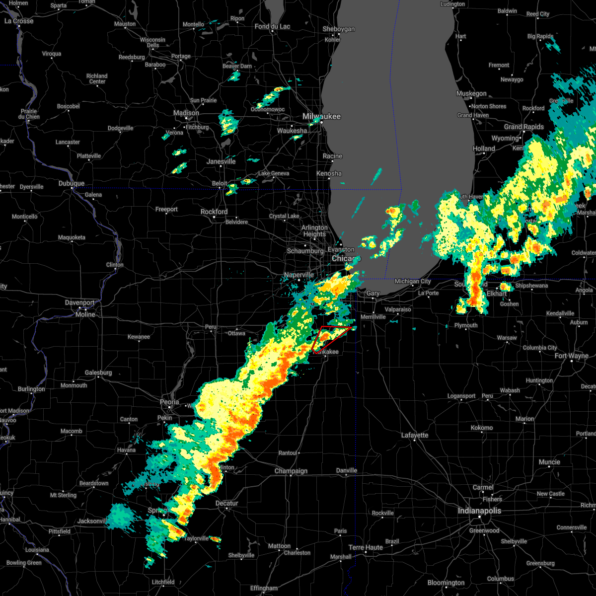 At 405 pm cdt, a severe thunderstorm capable of producing a tornado was located near manteno, moving northeast at 30 mph (radar and spotter indicated rotation). Hazards include tornado. Flying debris will be dangerous to those caught without shelter. mobile homes will be damaged or destroyed. damage to roofs, windows, and vehicles will occur. tree damage is likely. this dangerous storm will be near, manteno around 415 pm cdt. Other locations in the path of this tornadic thunderstorm include peotone and beecher. At 405 pm cdt, a severe thunderstorm capable of producing a tornado was located near manteno, moving northeast at 30 mph (radar and spotter indicated rotation). Hazards include tornado. Flying debris will be dangerous to those caught without shelter. mobile homes will be damaged or destroyed. damage to roofs, windows, and vehicles will occur. tree damage is likely. this dangerous storm will be near, manteno around 415 pm cdt. Other locations in the path of this tornadic thunderstorm include peotone and beecher.
|
| 6/26/2021 3:57 PM CDT |
 At 357 pm cdt, a severe thunderstorm capable of producing a tornado was located near saunemin, or 10 miles south of dwight, moving northeast at 35 mph (radar indicated rotation). Hazards include tornado. Flying debris will be dangerous to those caught without shelter. mobile homes will be damaged or destroyed. damage to roofs, windows, and vehicles will occur. Tree damage is likely. At 357 pm cdt, a severe thunderstorm capable of producing a tornado was located near saunemin, or 10 miles south of dwight, moving northeast at 35 mph (radar indicated rotation). Hazards include tornado. Flying debris will be dangerous to those caught without shelter. mobile homes will be damaged or destroyed. damage to roofs, windows, and vehicles will occur. Tree damage is likely.
|
| 6/26/2021 3:56 PM CDT |
 At 355 pm cdt, a severe thunderstorm capable of producing a tornado was located near limestone, or near bourbonnais, moving northeast at 30 mph (radar indicated rotation). Hazards include tornado. Flying debris will be dangerous to those caught without shelter. mobile homes will be damaged or destroyed. damage to roofs, windows, and vehicles will occur. tree damage is likely. this dangerous storm will be near, manteno around 410 pm cdt. other locations in the path of this tornadic thunderstorm include peotone and beecher. this includes, will county fairgrounds. Including the following interstate, i-57 between mile markers 318 and 330. At 355 pm cdt, a severe thunderstorm capable of producing a tornado was located near limestone, or near bourbonnais, moving northeast at 30 mph (radar indicated rotation). Hazards include tornado. Flying debris will be dangerous to those caught without shelter. mobile homes will be damaged or destroyed. damage to roofs, windows, and vehicles will occur. tree damage is likely. this dangerous storm will be near, manteno around 410 pm cdt. other locations in the path of this tornadic thunderstorm include peotone and beecher. this includes, will county fairgrounds. Including the following interstate, i-57 between mile markers 318 and 330.
|
| 6/21/2021 12:08 AM CDT |
 At 1207 am cdt, severe thunderstorms were located along a line extending from ogden dunes to near grant park, moving east at 40 mph. gusty winds continue for a while behind the leading edge of the storms (radar indicated). Hazards include 70 mph wind gusts and penny size hail. Expect considerable tree damage. damage is likely to mobile homes, roofs, and outbuildings. Locations impacted include, hammond, gary, portage, merrillville, valparaiso, east chicago, schererville, hobart, kankakee, crown point, highland, munster, bourbonnais, bradley, chesterton, cedar lake, lowell, manteno, demotte and hebron. At 1207 am cdt, severe thunderstorms were located along a line extending from ogden dunes to near grant park, moving east at 40 mph. gusty winds continue for a while behind the leading edge of the storms (radar indicated). Hazards include 70 mph wind gusts and penny size hail. Expect considerable tree damage. damage is likely to mobile homes, roofs, and outbuildings. Locations impacted include, hammond, gary, portage, merrillville, valparaiso, east chicago, schererville, hobart, kankakee, crown point, highland, munster, bourbonnais, bradley, chesterton, cedar lake, lowell, manteno, demotte and hebron.
|
| 6/20/2021 11:41 PM CDT |
 At 1141 pm cdt, severe thunderstorms were located along a line extending from near whiting to near elwood, moving east at 35 mph. these storms have a history of producing wind damage (radar indicated). Hazards include 70 mph wind gusts and penny size hail. Expect considerable tree damage. Damage is likely to mobile homes, roofs, and outbuildings. At 1141 pm cdt, severe thunderstorms were located along a line extending from near whiting to near elwood, moving east at 35 mph. these storms have a history of producing wind damage (radar indicated). Hazards include 70 mph wind gusts and penny size hail. Expect considerable tree damage. Damage is likely to mobile homes, roofs, and outbuildings.
|
| 8/10/2020 3:32 PM CDT |
 At 331 pm cdt, a severe thunderstorm was located 23 miles northwest of long beach, or 24 miles northwest of michigan city, moving east at 75 mph. this is a very dangerous storm (trained weather spotters). Hazards include 80 mph wind gusts and quarter size hail. Flying debris will be dangerous to those caught without shelter. mobile homes will be heavily damaged. expect considerable damage to roofs, windows, and vehicles. Extensive tree damage and power outages are likely. At 331 pm cdt, a severe thunderstorm was located 23 miles northwest of long beach, or 24 miles northwest of michigan city, moving east at 75 mph. this is a very dangerous storm (trained weather spotters). Hazards include 80 mph wind gusts and quarter size hail. Flying debris will be dangerous to those caught without shelter. mobile homes will be heavily damaged. expect considerable damage to roofs, windows, and vehicles. Extensive tree damage and power outages are likely.
|
| 8/10/2020 3:21 PM CDT |
 At 320 pm cdt, a severe thunderstorm was located 18 miles east of uptown, or 18 miles east of lake view, moving east at 75 mph. this is a very dangerous storm (trained weather spotters). Hazards include 80 mph wind gusts and quarter size hail. the strongest winds are heading into will county, and may last longer than 30 minutes!. Flying debris will be dangerous to those caught without shelter. mobile homes will be heavily damaged. expect considerable damage to roofs, windows, and vehicles. extensive tree damage and power outages are likely. Locations impacted include, chicago, aurora, joliet, naperville, elgin, waukegan, cicero, hammond, arlington heights, evanston, schaumburg, bolingbrook, palatine, skokie, des plaines, orland park, tinley park, oak lawn, berwyn and mount prospect. At 320 pm cdt, a severe thunderstorm was located 18 miles east of uptown, or 18 miles east of lake view, moving east at 75 mph. this is a very dangerous storm (trained weather spotters). Hazards include 80 mph wind gusts and quarter size hail. the strongest winds are heading into will county, and may last longer than 30 minutes!. Flying debris will be dangerous to those caught without shelter. mobile homes will be heavily damaged. expect considerable damage to roofs, windows, and vehicles. extensive tree damage and power outages are likely. Locations impacted include, chicago, aurora, joliet, naperville, elgin, waukegan, cicero, hammond, arlington heights, evanston, schaumburg, bolingbrook, palatine, skokie, des plaines, orland park, tinley park, oak lawn, berwyn and mount prospect.
|
| 8/10/2020 2:56 PM CDT |
 At 254 pm cdt, a line of severe thunderstorms were located along a line from rockford to mendota, moving east at 75 mph. this is a very dangerous storm! (trained weather spotters. this storm has a history of producing widespread wind damage across western and north central illinois). Hazards include 80 mph wind gusts and quarter size hail. Flying debris will be dangerous to those caught without shelter. mobile homes will be heavily damaged. expect considerable damage to roofs, windows, and vehicles. Extensive tree damage and power outages are likely. At 254 pm cdt, a line of severe thunderstorms were located along a line from rockford to mendota, moving east at 75 mph. this is a very dangerous storm! (trained weather spotters. this storm has a history of producing widespread wind damage across western and north central illinois). Hazards include 80 mph wind gusts and quarter size hail. Flying debris will be dangerous to those caught without shelter. mobile homes will be heavily damaged. expect considerable damage to roofs, windows, and vehicles. Extensive tree damage and power outages are likely.
|
| 7/11/2020 1:04 PM CDT |
 At 104 pm cdt, severe thunderstorms were located along a line extending from kankakee to near herscher, moving southeast at 40 mph (radar indicated). Hazards include 60 mph wind gusts. Expect damage to roofs, siding, and trees. locations impacted include, kankakee, bourbonnais, bradley, momence, herscher, clifton, limestone, st. Anne, chebanse, ashkum, aroma park, hopkins park, martinton, sun river terrace, beaverville, donovan, sammons point, papineau, iroquois and irwin. At 104 pm cdt, severe thunderstorms were located along a line extending from kankakee to near herscher, moving southeast at 40 mph (radar indicated). Hazards include 60 mph wind gusts. Expect damage to roofs, siding, and trees. locations impacted include, kankakee, bourbonnais, bradley, momence, herscher, clifton, limestone, st. Anne, chebanse, ashkum, aroma park, hopkins park, martinton, sun river terrace, beaverville, donovan, sammons point, papineau, iroquois and irwin.
|
| 7/11/2020 12:54 PM CDT |
 At 1254 pm cdt, severe thunderstorms were located along a line extending from bourbonnais to near herscher, moving southeast at 40 mph (radar indicated). Hazards include 60 mph wind gusts. expect damage to roofs, siding, and trees At 1254 pm cdt, severe thunderstorms were located along a line extending from bourbonnais to near herscher, moving southeast at 40 mph (radar indicated). Hazards include 60 mph wind gusts. expect damage to roofs, siding, and trees
|
| 6/10/2020 9:04 AM CDT |
 At 903 am cdt, a severe thunderstorm was located over sauk village, or near steger, moving northeast at 40 mph (radar indicated). Hazards include two inch hail and 60 mph wind gusts. People and animals outdoors will be injured. expect hail damage to roofs, siding, windows, and vehicles. expect wind damage to roofs, siding, and trees. Locations impacted include, chicago, hammond, gary, tinley park, oak lawn, calumet city, merrillville, chicago heights, east chicago, schererville, hobart, lansing, kankakee, highland, blue island, munster, dolton, park forest, alsip and matteson. At 903 am cdt, a severe thunderstorm was located over sauk village, or near steger, moving northeast at 40 mph (radar indicated). Hazards include two inch hail and 60 mph wind gusts. People and animals outdoors will be injured. expect hail damage to roofs, siding, windows, and vehicles. expect wind damage to roofs, siding, and trees. Locations impacted include, chicago, hammond, gary, tinley park, oak lawn, calumet city, merrillville, chicago heights, east chicago, schererville, hobart, lansing, kankakee, highland, blue island, munster, dolton, park forest, alsip and matteson.
|
| 6/10/2020 8:56 AM CDT |
 At 856 am cdt, severe thunderstorms were located along a line extending from chatham to near beecher to near momence, moving northeast at 40 mph (trained weather spotters). Hazards include 70 mph wind gusts and quarter size hail. Hail damage to vehicles is expected. expect considerable tree damage. wind damage is also likely to mobile homes, roofs, and outbuildings. Locations impacted include, chicago, hammond, gary, tinley park, oak lawn, calumet city, merrillville, chicago heights, east chicago, schererville, hobart, lansing, kankakee, highland, blue island, munster, dolton, park forest, alsip and matteson. At 856 am cdt, severe thunderstorms were located along a line extending from chatham to near beecher to near momence, moving northeast at 40 mph (trained weather spotters). Hazards include 70 mph wind gusts and quarter size hail. Hail damage to vehicles is expected. expect considerable tree damage. wind damage is also likely to mobile homes, roofs, and outbuildings. Locations impacted include, chicago, hammond, gary, tinley park, oak lawn, calumet city, merrillville, chicago heights, east chicago, schererville, hobart, lansing, kankakee, highland, blue island, munster, dolton, park forest, alsip and matteson.
|
| 6/10/2020 8:53 AM CDT |
 At 853 am cdt, severe thunderstorms were located along a line extending from near chatham to beecher to near bradley, moving northeast at 40 mph (radar indicated). Hazards include 70 mph wind gusts and quarter size hail. Hail damage to vehicles is expected. expect considerable tree damage. wind damage is also likely to mobile homes, roofs, and outbuildings. Locations impacted include, chicago, hammond, gary, tinley park, oak lawn, calumet city, merrillville, chicago heights, east chicago, schererville, hobart, lansing, kankakee, highland, blue island, munster, dolton, park forest, alsip and matteson. At 853 am cdt, severe thunderstorms were located along a line extending from near chatham to beecher to near bradley, moving northeast at 40 mph (radar indicated). Hazards include 70 mph wind gusts and quarter size hail. Hail damage to vehicles is expected. expect considerable tree damage. wind damage is also likely to mobile homes, roofs, and outbuildings. Locations impacted include, chicago, hammond, gary, tinley park, oak lawn, calumet city, merrillville, chicago heights, east chicago, schererville, hobart, lansing, kankakee, highland, blue island, munster, dolton, park forest, alsip and matteson.
|
| 6/10/2020 8:50 AM CDT |
 At 850 am cdt, severe thunderstorms were located along a line extending from near blue island to beecher to near bradley, moving northeast at 50 mph (radar indicated). Hazards include 70 mph wind gusts. Expect considerable tree damage. damage is likely to mobile homes, roofs, and outbuildings. Locations impacted include, chicago, hammond, gary, tinley park, oak lawn, calumet city, merrillville, chicago heights, east chicago, schererville, hobart, lansing, kankakee, highland, blue island, munster, dolton, park forest, alsip and matteson. At 850 am cdt, severe thunderstorms were located along a line extending from near blue island to beecher to near bradley, moving northeast at 50 mph (radar indicated). Hazards include 70 mph wind gusts. Expect considerable tree damage. damage is likely to mobile homes, roofs, and outbuildings. Locations impacted include, chicago, hammond, gary, tinley park, oak lawn, calumet city, merrillville, chicago heights, east chicago, schererville, hobart, lansing, kankakee, highland, blue island, munster, dolton, park forest, alsip and matteson.
|
| 6/10/2020 8:38 AM CDT |
 At 837 am cdt, severe thunderstorms were located along a line extending from country club hills to park forest, moving northeast at 50 mph (radar indicated). Hazards include 70 mph wind gusts. Expect considerable tree damage. damage is likely to mobile homes, roofs, and outbuildings. Locations impacted include, chicago, hammond, gary, orland park, tinley park, oak lawn, calumet city, merrillville, chicago heights, east chicago, schererville, hobart, lansing, kankakee, new lenox, highland, blue island, munster, dolton and park forest. At 837 am cdt, severe thunderstorms were located along a line extending from country club hills to park forest, moving northeast at 50 mph (radar indicated). Hazards include 70 mph wind gusts. Expect considerable tree damage. damage is likely to mobile homes, roofs, and outbuildings. Locations impacted include, chicago, hammond, gary, orland park, tinley park, oak lawn, calumet city, merrillville, chicago heights, east chicago, schererville, hobart, lansing, kankakee, new lenox, highland, blue island, munster, dolton and park forest.
|
| 6/10/2020 8:31 AM CDT |
 At 830 am cdt, severe thunderstorms were located along a line extending from near monee to near bradley, moving northeast at 40 mph (radar indicated). Hazards include 70 mph wind gusts. Expect considerable tree damage. damage is likely to mobile homes, roofs, and outbuildings. Locations impacted include, chicago, hammond, gary, orland park, tinley park, oak lawn, calumet city, merrillville, chicago heights, east chicago, schererville, hobart, lansing, kankakee, new lenox, highland, blue island, munster, dolton and park forest. At 830 am cdt, severe thunderstorms were located along a line extending from near monee to near bradley, moving northeast at 40 mph (radar indicated). Hazards include 70 mph wind gusts. Expect considerable tree damage. damage is likely to mobile homes, roofs, and outbuildings. Locations impacted include, chicago, hammond, gary, orland park, tinley park, oak lawn, calumet city, merrillville, chicago heights, east chicago, schererville, hobart, lansing, kankakee, new lenox, highland, blue island, munster, dolton and park forest.
|
| 6/10/2020 8:24 AM CDT |
 At 824 am cdt, severe thunderstorms were located along a line extending from near monee to near kankakee, moving northeast at 40 mph (radar indicated). Hazards include 60 mph wind gusts. Expect damage to roofs, siding, and trees. Locations impacted include, chicago, hammond, gary, orland park, tinley park, oak lawn, calumet city, merrillville, chicago heights, east chicago, schererville, hobart, lansing, kankakee, new lenox, highland, blue island, munster, dolton and park forest. At 824 am cdt, severe thunderstorms were located along a line extending from near monee to near kankakee, moving northeast at 40 mph (radar indicated). Hazards include 60 mph wind gusts. Expect damage to roofs, siding, and trees. Locations impacted include, chicago, hammond, gary, orland park, tinley park, oak lawn, calumet city, merrillville, chicago heights, east chicago, schererville, hobart, lansing, kankakee, new lenox, highland, blue island, munster, dolton and park forest.
|
| 6/10/2020 8:14 AM CDT |
 At 813 am cdt, severe thunderstorms were located along a line extending from 6 miles west of peotone to near chebanse, moving northeast at 40 mph (radar indicated). Hazards include 60 mph wind gusts. expect damage to roofs, siding, and trees At 813 am cdt, severe thunderstorms were located along a line extending from 6 miles west of peotone to near chebanse, moving northeast at 40 mph (radar indicated). Hazards include 60 mph wind gusts. expect damage to roofs, siding, and trees
|
| 5/23/2020 4:40 PM CDT |
 The severe thunderstorm warning for southwestern kankakee county will expire at 445 pm cdt, the storm which prompted the warning has weakened below severe limits, and has exited the warned area. therefore, the warning will be allowed to expire. a tornado watch remains in effect until 800 pm cdt for northeastern illinois. The severe thunderstorm warning for southwestern kankakee county will expire at 445 pm cdt, the storm which prompted the warning has weakened below severe limits, and has exited the warned area. therefore, the warning will be allowed to expire. a tornado watch remains in effect until 800 pm cdt for northeastern illinois.
|
| 5/23/2020 4:26 PM CDT |
 At 425 pm cdt, a severe thunderstorm was located over herscher, or 12 miles west of kankakee, moving northeast at 45 mph (radar indicated). Hazards include quarter size hail. Damage to vehicles is expected. This severe thunderstorm will remain over mainly rural areas of southwestern kankakee county, including the following locations, irwin, buckingham and union hill. At 425 pm cdt, a severe thunderstorm was located over herscher, or 12 miles west of kankakee, moving northeast at 45 mph (radar indicated). Hazards include quarter size hail. Damage to vehicles is expected. This severe thunderstorm will remain over mainly rural areas of southwestern kankakee county, including the following locations, irwin, buckingham and union hill.
|
| 5/23/2020 4:16 PM CDT |
 At 416 pm cdt, a severe thunderstorm was located near kankakee, moving east at 25 mph (radar indicated). Hazards include golf ball size hail and 60 mph wind gusts. People and animals outdoors will be injured. expect hail damage to roofs, siding, windows, and vehicles. expect wind damage to roofs, siding, and trees. this severe thunderstorm will be near, bourbonnais around 425 pm cdt. kankakee, bradley and aroma park around 430 pm cdt. st. anne around 440 pm cdt. momence and hopkins park around 455 pm cdt. grant park around 500 pm cdt. other locations impacted by this severe thunderstorm include sun river terrace and irwin. including the following interstate, i-57 between mile markers 302 and 316. A tornado watch remains in effect until 800 pm cdt for northeastern and east central illinois. At 416 pm cdt, a severe thunderstorm was located near kankakee, moving east at 25 mph (radar indicated). Hazards include golf ball size hail and 60 mph wind gusts. People and animals outdoors will be injured. expect hail damage to roofs, siding, windows, and vehicles. expect wind damage to roofs, siding, and trees. this severe thunderstorm will be near, bourbonnais around 425 pm cdt. kankakee, bradley and aroma park around 430 pm cdt. st. anne around 440 pm cdt. momence and hopkins park around 455 pm cdt. grant park around 500 pm cdt. other locations impacted by this severe thunderstorm include sun river terrace and irwin. including the following interstate, i-57 between mile markers 302 and 316. A tornado watch remains in effect until 800 pm cdt for northeastern and east central illinois.
|
| 5/23/2020 4:09 PM CDT |
 At 409 pm cdt, a severe thunderstorm was located near cullom, or 10 miles north of piper city, moving northeast at 45 mph (radar indicated). Hazards include golf ball size hail. People and animals outdoors will be injured. expect damage to roofs, siding, windows, and vehicles. this severe thunderstorm will be near, herscher around 425 pm cdt. other locations impacted by this severe thunderstorm include irwin, cabery, union hill, buckingham and kempton. A tornado watch remains in effect until 800 pm cdt for central, northeastern and east central illinois. At 409 pm cdt, a severe thunderstorm was located near cullom, or 10 miles north of piper city, moving northeast at 45 mph (radar indicated). Hazards include golf ball size hail. People and animals outdoors will be injured. expect damage to roofs, siding, windows, and vehicles. this severe thunderstorm will be near, herscher around 425 pm cdt. other locations impacted by this severe thunderstorm include irwin, cabery, union hill, buckingham and kempton. A tornado watch remains in effect until 800 pm cdt for central, northeastern and east central illinois.
|
| 5/23/2020 3:51 PM CDT |
 At 350 pm cdt, a severe thunderstorm was located over herscher, or 13 miles southwest of kankakee, moving east at 25 mph (radar indicated). Hazards include golf ball size hail and 60 mph wind gusts. People and animals outdoors will be injured. expect hail damage to roofs, siding, windows, and vehicles. expect wind damage to roofs, siding, and trees. This severe thunderstorm will remain over mainly rural areas of southwestern kankakee, north central ford and northwestern iroquois counties, including the following locations, cabery, irwin and buckingham. At 350 pm cdt, a severe thunderstorm was located over herscher, or 13 miles southwest of kankakee, moving east at 25 mph (radar indicated). Hazards include golf ball size hail and 60 mph wind gusts. People and animals outdoors will be injured. expect hail damage to roofs, siding, windows, and vehicles. expect wind damage to roofs, siding, and trees. This severe thunderstorm will remain over mainly rural areas of southwestern kankakee, north central ford and northwestern iroquois counties, including the following locations, cabery, irwin and buckingham.
|
| 5/23/2020 3:27 PM CDT |
 At 326 pm cdt, a severe thunderstorm was located 7 miles north of cullom, or 11 miles southeast of dwight, moving east at 25 mph (radar indicated). Hazards include golf ball size hail and 60 mph wind gusts. People and animals outdoors will be injured. expect hail damage to roofs, siding, windows, and vehicles. expect wind damage to roofs, siding, and trees. this severe thunderstorm will be near, herscher around 350 pm cdt. other locations impacted by this severe thunderstorm include irwin, cabery, campus, buckingham and kempton. A tornado watch remains in effect until 800 pm cdt for central, northeastern and east central illinois. At 326 pm cdt, a severe thunderstorm was located 7 miles north of cullom, or 11 miles southeast of dwight, moving east at 25 mph (radar indicated). Hazards include golf ball size hail and 60 mph wind gusts. People and animals outdoors will be injured. expect hail damage to roofs, siding, windows, and vehicles. expect wind damage to roofs, siding, and trees. this severe thunderstorm will be near, herscher around 350 pm cdt. other locations impacted by this severe thunderstorm include irwin, cabery, campus, buckingham and kempton. A tornado watch remains in effect until 800 pm cdt for central, northeastern and east central illinois.
|
| 8/17/2019 1:29 AM CDT |
 At 129 am cdt, a severe thunderstorm was located near bourbonnais, moving east at 30 mph (radar indicated). Hazards include half dollar size hail. Damage to vehicles is expected. Locations impacted include, kankakee, bourbonnais, bradley, manteno, aroma park and sun river terrace. At 129 am cdt, a severe thunderstorm was located near bourbonnais, moving east at 30 mph (radar indicated). Hazards include half dollar size hail. Damage to vehicles is expected. Locations impacted include, kankakee, bourbonnais, bradley, manteno, aroma park and sun river terrace.
|
| 8/17/2019 1:15 AM CDT |
 At 115 am cdt, a severe thunderstorm was located near herscher, or 10 miles west of bourbonnais, moving east at 30 mph (radar indicated). Hazards include ping pong ball size hail. People and animals outdoors will be injured. expect damage to roofs, siding, windows, and vehicles. Locations impacted include, kankakee, bourbonnais, bradley, manteno, herscher, aroma park, sun river terrace, bonfield, irwin and union hill. At 115 am cdt, a severe thunderstorm was located near herscher, or 10 miles west of bourbonnais, moving east at 30 mph (radar indicated). Hazards include ping pong ball size hail. People and animals outdoors will be injured. expect damage to roofs, siding, windows, and vehicles. Locations impacted include, kankakee, bourbonnais, bradley, manteno, herscher, aroma park, sun river terrace, bonfield, irwin and union hill.
|
| 8/17/2019 1:05 AM CDT |
 The national weather service in chicago has issued a * severe thunderstorm warning for. central kankakee county in northeastern illinois. until 145 am cdt. At 105 am cdt, a severe thunderstorm was located near herscher, or 13 miles south of wilmington, moving east at 30 mph. The national weather service in chicago has issued a * severe thunderstorm warning for. central kankakee county in northeastern illinois. until 145 am cdt. At 105 am cdt, a severe thunderstorm was located near herscher, or 13 miles south of wilmington, moving east at 30 mph.
|
| 6/30/2019 3:22 PM CDT |
 At 322 pm cdt, severe thunderstorms were located along a line extending from cedar lake to near watseka, and extending back toward the east side of kankakee, moving southeast at 20 mph (trained weather spotters). Hazards include 60 mph wind gusts. Expect damage to roofs, siding, and trees. locations impacted include, kankakee, bourbonnais, bradley, manteno, university park, peotone, momence, crete, beecher, herscher, grant park, st. Anne, aroma park, hopkins park, sun river terrace and irwin. At 322 pm cdt, severe thunderstorms were located along a line extending from cedar lake to near watseka, and extending back toward the east side of kankakee, moving southeast at 20 mph (trained weather spotters). Hazards include 60 mph wind gusts. Expect damage to roofs, siding, and trees. locations impacted include, kankakee, bourbonnais, bradley, manteno, university park, peotone, momence, crete, beecher, herscher, grant park, st. Anne, aroma park, hopkins park, sun river terrace and irwin.
|
| 6/30/2019 2:53 PM CDT |
 At 252 pm cdt, severe thunderstorms were located along a line extending from sauk village to clifton, moving south at 110 mph. these are very dangerous storms (trained weather spotters reported 74 mph winds in manteno). Hazards include 80 mph wind gusts. Flying debris will be dangerous to those caught without shelter. mobile homes will be heavily damaged. expect considerable damage to roofs, windows, and vehicles. extensive tree damage and power outages are likely. Locations impacted include, joliet, hammond, orland park, tinley park, calumet city, chicago heights, lansing, kankakee, new lenox, munster, park forest, matteson, mokena, bourbonnais, frankfort, bradley, channahon, steger, flossmoor and manteno. At 252 pm cdt, severe thunderstorms were located along a line extending from sauk village to clifton, moving south at 110 mph. these are very dangerous storms (trained weather spotters reported 74 mph winds in manteno). Hazards include 80 mph wind gusts. Flying debris will be dangerous to those caught without shelter. mobile homes will be heavily damaged. expect considerable damage to roofs, windows, and vehicles. extensive tree damage and power outages are likely. Locations impacted include, joliet, hammond, orland park, tinley park, calumet city, chicago heights, lansing, kankakee, new lenox, munster, park forest, matteson, mokena, bourbonnais, frankfort, bradley, channahon, steger, flossmoor and manteno.
|
| 6/30/2019 2:42 PM CDT |
 At 240 pm cdt, severe thunderstorms were located along a line extending from 11 miles east of kenilworth to near herscher, moving southeast at 35 mph (trained weather spotters). Hazards include 70 mph wind gusts. Expect considerable tree damage. damage is likely to mobile homes, roofs, and outbuildings. Locations impacted include, south side of chicago, joliet, naperville, cicero, hammond, bolingbrook, orland park, tinley park, oak lawn, berwyn, oak park, romeoville, plainfield, calumet city, chicago heights, lansing, kankakee, lockport, new lenox and homer glen. At 240 pm cdt, severe thunderstorms were located along a line extending from 11 miles east of kenilworth to near herscher, moving southeast at 35 mph (trained weather spotters). Hazards include 70 mph wind gusts. Expect considerable tree damage. damage is likely to mobile homes, roofs, and outbuildings. Locations impacted include, south side of chicago, joliet, naperville, cicero, hammond, bolingbrook, orland park, tinley park, oak lawn, berwyn, oak park, romeoville, plainfield, calumet city, chicago heights, lansing, kankakee, lockport, new lenox and homer glen.
|
| 6/30/2019 2:13 PM CDT |
 At 211 pm cdt, severe thunderstorms were located along a line extending from 11 miles northeast of highland park to near shorewood, moving southeast at 20 mph (trained weather spotters). Hazards include 70 mph wind gusts. Expect considerable tree damage. Damage is likely to mobile homes, roofs, and outbuildings. At 211 pm cdt, severe thunderstorms were located along a line extending from 11 miles northeast of highland park to near shorewood, moving southeast at 20 mph (trained weather spotters). Hazards include 70 mph wind gusts. Expect considerable tree damage. Damage is likely to mobile homes, roofs, and outbuildings.
|
| 5/23/2019 2:27 AM CDT |
 At 226 am cdt/326 am edt/, severe thunderstorms were located along a line extending from grant park to thayer to near collegeville to boswell, moving northeast at 70 mph. numerous measured wind gusts in excess of 70 mph have been reported with these dangerous thunderstorms. these are very dangerous storms (radar indicated). Hazards include 80 mph wind gusts and nickel size hail. Flying debris will be dangerous to those caught without shelter. mobile homes will be heavily damaged. expect considerable damage to roofs, windows, and vehicles. extensive tree damage and power outages are likely. locations impacted include, merrillville, schererville, kankakee, crown point, bourbonnais, bradley, st. John, cedar lake, lowell, manteno, rensselaer, peotone, de motte, hebron, momence, fowler, kentland, morocco, hanging grove and roselawn. At 226 am cdt/326 am edt/, severe thunderstorms were located along a line extending from grant park to thayer to near collegeville to boswell, moving northeast at 70 mph. numerous measured wind gusts in excess of 70 mph have been reported with these dangerous thunderstorms. these are very dangerous storms (radar indicated). Hazards include 80 mph wind gusts and nickel size hail. Flying debris will be dangerous to those caught without shelter. mobile homes will be heavily damaged. expect considerable damage to roofs, windows, and vehicles. extensive tree damage and power outages are likely. locations impacted include, merrillville, schererville, kankakee, crown point, bourbonnais, bradley, st. John, cedar lake, lowell, manteno, rensselaer, peotone, de motte, hebron, momence, fowler, kentland, morocco, hanging grove and roselawn.
|
| 5/23/2019 2:14 AM CDT |
 At 212 am cdt/312 am edt/, severe thunderstorms were located along a line extending from near kankakee to hopkins park to near morocco to near dunnington, moving northeast at 70 mph. at 2:04 am an 83 mph wind gust was measured in watseka. these are very dangerous storms (radar indicated). Hazards include 80 mph wind gusts and nickel size hail. Flying debris will be dangerous to those caught without shelter. mobile homes will be heavily damaged. expect considerable damage to roofs, windows, and vehicles. extensive tree damage and power outages are likely. locations impacted include, merrillville, schererville, kankakee, crown point, bourbonnais, bradley, st. John, cedar lake, lowell, manteno, rensselaer, watseka, peotone, de motte, hebron, momence, fowler, kentland, morocco and stockland. At 212 am cdt/312 am edt/, severe thunderstorms were located along a line extending from near kankakee to hopkins park to near morocco to near dunnington, moving northeast at 70 mph. at 2:04 am an 83 mph wind gust was measured in watseka. these are very dangerous storms (radar indicated). Hazards include 80 mph wind gusts and nickel size hail. Flying debris will be dangerous to those caught without shelter. mobile homes will be heavily damaged. expect considerable damage to roofs, windows, and vehicles. extensive tree damage and power outages are likely. locations impacted include, merrillville, schererville, kankakee, crown point, bourbonnais, bradley, st. John, cedar lake, lowell, manteno, rensselaer, watseka, peotone, de motte, hebron, momence, fowler, kentland, morocco and stockland.
|
| 5/23/2019 1:54 AM CDT |
 At 154 am cdt/254 am edt/, severe thunderstorms were located along a line extending from 8 miles north of cullom to clifton to 6 miles west of watseka to near rankin, moving northeast at 70 mph (radar indicated). Hazards include 70 mph wind gusts and nickel size hail. localized wind gusts to 80 mph will be possible with these storms. Expect considerable tree damage. Damage is likely to mobile homes, roofs, and outbuildings. At 154 am cdt/254 am edt/, severe thunderstorms were located along a line extending from 8 miles north of cullom to clifton to 6 miles west of watseka to near rankin, moving northeast at 70 mph (radar indicated). Hazards include 70 mph wind gusts and nickel size hail. localized wind gusts to 80 mph will be possible with these storms. Expect considerable tree damage. Damage is likely to mobile homes, roofs, and outbuildings.
|
| 5/16/2019 1:29 PM CDT |
 At 129 pm cdt, a severe thunderstorm was located over chebanse, or near kankakee, moving southeast at 40 mph (radar indicated). Hazards include 60 mph wind gusts and quarter size hail. Hail damage to vehicles is expected. Expect wind damage to roofs, siding, and trees. At 129 pm cdt, a severe thunderstorm was located over chebanse, or near kankakee, moving southeast at 40 mph (radar indicated). Hazards include 60 mph wind gusts and quarter size hail. Hail damage to vehicles is expected. Expect wind damage to roofs, siding, and trees.
|
| 5/2/2018 5:43 PM CDT |
 The severe thunderstorm warning for northeastern kankakee county will expire at 545 pm cdt, the storm which prompted the warning has weakened below severe limits, and has exited the warned area. therefore, the warning will be allowed to expire. a severe thunderstorm watch remains in effect until 1100 pm cdt for northeastern illinois. The severe thunderstorm warning for northeastern kankakee county will expire at 545 pm cdt, the storm which prompted the warning has weakened below severe limits, and has exited the warned area. therefore, the warning will be allowed to expire. a severe thunderstorm watch remains in effect until 1100 pm cdt for northeastern illinois.
|
| 5/2/2018 5:26 PM CDT |
 At 526 pm cdt, a severe thunderstorm was located over grant park, or near momence, moving east at 40 mph (radar indicated). Hazards include 60 mph wind gusts and quarter size hail. Hail damage to vehicles is expected. expect wind damage to roofs, siding, and trees. Locations impacted include, kankakee, bourbonnais, bradley, manteno, momence, grant park, aroma park, hopkins park and sun river terrace. At 526 pm cdt, a severe thunderstorm was located over grant park, or near momence, moving east at 40 mph (radar indicated). Hazards include 60 mph wind gusts and quarter size hail. Hail damage to vehicles is expected. expect wind damage to roofs, siding, and trees. Locations impacted include, kankakee, bourbonnais, bradley, manteno, momence, grant park, aroma park, hopkins park and sun river terrace.
|
| 5/2/2018 5:08 PM CDT |
 At 508 pm cdt, a severe thunderstorm was located over bourbonnais, moving east at 35 mph (radar indicated). Hazards include ping pong ball size hail and 60 mph wind gusts. People and animals outdoors will be injured. expect hail damage to roofs, siding, windows, and vehicles. expect wind damage to roofs, siding, and trees. Locations impacted include, kankakee, bourbonnais, bradley, manteno, momence, grant park, aroma park, hopkins park and sun river terrace. At 508 pm cdt, a severe thunderstorm was located over bourbonnais, moving east at 35 mph (radar indicated). Hazards include ping pong ball size hail and 60 mph wind gusts. People and animals outdoors will be injured. expect hail damage to roofs, siding, windows, and vehicles. expect wind damage to roofs, siding, and trees. Locations impacted include, kankakee, bourbonnais, bradley, manteno, momence, grant park, aroma park, hopkins park and sun river terrace.
|
| 5/2/2018 5:02 PM CDT |
 The national weather service in chicago has issued a * severe thunderstorm warning for. northeastern kankakee county in northeastern illinois. Until 545 pm cdt * at 502 pm cdt, a severe thunderstorm was located near bourbonnais, moving east at 35 mph. The national weather service in chicago has issued a * severe thunderstorm warning for. northeastern kankakee county in northeastern illinois. Until 545 pm cdt * at 502 pm cdt, a severe thunderstorm was located near bourbonnais, moving east at 35 mph.
|
| 7/23/2017 6:35 PM CDT |
 At 635 pm cdt, a severe thunderstorm was located near herscher, or 15 miles southwest of kankakee, moving southeast at 30 mph (radar indicated). Hazards include 60 mph wind gusts and quarter size hail. Hail damage to vehicles is expected. Expect wind damage to roofs, siding, and trees. At 635 pm cdt, a severe thunderstorm was located near herscher, or 15 miles southwest of kankakee, moving southeast at 30 mph (radar indicated). Hazards include 60 mph wind gusts and quarter size hail. Hail damage to vehicles is expected. Expect wind damage to roofs, siding, and trees.
|
| 7/21/2017 7:58 PM CDT |
 At 758 pm cdt, a severe thunderstorm was located near herscher, or 10 miles southwest of kankakee, moving east at 20 mph (radar indicated). Hazards include 60 mph wind gusts and quarter size hail. Hail damage to vehicles is expected. Expect wind damage to roofs, siding, and trees. At 758 pm cdt, a severe thunderstorm was located near herscher, or 10 miles southwest of kankakee, moving east at 20 mph (radar indicated). Hazards include 60 mph wind gusts and quarter size hail. Hail damage to vehicles is expected. Expect wind damage to roofs, siding, and trees.
|
| 6/14/2017 2:11 PM CDT |
 The severe thunderstorm warning for northeastern livingston, southeastern grundy and western kankakee counties will expire at 215 pm cdt, the storm which prompted the warning has weakened below severe limits, and no longer pose an immediate threat to life or property. therefore the warning will be allowed to expire. however gusty winds and heavy rain are still possible with this thunderstorm. a severe thunderstorm watch remains in effect until 800 pm cdt for central and northeastern illinois. The severe thunderstorm warning for northeastern livingston, southeastern grundy and western kankakee counties will expire at 215 pm cdt, the storm which prompted the warning has weakened below severe limits, and no longer pose an immediate threat to life or property. therefore the warning will be allowed to expire. however gusty winds and heavy rain are still possible with this thunderstorm. a severe thunderstorm watch remains in effect until 800 pm cdt for central and northeastern illinois.
|
| 6/14/2017 1:48 PM CDT |
 At 147 pm cdt, a severe thunderstorm was located near herscher, or 11 miles east of dwight, moving east at 40 mph (radar indicated). Hazards include quarter size hail. Damage to vehicles is expected. Locations impacted include, dwight, herscher, gardner, essex, south wilmington, bonfield, buckingham, campus, reddick, east brooklyn, irwin and union hill. At 147 pm cdt, a severe thunderstorm was located near herscher, or 11 miles east of dwight, moving east at 40 mph (radar indicated). Hazards include quarter size hail. Damage to vehicles is expected. Locations impacted include, dwight, herscher, gardner, essex, south wilmington, bonfield, buckingham, campus, reddick, east brooklyn, irwin and union hill.
|
| 6/14/2017 1:31 PM CDT |
 At 130 pm cdt, a severe thunderstorm was located over dwight, moving east at 40 mph (radar indicated). Hazards include quarter size hail. damage to vehicles is expected At 130 pm cdt, a severe thunderstorm was located over dwight, moving east at 40 mph (radar indicated). Hazards include quarter size hail. damage to vehicles is expected
|
| 5/18/2017 12:58 AM CDT |
 The national weather service in chicago has issued a * severe thunderstorm warning for. southern will county in northeastern illinois. northwestern kankakee county in northeastern illinois. southeastern cook county in northeastern illinois. Until 145 am cdt. The national weather service in chicago has issued a * severe thunderstorm warning for. southern will county in northeastern illinois. northwestern kankakee county in northeastern illinois. southeastern cook county in northeastern illinois. Until 145 am cdt.
|
| 3/7/2017 1:31 AM CST |
 At 129 am cst, severe thunderstorms were located along a line extending from highland park to stickney to near bourbonnais, moving northeast at 65 mph (radar indicated). Hazards include 60 mph wind gusts and quarter size hail. Hail damage to vehicles is expected. expect wind damage to roofs, siding, and trees. these severe storms will be near, cicero, berwyn, oak park, winnetka, glencoe, stickney, northerly island, midway airport, bridgeport and forest view around 135 am cst. Lincoln park around 140 am cst. At 129 am cst, severe thunderstorms were located along a line extending from highland park to stickney to near bourbonnais, moving northeast at 65 mph (radar indicated). Hazards include 60 mph wind gusts and quarter size hail. Hail damage to vehicles is expected. expect wind damage to roofs, siding, and trees. these severe storms will be near, cicero, berwyn, oak park, winnetka, glencoe, stickney, northerly island, midway airport, bridgeport and forest view around 135 am cst. Lincoln park around 140 am cst.
|
| 3/7/2017 1:27 AM CST |
 At 127 am cst, severe thunderstorms were located along a line extending from near herscher to near gibson city, moving east at 65 mph (radar indicated). Hazards include 60 mph wind gusts. Expect damage to roofs, siding, and trees. these severe storms will be near, bourbonnais, chebanse and aroma park around 135 am cst. kankakee and bradley around 140 am cst. momence, hopkins park and buckley around 145 am cst. grant park and cissna park around 150 am cst. claytonville around 155 am cst. Stockland and milford around 200 am cst. At 127 am cst, severe thunderstorms were located along a line extending from near herscher to near gibson city, moving east at 65 mph (radar indicated). Hazards include 60 mph wind gusts. Expect damage to roofs, siding, and trees. these severe storms will be near, bourbonnais, chebanse and aroma park around 135 am cst. kankakee and bradley around 140 am cst. momence, hopkins park and buckley around 145 am cst. grant park and cissna park around 150 am cst. claytonville around 155 am cst. Stockland and milford around 200 am cst.
|
| 3/7/2017 1:13 AM CST |
 At 111 am cst, severe thunderstorms were located along a line extending from inverness to woodridge to 6 miles northwest of herscher, moving east at 60 mph (radar indicated). Hazards include 60 mph wind gusts and quarter size hail. Hail damage to vehicles is expected. expect wind damage to roofs, siding, and trees. these severe storms will be near, schaumburg, hoffman estates, downers grove, rolling meadows, woodridge and darien around 115 am cst. arlington heights, wheeling, westmont, hinsdale, willow springs and prospect heights around 120 am cst. skokie, glenview, morton grove, brookfield, westchester, la grange, forest park and justice around 125 am cst. cicero, oak lawn, bourbonnais, winnetka, and stickney around 130 am cst. Northerly island, lincoln park, douglas park, hyde park and lakeview around 135 am cst. At 111 am cst, severe thunderstorms were located along a line extending from inverness to woodridge to 6 miles northwest of herscher, moving east at 60 mph (radar indicated). Hazards include 60 mph wind gusts and quarter size hail. Hail damage to vehicles is expected. expect wind damage to roofs, siding, and trees. these severe storms will be near, schaumburg, hoffman estates, downers grove, rolling meadows, woodridge and darien around 115 am cst. arlington heights, wheeling, westmont, hinsdale, willow springs and prospect heights around 120 am cst. skokie, glenview, morton grove, brookfield, westchester, la grange, forest park and justice around 125 am cst. cicero, oak lawn, bourbonnais, winnetka, and stickney around 130 am cst. Northerly island, lincoln park, douglas park, hyde park and lakeview around 135 am cst.
|
| 3/7/2017 1:08 AM CST |
 At 108 am cst, severe thunderstorms were located along a line extending from 7 miles north of cullom to 6 miles north of mansfield, moving east at 70 mph (radar indicated). Hazards include 60 mph wind gusts. Expect damage to roofs, siding, and trees. severe thunderstorms will be near, herscher around 115 am cst. bourbonnais and chebanse around 125 am cst. kankakee, bradley, paxton, st. anne and aroma park around 130 am cst. momence and hopkins park around 135 am cst. grant park and cissna park around 140 am cst. claytonville around 145 am cst. milford around 150 am cst. stockland around 155 am cst. Including the following interstate, i-57 between mile markers 258 and 316. At 108 am cst, severe thunderstorms were located along a line extending from 7 miles north of cullom to 6 miles north of mansfield, moving east at 70 mph (radar indicated). Hazards include 60 mph wind gusts. Expect damage to roofs, siding, and trees. severe thunderstorms will be near, herscher around 115 am cst. bourbonnais and chebanse around 125 am cst. kankakee, bradley, paxton, st. anne and aroma park around 130 am cst. momence and hopkins park around 135 am cst. grant park and cissna park around 140 am cst. claytonville around 145 am cst. milford around 150 am cst. stockland around 155 am cst. Including the following interstate, i-57 between mile markers 258 and 316.
|
| 3/7/2017 1:03 AM CST |
 At 102 am cst, severe thunderstorms were located along a line extending from east dundee to near aurora to near dwight, moving east at 60 mph (radar indicated). Hazards include 60 mph wind gusts and quarter size hail. Hail damage to vehicles is expected. expect wind damage to roofs, siding, and trees. these severe storms will be near, naperville, elgin, and warrenville around 105 am cst. bolingbrook, wheaton, romeoville, streamwood, and inverness around 110 am cst. schaumburg, downers grove, westmont, rolling meadows, york center, and darien around 115 am cst. arlington heights, des plaines, mount prospect, wheeling, hinsdale, oak brook, willow springs and palos hills around 120 am cst. skokie, northbrook, maywood, morton grove, brookfield, and justice around 125 am cst. cicero, wilmette, bourbonnais, bradley, winnetka, and stickney around 130 am cst. Chatham, navy pier, lincoln park, hyde park and lakeview around 135 am cst. At 102 am cst, severe thunderstorms were located along a line extending from east dundee to near aurora to near dwight, moving east at 60 mph (radar indicated). Hazards include 60 mph wind gusts and quarter size hail. Hail damage to vehicles is expected. expect wind damage to roofs, siding, and trees. these severe storms will be near, naperville, elgin, and warrenville around 105 am cst. bolingbrook, wheaton, romeoville, streamwood, and inverness around 110 am cst. schaumburg, downers grove, westmont, rolling meadows, york center, and darien around 115 am cst. arlington heights, des plaines, mount prospect, wheeling, hinsdale, oak brook, willow springs and palos hills around 120 am cst. skokie, northbrook, maywood, morton grove, brookfield, and justice around 125 am cst. cicero, wilmette, bourbonnais, bradley, winnetka, and stickney around 130 am cst. Chatham, navy pier, lincoln park, hyde park and lakeview around 135 am cst.
|
| 3/7/2017 12:43 AM CST |
 At 1242 am cst, severe thunderstorms were located along a line extending from sycamore to near newark to near flanagan, moving northeast at 80 mph (radar indicated). Hazards include 60 mph wind gusts. Expect damage to roofs, siding, and trees. severe thunderstorms will be near, maple park, newark and virgil around 1245 am cst. yorkville, plano and lily lake around 1250 am cst. elgin and oswego around 1255 am cst. aurora, naperville, west dundee and odell around 100 am cst. hoffman estates, romeoville, dwight, and inverness around 105 am cst. bolingbrook, palatine, wheaton, downers grove, glen ellyn, lisle, woodridge, darien and gardner around 110 am cst. Cicero, westchester, forest park and river forest around 120 am cst. At 1242 am cst, severe thunderstorms were located along a line extending from sycamore to near newark to near flanagan, moving northeast at 80 mph (radar indicated). Hazards include 60 mph wind gusts. Expect damage to roofs, siding, and trees. severe thunderstorms will be near, maple park, newark and virgil around 1245 am cst. yorkville, plano and lily lake around 1250 am cst. elgin and oswego around 1255 am cst. aurora, naperville, west dundee and odell around 100 am cst. hoffman estates, romeoville, dwight, and inverness around 105 am cst. bolingbrook, palatine, wheaton, downers grove, glen ellyn, lisle, woodridge, darien and gardner around 110 am cst. Cicero, westchester, forest park and river forest around 120 am cst.
|
| 2/28/2017 6:44 PM CST |
 At 643 pm cst, a severe thunderstorm was located near braceville, or 9 miles south of wilmington, moving east at 60 mph (radar indicated). Hazards include 60 mph wind gusts and half dollar size hail. Hail damage to vehicles is expected. Expect wind damage to roofs, siding, and trees. At 643 pm cst, a severe thunderstorm was located near braceville, or 9 miles south of wilmington, moving east at 60 mph (radar indicated). Hazards include 60 mph wind gusts and half dollar size hail. Hail damage to vehicles is expected. Expect wind damage to roofs, siding, and trees.
|
| 7/17/2016 9:17 PM CDT |
 At 916 pm cdt, a severe thunderstorm was located 7 miles west of manteno, moving east at 30 mph (radar indicated). Hazards include 60 mph wind gusts and quarter size hail. Hail damage to vehicles is expected. expect wind damage to roofs, siding, and trees. locations impacted include, kankakee, bourbonnais, bradley, manteno, manhattan, bonfield and symerton. this includes, kankakee river state park and olivet nazarine university. Including the following interstate, i-57 between mile markers 316 and 321. At 916 pm cdt, a severe thunderstorm was located 7 miles west of manteno, moving east at 30 mph (radar indicated). Hazards include 60 mph wind gusts and quarter size hail. Hail damage to vehicles is expected. expect wind damage to roofs, siding, and trees. locations impacted include, kankakee, bourbonnais, bradley, manteno, manhattan, bonfield and symerton. this includes, kankakee river state park and olivet nazarine university. Including the following interstate, i-57 between mile markers 316 and 321.
|
| 7/17/2016 9:03 PM CDT |
 At 903 pm cdt, a severe thunderstorm was located over lakewood shores, or near wilmington, moving east at 30 mph (radar indicated). Hazards include 60 mph wind gusts and quarter size hail. Hail damage to vehicles is expected. Expect wind damage to roofs, siding, and trees. At 903 pm cdt, a severe thunderstorm was located over lakewood shores, or near wilmington, moving east at 30 mph (radar indicated). Hazards include 60 mph wind gusts and quarter size hail. Hail damage to vehicles is expected. Expect wind damage to roofs, siding, and trees.
|
| 7/13/2016 6:34 PM CDT |
 At 632 pm cdt, severe thunderstorms were located along a line extending from 5 miles southeast of yorkville to kankakee, moving east at 45 mph. winds of 65 mph were measured by trained storm spotters near the community of newark at 615 pm cdt with these storms. the most intense winds with these storms are moving into the southwest chicago suburbs, including plainfield, joliet, and romeoville (trained weather spotters). Hazards include 70 mph wind gusts and half dollar size hail. Hail damage to vehicles is expected. expect considerable tree damage. wind damage is also likely to mobile homes, roofs, and outbuildings. Locations impacted include, aurora, joliet, naperville, bolingbrook, orland park, tinley park, romeoville, plainfield, chicago heights, lansing, kankakee, lockport, new lenox, homer glen, munster, park forest, matteson, mokena, bourbonnais and frankfort. At 632 pm cdt, severe thunderstorms were located along a line extending from 5 miles southeast of yorkville to kankakee, moving east at 45 mph. winds of 65 mph were measured by trained storm spotters near the community of newark at 615 pm cdt with these storms. the most intense winds with these storms are moving into the southwest chicago suburbs, including plainfield, joliet, and romeoville (trained weather spotters). Hazards include 70 mph wind gusts and half dollar size hail. Hail damage to vehicles is expected. expect considerable tree damage. wind damage is also likely to mobile homes, roofs, and outbuildings. Locations impacted include, aurora, joliet, naperville, bolingbrook, orland park, tinley park, romeoville, plainfield, chicago heights, lansing, kankakee, lockport, new lenox, homer glen, munster, park forest, matteson, mokena, bourbonnais and frankfort.
|
| 7/13/2016 6:28 PM CDT |
 At 628 pm cdt, severe thunderstorms were located along a line extending from herscher to near remington, moving east at 60 mph (radar indicated). Hazards include 60 mph wind gusts and quarter size hail. Hail damage to vehicles is expected. Expect wind damage to roofs, siding, and trees. At 628 pm cdt, severe thunderstorms were located along a line extending from herscher to near remington, moving east at 60 mph (radar indicated). Hazards include 60 mph wind gusts and quarter size hail. Hail damage to vehicles is expected. Expect wind damage to roofs, siding, and trees.
|
| 7/13/2016 6:22 PM CDT |
 At 620 pm cdt, severe thunderstorms were located along a line extending from 6 miles south of yorkville to near ashkum, moving east at 50 mph. winds of 65 mph were measured by trained storm spotters near the community of newark at 615 pm cdt with these storms (trained weather spotters). Hazards include 70 mph wind gusts and quarter size hail. Hail damage to vehicles is expected. expect considerable tree damage. wind damage is also likely to mobile homes, roofs, and outbuildings. locations impacted include, aurora, joliet, naperville, bolingbrook, orland park, tinley park, romeoville, plainfield, chicago heights, lansing, kankakee, lockport, new lenox, homer glen, munster, park forest, matteson, mokena, bourbonnais and frankfort. this includes, university of st. Francis, channahon state park, chicagoland speedway route 66 raceway, first midwest bank amphitheatre, governors state university, joliet junior college, joliet slammers baseball, kankakee river state park, lewis university, olivet nazarine university, prairie state college, and will county fairgrounds. At 620 pm cdt, severe thunderstorms were located along a line extending from 6 miles south of yorkville to near ashkum, moving east at 50 mph. winds of 65 mph were measured by trained storm spotters near the community of newark at 615 pm cdt with these storms (trained weather spotters). Hazards include 70 mph wind gusts and quarter size hail. Hail damage to vehicles is expected. expect considerable tree damage. wind damage is also likely to mobile homes, roofs, and outbuildings. locations impacted include, aurora, joliet, naperville, bolingbrook, orland park, tinley park, romeoville, plainfield, chicago heights, lansing, kankakee, lockport, new lenox, homer glen, munster, park forest, matteson, mokena, bourbonnais and frankfort. this includes, university of st. Francis, channahon state park, chicagoland speedway route 66 raceway, first midwest bank amphitheatre, governors state university, joliet junior college, joliet slammers baseball, kankakee river state park, lewis university, olivet nazarine university, prairie state college, and will county fairgrounds.
|
| 7/13/2016 6:18 PM CDT |
 At 618 pm cdt, severe thunderstorms were located along a line extending from near dwight to near sheldon, moving northeast at 45 mph (radar indicated). Hazards include 60 mph wind gusts and quarter size hail. Hail damage to vehicles is expected. expect wind damage to roofs, siding, and trees. locations impacted include, kankakee, watseka, stockland, claytonville, gilman, herscher, clifton, onarga, milford, st. anne, sheldon, chebanse, cissna park, ashkum, aroma park, hopkins park, crescent city, danforth, martinton and beaverville. this includes, kankakee community college and kankakee county fairgrounds and speedway. Including the following interstate, i-57 between mile markers 275 and 311. At 618 pm cdt, severe thunderstorms were located along a line extending from near dwight to near sheldon, moving northeast at 45 mph (radar indicated). Hazards include 60 mph wind gusts and quarter size hail. Hail damage to vehicles is expected. expect wind damage to roofs, siding, and trees. locations impacted include, kankakee, watseka, stockland, claytonville, gilman, herscher, clifton, onarga, milford, st. anne, sheldon, chebanse, cissna park, ashkum, aroma park, hopkins park, crescent city, danforth, martinton and beaverville. this includes, kankakee community college and kankakee county fairgrounds and speedway. Including the following interstate, i-57 between mile markers 275 and 311.
|
| 7/13/2016 6:13 PM CDT |
 At 612 pm cdt, severe thunderstorms were located along a line extending from 5 miles south of yorkville to 15 miles southwest of kankakee, moving east at 50 mph. the most concentrated area of stronger winds is moving toward the southwest chicago metro area, including joliet (radar indicated). Hazards include 60 mph wind gusts and quarter size hail. Hail damage to vehicles is expected. Expect wind damage to roofs, siding, and trees. At 612 pm cdt, severe thunderstorms were located along a line extending from 5 miles south of yorkville to 15 miles southwest of kankakee, moving east at 50 mph. the most concentrated area of stronger winds is moving toward the southwest chicago metro area, including joliet (radar indicated). Hazards include 60 mph wind gusts and quarter size hail. Hail damage to vehicles is expected. Expect wind damage to roofs, siding, and trees.
|
| 7/13/2016 6:04 PM CDT |
 At 604 pm cdt, severe thunderstorms were located along a line extending from 8 miles west of cullom to near cissna park, moving northeast at 60 mph (radar indicated). Hazards include 60 mph wind gusts and quarter size hail. Hail damage to vehicles is expected. expect wind damage to roofs, siding, and trees. locations impacted include, kankakee, watseka, paxton, dwight, fairbury, piper city, stockland, claytonville, gilman, herscher, clifton, onarga, milford, st. anne, forrest, chatsworth, sheldon, chebanse, odell and cissna park. this includes, kankakee community college and kankakee county fairgrounds and speedway. including the following interstates, i-55 between mile markers 203 and 218. I-57 between mile markers 258 and 311. At 604 pm cdt, severe thunderstorms were located along a line extending from 8 miles west of cullom to near cissna park, moving northeast at 60 mph (radar indicated). Hazards include 60 mph wind gusts and quarter size hail. Hail damage to vehicles is expected. expect wind damage to roofs, siding, and trees. locations impacted include, kankakee, watseka, paxton, dwight, fairbury, piper city, stockland, claytonville, gilman, herscher, clifton, onarga, milford, st. anne, forrest, chatsworth, sheldon, chebanse, odell and cissna park. this includes, kankakee community college and kankakee county fairgrounds and speedway. including the following interstates, i-55 between mile markers 203 and 218. I-57 between mile markers 258 and 311.
|
| 7/13/2016 5:51 PM CDT |
 At 551 pm cdt, severe thunderstorms were located along a line extending from near lexington to near cissna park, moving northeast at 55 mph. an additional line of severe thunderstorms near pontiac were moving east into the area (radar indicated). Hazards include 60 mph wind gusts and quarter size hail. Hail damage to vehicles is expected. expect wind damage to roofs, siding, and trees. locations impacted include, kankakee, watseka, paxton, dwight, fairbury, gibson city, piper city, stockland, claytonville, gilman, herscher, clifton, onarga, milford, st. anne, forrest, chatsworth, sheldon, chebanse and odell. this includes, kankakee community college and kankakee county fairgrounds and speedway. including the following interstates, i-55 between mile markers 203 and 218. I-57 between mile markers 258 and 311. At 551 pm cdt, severe thunderstorms were located along a line extending from near lexington to near cissna park, moving northeast at 55 mph. an additional line of severe thunderstorms near pontiac were moving east into the area (radar indicated). Hazards include 60 mph wind gusts and quarter size hail. Hail damage to vehicles is expected. expect wind damage to roofs, siding, and trees. locations impacted include, kankakee, watseka, paxton, dwight, fairbury, gibson city, piper city, stockland, claytonville, gilman, herscher, clifton, onarga, milford, st. anne, forrest, chatsworth, sheldon, chebanse and odell. this includes, kankakee community college and kankakee county fairgrounds and speedway. including the following interstates, i-55 between mile markers 203 and 218. I-57 between mile markers 258 and 311.
|
| 7/13/2016 5:37 PM CDT |
 At 536 pm cdt, severe thunderstorms were located along a line extending from near hudson to 6 miles northwest of rantoul, moving northeast at 40 mph. an additional line of severe storms was near interstate 39 moving east at 40 mph (radar indicated). Hazards include 60 mph wind gusts and quarter size hail. Hail damage to vehicles is expected. Expect wind damage to roofs, siding, and trees. At 536 pm cdt, severe thunderstorms were located along a line extending from near hudson to 6 miles northwest of rantoul, moving northeast at 40 mph. an additional line of severe storms was near interstate 39 moving east at 40 mph (radar indicated). Hazards include 60 mph wind gusts and quarter size hail. Hail damage to vehicles is expected. Expect wind damage to roofs, siding, and trees.
|
| 7/13/2015 7:58 PM CDT | The severe thunderstorm warning for central kankakee county will expire at 800 pm cdt, the storm which prompted the warning has moved out of the area. therefore the warning will be allowed to expire. a tornado watch remains in effect until 1100 pm cdt for northeastern illinois. |
| 7/13/2015 7:43 PM CDT |
 At 742 pm cdt, a severe thunderstorm was located near bourbonnais, moving southeast at 25 mph (radar indicated). Hazards include 60 mph wind gusts and quarter size hail. Hail damage to vehicles is expected. expect wind damage to roofs, siding and trees. locations impacted include, bourbonnais and irwin. this includes, kankakee river state park. including the following interstate, i-57 near mile marker 318. A tornado watch remains in effect until 1100 pm cdt for northeastern illinois. At 742 pm cdt, a severe thunderstorm was located near bourbonnais, moving southeast at 25 mph (radar indicated). Hazards include 60 mph wind gusts and quarter size hail. Hail damage to vehicles is expected. expect wind damage to roofs, siding and trees. locations impacted include, bourbonnais and irwin. this includes, kankakee river state park. including the following interstate, i-57 near mile marker 318. A tornado watch remains in effect until 1100 pm cdt for northeastern illinois.
|
| 7/13/2015 7:31 PM CDT |
 At 731 pm cdt, a severe thunderstorm was located 8 miles northeast of herscher, or 8 miles west of bourbonnais, moving southeast at 35 mph (radar indicated). Hazards include 60 mph wind gusts and half dollar size hail. Hail damage to vehicles is expected. expect wind damage to roofs, siding and trees. locations impacted include, bourbonnais, manteno, lakewood shores, essex, bonfield and irwin. this includes, kankakee river state park. including the following interstate, i-57 between mile markers 319 and 320. A tornado watch remains in effect until 1100 pm cdt for northeastern illinois. At 731 pm cdt, a severe thunderstorm was located 8 miles northeast of herscher, or 8 miles west of bourbonnais, moving southeast at 35 mph (radar indicated). Hazards include 60 mph wind gusts and half dollar size hail. Hail damage to vehicles is expected. expect wind damage to roofs, siding and trees. locations impacted include, bourbonnais, manteno, lakewood shores, essex, bonfield and irwin. this includes, kankakee river state park. including the following interstate, i-57 between mile markers 319 and 320. A tornado watch remains in effect until 1100 pm cdt for northeastern illinois.
|
| 7/13/2015 7:11 PM CDT |
 At 711 pm cdt, a severe thunderstorm was located near braceville, or near wilmington, moving southeast at 25 mph (radar indicated). Hazards include golf ball size hail and 70 mph wind gusts. People and animals outdoors will be injured. expect hail damage to roofs, siding, windows and vehicles. expect considerable tree damage. Wind damage is also likely to mobile homes, roofs and outbuildings. At 711 pm cdt, a severe thunderstorm was located near braceville, or near wilmington, moving southeast at 25 mph (radar indicated). Hazards include golf ball size hail and 70 mph wind gusts. People and animals outdoors will be injured. expect hail damage to roofs, siding, windows and vehicles. expect considerable tree damage. Wind damage is also likely to mobile homes, roofs and outbuildings.
|
| 6/22/2015 11:32 PM CDT |
 At 1131 pm cdt, a severe thunderstorm was located over herscher, or 14 miles southwest of kankakee, moving east at 35 mph (radar indicated). Hazards include 60 mph wind gusts and quarter size hail. Hail damage to vehicles is expected. expect wind damage to roofs, siding and trees. this severe storm will be near, clifton, chebanse and ashkum around 1150 pm cdt. st. anne around 1200 am cdt. other locations impacted by this severe thunderstorm include cabery, papineau, reddick, irwin, union hill, beaverville, campus, martinton and buckingham. this includes, kankakee county fairgrounds and speedway. including the following interstate, i-57 between mile markers 291 and 310. a tornado watch remains in effect until 100 am cdt for northeastern illinois. A tornado watch also remains in effect until 200 am cdt for northeastern illinois. At 1131 pm cdt, a severe thunderstorm was located over herscher, or 14 miles southwest of kankakee, moving east at 35 mph (radar indicated). Hazards include 60 mph wind gusts and quarter size hail. Hail damage to vehicles is expected. expect wind damage to roofs, siding and trees. this severe storm will be near, clifton, chebanse and ashkum around 1150 pm cdt. st. anne around 1200 am cdt. other locations impacted by this severe thunderstorm include cabery, papineau, reddick, irwin, union hill, beaverville, campus, martinton and buckingham. this includes, kankakee county fairgrounds and speedway. including the following interstate, i-57 between mile markers 291 and 310. a tornado watch remains in effect until 100 am cdt for northeastern illinois. A tornado watch also remains in effect until 200 am cdt for northeastern illinois.
|
| 6/22/2015 11:17 PM CDT |
 At 1116 pm cdt, a severe thunderstorm was located near herscher, or 14 miles west of bourbonnais, moving east at 40 mph (radar indicated). Hazards include 60 mph wind gusts and quarter size hail. Hail damage to vehicles is expected. expect wind damage to roofs, siding and trees. this severe thunderstorm will be near, herscher around 1120 pm cdt. clifton and chebanse around 1135 pm cdt. aroma park around 1140 pm cdt. st. anne around 1150 pm cdt. other locations impacted by this severe thunderstorm include cabery, papineau, reddick, irwin, union hill, beaverville, campus, martinton and buckingham. a tornado watch remains in effect until 100 am cdt for northeastern illinois. A tornado watch also remains in effect until 200 am cdt for northeastern illinois. At 1116 pm cdt, a severe thunderstorm was located near herscher, or 14 miles west of bourbonnais, moving east at 40 mph (radar indicated). Hazards include 60 mph wind gusts and quarter size hail. Hail damage to vehicles is expected. expect wind damage to roofs, siding and trees. this severe thunderstorm will be near, herscher around 1120 pm cdt. clifton and chebanse around 1135 pm cdt. aroma park around 1140 pm cdt. st. anne around 1150 pm cdt. other locations impacted by this severe thunderstorm include cabery, papineau, reddick, irwin, union hill, beaverville, campus, martinton and buckingham. a tornado watch remains in effect until 100 am cdt for northeastern illinois. A tornado watch also remains in effect until 200 am cdt for northeastern illinois.
|
| 6/22/2015 10:34 PM CDT |
 At 1034 pm cdt, severe thunderstorms were located along a line extending from near lake village to near conrad to st. anne, moving southeast at 40 mph (radar indicated). Hazards include 70 mph wind gusts. Expect considerable tree damage. damage is likely to mobile homes, roofs and outbuildings. these severe storms will be near, conrad, sumava resorts, thayer and lake village around 1040 pm cdt. pembroke, roselawn and forest city around 1045 pm cdt. de motte around 1050 pm cdt. morocco, fair oaks and enos around 1055 pm cdt. beaver city around 1100 pm cdt. including the following interstates, i-57 between mile markers 302 and 316. indiana i-65 between mile markers 219 and 240. A tornado watch remains in effect until 200 am cdt for northeastern illinois and northwestern indiana. At 1034 pm cdt, severe thunderstorms were located along a line extending from near lake village to near conrad to st. anne, moving southeast at 40 mph (radar indicated). Hazards include 70 mph wind gusts. Expect considerable tree damage. damage is likely to mobile homes, roofs and outbuildings. these severe storms will be near, conrad, sumava resorts, thayer and lake village around 1040 pm cdt. pembroke, roselawn and forest city around 1045 pm cdt. de motte around 1050 pm cdt. morocco, fair oaks and enos around 1055 pm cdt. beaver city around 1100 pm cdt. including the following interstates, i-57 between mile markers 302 and 316. indiana i-65 between mile markers 219 and 240. A tornado watch remains in effect until 200 am cdt for northeastern illinois and northwestern indiana.
|
| 6/22/2015 10:22 PM CDT |
 At 1022 pm cdt, severe thunderstorms were located along a line extending from near grant park to near momence to aroma park, moving east at 40 mph (radar indicated). Hazards include 70 mph wind gusts. Expect considerable tree damage. damage is likely to mobile homes, roofs and outbuildings. these severe storms will be near, lowell around 1030 pm cdt. thayer, sumava resorts, lake village, conrad and hopkins park around 1040 pm cdt. roselawn and forest city around 1045 pm cdt. de motte and pembroke around 1050 pm cdt. morocco, fair oaks and enos around 1055 pm cdt. beaver city around 1100 pm cdt. other locations impacted by these severe thunderstorms include sun river terrace, papineau, irwin, schneider, beaverville and wheatfield. this includes, kankakee community college, kankakee county fairgrounds and speedway, olivet nazarine university, and us 41 dragway. including the following interstates, i-57 between mile markers 302 and 321. indiana i-65 between mile markers 219 and 241. A tornado watch remains in effect until 200 am cdt for northeastern illinois and northwestern indiana. At 1022 pm cdt, severe thunderstorms were located along a line extending from near grant park to near momence to aroma park, moving east at 40 mph (radar indicated). Hazards include 70 mph wind gusts. Expect considerable tree damage. damage is likely to mobile homes, roofs and outbuildings. these severe storms will be near, lowell around 1030 pm cdt. thayer, sumava resorts, lake village, conrad and hopkins park around 1040 pm cdt. roselawn and forest city around 1045 pm cdt. de motte and pembroke around 1050 pm cdt. morocco, fair oaks and enos around 1055 pm cdt. beaver city around 1100 pm cdt. other locations impacted by these severe thunderstorms include sun river terrace, papineau, irwin, schneider, beaverville and wheatfield. this includes, kankakee community college, kankakee county fairgrounds and speedway, olivet nazarine university, and us 41 dragway. including the following interstates, i-57 between mile markers 302 and 321. indiana i-65 between mile markers 219 and 241. A tornado watch remains in effect until 200 am cdt for northeastern illinois and northwestern indiana.
|
| 6/22/2015 10:12 PM CDT |
 At 1012 pm cdt, a severe thunderstorm capable of producing a tornado was located over bourbonnais, moving southeast at 30 mph (radar indicated rotation). Hazards include tornado. Flying debris will be dangerous to those caught without shelter. mobile homes will be damaged or destroyed. damage to roofs, windows and vehicles will occur. tree damage is likely. this dangerous storm will be near, kankakee around 1015 pm cdt. aroma park around 1020 pm cdt. momence around 1030 pm cdt. st. anne around 1035 pm cdt. this is an upgrade to the previously issued severe thunderstorm warning. other locations impacted by this tornadic thunderstorm include sun river terrace. this includes, kankakee community college and olivet nazarine university. Including the following interstate, i-57 between mile markers 310 and 320. At 1012 pm cdt, a severe thunderstorm capable of producing a tornado was located over bourbonnais, moving southeast at 30 mph (radar indicated rotation). Hazards include tornado. Flying debris will be dangerous to those caught without shelter. mobile homes will be damaged or destroyed. damage to roofs, windows and vehicles will occur. tree damage is likely. this dangerous storm will be near, kankakee around 1015 pm cdt. aroma park around 1020 pm cdt. momence around 1030 pm cdt. st. anne around 1035 pm cdt. this is an upgrade to the previously issued severe thunderstorm warning. other locations impacted by this tornadic thunderstorm include sun river terrace. this includes, kankakee community college and olivet nazarine university. Including the following interstate, i-57 between mile markers 310 and 320.
|
| 6/22/2015 10:09 PM CDT |
 At 1009 pm cdt, severe thunderstorms were located along a line extending from near grant park to near manteno to near bourbonnais, moving east at 40 mph (radar indicated). Hazards include 60 mph wind gusts. Expect damage to roofs. siding and trees. severe thunderstorms will be near, beecher and grant park around 1015 pm cdt. momence around 1020 pm cdt. lowell and st. anne around 1030 pm cdt. conrad, lake village and hopkins park around 1035 pm cdt. sumava resorts and thayer around 1040 pm cdt. roselawn, pembroke and forest city around 1045 pm cdt. de motte, fair oaks and enos around 1050 pm cdt. morocco around 1055 pm cdt. including the following interstates, i-57 between mile markers 302 and 324. indiana i-65 between mile markers 219 and 241. this includes, kankakee community college, kankakee county fairgrounds and speedway, olivet nazarine university, and us 41 dragway. A tornado watch remains in effect until 200 am cdt for northeastern illinois and northwestern indiana. At 1009 pm cdt, severe thunderstorms were located along a line extending from near grant park to near manteno to near bourbonnais, moving east at 40 mph (radar indicated). Hazards include 60 mph wind gusts. Expect damage to roofs. siding and trees. severe thunderstorms will be near, beecher and grant park around 1015 pm cdt. momence around 1020 pm cdt. lowell and st. anne around 1030 pm cdt. conrad, lake village and hopkins park around 1035 pm cdt. sumava resorts and thayer around 1040 pm cdt. roselawn, pembroke and forest city around 1045 pm cdt. de motte, fair oaks and enos around 1050 pm cdt. morocco around 1055 pm cdt. including the following interstates, i-57 between mile markers 302 and 324. indiana i-65 between mile markers 219 and 241. this includes, kankakee community college, kankakee county fairgrounds and speedway, olivet nazarine university, and us 41 dragway. A tornado watch remains in effect until 200 am cdt for northeastern illinois and northwestern indiana.
|
| 6/22/2015 9:54 PM CDT |
 At 954 pm cdt, a severe thunderstorm was located near manteno, moving east at 40 mph (radar indicated). Hazards include 60 mph wind gusts. Expect damage to roofs. siding and trees. locations impacted include, joliet, orland park, tinley park, romeoville, plainfield, calumet city, chicago heights, lansing, kankakee, lockport, new lenox, homer glen, dolton, park forest, matteson, mokena, bourbonnais, frankfort, bradley and midlothian. a tornado watch remains in effect until 1100 pm cdt for northeastern illinois. A tornado watch also remains in effect until 200 am cdt for northeastern illinois. At 954 pm cdt, a severe thunderstorm was located near manteno, moving east at 40 mph (radar indicated). Hazards include 60 mph wind gusts. Expect damage to roofs. siding and trees. locations impacted include, joliet, orland park, tinley park, romeoville, plainfield, calumet city, chicago heights, lansing, kankakee, lockport, new lenox, homer glen, dolton, park forest, matteson, mokena, bourbonnais, frankfort, bradley and midlothian. a tornado watch remains in effect until 1100 pm cdt for northeastern illinois. A tornado watch also remains in effect until 200 am cdt for northeastern illinois.
|
| 6/22/2015 9:38 PM CDT |
 At 938 pm cdt, a severe thunderstorm was located over wilmington, moving east at 40 mph (radar indicated). Hazards include 60 mph wind gusts. Expect damage to roofs. Siding and trees. At 938 pm cdt, a severe thunderstorm was located over wilmington, moving east at 40 mph (radar indicated). Hazards include 60 mph wind gusts. Expect damage to roofs. Siding and trees.
|
| 6/7/2015 4:57 PM CDT | At 456 pm cdt, a severe thunderstorm was located near chebanse, or 8 miles southwest of kankakee, moving east at 30 mph (radar indicated). Hazards include 60 mph wind gusts and quarter size hail. Hail damage to vehicles is expected. expect wind damage to roofs, siding and trees. locations impacted include, kankakee, bourbonnais, bradley, herscher, chebanse, bonfield, buckingham, cabery, irwin and union hill. Including the following interstate, i-57 between mile markers 303 and 307. |
| 6/7/2015 4:42 PM CDT | At 442 pm cdt, a severe thunderstorm was located near herscher, or 9 miles west of kankakee, moving east at 30 mph (radar indicated). Hazards include 60 mph wind gusts and quarter size hail. Hail damage to vehicles is expected. Expect wind damage to roofs, siding and trees. |
| 6/7/2015 4:37 PM CDT | Storm damage reported in kankakee county IL, 0.7 miles N of Limestone, IL |
| 6/7/2015 4:20 PM CDT | At 418 pm cdt, a severe thunderstorm was located near herscher, or 10 miles west of bourbonnais, moving east at 40 mph. additional strong storms were developing over northern livingston county and will likely move into kankakee county (radar indicated. at 417 pm cdt a spotter reported quarter sized hail with this storm at bonfield in kankakee county). Hazards include 70 mph wind gusts and half dollar size hail. Hail damage to vehicles is expected. expect considerable tree damage. wind damage is also likely to mobile homes, roofs and outbuildings. this severe storm will be near, kankakee and bourbonnais around 430 pm cdt. other locations impacted by this severe thunderstorm include essex, reddick, irwin, union hill, east brooklyn, godley, symerton, south wilmington, buckingham and bonfield. this includes, kankakee river state park. including the following interstates, i-55 near mile marker 230. I-57 between mile markers 304 and 305. |
| 6/7/2015 4:00 PM CDT | At 359 pm cdt, a severe thunderstorm was located near lakewood shores, or 8 miles south of wilmington, moving northeast at 35 mph (radar indicated. at 338 pm cdt trained weather spotters reported quarter size hail with this storm just north of dwight). Hazards include 70 mph wind gusts and half dollar size hail. Hail damage to vehicles is expected. expect considerable tree damage. wind damage is also likely to mobile homes, roofs and outbuildings. this severe storm will be near, bourbonnais around 420 pm cdt. other locations impacted by this severe thunderstorm include essex, reddick, irwin, union hill, east brooklyn, godley, symerton, south wilmington, buckingham and bonfield. this includes, kankakee river state park. including the following interstates, i-55 near mile marker 230. I-57 between mile markers 304 and 305. |
| 6/7/2015 3:48 PM CDT | At 348 pm cdt, a severe thunderstorm was located near gardner, or 8 miles east of dwight, moving northeast at 35 mph (radar indicated). Hazards include 70 mph wind gusts and quarter size hail. Hail damage to vehicles is expected. expect considerable tree damage. wind damage is also likely to mobile homes, roofs and outbuildings. this severe thunderstorm will be near, lakewood shores around 405 pm cdt. bourbonnais around 420 pm cdt. other locations impacted by this severe thunderstorm include essex, reddick, irwin, union hill, east brooklyn, godley, symerton, south wilmington, buckingham and bonfield. including the following interstates, i-55 near mile marker 230. i-57 between mile markers 304 and 305. This includes, kankakee river state park. |
| 6/30/2014 10:23 PM CDT | Storm damage reported in kankakee county IL, 2.3 miles ENE of Limestone, IL |
| 1/1/0001 12:00 AM | Trees down and across warner bridge road...1 mile north of rt 17. estimated diameter of biggest trees were 12-15 inche in kankakee county IL, 3.1 miles SSW of Limestone, IL |
| 1/1/0001 12:00 AM | Trees down and across warner bridge road...1 mile north of rt 17. estimated diameter of biggest trees were 12-15 inches. time estimated from rada in kankakee county IL, 3.1 miles SSW of Limestone, IL |
Hail Maps for Limestone, IL
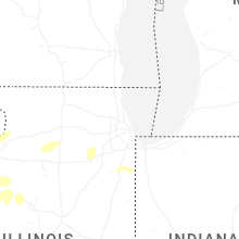
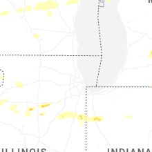

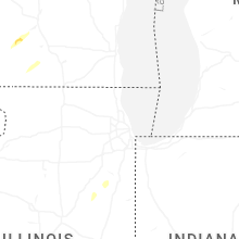
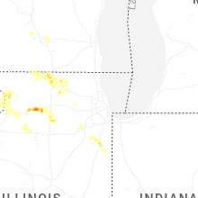

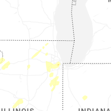


Connect with Interactive Hail Maps