

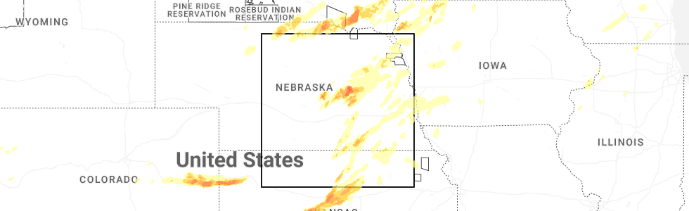
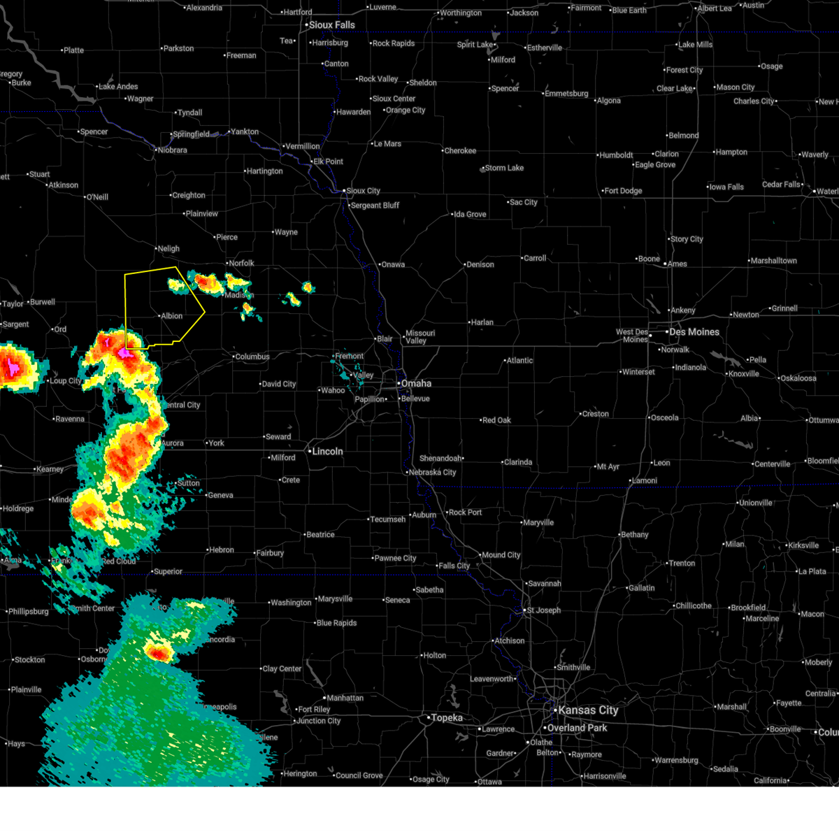
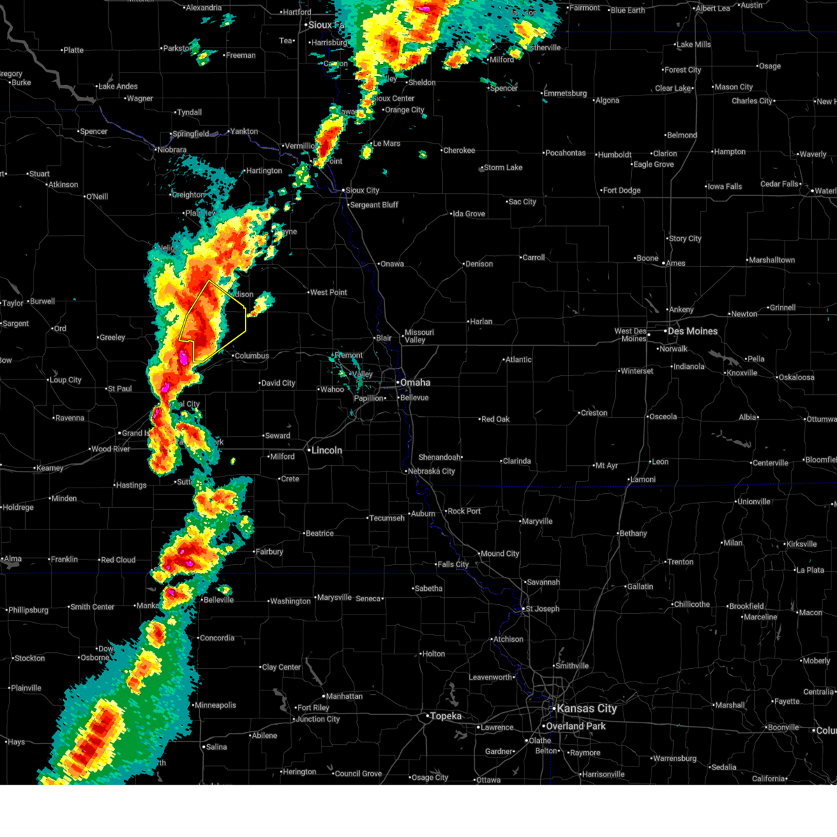
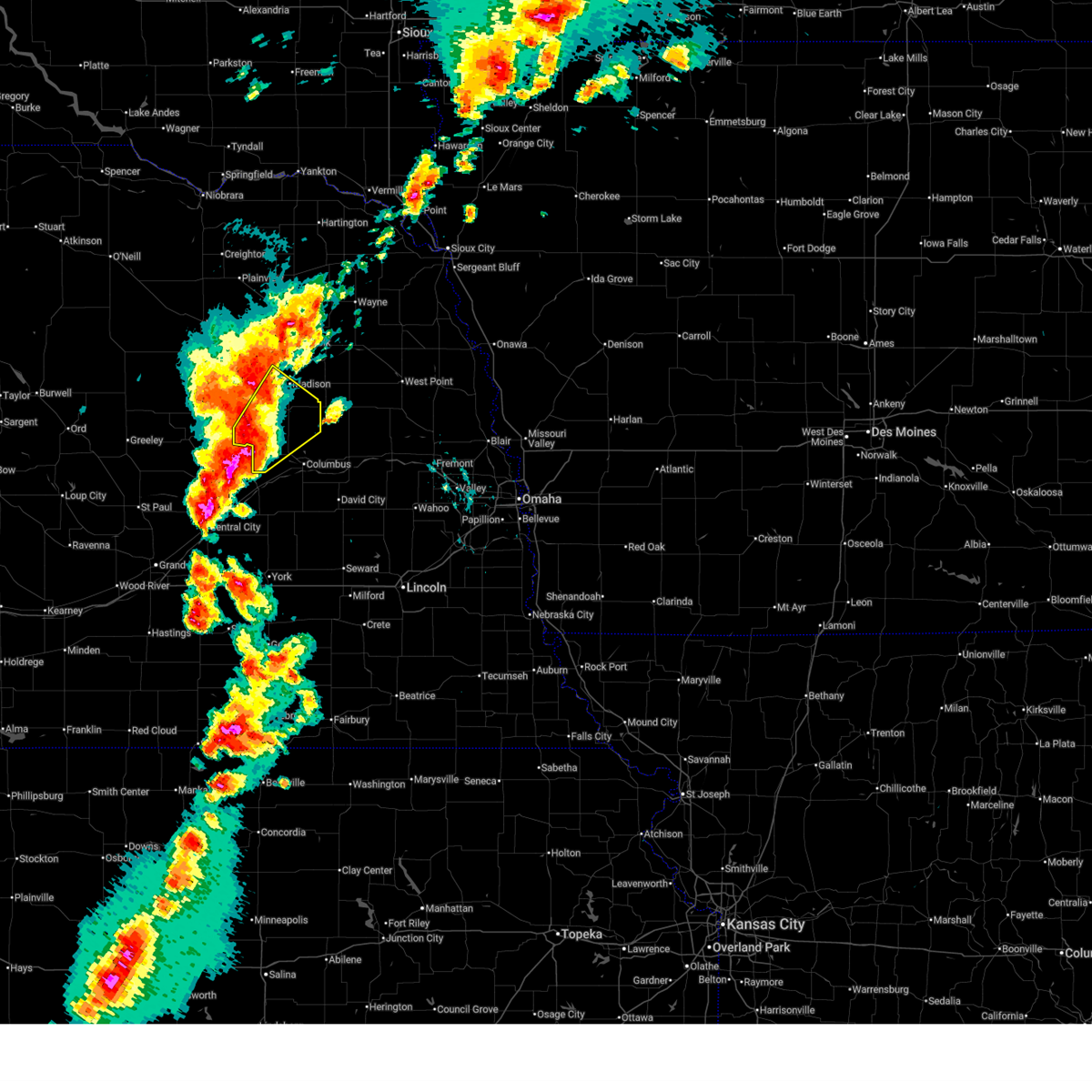
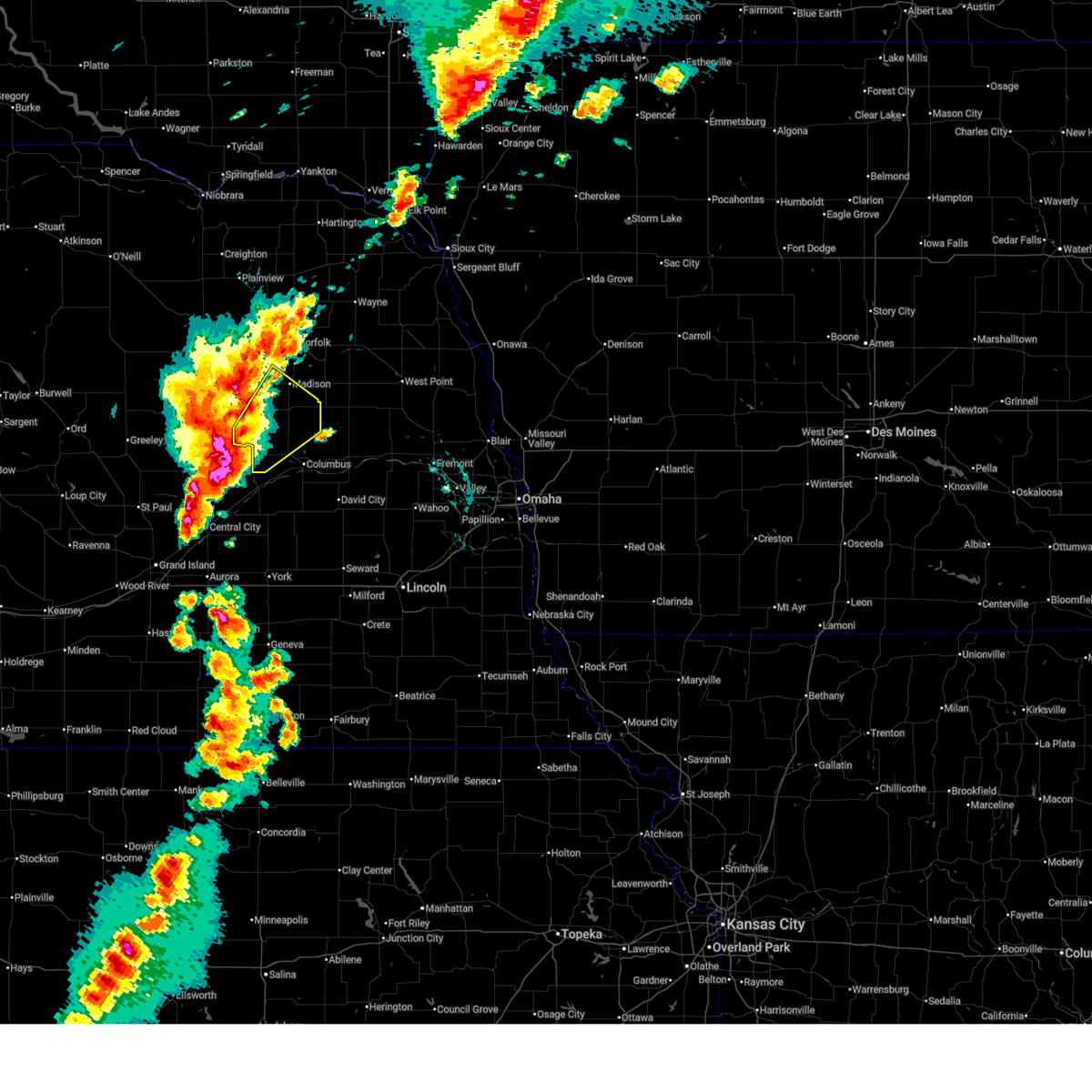
Hail Map for Lindsay, NE
The Lindsay, NE area has had 7 reports of on-the-ground hail by trained spotters, and has been under severe weather warnings 17 times during the past 12 months. Doppler radar has detected hail at or near Lindsay, NE on 87 occasions, including 5 occasions during the past year.
| Name: | Lindsay, NE |
| Where Located: | 63.3 miles NNE of Grand Island, NE |
| Map: | Google Map for Lindsay, NE |
| Population: | 255 |
| Housing Units: | 127 |
| More Info: | Search Google for Lindsay, NE |
1
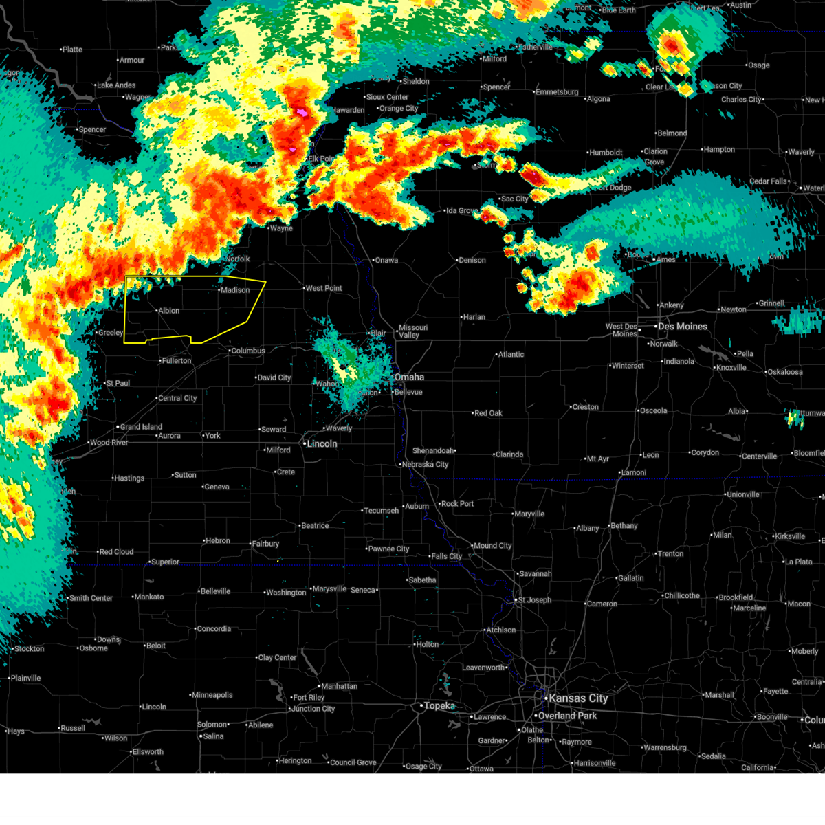
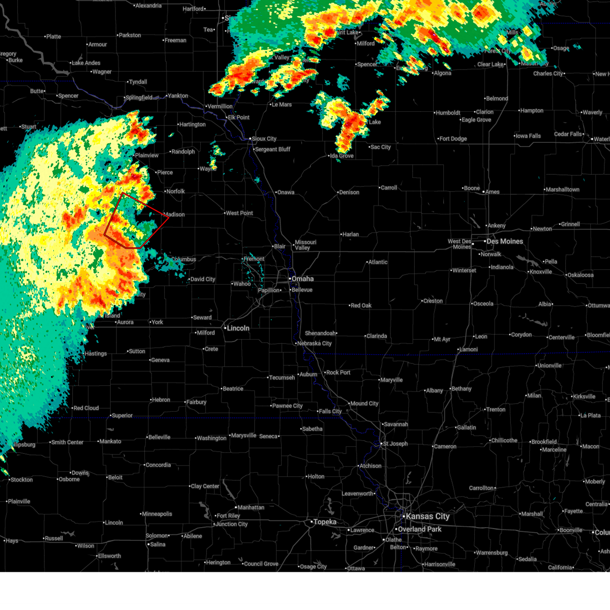
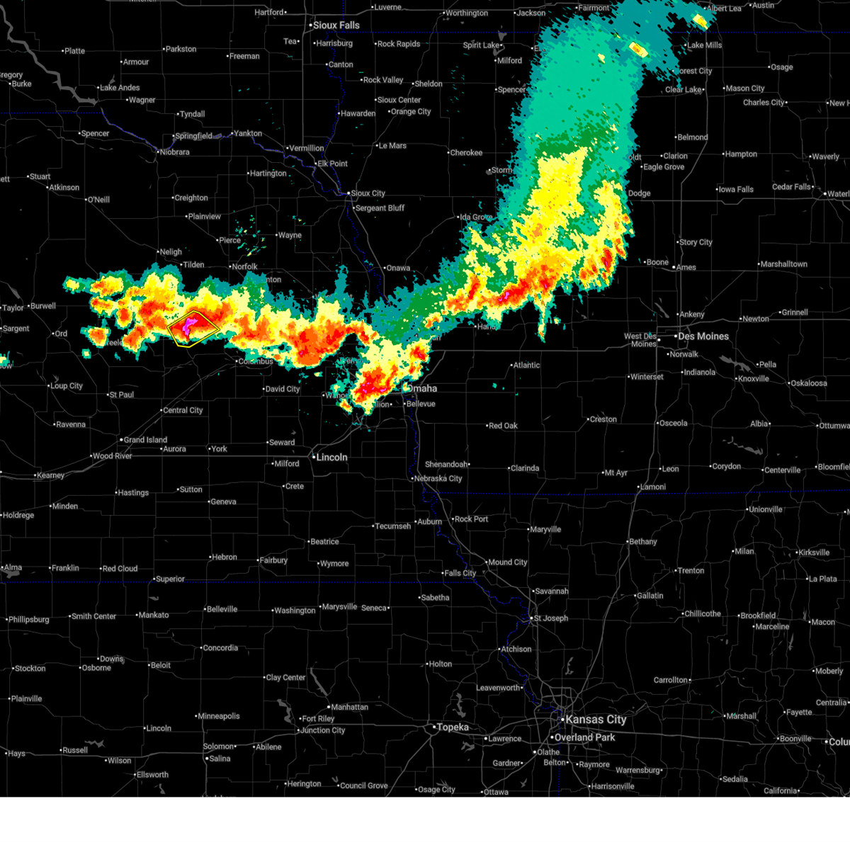
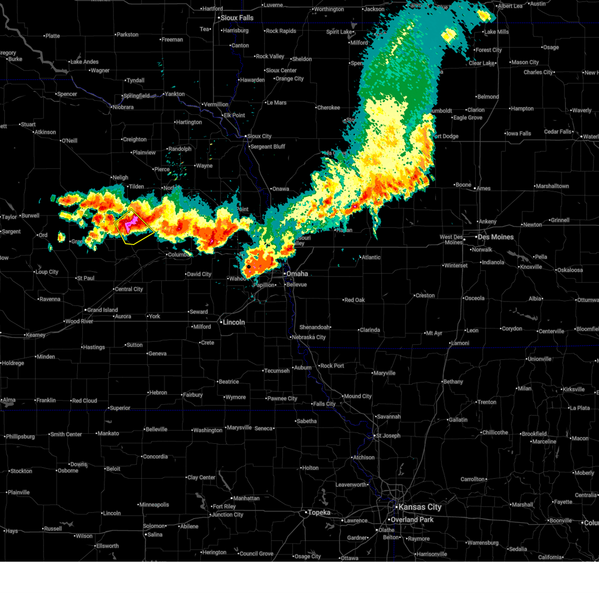
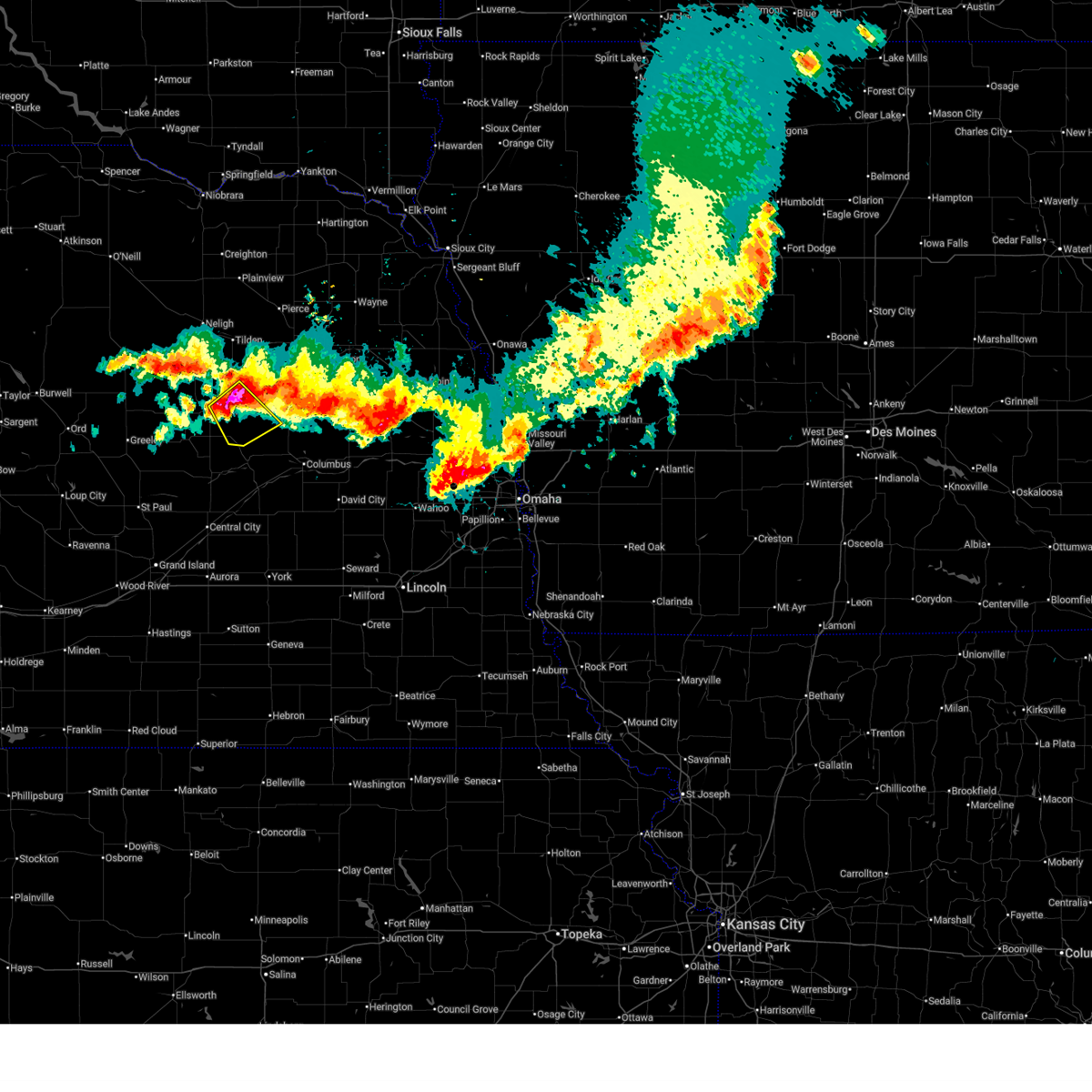
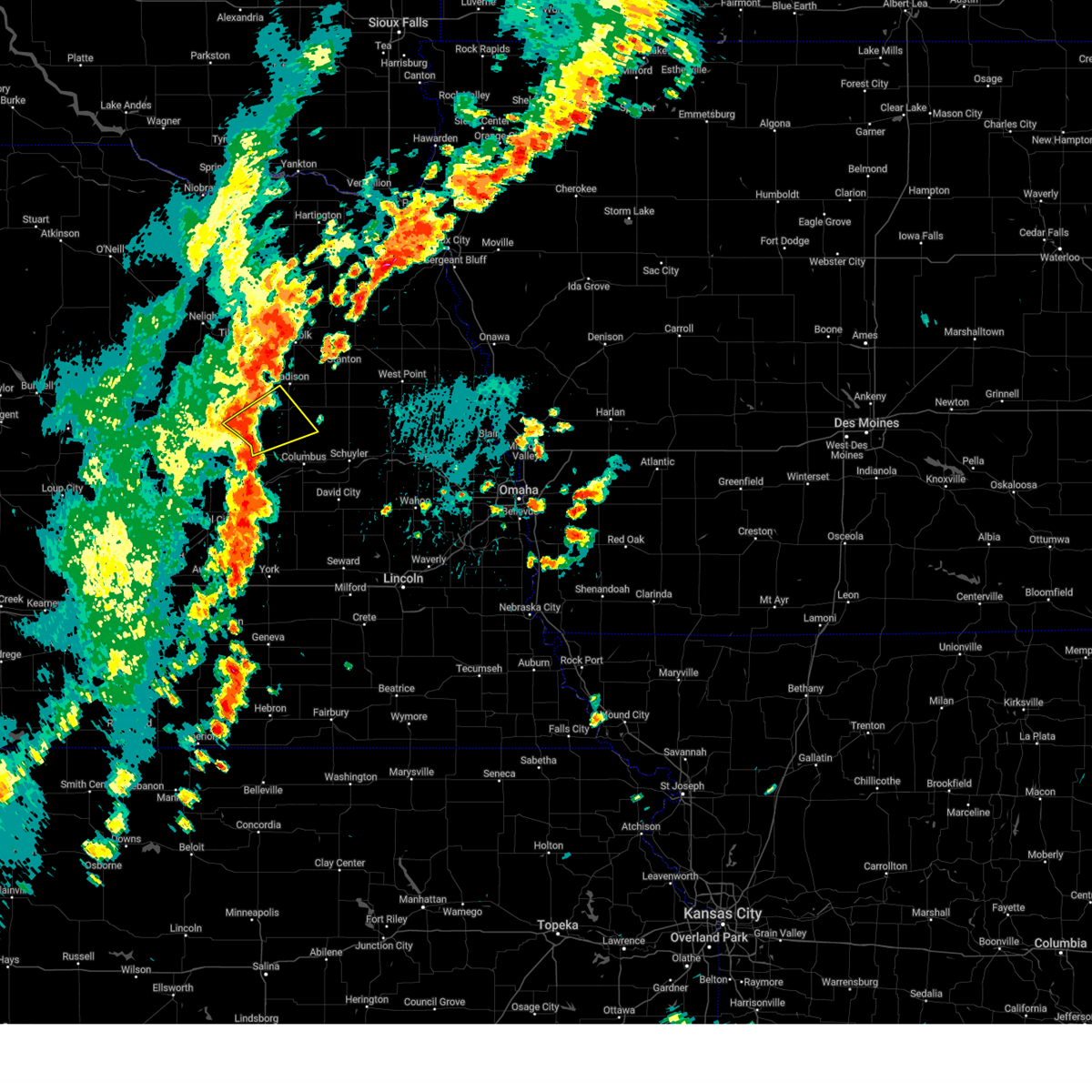
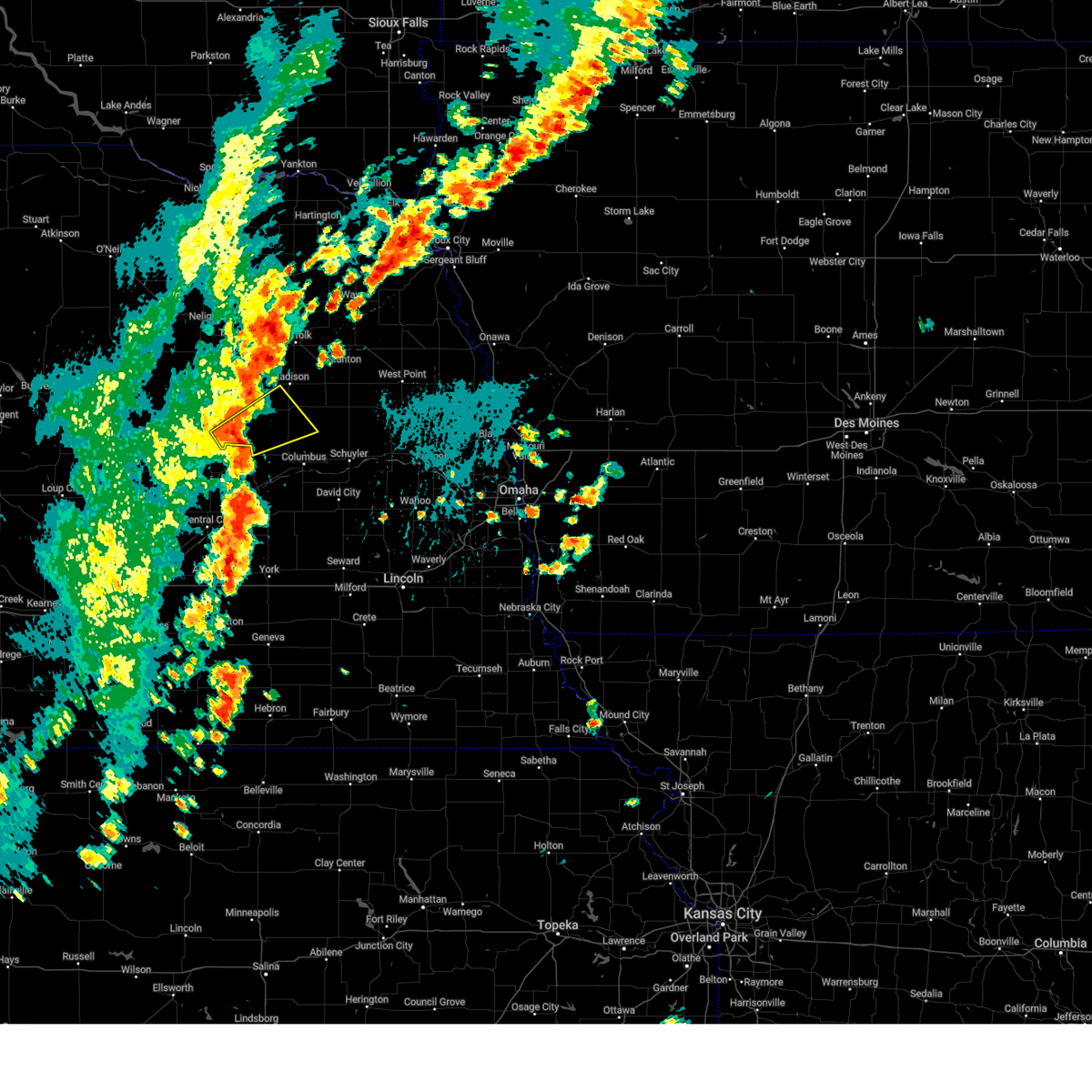
The Top Recent Hail Date for Lindsay, NE is Sunday, May 17, 2026 (31st out of 87)
Hail and Wind Damage Spotted near Lindsay, NE
| Date / Time | Report Details |
|---|---|
| 6/9/2026 9:09 PM CDT |
 The storms which prompted the warning have weakened below severe limits, and no longer pose an immediate threat to life or property. therefore, the warning will be allowed to expire. a tornado watch remains in effect until 300 am cdt for northeastern nebraska. to report severe weather, contact your nearest law enforcement agency. they will relay your report to the national weather service omaha. The storms which prompted the warning have weakened below severe limits, and no longer pose an immediate threat to life or property. therefore, the warning will be allowed to expire. a tornado watch remains in effect until 300 am cdt for northeastern nebraska. to report severe weather, contact your nearest law enforcement agency. they will relay your report to the national weather service omaha.
|
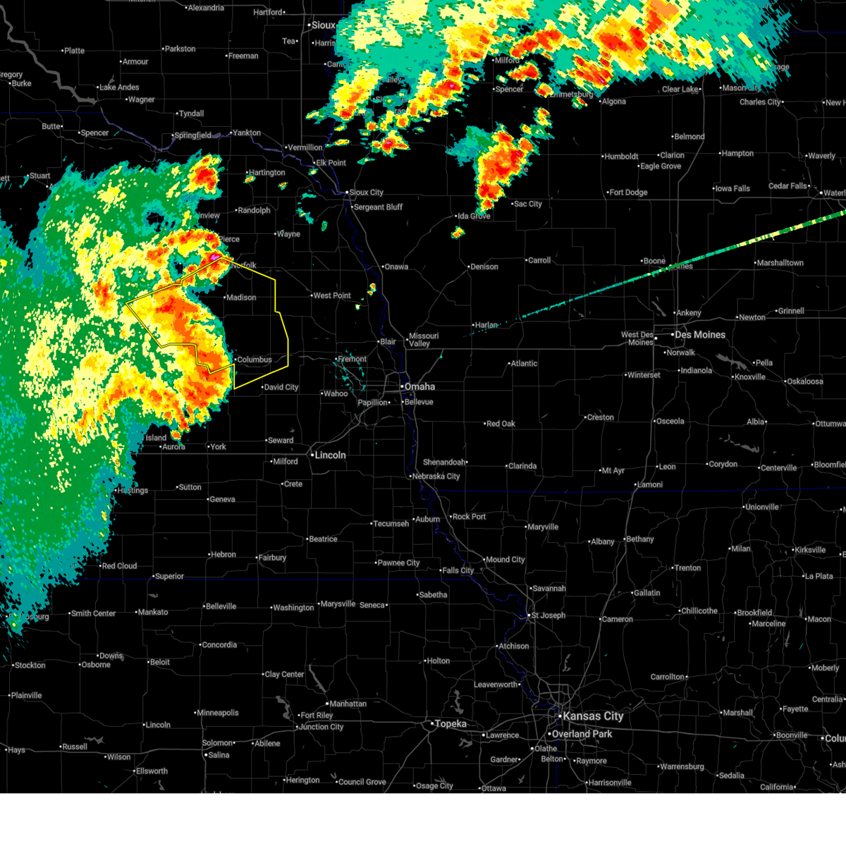
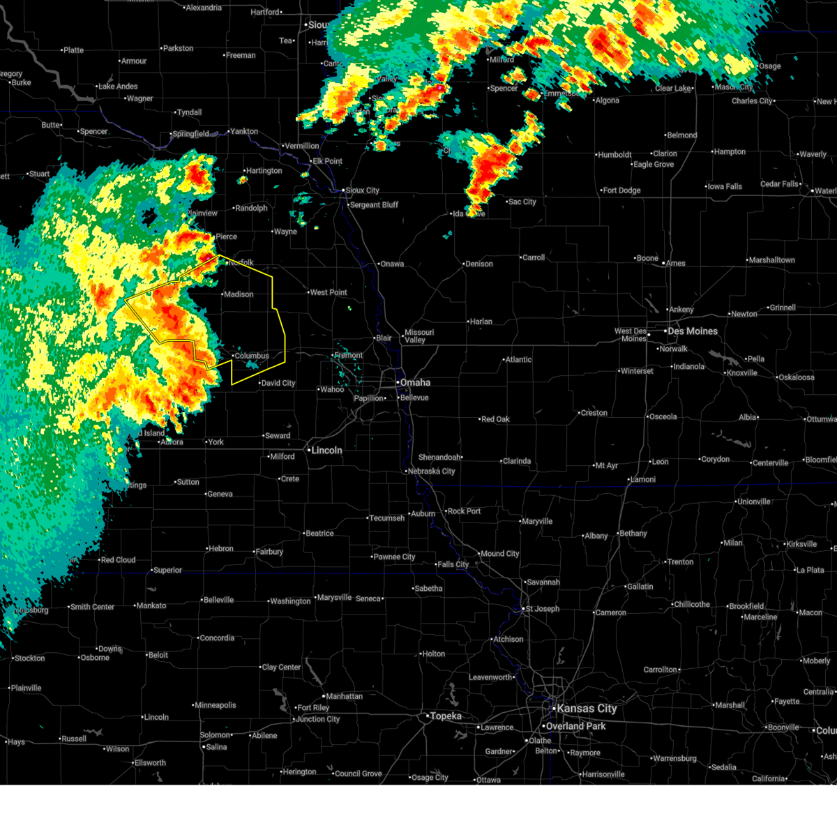
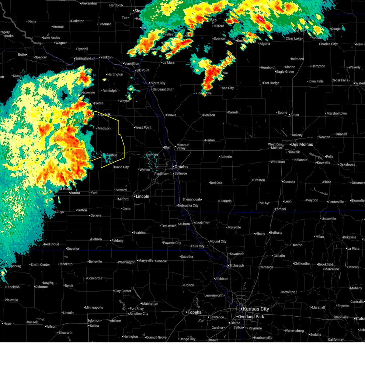
| 6/9/2026 8:51 PM CDT |
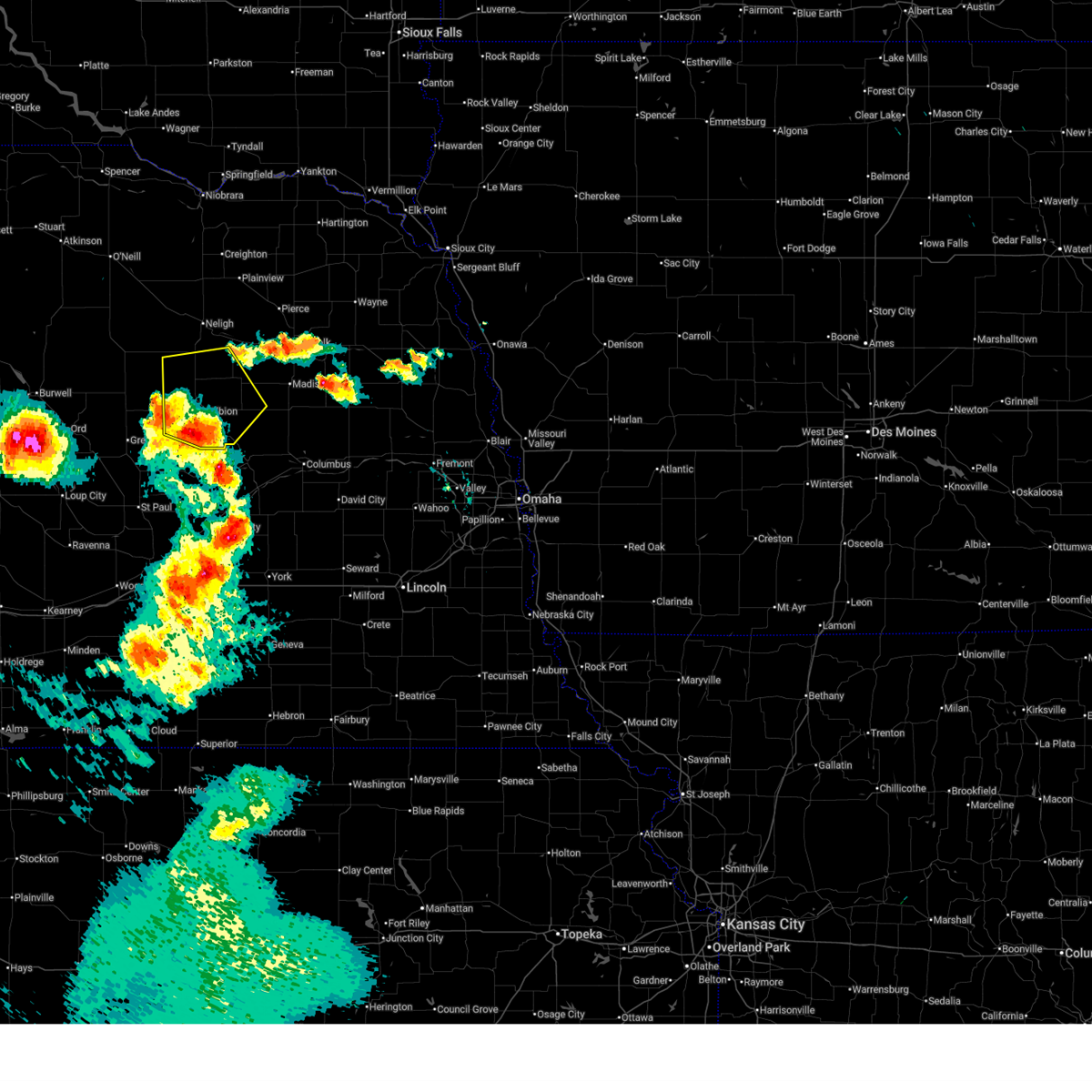 At 850 pm cdt, severe thunderstorms were located along a line extending from 7 miles northeast of spalding to 5 miles northwest of albion to 3 miles west of st. edward, moving northeast at 35 mph (radar indicated). Hazards include 60 mph wind gusts and nickel size hail. Expect damage to roofs, siding, and trees. locations impacted include, albion, st. Edward, petersburg, newman grove, elgin and lindsay. At 850 pm cdt, severe thunderstorms were located along a line extending from 7 miles northeast of spalding to 5 miles northwest of albion to 3 miles west of st. edward, moving northeast at 35 mph (radar indicated). Hazards include 60 mph wind gusts and nickel size hail. Expect damage to roofs, siding, and trees. locations impacted include, albion, st. Edward, petersburg, newman grove, elgin and lindsay.
|
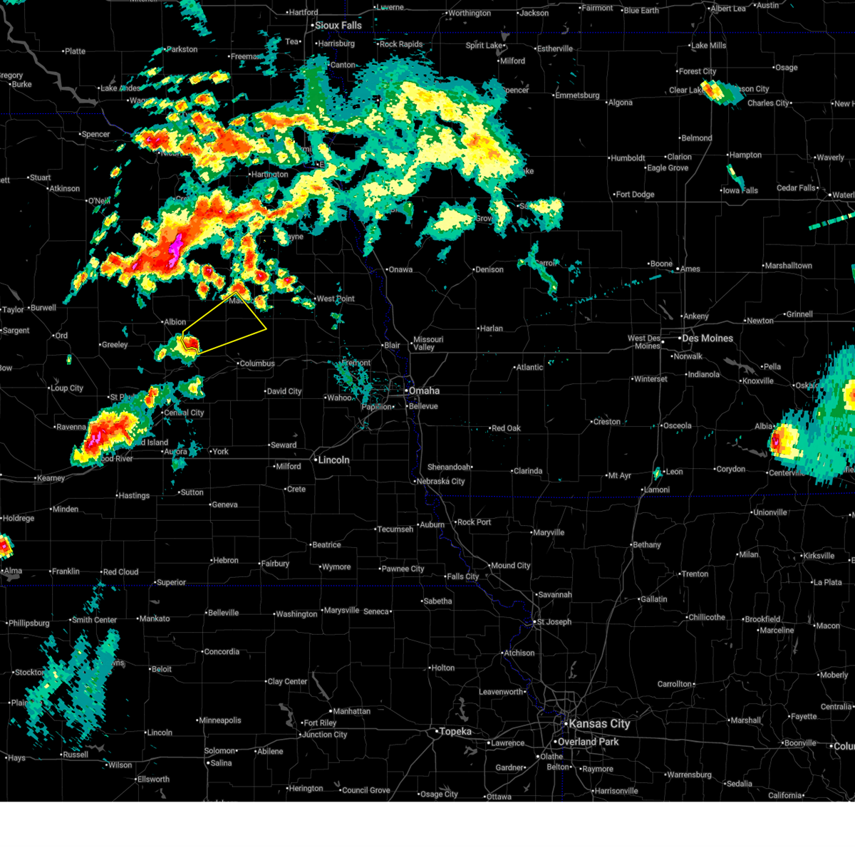
| 6/9/2026 8:34 PM CDT |
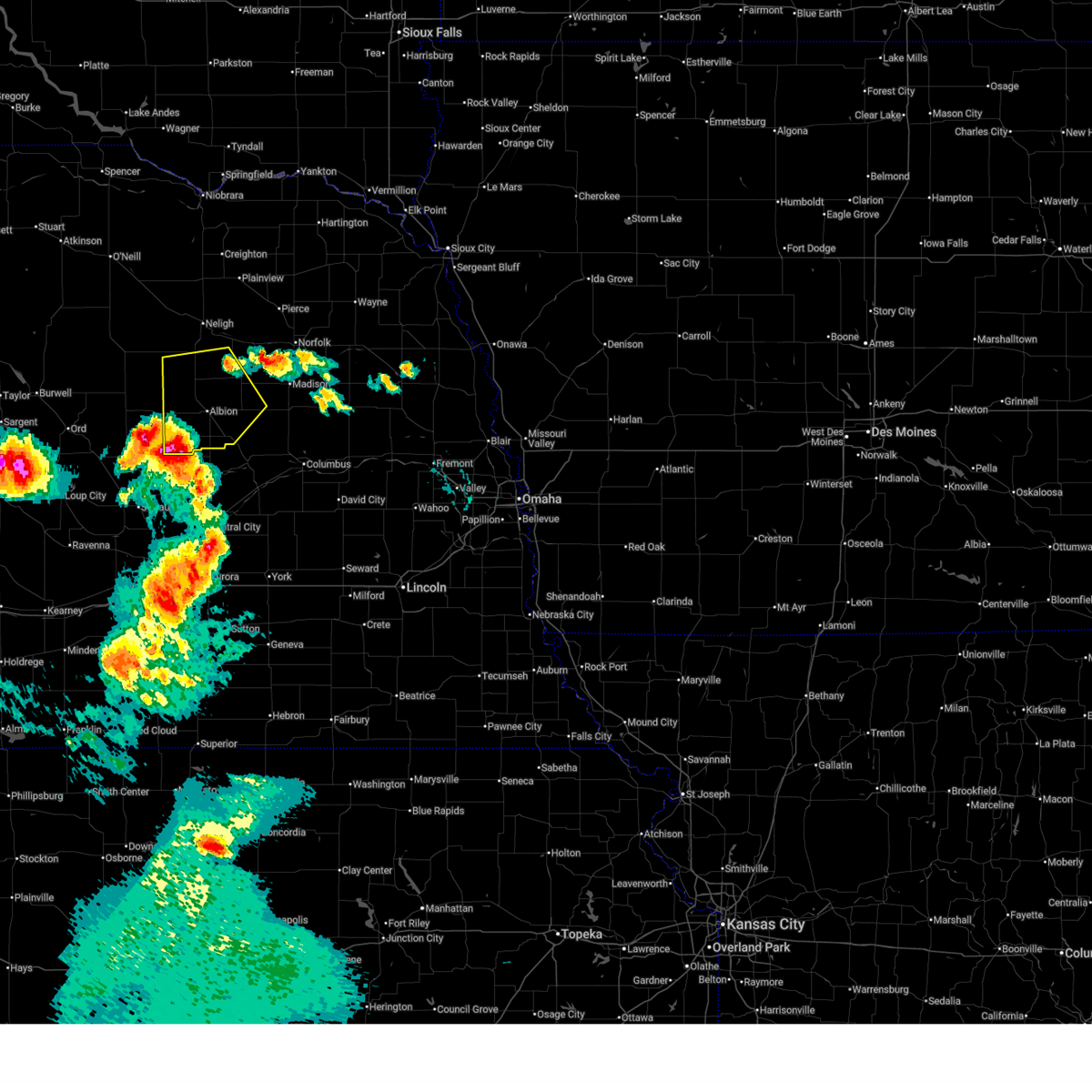 At 833 pm cdt, severe thunderstorms were located along a line extending from 4 miles southwest of spalding to 2 miles east of primrose to 2 miles south of belgrade, moving northeast at 50 mph (at 830 pm, a public mesonet station reported winds gusting to 62 mph 5.7 miles nne of wolbach, ne). Hazards include 70 mph wind gusts and half dollar size hail. Hail damage to vehicles is expected. expect considerable tree damage. wind damage is also likely to mobile homes, roofs, and outbuildings. these severe storms will be near, albion around 840 pm cdt. st. edward around 845 pm cdt. Other locations in the path of these severe thunderstorms include petersburg, newman grove, elgin and lindsay. At 833 pm cdt, severe thunderstorms were located along a line extending from 4 miles southwest of spalding to 2 miles east of primrose to 2 miles south of belgrade, moving northeast at 50 mph (at 830 pm, a public mesonet station reported winds gusting to 62 mph 5.7 miles nne of wolbach, ne). Hazards include 70 mph wind gusts and half dollar size hail. Hail damage to vehicles is expected. expect considerable tree damage. wind damage is also likely to mobile homes, roofs, and outbuildings. these severe storms will be near, albion around 840 pm cdt. st. edward around 845 pm cdt. Other locations in the path of these severe thunderstorms include petersburg, newman grove, elgin and lindsay.
|
| 6/9/2026 8:28 PM CDT |
 Svroax the national weather service in omaha has issued a * severe thunderstorm warning for, southwestern madison county in northeastern nebraska, northwestern platte county in northeastern nebraska, southern antelope county in northeastern nebraska, boone county in northeastern nebraska, * until 915 pm cdt. * at 827 pm cdt, severe thunderstorms were located along a line extending from 4 miles northeast of greeley to 3 miles south of primrose to 6 miles southwest of belgrade, moving northeast at 50 mph (radar indicated). Hazards include 60 mph wind gusts and half dollar size hail. Hail damage to vehicles is expected. expect wind damage to roofs, siding, and trees. severe thunderstorms will be near, cedar rapids and primrose around 835 pm cdt. albion around 840 pm cdt. st. edward around 845 pm cdt. Other locations in the path of these severe thunderstorms include petersburg, newman grove, elgin and lindsay. Svroax the national weather service in omaha has issued a * severe thunderstorm warning for, southwestern madison county in northeastern nebraska, northwestern platte county in northeastern nebraska, southern antelope county in northeastern nebraska, boone county in northeastern nebraska, * until 915 pm cdt. * at 827 pm cdt, severe thunderstorms were located along a line extending from 4 miles northeast of greeley to 3 miles south of primrose to 6 miles southwest of belgrade, moving northeast at 50 mph (radar indicated). Hazards include 60 mph wind gusts and half dollar size hail. Hail damage to vehicles is expected. expect wind damage to roofs, siding, and trees. severe thunderstorms will be near, cedar rapids and primrose around 835 pm cdt. albion around 840 pm cdt. st. edward around 845 pm cdt. Other locations in the path of these severe thunderstorms include petersburg, newman grove, elgin and lindsay.
|
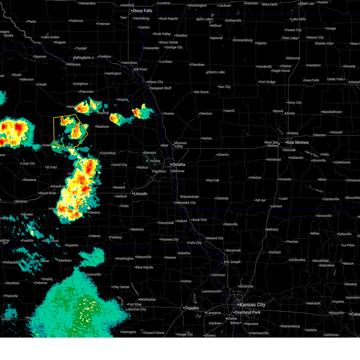
| 5/17/2026 6:21 PM CDT |
 At 620 pm cdt, severe thunderstorms were located along a line extending from 5 miles northeast of lindsay to 2 miles northeast of platte center to 5 miles west of lakeview, moving northeast at 50 mph (weather instruments measured 60 mph wind at several locations, including 4 miles south of monroe. power lines were down in fullerton and genoa). Hazards include golf ball size hail and 70 mph wind gusts. People and animals outdoors will be injured. expect hail damage to roofs, siding, windows, and vehicles. expect considerable tree damage. wind damage is also likely to mobile homes, roofs, and outbuildings. these severe storms will be near, humphrey and creston around 625 pm cdt. Madison around 630 pm cdt. At 620 pm cdt, severe thunderstorms were located along a line extending from 5 miles northeast of lindsay to 2 miles northeast of platte center to 5 miles west of lakeview, moving northeast at 50 mph (weather instruments measured 60 mph wind at several locations, including 4 miles south of monroe. power lines were down in fullerton and genoa). Hazards include golf ball size hail and 70 mph wind gusts. People and animals outdoors will be injured. expect hail damage to roofs, siding, windows, and vehicles. expect considerable tree damage. wind damage is also likely to mobile homes, roofs, and outbuildings. these severe storms will be near, humphrey and creston around 625 pm cdt. Madison around 630 pm cdt.
|
| 5/17/2026 6:10 PM CDT |
 At 609 pm cdt, severe thunderstorms were located along a line extending from 6 miles south of lindsay to 5 miles north of monroe to 2 miles east of genoa, moving northeast at 50 mph (weather instruments measured 60 mph winds across northern nance county. this storm has a history of producing hail larger than baseballs). Hazards include two inch hail and 70 mph wind gusts. People and animals outdoors will be injured. expect hail damage to roofs, siding, windows, and vehicles. expect considerable tree damage. wind damage is also likely to mobile homes, roofs, and outbuildings. these severe storms will be near, platte center and monroe around 615 pm cdt. humphrey around 620 pm cdt. Other locations in the path of these severe thunderstorms include creston. At 609 pm cdt, severe thunderstorms were located along a line extending from 6 miles south of lindsay to 5 miles north of monroe to 2 miles east of genoa, moving northeast at 50 mph (weather instruments measured 60 mph winds across northern nance county. this storm has a history of producing hail larger than baseballs). Hazards include two inch hail and 70 mph wind gusts. People and animals outdoors will be injured. expect hail damage to roofs, siding, windows, and vehicles. expect considerable tree damage. wind damage is also likely to mobile homes, roofs, and outbuildings. these severe storms will be near, platte center and monroe around 615 pm cdt. humphrey around 620 pm cdt. Other locations in the path of these severe thunderstorms include creston.
|
| 5/17/2026 6:01 PM CDT |
 Svroax the national weather service in omaha has issued a * severe thunderstorm warning for, southeastern madison county in northeastern nebraska, platte county in northeastern nebraska, southwestern stanton county in northeastern nebraska, * until 645 pm cdt. * at 559 pm cdt, severe thunderstorms were located along a line extending from 2 miles south of st. edward to 4 miles northwest of genoa to 7 miles east of fullerton, moving northeast at 55 mph. these are destructive storms for areas around monroe, platte center, and tarnov (radar indicated. this storm has a history of producing hail larger than 3 inches). Hazards include baseball size hail and 70 mph wind gusts. People and animals outdoors will be severely injured. expect shattered windows, extensive damage to roofs, siding, and vehicles. severe thunderstorms will be near, monroe and lindsay around 610 pm cdt. platte center around 615 pm cdt. Other locations in the path of these severe thunderstorms include humphrey, madison and creston. Svroax the national weather service in omaha has issued a * severe thunderstorm warning for, southeastern madison county in northeastern nebraska, platte county in northeastern nebraska, southwestern stanton county in northeastern nebraska, * until 645 pm cdt. * at 559 pm cdt, severe thunderstorms were located along a line extending from 2 miles south of st. edward to 4 miles northwest of genoa to 7 miles east of fullerton, moving northeast at 55 mph. these are destructive storms for areas around monroe, platte center, and tarnov (radar indicated. this storm has a history of producing hail larger than 3 inches). Hazards include baseball size hail and 70 mph wind gusts. People and animals outdoors will be severely injured. expect shattered windows, extensive damage to roofs, siding, and vehicles. severe thunderstorms will be near, monroe and lindsay around 610 pm cdt. platte center around 615 pm cdt. Other locations in the path of these severe thunderstorms include humphrey, madison and creston.
|
| 7/29/2025 9:15 PM CDT |
 Svroax the national weather service in omaha has issued a * severe thunderstorm warning for, southern madison county in northeastern nebraska, northwestern colfax county in northeastern nebraska, platte county in northeastern nebraska, south central antelope county in northeastern nebraska, boone county in northeastern nebraska, southern stanton county in northeastern nebraska, * until 945 pm cdt. * at 915 pm cdt, severe thunderstorms were located along a line extending from 5 miles north of madison to 6 miles southeast of petersburg, moving southeast at 40 mph (radar indicated). Hazards include 60 mph wind gusts. Expect damage to roofs, siding, and trees. severe thunderstorms will be near, albion, madison, and newman grove around 920 pm cdt. lindsay around 925 pm cdt. humphrey and creston around 930 pm cdt. st. Edward around 935 pm cdt. Svroax the national weather service in omaha has issued a * severe thunderstorm warning for, southern madison county in northeastern nebraska, northwestern colfax county in northeastern nebraska, platte county in northeastern nebraska, south central antelope county in northeastern nebraska, boone county in northeastern nebraska, southern stanton county in northeastern nebraska, * until 945 pm cdt. * at 915 pm cdt, severe thunderstorms were located along a line extending from 5 miles north of madison to 6 miles southeast of petersburg, moving southeast at 40 mph (radar indicated). Hazards include 60 mph wind gusts. Expect damage to roofs, siding, and trees. severe thunderstorms will be near, albion, madison, and newman grove around 920 pm cdt. lindsay around 925 pm cdt. humphrey and creston around 930 pm cdt. st. Edward around 935 pm cdt.
|
| 7/23/2025 8:55 PM CDT |
 At 855 pm cdt, severe thunderstorms were located along a line extending from 8 miles northeast of lindsay to creston to 3 miles northwest of bellwood, moving east at 50 mph (law enforcement). Hazards include 70 mph wind gusts and penny size hail. Expect considerable tree damage. damage is likely to mobile homes, roofs, and outbuildings. these severe storms will be near, schuyler, madison, leigh, creston, and richland around 900 pm cdt. clarkson and octavia around 905 pm cdt. Other locations in the path of these severe thunderstorms include howells and linwood. At 855 pm cdt, severe thunderstorms were located along a line extending from 8 miles northeast of lindsay to creston to 3 miles northwest of bellwood, moving east at 50 mph (law enforcement). Hazards include 70 mph wind gusts and penny size hail. Expect considerable tree damage. damage is likely to mobile homes, roofs, and outbuildings. these severe storms will be near, schuyler, madison, leigh, creston, and richland around 900 pm cdt. clarkson and octavia around 905 pm cdt. Other locations in the path of these severe thunderstorms include howells and linwood.
|
| 7/23/2025 8:49 PM CDT |
 At 849 pm cdt, severe thunderstorms were located along a line extending from 5 miles northeast of newman grove to 2 miles northeast of humphrey to 2 miles south of columbus, moving east at 50 mph (radar indicated). Hazards include 60 mph wind gusts and penny size hail. Expect damage to roofs, siding, and trees. these severe storms will be near, columbus, madison, bellwood, leigh, creston, and richland around 855 pm cdt. Other locations in the path of these severe thunderstorms include schuyler, clarkson, octavia, howells and linwood. At 849 pm cdt, severe thunderstorms were located along a line extending from 5 miles northeast of newman grove to 2 miles northeast of humphrey to 2 miles south of columbus, moving east at 50 mph (radar indicated). Hazards include 60 mph wind gusts and penny size hail. Expect damage to roofs, siding, and trees. these severe storms will be near, columbus, madison, bellwood, leigh, creston, and richland around 855 pm cdt. Other locations in the path of these severe thunderstorms include schuyler, clarkson, octavia, howells and linwood.
|
| 7/23/2025 8:41 PM CDT |
 At 841 pm cdt, severe thunderstorms capable of producing tornadoes were located along a line extending from 5 miles northeast of albion to 4 miles south of lindsay, moving northeast at 45 mph (radar indicated rotation). Hazards include tornado. Flying debris will be dangerous to those caught without shelter. mobile homes will be damaged or destroyed. damage to roofs, windows, and vehicles will occur. tree damage is likely. these dangerous storms will be near, newman grove and lindsay around 845 pm cdt. Other locations in the path of these tornadic storms include madison. At 841 pm cdt, severe thunderstorms capable of producing tornadoes were located along a line extending from 5 miles northeast of albion to 4 miles south of lindsay, moving northeast at 45 mph (radar indicated rotation). Hazards include tornado. Flying debris will be dangerous to those caught without shelter. mobile homes will be damaged or destroyed. damage to roofs, windows, and vehicles will occur. tree damage is likely. these dangerous storms will be near, newman grove and lindsay around 845 pm cdt. Other locations in the path of these tornadic storms include madison.
|
| 7/23/2025 8:37 PM CDT |
 At 837 pm cdt, severe thunderstorms were located along a line extending from 4 miles west of newman grove to 5 miles southeast of lindsay to 5 miles south of duncan, moving east at 50 mph (radar indicated). Hazards include 60 mph wind gusts and penny size hail. Expect damage to roofs, siding, and trees. these severe storms will be near, columbus, humphrey, newman grove, platte center, lindsay, and lakeview around 845 pm cdt. Other locations in the path of these severe thunderstorms include bellwood, creston, richland, schuyler, leigh, octavia, clarkson, linwood and howells. At 837 pm cdt, severe thunderstorms were located along a line extending from 4 miles west of newman grove to 5 miles southeast of lindsay to 5 miles south of duncan, moving east at 50 mph (radar indicated). Hazards include 60 mph wind gusts and penny size hail. Expect damage to roofs, siding, and trees. these severe storms will be near, columbus, humphrey, newman grove, platte center, lindsay, and lakeview around 845 pm cdt. Other locations in the path of these severe thunderstorms include bellwood, creston, richland, schuyler, leigh, octavia, clarkson, linwood and howells.
|
| 7/23/2025 8:29 PM CDT |
 Toroax the national weather service in omaha has issued a * tornado warning for, southern madison county in northeastern nebraska, northwestern platte county in northeastern nebraska, southeastern antelope county in northeastern nebraska, eastern boone county in northeastern nebraska, * until 900 pm cdt. * at 829 pm cdt, severe thunderstorms capable of producing a tornado were located along a line extending from near albion to near st. edward, moving northeast at 45 mph (radar indicated rotation). Hazards include tornado. Flying debris will be dangerous to those caught without shelter. mobile homes will be damaged or destroyed. damage to roofs, windows, and vehicles will occur. tree damage is likely. These dangerous storms will be near, newman grove and lindsay around 840 pm cdt. Toroax the national weather service in omaha has issued a * tornado warning for, southern madison county in northeastern nebraska, northwestern platte county in northeastern nebraska, southeastern antelope county in northeastern nebraska, eastern boone county in northeastern nebraska, * until 900 pm cdt. * at 829 pm cdt, severe thunderstorms capable of producing a tornado were located along a line extending from near albion to near st. edward, moving northeast at 45 mph (radar indicated rotation). Hazards include tornado. Flying debris will be dangerous to those caught without shelter. mobile homes will be damaged or destroyed. damage to roofs, windows, and vehicles will occur. tree damage is likely. These dangerous storms will be near, newman grove and lindsay around 840 pm cdt.
|
| 7/23/2025 8:25 PM CDT |
 Svroax the national weather service in omaha has issued a * severe thunderstorm warning for, madison county in northeastern nebraska, colfax county in northeastern nebraska, platte county in northeastern nebraska, northern butler county in east central nebraska, boone county in northeastern nebraska, stanton county in northeastern nebraska, * until 915 pm cdt. * at 825 pm cdt, severe thunderstorms were located along a line extending from 2 miles southwest of albion to 3 miles east of st. edward to 5 miles south of silver creek, moving northeast at 50 mph (radar indicated). Hazards include 60 mph wind gusts and penny size hail. Expect damage to roofs, siding, and trees. severe thunderstorms will be near, albion and monroe around 830 pm cdt. newman grove, duncan, and lindsay around 835 pm cdt. columbus, humphrey, and platte center around 840 pm cdt. lakeview around 845 pm cdt. Other locations in the path of these severe thunderstorms include madison, creston, leigh, richland, norfolk, stanton and clarkson. Svroax the national weather service in omaha has issued a * severe thunderstorm warning for, madison county in northeastern nebraska, colfax county in northeastern nebraska, platte county in northeastern nebraska, northern butler county in east central nebraska, boone county in northeastern nebraska, stanton county in northeastern nebraska, * until 915 pm cdt. * at 825 pm cdt, severe thunderstorms were located along a line extending from 2 miles southwest of albion to 3 miles east of st. edward to 5 miles south of silver creek, moving northeast at 50 mph (radar indicated). Hazards include 60 mph wind gusts and penny size hail. Expect damage to roofs, siding, and trees. severe thunderstorms will be near, albion and monroe around 830 pm cdt. newman grove, duncan, and lindsay around 835 pm cdt. columbus, humphrey, and platte center around 840 pm cdt. lakeview around 845 pm cdt. Other locations in the path of these severe thunderstorms include madison, creston, leigh, richland, norfolk, stanton and clarkson.
|
| 7/10/2025 5:59 PM CDT |
 Svroax the national weather service in omaha has issued a * severe thunderstorm warning for, southeastern madison county in northeastern nebraska, northwestern colfax county in northeastern nebraska, northern platte county in northeastern nebraska, southwestern stanton county in northeastern nebraska, * until 630 pm cdt. * at 559 pm cdt, a severe thunderstorm was located 8 miles northwest of monroe, or 18 miles southeast of albion, moving northeast at 50 mph (radar indicated). Hazards include 60 mph wind gusts and quarter size hail. Hail damage to vehicles is expected. expect wind damage to roofs, siding, and trees. this severe thunderstorm will be near, humphrey around 610 pm cdt. creston around 615 pm cdt. other locations in the path of this severe thunderstorm include leigh. People attending madison county fairgrounds should seek safe shelter immediately!. Svroax the national weather service in omaha has issued a * severe thunderstorm warning for, southeastern madison county in northeastern nebraska, northwestern colfax county in northeastern nebraska, northern platte county in northeastern nebraska, southwestern stanton county in northeastern nebraska, * until 630 pm cdt. * at 559 pm cdt, a severe thunderstorm was located 8 miles northwest of monroe, or 18 miles southeast of albion, moving northeast at 50 mph (radar indicated). Hazards include 60 mph wind gusts and quarter size hail. Hail damage to vehicles is expected. expect wind damage to roofs, siding, and trees. this severe thunderstorm will be near, humphrey around 610 pm cdt. creston around 615 pm cdt. other locations in the path of this severe thunderstorm include leigh. People attending madison county fairgrounds should seek safe shelter immediately!.
|
| 7/7/2025 9:30 PM CDT |
 At 930 pm cdt, severe thunderstorms were located along a line extending from 4 miles northeast of creston to 4 miles southeast of humphrey to 6 miles northeast of primrose, moving southeast at 30 mph (radar indicated). Hazards include 60 mph wind gusts and quarter size hail. Hail damage to vehicles is expected. expect wind damage to roofs, siding, and trees. locations impacted include, st. edward, leigh, platte center, creston, lakeview, columbus, monroe and duncan. People attending madison county fairgrounds should seek safe shelter immediately!. At 930 pm cdt, severe thunderstorms were located along a line extending from 4 miles northeast of creston to 4 miles southeast of humphrey to 6 miles northeast of primrose, moving southeast at 30 mph (radar indicated). Hazards include 60 mph wind gusts and quarter size hail. Hail damage to vehicles is expected. expect wind damage to roofs, siding, and trees. locations impacted include, st. edward, leigh, platte center, creston, lakeview, columbus, monroe and duncan. People attending madison county fairgrounds should seek safe shelter immediately!.
|
| 7/7/2025 9:07 PM CDT |
 Svroax the national weather service in omaha has issued a * severe thunderstorm warning for, madison county in northeastern nebraska, northern colfax county in northeastern nebraska, platte county in northeastern nebraska, central boone county in northeastern nebraska, southern stanton county in northeastern nebraska, * until 1000 pm cdt. * at 907 pm cdt, severe thunderstorms were located along a line extending from 6 miles northwest of madison to 3 miles north of lindsay to 2 miles northeast of cedar rapids, moving southeast at 40 mph (radar indicated). Hazards include 60 mph wind gusts and quarter size hail. Hail damage to vehicles is expected. expect wind damage to roofs, siding, and trees. severe thunderstorms will be near, madison, humphrey, st. edward, and lindsay around 915 pm cdt. creston around 925 pm cdt. other locations in the path of these severe thunderstorms include leigh, platte center, monroe, clarkson, lakeview, columbus and duncan. People attending madison county fairgrounds should seek safe shelter immediately!. Svroax the national weather service in omaha has issued a * severe thunderstorm warning for, madison county in northeastern nebraska, northern colfax county in northeastern nebraska, platte county in northeastern nebraska, central boone county in northeastern nebraska, southern stanton county in northeastern nebraska, * until 1000 pm cdt. * at 907 pm cdt, severe thunderstorms were located along a line extending from 6 miles northwest of madison to 3 miles north of lindsay to 2 miles northeast of cedar rapids, moving southeast at 40 mph (radar indicated). Hazards include 60 mph wind gusts and quarter size hail. Hail damage to vehicles is expected. expect wind damage to roofs, siding, and trees. severe thunderstorms will be near, madison, humphrey, st. edward, and lindsay around 915 pm cdt. creston around 925 pm cdt. other locations in the path of these severe thunderstorms include leigh, platte center, monroe, clarkson, lakeview, columbus and duncan. People attending madison county fairgrounds should seek safe shelter immediately!.
|
| 6/16/2025 7:48 PM CDT |
 At 748 pm cdt, a severe thunderstorm was located 6 miles northeast of st. edward, or 11 miles east of albion, moving southeast at 15 mph (radar indicated). Hazards include ping pong ball size hail and 60 mph wind gusts. People and animals outdoors will be injured. expect hail damage to roofs, siding, windows, and vehicles. expect wind damage to roofs, siding, and trees. locations impacted include, st. Edward and lindsay. At 748 pm cdt, a severe thunderstorm was located 6 miles northeast of st. edward, or 11 miles east of albion, moving southeast at 15 mph (radar indicated). Hazards include ping pong ball size hail and 60 mph wind gusts. People and animals outdoors will be injured. expect hail damage to roofs, siding, windows, and vehicles. expect wind damage to roofs, siding, and trees. locations impacted include, st. Edward and lindsay.
|
| 6/16/2025 7:48 PM CDT |
 the severe thunderstorm warning has been cancelled and is no longer in effect the severe thunderstorm warning has been cancelled and is no longer in effect
|
| 6/16/2025 7:38 PM CDT |
 At 737 pm cdt, a severe thunderstorm was located 5 miles south of newman grove, or 9 miles east of albion, moving east at 15 mph (radar indicated). Hazards include 60 mph wind gusts and half dollar size hail. Hail damage to vehicles is expected. expect wind damage to roofs, siding, and trees. Locations impacted include, lindsay. At 737 pm cdt, a severe thunderstorm was located 5 miles south of newman grove, or 9 miles east of albion, moving east at 15 mph (radar indicated). Hazards include 60 mph wind gusts and half dollar size hail. Hail damage to vehicles is expected. expect wind damage to roofs, siding, and trees. Locations impacted include, lindsay.
|
| 6/16/2025 7:25 PM CDT |
 Svroax the national weather service in omaha has issued a * severe thunderstorm warning for, southwestern madison county in northeastern nebraska, northwestern platte county in northeastern nebraska, east central boone county in northeastern nebraska, * until 815 pm cdt. * at 725 pm cdt, a severe thunderstorm was located 4 miles west of newman grove, or 8 miles northeast of albion, moving southeast at 15 mph (radar indicated). Hazards include 60 mph wind gusts and quarter size hail. Hail damage to vehicles is expected. expect wind damage to roofs, siding, and trees. This severe thunderstorm will be near, newman grove around 730 pm cdt. Svroax the national weather service in omaha has issued a * severe thunderstorm warning for, southwestern madison county in northeastern nebraska, northwestern platte county in northeastern nebraska, east central boone county in northeastern nebraska, * until 815 pm cdt. * at 725 pm cdt, a severe thunderstorm was located 4 miles west of newman grove, or 8 miles northeast of albion, moving southeast at 15 mph (radar indicated). Hazards include 60 mph wind gusts and quarter size hail. Hail damage to vehicles is expected. expect wind damage to roofs, siding, and trees. This severe thunderstorm will be near, newman grove around 730 pm cdt.
|
| 8/29/2024 3:14 PM CDT |
 At 313 pm cdt, a severe thunderstorm was located 7 miles northwest of monroe, or 18 miles southeast of albion, moving northeast at 35 mph (radar indicated). Hazards include 60 mph wind gusts and penny size hail. Expect damage to roofs, siding, and trees. Locations impacted include, humphrey, platte center, lindsay, tarnov, and cornlea. At 313 pm cdt, a severe thunderstorm was located 7 miles northwest of monroe, or 18 miles southeast of albion, moving northeast at 35 mph (radar indicated). Hazards include 60 mph wind gusts and penny size hail. Expect damage to roofs, siding, and trees. Locations impacted include, humphrey, platte center, lindsay, tarnov, and cornlea.
|
| 8/29/2024 3:01 PM CDT |
 Svroax the national weather service in omaha has issued a * severe thunderstorm warning for, south central madison county in northeastern nebraska, northern platte county in northeastern nebraska, southeastern boone county in northeastern nebraska, * until 345 pm cdt. * at 300 pm cdt, a severe thunderstorm was located near st. edward, or 13 miles southeast of albion, moving northeast at 35 mph (radar indicated). Hazards include 60 mph wind gusts and quarter size hail. Hail damage to vehicles is expected. Expect wind damage to roofs, siding, and trees. Svroax the national weather service in omaha has issued a * severe thunderstorm warning for, south central madison county in northeastern nebraska, northern platte county in northeastern nebraska, southeastern boone county in northeastern nebraska, * until 345 pm cdt. * at 300 pm cdt, a severe thunderstorm was located near st. edward, or 13 miles southeast of albion, moving northeast at 35 mph (radar indicated). Hazards include 60 mph wind gusts and quarter size hail. Hail damage to vehicles is expected. Expect wind damage to roofs, siding, and trees.
|
| 6/25/2024 10:34 PM CDT |
 At 1034 pm cdt, a severe thunderstorm was located 3 miles west of humphrey, or 20 miles northwest of columbus, moving east at 30 mph (nws employee). Hazards include half dollar size hail. Damage to vehicles is expected. Locations impacted include, humphrey, newman grove, clarkson, leigh, lindsay, creston, tarnov, cornlea, and maple creek recreation area. At 1034 pm cdt, a severe thunderstorm was located 3 miles west of humphrey, or 20 miles northwest of columbus, moving east at 30 mph (nws employee). Hazards include half dollar size hail. Damage to vehicles is expected. Locations impacted include, humphrey, newman grove, clarkson, leigh, lindsay, creston, tarnov, cornlea, and maple creek recreation area.
|
| 6/25/2024 10:29 PM CDT |
 At 1029 pm cdt, a severe thunderstorm was located 5 miles east of lindsay, or 20 miles east of albion, moving east at 30 mph (public). Hazards include quarter size hail. Damage to vehicles is expected. Locations impacted include, humphrey, newman grove, clarkson, leigh, lindsay, creston, tarnov, cornlea, and maple creek recreation area. At 1029 pm cdt, a severe thunderstorm was located 5 miles east of lindsay, or 20 miles east of albion, moving east at 30 mph (public). Hazards include quarter size hail. Damage to vehicles is expected. Locations impacted include, humphrey, newman grove, clarkson, leigh, lindsay, creston, tarnov, cornlea, and maple creek recreation area.
|
| 6/25/2024 10:29 PM CDT |
 the severe thunderstorm warning has been cancelled and is no longer in effect the severe thunderstorm warning has been cancelled and is no longer in effect
|
| 6/25/2024 10:14 PM CDT |
 Svroax the national weather service in omaha has issued a * severe thunderstorm warning for, southern madison county in northeastern nebraska, northwestern colfax county in northeastern nebraska, northern platte county in northeastern nebraska, east central boone county in northeastern nebraska, southern stanton county in northeastern nebraska, * until 1100 pm cdt. * at 1014 pm cdt, a severe thunderstorm was located near newman grove, or 13 miles east of albion, moving east at 30 mph (radar indicated). Hazards include half dollar size hail. damage to vehicles is expected Svroax the national weather service in omaha has issued a * severe thunderstorm warning for, southern madison county in northeastern nebraska, northwestern colfax county in northeastern nebraska, northern platte county in northeastern nebraska, east central boone county in northeastern nebraska, southern stanton county in northeastern nebraska, * until 1100 pm cdt. * at 1014 pm cdt, a severe thunderstorm was located near newman grove, or 13 miles east of albion, moving east at 30 mph (radar indicated). Hazards include half dollar size hail. damage to vehicles is expected
|
| 5/24/2024 12:51 AM CDT |
 Svroax the national weather service in omaha has issued a * severe thunderstorm warning for, western colfax county in northeastern nebraska, platte county in northeastern nebraska, northwestern butler county in east central nebraska, * until 130 am cdt. * at 1250 am cdt, severe thunderstorms were located along a line extending from 2 miles north of lindsay to 4 miles northwest of silver creek, moving east at 40 mph (radar indicated). Hazards include 70 mph wind gusts and quarter size hail. Hail damage to vehicles is expected. expect considerable tree damage. Wind damage is also likely to mobile homes, roofs, and outbuildings. Svroax the national weather service in omaha has issued a * severe thunderstorm warning for, western colfax county in northeastern nebraska, platte county in northeastern nebraska, northwestern butler county in east central nebraska, * until 130 am cdt. * at 1250 am cdt, severe thunderstorms were located along a line extending from 2 miles north of lindsay to 4 miles northwest of silver creek, moving east at 40 mph (radar indicated). Hazards include 70 mph wind gusts and quarter size hail. Hail damage to vehicles is expected. expect considerable tree damage. Wind damage is also likely to mobile homes, roofs, and outbuildings.
|
| 5/24/2024 12:33 AM CDT |
 At 1231 am cdt, severe thunderstorms were located along a line extending from 3 miles southwest of meadow grove to 3 miles south of belgrade, moving northeast at 40 mph (public. at 1214 am, a private weather station recorded a 66 mph wind gust 4 miles east of albion). Hazards include 70 mph wind gusts and half dollar size hail. Hail damage to vehicles is expected. expect considerable tree damage. wind damage is also likely to mobile homes, roofs, and outbuildings. locations impacted include, albion, battle creek, newman grove, st. Edward, elgin, cedar rapids, petersburg, meadow grove, monroe, lindsay, primrose, cornlea, loretto, and the highway 14 and 56 junction. At 1231 am cdt, severe thunderstorms were located along a line extending from 3 miles southwest of meadow grove to 3 miles south of belgrade, moving northeast at 40 mph (public. at 1214 am, a private weather station recorded a 66 mph wind gust 4 miles east of albion). Hazards include 70 mph wind gusts and half dollar size hail. Hail damage to vehicles is expected. expect considerable tree damage. wind damage is also likely to mobile homes, roofs, and outbuildings. locations impacted include, albion, battle creek, newman grove, st. Edward, elgin, cedar rapids, petersburg, meadow grove, monroe, lindsay, primrose, cornlea, loretto, and the highway 14 and 56 junction.
|
| 5/24/2024 12:31 AM CDT |
 At 1230 am cdt, severe thunderstorms were located along a line extending from 2 miles southwest of meadow grove to 3 miles south of belgrade, moving northeast at 40 mph (radar indicated). Hazards include 60 mph wind gusts and half dollar size hail. Hail damage to vehicles is expected. expect wind damage to roofs, siding, and trees. locations impacted include, albion, battle creek, newman grove, st. Edward, elgin, cedar rapids, petersburg, meadow grove, monroe, lindsay, primrose, cornlea, loretto, and the highway 14 and 56 junction. At 1230 am cdt, severe thunderstorms were located along a line extending from 2 miles southwest of meadow grove to 3 miles south of belgrade, moving northeast at 40 mph (radar indicated). Hazards include 60 mph wind gusts and half dollar size hail. Hail damage to vehicles is expected. expect wind damage to roofs, siding, and trees. locations impacted include, albion, battle creek, newman grove, st. Edward, elgin, cedar rapids, petersburg, meadow grove, monroe, lindsay, primrose, cornlea, loretto, and the highway 14 and 56 junction.
|
| 5/24/2024 12:17 AM CDT |
 Svroax the national weather service in omaha has issued a * severe thunderstorm warning for, western madison county in northeastern nebraska, western platte county in northeastern nebraska, southeastern antelope county in northeastern nebraska, boone county in northeastern nebraska, * until 100 am cdt. * at 1217 am cdt, severe thunderstorms were located along a line extending from 7 miles southwest of tilden to 8 miles northeast of palmer, moving northeast at 40 mph (radar indicated). Hazards include 60 mph wind gusts and half dollar size hail. Hail damage to vehicles is expected. Expect wind damage to roofs, siding, and trees. Svroax the national weather service in omaha has issued a * severe thunderstorm warning for, western madison county in northeastern nebraska, western platte county in northeastern nebraska, southeastern antelope county in northeastern nebraska, boone county in northeastern nebraska, * until 100 am cdt. * at 1217 am cdt, severe thunderstorms were located along a line extending from 7 miles southwest of tilden to 8 miles northeast of palmer, moving northeast at 40 mph (radar indicated). Hazards include 60 mph wind gusts and half dollar size hail. Hail damage to vehicles is expected. Expect wind damage to roofs, siding, and trees.
|
| 5/21/2024 4:50 AM CDT |
 At 449 am cdt, severe thunderstorms were located along a line extending from 3 miles northwest of newman grove to 4 miles southwest of lindsay to 6 miles northwest of monroe to osceola, moving northeast at 55 mph (public. at 431 am, a 58 mph wind gust was reported 5 miles ne of cedar rapids). Hazards include 60 mph wind gusts and penny size hail. Expect damage to roofs, siding, and trees. locations impacted include, columbus, madison, humphrey, newman grove, rising city, duncan, platte center, monroe, lindsay, creston, lakeview, tarnov, cornlea, lake oconee, college view trailer park, camp pawnee, shell creek elementary school, central community college, lake babcock, and circle h trailer park. People attending elks country club should seek safe shelter immediately!. At 449 am cdt, severe thunderstorms were located along a line extending from 3 miles northwest of newman grove to 4 miles southwest of lindsay to 6 miles northwest of monroe to osceola, moving northeast at 55 mph (public. at 431 am, a 58 mph wind gust was reported 5 miles ne of cedar rapids). Hazards include 60 mph wind gusts and penny size hail. Expect damage to roofs, siding, and trees. locations impacted include, columbus, madison, humphrey, newman grove, rising city, duncan, platte center, monroe, lindsay, creston, lakeview, tarnov, cornlea, lake oconee, college view trailer park, camp pawnee, shell creek elementary school, central community college, lake babcock, and circle h trailer park. People attending elks country club should seek safe shelter immediately!.
|
| 5/21/2024 4:35 AM CDT |
 At 435 am cdt, severe thunderstorms were located along a line extending from 3 miles east of albion to 4 miles south of st. edward to 5 miles west of silver creek to polk, moving east at 50 mph (public. at 430 am, a 64 mph wind gust was reported 3 miles north of belgrade, nebraska). Hazards include 60 mph wind gusts and penny size hail. Expect damage to roofs, siding, and trees. locations impacted include, columbus, madison, humphrey, newman grove, st. edward, rising city, duncan, platte center, monroe, lindsay, creston, lakeview, tarnov, cornlea, lake oconee, college view trailer park, camp pawnee, shell creek elementary school, central community college, and the highway 14 and 56 junction. People attending elks country club should seek safe shelter immediately!. At 435 am cdt, severe thunderstorms were located along a line extending from 3 miles east of albion to 4 miles south of st. edward to 5 miles west of silver creek to polk, moving east at 50 mph (public. at 430 am, a 64 mph wind gust was reported 3 miles north of belgrade, nebraska). Hazards include 60 mph wind gusts and penny size hail. Expect damage to roofs, siding, and trees. locations impacted include, columbus, madison, humphrey, newman grove, st. edward, rising city, duncan, platte center, monroe, lindsay, creston, lakeview, tarnov, cornlea, lake oconee, college view trailer park, camp pawnee, shell creek elementary school, central community college, and the highway 14 and 56 junction. People attending elks country club should seek safe shelter immediately!.
|
| 5/21/2024 4:31 AM CDT |
 Svroax the national weather service in omaha has issued a * severe thunderstorm warning for, southeastern madison county in northeastern nebraska, platte county in northeastern nebraska, northwestern butler county in east central nebraska, southeastern boone county in northeastern nebraska, southwestern stanton county in northeastern nebraska, * until 515 am cdt. * at 430 am cdt, severe thunderstorms were located along a line extending from 3 miles south of albion to 5 miles east of belgrade to 6 miles north of clarks to 3 miles south of hordville, moving northeast at 50 mph (radar indicated). Hazards include 60 mph wind gusts and penny size hail. expect damage to roofs, siding, and trees Svroax the national weather service in omaha has issued a * severe thunderstorm warning for, southeastern madison county in northeastern nebraska, platte county in northeastern nebraska, northwestern butler county in east central nebraska, southeastern boone county in northeastern nebraska, southwestern stanton county in northeastern nebraska, * until 515 am cdt. * at 430 am cdt, severe thunderstorms were located along a line extending from 3 miles south of albion to 5 miles east of belgrade to 6 miles north of clarks to 3 miles south of hordville, moving northeast at 50 mph (radar indicated). Hazards include 60 mph wind gusts and penny size hail. expect damage to roofs, siding, and trees
|
| 5/6/2024 6:14 PM CDT |
 At 614 pm cdt, severe thunderstorms were located along a line extending from 6 miles northeast of newman grove to 5 miles northeast of platte center to 3 miles south of columbus, moving northeast at 50 mph (radar indicated). Hazards include 60 mph wind gusts and quarter size hail. Hail damage to vehicles is expected. expect wind damage to roofs, siding, and trees. Locations impacted include, norfolk, columbus, schuyler, madison, humphrey, clarkson, bellwood, leigh, duncan, platte center, lindsay, creston, richland, lakeview, tarnov, cornlea, college view trailer park, camp pawnee, circle h trailer park, and camp luther. At 614 pm cdt, severe thunderstorms were located along a line extending from 6 miles northeast of newman grove to 5 miles northeast of platte center to 3 miles south of columbus, moving northeast at 50 mph (radar indicated). Hazards include 60 mph wind gusts and quarter size hail. Hail damage to vehicles is expected. expect wind damage to roofs, siding, and trees. Locations impacted include, norfolk, columbus, schuyler, madison, humphrey, clarkson, bellwood, leigh, duncan, platte center, lindsay, creston, richland, lakeview, tarnov, cornlea, college view trailer park, camp pawnee, circle h trailer park, and camp luther.
|
| 5/6/2024 6:04 PM CDT |
 At 604 pm cdt, severe thunderstorms were located along a line extending from 2 miles southeast of newman grove to near platte center to 6 miles north of shelby, moving northeast at 50 mph (radar indicated). Hazards include 60 mph wind gusts and quarter size hail. Hail damage to vehicles is expected. expect wind damage to roofs, siding, and trees. Locations impacted include, norfolk, columbus, schuyler, madison, humphrey, clarkson, bellwood, leigh, duncan, platte center, monroe, lindsay, creston, richland, lakeview, tarnov, cornlea, college view trailer park, camp pawnee, and circle h trailer park. At 604 pm cdt, severe thunderstorms were located along a line extending from 2 miles southeast of newman grove to near platte center to 6 miles north of shelby, moving northeast at 50 mph (radar indicated). Hazards include 60 mph wind gusts and quarter size hail. Hail damage to vehicles is expected. expect wind damage to roofs, siding, and trees. Locations impacted include, norfolk, columbus, schuyler, madison, humphrey, clarkson, bellwood, leigh, duncan, platte center, monroe, lindsay, creston, richland, lakeview, tarnov, cornlea, college view trailer park, camp pawnee, and circle h trailer park.
|
| 5/6/2024 5:55 PM CDT |
 Svroax the national weather service in omaha has issued a * severe thunderstorm warning for, southeastern madison county in northeastern nebraska, colfax county in northeastern nebraska, platte county in northeastern nebraska, northwestern butler county in east central nebraska, southwestern stanton county in northeastern nebraska, * until 645 pm cdt. * at 555 pm cdt, severe thunderstorms were located along a line extending from 5 miles northeast of st. edward to 2 miles west of shelby, moving northeast at 50 mph (radar indicated). Hazards include 60 mph wind gusts and quarter size hail. Hail damage to vehicles is expected. Expect wind damage to roofs, siding, and trees. Svroax the national weather service in omaha has issued a * severe thunderstorm warning for, southeastern madison county in northeastern nebraska, colfax county in northeastern nebraska, platte county in northeastern nebraska, northwestern butler county in east central nebraska, southwestern stanton county in northeastern nebraska, * until 645 pm cdt. * at 555 pm cdt, severe thunderstorms were located along a line extending from 5 miles northeast of st. edward to 2 miles west of shelby, moving northeast at 50 mph (radar indicated). Hazards include 60 mph wind gusts and quarter size hail. Hail damage to vehicles is expected. Expect wind damage to roofs, siding, and trees.
|
| 4/26/2024 3:46 PM CDT |
 At 345 pm cdt, a severe thunderstorm capable of producing a tornado was located near lindsay, or 16 miles east of albion, moving north at 30 mph (radar indicated rotation). Hazards include tornado and half dollar size hail. Flying debris will be dangerous to those caught without shelter. mobile homes will be damaged or destroyed. damage to roofs, windows, and vehicles will occur. tree damage is likely. This tornadic thunderstorm will remain over mainly rural areas of southern madison and northwestern platte counties. At 345 pm cdt, a severe thunderstorm capable of producing a tornado was located near lindsay, or 16 miles east of albion, moving north at 30 mph (radar indicated rotation). Hazards include tornado and half dollar size hail. Flying debris will be dangerous to those caught without shelter. mobile homes will be damaged or destroyed. damage to roofs, windows, and vehicles will occur. tree damage is likely. This tornadic thunderstorm will remain over mainly rural areas of southern madison and northwestern platte counties.
|
| 4/26/2024 3:27 PM CDT |
 Toroax the national weather service in omaha has issued a * tornado warning for, southern madison county in northeastern nebraska, northwestern platte county in northeastern nebraska, * until 415 pm cdt. * at 327 pm cdt, a confirmed tornado was located 6 miles east of st. edward, or 15 miles southeast of albion, moving north at 20 mph (law enforcement confirmed tornado). Hazards include damaging tornado and ping pong ball size hail. Flying debris will be dangerous to those caught without shelter. mobile homes will be damaged or destroyed. damage to roofs, windows, and vehicles will occur. tree damage is likely. The tornado will be near, lindsay around 340 pm cdt. Toroax the national weather service in omaha has issued a * tornado warning for, southern madison county in northeastern nebraska, northwestern platte county in northeastern nebraska, * until 415 pm cdt. * at 327 pm cdt, a confirmed tornado was located 6 miles east of st. edward, or 15 miles southeast of albion, moving north at 20 mph (law enforcement confirmed tornado). Hazards include damaging tornado and ping pong ball size hail. Flying debris will be dangerous to those caught without shelter. mobile homes will be damaged or destroyed. damage to roofs, windows, and vehicles will occur. tree damage is likely. The tornado will be near, lindsay around 340 pm cdt.
|
| 4/26/2024 3:11 PM CDT |
 Svroax the national weather service in omaha has issued a * severe thunderstorm warning for, southern madison county in northeastern nebraska, northwestern platte county in northeastern nebraska, southeastern antelope county in northeastern nebraska, eastern boone county in northeastern nebraska, * until 400 pm cdt. * at 311 pm cdt, a severe thunderstorm was located 6 miles north of genoa, or 18 miles southeast of albion, moving north at 40 mph (radar indicated). Hazards include ping pong ball size hail and 60 mph wind gusts. People and animals outdoors will be injured. expect hail damage to roofs, siding, windows, and vehicles. Expect wind damage to roofs, siding, and trees. Svroax the national weather service in omaha has issued a * severe thunderstorm warning for, southern madison county in northeastern nebraska, northwestern platte county in northeastern nebraska, southeastern antelope county in northeastern nebraska, eastern boone county in northeastern nebraska, * until 400 pm cdt. * at 311 pm cdt, a severe thunderstorm was located 6 miles north of genoa, or 18 miles southeast of albion, moving north at 40 mph (radar indicated). Hazards include ping pong ball size hail and 60 mph wind gusts. People and animals outdoors will be injured. expect hail damage to roofs, siding, windows, and vehicles. Expect wind damage to roofs, siding, and trees.
|
| 4/16/2024 4:57 AM CDT |
 the severe thunderstorm warning has been cancelled and is no longer in effect the severe thunderstorm warning has been cancelled and is no longer in effect
|
| 4/16/2024 4:38 AM CDT |
 At 438 am cdt, severe thunderstorms were located along a line extending from 4 miles southwest of st. edward to monroe, moving north at 65 mph (radar indicated). Hazards include 60 mph wind gusts and quarter size hail. Hail damage to vehicles is expected. expect wind damage to roofs, siding, and trees. Locations impacted include, lindsay, humphrey, newman grove and madison. At 438 am cdt, severe thunderstorms were located along a line extending from 4 miles southwest of st. edward to monroe, moving north at 65 mph (radar indicated). Hazards include 60 mph wind gusts and quarter size hail. Hail damage to vehicles is expected. expect wind damage to roofs, siding, and trees. Locations impacted include, lindsay, humphrey, newman grove and madison.
|
| 4/16/2024 4:24 AM CDT |
 Svroax the national weather service in omaha has issued a * severe thunderstorm warning for, southern madison county in northeastern nebraska, western platte county in northeastern nebraska, eastern boone county in northeastern nebraska, * until 515 am cdt. * at 424 am cdt, severe thunderstorms were located along a line extending from 2 miles east of fullerton to 3 miles southeast of silver creek, moving north at 65 mph (radar indicated). Hazards include 60 mph wind gusts and nickel size hail. Expect damage to roofs, siding, and trees. severe thunderstorms will be near, st. edward and monroe around 435 am cdt. platte center around 440 am cdt. Other locations in the path of these severe thunderstorms include newman grove, lindsay, humphrey and madison. Svroax the national weather service in omaha has issued a * severe thunderstorm warning for, southern madison county in northeastern nebraska, western platte county in northeastern nebraska, eastern boone county in northeastern nebraska, * until 515 am cdt. * at 424 am cdt, severe thunderstorms were located along a line extending from 2 miles east of fullerton to 3 miles southeast of silver creek, moving north at 65 mph (radar indicated). Hazards include 60 mph wind gusts and nickel size hail. Expect damage to roofs, siding, and trees. severe thunderstorms will be near, st. edward and monroe around 435 am cdt. platte center around 440 am cdt. Other locations in the path of these severe thunderstorms include newman grove, lindsay, humphrey and madison.
|
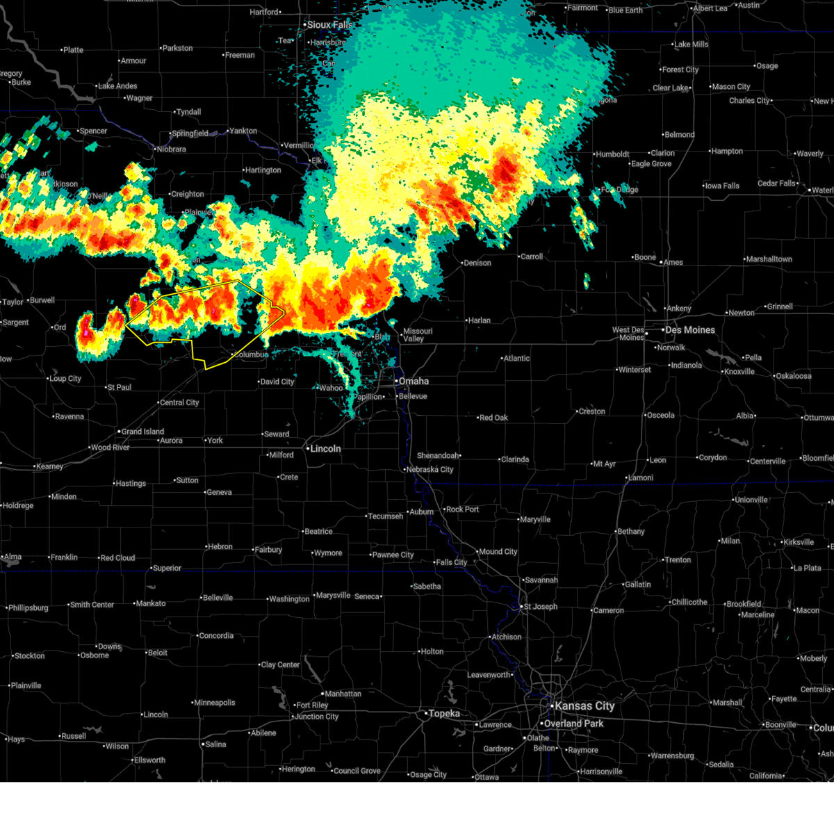
| 9/23/2023 8:39 AM CDT |
 At 838 am cdt, a severe thunderstorm was located 8 miles south of lindsay, or 17 miles southeast of albion, moving east at 30 mph (radar indicated). Hazards include quarter size hail. Damage to vehicles is expected. locations impacted include, st. edward, monroe, and lindsay. hail threat, radar indicated max hail size, 1. 00 in wind threat, radar indicated max wind gust, <50 mph. At 838 am cdt, a severe thunderstorm was located 8 miles south of lindsay, or 17 miles southeast of albion, moving east at 30 mph (radar indicated). Hazards include quarter size hail. Damage to vehicles is expected. locations impacted include, st. edward, monroe, and lindsay. hail threat, radar indicated max hail size, 1. 00 in wind threat, radar indicated max wind gust, <50 mph.
|
| 9/23/2023 8:29 AM CDT |
 At 828 am cdt, a severe thunderstorm was located 3 miles east of st. edward, or 13 miles southeast of albion, moving east at 30 mph (radar indicated). Hazards include ping pong ball size hail. People and animals outdoors will be injured. expect damage to roofs, siding, windows, and vehicles. locations impacted include, st. edward, monroe, and lindsay. hail threat, radar indicated max hail size, 1. 50 in wind threat, radar indicated max wind gust, <50 mph. At 828 am cdt, a severe thunderstorm was located 3 miles east of st. edward, or 13 miles southeast of albion, moving east at 30 mph (radar indicated). Hazards include ping pong ball size hail. People and animals outdoors will be injured. expect damage to roofs, siding, windows, and vehicles. locations impacted include, st. edward, monroe, and lindsay. hail threat, radar indicated max hail size, 1. 50 in wind threat, radar indicated max wind gust, <50 mph.
|
| 9/23/2023 8:15 AM CDT |
 At 814 am cdt, a severe thunderstorm was located 3 miles west of st. edward, or 9 miles southeast of albion, moving east at 30 mph (radar indicated). Hazards include ping pong ball size hail. People and animals outdoors will be injured. Expect damage to roofs, siding, windows, and vehicles. At 814 am cdt, a severe thunderstorm was located 3 miles west of st. edward, or 9 miles southeast of albion, moving east at 30 mph (radar indicated). Hazards include ping pong ball size hail. People and animals outdoors will be injured. Expect damage to roofs, siding, windows, and vehicles.
|
| 7/12/2023 5:10 AM CDT |
 At 510 am cdt, severe thunderstorms were located along a line extending from emerson to 7 miles southwest of beemer to 4 miles south of lindsay, moving southeast at 70 mph (at 508 am, a private weather station in wisner, nebraska recorded a 66 mph wind gust). Hazards include 70 mph wind gusts and penny size hail. Expect considerable tree damage. damage is likely to mobile homes, roofs, and outbuildings. locations impacted include, dodge, thurston, west point, walthill, winnebago, snyder, scribner, duncan, rosalie, lakeview, columbus and richland. people attending madison county fairgrounds should seek safe shelter immediately! thunderstorm damage threat, considerable hail threat, radar indicated max hail size, 0. 75 in wind threat, observed max wind gust, 70 mph. At 510 am cdt, severe thunderstorms were located along a line extending from emerson to 7 miles southwest of beemer to 4 miles south of lindsay, moving southeast at 70 mph (at 508 am, a private weather station in wisner, nebraska recorded a 66 mph wind gust). Hazards include 70 mph wind gusts and penny size hail. Expect considerable tree damage. damage is likely to mobile homes, roofs, and outbuildings. locations impacted include, dodge, thurston, west point, walthill, winnebago, snyder, scribner, duncan, rosalie, lakeview, columbus and richland. people attending madison county fairgrounds should seek safe shelter immediately! thunderstorm damage threat, considerable hail threat, radar indicated max hail size, 0. 75 in wind threat, observed max wind gust, 70 mph.
|
| 7/12/2023 4:45 AM CDT |
 At 444 am cdt, severe thunderstorms were located along a line extending from near coleridge to 3 miles west of hoskins to 2 miles west of petersburg, moving southeast at 75 mph (radar indicated). Hazards include 70 mph wind gusts and penny size hail. Expect considerable tree damage. damage is likely to mobile homes, roofs, and outbuildings. severe thunderstorms will be near, stanton around 455 am cdt. newman grove and pilger around 500 am cdt. other locations in the path of these severe thunderstorms include wakefield, st. edward, lindsay, howells, thurston, pender, dodge, platte center, snyder, monroe, scribner, walthill, bancroft, duncan, rosalie, columbus and lyons. people attending madison county fairgrounds should seek safe shelter immediately! thunderstorm damage threat, considerable hail threat, radar indicated max hail size, 0. 75 in wind threat, observed max wind gust, 70 mph. At 444 am cdt, severe thunderstorms were located along a line extending from near coleridge to 3 miles west of hoskins to 2 miles west of petersburg, moving southeast at 75 mph (radar indicated). Hazards include 70 mph wind gusts and penny size hail. Expect considerable tree damage. damage is likely to mobile homes, roofs, and outbuildings. severe thunderstorms will be near, stanton around 455 am cdt. newman grove and pilger around 500 am cdt. other locations in the path of these severe thunderstorms include wakefield, st. edward, lindsay, howells, thurston, pender, dodge, platte center, snyder, monroe, scribner, walthill, bancroft, duncan, rosalie, columbus and lyons. people attending madison county fairgrounds should seek safe shelter immediately! thunderstorm damage threat, considerable hail threat, radar indicated max hail size, 0. 75 in wind threat, observed max wind gust, 70 mph.
|
| 7/10/2023 7:20 PM CDT |
 The severe thunderstorm warning for southwestern madison, northwestern platte and northeastern boone counties will expire at 730 pm cdt, the storm which prompted the warning has weakened below severe limits, and no longer poses an immediate threat to life or property. therefore, the warning will be allowed to expire. however heavy rain is still possible with this thunderstorm. a severe thunderstorm watch remains in effect until 1000 pm cdt for northeastern nebraska. The severe thunderstorm warning for southwestern madison, northwestern platte and northeastern boone counties will expire at 730 pm cdt, the storm which prompted the warning has weakened below severe limits, and no longer poses an immediate threat to life or property. therefore, the warning will be allowed to expire. however heavy rain is still possible with this thunderstorm. a severe thunderstorm watch remains in effect until 1000 pm cdt for northeastern nebraska.
|
| 7/10/2023 7:14 PM CDT |
 At 713 pm cdt, a severe thunderstorm was located 3 miles southwest of newman grove, or 8 miles east of albion, moving southeast at 25 mph (radar indicated). Hazards include 60 mph wind gusts and quarter size hail. Hail damage to vehicles is expected. expect wind damage to roofs, siding, and trees. locations impacted include, lindsay. hail threat, radar indicated max hail size, 1. 00 in wind threat, radar indicated max wind gust, 60 mph. At 713 pm cdt, a severe thunderstorm was located 3 miles southwest of newman grove, or 8 miles east of albion, moving southeast at 25 mph (radar indicated). Hazards include 60 mph wind gusts and quarter size hail. Hail damage to vehicles is expected. expect wind damage to roofs, siding, and trees. locations impacted include, lindsay. hail threat, radar indicated max hail size, 1. 00 in wind threat, radar indicated max wind gust, 60 mph.
|
| 7/10/2023 6:41 PM CDT |
 At 640 pm cdt, a severe thunderstorm was located 4 miles east of petersburg, or 12 miles north of albion, moving southeast at 35 mph (radar indicated). Hazards include 60 mph wind gusts and quarter size hail. Hail damage to vehicles is expected. expect wind damage to roofs, siding, and trees. this severe thunderstorm will be near, albion around 655 pm cdt. newman grove around 700 pm cdt. other locations in the path of this severe thunderstorm include st. edward. hail threat, radar indicated max hail size, 1. 00 in wind threat, radar indicated max wind gust, 60 mph. At 640 pm cdt, a severe thunderstorm was located 4 miles east of petersburg, or 12 miles north of albion, moving southeast at 35 mph (radar indicated). Hazards include 60 mph wind gusts and quarter size hail. Hail damage to vehicles is expected. expect wind damage to roofs, siding, and trees. this severe thunderstorm will be near, albion around 655 pm cdt. newman grove around 700 pm cdt. other locations in the path of this severe thunderstorm include st. edward. hail threat, radar indicated max hail size, 1. 00 in wind threat, radar indicated max wind gust, 60 mph.
|
| 7/4/2023 3:48 PM CDT | Storm damage reported in platte county NE, 6.4 miles N of Lindsay, NE |
| 7/4/2023 3:41 PM CDT |
 At 341 pm cdt, severe thunderstorms were located along a line extending from 4 miles southwest of norfolk to 3 miles northeast of platte center, moving northeast at 30 mph (radar indicated). Hazards include 60 mph wind gusts and quarter size hail. Hail damage to vehicles is expected. expect wind damage to roofs, siding, and trees. locations impacted include, norfolk, creston and leigh. hail threat, radar indicated max hail size, 1. 00 in wind threat, radar indicated max wind gust, 60 mph. At 341 pm cdt, severe thunderstorms were located along a line extending from 4 miles southwest of norfolk to 3 miles northeast of platte center, moving northeast at 30 mph (radar indicated). Hazards include 60 mph wind gusts and quarter size hail. Hail damage to vehicles is expected. expect wind damage to roofs, siding, and trees. locations impacted include, norfolk, creston and leigh. hail threat, radar indicated max hail size, 1. 00 in wind threat, radar indicated max wind gust, 60 mph.
|
| 7/4/2023 3:23 PM CDT |
 At 323 pm cdt, severe thunderstorms were located along a line extending from 6 miles southwest of battle creek to 3 miles northwest of monroe, moving northeast at 35 mph (radar indicated). Hazards include 60 mph wind gusts and quarter size hail. Hail damage to vehicles is expected. expect wind damage to roofs, siding, and trees. severe thunderstorms will be near, battle creek around 335 pm cdt. other locations in the path of these severe thunderstorms include norfolk, humphrey, creston, leigh and clarkson. hail threat, radar indicated max hail size, 1. 00 in wind threat, radar indicated max wind gust, 60 mph. At 323 pm cdt, severe thunderstorms were located along a line extending from 6 miles southwest of battle creek to 3 miles northwest of monroe, moving northeast at 35 mph (radar indicated). Hazards include 60 mph wind gusts and quarter size hail. Hail damage to vehicles is expected. expect wind damage to roofs, siding, and trees. severe thunderstorms will be near, battle creek around 335 pm cdt. other locations in the path of these severe thunderstorms include norfolk, humphrey, creston, leigh and clarkson. hail threat, radar indicated max hail size, 1. 00 in wind threat, radar indicated max wind gust, 60 mph.
|
| 6/24/2023 3:52 AM CDT |
 The severe thunderstorm warning for madison, northwestern wayne, platte, pierce, southeastern antelope, southwestern cedar and eastern boone counties will expire at 400 am cdt, the storms which prompted the warning have moved out of the area. therefore, the warning will be allowed to expire. however gusty winds and heavy rain are still possible with these thunderstorms. a severe thunderstorm watch remains in effect until 600 am cdt for northeastern nebraska. The severe thunderstorm warning for madison, northwestern wayne, platte, pierce, southeastern antelope, southwestern cedar and eastern boone counties will expire at 400 am cdt, the storms which prompted the warning have moved out of the area. therefore, the warning will be allowed to expire. however gusty winds and heavy rain are still possible with these thunderstorms. a severe thunderstorm watch remains in effect until 600 am cdt for northeastern nebraska.
|
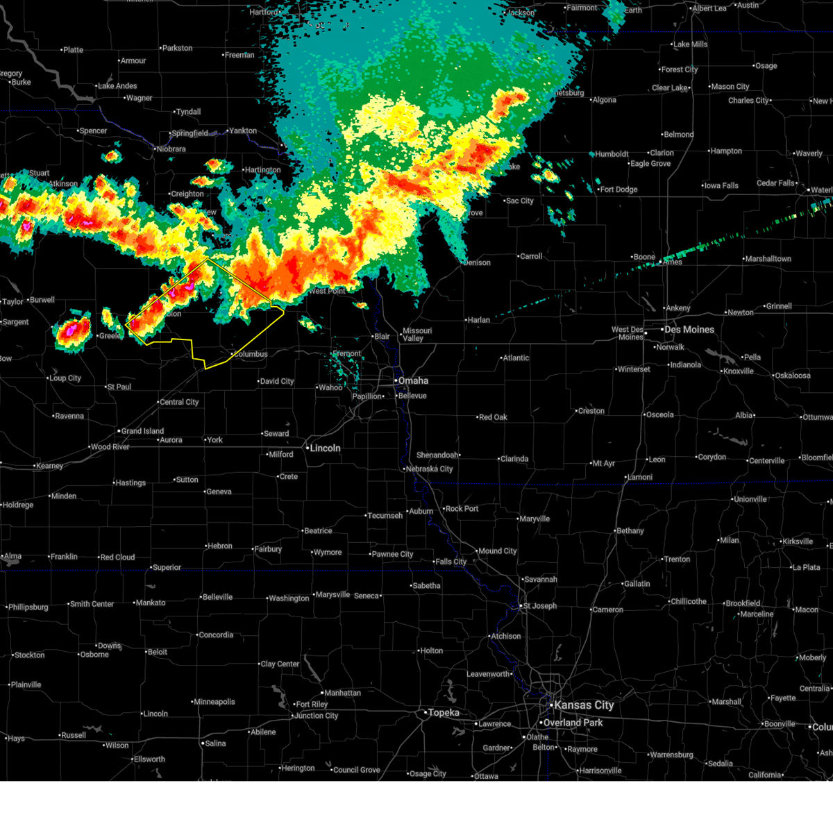
| 6/24/2023 3:43 AM CDT |
 At 343 am cdt, severe thunderstorms were located along a line extending from 8 miles northeast of newman grove to 4 miles south of lindsay to 7 miles north of archer, moving east at 40 mph (radar indicated). Hazards include 60 mph wind gusts and quarter size hail. Hail damage to vehicles is expected. expect wind damage to roofs, siding, and trees. severe thunderstorms will be near, lindsay around 350 am cdt. madison, humphrey and platte center around 400 am cdt. other locations in the path of these severe thunderstorms include creston, stanton, leigh and duncan. people attending pawnee park in columbus should seek safe shelter immediately! hail threat, radar indicated max hail size, 1. 00 in wind threat, radar indicated max wind gust, 60 mph. At 343 am cdt, severe thunderstorms were located along a line extending from 8 miles northeast of newman grove to 4 miles south of lindsay to 7 miles north of archer, moving east at 40 mph (radar indicated). Hazards include 60 mph wind gusts and quarter size hail. Hail damage to vehicles is expected. expect wind damage to roofs, siding, and trees. severe thunderstorms will be near, lindsay around 350 am cdt. madison, humphrey and platte center around 400 am cdt. other locations in the path of these severe thunderstorms include creston, stanton, leigh and duncan. people attending pawnee park in columbus should seek safe shelter immediately! hail threat, radar indicated max hail size, 1. 00 in wind threat, radar indicated max wind gust, 60 mph.
|
| 6/24/2023 3:21 AM CDT |
 At 321 am cdt, severe thunderstorms were located along a line extending from 3 miles northwest of plainview to 7 miles south of tilden to 5 miles northeast of albion to 2 miles northwest of belgrade, moving east at 40 mph (radar indicated). Hazards include 60 mph wind gusts and quarter size hail. Hail damage to vehicles is expected. expect wind damage to roofs, siding, and trees. severe thunderstorms will be near, plainview and tilden around 325 am cdt. newman grove around 330 am cdt. meadow grove around 335 am cdt. osmond, st. edward and lindsay around 340 am cdt. other locations in the path of these severe thunderstorms include battle creek, norfolk, humphrey, madison, randolph, platte center and monroe. hail threat, radar indicated max hail size, 1. 00 in wind threat, radar indicated max wind gust, 60 mph. At 321 am cdt, severe thunderstorms were located along a line extending from 3 miles northwest of plainview to 7 miles south of tilden to 5 miles northeast of albion to 2 miles northwest of belgrade, moving east at 40 mph (radar indicated). Hazards include 60 mph wind gusts and quarter size hail. Hail damage to vehicles is expected. expect wind damage to roofs, siding, and trees. severe thunderstorms will be near, plainview and tilden around 325 am cdt. newman grove around 330 am cdt. meadow grove around 335 am cdt. osmond, st. edward and lindsay around 340 am cdt. other locations in the path of these severe thunderstorms include battle creek, norfolk, humphrey, madison, randolph, platte center and monroe. hail threat, radar indicated max hail size, 1. 00 in wind threat, radar indicated max wind gust, 60 mph.
|
| 6/24/2023 3:05 AM CDT |
 At 305 am cdt, severe thunderstorms were located along a line extending from 9 miles southwest of creighton to 2 miles southeast of elgin to 4 miles northeast of cedar rapids, moving east at 60 mph (trained weather spotters). Hazards include 70 mph wind gusts and quarter size hail. Hail damage to vehicles is expected. expect considerable tree damage. wind damage is also likely to mobile homes, roofs, and outbuildings. locations impacted include, oakdale, plainview, tilden, st. edward, meadow grove, osmond, lindsay, battle creek, norfolk, humphrey, hadar and creston. thunderstorm damage threat, considerable hail threat, radar indicated max hail size, 1. 00 in wind threat, radar indicated max wind gust, 70 mph. At 305 am cdt, severe thunderstorms were located along a line extending from 9 miles southwest of creighton to 2 miles southeast of elgin to 4 miles northeast of cedar rapids, moving east at 60 mph (trained weather spotters). Hazards include 70 mph wind gusts and quarter size hail. Hail damage to vehicles is expected. expect considerable tree damage. wind damage is also likely to mobile homes, roofs, and outbuildings. locations impacted include, oakdale, plainview, tilden, st. edward, meadow grove, osmond, lindsay, battle creek, norfolk, humphrey, hadar and creston. thunderstorm damage threat, considerable hail threat, radar indicated max hail size, 1. 00 in wind threat, radar indicated max wind gust, 70 mph.
|
| 6/24/2023 2:45 AM CDT |
 At 245 am cdt, severe thunderstorms were located along a line extending from 4 miles south of page to 10 miles northeast of bartlett to 6 miles south of spalding, moving east at 55 mph (trained weather spotters). Hazards include 70 mph wind gusts and quarter size hail. Hail damage to vehicles is expected. expect considerable tree damage. wind damage is also likely to mobile homes, roofs, and outbuildings. severe thunderstorms will be near, cedar rapids, orchard and primrose around 255 am cdt. elgin and petersburg around 300 am cdt. albion around 305 am cdt. other locations in the path of these severe thunderstorms include oakdale, tilden, st. edward, plainview, meadow grove, lindsay, battle creek, osmond and humphrey. thunderstorm damage threat, considerable hail threat, radar indicated max hail size, 1. 00 in wind threat, radar indicated max wind gust, 70 mph. At 245 am cdt, severe thunderstorms were located along a line extending from 4 miles south of page to 10 miles northeast of bartlett to 6 miles south of spalding, moving east at 55 mph (trained weather spotters). Hazards include 70 mph wind gusts and quarter size hail. Hail damage to vehicles is expected. expect considerable tree damage. wind damage is also likely to mobile homes, roofs, and outbuildings. severe thunderstorms will be near, cedar rapids, orchard and primrose around 255 am cdt. elgin and petersburg around 300 am cdt. albion around 305 am cdt. other locations in the path of these severe thunderstorms include oakdale, tilden, st. edward, plainview, meadow grove, lindsay, battle creek, osmond and humphrey. thunderstorm damage threat, considerable hail threat, radar indicated max hail size, 1. 00 in wind threat, radar indicated max wind gust, 70 mph.
|
| 6/16/2023 5:48 PM CDT |
 At 547 pm cdt, severe thunderstorms were located along a line extending from newman grove to 6 miles northeast of albion, moving east at 5 mph (radar indicated). Hazards include 60 mph wind gusts and quarter size hail. Hail damage to vehicles is expected. expect wind damage to roofs, siding, and trees. severe thunderstorms will be near, newman grove around 555 pm cdt. other locations in the path of these severe thunderstorms include lindsay. hail threat, radar indicated max hail size, 1. 00 in wind threat, radar indicated max wind gust, 60 mph. At 547 pm cdt, severe thunderstorms were located along a line extending from newman grove to 6 miles northeast of albion, moving east at 5 mph (radar indicated). Hazards include 60 mph wind gusts and quarter size hail. Hail damage to vehicles is expected. expect wind damage to roofs, siding, and trees. severe thunderstorms will be near, newman grove around 555 pm cdt. other locations in the path of these severe thunderstorms include lindsay. hail threat, radar indicated max hail size, 1. 00 in wind threat, radar indicated max wind gust, 60 mph.
|
| 5/12/2023 4:53 PM CDT |
 The tornado warning for southwestern madison and northwestern platte counties will expire at 500 pm cdt, the storm which prompted the warning has moved out of the area. therefore, the warning will be allowed to expire. however gusty winds are still possible with this thunderstorm. a tornado watch remains in effect until 900 pm cdt for northeastern nebraska. The tornado warning for southwestern madison and northwestern platte counties will expire at 500 pm cdt, the storm which prompted the warning has moved out of the area. therefore, the warning will be allowed to expire. however gusty winds are still possible with this thunderstorm. a tornado watch remains in effect until 900 pm cdt for northeastern nebraska.
|
| 5/12/2023 4:20 PM CDT |
 At 420 pm cdt, a severe thunderstorm capable of producing a tornado was located 4 miles east of newman grove, or 16 miles east of albion, moving north at 35 mph (radar indicated rotation). Hazards include tornado. Flying debris will be dangerous to those caught without shelter. mobile homes will be damaged or destroyed. damage to roofs, windows, and vehicles will occur. Tree damage is likely. At 420 pm cdt, a severe thunderstorm capable of producing a tornado was located 4 miles east of newman grove, or 16 miles east of albion, moving north at 35 mph (radar indicated rotation). Hazards include tornado. Flying debris will be dangerous to those caught without shelter. mobile homes will be damaged or destroyed. damage to roofs, windows, and vehicles will occur. Tree damage is likely.
|
| 5/12/2023 3:57 PM CDT |
 At 356 pm cdt, a confirmed tornado was located 5 miles south of lindsay, or 16 miles east of albion, moving north at 40 mph (weather spotters confirmed tornado). Hazards include damaging tornado. Flying debris will be dangerous to those caught without shelter. mobile homes will be damaged or destroyed. damage to roofs, windows, and vehicles will occur. tree damage is likely. this tornado will be near, lindsay around 400 pm cdt. Other locations in the path of this tornadic thunderstorm include newman grove. At 356 pm cdt, a confirmed tornado was located 5 miles south of lindsay, or 16 miles east of albion, moving north at 40 mph (weather spotters confirmed tornado). Hazards include damaging tornado. Flying debris will be dangerous to those caught without shelter. mobile homes will be damaged or destroyed. damage to roofs, windows, and vehicles will occur. tree damage is likely. this tornado will be near, lindsay around 400 pm cdt. Other locations in the path of this tornadic thunderstorm include newman grove.
|
| 5/12/2023 3:41 PM CDT |
 At 340 pm cdt, a severe thunderstorm capable of producing a tornado was located 4 miles north of silver creek, or 15 miles west of columbus, moving north at 55 mph (radar indicated rotation). Hazards include tornado. Flying debris will be dangerous to those caught without shelter. mobile homes will be damaged or destroyed. damage to roofs, windows, and vehicles will occur. tree damage is likely. this dangerous storm will be near, monroe around 345 pm cdt. Other locations in the path of this tornadic thunderstorm include lindsay and newman grove. At 340 pm cdt, a severe thunderstorm capable of producing a tornado was located 4 miles north of silver creek, or 15 miles west of columbus, moving north at 55 mph (radar indicated rotation). Hazards include tornado. Flying debris will be dangerous to those caught without shelter. mobile homes will be damaged or destroyed. damage to roofs, windows, and vehicles will occur. tree damage is likely. this dangerous storm will be near, monroe around 345 pm cdt. Other locations in the path of this tornadic thunderstorm include lindsay and newman grove.
|
| 5/6/2023 1:26 AM CDT |
 The severe thunderstorm warning for northwestern platte and southern boone counties will expire at 130 am cdt, the storms which prompted the warning have weakened below severe limits, and no longer pose an immediate threat to life or property. therefore, the warning will be allowed to expire. however gusty winds are still possible with these thunderstorms. The severe thunderstorm warning for northwestern platte and southern boone counties will expire at 130 am cdt, the storms which prompted the warning have weakened below severe limits, and no longer pose an immediate threat to life or property. therefore, the warning will be allowed to expire. however gusty winds are still possible with these thunderstorms.
|
| 5/6/2023 1:14 AM CDT |
 At 113 am cdt, severe thunderstorms were located along a line extending from 4 miles north of albion to 4 miles north of st. edward to 6 miles northwest of genoa, moving northeast at 50 mph (radar indicated). Hazards include 60 mph wind gusts and quarter size hail. Hail damage to vehicles is expected. expect wind damage to roofs, siding, and trees. locations impacted include, albion, st. edward, cedar rapids, lindsay, primrose and the highway 14 and 56 junction. hail threat, radar indicated max hail size, 1. 00 in wind threat, radar indicated max wind gust, 60 mph. At 113 am cdt, severe thunderstorms were located along a line extending from 4 miles north of albion to 4 miles north of st. edward to 6 miles northwest of genoa, moving northeast at 50 mph (radar indicated). Hazards include 60 mph wind gusts and quarter size hail. Hail damage to vehicles is expected. expect wind damage to roofs, siding, and trees. locations impacted include, albion, st. edward, cedar rapids, lindsay, primrose and the highway 14 and 56 junction. hail threat, radar indicated max hail size, 1. 00 in wind threat, radar indicated max wind gust, 60 mph.
|
| 5/6/2023 12:57 AM CDT |
 At 1256 am cdt, severe thunderstorms were located along a line extending from 2 miles northeast of primrose to 2 miles southeast of cedar rapids to 4 miles south of belgrade, moving northeast at 50 mph (radar indicated). Hazards include 60 mph wind gusts and quarter size hail. Hail damage to vehicles is expected. expect wind damage to roofs, siding, and trees. locations impacted include, albion, st. edward and lindsay. hail threat, radar indicated max hail size, 1. 00 in wind threat, radar indicated max wind gust, 60 mph. At 1256 am cdt, severe thunderstorms were located along a line extending from 2 miles northeast of primrose to 2 miles southeast of cedar rapids to 4 miles south of belgrade, moving northeast at 50 mph (radar indicated). Hazards include 60 mph wind gusts and quarter size hail. Hail damage to vehicles is expected. expect wind damage to roofs, siding, and trees. locations impacted include, albion, st. edward and lindsay. hail threat, radar indicated max hail size, 1. 00 in wind threat, radar indicated max wind gust, 60 mph.
|
| 5/6/2023 12:43 AM CDT |
 At 1243 am cdt, severe thunderstorms were located along a line extending from 7 miles east of greeley to 7 miles northeast of wolbach to 7 miles north of palmer, moving northeast at 50 mph (radar indicated). Hazards include 60 mph wind gusts and quarter size hail. Hail damage to vehicles is expected. expect wind damage to roofs, siding, and trees. severe thunderstorms will be near, cedar rapids and primrose around 1255 am cdt. other locations in the path of these severe thunderstorms include albion, st. edward and lindsay. hail threat, radar indicated max hail size, 1. 00 in wind threat, radar indicated max wind gust, 60 mph. At 1243 am cdt, severe thunderstorms were located along a line extending from 7 miles east of greeley to 7 miles northeast of wolbach to 7 miles north of palmer, moving northeast at 50 mph (radar indicated). Hazards include 60 mph wind gusts and quarter size hail. Hail damage to vehicles is expected. expect wind damage to roofs, siding, and trees. severe thunderstorms will be near, cedar rapids and primrose around 1255 am cdt. other locations in the path of these severe thunderstorms include albion, st. edward and lindsay. hail threat, radar indicated max hail size, 1. 00 in wind threat, radar indicated max wind gust, 60 mph.
|
| 8/18/2022 6:02 PM CDT |
 At 601 pm cdt, a severe thunderstorm was located 5 miles east of st. edward, or 16 miles southeast of albion, moving southeast at 15 mph. the storm has some rotation noted just east of st. edward (radar indicated). Hazards include two inch hail and 60 mph wind gusts. People and animals outdoors will be injured. expect hail damage to roofs, siding, windows, and vehicles. expect wind damage to roofs, siding, and trees. Locations impacted include, duncan, platte center, monroe, lindsay, lakeview, college view trailer park, lake ocaonee, circle h trailer park, lake babcock and central community college. At 601 pm cdt, a severe thunderstorm was located 5 miles east of st. edward, or 16 miles southeast of albion, moving southeast at 15 mph. the storm has some rotation noted just east of st. edward (radar indicated). Hazards include two inch hail and 60 mph wind gusts. People and animals outdoors will be injured. expect hail damage to roofs, siding, windows, and vehicles. expect wind damage to roofs, siding, and trees. Locations impacted include, duncan, platte center, monroe, lindsay, lakeview, college view trailer park, lake ocaonee, circle h trailer park, lake babcock and central community college.
|
| 8/18/2022 5:53 PM CDT |
 At 552 pm cdt, a severe thunderstorm was located 7 miles east of st. edward, or 16 miles southeast of albion, moving southeast at 20 mph (radar indicated). Hazards include golf ball size hail and 60 mph wind gusts. People and animals outdoors will be injured. expect hail damage to roofs, siding, windows, and vehicles. expect wind damage to roofs, siding, and trees. locations impacted include, duncan, platte center, monroe, lindsay, lakeview, college view trailer park, lake ocaonee, circle h trailer park, lake babcock and central community college. thunderstorm damage threat, considerable hail threat, radar indicated max hail size, 1. 75 in wind threat, radar indicated max wind gust, 60 mph. At 552 pm cdt, a severe thunderstorm was located 7 miles east of st. edward, or 16 miles southeast of albion, moving southeast at 20 mph (radar indicated). Hazards include golf ball size hail and 60 mph wind gusts. People and animals outdoors will be injured. expect hail damage to roofs, siding, windows, and vehicles. expect wind damage to roofs, siding, and trees. locations impacted include, duncan, platte center, monroe, lindsay, lakeview, college view trailer park, lake ocaonee, circle h trailer park, lake babcock and central community college. thunderstorm damage threat, considerable hail threat, radar indicated max hail size, 1. 75 in wind threat, radar indicated max wind gust, 60 mph.
|
| 8/18/2022 5:42 PM CDT |
 At 542 pm cdt, a severe thunderstorm was located 5 miles south of lindsay, or 16 miles east of albion, moving southeast at 20 mph. this storm has produced hail up to nickel size (radar indicated). Hazards include 60 mph wind gusts and quarter size hail. Hail damage to vehicles is expected. Expect wind damage to roofs, siding, and trees. At 542 pm cdt, a severe thunderstorm was located 5 miles south of lindsay, or 16 miles east of albion, moving southeast at 20 mph. this storm has produced hail up to nickel size (radar indicated). Hazards include 60 mph wind gusts and quarter size hail. Hail damage to vehicles is expected. Expect wind damage to roofs, siding, and trees.
|
| 8/18/2022 5:35 PM CDT |
 At 534 pm cdt, a severe thunderstorm was located 4 miles south of lindsay, or 15 miles east of albion, moving southeast at 25 mph (radar indicated). Hazards include 60 mph wind gusts and quarter size hail. Hail damage to vehicles is expected. Expect wind damage to roofs, siding, and trees. At 534 pm cdt, a severe thunderstorm was located 4 miles south of lindsay, or 15 miles east of albion, moving southeast at 25 mph (radar indicated). Hazards include 60 mph wind gusts and quarter size hail. Hail damage to vehicles is expected. Expect wind damage to roofs, siding, and trees.
|
| 7/23/2022 7:21 PM CDT |
 At 721 pm cdt, a severe thunderstorm was located 4 miles southeast of humphrey, or 14 miles north of columbus, moving east at 35 mph (radar indicated). Hazards include 60 mph wind gusts and quarter size hail. Hail damage to vehicles is expected. expect wind damage to roofs, siding, and trees. this severe thunderstorm will remain over mainly rural areas of northern platte county, including the following locations, cornlea, circle h trailer park and tarnov. hail threat, radar indicated max hail size, 1. 00 in wind threat, radar indicated max wind gust, 60 mph. At 721 pm cdt, a severe thunderstorm was located 4 miles southeast of humphrey, or 14 miles north of columbus, moving east at 35 mph (radar indicated). Hazards include 60 mph wind gusts and quarter size hail. Hail damage to vehicles is expected. expect wind damage to roofs, siding, and trees. this severe thunderstorm will remain over mainly rural areas of northern platte county, including the following locations, cornlea, circle h trailer park and tarnov. hail threat, radar indicated max hail size, 1. 00 in wind threat, radar indicated max wind gust, 60 mph.
|
| 7/23/2022 6:45 PM CDT |
 At 644 pm cdt, a severe thunderstorm was located 6 miles north of st. edward, or 8 miles east of albion, moving east at 40 mph (trained weather spotters. this storm has a history of producing ping pong ball sized hail). Hazards include ping pong ball size hail and 60 mph wind gusts. People and animals outdoors will be injured. expect hail damage to roofs, siding, windows, and vehicles. expect wind damage to roofs, siding, and trees. this severe thunderstorm will be near, lindsay around 655 pm cdt. other locations in the path of this severe thunderstorm include humphrey. hail threat, observed max hail size, 1. 50 in wind threat, radar indicated max wind gust, 60 mph. At 644 pm cdt, a severe thunderstorm was located 6 miles north of st. edward, or 8 miles east of albion, moving east at 40 mph (trained weather spotters. this storm has a history of producing ping pong ball sized hail). Hazards include ping pong ball size hail and 60 mph wind gusts. People and animals outdoors will be injured. expect hail damage to roofs, siding, windows, and vehicles. expect wind damage to roofs, siding, and trees. this severe thunderstorm will be near, lindsay around 655 pm cdt. other locations in the path of this severe thunderstorm include humphrey. hail threat, observed max hail size, 1. 50 in wind threat, radar indicated max wind gust, 60 mph.
|
| 7/11/2022 1:26 AM CDT |
 At 126 am cdt, severe thunderstorms were located along a line extending from 2 miles south of norfolk to near creston to 3 miles northeast of monroe, moving east at 55 mph (radar indicated). Hazards include 70 mph wind gusts. Expect considerable tree damage. damage is likely to mobile homes, roofs, and outbuildings. locations impacted include, norfolk, columbus, schuyler, madison, stanton, wisner, humphrey, clarkson, dodge, howells, leigh, pilger, duncan, platte center, monroe, lindsay, creston, linwood, richland and lakeview. people attending madison county fairgrounds should seek safe shelter immediately! thunderstorm damage threat, considerable hail threat, radar indicated max hail size, <. 75 in wind threat, radar indicated max wind gust, 70 mph. At 126 am cdt, severe thunderstorms were located along a line extending from 2 miles south of norfolk to near creston to 3 miles northeast of monroe, moving east at 55 mph (radar indicated). Hazards include 70 mph wind gusts. Expect considerable tree damage. damage is likely to mobile homes, roofs, and outbuildings. locations impacted include, norfolk, columbus, schuyler, madison, stanton, wisner, humphrey, clarkson, dodge, howells, leigh, pilger, duncan, platte center, monroe, lindsay, creston, linwood, richland and lakeview. people attending madison county fairgrounds should seek safe shelter immediately! thunderstorm damage threat, considerable hail threat, radar indicated max hail size, <. 75 in wind threat, radar indicated max wind gust, 70 mph.
|
| 7/11/2022 1:17 AM CDT |
 At 117 am cdt, severe thunderstorms were located along a line extending from battle creek to 4 miles northwest of humphrey to 4 miles north of genoa, moving east at 55 mph (radar indicated). Hazards include 60 mph wind gusts. Expect damage to roofs, siding, and trees. locations impacted include, battle creek, humphrey, norfolk, madison, creston, platte center, leigh, lakeview, clarkson, pilger, dodge and howells. people attending madison county fairgrounds should seek safe shelter immediately! hail threat, radar indicated max hail size, <. 75 in wind threat, radar indicated max wind gust, 60 mph. At 117 am cdt, severe thunderstorms were located along a line extending from battle creek to 4 miles northwest of humphrey to 4 miles north of genoa, moving east at 55 mph (radar indicated). Hazards include 60 mph wind gusts. Expect damage to roofs, siding, and trees. locations impacted include, battle creek, humphrey, norfolk, madison, creston, platte center, leigh, lakeview, clarkson, pilger, dodge and howells. people attending madison county fairgrounds should seek safe shelter immediately! hail threat, radar indicated max hail size, <. 75 in wind threat, radar indicated max wind gust, 60 mph.
|
| 7/11/2022 12:59 AM CDT |
 At 1259 am cdt, severe thunderstorms were located along a line extending from 9 miles north of newman grove to 3 miles south of genoa, moving east at 55 mph (radar indicated). Hazards include 60 mph wind gusts. Expect damage to roofs, siding, and trees. severe thunderstorms will be near, monroe around 105 am cdt. battle creek and duncan around 110 am cdt. madison and lakeview around 115 am cdt. other locations in the path of these severe thunderstorms include columbus, stanton, richland, schuyler, pilger, linwood and wisner. people attending madison county fairgrounds should seek safe shelter immediately! hail threat, radar indicated max hail size, <. 75 in wind threat, radar indicated max wind gust, 60 mph. At 1259 am cdt, severe thunderstorms were located along a line extending from 9 miles north of newman grove to 3 miles south of genoa, moving east at 55 mph (radar indicated). Hazards include 60 mph wind gusts. Expect damage to roofs, siding, and trees. severe thunderstorms will be near, monroe around 105 am cdt. battle creek and duncan around 110 am cdt. madison and lakeview around 115 am cdt. other locations in the path of these severe thunderstorms include columbus, stanton, richland, schuyler, pilger, linwood and wisner. people attending madison county fairgrounds should seek safe shelter immediately! hail threat, radar indicated max hail size, <. 75 in wind threat, radar indicated max wind gust, 60 mph.
|
| 7/11/2022 12:54 AM CDT |
 At 1253 am cdt, severe thunderstorms were located along a line extending from 3 miles east of elgin to 3 miles west of st. edward, moving northeast at 55 mph (automated weather observing system). Hazards include 60 mph wind gusts. Expect damage to roofs, siding, and trees. these severe storms will be near, oakdale around 100 am cdt. tilden around 105 am cdt. other locations in the path of these severe thunderstorms include newman grove and lindsay. hail threat, radar indicated max hail size, <. 75 in wind threat, observed max wind gust, 60 mph. At 1253 am cdt, severe thunderstorms were located along a line extending from 3 miles east of elgin to 3 miles west of st. edward, moving northeast at 55 mph (automated weather observing system). Hazards include 60 mph wind gusts. Expect damage to roofs, siding, and trees. these severe storms will be near, oakdale around 100 am cdt. tilden around 105 am cdt. other locations in the path of these severe thunderstorms include newman grove and lindsay. hail threat, radar indicated max hail size, <. 75 in wind threat, observed max wind gust, 60 mph.
|
| 7/11/2022 12:46 AM CDT |
 At 1245 am cdt, severe thunderstorms were located along a line extending from 5 miles southwest of elgin to 4 miles southeast of cedar rapids, moving northeast at 55 mph (radar indicated). Hazards include 60 mph wind gusts. Expect damage to roofs, siding, and trees. these severe storms will be near, petersburg around 1250 am cdt. other locations in the path of these severe thunderstorms include st. edward, elgin, oakdale, tilden, newman grove and lindsay. hail threat, radar indicated max hail size, <. 75 in wind threat, radar indicated max wind gust, 60 mph. At 1245 am cdt, severe thunderstorms were located along a line extending from 5 miles southwest of elgin to 4 miles southeast of cedar rapids, moving northeast at 55 mph (radar indicated). Hazards include 60 mph wind gusts. Expect damage to roofs, siding, and trees. these severe storms will be near, petersburg around 1250 am cdt. other locations in the path of these severe thunderstorms include st. edward, elgin, oakdale, tilden, newman grove and lindsay. hail threat, radar indicated max hail size, <. 75 in wind threat, radar indicated max wind gust, 60 mph.
|
| 7/11/2022 12:32 AM CDT |
 At 1232 am cdt, severe thunderstorms were located along a line extending from 8 miles southeast of bartlett to 5 miles northeast of wolbach, moving northeast at 45 mph (radar indicated). Hazards include 60 mph wind gusts. Expect damage to roofs, siding, and trees. severe thunderstorms will be near, cedar rapids around 1245 am cdt. petersburg around 1250 am cdt. other locations in the path of these severe thunderstorms include elgin, st. edward, oakdale, tilden, newman grove and lindsay. hail threat, radar indicated max hail size, <. 75 in wind threat, radar indicated max wind gust, 60 mph. At 1232 am cdt, severe thunderstorms were located along a line extending from 8 miles southeast of bartlett to 5 miles northeast of wolbach, moving northeast at 45 mph (radar indicated). Hazards include 60 mph wind gusts. Expect damage to roofs, siding, and trees. severe thunderstorms will be near, cedar rapids around 1245 am cdt. petersburg around 1250 am cdt. other locations in the path of these severe thunderstorms include elgin, st. edward, oakdale, tilden, newman grove and lindsay. hail threat, radar indicated max hail size, <. 75 in wind threat, radar indicated max wind gust, 60 mph.
|
| 6/7/2022 7:24 PM CDT |
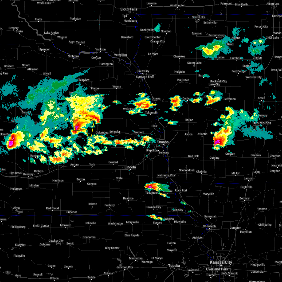 At 724 pm cdt, a severe thunderstorm was located 3 miles west of st. edward, or 9 miles south of albion, moving east at 30 mph (radar indicated). Hazards include 60 mph wind gusts and quarter size hail. Hail damage to vehicles is expected. expect wind damage to roofs, siding, and trees. this severe storm will be near, st. edward around 730 pm cdt. other locations in the path of this severe thunderstorm include monroe. hail threat, radar indicated max hail size, 1. 00 in wind threat, radar indicated max wind gust, 60 mph. At 724 pm cdt, a severe thunderstorm was located 3 miles west of st. edward, or 9 miles south of albion, moving east at 30 mph (radar indicated). Hazards include 60 mph wind gusts and quarter size hail. Hail damage to vehicles is expected. expect wind damage to roofs, siding, and trees. this severe storm will be near, st. edward around 730 pm cdt. other locations in the path of this severe thunderstorm include monroe. hail threat, radar indicated max hail size, 1. 00 in wind threat, radar indicated max wind gust, 60 mph.
|
| 6/7/2022 7:14 PM CDT |
 At 714 pm cdt, a severe thunderstorm was located 5 miles east of cedar rapids, or 8 miles south of albion, moving east at 30 mph (radar indicated). Hazards include 60 mph wind gusts and quarter size hail. Hail damage to vehicles is expected. expect wind damage to roofs, siding, and trees. this severe thunderstorm will be near, st. edward around 730 pm cdt. other locations in the path of this severe thunderstorm include monroe. hail threat, radar indicated max hail size, 1. 00 in wind threat, radar indicated max wind gust, 60 mph. At 714 pm cdt, a severe thunderstorm was located 5 miles east of cedar rapids, or 8 miles south of albion, moving east at 30 mph (radar indicated). Hazards include 60 mph wind gusts and quarter size hail. Hail damage to vehicles is expected. expect wind damage to roofs, siding, and trees. this severe thunderstorm will be near, st. edward around 730 pm cdt. other locations in the path of this severe thunderstorm include monroe. hail threat, radar indicated max hail size, 1. 00 in wind threat, radar indicated max wind gust, 60 mph.
|
| 5/12/2022 5:52 PM CDT |
 At 551 pm cdt, severe thunderstorms were located along a line extending from genoa to 2 miles east of columbus, moving northeast at 60 mph. a tornado warning is also in effect for portions of platte and colfax counties (radar indicated). Hazards include 70 mph wind gusts and quarter size hail. Hail damage to vehicles is expected. expect considerable tree damage. wind damage is also likely to mobile homes, roofs, and outbuildings. severe thunderstorms will be near, platte center around 605 pm cdt. humphrey and clarkson around 610 pm cdt. Other locations in the path of these severe thunderstorms include howells, creston and madison. At 551 pm cdt, severe thunderstorms were located along a line extending from genoa to 2 miles east of columbus, moving northeast at 60 mph. a tornado warning is also in effect for portions of platte and colfax counties (radar indicated). Hazards include 70 mph wind gusts and quarter size hail. Hail damage to vehicles is expected. expect considerable tree damage. wind damage is also likely to mobile homes, roofs, and outbuildings. severe thunderstorms will be near, platte center around 605 pm cdt. humphrey and clarkson around 610 pm cdt. Other locations in the path of these severe thunderstorms include howells, creston and madison.
|
| 5/12/2022 4:01 PM CDT |
 At 400 pm cdt, a severe thunderstorm was located over pierce, or 11 miles northwest of norfolk, moving northeast at 70 mph (radar indicated). Hazards include 70 mph wind gusts and ping pong ball size hail. People and animals outdoors will be injured. expect hail damage to roofs, siding, windows, and vehicles. expect considerable tree damage. wind damage is also likely to mobile homes, roofs, and outbuildings. this severe thunderstorm will remain over mainly rural areas of madison, north central platte, southern pierce and northwestern stanton counties, including the following locations, cornlea. thunderstorm damage threat, considerable hail threat, radar indicated max hail size, 1. 50 in wind threat, radar indicated max wind gust, 70 mph. At 400 pm cdt, a severe thunderstorm was located over pierce, or 11 miles northwest of norfolk, moving northeast at 70 mph (radar indicated). Hazards include 70 mph wind gusts and ping pong ball size hail. People and animals outdoors will be injured. expect hail damage to roofs, siding, windows, and vehicles. expect considerable tree damage. wind damage is also likely to mobile homes, roofs, and outbuildings. this severe thunderstorm will remain over mainly rural areas of madison, north central platte, southern pierce and northwestern stanton counties, including the following locations, cornlea. thunderstorm damage threat, considerable hail threat, radar indicated max hail size, 1. 50 in wind threat, radar indicated max wind gust, 70 mph.
|
| 5/12/2022 3:45 PM CDT |
 At 344 pm cdt, a severe thunderstorm was located 5 miles southwest of battle creek, or 14 miles southwest of norfolk, moving northeast at 70 mph (radar indicated). Hazards include 70 mph wind gusts and ping pong ball size hail. People and animals outdoors will be injured. expect hail damage to roofs, siding, windows, and vehicles. expect considerable tree damage. wind damage is also likely to mobile homes, roofs, and outbuildings. locations impacted include, norfolk and hadar. thunderstorm damage threat, considerable hail threat, radar indicated max hail size, 1. 50 in wind threat, radar indicated max wind gust, 70 mph. At 344 pm cdt, a severe thunderstorm was located 5 miles southwest of battle creek, or 14 miles southwest of norfolk, moving northeast at 70 mph (radar indicated). Hazards include 70 mph wind gusts and ping pong ball size hail. People and animals outdoors will be injured. expect hail damage to roofs, siding, windows, and vehicles. expect considerable tree damage. wind damage is also likely to mobile homes, roofs, and outbuildings. locations impacted include, norfolk and hadar. thunderstorm damage threat, considerable hail threat, radar indicated max hail size, 1. 50 in wind threat, radar indicated max wind gust, 70 mph.
|
| 5/12/2022 3:25 PM CDT |
 At 325 pm cdt, a severe thunderstorm was located 4 miles north of st. edward, or 8 miles southeast of albion, moving northeast at 70 mph (radar indicated). Hazards include 70 mph wind gusts and ping pong ball size hail. People and animals outdoors will be injured. expect hail damage to roofs, siding, windows, and vehicles. expect considerable tree damage. wind damage is also likely to mobile homes, roofs, and outbuildings. this severe thunderstorm will be near, lindsay around 330 pm cdt. newman grove around 335 pm cdt. other locations in the path of this severe thunderstorm include battle creek, meadow grove, norfolk and hadar. thunderstorm damage threat, considerable hail threat, radar indicated max hail size, 1. 50 in wind threat, radar indicated max wind gust, 70 mph. At 325 pm cdt, a severe thunderstorm was located 4 miles north of st. edward, or 8 miles southeast of albion, moving northeast at 70 mph (radar indicated). Hazards include 70 mph wind gusts and ping pong ball size hail. People and animals outdoors will be injured. expect hail damage to roofs, siding, windows, and vehicles. expect considerable tree damage. wind damage is also likely to mobile homes, roofs, and outbuildings. this severe thunderstorm will be near, lindsay around 330 pm cdt. newman grove around 335 pm cdt. other locations in the path of this severe thunderstorm include battle creek, meadow grove, norfolk and hadar. thunderstorm damage threat, considerable hail threat, radar indicated max hail size, 1. 50 in wind threat, radar indicated max wind gust, 70 mph.
|
| 4/29/2022 7:22 PM CDT |
 At 721 pm cdt, a severe thunderstorm was located near lindsay, or 23 miles southwest of norfolk, moving northeast at 35 mph (radar indicated). Hazards include 60 mph wind gusts. Expect damage to roofs, siding, and trees. this severe thunderstorm will be near, madison around 740 pm cdt. other locations in the path of this severe thunderstorm include creston and stanton. hail threat, radar indicated max hail size, <. 75 in wind threat, radar indicated max wind gust, 60 mph. At 721 pm cdt, a severe thunderstorm was located near lindsay, or 23 miles southwest of norfolk, moving northeast at 35 mph (radar indicated). Hazards include 60 mph wind gusts. Expect damage to roofs, siding, and trees. this severe thunderstorm will be near, madison around 740 pm cdt. other locations in the path of this severe thunderstorm include creston and stanton. hail threat, radar indicated max hail size, <. 75 in wind threat, radar indicated max wind gust, 60 mph.
|
| 4/28/2022 7:48 PM CDT |
 At 747 pm cdt, a severe thunderstorm was located near platte center, or 12 miles northwest of columbus, and is nearly stationary. this storm has a history of producing large hail (radar indicated). Hazards include half dollar size hail. Damage to vehicles is expected. locations impacted include, columbus, platte center, monroe, lindsay, creston, humphrey, tarnov, cornlea, college view trailer park, shell creek elementary school, lake north babcock campground, central community college and circle h trailer park. hail threat, radar indicated max hail size, 1. 25 in wind threat, radar indicated max wind gust, <50 mph. At 747 pm cdt, a severe thunderstorm was located near platte center, or 12 miles northwest of columbus, and is nearly stationary. this storm has a history of producing large hail (radar indicated). Hazards include half dollar size hail. Damage to vehicles is expected. locations impacted include, columbus, platte center, monroe, lindsay, creston, humphrey, tarnov, cornlea, college view trailer park, shell creek elementary school, lake north babcock campground, central community college and circle h trailer park. hail threat, radar indicated max hail size, 1. 25 in wind threat, radar indicated max wind gust, <50 mph.
|
| 4/28/2022 7:28 PM CDT |
 At 727 pm cdt, a severe thunderstorm was located over platte center, or 11 miles northwest of columbus, and is nearly stationary. this storm has a history of producing large hail (radar indicated). Hazards include half dollar size hail. Damage to vehicles is expected. this severe thunderstorm will remain over mainly rural areas of platte county, including the following locations, lake north babcock campground, tarnov, central community college, cornlea, college view trailer park, humphrey, circle h trailer park and shell creek elementary school. hail threat, radar indicated max hail size, 1. 25 in wind threat, radar indicated max wind gust, <50 mph. At 727 pm cdt, a severe thunderstorm was located over platte center, or 11 miles northwest of columbus, and is nearly stationary. this storm has a history of producing large hail (radar indicated). Hazards include half dollar size hail. Damage to vehicles is expected. this severe thunderstorm will remain over mainly rural areas of platte county, including the following locations, lake north babcock campground, tarnov, central community college, cornlea, college view trailer park, humphrey, circle h trailer park and shell creek elementary school. hail threat, radar indicated max hail size, 1. 25 in wind threat, radar indicated max wind gust, <50 mph.
|
| 4/28/2022 6:57 PM CDT |
 The severe thunderstorm warning for southeastern madison and northeastern platte counties will expire at 700 pm cdt, the storm which prompted the warning has weakened below severe limits, and no longer poses an immediate threat to life or property. therefore, the warning will be allowed to expire. however small hail and heavy rain are still possible with this thunderstorm. remember, a severe thunderstorm warning still remains in effect for platte county until 730 pm cdt. The severe thunderstorm warning for southeastern madison and northeastern platte counties will expire at 700 pm cdt, the storm which prompted the warning has weakened below severe limits, and no longer poses an immediate threat to life or property. therefore, the warning will be allowed to expire. however small hail and heavy rain are still possible with this thunderstorm. remember, a severe thunderstorm warning still remains in effect for platte county until 730 pm cdt.
|
| 4/28/2022 6:45 PM CDT |
 At 644 pm cdt, a severe thunderstorm was located near creston, or 14 miles north of columbus, and is stationary (radar indicated). Hazards include ping pong ball size hail. People and animals outdoors will be injured. expect damage to roofs, siding, windows, and vehicles. locations impacted include, madison, lindsay, creston, humphrey, tarnov and cornlea. hail threat, radar indicated max hail size, 1. 50 in wind threat, radar indicated max wind gust, <50 mph. At 644 pm cdt, a severe thunderstorm was located near creston, or 14 miles north of columbus, and is stationary (radar indicated). Hazards include ping pong ball size hail. People and animals outdoors will be injured. expect damage to roofs, siding, windows, and vehicles. locations impacted include, madison, lindsay, creston, humphrey, tarnov and cornlea. hail threat, radar indicated max hail size, 1. 50 in wind threat, radar indicated max wind gust, <50 mph.
|
| 4/28/2022 6:29 PM CDT |
 At 628 pm cdt, a severe thunderstorm was located over creston, or 16 miles north of columbus, moving southeast at 5 mph (radar indicated). Hazards include ping pong ball size hail. People and animals outdoors will be injured. expect damage to roofs, siding, windows, and vehicles. this severe thunderstorm will remain over mainly rural areas of southeastern madison and northeastern platte counties, including the following locations, cornlea, humphrey and tarnov. hail threat, radar indicated max hail size, 1. 50 in wind threat, radar indicated max wind gust, <50 mph. At 628 pm cdt, a severe thunderstorm was located over creston, or 16 miles north of columbus, moving southeast at 5 mph (radar indicated). Hazards include ping pong ball size hail. People and animals outdoors will be injured. expect damage to roofs, siding, windows, and vehicles. this severe thunderstorm will remain over mainly rural areas of southeastern madison and northeastern platte counties, including the following locations, cornlea, humphrey and tarnov. hail threat, radar indicated max hail size, 1. 50 in wind threat, radar indicated max wind gust, <50 mph.
|
| 4/28/2022 6:27 PM CDT |
 The severe thunderstorm warning for southeastern madison and northeastern platte counties will expire at 630 pm cdt, this severe thunderstorm warning will be expired. remember, a severe thunderstorm warning still remains in effect for madison and platte counties until 700 pm. The severe thunderstorm warning for southeastern madison and northeastern platte counties will expire at 630 pm cdt, this severe thunderstorm warning will be expired. remember, a severe thunderstorm warning still remains in effect for madison and platte counties until 700 pm.
|
| 4/28/2022 6:12 PM CDT |
 At 611 pm cdt, a severe thunderstorm was located 5 miles west of creston, or 19 miles north of columbus, moving southeast at 15 mph (radar indicated). Hazards include ping pong ball size hail. People and animals outdoors will be injured. expect damage to roofs, siding, windows, and vehicles. this severe thunderstorm will be near, creston around 630 pm cdt. hail threat, radar indicated max hail size, 1. 50 in wind threat, radar indicated max wind gust, <50 mph. At 611 pm cdt, a severe thunderstorm was located 5 miles west of creston, or 19 miles north of columbus, moving southeast at 15 mph (radar indicated). Hazards include ping pong ball size hail. People and animals outdoors will be injured. expect damage to roofs, siding, windows, and vehicles. this severe thunderstorm will be near, creston around 630 pm cdt. hail threat, radar indicated max hail size, 1. 50 in wind threat, radar indicated max wind gust, <50 mph.
|
| 4/28/2022 5:52 PM CDT |
 At 552 pm cdt, a severe thunderstorm was located 8 miles southwest of madison, or 21 miles south of norfolk, moving southeast at 10 mph (radar indicated). Hazards include two inch hail. People and animals outdoors will be injured. expect damage to roofs, siding, windows, and vehicles. locations impacted include, madison, lindsay, creston, humphrey, tarnov and cornlea. thunderstorm damage threat, considerable hail threat, radar indicated max hail size, 2. 00 in wind threat, radar indicated max wind gust, <50 mph. At 552 pm cdt, a severe thunderstorm was located 8 miles southwest of madison, or 21 miles south of norfolk, moving southeast at 10 mph (radar indicated). Hazards include two inch hail. People and animals outdoors will be injured. expect damage to roofs, siding, windows, and vehicles. locations impacted include, madison, lindsay, creston, humphrey, tarnov and cornlea. thunderstorm damage threat, considerable hail threat, radar indicated max hail size, 2. 00 in wind threat, radar indicated max wind gust, <50 mph.
|
| 4/28/2022 5:45 PM CDT |
 At 545 pm cdt, a severe thunderstorm was located 6 miles east of lindsay, or 22 miles south of norfolk, moving southeast at 10 mph (radar indicated). Hazards include ping pong ball size hail. People and animals outdoors will be injured. Expect damage to roofs, siding, windows, and vehicles. At 545 pm cdt, a severe thunderstorm was located 6 miles east of lindsay, or 22 miles south of norfolk, moving southeast at 10 mph (radar indicated). Hazards include ping pong ball size hail. People and animals outdoors will be injured. Expect damage to roofs, siding, windows, and vehicles.
|
| 8/28/2021 9:01 PM CDT |
 At 901 pm cdt, a severe thunderstorm was located near madison, or 14 miles south of norfolk, moving east at 35 mph (radar indicated). Hazards include 60 mph wind gusts and penny size hail. Expect damage to roofs, siding, and trees. locations impacted include, norfolk, madison, pierce, battle creek, newman grove, meadow grove, hadar, lindsay, humphrey, tarnov, cornlea and willow creek state recreation area. hail threat, radar indicated max hail size, 0. 75 in wind threat, radar indicated max wind gust, 60 mph. At 901 pm cdt, a severe thunderstorm was located near madison, or 14 miles south of norfolk, moving east at 35 mph (radar indicated). Hazards include 60 mph wind gusts and penny size hail. Expect damage to roofs, siding, and trees. locations impacted include, norfolk, madison, pierce, battle creek, newman grove, meadow grove, hadar, lindsay, humphrey, tarnov, cornlea and willow creek state recreation area. hail threat, radar indicated max hail size, 0. 75 in wind threat, radar indicated max wind gust, 60 mph.
|
| 8/28/2021 8:50 PM CDT |
 At 849 pm cdt, a severe thunderstorm was located 9 miles south of battle creek, or 17 miles southwest of norfolk, moving east at 35 mph (radar indicated). Hazards include 60 mph wind gusts and penny size hail. Expect damage to roofs, siding, and trees. locations impacted include, norfolk, madison, pierce, battle creek, newman grove, meadow grove, hadar, lindsay, tilden, humphrey, tarnov, cornlea and willow creek state recreation area. hail threat, radar indicated max hail size, 0. 75 in wind threat, radar indicated max wind gust, 60 mph. At 849 pm cdt, a severe thunderstorm was located 9 miles south of battle creek, or 17 miles southwest of norfolk, moving east at 35 mph (radar indicated). Hazards include 60 mph wind gusts and penny size hail. Expect damage to roofs, siding, and trees. locations impacted include, norfolk, madison, pierce, battle creek, newman grove, meadow grove, hadar, lindsay, tilden, humphrey, tarnov, cornlea and willow creek state recreation area. hail threat, radar indicated max hail size, 0. 75 in wind threat, radar indicated max wind gust, 60 mph.
|
| 8/28/2021 8:21 PM CDT |
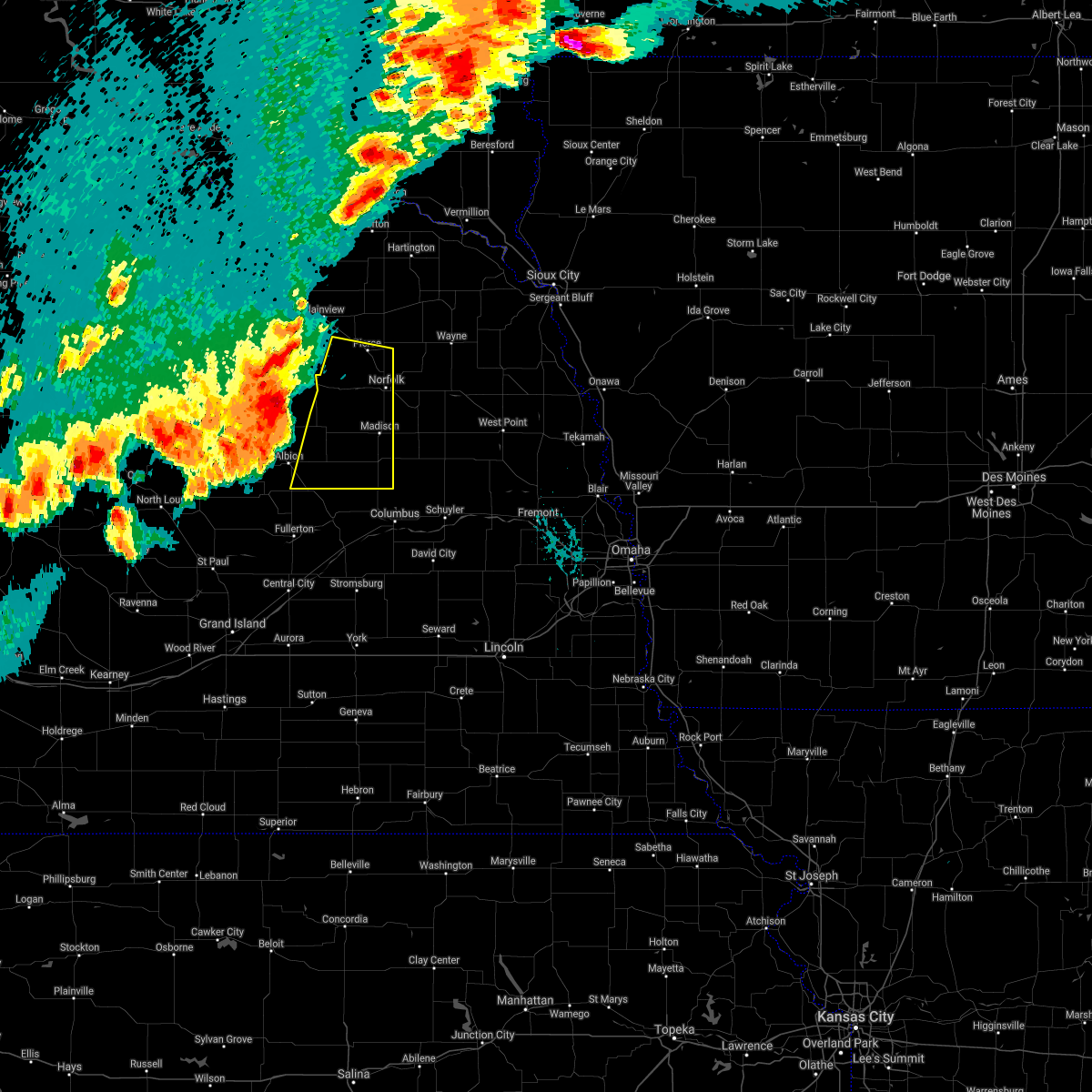 At 821 pm cdt, a severe thunderstorm was located 5 miles northeast of petersburg, or 30 miles west of norfolk, moving east at 35 mph (radar indicated). Hazards include 60 mph wind gusts and nickel size hail. expect damage to roofs, siding, and trees At 821 pm cdt, a severe thunderstorm was located 5 miles northeast of petersburg, or 30 miles west of norfolk, moving east at 35 mph (radar indicated). Hazards include 60 mph wind gusts and nickel size hail. expect damage to roofs, siding, and trees
|
| 6/24/2021 1:25 AM CDT |
 At 124 am cdt, a severe thunderstorm was located 5 miles west of pilger, or 13 miles east of norfolk, moving east at 35 mph. this is a very dangerous storm with a history of producing 80 mph gusts and uprooting trees (radar indicated). Hazards include 80 mph wind gusts and penny size hail. Flying debris will be dangerous to those caught without shelter. mobile homes will be heavily damaged. expect considerable damage to roofs, windows, and vehicles. extensive tree damage and power outages are likely. locations impacted include, norfolk, columbus, madison, pierce, albion, stanton, battle creek, newman grove, st. Edward, winside, leigh, cedar rapids, pilger, platte center, petersburg, meadow grove, hadar, hoskins, monroe and lindsay. At 124 am cdt, a severe thunderstorm was located 5 miles west of pilger, or 13 miles east of norfolk, moving east at 35 mph. this is a very dangerous storm with a history of producing 80 mph gusts and uprooting trees (radar indicated). Hazards include 80 mph wind gusts and penny size hail. Flying debris will be dangerous to those caught without shelter. mobile homes will be heavily damaged. expect considerable damage to roofs, windows, and vehicles. extensive tree damage and power outages are likely. locations impacted include, norfolk, columbus, madison, pierce, albion, stanton, battle creek, newman grove, st. Edward, winside, leigh, cedar rapids, pilger, platte center, petersburg, meadow grove, hadar, hoskins, monroe and lindsay.
|
| 6/24/2021 1:08 AM CDT |
 At 107 am cdt, a severe thunderstorm was located near norfolk, moving east at 35 mph. this is a very dangerous storm (a 84 mph gust was recorded at the albion airport at 12:55am). Hazards include 80 mph wind gusts and penny size hail. Flying debris will be dangerous to those caught without shelter. mobile homes will be heavily damaged. expect considerable damage to roofs, windows, and vehicles. extensive tree damage and power outages are likely. Locations impacted include, stanton and pilger. At 107 am cdt, a severe thunderstorm was located near norfolk, moving east at 35 mph. this is a very dangerous storm (a 84 mph gust was recorded at the albion airport at 12:55am). Hazards include 80 mph wind gusts and penny size hail. Flying debris will be dangerous to those caught without shelter. mobile homes will be heavily damaged. expect considerable damage to roofs, windows, and vehicles. extensive tree damage and power outages are likely. Locations impacted include, stanton and pilger.
|
| 6/24/2021 1:06 AM CDT |
 At 105 am cdt, a severe thunderstorm was located over petersburg, or 34 miles west of norfolk, moving southeast at 45 mph. this is a very dangerous storm (a 84 mph gust was reported at the albion airport at 12:55am). Hazards include 80 mph wind gusts and penny size hail. Flying debris will be dangerous to those caught without shelter. mobile homes will be heavily damaged. expect considerable damage to roofs, windows, and vehicles. extensive tree damage and power outages are likely. locations impacted include, albion, newman grove, st. Edward, elgin, petersburg, lindsay, loretto and the highway 14 and 56 junction. At 105 am cdt, a severe thunderstorm was located over petersburg, or 34 miles west of norfolk, moving southeast at 45 mph. this is a very dangerous storm (a 84 mph gust was reported at the albion airport at 12:55am). Hazards include 80 mph wind gusts and penny size hail. Flying debris will be dangerous to those caught without shelter. mobile homes will be heavily damaged. expect considerable damage to roofs, windows, and vehicles. extensive tree damage and power outages are likely. locations impacted include, albion, newman grove, st. Edward, elgin, petersburg, lindsay, loretto and the highway 14 and 56 junction.
|
| 6/24/2021 12:58 AM CDT |
 At 1257 am cdt, a severe thunderstorm was located near norfolk, moving east at 35 mph. this is a very dangerous storm (law enforcement). Hazards include 80 mph wind gusts and penny size hail. Flying debris will be dangerous to those caught without shelter. mobile homes will be heavily damaged. expect considerable damage to roofs, windows, and vehicles. extensive tree damage and power outages are likely. this severe thunderstorm will be near, hoskins around 110 am cdt. Other locations in the path of this severe thunderstorm include stanton and pilger. At 1257 am cdt, a severe thunderstorm was located near norfolk, moving east at 35 mph. this is a very dangerous storm (law enforcement). Hazards include 80 mph wind gusts and penny size hail. Flying debris will be dangerous to those caught without shelter. mobile homes will be heavily damaged. expect considerable damage to roofs, windows, and vehicles. extensive tree damage and power outages are likely. this severe thunderstorm will be near, hoskins around 110 am cdt. Other locations in the path of this severe thunderstorm include stanton and pilger.
|
| 6/24/2021 12:40 AM CDT |
 At 1239 am cdt, a severe thunderstorm was located 10 miles northeast of bartlett, or 35 miles south of o`neill, moving southeast at 45 mph (radar indicated). Hazards include 75 mph wind gusts and penny size hail. Expect considerable tree damage. Damage is likely to mobile homes, roofs, and outbuildings. At 1239 am cdt, a severe thunderstorm was located 10 miles northeast of bartlett, or 35 miles south of o`neill, moving southeast at 45 mph (radar indicated). Hazards include 75 mph wind gusts and penny size hail. Expect considerable tree damage. Damage is likely to mobile homes, roofs, and outbuildings.
|
| 6/22/2021 6:37 PM CDT |
 At 637 pm cdt, a severe thunderstorm was located 6 miles south of newman grove, or 28 miles northwest of columbus, moving southeast at 25 mph (radar indicated). Hazards include 60 mph wind gusts and half dollar size hail. Hail damage to vehicles is expected. expect wind damage to roofs, siding, and trees. This severe storm will be near, lindsay around 645 pm cdt. At 637 pm cdt, a severe thunderstorm was located 6 miles south of newman grove, or 28 miles northwest of columbus, moving southeast at 25 mph (radar indicated). Hazards include 60 mph wind gusts and half dollar size hail. Hail damage to vehicles is expected. expect wind damage to roofs, siding, and trees. This severe storm will be near, lindsay around 645 pm cdt.
|
| 6/22/2021 6:26 PM CDT |
 At 625 pm cdt, a severe thunderstorm was located near albion, or 35 miles southwest of norfolk, moving southeast at 20 mph (radar indicated). Hazards include 60 mph wind gusts and half dollar size hail. Hail damage to vehicles is expected. Expect wind damage to roofs, siding, and trees. At 625 pm cdt, a severe thunderstorm was located near albion, or 35 miles southwest of norfolk, moving southeast at 20 mph (radar indicated). Hazards include 60 mph wind gusts and half dollar size hail. Hail damage to vehicles is expected. Expect wind damage to roofs, siding, and trees.
|
| 6/11/2021 7:24 AM CDT |
 At 724 am cdt, a severe thunderstorm was located 6 miles northeast of st. edward, or 23 miles northwest of columbus, moving east at 20 mph (radar indicated). Hazards include 60 mph wind gusts and quarter size hail. Hail damage to vehicles is expected. expect wind damage to roofs, siding, and trees. This severe thunderstorm will be near, lindsay around 730 am cdt. At 724 am cdt, a severe thunderstorm was located 6 miles northeast of st. edward, or 23 miles northwest of columbus, moving east at 20 mph (radar indicated). Hazards include 60 mph wind gusts and quarter size hail. Hail damage to vehicles is expected. expect wind damage to roofs, siding, and trees. This severe thunderstorm will be near, lindsay around 730 am cdt.
|
| 7/8/2020 11:08 PM CDT |
 The severe thunderstorm warning for southwestern madison, northwestern platte and boone counties will expire at 1115 pm cdt, the storms which prompted the warning have weakened. therefore, the warning will be allowed to expire. however small hail and gusty winds to near 50 mph will still possible with these thunderstorms. a severe thunderstorm watch remains in effect until midnight cdt for northeastern nebraska. a severe thunderstorm watch also remains in effect until 500 am cdt for northeastern nebraska. The severe thunderstorm warning for southwestern madison, northwestern platte and boone counties will expire at 1115 pm cdt, the storms which prompted the warning have weakened. therefore, the warning will be allowed to expire. however small hail and gusty winds to near 50 mph will still possible with these thunderstorms. a severe thunderstorm watch remains in effect until midnight cdt for northeastern nebraska. a severe thunderstorm watch also remains in effect until 500 am cdt for northeastern nebraska.
|
| 7/8/2020 10:55 PM CDT |
 At 1054 pm cdt, severe thunderstorms were located along a line extending from 4 miles southwest of newman grove to near belgrade to 6 miles east of wolbach, moving south at 40 mph. the strongest storms are expected to affect the southern half of boone county (radar indicated). Hazards include 60 mph wind gusts and nickel size hail. Expect damage to roofs, siding, and trees. locations impacted include, albion, newman grove, st. Edward, cedar rapids, petersburg, lindsay, primrose, loretto and the highway 14 and 56 junction. At 1054 pm cdt, severe thunderstorms were located along a line extending from 4 miles southwest of newman grove to near belgrade to 6 miles east of wolbach, moving south at 40 mph. the strongest storms are expected to affect the southern half of boone county (radar indicated). Hazards include 60 mph wind gusts and nickel size hail. Expect damage to roofs, siding, and trees. locations impacted include, albion, newman grove, st. Edward, cedar rapids, petersburg, lindsay, primrose, loretto and the highway 14 and 56 junction.
|
| 7/8/2020 10:45 PM CDT |
 At 1043 pm cdt, the leading edge of an area of severe thunderstorms was located along a line extending from 7 miles north of newman grove to 5 miles north of st. edward to 6 miles southwest of cedar rapids, moving southeast at 30 mph. the strongest storms in this area were just north of primrose (radar indicated). Hazards include 60 mph wind gusts and nickel size hail. Expect damage to roofs, siding, and trees. locations impacted include, albion, newman grove, st. Edward, cedar rapids, petersburg, lindsay, primrose, loretto and the highway 14 and 56 junction. At 1043 pm cdt, the leading edge of an area of severe thunderstorms was located along a line extending from 7 miles north of newman grove to 5 miles north of st. edward to 6 miles southwest of cedar rapids, moving southeast at 30 mph. the strongest storms in this area were just north of primrose (radar indicated). Hazards include 60 mph wind gusts and nickel size hail. Expect damage to roofs, siding, and trees. locations impacted include, albion, newman grove, st. Edward, cedar rapids, petersburg, lindsay, primrose, loretto and the highway 14 and 56 junction.
|
| 7/8/2020 10:35 PM CDT |
 At 1035 pm cdt, the leading edge of an severe thunderstorms were located along a line extending from near meadow grove to near newman grove to near cedar rapids, moving east at 45 mph. the strongest part of the area was about 10 miles west of albion (radar indicated). Hazards include 60 mph wind gusts and nickel size hail. Expect damage to roofs, siding, and trees. locations impacted include, albion, newman grove, st. Edward, cedar rapids, petersburg, lindsay, primrose, loretto and the highway 14 and 56 junction. At 1035 pm cdt, the leading edge of an severe thunderstorms were located along a line extending from near meadow grove to near newman grove to near cedar rapids, moving east at 45 mph. the strongest part of the area was about 10 miles west of albion (radar indicated). Hazards include 60 mph wind gusts and nickel size hail. Expect damage to roofs, siding, and trees. locations impacted include, albion, newman grove, st. Edward, cedar rapids, petersburg, lindsay, primrose, loretto and the highway 14 and 56 junction.
|
| 7/8/2020 10:24 PM CDT |
 At 1024 pm cdt, severe thunderstorms were located along a line extending from 4 miles southwest of meadow grove to 4 miles north of albion to 6 miles northwest of cedar rapids, moving east at 45 mph (radar indicated). Hazards include 60 mph wind gusts and nickel size hail. expect damage to roofs, siding, and trees At 1024 pm cdt, severe thunderstorms were located along a line extending from 4 miles southwest of meadow grove to 4 miles north of albion to 6 miles northwest of cedar rapids, moving east at 45 mph (radar indicated). Hazards include 60 mph wind gusts and nickel size hail. expect damage to roofs, siding, and trees
|
| 7/6/2020 8:53 PM CDT |
 At 853 pm cdt, severe thunderstorms were located along a line extending from near lindsay to 6 miles southwest of newman grove to 7 miles west of petersburg, moving south at 20 mph (radar indicated). Hazards include 60 mph wind gusts. Expect damage to roofs, siding, and trees. Locations impacted include, newman grove, lindsay and loretto. At 853 pm cdt, severe thunderstorms were located along a line extending from near lindsay to 6 miles southwest of newman grove to 7 miles west of petersburg, moving south at 20 mph (radar indicated). Hazards include 60 mph wind gusts. Expect damage to roofs, siding, and trees. Locations impacted include, newman grove, lindsay and loretto.
|
| 7/6/2020 8:44 PM CDT |
 At 844 pm cdt, severe thunderstorms were located along a line extending from near lindsay to 4 miles southwest of newman grove to 7 miles west of petersburg, moving south at 20 mph (radar indicated). Hazards include 60 mph wind gusts. Expect damage to roofs, siding, and trees. Locations impacted include, newman grove, petersburg, lindsay and loretto. At 844 pm cdt, severe thunderstorms were located along a line extending from near lindsay to 4 miles southwest of newman grove to 7 miles west of petersburg, moving south at 20 mph (radar indicated). Hazards include 60 mph wind gusts. Expect damage to roofs, siding, and trees. Locations impacted include, newman grove, petersburg, lindsay and loretto.
|
| 7/6/2020 8:41 PM CDT |
 At 841 pm cdt, severe thunderstorms were located along a line extending from 4 miles northeast of lindsay to 4 miles southwest of newman grove to 7 miles west of petersburg, moving south at 25 mph (radar indicated). Hazards include 60 mph wind gusts and quarter size hail. Hail damage to vehicles is expected. expect wind damage to roofs, siding, and trees. Locations impacted include, newman grove, petersburg, lindsay and loretto. At 841 pm cdt, severe thunderstorms were located along a line extending from 4 miles northeast of lindsay to 4 miles southwest of newman grove to 7 miles west of petersburg, moving south at 25 mph (radar indicated). Hazards include 60 mph wind gusts and quarter size hail. Hail damage to vehicles is expected. expect wind damage to roofs, siding, and trees. Locations impacted include, newman grove, petersburg, lindsay and loretto.
|
| 7/6/2020 8:36 PM CDT |
 At 836 pm cdt, severe thunderstorms were located along a line extending from 5 miles north of lindsay to 8 miles west of petersburg, moving south at 20 mph (radar indicated). Hazards include 60 mph wind gusts and quarter size hail. Hail damage to vehicles is expected. expect wind damage to roofs, siding, and trees. Locations impacted include, newman grove, petersburg, lindsay and loretto. At 836 pm cdt, severe thunderstorms were located along a line extending from 5 miles north of lindsay to 8 miles west of petersburg, moving south at 20 mph (radar indicated). Hazards include 60 mph wind gusts and quarter size hail. Hail damage to vehicles is expected. expect wind damage to roofs, siding, and trees. Locations impacted include, newman grove, petersburg, lindsay and loretto.
|
| 7/6/2020 8:26 PM CDT |
 At 826 pm cdt, severe thunderstorms were located along a line extending from 9 miles northeast of newman grove to 9 miles west of elgin, moving south at 20 mph (radar indicated). Hazards include 60 mph wind gusts and quarter size hail. Hail damage to vehicles is expected. expect wind damage to roofs, siding, and trees. Locations impacted include, madison, newman grove, elgin, petersburg, lindsay and loretto. At 826 pm cdt, severe thunderstorms were located along a line extending from 9 miles northeast of newman grove to 9 miles west of elgin, moving south at 20 mph (radar indicated). Hazards include 60 mph wind gusts and quarter size hail. Hail damage to vehicles is expected. expect wind damage to roofs, siding, and trees. Locations impacted include, madison, newman grove, elgin, petersburg, lindsay and loretto.
|
| 7/6/2020 8:12 PM CDT |
 At 812 pm cdt, severe thunderstorms were located along a line extending from 7 miles south of meadow grove to 6 miles west of elgin, moving south at 20 mph (radar indicated). Hazards include 60 mph wind gusts and quarter size hail. Hail damage to vehicles is expected. Expect wind damage to roofs, siding, and trees. At 812 pm cdt, severe thunderstorms were located along a line extending from 7 miles south of meadow grove to 6 miles west of elgin, moving south at 20 mph (radar indicated). Hazards include 60 mph wind gusts and quarter size hail. Hail damage to vehicles is expected. Expect wind damage to roofs, siding, and trees.
|
| 6/30/2020 10:50 PM CDT |
 At 1050 pm cdt, a severe thunderstorm was located 7 miles south of lindsay, or 21 miles northwest of columbus, moving east at 20 mph (radar indicated). Hazards include 70 mph wind gusts and quarter size hail. Hail damage to vehicles is expected. expect considerable tree damage. wind damage is also likely to mobile homes, roofs, and outbuildings. Locations impacted include, duncan, platte center, monroe, lindsay, humphrey, tarnov, cornlea and lake ocaonee. At 1050 pm cdt, a severe thunderstorm was located 7 miles south of lindsay, or 21 miles northwest of columbus, moving east at 20 mph (radar indicated). Hazards include 70 mph wind gusts and quarter size hail. Hail damage to vehicles is expected. expect considerable tree damage. wind damage is also likely to mobile homes, roofs, and outbuildings. Locations impacted include, duncan, platte center, monroe, lindsay, humphrey, tarnov, cornlea and lake ocaonee.
|
| 6/30/2020 10:26 PM CDT |
 At 1025 pm cdt, a severe thunderstorm was located over st. edward, or 28 miles northwest of columbus, moving east at 20 mph (radar indicated). Hazards include 60 mph wind gusts and quarter size hail. Hail damage to vehicles is expected. Expect wind damage to roofs, siding, and trees. At 1025 pm cdt, a severe thunderstorm was located over st. edward, or 28 miles northwest of columbus, moving east at 20 mph (radar indicated). Hazards include 60 mph wind gusts and quarter size hail. Hail damage to vehicles is expected. Expect wind damage to roofs, siding, and trees.
|
| 6/30/2020 9:56 PM CDT |
 At 956 pm cdt, a severe thunderstorm was located near albion, or 36 miles northwest of columbus, moving east at 20 mph (radar indicated). Hazards include 60 mph wind gusts and quarter size hail. Hail damage to vehicles is expected. Expect wind damage to roofs, siding, and trees. At 956 pm cdt, a severe thunderstorm was located near albion, or 36 miles northwest of columbus, moving east at 20 mph (radar indicated). Hazards include 60 mph wind gusts and quarter size hail. Hail damage to vehicles is expected. Expect wind damage to roofs, siding, and trees.
|
| 5/24/2020 3:08 AM CDT |
 At 308 am cdt, severe thunderstorms were located along a line extending from near battle creek to near madison to 4 miles north of monroe, moving east at 45 mph (this storm has a history of producing 75 mph wind gusts). Hazards include 75 mph wind gusts and penny size hail. Expect considerable tree damage. damage is likely to mobile homes, roofs, and outbuildings. Locations impacted include, norfolk, columbus, schuyler, madison, stanton, battle creek, clarkson, howells, bellwood, leigh, rising city, pilger, duncan, platte center, monroe, lindsay, creston, humphrey, octavia and richland. At 308 am cdt, severe thunderstorms were located along a line extending from near battle creek to near madison to 4 miles north of monroe, moving east at 45 mph (this storm has a history of producing 75 mph wind gusts). Hazards include 75 mph wind gusts and penny size hail. Expect considerable tree damage. damage is likely to mobile homes, roofs, and outbuildings. Locations impacted include, norfolk, columbus, schuyler, madison, stanton, battle creek, clarkson, howells, bellwood, leigh, rising city, pilger, duncan, platte center, monroe, lindsay, creston, humphrey, octavia and richland.
|
| 5/24/2020 2:53 AM CDT |
 At 253 am cdt, severe thunderstorms were located along a line extending from meadow grove to 6 miles northeast of newman grove to near st. edward, moving east at 45 mph (radar indicated). Hazards include 60 mph wind gusts and penny size hail. Expect damage to roofs, siding, and trees. locations impacted include, norfolk, columbus, schuyler, madison, stanton, battle creek, newman grove, st. Edward, clarkson, howells, bellwood, leigh, rising city, pilger, duncan, platte center, meadow grove, monroe, lindsay and creston. At 253 am cdt, severe thunderstorms were located along a line extending from meadow grove to 6 miles northeast of newman grove to near st. edward, moving east at 45 mph (radar indicated). Hazards include 60 mph wind gusts and penny size hail. Expect damage to roofs, siding, and trees. locations impacted include, norfolk, columbus, schuyler, madison, stanton, battle creek, newman grove, st. Edward, clarkson, howells, bellwood, leigh, rising city, pilger, duncan, platte center, meadow grove, monroe, lindsay and creston.
|
| 5/24/2020 2:37 AM CDT |
 At 237 am cdt, severe thunderstorms were located along a line extending from 6 miles east of oakdale to near st. edward, moving east at 45 mph (radar indicated. these storms have a history of producing wind gusts near 70). Hazards include 70 mph wind gusts. Expect considerable tree damage. Damage is likely to mobile homes, roofs, and outbuildings. At 237 am cdt, severe thunderstorms were located along a line extending from 6 miles east of oakdale to near st. edward, moving east at 45 mph (radar indicated. these storms have a history of producing wind gusts near 70). Hazards include 70 mph wind gusts. Expect considerable tree damage. Damage is likely to mobile homes, roofs, and outbuildings.
|
| 7/13/2019 3:08 AM CDT |
 At 307 am cdt, severe thunderstorms were located along a line extending from near winside to 7 miles southwest of stanton to 5 miles northwest of platte center, moving east at 45 mph. the strongest storms were located in stanton county and northern platte county (radar indicated). Hazards include 60 mph wind gusts and quarter size hail. Hail damage to vehicles is expected. expect wind damage to roofs, siding, and trees. Locations impacted include, norfolk, madison, pierce, stanton, battle creek, clarkson, winside, leigh, pilger, platte center, hadar, hoskins, lindsay, creston, humphrey, tarnov, cornlea, the highway 15 and 32 junction, lake north babcock campground and circle h trailer park. At 307 am cdt, severe thunderstorms were located along a line extending from near winside to 7 miles southwest of stanton to 5 miles northwest of platte center, moving east at 45 mph. the strongest storms were located in stanton county and northern platte county (radar indicated). Hazards include 60 mph wind gusts and quarter size hail. Hail damage to vehicles is expected. expect wind damage to roofs, siding, and trees. Locations impacted include, norfolk, madison, pierce, stanton, battle creek, clarkson, winside, leigh, pilger, platte center, hadar, hoskins, lindsay, creston, humphrey, tarnov, cornlea, the highway 15 and 32 junction, lake north babcock campground and circle h trailer park.
|
| 7/13/2019 2:58 AM CDT |
 At 257 am cdt, severe thunderstorms were located along a line extending from hoskins to 5 miles northwest of platte center, moving east at 45 mph. the strongest storms in this line were near norfolk and also near lindsay (radar indicated). Hazards include 65 mph wind gusts and half dollar size hail. Hail damage to vehicles is expected. expect wind damage to roofs, siding, and trees. Locations impacted include, norfolk, madison, pierce, stanton, battle creek, clarkson, winside, leigh, pilger, platte center, hadar, hoskins, lindsay, creston, humphrey, tarnov, cornlea, the highway 15 and 32 junction, lake north babcock campground and circle h trailer park. At 257 am cdt, severe thunderstorms were located along a line extending from hoskins to 5 miles northwest of platte center, moving east at 45 mph. the strongest storms in this line were near norfolk and also near lindsay (radar indicated). Hazards include 65 mph wind gusts and half dollar size hail. Hail damage to vehicles is expected. expect wind damage to roofs, siding, and trees. Locations impacted include, norfolk, madison, pierce, stanton, battle creek, clarkson, winside, leigh, pilger, platte center, hadar, hoskins, lindsay, creston, humphrey, tarnov, cornlea, the highway 15 and 32 junction, lake north babcock campground and circle h trailer park.
|
| 7/13/2019 2:48 AM CDT |
 At 247 am cdt, severe thunderstorms were located along a line extending from hadar to 6 miles northwest of monroe, moving east at 45 mph. the strongest part of this line of storms should affect the norfolk area (radar indicated). Hazards include 65 mph wind gusts and half dollar size hail. Hail damage to vehicles is expected. expect wind damage to roofs, siding, and trees. Locations impacted include, norfolk, madison, pierce, stanton, battle creek, clarkson, winside, leigh, pilger, platte center, hadar, hoskins, lindsay, creston, humphrey, tarnov, cornlea, the highway 15 and 32 junction, lake north babcock campground and circle h trailer park. At 247 am cdt, severe thunderstorms were located along a line extending from hadar to 6 miles northwest of monroe, moving east at 45 mph. the strongest part of this line of storms should affect the norfolk area (radar indicated). Hazards include 65 mph wind gusts and half dollar size hail. Hail damage to vehicles is expected. expect wind damage to roofs, siding, and trees. Locations impacted include, norfolk, madison, pierce, stanton, battle creek, clarkson, winside, leigh, pilger, platte center, hadar, hoskins, lindsay, creston, humphrey, tarnov, cornlea, the highway 15 and 32 junction, lake north babcock campground and circle h trailer park.
|
| 7/13/2019 2:42 AM CDT |
 At 241 am cdt, severe thunderstorms were located along a line extending from 5 miles southwest of pierce to 7 miles east of st. edward, moving east at 45 mph (radar indicated). Hazards include 60 mph wind gusts and quarter size hail. Hail damage to vehicles is expected. Expect wind damage to roofs, siding, and trees. At 241 am cdt, severe thunderstorms were located along a line extending from 5 miles southwest of pierce to 7 miles east of st. edward, moving east at 45 mph (radar indicated). Hazards include 60 mph wind gusts and quarter size hail. Hail damage to vehicles is expected. Expect wind damage to roofs, siding, and trees.
|
| 6/21/2019 8:52 PM CDT |
 At 851 pm cdt, a severe thunderstorm was located 6 miles northwest of newman grove, or 29 miles southwest of norfolk, moving east at 15 mph (trained weather spotters have reported quarter size hail with this storm in boone county). Hazards include 60 mph wind gusts and quarter size hail. Hail damage to vehicles is expected. expect wind damage to roofs, siding, and trees. Locations impacted include, newman grove and lindsay. At 851 pm cdt, a severe thunderstorm was located 6 miles northwest of newman grove, or 29 miles southwest of norfolk, moving east at 15 mph (trained weather spotters have reported quarter size hail with this storm in boone county). Hazards include 60 mph wind gusts and quarter size hail. Hail damage to vehicles is expected. expect wind damage to roofs, siding, and trees. Locations impacted include, newman grove and lindsay.
|
| 6/21/2019 8:41 PM CDT |
 At 840 pm cdt, a severe thunderstorm was located 6 miles northeast of albion, or 32 miles southwest of norfolk, moving east at 15 mph (trained spotters reported quarter size hail with this storm). Hazards include 60 mph wind gusts and quarter size hail. Hail damage to vehicles is expected. Expect wind damage to roofs, siding, and trees. At 840 pm cdt, a severe thunderstorm was located 6 miles northeast of albion, or 32 miles southwest of norfolk, moving east at 15 mph (trained spotters reported quarter size hail with this storm). Hazards include 60 mph wind gusts and quarter size hail. Hail damage to vehicles is expected. Expect wind damage to roofs, siding, and trees.
|
| 4/21/2019 10:41 PM CDT |
 The severe thunderstorm warning for platte county will expire at 1045 pm cdt, the storm which prompted the warning has weakened below severe limits, and no longer poses an immediate threat to life or property. therefore, the warning will be allowed to expire. however gusty winds are still possible with this thunderstorm. The severe thunderstorm warning for platte county will expire at 1045 pm cdt, the storm which prompted the warning has weakened below severe limits, and no longer poses an immediate threat to life or property. therefore, the warning will be allowed to expire. however gusty winds are still possible with this thunderstorm.
|
| 4/21/2019 10:28 PM CDT |
 At 1028 pm cdt, a severe thunderstorm was located near platte center, or 14 miles northwest of columbus, moving northeast at 20 mph (radar indicated). Hazards include 60 mph wind gusts and quarter size hail. Hail damage to vehicles is expected. expect wind damage to roofs, siding, and trees. Locations impacted include, columbus, duncan, platte center, monroe, lindsay, creston, humphrey, tarnov, cornlea, college view trailer park, camp pawnee, shell creek elementary school, lake north babcock campground, central community college, lake ocaonee and circle h trailer park. At 1028 pm cdt, a severe thunderstorm was located near platte center, or 14 miles northwest of columbus, moving northeast at 20 mph (radar indicated). Hazards include 60 mph wind gusts and quarter size hail. Hail damage to vehicles is expected. expect wind damage to roofs, siding, and trees. Locations impacted include, columbus, duncan, platte center, monroe, lindsay, creston, humphrey, tarnov, cornlea, college view trailer park, camp pawnee, shell creek elementary school, lake north babcock campground, central community college, lake ocaonee and circle h trailer park.
|
| 4/21/2019 10:10 PM CDT |
 The severe thunderstorm warning for northwestern platte and southeastern boone counties will expire at 1015 pm cdt, the storm which prompted the warning has moved out of the area. therefore, the warning will be allowed to expire. however gusty winds are still possible with this thunderstorm. The severe thunderstorm warning for northwestern platte and southeastern boone counties will expire at 1015 pm cdt, the storm which prompted the warning has moved out of the area. therefore, the warning will be allowed to expire. however gusty winds are still possible with this thunderstorm.
|
| 4/21/2019 10:05 PM CDT |
 At 1004 pm cdt, a severe thunderstorm was located over genoa, or 18 miles west of columbus, moving northeast at 20 mph (radar indicated). Hazards include 60 mph wind gusts and quarter size hail. Hail damage to vehicles is expected. Expect wind damage to roofs, siding, and trees. At 1004 pm cdt, a severe thunderstorm was located over genoa, or 18 miles west of columbus, moving northeast at 20 mph (radar indicated). Hazards include 60 mph wind gusts and quarter size hail. Hail damage to vehicles is expected. Expect wind damage to roofs, siding, and trees.
|
| 4/21/2019 9:54 PM CDT |
 At 954 pm cdt, a severe thunderstorm was located over st. edward, or 25 miles northwest of columbus, moving northeast at 20 mph (radar indicated). Hazards include 60 mph wind gusts and quarter size hail. Hail damage to vehicles is expected. expect wind damage to roofs, siding, and trees. locations impacted include, albion, st. Edward, lindsay, cornlea and the highway 14 and 56 junction. At 954 pm cdt, a severe thunderstorm was located over st. edward, or 25 miles northwest of columbus, moving northeast at 20 mph (radar indicated). Hazards include 60 mph wind gusts and quarter size hail. Hail damage to vehicles is expected. expect wind damage to roofs, siding, and trees. locations impacted include, albion, st. Edward, lindsay, cornlea and the highway 14 and 56 junction.
|
| 4/21/2019 9:33 PM CDT |
 At 933 pm cdt, a severe thunderstorm was located near st. edward, or 27 miles west of columbus, moving northeast at 20 mph (radar indicated). Hazards include 60 mph wind gusts and quarter size hail. Hail damage to vehicles is expected. Expect wind damage to roofs, siding, and trees. At 933 pm cdt, a severe thunderstorm was located near st. edward, or 27 miles west of columbus, moving northeast at 20 mph (radar indicated). Hazards include 60 mph wind gusts and quarter size hail. Hail damage to vehicles is expected. Expect wind damage to roofs, siding, and trees.
|
| 7/27/2018 8:51 PM CDT |
 At 850 pm cdt, a severe thunderstorm was located 7 miles southwest of madison, or 21 miles south of norfolk, moving southeast at 35 mph (radar indicated). Hazards include 60 mph wind gusts and half dollar size hail. Hail damage to vehicles is expected. expect wind damage to roofs, siding, and trees. Locations impacted include, madison, lindsay, creston, humphrey and cornlea. At 850 pm cdt, a severe thunderstorm was located 7 miles southwest of madison, or 21 miles south of norfolk, moving southeast at 35 mph (radar indicated). Hazards include 60 mph wind gusts and half dollar size hail. Hail damage to vehicles is expected. expect wind damage to roofs, siding, and trees. Locations impacted include, madison, lindsay, creston, humphrey and cornlea.
|
| 7/27/2018 8:37 PM CDT |
 At 837 pm cdt, a severe thunderstorm was located 8 miles west of madison, or 17 miles southwest of norfolk, moving southeast at 35 mph (radar indicated). Hazards include ping pong ball size hail and 60 mph wind gusts. People and animals outdoors will be injured. expect hail damage to roofs, siding, windows, and vehicles. Expect wind damage to roofs, siding, and trees. At 837 pm cdt, a severe thunderstorm was located 8 miles west of madison, or 17 miles southwest of norfolk, moving southeast at 35 mph (radar indicated). Hazards include ping pong ball size hail and 60 mph wind gusts. People and animals outdoors will be injured. expect hail damage to roofs, siding, windows, and vehicles. Expect wind damage to roofs, siding, and trees.
|
| 7/19/2018 12:33 AM CDT |
 At 1232 am cdt, a severe thunderstorm was located 7 miles south of lindsay, or 20 miles northwest of columbus, moving southeast at 45 mph (radar indicated). Hazards include 60 mph wind gusts and penny size hail. expect damage to roofs, siding, and trees At 1232 am cdt, a severe thunderstorm was located 7 miles south of lindsay, or 20 miles northwest of columbus, moving southeast at 45 mph (radar indicated). Hazards include 60 mph wind gusts and penny size hail. expect damage to roofs, siding, and trees
|
| 7/19/2018 12:27 AM CDT |
 At 1227 am cdt, a severe thunderstorm was located 4 miles south of lindsay, or 23 miles northwest of columbus, moving southeast at 50 mph (radar indicated). Hazards include 60 mph wind gusts and nickel size hail. Expect damage to roofs, siding, and trees. locations impacted include, albion, newman grove, st. Edward, lindsay and the highway 14 and 56 junction. At 1227 am cdt, a severe thunderstorm was located 4 miles south of lindsay, or 23 miles northwest of columbus, moving southeast at 50 mph (radar indicated). Hazards include 60 mph wind gusts and nickel size hail. Expect damage to roofs, siding, and trees. locations impacted include, albion, newman grove, st. Edward, lindsay and the highway 14 and 56 junction.
|
| 7/19/2018 12:12 AM CDT |
 At 1211 am cdt, a severe thunderstorm was located 5 miles northeast of albion, or 32 miles southwest of norfolk, moving southeast at 40 mph (radar indicated). Hazards include 60 mph wind gusts and nickel size hail. expect damage to roofs, siding, and trees At 1211 am cdt, a severe thunderstorm was located 5 miles northeast of albion, or 32 miles southwest of norfolk, moving southeast at 40 mph (radar indicated). Hazards include 60 mph wind gusts and nickel size hail. expect damage to roofs, siding, and trees
|
| 7/19/2018 12:05 AM CDT |
 At 1204 am cdt, severe thunderstorms were located along a line extending from near meadow grove to 8 miles north of newman grove to 3 miles south of petersburg, moving southeast at 50 mph (radar indicated). Hazards include 60 mph wind gusts and nickel size hail. Expect damage to roofs, siding, and trees. Locations impacted include, albion, newman grove, petersburg, meadow grove, tilden and loretto. At 1204 am cdt, severe thunderstorms were located along a line extending from near meadow grove to 8 miles north of newman grove to 3 miles south of petersburg, moving southeast at 50 mph (radar indicated). Hazards include 60 mph wind gusts and nickel size hail. Expect damage to roofs, siding, and trees. Locations impacted include, albion, newman grove, petersburg, meadow grove, tilden and loretto.
|
| 7/18/2018 11:43 PM CDT |
 At 1143 pm cdt, severe thunderstorms were located along a line extending from near neligh to near elgin to 12 miles east of bartlett, moving southeast at 50 mph (radar indicated). Hazards include 70 mph wind gusts and quarter size hail. this storm has a history of wind damage. Hail damage to vehicles is expected. expect considerable tree damage. Wind damage is also likely to mobile homes, roofs, and outbuildings. At 1143 pm cdt, severe thunderstorms were located along a line extending from near neligh to near elgin to 12 miles east of bartlett, moving southeast at 50 mph (radar indicated). Hazards include 70 mph wind gusts and quarter size hail. this storm has a history of wind damage. Hail damage to vehicles is expected. expect considerable tree damage. Wind damage is also likely to mobile homes, roofs, and outbuildings.
|
| 6/28/2018 8:23 AM CDT |
 At 823 am cdt, severe thunderstorms were located along a line extending from 3 miles south of hoskins to 3 miles southeast of creston, moving east at 50 mph. strong winds are occurring behind the line of storms as well (radar indicated). Hazards include 70 mph wind gusts and quarter size hail. Hail damage to vehicles is expected. expect considerable tree damage. wind damage is also likely to mobile homes, roofs, and outbuildings. Locations impacted include, norfolk, madison, battle creek, newman grove, meadow grove, lindsay, humphrey and cornlea. At 823 am cdt, severe thunderstorms were located along a line extending from 3 miles south of hoskins to 3 miles southeast of creston, moving east at 50 mph. strong winds are occurring behind the line of storms as well (radar indicated). Hazards include 70 mph wind gusts and quarter size hail. Hail damage to vehicles is expected. expect considerable tree damage. wind damage is also likely to mobile homes, roofs, and outbuildings. Locations impacted include, norfolk, madison, battle creek, newman grove, meadow grove, lindsay, humphrey and cornlea.
|
| 6/28/2018 8:18 AM CDT |
 At 817 am cdt, severe thunderstorms were located along a line extending from 3 miles northeast of norfolk to near creston, moving east at 40 mph. strong winds are occurring along and behind the line of storms (radar indicated). Hazards include 70 mph wind gusts and quarter size hail. Hail damage to vehicles is expected. expect considerable tree damage. wind damage is also likely to mobile homes, roofs, and outbuildings. Locations impacted include, norfolk, madison, battle creek, newman grove, meadow grove, lindsay, humphrey and cornlea. At 817 am cdt, severe thunderstorms were located along a line extending from 3 miles northeast of norfolk to near creston, moving east at 40 mph. strong winds are occurring along and behind the line of storms (radar indicated). Hazards include 70 mph wind gusts and quarter size hail. Hail damage to vehicles is expected. expect considerable tree damage. wind damage is also likely to mobile homes, roofs, and outbuildings. Locations impacted include, norfolk, madison, battle creek, newman grove, meadow grove, lindsay, humphrey and cornlea.
|
| 6/28/2018 8:11 AM CDT |
 At 811 am cdt, severe thunderstorms were located along a line extending from near norfolk to 5 miles southwest of creston, moving east at 45 mph. these are very dangerous storms (radar indicated). Hazards include 80 mph wind gusts and quarter size hail. Flying debris will be dangerous to those caught without shelter. mobile homes will be heavily damaged. expect considerable damage to roofs, windows, and vehicles. extensive tree damage and power outages are likely. Locations impacted include, norfolk, madison, battle creek, newman grove, meadow grove, lindsay, humphrey and cornlea. At 811 am cdt, severe thunderstorms were located along a line extending from near norfolk to 5 miles southwest of creston, moving east at 45 mph. these are very dangerous storms (radar indicated). Hazards include 80 mph wind gusts and quarter size hail. Flying debris will be dangerous to those caught without shelter. mobile homes will be heavily damaged. expect considerable damage to roofs, windows, and vehicles. extensive tree damage and power outages are likely. Locations impacted include, norfolk, madison, battle creek, newman grove, meadow grove, lindsay, humphrey and cornlea.
|
| 6/28/2018 8:06 AM CDT |
 At 805 am cdt, severe thunderstorms were located along a line extending from 3 miles northwest of norfolk to 7 miles southwest of creston, moving east at 45 mph. this storm produced wind damage in newman grove with measured 79 mph winds. these are very dangerous storms (radar indicated). Hazards include 80 mph wind gusts and nickel size hail. Flying debris will be dangerous to those caught without shelter. mobile homes will be heavily damaged. expect considerable damage to roofs, windows, and vehicles. extensive tree damage and power outages are likely. Locations impacted include, norfolk, madison, battle creek, newman grove, meadow grove, lindsay, humphrey and cornlea. At 805 am cdt, severe thunderstorms were located along a line extending from 3 miles northwest of norfolk to 7 miles southwest of creston, moving east at 45 mph. this storm produced wind damage in newman grove with measured 79 mph winds. these are very dangerous storms (radar indicated). Hazards include 80 mph wind gusts and nickel size hail. Flying debris will be dangerous to those caught without shelter. mobile homes will be heavily damaged. expect considerable damage to roofs, windows, and vehicles. extensive tree damage and power outages are likely. Locations impacted include, norfolk, madison, battle creek, newman grove, meadow grove, lindsay, humphrey and cornlea.
|
| 6/28/2018 7:57 AM CDT |
 At 756 am cdt, severe thunderstorms were located along a line extending from 4 miles north of battle creek to 3 miles southeast of lindsay, moving east at 45 mph (radar indicated). Hazards include 70 mph wind gusts and quarter size hail. Hail damage to vehicles is expected. expect considerable tree damage. wind damage is also likely to mobile homes, roofs, and outbuildings. Locations impacted include, norfolk, madison, battle creek, newman grove, meadow grove, lindsay, humphrey and cornlea. At 756 am cdt, severe thunderstorms were located along a line extending from 4 miles north of battle creek to 3 miles southeast of lindsay, moving east at 45 mph (radar indicated). Hazards include 70 mph wind gusts and quarter size hail. Hail damage to vehicles is expected. expect considerable tree damage. wind damage is also likely to mobile homes, roofs, and outbuildings. Locations impacted include, norfolk, madison, battle creek, newman grove, meadow grove, lindsay, humphrey and cornlea.
|
| 6/28/2018 7:50 AM CDT |
 At 749 am cdt, severe thunderstorms were located along a line extending from 4 miles northwest of battle creek to near lindsay, moving east at 45 mph. these are very dangerous storms (radar indicated). Hazards include 80 mph wind gusts and quarter size hail. Flying debris will be dangerous to those caught without shelter. mobile homes will be heavily damaged. expect considerable damage to roofs, windows, and vehicles. extensive tree damage and power outages are likely. Locations impacted include, norfolk, madison, battle creek, newman grove, meadow grove, lindsay, humphrey and cornlea. At 749 am cdt, severe thunderstorms were located along a line extending from 4 miles northwest of battle creek to near lindsay, moving east at 45 mph. these are very dangerous storms (radar indicated). Hazards include 80 mph wind gusts and quarter size hail. Flying debris will be dangerous to those caught without shelter. mobile homes will be heavily damaged. expect considerable damage to roofs, windows, and vehicles. extensive tree damage and power outages are likely. Locations impacted include, norfolk, madison, battle creek, newman grove, meadow grove, lindsay, humphrey and cornlea.
|
| 6/28/2018 7:45 AM CDT |
 At 745 am cdt, severe thunderstorms were located along a line extending from 4 miles east of meadow grove to near lindsay, moving east at 50 mph. these are very dangerous storms (radar indicated). Hazards include 80 mph wind gusts and quarter size hail. Flying debris will be dangerous to those caught without shelter. mobile homes will be heavily damaged. expect considerable damage to roofs, windows, and vehicles. extensive tree damage and power outages are likely. Locations impacted include, norfolk, madison, battle creek, newman grove, meadow grove, lindsay, humphrey and cornlea. At 745 am cdt, severe thunderstorms were located along a line extending from 4 miles east of meadow grove to near lindsay, moving east at 50 mph. these are very dangerous storms (radar indicated). Hazards include 80 mph wind gusts and quarter size hail. Flying debris will be dangerous to those caught without shelter. mobile homes will be heavily damaged. expect considerable damage to roofs, windows, and vehicles. extensive tree damage and power outages are likely. Locations impacted include, norfolk, madison, battle creek, newman grove, meadow grove, lindsay, humphrey and cornlea.
|
| 6/28/2018 7:40 AM CDT |
 At 739 am cdt, severe thunderstorms were located along a line extending from 3 miles northwest of meadow grove to near newman grove, moving east at 50 mph. the strongest winds are expected across madison county. these are very dangerous storms (radar indicated). Hazards include 80 mph wind gusts and quarter size hail. Flying debris will be dangerous to those caught without shelter. mobile homes will be heavily damaged. expect considerable damage to roofs, windows, and vehicles. extensive tree damage and power outages are likely. Locations impacted include, norfolk, madison, battle creek, newman grove, meadow grove, lindsay, humphrey and cornlea. At 739 am cdt, severe thunderstorms were located along a line extending from 3 miles northwest of meadow grove to near newman grove, moving east at 50 mph. the strongest winds are expected across madison county. these are very dangerous storms (radar indicated). Hazards include 80 mph wind gusts and quarter size hail. Flying debris will be dangerous to those caught without shelter. mobile homes will be heavily damaged. expect considerable damage to roofs, windows, and vehicles. extensive tree damage and power outages are likely. Locations impacted include, norfolk, madison, battle creek, newman grove, meadow grove, lindsay, humphrey and cornlea.
|
| 6/28/2018 7:31 AM CDT |
 At 731 am cdt, severe thunderstorms were located along a line extending from 6 miles east of neligh to 5 miles north of albion, moving east at 50 mph (radar indicated). Hazards include 70 mph wind gusts and quarter size hail. Hail damage to vehicles is expected. expect considerable tree damage. Wind damage is also likely to mobile homes, roofs, and outbuildings. At 731 am cdt, severe thunderstorms were located along a line extending from 6 miles east of neligh to 5 miles north of albion, moving east at 50 mph (radar indicated). Hazards include 70 mph wind gusts and quarter size hail. Hail damage to vehicles is expected. expect considerable tree damage. Wind damage is also likely to mobile homes, roofs, and outbuildings.
|
| 6/18/2018 4:11 PM CDT |
 At 410 pm cdt, a severe thunderstorm was located 5 miles north of st. edward, or 31 miles northwest of columbus, moving northeast at 25 mph (radar indicated). Hazards include quarter size hail. damage to vehicles is expected At 410 pm cdt, a severe thunderstorm was located 5 miles north of st. edward, or 31 miles northwest of columbus, moving northeast at 25 mph (radar indicated). Hazards include quarter size hail. damage to vehicles is expected
|
| 6/18/2018 3:59 PM CDT |
 At 342 pm cdt, a severe thunderstorm was located 4 miles northwest of st. edward, or 32 miles northwest of columbus, moving north at 20 mph (radar indicated). Hazards include quarter size hail. damage to vehicles is expected At 342 pm cdt, a severe thunderstorm was located 4 miles northwest of st. edward, or 32 miles northwest of columbus, moving north at 20 mph (radar indicated). Hazards include quarter size hail. damage to vehicles is expected
|
| 6/18/2018 3:42 PM CDT |
 At 342 pm cdt, a severe thunderstorm was located 4 miles northwest of st. edward, or 32 miles northwest of columbus, moving north at 20 mph (radar indicated). Hazards include quarter size hail. damage to vehicles is expected At 342 pm cdt, a severe thunderstorm was located 4 miles northwest of st. edward, or 32 miles northwest of columbus, moving north at 20 mph (radar indicated). Hazards include quarter size hail. damage to vehicles is expected
|
| 6/9/2018 2:06 AM CDT |
 At 206 am cdt, a severe thunderstorm was located 7 miles northeast of lindsay, or 20 miles southwest of norfolk, moving east at 40 mph (radar indicated). Hazards include 60 mph wind gusts. Expect damage to roofs, siding, and trees. Locations impacted include, madison, lindsay, humphrey and cornlea. At 206 am cdt, a severe thunderstorm was located 7 miles northeast of lindsay, or 20 miles southwest of norfolk, moving east at 40 mph (radar indicated). Hazards include 60 mph wind gusts. Expect damage to roofs, siding, and trees. Locations impacted include, madison, lindsay, humphrey and cornlea.
|
| 6/9/2018 1:47 AM CDT |
 At 147 am cdt, a severe thunderstorm was located near newman grove, or 28 miles southwest of norfolk, moving east at 40 mph (radar indicated). Hazards include 60 mph wind gusts. expect damage to roofs, siding, and trees At 147 am cdt, a severe thunderstorm was located near newman grove, or 28 miles southwest of norfolk, moving east at 40 mph (radar indicated). Hazards include 60 mph wind gusts. expect damage to roofs, siding, and trees
|
| 6/9/2018 1:19 AM CDT |
 At 1255 am cdt, severe thunderstorms were located along a line extending from 6 miles northwest of elgin to 8 miles west of petersburg to spalding to near north loup, moving southeast at 45 mph (radar indicated). Hazards include 60 mph wind gusts. expect damage to roofs, siding, and trees At 1255 am cdt, severe thunderstorms were located along a line extending from 6 miles northwest of elgin to 8 miles west of petersburg to spalding to near north loup, moving southeast at 45 mph (radar indicated). Hazards include 60 mph wind gusts. expect damage to roofs, siding, and trees
|
| 6/9/2018 12:55 AM CDT |
 At 1255 am cdt, severe thunderstorms were located along a line extending from 6 miles northwest of elgin to 8 miles west of petersburg to spalding to near north loup, moving southeast at 45 mph (radar indicated). Hazards include 60 mph wind gusts. expect damage to roofs, siding, and trees At 1255 am cdt, severe thunderstorms were located along a line extending from 6 miles northwest of elgin to 8 miles west of petersburg to spalding to near north loup, moving southeast at 45 mph (radar indicated). Hazards include 60 mph wind gusts. expect damage to roofs, siding, and trees
|
| 6/6/2018 9:11 PM CDT |
 The severe thunderstorm warning for central platte and southern boone counties will expire at 915 pm cdt. the storms which prompted the warning have weakened below severe limits, and no longer pose an immediate threat to life or property. therefore, the warning will be allowed to expire. However small hail and heavy rain are still possible with these thunderstorms. The severe thunderstorm warning for central platte and southern boone counties will expire at 915 pm cdt. the storms which prompted the warning have weakened below severe limits, and no longer pose an immediate threat to life or property. therefore, the warning will be allowed to expire. However small hail and heavy rain are still possible with these thunderstorms.
|
| 6/6/2018 8:59 PM CDT |
 At 859 pm cdt, severe thunderstorms were located along a line extending from 3 miles north of cedar rapids to 5 miles northwest of platte center, moving northeast at 15 mph (radar indicated). Hazards include 60 mph wind gusts and quarter size hail. Hail damage to vehicles is expected. expect wind damage to roofs, siding, and trees. locations impacted include, albion, st. Edward, cedar rapids, platte center, monroe, lindsay, primrose, tarnov, cornlea and the highway 14 and 56 junction. At 859 pm cdt, severe thunderstorms were located along a line extending from 3 miles north of cedar rapids to 5 miles northwest of platte center, moving northeast at 15 mph (radar indicated). Hazards include 60 mph wind gusts and quarter size hail. Hail damage to vehicles is expected. expect wind damage to roofs, siding, and trees. locations impacted include, albion, st. Edward, cedar rapids, platte center, monroe, lindsay, primrose, tarnov, cornlea and the highway 14 and 56 junction.
|
| 6/6/2018 8:46 PM CDT |
 At 846 pm cdt, severe thunderstorms were located along a line extending from near cedar rapids to 4 miles north of monroe, moving northeast at 15 mph (radar indicated). Hazards include 60 mph wind gusts and quarter size hail. Hail damage to vehicles is expected. Expect wind damage to roofs, siding, and trees. At 846 pm cdt, severe thunderstorms were located along a line extending from near cedar rapids to 4 miles north of monroe, moving northeast at 15 mph (radar indicated). Hazards include 60 mph wind gusts and quarter size hail. Hail damage to vehicles is expected. Expect wind damage to roofs, siding, and trees.
|
| 6/6/2018 6:14 PM CDT |
 At 613 pm cdt, severe thunderstorms were located along a line extending from near petersburg to near newman grove, and are nearly stationary (radar indicated). Hazards include 60 mph wind gusts and penny size hail. Expect damage to roofs, siding, and trees. Locations impacted include, albion, newman grove, petersburg, lindsay and loretto. At 613 pm cdt, severe thunderstorms were located along a line extending from near petersburg to near newman grove, and are nearly stationary (radar indicated). Hazards include 60 mph wind gusts and penny size hail. Expect damage to roofs, siding, and trees. Locations impacted include, albion, newman grove, petersburg, lindsay and loretto.
|
| 6/6/2018 6:00 PM CDT |
 At 600 pm cdt, severe thunderstorms were located along a line extending from 8 miles northwest of petersburg to near newman grove, moving north at 10 mph (radar indicated). Hazards include 60 mph wind gusts and quarter size hail. Hail damage to vehicles is expected. Expect wind damage to roofs, siding, and trees. At 600 pm cdt, severe thunderstorms were located along a line extending from 8 miles northwest of petersburg to near newman grove, moving north at 10 mph (radar indicated). Hazards include 60 mph wind gusts and quarter size hail. Hail damage to vehicles is expected. Expect wind damage to roofs, siding, and trees.
|
| 6/6/2018 5:35 PM CDT |
 At 534 pm cdt, a severe thunderstorm was located over newman grove, or 27 miles southwest of norfolk, and is nearly stationary (radar indicated). Hazards include golf ball size hail and 60 mph wind gusts. People and animals outdoors will be injured. expect hail damage to roofs, siding, windows, and vehicles. expect wind damage to roofs, siding, and trees. Locations impacted include, newman grove, lindsay and cornlea. At 534 pm cdt, a severe thunderstorm was located over newman grove, or 27 miles southwest of norfolk, and is nearly stationary (radar indicated). Hazards include golf ball size hail and 60 mph wind gusts. People and animals outdoors will be injured. expect hail damage to roofs, siding, windows, and vehicles. expect wind damage to roofs, siding, and trees. Locations impacted include, newman grove, lindsay and cornlea.
|
| 6/6/2018 5:31 PM CDT |
 At 531 pm cdt, a severe thunderstorm was located over newman grove, or 27 miles southwest of norfolk, and is nearly stationary (radar indicated). Hazards include 60 mph wind gusts and quarter size hail. Hail damage to vehicles is expected. Expect wind damage to roofs, siding, and trees. At 531 pm cdt, a severe thunderstorm was located over newman grove, or 27 miles southwest of norfolk, and is nearly stationary (radar indicated). Hazards include 60 mph wind gusts and quarter size hail. Hail damage to vehicles is expected. Expect wind damage to roofs, siding, and trees.
|
| 6/1/2018 10:15 PM CDT | Storm damage reported in platte county NE, 0.3 miles WNW of Lindsay, NE |
| 6/1/2018 10:09 PM CDT |
 At 1008 pm cdt, a severe thunderstorm was located 4 miles northwest of creston, or 20 miles south of norfolk, moving east at 40 mph. this is a very dangerous storm (radar indicated). Hazards include 80 mph wind gusts and half dollar size hail. Flying debris will be dangerous to those caught without shelter. mobile homes will be heavily damaged. expect considerable damage to roofs, windows, and vehicles. extensive tree damage and power outages are likely. locations impacted include, madison, stanton, platte center, lindsay, creston, humphrey, tarnov, cornlea and 8 miles south of stanton. This includes highway 81 in nebraska between mile markers 124 and 146. At 1008 pm cdt, a severe thunderstorm was located 4 miles northwest of creston, or 20 miles south of norfolk, moving east at 40 mph. this is a very dangerous storm (radar indicated). Hazards include 80 mph wind gusts and half dollar size hail. Flying debris will be dangerous to those caught without shelter. mobile homes will be heavily damaged. expect considerable damage to roofs, windows, and vehicles. extensive tree damage and power outages are likely. locations impacted include, madison, stanton, platte center, lindsay, creston, humphrey, tarnov, cornlea and 8 miles south of stanton. This includes highway 81 in nebraska between mile markers 124 and 146.
|
| 8/19/2017 10:38 PM CDT |
 At 1037 pm cdt, a severe thunderstorm was located 7 miles north of platte center, or 16 miles northwest of columbus, moving east at 40 mph (radar indicated). Hazards include 60 mph wind gusts and half dollar size hail. Hail damage to vehicles is expected. expect wind damage to roofs, siding, and trees. Locations impacted include, lindsay and cornlea. At 1037 pm cdt, a severe thunderstorm was located 7 miles north of platte center, or 16 miles northwest of columbus, moving east at 40 mph (radar indicated). Hazards include 60 mph wind gusts and half dollar size hail. Hail damage to vehicles is expected. expect wind damage to roofs, siding, and trees. Locations impacted include, lindsay and cornlea.
|
| 8/19/2017 10:21 PM CDT |
 At 1020 pm cdt, a severe thunderstorm was located 6 miles south of lindsay, or 22 miles northwest of columbus, moving east at 35 mph (radar indicated). Hazards include 60 mph wind gusts and half dollar size hail. Hail damage to vehicles is expected. expect wind damage to roofs, siding, and trees. locations impacted include, newman grove, st. edward, monroe, lindsay and cornlea. 55 mph winds were reported with this storm as it moved through albion earlier. At 1020 pm cdt, a severe thunderstorm was located 6 miles south of lindsay, or 22 miles northwest of columbus, moving east at 35 mph (radar indicated). Hazards include 60 mph wind gusts and half dollar size hail. Hail damage to vehicles is expected. expect wind damage to roofs, siding, and trees. locations impacted include, newman grove, st. edward, monroe, lindsay and cornlea. 55 mph winds were reported with this storm as it moved through albion earlier.
|
| 8/19/2017 10:08 PM CDT |
 At 1008 pm cdt, a severe thunderstorm was located 4 miles north of st. edward, or 29 miles northwest of columbus, moving east at 35 mph (radar indicated). Hazards include 60 mph wind gusts and half dollar size hail. Hail damage to vehicles is expected. Expect wind damage to roofs, siding, and trees. At 1008 pm cdt, a severe thunderstorm was located 4 miles north of st. edward, or 29 miles northwest of columbus, moving east at 35 mph (radar indicated). Hazards include 60 mph wind gusts and half dollar size hail. Hail damage to vehicles is expected. Expect wind damage to roofs, siding, and trees.
|
| 6/16/2017 6:30 PM CDT | Quarter sized hail reported 0.3 miles WNW of Lindsay, NE |
| 6/16/2017 6:23 PM CDT |
 At 623 pm cdt, a severe thunderstorm was located near lindsay, or 21 miles northwest of columbus, moving southeast at 35 mph (radar indicated). Hazards include 60 mph wind gusts and half dollar size hail. Hail damage to vehicles is expected. Expect wind damage to roofs, siding, and trees. At 623 pm cdt, a severe thunderstorm was located near lindsay, or 21 miles northwest of columbus, moving southeast at 35 mph (radar indicated). Hazards include 60 mph wind gusts and half dollar size hail. Hail damage to vehicles is expected. Expect wind damage to roofs, siding, and trees.
|
| 6/16/2017 6:18 PM CDT | Quarter sized hail reported 5 miles N of Lindsay, NE |
| 6/16/2017 6:09 PM CDT |
 At 609 pm cdt, a severe thunderstorm capable of producing a tornado was located 5 miles southwest of newman grove, or 32 miles southwest of norfolk, moving southeast at 35 mph (radar indicated rotation). Hazards include tornado and golf ball size hail. Flying debris will be dangerous to those caught without shelter. mobile homes will be damaged or destroyed. damage to roofs, windows, and vehicles will occur. tree damage is likely. this dangerous storm will be near, lindsay around 620 pm cdt. other locations impacted by this tornadic thunderstorm include tarnov. This includes highway 81 in nebraska near mile marker 126. At 609 pm cdt, a severe thunderstorm capable of producing a tornado was located 5 miles southwest of newman grove, or 32 miles southwest of norfolk, moving southeast at 35 mph (radar indicated rotation). Hazards include tornado and golf ball size hail. Flying debris will be dangerous to those caught without shelter. mobile homes will be damaged or destroyed. damage to roofs, windows, and vehicles will occur. tree damage is likely. this dangerous storm will be near, lindsay around 620 pm cdt. other locations impacted by this tornadic thunderstorm include tarnov. This includes highway 81 in nebraska near mile marker 126.
|
| 6/16/2017 5:58 PM CDT |
 At 558 pm cdt, a severe thunderstorm was located 6 miles northwest of newman grove, or 25 miles southwest of norfolk, moving southeast at 30 mph (radar indicated). Hazards include golf ball size hail and 60 mph wind gusts. People and animals outdoors will be injured. expect hail damage to roofs, siding, windows, and vehicles. Expect wind damage to roofs, siding, and trees. At 558 pm cdt, a severe thunderstorm was located 6 miles northwest of newman grove, or 25 miles southwest of norfolk, moving southeast at 30 mph (radar indicated). Hazards include golf ball size hail and 60 mph wind gusts. People and animals outdoors will be injured. expect hail damage to roofs, siding, windows, and vehicles. Expect wind damage to roofs, siding, and trees.
|
| 6/13/2017 8:25 PM CDT |
 The severe thunderstorm warning for western platte and east central boone counties will expire at 830 pm cdt, the storm which prompted the warning has moved out of the area. therefore the warning will be allowed to expire. a severe thunderstorm watch remains in effect until 100 am cdt for northeastern nebraska. The severe thunderstorm warning for western platte and east central boone counties will expire at 830 pm cdt, the storm which prompted the warning has moved out of the area. therefore the warning will be allowed to expire. a severe thunderstorm watch remains in effect until 100 am cdt for northeastern nebraska.
|
| 6/13/2017 7:56 PM CDT |
 At 756 pm cdt, a severe thunderstorm was located 6 miles northwest of monroe, or 18 miles northwest of columbus, moving northeast at 40 mph (radar indicated). Hazards include 60 mph wind gusts and quarter size hail. Hail damage to vehicles is expected. Expect wind damage to roofs, siding, and trees. At 756 pm cdt, a severe thunderstorm was located 6 miles northwest of monroe, or 18 miles northwest of columbus, moving northeast at 40 mph (radar indicated). Hazards include 60 mph wind gusts and quarter size hail. Hail damage to vehicles is expected. Expect wind damage to roofs, siding, and trees.
|
| 4/15/2017 6:14 PM CDT |
 At 614 pm cdt, severe thunderstorms were located along a line extending from 4 miles southeast of pierce to near newman grove, moving east at 30 mph (radar indicated). Hazards include ping pong ball size hail and 60 mph wind gusts. People and animals outdoors will be injured. expect hail damage to roofs, siding, windows, and vehicles. expect wind damage to roofs, siding, and trees. locations impacted include, norfolk, pierce, battle creek, newman grove, hadar, hoskins, lindsay and willow creek state recreation area. this includes the following highways, highway 275 in nebraska between mile markers 64 and 74. Highway 81 in nebraska between mile markers 155 and 169. At 614 pm cdt, severe thunderstorms were located along a line extending from 4 miles southeast of pierce to near newman grove, moving east at 30 mph (radar indicated). Hazards include ping pong ball size hail and 60 mph wind gusts. People and animals outdoors will be injured. expect hail damage to roofs, siding, windows, and vehicles. expect wind damage to roofs, siding, and trees. locations impacted include, norfolk, pierce, battle creek, newman grove, hadar, hoskins, lindsay and willow creek state recreation area. this includes the following highways, highway 275 in nebraska between mile markers 64 and 74. Highway 81 in nebraska between mile markers 155 and 169.
|
| 4/15/2017 6:03 PM CDT |
 At 603 pm cdt, severe thunderstorms were located along a line extending from near pierce to 6 miles west of newman grove, moving east at 25 mph (radar indicated). Hazards include 60 mph wind gusts and quarter size hail. Hail damage to vehicles is expected. Expect wind damage to roofs, siding, and trees. At 603 pm cdt, severe thunderstorms were located along a line extending from near pierce to 6 miles west of newman grove, moving east at 25 mph (radar indicated). Hazards include 60 mph wind gusts and quarter size hail. Hail damage to vehicles is expected. Expect wind damage to roofs, siding, and trees.
|
| 4/14/2017 10:45 PM CDT | Quarter sized hail reported 0.3 miles WNW of Lindsay, NE, most hail was half inch... but a few were as large as quarter size. |
| 4/14/2017 10:34 PM CDT |
 At 1033 pm cdt, a severe thunderstorm was located near lindsay, or 23 miles northwest of columbus, moving east at 40 mph (radar indicated). Hazards include half dollar size hail. damage to vehicles is expected At 1033 pm cdt, a severe thunderstorm was located near lindsay, or 23 miles northwest of columbus, moving east at 40 mph (radar indicated). Hazards include half dollar size hail. damage to vehicles is expected
|
| 7/6/2016 11:46 PM CDT |
 At 1145 pm cdt, a severe thunderstorm was located 7 miles west of creston, or 19 miles northwest of columbus, moving east at 45 mph (radar indicated). Hazards include 70 mph wind gusts. Expect considerable tree damage. damage is likely to mobile homes, roofs and outbuildings. Locations impacted include, madison, newman grove, platte center, lindsay, creston, humphrey, tarnov and cornlea. At 1145 pm cdt, a severe thunderstorm was located 7 miles west of creston, or 19 miles northwest of columbus, moving east at 45 mph (radar indicated). Hazards include 70 mph wind gusts. Expect considerable tree damage. damage is likely to mobile homes, roofs and outbuildings. Locations impacted include, madison, newman grove, platte center, lindsay, creston, humphrey, tarnov and cornlea.
|
| 7/6/2016 11:31 PM CDT |
 At 1131 pm cdt, a severe thunderstorm was located near newman grove, or 28 miles northwest of columbus, moving east at 45 mph (radar indicated). Hazards include 70 mph wind gusts. Expect considerable tree damage. Damage is likely to mobile homes, roofs and outbuildings. At 1131 pm cdt, a severe thunderstorm was located near newman grove, or 28 miles northwest of columbus, moving east at 45 mph (radar indicated). Hazards include 70 mph wind gusts. Expect considerable tree damage. Damage is likely to mobile homes, roofs and outbuildings.
|
| 6/18/2016 12:01 AM CDT |
 At 1201 am cdt, severe thunderstorms were located along a line extending from 9 miles west of petersburg to 3 miles south of nickerson, moving south at 15 mph (radar indicated). Hazards include 60 mph wind gusts. Expect damage to roofs. Siding and trees. At 1201 am cdt, severe thunderstorms were located along a line extending from 9 miles west of petersburg to 3 miles south of nickerson, moving south at 15 mph (radar indicated). Hazards include 60 mph wind gusts. Expect damage to roofs. Siding and trees.
|
| 5/26/2016 12:09 AM CDT |
 The severe thunderstorm warning for southeastern madison and northern platte counties will expire at 1215 am cdt, the storm which prompted the warning has weakened below severe limits, and no longer poses an immediate threat to life or property. therefore the warning will be allowed to expire. however small hail and gusty winds are still possible with this thunderstorm. a severe thunderstorm watch remains in effect until 200 am cdt for northeastern nebraska. The severe thunderstorm warning for southeastern madison and northern platte counties will expire at 1215 am cdt, the storm which prompted the warning has weakened below severe limits, and no longer poses an immediate threat to life or property. therefore the warning will be allowed to expire. however small hail and gusty winds are still possible with this thunderstorm. a severe thunderstorm watch remains in effect until 200 am cdt for northeastern nebraska.
|
| 5/25/2016 11:59 PM CDT |
 At 1159 pm cdt, a severe thunderstorm was located 4 miles south of madison, or 18 miles south of norfolk, moving east at 40 mph (radar indicated). Hazards include 60 mph wind gusts and quarter size hail. Hail damage to vehicles is expected. expect wind damage to roofs, siding and trees. locations impacted include, madison, lindsay, humphrey and cornlea. This includes highway 81 in nebraska between milemarkers 130 and 146. At 1159 pm cdt, a severe thunderstorm was located 4 miles south of madison, or 18 miles south of norfolk, moving east at 40 mph (radar indicated). Hazards include 60 mph wind gusts and quarter size hail. Hail damage to vehicles is expected. expect wind damage to roofs, siding and trees. locations impacted include, madison, lindsay, humphrey and cornlea. This includes highway 81 in nebraska between milemarkers 130 and 146.
|
| 5/25/2016 11:42 PM CDT |
 At 1142 pm cdt, a severe thunderstorm was located near lindsay, or 27 miles northwest of columbus, moving east at 30 mph (radar indicated). Hazards include 60 mph wind gusts and quarter size hail. Hail damage to vehicles is expected. Expect wind damage to roofs, siding and trees. At 1142 pm cdt, a severe thunderstorm was located near lindsay, or 27 miles northwest of columbus, moving east at 30 mph (radar indicated). Hazards include 60 mph wind gusts and quarter size hail. Hail damage to vehicles is expected. Expect wind damage to roofs, siding and trees.
|
| 8/9/2015 7:40 PM CDT | The severe thunderstorm warning for southeastern madison and northwestern platte counties will expire at 745 pm cdt, the storm which prompted the warning has weakened below severe limits, and no longer poses an immediate threat to life or property. therefore the warning will be allowed to expire. however gusty winds are still possible with this thunderstorm. a severe thunderstorm watch remains in effect until 1000 pm cdt for northeastern nebraska. |
| 8/9/2015 7:30 PM CDT |
 At 730 pm cdt, a severe thunderstorm was located near lindsay, or 20 miles northwest of columbus, moving east at 40 mph (radar indicated). Hazards include 60 mph wind gusts and quarter size hail. Hail damage to vehicles is expected. expect wind damage to roofs, siding and trees. locations impacted include, platte center, lindsay, creston, humphrey, tarnov and cornlea. This includes highway 81 in nebraska between milemarkers 121 and 137. At 730 pm cdt, a severe thunderstorm was located near lindsay, or 20 miles northwest of columbus, moving east at 40 mph (radar indicated). Hazards include 60 mph wind gusts and quarter size hail. Hail damage to vehicles is expected. expect wind damage to roofs, siding and trees. locations impacted include, platte center, lindsay, creston, humphrey, tarnov and cornlea. This includes highway 81 in nebraska between milemarkers 121 and 137.
|
| 8/9/2015 7:20 PM CDT |
 At 718 pm cdt, a severe thunderstorm was located over lindsay, or 27 miles northwest of columbus, moving southeast at 30 mph (radar indicated). Hazards include 60 mph wind gusts and quarter size hail. Hail damage to vehicles is expected. expect wind damage to roofs, siding and trees. locations impacted include, newman grove, platte center, lindsay, creston, humphrey, tarnov and cornlea. This includes highway 81 in nebraska between milemarkers 121 and 137. At 718 pm cdt, a severe thunderstorm was located over lindsay, or 27 miles northwest of columbus, moving southeast at 30 mph (radar indicated). Hazards include 60 mph wind gusts and quarter size hail. Hail damage to vehicles is expected. expect wind damage to roofs, siding and trees. locations impacted include, newman grove, platte center, lindsay, creston, humphrey, tarnov and cornlea. This includes highway 81 in nebraska between milemarkers 121 and 137.
|
| 8/9/2015 7:05 PM CDT |
 At 705 pm cdt, a severe thunderstorm was located near newman grove, or 29 miles southwest of norfolk, moving east at 40 mph (radar indicated). Hazards include 60 mph wind gusts and quarter size hail. Hail damage to vehicles is expected. Expect wind damage to roofs, siding and trees. At 705 pm cdt, a severe thunderstorm was located near newman grove, or 29 miles southwest of norfolk, moving east at 40 mph (radar indicated). Hazards include 60 mph wind gusts and quarter size hail. Hail damage to vehicles is expected. Expect wind damage to roofs, siding and trees.
|
| 6/10/2015 8:39 PM CDT |
 At 838 pm cdt, a severe thunderstorm was located near creston, or 18 miles south of norfolk, moving northeast at 50 mph (radar indicated). Hazards include 70 mph wind gusts. Expect considerable tree damage. damage is likely to mobile homes, roofs and outbuildings. locations impacted include, madison, platte center, lindsay, creston, humphrey, tarnov, cornlea and 8 miles south of stanton. This includes highway 81 in nebraska between milemarkers 121 and 146. At 838 pm cdt, a severe thunderstorm was located near creston, or 18 miles south of norfolk, moving northeast at 50 mph (radar indicated). Hazards include 70 mph wind gusts. Expect considerable tree damage. damage is likely to mobile homes, roofs and outbuildings. locations impacted include, madison, platte center, lindsay, creston, humphrey, tarnov, cornlea and 8 miles south of stanton. This includes highway 81 in nebraska between milemarkers 121 and 146.
|
| 6/10/2015 8:32 PM CDT |
 At 832 pm cdt, a severe thunderstorm was located over creston, or 18 miles north of columbus, moving northeast at 60 mph (radar indicated). Hazards include 70 mph wind gusts. Expect considerable tree damage. Damage is likely to mobile homes, roofs and outbuildings. At 832 pm cdt, a severe thunderstorm was located over creston, or 18 miles north of columbus, moving northeast at 60 mph (radar indicated). Hazards include 70 mph wind gusts. Expect considerable tree damage. Damage is likely to mobile homes, roofs and outbuildings.
|
| 4/1/2015 6:00 PM CDT | A severe thunderstorm warning remains in effect until 630 pm cdt for east central boone. southern madison and northwestern platte counties. at 559 pm cdt. a severe thunderstorm was located near newman grove. or 23 miles southwest of norfolk. Moving northeast at 25 mph. |
| 4/1/2015 5:52 PM CDT | The national weather service in omaha has issued a * severe thunderstorm warning for. northeastern boone county in northeastern nebraska. southern madison county in northeastern nebraska. northwestern platte county in northeastern nebraska. Until 630 pm cdt. |
| 4/27/2014 7:40 PM CDT | Quarter sized hail reported 2.2 miles N of Lindsay, NE |
| 4/27/2014 6:27 PM CDT | Half Dollar sized hail reported 2.3 miles W of Lindsay, NE, also 60 mph wind. |
| 5/2/2012 10:50 PM CDT | Quarter sized hail reported 2 miles NE of Lindsay, NE |
| 3/30/2012 4:30 PM CDT | Quarter sized hail reported 3.9 miles SW of Lindsay, NE |
Hail Maps for Lindsay, NE
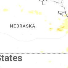
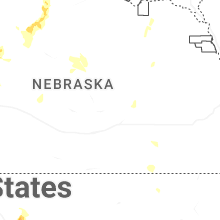
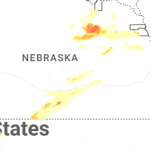
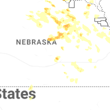

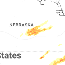


Connect with Interactive Hail Maps