

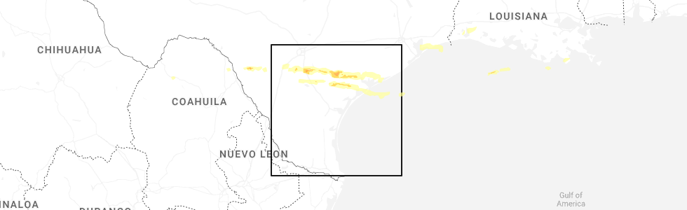
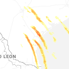
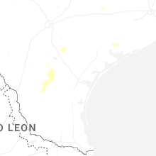
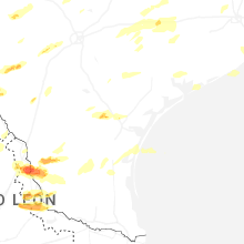
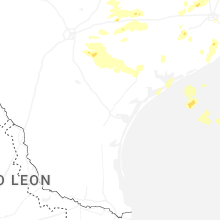
Hail Map for Lolita, TX
The Lolita, TX area has had 0 reports of on-the-ground hail by trained spotters, and has been under severe weather warnings 8 times during the past 12 months. Doppler radar has detected hail at or near Lolita, TX on 30 occasions, including 5 occasions during the past year.
| Name: | Lolita, TX |
| Where Located: | 88.8 miles NE of Corpus Christi, TX |
| Map: | Google Map for Lolita, TX |
| Population: | 555 |
| Housing Units: | 229 |
| More Info: | Search Google for Lolita, TX |
3
The Top Recent Hail Date for Lolita, TX is Friday, May 1, 2026 (3rd out of 30)
Hail and Wind Damage Spotted near Lolita, TX
| Date / Time | Report Details |
|---|---|
| 5/27/2026 12:05 AM CDT |
 Svrhgx the national weather service in league city has issued a * severe thunderstorm warning for, southwestern wharton county in southeastern texas, jackson county in south central texas, west central matagorda county in southeastern texas, * until 115 am cdt. * at 1205 am cdt, severe thunderstorms were located along a line extending from 6 miles west of ezzell to near mission valley, moving east at 45 mph (radar indicated). Hazards include 60 mph wind gusts. expect damage to roofs, siding, and trees Svrhgx the national weather service in league city has issued a * severe thunderstorm warning for, southwestern wharton county in southeastern texas, jackson county in south central texas, west central matagorda county in southeastern texas, * until 115 am cdt. * at 1205 am cdt, severe thunderstorms were located along a line extending from 6 miles west of ezzell to near mission valley, moving east at 45 mph (radar indicated). Hazards include 60 mph wind gusts. expect damage to roofs, siding, and trees
|
| 5/1/2026 2:28 PM CDT |
 At 228 pm cdt, a severe thunderstorm was located near lolita, or 10 miles north of port lavaca, moving east at 50 mph (radar indicated). Hazards include 60 mph wind gusts and quarter size hail. Hail damage to vehicles is expected. expect wind damage to roofs, siding, and trees. Locations impacted include, edna, palacios, point comfort, la ward, alamo beach, magnolia beach, schicke point, olivia, lolita, blessing, port alto, vanderbilt, midfield, and lake texana dam. At 228 pm cdt, a severe thunderstorm was located near lolita, or 10 miles north of port lavaca, moving east at 50 mph (radar indicated). Hazards include 60 mph wind gusts and quarter size hail. Hail damage to vehicles is expected. expect wind damage to roofs, siding, and trees. Locations impacted include, edna, palacios, point comfort, la ward, alamo beach, magnolia beach, schicke point, olivia, lolita, blessing, port alto, vanderbilt, midfield, and lake texana dam.
|
| 5/1/2026 1:58 PM CDT |
 Svrhgx the national weather service in league city has issued a * severe thunderstorm warning for, southwestern wharton county in southeastern texas, jackson county in south central texas, southwestern matagorda county in southeastern texas, * until 245 pm cdt. * at 157 pm cdt, a severe thunderstorm was located over wood hi, or 9 miles east of victoria, moving east at 50 mph (radar indicated). Hazards include 60 mph wind gusts and quarter size hail. Hail damage to vehicles is expected. Expect wind damage to roofs, siding, and trees. Svrhgx the national weather service in league city has issued a * severe thunderstorm warning for, southwestern wharton county in southeastern texas, jackson county in south central texas, southwestern matagorda county in southeastern texas, * until 245 pm cdt. * at 157 pm cdt, a severe thunderstorm was located over wood hi, or 9 miles east of victoria, moving east at 50 mph (radar indicated). Hazards include 60 mph wind gusts and quarter size hail. Hail damage to vehicles is expected. Expect wind damage to roofs, siding, and trees.
|
| 4/22/2026 7:12 PM CDT |
 Svrhgx the national weather service in league city has issued a * severe thunderstorm warning for, central jackson county in south central texas, * until 745 pm cdt. * at 712 pm cdt, a severe thunderstorm was located near edna, moving south at 15 mph (radar indicated). Hazards include quarter size hail. damage to vehicles is expected Svrhgx the national weather service in league city has issued a * severe thunderstorm warning for, central jackson county in south central texas, * until 745 pm cdt. * at 712 pm cdt, a severe thunderstorm was located near edna, moving south at 15 mph (radar indicated). Hazards include quarter size hail. damage to vehicles is expected
|
| 11/1/2025 7:47 PM CDT | Svrhgx the national weather service in league city has issued a * severe thunderstorm warning for, south central jackson county in south central texas, southwestern matagorda county in southeastern texas, * until 815 pm cdt. * at 747 pm cdt, a severe thunderstorm was located over lolita, or 12 miles southeast of edna, moving southeast at 25 mph (radar indicated). Hazards include quarter size hail. damage to vehicles is expected |
| 10/25/2025 3:53 AM CDT | At 352 am cdt, severe thunderstorms were located along a line extending from near brazos bend state park to 8 miles southeast of van vleck to port alto, moving east at 35 mph (radar indicated). Hazards include 60 mph wind gusts. Expect damage to roofs, siding, and trees. Locations impacted include, matagorda, lake jackson, angleton, bay city, freeport, clute, palacios, west columbia, sweeny, south texas nuclear plant, richwood, brazoria, jones creek, danbury, iowa colony, holiday lakes, bailey's prairie, bonney, la ward, and sargent. |
| 10/25/2025 3:53 AM CDT | the severe thunderstorm warning has been cancelled and is no longer in effect |
| 10/25/2025 3:44 AM CDT | Svrhgx the national weather service in league city has issued a * severe thunderstorm warning for, southeastern wharton county in southeastern texas, southeastern jackson county in south central texas, southeastern fort bend county in southeastern texas, brazoria county in southeastern texas, matagorda county in southeastern texas, * until 430 am cdt. * at 344 am cdt, severe thunderstorms were located along a line extending from brazos bend state park to near van vleck to near point comfort, moving east at 35 mph (radar indicated). Hazards include 60 mph wind gusts. expect damage to roofs, siding, and trees |
| 5/13/2024 3:19 PM CDT |
 the severe thunderstorm warning has been cancelled and is no longer in effect the severe thunderstorm warning has been cancelled and is no longer in effect
|
| 5/13/2024 3:07 PM CDT |
 Svrhgx the national weather service in league city has issued a * severe thunderstorm warning for, southeastern jackson county in south central texas, * until 330 pm cdt. * at 307 pm cdt, a severe thunderstorm was located near port lavaca, moving east at 25 mph (radar indicated). Hazards include 60 mph wind gusts and half dollar size hail. Hail damage to vehicles is expected. Expect wind damage to roofs, siding, and trees. Svrhgx the national weather service in league city has issued a * severe thunderstorm warning for, southeastern jackson county in south central texas, * until 330 pm cdt. * at 307 pm cdt, a severe thunderstorm was located near port lavaca, moving east at 25 mph (radar indicated). Hazards include 60 mph wind gusts and half dollar size hail. Hail damage to vehicles is expected. Expect wind damage to roofs, siding, and trees.
|
| 5/13/2024 3:04 PM CDT |
 At 304 pm cdt, a severe thunderstorm was located near edna, moving east at 25 mph (radar indicated). Hazards include ping pong ball size hail and 60 mph wind gusts. People and animals outdoors will be injured. expect hail damage to roofs, siding, windows, and vehicles. expect wind damage to roofs, siding, and trees. Locations impacted include, edna, ganado, lolita, lake texana dam, and vanderbilt. At 304 pm cdt, a severe thunderstorm was located near edna, moving east at 25 mph (radar indicated). Hazards include ping pong ball size hail and 60 mph wind gusts. People and animals outdoors will be injured. expect hail damage to roofs, siding, windows, and vehicles. expect wind damage to roofs, siding, and trees. Locations impacted include, edna, ganado, lolita, lake texana dam, and vanderbilt.
|
| 5/13/2024 2:40 PM CDT |
 Svrhgx the national weather service in league city has issued a * severe thunderstorm warning for, central jackson county in south central texas, * until 330 pm cdt. * at 239 pm cdt, a severe thunderstorm was located near inez, or 10 miles northeast of victoria, moving northeast at 25 mph (radar indicated). Hazards include ping pong ball size hail and 60 mph wind gusts. People and animals outdoors will be injured. expect hail damage to roofs, siding, windows, and vehicles. Expect wind damage to roofs, siding, and trees. Svrhgx the national weather service in league city has issued a * severe thunderstorm warning for, central jackson county in south central texas, * until 330 pm cdt. * at 239 pm cdt, a severe thunderstorm was located near inez, or 10 miles northeast of victoria, moving northeast at 25 mph (radar indicated). Hazards include ping pong ball size hail and 60 mph wind gusts. People and animals outdoors will be injured. expect hail damage to roofs, siding, windows, and vehicles. Expect wind damage to roofs, siding, and trees.
|
| 5/5/2024 1:18 PM CDT |
 the severe thunderstorm warning has been cancelled and is no longer in effect the severe thunderstorm warning has been cancelled and is no longer in effect
|
| 5/5/2024 12:54 PM CDT |
 Svrhgx the national weather service in league city has issued a * severe thunderstorm warning for, southeastern jackson county in south central texas, * until 130 pm cdt. * at 1254 pm cdt, a severe thunderstorm was located near lolita, or 9 miles south of edna, moving northeast at 40 mph (radar indicated). Hazards include quarter size hail. damage to vehicles is expected Svrhgx the national weather service in league city has issued a * severe thunderstorm warning for, southeastern jackson county in south central texas, * until 130 pm cdt. * at 1254 pm cdt, a severe thunderstorm was located near lolita, or 9 miles south of edna, moving northeast at 40 mph (radar indicated). Hazards include quarter size hail. damage to vehicles is expected
|
| 10/5/2023 8:39 AM CDT |
 At 839 am cdt, severe thunderstorms were located along a line extending from near wharton to 8 miles south of el campo to near lolita, moving southeast at 40 mph (radar indicated). Hazards include 60 mph wind gusts. Expect damage to roofs, siding, and trees. locations impacted include, el campo, edna, ganado, la ward, pierce, lolita, blessing, markham, cordele, vanderbilt, louise, midfield, lake texana dam, and danevang. hail threat, radar indicated max hail size, <. 75 in wind threat, observed max wind gust, 60 mph. At 839 am cdt, severe thunderstorms were located along a line extending from near wharton to 8 miles south of el campo to near lolita, moving southeast at 40 mph (radar indicated). Hazards include 60 mph wind gusts. Expect damage to roofs, siding, and trees. locations impacted include, el campo, edna, ganado, la ward, pierce, lolita, blessing, markham, cordele, vanderbilt, louise, midfield, lake texana dam, and danevang. hail threat, radar indicated max hail size, <. 75 in wind threat, observed max wind gust, 60 mph.
|
| 10/5/2023 8:21 AM CDT |
 At 820 am cdt, severe thunderstorms were located along a line extending from near pierce to near ganado to near inez, moving east at 40 mph. at 812 am cdt, victoria reported a 61 mph gust with this line of storms (radar indicated). Hazards include 60 mph wind gusts. expect damage to roofs, siding, and trees At 820 am cdt, severe thunderstorms were located along a line extending from near pierce to near ganado to near inez, moving east at 40 mph. at 812 am cdt, victoria reported a 61 mph gust with this line of storms (radar indicated). Hazards include 60 mph wind gusts. expect damage to roofs, siding, and trees
|
| 9/25/2023 8:05 PM CDT |
 At 805 pm cdt, a severe thunderstorm was located over edna, moving south at 30 mph (radar indicated). Hazards include quarter size hail. damage to vehicles is expected At 805 pm cdt, a severe thunderstorm was located over edna, moving south at 30 mph (radar indicated). Hazards include quarter size hail. damage to vehicles is expected
|
| 4/28/2023 9:18 PM CDT | Mesonet station ew3902 lolit in jackson county TX, 3.1 miles NNE of Lolita, TX |
| 4/28/2023 9:12 PM CDT |
 The severe thunderstorm warning for jackson county will expire at 915 pm cdt, the storms which prompted the warning have weakened below severe limits, and no longer pose an immediate threat to life or property. therefore, the warning will be allowed to expire. however gusty winds are still possible with these thunderstorms. a severe thunderstorm watch remains in effect until midnight cdt for south central texas. The severe thunderstorm warning for jackson county will expire at 915 pm cdt, the storms which prompted the warning have weakened below severe limits, and no longer pose an immediate threat to life or property. therefore, the warning will be allowed to expire. however gusty winds are still possible with these thunderstorms. a severe thunderstorm watch remains in effect until midnight cdt for south central texas.
|
| 4/28/2023 8:58 PM CDT |
 At 857 pm cdt, severe thunderstorms were located along a line extending from near ganado to near inez, moving southeast at 40 mph (radar indicated). Hazards include 60 mph wind gusts and penny size hail. expect damage to roofs, siding, and trees At 857 pm cdt, severe thunderstorms were located along a line extending from near ganado to near inez, moving southeast at 40 mph (radar indicated). Hazards include 60 mph wind gusts and penny size hail. expect damage to roofs, siding, and trees
|
| 4/21/2023 2:59 AM CDT |
 At 259 am cdt, severe thunderstorms were located along a line extending from 8 miles southwest of eagle lake to 13 miles northwest of el campo to 6 miles north of ganado to near edna, moving east at 35 mph (radar indicated). Hazards include 60 mph wind gusts and penny size hail. expect damage to roofs, siding, and trees At 259 am cdt, severe thunderstorms were located along a line extending from 8 miles southwest of eagle lake to 13 miles northwest of el campo to 6 miles north of ganado to near edna, moving east at 35 mph (radar indicated). Hazards include 60 mph wind gusts and penny size hail. expect damage to roofs, siding, and trees
|
| 4/21/2023 2:35 AM CDT |
 At 235 am cdt, a severe thunderstorm was located 9 miles northeast of fordtran, or 16 miles northwest of edna, moving southeast at 30 mph (radar indicated). Hazards include 60 mph wind gusts and quarter size hail. Hail damage to vehicles is expected. expect wind damage to roofs, siding, and trees. locations impacted include, el campo, edna, ganado, lolita, cordele, morales, lake texana dam and louise. hail threat, radar indicated max hail size, 1. 00 in wind threat, radar indicated max wind gust, 60 mph. At 235 am cdt, a severe thunderstorm was located 9 miles northeast of fordtran, or 16 miles northwest of edna, moving southeast at 30 mph (radar indicated). Hazards include 60 mph wind gusts and quarter size hail. Hail damage to vehicles is expected. expect wind damage to roofs, siding, and trees. locations impacted include, el campo, edna, ganado, lolita, cordele, morales, lake texana dam and louise. hail threat, radar indicated max hail size, 1. 00 in wind threat, radar indicated max wind gust, 60 mph.
|
| 4/21/2023 2:09 AM CDT |
 At 209 am cdt, a severe thunderstorm was located 7 miles southeast of yoakum, moving southeast at 30 mph (radar indicated). Hazards include golf ball size hail and 70 mph wind gusts. People and animals outdoors will be injured. expect hail damage to roofs, siding, windows, and vehicles. expect considerable tree damage. Wind damage is also likely to mobile homes, roofs, and outbuildings. At 209 am cdt, a severe thunderstorm was located 7 miles southeast of yoakum, moving southeast at 30 mph (radar indicated). Hazards include golf ball size hail and 70 mph wind gusts. People and animals outdoors will be injured. expect hail damage to roofs, siding, windows, and vehicles. expect considerable tree damage. Wind damage is also likely to mobile homes, roofs, and outbuildings.
|
| 5/25/2022 2:02 AM CDT |
 At 201 am cdt, severe thunderstorms were located along a line extending from near speaks to near olivia to 21 miles southwest of matagorda island state park, moving east at 30 mph (radar indicated). Hazards include 60 mph wind gusts. expect damage to roofs, siding, and trees At 201 am cdt, severe thunderstorms were located along a line extending from near speaks to near olivia to 21 miles southwest of matagorda island state park, moving east at 30 mph (radar indicated). Hazards include 60 mph wind gusts. expect damage to roofs, siding, and trees
|
| 5/19/2021 3:25 AM CDT |
 At 325 am cdt, severe thunderstorms located near ganado, or near edna, moving east at 50-60 mph (radar indicated). Hazards include 60 mph wind gusts and penny size hail. expect damage to roofs, siding, and trees At 325 am cdt, severe thunderstorms located near ganado, or near edna, moving east at 50-60 mph (radar indicated). Hazards include 60 mph wind gusts and penny size hail. expect damage to roofs, siding, and trees
|
| 5/16/2020 2:11 AM CDT |
 The severe thunderstorm warning for south central wharton and jackson counties will expire at 215 am cdt, the storms which prompted the warning have weakened below severe limits, and have exited the warned area. therefore, the warning will be allowed to expire. a severe thunderstorm watch remains in effect until 500 am cdt for south central and southeastern texas. The severe thunderstorm warning for south central wharton and jackson counties will expire at 215 am cdt, the storms which prompted the warning have weakened below severe limits, and have exited the warned area. therefore, the warning will be allowed to expire. a severe thunderstorm watch remains in effect until 500 am cdt for south central and southeastern texas.
|
| 5/16/2020 1:54 AM CDT |
 At 154 am cdt, severe thunderstorms were located along a line extending from near edna to dacosta, moving east at 55 mph (radar indicated). Hazards include 60 mph wind gusts. Expect damage to roofs, siding, and trees. Locations impacted include, edna, ganado, point comfort, la ward, olivia, alamo beach, lolita, port alto, vanderbilt and lake texana dam. At 154 am cdt, severe thunderstorms were located along a line extending from near edna to dacosta, moving east at 55 mph (radar indicated). Hazards include 60 mph wind gusts. Expect damage to roofs, siding, and trees. Locations impacted include, edna, ganado, point comfort, la ward, olivia, alamo beach, lolita, port alto, vanderbilt and lake texana dam.
|
| 5/16/2020 1:33 AM CDT |
 At 133 am cdt, severe thunderstorms were located along a line extending from fordtran to near oak village, moving east at 55 mph (radar indicated). Hazards include 60 mph wind gusts. expect damage to roofs, siding, and trees At 133 am cdt, severe thunderstorms were located along a line extending from fordtran to near oak village, moving east at 55 mph (radar indicated). Hazards include 60 mph wind gusts. expect damage to roofs, siding, and trees
|
| 6/17/2019 3:41 AM CDT |
 The severe thunderstorm warning for southwestern colorado, southwestern wharton and jackson counties will expire at 345 am cdt, the storms which prompted the warning have weakened below severe limits, and no longer pose an immediate threat to life or property. therefore, the warning will be allowed to expire. however gusty winds are still possible with these thunderstorms. a severe thunderstorm watch remains in effect until 500 am cdt for south central and southeastern texas. to report severe weather, contact your nearest law enforcement agency. they will relay your report to the national weather service league city. The severe thunderstorm warning for southwestern colorado, southwestern wharton and jackson counties will expire at 345 am cdt, the storms which prompted the warning have weakened below severe limits, and no longer pose an immediate threat to life or property. therefore, the warning will be allowed to expire. however gusty winds are still possible with these thunderstorms. a severe thunderstorm watch remains in effect until 500 am cdt for south central and southeastern texas. to report severe weather, contact your nearest law enforcement agency. they will relay your report to the national weather service league city.
|
| 6/17/2019 3:19 AM CDT |
 At 319 am cdt, severe thunderstorms were located along a line extending from near sublime to near ezzell to 8 miles east of fordtran, moving east at 55 mph (radar indicated). Hazards include 60 mph wind gusts. expect damage to roofs, siding, and trees At 319 am cdt, severe thunderstorms were located along a line extending from near sublime to near ezzell to 8 miles east of fordtran, moving east at 55 mph (radar indicated). Hazards include 60 mph wind gusts. expect damage to roofs, siding, and trees
|
| 5/9/2019 11:46 PM CDT |
 At 1146 pm cdt, severe thunderstorms were located along a line extending from near salem to inez to near port lavaca to near seadrift, moving east at 40 mph (radar indicated). Hazards include 60 mph wind gusts. expect damage to roofs, siding, and trees At 1146 pm cdt, severe thunderstorms were located along a line extending from near salem to inez to near port lavaca to near seadrift, moving east at 40 mph (radar indicated). Hazards include 60 mph wind gusts. expect damage to roofs, siding, and trees
|
| 4/7/2019 10:14 AM CDT |
 At 1014 am cdt, a severe thunderstorm was located near ganado, or near edna, moving northeast at 40 mph (radar indicated). Hazards include 60 mph wind gusts. expect damage to roofs, siding, and trees At 1014 am cdt, a severe thunderstorm was located near ganado, or near edna, moving northeast at 40 mph (radar indicated). Hazards include 60 mph wind gusts. expect damage to roofs, siding, and trees
|
| 2/14/2017 7:25 AM CST |
 At 724 am cst, severe thunderstorms were located along a line extending from near wallis to near lolita, moving east at 30 mph (radar indicated). Hazards include 60 mph wind gusts. expect damage to roofs, siding, and trees At 724 am cst, severe thunderstorms were located along a line extending from near wallis to near lolita, moving east at 30 mph (radar indicated). Hazards include 60 mph wind gusts. expect damage to roofs, siding, and trees
|
| 2/14/2017 6:28 AM CST |
 At 628 am cst, severe thunderstorms were located along a line extending from 6 miles northeast of speaks to 6 miles northeast of salem, moving northeast at 45 mph (radar indicated). Hazards include 60 mph wind gusts. expect damage to roofs, siding, and trees At 628 am cst, severe thunderstorms were located along a line extending from 6 miles northeast of speaks to 6 miles northeast of salem, moving northeast at 45 mph (radar indicated). Hazards include 60 mph wind gusts. expect damage to roofs, siding, and trees
|
| 3/18/2016 11:56 PM CDT |
 At 1156 pm cdt, a severe thunderstorm was located near inez, or 9 miles southwest of edna, moving east at 30 mph (radar indicated). Hazards include 60 mph wind gusts and quarter size hail. Hail damage to vehicles is expected. Expect wind damage to roofs, siding, and trees. At 1156 pm cdt, a severe thunderstorm was located near inez, or 9 miles southwest of edna, moving east at 30 mph (radar indicated). Hazards include 60 mph wind gusts and quarter size hail. Hail damage to vehicles is expected. Expect wind damage to roofs, siding, and trees.
|
| 7/31/2015 3:51 PM CDT |
 At 350 pm cdt, doppler radar indicated a severe thunderstorm capable of producing damaging winds in excess of 60 mph. this storm was located near point comfort, or 10 miles northeast of port lavaca, and moving southwest at 25 mph. At 350 pm cdt, doppler radar indicated a severe thunderstorm capable of producing damaging winds in excess of 60 mph. this storm was located near point comfort, or 10 miles northeast of port lavaca, and moving southwest at 25 mph.
|
| 5/25/2015 11:45 PM CDT | At 1144 pm cdt, doppler radar indicated a severe thunderstorm capable of producing quarter size hail and damaging winds in excess of 60 mph. this storm was located near inez, or 7 miles southwest of edna, and moving east at 25 mph. |
| 5/24/2015 3:39 AM CDT | At 338 am cdt, doppler radar indicated a line of severe thunderstorms capable of producing damaging winds in excess of 60 mph. these storms were located along a line extending from near speaks to 6 miles north of la ward to near alamo beach, and moving northeast at 45 mph. |
| 5/24/2015 2:53 AM CDT | At 253 am cdt, doppler radar indicated a severe thunderstorm capable of producing damaging winds in excess of 60 mph. this storm was located over bloomington, or 10 miles northeast of mcfaddin, and moving northeast at 40 mph. |
| 4/25/2015 7:39 AM CDT | At 739 am cdt, doppler radar indicated a severe thunderstorm capable of producing quarter size hail. this storm was located over la ward, or 13 miles southeast of edna, and moving northeast at 50 mph. |
| 4/17/2015 6:18 PM CDT | At 617 pm cdt, doppler radar indicated a line of severe thunderstorms capable of producing quarter size hail and damaging winds in excess of 60 mph. these storms were located along a line extending from 9 miles southeast of weimar to 6 miles northwest of el campo to 7 miles south of ganado, moving east at 45 mph. the most intense part of the storm was moving into el campo. locations impacted include, el campo, edna, ganado, la ward, pierce, lolita, lake texana dam, louise, altair, rock island, garwood, vanderbilt and nada. |
| 4/17/2015 6:03 PM CDT | At 601 pm cdt, doppler radar indicated a line of severe thunderstorms capable of producing quarter size hail and damaging winds in excess of 60 mph. these storms were located along a line extending from near sublime to 11 miles north of ganado to near inez, moving east at 30 mph. jackson county sheriffs office reported trees down in morales at 558 pm. locations impacted include, el campo, edna, ganado, la ward, pierce, lolita, altair, lake texana dam, sheridan, louise, rock island, garwood, vanderbilt and nada. |
| 4/17/2015 5:45 PM CDT | At 544 pm cdt, doppler radar indicated a line of severe thunderstorms capable of producing quarter size hail and damaging winds in excess of 60 mph. these storms were located along a line extending from near hallettsville to near speaks to near wood hi, and moving east at 45 mph. |
| 1/1/0001 12:00 AM | Power lines down along cr 426 between cr 427 and fm 313 in jackson county TX, 4.3 miles SSW of Lolita, TX |
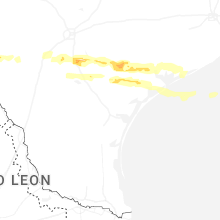
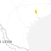
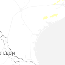
Hail Maps for Lolita, TX


Connect with Interactive Hail Maps