

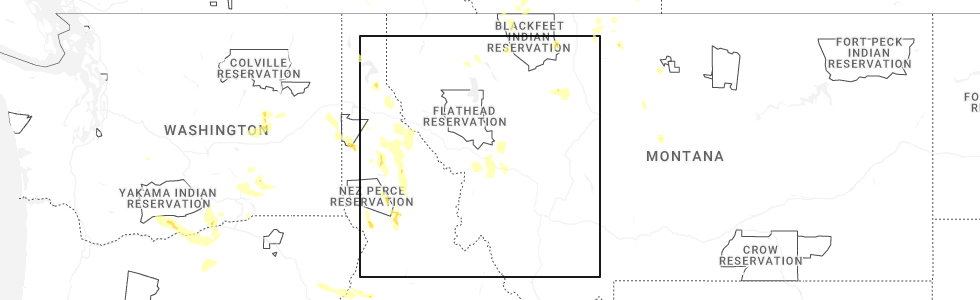
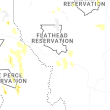
Hail Map for Lolo, MT
The Lolo, MT area has had 4 reports of on-the-ground hail by trained spotters, and has been under severe weather warnings 1 time during the past 12 months. Doppler radar has detected hail at or near Lolo, MT on 11 occasions, including 1 occasion during the past year.
| Name: | Lolo, MT |
| Where Located: | 8.6 miles SW of Missoula, MT |
| Map: | Google Map for Lolo, MT |
| Population: | 3892 |
| Housing Units: | 1517 |
| More Info: | Search Google for Lolo, MT |
5
The Top Recent Hail Date for Lolo, MT is Thursday, May 28, 2026 (1st out of 11)
Hail and Wind Damage Spotted near Lolo, MT
| Date / Time | Report Details |
|---|---|
| 7/31/2025 5:52 PM MDT | Golf Ball sized hail reported 3.1 miles NNW of Lolo, MT, multiple facebook photos in the southern lolo area depicted up to golf ball sized hail. the photo that showed possible golf ball was wide and flat. |
| 7/26/2025 9:15 PM MDT |
 Svrmso the national weather service in missoula has issued a * severe thunderstorm warning for, south central missoula county in west central montana, northern ravalli county in west central montana, * until 945 pm mdt. * at 915 pm mdt, a severe thunderstorm was located near lolo, or 9 miles south of missoula, moving northeast at 30 mph (radar indicated). Hazards include 60 mph wind gusts. expect damage to roofs, siding, and trees Svrmso the national weather service in missoula has issued a * severe thunderstorm warning for, south central missoula county in west central montana, northern ravalli county in west central montana, * until 945 pm mdt. * at 915 pm mdt, a severe thunderstorm was located near lolo, or 9 miles south of missoula, moving northeast at 30 mph (radar indicated). Hazards include 60 mph wind gusts. expect damage to roofs, siding, and trees
|
| 8/23/2024 3:41 PM MDT |
 Svrmso the national weather service in missoula has issued a * severe thunderstorm warning for, southern missoula county in west central montana, northwestern granite county in west central montana, north central ravalli county in west central montana, * until 415 pm mdt. * at 340 pm mdt, severe thunderstorms were located along a line extending from 20 miles west of drummond to 8 miles southwest of florence, moving north at 30 mph (trained weather spotters). Hazards include 60 mph wind gusts. expect damage to roofs, siding, and trees Svrmso the national weather service in missoula has issued a * severe thunderstorm warning for, southern missoula county in west central montana, northwestern granite county in west central montana, north central ravalli county in west central montana, * until 415 pm mdt. * at 340 pm mdt, severe thunderstorms were located along a line extending from 20 miles west of drummond to 8 miles southwest of florence, moving north at 30 mph (trained weather spotters). Hazards include 60 mph wind gusts. expect damage to roofs, siding, and trees
|
| 8/18/2024 5:58 PM MDT |
 At 557 pm mdt, severe thunderstorms were located along a line extending from near lolo to 17 miles west of drummond, moving north at 35 mph (radar indicated). Hazards include 60 mph wind gusts and quarter size hail. Hail damage to vehicles is expected. expect wind damage to roofs, siding, and trees. Locations impacted include, missoula, lolo, bonner-west riverside, wye, east missoula, florence, nimrod, potomac, greenough, twin creeks, clinton, and turah. At 557 pm mdt, severe thunderstorms were located along a line extending from near lolo to 17 miles west of drummond, moving north at 35 mph (radar indicated). Hazards include 60 mph wind gusts and quarter size hail. Hail damage to vehicles is expected. expect wind damage to roofs, siding, and trees. Locations impacted include, missoula, lolo, bonner-west riverside, wye, east missoula, florence, nimrod, potomac, greenough, twin creeks, clinton, and turah.
|
| 8/18/2024 5:40 PM MDT |
 Svrmso the national weather service in missoula has issued a * severe thunderstorm warning for, southeastern missoula county in west central montana, northwestern granite county in west central montana, north central ravalli county in west central montana, * until 615 pm mdt. * at 540 pm mdt, severe thunderstorms were located along a line extending from near florence to 20 miles west of drummond, moving north at 35 mph (radar indicated). Hazards include ping pong ball size hail and 60 mph wind gusts. People and animals outdoors will be injured. expect hail damage to roofs, siding, windows, and vehicles. Expect wind damage to roofs, siding, and trees. Svrmso the national weather service in missoula has issued a * severe thunderstorm warning for, southeastern missoula county in west central montana, northwestern granite county in west central montana, north central ravalli county in west central montana, * until 615 pm mdt. * at 540 pm mdt, severe thunderstorms were located along a line extending from near florence to 20 miles west of drummond, moving north at 35 mph (radar indicated). Hazards include ping pong ball size hail and 60 mph wind gusts. People and animals outdoors will be injured. expect hail damage to roofs, siding, windows, and vehicles. Expect wind damage to roofs, siding, and trees.
|
| 8/6/2024 6:02 PM MDT |
 Svrmso the national weather service in missoula has issued a * severe thunderstorm warning for, southeastern missoula county in west central montana, northwestern granite county in west central montana, north central ravalli county in west central montana, * until 630 pm mdt. * at 602 pm mdt, a severe thunderstorm was located near florence, or 12 miles south of missoula, moving east at 35 mph (radar indicated). Hazards include quarter size hail winds up to 40 mph. damage to vehicles is expected Svrmso the national weather service in missoula has issued a * severe thunderstorm warning for, southeastern missoula county in west central montana, northwestern granite county in west central montana, north central ravalli county in west central montana, * until 630 pm mdt. * at 602 pm mdt, a severe thunderstorm was located near florence, or 12 miles south of missoula, moving east at 35 mph (radar indicated). Hazards include quarter size hail winds up to 40 mph. damage to vehicles is expected
|
| 7/24/2024 9:25 PM MDT |
 The severe thunderstorm which prompted the warning has therefore, the warning will be allowed to expire. The severe thunderstorm which prompted the warning has therefore, the warning will be allowed to expire.
|
| 7/24/2024 9:13 PM MDT |
 At 913 pm mdt, a severe thunderstorm was located near wye, or near missoula, moving northeast at 25 mph (radar indicated). Hazards include 70 mph wind gusts. Expect damage to roofs, siding, and trees. Locations impacted include, missoula, lolo, bonner-west riverside, wye, east missoula, frenchtown, and turah. At 913 pm mdt, a severe thunderstorm was located near wye, or near missoula, moving northeast at 25 mph (radar indicated). Hazards include 70 mph wind gusts. Expect damage to roofs, siding, and trees. Locations impacted include, missoula, lolo, bonner-west riverside, wye, east missoula, frenchtown, and turah.
|
| 7/24/2024 9:04 PM MDT |
 At 903 pm mdt, a severe thunderstorm was located near missoula, moving northeast at 25 mph (radar indicated). Hazards include 60 mph wind gusts. wind gusts estimated up to 80 mph in the missoula valley. seek shelter now. Expect damage to roofs, siding, and trees. Locations impacted include, missoula, lolo, bonner-west riverside, wye, florence, east missoula, frenchtown, lolo hot springs, and turah. At 903 pm mdt, a severe thunderstorm was located near missoula, moving northeast at 25 mph (radar indicated). Hazards include 60 mph wind gusts. wind gusts estimated up to 80 mph in the missoula valley. seek shelter now. Expect damage to roofs, siding, and trees. Locations impacted include, missoula, lolo, bonner-west riverside, wye, florence, east missoula, frenchtown, lolo hot springs, and turah.
|
| 7/24/2024 8:59 PM MDT |
 At 859 pm mdt, a severe thunderstorm was located near lolo, or near missoula, moving northeast at 25 mph (radar indicated). Hazards include 60 mph wind gusts. gusts in excess of 65 mph is occuring in the missoula valley. take shelter now. Expect damage to roofs, siding, and trees. Locations impacted include, missoula, lolo, bonner-west riverside, wye, florence, east missoula, frenchtown, lolo hot springs, and turah. At 859 pm mdt, a severe thunderstorm was located near lolo, or near missoula, moving northeast at 25 mph (radar indicated). Hazards include 60 mph wind gusts. gusts in excess of 65 mph is occuring in the missoula valley. take shelter now. Expect damage to roofs, siding, and trees. Locations impacted include, missoula, lolo, bonner-west riverside, wye, florence, east missoula, frenchtown, lolo hot springs, and turah.
|
| 7/24/2024 8:42 PM MDT |
 Svrmso the national weather service in missoula has issued a * severe thunderstorm warning for, south central missoula county in west central montana, north central ravalli county in west central montana, * until 930 pm mdt. * at 841 pm mdt, a severe thunderstorm was located near lolo, or 12 miles southwest of missoula, moving northeast at 25 mph (radar indicated). Hazards include 60 mph wind gusts. this cluster of thunderstorms have a history of producing 50 to 60 mph wind gusts, creating poweroutages. expect damage to roofs, siding, and trees Svrmso the national weather service in missoula has issued a * severe thunderstorm warning for, south central missoula county in west central montana, north central ravalli county in west central montana, * until 930 pm mdt. * at 841 pm mdt, a severe thunderstorm was located near lolo, or 12 miles southwest of missoula, moving northeast at 25 mph (radar indicated). Hazards include 60 mph wind gusts. this cluster of thunderstorms have a history of producing 50 to 60 mph wind gusts, creating poweroutages. expect damage to roofs, siding, and trees
|
| 8/22/2023 5:22 PM MDT |
 The severe thunderstorm warning for south central missoula county will expire at 530 pm mdt, the severe thunderstorm which prompted the warning has weakened. moved out of the warned area. therefore, the warning will be allowed to expire. The severe thunderstorm warning for south central missoula county will expire at 530 pm mdt, the severe thunderstorm which prompted the warning has weakened. moved out of the warned area. therefore, the warning will be allowed to expire.
|
| 8/22/2023 5:19 PM MDT |
 At 519 pm mdt, a severe thunderstorm was located near missoula, moving northeast at 30 mph (radar indicated). Hazards include 50-60 mph wind gusts has been reported. Hail damage to vehicles is expected. expect wind damage to roofs, siding, and trees. locations impacted include, missoula, bonner-west riverside, wye, east missoula, frenchtown, and turah. hail threat, radar indicated max hail size, 1. 00 in wind threat, radar indicated max wind gust, 60 mph. At 519 pm mdt, a severe thunderstorm was located near missoula, moving northeast at 30 mph (radar indicated). Hazards include 50-60 mph wind gusts has been reported. Hail damage to vehicles is expected. expect wind damage to roofs, siding, and trees. locations impacted include, missoula, bonner-west riverside, wye, east missoula, frenchtown, and turah. hail threat, radar indicated max hail size, 1. 00 in wind threat, radar indicated max wind gust, 60 mph.
|
| 8/22/2023 5:02 PM MDT |
 At 502 pm mdt, a severe thunderstorm was located over lolo, or near missoula, moving northeast at 30 mph (radar indicated). Hazards include 60 mph wind gusts and quarter size hail. Hail damage to vehicles is expected. Expect wind damage to roofs, siding, and trees. At 502 pm mdt, a severe thunderstorm was located over lolo, or near missoula, moving northeast at 30 mph (radar indicated). Hazards include 60 mph wind gusts and quarter size hail. Hail damage to vehicles is expected. Expect wind damage to roofs, siding, and trees.
|
| 6/18/2022 2:09 PM MDT |
 The severe thunderstorm warning for southeastern missoula county will expire at 215 pm mdt, the storm which prompted the warning has moved out of the area. therefore, the warning will be allowed to expire. a severe thunderstorm watch remains in effect until 700 pm mdt for west central montana. The severe thunderstorm warning for southeastern missoula county will expire at 215 pm mdt, the storm which prompted the warning has moved out of the area. therefore, the warning will be allowed to expire. a severe thunderstorm watch remains in effect until 700 pm mdt for west central montana.
|
| 6/18/2022 1:38 PM MDT |
 The severe thunderstorm warning for south central missoula and north central ravalli counties will expire at 145 pm mdt, the severe thunderstorm which prompted the warning has moved out of the warned area. therefore, the warning will be allowed to expire. a severe thunderstorm watch remains in effect until 700 pm mdt for west central montana. The severe thunderstorm warning for south central missoula and north central ravalli counties will expire at 145 pm mdt, the severe thunderstorm which prompted the warning has moved out of the warned area. therefore, the warning will be allowed to expire. a severe thunderstorm watch remains in effect until 700 pm mdt for west central montana.
|
| 6/18/2022 1:34 PM MDT |
 At 133 pm mdt, a severe thunderstorm was located near florence, or 12 miles south of missoula, moving northeast at 45 mph (radar indicated). Hazards include quarter size hail. in addition wind gusts to 40 mph and heavy rain is anticipated. damage to vehicles is expected At 133 pm mdt, a severe thunderstorm was located near florence, or 12 miles south of missoula, moving northeast at 45 mph (radar indicated). Hazards include quarter size hail. in addition wind gusts to 40 mph and heavy rain is anticipated. damage to vehicles is expected
|
| 6/18/2022 1:13 PM MDT |
 At 112 pm mdt, a severe thunderstorm was located over victor, or 14 miles north of hamilton, moving northeast at 25 mph (radar indicated). Hazards include quarter size hail. winds gusting to 40 mph and heavy rain are also expected. damage to vehicles is expected At 112 pm mdt, a severe thunderstorm was located over victor, or 14 miles north of hamilton, moving northeast at 25 mph (radar indicated). Hazards include quarter size hail. winds gusting to 40 mph and heavy rain are also expected. damage to vehicles is expected
|
| 7/1/2021 6:08 PM MDT |
 At 608 pm mdt, a severe thunderstorm was located over lolo, or near missoula, moving northwest at 10 mph (radar indicated). Hazards include 60 mph wind gusts. Expect damage to roofs, siding, and trees. Locations impacted include, missoula, lolo and wye. At 608 pm mdt, a severe thunderstorm was located over lolo, or near missoula, moving northwest at 10 mph (radar indicated). Hazards include 60 mph wind gusts. Expect damage to roofs, siding, and trees. Locations impacted include, missoula, lolo and wye.
|
| 7/1/2021 5:56 PM MDT |
 At 555 pm mdt, a severe thunderstorm was located over lolo, or near missoula, moving north at 10 mph (radar indicated). Hazards include 60 mph wind gusts. expect damage to roofs, siding, and trees At 555 pm mdt, a severe thunderstorm was located over lolo, or near missoula, moving north at 10 mph (radar indicated). Hazards include 60 mph wind gusts. expect damage to roofs, siding, and trees
|
| 7/1/2021 5:40 PM MDT | Mdt reports downed trees blocking us highway 12 five miles west of lolo... mt. time of damage estimated using radar dat in missoula county MT, 4.4 miles ENE of Lolo, MT |
| 8/11/2019 2:16 PM MDT | A tree fell on a powerline near the cross streets of cowcatcher drive and us-12. the call came in at 4:14 pm... but lsr time was estimated by rada in missoula county MT, 2.4 miles NE of Lolo, MT |
| 5/31/2018 1:41 PM MDT |
 At 141 pm mdt, a severe thunderstorm was located over missoula, moving northeast at 35 mph (radar indicated). Hazards include 60 mph wind gusts have been reported and penny size hail continues to be a threat as well. Expect damage to roofs, siding, and trees. Locations impacted include, missoula, lolo, bonner-west riverside, wye, east missoula, evaro, frenchtown, huson and turah. At 141 pm mdt, a severe thunderstorm was located over missoula, moving northeast at 35 mph (radar indicated). Hazards include 60 mph wind gusts have been reported and penny size hail continues to be a threat as well. Expect damage to roofs, siding, and trees. Locations impacted include, missoula, lolo, bonner-west riverside, wye, east missoula, evaro, frenchtown, huson and turah.
|
| 5/31/2018 1:20 PM MDT |
 At 120 pm mdt, a severe thunderstorm was located near lolo, or 11 miles southwest of missoula, moving northeast at 35 mph (radar indicated). Hazards include 60 mph wind gusts and penny size hail. expect damage to roofs, siding, and trees At 120 pm mdt, a severe thunderstorm was located near lolo, or 11 miles southwest of missoula, moving northeast at 35 mph (radar indicated). Hazards include 60 mph wind gusts and penny size hail. expect damage to roofs, siding, and trees
|
| 5/6/2018 7:06 PM MDT |
 The severe thunderstorm warning for southwestern missoula county will expire at 715 pm mdt, the severe thunderstorm which prompted the warning has weakened and is moving out of the warned area. therefore, the warning will be allowed to expire. strong winds near 40 mph, heavy rain, and small hail will continue for another 10 to 20 minutes. The severe thunderstorm warning for southwestern missoula county will expire at 715 pm mdt, the severe thunderstorm which prompted the warning has weakened and is moving out of the warned area. therefore, the warning will be allowed to expire. strong winds near 40 mph, heavy rain, and small hail will continue for another 10 to 20 minutes.
|
| 5/6/2018 6:40 PM MDT |
 At 640 pm mdt, a severe thunderstorm was located near missoula, moving north at 40 mph (radar indicated). Hazards include 60 mph wind gusts and nickel size hail. expect damage to roofs, siding, and trees At 640 pm mdt, a severe thunderstorm was located near missoula, moving north at 40 mph (radar indicated). Hazards include 60 mph wind gusts and nickel size hail. expect damage to roofs, siding, and trees
|
| 7/15/2017 5:39 PM MDT |
 The severe thunderstorm warning for southeastern missoula and north central ravalli counties will expire at 545 pm mdt, the storm which prompted the warning has weakened below severe limits, and has exited the warned area. therefore, the warning will be allowed to expire. The severe thunderstorm warning for southeastern missoula and north central ravalli counties will expire at 545 pm mdt, the storm which prompted the warning has weakened below severe limits, and has exited the warned area. therefore, the warning will be allowed to expire.
|
| 7/15/2017 4:59 PM MDT |
 At 458 pm mdt, a severe thunderstorm was located over florence, or 16 miles south of missoula, moving northeast at 30 mph (radar indicated). Hazards include 60 mph wind gusts, heavy rain and penny size hail. expect damage to roofs, siding, and trees At 458 pm mdt, a severe thunderstorm was located over florence, or 16 miles south of missoula, moving northeast at 30 mph (radar indicated). Hazards include 60 mph wind gusts, heavy rain and penny size hail. expect damage to roofs, siding, and trees
|
| 7/15/2017 4:27 PM MDT |
 At 426 pm mdt, a severe thunderstorm was located 8 miles west of stevensville, or 19 miles north of hamilton, moving northeast at 45 mph (radar indicated). Hazards include 65 mph wind gusts and penny size hail. expect damage to roofs, siding, and trees At 426 pm mdt, a severe thunderstorm was located 8 miles west of stevensville, or 19 miles north of hamilton, moving northeast at 45 mph (radar indicated). Hazards include 65 mph wind gusts and penny size hail. expect damage to roofs, siding, and trees
|
| 8/6/2016 4:55 PM MDT |
 The severe thunderstorm warning for northern ravalli and south central missoula counties will expire at 500 pm mdt, the storm which prompted the warning has weakened below severe limits, and no longer poses an immediate threat to life or property. therefore the warning will be allowed to expire. however gusty winds are still possible with this thunderstorm and power outages have been reported in the missoula area. The severe thunderstorm warning for northern ravalli and south central missoula counties will expire at 500 pm mdt, the storm which prompted the warning has weakened below severe limits, and no longer poses an immediate threat to life or property. therefore the warning will be allowed to expire. however gusty winds are still possible with this thunderstorm and power outages have been reported in the missoula area.
|
| 8/6/2016 4:18 PM MDT |
 At 417 pm mdt, doppler radar indicated a severe thunderstorm capable of producing damaging winds in excess of 60 mph. this storm was located over lolo, or 9 miles south of missoula, and moving northeast at 15 mph. the gust front ahead of the main thunderstorm could produce damaging winds. At 417 pm mdt, doppler radar indicated a severe thunderstorm capable of producing damaging winds in excess of 60 mph. this storm was located over lolo, or 9 miles south of missoula, and moving northeast at 15 mph. the gust front ahead of the main thunderstorm could produce damaging winds.
|
| 7/17/2016 9:51 PM MDT |
 At 951 pm mdt, multiple trained weather spotters reported a severe thunderstorm producing quarter size hail and damaging winds in excess of 60 mph. this storm was located 10 miles northeast of bonner-west riverside, or 15 miles east of missoula, moving northeast at 55 mph. locations impacted include, missoula, lolo, stevensville, evaro, wye, bonner-west riverside, frenchtown, florence, east missoula, arlee, twin creeks, clinton, potomac and turah. At 951 pm mdt, multiple trained weather spotters reported a severe thunderstorm producing quarter size hail and damaging winds in excess of 60 mph. this storm was located 10 miles northeast of bonner-west riverside, or 15 miles east of missoula, moving northeast at 55 mph. locations impacted include, missoula, lolo, stevensville, evaro, wye, bonner-west riverside, frenchtown, florence, east missoula, arlee, twin creeks, clinton, potomac and turah.
|
| 7/17/2016 9:27 PM MDT |
 At 926 pm mdt, doppler radar indicated a severe thunderstorm capable of producing damaging winds in excess of 60 mph. this storm was located over lolo, or 10 miles south of missoula, and moving northeast at 55 mph. nickel size to quarter size hail may also accompany the damaging winds. At 926 pm mdt, doppler radar indicated a severe thunderstorm capable of producing damaging winds in excess of 60 mph. this storm was located over lolo, or 10 miles south of missoula, and moving northeast at 55 mph. nickel size to quarter size hail may also accompany the damaging winds.
|
| 8/14/2015 4:11 PM MDT |
 The severe thunderstorm warning for southeastern missoula and northern ravalli counties will expire at 415 pm mdt, the storm which prompted the warning has weakened below severe limits, and no longer poses an immediate threat to life or property. therefore the warning will be allowed to expire. however gusty winds and heavy rain are still possible with this thunderstorm. to report severe weather, contact your nearest law enforcement agency. they will relay your report to the national weather service missoula. The severe thunderstorm warning for southeastern missoula and northern ravalli counties will expire at 415 pm mdt, the storm which prompted the warning has weakened below severe limits, and no longer poses an immediate threat to life or property. therefore the warning will be allowed to expire. however gusty winds and heavy rain are still possible with this thunderstorm. to report severe weather, contact your nearest law enforcement agency. they will relay your report to the national weather service missoula.
|
| 8/14/2015 3:58 PM MDT |
 At 358 pm mdt, the public reported a severe thunderstorm producing quarter size hail and damaging winds in excess of 60 mph. this storm was located over bonner-west riverside, or near missoula, moving northeast at 35 mph. locations impacted include, missoula, lolo, east missoula, bonner-west riverside, turah and clinton. At 358 pm mdt, the public reported a severe thunderstorm producing quarter size hail and damaging winds in excess of 60 mph. this storm was located over bonner-west riverside, or near missoula, moving northeast at 35 mph. locations impacted include, missoula, lolo, east missoula, bonner-west riverside, turah and clinton.
|
| 8/14/2015 3:38 PM MDT |
 At 337 pm mdt, doppler radar indicated a severe thunderstorm capable of producing quarter size hail and damaging winds in excess of 60 mph. this storm was located near florence, or 12 miles south of missoula, and moving northeast at 30 mph. At 337 pm mdt, doppler radar indicated a severe thunderstorm capable of producing quarter size hail and damaging winds in excess of 60 mph. this storm was located near florence, or 12 miles south of missoula, and moving northeast at 30 mph.
|
| 8/10/2015 7:06 PM MDT |
 The severe thunderstorm warning for south central missoula county will expire at 715 pm mdt, the storm which prompted the warning has moved out of the area. therefore the warning will be allowed to expire. this thunderstorm produce a wind gust to 74 mph at the missoula airport at 633 pm. The severe thunderstorm warning for south central missoula county will expire at 715 pm mdt, the storm which prompted the warning has moved out of the area. therefore the warning will be allowed to expire. this thunderstorm produce a wind gust to 74 mph at the missoula airport at 633 pm.
|
| 8/10/2015 6:56 PM MDT |
 At 655 pm mdt, emergency management reported a severe thunderstorm producing damaging winds in excess of 60 mph. this storm was located near evaro, or 8 miles north of missoula, moving north at 25 mph. locations impacted include, missoula, lolo, frenchtown, evaro, wye, east missoula, bonner-west riverside and turah. At 655 pm mdt, emergency management reported a severe thunderstorm producing damaging winds in excess of 60 mph. this storm was located near evaro, or 8 miles north of missoula, moving north at 25 mph. locations impacted include, missoula, lolo, frenchtown, evaro, wye, east missoula, bonner-west riverside and turah.
|
| 8/10/2015 6:23 PM MDT |
 At 622 pm mdt, doppler radar indicated a severe thunderstorm capable of producing damaging winds in excess of 60 mph. this storm was located near lolo, or near missoula, and moving north at 25 mph. this storm has a history of damaging winds, capable of downing power lines and trees. At 622 pm mdt, doppler radar indicated a severe thunderstorm capable of producing damaging winds in excess of 60 mph. this storm was located near lolo, or near missoula, and moving north at 25 mph. this storm has a history of damaging winds, capable of downing power lines and trees.
|
| 8/10/2015 6:04 PM MDT |
 At 602 pm mdt, doppler radar indicated a severe thunderstorm capable of producing damaging winds in excess of 60 mph. this storm was located near stevensville, or 17 miles north of hamilton, and moving north at 25 mph. this storm has a history of damaging winds, causing downed power lines and downed trees. At 602 pm mdt, doppler radar indicated a severe thunderstorm capable of producing damaging winds in excess of 60 mph. this storm was located near stevensville, or 17 miles north of hamilton, and moving north at 25 mph. this storm has a history of damaging winds, causing downed power lines and downed trees.
|
| 6/23/2012 7:38 PM MDT | Quarter sized hail reported 1.1 miles NW of Lolo, MT |
| 3/28/2012 2:09 PM MDT | Power outage in lolo. most of the towns along highway 93 south of lolo are impacted by thi in missoula county MT, 1.1 miles NW of Lolo, MT |
| 1/1/0001 12:00 AM | Quarter sized hail reported 1.3 miles ENE of Lolo, MT |
| 1/1/0001 12:00 AM | Quarter sized hail reported 1.3 miles ENE of Lolo, MT |
Hail Maps for Lolo, MT


Connect with Interactive Hail Maps