

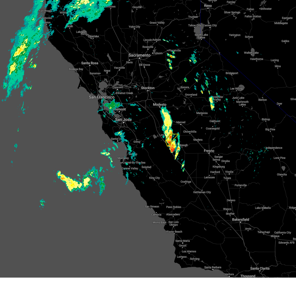
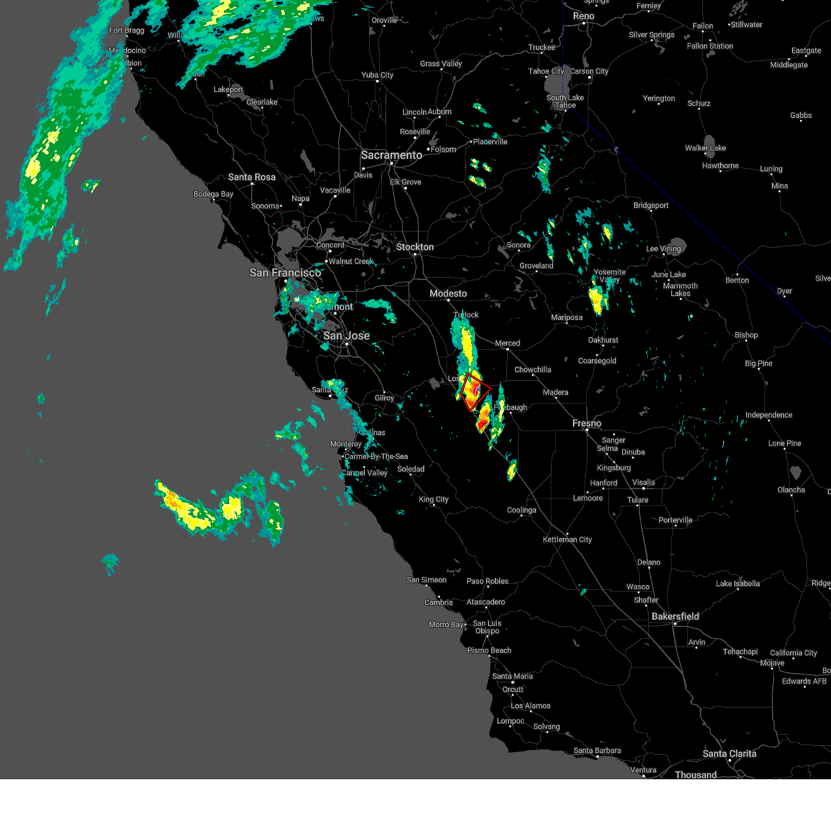
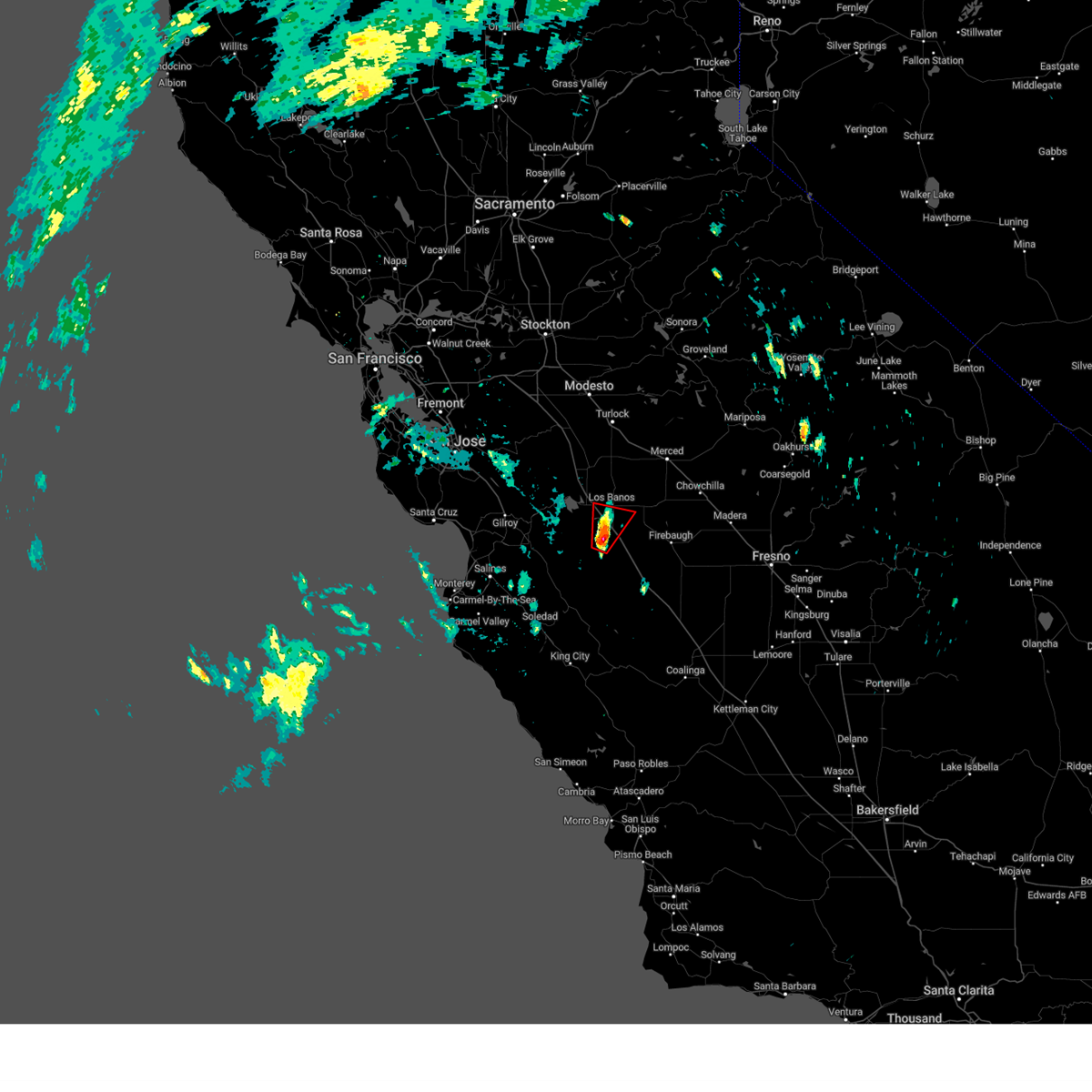
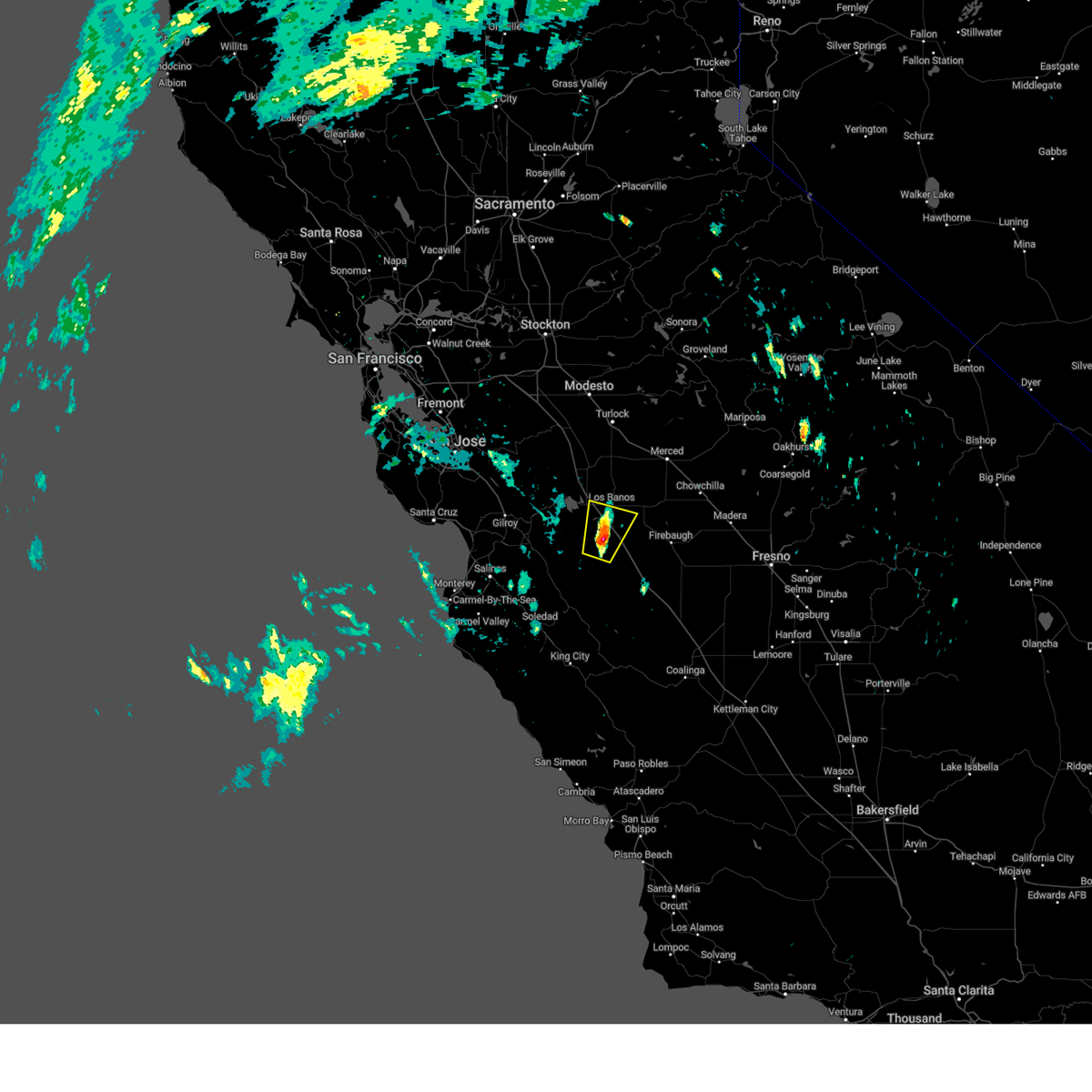
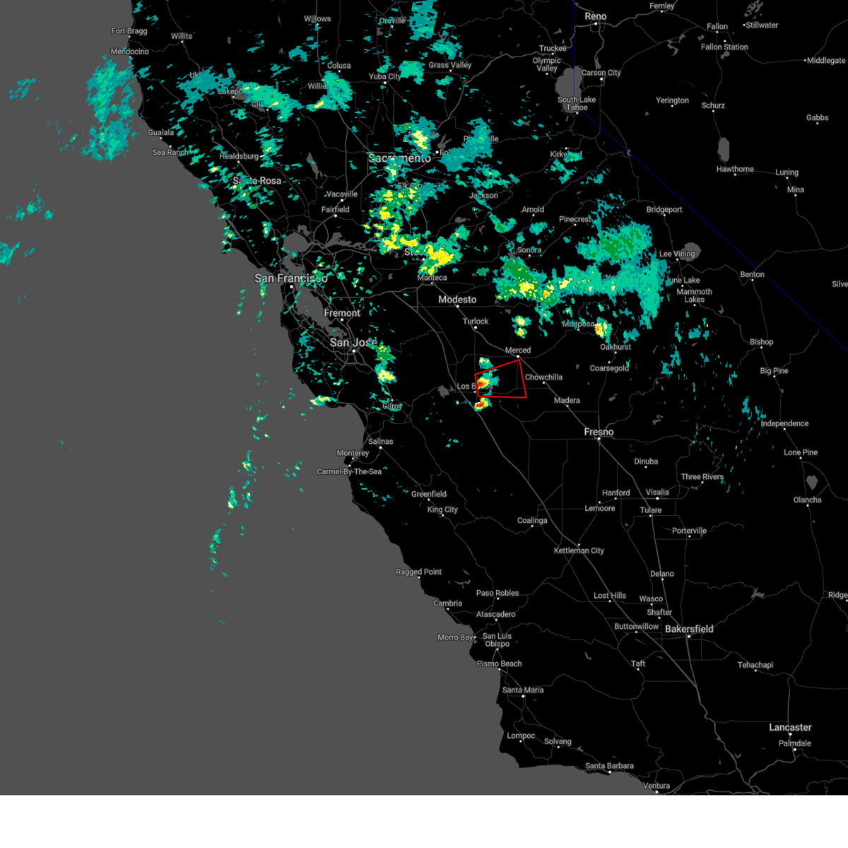
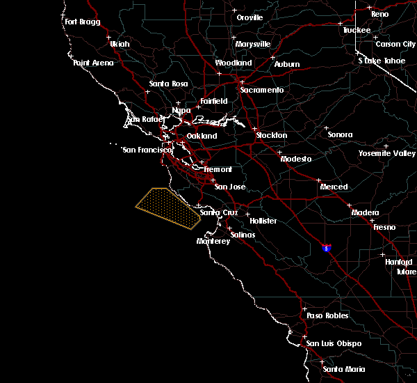
Hail Map for Los Banos, CA
The Los Banos, CA area has had 0 reports of on-the-ground hail by trained spotters, and has been under severe weather warnings 6 times during the past 12 months. Doppler radar has detected hail at or near Los Banos, CA on 2 occasions.
| Name: | Los Banos, CA |
| Where Located: | 60.3 miles ESE of San Jose, CA |
| Map: | Google Map for Los Banos, CA |
| Population: | 35972 |
| Housing Units: | 11375 |
| More Info: | Search Google for Los Banos, CA |
5
The Top Recent Hail Date for Los Banos, CA is Sunday, March 31, 2013 (1st out of 2)

Hail and Wind Damage Spotted near Los Banos, CA
| Date / Time | Report Details |
|---|---|
| 8/21/2023 1:45 PM PDT |
 At 145 pm pdt, a severe thunderstorm was located near south dos palos, or 27 miles southwest of merced, moving northeast at 10 mph (radar indicated). Hazards include 60 mph wind gusts and quarter size hail. Hail damage to vehicles is expected. Expect wind damage to roofs, siding, and trees. At 145 pm pdt, a severe thunderstorm was located near south dos palos, or 27 miles southwest of merced, moving northeast at 10 mph (radar indicated). Hazards include 60 mph wind gusts and quarter size hail. Hail damage to vehicles is expected. Expect wind damage to roofs, siding, and trees.
|
| 8/21/2023 1:34 PM PDT |
 At 134 pm pdt, a severe thunderstorm capable of producing a tornado was located 7 miles west of south dos palos, or 29 miles southwest of merced, moving northeast at 15 mph (radar indicated rotation). Hazards include tornado and quarter size hail. Flying debris will be dangerous to those caught without shelter. mobile homes will be damaged or destroyed. damage to roofs, windows, and vehicles will occur. tree damage is likely. This tornadic thunderstorm will remain over mainly rural areas of south central merced county, including the following locations, dos palos. At 134 pm pdt, a severe thunderstorm capable of producing a tornado was located 7 miles west of south dos palos, or 29 miles southwest of merced, moving northeast at 15 mph (radar indicated rotation). Hazards include tornado and quarter size hail. Flying debris will be dangerous to those caught without shelter. mobile homes will be damaged or destroyed. damage to roofs, windows, and vehicles will occur. tree damage is likely. This tornadic thunderstorm will remain over mainly rural areas of south central merced county, including the following locations, dos palos.
|
| 8/21/2023 1:12 PM PDT |
 At 111 pm pdt, a severe thunderstorm capable of producing a tornado was located 7 miles south of los banos, or 30 miles east of hollister, moving northeast at 10 mph (radar indicated rotation). Hazards include tornado. Flying debris will be dangerous to those caught without shelter. mobile homes will be damaged or destroyed. damage to roofs, windows, and vehicles will occur. tree damage is likely. this dangerous storm will be near, los banos around 125 pm pdt. Other locations impacted by this tornadic thunderstorm include dos palos. At 111 pm pdt, a severe thunderstorm capable of producing a tornado was located 7 miles south of los banos, or 30 miles east of hollister, moving northeast at 10 mph (radar indicated rotation). Hazards include tornado. Flying debris will be dangerous to those caught without shelter. mobile homes will be damaged or destroyed. damage to roofs, windows, and vehicles will occur. tree damage is likely. this dangerous storm will be near, los banos around 125 pm pdt. Other locations impacted by this tornadic thunderstorm include dos palos.
|
| 8/21/2023 12:59 PM PDT |
 At 1259 pm pdt, a severe thunderstorm capable of producing a tornado was located 9 miles south of los banos, or 30 miles east of hollister, moving north at 15 mph (radar indicated rotation). Hazards include tornado and quarter size hail. Flying debris will be dangerous to those caught without shelter. mobile homes will be damaged or destroyed. damage to roofs, windows, and vehicles will occur. tree damage is likely. Locations impacted include, los banos. At 1259 pm pdt, a severe thunderstorm capable of producing a tornado was located 9 miles south of los banos, or 30 miles east of hollister, moving north at 15 mph (radar indicated rotation). Hazards include tornado and quarter size hail. Flying debris will be dangerous to those caught without shelter. mobile homes will be damaged or destroyed. damage to roofs, windows, and vehicles will occur. tree damage is likely. Locations impacted include, los banos.
|
| 8/21/2023 12:41 PM PDT |
 At 1241 pm pdt, a severe thunderstorm capable of producing a tornado was located 13 miles south of los banos, or 28 miles east of hollister, moving north at 20 mph (radar indicated rotation). Hazards include tornado. Flying debris will be dangerous to those caught without shelter. mobile homes will be damaged or destroyed. damage to roofs, windows, and vehicles will occur. tree damage is likely. This tornadic thunderstorm will remain over mainly rural areas of south central merced county. At 1241 pm pdt, a severe thunderstorm capable of producing a tornado was located 13 miles south of los banos, or 28 miles east of hollister, moving north at 20 mph (radar indicated rotation). Hazards include tornado. Flying debris will be dangerous to those caught without shelter. mobile homes will be damaged or destroyed. damage to roofs, windows, and vehicles will occur. tree damage is likely. This tornadic thunderstorm will remain over mainly rural areas of south central merced county.
|
| 8/21/2023 12:35 PM PDT |
 At 1234 pm pdt, a severe thunderstorm was located 9 miles south of los banos, or 29 miles east of hollister, and is traveling nne around 10 mph (radar indicated). Hazards include 60 mph wind gusts and nickel size hail. expect damage to roofs, siding, and trees At 1234 pm pdt, a severe thunderstorm was located 9 miles south of los banos, or 29 miles east of hollister, and is traveling nne around 10 mph (radar indicated). Hazards include 60 mph wind gusts and nickel size hail. expect damage to roofs, siding, and trees
|
| 3/12/2023 3:05 PM PDT |
 At 304 pm pdt, a severe thunderstorm capable of producing a tornado was located near los banos, or 18 miles southwest of atwater, moving east at 20 mph (weather spotters reported funnel cloud). Hazards include tornado. Flying debris will be dangerous to those caught without shelter. mobile homes will be damaged or destroyed. damage to roofs, windows, and vehicles will occur. tree damage is likely. This tornadic thunderstorm will remain over mainly rural areas of southwestern madera, central merced and northwestern fresno counties, including the following locations, san luis national wildlife refuge. At 304 pm pdt, a severe thunderstorm capable of producing a tornado was located near los banos, or 18 miles southwest of atwater, moving east at 20 mph (weather spotters reported funnel cloud). Hazards include tornado. Flying debris will be dangerous to those caught without shelter. mobile homes will be damaged or destroyed. damage to roofs, windows, and vehicles will occur. tree damage is likely. This tornadic thunderstorm will remain over mainly rural areas of southwestern madera, central merced and northwestern fresno counties, including the following locations, san luis national wildlife refuge.
|
| 9/11/2017 7:40 PM PDT |
 At 738 pm pdt, an area of strong thunderstorms, a few of them severe, were located 9 miles north of south dos palos, or 14 miles southwest of merced, moving northwest at 55 mph (radar indicated). Hazards include 60 mph wind gusts and quarter size hail. Hail damage to vehicles is expected. expect wind damage to roofs, siding, and trees. in addition to frequent cloud to ground lightning, thunderstorms may bring very heavy rain and possible flooding. Motorists should expect ponding of water on roads. At 738 pm pdt, an area of strong thunderstorms, a few of them severe, were located 9 miles north of south dos palos, or 14 miles southwest of merced, moving northwest at 55 mph (radar indicated). Hazards include 60 mph wind gusts and quarter size hail. Hail damage to vehicles is expected. expect wind damage to roofs, siding, and trees. in addition to frequent cloud to ground lightning, thunderstorms may bring very heavy rain and possible flooding. Motorists should expect ponding of water on roads.
|
| 9/11/2017 6:42 PM PDT |
 At 641 pm pdt, a severe thunderstorm was located 9 miles southwest of parkwood, or 9 miles southwest of madera, moving northwest at 45 mph (radar indicated). Hazards include 60 mph wind gusts and quarter size hail. Hail damage to vehicles is expected. expect wind damage to roofs, siding, and trees. thunderstorms have had a history of producing very heavy rain and frequent cloud to ground lightning. Flooding is possible on roads and in poor drainage areas. At 641 pm pdt, a severe thunderstorm was located 9 miles southwest of parkwood, or 9 miles southwest of madera, moving northwest at 45 mph (radar indicated). Hazards include 60 mph wind gusts and quarter size hail. Hail damage to vehicles is expected. expect wind damage to roofs, siding, and trees. thunderstorms have had a history of producing very heavy rain and frequent cloud to ground lightning. Flooding is possible on roads and in poor drainage areas.
|
| 5/5/2016 7:06 PM PDT |
 At 705 pm pdt, doppler radar indicated a severe thunderstorm capable of producing quarter size hail. this storm was located near los banos, or 23 miles southwest of merced, moving north at 15 mph. locations impacted include, los banos, south dos palos and dos palos. At 705 pm pdt, doppler radar indicated a severe thunderstorm capable of producing quarter size hail. this storm was located near los banos, or 23 miles southwest of merced, moving north at 15 mph. locations impacted include, los banos, south dos palos and dos palos.
|
| 5/5/2016 6:45 PM PDT |
 At 644 pm pdt, doppler radar indicated a severe thunderstorm capable of producing quarter size hail and damaging winds in excess of 60 mph. this storm was located near south dos palos, or 27 miles southwest of merced, and moving north at 15 mph. At 644 pm pdt, doppler radar indicated a severe thunderstorm capable of producing quarter size hail and damaging winds in excess of 60 mph. this storm was located near south dos palos, or 27 miles southwest of merced, and moving north at 15 mph.
|
Hail Maps for Los Banos, CA

Connect with Interactive Hail Maps