

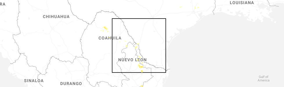
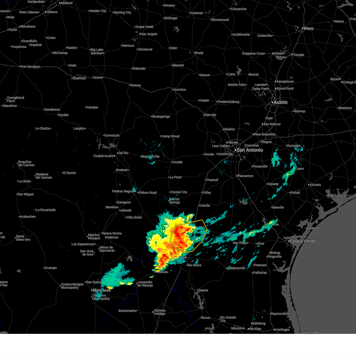
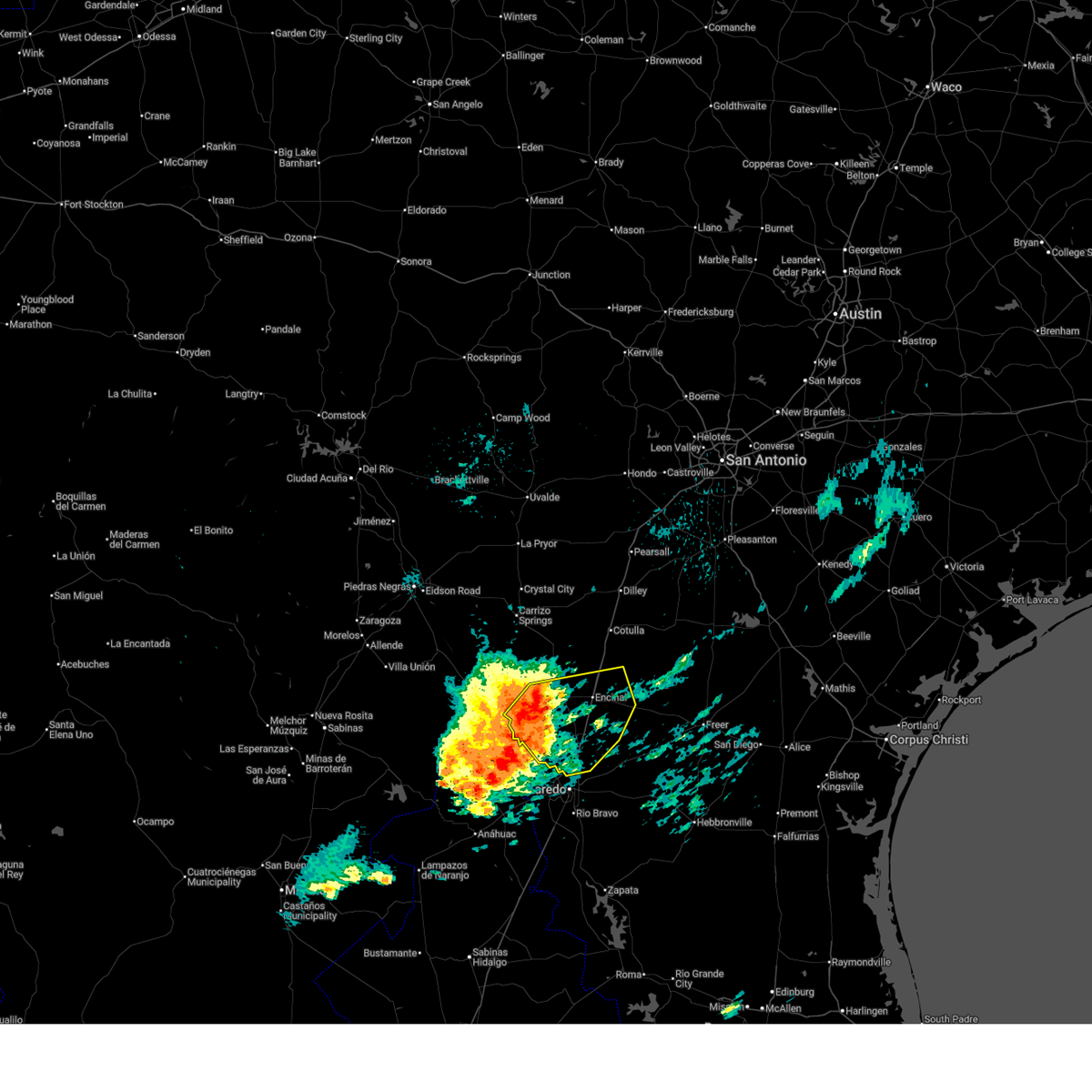
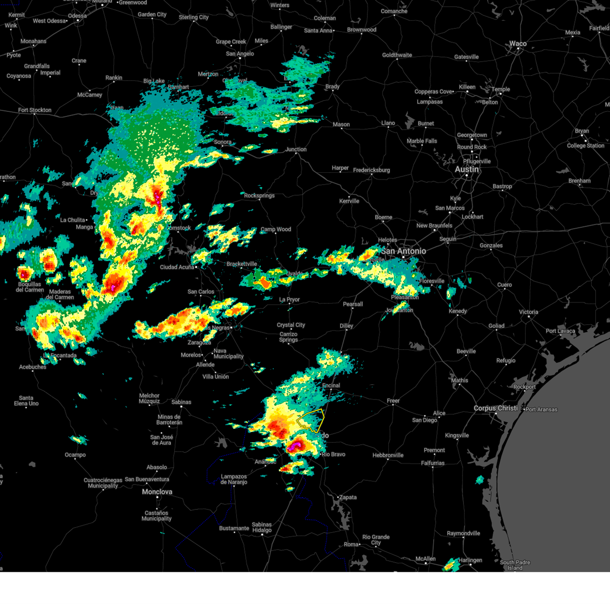
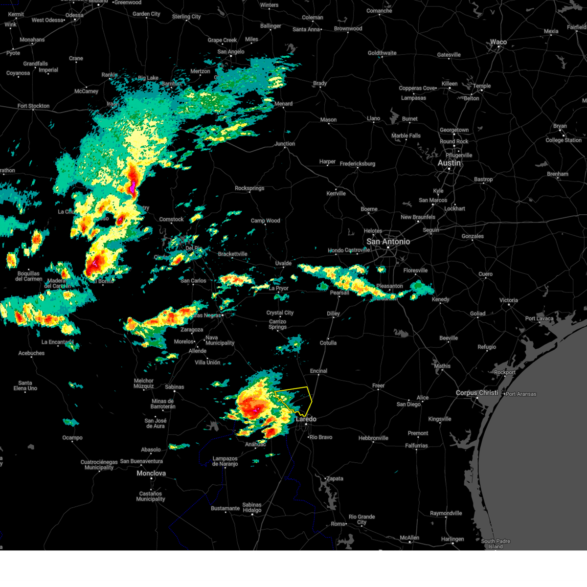
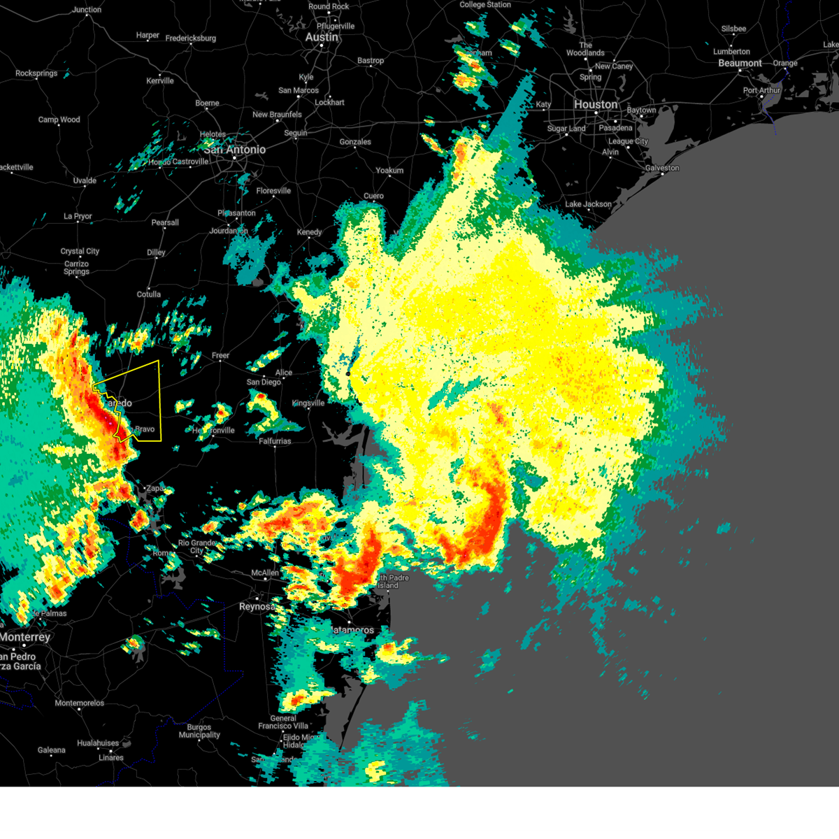
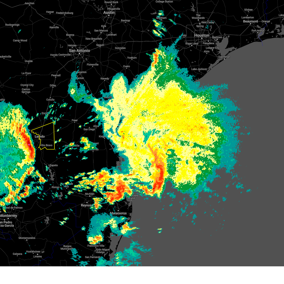
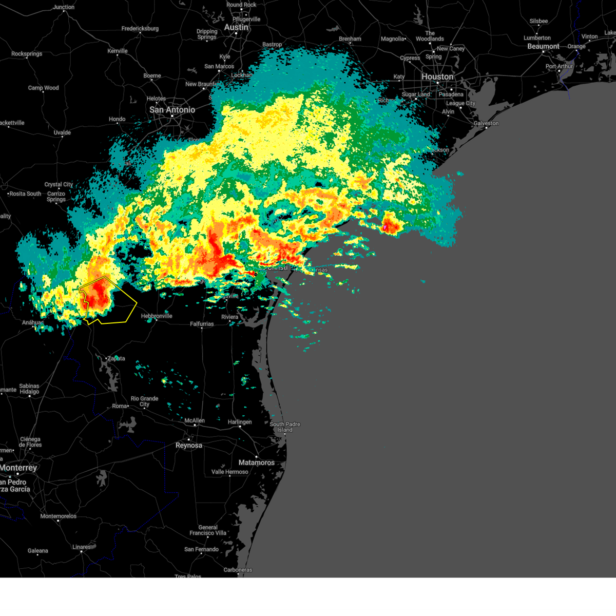
Hail Map for Los Corralitos, TX
The Los Corralitos, TX area has had 0 reports of on-the-ground hail by trained spotters, and has been under severe weather warnings 5 times during the past 12 months. Doppler radar has detected hail at or near Los Corralitos, TX on 38 occasions, including 1 occasion during the past year.
| Name: | Los Corralitos, TX |
| Where Located: | 8.3 miles NNW of Laredo, TX |
| Map: | Google Map for Los Corralitos, TX |
| Population: | 35 |
| Housing Units: | 8 |
| More Info: | Search Google for Los Corralitos, TX |
1
The Top Recent Hail Date for Los Corralitos, TX is Friday, June 19, 2026 (15th out of 38)
Hail and Wind Damage Spotted near Los Corralitos, TX
| Date / Time | Report Details |
|---|---|
| 5/27/2026 3:56 AM CDT |
 At 356 am cdt, severe thunderstorms were located along a line extending from callaghan to near unitec industrial park to st augustine high school south laredo, moving east at 55 mph (radar indicated). Hazards include 70 mph wind gusts and half dollar size hail. Hail damage to vehicles is expected. expect considerable tree damage. wind damage is also likely to mobile homes, roofs, and outbuildings. locations impacted include, laredo, texas a&m, laredo international airport, botines, unitec industrial park, mirando city, ranchos penitas west, oilton, united south high school, aguilares, ranchitos las lomas, st augustine high school south laredo, doctors hospital of laredo, laredo country club, laredo community college, bruni, orvil, and callaghan. this includes the following highways, interstate 35 between mile markers 1 and 38. us highway 59 between mile markers 770 and 824. Us highway 83 between mile markers 680 and 724. At 356 am cdt, severe thunderstorms were located along a line extending from callaghan to near unitec industrial park to st augustine high school south laredo, moving east at 55 mph (radar indicated). Hazards include 70 mph wind gusts and half dollar size hail. Hail damage to vehicles is expected. expect considerable tree damage. wind damage is also likely to mobile homes, roofs, and outbuildings. locations impacted include, laredo, texas a&m, laredo international airport, botines, unitec industrial park, mirando city, ranchos penitas west, oilton, united south high school, aguilares, ranchitos las lomas, st augustine high school south laredo, doctors hospital of laredo, laredo country club, laredo community college, bruni, orvil, and callaghan. this includes the following highways, interstate 35 between mile markers 1 and 38. us highway 59 between mile markers 770 and 824. Us highway 83 between mile markers 680 and 724.
|
| 5/27/2026 3:47 AM CDT |
 Svrcrp the national weather service in corpus christi has issued a * severe thunderstorm warning for, northwestern duval county in south central texas, webb county in south central texas, * until 430 am cdt. * at 347 am cdt, severe thunderstorms were located along a line extending from near callaghan to unitec industrial park to st augustine high school south laredo, moving east at 55 mph. site klrd observed winds in excess of 60 mph (radar indicated). Hazards include 70 mph wind gusts and quarter size hail. Hail damage to vehicles is expected. expect considerable tree damage. Wind damage is also likely to mobile homes, roofs, and outbuildings. Svrcrp the national weather service in corpus christi has issued a * severe thunderstorm warning for, northwestern duval county in south central texas, webb county in south central texas, * until 430 am cdt. * at 347 am cdt, severe thunderstorms were located along a line extending from near callaghan to unitec industrial park to st augustine high school south laredo, moving east at 55 mph. site klrd observed winds in excess of 60 mph (radar indicated). Hazards include 70 mph wind gusts and quarter size hail. Hail damage to vehicles is expected. expect considerable tree damage. Wind damage is also likely to mobile homes, roofs, and outbuildings.
|
| 5/18/2026 11:56 PM CDT |
 Svrcrp the national weather service in corpus christi has issued a * severe thunderstorm warning for, southwestern duval county in south central texas, southern la salle county in south central texas, webb county in south central texas, * until 100 am cdt. * at 1156 pm cdt, severe thunderstorms were located along a line extending from 8 miles south of artesia wells to near ranchitos las lomas to 33 miles west of el cenizo, moving southeast at 50 mph (radar indicated). Hazards include 60 mph wind gusts and quarter size hail. Hail damage to vehicles is expected. Expect wind damage to roofs, siding, and trees. Svrcrp the national weather service in corpus christi has issued a * severe thunderstorm warning for, southwestern duval county in south central texas, southern la salle county in south central texas, webb county in south central texas, * until 100 am cdt. * at 1156 pm cdt, severe thunderstorms were located along a line extending from 8 miles south of artesia wells to near ranchitos las lomas to 33 miles west of el cenizo, moving southeast at 50 mph (radar indicated). Hazards include 60 mph wind gusts and quarter size hail. Hail damage to vehicles is expected. Expect wind damage to roofs, siding, and trees.
|
| 5/18/2026 11:38 PM CDT |
 At 1138 pm cdt, severe thunderstorms were located along a line extending from 9 miles south of chaparral wildlife management area to near encinal to 8 miles northeast of callaghan to near botines to near orvil, moving east at 45 mph (radar indicated). Hazards include 60 mph wind gusts and quarter size hail. Hail damage to vehicles is expected. expect wind damage to roofs, siding, and trees. locations impacted include, laredo, encinal, las tiendas, botines, unitec industrial park, la esperanza ranch airport, doctors hospital of laredo, ranchos penitas west, orvil, columbia bridge, and callaghan. this includes the following highways, interstate 35 between mile markers 7 and 46. Us highway 83 between mile markers 674 and 698. At 1138 pm cdt, severe thunderstorms were located along a line extending from 9 miles south of chaparral wildlife management area to near encinal to 8 miles northeast of callaghan to near botines to near orvil, moving east at 45 mph (radar indicated). Hazards include 60 mph wind gusts and quarter size hail. Hail damage to vehicles is expected. expect wind damage to roofs, siding, and trees. locations impacted include, laredo, encinal, las tiendas, botines, unitec industrial park, la esperanza ranch airport, doctors hospital of laredo, ranchos penitas west, orvil, columbia bridge, and callaghan. this includes the following highways, interstate 35 between mile markers 7 and 46. Us highway 83 between mile markers 674 and 698.
|
| 5/18/2026 11:18 PM CDT |
 Svrcrp the national weather service in corpus christi has issued a * severe thunderstorm warning for, southwestern la salle county in south central texas, northern webb county in south central texas, * until midnight cdt. * at 1118 pm cdt, severe thunderstorms were located along a line extending from 9 miles southeast of gilson groves to la esperanza ranch airport to 6 miles northeast of las tiendas to near columbia bridge to 10 miles west of ranchos penitas west, moving east at 45 mph (radar indicated). Hazards include 60 mph wind gusts and quarter size hail. Hail damage to vehicles is expected. Expect wind damage to roofs, siding, and trees. Svrcrp the national weather service in corpus christi has issued a * severe thunderstorm warning for, southwestern la salle county in south central texas, northern webb county in south central texas, * until midnight cdt. * at 1118 pm cdt, severe thunderstorms were located along a line extending from 9 miles southeast of gilson groves to la esperanza ranch airport to 6 miles northeast of las tiendas to near columbia bridge to 10 miles west of ranchos penitas west, moving east at 45 mph (radar indicated). Hazards include 60 mph wind gusts and quarter size hail. Hail damage to vehicles is expected. Expect wind damage to roofs, siding, and trees.
|
| 5/8/2025 3:00 PM CDT |
 the severe thunderstorm warning has been cancelled and is no longer in effect the severe thunderstorm warning has been cancelled and is no longer in effect
|
| 5/8/2025 2:50 PM CDT |
 Svrcrp the national weather service in corpus christi has issued a * severe thunderstorm warning for, south central webb county in south central texas, * until 330 pm cdt. * at 249 pm cdt, a severe thunderstorm was located 11 miles west of laredo community college, or 13 miles west of laredo, moving east at 35 mph (radar indicated). Hazards include ping pong ball size hail and 60 mph wind gusts. People and animals outdoors will be injured. expect hail damage to roofs, siding, windows, and vehicles. Expect wind damage to roofs, siding, and trees. Svrcrp the national weather service in corpus christi has issued a * severe thunderstorm warning for, south central webb county in south central texas, * until 330 pm cdt. * at 249 pm cdt, a severe thunderstorm was located 11 miles west of laredo community college, or 13 miles west of laredo, moving east at 35 mph (radar indicated). Hazards include ping pong ball size hail and 60 mph wind gusts. People and animals outdoors will be injured. expect hail damage to roofs, siding, windows, and vehicles. Expect wind damage to roofs, siding, and trees.
|
| 5/8/2025 2:48 PM CDT |
 At 248 pm cdt, a severe thunderstorm was located over columbia bridge, or 20 miles northwest of laredo, moving east at 35 mph (radar indicated). Hazards include 60 mph wind gusts and half dollar size hail. Hail damage to vehicles is expected. expect wind damage to roofs, siding, and trees. locations impacted include, laredo, ranchos penitas west, columbia bridge, and botines. this includes the following highways, interstate 35 near mile marker 18. Us highway 83 between mile markers 694 and 696. At 248 pm cdt, a severe thunderstorm was located over columbia bridge, or 20 miles northwest of laredo, moving east at 35 mph (radar indicated). Hazards include 60 mph wind gusts and half dollar size hail. Hail damage to vehicles is expected. expect wind damage to roofs, siding, and trees. locations impacted include, laredo, ranchos penitas west, columbia bridge, and botines. this includes the following highways, interstate 35 near mile marker 18. Us highway 83 between mile markers 694 and 696.
|
| 5/8/2025 2:17 PM CDT |
 Svrcrp the national weather service in corpus christi has issued a * severe thunderstorm warning for, central webb county in south central texas, * until 315 pm cdt. * at 216 pm cdt, a severe thunderstorm was located 18 miles west of columbia bridge, or 35 miles west of laredo, moving east at 35 mph (radar indicated). Hazards include 60 mph wind gusts and half dollar size hail. Hail damage to vehicles is expected. Expect wind damage to roofs, siding, and trees. Svrcrp the national weather service in corpus christi has issued a * severe thunderstorm warning for, central webb county in south central texas, * until 315 pm cdt. * at 216 pm cdt, a severe thunderstorm was located 18 miles west of columbia bridge, or 35 miles west of laredo, moving east at 35 mph (radar indicated). Hazards include 60 mph wind gusts and half dollar size hail. Hail damage to vehicles is expected. Expect wind damage to roofs, siding, and trees.
|
| 3/27/2025 9:46 PM CDT |
 At 945 pm cdt, severe thunderstorms were located along a line extending from near unitec industrial park to 6 miles southwest of san ygnacio, moving east at 30 mph (radar indicated). Hazards include 70 mph wind gusts. Expect considerable tree damage. damage is likely to mobile homes, roofs, and outbuildings. locations impacted include, texas a&m, laredo international airport, botines, el cenizo, unitec industrial park, ranchos penitas west, united south high school, rio bravo, laredo, ranchitos las lomas, st augustine high school south laredo, doctors hospital of laredo, laredo country club, laredo community college, and orvil. this includes the following highways, interstate 35 between mile markers 1 and 21. us highway 59 between mile markers 806 and 824. Us highway 83 between mile markers 698 and 734. At 945 pm cdt, severe thunderstorms were located along a line extending from near unitec industrial park to 6 miles southwest of san ygnacio, moving east at 30 mph (radar indicated). Hazards include 70 mph wind gusts. Expect considerable tree damage. damage is likely to mobile homes, roofs, and outbuildings. locations impacted include, texas a&m, laredo international airport, botines, el cenizo, unitec industrial park, ranchos penitas west, united south high school, rio bravo, laredo, ranchitos las lomas, st augustine high school south laredo, doctors hospital of laredo, laredo country club, laredo community college, and orvil. this includes the following highways, interstate 35 between mile markers 1 and 21. us highway 59 between mile markers 806 and 824. Us highway 83 between mile markers 698 and 734.
|
| 3/27/2025 9:22 PM CDT |
 Svrcrp the national weather service in corpus christi has issued a * severe thunderstorm warning for, south central webb county in south central texas, * until 1000 pm cdt. * at 921 pm cdt, severe thunderstorms were located along a line extending from near ranchos penitas west to 15 miles southwest of san ygnacio, moving east at 30 mph (radar indicated). Hazards include 60 mph wind gusts. expect damage to roofs, siding, and trees Svrcrp the national weather service in corpus christi has issued a * severe thunderstorm warning for, south central webb county in south central texas, * until 1000 pm cdt. * at 921 pm cdt, severe thunderstorms were located along a line extending from near ranchos penitas west to 15 miles southwest of san ygnacio, moving east at 30 mph (radar indicated). Hazards include 60 mph wind gusts. expect damage to roofs, siding, and trees
|
| 5/28/2024 9:53 PM CDT |
 At 952 pm cdt, severe thunderstorms were located along a line extending from near encinal to 6 miles east of united south high school to 6 miles north of san ygnacio, moving east at 40 mph (radar indicated. at 945 pm cdt, 60 mph wind was reported at laredo international airport). Hazards include 60 mph wind gusts and penny size hail. Expect damage to roofs, siding, and trees. these severe storms will be near, ranchitos las lomas around 955 pm cdt. aguilares around 1010 pm cdt. mirando city around 1015 pm cdt. this includes the following highways, interstate 35 between mile markers 1 and 37. us highway 59 between mile markers 792 and 824. Us highway 83 between mile markers 684 and 734. At 952 pm cdt, severe thunderstorms were located along a line extending from near encinal to 6 miles east of united south high school to 6 miles north of san ygnacio, moving east at 40 mph (radar indicated. at 945 pm cdt, 60 mph wind was reported at laredo international airport). Hazards include 60 mph wind gusts and penny size hail. Expect damage to roofs, siding, and trees. these severe storms will be near, ranchitos las lomas around 955 pm cdt. aguilares around 1010 pm cdt. mirando city around 1015 pm cdt. this includes the following highways, interstate 35 between mile markers 1 and 37. us highway 59 between mile markers 792 and 824. Us highway 83 between mile markers 684 and 734.
|
| 5/28/2024 9:41 PM CDT |
 At 940 pm cdt, severe thunderstorms were located along a line extending from near encinal to near united south high school to 12 miles northwest of san ygnacio, moving southeast at 35 mph (radar indicated). Hazards include 60 mph wind gusts and penny size hail. Expect damage to roofs, siding, and trees. these severe storms will be near, laredo, rio bravo, and callaghan around 945 pm cdt. ranchitos las lomas around 950 pm cdt. aguilares around 1010 pm cdt. mirando city around 1020 pm cdt. this includes the following highways, interstate 35 between mile markers 1 and 38. us highway 59 between mile markers 792 and 824. Us highway 83 between mile markers 680 and 734. At 940 pm cdt, severe thunderstorms were located along a line extending from near encinal to near united south high school to 12 miles northwest of san ygnacio, moving southeast at 35 mph (radar indicated). Hazards include 60 mph wind gusts and penny size hail. Expect damage to roofs, siding, and trees. these severe storms will be near, laredo, rio bravo, and callaghan around 945 pm cdt. ranchitos las lomas around 950 pm cdt. aguilares around 1010 pm cdt. mirando city around 1020 pm cdt. this includes the following highways, interstate 35 between mile markers 1 and 38. us highway 59 between mile markers 792 and 824. Us highway 83 between mile markers 680 and 734.
|
| 5/28/2024 9:41 PM CDT |
 the severe thunderstorm warning has been cancelled and is no longer in effect the severe thunderstorm warning has been cancelled and is no longer in effect
|
| 5/28/2024 9:29 PM CDT |
 At 928 pm cdt, severe thunderstorms were located along a line extending from 8 miles south of light to orvil to 23 miles southwest of el cenizo, moving east at 40 mph (radar indicated). Hazards include 60 mph wind gusts and penny size hail. Expect damage to roofs, siding, and trees. these severe storms will be near, laredo, encinal, st augustine high school south laredo, callaghan, unitec industrial park, laredo international airport, doctors hospital of laredo, texas a&m, laredo country club, and united south high school around 935 pm cdt. rio bravo and el cenizo around 940 pm cdt. ranchitos las lomas around 945 pm cdt. aguilares around 1010 pm cdt. mirando city around 1015 pm cdt. this includes the following highways, interstate 35 between mile markers 1 and 50. us highway 59 between mile markers 792 and 824. Us highway 83 between mile markers 668 and 734. At 928 pm cdt, severe thunderstorms were located along a line extending from 8 miles south of light to orvil to 23 miles southwest of el cenizo, moving east at 40 mph (radar indicated). Hazards include 60 mph wind gusts and penny size hail. Expect damage to roofs, siding, and trees. these severe storms will be near, laredo, encinal, st augustine high school south laredo, callaghan, unitec industrial park, laredo international airport, doctors hospital of laredo, texas a&m, laredo country club, and united south high school around 935 pm cdt. rio bravo and el cenizo around 940 pm cdt. ranchitos las lomas around 945 pm cdt. aguilares around 1010 pm cdt. mirando city around 1015 pm cdt. this includes the following highways, interstate 35 between mile markers 1 and 50. us highway 59 between mile markers 792 and 824. Us highway 83 between mile markers 668 and 734.
|
| 5/28/2024 9:11 PM CDT |
 Svrcrp the national weather service in corpus christi has issued a * severe thunderstorm warning for, webb county in south central texas, southern la salle county in south central texas, * until 1015 pm cdt. * at 910 pm cdt, severe thunderstorms were located along a line extending from 8 miles north of la esperanza ranch airport to near columbia bridge to 31 miles west of el cenizo, moving east at 40 mph (radar indicated). Hazards include 60 mph wind gusts. Expect damage to roofs, siding, and trees. severe thunderstorms will be near, la esperanza ranch airport, las tiendas, and ranchos penitas west around 915 pm cdt. laredo around 920 pm cdt. orvil, unitec industrial park, doctors hospital of laredo, and botines around 925 pm cdt. encinal, callaghan, laredo international airport, texas a&m, laredo country club, and laredo community college around 930 pm cdt. united south high school around 935 pm cdt. rio bravo and el cenizo around 940 pm cdt. ranchitos las lomas around 945 pm cdt. this includes the following highways, interstate 35 between mile markers 1 and 50. us highway 59 between mile markers 792 and 824. Us highway 83 between mile markers 668 and 734. Svrcrp the national weather service in corpus christi has issued a * severe thunderstorm warning for, webb county in south central texas, southern la salle county in south central texas, * until 1015 pm cdt. * at 910 pm cdt, severe thunderstorms were located along a line extending from 8 miles north of la esperanza ranch airport to near columbia bridge to 31 miles west of el cenizo, moving east at 40 mph (radar indicated). Hazards include 60 mph wind gusts. Expect damage to roofs, siding, and trees. severe thunderstorms will be near, la esperanza ranch airport, las tiendas, and ranchos penitas west around 915 pm cdt. laredo around 920 pm cdt. orvil, unitec industrial park, doctors hospital of laredo, and botines around 925 pm cdt. encinal, callaghan, laredo international airport, texas a&m, laredo country club, and laredo community college around 930 pm cdt. united south high school around 935 pm cdt. rio bravo and el cenizo around 940 pm cdt. ranchitos las lomas around 945 pm cdt. this includes the following highways, interstate 35 between mile markers 1 and 50. us highway 59 between mile markers 792 and 824. Us highway 83 between mile markers 668 and 734.
|
| 5/17/2024 8:56 AM CDT |
 the severe thunderstorm warning has been cancelled and is no longer in effect the severe thunderstorm warning has been cancelled and is no longer in effect
|
| 5/17/2024 8:39 AM CDT |
 At 838 am cdt, a severe thunderstorm was located 18 miles west of freer, moving northeast at 30 mph (radar indicated). Hazards include ping pong ball size hail. People and animals outdoors will be injured. expect damage to roofs, siding, windows, and vehicles. locations impacted include, laredo, texas a&m, laredo international airport, ranchitos las lomas, unitec industrial park, st augustine high school south laredo, doctors hospital of laredo, laredo country club, laredo community college, orvil, and united south high school. this includes the following highways, interstate 35 between mile markers 1 and 14. us highway 59 between mile markers 804 and 824. Us highway 83 between mile markers 718 and 720. At 838 am cdt, a severe thunderstorm was located 18 miles west of freer, moving northeast at 30 mph (radar indicated). Hazards include ping pong ball size hail. People and animals outdoors will be injured. expect damage to roofs, siding, windows, and vehicles. locations impacted include, laredo, texas a&m, laredo international airport, ranchitos las lomas, unitec industrial park, st augustine high school south laredo, doctors hospital of laredo, laredo country club, laredo community college, orvil, and united south high school. this includes the following highways, interstate 35 between mile markers 1 and 14. us highway 59 between mile markers 804 and 824. Us highway 83 between mile markers 718 and 720.
|
| 5/17/2024 8:25 AM CDT |
 Svrcrp the national weather service in corpus christi has issued a * severe thunderstorm warning for, central webb county in south central texas, * until 915 am cdt. * at 824 am cdt, a severe thunderstorm was located over laredo, moving northeast at 30 mph (radar indicated). Hazards include half dollar size hail. damage to vehicles is expected Svrcrp the national weather service in corpus christi has issued a * severe thunderstorm warning for, central webb county in south central texas, * until 915 am cdt. * at 824 am cdt, a severe thunderstorm was located over laredo, moving northeast at 30 mph (radar indicated). Hazards include half dollar size hail. damage to vehicles is expected
|
| 5/13/2024 4:24 PM CDT |
 Svrcrp the national weather service in corpus christi has issued a * severe thunderstorm warning for, central webb county in south central texas, * until 515 pm cdt. * at 424 pm cdt, a severe thunderstorm was located near unitec industrial park, or 12 miles north of laredo, moving east at 40 mph (radar indicated). Hazards include two inch hail and 70 mph wind gusts. People and animals outdoors will be injured. expect hail damage to roofs, siding, windows, and vehicles. expect considerable tree damage. Wind damage is also likely to mobile homes, roofs, and outbuildings. Svrcrp the national weather service in corpus christi has issued a * severe thunderstorm warning for, central webb county in south central texas, * until 515 pm cdt. * at 424 pm cdt, a severe thunderstorm was located near unitec industrial park, or 12 miles north of laredo, moving east at 40 mph (radar indicated). Hazards include two inch hail and 70 mph wind gusts. People and animals outdoors will be injured. expect hail damage to roofs, siding, windows, and vehicles. expect considerable tree damage. Wind damage is also likely to mobile homes, roofs, and outbuildings.
|
| 4/28/2023 8:01 PM CDT |
 At 801 pm cdt, severe thunderstorms were located along a line extending from near unitec industrial park to laredo country club to 6 miles west of laredo community college, moving east at 40 mph (radar indicated). Hazards include quarter size hail. Damage to vehicles is expected. locations impacted include, laredo, texas a&m, laredo international airport, botines, unitec industrial park, ranchos penitas west, united south high school, ranchitos las lomas, st augustine high school south laredo, doctors hospital of laredo, laredo country club, laredo community college and orvil. this includes the following highways, interstate 35 between mile markers 1 and 20. us highway 59 between mile markers 810 and 824. us highway 83 between mile markers 698 and 728. hail threat, radar indicated max hail size, 1. 00 in wind threat, radar indicated max wind gust, <50 mph. At 801 pm cdt, severe thunderstorms were located along a line extending from near unitec industrial park to laredo country club to 6 miles west of laredo community college, moving east at 40 mph (radar indicated). Hazards include quarter size hail. Damage to vehicles is expected. locations impacted include, laredo, texas a&m, laredo international airport, botines, unitec industrial park, ranchos penitas west, united south high school, ranchitos las lomas, st augustine high school south laredo, doctors hospital of laredo, laredo country club, laredo community college and orvil. this includes the following highways, interstate 35 between mile markers 1 and 20. us highway 59 between mile markers 810 and 824. us highway 83 between mile markers 698 and 728. hail threat, radar indicated max hail size, 1. 00 in wind threat, radar indicated max wind gust, <50 mph.
|
| 4/28/2023 7:42 PM CDT |
 At 742 pm cdt, severe thunderstorms were located along a line extending from 6 miles northwest of unitec industrial park to near ranchos penitas west to 10 miles southwest of columbia bridge, moving east at 35 mph (radar indicated). Hazards include quarter size hail. damage to vehicles is expected At 742 pm cdt, severe thunderstorms were located along a line extending from 6 miles northwest of unitec industrial park to near ranchos penitas west to 10 miles southwest of columbia bridge, moving east at 35 mph (radar indicated). Hazards include quarter size hail. damage to vehicles is expected
|
| 4/23/2023 9:57 AM CDT |
 At 956 am cdt, a severe thunderstorm was located 8 miles west of aguilares, or 17 miles southeast of laredo, moving southeast at 30 mph (radar indicated). Hazards include half dollar size hail. Damage to vehicles is expected. locations impacted include, laredo, rio bravo, el cenizo, texas a&m, laredo international airport, unitec industrial park, mirando city, oilton, united south high school, aguilares, ranchitos las lomas, st augustine high school south laredo, doctors hospital of laredo, laredo country club, laredo community college and orvil. this includes the following highways, interstate 35 between mile markers 1 and 13. us highway 59 between mile markers 806 and 824. us highway 83 between mile markers 718 and 734. hail threat, radar indicated max hail size, 1. 25 in wind threat, radar indicated max wind gust, <50 mph. At 956 am cdt, a severe thunderstorm was located 8 miles west of aguilares, or 17 miles southeast of laredo, moving southeast at 30 mph (radar indicated). Hazards include half dollar size hail. Damage to vehicles is expected. locations impacted include, laredo, rio bravo, el cenizo, texas a&m, laredo international airport, unitec industrial park, mirando city, oilton, united south high school, aguilares, ranchitos las lomas, st augustine high school south laredo, doctors hospital of laredo, laredo country club, laredo community college and orvil. this includes the following highways, interstate 35 between mile markers 1 and 13. us highway 59 between mile markers 806 and 824. us highway 83 between mile markers 718 and 734. hail threat, radar indicated max hail size, 1. 25 in wind threat, radar indicated max wind gust, <50 mph.
|
| 4/23/2023 9:41 AM CDT |
 At 941 am cdt, a severe thunderstorm was located 7 miles southeast of texas a&m, or 9 miles east of laredo, moving southeast at 30 mph (radar indicated). Hazards include half dollar size hail. damage to vehicles is expected At 941 am cdt, a severe thunderstorm was located 7 miles southeast of texas a&m, or 9 miles east of laredo, moving southeast at 30 mph (radar indicated). Hazards include half dollar size hail. damage to vehicles is expected
|
| 4/23/2023 9:37 AM CDT |
 At 937 am cdt, a severe thunderstorm was located near texas a&m, or 8 miles east of laredo, moving southeast at 35 mph (radar indicated). Hazards include ping pong ball size hail. People and animals outdoors will be injured. expect damage to roofs, siding, windows, and vehicles. locations impacted include, laredo, texas a&m, laredo international airport, botines, unitec industrial park, ranchos penitas west, united south high school, ranchitos las lomas, st augustine high school south laredo, doctors hospital of laredo, laredo country club, laredo community college and orvil. this includes the following highways, interstate 35 between mile markers 1 and 23. us highway 59 between mile markers 806 and 824. us highway 83 between mile markers 696 and 724. hail threat, radar indicated max hail size, 1. 50 in wind threat, radar indicated max wind gust, <50 mph. At 937 am cdt, a severe thunderstorm was located near texas a&m, or 8 miles east of laredo, moving southeast at 35 mph (radar indicated). Hazards include ping pong ball size hail. People and animals outdoors will be injured. expect damage to roofs, siding, windows, and vehicles. locations impacted include, laredo, texas a&m, laredo international airport, botines, unitec industrial park, ranchos penitas west, united south high school, ranchitos las lomas, st augustine high school south laredo, doctors hospital of laredo, laredo country club, laredo community college and orvil. this includes the following highways, interstate 35 between mile markers 1 and 23. us highway 59 between mile markers 806 and 824. us highway 83 between mile markers 696 and 724. hail threat, radar indicated max hail size, 1. 50 in wind threat, radar indicated max wind gust, <50 mph.
|
| 4/23/2023 9:26 AM CDT |
 At 926 am cdt, a severe thunderstorm was located over texas a&m, or near laredo, moving southeast at 35 mph (radar indicated). Hazards include golf ball size hail. People and animals outdoors will be injured. expect damage to roofs, siding, windows, and vehicles. locations impacted include, laredo, texas a&m, laredo international airport, botines, unitec industrial park, ranchos penitas west, columbia bridge, united south high school, ranchitos las lomas, st augustine high school south laredo, doctors hospital of laredo, laredo country club, laredo community college, orvil and callaghan. this includes the following highways, interstate 35 between mile markers 1 and 27. us highway 59 between mile markers 806 and 824. us highway 83 between mile markers 688 and 724. thunderstorm damage threat, considerable hail threat, radar indicated max hail size, 1. 75 in wind threat, radar indicated max wind gust, <50 mph. At 926 am cdt, a severe thunderstorm was located over texas a&m, or near laredo, moving southeast at 35 mph (radar indicated). Hazards include golf ball size hail. People and animals outdoors will be injured. expect damage to roofs, siding, windows, and vehicles. locations impacted include, laredo, texas a&m, laredo international airport, botines, unitec industrial park, ranchos penitas west, columbia bridge, united south high school, ranchitos las lomas, st augustine high school south laredo, doctors hospital of laredo, laredo country club, laredo community college, orvil and callaghan. this includes the following highways, interstate 35 between mile markers 1 and 27. us highway 59 between mile markers 806 and 824. us highway 83 between mile markers 688 and 724. thunderstorm damage threat, considerable hail threat, radar indicated max hail size, 1. 75 in wind threat, radar indicated max wind gust, <50 mph.
|
| 4/23/2023 9:08 AM CDT |
 At 908 am cdt, a severe thunderstorm was located over ranchos penitas west, or 11 miles northwest of laredo, moving southeast at 30 mph (radar indicated). Hazards include golf ball size hail. People and animals outdoors will be injured. expect damage to roofs, siding, windows, and vehicles. locations impacted include, laredo, texas a&m, las tiendas, laredo international airport, botines, unitec industrial park, ranchos penitas west, columbia bridge, united south high school, ranchitos las lomas, st augustine high school south laredo, doctors hospital of laredo, laredo country club, laredo community college, orvil and callaghan. this includes the following highways, interstate 35 between mile markers 1 and 27. us highway 59 between mile markers 806 and 824. us highway 83 between mile markers 684 and 726. thunderstorm damage threat, considerable hail threat, radar indicated max hail size, 1. 75 in wind threat, radar indicated max wind gust, <50 mph. At 908 am cdt, a severe thunderstorm was located over ranchos penitas west, or 11 miles northwest of laredo, moving southeast at 30 mph (radar indicated). Hazards include golf ball size hail. People and animals outdoors will be injured. expect damage to roofs, siding, windows, and vehicles. locations impacted include, laredo, texas a&m, las tiendas, laredo international airport, botines, unitec industrial park, ranchos penitas west, columbia bridge, united south high school, ranchitos las lomas, st augustine high school south laredo, doctors hospital of laredo, laredo country club, laredo community college, orvil and callaghan. this includes the following highways, interstate 35 between mile markers 1 and 27. us highway 59 between mile markers 806 and 824. us highway 83 between mile markers 684 and 726. thunderstorm damage threat, considerable hail threat, radar indicated max hail size, 1. 75 in wind threat, radar indicated max wind gust, <50 mph.
|
| 4/23/2023 8:52 AM CDT |
 At 852 am cdt, a severe thunderstorm was located 7 miles northeast of columbia bridge, or 19 miles northwest of laredo, moving southeast at 30 mph (radar indicated). Hazards include golf ball size hail. People and animals outdoors will be injured. Expect damage to roofs, siding, windows, and vehicles. At 852 am cdt, a severe thunderstorm was located 7 miles northeast of columbia bridge, or 19 miles northwest of laredo, moving southeast at 30 mph (radar indicated). Hazards include golf ball size hail. People and animals outdoors will be injured. Expect damage to roofs, siding, windows, and vehicles.
|
| 4/5/2023 11:20 PM CDT |
 At 1120 pm cdt, a severe thunderstorm was located over st augustine high school south laredo, or near laredo, moving north at 30 mph (radar indicated). Hazards include half dollar size hail. damage to vehicles is expected At 1120 pm cdt, a severe thunderstorm was located over st augustine high school south laredo, or near laredo, moving north at 30 mph (radar indicated). Hazards include half dollar size hail. damage to vehicles is expected
|
| 8/15/2022 7:10 PM CDT |
 At 710 pm cdt, a severe thunderstorm capable of producing a tornado was located near united south high school, or 8 miles southeast of laredo, moving north at 30 mph (radar indicated rotation). Hazards include tornado. Flying debris will be dangerous to those caught without shelter. mobile homes will be damaged or destroyed. damage to roofs, windows, and vehicles will occur. tree damage is likely. this dangerous storm will be near, united south high school around 715 pm cdt. st augustine high school south laredo and laredo community college around 720 pm cdt. texas a&m and laredo international airport around 725 pm cdt. laredo, laredo country club, doctors hospital of laredo, orvil and unitec industrial park around 730 pm cdt. this includes the following highways, interstate 35 between mile markers 1 and 17. us highway 59 between mile markers 818 and 824. Us highway 83 between mile markers 718 and 732. At 710 pm cdt, a severe thunderstorm capable of producing a tornado was located near united south high school, or 8 miles southeast of laredo, moving north at 30 mph (radar indicated rotation). Hazards include tornado. Flying debris will be dangerous to those caught without shelter. mobile homes will be damaged or destroyed. damage to roofs, windows, and vehicles will occur. tree damage is likely. this dangerous storm will be near, united south high school around 715 pm cdt. st augustine high school south laredo and laredo community college around 720 pm cdt. texas a&m and laredo international airport around 725 pm cdt. laredo, laredo country club, doctors hospital of laredo, orvil and unitec industrial park around 730 pm cdt. this includes the following highways, interstate 35 between mile markers 1 and 17. us highway 59 between mile markers 818 and 824. Us highway 83 between mile markers 718 and 732.
|
| 8/15/2022 7:03 PM CDT |
 At 702 pm cdt, a severe thunderstorm capable of producing a tornado was located 7 miles east of rio bravo, or 12 miles southeast of laredo, moving north at 30 mph (radar indicated rotation). Hazards include tornado. Flying debris will be dangerous to those caught without shelter. mobile homes will be damaged or destroyed. damage to roofs, windows, and vehicles will occur. tree damage is likely. this dangerous storm will be near, united south high school around 715 pm cdt. st augustine high school south laredo and laredo community college around 720 pm cdt. texas a&m and laredo international airport around 725 pm cdt. laredo, laredo country club, doctors hospital of laredo, orvil and unitec industrial park around 730 pm cdt. this includes the following highways, interstate 35 between mile markers 1 and 19. us highway 59 between mile markers 814 and 824. Us highway 83 between mile markers 718 and 734. At 702 pm cdt, a severe thunderstorm capable of producing a tornado was located 7 miles east of rio bravo, or 12 miles southeast of laredo, moving north at 30 mph (radar indicated rotation). Hazards include tornado. Flying debris will be dangerous to those caught without shelter. mobile homes will be damaged or destroyed. damage to roofs, windows, and vehicles will occur. tree damage is likely. this dangerous storm will be near, united south high school around 715 pm cdt. st augustine high school south laredo and laredo community college around 720 pm cdt. texas a&m and laredo international airport around 725 pm cdt. laredo, laredo country club, doctors hospital of laredo, orvil and unitec industrial park around 730 pm cdt. this includes the following highways, interstate 35 between mile markers 1 and 19. us highway 59 between mile markers 814 and 824. Us highway 83 between mile markers 718 and 734.
|
| 5/24/2022 10:17 PM CDT |
 At 1016 pm cdt, a severe thunderstorm was located over laredo, moving southeast at 30 mph. this is a destructive storm for areas including and around laredo (radar indicated). Hazards include 80 mph wind gusts and two inch hail. Flying debris will be dangerous to those caught without shelter. mobile homes will be heavily damaged. expect considerable damage to roofs, windows, and vehicles. extensive tree damage and power outages are likely. locations impacted include, laredo, rio bravo, el cenizo, texas a&m, laredo international airport, unitec industrial park, ranchos penitas west, united south high school, st augustine high school south laredo, doctors hospital of laredo, laredo country club, laredo community college, orvil, botines and ranchitos las lomas. this includes the following highways, interstate 35 between mile markers 1 and 18. us highway 59 between mile markers 812 and 824. us highway 83 between mile markers 718 and 734. thunderstorm damage threat, destructive hail threat, radar indicated max hail size, 2. 00 in wind threat, radar indicated max wind gust, 80 mph. At 1016 pm cdt, a severe thunderstorm was located over laredo, moving southeast at 30 mph. this is a destructive storm for areas including and around laredo (radar indicated). Hazards include 80 mph wind gusts and two inch hail. Flying debris will be dangerous to those caught without shelter. mobile homes will be heavily damaged. expect considerable damage to roofs, windows, and vehicles. extensive tree damage and power outages are likely. locations impacted include, laredo, rio bravo, el cenizo, texas a&m, laredo international airport, unitec industrial park, ranchos penitas west, united south high school, st augustine high school south laredo, doctors hospital of laredo, laredo country club, laredo community college, orvil, botines and ranchitos las lomas. this includes the following highways, interstate 35 between mile markers 1 and 18. us highway 59 between mile markers 812 and 824. us highway 83 between mile markers 718 and 734. thunderstorm damage threat, destructive hail threat, radar indicated max hail size, 2. 00 in wind threat, radar indicated max wind gust, 80 mph.
|
| 5/24/2022 10:13 PM CDT |
 At 1013 pm cdt, a severe thunderstorm was located near laredo, moving southeast at 30 mph (radar indicated). Hazards include tennis ball size hail and 70 mph wind gusts. People and animals outdoors will be injured. expect hail damage to roofs, siding, windows, and vehicles. expect considerable tree damage. wind damage is also likely to mobile homes, roofs, and outbuildings. locations impacted include, laredo, ranchos penitas west, orvil and doctors hospital of laredo. this includes interstate 35 between mile markers 6 and 12. thunderstorm damage threat, considerable hail threat, radar indicated max hail size, 2. 50 in wind threat, radar indicated max wind gust, 70 mph. At 1013 pm cdt, a severe thunderstorm was located near laredo, moving southeast at 30 mph (radar indicated). Hazards include tennis ball size hail and 70 mph wind gusts. People and animals outdoors will be injured. expect hail damage to roofs, siding, windows, and vehicles. expect considerable tree damage. wind damage is also likely to mobile homes, roofs, and outbuildings. locations impacted include, laredo, ranchos penitas west, orvil and doctors hospital of laredo. this includes interstate 35 between mile markers 6 and 12. thunderstorm damage threat, considerable hail threat, radar indicated max hail size, 2. 50 in wind threat, radar indicated max wind gust, 70 mph.
|
| 5/24/2022 10:01 PM CDT |
 At 1001 pm cdt, a severe thunderstorm was located near ranchos penitas west, or 8 miles northwest of laredo, moving southeast at 30 mph (radar indicated). Hazards include tennis ball size hail and 70 mph wind gusts. People and animals outdoors will be injured. expect hail damage to roofs, siding, windows, and vehicles. expect considerable tree damage. Wind damage is also likely to mobile homes, roofs, and outbuildings. At 1001 pm cdt, a severe thunderstorm was located near ranchos penitas west, or 8 miles northwest of laredo, moving southeast at 30 mph (radar indicated). Hazards include tennis ball size hail and 70 mph wind gusts. People and animals outdoors will be injured. expect hail damage to roofs, siding, windows, and vehicles. expect considerable tree damage. Wind damage is also likely to mobile homes, roofs, and outbuildings.
|
| 5/24/2022 9:57 PM CDT |
 At 956 pm cdt, a severe thunderstorm was located over ranchos penitas west, or 12 miles northwest of laredo, moving southeast at 30 mph (radar indicated). Hazards include two inch hail and 70 mph wind gusts. People and animals outdoors will be injured. expect hail damage to roofs, siding, windows, and vehicles. expect considerable tree damage. wind damage is also likely to mobile homes, roofs, and outbuildings. locations impacted include, laredo, ranchos penitas west, orvil, columbia bridge and doctors hospital of laredo. this includes interstate 35 between mile markers 6 and 12. thunderstorm damage threat, considerable hail threat, radar indicated max hail size, 2. 00 in wind threat, radar indicated max wind gust, 70 mph. At 956 pm cdt, a severe thunderstorm was located over ranchos penitas west, or 12 miles northwest of laredo, moving southeast at 30 mph (radar indicated). Hazards include two inch hail and 70 mph wind gusts. People and animals outdoors will be injured. expect hail damage to roofs, siding, windows, and vehicles. expect considerable tree damage. wind damage is also likely to mobile homes, roofs, and outbuildings. locations impacted include, laredo, ranchos penitas west, orvil, columbia bridge and doctors hospital of laredo. this includes interstate 35 between mile markers 6 and 12. thunderstorm damage threat, considerable hail threat, radar indicated max hail size, 2. 00 in wind threat, radar indicated max wind gust, 70 mph.
|
| 5/24/2022 9:44 PM CDT |
 At 943 pm cdt, a severe thunderstorm was located near columbia bridge, or 24 miles northwest of laredo, moving southeast at 30 mph (radar indicated). Hazards include two inch hail and 70 mph wind gusts. People and animals outdoors will be injured. expect hail damage to roofs, siding, windows, and vehicles. expect considerable tree damage. wind damage is also likely to mobile homes, roofs, and outbuildings. locations impacted include, laredo, ranchos penitas west, orvil, columbia bridge and doctors hospital of laredo. this includes interstate 35 between mile markers 6 and 12. thunderstorm damage threat, considerable hail threat, radar indicated max hail size, 2. 00 in wind threat, radar indicated max wind gust, 70 mph. At 943 pm cdt, a severe thunderstorm was located near columbia bridge, or 24 miles northwest of laredo, moving southeast at 30 mph (radar indicated). Hazards include two inch hail and 70 mph wind gusts. People and animals outdoors will be injured. expect hail damage to roofs, siding, windows, and vehicles. expect considerable tree damage. wind damage is also likely to mobile homes, roofs, and outbuildings. locations impacted include, laredo, ranchos penitas west, orvil, columbia bridge and doctors hospital of laredo. this includes interstate 35 between mile markers 6 and 12. thunderstorm damage threat, considerable hail threat, radar indicated max hail size, 2. 00 in wind threat, radar indicated max wind gust, 70 mph.
|
| 5/24/2022 9:24 PM CDT |
 At 924 pm cdt, a severe thunderstorm was located 15 miles northwest of columbia bridge, or 34 miles northwest of laredo, moving southeast at 30 mph (radar indicated). Hazards include golf ball size hail and 60 mph wind gusts. People and animals outdoors will be injured. expect hail damage to roofs, siding, windows, and vehicles. Expect wind damage to roofs, siding, and trees. At 924 pm cdt, a severe thunderstorm was located 15 miles northwest of columbia bridge, or 34 miles northwest of laredo, moving southeast at 30 mph (radar indicated). Hazards include golf ball size hail and 60 mph wind gusts. People and animals outdoors will be injured. expect hail damage to roofs, siding, windows, and vehicles. Expect wind damage to roofs, siding, and trees.
|
| 12/18/2021 3:18 PM CST |
 At 318 pm cst, a severe thunderstorm was located over botines, or 14 miles north of laredo, moving east at 20 mph (radar indicated). Hazards include quarter size hail. Damage to vehicles is expected. locations impacted include, laredo, botines, unitec industrial park, doctors hospital of laredo, laredo country club, ranchos penitas west, orvil and texas a&m. this includes the following highways, interstate 35 between mile markers 7 and 26. us highway 83 between mile markers 694 and 698. hail threat, radar indicated max hail size, 1. 00 in wind threat, radar indicated max wind gust, <50 mph. At 318 pm cst, a severe thunderstorm was located over botines, or 14 miles north of laredo, moving east at 20 mph (radar indicated). Hazards include quarter size hail. Damage to vehicles is expected. locations impacted include, laredo, botines, unitec industrial park, doctors hospital of laredo, laredo country club, ranchos penitas west, orvil and texas a&m. this includes the following highways, interstate 35 between mile markers 7 and 26. us highway 83 between mile markers 694 and 698. hail threat, radar indicated max hail size, 1. 00 in wind threat, radar indicated max wind gust, <50 mph.
|
| 12/18/2021 3:04 PM CST |
 At 304 pm cst, a severe thunderstorm was located near botines, or 16 miles north of laredo, moving east at 30 mph (radar indicated). Hazards include quarter size hail. Damage to vehicles is expected. locations impacted include, laredo, botines, unitec industrial park, doctors hospital of laredo, laredo country club, ranchos penitas west, orvil, callaghan and texas a&m. this includes the following highways, interstate 35 between mile markers 7 and 28. us highway 83 between mile markers 690 and 698. hail threat, radar indicated max hail size, 1. 00 in wind threat, radar indicated max wind gust, <50 mph. At 304 pm cst, a severe thunderstorm was located near botines, or 16 miles north of laredo, moving east at 30 mph (radar indicated). Hazards include quarter size hail. Damage to vehicles is expected. locations impacted include, laredo, botines, unitec industrial park, doctors hospital of laredo, laredo country club, ranchos penitas west, orvil, callaghan and texas a&m. this includes the following highways, interstate 35 between mile markers 7 and 28. us highway 83 between mile markers 690 and 698. hail threat, radar indicated max hail size, 1. 00 in wind threat, radar indicated max wind gust, <50 mph.
|
| 12/18/2021 2:55 PM CST |
 At 254 pm cst, a severe thunderstorm was located 7 miles south of las tiendas, or 19 miles northwest of laredo, moving east at 20 mph (radar indicated). Hazards include quarter size hail. damage to vehicles is expected At 254 pm cst, a severe thunderstorm was located 7 miles south of las tiendas, or 19 miles northwest of laredo, moving east at 20 mph (radar indicated). Hazards include quarter size hail. damage to vehicles is expected
|
| 6/1/2021 3:09 AM CDT |
 At 309 am cdt, severe thunderstorms were located along a line extending from 13 miles south of fowlerton to 17 miles northeast of ranchitos las lomas to near unitec industrial park, moving southeast at 40 mph (radar indicated). Hazards include 60 mph wind gusts and penny size hail. expect damage to roofs, siding, and trees At 309 am cdt, severe thunderstorms were located along a line extending from 13 miles south of fowlerton to 17 miles northeast of ranchitos las lomas to near unitec industrial park, moving southeast at 40 mph (radar indicated). Hazards include 60 mph wind gusts and penny size hail. expect damage to roofs, siding, and trees
|
| 6/1/2021 2:59 AM CDT |
 At 258 am cdt, severe thunderstorms were located along a line extending from 6 miles west of zella to 11 miles south of fort ewell site to near botines, moving southeast at 40 mph (radar indicated). Hazards include 60 mph wind gusts and penny size hail. Expect damage to roofs, siding, and trees. locations impacted include, laredo, cotulla, encinal, las tiendas, botines, unitec industrial park, fowlerton, la esperanza ranch airport, ranchos penitas west, fort ewell site, artesia wells, gardendale, woodward, zella, doctors hospital of laredo, laredo country club, millett, orvil, los angeles and callaghan. this includes the following highways, interstate 35 between mile markers 4 and 82. Us highway 83 between mile markers 668 and 698. At 258 am cdt, severe thunderstorms were located along a line extending from 6 miles west of zella to 11 miles south of fort ewell site to near botines, moving southeast at 40 mph (radar indicated). Hazards include 60 mph wind gusts and penny size hail. Expect damage to roofs, siding, and trees. locations impacted include, laredo, cotulla, encinal, las tiendas, botines, unitec industrial park, fowlerton, la esperanza ranch airport, ranchos penitas west, fort ewell site, artesia wells, gardendale, woodward, zella, doctors hospital of laredo, laredo country club, millett, orvil, los angeles and callaghan. this includes the following highways, interstate 35 between mile markers 4 and 82. Us highway 83 between mile markers 668 and 698.
|
| 6/1/2021 2:33 AM CDT |
 At 231 am cdt, severe thunderstorms were located along a line extending from near dilley to 8 miles south of artesia wells to near las tiendas, moving east at 40 mph (radar indicated). Hazards include 60 mph wind gusts and penny size hail. expect damage to roofs, siding, and trees At 231 am cdt, severe thunderstorms were located along a line extending from near dilley to 8 miles south of artesia wells to near las tiendas, moving east at 40 mph (radar indicated). Hazards include 60 mph wind gusts and penny size hail. expect damage to roofs, siding, and trees
|
| 5/11/2021 8:04 PM CDT |
 At 804 pm cdt, a severe thunderstorm was located near unitec industrial park, or 9 miles northeast of laredo, moving southeast at 25 mph (radar indicated). Hazards include half dollar size hail. Damage to vehicles is expected. this severe storm will be near, laredo around 810 pm cdt. texas a&m around 815 pm cdt. this includes the following highways, interstate 35 between mile markers 5 and 23. us highway 59 between mile markers 810 and 820. Us highway 83 between mile markers 694 and 698. At 804 pm cdt, a severe thunderstorm was located near unitec industrial park, or 9 miles northeast of laredo, moving southeast at 25 mph (radar indicated). Hazards include half dollar size hail. Damage to vehicles is expected. this severe storm will be near, laredo around 810 pm cdt. texas a&m around 815 pm cdt. this includes the following highways, interstate 35 between mile markers 5 and 23. us highway 59 between mile markers 810 and 820. Us highway 83 between mile markers 694 and 698.
|
| 5/11/2021 7:52 PM CDT |
 At 752 pm cdt, a severe thunderstorm was located near botines, or 13 miles north of laredo, moving southeast at 25 mph. this is a very dangerous storm (radar indicated). Hazards include three inch hail. People and animals outdoors will be severely injured. expect shattered windows, extensive damage to roofs, siding, and vehicles. this severe storm will be near, laredo, unitec industrial park and orvil around 800 pm cdt. doctors hospital of laredo around 805 pm cdt. laredo country club around 810 pm cdt. texas a&m around 815 pm cdt. this includes the following highways, interstate 35 between mile markers 5 and 23. us highway 59 between mile markers 810 and 820. Us highway 83 between mile markers 694 and 698. At 752 pm cdt, a severe thunderstorm was located near botines, or 13 miles north of laredo, moving southeast at 25 mph. this is a very dangerous storm (radar indicated). Hazards include three inch hail. People and animals outdoors will be severely injured. expect shattered windows, extensive damage to roofs, siding, and vehicles. this severe storm will be near, laredo, unitec industrial park and orvil around 800 pm cdt. doctors hospital of laredo around 805 pm cdt. laredo country club around 810 pm cdt. texas a&m around 815 pm cdt. this includes the following highways, interstate 35 between mile markers 5 and 23. us highway 59 between mile markers 810 and 820. Us highway 83 between mile markers 694 and 698.
|
| 5/11/2021 7:38 PM CDT |
 At 738 pm cdt, a severe thunderstorm was located near botines, or 18 miles north of laredo, moving southeast at 25 mph (radar indicated). Hazards include two inch hail. People and animals outdoors will be injured. expect damage to roofs, siding, windows, and vehicles. this severe thunderstorm will be near, botines around 750 pm cdt. laredo, unitec industrial park and orvil around 800 pm cdt. doctors hospital of laredo around 805 pm cdt. laredo country club around 810 pm cdt. texas a&m around 815 pm cdt. this includes the following highways, interstate 35 between mile markers 5 and 23. us highway 59 between mile markers 810 and 820. Us highway 83 between mile markers 694 and 698. At 738 pm cdt, a severe thunderstorm was located near botines, or 18 miles north of laredo, moving southeast at 25 mph (radar indicated). Hazards include two inch hail. People and animals outdoors will be injured. expect damage to roofs, siding, windows, and vehicles. this severe thunderstorm will be near, botines around 750 pm cdt. laredo, unitec industrial park and orvil around 800 pm cdt. doctors hospital of laredo around 805 pm cdt. laredo country club around 810 pm cdt. texas a&m around 815 pm cdt. this includes the following highways, interstate 35 between mile markers 5 and 23. us highway 59 between mile markers 810 and 820. Us highway 83 between mile markers 694 and 698.
|
| 5/24/2020 10:10 PM CDT |
 At 1009 pm cdt, severe thunderstorms were located along a line extending from 19 miles north of oilton to near ranchitos las lomas to st augustine high school south laredo, moving east at 45 mph (radar indicated). Hazards include 60 mph wind gusts. expect damage to roofs, siding, and trees At 1009 pm cdt, severe thunderstorms were located along a line extending from 19 miles north of oilton to near ranchitos las lomas to st augustine high school south laredo, moving east at 45 mph (radar indicated). Hazards include 60 mph wind gusts. expect damage to roofs, siding, and trees
|
| 5/24/2020 9:46 PM CDT |
 At 946 pm cdt, severe thunderstorms were located along a line extending from 18 miles northeast of ranchitos las lomas to near ranchos penitas west, moving east at 55 mph (radar indicated). Hazards include 60 mph wind gusts and quarter size hail. Hail damage to vehicles is expected. Expect wind damage to roofs, siding, and trees. At 946 pm cdt, severe thunderstorms were located along a line extending from 18 miles northeast of ranchitos las lomas to near ranchos penitas west, moving east at 55 mph (radar indicated). Hazards include 60 mph wind gusts and quarter size hail. Hail damage to vehicles is expected. Expect wind damage to roofs, siding, and trees.
|
| 5/15/2020 11:31 PM CDT |
 At 1131 pm cdt, a severe thunderstorm was located over ranchos penitas west, or 8 miles northwest of laredo, moving northeast at 45 mph (radar indicated). Hazards include 60 mph wind gusts and penny size hail. expect damage to roofs, siding, and trees At 1131 pm cdt, a severe thunderstorm was located over ranchos penitas west, or 8 miles northwest of laredo, moving northeast at 45 mph (radar indicated). Hazards include 60 mph wind gusts and penny size hail. expect damage to roofs, siding, and trees
|
| 4/9/2020 7:16 PM CDT |
 At 715 pm cdt, severe thunderstorms were located along a line extending from chaparral wildlife management area to near encinal to 10 miles southeast of callaghan, moving northeast at 30 mph (radar indicated). Hazards include ping pong ball size hail and 60 mph wind gusts. People and animals outdoors will be injured. expect hail damage to roofs, siding, windows, and vehicles. Expect wind damage to roofs, siding, and trees. At 715 pm cdt, severe thunderstorms were located along a line extending from chaparral wildlife management area to near encinal to 10 miles southeast of callaghan, moving northeast at 30 mph (radar indicated). Hazards include ping pong ball size hail and 60 mph wind gusts. People and animals outdoors will be injured. expect hail damage to roofs, siding, windows, and vehicles. Expect wind damage to roofs, siding, and trees.
|
| 4/9/2020 6:51 PM CDT |
 At 651 pm cdt, severe thunderstorms were located along a line extending from 18 miles southeast of chupadera ranch airport to near las tiendas to near orvil, moving northeast at 30 mph (radar indicated). Hazards include ping pong ball size hail and 60 mph wind gusts. People and animals outdoors will be injured. expect hail damage to roofs, siding, windows, and vehicles. expect wind damage to roofs, siding, and trees. Locations impacted include, laredo, encinal, las tiendas, botines, unitec industrial park, la esperanza ranch airport, doctors hospital of laredo, ranchos penitas west, orvil, chupadera ranch airport, columbia bridge and callaghan. At 651 pm cdt, severe thunderstorms were located along a line extending from 18 miles southeast of chupadera ranch airport to near las tiendas to near orvil, moving northeast at 30 mph (radar indicated). Hazards include ping pong ball size hail and 60 mph wind gusts. People and animals outdoors will be injured. expect hail damage to roofs, siding, windows, and vehicles. expect wind damage to roofs, siding, and trees. Locations impacted include, laredo, encinal, las tiendas, botines, unitec industrial park, la esperanza ranch airport, doctors hospital of laredo, ranchos penitas west, orvil, chupadera ranch airport, columbia bridge and callaghan.
|
| 4/9/2020 6:33 PM CDT |
 At 632 pm cdt, severe thunderstorms were located along a line extending from 22 miles west of las tiendas to near columbia bridge to near laredo community college, moving northeast at 30 mph (radar indicated). Hazards include ping pong ball size hail and 60 mph wind gusts. People and animals outdoors will be injured. expect hail damage to roofs, siding, windows, and vehicles. Expect wind damage to roofs, siding, and trees. At 632 pm cdt, severe thunderstorms were located along a line extending from 22 miles west of las tiendas to near columbia bridge to near laredo community college, moving northeast at 30 mph (radar indicated). Hazards include ping pong ball size hail and 60 mph wind gusts. People and animals outdoors will be injured. expect hail damage to roofs, siding, windows, and vehicles. Expect wind damage to roofs, siding, and trees.
|
| 5/3/2019 5:56 AM CDT |
 At 555 am cdt, a severe thunderstorm was located near texas a&m international university, or 8 miles northeast of laredo, moving east at 25 mph (radar indicated). Hazards include 60 mph wind gusts and quarter size hail. Hail damage to vehicles is expected. Expect wind damage to roofs, siding, and trees. At 555 am cdt, a severe thunderstorm was located near texas a&m international university, or 8 miles northeast of laredo, moving east at 25 mph (radar indicated). Hazards include 60 mph wind gusts and quarter size hail. Hail damage to vehicles is expected. Expect wind damage to roofs, siding, and trees.
|
| 5/3/2019 5:44 AM CDT |
 At 544 am cdt, a severe thunderstorm was located over laredo, moving east at 25 mph (radar indicated). Hazards include 60 mph wind gusts and quarter size hail. Hail damage to vehicles is expected. expect wind damage to roofs, siding, and trees. Locations impacted include, laredo, rio bravo, el cenizo, las tiendas, laredo international airport, botines, unitec industrial park, ranchos penitas west, united south high school, texas a&m international university, aguilares, ranchitos las lomas, st augustine high school south laredo, doctors hospital of laredo, laredo country club, laredo community college, orvil and callaghan. At 544 am cdt, a severe thunderstorm was located over laredo, moving east at 25 mph (radar indicated). Hazards include 60 mph wind gusts and quarter size hail. Hail damage to vehicles is expected. expect wind damage to roofs, siding, and trees. Locations impacted include, laredo, rio bravo, el cenizo, las tiendas, laredo international airport, botines, unitec industrial park, ranchos penitas west, united south high school, texas a&m international university, aguilares, ranchitos las lomas, st augustine high school south laredo, doctors hospital of laredo, laredo country club, laredo community college, orvil and callaghan.
|
| 5/3/2019 5:08 AM CDT |
 At 507 am cdt, a severe thunderstorm was located near columbia bridge, or 15 miles west of laredo, moving southeast at 30 mph (radar indicated). Hazards include 60 mph wind gusts and quarter size hail. Hail damage to vehicles is expected. Expect wind damage to roofs, siding, and trees. At 507 am cdt, a severe thunderstorm was located near columbia bridge, or 15 miles west of laredo, moving southeast at 30 mph (radar indicated). Hazards include 60 mph wind gusts and quarter size hail. Hail damage to vehicles is expected. Expect wind damage to roofs, siding, and trees.
|
| 3/28/2018 10:51 PM CDT |
 At 1049 pm cdt, a severe thunderstorm was located near callaghan, or 15 miles south of encinal, moving northeast at 45 mph. an additional severe storm was located across northeast webb county, also moving northeast at 45 mph (radar indicated). Hazards include 70 mph wind gusts and half dollar size hail. Hail damage to vehicles is expected. expect considerable tree damage. wind damage is also likely to mobile homes, roofs, and outbuildings. Locations impacted include, laredo, laredo international airport, botines, unitec industrial park, ranchos penitas west, texas a&m international university, ranchitos las lomas, doctors hospital of laredo, st augustine high school south laredo, laredo community college, laredo country club, orvil and callaghan. At 1049 pm cdt, a severe thunderstorm was located near callaghan, or 15 miles south of encinal, moving northeast at 45 mph. an additional severe storm was located across northeast webb county, also moving northeast at 45 mph (radar indicated). Hazards include 70 mph wind gusts and half dollar size hail. Hail damage to vehicles is expected. expect considerable tree damage. wind damage is also likely to mobile homes, roofs, and outbuildings. Locations impacted include, laredo, laredo international airport, botines, unitec industrial park, ranchos penitas west, texas a&m international university, ranchitos las lomas, doctors hospital of laredo, st augustine high school south laredo, laredo community college, laredo country club, orvil and callaghan.
|
| 3/28/2018 10:26 PM CDT |
 At 1025 pm cdt, several areas of thunderstorms were strengthening across webb county, moving northeast at 40 mph. any of these storms have the potential to quickly become severe (radar indicated). Hazards include 60 mph wind gusts and half dollar size hail. Hail damage to vehicles is expected. Expect wind damage to roofs, siding, and trees. At 1025 pm cdt, several areas of thunderstorms were strengthening across webb county, moving northeast at 40 mph. any of these storms have the potential to quickly become severe (radar indicated). Hazards include 60 mph wind gusts and half dollar size hail. Hail damage to vehicles is expected. Expect wind damage to roofs, siding, and trees.
|
| 3/27/2018 10:23 PM CDT |
 At 1022 pm cdt, a severe thunderstorm was located near laredo community college, or 7 miles southwest of laredo, moving northeast at 20 mph (radar indicated). Hazards include golf ball size hail and 70 mph wind gusts. People and animals outdoors will be injured. expect hail damage to roofs, siding, windows, and vehicles. expect considerable tree damage. wind damage is also likely to mobile homes, roofs, and outbuildings. Locations impacted include, laredo, rio bravo, el cenizo, laredo international airport, unitec industrial park, ranchos penitas west, united south high school, texas a&m international university, doctors hospital of laredo, st augustine high school south laredo, laredo community college, laredo country club, orvil and ranchitos las lomas. At 1022 pm cdt, a severe thunderstorm was located near laredo community college, or 7 miles southwest of laredo, moving northeast at 20 mph (radar indicated). Hazards include golf ball size hail and 70 mph wind gusts. People and animals outdoors will be injured. expect hail damage to roofs, siding, windows, and vehicles. expect considerable tree damage. wind damage is also likely to mobile homes, roofs, and outbuildings. Locations impacted include, laredo, rio bravo, el cenizo, laredo international airport, unitec industrial park, ranchos penitas west, united south high school, texas a&m international university, doctors hospital of laredo, st augustine high school south laredo, laredo community college, laredo country club, orvil and ranchitos las lomas.
|
| 3/27/2018 10:06 PM CDT |
 At 1005 pm cdt, a severe thunderstorm was located near el cenizo, or 13 miles southwest of laredo, moving northeast at 20 mph (radar indicated). Hazards include golf ball size hail and 60 mph wind gusts. People and animals outdoors will be injured. expect hail damage to roofs, siding, windows, and vehicles. Expect wind damage to roofs, siding, and trees. At 1005 pm cdt, a severe thunderstorm was located near el cenizo, or 13 miles southwest of laredo, moving northeast at 20 mph (radar indicated). Hazards include golf ball size hail and 60 mph wind gusts. People and animals outdoors will be injured. expect hail damage to roofs, siding, windows, and vehicles. Expect wind damage to roofs, siding, and trees.
|
| 5/28/2017 8:28 PM CDT |
 At 828 pm cdt, a severe thunderstorm was located near las tiendas, or 25 miles northwest of laredo, moving southeast at 10 mph (radar indicated). Hazards include 60 mph wind gusts and quarter size hail. Hail damage to vehicles is expected. Expect wind damage to roofs, siding, and trees. At 828 pm cdt, a severe thunderstorm was located near las tiendas, or 25 miles northwest of laredo, moving southeast at 10 mph (radar indicated). Hazards include 60 mph wind gusts and quarter size hail. Hail damage to vehicles is expected. Expect wind damage to roofs, siding, and trees.
|
| 5/28/2017 8:12 PM CDT |
 At 811 pm cdt, a severe thunderstorm was located over columbia bridge, or 19 miles northwest of laredo, moving south at 15 mph (radar indicated). Hazards include ping pong ball size hail and 60 mph wind gusts. People and animals outdoors will be injured. expect hail damage to roofs, siding, windows, and vehicles. expect wind damage to roofs, siding, and trees. Locations impacted include, laredo, ranchos penitas west, las tiendas, columbia bridge, la esperanza ranch airport and botines. At 811 pm cdt, a severe thunderstorm was located over columbia bridge, or 19 miles northwest of laredo, moving south at 15 mph (radar indicated). Hazards include ping pong ball size hail and 60 mph wind gusts. People and animals outdoors will be injured. expect hail damage to roofs, siding, windows, and vehicles. expect wind damage to roofs, siding, and trees. Locations impacted include, laredo, ranchos penitas west, las tiendas, columbia bridge, la esperanza ranch airport and botines.
|
| 5/28/2017 7:50 PM CDT |
 At 750 pm cdt, a severe thunderstorm was located near columbia bridge, or 23 miles northwest of laredo, moving south at 15 mph (radar indicated). Hazards include two inch hail and 60 mph wind gusts. People and animals outdoors will be injured. expect hail damage to roofs, siding, windows, and vehicles. Expect wind damage to roofs, siding, and trees. At 750 pm cdt, a severe thunderstorm was located near columbia bridge, or 23 miles northwest of laredo, moving south at 15 mph (radar indicated). Hazards include two inch hail and 60 mph wind gusts. People and animals outdoors will be injured. expect hail damage to roofs, siding, windows, and vehicles. Expect wind damage to roofs, siding, and trees.
|
| 5/21/2017 4:38 PM CDT |
 At 437 pm cdt, a severe thunderstorm was located over laredo country club, or over laredo, moving east at 30 mph (radar indicated). Hazards include two inch hail and 60 mph wind gusts. People and animals outdoors will be injured. expect hail damage to roofs, siding, windows, and vehicles. expect wind damage to roofs, siding, and trees. Locations impacted include, laredo, laredo international airport, mirando city, oilton, united south high school, texas a&m international university, aguilares, ranchitos las lomas, st augustine high school south laredo, doctors hospital of laredo, laredo community college, laredo country club, bruni and orvil. At 437 pm cdt, a severe thunderstorm was located over laredo country club, or over laredo, moving east at 30 mph (radar indicated). Hazards include two inch hail and 60 mph wind gusts. People and animals outdoors will be injured. expect hail damage to roofs, siding, windows, and vehicles. expect wind damage to roofs, siding, and trees. Locations impacted include, laredo, laredo international airport, mirando city, oilton, united south high school, texas a&m international university, aguilares, ranchitos las lomas, st augustine high school south laredo, doctors hospital of laredo, laredo community college, laredo country club, bruni and orvil.
|
| 5/21/2017 4:32 PM CDT |
 At 432 pm cdt, a severe thunderstorm was located near unitec industrial park, or 12 miles north of laredo, moving east at 20 mph (radar indicated). Hazards include 60 mph wind gusts and quarter size hail. Hail damage to vehicles is expected. expect wind damage to roofs, siding, and trees. Locations impacted include, laredo, botines, unitec industrial park, doctors hospital of laredo, laredo country club, ranchos penitas west, orvil, columbia bridge and texas a&m international university. At 432 pm cdt, a severe thunderstorm was located near unitec industrial park, or 12 miles north of laredo, moving east at 20 mph (radar indicated). Hazards include 60 mph wind gusts and quarter size hail. Hail damage to vehicles is expected. expect wind damage to roofs, siding, and trees. Locations impacted include, laredo, botines, unitec industrial park, doctors hospital of laredo, laredo country club, ranchos penitas west, orvil, columbia bridge and texas a&m international university.
|
| 5/21/2017 4:29 PM CDT |
 At 428 pm cdt, a severe thunderstorm was located over doctors hospital of laredo, or over laredo, moving east at 30 mph (radar indicated). Hazards include 60 mph wind gusts and half dollar size hail. Hail damage to vehicles is expected. expect wind damage to roofs, siding, and trees. Locations impacted include, laredo, laredo international airport, mirando city, oilton, united south high school, texas a&m international university, aguilares, ranchitos las lomas, st augustine high school south laredo, doctors hospital of laredo, laredo community college, laredo country club, bruni and orvil. At 428 pm cdt, a severe thunderstorm was located over doctors hospital of laredo, or over laredo, moving east at 30 mph (radar indicated). Hazards include 60 mph wind gusts and half dollar size hail. Hail damage to vehicles is expected. expect wind damage to roofs, siding, and trees. Locations impacted include, laredo, laredo international airport, mirando city, oilton, united south high school, texas a&m international university, aguilares, ranchitos las lomas, st augustine high school south laredo, doctors hospital of laredo, laredo community college, laredo country club, bruni and orvil.
|
| 5/21/2017 4:25 PM CDT |
 At 425 pm cdt, a severe thunderstorm was located over laredo, moving east at 60 mph (radar indicated). Hazards include 60 mph wind gusts and half dollar size hail. Hail damage to vehicles is expected. Expect wind damage to roofs, siding, and trees. At 425 pm cdt, a severe thunderstorm was located over laredo, moving east at 60 mph (radar indicated). Hazards include 60 mph wind gusts and half dollar size hail. Hail damage to vehicles is expected. Expect wind damage to roofs, siding, and trees.
|
| 5/21/2017 3:58 PM CDT |
 At 357 pm cdt, a severe thunderstorm was located over columbia bridge, or 16 miles northwest of laredo, moving east at 20 mph (radar indicated). Hazards include 60 mph wind gusts and quarter size hail. Hail damage to vehicles is expected. Expect wind damage to roofs, siding, and trees. At 357 pm cdt, a severe thunderstorm was located over columbia bridge, or 16 miles northwest of laredo, moving east at 20 mph (radar indicated). Hazards include 60 mph wind gusts and quarter size hail. Hail damage to vehicles is expected. Expect wind damage to roofs, siding, and trees.
|
| 4/11/2017 7:28 PM CDT |
 At 727 pm cdt, a severe thunderstorm was located over laredo, moving south at 30 mph (radar indicated). Hazards include 60 mph wind gusts and quarter size hail. Hail damage to vehicles is expected. expect wind damage to roofs, siding, and trees. Locations impacted include, laredo, laredo international airport, botines, unitec industrial park, st augustine high school south laredo, doctors hospital of laredo, laredo community college, laredo country club, ranchos penitas west, orvil, united south high school and texas a&m international university. At 727 pm cdt, a severe thunderstorm was located over laredo, moving south at 30 mph (radar indicated). Hazards include 60 mph wind gusts and quarter size hail. Hail damage to vehicles is expected. expect wind damage to roofs, siding, and trees. Locations impacted include, laredo, laredo international airport, botines, unitec industrial park, st augustine high school south laredo, doctors hospital of laredo, laredo community college, laredo country club, ranchos penitas west, orvil, united south high school and texas a&m international university.
|
| 4/11/2017 6:55 PM CDT |
 At 655 pm cdt, a severe thunderstorm was located near botines, or 16 miles north of laredo, moving south at 30 mph (radar indicated). Hazards include 60 mph wind gusts and half dollar size hail. Hail damage to vehicles is expected. Expect wind damage to roofs, siding, and trees. At 655 pm cdt, a severe thunderstorm was located near botines, or 16 miles north of laredo, moving south at 30 mph (radar indicated). Hazards include 60 mph wind gusts and half dollar size hail. Hail damage to vehicles is expected. Expect wind damage to roofs, siding, and trees.
|
| 2/19/2017 8:11 PM CST |
 At 810 pm cst, severe thunderstorms were located along a line extending from near las tiendas to 10 miles east of rio bravo, moving northeast at 30 mph (radar indicated). Hazards include 60 mph wind gusts and quarter size hail. Hail damage to vehicles is expected. expect wind damage to roofs, siding, and trees. Locations impacted include, laredo, rio bravo, el cenizo, las tiendas, laredo international airport, botines, unitec industrial park, mirando city, la esperanza ranch airport, ranchos penitas west, oilton, columbia bridge, united south high school, texas a&m international university, aguilares, ranchitos las lomas, st augustine high school south laredo, laredo country club, doctors hospital of laredo and laredo community college. At 810 pm cst, severe thunderstorms were located along a line extending from near las tiendas to 10 miles east of rio bravo, moving northeast at 30 mph (radar indicated). Hazards include 60 mph wind gusts and quarter size hail. Hail damage to vehicles is expected. expect wind damage to roofs, siding, and trees. Locations impacted include, laredo, rio bravo, el cenizo, las tiendas, laredo international airport, botines, unitec industrial park, mirando city, la esperanza ranch airport, ranchos penitas west, oilton, columbia bridge, united south high school, texas a&m international university, aguilares, ranchitos las lomas, st augustine high school south laredo, laredo country club, doctors hospital of laredo and laredo community college.
|
| 2/19/2017 7:50 PM CST |
 At 749 pm cst, severe thunderstorms were located along a line extending from near columbia bridge to near rio bravo, moving northeast at 30 mph (radar indicated). Hazards include 60 mph wind gusts and quarter size hail. Hail damage to vehicles is expected. Expect wind damage to roofs, siding, and trees. At 749 pm cst, severe thunderstorms were located along a line extending from near columbia bridge to near rio bravo, moving northeast at 30 mph (radar indicated). Hazards include 60 mph wind gusts and quarter size hail. Hail damage to vehicles is expected. Expect wind damage to roofs, siding, and trees.
|
| 4/20/2016 9:43 PM CDT |
 At 942 pm cdt, a severe thunderstorm was located over laredo, moving northeast at 15 mph. although the storm has currently weakened, it may strengthen again (radar indicated). Hazards include 60 mph wind gusts and quarter size hail. Hail damage to vehicles is expected. expect wind damage to roofs, siding, and trees. Locations impacted include, laredo, rio bravo, botines, laredo international airport, texas a&m international university, orvil, united south high school, ranchos penitas west, doctors hospital of laredo, laredo community college, st augustine high school south laredo, unitec industrial park, laredo country club and rio bravo--el cenizo. At 942 pm cdt, a severe thunderstorm was located over laredo, moving northeast at 15 mph. although the storm has currently weakened, it may strengthen again (radar indicated). Hazards include 60 mph wind gusts and quarter size hail. Hail damage to vehicles is expected. expect wind damage to roofs, siding, and trees. Locations impacted include, laredo, rio bravo, botines, laredo international airport, texas a&m international university, orvil, united south high school, ranchos penitas west, doctors hospital of laredo, laredo community college, st augustine high school south laredo, unitec industrial park, laredo country club and rio bravo--el cenizo.
|
| 4/20/2016 9:28 PM CDT |
 At 926 pm cdt, a severe thunderstorm was located near laredo, moving northeast at 15 mph (radar indicated). Hazards include 60 mph wind gusts and quarter size hail. Hail damage to vehicles is expected. Expect wind damage to roofs, siding, and trees. At 926 pm cdt, a severe thunderstorm was located near laredo, moving northeast at 15 mph (radar indicated). Hazards include 60 mph wind gusts and quarter size hail. Hail damage to vehicles is expected. Expect wind damage to roofs, siding, and trees.
|
| 4/17/2016 10:42 PM CDT |
 At 1042 pm cdt, a severe thunderstorm was located near ranchos penitas west, or 10 miles west of laredo, moving northeast at 35 mph (radar indicated). Hazards include 60 mph wind gusts and quarter size hail. Hail damage to vehicles is expected. Expect wind damage to roofs, siding, and trees. At 1042 pm cdt, a severe thunderstorm was located near ranchos penitas west, or 10 miles west of laredo, moving northeast at 35 mph (radar indicated). Hazards include 60 mph wind gusts and quarter size hail. Hail damage to vehicles is expected. Expect wind damage to roofs, siding, and trees.
|
| 4/17/2016 10:20 PM CDT |
 At 1020 pm cdt, a severe thunderstorm was located over laredo international airport, or over laredo, moving north at 30 mph (radar indicated). Hazards include ping pong ball size hail and 60 mph wind gusts. People and animals outdoors will be injured. expect hail damage to roofs, siding, windows, and vehicles. expect wind damage to roofs, siding, and trees. Locations impacted include, laredo, laredo international airport, doctors hospital of laredo, texas a&m international university, orvil, laredo community college, st augustine high school south laredo, laredo country club and united south high school. At 1020 pm cdt, a severe thunderstorm was located over laredo international airport, or over laredo, moving north at 30 mph (radar indicated). Hazards include ping pong ball size hail and 60 mph wind gusts. People and animals outdoors will be injured. expect hail damage to roofs, siding, windows, and vehicles. expect wind damage to roofs, siding, and trees. Locations impacted include, laredo, laredo international airport, doctors hospital of laredo, texas a&m international university, orvil, laredo community college, st augustine high school south laredo, laredo country club and united south high school.
|
| 4/17/2016 9:58 PM CDT |
 At 958 pm cdt, a severe thunderstorm was located over rio bravo, or 10 miles south of laredo, moving north at 30 mph (radar indicated). Hazards include two inch hail and 60 mph wind gusts. People and animals outdoors will be injured. expect hail damage to roofs, siding, windows, and vehicles. expect wind damage to roofs, siding, and trees. Locations impacted include, laredo, rio bravo, el cenizo, laredo international airport, doctors hospital of laredo, texas a&m international university, rio bravo--el cenizo, orvil, laredo community college, st augustine high school south laredo, laredo country club and united south high school. At 958 pm cdt, a severe thunderstorm was located over rio bravo, or 10 miles south of laredo, moving north at 30 mph (radar indicated). Hazards include two inch hail and 60 mph wind gusts. People and animals outdoors will be injured. expect hail damage to roofs, siding, windows, and vehicles. expect wind damage to roofs, siding, and trees. Locations impacted include, laredo, rio bravo, el cenizo, laredo international airport, doctors hospital of laredo, texas a&m international university, rio bravo--el cenizo, orvil, laredo community college, st augustine high school south laredo, laredo country club and united south high school.
|
| 4/17/2016 9:47 PM CDT |
 At 946 pm cdt, a severe thunderstorm was located near el cenizo, or 16 miles south of laredo, moving north at 30 mph (radar indicated). Hazards include 60 mph wind gusts and half dollar size hail. Hail damage to vehicles is expected. Expect wind damage to roofs, siding, and trees. At 946 pm cdt, a severe thunderstorm was located near el cenizo, or 16 miles south of laredo, moving north at 30 mph (radar indicated). Hazards include 60 mph wind gusts and half dollar size hail. Hail damage to vehicles is expected. Expect wind damage to roofs, siding, and trees.
|
| 3/18/2016 8:55 PM CDT |
 At 854 pm cdt, severe thunderstorms were located about 9 miles southwest of gilson groves, and 6 miles west of encinal. these storms were nearly stationary (radar indicated). Hazards include quarter size hail. Damage to vehicles is expected. Locations impacted include, laredo, rio bravo, botines, laredo international airport, ranchitos las lomas, mirando city, texas a&m international university, columbia bridge, orvil, united south high school, oilton, ranchos penitas west, callaghan, las tiendas, doctors hospital of laredo, la esperanza ranch airport, aguilares, unitec industrial park, laredo community college and st augustine high school south laredo. At 854 pm cdt, severe thunderstorms were located about 9 miles southwest of gilson groves, and 6 miles west of encinal. these storms were nearly stationary (radar indicated). Hazards include quarter size hail. Damage to vehicles is expected. Locations impacted include, laredo, rio bravo, botines, laredo international airport, ranchitos las lomas, mirando city, texas a&m international university, columbia bridge, orvil, united south high school, oilton, ranchos penitas west, callaghan, las tiendas, doctors hospital of laredo, la esperanza ranch airport, aguilares, unitec industrial park, laredo community college and st augustine high school south laredo.
|
| 3/18/2016 8:34 PM CDT |
 At 832 pm cdt, severe thunderstorms were located about 8 miles west of las tiendas to doctors hospital of laredo, showing little movement. these storms have weakened slightly, but could intensify again. more storms are located west of the rio grande and webb county (trained weather spotters). Hazards include quarter size hail. Damage to vehicles is expected. Locations impacted include, laredo, rio bravo, el cenizo, botines, laredo international airport, ranchitos las lomas, mirando city, texas a&m international university, columbia bridge, orvil, united south high school, oilton, ranchos penitas west, callaghan, las tiendas, doctors hospital of laredo, la esperanza ranch airport, rio bravo--el cenizo, aguilares and unitec industrial park. At 832 pm cdt, severe thunderstorms were located about 8 miles west of las tiendas to doctors hospital of laredo, showing little movement. these storms have weakened slightly, but could intensify again. more storms are located west of the rio grande and webb county (trained weather spotters). Hazards include quarter size hail. Damage to vehicles is expected. Locations impacted include, laredo, rio bravo, el cenizo, botines, laredo international airport, ranchitos las lomas, mirando city, texas a&m international university, columbia bridge, orvil, united south high school, oilton, ranchos penitas west, callaghan, las tiendas, doctors hospital of laredo, la esperanza ranch airport, rio bravo--el cenizo, aguilares and unitec industrial park.
|
| 3/18/2016 8:21 PM CDT |
 At 820 pm cdt, severe thunderstorms were about 6 miles southwest of las tiendas, and near doctors hospital of laredo. the stroms were nearly stationary, but generally drifting west (radar indicated). Hazards include 60 mph wind gusts and half dollar size hail. Hail damage to vehicles is expected. Expect wind damage to roofs, siding, and trees. At 820 pm cdt, severe thunderstorms were about 6 miles southwest of las tiendas, and near doctors hospital of laredo. the stroms were nearly stationary, but generally drifting west (radar indicated). Hazards include 60 mph wind gusts and half dollar size hail. Hail damage to vehicles is expected. Expect wind damage to roofs, siding, and trees.
|
| 3/18/2016 8:04 PM CDT |
 At 801 pm cdt, severe thunderstorms were located around 6 miles north of columbia bridge, and near orvil. these storms were moving little, with the strongest activity travelling west toward the rio grande. so far, dime-sized hail has been reported with these storms, although larger hail is likely over more rural areas (radar indicated). Hazards include 60 mph wind gusts and half dollar size hail. Hail damage to vehicles is expected. expect wind damage to roofs, siding, and trees. Locations impacted include, laredo, botines, ranchos penitas west, callaghan, doctors hospital of laredo, texas a&m international university, columbia bridge, orvil, unitec industrial park and laredo country club. At 801 pm cdt, severe thunderstorms were located around 6 miles north of columbia bridge, and near orvil. these storms were moving little, with the strongest activity travelling west toward the rio grande. so far, dime-sized hail has been reported with these storms, although larger hail is likely over more rural areas (radar indicated). Hazards include 60 mph wind gusts and half dollar size hail. Hail damage to vehicles is expected. expect wind damage to roofs, siding, and trees. Locations impacted include, laredo, botines, ranchos penitas west, callaghan, doctors hospital of laredo, texas a&m international university, columbia bridge, orvil, unitec industrial park and laredo country club.
|
| 3/18/2016 7:45 PM CDT |
 At 744 pm cdt, a severe thunderstorm was located over ranchos penitas west, or 11 miles northwest of laredo, moving east at 10 mph or less (radar indicated). Hazards include 60 mph wind gusts and half dollar size hail. Hail damage to vehicles is expected. Expect wind damage to roofs, siding, and trees. At 744 pm cdt, a severe thunderstorm was located over ranchos penitas west, or 11 miles northwest of laredo, moving east at 10 mph or less (radar indicated). Hazards include 60 mph wind gusts and half dollar size hail. Hail damage to vehicles is expected. Expect wind damage to roofs, siding, and trees.
|
| 3/18/2016 7:32 PM CDT |
 At 731 pm cdt, a severe thunderstorm was located over ranchos penitas west, or 14 miles northwest of laredo, moving northeast at 10 mph (radar indicated). Hazards include ping pong ball size hail and 60 mph wind gusts. People and animals outdoors will be injured. expect hail damage to roofs, siding, windows, and vehicles. expect wind damage to roofs, siding, and trees. This severe thunderstorm will remain over mainly rural areas of central webb county. At 731 pm cdt, a severe thunderstorm was located over ranchos penitas west, or 14 miles northwest of laredo, moving northeast at 10 mph (radar indicated). Hazards include ping pong ball size hail and 60 mph wind gusts. People and animals outdoors will be injured. expect hail damage to roofs, siding, windows, and vehicles. expect wind damage to roofs, siding, and trees. This severe thunderstorm will remain over mainly rural areas of central webb county.
|
| 3/18/2016 7:04 PM CDT |
 At 703 pm cdt, a severe thunderstorm was located over ranchos penitas west, or 11 miles northwest of laredo, moving northeast at 15 mph (radar indicated). Hazards include 60 mph wind gusts and half dollar size hail. Hail damage to vehicles is expected. Expect wind damage to roofs, siding, and trees. At 703 pm cdt, a severe thunderstorm was located over ranchos penitas west, or 11 miles northwest of laredo, moving northeast at 15 mph (radar indicated). Hazards include 60 mph wind gusts and half dollar size hail. Hail damage to vehicles is expected. Expect wind damage to roofs, siding, and trees.
|
| 5/29/2015 3:55 AM CDT | At 355 am cdt, doppler radar indicated a line of severe thunderstorms capable of producing damaging winds in excess of 60 mph. these storms were located along a line extending from 9 miles northwest of freer to 6 miles southeast of ranchitos las lomas to near ranchos penitas west. these storms were nearly stationary. penny size hail may also accompany the damaging winds. locations impacted include, laredo, freer, benavides, jim hogg county airport, rio bravo, botines, united south high school, bruni, ranchos penitas west, callaghan, rio bravo--el cenizo, aguilares, san jose, unitec industrial park, laredo country club, laredo international airport, ranchitos las lomas, mirando city, texas a&m international university and orvil. |
| 5/29/2015 3:21 AM CDT | At 320 am cdt, doppler radar indicated a line of severe thunderstorms capable of producing damaging winds in excess of 60 mph. these storms were located along a line extending from 9 miles northwest of freer to 6 miles east of ranchitos las lomas to near ranchos penitas west, and moving southeast at 35 mph. penny size hail may also accompany the damaging winds. |
| 4/17/2015 8:59 PM CDT | At 858 pm cdt, doppler radar indicated a severe thunderstorm capable of producing quarter size hail and damaging winds in excess of 60 mph. this storm was located near laredo community college, or near laredo, and moving northeast at 35 mph. |
| 4/12/2015 9:19 PM CDT | A severe thunderstorm warning remains in effect until 930 pm cdt for southeastern webb county. at 917 pm cdt. trained weather spotters reported a line of severe thunderstorms producing damaging winds in excess of 60 mph. These storms were located along a line extending from 8 miles southeast of encinal to near texas a&m international university to 14 miles. |
| 4/12/2015 8:40 PM CDT | The national weather service in corpus christi has issued a * severe thunderstorm warning for. southeastern webb county in south central texas. until 930 pm cdt * at 839 pm cdt. Doppler radar indicated a line of severe thunderstorms capable of producing damaging winds in excess of 60. |
Hail Maps for Los Corralitos, TX
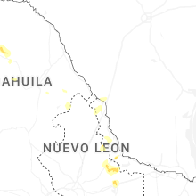


Connect with Interactive Hail Maps