

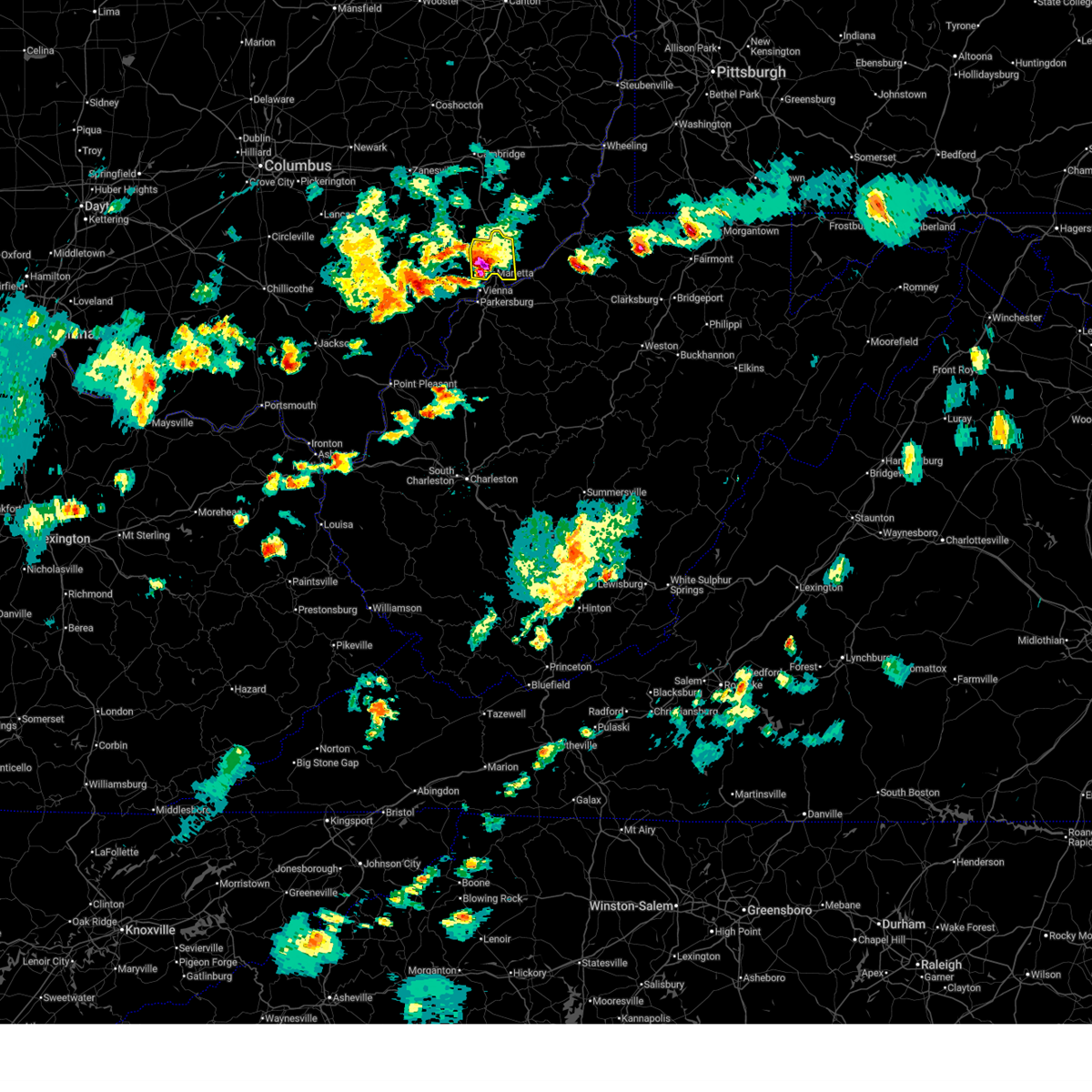
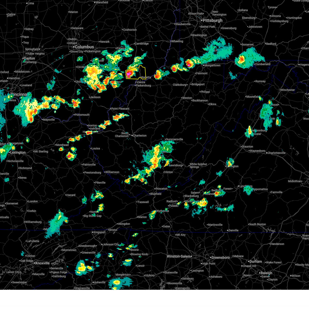
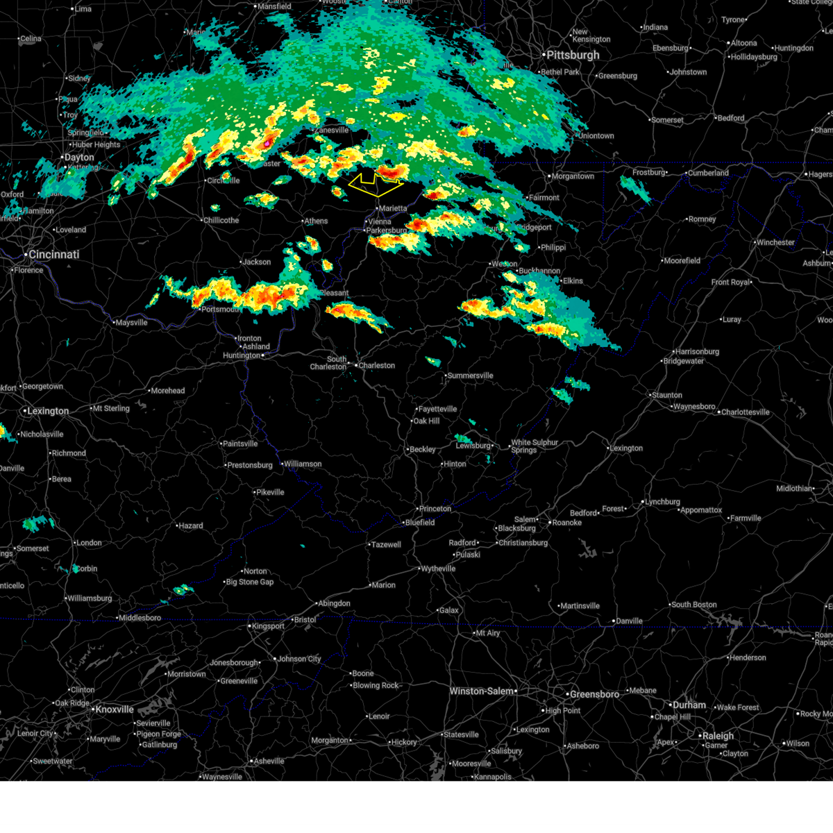
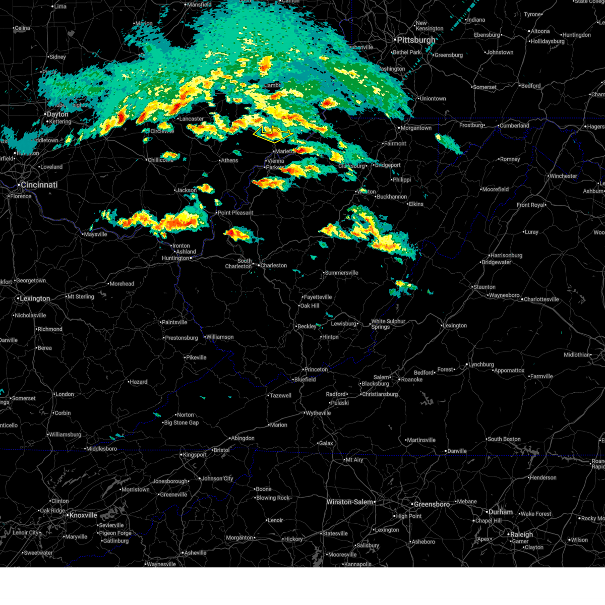
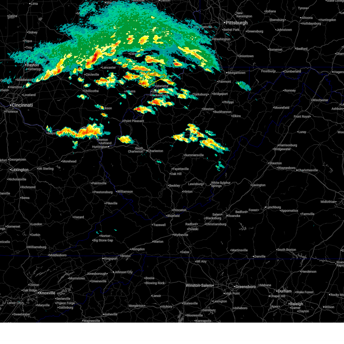
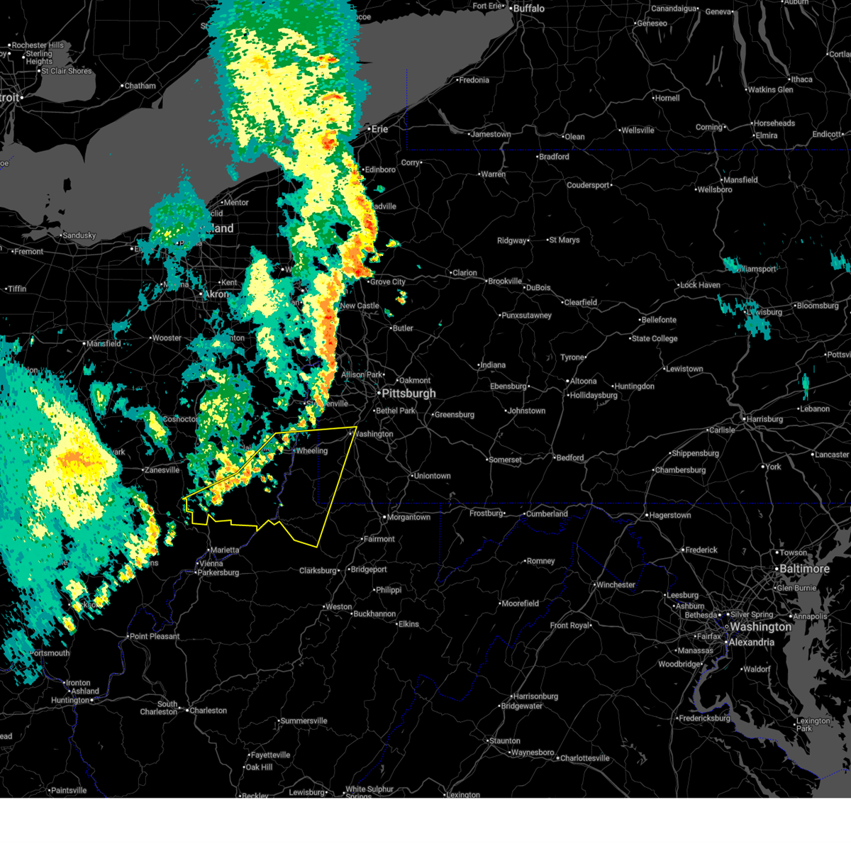
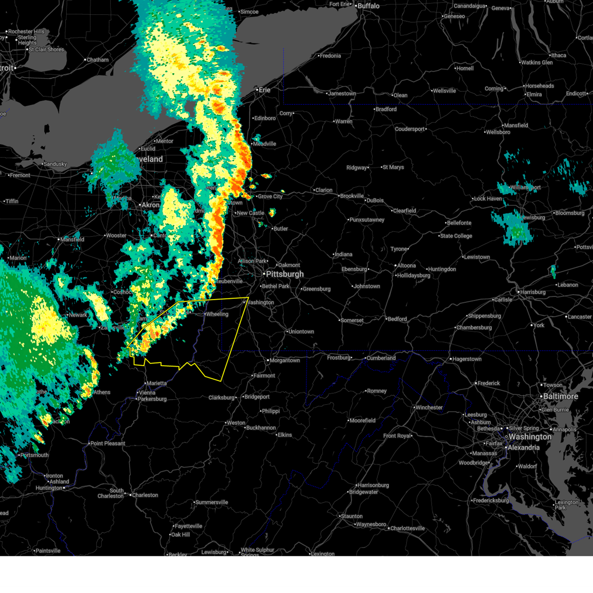
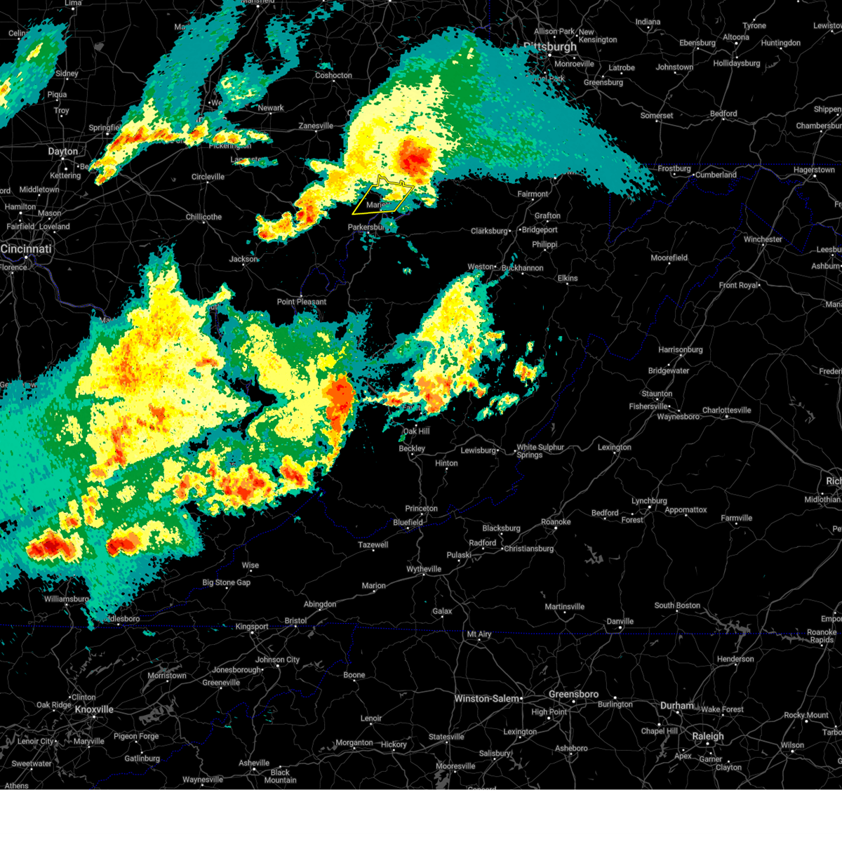
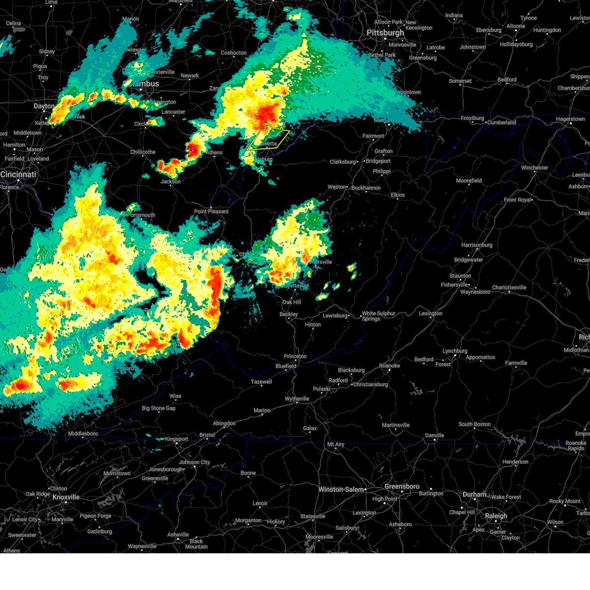
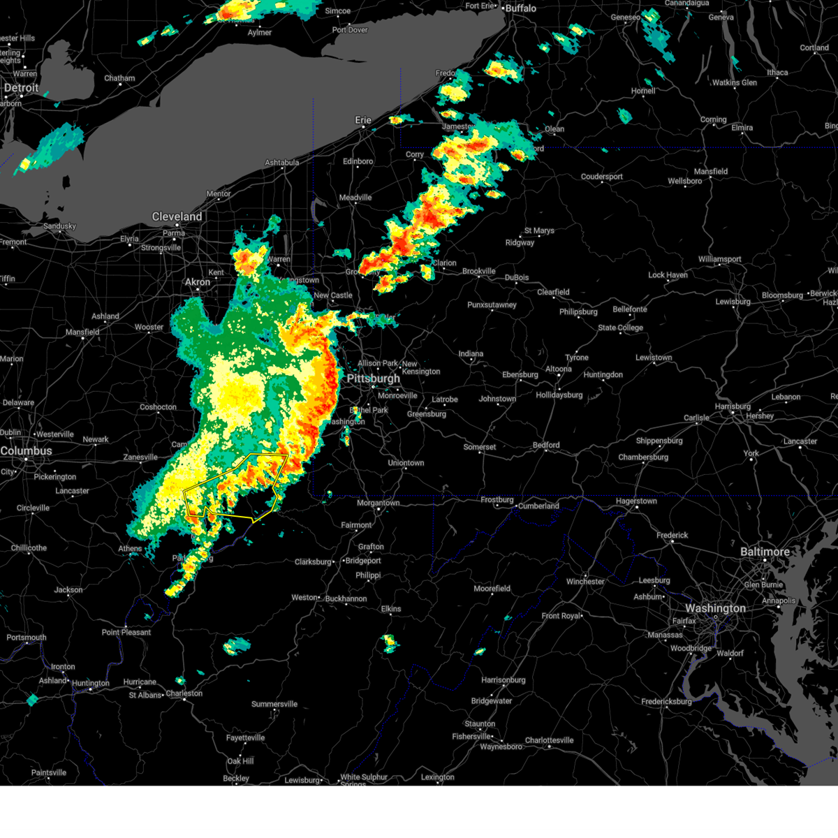
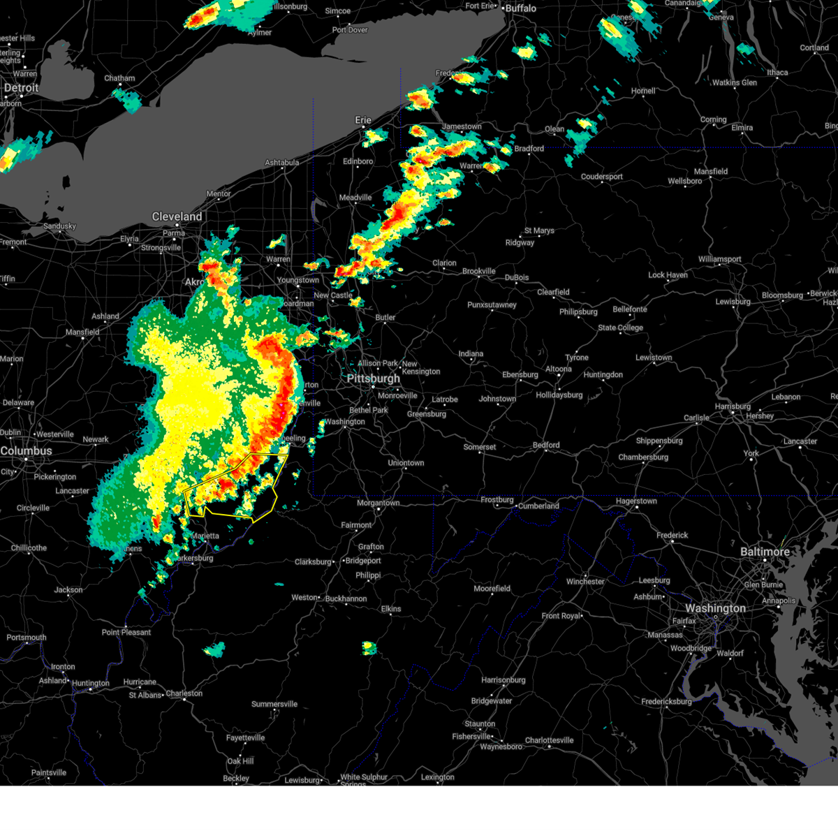
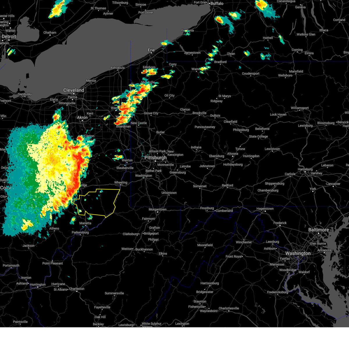
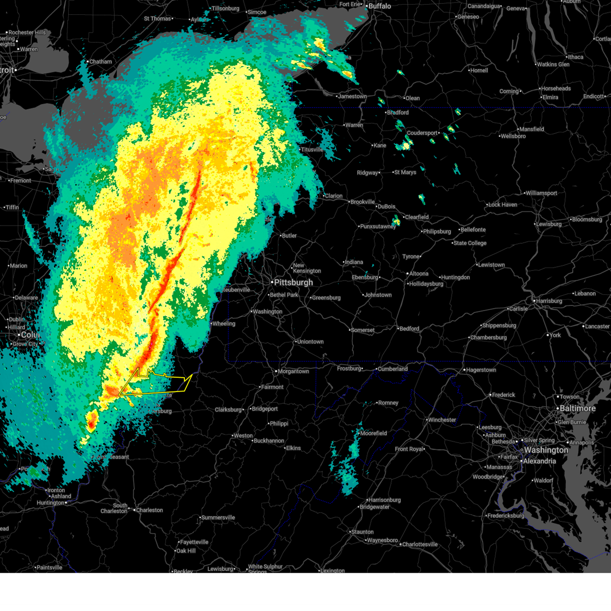
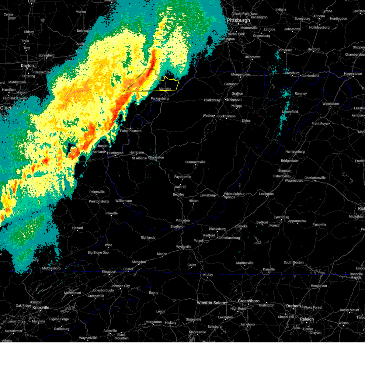
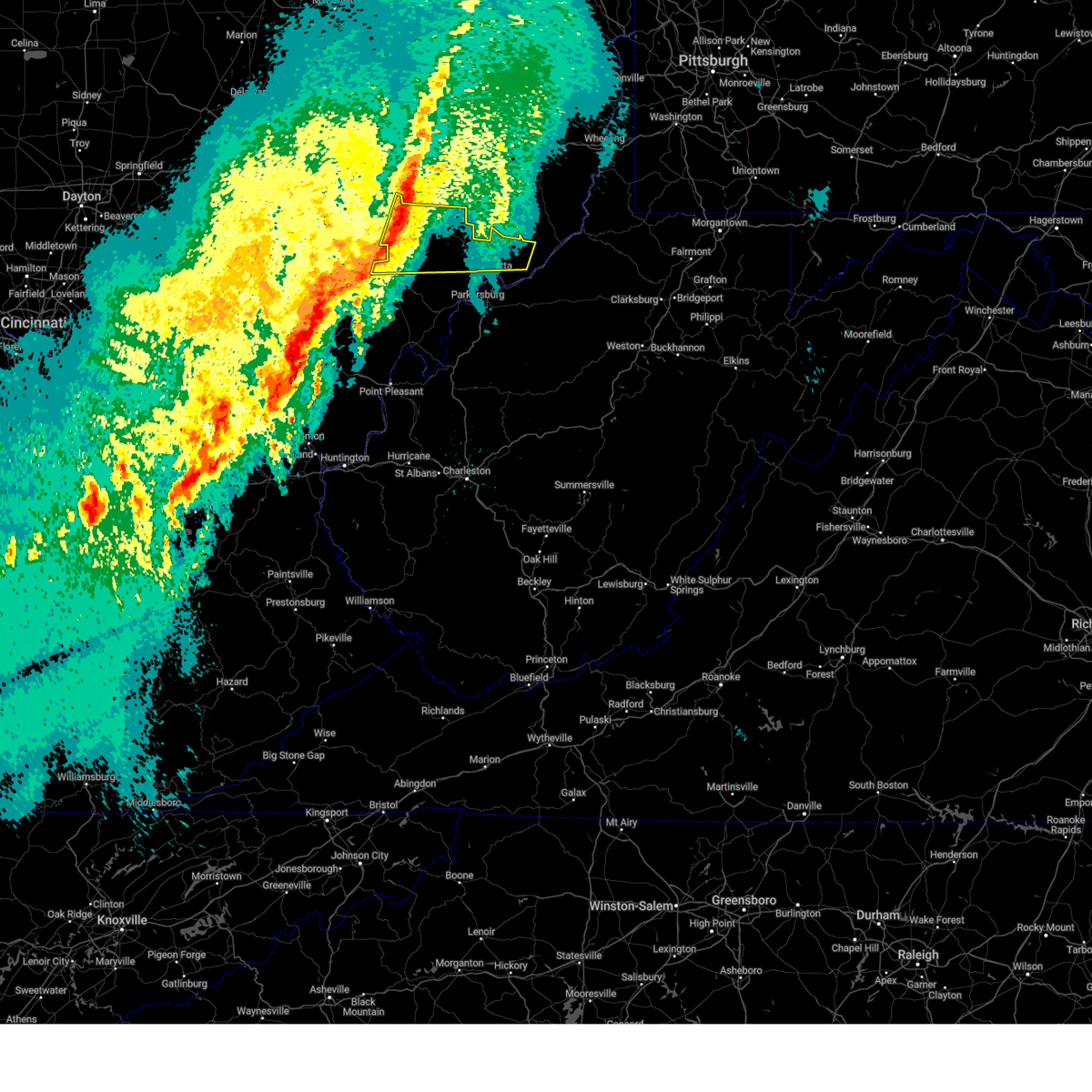
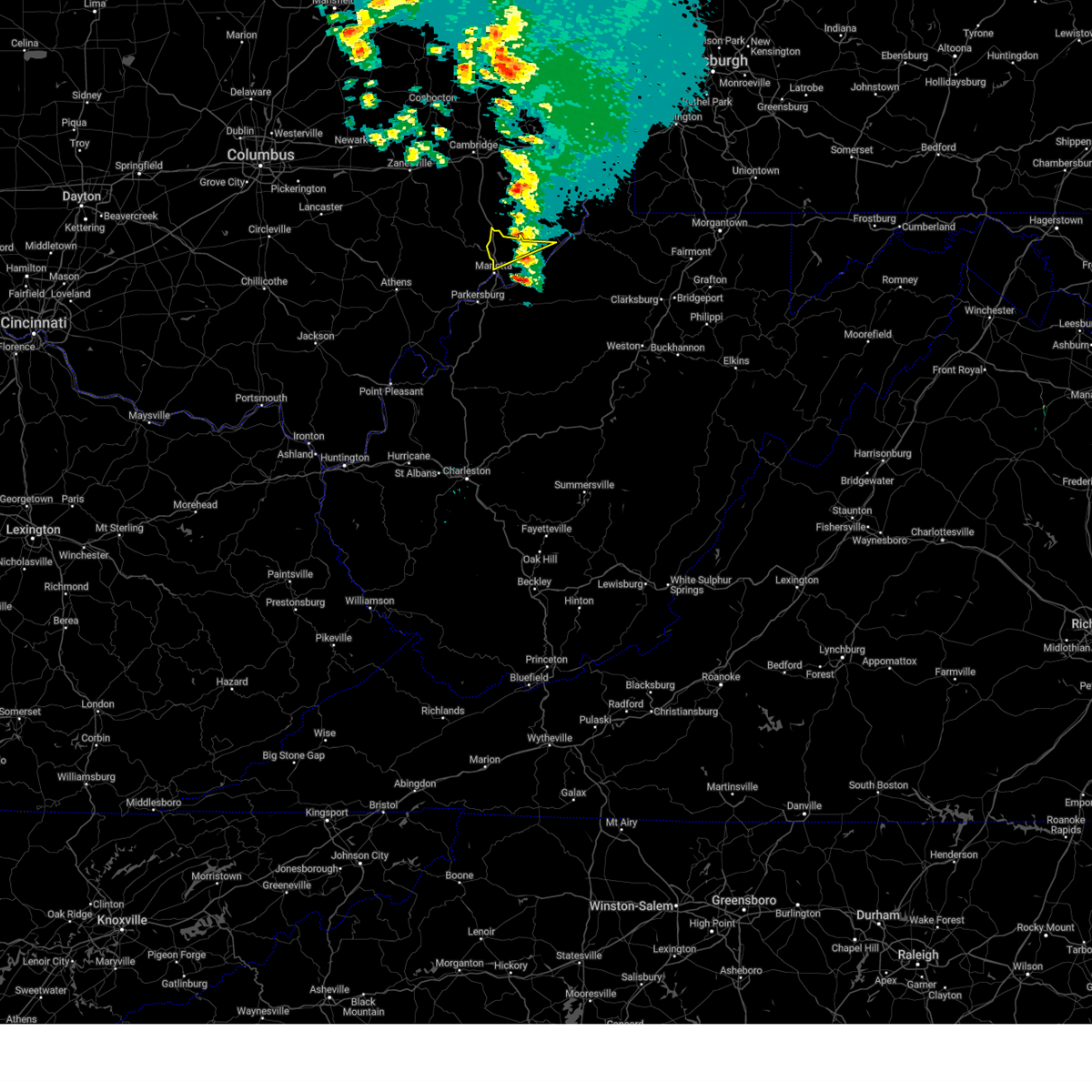
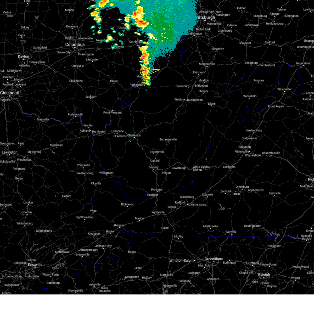
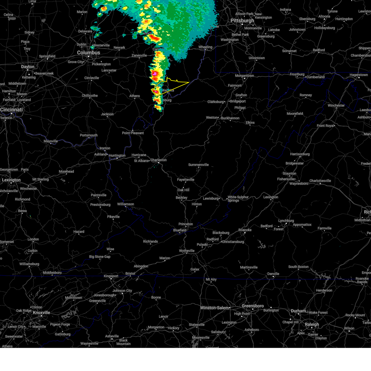
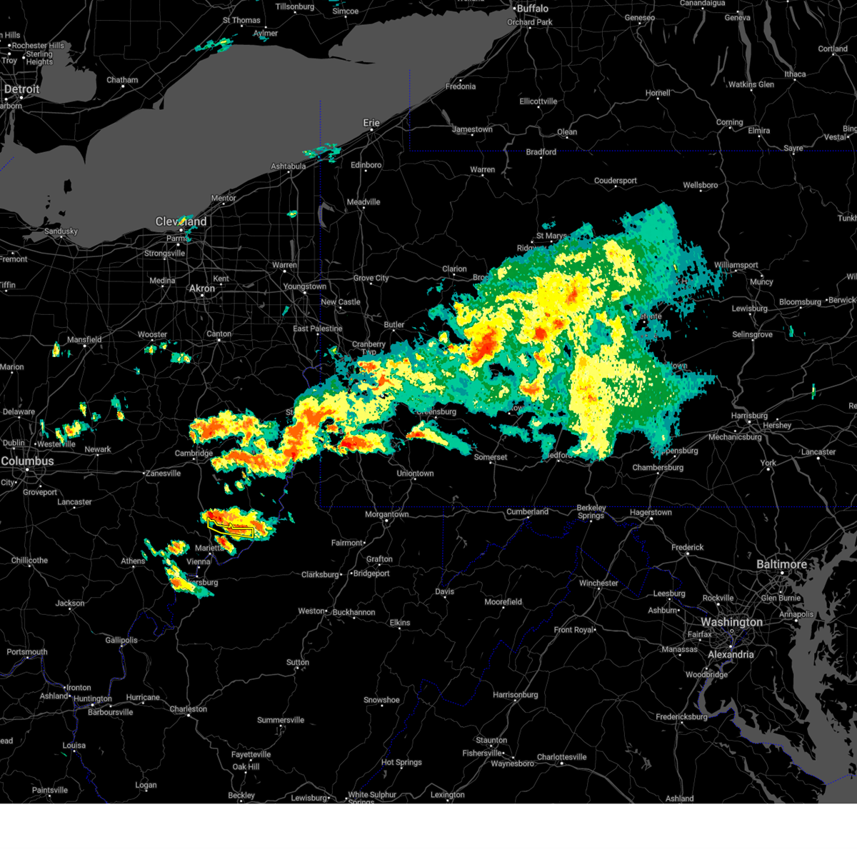
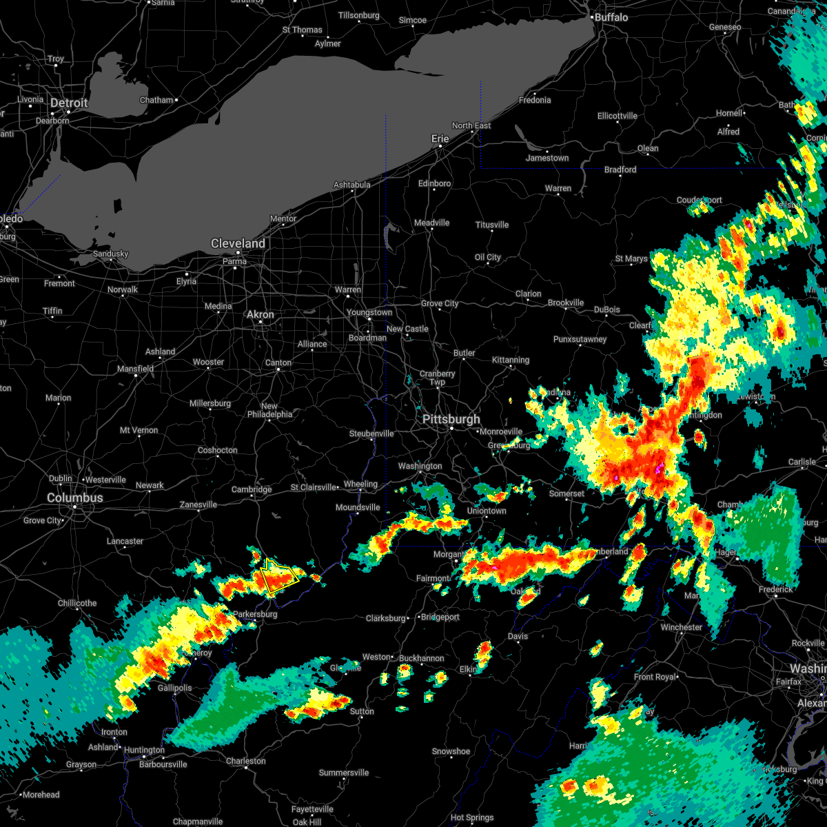
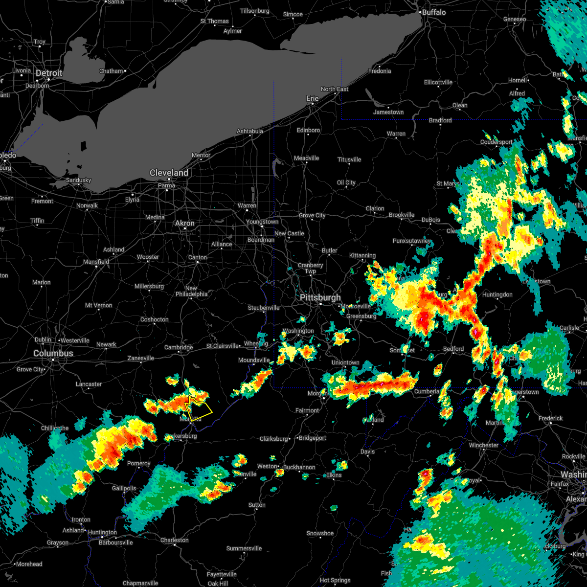
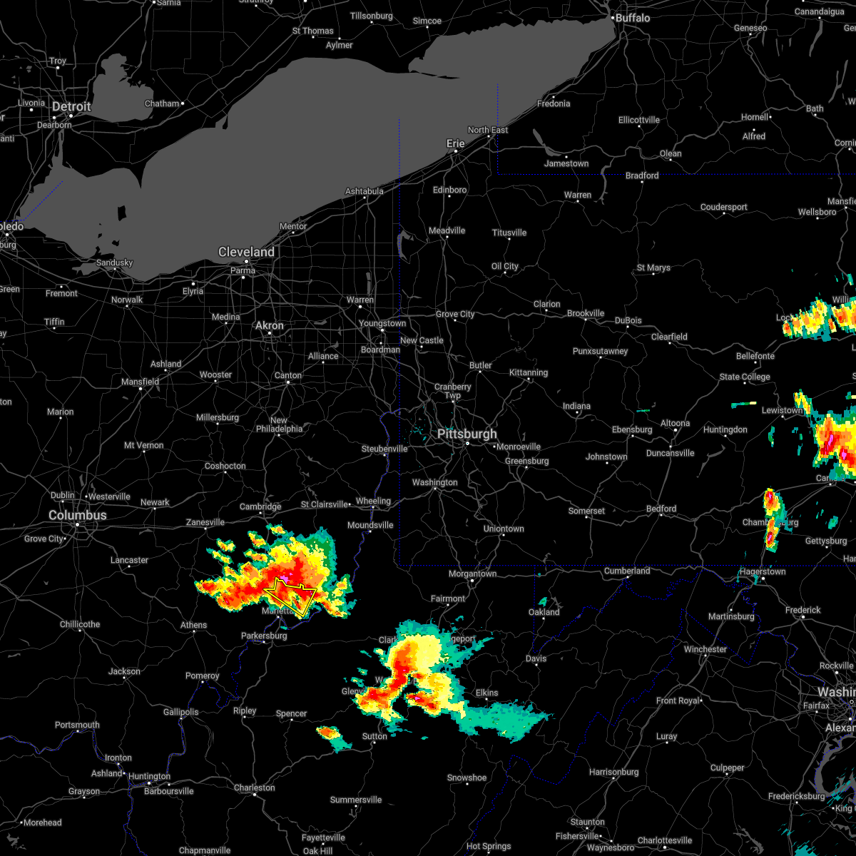
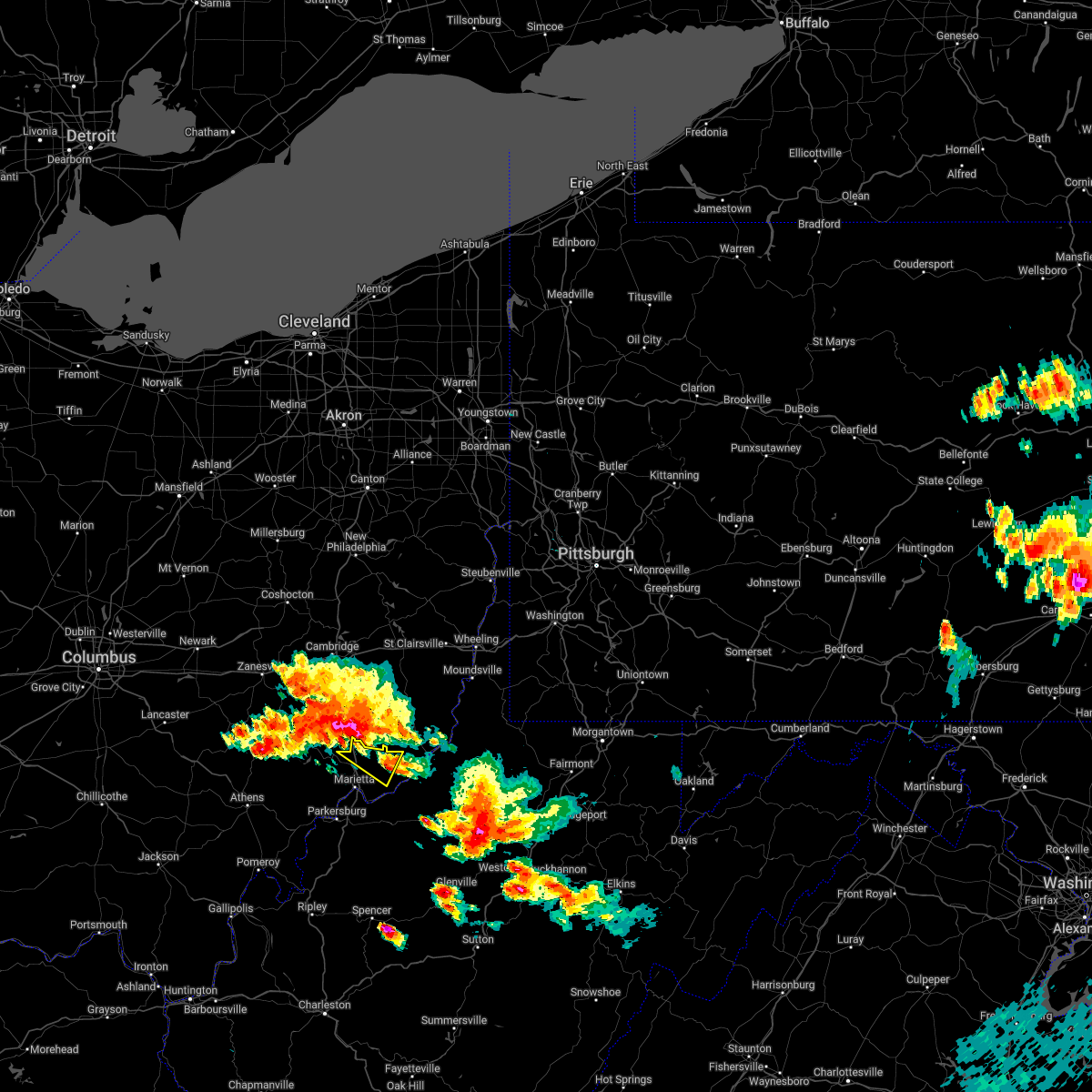
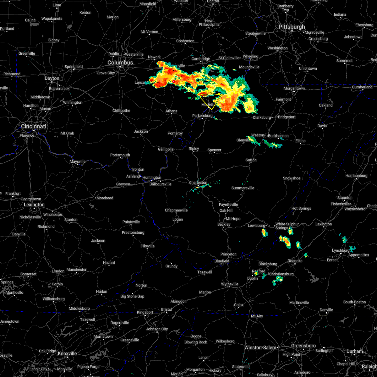
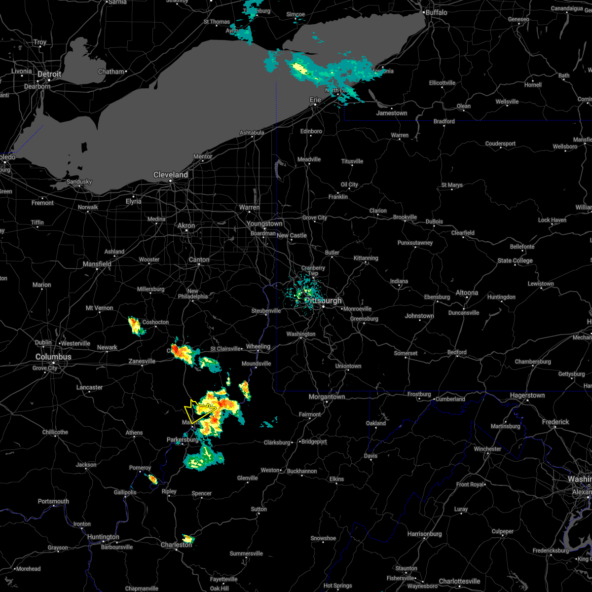
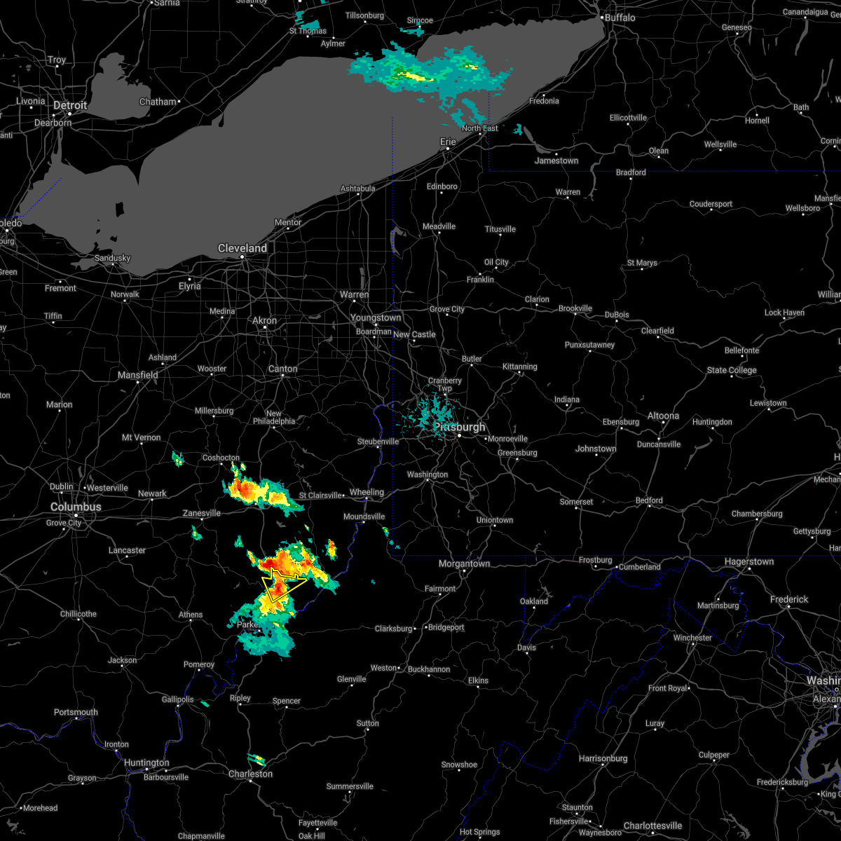
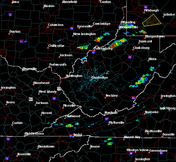
Hail Map for Macksburg, OH
The Macksburg, OH area has had 1 report of on-the-ground hail by trained spotters, and has been under severe weather warnings 6 times during the past 12 months. Doppler radar has detected hail at or near Macksburg, OH on 31 occasions, including 1 occasion during the past year.
| Name: | Macksburg, OH |
| Where Located: | 85.4 miles ESE of Columbus, OH |
| Map: | Google Map for Macksburg, OH |
| Population: | 186 |
| Housing Units: | 81 |
| More Info: | Search Google for Macksburg, OH |
0
The Top Recent Hail Date for Macksburg, OH is Saturday, June 20, 2026 (31st out of 31)
Hail and Wind Damage Spotted near Macksburg, OH
| Date / Time | Report Details |
|---|---|
| 4/1/2026 5:08 PM EDT |
 the severe thunderstorm warning has been cancelled and is no longer in effect the severe thunderstorm warning has been cancelled and is no longer in effect
|
| 4/1/2026 5:08 PM EDT |
 At 507 pm edt, a severe thunderstorm was located near beverly, moving east at 30 mph (radar indicated). Hazards include two inch hail and 60 mph wind gusts. People and animals outdoors will be injured. expect hail damage to roofs, siding, windows, and vehicles. expect wind damage to roofs, siding, and trees. Locations impacted include, marietta, lowell, macksburg, lower salem, and devola. At 507 pm edt, a severe thunderstorm was located near beverly, moving east at 30 mph (radar indicated). Hazards include two inch hail and 60 mph wind gusts. People and animals outdoors will be injured. expect hail damage to roofs, siding, windows, and vehicles. expect wind damage to roofs, siding, and trees. Locations impacted include, marietta, lowell, macksburg, lower salem, and devola.
|
| 4/1/2026 4:46 PM EDT |
 Svrrlx the national weather service in charleston west virginia has issued a * severe thunderstorm warning for, central washington county in southeastern ohio, southeastern morgan county in southeastern ohio, * until 515 pm edt. * at 446 pm edt, a severe thunderstorm was located near chesterhill, moving east at 30 mph (radar indicated). Hazards include two inch hail and 60 mph wind gusts. People and animals outdoors will be injured. expect hail damage to roofs, siding, windows, and vehicles. Expect wind damage to roofs, siding, and trees. Svrrlx the national weather service in charleston west virginia has issued a * severe thunderstorm warning for, central washington county in southeastern ohio, southeastern morgan county in southeastern ohio, * until 515 pm edt. * at 446 pm edt, a severe thunderstorm was located near chesterhill, moving east at 30 mph (radar indicated). Hazards include two inch hail and 60 mph wind gusts. People and animals outdoors will be injured. expect hail damage to roofs, siding, windows, and vehicles. Expect wind damage to roofs, siding, and trees.
|
| 2/20/2026 12:09 AM EST |
 The storm which prompted the warning has moved out of the area. therefore, the warning will be allowed to expire. however, heavy rain is still possible with this thunderstorm. The storm which prompted the warning has moved out of the area. therefore, the warning will be allowed to expire. however, heavy rain is still possible with this thunderstorm.
|
| 2/19/2026 11:55 PM EST |
 At 1154 pm est, a severe thunderstorm was located near beverly, moving northeast at 50 mph (radar indicated). Hazards include quarter size hail. Damage to vehicles is expected. Locations impacted include, beverly, lowell, macksburg, and lower salem. At 1154 pm est, a severe thunderstorm was located near beverly, moving northeast at 50 mph (radar indicated). Hazards include quarter size hail. Damage to vehicles is expected. Locations impacted include, beverly, lowell, macksburg, and lower salem.
|
| 2/19/2026 11:42 PM EST |
 Svrrlx the national weather service in charleston west virginia has issued a * severe thunderstorm warning for, northwestern washington county in southeastern ohio, southeastern morgan county in southeastern ohio, * until 1215 am est. * at 1142 pm est, a severe thunderstorm was located near beverly, moving northeast at 50 mph (radar indicated). Hazards include quarter size hail. damage to vehicles is expected Svrrlx the national weather service in charleston west virginia has issued a * severe thunderstorm warning for, northwestern washington county in southeastern ohio, southeastern morgan county in southeastern ohio, * until 1215 am est. * at 1142 pm est, a severe thunderstorm was located near beverly, moving northeast at 50 mph (radar indicated). Hazards include quarter size hail. damage to vehicles is expected
|
| 6/18/2025 11:08 PM EDT |
 At 1108 pm edt, severe thunderstorms were located along a line from over tiltonsville to 5 miles southeast of caldwell, or along a line from near clearview to 5 miles southeast of caldwell, moving east at 35 mph (law enforcement reported trees down with this line). Hazards include 60 mph wind gusts. Expect damage to roofs, siding, and trees. locations impacted include, wheeling, washington, moundsville, martins ferry, new martinsville, st. Clairsville, bellaire, warwood, bethlehem, woodsfield, caldwell, west liberty, triadelphia, clearview, valley grove, shadyside, wolfdale, east washington, mcmechen and powhatan point. At 1108 pm edt, severe thunderstorms were located along a line from over tiltonsville to 5 miles southeast of caldwell, or along a line from near clearview to 5 miles southeast of caldwell, moving east at 35 mph (law enforcement reported trees down with this line). Hazards include 60 mph wind gusts. Expect damage to roofs, siding, and trees. locations impacted include, wheeling, washington, moundsville, martins ferry, new martinsville, st. Clairsville, bellaire, warwood, bethlehem, woodsfield, caldwell, west liberty, triadelphia, clearview, valley grove, shadyside, wolfdale, east washington, mcmechen and powhatan point.
|
| 6/18/2025 11:08 PM EDT |
 the severe thunderstorm warning has been cancelled and is no longer in effect the severe thunderstorm warning has been cancelled and is no longer in effect
|
| 6/18/2025 10:57 PM EDT |
 Svrpbz the national weather service in pittsburgh has issued a * severe thunderstorm warning for, belmont county in east central ohio, southeastern guernsey county in east central ohio, southeastern harrison county in east central ohio, south central jefferson oh county in east central ohio, monroe county in east central ohio, noble county in east central ohio, western greene county in southwestern pennsylvania, southwestern washington county in southwestern pennsylvania, brooke county in northern west virginia, west central marion county in northern west virginia, marshall county in northern west virginia, ohio county in northern west virginia, wetzel county in northern west virginia, * until midnight edt. * at 1057 pm edt, severe thunderstorms were located along a line from 9 miles northeast of st. clairsville to near caldwell, moving east at 35 mph (law enforcement reported trees were reported down with this line). Hazards include 60 mph wind gusts. expect damage to roofs, siding, and trees Svrpbz the national weather service in pittsburgh has issued a * severe thunderstorm warning for, belmont county in east central ohio, southeastern guernsey county in east central ohio, southeastern harrison county in east central ohio, south central jefferson oh county in east central ohio, monroe county in east central ohio, noble county in east central ohio, western greene county in southwestern pennsylvania, southwestern washington county in southwestern pennsylvania, brooke county in northern west virginia, west central marion county in northern west virginia, marshall county in northern west virginia, ohio county in northern west virginia, wetzel county in northern west virginia, * until midnight edt. * at 1057 pm edt, severe thunderstorms were located along a line from 9 miles northeast of st. clairsville to near caldwell, moving east at 35 mph (law enforcement reported trees were reported down with this line). Hazards include 60 mph wind gusts. expect damage to roofs, siding, and trees
|
| 5/17/2025 12:12 AM EDT |
 The storms which prompted the warning have weakened below severe limits, and have exited the warned area. therefore, the warning will be allowed to expire. however, gusty winds are still possible with these thunderstorms. remember, a severe thunderstorm watch remains in effect until 500 am edt for southeastern ohio, and northwestern west virginia. The storms which prompted the warning have weakened below severe limits, and have exited the warned area. therefore, the warning will be allowed to expire. however, gusty winds are still possible with these thunderstorms. remember, a severe thunderstorm watch remains in effect until 500 am edt for southeastern ohio, and northwestern west virginia.
|
| 5/17/2025 12:04 AM EDT |
 At 1203 am edt, severe thunderstorms were located along a line extending from near woodsfield to 9 miles north of marietta, moving east at 65 mph (radar indicated). Hazards include 60 mph wind gusts. Expect damage to roofs, siding, and trees. Locations impacted include, marietta, williamstown, lowell, macksburg, lower salem, and devola. At 1203 am edt, severe thunderstorms were located along a line extending from near woodsfield to 9 miles north of marietta, moving east at 65 mph (radar indicated). Hazards include 60 mph wind gusts. Expect damage to roofs, siding, and trees. Locations impacted include, marietta, williamstown, lowell, macksburg, lower salem, and devola.
|
| 5/17/2025 12:04 AM EDT |
 the severe thunderstorm warning has been cancelled and is no longer in effect the severe thunderstorm warning has been cancelled and is no longer in effect
|
| 5/16/2025 11:43 PM EDT |
 Svrrlx the national weather service in charleston west virginia has issued a * severe thunderstorm warning for, northern washington county in southeastern ohio, morgan county in southeastern ohio, central athens county in southeastern ohio, * until 1215 am edt. * at 1142 pm edt, severe thunderstorms were located along a line extending from near caldwell to chesterhill, moving east at 60 mph (radar indicated). Hazards include 60 mph wind gusts and quarter size hail. Hail damage to vehicles is expected. Expect wind damage to roofs, siding, and trees. Svrrlx the national weather service in charleston west virginia has issued a * severe thunderstorm warning for, northern washington county in southeastern ohio, morgan county in southeastern ohio, central athens county in southeastern ohio, * until 1215 am edt. * at 1142 pm edt, severe thunderstorms were located along a line extending from near caldwell to chesterhill, moving east at 60 mph (radar indicated). Hazards include 60 mph wind gusts and quarter size hail. Hail damage to vehicles is expected. Expect wind damage to roofs, siding, and trees.
|
| 4/29/2025 4:51 PM EDT |
 The storms which prompted the warning have weakened below severe limits, and have exited the warned area. therefore, the warning will be allowed to expire. however, gusty winds are still possible with these thunderstorms. a severe thunderstorm watch remains in effect until 700 pm edt for east central ohio, and northern west virginia. The storms which prompted the warning have weakened below severe limits, and have exited the warned area. therefore, the warning will be allowed to expire. however, gusty winds are still possible with these thunderstorms. a severe thunderstorm watch remains in effect until 700 pm edt for east central ohio, and northern west virginia.
|
| 4/29/2025 4:39 PM EDT |
 At 439 pm edt, severe thunderstorms were located along a line extending from 9 miles southeast of barnesville to 7 miles southwest of woodsfield, moving east at 50 mph (radar indicated). Hazards include 60 mph wind gusts. Expect damage to trees and power lines, resulting in some power outages. Locations impacted include, new martinsville, woodsfield, caldwell, shadyside, paden city, powhatan point, glen dale, sistersville, dudley, sardis, beallsville, clarington, summerfield, macksburg, lewisville, sarahsville, jerusalem, dexter city, wilson, and cameron. At 439 pm edt, severe thunderstorms were located along a line extending from 9 miles southeast of barnesville to 7 miles southwest of woodsfield, moving east at 50 mph (radar indicated). Hazards include 60 mph wind gusts. Expect damage to trees and power lines, resulting in some power outages. Locations impacted include, new martinsville, woodsfield, caldwell, shadyside, paden city, powhatan point, glen dale, sistersville, dudley, sardis, beallsville, clarington, summerfield, macksburg, lewisville, sarahsville, jerusalem, dexter city, wilson, and cameron.
|
| 4/29/2025 4:02 PM EDT |
 Svrpbz the national weather service in pittsburgh has issued a * severe thunderstorm warning for, monroe county in east central ohio, southern belmont county in east central ohio, noble county in east central ohio, * until 500 pm edt. * at 401 pm edt, severe thunderstorms were located along a line extending from near byesville to near mcconnelsville, moving east at 50 mph (radar indicated). Hazards include 60 mph wind gusts. expect damage to trees and power lines, resulting in some power outages Svrpbz the national weather service in pittsburgh has issued a * severe thunderstorm warning for, monroe county in east central ohio, southern belmont county in east central ohio, noble county in east central ohio, * until 500 pm edt. * at 401 pm edt, severe thunderstorms were located along a line extending from near byesville to near mcconnelsville, moving east at 50 mph (radar indicated). Hazards include 60 mph wind gusts. expect damage to trees and power lines, resulting in some power outages
|
| 4/3/2025 3:28 AM EDT |
 Svrrlx the national weather service in charleston west virginia has issued a * severe thunderstorm warning for, northern washington county in southeastern ohio, southeastern morgan county in southeastern ohio, northeastern pleasants county in northwestern west virginia, northwestern tyler county in northern west virginia, * until 415 am edt. * at 328 am edt, severe thunderstorms were located along a line extending from near caldwell to near beverly, moving east at 60 mph (radar indicated). Hazards include 60 mph wind gusts and penny size hail. expect damage to roofs, siding, and trees Svrrlx the national weather service in charleston west virginia has issued a * severe thunderstorm warning for, northern washington county in southeastern ohio, southeastern morgan county in southeastern ohio, northeastern pleasants county in northwestern west virginia, northwestern tyler county in northern west virginia, * until 415 am edt. * at 328 am edt, severe thunderstorms were located along a line extending from near caldwell to near beverly, moving east at 60 mph (radar indicated). Hazards include 60 mph wind gusts and penny size hail. expect damage to roofs, siding, and trees
|
| 4/3/2025 3:14 AM EDT |
 At 314 am edt, severe thunderstorms were located along a line extending from 8 miles west of caldwell to near chesterhill, moving east at 60 mph (radar indicated). Hazards include 60 mph wind gusts. Expect damage to roofs, siding, and trees. Locations impacted include, lower salem, stockport, buchtel, burr oak state park, mcconnelsville, hackney, beverly, malta, chesterhill, lowell, macksburg, bristol, trimble, glouster, jacksonville, devola, and marietta. At 314 am edt, severe thunderstorms were located along a line extending from 8 miles west of caldwell to near chesterhill, moving east at 60 mph (radar indicated). Hazards include 60 mph wind gusts. Expect damage to roofs, siding, and trees. Locations impacted include, lower salem, stockport, buchtel, burr oak state park, mcconnelsville, hackney, beverly, malta, chesterhill, lowell, macksburg, bristol, trimble, glouster, jacksonville, devola, and marietta.
|
| 4/3/2025 3:14 AM EDT |
 the severe thunderstorm warning has been cancelled and is no longer in effect the severe thunderstorm warning has been cancelled and is no longer in effect
|
| 4/3/2025 2:55 AM EDT |
 Svrrlx the national weather service in charleston west virginia has issued a * severe thunderstorm warning for, southeastern perry county in southeastern ohio, northern washington county in southeastern ohio, morgan county in southeastern ohio, northern athens county in southeastern ohio, * until 330 am edt. * at 254 am edt, severe thunderstorms were located along a line extending from 8 miles south of south zanesville to buchtel, moving east at 60 mph (radar indicated). Hazards include 60 mph wind gusts. expect damage to roofs, siding, and trees Svrrlx the national weather service in charleston west virginia has issued a * severe thunderstorm warning for, southeastern perry county in southeastern ohio, northern washington county in southeastern ohio, morgan county in southeastern ohio, northern athens county in southeastern ohio, * until 330 am edt. * at 254 am edt, severe thunderstorms were located along a line extending from 8 miles south of south zanesville to buchtel, moving east at 60 mph (radar indicated). Hazards include 60 mph wind gusts. expect damage to roofs, siding, and trees
|
| 4/2/2025 12:38 PM EDT |
 The storm which prompted the warning has moved out of the area. therefore, the warning will be allowed to expire. The storm which prompted the warning has moved out of the area. therefore, the warning will be allowed to expire.
|
| 4/2/2025 12:29 PM EDT |
 At 1229 pm edt, a severe thunderstorm was located 12 miles north of marietta, moving northeast at 55 mph (radar indicated). Hazards include 60 mph wind gusts and quarter size hail. Hail damage to vehicles is expected. expect wind damage to roofs, siding, and trees. Locations impacted include, lower salem, macksburg, devola, and marietta. At 1229 pm edt, a severe thunderstorm was located 12 miles north of marietta, moving northeast at 55 mph (radar indicated). Hazards include 60 mph wind gusts and quarter size hail. Hail damage to vehicles is expected. expect wind damage to roofs, siding, and trees. Locations impacted include, lower salem, macksburg, devola, and marietta.
|
| 4/2/2025 12:11 PM EDT |
 Svrrlx the national weather service in charleston west virginia has issued a * severe thunderstorm warning for, northern washington county in southeastern ohio, * until 1245 pm edt. * at 1211 pm edt, a severe thunderstorm was located 7 miles south of beverly, moving northeast at 55 mph (radar indicated). Hazards include 60 mph wind gusts and quarter size hail. Hail damage to vehicles is expected. Expect wind damage to roofs, siding, and trees. Svrrlx the national weather service in charleston west virginia has issued a * severe thunderstorm warning for, northern washington county in southeastern ohio, * until 1245 pm edt. * at 1211 pm edt, a severe thunderstorm was located 7 miles south of beverly, moving northeast at 55 mph (radar indicated). Hazards include 60 mph wind gusts and quarter size hail. Hail damage to vehicles is expected. Expect wind damage to roofs, siding, and trees.
|
| 5/26/2024 5:26 PM EDT |
 The storm which prompted the warning has moved out of the area. therefore, the warning will be allowed to expire. however, gusty winds are still possible with this thunderstorm. a severe thunderstorm watch remains in effect until 800 pm edt for southeastern ohio, and western and northwestern west virginia. a severe thunderstorm watch also remains in effect until 900 pm edt for southeastern ohio, and central, north central and northwestern west virginia. The storm which prompted the warning has moved out of the area. therefore, the warning will be allowed to expire. however, gusty winds are still possible with this thunderstorm. a severe thunderstorm watch remains in effect until 800 pm edt for southeastern ohio, and western and northwestern west virginia. a severe thunderstorm watch also remains in effect until 900 pm edt for southeastern ohio, and central, north central and northwestern west virginia.
|
| 5/26/2024 4:44 PM EDT |
 At 443 pm edt, a severe thunderstorm was located over ravenswood, or near racine, moving northeast at 50 mph (radar indicated). Hazards include 60 mph wind gusts and penny size hail. Expect damage to roofs, siding, and trees. Locations impacted include, parkersburg, athens, marietta, belpre, ripley, spencer, beverly, elizabeth, coolville, chesterhill, forked run state park, vienna, ravenswood, williamstown, sissonville, clendenin, pinch, sandyville, mineralwells, and kenna. At 443 pm edt, a severe thunderstorm was located over ravenswood, or near racine, moving northeast at 50 mph (radar indicated). Hazards include 60 mph wind gusts and penny size hail. Expect damage to roofs, siding, and trees. Locations impacted include, parkersburg, athens, marietta, belpre, ripley, spencer, beverly, elizabeth, coolville, chesterhill, forked run state park, vienna, ravenswood, williamstown, sissonville, clendenin, pinch, sandyville, mineralwells, and kenna.
|
| 5/26/2024 4:32 PM EDT |
 Svrrlx the national weather service in charleston west virginia has issued a * severe thunderstorm warning for, eastern meigs county in southeastern ohio, washington county in southeastern ohio, southern morgan county in southeastern ohio, southeastern athens county in southeastern ohio, northeastern kanawha county in central west virginia, wirt county in northwestern west virginia, roane county in central west virginia, northwestern clay county in north central west virginia, jackson county in northwestern west virginia, wood county in northwestern west virginia, * until 530 pm edt. * at 432 pm edt, a severe thunderstorm was located over racine, moving northeast at 120 mph (radar indicated). Hazards include 60 mph wind gusts and penny size hail. expect damage to roofs, siding, and trees Svrrlx the national weather service in charleston west virginia has issued a * severe thunderstorm warning for, eastern meigs county in southeastern ohio, washington county in southeastern ohio, southern morgan county in southeastern ohio, southeastern athens county in southeastern ohio, northeastern kanawha county in central west virginia, wirt county in northwestern west virginia, roane county in central west virginia, northwestern clay county in north central west virginia, jackson county in northwestern west virginia, wood county in northwestern west virginia, * until 530 pm edt. * at 432 pm edt, a severe thunderstorm was located over racine, moving northeast at 120 mph (radar indicated). Hazards include 60 mph wind gusts and penny size hail. expect damage to roofs, siding, and trees
|
| 8/25/2023 3:23 AM EDT |
 At 323 am edt, severe thunderstorms were located along a line extending from near mannington to near beverly, moving southeast at 60 mph (radar indicated). Hazards include 60 mph wind gusts and penny size hail. expect damage to roofs, siding, and trees At 323 am edt, severe thunderstorms were located along a line extending from near mannington to near beverly, moving southeast at 60 mph (radar indicated). Hazards include 60 mph wind gusts and penny size hail. expect damage to roofs, siding, and trees
|
| 8/12/2023 8:23 PM EDT |
 At 823 pm edt, a severe thunderstorm was located 10 miles south of caldwell, moving east at 20 mph (radar indicated). Hazards include 60 mph wind gusts and quarter size hail. Hail damage to vehicles is expected. Expect wind damage to roofs, siding, and trees. At 823 pm edt, a severe thunderstorm was located 10 miles south of caldwell, moving east at 20 mph (radar indicated). Hazards include 60 mph wind gusts and quarter size hail. Hail damage to vehicles is expected. Expect wind damage to roofs, siding, and trees.
|
| 7/28/2023 2:57 PM EDT |
 At 257 pm edt, a severe thunderstorm was located near marietta, moving east at 30 mph (radar indicated). Hazards include 60 mph wind gusts and nickel size hail. Expect damage to roofs, siding, and trees. locations impacted include, marietta, st. marys, beverly, williamstown, belmont, boaz, newport, lowell, macksburg, lower salem, willow island, schultz, waverly, fleming, and devola. hail threat, radar indicated max hail size, 0. 88 in wind threat, radar indicated max wind gust, 60 mph. At 257 pm edt, a severe thunderstorm was located near marietta, moving east at 30 mph (radar indicated). Hazards include 60 mph wind gusts and nickel size hail. Expect damage to roofs, siding, and trees. locations impacted include, marietta, st. marys, beverly, williamstown, belmont, boaz, newport, lowell, macksburg, lower salem, willow island, schultz, waverly, fleming, and devola. hail threat, radar indicated max hail size, 0. 88 in wind threat, radar indicated max wind gust, 60 mph.
|
| 7/28/2023 2:28 PM EDT |
 At 228 pm edt, a severe thunderstorm was located near beverly, moving east at 30 mph (radar indicated). Hazards include 60 mph wind gusts and nickel size hail. expect damage to roofs, siding, and trees At 228 pm edt, a severe thunderstorm was located near beverly, moving east at 30 mph (radar indicated). Hazards include 60 mph wind gusts and nickel size hail. expect damage to roofs, siding, and trees
|
| 6/22/2022 7:05 PM EDT |
 The severe thunderstorm warning for northeastern washington county will expire at 715 pm edt, the storm which prompted the warning has weakened below severe limits, and no longer poses an immediate threat to life or property. therefore, the warning will be allowed to expire. however gusty winds and heavy rain are still possible with this thunderstorm. a severe thunderstorm watch remains in effect until 1000 pm edt for southeastern ohio. The severe thunderstorm warning for northeastern washington county will expire at 715 pm edt, the storm which prompted the warning has weakened below severe limits, and no longer poses an immediate threat to life or property. therefore, the warning will be allowed to expire. however gusty winds and heavy rain are still possible with this thunderstorm. a severe thunderstorm watch remains in effect until 1000 pm edt for southeastern ohio.
|
| 6/22/2022 6:45 PM EDT |
 At 644 pm edt, a severe thunderstorm was located 10 miles north of marietta, moving southeast at 25 mph (radar indicated). Hazards include 60 mph wind gusts and quarter size hail. Hail damage to vehicles is expected. Expect wind damage to roofs, siding, and trees. At 644 pm edt, a severe thunderstorm was located 10 miles north of marietta, moving southeast at 25 mph (radar indicated). Hazards include 60 mph wind gusts and quarter size hail. Hail damage to vehicles is expected. Expect wind damage to roofs, siding, and trees.
|
| 6/16/2022 9:21 PM EDT |
 At 921 pm edt, a severe thunderstorm was located 12 miles northeast of marietta, moving southeast at 25 mph (radar indicated). Hazards include 60 mph wind gusts and quarter size hail. Hail damage to vehicles is expected. expect wind damage to roofs, siding, and trees. locations impacted include, macksburg and lower salem. hail threat, radar indicated max hail size, 1. 00 in wind threat, radar indicated max wind gust, 60 mph. At 921 pm edt, a severe thunderstorm was located 12 miles northeast of marietta, moving southeast at 25 mph (radar indicated). Hazards include 60 mph wind gusts and quarter size hail. Hail damage to vehicles is expected. expect wind damage to roofs, siding, and trees. locations impacted include, macksburg and lower salem. hail threat, radar indicated max hail size, 1. 00 in wind threat, radar indicated max wind gust, 60 mph.
|
| 6/16/2022 9:06 PM EDT |
 At 905 pm edt, a severe thunderstorm was located near caldwell, moving southeast at 20 mph (radar indicated). Hazards include 60 mph wind gusts and quarter size hail. Hail damage to vehicles is expected. Expect wind damage to roofs, siding, and trees. At 905 pm edt, a severe thunderstorm was located near caldwell, moving southeast at 20 mph (radar indicated). Hazards include 60 mph wind gusts and quarter size hail. Hail damage to vehicles is expected. Expect wind damage to roofs, siding, and trees.
|
| 6/16/2022 8:26 PM EDT |
 At 825 pm edt, a severe thunderstorm was located near beverly, moving southeast at 30 mph (radar indicated). Hazards include 60 mph wind gusts and quarter size hail. Hail damage to vehicles is expected. Expect wind damage to roofs, siding, and trees. At 825 pm edt, a severe thunderstorm was located near beverly, moving southeast at 30 mph (radar indicated). Hazards include 60 mph wind gusts and quarter size hail. Hail damage to vehicles is expected. Expect wind damage to roofs, siding, and trees.
|
| 6/16/2022 7:43 PM EDT |
 At 742 pm edt, severe thunderstorms were located along a line extending from near caldwell to 8 miles northwest of mcconnelsville, moving southeast at 25 mph (radar indicated). Hazards include 60 mph wind gusts and half dollar size hail. Hail damage to vehicles is expected. Expect wind damage to roofs, siding, and trees. At 742 pm edt, severe thunderstorms were located along a line extending from near caldwell to 8 miles northwest of mcconnelsville, moving southeast at 25 mph (radar indicated). Hazards include 60 mph wind gusts and half dollar size hail. Hail damage to vehicles is expected. Expect wind damage to roofs, siding, and trees.
|
| 3/23/2022 7:58 PM EDT |
 The severe thunderstorm warning for northwestern washington and southeastern morgan counties will expire at 800 pm edt, the storm which prompted the warning has weakened below severe limits, and no longer poses an immediate threat to life or property. therefore, the warning will be allowed to expire. however small hail and gusty winds are still possible with this thunderstorm. a tornado watch remains in effect until 1000 pm edt for southeastern ohio. The severe thunderstorm warning for northwestern washington and southeastern morgan counties will expire at 800 pm edt, the storm which prompted the warning has weakened below severe limits, and no longer poses an immediate threat to life or property. therefore, the warning will be allowed to expire. however small hail and gusty winds are still possible with this thunderstorm. a tornado watch remains in effect until 1000 pm edt for southeastern ohio.
|
| 3/23/2022 7:36 PM EDT |
 At 736 pm edt, a severe thunderstorm was located 7 miles south of beverly, moving northeast at 70 mph (radar indicated). Hazards include 60 mph wind gusts and quarter size hail. Hail damage to vehicles is expected. Expect wind damage to roofs, siding, and trees. At 736 pm edt, a severe thunderstorm was located 7 miles south of beverly, moving northeast at 70 mph (radar indicated). Hazards include 60 mph wind gusts and quarter size hail. Hail damage to vehicles is expected. Expect wind damage to roofs, siding, and trees.
|
| 7/29/2021 5:16 PM EDT |
 At 516 pm edt, a severe thunderstorm was located 10 miles southeast of caldwell, moving southeast at 25 mph (radar indicated). Hazards include 60 mph wind gusts and penny size hail. Expect damage to roofs, siding, and trees. Locations impacted include, newport, matamoras, macksburg, lower salem and new matamoras. At 516 pm edt, a severe thunderstorm was located 10 miles southeast of caldwell, moving southeast at 25 mph (radar indicated). Hazards include 60 mph wind gusts and penny size hail. Expect damage to roofs, siding, and trees. Locations impacted include, newport, matamoras, macksburg, lower salem and new matamoras.
|
| 7/29/2021 4:55 PM EDT |
 At 454 pm edt, a severe thunderstorm was located near caldwell, moving southeast at 30 mph. this is a very dangerous storm (radar indicated). Hazards include 80 mph wind gusts and quarter size hail. Flying debris will be dangerous to those caught without shelter. mobile homes will be heavily damaged. expect considerable damage to roofs, windows, and vehicles. Extensive tree damage and power outages are likely. At 454 pm edt, a severe thunderstorm was located near caldwell, moving southeast at 30 mph. this is a very dangerous storm (radar indicated). Hazards include 80 mph wind gusts and quarter size hail. Flying debris will be dangerous to those caught without shelter. mobile homes will be heavily damaged. expect considerable damage to roofs, windows, and vehicles. Extensive tree damage and power outages are likely.
|
| 11/15/2020 1:32 PM EST |
 At 130 pm est, severe thunderstorms were located along a line extending from near sugarcreek to near beverly to near gallipolis, moving east at 50 mph (radar indicated). Hazards include 60 mph wind gusts. storm damage has been reported with this line of storms across perry county. severe wind gusts were recorded across athens county. Expect damage to roofs, siding, and trees. Locations impacted include, athens, marietta, belpre, mcconnelsville, beverly, coolville, chesterhill, tuppers plains, chester, malta, lowell, stockport, bristol, macksburg, amesville, lower salem, stroud run state park, little hocking, dyesville and darwin. At 130 pm est, severe thunderstorms were located along a line extending from near sugarcreek to near beverly to near gallipolis, moving east at 50 mph (radar indicated). Hazards include 60 mph wind gusts. storm damage has been reported with this line of storms across perry county. severe wind gusts were recorded across athens county. Expect damage to roofs, siding, and trees. Locations impacted include, athens, marietta, belpre, mcconnelsville, beverly, coolville, chesterhill, tuppers plains, chester, malta, lowell, stockport, bristol, macksburg, amesville, lower salem, stroud run state park, little hocking, dyesville and darwin.
|
| 11/15/2020 1:18 PM EST |
 At 117 pm est, severe thunderstorms were located along a line extending from near farmerstown to near chesterhill to 6 miles southwest of rio grande, moving east at 50 mph (radar indicated. at severe wind gust of 58 mph was recorded at the ohio university airport with this line of storms). Hazards include 60 mph wind gusts. Expect damage to roofs, siding, and trees. Locations impacted include, athens, marietta, belpre, jackson, wellston, glouster, mcconnelsville, beverly, albany, coolville, rutland, chesterhill, tuppers plains, washington, crooksville, chester, chauncey, malta, corning and lowell. At 117 pm est, severe thunderstorms were located along a line extending from near farmerstown to near chesterhill to 6 miles southwest of rio grande, moving east at 50 mph (radar indicated. at severe wind gust of 58 mph was recorded at the ohio university airport with this line of storms). Hazards include 60 mph wind gusts. Expect damage to roofs, siding, and trees. Locations impacted include, athens, marietta, belpre, jackson, wellston, glouster, mcconnelsville, beverly, albany, coolville, rutland, chesterhill, tuppers plains, washington, crooksville, chester, chauncey, malta, corning and lowell.
|
| 11/15/2020 12:51 PM EST |
 At 1249 pm est, severe thunderstorms were located along a line extending from near danville to near logan to clarktown, moving east at 50 mph (radar indicated). Hazards include 60 mph wind gusts. Expect damage to roofs, siding, and trees. Locations impacted include, athens, marietta, belpre, jackson, wellston, nelsonville, new lexington, glouster, mcconnelsville, mcarthur, somerset, beverly, albany, shawnee, coolville, rutland, chesterhill, perry state forest, lake hope state park and tuppers plains. At 1249 pm est, severe thunderstorms were located along a line extending from near danville to near logan to clarktown, moving east at 50 mph (radar indicated). Hazards include 60 mph wind gusts. Expect damage to roofs, siding, and trees. Locations impacted include, athens, marietta, belpre, jackson, wellston, nelsonville, new lexington, glouster, mcconnelsville, mcarthur, somerset, beverly, albany, shawnee, coolville, rutland, chesterhill, perry state forest, lake hope state park and tuppers plains.
|
| 11/15/2020 12:25 PM EST |
 At 1224 pm est, severe thunderstorms were located along a line extending from chesterville to 10 miles northeast of kingston to 10 miles southeast of peebles, moving east at 50 mph. sporadic severe wind gusts are likely with this line of thunderstorms (radar indicated). Hazards include 60 mph wind gusts. expect damage to roofs, siding, and trees At 1224 pm est, severe thunderstorms were located along a line extending from chesterville to 10 miles northeast of kingston to 10 miles southeast of peebles, moving east at 50 mph. sporadic severe wind gusts are likely with this line of thunderstorms (radar indicated). Hazards include 60 mph wind gusts. expect damage to roofs, siding, and trees
|
| 8/26/2020 4:40 PM EDT |
 The severe thunderstorm warning for north central washington county will expire at 445 pm edt, the storm which prompted the warning has weakened below severe limits, and no longer poses an immediate threat to life or property. therefore, the warning will be allowed to expire. The severe thunderstorm warning for north central washington county will expire at 445 pm edt, the storm which prompted the warning has weakened below severe limits, and no longer poses an immediate threat to life or property. therefore, the warning will be allowed to expire.
|
| 8/26/2020 4:22 PM EDT |
 At 421 pm edt, a severe thunderstorm was located near caldwell, moving southeast at 15 mph (radar indicated). Hazards include 60 mph wind gusts and quarter size hail. Hail damage to vehicles is expected. Expect wind damage to roofs, siding, and trees. At 421 pm edt, a severe thunderstorm was located near caldwell, moving southeast at 15 mph (radar indicated). Hazards include 60 mph wind gusts and quarter size hail. Hail damage to vehicles is expected. Expect wind damage to roofs, siding, and trees.
|
| 7/10/2020 4:23 PM EDT |
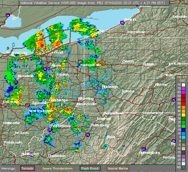 At 423 pm edt, a severe thunderstorm was located 9 miles southeast of caldwell, moving northeast at 35 mph (radar indicated). Hazards include 60 mph wind gusts and quarter size hail. Hail damage to vehicles is expected. expect wind damage to roofs, siding, and trees. Locations impacted include, macksburg. At 423 pm edt, a severe thunderstorm was located 9 miles southeast of caldwell, moving northeast at 35 mph (radar indicated). Hazards include 60 mph wind gusts and quarter size hail. Hail damage to vehicles is expected. expect wind damage to roofs, siding, and trees. Locations impacted include, macksburg.
|
| 7/10/2020 4:11 PM EDT |
 At 410 pm edt, a severe thunderstorm was located near beverly, moving northeast at 45 mph (radar indicated). Hazards include 60 mph wind gusts and quarter size hail. Hail damage to vehicles is expected. Expect wind damage to roofs, siding, and trees. At 410 pm edt, a severe thunderstorm was located near beverly, moving northeast at 45 mph (radar indicated). Hazards include 60 mph wind gusts and quarter size hail. Hail damage to vehicles is expected. Expect wind damage to roofs, siding, and trees.
|
| 8/18/2019 2:38 PM EDT |
 The national weather service in charleston west virginia has issued a * severe thunderstorm warning for. north central washington county in southeastern ohio. until 315 pm edt. At 238 pm edt, a severe thunderstorm was located 8 miles east of beverly, moving east at 10 mph. The national weather service in charleston west virginia has issued a * severe thunderstorm warning for. north central washington county in southeastern ohio. until 315 pm edt. At 238 pm edt, a severe thunderstorm was located 8 miles east of beverly, moving east at 10 mph.
|
| 8/8/2019 4:23 PM EDT |
 At 423 pm edt, a severe thunderstorm was located near beverly, moving southeast at 30 mph (radar indicated). Hazards include 60 mph wind gusts and quarter size hail. Hail damage to vehicles is expected. expect wind damage to roofs, siding, and trees. Locations impacted include, marietta, beverly, williamstown, lowell, bristol, macksburg, lower salem, hackney and devola. At 423 pm edt, a severe thunderstorm was located near beverly, moving southeast at 30 mph (radar indicated). Hazards include 60 mph wind gusts and quarter size hail. Hail damage to vehicles is expected. expect wind damage to roofs, siding, and trees. Locations impacted include, marietta, beverly, williamstown, lowell, bristol, macksburg, lower salem, hackney and devola.
|
| 8/8/2019 4:06 PM EDT |
 At 406 pm edt, a severe thunderstorm was located near mcconnelsville, moving southeast at 30 mph (radar indicated). Hazards include 60 mph wind gusts and quarter size hail. Hail damage to vehicles is expected. Expect wind damage to roofs, siding, and trees. At 406 pm edt, a severe thunderstorm was located near mcconnelsville, moving southeast at 30 mph (radar indicated). Hazards include 60 mph wind gusts and quarter size hail. Hail damage to vehicles is expected. Expect wind damage to roofs, siding, and trees.
|
| 6/24/2019 5:11 PM EDT |
 The severe thunderstorm warning for northwestern washington and central morgan counties will expire at 515 pm edt, the storms which prompted the warning have weakened and moved out of the warned area. therefore, the warning will be allowed to expire. a severe thunderstorm watch remains in effect until 900 pm edt for southeastern ohio. The severe thunderstorm warning for northwestern washington and central morgan counties will expire at 515 pm edt, the storms which prompted the warning have weakened and moved out of the warned area. therefore, the warning will be allowed to expire. a severe thunderstorm watch remains in effect until 900 pm edt for southeastern ohio.
|
| 6/24/2019 4:42 PM EDT |
 At 441 pm edt, severe thunderstorms were located along a line extending from 12 miles south of new concord to 10 miles west of caldwell to 6 miles southeast of mcconnelsville, moving northeast at 45 mph (radar indicated). Hazards include 60 mph wind gusts. expect damage to roofs, siding, and trees At 441 pm edt, severe thunderstorms were located along a line extending from 12 miles south of new concord to 10 miles west of caldwell to 6 miles southeast of mcconnelsville, moving northeast at 45 mph (radar indicated). Hazards include 60 mph wind gusts. expect damage to roofs, siding, and trees
|
| 5/25/2019 4:53 PM EDT |
 At 453 pm edt, a severe thunderstorm was located over beverly, moving east at 50 mph (radar indicated). Hazards include 60 mph wind gusts and quarter size hail. Hail damage to vehicles is expected. Expect wind damage to roofs, siding, and trees. At 453 pm edt, a severe thunderstorm was located over beverly, moving east at 50 mph (radar indicated). Hazards include 60 mph wind gusts and quarter size hail. Hail damage to vehicles is expected. Expect wind damage to roofs, siding, and trees.
|
| 4/14/2019 8:27 PM EDT |
 The severe thunderstorm warning for northwestern washington, southeastern morgan and northeastern athens counties will expire at 830 pm edt, the storm which prompted the warning has weakened below severe limits, and has exited the warned area. therefore, the warning will be allowed to expire. The severe thunderstorm warning for northwestern washington, southeastern morgan and northeastern athens counties will expire at 830 pm edt, the storm which prompted the warning has weakened below severe limits, and has exited the warned area. therefore, the warning will be allowed to expire.
|
| 4/14/2019 8:05 PM EDT |
 At 805 pm edt, a severe thunderstorm was located near chesterhill, moving northeast at 65 mph (radar indicated). Hazards include 60 mph wind gusts and penny size hail. expect damage to roofs, siding, and trees At 805 pm edt, a severe thunderstorm was located near chesterhill, moving northeast at 65 mph (radar indicated). Hazards include 60 mph wind gusts and penny size hail. expect damage to roofs, siding, and trees
|
| 4/14/2019 6:24 PM EDT |
 The severe thunderstorm warning for northwestern washington and east central morgan counties will expire at 630 pm edt, the storm which prompted the warning has weakened below severe limits, and no longer poses an immediate threat to life or property. therefore, the warning will be allowed to expire. a tornado watch remains in effect until 900 pm edt for southeastern ohio. The severe thunderstorm warning for northwestern washington and east central morgan counties will expire at 630 pm edt, the storm which prompted the warning has weakened below severe limits, and no longer poses an immediate threat to life or property. therefore, the warning will be allowed to expire. a tornado watch remains in effect until 900 pm edt for southeastern ohio.
|
| 4/14/2019 6:19 PM EDT |
 At 619 pm edt, a severe thunderstorm was located near caldwell, moving northeast at 55 mph (radar indicated). Hazards include 60 mph wind gusts. Expect damage to roofs, siding, and trees. Locations impacted include, beverly, lowell, macksburg and lower salem. At 619 pm edt, a severe thunderstorm was located near caldwell, moving northeast at 55 mph (radar indicated). Hazards include 60 mph wind gusts. Expect damage to roofs, siding, and trees. Locations impacted include, beverly, lowell, macksburg and lower salem.
|
| 4/14/2019 6:09 PM EDT |
 At 608 pm edt, a severe thunderstorm was located near beverly, moving northeast at 55 mph (radar indicated). Hazards include 60 mph wind gusts. Expect damage to roofs, siding, and trees. Locations impacted include, mcconnelsville, beverly, lowell, stockport, bristol, macksburg, lower salem and hackney. At 608 pm edt, a severe thunderstorm was located near beverly, moving northeast at 55 mph (radar indicated). Hazards include 60 mph wind gusts. Expect damage to roofs, siding, and trees. Locations impacted include, mcconnelsville, beverly, lowell, stockport, bristol, macksburg, lower salem and hackney.
|
| 4/14/2019 5:56 PM EDT |
 At 556 pm edt, a severe thunderstorm was located over chesterhill, moving northeast at 55 mph (radar indicated). Hazards include 60 mph wind gusts. expect damage to roofs, siding, and trees At 556 pm edt, a severe thunderstorm was located over chesterhill, moving northeast at 55 mph (radar indicated). Hazards include 60 mph wind gusts. expect damage to roofs, siding, and trees
|
| 10/28/2018 7:00 PM EDT |
 At 700 pm edt, a severe thunderstorm was located 8 miles southeast of caldwell, moving east at 55 mph (radar). Hazards include wind gusts to 60 mph and quarter-size hail. Minor hail damage to vehicles is possible. Expect wind damage to trees and power lines, resulting in some power outages. At 700 pm edt, a severe thunderstorm was located 8 miles southeast of caldwell, moving east at 55 mph (radar). Hazards include wind gusts to 60 mph and quarter-size hail. Minor hail damage to vehicles is possible. Expect wind damage to trees and power lines, resulting in some power outages.
|
| 5/15/2018 6:57 PM EDT |
 At 632 pm edt, severe thunderstorms were located along a line extending from 10 miles southeast of caldwell to 9 miles northeast of marietta, moving east at 35 mph (radar indicated). Hazards include 60 mph wind gusts and half dollar size hail. Hail damage to vehicles is expected. expect wind damage to roofs, siding, and trees. locations impacted include, matamoras, macksburg, lower salem and new matamoras. This includes interstate 77 in ohio between mile markers 13 and 17. At 632 pm edt, severe thunderstorms were located along a line extending from 10 miles southeast of caldwell to 9 miles northeast of marietta, moving east at 35 mph (radar indicated). Hazards include 60 mph wind gusts and half dollar size hail. Hail damage to vehicles is expected. expect wind damage to roofs, siding, and trees. locations impacted include, matamoras, macksburg, lower salem and new matamoras. This includes interstate 77 in ohio between mile markers 13 and 17.
|
| 5/15/2018 6:32 PM EDT |
 At 632 pm edt, severe thunderstorms were located along a line extending from 10 miles southeast of caldwell to 9 miles northeast of marietta, moving east at 35 mph (radar indicated). Hazards include 60 mph wind gusts and half dollar size hail. Hail damage to vehicles is expected. expect wind damage to roofs, siding, and trees. locations impacted include, matamoras, macksburg, lower salem and new matamoras. This includes interstate 77 in ohio between mile markers 13 and 17. At 632 pm edt, severe thunderstorms were located along a line extending from 10 miles southeast of caldwell to 9 miles northeast of marietta, moving east at 35 mph (radar indicated). Hazards include 60 mph wind gusts and half dollar size hail. Hail damage to vehicles is expected. expect wind damage to roofs, siding, and trees. locations impacted include, matamoras, macksburg, lower salem and new matamoras. This includes interstate 77 in ohio between mile markers 13 and 17.
|
| 5/15/2018 6:18 PM EDT |
 At 618 pm edt, severe thunderstorms were located along a line extending from 9 miles south of caldwell to near beverly, moving east at 40 mph (radar indicated). Hazards include 60 mph wind gusts and quarter size hail. Hail damage to vehicles is expected. Expect wind damage to roofs, siding, and trees. At 618 pm edt, severe thunderstorms were located along a line extending from 9 miles south of caldwell to near beverly, moving east at 40 mph (radar indicated). Hazards include 60 mph wind gusts and quarter size hail. Hail damage to vehicles is expected. Expect wind damage to roofs, siding, and trees.
|
| 11/5/2017 8:30 PM EST |
 At 829 pm est, severe thunderstorms were located along a line extending from near new concord to 14 miles west of caldwell to mcconnelsville, moving east at 40 mph (radar). Hazards include 60 mph wind gusts. expect damage to trees and power lines, resulting in some power outages At 829 pm est, severe thunderstorms were located along a line extending from near new concord to 14 miles west of caldwell to mcconnelsville, moving east at 40 mph (radar). Hazards include 60 mph wind gusts. expect damage to trees and power lines, resulting in some power outages
|
| 8/19/2017 5:50 PM EDT | Quarter sized hail reported 0.9 miles SE of Macksburg, OH |
| 8/19/2017 5:49 PM EDT |
 At 548 pm edt, a severe thunderstorm was located 7 miles south of caldwell, moving southeast at 30 mph (radar indicated). Hazards include 60 mph wind gusts and quarter size hail. Hail damage to vehicles is expected. Expect wind damage to roofs, siding, and trees. At 548 pm edt, a severe thunderstorm was located 7 miles south of caldwell, moving southeast at 30 mph (radar indicated). Hazards include 60 mph wind gusts and quarter size hail. Hail damage to vehicles is expected. Expect wind damage to roofs, siding, and trees.
|
| 7/7/2017 3:37 PM EDT |
 The severe thunderstorm warning for northwestern washington, morgan, northern athens and northeastern vinton counties will expire at 345 pm edt, the storms which prompted the warning have weakened below severe limits, and have exited the warned area. therefore the warning will be allowed to expire. however gusty winds and heavy rain are still possible with these thunderstorms. a severe thunderstorm watch remains in effect until 900 pm edt for southeastern ohio. The severe thunderstorm warning for northwestern washington, morgan, northern athens and northeastern vinton counties will expire at 345 pm edt, the storms which prompted the warning have weakened below severe limits, and have exited the warned area. therefore the warning will be allowed to expire. however gusty winds and heavy rain are still possible with these thunderstorms. a severe thunderstorm watch remains in effect until 900 pm edt for southeastern ohio.
|
| 7/7/2017 2:58 PM EDT |
 At 257 pm edt, severe thunderstorms were located along a line extending from 7 miles west of caldwell to near chesterhill to near logan, moving southeast at 35 mph (radar indicated). Hazards include 60 mph wind gusts. expect damage to roofs, siding, and trees At 257 pm edt, severe thunderstorms were located along a line extending from 7 miles west of caldwell to near chesterhill to near logan, moving southeast at 35 mph (radar indicated). Hazards include 60 mph wind gusts. expect damage to roofs, siding, and trees
|
| 3/1/2017 4:40 AM EST |
 The severe thunderstorm warning for washington and north central wood counties will expire at 445 am est, the storm which prompted the warning has weakened below severe limits, and was exiting the warned area. therefore, the warning will be allowed to expire. however gusty winds are still possible with this thunderstorm. The severe thunderstorm warning for washington and north central wood counties will expire at 445 am est, the storm which prompted the warning has weakened below severe limits, and was exiting the warned area. therefore, the warning will be allowed to expire. however gusty winds are still possible with this thunderstorm.
|
| 3/1/2017 4:26 AM EST |
 At 425 am est, a severe thunderstorm was located 7 miles north of marietta, moving east at 70 mph (radar indicated). Hazards include 60 mph wind gusts and penny size hail. Expect damage to roofs, siding, and trees. locations impacted include, marietta, beverly, vienna, williamstown, boaz, newport, matamoras, lowell, macksburg, lower salem, fleming and devola. this includes the following highways, interstate 77 in west virginia between mile markers 183 and 186. Interstate 77 in ohio between mile markers 1 and 17. At 425 am est, a severe thunderstorm was located 7 miles north of marietta, moving east at 70 mph (radar indicated). Hazards include 60 mph wind gusts and penny size hail. Expect damage to roofs, siding, and trees. locations impacted include, marietta, beverly, vienna, williamstown, boaz, newport, matamoras, lowell, macksburg, lower salem, fleming and devola. this includes the following highways, interstate 77 in west virginia between mile markers 183 and 186. Interstate 77 in ohio between mile markers 1 and 17.
|
| 3/1/2017 4:14 AM EST |
 At 414 am est, a severe thunderstorm was located near beverly, moving east at 75 mph (radar indicated). Hazards include 70 mph wind gusts and quarter size hail. Hail damage to vehicles is expected. expect considerable tree damage. Wind damage is also likely to mobile homes, roofs, and outbuildings. At 414 am est, a severe thunderstorm was located near beverly, moving east at 75 mph (radar indicated). Hazards include 70 mph wind gusts and quarter size hail. Hail damage to vehicles is expected. expect considerable tree damage. Wind damage is also likely to mobile homes, roofs, and outbuildings.
|
| 12/18/2016 1:37 AM EST |
 The severe thunderstorm warning for southeastern athens, washington, south central morgan, northwestern wood, northern pleasants and northwestern tyler counties will expire at 145 am est, the storm which prompted the warning has weakened below severe limits, and no longer pose an immediate threat to life or property. therefore the warning will be allowed to expire. however heavy rain is still possible with this thunderstorm. The severe thunderstorm warning for southeastern athens, washington, south central morgan, northwestern wood, northern pleasants and northwestern tyler counties will expire at 145 am est, the storm which prompted the warning has weakened below severe limits, and no longer pose an immediate threat to life or property. therefore the warning will be allowed to expire. however heavy rain is still possible with this thunderstorm.
|
| 12/18/2016 12:58 AM EST |
 At 1258 am est, a severe thunderstorm was located 9 miles north of washington, or 9 miles northwest of belpre, moving northeast at 55 mph (radar indicated). Hazards include 60 mph wind gusts. expect damage to roofs, siding, and trees At 1258 am est, a severe thunderstorm was located 9 miles north of washington, or 9 miles northwest of belpre, moving northeast at 55 mph (radar indicated). Hazards include 60 mph wind gusts. expect damage to roofs, siding, and trees
|
| 6/23/2016 2:41 AM EDT | The tornado warning for northwestern washington and southeastern morgan counties will expire at 245 am edt. the storm which prompted the warning has moved out of the area. therefore. the warning will be allowed to expire. Another warning has been issued downstream. |
| 6/23/2016 2:24 AM EDT |
 At 223 am edt, a severe thunderstorm capable of producing a tornado was located near beverly, moving east at 40 mph (radar indicated rotation). Hazards include tornado and quarter size hail. Flying debris will be dangerous to those caught without shelter. mobile homes will be damaged or destroyed. damage to roofs, windows, and vehicles will occur. tree damage is likely. this dangerous storm will be near, marietta around 240 am edt. Other locations impacted by this tornadic thunderstorm include lowell, devola, lower salem and macksburg. At 223 am edt, a severe thunderstorm capable of producing a tornado was located near beverly, moving east at 40 mph (radar indicated rotation). Hazards include tornado and quarter size hail. Flying debris will be dangerous to those caught without shelter. mobile homes will be damaged or destroyed. damage to roofs, windows, and vehicles will occur. tree damage is likely. this dangerous storm will be near, marietta around 240 am edt. Other locations impacted by this tornadic thunderstorm include lowell, devola, lower salem and macksburg.
|
| 6/23/2016 2:04 AM EDT |
 At 204 am edt, a severe thunderstorm capable of producing a tornado was located near mcconnelsville, moving east at 40 mph (radar indicated rotation). Hazards include tornado and quarter size hail. Flying debris will be dangerous to those caught without shelter. mobile homes will be damaged or destroyed. damage to roofs, windows, and vehicles will occur. tree damage is likely. this dangerous storm will be near, beverly around 220 am edt. marietta around 240 am edt. Other locations impacted by this tornadic thunderstorm include lowell, bristol, stockport, devola, lower salem, macksburg, malta and hackney. At 204 am edt, a severe thunderstorm capable of producing a tornado was located near mcconnelsville, moving east at 40 mph (radar indicated rotation). Hazards include tornado and quarter size hail. Flying debris will be dangerous to those caught without shelter. mobile homes will be damaged or destroyed. damage to roofs, windows, and vehicles will occur. tree damage is likely. this dangerous storm will be near, beverly around 220 am edt. marietta around 240 am edt. Other locations impacted by this tornadic thunderstorm include lowell, bristol, stockport, devola, lower salem, macksburg, malta and hackney.
|
| 4/26/2016 3:47 PM EDT |
 At 347 pm edt, doppler radar indicated a severe thunderstorm capable of producing half dollar size hail and damaging winds in excess of 60 mph. this storm was located near mcconnelsville, and moving east at 30 mph. At 347 pm edt, doppler radar indicated a severe thunderstorm capable of producing half dollar size hail and damaging winds in excess of 60 mph. this storm was located near mcconnelsville, and moving east at 30 mph.
|
| 5/11/2015 6:49 PM EDT | At 647 pm edt, national weather service doppler radar continued to indicate a line of severe thunderstorms capable of producing damaging winds in excess of 60 mph. these storms were located along a line extending from eagleport to chesterhill to 6 miles southeast of dexter, or along a line extending from 9 miles north of mcconnelsville to chesterhill to rutland, moving east at 35 mph. other locations in the warning include but are not limited to malta, darwin, stockport, bartlett, bristol, hackney, beverly, fleming, marietta, macksburg, lower salem, lowell and devola this will impact the following interstate, i-77 between mile markers 1 and 17 in ohio. very heavy rain will also fall from this line of severe thunderstorms, and will cause water to pond on roads and quickly fill roadside ditches and small streams. a severe thunderstorm watch remains in effect until 1000 pm edt monday evening for central kentucky and southeast ohio and central west virginia. a severe thunderstorm watch also remains in effect until 100 am edt tuesday morning for central west virginia. please report severe weather to the national weather service by calling toll free, 800-401-9535, when you can do so safely. you may also report severe weather by posting your report to the charleston west virginia national weather service facebook page, or by using the twitter hashtag, nwsrlx. |
| 5/11/2015 6:19 PM EDT | At 617 pm edt, national weather service doppler radar indicated a line of severe thunderstorms capable of producing damaging winds in excess of 60 mph. these storms were located along a line extending from 23 miles northwest of mcconnelsville to 7 miles west of glouster to 18 miles southwest of albany, or along a line extending from 8 miles southwest of zanesville to nelsonville to 9 miles north of rio grande, moving northeast at 55 mph. * other locations in the warning include but are not limited to stroud run state park, salem center, harrisonville, hackney, fleming, eagleport, dyesville, dexter, darwin, carpenter, burr oak state park, bristol, bartlett, vinton, stockport, malta, macksburg, lower salem, lowell, devola, trimble, the plains, jacksonville, chauncey, amesville, rendville and corning. this will impact the following interstate, i-77 between mile markers 1 and 17 in ohio. very heavy rain will also fall from this line of severe thunderstorms, and will cause water to pond on roads and quickly fill roadside ditches and small streams. a severe thunderstorm watch remains in effect until 1000 pm edt monday evening for central kentucky and southeast ohio and central west virginia. a severe thunderstorm watch also remains in effect until 100 am edt tuesday morning for central west virginia. please report hail or strong wind to the national weather service by calling toll free, 800-401-9535, when you can do so safely. you may also report severe weather by posting your report to the charleston west virginia national weather service facebook page, or by using the twitter hashtag, nwsrlx. |
| 4/9/2015 4:48 PM EDT | The national weather service in pittsburgh has issued a * severe thunderstorm warning for. noble county in east central ohio. western jefferson county in east central ohio. northeastern coshocton county in east central ohio. Guernsey county in east central ohio. |
| 4/9/2015 2:51 PM EDT | The national weather service in charleston has issued a * severe thunderstorm warning for. central athens county in southeast ohio. this includes the city of athens. morgan county in southeast ohio. this includes the cities of. mcconnelsville. Chesterhill. |
Hail Maps for Macksburg, OH


Connect with Interactive Hail Maps