

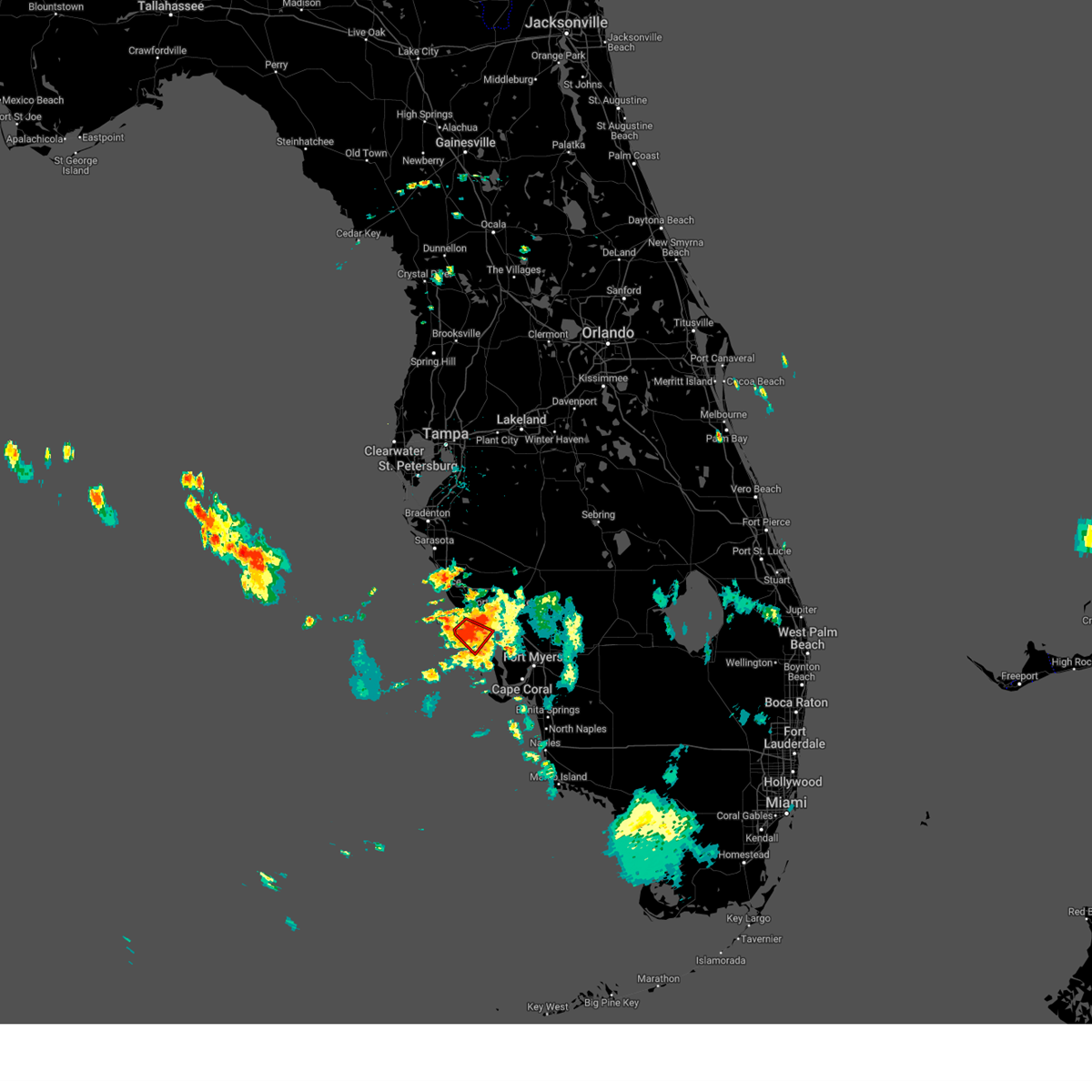
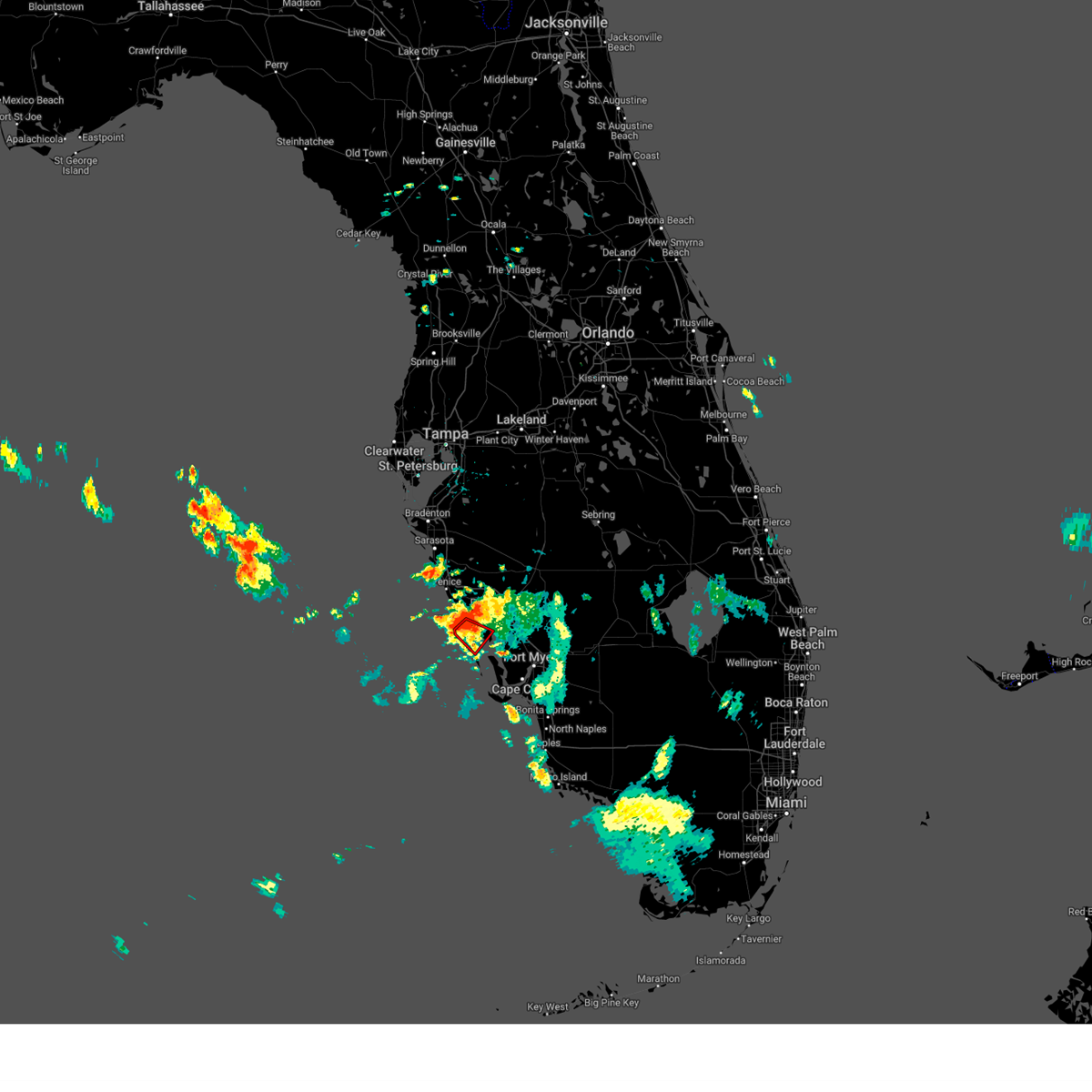
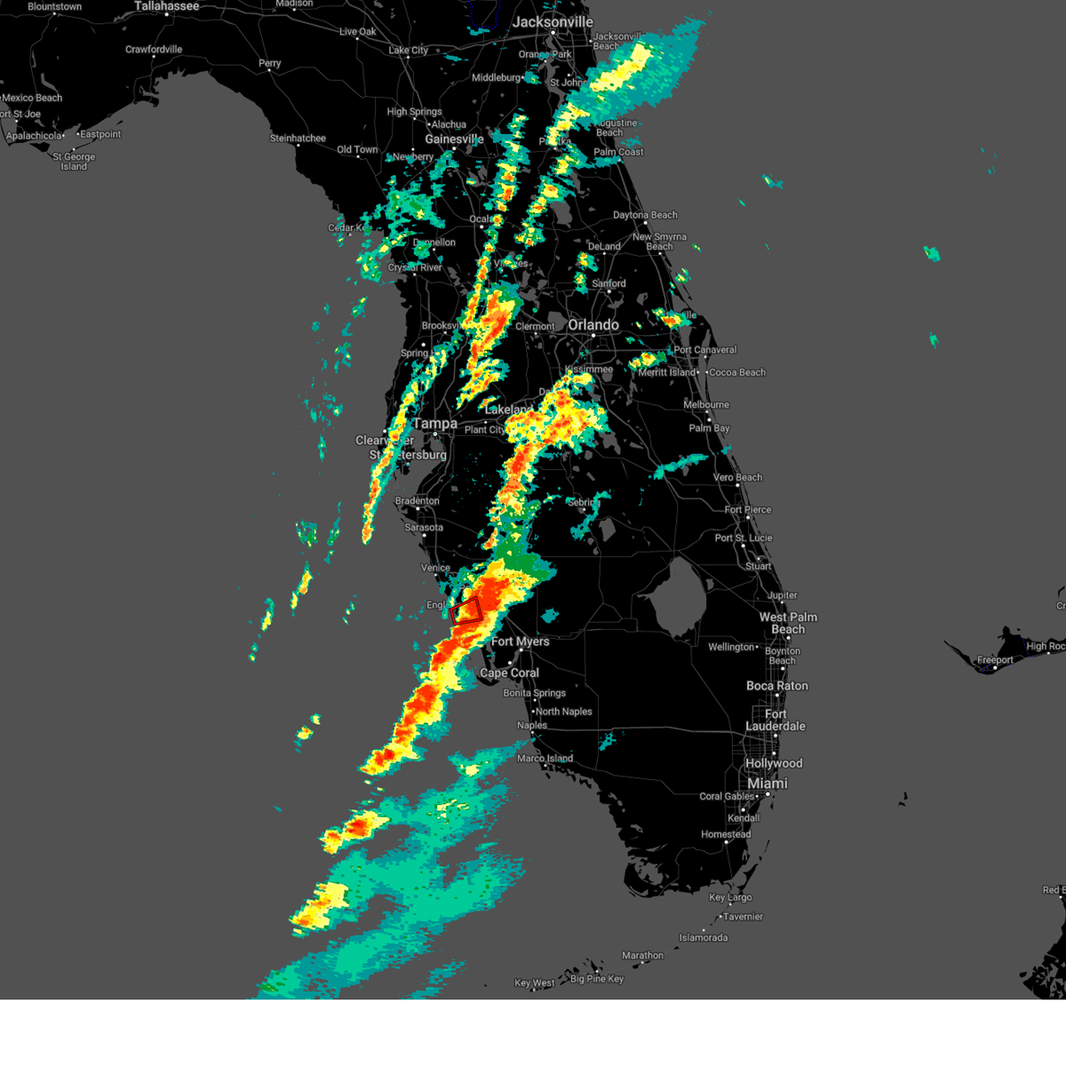
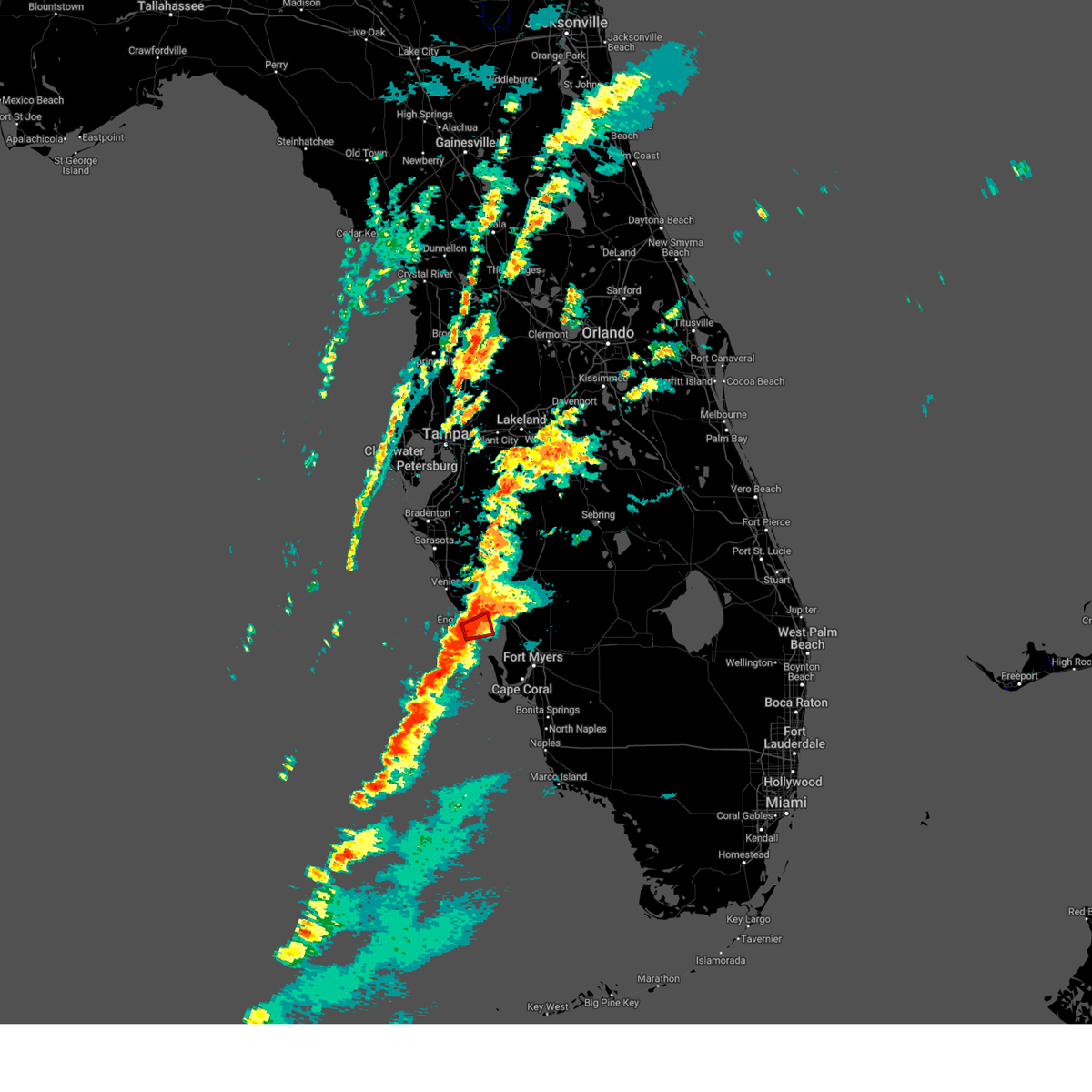
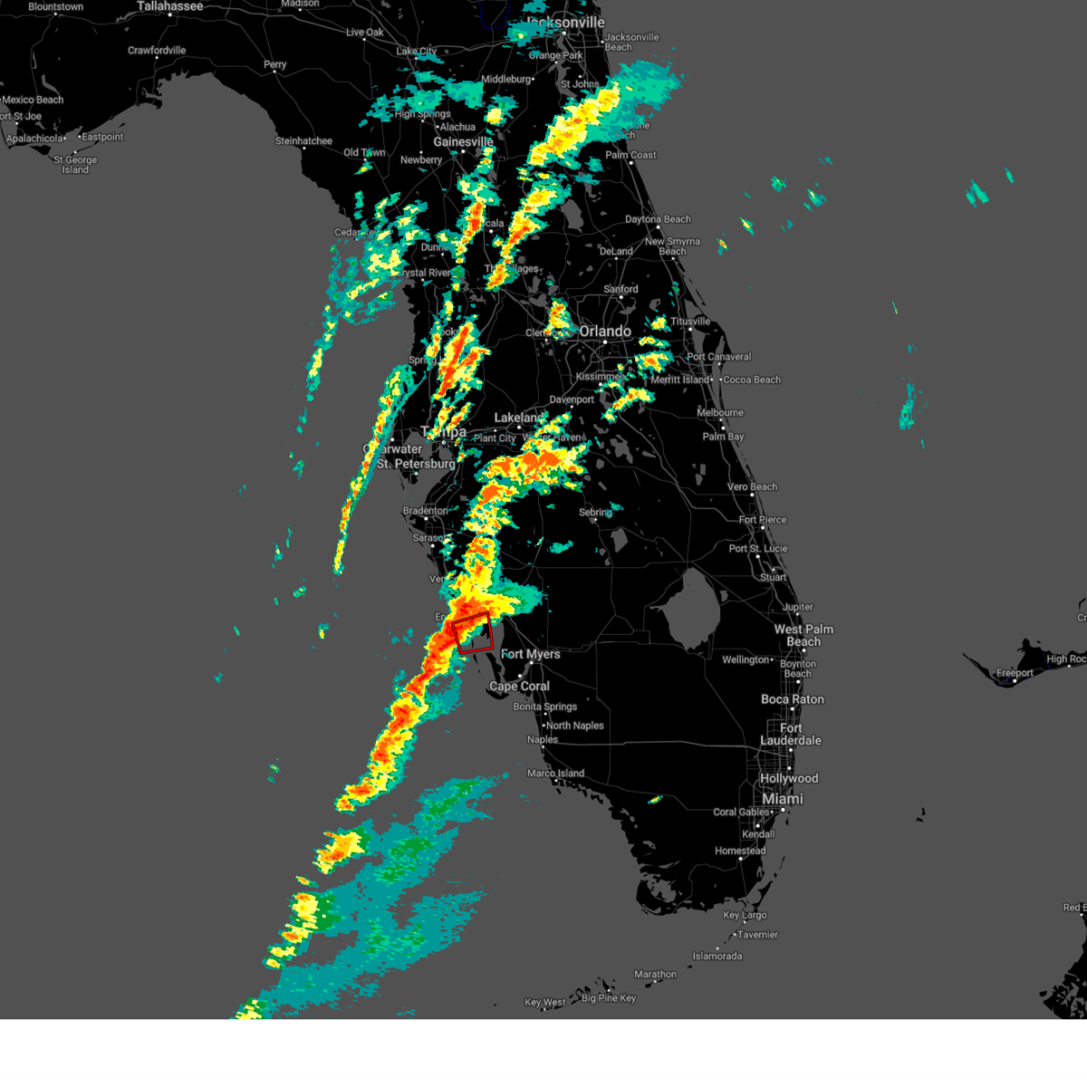
Hail Map for Manasota Key, FL
The Manasota Key, FL area has had 0 reports of on-the-ground hail by trained spotters, and has been under severe weather warnings 8 times during the past 12 months. Doppler radar has detected hail at or near Manasota Key, FL on 13 occasions.
| Name: | Manasota Key, FL |
| Where Located: | 41.7 miles SSE of Bradenton, FL |
| Map: | Google Map for Manasota Key, FL |
| Population: | 1229 |
| Housing Units: | 2083 |
| More Info: | Search Google for Manasota Key, FL |
5
The Top Recent Hail Date for Manasota Key, FL is Thursday, July 14, 2022 (1st out of 13)

Hail and Wind Damage Spotted near Manasota Key, FL
| Date / Time | Report Details |
|---|---|
| 1/9/2024 5:49 PM EST |
 At 548 pm est, severe thunderstorms were located along a line extending from 8 miles west of north port to 19 miles west of pineland to 38 miles west of st. james city, moving east at 50 mph (radar indicated). Hazards include 60 mph wind gusts. expect damage to roofs, siding, and trees At 548 pm est, severe thunderstorms were located along a line extending from 8 miles west of north port to 19 miles west of pineland to 38 miles west of st. james city, moving east at 50 mph (radar indicated). Hazards include 60 mph wind gusts. expect damage to roofs, siding, and trees
|
| 6/18/2023 10:27 AM EDT |
 The tornado warning for southwestern charlotte and northwestern lee counties will expire at 1030 am edt, the storm which prompted the warning has weakened below severe limits, and no longer appears capable of producing a tornado. therefore, the warning will be allowed to expire. however, gusty winds are still possible with this thunderstorm. The tornado warning for southwestern charlotte and northwestern lee counties will expire at 1030 am edt, the storm which prompted the warning has weakened below severe limits, and no longer appears capable of producing a tornado. therefore, the warning will be allowed to expire. however, gusty winds are still possible with this thunderstorm.
|
| 6/18/2023 10:20 AM EDT |
 At 1020 am edt, a severe thunderstorm capable of producing a tornado was located 15 miles northwest of pineland, or 16 miles southwest of port charlotte, moving southeast at 25 mph (radar indicated rotation). Hazards include tornado. Flying debris will be dangerous to those caught without shelter. mobile homes will be damaged or destroyed. damage to roofs, windows, and vehicles will occur. tree damage is likely. This tornadic thunderstorm will remain over mainly rural areas of southwestern charlotte and northwestern lee counties, including the following locations, palm island, placida, rotonda, and grove city. At 1020 am edt, a severe thunderstorm capable of producing a tornado was located 15 miles northwest of pineland, or 16 miles southwest of port charlotte, moving southeast at 25 mph (radar indicated rotation). Hazards include tornado. Flying debris will be dangerous to those caught without shelter. mobile homes will be damaged or destroyed. damage to roofs, windows, and vehicles will occur. tree damage is likely. This tornadic thunderstorm will remain over mainly rural areas of southwestern charlotte and northwestern lee counties, including the following locations, palm island, placida, rotonda, and grove city.
|
| 4/30/2023 5:53 AM EDT |
 The tornado warning for southwestern charlotte county will expire at 600 am edt, the tornado threat has diminished and the tornado warning has been cancelled. however, large hail and damaging winds remain likely and a severe thunderstorm warning remains in effect for the area. however, gusty winds are still possible with this thunderstorm. a tornado watch remains in effect until 200 pm edt for southwestern florida. remember, a severe thunderstorm warning still remains in effect for charlotte, lee, sarasota, and desoto counties. The tornado warning for southwestern charlotte county will expire at 600 am edt, the tornado threat has diminished and the tornado warning has been cancelled. however, large hail and damaging winds remain likely and a severe thunderstorm warning remains in effect for the area. however, gusty winds are still possible with this thunderstorm. a tornado watch remains in effect until 200 pm edt for southwestern florida. remember, a severe thunderstorm warning still remains in effect for charlotte, lee, sarasota, and desoto counties.
|
| 4/30/2023 5:44 AM EDT |
 At 544 am edt, a severe thunderstorm capable of producing a tornado was located 14 miles southwest of port charlotte, moving east at 30 mph (radar indicated rotation). Hazards include tornado. Flying debris will be dangerous to those caught without shelter. mobile homes will be damaged or destroyed. damage to roofs, windows, and vehicles will occur. tree damage is likely. This tornadic thunderstorm will remain over mainly rural areas of southwestern charlotte county, including the following locations, palm island, placida, rotonda , and grove city. At 544 am edt, a severe thunderstorm capable of producing a tornado was located 14 miles southwest of port charlotte, moving east at 30 mph (radar indicated rotation). Hazards include tornado. Flying debris will be dangerous to those caught without shelter. mobile homes will be damaged or destroyed. damage to roofs, windows, and vehicles will occur. tree damage is likely. This tornadic thunderstorm will remain over mainly rural areas of southwestern charlotte county, including the following locations, palm island, placida, rotonda , and grove city.
|
| 4/30/2023 5:39 AM EDT |
 At 539 am edt, a severe thunderstorm capable of producing a tornado was located 14 miles southwest of port charlotte, moving east at 50 mph (radar indicated rotation). Hazards include tornado. Flying debris will be dangerous to those caught without shelter. mobile homes will be damaged or destroyed. damage to roofs, windows, and vehicles will occur. tree damage is likely. Locations impacted include, palm island, placida, rotonda, and grove city. At 539 am edt, a severe thunderstorm capable of producing a tornado was located 14 miles southwest of port charlotte, moving east at 50 mph (radar indicated rotation). Hazards include tornado. Flying debris will be dangerous to those caught without shelter. mobile homes will be damaged or destroyed. damage to roofs, windows, and vehicles will occur. tree damage is likely. Locations impacted include, palm island, placida, rotonda, and grove city.
|
| 4/30/2023 5:31 AM EDT |
 At 531 am edt, a severe thunderstorm capable of producing a tornado was located 17 miles northwest of pineland, or 21 miles southwest of north port, moving east at 50 mph (radar indicated rotation). Hazards include tornado. Flying debris will be dangerous to those caught without shelter. mobile homes will be damaged or destroyed. damage to roofs, windows, and vehicles will occur. tree damage is likely. This tornadic thunderstorm will remain over mainly rural areas of southwestern charlotte and northwestern lee counties, including the following locations, palm island, placida, rotonda , and grove city. At 531 am edt, a severe thunderstorm capable of producing a tornado was located 17 miles northwest of pineland, or 21 miles southwest of north port, moving east at 50 mph (radar indicated rotation). Hazards include tornado. Flying debris will be dangerous to those caught without shelter. mobile homes will be damaged or destroyed. damage to roofs, windows, and vehicles will occur. tree damage is likely. This tornadic thunderstorm will remain over mainly rural areas of southwestern charlotte and northwestern lee counties, including the following locations, palm island, placida, rotonda , and grove city.
|
| 4/30/2023 5:24 AM EDT |
 At 524 am edt, severe thunderstorms were located along a line extending from 9 miles southwest of myakka river state park to near north port to 10 miles west of punta gorda, moving east at 50 mph (radar indicated). Hazards include 60 mph wind gusts. expect damage to roofs, siding, and trees At 524 am edt, severe thunderstorms were located along a line extending from 9 miles southwest of myakka river state park to near north port to 10 miles west of punta gorda, moving east at 50 mph (radar indicated). Hazards include 60 mph wind gusts. expect damage to roofs, siding, and trees
|
| 8/8/2022 5:42 PM EDT |
 The severe thunderstorm warning for western charlotte, southwestern desoto and southeastern sarasota counties will expire at 545 pm edt, the storm which prompted the warning has weakened below severe limits, and no longer poses an immediate threat to life or property. therefore, the warning will be allowed to expire. however small hail, gusty winds and heavy rain are still possible with this thunderstorm. The severe thunderstorm warning for western charlotte, southwestern desoto and southeastern sarasota counties will expire at 545 pm edt, the storm which prompted the warning has weakened below severe limits, and no longer poses an immediate threat to life or property. therefore, the warning will be allowed to expire. however small hail, gusty winds and heavy rain are still possible with this thunderstorm.
|
| 8/8/2022 5:33 PM EDT |
 At 533 pm edt, a severe thunderstorm was located near port charlotte, moving northwest at 5 mph (radar indicated). Hazards include 60 mph wind gusts and quarter size hail. Hail damage to vehicles is expected. Expect wind damage to roofs, siding, and trees. At 533 pm edt, a severe thunderstorm was located near port charlotte, moving northwest at 5 mph (radar indicated). Hazards include 60 mph wind gusts and quarter size hail. Hail damage to vehicles is expected. Expect wind damage to roofs, siding, and trees.
|
| 8/5/2022 5:19 PM EDT |
 At 519 pm edt, a severe thunderstorm was located over port charlotte, moving west at 20 mph (radar indicated). Hazards include 60 mph wind gusts and quarter size hail. Hail damage to vehicles is expected. Expect wind damage to roofs, siding, and trees. At 519 pm edt, a severe thunderstorm was located over port charlotte, moving west at 20 mph (radar indicated). Hazards include 60 mph wind gusts and quarter size hail. Hail damage to vehicles is expected. Expect wind damage to roofs, siding, and trees.
|
| 1/16/2022 7:23 AM EST |
 At 722 am est, a severe thunderstorm capable of producing a tornado was located 12 miles southwest of north port, moving northeast at 40 mph (radar indicated rotation). Hazards include tornado. Flying debris will be dangerous to those caught without shelter. mobile homes will be damaged or destroyed. damage to roofs, windows, and vehicles will occur. tree damage is likely. this dangerous storm will be near, north port around 745 am est. Other locations impacted by this tornadic thunderstorm include warm mineral springs. At 722 am est, a severe thunderstorm capable of producing a tornado was located 12 miles southwest of north port, moving northeast at 40 mph (radar indicated rotation). Hazards include tornado. Flying debris will be dangerous to those caught without shelter. mobile homes will be damaged or destroyed. damage to roofs, windows, and vehicles will occur. tree damage is likely. this dangerous storm will be near, north port around 745 am est. Other locations impacted by this tornadic thunderstorm include warm mineral springs.
|
| 8/9/2020 4:42 PM EDT |
 The severe thunderstorm warning for charlotte and western lee counties will expire at 445 pm edt, the storms which prompted the warning have weakened below severe limits, and no longer pose an immediate threat to life or property. therefore, the warning will be allowed to expire. however gusty winds and heavy rain are still possible with these thunderstorms. The severe thunderstorm warning for charlotte and western lee counties will expire at 445 pm edt, the storms which prompted the warning have weakened below severe limits, and no longer pose an immediate threat to life or property. therefore, the warning will be allowed to expire. however gusty winds and heavy rain are still possible with these thunderstorms.
|
| 8/9/2020 4:00 PM EDT |
 At 400 pm edt, severe thunderstorms were located along a line extending from 6 miles northwest of olga to palmona park to near iona, moving northwest at 20 mph (radar indicated). Hazards include 60 mph wind gusts. expect damage to roofs, siding, and trees At 400 pm edt, severe thunderstorms were located along a line extending from 6 miles northwest of olga to palmona park to near iona, moving northwest at 20 mph (radar indicated). Hazards include 60 mph wind gusts. expect damage to roofs, siding, and trees
|
| 4/19/2019 3:29 PM EDT |
 At 329 pm edt, severe thunderstorms were located along a line extending from near intercession city to 9 miles northwest of arcadia to 34 miles west of pine island, moving northeast at 60 mph (radar indicated). Hazards include 60 mph wind gusts. expect damage to roofs, siding, and trees At 329 pm edt, severe thunderstorms were located along a line extending from near intercession city to 9 miles northwest of arcadia to 34 miles west of pine island, moving northeast at 60 mph (radar indicated). Hazards include 60 mph wind gusts. expect damage to roofs, siding, and trees
|
| 12/20/2018 11:21 AM EST |
 At 1120 am est, severe thunderstorms were located along a line extending from south gate ridge to 27 miles west of pineland, moving east at 45 mph (radar indicated). Hazards include 60 mph wind gusts. expect damage to roofs, siding, and trees At 1120 am est, severe thunderstorms were located along a line extending from south gate ridge to 27 miles west of pineland, moving east at 45 mph (radar indicated). Hazards include 60 mph wind gusts. expect damage to roofs, siding, and trees
|
| 6/7/2017 12:18 PM EDT |
 At 1218 pm edt, a severe thunderstorm was located 10 miles south of north port, moving northeast at 50 mph (radar indicated). Hazards include 60 mph wind gusts. expect damage to roofs, siding, and trees At 1218 pm edt, a severe thunderstorm was located 10 miles south of north port, moving northeast at 50 mph (radar indicated). Hazards include 60 mph wind gusts. expect damage to roofs, siding, and trees
|
| 6/24/2016 5:52 PM EDT |
 At 551 pm edt, a severe thunderstorm was located over port charlotte, moving west at 15 mph (radar indicated). Hazards include 60 mph wind gusts and quarter size hail. Hail damage to vehicles is possible. Expect wind damage to roofs, siding, and trees. At 551 pm edt, a severe thunderstorm was located over port charlotte, moving west at 15 mph (radar indicated). Hazards include 60 mph wind gusts and quarter size hail. Hail damage to vehicles is possible. Expect wind damage to roofs, siding, and trees.
|
| 3/29/2016 2:51 PM EDT |
 The severe thunderstorm warning for sarasota and northwestern charlotte counties will expire at 300 pm edt, the storm which prompted the warning has weakened below severe limits, and no longer poses an immediate threat to life or property. therefore the warning will be allowed to expire. however gusty winds and heavy rain are still possible with this thunderstorm. The severe thunderstorm warning for sarasota and northwestern charlotte counties will expire at 300 pm edt, the storm which prompted the warning has weakened below severe limits, and no longer poses an immediate threat to life or property. therefore the warning will be allowed to expire. however gusty winds and heavy rain are still possible with this thunderstorm.
|
| 3/29/2016 2:22 PM EDT |
 At 221 pm edt, a severe thunderstorm was located 15 miles west of north port, moving northeast at 20 mph (radar indicated). Hazards include 60 mph wind gusts and quarter size hail. Hail damage to vehicles is expected. Expect wind damage to roofs, siding, and trees. At 221 pm edt, a severe thunderstorm was located 15 miles west of north port, moving northeast at 20 mph (radar indicated). Hazards include 60 mph wind gusts and quarter size hail. Hail damage to vehicles is expected. Expect wind damage to roofs, siding, and trees.
|
| 2/24/2016 12:49 PM EST |
 At 1248 pm est, a severe thunderstorm capable of producing a tornado was located 9 miles southwest of north port or near englewood, moving east at 35 mph (radar indicated rotation). Hazards include tornado. Flying debris will be dangerous to those caught without shelter. mobile homes will be damaged or destroyed. damage to roofs, windows, and vehicles will occur. tree damage is likely. Other locations impacted by this tornadic thunderstorm include grove city, gulf cove, el jobean and warm mineral springs. At 1248 pm est, a severe thunderstorm capable of producing a tornado was located 9 miles southwest of north port or near englewood, moving east at 35 mph (radar indicated rotation). Hazards include tornado. Flying debris will be dangerous to those caught without shelter. mobile homes will be damaged or destroyed. damage to roofs, windows, and vehicles will occur. tree damage is likely. Other locations impacted by this tornadic thunderstorm include grove city, gulf cove, el jobean and warm mineral springs.
|
| 2/24/2016 12:31 PM EST |
 At 1229 pm est, a severe thunderstorm capable of producing a tornado was located 19 miles southwest of north port or 7 miles west of englewood, moving east at 30 mph (radar indicated rotation). Hazards include tornado. Flying debris will be dangerous to those caught without shelter. mobile homes will be damaged or destroyed. damage to roofs, windows, and vehicles will occur. tree damage is likely. this dangerous storm will be near, north port around 100 pm est. Other locations impacted by this tornadic thunderstorm include grove city, south venice, warm mineral springs, rotonda, gulf cove, el jobean and venice gardens. At 1229 pm est, a severe thunderstorm capable of producing a tornado was located 19 miles southwest of north port or 7 miles west of englewood, moving east at 30 mph (radar indicated rotation). Hazards include tornado. Flying debris will be dangerous to those caught without shelter. mobile homes will be damaged or destroyed. damage to roofs, windows, and vehicles will occur. tree damage is likely. this dangerous storm will be near, north port around 100 pm est. Other locations impacted by this tornadic thunderstorm include grove city, south venice, warm mineral springs, rotonda, gulf cove, el jobean and venice gardens.
|
| 1/22/2016 8:15 AM EST | At 814 am est, a severe thunderstorm was located 16 miles northwest of pineland, or 23 miles southwest of port charlotte, moving northeast at 45 mph (radar indicated). Hazards include 60 mph wind gusts. Expect damage to roofs. Siding and trees. |
| 1/17/2016 4:32 AM EST |
 At 431 am est, severe thunderstorms were located along a line extending from near port charlotte to 30 miles southwest of st. james city, moving east at 60 mph. these storms have a history of producing damaging winds around 60 mph (public). Hazards include 60 mph wind gusts. Expect damage to roofs. siding and trees. locations impacted include, cape coral, fort myers, north port, punta gorda, port charlotte, babcock ranch, st. james city, buckingham, matlacha, east dunbar, southwest florida airport, iona, charlotte county airport, lochmoor waterway estates, babcock webb wma, olga, cypress lake, pine manor, matlacha isles-matlacha shores and three oaks. A tornado watch remains in effect until 800 am est for southwestern florida. At 431 am est, severe thunderstorms were located along a line extending from near port charlotte to 30 miles southwest of st. james city, moving east at 60 mph. these storms have a history of producing damaging winds around 60 mph (public). Hazards include 60 mph wind gusts. Expect damage to roofs. siding and trees. locations impacted include, cape coral, fort myers, north port, punta gorda, port charlotte, babcock ranch, st. james city, buckingham, matlacha, east dunbar, southwest florida airport, iona, charlotte county airport, lochmoor waterway estates, babcock webb wma, olga, cypress lake, pine manor, matlacha isles-matlacha shores and three oaks. A tornado watch remains in effect until 800 am est for southwestern florida.
|
| 1/17/2016 4:15 AM EST |
 At 414 am est, severe thunderstorms were located along a line extending from 10 miles southwest of north port to 45 miles southwest of st. james city, moving east at 60 mph (radar indicated). Hazards include 60 mph wind gusts. Expect damage to roofs. Siding and trees. At 414 am est, severe thunderstorms were located along a line extending from 10 miles southwest of north port to 45 miles southwest of st. james city, moving east at 60 mph (radar indicated). Hazards include 60 mph wind gusts. Expect damage to roofs. Siding and trees.
|
| 1/17/2016 4:04 AM EST |
 At 403 am est, a severe thunderstorm capable of producing a tornado was located 9 miles west of north port between south venice and englewood, moving northeast at 65 mph (radar indicated rotation). Hazards include tornado. Flying debris will be dangerous to those caught without shelter. mobile homes will be damaged or destroyed. damage to roofs, windows and vehicles will occur. tree damage is likely. this dangerous storm will be near, north port around 410 am est. Other locations impacted by this tornadic thunderstorm include murdock, south venice, warm mineral springs, gulf cove, el jobean and venice gardens. At 403 am est, a severe thunderstorm capable of producing a tornado was located 9 miles west of north port between south venice and englewood, moving northeast at 65 mph (radar indicated rotation). Hazards include tornado. Flying debris will be dangerous to those caught without shelter. mobile homes will be damaged or destroyed. damage to roofs, windows and vehicles will occur. tree damage is likely. this dangerous storm will be near, north port around 410 am est. Other locations impacted by this tornadic thunderstorm include murdock, south venice, warm mineral springs, gulf cove, el jobean and venice gardens.
|
| 1/17/2016 3:49 AM EST |
 At 347 am est, a severe thunderstorm capable of producing a tornado was located 26 miles southwest of north port, moving northeast at 65 mph (radar indicated rotation). Hazards include tornado. Flying debris will be dangerous to those caught without shelter. mobile homes will be damaged or destroyed. damage to roofs, windows and vehicles will occur. tree damage is likely. this dangerous storm will be near, north port around 410 am est. Other locations impacted by this tornadic thunderstorm include nokomis, grove city, murdock, south venice, warm mineral springs, gulf cove, el jobean, venice gardens and rotonda. At 347 am est, a severe thunderstorm capable of producing a tornado was located 26 miles southwest of north port, moving northeast at 65 mph (radar indicated rotation). Hazards include tornado. Flying debris will be dangerous to those caught without shelter. mobile homes will be damaged or destroyed. damage to roofs, windows and vehicles will occur. tree damage is likely. this dangerous storm will be near, north port around 410 am est. Other locations impacted by this tornadic thunderstorm include nokomis, grove city, murdock, south venice, warm mineral springs, gulf cove, el jobean, venice gardens and rotonda.
|
Hail Maps for Manasota Key, FL


Connect with Interactive Hail Maps