

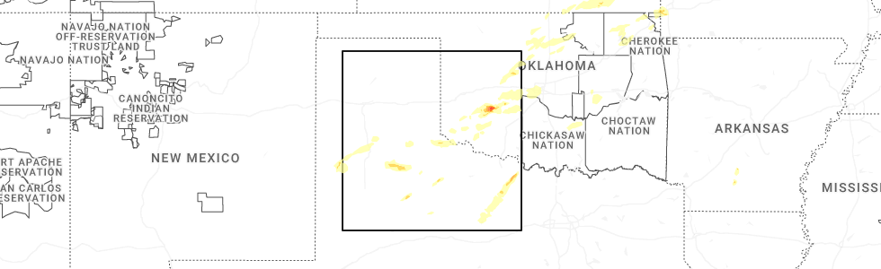
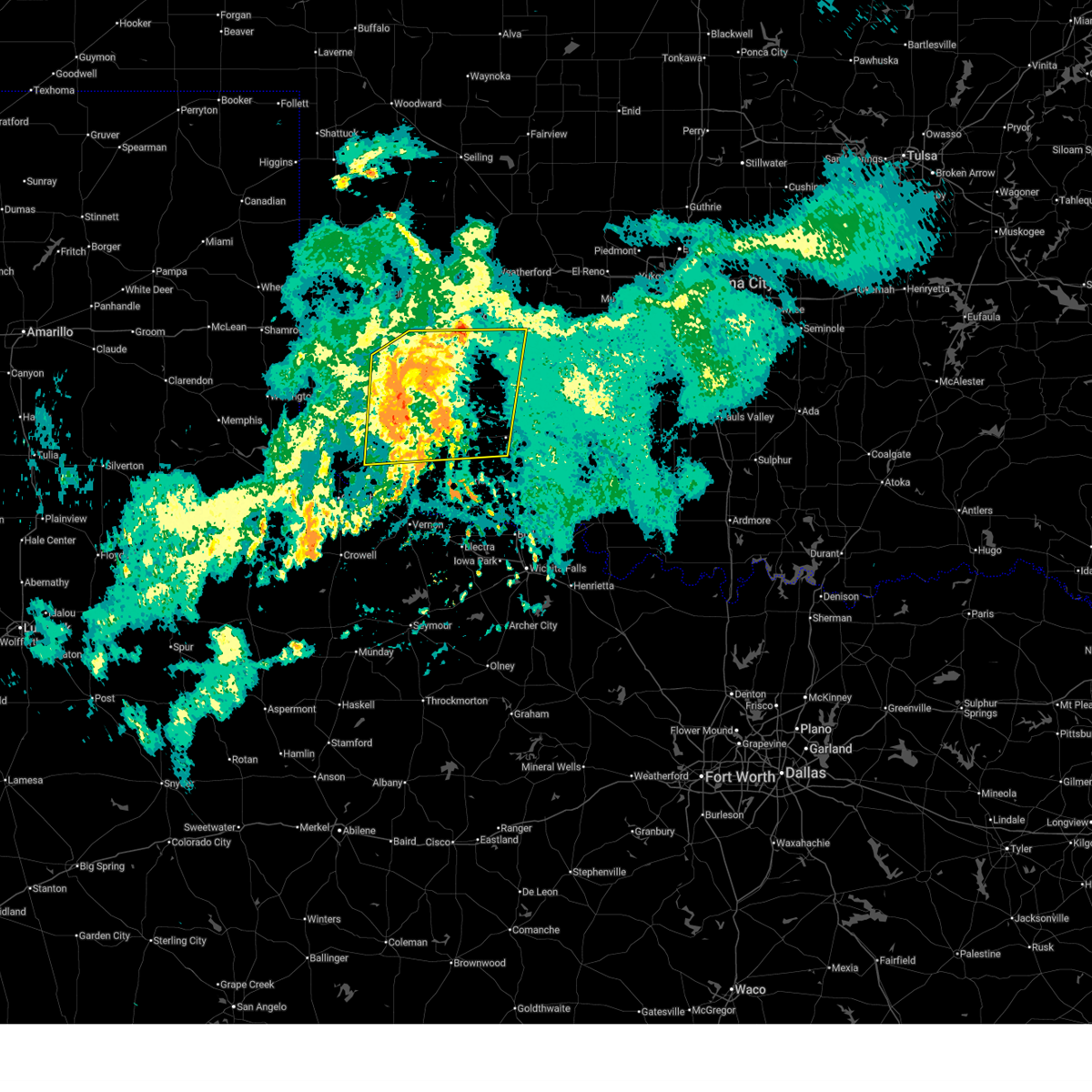
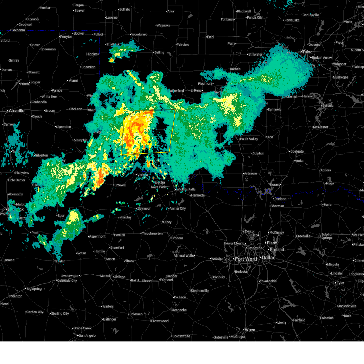
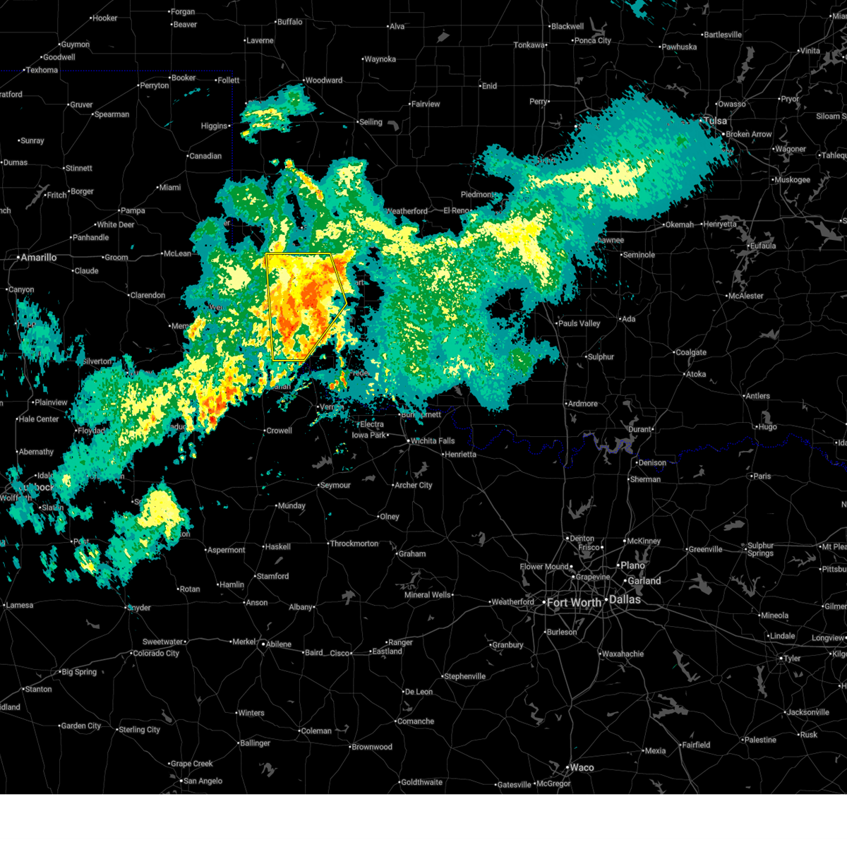
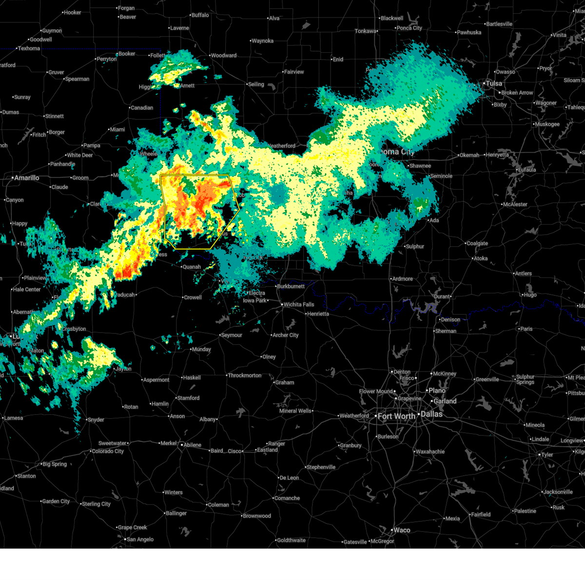
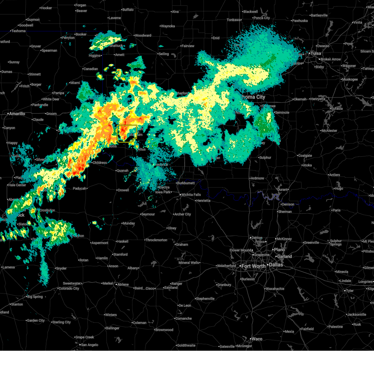
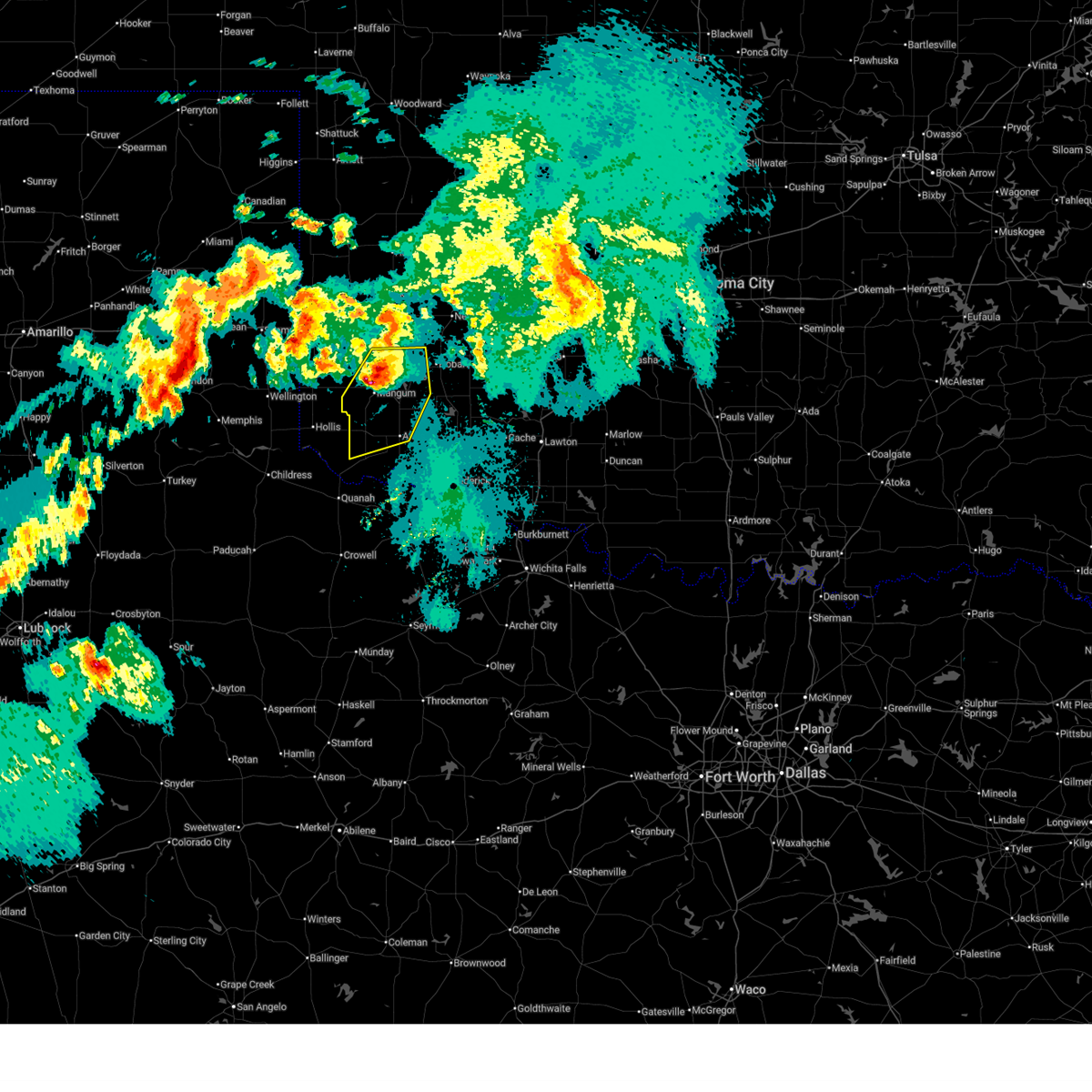
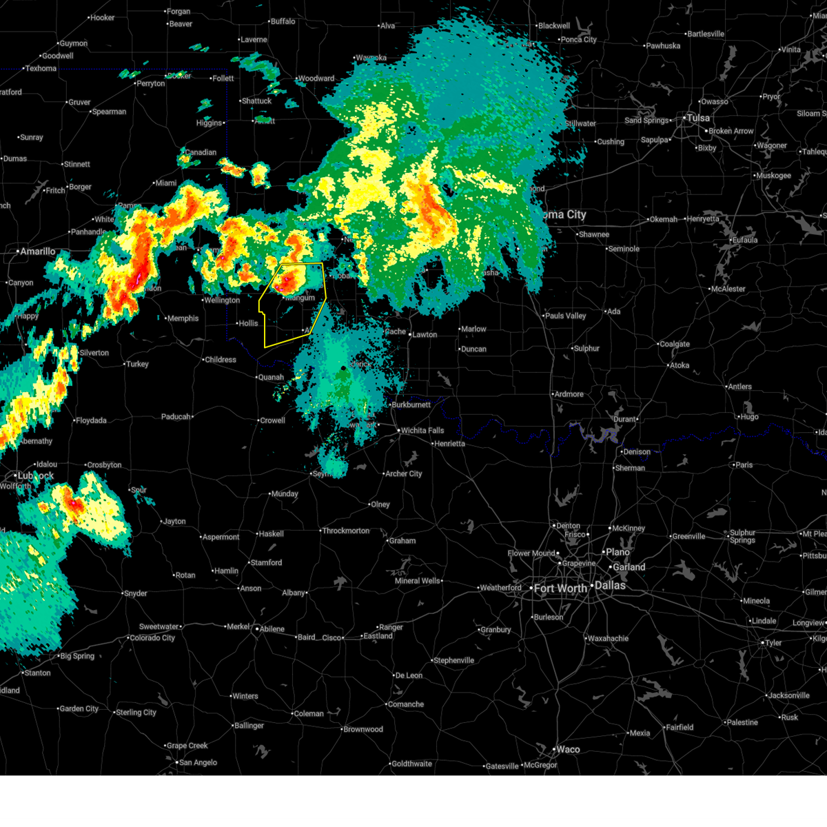
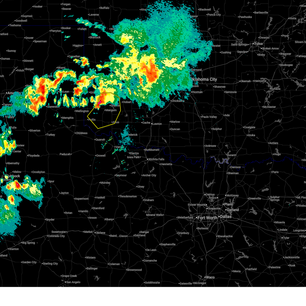
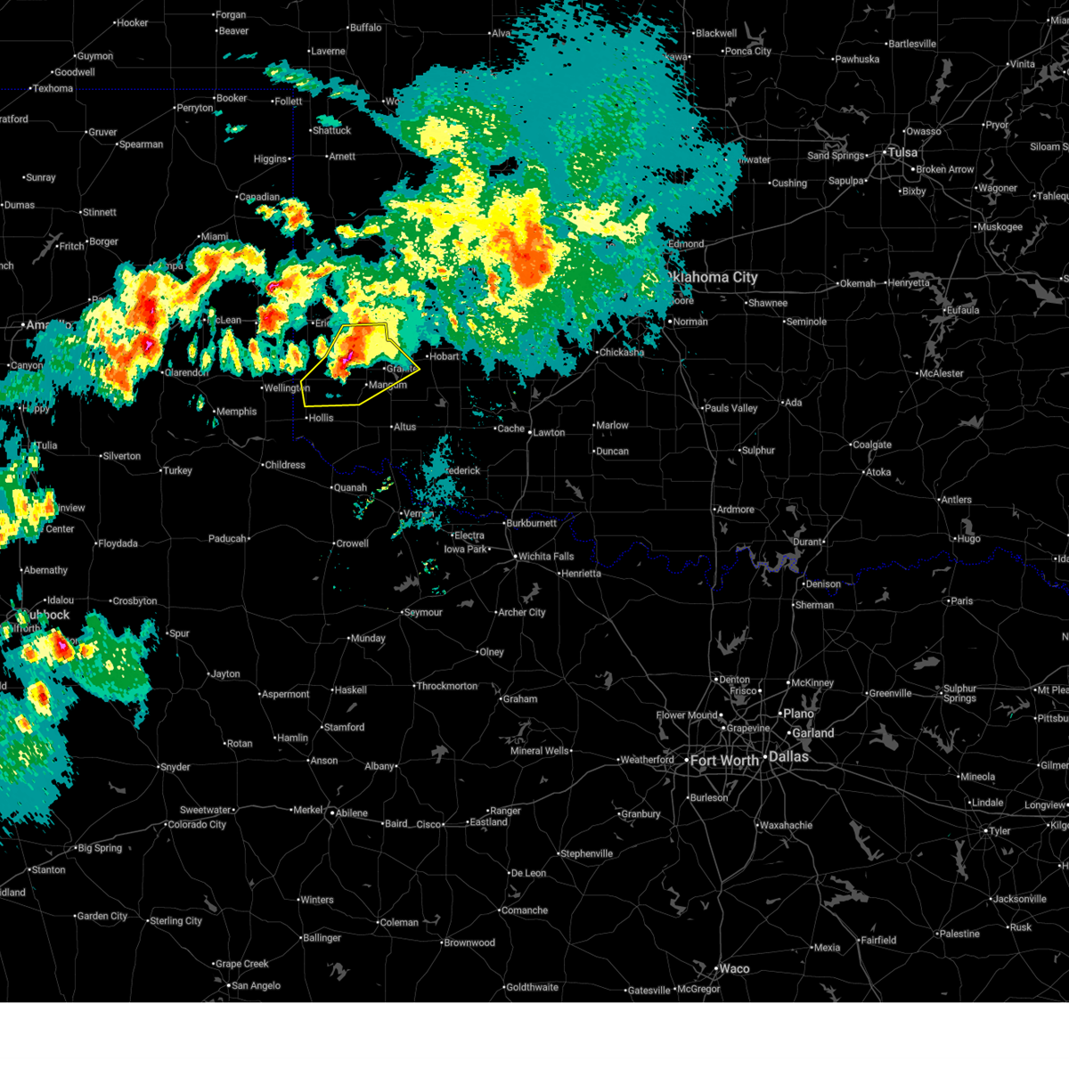
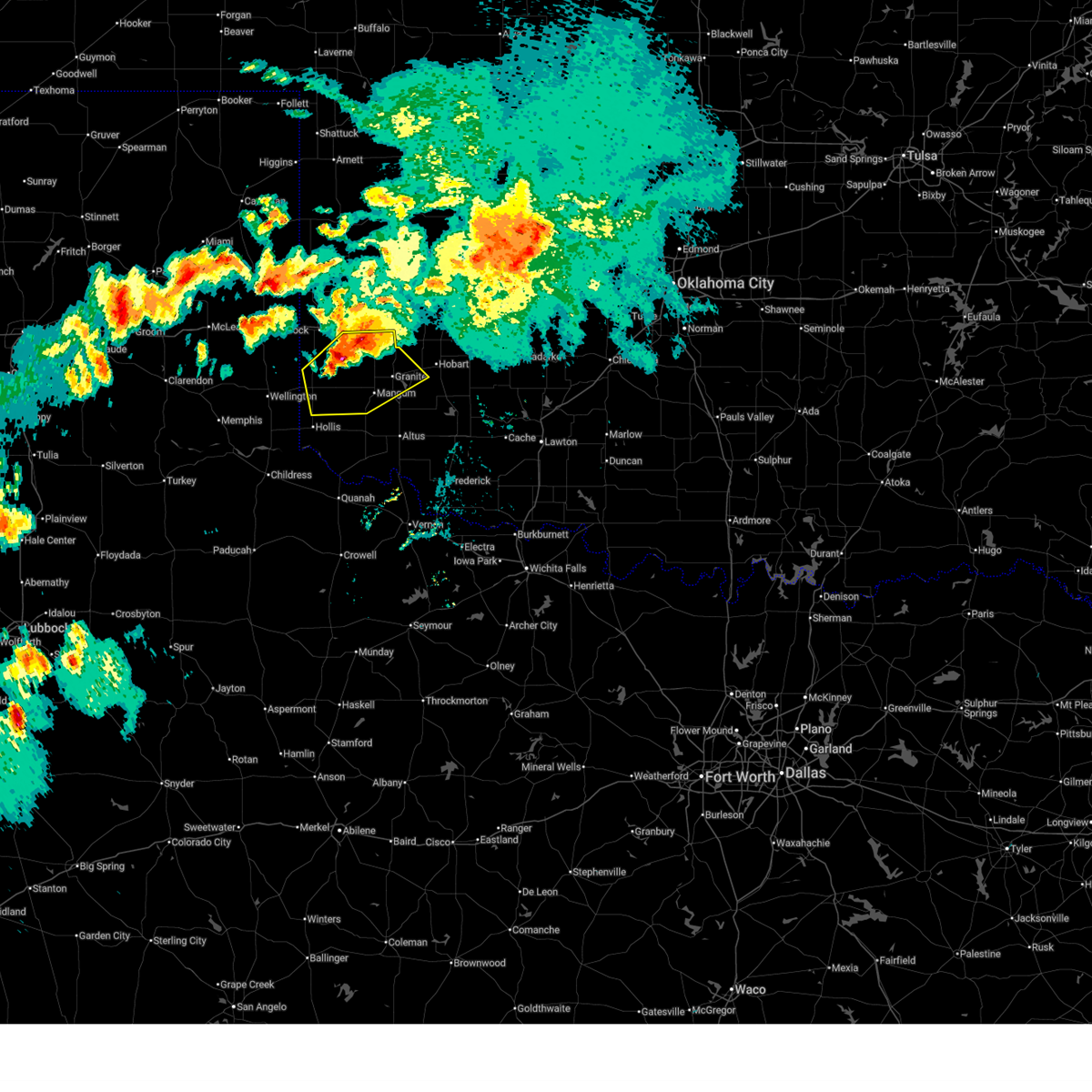
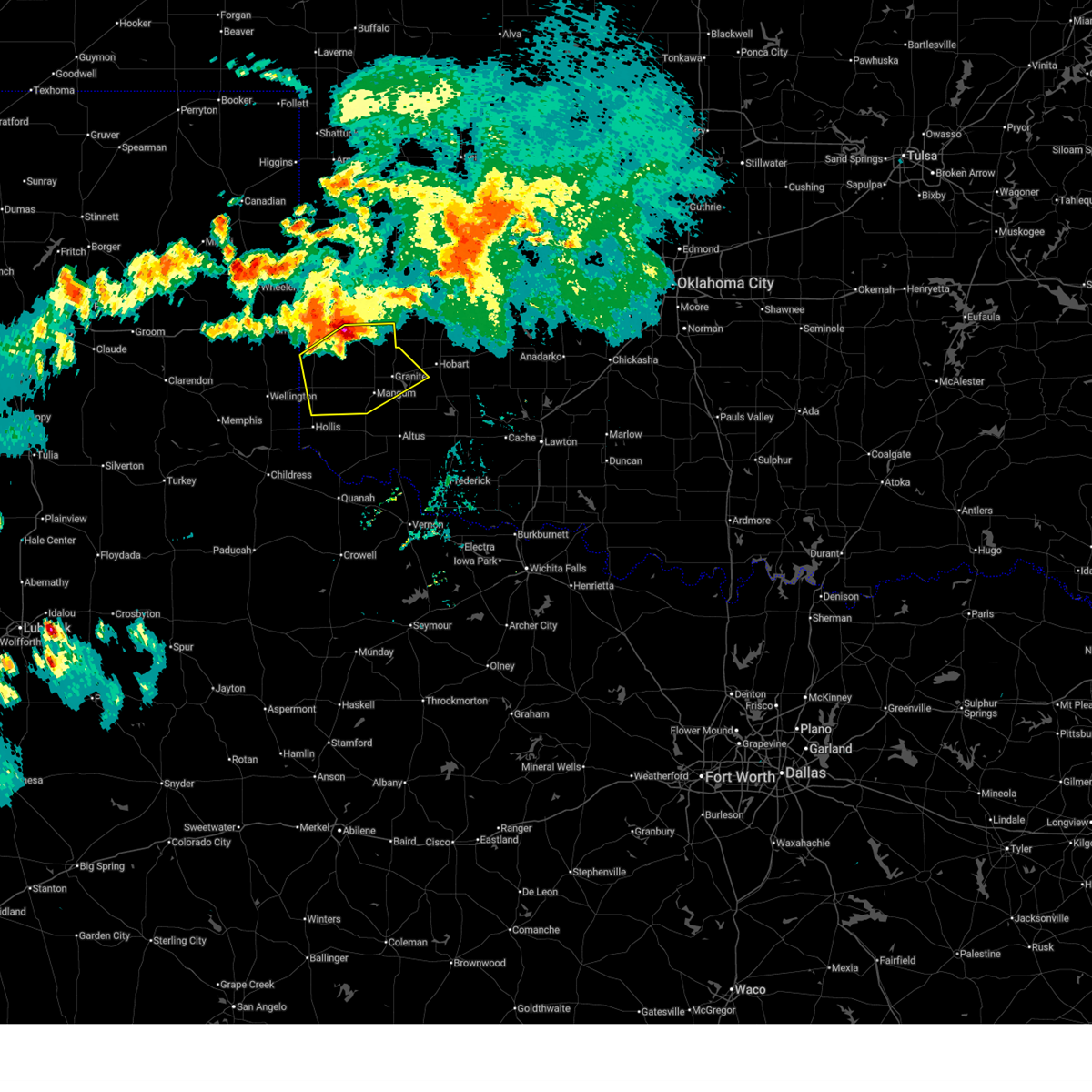
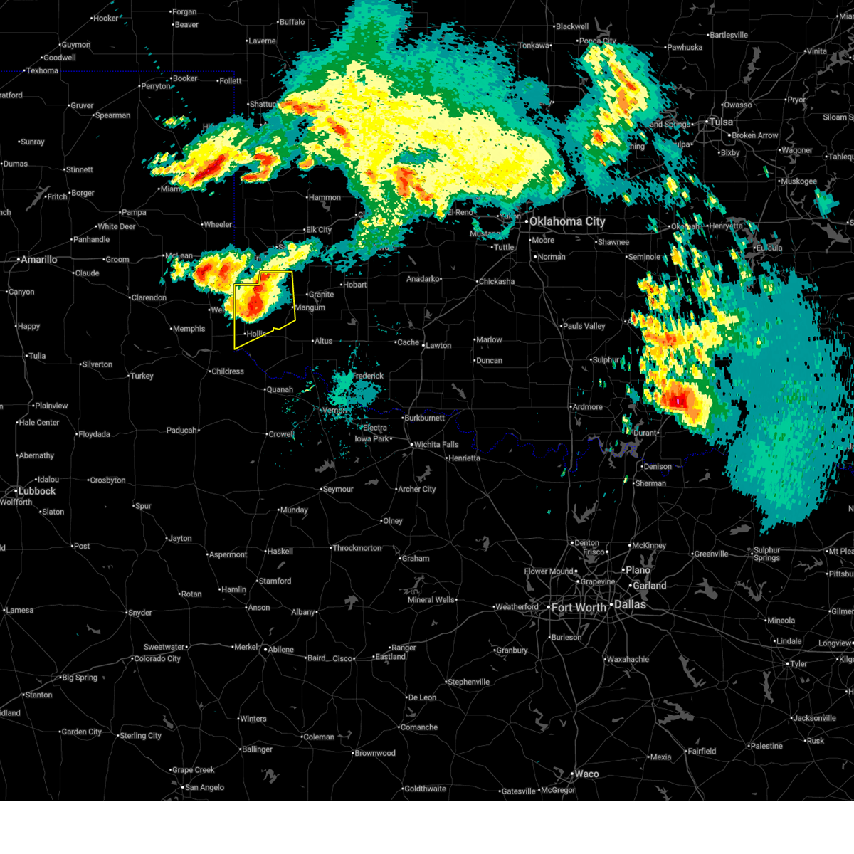
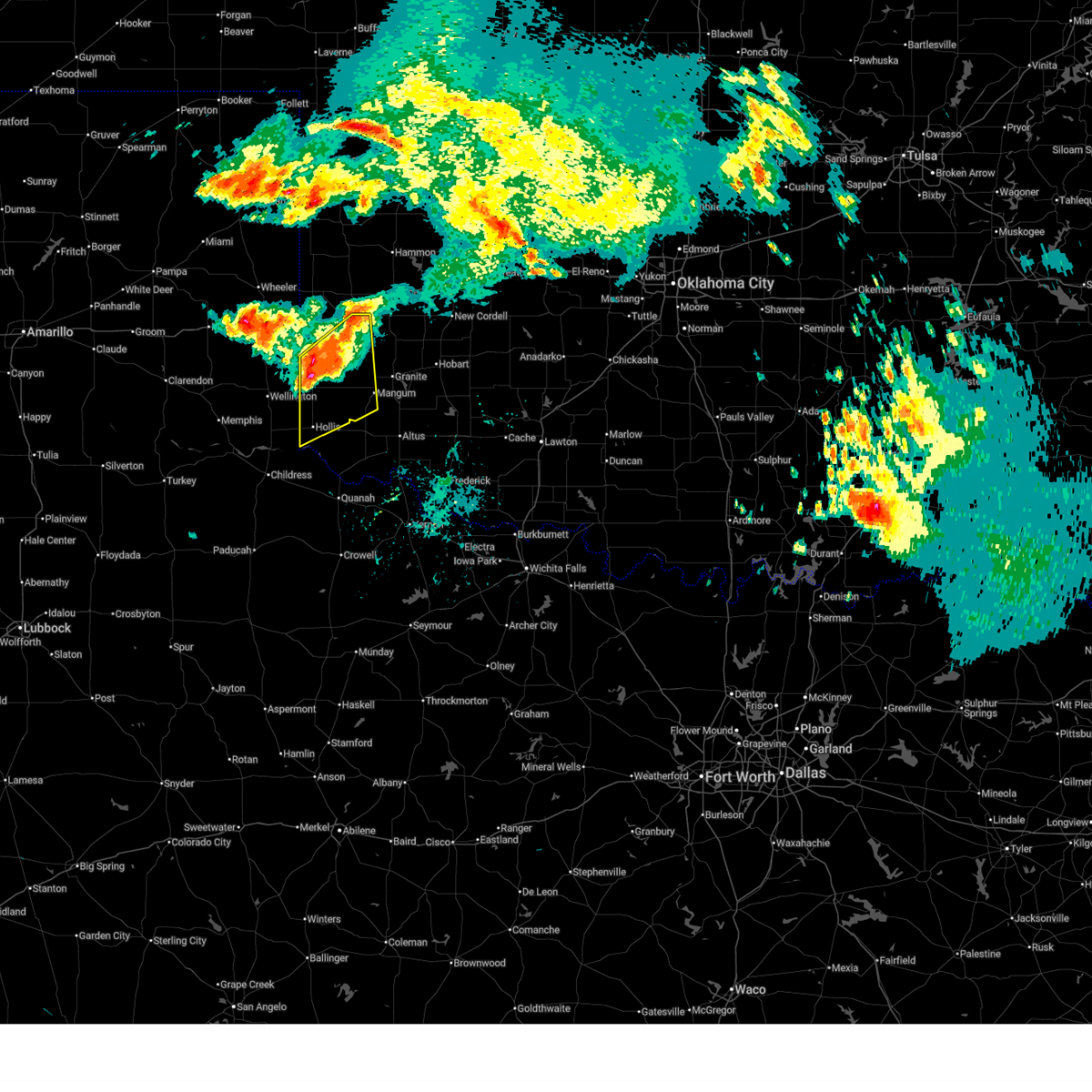
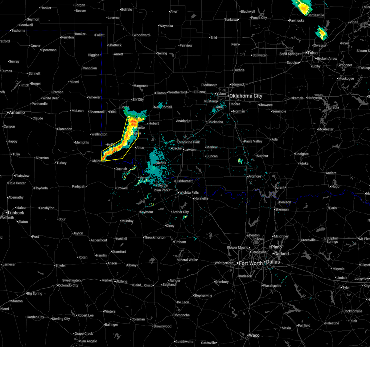
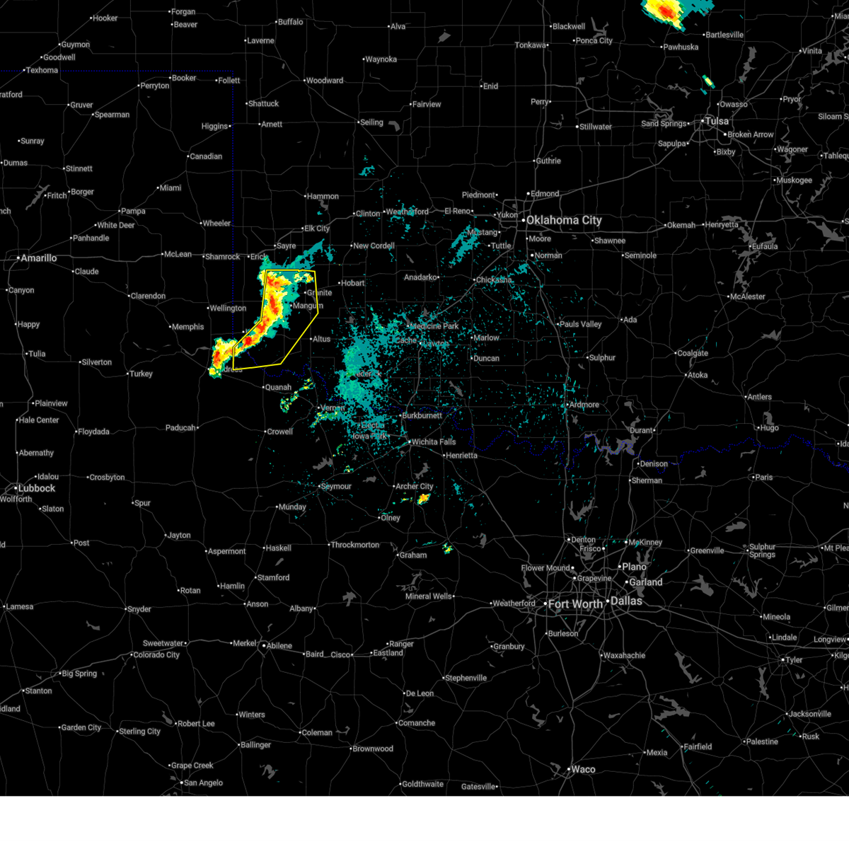
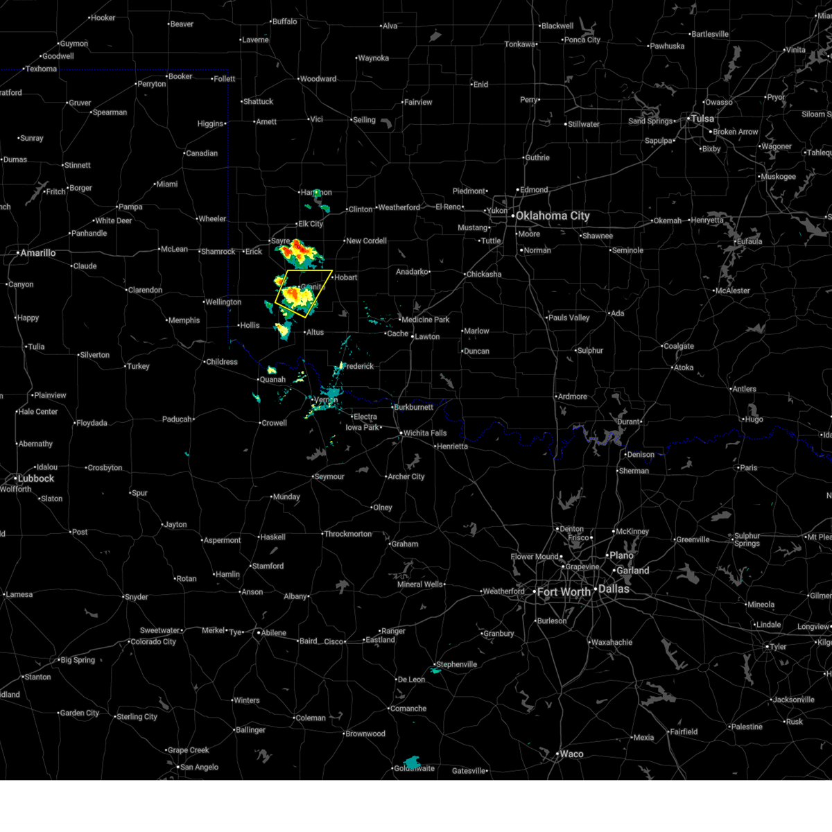
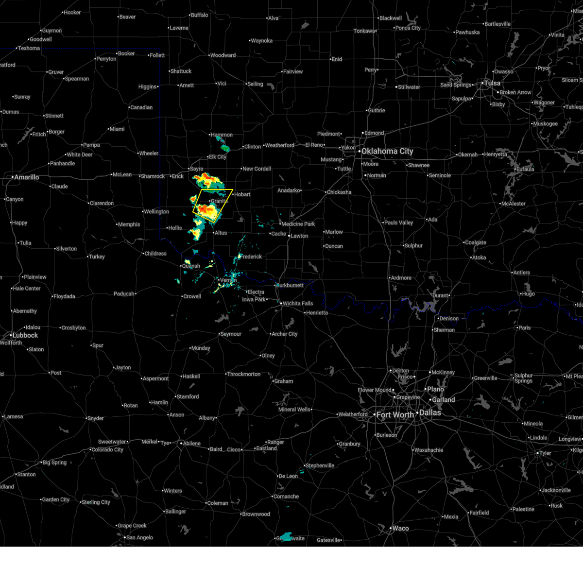
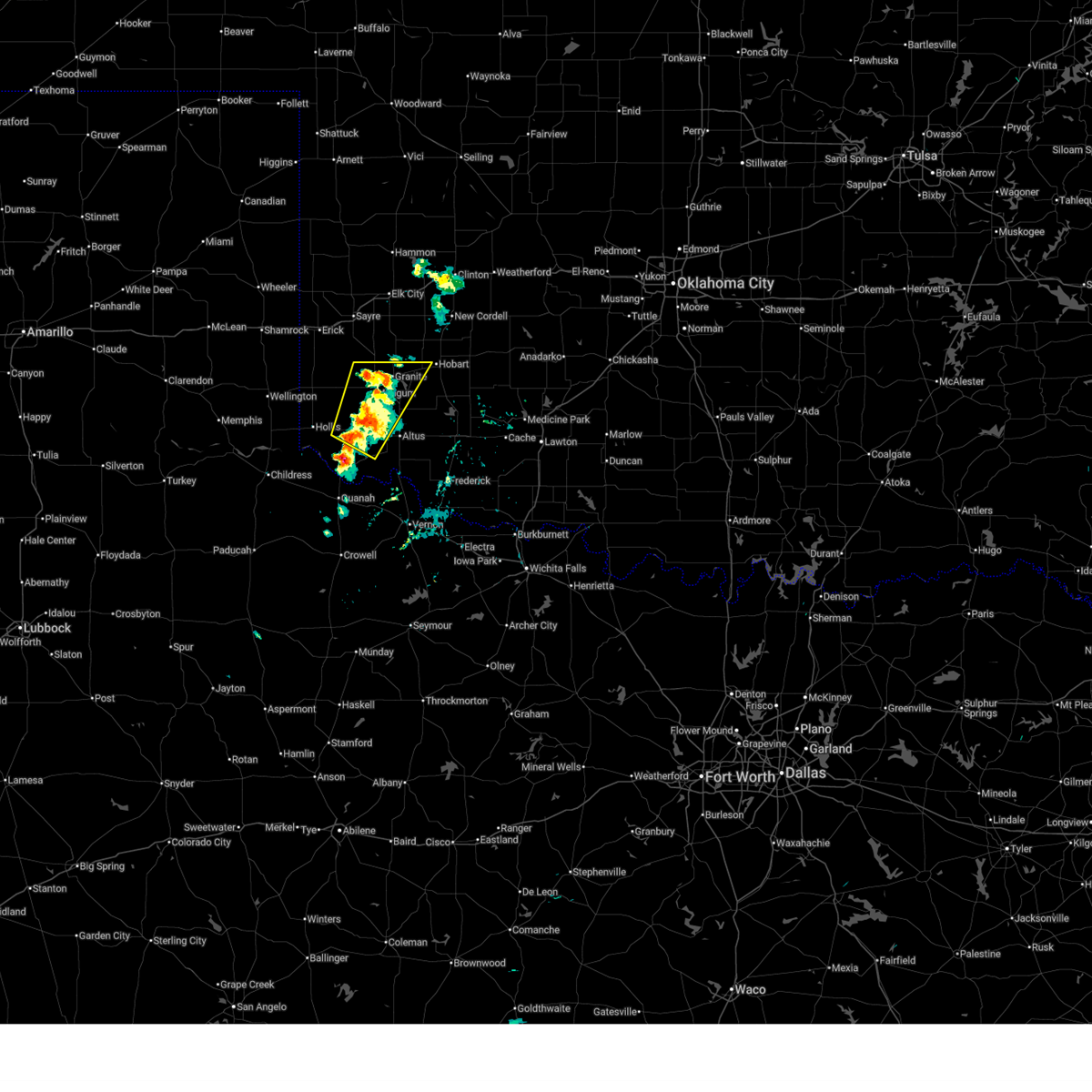
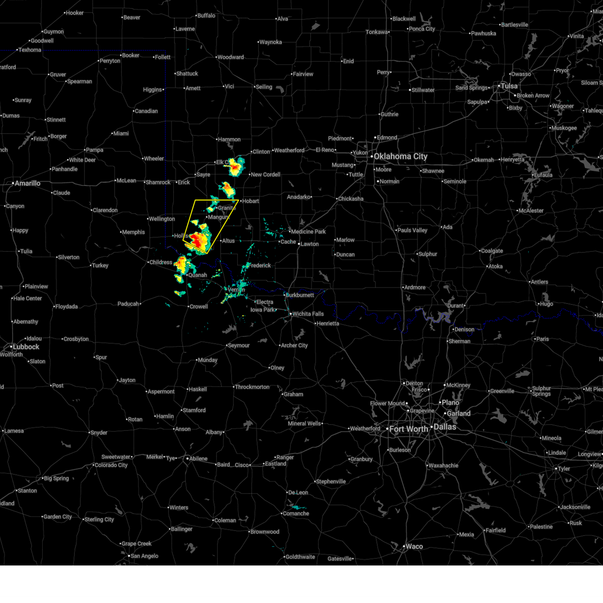
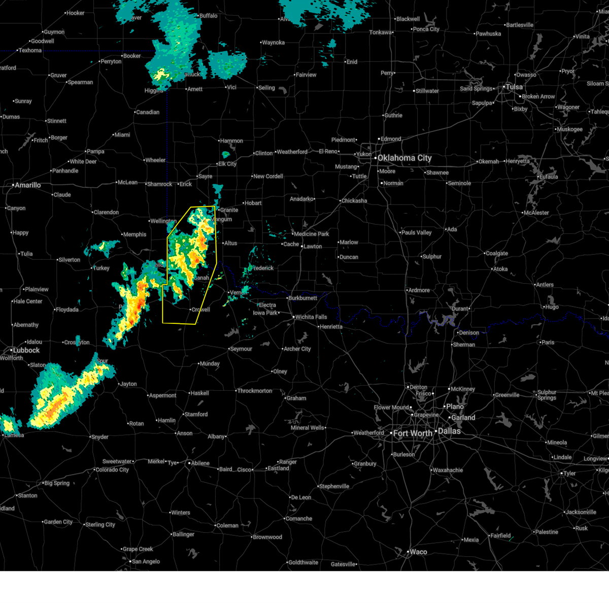
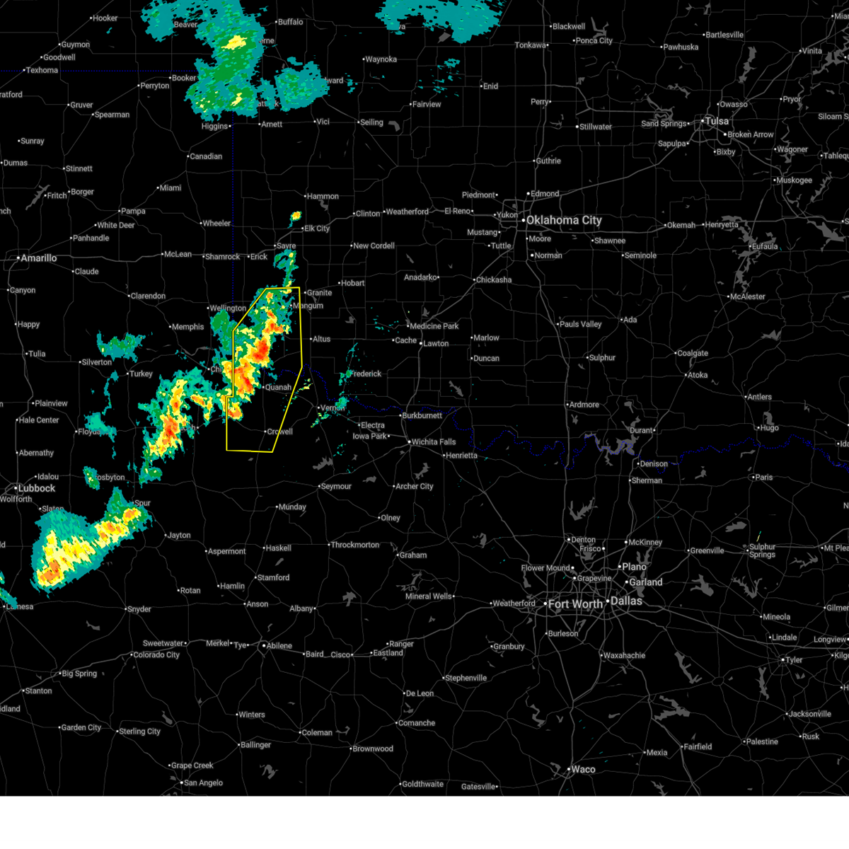
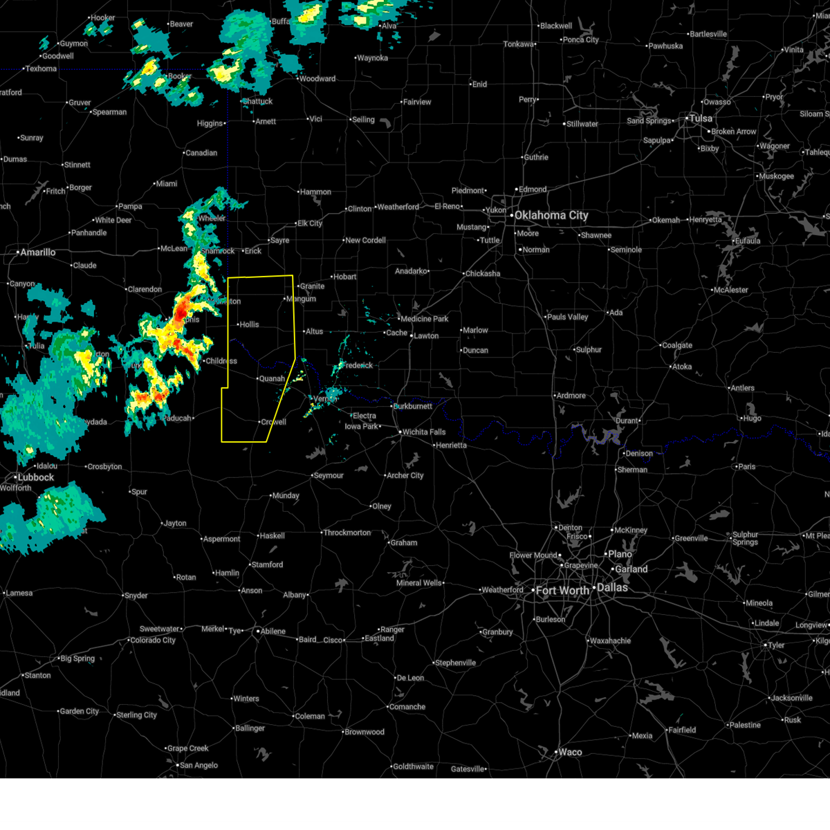
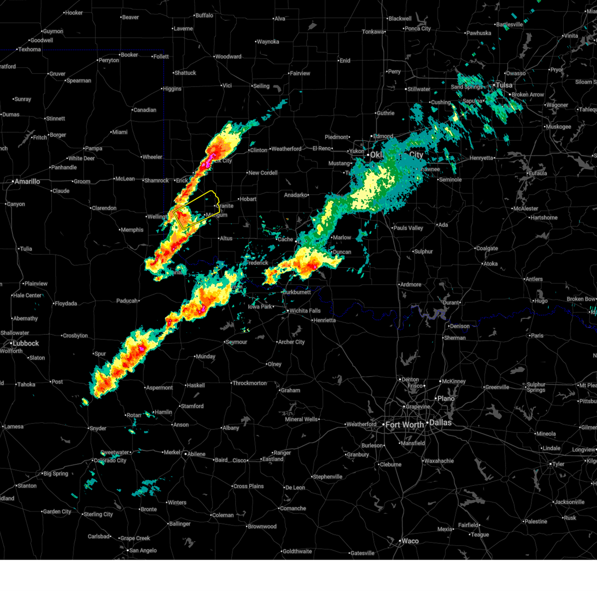
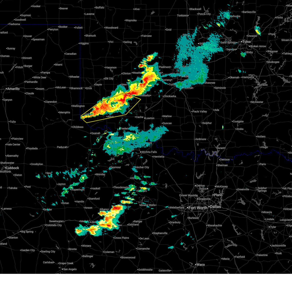
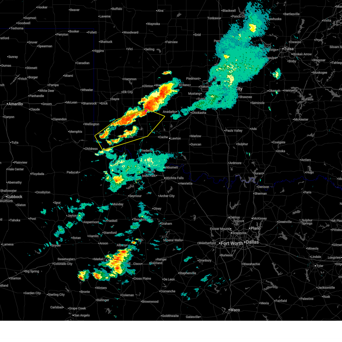
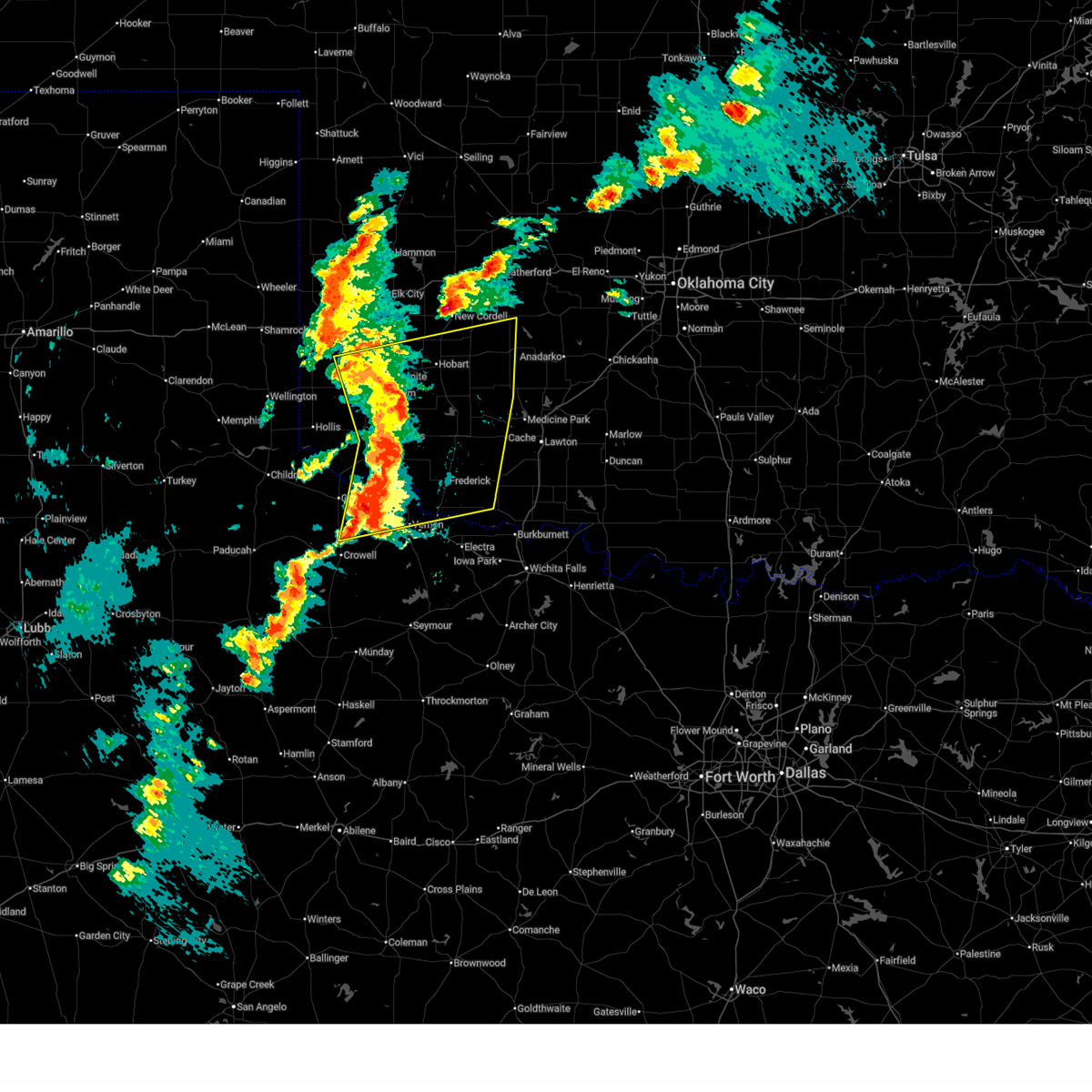
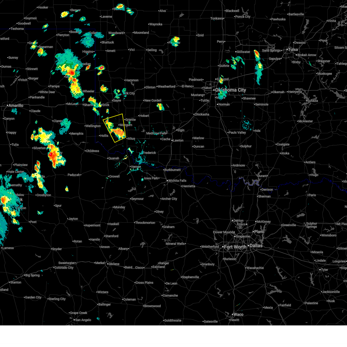
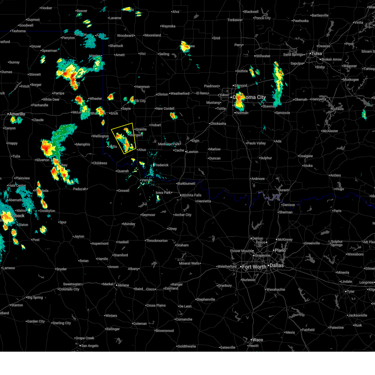
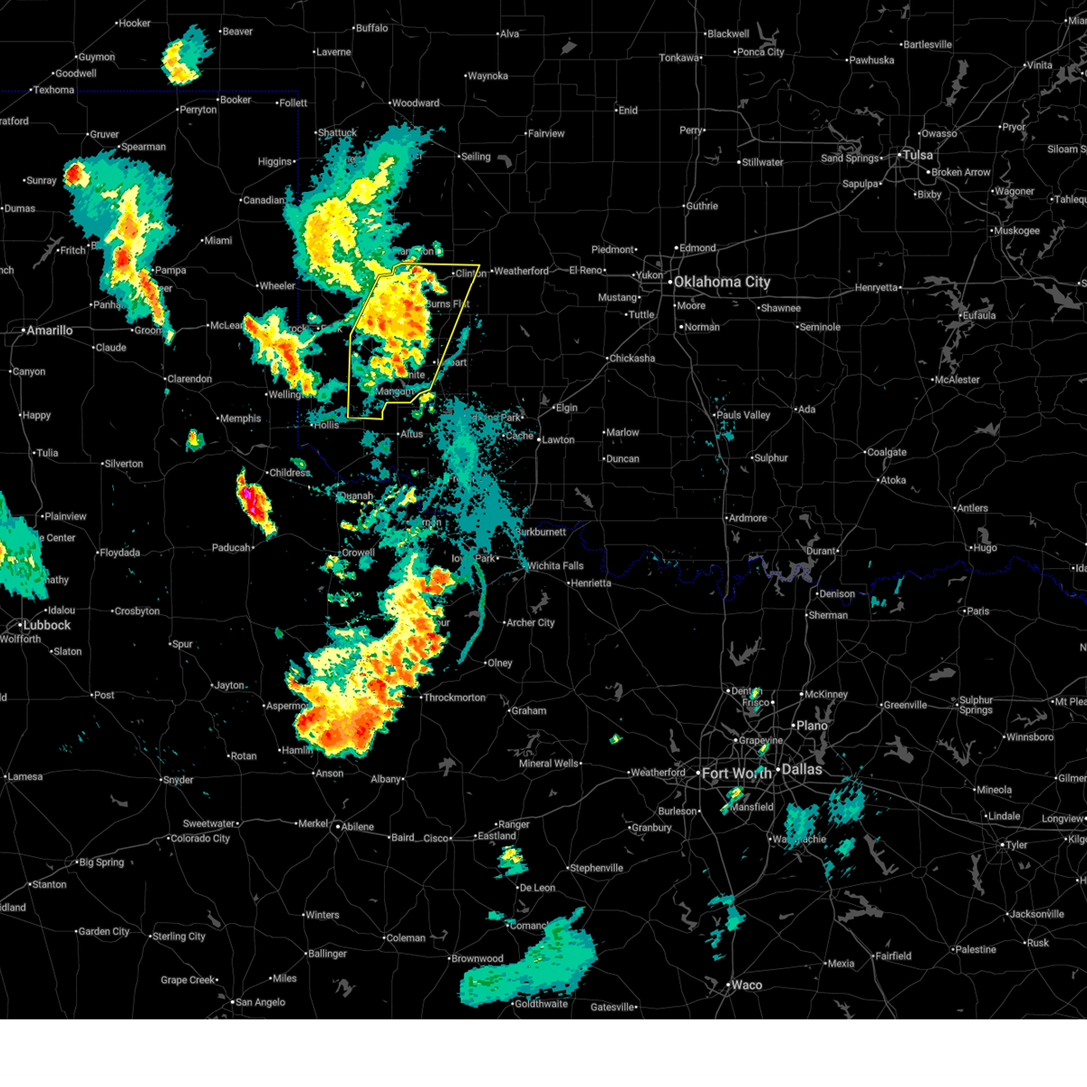
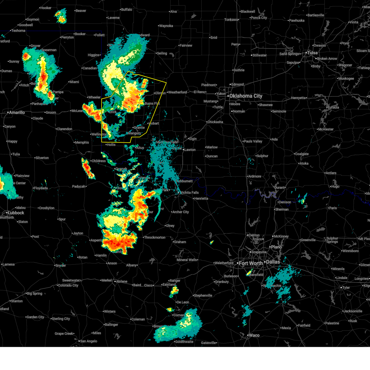
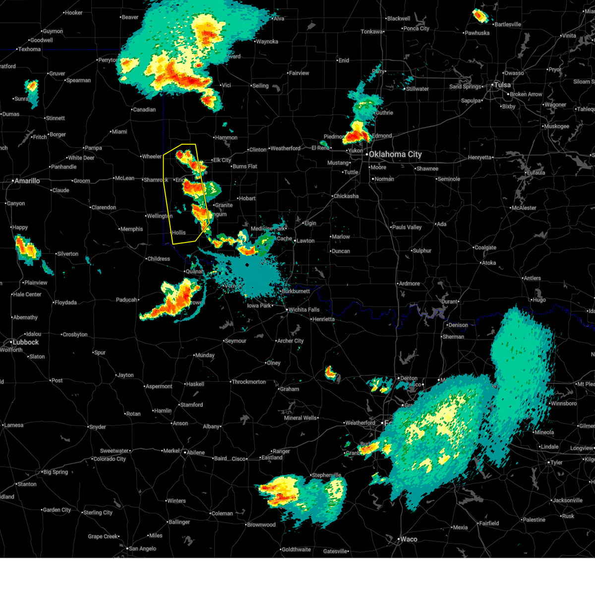
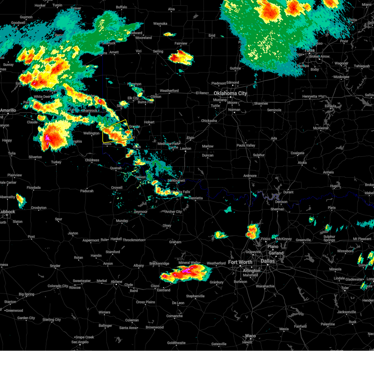
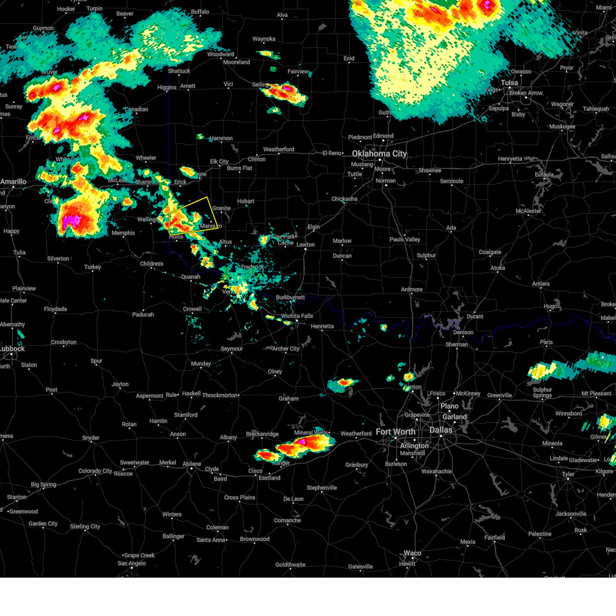
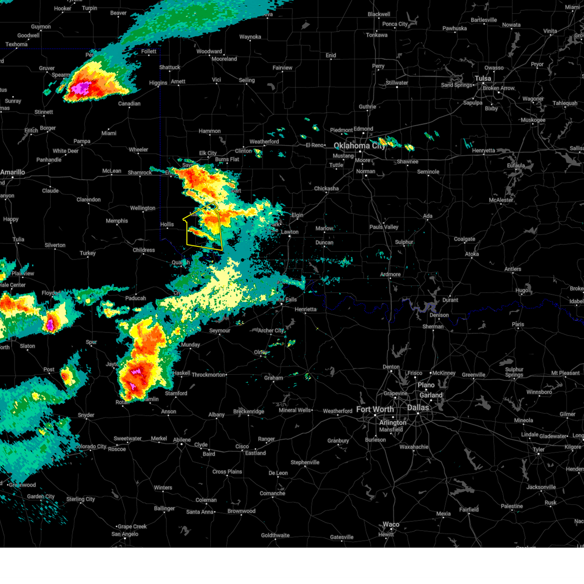
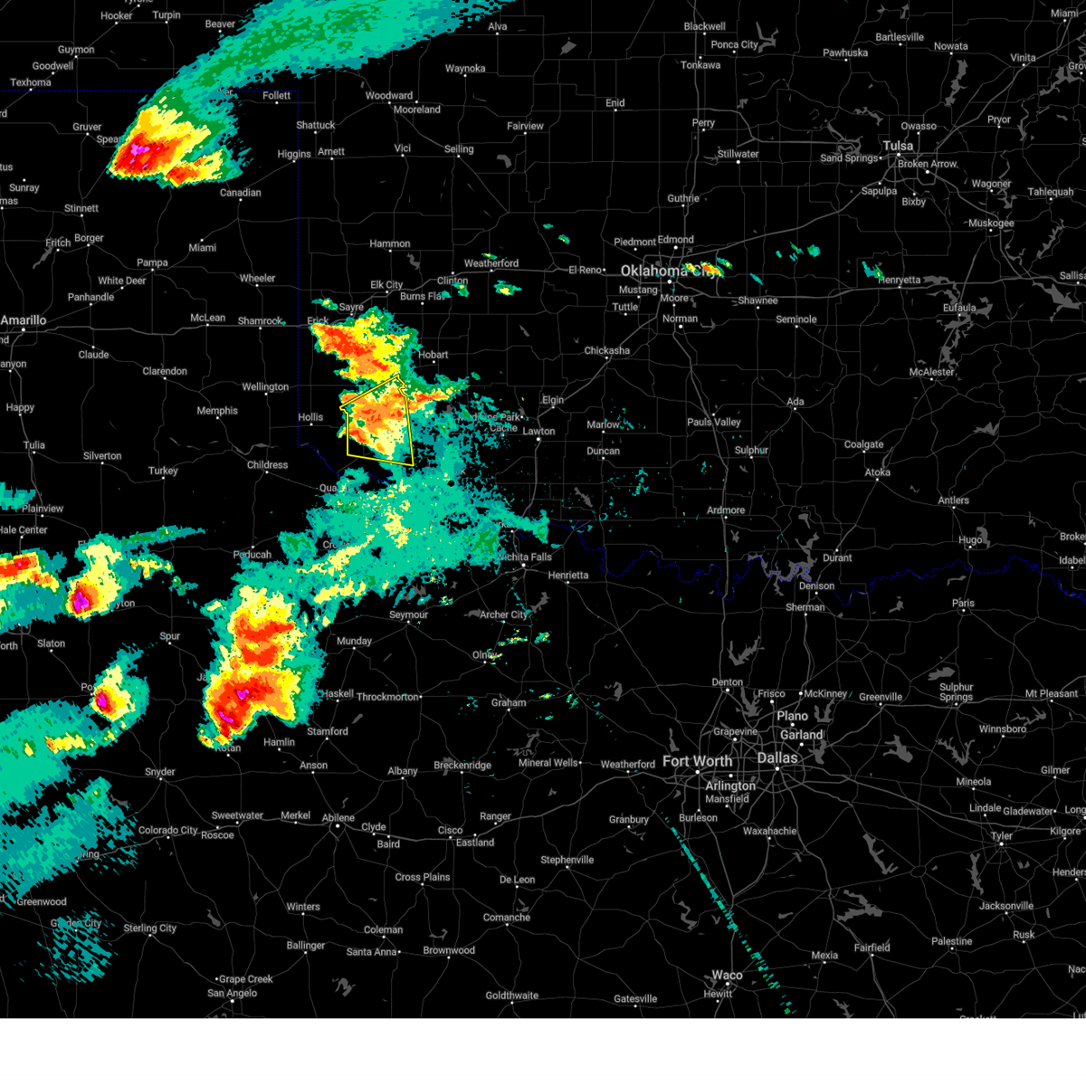
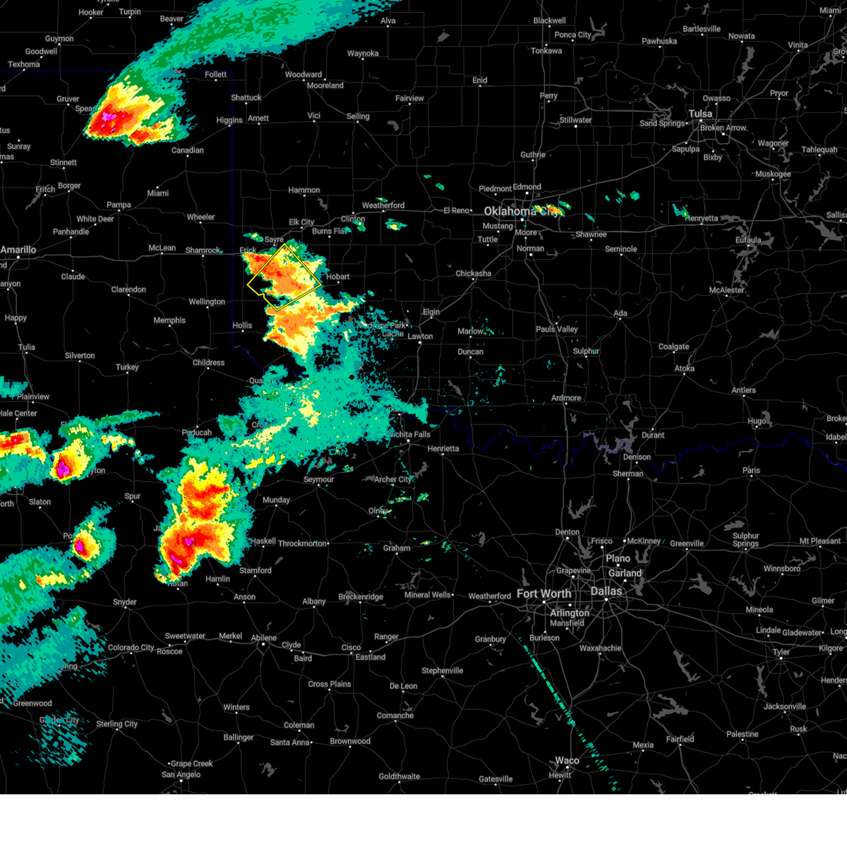
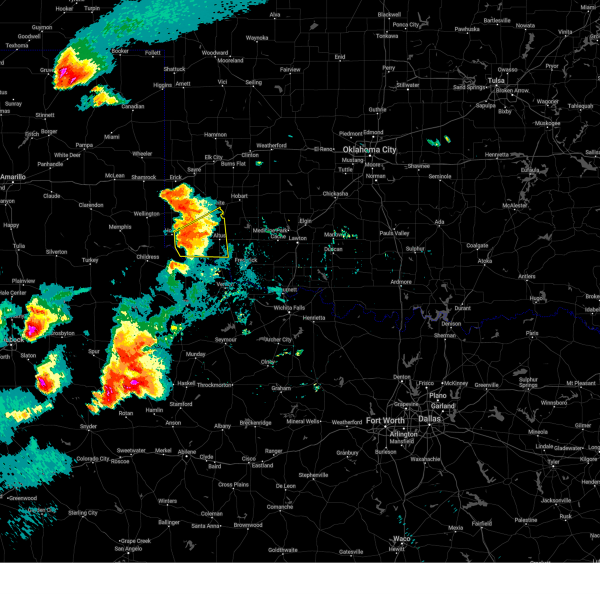
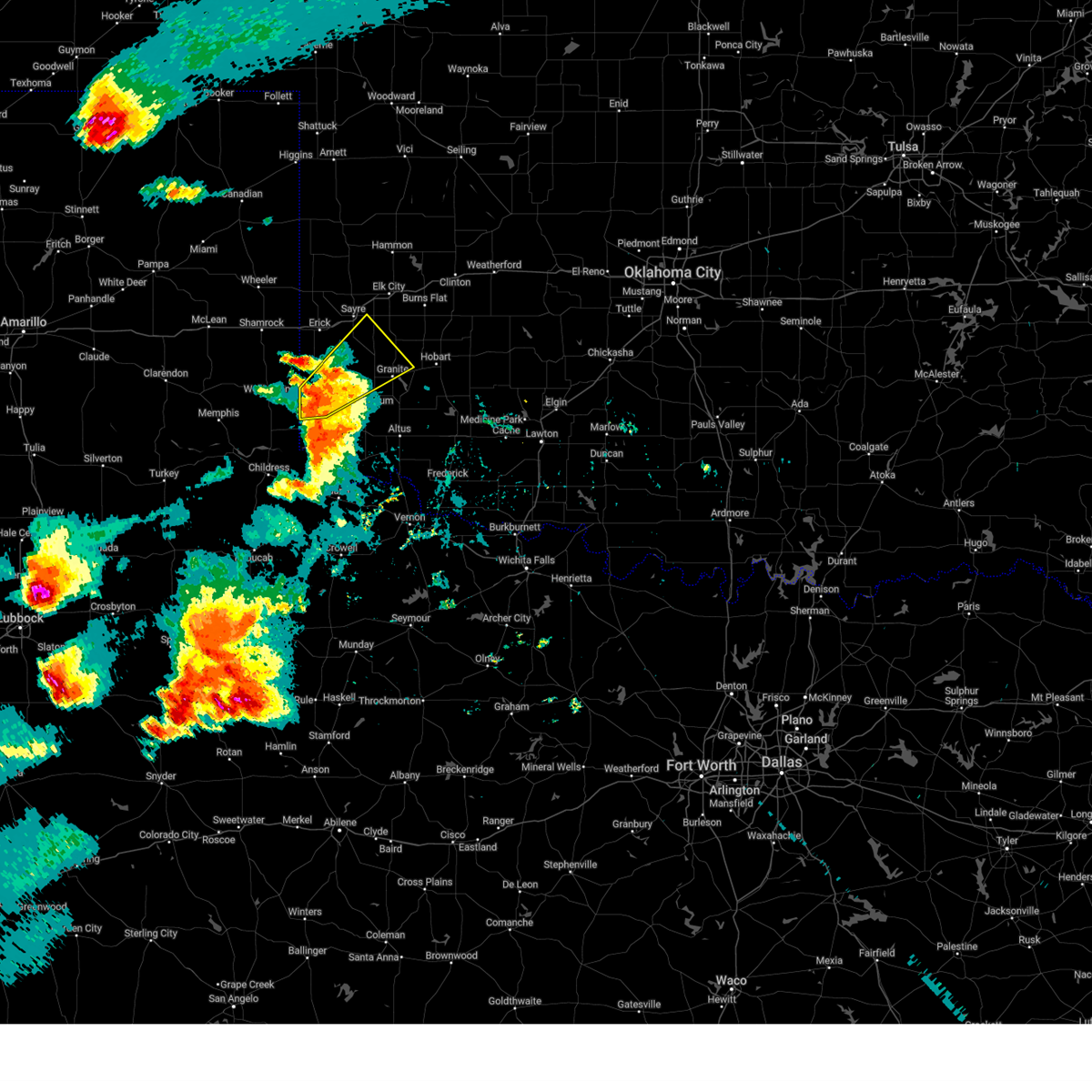
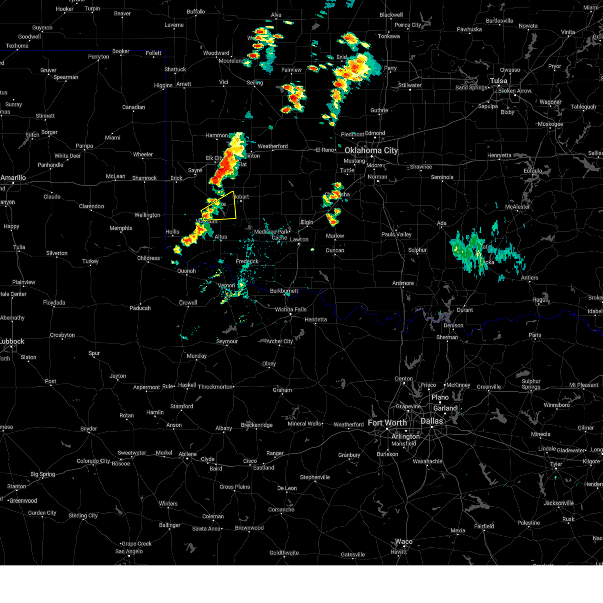
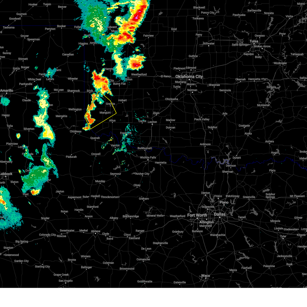
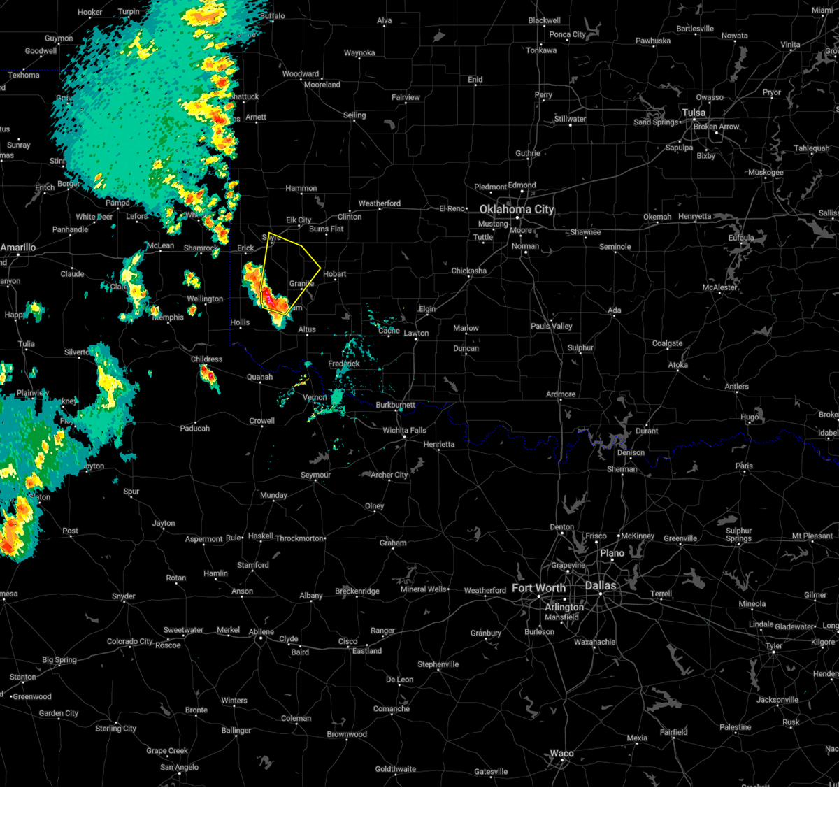
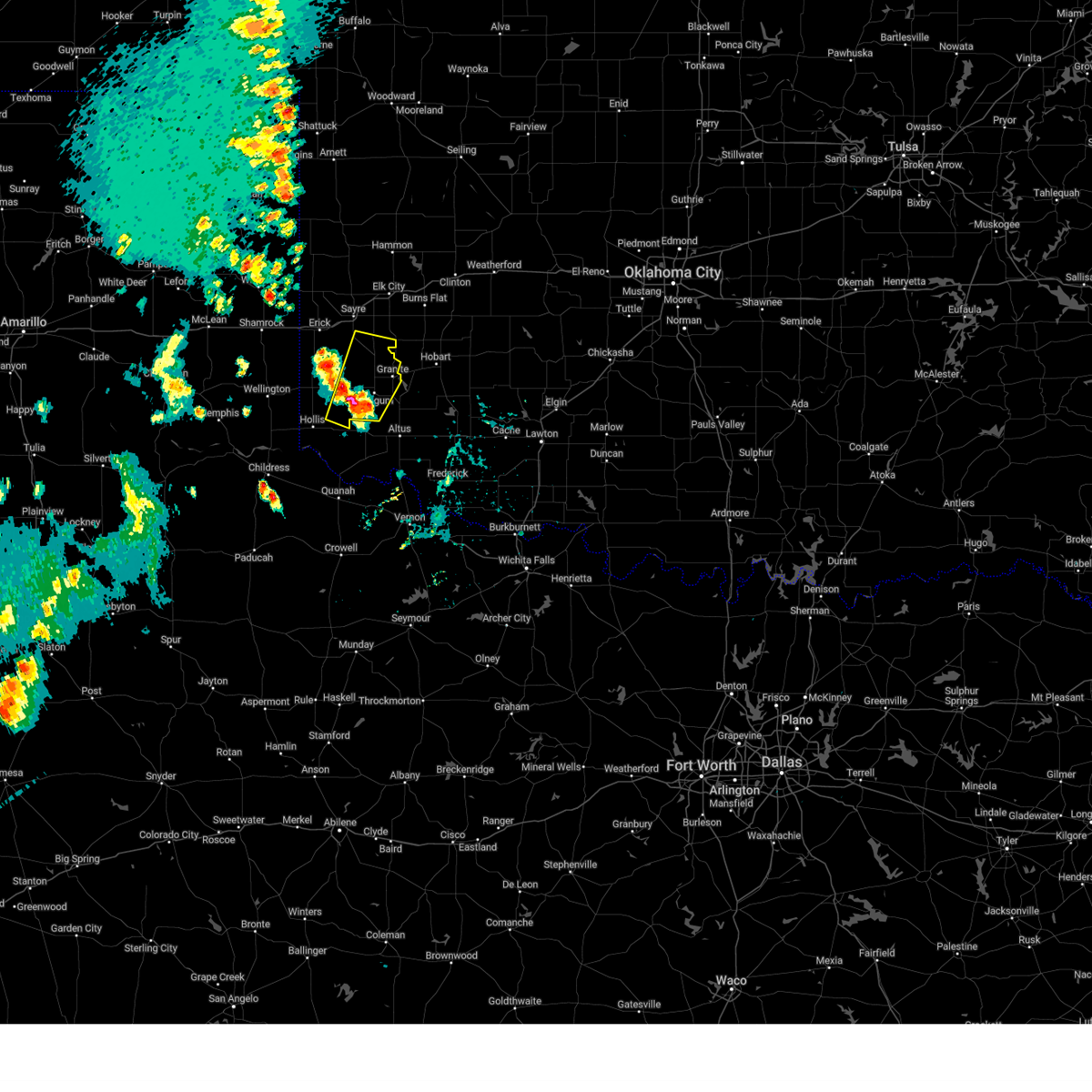
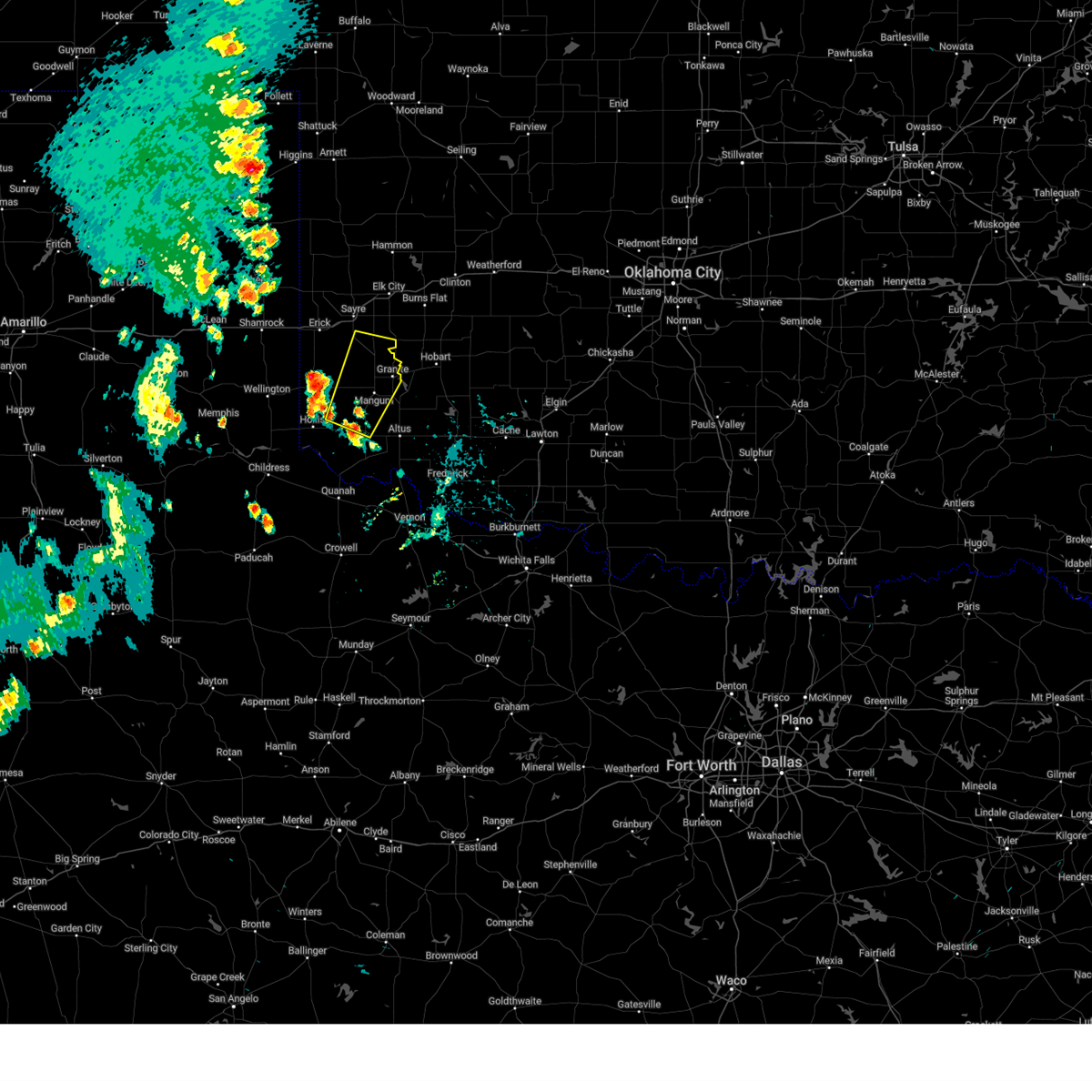
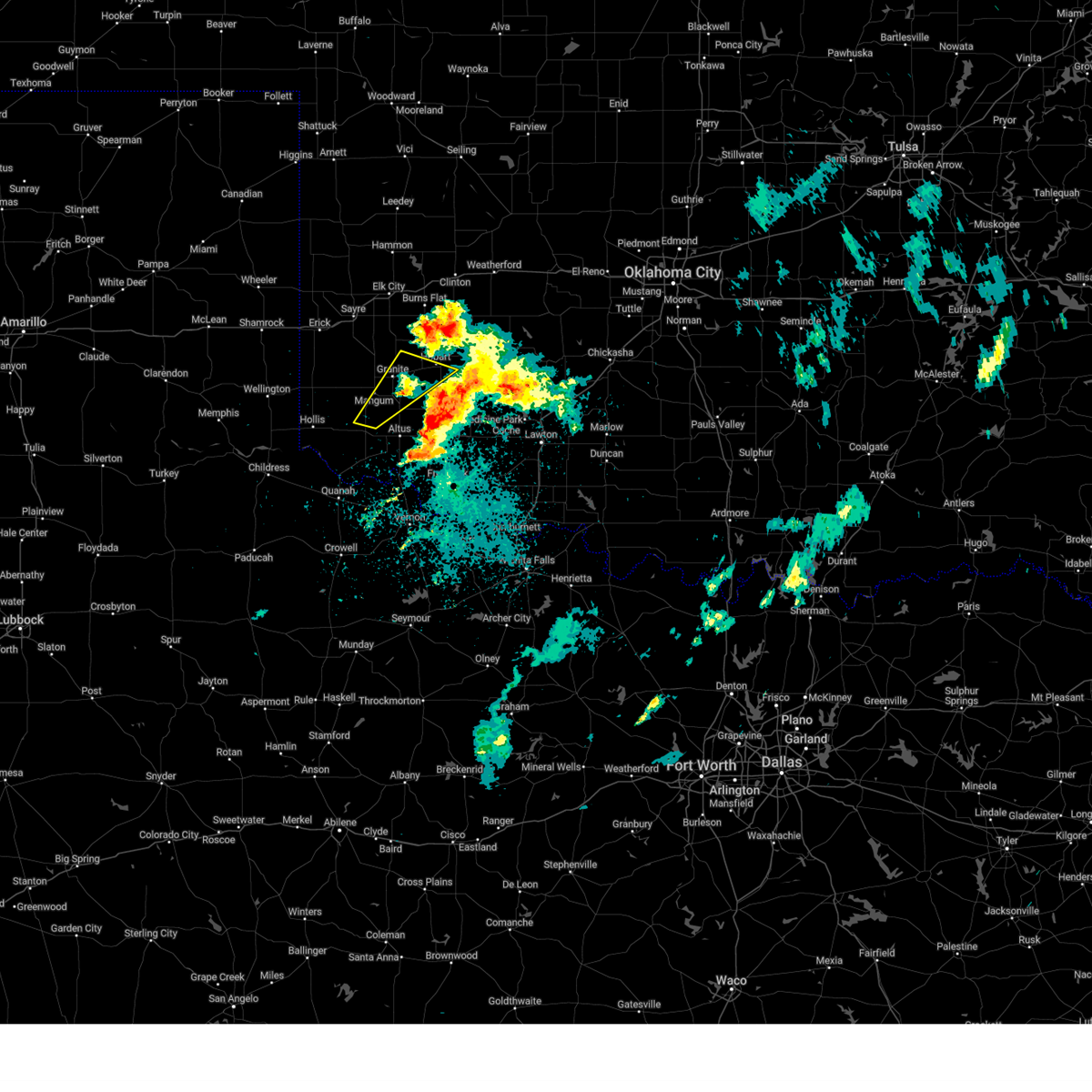
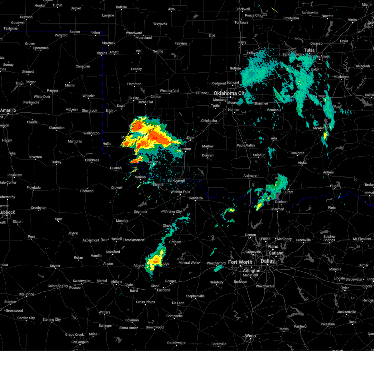
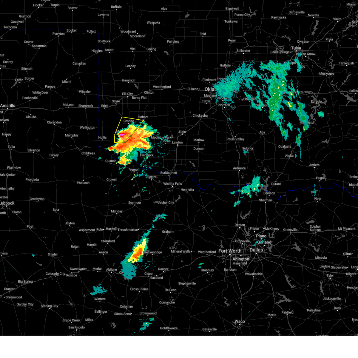
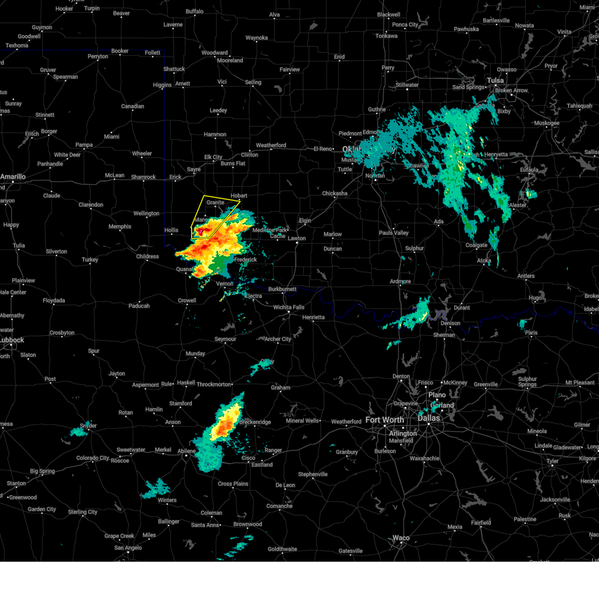
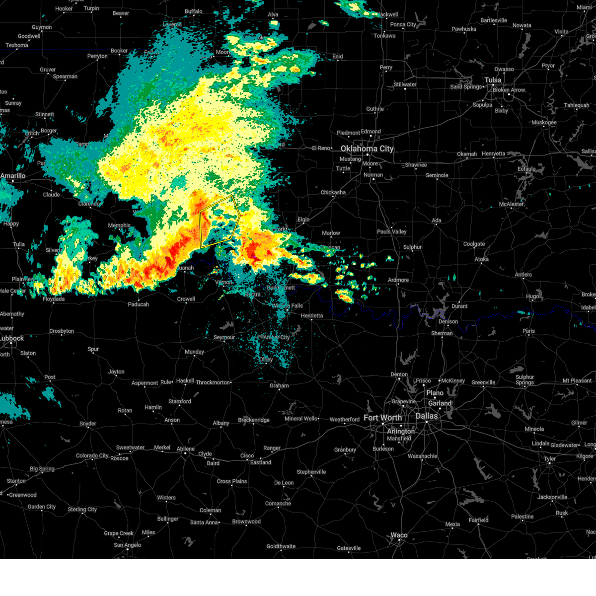
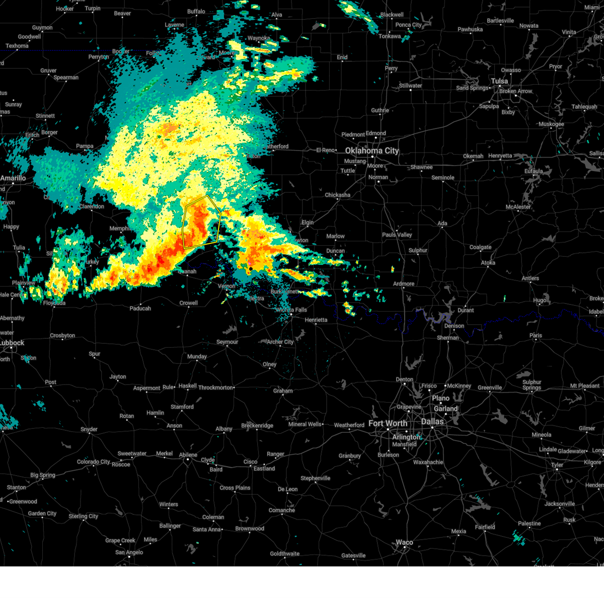
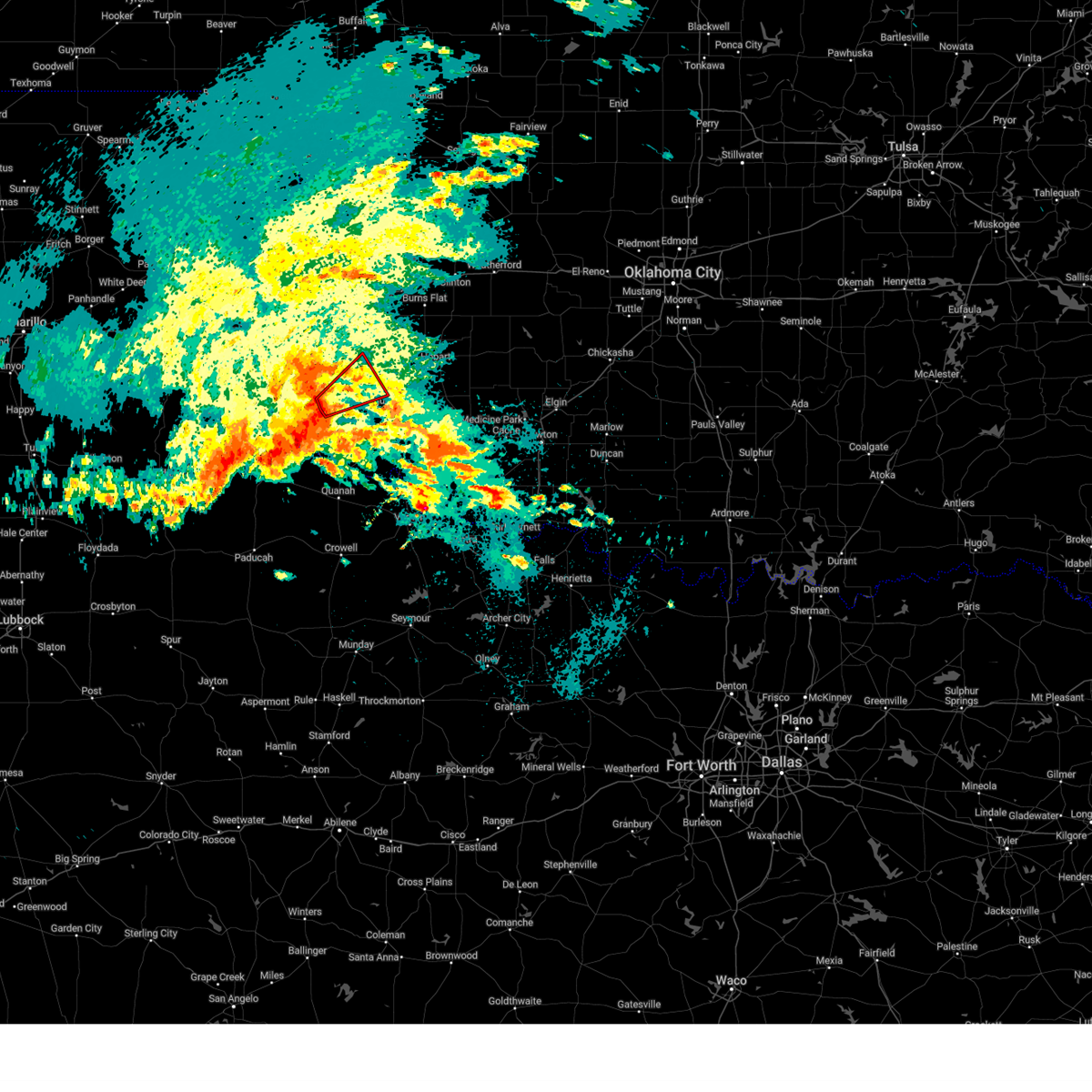
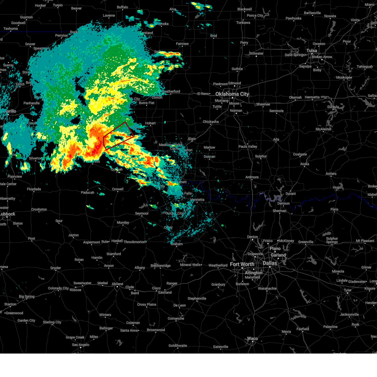
Hail Map for Mangum, OK
The Mangum, OK area has had 39 reports of on-the-ground hail by trained spotters, and has been under severe weather warnings 43 times during the past 12 months. Doppler radar has detected hail at or near Mangum, OK on 92 occasions, including 4 occasions during the past year.
| Name: | Mangum, OK |
| Where Located: | 50.8 miles NE of Childress, TX |
| Map: | Google Map for Mangum, OK |
| Population: | 3010 |
| Housing Units: | 1529 |
| More Info: | Search Google for Mangum, OK |
1
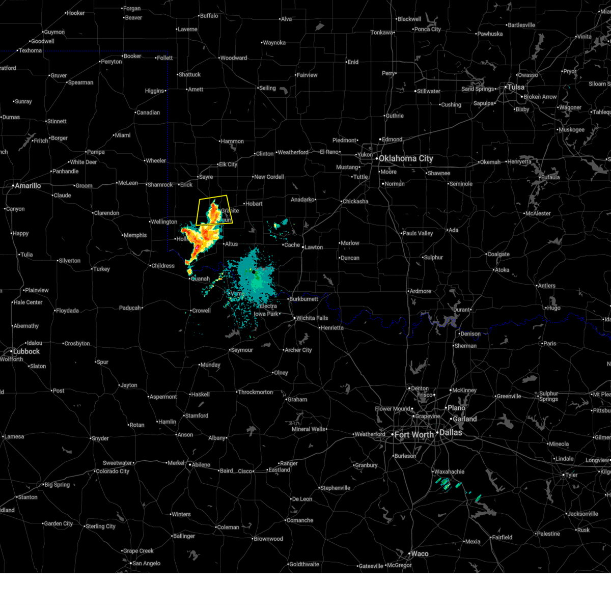
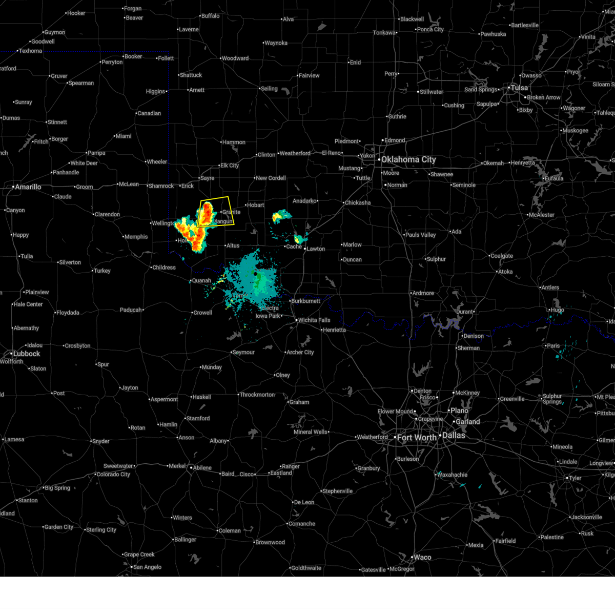
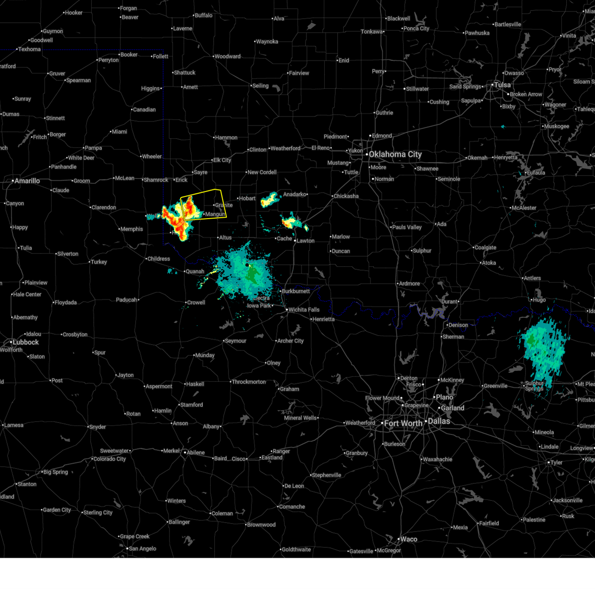
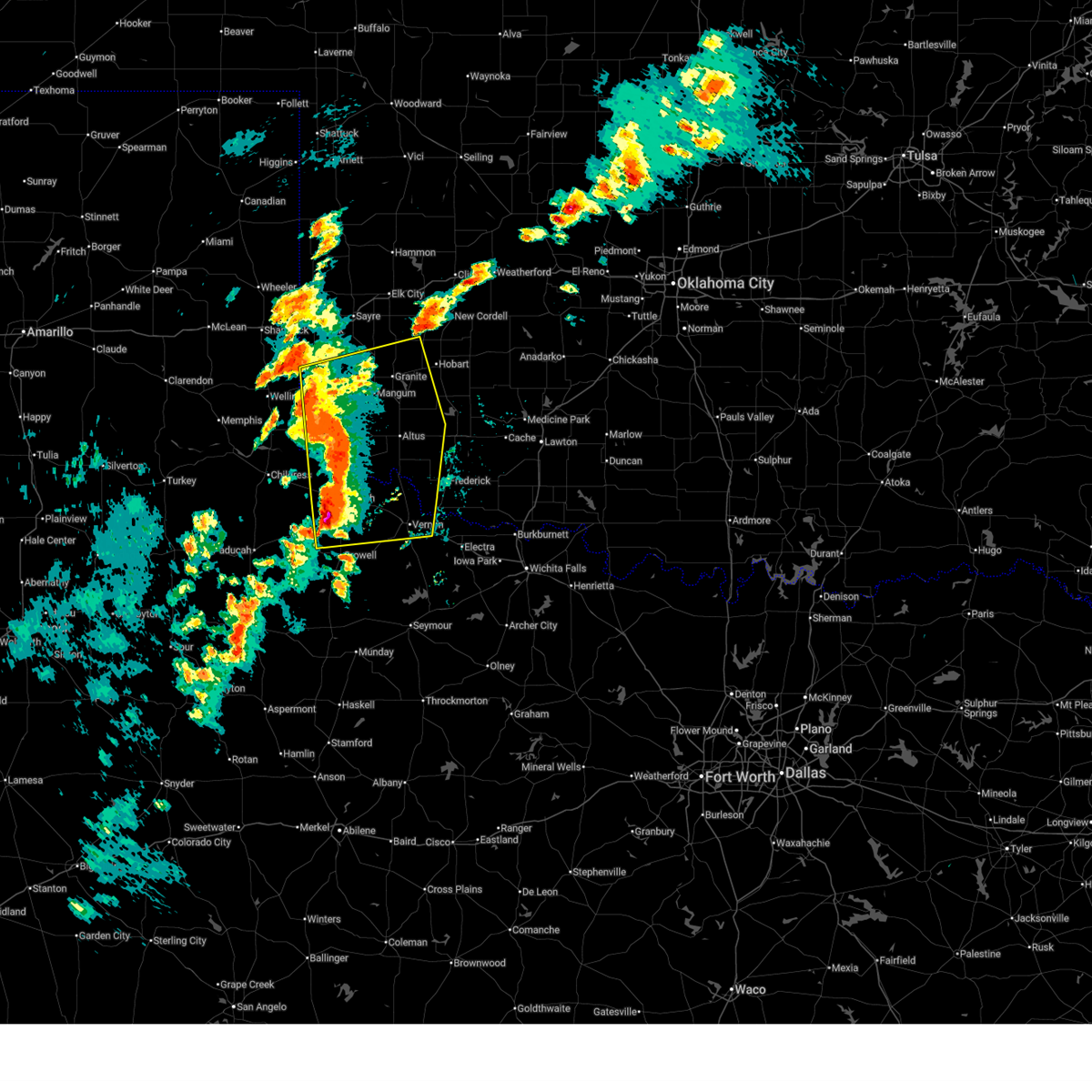
The Top Recent Hail Date for Mangum, OK is Friday, April 3, 2026 (24th out of 92)
Hail and Wind Damage Spotted near Mangum, OK
| Date / Time | Report Details |
|---|---|
| 7/5/2026 3:42 AM CDT |
 The storm which prompted the warning has weakened below severe limits, therefore the warning will be allowed to expire. The storm which prompted the warning has weakened below severe limits, therefore the warning will be allowed to expire.
|
| 7/5/2026 3:20 AM CDT |
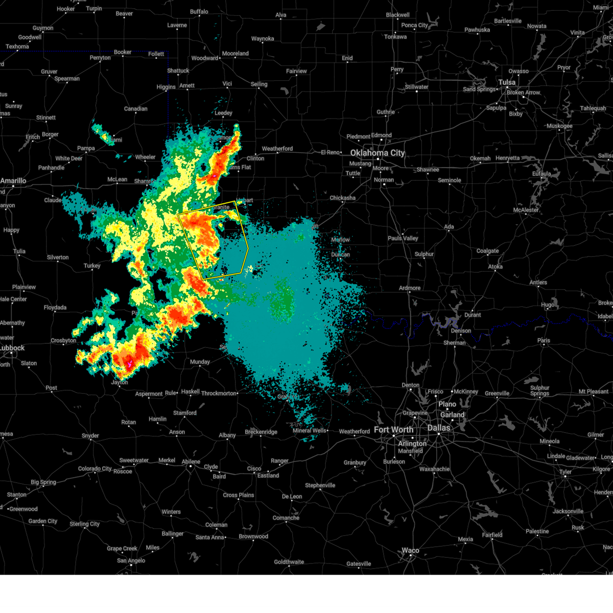
 At 320 am cdt, a severe thunderstorm was located near mangum, moving east at 25 mph (radar indicated). Hazards include 60 mph wind gusts and quarter size hail. Hail damage to vehicles is expected. expect wind damage to roofs, siding, and trees. Locations impacted include, mangum, granite, willow, brinkman, and altus-lugert lake. At 320 am cdt, a severe thunderstorm was located near mangum, moving east at 25 mph (radar indicated). Hazards include 60 mph wind gusts and quarter size hail. Hail damage to vehicles is expected. expect wind damage to roofs, siding, and trees. Locations impacted include, mangum, granite, willow, brinkman, and altus-lugert lake.
|
| 7/5/2026 2:58 AM CDT |
 Svroun the national weather service in norman has issued a * severe thunderstorm warning for, northwestern kiowa county in southwestern oklahoma, northeastern harmon county in southwestern oklahoma, greer county in southwestern oklahoma, * until 345 am cdt. * at 258 am cdt, a severe thunderstorm was located 9 miles northwest of mangum, moving east at 20 mph (radar indicated). Hazards include 60 mph wind gusts and quarter size hail. Hail damage to vehicles is expected. Expect wind damage to roofs, siding, and trees. Svroun the national weather service in norman has issued a * severe thunderstorm warning for, northwestern kiowa county in southwestern oklahoma, northeastern harmon county in southwestern oklahoma, greer county in southwestern oklahoma, * until 345 am cdt. * at 258 am cdt, a severe thunderstorm was located 9 miles northwest of mangum, moving east at 20 mph (radar indicated). Hazards include 60 mph wind gusts and quarter size hail. Hail damage to vehicles is expected. Expect wind damage to roofs, siding, and trees.
|
| 6/26/2026 12:16 AM CDT |
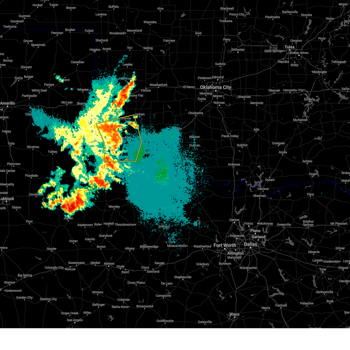
 At 1216 am cdt, severe thunderstorms were located along a line extending from 6 miles southwest of cloud chief to near roosevelt to 4 miles south of humphreys, moving east at 40 mph (radar indicated). Hazards include 70 mph wind gusts and penny size hail. Expect considerable tree damage. damage is likely to mobile homes, roofs, and outbuildings. Locations impacted include, altus, hobart, mangum, cache, granite, carnegie, snyder, sentinel, tipton, blair, mountain view, olustee, lone wolf, mountain park, indiahoma, roosevelt, gotebo, manitou, martha, and rocky. At 1216 am cdt, severe thunderstorms were located along a line extending from 6 miles southwest of cloud chief to near roosevelt to 4 miles south of humphreys, moving east at 40 mph (radar indicated). Hazards include 70 mph wind gusts and penny size hail. Expect considerable tree damage. damage is likely to mobile homes, roofs, and outbuildings. Locations impacted include, altus, hobart, mangum, cache, granite, carnegie, snyder, sentinel, tipton, blair, mountain view, olustee, lone wolf, mountain park, indiahoma, roosevelt, gotebo, manitou, martha, and rocky.
|
| 6/26/2026 12:07 AM CDT |
 Svroun the national weather service in norman has issued a * severe thunderstorm warning for, southern washita county in western oklahoma, northwestern comanche county in southwestern oklahoma, southwestern caddo county in southwestern oklahoma, jackson county in southwestern oklahoma, kiowa county in southwestern oklahoma, northwestern tillman county in southwestern oklahoma, eastern greer county in southwestern oklahoma, eastern beckham county in western oklahoma, * until 1245 am cdt. * at 1206 am cdt, severe thunderstorms were located along a line extending from 4 miles east of rocky to near roosevelt to 3 miles east of elmer, moving east at 40 mph (radar indicated). Hazards include 60 mph wind gusts and penny size hail. expect damage to roofs, siding, and trees Svroun the national weather service in norman has issued a * severe thunderstorm warning for, southern washita county in western oklahoma, northwestern comanche county in southwestern oklahoma, southwestern caddo county in southwestern oklahoma, jackson county in southwestern oklahoma, kiowa county in southwestern oklahoma, northwestern tillman county in southwestern oklahoma, eastern greer county in southwestern oklahoma, eastern beckham county in western oklahoma, * until 1245 am cdt. * at 1206 am cdt, severe thunderstorms were located along a line extending from 4 miles east of rocky to near roosevelt to 3 miles east of elmer, moving east at 40 mph (radar indicated). Hazards include 60 mph wind gusts and penny size hail. expect damage to roofs, siding, and trees
|
| 6/26/2026 12:03 AM CDT |
 At 1203 am cdt, severe thunderstorms were located along a line extending from near retrop to 7 miles northwest of roosevelt to near olustee, moving east at 30 mph (radar indicated). Hazards include 70 mph wind gusts and nickel size hail. Expect considerable tree damage. damage is likely to mobile homes, roofs, and outbuildings. Locations impacted include, altus, hobart, mangum, granite, sentinel, blair, olustee, lone wolf, carter, martha, willow, friendship, altus air force base, delhi, retrop, duke, warren, brinkman, hester, and altus-lugert lake. At 1203 am cdt, severe thunderstorms were located along a line extending from near retrop to 7 miles northwest of roosevelt to near olustee, moving east at 30 mph (radar indicated). Hazards include 70 mph wind gusts and nickel size hail. Expect considerable tree damage. damage is likely to mobile homes, roofs, and outbuildings. Locations impacted include, altus, hobart, mangum, granite, sentinel, blair, olustee, lone wolf, carter, martha, willow, friendship, altus air force base, delhi, retrop, duke, warren, brinkman, hester, and altus-lugert lake.
|
| 6/25/2026 11:50 PM CDT | Storm damage reported in greer county OK, 4.9 miles NW of Mangum, OK |
| 6/25/2026 11:26 PM CDT |
 Svroun the national weather service in norman has issued a * severe thunderstorm warning for, southwestern washita county in western oklahoma, jackson county in southwestern oklahoma, northwestern kiowa county in southwestern oklahoma, harmon county in southwestern oklahoma, greer county in southwestern oklahoma, southern beckham county in western oklahoma, * until 1215 am cdt. * at 1126 pm cdt, severe thunderstorms were located along a line extending from near erick to near mangum to 7 miles south of hollis, moving east at 30 mph (radar indicated). Hazards include 70 mph wind gusts and half dollar size hail. Hail damage to vehicles is expected. expect considerable tree damage. Wind damage is also likely to mobile homes, roofs, and outbuildings. Svroun the national weather service in norman has issued a * severe thunderstorm warning for, southwestern washita county in western oklahoma, jackson county in southwestern oklahoma, northwestern kiowa county in southwestern oklahoma, harmon county in southwestern oklahoma, greer county in southwestern oklahoma, southern beckham county in western oklahoma, * until 1215 am cdt. * at 1126 pm cdt, severe thunderstorms were located along a line extending from near erick to near mangum to 7 miles south of hollis, moving east at 30 mph (radar indicated). Hazards include 70 mph wind gusts and half dollar size hail. Hail damage to vehicles is expected. expect considerable tree damage. Wind damage is also likely to mobile homes, roofs, and outbuildings.
|
| 6/25/2026 11:18 PM CDT |
 At 1118 pm cdt, a severe thunderstorm was located near mangum, moving east at 25 mph (radar indicated). Hazards include golf ball size hail and 70 mph wind gusts. People and animals outdoors will be injured. expect hail damage to roofs, siding, windows, and vehicles. expect considerable tree damage. wind damage is also likely to mobile homes, roofs, and outbuildings. Locations impacted include, mangum, granite, hester, brinkman, and northwestern altus-lugert lake. At 1118 pm cdt, a severe thunderstorm was located near mangum, moving east at 25 mph (radar indicated). Hazards include golf ball size hail and 70 mph wind gusts. People and animals outdoors will be injured. expect hail damage to roofs, siding, windows, and vehicles. expect considerable tree damage. wind damage is also likely to mobile homes, roofs, and outbuildings. Locations impacted include, mangum, granite, hester, brinkman, and northwestern altus-lugert lake.
|
| 6/25/2026 11:08 PM CDT |
 Svroun the national weather service in norman has issued a * severe thunderstorm warning for, central greer county in southwestern oklahoma, * until 1130 pm cdt. * at 1107 pm cdt, a severe thunderstorm was located 6 miles west of mangum, moving east at 30 mph (radar indicated). Hazards include golf ball size hail and 70 mph wind gusts. People and animals outdoors will be injured. expect hail damage to roofs, siding, windows, and vehicles. expect considerable tree damage. Wind damage is also likely to mobile homes, roofs, and outbuildings. Svroun the national weather service in norman has issued a * severe thunderstorm warning for, central greer county in southwestern oklahoma, * until 1130 pm cdt. * at 1107 pm cdt, a severe thunderstorm was located 6 miles west of mangum, moving east at 30 mph (radar indicated). Hazards include golf ball size hail and 70 mph wind gusts. People and animals outdoors will be injured. expect hail damage to roofs, siding, windows, and vehicles. expect considerable tree damage. Wind damage is also likely to mobile homes, roofs, and outbuildings.
|
| 6/25/2026 10:20 PM CDT |
 The storms which prompted the warning have weakened below severe limits, therefore the warning will be allowed to expire. however, gusty winds and heavy rain are still possible with these thunderstorms. The storms which prompted the warning have weakened below severe limits, therefore the warning will be allowed to expire. however, gusty winds and heavy rain are still possible with these thunderstorms.
|
| 6/25/2026 10:12 PM CDT |
 At 1011 pm cdt, severe thunderstorms were located along a line extending from 5 miles north of mangum to 4 miles northeast of blair to 3 miles northeast of duke, moving east at 30 mph (radar indicated). Hazards include 60 mph wind gusts and penny size hail. Expect damage to roofs, siding, and trees. Locations impacted include, altus, mangum, granite, blair, lone wolf, martha, willow, friendship, altus air force base, duke, warren, brinkman, hester, and altus-lugert lake. At 1011 pm cdt, severe thunderstorms were located along a line extending from 5 miles north of mangum to 4 miles northeast of blair to 3 miles northeast of duke, moving east at 30 mph (radar indicated). Hazards include 60 mph wind gusts and penny size hail. Expect damage to roofs, siding, and trees. Locations impacted include, altus, mangum, granite, blair, lone wolf, martha, willow, friendship, altus air force base, duke, warren, brinkman, hester, and altus-lugert lake.
|
| 6/25/2026 9:58 PM CDT |
 the severe thunderstorm warning has been cancelled and is no longer in effect the severe thunderstorm warning has been cancelled and is no longer in effect
|
| 6/25/2026 9:58 PM CDT |
 At 957 pm cdt, severe thunderstorms were located along a line extending from 3 miles southeast of willow to 6 miles northwest of blair to 7 miles northwest of duke, moving east at 20 mph (trained weather spotters. at 948 pm cdt, a 72 mph wind gust was reported northeast of mangum). Hazards include 70 mph wind gusts and ping pong ball size hail. People and animals outdoors will be injured. expect hail damage to roofs, siding, windows, and vehicles. expect considerable tree damage. wind damage is also likely to mobile homes, roofs, and outbuildings. Locations impacted include, altus, mangum, granite, blair, lone wolf, martha, willow, friendship, altus air force base, duke, warren, brinkman, hester, and altus-lugert lake. At 957 pm cdt, severe thunderstorms were located along a line extending from 3 miles southeast of willow to 6 miles northwest of blair to 7 miles northwest of duke, moving east at 20 mph (trained weather spotters. at 948 pm cdt, a 72 mph wind gust was reported northeast of mangum). Hazards include 70 mph wind gusts and ping pong ball size hail. People and animals outdoors will be injured. expect hail damage to roofs, siding, windows, and vehicles. expect considerable tree damage. wind damage is also likely to mobile homes, roofs, and outbuildings. Locations impacted include, altus, mangum, granite, blair, lone wolf, martha, willow, friendship, altus air force base, duke, warren, brinkman, hester, and altus-lugert lake.
|
| 6/25/2026 9:48 PM CDT | Storm damage reported in greer county OK, 3.8 miles SW of Mangum, OK |
| 6/25/2026 9:39 PM CDT |
 Svroun the national weather service in norman has issued a * severe thunderstorm warning for, southwestern washita county in western oklahoma, northern jackson county in southwestern oklahoma, northwestern kiowa county in southwestern oklahoma, eastern harmon county in southwestern oklahoma, greer county in southwestern oklahoma, southeastern beckham county in western oklahoma, * until 1030 pm cdt. * at 938 pm cdt, severe thunderstorms were located along a line extending from 5 miles south of carter to 7 miles southwest of willow to 8 miles southeast of vinson, moving southeast at 30 mph (radar indicated). Hazards include two inch hail and 70 mph wind gusts. People and animals outdoors will be injured. expect hail damage to roofs, siding, windows, and vehicles. expect considerable tree damage. Wind damage is also likely to mobile homes, roofs, and outbuildings. Svroun the national weather service in norman has issued a * severe thunderstorm warning for, southwestern washita county in western oklahoma, northern jackson county in southwestern oklahoma, northwestern kiowa county in southwestern oklahoma, eastern harmon county in southwestern oklahoma, greer county in southwestern oklahoma, southeastern beckham county in western oklahoma, * until 1030 pm cdt. * at 938 pm cdt, severe thunderstorms were located along a line extending from 5 miles south of carter to 7 miles southwest of willow to 8 miles southeast of vinson, moving southeast at 30 mph (radar indicated). Hazards include two inch hail and 70 mph wind gusts. People and animals outdoors will be injured. expect hail damage to roofs, siding, windows, and vehicles. expect considerable tree damage. Wind damage is also likely to mobile homes, roofs, and outbuildings.
|
| 6/25/2026 9:34 PM CDT |
 At 934 pm cdt, severe thunderstorms were located along a line extending from 3 miles south of carter to 9 miles east of vinson, moving east at 30 mph (radar indicated). Hazards include two inch hail and 70 mph wind gusts. People and animals outdoors will be injured. expect hail damage to roofs, siding, windows, and vehicles. expect considerable tree damage. wind damage is also likely to mobile homes, roofs, and outbuildings. Locations impacted include, mangum, granite, lone wolf, willow, vinson, brinkman, mcknight, and altus-lugert lake. At 934 pm cdt, severe thunderstorms were located along a line extending from 3 miles south of carter to 9 miles east of vinson, moving east at 30 mph (radar indicated). Hazards include two inch hail and 70 mph wind gusts. People and animals outdoors will be injured. expect hail damage to roofs, siding, windows, and vehicles. expect considerable tree damage. wind damage is also likely to mobile homes, roofs, and outbuildings. Locations impacted include, mangum, granite, lone wolf, willow, vinson, brinkman, mcknight, and altus-lugert lake.
|
| 6/25/2026 9:16 PM CDT |
 At 916 pm cdt, severe thunderstorms were located along a line extending from 6 miles south of carter to 4 miles northeast of vinson, moving southeast at 25 mph (radar indicated). Hazards include golf ball size hail and 70 mph wind gusts. People and animals outdoors will be injured. expect hail damage to roofs, siding, windows, and vehicles. expect considerable tree damage. wind damage is also likely to mobile homes, roofs, and outbuildings. Locations impacted include, mangum, granite, lone wolf, willow, delhi, vinson, brinkman, mcknight, and altus-lugert lake. At 916 pm cdt, severe thunderstorms were located along a line extending from 6 miles south of carter to 4 miles northeast of vinson, moving southeast at 25 mph (radar indicated). Hazards include golf ball size hail and 70 mph wind gusts. People and animals outdoors will be injured. expect hail damage to roofs, siding, windows, and vehicles. expect considerable tree damage. wind damage is also likely to mobile homes, roofs, and outbuildings. Locations impacted include, mangum, granite, lone wolf, willow, delhi, vinson, brinkman, mcknight, and altus-lugert lake.
|
| 6/25/2026 9:03 PM CDT |
 Svroun the national weather service in norman has issued a * severe thunderstorm warning for, northwestern kiowa county in southwestern oklahoma, northern harmon county in southwestern oklahoma, greer county in southwestern oklahoma, southern beckham county in western oklahoma, * until 945 pm cdt. * at 902 pm cdt, severe thunderstorms were located along a line extending from 3 miles southwest of carter to 10 miles north of vinson, moving southeast at 30 mph (radar indicated). Hazards include golf ball size hail and 70 mph wind gusts. People and animals outdoors will be injured. expect hail damage to roofs, siding, windows, and vehicles. expect considerable tree damage. Wind damage is also likely to mobile homes, roofs, and outbuildings. Svroun the national weather service in norman has issued a * severe thunderstorm warning for, northwestern kiowa county in southwestern oklahoma, northern harmon county in southwestern oklahoma, greer county in southwestern oklahoma, southern beckham county in western oklahoma, * until 945 pm cdt. * at 902 pm cdt, severe thunderstorms were located along a line extending from 3 miles southwest of carter to 10 miles north of vinson, moving southeast at 30 mph (radar indicated). Hazards include golf ball size hail and 70 mph wind gusts. People and animals outdoors will be injured. expect hail damage to roofs, siding, windows, and vehicles. expect considerable tree damage. Wind damage is also likely to mobile homes, roofs, and outbuildings.
|
| 6/23/2026 11:59 AM CDT |
 At 1158 am cdt, a severe thunderstorm was located 4 miles south of vinson, moving south at 30 mph (public. at 1155 am cdt, quarter size hail was reported southwest of vinson). Hazards include 70 mph wind gusts and ping pong ball size hail. People and animals outdoors will be injured. expect hail damage to roofs, siding, windows, and vehicles. expect considerable tree damage. wind damage is also likely to mobile homes, roofs, and outbuildings. Locations impacted include, mangum, hollis, willow, gould, vinson, madge, brinkman, and mcknight. At 1158 am cdt, a severe thunderstorm was located 4 miles south of vinson, moving south at 30 mph (public. at 1155 am cdt, quarter size hail was reported southwest of vinson). Hazards include 70 mph wind gusts and ping pong ball size hail. People and animals outdoors will be injured. expect hail damage to roofs, siding, windows, and vehicles. expect considerable tree damage. wind damage is also likely to mobile homes, roofs, and outbuildings. Locations impacted include, mangum, hollis, willow, gould, vinson, madge, brinkman, and mcknight.
|
| 6/23/2026 11:42 AM CDT |
 Svroun the national weather service in norman has issued a * severe thunderstorm warning for, harmon county in southwestern oklahoma, greer county in southwestern oklahoma, southwestern beckham county in western oklahoma, * until 1230 pm cdt. * at 1142 am cdt, a severe thunderstorm was located 4 miles northwest of vinson, moving south at 30 mph (radar indicated). Hazards include 70 mph wind gusts and ping pong ball size hail. People and animals outdoors will be injured. expect hail damage to roofs, siding, windows, and vehicles. expect considerable tree damage. Wind damage is also likely to mobile homes, roofs, and outbuildings. Svroun the national weather service in norman has issued a * severe thunderstorm warning for, harmon county in southwestern oklahoma, greer county in southwestern oklahoma, southwestern beckham county in western oklahoma, * until 1230 pm cdt. * at 1142 am cdt, a severe thunderstorm was located 4 miles northwest of vinson, moving south at 30 mph (radar indicated). Hazards include 70 mph wind gusts and ping pong ball size hail. People and animals outdoors will be injured. expect hail damage to roofs, siding, windows, and vehicles. expect considerable tree damage. Wind damage is also likely to mobile homes, roofs, and outbuildings.
|
| 5/29/2026 11:19 PM CDT |
 At 1119 pm cdt, severe thunderstorms were located along a line extending from 4 miles east of willow to 4 miles northwest of blair to 6 miles northwest of eldorado, moving east at 25 mph (radar indicated). Hazards include 60 mph wind gusts. Expect damage to roofs, siding, and trees. Locations impacted include, mangum, granite, blair, eldorado, martha, willow, gould, duke, brinkman, hester, altus-lugert lake, and mcqueen. At 1119 pm cdt, severe thunderstorms were located along a line extending from 4 miles east of willow to 4 miles northwest of blair to 6 miles northwest of eldorado, moving east at 25 mph (radar indicated). Hazards include 60 mph wind gusts. Expect damage to roofs, siding, and trees. Locations impacted include, mangum, granite, blair, eldorado, martha, willow, gould, duke, brinkman, hester, altus-lugert lake, and mcqueen.
|
| 5/29/2026 11:00 PM CDT |
 Svroun the national weather service in norman has issued a * severe thunderstorm warning for, western jackson county in southwestern oklahoma, northwestern kiowa county in southwestern oklahoma, southern harmon county in southwestern oklahoma, greer county in southwestern oklahoma, northwestern hardeman county in northern texas, * until 1145 pm cdt. * at 1059 pm cdt, severe thunderstorms were located along a line extending from 5 miles west of willow to 6 miles southwest of mangum to 11 miles south of hollis, moving east at 20 mph (the hollis mesonet measured a 63 mph wind gust). Hazards include 60 mph wind gusts. expect damage to roofs, siding, and trees Svroun the national weather service in norman has issued a * severe thunderstorm warning for, western jackson county in southwestern oklahoma, northwestern kiowa county in southwestern oklahoma, southern harmon county in southwestern oklahoma, greer county in southwestern oklahoma, northwestern hardeman county in northern texas, * until 1145 pm cdt. * at 1059 pm cdt, severe thunderstorms were located along a line extending from 5 miles west of willow to 6 miles southwest of mangum to 11 miles south of hollis, moving east at 20 mph (the hollis mesonet measured a 63 mph wind gust). Hazards include 60 mph wind gusts. expect damage to roofs, siding, and trees
|
| 5/18/2026 5:38 PM CDT |
 At 538 pm cdt, a severe thunderstorm was located near granite, moving northeast at 30 mph (radar indicated). Hazards include 60 mph wind gusts and penny size hail. Expect damage to roofs, siding, and trees. Locations impacted include, mangum, granite, blair, lone wolf, hester, altus-lugert lake, and brinkman. At 538 pm cdt, a severe thunderstorm was located near granite, moving northeast at 30 mph (radar indicated). Hazards include 60 mph wind gusts and penny size hail. Expect damage to roofs, siding, and trees. Locations impacted include, mangum, granite, blair, lone wolf, hester, altus-lugert lake, and brinkman.
|
| 5/18/2026 5:28 PM CDT |
 At 527 pm cdt, a severe thunderstorm was located near mangum, moving northeast at 35 mph (public. at 525 pm cdt, half dollar size hail was reported near mangum). Hazards include 60 mph wind gusts and half dollar size hail. Hail damage to vehicles is expected. expect wind damage to roofs, siding, and trees. Locations impacted include, mangum, granite, blair, lone wolf, hester, altus-lugert lake, and brinkman. At 527 pm cdt, a severe thunderstorm was located near mangum, moving northeast at 35 mph (public. at 525 pm cdt, half dollar size hail was reported near mangum). Hazards include 60 mph wind gusts and half dollar size hail. Hail damage to vehicles is expected. expect wind damage to roofs, siding, and trees. Locations impacted include, mangum, granite, blair, lone wolf, hester, altus-lugert lake, and brinkman.
|
| 5/18/2026 5:25 PM CDT | Half Dollar sized hail reported 1 miles NW of Mangum, OK |
| 5/18/2026 5:13 PM CDT |
 At 513 pm cdt, a severe thunderstorm was located 6 miles west of martha, moving northeast at 30 mph (radar indicated). Hazards include 60 mph wind gusts and quarter size hail. Hail damage to vehicles is expected. expect wind damage to roofs, siding, and trees. Locations impacted include, mangum, granite, blair, lone wolf, martha, gould, duke, brinkman, hester, altus-lugert lake, and mcqueen. At 513 pm cdt, a severe thunderstorm was located 6 miles west of martha, moving northeast at 30 mph (radar indicated). Hazards include 60 mph wind gusts and quarter size hail. Hail damage to vehicles is expected. expect wind damage to roofs, siding, and trees. Locations impacted include, mangum, granite, blair, lone wolf, martha, gould, duke, brinkman, hester, altus-lugert lake, and mcqueen.
|
| 5/18/2026 4:52 PM CDT |
 Svroun the national weather service in norman has issued a * severe thunderstorm warning for, central jackson county in southwestern oklahoma, northwestern kiowa county in southwestern oklahoma, southeastern harmon county in southwestern oklahoma, greer county in southwestern oklahoma, * until 530 pm cdt. * at 451 pm cdt, a severe thunderstorm was located near duke, moving northeast at 40 mph (radar indicated). Hazards include 60 mph wind gusts and quarter size hail. Hail damage to vehicles is expected. Expect wind damage to roofs, siding, and trees. Svroun the national weather service in norman has issued a * severe thunderstorm warning for, central jackson county in southwestern oklahoma, northwestern kiowa county in southwestern oklahoma, southeastern harmon county in southwestern oklahoma, greer county in southwestern oklahoma, * until 530 pm cdt. * at 451 pm cdt, a severe thunderstorm was located near duke, moving northeast at 40 mph (radar indicated). Hazards include 60 mph wind gusts and quarter size hail. Hail damage to vehicles is expected. Expect wind damage to roofs, siding, and trees.
|
| 5/14/2026 8:14 PM CDT |
 The storms which prompted the warning have weakened below severe limits, therefore the warning will be allowed to expire. however, gusty winds of 50 mph are still possible with these thunderstorms. The storms which prompted the warning have weakened below severe limits, therefore the warning will be allowed to expire. however, gusty winds of 50 mph are still possible with these thunderstorms.
|
| 5/14/2026 8:00 PM CDT |
 At 759 pm cdt, severe thunderstorms were located 6 miles northwest of duke, 5 miles northwest of eldorado, 3 miles northwest of quanah and 11 miles east of swearingen. these storms are moving east at 40 mph (radar indicated). Hazards include 60 mph wind gusts. Expect damage to roofs, siding, and trees. Locations impacted include, mangum, quanah, hollis, crowell, chillicothe, olustee, eldorado, gould, duke, margaret, goodlett, medicine mound, hester, lazare, mcqueen, copper breaks state park, and mcknight. At 759 pm cdt, severe thunderstorms were located 6 miles northwest of duke, 5 miles northwest of eldorado, 3 miles northwest of quanah and 11 miles east of swearingen. these storms are moving east at 40 mph (radar indicated). Hazards include 60 mph wind gusts. Expect damage to roofs, siding, and trees. Locations impacted include, mangum, quanah, hollis, crowell, chillicothe, olustee, eldorado, gould, duke, margaret, goodlett, medicine mound, hester, lazare, mcqueen, copper breaks state park, and mcknight.
|
| 5/14/2026 7:30 PM CDT |
 Svroun the national weather service in norman has issued a * severe thunderstorm warning for, western jackson county in southwestern oklahoma, harmon county in southwestern oklahoma, southwestern greer county in southwestern oklahoma, foard county in northern texas, western wilbarger county in northern texas, hardeman county in northern texas, * until 815 pm cdt. * at 729 pm cdt, severe thunderstorms were located along a line extending from 6 miles north of hollis to 4 miles northeast of paducah, moving east at 40 mph. a wind gust of 62 mph was measured near childress texas with this line of storms (radar indicated). Hazards include 60 mph wind gusts. expect damage to roofs, siding, and trees Svroun the national weather service in norman has issued a * severe thunderstorm warning for, western jackson county in southwestern oklahoma, harmon county in southwestern oklahoma, southwestern greer county in southwestern oklahoma, foard county in northern texas, western wilbarger county in northern texas, hardeman county in northern texas, * until 815 pm cdt. * at 729 pm cdt, severe thunderstorms were located along a line extending from 6 miles north of hollis to 4 miles northeast of paducah, moving east at 40 mph. a wind gust of 62 mph was measured near childress texas with this line of storms (radar indicated). Hazards include 60 mph wind gusts. expect damage to roofs, siding, and trees
|
| 5/14/2026 6:52 PM CDT |
 Svroun the national weather service in norman has issued a * severe thunderstorm warning for, western jackson county in southwestern oklahoma, harmon county in southwestern oklahoma, greer county in southwestern oklahoma, foard county in northern texas, western wilbarger county in northern texas, hardeman county in northern texas, * until 730 pm cdt. * at 652 pm cdt, severe thunderstorms were located along a line extending from 3 miles northwest of wellington to 3 miles northwest of childress to 11 miles east of matador, moving east at 20 mph (radar indicated). Hazards include 60 mph wind gusts. expect damage to roofs, siding, and trees Svroun the national weather service in norman has issued a * severe thunderstorm warning for, western jackson county in southwestern oklahoma, harmon county in southwestern oklahoma, greer county in southwestern oklahoma, foard county in northern texas, western wilbarger county in northern texas, hardeman county in northern texas, * until 730 pm cdt. * at 652 pm cdt, severe thunderstorms were located along a line extending from 3 miles northwest of wellington to 3 miles northwest of childress to 11 miles east of matador, moving east at 20 mph (radar indicated). Hazards include 60 mph wind gusts. expect damage to roofs, siding, and trees
|
| 4/14/2026 5:36 PM CDT |
 Svroun the national weather service in norman has issued a * severe thunderstorm warning for, northeastern harmon county in southwestern oklahoma, central greer county in southwestern oklahoma, * until 615 pm cdt. * at 536 pm cdt, a severe thunderstorm was located 6 miles southeast of vinson, moving northeast at 30 mph (radar indicated). Hazards include 60 mph wind gusts and quarter size hail. Hail damage to vehicles is expected. Expect wind damage to roofs, siding, and trees. Svroun the national weather service in norman has issued a * severe thunderstorm warning for, northeastern harmon county in southwestern oklahoma, central greer county in southwestern oklahoma, * until 615 pm cdt. * at 536 pm cdt, a severe thunderstorm was located 6 miles southeast of vinson, moving northeast at 30 mph (radar indicated). Hazards include 60 mph wind gusts and quarter size hail. Hail damage to vehicles is expected. Expect wind damage to roofs, siding, and trees.
|
| 4/3/2026 7:29 PM CDT |
 the severe thunderstorm warning has been cancelled and is no longer in effect the severe thunderstorm warning has been cancelled and is no longer in effect
|
| 4/3/2026 7:29 PM CDT |
 At 729 pm cdt, severe thunderstorms were located along a line extending from 7 miles south of carnegie to 4 miles southeast of warren to 7 miles south of hollis, moving east at 15 mph (radar indicated). Hazards include ping pong ball size hail and 60 mph wind gusts. People and animals outdoors will be injured. expect hail damage to roofs, siding, windows, and vehicles. expect wind damage to roofs, siding, and trees. Locations impacted include, altus, hobart, mangum, hollis, granite, snyder, blair, lone wolf, mountain park, roosevelt, gotebo, martha, gould, friendship, cooperton, altus air force base, tom steed reservoir, duke, warren, and hester. At 729 pm cdt, severe thunderstorms were located along a line extending from 7 miles south of carnegie to 4 miles southeast of warren to 7 miles south of hollis, moving east at 15 mph (radar indicated). Hazards include ping pong ball size hail and 60 mph wind gusts. People and animals outdoors will be injured. expect hail damage to roofs, siding, windows, and vehicles. expect wind damage to roofs, siding, and trees. Locations impacted include, altus, hobart, mangum, hollis, granite, snyder, blair, lone wolf, mountain park, roosevelt, gotebo, martha, gould, friendship, cooperton, altus air force base, tom steed reservoir, duke, warren, and hester.
|
| 4/3/2026 7:05 PM CDT |
 Svroun the national weather service in norman has issued a * severe thunderstorm warning for, northwestern comanche county in southwestern oklahoma, southwestern caddo county in southwestern oklahoma, jackson county in southwestern oklahoma, kiowa county in southwestern oklahoma, northwestern tillman county in southwestern oklahoma, southern harmon county in southwestern oklahoma, southeastern greer county in southwestern oklahoma, north central hardeman county in northern texas, * until 745 pm cdt. * at 705 pm cdt, severe thunderstorms were located along a line extending from 3 miles south of gotebo to 4 miles north of headrick to 11 miles southwest of gould, moving east at 15 mph (radar indicated). Hazards include ping pong ball size hail and 60 mph wind gusts. People and animals outdoors will be injured. expect hail damage to roofs, siding, windows, and vehicles. Expect wind damage to roofs, siding, and trees. Svroun the national weather service in norman has issued a * severe thunderstorm warning for, northwestern comanche county in southwestern oklahoma, southwestern caddo county in southwestern oklahoma, jackson county in southwestern oklahoma, kiowa county in southwestern oklahoma, northwestern tillman county in southwestern oklahoma, southern harmon county in southwestern oklahoma, southeastern greer county in southwestern oklahoma, north central hardeman county in northern texas, * until 745 pm cdt. * at 705 pm cdt, severe thunderstorms were located along a line extending from 3 miles south of gotebo to 4 miles north of headrick to 11 miles southwest of gould, moving east at 15 mph (radar indicated). Hazards include ping pong ball size hail and 60 mph wind gusts. People and animals outdoors will be injured. expect hail damage to roofs, siding, windows, and vehicles. Expect wind damage to roofs, siding, and trees.
|
| 4/1/2026 6:52 PM CDT |
 Svroun the national weather service in norman has issued a * severe thunderstorm warning for, southern washita county in western oklahoma, western comanche county in southwestern oklahoma, southwestern caddo county in southwestern oklahoma, jackson county in southwestern oklahoma, kiowa county in southwestern oklahoma, tillman county in southwestern oklahoma, greer county in southwestern oklahoma, southeastern beckham county in western oklahoma, central foard county in northern texas, northern wilbarger county in northern texas, southeastern hardeman county in northern texas, * until 730 pm cdt. * at 652 pm cdt, severe thunderstorms were located along a line extending from 6 miles north of granite to 5 miles north of warren to near humphreys to 3 miles west of vernon, moving northeast at 55 mph (radar indicated). Hazards include 70 mph wind gusts and quarter size hail. Hail damage to vehicles is expected. expect considerable tree damage. Wind damage is also likely to mobile homes, roofs, and outbuildings. Svroun the national weather service in norman has issued a * severe thunderstorm warning for, southern washita county in western oklahoma, western comanche county in southwestern oklahoma, southwestern caddo county in southwestern oklahoma, jackson county in southwestern oklahoma, kiowa county in southwestern oklahoma, tillman county in southwestern oklahoma, greer county in southwestern oklahoma, southeastern beckham county in western oklahoma, central foard county in northern texas, northern wilbarger county in northern texas, southeastern hardeman county in northern texas, * until 730 pm cdt. * at 652 pm cdt, severe thunderstorms were located along a line extending from 6 miles north of granite to 5 miles north of warren to near humphreys to 3 miles west of vernon, moving northeast at 55 mph (radar indicated). Hazards include 70 mph wind gusts and quarter size hail. Hail damage to vehicles is expected. expect considerable tree damage. Wind damage is also likely to mobile homes, roofs, and outbuildings.
|
| 4/1/2026 6:45 PM CDT | Storm damage reported in greer county OK, 4.9 miles NW of Mangum, OK |
| 4/1/2026 6:18 PM CDT |
 Svroun the national weather service in norman has issued a * severe thunderstorm warning for, southwestern washita county in western oklahoma, jackson county in southwestern oklahoma, western kiowa county in southwestern oklahoma, western tillman county in southwestern oklahoma, harmon county in southwestern oklahoma, greer county in southwestern oklahoma, southeastern beckham county in western oklahoma, northeastern foard county in northern texas, northwestern wilbarger county in northern texas, hardeman county in northern texas, * until 700 pm cdt. * at 618 pm cdt, severe thunderstorms were located along a line extending from 3 miles east of vinson to 5 miles east of gould to near eldorado to 6 miles northwest of margaret, moving northeast at 45 mph (radar indicated). Hazards include 70 mph wind gusts and half dollar size hail. Hail damage to vehicles is expected. expect considerable tree damage. Wind damage is also likely to mobile homes, roofs, and outbuildings. Svroun the national weather service in norman has issued a * severe thunderstorm warning for, southwestern washita county in western oklahoma, jackson county in southwestern oklahoma, western kiowa county in southwestern oklahoma, western tillman county in southwestern oklahoma, harmon county in southwestern oklahoma, greer county in southwestern oklahoma, southeastern beckham county in western oklahoma, northeastern foard county in northern texas, northwestern wilbarger county in northern texas, hardeman county in northern texas, * until 700 pm cdt. * at 618 pm cdt, severe thunderstorms were located along a line extending from 3 miles east of vinson to 5 miles east of gould to near eldorado to 6 miles northwest of margaret, moving northeast at 45 mph (radar indicated). Hazards include 70 mph wind gusts and half dollar size hail. Hail damage to vehicles is expected. expect considerable tree damage. Wind damage is also likely to mobile homes, roofs, and outbuildings.
|
| 3/31/2026 6:40 PM CDT |
 Svroun the national weather service in norman has issued a * severe thunderstorm warning for, western jackson county in southwestern oklahoma, west central kiowa county in southwestern oklahoma, harmon county in southwestern oklahoma, southeastern greer county in southwestern oklahoma, northwestern foard county in northern texas, western hardeman county in northern texas, * until 730 pm cdt. * at 639 pm cdt, severe thunderstorms were located along a line extending from 7 miles east of vinson to 4 miles southeast of childress, moving east at 25 mph (radar indicated). Hazards include 60 mph wind gusts and quarter size hail. Hail damage to vehicles is expected. Expect wind damage to roofs, siding, and trees. Svroun the national weather service in norman has issued a * severe thunderstorm warning for, western jackson county in southwestern oklahoma, west central kiowa county in southwestern oklahoma, harmon county in southwestern oklahoma, southeastern greer county in southwestern oklahoma, northwestern foard county in northern texas, western hardeman county in northern texas, * until 730 pm cdt. * at 639 pm cdt, severe thunderstorms were located along a line extending from 7 miles east of vinson to 4 miles southeast of childress, moving east at 25 mph (radar indicated). Hazards include 60 mph wind gusts and quarter size hail. Hail damage to vehicles is expected. Expect wind damage to roofs, siding, and trees.
|
| 9/15/2025 7:04 AM CDT | At 704 am cdt, a severe thunderstorm was located 8 miles northwest of duke, moving north at 10 mph (radar indicated). Hazards include 60 mph wind gusts. Expect damage to roofs, siding, and trees. Locations impacted include, mangum. |
| 9/15/2025 7:04 AM CDT | the severe thunderstorm warning has been cancelled and is no longer in effect |
| 9/15/2025 6:54 AM CDT | At 654 am cdt, a severe thunderstorm was located 7 miles northwest of duke, and is nearly stationary (radar indicated). Hazards include 60 mph wind gusts. Expect damage to roofs, siding, and trees. Locations impacted include, mangum. |
| 9/15/2025 6:39 AM CDT | Svroun the national weather service in norman has issued a * severe thunderstorm warning for, west central jackson county in southwestern oklahoma, eastern harmon county in southwestern oklahoma, southeastern greer county in southwestern oklahoma, * until 715 am cdt. * at 639 am cdt, a severe thunderstorm was located 5 miles north of duke, moving north at 10 mph (radar indicated). Hazards include 60 mph wind gusts and penny size hail. expect damage to roofs, siding, and trees |
| 8/17/2025 5:45 PM CDT |
 The storm which prompted the warning has weakened below severe limits, therefore the warning will be allowed to expire. however, gusty winds are still possible with this thunderstorm. The storm which prompted the warning has weakened below severe limits, therefore the warning will be allowed to expire. however, gusty winds are still possible with this thunderstorm.
|
| 8/17/2025 5:22 PM CDT |
 At 522 pm cdt, a severe thunderstorm was located 6 miles south of mangum, moving north at 10 mph (radar indicated). Hazards include 60 mph wind gusts. Expect damage to roofs, siding, and trees. Locations impacted include, mangum, martha, duke, hester, and brinkman. At 522 pm cdt, a severe thunderstorm was located 6 miles south of mangum, moving north at 10 mph (radar indicated). Hazards include 60 mph wind gusts. Expect damage to roofs, siding, and trees. Locations impacted include, mangum, martha, duke, hester, and brinkman.
|
| 8/17/2025 5:07 PM CDT |
 Svroun the national weather service in norman has issued a * severe thunderstorm warning for, northwestern jackson county in southwestern oklahoma, northeastern harmon county in southwestern oklahoma, central greer county in southwestern oklahoma, * until 545 pm cdt. * at 506 pm cdt, a severe thunderstorm was located 6 miles north of duke, moving north at 15 mph (radar indicated). Hazards include 60 mph wind gusts and quarter size hail. Hail damage to vehicles is expected. Expect wind damage to roofs, siding, and trees. Svroun the national weather service in norman has issued a * severe thunderstorm warning for, northwestern jackson county in southwestern oklahoma, northeastern harmon county in southwestern oklahoma, central greer county in southwestern oklahoma, * until 545 pm cdt. * at 506 pm cdt, a severe thunderstorm was located 6 miles north of duke, moving north at 15 mph (radar indicated). Hazards include 60 mph wind gusts and quarter size hail. Hail damage to vehicles is expected. Expect wind damage to roofs, siding, and trees.
|
| 7/9/2025 12:04 AM CDT |
 the severe thunderstorm warning has been cancelled and is no longer in effect the severe thunderstorm warning has been cancelled and is no longer in effect
|
| 7/9/2025 12:04 AM CDT |
 At 1203 am cdt, severe thunderstorms were located along a line extending from near bessie to 4 miles southwest of sentinel to 8 miles west of mangum, moving southeast at 50 mph (radar indicated). Hazards include 60 mph wind gusts. Expect damage to roofs, siding, and trees. Locations impacted include, elk city, clinton, hobart, mangum, cordell, granite, burns flat, sentinel, dill city, canute, lone wolf, carter, bessie, rocky, foss, willow, retrop, foss reservoir, brinkman, and stafford. At 1203 am cdt, severe thunderstorms were located along a line extending from near bessie to 4 miles southwest of sentinel to 8 miles west of mangum, moving southeast at 50 mph (radar indicated). Hazards include 60 mph wind gusts. Expect damage to roofs, siding, and trees. Locations impacted include, elk city, clinton, hobart, mangum, cordell, granite, burns flat, sentinel, dill city, canute, lone wolf, carter, bessie, rocky, foss, willow, retrop, foss reservoir, brinkman, and stafford.
|
| 7/8/2025 11:44 PM CDT |
 Svroun the national weather service in norman has issued a * severe thunderstorm warning for, western washita county in western oklahoma, southeastern roger mills county in western oklahoma, custer county in western oklahoma, northwestern kiowa county in southwestern oklahoma, northern harmon county in southwestern oklahoma, greer county in southwestern oklahoma, beckham county in western oklahoma, * until 1230 am cdt. * at 1144 pm cdt, severe thunderstorms were located along a line extending from near foss reservoir to 4 miles east of carter to 8 miles north of vinson, moving southeast at 50 mph (radar indicated). Hazards include 60 mph wind gusts and quarter size hail. Hail damage to vehicles is expected. Expect wind damage to roofs, siding, and trees. Svroun the national weather service in norman has issued a * severe thunderstorm warning for, western washita county in western oklahoma, southeastern roger mills county in western oklahoma, custer county in western oklahoma, northwestern kiowa county in southwestern oklahoma, northern harmon county in southwestern oklahoma, greer county in southwestern oklahoma, beckham county in western oklahoma, * until 1230 am cdt. * at 1144 pm cdt, severe thunderstorms were located along a line extending from near foss reservoir to 4 miles east of carter to 8 miles north of vinson, moving southeast at 50 mph (radar indicated). Hazards include 60 mph wind gusts and quarter size hail. Hail damage to vehicles is expected. Expect wind damage to roofs, siding, and trees.
|
| 7/8/2025 9:57 PM CDT |
 Svroun the national weather service in norman has issued a * severe thunderstorm warning for, southwestern roger mills county in western oklahoma, west central jackson county in southwestern oklahoma, harmon county in southwestern oklahoma, greer county in southwestern oklahoma, beckham county in western oklahoma, * until 1045 pm cdt. * at 957 pm cdt, severe thunderstorms were located along a line extending from 8 miles east of sweetwater to 6 miles southwest of mangum, moving southwest at 15 mph (radar indicated). Hazards include 60 mph wind gusts and quarter size hail. Hail damage to vehicles is expected. Expect wind damage to roofs, siding, and trees. Svroun the national weather service in norman has issued a * severe thunderstorm warning for, southwestern roger mills county in western oklahoma, west central jackson county in southwestern oklahoma, harmon county in southwestern oklahoma, greer county in southwestern oklahoma, beckham county in western oklahoma, * until 1045 pm cdt. * at 957 pm cdt, severe thunderstorms were located along a line extending from 8 miles east of sweetwater to 6 miles southwest of mangum, moving southwest at 15 mph (radar indicated). Hazards include 60 mph wind gusts and quarter size hail. Hail damage to vehicles is expected. Expect wind damage to roofs, siding, and trees.
|
| 6/15/2025 7:04 AM CDT |
 the severe thunderstorm warning has been cancelled and is no longer in effect the severe thunderstorm warning has been cancelled and is no longer in effect
|
| 6/15/2025 7:04 AM CDT |
 At 703 am cdt, the leading edge of winds from severe thunderstorms was located along a line extending from 7 miles southwest of dill city to near granite to 8 miles northeast of gould, moving southeast at 55 mph (radar indicated). Hazards include 60 mph wind gusts and penny size hail. Expect damage to roofs, siding, and trees. Locations impacted include, elk city, mangum, granite, sentinel, blair, dill city, lone wolf, carter, willow, gould, retrop, duke, vinson, madge, brinkman, hester, mcqueen, and altus-lugert lake. At 703 am cdt, the leading edge of winds from severe thunderstorms was located along a line extending from 7 miles southwest of dill city to near granite to 8 miles northeast of gould, moving southeast at 55 mph (radar indicated). Hazards include 60 mph wind gusts and penny size hail. Expect damage to roofs, siding, and trees. Locations impacted include, elk city, mangum, granite, sentinel, blair, dill city, lone wolf, carter, willow, gould, retrop, duke, vinson, madge, brinkman, hester, mcqueen, and altus-lugert lake.
|
| 6/15/2025 6:36 AM CDT |
 Svroun the national weather service in norman has issued a * severe thunderstorm warning for, southwestern washita county in western oklahoma, southeastern roger mills county in western oklahoma, northwestern jackson county in southwestern oklahoma, northwestern kiowa county in southwestern oklahoma, central harmon county in southwestern oklahoma, greer county in southwestern oklahoma, beckham county in western oklahoma, * until 715 am cdt. * at 636 am cdt, the leading edge of winds from a line of severe thunderstorms was located along a line extending from 6 miles northwest of elk city to 4 miles east of delhi to 8 miles northwest of vinson, moving southeast at 35 mph (radar indicated). Hazards include 60 mph wind gusts and penny size hail. expect damage to roofs, siding, and trees Svroun the national weather service in norman has issued a * severe thunderstorm warning for, southwestern washita county in western oklahoma, southeastern roger mills county in western oklahoma, northwestern jackson county in southwestern oklahoma, northwestern kiowa county in southwestern oklahoma, central harmon county in southwestern oklahoma, greer county in southwestern oklahoma, beckham county in western oklahoma, * until 715 am cdt. * at 636 am cdt, the leading edge of winds from a line of severe thunderstorms was located along a line extending from 6 miles northwest of elk city to 4 miles east of delhi to 8 miles northwest of vinson, moving southeast at 35 mph (radar indicated). Hazards include 60 mph wind gusts and penny size hail. expect damage to roofs, siding, and trees
|
| 6/8/2025 4:53 PM CDT |
 the severe thunderstorm warning has been cancelled and is no longer in effect the severe thunderstorm warning has been cancelled and is no longer in effect
|
| 6/8/2025 4:37 PM CDT |
 Svroun the national weather service in norman has issued a * severe thunderstorm warning for, northern harmon county in southwestern oklahoma, central greer county in southwestern oklahoma, * until 515 pm cdt. * at 436 pm cdt, a few severe thunderstorms were located 6 miles north of dodson and 5 miles south of vinson, moving east at 35 mph (radar indicated). Hazards include 60 mph wind gusts and quarter size hail. Hail damage to vehicles is expected. Expect wind damage to roofs, siding, and trees. Svroun the national weather service in norman has issued a * severe thunderstorm warning for, northern harmon county in southwestern oklahoma, central greer county in southwestern oklahoma, * until 515 pm cdt. * at 436 pm cdt, a few severe thunderstorms were located 6 miles north of dodson and 5 miles south of vinson, moving east at 35 mph (radar indicated). Hazards include 60 mph wind gusts and quarter size hail. Hail damage to vehicles is expected. Expect wind damage to roofs, siding, and trees.
|
| 6/6/2025 9:42 PM CDT |
 the severe thunderstorm warning has been cancelled and is no longer in effect the severe thunderstorm warning has been cancelled and is no longer in effect
|
| 6/6/2025 9:26 PM CDT |
 At 926 pm cdt, a severe thunderstorm was located near duke, moving east at 30 mph (radar indicated). Hazards include 60 mph wind gusts and quarter size hail. Hail damage to vehicles is expected. expect wind damage to roofs, siding, and trees. Locations impacted include, altus, mangum, blair, olustee, martha, elmer, altus air force base, duke, hester, and altus-lugert lake. At 926 pm cdt, a severe thunderstorm was located near duke, moving east at 30 mph (radar indicated). Hazards include 60 mph wind gusts and quarter size hail. Hail damage to vehicles is expected. expect wind damage to roofs, siding, and trees. Locations impacted include, altus, mangum, blair, olustee, martha, elmer, altus air force base, duke, hester, and altus-lugert lake.
|
| 6/6/2025 9:26 PM CDT |
 the severe thunderstorm warning has been cancelled and is no longer in effect the severe thunderstorm warning has been cancelled and is no longer in effect
|
| 6/6/2025 9:25 PM CDT |
 the severe thunderstorm warning has been cancelled and is no longer in effect the severe thunderstorm warning has been cancelled and is no longer in effect
|
| 6/6/2025 9:25 PM CDT |
 At 921 pm cdt, a severe thunderstorm was located 9 miles southwest of willow, moving northeast at 30 mph (radar indicated). Hazards include 60 mph wind gusts and quarter size hail. Hail damage to vehicles is expected. expect wind damage to roofs, siding, and trees. Locations impacted include, mangum, granite, carter, willow, delhi, brinkman, and northwestern altus-lugert lake. At 921 pm cdt, a severe thunderstorm was located 9 miles southwest of willow, moving northeast at 30 mph (radar indicated). Hazards include 60 mph wind gusts and quarter size hail. Hail damage to vehicles is expected. expect wind damage to roofs, siding, and trees. Locations impacted include, mangum, granite, carter, willow, delhi, brinkman, and northwestern altus-lugert lake.
|
| 6/6/2025 9:10 PM CDT |
 Svroun the national weather service in norman has issued a * severe thunderstorm warning for, jackson county in southwestern oklahoma, southeastern harmon county in southwestern oklahoma, southeastern greer county in southwestern oklahoma, * until 1000 pm cdt. * at 910 pm cdt, a severe thunderstorm was located 5 miles south of gould, moving east at 35 mph (radar indicated). Hazards include 60 mph wind gusts and quarter size hail. Hail damage to vehicles is expected. Expect wind damage to roofs, siding, and trees. Svroun the national weather service in norman has issued a * severe thunderstorm warning for, jackson county in southwestern oklahoma, southeastern harmon county in southwestern oklahoma, southeastern greer county in southwestern oklahoma, * until 1000 pm cdt. * at 910 pm cdt, a severe thunderstorm was located 5 miles south of gould, moving east at 35 mph (radar indicated). Hazards include 60 mph wind gusts and quarter size hail. Hail damage to vehicles is expected. Expect wind damage to roofs, siding, and trees.
|
| 6/6/2025 8:55 PM CDT |
 Svroun the national weather service in norman has issued a * severe thunderstorm warning for, northwestern kiowa county in southwestern oklahoma, central harmon county in southwestern oklahoma, greer county in southwestern oklahoma, southeastern beckham county in western oklahoma, * until 945 pm cdt. * at 855 pm cdt, a severe thunderstorm was located near vinson, moving northeast at 30 mph (radar indicated). Hazards include 60 mph wind gusts and quarter size hail. Hail damage to vehicles is expected. Expect wind damage to roofs, siding, and trees. Svroun the national weather service in norman has issued a * severe thunderstorm warning for, northwestern kiowa county in southwestern oklahoma, central harmon county in southwestern oklahoma, greer county in southwestern oklahoma, southeastern beckham county in western oklahoma, * until 945 pm cdt. * at 855 pm cdt, a severe thunderstorm was located near vinson, moving northeast at 30 mph (radar indicated). Hazards include 60 mph wind gusts and quarter size hail. Hail damage to vehicles is expected. Expect wind damage to roofs, siding, and trees.
|
| 6/6/2025 4:05 AM CDT | Heat burs in greer county OK, 4.2 miles NNW of Mangum, OK |
| 6/3/2025 2:14 PM CDT |
 Svroun the national weather service in norman has issued a * severe thunderstorm warning for, northwestern kiowa county in southwestern oklahoma, east central greer county in southwestern oklahoma, * until 300 pm cdt. * at 214 pm cdt, a severe thunderstorm was located near mangum, moving northeast at 25 mph (radar indicated). Hazards include 60 mph wind gusts and quarter size hail. Hail damage to vehicles is expected. expect wind damage to roofs, siding, and trees. Locations in or near the path include, mangum, altus-lugert lake, lone wolf, granite,. Svroun the national weather service in norman has issued a * severe thunderstorm warning for, northwestern kiowa county in southwestern oklahoma, east central greer county in southwestern oklahoma, * until 300 pm cdt. * at 214 pm cdt, a severe thunderstorm was located near mangum, moving northeast at 25 mph (radar indicated). Hazards include 60 mph wind gusts and quarter size hail. Hail damage to vehicles is expected. expect wind damage to roofs, siding, and trees. Locations in or near the path include, mangum, altus-lugert lake, lone wolf, granite,.
|
| 6/2/2025 9:25 PM CDT |
 Svroun the national weather service in norman has issued a * severe thunderstorm warning for, western washita county in western oklahoma, northwestern kiowa county in southwestern oklahoma, northeastern greer county in southwestern oklahoma, southeastern beckham county in western oklahoma, * until 1015 pm cdt. * at 924 pm cdt, a severe thunderstorm was located 4 miles west of willow, moving northeast at 30 mph (radar indicated). Hazards include 60 mph wind gusts and quarter size hail. Hail damage to vehicles is expected. Expect wind damage to roofs, siding, and trees. Svroun the national weather service in norman has issued a * severe thunderstorm warning for, western washita county in western oklahoma, northwestern kiowa county in southwestern oklahoma, northeastern greer county in southwestern oklahoma, southeastern beckham county in western oklahoma, * until 1015 pm cdt. * at 924 pm cdt, a severe thunderstorm was located 4 miles west of willow, moving northeast at 30 mph (radar indicated). Hazards include 60 mph wind gusts and quarter size hail. Hail damage to vehicles is expected. Expect wind damage to roofs, siding, and trees.
|
| 6/2/2025 8:49 PM CDT |
 Svroun the national weather service in norman has issued a * severe thunderstorm warning for, northwestern jackson county in southwestern oklahoma, west central kiowa county in southwestern oklahoma, harmon county in southwestern oklahoma, greer county in southwestern oklahoma, southeastern beckham county in western oklahoma, * until 930 pm cdt. * at 848 pm cdt, a severe thunderstorm was located 4 miles northwest of gould, moving northeast at 35 mph (radar indicated). Hazards include 60 mph wind gusts and quarter size hail. Hail damage to vehicles is expected. Expect wind damage to roofs, siding, and trees. Svroun the national weather service in norman has issued a * severe thunderstorm warning for, northwestern jackson county in southwestern oklahoma, west central kiowa county in southwestern oklahoma, harmon county in southwestern oklahoma, greer county in southwestern oklahoma, southeastern beckham county in western oklahoma, * until 930 pm cdt. * at 848 pm cdt, a severe thunderstorm was located 4 miles northwest of gould, moving northeast at 35 mph (radar indicated). Hazards include 60 mph wind gusts and quarter size hail. Hail damage to vehicles is expected. Expect wind damage to roofs, siding, and trees.
|
| 6/2/2025 6:43 PM CDT |
 Svroun the national weather service in norman has issued a * severe thunderstorm warning for, southwestern washita county in western oklahoma, northwestern kiowa county in southwestern oklahoma, greer county in southwestern oklahoma, southeastern beckham county in western oklahoma, * until 730 pm cdt. * at 642 pm cdt, a severe thunderstorm was located 7 miles northwest of mangum, moving northeast at 30 mph (radar indicated). Hazards include 60 mph wind gusts and quarter size hail. Hail damage to vehicles is expected. Expect wind damage to roofs, siding, and trees. Svroun the national weather service in norman has issued a * severe thunderstorm warning for, southwestern washita county in western oklahoma, northwestern kiowa county in southwestern oklahoma, greer county in southwestern oklahoma, southeastern beckham county in western oklahoma, * until 730 pm cdt. * at 642 pm cdt, a severe thunderstorm was located 7 miles northwest of mangum, moving northeast at 30 mph (radar indicated). Hazards include 60 mph wind gusts and quarter size hail. Hail damage to vehicles is expected. Expect wind damage to roofs, siding, and trees.
|
| 6/2/2025 6:41 PM CDT | Quarter sized hail reported 0.6 miles NNE of Mangum, OK, report from mping: quarter (1.00 in.). |
| 6/2/2025 6:33 PM CDT |
 At 632 pm cdt, a severe thunderstorm was located 8 miles west of mangum, moving north at 30 mph (radar indicated). Hazards include 60 mph wind gusts and quarter size hail. Hail damage to vehicles is expected. expect wind damage to roofs, siding, and trees. Locations impacted include, mangum, granite, willow, retrop, brinkman, hester, and northwestern altus-lugert lake. At 632 pm cdt, a severe thunderstorm was located 8 miles west of mangum, moving north at 30 mph (radar indicated). Hazards include 60 mph wind gusts and quarter size hail. Hail damage to vehicles is expected. expect wind damage to roofs, siding, and trees. Locations impacted include, mangum, granite, willow, retrop, brinkman, hester, and northwestern altus-lugert lake.
|
| 6/2/2025 6:33 PM CDT |
 the severe thunderstorm warning has been cancelled and is no longer in effect the severe thunderstorm warning has been cancelled and is no longer in effect
|
| 6/2/2025 6:15 PM CDT |
 Svroun the national weather service in norman has issued a * severe thunderstorm warning for, west central jackson county in southwestern oklahoma, northeastern harmon county in southwestern oklahoma, greer county in southwestern oklahoma, southeastern beckham county in western oklahoma, * until 645 pm cdt. * at 615 pm cdt, a severe thunderstorm was located 4 miles west of duke, moving north at 25 mph (radar indicated). Hazards include 60 mph wind gusts and quarter size hail. Hail damage to vehicles is expected. Expect wind damage to roofs, siding, and trees. Svroun the national weather service in norman has issued a * severe thunderstorm warning for, west central jackson county in southwestern oklahoma, northeastern harmon county in southwestern oklahoma, greer county in southwestern oklahoma, southeastern beckham county in western oklahoma, * until 645 pm cdt. * at 615 pm cdt, a severe thunderstorm was located 4 miles west of duke, moving north at 25 mph (radar indicated). Hazards include 60 mph wind gusts and quarter size hail. Hail damage to vehicles is expected. Expect wind damage to roofs, siding, and trees.
|
| 5/2/2025 12:28 AM CDT | Half Dollar sized hail reported 0.3 miles WSW of Mangum, OK |
| 4/28/2025 9:13 PM CDT |
 the severe thunderstorm warning has been cancelled and is no longer in effect the severe thunderstorm warning has been cancelled and is no longer in effect
|
| 4/28/2025 8:46 PM CDT |
 Svroun the national weather service in norman has issued a * severe thunderstorm warning for, north central jackson county in southwestern oklahoma, northwestern kiowa county in southwestern oklahoma, southeastern greer county in southwestern oklahoma, * until 930 pm cdt. * at 846 pm cdt, a severe thunderstorm was located 4 miles north of duke, moving northeast at 40 mph (radar indicated). Hazards include 60 mph wind gusts and quarter size hail. Hail damage to vehicles is expected. Expect wind damage to roofs, siding, and trees. Svroun the national weather service in norman has issued a * severe thunderstorm warning for, north central jackson county in southwestern oklahoma, northwestern kiowa county in southwestern oklahoma, southeastern greer county in southwestern oklahoma, * until 930 pm cdt. * at 846 pm cdt, a severe thunderstorm was located 4 miles north of duke, moving northeast at 40 mph (radar indicated). Hazards include 60 mph wind gusts and quarter size hail. Hail damage to vehicles is expected. Expect wind damage to roofs, siding, and trees.
|
| 4/28/2025 8:35 PM CDT |
 At 835 pm cdt, a severe thunderstorm was located near mangum, moving northeast at 35 mph. this is a destructive storm for mangum! (public). Hazards include three inch hail and 70 mph wind gusts. People and animals outdoors will be severely injured. expect shattered windows, extensive damage to roofs, siding, and vehicles. Locations impacted include, hobart, mangum, granite, blair, lone wolf, willow, brinkman, hester, and altus-lugert lake. At 835 pm cdt, a severe thunderstorm was located near mangum, moving northeast at 35 mph. this is a destructive storm for mangum! (public). Hazards include three inch hail and 70 mph wind gusts. People and animals outdoors will be severely injured. expect shattered windows, extensive damage to roofs, siding, and vehicles. Locations impacted include, hobart, mangum, granite, blair, lone wolf, willow, brinkman, hester, and altus-lugert lake.
|
| 4/28/2025 8:33 PM CDT | Tea Cup sized hail reported 0.3 miles WSW of Mangum, OK, photos on social media and nwschat. |
| 4/28/2025 8:32 PM CDT | Tea Cup sized hail reported 0.6 miles NNE of Mangum, OK, report from mping: tea cup (3.00 in.). |
| 4/28/2025 8:29 PM CDT | Half Dollar sized hail reported 0.6 miles NNE of Mangum, OK, report from mping: half dollar (1.25 in.). |
| 4/28/2025 8:23 PM CDT |
 At 823 pm cdt, a severe thunderstorm was located 4 miles south of mangum, moving northeast at 35 mph. this is a destructive storm for hester and mangum (radar indicated). Hazards include three inch hail and 70 mph wind gusts. People and animals outdoors will be severely injured. expect shattered windows, extensive damage to roofs, siding, and vehicles. Locations impacted include, hobart, mangum, granite, blair, lone wolf, martha, willow, duke, brinkman, hester, and altus-lugert lake. At 823 pm cdt, a severe thunderstorm was located 4 miles south of mangum, moving northeast at 35 mph. this is a destructive storm for hester and mangum (radar indicated). Hazards include three inch hail and 70 mph wind gusts. People and animals outdoors will be severely injured. expect shattered windows, extensive damage to roofs, siding, and vehicles. Locations impacted include, hobart, mangum, granite, blair, lone wolf, martha, willow, duke, brinkman, hester, and altus-lugert lake.
|
| 4/28/2025 8:18 PM CDT |
 Svroun the national weather service in norman has issued a * severe thunderstorm warning for, northwestern jackson county in southwestern oklahoma, northwestern kiowa county in southwestern oklahoma, central greer county in southwestern oklahoma, * until 900 pm cdt. * at 817 pm cdt, a severe thunderstorm was located 6 miles northeast of duke, moving northeast at 40 mph. this is a destructive storm for hester and mangum (radar indicated). Hazards include baseball size hail and 70 mph wind gusts. People and animals outdoors will be severely injured. Expect shattered windows, extensive damage to roofs, siding, and vehicles. Svroun the national weather service in norman has issued a * severe thunderstorm warning for, northwestern jackson county in southwestern oklahoma, northwestern kiowa county in southwestern oklahoma, central greer county in southwestern oklahoma, * until 900 pm cdt. * at 817 pm cdt, a severe thunderstorm was located 6 miles northeast of duke, moving northeast at 40 mph. this is a destructive storm for hester and mangum (radar indicated). Hazards include baseball size hail and 70 mph wind gusts. People and animals outdoors will be severely injured. Expect shattered windows, extensive damage to roofs, siding, and vehicles.
|
| 4/28/2025 6:56 PM CDT | Quarter sized hail reported 9.4 miles WNW of Mangum, OK |
| 4/26/2025 5:54 AM CDT |
 Svroun the national weather service in norman has issued a * severe thunderstorm warning for, northeastern jackson county in southwestern oklahoma, western kiowa county in southwestern oklahoma, southeastern greer county in southwestern oklahoma, * until 645 am cdt. * at 554 am cdt, severe thunderstorms were located along a line extending from near mangum to near martha to 4 miles northwest of olustee, moving northeast at 25 mph (radar indicated). Hazards include 60 mph wind gusts and penny size hail. expect damage to roofs, siding, and trees Svroun the national weather service in norman has issued a * severe thunderstorm warning for, northeastern jackson county in southwestern oklahoma, western kiowa county in southwestern oklahoma, southeastern greer county in southwestern oklahoma, * until 645 am cdt. * at 554 am cdt, severe thunderstorms were located along a line extending from near mangum to near martha to 4 miles northwest of olustee, moving northeast at 25 mph (radar indicated). Hazards include 60 mph wind gusts and penny size hail. expect damage to roofs, siding, and trees
|
| 4/26/2025 5:39 AM CDT |
 At 539 am cdt, severe thunderstorms were located along a line extending from 6 miles south of willow to near mangum to near duke, moving northeast at 30 mph (radar indicated). Hazards include 60 mph wind gusts and penny size hail. Expect damage to roofs, siding, and trees. Locations impacted include, mangum, granite, martha, willow, gould, duke, brinkman, hester, and mcqueen. At 539 am cdt, severe thunderstorms were located along a line extending from 6 miles south of willow to near mangum to near duke, moving northeast at 30 mph (radar indicated). Hazards include 60 mph wind gusts and penny size hail. Expect damage to roofs, siding, and trees. Locations impacted include, mangum, granite, martha, willow, gould, duke, brinkman, hester, and mcqueen.
|
| 4/26/2025 5:10 AM CDT |
 Svroun the national weather service in norman has issued a * severe thunderstorm warning for, northwestern jackson county in southwestern oklahoma, central harmon county in southwestern oklahoma, greer county in southwestern oklahoma, * until 600 am cdt. * at 509 am cdt, severe thunderstorms were located along a line extending from 5 miles east of vinson to 10 miles northwest of duke to 5 miles south of gould, moving northeast at 30 mph (radar indicated). Hazards include 70 mph wind gusts and quarter size hail. Hail damage to vehicles is expected. expect considerable tree damage. Wind damage is also likely to mobile homes, roofs, and outbuildings. Svroun the national weather service in norman has issued a * severe thunderstorm warning for, northwestern jackson county in southwestern oklahoma, central harmon county in southwestern oklahoma, greer county in southwestern oklahoma, * until 600 am cdt. * at 509 am cdt, severe thunderstorms were located along a line extending from 5 miles east of vinson to 10 miles northwest of duke to 5 miles south of gould, moving northeast at 30 mph (radar indicated). Hazards include 70 mph wind gusts and quarter size hail. Hail damage to vehicles is expected. expect considerable tree damage. Wind damage is also likely to mobile homes, roofs, and outbuildings.
|
| 4/26/2025 5:07 AM CDT |
 the tornado warning has been cancelled and is no longer in effect the tornado warning has been cancelled and is no longer in effect
|
| 4/26/2025 4:58 AM CDT |
 At 457 am cdt, a severe thunderstorm capable of producing a tornado was located 7 miles south of vinson, moving east at 20 mph (radar indicated rotation). Hazards include tornado and half dollar size hail. Flying debris will be dangerous to those caught without shelter. mobile homes will be damaged or destroyed. damage to roofs, windows, and vehicles will occur. tree damage is likely. Locations impacted include, mangum and brinkman. At 457 am cdt, a severe thunderstorm capable of producing a tornado was located 7 miles south of vinson, moving east at 20 mph (radar indicated rotation). Hazards include tornado and half dollar size hail. Flying debris will be dangerous to those caught without shelter. mobile homes will be damaged or destroyed. damage to roofs, windows, and vehicles will occur. tree damage is likely. Locations impacted include, mangum and brinkman.
|
| 4/26/2025 4:39 AM CDT |
 Toroun the national weather service in norman has issued a * tornado warning for, central harmon county in southwestern oklahoma, central greer county in southwestern oklahoma, * until 530 am cdt. * at 439 am cdt, a severe thunderstorm capable of producing a tornado was located 5 miles east of dodson, moving northeast at 30 mph (radar indicated rotation). Hazards include tornado and half dollar size hail. Flying debris will be dangerous to those caught without shelter. mobile homes will be damaged or destroyed. damage to roofs, windows, and vehicles will occur. Tree damage is likely. Toroun the national weather service in norman has issued a * tornado warning for, central harmon county in southwestern oklahoma, central greer county in southwestern oklahoma, * until 530 am cdt. * at 439 am cdt, a severe thunderstorm capable of producing a tornado was located 5 miles east of dodson, moving northeast at 30 mph (radar indicated rotation). Hazards include tornado and half dollar size hail. Flying debris will be dangerous to those caught without shelter. mobile homes will be damaged or destroyed. damage to roofs, windows, and vehicles will occur. Tree damage is likely.
|
| 4/24/2025 1:27 AM CDT |
 At 126 am cdt, severe thunderstorms were located along a line extending from 5 miles northwest of mangum to near altus to 5 miles east of chillicothe, moving east at 35 mph (radar indicated). Hazards include 60 mph wind gusts and penny size hail. Expect damage to roofs, siding, and trees. Locations impacted include, altus, mangum, granite, tipton, blair, olustee, eldorado, lone wolf, martha, elmer, headrick, friendship, altus air force base, vinson, duke, warren, humphreys, odell, hester, and mcqueen. At 126 am cdt, severe thunderstorms were located along a line extending from 5 miles northwest of mangum to near altus to 5 miles east of chillicothe, moving east at 35 mph (radar indicated). Hazards include 60 mph wind gusts and penny size hail. Expect damage to roofs, siding, and trees. Locations impacted include, altus, mangum, granite, tipton, blair, olustee, eldorado, lone wolf, martha, elmer, headrick, friendship, altus air force base, vinson, duke, warren, humphreys, odell, hester, and mcqueen.
|
| 4/24/2025 1:15 AM CDT |
 At 114 am cdt, severe thunderstorms were located along a line extending from 8 miles east of vinson to 5 miles north of olustee to near chillicothe, moving east at 35 mph (radar indicated). Hazards include 60 mph wind gusts and nickel size hail. Expect damage to roofs, siding, and trees. Locations impacted include, altus, mangum, quanah, granite, tipton, blair, chillicothe, olustee, eldorado, lone wolf, martha, gould, elmer, headrick, friendship, altus air force base, vinson, warren, fargo, and humphreys. At 114 am cdt, severe thunderstorms were located along a line extending from 8 miles east of vinson to 5 miles north of olustee to near chillicothe, moving east at 35 mph (radar indicated). Hazards include 60 mph wind gusts and nickel size hail. Expect damage to roofs, siding, and trees. Locations impacted include, altus, mangum, quanah, granite, tipton, blair, chillicothe, olustee, eldorado, lone wolf, martha, gould, elmer, headrick, friendship, altus air force base, vinson, warren, fargo, and humphreys.
|
| 4/24/2025 12:56 AM CDT |
 Svroun the national weather service in norman has issued a * severe thunderstorm warning for, jackson county in southwestern oklahoma, western kiowa county in southwestern oklahoma, northwestern tillman county in southwestern oklahoma, harmon county in southwestern oklahoma, greer county in southwestern oklahoma, northwestern wilbarger county in northern texas, central hardeman county in northern texas, * until 145 am cdt. * at 1255 am cdt, severe thunderstorms were located along a line extending from 4 miles east of vinson to 6 miles north of eldorado to 5 miles south of quanah, moving east at 30 mph (radar indicated). Hazards include 60 mph wind gusts and quarter size hail. Hail damage to vehicles is expected. Expect wind damage to roofs, siding, and trees. Svroun the national weather service in norman has issued a * severe thunderstorm warning for, jackson county in southwestern oklahoma, western kiowa county in southwestern oklahoma, northwestern tillman county in southwestern oklahoma, harmon county in southwestern oklahoma, greer county in southwestern oklahoma, northwestern wilbarger county in northern texas, central hardeman county in northern texas, * until 145 am cdt. * at 1255 am cdt, severe thunderstorms were located along a line extending from 4 miles east of vinson to 6 miles north of eldorado to 5 miles south of quanah, moving east at 30 mph (radar indicated). Hazards include 60 mph wind gusts and quarter size hail. Hail damage to vehicles is expected. Expect wind damage to roofs, siding, and trees.
|
| 3/3/2025 11:14 PM CST |
 At 1113 pm cst, severe thunderstorms were located along a line extending from 7 miles north of hydro to near blair, moving east at 30 mph (radar indicated). Hazards include 60 mph wind gusts and quarter size hail. Hail damage to vehicles is expected. expect wind damage to roofs, siding, and trees. Locations impacted include, eakly, cordell, hester, tom steed reservoir, cloud chief, granite, weatherford, hobart, bridgeport, friendship, warren, roosevelt, lone wolf, martha, rocky, sentinel, corn, alfalfa, cowden, and clinton. At 1113 pm cst, severe thunderstorms were located along a line extending from 7 miles north of hydro to near blair, moving east at 30 mph (radar indicated). Hazards include 60 mph wind gusts and quarter size hail. Hail damage to vehicles is expected. expect wind damage to roofs, siding, and trees. Locations impacted include, eakly, cordell, hester, tom steed reservoir, cloud chief, granite, weatherford, hobart, bridgeport, friendship, warren, roosevelt, lone wolf, martha, rocky, sentinel, corn, alfalfa, cowden, and clinton.
|
| 3/3/2025 11:14 PM CST |
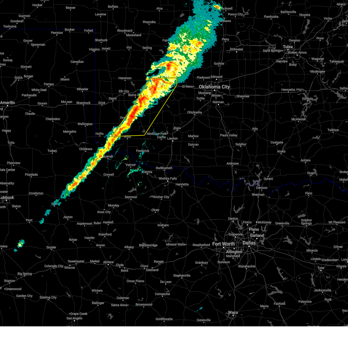 the severe thunderstorm warning has been cancelled and is no longer in effect the severe thunderstorm warning has been cancelled and is no longer in effect
|
| 3/3/2025 10:55 PM CST |
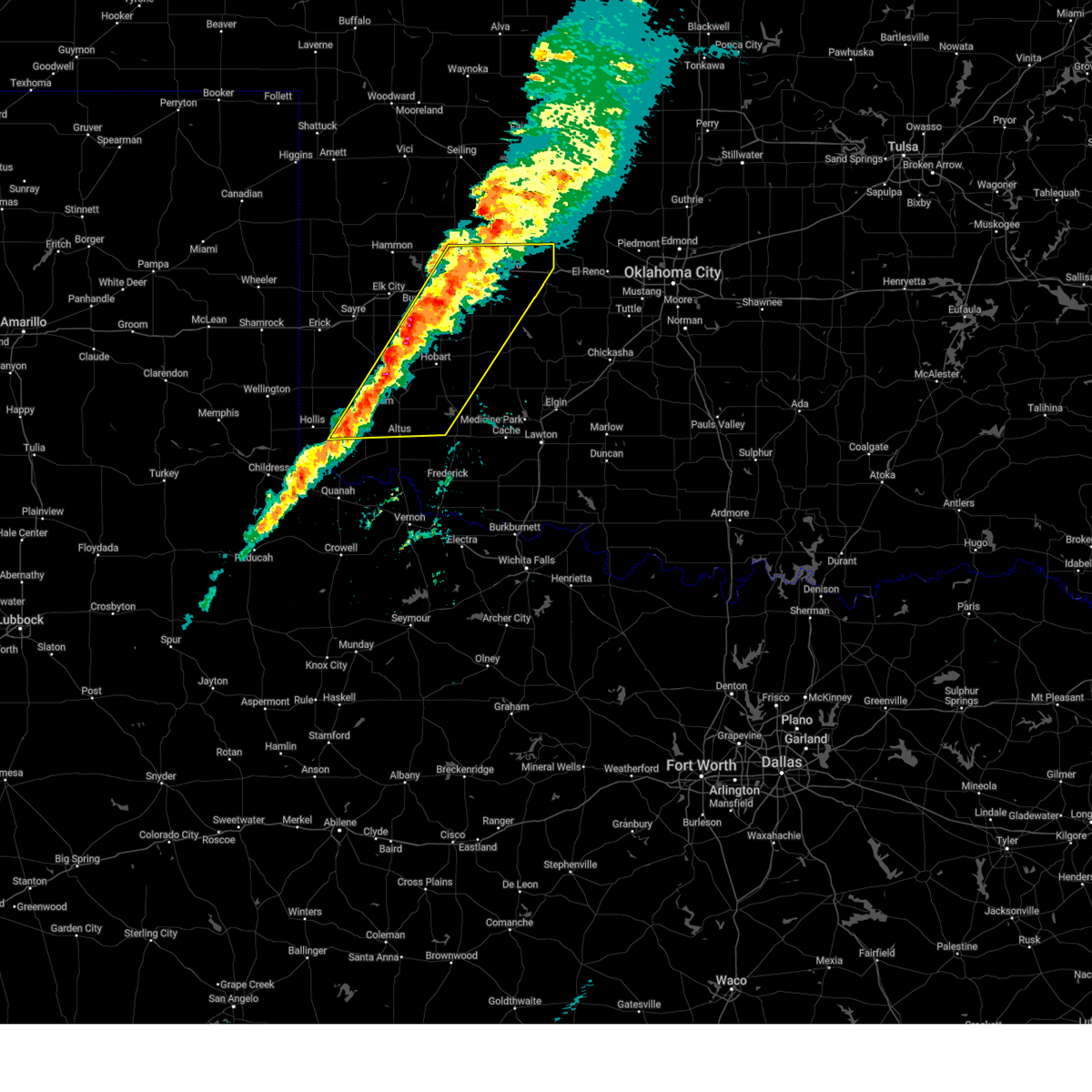 Svroun the national weather service in norman has issued a * severe thunderstorm warning for, washita county in western oklahoma, northwestern caddo county in southwestern oklahoma, northern jackson county in southwestern oklahoma, southeastern custer county in western oklahoma, kiowa county in southwestern oklahoma, southwestern blaine county in northwestern oklahoma, southeastern harmon county in southwestern oklahoma, eastern greer county in southwestern oklahoma, southeastern beckham county in western oklahoma, * until 1145 pm cst. * at 1054 pm cst, severe thunderstorms were located along a line extending from near cordell to near duke, moving east at 30 mph (radar indicated). Hazards include 60 mph wind gusts and quarter size hail. Hail damage to vehicles is expected. Expect wind damage to roofs, siding, and trees. Svroun the national weather service in norman has issued a * severe thunderstorm warning for, washita county in western oklahoma, northwestern caddo county in southwestern oklahoma, northern jackson county in southwestern oklahoma, southeastern custer county in western oklahoma, kiowa county in southwestern oklahoma, southwestern blaine county in northwestern oklahoma, southeastern harmon county in southwestern oklahoma, eastern greer county in southwestern oklahoma, southeastern beckham county in western oklahoma, * until 1145 pm cst. * at 1054 pm cst, severe thunderstorms were located along a line extending from near cordell to near duke, moving east at 30 mph (radar indicated). Hazards include 60 mph wind gusts and quarter size hail. Hail damage to vehicles is expected. Expect wind damage to roofs, siding, and trees.
|
| 3/3/2025 10:40 PM CST |
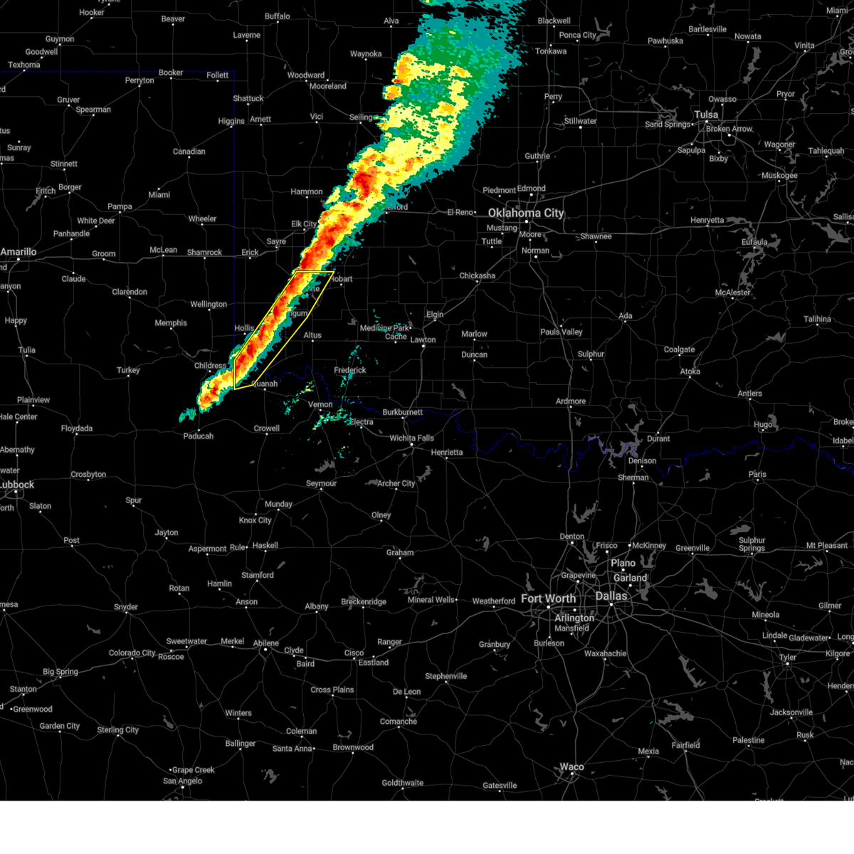 At 1040 pm cst, severe thunderstorms were located along a line extending from 3 miles east of retrop to 5 miles north of duke to 3 miles northwest of goodlett, moving east at 35 mph (radar indicated). Hazards include 60 mph wind gusts and quarter size hail. Hail damage to vehicles is expected. expect wind damage to roofs, siding, and trees. Locations impacted include, goodlett, brinkman, willow, gould, hester, mangum, duke, altus-lugert lake, lone wolf, mcqueen, and granite. At 1040 pm cst, severe thunderstorms were located along a line extending from 3 miles east of retrop to 5 miles north of duke to 3 miles northwest of goodlett, moving east at 35 mph (radar indicated). Hazards include 60 mph wind gusts and quarter size hail. Hail damage to vehicles is expected. expect wind damage to roofs, siding, and trees. Locations impacted include, goodlett, brinkman, willow, gould, hester, mangum, duke, altus-lugert lake, lone wolf, mcqueen, and granite.
|
| 3/3/2025 10:24 PM CST |
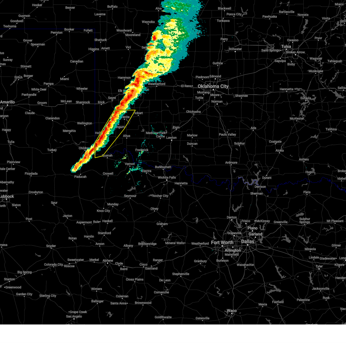 At 1024 pm cst, severe thunderstorms were located along a line extending from 4 miles west of retrop to 4 miles northeast of gould to 4 miles south of kirkland, moving east at 20 mph (radar indicated). Hazards include 60 mph wind gusts and half dollar size hail. Hail damage to vehicles is expected. expect wind damage to roofs, siding, and trees. Locations impacted include, goodlett, brinkman, willow, gould, hester, mangum, duke, altus-lugert lake, lone wolf, mcqueen, granite, and hollis. At 1024 pm cst, severe thunderstorms were located along a line extending from 4 miles west of retrop to 4 miles northeast of gould to 4 miles south of kirkland, moving east at 20 mph (radar indicated). Hazards include 60 mph wind gusts and half dollar size hail. Hail damage to vehicles is expected. expect wind damage to roofs, siding, and trees. Locations impacted include, goodlett, brinkman, willow, gould, hester, mangum, duke, altus-lugert lake, lone wolf, mcqueen, granite, and hollis.
|
| 3/3/2025 10:12 PM CST |
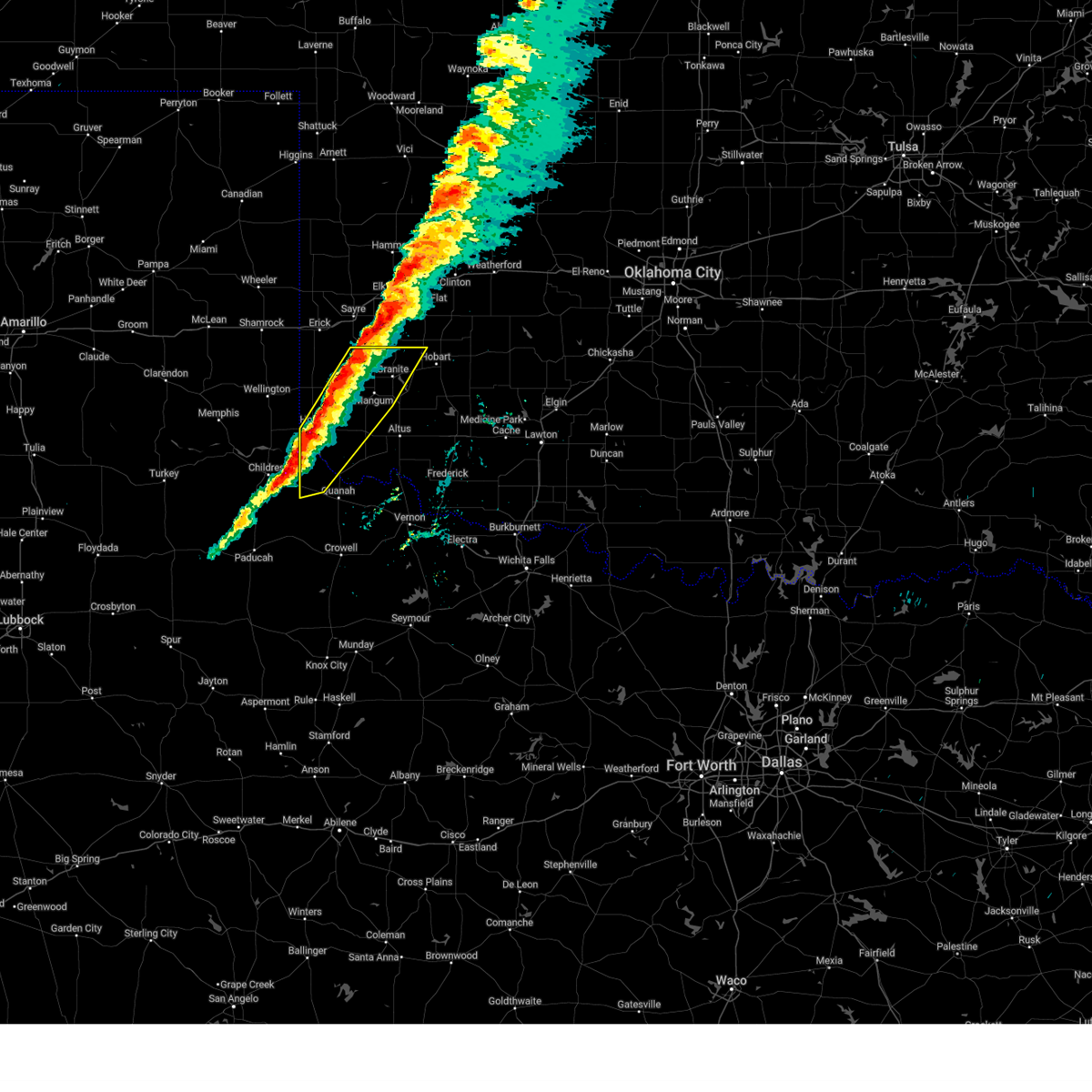 Svroun the national weather service in norman has issued a * severe thunderstorm warning for, northwestern jackson county in southwestern oklahoma, northwestern kiowa county in southwestern oklahoma, harmon county in southwestern oklahoma, greer county in southwestern oklahoma, northwestern hardeman county in northern texas, * until 1100 pm cst. * at 1012 pm cst, severe thunderstorms were located along a line extending from 5 miles north of willow to 3 miles north of gould to 6 miles southwest of kirkland, moving east at 20 mph (radar indicated). Hazards include 60 mph wind gusts and quarter size hail. Hail damage to vehicles is expected. Expect wind damage to roofs, siding, and trees. Svroun the national weather service in norman has issued a * severe thunderstorm warning for, northwestern jackson county in southwestern oklahoma, northwestern kiowa county in southwestern oklahoma, harmon county in southwestern oklahoma, greer county in southwestern oklahoma, northwestern hardeman county in northern texas, * until 1100 pm cst. * at 1012 pm cst, severe thunderstorms were located along a line extending from 5 miles north of willow to 3 miles north of gould to 6 miles southwest of kirkland, moving east at 20 mph (radar indicated). Hazards include 60 mph wind gusts and quarter size hail. Hail damage to vehicles is expected. Expect wind damage to roofs, siding, and trees.
|
| 11/18/2024 3:26 AM CST |
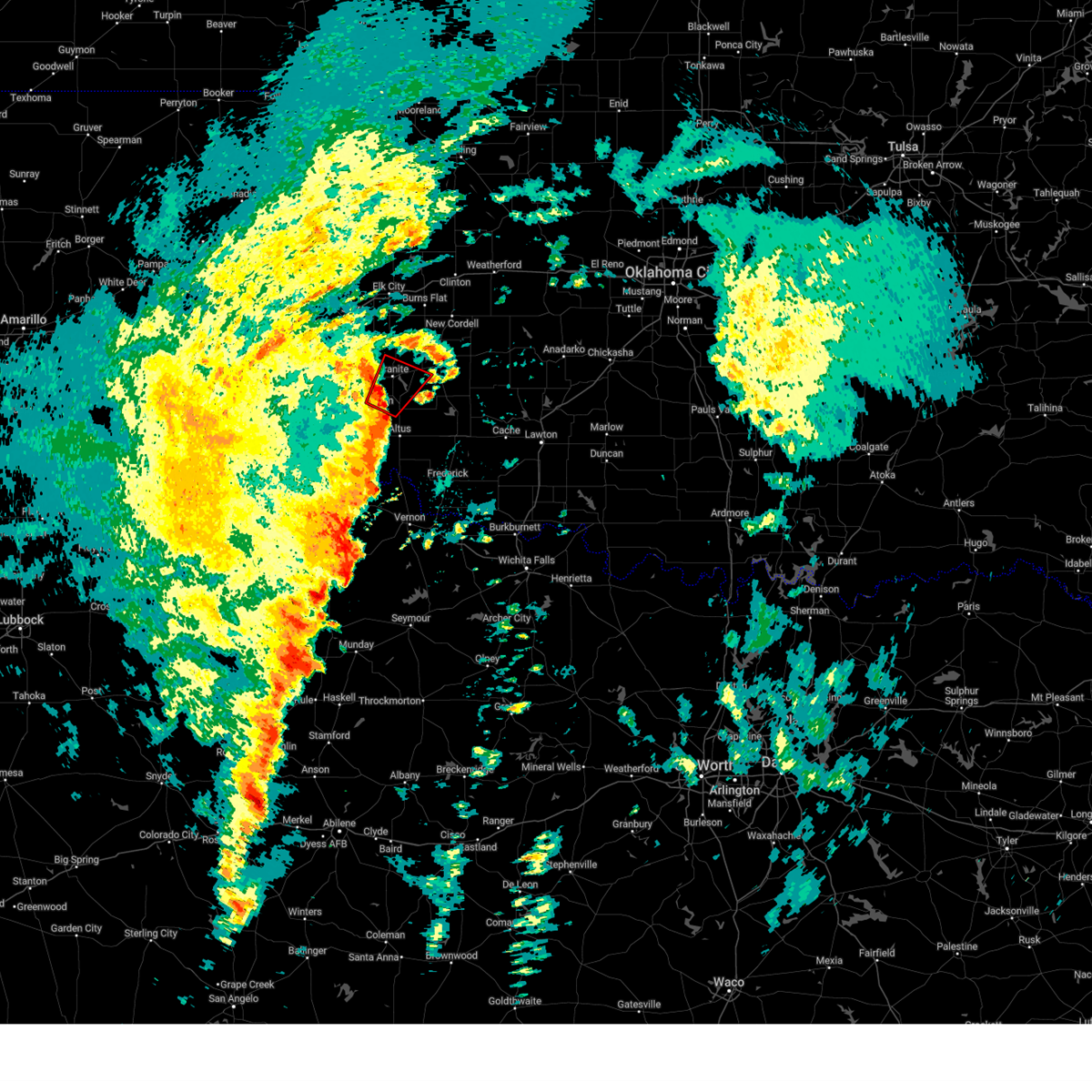 At 326 am cst, a confirmed tornado was located near mangum, moving northeast at 55 mph (radar confirmed tornado). Hazards include damaging tornado and golf ball size hail. Flying debris will be dangerous to those caught without shelter. mobile homes will be damaged or destroyed. damage to roofs, windows, and vehicles will occur. tree damage is likely. Locations impacted include, mangum, granite, blair, lone wolf, hester, and altus-lugert lake. At 326 am cst, a confirmed tornado was located near mangum, moving northeast at 55 mph (radar confirmed tornado). Hazards include damaging tornado and golf ball size hail. Flying debris will be dangerous to those caught without shelter. mobile homes will be damaged or destroyed. damage to roofs, windows, and vehicles will occur. tree damage is likely. Locations impacted include, mangum, granite, blair, lone wolf, hester, and altus-lugert lake.
|
| 11/18/2024 3:19 AM CST |
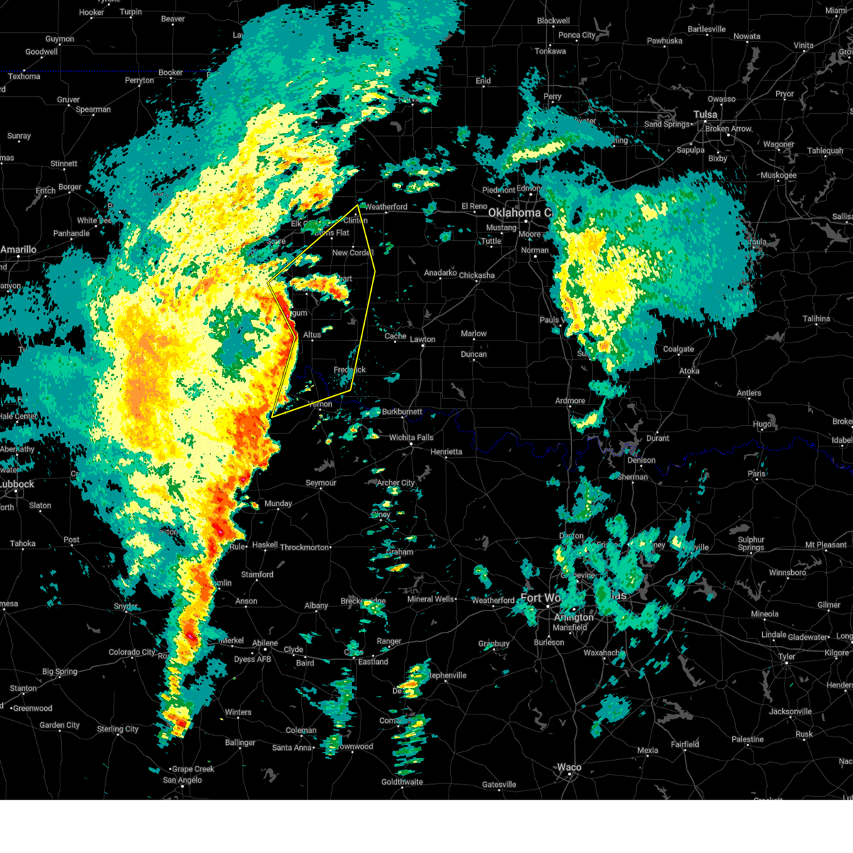 Svroun the national weather service in norman has issued a * severe thunderstorm warning for, western washita county in western oklahoma, jackson county in southwestern oklahoma, south central custer county in western oklahoma, kiowa county in southwestern oklahoma, northwestern tillman county in southwestern oklahoma, greer county in southwestern oklahoma, southeastern beckham county in western oklahoma, northwestern wilbarger county in northern texas, southeastern hardeman county in northern texas, * until 400 am cst. * at 319 am cst, severe thunderstorms were located along a line extending from 3 miles south of willow to 3 miles southwest of martha to near medicine mound, moving northeast at 45 mph (radar indicated). Hazards include 70 mph wind gusts and quarter size hail. Hail damage to vehicles is expected. expect considerable tree damage. Wind damage is also likely to mobile homes, roofs, and outbuildings. Svroun the national weather service in norman has issued a * severe thunderstorm warning for, western washita county in western oklahoma, jackson county in southwestern oklahoma, south central custer county in western oklahoma, kiowa county in southwestern oklahoma, northwestern tillman county in southwestern oklahoma, greer county in southwestern oklahoma, southeastern beckham county in western oklahoma, northwestern wilbarger county in northern texas, southeastern hardeman county in northern texas, * until 400 am cst. * at 319 am cst, severe thunderstorms were located along a line extending from 3 miles south of willow to 3 miles southwest of martha to near medicine mound, moving northeast at 45 mph (radar indicated). Hazards include 70 mph wind gusts and quarter size hail. Hail damage to vehicles is expected. expect considerable tree damage. Wind damage is also likely to mobile homes, roofs, and outbuildings.
|
| 11/18/2024 3:15 AM CST |
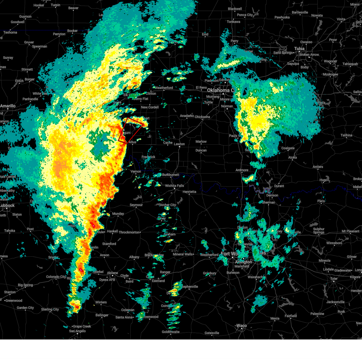 At 315 am cst, a confirmed tornado was located 5 miles north of duke, moving northeast at 55 mph (radar confirmed tornado). Hazards include damaging tornado and golf ball size hail. Flying debris will be dangerous to those caught without shelter. mobile homes will be damaged or destroyed. damage to roofs, windows, and vehicles will occur. tree damage is likely. Locations impacted include, mangum, granite, blair, lone wolf, martha, hester, and altus-lugert lake. At 315 am cst, a confirmed tornado was located 5 miles north of duke, moving northeast at 55 mph (radar confirmed tornado). Hazards include damaging tornado and golf ball size hail. Flying debris will be dangerous to those caught without shelter. mobile homes will be damaged or destroyed. damage to roofs, windows, and vehicles will occur. tree damage is likely. Locations impacted include, mangum, granite, blair, lone wolf, martha, hester, and altus-lugert lake.
|
| 11/18/2024 3:09 AM CST |
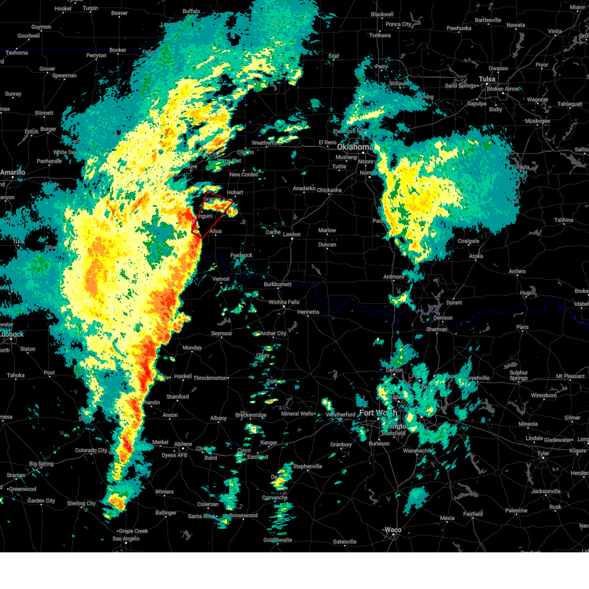 Toroun the national weather service in norman has issued a * tornado warning for, north central jackson county in southwestern oklahoma, northwestern kiowa county in southwestern oklahoma, eastern greer county in southwestern oklahoma, * until 345 am cst. * at 309 am cst, a severe thunderstorm capable of producing a tornado was located near duke, moving northeast at 55 mph (radar indicated rotation). Hazards include tornado and golf ball size hail. Flying debris will be dangerous to those caught without shelter. mobile homes will be damaged or destroyed. damage to roofs, windows, and vehicles will occur. Tree damage is likely. Toroun the national weather service in norman has issued a * tornado warning for, north central jackson county in southwestern oklahoma, northwestern kiowa county in southwestern oklahoma, eastern greer county in southwestern oklahoma, * until 345 am cst. * at 309 am cst, a severe thunderstorm capable of producing a tornado was located near duke, moving northeast at 55 mph (radar indicated rotation). Hazards include tornado and golf ball size hail. Flying debris will be dangerous to those caught without shelter. mobile homes will be damaged or destroyed. damage to roofs, windows, and vehicles will occur. Tree damage is likely.
|
| 11/18/2024 2:54 AM CST |
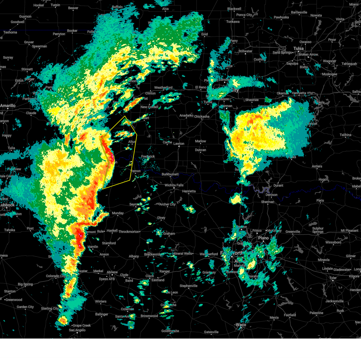 At 254 am cst, severe thunderstorms were located along a line extending from 3 miles southwest of gould to near eldorado to 4 miles northwest of crowell, moving northeast at 50 mph (radar indicated). Hazards include ping pong ball size hail and 60 mph wind gusts. People and animals outdoors will be injured. expect hail damage to roofs, siding, windows, and vehicles. expect wind damage to roofs, siding, and trees. Locations impacted include, altus, mangum, quanah, hollis, crowell, granite, blair, chillicothe, olustee, eldorado, martha, willow, gould, elmer, altus air force base, margaret, medicine mound, odell, duke, and lockett. At 254 am cst, severe thunderstorms were located along a line extending from 3 miles southwest of gould to near eldorado to 4 miles northwest of crowell, moving northeast at 50 mph (radar indicated). Hazards include ping pong ball size hail and 60 mph wind gusts. People and animals outdoors will be injured. expect hail damage to roofs, siding, windows, and vehicles. expect wind damage to roofs, siding, and trees. Locations impacted include, altus, mangum, quanah, hollis, crowell, granite, blair, chillicothe, olustee, eldorado, martha, willow, gould, elmer, altus air force base, margaret, medicine mound, odell, duke, and lockett.
|
| 11/18/2024 2:41 AM CST |
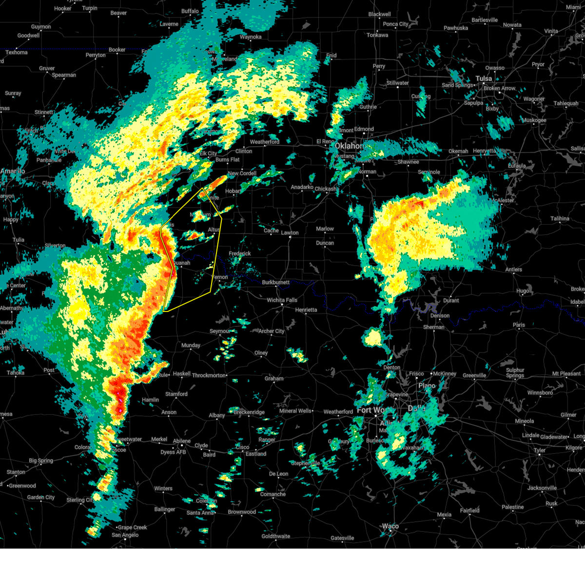 Svroun the national weather service in norman has issued a * severe thunderstorm warning for, jackson county in southwestern oklahoma, harmon county in southwestern oklahoma, greer county in southwestern oklahoma, central foard county in northern texas, northwestern wilbarger county in northern texas, hardeman county in northern texas, * until 330 am cst. * at 241 am cst, severe thunderstorms were located along a line extending from 10 miles northeast of kirkland to 4 miles east of goodlett to 12 miles west of crowell, moving northeast at 45 mph (goodlett mesonet site reported 62 mph wind gust). Hazards include 60 mph wind gusts and quarter size hail. Hail damage to vehicles is expected. Expect wind damage to roofs, siding, and trees. Svroun the national weather service in norman has issued a * severe thunderstorm warning for, jackson county in southwestern oklahoma, harmon county in southwestern oklahoma, greer county in southwestern oklahoma, central foard county in northern texas, northwestern wilbarger county in northern texas, hardeman county in northern texas, * until 330 am cst. * at 241 am cst, severe thunderstorms were located along a line extending from 10 miles northeast of kirkland to 4 miles east of goodlett to 12 miles west of crowell, moving northeast at 45 mph (goodlett mesonet site reported 62 mph wind gust). Hazards include 60 mph wind gusts and quarter size hail. Hail damage to vehicles is expected. Expect wind damage to roofs, siding, and trees.
|
| 10/30/2024 4:03 PM CDT |
 At 403 pm cdt, severe thunderstorms were located along a line extending from 3 miles southwest of burns flat to near mangum, moving northeast at 55 mph (radar indicated). Hazards include 60 mph wind gusts and quarter size hail. Hail damage to vehicles is expected. expect wind damage to roofs, siding, and trees. Locations impacted include, mangum, cordell, granite, burns flat, sentinel, dill city, canute, lone wolf, bessie, rocky, foss, willow, retrop, brinkman, hester, and altus-lugert lake. At 403 pm cdt, severe thunderstorms were located along a line extending from 3 miles southwest of burns flat to near mangum, moving northeast at 55 mph (radar indicated). Hazards include 60 mph wind gusts and quarter size hail. Hail damage to vehicles is expected. expect wind damage to roofs, siding, and trees. Locations impacted include, mangum, cordell, granite, burns flat, sentinel, dill city, canute, lone wolf, bessie, rocky, foss, willow, retrop, brinkman, hester, and altus-lugert lake.
|
| 10/30/2024 4:03 PM CDT |
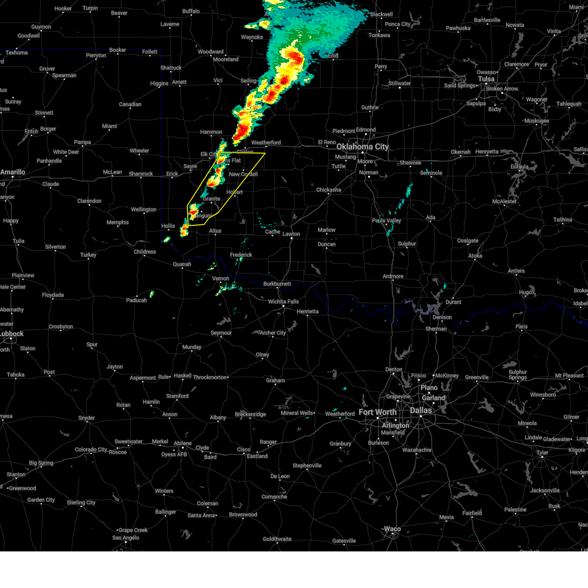 the severe thunderstorm warning has been cancelled and is no longer in effect the severe thunderstorm warning has been cancelled and is no longer in effect
|
| 10/30/2024 3:47 PM CDT |
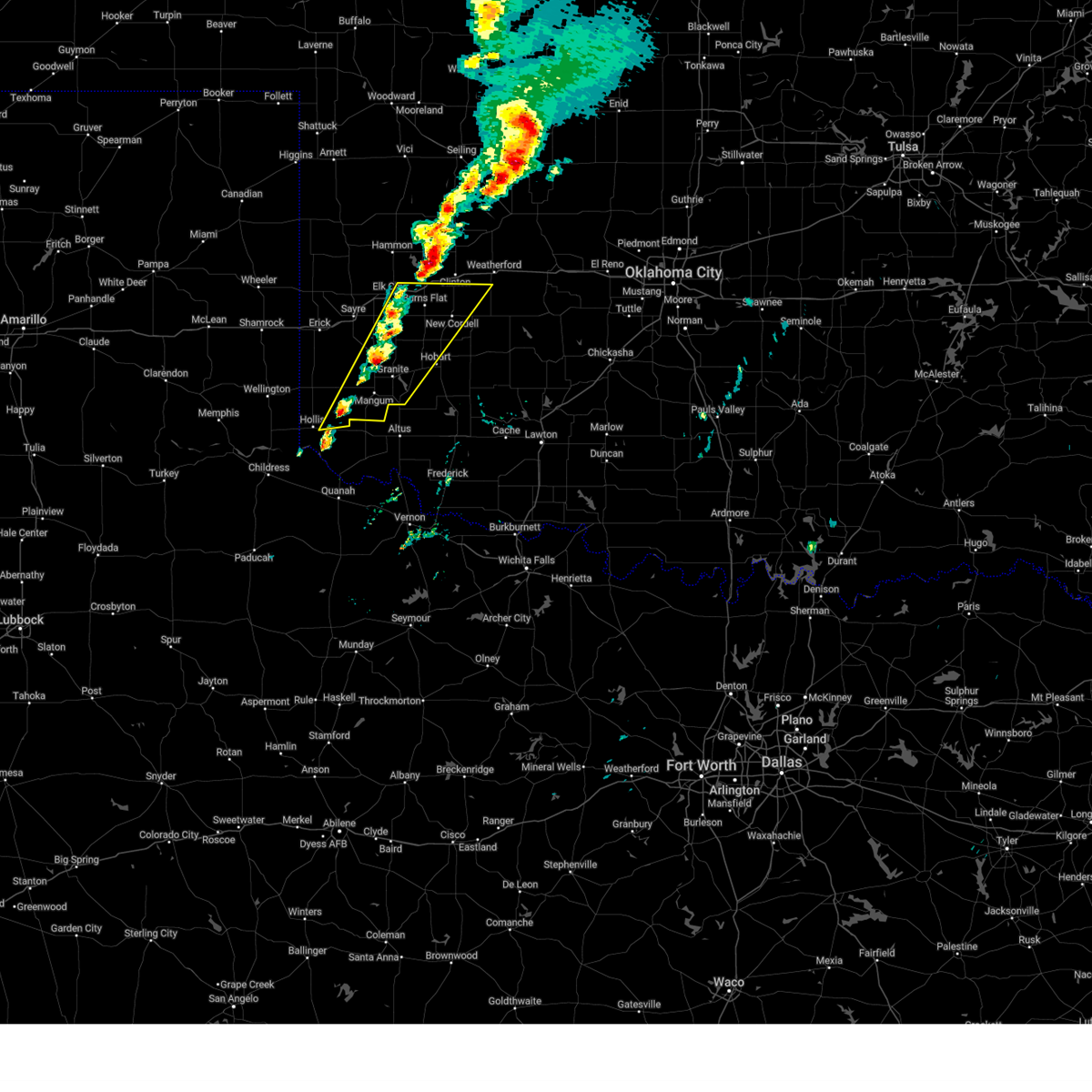 Svroun the national weather service in norman has issued a * severe thunderstorm warning for, washita county in western oklahoma, northwestern kiowa county in southwestern oklahoma, east central harmon county in southwestern oklahoma, greer county in southwestern oklahoma, southeastern beckham county in western oklahoma, * until 430 pm cdt. * at 345 pm cdt, severe thunderstorms were located along 3 miles east of willow and 5 miles northeast of gould, moving northeast at 45 mph. a wind gust of 74 mph was measured west of gould in harmon county (radar indicated). Hazards include 70 mph wind gusts and quarter size hail. Hail damage to vehicles is expected. expect considerable tree damage. Wind damage is also likely to mobile homes, roofs, and outbuildings. Svroun the national weather service in norman has issued a * severe thunderstorm warning for, washita county in western oklahoma, northwestern kiowa county in southwestern oklahoma, east central harmon county in southwestern oklahoma, greer county in southwestern oklahoma, southeastern beckham county in western oklahoma, * until 430 pm cdt. * at 345 pm cdt, severe thunderstorms were located along 3 miles east of willow and 5 miles northeast of gould, moving northeast at 45 mph. a wind gust of 74 mph was measured west of gould in harmon county (radar indicated). Hazards include 70 mph wind gusts and quarter size hail. Hail damage to vehicles is expected. expect considerable tree damage. Wind damage is also likely to mobile homes, roofs, and outbuildings.
|
| 5/30/2024 10:22 PM CDT |
 At 1022 pm cdt, severe thunderstorms were located along a line extending from 4 miles southwest of mangum to 4 miles southwest of olustee to near quanah, moving east at 35 mph (radar indicated). Hazards include 60 mph wind gusts and nickel size hail. Expect damage to roofs, siding, and trees. Locations impacted include, altus, mangum, quanah, blair, chillicothe, olustee, eldorado, martha, gould, elmer, altus air force base, duke, goodlett, odell, hester, mcqueen, and hess. At 1022 pm cdt, severe thunderstorms were located along a line extending from 4 miles southwest of mangum to 4 miles southwest of olustee to near quanah, moving east at 35 mph (radar indicated). Hazards include 60 mph wind gusts and nickel size hail. Expect damage to roofs, siding, and trees. Locations impacted include, altus, mangum, quanah, blair, chillicothe, olustee, eldorado, martha, gould, elmer, altus air force base, duke, goodlett, odell, hester, mcqueen, and hess.
|
| 5/30/2024 9:56 PM CDT |
 Svroun the national weather service in norman has issued a * severe thunderstorm warning for, jackson county in southwestern oklahoma, harmon county in southwestern oklahoma, southeastern greer county in southwestern oklahoma, northwestern wilbarger county in northern texas, central hardeman county in northern texas, * until 1045 pm cdt. * at 956 pm cdt, severe thunderstorms were located along a line extending from 4 miles east of vinson to 7 miles northwest of eldorado to 3 miles west of goodlett, moving east at 35 mph (radar indicated). Hazards include 60 mph wind gusts and nickel size hail. expect damage to roofs, siding, and trees Svroun the national weather service in norman has issued a * severe thunderstorm warning for, jackson county in southwestern oklahoma, harmon county in southwestern oklahoma, southeastern greer county in southwestern oklahoma, northwestern wilbarger county in northern texas, central hardeman county in northern texas, * until 1045 pm cdt. * at 956 pm cdt, severe thunderstorms were located along a line extending from 4 miles east of vinson to 7 miles northwest of eldorado to 3 miles west of goodlett, moving east at 35 mph (radar indicated). Hazards include 60 mph wind gusts and nickel size hail. expect damage to roofs, siding, and trees
|
| 5/30/2024 9:48 PM CDT |
 At 947 pm cdt, severe thunderstorms were located along a line extending from near carter to 9 miles southeast of vinson to 6 miles northwest of goodlett, moving east at 30 mph (radar indicated). Hazards include 60 mph wind gusts and nickel size hail. Expect damage to roofs, siding, and trees. Locations impacted include, sayre, mangum, hollis, erick, carter, willow, gould, delhi, vinson, goodlett, madge, brinkman, mcqueen, and mcknight. At 947 pm cdt, severe thunderstorms were located along a line extending from near carter to 9 miles southeast of vinson to 6 miles northwest of goodlett, moving east at 30 mph (radar indicated). Hazards include 60 mph wind gusts and nickel size hail. Expect damage to roofs, siding, and trees. Locations impacted include, sayre, mangum, hollis, erick, carter, willow, gould, delhi, vinson, goodlett, madge, brinkman, mcqueen, and mcknight.
|
| 5/30/2024 9:37 PM CDT |
 At 937 pm cdt, severe thunderstorms were located along a line extending from 4 miles southeast of sayre to 5 miles southeast of vinson to 4 miles northeast of kirkland, moving east at 30 mph (radar indicated). Hazards include 60 mph wind gusts and nickel size hail. Expect damage to roofs, siding, and trees. Locations impacted include, sayre, mangum, hollis, erick, carter, willow, gould, delhi, vinson, goodlett, madge, brinkman, mcqueen, and mcknight. At 937 pm cdt, severe thunderstorms were located along a line extending from 4 miles southeast of sayre to 5 miles southeast of vinson to 4 miles northeast of kirkland, moving east at 30 mph (radar indicated). Hazards include 60 mph wind gusts and nickel size hail. Expect damage to roofs, siding, and trees. Locations impacted include, sayre, mangum, hollis, erick, carter, willow, gould, delhi, vinson, goodlett, madge, brinkman, mcqueen, and mcknight.
|
| 5/30/2024 9:15 PM CDT |
 Svroun the national weather service in norman has issued a * severe thunderstorm warning for, west central jackson county in southwestern oklahoma, harmon county in southwestern oklahoma, greer county in southwestern oklahoma, southern beckham county in western oklahoma, northwestern hardeman county in northern texas, * until 1000 pm cdt. * at 915 pm cdt, severe thunderstorms were located along a line extending from 4 miles northeast of erick to 6 miles west of vinson to 5 miles northeast of childress, moving east at 30 mph (radar indicated). Hazards include 60 mph wind gusts and nickel size hail. expect damage to roofs, siding, and trees Svroun the national weather service in norman has issued a * severe thunderstorm warning for, west central jackson county in southwestern oklahoma, harmon county in southwestern oklahoma, greer county in southwestern oklahoma, southern beckham county in western oklahoma, northwestern hardeman county in northern texas, * until 1000 pm cdt. * at 915 pm cdt, severe thunderstorms were located along a line extending from 4 miles northeast of erick to 6 miles west of vinson to 5 miles northeast of childress, moving east at 30 mph (radar indicated). Hazards include 60 mph wind gusts and nickel size hail. expect damage to roofs, siding, and trees
|
| 5/23/2024 8:01 PM CDT |
 Svroun the national weather service in norman has issued a * severe thunderstorm warning for, west central jackson county in southwestern oklahoma, central harmon county in southwestern oklahoma, south central greer county in southwestern oklahoma, * until 845 pm cdt. * at 801 pm cdt, a severe thunderstorm was located 6 miles north of gould, moving east at 15 mph (radar indicated). Hazards include golf ball size hail and 60 mph wind gusts. People and animals outdoors will be injured. expect hail damage to roofs, siding, windows, and vehicles. Expect wind damage to roofs, siding, and trees. Svroun the national weather service in norman has issued a * severe thunderstorm warning for, west central jackson county in southwestern oklahoma, central harmon county in southwestern oklahoma, south central greer county in southwestern oklahoma, * until 845 pm cdt. * at 801 pm cdt, a severe thunderstorm was located 6 miles north of gould, moving east at 15 mph (radar indicated). Hazards include golf ball size hail and 60 mph wind gusts. People and animals outdoors will be injured. expect hail damage to roofs, siding, windows, and vehicles. Expect wind damage to roofs, siding, and trees.
|
| 5/23/2024 6:36 PM CDT |
 At 636 pm cdt, a severe thunderstorm was located 4 miles west of duke, moving east at 25 mph (broadcast media). Hazards include tennis ball size hail and 60 mph wind gusts. People and animals outdoors will be injured. expect hail damage to roofs, siding, windows, and vehicles. expect wind damage to roofs, siding, and trees. Locations impacted include, mangum, olustee, martha, gould, duke, hester, and mcqueen. At 636 pm cdt, a severe thunderstorm was located 4 miles west of duke, moving east at 25 mph (broadcast media). Hazards include tennis ball size hail and 60 mph wind gusts. People and animals outdoors will be injured. expect hail damage to roofs, siding, windows, and vehicles. expect wind damage to roofs, siding, and trees. Locations impacted include, mangum, olustee, martha, gould, duke, hester, and mcqueen.
|
| 5/23/2024 6:22 PM CDT |
 At 622 pm cdt, a severe thunderstorm was located 6 miles northeast of vinson, moving east at 20 mph. this is a destructive storm for brinkman and willow (radar indicated). Hazards include baseball size hail and 60 mph wind gusts. People and animals outdoors will be severely injured. expect shattered windows, extensive damage to roofs, siding, and vehicles. Locations impacted include, mangum, willow, and brinkman. At 622 pm cdt, a severe thunderstorm was located 6 miles northeast of vinson, moving east at 20 mph. this is a destructive storm for brinkman and willow (radar indicated). Hazards include baseball size hail and 60 mph wind gusts. People and animals outdoors will be severely injured. expect shattered windows, extensive damage to roofs, siding, and vehicles. Locations impacted include, mangum, willow, and brinkman.
|
| 5/23/2024 6:08 PM CDT |
 Svroun the national weather service in norman has issued a * severe thunderstorm warning for, northern harmon county in southwestern oklahoma, central greer county in southwestern oklahoma, southern beckham county in western oklahoma, * until 700 pm cdt. * at 608 pm cdt, a severe thunderstorm was located 4 miles north of vinson, moving east at 20 mph (radar indicated). Hazards include golf ball size hail and 60 mph wind gusts. People and animals outdoors will be injured. expect hail damage to roofs, siding, windows, and vehicles. Expect wind damage to roofs, siding, and trees. Svroun the national weather service in norman has issued a * severe thunderstorm warning for, northern harmon county in southwestern oklahoma, central greer county in southwestern oklahoma, southern beckham county in western oklahoma, * until 700 pm cdt. * at 608 pm cdt, a severe thunderstorm was located 4 miles north of vinson, moving east at 20 mph (radar indicated). Hazards include golf ball size hail and 60 mph wind gusts. People and animals outdoors will be injured. expect hail damage to roofs, siding, windows, and vehicles. Expect wind damage to roofs, siding, and trees.
|
| 5/23/2024 5:58 PM CDT |
 Svroun the national weather service in norman has issued a * severe thunderstorm warning for, central jackson county in southwestern oklahoma, southern harmon county in southwestern oklahoma, southeastern greer county in southwestern oklahoma, * until 645 pm cdt. * at 557 pm cdt, a severe thunderstorm was located 5 miles north of gould, moving east at 20 mph (broadcast media). Hazards include tennis ball size hail and 60 mph wind gusts. People and animals outdoors will be injured. expect hail damage to roofs, siding, windows, and vehicles. Expect wind damage to roofs, siding, and trees. Svroun the national weather service in norman has issued a * severe thunderstorm warning for, central jackson county in southwestern oklahoma, southern harmon county in southwestern oklahoma, southeastern greer county in southwestern oklahoma, * until 645 pm cdt. * at 557 pm cdt, a severe thunderstorm was located 5 miles north of gould, moving east at 20 mph (broadcast media). Hazards include tennis ball size hail and 60 mph wind gusts. People and animals outdoors will be injured. expect hail damage to roofs, siding, windows, and vehicles. Expect wind damage to roofs, siding, and trees.
|
| 5/19/2024 6:36 PM CDT |
 the severe thunderstorm warning has been cancelled and is no longer in effect the severe thunderstorm warning has been cancelled and is no longer in effect
|
| 5/19/2024 6:20 PM CDT |
 Svroun the national weather service in norman has issued a * severe thunderstorm warning for, southwestern washita county in western oklahoma, northwestern kiowa county in southwestern oklahoma, northeastern greer county in southwestern oklahoma, * until 700 pm cdt. * at 620 pm cdt, a severe thunderstorm was located 4 miles south of willow, moving northeast at 40 mph (radar indicated). Hazards include 60 mph wind gusts and quarter size hail. Hail damage to vehicles is expected. Expect wind damage to roofs, siding, and trees. Svroun the national weather service in norman has issued a * severe thunderstorm warning for, southwestern washita county in western oklahoma, northwestern kiowa county in southwestern oklahoma, northeastern greer county in southwestern oklahoma, * until 700 pm cdt. * at 620 pm cdt, a severe thunderstorm was located 4 miles south of willow, moving northeast at 40 mph (radar indicated). Hazards include 60 mph wind gusts and quarter size hail. Hail damage to vehicles is expected. Expect wind damage to roofs, siding, and trees.
|
| 5/1/2024 11:05 PM CDT |
 the severe thunderstorm warning has been cancelled and is no longer in effect the severe thunderstorm warning has been cancelled and is no longer in effect
|
| 5/1/2024 11:05 PM CDT |
 At 1105 pm cdt, severe thunderstorms were located along a line extending from 6 miles west of roosevelt to near friendship to 3 miles north of elmer to 4 miles east of odell, moving east at 40 mph (radar indicated). Hazards include 70 mph wind gusts and penny size hail. Expect considerable tree damage. damage is likely to mobile homes, roofs, and outbuildings. Locations impacted include, altus, frederick, mangum, granite, snyder, tipton, blair, olustee, lone wolf, mountain park, roosevelt, manitou, martha, elmer, headrick, friendship, altus air force base, tom steed reservoir, warren, and fargo. At 1105 pm cdt, severe thunderstorms were located along a line extending from 6 miles west of roosevelt to near friendship to 3 miles north of elmer to 4 miles east of odell, moving east at 40 mph (radar indicated). Hazards include 70 mph wind gusts and penny size hail. Expect considerable tree damage. damage is likely to mobile homes, roofs, and outbuildings. Locations impacted include, altus, frederick, mangum, granite, snyder, tipton, blair, olustee, lone wolf, mountain park, roosevelt, manitou, martha, elmer, headrick, friendship, altus air force base, tom steed reservoir, warren, and fargo.
|
| 5/1/2024 10:52 PM CDT |
 At 1052 pm cdt, severe thunderstorms were located along a line extending from 4 miles northeast of blair to near altus to 5 miles southwest of olustee to 3 miles west of odell, moving east at 45 mph (radar indicated). Hazards include 70 mph wind gusts and penny size hail. Expect considerable tree damage. damage is likely to mobile homes, roofs, and outbuildings. Locations impacted include, altus, frederick, mangum, hollis, granite, snyder, tipton, blair, chillicothe, olustee, eldorado, lone wolf, mountain park, roosevelt, manitou, martha, gould, elmer, headrick, and friendship. At 1052 pm cdt, severe thunderstorms were located along a line extending from 4 miles northeast of blair to near altus to 5 miles southwest of olustee to 3 miles west of odell, moving east at 45 mph (radar indicated). Hazards include 70 mph wind gusts and penny size hail. Expect considerable tree damage. damage is likely to mobile homes, roofs, and outbuildings. Locations impacted include, altus, frederick, mangum, hollis, granite, snyder, tipton, blair, chillicothe, olustee, eldorado, lone wolf, mountain park, roosevelt, manitou, martha, gould, elmer, headrick, and friendship.
|
| 5/1/2024 10:34 PM CDT |
 Svroun the national weather service in norman has issued a * severe thunderstorm warning for, jackson county in southwestern oklahoma, western kiowa county in southwestern oklahoma, northwestern tillman county in southwestern oklahoma, southern harmon county in southwestern oklahoma, greer county in southwestern oklahoma, northwestern wilbarger county in northern texas, east central hardeman county in northern texas, * until 1130 pm cdt. * at 1034 pm cdt, severe thunderstorms were located along a line extending from 3 miles northwest of gould to 6 miles southwest of duke to 3 miles northeast of eldorado to near medicine mound, moving northeast at 30 mph (radar indicated). Hazards include 60 mph wind gusts and penny size hail. expect damage to roofs, siding, and trees Svroun the national weather service in norman has issued a * severe thunderstorm warning for, jackson county in southwestern oklahoma, western kiowa county in southwestern oklahoma, northwestern tillman county in southwestern oklahoma, southern harmon county in southwestern oklahoma, greer county in southwestern oklahoma, northwestern wilbarger county in northern texas, east central hardeman county in northern texas, * until 1130 pm cdt. * at 1034 pm cdt, severe thunderstorms were located along a line extending from 3 miles northwest of gould to 6 miles southwest of duke to 3 miles northeast of eldorado to near medicine mound, moving northeast at 30 mph (radar indicated). Hazards include 60 mph wind gusts and penny size hail. expect damage to roofs, siding, and trees
|
| 4/27/2024 1:47 PM CDT |
 At 146 pm cdt, severe thunderstorms were located along a line extending from 6 miles northwest of blair to 4 miles east of duke, moving northeast at 45 mph (radar indicated). Hazards include 70 mph wind gusts and ping pong ball size hail. People and animals outdoors will be injured. expect hail damage to roofs, siding, windows, and vehicles. expect considerable tree damage. wind damage is also likely to mobile homes, roofs, and outbuildings. Locations impacted include, altus, mangum, martha, friendship, altus air force base, duke, and hester. At 146 pm cdt, severe thunderstorms were located along a line extending from 6 miles northwest of blair to 4 miles east of duke, moving northeast at 45 mph (radar indicated). Hazards include 70 mph wind gusts and ping pong ball size hail. People and animals outdoors will be injured. expect hail damage to roofs, siding, windows, and vehicles. expect considerable tree damage. wind damage is also likely to mobile homes, roofs, and outbuildings. Locations impacted include, altus, mangum, martha, friendship, altus air force base, duke, and hester.
|
| 4/27/2024 1:47 PM CDT |
 the severe thunderstorm warning has been cancelled and is no longer in effect the severe thunderstorm warning has been cancelled and is no longer in effect
|
| 4/27/2024 1:24 PM CDT |
 Svroun the national weather service in norman has issued a * severe thunderstorm warning for, central jackson county in southwestern oklahoma, southeastern harmon county in southwestern oklahoma, south central greer county in southwestern oklahoma, * until 215 pm cdt. * at 123 pm cdt, severe thunderstorms were located along a line extending from near duke to 3 miles west of eldorado, moving northeast at 40 mph (radar indicated). Hazards include 60 mph wind gusts and half dollar size hail. Hail damage to vehicles is expected. Expect wind damage to roofs, siding, and trees. Svroun the national weather service in norman has issued a * severe thunderstorm warning for, central jackson county in southwestern oklahoma, southeastern harmon county in southwestern oklahoma, south central greer county in southwestern oklahoma, * until 215 pm cdt. * at 123 pm cdt, severe thunderstorms were located along a line extending from near duke to 3 miles west of eldorado, moving northeast at 40 mph (radar indicated). Hazards include 60 mph wind gusts and half dollar size hail. Hail damage to vehicles is expected. Expect wind damage to roofs, siding, and trees.
|
| 3/7/2024 6:41 PM CST |
 At 640 pm cst, severe thunderstorms were located along a line extending from 4 miles north of gotebo to near hobart to 3 miles south of lone wolf to 3 miles southeast of mangum, moving northeast at 30 mph (radar indicated). Hazards include 60 mph wind gusts and quarter size hail. Hail damage to vehicles is expected. expect wind damage to roofs, siding, and trees. Locations impacted include, hobart, mangum, granite, sentinel, mountain view, lone wolf, gotebo, rocky, brinkman, and altus-lugert lake. At 640 pm cst, severe thunderstorms were located along a line extending from 4 miles north of gotebo to near hobart to 3 miles south of lone wolf to 3 miles southeast of mangum, moving northeast at 30 mph (radar indicated). Hazards include 60 mph wind gusts and quarter size hail. Hail damage to vehicles is expected. expect wind damage to roofs, siding, and trees. Locations impacted include, hobart, mangum, granite, sentinel, mountain view, lone wolf, gotebo, rocky, brinkman, and altus-lugert lake.
|
| 3/7/2024 6:27 PM CST |
 Svroun the national weather service in norman has issued a * severe thunderstorm warning for, southern washita county in western oklahoma, kiowa county in southwestern oklahoma, central greer county in southwestern oklahoma, * until 715 pm cst. * at 626 pm cst, severe thunderstorms were located along a line extending from 5 miles northeast of hobart to 3 miles southeast of lone wolf to 5 miles south of granite to 7 miles southwest of mangum, moving east at 30 mph (radar indicated). Hazards include golf ball size hail and 60 mph wind gusts. People and animals outdoors will be injured. expect hail damage to roofs, siding, windows, and vehicles. Expect wind damage to roofs, siding, and trees. Svroun the national weather service in norman has issued a * severe thunderstorm warning for, southern washita county in western oklahoma, kiowa county in southwestern oklahoma, central greer county in southwestern oklahoma, * until 715 pm cst. * at 626 pm cst, severe thunderstorms were located along a line extending from 5 miles northeast of hobart to 3 miles southeast of lone wolf to 5 miles south of granite to 7 miles southwest of mangum, moving east at 30 mph (radar indicated). Hazards include golf ball size hail and 60 mph wind gusts. People and animals outdoors will be injured. expect hail damage to roofs, siding, windows, and vehicles. Expect wind damage to roofs, siding, and trees.
|
| 3/7/2024 6:09 PM CST |
 At 609 pm cst, a severe thunderstorm was located 8 miles west of mangum, moving east at 30 mph (radar indicated). Hazards include golf ball size hail and 60 mph wind gusts. People and animals outdoors will be injured. expect hail damage to roofs, siding, windows, and vehicles. expect wind damage to roofs, siding, and trees. Locations impacted include, mangum, granite, and hester. At 609 pm cst, a severe thunderstorm was located 8 miles west of mangum, moving east at 30 mph (radar indicated). Hazards include golf ball size hail and 60 mph wind gusts. People and animals outdoors will be injured. expect hail damage to roofs, siding, windows, and vehicles. expect wind damage to roofs, siding, and trees. Locations impacted include, mangum, granite, and hester.
|
| 3/7/2024 5:50 PM CST |
 Svroun the national weather service in norman has issued a * severe thunderstorm warning for, central harmon county in southwestern oklahoma, southeastern greer county in southwestern oklahoma, * until 630 pm cst. * at 549 pm cst, a severe thunderstorm was located 6 miles south of vinson, moving east at 25 mph (radar indicated). Hazards include 60 mph wind gusts and quarter size hail. Hail damage to vehicles is expected. Expect wind damage to roofs, siding, and trees. Svroun the national weather service in norman has issued a * severe thunderstorm warning for, central harmon county in southwestern oklahoma, southeastern greer county in southwestern oklahoma, * until 630 pm cst. * at 549 pm cst, a severe thunderstorm was located 6 miles south of vinson, moving east at 25 mph (radar indicated). Hazards include 60 mph wind gusts and quarter size hail. Hail damage to vehicles is expected. Expect wind damage to roofs, siding, and trees.
|
| 2/2/2024 7:35 PM CST | Storm damage reported in greer county OK, 4.9 miles NW of Mangum, OK |
| 8/11/2023 5:30 PM CDT |
 At 529 pm cdt, a severe thunderstorm was located 10 miles east of vinson, moving northeast at 15 mph (radar indicated). Hazards include 60 mph wind gusts. expect damage to roofs, siding, and trees At 529 pm cdt, a severe thunderstorm was located 10 miles east of vinson, moving northeast at 15 mph (radar indicated). Hazards include 60 mph wind gusts. expect damage to roofs, siding, and trees
|
| 8/8/2023 11:50 PM CDT |
 At 1149 pm cdt, severe thunderstorms were located along a line extending from 10 miles west of willow to near duke to near eldorado, moving east at 45 mph (radar indicated). Hazards include 60 mph wind gusts. expect damage to roofs, siding, and trees At 1149 pm cdt, severe thunderstorms were located along a line extending from 10 miles west of willow to near duke to near eldorado, moving east at 45 mph (radar indicated). Hazards include 60 mph wind gusts. expect damage to roofs, siding, and trees
|
| 7/9/2023 3:19 AM CDT |
 At 319 am cdt, severe thunderstorms were located along a line extending from near minco to 5 miles south of cloud chief to near blair, moving east at 45 mph (radar indicated). Hazards include golf ball size hail and 70 mph wind gusts. People and animals outdoors will be injured. expect hail damage to roofs, siding, windows, and vehicles. expect considerable tree damage. wind damage is also likely to mobile homes, roofs, and outbuildings. locations impacted include, altus, el reno, blanchard, anadarko, hobart, mangum, cordell, tuttle, hinton, granite, carnegie, union city, minco, sentinel, blair, mountain view, binger, fort cobb, calumet, and corn. thunderstorm damage threat, considerable hail threat, radar indicated max hail size, 1. 75 in wind threat, radar indicated max wind gust, 70 mph. At 319 am cdt, severe thunderstorms were located along a line extending from near minco to 5 miles south of cloud chief to near blair, moving east at 45 mph (radar indicated). Hazards include golf ball size hail and 70 mph wind gusts. People and animals outdoors will be injured. expect hail damage to roofs, siding, windows, and vehicles. expect considerable tree damage. wind damage is also likely to mobile homes, roofs, and outbuildings. locations impacted include, altus, el reno, blanchard, anadarko, hobart, mangum, cordell, tuttle, hinton, granite, carnegie, union city, minco, sentinel, blair, mountain view, binger, fort cobb, calumet, and corn. thunderstorm damage threat, considerable hail threat, radar indicated max hail size, 1. 75 in wind threat, radar indicated max wind gust, 70 mph.
|
| 7/9/2023 2:54 AM CDT |
 At 253 am cdt, severe thunderstorms were located along a line extending from 8 miles northwest of cogar to 5 miles northeast of dill city to 5 miles northwest of mangum, moving southeast at 45 mph (clinton asos reported 70 mph wind gust). Hazards include golf ball size hail and 70 mph wind gusts. People and animals outdoors will be injured. expect hail damage to roofs, siding, windows, and vehicles. expect considerable tree damage. wind damage is also likely to mobile homes, roofs, and outbuildings. locations impacted include, altus, el reno, elk city, weatherford, clinton, blanchard, anadarko, hobart, mangum, cordell, tuttle, hinton, granite, burns flat, carnegie, union city, minco, geary, hydro, and sentinel. thunderstorm damage threat, considerable hail threat, radar indicated max hail size, 1. 75 in wind threat, observed max wind gust, 70 mph. At 253 am cdt, severe thunderstorms were located along a line extending from 8 miles northwest of cogar to 5 miles northeast of dill city to 5 miles northwest of mangum, moving southeast at 45 mph (clinton asos reported 70 mph wind gust). Hazards include golf ball size hail and 70 mph wind gusts. People and animals outdoors will be injured. expect hail damage to roofs, siding, windows, and vehicles. expect considerable tree damage. wind damage is also likely to mobile homes, roofs, and outbuildings. locations impacted include, altus, el reno, elk city, weatherford, clinton, blanchard, anadarko, hobart, mangum, cordell, tuttle, hinton, granite, burns flat, carnegie, union city, minco, geary, hydro, and sentinel. thunderstorm damage threat, considerable hail threat, radar indicated max hail size, 1. 75 in wind threat, observed max wind gust, 70 mph.
|
| 7/9/2023 2:46 AM CDT |
 At 246 am cdt, severe thunderstorms were located along a line extending from 5 miles east of hinton to near burns flat to 8 miles southwest of willow, moving southeast at 45 mph (radar indicated). Hazards include golf ball size hail and 60 mph wind gusts. People and animals outdoors will be injured. expect hail damage to roofs, siding, windows, and vehicles. expect wind damage to roofs, siding, and trees. locations impacted include, altus, el reno, elk city, weatherford, clinton, blanchard, anadarko, hobart, mangum, cordell, tuttle, hinton, granite, burns flat, carnegie, union city, minco, geary, hydro, and sentinel. thunderstorm damage threat, considerable hail threat, radar indicated max hail size, 1. 75 in wind threat, radar indicated max wind gust, 60 mph. At 246 am cdt, severe thunderstorms were located along a line extending from 5 miles east of hinton to near burns flat to 8 miles southwest of willow, moving southeast at 45 mph (radar indicated). Hazards include golf ball size hail and 60 mph wind gusts. People and animals outdoors will be injured. expect hail damage to roofs, siding, windows, and vehicles. expect wind damage to roofs, siding, and trees. locations impacted include, altus, el reno, elk city, weatherford, clinton, blanchard, anadarko, hobart, mangum, cordell, tuttle, hinton, granite, burns flat, carnegie, union city, minco, geary, hydro, and sentinel. thunderstorm damage threat, considerable hail threat, radar indicated max hail size, 1. 75 in wind threat, radar indicated max wind gust, 60 mph.
|
| 7/9/2023 2:40 AM CDT |
 At 239 am cdt, severe thunderstorms were located along a line extending from 4 miles east of bridgeport to near foss to 10 miles west of willow, moving southeast at 45 mph (radar indicated). Hazards include ping pong ball size hail and 60 mph wind gusts. People and animals outdoors will be injured. expect hail damage to roofs, siding, windows, and vehicles. Expect wind damage to roofs, siding, and trees. At 239 am cdt, severe thunderstorms were located along a line extending from 4 miles east of bridgeport to near foss to 10 miles west of willow, moving southeast at 45 mph (radar indicated). Hazards include ping pong ball size hail and 60 mph wind gusts. People and animals outdoors will be injured. expect hail damage to roofs, siding, windows, and vehicles. Expect wind damage to roofs, siding, and trees.
|
| 7/7/2023 8:41 PM CDT |
 At 840 pm cdt, severe thunderstorms were located along a line extending from 6 miles north of vinson to 3 miles east of hollis to 10 miles northeast of kirkland, moving east at 50 mph (radar indicated). Hazards include 70 mph wind gusts and penny size hail. Expect considerable tree damage. damage is likely to mobile homes, roofs, and outbuildings. locations impacted include, mangum, hollis, granite, eldorado, gould, vinson, duke, goodlett, madge, brinkman, hester, mcqueen, lazare, and mcknight. thunderstorm damage threat, considerable hail threat, radar indicated max hail size, 0. 75 in wind threat, radar indicated max wind gust, 70 mph. At 840 pm cdt, severe thunderstorms were located along a line extending from 6 miles north of vinson to 3 miles east of hollis to 10 miles northeast of kirkland, moving east at 50 mph (radar indicated). Hazards include 70 mph wind gusts and penny size hail. Expect considerable tree damage. damage is likely to mobile homes, roofs, and outbuildings. locations impacted include, mangum, hollis, granite, eldorado, gould, vinson, duke, goodlett, madge, brinkman, hester, mcqueen, lazare, and mcknight. thunderstorm damage threat, considerable hail threat, radar indicated max hail size, 0. 75 in wind threat, radar indicated max wind gust, 70 mph.
|
| 7/7/2023 8:18 PM CDT |
 At 817 pm cdt, severe thunderstorms were located along a line extending from near texola to 5 miles southeast of wellington to 12 miles south of memphis, moving east at 55 mph (radar indicated). Hazards include 70 mph wind gusts and penny size hail. Expect considerable tree damage. Damage is likely to mobile homes, roofs, and outbuildings. At 817 pm cdt, severe thunderstorms were located along a line extending from near texola to 5 miles southeast of wellington to 12 miles south of memphis, moving east at 55 mph (radar indicated). Hazards include 70 mph wind gusts and penny size hail. Expect considerable tree damage. Damage is likely to mobile homes, roofs, and outbuildings.
|
| 7/6/2023 6:28 AM CDT |
 The severe thunderstorm warning for washita, custer, northwestern kiowa, northern harmon, greer and beckham counties will expire at 630 am cdt, the storms which prompted the warning have weakened below severe limits, therefore the warning will be allowed to expire. however, gusty winds are still possible with these thunderstorms. The severe thunderstorm warning for washita, custer, northwestern kiowa, northern harmon, greer and beckham counties will expire at 630 am cdt, the storms which prompted the warning have weakened below severe limits, therefore the warning will be allowed to expire. however, gusty winds are still possible with these thunderstorms.
|
| 7/6/2023 6:14 AM CDT |
 At 613 am cdt, severe thunderstorms were located along a line extending from near arapaho to 4 miles northeast of sentinel to 10 miles east of vinson, moving southeast at 40 mph (radar indicated). Hazards include 60 mph wind gusts. Expect damage to roofs, siding, and trees. locations impacted include, elk city, clinton, sayre, hobart, mangum, cordell, granite, burns flat, erick, sentinel, arapaho, dill city, canute, corn, lone wolf, custer city, butler, carter, bessie, and rocky. hail threat, radar indicated max hail size, <. 75 in wind threat, radar indicated max wind gust, 60 mph. At 613 am cdt, severe thunderstorms were located along a line extending from near arapaho to 4 miles northeast of sentinel to 10 miles east of vinson, moving southeast at 40 mph (radar indicated). Hazards include 60 mph wind gusts. Expect damage to roofs, siding, and trees. locations impacted include, elk city, clinton, sayre, hobart, mangum, cordell, granite, burns flat, erick, sentinel, arapaho, dill city, canute, corn, lone wolf, custer city, butler, carter, bessie, and rocky. hail threat, radar indicated max hail size, <. 75 in wind threat, radar indicated max wind gust, 60 mph.
|
| 7/6/2023 5:42 AM CDT |
 At 542 am cdt, severe thunderstorms were located along a line extending from 7 miles north of butler to near elk city to 5 miles south of texola, moving southeast at 40 mph (radar indicated). Hazards include 60 mph wind gusts and penny size hail. expect damage to roofs, siding, and trees At 542 am cdt, severe thunderstorms were located along a line extending from 7 miles north of butler to near elk city to 5 miles south of texola, moving southeast at 40 mph (radar indicated). Hazards include 60 mph wind gusts and penny size hail. expect damage to roofs, siding, and trees
|
| 6/18/2023 12:17 AM CDT |
 At 1217 am cdt, severe thunderstorms were located along a line extending from near martha to 3 miles north of mountain park to near elgin to near verden, moving east at 55 mph (radar indicated). Hazards include 60 mph wind gusts and half dollar size hail. Hail damage to vehicles is expected. expect wind damage to roofs, siding, and trees. locations impacted include, altus, anadarko, mangum, elgin, apache, fletcher, cyril, blair, sterling, verden, cement, mountain park, medicine park, roosevelt, martha, friendship, cooperton, meers, tom steed reservoir, and boone. hail threat, radar indicated max hail size, 1. 25 in wind threat, radar indicated max wind gust, 60 mph. At 1217 am cdt, severe thunderstorms were located along a line extending from near martha to 3 miles north of mountain park to near elgin to near verden, moving east at 55 mph (radar indicated). Hazards include 60 mph wind gusts and half dollar size hail. Hail damage to vehicles is expected. expect wind damage to roofs, siding, and trees. locations impacted include, altus, anadarko, mangum, elgin, apache, fletcher, cyril, blair, sterling, verden, cement, mountain park, medicine park, roosevelt, martha, friendship, cooperton, meers, tom steed reservoir, and boone. hail threat, radar indicated max hail size, 1. 25 in wind threat, radar indicated max wind gust, 60 mph.
|
| 6/17/2023 11:52 PM CDT |
 At 1152 pm cdt, severe thunderstorms were located along a line extending from 7 miles south of vinson to 3 miles northeast of blair to 6 miles northwest of meers to near fort cobb, moving east at 55 mph (radar indicated). Hazards include 60 mph wind gusts and half dollar size hail. Hail damage to vehicles is expected. Expect wind damage to roofs, siding, and trees. At 1152 pm cdt, severe thunderstorms were located along a line extending from 7 miles south of vinson to 3 miles northeast of blair to 6 miles northwest of meers to near fort cobb, moving east at 55 mph (radar indicated). Hazards include 60 mph wind gusts and half dollar size hail. Hail damage to vehicles is expected. Expect wind damage to roofs, siding, and trees.
|
| 6/17/2023 11:45 PM CDT |
 At 1145 pm cdt, severe thunderstorms were located along a line extending from near carnegie to near cooperton to 7 miles south of vinson, moving southeast at 45 mph (radar indicated). Hazards include ping pong ball size hail and 60 mph wind gusts. People and animals outdoors will be injured. expect hail damage to roofs, siding, windows, and vehicles. expect wind damage to roofs, siding, and trees. locations impacted include, hobart, mangum, hollis, granite, carnegie, blair, mountain view, lone wolf, mountain park, roosevelt, gotebo, martha, rocky, gould, friendship, cooperton, tom steed reservoir, vinson, cloud chief, and warren. hail threat, radar indicated max hail size, 1. 50 in wind threat, radar indicated max wind gust, 60 mph. At 1145 pm cdt, severe thunderstorms were located along a line extending from near carnegie to near cooperton to 7 miles south of vinson, moving southeast at 45 mph (radar indicated). Hazards include ping pong ball size hail and 60 mph wind gusts. People and animals outdoors will be injured. expect hail damage to roofs, siding, windows, and vehicles. expect wind damage to roofs, siding, and trees. locations impacted include, hobart, mangum, hollis, granite, carnegie, blair, mountain view, lone wolf, mountain park, roosevelt, gotebo, martha, rocky, gould, friendship, cooperton, tom steed reservoir, vinson, cloud chief, and warren. hail threat, radar indicated max hail size, 1. 50 in wind threat, radar indicated max wind gust, 60 mph.
|
| 6/17/2023 11:22 PM CDT |
 At 1122 pm cdt, severe thunderstorms were located along a line extending from 4 miles east of bessie to 5 miles southwest of hobart to 7 miles east of vinson, moving southeast at 45 mph (radar indicated). Hazards include 70 mph wind gusts and quarter size hail. Hail damage to vehicles is expected. expect considerable tree damage. Wind damage is also likely to mobile homes, roofs, and outbuildings. At 1122 pm cdt, severe thunderstorms were located along a line extending from 4 miles east of bessie to 5 miles southwest of hobart to 7 miles east of vinson, moving southeast at 45 mph (radar indicated). Hazards include 70 mph wind gusts and quarter size hail. Hail damage to vehicles is expected. expect considerable tree damage. Wind damage is also likely to mobile homes, roofs, and outbuildings.
|
| 6/17/2023 10:59 PM CDT |
 At 1059 pm cdt, severe thunderstorms were located along a line extending from 3 miles northeast of carter to near willow to 6 miles north of dodson, moving east at 30 mph (radar indicated). Hazards include 70 mph wind gusts and quarter size hail. Hail damage to vehicles is expected. expect considerable tree damage. Wind damage is also likely to mobile homes, roofs, and outbuildings. At 1059 pm cdt, severe thunderstorms were located along a line extending from 3 miles northeast of carter to near willow to 6 miles north of dodson, moving east at 30 mph (radar indicated). Hazards include 70 mph wind gusts and quarter size hail. Hail damage to vehicles is expected. expect considerable tree damage. Wind damage is also likely to mobile homes, roofs, and outbuildings.
|
| 6/15/2023 3:05 PM CDT |
 At 305 pm cdt, a severe thunderstorm was located over granite, moving east at 25 mph (public). Hazards include 60 mph wind gusts and half dollar size hail. Hail damage to vehicles is expected. expect wind damage to roofs, siding, and trees. locations impacted include, mangum, granite, lone wolf, willow, retrop, brinkman, and altus-lugert lake. hail threat, radar indicated max hail size, 1. 25 in wind threat, radar indicated max wind gust, 60 mph. At 305 pm cdt, a severe thunderstorm was located over granite, moving east at 25 mph (public). Hazards include 60 mph wind gusts and half dollar size hail. Hail damage to vehicles is expected. expect wind damage to roofs, siding, and trees. locations impacted include, mangum, granite, lone wolf, willow, retrop, brinkman, and altus-lugert lake. hail threat, radar indicated max hail size, 1. 25 in wind threat, radar indicated max wind gust, 60 mph.
|
| 6/15/2023 2:42 PM CDT |
 At 242 pm cdt, a severe thunderstorm was located 6 miles south of willow, moving east at 20 mph (radar indicated). Hazards include golf ball size hail and 60 mph wind gusts. People and animals outdoors will be injured. expect hail damage to roofs, siding, windows, and vehicles. Expect wind damage to roofs, siding, and trees. At 242 pm cdt, a severe thunderstorm was located 6 miles south of willow, moving east at 20 mph (radar indicated). Hazards include golf ball size hail and 60 mph wind gusts. People and animals outdoors will be injured. expect hail damage to roofs, siding, windows, and vehicles. Expect wind damage to roofs, siding, and trees.
|
| 6/13/2023 9:41 PM CDT |
 At 941 pm cdt, a severe thunderstorm was located near blair, moving southeast at 50 mph (radar indicated). Hazards include two inch hail and 70 mph wind gusts. People and animals outdoors will be injured. expect hail damage to roofs, siding, windows, and vehicles. expect considerable tree damage. wind damage is also likely to mobile homes, roofs, and outbuildings. locations impacted include, altus, mangum, blair, olustee, martha, friendship, altus air force base, warren, duke, hester, and southeastern altus-lugert lake. thunderstorm damage threat, considerable hail threat, radar indicated max hail size, 2. 00 in wind threat, radar indicated max wind gust, 70 mph. At 941 pm cdt, a severe thunderstorm was located near blair, moving southeast at 50 mph (radar indicated). Hazards include two inch hail and 70 mph wind gusts. People and animals outdoors will be injured. expect hail damage to roofs, siding, windows, and vehicles. expect considerable tree damage. wind damage is also likely to mobile homes, roofs, and outbuildings. locations impacted include, altus, mangum, blair, olustee, martha, friendship, altus air force base, warren, duke, hester, and southeastern altus-lugert lake. thunderstorm damage threat, considerable hail threat, radar indicated max hail size, 2. 00 in wind threat, radar indicated max wind gust, 70 mph.
|
| 6/13/2023 9:31 PM CDT |
 At 929 pm cdt, a severe thunderstorm was located near mangum, moving east at 50 mph (radar indicated. at 827 pm cdt, the public reported ping pong ball size hail in mangum). Hazards include two inch hail and 70 mph wind gusts. People and animals outdoors will be injured. expect hail damage to roofs, siding, windows, and vehicles. expect considerable tree damage. wind damage is also likely to mobile homes, roofs, and outbuildings. locations impacted include, altus, mangum, granite, blair, olustee, lone wolf, martha, friendship, altus air force base, duke, warren, brinkman, hester, and altus-lugert lake. thunderstorm damage threat, considerable hail threat, observed max hail size, 2. 00 in wind threat, radar indicated max wind gust, 70 mph. At 929 pm cdt, a severe thunderstorm was located near mangum, moving east at 50 mph (radar indicated. at 827 pm cdt, the public reported ping pong ball size hail in mangum). Hazards include two inch hail and 70 mph wind gusts. People and animals outdoors will be injured. expect hail damage to roofs, siding, windows, and vehicles. expect considerable tree damage. wind damage is also likely to mobile homes, roofs, and outbuildings. locations impacted include, altus, mangum, granite, blair, olustee, lone wolf, martha, friendship, altus air force base, duke, warren, brinkman, hester, and altus-lugert lake. thunderstorm damage threat, considerable hail threat, observed max hail size, 2. 00 in wind threat, radar indicated max wind gust, 70 mph.
|
| 6/13/2023 9:27 PM CDT | Ping Pong Ball sized hail reported 0.6 miles NNE of Mangum, OK, report from mping: ping pong ball (1.50 in.). |
| 6/13/2023 9:17 PM CDT |
 At 916 pm cdt, a severe thunderstorm was located 7 miles east of vinson, moving southeast at 50 mph (radar indicated). Hazards include two inch hail and 70 mph wind gusts. People and animals outdoors will be injured. expect hail damage to roofs, siding, windows, and vehicles. expect considerable tree damage. Wind damage is also likely to mobile homes, roofs, and outbuildings. At 916 pm cdt, a severe thunderstorm was located 7 miles east of vinson, moving southeast at 50 mph (radar indicated). Hazards include two inch hail and 70 mph wind gusts. People and animals outdoors will be injured. expect hail damage to roofs, siding, windows, and vehicles. expect considerable tree damage. Wind damage is also likely to mobile homes, roofs, and outbuildings.
|
| 4/10/2023 5:36 PM CDT | Half Dollar sized hail reported 12.9 miles E of Mangum, OK |
| 4/9/2023 3:20 PM CDT |
 The severe thunderstorm warning for south central greer county will expire at 330 pm cdt, the storm which prompted the warning has weakened below severe limits, therefore the warning will be allowed to expire. however, small hail up to the size of pennies, gusty winds up to 50 mph, and heavy rain are still possible with this thunderstorm. The severe thunderstorm warning for south central greer county will expire at 330 pm cdt, the storm which prompted the warning has weakened below severe limits, therefore the warning will be allowed to expire. however, small hail up to the size of pennies, gusty winds up to 50 mph, and heavy rain are still possible with this thunderstorm.
|
| 4/9/2023 3:05 PM CDT |
 At 305 pm cdt, a severe thunderstorm was located 7 miles south of mangum, moving southeast at 15 mph (radar indicated). Hazards include 60 mph wind gusts and penny size hail. Expect damage to roofs, siding, and trees. locations impacted include, hester. hail threat, radar indicated max hail size, 0. 75 in wind threat, radar indicated max wind gust, 60 mph. At 305 pm cdt, a severe thunderstorm was located 7 miles south of mangum, moving southeast at 15 mph (radar indicated). Hazards include 60 mph wind gusts and penny size hail. Expect damage to roofs, siding, and trees. locations impacted include, hester. hail threat, radar indicated max hail size, 0. 75 in wind threat, radar indicated max wind gust, 60 mph.
|
| 4/9/2023 2:49 PM CDT |
 At 249 pm cdt, a severe thunderstorm was located 7 miles southwest of mangum, moving east at 10 mph (radar indicated). Hazards include 60 mph wind gusts and quarter size hail. Hail damage to vehicles is expected. Expect wind damage to roofs, siding, and trees. At 249 pm cdt, a severe thunderstorm was located 7 miles southwest of mangum, moving east at 10 mph (radar indicated). Hazards include 60 mph wind gusts and quarter size hail. Hail damage to vehicles is expected. Expect wind damage to roofs, siding, and trees.
|
| 4/9/2023 2:34 PM CDT |
 At 233 pm cdt, a severe thunderstorm was located 6 miles west of mangum, moving east southeast at 15 mph (radar indicated). Hazards include 60 mph wind gusts and nickel size hail. Expect damage to roofs, siding, and trees. locations impacted include, mangum. hail threat, radar indicated max hail size, 0. 88 in wind threat, radar indicated max wind gust, 60 mph. At 233 pm cdt, a severe thunderstorm was located 6 miles west of mangum, moving east southeast at 15 mph (radar indicated). Hazards include 60 mph wind gusts and nickel size hail. Expect damage to roofs, siding, and trees. locations impacted include, mangum. hail threat, radar indicated max hail size, 0. 88 in wind threat, radar indicated max wind gust, 60 mph.
|
| 4/9/2023 2:14 PM CDT |
 At 214 pm cdt, a severe thunderstorm was located 10 miles west of mangum, moving east at 15 mph (radar indicated). Hazards include 60 mph wind gusts and quarter size hail. Hail damage to vehicles is expected. Expect wind damage to roofs, siding, and trees. At 214 pm cdt, a severe thunderstorm was located 10 miles west of mangum, moving east at 15 mph (radar indicated). Hazards include 60 mph wind gusts and quarter size hail. Hail damage to vehicles is expected. Expect wind damage to roofs, siding, and trees.
|
| 2/26/2023 7:35 PM CST | Storm damage reported in greer county OK, 4.9 miles NW of Mangum, OK |
| 2/26/2023 7:33 PM CST |
 At 732 pm cst, severe thunderstorms were located along a line extending from 7 miles south of hammon to 4 miles northeast of granite to near duke, moving east at 75 mph. these are destructive storms for hobart, foss reservoir, and altus (radar indicated). Hazards include 80 mph wind gusts and ping pong ball size hail. Flying debris will be dangerous to those caught without shelter. mobile homes will be heavily damaged. expect considerable damage to roofs, windows, and vehicles. Extensive tree damage and power outages are likely. At 732 pm cst, severe thunderstorms were located along a line extending from 7 miles south of hammon to 4 miles northeast of granite to near duke, moving east at 75 mph. these are destructive storms for hobart, foss reservoir, and altus (radar indicated). Hazards include 80 mph wind gusts and ping pong ball size hail. Flying debris will be dangerous to those caught without shelter. mobile homes will be heavily damaged. expect considerable damage to roofs, windows, and vehicles. Extensive tree damage and power outages are likely.
|
| 2/26/2023 7:24 PM CST |
 At 724 pm cst, a confirmed tornado was located 9 miles east of vinson, moving northeast at 65 mph (weather spotters confirmed tornado). Hazards include damaging tornado and hail up to two inches in diameter. Flying debris will be dangerous to those caught without shelter. mobile homes will be damaged or destroyed. damage to roofs, windows, and vehicles will occur. Tree damage is likely. At 724 pm cst, a confirmed tornado was located 9 miles east of vinson, moving northeast at 65 mph (weather spotters confirmed tornado). Hazards include damaging tornado and hail up to two inches in diameter. Flying debris will be dangerous to those caught without shelter. mobile homes will be damaged or destroyed. damage to roofs, windows, and vehicles will occur. Tree damage is likely.
|
| 2/26/2023 7:22 PM CST |
 At 720 pm cst, severe thunderstorms were located along a line extending from 5 miles north of erick to 3 miles southwest of delhi to 6 miles northeast of vinson to 4 miles north of gould to 10 miles northeast of kirkland, moving northeast at 100 mph. these are destructive storms for sayre, willow, mangum, hollis, and gould (a recent weather observation near erick reported 80 mph winds. another observation recorded 75 mph near gould). Hazards include 90 mph wind gusts and golf ball size hail. You are in a life-threatening situation. flying debris may be deadly to those caught without shelter. mobile homes will be heavily damaged or destroyed. homes and businesses will have substantial roof and window damage. expect extensive tree damage and power outages. Locations impacted include, elk city, sayre, mangum, hollis, granite, erick, hammon, carter, willow, gould, texola, delhi, vinson, duke, madge, brinkman, berlin, hester, mcqueen and mcknight. At 720 pm cst, severe thunderstorms were located along a line extending from 5 miles north of erick to 3 miles southwest of delhi to 6 miles northeast of vinson to 4 miles north of gould to 10 miles northeast of kirkland, moving northeast at 100 mph. these are destructive storms for sayre, willow, mangum, hollis, and gould (a recent weather observation near erick reported 80 mph winds. another observation recorded 75 mph near gould). Hazards include 90 mph wind gusts and golf ball size hail. You are in a life-threatening situation. flying debris may be deadly to those caught without shelter. mobile homes will be heavily damaged or destroyed. homes and businesses will have substantial roof and window damage. expect extensive tree damage and power outages. Locations impacted include, elk city, sayre, mangum, hollis, granite, erick, hammon, carter, willow, gould, texola, delhi, vinson, duke, madge, brinkman, berlin, hester, mcqueen and mcknight.
|
| 2/26/2023 7:13 PM CST |
 At 713 pm cst, a severe thunderstorm capable of producing a tornado was located 4 miles south of vinson, moving east at 70 mph (radar indicated rotation). Hazards include tornado and golf ball size hail. Flying debris will be dangerous to those caught without shelter. mobile homes will be damaged or destroyed. damage to roofs, windows, and vehicles will occur. tree damage is likely. Locations impacted include, mangum, vinson, madge, brinkman and mcknight. At 713 pm cst, a severe thunderstorm capable of producing a tornado was located 4 miles south of vinson, moving east at 70 mph (radar indicated rotation). Hazards include tornado and golf ball size hail. Flying debris will be dangerous to those caught without shelter. mobile homes will be damaged or destroyed. damage to roofs, windows, and vehicles will occur. tree damage is likely. Locations impacted include, mangum, vinson, madge, brinkman and mcknight.
|
| 2/26/2023 7:00 PM CST |
 At 659 pm cst, a severe thunderstorm capable of producing a tornado was located near dodson, moving east at 75 mph (radar indicated rotation). Hazards include tornado and golf ball size hail. Flying debris will be dangerous to those caught without shelter. mobile homes will be damaged or destroyed. damage to roofs, windows, and vehicles will occur. Tree damage is likely. At 659 pm cst, a severe thunderstorm capable of producing a tornado was located near dodson, moving east at 75 mph (radar indicated rotation). Hazards include tornado and golf ball size hail. Flying debris will be dangerous to those caught without shelter. mobile homes will be damaged or destroyed. damage to roofs, windows, and vehicles will occur. Tree damage is likely.
|
| 2/26/2023 6:53 PM CST |
 At 651 pm cst, severe thunderstorms were located along a line extending from near lutie to 10 miles south of wellington to 6 miles west of tell to 7 miles southwest of northfield, moving northeast at 95 mph. these are destructive storms for erick, sayre, hollis, and mangum (texas weather observations have recorded wind speeds over 100 mph with this line of storm. prepare now for desctructive winds!). Hazards include 90 mph wind gusts and golf ball size hail. You are in a life-threatening situation. flying debris may be deadly to those caught without shelter. mobile homes will be heavily damaged or destroyed. homes and businesses will have substantial roof and window damage. Expect extensive tree damage and power outages. At 651 pm cst, severe thunderstorms were located along a line extending from near lutie to 10 miles south of wellington to 6 miles west of tell to 7 miles southwest of northfield, moving northeast at 95 mph. these are destructive storms for erick, sayre, hollis, and mangum (texas weather observations have recorded wind speeds over 100 mph with this line of storm. prepare now for desctructive winds!). Hazards include 90 mph wind gusts and golf ball size hail. You are in a life-threatening situation. flying debris may be deadly to those caught without shelter. mobile homes will be heavily damaged or destroyed. homes and businesses will have substantial roof and window damage. Expect extensive tree damage and power outages.
|
| 11/4/2022 7:06 AM CDT |
 At 706 am cdt, a severe thunderstorm was located 5 miles south of vinson, moving northeast at 45 mph (radar indicated). Hazards include 60 mph wind gusts and quarter size hail. Hail damage to vehicles is expected. expect wind damage to roofs, siding, and trees. locations impacted include, mangum, granite, willow, vinson, brinkman, mcknight and northwestern altus-lugert lake. hail threat, radar indicated max hail size, 1. 00 in wind threat, radar indicated max wind gust, 60 mph. At 706 am cdt, a severe thunderstorm was located 5 miles south of vinson, moving northeast at 45 mph (radar indicated). Hazards include 60 mph wind gusts and quarter size hail. Hail damage to vehicles is expected. expect wind damage to roofs, siding, and trees. locations impacted include, mangum, granite, willow, vinson, brinkman, mcknight and northwestern altus-lugert lake. hail threat, radar indicated max hail size, 1. 00 in wind threat, radar indicated max wind gust, 60 mph.
|
| 11/4/2022 6:56 AM CDT |
 At 656 am cdt, a severe thunderstorm was located near dodson, moving northeast at 55 mph (radar indicated). Hazards include 60 mph wind gusts and quarter size hail. Hail damage to vehicles is expected. Expect wind damage to roofs, siding, and trees. At 656 am cdt, a severe thunderstorm was located near dodson, moving northeast at 55 mph (radar indicated). Hazards include 60 mph wind gusts and quarter size hail. Hail damage to vehicles is expected. Expect wind damage to roofs, siding, and trees.
|
| 9/1/2022 9:35 PM CDT | Mesonet station mang mangu in greer county OK, 5.4 miles WNW of Mangum, OK |
| 8/31/2022 3:38 PM CDT |
 At 338 pm cdt, a severe thunderstorm was located 6 miles west of mangum, moving west at 20 mph (radar indicated). Hazards include 60 mph wind gusts and penny size hail. Expect damage to roofs, siding, and trees. locations impacted include, mangum. hail threat, radar indicated max hail size, 0. 75 in wind threat, radar indicated max wind gust, 60 mph. At 338 pm cdt, a severe thunderstorm was located 6 miles west of mangum, moving west at 20 mph (radar indicated). Hazards include 60 mph wind gusts and penny size hail. Expect damage to roofs, siding, and trees. locations impacted include, mangum. hail threat, radar indicated max hail size, 0. 75 in wind threat, radar indicated max wind gust, 60 mph.
|
| 8/31/2022 3:24 PM CDT |
 At 324 pm cdt, a severe thunderstorm was located over mangum, moving west at 15 mph (radar indicated). Hazards include 60 mph wind gusts and nickel size hail. expect damage to roofs, siding, and trees At 324 pm cdt, a severe thunderstorm was located over mangum, moving west at 15 mph (radar indicated). Hazards include 60 mph wind gusts and nickel size hail. expect damage to roofs, siding, and trees
|
| 7/8/2022 4:20 PM CDT |
 The severe thunderstorm warning for north central greer county will expire at 430 pm cdt, the storm which prompted the warning has weakened below severe limits, therefore the warning will be allowed to expire. however gusty winds are still possible with this thunderstorm. The severe thunderstorm warning for north central greer county will expire at 430 pm cdt, the storm which prompted the warning has weakened below severe limits, therefore the warning will be allowed to expire. however gusty winds are still possible with this thunderstorm.
|
| 7/8/2022 3:46 PM CDT |
 At 345 pm cdt, a severe thunderstorm was located near willow, and is nearly stationary (radar indicated). Hazards include 70 mph wind gusts and quarter size hail. Hail damage to vehicles is expected. expect considerable tree damage. Wind damage is also likely to mobile homes, roofs, and outbuildings. At 345 pm cdt, a severe thunderstorm was located near willow, and is nearly stationary (radar indicated). Hazards include 70 mph wind gusts and quarter size hail. Hail damage to vehicles is expected. expect considerable tree damage. Wind damage is also likely to mobile homes, roofs, and outbuildings.
|
| 6/9/2022 11:59 PM CDT |
 At 1159 pm cdt, severe thunderstorms were located along a line extending from near martha to 3 miles northwest of quanah, moving east at 60 mph (the gould mesonet measured a 62 mph wind gust). Hazards include 70 mph wind gusts and penny size hail. Expect considerable tree damage. damage is likely to mobile homes, roofs, and outbuildings. locations impacted include, altus, mangum, quanah, hollis, granite, blair, chillicothe, olustee, eldorado, martha, gould, elmer, friendship, altus air force base, vinson, warren, medicine mound, humphreys, odell and duke. thunderstorm damage threat, considerable hail threat, radar indicated max hail size, 0. 75 in wind threat, observed max wind gust, 70 mph. At 1159 pm cdt, severe thunderstorms were located along a line extending from near martha to 3 miles northwest of quanah, moving east at 60 mph (the gould mesonet measured a 62 mph wind gust). Hazards include 70 mph wind gusts and penny size hail. Expect considerable tree damage. damage is likely to mobile homes, roofs, and outbuildings. locations impacted include, altus, mangum, quanah, hollis, granite, blair, chillicothe, olustee, eldorado, martha, gould, elmer, friendship, altus air force base, vinson, warren, medicine mound, humphreys, odell and duke. thunderstorm damage threat, considerable hail threat, radar indicated max hail size, 0. 75 in wind threat, observed max wind gust, 70 mph.
|
| 6/9/2022 11:44 PM CDT |
 At 1143 pm cdt, severe thunderstorms were located along a line extending from 4 miles northwest of hobart to near martha, moving east at 40 mph (radar indicated). Hazards include 60 mph wind gusts and penny size hail. Expect damage to roofs, siding, and trees. locations impacted include, altus, hobart, mangum, granite, sentinel, blair, lone wolf, roosevelt, gotebo, rocky, martha, willow, friendship, altus air force base, retrop, warren, humphreys, tom steed reservoir, brinkman and hester. hail threat, radar indicated max hail size, 0. 75 in wind threat, radar indicated max wind gust, 60 mph. At 1143 pm cdt, severe thunderstorms were located along a line extending from 4 miles northwest of hobart to near martha, moving east at 40 mph (radar indicated). Hazards include 60 mph wind gusts and penny size hail. Expect damage to roofs, siding, and trees. locations impacted include, altus, hobart, mangum, granite, sentinel, blair, lone wolf, roosevelt, gotebo, rocky, martha, willow, friendship, altus air force base, retrop, warren, humphreys, tom steed reservoir, brinkman and hester. hail threat, radar indicated max hail size, 0. 75 in wind threat, radar indicated max wind gust, 60 mph.
|
| 6/9/2022 11:30 PM CDT |
 At 1130 pm cdt, severe thunderstorms were located along a line extending from 4 miles west of vinson to 5 miles northwest of childress, moving southeast at 50 mph (radar indicated). Hazards include 70 mph wind gusts and penny size hail. Expect considerable tree damage. Damage is likely to mobile homes, roofs, and outbuildings. At 1130 pm cdt, severe thunderstorms were located along a line extending from 4 miles west of vinson to 5 miles northwest of childress, moving southeast at 50 mph (radar indicated). Hazards include 70 mph wind gusts and penny size hail. Expect considerable tree damage. Damage is likely to mobile homes, roofs, and outbuildings.
|
| 6/9/2022 11:24 PM CDT |
 At 1124 pm cdt, severe thunderstorms were located along a line extending from 3 miles north of retrop to 4 miles west of mangum, moving east at 40 mph (radar indicated). Hazards include 70 mph wind gusts and penny size hail. Expect considerable tree damage. Damage is likely to mobile homes, roofs, and outbuildings. At 1124 pm cdt, severe thunderstorms were located along a line extending from 3 miles north of retrop to 4 miles west of mangum, moving east at 40 mph (radar indicated). Hazards include 70 mph wind gusts and penny size hail. Expect considerable tree damage. Damage is likely to mobile homes, roofs, and outbuildings.
|
| 6/9/2022 11:11 PM CDT |
 At 1111 pm cdt, severe thunderstorms were located along a line extending from 5 miles northeast of carter to 6 miles northeast of vinson, moving east at 45 mph (radar indicated). Hazards include 70 mph wind gusts and penny size hail. Expect considerable tree damage. damage is likely to mobile homes, roofs, and outbuildings. locations impacted include, elk city, sayre, mangum, granite, erick, dill city, carter, willow, retrop, delhi, vinson and brinkman. thunderstorm damage threat, considerable hail threat, radar indicated max hail size, 0. 75 in wind threat, radar indicated max wind gust, 70 mph. At 1111 pm cdt, severe thunderstorms were located along a line extending from 5 miles northeast of carter to 6 miles northeast of vinson, moving east at 45 mph (radar indicated). Hazards include 70 mph wind gusts and penny size hail. Expect considerable tree damage. damage is likely to mobile homes, roofs, and outbuildings. locations impacted include, elk city, sayre, mangum, granite, erick, dill city, carter, willow, retrop, delhi, vinson and brinkman. thunderstorm damage threat, considerable hail threat, radar indicated max hail size, 0. 75 in wind threat, radar indicated max wind gust, 70 mph.
|
| 6/9/2022 10:54 PM CDT |
 At 1054 pm cdt, severe thunderstorms were located along a line extending from 5 miles northwest of sayre to 11 miles northwest of vinson, moving east at 40 mph (radar indicated). Hazards include 60 mph wind gusts and penny size hail. expect damage to roofs, siding, and trees At 1054 pm cdt, severe thunderstorms were located along a line extending from 5 miles northwest of sayre to 11 miles northwest of vinson, moving east at 40 mph (radar indicated). Hazards include 60 mph wind gusts and penny size hail. expect damage to roofs, siding, and trees
|
| 6/8/2022 8:08 AM CDT |
 At 808 am cdt, severe thunderstorms were located along a line extending from near gotebo to near hollis, moving south at 30 mph (radar indicated). Hazards include 60 mph wind gusts and penny size hail. expect damage to roofs, siding, and trees At 808 am cdt, severe thunderstorms were located along a line extending from near gotebo to near hollis, moving south at 30 mph (radar indicated). Hazards include 60 mph wind gusts and penny size hail. expect damage to roofs, siding, and trees
|
| 6/8/2022 7:27 AM CDT |
 At 727 am cdt, severe thunderstorms were located along a line extending from near dill city to 9 miles southwest of erick, moving southeast at 40 mph (radar indicated). Hazards include 60 mph wind gusts and quarter size hail. Hail damage to vehicles is expected. Expect wind damage to roofs, siding, and trees. At 727 am cdt, severe thunderstorms were located along a line extending from near dill city to 9 miles southwest of erick, moving southeast at 40 mph (radar indicated). Hazards include 60 mph wind gusts and quarter size hail. Hail damage to vehicles is expected. Expect wind damage to roofs, siding, and trees.
|
| 6/1/2022 3:28 PM CDT |
 At 327 pm cdt, a severe thunderstorm was located 6 miles northwest of mangum, moving northeast at 20 mph (radar indicated). Hazards include 60 mph wind gusts and quarter size hail. Hail damage to vehicles is expected. Expect wind damage to roofs, siding, and trees. At 327 pm cdt, a severe thunderstorm was located 6 miles northwest of mangum, moving northeast at 20 mph (radar indicated). Hazards include 60 mph wind gusts and quarter size hail. Hail damage to vehicles is expected. Expect wind damage to roofs, siding, and trees.
|
| 5/31/2022 8:13 PM CDT |
 At 812 pm cdt, severe thunderstorms were located along a line extending from 4 miles northwest of blair to 3 miles east of eldorado to 9 miles southwest of goodlett, moving southeast at 20 mph (radar indicated). Hazards include 70 mph wind gusts and ping pong ball size hail. People and animals outdoors will be injured. expect hail damage to roofs, siding, windows, and vehicles. expect considerable tree damage. Wind damage is also likely to mobile homes, roofs, and outbuildings. At 812 pm cdt, severe thunderstorms were located along a line extending from 4 miles northwest of blair to 3 miles east of eldorado to 9 miles southwest of goodlett, moving southeast at 20 mph (radar indicated). Hazards include 70 mph wind gusts and ping pong ball size hail. People and animals outdoors will be injured. expect hail damage to roofs, siding, windows, and vehicles. expect considerable tree damage. Wind damage is also likely to mobile homes, roofs, and outbuildings.
|
| 5/17/2022 9:39 PM CDT |
 The severe thunderstorm warning for central jackson, northwestern kiowa, harmon, greer and northwestern hardeman counties will expire at 945 pm cdt, the storm which prompted the warning has weakened below severe limits, therefore the warning will be allowed to expire. however gusty winds are still possible with this thunderstorm. The severe thunderstorm warning for central jackson, northwestern kiowa, harmon, greer and northwestern hardeman counties will expire at 945 pm cdt, the storm which prompted the warning has weakened below severe limits, therefore the warning will be allowed to expire. however gusty winds are still possible with this thunderstorm.
|
| 5/17/2022 9:20 PM CDT |
 At 919 pm cdt, a severe thunderstorm was located 5 miles northwest of martha, moving east at 30 mph (radar indicated). Hazards include 60 mph wind gusts. Expect damage to roofs, siding, and trees. locations impacted include, mangum, hollis, granite, blair, olustee, lone wolf, martha, willow, gould, vinson, duke, madge, brinkman, hester, mcqueen, mcknight and altus-lugert lake. hail threat, radar indicated max hail size, <. 75 in wind threat, radar indicated max wind gust, 60 mph. At 919 pm cdt, a severe thunderstorm was located 5 miles northwest of martha, moving east at 30 mph (radar indicated). Hazards include 60 mph wind gusts. Expect damage to roofs, siding, and trees. locations impacted include, mangum, hollis, granite, blair, olustee, lone wolf, martha, willow, gould, vinson, duke, madge, brinkman, hester, mcqueen, mcknight and altus-lugert lake. hail threat, radar indicated max hail size, <. 75 in wind threat, radar indicated max wind gust, 60 mph.
|
| 5/17/2022 8:29 PM CDT |
 At 829 pm cdt, a cluster of severe thunderstorms were located from 10 miles east of sweetwater to 3 miles west of delhi to 8 miles southwest of gould, moving east at 30 mph (radar indicated). Hazards include 60 mph wind gusts and penny size hail. expect damage to roofs, siding, and trees At 829 pm cdt, a cluster of severe thunderstorms were located from 10 miles east of sweetwater to 3 miles west of delhi to 8 miles southwest of gould, moving east at 30 mph (radar indicated). Hazards include 60 mph wind gusts and penny size hail. expect damage to roofs, siding, and trees
|
| 5/10/2022 11:56 PM CDT |
 At 1155 pm cdt, severe thunderstorms were located along a line extending from near rocky to near blair to 4 miles southeast of eldorado to 10 miles west of crowell, moving east at 40 mph (radar indicated). Hazards include 60 mph wind gusts and nickel size hail. expect damage to roofs, siding, and trees At 1155 pm cdt, severe thunderstorms were located along a line extending from near rocky to near blair to 4 miles southeast of eldorado to 10 miles west of crowell, moving east at 40 mph (radar indicated). Hazards include 60 mph wind gusts and nickel size hail. expect damage to roofs, siding, and trees
|
| 5/10/2022 11:44 PM CDT |
 At 1144 pm cdt, severe thunderstorms were located along a line extending from 6 miles west of mangum to 7 miles northwest of eldorado to 11 miles northwest of margaret, moving northeast at 50 mph (radar indicated). Hazards include 60 mph wind gusts. Expect damage to roofs, siding, and trees. locations impacted include, mangum, quanah, hollis, crowell, chillicothe, eldorado, willow, gould, thalia, vinson, duke, margaret, goodlett, medicine mound, madge, brinkman, mcqueen, lazare, copper breaks state park and mcknight. hail threat, radar indicated max hail size, <. 75 in wind threat, radar indicated max wind gust, 60 mph. At 1144 pm cdt, severe thunderstorms were located along a line extending from 6 miles west of mangum to 7 miles northwest of eldorado to 11 miles northwest of margaret, moving northeast at 50 mph (radar indicated). Hazards include 60 mph wind gusts. Expect damage to roofs, siding, and trees. locations impacted include, mangum, quanah, hollis, crowell, chillicothe, eldorado, willow, gould, thalia, vinson, duke, margaret, goodlett, medicine mound, madge, brinkman, mcqueen, lazare, copper breaks state park and mcknight. hail threat, radar indicated max hail size, <. 75 in wind threat, radar indicated max wind gust, 60 mph.
|
| 5/10/2022 11:09 PM CDT |
 At 1109 pm cdt, severe thunderstorms were located along a line extending from 6 miles southwest of dodson to 4 miles west of kirkland to 6 miles east of paducah, moving northeast at 55 mph (radar indicated). Hazards include 70 mph wind gusts and quarter size hail. Hail damage to vehicles is expected. expect considerable tree damage. Wind damage is also likely to mobile homes, roofs, and outbuildings. At 1109 pm cdt, severe thunderstorms were located along a line extending from 6 miles southwest of dodson to 4 miles west of kirkland to 6 miles east of paducah, moving northeast at 55 mph (radar indicated). Hazards include 70 mph wind gusts and quarter size hail. Hail damage to vehicles is expected. expect considerable tree damage. Wind damage is also likely to mobile homes, roofs, and outbuildings.
|
| 5/4/2022 8:45 PM CDT |
 At 845 pm cdt, a severe thunderstorm was located 9 miles west of mangum, moving east at 30 mph (radar indicated). Hazards include ping pong ball size hail and 60 mph wind gusts. People and animals outdoors will be injured. expect hail damage to roofs, siding, windows, and vehicles. Expect wind damage to roofs, siding, and trees. At 845 pm cdt, a severe thunderstorm was located 9 miles west of mangum, moving east at 30 mph (radar indicated). Hazards include ping pong ball size hail and 60 mph wind gusts. People and animals outdoors will be injured. expect hail damage to roofs, siding, windows, and vehicles. Expect wind damage to roofs, siding, and trees.
|
| 8/19/2021 5:28 PM CDT |
 At 528 pm cdt, severe thunderstorms were located along a line extending from 5 miles west of mangum to near duke to 9 miles west of eldorado, moving east at 25 mph (radar indicated). Hazards include 70 mph wind gusts and quarter size hail. Hail damage to vehicles is expected. expect considerable tree damage. Wind damage is also likely to mobile homes, roofs, and outbuildings. At 528 pm cdt, severe thunderstorms were located along a line extending from 5 miles west of mangum to near duke to 9 miles west of eldorado, moving east at 25 mph (radar indicated). Hazards include 70 mph wind gusts and quarter size hail. Hail damage to vehicles is expected. expect considerable tree damage. Wind damage is also likely to mobile homes, roofs, and outbuildings.
|
| 8/13/2021 5:34 PM CDT |
 At 534 pm cdt, a severe thunderstorm was located near granite, moving northeast at 10 mph (radar indicated). Hazards include 60 mph wind gusts. Expect damage to roofs, siding, and trees. locations impacted include, mangum, granite, lone wolf, willow, brinkman and altus-lugert lake. hail threat, radar indicated max hail size, <. 75 in wind threat, radar indicated max wind gust, 60 mph. At 534 pm cdt, a severe thunderstorm was located near granite, moving northeast at 10 mph (radar indicated). Hazards include 60 mph wind gusts. Expect damage to roofs, siding, and trees. locations impacted include, mangum, granite, lone wolf, willow, brinkman and altus-lugert lake. hail threat, radar indicated max hail size, <. 75 in wind threat, radar indicated max wind gust, 60 mph.
|
| 8/13/2021 5:10 PM CDT |
 At 510 pm cdt, a severe thunderstorm was located 4 miles northwest of granite, moving northeast at 10 mph (radar indicated). Hazards include 60 mph wind gusts and nickel size hail. expect damage to roofs, siding, and trees At 510 pm cdt, a severe thunderstorm was located 4 miles northwest of granite, moving northeast at 10 mph (radar indicated). Hazards include 60 mph wind gusts and nickel size hail. expect damage to roofs, siding, and trees
|
| 6/13/2021 2:56 PM CDT | Telephone lines are inoperable from storms earlier in the da in greer county OK, 0.3 miles WSW of Mangum, OK |
| 6/13/2021 2:21 PM CDT |
 At 220 pm cdt, a severe thunderstorm was located near mangum, moving southeast at 20 mph (radar indicated). Hazards include 60 mph wind gusts and quarter size hail. Hail damage to vehicles is expected. expect wind damage to roofs, siding, and trees. Locations impacted include, mangum and hester. At 220 pm cdt, a severe thunderstorm was located near mangum, moving southeast at 20 mph (radar indicated). Hazards include 60 mph wind gusts and quarter size hail. Hail damage to vehicles is expected. expect wind damage to roofs, siding, and trees. Locations impacted include, mangum and hester.
|
| 6/13/2021 1:57 PM CDT |
 At 156 pm cdt, a severe thunderstorm was located 4 miles northwest of mangum, moving southeast at 25 mph (radar indicated). Hazards include 60 mph wind gusts and quarter size hail. Hail damage to vehicles is expected. Expect wind damage to roofs, siding, and trees. At 156 pm cdt, a severe thunderstorm was located 4 miles northwest of mangum, moving southeast at 25 mph (radar indicated). Hazards include 60 mph wind gusts and quarter size hail. Hail damage to vehicles is expected. Expect wind damage to roofs, siding, and trees.
|
| 6/13/2021 1:46 PM CDT |
 At 145 pm cdt, a severe thunderstorm was located near mangum, moving southeast at 20 mph (radar indicated). Hazards include ping pong ball size hail and 60 mph wind gusts. People and animals outdoors will be injured. expect hail damage to roofs, siding, windows, and vehicles. expect wind damage to roofs, siding, and trees. Locations impacted include, mangum. At 145 pm cdt, a severe thunderstorm was located near mangum, moving southeast at 20 mph (radar indicated). Hazards include ping pong ball size hail and 60 mph wind gusts. People and animals outdoors will be injured. expect hail damage to roofs, siding, windows, and vehicles. expect wind damage to roofs, siding, and trees. Locations impacted include, mangum.
|
| 6/13/2021 1:21 PM CDT |
 At 121 pm cdt, a severe thunderstorm was located 4 miles northwest of mangum, moving southeast at 30 mph (radar indicated). Hazards include ping pong ball size hail and 60 mph wind gusts. People and animals outdoors will be injured. expect hail damage to roofs, siding, windows, and vehicles. Expect wind damage to roofs, siding, and trees. At 121 pm cdt, a severe thunderstorm was located 4 miles northwest of mangum, moving southeast at 30 mph (radar indicated). Hazards include ping pong ball size hail and 60 mph wind gusts. People and animals outdoors will be injured. expect hail damage to roofs, siding, windows, and vehicles. Expect wind damage to roofs, siding, and trees.
|
| 6/13/2021 12:07 PM CDT |
 The severe thunderstorm warning for southeastern greer county will expire at 1215 pm cdt, the storm which prompted the warning has weakened below severe limits, therefore the warning will be allowed to expire. The severe thunderstorm warning for southeastern greer county will expire at 1215 pm cdt, the storm which prompted the warning has weakened below severe limits, therefore the warning will be allowed to expire.
|
| 6/13/2021 11:47 AM CDT |
 At 1146 am cdt, a severe thunderstorm was located 4 miles west of mangum, moving southeast at 5 mph (radar indicated). Hazards include ping pong ball size hail and 60 mph wind gusts. People and animals outdoors will be injured. expect hail damage to roofs, siding, windows, and vehicles. expect wind damage to roofs, siding, and trees. Locations impacted include, mangum. At 1146 am cdt, a severe thunderstorm was located 4 miles west of mangum, moving southeast at 5 mph (radar indicated). Hazards include ping pong ball size hail and 60 mph wind gusts. People and animals outdoors will be injured. expect hail damage to roofs, siding, windows, and vehicles. expect wind damage to roofs, siding, and trees. Locations impacted include, mangum.
|
| 6/13/2021 11:45 AM CDT | Large trees downed. est. 60 to 65 mp in greer county OK, 0.6 miles NNW of Mangum, OK |
| 6/13/2021 11:33 AM CDT |
 At 1133 am cdt, a severe thunderstorm was located 5 miles southwest of mangum, moving southeast at 10 mph (radar indicated). Hazards include 60 mph wind gusts and quarter size hail. Hail damage to vehicles is expected. Expect wind damage to roofs, siding, and trees. At 1133 am cdt, a severe thunderstorm was located 5 miles southwest of mangum, moving southeast at 10 mph (radar indicated). Hazards include 60 mph wind gusts and quarter size hail. Hail damage to vehicles is expected. Expect wind damage to roofs, siding, and trees.
|
| 6/13/2021 11:05 AM CDT |
 At 1105 am cdt, a severe thunderstorm was located 10 miles east of vinson, moving southeast at 15 mph (radar indicated). Hazards include 60 mph wind gusts and quarter size hail. Hail damage to vehicles is expected. expect wind damage to roofs, siding, and trees. Locations impacted include, mangum. At 1105 am cdt, a severe thunderstorm was located 10 miles east of vinson, moving southeast at 15 mph (radar indicated). Hazards include 60 mph wind gusts and quarter size hail. Hail damage to vehicles is expected. expect wind damage to roofs, siding, and trees. Locations impacted include, mangum.
|
| 6/13/2021 10:45 AM CDT |
 At 1044 am cdt, a severe thunderstorm was located 8 miles northeast of vinson, moving southeast at 20 mph (radar indicated). Hazards include 60 mph wind gusts and quarter size hail. Hail damage to vehicles is expected. Expect wind damage to roofs, siding, and trees. At 1044 am cdt, a severe thunderstorm was located 8 miles northeast of vinson, moving southeast at 20 mph (radar indicated). Hazards include 60 mph wind gusts and quarter size hail. Hail damage to vehicles is expected. Expect wind damage to roofs, siding, and trees.
|
| 6/7/2021 4:39 AM CDT |
 At 438 am cdt, a severe thunderstorm was located near granite, moving south at 15 mph (radar indicated). Hazards include 60 mph wind gusts and half dollar size hail. Hail damage to vehicles is expected. Expect wind damage to roofs, siding, and trees. At 438 am cdt, a severe thunderstorm was located near granite, moving south at 15 mph (radar indicated). Hazards include 60 mph wind gusts and half dollar size hail. Hail damage to vehicles is expected. Expect wind damage to roofs, siding, and trees.
|
| 5/14/2021 2:44 PM CDT |
 At 244 pm cdt, a severe thunderstorm was located 5 miles east of mangum, moving southeast at 30 mph (radar indicated). Hazards include 60 mph wind gusts and quarter size hail. Hail damage to vehicles is expected. expect wind damage to roofs, siding, and trees. Locations impacted include, altus, mangum, granite, blair, roosevelt, martha, friendship, altus air force base, warren, hester and altus-lugert lake. At 244 pm cdt, a severe thunderstorm was located 5 miles east of mangum, moving southeast at 30 mph (radar indicated). Hazards include 60 mph wind gusts and quarter size hail. Hail damage to vehicles is expected. expect wind damage to roofs, siding, and trees. Locations impacted include, altus, mangum, granite, blair, roosevelt, martha, friendship, altus air force base, warren, hester and altus-lugert lake.
|
| 5/14/2021 2:38 PM CDT |
 At 237 pm cdt, a severe thunderstorm was located near mangum, moving southeast at 30 mph (radar indicated). Hazards include 60 mph wind gusts and quarter size hail. Hail damage to vehicles is expected. Expect wind damage to roofs, siding, and trees. At 237 pm cdt, a severe thunderstorm was located near mangum, moving southeast at 30 mph (radar indicated). Hazards include 60 mph wind gusts and quarter size hail. Hail damage to vehicles is expected. Expect wind damage to roofs, siding, and trees.
|
| 4/9/2021 3:37 PM CDT |
 At 337 pm cdt, a severe thunderstorm was located 9 miles northwest of mangum, moving southeast at 25 mph (radar indicated). Hazards include 60 mph wind gusts and quarter size hail. Hail damage to vehicles is expected. expect wind damage to roofs, siding, and trees. Locations impacted include, mangum and hester. At 337 pm cdt, a severe thunderstorm was located 9 miles northwest of mangum, moving southeast at 25 mph (radar indicated). Hazards include 60 mph wind gusts and quarter size hail. Hail damage to vehicles is expected. expect wind damage to roofs, siding, and trees. Locations impacted include, mangum and hester.
|
| 4/9/2021 3:28 PM CDT |
 At 328 pm cdt, a severe thunderstorm was located 11 miles northeast of vinson, moving southeast at 25 mph (radar indicated). Hazards include 60 mph wind gusts and quarter size hail. Hail damage to vehicles is expected. Expect wind damage to roofs, siding, and trees. At 328 pm cdt, a severe thunderstorm was located 11 miles northeast of vinson, moving southeast at 25 mph (radar indicated). Hazards include 60 mph wind gusts and quarter size hail. Hail damage to vehicles is expected. Expect wind damage to roofs, siding, and trees.
|
| 3/22/2021 4:40 PM CDT | Mangum sit in greer county OK, 4.9 miles NW of Mangum, OK |
| 3/17/2021 12:49 AM CDT |
 At 1249 am cdt, severe thunderstorms were located along a line extending from near carter to 5 miles southwest of retrop to near mangum, moving northeast at 40 mph (radar indicated). Hazards include 70 mph wind gusts and up to quarter size hail. Hail damage to vehicles is expected. expect considerable tree damage. wind damage is also likely to mobile homes, roofs, and outbuildings. Locations impacted include, elk city, hobart, mangum, cordell, granite, burns flat, sentinel, dill city, canute, lone wolf, carter, rocky, foss, willow, retrop, brinkman, hester and altus-lugert lake. At 1249 am cdt, severe thunderstorms were located along a line extending from near carter to 5 miles southwest of retrop to near mangum, moving northeast at 40 mph (radar indicated). Hazards include 70 mph wind gusts and up to quarter size hail. Hail damage to vehicles is expected. expect considerable tree damage. wind damage is also likely to mobile homes, roofs, and outbuildings. Locations impacted include, elk city, hobart, mangum, cordell, granite, burns flat, sentinel, dill city, canute, lone wolf, carter, rocky, foss, willow, retrop, brinkman, hester and altus-lugert lake.
|
| 3/17/2021 12:32 AM CDT |
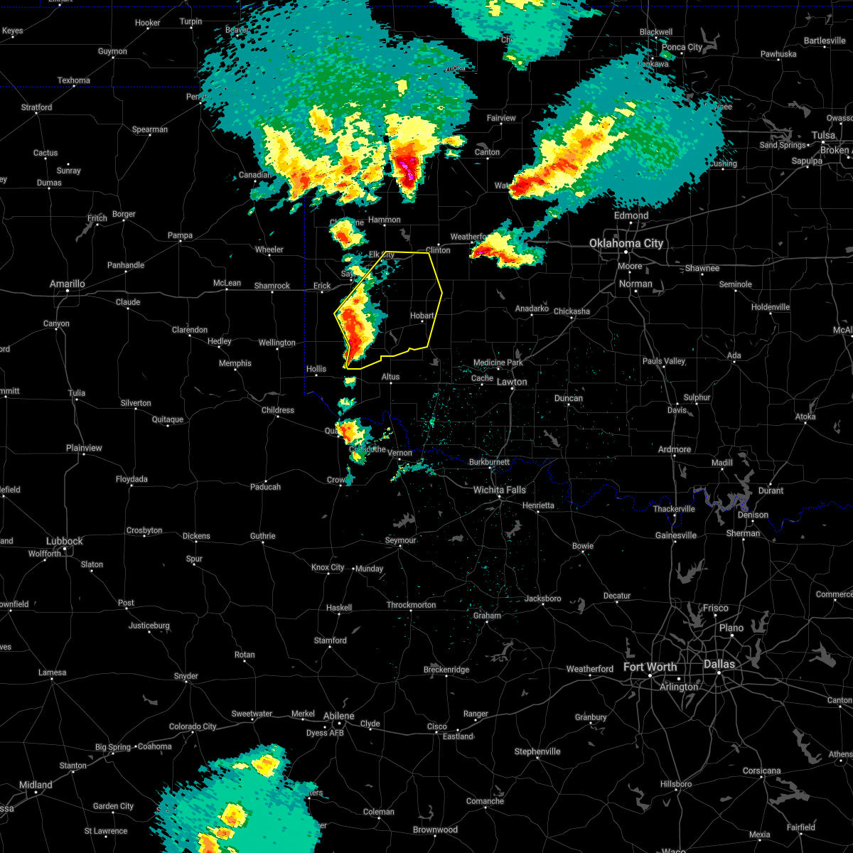 At 1232 am cdt, severe thunderstorms were located along a line extending from 7 miles south of delhi to 4 miles south of willow to 7 miles northwest of duke, moving northeast at 45 mph (radar indicated). Hazards include 70 mph wind gusts and quarter size hail. Hail damage to vehicles is expected. expect considerable tree damage. Wind damage is also likely to mobile homes, roofs, and outbuildings. At 1232 am cdt, severe thunderstorms were located along a line extending from 7 miles south of delhi to 4 miles south of willow to 7 miles northwest of duke, moving northeast at 45 mph (radar indicated). Hazards include 70 mph wind gusts and quarter size hail. Hail damage to vehicles is expected. expect considerable tree damage. Wind damage is also likely to mobile homes, roofs, and outbuildings.
|
| 3/17/2021 12:23 AM CDT |
 At 1223 am cdt, a severe thunderstorm was located 7 miles northeast of gould, moving northeast at 30 mph (radar indicated). Hazards include 60 mph wind gusts and quarter size hail. Hail damage to vehicles is expected. expect wind damage to roofs, siding, and trees. Locations impacted include, mangum, gould and mcqueen. At 1223 am cdt, a severe thunderstorm was located 7 miles northeast of gould, moving northeast at 30 mph (radar indicated). Hazards include 60 mph wind gusts and quarter size hail. Hail damage to vehicles is expected. expect wind damage to roofs, siding, and trees. Locations impacted include, mangum, gould and mcqueen.
|
| 3/17/2021 12:06 AM CDT |
 At 1206 am cdt, a severe thunderstorm was located near gould, moving east at 35 mph (radar indicated). Hazards include 60 mph wind gusts and quarter size hail. Hail damage to vehicles is expected. expect wind damage to roofs, siding, and trees. Locations impacted include, mangum, hollis, gould, mcknight and mcqueen. At 1206 am cdt, a severe thunderstorm was located near gould, moving east at 35 mph (radar indicated). Hazards include 60 mph wind gusts and quarter size hail. Hail damage to vehicles is expected. expect wind damage to roofs, siding, and trees. Locations impacted include, mangum, hollis, gould, mcknight and mcqueen.
|
| 3/16/2021 11:53 PM CDT |
 At 1153 pm cdt, a severe thunderstorm was located near hollis, moving east at 35 mph (radar indicated). Hazards include 60 mph wind gusts and quarter size hail. Hail damage to vehicles is expected. Expect wind damage to roofs, siding, and trees. At 1153 pm cdt, a severe thunderstorm was located near hollis, moving east at 35 mph (radar indicated). Hazards include 60 mph wind gusts and quarter size hail. Hail damage to vehicles is expected. Expect wind damage to roofs, siding, and trees.
|
| 3/16/2021 10:00 PM CDT | Quarter sized hail reported 3.6 miles S of Mangum, OK |
| 3/16/2021 9:30 PM CDT | Quarter sized hail reported 3 miles ESE of Mangum, OK |
| 3/16/2021 9:29 PM CDT |
 At 929 pm cdt, a severe thunderstorm was located 7 miles west of mangum, moving northeast at 25 mph (trained weather spotters). Hazards include golf ball size hail and 60 mph wind gusts. People and animals outdoors will be injured. expect hail damage to roofs, siding, windows, and vehicles. Expect wind damage to roofs, siding, and trees. At 929 pm cdt, a severe thunderstorm was located 7 miles west of mangum, moving northeast at 25 mph (trained weather spotters). Hazards include golf ball size hail and 60 mph wind gusts. People and animals outdoors will be injured. expect hail damage to roofs, siding, windows, and vehicles. Expect wind damage to roofs, siding, and trees.
|
| 3/16/2021 9:25 PM CDT | Golf Ball sized hail reported 0.9 miles E of Mangum, OK |
| 3/16/2021 9:25 PM CDT | Quarter sized hail reported 10.1 miles E of Mangum, OK |
| 3/16/2021 9:19 PM CDT |
 At 919 pm cdt, a severe thunderstorm was located 10 miles east of vinson, moving northeast at 30 mph (radar indicated). Hazards include 60 mph wind gusts and quarter size hail. Hail damage to vehicles is expected. expect wind damage to roofs, siding, and trees. Locations impacted include, mangum, granite, willow, brinkman and northwestern altus-lugert lake. At 919 pm cdt, a severe thunderstorm was located 10 miles east of vinson, moving northeast at 30 mph (radar indicated). Hazards include 60 mph wind gusts and quarter size hail. Hail damage to vehicles is expected. expect wind damage to roofs, siding, and trees. Locations impacted include, mangum, granite, willow, brinkman and northwestern altus-lugert lake.
|
| 3/16/2021 9:08 PM CDT |
 At 908 pm cdt, a severe thunderstorm was located 8 miles southeast of vinson, moving northeast at 40 mph (radar indicated). Hazards include 60 mph wind gusts and quarter size hail. Hail damage to vehicles is expected. expect wind damage to roofs, siding, and trees. Locations impacted include, mangum, granite, willow, hester, brinkman and northwestern altus-lugert lake. At 908 pm cdt, a severe thunderstorm was located 8 miles southeast of vinson, moving northeast at 40 mph (radar indicated). Hazards include 60 mph wind gusts and quarter size hail. Hail damage to vehicles is expected. expect wind damage to roofs, siding, and trees. Locations impacted include, mangum, granite, willow, hester, brinkman and northwestern altus-lugert lake.
|
| 3/16/2021 8:57 PM CDT |
 At 847 pm cdt, a severe thunderstorm was located near gould, moving northeast at 40 mph (radar indicated). Hazards include 60 mph wind gusts and quarter size hail. Hail damage to vehicles is expected. Expect wind damage to roofs, siding, and trees. At 847 pm cdt, a severe thunderstorm was located near gould, moving northeast at 40 mph (radar indicated). Hazards include 60 mph wind gusts and quarter size hail. Hail damage to vehicles is expected. Expect wind damage to roofs, siding, and trees.
|
| 3/16/2021 8:47 PM CDT |
 At 847 pm cdt, a severe thunderstorm was located near gould, moving northeast at 40 mph (radar indicated). Hazards include 60 mph wind gusts and quarter size hail. Hail damage to vehicles is expected. Expect wind damage to roofs, siding, and trees. At 847 pm cdt, a severe thunderstorm was located near gould, moving northeast at 40 mph (radar indicated). Hazards include 60 mph wind gusts and quarter size hail. Hail damage to vehicles is expected. Expect wind damage to roofs, siding, and trees.
|
| 3/13/2021 9:57 PM CDT |
 A severe thunderstorm warning remains in effect until 915 pm cst for east central harmon and southeastern greer counties. at 856 pm cst, a severe thunderstorm was located 8 miles southwest of mangum, moving northeast at 40 mph. hazard. 70 mph wind gusts. source. Radar indicated. A severe thunderstorm warning remains in effect until 915 pm cst for east central harmon and southeastern greer counties. at 856 pm cst, a severe thunderstorm was located 8 miles southwest of mangum, moving northeast at 40 mph. hazard. 70 mph wind gusts. source. Radar indicated.
|
| 3/13/2021 9:46 PM CDT |
 At 845 pm cst, a severe thunderstorm was located 7 miles northwest of duke, moving northeast at 40 mph (radar indicated). Hazards include 70 mph wind gusts. Expect considerable tree damage. damage is likely to mobile homes, roofs, and outbuildings. Locations impacted include, mangum and mcqueen. At 845 pm cst, a severe thunderstorm was located 7 miles northwest of duke, moving northeast at 40 mph (radar indicated). Hazards include 70 mph wind gusts. Expect considerable tree damage. damage is likely to mobile homes, roofs, and outbuildings. Locations impacted include, mangum and mcqueen.
|
| 3/13/2021 9:39 PM CDT |
 At 838 pm cst, a severe thunderstorm was located 5 miles west of duke, moving northeast at 40 mph (radar indicated). Hazards include 70 mph wind gusts. Expect considerable tree damage. damage is likely to mobile homes, roofs, and outbuildings. Locations impacted include, mangum, gould, hester and mcqueen. At 838 pm cst, a severe thunderstorm was located 5 miles west of duke, moving northeast at 40 mph (radar indicated). Hazards include 70 mph wind gusts. Expect considerable tree damage. damage is likely to mobile homes, roofs, and outbuildings. Locations impacted include, mangum, gould, hester and mcqueen.
|
| 3/13/2021 9:33 PM CDT |
 At 833 pm cst, a severe thunderstorm was located 4 miles southeast of gould, moving northeast at 40 mph (radar indicated). Hazards include 60 mph wind gusts. expect damage to roofs, siding, and trees At 833 pm cst, a severe thunderstorm was located 4 miles southeast of gould, moving northeast at 40 mph (radar indicated). Hazards include 60 mph wind gusts. expect damage to roofs, siding, and trees
|
| 8/10/2020 10:11 PM CDT |
 At 1010 pm cdt, the leading edge of winds from severe thunderstorms was located along a line extending from 3 miles northwest of clinton to 5 miles southeast of retrop to near gould, moving east at 30 mph (radar indicated). Hazards include 60 mph wind gusts. Expect damage to roofs, siding, and trees. Locations impacted include, elk city, clinton, mangum, cordell, granite, burns flat, sentinel, arapaho, dill city, canute, lone wolf, butler, carter, bessie, foss, willow, gould, retrop, foss reservoir and brinkman. At 1010 pm cdt, the leading edge of winds from severe thunderstorms was located along a line extending from 3 miles northwest of clinton to 5 miles southeast of retrop to near gould, moving east at 30 mph (radar indicated). Hazards include 60 mph wind gusts. Expect damage to roofs, siding, and trees. Locations impacted include, elk city, clinton, mangum, cordell, granite, burns flat, sentinel, arapaho, dill city, canute, lone wolf, butler, carter, bessie, foss, willow, gould, retrop, foss reservoir and brinkman.
|
| 8/10/2020 10:04 PM CDT |
 At 1003 pm cdt, the leading edge of winds from a line of severe thunderstorms was located along a line extending from 5 miles southeast of foss to 3 miles north of lone wolf to 6 miles north of duke, moving east at 35 mph (radar indicated). Hazards include 60 mph wind gusts. expect damage to roofs, siding, and trees At 1003 pm cdt, the leading edge of winds from a line of severe thunderstorms was located along a line extending from 5 miles southeast of foss to 3 miles north of lone wolf to 6 miles north of duke, moving east at 35 mph (radar indicated). Hazards include 60 mph wind gusts. expect damage to roofs, siding, and trees
|
| 8/10/2020 9:38 PM CDT |
 At 938 pm cdt, the leading edge of winds from a line of severe thunderstorms was located along a line extending from 4 miles northwest of foss reservoir to 3 miles southwest of carter to near dodson, moving east at 30 mph (the erick mesonet measured a 64 mph wind gust). Hazards include 60 mph wind gusts. expect damage to roofs, siding, and trees At 938 pm cdt, the leading edge of winds from a line of severe thunderstorms was located along a line extending from 4 miles northwest of foss reservoir to 3 miles southwest of carter to near dodson, moving east at 30 mph (the erick mesonet measured a 64 mph wind gust). Hazards include 60 mph wind gusts. expect damage to roofs, siding, and trees
|
| 6/23/2020 1:01 AM CDT |
 At 100 am cdt, the leading edge of an area of severe thunderstorms were located along a line extending from 5 miles southeast of granite to 3 miles northeast of duke, moving southeast at 20 mph. some strong to severe winds will arrive before the thunderstorms themselves (radar indicated). Hazards include 60 mph wind gusts. Expect damage to roofs, siding, and trees. Locations impacted include, altus, mangum, granite, blair, martha, friendship, altus air force base, warren, humphreys, hester and altus-lugert lake. At 100 am cdt, the leading edge of an area of severe thunderstorms were located along a line extending from 5 miles southeast of granite to 3 miles northeast of duke, moving southeast at 20 mph. some strong to severe winds will arrive before the thunderstorms themselves (radar indicated). Hazards include 60 mph wind gusts. Expect damage to roofs, siding, and trees. Locations impacted include, altus, mangum, granite, blair, martha, friendship, altus air force base, warren, humphreys, hester and altus-lugert lake.
|
| 6/23/2020 12:34 AM CDT |
 At 1234 am cdt, a severe thunderstorm was located 4 miles southwest of mangum, moving southeast at 25 mph (radar indicated). Hazards include 60 mph wind gusts. expect damage to roofs, siding, and trees At 1234 am cdt, a severe thunderstorm was located 4 miles southwest of mangum, moving southeast at 25 mph (radar indicated). Hazards include 60 mph wind gusts. expect damage to roofs, siding, and trees
|
| 6/19/2020 9:20 PM CDT |
 The severe thunderstorm warning for jackson, southeastern harmon, southeastern greer and northern hardeman counties will expire at 930 pm cdt, the storms which prompted the warning have weakened below severe limits, therefore the warning will be allowed to expire. however gusty winds and heavy rain are still possible with these thunderstorms. The severe thunderstorm warning for jackson, southeastern harmon, southeastern greer and northern hardeman counties will expire at 930 pm cdt, the storms which prompted the warning have weakened below severe limits, therefore the warning will be allowed to expire. however gusty winds and heavy rain are still possible with these thunderstorms.
|
| 6/19/2020 9:05 PM CDT |
 At 904 pm cdt, severe thunderstorms were located along a line extending from 4 miles southeast of mangum to 7 miles west of olustee to 4 miles north of quanah, moving southeast at 40 mph (radar indicated). Hazards include 60 mph wind gusts and dime size hail. Expect damage to roofs, siding, and trees. Locations impacted include, altus, mangum, quanah, blair, olustee, eldorado, martha, gould, altus air force base, duke, goodlett, hester and mcqueen. At 904 pm cdt, severe thunderstorms were located along a line extending from 4 miles southeast of mangum to 7 miles west of olustee to 4 miles north of quanah, moving southeast at 40 mph (radar indicated). Hazards include 60 mph wind gusts and dime size hail. Expect damage to roofs, siding, and trees. Locations impacted include, altus, mangum, quanah, blair, olustee, eldorado, martha, gould, altus air force base, duke, goodlett, hester and mcqueen.
|
| 6/19/2020 8:28 PM CDT |
 At 828 pm cdt, severe thunderstorms were located along a line extending from 4 miles northeast of vinson to 3 miles northeast of hollis to 9 miles north of kirkland, moving east at 35 mph (radar indicated). Hazards include 60 mph wind gusts and nickel size hail. expect damage to roofs, siding, and trees At 828 pm cdt, severe thunderstorms were located along a line extending from 4 miles northeast of vinson to 3 miles northeast of hollis to 9 miles north of kirkland, moving east at 35 mph (radar indicated). Hazards include 60 mph wind gusts and nickel size hail. expect damage to roofs, siding, and trees
|
| 6/4/2020 8:00 PM CDT |
 At 800 pm cdt, severe thunderstorms were located along a line extending from 5 miles north of lake chickasha to near duke, moving east at 45 mph (radar indicated). Hazards include 60 mph wind gusts. expect damage to roofs, siding, and trees At 800 pm cdt, severe thunderstorms were located along a line extending from 5 miles north of lake chickasha to near duke, moving east at 45 mph (radar indicated). Hazards include 60 mph wind gusts. expect damage to roofs, siding, and trees
|
| 6/4/2020 7:25 PM CDT |
 At 725 pm cdt, severe thunderstorms were located along a line extending from 9 miles south of erick to 3 miles west of willow to 5 miles southwest of burns flat, moving southeast at 25 mph (radar indicated). Hazards include 60 mph wind gusts. Expect damage to roofs, siding, and trees. Locations impacted include, elk city, mangum, granite, erick, carter, willow, texola, delhi, vinson, madge, brinkman, hester, mcknight and altus-lugert lake. At 725 pm cdt, severe thunderstorms were located along a line extending from 9 miles south of erick to 3 miles west of willow to 5 miles southwest of burns flat, moving southeast at 25 mph (radar indicated). Hazards include 60 mph wind gusts. Expect damage to roofs, siding, and trees. Locations impacted include, elk city, mangum, granite, erick, carter, willow, texola, delhi, vinson, madge, brinkman, hester, mcknight and altus-lugert lake.
|
| 6/4/2020 6:57 PM CDT |
 At 657 pm cdt, severe thunderstorms were located along a line extending from near texola to near delhi to 4 miles northeast of elk city, moving southeast at 25 mph (radar indicated). Hazards include 70 mph wind gusts. Expect considerable tree damage. Damage is likely to mobile homes, roofs, and outbuildings. At 657 pm cdt, severe thunderstorms were located along a line extending from near texola to near delhi to 4 miles northeast of elk city, moving southeast at 25 mph (radar indicated). Hazards include 70 mph wind gusts. Expect considerable tree damage. Damage is likely to mobile homes, roofs, and outbuildings.
|
| 5/24/2020 10:10 PM CDT |
 At 1010 pm cdt, severe thunderstorms were located along a line extending from 6 miles southwest of putnam to 5 miles northeast of foss to 4 miles south of willow, moving east at 30 mph (radar indicated). Hazards include 60 mph wind gusts and quarter size hail. Hail damage to vehicles is expected. Expect wind damage to roofs, siding, and trees. At 1010 pm cdt, severe thunderstorms were located along a line extending from 6 miles southwest of putnam to 5 miles northeast of foss to 4 miles south of willow, moving east at 30 mph (radar indicated). Hazards include 60 mph wind gusts and quarter size hail. Hail damage to vehicles is expected. Expect wind damage to roofs, siding, and trees.
|
| 5/24/2020 9:48 PM CDT |
 At 948 pm cdt, severe thunderstorms were located along a line extending from 6 miles east of camargo to near foss reservoir to 7 miles southeast of delhi, moving east at 25 mph (radar indicated). Hazards include 60 mph wind gusts and quarter size hail. Hail damage to vehicles is expected. expect wind damage to roofs, siding, and trees. Locations impacted include, elk city, clinton, sayre, mangum, cordell, taloga, granite, burns flat, sentinel, arapaho, hammon, dill city, canute, lone wolf, leedey, custer city, butler, carter, bessie and camargo. At 948 pm cdt, severe thunderstorms were located along a line extending from 6 miles east of camargo to near foss reservoir to 7 miles southeast of delhi, moving east at 25 mph (radar indicated). Hazards include 60 mph wind gusts and quarter size hail. Hail damage to vehicles is expected. expect wind damage to roofs, siding, and trees. Locations impacted include, elk city, clinton, sayre, mangum, cordell, taloga, granite, burns flat, sentinel, arapaho, hammon, dill city, canute, lone wolf, leedey, custer city, butler, carter, bessie and camargo.
|
| 5/24/2020 9:18 PM CDT |
 At 917 pm cdt, severe thunderstorms were located along a line extending from 6 miles west of camargo to 5 miles south of hammon to 9 miles south of erick, moving east at 25 mph. brief gustnadoes are possible along the leading edge of this line (radar indicated). Hazards include 60 mph wind gusts and quarter size hail. Hail damage to vehicles is expected. Expect wind damage to roofs, siding, and trees. At 917 pm cdt, severe thunderstorms were located along a line extending from 6 miles west of camargo to 5 miles south of hammon to 9 miles south of erick, moving east at 25 mph. brief gustnadoes are possible along the leading edge of this line (radar indicated). Hazards include 60 mph wind gusts and quarter size hail. Hail damage to vehicles is expected. Expect wind damage to roofs, siding, and trees.
|
| 5/13/2020 8:11 PM CDT |
 At 810 pm cdt, severe thunderstorms were located along a line extending from near sentinel to 4 miles southeast of lone wolf to 4 miles northwest of eldorado, moving east at 35 mph (radar indicated). Hazards include 70 mph wind gusts and quarter size hail. Hail damage to vehicles is expected. expect considerable tree damage. Wind damage is also likely to mobile homes, roofs, and outbuildings. At 810 pm cdt, severe thunderstorms were located along a line extending from near sentinel to 4 miles southeast of lone wolf to 4 miles northwest of eldorado, moving east at 35 mph (radar indicated). Hazards include 70 mph wind gusts and quarter size hail. Hail damage to vehicles is expected. expect considerable tree damage. Wind damage is also likely to mobile homes, roofs, and outbuildings.
|
| 5/13/2020 7:57 PM CDT |
 At 756 pm cdt, severe thunderstorms were located along a line extending from 4 miles north of granite to 5 miles east of mangum to near duke to 6 miles northwest of eldorado, moving east at 35 mph (at 754 pm, trained weather spotters reported a 70 mph wind gust with this storm 1 mile south southeast of mangum). Hazards include 70 mph wind gusts and quarter size hail. Hail damage to vehicles is expected. expect considerable tree damage. wind damage is also likely to mobile homes, roofs, and outbuildings. Locations impacted include, mangum, granite, sentinel, blair, eldorado, lone wolf, martha, willow, gould, retrop, duke, brinkman, hester, mcqueen and altus-lugert lake. At 756 pm cdt, severe thunderstorms were located along a line extending from 4 miles north of granite to 5 miles east of mangum to near duke to 6 miles northwest of eldorado, moving east at 35 mph (at 754 pm, trained weather spotters reported a 70 mph wind gust with this storm 1 mile south southeast of mangum). Hazards include 70 mph wind gusts and quarter size hail. Hail damage to vehicles is expected. expect considerable tree damage. wind damage is also likely to mobile homes, roofs, and outbuildings. Locations impacted include, mangum, granite, sentinel, blair, eldorado, lone wolf, martha, willow, gould, retrop, duke, brinkman, hester, mcqueen and altus-lugert lake.
|
| 5/13/2020 7:54 PM CDT | Also pea sized hai in greer county OK, 0.6 miles NNW of Mangum, OK |
| 5/13/2020 7:31 PM CDT |
 At 730 pm cdt, severe thunderstorms were located along a line extending from 9 miles northwest of mangum to 10 miles northwest of duke to 3 miles southwest of gould to 9 miles north of goodlett, moving east at 35 mph (radar indicated). Hazards include 70 mph wind gusts and ping pong ball size hail. People and animals outdoors will be injured. expect hail damage to roofs, siding, windows, and vehicles. expect considerable tree damage. Wind damage is also likely to mobile homes, roofs, and outbuildings. At 730 pm cdt, severe thunderstorms were located along a line extending from 9 miles northwest of mangum to 10 miles northwest of duke to 3 miles southwest of gould to 9 miles north of goodlett, moving east at 35 mph (radar indicated). Hazards include 70 mph wind gusts and ping pong ball size hail. People and animals outdoors will be injured. expect hail damage to roofs, siding, windows, and vehicles. expect considerable tree damage. Wind damage is also likely to mobile homes, roofs, and outbuildings.
|
| 5/7/2020 6:17 PM CDT | Tennis Ball sized hail reported 11.2 miles E of Mangum, OK, twitter photo. |
| 5/7/2020 6:00 PM CDT | Golf Ball sized hail reported 11.1 miles E of Mangum, OK |
| 5/7/2020 5:56 PM CDT |
 The national weather service in norman has issued a * severe thunderstorm warning for. southwestern washita county in western oklahoma. northern jackson county in southwestern oklahoma. northwestern kiowa county in southwestern oklahoma. Northeastern harmon county in southwestern oklahoma. The national weather service in norman has issued a * severe thunderstorm warning for. southwestern washita county in western oklahoma. northern jackson county in southwestern oklahoma. northwestern kiowa county in southwestern oklahoma. Northeastern harmon county in southwestern oklahoma.
|
| 5/7/2020 5:44 PM CDT |
 At 544 pm cdt, a severe thunderstorm was located 7 miles north of gould, moving east at 50 mph (radar indicated). Hazards include ping pong ball size hail and 60 mph wind gusts. People and animals outdoors will be injured. expect hail damage to roofs, siding, windows, and vehicles. expect wind damage to roofs, siding, and trees. Locations impacted include, mangum, hollis, willow, gould, vinson, duke, brinkman, hester, mcknight and mcqueen. At 544 pm cdt, a severe thunderstorm was located 7 miles north of gould, moving east at 50 mph (radar indicated). Hazards include ping pong ball size hail and 60 mph wind gusts. People and animals outdoors will be injured. expect hail damage to roofs, siding, windows, and vehicles. expect wind damage to roofs, siding, and trees. Locations impacted include, mangum, hollis, willow, gould, vinson, duke, brinkman, hester, mcknight and mcqueen.
|
| 5/7/2020 5:21 PM CDT |
 At 521 pm cdt, a severe thunderstorm was located near dodson, moving east at 55 mph (radar indicated). Hazards include ping pong ball size hail and 60 mph wind gusts. People and animals outdoors will be injured. expect hail damage to roofs, siding, windows, and vehicles. Expect wind damage to roofs, siding, and trees. At 521 pm cdt, a severe thunderstorm was located near dodson, moving east at 55 mph (radar indicated). Hazards include ping pong ball size hail and 60 mph wind gusts. People and animals outdoors will be injured. expect hail damage to roofs, siding, windows, and vehicles. Expect wind damage to roofs, siding, and trees.
|
| 6/18/2019 11:54 PM CDT |
 At 1153 pm cdt, severe thunderstorms were located along a line extending from near sentinel to 7 miles northwest of roosevelt to 5 miles northeast of gould, moving southeast at 35 mph (radar indicated). Hazards include 60 mph wind gusts and nickel size hail. expect damage to roofs, siding, and trees At 1153 pm cdt, severe thunderstorms were located along a line extending from near sentinel to 7 miles northwest of roosevelt to 5 miles northeast of gould, moving southeast at 35 mph (radar indicated). Hazards include 60 mph wind gusts and nickel size hail. expect damage to roofs, siding, and trees
|
| 6/18/2019 11:30 PM CDT |
 At 1130 pm cdt, severe thunderstorms were located along a line extending from near carter to near willow to 5 miles west of vinson, moving east at 40 mph (radar indicated). Hazards include 60 mph wind gusts and nickel size hail. Expect damage to roofs, siding, and trees. Locations impacted include, mangum, hollis, granite, blair, lone wolf, martha, willow, gould, vinson, duke, warren, madge, brinkman, hester, mcqueen, mcknight and altus-lugert lake. At 1130 pm cdt, severe thunderstorms were located along a line extending from near carter to near willow to 5 miles west of vinson, moving east at 40 mph (radar indicated). Hazards include 60 mph wind gusts and nickel size hail. Expect damage to roofs, siding, and trees. Locations impacted include, mangum, hollis, granite, blair, lone wolf, martha, willow, gould, vinson, duke, warren, madge, brinkman, hester, mcqueen, mcknight and altus-lugert lake.
|
| 6/18/2019 11:07 PM CDT |
 At 1107 pm cdt, severe thunderstorms were located along a line extending from near sayre to near erick to near wellington, moving east at 35 mph (radar indicated). Hazards include 70 mph wind gusts and quarter size hail. Expect considerable tree damage. Wind damage is also likely to mobile homes, roofs, and outbuildings. At 1107 pm cdt, severe thunderstorms were located along a line extending from near sayre to near erick to near wellington, moving east at 35 mph (radar indicated). Hazards include 70 mph wind gusts and quarter size hail. Expect considerable tree damage. Wind damage is also likely to mobile homes, roofs, and outbuildings.
|
| 6/15/2019 9:18 PM CDT |
 At 917 pm cdt, severe thunderstorms were located along a line extending from 4 miles southeast of lone wolf to 4 miles southeast of headrick to 6 miles west of davidson, moving east at 45 mph (radar indicated). Hazards include 70 mph wind gusts and quarter size hail. Hail damage to vehicles is expected. expect considerable tree damage. wind damage is also likely to mobile homes, roofs, and outbuildings. Locations impacted include, altus, vernon, frederick, hobart, mangum, quanah, granite, snyder, tipton, blair, chillicothe, olustee, eldorado, lone wolf, mountain park, indiahoma, davidson, roosevelt, gotebo and manitou. At 917 pm cdt, severe thunderstorms were located along a line extending from 4 miles southeast of lone wolf to 4 miles southeast of headrick to 6 miles west of davidson, moving east at 45 mph (radar indicated). Hazards include 70 mph wind gusts and quarter size hail. Hail damage to vehicles is expected. expect considerable tree damage. wind damage is also likely to mobile homes, roofs, and outbuildings. Locations impacted include, altus, vernon, frederick, hobart, mangum, quanah, granite, snyder, tipton, blair, chillicothe, olustee, eldorado, lone wolf, mountain park, indiahoma, davidson, roosevelt, gotebo and manitou.
|
| 6/15/2019 8:56 PM CDT |
 At 854 pm cdt, severe thunderstorms were located along a line extending from near mangum to near elmer to 5 miles southeast of chillicothe, moving east at 45 mph (radar indicated). Hazards include 70 mph wind gusts and quarter size hail. Hail damage to vehicles is expected. expect considerable tree damage. Wind damage is also likely to mobile homes, roofs, and outbuildings. At 854 pm cdt, severe thunderstorms were located along a line extending from near mangum to near elmer to 5 miles southeast of chillicothe, moving east at 45 mph (radar indicated). Hazards include 70 mph wind gusts and quarter size hail. Hail damage to vehicles is expected. expect considerable tree damage. Wind damage is also likely to mobile homes, roofs, and outbuildings.
|
| 6/15/2019 8:27 PM CDT |
 At 826 pm cdt, severe thunderstorms were located along a line extending from near hollis to 4 miles south of gould to 4 miles north of quanah to 8 miles northwest of crowell, moving east at 55 mph. these are very dangerous storms (radar indicated). Hazards include 80 mph wind gusts and quarter size hail. Flying debris will be dangerous to those caught without shelter. mobile homes will be heavily damaged. expect considerable damage to roofs, windows, and vehicles. Extensive tree damage and power outages are likely. At 826 pm cdt, severe thunderstorms were located along a line extending from near hollis to 4 miles south of gould to 4 miles north of quanah to 8 miles northwest of crowell, moving east at 55 mph. these are very dangerous storms (radar indicated). Hazards include 80 mph wind gusts and quarter size hail. Flying debris will be dangerous to those caught without shelter. mobile homes will be heavily damaged. expect considerable damage to roofs, windows, and vehicles. Extensive tree damage and power outages are likely.
|
| 6/12/2019 2:34 AM CDT |
 At 234 am cdt, a severe thunderstorm was located near vinson, moving southeast at 35 mph (radar indicated). Hazards include quarter size hail. damage to vehicles is expected At 234 am cdt, a severe thunderstorm was located near vinson, moving southeast at 35 mph (radar indicated). Hazards include quarter size hail. damage to vehicles is expected
|
| 6/12/2019 2:34 AM CDT |
 At 233 am cdt, a severe thunderstorm was located near vinson, moving southeast at 35 mph (radar indicated). Hazards include quarter size hail. damage to vehicles is expected At 233 am cdt, a severe thunderstorm was located near vinson, moving southeast at 35 mph (radar indicated). Hazards include quarter size hail. damage to vehicles is expected
|
| 6/12/2019 12:57 AM CDT |
 At 1256 am cdt, a severe thunderstorm was located 4 miles southeast of mangum, moving southeast at 20 mph. half dollar size hail has been reported with this storm (radar indicated). Hazards include 60 mph wind gusts and quarter to half dollar size hail. Hail damage to vehicles is expected. Expect wind damage to roofs, siding, and trees. At 1256 am cdt, a severe thunderstorm was located 4 miles southeast of mangum, moving southeast at 20 mph. half dollar size hail has been reported with this storm (radar indicated). Hazards include 60 mph wind gusts and quarter to half dollar size hail. Hail damage to vehicles is expected. Expect wind damage to roofs, siding, and trees.
|
| 6/12/2019 12:48 AM CDT | Half Dollar sized hail reported 0.3 miles WSW of Mangum, OK, from pic on twitter. |
| 5/25/2019 9:13 PM CDT |
 At 912 pm cdt, severe thunderstorms were located along a line extending from near cordell to near rocky to near mangum, moving east at 45 mph (radar indicated). Hazards include 60 mph wind gusts, flooding, and quarter size hail. Expect wind damage to roofs, siding, and trees. Locations impacted include, hobart, mangum, cordell, granite, sentinel, blair, mountain view, dill city, lone wolf, roosevelt, gotebo, rocky, martha, colony, cloud chief, warren, hester, cowden and altus-lugert lake. At 912 pm cdt, severe thunderstorms were located along a line extending from near cordell to near rocky to near mangum, moving east at 45 mph (radar indicated). Hazards include 60 mph wind gusts, flooding, and quarter size hail. Expect wind damage to roofs, siding, and trees. Locations impacted include, hobart, mangum, cordell, granite, sentinel, blair, mountain view, dill city, lone wolf, roosevelt, gotebo, rocky, martha, colony, cloud chief, warren, hester, cowden and altus-lugert lake.
|
| 5/25/2019 8:58 PM CDT |
 At 858 pm cdt, severe thunderstorms were located along a line extending from 7 miles southwest of elk city to 5 miles north of granite to 7 miles southwest of mangum, moving east at 45 mph (radar indicated). Hazards include 70 mph wind gusts, flash flooding, and up to quarter size hail. Expect considerable tree damage. Wind damage is also likely to mobile homes, roofs, and outbuildings. At 858 pm cdt, severe thunderstorms were located along a line extending from 7 miles southwest of elk city to 5 miles north of granite to 7 miles southwest of mangum, moving east at 45 mph (radar indicated). Hazards include 70 mph wind gusts, flash flooding, and up to quarter size hail. Expect considerable tree damage. Wind damage is also likely to mobile homes, roofs, and outbuildings.
|
| 5/25/2019 8:32 PM CDT |
 At 831 pm cdt, severe thunderstorms were located along a line extending from 4 miles northeast of texola to 6 miles northeast of vinson to 3 miles northwest of hollis, moving east at 60 mph (radar indicated). Hazards include 70 mph wind gusts and nickel size hail. Expect considerable tree damage. damage is likely to mobile homes, roofs, and outbuildings. Locations impacted include, elk city, sayre, mangum, hollis, granite, erick, carter, willow, texola, delhi, vinson, retrop, madge, brinkman, hester, mcknight and altus-lugert lake. At 831 pm cdt, severe thunderstorms were located along a line extending from 4 miles northeast of texola to 6 miles northeast of vinson to 3 miles northwest of hollis, moving east at 60 mph (radar indicated). Hazards include 70 mph wind gusts and nickel size hail. Expect considerable tree damage. damage is likely to mobile homes, roofs, and outbuildings. Locations impacted include, elk city, sayre, mangum, hollis, granite, erick, carter, willow, texola, delhi, vinson, retrop, madge, brinkman, hester, mcknight and altus-lugert lake.
|
| 5/25/2019 8:19 PM CDT |
 At 818 pm cdt, severe thunderstorms were located along a line extending from 6 miles east of twitty to 7 miles southwest of dodson, moving east at 40 mph (radar indicated). Hazards include 70 mph wind gusts, flash flooding, and nickel size hail. Expect considerable tree damage. Damage is likely to mobile homes, roofs, and outbuildings. At 818 pm cdt, severe thunderstorms were located along a line extending from 6 miles east of twitty to 7 miles southwest of dodson, moving east at 40 mph (radar indicated). Hazards include 70 mph wind gusts, flash flooding, and nickel size hail. Expect considerable tree damage. Damage is likely to mobile homes, roofs, and outbuildings.
|
| 5/25/2019 7:53 PM CDT |
 At 752 pm cdt, a severe thunderstorm was located 5 miles northeast of vinson, moving northeast at 50 mph (radar indicated). Hazards include ping pong ball size hail and 60 mph wind gusts. People and animals outdoors will be injured. expect hail damage to roofs, siding, windows, and vehicles. Expect wind damage to roofs, siding, and trees. At 752 pm cdt, a severe thunderstorm was located 5 miles northeast of vinson, moving northeast at 50 mph (radar indicated). Hazards include ping pong ball size hail and 60 mph wind gusts. People and animals outdoors will be injured. expect hail damage to roofs, siding, windows, and vehicles. Expect wind damage to roofs, siding, and trees.
|
| 5/24/2019 6:42 PM CDT |
 At 641 pm cdt, severe thunderstorms were located along a line extending from near blair to near friendship to 4 miles east of elmer, moving northeast at 35 mph (radar indicated. a 58 mph wind gust was measured in altus). Hazards include 70 mph wind gusts and nickel size hail. Expect considerable tree damage. damage is likely to mobile homes, roofs, and outbuildings. Locations impacted include, altus, mangum, granite, tipton, blair, olustee, lone wolf, martha, elmer, headrick, friendship, altus air force base, warren, humphreys, hester, altus-lugert lake and hess. At 641 pm cdt, severe thunderstorms were located along a line extending from near blair to near friendship to 4 miles east of elmer, moving northeast at 35 mph (radar indicated. a 58 mph wind gust was measured in altus). Hazards include 70 mph wind gusts and nickel size hail. Expect considerable tree damage. damage is likely to mobile homes, roofs, and outbuildings. Locations impacted include, altus, mangum, granite, tipton, blair, olustee, lone wolf, martha, elmer, headrick, friendship, altus air force base, warren, humphreys, hester, altus-lugert lake and hess.
|
| 5/24/2019 6:34 PM CDT |
 At 633 pm cdt, severe thunderstorms were located along a line extending from 5 miles northwest of martha to near altus to near humphreys, moving northeast at 35 mph (radar indicated). Hazards include 70 mph wind gusts and nickel size hail. Expect considerable tree damage. damage is likely to mobile homes, roofs, and outbuildings. Locations impacted include, altus, mangum, quanah, granite, tipton, blair, olustee, eldorado, lone wolf, martha, elmer, headrick, friendship, altus air force base, duke, warren, humphreys, hester, altus-lugert lake and hess. At 633 pm cdt, severe thunderstorms were located along a line extending from 5 miles northwest of martha to near altus to near humphreys, moving northeast at 35 mph (radar indicated). Hazards include 70 mph wind gusts and nickel size hail. Expect considerable tree damage. damage is likely to mobile homes, roofs, and outbuildings. Locations impacted include, altus, mangum, quanah, granite, tipton, blair, olustee, eldorado, lone wolf, martha, elmer, headrick, friendship, altus air force base, duke, warren, humphreys, hester, altus-lugert lake and hess.
|
| 5/24/2019 6:18 PM CDT |
 At 617 pm cdt, severe thunderstorms were located along a line extending from 6 miles north of duke to near olustee to 7 miles west of odell to 3 miles south of quanah, moving northeast at 35 mph (radar indicated). Hazards include 70 mph wind gusts and ping pong ball size hail. the greatest threat of large hail is with the section of the line that is near and south of the red river. People and animals outdoors will be injured. expect hail damage to roofs, siding, windows, and vehicles. expect considerable tree damage. wind damage is also likely to mobile homes, roofs, and outbuildings. Locations impacted include, altus, vernon, mangum, quanah, granite, tipton, blair, chillicothe, olustee, eldorado, lone wolf, martha, gould, elmer, headrick, friendship, altus air force base, warren, lockett and medicine mound. At 617 pm cdt, severe thunderstorms were located along a line extending from 6 miles north of duke to near olustee to 7 miles west of odell to 3 miles south of quanah, moving northeast at 35 mph (radar indicated). Hazards include 70 mph wind gusts and ping pong ball size hail. the greatest threat of large hail is with the section of the line that is near and south of the red river. People and animals outdoors will be injured. expect hail damage to roofs, siding, windows, and vehicles. expect considerable tree damage. wind damage is also likely to mobile homes, roofs, and outbuildings. Locations impacted include, altus, vernon, mangum, quanah, granite, tipton, blair, chillicothe, olustee, eldorado, lone wolf, martha, gould, elmer, headrick, friendship, altus air force base, warren, lockett and medicine mound.
|
| 5/24/2019 5:59 PM CDT |
 At 558 pm cdt, severe thunderstorms were located along a line extending from near gould to near eldorado to near quanah to 11 miles south of goodlett, moving northeast at 35 mph (radar indicated). Hazards include 70 mph wind gusts and quarter size hail. Hail damage to vehicles is expected. expect considerable tree damage. Wind damage is also likely to mobile homes, roofs, and outbuildings. At 558 pm cdt, severe thunderstorms were located along a line extending from near gould to near eldorado to near quanah to 11 miles south of goodlett, moving northeast at 35 mph (radar indicated). Hazards include 70 mph wind gusts and quarter size hail. Hail damage to vehicles is expected. expect considerable tree damage. Wind damage is also likely to mobile homes, roofs, and outbuildings.
|
| 5/24/2019 5:38 PM CDT |
 At 537 pm cdt, severe thunderstorms were located along a line extending from near hollis to 9 miles west of eldorado to near goodlett to 11 miles southeast of swearingen, moving northeast at 40 mph (radar indicated). Hazards include 70 mph wind gusts and quarter size hail. Expect considerable tree damage. wind damage is also likely to mobile homes, roofs, and outbuildings. Locations impacted include, altus, mangum, quanah, hollis, chillicothe, olustee, eldorado, martha, gould, elmer, duke, goodlett, medicine mound, odell, hester, mcqueen, lazare and copper breaks state park. At 537 pm cdt, severe thunderstorms were located along a line extending from near hollis to 9 miles west of eldorado to near goodlett to 11 miles southeast of swearingen, moving northeast at 40 mph (radar indicated). Hazards include 70 mph wind gusts and quarter size hail. Expect considerable tree damage. wind damage is also likely to mobile homes, roofs, and outbuildings. Locations impacted include, altus, mangum, quanah, hollis, chillicothe, olustee, eldorado, martha, gould, elmer, duke, goodlett, medicine mound, odell, hester, mcqueen, lazare and copper breaks state park.
|
| 5/24/2019 5:23 PM CDT |
 At 523 pm cdt, severe thunderstorms were located along a line extending from 7 miles north of childress to 6 miles east of kirkland to 7 miles southwest of goodlett to 4 miles east of swearingen, moving northeast at 40 mph (radar indicated). Hazards include 70 mph wind gusts and ping pong ball size hail. People and animals outdoors will be injured. expect hail damage to roofs, siding, windows, and vehicles. expect considerable tree damage. wind damage is also likely to mobile homes, roofs, and outbuildings. Locations impacted include, altus, mangum, quanah, hollis, chillicothe, olustee, eldorado, martha, gould, elmer, duke, goodlett, medicine mound, odell, hester, mcqueen, lazare, copper breaks state park and mcknight. At 523 pm cdt, severe thunderstorms were located along a line extending from 7 miles north of childress to 6 miles east of kirkland to 7 miles southwest of goodlett to 4 miles east of swearingen, moving northeast at 40 mph (radar indicated). Hazards include 70 mph wind gusts and ping pong ball size hail. People and animals outdoors will be injured. expect hail damage to roofs, siding, windows, and vehicles. expect considerable tree damage. wind damage is also likely to mobile homes, roofs, and outbuildings. Locations impacted include, altus, mangum, quanah, hollis, chillicothe, olustee, eldorado, martha, gould, elmer, duke, goodlett, medicine mound, odell, hester, mcqueen, lazare, copper breaks state park and mcknight.
|
| 5/24/2019 5:06 PM CDT |
 At 506 pm cdt, severe thunderstorms were located along a line extending from 5 miles north of childress to 3 miles south of kirkland to 7 miles northeast of chalk, moving northeast at 40 mph (radar indicated). Hazards include 70 mph wind gusts and ping pong ball size hail. People and animals outdoors will be injured. expect hail damage to roofs, siding, windows, and vehicles. expect considerable tree damage. Wind damage is also likely to mobile homes, roofs, and outbuildings. At 506 pm cdt, severe thunderstorms were located along a line extending from 5 miles north of childress to 3 miles south of kirkland to 7 miles northeast of chalk, moving northeast at 40 mph (radar indicated). Hazards include 70 mph wind gusts and ping pong ball size hail. People and animals outdoors will be injured. expect hail damage to roofs, siding, windows, and vehicles. expect considerable tree damage. Wind damage is also likely to mobile homes, roofs, and outbuildings.
|
| 5/20/2019 6:21 PM CDT |
 At 621 pm cdt, severe thunderstorms were located along a line extending from 3 miles north of sayre to 6 miles southeast of delhi to 3 miles east of vinson to 9 miles southwest of hollis, moving northeast at 50 mph (radar indicated). Hazards include 60 mph wind gusts and quarter size hail. Hail damage to vehicles is expected. Expect wind damage to roofs, siding, and trees. At 621 pm cdt, severe thunderstorms were located along a line extending from 3 miles north of sayre to 6 miles southeast of delhi to 3 miles east of vinson to 9 miles southwest of hollis, moving northeast at 50 mph (radar indicated). Hazards include 60 mph wind gusts and quarter size hail. Hail damage to vehicles is expected. Expect wind damage to roofs, siding, and trees.
|
| 5/20/2019 5:24 PM CDT |
 At 520 pm cdt, a large and extremely dangerous tornado was located near mangum, moving northeast at 35 mph. this is a particularly dangerous situation. take cover now! (radar indicated rotation). Hazards include damaging tornado. You are in a life-threatening situation. flying debris may be deadly to those caught without shelter. mobile homes will be destroyed. Considerable damage to homes, businesses, and vehicles is likely and complete destruction is possible. At 520 pm cdt, a large and extremely dangerous tornado was located near mangum, moving northeast at 35 mph. this is a particularly dangerous situation. take cover now! (radar indicated rotation). Hazards include damaging tornado. You are in a life-threatening situation. flying debris may be deadly to those caught without shelter. mobile homes will be destroyed. Considerable damage to homes, businesses, and vehicles is likely and complete destruction is possible.
|
| 5/20/2019 5:23 PM CDT |
 At 523 pm cdt, a confirmed large and extremely dangerous tornado was located near mangum, moving northeast at 30 mph. this is a particularly dangerous situation. take cover now! (weather spotters confirmed tornado). Hazards include damaging tornado. You are in a life-threatening situation. flying debris may be deadly to those caught without shelter. mobile homes will be destroyed. considerable damage to homes, businesses, and vehicles is likely and complete destruction is possible. Locations impacted include, mangum. At 523 pm cdt, a confirmed large and extremely dangerous tornado was located near mangum, moving northeast at 30 mph. this is a particularly dangerous situation. take cover now! (weather spotters confirmed tornado). Hazards include damaging tornado. You are in a life-threatening situation. flying debris may be deadly to those caught without shelter. mobile homes will be destroyed. considerable damage to homes, businesses, and vehicles is likely and complete destruction is possible. Locations impacted include, mangum.
|
| 5/20/2019 5:21 PM CDT |
 At 520 pm cdt, a large and extremely dangerous tornado was located near mangum, moving northeast at 35 mph. this is a particularly dangerous situation. take cover now! (radar indicated rotation). Hazards include damaging tornado. You are in a life-threatening situation. flying debris may be deadly to those caught without shelter. mobile homes will be destroyed. Considerable damage to homes, businesses, and vehicles is likely and complete destruction is possible. At 520 pm cdt, a large and extremely dangerous tornado was located near mangum, moving northeast at 35 mph. this is a particularly dangerous situation. take cover now! (radar indicated rotation). Hazards include damaging tornado. You are in a life-threatening situation. flying debris may be deadly to those caught without shelter. mobile homes will be destroyed. Considerable damage to homes, businesses, and vehicles is likely and complete destruction is possible.
|
| 5/20/2019 5:15 PM CDT |
 At 515 pm cdt, a confirmed large and extremely dangerous tornado was located 7 miles southwest of mangum, moving northeast at 30 mph. this is a particularly dangerous situation. take cover now! (weather spotters confirmed tornado). Hazards include damaging tornado. You are in a life-threatening situation. flying debris may be deadly to those caught without shelter. mobile homes will be destroyed. considerable damage to homes, businesses, and vehicles is likely and complete destruction is possible. Locations impacted include, mangum. At 515 pm cdt, a confirmed large and extremely dangerous tornado was located 7 miles southwest of mangum, moving northeast at 30 mph. this is a particularly dangerous situation. take cover now! (weather spotters confirmed tornado). Hazards include damaging tornado. You are in a life-threatening situation. flying debris may be deadly to those caught without shelter. mobile homes will be destroyed. considerable damage to homes, businesses, and vehicles is likely and complete destruction is possible. Locations impacted include, mangum.
|
| 5/20/2019 5:13 PM CDT |
 At 512 pm cdt, a confirmed tornado was located 8 miles southwest of mangum, moving northeast at 30 mph (weather spotters confirmed tornado). Hazards include damaging tornado and golf ball size hail. Flying debris will be dangerous to those caught without shelter. mobile homes will be damaged or destroyed. damage to roofs, windows, and vehicles will occur. tree damage is likely. Locations impacted include, mangum. At 512 pm cdt, a confirmed tornado was located 8 miles southwest of mangum, moving northeast at 30 mph (weather spotters confirmed tornado). Hazards include damaging tornado and golf ball size hail. Flying debris will be dangerous to those caught without shelter. mobile homes will be damaged or destroyed. damage to roofs, windows, and vehicles will occur. tree damage is likely. Locations impacted include, mangum.
|
| 5/20/2019 4:56 PM CDT |
 At 456 pm cdt, a severe thunderstorm capable of producing a tornado was located 4 miles north of gould, moving northeast at 30 mph (radar indicated rotation). Hazards include tornado and golf ball size hail. Flying debris will be dangerous to those caught without shelter. mobile homes will be damaged or destroyed. damage to roofs, windows, and vehicles will occur. Tree damage is likely. At 456 pm cdt, a severe thunderstorm capable of producing a tornado was located 4 miles north of gould, moving northeast at 30 mph (radar indicated rotation). Hazards include tornado and golf ball size hail. Flying debris will be dangerous to those caught without shelter. mobile homes will be damaged or destroyed. damage to roofs, windows, and vehicles will occur. Tree damage is likely.
|
| 5/8/2019 2:46 AM CDT |
 At 245 am cdt, severe thunderstorms were located along a line extending from near willow to near mangum to 8 miles west of eldorado, moving northeast at 45 mph (radar indicated). Hazards include 60 mph wind gusts and nickel size hail. Expect damage to roofs, siding, and trees. Locations impacted include, mangum, granite, eldorado, willow, duke, brinkman, hester and mcqueen. At 245 am cdt, severe thunderstorms were located along a line extending from near willow to near mangum to 8 miles west of eldorado, moving northeast at 45 mph (radar indicated). Hazards include 60 mph wind gusts and nickel size hail. Expect damage to roofs, siding, and trees. Locations impacted include, mangum, granite, eldorado, willow, duke, brinkman, hester and mcqueen.
|
| 5/8/2019 2:32 AM CDT |
 At 231 am cdt, severe thunderstorms were located along a line extending from 7 miles west of willow to near gould to 7 miles northeast of kirkland, moving east at 35 mph (radar indicated). Hazards include 60 mph wind gusts and nickel size hail. Expect damage to roofs, siding, and trees. Locations impacted include, mangum, hollis, granite, eldorado, willow, gould, goodlett, duke, brinkman, hester, mcqueen and lazare. At 231 am cdt, severe thunderstorms were located along a line extending from 7 miles west of willow to near gould to 7 miles northeast of kirkland, moving east at 35 mph (radar indicated). Hazards include 60 mph wind gusts and nickel size hail. Expect damage to roofs, siding, and trees. Locations impacted include, mangum, hollis, granite, eldorado, willow, gould, goodlett, duke, brinkman, hester, mcqueen and lazare.
|
| 5/8/2019 2:16 AM CDT |
 The national weather service in norman has issued a * severe thunderstorm warning for. western jackson county in southwestern oklahoma. harmon county in southwestern oklahoma. greer county in southwestern oklahoma. Northern hardeman county in northern texas. The national weather service in norman has issued a * severe thunderstorm warning for. western jackson county in southwestern oklahoma. harmon county in southwestern oklahoma. greer county in southwestern oklahoma. Northern hardeman county in northern texas.
|
| 5/7/2019 11:15 PM CDT | Mesonet measurement in greer county OK, 4.9 miles NW of Mangum, OK |
| 5/7/2019 11:10 PM CDT |
 At 1110 pm cdt, a severe thunderstorm was located 4 miles north of martha, moving northeast at 60 mph (radar indicated). Hazards include 60 mph wind gusts and quarter size hail. Hail damage to vehicles is expected. Expect wind damage to roofs, siding, and trees. At 1110 pm cdt, a severe thunderstorm was located 4 miles north of martha, moving northeast at 60 mph (radar indicated). Hazards include 60 mph wind gusts and quarter size hail. Hail damage to vehicles is expected. Expect wind damage to roofs, siding, and trees.
|
| 5/7/2019 10:30 PM CDT |
 At 1030 pm cdt, a severe thunderstorm was located 5 miles east of mangum, moving northeast at 30 mph (radar indicated). Hazards include 60 mph wind gusts and quarter size hail. Hail damage to vehicles is expected. expect wind damage to roofs, siding, and trees. Locations impacted include, mangum, granite, blair, hester and altus-lugert lake. At 1030 pm cdt, a severe thunderstorm was located 5 miles east of mangum, moving northeast at 30 mph (radar indicated). Hazards include 60 mph wind gusts and quarter size hail. Hail damage to vehicles is expected. expect wind damage to roofs, siding, and trees. Locations impacted include, mangum, granite, blair, hester and altus-lugert lake.
|
| 5/7/2019 10:16 PM CDT |
 At 1016 pm cdt, a severe thunderstorm was located near mangum, moving northeast at 30 mph (radar indicated). Hazards include 60 mph wind gusts and quarter size hail. Hail damage to vehicles is expected. expect wind damage to roofs, siding, and trees. Locations impacted include, mangum, granite, blair, willow, brinkman, hester and altus-lugert lake. At 1016 pm cdt, a severe thunderstorm was located near mangum, moving northeast at 30 mph (radar indicated). Hazards include 60 mph wind gusts and quarter size hail. Hail damage to vehicles is expected. expect wind damage to roofs, siding, and trees. Locations impacted include, mangum, granite, blair, willow, brinkman, hester and altus-lugert lake.
|
| 5/7/2019 10:04 PM CDT |
 The national weather service in norman has issued a * severe thunderstorm warning for. north central jackson county in southwestern oklahoma. west central kiowa county in southwestern oklahoma. greer county in southwestern oklahoma. Until 1045 pm cdt. The national weather service in norman has issued a * severe thunderstorm warning for. north central jackson county in southwestern oklahoma. west central kiowa county in southwestern oklahoma. greer county in southwestern oklahoma. Until 1045 pm cdt.
|
| 4/22/2019 9:35 PM CDT | Mangum sit in greer county OK, 4.9 miles NW of Mangum, OK |
| 4/3/2019 11:22 PM CDT |
 The severe thunderstorm warning for west central kiowa and northeastern greer counties will expire at 1130 pm cdt, the storm which prompted the warning has weakened below severe limits, and no longer poses an immediate threat to life or property. therefore, the warning will be allowed to expire. however small hail and heavy rain are still possible with this thunderstorm. The severe thunderstorm warning for west central kiowa and northeastern greer counties will expire at 1130 pm cdt, the storm which prompted the warning has weakened below severe limits, and no longer poses an immediate threat to life or property. therefore, the warning will be allowed to expire. however small hail and heavy rain are still possible with this thunderstorm.
|
| 4/3/2019 11:08 PM CDT |
 At 1108 pm cdt, a severe thunderstorm was located over granite, moving east at 30 mph (radar indicated). Hazards include quarter size hail. Damage to vehicles is expected. Locations impacted include, mangum, granite, brinkman and altus-lugert lake. At 1108 pm cdt, a severe thunderstorm was located over granite, moving east at 30 mph (radar indicated). Hazards include quarter size hail. Damage to vehicles is expected. Locations impacted include, mangum, granite, brinkman and altus-lugert lake.
|
| 4/3/2019 10:47 PM CDT |
 At 1047 pm cdt, a severe thunderstorm was located 7 miles southwest of willow, moving east at 30 mph (radar indicated). Hazards include ping pong ball size hail. People and animals outdoors will be injured. Expect damage to roofs, siding, windows, and vehicles. At 1047 pm cdt, a severe thunderstorm was located 7 miles southwest of willow, moving east at 30 mph (radar indicated). Hazards include ping pong ball size hail. People and animals outdoors will be injured. Expect damage to roofs, siding, windows, and vehicles.
|
| 12/26/2018 6:02 PM CST |
 At 602 pm cst, severe thunderstorms were located along a line extending from 6 miles northwest of sayre to near willow to near blair to 5 miles south of tipton, moving east at 45 mph (radar indicated). Hazards include 70 mph wind gusts. Expect considerable tree damage. damage is likely to mobile homes, roofs, and outbuildings. Locations impacted include, altus, elk city, sayre, hobart, mangum, cheyenne, granite, snyder, erick, sentinel, tipton, blair, olustee, lone wolf, mountain park, carter, roosevelt, manitou, martha and willow. At 602 pm cst, severe thunderstorms were located along a line extending from 6 miles northwest of sayre to near willow to near blair to 5 miles south of tipton, moving east at 45 mph (radar indicated). Hazards include 70 mph wind gusts. Expect considerable tree damage. damage is likely to mobile homes, roofs, and outbuildings. Locations impacted include, altus, elk city, sayre, hobart, mangum, cheyenne, granite, snyder, erick, sentinel, tipton, blair, olustee, lone wolf, mountain park, carter, roosevelt, manitou, martha and willow.
|
| 12/26/2018 5:40 PM CST |
 At 540 pm cst, severe thunderstorms were located along a line extending from 4 miles southwest of erick to 8 miles east of vinson to 5 miles northwest of olustee to 5 miles south of odell, moving northeast at 50 mph (radar indicated). Hazards include 60 mph wind gusts. expect damage to roofs, siding, and trees At 540 pm cst, severe thunderstorms were located along a line extending from 4 miles southwest of erick to 8 miles east of vinson to 5 miles northwest of olustee to 5 miles south of odell, moving northeast at 50 mph (radar indicated). Hazards include 60 mph wind gusts. expect damage to roofs, siding, and trees
|
| 8/15/2018 12:24 AM CDT |
 At 1224 am cdt, severe thunderstorms were located along a line extending from 3 miles southwest of tom steed reservoir to 4 miles west of headrick to 6 miles southeast of mangum, moving south at 35 mph (radar indicated). Hazards include 60 mph wind gusts and quarter size hail. Hail damage to vehicles is expected. expect wind damage to roofs, siding, and trees. Locations impacted include, altus, mangum, snyder, blair, olustee, mountain park, roosevelt, manitou, martha, headrick, friendship, cooperton, altus air force base, tom steed reservoir, warren, humphreys, hester and altus-lugert lake. At 1224 am cdt, severe thunderstorms were located along a line extending from 3 miles southwest of tom steed reservoir to 4 miles west of headrick to 6 miles southeast of mangum, moving south at 35 mph (radar indicated). Hazards include 60 mph wind gusts and quarter size hail. Hail damage to vehicles is expected. expect wind damage to roofs, siding, and trees. Locations impacted include, altus, mangum, snyder, blair, olustee, mountain park, roosevelt, manitou, martha, headrick, friendship, cooperton, altus air force base, tom steed reservoir, warren, humphreys, hester and altus-lugert lake.
|
| 8/15/2018 12:05 AM CDT | Storm damage reported in greer county OK, 4.9 miles NW of Mangum, OK |
| 8/15/2018 12:00 AM CDT |
 At 1200 am cdt, severe thunderstorms were located along a line extending from 3 miles north of roosevelt to near warren to 3 miles northwest of mangum, moving southeast at 25 mph (radar indicated). Hazards include ping pong ball size hail and 60 mph wind gusts. People and animals outdoors will be injured. expect hail damage to roofs, siding, windows, and vehicles. Expect wind damage to roofs, siding, and trees. At 1200 am cdt, severe thunderstorms were located along a line extending from 3 miles north of roosevelt to near warren to 3 miles northwest of mangum, moving southeast at 25 mph (radar indicated). Hazards include ping pong ball size hail and 60 mph wind gusts. People and animals outdoors will be injured. expect hail damage to roofs, siding, windows, and vehicles. Expect wind damage to roofs, siding, and trees.
|
| 6/25/2018 2:47 AM CDT |
 At 246 am cdt, severe thunderstorms were located along a line extending from 4 miles northeast of cement to 6 miles north of faxon to 3 miles southeast of quanah, moving southeast at 65 mph (radar indicated). Hazards include 70 mph wind gusts and quarter size hail. Hail damage to vehicles is expected. expect considerable tree damage. Wind damage is also likely to mobile homes, roofs, and outbuildings. At 246 am cdt, severe thunderstorms were located along a line extending from 4 miles northeast of cement to 6 miles north of faxon to 3 miles southeast of quanah, moving southeast at 65 mph (radar indicated). Hazards include 70 mph wind gusts and quarter size hail. Hail damage to vehicles is expected. expect considerable tree damage. Wind damage is also likely to mobile homes, roofs, and outbuildings.
|
| 6/25/2018 2:16 AM CDT |
 At 216 am cdt, severe thunderstorms were located along a line extending from 5 miles southwest of gracemont to 3 miles northwest of quanah, moving southeast at 60 mph. these are very dangerous storms (radar indicated). Hazards include 80 mph wind gusts and quarter size hail. Flying debris will be dangerous to those caught without shelter. mobile homes will be heavily damaged. expect considerable damage to roofs, windows, and vehicles. extensive tree damage and power outages are likely. locations impacted include, lawton, altus, vernon, anadarko, frederick, hobart, mangum, cordell, quanah, hollis, crowell, cache, elgin, granite, burns flat, carnegie, apache, snyder, geronimo and fletcher. this includes the following highways, interstate 40 between mile markers 8 and 15, and between mile markers 19 and 22, and near mile marker 91. Interstate 44 between mile markers 23 and 72. At 216 am cdt, severe thunderstorms were located along a line extending from 5 miles southwest of gracemont to 3 miles northwest of quanah, moving southeast at 60 mph. these are very dangerous storms (radar indicated). Hazards include 80 mph wind gusts and quarter size hail. Flying debris will be dangerous to those caught without shelter. mobile homes will be heavily damaged. expect considerable damage to roofs, windows, and vehicles. extensive tree damage and power outages are likely. locations impacted include, lawton, altus, vernon, anadarko, frederick, hobart, mangum, cordell, quanah, hollis, crowell, cache, elgin, granite, burns flat, carnegie, apache, snyder, geronimo and fletcher. this includes the following highways, interstate 40 between mile markers 8 and 15, and between mile markers 19 and 22, and near mile marker 91. Interstate 44 between mile markers 23 and 72.
|
| 6/25/2018 1:56 AM CDT |
 At 156 am cdt, severe thunderstorms were located along a line extending from 6 miles west of lookeba to 9 miles south of hollis, moving southeast at 60 mph. these are very dangerous storms (radar indicated). Hazards include 80 mph wind gusts and quarter size hail. Flying debris will be dangerous to those caught without shelter. mobile homes will be heavily damaged. expect considerable damage to roofs, windows, and vehicles. Extensive tree damage and power outages are likely. At 156 am cdt, severe thunderstorms were located along a line extending from 6 miles west of lookeba to 9 miles south of hollis, moving southeast at 60 mph. these are very dangerous storms (radar indicated). Hazards include 80 mph wind gusts and quarter size hail. Flying debris will be dangerous to those caught without shelter. mobile homes will be heavily damaged. expect considerable damage to roofs, windows, and vehicles. Extensive tree damage and power outages are likely.
|
| 6/22/2018 11:51 PM CDT |
 At 1151 pm cdt, severe thunderstorms were located along a line extending from near cement to 3 miles southwest of sentinel, moving east at 45 mph (radar indicated). Hazards include 70 mph wind gusts and quarter size hail. Hail damage to vehicles is expected. expect considerable tree damage. Wind damage is also likely to mobile homes, roofs, and outbuildings. At 1151 pm cdt, severe thunderstorms were located along a line extending from near cement to 3 miles southwest of sentinel, moving east at 45 mph (radar indicated). Hazards include 70 mph wind gusts and quarter size hail. Hail damage to vehicles is expected. expect considerable tree damage. Wind damage is also likely to mobile homes, roofs, and outbuildings.
|
| 6/22/2018 11:28 PM CDT |
 At 1128 pm cdt, severe thunderstorms were located along a line extending from near carter to 4 miles south of fort cobb, moving southeast at 40 mph (radar indicated). Hazards include 60 mph wind gusts and nickel size hail. expect damage to roofs, siding, and trees At 1128 pm cdt, severe thunderstorms were located along a line extending from near carter to 4 miles south of fort cobb, moving southeast at 40 mph (radar indicated). Hazards include 60 mph wind gusts and nickel size hail. expect damage to roofs, siding, and trees
|
| 6/22/2018 10:13 PM CDT |
 At 1012 pm cdt, severe thunderstorms were located along a line extending from 7 miles west of kingfisher to 5 miles west of corn to 7 miles southwest of delhi, moving south at 40 mph (radar indicated). Hazards include 70 mph wind gusts. Expect considerable tree damage. damage is likely to mobile homes, roofs, and outbuildings. locations impacted include, el reno, elk city, weatherford, clinton, watonga, kingfisher, sayre, hobart, mangum, cordell, piedmont, hinton, granite, burns flat, geary, okarche, thomas, erick, hydro and sentinel. This includes interstate 40 between mile markers 7 and 120. At 1012 pm cdt, severe thunderstorms were located along a line extending from 7 miles west of kingfisher to 5 miles west of corn to 7 miles southwest of delhi, moving south at 40 mph (radar indicated). Hazards include 70 mph wind gusts. Expect considerable tree damage. damage is likely to mobile homes, roofs, and outbuildings. locations impacted include, el reno, elk city, weatherford, clinton, watonga, kingfisher, sayre, hobart, mangum, cordell, piedmont, hinton, granite, burns flat, geary, okarche, thomas, erick, hydro and sentinel. This includes interstate 40 between mile markers 7 and 120.
|
| 6/22/2018 9:53 PM CDT |
 At 953 pm cdt, severe thunderstorms were located along a line extending from near hitchcock to 3 miles southeast of clinton to 7 miles south of erick, moving south at 45 mph (radar indicated). Hazards include 70 mph wind gusts and penny size hail. Expect considerable tree damage. Damage is likely to mobile homes, roofs, and outbuildings. At 953 pm cdt, severe thunderstorms were located along a line extending from near hitchcock to 3 miles southeast of clinton to 7 miles south of erick, moving south at 45 mph (radar indicated). Hazards include 70 mph wind gusts and penny size hail. Expect considerable tree damage. Damage is likely to mobile homes, roofs, and outbuildings.
|
| 5/29/2018 8:15 PM CDT |
 At 813 pm cdt, the leading edge of a large severe thunderstorms was located along a line extending from 10 miles west of elk city to 3 miles south of sayre to 5 miles west of delhi, moving southeast at 25 mph. this is a very dangerous storms (radar indicated). Hazards include three inch hail and 70 mph wind gusts. People and animals outdoors will be severely injured. Expect shattered windows, extensive damage to roofs, siding, and vehicles. At 813 pm cdt, the leading edge of a large severe thunderstorms was located along a line extending from 10 miles west of elk city to 3 miles south of sayre to 5 miles west of delhi, moving southeast at 25 mph. this is a very dangerous storms (radar indicated). Hazards include three inch hail and 70 mph wind gusts. People and animals outdoors will be severely injured. Expect shattered windows, extensive damage to roofs, siding, and vehicles.
|
| 5/25/2018 9:25 PM CDT |
 At 924 pm cdt, severe thunderstorms were located along a line extending from 5 miles south of lone wolf to 4 miles northwest of blair to 7 miles southwest of mangum, moving southeast at 30 mph (radar indicated). Hazards include 60 mph wind gusts and quarter size hail. Hail damage to vehicles is expected. expect wind damage to roofs, siding, and trees. Locations impacted include, mangum, granite, blair, lone wolf, martha, warren, hester and altus-lugert lake. At 924 pm cdt, severe thunderstorms were located along a line extending from 5 miles south of lone wolf to 4 miles northwest of blair to 7 miles southwest of mangum, moving southeast at 30 mph (radar indicated). Hazards include 60 mph wind gusts and quarter size hail. Hail damage to vehicles is expected. expect wind damage to roofs, siding, and trees. Locations impacted include, mangum, granite, blair, lone wolf, martha, warren, hester and altus-lugert lake.
|
| 5/25/2018 9:15 PM CDT | Quarter sized hail reported 10 miles E of Mangum, OK, dime to quarter hail in reed. |
| 5/25/2018 9:15 PM CDT |
 At 915 pm cdt, severe thunderstorms were located along a line extending from 3 miles east of granite to 3 miles east of mangum to 9 miles east of vinson, moving south at 35 mph (radar indicated). Hazards include 60 mph wind gusts and quarter size hail. Hail damage to vehicles is expected. expect wind damage to roofs, siding, and trees. Locations impacted include, mangum, granite, blair, lone wolf, martha, willow, warren, brinkman, hester and altus-lugert lake. At 915 pm cdt, severe thunderstorms were located along a line extending from 3 miles east of granite to 3 miles east of mangum to 9 miles east of vinson, moving south at 35 mph (radar indicated). Hazards include 60 mph wind gusts and quarter size hail. Hail damage to vehicles is expected. expect wind damage to roofs, siding, and trees. Locations impacted include, mangum, granite, blair, lone wolf, martha, willow, warren, brinkman, hester and altus-lugert lake.
|
| 5/25/2018 8:57 PM CDT |
 At 857 pm cdt, severe thunderstorms were located along a line extending from 5 miles south of retrop to near willow to 10 miles northeast of vinson, moving south at 30 mph (radar indicated). Hazards include 60 mph wind gusts and quarter size hail. Hail damage to vehicles is expected. Expect wind damage to roofs, siding, and trees. At 857 pm cdt, severe thunderstorms were located along a line extending from 5 miles south of retrop to near willow to 10 miles northeast of vinson, moving south at 30 mph (radar indicated). Hazards include 60 mph wind gusts and quarter size hail. Hail damage to vehicles is expected. Expect wind damage to roofs, siding, and trees.
|
| 5/19/2018 3:00 PM CDT |
 At 259 pm cdt, a severe thunderstorm was located 4 miles west of martha, moving northeast at 20 mph (radar indicated). Hazards include 60 mph wind gusts and quarter size hail. Hail damage to vehicles is expected. expect wind damage to roofs, siding, and trees. Locations impacted include, blair, martha and hester. At 259 pm cdt, a severe thunderstorm was located 4 miles west of martha, moving northeast at 20 mph (radar indicated). Hazards include 60 mph wind gusts and quarter size hail. Hail damage to vehicles is expected. expect wind damage to roofs, siding, and trees. Locations impacted include, blair, martha and hester.
|
| 5/19/2018 2:48 PM CDT |
 At 248 pm cdt, a severe thunderstorm was located near duke, moving northeast at 20 mph (radar indicated). Hazards include 60 mph wind gusts and quarter size hail. Hail damage to vehicles is expected. expect wind damage to roofs, siding, and trees. Locations impacted include, blair, martha, duke and hester. At 248 pm cdt, a severe thunderstorm was located near duke, moving northeast at 20 mph (radar indicated). Hazards include 60 mph wind gusts and quarter size hail. Hail damage to vehicles is expected. expect wind damage to roofs, siding, and trees. Locations impacted include, blair, martha, duke and hester.
|
| 5/19/2018 2:42 PM CDT |
 At 242 pm cdt, a severe thunderstorm was located near duke, moving northeast at 20 mph (radar indicated). Hazards include 60 mph wind gusts and quarter size hail. Hail damage to vehicles is expected. Expect wind damage to roofs, siding, and trees. At 242 pm cdt, a severe thunderstorm was located near duke, moving northeast at 20 mph (radar indicated). Hazards include 60 mph wind gusts and quarter size hail. Hail damage to vehicles is expected. Expect wind damage to roofs, siding, and trees.
|
| 5/18/2018 9:19 PM CDT |
 The national weather service in norman has issued a * severe thunderstorm warning for. southwestern washita county in western oklahoma. north central jackson county in southwestern oklahoma. northwestern kiowa county in southwestern oklahoma. Greer county in southwestern oklahoma. The national weather service in norman has issued a * severe thunderstorm warning for. southwestern washita county in western oklahoma. north central jackson county in southwestern oklahoma. northwestern kiowa county in southwestern oklahoma. Greer county in southwestern oklahoma.
|
| 5/15/2018 10:59 PM CDT |
 At 1039 pm cdt, a severe thunderstorm was located 5 miles northwest of mangum, moving east at 15 mph (radar indicated). Hazards include ping pong ball size hail and 60 mph wind gusts. People and animals outdoors will be injured. expect hail damage to roofs, siding, windows, and vehicles. Expect wind damage to roofs, siding, and trees. At 1039 pm cdt, a severe thunderstorm was located 5 miles northwest of mangum, moving east at 15 mph (radar indicated). Hazards include ping pong ball size hail and 60 mph wind gusts. People and animals outdoors will be injured. expect hail damage to roofs, siding, windows, and vehicles. Expect wind damage to roofs, siding, and trees.
|
| 5/15/2018 10:39 PM CDT |
 At 1039 pm cdt, a severe thunderstorm was located 5 miles northwest of mangum, moving east at 15 mph (radar indicated). Hazards include ping pong ball size hail and 60 mph wind gusts. People and animals outdoors will be injured. expect hail damage to roofs, siding, windows, and vehicles. Expect wind damage to roofs, siding, and trees. At 1039 pm cdt, a severe thunderstorm was located 5 miles northwest of mangum, moving east at 15 mph (radar indicated). Hazards include ping pong ball size hail and 60 mph wind gusts. People and animals outdoors will be injured. expect hail damage to roofs, siding, windows, and vehicles. Expect wind damage to roofs, siding, and trees.
|
| 5/14/2018 7:15 PM CDT |
 At 703 pm cdt, severe thunderstorms were located along a line extending from near vinson to 6 miles north of gould to 11 miles west of eldorado, moving northeast at 50 mph. wind gusts of 80 mph were measured in hollis at 650 pm. the area of strongest wind is moving toward mangum and quartz mountain state park. these are very dangerous storms (radar indicated). Hazards include 80 mph wind gusts and quarter size hail. Flying debris will be dangerous to those caught without shelter. mobile homes will be heavily damaged. expect considerable damage to roofs, windows, and vehicles. extensive tree damage and power outages are likely. Locations impacted include, mangum, hollis, granite, willow, gould, vinson, duke, madge, brinkman, hester, mcqueen, mcknight and altus-lugert lake. At 703 pm cdt, severe thunderstorms were located along a line extending from near vinson to 6 miles north of gould to 11 miles west of eldorado, moving northeast at 50 mph. wind gusts of 80 mph were measured in hollis at 650 pm. the area of strongest wind is moving toward mangum and quartz mountain state park. these are very dangerous storms (radar indicated). Hazards include 80 mph wind gusts and quarter size hail. Flying debris will be dangerous to those caught without shelter. mobile homes will be heavily damaged. expect considerable damage to roofs, windows, and vehicles. extensive tree damage and power outages are likely. Locations impacted include, mangum, hollis, granite, willow, gould, vinson, duke, madge, brinkman, hester, mcqueen, mcknight and altus-lugert lake.
|
| 5/14/2018 7:06 PM CDT |
 At 703 pm cdt, severe thunderstorms were located along a line extending from near vinson to 6 miles north of gould to 11 miles west of eldorado, moving northeast at 50 mph. wind gusts of 80 mph were measured in hollis at 650 pm. the area of strongest wind is moving toward mangum and quartz mountain state park. these are very dangerous storms (radar indicated). Hazards include 80 mph wind gusts and quarter size hail. Flying debris will be dangerous to those caught without shelter. mobile homes will be heavily damaged. expect considerable damage to roofs, windows, and vehicles. extensive tree damage and power outages are likely. Locations impacted include, mangum, hollis, granite, willow, gould, vinson, duke, madge, brinkman, hester, mcqueen, mcknight and altus-lugert lake. At 703 pm cdt, severe thunderstorms were located along a line extending from near vinson to 6 miles north of gould to 11 miles west of eldorado, moving northeast at 50 mph. wind gusts of 80 mph were measured in hollis at 650 pm. the area of strongest wind is moving toward mangum and quartz mountain state park. these are very dangerous storms (radar indicated). Hazards include 80 mph wind gusts and quarter size hail. Flying debris will be dangerous to those caught without shelter. mobile homes will be heavily damaged. expect considerable damage to roofs, windows, and vehicles. extensive tree damage and power outages are likely. Locations impacted include, mangum, hollis, granite, willow, gould, vinson, duke, madge, brinkman, hester, mcqueen, mcknight and altus-lugert lake.
|
| 5/14/2018 6:46 PM CDT |
 At 645 pm cdt, severe thunderstorms were located along a line extending from near dodson to 4 miles southwest of hollis to 3 miles north of kirkland, moving northeast at 60 mph. these are very dangerous storms (radar indicated). Hazards include 80 mph wind gusts and quarter size hail. Flying debris will be dangerous to those caught without shelter. mobile homes will be heavily damaged. expect considerable damage to roofs, windows, and vehicles. Extensive tree damage and power outages are likely. At 645 pm cdt, severe thunderstorms were located along a line extending from near dodson to 4 miles southwest of hollis to 3 miles north of kirkland, moving northeast at 60 mph. these are very dangerous storms (radar indicated). Hazards include 80 mph wind gusts and quarter size hail. Flying debris will be dangerous to those caught without shelter. mobile homes will be heavily damaged. expect considerable damage to roofs, windows, and vehicles. Extensive tree damage and power outages are likely.
|
| 5/2/2018 4:18 PM CDT |
 At 418 pm cdt, a severe thunderstorm was located 4 miles southwest of mangum, moving northeast at 30 mph (radar indicated). Hazards include two inch hail and 60 mph wind gusts. People and animals outdoors will be injured. expect hail damage to roofs, siding, windows, and vehicles. expect wind damage to roofs, siding, and trees. Locations impacted include, mangum, granite, blair, hester and altus-lugert lake. At 418 pm cdt, a severe thunderstorm was located 4 miles southwest of mangum, moving northeast at 30 mph (radar indicated). Hazards include two inch hail and 60 mph wind gusts. People and animals outdoors will be injured. expect hail damage to roofs, siding, windows, and vehicles. expect wind damage to roofs, siding, and trees. Locations impacted include, mangum, granite, blair, hester and altus-lugert lake.
|
| 5/2/2018 4:15 PM CDT | Golf Ball sized hail reported 5.4 miles NNE of Mangum, OK |
| 5/2/2018 4:07 PM CDT |
 At 407 pm cdt, a severe thunderstorm was located near mangum, moving northeast at 30 mph (radar indicated). Hazards include two inch hail and 70 mph wind gusts. People and animals outdoors will be injured. expect hail damage to roofs, siding, windows, and vehicles. expect considerable tree damage. wind damage is also likely to mobile homes, roofs, and outbuildings. Locations impacted include, hobart, mangum, granite, burns flat, sentinel, dill city, lone wolf, rocky, willow, retrop, brinkman and altus-lugert lake. At 407 pm cdt, a severe thunderstorm was located near mangum, moving northeast at 30 mph (radar indicated). Hazards include two inch hail and 70 mph wind gusts. People and animals outdoors will be injured. expect hail damage to roofs, siding, windows, and vehicles. expect considerable tree damage. wind damage is also likely to mobile homes, roofs, and outbuildings. Locations impacted include, hobart, mangum, granite, burns flat, sentinel, dill city, lone wolf, rocky, willow, retrop, brinkman and altus-lugert lake.
|
| 5/2/2018 4:04 PM CDT |
 The national weather service in norman has issued a * severe thunderstorm warning for. northwestern jackson county in southwestern oklahoma. west central kiowa county in southwestern oklahoma. southeastern greer county in southwestern oklahoma. Eastern harmon county in southwestern oklahoma. The national weather service in norman has issued a * severe thunderstorm warning for. northwestern jackson county in southwestern oklahoma. west central kiowa county in southwestern oklahoma. southeastern greer county in southwestern oklahoma. Eastern harmon county in southwestern oklahoma.
|
| 5/2/2018 3:55 PM CDT |
 At 355 pm cdt, a severe thunderstorm was located 4 miles northwest of mangum, moving northeast at 35 mph (radar indicated). Hazards include two inch hail and 70 mph wind gusts. People and animals outdoors will be injured. expect hail damage to roofs, siding, windows, and vehicles. expect considerable tree damage. Wind damage is also likely to mobile homes, roofs, and outbuildings. At 355 pm cdt, a severe thunderstorm was located 4 miles northwest of mangum, moving northeast at 35 mph (radar indicated). Hazards include two inch hail and 70 mph wind gusts. People and animals outdoors will be injured. expect hail damage to roofs, siding, windows, and vehicles. expect considerable tree damage. Wind damage is also likely to mobile homes, roofs, and outbuildings.
|
| 5/2/2018 3:46 PM CDT |
 At 346 pm cdt, a severe thunderstorm was located 5 miles northwest of mangum, moving northeast at 35 mph (radar indicated). Hazards include two inch hail and 60 mph wind gusts. People and animals outdoors will be injured. expect hail damage to roofs, siding, windows, and vehicles. expect wind damage to roofs, siding, and trees. Locations impacted include, mangum, granite, willow and brinkman. At 346 pm cdt, a severe thunderstorm was located 5 miles northwest of mangum, moving northeast at 35 mph (radar indicated). Hazards include two inch hail and 60 mph wind gusts. People and animals outdoors will be injured. expect hail damage to roofs, siding, windows, and vehicles. expect wind damage to roofs, siding, and trees. Locations impacted include, mangum, granite, willow and brinkman.
|
| 5/2/2018 3:36 PM CDT |
 At 336 pm cdt, a severe thunderstorm was located 9 miles west of mangum, moving northeast at 40 mph (radar indicated). Hazards include hail up to the size of tennis balls and 60 mph wind gusts. People and animals outdoors will be injured. expect hail damage to roofs, siding, windows, and vehicles. expect wind damage to roofs, siding, and trees. Locations impacted include, mangum, granite, willow and brinkman. At 336 pm cdt, a severe thunderstorm was located 9 miles west of mangum, moving northeast at 40 mph (radar indicated). Hazards include hail up to the size of tennis balls and 60 mph wind gusts. People and animals outdoors will be injured. expect hail damage to roofs, siding, windows, and vehicles. expect wind damage to roofs, siding, and trees. Locations impacted include, mangum, granite, willow and brinkman.
|
| 5/2/2018 3:24 PM CDT |
 At 324 pm cdt, a severe thunderstorm was located 8 miles north of gould, moving northeast at 35 mph (radar indicated). Hazards include two inch hail and 60 mph wind gusts. People and animals outdoors will be injured. expect hail damage to roofs, siding, windows, and vehicles. Expect wind damage to roofs, siding, and trees. At 324 pm cdt, a severe thunderstorm was located 8 miles north of gould, moving northeast at 35 mph (radar indicated). Hazards include two inch hail and 60 mph wind gusts. People and animals outdoors will be injured. expect hail damage to roofs, siding, windows, and vehicles. Expect wind damage to roofs, siding, and trees.
|
| 7/3/2017 9:45 PM CDT |
 At 945 pm cdt, severe thunderstorms were located along a line extending from 6 miles northwest of lone wolf to 6 miles north of gould to 3 miles southeast of dodson, moving southeast at 30 mph (radar indicated). Hazards include 60 mph wind gusts and nickel size hail. expect damage to roofs, siding, and trees At 945 pm cdt, severe thunderstorms were located along a line extending from 6 miles northwest of lone wolf to 6 miles north of gould to 3 miles southeast of dodson, moving southeast at 30 mph (radar indicated). Hazards include 60 mph wind gusts and nickel size hail. expect damage to roofs, siding, and trees
|
| 7/3/2017 9:14 PM CDT |
 At 914 pm cdt, severe thunderstorms were located along a line extending from 6 miles south of sweetwater to 5 miles south of erick to 8 miles northwest of vinson, moving southeast at 30 mph (radar indicated). Hazards include 60 mph wind gusts and quarter size hail. Hail damage to vehicles is expected. Expect wind damage to roofs, siding, and trees. At 914 pm cdt, severe thunderstorms were located along a line extending from 6 miles south of sweetwater to 5 miles south of erick to 8 miles northwest of vinson, moving southeast at 30 mph (radar indicated). Hazards include 60 mph wind gusts and quarter size hail. Hail damage to vehicles is expected. Expect wind damage to roofs, siding, and trees.
|
| 6/30/2017 9:06 PM CDT |
 At 906 pm cdt, severe thunderstorms were located along a line extending from 6 miles north of blair to 5 miles west of mangum, moving northeast at 20 mph (radar indicated). Hazards include 70 mph wind gusts and ping pong ball size hail. People and animals outdoors will be injured. expect hail damage to roofs, siding, windows, and vehicles. expect considerable tree damage. wind damage is also likely to mobile homes, roofs, and outbuildings. Locations impacted include, mangum, granite, blair, roosevelt, warren, hester and altus-lugert lake. At 906 pm cdt, severe thunderstorms were located along a line extending from 6 miles north of blair to 5 miles west of mangum, moving northeast at 20 mph (radar indicated). Hazards include 70 mph wind gusts and ping pong ball size hail. People and animals outdoors will be injured. expect hail damage to roofs, siding, windows, and vehicles. expect considerable tree damage. wind damage is also likely to mobile homes, roofs, and outbuildings. Locations impacted include, mangum, granite, blair, roosevelt, warren, hester and altus-lugert lake.
|
| 6/30/2017 8:49 PM CDT |
 At 848 pm cdt, severe thunderstorms were centered 3 miles northwest of blair and 10 miles west of mangum, moving east- southeast at 20 mph (radar indicated). Hazards include 70 mph wind gusts and ping pong ball size hail. People and animals outdoors will be injured. expect hail damage to roofs, siding, windows, and vehicles. expect considerable tree damage. Wind damage is also likely to mobile homes, roofs, and outbuildings. At 848 pm cdt, severe thunderstorms were centered 3 miles northwest of blair and 10 miles west of mangum, moving east- southeast at 20 mph (radar indicated). Hazards include 70 mph wind gusts and ping pong ball size hail. People and animals outdoors will be injured. expect hail damage to roofs, siding, windows, and vehicles. expect considerable tree damage. Wind damage is also likely to mobile homes, roofs, and outbuildings.
|
| 6/30/2017 8:17 PM CDT |
 At 816 pm cdt, a severe thunderstorm was located 4 miles northeast of duke, moving northeast at 25 mph. this is a very dangerous storm (radar indicated). Hazards include baseball size hail and 70 mph wind gusts. People and animals outdoors will be severely injured. expect shattered windows, extensive damage to roofs, siding, and vehicles. Locations impacted include, mangum, blair, martha, duke and hester. At 816 pm cdt, a severe thunderstorm was located 4 miles northeast of duke, moving northeast at 25 mph. this is a very dangerous storm (radar indicated). Hazards include baseball size hail and 70 mph wind gusts. People and animals outdoors will be severely injured. expect shattered windows, extensive damage to roofs, siding, and vehicles. Locations impacted include, mangum, blair, martha, duke and hester.
|
| 6/30/2017 7:57 PM CDT |
 The national weather service in norman has issued a * severe thunderstorm warning for. northwestern jackson county in southwestern oklahoma. southeastern greer county in southwestern oklahoma. east central harmon county in southwestern oklahoma. Until 845 pm cdt. The national weather service in norman has issued a * severe thunderstorm warning for. northwestern jackson county in southwestern oklahoma. southeastern greer county in southwestern oklahoma. east central harmon county in southwestern oklahoma. Until 845 pm cdt.
|
| 5/18/2017 3:34 PM CDT |
 At 334 pm cdt, a severe thunderstorm was located over granite, moving northeast at 40 mph (radar indicated). Hazards include golf ball size hail and 60 mph wind gusts. People and animals outdoors will be injured. expect hail damage to roofs, siding, windows, and vehicles. Expect wind damage to roofs, siding, and trees. At 334 pm cdt, a severe thunderstorm was located over granite, moving northeast at 40 mph (radar indicated). Hazards include golf ball size hail and 60 mph wind gusts. People and animals outdoors will be injured. expect hail damage to roofs, siding, windows, and vehicles. Expect wind damage to roofs, siding, and trees.
|
| 5/18/2017 2:38 PM CDT |
 At 238 pm cdt, a severe thunderstorm capable of producing a tornado was located 6 miles south of granite, moving northeast at 25 mph (radar indicated rotation). Hazards include tornado and hail up to two inches in diameter. Flying debris will be dangerous to those caught without shelter. mobile homes will be damaged or destroyed. damage to roofs, windows, and vehicles will occur. Tree damage is likely. At 238 pm cdt, a severe thunderstorm capable of producing a tornado was located 6 miles south of granite, moving northeast at 25 mph (radar indicated rotation). Hazards include tornado and hail up to two inches in diameter. Flying debris will be dangerous to those caught without shelter. mobile homes will be damaged or destroyed. damage to roofs, windows, and vehicles will occur. Tree damage is likely.
|
| 5/18/2017 2:24 PM CDT |
 At 224 pm cdt, a severe thunderstorm capable of producing a tornado was located 6 miles south of mangum, moving northeast at 25 mph (radar indicated rotation). Hazards include tornado and tennis ball size hail. Flying debris will be dangerous to those caught without shelter. mobile homes will be damaged or destroyed. damage to roofs, windows, and vehicles will occur. tree damage is likely. Locations impacted include, mangum, granite, hester and altus-lugert lake. At 224 pm cdt, a severe thunderstorm capable of producing a tornado was located 6 miles south of mangum, moving northeast at 25 mph (radar indicated rotation). Hazards include tornado and tennis ball size hail. Flying debris will be dangerous to those caught without shelter. mobile homes will be damaged or destroyed. damage to roofs, windows, and vehicles will occur. tree damage is likely. Locations impacted include, mangum, granite, hester and altus-lugert lake.
|
| 5/18/2017 2:16 PM CDT |
 At 215 pm cdt, a confirmed tornado was located 5 miles north of duke, moving northeast at 30 mph (weather spotters confirmed tornado). Hazards include damaging tornado and tennis ball size hail. Flying debris will be dangerous to those caught without shelter. mobile homes will be damaged or destroyed. damage to roofs, windows, and vehicles will occur. tree damage is likely. Locations impacted include, mangum, granite, hester, brinkman and altus-lugert lake. At 215 pm cdt, a confirmed tornado was located 5 miles north of duke, moving northeast at 30 mph (weather spotters confirmed tornado). Hazards include damaging tornado and tennis ball size hail. Flying debris will be dangerous to those caught without shelter. mobile homes will be damaged or destroyed. damage to roofs, windows, and vehicles will occur. tree damage is likely. Locations impacted include, mangum, granite, hester, brinkman and altus-lugert lake.
|
| 5/18/2017 2:14 PM CDT | Tennis Ball sized hail reported 0.3 miles WSW of Mangum, OK |
| 5/18/2017 2:05 PM CDT |
 At 204 pm cdt, a confirmed tornado was located near duke, moving northeast at 25 mph (weather spotters confirmed tornado). Hazards include damaging tornado and two inch hail. Flying debris will be dangerous to those caught without shelter. mobile homes will be damaged or destroyed. damage to roofs, windows, and vehicles will occur. tree damage is likely. Locations impacted include, mangum, granite, willow, duke, brinkman, hester and altus-lugert lake. At 204 pm cdt, a confirmed tornado was located near duke, moving northeast at 25 mph (weather spotters confirmed tornado). Hazards include damaging tornado and two inch hail. Flying debris will be dangerous to those caught without shelter. mobile homes will be damaged or destroyed. damage to roofs, windows, and vehicles will occur. tree damage is likely. Locations impacted include, mangum, granite, willow, duke, brinkman, hester and altus-lugert lake.
|
| 5/18/2017 2:03 PM CDT |
 At 202 pm cdt, a severe thunderstorm was located 5 miles southwest of mangum, moving northeast at 40 mph (radar indicated). Hazards include two inch hail and 70 mph wind gusts. People and animals outdoors will be injured. expect hail damage to roofs, siding, windows, and vehicles. expect considerable tree damage. wind damage is also likely to mobile homes, roofs, and outbuildings. Locations impacted include, mangum, granite, duke, hester, brinkman and altus-lugert lake. At 202 pm cdt, a severe thunderstorm was located 5 miles southwest of mangum, moving northeast at 40 mph (radar indicated). Hazards include two inch hail and 70 mph wind gusts. People and animals outdoors will be injured. expect hail damage to roofs, siding, windows, and vehicles. expect considerable tree damage. wind damage is also likely to mobile homes, roofs, and outbuildings. Locations impacted include, mangum, granite, duke, hester, brinkman and altus-lugert lake.
|
| 5/18/2017 1:58 PM CDT |
 At 158 pm cdt, a severe thunderstorm capable of producing a tornado was located near duke, moving northeast at 40 mph (radar indicated rotation). Hazards include tornado and hail up to two inches in diameter. Flying debris will be dangerous to those caught without shelter. mobile homes will be damaged or destroyed. damage to roofs, windows, and vehicles will occur. Tree damage is likely. At 158 pm cdt, a severe thunderstorm capable of producing a tornado was located near duke, moving northeast at 40 mph (radar indicated rotation). Hazards include tornado and hail up to two inches in diameter. Flying debris will be dangerous to those caught without shelter. mobile homes will be damaged or destroyed. damage to roofs, windows, and vehicles will occur. Tree damage is likely.
|
| 5/18/2017 1:42 PM CDT |
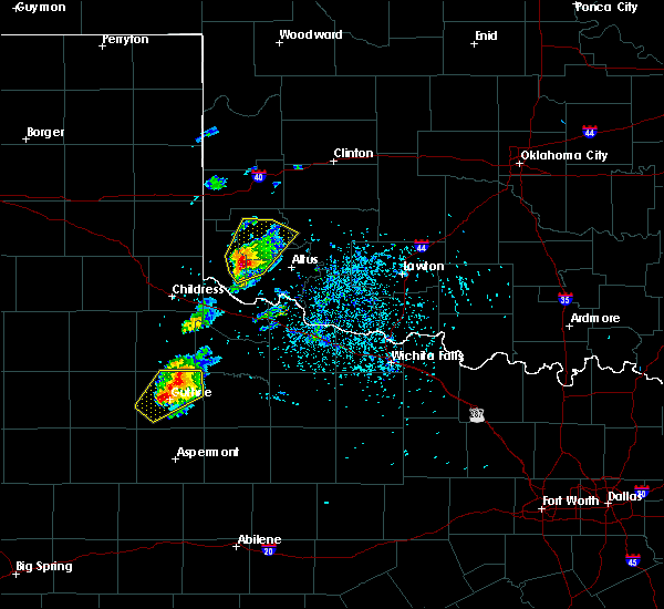 At 141 pm cdt, a severe thunderstorm was located 5 miles east of gould, moving northeast at 35 mph. this is a very dangerous storm (radar indicated). Hazards include baseball size hail and 70 mph wind gusts. People and animals outdoors will be severely injured. expect shattered windows, extensive damage to roofs, siding, and vehicles. Locations impacted include, mangum, granite, gould, duke, brinkman, hester, altus-lugert lake and mcqueen. At 141 pm cdt, a severe thunderstorm was located 5 miles east of gould, moving northeast at 35 mph. this is a very dangerous storm (radar indicated). Hazards include baseball size hail and 70 mph wind gusts. People and animals outdoors will be severely injured. expect shattered windows, extensive damage to roofs, siding, and vehicles. Locations impacted include, mangum, granite, gould, duke, brinkman, hester, altus-lugert lake and mcqueen.
|
| 5/18/2017 1:30 PM CDT |
 At 130 pm cdt, a severe thunderstorm was located 4 miles southeast of gould, moving northeast at 45 mph (radar indicated). Hazards include golf ball size hail and 60 mph wind gusts. People and animals outdoors will be injured. expect hail damage to roofs, siding, windows, and vehicles. expect wind damage to roofs, siding, and trees. Locations impacted include, mangum, granite, gould, duke, brinkman, hester, altus-lugert lake and mcqueen. At 130 pm cdt, a severe thunderstorm was located 4 miles southeast of gould, moving northeast at 45 mph (radar indicated). Hazards include golf ball size hail and 60 mph wind gusts. People and animals outdoors will be injured. expect hail damage to roofs, siding, windows, and vehicles. expect wind damage to roofs, siding, and trees. Locations impacted include, mangum, granite, gould, duke, brinkman, hester, altus-lugert lake and mcqueen.
|
| 5/18/2017 1:19 PM CDT |
 At 119 pm cdt, a severe thunderstorm was located 6 miles south of gould, moving northeast at 35 mph (radar indicated). Hazards include golf ball size hail and 60 mph wind gusts. People and animals outdoors will be injured. expect hail damage to roofs, siding, windows, and vehicles. Expect wind damage to roofs, siding, and trees. At 119 pm cdt, a severe thunderstorm was located 6 miles south of gould, moving northeast at 35 mph (radar indicated). Hazards include golf ball size hail and 60 mph wind gusts. People and animals outdoors will be injured. expect hail damage to roofs, siding, windows, and vehicles. Expect wind damage to roofs, siding, and trees.
|
| 5/16/2017 6:50 PM CDT |
 At 650 pm cdt, a severe thunderstorm was located 5 miles southeast of gould, moving northeast at 25 mph (radar indicated). Hazards include two inch hail and 60 mph wind gusts. People and animals outdoors will be injured. expect hail damage to roofs, siding, windows, and vehicles. expect wind damage to roofs, siding, and trees. Locations impacted include, altus, martha, gould, duke, hester and mcqueen. At 650 pm cdt, a severe thunderstorm was located 5 miles southeast of gould, moving northeast at 25 mph (radar indicated). Hazards include two inch hail and 60 mph wind gusts. People and animals outdoors will be injured. expect hail damage to roofs, siding, windows, and vehicles. expect wind damage to roofs, siding, and trees. Locations impacted include, altus, martha, gould, duke, hester and mcqueen.
|
| 5/16/2017 6:43 PM CDT |
 At 642 pm cdt, a severe thunderstorm was located 5 miles south of gould, moving northeast at 30 mph (radar indicated). Hazards include 60 mph wind gusts and half dollar size hail. Hail damage to vehicles is expected. Expect wind damage to roofs, siding, and trees. At 642 pm cdt, a severe thunderstorm was located 5 miles south of gould, moving northeast at 30 mph (radar indicated). Hazards include 60 mph wind gusts and half dollar size hail. Hail damage to vehicles is expected. Expect wind damage to roofs, siding, and trees.
|
| 4/29/2017 2:24 AM CDT |
 At 224 am cdt, severe thunderstorms were located along a line extending from 3 miles south of mangum to 5 miles northwest of olustee, moving northeast at 40 mph (radar indicated). Hazards include golf ball size hail and 60 mph wind gusts. People and animals outdoors will be injured. expect hail damage to roofs, siding, windows, and vehicles. expect wind damage to roofs, siding, and trees. Locations impacted include, altus, mangum, granite, blair, olustee, martha, altus air force base, duke and hester. At 224 am cdt, severe thunderstorms were located along a line extending from 3 miles south of mangum to 5 miles northwest of olustee, moving northeast at 40 mph (radar indicated). Hazards include golf ball size hail and 60 mph wind gusts. People and animals outdoors will be injured. expect hail damage to roofs, siding, windows, and vehicles. expect wind damage to roofs, siding, and trees. Locations impacted include, altus, mangum, granite, blair, olustee, martha, altus air force base, duke and hester.
|
| 4/29/2017 1:58 AM CDT |
 At 157 am cdt, a severe thunderstorm was located near gould, moving northeast at 35 mph. strong winds may also occur well ahead of the thunderstorm (radar indicated). Hazards include golf ball size hail and 60 mph wind gusts. People and animals outdoors will be injured. expect hail damage to roofs, siding, windows, and vehicles. Expect wind damage to roofs, siding, and trees. At 157 am cdt, a severe thunderstorm was located near gould, moving northeast at 35 mph. strong winds may also occur well ahead of the thunderstorm (radar indicated). Hazards include golf ball size hail and 60 mph wind gusts. People and animals outdoors will be injured. expect hail damage to roofs, siding, windows, and vehicles. Expect wind damage to roofs, siding, and trees.
|
| 4/29/2017 1:52 AM CDT |
 At 150 am cdt, a severe thunderstorm was located 6 miles southwest of gould, moving northeast at 45 mph. another severe storm was located 10 miles northwest of mangum (radar indicated). Hazards include 60 mph wind gusts and half dollar size hail. Hail damage to vehicles is expected. expect wind damage to roofs, siding, and trees. Locations impacted include, mangum, hollis, eldorado, willow, gould, vinson, duke, goodlett, madge, brinkman, mcknight and mcqueen. At 150 am cdt, a severe thunderstorm was located 6 miles southwest of gould, moving northeast at 45 mph. another severe storm was located 10 miles northwest of mangum (radar indicated). Hazards include 60 mph wind gusts and half dollar size hail. Hail damage to vehicles is expected. expect wind damage to roofs, siding, and trees. Locations impacted include, mangum, hollis, eldorado, willow, gould, vinson, duke, goodlett, madge, brinkman, mcknight and mcqueen.
|
| 4/29/2017 1:20 AM CDT |
 At 119 am cdt, severe thunderstorms were located along a line extending from 8 miles southwest of hollis to 4 miles southwest of kirkland, moving northeast at 40 mph. other strong to severe storms were developing between vinson and dodson (radar indicated). Hazards include ping pong ball size hail and 60 mph wind gusts. People and animals outdoors will be injured. expect hail damage to roofs, siding, windows, and vehicles. Expect wind damage to roofs, siding, and trees. At 119 am cdt, severe thunderstorms were located along a line extending from 8 miles southwest of hollis to 4 miles southwest of kirkland, moving northeast at 40 mph. other strong to severe storms were developing between vinson and dodson (radar indicated). Hazards include ping pong ball size hail and 60 mph wind gusts. People and animals outdoors will be injured. expect hail damage to roofs, siding, windows, and vehicles. Expect wind damage to roofs, siding, and trees.
|
| 10/6/2016 4:09 PM CDT |
 At 409 pm cdt, severe thunderstorms were located 3 miles south of hollis and 4 miles northeast of hollis, moving northeast at 40 mph (radar indicated). Hazards include 60 mph wind gusts and quarter size hail. Hail damage to vehicles is expected. expect wind damage to roofs, siding, and trees. Locations impacted include, mangum, hollis, gould, vinson and mcknight. At 409 pm cdt, severe thunderstorms were located 3 miles south of hollis and 4 miles northeast of hollis, moving northeast at 40 mph (radar indicated). Hazards include 60 mph wind gusts and quarter size hail. Hail damage to vehicles is expected. expect wind damage to roofs, siding, and trees. Locations impacted include, mangum, hollis, gould, vinson and mcknight.
|
| 10/6/2016 4:00 PM CDT |
 At 400 pm cdt, severe thunderstorms were located 11 miles southwest of gould and 3 miles east of hollis, moving northeast at 30 mph. golfball size hail was reported 2 miles south of hollis (radar indicated). Hazards include golf ball size hail and 60 mph wind gusts. People and animals outdoors will be injured. expect hail damage to roofs, siding, windows, and vehicles. expect wind damage to roofs, siding, and trees. Locations impacted include, mangum, hollis, gould, vinson and mcknight. At 400 pm cdt, severe thunderstorms were located 11 miles southwest of gould and 3 miles east of hollis, moving northeast at 30 mph. golfball size hail was reported 2 miles south of hollis (radar indicated). Hazards include golf ball size hail and 60 mph wind gusts. People and animals outdoors will be injured. expect hail damage to roofs, siding, windows, and vehicles. expect wind damage to roofs, siding, and trees. Locations impacted include, mangum, hollis, gould, vinson and mcknight.
|
| 10/6/2016 3:49 PM CDT |
 At 349 pm cdt, a severe thunderstorm was located 5 miles south of hollis, moving northeast at 35 mph. another strong storm that may become severe was located 12 miles southwest of hollis (radar indicated). Hazards include 60 mph wind gusts and half dollar size hail. Hail damage to vehicles is expected. Expect wind damage to roofs, siding, and trees. At 349 pm cdt, a severe thunderstorm was located 5 miles south of hollis, moving northeast at 35 mph. another strong storm that may become severe was located 12 miles southwest of hollis (radar indicated). Hazards include 60 mph wind gusts and half dollar size hail. Hail damage to vehicles is expected. Expect wind damage to roofs, siding, and trees.
|
| 9/17/2016 3:26 PM CDT |
 At 325 pm cdt, severe thunderstorms were located along a line extending from 7 miles east of leedey to near foss to 3 miles south of granite, moving east at 40 mph (radar indicated). Hazards include 70 mph wind gusts and quarter size hail. Hail damage to vehicles is expected. expect considerable tree damage. wind damage is also likely to mobile homes, roofs, and outbuildings. Locations impacted include, elk city, clinton, hobart, mangum, cordell, granite, burns flat, sentinel, arapaho, hammon, dill city, canute, lone wolf, custer city, butler, carter, bessie, rocky, foss and willow. At 325 pm cdt, severe thunderstorms were located along a line extending from 7 miles east of leedey to near foss to 3 miles south of granite, moving east at 40 mph (radar indicated). Hazards include 70 mph wind gusts and quarter size hail. Hail damage to vehicles is expected. expect considerable tree damage. wind damage is also likely to mobile homes, roofs, and outbuildings. Locations impacted include, elk city, clinton, hobart, mangum, cordell, granite, burns flat, sentinel, arapaho, hammon, dill city, canute, lone wolf, custer city, butler, carter, bessie, rocky, foss and willow.
|
| 9/17/2016 3:11 PM CDT |
 At 309 pm cdt, severe thunderstorms were located along a line extending from near hammon to near elk city to 4 miles northwest of mangum, moving east at 40 mph (radar indicated). Hazards include 70 mph wind gusts and ping pong ball size hail. People and animals outdoors will be injured. expect hail damage to roofs, siding, windows, and vehicles. expect considerable tree damage. wind damage is also likely to mobile homes, roofs, and outbuildings. locations impacted include, elk city, clinton, sayre, hobart, mangum, cordell, granite, burns flat, sentinel, blair, arapaho, hammon, dill city, canute, lone wolf, custer city, butler, carter, bessie and rocky. This line of storms produced a 64 mph wind gust near erick at 245 pm. At 309 pm cdt, severe thunderstorms were located along a line extending from near hammon to near elk city to 4 miles northwest of mangum, moving east at 40 mph (radar indicated). Hazards include 70 mph wind gusts and ping pong ball size hail. People and animals outdoors will be injured. expect hail damage to roofs, siding, windows, and vehicles. expect considerable tree damage. wind damage is also likely to mobile homes, roofs, and outbuildings. locations impacted include, elk city, clinton, sayre, hobart, mangum, cordell, granite, burns flat, sentinel, blair, arapaho, hammon, dill city, canute, lone wolf, custer city, butler, carter, bessie and rocky. This line of storms produced a 64 mph wind gust near erick at 245 pm.
|
| 9/17/2016 2:57 PM CDT |
 At 257 pm cdt, severe thunderstorms were located along a line extending from 6 miles west of elk city to near vinson, moving east at 45 mph (radar indicated). Hazards include 70 mph wind gusts and ping pong ball size hail. People and animals outdoors will be injured. expect hail damage to roofs, siding, windows, and vehicles. expect considerable tree damage. Wind damage is also likely to mobile homes, roofs, and outbuildings. At 257 pm cdt, severe thunderstorms were located along a line extending from 6 miles west of elk city to near vinson, moving east at 45 mph (radar indicated). Hazards include 70 mph wind gusts and ping pong ball size hail. People and animals outdoors will be injured. expect hail damage to roofs, siding, windows, and vehicles. expect considerable tree damage. Wind damage is also likely to mobile homes, roofs, and outbuildings.
|
| 9/17/2016 2:45 PM CDT |
 At 244 pm cdt, severe thunderstorms were located along a line extending from 7 miles west of elk city to 5 miles northwest of vinson, moving east at 55 mph (radar indicated). Hazards include 70 mph wind gusts and ping pong ball size hail. People and animals outdoors will be injured. expect hail damage to roofs, siding, windows, and vehicles. expect considerable tree damage. wind damage is also likely to mobile homes, roofs, and outbuildings. locations impacted include, elk city, sayre, mangum, erick, carter, willow, vinson, delhi, hester, berlin, brinkman, madge and mcknight. This includes interstate 40 between mile markers 4 and 41. At 244 pm cdt, severe thunderstorms were located along a line extending from 7 miles west of elk city to 5 miles northwest of vinson, moving east at 55 mph (radar indicated). Hazards include 70 mph wind gusts and ping pong ball size hail. People and animals outdoors will be injured. expect hail damage to roofs, siding, windows, and vehicles. expect considerable tree damage. wind damage is also likely to mobile homes, roofs, and outbuildings. locations impacted include, elk city, sayre, mangum, erick, carter, willow, vinson, delhi, hester, berlin, brinkman, madge and mcknight. This includes interstate 40 between mile markers 4 and 41.
|
| 9/17/2016 2:00 PM CDT |
 At 200 pm cdt, severe thunderstorms were located along a line extending from 4 miles southwest of wheeler to 6 miles northeast of quail, moving east at 50 mph (radar indicated). Hazards include 70 mph wind gusts and ping pong ball size hail. People and animals outdoors will be injured. expect hail damage to roofs, siding, windows, and vehicles. expect considerable tree damage. Wind damage is also likely to mobile homes, roofs, and outbuildings. At 200 pm cdt, severe thunderstorms were located along a line extending from 4 miles southwest of wheeler to 6 miles northeast of quail, moving east at 50 mph (radar indicated). Hazards include 70 mph wind gusts and ping pong ball size hail. People and animals outdoors will be injured. expect hail damage to roofs, siding, windows, and vehicles. expect considerable tree damage. Wind damage is also likely to mobile homes, roofs, and outbuildings.
|
| 9/8/2016 8:44 PM CDT |
 At 843 pm cdt, a severe thunderstorm was located 7 miles south of mangum, moving northeast at 30 mph (radar indicated). Hazards include 70 mph wind gusts and half dollar size hail. Hail damage to vehicles is expected. expect considerable tree damage. Wind damage is also likely to mobile homes, roofs, and outbuildings. At 843 pm cdt, a severe thunderstorm was located 7 miles south of mangum, moving northeast at 30 mph (radar indicated). Hazards include 70 mph wind gusts and half dollar size hail. Hail damage to vehicles is expected. expect considerable tree damage. Wind damage is also likely to mobile homes, roofs, and outbuildings.
|
| 8/19/2016 7:21 PM CDT |
 The severe thunderstorm warning for west central jackson, south central greer and southern harmon counties will expire at 730 pm cdt, the storm which prompted the warning has weakened below severe limits, and no longer pose an immediate threat to life or property. therefore the warning will be allowed to expire. however gusty winds and heavy rain are still possible with this thunderstorm. The severe thunderstorm warning for west central jackson, south central greer and southern harmon counties will expire at 730 pm cdt, the storm which prompted the warning has weakened below severe limits, and no longer pose an immediate threat to life or property. therefore the warning will be allowed to expire. however gusty winds and heavy rain are still possible with this thunderstorm.
|
| 8/19/2016 7:17 PM CDT |
 At 717 pm cdt, a severe thunderstorm was located near duke, moving southeast at 25 mph (radar indicated). Hazards include 60 mph wind gusts and penny size hail. Expect damage to roofs. siding. and trees. Locations impacted include, mangum, hollis, gould and mcqueen. At 717 pm cdt, a severe thunderstorm was located near duke, moving southeast at 25 mph (radar indicated). Hazards include 60 mph wind gusts and penny size hail. Expect damage to roofs. siding. and trees. Locations impacted include, mangum, hollis, gould and mcqueen.
|
| 8/19/2016 7:02 PM CDT |
 At 701 pm cdt, a severe thunderstorm was located 6 miles northeast of gould, moving east at 30 mph (wind gusts near 65 mph were observed with this storm 3 miles west of gould at 650 pm cdt). Hazards include 70 mph wind gusts and quarter size hail. Hail damage to vehicles is expected. expect considerable tree damage. wind damage is also likely to mobile homes, roofs, and outbuildings. Locations impacted include, mangum, hollis, gould, vinson, mcqueen and mcknight. At 701 pm cdt, a severe thunderstorm was located 6 miles northeast of gould, moving east at 30 mph (wind gusts near 65 mph were observed with this storm 3 miles west of gould at 650 pm cdt). Hazards include 70 mph wind gusts and quarter size hail. Hail damage to vehicles is expected. expect considerable tree damage. wind damage is also likely to mobile homes, roofs, and outbuildings. Locations impacted include, mangum, hollis, gould, vinson, mcqueen and mcknight.
|
| 8/19/2016 6:44 PM CDT |
 At 644 pm cdt, a severe thunderstorm was located 7 miles north of hollis, moving southeast at 25 mph (radar indicated). Hazards include 70 mph wind gusts and quarter size hail. Hail damage to vehicles is expected. expect considerable tree damage. Wind damage is also likely to mobile homes, roofs, and outbuildings. At 644 pm cdt, a severe thunderstorm was located 7 miles north of hollis, moving southeast at 25 mph (radar indicated). Hazards include 70 mph wind gusts and quarter size hail. Hail damage to vehicles is expected. expect considerable tree damage. Wind damage is also likely to mobile homes, roofs, and outbuildings.
|
| 7/15/2016 11:13 PM CDT |
 At 1113 pm cdt, severe thunderstorms were located along a line extending from 3 miles northwest of warren to 5 miles southwest of eldorado, moving southeast at 50 mph (radar indicated). Hazards include 70 mph wind gusts and quarter size hail. Hail damage to vehicles is expected. expect considerable tree damage. Wind damage is also likely to mobile homes, roofs, and outbuildings. At 1113 pm cdt, severe thunderstorms were located along a line extending from 3 miles northwest of warren to 5 miles southwest of eldorado, moving southeast at 50 mph (radar indicated). Hazards include 70 mph wind gusts and quarter size hail. Hail damage to vehicles is expected. expect considerable tree damage. Wind damage is also likely to mobile homes, roofs, and outbuildings.
|
| 7/15/2016 10:51 PM CDT |
 At 1050 pm cdt, a severe thunderstorm was located 7 miles south of vinson, moving southeast at 30 mph. this is part of a line of severe storms extending from near willow to near hollis and into the texas panhandle. this is a very dangerous storm (radar indicated). Hazards include 80 mph wind gusts and golf ball size hail. Flying debris will be dangerous to those caught without shelter. mobile homes will be heavily damaged. expect considerable damage to roofs, windows, and vehicles. extensive tree damage and power outages are likely. Locations impacted include, altus, mangum, quanah, hollis, granite, blair, olustee, eldorado, martha, willow, gould, friendship, goodlett, duke, altus air force base, vinson, warren, hester, lazare and altus-lugert lake. At 1050 pm cdt, a severe thunderstorm was located 7 miles south of vinson, moving southeast at 30 mph. this is part of a line of severe storms extending from near willow to near hollis and into the texas panhandle. this is a very dangerous storm (radar indicated). Hazards include 80 mph wind gusts and golf ball size hail. Flying debris will be dangerous to those caught without shelter. mobile homes will be heavily damaged. expect considerable damage to roofs, windows, and vehicles. extensive tree damage and power outages are likely. Locations impacted include, altus, mangum, quanah, hollis, granite, blair, olustee, eldorado, martha, willow, gould, friendship, goodlett, duke, altus air force base, vinson, warren, hester, lazare and altus-lugert lake.
|
| 7/15/2016 10:34 PM CDT |
 At 1034 pm cdt, a severe thunderstorm was located 5 miles northeast of dodson texas, moving southeast at 55 mph (radar indicated). Hazards include 70 mph wind gusts and quarter size hail. Hail damage to vehicles is expected. expect considerable tree damage. Wind damage is also likely to mobile homes, roofs, and outbuildings. At 1034 pm cdt, a severe thunderstorm was located 5 miles northeast of dodson texas, moving southeast at 55 mph (radar indicated). Hazards include 70 mph wind gusts and quarter size hail. Hail damage to vehicles is expected. expect considerable tree damage. Wind damage is also likely to mobile homes, roofs, and outbuildings.
|
| 7/8/2016 6:15 PM CDT |
 At 615 pm cdt, a severe thunderstorm was located over willow, moving east at 15 mph. another strong to severe storm was located near mangum (radar indicated). Hazards include 60 mph wind gusts and quarter size hail. Hail damage to vehicles is expected. Expect wind damage to roofs, siding, and trees. At 615 pm cdt, a severe thunderstorm was located over willow, moving east at 15 mph. another strong to severe storm was located near mangum (radar indicated). Hazards include 60 mph wind gusts and quarter size hail. Hail damage to vehicles is expected. Expect wind damage to roofs, siding, and trees.
|
| 7/6/2016 8:56 PM CDT |
 At 855 pm cdt, the leading edge of winds from a line of severe thunderstorms was located along a line extending from 9 miles northwest of mangum to 5 miles north of duke to 6 miles south of eldorado, moving east at 45 mph. winds over 80 mph have been recorded near eldorado. these are very dangerous storms (radar indicated). Hazards include 80 mph wind gusts and quarter size hail. Flying debris will be dangerous to those caught without shelter. mobile homes will be heavily damaged. expect considerable damage to roofs, windows, and vehicles. Extensive tree damage and power outages are likely. At 855 pm cdt, the leading edge of winds from a line of severe thunderstorms was located along a line extending from 9 miles northwest of mangum to 5 miles north of duke to 6 miles south of eldorado, moving east at 45 mph. winds over 80 mph have been recorded near eldorado. these are very dangerous storms (radar indicated). Hazards include 80 mph wind gusts and quarter size hail. Flying debris will be dangerous to those caught without shelter. mobile homes will be heavily damaged. expect considerable damage to roofs, windows, and vehicles. Extensive tree damage and power outages are likely.
|
| 7/6/2016 8:53 PM CDT |
 At 851 pm cdt, the leading edge of winds from severe thunderstorms was located along a line extending from 7 miles west of mangum to near duke to 4 miles northwest of quanah, moving east at 55 mph. wind gusts of 82 mph were recorded 6 miles west-northwest of eldorado oklahoma and 67 mph winds were recorded 3 miles west of goodlett texas. these are very dangerous storms (radar indicated). Hazards include 80 mph wind gusts and quarter size hail. Flying debris will be dangerous to those caught without shelter. mobile homes will be heavily damaged. expect considerable damage to roofs, windows, and vehicles. extensive tree damage and power outages are likely. Locations impacted include, mangum, quanah, hollis, granite, eldorado, martha, gould, duke, goodlett, vinson, hester, lazare, brinkman, mcqueen, madge and mcknight. At 851 pm cdt, the leading edge of winds from severe thunderstorms was located along a line extending from 7 miles west of mangum to near duke to 4 miles northwest of quanah, moving east at 55 mph. wind gusts of 82 mph were recorded 6 miles west-northwest of eldorado oklahoma and 67 mph winds were recorded 3 miles west of goodlett texas. these are very dangerous storms (radar indicated). Hazards include 80 mph wind gusts and quarter size hail. Flying debris will be dangerous to those caught without shelter. mobile homes will be heavily damaged. expect considerable damage to roofs, windows, and vehicles. extensive tree damage and power outages are likely. Locations impacted include, mangum, quanah, hollis, granite, eldorado, martha, gould, duke, goodlett, vinson, hester, lazare, brinkman, mcqueen, madge and mcknight.
|
| 7/6/2016 8:32 PM CDT |
 At 831 pm cdt, the leading edge of winds from severe thunderstorms was located along a line extending from near vinson to 3 miles east of hollis to near kirkland texas, moving east at 50 mph. winds of 84 mph have been measured near childress texas. these are very dangerous storms (radar indicated). Hazards include 80 mph wind gusts and quarter size hail. Flying debris will be dangerous to those caught without shelter. mobile homes will be heavily damaged. expect considerable damage to roofs, windows, and vehicles. extensive tree damage and power outages are likely. Locations impacted include, mangum, quanah, hollis, granite, eldorado, martha, gould, duke, goodlett, vinson, hester, lazare, brinkman, mcqueen, madge and mcknight. At 831 pm cdt, the leading edge of winds from severe thunderstorms was located along a line extending from near vinson to 3 miles east of hollis to near kirkland texas, moving east at 50 mph. winds of 84 mph have been measured near childress texas. these are very dangerous storms (radar indicated). Hazards include 80 mph wind gusts and quarter size hail. Flying debris will be dangerous to those caught without shelter. mobile homes will be heavily damaged. expect considerable damage to roofs, windows, and vehicles. extensive tree damage and power outages are likely. Locations impacted include, mangum, quanah, hollis, granite, eldorado, martha, gould, duke, goodlett, vinson, hester, lazare, brinkman, mcqueen, madge and mcknight.
|
| 7/6/2016 8:26 PM CDT |
 At 825 pm cdt, the leading edge of winds from severe thunderstorms was located along a line extending from 3 miles northwest of vinson to near hollis to 4 miles northwest of kirkland, moving east at 45 mph. winds of 70 mph were measured 2 miles north-northeast of childress texas (radar indicated). Hazards include 70 mph wind gusts and quarter size hail. Hail damage to vehicles is expected. expect considerable tree damage. wind damage is also likely to mobile homes, roofs, and outbuildings. Locations impacted include, mangum, quanah, hollis, granite, eldorado, martha, gould, duke, goodlett, vinson, hester, lazare, brinkman, mcqueen, madge and mcknight. At 825 pm cdt, the leading edge of winds from severe thunderstorms was located along a line extending from 3 miles northwest of vinson to near hollis to 4 miles northwest of kirkland, moving east at 45 mph. winds of 70 mph were measured 2 miles north-northeast of childress texas (radar indicated). Hazards include 70 mph wind gusts and quarter size hail. Hail damage to vehicles is expected. expect considerable tree damage. wind damage is also likely to mobile homes, roofs, and outbuildings. Locations impacted include, mangum, quanah, hollis, granite, eldorado, martha, gould, duke, goodlett, vinson, hester, lazare, brinkman, mcqueen, madge and mcknight.
|
| 7/6/2016 8:20 PM CDT |
 At 819 pm cdt, the leading edge of winds from a line of severe thunderstorms was located along a line extending from 6 miles west of vinson to near hollis to 3 miles east of childress, moving east at 45 mph (radar indicated). Hazards include 60 mph wind gusts and quarter size hail. Hail damage to vehicles is expected. Expect wind damage to roofs, siding, and trees. At 819 pm cdt, the leading edge of winds from a line of severe thunderstorms was located along a line extending from 6 miles west of vinson to near hollis to 3 miles east of childress, moving east at 45 mph (radar indicated). Hazards include 60 mph wind gusts and quarter size hail. Hail damage to vehicles is expected. Expect wind damage to roofs, siding, and trees.
|
| 7/5/2016 5:25 AM CDT |
 At 524 am cdt, a severe thunderstorm was located 8 miles northeast of vinson, moving east at 25 mph (radar indicated). Hazards include ping pong ball size hail and 60 mph wind gusts. People and animals outdoors will be injured. expect hail damage to roofs, siding, windows, and vehicles. Expect wind damage to roofs, siding, and trees. At 524 am cdt, a severe thunderstorm was located 8 miles northeast of vinson, moving east at 25 mph (radar indicated). Hazards include ping pong ball size hail and 60 mph wind gusts. People and animals outdoors will be injured. expect hail damage to roofs, siding, windows, and vehicles. Expect wind damage to roofs, siding, and trees.
|
| 6/28/2016 9:01 PM CDT |
 At 900 pm cdt, severe thunderstorms were located along a line extending from 8 miles northwest of meers to 6 miles northeast of eldorado, moving south at 45 mph (trained spotters and radar indicated). Hazards include 70 mph wind gusts and half dollar size hail. Hail damage to vehicles is expected. expect considerable tree damage. wind damage is also likely to mobile homes, roofs, and outbuildings. Locations impacted include, altus, mangum, hollis, cache, snyder, tipton, blair, mountain view, olustee, eldorado, mountain park, indiahoma, roosevelt, manitou, martha, gould, elmer, headrick, friendship and cooperton. At 900 pm cdt, severe thunderstorms were located along a line extending from 8 miles northwest of meers to 6 miles northeast of eldorado, moving south at 45 mph (trained spotters and radar indicated). Hazards include 70 mph wind gusts and half dollar size hail. Hail damage to vehicles is expected. expect considerable tree damage. wind damage is also likely to mobile homes, roofs, and outbuildings. Locations impacted include, altus, mangum, hollis, cache, snyder, tipton, blair, mountain view, olustee, eldorado, mountain park, indiahoma, roosevelt, manitou, martha, gould, elmer, headrick, friendship and cooperton.
|
| 6/28/2016 8:52 PM CDT |
 At 851 pm cdt, severe thunderstorms were located along a line extending from 10 miles southeast of mountain view to near duke, moving south at 45 mph. these are very dangerous storms (trained weather spotters and radar. at 845 pm...altus airforce base reported a wind gust of 64 mph). Hazards include 80 mph wind gusts and ping pong ball size hail. Flying debris will be dangerous to those caught without shelter. mobile homes will be heavily damaged. expect considerable damage to roofs, windows, and vehicles. extensive tree damage and power outages are likely. locations impacted include, lawton, altus, hobart, mangum, hollis, cache, granite, carnegie, apache, snyder, geronimo, tipton, blair, mountain view, fort cobb, olustee, eldorado, lone wolf, mountain park and medicine park. This includes interstate 44 between mile markers 29 and 52. At 851 pm cdt, severe thunderstorms were located along a line extending from 10 miles southeast of mountain view to near duke, moving south at 45 mph. these are very dangerous storms (trained weather spotters and radar. at 845 pm...altus airforce base reported a wind gust of 64 mph). Hazards include 80 mph wind gusts and ping pong ball size hail. Flying debris will be dangerous to those caught without shelter. mobile homes will be heavily damaged. expect considerable damage to roofs, windows, and vehicles. extensive tree damage and power outages are likely. locations impacted include, lawton, altus, hobart, mangum, hollis, cache, granite, carnegie, apache, snyder, geronimo, tipton, blair, mountain view, fort cobb, olustee, eldorado, lone wolf, mountain park and medicine park. This includes interstate 44 between mile markers 29 and 52.
|
| 6/28/2016 8:31 PM CDT |
 At 829 pm cdt, severe thunderstorms were located along a line extending from 3 miles southwest of alfalfa to near mangum, moving south at 40 mph. these are very dangerous storms (trained weather spotters and radar. at 815 pm...significant wind damage was reported in carnegie). Hazards include 80 mph wind gusts and golf ball size hail. Flying debris will be dangerous to those caught without shelter. mobile homes will be heavily damaged. expect considerable damage to roofs, windows, and vehicles. extensive tree damage and power outages are likely. locations impacted include, lawton, altus, hobart, mangum, hollis, cache, elgin, granite, carnegie, apache, snyder, geronimo, sentinel, tipton, blair, mountain view, binger, fort cobb, olustee and eldorado. This includes interstate 44 between mile markers 28 and 56. At 829 pm cdt, severe thunderstorms were located along a line extending from 3 miles southwest of alfalfa to near mangum, moving south at 40 mph. these are very dangerous storms (trained weather spotters and radar. at 815 pm...significant wind damage was reported in carnegie). Hazards include 80 mph wind gusts and golf ball size hail. Flying debris will be dangerous to those caught without shelter. mobile homes will be heavily damaged. expect considerable damage to roofs, windows, and vehicles. extensive tree damage and power outages are likely. locations impacted include, lawton, altus, hobart, mangum, hollis, cache, elgin, granite, carnegie, apache, snyder, geronimo, sentinel, tipton, blair, mountain view, binger, fort cobb, olustee and eldorado. This includes interstate 44 between mile markers 28 and 56.
|
| 6/28/2016 8:28 PM CDT |
 At 827 pm cdt, severe thunderstorms were located along a line extending from 3 miles southeast of mountain view to 6 miles northwest of mangum, moving south at 40 mph. these are very dangerous storms (trained weather spotters and radar). Hazards include 80 mph wind gusts and golf ball size hail. Flying debris will be dangerous to those caught without shelter. mobile homes will be heavily damaged. expect considerable damage to roofs, windows, and vehicles. extensive tree damage and power outages are likely. Locations impacted include, hobart, mangum, hollis, granite, carnegie, apache, sentinel, blair, mountain view, binger, fort cobb, lone wolf, eakly, roosevelt, gotebo, lookeba, rocky, willow, colony and cooperton. At 827 pm cdt, severe thunderstorms were located along a line extending from 3 miles southeast of mountain view to 6 miles northwest of mangum, moving south at 40 mph. these are very dangerous storms (trained weather spotters and radar). Hazards include 80 mph wind gusts and golf ball size hail. Flying debris will be dangerous to those caught without shelter. mobile homes will be heavily damaged. expect considerable damage to roofs, windows, and vehicles. extensive tree damage and power outages are likely. Locations impacted include, hobart, mangum, hollis, granite, carnegie, apache, sentinel, blair, mountain view, binger, fort cobb, lone wolf, eakly, roosevelt, gotebo, lookeba, rocky, willow, colony and cooperton.
|
| 6/28/2016 8:06 PM CDT |
 At 804 pm cdt, severe thunderstorms were located along a line extending from 3 miles east of fort cobb to near lone wolf, moving south at 50 mph. these are very dangerous storms (radar indicated). Hazards include 80 mph wind gusts and golf ball size hail. Flying debris will be dangerous to those caught without shelter. mobile homes will be heavily damaged. expect considerable damage to roofs, windows, and vehicles. extensive tree damage and power outages are likely. Locations impacted include, hobart, mangum, cordell, hollis, granite, carnegie, apache, sentinel, blair, mountain view, binger, fort cobb, dill city, corn, lone wolf, eakly, carter, roosevelt, gotebo and lookeba. At 804 pm cdt, severe thunderstorms were located along a line extending from 3 miles east of fort cobb to near lone wolf, moving south at 50 mph. these are very dangerous storms (radar indicated). Hazards include 80 mph wind gusts and golf ball size hail. Flying debris will be dangerous to those caught without shelter. mobile homes will be heavily damaged. expect considerable damage to roofs, windows, and vehicles. extensive tree damage and power outages are likely. Locations impacted include, hobart, mangum, cordell, hollis, granite, carnegie, apache, sentinel, blair, mountain view, binger, fort cobb, dill city, corn, lone wolf, eakly, carter, roosevelt, gotebo and lookeba.
|
| 6/28/2016 7:58 PM CDT |
 At 757 pm cdt, severe thunderstorms were located along a line extending from 3 miles west of lookeba to 5 miles northwest of lone wolf, moving south at 50 mph. these are very dangerous storms (radar indicated). Hazards include 80 mph wind gusts and golf ball size hail. Flying debris will be dangerous to those caught without shelter. mobile homes will be heavily damaged. expect considerable damage to roofs, windows, and vehicles. Extensive tree damage and power outages are likely. At 757 pm cdt, severe thunderstorms were located along a line extending from 3 miles west of lookeba to 5 miles northwest of lone wolf, moving south at 50 mph. these are very dangerous storms (radar indicated). Hazards include 80 mph wind gusts and golf ball size hail. Flying debris will be dangerous to those caught without shelter. mobile homes will be heavily damaged. expect considerable damage to roofs, windows, and vehicles. Extensive tree damage and power outages are likely.
|
| 6/28/2016 7:31 PM CDT |
 At 730 pm cdt, severe thunderstorms were located along a line extending from near hinton to 4 miles west of burns flat, moving south at 50 mph. these are very dangerous storms (radar indicated). Hazards include 80 mph wind gusts and golf ball size hail. Flying debris will be dangerous to those caught without shelter. mobile homes will be heavily damaged. expect considerable damage to roofs, windows, and vehicles. Extensive tree damage and power outages are likely. At 730 pm cdt, severe thunderstorms were located along a line extending from near hinton to 4 miles west of burns flat, moving south at 50 mph. these are very dangerous storms (radar indicated). Hazards include 80 mph wind gusts and golf ball size hail. Flying debris will be dangerous to those caught without shelter. mobile homes will be heavily damaged. expect considerable damage to roofs, windows, and vehicles. Extensive tree damage and power outages are likely.
|
| 6/19/2016 12:58 AM CDT | The severe thunderstorm warning for north central jackson and central greer counties will expire at 100 am cdt, the storms which prompted the warning have weakened below severe limits, and no longer pose an immediate threat to life or property. therefore the warning will be allowed to expire. however gusty winds and heavy rain are still possible with these thunderstorms. |
| 6/19/2016 12:49 AM CDT |
 At 1249 am cdt, severe thunderstorms were located 6 miles west of mangum and 6 miles west of martha, moving west at 35 mph (radar indicated). Hazards include 60 mph wind gusts and quarter size hail. Hail damage to vehicles is expected. expect wind damage to roofs, siding, and trees. Locations impacted include, mangum, granite, blair, martha, willow, hester, brinkman and altus-lugert lake. At 1249 am cdt, severe thunderstorms were located 6 miles west of mangum and 6 miles west of martha, moving west at 35 mph (radar indicated). Hazards include 60 mph wind gusts and quarter size hail. Hail damage to vehicles is expected. expect wind damage to roofs, siding, and trees. Locations impacted include, mangum, granite, blair, martha, willow, hester, brinkman and altus-lugert lake.
|
| 6/19/2016 12:17 AM CDT |
 At 1217 am cdt, severe thunderstorms were located along a line extending from 4 miles north of granite to 5 miles north of blair, moving southwest at 15 mph (radar indicated). Hazards include golf ball size hail and 60 mph wind gusts. People and animals outdoors will be injured. expect hail damage to roofs, siding, windows, and vehicles. Expect wind damage to roofs, siding, and trees. At 1217 am cdt, severe thunderstorms were located along a line extending from 4 miles north of granite to 5 miles north of blair, moving southwest at 15 mph (radar indicated). Hazards include golf ball size hail and 60 mph wind gusts. People and animals outdoors will be injured. expect hail damage to roofs, siding, windows, and vehicles. Expect wind damage to roofs, siding, and trees.
|
| 5/26/2016 8:59 PM CDT |
 At 859 pm cdt, a severe thunderstorm was located near blair, moving north at 50 mph (radar indicated). Hazards include golf ball size hail and 60 mph wind gusts. People and animals outdoors will be injured. expect hail damage to roofs, siding, windows, and vehicles. Expect wind damage to roofs, siding, and trees. At 859 pm cdt, a severe thunderstorm was located near blair, moving north at 50 mph (radar indicated). Hazards include golf ball size hail and 60 mph wind gusts. People and animals outdoors will be injured. expect hail damage to roofs, siding, windows, and vehicles. Expect wind damage to roofs, siding, and trees.
|
| 5/12/2016 12:50 AM CDT | Quarter sized hail reported 2.9 miles S of Mangum, OK |
| 5/12/2016 12:50 AM CDT |
 At 1250 am cdt, a severe thunderstorm was located 4 miles northeast of mangum, moving east at 35 mph (radar indicated). Hazards include two inch hail and 60 mph wind gusts. People and animals outdoors will be injured. expect hail damage to roofs, siding, windows, and vehicles. expect wind damage to roofs, siding, and trees. Locations impacted include, mangum, granite, blair, lone wolf, willow, warren, hester, altus-lugert lake and brinkman. At 1250 am cdt, a severe thunderstorm was located 4 miles northeast of mangum, moving east at 35 mph (radar indicated). Hazards include two inch hail and 60 mph wind gusts. People and animals outdoors will be injured. expect hail damage to roofs, siding, windows, and vehicles. expect wind damage to roofs, siding, and trees. Locations impacted include, mangum, granite, blair, lone wolf, willow, warren, hester, altus-lugert lake and brinkman.
|
| 5/12/2016 12:41 AM CDT |
 At 1241 am cdt, a severe thunderstorm was located 5 miles northwest of mangum, moving east at 35 mph (radar indicated). Hazards include ping pong ball size hail and 60 mph wind gusts. People and animals outdoors will be injured. expect hail damage to roofs, siding, windows, and vehicles. expect wind damage to roofs, siding, and trees. Locations impacted include, mangum, granite, blair, lone wolf, willow, warren, hester, altus-lugert lake and brinkman. At 1241 am cdt, a severe thunderstorm was located 5 miles northwest of mangum, moving east at 35 mph (radar indicated). Hazards include ping pong ball size hail and 60 mph wind gusts. People and animals outdoors will be injured. expect hail damage to roofs, siding, windows, and vehicles. expect wind damage to roofs, siding, and trees. Locations impacted include, mangum, granite, blair, lone wolf, willow, warren, hester, altus-lugert lake and brinkman.
|
| 5/12/2016 12:24 AM CDT |
 At 1223 am cdt, a severe thunderstorm was located 10 miles northeast of vinson, moving east at 40 mph (radar indicated). Hazards include 60 mph wind gusts and half dollar size hail. Hail damage to vehicles is expected. Expect wind damage to roofs, siding, and trees. At 1223 am cdt, a severe thunderstorm was located 10 miles northeast of vinson, moving east at 40 mph (radar indicated). Hazards include 60 mph wind gusts and half dollar size hail. Hail damage to vehicles is expected. Expect wind damage to roofs, siding, and trees.
|
| 4/28/2016 8:24 PM CDT |
 The severe thunderstorm warning for central greer county will expire at 830 pm cdt, the storm which prompted the warning has weakened below severe limits, and no longer pose an immediate threat to life or property. therefore the warning will be allowed to expire. The severe thunderstorm warning for central greer county will expire at 830 pm cdt, the storm which prompted the warning has weakened below severe limits, and no longer pose an immediate threat to life or property. therefore the warning will be allowed to expire.
|
| 4/28/2016 8:12 PM CDT |
 At 811 pm cdt, a severe thunderstorm was located near mangum, moving northeast at 25 mph (radar indicated). Hazards include 60 mph wind gusts and quarter size hail. Hail damage to vehicles is expected. expect wind damage to roofs, siding, and trees. Locations impacted include, mangum, granite and hester. At 811 pm cdt, a severe thunderstorm was located near mangum, moving northeast at 25 mph (radar indicated). Hazards include 60 mph wind gusts and quarter size hail. Hail damage to vehicles is expected. expect wind damage to roofs, siding, and trees. Locations impacted include, mangum, granite and hester.
|
| 4/28/2016 7:59 PM CDT |
 At 759 pm cdt, a severe thunderstorm was located 6 miles southwest of mangum, moving northeast at 25 mph (radar indicated). Hazards include 60 mph wind gusts and quarter size hail. Hail damage to vehicles is expected. expect wind damage to roofs, siding, and trees. Locations impacted include, altus, mangum, granite, blair, duke, martha, altus air force base and hester. At 759 pm cdt, a severe thunderstorm was located 6 miles southwest of mangum, moving northeast at 25 mph (radar indicated). Hazards include 60 mph wind gusts and quarter size hail. Hail damage to vehicles is expected. expect wind damage to roofs, siding, and trees. Locations impacted include, altus, mangum, granite, blair, duke, martha, altus air force base and hester.
|
| 4/28/2016 7:41 PM CDT |
 At 741 pm cdt, a severe thunderstorm was located 8 miles northeast of gould, moving east at 30 mph (radar indicated). Hazards include 60 mph wind gusts and quarter size hail. Hail damage to vehicles is expected. Expect wind damage to roofs, siding, and trees. At 741 pm cdt, a severe thunderstorm was located 8 miles northeast of gould, moving east at 30 mph (radar indicated). Hazards include 60 mph wind gusts and quarter size hail. Hail damage to vehicles is expected. Expect wind damage to roofs, siding, and trees.
|
| 4/10/2016 9:46 PM CDT |
 At 946 pm cdt, severe thunderstorms were located along a line extending from near granite to 6 miles southwest of olustee, moving east at 45 mph (radar indicated). Hazards include golf ball size hail and 70 mph wind gusts. People and animals outdoors will be injured. expect hail damage to roofs, siding, windows, and vehicles. expect considerable tree damage. wind damage is also likely to mobile homes, roofs, and outbuildings. Locations impacted include, altus, hobart, mangum, granite, snyder, tipton, blair, olustee, eldorado, lone wolf, mountain park, roosevelt, gotebo, manitou, martha, willow, elmer, headrick, friendship and cooperton. At 946 pm cdt, severe thunderstorms were located along a line extending from near granite to 6 miles southwest of olustee, moving east at 45 mph (radar indicated). Hazards include golf ball size hail and 70 mph wind gusts. People and animals outdoors will be injured. expect hail damage to roofs, siding, windows, and vehicles. expect considerable tree damage. wind damage is also likely to mobile homes, roofs, and outbuildings. Locations impacted include, altus, hobart, mangum, granite, snyder, tipton, blair, olustee, eldorado, lone wolf, mountain park, roosevelt, gotebo, manitou, martha, willow, elmer, headrick, friendship and cooperton.
|
| 4/10/2016 9:35 PM CDT |
 At 934 pm cdt, severe thunderstorms were located along a line extending from 4 miles south of willow to near eldorado, moving east at 50 mph (radar indicated). Hazards include golf ball size hail and 60 mph wind gusts. People and animals outdoors will be injured. expect hail damage to roofs, siding, windows, and vehicles. Expect wind damage to roofs, siding, and trees. At 934 pm cdt, severe thunderstorms were located along a line extending from 4 miles south of willow to near eldorado, moving east at 50 mph (radar indicated). Hazards include golf ball size hail and 60 mph wind gusts. People and animals outdoors will be injured. expect hail damage to roofs, siding, windows, and vehicles. Expect wind damage to roofs, siding, and trees.
|
| 4/10/2016 9:20 PM CDT | Hen Egg sized hail reported 11.1 miles E of Mangum, OK, trained spotter reports 2 inch hail 11 w mangum ok. |
| 4/10/2016 8:51 PM CDT |
 At 851 pm cdt, severe thunderstorms were located along a line extending from 10 miles south of texola to 7 miles west of vinson to 4 miles southwest of dodson, moving east at 45 mph (radar indicated). Hazards include 60 mph wind gusts and half dollar size hail. Hail damage to vehicles is expected. Expect wind damage to roofs, siding, and trees. At 851 pm cdt, severe thunderstorms were located along a line extending from 10 miles south of texola to 7 miles west of vinson to 4 miles southwest of dodson, moving east at 45 mph (radar indicated). Hazards include 60 mph wind gusts and half dollar size hail. Hail damage to vehicles is expected. Expect wind damage to roofs, siding, and trees.
|
| 12/26/2015 12:14 PM CST |
 At 1213 pm cst, a severe thunderstorm was located near duke, moving north at 45 mph (radar indicated). Hazards include quarter size hail. Damage to vehicles is expected. Locations impacted include, altus, mangum, granite, blair, duke, martha, hester and altus-lugert lake. At 1213 pm cst, a severe thunderstorm was located near duke, moving north at 45 mph (radar indicated). Hazards include quarter size hail. Damage to vehicles is expected. Locations impacted include, altus, mangum, granite, blair, duke, martha, hester and altus-lugert lake.
|
| 12/26/2015 11:56 AM CST |
 The national weather service in norman has issued a * severe thunderstorm warning for. central jackson county in southwestern oklahoma. southeastern greer county in southwestern oklahoma. east central harmon county in southwestern oklahoma. Until 1245 pm cst. The national weather service in norman has issued a * severe thunderstorm warning for. central jackson county in southwestern oklahoma. southeastern greer county in southwestern oklahoma. east central harmon county in southwestern oklahoma. Until 1245 pm cst.
|
| 12/26/2015 11:56 AM CST |
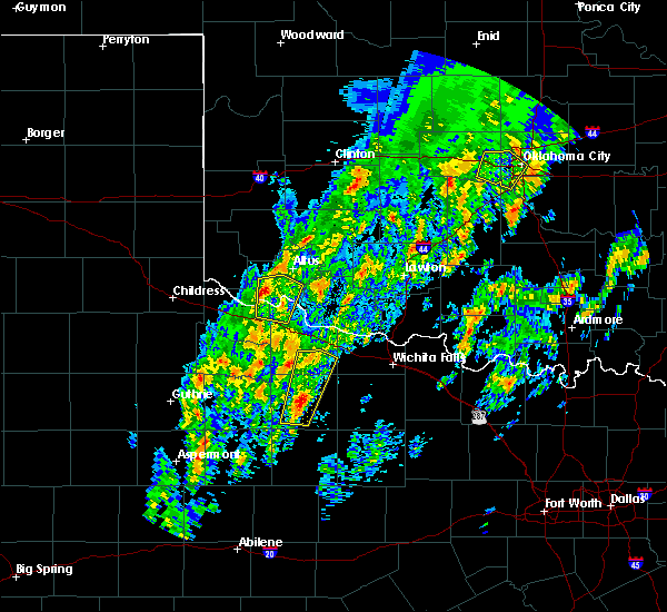 At 1156 am cst, a severe thunderstorm was located 6 miles east of eldorado, moving north at 45 mph (radar indicated). Hazards include quarter size hail. damage to vehicles is expected At 1156 am cst, a severe thunderstorm was located 6 miles east of eldorado, moving north at 45 mph (radar indicated). Hazards include quarter size hail. damage to vehicles is expected
|
| 11/16/2015 10:29 PM CST |
 At 1029 pm cst, severe thunderstorms were located along a line extending from 5 miles north of carter to near blair, moving northeast at 55 mph (radar indicated). Hazards include 60 mph wind gusts and nickel size hail. Expect damage to roofs. siding and trees. Locations impacted include, elk city, mangum, granite, lone wolf, carter, willow, retrop, altus-lugert lake and brinkman. At 1029 pm cst, severe thunderstorms were located along a line extending from 5 miles north of carter to near blair, moving northeast at 55 mph (radar indicated). Hazards include 60 mph wind gusts and nickel size hail. Expect damage to roofs. siding and trees. Locations impacted include, elk city, mangum, granite, lone wolf, carter, willow, retrop, altus-lugert lake and brinkman.
|
| 11/16/2015 10:25 PM CST | Storm damage reported in greer county OK, 4.9 miles NW of Mangum, OK |
| 11/16/2015 10:24 PM CST |
 At 1024 pm cst, severe thunderstorms were located along a line extending from near carter to near martha, moving northeast at 60 mph (radar indicated). Hazards include 60 mph wind gusts and nickel size hail. Expect damage to roofs. siding and trees. Locations impacted include, altus, elk city, mangum, granite, blair, lone wolf, duke, carter, martha, willow, friendship, altus air force base, delhi, retrop, hester, altus-lugert lake and brinkman. At 1024 pm cst, severe thunderstorms were located along a line extending from near carter to near martha, moving northeast at 60 mph (radar indicated). Hazards include 60 mph wind gusts and nickel size hail. Expect damage to roofs. siding and trees. Locations impacted include, altus, elk city, mangum, granite, blair, lone wolf, duke, carter, martha, willow, friendship, altus air force base, delhi, retrop, hester, altus-lugert lake and brinkman.
|
| 11/16/2015 10:17 PM CST |
 At 1017 pm cst, severe thunderstorms were located along a line extending from 4 miles northeast of delhi to 4 miles east of duke, moving northeast at 55 mph (radar indicated). Hazards include 60 mph wind gusts and nickel size hail. Expect damage to roofs. siding and trees. Locations impacted include, altus, elk city, mangum, granite, blair, lone wolf, carter, martha, willow, friendship, duke, altus air force base, delhi, retrop, hester, altus-lugert lake, brinkman and mcqueen. At 1017 pm cst, severe thunderstorms were located along a line extending from 4 miles northeast of delhi to 4 miles east of duke, moving northeast at 55 mph (radar indicated). Hazards include 60 mph wind gusts and nickel size hail. Expect damage to roofs. siding and trees. Locations impacted include, altus, elk city, mangum, granite, blair, lone wolf, carter, martha, willow, friendship, duke, altus air force base, delhi, retrop, hester, altus-lugert lake, brinkman and mcqueen.
|
| 11/16/2015 10:06 PM CST |
 At 1006 pm cst, severe thunderstorms were located along a line extending from 7 miles southwest of delhi to 5 miles north of eldorado, moving northeast at 55 mph (radar indicated). Hazards include 60 mph wind gusts and nickel size hail. Expect damage to roofs. siding and trees. Locations impacted include, altus, elk city, mangum, hollis, granite, blair, lone wolf, carter, martha, willow, gould, friendship, duke, altus air force base, vinson, delhi, retrop, hester, altus-lugert lake and brinkman. At 1006 pm cst, severe thunderstorms were located along a line extending from 7 miles southwest of delhi to 5 miles north of eldorado, moving northeast at 55 mph (radar indicated). Hazards include 60 mph wind gusts and nickel size hail. Expect damage to roofs. siding and trees. Locations impacted include, altus, elk city, mangum, hollis, granite, blair, lone wolf, carter, martha, willow, gould, friendship, duke, altus air force base, vinson, delhi, retrop, hester, altus-lugert lake and brinkman.
|
| 11/16/2015 9:55 PM CST |
 At 955 pm cst, severe thunderstorms were located along a line extending from 10 miles north of vinson to 6 miles northeast of goodlett, moving northeast at 55 mph (radar indicated). Hazards include 60 mph wind gusts and nickel size hail. Expect damage to roofs. Siding and trees. At 955 pm cst, severe thunderstorms were located along a line extending from 10 miles north of vinson to 6 miles northeast of goodlett, moving northeast at 55 mph (radar indicated). Hazards include 60 mph wind gusts and nickel size hail. Expect damage to roofs. Siding and trees.
|
| 6/12/2015 5:51 PM CDT |
 The severe thunderstorm warning for east central harmon and southeastern greer counties will expire at 600 pm cdt, the storm which prompted the warning has weakened below severe limits, and no longer pose an immediate threat to life or property. therefore the warning will be allowed to expire. however, gusty winds and heavy rain are still possible with this thunderstorm. The severe thunderstorm warning for east central harmon and southeastern greer counties will expire at 600 pm cdt, the storm which prompted the warning has weakened below severe limits, and no longer pose an immediate threat to life or property. therefore the warning will be allowed to expire. however, gusty winds and heavy rain are still possible with this thunderstorm.
|
| 6/12/2015 5:19 PM CDT |
 At 519 pm cdt, a severe thunderstorm was located 7 miles southeast of vinson, moving east at 35 mph (radar indicated). Hazards include 60 mph wind gusts and quarter size hail. Hail damage to vehicles is expected. Expect wind damage to roofs, siding and trees. At 519 pm cdt, a severe thunderstorm was located 7 miles southeast of vinson, moving east at 35 mph (radar indicated). Hazards include 60 mph wind gusts and quarter size hail. Hail damage to vehicles is expected. Expect wind damage to roofs, siding and trees.
|
| 5/28/2015 2:14 AM CDT | At 213 am cdt, severe thunderstorms were located along a line extending from 3 miles northeast of mangum to near martha to 6 miles east of eldorado to near quanah, moving east at 45 mph (radar indicated). Hazards include 60 mph wind gusts and nickel size hail. Expect damage to roofs. siding and trees. Locations impacted include, altus, mangum, quanah, hollis, granite, blair, chillicothe, olustee, eldorado, martha, gould, elmer, duke, goodlett, altus air force base, odell, hester, lazare, mcqueen and mcknight. |
| 5/28/2015 2:14 AM CDT | At 213 am cdt, severe thunderstorms were located along a line extending from 3 miles northeast of mangum to near martha to 6 miles east of eldorado to near quanah, moving east at 45 mph (radar indicated). Hazards include 60 mph wind gusts and nickel size hail. Expect damage to roofs. siding and trees. Locations impacted include, altus, mangum, quanah, hollis, granite, blair, chillicothe, olustee, eldorado, martha, gould, elmer, duke, goodlett, altus air force base, odell, hester, lazare, mcqueen and mcknight. |
| 5/28/2015 2:05 AM CDT | At 204 am cdt, severe thunderstorms were located along a line extending from near mangum to 4 miles east of duke to near eldorado to 3 miles southeast of goodlett, moving east at 50 mph (mesonet observation). Hazards include 70 mph wind gusts and quarter size hail. Hail damage to vehicles is expected. expect considerable tree damage. wind damage is also likely to mobile homes, roofs and outbuildings. Locations impacted include, altus, mangum, quanah, hollis, granite, blair, chillicothe, olustee, eldorado, martha, gould, elmer, duke, goodlett, altus air force base, odell, hester, lazare, mcqueen and mcknight. |
| 5/28/2015 2:05 AM CDT | At 204 am cdt, severe thunderstorms were located along a line extending from near mangum to 4 miles east of duke to near eldorado to 3 miles southeast of goodlett, moving east at 50 mph (mesonet observation). Hazards include 70 mph wind gusts and quarter size hail. Hail damage to vehicles is expected. expect considerable tree damage. wind damage is also likely to mobile homes, roofs and outbuildings. Locations impacted include, altus, mangum, quanah, hollis, granite, blair, chillicothe, olustee, eldorado, martha, gould, elmer, duke, goodlett, altus air force base, odell, hester, lazare, mcqueen and mcknight. |
| 5/28/2015 2:00 AM CDT | At 159 am cdt, severe thunderstorms were located along a line extending from 5 miles southwest of dodson to 8 miles south of hollis to 5 miles northeast of kirkland to 7 miles north of swearingen, moving northeast at 50 mph (mesonet observation). Hazards include 70 mph wind gusts and quarter size hail. Hail damage to vehicles is expected. expect considerable tree damage. wind damage is also likely to mobile homes, roofs and outbuildings. Locations impacted include, altus, mangum, quanah, hollis, granite, blair, chillicothe, olustee, eldorado, martha, gould, elmer, duke, goodlett, altus air force base, odell, hester, lazare, mcqueen and mcknight. |
| 5/28/2015 2:00 AM CDT | At 159 am cdt, severe thunderstorms were located along a line extending from 5 miles southwest of dodson to 8 miles south of hollis to 5 miles northeast of kirkland to 7 miles north of swearingen, moving northeast at 50 mph (mesonet observation). Hazards include 70 mph wind gusts and quarter size hail. Hail damage to vehicles is expected. expect considerable tree damage. wind damage is also likely to mobile homes, roofs and outbuildings. Locations impacted include, altus, mangum, quanah, hollis, granite, blair, chillicothe, olustee, eldorado, martha, gould, elmer, duke, goodlett, altus air force base, odell, hester, lazare, mcqueen and mcknight. |
| 5/28/2015 1:53 AM CDT | At 153 am cdt, severe thunderstorms were located along a line extending from 7 miles southwest of dodson to 10 miles southwest of hollis to 3 miles northeast of kirkland to 5 miles north of swearingen, moving northeast at 50 mph (radar indicated). Hazards include 70 mph wind gusts and half dollar size hail. Hail damage to vehicles is expected. expect considerable tree damage. Wind damage is also likely to mobile homes, roofs and outbuildings. |
| 5/28/2015 1:53 AM CDT | At 153 am cdt, severe thunderstorms were located along a line extending from 7 miles southwest of dodson to 10 miles southwest of hollis to 3 miles northeast of kirkland to 5 miles north of swearingen, moving northeast at 50 mph (radar indicated). Hazards include 70 mph wind gusts and half dollar size hail. Hail damage to vehicles is expected. expect considerable tree damage. Wind damage is also likely to mobile homes, roofs and outbuildings. |
| 5/19/2015 9:26 PM CDT | At 925 pm cdt, severe thunderstorms were located along a line extending from 4 miles southeast of retrop to 6 miles northwest of lone wolf to 3 miles east of granite to 5 miles east of mangum, moving east at 35 mph (radar indicated). Hazards include 70 mph wind gusts and half dollar size hail. Hail damage to vehicles is expected. expect considerable tree damage. wind damage is also likely to mobile homes, roofs and outbuildings. Locations impacted include, hobart, mangum, granite, sentinel, lone wolf, roosevelt, rocky, retrop, tom steed reservoir and altus-lugert lake. |
| 5/19/2015 9:03 PM CDT | At 903 pm cdt, severe thunderstorms were located along a line extending from 7 miles southeast of delhi to near willow to 9 miles west of granite to 5 miles west of mangum, moving east at 35 mph (radar indicated). Hazards include 70 mph wind gusts and half dollar size hail. Hail damage to vehicles is expected. expect considerable tree damage. Wind damage is also likely to mobile homes, roofs and outbuildings. |
| 5/19/2015 8:30 PM CDT | At 830 pm cdt, a severe thunderstorm was located near dodson, moving east at 35 mph (radar indicated). Hazards include ping pong ball size hail and 60 mph wind gusts. People and animals outdoors will be injured. expect hail damage to roofs, siding, windows and vehicles. Expect wind damage to roofs, siding and trees. |
| 5/19/2015 2:37 PM CDT | At 237 pm cdt, severe thunderstorms were located along a line extending from 4 miles south of sayre to 6 miles west of willow to 7 miles west of mangum, moving east at 30 mph (radar indicated). Hazards include 70 mph wind gusts and quarter size hail. Hail damage to vehicles is expected. expect considerable tree damage. wind damage is also likely to mobile homes, roofs and outbuildings. Locations impacted include, sayre, mangum, carter, willow, delhi and brinkman. |
| 5/19/2015 2:31 PM CDT | At 231 pm cdt, severe thunderstorms were located along a line extending from 3 miles north of delhi to 7 miles west of willow to 9 miles northwest of mangum to 9 miles east of vinson, moving east at 40 mph (radar indicated). Hazards include 70 mph wind gusts and quarter size hail. Hail damage to vehicles is expected. expect considerable tree damage. wind damage is also likely to mobile homes, roofs and outbuildings. Locations impacted include, sayre, mangum, carter, willow, delhi and brinkman. |
| 5/19/2015 2:14 PM CDT | At 214 pm cdt, severe thunderstorms were located along a line extending from near erick to 11 miles southwest of delhi to near vinson, moving east at 35 mph (radar indicated). Hazards include 70 mph wind gusts and quarter size hail. Hail damage to vehicles is expected. expect considerable tree damage. wind damage is also likely to mobile homes, roofs and outbuildings. Locations impacted include, sayre, mangum, erick, carter, willow, texola, vinson, delhi, brinkman and madge. |
| 5/19/2015 1:59 PM CDT | At 159 pm cdt, severe thunderstorms were located along a line extending from 8 miles southwest of texola to 11 miles east of lutie to 6 miles west of vinson, moving east at 30 mph (radar indicated). Hazards include 70 mph wind gusts and quarter size hail. Hail damage to vehicles is expected. expect considerable tree damage. wind damage is also likely to mobile homes, roofs and outbuildings. Locations impacted include, sayre, mangum, erick, carter, willow, texola, vinson, delhi, brinkman and madge. |
| 5/19/2015 1:54 PM CDT | At 153 pm cdt, severe thunderstorms were located along a line extending from 8 miles southwest of texola to 9 miles east of lutie to 7 miles northeast of wellington, moving east at 30 mph (radar indicated). Hazards include 70 mph wind gusts and quarter size hail. Hail damage to vehicles is expected. expect considerable tree damage. Wind damage is also likely to mobile homes, roofs and outbuildings. |
| 5/16/2015 5:30 PM CDT | At 530 pm cdt, severe thunderstorms were located along a line extending from 4 miles southwest of retrop to 4 miles northwest of martha, moving northeast at 40 mph (radar indicated). Hazards include 60 mph wind gusts and half dollar size hail. Hail damage to vehicles is expected. Expect wind damage to roofs, siding and trees. |
| 5/16/2015 5:16 PM CDT | At 516 pm cdt, severe thunderstorms were located along a line extending from near willow to 9 miles southwest of mangum, moving northeast at 55 mph (radar indicated). Hazards include 60 mph wind gusts and half dollar size hail. Hail damage to vehicles is expected. expect wind damage to roofs, siding and trees. locations impacted include, mangum, willow, mcqueen and brinkman. Possible. |
| 5/16/2015 4:49 PM CDT | At 449 pm cdt, severe thunderstorms were located along a line extending from 3 miles southeast of vinson to 7 miles south of hollis, moving northeast at 50 mph (radar indicated). Hazards include 60 mph wind gusts and half dollar size hail. Hail damage to vehicles is expected. Expect wind damage to roofs, siding and trees. |
| 5/16/2015 4:49 PM CDT | At 449 pm cdt, severe thunderstorms were located along a line extending from 3 miles southeast of vinson to 7 miles south of hollis, moving northeast at 50 mph (radar indicated). Hazards include 60 mph wind gusts and half dollar size hail. Hail damage to vehicles is expected. Expect wind damage to roofs, siding and trees. |
| 5/8/2015 3:25 PM CDT | Storm damage reported in greer county OK, 4.9 miles NW of Mangum, OK |
| 5/8/2015 3:21 PM CDT | At 321 pm cdt, a severe thunderstorm was located near blair, moving east at 35 mph (radar indicated). Hazards include tennis ball size hail and 70 mph wind gusts. People and animals outdoors will be injured. expect hail damage to roofs, siding, windows and vehicles. expect considerable tree damage. Wind damage is also likely to mobile homes, roofs and outbuildings. |
| 5/8/2015 3:20 PM CDT | Storm damage reported in greer county OK, 4.9 miles NW of Mangum, OK |
| 5/8/2015 3:14 PM CDT | Quarter sized hail reported 0.3 miles WSW of Mangum, OK |
| 5/8/2015 2:59 PM CDT | At 259 pm cdt, a severe thunderstorm was located 8 miles southwest of mangum, moving northeast at 25 mph (radar indicated). Hazards include 60 mph wind gusts and half dollar size hail. Hail damage to vehicles is expected. expect wind damage to roofs, siding and trees. locations impacted include, mangum, granite, blair, martha, duke and hester. 1. 25in. |
| 5/8/2015 2:41 PM CDT | At 241 pm cdt, a severe thunderstorm was located 5 miles northeast of gould, moving northeast at 30 mph (radar indicated). Hazards include 60 mph wind gusts and half dollar size hail. Hail damage to vehicles is expected. Expect wind damage to roofs, siding and trees. |
| 5/8/2015 1:39 PM CDT | At 139 pm cdt, a severe thunderstorm was located over martha, moving east at 35 mph. this storm has a history of producing golf ball hail in and near martha (radar indicated). Hazards include golf ball size hail and 60 mph wind gusts. People and animals outdoors will be injured. expect hail damage to roofs, siding, windows and vehicles. expect wind damage to roofs, siding and trees. locations impacted include, altus, mangum, blair, lone wolf, martha, friendship, warren, altus air force base, hester and altus-lugert lake. 1. 75in. |
| 5/8/2015 1:28 PM CDT | At 127 pm cdt, a severe thunderstorm was located 5 miles southwest of martha, moving east at 40 mph (radar indicated). Hazards include two inch hail and 70 mph wind gusts. People and animals outdoors will be injured. expect hail damage to roofs, siding, windows and vehicles. expect considerable tree damage. wind damage is also likely to mobile homes, roofs and outbuildings. locations impacted include, altus, mangum, blair, lone wolf, martha, headrick, friendship, duke, warren, altus air force base, hester and altus-lugert lake. 2. 00in. |
| 5/8/2015 1:10 PM CDT | At 110 pm cdt, a severe thunderstorm was located 4 miles west of duke, moving east at 35 mph (radar indicated). Hazards include tennis ball size hail and 70 mph wind gusts. People and animals outdoors will be injured. expect hail damage to roofs, siding, windows and vehicles. expect considerable tree damage. Wind damage is also likely to mobile homes, roofs and outbuildings. |
| 5/7/2015 12:56 PM CDT | At 1256 pm cdt, severe thunderstorms were located along a line extending from 9 miles southwest of mangum to 3 miles south of duke to 3 miles east of eldorado, moving northeast at 25 mph (radar indicated). Hazards include 60 mph wind gusts and half dollar size hail. Hail damage to vehicles is expected. Expect wind damage to roofs, siding and trees. |
| 5/7/2015 12:21 AM CDT | At 1220 am cdt, a severe thunderstorm was located 5 miles southeast of gould, moving northeast at 35 mph (radar indicated). Hazards include golf ball size hail and 60 mph wind gusts. People and animals outdoors will be injured. expect hail damage to roofs, siding, windows and vehicles. Expect wind damage to roofs, siding and trees. |
| 5/6/2015 9:48 PM CDT | At 948 pm cdt, a severe thunderstorm was located 4 miles east of mangum, moving north-northeast at 40 mph (radar indicated). Hazards include tennis ball size hail and 60 mph wind gusts. People and animals outdoors will be injured. expect hail damage to roofs, siding, windows and vehicles. Expect wind damage to roofs, siding and trees. |
| 4/24/2015 1:48 PM CDT | At 147 pm cdt, severe thunderstorms were located along a line extending from near delhi to 11 miles southwest of willow to 10 miles south of hollis to 5 miles south of kirkland, moving east and northeast at 50 mph. this line of storms produced wind damage in vinson (radar indicated). Hazards include 60 mph wind gusts and nickel size hail. Expect damage to roofs. siding and trees. locations impacted include, mangum, hollis, granite, carter, willow, gould, duke, vinson, delhi, hester, lazare, brinkman, mcqueen, madge, mcknight and northwestern altus-lugert lake. 0. 88in. |
| 4/24/2015 1:48 PM CDT | At 147 pm cdt, severe thunderstorms were located along a line extending from near delhi to 11 miles southwest of willow to 10 miles south of hollis to 5 miles south of kirkland, moving east and northeast at 50 mph. this line of storms produced wind damage in vinson (radar indicated). Hazards include 60 mph wind gusts and nickel size hail. Expect damage to roofs. siding and trees. locations impacted include, mangum, hollis, granite, carter, willow, gould, duke, vinson, delhi, hester, lazare, brinkman, mcqueen, madge, mcknight and northwestern altus-lugert lake. 0. 88in. |
| 4/24/2015 1:36 PM CDT | At 135 pm cdt, a line of severe thunderstorms was located from hollis to madge, moving northeast at 60 mph (radar indicated). Hazards include 60 mph wind gusts and nickel size hail. Expect damage to roofs. Siding and trees. |
| 4/24/2015 1:36 PM CDT | At 135 pm cdt, a line of severe thunderstorms was located from hollis to madge, moving northeast at 60 mph (radar indicated). Hazards include 60 mph wind gusts and nickel size hail. Expect damage to roofs. Siding and trees. |
| 10/4/2013 10:00 PM CDT | Storm damage reported in greer county OK, 4.9 miles NW of Mangum, OK |
| 10/4/2013 8:13 PM CDT | Quarter sized hail reported 10.1 miles E of Mangum, OK |
| 6/8/2013 10:45 PM CDT | Storm damage reported in greer county OK, 4.9 miles NW of Mangum, OK |
| 5/29/2013 7:20 PM CDT | Tennis Ball sized hail reported 22.7 miles ESE of Mangum, OK |
| 5/29/2013 7:15 PM CDT | Hen Egg sized hail reported 22.7 miles ESE of Mangum, OK |
| 5/27/2013 6:33 PM CDT | Quarter sized hail reported 10.1 miles E of Mangum, OK |
| 5/21/2013 9:53 AM CDT | Quarter sized hail reported 10.1 miles E of Mangum, OK |
| 2/24/2013 8:13 PM CST | Storm damage reported in greer county OK, 4.9 miles NW of Mangum, OK |
| 5/19/2012 10:49 PM CDT | Golf Ball sized hail reported 0.3 miles WSW of Mangum, OK |
| 5/19/2012 10:47 PM CDT | Tennis Ball sized hail reported 3 miles SE of Mangum, OK, numerous on the ground |
| 5/19/2012 10:45 PM CDT | Quarter sized hail reported 0.3 miles WSW of Mangum, OK |
| 4/13/2012 5:37 PM CDT | Golf Ball sized hail reported 4 miles N of Mangum, OK |
| 4/2/2012 9:35 PM CDT | Quarter sized hail reported 0.3 miles WSW of Mangum, OK |
| 3/18/2012 6:44 PM CDT | Hen Egg sized hail reported 12.4 miles E of Mangum, OK |
| 11/7/2011 2:30 PM CST | Golf Ball sized hail reported 10 miles E of Mangum, OK |
| 11/7/2011 2:25 PM CST | Golf Ball sized hail reported 11.2 miles E of Mangum, OK |
| 1/1/0001 12:00 AM | Storm damage reported in greer county OK, 4.9 miles NW of Mangum, OK |
| 1/1/0001 12:00 AM | Quarter sized hail reported 0.3 miles WSW of Mangum, OK, the hail lasted about 12 minutes. relayed by the altus eoc. |
| 1/1/0001 12:00 AM | Quarter sized hail reported 5.9 miles ESE of Mangum, OK, 60 mph winds were also estimated at this location. |
| 1/1/0001 12:00 AM | Ping Pong Ball sized hail reported 5.9 miles NE of Mangum, OK |
| 1/1/0001 12:00 AM | Quarter sized hail reported 10.5 miles NNW of Mangum, OK |
Hail Maps for Mangum, OK

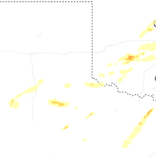
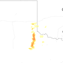
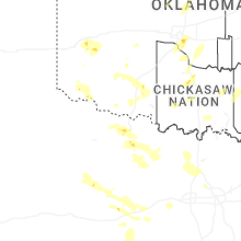
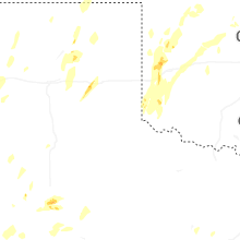
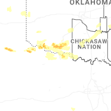
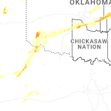
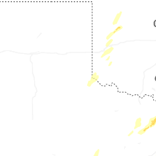
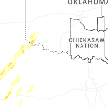


Connect with Interactive Hail Maps