

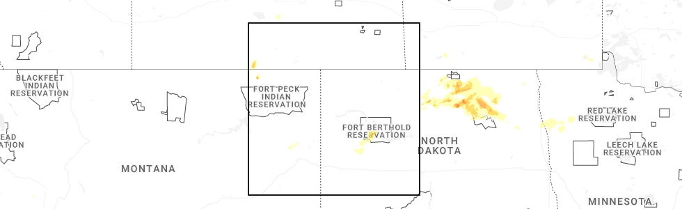
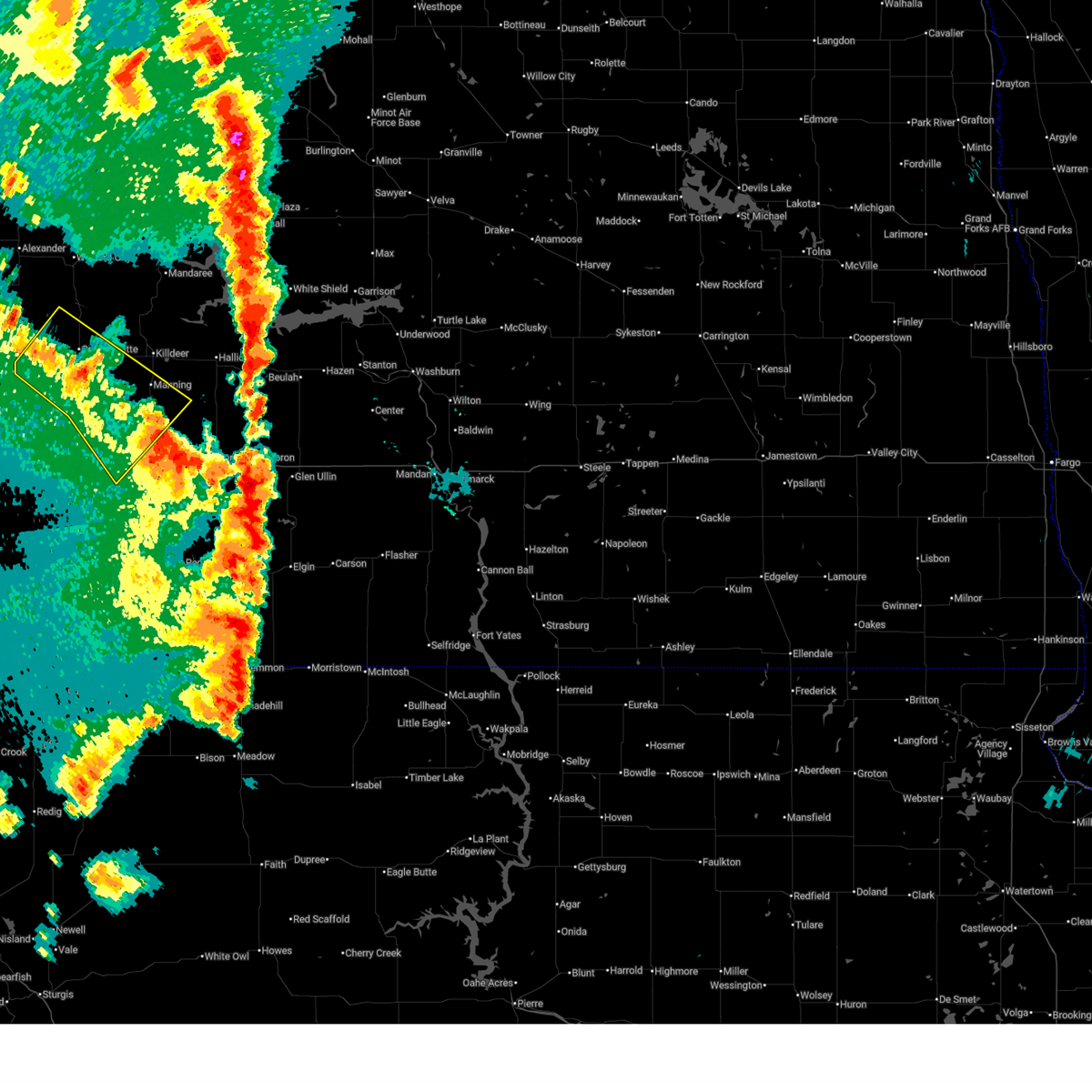
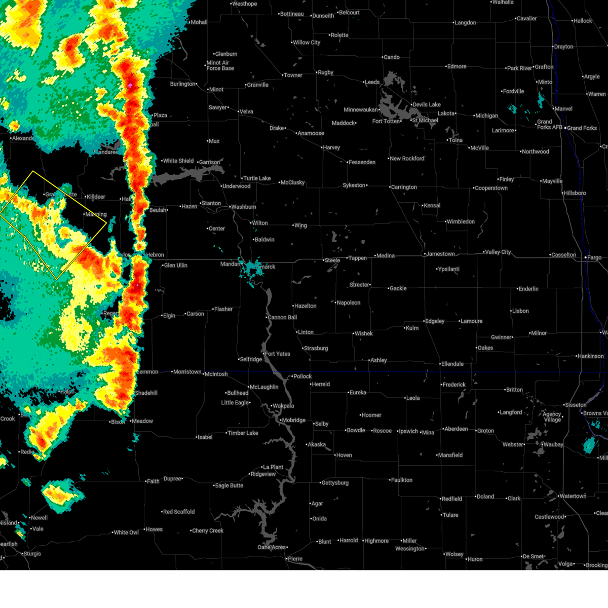
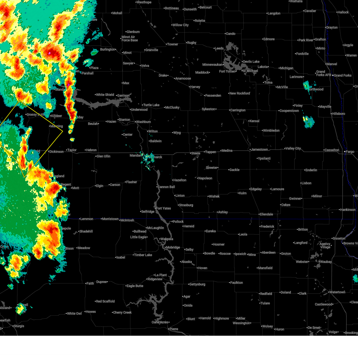
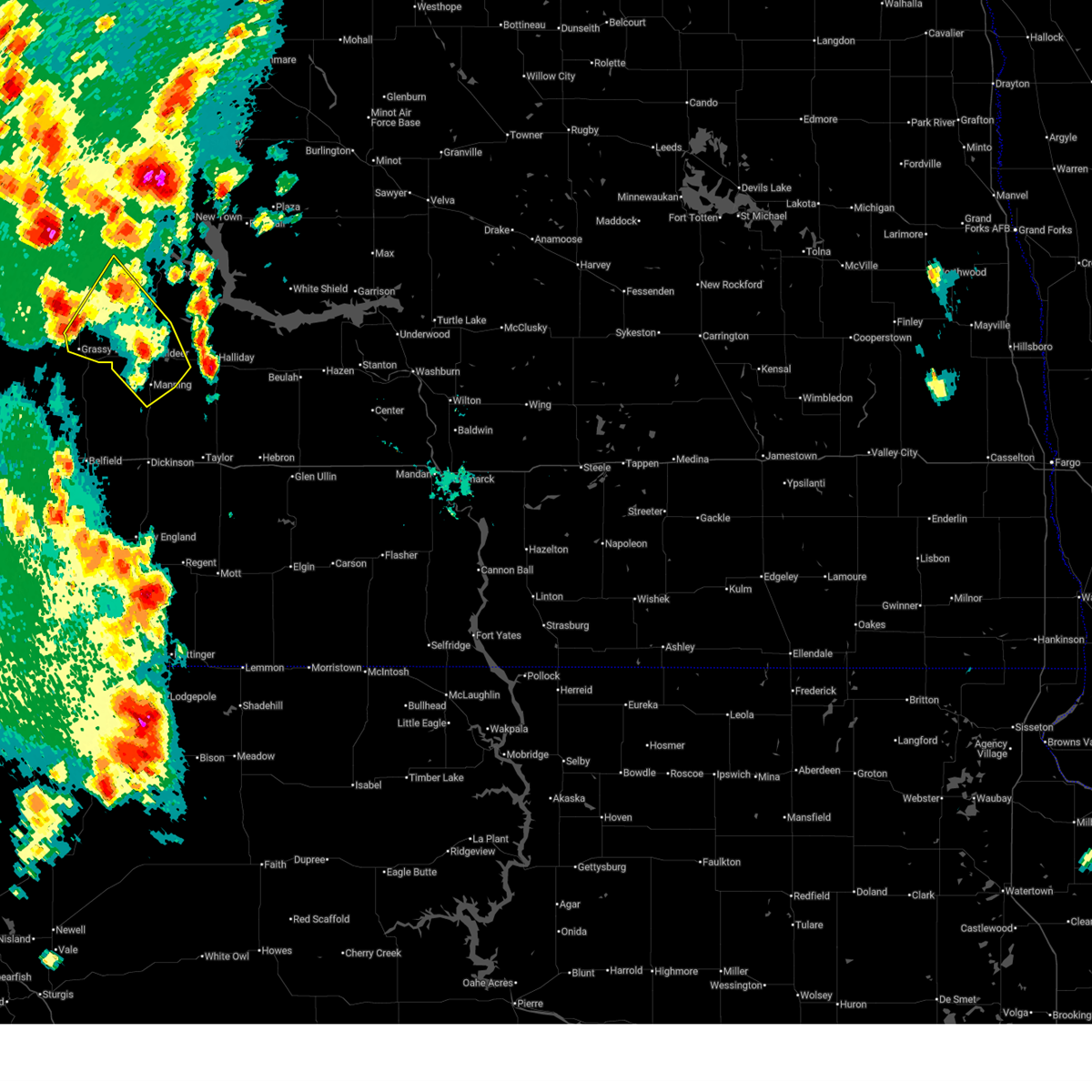
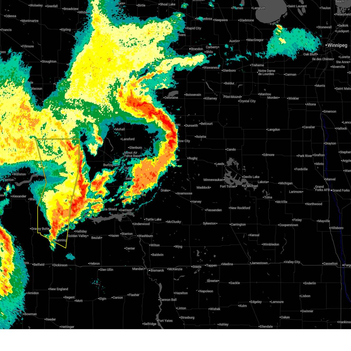
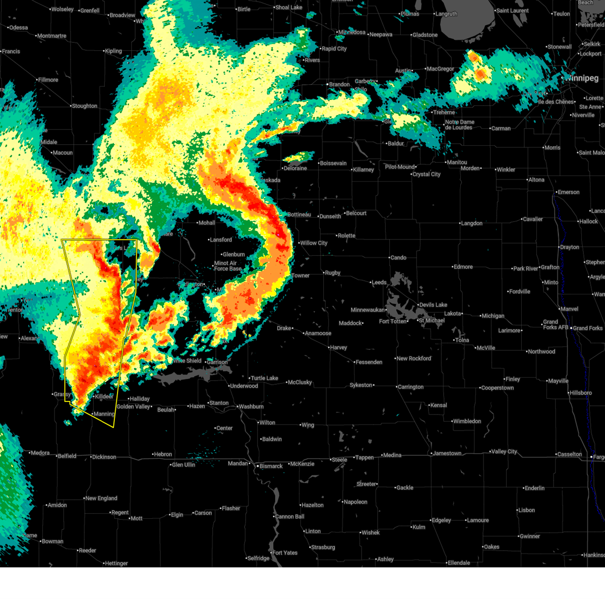
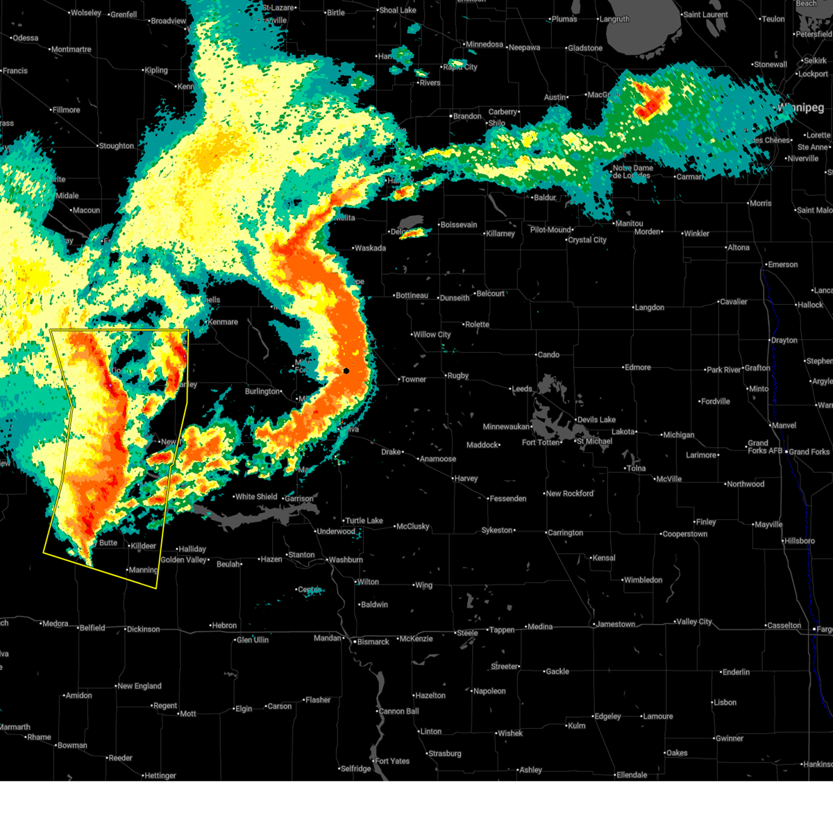
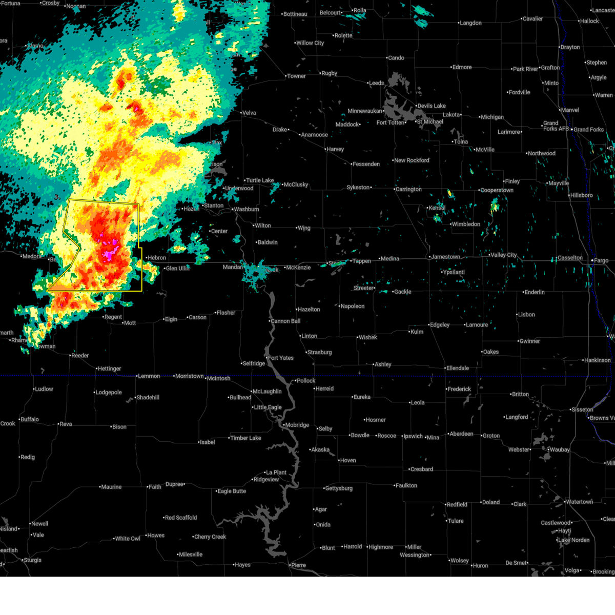
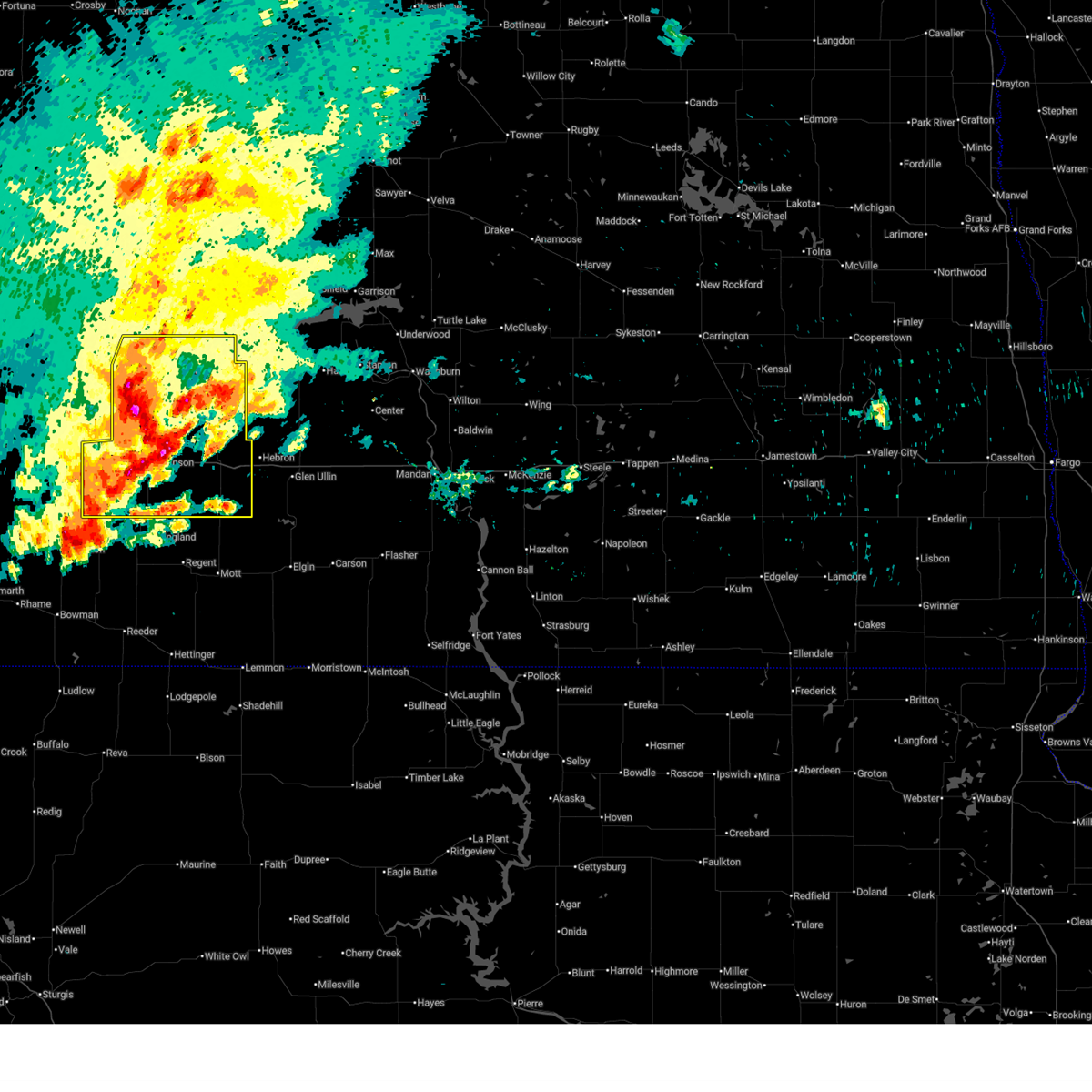
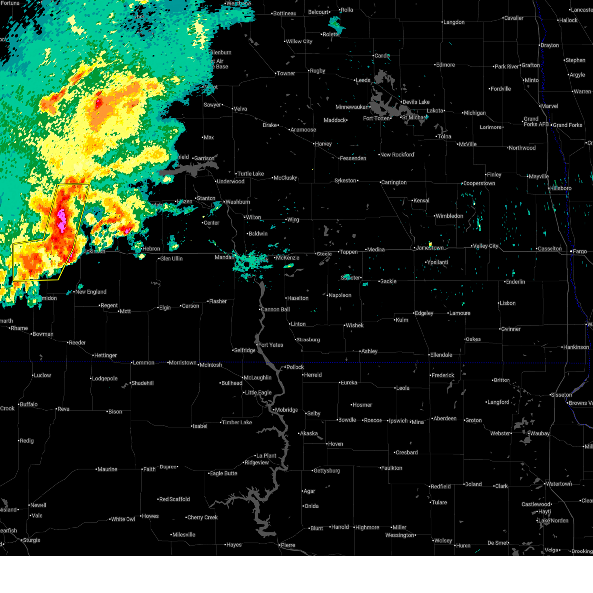
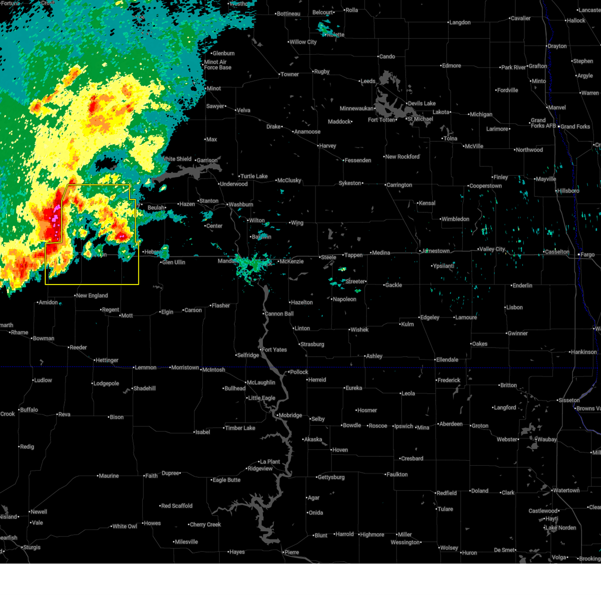
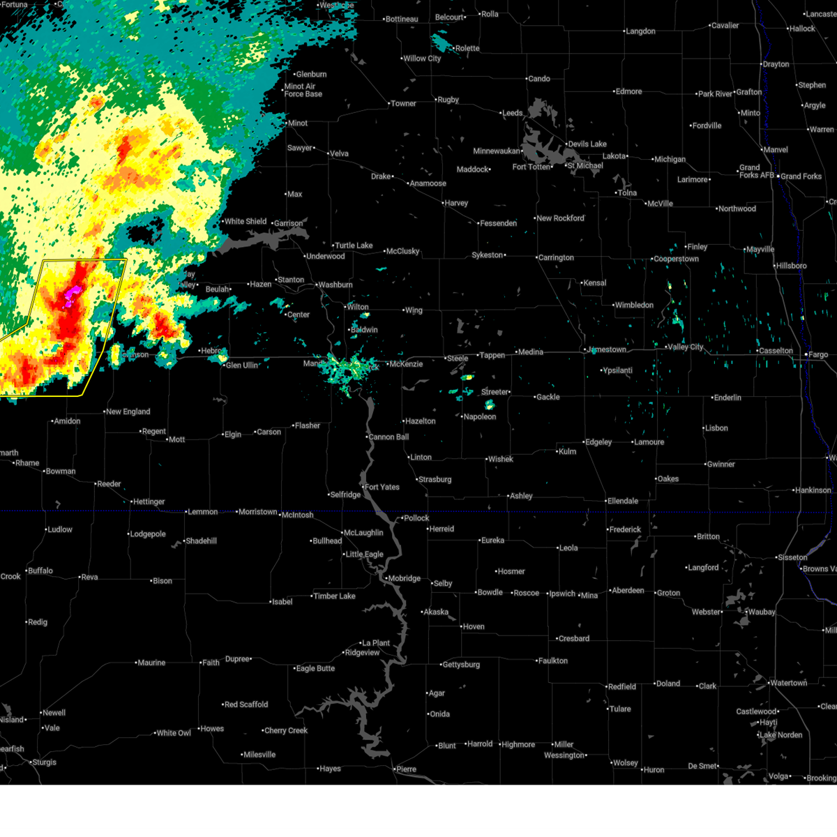
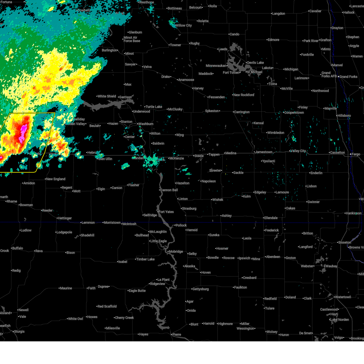
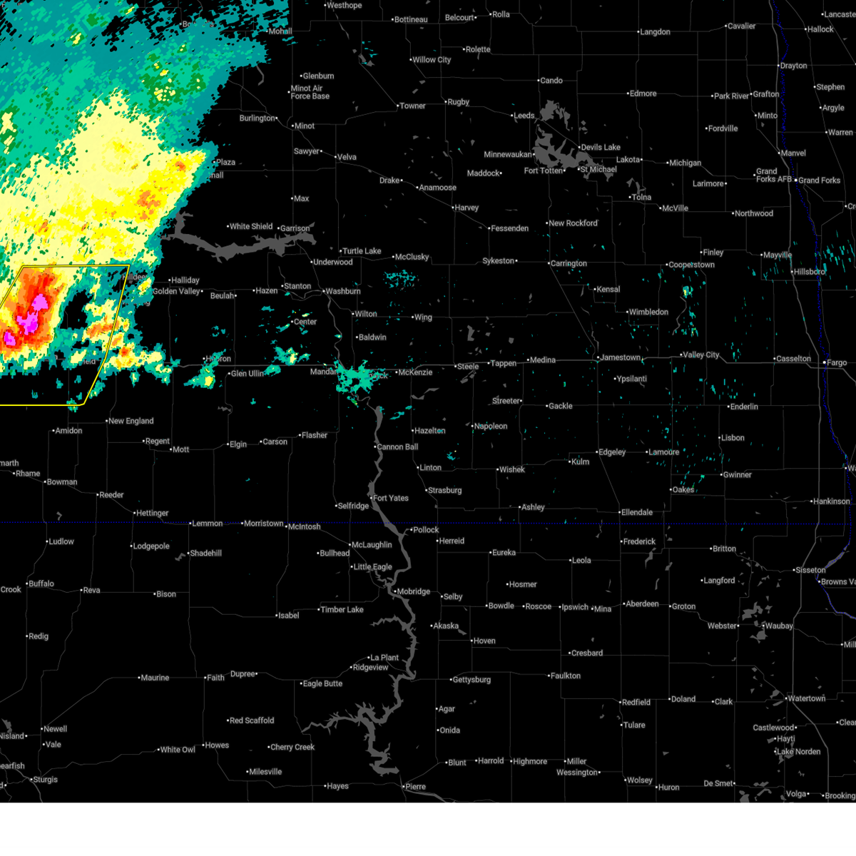
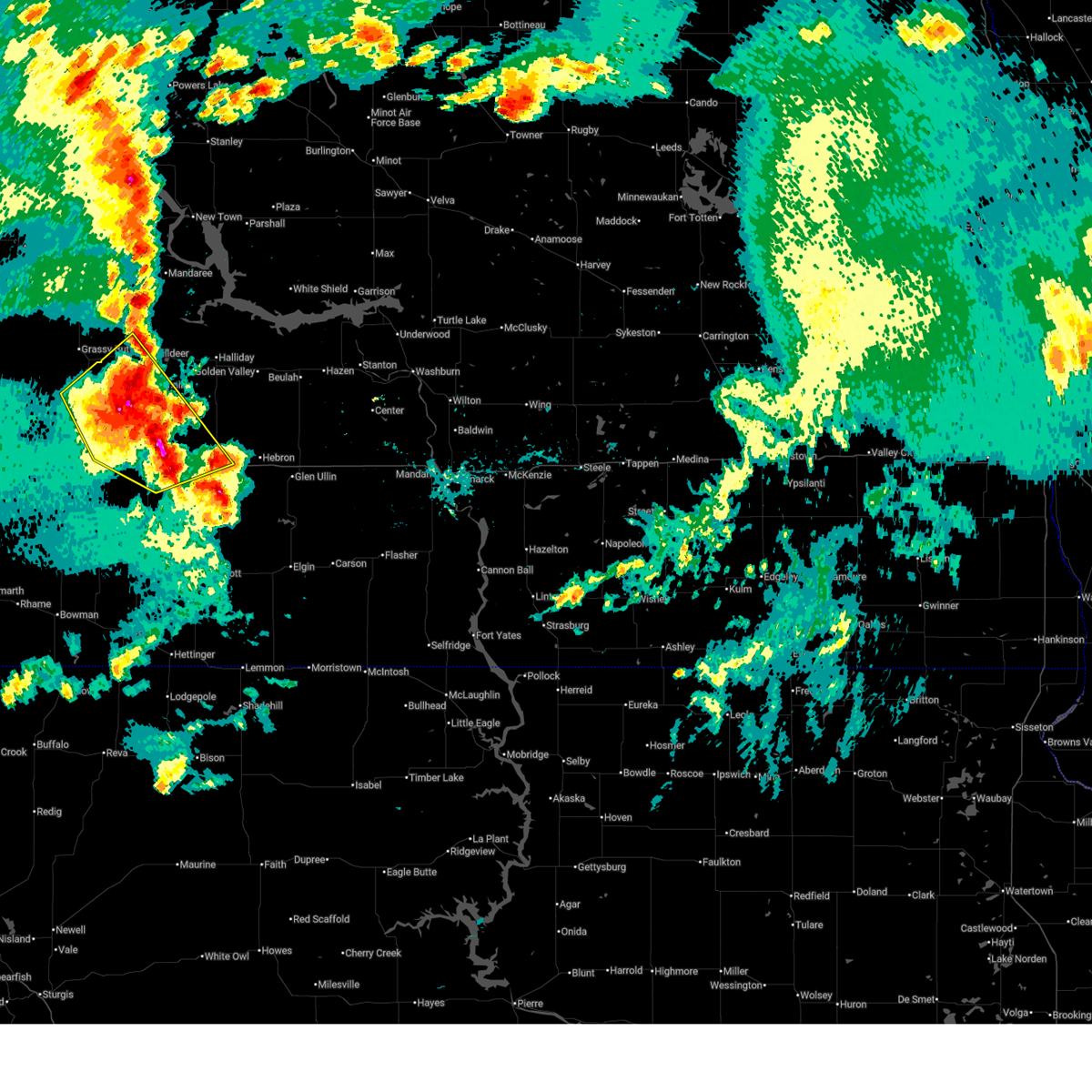
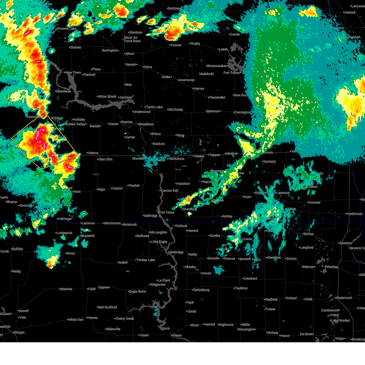
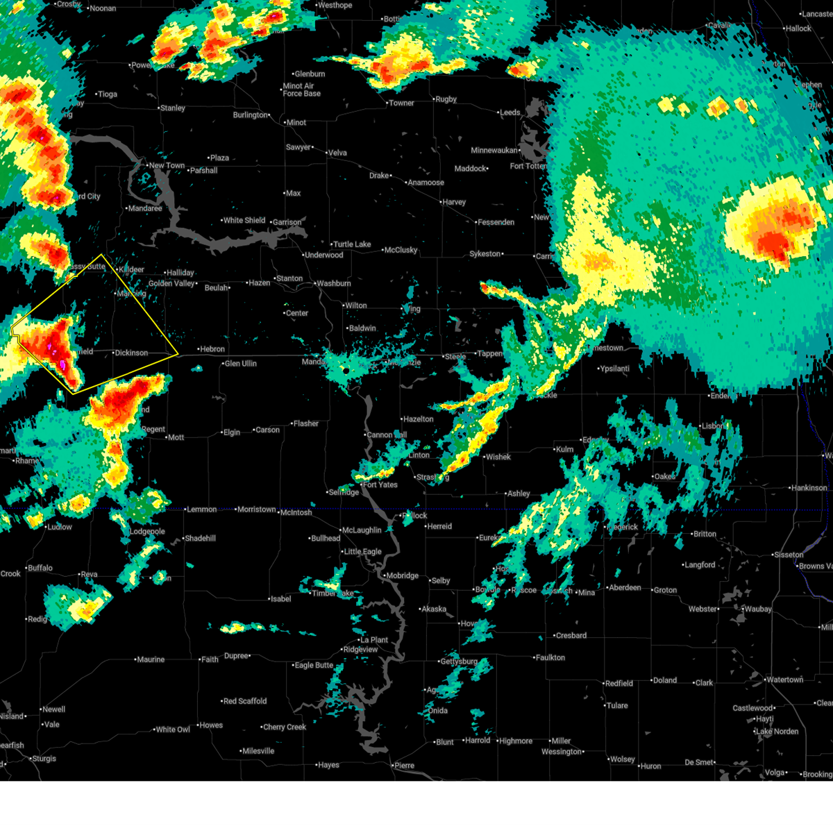
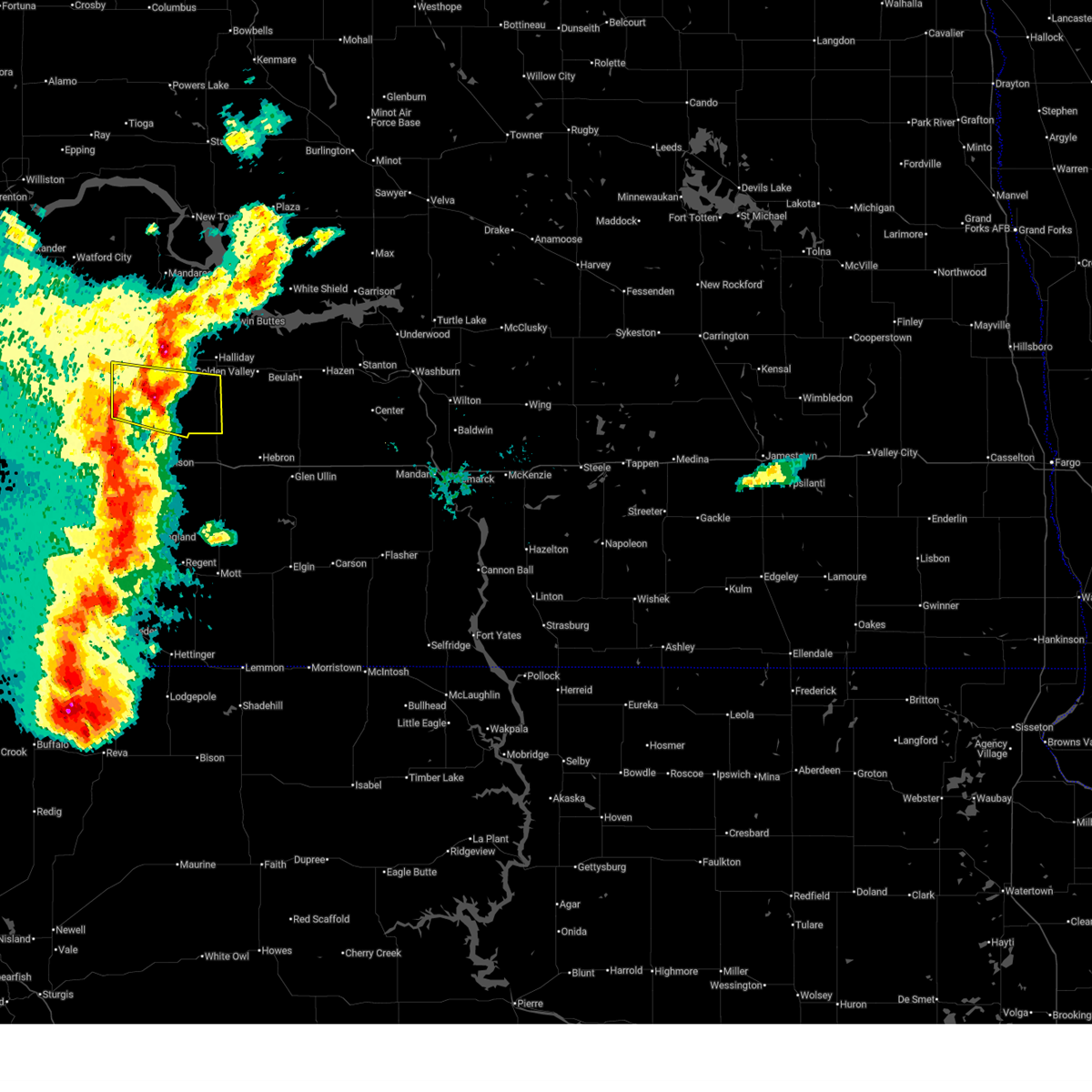
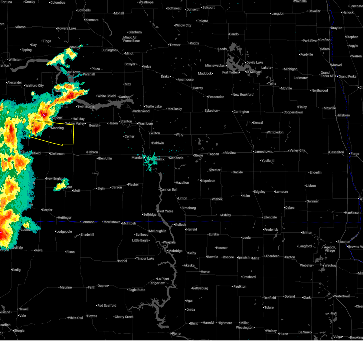
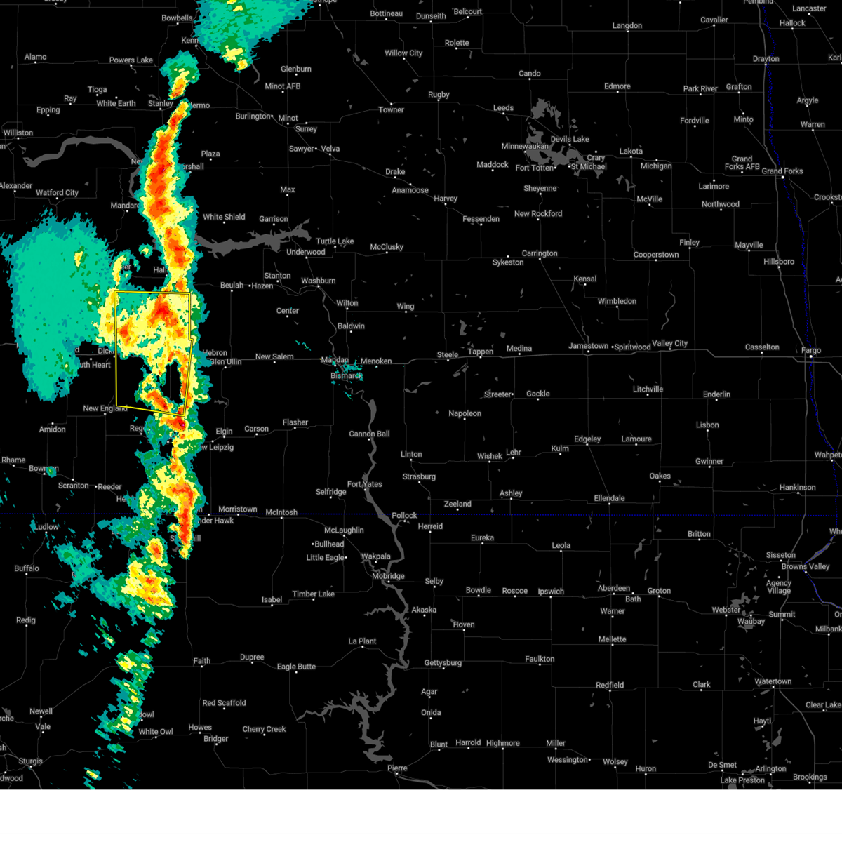
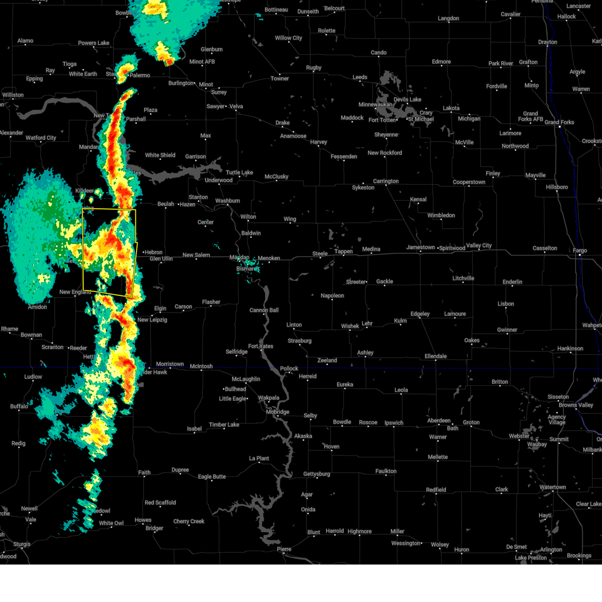
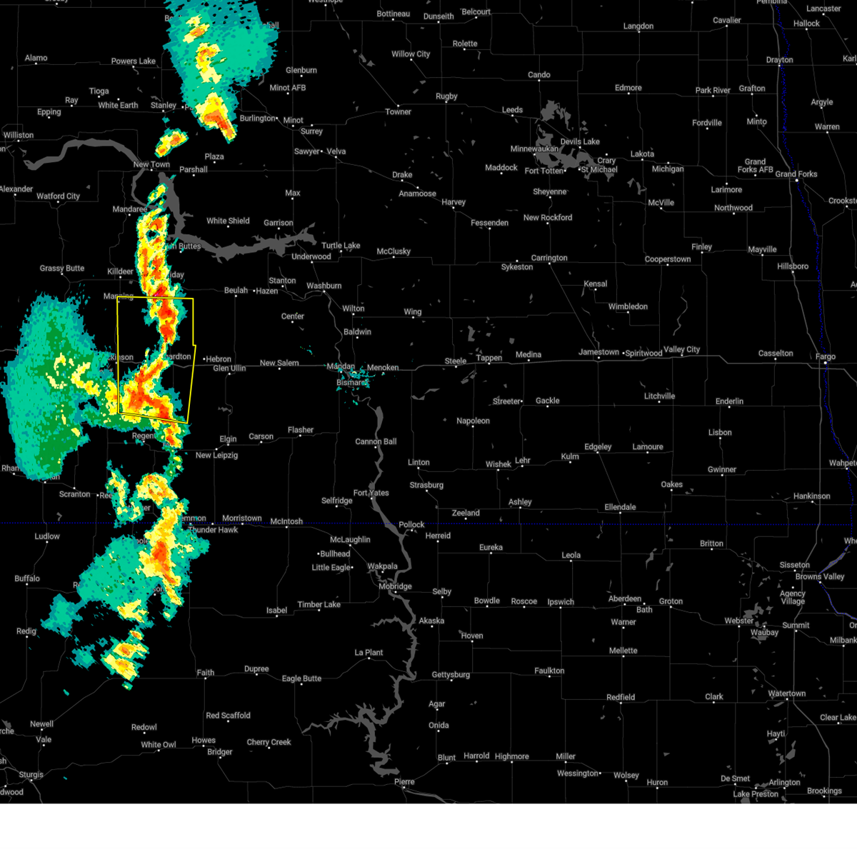
Hail Map for Manning, ND
The Manning, ND area has had 8 reports of on-the-ground hail by trained spotters, and has been under severe weather warnings 38 times during the past 12 months. Doppler radar has detected hail at or near Manning, ND on 43 occasions, including 5 occasions during the past year.
| Name: | Manning, ND |
| Where Located: | 74.6 miles SSE of Williston, ND |
| Map: | Google Map for Manning, ND |
| Population: | 74 |
| Housing Units: | 30 |
| More Info: | Search Google for Manning, ND |
1
The Top Recent Hail Date for Manning, ND is Thursday, September 11, 2025 (13th out of 43)
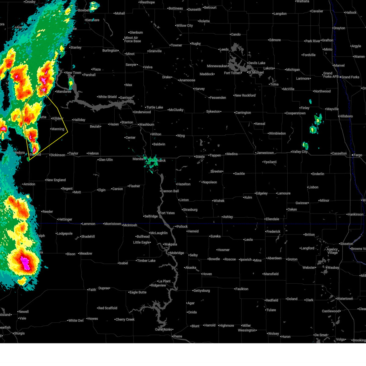
Hail and Wind Damage Spotted near Manning, ND
| Date / Time | Report Details |
|---|---|
| 6/27/2026 8:18 PM MDT |
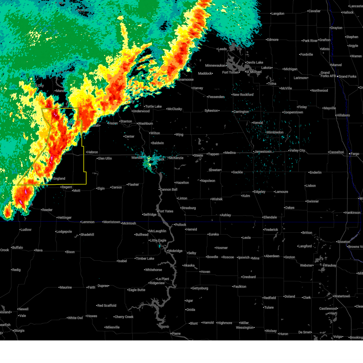
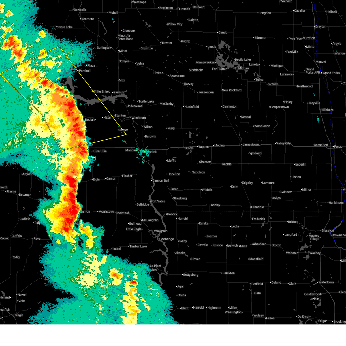 At 916 pm cdt/816 pm mdt/, severe thunderstorms were located along a line extending from 12 miles northwest of four bears village to 13 miles northwest of new salem, moving east at 75 mph. these are destructive storms for mercer and western mclean counties (radar indicated). Hazards include 80 mph wind gusts. Flying debris will be dangerous to those caught without shelter. mobile homes will be heavily damaged. expect considerable damage to roofs, windows, and vehicles. extensive tree damage and power outages are likely. Locations impacted include, beulah, watford city, hazen, new town, killdeer, hebron, center, richardton, zap, alexander, halliday, golden valley, taylor, dunn center, arnegard, dodge, manning, marshall, van hook park, and beulah bay recreation area. At 916 pm cdt/816 pm mdt/, severe thunderstorms were located along a line extending from 12 miles northwest of four bears village to 13 miles northwest of new salem, moving east at 75 mph. these are destructive storms for mercer and western mclean counties (radar indicated). Hazards include 80 mph wind gusts. Flying debris will be dangerous to those caught without shelter. mobile homes will be heavily damaged. expect considerable damage to roofs, windows, and vehicles. extensive tree damage and power outages are likely. Locations impacted include, beulah, watford city, hazen, new town, killdeer, hebron, center, richardton, zap, alexander, halliday, golden valley, taylor, dunn center, arnegard, dodge, manning, marshall, van hook park, and beulah bay recreation area.
|
| 6/27/2026 7:55 PM MDT |
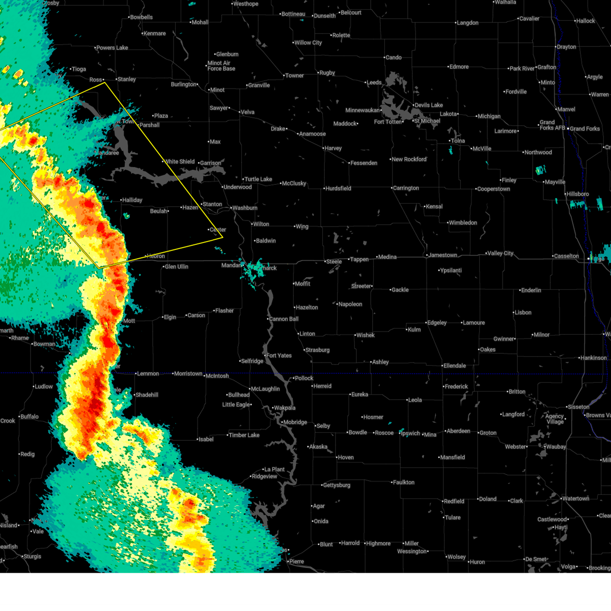 Svrbis the national weather service in bismarck has issued a * severe thunderstorm warning for, dunn county in southwestern north dakota, northwestern mclean county in south central north dakota, northeastern billings county in southwestern north dakota, northwestern morton county in south central north dakota, mckenzie county in northwestern north dakota, northeastern stark county in southwestern north dakota, southeastern williams county in northwestern north dakota, southwestern mountrail county in northwestern north dakota, western oliver county in south central north dakota, mercer county in south central north dakota, * until 1000 pm cdt/900 pm mdt/. * at 854 pm cdt/754 pm mdt/, severe thunderstorms were located along a line extending from 15 miles north of watford city to near hebron, moving east at 40 mph. these are destructive storms for dunn and mercer counties (radar indicated). Hazards include 80 mph wind gusts. Flying debris will be dangerous to those caught without shelter. mobile homes will be heavily damaged. expect considerable damage to roofs, windows, and vehicles. Extensive tree damage and power outages are likely. Svrbis the national weather service in bismarck has issued a * severe thunderstorm warning for, dunn county in southwestern north dakota, northwestern mclean county in south central north dakota, northeastern billings county in southwestern north dakota, northwestern morton county in south central north dakota, mckenzie county in northwestern north dakota, northeastern stark county in southwestern north dakota, southeastern williams county in northwestern north dakota, southwestern mountrail county in northwestern north dakota, western oliver county in south central north dakota, mercer county in south central north dakota, * until 1000 pm cdt/900 pm mdt/. * at 854 pm cdt/754 pm mdt/, severe thunderstorms were located along a line extending from 15 miles north of watford city to near hebron, moving east at 40 mph. these are destructive storms for dunn and mercer counties (radar indicated). Hazards include 80 mph wind gusts. Flying debris will be dangerous to those caught without shelter. mobile homes will be heavily damaged. expect considerable damage to roofs, windows, and vehicles. Extensive tree damage and power outages are likely.
|
| 6/27/2026 8:34 PM CDT |
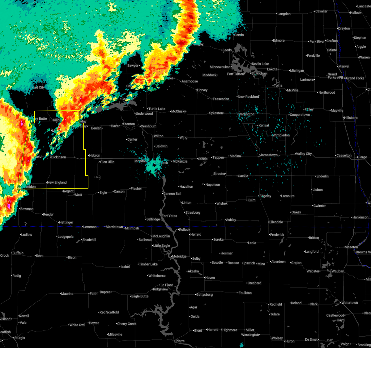
 At 834 pm cdt/734 pm mdt/, severe thunderstorms were located along a line extending from 8 miles northeast of alexander to 9 miles north of killdeer to near taylor, moving northeast at 50 mph. these are destructive storms for dunn county (radar indicated). Hazards include 80 mph wind gusts. Flying debris will be dangerous to those caught without shelter. mobile homes will be heavily damaged. expect considerable damage to roofs, windows, and vehicles. extensive tree damage and power outages are likely. Locations impacted include, dickinson, watford city, killdeer, richardton, south heart, gladstone, alexander, halliday, taylor, dunn center, arnegard, dodge, manning, marshall, grassy butte, south fairfield, four bears village, mandaree, mckenzie bay recreation area, and theodore roosevelt national park north unit. At 834 pm cdt/734 pm mdt/, severe thunderstorms were located along a line extending from 8 miles northeast of alexander to 9 miles north of killdeer to near taylor, moving northeast at 50 mph. these are destructive storms for dunn county (radar indicated). Hazards include 80 mph wind gusts. Flying debris will be dangerous to those caught without shelter. mobile homes will be heavily damaged. expect considerable damage to roofs, windows, and vehicles. extensive tree damage and power outages are likely. Locations impacted include, dickinson, watford city, killdeer, richardton, south heart, gladstone, alexander, halliday, taylor, dunn center, arnegard, dodge, manning, marshall, grassy butte, south fairfield, four bears village, mandaree, mckenzie bay recreation area, and theodore roosevelt national park north unit.
|
| 6/27/2026 7:30 PM MDT | 80 mph gust at 10m recorded at manning 4sw ndaw in dunn county ND, 4 miles NE of Manning, ND |
| 6/27/2026 8:02 PM CDT |
 Svrbis the national weather service in bismarck has issued a * severe thunderstorm warning for, northern golden valley county in southwestern north dakota, dunn county in southwestern north dakota, billings county in southwestern north dakota, mckenzie county in northwestern north dakota, northern stark county in southwestern north dakota, * until 900 pm cdt/800 pm mdt/. * at 800 pm cdt/700 pm mdt/, severe thunderstorms were located along a line extending from 4 miles south of fairview to 9 miles northeast of grassy butte to near dickinson, moving northeast at 60 mph. these are destructive storms for dunn county (radar indicated). Hazards include 80 mph wind gusts. Flying debris will be dangerous to those caught without shelter. mobile homes will be heavily damaged. expect considerable damage to roofs, windows, and vehicles. Extensive tree damage and power outages are likely. Svrbis the national weather service in bismarck has issued a * severe thunderstorm warning for, northern golden valley county in southwestern north dakota, dunn county in southwestern north dakota, billings county in southwestern north dakota, mckenzie county in northwestern north dakota, northern stark county in southwestern north dakota, * until 900 pm cdt/800 pm mdt/. * at 800 pm cdt/700 pm mdt/, severe thunderstorms were located along a line extending from 4 miles south of fairview to 9 miles northeast of grassy butte to near dickinson, moving northeast at 60 mph. these are destructive storms for dunn county (radar indicated). Hazards include 80 mph wind gusts. Flying debris will be dangerous to those caught without shelter. mobile homes will be heavily damaged. expect considerable damage to roofs, windows, and vehicles. Extensive tree damage and power outages are likely.
|
| 6/27/2026 6:09 PM MDT |
 Svrbis the national weather service in bismarck has issued a * severe thunderstorm warning for, southwestern dunn county in southwestern north dakota, northeastern billings county in southwestern north dakota, northwestern stark county in southwestern north dakota, * until 715 pm mdt. * at 608 pm mdt, a severe thunderstorm was located 8 miles north of belfield, or 21 miles northwest of dickinson, moving north at 30 mph (radar indicated). Hazards include golf ball size hail. People and animals outdoors will be injured. Expect damage to roofs, siding, windows, and vehicles. Svrbis the national weather service in bismarck has issued a * severe thunderstorm warning for, southwestern dunn county in southwestern north dakota, northeastern billings county in southwestern north dakota, northwestern stark county in southwestern north dakota, * until 715 pm mdt. * at 608 pm mdt, a severe thunderstorm was located 8 miles north of belfield, or 21 miles northwest of dickinson, moving north at 30 mph (radar indicated). Hazards include golf ball size hail. People and animals outdoors will be injured. Expect damage to roofs, siding, windows, and vehicles.
|
| 6/7/2026 8:05 PM MDT |
 At 905 pm cdt /805 pm mdt/, severe thunderstorms were located along a line from over theodore roosevelt national park north unit to 9 miles south of dunn center, or along a line from 15 miles south of watford city to 26 miles northeast of dickinson, moving northeast at 45 mph (radar indicated). Hazards include 60 mph wind gusts and small hail. Expect damage to roofs, siding, and trees. Locations impacted include, watford city, killdeer, dunn center, manning, mandaree, theodore roosevelt national park north unit, oakdale, little missouri state park, johnsons corner and fort berthold. At 905 pm cdt /805 pm mdt/, severe thunderstorms were located along a line from over theodore roosevelt national park north unit to 9 miles south of dunn center, or along a line from 15 miles south of watford city to 26 miles northeast of dickinson, moving northeast at 45 mph (radar indicated). Hazards include 60 mph wind gusts and small hail. Expect damage to roofs, siding, and trees. Locations impacted include, watford city, killdeer, dunn center, manning, mandaree, theodore roosevelt national park north unit, oakdale, little missouri state park, johnsons corner and fort berthold.
|
| 6/7/2026 7:51 PM MDT |
 Svrbis the national weather service in bismarck has issued a * severe thunderstorm warning for, central mckenzie county in northwestern north dakota, northeastern billings county in southwestern north dakota, western dunn county in southwestern north dakota, * until 930 pm cdt /830 pm mdt/. * at 851 pm cdt /751 pm mdt/, severe thunderstorms were located along a line from 10 miles northwest of grassy butte to 9 miles south of manning, or along a line from 24 miles south of watford city to 16 miles north of dickinson, moving northeast at 45 mph (radar indicated). Hazards include 60 mph wind gusts and small hail. expect damage to roofs, siding, and trees Svrbis the national weather service in bismarck has issued a * severe thunderstorm warning for, central mckenzie county in northwestern north dakota, northeastern billings county in southwestern north dakota, western dunn county in southwestern north dakota, * until 930 pm cdt /830 pm mdt/. * at 851 pm cdt /751 pm mdt/, severe thunderstorms were located along a line from 10 miles northwest of grassy butte to 9 miles south of manning, or along a line from 24 miles south of watford city to 16 miles north of dickinson, moving northeast at 45 mph (radar indicated). Hazards include 60 mph wind gusts and small hail. expect damage to roofs, siding, and trees
|
| 6/7/2026 7:45 PM MDT | 10 meter measured wind gust at ndawn 4 s in dunn county ND, 4 miles NE of Manning, ND |
| 6/7/2026 7:43 PM MDT |
 At 843 pm cdt /743 pm mdt/, severe thunderstorms were located along a line from 9 miles northwest of manning to 5 miles northwest of gladstone, or along a line from 29 miles north of dickinson to 6 miles east of dickinson, moving northeast at 50 mph (radar indicated). Hazards include 60 mph wind gusts and quarter size hail. Hail damage to vehicles is expected. expect wind damage to roofs, siding, and trees. Locations impacted include, south heart, manning, south fairfield, grassy butte, fairfield and new hradec. At 843 pm cdt /743 pm mdt/, severe thunderstorms were located along a line from 9 miles northwest of manning to 5 miles northwest of gladstone, or along a line from 29 miles north of dickinson to 6 miles east of dickinson, moving northeast at 50 mph (radar indicated). Hazards include 60 mph wind gusts and quarter size hail. Hail damage to vehicles is expected. expect wind damage to roofs, siding, and trees. Locations impacted include, south heart, manning, south fairfield, grassy butte, fairfield and new hradec.
|
| 6/7/2026 7:43 PM MDT |
 the severe thunderstorm warning has been cancelled and is no longer in effect the severe thunderstorm warning has been cancelled and is no longer in effect
|
| 6/7/2026 7:38 PM MDT |
 At 838 pm cdt /738 pm mdt/, severe thunderstorms were located along a line from 12 miles northeast of south fairfield to over dickinson, or along a line from 28 miles northwest of dickinson to over dickinson, moving northeast at 50 mph (radar indicated). Hazards include 60 mph wind gusts and quarter size hail. Hail damage to vehicles is expected. expect wind damage to roofs, siding, and trees. Locations impacted include, belfield, south heart, manning, south fairfield, grassy butte, fairfield, new hradec and elkhorn state natural area. At 838 pm cdt /738 pm mdt/, severe thunderstorms were located along a line from 12 miles northeast of south fairfield to over dickinson, or along a line from 28 miles northwest of dickinson to over dickinson, moving northeast at 50 mph (radar indicated). Hazards include 60 mph wind gusts and quarter size hail. Hail damage to vehicles is expected. expect wind damage to roofs, siding, and trees. Locations impacted include, belfield, south heart, manning, south fairfield, grassy butte, fairfield, new hradec and elkhorn state natural area.
|
| 6/7/2026 7:38 PM MDT |
 the severe thunderstorm warning has been cancelled and is no longer in effect the severe thunderstorm warning has been cancelled and is no longer in effect
|
| 6/7/2026 7:08 PM MDT |
 Svrbis the national weather service in bismarck has issued a * severe thunderstorm warning for, south central mckenzie county in northwestern north dakota, billings county in southwestern north dakota, southwestern dunn county in southwestern north dakota, northeastern golden valley county in southwestern north dakota, north central slope county in southwestern north dakota, western stark county in southwestern north dakota, * until 900 pm cdt /800 pm mdt/. * at 808 pm cdt /708 pm mdt/, severe thunderstorms were located along a line from 10 miles north of medora to 15 miles south of belfield, or along a line from 28 miles east of beach to 23 miles southwest of dickinson, moving northeast at 50 mph (radar indicated). Hazards include ping pong ball size hail and 60 mph wind gusts. People and animals outdoors will be injured. expect hail damage to roofs, siding, windows, and vehicles. Expect wind damage to roofs, siding, and trees. Svrbis the national weather service in bismarck has issued a * severe thunderstorm warning for, south central mckenzie county in northwestern north dakota, billings county in southwestern north dakota, southwestern dunn county in southwestern north dakota, northeastern golden valley county in southwestern north dakota, north central slope county in southwestern north dakota, western stark county in southwestern north dakota, * until 900 pm cdt /800 pm mdt/. * at 808 pm cdt /708 pm mdt/, severe thunderstorms were located along a line from 10 miles north of medora to 15 miles south of belfield, or along a line from 28 miles east of beach to 23 miles southwest of dickinson, moving northeast at 50 mph (radar indicated). Hazards include ping pong ball size hail and 60 mph wind gusts. People and animals outdoors will be injured. expect hail damage to roofs, siding, windows, and vehicles. Expect wind damage to roofs, siding, and trees.
|
| 6/7/2026 6:57 PM MDT |
 At 757 pm cdt /657 pm mdt/, severe thunderstorms were located along a line from 10 miles west of mandaree to near manning, or along a line from 20 miles southeast of watford city to 21 miles north of dickinson, moving northeast at 35 mph (radar indicated). Hazards include golf ball size hail and 60 mph wind gusts. People and animals outdoors will be injured. expect hail damage to roofs, siding, windows, and vehicles. expect wind damage to roofs, siding, and trees. Locations impacted include, killdeer, dunn center, manning, grassy butte, oakdale and little missouri state park. At 757 pm cdt /657 pm mdt/, severe thunderstorms were located along a line from 10 miles west of mandaree to near manning, or along a line from 20 miles southeast of watford city to 21 miles north of dickinson, moving northeast at 35 mph (radar indicated). Hazards include golf ball size hail and 60 mph wind gusts. People and animals outdoors will be injured. expect hail damage to roofs, siding, windows, and vehicles. expect wind damage to roofs, siding, and trees. Locations impacted include, killdeer, dunn center, manning, grassy butte, oakdale and little missouri state park.
|
| 6/7/2026 6:30 PM MDT | Ping Pong Ball sized hail reported 13.5 miles ENE of Manning, ND |
| 6/7/2026 6:16 PM MDT |
 Svrbis the national weather service in bismarck has issued a * severe thunderstorm warning for, southeastern mckenzie county in northwestern north dakota, northeastern billings county in southwestern north dakota, western dunn county in southwestern north dakota, northwestern stark county in southwestern north dakota, * until 815 pm cdt /715 pm mdt/. * at 716 pm cdt /616 pm mdt/, severe thunderstorms were located along a line from near grassy butte to 7 miles northwest of south heart, or along a line from 25 miles south of watford city to 14 miles west of dickinson, moving northeast at 35 mph (radar indicated). Hazards include two inch hail and 60 mph wind gusts. People and animals outdoors will be injured. expect hail damage to roofs, siding, windows, and vehicles. Expect wind damage to roofs, siding, and trees. Svrbis the national weather service in bismarck has issued a * severe thunderstorm warning for, southeastern mckenzie county in northwestern north dakota, northeastern billings county in southwestern north dakota, western dunn county in southwestern north dakota, northwestern stark county in southwestern north dakota, * until 815 pm cdt /715 pm mdt/. * at 716 pm cdt /616 pm mdt/, severe thunderstorms were located along a line from near grassy butte to 7 miles northwest of south heart, or along a line from 25 miles south of watford city to 14 miles west of dickinson, moving northeast at 35 mph (radar indicated). Hazards include two inch hail and 60 mph wind gusts. People and animals outdoors will be injured. expect hail damage to roofs, siding, windows, and vehicles. Expect wind damage to roofs, siding, and trees.
|
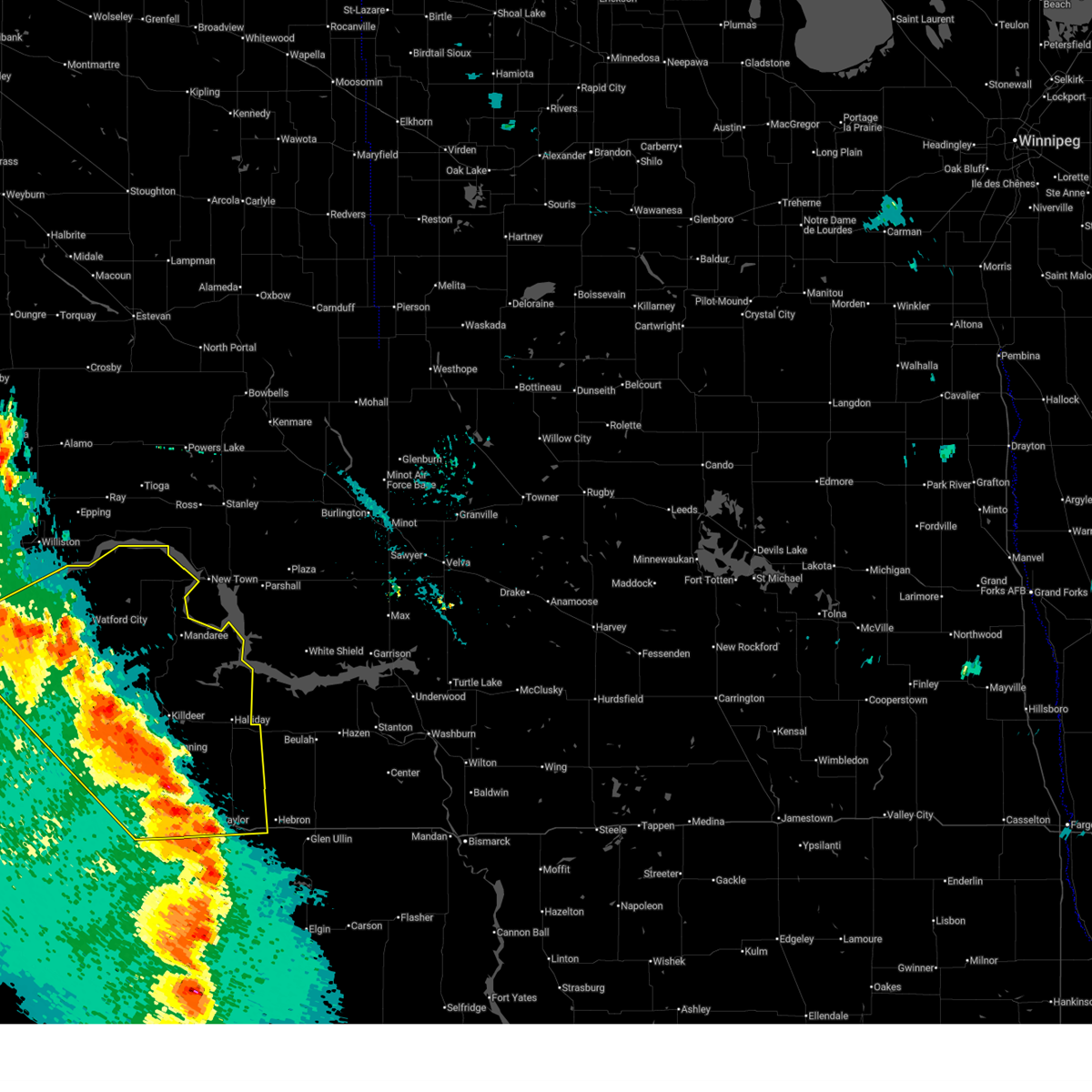
| 9/12/2025 9:42 PM MDT | Svrbis the national weather service in bismarck has issued a * severe thunderstorm warning for, central dunn county in southwestern north dakota, east central mckenzie county in northwestern north dakota, south central mountrail county in northwestern north dakota, * until 1130 pm cdt. * at 1042 pm cdt, a severe thunderstorm was located 11 miles north of killdeer, or 30 miles southeast of watford city, moving north at 20 mph (radar indicated). Hazards include 60 mph wind gusts and quarter size hail. Hail damage to vehicles is expected. Expect wind damage to roofs, siding, and trees. |
| 8/7/2025 11:24 PM MDT | Ndawn station manning 4sw. report at 10 meters... 61 mph observed at the surface. report was made well behind the line of thunderstorms... with no lightning in the area in dunn county ND, 4 miles NE of Manning, ND |
| 8/7/2025 11:15 PM MDT | Ndawn station manning 4sw. report at 10 meters... 57 mph observed at the surfac in dunn county ND, 4 miles NE of Manning, ND |
| 8/7/2025 11:01 PM MDT |
 At 1100 pm mdt, severe thunderstorms were located along a line extending from 10 miles southwest of mckenzie bay recreation area to 8 miles south of marshall to 9 miles east of new england, moving east at 80 mph (public. at 1051 pm mdt, a 62 mph wind gust was reported in dickinson). Hazards include 60 mph wind gusts. Expect damage to roofs, siding, and trees. Locations impacted include, dickinson, killdeer, new england, richardton, gladstone, halliday, taylor, dunn center, dodge, marshall, amidon, havelock, hirschville, oakdale, lefor, schefield, and dickinson regional airport. At 1100 pm mdt, severe thunderstorms were located along a line extending from 10 miles southwest of mckenzie bay recreation area to 8 miles south of marshall to 9 miles east of new england, moving east at 80 mph (public. at 1051 pm mdt, a 62 mph wind gust was reported in dickinson). Hazards include 60 mph wind gusts. Expect damage to roofs, siding, and trees. Locations impacted include, dickinson, killdeer, new england, richardton, gladstone, halliday, taylor, dunn center, dodge, marshall, amidon, havelock, hirschville, oakdale, lefor, schefield, and dickinson regional airport.
|
| 8/7/2025 11:01 PM MDT |
 the severe thunderstorm warning has been cancelled and is no longer in effect the severe thunderstorm warning has been cancelled and is no longer in effect
|
| 8/7/2025 10:31 PM MDT |
 Svrbis the national weather service in bismarck has issued a * severe thunderstorm warning for, dunn county in southwestern north dakota, northern hettinger county in southwestern north dakota, eastern billings county in southwestern north dakota, northeastern slope county in southwestern north dakota, stark county in southwestern north dakota, * until 1130 pm mdt. * at 1030 pm mdt, severe thunderstorms were located along a line extending from grassy butte to 4 miles northwest of south heart to 4 miles southwest of amidon, moving east at 75 mph (radar indicated). Hazards include 60 mph wind gusts. expect damage to roofs, siding, and trees Svrbis the national weather service in bismarck has issued a * severe thunderstorm warning for, dunn county in southwestern north dakota, northern hettinger county in southwestern north dakota, eastern billings county in southwestern north dakota, northeastern slope county in southwestern north dakota, stark county in southwestern north dakota, * until 1130 pm mdt. * at 1030 pm mdt, severe thunderstorms were located along a line extending from grassy butte to 4 miles northwest of south heart to 4 miles southwest of amidon, moving east at 75 mph (radar indicated). Hazards include 60 mph wind gusts. expect damage to roofs, siding, and trees
|
| 8/7/2025 11:09 PM CDT |
 The storms which prompted the warning have weakened below severe limits, and no longer pose an immediate threat to life or property. therefore, the warning will be allowed to expire. however, gusty winds are still possible with these thunderstorms. a severe thunderstorm watch remains in effect until 300 am cdt for south central, southwestern and northwestern north dakota. The storms which prompted the warning have weakened below severe limits, and no longer pose an immediate threat to life or property. therefore, the warning will be allowed to expire. however, gusty winds are still possible with these thunderstorms. a severe thunderstorm watch remains in effect until 300 am cdt for south central, southwestern and northwestern north dakota.
|
| 8/7/2025 10:55 PM CDT |
 the severe thunderstorm warning has been cancelled and is no longer in effect the severe thunderstorm warning has been cancelled and is no longer in effect
|
| 8/7/2025 10:55 PM CDT |
 At 1054 pm cdt, severe thunderstorms were located along a line extending from powers lake to near ross to new town to 7 miles southwest of killdeer, moving east at 55 mph (trained weather spotters). Hazards include 70 mph wind gusts. Expect considerable tree damage. damage is likely to mobile homes, roofs, and outbuildings. Locations impacted include, stanley, new town, tioga, killdeer, powers lake, dunn center, ross, battleview, manning, lostwood, van hook park, four bears village, mandaree, belden, 4 bears lodge, white earth, hamlet, keene, white earth bay recreation area, and oakdale. At 1054 pm cdt, severe thunderstorms were located along a line extending from powers lake to near ross to new town to 7 miles southwest of killdeer, moving east at 55 mph (trained weather spotters). Hazards include 70 mph wind gusts. Expect considerable tree damage. damage is likely to mobile homes, roofs, and outbuildings. Locations impacted include, stanley, new town, tioga, killdeer, powers lake, dunn center, ross, battleview, manning, lostwood, van hook park, four bears village, mandaree, belden, 4 bears lodge, white earth, hamlet, keene, white earth bay recreation area, and oakdale.
|
| 8/7/2025 10:36 PM CDT |
 At 1035 pm cdt/935 pm mdt/, severe thunderstorms were located along a line extending from 6 miles northwest of tioga to 13 miles west of ross to 11 miles northwest of mandaree to 10 miles northeast of grassy butte, moving east at 55 mph (trained weather spotters. at 1023 pm cdt, a 66 mph wind gust was reported 4 miles north of ray). Hazards include 70 mph wind gusts. Expect considerable tree damage. damage is likely to mobile homes, roofs, and outbuildings. Locations impacted include, watford city, stanley, new town, tioga, killdeer, ray, powers lake, dunn center, wildrose, ross, battleview, manning, lostwood, grassy butte, van hook park, four bears village, mandaree, belden, 4 bears lodge, and theodore roosevelt national park north unit. At 1035 pm cdt/935 pm mdt/, severe thunderstorms were located along a line extending from 6 miles northwest of tioga to 13 miles west of ross to 11 miles northwest of mandaree to 10 miles northeast of grassy butte, moving east at 55 mph (trained weather spotters. at 1023 pm cdt, a 66 mph wind gust was reported 4 miles north of ray). Hazards include 70 mph wind gusts. Expect considerable tree damage. damage is likely to mobile homes, roofs, and outbuildings. Locations impacted include, watford city, stanley, new town, tioga, killdeer, ray, powers lake, dunn center, wildrose, ross, battleview, manning, lostwood, grassy butte, van hook park, four bears village, mandaree, belden, 4 bears lodge, and theodore roosevelt national park north unit.
|
| 8/7/2025 10:14 PM CDT |
 Svrbis the national weather service in bismarck has issued a * severe thunderstorm warning for, western dunn county in southwestern north dakota, northern billings county in southwestern north dakota, southern burke county in northwestern north dakota, central mckenzie county in northwestern north dakota, eastern williams county in northwestern north dakota, western mountrail county in northwestern north dakota, * until 1115 pm cdt/1015 pm mdt/. * at 1014 pm cdt/914 pm mdt/, severe thunderstorms were located along a line extending from 7 miles north of epping to 11 miles south of ray to 5 miles east of watford city to 7 miles west of grassy butte, moving east at 50 mph (radar indicated). Hazards include 70 mph wind gusts and nickel size hail. Expect considerable tree damage. Damage is likely to mobile homes, roofs, and outbuildings. Svrbis the national weather service in bismarck has issued a * severe thunderstorm warning for, western dunn county in southwestern north dakota, northern billings county in southwestern north dakota, southern burke county in northwestern north dakota, central mckenzie county in northwestern north dakota, eastern williams county in northwestern north dakota, western mountrail county in northwestern north dakota, * until 1115 pm cdt/1015 pm mdt/. * at 1014 pm cdt/914 pm mdt/, severe thunderstorms were located along a line extending from 7 miles north of epping to 11 miles south of ray to 5 miles east of watford city to 7 miles west of grassy butte, moving east at 50 mph (radar indicated). Hazards include 70 mph wind gusts and nickel size hail. Expect considerable tree damage. Damage is likely to mobile homes, roofs, and outbuildings.
|
| 7/28/2025 7:41 AM MDT |
 At 741 am mdt, severe thunderstorms were located along a line extending from near marshall to 6 miles southeast of richardton to 7 miles northeast of new england, moving east at 50 mph (trained weather spotters). Hazards include 70 mph wind gusts and quarter size hail. Hail damage to vehicles is expected. expect considerable tree damage. wind damage is also likely to mobile homes, roofs, and outbuildings. Locations impacted include, dickinson, killdeer, richardton, gladstone, taylor, dunn center, dodge, manning, marshall, hirschville, lefor, schefield, and dickinson regional airport. At 741 am mdt, severe thunderstorms were located along a line extending from near marshall to 6 miles southeast of richardton to 7 miles northeast of new england, moving east at 50 mph (trained weather spotters). Hazards include 70 mph wind gusts and quarter size hail. Hail damage to vehicles is expected. expect considerable tree damage. wind damage is also likely to mobile homes, roofs, and outbuildings. Locations impacted include, dickinson, killdeer, richardton, gladstone, taylor, dunn center, dodge, manning, marshall, hirschville, lefor, schefield, and dickinson regional airport.
|
| 7/28/2025 7:24 AM MDT |
 At 723 am mdt, severe thunderstorms were located along a line extending from manning to gladstone to 11 miles northwest of new england, moving east at 30 mph (trained weather spotters. at 708 am mdt, a 76 mph wind gust was reported 9 miles southwest of manning). Hazards include 70 mph wind gusts and quarter size hail. Hail damage to vehicles is expected. expect considerable tree damage. wind damage is also likely to mobile homes, roofs, and outbuildings. Locations impacted include, dickinson, belfield, killdeer, richardton, south heart, gladstone, halliday, taylor, dunn center, dodge, manning, marshall, hirschville, lefor, new hradec, schefield, and dickinson regional airport. At 723 am mdt, severe thunderstorms were located along a line extending from manning to gladstone to 11 miles northwest of new england, moving east at 30 mph (trained weather spotters. at 708 am mdt, a 76 mph wind gust was reported 9 miles southwest of manning). Hazards include 70 mph wind gusts and quarter size hail. Hail damage to vehicles is expected. expect considerable tree damage. wind damage is also likely to mobile homes, roofs, and outbuildings. Locations impacted include, dickinson, belfield, killdeer, richardton, south heart, gladstone, halliday, taylor, dunn center, dodge, manning, marshall, hirschville, lefor, new hradec, schefield, and dickinson regional airport.
|
| 7/28/2025 7:05 AM MDT |
 At 705 am mdt, severe thunderstorms were located along a line extending from 7 miles west of killdeer to south heart to 14 miles south of medora, moving east at 30 mph (trained weather spotters). Hazards include 70 mph wind gusts and quarter size hail. Hail damage to vehicles is expected. expect considerable tree damage. wind damage is also likely to mobile homes, roofs, and outbuildings. Locations impacted include, belfield, killdeer, south heart, medora, manning, fryburg, sully creek state park, and new hradec. At 705 am mdt, severe thunderstorms were located along a line extending from 7 miles west of killdeer to south heart to 14 miles south of medora, moving east at 30 mph (trained weather spotters). Hazards include 70 mph wind gusts and quarter size hail. Hail damage to vehicles is expected. expect considerable tree damage. wind damage is also likely to mobile homes, roofs, and outbuildings. Locations impacted include, belfield, killdeer, south heart, medora, manning, fryburg, sully creek state park, and new hradec.
|
| 7/28/2025 7:05 AM MDT |
 the severe thunderstorm warning has been cancelled and is no longer in effect the severe thunderstorm warning has been cancelled and is no longer in effect
|
| 7/28/2025 7:02 AM MDT |
 Svrbis the national weather service in bismarck has issued a * severe thunderstorm warning for, dunn county in southwestern north dakota, stark county in southwestern north dakota, * until 815 am mdt. * at 701 am mdt, severe thunderstorms were located along a line extending from 9 miles west of killdeer to near south heart to 14 miles northwest of amidon, moving east at 30 mph (radar indicated). Hazards include 70 mph wind gusts and quarter size hail. Hail damage to vehicles is expected. expect considerable tree damage. Wind damage is also likely to mobile homes, roofs, and outbuildings. Svrbis the national weather service in bismarck has issued a * severe thunderstorm warning for, dunn county in southwestern north dakota, stark county in southwestern north dakota, * until 815 am mdt. * at 701 am mdt, severe thunderstorms were located along a line extending from 9 miles west of killdeer to near south heart to 14 miles northwest of amidon, moving east at 30 mph (radar indicated). Hazards include 70 mph wind gusts and quarter size hail. Hail damage to vehicles is expected. expect considerable tree damage. Wind damage is also likely to mobile homes, roofs, and outbuildings.
|
| 7/28/2025 6:54 AM MDT |
 At 654 am mdt, severe thunderstorms were located along a line extending from 11 miles east of grassy butte to 4 miles east of belfield to 13 miles south of medora, moving east at 30 mph (trained weather spotters). Hazards include 70 mph wind gusts and ping pong ball size hail. People and animals outdoors will be injured. expect hail damage to roofs, siding, windows, and vehicles. expect considerable tree damage. wind damage is also likely to mobile homes, roofs, and outbuildings. Locations impacted include, belfield, killdeer, south heart, medora, manning, golva, sentinel butte, grassy butte, south fairfield, fairfield, fryburg, new hradec, alpha, sentinel butte state nature preserve, and sully creek state park. At 654 am mdt, severe thunderstorms were located along a line extending from 11 miles east of grassy butte to 4 miles east of belfield to 13 miles south of medora, moving east at 30 mph (trained weather spotters). Hazards include 70 mph wind gusts and ping pong ball size hail. People and animals outdoors will be injured. expect hail damage to roofs, siding, windows, and vehicles. expect considerable tree damage. wind damage is also likely to mobile homes, roofs, and outbuildings. Locations impacted include, belfield, killdeer, south heart, medora, manning, golva, sentinel butte, grassy butte, south fairfield, fairfield, fryburg, new hradec, alpha, sentinel butte state nature preserve, and sully creek state park.
|
| 7/28/2025 6:40 AM MDT |
 At 638 am mdt, severe thunderstorms were located along a line extending from 9 miles southeast of grassy butte to 8 miles northwest of belfield to 8 miles east of golva, moving east at 35 mph (trained weather spotters. at 634 am mdt, a 75 mph wind gust was reported 2 miles west of fairfield). Hazards include 70 mph wind gusts and ping pong ball size hail. People and animals outdoors will be injured. expect hail damage to roofs, siding, windows, and vehicles. expect considerable tree damage. wind damage is also likely to mobile homes, roofs, and outbuildings. Locations impacted include, beach, belfield, killdeer, south heart, medora, manning, golva, sentinel butte, grassy butte, south fairfield, fairfield, fryburg, elkhorn state natural area, new hradec, alpha, sentinel butte state nature preserve, and sully creek state park. At 638 am mdt, severe thunderstorms were located along a line extending from 9 miles southeast of grassy butte to 8 miles northwest of belfield to 8 miles east of golva, moving east at 35 mph (trained weather spotters. at 634 am mdt, a 75 mph wind gust was reported 2 miles west of fairfield). Hazards include 70 mph wind gusts and ping pong ball size hail. People and animals outdoors will be injured. expect hail damage to roofs, siding, windows, and vehicles. expect considerable tree damage. wind damage is also likely to mobile homes, roofs, and outbuildings. Locations impacted include, beach, belfield, killdeer, south heart, medora, manning, golva, sentinel butte, grassy butte, south fairfield, fairfield, fryburg, elkhorn state natural area, new hradec, alpha, sentinel butte state nature preserve, and sully creek state park.
|
| 7/28/2025 6:23 AM MDT |
 Svrbis the national weather service in bismarck has issued a * severe thunderstorm warning for, golden valley county in southwestern north dakota, southwestern dunn county in southwestern north dakota, billings county in southwestern north dakota, south central mckenzie county in northwestern north dakota, western stark county in southwestern north dakota, * until 730 am mdt. * at 622 am mdt, severe thunderstorms were located along a line extending from 5 miles southwest of grassy butte to 7 miles north of medora to 5 miles northwest of golva, moving east at 30 mph (radar indicated). Hazards include golf ball size hail and 60 mph wind gusts. People and animals outdoors will be injured. expect hail damage to roofs, siding, windows, and vehicles. Expect wind damage to roofs, siding, and trees. Svrbis the national weather service in bismarck has issued a * severe thunderstorm warning for, golden valley county in southwestern north dakota, southwestern dunn county in southwestern north dakota, billings county in southwestern north dakota, south central mckenzie county in northwestern north dakota, western stark county in southwestern north dakota, * until 730 am mdt. * at 622 am mdt, severe thunderstorms were located along a line extending from 5 miles southwest of grassy butte to 7 miles north of medora to 5 miles northwest of golva, moving east at 30 mph (radar indicated). Hazards include golf ball size hail and 60 mph wind gusts. People and animals outdoors will be injured. expect hail damage to roofs, siding, windows, and vehicles. Expect wind damage to roofs, siding, and trees.
|
| 7/27/2025 2:50 AM MDT |
 At 348 am cdt/248 am mdt/, severe thunderstorms were located along a line extending from 4 miles east of dunn center to 5 miles east of marshall to 7 miles north of glen ullin, moving northeast at 40 mph (at 344 am cdt, a 64 mph wind gust was reported 11 miles north of zap). Hazards include 60 mph wind gusts and penny size hail. Expect damage to roofs, siding, and trees. Locations impacted include, beulah, hazen, glen ullin, killdeer, hebron, center, richardton, zap, halliday, golden valley, dunn center, dodge, manning, marshall, hannover, hirschville, nelson lake, twin buttes, and fort berthold. At 348 am cdt/248 am mdt/, severe thunderstorms were located along a line extending from 4 miles east of dunn center to 5 miles east of marshall to 7 miles north of glen ullin, moving northeast at 40 mph (at 344 am cdt, a 64 mph wind gust was reported 11 miles north of zap). Hazards include 60 mph wind gusts and penny size hail. Expect damage to roofs, siding, and trees. Locations impacted include, beulah, hazen, glen ullin, killdeer, hebron, center, richardton, zap, halliday, golden valley, dunn center, dodge, manning, marshall, hannover, hirschville, nelson lake, twin buttes, and fort berthold.
|
| 7/27/2025 2:26 AM MDT |
 At 325 am cdt/225 am mdt/, severe thunderstorms were located along a line extending from near manning to 6 miles northwest of taylor to 10 miles southeast of richardton, moving northeast at 35 mph (ndawn mesonet site observed 63 mph wind gust 7 s hebron at 320 am cdt). Hazards include 60 mph wind gusts and quarter size hail. Hail damage to vehicles is expected. expect wind damage to roofs, siding, and trees. Locations impacted include, beulah, hazen, glen ullin, killdeer, hebron, center, richardton, zap, halliday, golden valley, taylor, dunn center, dodge, manning, marshall, hannover, hirschville, nelson lake, twin buttes, and fort berthold. At 325 am cdt/225 am mdt/, severe thunderstorms were located along a line extending from near manning to 6 miles northwest of taylor to 10 miles southeast of richardton, moving northeast at 35 mph (ndawn mesonet site observed 63 mph wind gust 7 s hebron at 320 am cdt). Hazards include 60 mph wind gusts and quarter size hail. Hail damage to vehicles is expected. expect wind damage to roofs, siding, and trees. Locations impacted include, beulah, hazen, glen ullin, killdeer, hebron, center, richardton, zap, halliday, golden valley, taylor, dunn center, dodge, manning, marshall, hannover, hirschville, nelson lake, twin buttes, and fort berthold.
|
| 7/27/2025 2:16 AM MDT |
 Svrbis the national weather service in bismarck has issued a * severe thunderstorm warning for, southern dunn county in southwestern north dakota, northwestern morton county in south central north dakota, eastern stark county in southwestern north dakota, western oliver county in south central north dakota, mercer county in south central north dakota, * until 415 am cdt/315 am mdt/. * at 315 am cdt/215 am mdt/, severe thunderstorms were located along a line extending from 7 miles southwest of manning to 5 miles north of gladstone to 10 miles south of richardton, moving northeast at 35 mph (radar indicated). Hazards include 70 mph wind gusts and quarter size hail. Hail damage to vehicles is expected. expect considerable tree damage. Wind damage is also likely to mobile homes, roofs, and outbuildings. Svrbis the national weather service in bismarck has issued a * severe thunderstorm warning for, southern dunn county in southwestern north dakota, northwestern morton county in south central north dakota, eastern stark county in southwestern north dakota, western oliver county in south central north dakota, mercer county in south central north dakota, * until 415 am cdt/315 am mdt/. * at 315 am cdt/215 am mdt/, severe thunderstorms were located along a line extending from 7 miles southwest of manning to 5 miles north of gladstone to 10 miles south of richardton, moving northeast at 35 mph (radar indicated). Hazards include 70 mph wind gusts and quarter size hail. Hail damage to vehicles is expected. expect considerable tree damage. Wind damage is also likely to mobile homes, roofs, and outbuildings.
|
| 7/27/2025 2:13 AM MDT |
 At 213 am mdt, a severe thunderstorm was located 10 miles north of dickinson, moving northeast at 35 mph (mesonet site observed 65 mph wind gust 4 sw manning at 209 am mdt). Hazards include 70 mph wind gusts and quarter size hail. Hail damage to vehicles is expected. expect considerable tree damage. wind damage is also likely to mobile homes, roofs, and outbuildings. Locations impacted include, dickinson, richardton, south heart, gladstone, taylor, manning, south fairfield, fairfield, hirschville, new hradec, and dickinson regional airport. At 213 am mdt, a severe thunderstorm was located 10 miles north of dickinson, moving northeast at 35 mph (mesonet site observed 65 mph wind gust 4 sw manning at 209 am mdt). Hazards include 70 mph wind gusts and quarter size hail. Hail damage to vehicles is expected. expect considerable tree damage. wind damage is also likely to mobile homes, roofs, and outbuildings. Locations impacted include, dickinson, richardton, south heart, gladstone, taylor, manning, south fairfield, fairfield, hirschville, new hradec, and dickinson regional airport.
|
| 7/27/2025 2:09 AM MDT | 10 m wind gusts at ndawn station manning 4 s in dunn county ND, 4 miles NE of Manning, ND |
| 7/27/2025 1:59 AM MDT |
 At 159 am mdt, a severe thunderstorm was located 7 miles north of south heart, or 10 miles northwest of dickinson, moving northeast at 35 mph (radar indicated). Hazards include 60 mph wind gusts and quarter size hail. Hail damage to vehicles is expected. expect wind damage to roofs, siding, and trees. Locations impacted include, dickinson, belfield, richardton, south heart, gladstone, taylor, manning, south fairfield, fairfield, hirschville, new hradec, and dickinson regional airport. At 159 am mdt, a severe thunderstorm was located 7 miles north of south heart, or 10 miles northwest of dickinson, moving northeast at 35 mph (radar indicated). Hazards include 60 mph wind gusts and quarter size hail. Hail damage to vehicles is expected. expect wind damage to roofs, siding, and trees. Locations impacted include, dickinson, belfield, richardton, south heart, gladstone, taylor, manning, south fairfield, fairfield, hirschville, new hradec, and dickinson regional airport.
|
| 7/27/2025 1:39 AM MDT |
 At 138 am mdt, a severe thunderstorm was located over belfield, or 19 miles west of dickinson, moving northeast at 35 mph (radar indicated). Hazards include golf ball size hail and 60 mph wind gusts. People and animals outdoors will be injured. expect hail damage to roofs, siding, windows, and vehicles. expect wind damage to roofs, siding, and trees. Locations impacted include, dickinson, belfield, richardton, south heart, gladstone, taylor, medora, manning, south fairfield, fairfield, fryburg, hirschville, new hradec, sully creek state park, and dickinson regional airport. At 138 am mdt, a severe thunderstorm was located over belfield, or 19 miles west of dickinson, moving northeast at 35 mph (radar indicated). Hazards include golf ball size hail and 60 mph wind gusts. People and animals outdoors will be injured. expect hail damage to roofs, siding, windows, and vehicles. expect wind damage to roofs, siding, and trees. Locations impacted include, dickinson, belfield, richardton, south heart, gladstone, taylor, medora, manning, south fairfield, fairfield, fryburg, hirschville, new hradec, sully creek state park, and dickinson regional airport.
|
| 7/27/2025 1:35 AM MDT |
 Svrbis the national weather service in bismarck has issued a * severe thunderstorm warning for, southwestern dunn county in southwestern north dakota, central billings county in southwestern north dakota, northwestern stark county in southwestern north dakota, * until 230 am mdt. * at 135 am mdt, a severe thunderstorm was located over belfield, or 21 miles west of dickinson, moving northeast at 35 mph (radar indicated). Hazards include 60 mph wind gusts and half dollar size hail. Hail damage to vehicles is expected. Expect wind damage to roofs, siding, and trees. Svrbis the national weather service in bismarck has issued a * severe thunderstorm warning for, southwestern dunn county in southwestern north dakota, central billings county in southwestern north dakota, northwestern stark county in southwestern north dakota, * until 230 am mdt. * at 135 am mdt, a severe thunderstorm was located over belfield, or 21 miles west of dickinson, moving northeast at 35 mph (radar indicated). Hazards include 60 mph wind gusts and half dollar size hail. Hail damage to vehicles is expected. Expect wind damage to roofs, siding, and trees.
|
| 6/20/2025 6:28 PM MDT |
 the severe thunderstorm warning has been cancelled and is no longer in effect the severe thunderstorm warning has been cancelled and is no longer in effect
|
| 6/20/2025 6:28 PM MDT |
 At 627 pm mdt, a severe thunderstorm was located 6 miles southeast of manning, or 20 miles north of dickinson, moving east at 35 mph (radar indicated). Hazards include 70 mph wind gusts and quarter size hail. Hail damage to vehicles is expected. expect considerable tree damage. wind damage is also likely to mobile homes, roofs, and outbuildings. Locations impacted include, manning, marshall, and hirschville. At 627 pm mdt, a severe thunderstorm was located 6 miles southeast of manning, or 20 miles north of dickinson, moving east at 35 mph (radar indicated). Hazards include 70 mph wind gusts and quarter size hail. Hail damage to vehicles is expected. expect considerable tree damage. wind damage is also likely to mobile homes, roofs, and outbuildings. Locations impacted include, manning, marshall, and hirschville.
|
| 6/20/2025 5:55 PM MDT | Quarter sized hail reported 14.8 miles E of Manning, ND |
| 6/20/2025 5:51 PM MDT |
 Svrbis the national weather service in bismarck has issued a * severe thunderstorm warning for, southern dunn county in southwestern north dakota, northeastern billings county in southwestern north dakota, * until 645 pm mdt. * at 551 pm mdt, a severe thunderstorm was located 10 miles northeast of south fairfield, or 23 miles northwest of dickinson, moving east at 35 mph (radar indicated). Hazards include ping pong ball size hail. People and animals outdoors will be injured. Expect damage to roofs, siding, windows, and vehicles. Svrbis the national weather service in bismarck has issued a * severe thunderstorm warning for, southern dunn county in southwestern north dakota, northeastern billings county in southwestern north dakota, * until 645 pm mdt. * at 551 pm mdt, a severe thunderstorm was located 10 miles northeast of south fairfield, or 23 miles northwest of dickinson, moving east at 35 mph (radar indicated). Hazards include ping pong ball size hail. People and animals outdoors will be injured. Expect damage to roofs, siding, windows, and vehicles.
|
| 9/12/2024 6:41 PM MDT |
 The storm which prompted the warning has weakened below severe limits. therefore, the warning will be allowed to expire. however, gusty winds are still possible with this thunderstorm. a severe thunderstorm watch remains in effect until 1000 pm mdt for southwestern north dakota. The storm which prompted the warning has weakened below severe limits. therefore, the warning will be allowed to expire. however, gusty winds are still possible with this thunderstorm. a severe thunderstorm watch remains in effect until 1000 pm mdt for southwestern north dakota.
|
| 9/12/2024 6:30 PM MDT |
 At 630 pm mdt, a severe thunderstorm was located 7 miles southwest of marshall, or 20 miles northeast of dickinson, moving north at 65 mph (radar indicated). Hazards include 60 mph wind gusts. Expect damage to roofs, siding, and trees. Locations impacted include, dickinson, richardton, gladstone, taylor, manning, marshall, hirschville, and lefor. At 630 pm mdt, a severe thunderstorm was located 7 miles southwest of marshall, or 20 miles northeast of dickinson, moving north at 65 mph (radar indicated). Hazards include 60 mph wind gusts. Expect damage to roofs, siding, and trees. Locations impacted include, dickinson, richardton, gladstone, taylor, manning, marshall, hirschville, and lefor.
|
| 9/12/2024 6:09 PM MDT |
 Svrbis the national weather service in bismarck has issued a * severe thunderstorm warning for, southeastern dunn county in southwestern north dakota, northeastern hettinger county in southwestern north dakota, eastern stark county in southwestern north dakota, * until 645 pm mdt. * at 609 pm mdt, a severe thunderstorm was located 7 miles south of gladstone, or 14 miles southeast of dickinson, moving north at 65 mph (radar indicated). Hazards include 60 mph wind gusts. expect damage to roofs, siding, and trees Svrbis the national weather service in bismarck has issued a * severe thunderstorm warning for, southeastern dunn county in southwestern north dakota, northeastern hettinger county in southwestern north dakota, eastern stark county in southwestern north dakota, * until 645 pm mdt. * at 609 pm mdt, a severe thunderstorm was located 7 miles south of gladstone, or 14 miles southeast of dickinson, moving north at 65 mph (radar indicated). Hazards include 60 mph wind gusts. expect damage to roofs, siding, and trees
|
| 7/12/2024 6:28 PM MDT |
 Svrbis the national weather service in bismarck has issued a * severe thunderstorm warning for, central dunn county in southwestern north dakota, * until 830 pm cdt. * at 728 pm cdt, a severe thunderstorm was located 7 miles north of killdeer, or 33 miles southeast of watford city, moving southeast at 25 mph (radar indicated). Hazards include tennis ball size hail and 60 mph wind gusts. People and animals outdoors will be injured. expect hail damage to roofs, siding, windows, and vehicles. Expect wind damage to roofs, siding, and trees. Svrbis the national weather service in bismarck has issued a * severe thunderstorm warning for, central dunn county in southwestern north dakota, * until 830 pm cdt. * at 728 pm cdt, a severe thunderstorm was located 7 miles north of killdeer, or 33 miles southeast of watford city, moving southeast at 25 mph (radar indicated). Hazards include tennis ball size hail and 60 mph wind gusts. People and animals outdoors will be injured. expect hail damage to roofs, siding, windows, and vehicles. Expect wind damage to roofs, siding, and trees.
|
| 6/27/2024 6:48 PM MDT |
 At 647 pm mdt, severe thunderstorms were located along a line extending from 11 miles west of killdeer to 10 miles north of dickinson to 12 miles northeast of new england, moving east at 60 mph (radar indicated). Hazards include 70 mph wind gusts and half dollar size hail. Hail damage to vehicles is expected. expect considerable tree damage. wind damage is also likely to mobile homes, roofs, and outbuildings. Locations impacted include, dickinson, belfield, richardton, south heart, gladstone, taylor, dodge, manning, marshall, south fairfield, fairfield, hirschville, lefor, new hradec, schefield, and dickinson regional airport. At 647 pm mdt, severe thunderstorms were located along a line extending from 11 miles west of killdeer to 10 miles north of dickinson to 12 miles northeast of new england, moving east at 60 mph (radar indicated). Hazards include 70 mph wind gusts and half dollar size hail. Hail damage to vehicles is expected. expect considerable tree damage. wind damage is also likely to mobile homes, roofs, and outbuildings. Locations impacted include, dickinson, belfield, richardton, south heart, gladstone, taylor, dodge, manning, marshall, south fairfield, fairfield, hirschville, lefor, new hradec, schefield, and dickinson regional airport.
|
| 6/27/2024 6:13 PM MDT |
 Svrbis the national weather service in bismarck has issued a * severe thunderstorm warning for, southern dunn county in southwestern north dakota, billings county in southwestern north dakota, stark county in southwestern north dakota, * until 730 pm mdt. * at 612 pm mdt, severe thunderstorms were located along a line extending from 15 miles east of trotters to 7 miles northeast of medora to 9 miles north of amidon, moving east at 55 mph (radar indicated). Hazards include 70 mph wind gusts. Expect considerable tree damage. Damage is likely to mobile homes, roofs, and outbuildings. Svrbis the national weather service in bismarck has issued a * severe thunderstorm warning for, southern dunn county in southwestern north dakota, billings county in southwestern north dakota, stark county in southwestern north dakota, * until 730 pm mdt. * at 612 pm mdt, severe thunderstorms were located along a line extending from 15 miles east of trotters to 7 miles northeast of medora to 9 miles north of amidon, moving east at 55 mph (radar indicated). Hazards include 70 mph wind gusts. Expect considerable tree damage. Damage is likely to mobile homes, roofs, and outbuildings.
|
| 8/30/2023 8:53 PM MDT |
 At 853 pm mdt, a severe thunderstorm was located 11 miles northeast of dickinson, moving northeast at 35 mph (radar indicated). Hazards include 60 mph wind gusts and half dollar size hail. Hail damage to vehicles is expected. expect wind damage to roofs, siding, and trees. this severe storm will be near, marshall around 915 pm mdt. other locations impacted by this severe thunderstorm include hirschville. hail threat, radar indicated max hail size, 1. 25 in wind threat, radar indicated max wind gust, 60 mph. At 853 pm mdt, a severe thunderstorm was located 11 miles northeast of dickinson, moving northeast at 35 mph (radar indicated). Hazards include 60 mph wind gusts and half dollar size hail. Hail damage to vehicles is expected. expect wind damage to roofs, siding, and trees. this severe storm will be near, marshall around 915 pm mdt. other locations impacted by this severe thunderstorm include hirschville. hail threat, radar indicated max hail size, 1. 25 in wind threat, radar indicated max wind gust, 60 mph.
|
| 8/30/2023 8:36 PM MDT |
 At 836 pm mdt, a severe thunderstorm was located over dickinson, moving northeast at 40 mph (radar indicated). Hazards include 60 mph wind gusts and quarter size hail. Hail damage to vehicles is expected. expect wind damage to roofs, siding, and trees. this severe thunderstorm will be near, dickinson around 840 pm mdt. other locations impacted by this severe thunderstorm include hirschville, new hradec and dickinson regional airport. hail threat, radar indicated max hail size, 1. 00 in wind threat, radar indicated max wind gust, 60 mph. At 836 pm mdt, a severe thunderstorm was located over dickinson, moving northeast at 40 mph (radar indicated). Hazards include 60 mph wind gusts and quarter size hail. Hail damage to vehicles is expected. expect wind damage to roofs, siding, and trees. this severe thunderstorm will be near, dickinson around 840 pm mdt. other locations impacted by this severe thunderstorm include hirschville, new hradec and dickinson regional airport. hail threat, radar indicated max hail size, 1. 00 in wind threat, radar indicated max wind gust, 60 mph.
|
| 8/1/2023 8:04 PM MDT |
 At 804 pm mdt, severe thunderstorms were located along a line extending from 4 miles northeast of marshall to 6 miles north of taylor to 5 miles southeast of gladstone, moving southeast at 45 mph (radar indicated). Hazards include 70 mph wind gusts and half dollar size hail. Hail damage to vehicles is expected. expect considerable tree damage. wind damage is also likely to mobile homes, roofs, and outbuildings. these severe thunderstorms will remain over mainly rural areas of southeastern dunn and northeastern stark counties, including the following locations, hirschville. thunderstorm damage threat, considerable hail threat, radar indicated max hail size, 1. 25 in wind threat, radar indicated max wind gust, 70 mph. At 804 pm mdt, severe thunderstorms were located along a line extending from 4 miles northeast of marshall to 6 miles north of taylor to 5 miles southeast of gladstone, moving southeast at 45 mph (radar indicated). Hazards include 70 mph wind gusts and half dollar size hail. Hail damage to vehicles is expected. expect considerable tree damage. wind damage is also likely to mobile homes, roofs, and outbuildings. these severe thunderstorms will remain over mainly rural areas of southeastern dunn and northeastern stark counties, including the following locations, hirschville. thunderstorm damage threat, considerable hail threat, radar indicated max hail size, 1. 25 in wind threat, radar indicated max wind gust, 70 mph.
|
| 8/1/2023 7:01 PM MDT |
 At 701 pm mdt, severe thunderstorms were located along a line extending from near grassy butte to 8 miles north of south fairfield to 10 miles northeast of medora, moving east at 30 mph (radar indicated). Hazards include 70 mph wind gusts and quarter size hail. Hail damage to vehicles is expected. expect considerable tree damage. wind damage is also likely to mobile homes, roofs, and outbuildings. severe thunderstorms will be near, south fairfield around 705 pm mdt. manning around 740 pm mdt. killdeer around 750 pm mdt. dunn center around 800 pm mdt. taylor and marshall around 815 pm mdt. other locations impacted by these severe thunderstorms include hirschville, oakdale, fairfield and new hradec. thunderstorm damage threat, considerable hail threat, radar indicated max hail size, 1. 00 in wind threat, radar indicated max wind gust, 70 mph. At 701 pm mdt, severe thunderstorms were located along a line extending from near grassy butte to 8 miles north of south fairfield to 10 miles northeast of medora, moving east at 30 mph (radar indicated). Hazards include 70 mph wind gusts and quarter size hail. Hail damage to vehicles is expected. expect considerable tree damage. wind damage is also likely to mobile homes, roofs, and outbuildings. severe thunderstorms will be near, south fairfield around 705 pm mdt. manning around 740 pm mdt. killdeer around 750 pm mdt. dunn center around 800 pm mdt. taylor and marshall around 815 pm mdt. other locations impacted by these severe thunderstorms include hirschville, oakdale, fairfield and new hradec. thunderstorm damage threat, considerable hail threat, radar indicated max hail size, 1. 00 in wind threat, radar indicated max wind gust, 70 mph.
|
| 8/1/2023 6:46 PM MDT |
 At 746 pm cdt, a severe thunderstorm was located over dunn center, or 31 miles north of dickinson, moving southeast at 40 mph (radar indicated). Hazards include golf ball size hail and 70 mph wind gusts. People and animals outdoors will be injured. expect hail damage to roofs, siding, windows, and vehicles. expect considerable tree damage. wind damage is also likely to mobile homes, roofs, and outbuildings. this severe storm will be near, halliday around 700 pm mdt. other locations impacted by this severe thunderstorm include twin buttes. thunderstorm damage threat, considerable hail threat, observed max hail size, 1. 75 in wind threat, radar indicated max wind gust, 70 mph. At 746 pm cdt, a severe thunderstorm was located over dunn center, or 31 miles north of dickinson, moving southeast at 40 mph (radar indicated). Hazards include golf ball size hail and 70 mph wind gusts. People and animals outdoors will be injured. expect hail damage to roofs, siding, windows, and vehicles. expect considerable tree damage. wind damage is also likely to mobile homes, roofs, and outbuildings. this severe storm will be near, halliday around 700 pm mdt. other locations impacted by this severe thunderstorm include twin buttes. thunderstorm damage threat, considerable hail threat, observed max hail size, 1. 75 in wind threat, radar indicated max wind gust, 70 mph.
|
| 8/1/2023 6:30 PM MDT |
 At 730 pm cdt, a severe thunderstorm was located near killdeer, or 35 miles southeast of watford city, moving southeast at 35 mph (radar indicated). Hazards include golf ball size hail and 70 mph wind gusts. People and animals outdoors will be injured. expect hail damage to roofs, siding, windows, and vehicles. expect considerable tree damage. wind damage is also likely to mobile homes, roofs, and outbuildings. this severe storm will be near, killdeer around 635 pm mdt. dunn center around 645 pm mdt. other locations impacted by this severe thunderstorm include oakdale, twin buttes and little missouri state park. thunderstorm damage threat, considerable hail threat, observed max hail size, 1. 75 in wind threat, radar indicated max wind gust, 70 mph. At 730 pm cdt, a severe thunderstorm was located near killdeer, or 35 miles southeast of watford city, moving southeast at 35 mph (radar indicated). Hazards include golf ball size hail and 70 mph wind gusts. People and animals outdoors will be injured. expect hail damage to roofs, siding, windows, and vehicles. expect considerable tree damage. wind damage is also likely to mobile homes, roofs, and outbuildings. this severe storm will be near, killdeer around 635 pm mdt. dunn center around 645 pm mdt. other locations impacted by this severe thunderstorm include oakdale, twin buttes and little missouri state park. thunderstorm damage threat, considerable hail threat, observed max hail size, 1. 75 in wind threat, radar indicated max wind gust, 70 mph.
|
| 8/1/2023 6:09 PM MDT |
 At 708 pm cdt, a severe thunderstorm was located 13 miles southeast of theodore roosevelt national park north unit, or 23 miles southeast of watford city, moving southeast at 40 mph (radar indicated). Hazards include golf ball size hail and 60 mph wind gusts. People and animals outdoors will be injured. expect hail damage to roofs, siding, windows, and vehicles. expect wind damage to roofs, siding, and trees. this severe thunderstorm will be near, killdeer around 630 pm mdt. dunn center around 640 pm mdt. halliday around 655 pm mdt. other locations impacted by this severe thunderstorm include oakdale, twin buttes, little missouri state park and fort berthold. thunderstorm damage threat, considerable hail threat, observed max hail size, 1. 75 in wind threat, radar indicated max wind gust, 60 mph. At 708 pm cdt, a severe thunderstorm was located 13 miles southeast of theodore roosevelt national park north unit, or 23 miles southeast of watford city, moving southeast at 40 mph (radar indicated). Hazards include golf ball size hail and 60 mph wind gusts. People and animals outdoors will be injured. expect hail damage to roofs, siding, windows, and vehicles. expect wind damage to roofs, siding, and trees. this severe thunderstorm will be near, killdeer around 630 pm mdt. dunn center around 640 pm mdt. halliday around 655 pm mdt. other locations impacted by this severe thunderstorm include oakdale, twin buttes, little missouri state park and fort berthold. thunderstorm damage threat, considerable hail threat, observed max hail size, 1. 75 in wind threat, radar indicated max wind gust, 60 mph.
|
| 7/10/2022 2:15 AM MDT |
 At 314 am cdt/214 am mdt/, severe thunderstorms were located along a line extending from near little missouri state park to 7 miles southwest of halliday to 7 miles northwest of gladstone to 8 miles east of new england, moving east at 55 mph (radar indicated). Hazards include 70 mph wind gusts and quarter size hail. Hail damage to vehicles is expected. expect considerable tree damage. wind damage is also likely to mobile homes, roofs, and outbuildings. locations impacted include, dickinson, killdeer, new england, richardton, south heart, gladstone, halliday, taylor, dunn center, dodge, manning, marshall, little missouri state park, lefor, and schefield. thunderstorm damage threat, considerable hail threat, radar indicated max hail size, 1. 00 in wind threat, observed max wind gust, 70 mph. At 314 am cdt/214 am mdt/, severe thunderstorms were located along a line extending from near little missouri state park to 7 miles southwest of halliday to 7 miles northwest of gladstone to 8 miles east of new england, moving east at 55 mph (radar indicated). Hazards include 70 mph wind gusts and quarter size hail. Hail damage to vehicles is expected. expect considerable tree damage. wind damage is also likely to mobile homes, roofs, and outbuildings. locations impacted include, dickinson, killdeer, new england, richardton, south heart, gladstone, halliday, taylor, dunn center, dodge, manning, marshall, little missouri state park, lefor, and schefield. thunderstorm damage threat, considerable hail threat, radar indicated max hail size, 1. 00 in wind threat, observed max wind gust, 70 mph.
|
| 7/10/2022 2:12 AM MDT | Ndawn reporting sit in dunn county ND, 11.4 miles E of Manning, ND |
| 7/10/2022 2:12 AM MDT |
 At 211 am mdt, severe thunderstorms were located along a line extending from 5 miles south of little missouri state park to near dunn center to 11 miles northeast of dickinson, moving east at 60 mph. these are destructive storms for southwest dunn county (trained weather spotters). Hazards include 80 mph wind gusts and quarter size hail. Flying debris will be dangerous to those caught without shelter. mobile homes will be heavily damaged. expect considerable damage to roofs, windows, and vehicles. extensive tree damage and power outages are likely. these severe thunderstorms will remain over mainly rural areas of southwestern dunn and northeastern billings counties, including the following locations, hirschville, oakdale and new hradec. thunderstorm damage threat, destructive hail threat, radar indicated max hail size, 1. 00 in wind threat, observed max wind gust, 80 mph. At 211 am mdt, severe thunderstorms were located along a line extending from 5 miles south of little missouri state park to near dunn center to 11 miles northeast of dickinson, moving east at 60 mph. these are destructive storms for southwest dunn county (trained weather spotters). Hazards include 80 mph wind gusts and quarter size hail. Flying debris will be dangerous to those caught without shelter. mobile homes will be heavily damaged. expect considerable damage to roofs, windows, and vehicles. extensive tree damage and power outages are likely. these severe thunderstorms will remain over mainly rural areas of southwestern dunn and northeastern billings counties, including the following locations, hirschville, oakdale and new hradec. thunderstorm damage threat, destructive hail threat, radar indicated max hail size, 1. 00 in wind threat, observed max wind gust, 80 mph.
|
| 7/10/2022 2:02 AM MDT |
 At 300 am cdt/200 am mdt/, severe thunderstorms were located along a line extending from 7 miles east of grassy butte to 4 miles northeast of manning to 6 miles northwest of dickinson to 4 miles west of new england, moving east at 50 mph (radar indicated). Hazards include 70 mph wind gusts and half dollar size hail. Hail damage to vehicles is expected. expect considerable tree damage. wind damage is also likely to mobile homes, roofs, and outbuildings. these severe storms will be near, manning around 205 am mdt. dunn center around 210 am mdt. killdeer around 220 am mdt. halliday and taylor around 225 am mdt. dodge around 230 am mdt. marshall around 240 am mdt. other locations impacted by these severe thunderstorms include hirschville, schefield, oakdale, fairfield, havelock, lefor, new hradec and dickinson regional airport. thunderstorm damage threat, considerable hail threat, radar indicated max hail size, 1. 25 in wind threat, observed max wind gust, 70 mph. At 300 am cdt/200 am mdt/, severe thunderstorms were located along a line extending from 7 miles east of grassy butte to 4 miles northeast of manning to 6 miles northwest of dickinson to 4 miles west of new england, moving east at 50 mph (radar indicated). Hazards include 70 mph wind gusts and half dollar size hail. Hail damage to vehicles is expected. expect considerable tree damage. wind damage is also likely to mobile homes, roofs, and outbuildings. these severe storms will be near, manning around 205 am mdt. dunn center around 210 am mdt. killdeer around 220 am mdt. halliday and taylor around 225 am mdt. dodge around 230 am mdt. marshall around 240 am mdt. other locations impacted by these severe thunderstorms include hirschville, schefield, oakdale, fairfield, havelock, lefor, new hradec and dickinson regional airport. thunderstorm damage threat, considerable hail threat, radar indicated max hail size, 1. 25 in wind threat, observed max wind gust, 70 mph.
|
| 7/10/2022 1:57 AM MDT |
 At 156 am mdt, severe thunderstorms were located along a line extending from 5 miles east of grassy butte to 4 miles north of manning to 10 miles northwest of dickinson, moving east at 80 mph. these are destructive storms for northeast billings, south central mckenzie, and southwest dunn counties (trained weather spotters). Hazards include 80 mph wind gusts and quarter size hail. Flying debris will be dangerous to those caught without shelter. mobile homes will be heavily damaged. expect considerable damage to roofs, windows, and vehicles. extensive tree damage and power outages are likely. severe thunderstorms will be near, killdeer and manning around 200 am mdt. dunn center around 205 am mdt. little missouri state park around 215 am mdt. other locations impacted by these severe thunderstorms include hirschville, oakdale, fairfield, and new hradec. thunderstorm damage threat, destructive hail threat, radar indicated max hail size, 1. 00 in wind threat, observed max wind gust, 80 mph. At 156 am mdt, severe thunderstorms were located along a line extending from 5 miles east of grassy butte to 4 miles north of manning to 10 miles northwest of dickinson, moving east at 80 mph. these are destructive storms for northeast billings, south central mckenzie, and southwest dunn counties (trained weather spotters). Hazards include 80 mph wind gusts and quarter size hail. Flying debris will be dangerous to those caught without shelter. mobile homes will be heavily damaged. expect considerable damage to roofs, windows, and vehicles. extensive tree damage and power outages are likely. severe thunderstorms will be near, killdeer and manning around 200 am mdt. dunn center around 205 am mdt. little missouri state park around 215 am mdt. other locations impacted by these severe thunderstorms include hirschville, oakdale, fairfield, and new hradec. thunderstorm damage threat, destructive hail threat, radar indicated max hail size, 1. 00 in wind threat, observed max wind gust, 80 mph.
|
| 7/10/2022 1:42 AM MDT |
 At 242 am cdt/142 am mdt/, severe thunderstorms were located along a line extending from 9 miles southwest of grassy butte to 6 miles southeast of south fairfield to near amidon, moving east at 55 mph (radar indicated). Hazards include 70 mph wind gusts and half dollar size hail. Hail damage to vehicles is expected. expect considerable tree damage. wind damage is also likely to mobile homes, roofs, and outbuildings. severe thunderstorms will be near, new england around 205 am mdt. killdeer around 220 am mdt. dunn center and marshall around 225 am mdt. halliday around 240 am mdt. dodge around 245 am mdt. other locations impacted by these severe thunderstorms include fryburg, hirschville, schefield, oakdale, fairfield, havelock, lefor, new hradec, and dickinson. thunderstorm damage threat, considerable hail threat, radar indicated max hail size, 1. 25 in wind threat, observed max wind gust, 70 mph. At 242 am cdt/142 am mdt/, severe thunderstorms were located along a line extending from 9 miles southwest of grassy butte to 6 miles southeast of south fairfield to near amidon, moving east at 55 mph (radar indicated). Hazards include 70 mph wind gusts and half dollar size hail. Hail damage to vehicles is expected. expect considerable tree damage. wind damage is also likely to mobile homes, roofs, and outbuildings. severe thunderstorms will be near, new england around 205 am mdt. killdeer around 220 am mdt. dunn center and marshall around 225 am mdt. halliday around 240 am mdt. dodge around 245 am mdt. other locations impacted by these severe thunderstorms include fryburg, hirschville, schefield, oakdale, fairfield, havelock, lefor, new hradec, and dickinson. thunderstorm damage threat, considerable hail threat, radar indicated max hail size, 1. 25 in wind threat, observed max wind gust, 70 mph.
|
| 6/5/2021 10:38 PM MDT |
 At 1138 pm cdt/1038 pm mdt/, severe thunderstorms were located along a line extending from 5 miles northwest of mckenzie bay recreation area to 7 miles southwest of marshall, moving northeast at 50 mph (radar indicated). Hazards include 60 mph wind gusts. Expect damage to roofs, siding, and trees. Locations impacted include, killdeer, halliday, dunn center, dodge, manning, marshall, mckenzie bay recreation area, little missouri state park, skunk creek bay recreation area, twin buttes, hirschville, and oakdale. At 1138 pm cdt/1038 pm mdt/, severe thunderstorms were located along a line extending from 5 miles northwest of mckenzie bay recreation area to 7 miles southwest of marshall, moving northeast at 50 mph (radar indicated). Hazards include 60 mph wind gusts. Expect damage to roofs, siding, and trees. Locations impacted include, killdeer, halliday, dunn center, dodge, manning, marshall, mckenzie bay recreation area, little missouri state park, skunk creek bay recreation area, twin buttes, hirschville, and oakdale.
|
| 6/5/2021 10:25 PM MDT |
 At 1124 pm cdt/1024 pm mdt/, severe thunderstorms were located along a line extending from 8 miles northwest of mckenzie bay recreation area to marshall to 14 miles south of gladstone, moving east at 60 mph (surface observations). Hazards include 60 mph wind gusts and penny size hail. Expect damage to roofs, siding, and trees. Locations impacted include, dickinson, killdeer, richardton, south heart, gladstone, halliday, taylor, dunn center, dodge, manning, marshall, little missouri state park, mckenzie bay recreation area, hirschville, oakdale, lefor, new hradec, skunk creek bay recreation area, and twin buttes. At 1124 pm cdt/1024 pm mdt/, severe thunderstorms were located along a line extending from 8 miles northwest of mckenzie bay recreation area to marshall to 14 miles south of gladstone, moving east at 60 mph (surface observations). Hazards include 60 mph wind gusts and penny size hail. Expect damage to roofs, siding, and trees. Locations impacted include, dickinson, killdeer, richardton, south heart, gladstone, halliday, taylor, dunn center, dodge, manning, marshall, little missouri state park, mckenzie bay recreation area, hirschville, oakdale, lefor, new hradec, skunk creek bay recreation area, and twin buttes.
|
| 6/5/2021 10:11 PM MDT |
 At 1110 pm cdt/1010 pm mdt/, severe thunderstorms were located along a line extending from 5 miles north of little missouri state park to 8 miles northeast of new england, moving east at 45 mph (surface observations). Hazards include 60 mph wind gusts and penny size hail. expect damage to roofs, siding, and trees At 1110 pm cdt/1010 pm mdt/, severe thunderstorms were located along a line extending from 5 miles north of little missouri state park to 8 miles northeast of new england, moving east at 45 mph (surface observations). Hazards include 60 mph wind gusts and penny size hail. expect damage to roofs, siding, and trees
|
| 8/11/2020 7:38 PM MDT |
 At 838 pm cdt/738 pm mdt/, severe thunderstorms were located along a line extending from 11 miles south of parshall to 7 miles northeast of dickinson, moving east at 30 mph (radar indicated). Hazards include 70 mph wind gusts and quarter size hail. Hail damage to vehicles is expected. expect considerable tree damage. wind damage is also likely to mobile homes, roofs, and outbuildings. these severe storms will be near, roseglen around 905 pm cdt. Other locations impacted by these severe thunderstorms include skunk creek bay recreation area, white shield, twin buttes, pouch point recreation area, hirschville, deep water creek recreation area, dakota waters recreation area, raub, emmet and new hradec. At 838 pm cdt/738 pm mdt/, severe thunderstorms were located along a line extending from 11 miles south of parshall to 7 miles northeast of dickinson, moving east at 30 mph (radar indicated). Hazards include 70 mph wind gusts and quarter size hail. Hail damage to vehicles is expected. expect considerable tree damage. wind damage is also likely to mobile homes, roofs, and outbuildings. these severe storms will be near, roseglen around 905 pm cdt. Other locations impacted by these severe thunderstorms include skunk creek bay recreation area, white shield, twin buttes, pouch point recreation area, hirschville, deep water creek recreation area, dakota waters recreation area, raub, emmet and new hradec.
|
| 8/11/2020 7:19 PM MDT |
 At 818 pm cdt/718 pm mdt/, severe thunderstorms were located along a line extending from 10 miles south of van hook park to 8 miles north of south heart, moving east at 30 mph (radar indicated). Hazards include 70 mph wind gusts and quarter size hail. Hail damage to vehicles is expected. expect considerable tree damage. wind damage is also likely to mobile homes, roofs, and outbuildings. severe thunderstorms will be near, roseglen around 905 pm cdt. Other locations impacted by these severe thunderstorms include skunk creek bay recreation area, white shield, twin buttes, pouch point recreation area, hirschville, deep water creek recreation area, dakota waters recreation area, oakdale, raub and emmet. At 818 pm cdt/718 pm mdt/, severe thunderstorms were located along a line extending from 10 miles south of van hook park to 8 miles north of south heart, moving east at 30 mph (radar indicated). Hazards include 70 mph wind gusts and quarter size hail. Hail damage to vehicles is expected. expect considerable tree damage. wind damage is also likely to mobile homes, roofs, and outbuildings. severe thunderstorms will be near, roseglen around 905 pm cdt. Other locations impacted by these severe thunderstorms include skunk creek bay recreation area, white shield, twin buttes, pouch point recreation area, hirschville, deep water creek recreation area, dakota waters recreation area, oakdale, raub and emmet.
|
| 7/13/2020 12:24 AM MDT |
 The severe thunderstorm warning for southwestern dunn, northeastern billings and north central stark counties will expire at 1230 am mdt, the storm which prompted the warning has weakened below severe limits, and no longer poses an immediate threat to life or property. therefore, the warning will be allowed to expire. however heavy rain is still possible with this thunderstorm. to report severe weather, contact your nearest law enforcement agency. they will relay your report to the national weather service bismarck. The severe thunderstorm warning for southwestern dunn, northeastern billings and north central stark counties will expire at 1230 am mdt, the storm which prompted the warning has weakened below severe limits, and no longer poses an immediate threat to life or property. therefore, the warning will be allowed to expire. however heavy rain is still possible with this thunderstorm. to report severe weather, contact your nearest law enforcement agency. they will relay your report to the national weather service bismarck.
|
| 7/13/2020 12:08 AM MDT |
 At 1208 am mdt, a severe thunderstorm was located near manning, or 9 miles south of killdeer, moving northeast at 30 mph (radar indicated). Hazards include 60 mph wind gusts and quarter size hail. Hail damage to vehicles is expected. expect wind damage to roofs, siding, and trees. Locations impacted include, killdeer, taylor, dunn center, manning and hirschville. At 1208 am mdt, a severe thunderstorm was located near manning, or 9 miles south of killdeer, moving northeast at 30 mph (radar indicated). Hazards include 60 mph wind gusts and quarter size hail. Hail damage to vehicles is expected. expect wind damage to roofs, siding, and trees. Locations impacted include, killdeer, taylor, dunn center, manning and hirschville.
|
| 7/12/2020 11:41 PM MDT |
 At 1140 pm mdt, a severe thunderstorm was located 7 miles southwest of manning, or 16 miles south of killdeer, moving east at 30 mph (radar indicated). Hazards include ping pong ball size hail and 60 mph wind gusts. People and animals outdoors will be injured. expect hail damage to roofs, siding, windows, and vehicles. expect wind damage to roofs, siding, and trees. Locations impacted include, killdeer, taylor, dunn center, manning, hirschville and new hradec. At 1140 pm mdt, a severe thunderstorm was located 7 miles southwest of manning, or 16 miles south of killdeer, moving east at 30 mph (radar indicated). Hazards include ping pong ball size hail and 60 mph wind gusts. People and animals outdoors will be injured. expect hail damage to roofs, siding, windows, and vehicles. expect wind damage to roofs, siding, and trees. Locations impacted include, killdeer, taylor, dunn center, manning, hirschville and new hradec.
|
| 7/12/2020 11:24 PM MDT |
 At 1123 pm mdt, a severe thunderstorm was located near south fairfield, or 21 miles northwest of dickinson, moving east at 30 mph (radar indicated). Hazards include golf ball size hail and 60 mph wind gusts. People and animals outdoors will be injured. expect hail damage to roofs, siding, windows, and vehicles. Expect wind damage to roofs, siding, and trees. At 1123 pm mdt, a severe thunderstorm was located near south fairfield, or 21 miles northwest of dickinson, moving east at 30 mph (radar indicated). Hazards include golf ball size hail and 60 mph wind gusts. People and animals outdoors will be injured. expect hail damage to roofs, siding, windows, and vehicles. Expect wind damage to roofs, siding, and trees.
|
| 7/7/2020 9:39 PM MDT |
 At 1039 pm cdt/939 pm mdt/, severe thunderstorms were located along a line extending from 5 miles northeast of manning to 9 miles east of marshall to 10 miles southwest of glen ullin to 9 miles south of mott, moving northeast at 55 mph. these are very dangerous storms (radar indicated). Hazards include 80 mph wind gusts and half dollar size hail. Flying debris will be dangerous to those caught without shelter. mobile homes will be heavily damaged. expect considerable damage to roofs, windows, and vehicles. extensive tree damage and power outages are likely. these severe storms will be near, glen ullin around 1050 pm cdt. zap and halliday around 1055 pm cdt. beulah and new leipzig around 1100 pm cdt. elgin and hazen around 1110 pm cdt. Other locations impacted by these severe thunderstorms include heil, twin buttes, hirschville, burt, bentley, lefor and new hradec. At 1039 pm cdt/939 pm mdt/, severe thunderstorms were located along a line extending from 5 miles northeast of manning to 9 miles east of marshall to 10 miles southwest of glen ullin to 9 miles south of mott, moving northeast at 55 mph. these are very dangerous storms (radar indicated). Hazards include 80 mph wind gusts and half dollar size hail. Flying debris will be dangerous to those caught without shelter. mobile homes will be heavily damaged. expect considerable damage to roofs, windows, and vehicles. extensive tree damage and power outages are likely. these severe storms will be near, glen ullin around 1050 pm cdt. zap and halliday around 1055 pm cdt. beulah and new leipzig around 1100 pm cdt. elgin and hazen around 1110 pm cdt. Other locations impacted by these severe thunderstorms include heil, twin buttes, hirschville, burt, bentley, lefor and new hradec.
|
| 7/7/2020 9:13 PM MDT |
 At 1013 pm cdt/913 pm mdt/, severe thunderstorms were located along a line extending from 8 miles east of south fairfield to 5 miles north of gladstone to 10 miles northeast of regent to 7 miles northeast of reeder, moving northeast at 50 mph. these are very dangerous storms (radar indicated). Hazards include 80 mph wind gusts and half dollar size hail. Flying debris will be dangerous to those caught without shelter. mobile homes will be heavily damaged. expect considerable damage to roofs, windows, and vehicles. extensive tree damage and power outages are likely. severe thunderstorms will be near, taylor around 920 pm mdt. manning and marshall around 935 pm mdt. regent around 940 pm mdt. dunn center around 945 pm mdt. mott around 950 pm mdt. glen ullin and golden valley around 1055 pm cdt. zap and halliday around 1100 pm cdt. dodge around 1105 pm cdt. Other locations impacted by these severe thunderstorms include heil, twin buttes, hirschville, burt, bentley, lefor and new hradec. At 1013 pm cdt/913 pm mdt/, severe thunderstorms were located along a line extending from 8 miles east of south fairfield to 5 miles north of gladstone to 10 miles northeast of regent to 7 miles northeast of reeder, moving northeast at 50 mph. these are very dangerous storms (radar indicated). Hazards include 80 mph wind gusts and half dollar size hail. Flying debris will be dangerous to those caught without shelter. mobile homes will be heavily damaged. expect considerable damage to roofs, windows, and vehicles. extensive tree damage and power outages are likely. severe thunderstorms will be near, taylor around 920 pm mdt. manning and marshall around 935 pm mdt. regent around 940 pm mdt. dunn center around 945 pm mdt. mott around 950 pm mdt. glen ullin and golden valley around 1055 pm cdt. zap and halliday around 1100 pm cdt. dodge around 1105 pm cdt. Other locations impacted by these severe thunderstorms include heil, twin buttes, hirschville, burt, bentley, lefor and new hradec.
|
| 7/7/2020 8:59 PM MDT |
 At 934 pm cdt/834 pm mdt/, severe thunderstorms were located along a line extending from 12 miles north of skaar to 8 miles northeast of beach, moving east at 40 mph (radar indicated). Hazards include 60 mph wind gusts and penny size hail. expect damage to roofs, siding, and trees At 934 pm cdt/834 pm mdt/, severe thunderstorms were located along a line extending from 12 miles north of skaar to 8 miles northeast of beach, moving east at 40 mph (radar indicated). Hazards include 60 mph wind gusts and penny size hail. expect damage to roofs, siding, and trees
|
| 7/7/2020 8:34 PM MDT |
 At 934 pm cdt/834 pm mdt/, severe thunderstorms were located along a line extending from 12 miles north of skaar to 8 miles northeast of beach, moving east at 40 mph (radar indicated). Hazards include 60 mph wind gusts and penny size hail. expect damage to roofs, siding, and trees At 934 pm cdt/834 pm mdt/, severe thunderstorms were located along a line extending from 12 miles north of skaar to 8 miles northeast of beach, moving east at 40 mph (radar indicated). Hazards include 60 mph wind gusts and penny size hail. expect damage to roofs, siding, and trees
|
| 6/29/2020 8:49 PM CDT |
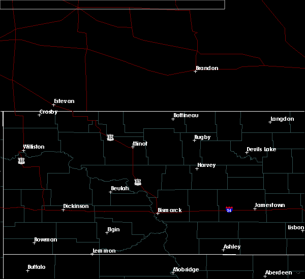 At 849 pm cdt/749 pm mdt/, severe thunderstorms were located along a line extending from 8 miles northeast of mandaree to 10 miles northwest of taylor, moving northeast at 10 mph (radar indicated). Hazards include 60 mph wind gusts and quarter size hail. Hail damage to vehicles is expected. expect wind damage to roofs, siding, and trees. Locations impacted include, killdeer, halliday, dunn center, manning, mckenzie bay recreation area, little missouri state park, skunk creek bay recreation area and hirschville. At 849 pm cdt/749 pm mdt/, severe thunderstorms were located along a line extending from 8 miles northeast of mandaree to 10 miles northwest of taylor, moving northeast at 10 mph (radar indicated). Hazards include 60 mph wind gusts and quarter size hail. Hail damage to vehicles is expected. expect wind damage to roofs, siding, and trees. Locations impacted include, killdeer, halliday, dunn center, manning, mckenzie bay recreation area, little missouri state park, skunk creek bay recreation area and hirschville.
|
| 6/29/2020 8:29 PM CDT |
 At 829 pm cdt/729 pm mdt/, severe thunderstorms were located along a line extending from 4 miles northeast of mandaree to 9 miles north of gladstone, moving northeast at 10 mph (radar indicated). Hazards include 60 mph wind gusts and quarter size hail. Hail damage to vehicles is expected. expect wind damage to roofs, siding, and trees. These severe thunderstorms will remain over mainly rural areas of dunn county, including the following locations, hirschville, oakdale, skunk creek bay recreation area and new hradec. At 829 pm cdt/729 pm mdt/, severe thunderstorms were located along a line extending from 4 miles northeast of mandaree to 9 miles north of gladstone, moving northeast at 10 mph (radar indicated). Hazards include 60 mph wind gusts and quarter size hail. Hail damage to vehicles is expected. expect wind damage to roofs, siding, and trees. These severe thunderstorms will remain over mainly rural areas of dunn county, including the following locations, hirschville, oakdale, skunk creek bay recreation area and new hradec.
|
| 6/29/2020 7:08 PM MDT |
 At 808 pm cdt/708 pm mdt/, severe thunderstorms were located along a line extending from near mandaree to 6 miles northeast of killdeer to 9 miles southeast of manning, moving northeast at 20 mph (radar indicated). Hazards include golf ball size hail and 70 mph wind gusts. People and animals outdoors will be injured. expect hail damage to roofs, siding, windows, and vehicles. expect considerable tree damage. wind damage is also likely to mobile homes, roofs, and outbuildings. these severe storms will be near, little missouri state park around 720 pm mdt. Other locations impacted by these severe thunderstorms include hirschville, oakdale and new hradec. At 808 pm cdt/708 pm mdt/, severe thunderstorms were located along a line extending from near mandaree to 6 miles northeast of killdeer to 9 miles southeast of manning, moving northeast at 20 mph (radar indicated). Hazards include golf ball size hail and 70 mph wind gusts. People and animals outdoors will be injured. expect hail damage to roofs, siding, windows, and vehicles. expect considerable tree damage. wind damage is also likely to mobile homes, roofs, and outbuildings. these severe storms will be near, little missouri state park around 720 pm mdt. Other locations impacted by these severe thunderstorms include hirschville, oakdale and new hradec.
|
| 6/29/2020 6:51 PM MDT |
 At 750 pm cdt/650 pm mdt/, severe thunderstorms were located along a line extending from 9 miles west of mandaree to 11 miles north of dickinson, moving north at 10 mph (radar indicated). Hazards include golf ball size hail and 70 mph wind gusts. People and animals outdoors will be injured. expect hail damage to roofs, siding, windows, and vehicles. expect considerable tree damage. Wind damage is also likely to mobile homes, roofs, and outbuildings. At 750 pm cdt/650 pm mdt/, severe thunderstorms were located along a line extending from 9 miles west of mandaree to 11 miles north of dickinson, moving north at 10 mph (radar indicated). Hazards include golf ball size hail and 70 mph wind gusts. People and animals outdoors will be injured. expect hail damage to roofs, siding, windows, and vehicles. expect considerable tree damage. Wind damage is also likely to mobile homes, roofs, and outbuildings.
|
| 6/14/2020 6:32 PM MDT |
 At 631 pm mdt, a severe thunderstorm was located 10 miles west of manning, or 16 miles southwest of killdeer, moving northeast at 40 mph (radar indicated). Hazards include two inch hail and 70 mph wind gusts. People and animals outdoors will be injured. expect hail damage to roofs, siding, windows, and vehicles. expect considerable tree damage. wind damage is also likely to mobile homes, roofs, and outbuildings. this severe storm will be near, manning around 645 pm mdt. killdeer around 655 pm mdt. dunn center around 705 pm mdt. Other locations impacted by this severe thunderstorm include fairfield. At 631 pm mdt, a severe thunderstorm was located 10 miles west of manning, or 16 miles southwest of killdeer, moving northeast at 40 mph (radar indicated). Hazards include two inch hail and 70 mph wind gusts. People and animals outdoors will be injured. expect hail damage to roofs, siding, windows, and vehicles. expect considerable tree damage. wind damage is also likely to mobile homes, roofs, and outbuildings. this severe storm will be near, manning around 645 pm mdt. killdeer around 655 pm mdt. dunn center around 705 pm mdt. Other locations impacted by this severe thunderstorm include fairfield.
|
| 6/14/2020 6:14 PM MDT |
 At 613 pm mdt, a severe thunderstorm was located over south fairfield, or 24 miles northwest of dickinson, moving northeast at 30 mph (radar indicated). Hazards include two inch hail and 70 mph wind gusts. People and animals outdoors will be injured. expect hail damage to roofs, siding, windows, and vehicles. expect considerable tree damage. wind damage is also likely to mobile homes, roofs, and outbuildings. this severe thunderstorm will be near, manning around 650 pm mdt. killdeer around 705 pm mdt. dunn center around 710 pm mdt. Other locations impacted by this severe thunderstorm include hirschville and fairfield. At 613 pm mdt, a severe thunderstorm was located over south fairfield, or 24 miles northwest of dickinson, moving northeast at 30 mph (radar indicated). Hazards include two inch hail and 70 mph wind gusts. People and animals outdoors will be injured. expect hail damage to roofs, siding, windows, and vehicles. expect considerable tree damage. wind damage is also likely to mobile homes, roofs, and outbuildings. this severe thunderstorm will be near, manning around 650 pm mdt. killdeer around 705 pm mdt. dunn center around 710 pm mdt. Other locations impacted by this severe thunderstorm include hirschville and fairfield.
|
| 8/19/2019 6:21 PM MDT |
 At 621 pm mdt, a severe thunderstorm was located 11 miles southwest of manning, or 17 miles northwest of dickinson, moving east at 15 mph (radar indicated). Hazards include ping pong ball size hail and 60 mph wind gusts. People and animals outdoors will be injured. expect hail damage to roofs, siding, windows, and vehicles. expect wind damage to roofs, siding, and trees. Locations impacted include, manning and new hradec. At 621 pm mdt, a severe thunderstorm was located 11 miles southwest of manning, or 17 miles northwest of dickinson, moving east at 15 mph (radar indicated). Hazards include ping pong ball size hail and 60 mph wind gusts. People and animals outdoors will be injured. expect hail damage to roofs, siding, windows, and vehicles. expect wind damage to roofs, siding, and trees. Locations impacted include, manning and new hradec.
|
| 8/19/2019 6:04 PM MDT |
 The national weather service in bismarck has issued a * severe thunderstorm warning for. southwestern dunn county in southwestern north dakota. northeastern billings county in southwestern north dakota. until 700 pm mdt. At 603 pm mdt, a severe thunderstorm was located 9 miles east of. The national weather service in bismarck has issued a * severe thunderstorm warning for. southwestern dunn county in southwestern north dakota. northeastern billings county in southwestern north dakota. until 700 pm mdt. At 603 pm mdt, a severe thunderstorm was located 9 miles east of.
|
| 7/31/2019 7:20 PM MDT |
 At 720 pm mdt, a severe thunderstorm was located 13 miles southeast of manning, or 15 miles northeast of dickinson, moving southeast at 30 mph (radar indicated). Hazards include 70 mph wind gusts and half dollar size hail. Hail damage to vehicles is expected. expect considerable tree damage. wind damage is also likely to mobile homes, roofs, and outbuildings. this severe storm will be near, taylor around 750 pm mdt. richardton around 800 pm mdt. Other locations impacted by this severe thunderstorm include hirschville. At 720 pm mdt, a severe thunderstorm was located 13 miles southeast of manning, or 15 miles northeast of dickinson, moving southeast at 30 mph (radar indicated). Hazards include 70 mph wind gusts and half dollar size hail. Hail damage to vehicles is expected. expect considerable tree damage. wind damage is also likely to mobile homes, roofs, and outbuildings. this severe storm will be near, taylor around 750 pm mdt. richardton around 800 pm mdt. Other locations impacted by this severe thunderstorm include hirschville.
|
| 7/31/2019 7:07 PM MDT | Lots of pea size hail. time estimated from rada in dunn county ND, 5.2 miles NE of Manning, ND |
| 7/31/2019 7:02 PM MDT |
 At 702 pm mdt, a severe thunderstorm was located 5 miles south of manning, or 15 miles south of killdeer, moving southeast at 30 mph (radar indicated). Hazards include 70 mph wind gusts and half dollar size hail. Hail damage to vehicles is expected. expect considerable tree damage. wind damage is also likely to mobile homes, roofs, and outbuildings. this severe thunderstorm will be near, taylor around 750 pm mdt. richardton around 800 pm mdt. Other locations impacted by this severe thunderstorm include hirschville. At 702 pm mdt, a severe thunderstorm was located 5 miles south of manning, or 15 miles south of killdeer, moving southeast at 30 mph (radar indicated). Hazards include 70 mph wind gusts and half dollar size hail. Hail damage to vehicles is expected. expect considerable tree damage. wind damage is also likely to mobile homes, roofs, and outbuildings. this severe thunderstorm will be near, taylor around 750 pm mdt. richardton around 800 pm mdt. Other locations impacted by this severe thunderstorm include hirschville.
|
| 7/15/2019 12:20 AM MDT | Davis weather instrument measured wind gus in dunn county ND, 5.2 miles NE of Manning, ND |
| 7/15/2019 12:19 AM MDT |
 At 117 am cdt/1217 am mdt/, severe thunderstorms were located along a line extending from 8 miles southeast of mandaree to 9 miles south of regent, moving east at 55 mph. these are very dangerous storms (radar indicated. also, a 77 mph wind gust was measured at the dickinson airport). Hazards include 80 mph wind gusts. Flying debris will be dangerous to those caught without shelter. mobile homes will be heavily damaged. expect considerable damage to roofs, windows, and vehicles. extensive tree damage and power outages are likely. Locations impacted include, dickinson, killdeer, mott, amidon, belfield, new england, richardton, south heart, gladstone, halliday, regent, taylor, dunn center, dodge, manning, marshall, grassy butte, south fairfield, little missouri state park and mckenzie bay recreation area. At 117 am cdt/1217 am mdt/, severe thunderstorms were located along a line extending from 8 miles southeast of mandaree to 9 miles south of regent, moving east at 55 mph. these are very dangerous storms (radar indicated. also, a 77 mph wind gust was measured at the dickinson airport). Hazards include 80 mph wind gusts. Flying debris will be dangerous to those caught without shelter. mobile homes will be heavily damaged. expect considerable damage to roofs, windows, and vehicles. extensive tree damage and power outages are likely. Locations impacted include, dickinson, killdeer, mott, amidon, belfield, new england, richardton, south heart, gladstone, halliday, regent, taylor, dunn center, dodge, manning, marshall, grassy butte, south fairfield, little missouri state park and mckenzie bay recreation area.
|
| 7/15/2019 12:12 AM MDT |
 At 111 am cdt/1211 am mdt/, severe thunderstorms were located along a line extending from 7 miles northwest of little missouri state park to 12 miles north of reeder, moving east at 50 mph (radar indicated). Hazards include 70 mph wind gusts. Expect considerable tree damage. damage is likely to mobile homes, roofs, and outbuildings. severe thunderstorms will be near, little missouri state park around 1220 am mdt. mckenzie bay recreation area around 1240 am mdt. mott around 1250 am mdt. Other locations impacted by these severe thunderstorms include fryburg, twin buttes, hirschville, schefield, burt, oakdale, fairfield, havelock, bentley and lefor. At 111 am cdt/1211 am mdt/, severe thunderstorms were located along a line extending from 7 miles northwest of little missouri state park to 12 miles north of reeder, moving east at 50 mph (radar indicated). Hazards include 70 mph wind gusts. Expect considerable tree damage. damage is likely to mobile homes, roofs, and outbuildings. severe thunderstorms will be near, little missouri state park around 1220 am mdt. mckenzie bay recreation area around 1240 am mdt. mott around 1250 am mdt. Other locations impacted by these severe thunderstorms include fryburg, twin buttes, hirschville, schefield, burt, oakdale, fairfield, havelock, bentley and lefor.
|
| 9/3/2018 6:58 PM MDT |
 At 657 pm mdt, a severe thunderstorm was located 7 miles north of south heart, or 13 miles northwest of dickinson, moving northeast at 25 mph (radar indicated). Hazards include 70 mph wind gusts and ping pong ball size hail. People and animals outdoors will be injured. expect hail damage to roofs, siding, windows, and vehicles. expect considerable tree damage. wind damage is also likely to mobile homes, roofs, and outbuildings. this severe thunderstorm will be near, manning around 755 pm mdt. killdeer around 800 pm mdt. Other locations impacted by this severe thunderstorm include new hradec. At 657 pm mdt, a severe thunderstorm was located 7 miles north of south heart, or 13 miles northwest of dickinson, moving northeast at 25 mph (radar indicated). Hazards include 70 mph wind gusts and ping pong ball size hail. People and animals outdoors will be injured. expect hail damage to roofs, siding, windows, and vehicles. expect considerable tree damage. wind damage is also likely to mobile homes, roofs, and outbuildings. this severe thunderstorm will be near, manning around 755 pm mdt. killdeer around 800 pm mdt. Other locations impacted by this severe thunderstorm include new hradec.
|
| 7/21/2018 7:32 PM MDT |
 At 731 pm mdt, a severe thunderstorm was located near manning, or 13 miles south of killdeer, moving southeast at 35 mph (66 mph wind gust was reported just south of manning). Hazards include 60 mph wind gusts and quarter size hail. Hail damage to vehicles is expected. expect wind damage to roofs, siding, and trees. This severe thunderstorm will remain over mainly rural areas of southwestern dunn and east central billings counties, including the following locations, hirschville and new hradec. At 731 pm mdt, a severe thunderstorm was located near manning, or 13 miles south of killdeer, moving southeast at 35 mph (66 mph wind gust was reported just south of manning). Hazards include 60 mph wind gusts and quarter size hail. Hail damage to vehicles is expected. expect wind damage to roofs, siding, and trees. This severe thunderstorm will remain over mainly rural areas of southwestern dunn and east central billings counties, including the following locations, hirschville and new hradec.
|
| 7/21/2018 7:16 PM MDT |
 At 716 pm mdt, a severe thunderstorm was located over manning, or 7 miles south of killdeer, moving southeast at 35 mph (radar indicated). Hazards include 60 mph wind gusts and quarter size hail. Hail damage to vehicles is expected. expect wind damage to roofs, siding, and trees. this severe storm will be near, manning around 720 pm mdt. Other locations impacted by this severe thunderstorm include hirschville, new hradec and fairfield. At 716 pm mdt, a severe thunderstorm was located over manning, or 7 miles south of killdeer, moving southeast at 35 mph (radar indicated). Hazards include 60 mph wind gusts and quarter size hail. Hail damage to vehicles is expected. expect wind damage to roofs, siding, and trees. this severe storm will be near, manning around 720 pm mdt. Other locations impacted by this severe thunderstorm include hirschville, new hradec and fairfield.
|
| 7/21/2018 6:56 PM MDT |
 At 755 pm cdt/655 pm mdt/, a severe thunderstorm was located 11 miles west of killdeer, moving southeast at 35 mph (radar indicated). Hazards include 70 mph wind gusts and ping pong ball size hail. People and animals outdoors will be injured. expect hail damage to roofs, siding, windows, and vehicles. expect considerable tree damage. wind damage is also likely to mobile homes, roofs, and outbuildings. this severe thunderstorm will be near, killdeer around 710 pm mdt. manning around 725 pm mdt. Other locations impacted by this severe thunderstorm include hirschville, oakdale, fairfield and new hradec. At 755 pm cdt/655 pm mdt/, a severe thunderstorm was located 11 miles west of killdeer, moving southeast at 35 mph (radar indicated). Hazards include 70 mph wind gusts and ping pong ball size hail. People and animals outdoors will be injured. expect hail damage to roofs, siding, windows, and vehicles. expect considerable tree damage. wind damage is also likely to mobile homes, roofs, and outbuildings. this severe thunderstorm will be near, killdeer around 710 pm mdt. manning around 725 pm mdt. Other locations impacted by this severe thunderstorm include hirschville, oakdale, fairfield and new hradec.
|
| 6/28/2018 10:40 PM MDT |
 The severe thunderstorm warning for dunn, northwestern mclean, northeastern billings, east central mckenzie, south central mountrail and mercer counties will expire at 1145 pm cdt/1045 pm mdt/, the storms which prompted the warning have moved out of the area. therefore, the warning will be allowed to expire. however small hail and gusty winds are still possible with these thunderstorms. a severe thunderstorm watch remains in effect until 800 am cdt/700 am mdt/ for south central, southwestern, north central and northwestern north dakota. remember, a severe thunderstorm warning still remains in effect for eastern dunn, mclean, and mercer counties. The severe thunderstorm warning for dunn, northwestern mclean, northeastern billings, east central mckenzie, south central mountrail and mercer counties will expire at 1145 pm cdt/1045 pm mdt/, the storms which prompted the warning have moved out of the area. therefore, the warning will be allowed to expire. however small hail and gusty winds are still possible with these thunderstorms. a severe thunderstorm watch remains in effect until 800 am cdt/700 am mdt/ for south central, southwestern, north central and northwestern north dakota. remember, a severe thunderstorm warning still remains in effect for eastern dunn, mclean, and mercer counties.
|
| 6/28/2018 10:09 PM MDT |
 At 1046 pm cdt/946 pm mdt/, severe thunderstorms were located along a line extending from 6 miles south of van hook park to 4 miles northwest of halliday to 10 miles northwest of dickinson, moving east at 50 mph (radar indicated). Hazards include 70 mph wind gusts and quarter size hail. Hail damage to vehicles is expected. expect considerable tree damage. wind damage is also likely to mobile homes, roofs, and outbuildings. severe thunderstorms will be near, halliday around 950 pm mdt. dodge around 1000 pm mdt. golden valley around 1005 pm mdt. zap around 1115 pm cdt. roseglen around 1120 pm cdt. beulah and beulah bay recreation area around 1125 pm cdt. hazen and hazen bay recreation area around 1130 pm cdt. other locations impacted by these severe thunderstorms include skunk creek bay recreation area, white shield, twin buttes, pouch point recreation area, hirschville, deep water creek recreation area, dakota waters recreation area, oakdale, raub and emmet. A tornado watch remains in effect until 1100 pm cdt/1000 pm mdt/ for south central, southwestern, north central and northwestern north dakota. At 1046 pm cdt/946 pm mdt/, severe thunderstorms were located along a line extending from 6 miles south of van hook park to 4 miles northwest of halliday to 10 miles northwest of dickinson, moving east at 50 mph (radar indicated). Hazards include 70 mph wind gusts and quarter size hail. Hail damage to vehicles is expected. expect considerable tree damage. wind damage is also likely to mobile homes, roofs, and outbuildings. severe thunderstorms will be near, halliday around 950 pm mdt. dodge around 1000 pm mdt. golden valley around 1005 pm mdt. zap around 1115 pm cdt. roseglen around 1120 pm cdt. beulah and beulah bay recreation area around 1125 pm cdt. hazen and hazen bay recreation area around 1130 pm cdt. other locations impacted by these severe thunderstorms include skunk creek bay recreation area, white shield, twin buttes, pouch point recreation area, hirschville, deep water creek recreation area, dakota waters recreation area, oakdale, raub and emmet. A tornado watch remains in effect until 1100 pm cdt/1000 pm mdt/ for south central, southwestern, north central and northwestern north dakota.
|
| 6/28/2018 9:46 PM MDT |
 At 1046 pm cdt/946 pm mdt/, severe thunderstorms were located along a line extending from 6 miles south of van hook park to 4 miles northwest of halliday to 10 miles northwest of dickinson, moving east at 50 mph (radar indicated). Hazards include 70 mph wind gusts and quarter size hail. Hail damage to vehicles is expected. expect considerable tree damage. wind damage is also likely to mobile homes, roofs, and outbuildings. severe thunderstorms will be near, halliday around 950 pm mdt. dodge around 1000 pm mdt. golden valley around 1005 pm mdt. zap around 1115 pm cdt. roseglen around 1120 pm cdt. beulah and beulah bay recreation area around 1125 pm cdt. hazen and hazen bay recreation area around 1130 pm cdt. other locations impacted by these severe thunderstorms include skunk creek bay recreation area, white shield, twin buttes, pouch point recreation area, hirschville, deep water creek recreation area, dakota waters recreation area, oakdale, raub and emmet. A tornado watch remains in effect until 1100 pm cdt/1000 pm mdt/ for south central, southwestern, north central and northwestern north dakota. At 1046 pm cdt/946 pm mdt/, severe thunderstorms were located along a line extending from 6 miles south of van hook park to 4 miles northwest of halliday to 10 miles northwest of dickinson, moving east at 50 mph (radar indicated). Hazards include 70 mph wind gusts and quarter size hail. Hail damage to vehicles is expected. expect considerable tree damage. wind damage is also likely to mobile homes, roofs, and outbuildings. severe thunderstorms will be near, halliday around 950 pm mdt. dodge around 1000 pm mdt. golden valley around 1005 pm mdt. zap around 1115 pm cdt. roseglen around 1120 pm cdt. beulah and beulah bay recreation area around 1125 pm cdt. hazen and hazen bay recreation area around 1130 pm cdt. other locations impacted by these severe thunderstorms include skunk creek bay recreation area, white shield, twin buttes, pouch point recreation area, hirschville, deep water creek recreation area, dakota waters recreation area, oakdale, raub and emmet. A tornado watch remains in effect until 1100 pm cdt/1000 pm mdt/ for south central, southwestern, north central and northwestern north dakota.
|
| 8/10/2016 6:16 PM MDT |
 At 615 pm mdt, a severe thunderstorm was located 11 miles north of gladstone, or 13 miles northeast of dickinson, moving east at 25 mph. this is a very dangerous storm (radar indicated). Hazards include baseball size hail and 60 mph wind gusts. People and animals outdoors will be severely injured. expect shattered windows, extensive damage to roofs, siding, and vehicles. this severe storm will be near, taylor around 640 pm mdt. Other locations impacted by this severe thunderstorm include hirschville. At 615 pm mdt, a severe thunderstorm was located 11 miles north of gladstone, or 13 miles northeast of dickinson, moving east at 25 mph. this is a very dangerous storm (radar indicated). Hazards include baseball size hail and 60 mph wind gusts. People and animals outdoors will be severely injured. expect shattered windows, extensive damage to roofs, siding, and vehicles. this severe storm will be near, taylor around 640 pm mdt. Other locations impacted by this severe thunderstorm include hirschville.
|
| 8/10/2016 5:57 PM MDT |
 At 557 pm mdt, a severe thunderstorm was located 11 miles north of dickinson, moving east at 25 mph. this is a very dangerous storm (radar indicated). Hazards include baseball size hail and 60 mph wind gusts. People and animals outdoors will be severely injured. expect shattered windows, extensive damage to roofs, siding, and vehicles. This severe thunderstorm will remain over mainly rural areas of northern stark and southern dunn counties, including the following locations: hirschville and new hradec. At 557 pm mdt, a severe thunderstorm was located 11 miles north of dickinson, moving east at 25 mph. this is a very dangerous storm (radar indicated). Hazards include baseball size hail and 60 mph wind gusts. People and animals outdoors will be severely injured. expect shattered windows, extensive damage to roofs, siding, and vehicles. This severe thunderstorm will remain over mainly rural areas of northern stark and southern dunn counties, including the following locations: hirschville and new hradec.
|
| 8/10/2016 5:42 PM MDT |
 At 542 pm mdt, a severe thunderstorm was located 12 miles north of dickinson, moving east at 25 mph (radar indicated). Hazards include tennis ball size hail and 60 mph wind gusts. People and animals outdoors will be injured. expect hail damage to roofs, siding, windows, and vehicles. expect wind damage to roofs, siding, and trees. this severe thunderstorm will be near, marshall around 640 pm mdt. Other locations impacted by this severe thunderstorm include hirschville and new hradec. At 542 pm mdt, a severe thunderstorm was located 12 miles north of dickinson, moving east at 25 mph (radar indicated). Hazards include tennis ball size hail and 60 mph wind gusts. People and animals outdoors will be injured. expect hail damage to roofs, siding, windows, and vehicles. expect wind damage to roofs, siding, and trees. this severe thunderstorm will be near, marshall around 640 pm mdt. Other locations impacted by this severe thunderstorm include hirschville and new hradec.
|
| 8/10/2016 5:30 PM MDT |
 At 529 pm mdt, a severe thunderstorm was located 7 miles west of manning, or 14 miles southwest of killdeer, moving northeast at 40 mph (radar indicated. at 510 pm mdt...ping pong ball sized hail was reported 1 mile south of south fairfield). Hazards include tennis ball size hail and 60 mph wind gusts. People and animals outdoors will be injured. expect hail damage to roofs, siding, windows, and vehicles. expect wind damage to roofs, siding, and trees. Locations impacted include, killdeer, dunn center, manning, south fairfield and fairfield. At 529 pm mdt, a severe thunderstorm was located 7 miles west of manning, or 14 miles southwest of killdeer, moving northeast at 40 mph (radar indicated. at 510 pm mdt...ping pong ball sized hail was reported 1 mile south of south fairfield). Hazards include tennis ball size hail and 60 mph wind gusts. People and animals outdoors will be injured. expect hail damage to roofs, siding, windows, and vehicles. expect wind damage to roofs, siding, and trees. Locations impacted include, killdeer, dunn center, manning, south fairfield and fairfield.
|
| 8/10/2016 5:09 PM MDT |
 At 509 pm mdt, a severe thunderstorm was located over south fairfield, or 23 miles northwest of dickinson, moving east at 20 mph (radar indicated). Hazards include tennis ball size hail and 60 mph wind gusts. People and animals outdoors will be injured. expect hail damage to roofs, siding, windows, and vehicles. expect wind damage to roofs, siding, and trees. This severe thunderstorm will remain over mainly rural areas of northeastern billings and southwestern dunn counties, including the following locations: fairfield. At 509 pm mdt, a severe thunderstorm was located over south fairfield, or 23 miles northwest of dickinson, moving east at 20 mph (radar indicated). Hazards include tennis ball size hail and 60 mph wind gusts. People and animals outdoors will be injured. expect hail damage to roofs, siding, windows, and vehicles. expect wind damage to roofs, siding, and trees. This severe thunderstorm will remain over mainly rural areas of northeastern billings and southwestern dunn counties, including the following locations: fairfield.
|
| 8/10/2016 4:43 PM MDT |
 At 443 pm mdt, a severe thunderstorm was located 5 miles southwest of south fairfield, or 28 miles northwest of dickinson, moving northeast at 45 mph (radar indicated). Hazards include tennis ball size hail and 60 mph wind gusts. People and animals outdoors will be injured. expect hail damage to roofs, siding, windows, and vehicles. expect wind damage to roofs, siding, and trees. this severe thunderstorm will be near, south fairfield around 450 pm mdt. manning around 515 pm mdt. killdeer around 525 pm mdt. dunn center around 530 pm mdt. Other locations impacted by this severe thunderstorm include fairfield. At 443 pm mdt, a severe thunderstorm was located 5 miles southwest of south fairfield, or 28 miles northwest of dickinson, moving northeast at 45 mph (radar indicated). Hazards include tennis ball size hail and 60 mph wind gusts. People and animals outdoors will be injured. expect hail damage to roofs, siding, windows, and vehicles. expect wind damage to roofs, siding, and trees. this severe thunderstorm will be near, south fairfield around 450 pm mdt. manning around 515 pm mdt. killdeer around 525 pm mdt. dunn center around 530 pm mdt. Other locations impacted by this severe thunderstorm include fairfield.
|
| 7/10/2016 5:36 PM MDT |
 At 635 pm cdt/535 pm mdt/, severe thunderstorms were located along a line extending from 5 miles east of south fairfield to 13 miles north of regent to 6 miles east of reeder, moving east at 70 mph (radar indicated). Hazards include two inch hail and 70 mph wind gusts. People and animals outdoors will be injured. expect hail damage to roofs, siding, windows, and vehicles. expect considerable tree damage. Wind damage is also likely to mobile homes, roofs, and outbuildings. At 635 pm cdt/535 pm mdt/, severe thunderstorms were located along a line extending from 5 miles east of south fairfield to 13 miles north of regent to 6 miles east of reeder, moving east at 70 mph (radar indicated). Hazards include two inch hail and 70 mph wind gusts. People and animals outdoors will be injured. expect hail damage to roofs, siding, windows, and vehicles. expect considerable tree damage. Wind damage is also likely to mobile homes, roofs, and outbuildings.
|
| 7/10/2016 3:57 PM MDT |
 At 456 pm cdt/356 pm mdt/, a severe thunderstorm was located near dunn center, or 6 miles southeast of killdeer, moving northeast at 35 mph (radar indicated). Hazards include golf ball size hail and 70 mph wind gusts. People and animals outdoors will be injured. expect hail damage to roofs, siding, windows, and vehicles. expect considerable tree damage. wind damage is also likely to mobile homes, roofs, and outbuildings. this severe storm will be near, dunn center around 400 pm mdt. halliday around 420 pm mdt. other locations impacted by this severe thunderstorm include oakdale. torrential rain is occurring with this storm, and may lead to flooding of streets, ditches, and creeks. Do not drive your vehicle through flooded roadways. At 456 pm cdt/356 pm mdt/, a severe thunderstorm was located near dunn center, or 6 miles southeast of killdeer, moving northeast at 35 mph (radar indicated). Hazards include golf ball size hail and 70 mph wind gusts. People and animals outdoors will be injured. expect hail damage to roofs, siding, windows, and vehicles. expect considerable tree damage. wind damage is also likely to mobile homes, roofs, and outbuildings. this severe storm will be near, dunn center around 400 pm mdt. halliday around 420 pm mdt. other locations impacted by this severe thunderstorm include oakdale. torrential rain is occurring with this storm, and may lead to flooding of streets, ditches, and creeks. Do not drive your vehicle through flooded roadways.
|
| 7/10/2016 3:41 PM MDT |
 At 438 pm cdt/338 pm mdt/, a severe thunderstorm was located near manning, or 10 miles southwest of killdeer, moving northeast at 35 mph (radar indicated). Hazards include golf ball size hail and 70 mph wind gusts. People and animals outdoors will be injured. expect hail damage to roofs, siding, windows, and vehicles. expect considerable tree damage. wind damage is also likely to mobile homes, roofs, and outbuildings. this severe thunderstorm will be near, manning around 345 pm mdt. killdeer around 355 pm mdt. dunn center around 400 pm mdt. halliday around 425 pm mdt. other locations impacted by this severe thunderstorm include oakdale. very heavy rain is occurring with this storm, and may lead to minor flooding of low lying and poor drainage areas as well as streets and culverts. Do not drive or walk into flood water. At 438 pm cdt/338 pm mdt/, a severe thunderstorm was located near manning, or 10 miles southwest of killdeer, moving northeast at 35 mph (radar indicated). Hazards include golf ball size hail and 70 mph wind gusts. People and animals outdoors will be injured. expect hail damage to roofs, siding, windows, and vehicles. expect considerable tree damage. wind damage is also likely to mobile homes, roofs, and outbuildings. this severe thunderstorm will be near, manning around 345 pm mdt. killdeer around 355 pm mdt. dunn center around 400 pm mdt. halliday around 425 pm mdt. other locations impacted by this severe thunderstorm include oakdale. very heavy rain is occurring with this storm, and may lead to minor flooding of low lying and poor drainage areas as well as streets and culverts. Do not drive or walk into flood water.
|
| 7/10/2016 3:27 PM MDT | Ping Pong Ball sized hail reported 15.7 miles E of Manning, ND, ping pong ball size hail for 10 minutes. occurred from 427pm cdt and 437pm cdt. |
| 7/10/2016 12:26 AM MDT |
 At 1225 am mdt, severe thunderstorms were located along a line extending from near dunn center to 12 miles southeast of manning to near gladstone, moving east at 55 mph. these are very dangerous storms (radar indicated). Hazards include 80 mph wind gusts and nickel size hail. Flying debris will be dangerous to those caught without shelter. mobile homes will be heavily damaged. expect considerable damage to roofs, windows, and vehicles. extensive tree damage and power outages are likely. these severe storms will be near, dunn center around 1230 am mdt. taylor around 1235 am mdt. richardton, halliday and marshall around 1240 am mdt. dodge around 1245 am mdt. Other locations impacted by these severe thunderstorms include twin buttes, hirschville and new hradec. At 1225 am mdt, severe thunderstorms were located along a line extending from near dunn center to 12 miles southeast of manning to near gladstone, moving east at 55 mph. these are very dangerous storms (radar indicated). Hazards include 80 mph wind gusts and nickel size hail. Flying debris will be dangerous to those caught without shelter. mobile homes will be heavily damaged. expect considerable damage to roofs, windows, and vehicles. extensive tree damage and power outages are likely. these severe storms will be near, dunn center around 1230 am mdt. taylor around 1235 am mdt. richardton, halliday and marshall around 1240 am mdt. dodge around 1245 am mdt. Other locations impacted by these severe thunderstorms include twin buttes, hirschville and new hradec.
|
| 7/10/2016 12:11 AM MDT |
 At 1210 am mdt, severe thunderstorms were located along a line extending from 7 miles west of manning to near south heart, moving northeast at 45 mph (radar indicated). Hazards include 70 mph wind gusts and nickel size hail. Expect considerable tree damage. damage is likely to mobile homes, roofs, and outbuildings. these severe storms will be near, dickinson around 1210 am mdt. manning around 1215 am mdt. killdeer around 1225 am mdt. dunn center around 1230 am mdt. halliday around 1245 am mdt. marshall around 1250 am mdt. Other locations impacted by these severe thunderstorms include twin buttes, hirschville and new hradec. At 1210 am mdt, severe thunderstorms were located along a line extending from 7 miles west of manning to near south heart, moving northeast at 45 mph (radar indicated). Hazards include 70 mph wind gusts and nickel size hail. Expect considerable tree damage. damage is likely to mobile homes, roofs, and outbuildings. these severe storms will be near, dickinson around 1210 am mdt. manning around 1215 am mdt. killdeer around 1225 am mdt. dunn center around 1230 am mdt. halliday around 1245 am mdt. marshall around 1250 am mdt. Other locations impacted by these severe thunderstorms include twin buttes, hirschville and new hradec.
|
| 7/10/2016 12:02 AM MDT |
 At 1201 am mdt, severe thunderstorms were located along a line extending from 10 miles northeast of south fairfield to south heart, moving northeast at 45 mph (radar indicated). Hazards include 70 mph wind gusts and nickel size hail. Expect considerable tree damage. damage is likely to mobile homes, roofs, and outbuildings. severe thunderstorms will be near, dickinson and manning around 1210 am mdt. killdeer around 1220 am mdt. dunn center around 1230 am mdt. halliday around 1240 am mdt. marshall around 1250 am mdt. Other locations impacted by these severe thunderstorms include twin buttes, hirschville and new hradec. At 1201 am mdt, severe thunderstorms were located along a line extending from 10 miles northeast of south fairfield to south heart, moving northeast at 45 mph (radar indicated). Hazards include 70 mph wind gusts and nickel size hail. Expect considerable tree damage. damage is likely to mobile homes, roofs, and outbuildings. severe thunderstorms will be near, dickinson and manning around 1210 am mdt. killdeer around 1220 am mdt. dunn center around 1230 am mdt. halliday around 1240 am mdt. marshall around 1250 am mdt. Other locations impacted by these severe thunderstorms include twin buttes, hirschville and new hradec.
|
| 6/9/2016 11:00 PM CDT |
 At 1059 pm cdt/959 pm mdt/, a severe thunderstorm was located near mckenzie bay recreation area, or 23 miles northeast of killdeer, moving northeast at 50 mph (radar indicated). Hazards include 60 mph wind gusts and quarter size hail. Hail damage to vehicles is expected. expect wind damage to roofs, siding, and trees. This severe thunderstorm will remain over mainly rural areas of northwestern mercer and central dunn counties, including the following locations: skunk creek bay recreation area, twin buttes and oakdale. At 1059 pm cdt/959 pm mdt/, a severe thunderstorm was located near mckenzie bay recreation area, or 23 miles northeast of killdeer, moving northeast at 50 mph (radar indicated). Hazards include 60 mph wind gusts and quarter size hail. Hail damage to vehicles is expected. expect wind damage to roofs, siding, and trees. This severe thunderstorm will remain over mainly rural areas of northwestern mercer and central dunn counties, including the following locations: skunk creek bay recreation area, twin buttes and oakdale.
|
| 6/9/2016 10:30 PM CDT |
 At 1029 pm cdt/929 pm mdt/, a severe thunderstorm was located 7 miles west of killdeer, moving northeast at 45 mph (radar indicated). Hazards include 60 mph wind gusts and half dollar size hail. Hail damage to vehicles is expected. expect wind damage to roofs, siding, and trees. this severe thunderstorm will be near, little missouri state park around 945 pm mdt. mandaree around 1105 pm cdt. Other locations impacted by this severe thunderstorm include skunk creek bay recreation area, twin buttes and oakdale. At 1029 pm cdt/929 pm mdt/, a severe thunderstorm was located 7 miles west of killdeer, moving northeast at 45 mph (radar indicated). Hazards include 60 mph wind gusts and half dollar size hail. Hail damage to vehicles is expected. expect wind damage to roofs, siding, and trees. this severe thunderstorm will be near, little missouri state park around 945 pm mdt. mandaree around 1105 pm cdt. Other locations impacted by this severe thunderstorm include skunk creek bay recreation area, twin buttes and oakdale.
|
| 9/5/2015 11:20 PM MDT |
 At 1120 pm mdt, severe thunderstorms were located along a line extending from 11 miles southwest of manning to 9 miles northeast of new england, moving northeast at 45 mph (radar indicated). Hazards include 60 mph wind gusts and quarter size hail. Hail damage to vehicles is expected. Expect wind damage to roofs, siding and trees. At 1120 pm mdt, severe thunderstorms were located along a line extending from 11 miles southwest of manning to 9 miles northeast of new england, moving northeast at 45 mph (radar indicated). Hazards include 60 mph wind gusts and quarter size hail. Hail damage to vehicles is expected. Expect wind damage to roofs, siding and trees.
|
| 7/27/2015 10:03 PM MDT |
 At 1100 pm cdt /1000 pm mdt/, severe thunderstorms were located along a line extending from 9 miles southeast of east fairview to 8 miles west of manning, moving northeast at 45 mph (radar indicated). Hazards include 60 mph wind gusts and penny size hail. Expect damage to roofs. siding and trees. These severe storms will imapct the following locations, manning, killdeer, theodore roosevelt national park north unit, watford city, charbonneau, and alexander. At 1100 pm cdt /1000 pm mdt/, severe thunderstorms were located along a line extending from 9 miles southeast of east fairview to 8 miles west of manning, moving northeast at 45 mph (radar indicated). Hazards include 60 mph wind gusts and penny size hail. Expect damage to roofs. siding and trees. These severe storms will imapct the following locations, manning, killdeer, theodore roosevelt national park north unit, watford city, charbonneau, and alexander.
|
| 7/27/2015 9:31 PM MDT |
 At 1030 pm cdt /930 pm mdt/, severe thunderstorms were located along a line extending from 6 miles north of skaar to 5 miles north of medora, moving northeast at 40 mph (public. at 900 pm mdt 70 mph wind gusts were reported at beach). Hazards include 60 mph wind gusts. Expect damage to roofs. siding and trees. severe thunderstorms will be near, south fairfield around 955 pm mdt. arnegard and manning around 1025 pm mdt. watford city, killdeer and dunn center around 1030 pm mdt. Other locations impacted by these severe thunderstorms include keene, rawson, oakdale, sather dam, fairfield, charbonneau, johnsons corner, cartwright and new hradec. At 1030 pm cdt /930 pm mdt/, severe thunderstorms were located along a line extending from 6 miles north of skaar to 5 miles north of medora, moving northeast at 40 mph (public. at 900 pm mdt 70 mph wind gusts were reported at beach). Hazards include 60 mph wind gusts. Expect damage to roofs. siding and trees. severe thunderstorms will be near, south fairfield around 955 pm mdt. arnegard and manning around 1025 pm mdt. watford city, killdeer and dunn center around 1030 pm mdt. Other locations impacted by these severe thunderstorms include keene, rawson, oakdale, sather dam, fairfield, charbonneau, johnsons corner, cartwright and new hradec.
|
| 7/26/2015 4:52 PM MDT |
 At 452 pm mdt, a severe thunderstorm was located over south fairfield, or 24 miles northwest of dickinson, moving east at 20 mph (radar indicated). Hazards include 60 mph wind gusts and quarter size hail. Hail damage to vehicles is expected. expect wind damage to roofs, siding and trees. Locations impacted include, south fairfield and new hradec. At 452 pm mdt, a severe thunderstorm was located over south fairfield, or 24 miles northwest of dickinson, moving east at 20 mph (radar indicated). Hazards include 60 mph wind gusts and quarter size hail. Hail damage to vehicles is expected. expect wind damage to roofs, siding and trees. Locations impacted include, south fairfield and new hradec.
|
| 7/26/2015 4:28 PM MDT |
 At 428 pm mdt, a severe thunderstorm was located 5 miles northeast of south fairfield, or 21 miles southwest of killdeer, moving east at 15 mph (radar indicated). Hazards include 60 mph wind gusts and quarter size hail. Hail damage to vehicles is expected. expect wind damage to roofs, siding and trees. Locations impacted include, south fairfield, fairfield and new hradec. At 428 pm mdt, a severe thunderstorm was located 5 miles northeast of south fairfield, or 21 miles southwest of killdeer, moving east at 15 mph (radar indicated). Hazards include 60 mph wind gusts and quarter size hail. Hail damage to vehicles is expected. expect wind damage to roofs, siding and trees. Locations impacted include, south fairfield, fairfield and new hradec.
|
| 7/26/2015 4:10 PM MDT |
 At 410 pm mdt, a severe thunderstorm was located near south fairfield, or 25 miles southwest of killdeer, moving east at 15 mph (radar indicated). Hazards include 60 mph wind gusts and quarter size hail. Hail damage to vehicles is expected. expect wind damage to roofs, siding and trees. This severe thunderstorm will remain over mainly rural areas of southwestern dunn and northeastern billings counties, including the following locations, fairfield and new hradec. At 410 pm mdt, a severe thunderstorm was located near south fairfield, or 25 miles southwest of killdeer, moving east at 15 mph (radar indicated). Hazards include 60 mph wind gusts and quarter size hail. Hail damage to vehicles is expected. expect wind damage to roofs, siding and trees. This severe thunderstorm will remain over mainly rural areas of southwestern dunn and northeastern billings counties, including the following locations, fairfield and new hradec.
|
| 6/19/2015 6:21 PM MDT |
 At 719 pm cdt /619 pm mdt/, severe thunderstorms were located along a line extending from 11 miles north of indian hills recreation area to dunn center, moving east at 40 mph (radar indicated). Hazards include 60 mph wind gusts and quarter size hail. Hail damage to vehicles is expected. expect wind damage to roofs, siding and trees. these severe storms will be near, dodge around 740 pm cdt. golden valley around 745 pm cdt. Other locations impacted by these severe thunderstorms include twin buttes and hirschville. At 719 pm cdt /619 pm mdt/, severe thunderstorms were located along a line extending from 11 miles north of indian hills recreation area to dunn center, moving east at 40 mph (radar indicated). Hazards include 60 mph wind gusts and quarter size hail. Hail damage to vehicles is expected. expect wind damage to roofs, siding and trees. these severe storms will be near, dodge around 740 pm cdt. golden valley around 745 pm cdt. Other locations impacted by these severe thunderstorms include twin buttes and hirschville.
|
| 6/19/2015 6:02 PM MDT |
 At 701 pm cdt /601 pm mdt/, severe thunderstorms were located along a line extending from 10 miles north of mckenzie bay recreation area to 5 miles southwest of killdeer, moving east at 50 mph (radar indicated). Hazards include 60 mph wind gusts and quarter size hail. Hail damage to vehicles is expected. expect wind damage to roofs, siding and trees. these severe storms will be near, roseglen around 725 pm cdt. halliday around 730 pm cdt. dodge around 735 pm cdt. golden valley around 740 pm cdt. Other locations impacted by these severe thunderstorms include raub, hirschville, oakdale, white shield, deep water creek recreation area, dakota waters recreation area and twin buttes. At 701 pm cdt /601 pm mdt/, severe thunderstorms were located along a line extending from 10 miles north of mckenzie bay recreation area to 5 miles southwest of killdeer, moving east at 50 mph (radar indicated). Hazards include 60 mph wind gusts and quarter size hail. Hail damage to vehicles is expected. expect wind damage to roofs, siding and trees. these severe storms will be near, roseglen around 725 pm cdt. halliday around 730 pm cdt. dodge around 735 pm cdt. golden valley around 740 pm cdt. Other locations impacted by these severe thunderstorms include raub, hirschville, oakdale, white shield, deep water creek recreation area, dakota waters recreation area and twin buttes.
|
| 6/19/2015 6:41 PM CDT |
 At 637 pm cdt /537 pm mdt/, severe thunderstorms were located along a line extending from mandaree to 8 miles south of grassy butte, moving east at 50 mph (radar indicated). Hazards include 60 mph wind gusts and half dollar size hail. Hail damage to vehicles is expected. expect wind damage to roofs, siding and trees. severe thunderstorms will be near, mandaree around 545 pm mdt. manning around 600 pm mdt. killdeer around 705 pm cdt. halliday and roseglen around 725 pm cdt. dodge around 735 pm cdt. golden valley around 740 pm cdt. zap around 745 pm cdt. Other locations impacted by these severe thunderstorms include raub, hirschville, oakdale, white shield, deep water creek recreation area, skunk creek bay recreation area, fairfield, dakota waters recreation area and twin buttes. At 637 pm cdt /537 pm mdt/, severe thunderstorms were located along a line extending from mandaree to 8 miles south of grassy butte, moving east at 50 mph (radar indicated). Hazards include 60 mph wind gusts and half dollar size hail. Hail damage to vehicles is expected. expect wind damage to roofs, siding and trees. severe thunderstorms will be near, mandaree around 545 pm mdt. manning around 600 pm mdt. killdeer around 705 pm cdt. halliday and roseglen around 725 pm cdt. dodge around 735 pm cdt. golden valley around 740 pm cdt. zap around 745 pm cdt. Other locations impacted by these severe thunderstorms include raub, hirschville, oakdale, white shield, deep water creek recreation area, skunk creek bay recreation area, fairfield, dakota waters recreation area and twin buttes.
|
| 9/3/2014 10:09 PM MDT | Baseball sized hail reported 0.1 miles NNW of Manning, ND |
| 9/3/2014 9:10 PM MDT | *** 1 inj *** a camper was tipped on its side...horse trailer moved and a quonset damaged by a possible tornado. a nine year old child was trapped in the camper pull-ou in dunn county ND, 4.9 miles SW of Manning, ND |
| 5/26/2014 9:10 PM MDT | Storm damage reported in dunn county ND, 8.7 miles ENE of Manning, ND |
| 7/21/2013 3:15 PM MDT | Golf Ball sized hail reported 8.1 miles E of Manning, ND |
| 7/11/2013 6:35 PM MDT | Quarter sized hail reported 9.9 miles N of Manning, ND, late report. hail lasted seven minutes. |
| 7/11/2013 6:33 PM MDT | Winds began with gust front ahead of rainfall and continued until heavy rain ended. measured sustained 75 mph gusts to 80 mp in dunn county ND, 10.5 miles N of Manning, ND |
| 7/8/2013 7:00 PM MDT | Reported by a north dakota arb observe in billings county ND, 17.7 miles ESE of Manning, ND |
| 7/8/2013 7:00 PM MDT | Calf shelter flipped over. several power poles down 2 miles east of residence. hay bales rolled one-quarter of a mile through a fenc in billings county ND, 14.9 miles ESE of Manning, ND |
| 7/11/2012 6:40 PM MDT | Quarter sized hail reported 0.1 miles NNW of Manning, ND, dime to quarter size hail. |
| 1/1/0001 12:00 AM | Golf Ball sized hail reported 4.9 miles NW of Manning, ND, also had 50 mph wind gusts. windows broken and a vehicle damaged. crops damaged. hail lasted 10 minutes. also had 0.80 inches of rain. time estimated. |
Hail Maps for Manning, ND
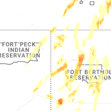
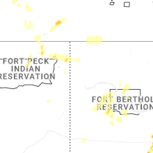
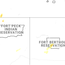
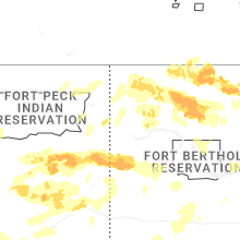
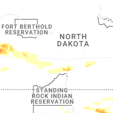
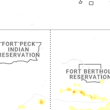


Connect with Interactive Hail Maps