

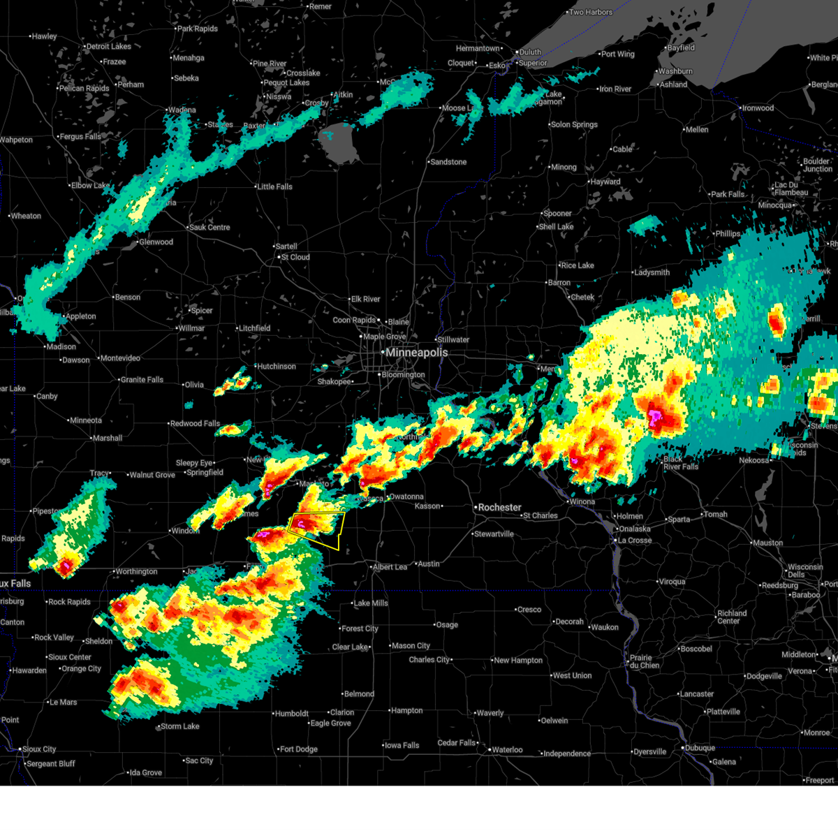
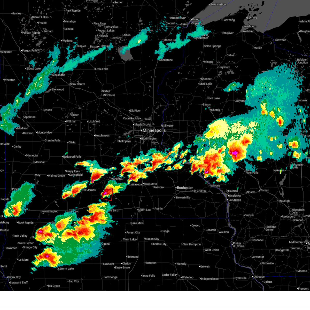
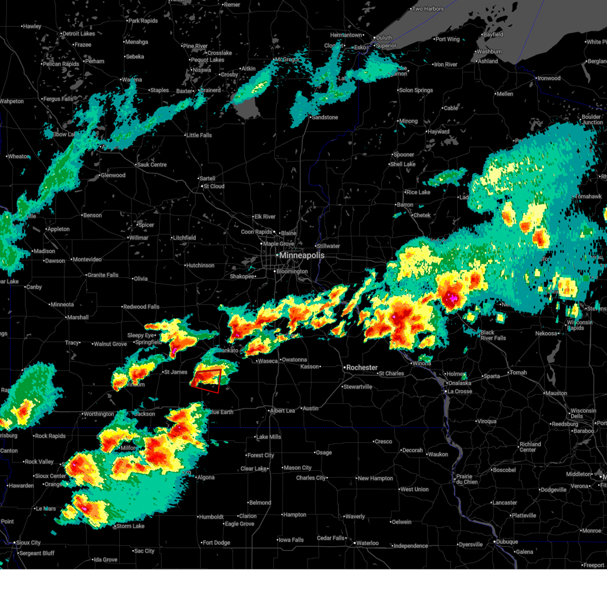
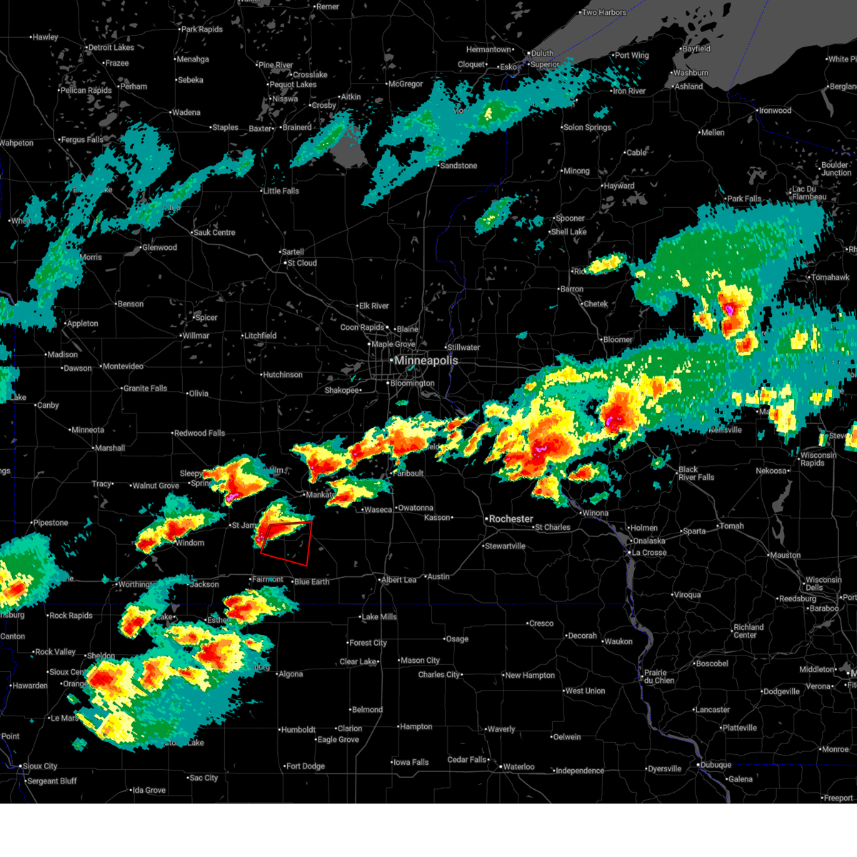
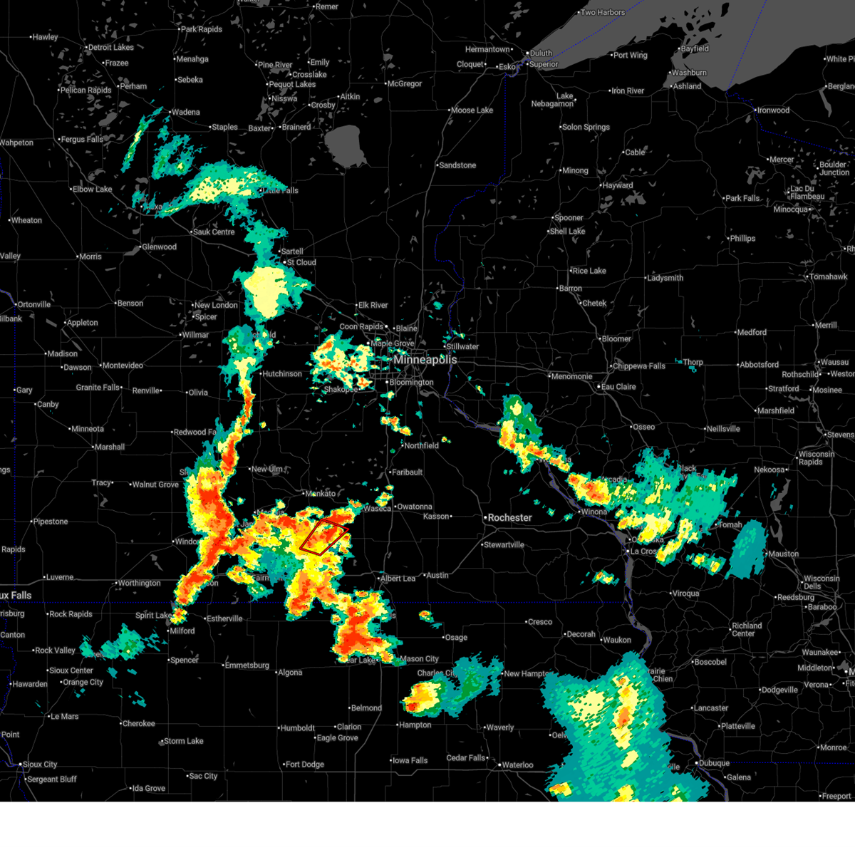
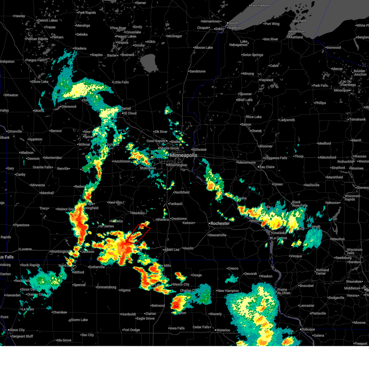
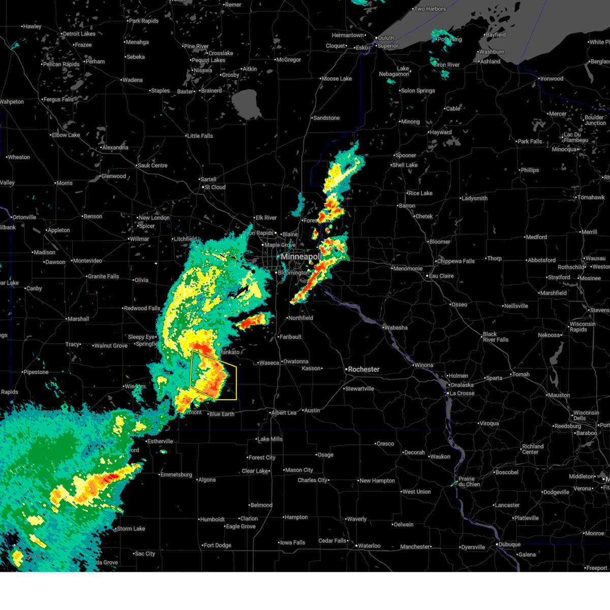
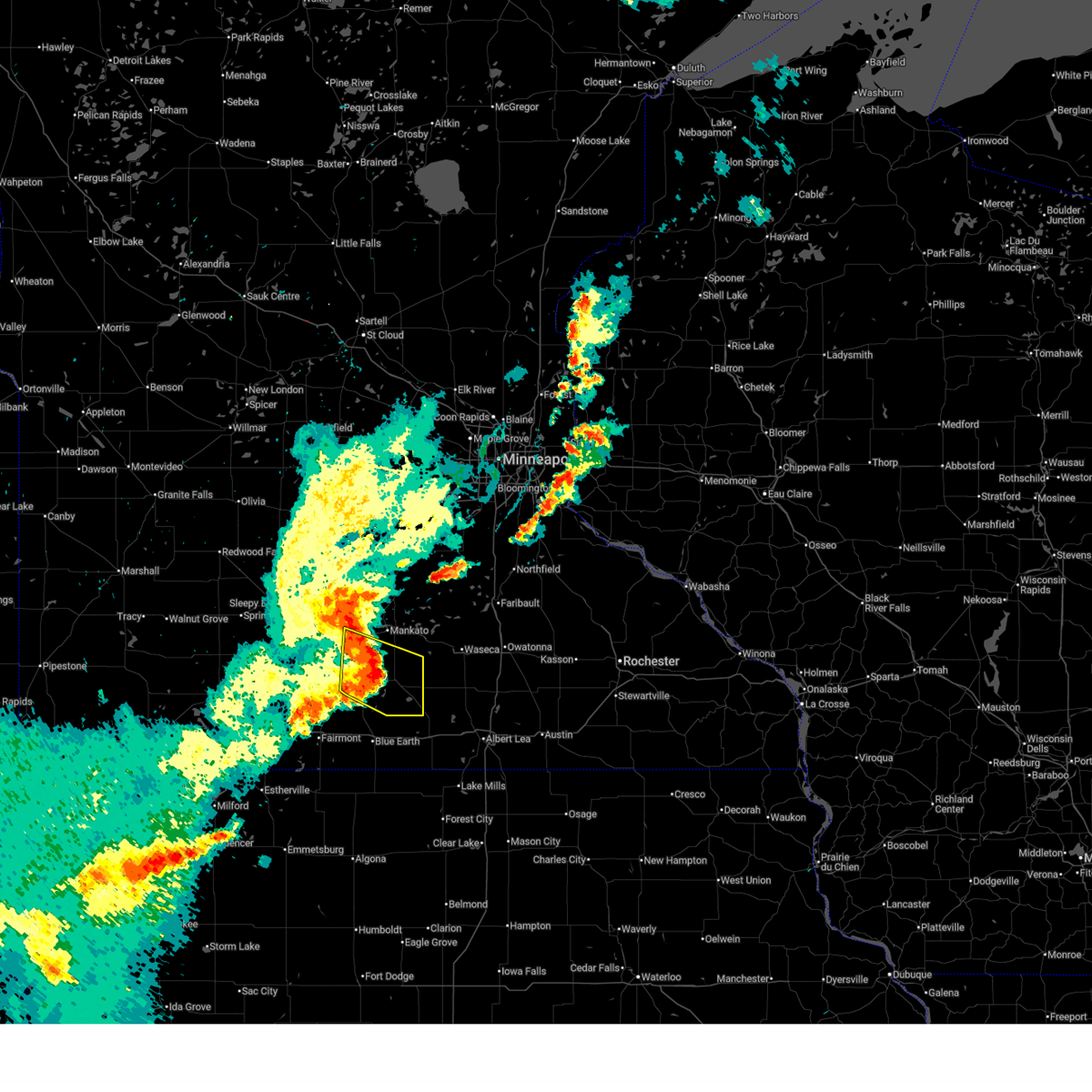
Hail Map for Mapleton, MN
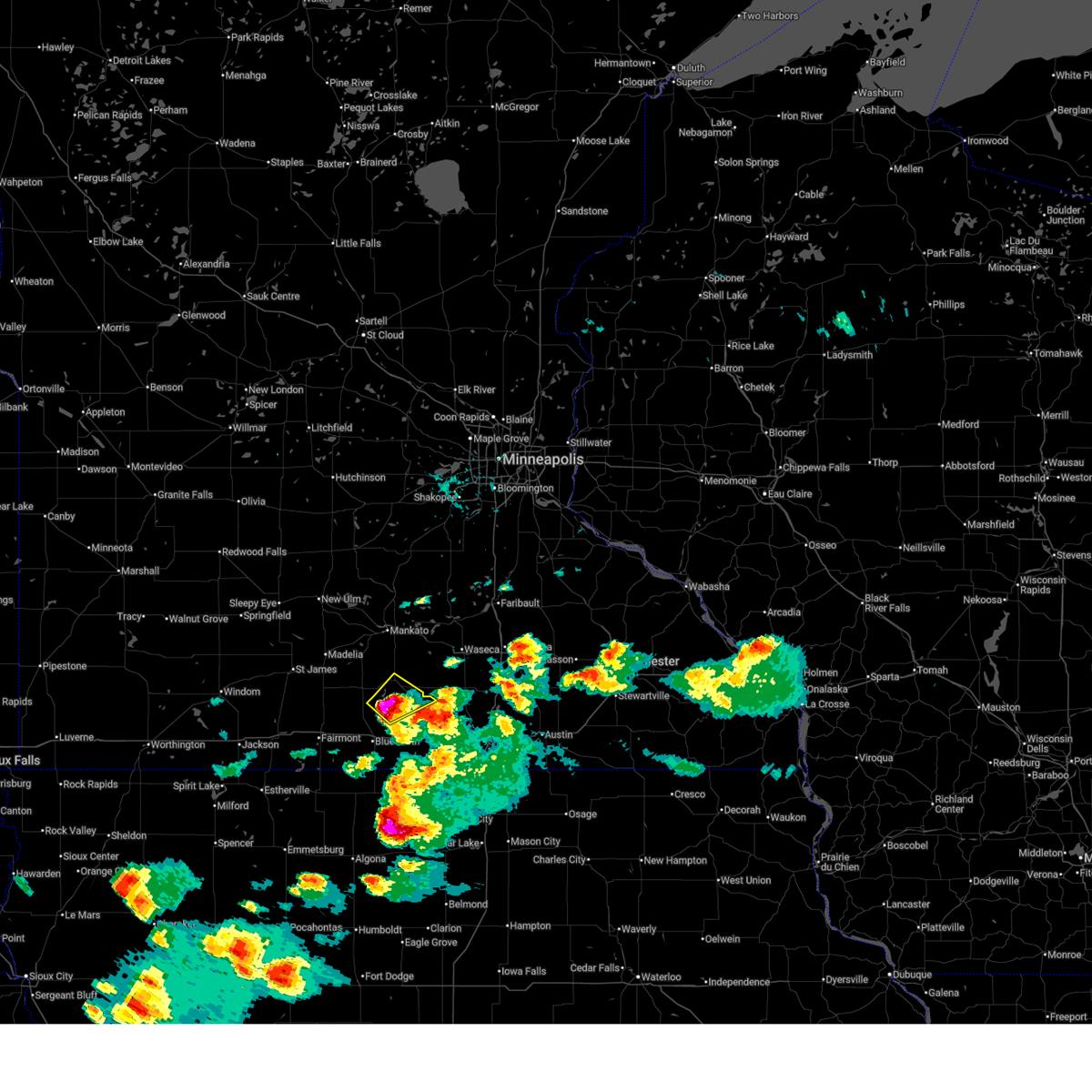
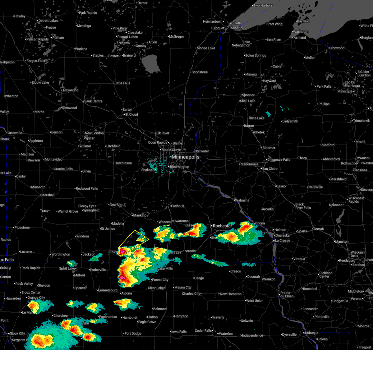
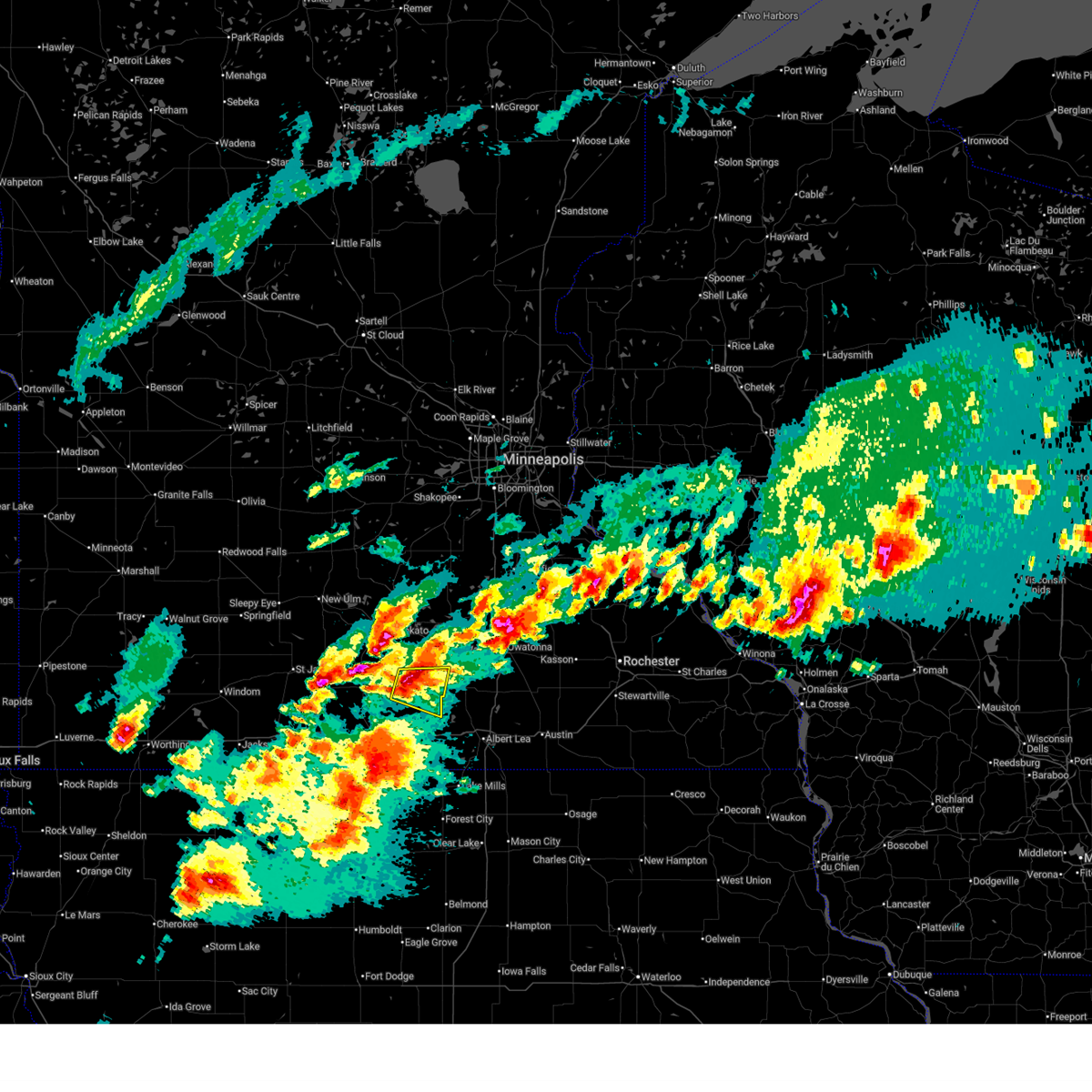
The Mapleton, MN area has had 2 reports of on-the-ground hail by trained spotters, and has been under severe weather warnings 20 times during the past 12 months. Doppler radar has detected hail at or near Mapleton, MN on 59 occasions, including 5 occasions during the past year.
| Name: | Mapleton, MN |
| Where Located: | 65.6 miles NW of Mason City, IA |
| Map: | Google Map for Mapleton, MN |
| Population: | 1756 |
| Housing Units: | 715 |
| More Info: | Search Google for Mapleton, MN |
5
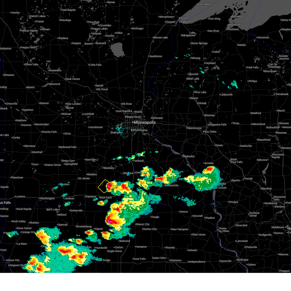
The Top Recent Hail Date for Mapleton, MN is Monday, April 13, 2026 (1st out of 59)
Hail and Wind Damage Spotted near Mapleton, MN
| Date / Time | Report Details |
|---|---|
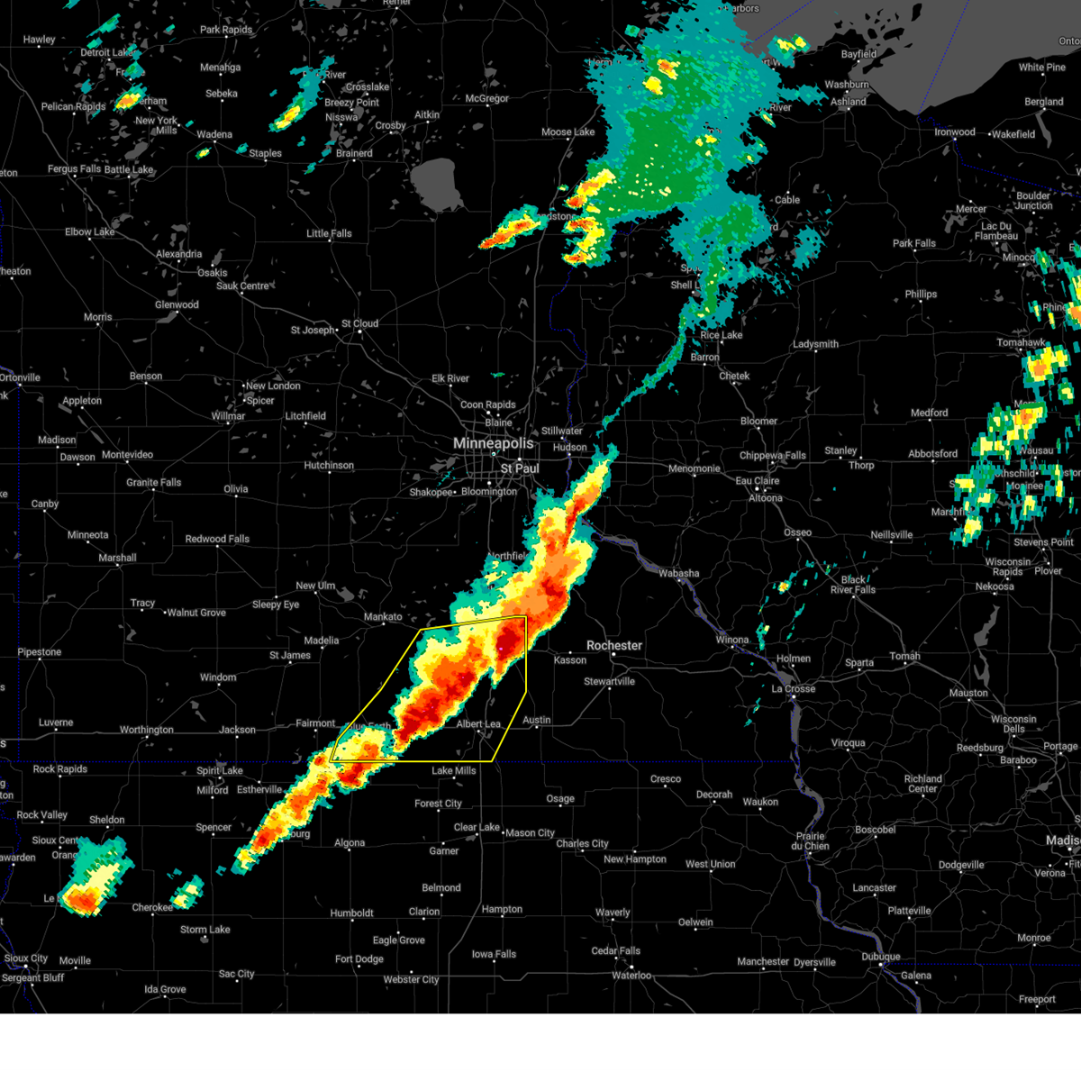
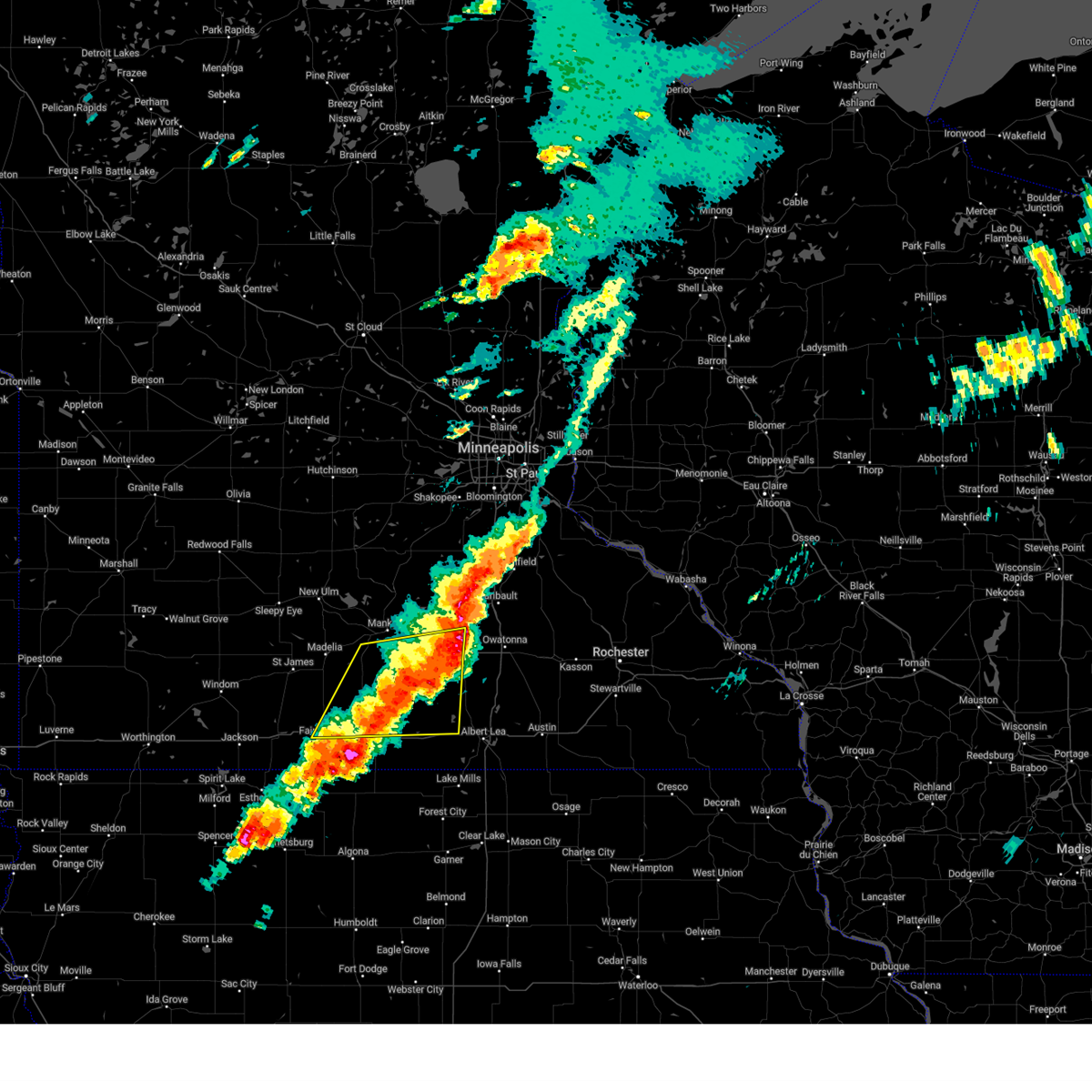
| 5/17/2026 9:32 PM CDT |
 the severe thunderstorm warning has been cancelled and is no longer in effect the severe thunderstorm warning has been cancelled and is no longer in effect
|
| 5/17/2026 9:11 PM CDT |
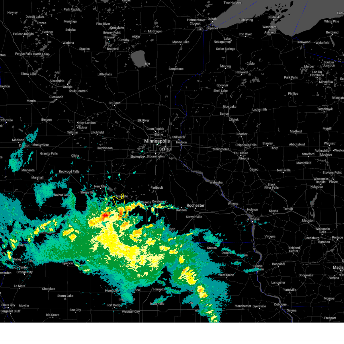
 At 911 pm cdt, severe thunderstorms were located along a line from near cleveland to over minnesota lake, or along a line from 11 miles northeast of mankato to 21 miles south of mankato, moving northeast at 35 mph (radar indicated). Hazards include 60 mph wind gusts and half dollar size hail. Hail damage to vehicles is expected. expect wind damage to roofs, siding, and trees. locations impacted include, mankato, skyline, mapleton, st. Clair, eagle lake, pemberton, smiths mill, janesville, alma city and waldorf. At 911 pm cdt, severe thunderstorms were located along a line from near cleveland to over minnesota lake, or along a line from 11 miles northeast of mankato to 21 miles south of mankato, moving northeast at 35 mph (radar indicated). Hazards include 60 mph wind gusts and half dollar size hail. Hail damage to vehicles is expected. expect wind damage to roofs, siding, and trees. locations impacted include, mankato, skyline, mapleton, st. Clair, eagle lake, pemberton, smiths mill, janesville, alma city and waldorf.
|
| 5/17/2026 8:49 PM CDT |
 Svrmpx the national weather service in the twin cities has issued a * severe thunderstorm warning for, eastern blue earth county in south central minnesota, northeastern faribault county in south central minnesota, northwestern freeborn county in south central minnesota, western waseca county in south central minnesota, * until 945 pm cdt. * at 849 pm cdt, severe thunderstorms were located along a line from 5 miles south of north mankato to near blue earth, moving east at 25 mph (radar indicated). Hazards include 60 mph wind gusts and half dollar size hail. Hail damage to vehicles is expected. Expect wind damage to roofs, siding, and trees. Svrmpx the national weather service in the twin cities has issued a * severe thunderstorm warning for, eastern blue earth county in south central minnesota, northeastern faribault county in south central minnesota, northwestern freeborn county in south central minnesota, western waseca county in south central minnesota, * until 945 pm cdt. * at 849 pm cdt, severe thunderstorms were located along a line from 5 miles south of north mankato to near blue earth, moving east at 25 mph (radar indicated). Hazards include 60 mph wind gusts and half dollar size hail. Hail damage to vehicles is expected. Expect wind damage to roofs, siding, and trees.
|
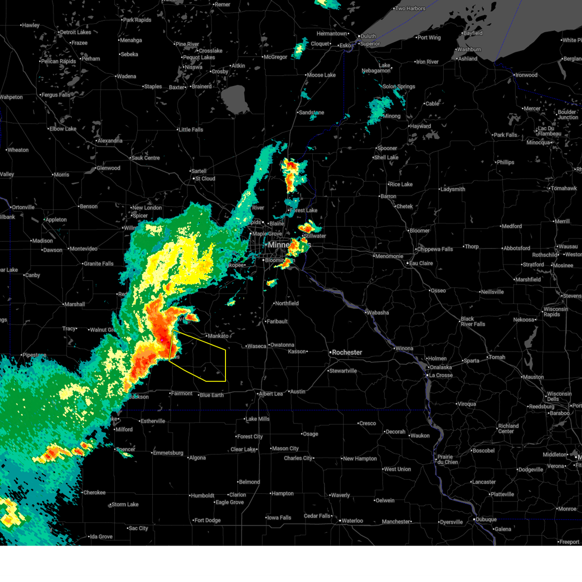
| 5/15/2026 7:05 PM CDT |
 The severe thunderstorm warning that was previously in effect has been reissued for blue earth county and is in effect until 745 pm cdt. please refer to that bulletin for the latest severe weather information. a severe thunderstorm watch remains in effect until 100 am cdt saturday for a portion of south central minnesota. The severe thunderstorm warning that was previously in effect has been reissued for blue earth county and is in effect until 745 pm cdt. please refer to that bulletin for the latest severe weather information. a severe thunderstorm watch remains in effect until 100 am cdt saturday for a portion of south central minnesota.
|
| 5/15/2026 6:46 PM CDT |
 At 646 pm cdt, a severe thunderstorm was located over delavan, or 24 miles northeast of fairmont, moving northeast at 30 mph (radar indicated). Hazards include 60 mph wind gusts and quarter size hail. Hail damage to vehicles is expected. expect wind damage to roofs, siding, and trees. Locations impacted include, delavan, easton, minnesota lake and mapleton. At 646 pm cdt, a severe thunderstorm was located over delavan, or 24 miles northeast of fairmont, moving northeast at 30 mph (radar indicated). Hazards include 60 mph wind gusts and quarter size hail. Hail damage to vehicles is expected. expect wind damage to roofs, siding, and trees. Locations impacted include, delavan, easton, minnesota lake and mapleton.
|
| 5/15/2026 6:28 PM CDT |
 Svrmpx the national weather service in the twin cities has issued a * severe thunderstorm warning for, southeastern blue earth county in south central minnesota, northern faribault county in south central minnesota, * until 715 pm cdt. * at 628 pm cdt, a severe thunderstorm was located 6 miles south of winnebago, or 15 miles east of fairmont, moving northeast at 45 mph (radar indicated). Hazards include 60 mph wind gusts and quarter size hail. Hail damage to vehicles is expected. Expect wind damage to roofs, siding, and trees. Svrmpx the national weather service in the twin cities has issued a * severe thunderstorm warning for, southeastern blue earth county in south central minnesota, northern faribault county in south central minnesota, * until 715 pm cdt. * at 628 pm cdt, a severe thunderstorm was located 6 miles south of winnebago, or 15 miles east of fairmont, moving northeast at 45 mph (radar indicated). Hazards include 60 mph wind gusts and quarter size hail. Hail damage to vehicles is expected. Expect wind damage to roofs, siding, and trees.
|
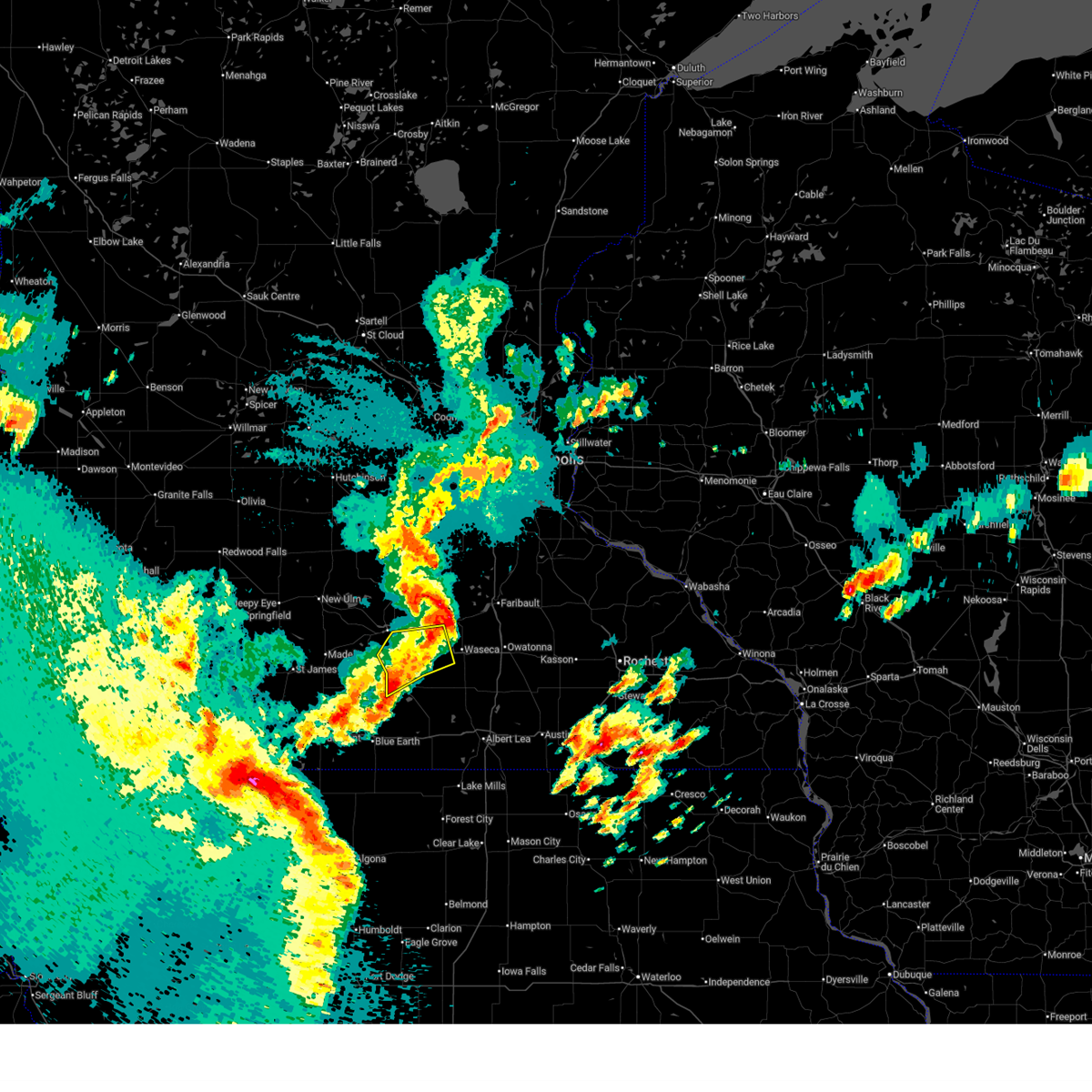
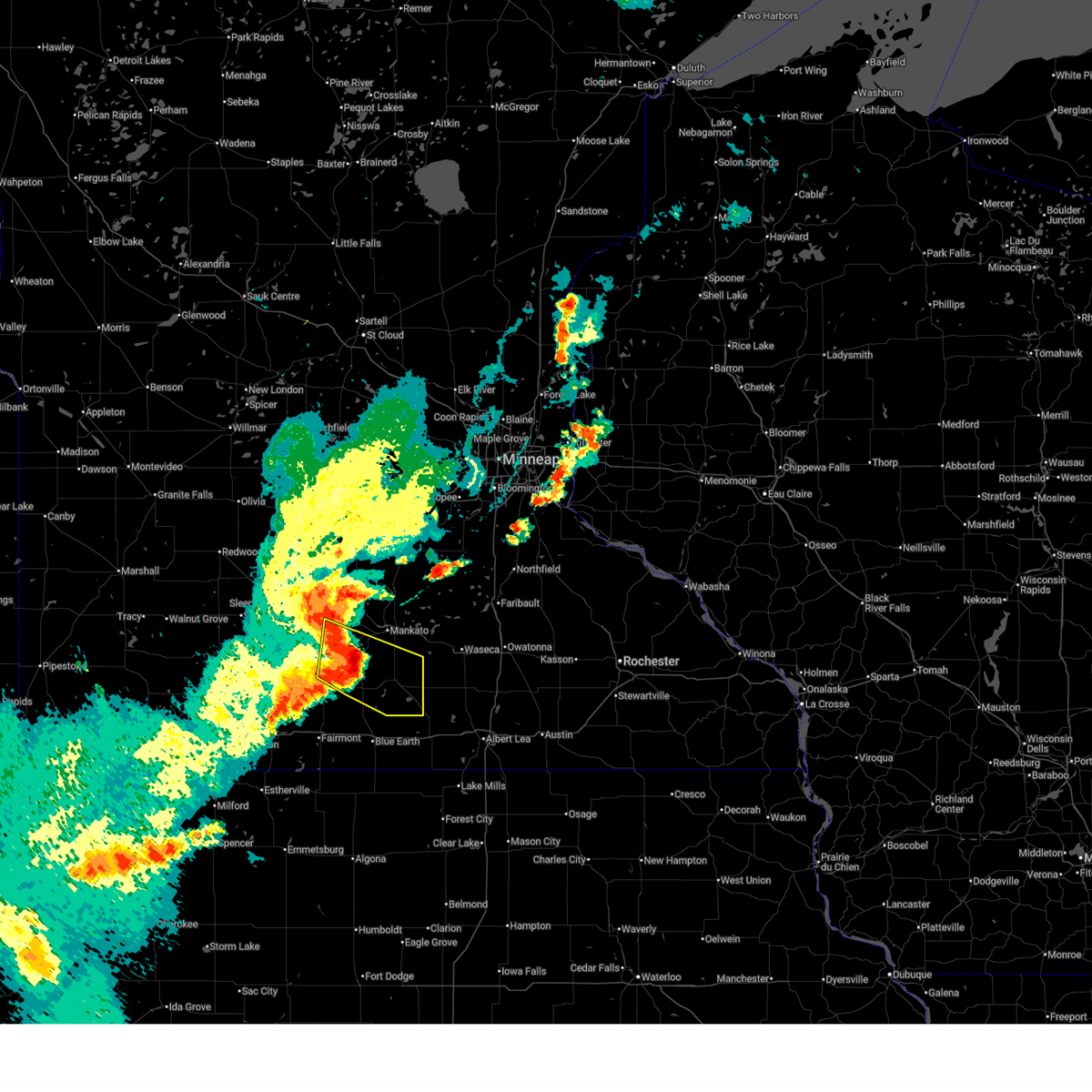
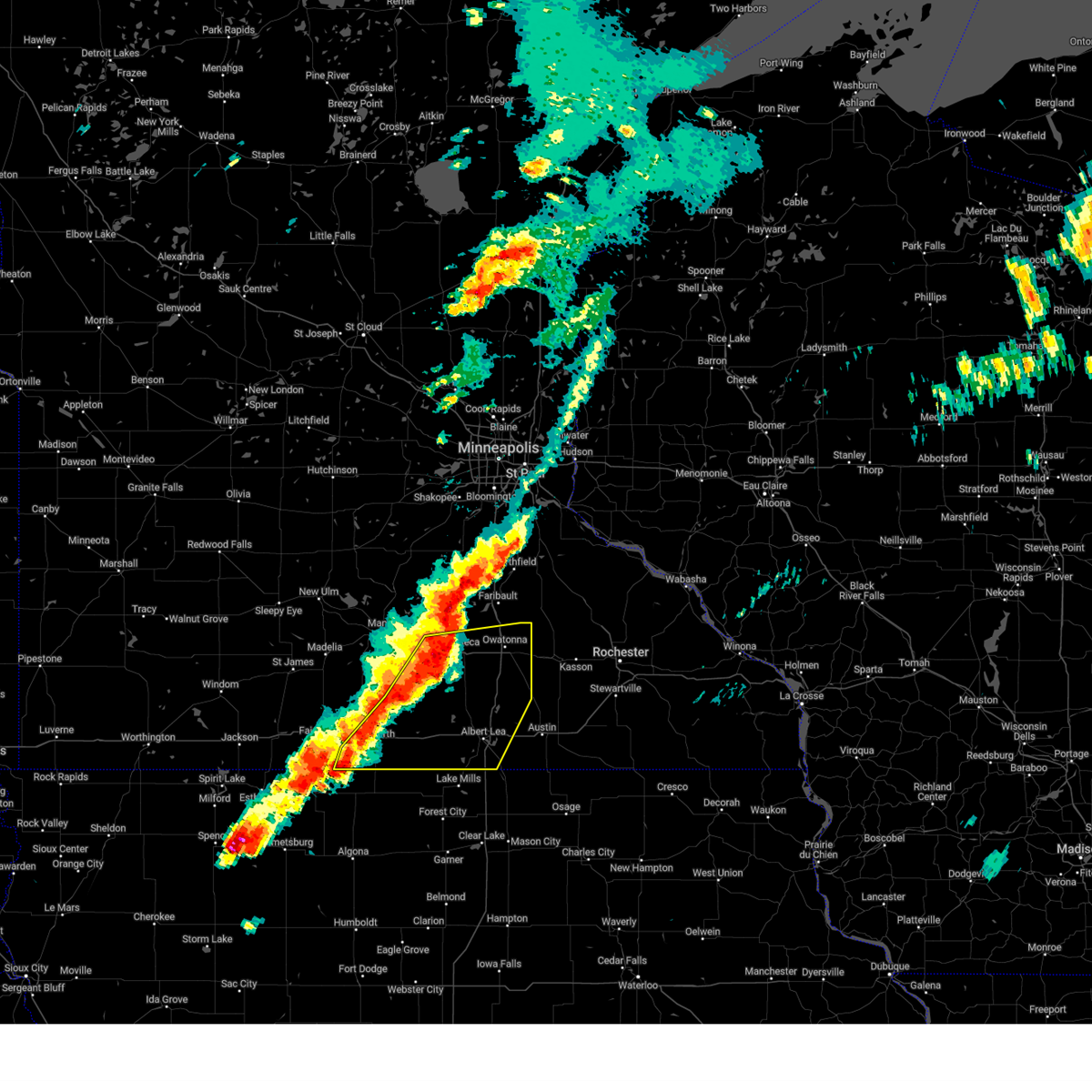
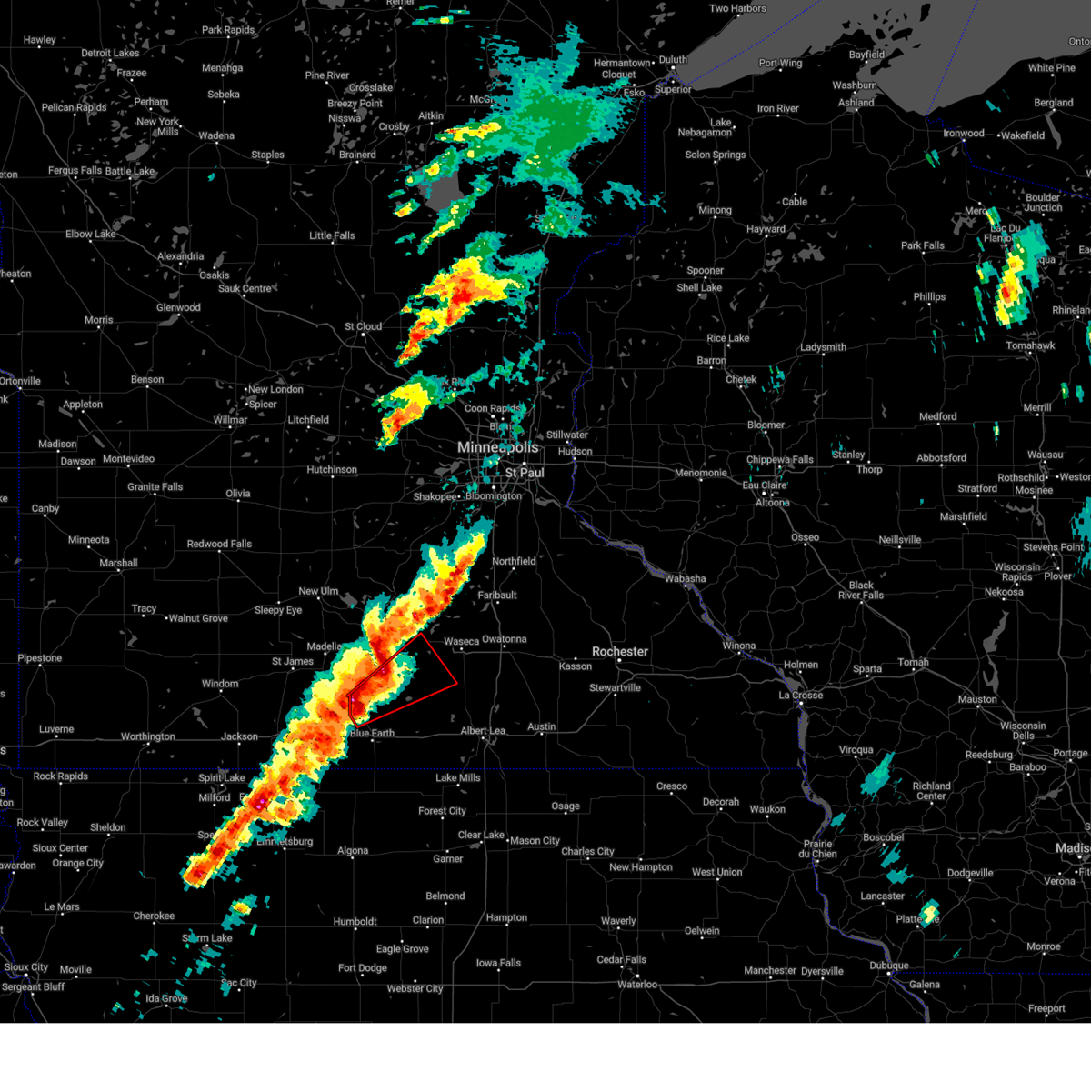
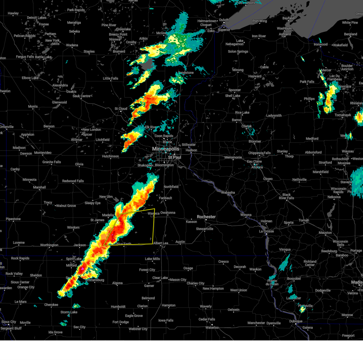
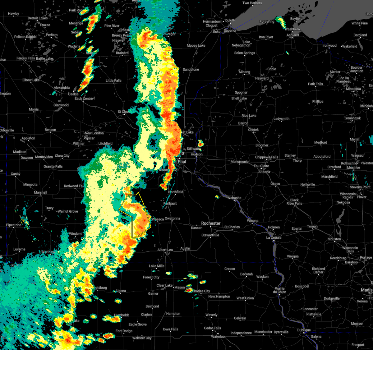
| 4/13/2026 7:29 PM CDT |
 At 729 pm cdt, a severe thunderstorm was located over minnesota lake, or 21 miles south of mankato, moving east at 25 mph (radar indicated). Hazards include golf ball size hail and 60 mph wind gusts. People and animals outdoors will be injured. expect hail damage to roofs, siding, windows, and vehicles. expect wind damage to roofs, siding, and trees. Locations impacted include, mapleton, minnesota lake and waldorf. At 729 pm cdt, a severe thunderstorm was located over minnesota lake, or 21 miles south of mankato, moving east at 25 mph (radar indicated). Hazards include golf ball size hail and 60 mph wind gusts. People and animals outdoors will be injured. expect hail damage to roofs, siding, windows, and vehicles. expect wind damage to roofs, siding, and trees. Locations impacted include, mapleton, minnesota lake and waldorf.
|
| 4/13/2026 7:07 PM CDT |
 Svrmpx the national weather service in the twin cities has issued a * severe thunderstorm warning for, southeastern blue earth county in south central minnesota, northeastern faribault county in south central minnesota, southwestern waseca county in south central minnesota, * until 800 pm cdt. * at 707 pm cdt, a severe thunderstorm was located near mapleton, or 19 miles south of mankato, moving east at 25 mph (radar indicated). Hazards include golf ball size hail and 60 mph wind gusts. People and animals outdoors will be injured. expect hail damage to roofs, siding, windows, and vehicles. Expect wind damage to roofs, siding, and trees. Svrmpx the national weather service in the twin cities has issued a * severe thunderstorm warning for, southeastern blue earth county in south central minnesota, northeastern faribault county in south central minnesota, southwestern waseca county in south central minnesota, * until 800 pm cdt. * at 707 pm cdt, a severe thunderstorm was located near mapleton, or 19 miles south of mankato, moving east at 25 mph (radar indicated). Hazards include golf ball size hail and 60 mph wind gusts. People and animals outdoors will be injured. expect hail damage to roofs, siding, windows, and vehicles. Expect wind damage to roofs, siding, and trees.
|
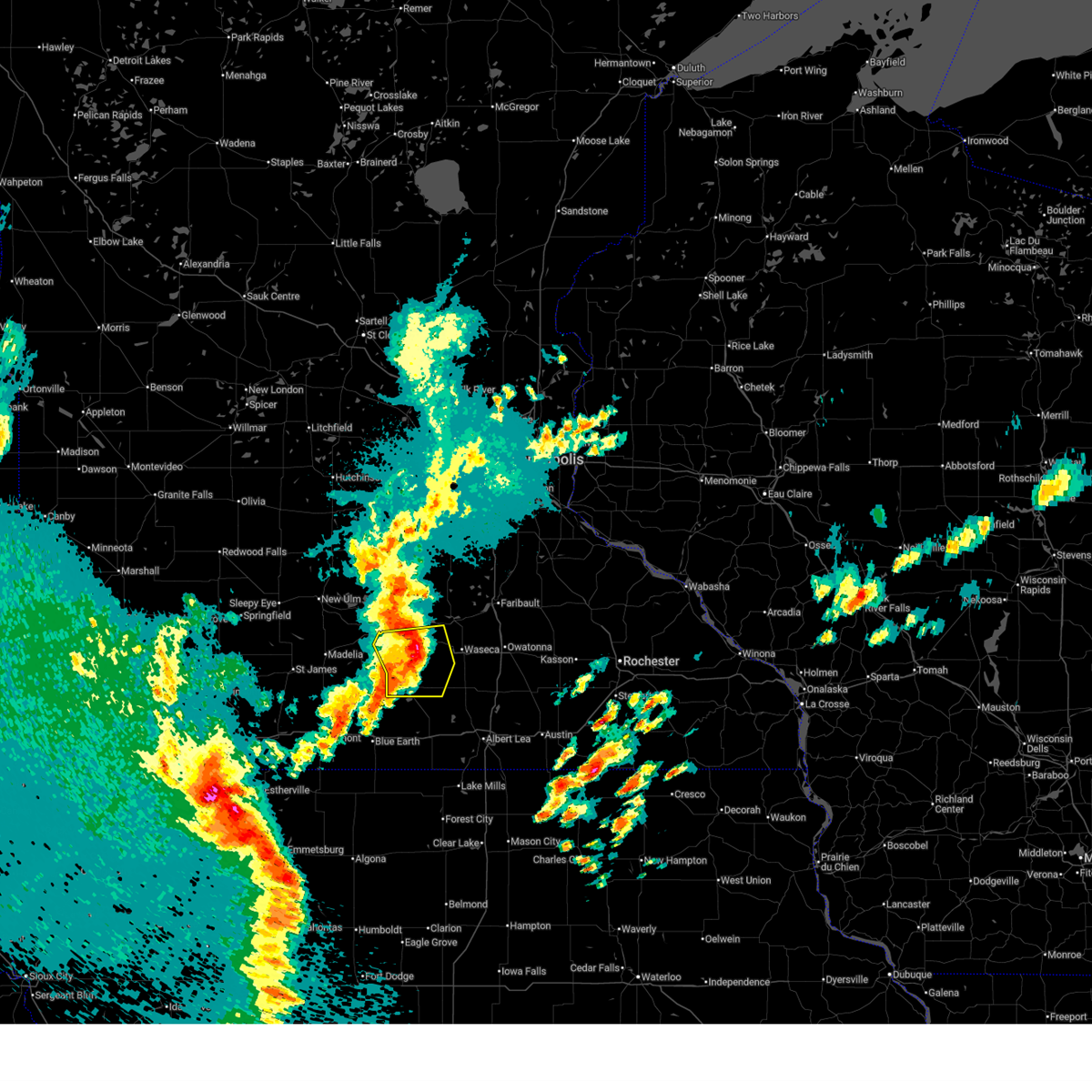
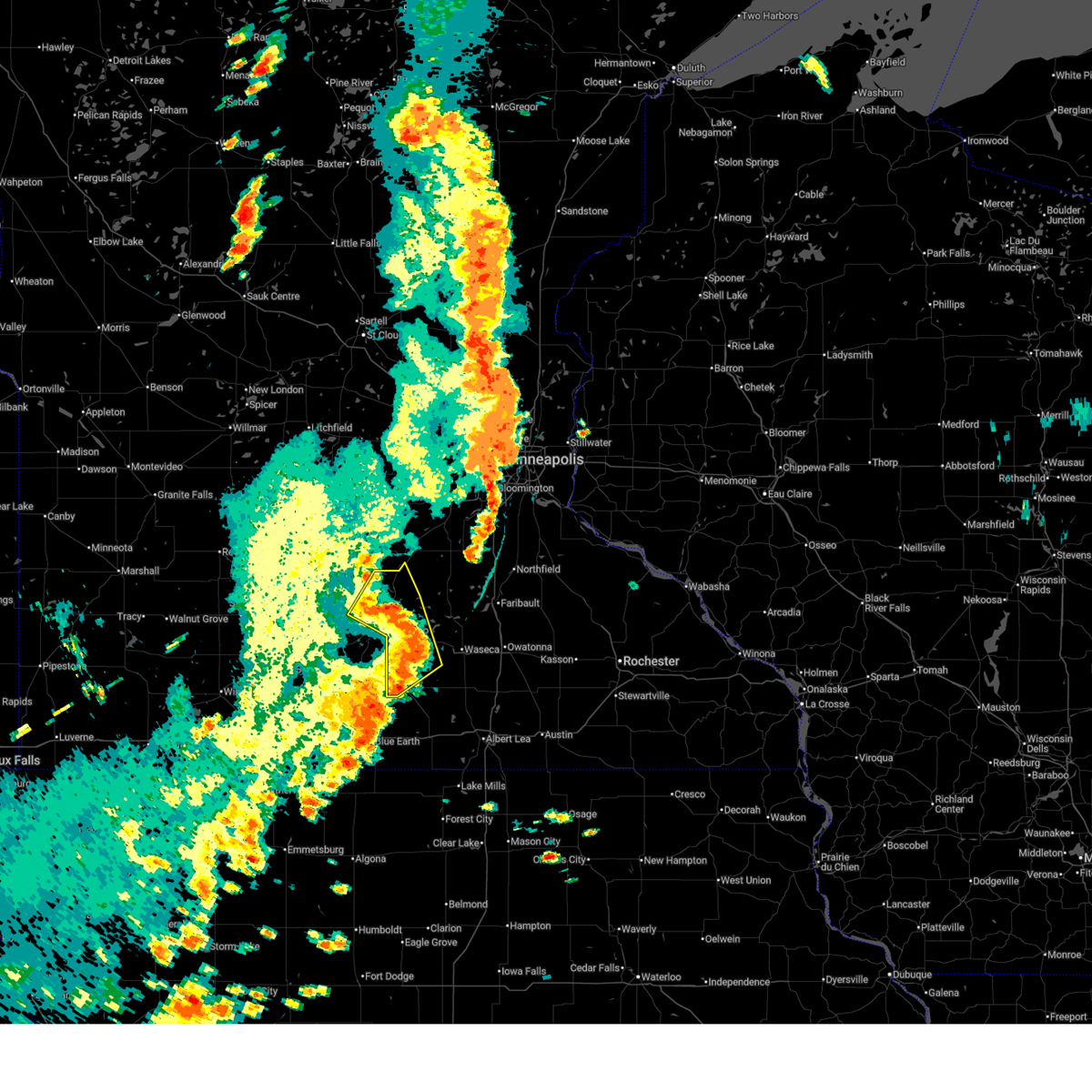
| 4/13/2026 6:56 PM CDT |
 At 656 pm cdt, a severe thunderstorm capable of producing a tornado was located near amboy, or 21 miles south of mankato, moving east at 25 mph (radar indicated rotation). Hazards include tornado and tennis ball size hail. Flying debris will be dangerous to those caught without shelter. mobile homes will be damaged or destroyed. damage to roofs, windows and vehicles will occur. tree damage is likely. Locations impacted include, amboy and mapleton. At 656 pm cdt, a severe thunderstorm capable of producing a tornado was located near amboy, or 21 miles south of mankato, moving east at 25 mph (radar indicated rotation). Hazards include tornado and tennis ball size hail. Flying debris will be dangerous to those caught without shelter. mobile homes will be damaged or destroyed. damage to roofs, windows and vehicles will occur. tree damage is likely. Locations impacted include, amboy and mapleton.
|
| 4/13/2026 6:46 PM CDT |
 At 646 pm cdt, a confirmed tornado was located over amboy, or 22 miles southwest of mankato, moving east at 25 mph (weather spotters confirmed tornado). Hazards include damaging tornado and two inch hail. Flying debris will be dangerous to those caught without shelter. mobile homes will be damaged or destroyed. damage to roofs, windows and vehicles will occur. tree damage is likely. Locations impacted include, vernon center, amboy and mapleton. At 646 pm cdt, a confirmed tornado was located over amboy, or 22 miles southwest of mankato, moving east at 25 mph (weather spotters confirmed tornado). Hazards include damaging tornado and two inch hail. Flying debris will be dangerous to those caught without shelter. mobile homes will be damaged or destroyed. damage to roofs, windows and vehicles will occur. tree damage is likely. Locations impacted include, vernon center, amboy and mapleton.
|
| 4/13/2026 6:46 PM CDT |
 the tornado warning has been cancelled and is no longer in effect the tornado warning has been cancelled and is no longer in effect
|
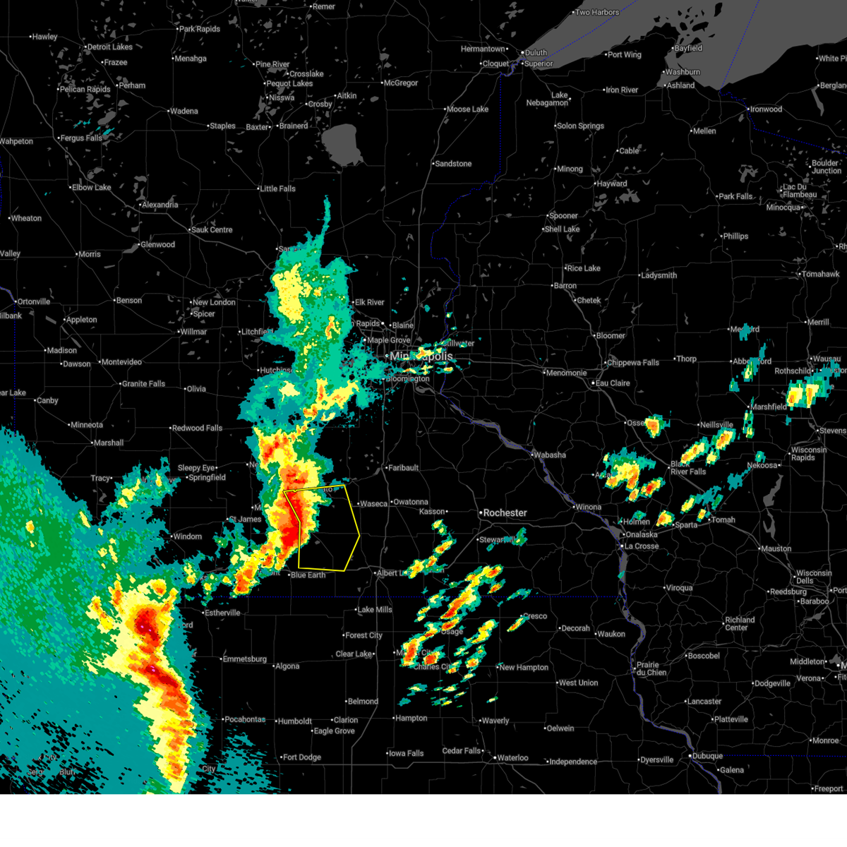
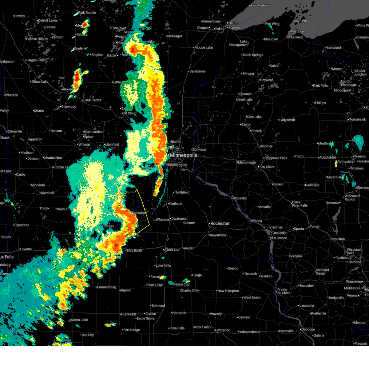
| 4/13/2026 6:28 PM CDT |
 Tormpx the national weather service in the twin cities has issued a * tornado warning for, southwestern blue earth county in south central minnesota, northwestern faribault county in south central minnesota, northeastern martin county in south central minnesota, * until 715 pm cdt. * at 628 pm cdt, a confirmed tornado was located 7 miles southeast of lewisville, or 19 miles northeast of fairmont, moving east at 25 mph (weather spotters confirmed tornado). Hazards include damaging tornado and two inch hail. Flying debris will be dangerous to those caught without shelter. mobile homes will be damaged or destroyed. damage to roofs, windows and vehicles will occur. Tree damage is likely. Tormpx the national weather service in the twin cities has issued a * tornado warning for, southwestern blue earth county in south central minnesota, northwestern faribault county in south central minnesota, northeastern martin county in south central minnesota, * until 715 pm cdt. * at 628 pm cdt, a confirmed tornado was located 7 miles southeast of lewisville, or 19 miles northeast of fairmont, moving east at 25 mph (weather spotters confirmed tornado). Hazards include damaging tornado and two inch hail. Flying debris will be dangerous to those caught without shelter. mobile homes will be damaged or destroyed. damage to roofs, windows and vehicles will occur. Tree damage is likely.
|
| 8/17/2025 7:56 PM CDT |
 The tornado warning that was previously in effect has been reissued for waseca county and is in effect until 830 pm cdt. please refer to that bulletin for the latest severe weather information. The tornado warning that was previously in effect has been reissued for waseca county and is in effect until 830 pm cdt. please refer to that bulletin for the latest severe weather information.
|
| 8/17/2025 7:48 PM CDT |
 At 748 pm cdt, a severe thunderstorm capable of producing a tornado was located near minnesota lake, or 23 miles south of mankato, moving northeast at 20 mph (radar indicated rotation). Hazards include tornado. Flying debris will be dangerous to those caught without shelter. mobile homes will be damaged or destroyed. damage to roofs, windows and vehicles will occur. tree damage is likely. Locations impacted include, mapleton, minnesota lake and waldorf. At 748 pm cdt, a severe thunderstorm capable of producing a tornado was located near minnesota lake, or 23 miles south of mankato, moving northeast at 20 mph (radar indicated rotation). Hazards include tornado. Flying debris will be dangerous to those caught without shelter. mobile homes will be damaged or destroyed. damage to roofs, windows and vehicles will occur. tree damage is likely. Locations impacted include, mapleton, minnesota lake and waldorf.
|
| 8/17/2025 7:32 PM CDT |
 Tormpx the national weather service in the twin cities has issued a * tornado warning for, southeastern blue earth county in south central minnesota, north central faribault county in south central minnesota, southwestern waseca county in south central minnesota, * until 800 pm cdt. * at 732 pm cdt, a severe thunderstorm capable of producing a tornado was located near easton, or 25 miles south of mankato, moving northeast at 35 mph (weather spotters reported funnel cloud near delavan). Hazards include tornado. Flying debris will be dangerous to those caught without shelter. mobile homes will be damaged or destroyed. damage to roofs, windows and vehicles will occur. Tree damage is likely. Tormpx the national weather service in the twin cities has issued a * tornado warning for, southeastern blue earth county in south central minnesota, north central faribault county in south central minnesota, southwestern waseca county in south central minnesota, * until 800 pm cdt. * at 732 pm cdt, a severe thunderstorm capable of producing a tornado was located near easton, or 25 miles south of mankato, moving northeast at 35 mph (weather spotters reported funnel cloud near delavan). Hazards include tornado. Flying debris will be dangerous to those caught without shelter. mobile homes will be damaged or destroyed. damage to roofs, windows and vehicles will occur. Tree damage is likely.
|
| 7/7/2025 8:27 PM CDT |
 The storm which prompted the warning has weakened below severe limits, and no longer poses an immediate threat to life or property. therefore, the warning will be allowed to expire. to report severe weather, contact your nearest law enforcement agency. they will send your report to the national weather service office. The storm which prompted the warning has weakened below severe limits, and no longer poses an immediate threat to life or property. therefore, the warning will be allowed to expire. to report severe weather, contact your nearest law enforcement agency. they will send your report to the national weather service office.
|
| 7/7/2025 8:15 PM CDT |
 the severe thunderstorm warning has been cancelled and is no longer in effect the severe thunderstorm warning has been cancelled and is no longer in effect
|
| 7/7/2025 8:15 PM CDT |
 At 815 pm cdt, a severe thunderstorm was located near mapleton, or 16 miles south of mankato, moving east at 45 mph (radar indicated). Hazards include 60 mph wind gusts. Expect damage to roofs, siding, and trees. Locations impacted include, lake crystal, mapleton, minnesota lake, good thunder, amboy, vernon center, pemberton, easton, delavan and garden city. At 815 pm cdt, a severe thunderstorm was located near mapleton, or 16 miles south of mankato, moving east at 45 mph (radar indicated). Hazards include 60 mph wind gusts. Expect damage to roofs, siding, and trees. Locations impacted include, lake crystal, mapleton, minnesota lake, good thunder, amboy, vernon center, pemberton, easton, delavan and garden city.
|
| 7/7/2025 8:08 PM CDT |
 At 808 pm cdt, a severe thunderstorm was located near mapleton, or 13 miles south of mankato, moving east at 45 mph (radar indicated). Hazards include 60 mph wind gusts and small hail. Expect damage to roofs, siding, and trees. Locations impacted include, lake crystal, madelia, mapleton, minnesota lake, good thunder, amboy, vernon center, lewisville, pemberton, easton, delavan and garden city. At 808 pm cdt, a severe thunderstorm was located near mapleton, or 13 miles south of mankato, moving east at 45 mph (radar indicated). Hazards include 60 mph wind gusts and small hail. Expect damage to roofs, siding, and trees. Locations impacted include, lake crystal, madelia, mapleton, minnesota lake, good thunder, amboy, vernon center, lewisville, pemberton, easton, delavan and garden city.
|
| 7/7/2025 7:42 PM CDT |
 Svrmpx the national weather service in the twin cities has issued a * severe thunderstorm warning for, blue earth county in south central minnesota, southeastern brown county in south central minnesota, northeastern faribault county in south central minnesota, northeastern watonwan county in south central minnesota, * until 830 pm cdt. * at 742 pm cdt, a severe thunderstorm was located over madelia, or 18 miles south of new ulm, moving east at 45 mph (radar indicated). Hazards include 60 mph wind gusts and quarter size hail. Hail damage to vehicles is expected. Expect wind damage to roofs, siding, and trees. Svrmpx the national weather service in the twin cities has issued a * severe thunderstorm warning for, blue earth county in south central minnesota, southeastern brown county in south central minnesota, northeastern faribault county in south central minnesota, northeastern watonwan county in south central minnesota, * until 830 pm cdt. * at 742 pm cdt, a severe thunderstorm was located over madelia, or 18 miles south of new ulm, moving east at 45 mph (radar indicated). Hazards include 60 mph wind gusts and quarter size hail. Hail damage to vehicles is expected. Expect wind damage to roofs, siding, and trees.
|
| 4/28/2025 6:17 PM CDT |
 The severe thunderstorm warning that was previously in effect has been reissued for and is in effect until 700 pm cdt. please refer to those bulletins for the latest severe weather information. a tornado watch remains in effect until 800 pm cdt for a portion of south central minnesota. The severe thunderstorm warning that was previously in effect has been reissued for and is in effect until 700 pm cdt. please refer to those bulletins for the latest severe weather information. a tornado watch remains in effect until 800 pm cdt for a portion of south central minnesota.
|
| 4/28/2025 5:33 PM CDT |
 The storms which prompted the warning have moved out of the area. therefore, the warning has been allowed to expire. a severe thunderstorm warning still remains in effect for southeastern blue earth, waseca, faribault, southeastern martin, and freeborn counties. The storms which prompted the warning have moved out of the area. therefore, the warning has been allowed to expire. a severe thunderstorm warning still remains in effect for southeastern blue earth, waseca, faribault, southeastern martin, and freeborn counties.
|
| 4/28/2025 5:29 PM CDT |
 Svrmpx the national weather service in the twin cities has issued a * severe thunderstorm warning for, southeastern blue earth county in south central minnesota, faribault county in south central minnesota, freeborn county in south central minnesota, southeastern martin county in south central minnesota, steele county in south central minnesota, waseca county in south central minnesota, * until 615 pm cdt. * at 529 pm cdt, severe thunderstorms were located along a line from over waseca to near elmore, or along a line from 13 miles west of owatonna to 17 miles southeast of fairmont, moving east at 50 mph (radar indicated). Hazards include 60 mph wind gusts and half dollar size hail. Hail damage to vehicles is expected. Expect wind damage to roofs, siding, and trees. Svrmpx the national weather service in the twin cities has issued a * severe thunderstorm warning for, southeastern blue earth county in south central minnesota, faribault county in south central minnesota, freeborn county in south central minnesota, southeastern martin county in south central minnesota, steele county in south central minnesota, waseca county in south central minnesota, * until 615 pm cdt. * at 529 pm cdt, severe thunderstorms were located along a line from over waseca to near elmore, or along a line from 13 miles west of owatonna to 17 miles southeast of fairmont, moving east at 50 mph (radar indicated). Hazards include 60 mph wind gusts and half dollar size hail. Hail damage to vehicles is expected. Expect wind damage to roofs, siding, and trees.
|
| 4/28/2025 5:00 PM CDT |
 Tormpx the national weather service in the twin cities has issued a * tornado warning for, southeastern blue earth county in south central minnesota, northwestern faribault county in south central minnesota, southwestern waseca county in south central minnesota, * until 545 pm cdt. * at 500 pm cdt, a severe thunderstorm capable of producing a tornado was located over winnebago, or 20 miles northeast of fairmont, moving northeast at 60 mph (weather spotters reported funnel cloud). Hazards include tornado and ping pong ball size hail. Flying debris will be dangerous to those caught without shelter. mobile homes will be damaged or destroyed. damage to roofs, windows and vehicles will occur. Tree damage is likely. Tormpx the national weather service in the twin cities has issued a * tornado warning for, southeastern blue earth county in south central minnesota, northwestern faribault county in south central minnesota, southwestern waseca county in south central minnesota, * until 545 pm cdt. * at 500 pm cdt, a severe thunderstorm capable of producing a tornado was located over winnebago, or 20 miles northeast of fairmont, moving northeast at 60 mph (weather spotters reported funnel cloud). Hazards include tornado and ping pong ball size hail. Flying debris will be dangerous to those caught without shelter. mobile homes will be damaged or destroyed. damage to roofs, windows and vehicles will occur. Tree damage is likely.
|
| 4/28/2025 4:52 PM CDT |
 Svrmpx the national weather service in the twin cities has issued a * severe thunderstorm warning for, blue earth county in south central minnesota, northern faribault county in south central minnesota, northwestern freeborn county in south central minnesota, northeastern martin county in south central minnesota, waseca county in south central minnesota, * until 530 pm cdt. * at 452 pm cdt, severe thunderstorms were located along a line from 6 miles north of good thunder to over winnebago, or along a line from 7 miles southwest of mankato to 14 miles northeast of fairmont, moving northeast at 60 mph (radar indicated). Hazards include 60 mph wind gusts and half dollar size hail. Hail damage to vehicles is expected. Expect wind damage to roofs, siding, and trees. Svrmpx the national weather service in the twin cities has issued a * severe thunderstorm warning for, blue earth county in south central minnesota, northern faribault county in south central minnesota, northwestern freeborn county in south central minnesota, northeastern martin county in south central minnesota, waseca county in south central minnesota, * until 530 pm cdt. * at 452 pm cdt, severe thunderstorms were located along a line from 6 miles north of good thunder to over winnebago, or along a line from 7 miles southwest of mankato to 14 miles northeast of fairmont, moving northeast at 60 mph (radar indicated). Hazards include 60 mph wind gusts and half dollar size hail. Hail damage to vehicles is expected. Expect wind damage to roofs, siding, and trees.
|
| 3/14/2025 8:26 PM CDT |
 The storm which prompted the warning has weakened below severe limits, and has exited the warned area. therefore, the warning will be allowed to expire. however, gusty winds are still possible with this thunderstorm. a severe thunderstorm watch remains in effect until 100 am cdt saturday for a portion of south central minnesota. The storm which prompted the warning has weakened below severe limits, and has exited the warned area. therefore, the warning will be allowed to expire. however, gusty winds are still possible with this thunderstorm. a severe thunderstorm watch remains in effect until 100 am cdt saturday for a portion of south central minnesota.
|
| 3/14/2025 8:05 PM CDT |
 Svrmpx the national weather service in the twin cities has issued a * severe thunderstorm warning for, central blue earth county in south central minnesota, * until 830 pm cdt. * at 805 pm cdt, a severe thunderstorm was located over mapleton, or 15 miles south of mankato, moving north at 55 mph (radar indicated). Hazards include 60 mph wind gusts and small hail. expect damage to roofs, siding, and trees Svrmpx the national weather service in the twin cities has issued a * severe thunderstorm warning for, central blue earth county in south central minnesota, * until 830 pm cdt. * at 805 pm cdt, a severe thunderstorm was located over mapleton, or 15 miles south of mankato, moving north at 55 mph (radar indicated). Hazards include 60 mph wind gusts and small hail. expect damage to roofs, siding, and trees
|
| 8/29/2024 4:44 PM CDT |
 the severe thunderstorm warning has been cancelled and is no longer in effect the severe thunderstorm warning has been cancelled and is no longer in effect
|
| 8/29/2024 4:37 PM CDT |
 At 437 pm cdt, severe thunderstorms were located along a line extending from near st. peter to kasota to near madison lake to janesville to pemberton, moving east at 40 mph (radar indicated). Hazards include 60 mph wind gusts. Expect damage to roofs, siding, and trees. locations impacted include, mankato, north mankato, st. peter, le sueur, eagle lake, janesville, mapleton, nicollet, madison lake, st. Clair, kasota, and pemberton. At 437 pm cdt, severe thunderstorms were located along a line extending from near st. peter to kasota to near madison lake to janesville to pemberton, moving east at 40 mph (radar indicated). Hazards include 60 mph wind gusts. Expect damage to roofs, siding, and trees. locations impacted include, mankato, north mankato, st. peter, le sueur, eagle lake, janesville, mapleton, nicollet, madison lake, st. Clair, kasota, and pemberton.
|
| 8/29/2024 4:23 PM CDT |
 the severe thunderstorm warning has been cancelled and is no longer in effect the severe thunderstorm warning has been cancelled and is no longer in effect
|
| 8/29/2024 4:23 PM CDT |
 At 423 pm cdt, severe thunderstorms were located along a line extending from near nicollet to near north mankato to near mankato to mapleton, moving northeast at 40 mph (radar indicated). Hazards include 60 mph wind gusts. Expect damage to roofs, siding, and trees. locations impacted include, mankato, north mankato, st. peter, le sueur, lake crystal, eagle lake, janesville, mapleton, nicollet, madison lake, st. Clair, and kasota. At 423 pm cdt, severe thunderstorms were located along a line extending from near nicollet to near north mankato to near mankato to mapleton, moving northeast at 40 mph (radar indicated). Hazards include 60 mph wind gusts. Expect damage to roofs, siding, and trees. locations impacted include, mankato, north mankato, st. peter, le sueur, lake crystal, eagle lake, janesville, mapleton, nicollet, madison lake, st. Clair, and kasota.
|
| 8/29/2024 4:08 PM CDT |
 Svrmpx the national weather service in the twin cities has issued a * severe thunderstorm warning for, north central faribault county in south central minnesota, western le sueur county in south central minnesota, blue earth county in south central minnesota, northwestern waseca county in south central minnesota, eastern nicollet county in south central minnesota, * until 500 pm cdt. * at 407 pm cdt, severe thunderstorms were located along a line extending from near lake crystal to near vernon center to near delavan, moving northeast at 40 mph (radar indicated). Hazards include 60 mph wind gusts. expect damage to roofs, siding, and trees Svrmpx the national weather service in the twin cities has issued a * severe thunderstorm warning for, north central faribault county in south central minnesota, western le sueur county in south central minnesota, blue earth county in south central minnesota, northwestern waseca county in south central minnesota, eastern nicollet county in south central minnesota, * until 500 pm cdt. * at 407 pm cdt, severe thunderstorms were located along a line extending from near lake crystal to near vernon center to near delavan, moving northeast at 40 mph (radar indicated). Hazards include 60 mph wind gusts. expect damage to roofs, siding, and trees
|
| 6/17/2024 4:51 AM CDT |
 Svrmpx the national weather service in the twin cities has issued a * severe thunderstorm warning for, western freeborn county in south central minnesota, eastern faribault county in south central minnesota, southeastern blue earth county in south central minnesota, waseca county in south central minnesota, * until 545 am cdt. * at 450 am cdt, severe thunderstorms were located along a line extending from near good thunder to easton to near bricelyn, moving east at 30 mph (radar indicated). Hazards include 60 mph wind gusts. expect damage to roofs, siding, and trees Svrmpx the national weather service in the twin cities has issued a * severe thunderstorm warning for, western freeborn county in south central minnesota, eastern faribault county in south central minnesota, southeastern blue earth county in south central minnesota, waseca county in south central minnesota, * until 545 am cdt. * at 450 am cdt, severe thunderstorms were located along a line extending from near good thunder to easton to near bricelyn, moving east at 30 mph (radar indicated). Hazards include 60 mph wind gusts. expect damage to roofs, siding, and trees
|
| 6/17/2024 4:46 AM CDT |
 At 446 am cdt, severe thunderstorms were located along a line extending from near good thunder to near mapleton to near frost, moving east at 40 mph (radar indicated). Hazards include 60 mph wind gusts. Expect damage to roofs, siding, and trees. these severe storms will be near, mapleton, minnesota lake, and easton around 450 am cdt. pemberton around 500 am cdt. Other locations impacted by these severe thunderstorms include huntley, garden city, guckeen, and brush creek. At 446 am cdt, severe thunderstorms were located along a line extending from near good thunder to near mapleton to near frost, moving east at 40 mph (radar indicated). Hazards include 60 mph wind gusts. Expect damage to roofs, siding, and trees. these severe storms will be near, mapleton, minnesota lake, and easton around 450 am cdt. pemberton around 500 am cdt. Other locations impacted by these severe thunderstorms include huntley, garden city, guckeen, and brush creek.
|
| 6/17/2024 4:45 AM CDT | Mesonet station mn152 t.h.30 - mapleton - mp 146. in blue earth county MN, 2.7 miles NW of Mapleton, MN |
| 6/17/2024 4:27 AM CDT |
 At 426 am cdt, severe thunderstorms were located along a line extending from 5 miles west of vernon center to near amboy to near elmore, moving east at 35 mph (radar indicated). Hazards include 70 mph wind gusts. Expect considerable tree damage. damage is likely to mobile homes, roofs, and outbuildings. these severe storms will be near, blue earth, amboy, vernon center, and delavan around 430 am cdt. frost around 435 am cdt. mapleton, good thunder, and easton around 440 am cdt. minnesota lake around 450 am cdt. pemberton around 500 am cdt. Other locations impacted by these severe thunderstorms include huntley, garden city, guckeen, and brush creek. At 426 am cdt, severe thunderstorms were located along a line extending from 5 miles west of vernon center to near amboy to near elmore, moving east at 35 mph (radar indicated). Hazards include 70 mph wind gusts. Expect considerable tree damage. damage is likely to mobile homes, roofs, and outbuildings. these severe storms will be near, blue earth, amboy, vernon center, and delavan around 430 am cdt. frost around 435 am cdt. mapleton, good thunder, and easton around 440 am cdt. minnesota lake around 450 am cdt. pemberton around 500 am cdt. Other locations impacted by these severe thunderstorms include huntley, garden city, guckeen, and brush creek.
|
| 6/17/2024 4:08 AM CDT |
 At 407 am cdt, severe thunderstorms were located along a line extending from 5 miles southeast of madelia to 6 miles northwest of winnebago to 8 miles northeast of iowa lake, moving east at 35 mph (radar indicated. at 401 am, a 67 mph wind gust was measured at fairmont airport). Hazards include 70 mph wind gusts. Expect considerable tree damage. damage is likely to mobile homes, roofs, and outbuildings. these severe storms will be near, blue earth, winnebago, amboy, and vernon center around 415 am cdt. good thunder around 420 am cdt. delavan around 425 am cdt. mapleton around 430 am cdt. easton and frost around 435 am cdt. st. clair and minnesota lake around 440 am cdt. pemberton around 445 am cdt. Other locations impacted by these severe thunderstorms include huntley, garden city, guckeen, and brush creek. At 407 am cdt, severe thunderstorms were located along a line extending from 5 miles southeast of madelia to 6 miles northwest of winnebago to 8 miles northeast of iowa lake, moving east at 35 mph (radar indicated. at 401 am, a 67 mph wind gust was measured at fairmont airport). Hazards include 70 mph wind gusts. Expect considerable tree damage. damage is likely to mobile homes, roofs, and outbuildings. these severe storms will be near, blue earth, winnebago, amboy, and vernon center around 415 am cdt. good thunder around 420 am cdt. delavan around 425 am cdt. mapleton around 430 am cdt. easton and frost around 435 am cdt. st. clair and minnesota lake around 440 am cdt. pemberton around 445 am cdt. Other locations impacted by these severe thunderstorms include huntley, garden city, guckeen, and brush creek.
|
| 6/17/2024 3:58 AM CDT |
 Svrmpx the national weather service in the twin cities has issued a * severe thunderstorm warning for, faribault county in south central minnesota, blue earth county in south central minnesota, * until 500 am cdt. * at 358 am cdt, severe thunderstorms were located along a line extending from near madelia to near truman to near iowa lake, moving east at 40 mph (radar indicated). Hazards include 60 mph wind gusts. Expect damage to roofs, siding, and trees. severe thunderstorms will be near, winnebago around 405 am cdt. amboy and vernon center around 410 am cdt. blue earth around 415 am cdt. good thunder and delavan around 420 am cdt. mapleton around 425 am cdt. other locations impacted by these severe thunderstorms include huntley, garden city, guckeen, and brush creek. this includes the following highways, interstate 90 between mile markers 113 and 134. u. s. Highway 169 between mile markers 1 and 43. Svrmpx the national weather service in the twin cities has issued a * severe thunderstorm warning for, faribault county in south central minnesota, blue earth county in south central minnesota, * until 500 am cdt. * at 358 am cdt, severe thunderstorms were located along a line extending from near madelia to near truman to near iowa lake, moving east at 40 mph (radar indicated). Hazards include 60 mph wind gusts. Expect damage to roofs, siding, and trees. severe thunderstorms will be near, winnebago around 405 am cdt. amboy and vernon center around 410 am cdt. blue earth around 415 am cdt. good thunder and delavan around 420 am cdt. mapleton around 425 am cdt. other locations impacted by these severe thunderstorms include huntley, garden city, guckeen, and brush creek. this includes the following highways, interstate 90 between mile markers 113 and 134. u. s. Highway 169 between mile markers 1 and 43.
|
| 5/21/2024 4:37 PM CDT |
 The storm which prompted the warning has moved out of the area. therefore, the warning will be allowed to expire. a tornado watch remains in effect until 900 pm cdt for south central minnesota. The storm which prompted the warning has moved out of the area. therefore, the warning will be allowed to expire. a tornado watch remains in effect until 900 pm cdt for south central minnesota.
|
| 5/21/2024 4:16 PM CDT |
 At 416 pm cdt, a severe thunderstorm capable of producing a tornado was located over amboy, or 21 miles southwest of mankato, moving northeast at 45 mph (radar indicated rotation). Hazards include tornado. Flying debris will be dangerous to those caught without shelter. mobile homes will be damaged or destroyed. damage to roofs, windows, and vehicles will occur. tree damage is likely. this dangerous storm will be near, amboy and vernon center around 420 pm cdt. good thunder around 425 pm cdt. Other locations impacted by this tornadic thunderstorm include garden city. At 416 pm cdt, a severe thunderstorm capable of producing a tornado was located over amboy, or 21 miles southwest of mankato, moving northeast at 45 mph (radar indicated rotation). Hazards include tornado. Flying debris will be dangerous to those caught without shelter. mobile homes will be damaged or destroyed. damage to roofs, windows, and vehicles will occur. tree damage is likely. this dangerous storm will be near, amboy and vernon center around 420 pm cdt. good thunder around 425 pm cdt. Other locations impacted by this tornadic thunderstorm include garden city.
|
| 5/21/2024 4:16 PM CDT |
 the tornado warning has been cancelled and is no longer in effect the tornado warning has been cancelled and is no longer in effect
|
| 5/21/2024 3:59 PM CDT |
 Tormpx the national weather service in the twin cities has issued a * tornado warning for, northwestern faribault county in south central minnesota, northeastern martin county in south central minnesota, southern blue earth county in south central minnesota, * until 445 pm cdt. * at 359 pm cdt, a severe thunderstorm capable of producing a tornado was located 7 miles southeast of truman, or 8 miles northeast of fairmont, moving northeast at 45 mph (radar indicated rotation). Hazards include tornado. Flying debris will be dangerous to those caught without shelter. mobile homes will be damaged or destroyed. damage to roofs, windows, and vehicles will occur. tree damage is likely. this dangerous storm will be near, amboy around 410 pm cdt. vernon center around 415 pm cdt. good thunder around 425 pm cdt. other locations impacted by this tornadic thunderstorm include imogene, garden city, granada, and northrop. this includes the following highways, interstate 90 between mile markers 105 and 111. u. s. Highway 169 between mile markers 19 and 43. Tormpx the national weather service in the twin cities has issued a * tornado warning for, northwestern faribault county in south central minnesota, northeastern martin county in south central minnesota, southern blue earth county in south central minnesota, * until 445 pm cdt. * at 359 pm cdt, a severe thunderstorm capable of producing a tornado was located 7 miles southeast of truman, or 8 miles northeast of fairmont, moving northeast at 45 mph (radar indicated rotation). Hazards include tornado. Flying debris will be dangerous to those caught without shelter. mobile homes will be damaged or destroyed. damage to roofs, windows, and vehicles will occur. tree damage is likely. this dangerous storm will be near, amboy around 410 pm cdt. vernon center around 415 pm cdt. good thunder around 425 pm cdt. other locations impacted by this tornadic thunderstorm include imogene, garden city, granada, and northrop. this includes the following highways, interstate 90 between mile markers 105 and 111. u. s. Highway 169 between mile markers 19 and 43.
|
| 8/11/2023 12:35 AM CDT |
 At 1235 am cdt, a severe thunderstorm was located near waldorf, or 19 miles southeast of mankato, moving east at 40 mph (radar indicated). Hazards include 60 mph wind gusts. Expect damage to roofs, siding, and trees. locations impacted include, mapleton, st. clair and pemberton. hail threat, radar indicated max hail size, <. 75 in wind threat, radar indicated max wind gust, 60 mph. At 1235 am cdt, a severe thunderstorm was located near waldorf, or 19 miles southeast of mankato, moving east at 40 mph (radar indicated). Hazards include 60 mph wind gusts. Expect damage to roofs, siding, and trees. locations impacted include, mapleton, st. clair and pemberton. hail threat, radar indicated max hail size, <. 75 in wind threat, radar indicated max wind gust, 60 mph.
|
| 8/11/2023 12:20 AM CDT |
 At 1219 am cdt, a severe thunderstorm was located near pemberton, or 14 miles southeast of mankato, moving east at 40 mph (radar indicated). Hazards include 60 mph wind gusts. Expect damage to roofs, siding, and trees. This severe thunderstorm will remain over mainly rural areas of southeastern blue earth county, including the following locations, skyline and minneopa state park. At 1219 am cdt, a severe thunderstorm was located near pemberton, or 14 miles southeast of mankato, moving east at 40 mph (radar indicated). Hazards include 60 mph wind gusts. Expect damage to roofs, siding, and trees. This severe thunderstorm will remain over mainly rural areas of southeastern blue earth county, including the following locations, skyline and minneopa state park.
|
| 8/10/2023 11:59 PM CDT |
 At 1159 pm cdt, a severe thunderstorm was located over good thunder, or 13 miles southwest of mankato, moving east at 40 mph (radar indicated). Hazards include 60 mph wind gusts. Expect damage to roofs, siding, and trees. this severe thunderstorm will be near, mapleton around 1215 am cdt. other locations in the path of this severe thunderstorm include st. Clair and pemberton. At 1159 pm cdt, a severe thunderstorm was located over good thunder, or 13 miles southwest of mankato, moving east at 40 mph (radar indicated). Hazards include 60 mph wind gusts. Expect damage to roofs, siding, and trees. this severe thunderstorm will be near, mapleton around 1215 am cdt. other locations in the path of this severe thunderstorm include st. Clair and pemberton.
|
| 7/10/2023 10:12 PM CDT |
 At 1012 pm cdt, severe thunderstorms were located along a line extending from 5 miles north of wells to near minnesota lake, moving southeast at 20 mph (radar indicated). Hazards include quarter size hail. Damage to vehicles is expected. locations impacted include, freeborn and wells. hail threat, radar indicated max hail size, 1. 00 in wind threat, radar indicated max wind gust, <50 mph. At 1012 pm cdt, severe thunderstorms were located along a line extending from 5 miles north of wells to near minnesota lake, moving southeast at 20 mph (radar indicated). Hazards include quarter size hail. Damage to vehicles is expected. locations impacted include, freeborn and wells. hail threat, radar indicated max hail size, 1. 00 in wind threat, radar indicated max wind gust, <50 mph.
|
| 7/10/2023 9:56 PM CDT |
 At 956 pm cdt, a severe thunderstorm was located over minnesota lake, or 21 miles south of mankato, moving southeast at 25 mph (radar indicated). Hazards include half dollar size hail. Damage to vehicles is expected. this severe thunderstorm will be near, waldorf around 1000 pm cdt. easton around 1005 pm cdt. other locations in the path of this severe thunderstorm include wells and freeborn. hail threat, radar indicated max hail size, 1. 25 in wind threat, radar indicated max wind gust, <50 mph. At 956 pm cdt, a severe thunderstorm was located over minnesota lake, or 21 miles south of mankato, moving southeast at 25 mph (radar indicated). Hazards include half dollar size hail. Damage to vehicles is expected. this severe thunderstorm will be near, waldorf around 1000 pm cdt. easton around 1005 pm cdt. other locations in the path of this severe thunderstorm include wells and freeborn. hail threat, radar indicated max hail size, 1. 25 in wind threat, radar indicated max wind gust, <50 mph.
|
| 7/10/2023 9:25 PM CDT |
 The severe thunderstorm warning for southeastern blue earth and northern waseca counties will expire at 930 pm cdt, the storms which prompted the warning have weakened below severe limits, and no longer pose an immediate threat to life or property. therefore, the warning will be allowed to expire. The severe thunderstorm warning for southeastern blue earth and northern waseca counties will expire at 930 pm cdt, the storms which prompted the warning have weakened below severe limits, and no longer pose an immediate threat to life or property. therefore, the warning will be allowed to expire.
|
| 7/10/2023 9:06 PM CDT |
 At 906 pm cdt, severe thunderstorms were located along a line extending from near good thunder to near eagle lake, moving southeast at 20 mph (radar indicated). Hazards include quarter size hail. Damage to vehicles is expected. these severe storms will be near, st. clair around 915 pm cdt. other locations in the path of these severe thunderstorms include janesville, pemberton and waseca. hail threat, radar indicated max hail size, 1. 00 in wind threat, radar indicated max wind gust, <50 mph. At 906 pm cdt, severe thunderstorms were located along a line extending from near good thunder to near eagle lake, moving southeast at 20 mph (radar indicated). Hazards include quarter size hail. Damage to vehicles is expected. these severe storms will be near, st. clair around 915 pm cdt. other locations in the path of these severe thunderstorms include janesville, pemberton and waseca. hail threat, radar indicated max hail size, 1. 00 in wind threat, radar indicated max wind gust, <50 mph.
|
| 7/10/2023 8:56 PM CDT |
 At 856 pm cdt, severe thunderstorms were located along a line extending from near lake crystal to eagle lake, moving southeast at 20 mph (radar indicated). Hazards include quarter size hail. Damage to vehicles is expected. severe thunderstorms will be near, eagle lake and madison lake around 900 pm cdt. st. clair around 915 pm cdt. other locations in the path of these severe thunderstorms include good thunder, janesville, mapleton and pemberton. hail threat, radar indicated max hail size, 1. 00 in wind threat, radar indicated max wind gust, <50 mph. At 856 pm cdt, severe thunderstorms were located along a line extending from near lake crystal to eagle lake, moving southeast at 20 mph (radar indicated). Hazards include quarter size hail. Damage to vehicles is expected. severe thunderstorms will be near, eagle lake and madison lake around 900 pm cdt. st. clair around 915 pm cdt. other locations in the path of these severe thunderstorms include good thunder, janesville, mapleton and pemberton. hail threat, radar indicated max hail size, 1. 00 in wind threat, radar indicated max wind gust, <50 mph.
|
| 7/31/2022 7:36 PM CDT |
 At 735 pm cdt, a severe thunderstorm was located over minnesota lake, or 21 miles southeast of mankato, moving east at 30 mph (radar indicated). Hazards include ping pong ball size hail and 60 mph wind gusts. People and animals outdoors will be injured. expect hail damage to roofs, siding, windows, and vehicles. expect wind damage to roofs, siding, and trees. Locations impacted include, freeborn. At 735 pm cdt, a severe thunderstorm was located over minnesota lake, or 21 miles southeast of mankato, moving east at 30 mph (radar indicated). Hazards include ping pong ball size hail and 60 mph wind gusts. People and animals outdoors will be injured. expect hail damage to roofs, siding, windows, and vehicles. expect wind damage to roofs, siding, and trees. Locations impacted include, freeborn.
|
| 7/31/2022 7:28 PM CDT |
 At 728 pm cdt, a severe thunderstorm was located near mapleton, or 20 miles south of mankato, moving east at 30 mph (radar indicated). Hazards include 60 mph wind gusts and quarter size hail. Hail damage to vehicles is expected. expect wind damage to roofs, siding, and trees. this severe thunderstorm will be near, minnesota lake around 735 pm cdt. Other locations in the path of this severe thunderstorm include freeborn. At 728 pm cdt, a severe thunderstorm was located near mapleton, or 20 miles south of mankato, moving east at 30 mph (radar indicated). Hazards include 60 mph wind gusts and quarter size hail. Hail damage to vehicles is expected. expect wind damage to roofs, siding, and trees. this severe thunderstorm will be near, minnesota lake around 735 pm cdt. Other locations in the path of this severe thunderstorm include freeborn.
|
| 6/13/2022 7:38 AM CDT |
 The severe thunderstorm warning for north central faribault and southeastern blue earth counties will expire at 745 am cdt, the storm which prompted the warning has weakened below severe limits, and has exited the warned area. therefore, the warning will be allowed to expire. The severe thunderstorm warning for north central faribault and southeastern blue earth counties will expire at 745 am cdt, the storm which prompted the warning has weakened below severe limits, and has exited the warned area. therefore, the warning will be allowed to expire.
|
| 6/13/2022 7:35 AM CDT | Quarter sized hail reported 3.8 miles N of Mapleton, MN, mostly smaller hail... with some stones at least quarter size. |
| 6/13/2022 7:22 AM CDT |
 At 722 am cdt, a severe thunderstorm was located near mapleton, or 19 miles south of mankato, moving east at 35 mph (radar indicated). Hazards include half dollar size hail. Damage to vehicles is expected. locations impacted include, minnesota lake. hail threat, radar indicated max hail size, 1. 25 in wind threat, radar indicated max wind gust, <50 mph. At 722 am cdt, a severe thunderstorm was located near mapleton, or 19 miles south of mankato, moving east at 35 mph (radar indicated). Hazards include half dollar size hail. Damage to vehicles is expected. locations impacted include, minnesota lake. hail threat, radar indicated max hail size, 1. 25 in wind threat, radar indicated max wind gust, <50 mph.
|
| 6/13/2022 7:09 AM CDT |
 At 709 am cdt, a severe thunderstorm was located near amboy, or 21 miles northeast of fairmont, moving east at 35 mph (radar indicated). Hazards include half dollar size hail. Damage to vehicles is expected. this severe storm will be near, delavan around 715 am cdt. other locations in the path of this severe thunderstorm include mapleton and minnesota lake. hail threat, radar indicated max hail size, 1. 25 in wind threat, radar indicated max wind gust, <50 mph. At 709 am cdt, a severe thunderstorm was located near amboy, or 21 miles northeast of fairmont, moving east at 35 mph (radar indicated). Hazards include half dollar size hail. Damage to vehicles is expected. this severe storm will be near, delavan around 715 am cdt. other locations in the path of this severe thunderstorm include mapleton and minnesota lake. hail threat, radar indicated max hail size, 1. 25 in wind threat, radar indicated max wind gust, <50 mph.
|
| 6/13/2022 7:00 AM CDT | At 659 am cdt, a severe thunderstorm was located near winnebago, or 16 miles northeast of fairmont, moving east at 35 mph (radar indicated). Hazards include half dollar size hail. Damage to vehicles is expected. this severe thunderstorm will be near, amboy around 710 am cdt. delavan around 715 am cdt. other locations in the path of this severe thunderstorm include mapleton and minnesota lake. hail threat, radar indicated max hail size, 1. 25 in wind threat, radar indicated max wind gust, <50 mph. |
| 5/12/2022 7:52 PM CDT |
 The severe thunderstorm warning for blue earth and watonwan counties will expire at 800 pm cdt, the storms which prompted the warning have weakened below severe limits, and no longer pose an immediate threat to life or property. therefore, the warning will be allowed to expire. however gusty winds are still possible with these thunderstorms. a tornado watch remains in effect until midnight cdt for south central minnesota. The severe thunderstorm warning for blue earth and watonwan counties will expire at 800 pm cdt, the storms which prompted the warning have weakened below severe limits, and no longer pose an immediate threat to life or property. therefore, the warning will be allowed to expire. however gusty winds are still possible with these thunderstorms. a tornado watch remains in effect until midnight cdt for south central minnesota.
|
| 5/12/2022 7:28 PM CDT |
 At 728 pm cdt, severe thunderstorms were located along a line extending from near lake crystal to near amboy, moving east at 45 mph (radar indicated). Hazards include 60 mph wind gusts. Expect damage to roofs, siding, and trees. these severe storms will be near, mankato around 740 pm cdt. mapleton and good thunder around 745 pm cdt. other locations impacted by these severe thunderstorms include sveadahl, skyline, grogan, mankato airport, st james airport, garden city, darfur, la salle, echols and judson. hail threat, radar indicated max hail size, <. 75 in wind threat, radar indicated max wind gust, 60 mph. At 728 pm cdt, severe thunderstorms were located along a line extending from near lake crystal to near amboy, moving east at 45 mph (radar indicated). Hazards include 60 mph wind gusts. Expect damage to roofs, siding, and trees. these severe storms will be near, mankato around 740 pm cdt. mapleton and good thunder around 745 pm cdt. other locations impacted by these severe thunderstorms include sveadahl, skyline, grogan, mankato airport, st james airport, garden city, darfur, la salle, echols and judson. hail threat, radar indicated max hail size, <. 75 in wind threat, radar indicated max wind gust, 60 mph.
|
| 5/12/2022 7:02 PM CDT |
 At 702 pm cdt, severe thunderstorms were located along a line extending from 5 miles west of hanska to ceylon, moving east at 40 mph (radar indicated). Hazards include 60 mph wind gusts. Expect damage to roofs, siding, and trees. severe thunderstorms will be near, fairmont around 710 pm cdt. courtland around 720 pm cdt. lake crystal around 730 pm cdt. elmore around 740 pm cdt. mankato around 745 pm cdt. frost around 750 pm cdt. hail threat, radar indicated max hail size, <. 75 in wind threat, radar indicated max wind gust, 60 mph. At 702 pm cdt, severe thunderstorms were located along a line extending from 5 miles west of hanska to ceylon, moving east at 40 mph (radar indicated). Hazards include 60 mph wind gusts. Expect damage to roofs, siding, and trees. severe thunderstorms will be near, fairmont around 710 pm cdt. courtland around 720 pm cdt. lake crystal around 730 pm cdt. elmore around 740 pm cdt. mankato around 745 pm cdt. frost around 750 pm cdt. hail threat, radar indicated max hail size, <. 75 in wind threat, radar indicated max wind gust, 60 mph.
|
| 5/11/2022 8:09 PM CDT |
 At 808 pm cdt, a severe thunderstorm was located over easton, or 27 miles south of mankato, moving northeast at 55 mph (radar indicated). Hazards include 60 mph wind gusts and penny size hail. Expect damage to roofs, siding, and trees. This severe thunderstorm will be near, wells and minnesota lake around 815 pm cdt. At 808 pm cdt, a severe thunderstorm was located over easton, or 27 miles south of mankato, moving northeast at 55 mph (radar indicated). Hazards include 60 mph wind gusts and penny size hail. Expect damage to roofs, siding, and trees. This severe thunderstorm will be near, wells and minnesota lake around 815 pm cdt.
|
| 5/11/2022 7:51 PM CDT |
 At 749 pm cdt, a severe thunderstorm was located near good thunder, or 9 miles south of mankato, moving east at 50 mph (radar indicated). Hazards include 70 mph wind gusts and quarter size hail. Hail damage to vehicles is expected. expect considerable tree damage. wind damage is also likely to mobile homes, roofs, and outbuildings. locations impacted include, eagle lake, st. Clair, pemberton and madison lake. At 749 pm cdt, a severe thunderstorm was located near good thunder, or 9 miles south of mankato, moving east at 50 mph (radar indicated). Hazards include 70 mph wind gusts and quarter size hail. Hail damage to vehicles is expected. expect considerable tree damage. wind damage is also likely to mobile homes, roofs, and outbuildings. locations impacted include, eagle lake, st. Clair, pemberton and madison lake.
|
| 5/11/2022 7:12 PM CDT |
 At 711 pm cdt, a severe thunderstorm was located near lake crystal, or 15 miles southeast of new ulm, moving east at 40 mph (radar indicated). Hazards include 70 mph wind gusts and quarter size hail. Hail damage to vehicles is expected. expect considerable tree damage. wind damage is also likely to mobile homes, roofs, and outbuildings. this severe thunderstorm will be near, lake crystal around 720 pm cdt. nicollet around 725 pm cdt. other locations in the path of this severe thunderstorm include mankato, kasota, st. Peter, eagle lake, madison lake and cleveland. At 711 pm cdt, a severe thunderstorm was located near lake crystal, or 15 miles southeast of new ulm, moving east at 40 mph (radar indicated). Hazards include 70 mph wind gusts and quarter size hail. Hail damage to vehicles is expected. expect considerable tree damage. wind damage is also likely to mobile homes, roofs, and outbuildings. this severe thunderstorm will be near, lake crystal around 720 pm cdt. nicollet around 725 pm cdt. other locations in the path of this severe thunderstorm include mankato, kasota, st. Peter, eagle lake, madison lake and cleveland.
|
| 8/28/2021 7:09 PM CDT |
 At 709 pm cdt, severe thunderstorms were located along a line extending from near lake crystal to near lewisville, moving east at 50 mph (radar indicated). Hazards include 60 mph wind gusts. Expect damage to roofs, siding, and trees. locations impacted include, lake crystal, madelia, mapleton, st. Clair, good thunder, amboy, vernon center, lewisville, garden city, grogan and st james airport. At 709 pm cdt, severe thunderstorms were located along a line extending from near lake crystal to near lewisville, moving east at 50 mph (radar indicated). Hazards include 60 mph wind gusts. Expect damage to roofs, siding, and trees. locations impacted include, lake crystal, madelia, mapleton, st. Clair, good thunder, amboy, vernon center, lewisville, garden city, grogan and st james airport.
|
| 8/28/2021 6:53 PM CDT |
 At 653 pm cdt, severe thunderstorms were located along a line extending from 5 miles north of madelia to near butterfield, moving east at 45 mph (radar indicated). Hazards include 60 mph wind gusts. Expect damage to roofs, siding, and trees. locations impacted include, st. james, lake crystal, madelia, mapleton, st. clair, butterfield, good thunder, amboy, vernon center, lewisville, garden city and south branch. hail threat, radar indicated max hail size, <. 75 in wind threat, observed max wind gust, 60 mph. At 653 pm cdt, severe thunderstorms were located along a line extending from 5 miles north of madelia to near butterfield, moving east at 45 mph (radar indicated). Hazards include 60 mph wind gusts. Expect damage to roofs, siding, and trees. locations impacted include, st. james, lake crystal, madelia, mapleton, st. clair, butterfield, good thunder, amboy, vernon center, lewisville, garden city and south branch. hail threat, radar indicated max hail size, <. 75 in wind threat, observed max wind gust, 60 mph.
|
| 8/28/2021 6:38 PM CDT |
 At 638 pm cdt, severe thunderstorms were located along a line extending from 7 miles west of hanska to near mountain lake, moving east at 55 mph (radar indicated). Hazards include 60 mph wind gusts. Expect damage to roofs, siding, and trees. locations impacted include, st. james, lewisville, madelia, vernon center, lake crystal, good thunder and st. clair. hail threat, radar indicated max hail size, <. 75 in wind threat, observed max wind gust, 60 mph. At 638 pm cdt, severe thunderstorms were located along a line extending from 7 miles west of hanska to near mountain lake, moving east at 55 mph (radar indicated). Hazards include 60 mph wind gusts. Expect damage to roofs, siding, and trees. locations impacted include, st. james, lewisville, madelia, vernon center, lake crystal, good thunder and st. clair. hail threat, radar indicated max hail size, <. 75 in wind threat, observed max wind gust, 60 mph.
|
| 8/28/2021 6:26 PM CDT |
 At 624 pm cdt, severe thunderstorms were located along a line extending from near comfrey to near kilen woods state park, moving east at 50 mph. at 615 pm cdt a 66 mph wind gust was observed near windom, mn (automated observation). Hazards include 70 mph wind gusts. Expect considerable tree damage. damage is likely to mobile homes, roofs, and outbuildings. severe thunderstorms will be near, butterfield around 630 pm cdt. st. james around 640 pm cdt. other locations in the path of these severe thunderstorms include trimont, madelia, lake crystal, truman, good thunder, winnebago, amboy, st. clair, easton and delavan. thunderstorm damage threat, considerable hail threat, radar indicated max hail size, <. 75 in wind threat, observed max wind gust, 70 mph. At 624 pm cdt, severe thunderstorms were located along a line extending from near comfrey to near kilen woods state park, moving east at 50 mph. at 615 pm cdt a 66 mph wind gust was observed near windom, mn (automated observation). Hazards include 70 mph wind gusts. Expect considerable tree damage. damage is likely to mobile homes, roofs, and outbuildings. severe thunderstorms will be near, butterfield around 630 pm cdt. st. james around 640 pm cdt. other locations in the path of these severe thunderstorms include trimont, madelia, lake crystal, truman, good thunder, winnebago, amboy, st. clair, easton and delavan. thunderstorm damage threat, considerable hail threat, radar indicated max hail size, <. 75 in wind threat, observed max wind gust, 70 mph.
|
| 7/11/2020 3:32 PM CDT |
 At 332 pm cdt, a severe thunderstorm was located near st. clair, or 12 miles southeast of mankato, moving southeast at 55 mph (radar indicated). Hazards include 70 mph wind gusts and quarter size hail. Hail damage to vehicles is expected. expect considerable tree damage. Wind damage is also likely to mobile homes, roofs, and outbuildings. At 332 pm cdt, a severe thunderstorm was located near st. clair, or 12 miles southeast of mankato, moving southeast at 55 mph (radar indicated). Hazards include 70 mph wind gusts and quarter size hail. Hail damage to vehicles is expected. expect considerable tree damage. Wind damage is also likely to mobile homes, roofs, and outbuildings.
|
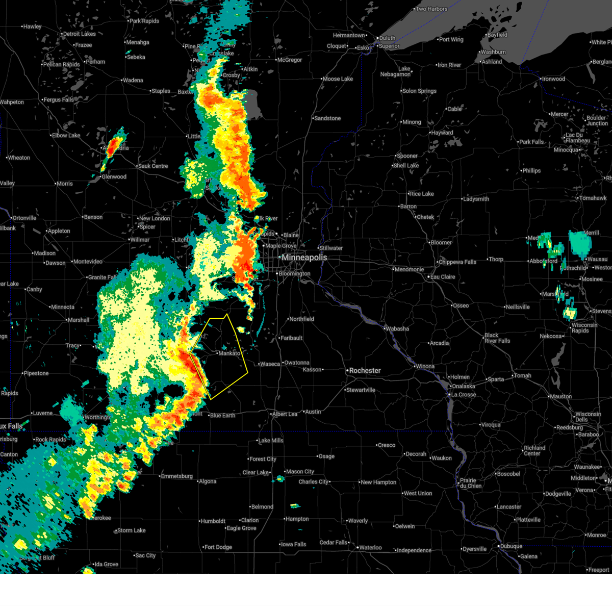
| 6/2/2020 6:05 PM CDT |
 At 605 pm cdt, severe thunderstorms were located along a line extending from near good thunder to 6 miles southwest of winnebago, moving east at 45 mph (radar indicated). Hazards include 60 mph wind gusts and half dollar size hail. Hail damage to vehicles is expected. expect wind damage to roofs, siding, and trees. Locations impacted include, fairmont, blue earth, mapleton, winnebago, truman, minnesota lake, amboy, vernon center, lewisville, easton, delavan and granada. At 605 pm cdt, severe thunderstorms were located along a line extending from near good thunder to 6 miles southwest of winnebago, moving east at 45 mph (radar indicated). Hazards include 60 mph wind gusts and half dollar size hail. Hail damage to vehicles is expected. expect wind damage to roofs, siding, and trees. Locations impacted include, fairmont, blue earth, mapleton, winnebago, truman, minnesota lake, amboy, vernon center, lewisville, easton, delavan and granada.
|
| 6/2/2020 5:50 PM CDT | Quarter sized hail reported 9.4 miles WSW of Mapleton, MN |
| 6/2/2020 5:50 PM CDT | Report of downed tree branches across the road. some larger than 12 inch in diamete in blue earth county MN, 9.4 miles WSW of Mapleton, MN |
| 6/2/2020 5:42 PM CDT |
 At 542 pm cdt, severe thunderstorms were located along a line extending from near lake crystal to near trimont, moving east at 45 mph (radar indicated). Hazards include golf ball size hail and 60 mph wind gusts. People and animals outdoors will be injured. expect hail damage to roofs, siding, windows, and vehicles. Expect wind damage to roofs, siding, and trees. At 542 pm cdt, severe thunderstorms were located along a line extending from near lake crystal to near trimont, moving east at 45 mph (radar indicated). Hazards include golf ball size hail and 60 mph wind gusts. People and animals outdoors will be injured. expect hail damage to roofs, siding, windows, and vehicles. Expect wind damage to roofs, siding, and trees.
|
| 6/2/2020 5:30 PM CDT |
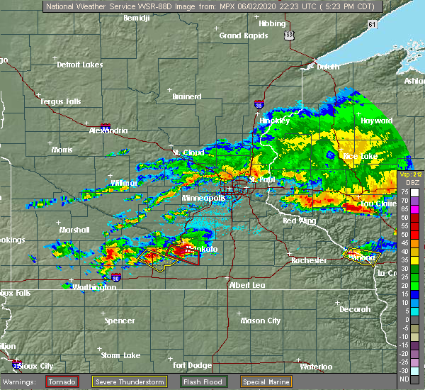 At 529 pm cdt, a confirmed tornado was located northeast of mapleton, or 15 miles southeast of mankato, moving southeast at 30 mph (weather spotters confirmed tornado). Hazards include damaging tornado and three inch hail. Flying debris will be dangerous to those caught without shelter. mobile homes will be damaged or destroyed. damage to roofs, windows, and vehicles will occur. tree damage is likely. This tornadic thunderstorm will remain over mainly rural areas of southeastern blue earth county. At 529 pm cdt, a confirmed tornado was located northeast of mapleton, or 15 miles southeast of mankato, moving southeast at 30 mph (weather spotters confirmed tornado). Hazards include damaging tornado and three inch hail. Flying debris will be dangerous to those caught without shelter. mobile homes will be damaged or destroyed. damage to roofs, windows, and vehicles will occur. tree damage is likely. This tornadic thunderstorm will remain over mainly rural areas of southeastern blue earth county.
|
| 6/2/2020 5:09 PM CDT |
 At 509 pm cdt, a confirmed tornado was located over good thunder, or 9 miles southwest of mankato, moving southeast at 30 mph (weather spotters confirmed tornado). Hazards include damaging tornado and hail up to three inches in diameter. Flying debris will be dangerous to those caught without shelter. mobile homes will be damaged or destroyed. damage to roofs, windows, and vehicles will occur. tree damage is likely. the tornado will be near, mapleton around 530 pm cdt. pemberton around 540 pm cdt. other locations impacted by this tornadic thunderstorm include garden city. this includes u. s. Highway 169 between mile markers 35 and 46. At 509 pm cdt, a confirmed tornado was located over good thunder, or 9 miles southwest of mankato, moving southeast at 30 mph (weather spotters confirmed tornado). Hazards include damaging tornado and hail up to three inches in diameter. Flying debris will be dangerous to those caught without shelter. mobile homes will be damaged or destroyed. damage to roofs, windows, and vehicles will occur. tree damage is likely. the tornado will be near, mapleton around 530 pm cdt. pemberton around 540 pm cdt. other locations impacted by this tornadic thunderstorm include garden city. this includes u. s. Highway 169 between mile markers 35 and 46.
|
| 8/18/2019 12:44 AM CDT |
 At 1227 am cdt, severe thunderstorms were located along a line extending from lake crystal to near good thunder to near frost, moving east at 55 mph (radar indicated). Hazards include 60 mph wind gusts and quarter size hail. Hail damage to vehicles is expected. expect wind damage to roofs, siding, and trees. locations impacted include, mankato, north mankato, blue earth, lake crystal, eagle lake, mapleton, winnebago, st. Clair, minnesota lake, elmore, good thunder and amboy. At 1227 am cdt, severe thunderstorms were located along a line extending from lake crystal to near good thunder to near frost, moving east at 55 mph (radar indicated). Hazards include 60 mph wind gusts and quarter size hail. Hail damage to vehicles is expected. expect wind damage to roofs, siding, and trees. locations impacted include, mankato, north mankato, blue earth, lake crystal, eagle lake, mapleton, winnebago, st. Clair, minnesota lake, elmore, good thunder and amboy.
|
| 8/18/2019 12:33 AM CDT | Tree damage in mapleton and damage to transformer - delayed report... time estimated from rada in blue earth county MN, 0.5 miles SE of Mapleton, MN |
| 8/18/2019 12:27 AM CDT |
 At 1227 am cdt, severe thunderstorms were located along a line extending from lake crystal to near good thunder to near frost, moving east at 55 mph (radar indicated). Hazards include 60 mph wind gusts and quarter size hail. Hail damage to vehicles is expected. expect wind damage to roofs, siding, and trees. locations impacted include, mankato, north mankato, blue earth, lake crystal, eagle lake, mapleton, winnebago, st. Clair, minnesota lake, elmore, good thunder and amboy. At 1227 am cdt, severe thunderstorms were located along a line extending from lake crystal to near good thunder to near frost, moving east at 55 mph (radar indicated). Hazards include 60 mph wind gusts and quarter size hail. Hail damage to vehicles is expected. expect wind damage to roofs, siding, and trees. locations impacted include, mankato, north mankato, blue earth, lake crystal, eagle lake, mapleton, winnebago, st. Clair, minnesota lake, elmore, good thunder and amboy.
|
| 8/18/2019 12:03 AM CDT |
 The national weather service in the twin cities has issued a * severe thunderstorm warning for. faribault county in south central minnesota. blue earth county in south central minnesota. until 100 am cdt. At 1203 am cdt, a severe thunderstorm was located over truman, or. The national weather service in the twin cities has issued a * severe thunderstorm warning for. faribault county in south central minnesota. blue earth county in south central minnesota. until 100 am cdt. At 1203 am cdt, a severe thunderstorm was located over truman, or.
|
| 7/20/2019 10:28 AM CDT |
 At 1027 am cdt, a severe thunderstorm was located near minnesota lake, or 20 miles southeast of mankato, moving east at 65 mph. at 1007 am a wind gust of 64 mph was measured at the fairmont airport. additionally, a trained spotter in winnebago reported wind gusts around 60 mph (radar indicated). Hazards include 60 mph wind gusts and penny size hail. Expect damage to roofs, siding, and trees. locations impacted include, mankato, fairmont, north mankato, blue earth, lake crystal, eagle lake, wells, janesville, mapleton, winnebago, madison lake and st. Clair. At 1027 am cdt, a severe thunderstorm was located near minnesota lake, or 20 miles southeast of mankato, moving east at 65 mph. at 1007 am a wind gust of 64 mph was measured at the fairmont airport. additionally, a trained spotter in winnebago reported wind gusts around 60 mph (radar indicated). Hazards include 60 mph wind gusts and penny size hail. Expect damage to roofs, siding, and trees. locations impacted include, mankato, fairmont, north mankato, blue earth, lake crystal, eagle lake, wells, janesville, mapleton, winnebago, madison lake and st. Clair.
|
| 7/20/2019 10:01 AM CDT |
 At 1000 am cdt, a severe thunderstorm was located near lewisville, or 21 miles north of fairmont, moving east at 65 mph (radar indicated). Hazards include 60 mph wind gusts and penny size hail. expect damage to roofs, siding, and trees At 1000 am cdt, a severe thunderstorm was located near lewisville, or 21 miles north of fairmont, moving east at 65 mph (radar indicated). Hazards include 60 mph wind gusts and penny size hail. expect damage to roofs, siding, and trees
|
| 7/18/2019 10:00 PM CDT |
 At 1000 pm cdt, a severe thunderstorm was located over good thunder, or 10 miles south of mankato, moving east at 20 mph (radar indicated). Hazards include ping pong ball size hail and 60 mph wind gusts. People and animals outdoors will be injured. expect hail damage to roofs, siding, windows, and vehicles. expect wind damage to roofs, siding, and trees. this severe thunderstorm will be near, mapleton around 1015 pm cdt. st. clair around 1030 pm cdt. Pemberton around 1040 pm cdt. At 1000 pm cdt, a severe thunderstorm was located over good thunder, or 10 miles south of mankato, moving east at 20 mph (radar indicated). Hazards include ping pong ball size hail and 60 mph wind gusts. People and animals outdoors will be injured. expect hail damage to roofs, siding, windows, and vehicles. expect wind damage to roofs, siding, and trees. this severe thunderstorm will be near, mapleton around 1015 pm cdt. st. clair around 1030 pm cdt. Pemberton around 1040 pm cdt.
|
| 7/18/2019 5:59 PM CDT |
 The national weather service in the twin cities has issued a * severe thunderstorm warning for. northeastern faribault county in south central minnesota. southeastern blue earth county in south central minnesota. southwestern waseca county in south central minnesota. Until 630 pm cdt. The national weather service in the twin cities has issued a * severe thunderstorm warning for. northeastern faribault county in south central minnesota. southeastern blue earth county in south central minnesota. southwestern waseca county in south central minnesota. Until 630 pm cdt.
|
| 7/15/2019 10:27 PM CDT |
 The severe thunderstorm warning for central blue earth and west central waseca counties will expire at 1030 pm cdt, the storms which prompted the warning have weakened below severe limits, and no longer pose an immediate threat to life or property. therefore, the warning will be allowed to expire. however heavy rain is still possible with these thunderstorms. to report severe weather, contact your nearest law enforcement agency. they will relay your report to the national weather service the twin cities. The severe thunderstorm warning for central blue earth and west central waseca counties will expire at 1030 pm cdt, the storms which prompted the warning have weakened below severe limits, and no longer pose an immediate threat to life or property. therefore, the warning will be allowed to expire. however heavy rain is still possible with these thunderstorms. to report severe weather, contact your nearest law enforcement agency. they will relay your report to the national weather service the twin cities.
|
| 7/15/2019 10:05 PM CDT |
 At 1004 pm cdt, severe thunderstorms were located along a line extending from st. clair to near vernon center, moving south at 25 mph (radar indicated). Hazards include 60 mph wind gusts and penny size hail. Expect damage to roofs, siding, and trees. locations impacted include, mankato, mapleton, st. Clair, good thunder, amboy, vernon center, pemberton, garden city and alma city. At 1004 pm cdt, severe thunderstorms were located along a line extending from st. clair to near vernon center, moving south at 25 mph (radar indicated). Hazards include 60 mph wind gusts and penny size hail. Expect damage to roofs, siding, and trees. locations impacted include, mankato, mapleton, st. Clair, good thunder, amboy, vernon center, pemberton, garden city and alma city.
|
| 7/15/2019 9:50 PM CDT |
 At 949 pm cdt, severe thunderstorms were located along a line extending from eagle lake to lake crystal, moving south at 25 mph (radar indicated). Hazards include 60 mph wind gusts and penny size hail. expect damage to roofs, siding, and trees At 949 pm cdt, severe thunderstorms were located along a line extending from eagle lake to lake crystal, moving south at 25 mph (radar indicated). Hazards include 60 mph wind gusts and penny size hail. expect damage to roofs, siding, and trees
|
| 7/1/2019 4:52 PM CDT |
 At 452 pm cdt, severe thunderstorms were located along a line extending from near mankato to st. clair to near minnesota lake, moving east at 40 mph (radar indicated). Hazards include 60 mph wind gusts. Expect damage to roofs, siding, and trees. these severe storms will be near, madison lake and pemberton around 500 pm cdt. Other locations impacted by these severe thunderstorms include mankato airport and skyline. At 452 pm cdt, severe thunderstorms were located along a line extending from near mankato to st. clair to near minnesota lake, moving east at 40 mph (radar indicated). Hazards include 60 mph wind gusts. Expect damage to roofs, siding, and trees. these severe storms will be near, madison lake and pemberton around 500 pm cdt. Other locations impacted by these severe thunderstorms include mankato airport and skyline.
|
| 7/1/2019 4:36 PM CDT |
 At 436 pm cdt, severe thunderstorms were located along a line extending from near lake crystal to near good thunder to near amboy, moving east at 40 mph (radar indicated). Hazards include 60 mph wind gusts. Expect damage to roofs, siding, and trees. these severe storms will be near, mankato around 440 pm cdt. mapleton around 445 pm cdt. st. clair and pemberton around 455 pm cdt. eagle lake and madison lake around 500 pm cdt. Other locations impacted by these severe thunderstorms include skyline, garden city, mankato airport and judson. At 436 pm cdt, severe thunderstorms were located along a line extending from near lake crystal to near good thunder to near amboy, moving east at 40 mph (radar indicated). Hazards include 60 mph wind gusts. Expect damage to roofs, siding, and trees. these severe storms will be near, mankato around 440 pm cdt. mapleton around 445 pm cdt. st. clair and pemberton around 455 pm cdt. eagle lake and madison lake around 500 pm cdt. Other locations impacted by these severe thunderstorms include skyline, garden city, mankato airport and judson.
|
| 7/1/2019 4:21 PM CDT |
 At 420 pm cdt, severe thunderstorms were located along a line extending from near hanska to near lake crystal to near amboy, moving east at 40 mph (radar indicated. at 414 pm, a wind gust of 55 mph was measured in madelia). Hazards include 60 mph wind gusts. Expect damage to roofs, siding, and trees. severe thunderstorms will be near, amboy and vernon center around 425 pm cdt. lake crystal and good thunder around 435 pm cdt. mankato around 440 pm cdt. mapleton around 445 pm cdt. st. clair around 455 pm cdt. Eagle lake, madison lake and pemberton around 500 pm cdt. At 420 pm cdt, severe thunderstorms were located along a line extending from near hanska to near lake crystal to near amboy, moving east at 40 mph (radar indicated. at 414 pm, a wind gust of 55 mph was measured in madelia). Hazards include 60 mph wind gusts. Expect damage to roofs, siding, and trees. severe thunderstorms will be near, amboy and vernon center around 425 pm cdt. lake crystal and good thunder around 435 pm cdt. mankato around 440 pm cdt. mapleton around 445 pm cdt. st. clair around 455 pm cdt. Eagle lake, madison lake and pemberton around 500 pm cdt.
|
| 6/15/2019 2:20 PM CDT | Large tree limb down... damaging a camper and a truc in blue earth county MN, 0.4 miles SSW of Mapleton, MN |
| 9/20/2018 6:07 PM CDT |
 At 607 pm cdt, severe thunderstorms were located along a line extending from 6 miles east of lewisville to near amboy to near blue earth to near elmore, moving northeast at 65 mph. these are very dangerous storms (radar indicated). Hazards include 80 mph wind gusts. Flying debris will be dangerous to those caught without shelter. mobile homes will be heavily damaged. expect considerable damage to roofs, windows, and vehicles. extensive tree damage and power outages are likely. these severe storms will be near, mapleton and easton around 615 pm cdt. minnesota lake and good thunder around 620 pm cdt. mankato and pemberton around 625 pm cdt. eagle lake, wells, janesville, st. clair and waldorf around 630 pm cdt. madison lake around 635 pm cdt. elysian around 640 pm cdt. A tornado watch remains in effect until 1100 pm cdt for south central minnesota. At 607 pm cdt, severe thunderstorms were located along a line extending from 6 miles east of lewisville to near amboy to near blue earth to near elmore, moving northeast at 65 mph. these are very dangerous storms (radar indicated). Hazards include 80 mph wind gusts. Flying debris will be dangerous to those caught without shelter. mobile homes will be heavily damaged. expect considerable damage to roofs, windows, and vehicles. extensive tree damage and power outages are likely. these severe storms will be near, mapleton and easton around 615 pm cdt. minnesota lake and good thunder around 620 pm cdt. mankato and pemberton around 625 pm cdt. eagle lake, wells, janesville, st. clair and waldorf around 630 pm cdt. madison lake around 635 pm cdt. elysian around 640 pm cdt. A tornado watch remains in effect until 1100 pm cdt for south central minnesota.
|
| 9/20/2018 5:59 PM CDT |
 At 559 pm cdt, severe thunderstorms were located along a line extending from truman to near huntley to near ledyard, moving northeast at 70 mph. these are very dangerous storms (radar indicated). Hazards include 80 mph wind gusts. Flying debris will be dangerous to those caught without shelter. mobile homes will be heavily damaged. expect considerable damage to roofs, windows, and vehicles. extensive tree damage and power outages are likely. severe thunderstorms will be near, amboy and vernon center around 610 pm cdt. lake crystal, mapleton, good thunder and frost around 615 pm cdt. mankato, easton and delavan around 620 pm cdt. wells, st. clair, minnesota lake and pemberton around 625 pm cdt. eagle lake, janesville and madison lake around 630 pm cdt. elysian and waldorf around 635 pm cdt. other locations impacted by these severe thunderstorms include kiester, skyline, alma city, mankato airport, matawan, baroda, brush creek, walters, garden city and smiths mill. A tornado watch remains in effect until 1100 pm cdt for south central minnesota. At 559 pm cdt, severe thunderstorms were located along a line extending from truman to near huntley to near ledyard, moving northeast at 70 mph. these are very dangerous storms (radar indicated). Hazards include 80 mph wind gusts. Flying debris will be dangerous to those caught without shelter. mobile homes will be heavily damaged. expect considerable damage to roofs, windows, and vehicles. extensive tree damage and power outages are likely. severe thunderstorms will be near, amboy and vernon center around 610 pm cdt. lake crystal, mapleton, good thunder and frost around 615 pm cdt. mankato, easton and delavan around 620 pm cdt. wells, st. clair, minnesota lake and pemberton around 625 pm cdt. eagle lake, janesville and madison lake around 630 pm cdt. elysian and waldorf around 635 pm cdt. other locations impacted by these severe thunderstorms include kiester, skyline, alma city, mankato airport, matawan, baroda, brush creek, walters, garden city and smiths mill. A tornado watch remains in effect until 1100 pm cdt for south central minnesota.
|
| 9/17/2018 4:27 PM CDT |
 The severe thunderstorm warning for eastern sibley, southeastern brown, blue earth, northern watonwan and nicollet counties will expire at 430 pm cdt, the severe thunderstorm which prompted the warning has weakened. therefore, the warning will be allowed to expire. The severe thunderstorm warning for eastern sibley, southeastern brown, blue earth, northern watonwan and nicollet counties will expire at 430 pm cdt, the severe thunderstorm which prompted the warning has weakened. therefore, the warning will be allowed to expire.
|
| 9/17/2018 4:21 PM CDT |
 At 420 pm cdt, a severe thunderstorm was located over st. peter, or 12 miles north of mankato, moving east at 60 mph (radar indicated). Hazards include 60 mph wind gusts. Expect damage to roofs, siding, and trees. locations impacted include, mankato, north mankato, st. peter, st. James, lake crystal, madelia, gaylord, arlington, mapleton, nicollet, henderson and courtland. At 420 pm cdt, a severe thunderstorm was located over st. peter, or 12 miles north of mankato, moving east at 60 mph (radar indicated). Hazards include 60 mph wind gusts. Expect damage to roofs, siding, and trees. locations impacted include, mankato, north mankato, st. peter, st. James, lake crystal, madelia, gaylord, arlington, mapleton, nicollet, henderson and courtland.
|
| 9/17/2018 4:13 PM CDT |
 At 411 pm cdt, a severe thunderstorm was located near nicollet, or 13 miles east of new ulm, moving east at 60 mph (wind gust of 59 mph observed at new ulm. otherwise, radar indicated). Hazards include 60 mph wind gusts. Expect damage to roofs, siding, and trees. locations impacted include, mankato, new ulm, north mankato, st. peter, st. James, lake crystal, madelia, gaylord, arlington, mapleton, winthrop and nicollet. At 411 pm cdt, a severe thunderstorm was located near nicollet, or 13 miles east of new ulm, moving east at 60 mph (wind gust of 59 mph observed at new ulm. otherwise, radar indicated). Hazards include 60 mph wind gusts. Expect damage to roofs, siding, and trees. locations impacted include, mankato, new ulm, north mankato, st. peter, st. James, lake crystal, madelia, gaylord, arlington, mapleton, winthrop and nicollet.
|
| 9/17/2018 4:03 PM CDT |
 At 403 pm cdt, a severe thunderstorm was located near courtland, or near new ulm, moving east at 55 mph (radar indicated). Hazards include 60 mph wind gusts. expect damage to roofs, siding, and trees At 403 pm cdt, a severe thunderstorm was located near courtland, or near new ulm, moving east at 55 mph (radar indicated). Hazards include 60 mph wind gusts. expect damage to roofs, siding, and trees
|
| 8/31/2018 6:10 AM CDT |
 At 609 am cdt, severe thunderstorms were located along a line extending from near janesville to near pemberton, moving east at 30 mph (radar indicated). Hazards include half dollar size hail. Damage to vehicles is expected. severe thunderstorms will be near, waseca around 645 am cdt. Medford around 650 am cdt. At 609 am cdt, severe thunderstorms were located along a line extending from near janesville to near pemberton, moving east at 30 mph (radar indicated). Hazards include half dollar size hail. Damage to vehicles is expected. severe thunderstorms will be near, waseca around 645 am cdt. Medford around 650 am cdt.
|
| 8/27/2018 4:22 PM CDT |
 At 422 pm cdt, severe thunderstorms were located along a line extending from oshawa to near st. clair, moving northeast at 55 mph (radar indicated). Hazards include 70 mph wind gusts and quarter size hail. Hail damage to vehicles is expected. expect considerable tree damage. wind damage is also likely to mobile homes, roofs, and outbuildings. these severe storms will be near, janesville around 425 pm cdt. madison lake around 430 pm cdt. elysian around 435 pm cdt. Other locations impacted by these severe thunderstorms include skyline, alma city, garden city, mankato airport, smiths mill and judson. At 422 pm cdt, severe thunderstorms were located along a line extending from oshawa to near st. clair, moving northeast at 55 mph (radar indicated). Hazards include 70 mph wind gusts and quarter size hail. Hail damage to vehicles is expected. expect considerable tree damage. wind damage is also likely to mobile homes, roofs, and outbuildings. these severe storms will be near, janesville around 425 pm cdt. madison lake around 430 pm cdt. elysian around 435 pm cdt. Other locations impacted by these severe thunderstorms include skyline, alma city, garden city, mankato airport, smiths mill and judson.
|
| 8/27/2018 4:04 PM CDT |
 At 403 pm cdt, severe thunderstorms were located along a line extending from near lake crystal to near mapleton, moving northeast at 55 mph (public). Hazards include 70 mph wind gusts and quarter size hail. Hail damage to vehicles is expected. expect considerable tree damage. wind damage is also likely to mobile homes, roofs, and outbuildings. these severe storms will be near, nicollet around 415 pm cdt. st. clair and pemberton around 420 pm cdt. eagle lake, janesville and madison lake around 425 pm cdt. elysian around 430 pm cdt. Other locations impacted by these severe thunderstorms include skyline, alma city, garden city, mankato airport, smiths mill and judson. At 403 pm cdt, severe thunderstorms were located along a line extending from near lake crystal to near mapleton, moving northeast at 55 mph (public). Hazards include 70 mph wind gusts and quarter size hail. Hail damage to vehicles is expected. expect considerable tree damage. wind damage is also likely to mobile homes, roofs, and outbuildings. these severe storms will be near, nicollet around 415 pm cdt. st. clair and pemberton around 420 pm cdt. eagle lake, janesville and madison lake around 425 pm cdt. elysian around 430 pm cdt. Other locations impacted by these severe thunderstorms include skyline, alma city, garden city, mankato airport, smiths mill and judson.
|
| 8/27/2018 3:52 PM CDT |
 At 352 pm cdt, severe thunderstorms were located along a line extending from madelia to near winnebago, moving northeast at 55 mph (radar indicated). Hazards include 60 mph wind gusts. Expect damage to roofs, siding, and trees. severe thunderstorms will be near, lake crystal, mapleton and good thunder around 405 pm cdt. nicollet and pemberton around 415 pm cdt. eagle lake and st. clair around 420 pm cdt. janesville and madison lake around 425 pm cdt. Elysian around 430 pm cdt. At 352 pm cdt, severe thunderstorms were located along a line extending from madelia to near winnebago, moving northeast at 55 mph (radar indicated). Hazards include 60 mph wind gusts. Expect damage to roofs, siding, and trees. severe thunderstorms will be near, lake crystal, mapleton and good thunder around 405 pm cdt. nicollet and pemberton around 415 pm cdt. eagle lake and st. clair around 420 pm cdt. janesville and madison lake around 425 pm cdt. Elysian around 430 pm cdt.
|
| 7/19/2017 3:55 PM CDT | Storm damage reported in blue earth county MN, 3.9 miles S of Mapleton, MN |
| 7/19/2017 3:34 PM CDT |
 At 333 pm cdt, severe thunderstorms were located along a line extending from near nicollet to near skyline to near amboy, moving east at 60 mph (radar indicated). Hazards include 60 mph wind gusts and penny size hail. Expect damage to roofs, siding, and trees. these severe storms will be near, st. clair around 340 pm cdt. eagle lake, madison lake and pemberton around 345 pm cdt. Other locations impacted by these severe thunderstorms include skyline, garden city, mankato airport and judson. At 333 pm cdt, severe thunderstorms were located along a line extending from near nicollet to near skyline to near amboy, moving east at 60 mph (radar indicated). Hazards include 60 mph wind gusts and penny size hail. Expect damage to roofs, siding, and trees. these severe storms will be near, st. clair around 340 pm cdt. eagle lake, madison lake and pemberton around 345 pm cdt. Other locations impacted by these severe thunderstorms include skyline, garden city, mankato airport and judson.
|
| 7/19/2017 3:24 PM CDT |
 At 324 pm cdt, severe thunderstorms were located along a line extending from near courtland to near garden city to 6 miles west of amboy, moving east at 60 mph (radar indicated). Hazards include 60 mph wind gusts and penny size hail. Expect damage to roofs, siding, and trees. these severe storms will be near, mankato and good thunder around 330 pm cdt. mapleton, st. clair and pemberton around 340 pm cdt. eagle lake and madison lake around 345 pm cdt. Other locations impacted by these severe thunderstorms include skyline, garden city, searles, mankato airport and judson. At 324 pm cdt, severe thunderstorms were located along a line extending from near courtland to near garden city to 6 miles west of amboy, moving east at 60 mph (radar indicated). Hazards include 60 mph wind gusts and penny size hail. Expect damage to roofs, siding, and trees. these severe storms will be near, mankato and good thunder around 330 pm cdt. mapleton, st. clair and pemberton around 340 pm cdt. eagle lake and madison lake around 345 pm cdt. Other locations impacted by these severe thunderstorms include skyline, garden city, searles, mankato airport and judson.
|
| 7/19/2017 3:11 PM CDT |
 At 310 pm cdt, severe thunderstorms were located along a line extending from near new ulm airport to near madelia to south branch, moving east at 60 mph (radar indicated). Hazards include 60 mph wind gusts and penny size hail. Expect damage to roofs, siding, and trees. severe thunderstorms will be near, lake crystal around 320 pm cdt. mankato, good thunder, amboy and vernon center around 330 pm cdt. mapleton, st. clair and pemberton around 340 pm cdt. eagle lake and madison lake around 345 pm cdt. Other locations impacted by these severe thunderstorms include skyline, garden city, searles, mankato airport, judson and south branch. At 310 pm cdt, severe thunderstorms were located along a line extending from near new ulm airport to near madelia to south branch, moving east at 60 mph (radar indicated). Hazards include 60 mph wind gusts and penny size hail. Expect damage to roofs, siding, and trees. severe thunderstorms will be near, lake crystal around 320 pm cdt. mankato, good thunder, amboy and vernon center around 330 pm cdt. mapleton, st. clair and pemberton around 340 pm cdt. eagle lake and madison lake around 345 pm cdt. Other locations impacted by these severe thunderstorms include skyline, garden city, searles, mankato airport, judson and south branch.
|
| 7/10/2017 12:25 AM CDT |
 At 1224 am cdt, severe thunderstorms were located along a line extending from near waldorf to near easton to guckeen, moving southeast at 50 mph (radar indicated). Hazards include 60 mph wind gusts and quarter size hail. Hail damage to vehicles is expected. expect wind damage to roofs, siding, and trees. A tornado watch remains in effect until 100 am cdt for south central minnesota. At 1224 am cdt, severe thunderstorms were located along a line extending from near waldorf to near easton to guckeen, moving southeast at 50 mph (radar indicated). Hazards include 60 mph wind gusts and quarter size hail. Hail damage to vehicles is expected. expect wind damage to roofs, siding, and trees. A tornado watch remains in effect until 100 am cdt for south central minnesota.
|
| 7/10/2017 12:05 AM CDT |
 At 1205 am cdt, severe thunderstorms were located along a line extending from st. clair to near amboy to near truman, moving southeast at 50 mph (radar indicated). Hazards include 60 mph wind gusts and quarter size hail. Hail damage to vehicles is expected. expect wind damage to roofs, siding, and trees. severe thunderstorms will be near, mapleton around 1215 am cdt. winnebago and delavan around 1220 am cdt. minnesota lake and easton around 1225 am cdt. blue earth and wells around 1230 am cdt. other locations impacted by these severe thunderstorms include huntley and brush creek. this includes the following highways, interstate 90 between mile markers 116 and 135. u. s. highway 169 between mile markers 6 and 35. A tornado watch remains in effect until 100 am cdt for south central minnesota. At 1205 am cdt, severe thunderstorms were located along a line extending from st. clair to near amboy to near truman, moving southeast at 50 mph (radar indicated). Hazards include 60 mph wind gusts and quarter size hail. Hail damage to vehicles is expected. expect wind damage to roofs, siding, and trees. severe thunderstorms will be near, mapleton around 1215 am cdt. winnebago and delavan around 1220 am cdt. minnesota lake and easton around 1225 am cdt. blue earth and wells around 1230 am cdt. other locations impacted by these severe thunderstorms include huntley and brush creek. this includes the following highways, interstate 90 between mile markers 116 and 135. u. s. highway 169 between mile markers 6 and 35. A tornado watch remains in effect until 100 am cdt for south central minnesota.
|
| 7/9/2017 11:22 PM CDT |
 At 1122 pm cdt, a severe thunderstorm was located over mapleton, or 16 miles south of mankato, moving southeast at 25 mph (radar indicated). Hazards include 60 mph wind gusts and quarter size hail. Hail damage to vehicles is expected. expect wind damage to roofs, siding, and trees. this severe thunderstorm will remain over mainly rural areas of southeastern blue earth county. A tornado watch remains in effect until 100 am cdt for south central minnesota. At 1122 pm cdt, a severe thunderstorm was located over mapleton, or 16 miles south of mankato, moving southeast at 25 mph (radar indicated). Hazards include 60 mph wind gusts and quarter size hail. Hail damage to vehicles is expected. expect wind damage to roofs, siding, and trees. this severe thunderstorm will remain over mainly rural areas of southeastern blue earth county. A tornado watch remains in effect until 100 am cdt for south central minnesota.
|
| 7/9/2017 11:05 PM CDT |
 At 1105 pm cdt, a severe thunderstorm was located near good thunder, or 10 miles south of mankato, moving southeast at 25 mph (radar indicated). Hazards include 60 mph wind gusts and quarter size hail. Hail damage to vehicles is expected. expect wind damage to roofs, siding, and trees. this severe thunderstorm will be near, mapleton around 1120 pm cdt. A tornado watch remains in effect until 100 am cdt for south central minnesota. At 1105 pm cdt, a severe thunderstorm was located near good thunder, or 10 miles south of mankato, moving southeast at 25 mph (radar indicated). Hazards include 60 mph wind gusts and quarter size hail. Hail damage to vehicles is expected. expect wind damage to roofs, siding, and trees. this severe thunderstorm will be near, mapleton around 1120 pm cdt. A tornado watch remains in effect until 100 am cdt for south central minnesota.
|
| 6/16/2017 4:24 PM CDT |
 At 423 pm cdt, a severe thunderstorm was located over minnesota lake, or 22 miles south of mankato, moving northeast at 35 mph (radar indicated). Hazards include 60 mph wind gusts and quarter size hail. Hail damage to vehicles is expected. expect wind damage to roofs, siding, and trees. This severe thunderstorm will remain over mainly rural areas of northeastern faribault and southeastern blue earth counties. At 423 pm cdt, a severe thunderstorm was located over minnesota lake, or 22 miles south of mankato, moving northeast at 35 mph (radar indicated). Hazards include 60 mph wind gusts and quarter size hail. Hail damage to vehicles is expected. expect wind damage to roofs, siding, and trees. This severe thunderstorm will remain over mainly rural areas of northeastern faribault and southeastern blue earth counties.
|
| 6/16/2017 4:11 PM CDT |
 At 411 pm cdt, a severe thunderstorm was located near vernon center, or 16 miles south of mankato, moving northeast at 35 mph (radar indicated). Hazards include ping pong ball size hail and 60 mph wind gusts. People and animals outdoors will be injured. expect hail damage to roofs, siding, windows, and vehicles. expect wind damage to roofs, siding, and trees. this severe storm will be near, good thunder around 415 pm cdt. mapleton around 420 pm cdt. st. Clair and pemberton around 440 pm cdt. At 411 pm cdt, a severe thunderstorm was located near vernon center, or 16 miles south of mankato, moving northeast at 35 mph (radar indicated). Hazards include ping pong ball size hail and 60 mph wind gusts. People and animals outdoors will be injured. expect hail damage to roofs, siding, windows, and vehicles. expect wind damage to roofs, siding, and trees. this severe storm will be near, good thunder around 415 pm cdt. mapleton around 420 pm cdt. st. Clair and pemberton around 440 pm cdt.
|
| 6/16/2017 4:02 PM CDT |
 At 402 pm cdt, a severe thunderstorm was located over amboy, or 21 miles southwest of mankato, moving east at 40 mph (radar indicated). Hazards include ping pong ball size hail and 60 mph wind gusts. People and animals outdoors will be injured. expect hail damage to roofs, siding, windows, and vehicles. expect wind damage to roofs, siding, and trees. this severe storm will be near, vernon center around 405 pm cdt. good thunder around 415 pm cdt. mapleton around 420 pm cdt. st. Clair and pemberton around 435 pm cdt. At 402 pm cdt, a severe thunderstorm was located over amboy, or 21 miles southwest of mankato, moving east at 40 mph (radar indicated). Hazards include ping pong ball size hail and 60 mph wind gusts. People and animals outdoors will be injured. expect hail damage to roofs, siding, windows, and vehicles. expect wind damage to roofs, siding, and trees. this severe storm will be near, vernon center around 405 pm cdt. good thunder around 415 pm cdt. mapleton around 420 pm cdt. st. Clair and pemberton around 435 pm cdt.
|
| 6/16/2017 3:48 PM CDT |
 At 348 pm cdt, a severe thunderstorm was located near truman, or 14 miles north of fairmont, moving east at 35 mph (radar indicated). Hazards include ping pong ball size hail and 60 mph wind gusts. People and animals outdoors will be injured. expect hail damage to roofs, siding, windows, and vehicles. expect wind damage to roofs, siding, and trees. this severe thunderstorm will be near, winnebago around 400 pm cdt. amboy and vernon center around 405 pm cdt. mapleton around 425 pm cdt. minnesota lake around 430 pm cdt. pemberton around 440 pm cdt. this includes u. s. Highway 169 between mile markers 19 and 35. At 348 pm cdt, a severe thunderstorm was located near truman, or 14 miles north of fairmont, moving east at 35 mph (radar indicated). Hazards include ping pong ball size hail and 60 mph wind gusts. People and animals outdoors will be injured. expect hail damage to roofs, siding, windows, and vehicles. expect wind damage to roofs, siding, and trees. this severe thunderstorm will be near, winnebago around 400 pm cdt. amboy and vernon center around 405 pm cdt. mapleton around 425 pm cdt. minnesota lake around 430 pm cdt. pemberton around 440 pm cdt. this includes u. s. Highway 169 between mile markers 19 and 35.
|
| 6/12/2017 1:19 PM CDT |
 At 118 pm cdt, severe thunderstorms were located along a line extending from near smiths mill to near alma city to near minnesota lake, moving northeast at 40 mph (radar indicated). Hazards include 60 mph wind gusts and penny size hail. Expect damage to roofs, siding, and trees. locations impacted include, mankato, janesville, mapleton, st. Clair, pemberton, waldorf, otisco, skyline, alma city and smiths mill. At 118 pm cdt, severe thunderstorms were located along a line extending from near smiths mill to near alma city to near minnesota lake, moving northeast at 40 mph (radar indicated). Hazards include 60 mph wind gusts and penny size hail. Expect damage to roofs, siding, and trees. locations impacted include, mankato, janesville, mapleton, st. Clair, pemberton, waldorf, otisco, skyline, alma city and smiths mill.
|
| 6/12/2017 12:54 PM CDT |
 At 1254 pm cdt, a severe thunderstorm was located near mapleton, or 19 miles south of mankato, moving northeast at 45 mph (radar indicated). Hazards include 60 mph wind gusts and penny size hail. Expect damage to roofs, siding, and trees. this severe thunderstorm will be near, st. clair and pemberton around 115 pm cdt. janesville around 125 pm cdt. other locations impacted by this severe thunderstorm include otisco, alma city, garden city, smiths mill and skyline. this includes the following highways, u. s. highway 14 between mile markers 142 and 154, and between mile markers 156 and 157. u. s. Highway 169 between mile markers 26 and 46. At 1254 pm cdt, a severe thunderstorm was located near mapleton, or 19 miles south of mankato, moving northeast at 45 mph (radar indicated). Hazards include 60 mph wind gusts and penny size hail. Expect damage to roofs, siding, and trees. this severe thunderstorm will be near, st. clair and pemberton around 115 pm cdt. janesville around 125 pm cdt. other locations impacted by this severe thunderstorm include otisco, alma city, garden city, smiths mill and skyline. this includes the following highways, u. s. highway 14 between mile markers 142 and 154, and between mile markers 156 and 157. u. s. Highway 169 between mile markers 26 and 46.
|
| 5/15/2017 10:06 PM CDT |
 At 1006 pm cdt, a severe thunderstorm was located near mapleton, or 17 miles southeast of mankato, moving northeast at 45 mph (radar indicated). Hazards include half dollar size hail. Damage to vehicles is expected. this severe storm will be near, pemberton and waldorf around 1015 pm cdt. janesville around 1025 pm cdt. Other locations impacted by this severe thunderstorm include alma city. At 1006 pm cdt, a severe thunderstorm was located near mapleton, or 17 miles southeast of mankato, moving northeast at 45 mph (radar indicated). Hazards include half dollar size hail. Damage to vehicles is expected. this severe storm will be near, pemberton and waldorf around 1015 pm cdt. janesville around 1025 pm cdt. Other locations impacted by this severe thunderstorm include alma city.
|
| 5/15/2017 9:55 PM CDT |
 At 955 pm cdt, a severe thunderstorm was located near mapleton, or 19 miles south of mankato, moving northeast at 45 mph (radar indicated). Hazards include quarter size hail. Damage to vehicles is expected. this severe thunderstorm will be near, mapleton around 1000 pm cdt. pemberton and waldorf around 1015 pm cdt. janesville around 1025 pm cdt. other locations impacted by this severe thunderstorm include alma city. this includes the following highways, u. s. highway 14 between mile markers 146 and 147. u. s. Highway 169 near mile marker 27. At 955 pm cdt, a severe thunderstorm was located near mapleton, or 19 miles south of mankato, moving northeast at 45 mph (radar indicated). Hazards include quarter size hail. Damage to vehicles is expected. this severe thunderstorm will be near, mapleton around 1000 pm cdt. pemberton and waldorf around 1015 pm cdt. janesville around 1025 pm cdt. other locations impacted by this severe thunderstorm include alma city. this includes the following highways, u. s. highway 14 between mile markers 146 and 147. u. s. Highway 169 near mile marker 27.
|
| 8/16/2016 11:18 PM CDT |
 At 1118 pm cdt, severe thunderstorms were located along a line extending from near good thunder to mapleton to near winnebago, moving southeast at 25 mph (radar indicated). Hazards include 60 mph wind gusts and quarter size hail. Hail damage to vehicles is expected. expect wind damage to roofs, siding, and trees. These severe storms will be near, mapleton around 1125 pm cdt. At 1118 pm cdt, severe thunderstorms were located along a line extending from near good thunder to mapleton to near winnebago, moving southeast at 25 mph (radar indicated). Hazards include 60 mph wind gusts and quarter size hail. Hail damage to vehicles is expected. expect wind damage to roofs, siding, and trees. These severe storms will be near, mapleton around 1125 pm cdt.
|
| 8/16/2016 10:58 PM CDT |
 At 1058 pm cdt, a severe thunderstorm was located over garden city, or 11 miles southwest of mankato, moving southeast at 10 mph (radar indicated). Hazards include half dollar size hail. Damage to vehicles is expected. this severe thunderstorm will be near, vernon center around 1120 pm cdt. good thunder around 1130 pm cdt. mapleton around 1200 am cdt. other locations impacted by this severe thunderstorm include garden city. this includes u. s. Highway 169 between mile markers 15 and 48. At 1058 pm cdt, a severe thunderstorm was located over garden city, or 11 miles southwest of mankato, moving southeast at 10 mph (radar indicated). Hazards include half dollar size hail. Damage to vehicles is expected. this severe thunderstorm will be near, vernon center around 1120 pm cdt. good thunder around 1130 pm cdt. mapleton around 1200 am cdt. other locations impacted by this severe thunderstorm include garden city. this includes u. s. Highway 169 between mile markers 15 and 48.
|
| 7/13/2016 9:03 AM CDT |
 At 902 am cdt, severe thunderstorms were located along a line extending from near st. clair to near amboy to near truman, moving east at 40 mph (law enforcement). Hazards include 60 mph wind gusts and quarter size hail. Hail damage to vehicles is expected. expect wind damage to roofs, siding, and trees. these severe storms will be near, st. clair around 910 am cdt. mapleton and pemberton around 915 am cdt. Other locations impacted by these severe thunderstorms include skyline and garden city. At 902 am cdt, severe thunderstorms were located along a line extending from near st. clair to near amboy to near truman, moving east at 40 mph (law enforcement). Hazards include 60 mph wind gusts and quarter size hail. Hail damage to vehicles is expected. expect wind damage to roofs, siding, and trees. these severe storms will be near, st. clair around 910 am cdt. mapleton and pemberton around 915 am cdt. Other locations impacted by these severe thunderstorms include skyline and garden city.
|
| 7/13/2016 8:52 AM CDT |
 At 852 am cdt, severe thunderstorms were located along a line extending from near skyline to near vernon center to truman, moving east at 40 mph (law enforcement). Hazards include ping pong ball size hail and 60 mph wind gusts. People and animals outdoors will be injured. expect hail damage to roofs, siding, windows, and vehicles. expect wind damage to roofs, siding, and trees. these severe storms will be near, mankato and good thunder around 855 am cdt. amboy and vernon center around 900 am cdt. eagle lake around 905 am cdt. st. clair around 910 am cdt. mapleton, winnebago and pemberton around 915 am cdt. Other locations impacted by these severe thunderstorms include garden city, granada, northrop and skyline. At 852 am cdt, severe thunderstorms were located along a line extending from near skyline to near vernon center to truman, moving east at 40 mph (law enforcement). Hazards include ping pong ball size hail and 60 mph wind gusts. People and animals outdoors will be injured. expect hail damage to roofs, siding, windows, and vehicles. expect wind damage to roofs, siding, and trees. these severe storms will be near, mankato and good thunder around 855 am cdt. amboy and vernon center around 900 am cdt. eagle lake around 905 am cdt. st. clair around 910 am cdt. mapleton, winnebago and pemberton around 915 am cdt. Other locations impacted by these severe thunderstorms include garden city, granada, northrop and skyline.
|
| 7/13/2016 8:46 AM CDT |
 At 844 am cdt, severe thunderstorms were located along a line extending from near garden city to near lewisville to near south branch, moving east at 40 mph (law enforcement in watonwan county reported widespread tree damage in the st. james area). Hazards include ping pong ball size hail and 60 mph wind gusts. People and animals outdoors could be injured. expect hail damage to roofs, siding, windows, and vehicles. expect wind damage to roofs, siding, and trees. these severe storms will be near, lake crystal and good thunder around 850 am cdt. eagle lake, amboy and vernon center around 900 am cdt. st. clair around 905 am cdt. mapleton, winnebago, minnesota lake, pemberton and delavan around 915 am cdt. Other locations impacted by these severe thunderstorms include ormsby, garden city, granada, judson, northrop and skyline. At 844 am cdt, severe thunderstorms were located along a line extending from near garden city to near lewisville to near south branch, moving east at 40 mph (law enforcement in watonwan county reported widespread tree damage in the st. james area). Hazards include ping pong ball size hail and 60 mph wind gusts. People and animals outdoors could be injured. expect hail damage to roofs, siding, windows, and vehicles. expect wind damage to roofs, siding, and trees. these severe storms will be near, lake crystal and good thunder around 850 am cdt. eagle lake, amboy and vernon center around 900 am cdt. st. clair around 905 am cdt. mapleton, winnebago, minnesota lake, pemberton and delavan around 915 am cdt. Other locations impacted by these severe thunderstorms include ormsby, garden city, granada, judson, northrop and skyline.
|
| 7/13/2016 8:34 AM CDT |
 At 834 am cdt, severe thunderstorms were located along a line extending from lake crystal to near lewisville to near ormsby, moving east at 40 mph (radar indicated). Hazards include ping pong ball size hail and 60 mph wind gusts. People and animals outdoors will be injured. expect hail damage to roofs, siding, windows, and vehicles. expect wind damage to roofs, siding, and trees. severe thunderstorms will be near, lake crystal around 840 am cdt. mankato and good thunder around 850 am cdt. vernon center around 855 am cdt. eagle lake and amboy around 900 am cdt. st. clair around 905 am cdt. pemberton around 910 am cdt. mapleton, winnebago, minnesota lake and delavan around 915 am cdt. other locations impacted by these severe thunderstorms include ormsby, garden city, granada, judson, northrop and skyline. this includes the following highways, u. s. highway 14 between mile markers 131 and 143. u. s. Highway 169 between mile markers 15 and 55. At 834 am cdt, severe thunderstorms were located along a line extending from lake crystal to near lewisville to near ormsby, moving east at 40 mph (radar indicated). Hazards include ping pong ball size hail and 60 mph wind gusts. People and animals outdoors will be injured. expect hail damage to roofs, siding, windows, and vehicles. expect wind damage to roofs, siding, and trees. severe thunderstorms will be near, lake crystal around 840 am cdt. mankato and good thunder around 850 am cdt. vernon center around 855 am cdt. eagle lake and amboy around 900 am cdt. st. clair around 905 am cdt. pemberton around 910 am cdt. mapleton, winnebago, minnesota lake and delavan around 915 am cdt. other locations impacted by these severe thunderstorms include ormsby, garden city, granada, judson, northrop and skyline. this includes the following highways, u. s. highway 14 between mile markers 131 and 143. u. s. Highway 169 between mile markers 15 and 55.
|
| 6/10/2016 4:25 PM CDT |
 At 424 pm cdt, severe thunderstorms were located along a line extending from near waseca to near amboy, moving east at 35 mph (radar indicated). Hazards include 60 mph wind gusts and penny size hail. Expect damage to roofs. siding. and trees. locations impacted include, janesville, mapleton, st. Clair, amboy, pemberton and alma city. At 424 pm cdt, severe thunderstorms were located along a line extending from near waseca to near amboy, moving east at 35 mph (radar indicated). Hazards include 60 mph wind gusts and penny size hail. Expect damage to roofs. siding. and trees. locations impacted include, janesville, mapleton, st. Clair, amboy, pemberton and alma city.
|
| 6/10/2016 4:01 PM CDT |
 At 401 pm cdt, severe thunderstorms were located along a line extending from smiths mill to near truman, moving east at 30 mph (radar indicated). Hazards include 60 mph wind gusts and nickel size hail. Expect damage to roofs. siding. and trees. locations impacted include, mankato, eagle lake, janesville, mapleton, st. Clair, elysian, good thunder, amboy, vernon center, pemberton, smiths mill and alma city. At 401 pm cdt, severe thunderstorms were located along a line extending from smiths mill to near truman, moving east at 30 mph (radar indicated). Hazards include 60 mph wind gusts and nickel size hail. Expect damage to roofs. siding. and trees. locations impacted include, mankato, eagle lake, janesville, mapleton, st. Clair, elysian, good thunder, amboy, vernon center, pemberton, smiths mill and alma city.
|
| 6/10/2016 3:28 PM CDT |
 At 327 pm cdt, severe thunderstorms were located along a line extending from near lake crystal to near truman, moving east at 35 mph (radar indicated). Hazards include 60 mph wind gusts and quarter size hail. Hail damage to vehicles is expected. Expect wind damage to roofs, siding, and trees. At 327 pm cdt, severe thunderstorms were located along a line extending from near lake crystal to near truman, moving east at 35 mph (radar indicated). Hazards include 60 mph wind gusts and quarter size hail. Hail damage to vehicles is expected. Expect wind damage to roofs, siding, and trees.
|
| 7/24/2015 6:44 AM CDT |
 At 643 am cdt, severe thunderstorms were located along a line extending from near county roads 3 and 6 to otisco to near mapleton, moving south at 25 mph (radar indicated). Hazards include 60 mph wind gusts. Expect damage to roofs. siding and trees. these severe storms will be near, new richland around 655 am cdt. blooming prairie and hartland around 705 am cdt. minnesota lake and freeborn around 710 am cdt. easton around 720 am cdt. alden around 725 am cdt. albert lea and conger around 730 am cdt. other locations impacted by these severe thunderstorms include lemond, otisco, bixby, matawan, hope, steele center, baroda, albert lea airport, manchester and brush creek. this includes the following highways, interstate 35 between mile markers 8 and 38. interstate 90 between mile markers 127 and 173. u. s. Highway 14 between mile markers 180 and 182. At 643 am cdt, severe thunderstorms were located along a line extending from near county roads 3 and 6 to otisco to near mapleton, moving south at 25 mph (radar indicated). Hazards include 60 mph wind gusts. Expect damage to roofs. siding and trees. these severe storms will be near, new richland around 655 am cdt. blooming prairie and hartland around 705 am cdt. minnesota lake and freeborn around 710 am cdt. easton around 720 am cdt. alden around 725 am cdt. albert lea and conger around 730 am cdt. other locations impacted by these severe thunderstorms include lemond, otisco, bixby, matawan, hope, steele center, baroda, albert lea airport, manchester and brush creek. this includes the following highways, interstate 35 between mile markers 8 and 38. interstate 90 between mile markers 127 and 173. u. s. Highway 14 between mile markers 180 and 182.
|
| 7/24/2015 6:37 AM CDT |
 At 637 am cdt, severe thunderstorms were located along a line extending from near claremont to otisco to near good thunder, moving south at 25 mph (radar indicated). Hazards include 60 mph wind gusts and penny size hail. Expect damage to roofs. siding and trees. severe thunderstorms will be near, new richland around 650 am cdt. blooming prairie, minnesota lake and hartland around 705 am cdt. freeborn around 710 am cdt. easton around 715 am cdt. albert lea and alden around 725 am cdt. conger around 730 am cdt. other locations impacted by these severe thunderstorms include lemond, otisco, bixby, matawan, hope, steele center, baroda, albert lea airport, manchester and brush creek. this includes the following highways, interstate 35 between mile markers 8 and 39. interstate 90 between mile markers 127 and 173. u. s. Highway 14 between mile markers 175 and 182. At 637 am cdt, severe thunderstorms were located along a line extending from near claremont to otisco to near good thunder, moving south at 25 mph (radar indicated). Hazards include 60 mph wind gusts and penny size hail. Expect damage to roofs. siding and trees. severe thunderstorms will be near, new richland around 650 am cdt. blooming prairie, minnesota lake and hartland around 705 am cdt. freeborn around 710 am cdt. easton around 715 am cdt. albert lea and alden around 725 am cdt. conger around 730 am cdt. other locations impacted by these severe thunderstorms include lemond, otisco, bixby, matawan, hope, steele center, baroda, albert lea airport, manchester and brush creek. this includes the following highways, interstate 35 between mile markers 8 and 39. interstate 90 between mile markers 127 and 173. u. s. Highway 14 between mile markers 175 and 182.
|
| 6/22/2015 6:21 AM CDT |
 At 620 am cdt, severe thunderstorms were located along a line extending from near rush river to near mapleton to frost, moving east at 70 mph (radar indicated). Hazards include 70 mph wind gusts and quarter size hail. Hail damage to vehicles is expected. expect considerable tree damage. wind damage is also likely to mobile homes, roofs and outbuildings. locations impacted include, mankato, albert lea, new ulm, north mankato, st. peter, waseca, blue earth, montgomery, lake crystal, le center, eagle lake and wells. This includes interstate 90 between mile markers 108 and 156. At 620 am cdt, severe thunderstorms were located along a line extending from near rush river to near mapleton to frost, moving east at 70 mph (radar indicated). Hazards include 70 mph wind gusts and quarter size hail. Hail damage to vehicles is expected. expect considerable tree damage. wind damage is also likely to mobile homes, roofs and outbuildings. locations impacted include, mankato, albert lea, new ulm, north mankato, st. peter, waseca, blue earth, montgomery, lake crystal, le center, eagle lake and wells. This includes interstate 90 between mile markers 108 and 156.
|
| 6/22/2015 6:00 AM CDT |
 At 559 am cdt, severe thunderstorms were located along a line extending from near lafayette to near lewisville to near east chain, moving east at 70 mph (radar indicated). Hazards include 70 mph wind gusts and quarter size hail. Hail damage to vehicles is expected. expect considerable tree damage. wind damage is also likely to mobile homes, roofs and outbuildings. severe thunderstorms will be near, amboy and vernon center around 605 am cdt. blue earth, elmore and good thunder around 610 am cdt. mapleton and frost around 615 am cdt. minnesota lake and bricelyn around 620 am cdt. pemberton around 625 am cdt. le center, mansfield and waldorf around 630 am cdt. waseca, montgomery, new richland, alden and emmons around 635 am cdt. albert lea and twin lakes around 640 am cdt. other locations impacted by these severe thunderstorms include norseland, klossner, matawan, alma city, kilkenny, brush creek, guckeen, greenland, east chain and lake jefferson. This includes interstate 90 between mile markers 108 and 156. At 559 am cdt, severe thunderstorms were located along a line extending from near lafayette to near lewisville to near east chain, moving east at 70 mph (radar indicated). Hazards include 70 mph wind gusts and quarter size hail. Hail damage to vehicles is expected. expect considerable tree damage. wind damage is also likely to mobile homes, roofs and outbuildings. severe thunderstorms will be near, amboy and vernon center around 605 am cdt. blue earth, elmore and good thunder around 610 am cdt. mapleton and frost around 615 am cdt. minnesota lake and bricelyn around 620 am cdt. pemberton around 625 am cdt. le center, mansfield and waldorf around 630 am cdt. waseca, montgomery, new richland, alden and emmons around 635 am cdt. albert lea and twin lakes around 640 am cdt. other locations impacted by these severe thunderstorms include norseland, klossner, matawan, alma city, kilkenny, brush creek, guckeen, greenland, east chain and lake jefferson. This includes interstate 90 between mile markers 108 and 156.
|
| 6/16/2014 5:35 PM CDT | Large tree down over highway 2 in blue earth county MN, 3.2 miles S of Mapleton, MN |
| 6/16/2014 5:35 PM CDT | Numerous trees and powerlines down along routes 22 and 30. trees in excess of 12-14 inches in diameter downe in blue earth county MN, 2.3 miles NW of Mapleton, MN |
| 6/16/2014 5:35 PM CDT | Large grain bins blown over. more then likely empty. trees dow in blue earth county MN, 0.4 miles SSW of Mapleton, MN |
| 6/12/2013 4:20 PM CDT | Four inch branches down near county road 30 on west side of town. law enforcement also reported power line down in mapleto in blue earth county MN, 0.4 miles SSW of Mapleton, MN |
| 6/12/2013 4:20 PM CDT | Four inch branches down near county road 30 on west side of tow in blue earth county MN, 0.4 miles SSW of Mapleton, MN |
Hail Maps for Mapleton, MN
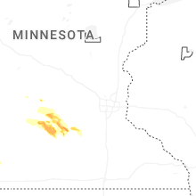
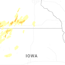
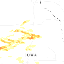


Connect with Interactive Hail Maps