

Hail Map for Maybeury, WV
The Maybeury, WV area has had 0 reports of on-the-ground hail by trained spotters, and has been under severe weather warnings 16 times during the past 12 months. Doppler radar has detected hail at or near Maybeury, WV on 24 occasions, including 2 occasions during the past year.
| Name: | Maybeury, WV |
| Where Located: | 69.4 miles SSE of Charleston, WV |
| Map: | Google Map for Maybeury, WV |
| Population: | 234 |
| Housing Units: | 129 |
| More Info: | Search Google for Maybeury, WV |
1
The Top Recent Hail Date for Maybeury, WV is Monday, April 15, 2024 (8th out of 24)

Hail and Wind Damage Spotted near Maybeury, WV
| Date / Time | Report Details |
|---|---|
| 4/15/2024 9:40 PM EDT |
 The storm which prompted the warning has moved out of the area. therefore, the warning will be allowed to expire. a severe thunderstorm watch remains in effect until 1000 pm edt for southern west virginia. to report severe weather, contact your nearest law enforcement agency. they will relay your report to the national weather service charleston west virginia. The storm which prompted the warning has moved out of the area. therefore, the warning will be allowed to expire. a severe thunderstorm watch remains in effect until 1000 pm edt for southern west virginia. to report severe weather, contact your nearest law enforcement agency. they will relay your report to the national weather service charleston west virginia.
|
| 4/15/2024 9:31 PM EDT |
 Svrrnk the national weather service in blacksburg has issued a * severe thunderstorm warning for, west central giles county in southwestern virginia, northeastern tazewell county in southwestern virginia, northeastern bland county in southwestern virginia, southwestern mercer county in southeastern west virginia, * until 1030 pm edt. * at 930 pm edt, a severe thunderstorm was located near northfork, or near matoaka, moving southeast at 20 mph (radar indicated). Hazards include 60 mph wind gusts and quarter size hail. Hail damage to vehicles is expected. Expect wind damage to roofs, siding, and trees. Svrrnk the national weather service in blacksburg has issued a * severe thunderstorm warning for, west central giles county in southwestern virginia, northeastern tazewell county in southwestern virginia, northeastern bland county in southwestern virginia, southwestern mercer county in southeastern west virginia, * until 1030 pm edt. * at 930 pm edt, a severe thunderstorm was located near northfork, or near matoaka, moving southeast at 20 mph (radar indicated). Hazards include 60 mph wind gusts and quarter size hail. Hail damage to vehicles is expected. Expect wind damage to roofs, siding, and trees.
|
| 4/15/2024 9:25 PM EDT |
 At 924 pm edt, a severe thunderstorm was located near mullens, or 9 miles northwest of matoaka, moving southeast at 20 mph (radar indicated). Hazards include 60 mph wind gusts and half dollar size hail. Hail damage to vehicles is expected. expect wind damage to roofs, siding, and trees. Locations impacted include, herndon and maybeury. At 924 pm edt, a severe thunderstorm was located near mullens, or 9 miles northwest of matoaka, moving southeast at 20 mph (radar indicated). Hazards include 60 mph wind gusts and half dollar size hail. Hail damage to vehicles is expected. expect wind damage to roofs, siding, and trees. Locations impacted include, herndon and maybeury.
|
| 4/15/2024 9:13 PM EDT |
 Svrrlx the national weather service in charleston west virginia has issued a * severe thunderstorm warning for, northeastern mcdowell county in southern west virginia, southeastern wyoming county in southern west virginia, * until 945 pm edt. * at 912 pm edt, a severe thunderstorm was located near mullens, or near pineville, moving southeast at 20 mph (radar indicated). Hazards include 60 mph wind gusts and half dollar size hail. Hail damage to vehicles is expected. Expect wind damage to roofs, siding, and trees. Svrrlx the national weather service in charleston west virginia has issued a * severe thunderstorm warning for, northeastern mcdowell county in southern west virginia, southeastern wyoming county in southern west virginia, * until 945 pm edt. * at 912 pm edt, a severe thunderstorm was located near mullens, or near pineville, moving southeast at 20 mph (radar indicated). Hazards include 60 mph wind gusts and half dollar size hail. Hail damage to vehicles is expected. Expect wind damage to roofs, siding, and trees.
|
| 4/2/2024 12:22 PM EDT |
 The storms which prompted the warning have weakened below severe limits, and no longer pose an immediate threat to life or property. therefore, the warning will be allowed to expire. a tornado watch remains in effect until 100 pm edt for central, southern and southeastern west virginia. The storms which prompted the warning have weakened below severe limits, and no longer pose an immediate threat to life or property. therefore, the warning will be allowed to expire. a tornado watch remains in effect until 100 pm edt for central, southern and southeastern west virginia.
|
| 4/2/2024 11:46 AM EDT |
 Svrrlx the national weather service in charleston west virginia has issued a * severe thunderstorm warning for, northeastern mcdowell county in southern west virginia, southeastern mingo county in southern west virginia, raleigh county in southeastern west virginia, wyoming county in southern west virginia, southeastern logan county in southern west virginia, southern fayette county in southeastern west virginia, southern boone county in central west virginia, * until 1230 pm edt. * at 1146 am edt, severe thunderstorms were located along a line extending from mount hope to 7 miles west of dry creek to near r.d. bailey lake, moving southeast at 55 mph (radar indicated). Hazards include 60 mph wind gusts. expect damage to roofs, siding, and trees Svrrlx the national weather service in charleston west virginia has issued a * severe thunderstorm warning for, northeastern mcdowell county in southern west virginia, southeastern mingo county in southern west virginia, raleigh county in southeastern west virginia, wyoming county in southern west virginia, southeastern logan county in southern west virginia, southern fayette county in southeastern west virginia, southern boone county in central west virginia, * until 1230 pm edt. * at 1146 am edt, severe thunderstorms were located along a line extending from mount hope to 7 miles west of dry creek to near r.d. bailey lake, moving southeast at 55 mph (radar indicated). Hazards include 60 mph wind gusts. expect damage to roofs, siding, and trees
|
| 7/28/2023 5:13 PM EDT |
 The severe thunderstorm warning for giles, northwestern smyth, tazewell, bland, greenbrier, summers, mercer and monroe counties will expire at 515 pm edt, the storms which prompted the warning have moved out of the area. therefore, the warning will be allowed to expire. a severe thunderstorm watch remains in effect until 1100 pm edt for southwestern and west central virginia, and southeastern west virginia. The severe thunderstorm warning for giles, northwestern smyth, tazewell, bland, greenbrier, summers, mercer and monroe counties will expire at 515 pm edt, the storms which prompted the warning have moved out of the area. therefore, the warning will be allowed to expire. a severe thunderstorm watch remains in effect until 1100 pm edt for southwestern and west central virginia, and southeastern west virginia.
|
| 7/28/2023 4:31 PM EDT |
 At 431 pm edt, severe thunderstorms were located along a line extending from 6 miles northwest of bingham to near hix to pipestem resort state park to near amonate, moving southeast at 60 mph (radar indicated). Hazards include 60 mph wind gusts. Expect damage to roofs, siding, and trees. locations impacted include, alleghany, bluefield, bland, princeton, richlands, tazewell, and lewisburg. this includes the following locations the west virginia state fairgrounds and mercer county airport. hail threat, radar indicated max hail size, <. 75 in wind threat, radar indicated max wind gust, 60 mph. At 431 pm edt, severe thunderstorms were located along a line extending from 6 miles northwest of bingham to near hix to pipestem resort state park to near amonate, moving southeast at 60 mph (radar indicated). Hazards include 60 mph wind gusts. Expect damage to roofs, siding, and trees. locations impacted include, alleghany, bluefield, bland, princeton, richlands, tazewell, and lewisburg. this includes the following locations the west virginia state fairgrounds and mercer county airport. hail threat, radar indicated max hail size, <. 75 in wind threat, radar indicated max wind gust, 60 mph.
|
| 7/28/2023 4:25 PM EDT |
 The severe thunderstorm warning for northeastern mcdowell, raleigh, eastern wyoming and southeastern fayette counties will expire at 430 pm edt, the storms which prompted the warning are nivubg out of the area. therefore, the warning will be allowed to expire. a severe thunderstorm watch remains in effect until 800 pm edt for southern and southeastern west virginia. The severe thunderstorm warning for northeastern mcdowell, raleigh, eastern wyoming and southeastern fayette counties will expire at 430 pm edt, the storms which prompted the warning are nivubg out of the area. therefore, the warning will be allowed to expire. a severe thunderstorm watch remains in effect until 800 pm edt for southern and southeastern west virginia.
|
| 7/28/2023 4:03 PM EDT |
 At 402 pm edt, severe thunderstorms were located along a line extending from 6 miles south of burnwell to near sophia to near hanover, moving east at 30 mph (radar indicated). Hazards include 60 mph wind gusts. expect damage to roofs, siding, and trees At 402 pm edt, severe thunderstorms were located along a line extending from 6 miles south of burnwell to near sophia to near hanover, moving east at 30 mph (radar indicated). Hazards include 60 mph wind gusts. expect damage to roofs, siding, and trees
|
| 7/28/2023 3:59 PM EDT |
 At 359 pm edt, severe thunderstorms were located along a line extending from near dry creek to near pineville, moving east at 45 mph (radar indicated). Hazards include 60 mph wind gusts and nickel size hail. expect damage to roofs, siding, and trees At 359 pm edt, severe thunderstorms were located along a line extending from near dry creek to near pineville, moving east at 45 mph (radar indicated). Hazards include 60 mph wind gusts and nickel size hail. expect damage to roofs, siding, and trees
|
| 7/14/2023 3:15 PM EDT |
 At 315 pm edt, a severe thunderstorm was located near boissevain, or 10 miles northwest of bluefield, moving east at 25 mph (radar indicated). Hazards include 60 mph wind gusts and quarter size hail. Hail damage to vehicles is expected. Expect wind damage to roofs, siding, and trees. At 315 pm edt, a severe thunderstorm was located near boissevain, or 10 miles northwest of bluefield, moving east at 25 mph (radar indicated). Hazards include 60 mph wind gusts and quarter size hail. Hail damage to vehicles is expected. Expect wind damage to roofs, siding, and trees.
|
| 6/17/2022 2:30 PM EDT |
 At 230 pm edt, severe thunderstorms were located along a line extending from jenkins to near bald knob, moving southeast at 45 mph (radar indicated). Hazards include 60 mph wind gusts. expect damage to roofs, siding, and trees At 230 pm edt, severe thunderstorms were located along a line extending from jenkins to near bald knob, moving southeast at 45 mph (radar indicated). Hazards include 60 mph wind gusts. expect damage to roofs, siding, and trees
|
| 6/17/2022 12:52 AM EDT |
 At 1252 am edt, severe thunderstorms were located along a line extending from near indian mills to oakvale to near war, moving southeast at 20 mph (radar indicated). Hazards include 60 mph wind gusts and quarter size hail. Hail damage to vehicles is expected. Expect wind damage to roofs, siding, and trees. At 1252 am edt, severe thunderstorms were located along a line extending from near indian mills to oakvale to near war, moving southeast at 20 mph (radar indicated). Hazards include 60 mph wind gusts and quarter size hail. Hail damage to vehicles is expected. Expect wind damage to roofs, siding, and trees.
|
| 6/13/2022 11:56 PM EDT |
 The severe thunderstorm warning for northwestern pulaski, southwestern giles, northeastern tazewell, bland, wythe and mercer counties will expire at midnight edt, the storms which prompted the warning have weakened below severe limits, and no longer pose an immediate threat to life or property. therefore, the warning will be allowed to expire. however gusty winds and heavy rain are still possible with these thunderstorms. a severe thunderstorm watch remains in effect until 100 am edt for southwestern virginia, and southeastern west virginia. The severe thunderstorm warning for northwestern pulaski, southwestern giles, northeastern tazewell, bland, wythe and mercer counties will expire at midnight edt, the storms which prompted the warning have weakened below severe limits, and no longer pose an immediate threat to life or property. therefore, the warning will be allowed to expire. however gusty winds and heavy rain are still possible with these thunderstorms. a severe thunderstorm watch remains in effect until 100 am edt for southwestern virginia, and southeastern west virginia.
|
| 6/13/2022 11:18 PM EDT |
 At 1117 pm edt, severe thunderstorms were located along a line extending from glen lyn to near suiter, moving southeast at 30 mph (radar indicated). Hazards include 70 mph wind gusts. Expect considerable tree damage. damage is likely to mobile homes, roofs, and outbuildings. locations impacted include, bluefield, pulaski, wytheville, bland, princeton, tazewell, and narrows. this includes the following location, the mercer county airport. thunderstorm damage threat, considerable hail threat, radar indicated max hail size, <. 75 in wind threat, radar indicated max wind gust, 70 mph. At 1117 pm edt, severe thunderstorms were located along a line extending from glen lyn to near suiter, moving southeast at 30 mph (radar indicated). Hazards include 70 mph wind gusts. Expect considerable tree damage. damage is likely to mobile homes, roofs, and outbuildings. locations impacted include, bluefield, pulaski, wytheville, bland, princeton, tazewell, and narrows. this includes the following location, the mercer county airport. thunderstorm damage threat, considerable hail threat, radar indicated max hail size, <. 75 in wind threat, radar indicated max wind gust, 70 mph.
|
| 6/13/2022 10:44 PM EDT |
 At 1043 pm edt, severe thunderstorms were located along a line extending from near camp creek to near tiptop, moving southeast at 30 mph (radar indicated). Hazards include 70 mph wind gusts. Expect considerable tree damage. Damage is likely to mobile homes, roofs, and outbuildings. At 1043 pm edt, severe thunderstorms were located along a line extending from near camp creek to near tiptop, moving southeast at 30 mph (radar indicated). Hazards include 70 mph wind gusts. Expect considerable tree damage. Damage is likely to mobile homes, roofs, and outbuildings.
|
| 6/2/2022 1:07 PM EDT |
 At 107 pm edt, a severe thunderstorm was located over coaldale, or near matoaka, moving east at 40 mph (radar indicated). Hazards include 60 mph wind gusts and quarter size hail. Hail damage to vehicles is expected. Expect wind damage to roofs, siding, and trees. At 107 pm edt, a severe thunderstorm was located over coaldale, or near matoaka, moving east at 40 mph (radar indicated). Hazards include 60 mph wind gusts and quarter size hail. Hail damage to vehicles is expected. Expect wind damage to roofs, siding, and trees.
|
| 4/8/2020 4:40 PM EDT |
 The severe thunderstorm warning for eastern mcdowell and wyoming counties will expire at 445 pm edt, the storms which prompted the warning have weakened below severe limits, and no longer pose an immediate threat to life or property. therefore, the warning will be allowed to expire. however small hail, gusty winds and heavy rain are still possible with these thunderstorms. a severe thunderstorm watch remains in effect until 800 pm edt for southern and southeastern west virginia. to report severe weather, contact your nearest law enforcement agency. they will relay your report to the national weather service charleston west virginia. The severe thunderstorm warning for eastern mcdowell and wyoming counties will expire at 445 pm edt, the storms which prompted the warning have weakened below severe limits, and no longer pose an immediate threat to life or property. therefore, the warning will be allowed to expire. however small hail, gusty winds and heavy rain are still possible with these thunderstorms. a severe thunderstorm watch remains in effect until 800 pm edt for southern and southeastern west virginia. to report severe weather, contact your nearest law enforcement agency. they will relay your report to the national weather service charleston west virginia.
|
| 4/8/2020 4:21 PM EDT |
 At 420 pm edt, severe thunderstorms were located along a line extending from near lick creek to near princeton to pinnacle rock state park to northfork, moving southeast at 45 mph (radar indicated). Hazards include 60 mph wind gusts and penny size hail. Expect damage to roofs, siding, and trees. Locations impacted include, welch, pineville, mullens, gary, northfork, twin falls state park, hanover, davy, keystone, anawalt, kimball, clear fork, maybeury, elbert, wolf pen, maben, baileysville, jenkinjones and herndon. At 420 pm edt, severe thunderstorms were located along a line extending from near lick creek to near princeton to pinnacle rock state park to northfork, moving southeast at 45 mph (radar indicated). Hazards include 60 mph wind gusts and penny size hail. Expect damage to roofs, siding, and trees. Locations impacted include, welch, pineville, mullens, gary, northfork, twin falls state park, hanover, davy, keystone, anawalt, kimball, clear fork, maybeury, elbert, wolf pen, maben, baileysville, jenkinjones and herndon.
|
| 4/8/2020 3:58 PM EDT |
 At 357 pm edt, severe thunderstorms were located along a line extending from near shady spring to near flat top to near mullens to near oceana, moving southeast at 45 mph (radar indicated). Hazards include 60 mph wind gusts and nickel size hail. expect damage to roofs, siding, and trees At 357 pm edt, severe thunderstorms were located along a line extending from near shady spring to near flat top to near mullens to near oceana, moving southeast at 45 mph (radar indicated). Hazards include 60 mph wind gusts and nickel size hail. expect damage to roofs, siding, and trees
|
| 1/11/2020 8:04 PM EST |
 At 803 pm est, severe thunderstorms were located along a line extending from bramwell to near wytheville, moving northeast at 70 mph (radar indicated). Hazards include 70 mph wind gusts. Expect considerable tree damage. Damage is likely to mobile homes, roofs, and outbuildings. At 803 pm est, severe thunderstorms were located along a line extending from bramwell to near wytheville, moving northeast at 70 mph (radar indicated). Hazards include 70 mph wind gusts. Expect considerable tree damage. Damage is likely to mobile homes, roofs, and outbuildings.
|
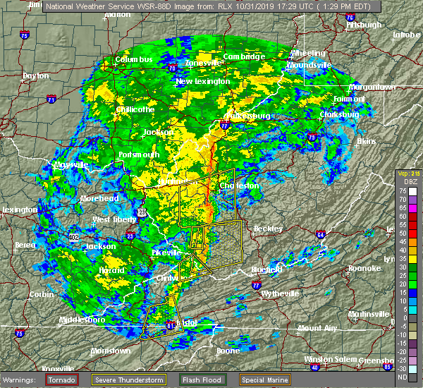
| 10/31/2019 2:45 PM EDT |
 The national weather service in blacksburg has issued a * severe thunderstorm warning for. giles county in southwestern virginia. smyth county in southwestern virginia. tazewell county in southwestern virginia. Bland county in southwestern virginia. The national weather service in blacksburg has issued a * severe thunderstorm warning for. giles county in southwestern virginia. smyth county in southwestern virginia. tazewell county in southwestern virginia. Bland county in southwestern virginia.
|
| 10/31/2019 2:45 PM EDT |
 At 242 pm edt, severe thunderstorms were located along a line extending from camden on gauley to near marion, moving northeast at 70 mph (radar indicated). Hazards include 60 mph wind gusts. expect damage to roofs, siding, and trees At 242 pm edt, severe thunderstorms were located along a line extending from camden on gauley to near marion, moving northeast at 70 mph (radar indicated). Hazards include 60 mph wind gusts. expect damage to roofs, siding, and trees
|
| 10/31/2019 2:06 PM EDT |
 At 205 pm edt, severe thunderstorms were located along a line extending from 7 miles southwest of summersville to near quarry, moving east at 60 mph (radar indicated). Hazards include 60 mph wind gusts. Expect damage to roofs, siding, and trees. locations impacted include, bluefield, wytheville, bland, princeton, marion, richlands, and tazewell. this includes the following location mercer county airport. A tornado watch remains in effect until 700 pm edt for northwestern north carolina, southwestern virginia, and southeastern west virginia. At 205 pm edt, severe thunderstorms were located along a line extending from 7 miles southwest of summersville to near quarry, moving east at 60 mph (radar indicated). Hazards include 60 mph wind gusts. Expect damage to roofs, siding, and trees. locations impacted include, bluefield, wytheville, bland, princeton, marion, richlands, and tazewell. this includes the following location mercer county airport. A tornado watch remains in effect until 700 pm edt for northwestern north carolina, southwestern virginia, and southeastern west virginia.
|
| 10/31/2019 1:32 PM EDT |
 At 130 pm edt, severe thunderstorms were located along a line extending from near oceana to near bristol va, moving northeast at 55 mph (radar indicated). Hazards include 60 mph wind gusts. expect damage to roofs, siding, and trees At 130 pm edt, severe thunderstorms were located along a line extending from near oceana to near bristol va, moving northeast at 55 mph (radar indicated). Hazards include 60 mph wind gusts. expect damage to roofs, siding, and trees
|
| 8/13/2019 4:01 PM EDT |
 The national weather service in blacksburg has issued a * severe thunderstorm warning for. northeastern tazewell county in southwestern virginia. north central bland county in southwestern virginia. southwestern mercer county in southeastern west virginia. Until 445 pm edt. The national weather service in blacksburg has issued a * severe thunderstorm warning for. northeastern tazewell county in southwestern virginia. north central bland county in southwestern virginia. southwestern mercer county in southeastern west virginia. Until 445 pm edt.
|
| 6/16/2019 3:35 PM EDT |
 At 335 pm edt, a severe thunderstorm was located over coaldale, moving east at 20 mph (radar indicated). Hazards include 60 mph wind gusts and quarter size hail. Hail damage to vehicles is expected. Expect wind damage to roofs, siding, and trees. At 335 pm edt, a severe thunderstorm was located over coaldale, moving east at 20 mph (radar indicated). Hazards include 60 mph wind gusts and quarter size hail. Hail damage to vehicles is expected. Expect wind damage to roofs, siding, and trees.
|
| 5/29/2019 4:57 PM EDT |
 The severe thunderstorm warning for western giles, smyth, tazewell, bland, western wythe, summers, mercer and western monroe counties will expire at 500 pm edt, the storms which prompted the warning have moved out of the area, but additional storms are expected so a new warning has been issued for a portion of the area. a severe thunderstorm watch remains in effect until 800 pm edt for southwestern and west central virginia, and southeastern west virginia. when it is safe to do so, please send your reports of hail of any size, as well as reports of any wind damage, including downed trees or large limbs, to the national weather service by calling toll free at 1, 8 6 6, 2 1 5, 4 3 2 4. reports and pictures can also be shared on the national weather service blacksburg facebook page and on twitter. The severe thunderstorm warning for western giles, smyth, tazewell, bland, western wythe, summers, mercer and western monroe counties will expire at 500 pm edt, the storms which prompted the warning have moved out of the area, but additional storms are expected so a new warning has been issued for a portion of the area. a severe thunderstorm watch remains in effect until 800 pm edt for southwestern and west central virginia, and southeastern west virginia. when it is safe to do so, please send your reports of hail of any size, as well as reports of any wind damage, including downed trees or large limbs, to the national weather service by calling toll free at 1, 8 6 6, 2 1 5, 4 3 2 4. reports and pictures can also be shared on the national weather service blacksburg facebook page and on twitter.
|
| 5/29/2019 4:57 PM EDT |
 The severe thunderstorm warning for western giles. smyth. tazewell. bland. western wythe. summers. mercer and western monroe counties will expire at 500 pm edt. The storms which prompted the warning have moved out of the area, but additional storms are expected so a new warning has been issued for a portion of the area. The severe thunderstorm warning for western giles. smyth. tazewell. bland. western wythe. summers. mercer and western monroe counties will expire at 500 pm edt. The storms which prompted the warning have moved out of the area, but additional storms are expected so a new warning has been issued for a portion of the area.
|
| 5/29/2019 4:22 PM EDT |
 The severe thunderstorm warning for southeastern buchanan and mcdowell counties will expire at 430 pm edt, the storm which prompted the warning has moved out of the area. therefore, the warning will be allowed to expire. however gusty winds are still possible with this thunderstorm. a severe thunderstorm watch remains in effect until 700 pm edt for southwestern virginia, and southern west virginia. The severe thunderstorm warning for southeastern buchanan and mcdowell counties will expire at 430 pm edt, the storm which prompted the warning has moved out of the area. therefore, the warning will be allowed to expire. however gusty winds are still possible with this thunderstorm. a severe thunderstorm watch remains in effect until 700 pm edt for southwestern virginia, and southern west virginia.
|
| 5/29/2019 4:05 PM EDT |
 At 405 pm edt, a severe thunderstorm was located near gary, or 8 miles southeast of welch, moving east at 45 mph (radar indicated). Hazards include 60 mph wind gusts and nickel size hail. Expect damage to roofs, siding, and trees. Locations impacted include, welch, gary, war, northfork, bradshaw, keystone, anawalt, kimball, jolo, maybeury, elbert, coalwood, cucumber and jenkinjones. At 405 pm edt, a severe thunderstorm was located near gary, or 8 miles southeast of welch, moving east at 45 mph (radar indicated). Hazards include 60 mph wind gusts and nickel size hail. Expect damage to roofs, siding, and trees. Locations impacted include, welch, gary, war, northfork, bradshaw, keystone, anawalt, kimball, jolo, maybeury, elbert, coalwood, cucumber and jenkinjones.
|
| 5/29/2019 4:02 PM EDT |
 At 401 pm edt, severe thunderstorms were located along a line extending from near bradley to near coal city to near welch to near lebanon, moving east at 45 mph (radar indicated). Hazards include 70 mph wind gusts and quarter size hail. Hail damage to vehicles is expected. expect considerable tree damage. wind damage is also likely to mobile homes, roofs, and outbuildings. locations impacted include, bluefield, wytheville, bland, princeton, and marion. This includes the following location mercer county airport. At 401 pm edt, severe thunderstorms were located along a line extending from near bradley to near coal city to near welch to near lebanon, moving east at 45 mph (radar indicated). Hazards include 70 mph wind gusts and quarter size hail. Hail damage to vehicles is expected. expect considerable tree damage. wind damage is also likely to mobile homes, roofs, and outbuildings. locations impacted include, bluefield, wytheville, bland, princeton, and marion. This includes the following location mercer county airport.
|
| 5/29/2019 3:51 PM EDT |
 At 351 pm edt, a severe thunderstorm was located near war, or 7 miles southwest of welch, moving east at 50 mph (radar indicated). Hazards include 60 mph wind gusts and penny size hail. expect damage to roofs, siding, and trees At 351 pm edt, a severe thunderstorm was located near war, or 7 miles southwest of welch, moving east at 50 mph (radar indicated). Hazards include 60 mph wind gusts and penny size hail. expect damage to roofs, siding, and trees
|
| 5/29/2019 3:25 PM EDT |
 At 324 pm edt, severe thunderstorms were located along a line extending from wharton to 6 miles southeast of argo to 8 miles south of trammel, moving east at 40 mph (radar indicated). Hazards include 60 mph wind gusts and quarter size hail. Hail damage to vehicles is expected. Expect wind damage to roofs, siding, and trees. At 324 pm edt, severe thunderstorms were located along a line extending from wharton to 6 miles southeast of argo to 8 miles south of trammel, moving east at 40 mph (radar indicated). Hazards include 60 mph wind gusts and quarter size hail. Hail damage to vehicles is expected. Expect wind damage to roofs, siding, and trees.
|
| 5/26/2019 9:27 PM EDT |
 At 926 pm edt, severe thunderstorms were located along a line extending from pipestem resort state park to near montcalm to near broadford, moving east at 45 mph. multiple trees were reported down in tazewell county (law enforcement). Hazards include 60 mph wind gusts. Expect damage to roofs, siding, and trees. locations impacted include, bluefield, bland, princeton, tazewell, and athens. This includes the following location mercer county airport. At 926 pm edt, severe thunderstorms were located along a line extending from pipestem resort state park to near montcalm to near broadford, moving east at 45 mph. multiple trees were reported down in tazewell county (law enforcement). Hazards include 60 mph wind gusts. Expect damage to roofs, siding, and trees. locations impacted include, bluefield, bland, princeton, tazewell, and athens. This includes the following location mercer county airport.
|
| 5/26/2019 9:05 PM EDT |
 At 905 pm edt, severe thunderstorms were located along a line extending from near camp creek state park to near gary to 8 miles west of allison gap, moving east at 45 mph. trees have already been reported down in richlands (law enforcement). Hazards include 60 mph wind gusts. expect damage to roofs, siding, and trees At 905 pm edt, severe thunderstorms were located along a line extending from near camp creek state park to near gary to 8 miles west of allison gap, moving east at 45 mph. trees have already been reported down in richlands (law enforcement). Hazards include 60 mph wind gusts. expect damage to roofs, siding, and trees
|
| 5/17/2019 9:40 PM EDT |
 The severe thunderstorm warning for eastern mcdowell, south central raleigh and southeastern wyoming counties will expire at 945 pm edt, the storm which prompted the warning has weakened below severe limits, and has exited the warned area. therefore, the warning will be allowed to expire. a severe thunderstorm watch remains in effect until 1100 pm edt for southern and southeastern west virginia. The severe thunderstorm warning for eastern mcdowell, south central raleigh and southeastern wyoming counties will expire at 945 pm edt, the storm which prompted the warning has weakened below severe limits, and has exited the warned area. therefore, the warning will be allowed to expire. a severe thunderstorm watch remains in effect until 1100 pm edt for southern and southeastern west virginia.
|
| 5/17/2019 9:29 PM EDT |
 At 929 pm edt, a severe thunderstorm was located over boissevain, or 7 miles northwest of bluefield, moving southeast at 45 mph (radar indicated). Hazards include 60 mph wind gusts and penny size hail. Expect damage to roofs, siding, and trees. Locations impacted include, welch, mullens, gary, northfork, davy, keystone, anawalt, kimball, rhodell, maybeury, elbert, coalwood, wolf pen, jenkinjones and herndon. At 929 pm edt, a severe thunderstorm was located over boissevain, or 7 miles northwest of bluefield, moving southeast at 45 mph (radar indicated). Hazards include 60 mph wind gusts and penny size hail. Expect damage to roofs, siding, and trees. Locations impacted include, welch, mullens, gary, northfork, davy, keystone, anawalt, kimball, rhodell, maybeury, elbert, coalwood, wolf pen, jenkinjones and herndon.
|
| 5/17/2019 8:59 PM EDT |
 The national weather service in charleston west virginia has issued a * severe thunderstorm warning for. eastern mcdowell county in southern west virginia. south central raleigh county in southeastern west virginia. wyoming county in southern west virginia. Until 945 pm edt. The national weather service in charleston west virginia has issued a * severe thunderstorm warning for. eastern mcdowell county in southern west virginia. south central raleigh county in southeastern west virginia. wyoming county in southern west virginia. Until 945 pm edt.
|
| 4/14/2019 8:53 PM EDT |
 The severe thunderstorm warning for east central buchanan, mcdowell, south central raleigh and central wyoming counties will expire at 900 pm edt, the storms which prompted the warning have weakened below severe limits, and no longer pose an immediate threat to life or property. therefore, the warning will be allowed to expire. The severe thunderstorm warning for east central buchanan, mcdowell, south central raleigh and central wyoming counties will expire at 900 pm edt, the storms which prompted the warning have weakened below severe limits, and no longer pose an immediate threat to life or property. therefore, the warning will be allowed to expire.
|
| 4/14/2019 8:32 PM EDT |
 At 831 pm edt, severe thunderstorms were located along a line extending from near stanaford to near ceres, moving northeast at 60 mph (radar indicated). Hazards include 60 mph wind gusts. expect damage to roofs, siding, and trees At 831 pm edt, severe thunderstorms were located along a line extending from near stanaford to near ceres, moving northeast at 60 mph (radar indicated). Hazards include 60 mph wind gusts. expect damage to roofs, siding, and trees
|
| 4/14/2019 8:20 PM EDT |
 At 819 pm edt, severe thunderstorms were located along a line extending from near oceana to near jewell ridge to quarry, moving east at 40 mph (radar indicated). Hazards include 60 mph wind gusts. expect damage to roofs, siding, and trees At 819 pm edt, severe thunderstorms were located along a line extending from near oceana to near jewell ridge to quarry, moving east at 40 mph (radar indicated). Hazards include 60 mph wind gusts. expect damage to roofs, siding, and trees
|
| 4/4/2018 2:17 AM EDT |
 At 216 am edt, severe thunderstorms were located along a line extending from near red jacket to woodman to near davenport to 12 miles southeast of norton, moving east at 60 mph (radar indicated). Hazards include 60 mph wind gusts. expect damage to roofs, siding, and trees At 216 am edt, severe thunderstorms were located along a line extending from near red jacket to woodman to near davenport to 12 miles southeast of norton, moving east at 60 mph (radar indicated). Hazards include 60 mph wind gusts. expect damage to roofs, siding, and trees
|
| 4/4/2018 2:16 AM EDT |
 At 215 am edt, a severe thunderstorm was located over argo, or 14 miles north of grundy, moving northeast at 65 mph (radar indicated). Hazards include 60 mph wind gusts. expect damage to roofs, siding, and trees At 215 am edt, a severe thunderstorm was located over argo, or 14 miles north of grundy, moving northeast at 65 mph (radar indicated). Hazards include 60 mph wind gusts. expect damage to roofs, siding, and trees
|
| 3/1/2017 10:44 AM EST |
 At 1044 am est, a severe thunderstorm was located over welch, moving east at 60 mph (radar indicated). Hazards include 60 mph wind gusts. Expect damage to roofs, siding, and trees. Locations impacted include, welch, pineville, gary, war, northfork, hanover, davy, bradshaw, iaeger, keystone, anawalt, kimball, jolo, maybeury, elbert, coalwood, avondale, wolf pen, cucumber and baileysville. At 1044 am est, a severe thunderstorm was located over welch, moving east at 60 mph (radar indicated). Hazards include 60 mph wind gusts. Expect damage to roofs, siding, and trees. Locations impacted include, welch, pineville, gary, war, northfork, hanover, davy, bradshaw, iaeger, keystone, anawalt, kimball, jolo, maybeury, elbert, coalwood, avondale, wolf pen, cucumber and baileysville.
|
| 3/1/2017 10:43 AM EST |
 At 1043 am est, severe thunderstorms were located along a line extending from near oceana to near welch to 6 miles west of war, moving southeast at 50 mph (radar indicated). Hazards include 60 mph wind gusts and quarter size hail. Hail damage to vehicles is expected. Expect wind damage to roofs, siding, and trees. At 1043 am est, severe thunderstorms were located along a line extending from near oceana to near welch to 6 miles west of war, moving southeast at 50 mph (radar indicated). Hazards include 60 mph wind gusts and quarter size hail. Hail damage to vehicles is expected. Expect wind damage to roofs, siding, and trees.
|
| 3/1/2017 10:28 AM EST |
 At 1028 am est, a severe thunderstorm was located near gilbert creek, or 16 miles west of welch, moving east at 60 mph (radar indicated). Hazards include 60 mph wind gusts. expect damage to roofs, siding, and trees At 1028 am est, a severe thunderstorm was located near gilbert creek, or 16 miles west of welch, moving east at 60 mph (radar indicated). Hazards include 60 mph wind gusts. expect damage to roofs, siding, and trees
|
| 7/4/2016 8:25 PM EDT |
 At 824 pm edt, severe thunderstorms were located along a line extending from mullens to near war, moving east at 45 mph (radar indicated). Hazards include 60 mph wind gusts and quarter size hail. Hail damage to vehicles is expected. Expect wind damage to roofs, siding, and trees. At 824 pm edt, severe thunderstorms were located along a line extending from mullens to near war, moving east at 45 mph (radar indicated). Hazards include 60 mph wind gusts and quarter size hail. Hail damage to vehicles is expected. Expect wind damage to roofs, siding, and trees.
|
| 6/23/2016 7:53 PM EDT |
 The severe thunderstorm warning for east central buchanan, southern mcdowell and southeastern wyoming counties will expire at 800 pm edt, the storm which prompted the warning has moved out of the area. therefore, the warning will be allowed to expire. a tornado watch remains in effect until 1000 pm edt for southwestern virginia, and southern west virginia. The severe thunderstorm warning for east central buchanan, southern mcdowell and southeastern wyoming counties will expire at 800 pm edt, the storm which prompted the warning has moved out of the area. therefore, the warning will be allowed to expire. a tornado watch remains in effect until 1000 pm edt for southwestern virginia, and southern west virginia.
|
| 6/23/2016 7:41 PM EDT |
 At 741 pm edt, a severe thunderstorm was located near gary, or 8 miles southeast of welch, moving southeast at 30 mph (radar indicated). Hazards include 60 mph wind gusts. Expect damage to roofs. siding. and trees. locations impacted include, gary, war, northfork, bradshaw, keystone, anawalt, kimball, elbert, jolo, jenkinjones, maybeury and cucumber. A tornado watch remains in effect until 1000 pm edt for southwestern virginia, and southern west virginia. At 741 pm edt, a severe thunderstorm was located near gary, or 8 miles southeast of welch, moving southeast at 30 mph (radar indicated). Hazards include 60 mph wind gusts. Expect damage to roofs. siding. and trees. locations impacted include, gary, war, northfork, bradshaw, keystone, anawalt, kimball, elbert, jolo, jenkinjones, maybeury and cucumber. A tornado watch remains in effect until 1000 pm edt for southwestern virginia, and southern west virginia.
|
| 6/23/2016 7:33 PM EDT |
 At 732 pm edt, a severe thunderstorm was located over gary, or near welch, moving southeast at 30 mph (radar indicated). Hazards include 60 mph wind gusts. Expect damage to roofs. siding. and trees. locations impacted include, welch, gary, war, northfork, bradshaw, keystone, anawalt, kimball, jolo, maybeury, avondale, elbert, jenkinjones, coalwood and cucumber. A tornado watch remains in effect until 1000 pm edt for southwestern virginia, and southern west virginia. At 732 pm edt, a severe thunderstorm was located over gary, or near welch, moving southeast at 30 mph (radar indicated). Hazards include 60 mph wind gusts. Expect damage to roofs. siding. and trees. locations impacted include, welch, gary, war, northfork, bradshaw, keystone, anawalt, kimball, jolo, maybeury, avondale, elbert, jenkinjones, coalwood and cucumber. A tornado watch remains in effect until 1000 pm edt for southwestern virginia, and southern west virginia.
|
| 6/23/2016 7:27 PM EDT |
 At 727 pm edt, a severe thunderstorm was located near welch, moving southeast at 30 mph (radar indicated). Hazards include 60 mph wind gusts. Expect damage to roofs. siding. and trees. locations impacted include, welch, pineville, gary, war, northfork, davy, bradshaw, iaeger, keystone, anawalt, kimball, jolo, maybeury, wolf pen, avondale, elbert, jenkinjones, coalwood and cucumber. A tornado watch remains in effect until 1000 pm edt for southwestern virginia, and southern west virginia. At 727 pm edt, a severe thunderstorm was located near welch, moving southeast at 30 mph (radar indicated). Hazards include 60 mph wind gusts. Expect damage to roofs. siding. and trees. locations impacted include, welch, pineville, gary, war, northfork, davy, bradshaw, iaeger, keystone, anawalt, kimball, jolo, maybeury, wolf pen, avondale, elbert, jenkinjones, coalwood and cucumber. A tornado watch remains in effect until 1000 pm edt for southwestern virginia, and southern west virginia.
|
| 6/23/2016 7:18 PM EDT |
 At 717 pm edt, a severe thunderstorm was located near welch, moving southeast at 30 mph (radar indicated). Hazards include 60 mph wind gusts. Expect damage to roofs. siding. and trees. locations impacted include, welch, pineville, gary, war, northfork, davy, bradshaw, iaeger, keystone, anawalt, kimball, jolo, maybeury, panther, wolf pen, avondale, elbert, jenkinjones, coalwood and cucumber. A tornado watch remains in effect until 1000 pm edt for southwestern virginia, and southern west virginia. At 717 pm edt, a severe thunderstorm was located near welch, moving southeast at 30 mph (radar indicated). Hazards include 60 mph wind gusts. Expect damage to roofs. siding. and trees. locations impacted include, welch, pineville, gary, war, northfork, davy, bradshaw, iaeger, keystone, anawalt, kimball, jolo, maybeury, panther, wolf pen, avondale, elbert, jenkinjones, coalwood and cucumber. A tornado watch remains in effect until 1000 pm edt for southwestern virginia, and southern west virginia.
|
| 6/23/2016 7:00 PM EDT |
 At 700 pm edt, a severe thunderstorm was located near hanover, or 14 miles northwest of welch, moving southeast at 30 mph (radar indicated). Hazards include 60 mph wind gusts. Expect damage to roofs. siding. And trees. At 700 pm edt, a severe thunderstorm was located near hanover, or 14 miles northwest of welch, moving southeast at 30 mph (radar indicated). Hazards include 60 mph wind gusts. Expect damage to roofs. siding. And trees.
|
| 6/23/2016 8:57 AM EDT | The severe thunderstorm warning for northeastern buchanan, raleigh, mingo, mcdowell, southwestern fayette, southeastern boone, logan, wyoming and south central kanawha counties will expire at 900 am edt, the storms which prompted the warning weakened below severe limits and exited the warned area. therefore, the warning will be allowed to expire. |
| 6/23/2016 8:57 AM EDT | The severe thunderstorm warning for northeastern buchanan, raleigh, mingo, mcdowell, southwestern fayette, southeastern boone, logan, wyoming and south central kanawha counties will expire at 900 am edt, the storms which prompted the warning weakened below severe limits and exited the warned area. therefore, the warning will be allowed to expire. |
| 6/23/2016 8:27 AM EDT |
 At 827 am edt, severe thunderstorms were located along a line extending from near hinton to mallory, moving south at 45 mph (radar indicated). Hazards include 60 mph wind gusts. Expect damage to roofs. siding. And trees. At 827 am edt, severe thunderstorms were located along a line extending from near hinton to mallory, moving south at 45 mph (radar indicated). Hazards include 60 mph wind gusts. Expect damage to roofs. siding. And trees.
|
| 6/23/2016 8:10 AM EDT |
 At 809 am edt, severe thunderstorms were located along a line extending from near burnwell to oppy, moving southeast at 50 mph (radar indicated). Hazards include 60 mph wind gusts. Expect damage to roofs. siding. and trees. locations impacted include, beckley, welch, logan, pineville, oak hill, mullens, mount hope, mabscott, oceana, sophia, gary, war, man, delbarton, northfork, shady spring, r. d. Bailey lake, wharton, holden and daniels. At 809 am edt, severe thunderstorms were located along a line extending from near burnwell to oppy, moving southeast at 50 mph (radar indicated). Hazards include 60 mph wind gusts. Expect damage to roofs. siding. and trees. locations impacted include, beckley, welch, logan, pineville, oak hill, mullens, mount hope, mabscott, oceana, sophia, gary, war, man, delbarton, northfork, shady spring, r. d. Bailey lake, wharton, holden and daniels.
|
| 6/23/2016 7:47 AM EDT |
 At 746 am edt, severe thunderstorms were located along a line extending from 8 miles south of chesapeake to coalpoint, moving southeast at 45 mph (radar indicated). Hazards include 60 mph wind gusts. Expect damage to roofs. siding. And trees. At 746 am edt, severe thunderstorms were located along a line extending from 8 miles south of chesapeake to coalpoint, moving southeast at 45 mph (radar indicated). Hazards include 60 mph wind gusts. Expect damage to roofs. siding. And trees.
|
| 5/1/2016 8:34 PM EDT |
 At 833 pm edt, a severe thunderstorm was located near gary, or 9 miles southeast of welch, moving southeast at 45 mph. quarter size hail was reported two miles north of bradshaw (public). Hazards include half dollar size hail. Damage to vehicles is expected. Locations impacted include, welch, gary, coaldale, anawalt, elbert, jenkinjones and coalwood. At 833 pm edt, a severe thunderstorm was located near gary, or 9 miles southeast of welch, moving southeast at 45 mph. quarter size hail was reported two miles north of bradshaw (public). Hazards include half dollar size hail. Damage to vehicles is expected. Locations impacted include, welch, gary, coaldale, anawalt, elbert, jenkinjones and coalwood.
|
| 5/1/2016 8:17 PM EDT |
 At 816 pm edt, a severe thunderstorm was located near war, or 8 miles southwest of welch, moving east at 30 mph (public). Hazards include golf ball size hail. People and animals outdoors will be injured. expect damage to roofs, siding, windows, and vehicles. Locations impacted include, welch, gary, war, coaldale, bradshaw, anawalt, elbert, jenkinjones, coalwood, cucumber and avondale. At 816 pm edt, a severe thunderstorm was located near war, or 8 miles southwest of welch, moving east at 30 mph (public). Hazards include golf ball size hail. People and animals outdoors will be injured. expect damage to roofs, siding, windows, and vehicles. Locations impacted include, welch, gary, war, coaldale, bradshaw, anawalt, elbert, jenkinjones, coalwood, cucumber and avondale.
|
| 5/1/2016 7:54 PM EDT |
 At 754 pm edt, a severe thunderstorm was located 11 miles southeast of argo, or 14 miles northeast of grundy, moving southeast at 45 mph (radar indicated). Hazards include golf ball size hail. People and animals outdoors will be injured. Expect damage to roofs, siding, windows, and vehicles. At 754 pm edt, a severe thunderstorm was located 11 miles southeast of argo, or 14 miles northeast of grundy, moving southeast at 45 mph (radar indicated). Hazards include golf ball size hail. People and animals outdoors will be injured. Expect damage to roofs, siding, windows, and vehicles.
|
| 5/1/2016 7:54 PM EDT |
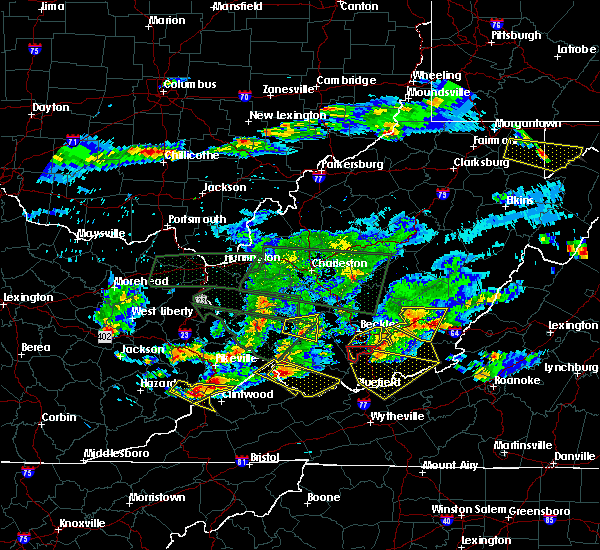 At 754 pm edt, a severe thunderstorm was located 11 miles southeast of argo, or 14 miles northeast of grundy, moving southeast at 45 mph (radar indicated). Hazards include golf ball size hail. People and animals outdoors will be injured. Expect damage to roofs, siding, windows, and vehicles. At 754 pm edt, a severe thunderstorm was located 11 miles southeast of argo, or 14 miles northeast of grundy, moving southeast at 45 mph (radar indicated). Hazards include golf ball size hail. People and animals outdoors will be injured. Expect damage to roofs, siding, windows, and vehicles.
|
| 7/14/2015 8:21 PM EDT |
 At 821 pm edt, severe thunderstorms were located along a line extending from princeton to near bandy to trammel, moving south at 45 mph (radar indicated). Hazards include 60 mph wind gusts and quarter size hail. Hail damage to vehicles is expected. expect wind damage to roofs, siding and trees. locations impacted include, bluefield, wytheville, bland, princeton, and marion. This includes mercer county airport. At 821 pm edt, severe thunderstorms were located along a line extending from princeton to near bandy to trammel, moving south at 45 mph (radar indicated). Hazards include 60 mph wind gusts and quarter size hail. Hail damage to vehicles is expected. expect wind damage to roofs, siding and trees. locations impacted include, bluefield, wytheville, bland, princeton, and marion. This includes mercer county airport.
|
| 7/14/2015 8:01 PM EDT |
 At 801 pm edt, severe thunderstorms were located along a line extending from near mullens to near war to john flannagan lake, moving south at 40 mph (radar indicated). Hazards include 60 mph wind gusts and quarter size hail. Hail damage to vehicles is expected. Expect wind damage to roofs, siding and trees. At 801 pm edt, severe thunderstorms were located along a line extending from near mullens to near war to john flannagan lake, moving south at 40 mph (radar indicated). Hazards include 60 mph wind gusts and quarter size hail. Hail damage to vehicles is expected. Expect wind damage to roofs, siding and trees.
|
| 7/14/2015 7:41 PM EDT |
 At 739 pm edt, doppler radar indicated a line of severe thunderstorms capable of producing damaging winds in excess of 60 mph. these storms were located along a line extending from near sandstone to near oceana to near buskirk, moving west at 15 mph. locations impacted include, beckley, welch, pineville, mullens, mabscott, oceana, sophia, gary, northfork, shady spring, r.d. bailey lake, twin falls state park, daniels, gilbert creek, buskirk, macarthur, crab orchard, paw paw, beaver and coal city. At 739 pm edt, doppler radar indicated a line of severe thunderstorms capable of producing damaging winds in excess of 60 mph. these storms were located along a line extending from near sandstone to near oceana to near buskirk, moving west at 15 mph. locations impacted include, beckley, welch, pineville, mullens, mabscott, oceana, sophia, gary, northfork, shady spring, r.d. bailey lake, twin falls state park, daniels, gilbert creek, buskirk, macarthur, crab orchard, paw paw, beaver and coal city.
|
| 7/14/2015 6:59 PM EDT |
 At 659 pm edt, doppler radar indicated a line of severe thunderstorms capable of producing damaging winds in excess of 60 mph. these storms were located along a line extending from babcock state park to 7 miles east of bald knob to davella, and moving south at 35 mph. At 659 pm edt, doppler radar indicated a line of severe thunderstorms capable of producing damaging winds in excess of 60 mph. these storms were located along a line extending from babcock state park to 7 miles east of bald knob to davella, and moving south at 35 mph.
|
| 7/13/2015 6:22 PM EDT |
 At 621 pm edt, severe thunderstorms were located along a line extending from near hinton to richlands, moving east at 50 mph (radar indicated). Hazards include 60 mph wind gusts. Expect damage to roofs. siding and trees. locations impacted include, bluefield, princeton, richlands, tazewell, and hinton. This includes mercer county airport. At 621 pm edt, severe thunderstorms were located along a line extending from near hinton to richlands, moving east at 50 mph (radar indicated). Hazards include 60 mph wind gusts. Expect damage to roofs. siding and trees. locations impacted include, bluefield, princeton, richlands, tazewell, and hinton. This includes mercer county airport.
|
| 7/13/2015 6:22 PM EDT |
 At 537 pm edt, severe thunderstorms were located along a line extending from near dry creek to near war, moving east at 50 mph. another severe thunderstorm was developing in western tazewell just west of claypool hill and is also rapidly approaching severe limits (radar indicated). Hazards include 70 mph wind gusts and quarter size hail. Hail damage to vehicles is expected. expect considerable tree damage. Wind damage is also likely to mobile homes, roofs and outbuildings. At 537 pm edt, severe thunderstorms were located along a line extending from near dry creek to near war, moving east at 50 mph. another severe thunderstorm was developing in western tazewell just west of claypool hill and is also rapidly approaching severe limits (radar indicated). Hazards include 70 mph wind gusts and quarter size hail. Hail damage to vehicles is expected. expect considerable tree damage. Wind damage is also likely to mobile homes, roofs and outbuildings.
|
| 7/13/2015 5:46 PM EDT |
 At 545 pm edt, doppler radar indicated a line of severe thunderstorms capable of producing damaging winds in excess of 60 mph. these storms were located along a line extending from near bradley to near mullens to near war, moving southeast at 40 mph. locations impacted include, beckley, fayetteville, welch, pineville, oak hill, mullens, mount hope, mabscott, sophia, gary, war, northfork, shady spring, prosperity, dry creek, twin falls state park, daniels, macarthur, crab orchard and bradley. At 545 pm edt, doppler radar indicated a line of severe thunderstorms capable of producing damaging winds in excess of 60 mph. these storms were located along a line extending from near bradley to near mullens to near war, moving southeast at 40 mph. locations impacted include, beckley, fayetteville, welch, pineville, oak hill, mullens, mount hope, mabscott, sophia, gary, war, northfork, shady spring, prosperity, dry creek, twin falls state park, daniels, macarthur, crab orchard and bradley.
|
| 7/13/2015 5:39 PM EDT |
 At 537 pm edt, severe thunderstorms were located along a line extending from near dry creek to near war, moving east at 50 mph. another severe thunderstorm was developing in western tazewell just west of claypool hill and is also rapidly approaching severe limits (radar indicated). Hazards include 70 mph wind gusts and quarter size hail. Hail damage to vehicles is expected. expect considerable tree damage. Wind damage is also likely to mobile homes, roofs and outbuildings. At 537 pm edt, severe thunderstorms were located along a line extending from near dry creek to near war, moving east at 50 mph. another severe thunderstorm was developing in western tazewell just west of claypool hill and is also rapidly approaching severe limits (radar indicated). Hazards include 70 mph wind gusts and quarter size hail. Hail damage to vehicles is expected. expect considerable tree damage. Wind damage is also likely to mobile homes, roofs and outbuildings.
|
| 7/13/2015 5:05 PM EDT |
 At 505 pm edt, doppler radar indicated a line of severe thunderstorms capable of producing damaging winds in excess of 60 mph. these storms were located along a line extending from 9 miles south of chesapeake to near amherstdale-robinette to majestic, and moving southeast at 40 mph. At 505 pm edt, doppler radar indicated a line of severe thunderstorms capable of producing damaging winds in excess of 60 mph. these storms were located along a line extending from 9 miles south of chesapeake to near amherstdale-robinette to majestic, and moving southeast at 40 mph.
|
| 6/23/2015 6:47 PM EDT |
 At 646 pm edt, doppler radar indicated a severe thunderstorm capable of producing quarter size hail and damaging winds in excess of 60 mph. this storm was located over matoaka, moving southeast at 30 mph. locations impacted include, coaldale and maybeury. At 646 pm edt, doppler radar indicated a severe thunderstorm capable of producing quarter size hail and damaging winds in excess of 60 mph. this storm was located over matoaka, moving southeast at 30 mph. locations impacted include, coaldale and maybeury.
|
| 6/23/2015 6:34 PM EDT |
 At 633 pm edt, doppler radar indicated a severe thunderstorm capable of producing quarter size hail and damaging winds in excess of 60 mph. this storm was located near northfork, or 9 miles west of matoaka, and moving southeast at 30 mph. At 633 pm edt, doppler radar indicated a severe thunderstorm capable of producing quarter size hail and damaging winds in excess of 60 mph. this storm was located near northfork, or 9 miles west of matoaka, and moving southeast at 30 mph.
|
Hail Maps for Maybeury, WV


Connect with Interactive Hail Maps