

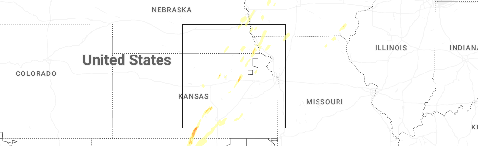
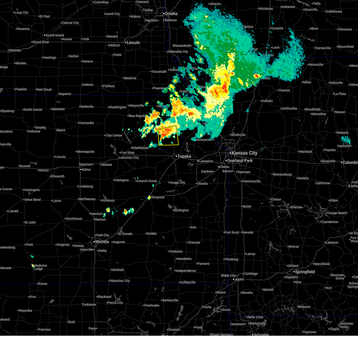
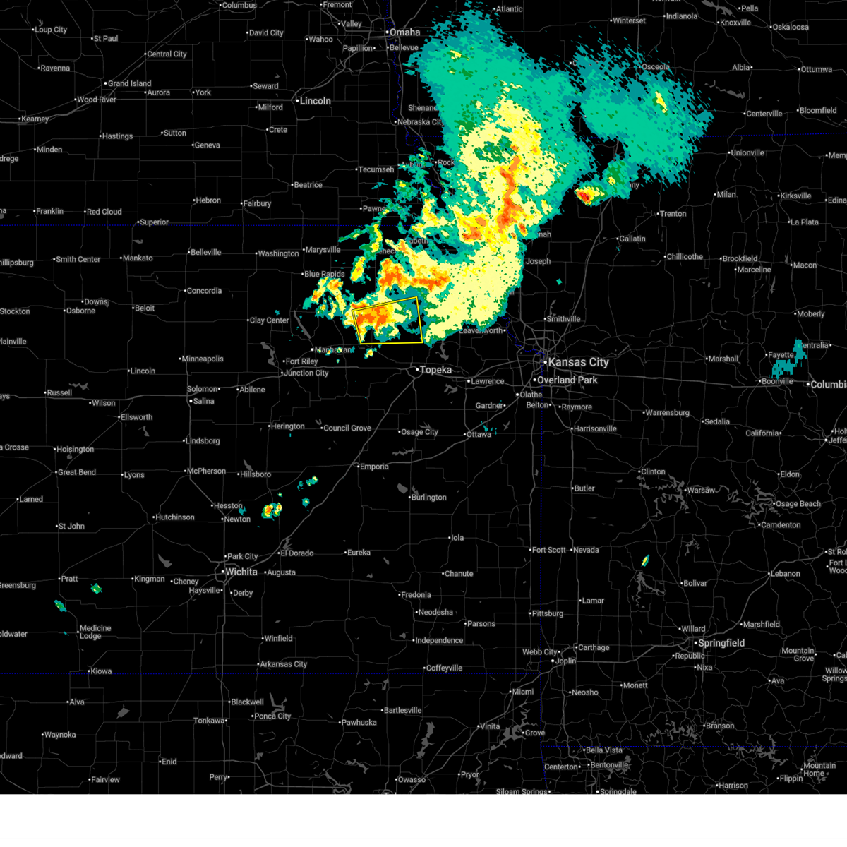
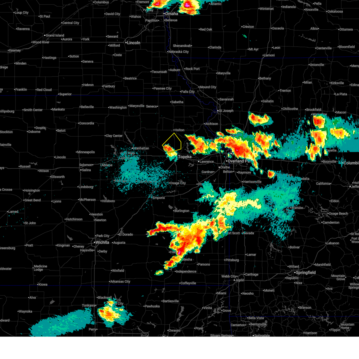
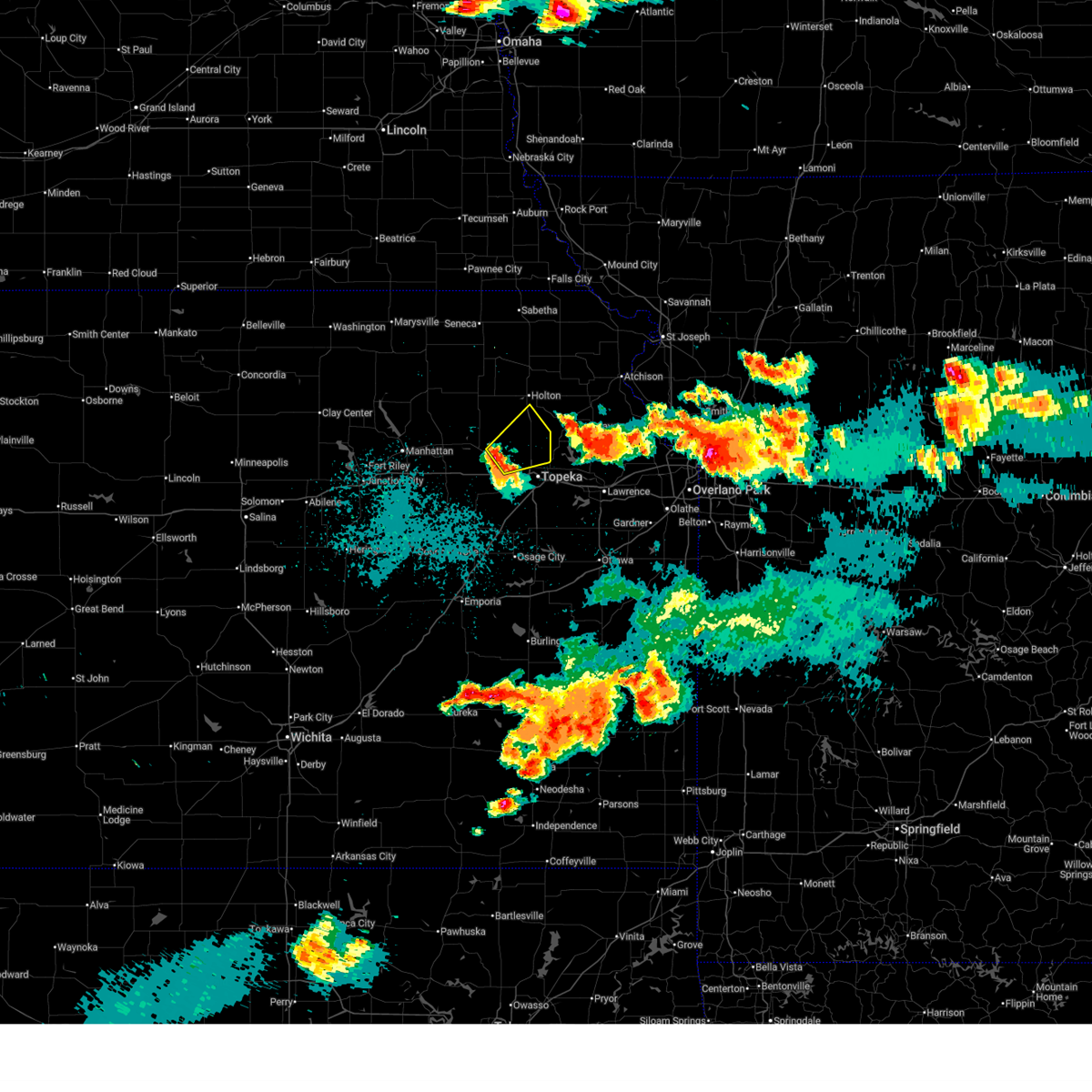
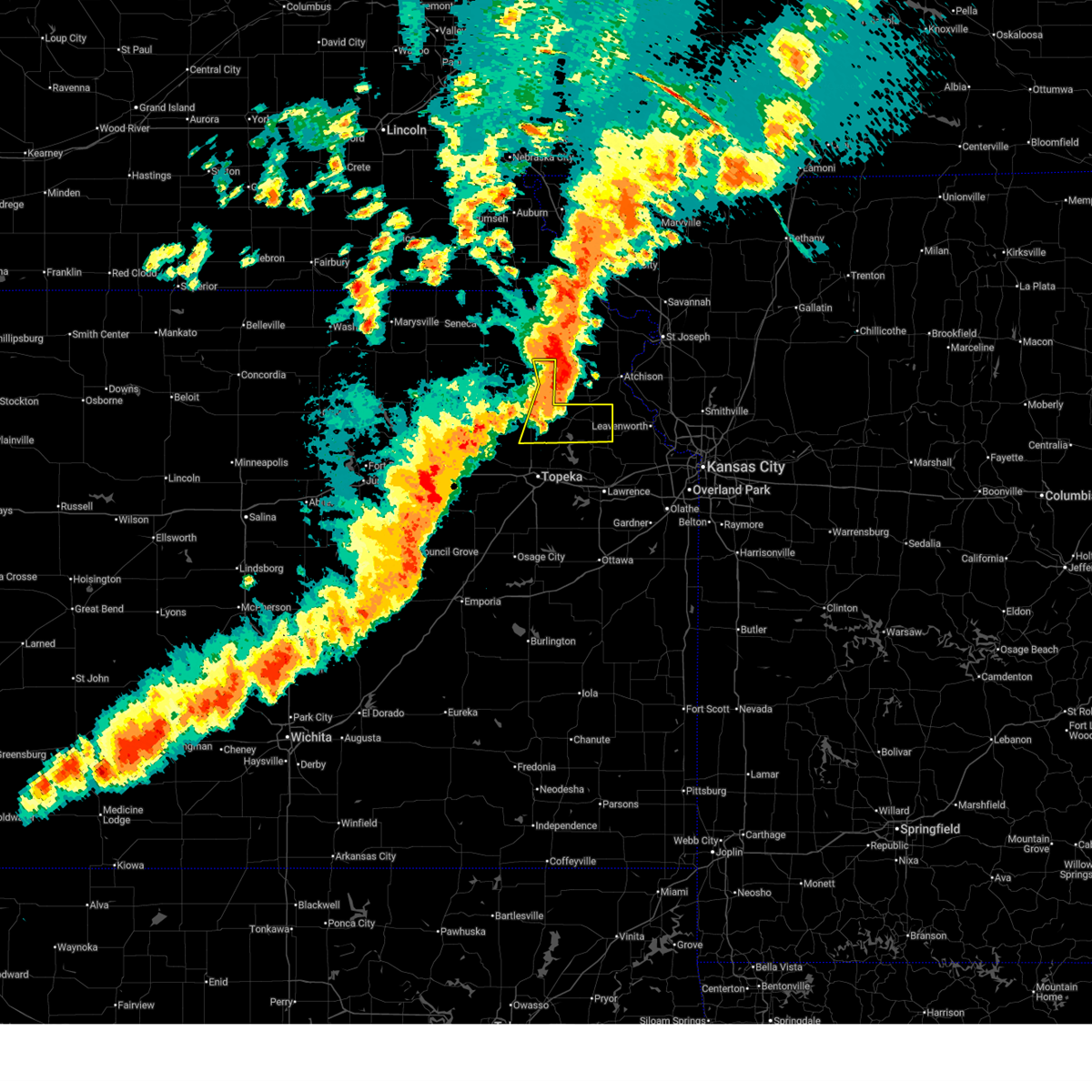
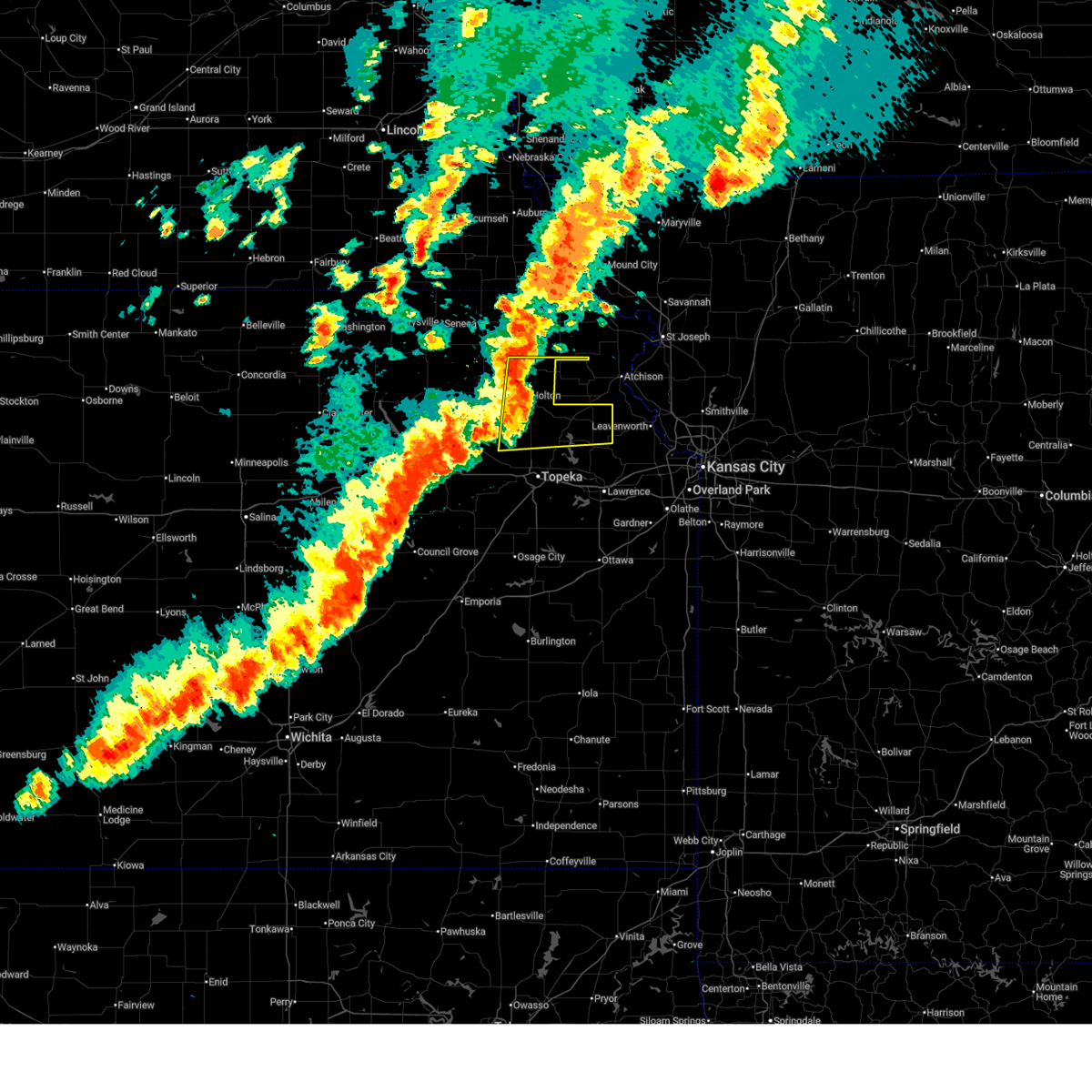
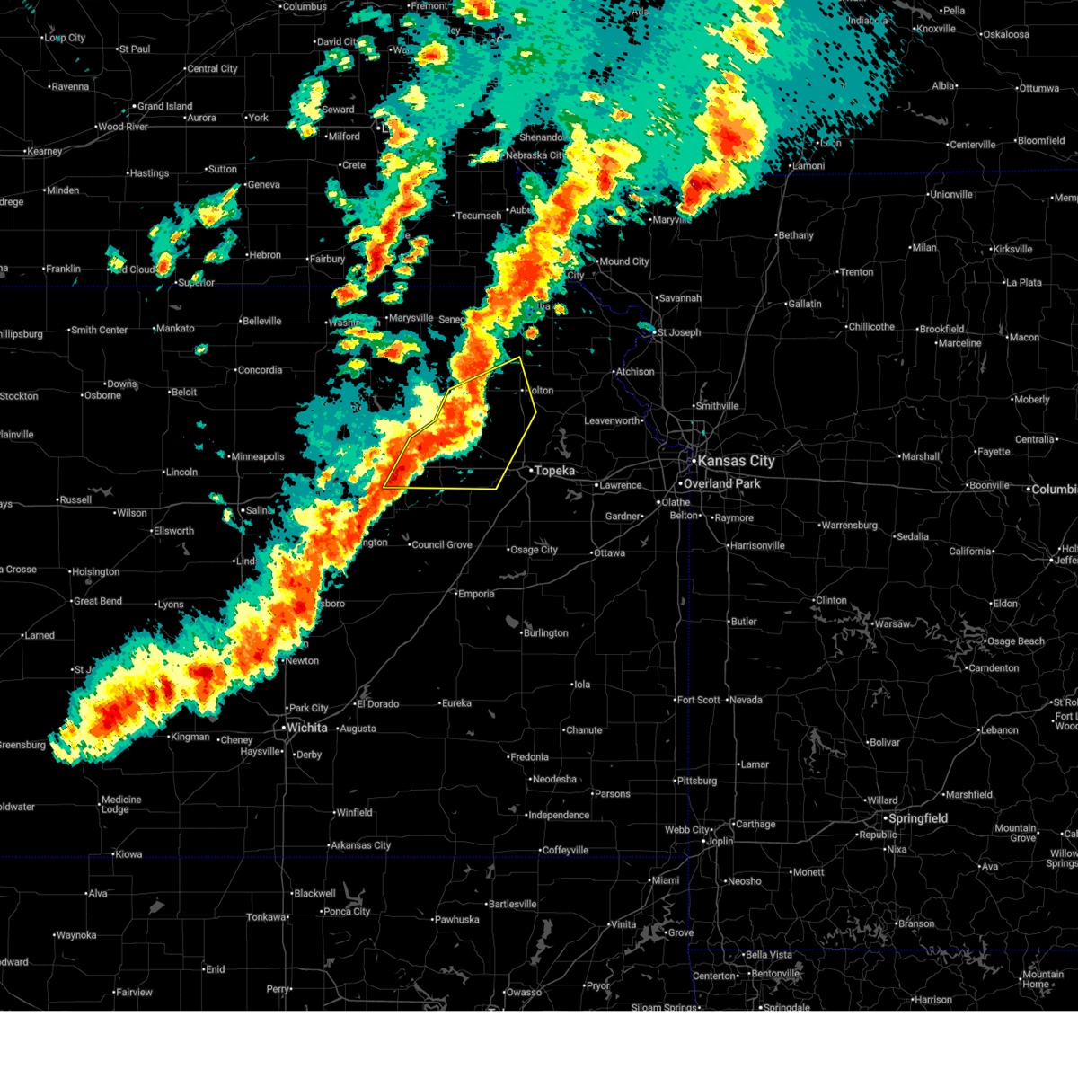
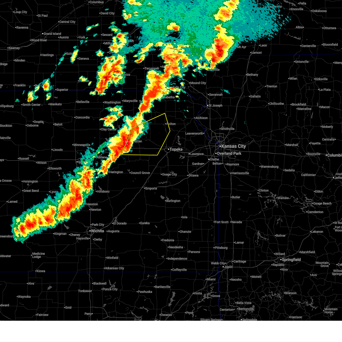
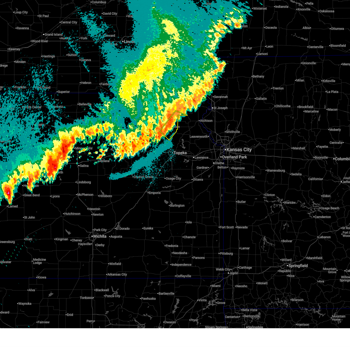
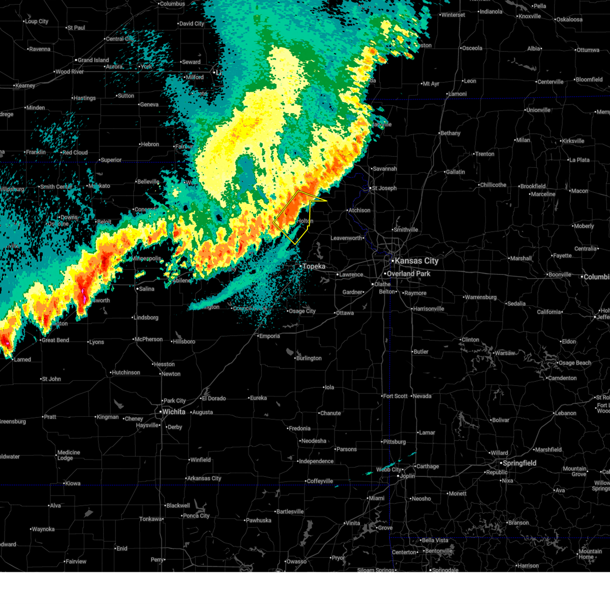
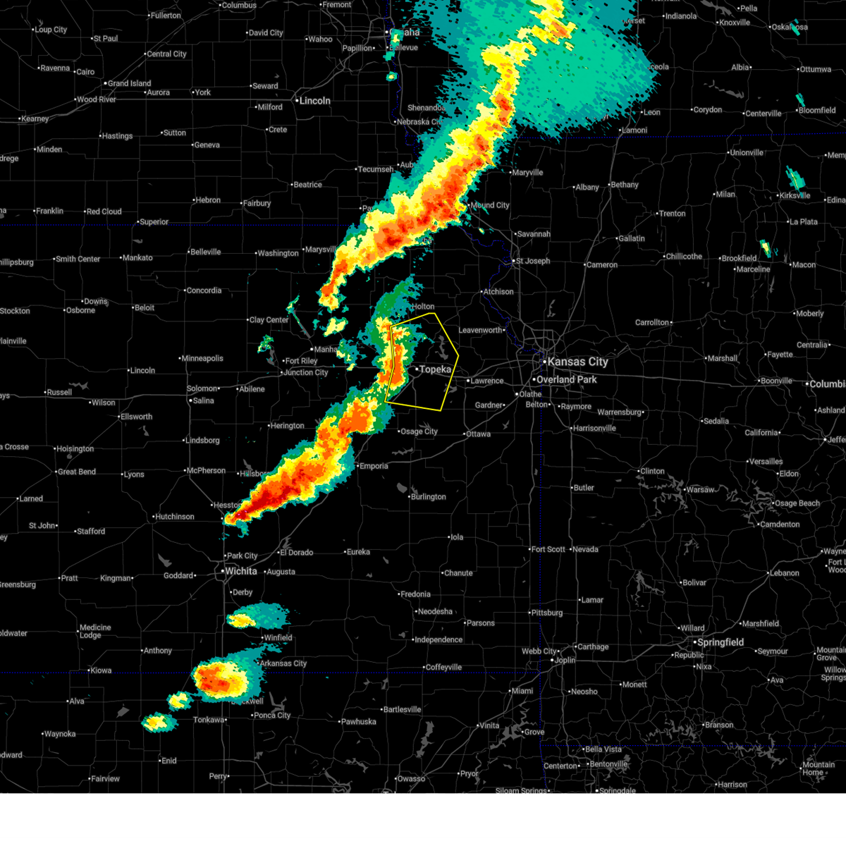
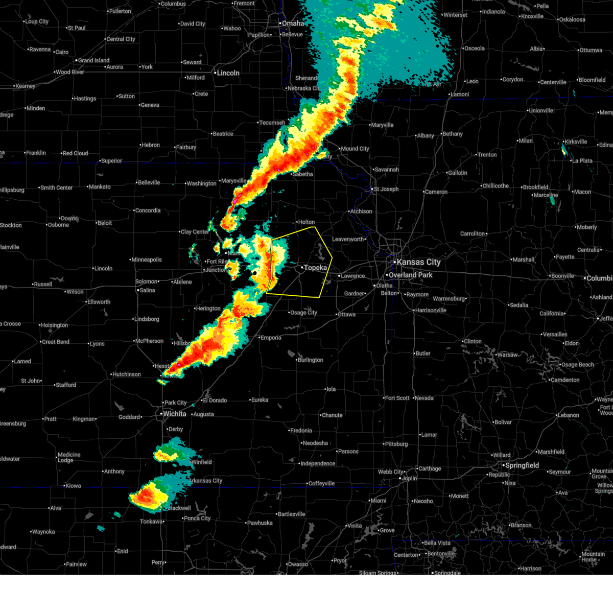
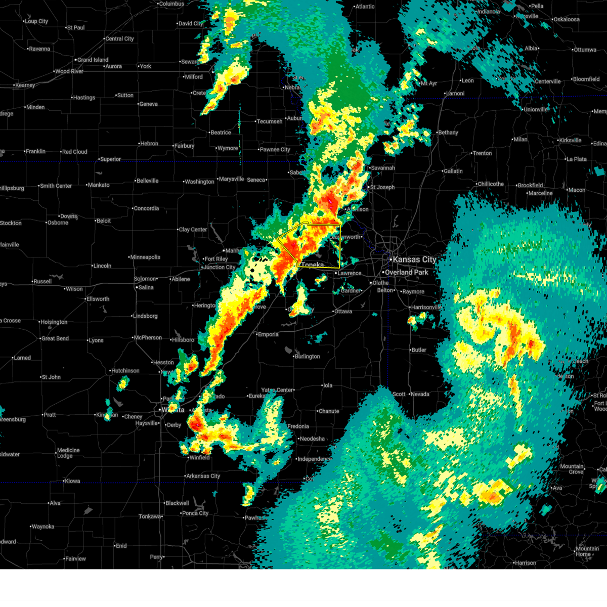
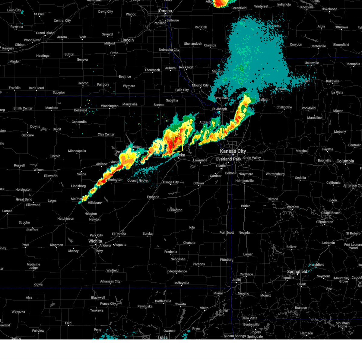
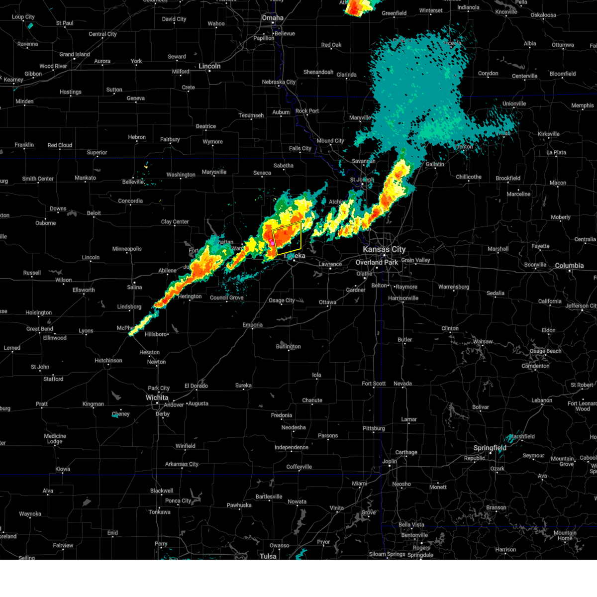
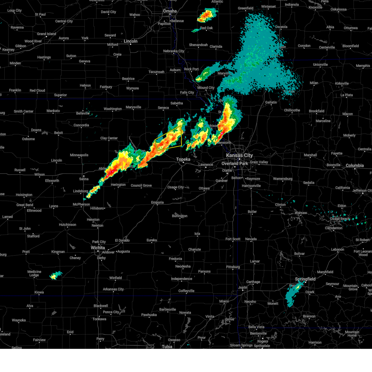
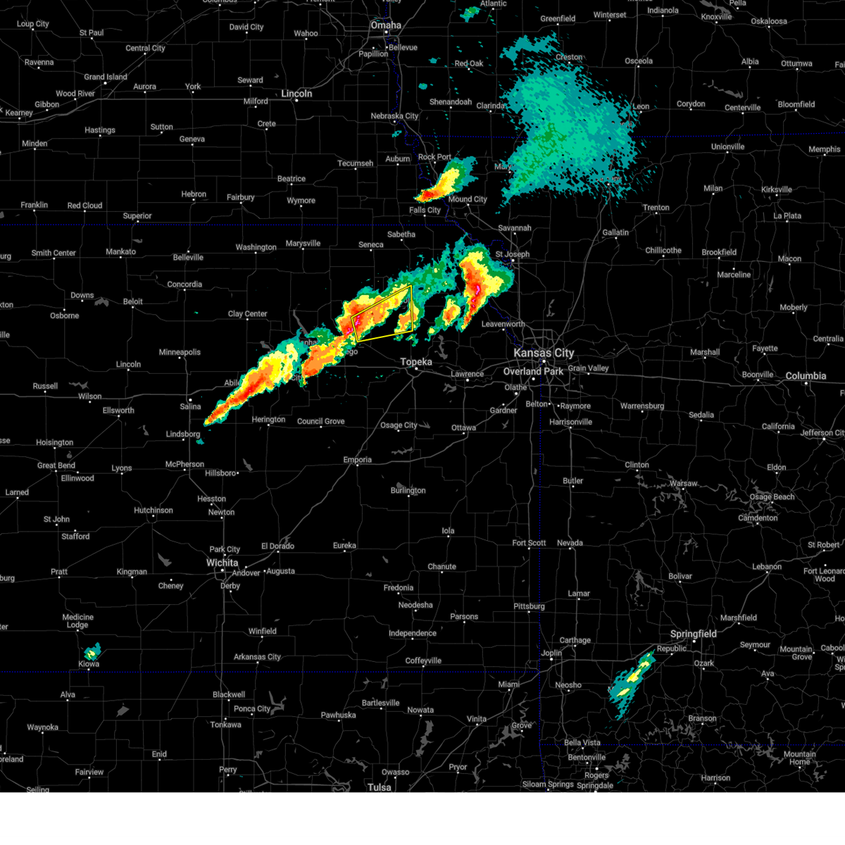
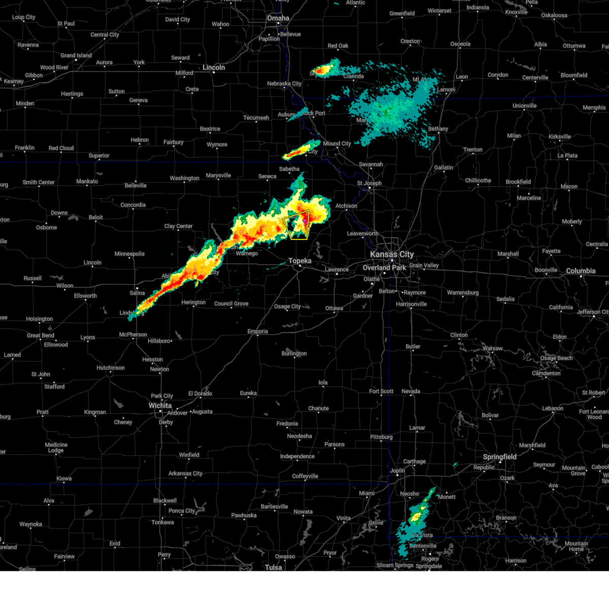
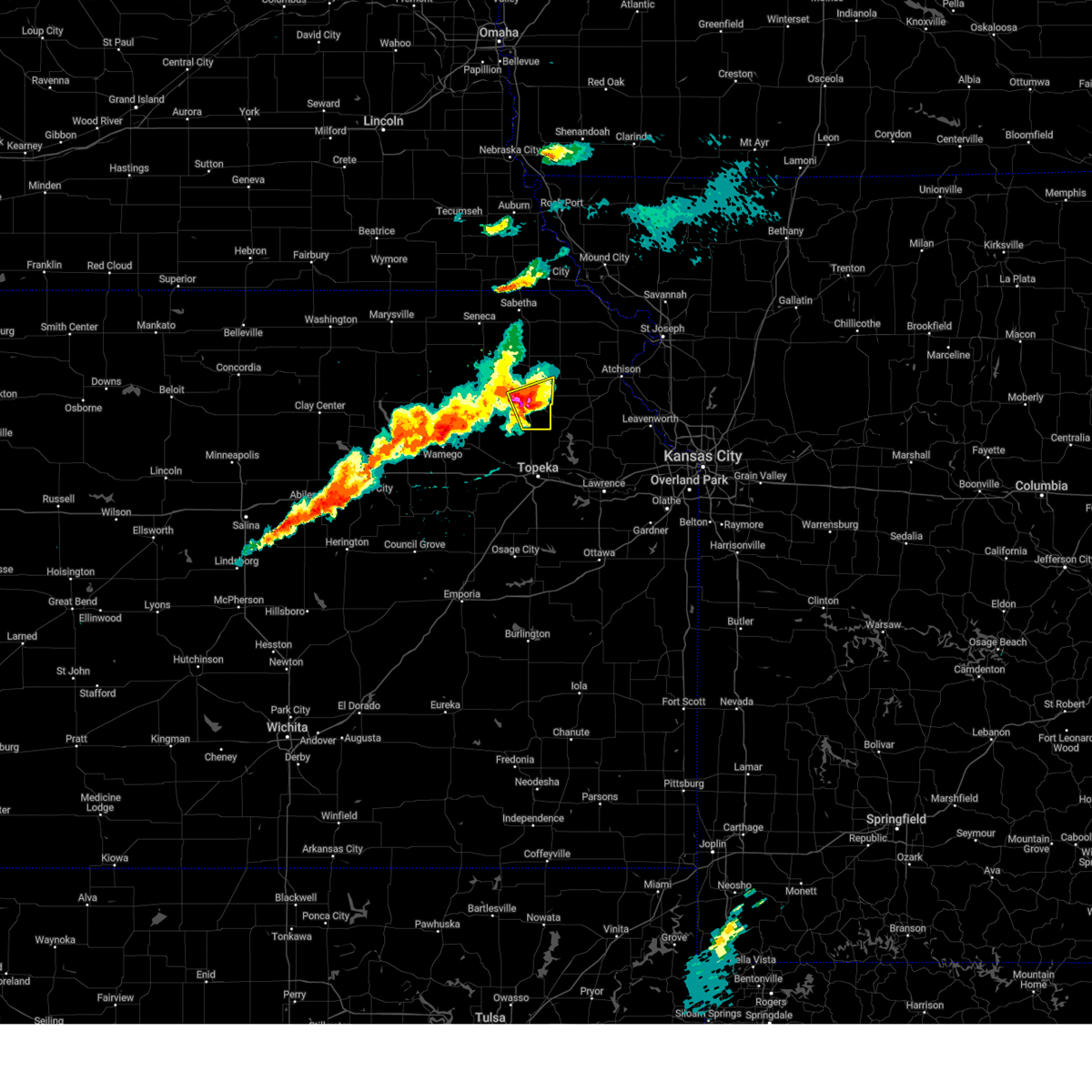
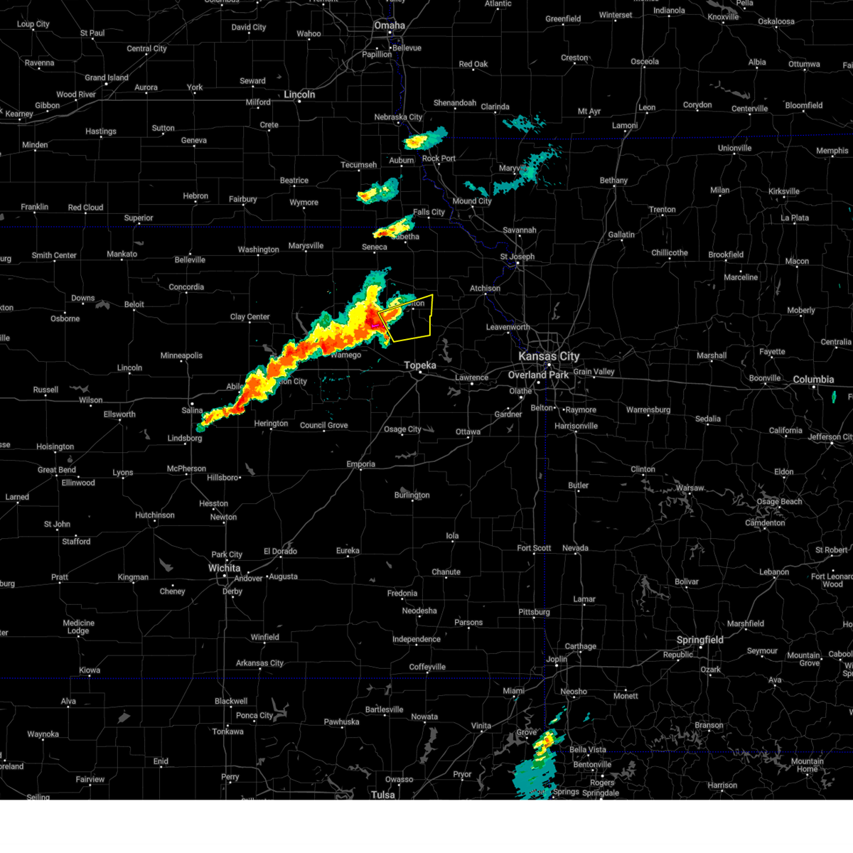
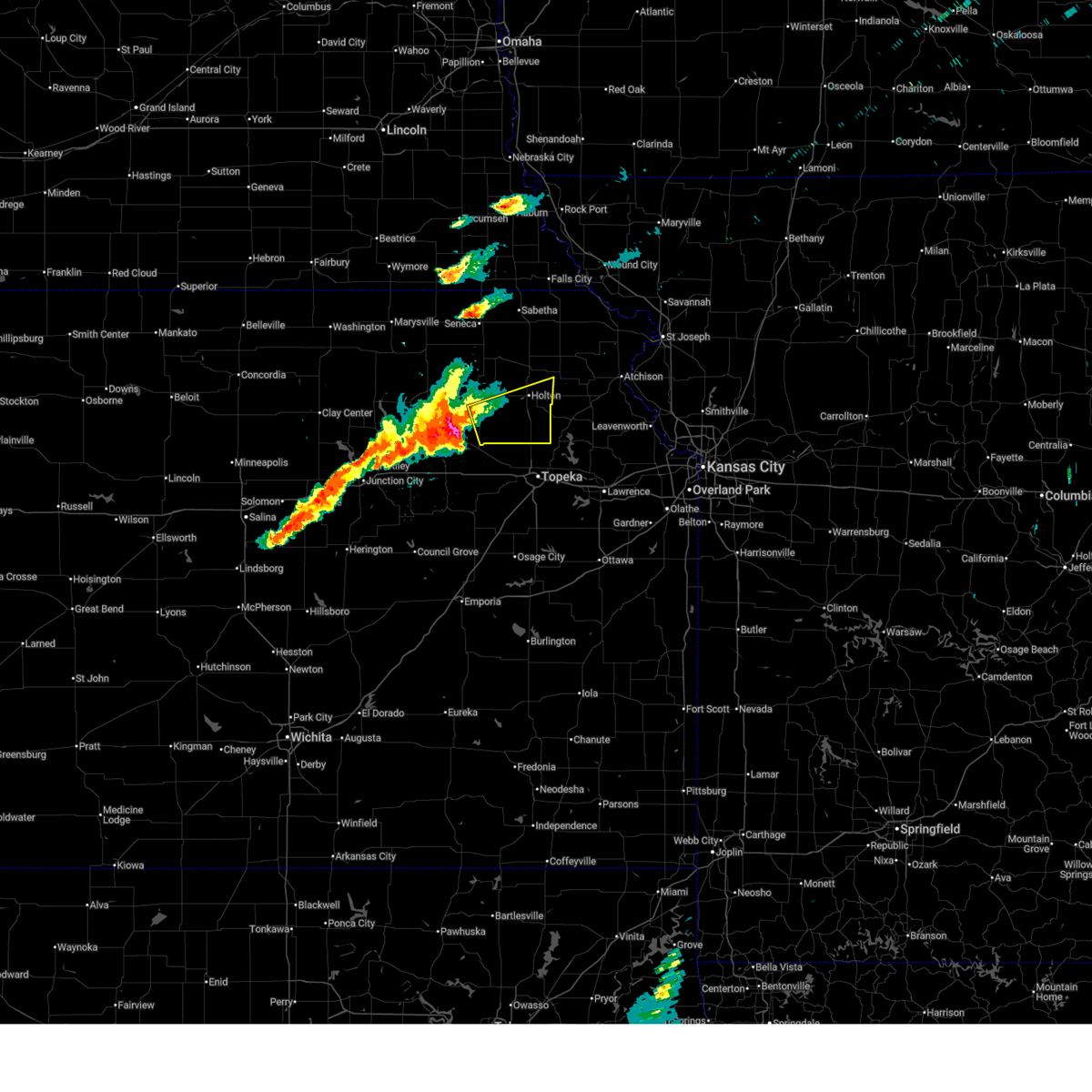
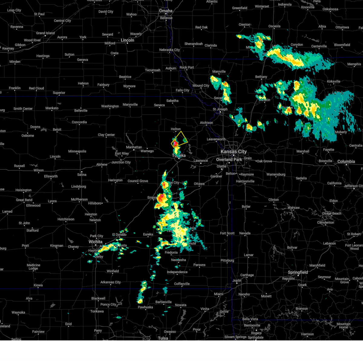
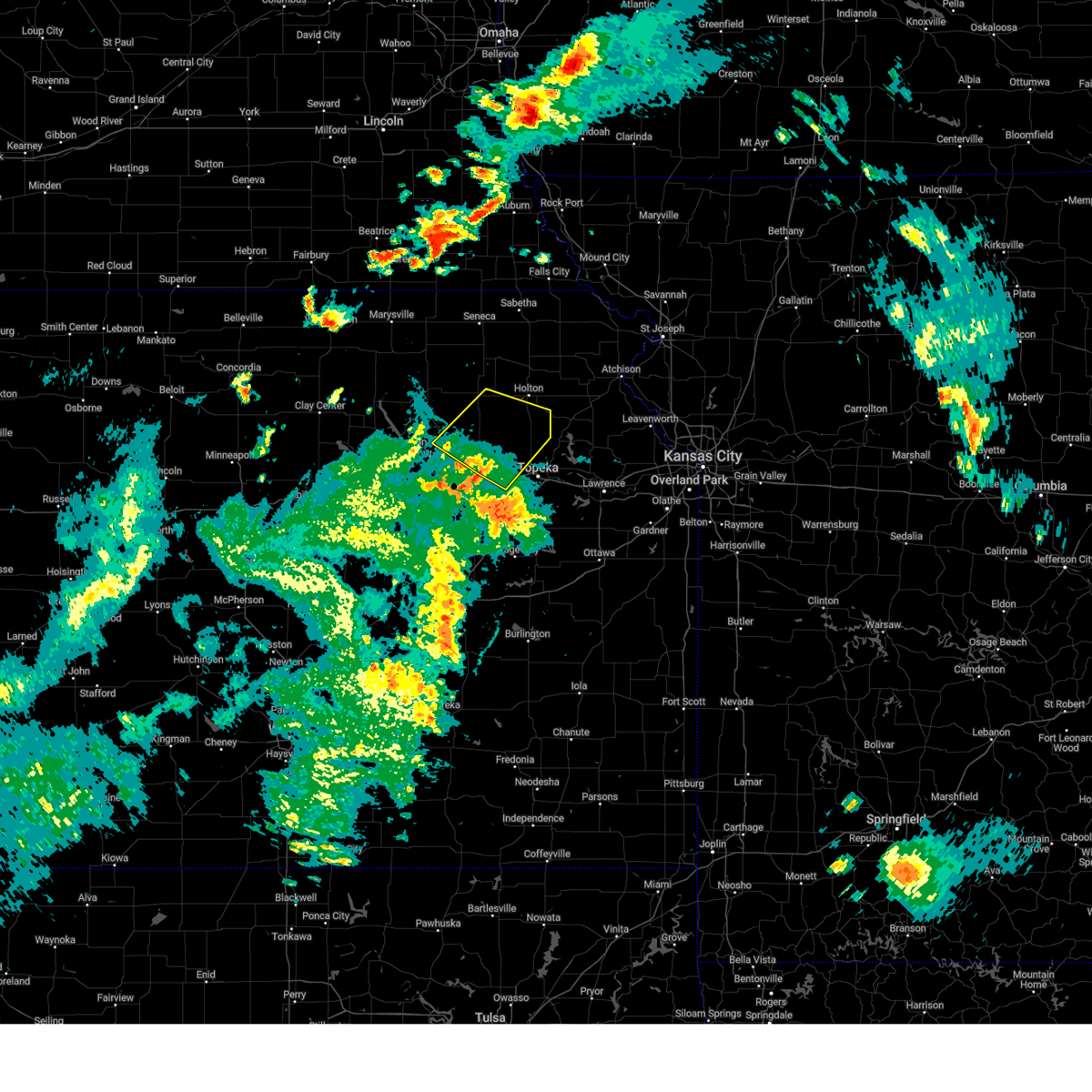
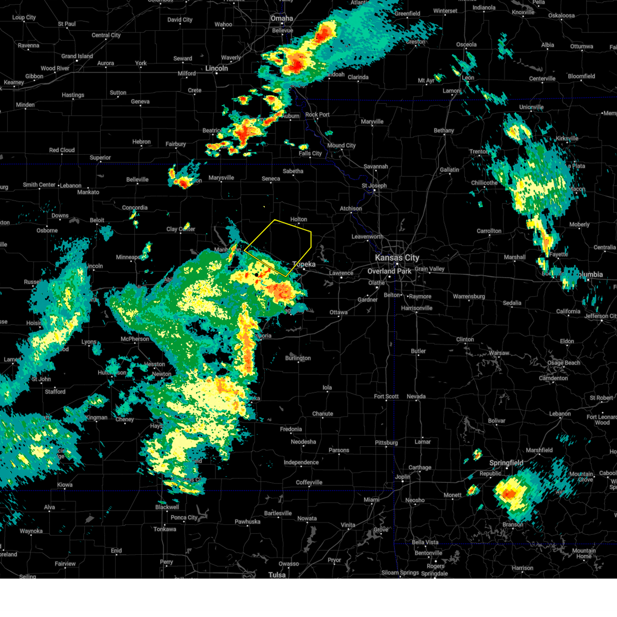
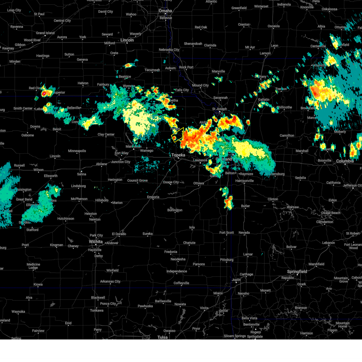
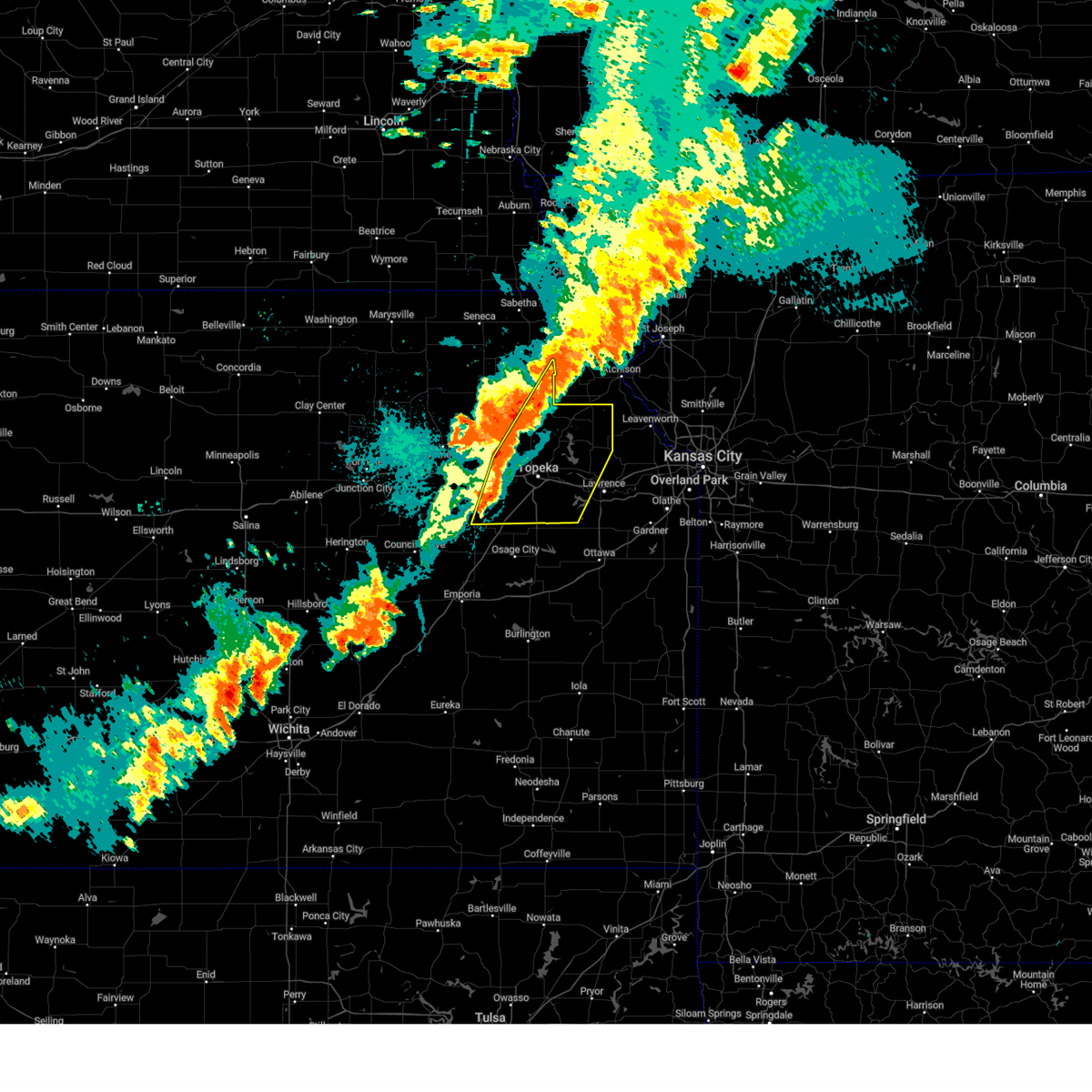
Hail Map for Mayetta, KS
The Mayetta, KS area has had 19 reports of on-the-ground hail by trained spotters, and has been under severe weather warnings 18 times during the past 12 months. Doppler radar has detected hail at or near Mayetta, KS on 79 occasions, including 1 occasion during the past year.
| Name: | Mayetta, KS |
| Where Located: | 46.3 miles ENE of Manhattan, KS |
| Map: | Google Map for Mayetta, KS |
| Population: | 341 |
| Housing Units: | 131 |
| More Info: | Search Google for Mayetta, KS |
0
The Top Recent Hail Date for Mayetta, KS is Thursday, March 5, 2026 (77th out of 79)
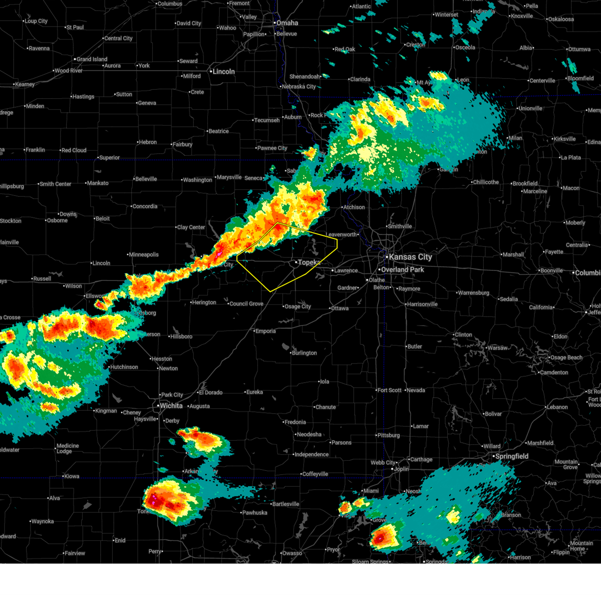
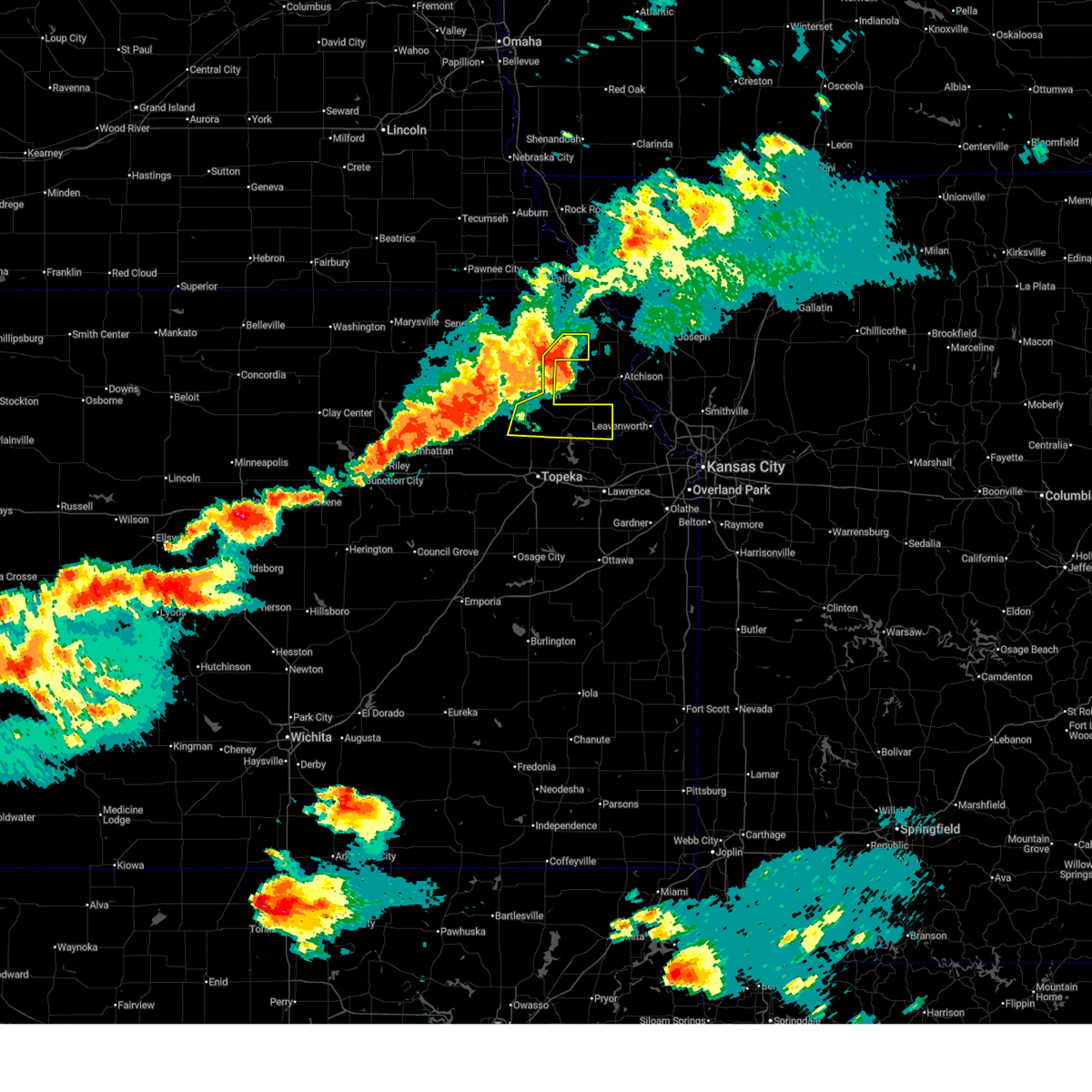
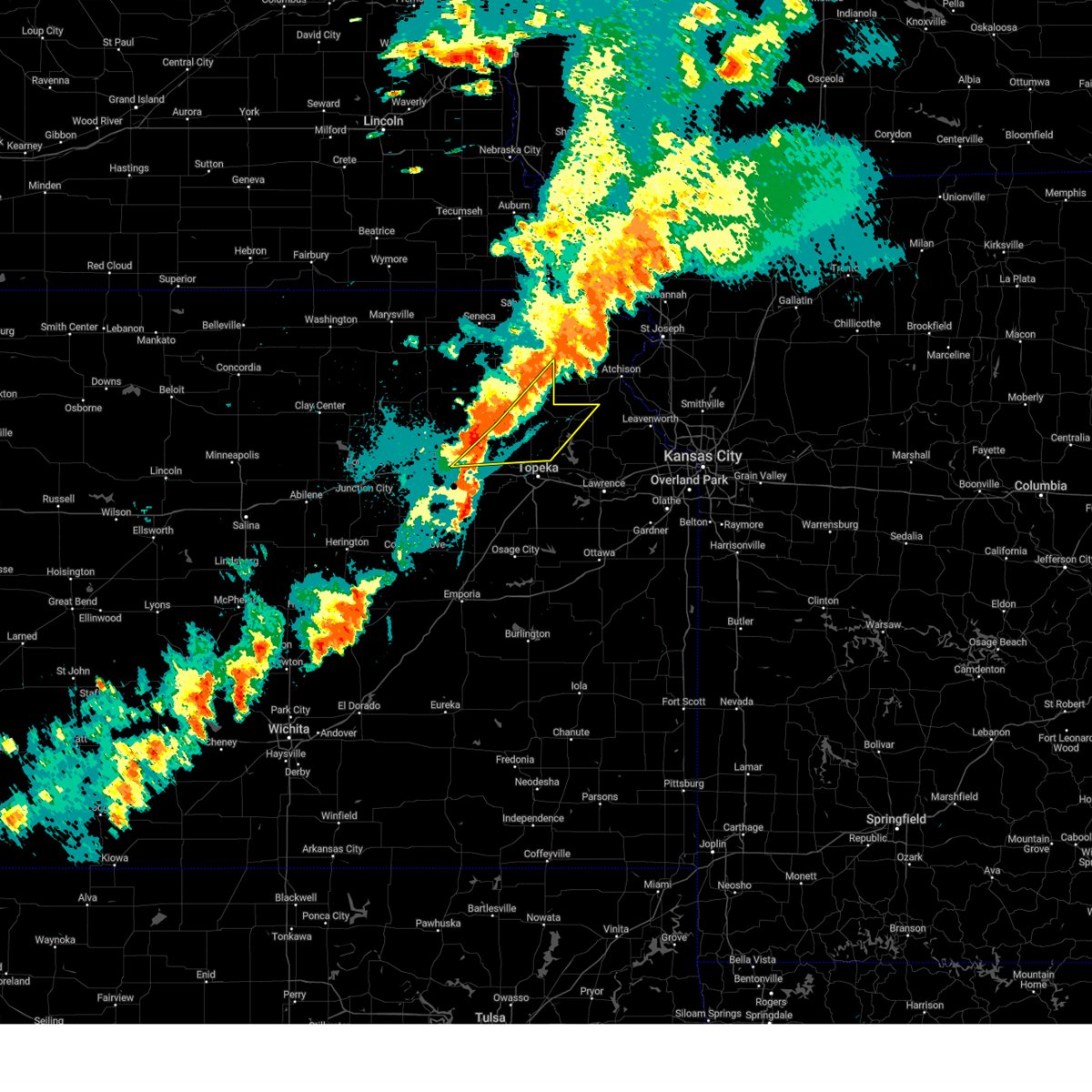
Hail and Wind Damage Spotted near Mayetta, KS
| Date / Time | Report Details |
|---|---|
| 6/13/2026 7:30 PM CDT |
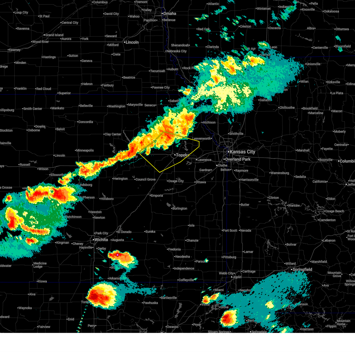 At 728 pm cdt, severe thunderstorms were located along a line extending from 4 miles southeast of alma to near meriden to 4 miles southeast of denison, moving southeast at 65 mph (trained weather spotters. at 7:26 pm, 6 inch diameter tree limbs were reported down near silver lake). Hazards include 70 mph wind gusts and quarter size hail. Hail damage to vehicles is expected. expect considerable tree damage. wind damage is also likely to mobile homes, roofs, and outbuildings. locations impacted include, topeka, rossville, oskaloosa, alma, eskridge, tecumseh, st. marys, dover, silver lake, auburn, perry, mclouth, meriden, hoyt, ozawkie, lecompton, maple hill, mayetta, mcfarland, and harveyville. this includes the following highways, interstate 70 between mile markers 323 and 355. Kansas turnpike between mile markers 160 and 191. At 728 pm cdt, severe thunderstorms were located along a line extending from 4 miles southeast of alma to near meriden to 4 miles southeast of denison, moving southeast at 65 mph (trained weather spotters. at 7:26 pm, 6 inch diameter tree limbs were reported down near silver lake). Hazards include 70 mph wind gusts and quarter size hail. Hail damage to vehicles is expected. expect considerable tree damage. wind damage is also likely to mobile homes, roofs, and outbuildings. locations impacted include, topeka, rossville, oskaloosa, alma, eskridge, tecumseh, st. marys, dover, silver lake, auburn, perry, mclouth, meriden, hoyt, ozawkie, lecompton, maple hill, mayetta, mcfarland, and harveyville. this includes the following highways, interstate 70 between mile markers 323 and 355. Kansas turnpike between mile markers 160 and 191.
|
| 6/13/2026 7:17 PM CDT |
 Svrtop the national weather service in topeka has issued a * severe thunderstorm warning for, central jefferson county in northeastern kansas, shawnee county in east central kansas, northeastern wabaunsee county in east central kansas, northwestern douglas county in east central kansas, northwestern osage county in east central kansas, southeastern pottawatomie county in northeastern kansas, southern jackson county in northeastern kansas, * until 800 pm cdt. * at 717 pm cdt, severe thunderstorms were located along a line extending from 5 miles west of alma to 3 miles east of st. marys to near mayetta, moving southeast at 50 mph (radar indicated). Hazards include 70 mph wind gusts and half dollar size hail. Hail damage to vehicles is expected. expect considerable tree damage. Wind damage is also likely to mobile homes, roofs, and outbuildings. Svrtop the national weather service in topeka has issued a * severe thunderstorm warning for, central jefferson county in northeastern kansas, shawnee county in east central kansas, northeastern wabaunsee county in east central kansas, northwestern douglas county in east central kansas, northwestern osage county in east central kansas, southeastern pottawatomie county in northeastern kansas, southern jackson county in northeastern kansas, * until 800 pm cdt. * at 717 pm cdt, severe thunderstorms were located along a line extending from 5 miles west of alma to 3 miles east of st. marys to near mayetta, moving southeast at 50 mph (radar indicated). Hazards include 70 mph wind gusts and half dollar size hail. Hail damage to vehicles is expected. expect considerable tree damage. Wind damage is also likely to mobile homes, roofs, and outbuildings.
|
| 6/13/2026 7:08 PM CDT |
 Svrtop the national weather service in topeka has issued a * severe thunderstorm warning for, northern jefferson county in northeastern kansas, eastern jackson county in northeastern kansas, southeastern brown county in northeastern kansas, * until 745 pm cdt. * at 706 pm cdt, severe thunderstorms were located along a line extending from 3 miles west of denton to near effingham to near mayetta, moving east at 55 mph (public. at 6:56 pm, a personal weather station reported 69 mph wind gusts in holton). Hazards include 70 mph wind gusts and quarter size hail. Hail damage to vehicles is expected. expect considerable tree damage. Wind damage is also likely to mobile homes, roofs, and outbuildings. Svrtop the national weather service in topeka has issued a * severe thunderstorm warning for, northern jefferson county in northeastern kansas, eastern jackson county in northeastern kansas, southeastern brown county in northeastern kansas, * until 745 pm cdt. * at 706 pm cdt, severe thunderstorms were located along a line extending from 3 miles west of denton to near effingham to near mayetta, moving east at 55 mph (public. at 6:56 pm, a personal weather station reported 69 mph wind gusts in holton). Hazards include 70 mph wind gusts and quarter size hail. Hail damage to vehicles is expected. expect considerable tree damage. Wind damage is also likely to mobile homes, roofs, and outbuildings.
|
| 6/4/2026 8:48 PM CDT |
 At 847 pm cdt, a severe thunderstorm was located near potawatomi reservation, moving east at 35 mph (radar indicated). Hazards include 60 mph wind gusts and quarter size hail. Hail damage to vehicles is expected. expect wind damage to roofs, siding, and trees. Locations impacted include, holton, hoyt, mayetta, delia, and potawatomi reservation. At 847 pm cdt, a severe thunderstorm was located near potawatomi reservation, moving east at 35 mph (radar indicated). Hazards include 60 mph wind gusts and quarter size hail. Hail damage to vehicles is expected. expect wind damage to roofs, siding, and trees. Locations impacted include, holton, hoyt, mayetta, delia, and potawatomi reservation.
|
| 6/4/2026 8:24 PM CDT |
 Svrtop the national weather service in topeka has issued a * severe thunderstorm warning for, east central pottawatomie county in northeastern kansas, southern jackson county in northeastern kansas, * until 900 pm cdt. * at 823 pm cdt, a severe thunderstorm was located over emmett, moving east at 35 mph (radar indicated). Hazards include 60 mph wind gusts and quarter size hail. Hail damage to vehicles is expected. Expect wind damage to roofs, siding, and trees. Svrtop the national weather service in topeka has issued a * severe thunderstorm warning for, east central pottawatomie county in northeastern kansas, southern jackson county in northeastern kansas, * until 900 pm cdt. * at 823 pm cdt, a severe thunderstorm was located over emmett, moving east at 35 mph (radar indicated). Hazards include 60 mph wind gusts and quarter size hail. Hail damage to vehicles is expected. Expect wind damage to roofs, siding, and trees.
|
| 6/1/2026 1:55 AM CDT |
 At 154 am cdt, a severe thunderstorm was located 7 miles north of silver lake, moving northeast at 30 mph (radar indicated). Hazards include 60 mph wind gusts and quarter size hail. Hail damage to vehicles is expected. expect wind damage to roofs, siding, and trees. Locations impacted include, hoyt, mayetta, and delia. At 154 am cdt, a severe thunderstorm was located 7 miles north of silver lake, moving northeast at 30 mph (radar indicated). Hazards include 60 mph wind gusts and quarter size hail. Hail damage to vehicles is expected. expect wind damage to roofs, siding, and trees. Locations impacted include, hoyt, mayetta, and delia.
|
| 6/1/2026 1:40 AM CDT |
 Svrtop the national weather service in topeka has issued a * severe thunderstorm warning for, northern shawnee county in east central kansas, southeastern jackson county in northeastern kansas, * until 215 am cdt. * at 140 am cdt, a severe thunderstorm was located over rossville, moving northeast at 30 mph (radar indicated). Hazards include ping pong ball size hail and 60 mph wind gusts. People and animals outdoors will be injured. expect hail damage to roofs, siding, windows, and vehicles. Expect wind damage to roofs, siding, and trees. Svrtop the national weather service in topeka has issued a * severe thunderstorm warning for, northern shawnee county in east central kansas, southeastern jackson county in northeastern kansas, * until 215 am cdt. * at 140 am cdt, a severe thunderstorm was located over rossville, moving northeast at 30 mph (radar indicated). Hazards include ping pong ball size hail and 60 mph wind gusts. People and animals outdoors will be injured. expect hail damage to roofs, siding, windows, and vehicles. Expect wind damage to roofs, siding, and trees.
|
| 5/18/2026 7:46 PM CDT |
 At 746 pm cdt, a severe thunderstorm was located near effingham, moving northeast at 55 mph (radar indicated). Hazards include 60 mph wind gusts and quarter size hail. Hail damage to vehicles is expected. expect wind damage to roofs, siding, and trees. Locations impacted include, holton, valley falls, hoyt, ozawkie, nortonville, winchester, mayetta, whiting, and denison. At 746 pm cdt, a severe thunderstorm was located near effingham, moving northeast at 55 mph (radar indicated). Hazards include 60 mph wind gusts and quarter size hail. Hail damage to vehicles is expected. expect wind damage to roofs, siding, and trees. Locations impacted include, holton, valley falls, hoyt, ozawkie, nortonville, winchester, mayetta, whiting, and denison.
|
| 5/18/2026 7:46 PM CDT |
 the severe thunderstorm warning has been cancelled and is no longer in effect the severe thunderstorm warning has been cancelled and is no longer in effect
|
| 5/18/2026 7:27 PM CDT |
 Svrtop the national weather service in topeka has issued a * severe thunderstorm warning for, northern jefferson county in northeastern kansas, north central shawnee county in east central kansas, southeastern nemaha county in northeastern kansas, jackson county in northeastern kansas, southern brown county in northeastern kansas, * until 800 pm cdt. * at 727 pm cdt, a severe thunderstorm was located near holton, moving northeast at 55 mph (radar indicated). Hazards include 70 mph wind gusts and quarter size hail. Hail damage to vehicles is expected. expect considerable tree damage. Wind damage is also likely to mobile homes, roofs, and outbuildings. Svrtop the national weather service in topeka has issued a * severe thunderstorm warning for, northern jefferson county in northeastern kansas, north central shawnee county in east central kansas, southeastern nemaha county in northeastern kansas, jackson county in northeastern kansas, southern brown county in northeastern kansas, * until 800 pm cdt. * at 727 pm cdt, a severe thunderstorm was located near holton, moving northeast at 55 mph (radar indicated). Hazards include 70 mph wind gusts and quarter size hail. Hail damage to vehicles is expected. expect considerable tree damage. Wind damage is also likely to mobile homes, roofs, and outbuildings.
|
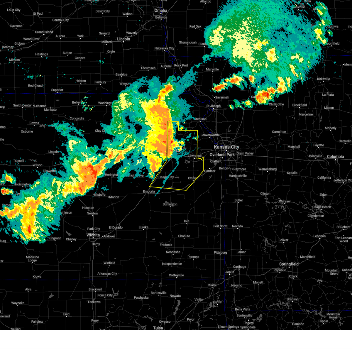
| 5/18/2026 7:12 PM CDT |
 At 712 pm cdt, severe thunderstorms were located along a line extending from 3 miles northwest of holton to 4 miles southwest of potawatomi reservation to near maple hill, moving east at 60 mph (radar indicated). Hazards include 70 mph wind gusts. Expect considerable tree damage. damage is likely to mobile homes, roofs, and outbuildings. locations impacted include, wamego, holton, rossville, alma, st. marys, dover, silver lake, onaga, hoyt, st. george, maple hill, mayetta, mcfarland, paxico, belvue, emmett, louisville, circleville, delia, and soldier. This includes interstate 70 between mile markers 311 and 351. At 712 pm cdt, severe thunderstorms were located along a line extending from 3 miles northwest of holton to 4 miles southwest of potawatomi reservation to near maple hill, moving east at 60 mph (radar indicated). Hazards include 70 mph wind gusts. Expect considerable tree damage. damage is likely to mobile homes, roofs, and outbuildings. locations impacted include, wamego, holton, rossville, alma, st. marys, dover, silver lake, onaga, hoyt, st. george, maple hill, mayetta, mcfarland, paxico, belvue, emmett, louisville, circleville, delia, and soldier. This includes interstate 70 between mile markers 311 and 351.
|
| 5/18/2026 6:42 PM CDT |
 Svrtop the national weather service in topeka has issued a * severe thunderstorm warning for, east central geary county in east central kansas, southeastern riley county in northeastern kansas, northwestern shawnee county in east central kansas, northern wabaunsee county in east central kansas, southeastern nemaha county in northeastern kansas, eastern pottawatomie county in northeastern kansas, jackson county in northeastern kansas, * until 730 pm cdt. * at 641 pm cdt, severe thunderstorms were located along a line extending from 7 miles southeast of westmoreland to 3 miles southeast of st. george to 4 miles northwest of alta vista, moving east at 60 mph (public reported a 67 mph wind gust east of manhattan at 628 pm). Hazards include 70 mph wind gusts. Expect considerable tree damage. Damage is likely to mobile homes, roofs, and outbuildings. Svrtop the national weather service in topeka has issued a * severe thunderstorm warning for, east central geary county in east central kansas, southeastern riley county in northeastern kansas, northwestern shawnee county in east central kansas, northern wabaunsee county in east central kansas, southeastern nemaha county in northeastern kansas, eastern pottawatomie county in northeastern kansas, jackson county in northeastern kansas, * until 730 pm cdt. * at 641 pm cdt, severe thunderstorms were located along a line extending from 7 miles southeast of westmoreland to 3 miles southeast of st. george to 4 miles northwest of alta vista, moving east at 60 mph (public reported a 67 mph wind gust east of manhattan at 628 pm). Hazards include 70 mph wind gusts. Expect considerable tree damage. Damage is likely to mobile homes, roofs, and outbuildings.
|
| 5/17/2026 11:20 PM CDT |
 At 1119 pm cdt, a severe thunderstorm was located near holton, moving southeast at 25 mph (radar indicated). Hazards include 60 mph wind gusts and quarter size hail. Hail damage to vehicles is expected. expect wind damage to roofs, siding, and trees. Locations impacted include, holton, horton, mayetta, whiting, denison, netawaka, and potawatomi reservation. At 1119 pm cdt, a severe thunderstorm was located near holton, moving southeast at 25 mph (radar indicated). Hazards include 60 mph wind gusts and quarter size hail. Hail damage to vehicles is expected. expect wind damage to roofs, siding, and trees. Locations impacted include, holton, horton, mayetta, whiting, denison, netawaka, and potawatomi reservation.
|
| 5/17/2026 11:11 PM CDT |
 At 1111 pm cdt, a severe thunderstorm was located over holton, moving southeast at 25 mph (radar indicated). Hazards include 60 mph wind gusts and quarter size hail. Hail damage to vehicles is expected. expect wind damage to roofs, siding, and trees. Locations impacted include, holton, horton, wetmore, mayetta, whiting, denison, circleville, netawaka, potawatomi reservation, and kickapoo reservation. At 1111 pm cdt, a severe thunderstorm was located over holton, moving southeast at 25 mph (radar indicated). Hazards include 60 mph wind gusts and quarter size hail. Hail damage to vehicles is expected. expect wind damage to roofs, siding, and trees. Locations impacted include, holton, horton, wetmore, mayetta, whiting, denison, circleville, netawaka, potawatomi reservation, and kickapoo reservation.
|
| 5/17/2026 10:56 PM CDT |
 Svrtop the national weather service in topeka has issued a * severe thunderstorm warning for, southeastern nemaha county in northeastern kansas, jackson county in northeastern kansas, southwestern brown county in northeastern kansas, * until 1145 pm cdt. * at 1056 pm cdt, a severe thunderstorm was located near circleville, moving southeast at 25 mph (radar indicated). Hazards include 60 mph wind gusts and quarter size hail. Hail damage to vehicles is expected. Expect wind damage to roofs, siding, and trees. Svrtop the national weather service in topeka has issued a * severe thunderstorm warning for, southeastern nemaha county in northeastern kansas, jackson county in northeastern kansas, southwestern brown county in northeastern kansas, * until 1145 pm cdt. * at 1056 pm cdt, a severe thunderstorm was located near circleville, moving southeast at 25 mph (radar indicated). Hazards include 60 mph wind gusts and quarter size hail. Hail damage to vehicles is expected. Expect wind damage to roofs, siding, and trees.
|
| 4/23/2026 7:02 PM CDT |
 the severe thunderstorm warning has been cancelled and is no longer in effect the severe thunderstorm warning has been cancelled and is no longer in effect
|
| 4/23/2026 7:02 PM CDT |
 At 701 pm cdt, severe thunderstorms were located along a line extending from near mayetta to topeka to 4 miles southeast of auburn, moving east at 40 mph (trained weather spotters. a 60 mph wind gust was reported in west topeka). Hazards include 70 mph wind gusts and half dollar size hail. Hail damage to vehicles is expected. expect considerable tree damage. wind damage is also likely to mobile homes, roofs, and outbuildings. locations impacted include, topeka, carbondale, valley falls, tecumseh, richland, silver lake, auburn, overbrook, perry, meriden, hoyt, ozawkie, lecompton, mayetta, denison, pauline, perry lake, grantville, potawatomi reservation, and berryton. this includes the following highways, interstate 70 between mile markers 350 and 355. Kansas turnpike between mile markers 161 and 195. At 701 pm cdt, severe thunderstorms were located along a line extending from near mayetta to topeka to 4 miles southeast of auburn, moving east at 40 mph (trained weather spotters. a 60 mph wind gust was reported in west topeka). Hazards include 70 mph wind gusts and half dollar size hail. Hail damage to vehicles is expected. expect considerable tree damage. wind damage is also likely to mobile homes, roofs, and outbuildings. locations impacted include, topeka, carbondale, valley falls, tecumseh, richland, silver lake, auburn, overbrook, perry, meriden, hoyt, ozawkie, lecompton, mayetta, denison, pauline, perry lake, grantville, potawatomi reservation, and berryton. this includes the following highways, interstate 70 between mile markers 350 and 355. Kansas turnpike between mile markers 161 and 195.
|
| 4/23/2026 6:40 PM CDT |
 Svrtop the national weather service in topeka has issued a * severe thunderstorm warning for, western jefferson county in northeastern kansas, shawnee county in east central kansas, southeastern wabaunsee county in east central kansas, northwestern douglas county in east central kansas, northern osage county in east central kansas, southern jackson county in northeastern kansas, * until 715 pm cdt. * at 639 pm cdt, severe thunderstorms were located along a line extending from delia to near dover to 3 miles west of harveyville, moving east at 40 mph (radar indicated). Hazards include 70 mph wind gusts and half dollar size hail. Hail damage to vehicles is expected. expect considerable tree damage. Wind damage is also likely to mobile homes, roofs, and outbuildings. Svrtop the national weather service in topeka has issued a * severe thunderstorm warning for, western jefferson county in northeastern kansas, shawnee county in east central kansas, southeastern wabaunsee county in east central kansas, northwestern douglas county in east central kansas, northern osage county in east central kansas, southern jackson county in northeastern kansas, * until 715 pm cdt. * at 639 pm cdt, severe thunderstorms were located along a line extending from delia to near dover to 3 miles west of harveyville, moving east at 40 mph (radar indicated). Hazards include 70 mph wind gusts and half dollar size hail. Hail damage to vehicles is expected. expect considerable tree damage. Wind damage is also likely to mobile homes, roofs, and outbuildings.
|
| 5/19/2025 7:43 PM CDT |
 Svrtop the national weather service in topeka has issued a * severe thunderstorm warning for, jefferson county in northeastern kansas, northeastern shawnee county in east central kansas, northwestern douglas county in east central kansas, southeastern jackson county in northeastern kansas, * until 815 pm cdt. * at 743 pm cdt, severe thunderstorms were located along a line extending from 3 miles northeast of hoyt to near grantville to near pauline, moving east at 45 mph (radar indicated). Hazards include 60 mph wind gusts and penny size hail. expect damage to roofs, siding, and trees Svrtop the national weather service in topeka has issued a * severe thunderstorm warning for, jefferson county in northeastern kansas, northeastern shawnee county in east central kansas, northwestern douglas county in east central kansas, southeastern jackson county in northeastern kansas, * until 815 pm cdt. * at 743 pm cdt, severe thunderstorms were located along a line extending from 3 miles northeast of hoyt to near grantville to near pauline, moving east at 45 mph (radar indicated). Hazards include 60 mph wind gusts and penny size hail. expect damage to roofs, siding, and trees
|
| 4/28/2025 9:05 PM CDT |
 At 905 pm cdt, a severe thunderstorm was located near hoyt, moving east at 40 mph (radar indicated). Hazards include 60 mph wind gusts and half dollar size hail. Hail damage to vehicles is expected. expect wind damage to roofs, siding, and trees. Locations impacted include, hoyt, denison, and mayetta. At 905 pm cdt, a severe thunderstorm was located near hoyt, moving east at 40 mph (radar indicated). Hazards include 60 mph wind gusts and half dollar size hail. Hail damage to vehicles is expected. expect wind damage to roofs, siding, and trees. Locations impacted include, hoyt, denison, and mayetta.
|
| 4/28/2025 8:48 PM CDT |
 Svrtop the national weather service in topeka has issued a * severe thunderstorm warning for, north central shawnee county in east central kansas, southern jackson county in northeastern kansas, * until 915 pm cdt. * at 848 pm cdt, a severe thunderstorm was located near delia, moving east at 40 mph (radar indicated). Hazards include 60 mph wind gusts and half dollar size hail. Hail damage to vehicles is expected. Expect wind damage to roofs, siding, and trees. Svrtop the national weather service in topeka has issued a * severe thunderstorm warning for, north central shawnee county in east central kansas, southern jackson county in northeastern kansas, * until 915 pm cdt. * at 848 pm cdt, a severe thunderstorm was located near delia, moving east at 40 mph (radar indicated). Hazards include 60 mph wind gusts and half dollar size hail. Hail damage to vehicles is expected. Expect wind damage to roofs, siding, and trees.
|
| 4/28/2025 8:13 PM CDT |
 the severe thunderstorm warning has been cancelled and is no longer in effect the severe thunderstorm warning has been cancelled and is no longer in effect
|
| 4/28/2025 7:52 PM CDT |
 Svrtop the national weather service in topeka has issued a * severe thunderstorm warning for, east central pottawatomie county in northeastern kansas, western jackson county in northeastern kansas, * until 830 pm cdt. * at 751 pm cdt, a severe thunderstorm was located 6 miles north of belvue, moving northeast at 45 mph (radar indicated). Hazards include 60 mph wind gusts and half dollar size hail. Hail damage to vehicles is expected. Expect wind damage to roofs, siding, and trees. Svrtop the national weather service in topeka has issued a * severe thunderstorm warning for, east central pottawatomie county in northeastern kansas, western jackson county in northeastern kansas, * until 830 pm cdt. * at 751 pm cdt, a severe thunderstorm was located 6 miles north of belvue, moving northeast at 45 mph (radar indicated). Hazards include 60 mph wind gusts and half dollar size hail. Hail damage to vehicles is expected. Expect wind damage to roofs, siding, and trees.
|
| 4/28/2025 7:24 PM CDT |
 The storm which prompted the warning has moved out of the area. therefore, the warning will be allowed to expire. however, gusty winds are still possible with this thunderstorm. a tornado watch remains in effect until midnight cdt for northeastern kansas. The storm which prompted the warning has moved out of the area. therefore, the warning will be allowed to expire. however, gusty winds are still possible with this thunderstorm. a tornado watch remains in effect until midnight cdt for northeastern kansas.
|
| 4/28/2025 7:09 PM CDT |
 At 709 pm cdt, a severe thunderstorm was located near mayetta, moving east at 50 mph (radar indicated). Hazards include two inch hail and 70 mph wind gusts. People and animals outdoors will be injured. expect hail damage to roofs, siding, windows, and vehicles. expect considerable tree damage. wind damage is also likely to mobile homes, roofs, and outbuildings. This severe storm will be near, holton and denison around 715 pm cdt. At 709 pm cdt, a severe thunderstorm was located near mayetta, moving east at 50 mph (radar indicated). Hazards include two inch hail and 70 mph wind gusts. People and animals outdoors will be injured. expect hail damage to roofs, siding, windows, and vehicles. expect considerable tree damage. wind damage is also likely to mobile homes, roofs, and outbuildings. This severe storm will be near, holton and denison around 715 pm cdt.
|
| 4/28/2025 7:02 PM CDT |
 At 701 pm cdt, a severe thunderstorm was located over potawatomi reservation, moving east at 50 mph (radar indicated). Hazards include golf ball size hail and 70 mph wind gusts. People and animals outdoors will be injured. expect hail damage to roofs, siding, windows, and vehicles. expect considerable tree damage. wind damage is also likely to mobile homes, roofs, and outbuildings. This severe storm will be near, holton, mayetta, and denison around 705 pm cdt. At 701 pm cdt, a severe thunderstorm was located over potawatomi reservation, moving east at 50 mph (radar indicated). Hazards include golf ball size hail and 70 mph wind gusts. People and animals outdoors will be injured. expect hail damage to roofs, siding, windows, and vehicles. expect considerable tree damage. wind damage is also likely to mobile homes, roofs, and outbuildings. This severe storm will be near, holton, mayetta, and denison around 705 pm cdt.
|
| 4/28/2025 7:02 PM CDT |
 the severe thunderstorm warning has been cancelled and is no longer in effect the severe thunderstorm warning has been cancelled and is no longer in effect
|
| 4/28/2025 7:00 PM CDT | Building damage. time estimated by rada in jackson county KS, 1.4 miles WNW of Mayetta, KS |
| 4/28/2025 6:48 PM CDT |
 Svrtop the national weather service in topeka has issued a * severe thunderstorm warning for, east central pottawatomie county in northeastern kansas, jackson county in northeastern kansas, * until 730 pm cdt. * at 647 pm cdt, a severe thunderstorm was located over emmett, moving east at 50 mph (trained weather spotters). Hazards include golf ball size hail and 70 mph wind gusts. People and animals outdoors will be injured. expect hail damage to roofs, siding, windows, and vehicles. expect considerable tree damage. Wind damage is also likely to mobile homes, roofs, and outbuildings. Svrtop the national weather service in topeka has issued a * severe thunderstorm warning for, east central pottawatomie county in northeastern kansas, jackson county in northeastern kansas, * until 730 pm cdt. * at 647 pm cdt, a severe thunderstorm was located over emmett, moving east at 50 mph (trained weather spotters). Hazards include golf ball size hail and 70 mph wind gusts. People and animals outdoors will be injured. expect hail damage to roofs, siding, windows, and vehicles. expect considerable tree damage. Wind damage is also likely to mobile homes, roofs, and outbuildings.
|
| 4/23/2025 4:33 PM CDT |
 At 432 pm cdt, a severe thunderstorm was located near hoyt, moving east at 25 mph (radar indicated). Hazards include 60 mph wind gusts and half dollar size hail. Hail damage to vehicles is expected. expect wind damage to roofs, siding, and trees. Locations impacted include, hoyt, potawatomi reservation, denison, and mayetta. At 432 pm cdt, a severe thunderstorm was located near hoyt, moving east at 25 mph (radar indicated). Hazards include 60 mph wind gusts and half dollar size hail. Hail damage to vehicles is expected. expect wind damage to roofs, siding, and trees. Locations impacted include, hoyt, potawatomi reservation, denison, and mayetta.
|
| 4/23/2025 4:19 PM CDT |
 Svrtop the national weather service in topeka has issued a * severe thunderstorm warning for, north central shawnee county in east central kansas, southern jackson county in northeastern kansas, * until 500 pm cdt. * at 418 pm cdt, a severe thunderstorm was located 5 miles south of potawatomi reservation, moving east at 25 mph (radar indicated). Hazards include 60 mph wind gusts and quarter size hail. Hail damage to vehicles is expected. Expect wind damage to roofs, siding, and trees. Svrtop the national weather service in topeka has issued a * severe thunderstorm warning for, north central shawnee county in east central kansas, southern jackson county in northeastern kansas, * until 500 pm cdt. * at 418 pm cdt, a severe thunderstorm was located 5 miles south of potawatomi reservation, moving east at 25 mph (radar indicated). Hazards include 60 mph wind gusts and quarter size hail. Hail damage to vehicles is expected. Expect wind damage to roofs, siding, and trees.
|
| 3/27/2025 10:20 AM CDT |
 At 1019 am cdt, a severe thunderstorm was located near mayetta, moving northeast at 30 mph (radar indicated). Hazards include ping pong ball size hail and 60 mph wind gusts. People and animals outdoors will be injured. expect hail damage to roofs, siding, windows, and vehicles. expect wind damage to roofs, siding, and trees. Locations impacted include, denison and mayetta. At 1019 am cdt, a severe thunderstorm was located near mayetta, moving northeast at 30 mph (radar indicated). Hazards include ping pong ball size hail and 60 mph wind gusts. People and animals outdoors will be injured. expect hail damage to roofs, siding, windows, and vehicles. expect wind damage to roofs, siding, and trees. Locations impacted include, denison and mayetta.
|
| 3/27/2025 10:15 AM CDT | Half Dollar sized hail reported 1.3 miles N of Mayetta, KS, hail covered the ground. |
| 3/27/2025 10:09 AM CDT |
 At 1008 am cdt, a severe thunderstorm was located near mayetta, moving northeast at 30 mph (radar indicated). Hazards include ping pong ball size hail and 60 mph wind gusts. People and animals outdoors will be injured. expect hail damage to roofs, siding, windows, and vehicles. expect wind damage to roofs, siding, and trees. Locations impacted include, hoyt, denison, and mayetta. At 1008 am cdt, a severe thunderstorm was located near mayetta, moving northeast at 30 mph (radar indicated). Hazards include ping pong ball size hail and 60 mph wind gusts. People and animals outdoors will be injured. expect hail damage to roofs, siding, windows, and vehicles. expect wind damage to roofs, siding, and trees. Locations impacted include, hoyt, denison, and mayetta.
|
| 3/27/2025 9:58 AM CDT |
 Svrtop the national weather service in topeka has issued a * severe thunderstorm warning for, west central jefferson county in northeastern kansas, southeastern jackson county in northeastern kansas, * until 1030 am cdt. * at 958 am cdt, a severe thunderstorm was located 4 miles south of potawatomi reservation, moving northeast at 30 mph (radar indicated). Hazards include 60 mph wind gusts and quarter size hail. Hail damage to vehicles is expected. Expect wind damage to roofs, siding, and trees. Svrtop the national weather service in topeka has issued a * severe thunderstorm warning for, west central jefferson county in northeastern kansas, southeastern jackson county in northeastern kansas, * until 1030 am cdt. * at 958 am cdt, a severe thunderstorm was located 4 miles south of potawatomi reservation, moving northeast at 30 mph (radar indicated). Hazards include 60 mph wind gusts and quarter size hail. Hail damage to vehicles is expected. Expect wind damage to roofs, siding, and trees.
|
| 10/30/2024 6:13 PM CDT |
 Svrtop the national weather service in topeka has issued a * severe thunderstorm warning for, jefferson county in northeastern kansas, northeastern shawnee county in east central kansas, southeastern jackson county in northeastern kansas, * until 700 pm cdt. * at 613 pm cdt, severe thunderstorms were located along a line extending from near denison to 3 miles north of meriden to 3 miles northwest of grantville, moving northeast at 40 mph (radar indicated). Hazards include 60 mph wind gusts. expect damage to roofs, siding, and trees Svrtop the national weather service in topeka has issued a * severe thunderstorm warning for, jefferson county in northeastern kansas, northeastern shawnee county in east central kansas, southeastern jackson county in northeastern kansas, * until 700 pm cdt. * at 613 pm cdt, severe thunderstorms were located along a line extending from near denison to 3 miles north of meriden to 3 miles northwest of grantville, moving northeast at 40 mph (radar indicated). Hazards include 60 mph wind gusts. expect damage to roofs, siding, and trees
|
| 9/21/2024 7:12 PM CDT |
 The storms which prompted the warning have weakened below severe limits, and no longer pose an immediate threat to life or property. therefore, the warning will be allowed to expire. however, gusty winds and heavy rain are still possible with these thunderstorms. to report severe weather, contact your nearest law enforcement agency. they will relay your report to the national weather service topeka. The storms which prompted the warning have weakened below severe limits, and no longer pose an immediate threat to life or property. therefore, the warning will be allowed to expire. however, gusty winds and heavy rain are still possible with these thunderstorms. to report severe weather, contact your nearest law enforcement agency. they will relay your report to the national weather service topeka.
|
| 9/21/2024 6:56 PM CDT |
 At 654 pm cdt, severe thunderstorms were located along a line extending from 3 miles west of belvue to near rossville to 4 miles southeast of silver lake, moving northeast at 55 mph (emergency management 2 miles northwest at 652 pm cdt). Hazards include 62 mph wind gusts. Expect damage to roofs, siding, and trees. locations impacted include, wamego, rossville, st. marys, silver lake, hoyt, maple hill, mayetta, belvue, emmett, louisville, denison, delia, willard, and potawatomi reservation. This includes interstate 70 between mile markers 340 and 353. At 654 pm cdt, severe thunderstorms were located along a line extending from 3 miles west of belvue to near rossville to 4 miles southeast of silver lake, moving northeast at 55 mph (emergency management 2 miles northwest at 652 pm cdt). Hazards include 62 mph wind gusts. Expect damage to roofs, siding, and trees. locations impacted include, wamego, rossville, st. marys, silver lake, hoyt, maple hill, mayetta, belvue, emmett, louisville, denison, delia, willard, and potawatomi reservation. This includes interstate 70 between mile markers 340 and 353.
|
| 9/21/2024 6:49 PM CDT |
 Svrtop the national weather service in topeka has issued a * severe thunderstorm warning for, northwestern shawnee county in east central kansas, northeastern wabaunsee county in east central kansas, southeastern pottawatomie county in northeastern kansas, southern jackson county in northeastern kansas, * until 715 pm cdt. * at 649 pm cdt, severe thunderstorms were located along a line extending from near wamego to near maple hill to 4 miles northeast of dover, moving northeast at 50 mph (radar indicated). Hazards include 60 mph wind gusts. expect damage to roofs, siding, and trees Svrtop the national weather service in topeka has issued a * severe thunderstorm warning for, northwestern shawnee county in east central kansas, northeastern wabaunsee county in east central kansas, southeastern pottawatomie county in northeastern kansas, southern jackson county in northeastern kansas, * until 715 pm cdt. * at 649 pm cdt, severe thunderstorms were located along a line extending from near wamego to near maple hill to 4 miles northeast of dover, moving northeast at 50 mph (radar indicated). Hazards include 60 mph wind gusts. expect damage to roofs, siding, and trees
|
| 8/27/2024 8:03 PM CDT |
 Svrtop the national weather service in topeka has issued a * severe thunderstorm warning for, southeastern jackson county in northeastern kansas, * until 830 pm cdt. * at 802 pm cdt, a severe thunderstorm was located over mayetta, moving northeast at 15 mph (trained weather spotters. at 759 pm cdt a trained spotter reported half dollar size hail 3 miles nnw of mayetta). Hazards include 60 mph wind gusts and half dollar size hail. Hail damage to vehicles is expected. Expect wind damage to roofs, siding, and trees. Svrtop the national weather service in topeka has issued a * severe thunderstorm warning for, southeastern jackson county in northeastern kansas, * until 830 pm cdt. * at 802 pm cdt, a severe thunderstorm was located over mayetta, moving northeast at 15 mph (trained weather spotters. at 759 pm cdt a trained spotter reported half dollar size hail 3 miles nnw of mayetta). Hazards include 60 mph wind gusts and half dollar size hail. Hail damage to vehicles is expected. Expect wind damage to roofs, siding, and trees.
|
| 8/14/2024 10:11 PM CDT |
 Svrtop the national weather service in topeka has issued a * severe thunderstorm warning for, jefferson county in northeastern kansas, shawnee county in east central kansas, southeastern wabaunsee county in east central kansas, northwestern douglas county in east central kansas, northern osage county in east central kansas, eastern jackson county in northeastern kansas, * until 1100 pm cdt. * at 1011 pm cdt, severe thunderstorms were located along a line extending from 4 miles southwest of denton to 3 miles northeast of silver lake to 5 miles west of harveyville, moving east at 45 mph (radar indicated). Hazards include 60 mph wind gusts. expect damage to roofs, siding, and trees Svrtop the national weather service in topeka has issued a * severe thunderstorm warning for, jefferson county in northeastern kansas, shawnee county in east central kansas, southeastern wabaunsee county in east central kansas, northwestern douglas county in east central kansas, northern osage county in east central kansas, eastern jackson county in northeastern kansas, * until 1100 pm cdt. * at 1011 pm cdt, severe thunderstorms were located along a line extending from 4 miles southwest of denton to 3 miles northeast of silver lake to 5 miles west of harveyville, moving east at 45 mph (radar indicated). Hazards include 60 mph wind gusts. expect damage to roofs, siding, and trees
|
| 8/14/2024 9:55 PM CDT |
 Svrtop the national weather service in topeka has issued a * severe thunderstorm warning for, northwestern jefferson county in northeastern kansas, northern shawnee county in east central kansas, northeastern wabaunsee county in east central kansas, southeastern pottawatomie county in northeastern kansas, southeastern jackson county in northeastern kansas, * until 1015 pm cdt. * at 955 pm cdt, severe thunderstorms were located along a line extending from near whiting to near potawatomi reservation to near paxico, moving east at 25 mph (radar indicated). Hazards include 60 mph wind gusts. expect damage to roofs, siding, and trees Svrtop the national weather service in topeka has issued a * severe thunderstorm warning for, northwestern jefferson county in northeastern kansas, northern shawnee county in east central kansas, northeastern wabaunsee county in east central kansas, southeastern pottawatomie county in northeastern kansas, southeastern jackson county in northeastern kansas, * until 1015 pm cdt. * at 955 pm cdt, severe thunderstorms were located along a line extending from near whiting to near potawatomi reservation to near paxico, moving east at 25 mph (radar indicated). Hazards include 60 mph wind gusts. expect damage to roofs, siding, and trees
|
| 8/14/2024 9:24 PM CDT |
 Svrtop the national weather service in topeka has issued a * severe thunderstorm warning for, northwestern jefferson county in northeastern kansas, northwestern shawnee county in east central kansas, northern wabaunsee county in east central kansas, southeastern pottawatomie county in northeastern kansas, southeastern nemaha county in northeastern kansas, jackson county in northeastern kansas, brown county in northeastern kansas, * until 1000 pm cdt. * at 923 pm cdt, severe thunderstorms were located along a line extending from 4 miles northwest of forest city to near kickapoo reservation to 5 miles northwest of paxico, moving east at 50 mph (radar indicated). Hazards include 60 mph wind gusts. expect damage to roofs, siding, and trees Svrtop the national weather service in topeka has issued a * severe thunderstorm warning for, northwestern jefferson county in northeastern kansas, northwestern shawnee county in east central kansas, northern wabaunsee county in east central kansas, southeastern pottawatomie county in northeastern kansas, southeastern nemaha county in northeastern kansas, jackson county in northeastern kansas, brown county in northeastern kansas, * until 1000 pm cdt. * at 923 pm cdt, severe thunderstorms were located along a line extending from 4 miles northwest of forest city to near kickapoo reservation to 5 miles northwest of paxico, moving east at 50 mph (radar indicated). Hazards include 60 mph wind gusts. expect damage to roofs, siding, and trees
|
| 7/31/2024 9:38 PM CDT |
 Svrtop the national weather service in topeka has issued a * severe thunderstorm warning for, western franklin county in east central kansas, jefferson county in northeastern kansas, shawnee county in east central kansas, douglas county in east central kansas, osage county in east central kansas, eastern jackson county in northeastern kansas, northeastern lyon county in east central kansas, * until 1015 pm cdt. * at 937 pm cdt, severe thunderstorms were located along a line extending from 4 miles east of holton to near richland to near olpe, moving east at 35 mph (trained weather spotters. 60 to 70 mph wind gusts have been reported along this line from dover to st. marys as the line passed). Hazards include 60 mph wind gusts and nickel size hail. expect damage to roofs, siding, and trees Svrtop the national weather service in topeka has issued a * severe thunderstorm warning for, western franklin county in east central kansas, jefferson county in northeastern kansas, shawnee county in east central kansas, douglas county in east central kansas, osage county in east central kansas, eastern jackson county in northeastern kansas, northeastern lyon county in east central kansas, * until 1015 pm cdt. * at 937 pm cdt, severe thunderstorms were located along a line extending from 4 miles east of holton to near richland to near olpe, moving east at 35 mph (trained weather spotters. 60 to 70 mph wind gusts have been reported along this line from dover to st. marys as the line passed). Hazards include 60 mph wind gusts and nickel size hail. expect damage to roofs, siding, and trees
|
| 7/31/2024 9:18 PM CDT |
 At 916 pm cdt, severe thunderstorms were located along a line extending from 4 miles southwest of circleville to 3 miles southwest of auburn to 3 miles west of olpe, moving east at 45 mph (trained weather spotters. wind gust of 70 mph were reported in dover at 913pm, and 68mph wind gusts were reported 2 miles nw of wamego at 854pm). Hazards include 70 mph wind gusts and nickel size hail. Expect considerable tree damage. damage is likely to mobile homes, roofs, and outbuildings. locations impacted include, topeka, emporia, holton, osage city, carbondale, valley falls, rossville, eskridge, tecumseh, st. marys, richland, dover, silver lake, auburn, overbrook, lyndon, lebo, burlingame, perry, and americus. this includes the following highways, interstate 35 between mile markers 128 and 162. interstate 70 between mile markers 337 and 355. Kansas turnpike between mile markers 117 and 195. At 916 pm cdt, severe thunderstorms were located along a line extending from 4 miles southwest of circleville to 3 miles southwest of auburn to 3 miles west of olpe, moving east at 45 mph (trained weather spotters. wind gust of 70 mph were reported in dover at 913pm, and 68mph wind gusts were reported 2 miles nw of wamego at 854pm). Hazards include 70 mph wind gusts and nickel size hail. Expect considerable tree damage. damage is likely to mobile homes, roofs, and outbuildings. locations impacted include, topeka, emporia, holton, osage city, carbondale, valley falls, rossville, eskridge, tecumseh, st. marys, richland, dover, silver lake, auburn, overbrook, lyndon, lebo, burlingame, perry, and americus. this includes the following highways, interstate 35 between mile markers 128 and 162. interstate 70 between mile markers 337 and 355. Kansas turnpike between mile markers 117 and 195.
|
| 7/31/2024 9:07 PM CDT |
 Svrtop the national weather service in topeka has issued a * severe thunderstorm warning for, northwestern franklin county in east central kansas, western jefferson county in northeastern kansas, shawnee county in east central kansas, eastern wabaunsee county in east central kansas, western douglas county in east central kansas, osage county in east central kansas, eastern pottawatomie county in northeastern kansas, southeastern nemaha county in northeastern kansas, jackson county in northeastern kansas, western coffey county in east central kansas, lyon county in east central kansas, * until 945 pm cdt. * at 906 pm cdt, severe thunderstorms were located along a line extending from 3 miles southeast of havensville to 6 miles north of harveyville to 10 miles west of olpe, moving east at 45 mph (radar indicated). Hazards include 60 mph wind gusts and nickel size hail. expect damage to roofs, siding, and trees Svrtop the national weather service in topeka has issued a * severe thunderstorm warning for, northwestern franklin county in east central kansas, western jefferson county in northeastern kansas, shawnee county in east central kansas, eastern wabaunsee county in east central kansas, western douglas county in east central kansas, osage county in east central kansas, eastern pottawatomie county in northeastern kansas, southeastern nemaha county in northeastern kansas, jackson county in northeastern kansas, western coffey county in east central kansas, lyon county in east central kansas, * until 945 pm cdt. * at 906 pm cdt, severe thunderstorms were located along a line extending from 3 miles southeast of havensville to 6 miles north of harveyville to 10 miles west of olpe, moving east at 45 mph (radar indicated). Hazards include 60 mph wind gusts and nickel size hail. expect damage to roofs, siding, and trees
|
| 7/16/2024 7:36 AM CDT |
 At 736 am cdt, severe thunderstorms were located along a line extending from near ozawkie to near williamstown to 3 miles southwest of clinton lake, moving east at 55 mph (radar indicated). Hazards include 70 mph wind gusts and nickel size hail. Expect considerable tree damage. damage is likely to mobile homes, roofs, and outbuildings. locations impacted include, topeka, western lawrence, valley falls, oskaloosa, tecumseh, richland, perry, mclouth, meriden, hoyt, ozawkie, nortonville, lecompton, clinton, winchester, mayetta, lone star, denison, pauline, and williamstown. this includes the following highways, interstate 70 between mile markers 354 and 355. Kansas turnpike between mile markers 170 and 202. At 736 am cdt, severe thunderstorms were located along a line extending from near ozawkie to near williamstown to 3 miles southwest of clinton lake, moving east at 55 mph (radar indicated). Hazards include 70 mph wind gusts and nickel size hail. Expect considerable tree damage. damage is likely to mobile homes, roofs, and outbuildings. locations impacted include, topeka, western lawrence, valley falls, oskaloosa, tecumseh, richland, perry, mclouth, meriden, hoyt, ozawkie, nortonville, lecompton, clinton, winchester, mayetta, lone star, denison, pauline, and williamstown. this includes the following highways, interstate 70 between mile markers 354 and 355. Kansas turnpike between mile markers 170 and 202.
|
| 7/16/2024 7:30 AM CDT |
 the severe thunderstorm warning has been cancelled and is no longer in effect the severe thunderstorm warning has been cancelled and is no longer in effect
|
| 7/16/2024 7:30 AM CDT |
 At 728 am cdt, severe thunderstorms were located along a line extending from 4 miles north of meriden to 3 miles west of lecompton to near richland, moving east at 55 mph (at 7:25 am, automated weather station at topeka billard airport measured a 68 mph wind gusts). Hazards include 70 mph wind gusts and nickel size hail. Expect considerable tree damage. damage is likely to mobile homes, roofs, and outbuildings. locations impacted include, topeka, western lawrence, valley falls, rossville, oskaloosa, tecumseh, richland, dover, silver lake, auburn, perry, mclouth, meriden, hoyt, ozawkie, nortonville, lecompton, clinton, winchester, and mayetta. this includes the following highways, interstate 70 between mile markers 346 and 355. Kansas turnpike between mile markers 170 and 202. At 728 am cdt, severe thunderstorms were located along a line extending from 4 miles north of meriden to 3 miles west of lecompton to near richland, moving east at 55 mph (at 7:25 am, automated weather station at topeka billard airport measured a 68 mph wind gusts). Hazards include 70 mph wind gusts and nickel size hail. Expect considerable tree damage. damage is likely to mobile homes, roofs, and outbuildings. locations impacted include, topeka, western lawrence, valley falls, rossville, oskaloosa, tecumseh, richland, dover, silver lake, auburn, perry, mclouth, meriden, hoyt, ozawkie, nortonville, lecompton, clinton, winchester, and mayetta. this includes the following highways, interstate 70 between mile markers 346 and 355. Kansas turnpike between mile markers 170 and 202.
|
| 7/16/2024 7:18 AM CDT |
 At 718 am cdt, severe thunderstorms were located along a line extending from near mayetta to near grantville to 3 miles east of auburn, moving east at 60 mph (at 7:11 am, a storm chaser and trained spotter reported 60 to 70 mph winds 5 miles east of silver lake). Hazards include 70 mph wind gusts and nickel size hail. Expect considerable tree damage. damage is likely to mobile homes, roofs, and outbuildings. locations impacted include, topeka, western lawrence, valley falls, rossville, oskaloosa, tecumseh, st. marys, richland, dover, silver lake, perry, mclouth, meriden, hoyt, ozawkie, nortonville, lecompton, maple hill, clinton, and winchester. this includes the following highways, interstate 70 between mile markers 336 and 355. Kansas turnpike between mile markers 170 and 202. At 718 am cdt, severe thunderstorms were located along a line extending from near mayetta to near grantville to 3 miles east of auburn, moving east at 60 mph (at 7:11 am, a storm chaser and trained spotter reported 60 to 70 mph winds 5 miles east of silver lake). Hazards include 70 mph wind gusts and nickel size hail. Expect considerable tree damage. damage is likely to mobile homes, roofs, and outbuildings. locations impacted include, topeka, western lawrence, valley falls, rossville, oskaloosa, tecumseh, st. marys, richland, dover, silver lake, perry, mclouth, meriden, hoyt, ozawkie, nortonville, lecompton, maple hill, clinton, and winchester. this includes the following highways, interstate 70 between mile markers 336 and 355. Kansas turnpike between mile markers 170 and 202.
|
| 7/16/2024 7:09 AM CDT |
 Svrtop the national weather service in topeka has issued a * severe thunderstorm warning for, jefferson county in northeastern kansas, shawnee county in east central kansas, northeastern wabaunsee county in east central kansas, northwestern douglas county in east central kansas, southeastern pottawatomie county in northeastern kansas, southern jackson county in northeastern kansas, * until 745 am cdt. * at 709 am cdt, severe thunderstorms were located along a line extending from potawatomi reservation to 5 miles east of silver lake to 3 miles southeast of dover, moving east at 65 mph (radar indicated). Hazards include 70 mph wind gusts and nickel size hail. Expect considerable tree damage. Damage is likely to mobile homes, roofs, and outbuildings. Svrtop the national weather service in topeka has issued a * severe thunderstorm warning for, jefferson county in northeastern kansas, shawnee county in east central kansas, northeastern wabaunsee county in east central kansas, northwestern douglas county in east central kansas, southeastern pottawatomie county in northeastern kansas, southern jackson county in northeastern kansas, * until 745 am cdt. * at 709 am cdt, severe thunderstorms were located along a line extending from potawatomi reservation to 5 miles east of silver lake to 3 miles southeast of dover, moving east at 65 mph (radar indicated). Hazards include 70 mph wind gusts and nickel size hail. Expect considerable tree damage. Damage is likely to mobile homes, roofs, and outbuildings.
|
| 7/16/2024 7:01 AM CDT |
 the severe thunderstorm warning has been cancelled and is no longer in effect the severe thunderstorm warning has been cancelled and is no longer in effect
|
| 7/16/2024 7:01 AM CDT |
 At 700 am cdt, severe thunderstorms were located along a line extending from 4 miles southeast of havensville to 3 miles north of rossville to 3 miles northwest of keene, moving east at 60 mph (public. at 656 am, the public reported wind gusts of 70 mph in alma). Hazards include 70 mph wind gusts and nickel size hail. Expect considerable tree damage. damage is likely to mobile homes, roofs, and outbuildings. locations impacted include, western topeka, holton, rossville, alma, st. marys, silver lake, hoyt, maple hill, mayetta, mcfarland, paxico, belvue, emmett, delia, willard, and potawatomi reservation. This includes interstate 70 between mile markers 328 and 355. At 700 am cdt, severe thunderstorms were located along a line extending from 4 miles southeast of havensville to 3 miles north of rossville to 3 miles northwest of keene, moving east at 60 mph (public. at 656 am, the public reported wind gusts of 70 mph in alma). Hazards include 70 mph wind gusts and nickel size hail. Expect considerable tree damage. damage is likely to mobile homes, roofs, and outbuildings. locations impacted include, western topeka, holton, rossville, alma, st. marys, silver lake, hoyt, maple hill, mayetta, mcfarland, paxico, belvue, emmett, delia, willard, and potawatomi reservation. This includes interstate 70 between mile markers 328 and 355.
|
| 7/16/2024 6:42 AM CDT |
 Svrtop the national weather service in topeka has issued a * severe thunderstorm warning for, southeastern riley county in northeastern kansas, northwestern shawnee county in east central kansas, northern wabaunsee county in east central kansas, eastern pottawatomie county in northeastern kansas, southwestern jackson county in northeastern kansas, * until 715 am cdt. * at 642 am cdt, severe thunderstorms were located along a line extending from 3 miles south of wheaton to 3 miles southeast of wamego to 3 miles northeast of volland, moving east at 60 mph (radar indicated). Hazards include 70 mph wind gusts and nickel size hail. Expect considerable tree damage. Damage is likely to mobile homes, roofs, and outbuildings. Svrtop the national weather service in topeka has issued a * severe thunderstorm warning for, southeastern riley county in northeastern kansas, northwestern shawnee county in east central kansas, northern wabaunsee county in east central kansas, eastern pottawatomie county in northeastern kansas, southwestern jackson county in northeastern kansas, * until 715 am cdt. * at 642 am cdt, severe thunderstorms were located along a line extending from 3 miles south of wheaton to 3 miles southeast of wamego to 3 miles northeast of volland, moving east at 60 mph (radar indicated). Hazards include 70 mph wind gusts and nickel size hail. Expect considerable tree damage. Damage is likely to mobile homes, roofs, and outbuildings.
|
| 6/26/2024 3:03 AM CDT |
 the severe thunderstorm warning has been cancelled and is no longer in effect the severe thunderstorm warning has been cancelled and is no longer in effect
|
| 6/26/2024 3:03 AM CDT |
 At 302 am cdt, severe thunderstorms were located along a line extending from 7 miles south of muscotah to 3 miles south of potawatomi reservation to 4 miles northeast of moonlight, moving southeast at 80 mph (radar indicated). Hazards include 70 mph wind gusts. Expect considerable tree damage. damage is likely to mobile homes, roofs, and outbuildings. locations impacted include, manhattan, wamego, holton, westmoreland, riley, onaga, hoyt, st. George, milford, leonardville, wetmore, mayetta, olsburg, belvue, emmett, louisville, circleville, delia, soldier, and havensville. At 302 am cdt, severe thunderstorms were located along a line extending from 7 miles south of muscotah to 3 miles south of potawatomi reservation to 4 miles northeast of moonlight, moving southeast at 80 mph (radar indicated). Hazards include 70 mph wind gusts. Expect considerable tree damage. damage is likely to mobile homes, roofs, and outbuildings. locations impacted include, manhattan, wamego, holton, westmoreland, riley, onaga, hoyt, st. George, milford, leonardville, wetmore, mayetta, olsburg, belvue, emmett, louisville, circleville, delia, soldier, and havensville.
|
| 6/26/2024 3:00 AM CDT |
 Svrtop the national weather service in topeka has issued a * severe thunderstorm warning for, geary county in east central kansas, southern riley county in northeastern kansas, shawnee county in east central kansas, wabaunsee county in east central kansas, southern pottawatomie county in northeastern kansas, southern jackson county in northeastern kansas, * until 345 am cdt. * at 300 am cdt, severe thunderstorms were located along a line extending from near holton to 3 miles northwest of st. marys to near milford lake, moving southeast at 50 mph (radar indicated). Hazards include 70 mph wind gusts. Expect considerable tree damage. Damage is likely to mobile homes, roofs, and outbuildings. Svrtop the national weather service in topeka has issued a * severe thunderstorm warning for, geary county in east central kansas, southern riley county in northeastern kansas, shawnee county in east central kansas, wabaunsee county in east central kansas, southern pottawatomie county in northeastern kansas, southern jackson county in northeastern kansas, * until 345 am cdt. * at 300 am cdt, severe thunderstorms were located along a line extending from near holton to 3 miles northwest of st. marys to near milford lake, moving southeast at 50 mph (radar indicated). Hazards include 70 mph wind gusts. Expect considerable tree damage. Damage is likely to mobile homes, roofs, and outbuildings.
|
| 6/26/2024 2:41 AM CDT |
 Svrtop the national weather service in topeka has issued a * severe thunderstorm warning for, northwestern dickinson county in central kansas, northwestern geary county in east central kansas, riley county in northeastern kansas, northeastern ottawa county in north central kansas, pottawatomie county in northeastern kansas, southern nemaha county in northeastern kansas, jackson county in northeastern kansas, clay county in north central kansas, southeastern cloud county in north central kansas, southeastern marshall county in northeastern kansas, * until 315 am cdt. * at 241 am cdt, severe thunderstorms were located along a line extending from near goff to 3 miles west of onaga to 6 miles south of miltonvale, moving southeast at 45 mph (radar indicated). Hazards include 70 mph wind gusts. Expect considerable tree damage. Damage is likely to mobile homes, roofs, and outbuildings. Svrtop the national weather service in topeka has issued a * severe thunderstorm warning for, northwestern dickinson county in central kansas, northwestern geary county in east central kansas, riley county in northeastern kansas, northeastern ottawa county in north central kansas, pottawatomie county in northeastern kansas, southern nemaha county in northeastern kansas, jackson county in northeastern kansas, clay county in north central kansas, southeastern cloud county in north central kansas, southeastern marshall county in northeastern kansas, * until 315 am cdt. * at 241 am cdt, severe thunderstorms were located along a line extending from near goff to 3 miles west of onaga to 6 miles south of miltonvale, moving southeast at 45 mph (radar indicated). Hazards include 70 mph wind gusts. Expect considerable tree damage. Damage is likely to mobile homes, roofs, and outbuildings.
|
| 6/13/2024 9:01 PM CDT |
 At 901 pm cdt, a severe thunderstorm was located 4 miles southeast of denison, moving southeast at 35 mph (radar indicated). Hazards include golf ball size hail and 60 mph wind gusts. People and animals outdoors will be injured. expect hail damage to roofs, siding, windows, and vehicles. expect wind damage to roofs, siding, and trees. Locations impacted include, valley falls, hoyt, ozawkie, nortonville, mayetta, and denison. At 901 pm cdt, a severe thunderstorm was located 4 miles southeast of denison, moving southeast at 35 mph (radar indicated). Hazards include golf ball size hail and 60 mph wind gusts. People and animals outdoors will be injured. expect hail damage to roofs, siding, windows, and vehicles. expect wind damage to roofs, siding, and trees. Locations impacted include, valley falls, hoyt, ozawkie, nortonville, mayetta, and denison.
|
| 6/13/2024 8:55 PM CDT |
 The storm which prompted the warning has moved out of the area. therefore, the warning will be allowed to expire. a severe thunderstorm watch remains in effect until 1000 pm cdt for northeastern kansas. a severe thunderstorm watch also remains in effect until 1100 pm cdt for east central kansas. remember, a severe thunderstorm warning still remains in effect for eastern jackson county until 915 pm. The storm which prompted the warning has moved out of the area. therefore, the warning will be allowed to expire. a severe thunderstorm watch remains in effect until 1000 pm cdt for northeastern kansas. a severe thunderstorm watch also remains in effect until 1100 pm cdt for east central kansas. remember, a severe thunderstorm warning still remains in effect for eastern jackson county until 915 pm.
|
| 6/13/2024 8:50 PM CDT |
 At 849 pm cdt, a severe thunderstorm was located near denison, moving northeast at 40 mph (emergency management reported golf ball size hail at 839 pm in holton). Hazards include golf ball size hail and 60 mph wind gusts. People and animals outdoors will be injured. expect hail damage to roofs, siding, windows, and vehicles. expect wind damage to roofs, siding, and trees. Locations impacted include, holton, valley falls, hoyt, ozawkie, nortonville, mayetta, and denison. At 849 pm cdt, a severe thunderstorm was located near denison, moving northeast at 40 mph (emergency management reported golf ball size hail at 839 pm in holton). Hazards include golf ball size hail and 60 mph wind gusts. People and animals outdoors will be injured. expect hail damage to roofs, siding, windows, and vehicles. expect wind damage to roofs, siding, and trees. Locations impacted include, holton, valley falls, hoyt, ozawkie, nortonville, mayetta, and denison.
|
| 6/13/2024 8:36 PM CDT |
 Svrtop the national weather service in topeka has issued a * severe thunderstorm warning for, northwestern jefferson county in northeastern kansas, southeastern jackson county in northeastern kansas, * until 915 pm cdt. * at 836 pm cdt, a severe thunderstorm was located over potawatomi reservation, moving east at 40 mph (radar indicated). Hazards include 60 mph wind gusts and half dollar size hail. Hail damage to vehicles is expected. Expect wind damage to roofs, siding, and trees. Svrtop the national weather service in topeka has issued a * severe thunderstorm warning for, northwestern jefferson county in northeastern kansas, southeastern jackson county in northeastern kansas, * until 915 pm cdt. * at 836 pm cdt, a severe thunderstorm was located over potawatomi reservation, moving east at 40 mph (radar indicated). Hazards include 60 mph wind gusts and half dollar size hail. Hail damage to vehicles is expected. Expect wind damage to roofs, siding, and trees.
|
| 6/13/2024 8:27 PM CDT |
 the severe thunderstorm warning has been cancelled and is no longer in effect the severe thunderstorm warning has been cancelled and is no longer in effect
|
| 6/13/2024 8:27 PM CDT |
 At 826 pm cdt, a severe thunderstorm was located 5 miles north of delia, moving east at 40 mph (radar indicated). Hazards include 60 mph wind gusts and half dollar size hail. Hail damage to vehicles is expected. expect wind damage to roofs, siding, and trees. Locations impacted include, mayetta, delia, and potawatomi reservation. At 826 pm cdt, a severe thunderstorm was located 5 miles north of delia, moving east at 40 mph (radar indicated). Hazards include 60 mph wind gusts and half dollar size hail. Hail damage to vehicles is expected. expect wind damage to roofs, siding, and trees. Locations impacted include, mayetta, delia, and potawatomi reservation.
|
| 6/13/2024 8:00 PM CDT |
 Svrtop the national weather service in topeka has issued a * severe thunderstorm warning for, northwestern shawnee county in east central kansas, northeastern wabaunsee county in east central kansas, southeastern pottawatomie county in northeastern kansas, southwestern jackson county in northeastern kansas, * until 900 pm cdt. * at 759 pm cdt, a severe thunderstorm was located near belvue, moving east at 25 mph (trained weather spotters). Hazards include two inch hail and 60 mph wind gusts. People and animals outdoors will be injured. expect hail damage to roofs, siding, windows, and vehicles. Expect wind damage to roofs, siding, and trees. Svrtop the national weather service in topeka has issued a * severe thunderstorm warning for, northwestern shawnee county in east central kansas, northeastern wabaunsee county in east central kansas, southeastern pottawatomie county in northeastern kansas, southwestern jackson county in northeastern kansas, * until 900 pm cdt. * at 759 pm cdt, a severe thunderstorm was located near belvue, moving east at 25 mph (trained weather spotters). Hazards include two inch hail and 60 mph wind gusts. People and animals outdoors will be injured. expect hail damage to roofs, siding, windows, and vehicles. Expect wind damage to roofs, siding, and trees.
|
| 6/8/2024 12:25 AM CDT |
 The storm which prompted the warning has weakened below severe limits, and no longer poses an immediate threat to life or property. therefore, the warning will be allowed to expire. however, small hail, gusty winds and heavy rain are still possible with this thunderstorm. a severe thunderstorm watch remains in effect until 100 am cdt for northeastern kansas. The storm which prompted the warning has weakened below severe limits, and no longer poses an immediate threat to life or property. therefore, the warning will be allowed to expire. however, small hail, gusty winds and heavy rain are still possible with this thunderstorm. a severe thunderstorm watch remains in effect until 100 am cdt for northeastern kansas.
|
| 6/8/2024 12:06 AM CDT |
 At 1206 am cdt, a severe thunderstorm was located near hoyt, moving east at 30 mph (radar indicated). Hazards include ping pong ball size hail and 60 mph wind gusts. People and animals outdoors will be injured. expect hail damage to roofs, siding, windows, and vehicles. expect wind damage to roofs, siding, and trees. Locations impacted include, hoyt, mayetta, and potawatomi reservation. At 1206 am cdt, a severe thunderstorm was located near hoyt, moving east at 30 mph (radar indicated). Hazards include ping pong ball size hail and 60 mph wind gusts. People and animals outdoors will be injured. expect hail damage to roofs, siding, windows, and vehicles. expect wind damage to roofs, siding, and trees. Locations impacted include, hoyt, mayetta, and potawatomi reservation.
|
| 6/7/2024 11:58 PM CDT |
 Svrtop the national weather service in topeka has issued a * severe thunderstorm warning for, southeastern jackson county in northeastern kansas, * until 1230 am cdt. * at 1157 pm cdt, a severe thunderstorm was located over potawatomi reservation, moving east at 30 mph (radar indicated). Hazards include 60 mph wind gusts and quarter size hail. Hail damage to vehicles is expected. Expect wind damage to roofs, siding, and trees. Svrtop the national weather service in topeka has issued a * severe thunderstorm warning for, southeastern jackson county in northeastern kansas, * until 1230 am cdt. * at 1157 pm cdt, a severe thunderstorm was located over potawatomi reservation, moving east at 30 mph (radar indicated). Hazards include 60 mph wind gusts and quarter size hail. Hail damage to vehicles is expected. Expect wind damage to roofs, siding, and trees.
|
| 6/7/2024 11:51 PM CDT |
 At 1150 pm cdt, a severe thunderstorm was located near potawatomi reservation, moving east at 35 mph (radar indicated). Hazards include 60 mph wind gusts and quarter size hail. Hail damage to vehicles is expected. expect wind damage to roofs, siding, and trees. Locations impacted include, hoyt, mayetta, and potawatomi reservation. At 1150 pm cdt, a severe thunderstorm was located near potawatomi reservation, moving east at 35 mph (radar indicated). Hazards include 60 mph wind gusts and quarter size hail. Hail damage to vehicles is expected. expect wind damage to roofs, siding, and trees. Locations impacted include, hoyt, mayetta, and potawatomi reservation.
|
| 6/7/2024 11:35 PM CDT |
 Svrtop the national weather service in topeka has issued a * severe thunderstorm warning for, southern jackson county in northeastern kansas, * until midnight cdt. * at 1135 pm cdt, a severe thunderstorm was located over emmett, moving east at 35 mph (radar indicated). Hazards include 60 mph wind gusts and half dollar size hail. Hail damage to vehicles is expected. Expect wind damage to roofs, siding, and trees. Svrtop the national weather service in topeka has issued a * severe thunderstorm warning for, southern jackson county in northeastern kansas, * until midnight cdt. * at 1135 pm cdt, a severe thunderstorm was located over emmett, moving east at 35 mph (radar indicated). Hazards include 60 mph wind gusts and half dollar size hail. Hail damage to vehicles is expected. Expect wind damage to roofs, siding, and trees.
|
| 5/19/2024 11:22 PM CDT |
 The storms which prompted the warning have weakened below severe limits, and no longer pose an immediate threat to life or property. therefore, the warning will be allowed to expire. however, gusty winds are still expected with these thunderstorms. a severe thunderstorm watch remains in effect until 200 am cdt for northeastern kansas. The storms which prompted the warning have weakened below severe limits, and no longer pose an immediate threat to life or property. therefore, the warning will be allowed to expire. however, gusty winds are still expected with these thunderstorms. a severe thunderstorm watch remains in effect until 200 am cdt for northeastern kansas.
|
| 5/19/2024 11:09 PM CDT |
 The storms which prompted the warning have weakened below severe limits, and no longer pose an immediate threat to life or property. therefore, the warning will be allowed to expire. however, gusty winds are still expected with these thunderstorms. a severe thunderstorm watch remains in effect until 200 am cdt for northeastern and east central kansas. remember, a severe thunderstorm warning still remains in effect for northern jefferson and northeastern jackson counties until 1130 pm. The storms which prompted the warning have weakened below severe limits, and no longer pose an immediate threat to life or property. therefore, the warning will be allowed to expire. however, gusty winds are still expected with these thunderstorms. a severe thunderstorm watch remains in effect until 200 am cdt for northeastern and east central kansas. remember, a severe thunderstorm warning still remains in effect for northern jefferson and northeastern jackson counties until 1130 pm.
|
| 5/19/2024 10:48 PM CDT |
 Svrtop the national weather service in topeka has issued a * severe thunderstorm warning for, northern jefferson county in northeastern kansas, northeastern jackson county in northeastern kansas, * until 1130 pm cdt. * at 1047 pm cdt, severe thunderstorms were located along a line extending from near mayetta to near mclouth, moving northeast at 40 mph (emergency management). Hazards include 60 mph wind gusts. expect damage to roofs, siding, and trees Svrtop the national weather service in topeka has issued a * severe thunderstorm warning for, northern jefferson county in northeastern kansas, northeastern jackson county in northeastern kansas, * until 1130 pm cdt. * at 1047 pm cdt, severe thunderstorms were located along a line extending from near mayetta to near mclouth, moving northeast at 40 mph (emergency management). Hazards include 60 mph wind gusts. expect damage to roofs, siding, and trees
|
| 5/19/2024 10:26 PM CDT |
 Svrtop the national weather service in topeka has issued a * severe thunderstorm warning for, southern jefferson county in northeastern kansas, shawnee county in east central kansas, northeastern wabaunsee county in east central kansas, southeastern pottawatomie county in northeastern kansas, southern jackson county in northeastern kansas, * until 1115 pm cdt. * at 1026 pm cdt, severe thunderstorms were located along a line extending from near rossville to near perry, moving northeast at 20 mph (radar indicated). Hazards include 60 mph wind gusts and nickel size hail. expect damage to roofs, siding, and trees Svrtop the national weather service in topeka has issued a * severe thunderstorm warning for, southern jefferson county in northeastern kansas, shawnee county in east central kansas, northeastern wabaunsee county in east central kansas, southeastern pottawatomie county in northeastern kansas, southern jackson county in northeastern kansas, * until 1115 pm cdt. * at 1026 pm cdt, severe thunderstorms were located along a line extending from near rossville to near perry, moving northeast at 20 mph (radar indicated). Hazards include 60 mph wind gusts and nickel size hail. expect damage to roofs, siding, and trees
|
| 5/19/2024 9:48 PM CDT |
 Svrtop the national weather service in topeka has issued a * severe thunderstorm warning for, jefferson county in northeastern kansas, shawnee county in east central kansas, northeastern wabaunsee county in east central kansas, northwestern douglas county in east central kansas, north central osage county in east central kansas, southeastern pottawatomie county in northeastern kansas, jackson county in northeastern kansas, * until 1030 pm cdt. * at 948 pm cdt, severe thunderstorms were located along a line extending from 3 miles southeast of belvue to 3 miles southeast of auburn, moving northeast at 35 mph (radar indicated). Hazards include 60 mph wind gusts and quarter size hail. Hail damage to vehicles is expected. Expect wind damage to roofs, siding, and trees. Svrtop the national weather service in topeka has issued a * severe thunderstorm warning for, jefferson county in northeastern kansas, shawnee county in east central kansas, northeastern wabaunsee county in east central kansas, northwestern douglas county in east central kansas, north central osage county in east central kansas, southeastern pottawatomie county in northeastern kansas, jackson county in northeastern kansas, * until 1030 pm cdt. * at 948 pm cdt, severe thunderstorms were located along a line extending from 3 miles southeast of belvue to 3 miles southeast of auburn, moving northeast at 35 mph (radar indicated). Hazards include 60 mph wind gusts and quarter size hail. Hail damage to vehicles is expected. Expect wind damage to roofs, siding, and trees.
|
| 4/30/2024 5:22 PM CDT |
 Svrtop the national weather service in topeka has issued a * severe thunderstorm warning for, northwestern shawnee county in east central kansas, east central pottawatomie county in northeastern kansas, southern jackson county in northeastern kansas, * until 600 pm cdt. * at 522 pm cdt, a severe thunderstorm was located near emmett, moving east at 35 mph (radar indicated). Hazards include golf ball size hail and 70 mph wind gusts. People and animals outdoors will be injured. expect hail damage to roofs, siding, windows, and vehicles. expect considerable tree damage. Wind damage is also likely to mobile homes, roofs, and outbuildings. Svrtop the national weather service in topeka has issued a * severe thunderstorm warning for, northwestern shawnee county in east central kansas, east central pottawatomie county in northeastern kansas, southern jackson county in northeastern kansas, * until 600 pm cdt. * at 522 pm cdt, a severe thunderstorm was located near emmett, moving east at 35 mph (radar indicated). Hazards include golf ball size hail and 70 mph wind gusts. People and animals outdoors will be injured. expect hail damage to roofs, siding, windows, and vehicles. expect considerable tree damage. Wind damage is also likely to mobile homes, roofs, and outbuildings.
|
| 4/18/2024 2:20 AM CDT |
 At 219 am cdt, severe thunderstorms were located along a line extending from near everest to northwest topeka, moving east at 50 mph (radar indicated). Hazards include 70 mph wind gusts and penny size hail. Expect considerable tree damage. damage is likely to mobile homes, roofs, and outbuildings. Locations impacted include, northeastern topeka, holton, valley falls, silver lake, meriden, hoyt, ozawkie, nortonville, mayetta, denison, perry lake, and grantville. At 219 am cdt, severe thunderstorms were located along a line extending from near everest to northwest topeka, moving east at 50 mph (radar indicated). Hazards include 70 mph wind gusts and penny size hail. Expect considerable tree damage. damage is likely to mobile homes, roofs, and outbuildings. Locations impacted include, northeastern topeka, holton, valley falls, silver lake, meriden, hoyt, ozawkie, nortonville, mayetta, denison, perry lake, and grantville.
|
| 4/18/2024 2:10 AM CDT |
 Svrtop the national weather service in topeka has issued a * severe thunderstorm warning for, western jefferson county in northeastern kansas, northern shawnee county in east central kansas, southeastern jackson county in northeastern kansas, * until 245 am cdt. * at 209 am cdt, severe thunderstorms were located along a line extending from 4 miles southeast of powhattan to silver lake, moving east at 40 mph (trained weather spotters, 5 mile west of mayetta). Hazards include 70 mph wind gusts and penny size hail. Expect considerable tree damage. Damage is likely to mobile homes, roofs, and outbuildings. Svrtop the national weather service in topeka has issued a * severe thunderstorm warning for, western jefferson county in northeastern kansas, northern shawnee county in east central kansas, southeastern jackson county in northeastern kansas, * until 245 am cdt. * at 209 am cdt, severe thunderstorms were located along a line extending from 4 miles southeast of powhattan to silver lake, moving east at 40 mph (trained weather spotters, 5 mile west of mayetta). Hazards include 70 mph wind gusts and penny size hail. Expect considerable tree damage. Damage is likely to mobile homes, roofs, and outbuildings.
|
| 4/18/2024 2:05 AM CDT | Storm damage reported in jackson county KS, 5.5 miles ESE of Mayetta, KS |
| 4/18/2024 2:02 AM CDT |
 the severe thunderstorm warning has been cancelled and is no longer in effect the severe thunderstorm warning has been cancelled and is no longer in effect
|
| 4/18/2024 2:02 AM CDT |
 At 157 am cdt, a severe thunderstorm was located 5 miles northwest of potawatomi reservation, moving east at 35 mph (radar indicated). Hazards include 60 mph wind gusts and quarter size hail. Hail damage to vehicles is expected. expect wind damage to roofs, siding, and trees. Locations impacted include, hoyt, mayetta, delia, and potawatomi reservation. At 157 am cdt, a severe thunderstorm was located 5 miles northwest of potawatomi reservation, moving east at 35 mph (radar indicated). Hazards include 60 mph wind gusts and quarter size hail. Hail damage to vehicles is expected. expect wind damage to roofs, siding, and trees. Locations impacted include, hoyt, mayetta, delia, and potawatomi reservation.
|
| 4/18/2024 1:38 AM CDT |
 Svrtop the national weather service in topeka has issued a * severe thunderstorm warning for, eastern pottawatomie county in northeastern kansas, southwestern jackson county in northeastern kansas, * until 215 am cdt. * at 137 am cdt, a severe thunderstorm was located 6 miles northwest of emmett, moving east at 35 mph (radar indicated). Hazards include 60 mph wind gusts and quarter size hail. Hail damage to vehicles is expected. Expect wind damage to roofs, siding, and trees. Svrtop the national weather service in topeka has issued a * severe thunderstorm warning for, eastern pottawatomie county in northeastern kansas, southwestern jackson county in northeastern kansas, * until 215 am cdt. * at 137 am cdt, a severe thunderstorm was located 6 miles northwest of emmett, moving east at 35 mph (radar indicated). Hazards include 60 mph wind gusts and quarter size hail. Hail damage to vehicles is expected. Expect wind damage to roofs, siding, and trees.
|
| 4/16/2024 8:12 AM CDT |
 At 812 am cdt, severe thunderstorms were located along a line extending from 3 miles southeast of holton to 3 miles northeast of silver lake, moving northeast at 50 mph (radar indicated). Hazards include 60 mph wind gusts and nickel size hail. Expect damage to roofs, siding, and trees. locations impacted include, northwestern topeka, silver lake, hoyt, mayetta, and denison. This includes interstate 70 between mile markers 351 and 355. At 812 am cdt, severe thunderstorms were located along a line extending from 3 miles southeast of holton to 3 miles northeast of silver lake, moving northeast at 50 mph (radar indicated). Hazards include 60 mph wind gusts and nickel size hail. Expect damage to roofs, siding, and trees. locations impacted include, northwestern topeka, silver lake, hoyt, mayetta, and denison. This includes interstate 70 between mile markers 351 and 355.
|
| 4/16/2024 7:54 AM CDT |
 Svrtop the national weather service in topeka has issued a * severe thunderstorm warning for, northwestern shawnee county in east central kansas, southeastern jackson county in northeastern kansas, * until 830 am cdt. * at 754 am cdt, severe thunderstorms were located along a line extending from 5 miles west of hoyt to near dover, moving northeast at 50 mph (radar indicated). Hazards include 60 mph wind gusts and quarter size hail. Hail damage to vehicles is expected. Expect wind damage to roofs, siding, and trees. Svrtop the national weather service in topeka has issued a * severe thunderstorm warning for, northwestern shawnee county in east central kansas, southeastern jackson county in northeastern kansas, * until 830 am cdt. * at 754 am cdt, severe thunderstorms were located along a line extending from 5 miles west of hoyt to near dover, moving northeast at 50 mph (radar indicated). Hazards include 60 mph wind gusts and quarter size hail. Hail damage to vehicles is expected. Expect wind damage to roofs, siding, and trees.
|
| 4/16/2024 7:34 AM CDT |
 At 733 am cdt, a severe thunderstorm was located 5 miles west of hoyt, moving northeast at 45 mph (radar indicated). Hazards include 60 mph wind gusts and nickel size hail. Expect damage to roofs, siding, and trees. Locations impacted include, holton, rossville, silver lake, hoyt, mayetta, denison, willard, and potawatomi reservation. At 733 am cdt, a severe thunderstorm was located 5 miles west of hoyt, moving northeast at 45 mph (radar indicated). Hazards include 60 mph wind gusts and nickel size hail. Expect damage to roofs, siding, and trees. Locations impacted include, holton, rossville, silver lake, hoyt, mayetta, denison, willard, and potawatomi reservation.
|
| 4/16/2024 7:26 AM CDT |
 At 726 am cdt, a severe thunderstorm was located near holton, moving northeast at 35 mph (radar indicated). Hazards include 60 mph wind gusts and nickel size hail. Expect damage to roofs, siding, and trees. Locations impacted include, holton, mayetta, whiting, denison, netawaka, and potawatomi reservation. At 726 am cdt, a severe thunderstorm was located near holton, moving northeast at 35 mph (radar indicated). Hazards include 60 mph wind gusts and nickel size hail. Expect damage to roofs, siding, and trees. Locations impacted include, holton, mayetta, whiting, denison, netawaka, and potawatomi reservation.
|
| 4/16/2024 7:24 AM CDT |
 Svrtop the national weather service in topeka has issued a * severe thunderstorm warning for, northwestern shawnee county in east central kansas, southern jackson county in northeastern kansas, * until 800 am cdt. * at 723 am cdt, a severe thunderstorm was located near rossville, moving northeast at 45 mph (radar indicated). Hazards include 60 mph wind gusts and nickel size hail. expect damage to roofs, siding, and trees Svrtop the national weather service in topeka has issued a * severe thunderstorm warning for, northwestern shawnee county in east central kansas, southern jackson county in northeastern kansas, * until 800 am cdt. * at 723 am cdt, a severe thunderstorm was located near rossville, moving northeast at 45 mph (radar indicated). Hazards include 60 mph wind gusts and nickel size hail. expect damage to roofs, siding, and trees
|
| 4/16/2024 7:11 AM CDT |
 Svrtop the national weather service in topeka has issued a * severe thunderstorm warning for, eastern jackson county in northeastern kansas, * until 800 am cdt. * at 710 am cdt, a severe thunderstorm was located near potawatomi reservation, moving northeast at 35 mph (radar indicated). Hazards include 60 mph wind gusts and nickel size hail. expect damage to roofs, siding, and trees Svrtop the national weather service in topeka has issued a * severe thunderstorm warning for, eastern jackson county in northeastern kansas, * until 800 am cdt. * at 710 am cdt, a severe thunderstorm was located near potawatomi reservation, moving northeast at 35 mph (radar indicated). Hazards include 60 mph wind gusts and nickel size hail. expect damage to roofs, siding, and trees
|
| 3/13/2024 9:59 PM CDT |
 The storm which prompted the warning has moved out of the area. therefore, the warning will be allowed to expire. however, small hail and gusty winds are still possible with a trailing thunderstorm. a tornado watch remains in effect until 100 am cdt for northeastern and east central kansas. remember, a severe thunderstorm warning still remains in effect for southwest jackson county until 1030 pm cdt and for western jefferson county until 1030 pm cdt. remember, a tornado warning still remains in effect for northwest jefferson county until 1015 pm cdt. The storm which prompted the warning has moved out of the area. therefore, the warning will be allowed to expire. however, small hail and gusty winds are still possible with a trailing thunderstorm. a tornado watch remains in effect until 100 am cdt for northeastern and east central kansas. remember, a severe thunderstorm warning still remains in effect for southwest jackson county until 1030 pm cdt and for western jefferson county until 1030 pm cdt. remember, a tornado warning still remains in effect for northwest jefferson county until 1015 pm cdt.
|
| 3/13/2024 9:40 PM CDT |
 the severe thunderstorm warning has been cancelled and is no longer in effect the severe thunderstorm warning has been cancelled and is no longer in effect
|
| 3/13/2024 9:40 PM CDT |
 At 940 pm cdt, a severe thunderstorm was located near denison, moving northeast at 25 mph (radar indicated). Hazards include golf ball size hail and 70 mph wind gusts. People and animals outdoors will be injured. expect hail damage to roofs, siding, windows, and vehicles. expect considerable tree damage. wind damage is also likely to mobile homes, roofs, and outbuildings. Locations impacted include, holton, meriden, hoyt, mayetta, and denison. At 940 pm cdt, a severe thunderstorm was located near denison, moving northeast at 25 mph (radar indicated). Hazards include golf ball size hail and 70 mph wind gusts. People and animals outdoors will be injured. expect hail damage to roofs, siding, windows, and vehicles. expect considerable tree damage. wind damage is also likely to mobile homes, roofs, and outbuildings. Locations impacted include, holton, meriden, hoyt, mayetta, and denison.
|
| 3/13/2024 9:31 PM CDT |
 At 930 pm cdt, a severe thunderstorm was located near mayetta, moving northeast at 25 mph (radar indicated). Hazards include two inch hail and 70 mph wind gusts. People and animals outdoors will be injured. expect hail damage to roofs, siding, windows, and vehicles. expect considerable tree damage. wind damage is also likely to mobile homes, roofs, and outbuildings. Locations impacted include, holton, rossville, meriden, hoyt, mayetta, denison, delia, and potawatomi reservation. At 930 pm cdt, a severe thunderstorm was located near mayetta, moving northeast at 25 mph (radar indicated). Hazards include two inch hail and 70 mph wind gusts. People and animals outdoors will be injured. expect hail damage to roofs, siding, windows, and vehicles. expect considerable tree damage. wind damage is also likely to mobile homes, roofs, and outbuildings. Locations impacted include, holton, rossville, meriden, hoyt, mayetta, denison, delia, and potawatomi reservation.
|
| 3/13/2024 9:25 PM CDT |
 The tornado threat has diminished and the tornado warning has been cancelled. however, large hail and damaging winds remain likely and a severe thunderstorm warning remains in effect for the area. however, small hail is still possible with this thunderstorm. a tornado watch remains in effect until 100 am cdt for northeastern kansas. remember, a severe thunderstorm warning still remains in effect. The tornado threat has diminished and the tornado warning has been cancelled. however, large hail and damaging winds remain likely and a severe thunderstorm warning remains in effect for the area. however, small hail is still possible with this thunderstorm. a tornado watch remains in effect until 100 am cdt for northeastern kansas. remember, a severe thunderstorm warning still remains in effect.
|
| 3/13/2024 9:24 PM CDT |
 Svrtop the national weather service in topeka has issued a * severe thunderstorm warning for, northwestern jefferson county in northeastern kansas, northern shawnee county in east central kansas, jackson county in northeastern kansas, * until 1000 pm cdt. * at 924 pm cdt, a severe thunderstorm was located near mayetta, moving northeast at 20 mph (radar indicated). Hazards include tennis ball size hail and 60 mph wind gusts. People and animals outdoors will be injured. expect hail damage to roofs, siding, windows, and vehicles. Expect wind damage to roofs, siding, and trees. Svrtop the national weather service in topeka has issued a * severe thunderstorm warning for, northwestern jefferson county in northeastern kansas, northern shawnee county in east central kansas, jackson county in northeastern kansas, * until 1000 pm cdt. * at 924 pm cdt, a severe thunderstorm was located near mayetta, moving northeast at 20 mph (radar indicated). Hazards include tennis ball size hail and 60 mph wind gusts. People and animals outdoors will be injured. expect hail damage to roofs, siding, windows, and vehicles. Expect wind damage to roofs, siding, and trees.
|
| 3/13/2024 9:18 PM CDT |
 At 918 pm cdt, a severe thunderstorm capable of producing a tornado was located near mayetta, moving northeast at 20 mph (radar indicated rotation). Hazards include tornado and baseball size hail. Flying debris will be dangerous to those caught without shelter. mobile homes will be damaged or destroyed. damage to roofs, windows, and vehicles will occur. tree damage is likely. Locations impacted include, hoyt, mayetta, and denison. At 918 pm cdt, a severe thunderstorm capable of producing a tornado was located near mayetta, moving northeast at 20 mph (radar indicated rotation). Hazards include tornado and baseball size hail. Flying debris will be dangerous to those caught without shelter. mobile homes will be damaged or destroyed. damage to roofs, windows, and vehicles will occur. tree damage is likely. Locations impacted include, hoyt, mayetta, and denison.
|
| 3/13/2024 9:14 PM CDT |
 At 913 pm cdt, a severe thunderstorm was located over delia, moving northeast at 20 mph (radar indicated). Hazards include tennis ball size hail and 60 mph wind gusts. People and animals outdoors will be injured. expect hail damage to roofs, siding, windows, and vehicles. expect wind damage to roofs, siding, and trees. locations impacted include, rossville, st. Marys, hoyt, mayetta, belvue, emmett, delia, willard, and potawatomi reservation. At 913 pm cdt, a severe thunderstorm was located over delia, moving northeast at 20 mph (radar indicated). Hazards include tennis ball size hail and 60 mph wind gusts. People and animals outdoors will be injured. expect hail damage to roofs, siding, windows, and vehicles. expect wind damage to roofs, siding, and trees. locations impacted include, rossville, st. Marys, hoyt, mayetta, belvue, emmett, delia, willard, and potawatomi reservation.
|
| 3/13/2024 9:07 PM CDT |
 At 907 pm cdt, a confirmed tornado was located near hoyt, moving northeast at 20 mph (weather spotters confirmed tornado northwest of hoyt). Hazards include damaging tornado and baseball size hail. Flying debris will be dangerous to those caught without shelter. mobile homes will be damaged or destroyed. damage to roofs, windows, and vehicles will occur. tree damage is likely. Locations impacted include, hoyt, mayetta, and denison. At 907 pm cdt, a confirmed tornado was located near hoyt, moving northeast at 20 mph (weather spotters confirmed tornado northwest of hoyt). Hazards include damaging tornado and baseball size hail. Flying debris will be dangerous to those caught without shelter. mobile homes will be damaged or destroyed. damage to roofs, windows, and vehicles will occur. tree damage is likely. Locations impacted include, hoyt, mayetta, and denison.
|
| 3/13/2024 9:05 PM CDT |
 Tortop the national weather service in topeka has issued a * tornado warning for, southeastern jackson county in northeastern kansas, * until 930 pm cdt. * at 905 pm cdt, a severe thunderstorm capable of producing a tornado was located 4 miles west of hoyt, moving northeast at 20 mph (radar indicated rotation). Hazards include tornado and baseball size hail. Flying debris will be dangerous to those caught without shelter. mobile homes will be damaged or destroyed. damage to roofs, windows, and vehicles will occur. Tree damage is likely. Tortop the national weather service in topeka has issued a * tornado warning for, southeastern jackson county in northeastern kansas, * until 930 pm cdt. * at 905 pm cdt, a severe thunderstorm capable of producing a tornado was located 4 miles west of hoyt, moving northeast at 20 mph (radar indicated rotation). Hazards include tornado and baseball size hail. Flying debris will be dangerous to those caught without shelter. mobile homes will be damaged or destroyed. damage to roofs, windows, and vehicles will occur. Tree damage is likely.
|
| 3/13/2024 8:45 PM CDT |
 Svrtop the national weather service in topeka has issued a * severe thunderstorm warning for, northwestern shawnee county in east central kansas, northeastern wabaunsee county in east central kansas, southeastern pottawatomie county in northeastern kansas, southern jackson county in northeastern kansas, * until 930 pm cdt. * at 842 pm cdt, a severe thunderstorm was located 4 miles northwest of maple hill, moving northeast at 20 mph. this is a destructive storm for delia, st. marys, and mayetta (radar indicated). Hazards include baseball size hail and 60 mph wind gusts. People and animals outdoors will be severely injured. Expect shattered windows, extensive damage to roofs, siding, and vehicles. Svrtop the national weather service in topeka has issued a * severe thunderstorm warning for, northwestern shawnee county in east central kansas, northeastern wabaunsee county in east central kansas, southeastern pottawatomie county in northeastern kansas, southern jackson county in northeastern kansas, * until 930 pm cdt. * at 842 pm cdt, a severe thunderstorm was located 4 miles northwest of maple hill, moving northeast at 20 mph. this is a destructive storm for delia, st. marys, and mayetta (radar indicated). Hazards include baseball size hail and 60 mph wind gusts. People and animals outdoors will be severely injured. Expect shattered windows, extensive damage to roofs, siding, and vehicles.
|
| 9/16/2023 4:38 PM CDT | Ping Pong Ball sized hail reported 4.2 miles SSW of Mayetta, KS, photos shared. radar estimated time. |
| 8/13/2023 5:36 AM CDT |
 The severe thunderstorm warning for northeastern pottawatomie, southeastern nemaha and jackson counties will expire at 545 am cdt, the storms which prompted the warning have weakened below severe limits, and no longer pose an immediate threat to life or property. therefore, the warning will be allowed to expire. however gusty winds and heavy rain are still possible with these thunderstorms. The severe thunderstorm warning for northeastern pottawatomie, southeastern nemaha and jackson counties will expire at 545 am cdt, the storms which prompted the warning have weakened below severe limits, and no longer pose an immediate threat to life or property. therefore, the warning will be allowed to expire. however gusty winds and heavy rain are still possible with these thunderstorms.
|
| 8/13/2023 5:24 AM CDT |
 At 523 am cdt, severe thunderstorms were located along a line extending from near onaga to 5 miles west of potawatomi reservation to 3 miles northeast of delia, moving northeast at 40 mph (radar indicated). Hazards include 60 mph wind gusts. Expect damage to roofs, siding, and trees. locations impacted include, holton, onaga, mayetta, emmett, circleville, delia, corning, soldier, havensville and potawatomi reservation. hail threat, radar indicated max hail size, <. 75 in wind threat, radar indicated max wind gust, 60 mph. At 523 am cdt, severe thunderstorms were located along a line extending from near onaga to 5 miles west of potawatomi reservation to 3 miles northeast of delia, moving northeast at 40 mph (radar indicated). Hazards include 60 mph wind gusts. Expect damage to roofs, siding, and trees. locations impacted include, holton, onaga, mayetta, emmett, circleville, delia, corning, soldier, havensville and potawatomi reservation. hail threat, radar indicated max hail size, <. 75 in wind threat, radar indicated max wind gust, 60 mph.
|
| 8/13/2023 5:16 AM CDT |
 At 515 am cdt, severe thunderstorms were located along a line extending from 4 miles south of onaga to near emmett to near delia, moving northeast at 35 mph (radar indicated). Hazards include 60 mph wind gusts. expect damage to roofs, siding, and trees At 515 am cdt, severe thunderstorms were located along a line extending from 4 miles south of onaga to near emmett to near delia, moving northeast at 35 mph (radar indicated). Hazards include 60 mph wind gusts. expect damage to roofs, siding, and trees
|
| 7/31/2023 1:57 AM CDT |
 At 157 am cdt, a severe thunderstorm was located 4 miles northwest of potawatomi reservation, moving southeast at 20 mph (radar indicated). Hazards include 60 mph wind gusts and quarter size hail. Hail damage to vehicles is expected. expect wind damage to roofs, siding, and trees. locations impacted include, mayetta and potawatomi reservation. hail threat, radar indicated max hail size, 1. 00 in wind threat, radar indicated max wind gust, 60 mph. At 157 am cdt, a severe thunderstorm was located 4 miles northwest of potawatomi reservation, moving southeast at 20 mph (radar indicated). Hazards include 60 mph wind gusts and quarter size hail. Hail damage to vehicles is expected. expect wind damage to roofs, siding, and trees. locations impacted include, mayetta and potawatomi reservation. hail threat, radar indicated max hail size, 1. 00 in wind threat, radar indicated max wind gust, 60 mph.
|
| 7/31/2023 1:48 AM CDT |
 At 148 am cdt, a severe thunderstorm was located 7 miles northwest of potawatomi reservation, moving southeast at 20 mph (radar indicated). Hazards include golf ball size hail and 60 mph wind gusts. People and animals outdoors will be injured. expect hail damage to roofs, siding, windows, and vehicles. expect wind damage to roofs, siding, and trees. locations impacted include, mayetta and potawatomi reservation. thunderstorm damage threat, considerable hail threat, radar indicated max hail size, 1. 75 in wind threat, radar indicated max wind gust, 60 mph. At 148 am cdt, a severe thunderstorm was located 7 miles northwest of potawatomi reservation, moving southeast at 20 mph (radar indicated). Hazards include golf ball size hail and 60 mph wind gusts. People and animals outdoors will be injured. expect hail damage to roofs, siding, windows, and vehicles. expect wind damage to roofs, siding, and trees. locations impacted include, mayetta and potawatomi reservation. thunderstorm damage threat, considerable hail threat, radar indicated max hail size, 1. 75 in wind threat, radar indicated max wind gust, 60 mph.
|
| 7/31/2023 1:37 AM CDT |
 At 137 am cdt, a severe thunderstorm was located 4 miles south of soldier, moving southeast at 20 mph (radar indicated). Hazards include 60 mph wind gusts and half dollar size hail. Hail damage to vehicles is expected. Expect wind damage to roofs, siding, and trees. At 137 am cdt, a severe thunderstorm was located 4 miles south of soldier, moving southeast at 20 mph (radar indicated). Hazards include 60 mph wind gusts and half dollar size hail. Hail damage to vehicles is expected. Expect wind damage to roofs, siding, and trees.
|
| 7/14/2023 1:58 PM CDT |
 At 157 pm cdt, severe thunderstorms were located along a line extending from 3 miles northeast of soldier to 3 miles southeast of delia, moving east at 35 mph (radar indicated). Hazards include 60 mph wind gusts and quarter size hail. Hail damage to vehicles is expected. Expect wind damage to roofs, siding, and trees. At 157 pm cdt, severe thunderstorms were located along a line extending from 3 miles northeast of soldier to 3 miles southeast of delia, moving east at 35 mph (radar indicated). Hazards include 60 mph wind gusts and quarter size hail. Hail damage to vehicles is expected. Expect wind damage to roofs, siding, and trees.
|
| 7/4/2023 11:16 PM CDT |
 At 1115 pm cdt, severe thunderstorms were located along a line extending from near nortonville to 3 miles north of grantville to 5 miles north of harveyville, moving southeast at 45 mph. these are destructive storms for the warned area (public weather station in denison). Hazards include 80 mph wind gusts and penny size hail. Flying debris will be dangerous to those caught without shelter. mobile homes will be heavily damaged. expect considerable damage to roofs, windows, and vehicles. Extensive tree damage and power outages are likely. At 1115 pm cdt, severe thunderstorms were located along a line extending from near nortonville to 3 miles north of grantville to 5 miles north of harveyville, moving southeast at 45 mph. these are destructive storms for the warned area (public weather station in denison). Hazards include 80 mph wind gusts and penny size hail. Flying debris will be dangerous to those caught without shelter. mobile homes will be heavily damaged. expect considerable damage to roofs, windows, and vehicles. Extensive tree damage and power outages are likely.
|
| 7/4/2023 11:07 PM CDT |
 At 1107 pm cdt, severe thunderstorms were located along a line extending from 6 miles east of savannah to 5 miles southwest of lewis and clark village to near dover, moving east at 55 mph (radar indicated). Hazards include 70 mph wind gusts and penny size hail. Expect considerable tree damage. damage is likely to mobile homes, roofs, and outbuildings. locations impacted include, topeka, northwestern lawrence, wamego, holton, hiawatha, horton, valley falls, rossville, oskaloosa, alma, tecumseh, st. marys, richland, dover, silver lake, auburn, perry, mclouth, meriden and hoyt. this includes the following highways, interstate 70 between mile markers 314 and 355. kansas turnpike between mile markers 165 and 202. thunderstorm damage threat, considerable hail threat, radar indicated max hail size, 0. 75 in wind threat, radar indicated max wind gust, 70 mph. At 1107 pm cdt, severe thunderstorms were located along a line extending from 6 miles east of savannah to 5 miles southwest of lewis and clark village to near dover, moving east at 55 mph (radar indicated). Hazards include 70 mph wind gusts and penny size hail. Expect considerable tree damage. damage is likely to mobile homes, roofs, and outbuildings. locations impacted include, topeka, northwestern lawrence, wamego, holton, hiawatha, horton, valley falls, rossville, oskaloosa, alma, tecumseh, st. marys, richland, dover, silver lake, auburn, perry, mclouth, meriden and hoyt. this includes the following highways, interstate 70 between mile markers 314 and 355. kansas turnpike between mile markers 165 and 202. thunderstorm damage threat, considerable hail threat, radar indicated max hail size, 0. 75 in wind threat, radar indicated max wind gust, 70 mph.
|
| 7/4/2023 11:04 PM CDT |
 At 1104 pm cdt, severe thunderstorms were located along a line extending from 4 miles southeast of savannah to 6 miles southwest of atchison to near dover, moving east at 55 mph (radar indicated). Hazards include 70 mph wind gusts and penny size hail. Expect considerable tree damage. damage is likely to mobile homes, roofs, and outbuildings. locations impacted include, topeka, northwestern lawrence, wamego, holton, hiawatha, sabetha, horton, valley falls, rossville, oskaloosa, alma, tecumseh, st. marys, richland, dover, silver lake, auburn, perry, mclouth and meriden. this includes the following highways, interstate 70 between mile markers 309 and 355. kansas turnpike between mile markers 165 and 202. thunderstorm damage threat, considerable hail threat, radar indicated max hail size, 0. 75 in wind threat, radar indicated max wind gust, 70 mph. At 1104 pm cdt, severe thunderstorms were located along a line extending from 4 miles southeast of savannah to 6 miles southwest of atchison to near dover, moving east at 55 mph (radar indicated). Hazards include 70 mph wind gusts and penny size hail. Expect considerable tree damage. damage is likely to mobile homes, roofs, and outbuildings. locations impacted include, topeka, northwestern lawrence, wamego, holton, hiawatha, sabetha, horton, valley falls, rossville, oskaloosa, alma, tecumseh, st. marys, richland, dover, silver lake, auburn, perry, mclouth and meriden. this includes the following highways, interstate 70 between mile markers 309 and 355. kansas turnpike between mile markers 165 and 202. thunderstorm damage threat, considerable hail threat, radar indicated max hail size, 0. 75 in wind threat, radar indicated max wind gust, 70 mph.
|
| 7/4/2023 10:42 PM CDT |
 At 1042 pm cdt, severe thunderstorms were located along a line extending from 3 miles southeast of oregon to near muscotah to near alma, moving east at 55 mph (radar indicated). Hazards include 70 mph wind gusts and penny size hail. Expect considerable tree damage. Damage is likely to mobile homes, roofs, and outbuildings. At 1042 pm cdt, severe thunderstorms were located along a line extending from 3 miles southeast of oregon to near muscotah to near alma, moving east at 55 mph (radar indicated). Hazards include 70 mph wind gusts and penny size hail. Expect considerable tree damage. Damage is likely to mobile homes, roofs, and outbuildings.
|
| 7/4/2023 10:31 PM CDT |
 At 1031 pm cdt, severe thunderstorms were located along a line extending from near white cloud to 4 miles southwest of whiting to 4 miles northwest of belvue, moving east at 55 mph (radar indicated). Hazards include 70 mph wind gusts and penny size hail. Expect considerable tree damage. damage is likely to mobile homes, roofs, and outbuildings. locations impacted include, holton, hiawatha, sabetha, seneca, horton, valley falls, westmoreland, blaine, meriden, onaga, hoyt, centralia, axtell, wetmore, mayetta, everest, fairview, robinson, morrill and emmett. thunderstorm damage threat, considerable hail threat, radar indicated max hail size, 0. 75 in wind threat, radar indicated max wind gust, 70 mph. At 1031 pm cdt, severe thunderstorms were located along a line extending from near white cloud to 4 miles southwest of whiting to 4 miles northwest of belvue, moving east at 55 mph (radar indicated). Hazards include 70 mph wind gusts and penny size hail. Expect considerable tree damage. damage is likely to mobile homes, roofs, and outbuildings. locations impacted include, holton, hiawatha, sabetha, seneca, horton, valley falls, westmoreland, blaine, meriden, onaga, hoyt, centralia, axtell, wetmore, mayetta, everest, fairview, robinson, morrill and emmett. thunderstorm damage threat, considerable hail threat, radar indicated max hail size, 0. 75 in wind threat, radar indicated max wind gust, 70 mph.
|
| 7/4/2023 10:22 PM CDT |
 At 1022 pm cdt, severe thunderstorms were located along a line extending from 4 miles east of reserve to 4 miles northeast of circleville to near louisville, moving east at 55 mph (radar indicated). Hazards include 70 mph wind gusts and penny size hail. Expect considerable tree damage. Damage is likely to mobile homes, roofs, and outbuildings. At 1022 pm cdt, severe thunderstorms were located along a line extending from 4 miles east of reserve to 4 miles northeast of circleville to near louisville, moving east at 55 mph (radar indicated). Hazards include 70 mph wind gusts and penny size hail. Expect considerable tree damage. Damage is likely to mobile homes, roofs, and outbuildings.
|
| 5/12/2023 7:40 PM CDT |
 At 739 pm cdt, a severe thunderstorm was located near mayetta, moving north at 45 mph (radar indicated). Hazards include golf ball size hail and 60 mph wind gusts. People and animals outdoors will be injured. expect hail damage to roofs, siding, windows, and vehicles. expect wind damage to roofs, siding, and trees. locations impacted include, holton, mayetta and denison. thunderstorm damage threat, considerable hail threat, radar indicated max hail size, 1. 75 in wind threat, radar indicated max wind gust, 60 mph. At 739 pm cdt, a severe thunderstorm was located near mayetta, moving north at 45 mph (radar indicated). Hazards include golf ball size hail and 60 mph wind gusts. People and animals outdoors will be injured. expect hail damage to roofs, siding, windows, and vehicles. expect wind damage to roofs, siding, and trees. locations impacted include, holton, mayetta and denison. thunderstorm damage threat, considerable hail threat, radar indicated max hail size, 1. 75 in wind threat, radar indicated max wind gust, 60 mph.
|
| 5/12/2023 7:33 PM CDT | Quarter sized hail reported 1.3 miles N of Mayetta, KS |
| 5/12/2023 7:30 PM CDT |
 At 729 pm cdt, a severe thunderstorm was located near hoyt, moving north at 45 mph (radar indicated). Hazards include two inch hail and 60 mph wind gusts. People and animals outdoors will be injured. expect hail damage to roofs, siding, windows, and vehicles. expect wind damage to roofs, siding, and trees. locations impacted include, holton, hoyt, mayetta, denison, circleville and potawatomi reservation. thunderstorm damage threat, considerable hail threat, radar indicated max hail size, 2. 00 in wind threat, radar indicated max wind gust, 60 mph. At 729 pm cdt, a severe thunderstorm was located near hoyt, moving north at 45 mph (radar indicated). Hazards include two inch hail and 60 mph wind gusts. People and animals outdoors will be injured. expect hail damage to roofs, siding, windows, and vehicles. expect wind damage to roofs, siding, and trees. locations impacted include, holton, hoyt, mayetta, denison, circleville and potawatomi reservation. thunderstorm damage threat, considerable hail threat, radar indicated max hail size, 2. 00 in wind threat, radar indicated max wind gust, 60 mph.
|
| 5/12/2023 7:19 PM CDT |
 At 719 pm cdt, a severe thunderstorm was located near silver lake, moving north at 45 mph (radar indicated). Hazards include ping pong ball size hail and 60 mph wind gusts. People and animals outdoors will be injured. expect hail damage to roofs, siding, windows, and vehicles. Expect wind damage to roofs, siding, and trees. At 719 pm cdt, a severe thunderstorm was located near silver lake, moving north at 45 mph (radar indicated). Hazards include ping pong ball size hail and 60 mph wind gusts. People and animals outdoors will be injured. expect hail damage to roofs, siding, windows, and vehicles. Expect wind damage to roofs, siding, and trees.
|
| 4/19/2023 7:52 PM CDT |
 At 751 pm cdt, a severe thunderstorm was located 4 miles northwest of mayetta, moving northeast at 50 mph (radar indicated). Hazards include 60 mph wind gusts and quarter size hail. Hail damage to vehicles is expected. expect wind damage to roofs, siding, and trees. locations impacted include, holton, valley falls, hoyt, mayetta, whiting, denison, circleville, delia, netawaka and potawatomi reservation. hail threat, radar indicated max hail size, 1. 00 in wind threat, radar indicated max wind gust, 60 mph. At 751 pm cdt, a severe thunderstorm was located 4 miles northwest of mayetta, moving northeast at 50 mph (radar indicated). Hazards include 60 mph wind gusts and quarter size hail. Hail damage to vehicles is expected. expect wind damage to roofs, siding, and trees. locations impacted include, holton, valley falls, hoyt, mayetta, whiting, denison, circleville, delia, netawaka and potawatomi reservation. hail threat, radar indicated max hail size, 1. 00 in wind threat, radar indicated max wind gust, 60 mph.
|
| 4/19/2023 7:46 PM CDT |
 At 745 pm cdt, a severe thunderstorm was located over potawatomi reservation, moving northeast at 50 mph (radar indicated). Hazards include 60 mph wind gusts and half dollar size hail. Hail damage to vehicles is expected. Expect wind damage to roofs, siding, and trees. At 745 pm cdt, a severe thunderstorm was located over potawatomi reservation, moving northeast at 50 mph (radar indicated). Hazards include 60 mph wind gusts and half dollar size hail. Hail damage to vehicles is expected. Expect wind damage to roofs, siding, and trees.
|
| 4/4/2023 8:26 PM CDT |
 The severe thunderstorm warning for north central shawnee and eastern jackson counties will expire at 830 pm cdt, the storm which prompted the warning has moved out of the area. therefore, the warning will be allowed to expire. a severe thunderstorm watch remains in effect until midnight cdt for northeastern and east central kansas. remember, a severe thunderstorm warning still remains in effect for southeastern jackson county. The severe thunderstorm warning for north central shawnee and eastern jackson counties will expire at 830 pm cdt, the storm which prompted the warning has moved out of the area. therefore, the warning will be allowed to expire. a severe thunderstorm watch remains in effect until midnight cdt for northeastern and east central kansas. remember, a severe thunderstorm warning still remains in effect for southeastern jackson county.
|
| 4/4/2023 8:23 PM CDT |
 At 822 pm cdt, severe thunderstorms were located along a line extending from near denton to 5 miles south of hoyt, moving northeast at 45 mph (radar indicated). Hazards include 60 mph wind gusts and quarter size hail. Hail damage to vehicles is expected. Expect wind damage to roofs, siding, and trees. At 822 pm cdt, severe thunderstorms were located along a line extending from near denton to 5 miles south of hoyt, moving northeast at 45 mph (radar indicated). Hazards include 60 mph wind gusts and quarter size hail. Hail damage to vehicles is expected. Expect wind damage to roofs, siding, and trees.
|
| 4/4/2023 8:18 PM CDT |
 At 817 pm cdt, a severe thunderstorm was located near willis, moving northeast at 45 mph (radar indicated). Hazards include 60 mph wind gusts and quarter size hail. Hail damage to vehicles is expected. expect wind damage to roofs, siding, and trees. locations impacted include, holton, hoyt, mayetta, whiting and denison. hail threat, radar indicated max hail size, 1. 00 in wind threat, radar indicated max wind gust, 60 mph. At 817 pm cdt, a severe thunderstorm was located near willis, moving northeast at 45 mph (radar indicated). Hazards include 60 mph wind gusts and quarter size hail. Hail damage to vehicles is expected. expect wind damage to roofs, siding, and trees. locations impacted include, holton, hoyt, mayetta, whiting and denison. hail threat, radar indicated max hail size, 1. 00 in wind threat, radar indicated max wind gust, 60 mph.
|
| 4/4/2023 8:03 PM CDT |
 At 802 pm cdt, a severe thunderstorm was located near netawaka, moving northeast at 50 mph (radar indicated). Hazards include 60 mph wind gusts and quarter size hail. Hail damage to vehicles is expected. expect wind damage to roofs, siding, and trees. locations impacted include, holton, horton, hoyt, mayetta, whiting, denison, netawaka and potawatomi reservation. hail threat, radar indicated max hail size, 1. 00 in wind threat, radar indicated max wind gust, 60 mph. At 802 pm cdt, a severe thunderstorm was located near netawaka, moving northeast at 50 mph (radar indicated). Hazards include 60 mph wind gusts and quarter size hail. Hail damage to vehicles is expected. expect wind damage to roofs, siding, and trees. locations impacted include, holton, horton, hoyt, mayetta, whiting, denison, netawaka and potawatomi reservation. hail threat, radar indicated max hail size, 1. 00 in wind threat, radar indicated max wind gust, 60 mph.
|
| 4/4/2023 7:46 PM CDT |
 At 746 pm cdt, a severe thunderstorm was located 4 miles northwest of potawatomi reservation, moving northeast at 50 mph (radar indicated). Hazards include 60 mph wind gusts and quarter size hail. Hail damage to vehicles is expected. Expect wind damage to roofs, siding, and trees. At 746 pm cdt, a severe thunderstorm was located 4 miles northwest of potawatomi reservation, moving northeast at 50 mph (radar indicated). Hazards include 60 mph wind gusts and quarter size hail. Hail damage to vehicles is expected. Expect wind damage to roofs, siding, and trees.
|
| 2/27/2023 12:13 AM CST |
 At 1212 am cst, severe thunderstorms were located along a line extending from near holton to 6 miles north of topeka to 6 miles south of scranton, moving northeast at 60 mph (radar indicated). Hazards include 60 mph wind gusts. expect damage to roofs, siding, and trees At 1212 am cst, severe thunderstorms were located along a line extending from near holton to 6 miles north of topeka to 6 miles south of scranton, moving northeast at 60 mph (radar indicated). Hazards include 60 mph wind gusts. expect damage to roofs, siding, and trees
|
| 6/21/2022 9:24 PM CDT |
 The severe thunderstorm warning for northwestern shawnee, east central pottawatomie and southern jackson counties will expire at 930 pm cdt, the storms which prompted the warning have weakened below severe limits, and no longer pose an immediate threat to life or property. therefore, the warning will be allowed to expire. however gusty winds are still possible with these thunderstorms. a severe thunderstorm watch remains in effect until midnight cdt for northeastern and east central kansas. The severe thunderstorm warning for northwestern shawnee, east central pottawatomie and southern jackson counties will expire at 930 pm cdt, the storms which prompted the warning have weakened below severe limits, and no longer pose an immediate threat to life or property. therefore, the warning will be allowed to expire. however gusty winds are still possible with these thunderstorms. a severe thunderstorm watch remains in effect until midnight cdt for northeastern and east central kansas.
|
| 6/21/2022 8:58 PM CDT |
 At 858 pm cdt, severe thunderstorms were located along a line extending from near hoyt to 3 miles southeast of st. marys, moving north at 5 mph (radar indicated). Hazards include 60 mph wind gusts. expect damage to roofs, siding, and trees At 858 pm cdt, severe thunderstorms were located along a line extending from near hoyt to 3 miles southeast of st. marys, moving north at 5 mph (radar indicated). Hazards include 60 mph wind gusts. expect damage to roofs, siding, and trees
|
| 6/8/2022 12:08 AM CDT |
 At 1208 am cdt, severe thunderstorms were located along a line extending from 3 miles southwest of kickapoo reservation to 3 miles northeast of denison to 4 miles south of hoyt, moving east at 60 mph (radar indicated). Hazards include 60 mph wind gusts. Expect damage to roofs, siding, and trees. locations impacted include, holton, horton, valley falls, oskaloosa, mclouth, meriden, hoyt, ozawkie, nortonville, winchester, wetmore, mayetta, everest, robinson, whiting, denison, netawaka, powhattan, willis and kickapoo reservation. hail threat, radar indicated max hail size, <. 75 in wind threat, radar indicated max wind gust, 60 mph. At 1208 am cdt, severe thunderstorms were located along a line extending from 3 miles southwest of kickapoo reservation to 3 miles northeast of denison to 4 miles south of hoyt, moving east at 60 mph (radar indicated). Hazards include 60 mph wind gusts. Expect damage to roofs, siding, and trees. locations impacted include, holton, horton, valley falls, oskaloosa, mclouth, meriden, hoyt, ozawkie, nortonville, winchester, wetmore, mayetta, everest, robinson, whiting, denison, netawaka, powhattan, willis and kickapoo reservation. hail threat, radar indicated max hail size, <. 75 in wind threat, radar indicated max wind gust, 60 mph.
|
| 6/8/2022 12:04 AM CDT |
 At 1204 am cdt, severe thunderstorms were located along a line extending from 3 miles south of fairview to 3 miles north of denison to 5 miles southwest of hoyt, moving east at 60 mph (radar indicated). Hazards include 60 mph wind gusts. Expect damage to roofs, siding, and trees. locations impacted include, holton, hiawatha, horton, valley falls, oskaloosa, mclouth, meriden, hoyt, ozawkie, nortonville, winchester, wetmore, mayetta, everest, robinson, whiting, denison, circleville, netawaka and goff. hail threat, radar indicated max hail size, <. 75 in wind threat, radar indicated max wind gust, 60 mph. At 1204 am cdt, severe thunderstorms were located along a line extending from 3 miles south of fairview to 3 miles north of denison to 5 miles southwest of hoyt, moving east at 60 mph (radar indicated). Hazards include 60 mph wind gusts. Expect damage to roofs, siding, and trees. locations impacted include, holton, hiawatha, horton, valley falls, oskaloosa, mclouth, meriden, hoyt, ozawkie, nortonville, winchester, wetmore, mayetta, everest, robinson, whiting, denison, circleville, netawaka and goff. hail threat, radar indicated max hail size, <. 75 in wind threat, radar indicated max wind gust, 60 mph.
|
| 6/7/2022 11:55 PM CDT |
 At 1155 pm cdt, severe thunderstorms were located along a line extending from 3 miles northeast of woodlawn to near holton to 4 miles southeast of delia, moving east at 60 mph (radar indicated). Hazards include 60 mph wind gusts. expect damage to roofs, siding, and trees At 1155 pm cdt, severe thunderstorms were located along a line extending from 3 miles northeast of woodlawn to near holton to 4 miles southeast of delia, moving east at 60 mph (radar indicated). Hazards include 60 mph wind gusts. expect damage to roofs, siding, and trees
|
| 5/30/2022 6:07 PM CDT | Quarter sized hail reported 0.2 miles WSW of Mayetta, KS |
| 5/30/2022 6:07 PM CDT | Half Dollar sized hail reported 0.2 miles WSW of Mayetta, KS, corrects previous hail report from mayetta. |
| 5/30/2022 6:06 PM CDT |
 At 605 pm cdt, a severe thunderstorm was located over potawatomi reservation, moving northeast at 50 mph (trained weather spotters. at 600 pm, quarter-size hail was reported just west of holton). Hazards include 60 mph wind gusts and half dollar size hail. Hail damage to vehicles is expected. expect wind damage to roofs, siding, and trees. locations impacted include, holton, mayetta, whiting, denison and potawatomi reservation. hail threat, observed max hail size, 1. 25 in wind threat, radar indicated max wind gust, 60 mph. At 605 pm cdt, a severe thunderstorm was located over potawatomi reservation, moving northeast at 50 mph (trained weather spotters. at 600 pm, quarter-size hail was reported just west of holton). Hazards include 60 mph wind gusts and half dollar size hail. Hail damage to vehicles is expected. expect wind damage to roofs, siding, and trees. locations impacted include, holton, mayetta, whiting, denison and potawatomi reservation. hail threat, observed max hail size, 1. 25 in wind threat, radar indicated max wind gust, 60 mph.
|
| 5/30/2022 5:59 PM CDT |
 At 558 pm cdt, a severe thunderstorm was located 4 miles northeast of delia, moving northeast at 50 mph (radar indicated). Hazards include 60 mph wind gusts and half dollar size hail. Hail damage to vehicles is expected. Expect wind damage to roofs, siding, and trees. At 558 pm cdt, a severe thunderstorm was located 4 miles northeast of delia, moving northeast at 50 mph (radar indicated). Hazards include 60 mph wind gusts and half dollar size hail. Hail damage to vehicles is expected. Expect wind damage to roofs, siding, and trees.
|
| 5/17/2022 9:42 PM CDT |
 The severe thunderstorm warning for southeastern jackson county will expire at 945 pm cdt, the storm which prompted the warning has weakened below severe limits, and no longer poses an immediate threat to life or property. therefore, the warning will be allowed to expire. however gusty winds and heavy rain are still possible with this thunderstorm. a severe thunderstorm watch remains in effect until 400 am cdt for northeastern kansas. The severe thunderstorm warning for southeastern jackson county will expire at 945 pm cdt, the storm which prompted the warning has weakened below severe limits, and no longer poses an immediate threat to life or property. therefore, the warning will be allowed to expire. however gusty winds and heavy rain are still possible with this thunderstorm. a severe thunderstorm watch remains in effect until 400 am cdt for northeastern kansas.
|
| 5/17/2022 9:35 PM CDT |
 At 935 pm cdt, a severe thunderstorm was located over mayetta, moving east at 30 mph (radar indicated). Hazards include 60 mph wind gusts and quarter size hail. Hail damage to vehicles is expected. expect wind damage to roofs, siding, and trees. locations impacted include, hoyt and mayetta. hail threat, radar indicated max hail size, 1. 00 in wind threat, radar indicated max wind gust, 60 mph. At 935 pm cdt, a severe thunderstorm was located over mayetta, moving east at 30 mph (radar indicated). Hazards include 60 mph wind gusts and quarter size hail. Hail damage to vehicles is expected. expect wind damage to roofs, siding, and trees. locations impacted include, hoyt and mayetta. hail threat, radar indicated max hail size, 1. 00 in wind threat, radar indicated max wind gust, 60 mph.
|
| 5/17/2022 9:25 PM CDT |
 At 925 pm cdt, a severe thunderstorm was located near potawatomi reservation, moving east at 30 mph (radar indicated). Hazards include 60 mph wind gusts and quarter size hail. Hail damage to vehicles is expected. expect wind damage to roofs, siding, and trees. locations impacted include, hoyt, mayetta and potawatomi reservation. hail threat, radar indicated max hail size, 1. 00 in wind threat, radar indicated max wind gust, 60 mph. At 925 pm cdt, a severe thunderstorm was located near potawatomi reservation, moving east at 30 mph (radar indicated). Hazards include 60 mph wind gusts and quarter size hail. Hail damage to vehicles is expected. expect wind damage to roofs, siding, and trees. locations impacted include, hoyt, mayetta and potawatomi reservation. hail threat, radar indicated max hail size, 1. 00 in wind threat, radar indicated max wind gust, 60 mph.
|
| 5/17/2022 9:10 PM CDT |
 At 909 pm cdt, a severe thunderstorm was located near delia, moving east at 30 mph (radar indicated). Hazards include 60 mph wind gusts and half dollar size hail. Hail damage to vehicles is expected. Expect wind damage to roofs, siding, and trees. At 909 pm cdt, a severe thunderstorm was located near delia, moving east at 30 mph (radar indicated). Hazards include 60 mph wind gusts and half dollar size hail. Hail damage to vehicles is expected. Expect wind damage to roofs, siding, and trees.
|
| 5/15/2022 6:47 AM CDT |
 At 647 am cdt, severe thunderstorms were located along a line extending from 5 miles northwest of potawatomi reservation to 6 miles southeast of mcfarland, moving east at 50 mph (radar indicated). Hazards include ping pong ball size hail and 60 mph wind gusts. People and animals outdoors will be injured. expect hail damage to roofs, siding, windows, and vehicles. expect wind damage to roofs, siding, and trees. locations impacted include, wamego, holton, rossville, alma, st. marys, onaga, maple hill, mayetta, mcfarland, paxico, belvue, emmett, louisville, circleville, delia, havensville, willard, potawatomi reservation and keene. this includes interstate 70 between mile markers 323 and 348. hail threat, radar indicated max hail size, 1. 50 in wind threat, radar indicated max wind gust, 60 mph. At 647 am cdt, severe thunderstorms were located along a line extending from 5 miles northwest of potawatomi reservation to 6 miles southeast of mcfarland, moving east at 50 mph (radar indicated). Hazards include ping pong ball size hail and 60 mph wind gusts. People and animals outdoors will be injured. expect hail damage to roofs, siding, windows, and vehicles. expect wind damage to roofs, siding, and trees. locations impacted include, wamego, holton, rossville, alma, st. marys, onaga, maple hill, mayetta, mcfarland, paxico, belvue, emmett, louisville, circleville, delia, havensville, willard, potawatomi reservation and keene. this includes interstate 70 between mile markers 323 and 348. hail threat, radar indicated max hail size, 1. 50 in wind threat, radar indicated max wind gust, 60 mph.
|
| 5/15/2022 6:34 AM CDT |
 At 633 am cdt, severe thunderstorms were located along a line extending from 3 miles south of havensville to 4 miles west of alma, moving east at 50 mph (radar indicated). Hazards include 60 mph wind gusts and quarter size hail. Hail damage to vehicles is expected. expect wind damage to roofs, siding, and trees. locations impacted include, eastern manhattan, wamego, holton, rossville, alma, westmoreland, blaine, st. marys, onaga, st. george, maple hill, mayetta, mcfarland, paxico, belvue, emmett, louisville, circleville, delia and havensville. this includes interstate 70 between mile markers 316 and 348. hail threat, radar indicated max hail size, 1. 00 in wind threat, radar indicated max wind gust, 60 mph. At 633 am cdt, severe thunderstorms were located along a line extending from 3 miles south of havensville to 4 miles west of alma, moving east at 50 mph (radar indicated). Hazards include 60 mph wind gusts and quarter size hail. Hail damage to vehicles is expected. expect wind damage to roofs, siding, and trees. locations impacted include, eastern manhattan, wamego, holton, rossville, alma, westmoreland, blaine, st. marys, onaga, st. george, maple hill, mayetta, mcfarland, paxico, belvue, emmett, louisville, circleville, delia and havensville. this includes interstate 70 between mile markers 316 and 348. hail threat, radar indicated max hail size, 1. 00 in wind threat, radar indicated max wind gust, 60 mph.
|
| 5/15/2022 6:19 AM CDT |
 At 618 am cdt, severe thunderstorms were located along a line extending from wheaton to 6 miles southeast of ogden, moving east at 50 mph (radar indicated). Hazards include 60 mph wind gusts and quarter size hail. Hail damage to vehicles is expected. Expect wind damage to roofs, siding, and trees. At 618 am cdt, severe thunderstorms were located along a line extending from wheaton to 6 miles southeast of ogden, moving east at 50 mph (radar indicated). Hazards include 60 mph wind gusts and quarter size hail. Hail damage to vehicles is expected. Expect wind damage to roofs, siding, and trees.
|
| 4/29/2022 9:10 PM CDT |
 The severe thunderstorm warning for western jefferson, northern shawnee, northwestern douglas, northeastern wabaunsee, southeastern pottawatomie and jackson counties will expire at 915 pm cdt, the storms which prompted the warning have weakened below severe limits, and no longer pose an immediate threat to life or property. therefore, the warning will be allowed to expire. however small hail and gusty winds are still possible with these thunderstorms. a tornado watch remains in effect until 1100 pm cdt for northeastern and east central kansas. remember, a severe thunderstorm warning still remains in effect for western shawnee and east central wabaunsee counties. The severe thunderstorm warning for western jefferson, northern shawnee, northwestern douglas, northeastern wabaunsee, southeastern pottawatomie and jackson counties will expire at 915 pm cdt, the storms which prompted the warning have weakened below severe limits, and no longer pose an immediate threat to life or property. therefore, the warning will be allowed to expire. however small hail and gusty winds are still possible with these thunderstorms. a tornado watch remains in effect until 1100 pm cdt for northeastern and east central kansas. remember, a severe thunderstorm warning still remains in effect for western shawnee and east central wabaunsee counties.
|
| 4/29/2022 8:56 PM CDT |
 The tornado warning for northwestern jefferson and southeastern jackson counties will expire at 900 pm cdt, the tornado threat has diminished and the tornado warning has been cancelled. however, large hail and damaging winds remain likely and a severe thunderstorm warning remains in effect for the area. a tornado watch remains in effect until 1100 pm cdt for northeastern kansas. The tornado warning for northwestern jefferson and southeastern jackson counties will expire at 900 pm cdt, the tornado threat has diminished and the tornado warning has been cancelled. however, large hail and damaging winds remain likely and a severe thunderstorm warning remains in effect for the area. a tornado watch remains in effect until 1100 pm cdt for northeastern kansas.
|
| 4/29/2022 8:54 PM CDT |
 At 854 pm cdt, severe thunderstorms were located along a line extending from near denison to 3 miles west of hoyt to 4 miles northeast of paxico, moving east at 45 mph (radar indicated). Hazards include 60 mph wind gusts and quarter size hail. Hail damage to vehicles is expected. expect wind damage to roofs, siding, and trees. locations impacted include, topeka, holton, valley falls, rossville, tecumseh, st. marys, silver lake, meriden, hoyt, ozawkie, nortonville, maple hill, mayetta, paxico, emmett, denison, delia, willard, perry lake and grantville. this includes the following highways, interstate 70 between mile markers 341 and 355. kansas turnpike between mile markers 181 and 191. hail threat, radar indicated max hail size, 1. 00 in wind threat, radar indicated max wind gust, 60 mph. At 854 pm cdt, severe thunderstorms were located along a line extending from near denison to 3 miles west of hoyt to 4 miles northeast of paxico, moving east at 45 mph (radar indicated). Hazards include 60 mph wind gusts and quarter size hail. Hail damage to vehicles is expected. expect wind damage to roofs, siding, and trees. locations impacted include, topeka, holton, valley falls, rossville, tecumseh, st. marys, silver lake, meriden, hoyt, ozawkie, nortonville, maple hill, mayetta, paxico, emmett, denison, delia, willard, perry lake and grantville. this includes the following highways, interstate 70 between mile markers 341 and 355. kansas turnpike between mile markers 181 and 191. hail threat, radar indicated max hail size, 1. 00 in wind threat, radar indicated max wind gust, 60 mph.
|
| 4/29/2022 8:50 PM CDT |
 At 849 pm cdt, a severe thunderstorm capable of producing a tornado was located 2 miles northwest of mayetta, moving east at 45 mph (radar indicated rotation). Hazards include tornado and quarter size hail. Flying debris will be dangerous to those caught without shelter. mobile homes will be damaged or destroyed. damage to roofs, windows, and vehicles will occur. tree damage is likely. Locations impacted include, mayetta and denison. At 849 pm cdt, a severe thunderstorm capable of producing a tornado was located 2 miles northwest of mayetta, moving east at 45 mph (radar indicated rotation). Hazards include tornado and quarter size hail. Flying debris will be dangerous to those caught without shelter. mobile homes will be damaged or destroyed. damage to roofs, windows, and vehicles will occur. tree damage is likely. Locations impacted include, mayetta and denison.
|
| 4/29/2022 8:47 PM CDT | Em coordinator reports power poles snapped in half. time estimated from rada in jackson county KS, 0.9 miles SSE of Mayetta, KS |
| 4/29/2022 8:43 PM CDT |
 At 843 pm cdt, a severe thunderstorm capable of producing a tornado was located near potawatomi reservation, moving east at 50 mph (radar indicated rotation). Hazards include tornado and quarter size hail. Flying debris will be dangerous to those caught without shelter. mobile homes will be damaged or destroyed. damage to roofs, windows, and vehicles will occur. Tree damage is likely. At 843 pm cdt, a severe thunderstorm capable of producing a tornado was located near potawatomi reservation, moving east at 50 mph (radar indicated rotation). Hazards include tornado and quarter size hail. Flying debris will be dangerous to those caught without shelter. mobile homes will be damaged or destroyed. damage to roofs, windows, and vehicles will occur. Tree damage is likely.
|
| 4/29/2022 8:27 PM CDT |
 At 827 pm cdt, severe thunderstorms were located along a line extending from 8 miles south of havensville to 3 miles south of emmett to near paxico, moving east at 50 mph (radar indicated). Hazards include 60 mph wind gusts and quarter size hail. Hail damage to vehicles is expected. Expect wind damage to roofs, siding, and trees. At 827 pm cdt, severe thunderstorms were located along a line extending from 8 miles south of havensville to 3 miles south of emmett to near paxico, moving east at 50 mph (radar indicated). Hazards include 60 mph wind gusts and quarter size hail. Hail damage to vehicles is expected. Expect wind damage to roofs, siding, and trees.
|
| 4/23/2022 6:57 PM CDT |
 At 657 pm cdt, a severe thunderstorm was located near hoyt, moving northeast at 50 mph (radar indicated). Hazards include 70 mph wind gusts and penny size hail. Expect considerable tree damage. Damage is likely to mobile homes, roofs, and outbuildings. At 657 pm cdt, a severe thunderstorm was located near hoyt, moving northeast at 50 mph (radar indicated). Hazards include 70 mph wind gusts and penny size hail. Expect considerable tree damage. Damage is likely to mobile homes, roofs, and outbuildings.
|
| 4/23/2022 6:49 PM CDT |
 At 649 pm cdt, a severe thunderstorm was located over hoyt, moving northeast at 50 mph (trained weather spotters reported 60-70 mph winds near silver lake). Hazards include 70 mph wind gusts and penny size hail. Expect considerable tree damage. damage is likely to mobile homes, roofs, and outbuildings. locations impacted include, rossville, silver lake, hoyt, mayetta, denison and willard. this includes interstate 70 between mile markers 346 and 352. thunderstorm damage threat, considerable hail threat, radar indicated max hail size, 0. 75 in wind threat, observed max wind gust, 70 mph. At 649 pm cdt, a severe thunderstorm was located over hoyt, moving northeast at 50 mph (trained weather spotters reported 60-70 mph winds near silver lake). Hazards include 70 mph wind gusts and penny size hail. Expect considerable tree damage. damage is likely to mobile homes, roofs, and outbuildings. locations impacted include, rossville, silver lake, hoyt, mayetta, denison and willard. this includes interstate 70 between mile markers 346 and 352. thunderstorm damage threat, considerable hail threat, radar indicated max hail size, 0. 75 in wind threat, observed max wind gust, 70 mph.
|
| 4/23/2022 6:43 PM CDT |
 At 643 pm cdt, a severe thunderstorm was located 6 miles southwest of hoyt, moving northeast at 50 mph (trained weather spotters reported 60-70 mph winds near silver lake). Hazards include 70 mph wind gusts and penny size hail. Expect considerable tree damage. damage is likely to mobile homes, roofs, and outbuildings. locations impacted include, rossville, silver lake, hoyt, maple hill, mayetta, denison and willard. this includes interstate 70 between mile markers 342 and 352. thunderstorm damage threat, considerable hail threat, radar indicated max hail size, 0. 75 in wind threat, observed max wind gust, 70 mph. At 643 pm cdt, a severe thunderstorm was located 6 miles southwest of hoyt, moving northeast at 50 mph (trained weather spotters reported 60-70 mph winds near silver lake). Hazards include 70 mph wind gusts and penny size hail. Expect considerable tree damage. damage is likely to mobile homes, roofs, and outbuildings. locations impacted include, rossville, silver lake, hoyt, maple hill, mayetta, denison and willard. this includes interstate 70 between mile markers 342 and 352. thunderstorm damage threat, considerable hail threat, radar indicated max hail size, 0. 75 in wind threat, observed max wind gust, 70 mph.
|
| 4/23/2022 6:31 PM CDT |
 At 631 pm cdt, a severe thunderstorm was located over willard, moving northeast at 50 mph (radar indicated). Hazards include 60 mph wind gusts and penny size hail. expect damage to roofs, siding, and trees At 631 pm cdt, a severe thunderstorm was located over willard, moving northeast at 50 mph (radar indicated). Hazards include 60 mph wind gusts and penny size hail. expect damage to roofs, siding, and trees
|
| 3/29/2022 7:24 PM CDT |
 At 723 pm cdt, severe thunderstorms were located along a line extending from near holton to 3 miles south of auburn to 5 miles west of neosho rapids, moving east at 40 mph (trained weather spotters. at 6:17pm, trained spotter estimated 60mph wind gusts in rossville). Hazards include 60 mph wind gusts and nickel size hail. Expect damage to roofs, siding, and trees. locations impacted include, topeka, emporia, holton, osage city, carbondale, rossville, dover, silver lake, auburn, lebo, burlingame, scranton, hoyt, mayetta, neosho rapids, harveyville, reading, denison, delia and admire. this includes the following highways, interstate 35 between mile markers 128 and 150. interstate 70 between mile markers 343 and 355. kansas turnpike between mile markers 121 and 183. hail threat, radar indicated max hail size, 0. 88 in wind threat, observed max wind gust, 60 mph. At 723 pm cdt, severe thunderstorms were located along a line extending from near holton to 3 miles south of auburn to 5 miles west of neosho rapids, moving east at 40 mph (trained weather spotters. at 6:17pm, trained spotter estimated 60mph wind gusts in rossville). Hazards include 60 mph wind gusts and nickel size hail. Expect damage to roofs, siding, and trees. locations impacted include, topeka, emporia, holton, osage city, carbondale, rossville, dover, silver lake, auburn, lebo, burlingame, scranton, hoyt, mayetta, neosho rapids, harveyville, reading, denison, delia and admire. this includes the following highways, interstate 35 between mile markers 128 and 150. interstate 70 between mile markers 343 and 355. kansas turnpike between mile markers 121 and 183. hail threat, radar indicated max hail size, 0. 88 in wind threat, observed max wind gust, 60 mph.
|
| 3/29/2022 7:09 PM CDT |
 At 709 pm cdt, severe thunderstorms were located along a line extending from 6 miles northwest of potawatomi reservation to near harveyville to 6 miles northwest of olpe, moving northeast at 50 mph (radar indicated). Hazards include 60 mph wind gusts and nickel size hail. expect damage to roofs, siding, and trees At 709 pm cdt, severe thunderstorms were located along a line extending from 6 miles northwest of potawatomi reservation to near harveyville to 6 miles northwest of olpe, moving northeast at 50 mph (radar indicated). Hazards include 60 mph wind gusts and nickel size hail. expect damage to roofs, siding, and trees
|
| 12/15/2021 4:43 PM CST | Storm damage reported in jackson county KS, 1.2 miles SE of Mayetta, KS |
| 11/10/2021 1:17 PM CST |
 At 116 pm cst, severe thunderstorms were located along a line extending from 4 miles south of corning to near circleville to mayetta, moving northeast at 40 mph (radar indicated). Hazards include 60 mph wind gusts and nickel size hail. expect damage to roofs, siding, and trees At 116 pm cst, severe thunderstorms were located along a line extending from 4 miles south of corning to near circleville to mayetta, moving northeast at 40 mph (radar indicated). Hazards include 60 mph wind gusts and nickel size hail. expect damage to roofs, siding, and trees
|
| 8/20/2021 9:53 PM CDT |
 At 952 pm cdt, a severe thunderstorm was located 5 miles west of hoyt, moving northeast at 30 mph (radar indicated). Hazards include 60 mph wind gusts. expect damage to roofs, siding, and trees At 952 pm cdt, a severe thunderstorm was located 5 miles west of hoyt, moving northeast at 30 mph (radar indicated). Hazards include 60 mph wind gusts. expect damage to roofs, siding, and trees
|
| 7/10/2021 1:55 AM CDT |
 At 155 am cdt, severe thunderstorms were located along a line extending from near meriden to 4 miles southwest of auburn to 8 miles west of eskridge to 3 miles northeast of white city, moving southeast at 60 mph (radar indicated). Hazards include 70 mph wind gusts. Expect considerable tree damage. damage is likely to mobile homes, roofs, and outbuildings. locations impacted include, topeka, wamego, rossville, alma, eskridge, tecumseh, richland, dover, silver lake, auburn, hoyt, maple hill, white city, alta vista, mayetta, dwight, mcfarland, harveyville, paxico and delia. this includes the following highways, interstate 70 between mile markers 313 and 315, and between mile markers 323 and 355. Kansas turnpike between mile markers 166 and 188. At 155 am cdt, severe thunderstorms were located along a line extending from near meriden to 4 miles southwest of auburn to 8 miles west of eskridge to 3 miles northeast of white city, moving southeast at 60 mph (radar indicated). Hazards include 70 mph wind gusts. Expect considerable tree damage. damage is likely to mobile homes, roofs, and outbuildings. locations impacted include, topeka, wamego, rossville, alma, eskridge, tecumseh, richland, dover, silver lake, auburn, hoyt, maple hill, white city, alta vista, mayetta, dwight, mcfarland, harveyville, paxico and delia. this includes the following highways, interstate 70 between mile markers 313 and 315, and between mile markers 323 and 355. Kansas turnpike between mile markers 166 and 188.
|
| 7/10/2021 1:38 AM CDT |
 At 137 am cdt, severe thunderstorms were located along a line extending from 3 miles northwest of potawatomi reservation to near paxico to 5 miles northwest of volland to 3 miles west of junction city, moving southeast at 55 mph (mesonet site measured a gust of 58 mph 2 miles northwest of wamego at 134 am). Hazards include 70 mph wind gusts. Expect considerable tree damage. damage is likely to mobile homes, roofs, and outbuildings. locations impacted include, topeka, wamego, rossville, alma, eskridge, tecumseh, richland, dover, silver lake, auburn, hoyt, maple hill, white city, alta vista, mayetta, dwight, mcfarland, harveyville, paxico and delia. this includes the following highways, interstate 70 between mile markers 313 and 315, and between mile markers 323 and 355. Kansas turnpike between mile markers 166 and 188. At 137 am cdt, severe thunderstorms were located along a line extending from 3 miles northwest of potawatomi reservation to near paxico to 5 miles northwest of volland to 3 miles west of junction city, moving southeast at 55 mph (mesonet site measured a gust of 58 mph 2 miles northwest of wamego at 134 am). Hazards include 70 mph wind gusts. Expect considerable tree damage. damage is likely to mobile homes, roofs, and outbuildings. locations impacted include, topeka, wamego, rossville, alma, eskridge, tecumseh, richland, dover, silver lake, auburn, hoyt, maple hill, white city, alta vista, mayetta, dwight, mcfarland, harveyville, paxico and delia. this includes the following highways, interstate 70 between mile markers 313 and 315, and between mile markers 323 and 355. Kansas turnpike between mile markers 166 and 188.
|
| 7/10/2021 1:19 AM CDT |
 At 118 am cdt, severe thunderstorms were located along a line extending from 3 miles northwest of havensville to near louisville to near keats to 5 miles west of wakefield, moving southeast at 55 mph (radar indicated). Hazards include 70 mph wind gusts. Expect considerable tree damage. Damage is likely to mobile homes, roofs, and outbuildings. At 118 am cdt, severe thunderstorms were located along a line extending from 3 miles northwest of havensville to near louisville to near keats to 5 miles west of wakefield, moving southeast at 55 mph (radar indicated). Hazards include 70 mph wind gusts. Expect considerable tree damage. Damage is likely to mobile homes, roofs, and outbuildings.
|
| 6/25/2021 4:01 AM CDT |
 At 400 am cdt, severe thunderstorms were located along a line extending from hoyt to 4 miles northwest of clinton lake, moving northeast at 35 mph (law enforcement. at 354 am cdt, a 58 mph wind gust was measured at topeka`s billard airport). Hazards include 70 mph wind gusts and penny size hail. Expect considerable tree damage. damage is likely to mobile homes, roofs, and outbuildings. locations impacted include, northeastern topeka, northwestern lawrence, valley falls, oskaloosa, tecumseh, perry, mclouth, meriden, hoyt, ozawkie, nortonville, lecompton, winchester, mayetta, denison, williamstown, perry lake and grantville. This includes kansas turnpike between mile markers 183 and 201. At 400 am cdt, severe thunderstorms were located along a line extending from hoyt to 4 miles northwest of clinton lake, moving northeast at 35 mph (law enforcement. at 354 am cdt, a 58 mph wind gust was measured at topeka`s billard airport). Hazards include 70 mph wind gusts and penny size hail. Expect considerable tree damage. damage is likely to mobile homes, roofs, and outbuildings. locations impacted include, northeastern topeka, northwestern lawrence, valley falls, oskaloosa, tecumseh, perry, mclouth, meriden, hoyt, ozawkie, nortonville, lecompton, winchester, mayetta, denison, williamstown, perry lake and grantville. This includes kansas turnpike between mile markers 183 and 201.
|
| 6/25/2021 3:51 AM CDT |
 At 350 am cdt, severe thunderstorms were located along a line extending from hoyt to 3 miles west of clinton lake, moving east at 45 mph (law enforcement. at 344 am cdt, wind gusts of 77 mph were measured at forbes field in topeka). Hazards include 70 mph wind gusts and penny size hail. Expect considerable tree damage. damage is likely to mobile homes, roofs, and outbuildings. locations impacted include, topeka, northwestern lawrence, valley falls, oskaloosa, tecumseh, richland, perry, mclouth, meriden, hoyt, ozawkie, nortonville, lecompton, winchester, mayetta, denison, williamstown, perry lake, grantville and potawatomi reservation. This includes kansas turnpike between mile markers 178 and 201. At 350 am cdt, severe thunderstorms were located along a line extending from hoyt to 3 miles west of clinton lake, moving east at 45 mph (law enforcement. at 344 am cdt, wind gusts of 77 mph were measured at forbes field in topeka). Hazards include 70 mph wind gusts and penny size hail. Expect considerable tree damage. damage is likely to mobile homes, roofs, and outbuildings. locations impacted include, topeka, northwestern lawrence, valley falls, oskaloosa, tecumseh, richland, perry, mclouth, meriden, hoyt, ozawkie, nortonville, lecompton, winchester, mayetta, denison, williamstown, perry lake, grantville and potawatomi reservation. This includes kansas turnpike between mile markers 178 and 201.
|
| 6/25/2021 3:45 AM CDT |
 At 344 am cdt, severe thunderstorms were located along a line extending from 4 miles southeast of potawatomi reservation to 4 miles east of berryton, moving northeast at 45 mph (radar indicated. at 3:34 am cdt, a 59 mph wind gust was measured at forbes field in topeka). Hazards include 60 mph wind gusts and penny size hail. expect damage to roofs, siding, and trees At 344 am cdt, severe thunderstorms were located along a line extending from 4 miles southeast of potawatomi reservation to 4 miles east of berryton, moving northeast at 45 mph (radar indicated. at 3:34 am cdt, a 59 mph wind gust was measured at forbes field in topeka). Hazards include 60 mph wind gusts and penny size hail. expect damage to roofs, siding, and trees
|
| 6/24/2021 6:09 AM CDT |
 The severe thunderstorm warning for northwestern jefferson and southeastern jackson counties will expire at 615 am cdt, the storm which prompted the warning has weakened below severe limits, and no longer poses an immediate threat to life or property. therefore, the warning will be allowed to expire. however heavy rain is still possible with this thunderstorm. The severe thunderstorm warning for northwestern jefferson and southeastern jackson counties will expire at 615 am cdt, the storm which prompted the warning has weakened below severe limits, and no longer poses an immediate threat to life or property. therefore, the warning will be allowed to expire. however heavy rain is still possible with this thunderstorm.
|
| 6/24/2021 6:02 AM CDT |
 At 601 am cdt, a severe thunderstorm was located near mayetta, moving east at 25 mph (radar indicated). Hazards include 60 mph wind gusts and quarter size hail. Hail damage to vehicles is expected. expect wind damage to roofs, siding, and trees. Locations impacted include, meriden, hoyt, mayetta, denison and potawatomi reservation. At 601 am cdt, a severe thunderstorm was located near mayetta, moving east at 25 mph (radar indicated). Hazards include 60 mph wind gusts and quarter size hail. Hail damage to vehicles is expected. expect wind damage to roofs, siding, and trees. Locations impacted include, meriden, hoyt, mayetta, denison and potawatomi reservation.
|
| 6/24/2021 5:58 AM CDT | Quarter sized hail reported 4.9 miles ESE of Mayetta, KS |
| 6/24/2021 5:48 AM CDT |
 At 548 am cdt, a severe thunderstorm was located near potawatomi reservation, moving east at 40 mph (radar indicated). Hazards include 60 mph wind gusts and quarter size hail. Hail damage to vehicles is expected. Expect wind damage to roofs, siding, and trees. At 548 am cdt, a severe thunderstorm was located near potawatomi reservation, moving east at 40 mph (radar indicated). Hazards include 60 mph wind gusts and quarter size hail. Hail damage to vehicles is expected. Expect wind damage to roofs, siding, and trees.
|
| 6/11/2021 3:56 PM CDT |
 The severe thunderstorm warning for southeastern jackson county will expire at 400 pm cdt, the storm which prompted the warning has weakened below severe limits, and no longer poses an immediate threat to life or property. therefore, the warning will be allowed to expire. however gusty winds are still possible with this thunderstorm. The severe thunderstorm warning for southeastern jackson county will expire at 400 pm cdt, the storm which prompted the warning has weakened below severe limits, and no longer poses an immediate threat to life or property. therefore, the warning will be allowed to expire. however gusty winds are still possible with this thunderstorm.
|
| 6/11/2021 3:52 PM CDT |
 At 352 pm cdt, a severe thunderstorm was located near mayetta, moving east at 40 mph (radar indicated). Hazards include 60 mph wind gusts and nickel size hail. Expect damage to roofs, siding, and trees. This severe thunderstorm will remain over mainly rural areas of southeastern jackson county. At 352 pm cdt, a severe thunderstorm was located near mayetta, moving east at 40 mph (radar indicated). Hazards include 60 mph wind gusts and nickel size hail. Expect damage to roofs, siding, and trees. This severe thunderstorm will remain over mainly rural areas of southeastern jackson county.
|
| 6/11/2021 3:35 PM CDT |
 At 334 pm cdt, a severe thunderstorm was located 4 miles northwest of potawatomi reservation, moving east at 40 mph (radar indicated). Hazards include 60 mph wind gusts and quarter size hail. Hail damage to vehicles is expected. expect wind damage to roofs, siding, and trees. this severe thunderstorm will be near, holton and mayetta around 350 pm cdt. Other locations in the path of this severe thunderstorm include denison. At 334 pm cdt, a severe thunderstorm was located 4 miles northwest of potawatomi reservation, moving east at 40 mph (radar indicated). Hazards include 60 mph wind gusts and quarter size hail. Hail damage to vehicles is expected. expect wind damage to roofs, siding, and trees. this severe thunderstorm will be near, holton and mayetta around 350 pm cdt. Other locations in the path of this severe thunderstorm include denison.
|
| 6/11/2021 1:48 PM CDT | Report from mping: 1-inch tree limbs broken; shingles blown of in jackson county KS, 0.2 miles WSW of Mayetta, KS |
| 6/11/2021 1:44 PM CDT | Storm damage reported in jackson county KS, 0.6 miles NNW of Mayetta, KS |
| 6/11/2021 1:28 PM CDT |
 At 127 pm cdt, severe thunderstorms were located along a line extending from near holton to 6 miles northeast of louisville, moving southeast at 35 mph (radar indicated). Hazards include 60 mph wind gusts. Expect damage to roofs, siding, and trees. severe thunderstorms will be near, holton around 135 pm cdt. mayetta around 140 pm cdt. denison around 145 pm cdt. Other locations in the path of these severe thunderstorms include valley falls, ozawkie, perry lake, oskaloosa, mclouth and winchester. At 127 pm cdt, severe thunderstorms were located along a line extending from near holton to 6 miles northeast of louisville, moving southeast at 35 mph (radar indicated). Hazards include 60 mph wind gusts. Expect damage to roofs, siding, and trees. severe thunderstorms will be near, holton around 135 pm cdt. mayetta around 140 pm cdt. denison around 145 pm cdt. Other locations in the path of these severe thunderstorms include valley falls, ozawkie, perry lake, oskaloosa, mclouth and winchester.
|
| 3/26/2021 9:01 PM CDT |
 At 901 pm cdt, a severe thunderstorm was located 4 miles northwest of potawatomi reservation, moving east at 30 mph (radar indicated). Hazards include 60 mph wind gusts and quarter size hail. Hail damage to vehicles is expected. expect wind damage to roofs, siding, and trees. Locations impacted include, holton, mayetta, denison, circleville and potawatomi reservation. At 901 pm cdt, a severe thunderstorm was located 4 miles northwest of potawatomi reservation, moving east at 30 mph (radar indicated). Hazards include 60 mph wind gusts and quarter size hail. Hail damage to vehicles is expected. expect wind damage to roofs, siding, and trees. Locations impacted include, holton, mayetta, denison, circleville and potawatomi reservation.
|
| 3/26/2021 8:31 PM CDT |
 At 831 pm cdt, a severe thunderstorm was located 6 miles northeast of emmett, moving east at 30 mph (radar indicated). Hazards include 60 mph wind gusts and quarter size hail. Hail damage to vehicles is expected. Expect wind damage to roofs, siding, and trees. At 831 pm cdt, a severe thunderstorm was located 6 miles northeast of emmett, moving east at 30 mph (radar indicated). Hazards include 60 mph wind gusts and quarter size hail. Hail damage to vehicles is expected. Expect wind damage to roofs, siding, and trees.
|
| 7/11/2020 3:13 PM CDT |
 The severe thunderstorm warning for west central jefferson, northeastern shawnee and southern jackson counties will expire at 315 pm cdt, the storm which prompted the warning has weakened below severe limits, and no longer poses an immediate threat to life or property. therefore, the warning will be allowed to expire. however small hail and gusty winds are still possible with this thunderstorm. a severe thunderstorm watch remains in effect until 800 pm cdt for northeastern and east central kansas. The severe thunderstorm warning for west central jefferson, northeastern shawnee and southern jackson counties will expire at 315 pm cdt, the storm which prompted the warning has weakened below severe limits, and no longer poses an immediate threat to life or property. therefore, the warning will be allowed to expire. however small hail and gusty winds are still possible with this thunderstorm. a severe thunderstorm watch remains in effect until 800 pm cdt for northeastern and east central kansas.
|
| 7/11/2020 2:44 PM CDT |
 At 244 pm cdt, a severe thunderstorm was located near potawatomi reservation, moving southeast at 45 mph (radar indicated). Hazards include 60 mph wind gusts and half dollar size hail. Hail damage to vehicles is expected. expect wind damage to roofs, siding, and trees. Locations impacted include, northeastern topeka, meriden, hoyt, ozawkie, mayetta and potawatomi reservation. At 244 pm cdt, a severe thunderstorm was located near potawatomi reservation, moving southeast at 45 mph (radar indicated). Hazards include 60 mph wind gusts and half dollar size hail. Hail damage to vehicles is expected. expect wind damage to roofs, siding, and trees. Locations impacted include, northeastern topeka, meriden, hoyt, ozawkie, mayetta and potawatomi reservation.
|
| 7/11/2020 2:34 PM CDT |
 At 233 pm cdt, a severe thunderstorm was located 7 miles southeast of havensville, moving southeast at 45 mph (radar indicated). Hazards include ping pong ball size hail and 60 mph wind gusts. People and animals outdoors will be injured. expect hail damage to roofs, siding, windows, and vehicles. Expect wind damage to roofs, siding, and trees. At 233 pm cdt, a severe thunderstorm was located 7 miles southeast of havensville, moving southeast at 45 mph (radar indicated). Hazards include ping pong ball size hail and 60 mph wind gusts. People and animals outdoors will be injured. expect hail damage to roofs, siding, windows, and vehicles. Expect wind damage to roofs, siding, and trees.
|
| 7/9/2020 3:07 AM CDT |
 The severe thunderstorm warning for jefferson, southeastern geary, southeastern riley, shawnee, wabaunsee, southeastern pottawatomie, jackson, southeastern nemaha and brown counties will expire at 315 am cdt, the storms which prompted the warning have weakened below severe limits, and no longer pose an immediate threat to life or property. therefore, the warning will be allowed to expire. however gusty winds and heavy rain are still possible with these thunderstorms. a severe thunderstorm watch remains in effect until 500 am cdt for northeastern and east central kansas. The severe thunderstorm warning for jefferson, southeastern geary, southeastern riley, shawnee, wabaunsee, southeastern pottawatomie, jackson, southeastern nemaha and brown counties will expire at 315 am cdt, the storms which prompted the warning have weakened below severe limits, and no longer pose an immediate threat to life or property. therefore, the warning will be allowed to expire. however gusty winds and heavy rain are still possible with these thunderstorms. a severe thunderstorm watch remains in effect until 500 am cdt for northeastern and east central kansas.
|
| 7/9/2020 2:41 AM CDT |
 At 241 am cdt, severe thunderstorms were located along a line extending from 4 miles northeast of morrill to 6 miles southwest of hoyt to 8 miles west of eskridge, moving east at 45 mph (radar indicated). Hazards include 60 mph wind gusts. Expect damage to roofs, siding, and trees. locations impacted include, topeka, holton, hiawatha, sabetha, horton, valley falls, rossville, oskaloosa, alma, tecumseh, st. marys, dover, silver lake, auburn, meriden, hoyt, ozawkie, nortonville, maple hill and wetmore. this includes the following highways, interstate 70 between mile markers 313 and 355. Kansas turnpike between mile markers 166 and 185. At 241 am cdt, severe thunderstorms were located along a line extending from 4 miles northeast of morrill to 6 miles southwest of hoyt to 8 miles west of eskridge, moving east at 45 mph (radar indicated). Hazards include 60 mph wind gusts. Expect damage to roofs, siding, and trees. locations impacted include, topeka, holton, hiawatha, sabetha, horton, valley falls, rossville, oskaloosa, alma, tecumseh, st. marys, dover, silver lake, auburn, meriden, hoyt, ozawkie, nortonville, maple hill and wetmore. this includes the following highways, interstate 70 between mile markers 313 and 355. Kansas turnpike between mile markers 166 and 185.
|
| 7/9/2020 2:09 AM CDT |
 At 209 am cdt, severe thunderstorms were located along a line extending from 4 miles northeast of bern to near belvue to 8 miles southeast of ogden, moving east at 65 mph (radar indicated). Hazards include 60 mph wind gusts. expect damage to roofs, siding, and trees At 209 am cdt, severe thunderstorms were located along a line extending from 4 miles northeast of bern to near belvue to 8 miles southeast of ogden, moving east at 65 mph (radar indicated). Hazards include 60 mph wind gusts. expect damage to roofs, siding, and trees
|
| 6/28/2020 6:40 AM CDT |
 At 639 am cdt, severe thunderstorms were located along a line extending from 5 miles south of potawatomi reservation to 3 miles northwest of dover, moving northeast at 25 mph (trained weather spotters. at 638 am cdt, spotters in rossville reported quarter sized hail). Hazards include 60 mph wind gusts and quarter size hail. Hail damage to vehicles is expected. expect wind damage to roofs, siding, and trees. locations impacted include, topeka, rossville, dover, silver lake, hoyt, mayetta, denison and willard. This includes interstate 70 between mile markers 346 and 355. At 639 am cdt, severe thunderstorms were located along a line extending from 5 miles south of potawatomi reservation to 3 miles northwest of dover, moving northeast at 25 mph (trained weather spotters. at 638 am cdt, spotters in rossville reported quarter sized hail). Hazards include 60 mph wind gusts and quarter size hail. Hail damage to vehicles is expected. expect wind damage to roofs, siding, and trees. locations impacted include, topeka, rossville, dover, silver lake, hoyt, mayetta, denison and willard. This includes interstate 70 between mile markers 346 and 355.
|
| 6/28/2020 6:28 AM CDT |
 At 628 am cdt, severe thunderstorms were located along a line extending from 3 miles southeast of delia to near keene, moving northeast at 25 mph (radar indicated). Hazards include 60 mph wind gusts and quarter size hail. Hail damage to vehicles is expected. Expect wind damage to roofs, siding, and trees. At 628 am cdt, severe thunderstorms were located along a line extending from 3 miles southeast of delia to near keene, moving northeast at 25 mph (radar indicated). Hazards include 60 mph wind gusts and quarter size hail. Hail damage to vehicles is expected. Expect wind damage to roofs, siding, and trees.
|
| 6/5/2020 2:08 AM CDT |
 The severe thunderstorm warning for northwestern shawnee, northeastern wabaunsee, eastern pottawatomie, jackson, southern nemaha and southwestern brown counties will expire at 215 am cdt, the storms which prompted the warning have weakened below severe limits, and no longer pose an immediate threat to life or property. therefore, the warning will be allowed to expire. however small hail and gusty winds are still possible with these thunderstorms. a severe thunderstorm watch remains in effect until 500 am cdt for northeastern and east central kansas. remember, a severe thunderstorm warning still remains in effect for central and northern brown county until 230 am cdt. The severe thunderstorm warning for northwestern shawnee, northeastern wabaunsee, eastern pottawatomie, jackson, southern nemaha and southwestern brown counties will expire at 215 am cdt, the storms which prompted the warning have weakened below severe limits, and no longer pose an immediate threat to life or property. therefore, the warning will be allowed to expire. however small hail and gusty winds are still possible with these thunderstorms. a severe thunderstorm watch remains in effect until 500 am cdt for northeastern and east central kansas. remember, a severe thunderstorm warning still remains in effect for central and northern brown county until 230 am cdt.
|
| 6/5/2020 2:03 AM CDT |
 At 153 am cdt, severe thunderstorms were located along a line extending from 4 miles north of wetmore to 3 miles southwest of emmett to 3 miles west of belvue, moving southeast at 45 mph (radar indicated). Hazards include 60 mph wind gusts and penny size hail. Expect damage to roofs, siding, and trees. locations impacted include, wamego, holton, seneca, rossville, westmoreland, st. marys, silver lake, onaga, hoyt, maple hill, centralia, wetmore, mayetta, paxico, belvue, emmett, louisville, whiting, denison and circleville. This includes interstate 70 between mile markers 335 and 349. At 153 am cdt, severe thunderstorms were located along a line extending from 4 miles north of wetmore to 3 miles southwest of emmett to 3 miles west of belvue, moving southeast at 45 mph (radar indicated). Hazards include 60 mph wind gusts and penny size hail. Expect damage to roofs, siding, and trees. locations impacted include, wamego, holton, seneca, rossville, westmoreland, st. marys, silver lake, onaga, hoyt, maple hill, centralia, wetmore, mayetta, paxico, belvue, emmett, louisville, whiting, denison and circleville. This includes interstate 70 between mile markers 335 and 349.
|
| 6/5/2020 1:54 AM CDT |
 At 153 am cdt, severe thunderstorms were located along a line extending from 4 miles north of wetmore to 3 miles southwest of emmett to 3 miles west of belvue, moving southeast at 45 mph (radar indicated). Hazards include 60 mph wind gusts and penny size hail. Expect damage to roofs, siding, and trees. locations impacted include, wamego, holton, seneca, rossville, westmoreland, st. marys, silver lake, onaga, hoyt, maple hill, centralia, wetmore, mayetta, paxico, belvue, emmett, louisville, whiting, denison and circleville. This includes interstate 70 between mile markers 335 and 349. At 153 am cdt, severe thunderstorms were located along a line extending from 4 miles north of wetmore to 3 miles southwest of emmett to 3 miles west of belvue, moving southeast at 45 mph (radar indicated). Hazards include 60 mph wind gusts and penny size hail. Expect damage to roofs, siding, and trees. locations impacted include, wamego, holton, seneca, rossville, westmoreland, st. marys, silver lake, onaga, hoyt, maple hill, centralia, wetmore, mayetta, paxico, belvue, emmett, louisville, whiting, denison and circleville. This includes interstate 70 between mile markers 335 and 349.
|
| 6/5/2020 1:36 AM CDT |
 At 135 am cdt, severe thunderstorms were located along a line extending from near seneca to 4 miles southwest of onaga to near westmoreland, moving southeast at 50 mph (radar indicated). Hazards include 70 mph wind gusts and penny size hail. Expect considerable tree damage. Damage is likely to mobile homes, roofs, and outbuildings. At 135 am cdt, severe thunderstorms were located along a line extending from near seneca to 4 miles southwest of onaga to near westmoreland, moving southeast at 50 mph (radar indicated). Hazards include 70 mph wind gusts and penny size hail. Expect considerable tree damage. Damage is likely to mobile homes, roofs, and outbuildings.
|
| 6/4/2020 1:23 AM CDT |
 The severe thunderstorm warning for northern dickinson, geary, southern riley, western shawnee, wabaunsee, southern pottawatomie, jackson and southeastern brown counties will expire at 130 am cdt, the storms which prompted the warning have weakened below severe limits, and no longer pose an immediate threat to life or property. therefore, the warning will be allowed to expire. however gusty winds and heavy rain are still possible with these thunderstorms. a severe thunderstorm watch remains in effect until 300 am cdt for central, northeastern and east central kansas. The severe thunderstorm warning for northern dickinson, geary, southern riley, western shawnee, wabaunsee, southern pottawatomie, jackson and southeastern brown counties will expire at 130 am cdt, the storms which prompted the warning have weakened below severe limits, and no longer pose an immediate threat to life or property. therefore, the warning will be allowed to expire. however gusty winds and heavy rain are still possible with these thunderstorms. a severe thunderstorm watch remains in effect until 300 am cdt for central, northeastern and east central kansas.
|
| 6/4/2020 1:09 AM CDT |
 At 108 am cdt, severe thunderstorms were located along a line extending from near st. joseph to topeka to 3 miles east of woodbine, moving southeast at 60 mph (radar indicated). Hazards include 60 mph wind gusts and nickel size hail. Expect damage to roofs, siding, and trees. locations impacted include, northwestern topeka, manhattan, junction city, abilene, wamego, holton, horton, rossville, alma, st. marys, ogden, grandview plaza, dover, silver lake, chapman, enterprise, hoyt, st. george, maple hill and milford. This includes interstate 70 between mile markers 268 and 355. At 108 am cdt, severe thunderstorms were located along a line extending from near st. joseph to topeka to 3 miles east of woodbine, moving southeast at 60 mph (radar indicated). Hazards include 60 mph wind gusts and nickel size hail. Expect damage to roofs, siding, and trees. locations impacted include, northwestern topeka, manhattan, junction city, abilene, wamego, holton, horton, rossville, alma, st. marys, ogden, grandview plaza, dover, silver lake, chapman, enterprise, hoyt, st. george, maple hill and milford. This includes interstate 70 between mile markers 268 and 355.
|
| 6/4/2020 12:56 AM CDT |
 At 1255 am cdt, severe thunderstorms were located along a line extending from 5 miles north of troy to 5 miles northeast of rossville to 5 miles southeast of enterprise, moving southeast at 55 mph (radar indicated). Hazards include 60 mph wind gusts and nickel size hail. Expect damage to roofs, siding, and trees. locations impacted include, northwestern topeka, manhattan, junction city, abilene, wamego, holton, hiawatha, sabetha, horton, rossville, alma, westmoreland, blaine, st. marys, ogden, grandview plaza, dover, silver lake, chapman and solomon. This includes interstate 70 between mile markers 267 and 355. At 1255 am cdt, severe thunderstorms were located along a line extending from 5 miles north of troy to 5 miles northeast of rossville to 5 miles southeast of enterprise, moving southeast at 55 mph (radar indicated). Hazards include 60 mph wind gusts and nickel size hail. Expect damage to roofs, siding, and trees. locations impacted include, northwestern topeka, manhattan, junction city, abilene, wamego, holton, hiawatha, sabetha, horton, rossville, alma, westmoreland, blaine, st. marys, ogden, grandview plaza, dover, silver lake, chapman and solomon. This includes interstate 70 between mile markers 267 and 355.
|
| 6/4/2020 12:43 AM CDT | Corrects previous non-tstm wnd gst report from 7 w mayetta. mesonet station ts790 potawatomi. time estimated from rada in jackson county KS, 6.8 miles E of Mayetta, KS |
| 6/4/2020 12:31 AM CDT |
 At 1230 am cdt, severe thunderstorms were located along a line extending from 5 miles northeast of reserve to near havensville to near moonlight, moving east at 55 mph (radar indicated). Hazards include 60 mph wind gusts and nickel size hail. Expect damage to roofs, siding, and trees. locations impacted include, northwestern topeka, manhattan, junction city, abilene, wamego, holton, hiawatha, sabetha, seneca, horton, rossville, alma, westmoreland, blaine, st. marys, ogden, grandview plaza, dover, silver lake and chapman. This includes interstate 70 between mile markers 267 and 355. At 1230 am cdt, severe thunderstorms were located along a line extending from 5 miles northeast of reserve to near havensville to near moonlight, moving east at 55 mph (radar indicated). Hazards include 60 mph wind gusts and nickel size hail. Expect damage to roofs, siding, and trees. locations impacted include, northwestern topeka, manhattan, junction city, abilene, wamego, holton, hiawatha, sabetha, seneca, horton, rossville, alma, westmoreland, blaine, st. marys, ogden, grandview plaza, dover, silver lake and chapman. This includes interstate 70 between mile markers 267 and 355.
|
| 6/4/2020 12:25 AM CDT |
 At 1224 am cdt, severe thunderstorms were located along a line extending from 3 miles north of reserve to onaga to 4 miles northeast of talmage, moving east at 55 mph (radar indicated). Hazards include 60 mph wind gusts and nickel size hail. expect damage to roofs, siding, and trees At 1224 am cdt, severe thunderstorms were located along a line extending from 3 miles north of reserve to onaga to 4 miles northeast of talmage, moving east at 55 mph (radar indicated). Hazards include 60 mph wind gusts and nickel size hail. expect damage to roofs, siding, and trees
|
| 5/14/2020 2:50 AM CDT |
 The severe thunderstorm warning for southeastern jackson county will expire at 300 am cdt, the storm which prompted the warning has weakened below severe limits, and no longer poses an immediate threat to life or property. therefore, the warning will be allowed to expire. however small hail, gusty winds and heavy rain are still possible with this thunderstorm. The severe thunderstorm warning for southeastern jackson county will expire at 300 am cdt, the storm which prompted the warning has weakened below severe limits, and no longer poses an immediate threat to life or property. therefore, the warning will be allowed to expire. however small hail, gusty winds and heavy rain are still possible with this thunderstorm.
|
| 5/14/2020 2:33 AM CDT |
 At 233 am cdt, a severe thunderstorm was located near potawatomi reservation, moving northeast at 15 mph (radar indicated). Hazards include 60 mph wind gusts and half dollar size hail. Hail damage to vehicles is expected. expect wind damage to roofs, siding, and trees. Locations impacted include, holton, mayetta, denison and potawatomi reservation. At 233 am cdt, a severe thunderstorm was located near potawatomi reservation, moving northeast at 15 mph (radar indicated). Hazards include 60 mph wind gusts and half dollar size hail. Hail damage to vehicles is expected. expect wind damage to roofs, siding, and trees. Locations impacted include, holton, mayetta, denison and potawatomi reservation.
|
| 5/14/2020 2:18 AM CDT |
 At 218 am cdt, a severe thunderstorm was located near potawatomi reservation, moving northeast at 15 mph (radar indicated). Hazards include 60 mph wind gusts and half dollar size hail. Hail damage to vehicles is expected. Expect wind damage to roofs, siding, and trees. At 218 am cdt, a severe thunderstorm was located near potawatomi reservation, moving northeast at 15 mph (radar indicated). Hazards include 60 mph wind gusts and half dollar size hail. Hail damage to vehicles is expected. Expect wind damage to roofs, siding, and trees.
|
| 5/4/2020 10:20 AM CDT |
 At 1020 am cdt, severe thunderstorms were located along a line extending from near delia to near silver lake to 3 miles west of auburn, moving east at 50 mph (radar indicated). Hazards include 70 mph wind gusts. Expect considerable tree damage. damage is likely to mobile homes, roofs, and outbuildings. locations impacted include, topeka, rossville, eskridge, st. Marys, dover, silver lake, auburn, hoyt, maple hill, mayetta, belvue, delia, willard, pauline and keene. At 1020 am cdt, severe thunderstorms were located along a line extending from near delia to near silver lake to 3 miles west of auburn, moving east at 50 mph (radar indicated). Hazards include 70 mph wind gusts. Expect considerable tree damage. damage is likely to mobile homes, roofs, and outbuildings. locations impacted include, topeka, rossville, eskridge, st. Marys, dover, silver lake, auburn, hoyt, maple hill, mayetta, belvue, delia, willard, pauline and keene.
|
| 5/4/2020 10:14 AM CDT |
 At 1014 am cdt, severe thunderstorms were located along a line extending from 3 miles north of st. marys to near willard to 6 miles south of dover, moving east at 50 mph. these are very dangerous storms (radar indicated). Hazards include 80 mph wind gusts and quarter size hail. Flying debris will be dangerous to those caught without shelter. mobile homes will be heavily damaged. expect considerable damage to roofs, windows, and vehicles. extensive tree damage and power outages are likely. locations impacted include, topeka, rossville, eskridge, st. Marys, dover, silver lake, auburn, hoyt, maple hill, mayetta, belvue, delia, willard, pauline and keene. At 1014 am cdt, severe thunderstorms were located along a line extending from 3 miles north of st. marys to near willard to 6 miles south of dover, moving east at 50 mph. these are very dangerous storms (radar indicated). Hazards include 80 mph wind gusts and quarter size hail. Flying debris will be dangerous to those caught without shelter. mobile homes will be heavily damaged. expect considerable damage to roofs, windows, and vehicles. extensive tree damage and power outages are likely. locations impacted include, topeka, rossville, eskridge, st. Marys, dover, silver lake, auburn, hoyt, maple hill, mayetta, belvue, delia, willard, pauline and keene.
|
| 5/4/2020 10:10 AM CDT |
 At 1009 am cdt, severe thunderstorms were located along a line extending from 3 miles northwest of st. marys to near willard to 4 miles east of eskridge, moving east at 50 mph. these are very dangerous storms (radar indicated). Hazards include 80 mph wind gusts and quarter size hail. Flying debris will be dangerous to those caught without shelter. mobile homes will be heavily damaged. expect considerable damage to roofs, windows, and vehicles. extensive tree damage and power outages are likely. locations impacted include, topeka, holton, rossville, eskridge, st. Marys, dover, silver lake, auburn, hoyt, maple hill, mayetta, belvue, emmett, delia, willard, pauline, potawatomi reservation and keene. At 1009 am cdt, severe thunderstorms were located along a line extending from 3 miles northwest of st. marys to near willard to 4 miles east of eskridge, moving east at 50 mph. these are very dangerous storms (radar indicated). Hazards include 80 mph wind gusts and quarter size hail. Flying debris will be dangerous to those caught without shelter. mobile homes will be heavily damaged. expect considerable damage to roofs, windows, and vehicles. extensive tree damage and power outages are likely. locations impacted include, topeka, holton, rossville, eskridge, st. Marys, dover, silver lake, auburn, hoyt, maple hill, mayetta, belvue, emmett, delia, willard, pauline, potawatomi reservation and keene.
|
| 5/4/2020 9:57 AM CDT |
 At 957 am cdt, severe thunderstorms were located along a line extending from near louisville to near paxico to 3 miles northwest of eskridge, moving east at 50 mph. these are very dangerous storms (radar indicated). Hazards include 80 mph wind gusts and quarter size hail. Flying debris will be dangerous to those caught without shelter. mobile homes will be heavily damaged. expect considerable damage to roofs, windows, and vehicles. Extensive tree damage and power outages are likely. At 957 am cdt, severe thunderstorms were located along a line extending from near louisville to near paxico to 3 miles northwest of eskridge, moving east at 50 mph. these are very dangerous storms (radar indicated). Hazards include 80 mph wind gusts and quarter size hail. Flying debris will be dangerous to those caught without shelter. mobile homes will be heavily damaged. expect considerable damage to roofs, windows, and vehicles. Extensive tree damage and power outages are likely.
|
| 4/11/2020 11:45 PM CDT |
 At 1145 pm cdt, a severe thunderstorm was located 4 miles southwest of holton, moving east at 20 mph (radar indicated). Hazards include 60 mph wind gusts and quarter size hail. Hail damage to vehicles is expected. expect wind damage to roofs, siding, and trees. Locations impacted include, holton, mayetta, denison and potawatomi reservation. At 1145 pm cdt, a severe thunderstorm was located 4 miles southwest of holton, moving east at 20 mph (radar indicated). Hazards include 60 mph wind gusts and quarter size hail. Hail damage to vehicles is expected. expect wind damage to roofs, siding, and trees. Locations impacted include, holton, mayetta, denison and potawatomi reservation.
|
| 4/11/2020 11:20 PM CDT |
 At 1119 pm cdt, a severe thunderstorm was located near circleville, moving southeast at 15 mph (radar indicated). Hazards include 60 mph wind gusts and half dollar size hail. Hail damage to vehicles is expected. Expect wind damage to roofs, siding, and trees. At 1119 pm cdt, a severe thunderstorm was located near circleville, moving southeast at 15 mph (radar indicated). Hazards include 60 mph wind gusts and half dollar size hail. Hail damage to vehicles is expected. Expect wind damage to roofs, siding, and trees.
|
| 4/11/2020 10:00 PM CDT |
 At 1000 pm cdt, a severe thunderstorm was located 4 miles southwest of holton, moving east at 40 mph (radar indicated). Hazards include 60 mph wind gusts and half dollar size hail. Hail damage to vehicles is expected. expect wind damage to roofs, siding, and trees. Locations impacted include, holton, mayetta, denison and potawatomi reservation. At 1000 pm cdt, a severe thunderstorm was located 4 miles southwest of holton, moving east at 40 mph (radar indicated). Hazards include 60 mph wind gusts and half dollar size hail. Hail damage to vehicles is expected. expect wind damage to roofs, siding, and trees. Locations impacted include, holton, mayetta, denison and potawatomi reservation.
|
| 4/11/2020 9:40 PM CDT |
 At 939 pm cdt, a severe thunderstorm was located 5 miles northeast of emmett, moving east at 30 mph (radar indicated). Hazards include 60 mph wind gusts and quarter size hail. Hail damage to vehicles is expected. Expect wind damage to roofs, siding, and trees. At 939 pm cdt, a severe thunderstorm was located 5 miles northeast of emmett, moving east at 30 mph (radar indicated). Hazards include 60 mph wind gusts and quarter size hail. Hail damage to vehicles is expected. Expect wind damage to roofs, siding, and trees.
|
| 4/11/2020 8:51 PM CDT |
 The severe thunderstorm warning for northern shawnee, east central wabaunsee and southeastern jackson counties will expire at 900 pm cdt, the storm which prompted the warning has weakened below severe limits, and no longer poses an immediate threat to life or property. therefore, the warning will be allowed to expire. however small hail and gusty winds are still possible with this thunderstorm. a severe thunderstorm watch remains in effect until 1100 pm cdt for northeastern and east central kansas. The severe thunderstorm warning for northern shawnee, east central wabaunsee and southeastern jackson counties will expire at 900 pm cdt, the storm which prompted the warning has weakened below severe limits, and no longer poses an immediate threat to life or property. therefore, the warning will be allowed to expire. however small hail and gusty winds are still possible with this thunderstorm. a severe thunderstorm watch remains in effect until 1100 pm cdt for northeastern and east central kansas.
|
| 4/11/2020 8:27 PM CDT |
 At 826 pm cdt, a severe thunderstorm was located near willard, moving northeast at 45 mph (radar indicated). Hazards include golf ball size hail and 60 mph wind gusts. People and animals outdoors will be injured. expect hail damage to roofs, siding, windows, and vehicles. Expect wind damage to roofs, siding, and trees. At 826 pm cdt, a severe thunderstorm was located near willard, moving northeast at 45 mph (radar indicated). Hazards include golf ball size hail and 60 mph wind gusts. People and animals outdoors will be injured. expect hail damage to roofs, siding, windows, and vehicles. Expect wind damage to roofs, siding, and trees.
|
| 4/11/2020 8:04 PM CDT |
 At 803 pm cdt, a severe thunderstorm was located near holton, moving northeast at 35 mph (radar indicated). Hazards include 60 mph wind gusts and half dollar size hail. Hail damage to vehicles is expected. Expect wind damage to roofs, siding, and trees. At 803 pm cdt, a severe thunderstorm was located near holton, moving northeast at 35 mph (radar indicated). Hazards include 60 mph wind gusts and half dollar size hail. Hail damage to vehicles is expected. Expect wind damage to roofs, siding, and trees.
|
| 8/17/2019 2:23 AM CDT |
 At 222 am cdt, severe thunderstorms were located along a line extending from near atchison to 4 miles northwest of ozawkie, moving east at 40 mph (radar indicated). Hazards include 60 mph wind gusts and quarter size hail. Hail damage to vehicles is expected. expect wind damage to roofs, siding, and trees. Locations impacted include, valley falls, oskaloosa, mclouth, nortonville, winchester, mayetta and denison. At 222 am cdt, severe thunderstorms were located along a line extending from near atchison to 4 miles northwest of ozawkie, moving east at 40 mph (radar indicated). Hazards include 60 mph wind gusts and quarter size hail. Hail damage to vehicles is expected. expect wind damage to roofs, siding, and trees. Locations impacted include, valley falls, oskaloosa, mclouth, nortonville, winchester, mayetta and denison.
|
| 8/17/2019 2:21 AM CDT |
 At 217 am cdt, severe thunderstorms were located along a line extending from 5 miles north of valley falls to 4 miles southwest of meriden to near keene, moving southeast at 40 mph. an isolated severe thunderstorms was producing ping pong hail 1 mile west of mclouth (radar indicated). Hazards include 60 mph wind gusts and quarter size hail. Hail damage to vehicles is expected. expect wind damage to roofs, siding, and trees. locations impacted include, topeka, lawrence, ottawa, baldwin city, holton, carbondale, valley falls, rossville, oskaloosa, tecumseh, eudora, richland, wellsville, dover, silver lake, auburn, overbrook, centropolis, perry and mclouth. this includes the following highways, interstate 35 between mile markers 188 and 198. interstate 70 between mile markers 333 and 355. kansas turnpike between mile markers 164 and 205. Spotter reported ping pong size hail 1 mile west of mclouth at 215 am. At 217 am cdt, severe thunderstorms were located along a line extending from 5 miles north of valley falls to 4 miles southwest of meriden to near keene, moving southeast at 40 mph. an isolated severe thunderstorms was producing ping pong hail 1 mile west of mclouth (radar indicated). Hazards include 60 mph wind gusts and quarter size hail. Hail damage to vehicles is expected. expect wind damage to roofs, siding, and trees. locations impacted include, topeka, lawrence, ottawa, baldwin city, holton, carbondale, valley falls, rossville, oskaloosa, tecumseh, eudora, richland, wellsville, dover, silver lake, auburn, overbrook, centropolis, perry and mclouth. this includes the following highways, interstate 35 between mile markers 188 and 198. interstate 70 between mile markers 333 and 355. kansas turnpike between mile markers 164 and 205. Spotter reported ping pong size hail 1 mile west of mclouth at 215 am.
|
| 8/17/2019 2:04 AM CDT |
 At 204 am cdt, severe thunderstorms were located along a line extending from 6 miles northeast of lancaster to 3 miles east of mayetta, moving east at 50 mph (radar indicated). Hazards include 60 mph wind gusts and quarter size hail. Hail damage to vehicles is expected. expect wind damage to roofs, siding, and trees. Locations impacted include, holton, valley falls, oskaloosa, mclouth, nortonville, winchester, mayetta, whiting, denison, circleville and netawaka. At 204 am cdt, severe thunderstorms were located along a line extending from 6 miles northeast of lancaster to 3 miles east of mayetta, moving east at 50 mph (radar indicated). Hazards include 60 mph wind gusts and quarter size hail. Hail damage to vehicles is expected. expect wind damage to roofs, siding, and trees. Locations impacted include, holton, valley falls, oskaloosa, mclouth, nortonville, winchester, mayetta, whiting, denison, circleville and netawaka.
|
| 8/17/2019 2:01 AM CDT |
 A severe thunderstorm warning remains in effect until 245 am cdt for northern franklin. jefferson. shawnee. northern wabaunsee. douglas. northern osage. southeastern pottawatomie and southern jackson counties. At 201 am cdt, severe thunderstorms were located along a line extending from 4 miles northeast of denison to 5 miles north of. A severe thunderstorm warning remains in effect until 245 am cdt for northern franklin. jefferson. shawnee. northern wabaunsee. douglas. northern osage. southeastern pottawatomie and southern jackson counties. At 201 am cdt, severe thunderstorms were located along a line extending from 4 miles northeast of denison to 5 miles north of.
|
| 8/17/2019 1:58 AM CDT | Storm damage reported in jackson county KS, 5.1 miles ESE of Mayetta, KS |
| 8/17/2019 1:43 AM CDT |
 At 142 am cdt, severe thunderstorms were located along a line extending from 5 miles north of potawatomi reservation to near belvue to 6 miles northwest of volland, moving east at 70 mph (radar indicated). Hazards include 70 mph wind gusts and quarter size hail. Hail damage to vehicles is expected. expect considerable tree damage. Wind damage is also likely to mobile homes, roofs, and outbuildings. At 142 am cdt, severe thunderstorms were located along a line extending from 5 miles north of potawatomi reservation to near belvue to 6 miles northwest of volland, moving east at 70 mph (radar indicated). Hazards include 70 mph wind gusts and quarter size hail. Hail damage to vehicles is expected. expect considerable tree damage. Wind damage is also likely to mobile homes, roofs, and outbuildings.
|
| 8/17/2019 1:40 AM CDT |
 The national weather service in topeka has issued a * severe thunderstorm warning for. northern jefferson county in northeastern kansas. central jackson county in northeastern kansas. southeastern brown county in northeastern kansas. Until 245 am cdt. The national weather service in topeka has issued a * severe thunderstorm warning for. northern jefferson county in northeastern kansas. central jackson county in northeastern kansas. southeastern brown county in northeastern kansas. Until 245 am cdt.
|
| 8/15/2019 8:23 PM CDT |
 At 755 pm cdt, a severe thunderstorm was located over onaga, moving southeast at 15 mph (radar indicated). Hazards include two inch hail and 60 mph wind gusts. People and animals outdoors will be injured. expect hail damage to roofs, siding, windows, and vehicles. Expect wind damage to roofs, siding, and trees. At 755 pm cdt, a severe thunderstorm was located over onaga, moving southeast at 15 mph (radar indicated). Hazards include two inch hail and 60 mph wind gusts. People and animals outdoors will be injured. expect hail damage to roofs, siding, windows, and vehicles. Expect wind damage to roofs, siding, and trees.
|
| 8/15/2019 7:55 PM CDT |
 The national weather service in topeka has issued a * severe thunderstorm warning for. northwestern shawnee county in east central kansas. eastern pottawatomie county in northeastern kansas. southwestern nemaha county in northeastern kansas. Jackson county in northeastern kansas. The national weather service in topeka has issued a * severe thunderstorm warning for. northwestern shawnee county in east central kansas. eastern pottawatomie county in northeastern kansas. southwestern nemaha county in northeastern kansas. Jackson county in northeastern kansas.
|
| 8/7/2019 6:39 AM CDT |
 At 638 am cdt, severe thunderstorms were located along a line extending from near valley falls to 4 miles east of dover to near council grove, moving southeast at 50 mph (radar indicated). Hazards include 60 mph wind gusts and penny size hail. Expect damage to roofs, siding, and trees. locations impacted include, topeka, emporia, holton, osage city, council grove, carbondale, valley falls, rossville, oskaloosa, alma, eskridge, tecumseh, st. marys, richland, dover, silver lake, auburn, overbrook, burlingame and perry. this includes the following highways, interstate 35 between mile markers 128 and 132. interstate 70 between mile markers 325 and 355. Kansas turnpike between mile markers 125 and 198. At 638 am cdt, severe thunderstorms were located along a line extending from near valley falls to 4 miles east of dover to near council grove, moving southeast at 50 mph (radar indicated). Hazards include 60 mph wind gusts and penny size hail. Expect damage to roofs, siding, and trees. locations impacted include, topeka, emporia, holton, osage city, council grove, carbondale, valley falls, rossville, oskaloosa, alma, eskridge, tecumseh, st. marys, richland, dover, silver lake, auburn, overbrook, burlingame and perry. this includes the following highways, interstate 35 between mile markers 128 and 132. interstate 70 between mile markers 325 and 355. Kansas turnpike between mile markers 125 and 198.
|
| 8/7/2019 6:21 AM CDT |
 At 621 am cdt, severe thunderstorms were located along a line extending from 4 miles north of denison to near maple hill to near parkerville, moving southeast at 50 mph (radar indicated). Hazards include 60 mph wind gusts and penny size hail. expect damage to roofs, siding, and trees At 621 am cdt, severe thunderstorms were located along a line extending from 4 miles north of denison to near maple hill to near parkerville, moving southeast at 50 mph (radar indicated). Hazards include 60 mph wind gusts and penny size hail. expect damage to roofs, siding, and trees
|
| 8/7/2019 6:07 AM CDT |
 At 606 am cdt, severe thunderstorms were located along a line extending from 4 miles northeast of holton to near potawatomi reservation to 4 miles north of mcfarland, moving southeast at 45 mph (radar indicated). Hazards include 60 mph wind gusts and penny size hail. Expect damage to roofs, siding, and trees. locations impacted include, wamego, holton, valley falls, rossville, westmoreland, blaine, st. marys, silver lake, onaga, hoyt, maple hill, mayetta, paxico, belvue, emmett, louisville, denison, circleville, delia and soldier. This includes interstate 70 between mile markers 334 and 348. At 606 am cdt, severe thunderstorms were located along a line extending from 4 miles northeast of holton to near potawatomi reservation to 4 miles north of mcfarland, moving southeast at 45 mph (radar indicated). Hazards include 60 mph wind gusts and penny size hail. Expect damage to roofs, siding, and trees. locations impacted include, wamego, holton, valley falls, rossville, westmoreland, blaine, st. marys, silver lake, onaga, hoyt, maple hill, mayetta, paxico, belvue, emmett, louisville, denison, circleville, delia and soldier. This includes interstate 70 between mile markers 334 and 348.
|
| 8/7/2019 5:51 AM CDT |
 At 551 am cdt, severe thunderstorms were located along a line extending from near wetmore to 4 miles southeast of havensville to 3 miles west of louisville, moving southeast at 40 mph (radar indicated). Hazards include 60 mph wind gusts and penny size hail. expect damage to roofs, siding, and trees At 551 am cdt, severe thunderstorms were located along a line extending from near wetmore to 4 miles southeast of havensville to 3 miles west of louisville, moving southeast at 40 mph (radar indicated). Hazards include 60 mph wind gusts and penny size hail. expect damage to roofs, siding, and trees
|
| 7/10/2019 8:06 AM CDT |
 At 804 am cdt, severe thunderstorms were located along a line extending from near lancaster to 3 miles south of winchester to 5 miles northwest of clinton lake, moving east at 50 mph (emergency management reported 60 mph winds in ozawkie at 8 am). Hazards include 60 mph wind gusts and penny size hail. Expect damage to roofs, siding, and trees. locations impacted include, topeka, lawrence, holton, horton, valley falls, oskaloosa, tecumseh, eudora, perry, mclouth, meriden, hoyt, ozawkie, nortonville, lecompton, clinton, winchester, mayetta, everest and whiting. this includes the following highways, interstate 70 between mile markers 353 and 355. Kansas turnpike between mile markers 173 and 205. At 804 am cdt, severe thunderstorms were located along a line extending from near lancaster to 3 miles south of winchester to 5 miles northwest of clinton lake, moving east at 50 mph (emergency management reported 60 mph winds in ozawkie at 8 am). Hazards include 60 mph wind gusts and penny size hail. Expect damage to roofs, siding, and trees. locations impacted include, topeka, lawrence, holton, horton, valley falls, oskaloosa, tecumseh, eudora, perry, mclouth, meriden, hoyt, ozawkie, nortonville, lecompton, clinton, winchester, mayetta, everest and whiting. this includes the following highways, interstate 70 between mile markers 353 and 355. Kansas turnpike between mile markers 173 and 205.
|
| 7/10/2019 7:57 AM CDT |
 At 757 am cdt, severe thunderstorms were located along a line extending from 4 miles west of lancaster to 4 miles northeast of ozawkie to 3 miles northeast of berryton, moving east at 50 mph (radar indicated). Hazards include 60 mph wind gusts and penny size hail. expect damage to roofs, siding, and trees At 757 am cdt, severe thunderstorms were located along a line extending from 4 miles west of lancaster to 4 miles northeast of ozawkie to 3 miles northeast of berryton, moving east at 50 mph (radar indicated). Hazards include 60 mph wind gusts and penny size hail. expect damage to roofs, siding, and trees
|
| 7/10/2019 7:35 AM CDT |
 At 734 am cdt, severe thunderstorms were located along a line extending from near netawaka to mayetta to 3 miles south of willard, moving east at 50 mph (trained weather spotters. at 716 am cdt...trained spotters reported estimated 80 mph wind gusts 4 miles southeast of lillis). Hazards include 70 mph wind gusts and quarter size hail. Hail damage to vehicles is expected. expect considerable tree damage. wind damage is also likely to mobile homes, roofs, and outbuildings. locations impacted include, topeka, wamego, holton, horton, valley falls, rossville, tecumseh, st. marys, silver lake, meriden, onaga, hoyt, ozawkie, nortonville, maple hill, centralia, wetmore, mayetta, everest and mcfarland. this includes the following highways, interstate 70 between mile markers 328 and 355. Kansas turnpike between mile markers 172 and 186. At 734 am cdt, severe thunderstorms were located along a line extending from near netawaka to mayetta to 3 miles south of willard, moving east at 50 mph (trained weather spotters. at 716 am cdt...trained spotters reported estimated 80 mph wind gusts 4 miles southeast of lillis). Hazards include 70 mph wind gusts and quarter size hail. Hail damage to vehicles is expected. expect considerable tree damage. wind damage is also likely to mobile homes, roofs, and outbuildings. locations impacted include, topeka, wamego, holton, horton, valley falls, rossville, tecumseh, st. marys, silver lake, meriden, onaga, hoyt, ozawkie, nortonville, maple hill, centralia, wetmore, mayetta, everest and mcfarland. this includes the following highways, interstate 70 between mile markers 328 and 355. Kansas turnpike between mile markers 172 and 186.
|
| 7/10/2019 7:30 AM CDT |
 At 714 am cdt, severe thunderstorms were located along a line extending from near goff to 5 miles north of emmett to near alma, moving east at 50 mph (radar indicated). Hazards include 60 mph wind gusts and quarter size hail. Hail damage to vehicles is expected. Expect wind damage to roofs, siding, and trees. At 714 am cdt, severe thunderstorms were located along a line extending from near goff to 5 miles north of emmett to near alma, moving east at 50 mph (radar indicated). Hazards include 60 mph wind gusts and quarter size hail. Hail damage to vehicles is expected. Expect wind damage to roofs, siding, and trees.
|
| 7/10/2019 7:15 AM CDT |
 At 714 am cdt, severe thunderstorms were located along a line extending from near goff to 5 miles north of emmett to near alma, moving east at 50 mph (radar indicated). Hazards include 60 mph wind gusts and quarter size hail. Hail damage to vehicles is expected. Expect wind damage to roofs, siding, and trees. At 714 am cdt, severe thunderstorms were located along a line extending from near goff to 5 miles north of emmett to near alma, moving east at 50 mph (radar indicated). Hazards include 60 mph wind gusts and quarter size hail. Hail damage to vehicles is expected. Expect wind damage to roofs, siding, and trees.
|
| 6/22/2019 7:59 PM CDT |
 At 758 pm cdt, severe thunderstorms were located along a line extending from near goff to 3 miles north of holton to 3 miles south of potawatomi reservation, moving east at 45 mph (radar indicated). Hazards include 60 mph wind gusts. Expect damage to roofs, siding, and trees. these severe storms will be near, whiting and netawaka around 810 pm cdt. denison around 815 pm cdt. powhattan and kickapoo reservation around 820 pm cdt. horton, valley falls and horton around 825 pm cdt. Willis around 830 pm cdt. At 758 pm cdt, severe thunderstorms were located along a line extending from near goff to 3 miles north of holton to 3 miles south of potawatomi reservation, moving east at 45 mph (radar indicated). Hazards include 60 mph wind gusts. Expect damage to roofs, siding, and trees. these severe storms will be near, whiting and netawaka around 810 pm cdt. denison around 815 pm cdt. powhattan and kickapoo reservation around 820 pm cdt. horton, valley falls and horton around 825 pm cdt. Willis around 830 pm cdt.
|
| 6/22/2019 7:41 PM CDT |
 At 740 pm cdt, severe thunderstorms were located along a line extending from 6 miles south of havensville to near delia to 4 miles southeast of paxico, moving east at 35 mph (radar indicated). Hazards include 60 mph wind gusts. Expect damage to roofs, siding, and trees. these severe storms will be near, delia around 745 pm cdt. rossville and willard around 755 pm cdt. Silver lake, mayetta and potawatomi reservation around 800 pm cdt. At 740 pm cdt, severe thunderstorms were located along a line extending from 6 miles south of havensville to near delia to 4 miles southeast of paxico, moving east at 35 mph (radar indicated). Hazards include 60 mph wind gusts. Expect damage to roofs, siding, and trees. these severe storms will be near, delia around 745 pm cdt. rossville and willard around 755 pm cdt. Silver lake, mayetta and potawatomi reservation around 800 pm cdt.
|
| 6/22/2019 7:39 PM CDT |
 The national weather service in topeka has issued a * severe thunderstorm warning for. northwestern jefferson county in northeastern kansas. northeastern pottawatomie county in northeastern kansas. southern nemaha county in northeastern kansas. Jackson county in northeastern kansas. The national weather service in topeka has issued a * severe thunderstorm warning for. northwestern jefferson county in northeastern kansas. northeastern pottawatomie county in northeastern kansas. southern nemaha county in northeastern kansas. Jackson county in northeastern kansas.
|
| 6/22/2019 7:19 PM CDT |
 At 719 pm cdt, severe thunderstorms were located along a line extending from 5 miles east of westmoreland to 3 miles east of wamego to near alma, moving east at 35 mph (radar indicated). Hazards include 60 mph wind gusts. Expect damage to roofs, siding, and trees. severe thunderstorms will be near, belvue around 725 pm cdt. st. marys, paxico and emmett around 735 pm cdt. maple hill and delia around 745 pm cdt. rossville, willard and potawatomi reservation around 755 pm cdt. silver lake and mayetta around 800 pm cdt. This includes interstate 70 between mile markers 326 and 355. At 719 pm cdt, severe thunderstorms were located along a line extending from 5 miles east of westmoreland to 3 miles east of wamego to near alma, moving east at 35 mph (radar indicated). Hazards include 60 mph wind gusts. Expect damage to roofs, siding, and trees. severe thunderstorms will be near, belvue around 725 pm cdt. st. marys, paxico and emmett around 735 pm cdt. maple hill and delia around 745 pm cdt. rossville, willard and potawatomi reservation around 755 pm cdt. silver lake and mayetta around 800 pm cdt. This includes interstate 70 between mile markers 326 and 355.
|
| 6/22/2019 6:34 PM CDT |
 At 633 pm cdt, severe thunderstorms were located along a line extending from 6 miles north of denison to near delia, moving east at 35 mph (radar indicated). Hazards include 60 mph wind gusts. Expect damage to roofs, siding, and trees. Locations impacted include, holton, mayetta, delia and potawatomi reservation. At 633 pm cdt, severe thunderstorms were located along a line extending from 6 miles north of denison to near delia, moving east at 35 mph (radar indicated). Hazards include 60 mph wind gusts. Expect damage to roofs, siding, and trees. Locations impacted include, holton, mayetta, delia and potawatomi reservation.
|
| 6/22/2019 6:24 PM CDT | Delayed repor in jackson county KS, 6.8 miles E of Mayetta, KS |
| 6/22/2019 6:22 PM CDT |
 At 622 pm cdt, severe thunderstorms were located along a line extending from near holton to 3 miles northeast of st. marys, moving east at 35 mph (radar indicated). Hazards include 60 mph wind gusts and quarter size hail. Hail damage to vehicles is expected. expect wind damage to roofs, siding, and trees. Locations impacted include, holton, onaga, mayetta, emmett, delia and potawatomi reservation. At 622 pm cdt, severe thunderstorms were located along a line extending from near holton to 3 miles northeast of st. marys, moving east at 35 mph (radar indicated). Hazards include 60 mph wind gusts and quarter size hail. Hail damage to vehicles is expected. expect wind damage to roofs, siding, and trees. Locations impacted include, holton, onaga, mayetta, emmett, delia and potawatomi reservation.
|
| 6/22/2019 6:20 PM CDT |
 At 620 pm cdt, severe thunderstorms were located along a line extending from near circleville to near potawatomi reservation to 3 miles north of st. marys, moving east at 35 mph (radar indicated). Hazards include 60 mph wind gusts and quarter size hail. Hail damage to vehicles is expected. expect wind damage to roofs, siding, and trees. severe thunderstorms will be near, holton around 625 pm cdt. mayetta around 630 pm cdt. denison around 635 pm cdt. valley falls and ozawkie around 650 pm cdt. hoyt around 655 pm cdt. Meriden and nortonville around 700 pm cdt. At 620 pm cdt, severe thunderstorms were located along a line extending from near circleville to near potawatomi reservation to 3 miles north of st. marys, moving east at 35 mph (radar indicated). Hazards include 60 mph wind gusts and quarter size hail. Hail damage to vehicles is expected. expect wind damage to roofs, siding, and trees. severe thunderstorms will be near, holton around 625 pm cdt. mayetta around 630 pm cdt. denison around 635 pm cdt. valley falls and ozawkie around 650 pm cdt. hoyt around 655 pm cdt. Meriden and nortonville around 700 pm cdt.
|
| 6/22/2019 5:55 PM CDT |
 At 554 pm cdt, severe thunderstorms were located along a line extending from 6 miles southeast of havensville to near wamego, moving east at 35 mph (radar indicated). Hazards include 60 mph wind gusts and quarter size hail. Hail damage to vehicles is expected. Expect wind damage to roofs, siding, and trees. At 554 pm cdt, severe thunderstorms were located along a line extending from 6 miles southeast of havensville to near wamego, moving east at 35 mph (radar indicated). Hazards include 60 mph wind gusts and quarter size hail. Hail damage to vehicles is expected. Expect wind damage to roofs, siding, and trees.
|
| 6/22/2019 4:48 PM CDT |
 At 448 pm cdt, a severe thunderstorm was located near hoyt, moving northeast at 35 mph (trained weather spotters. quarter-sized hail was reported northeast of silver lake at 4:47pm). Hazards include 60 mph wind gusts and quarter size hail. Hail damage to vehicles is expected. Expect wind damage to roofs, siding, and trees. At 448 pm cdt, a severe thunderstorm was located near hoyt, moving northeast at 35 mph (trained weather spotters. quarter-sized hail was reported northeast of silver lake at 4:47pm). Hazards include 60 mph wind gusts and quarter size hail. Hail damage to vehicles is expected. Expect wind damage to roofs, siding, and trees.
|
| 6/21/2019 8:58 AM CDT |
 At 842 am cdt, severe thunderstorms were located along a line extending from everest to 4 miles west of cottonwood falls, moving east at 55 mph (radar indicated). Hazards include 60 mph wind gusts and penny size hail. expect damage to roofs, siding, and trees At 842 am cdt, severe thunderstorms were located along a line extending from everest to 4 miles west of cottonwood falls, moving east at 55 mph (radar indicated). Hazards include 60 mph wind gusts and penny size hail. expect damage to roofs, siding, and trees
|
| 6/21/2019 8:46 AM CDT |
 At 845 am cdt, severe thunderstorms were located along a line extending from 4 miles northeast of oregon to near delia to 6 miles southeast of alma, moving east at 55 mph (radar indicated). Hazards include 60 mph wind gusts and penny size hail. Expect damage to roofs, siding, and trees. locations impacted include, holton, hiawatha, horton, rossville, alma, st. marys, maple hill, wetmore, mayetta, everest, fairview, mcfarland, robinson, morrill, paxico, belvue, emmett, whiting, circleville and delia. This includes interstate 70 between mile markers 323 and 343. At 845 am cdt, severe thunderstorms were located along a line extending from 4 miles northeast of oregon to near delia to 6 miles southeast of alma, moving east at 55 mph (radar indicated). Hazards include 60 mph wind gusts and penny size hail. Expect damage to roofs, siding, and trees. locations impacted include, holton, hiawatha, horton, rossville, alma, st. marys, maple hill, wetmore, mayetta, everest, fairview, mcfarland, robinson, morrill, paxico, belvue, emmett, whiting, circleville and delia. This includes interstate 70 between mile markers 323 and 343.
|
| 6/21/2019 8:43 AM CDT |
 At 842 am cdt, severe thunderstorms were located along a line extending from everest to 4 miles west of cottonwood falls, moving east at 55 mph (radar indicated). Hazards include 60 mph wind gusts and penny size hail. expect damage to roofs, siding, and trees At 842 am cdt, severe thunderstorms were located along a line extending from everest to 4 miles west of cottonwood falls, moving east at 55 mph (radar indicated). Hazards include 60 mph wind gusts and penny size hail. expect damage to roofs, siding, and trees
|
| 6/21/2019 8:22 AM CDT |
 At 822 am cdt, severe thunderstorms were located along a line extending from 6 miles northeast of reserve to near wamego to 7 miles northwest of alta vista, moving east at 55 mph (radar indicated). Hazards include 60 mph wind gusts and penny size hail. expect damage to roofs, siding, and trees At 822 am cdt, severe thunderstorms were located along a line extending from 6 miles northeast of reserve to near wamego to 7 miles northwest of alta vista, moving east at 55 mph (radar indicated). Hazards include 60 mph wind gusts and penny size hail. expect damage to roofs, siding, and trees
|
| 6/18/2019 4:34 PM CDT |
 At 434 pm cdt, a severe thunderstorm was located near mayetta, moving northeast at 30 mph (radar indicated). Hazards include 60 mph wind gusts. Expect damage to roofs, siding, and trees. Locations impacted include, holton, hoyt, mayetta, denison, delia and potawatomi reservation. At 434 pm cdt, a severe thunderstorm was located near mayetta, moving northeast at 30 mph (radar indicated). Hazards include 60 mph wind gusts. Expect damage to roofs, siding, and trees. Locations impacted include, holton, hoyt, mayetta, denison, delia and potawatomi reservation.
|
| 6/18/2019 4:19 PM CDT |
 The national weather service in topeka has issued a * severe thunderstorm warning for. northwestern jefferson county in northeastern kansas. northwestern shawnee county in east central kansas. southern jackson county in northeastern kansas. Until 500 pm cdt. The national weather service in topeka has issued a * severe thunderstorm warning for. northwestern jefferson county in northeastern kansas. northwestern shawnee county in east central kansas. southern jackson county in northeastern kansas. Until 500 pm cdt.
|
| 6/18/2019 3:43 PM CDT |
 The national weather service in topeka has issued a * severe thunderstorm warning for. shawnee county in east central kansas. eastern wabaunsee county in east central kansas. northwestern osage county in east central kansas. Southeastern pottawatomie county in northeastern kansas. The national weather service in topeka has issued a * severe thunderstorm warning for. shawnee county in east central kansas. eastern wabaunsee county in east central kansas. northwestern osage county in east central kansas. Southeastern pottawatomie county in northeastern kansas.
|
| 5/28/2019 5:31 PM CDT |
 At 530 pm cdt, a severe thunderstorm was located 4 miles east of denison, moving northeast at 50 mph. another severe thunderstorm was located 4 miles west of meriden, and was also moving northeast at 50 mph (radar indicated). Hazards include 60 mph wind gusts and quarter size hail. Hail damage to vehicles is expected. expect wind damage to roofs, siding, and trees. locations impacted include, topeka, holton, valley falls, oskaloosa, tecumseh, meriden, hoyt, ozawkie, nortonville, winchester, mayetta, whiting, denison, netawaka, perry lake and grantville. This includes kansas turnpike between mile markers 180 and 187. At 530 pm cdt, a severe thunderstorm was located 4 miles east of denison, moving northeast at 50 mph. another severe thunderstorm was located 4 miles west of meriden, and was also moving northeast at 50 mph (radar indicated). Hazards include 60 mph wind gusts and quarter size hail. Hail damage to vehicles is expected. expect wind damage to roofs, siding, and trees. locations impacted include, topeka, holton, valley falls, oskaloosa, tecumseh, meriden, hoyt, ozawkie, nortonville, winchester, mayetta, whiting, denison, netawaka, perry lake and grantville. This includes kansas turnpike between mile markers 180 and 187.
|
| 5/28/2019 5:12 PM CDT |
 At 511 pm cdt, a severe thunderstorm was located near hoyt, moving northeast at 45 mph. another severe thunderstorm was located near auburn, and was also moving northeast at 45 mph (emergency management). Hazards include two inch hail and 60 mph wind gusts. People and animals outdoors will be injured. expect hail damage to roofs, siding, windows, and vehicles. expect wind damage to roofs, siding, and trees. locations impacted include, topeka, holton, valley falls, oskaloosa, tecumseh, dover, silver lake, auburn, meriden, hoyt, ozawkie, nortonville, winchester, mayetta, whiting, denison, netawaka, pauline, perry lake and grantville. this includes the following highways, interstate 70 between mile markers 347 and 355. Kansas turnpike between mile markers 167 and 188. At 511 pm cdt, a severe thunderstorm was located near hoyt, moving northeast at 45 mph. another severe thunderstorm was located near auburn, and was also moving northeast at 45 mph (emergency management). Hazards include two inch hail and 60 mph wind gusts. People and animals outdoors will be injured. expect hail damage to roofs, siding, windows, and vehicles. expect wind damage to roofs, siding, and trees. locations impacted include, topeka, holton, valley falls, oskaloosa, tecumseh, dover, silver lake, auburn, meriden, hoyt, ozawkie, nortonville, winchester, mayetta, whiting, denison, netawaka, pauline, perry lake and grantville. this includes the following highways, interstate 70 between mile markers 347 and 355. Kansas turnpike between mile markers 167 and 188.
|
| 5/28/2019 4:58 PM CDT |
 At 458 pm cdt, a severe thunderstorm was located near hoyt, moving northeast at 50 mph (emergency management). Hazards include two inch hail and 60 mph wind gusts. People and animals outdoors will be injured. expect hail damage to roofs, siding, windows, and vehicles. Expect wind damage to roofs, siding, and trees. At 458 pm cdt, a severe thunderstorm was located near hoyt, moving northeast at 50 mph (emergency management). Hazards include two inch hail and 60 mph wind gusts. People and animals outdoors will be injured. expect hail damage to roofs, siding, windows, and vehicles. Expect wind damage to roofs, siding, and trees.
|
| 5/28/2019 4:51 PM CDT |
 At 450 pm cdt, a severe thunderstorm was located near hoyt, moving northeast at 60 mph. another severe thunderstorm was located near dover, and was also moving northeast at 60 mph (radar indicated). Hazards include 60 mph wind gusts and quarter size hail. Hail damage to vehicles is expected. expect wind damage to roofs, siding, and trees. locations impacted include, topeka, rossville, oskaloosa, tecumseh, dover, silver lake, auburn, meriden, hoyt, ozawkie, mayetta, willard, pauline, perry lake, grantville, potawatomi reservation and keene. this includes the following highways, interstate 70 between mile markers 343 and 355. Kansas turnpike between mile markers 167 and 186. At 450 pm cdt, a severe thunderstorm was located near hoyt, moving northeast at 60 mph. another severe thunderstorm was located near dover, and was also moving northeast at 60 mph (radar indicated). Hazards include 60 mph wind gusts and quarter size hail. Hail damage to vehicles is expected. expect wind damage to roofs, siding, and trees. locations impacted include, topeka, rossville, oskaloosa, tecumseh, dover, silver lake, auburn, meriden, hoyt, ozawkie, mayetta, willard, pauline, perry lake, grantville, potawatomi reservation and keene. this includes the following highways, interstate 70 between mile markers 343 and 355. Kansas turnpike between mile markers 167 and 186.
|
| 5/28/2019 4:35 PM CDT |
 At 435 pm cdt, a severe thunderstorm was located 2 miles south of silver lake, moving northeast at 55 mph (radar indicated). Hazards include 60 mph wind gusts and quarter size hail. Hail damage to vehicles is expected. expect wind damage to roofs, siding, and trees. locations impacted include, topeka, rossville, oskaloosa, tecumseh, dover, silver lake, auburn, meriden, hoyt, ozawkie, mayetta, willard, pauline, perry lake, grantville, potawatomi reservation and keene. this includes the following highways, interstate 70 between mile markers 342 and 355. Kansas turnpike between mile markers 167 and 186. At 435 pm cdt, a severe thunderstorm was located 2 miles south of silver lake, moving northeast at 55 mph (radar indicated). Hazards include 60 mph wind gusts and quarter size hail. Hail damage to vehicles is expected. expect wind damage to roofs, siding, and trees. locations impacted include, topeka, rossville, oskaloosa, tecumseh, dover, silver lake, auburn, meriden, hoyt, ozawkie, mayetta, willard, pauline, perry lake, grantville, potawatomi reservation and keene. this includes the following highways, interstate 70 between mile markers 342 and 355. Kansas turnpike between mile markers 167 and 186.
|
| 5/28/2019 4:21 PM CDT |
 At 420 pm cdt, a severe thunderstorm was located over dover, moving northeast at 50 mph (radar indicated). Hazards include 60 mph wind gusts and quarter size hail. Hail damage to vehicles is expected. Expect wind damage to roofs, siding, and trees. At 420 pm cdt, a severe thunderstorm was located over dover, moving northeast at 50 mph (radar indicated). Hazards include 60 mph wind gusts and quarter size hail. Hail damage to vehicles is expected. Expect wind damage to roofs, siding, and trees.
|
| 7/19/2018 3:43 PM CDT |
 At 341 pm cdt, severe thunderstorms were located along a line extending from near nortonville to 3 miles southwest of lawrence to 3 miles northwest of pomona, moving east at 55 mph. this is a dangerous situation! widespread damaging winds are occurring! take shelter now! (trained weather spotters. measured severe winds of around 70 to 85 mph have been reported with these storms!). Hazards include 90 mph wind gusts and quarter size hail. You are in a life-threatening situation. flying debris may be deadly to those caught without shelter. mobile homes will be heavily damaged or destroyed. homes and businesses will have substantial roof and window damage. expect extensive tree damage and power outages. locations impacted include, topeka, lawrence, ottawa, baldwin city, carbondale, valley falls, oskaloosa, tecumseh, eudora, richland, wellsville, overbrook, centropolis, burlingame, perry, mclouth, pomona, meriden, scranton and hoyt. this includes the following highways, interstate 35 between mile markers 183 and 198. Kansas turnpike between mile markers 171 and 205. At 341 pm cdt, severe thunderstorms were located along a line extending from near nortonville to 3 miles southwest of lawrence to 3 miles northwest of pomona, moving east at 55 mph. this is a dangerous situation! widespread damaging winds are occurring! take shelter now! (trained weather spotters. measured severe winds of around 70 to 85 mph have been reported with these storms!). Hazards include 90 mph wind gusts and quarter size hail. You are in a life-threatening situation. flying debris may be deadly to those caught without shelter. mobile homes will be heavily damaged or destroyed. homes and businesses will have substantial roof and window damage. expect extensive tree damage and power outages. locations impacted include, topeka, lawrence, ottawa, baldwin city, carbondale, valley falls, oskaloosa, tecumseh, eudora, richland, wellsville, overbrook, centropolis, burlingame, perry, mclouth, pomona, meriden, scranton and hoyt. this includes the following highways, interstate 35 between mile markers 183 and 198. Kansas turnpike between mile markers 171 and 205.
|
| 7/19/2018 3:37 PM CDT |
 At 335 pm cdt, severe thunderstorms were located along a line extending from near valley falls to 4 miles southwest of lecompton to 3 miles north of lyndon, moving east at 45 mph. this is a dangerous situation! widespread damaging winds are occurring! take shelter now! (trained weather spotters. widespread measured severe winds are occurring. widespread damaging winds are occurring). Hazards include 80 mph wind gusts and quarter size hail. Flying debris will be dangerous to those caught without shelter. mobile homes will be heavily damaged. expect considerable damage to roofs, windows, and vehicles. extensive tree damage and power outages are likely. locations impacted include, topeka, carbondale, tecumseh, richland, auburn, overbrook, burlingame, scranton, hoyt, mayetta, denison, pauline, pomona lake, potawatomi reservation and berryton. this includes the following highways, interstate 70 between mile markers 353 and 355. Kansas turnpike between mile markers 165 and 188. At 335 pm cdt, severe thunderstorms were located along a line extending from near valley falls to 4 miles southwest of lecompton to 3 miles north of lyndon, moving east at 45 mph. this is a dangerous situation! widespread damaging winds are occurring! take shelter now! (trained weather spotters. widespread measured severe winds are occurring. widespread damaging winds are occurring). Hazards include 80 mph wind gusts and quarter size hail. Flying debris will be dangerous to those caught without shelter. mobile homes will be heavily damaged. expect considerable damage to roofs, windows, and vehicles. extensive tree damage and power outages are likely. locations impacted include, topeka, carbondale, tecumseh, richland, auburn, overbrook, burlingame, scranton, hoyt, mayetta, denison, pauline, pomona lake, potawatomi reservation and berryton. this includes the following highways, interstate 70 between mile markers 353 and 355. Kansas turnpike between mile markers 165 and 188.
|
| 7/19/2018 3:30 PM CDT |
 At 328 pm cdt, severe thunderstorms were located along a line extending from 3 miles northwest of valley falls to 4 miles northwest of clinton lake to 4 miles north of lyndon, moving east at 45 mph. this is a dangerous situation! widespread damaging winds are occurring! take shelter now! (trained weather spotters. a measured severe wind gust of 82 mph has been reported on the west side of the topeka area, just west of downtown topeka . widespread measured severe winds are occurring. widespread damaging winds are occurring). Hazards include 90 mph wind gusts and quarter size hail. You are in a life-threatening situation. flying debris may be deadly to those caught without shelter. mobile homes will be heavily damaged or destroyed. homes and businesses will have substantial roof and window damage. expect extensive tree damage and power outages. locations impacted include, topeka, lawrence, ottawa, baldwin city, carbondale, valley falls, oskaloosa, tecumseh, eudora, richland, wellsville, overbrook, centropolis, burlingame, perry, mclouth, pomona, meriden, scranton and hoyt. this includes the following highways, interstate 35 between mile markers 183 and 198. Kansas turnpike between mile markers 171 and 205. At 328 pm cdt, severe thunderstorms were located along a line extending from 3 miles northwest of valley falls to 4 miles northwest of clinton lake to 4 miles north of lyndon, moving east at 45 mph. this is a dangerous situation! widespread damaging winds are occurring! take shelter now! (trained weather spotters. a measured severe wind gust of 82 mph has been reported on the west side of the topeka area, just west of downtown topeka . widespread measured severe winds are occurring. widespread damaging winds are occurring). Hazards include 90 mph wind gusts and quarter size hail. You are in a life-threatening situation. flying debris may be deadly to those caught without shelter. mobile homes will be heavily damaged or destroyed. homes and businesses will have substantial roof and window damage. expect extensive tree damage and power outages. locations impacted include, topeka, lawrence, ottawa, baldwin city, carbondale, valley falls, oskaloosa, tecumseh, eudora, richland, wellsville, overbrook, centropolis, burlingame, perry, mclouth, pomona, meriden, scranton and hoyt. this includes the following highways, interstate 35 between mile markers 183 and 198. Kansas turnpike between mile markers 171 and 205.
|
| 7/19/2018 3:26 PM CDT |
 At 324 pm cdt, severe thunderstorms were located along a line extending from near denison to near tecumseh to 4 miles northeast of osage city, moving east at 50 mph. this is a dangerous situation! widespread damaging winds are occurring! take shelter now! (trained weather spotters. measured severe winds have been reported at topeka billard airport). Hazards include 80 mph wind gusts and quarter size hail. Flying debris will be dangerous to those caught without shelter. mobile homes will be heavily damaged. expect considerable damage to roofs, windows, and vehicles. extensive tree damage and power outages are likely. locations impacted include, topeka, carbondale, rossville, eskridge, tecumseh, st. marys, richland, dover, silver lake, auburn, overbrook, burlingame, scranton, hoyt, maple hill, mayetta, harveyville, paxico, emmett and denison. this includes the following highways, interstate 70 between mile markers 333 and 355. Kansas turnpike between mile markers 151 and 188. At 324 pm cdt, severe thunderstorms were located along a line extending from near denison to near tecumseh to 4 miles northeast of osage city, moving east at 50 mph. this is a dangerous situation! widespread damaging winds are occurring! take shelter now! (trained weather spotters. measured severe winds have been reported at topeka billard airport). Hazards include 80 mph wind gusts and quarter size hail. Flying debris will be dangerous to those caught without shelter. mobile homes will be heavily damaged. expect considerable damage to roofs, windows, and vehicles. extensive tree damage and power outages are likely. locations impacted include, topeka, carbondale, rossville, eskridge, tecumseh, st. marys, richland, dover, silver lake, auburn, overbrook, burlingame, scranton, hoyt, maple hill, mayetta, harveyville, paxico, emmett and denison. this includes the following highways, interstate 70 between mile markers 333 and 355. Kansas turnpike between mile markers 151 and 188.
|
| 7/19/2018 3:20 PM CDT |
 At 300 pm cdt, severe thunderstorms were located along a line extending from 6 miles south of soldier to 3 miles north of dover to 7 miles north of allen, moving east at 45 mph. these are very dangerous storms. widespread damaging winds are occurring (trained weather spotters. automated weather observations are indicating measured severe winds with these storms). Hazards include 80 mph wind gusts and quarter size hail. Flying debris will be dangerous to those caught without shelter. mobile homes will be heavily damaged. expect considerable damage to roofs, windows, and vehicles. Extensive tree damage and power outages are likely. At 300 pm cdt, severe thunderstorms were located along a line extending from 6 miles south of soldier to 3 miles north of dover to 7 miles north of allen, moving east at 45 mph. these are very dangerous storms. widespread damaging winds are occurring (trained weather spotters. automated weather observations are indicating measured severe winds with these storms). Hazards include 80 mph wind gusts and quarter size hail. Flying debris will be dangerous to those caught without shelter. mobile homes will be heavily damaged. expect considerable damage to roofs, windows, and vehicles. Extensive tree damage and power outages are likely.
|
| 7/19/2018 3:16 PM CDT |
 At 315 pm cdt, severe thunderstorms were located along a line extending from 4 miles west of denison to topeka to 4 miles southwest of burlingame, moving east at 55 mph. these are very dangerous storms. widespread damaging winds are occurring (trained weather spotters. automated weather observations are indicating measured severe winds). Hazards include 80 mph wind gusts and quarter size hail. Flying debris will be dangerous to those caught without shelter. mobile homes will be heavily damaged. expect considerable damage to roofs, windows, and vehicles. extensive tree damage and power outages are likely. locations impacted include, topeka, carbondale, rossville, eskridge, tecumseh, st. marys, richland, dover, silver lake, auburn, overbrook, burlingame, scranton, hoyt, maple hill, mayetta, harveyville, paxico, emmett and denison. this includes the following highways, interstate 70 between mile markers 333 and 355. Kansas turnpike between mile markers 151 and 188. At 315 pm cdt, severe thunderstorms were located along a line extending from 4 miles west of denison to topeka to 4 miles southwest of burlingame, moving east at 55 mph. these are very dangerous storms. widespread damaging winds are occurring (trained weather spotters. automated weather observations are indicating measured severe winds). Hazards include 80 mph wind gusts and quarter size hail. Flying debris will be dangerous to those caught without shelter. mobile homes will be heavily damaged. expect considerable damage to roofs, windows, and vehicles. extensive tree damage and power outages are likely. locations impacted include, topeka, carbondale, rossville, eskridge, tecumseh, st. marys, richland, dover, silver lake, auburn, overbrook, burlingame, scranton, hoyt, maple hill, mayetta, harveyville, paxico, emmett and denison. this includes the following highways, interstate 70 between mile markers 333 and 355. Kansas turnpike between mile markers 151 and 188.
|
| 7/19/2018 3:02 PM CDT |
 At 300 pm cdt, severe thunderstorms were located along a line extending from 6 miles south of soldier to 3 miles north of dover to 7 miles north of allen, moving east at 45 mph. these are very dangerous storms. widespread damaging winds are occurring (trained weather spotters. automated weather observations are indicating measured severe winds with these storms). Hazards include 80 mph wind gusts and quarter size hail. Flying debris will be dangerous to those caught without shelter. mobile homes will be heavily damaged. expect considerable damage to roofs, windows, and vehicles. Extensive tree damage and power outages are likely. At 300 pm cdt, severe thunderstorms were located along a line extending from 6 miles south of soldier to 3 miles north of dover to 7 miles north of allen, moving east at 45 mph. these are very dangerous storms. widespread damaging winds are occurring (trained weather spotters. automated weather observations are indicating measured severe winds with these storms). Hazards include 80 mph wind gusts and quarter size hail. Flying debris will be dangerous to those caught without shelter. mobile homes will be heavily damaged. expect considerable damage to roofs, windows, and vehicles. Extensive tree damage and power outages are likely.
|
| 7/19/2018 2:50 PM CDT |
 At 249 pm cdt, severe thunderstorms were located along a line extending from 5 miles south of onaga to 3 miles west of maple hill to 7 miles north of bushong, moving east at 45 mph. these are very dangerous storms. widespread damaging winds are occurring (trained weather spotters. automated weather observations are measuring severe winds). Hazards include 80 mph wind gusts and quarter size hail. Flying debris will be dangerous to those caught without shelter. mobile homes will be heavily damaged. expect considerable damage to roofs, windows, and vehicles. extensive tree damage and power outages are likely. locations impacted include, topeka, carbondale, rossville, eskridge, tecumseh, st. marys, richland, dover, silver lake, auburn, overbrook, burlingame, scranton, hoyt, maple hill, mayetta, harveyville, paxico, emmett and denison. this includes the following highways, interstate 70 between mile markers 333 and 355. Kansas turnpike between mile markers 151 and 188. At 249 pm cdt, severe thunderstorms were located along a line extending from 5 miles south of onaga to 3 miles west of maple hill to 7 miles north of bushong, moving east at 45 mph. these are very dangerous storms. widespread damaging winds are occurring (trained weather spotters. automated weather observations are measuring severe winds). Hazards include 80 mph wind gusts and quarter size hail. Flying debris will be dangerous to those caught without shelter. mobile homes will be heavily damaged. expect considerable damage to roofs, windows, and vehicles. extensive tree damage and power outages are likely. locations impacted include, topeka, carbondale, rossville, eskridge, tecumseh, st. marys, richland, dover, silver lake, auburn, overbrook, burlingame, scranton, hoyt, maple hill, mayetta, harveyville, paxico, emmett and denison. this includes the following highways, interstate 70 between mile markers 333 and 355. Kansas turnpike between mile markers 151 and 188.
|
| 7/19/2018 2:44 PM CDT |
 At 243 pm cdt, severe thunderstorms were located along a line extending from 5 miles southwest of onaga to near paxico to 9 miles northwest of bushong, moving east at 50 mph. these are very dangerous storms. these storms have a history of producing wind damage (trained weather spotters. automated weather observations are measuring severe winds with these storms). Hazards include 80 mph wind gusts and quarter size hail. Flying debris will be dangerous to those caught without shelter. mobile homes will be heavily damaged. expect considerable damage to roofs, windows, and vehicles. extensive tree damage and power outages are likely. locations impacted include, topeka, carbondale, rossville, eskridge, tecumseh, st. marys, richland, dover, silver lake, auburn, overbrook, burlingame, scranton, hoyt, maple hill, mayetta, harveyville, paxico, emmett and denison. this includes the following highways, interstate 70 between mile markers 333 and 355. Kansas turnpike between mile markers 151 and 188. At 243 pm cdt, severe thunderstorms were located along a line extending from 5 miles southwest of onaga to near paxico to 9 miles northwest of bushong, moving east at 50 mph. these are very dangerous storms. these storms have a history of producing wind damage (trained weather spotters. automated weather observations are measuring severe winds with these storms). Hazards include 80 mph wind gusts and quarter size hail. Flying debris will be dangerous to those caught without shelter. mobile homes will be heavily damaged. expect considerable damage to roofs, windows, and vehicles. extensive tree damage and power outages are likely. locations impacted include, topeka, carbondale, rossville, eskridge, tecumseh, st. marys, richland, dover, silver lake, auburn, overbrook, burlingame, scranton, hoyt, maple hill, mayetta, harveyville, paxico, emmett and denison. this includes the following highways, interstate 70 between mile markers 333 and 355. Kansas turnpike between mile markers 151 and 188.
|
| 7/19/2018 2:39 PM CDT |
 At 239 pm cdt, severe thunderstorms were located along a line extending from 6 miles southeast of wheaton to 3 miles northwest of paxico to 9 miles southeast of alta vista, moving east at 50 mph (radar indicated). Hazards include 70 mph wind gusts and quarter size hail. Hail damage to vehicles is expected. expect considerable tree damage. Wind damage is also likely to mobile homes, roofs, and outbuildings. At 239 pm cdt, severe thunderstorms were located along a line extending from 6 miles southeast of wheaton to 3 miles northwest of paxico to 9 miles southeast of alta vista, moving east at 50 mph (radar indicated). Hazards include 70 mph wind gusts and quarter size hail. Hail damage to vehicles is expected. expect considerable tree damage. Wind damage is also likely to mobile homes, roofs, and outbuildings.
|
| 6/11/2018 11:16 PM CDT |
 At 1116 pm cdt, severe thunderstorms were located along a line extending from 5 miles southwest of tonganoxie to near paxico, moving south at 40 mph (radar indicated). Hazards include 70 mph wind gusts and quarter size hail. Hail damage to vehicles is expected. expect considerable tree damage. wind damage is also likely to mobile homes, roofs, and outbuildings. locations impacted include, topeka, lawrence, holton, carbondale, valley falls, rossville, oskaloosa, tecumseh, eudora, st. marys, richland, dover, silver lake, auburn, perry, mclouth, meriden, hoyt, ozawkie and nortonville. this includes the following highways, interstate 70 between mile markers 337 and 355. Kansas turnpike between mile markers 161 and 205. At 1116 pm cdt, severe thunderstorms were located along a line extending from 5 miles southwest of tonganoxie to near paxico, moving south at 40 mph (radar indicated). Hazards include 70 mph wind gusts and quarter size hail. Hail damage to vehicles is expected. expect considerable tree damage. wind damage is also likely to mobile homes, roofs, and outbuildings. locations impacted include, topeka, lawrence, holton, carbondale, valley falls, rossville, oskaloosa, tecumseh, eudora, st. marys, richland, dover, silver lake, auburn, perry, mclouth, meriden, hoyt, ozawkie and nortonville. this includes the following highways, interstate 70 between mile markers 337 and 355. Kansas turnpike between mile markers 161 and 205.
|
| 6/11/2018 11:01 PM CDT |
 At 1101 pm cdt, severe thunderstorms were located along a line extending from 4 miles southeast of mclouth to 4 miles southwest of st. marys, moving south at 30 mph (radar indicated). Hazards include 70 mph wind gusts and quarter size hail. Hail damage to vehicles is expected. expect considerable tree damage. wind damage is also likely to mobile homes, roofs, and outbuildings. locations impacted include, topeka, lawrence, holton, carbondale, valley falls, rossville, oskaloosa, tecumseh, eudora, st. marys, richland, dover, silver lake, auburn, perry, mclouth, meriden, hoyt, ozawkie and nortonville. this includes the following highways, interstate 70 between mile markers 337 and 355. Kansas turnpike between mile markers 161 and 205. At 1101 pm cdt, severe thunderstorms were located along a line extending from 4 miles southeast of mclouth to 4 miles southwest of st. marys, moving south at 30 mph (radar indicated). Hazards include 70 mph wind gusts and quarter size hail. Hail damage to vehicles is expected. expect considerable tree damage. wind damage is also likely to mobile homes, roofs, and outbuildings. locations impacted include, topeka, lawrence, holton, carbondale, valley falls, rossville, oskaloosa, tecumseh, eudora, st. marys, richland, dover, silver lake, auburn, perry, mclouth, meriden, hoyt, ozawkie and nortonville. this includes the following highways, interstate 70 between mile markers 337 and 355. Kansas turnpike between mile markers 161 and 205.
|
| 6/11/2018 10:58 PM CDT |
 At 1058 pm cdt, severe thunderstorms were located along a line extending from near oskaloosa to near meriden to 4 miles southeast of potawatomi reservation to near emmett, moving south at 35 mph (radar indicated). Hazards include 70 mph wind gusts and half dollar size hail. Hail damage to vehicles is expected. expect considerable tree damage. wind damage is also likely to mobile homes, roofs, and outbuildings. Locations impacted include, holton, hiawatha, horton, valley falls, oskaloosa, hoyt, ozawkie, nortonville, winchester, wetmore, mayetta, everest, fairview, robinson, whiting, denison, circleville, delia, netawaka and soldier. At 1058 pm cdt, severe thunderstorms were located along a line extending from near oskaloosa to near meriden to 4 miles southeast of potawatomi reservation to near emmett, moving south at 35 mph (radar indicated). Hazards include 70 mph wind gusts and half dollar size hail. Hail damage to vehicles is expected. expect considerable tree damage. wind damage is also likely to mobile homes, roofs, and outbuildings. Locations impacted include, holton, hiawatha, horton, valley falls, oskaloosa, hoyt, ozawkie, nortonville, winchester, wetmore, mayetta, everest, fairview, robinson, whiting, denison, circleville, delia, netawaka and soldier.
|
| 6/11/2018 10:55 PM CDT | Storm damage reported in jackson county KS, 5.1 miles ESE of Mayetta, KS |
| 6/11/2018 10:50 PM CDT |
 At 1049 pm cdt, severe thunderstorms were located along a line extending from 3 miles northeast of mclouth to 4 miles east of delia to 4 miles south of belvue, moving south at 45 mph (radar indicated). Hazards include 70 mph wind gusts and quarter size hail. Hail damage to vehicles is expected. expect considerable tree damage. wind damage is also likely to mobile homes, roofs, and outbuildings. locations impacted include, topeka, lawrence, holton, carbondale, valley falls, rossville, oskaloosa, tecumseh, eudora, st. marys, richland, dover, silver lake, auburn, perry, mclouth, meriden, hoyt, ozawkie and nortonville. this includes the following highways, interstate 70 between mile markers 337 and 355. Kansas turnpike between mile markers 161 and 205. At 1049 pm cdt, severe thunderstorms were located along a line extending from 3 miles northeast of mclouth to 4 miles east of delia to 4 miles south of belvue, moving south at 45 mph (radar indicated). Hazards include 70 mph wind gusts and quarter size hail. Hail damage to vehicles is expected. expect considerable tree damage. wind damage is also likely to mobile homes, roofs, and outbuildings. locations impacted include, topeka, lawrence, holton, carbondale, valley falls, rossville, oskaloosa, tecumseh, eudora, st. marys, richland, dover, silver lake, auburn, perry, mclouth, meriden, hoyt, ozawkie and nortonville. this includes the following highways, interstate 70 between mile markers 337 and 355. Kansas turnpike between mile markers 161 and 205.
|
| 6/11/2018 10:41 PM CDT |
 At 1040 pm cdt, severe thunderstorms were located along a line extending from 3 miles west of easton to near potawatomi reservation to near belvue, moving south at 45 mph (law enforcement reported 60 mph winds with this line of storms). Hazards include 60 mph wind gusts and quarter size hail. Hail damage to vehicles is expected. Expect wind damage to roofs, siding, and trees. At 1040 pm cdt, severe thunderstorms were located along a line extending from 3 miles west of easton to near potawatomi reservation to near belvue, moving south at 45 mph (law enforcement reported 60 mph winds with this line of storms). Hazards include 60 mph wind gusts and quarter size hail. Hail damage to vehicles is expected. Expect wind damage to roofs, siding, and trees.
|
| 6/11/2018 10:09 PM CDT |
 At 1009 pm cdt, severe thunderstorms were located along a line extending from 4 miles southeast of lancaster to 4 miles southwest of muscotah to 3 miles southwest of netawaka to 3 miles northwest of soldier, moving south at 40 mph (radar indicated). Hazards include 60 mph wind gusts and quarter size hail. Hail damage to vehicles is expected. Expect wind damage to roofs, siding, and trees. At 1009 pm cdt, severe thunderstorms were located along a line extending from 4 miles southeast of lancaster to 4 miles southwest of muscotah to 3 miles southwest of netawaka to 3 miles northwest of soldier, moving south at 40 mph (radar indicated). Hazards include 60 mph wind gusts and quarter size hail. Hail damage to vehicles is expected. Expect wind damage to roofs, siding, and trees.
|
| 6/11/2018 9:48 PM CDT |
 At 948 pm cdt, severe thunderstorms were located along a line extending from near lancaster to near havensville to 4 miles southeast of wheaton, moving south at 35 mph (radar indicated). Hazards include 60 mph wind gusts and quarter size hail. Hail damage to vehicles is expected. expect wind damage to roofs, siding, and trees. Locations impacted include, holton, valley falls, onaga, nortonville, wetmore, mayetta, whiting, denison, circleville, netawaka, soldier, havensville and potawatomi reservation. At 948 pm cdt, severe thunderstorms were located along a line extending from near lancaster to near havensville to 4 miles southeast of wheaton, moving south at 35 mph (radar indicated). Hazards include 60 mph wind gusts and quarter size hail. Hail damage to vehicles is expected. expect wind damage to roofs, siding, and trees. Locations impacted include, holton, valley falls, onaga, nortonville, wetmore, mayetta, whiting, denison, circleville, netawaka, soldier, havensville and potawatomi reservation.
|
| 6/11/2018 9:39 PM CDT |
 At 939 pm cdt, severe thunderstorms were located along a line extending from 4 miles south of denton to near corning to 4 miles east of wheaton, moving south at 30 mph (radar indicated). Hazards include 60 mph wind gusts and quarter size hail. Hail damage to vehicles is expected. expect wind damage to roofs, siding, and trees. Locations impacted include, holton, valley falls, onaga, nortonville, wetmore, mayetta, whiting, denison, circleville, netawaka, soldier, havensville and potawatomi reservation. At 939 pm cdt, severe thunderstorms were located along a line extending from 4 miles south of denton to near corning to 4 miles east of wheaton, moving south at 30 mph (radar indicated). Hazards include 60 mph wind gusts and quarter size hail. Hail damage to vehicles is expected. expect wind damage to roofs, siding, and trees. Locations impacted include, holton, valley falls, onaga, nortonville, wetmore, mayetta, whiting, denison, circleville, netawaka, soldier, havensville and potawatomi reservation.
|
| 6/11/2018 9:20 PM CDT |
 At 919 pm cdt, severe thunderstorms were located along a line extending from 3 miles southeast of robinson to 6 miles southeast of seneca to 3 miles northeast of lillis, moving south at 35 mph (trained weather spotters). Hazards include 60 mph wind gusts and half dollar size hail. Hail damage to vehicles is expected. Expect wind damage to roofs, siding, and trees. At 919 pm cdt, severe thunderstorms were located along a line extending from 3 miles southeast of robinson to 6 miles southeast of seneca to 3 miles northeast of lillis, moving south at 35 mph (trained weather spotters). Hazards include 60 mph wind gusts and half dollar size hail. Hail damage to vehicles is expected. Expect wind damage to roofs, siding, and trees.
|
| 5/14/2018 8:39 PM CDT |
 The severe thunderstorm warning for northwestern jefferson and southeastern jackson counties will expire at 845 pm cdt, the storms which prompted the warning have weakened below severe limits, and no longer pose an immediate threat to life or property. therefore the warning will be allowed to expire. however small hail, gusty winds and heavy rain are still possible with these thunderstorms. a severe thunderstorm warning remains in effect for southern jefferson county. a severe thunderstorm watch remains in effect until 1000 pm cdt for northeastern and east central kansas. The severe thunderstorm warning for northwestern jefferson and southeastern jackson counties will expire at 845 pm cdt, the storms which prompted the warning have weakened below severe limits, and no longer pose an immediate threat to life or property. therefore the warning will be allowed to expire. however small hail, gusty winds and heavy rain are still possible with these thunderstorms. a severe thunderstorm warning remains in effect for southern jefferson county. a severe thunderstorm watch remains in effect until 1000 pm cdt for northeastern and east central kansas.
|
| 5/14/2018 8:28 PM CDT |
 At 828 pm cdt, severe thunderstorms were located along a line extending from 4 miles south of holton to 5 miles west of hoyt, moving east at 25 mph (radar indicated). Hazards include quarter size hail. Damage to vehicles is expected. Locations impacted include, holton, hoyt, mayetta, denison and potawatomi reservation. At 828 pm cdt, severe thunderstorms were located along a line extending from 4 miles south of holton to 5 miles west of hoyt, moving east at 25 mph (radar indicated). Hazards include quarter size hail. Damage to vehicles is expected. Locations impacted include, holton, hoyt, mayetta, denison and potawatomi reservation.
|
| 5/14/2018 8:05 PM CDT |
 At 805 pm cdt, severe thunderstorms were located along a line extending from 5 miles south of circleville to near emmett, moving east at 25 mph (radar indicated). Hazards include ping pong ball size hail. People and animals outdoors will be injured. Expect damage to roofs, siding, windows, and vehicles. At 805 pm cdt, severe thunderstorms were located along a line extending from 5 miles south of circleville to near emmett, moving east at 25 mph (radar indicated). Hazards include ping pong ball size hail. People and animals outdoors will be injured. Expect damage to roofs, siding, windows, and vehicles.
|
| 5/14/2018 6:18 PM CDT |
 At 617 pm cdt, a severe thunderstorm was located near holton, moving northeast at 20 mph. this storm has shown signs of weakening over the past 15 to 20 minutes (radar indicated). Hazards include quarter size hail. Damage to vehicles is expected. Locations impacted include, holton, mayetta and denison. At 617 pm cdt, a severe thunderstorm was located near holton, moving northeast at 20 mph. this storm has shown signs of weakening over the past 15 to 20 minutes (radar indicated). Hazards include quarter size hail. Damage to vehicles is expected. Locations impacted include, holton, mayetta and denison.
|
| 5/14/2018 6:03 PM CDT |
 At 601 pm cdt, a severe thunderstorm was located near potawatomi reservation, moving northeast at 20 mph. at 553 pm numerous half dollar to golf ball size hail stones were reported 5 miles west northwest of mayetta (trained weather spotters). Hazards include ping pong ball size hail. People and animals outdoors will be injured. expect damage to roofs, siding, windows, and vehicles. Locations impacted include, holton, mayetta, denison and potawatomi reservation. At 601 pm cdt, a severe thunderstorm was located near potawatomi reservation, moving northeast at 20 mph. at 553 pm numerous half dollar to golf ball size hail stones were reported 5 miles west northwest of mayetta (trained weather spotters). Hazards include ping pong ball size hail. People and animals outdoors will be injured. expect damage to roofs, siding, windows, and vehicles. Locations impacted include, holton, mayetta, denison and potawatomi reservation.
|
| 5/14/2018 5:53 PM CDT | Golf Ball sized hail reported 5.1 miles ESE of Mayetta, KS, quarter to golf ball size hail. |
| 5/14/2018 5:51 PM CDT |
 At 550 pm cdt, a severe thunderstorm was located over potawatomi reservation, moving northeast at 20 mph (radar indicated). Hazards include half dollar size hail. damage to vehicles is expected At 550 pm cdt, a severe thunderstorm was located over potawatomi reservation, moving northeast at 20 mph (radar indicated). Hazards include half dollar size hail. damage to vehicles is expected
|
| 5/2/2018 7:21 PM CDT |
 At 721 pm cdt, severe thunderstorms were located along a line extending from 3 miles northwest of white cloud to near lancaster to near ozawkie, moving east at 40 mph (radar indicated). Hazards include 60 mph wind gusts and quarter size hail. Hail damage to vehicles is expected. expect wind damage to roofs, siding, and trees. locations impacted include, hiawatha, horton, valley falls, hoyt, ozawkie, nortonville, winchester, mayetta, everest, robinson, whiting, denison and willis. A tornado watch remains in effect until 1000 pm cdt for northeastern kansas. At 721 pm cdt, severe thunderstorms were located along a line extending from 3 miles northwest of white cloud to near lancaster to near ozawkie, moving east at 40 mph (radar indicated). Hazards include 60 mph wind gusts and quarter size hail. Hail damage to vehicles is expected. expect wind damage to roofs, siding, and trees. locations impacted include, hiawatha, horton, valley falls, hoyt, ozawkie, nortonville, winchester, mayetta, everest, robinson, whiting, denison and willis. A tornado watch remains in effect until 1000 pm cdt for northeastern kansas.
|
| 5/2/2018 7:13 PM CDT |
 At 713 pm cdt, severe thunderstorms were located along a line extending from 7 miles northwest of white cloud to near effingham to 3 miles west of ozawkie, moving east at 35 mph (radar indicated). Hazards include 60 mph wind gusts and quarter size hail. Hail damage to vehicles is expected. expect wind damage to roofs, siding, and trees. locations impacted include, holton, hiawatha, horton, valley falls, hoyt, ozawkie, nortonville, winchester, mayetta, everest, robinson, whiting, denison, reserve, powhattan, hamlin and willis. A tornado watch remains in effect until 1000 pm cdt for northeastern kansas. At 713 pm cdt, severe thunderstorms were located along a line extending from 7 miles northwest of white cloud to near effingham to 3 miles west of ozawkie, moving east at 35 mph (radar indicated). Hazards include 60 mph wind gusts and quarter size hail. Hail damage to vehicles is expected. expect wind damage to roofs, siding, and trees. locations impacted include, holton, hiawatha, horton, valley falls, hoyt, ozawkie, nortonville, winchester, mayetta, everest, robinson, whiting, denison, reserve, powhattan, hamlin and willis. A tornado watch remains in effect until 1000 pm cdt for northeastern kansas.
|
| 5/2/2018 7:06 PM CDT |
 At 706 pm cdt, severe thunderstorms were located along a line extending from 4 miles northeast of reserve to 3 miles west of effingham to 4 miles northwest of meriden, moving east at 35 mph (radar indicated). Hazards include 60 mph wind gusts and quarter size hail. Hail damage to vehicles is expected. expect wind damage to roofs, siding, and trees. locations impacted include, holton, hiawatha, horton, valley falls, hoyt, ozawkie, nortonville, winchester, mayetta, everest, fairview, robinson, morrill, whiting, denison, netawaka, reserve, powhattan, hamlin and willis. A tornado watch remains in effect until 1000 pm cdt for northeastern kansas. At 706 pm cdt, severe thunderstorms were located along a line extending from 4 miles northeast of reserve to 3 miles west of effingham to 4 miles northwest of meriden, moving east at 35 mph (radar indicated). Hazards include 60 mph wind gusts and quarter size hail. Hail damage to vehicles is expected. expect wind damage to roofs, siding, and trees. locations impacted include, holton, hiawatha, horton, valley falls, hoyt, ozawkie, nortonville, winchester, mayetta, everest, fairview, robinson, morrill, whiting, denison, netawaka, reserve, powhattan, hamlin and willis. A tornado watch remains in effect until 1000 pm cdt for northeastern kansas.
|
| 5/2/2018 6:41 PM CDT |
 At 641 pm cdt, severe thunderstorms were located along a line extending from 6 miles north of sabetha to near holton to 4 miles southeast of delia, moving east at 35 mph (radar indicated). Hazards include 60 mph wind gusts and quarter size hail. Hail damage to vehicles is expected. Expect wind damage to roofs, siding, and trees. At 641 pm cdt, severe thunderstorms were located along a line extending from 6 miles north of sabetha to near holton to 4 miles southeast of delia, moving east at 35 mph (radar indicated). Hazards include 60 mph wind gusts and quarter size hail. Hail damage to vehicles is expected. Expect wind damage to roofs, siding, and trees.
|
| 5/2/2018 6:35 PM CDT |
 At 634 pm cdt, severe thunderstorms were located along a line extending from 3 miles northeast of bern to near woodlawn to 3 miles northeast of delia, moving northeast at 45 mph (radar indicated). Hazards include 60 mph wind gusts and quarter size hail. Hail damage to vehicles is expected. expect wind damage to roofs, siding, and trees. locations impacted include, wamego, holton, sabetha, seneca, st. marys, horton, onaga, hoyt, centralia, wetmore, mayetta, fairview, morrill, belvue, emmett, whiting, denison, circleville, delia and bern. A tornado watch remains in effect until 1000 pm cdt for northeastern and east central kansas. At 634 pm cdt, severe thunderstorms were located along a line extending from 3 miles northeast of bern to near woodlawn to 3 miles northeast of delia, moving northeast at 45 mph (radar indicated). Hazards include 60 mph wind gusts and quarter size hail. Hail damage to vehicles is expected. expect wind damage to roofs, siding, and trees. locations impacted include, wamego, holton, sabetha, seneca, st. marys, horton, onaga, hoyt, centralia, wetmore, mayetta, fairview, morrill, belvue, emmett, whiting, denison, circleville, delia and bern. A tornado watch remains in effect until 1000 pm cdt for northeastern and east central kansas.
|
| 5/2/2018 6:26 PM CDT |
 At 626 pm cdt, severe thunderstorms were located along a line extending from 3 miles west of bern to 4 miles north of goff to 3 miles southwest of delia, moving east at 40 mph (radar indicated). Hazards include 60 mph wind gusts and quarter size hail. Hail damage to vehicles is expected. expect wind damage to roofs, siding, and trees. locations impacted include, wamego, holton, sabetha, seneca, st. marys, horton, onaga, hoyt, centralia, axtell, wetmore, mayetta, fairview, morrill, belvue, emmett, louisville, whiting, denison and circleville. A tornado watch remains in effect until 1000 pm cdt for northeastern and east central kansas. At 626 pm cdt, severe thunderstorms were located along a line extending from 3 miles west of bern to 4 miles north of goff to 3 miles southwest of delia, moving east at 40 mph (radar indicated). Hazards include 60 mph wind gusts and quarter size hail. Hail damage to vehicles is expected. expect wind damage to roofs, siding, and trees. locations impacted include, wamego, holton, sabetha, seneca, st. marys, horton, onaga, hoyt, centralia, axtell, wetmore, mayetta, fairview, morrill, belvue, emmett, louisville, whiting, denison and circleville. A tornado watch remains in effect until 1000 pm cdt for northeastern and east central kansas.
|
| 5/2/2018 6:20 PM CDT |
 At 619 pm cdt, severe thunderstorms were located along a line extending from 6 miles northeast of axtell to 3 miles east of centralia to belvue, moving northeast at 45 mph (radar indicated). Hazards include 60 mph wind gusts and quarter size hail. Hail damage to vehicles is expected. expect wind damage to roofs, siding, and trees. locations impacted include, wamego, holton, sabetha, seneca, st. marys, horton, onaga, hoyt, centralia, axtell, wetmore, mayetta, fairview, morrill, belvue, emmett, louisville, whiting, denison and circleville. A tornado watch remains in effect until 1000 pm cdt for northeastern and east central kansas. At 619 pm cdt, severe thunderstorms were located along a line extending from 6 miles northeast of axtell to 3 miles east of centralia to belvue, moving northeast at 45 mph (radar indicated). Hazards include 60 mph wind gusts and quarter size hail. Hail damage to vehicles is expected. expect wind damage to roofs, siding, and trees. locations impacted include, wamego, holton, sabetha, seneca, st. marys, horton, onaga, hoyt, centralia, axtell, wetmore, mayetta, fairview, morrill, belvue, emmett, louisville, whiting, denison and circleville. A tornado watch remains in effect until 1000 pm cdt for northeastern and east central kansas.
|
| 5/2/2018 6:03 PM CDT |
 At 602 pm cdt, severe thunderstorms were located along a line extending from near beattie to near lillis to louisville, moving northeast at 45 mph (radar indicated). Hazards include 60 mph wind gusts and quarter size hail. Hail damage to vehicles is expected. Expect wind damage to roofs, siding, and trees. At 602 pm cdt, severe thunderstorms were located along a line extending from near beattie to near lillis to louisville, moving northeast at 45 mph (radar indicated). Hazards include 60 mph wind gusts and quarter size hail. Hail damage to vehicles is expected. Expect wind damage to roofs, siding, and trees.
|
| 6/17/2017 12:08 AM CDT |
 The severe thunderstorm warning for northwestern jefferson, north central shawnee, east central pottawatomie, southeastern nemaha and jackson counties will expire at 1215 am cdt, the storms which prompted the warning have moved out of the area. therefore the warning will be allowed to expire. however gusty winds and heavy rain are still possible with these thunderstorms. a severe thunderstorm watch remains in effect until 400 am cdt for northeastern and east central kansas. The severe thunderstorm warning for northwestern jefferson, north central shawnee, east central pottawatomie, southeastern nemaha and jackson counties will expire at 1215 am cdt, the storms which prompted the warning have moved out of the area. therefore the warning will be allowed to expire. however gusty winds and heavy rain are still possible with these thunderstorms. a severe thunderstorm watch remains in effect until 400 am cdt for northeastern and east central kansas.
|
| 6/16/2017 11:53 PM CDT |
 At 1152 pm cdt, severe thunderstorms were located along a line extending from 4 miles southwest of wetmore to 5 miles southwest of holton to near potawatomi reservation to 3 miles north of delia, moving southeast at 50 mph (radar indicated). Hazards include 70 mph wind gusts. Expect considerable tree damage. damage is likely to mobile homes, roofs, and outbuildings. these severe storms will be near, mayetta around 1200 am cdt. Hoyt, denison and whiting around 1205 am cdt. At 1152 pm cdt, severe thunderstorms were located along a line extending from 4 miles southwest of wetmore to 5 miles southwest of holton to near potawatomi reservation to 3 miles north of delia, moving southeast at 50 mph (radar indicated). Hazards include 70 mph wind gusts. Expect considerable tree damage. damage is likely to mobile homes, roofs, and outbuildings. these severe storms will be near, mayetta around 1200 am cdt. Hoyt, denison and whiting around 1205 am cdt.
|
| 6/16/2017 11:41 PM CDT |
 At 1141 pm cdt, severe thunderstorms were located along a line extending from 3 miles north of soldier to 7 miles southwest of circleville to 3 miles northwest of emmett to 5 miles northeast of louisville, moving southeast at 50 mph (radar indicated). Hazards include 70 mph wind gusts. Expect considerable tree damage. damage is likely to mobile homes, roofs, and outbuildings. severe thunderstorms will be near, wetmore, circleville and potawatomi reservation around 1150 pm cdt. netawaka around 1155 pm cdt. holton, st. marys, mayetta and delia around 1200 am cdt. hoyt around 1205 am cdt. Denison around 1210 am cdt. At 1141 pm cdt, severe thunderstorms were located along a line extending from 3 miles north of soldier to 7 miles southwest of circleville to 3 miles northwest of emmett to 5 miles northeast of louisville, moving southeast at 50 mph (radar indicated). Hazards include 70 mph wind gusts. Expect considerable tree damage. damage is likely to mobile homes, roofs, and outbuildings. severe thunderstorms will be near, wetmore, circleville and potawatomi reservation around 1150 pm cdt. netawaka around 1155 pm cdt. holton, st. marys, mayetta and delia around 1200 am cdt. hoyt around 1205 am cdt. Denison around 1210 am cdt.
|
| 6/15/2017 7:24 PM CDT |
 At 723 pm cdt, a severe thunderstorm was located 7 miles north of belvue, moving east at 30 mph (radar indicated). Hazards include 60 mph wind gusts and quarter size hail. Hail damage to vehicles is expected. Expect wind damage to roofs, siding, and trees. At 723 pm cdt, a severe thunderstorm was located 7 miles north of belvue, moving east at 30 mph (radar indicated). Hazards include 60 mph wind gusts and quarter size hail. Hail damage to vehicles is expected. Expect wind damage to roofs, siding, and trees.
|
| 5/18/2017 9:22 PM CDT | Photo received via social media showing a 4 inch diameter limb snapped off a tre in jackson county KS, 5.3 miles WSW of Mayetta, KS |
| 5/18/2017 7:55 PM CDT |
 At 755 pm cdt, a severe thunderstorm was located 6 miles southwest of valley falls, moving northeast at 40 mph (trained weather spotters reported quarter size hail and strong winds in mayetta at 753 pm). Hazards include 60 mph wind gusts and half dollar size hail. Hail damage to vehicles is expected. expect wind damage to roofs, siding, and trees. locations impacted include, valley falls, hoyt, ozawkie, nortonville, winchester, mayetta and denison. A tornado watch remains in effect until 1000 pm cdt for northeastern kansas. At 755 pm cdt, a severe thunderstorm was located 6 miles southwest of valley falls, moving northeast at 40 mph (trained weather spotters reported quarter size hail and strong winds in mayetta at 753 pm). Hazards include 60 mph wind gusts and half dollar size hail. Hail damage to vehicles is expected. expect wind damage to roofs, siding, and trees. locations impacted include, valley falls, hoyt, ozawkie, nortonville, winchester, mayetta and denison. A tornado watch remains in effect until 1000 pm cdt for northeastern kansas.
|
| 5/18/2017 7:41 PM CDT |
 At 741 pm cdt, a severe thunderstorm was located near hoyt, moving east at 45 mph (radar indicated). Hazards include ping pong ball size hail and 60 mph wind gusts. People and animals outdoors will be injured. expect hail damage to roofs, siding, windows, and vehicles. Expect wind damage to roofs, siding, and trees. At 741 pm cdt, a severe thunderstorm was located near hoyt, moving east at 45 mph (radar indicated). Hazards include ping pong ball size hail and 60 mph wind gusts. People and animals outdoors will be injured. expect hail damage to roofs, siding, windows, and vehicles. Expect wind damage to roofs, siding, and trees.
|
| 4/15/2017 9:35 PM CDT |
 At 934 pm cdt, severe thunderstorms were located along a line extending from near holton to near potawatomi reservation, moving east at 35 mph (radar indicated). Hazards include 60 mph wind gusts. expect damage to roofs, siding, and trees At 934 pm cdt, severe thunderstorms were located along a line extending from near holton to near potawatomi reservation, moving east at 35 mph (radar indicated). Hazards include 60 mph wind gusts. expect damage to roofs, siding, and trees
|
| 3/24/2017 8:28 AM CDT | Quarter sized hail reported 6.2 miles NE of Mayetta, KS, mostly nickel size hail with a few quarter size. |
| 3/24/2017 8:28 AM CDT | Quarter sized hail reported 5.9 miles ENE of Mayetta, KS, most were nickel size with a few quarters mixed in. |
| 3/6/2017 6:53 PM CST |
 The tornado warning for jefferson, northeastern shawnee and southeastern jackson counties will expire at 700 pm cst, the tornado threat has diminished and the tornado warning has been cancelled. however, large hail and damaging winds remain likely and a severe thunderstorm warning remains in effect for the area. a tornado watch remains in effect until 1000 pm cst for northeastern and east central kansas. remember, a severe thunderstorm warning still remains in effect for the warned area until 730 pm. The tornado warning for jefferson, northeastern shawnee and southeastern jackson counties will expire at 700 pm cst, the tornado threat has diminished and the tornado warning has been cancelled. however, large hail and damaging winds remain likely and a severe thunderstorm warning remains in effect for the area. a tornado watch remains in effect until 1000 pm cst for northeastern and east central kansas. remember, a severe thunderstorm warning still remains in effect for the warned area until 730 pm.
|
| 3/6/2017 6:30 PM CST |
 At 629 pm cst, a confirmed tornado was located 5 miles southwest of meriden, moving east at 50 mph (weather spotters confirmed tornado. 3 miles northeast of silver lake at 619 pm cst). Hazards include damaging tornado and half dollar size hail. Flying debris will be dangerous to those caught without shelter. mobile homes will be damaged or destroyed. damage to roofs, windows, and vehicles will occur. tree damage is likely. the tornado will be near, meriden around 635 pm cst. ozawkie and perry lake around 645 pm cst. oskaloosa around 655 pm cst. Mclouth around 700 pm cst. At 629 pm cst, a confirmed tornado was located 5 miles southwest of meriden, moving east at 50 mph (weather spotters confirmed tornado. 3 miles northeast of silver lake at 619 pm cst). Hazards include damaging tornado and half dollar size hail. Flying debris will be dangerous to those caught without shelter. mobile homes will be damaged or destroyed. damage to roofs, windows, and vehicles will occur. tree damage is likely. the tornado will be near, meriden around 635 pm cst. ozawkie and perry lake around 645 pm cst. oskaloosa around 655 pm cst. Mclouth around 700 pm cst.
|
| 3/6/2017 6:22 PM CST |
 At 619 pm cst, a confirmed tornado was located near silver lake, moving east at 50 mph (weather spotters confirmed tornado. 1 mile north silver lake). Hazards include damaging tornado and quarter size hail. Flying debris will be dangerous to those caught without shelter. mobile homes will be damaged or destroyed. damage to roofs, windows, and vehicles will occur. tree damage is likely. This tornado will be near, hoyt around 630 pm cst. At 619 pm cst, a confirmed tornado was located near silver lake, moving east at 50 mph (weather spotters confirmed tornado. 1 mile north silver lake). Hazards include damaging tornado and quarter size hail. Flying debris will be dangerous to those caught without shelter. mobile homes will be damaged or destroyed. damage to roofs, windows, and vehicles will occur. tree damage is likely. This tornado will be near, hoyt around 630 pm cst.
|
| 3/6/2017 6:14 PM CST |
 At 607 pm cst, a confirmed tornado was located near st. marys, moving east at 55 mph (weather spotters confirmed tornado. spotters reported a tornado east of st.mary at 601 pm cst). Hazards include damaging tornado and half dollar size hail. Flying debris will be dangerous to those caught without shelter. mobile homes will be damaged or destroyed. damage to roofs, windows, and vehicles will occur. tree damage is likely. this tornado will be near, silver lake around 615 pm cst. Hoyt and mayetta around 625 pm cst. At 607 pm cst, a confirmed tornado was located near st. marys, moving east at 55 mph (weather spotters confirmed tornado. spotters reported a tornado east of st.mary at 601 pm cst). Hazards include damaging tornado and half dollar size hail. Flying debris will be dangerous to those caught without shelter. mobile homes will be damaged or destroyed. damage to roofs, windows, and vehicles will occur. tree damage is likely. this tornado will be near, silver lake around 615 pm cst. Hoyt and mayetta around 625 pm cst.
|
| 3/6/2017 5:58 PM CST |
 At 558 pm cst, a confirmed tornado was located near st. marys, moving northeast at 65 mph (law enforcement confirmed tornado. 1 mile west of paxico). Hazards include damaging tornado and half dollar size hail. Flying debris will be dangerous to those caught without shelter. mobile homes will be damaged or destroyed. damage to roofs, windows, and vehicles will occur. tree damage is likely. the tornado will be near, delia around 605 pm cst. potawatomi reservation around 615 pm cst. hoyt and mayetta around 620 pm cst. denison around 625 pm cst. This includes interstate 70 between mile markers 329 and 332. At 558 pm cst, a confirmed tornado was located near st. marys, moving northeast at 65 mph (law enforcement confirmed tornado. 1 mile west of paxico). Hazards include damaging tornado and half dollar size hail. Flying debris will be dangerous to those caught without shelter. mobile homes will be damaged or destroyed. damage to roofs, windows, and vehicles will occur. tree damage is likely. the tornado will be near, delia around 605 pm cst. potawatomi reservation around 615 pm cst. hoyt and mayetta around 620 pm cst. denison around 625 pm cst. This includes interstate 70 between mile markers 329 and 332.
|
| 3/6/2017 5:53 PM CST |
 At 552 pm cst, severe thunderstorms were located along a line extending from 4 miles southeast of onaga to belvue, moving northeast at 45 mph. there are tornado warnings in effect for portions of this line of severe storms (radar indicated). Hazards include 60 mph wind gusts and quarter size hail. Hail damage to vehicles is expected. Expect wind damage to roofs, siding, and trees. At 552 pm cst, severe thunderstorms were located along a line extending from 4 miles southeast of onaga to belvue, moving northeast at 45 mph. there are tornado warnings in effect for portions of this line of severe storms (radar indicated). Hazards include 60 mph wind gusts and quarter size hail. Hail damage to vehicles is expected. Expect wind damage to roofs, siding, and trees.
|
| 10/6/2016 6:59 PM CDT |
 At 658 pm cdt, severe thunderstorms were located along a line extending from 4 miles northeast of denison to 3 miles north of auburn, moving northeast at 50 mph (radar indicated). Hazards include 60 mph wind gusts and penny size hail. Expect damage to roofs. siding. and trees. locations impacted include, topeka, valley falls, tecumseh, richland, dover, silver lake, auburn, meriden, hoyt, ozawkie, nortonville, winchester, mayetta, denison, berryton, perry lake, grantville and pauline. this includes the following highways, interstate 70 between mile markers 348 and 355. kansas turnpike between mile markers 165 and 191. A tornado watch remains in effect until 900 pm cdt for northeastern and east central kansas. At 658 pm cdt, severe thunderstorms were located along a line extending from 4 miles northeast of denison to 3 miles north of auburn, moving northeast at 50 mph (radar indicated). Hazards include 60 mph wind gusts and penny size hail. Expect damage to roofs. siding. and trees. locations impacted include, topeka, valley falls, tecumseh, richland, dover, silver lake, auburn, meriden, hoyt, ozawkie, nortonville, winchester, mayetta, denison, berryton, perry lake, grantville and pauline. this includes the following highways, interstate 70 between mile markers 348 and 355. kansas turnpike between mile markers 165 and 191. A tornado watch remains in effect until 900 pm cdt for northeastern and east central kansas.
|
| 10/6/2016 6:46 PM CDT |
 At 645 pm cdt, severe thunderstorms were located along a line extending from near mayetta to 3 miles southwest of dover, moving east at 50 mph (radar indicated). Hazards include 70 mph wind gusts. Expect considerable tree damage. Damage is likely to mobile homes, roofs, and outbuildings. At 645 pm cdt, severe thunderstorms were located along a line extending from near mayetta to 3 miles southwest of dover, moving east at 50 mph (radar indicated). Hazards include 70 mph wind gusts. Expect considerable tree damage. Damage is likely to mobile homes, roofs, and outbuildings.
|
| 7/13/2016 9:39 AM CDT |
 At 938 am cdt, severe thunderstorms were located along a line extending from near mayetta to 5 miles northwest of pauline, moving east at 60 mph (radar indicated). Hazards include 70 mph wind gusts and nickel size hail. Expect considerable tree damage. damage is likely to mobile homes, roofs, and outbuildings. locations impacted include, topeka, holton, tecumseh, silver lake, auburn, hoyt, mayetta, denison, berryton, potawatomi reservation and pauline. this includes the following highways, interstate 70 between mile markers 350 and 355. Kansas turnpike between mile markers 166 and 184. At 938 am cdt, severe thunderstorms were located along a line extending from near mayetta to 5 miles northwest of pauline, moving east at 60 mph (radar indicated). Hazards include 70 mph wind gusts and nickel size hail. Expect considerable tree damage. damage is likely to mobile homes, roofs, and outbuildings. locations impacted include, topeka, holton, tecumseh, silver lake, auburn, hoyt, mayetta, denison, berryton, potawatomi reservation and pauline. this includes the following highways, interstate 70 between mile markers 350 and 355. Kansas turnpike between mile markers 166 and 184.
|
| 7/13/2016 9:21 AM CDT |
 At 919 am cdt, severe thunderstorms were located along a line extending from near emmett to 5 miles west of keene, moving east at 45 mph (trained weather spotters. at 910 am cdt...spotters estimated winds as strong as 65 mph in belvue). Hazards include 70 mph wind gusts and nickel size hail. Expect considerable tree damage. damage is likely to mobile homes, roofs, and outbuildings. locations impacted include, topeka, holton, rossville, tecumseh, st. marys, dover, silver lake, auburn, hoyt, maple hill, mayetta, paxico, belvue, emmett, denison, delia, willard, potawatomi reservation, keene and berryton. this includes the following highways, interstate 70 between mile markers 332 and 355. Kansas turnpike between mile markers 166 and 184. At 919 am cdt, severe thunderstorms were located along a line extending from near emmett to 5 miles west of keene, moving east at 45 mph (trained weather spotters. at 910 am cdt...spotters estimated winds as strong as 65 mph in belvue). Hazards include 70 mph wind gusts and nickel size hail. Expect considerable tree damage. damage is likely to mobile homes, roofs, and outbuildings. locations impacted include, topeka, holton, rossville, tecumseh, st. marys, dover, silver lake, auburn, hoyt, maple hill, mayetta, paxico, belvue, emmett, denison, delia, willard, potawatomi reservation, keene and berryton. this includes the following highways, interstate 70 between mile markers 332 and 355. Kansas turnpike between mile markers 166 and 184.
|
| 7/13/2016 9:10 AM CDT |
 At 909 am cdt, severe thunderstorms were located along a line extending from 7 miles west of emmett to near alma, moving east at 45 mph (law enforcement. at 859 am...wamego pd reported 60 mph winds with nickel sized hail in the city). Hazards include 60 mph wind gusts and nickel size hail. Expect damage to roofs. siding. and trees. locations impacted include, topeka, wamego, holton, rossville, alma, eskridge, tecumseh, st. marys, dover, silver lake, auburn, hoyt, st. george, maple hill, alta vista, mayetta, mcfarland, paxico, belvue and emmett. this includes the following highways, interstate 70 between mile markers 319 and 355. Kansas turnpike between mile markers 166 and 184. At 909 am cdt, severe thunderstorms were located along a line extending from 7 miles west of emmett to near alma, moving east at 45 mph (law enforcement. at 859 am...wamego pd reported 60 mph winds with nickel sized hail in the city). Hazards include 60 mph wind gusts and nickel size hail. Expect damage to roofs. siding. and trees. locations impacted include, topeka, wamego, holton, rossville, alma, eskridge, tecumseh, st. marys, dover, silver lake, auburn, hoyt, st. george, maple hill, alta vista, mayetta, mcfarland, paxico, belvue and emmett. this includes the following highways, interstate 70 between mile markers 319 and 355. Kansas turnpike between mile markers 166 and 184.
|
| 7/13/2016 9:00 AM CDT |
 At 859 am cdt, severe thunderstorms were located along a line extending from 6 miles northeast of louisville to near alma, moving east at 45 mph (trained weather spotters. at 858 am cdt...winds were estimated to be 60 mph 8 miles southwest of wamego). Hazards include 60 mph wind gusts and quarter size hail. Hail damage to vehicles is expected. expect wind damage to roofs, siding, and trees. locations impacted include, topeka, wamego, holton, rossville, alma, eskridge, tecumseh, st. marys, dover, silver lake, auburn, hoyt, st. george, maple hill, alta vista, mayetta, mcfarland, paxico, belvue and emmett. this includes the following highways, interstate 70 between mile markers 319 and 355. Kansas turnpike between mile markers 166 and 184. At 859 am cdt, severe thunderstorms were located along a line extending from 6 miles northeast of louisville to near alma, moving east at 45 mph (trained weather spotters. at 858 am cdt...winds were estimated to be 60 mph 8 miles southwest of wamego). Hazards include 60 mph wind gusts and quarter size hail. Hail damage to vehicles is expected. expect wind damage to roofs, siding, and trees. locations impacted include, topeka, wamego, holton, rossville, alma, eskridge, tecumseh, st. marys, dover, silver lake, auburn, hoyt, st. george, maple hill, alta vista, mayetta, mcfarland, paxico, belvue and emmett. this includes the following highways, interstate 70 between mile markers 319 and 355. Kansas turnpike between mile markers 166 and 184.
|
| 7/13/2016 8:54 AM CDT |
 At 852 am cdt, severe thunderstorms were located along a line extending from 5 miles north of louisville to volland, moving east at 45 mph (trained weather spotters. at 850 am cdt...winds were estimated to be around 70 mph on the east side of manhattan). Hazards include 70 mph wind gusts and quarter size hail. Hail damage to vehicles is expected. expect considerable tree damage. Wind damage is also likely to mobile homes, roofs, and outbuildings. At 852 am cdt, severe thunderstorms were located along a line extending from 5 miles north of louisville to volland, moving east at 45 mph (trained weather spotters. at 850 am cdt...winds were estimated to be around 70 mph on the east side of manhattan). Hazards include 70 mph wind gusts and quarter size hail. Hail damage to vehicles is expected. expect considerable tree damage. Wind damage is also likely to mobile homes, roofs, and outbuildings.
|
| 7/7/2016 4:15 AM CDT |
 At 415 am cdt, a severe thunderstorm was located near hoyt, moving southeast at 45 mph (radar indicated). Hazards include 60 mph wind gusts and penny size hail. Expect damage to roofs. siding. and trees. locations impacted include, northeastern topeka, st. Marys, hoyt, mayetta, belvue, emmett, denison, delia and potawatomi reservation. At 415 am cdt, a severe thunderstorm was located near hoyt, moving southeast at 45 mph (radar indicated). Hazards include 60 mph wind gusts and penny size hail. Expect damage to roofs. siding. and trees. locations impacted include, northeastern topeka, st. Marys, hoyt, mayetta, belvue, emmett, denison, delia and potawatomi reservation.
|
| 7/7/2016 4:07 AM CDT |
 At 406 am cdt, a severe thunderstorm was located near potawatomi reservation, moving east at 55 mph (radar indicated). Hazards include 60 mph wind gusts and penny size hail. Expect damage to roofs. siding. and trees. locations impacted include, northeastern topeka, holton, st. Marys, hoyt, mayetta, belvue, emmett, denison, whiting, circleville, delia, netawaka, soldier and potawatomi reservation. At 406 am cdt, a severe thunderstorm was located near potawatomi reservation, moving east at 55 mph (radar indicated). Hazards include 60 mph wind gusts and penny size hail. Expect damage to roofs. siding. and trees. locations impacted include, northeastern topeka, holton, st. Marys, hoyt, mayetta, belvue, emmett, denison, whiting, circleville, delia, netawaka, soldier and potawatomi reservation.
|
| 7/7/2016 4:05 AM CDT | Measured by kdot sit in jackson county KS, 1.3 miles N of Mayetta, KS |
| 7/7/2016 3:51 AM CDT |
 At 350 am cdt, a severe thunderstorm was located near emmett, moving southeast at 55 mph (radar indicated). Hazards include 60 mph wind gusts and quarter size hail. Hail damage to vehicles is expected. Expect wind damage to roofs, siding, and trees. At 350 am cdt, a severe thunderstorm was located near emmett, moving southeast at 55 mph (radar indicated). Hazards include 60 mph wind gusts and quarter size hail. Hail damage to vehicles is expected. Expect wind damage to roofs, siding, and trees.
|
| 5/26/2016 3:50 PM CDT |
 At 349 pm cdt, a severe thunderstorm was located over holton, moving northeast at 25 mph (radar indicated). Hazards include 60 mph wind gusts and half dollar size hail. Hail damage to vehicles is expected. Expect wind damage to roofs, siding, and trees. At 349 pm cdt, a severe thunderstorm was located over holton, moving northeast at 25 mph (radar indicated). Hazards include 60 mph wind gusts and half dollar size hail. Hail damage to vehicles is expected. Expect wind damage to roofs, siding, and trees.
|
| 5/26/2016 2:08 PM CDT |
 At 208 pm cdt, a severe thunderstorm was located near hoyt, moving northeast at 20 mph (radar indicated). Hazards include two inch hail. People and animals outdoors will be injured. expect damage to roofs, siding, windows, and vehicles. locations impacted include, hoyt, mayetta and potawatomi reservation. a tornado watch remains in rossville, silver lake. Effect until 1000 pm cdt for northeastern kansas. At 208 pm cdt, a severe thunderstorm was located near hoyt, moving northeast at 20 mph (radar indicated). Hazards include two inch hail. People and animals outdoors will be injured. expect damage to roofs, siding, windows, and vehicles. locations impacted include, hoyt, mayetta and potawatomi reservation. a tornado watch remains in rossville, silver lake. Effect until 1000 pm cdt for northeastern kansas.
|
| 5/26/2016 1:39 PM CDT |
 At 139 pm cdt, a severe thunderstorm was located near silver lake, moving northeast at 25 mph (radar indicated). Hazards include half dollar size hail. damage to vehicles is expected At 139 pm cdt, a severe thunderstorm was located near silver lake, moving northeast at 25 mph (radar indicated). Hazards include half dollar size hail. damage to vehicles is expected
|
| 5/26/2016 2:42 AM CDT |
 At 242 am cdt, a severe thunderstorm was located near muscotah, moving northeast at 25 mph (radar indicated). Hazards include 60 mph wind gusts and quarter size hail. Hail damage to vehicles is expected. expect wind damage to roofs, siding, and trees. Locations impacted include, holton, mayetta, denison and potawatomi reservation. At 242 am cdt, a severe thunderstorm was located near muscotah, moving northeast at 25 mph (radar indicated). Hazards include 60 mph wind gusts and quarter size hail. Hail damage to vehicles is expected. expect wind damage to roofs, siding, and trees. Locations impacted include, holton, mayetta, denison and potawatomi reservation.
|
| 5/26/2016 2:24 AM CDT |
 At 224 am cdt, a severe thunderstorm was located over holton, moving northeast at 25 mph (radar indicated). Hazards include ping pong ball size hail and 60 mph wind gusts. People and animals outdoors will be injured. expect hail damage to roofs, siding, windows, and vehicles. Expect wind damage to roofs, siding, and trees. At 224 am cdt, a severe thunderstorm was located over holton, moving northeast at 25 mph (radar indicated). Hazards include ping pong ball size hail and 60 mph wind gusts. People and animals outdoors will be injured. expect hail damage to roofs, siding, windows, and vehicles. Expect wind damage to roofs, siding, and trees.
|
| 4/27/2016 2:04 PM CDT |
 At 204 pm cdt, a severe thunderstorm was located over denison, moving northeast at 22 mph (radar indicated). Hazards include 60 mph wind gusts and quarter size hail. Hail damage to vehicles is expected. expect wind damage to roofs, siding, and trees. Locations impacted include, mayetta, everest and denison. At 204 pm cdt, a severe thunderstorm was located over denison, moving northeast at 22 mph (radar indicated). Hazards include 60 mph wind gusts and quarter size hail. Hail damage to vehicles is expected. expect wind damage to roofs, siding, and trees. Locations impacted include, mayetta, everest and denison.
|
| 4/27/2016 1:49 PM CDT |
 At 149 pm cdt, a severe thunderstorm was located near denison, moving northeast at 25 mph (radar indicated). Hazards include 60 mph wind gusts and quarter size hail. Hail damage to vehicles is expected. Expect wind damage to roofs, siding, and trees. At 149 pm cdt, a severe thunderstorm was located near denison, moving northeast at 25 mph (radar indicated). Hazards include 60 mph wind gusts and quarter size hail. Hail damage to vehicles is expected. Expect wind damage to roofs, siding, and trees.
|
| 4/24/2016 9:45 PM CDT |
 At 945 pm cdt, severe thunderstorms were located along a line extending from near mayetta to near hoyt to 5 miles northwest of topeka, moving east at 40 mph (radar indicated). Hazards include 70 mph wind gusts. Expect considerable tree damage. damage is likely to mobile homes, roofs, and outbuildings. locations impacted include, hoyt, mayetta and denison. A tornado watch remains in effect until 1100 pm cdt for northeastern kansas. At 945 pm cdt, severe thunderstorms were located along a line extending from near mayetta to near hoyt to 5 miles northwest of topeka, moving east at 40 mph (radar indicated). Hazards include 70 mph wind gusts. Expect considerable tree damage. damage is likely to mobile homes, roofs, and outbuildings. locations impacted include, hoyt, mayetta and denison. A tornado watch remains in effect until 1100 pm cdt for northeastern kansas.
|
| 4/24/2016 9:35 PM CDT |
 At 934 pm cdt, severe thunderstorms were located along a line extending from near potawatomi reservation to 6 miles west of hoyt to silver lake, moving east at 40 mph (radar indicated). Hazards include 60 mph wind gusts. Expect damage to roofs. siding. and trees. locations impacted include, silver lake, hoyt, mayetta, denison and potawatomi reservation. A tornado watch remains in effect until 1100 pm cdt for northeastern kansas. At 934 pm cdt, severe thunderstorms were located along a line extending from near potawatomi reservation to 6 miles west of hoyt to silver lake, moving east at 40 mph (radar indicated). Hazards include 60 mph wind gusts. Expect damage to roofs. siding. and trees. locations impacted include, silver lake, hoyt, mayetta, denison and potawatomi reservation. A tornado watch remains in effect until 1100 pm cdt for northeastern kansas.
|
| 4/24/2016 9:13 PM CDT |
 At 913 pm cdt, a severe thunderstorm was located over st. marys, moving east at 35 mph (radar indicated). Hazards include 70 mph wind gusts and quarter size hail. Hail damage to vehicles is expected. expect considerable tree damage. Wind damage is also likely to mobile homes, roofs, and outbuildings. At 913 pm cdt, a severe thunderstorm was located over st. marys, moving east at 35 mph (radar indicated). Hazards include 70 mph wind gusts and quarter size hail. Hail damage to vehicles is expected. expect considerable tree damage. Wind damage is also likely to mobile homes, roofs, and outbuildings.
|
| 6/26/2015 12:20 AM CDT |
 At 1219 am cdt, severe thunderstorms were located along a line extending from muscotah to near emmett, moving southeast at 45 mph (radar indicated). Hazards include 60 mph wind gusts. Expect damage to roofs. Siding and trees. At 1219 am cdt, severe thunderstorms were located along a line extending from muscotah to near emmett, moving southeast at 45 mph (radar indicated). Hazards include 60 mph wind gusts. Expect damage to roofs. Siding and trees.
|
| 6/11/2015 8:40 PM CDT |
 At 837 pm cdt, a severe thunderstorm was located just north of mayetta, and moving northeast at 20 mph (radar indicated). Hazards include 70 mph wind gusts and nickel size hail. Expect considerable tree damage. damage is likely to mobile homes, roofs and outbuildings. Locations impacted include, holton and denison. At 837 pm cdt, a severe thunderstorm was located just north of mayetta, and moving northeast at 20 mph (radar indicated). Hazards include 70 mph wind gusts and nickel size hail. Expect considerable tree damage. damage is likely to mobile homes, roofs and outbuildings. Locations impacted include, holton and denison.
|
| 6/11/2015 8:25 PM CDT |
 The national weather service in topeka has issued a * severe thunderstorm warning for. central jackson county in northeast kansas. northwestern jefferson county in northeast kansas. until 900 pm cdt * at 823 pm cdt. A severe thunderstorm was located near mayetta. The national weather service in topeka has issued a * severe thunderstorm warning for. central jackson county in northeast kansas. northwestern jefferson county in northeast kansas. until 900 pm cdt * at 823 pm cdt. A severe thunderstorm was located near mayetta.
|
| 6/11/2015 7:59 PM CDT |
 At 755 pm cdt, a severe thunderstorm was located 6 miles south of denison, and moving northeast at 30 mph (trained weather spotters reported 70 mph wind gusts 4 miles east southeast mayetta at 746 pm). Hazards include 70 mph wind gusts and quarter size hail. Hail damage to vehicles is expected. expect considerable tree damage. wind damage is also likely to mobile homes, roofs and outbuildings. Locations impacted include, valley falls and nortonville. At 755 pm cdt, a severe thunderstorm was located 6 miles south of denison, and moving northeast at 30 mph (trained weather spotters reported 70 mph wind gusts 4 miles east southeast mayetta at 746 pm). Hazards include 70 mph wind gusts and quarter size hail. Hail damage to vehicles is expected. expect considerable tree damage. wind damage is also likely to mobile homes, roofs and outbuildings. Locations impacted include, valley falls and nortonville.
|
| 6/11/2015 7:49 PM CDT |
 At 746 pm cdt, a severe thunderstorm was located near hoyt, and moving northeast at 30 mph (trained weather spotters reported 65 mph wind gusts in hoyt at 740 pm). Hazards include 70 mph wind gusts and quarter size hail. Hail damage to vehicles is expected. expect considerable tree damage. wind damage is also likely to mobile homes, roofs and outbuildings. Locations impacted include, valley falls and nortonville. At 746 pm cdt, a severe thunderstorm was located near hoyt, and moving northeast at 30 mph (trained weather spotters reported 65 mph wind gusts in hoyt at 740 pm). Hazards include 70 mph wind gusts and quarter size hail. Hail damage to vehicles is expected. expect considerable tree damage. wind damage is also likely to mobile homes, roofs and outbuildings. Locations impacted include, valley falls and nortonville.
|
| 6/11/2015 7:46 PM CDT | Estimated 60-70 mph winds in jackson county KS, 3.9 miles WNW of Mayetta, KS |
| 6/11/2015 7:38 PM CDT |
 The national weather service in topeka has issued a * severe thunderstorm warning for. southeastern jackson county in northeast kansas. northern jefferson county in northeast kansas. north central shawnee county in east central kansas. Until 830 pm cdt. The national weather service in topeka has issued a * severe thunderstorm warning for. southeastern jackson county in northeast kansas. northern jefferson county in northeast kansas. north central shawnee county in east central kansas. Until 830 pm cdt.
|
| 6/5/2015 1:01 AM CDT | At 1258 am cdt, severe thunderstorms were located along a line extending from oskaloosa to emmett, and moving south at 25 mph (radar indicated). Hazards include 60 mph wind gusts. Expect damage to roofs. Siding and trees. |
| 6/3/2015 3:39 PM CDT | At 336 pm cdt, a severe thunderstorm was located over the potawatomi reservation, and moving southeast at 20 mph (radar indicated). Hazards include 60 mph wind gusts and half dollar size hail. Hail damage to vehicles is expected. expect wind damage to roofs, siding and trees. Locations impacted include, hoyt. |
| 6/3/2015 3:24 PM CDT | At 320 pm cdt, a severe thunderstorm was located about 10 miles west of mayetta, and moving southeast at 20 mph (radar indicated). Hazards include 60 mph wind gusts and quarter size hail. Hail damage to vehicles is expected. expect wind damage to roofs, siding and trees. Locations impacted include, potawatomi reservation, mayetta and hoyt. |
| 6/3/2015 3:12 PM CDT | At 310 pm cdt, a severe thunderstorm was located 7 miles northeast of emmett, and moving southeast at 25 mph (radar indicated). Hazards include 60 mph wind gusts and quarter size hail. Hail damage to vehicles is expected. Expect wind damage to roofs, siding and trees. |
| 10/1/2014 7:28 PM CDT | Golf Ball sized hail reported 4.2 miles ESE of Mayetta, KS, at 174 and k road. |
| 6/29/2014 6:46 PM CDT | Quarter sized hail reported 5.9 miles ENE of Mayetta, KS, trained spotter estimated largest hail size of 1 inch. |
| 11/16/2013 6:26 PM CST | Quarter sized hail reported 4.1 miles WNW of Mayetta, KS |
| 6/30/2012 8:51 PM CDT | Four inch diameter tree branch down. delayed repor in jackson county KS, 0.2 miles WSW of Mayetta, KS |
| 3/28/2012 9:19 PM CDT | Quarter sized hail reported 2.9 miles NNW of Mayetta, KS |
| 3/28/2012 9:10 PM CDT | Quarter sized hail reported 5.2 miles E of Mayetta, KS, delayed report |
| 1/1/0001 12:00 AM | Raws mesonet site...time estimated in jackson county KS, 6.9 miles ESE of Mayetta, KS |
| 1/1/0001 12:00 AM | Quarter sized hail reported 2.9 miles NNW of Mayetta, KS |
| 1/1/0001 12:00 AM | Golf Ball sized hail reported 1.9 miles WNW of Mayetta, KS |
| 1/1/0001 12:00 AM | Half Dollar sized hail reported 0.2 miles WSW of Mayetta, KS |
| 1/1/0001 12:00 AM | Hen Egg sized hail reported 5.9 miles ENE of Mayetta, KS |
| 1/1/0001 12:00 AM | Quarter sized hail reported 6.6 miles NNE of Mayetta, KS |
Hail Maps for Mayetta, KS


Connect with Interactive Hail Maps