

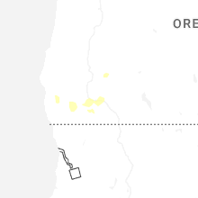
Hail Map for Medford, OR
The Medford, OR area has had 1 report of on-the-ground hail by trained spotters, and has been under severe weather warnings 0 times during the past 12 months. Doppler radar has detected hail at or near Medford, OR on 9 occasions, including 1 occasion during the past year.
| Name: | Medford, OR |
| Where Located: | 1.3 miles NE of Medford, OR |
| Map: | Google Map for Medford, OR |
| Population: | 74907 |
| Housing Units: | 32430 |
| More Info: | Search Google for Medford, OR |
0
The Top Recent Hail Date for Medford, OR is Sunday, May 3, 2026 (9th out of 9)

Hail and Wind Damage Spotted near Medford, OR
| Date / Time | Report Details |
|---|---|
| 8/17/2024 6:58 PM PDT |
 The storm which prompted the warning has weakened below severe limits, and no longer poses an immediate threat to life or property. therefore, the warning will be allowed to expire. however small hail and heavy rain are still possible with this thunderstorm. a severe thunderstorm watch remains in effect until 900 pm pdt for southwestern oregon. The storm which prompted the warning has weakened below severe limits, and no longer poses an immediate threat to life or property. therefore, the warning will be allowed to expire. however small hail and heavy rain are still possible with this thunderstorm. a severe thunderstorm watch remains in effect until 900 pm pdt for southwestern oregon.
|
| 8/17/2024 6:32 PM PDT |
 Svrmfr the national weather service in medford has issued a * severe thunderstorm warning for, southwestern jackson county in southwestern oregon, * until 700 pm pdt. * at 632 pm pdt, a severe thunderstorm was located near woodrat mountain, or 9 miles southwest of medford, moving northeast at 20 mph (radar indicated). Hazards include 60 mph wind gusts and quarter size hail. Hail damage to vehicles is expected. Expect wind damage to roofs, siding, and trees. Svrmfr the national weather service in medford has issued a * severe thunderstorm warning for, southwestern jackson county in southwestern oregon, * until 700 pm pdt. * at 632 pm pdt, a severe thunderstorm was located near woodrat mountain, or 9 miles southwest of medford, moving northeast at 20 mph (radar indicated). Hazards include 60 mph wind gusts and quarter size hail. Hail damage to vehicles is expected. Expect wind damage to roofs, siding, and trees.
|
| 6/7/2023 8:58 PM PDT |
 The severe thunderstorm warning for south central jackson county will expire at 900 pm pdt, the storm which prompted the warning has weakened below severe limits, and no longer poses an immediate threat to life or property. therefore, the warning will be allowed to expire. to report severe weather, contact your nearest law enforcement agency. they will relay your report to the national weather service medford. The severe thunderstorm warning for south central jackson county will expire at 900 pm pdt, the storm which prompted the warning has weakened below severe limits, and no longer poses an immediate threat to life or property. therefore, the warning will be allowed to expire. to report severe weather, contact your nearest law enforcement agency. they will relay your report to the national weather service medford.
|
| 6/7/2023 8:34 PM PDT | Quarter sized hail reported 2.1 miles NNW of Medford, OR, verified quarter size hail via photo. |
| 6/7/2023 8:28 PM PDT |
 At 828 pm pdt, a severe thunderstorm was located over medford, moving east at 15 mph (radar indicated). Hazards include quarter size hail. damage to vehicles is expected At 828 pm pdt, a severe thunderstorm was located over medford, moving east at 15 mph (radar indicated). Hazards include quarter size hail. damage to vehicles is expected
|
| 7/2/2022 8:08 PM PDT | Greg roberts reported a tree blown down at the entrance to bear creek park in medford. it was 8-10 inches in diamete in jackson county OR, 1.2 miles NNW of Medford, OR |
| 7/2/2022 7:40 PM PDT |
 At 738 pm pdt, a severe thunderstorm was located over central point, or over medford, moving north at 20 mph (radar indicated). Hazards include quarter size hail. Damage to vehicles is expected. locations impacted include, medford, central point, eagle point, touvelle state park, agate reservoir, white city and upper table rock trailhead. hail threat, radar indicated max hail size, 1. 00 in wind threat, radar indicated max wind gust, <50 mph. At 738 pm pdt, a severe thunderstorm was located over central point, or over medford, moving north at 20 mph (radar indicated). Hazards include quarter size hail. Damage to vehicles is expected. locations impacted include, medford, central point, eagle point, touvelle state park, agate reservoir, white city and upper table rock trailhead. hail threat, radar indicated max hail size, 1. 00 in wind threat, radar indicated max wind gust, <50 mph.
|
| 7/2/2022 7:22 PM PDT |
 At 722 pm pdt, a severe thunderstorm was located near medford, moving north at 20 mph (radar indicated). Hazards include quarter size hail. damage to vehicles is expected At 722 pm pdt, a severe thunderstorm was located near medford, moving north at 20 mph (radar indicated). Hazards include quarter size hail. damage to vehicles is expected
|
| 8/8/2017 6:43 PM PDT |
 The severe thunderstorm warning for west central jackson county will expire at 645 pm pdt, the severe thunderstorm which prompted the warning has weakened. therefore, the warning will be allowed to expire. The severe thunderstorm warning for west central jackson county will expire at 645 pm pdt, the severe thunderstorm which prompted the warning has weakened. therefore, the warning will be allowed to expire.
|
| 8/8/2017 6:34 PM PDT |
 At 633 pm pdt, a severe thunderstorm was located near central point, or 7 miles northwest of medford, moving southwest at 10 mph (radar indicated). Hazards include quarter size hail and wind gusts up to 50 mph. Damage to vehicles is expected. locations impacted include, medford, central point, gold hill, touvelle state park and lower table rock trailhead. this includes the following highways, highway 234 in oregon between mile markers 1 and 9. highway 238 in oregon between mile markers 35 and 38. Interstate 5 in oregon between mile markers 31 and 44. At 633 pm pdt, a severe thunderstorm was located near central point, or 7 miles northwest of medford, moving southwest at 10 mph (radar indicated). Hazards include quarter size hail and wind gusts up to 50 mph. Damage to vehicles is expected. locations impacted include, medford, central point, gold hill, touvelle state park and lower table rock trailhead. this includes the following highways, highway 234 in oregon between mile markers 1 and 9. highway 238 in oregon between mile markers 35 and 38. Interstate 5 in oregon between mile markers 31 and 44.
|
| 8/8/2017 6:21 PM PDT |
 At 620 pm pdt, a severe thunderstorm was located over lower table rock trailhead, or 7 miles northwest of medford, moving southwest at 10 mph (radar indicated). Hazards include quarter size hail and wind gusts up to 50 mph. damage to vehicles is expected At 620 pm pdt, a severe thunderstorm was located over lower table rock trailhead, or 7 miles northwest of medford, moving southwest at 10 mph (radar indicated). Hazards include quarter size hail and wind gusts up to 50 mph. damage to vehicles is expected
|
| 8/8/2017 6:10 PM PDT | 5 inch tree branch down. spotter reports tree was healthy and estimates gusts could've been up to 50 mph. time estimated from rada in jackson county OR, 2.8 miles SE of Medford, OR |
| 7/7/2015 8:30 PM PDT | Numerous reports throughout medford of trees and power lines down. also investigating a few reports of fires due to lightnin in jackson county OR, 1.3 miles NNE of Medford, OR |
| 7/7/2015 8:14 PM PDT |
 At 812 pm pdt, trained weather spotters reported a severe thunderstorm producing damaging winds in excess of 40 mph. this storm was located near talent. this storm was moving northwest at 10 to 15 mph. in addition, at 0810 pdt..1/2 inch size hail was reported by a weather spotter. locations impacted include, medford, ashland, central point, talent, jacksonville, roxy ann peak, agate reservoir, emigrant lake, jacksonville woodlands association trails, britt gardens, white city and phoenix. At 812 pm pdt, trained weather spotters reported a severe thunderstorm producing damaging winds in excess of 40 mph. this storm was located near talent. this storm was moving northwest at 10 to 15 mph. in addition, at 0810 pdt..1/2 inch size hail was reported by a weather spotter. locations impacted include, medford, ashland, central point, talent, jacksonville, roxy ann peak, agate reservoir, emigrant lake, jacksonville woodlands association trails, britt gardens, white city and phoenix.
|
| 7/7/2015 8:10 PM PDT | Trees down at church of jesus christ of latter-day saints in jackson county OR, 2.4 miles NW of Medford, OR |
| 7/7/2015 7:56 PM PDT |
 At 755 pm pdt, doppler radar indicated a severe thunderstorm with strong winds gusting to 60 mph, small hail, and frequent lightning. this storm was located near buck prairie nordic trails, or near ashland, and moving northeast at 15 mph. At 755 pm pdt, doppler radar indicated a severe thunderstorm with strong winds gusting to 60 mph, small hail, and frequent lightning. this storm was located near buck prairie nordic trails, or near ashland, and moving northeast at 15 mph.
|
| 8/5/2012 8:53 PM PDT | Teresa from the mail tribune. tall tree down across one lane of the roadway near 1st street and ivy stree in jackson county OR, 0.5 miles WSW of Medford, OR |
Hail Maps for Medford, OR


Connect with Interactive Hail Maps