

Hail Map for Melville, RI
The Melville, RI area has had 1 report of on-the-ground hail by trained spotters, and has been under severe weather warnings 1 time during the past 12 months. Doppler radar has detected hail at or near Melville, RI on 12 occasions, including 1 occasion during the past year.
| Name: | Melville, RI |
| Where Located: | 18.9 miles SSE of Providence, RI |
| Map: | Google Map for Melville, RI |
| Population: | 1320 |
| Housing Units: | 579 |
| More Info: | Search Google for Melville, RI |
0
The Top Recent Hail Date for Melville, RI is Thursday, July 3, 2025 (12th out of 12)

Hail and Wind Damage Spotted near Melville, RI
| Date / Time | Report Details |
|---|---|
| 7/8/2025 6:00 PM EDT |
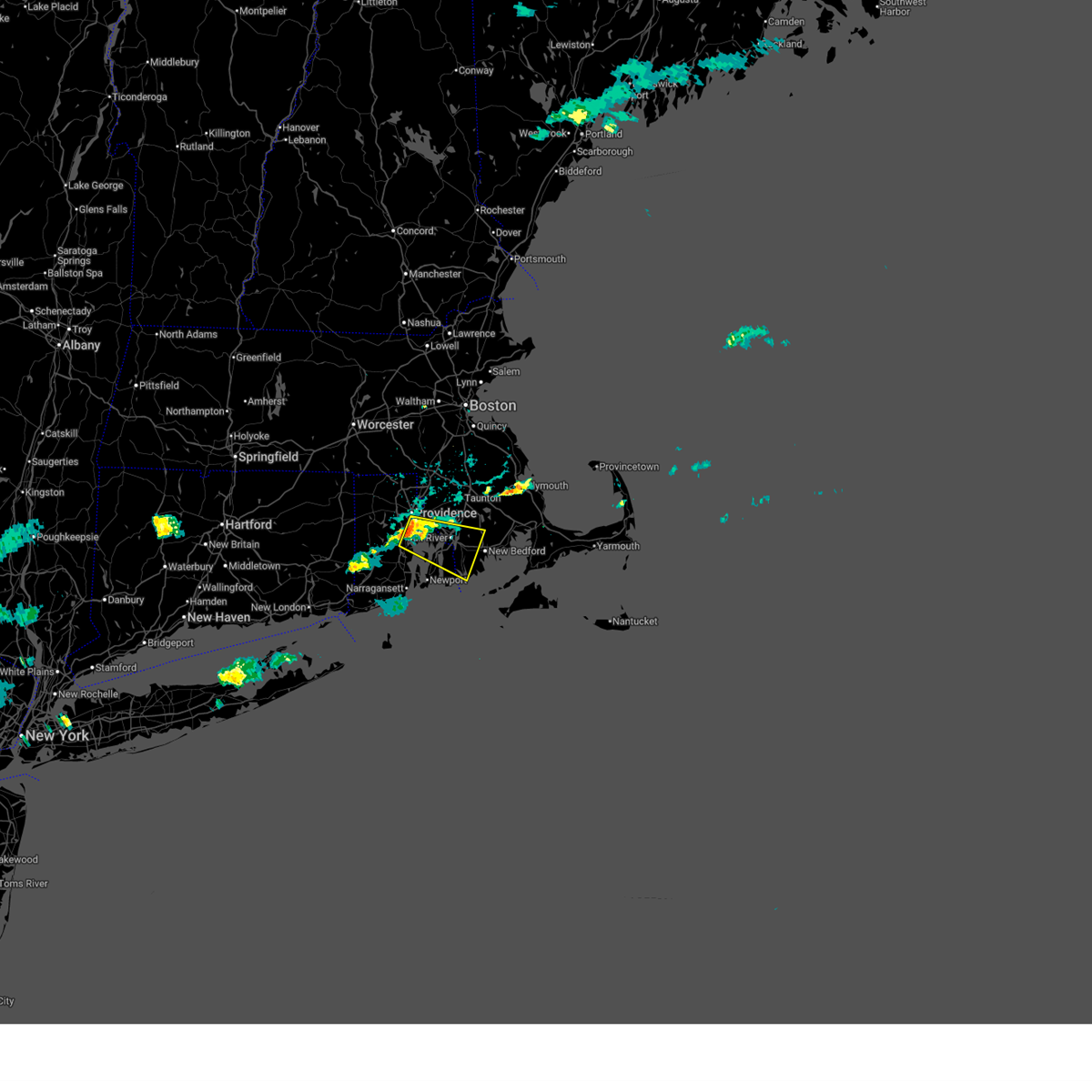 Svrbox the national weather service in boston/norton has issued a * severe thunderstorm warning for, southern bristol county in southeastern massachusetts, northeastern washington county in rhode island, northeastern newport county in rhode island, northeastern kent county in rhode island, southeastern providence county in rhode island, bristol county in rhode island, * until 700 pm edt. * at 600 pm edt, a severe thunderstorm was located over barrington, or near warwick, moving east at 15 mph (radar indicated). Hazards include 60 mph wind gusts and penny size hail. expect damage to trees and power lines Svrbox the national weather service in boston/norton has issued a * severe thunderstorm warning for, southern bristol county in southeastern massachusetts, northeastern washington county in rhode island, northeastern newport county in rhode island, northeastern kent county in rhode island, southeastern providence county in rhode island, bristol county in rhode island, * until 700 pm edt. * at 600 pm edt, a severe thunderstorm was located over barrington, or near warwick, moving east at 15 mph (radar indicated). Hazards include 60 mph wind gusts and penny size hail. expect damage to trees and power lines
|
| 8/26/2024 3:47 PM EDT |
 the severe thunderstorm warning has been cancelled and is no longer in effect the severe thunderstorm warning has been cancelled and is no longer in effect
|
| 8/26/2024 3:17 PM EDT |
 Svrbox the national weather service in boston/norton has issued a * severe thunderstorm warning for, south central bristol county in southeastern massachusetts, northeastern washington county in rhode island, newport county in rhode island, eastern kent county in rhode island, southeastern providence county in rhode island, bristol county in rhode island, * until 400 pm edt. * at 317 pm edt, a severe thunderstorm was located over warwick, moving southeast at 20 mph (radar indicated). Hazards include golf ball size hail and 60 mph wind gusts. People and animals outdoors will be injured. expect hail damage to roofs, siding, windows, and vehicles. Expect wind damage to trees and power lines. Svrbox the national weather service in boston/norton has issued a * severe thunderstorm warning for, south central bristol county in southeastern massachusetts, northeastern washington county in rhode island, newport county in rhode island, eastern kent county in rhode island, southeastern providence county in rhode island, bristol county in rhode island, * until 400 pm edt. * at 317 pm edt, a severe thunderstorm was located over warwick, moving southeast at 20 mph (radar indicated). Hazards include golf ball size hail and 60 mph wind gusts. People and animals outdoors will be injured. expect hail damage to roofs, siding, windows, and vehicles. Expect wind damage to trees and power lines.
|
| 8/26/2024 3:14 PM EDT |
 Svrbox the national weather service in boston/norton has issued a * severe thunderstorm warning for, south central bristol county in southeastern massachusetts, northeastern washington county in rhode island, newport county in rhode island, eastern kent county in rhode island, southeastern providence county in rhode island, bristol county in rhode island, * until 400 pm edt. * at 314 pm edt, a severe thunderstorm was located over warwick, moving southeast at 20 mph (radar indicated). Hazards include 60 mph wind gusts and quarter size hail. Hail damage to vehicles is expected. Expect wind damage to trees and power lines. Svrbox the national weather service in boston/norton has issued a * severe thunderstorm warning for, south central bristol county in southeastern massachusetts, northeastern washington county in rhode island, newport county in rhode island, eastern kent county in rhode island, southeastern providence county in rhode island, bristol county in rhode island, * until 400 pm edt. * at 314 pm edt, a severe thunderstorm was located over warwick, moving southeast at 20 mph (radar indicated). Hazards include 60 mph wind gusts and quarter size hail. Hail damage to vehicles is expected. Expect wind damage to trees and power lines.
|
| 8/26/2024 2:15 PM EDT |
 Svrbox the national weather service in boston/norton has issued a * severe thunderstorm warning for, southern bristol county in southeastern massachusetts, northeastern washington county in rhode island, newport county in rhode island, bristol county in rhode island, * until 300 pm edt. * at 215 pm edt, a severe thunderstorm was located over fall river, moving south at 15 mph (radar indicated). Hazards include 60 mph wind gusts and quarter size hail. Hail damage to vehicles is expected. Expect wind damage to trees and power lines. Svrbox the national weather service in boston/norton has issued a * severe thunderstorm warning for, southern bristol county in southeastern massachusetts, northeastern washington county in rhode island, newport county in rhode island, bristol county in rhode island, * until 300 pm edt. * at 215 pm edt, a severe thunderstorm was located over fall river, moving south at 15 mph (radar indicated). Hazards include 60 mph wind gusts and quarter size hail. Hail damage to vehicles is expected. Expect wind damage to trees and power lines.
|
| 8/15/2024 5:25 PM EDT |
 At 525 pm edt, a severe thunderstorm was located near tiverton, or near bristol, moving south at 30 mph (radar indicated). Hazards include 60 mph wind gusts and penny size hail. Expect damage to trees and power lines. Locations impacted include, fall river, east providence, dartmouth, newport, bristol, somerset, portsmouth, barrington, middletown, swansea, tiverton, westport, seekonk, rehoboth, warren, freetown, dighton, berkley, little compton, and prudence island. At 525 pm edt, a severe thunderstorm was located near tiverton, or near bristol, moving south at 30 mph (radar indicated). Hazards include 60 mph wind gusts and penny size hail. Expect damage to trees and power lines. Locations impacted include, fall river, east providence, dartmouth, newport, bristol, somerset, portsmouth, barrington, middletown, swansea, tiverton, westport, seekonk, rehoboth, warren, freetown, dighton, berkley, little compton, and prudence island.
|
| 8/15/2024 5:06 PM EDT |
 Svrbox the national weather service in boston/norton has issued a * severe thunderstorm warning for, central bristol county in southeastern massachusetts, newport county in rhode island, east central providence county in rhode island, bristol county in rhode island, * until 545 pm edt. * at 505 pm edt, a severe thunderstorm was located over dighton, or 8 miles east of east providence, moving south at 35 mph (radar indicated). Hazards include 60 mph wind gusts and penny size hail. expect damage to trees and power lines Svrbox the national weather service in boston/norton has issued a * severe thunderstorm warning for, central bristol county in southeastern massachusetts, newport county in rhode island, east central providence county in rhode island, bristol county in rhode island, * until 545 pm edt. * at 505 pm edt, a severe thunderstorm was located over dighton, or 8 miles east of east providence, moving south at 35 mph (radar indicated). Hazards include 60 mph wind gusts and penny size hail. expect damage to trees and power lines
|
| 6/30/2024 4:05 PM EDT |
 The storms which prompted the warning have weakened below severe limits, and have exited the warned area. therefore, the warning will be allowed to expire. however gusty winds and heavy rain are still possible with these thunderstorms. a severe thunderstorm watch remains in effect until 700 pm edt for southeastern massachusetts, and rhode island. The storms which prompted the warning have weakened below severe limits, and have exited the warned area. therefore, the warning will be allowed to expire. however gusty winds and heavy rain are still possible with these thunderstorms. a severe thunderstorm watch remains in effect until 700 pm edt for southeastern massachusetts, and rhode island.
|
| 6/30/2024 3:50 PM EDT |
 the severe thunderstorm warning has been cancelled and is no longer in effect the severe thunderstorm warning has been cancelled and is no longer in effect
|
| 6/30/2024 3:50 PM EDT |
 At 350 pm edt, severe thunderstorms were located along a line extending from near swansea to near tiverton to newport, moving east at 40 mph (radar indicated). Hazards include 60 mph wind gusts. Expect damage to roofs, siding, and trees. Locations impacted include, fall river, dartmouth, newport, somerset, portsmouth, middletown, swansea, tiverton, westport, rehoboth, freetown, dighton, berkley, and little compton. At 350 pm edt, severe thunderstorms were located along a line extending from near swansea to near tiverton to newport, moving east at 40 mph (radar indicated). Hazards include 60 mph wind gusts. Expect damage to roofs, siding, and trees. Locations impacted include, fall river, dartmouth, newport, somerset, portsmouth, middletown, swansea, tiverton, westport, rehoboth, freetown, dighton, berkley, and little compton.
|
| 6/30/2024 3:43 PM EDT |
 At 342 pm edt, severe thunderstorms were located along a line extending from east providence to bristol to near jamestown, moving east at 40 mph (radar indicated). Hazards include 60 mph wind gusts. Expect damage to roofs, siding, and trees. Locations impacted include, fall river, east providence, dartmouth, newport, bristol, somerset, portsmouth, barrington, middletown, swansea, tiverton, westport, seekonk, rehoboth, warren, freetown, dighton, berkley, jamestown, and little compton. At 342 pm edt, severe thunderstorms were located along a line extending from east providence to bristol to near jamestown, moving east at 40 mph (radar indicated). Hazards include 60 mph wind gusts. Expect damage to roofs, siding, and trees. Locations impacted include, fall river, east providence, dartmouth, newport, bristol, somerset, portsmouth, barrington, middletown, swansea, tiverton, westport, seekonk, rehoboth, warren, freetown, dighton, berkley, jamestown, and little compton.
|
| 6/30/2024 3:43 PM EDT |
 the severe thunderstorm warning has been cancelled and is no longer in effect the severe thunderstorm warning has been cancelled and is no longer in effect
|
| 6/30/2024 3:22 PM EDT |
 Svrbox the national weather service in boston/norton has issued a * severe thunderstorm warning for, southwestern bristol county in southeastern massachusetts, northeastern washington county in rhode island, newport county in rhode island, eastern kent county in rhode island, southern providence county in rhode island, bristol county in rhode island, * until 415 pm edt. * at 321 pm edt, severe thunderstorms were located along a line extending from scituate to west warwick to richmond, moving east at 40 mph (radar indicated). Hazards include 60 mph wind gusts. expect damage to roofs, siding, and trees Svrbox the national weather service in boston/norton has issued a * severe thunderstorm warning for, southwestern bristol county in southeastern massachusetts, northeastern washington county in rhode island, newport county in rhode island, eastern kent county in rhode island, southern providence county in rhode island, bristol county in rhode island, * until 415 pm edt. * at 321 pm edt, severe thunderstorms were located along a line extending from scituate to west warwick to richmond, moving east at 40 mph (radar indicated). Hazards include 60 mph wind gusts. expect damage to roofs, siding, and trees
|
| 6/26/2024 11:16 PM EDT |
 Svrbox the national weather service in boston/norton has issued a * severe thunderstorm warning for, norfolk county in eastern massachusetts, suffolk county in eastern massachusetts, southeastern middlesex county in northeastern massachusetts, plymouth county in southeastern massachusetts, bristol county in southeastern massachusetts, northeastern washington county in rhode island, newport county in rhode island, northeastern kent county in rhode island, eastern providence county in rhode island, bristol county in rhode island, * until 1215 am edt. * at 1115 pm edt, severe thunderstorms were located along a line extending from near millbury to johnston to south kingstown, moving east at 55 mph (radar indicated). Hazards include 60 mph wind gusts. expect damage to roofs, siding, and trees Svrbox the national weather service in boston/norton has issued a * severe thunderstorm warning for, norfolk county in eastern massachusetts, suffolk county in eastern massachusetts, southeastern middlesex county in northeastern massachusetts, plymouth county in southeastern massachusetts, bristol county in southeastern massachusetts, northeastern washington county in rhode island, newport county in rhode island, northeastern kent county in rhode island, eastern providence county in rhode island, bristol county in rhode island, * until 1215 am edt. * at 1115 pm edt, severe thunderstorms were located along a line extending from near millbury to johnston to south kingstown, moving east at 55 mph (radar indicated). Hazards include 60 mph wind gusts. expect damage to roofs, siding, and trees
|
| 5/8/2024 10:09 PM EDT |
 The storm which prompted the warning has moved out of the area. therefore, the warning will be allowed to expire. to report severe weather, contact your nearest law enforcement agency. they will relay your report to the national weather service boston/norton. The storm which prompted the warning has moved out of the area. therefore, the warning will be allowed to expire. to report severe weather, contact your nearest law enforcement agency. they will relay your report to the national weather service boston/norton.
|
| 5/8/2024 9:55 PM EDT |
 At 955 pm edt, a severe thunderstorm was located over jamestown, or near newport, moving southeast at 50 mph (radar indicated). Hazards include quarter size hail. Damage to vehicles is expected. Locations impacted include, south kingstown, north kingstown, newport, portsmouth, middletown, narragansett, exeter, jamestown, and little compton. At 955 pm edt, a severe thunderstorm was located over jamestown, or near newport, moving southeast at 50 mph (radar indicated). Hazards include quarter size hail. Damage to vehicles is expected. Locations impacted include, south kingstown, north kingstown, newport, portsmouth, middletown, narragansett, exeter, jamestown, and little compton.
|
| 5/8/2024 9:55 PM EDT |
 the severe thunderstorm warning has been cancelled and is no longer in effect the severe thunderstorm warning has been cancelled and is no longer in effect
|
| 5/8/2024 9:47 PM EDT |
 Svrbox the national weather service in boston/norton has issued a * severe thunderstorm warning for, southern bristol county in southeastern massachusetts, northeastern washington county in rhode island, southern newport county in rhode island, south central kent county in rhode island, * until 1015 pm edt. * at 947 pm edt, a severe thunderstorm was located near exeter, or near north kingstown, moving southeast at 40 mph (radar indicated). Hazards include quarter size hail. damage to vehicles is expected Svrbox the national weather service in boston/norton has issued a * severe thunderstorm warning for, southern bristol county in southeastern massachusetts, northeastern washington county in rhode island, southern newport county in rhode island, south central kent county in rhode island, * until 1015 pm edt. * at 947 pm edt, a severe thunderstorm was located near exeter, or near north kingstown, moving southeast at 40 mph (radar indicated). Hazards include quarter size hail. damage to vehicles is expected
|
| 5/8/2024 8:16 PM EDT |
 At 815 pm edt, a severe thunderstorm was located near gosnold, or 9 miles northwest of tisbury, moving southeast at 40 mph (radar indicated). Hazards include quarter size hail. Damage to vehicles is expected. Locations impacted include, new bedford, fall river, dartmouth, newport, bristol, marion, wareham, somerset, portsmouth, middletown, fairhaven, tiverton, westport, acushnet, freetown, mattapoisett, jamestown, rochester, little compton, and gosnold. At 815 pm edt, a severe thunderstorm was located near gosnold, or 9 miles northwest of tisbury, moving southeast at 40 mph (radar indicated). Hazards include quarter size hail. Damage to vehicles is expected. Locations impacted include, new bedford, fall river, dartmouth, newport, bristol, marion, wareham, somerset, portsmouth, middletown, fairhaven, tiverton, westport, acushnet, freetown, mattapoisett, jamestown, rochester, little compton, and gosnold.
|
| 5/8/2024 8:16 PM EDT |
 the severe thunderstorm warning has been cancelled and is no longer in effect the severe thunderstorm warning has been cancelled and is no longer in effect
|
| 5/8/2024 8:06 PM EDT | Quarter sized hail reported 3.2 miles SW of Melville, RI, time estimated from radar. |
| 5/8/2024 8:00 PM EDT |
 At 800 pm edt, a severe thunderstorm was located over dartmouth, moving east at 40 mph (radar indicated). Hazards include ping pong ball size hail. People and animals outdoors will be injured. expect damage to roofs, siding, windows, and vehicles. Locations impacted include, providence, new bedford, fall river, warwick, cranston, east providence, dartmouth, west warwick, north kingstown, newport, bristol, marion, wareham, somerset, portsmouth, barrington, middletown, fairhaven, swansea, and tiverton. At 800 pm edt, a severe thunderstorm was located over dartmouth, moving east at 40 mph (radar indicated). Hazards include ping pong ball size hail. People and animals outdoors will be injured. expect damage to roofs, siding, windows, and vehicles. Locations impacted include, providence, new bedford, fall river, warwick, cranston, east providence, dartmouth, west warwick, north kingstown, newport, bristol, marion, wareham, somerset, portsmouth, barrington, middletown, fairhaven, swansea, and tiverton.
|
| 5/8/2024 7:51 PM EDT |
 Svrbox the national weather service in boston/norton has issued a * severe thunderstorm warning for, south central plymouth county in southeastern massachusetts, southern bristol county in southeastern massachusetts, newport county in rhode island, eastern kent county in rhode island, southeastern providence county in rhode island, bristol county in rhode island, * until 830 pm edt. * at 751 pm edt, a severe thunderstorm was located over west warwick, moving southeast at 40 mph (radar indicated). Hazards include quarter size hail. damage to vehicles is expected Svrbox the national weather service in boston/norton has issued a * severe thunderstorm warning for, south central plymouth county in southeastern massachusetts, southern bristol county in southeastern massachusetts, newport county in rhode island, eastern kent county in rhode island, southeastern providence county in rhode island, bristol county in rhode island, * until 830 pm edt. * at 751 pm edt, a severe thunderstorm was located over west warwick, moving southeast at 40 mph (radar indicated). Hazards include quarter size hail. damage to vehicles is expected
|
| 5/8/2024 7:42 PM EDT |
 At 742 pm edt, a severe thunderstorm was located near west warwick, moving east at 45 mph (radar indicated). Hazards include quarter size hail. Damage to vehicles is expected. Locations impacted include, providence, fall river, warwick, cranston, east providence, coventry, north providence, west warwick, johnston, north kingstown, bristol, plainfield, somerset, portsmouth, killingly, barrington, middletown, swansea, seekonk, and east greenwich. At 742 pm edt, a severe thunderstorm was located near west warwick, moving east at 45 mph (radar indicated). Hazards include quarter size hail. Damage to vehicles is expected. Locations impacted include, providence, fall river, warwick, cranston, east providence, coventry, north providence, west warwick, johnston, north kingstown, bristol, plainfield, somerset, portsmouth, killingly, barrington, middletown, swansea, seekonk, and east greenwich.
|
| 5/8/2024 7:25 PM EDT |
 Svrbox the national weather service in boston/norton has issued a * severe thunderstorm warning for, eastern windham county in northern connecticut, west central bristol county in southeastern massachusetts, northeastern washington county in rhode island, northwestern newport county in rhode island, kent county in rhode island, providence county in rhode island, bristol county in rhode island, * until 800 pm edt. * at 725 pm edt, a severe thunderstorm was located near killingly, or 8 miles northeast of plainfield, moving east at 40 mph (radar indicated). Hazards include quarter size hail. damage to vehicles is expected Svrbox the national weather service in boston/norton has issued a * severe thunderstorm warning for, eastern windham county in northern connecticut, west central bristol county in southeastern massachusetts, northeastern washington county in rhode island, northwestern newport county in rhode island, kent county in rhode island, providence county in rhode island, bristol county in rhode island, * until 800 pm edt. * at 725 pm edt, a severe thunderstorm was located near killingly, or 8 miles northeast of plainfield, moving east at 40 mph (radar indicated). Hazards include quarter size hail. damage to vehicles is expected
|
| 8/18/2023 8:50 AM EDT |
 At 850 am edt, severe thunderstorms were located along a line extending from west warwick to exeter to near westerly, moving northeast at 30 mph (radar indicated). Hazards include 60 mph wind gusts and nickel size hail. expect damage to roofs, siding, and trees At 850 am edt, severe thunderstorms were located along a line extending from west warwick to exeter to near westerly, moving northeast at 30 mph (radar indicated). Hazards include 60 mph wind gusts and nickel size hail. expect damage to roofs, siding, and trees
|
| 8/8/2023 10:37 AM EDT |
 At 1036 am edt, severe thunderstorms were located along a line extending from fall river to near little compton to 8 miles east of block island, moving northeast at 30 mph (radar indicated). Hazards include 60 mph wind gusts. Expect damage to roofs, siding, and trees. locations impacted include, new bedford, fall river, warwick, dartmouth, newport, bristol, marion, middleborough, somerset, portsmouth, barrington, middletown, fairhaven, swansea, tiverton, westport, warren, lakeville, acushnet, and freetown. hail threat, radar indicated max hail size, <. 75 in wind threat, observed max wind gust, 60 mph. At 1036 am edt, severe thunderstorms were located along a line extending from fall river to near little compton to 8 miles east of block island, moving northeast at 30 mph (radar indicated). Hazards include 60 mph wind gusts. Expect damage to roofs, siding, and trees. locations impacted include, new bedford, fall river, warwick, dartmouth, newport, bristol, marion, middleborough, somerset, portsmouth, barrington, middletown, fairhaven, swansea, tiverton, westport, warren, lakeville, acushnet, and freetown. hail threat, radar indicated max hail size, <. 75 in wind threat, observed max wind gust, 60 mph.
|
| 8/8/2023 10:07 AM EDT |
 At 1007 am edt, severe thunderstorms were located along a line extending from near bristol to near newport to block island, moving northeast at 15 mph (radar indicated. at 930 am conimicut light reported a gust of 60 mph). Hazards include 60 mph wind gusts. expect damage to roofs, siding, and trees At 1007 am edt, severe thunderstorms were located along a line extending from near bristol to near newport to block island, moving northeast at 15 mph (radar indicated. at 930 am conimicut light reported a gust of 60 mph). Hazards include 60 mph wind gusts. expect damage to roofs, siding, and trees
|
| 8/8/2023 9:54 AM EDT |
 At 953 am edt, a severe thunderstorm was located near portsmouth, or near newport, moving northeast at 30 mph (radar indicated). Hazards include 60 mph wind gusts. Expect damage to roofs, siding, and trees. locations impacted include, new bedford, fall river, warwick, taunton, dartmouth, north kingstown, newport, bristol, somerset, portsmouth, barrington, middletown, fairhaven, narragansett, swansea, tiverton, westport, seekonk, rehoboth, and warren. hail threat, radar indicated max hail size, <. 75 in wind threat, radar indicated max wind gust, 60 mph. At 953 am edt, a severe thunderstorm was located near portsmouth, or near newport, moving northeast at 30 mph (radar indicated). Hazards include 60 mph wind gusts. Expect damage to roofs, siding, and trees. locations impacted include, new bedford, fall river, warwick, taunton, dartmouth, north kingstown, newport, bristol, somerset, portsmouth, barrington, middletown, fairhaven, narragansett, swansea, tiverton, westport, seekonk, rehoboth, and warren. hail threat, radar indicated max hail size, <. 75 in wind threat, radar indicated max wind gust, 60 mph.
|
| 8/8/2023 9:33 AM EDT |
 At 933 am edt, a severe thunderstorm was located over north kingstown, moving northeast at 35 mph (radar indicated). Hazards include 60 mph wind gusts. Expect damage to roofs, siding, and trees. locations impacted include, new bedford, fall river, warwick, cranston, taunton, east providence, coventry, dartmouth, south kingstown, west warwick, north kingstown, newport, bristol, somerset, portsmouth, barrington, middletown, fairhaven, narragansett, and swansea. hail threat, radar indicated max hail size, <. 75 in wind threat, radar indicated max wind gust, 60 mph. At 933 am edt, a severe thunderstorm was located over north kingstown, moving northeast at 35 mph (radar indicated). Hazards include 60 mph wind gusts. Expect damage to roofs, siding, and trees. locations impacted include, new bedford, fall river, warwick, cranston, taunton, east providence, coventry, dartmouth, south kingstown, west warwick, north kingstown, newport, bristol, somerset, portsmouth, barrington, middletown, fairhaven, narragansett, and swansea. hail threat, radar indicated max hail size, <. 75 in wind threat, radar indicated max wind gust, 60 mph.
|
| 8/8/2023 9:17 AM EDT |
 At 917 am edt, a severe thunderstorm was located near south kingstown, moving northeast at 35 mph (radar indicated). Hazards include 60 mph wind gusts. expect damage to roofs, siding, and trees At 917 am edt, a severe thunderstorm was located near south kingstown, moving northeast at 35 mph (radar indicated). Hazards include 60 mph wind gusts. expect damage to roofs, siding, and trees
|
| 6/17/2022 3:16 PM EDT |
 At 315 pm edt, a severe thunderstorm was located near bristol, moving east at 35 mph (radar indicated). Hazards include 60 mph wind gusts, penny size hail and brief torrential rain. Expect damage to trees and power lines. locations impacted include, new bedford, fall river, warwick, dartmouth, south kingstown, west warwick, north kingstown, newport, bristol, portsmouth, barrington, middletown, narragansett, tiverton, westport, east greenwich, warren, hopkinton, richmond and exeter. hail threat, radar indicated max hail size, 0. 75 in wind threat, radar indicated max wind gust, 60 mph. At 315 pm edt, a severe thunderstorm was located near bristol, moving east at 35 mph (radar indicated). Hazards include 60 mph wind gusts, penny size hail and brief torrential rain. Expect damage to trees and power lines. locations impacted include, new bedford, fall river, warwick, dartmouth, south kingstown, west warwick, north kingstown, newport, bristol, portsmouth, barrington, middletown, narragansett, tiverton, westport, east greenwich, warren, hopkinton, richmond and exeter. hail threat, radar indicated max hail size, 0. 75 in wind threat, radar indicated max wind gust, 60 mph.
|
| 6/17/2022 3:02 PM EDT |
 At 302 pm edt, a severe thunderstorm was located over east greenwich, or over west warwick, moving east at 45 mph (radar indicated). Hazards include 60 mph wind gusts and penny size hail. Expect damage to trees and power lines. locations impacted include, new bedford, fall river, warwick, cranston, coventry, dartmouth, south kingstown, west warwick, north kingstown, newport, bristol, portsmouth, barrington, middletown, narragansett, tiverton, westport, east greenwich, warren and scituate. hail threat, radar indicated max hail size, 0. 75 in wind threat, radar indicated max wind gust, 60 mph. At 302 pm edt, a severe thunderstorm was located over east greenwich, or over west warwick, moving east at 45 mph (radar indicated). Hazards include 60 mph wind gusts and penny size hail. Expect damage to trees and power lines. locations impacted include, new bedford, fall river, warwick, cranston, coventry, dartmouth, south kingstown, west warwick, north kingstown, newport, bristol, portsmouth, barrington, middletown, narragansett, tiverton, westport, east greenwich, warren and scituate. hail threat, radar indicated max hail size, 0. 75 in wind threat, radar indicated max wind gust, 60 mph.
|
| 6/17/2022 2:51 PM EDT |
 At 250 pm edt, a severe thunderstorm was located over coventry, moving east at 45 mph (radar indicated). Hazards include 60 mph wind gusts and penny size hail. expect damage to trees and power lines At 250 pm edt, a severe thunderstorm was located over coventry, moving east at 45 mph (radar indicated). Hazards include 60 mph wind gusts and penny size hail. expect damage to trees and power lines
|
| 11/13/2021 5:12 PM EST |
 At 512 pm est, severe thunderstorms were located along a line extending from near coventry to near exeter to near south kingstown, moving northeast at 50 mph (radar indicated). Hazards include 60 mph wind gusts and penny size hail. expect damage to trees and power lines At 512 pm est, severe thunderstorms were located along a line extending from near coventry to near exeter to near south kingstown, moving northeast at 50 mph (radar indicated). Hazards include 60 mph wind gusts and penny size hail. expect damage to trees and power lines
|
| 9/28/2021 2:07 PM EDT |
 At 207 pm edt, a severe thunderstorm was located over newport, moving northeast at 40 mph (radar indicated). Hazards include 60 mph wind gusts. expect damage to trees and power lines At 207 pm edt, a severe thunderstorm was located over newport, moving northeast at 40 mph (radar indicated). Hazards include 60 mph wind gusts. expect damage to trees and power lines
|
| 9/16/2021 6:38 AM EDT |
 At 638 am edt, a severe thunderstorm was located over tiverton, or near bristol, moving northeast at 20 mph (radar indicated). Hazards include 60 mph wind gusts and penny size hail. expect damage to trees and power lines At 638 am edt, a severe thunderstorm was located over tiverton, or near bristol, moving northeast at 20 mph (radar indicated). Hazards include 60 mph wind gusts and penny size hail. expect damage to trees and power lines
|
| 7/6/2021 6:41 PM EDT |
 The severe thunderstorm warning for south central norfolk, northwestern bristol, washington, west central newport, kent, southeastern providence and bristol counties will expire at 645 pm edt, the storms which prompted the warning have weakened below severe limits, and no longer pose an immediate threat to life or property. therefore, the warning will be allowed to expire. however gusty winds and heavy rain are still possible with these thunderstorms. a severe thunderstorm watch remains in effect until 800 pm edt for eastern and southeastern massachusetts, and rhode island. The severe thunderstorm warning for south central norfolk, northwestern bristol, washington, west central newport, kent, southeastern providence and bristol counties will expire at 645 pm edt, the storms which prompted the warning have weakened below severe limits, and no longer pose an immediate threat to life or property. therefore, the warning will be allowed to expire. however gusty winds and heavy rain are still possible with these thunderstorms. a severe thunderstorm watch remains in effect until 800 pm edt for eastern and southeastern massachusetts, and rhode island.
|
| 7/6/2021 6:35 PM EDT |
 At 635 pm edt, severe thunderstorms were located along a line extending from near wrentham to near norwich, moving southeast at 25 mph (radar indicated). Hazards include 60 mph wind gusts. Expect damage to trees and power lines. Locations impacted include, providence, fall river, warwick, cranston, pawtucket, taunton, east providence, coventry, cumberland, north providence, south kingstown, west warwick, johnston, north attleborough, north kingstown, bristol, attleboro, mansfield, westerly and smithfield. At 635 pm edt, severe thunderstorms were located along a line extending from near wrentham to near norwich, moving southeast at 25 mph (radar indicated). Hazards include 60 mph wind gusts. Expect damage to trees and power lines. Locations impacted include, providence, fall river, warwick, cranston, pawtucket, taunton, east providence, coventry, cumberland, north providence, south kingstown, west warwick, johnston, north attleborough, north kingstown, bristol, attleboro, mansfield, westerly and smithfield.
|
| 7/6/2021 6:21 PM EDT |
 At 620 pm edt, severe thunderstorms were located along a line extending from franklin to near jewett city connecticut, moving southeast at 25 mph (radar indicated). Hazards include 60 mph wind gusts. Expect damage to trees and power lines. Locations impacted include, providence, fall river, warwick, cranston, pawtucket, taunton, east providence, woonsocket, coventry, cumberland, north providence, franklin, south kingstown, west warwick, johnston, north attleborough, north kingstown, windham, bristol and plainfield. At 620 pm edt, severe thunderstorms were located along a line extending from franklin to near jewett city connecticut, moving southeast at 25 mph (radar indicated). Hazards include 60 mph wind gusts. Expect damage to trees and power lines. Locations impacted include, providence, fall river, warwick, cranston, pawtucket, taunton, east providence, woonsocket, coventry, cumberland, north providence, franklin, south kingstown, west warwick, johnston, north attleborough, north kingstown, windham, bristol and plainfield.
|
| 7/6/2021 5:52 PM EDT |
 At 552 pm edt, severe thunderstorms were located along a line extending from near holliston to willimantic, moving southeast at 25 mph (radar indicated). Hazards include 60 mph wind gusts and penny size hail. expect damage to trees and power lines At 552 pm edt, severe thunderstorms were located along a line extending from near holliston to willimantic, moving southeast at 25 mph (radar indicated). Hazards include 60 mph wind gusts and penny size hail. expect damage to trees and power lines
|
| 6/19/2021 4:35 PM EDT |
 At 435 pm edt, a severe thunderstorm was located near west warwick, moving east at 35 mph (radar indicated). Hazards include 60 mph wind gusts. expect damage to trees and power lines At 435 pm edt, a severe thunderstorm was located near west warwick, moving east at 35 mph (radar indicated). Hazards include 60 mph wind gusts. expect damage to trees and power lines
|
| 11/15/2020 10:24 PM EST |
 At 1024 pm est, severe thunderstorms were located along a line extending from near southbridge to preston to gardner`s island, moving east at 45 mph (radar indicated). Hazards include 60 mph wind gusts. expect damage to trees and power lines At 1024 pm est, severe thunderstorms were located along a line extending from near southbridge to preston to gardner`s island, moving east at 45 mph (radar indicated). Hazards include 60 mph wind gusts. expect damage to trees and power lines
|
| 10/7/2020 6:40 PM EDT |
 The severe thunderstorm warning for southeastern windham, central norfolk, southeastern worcester, plymouth, bristol, northeastern washington, northern newport, kent, providence and bristol counties will expire at 645 pm edt, the storms which prompted the warning have moved out of the area. therefore, the warning will be allowed to expire. The severe thunderstorm warning for southeastern windham, central norfolk, southeastern worcester, plymouth, bristol, northeastern washington, northern newport, kent, providence and bristol counties will expire at 645 pm edt, the storms which prompted the warning have moved out of the area. therefore, the warning will be allowed to expire.
|
| 10/7/2020 6:03 PM EDT |
 At 602 pm edt, severe thunderstorms were located along a line extending from canton to near killingly, moving southeast at 55 mph (radar indicated). Hazards include 60 mph wind gusts. expect damage to trees and power lines At 602 pm edt, severe thunderstorms were located along a line extending from canton to near killingly, moving southeast at 55 mph (radar indicated). Hazards include 60 mph wind gusts. expect damage to trees and power lines
|
| 8/25/2020 7:23 PM EDT |
 The severe thunderstorm warning for southern bristol, eastern washington and southern newport counties will expire at 730 pm edt, the storm which prompted the warning has moved out of the area. therefore, the warning will be allowed to expire. a severe thunderstorm watch remains in effect until 1000 pm edt for southeastern massachusetts, and rhode island. The severe thunderstorm warning for southern bristol, eastern washington and southern newport counties will expire at 730 pm edt, the storm which prompted the warning has moved out of the area. therefore, the warning will be allowed to expire. a severe thunderstorm watch remains in effect until 1000 pm edt for southeastern massachusetts, and rhode island.
|
| 8/25/2020 6:58 PM EDT |
 At 658 pm edt, a severe thunderstorm was located over jamestown, or near north kingstown, moving southeast at 45 mph (radar indicated). Hazards include ping pong ball size hail and 60 mph wind gusts. Expect wind damage to trees and power lines. Minor hail damage to vehicles is possible. At 658 pm edt, a severe thunderstorm was located over jamestown, or near north kingstown, moving southeast at 45 mph (radar indicated). Hazards include ping pong ball size hail and 60 mph wind gusts. Expect wind damage to trees and power lines. Minor hail damage to vehicles is possible.
|
| 8/22/2020 5:31 PM EDT |
 At 531 pm edt, a severe thunderstorm was located over tiverton, or near bristol, moving southeast at 30 mph (radar indicated). Hazards include 60 mph wind gusts and quarter size hail. Expect wind damage to trees and power lines. minor hail damage to vehicles is possible. Locations impacted include, new bedford, fall river, warwick, east providence, dartmouth, north kingstown, bristol, somerset, portsmouth, barrington, swansea, tiverton, westport, warren, acushnet, little compton and prudence island. At 531 pm edt, a severe thunderstorm was located over tiverton, or near bristol, moving southeast at 30 mph (radar indicated). Hazards include 60 mph wind gusts and quarter size hail. Expect wind damage to trees and power lines. minor hail damage to vehicles is possible. Locations impacted include, new bedford, fall river, warwick, east providence, dartmouth, north kingstown, bristol, somerset, portsmouth, barrington, swansea, tiverton, westport, warren, acushnet, little compton and prudence island.
|
| 8/22/2020 5:09 PM EDT |
 At 509 pm edt, a severe thunderstorm was located over warwick, moving southeast at 30 mph (radar indicated). Hazards include 60 mph wind gusts and quarter size hail. Expect wind damage to trees and power lines. Minor hail damage to vehicles is possible. At 509 pm edt, a severe thunderstorm was located over warwick, moving southeast at 30 mph (radar indicated). Hazards include 60 mph wind gusts and quarter size hail. Expect wind damage to trees and power lines. Minor hail damage to vehicles is possible.
|
| 7/14/2020 3:25 PM EDT |
 At 324 pm edt, severe thunderstorms were located along a line extending from near little compton to near south kingstown, moving southeast at 10 mph (radar indicated. half-dollar size hail was reported at 319 pm in south kingstown). Hazards include golf ball size hail and 60 mph wind gusts. Large hail may injure people caught outdoors. expect hail damage to roofs, siding, windows, and vehicles. expect wind damage to trees and power lines. Locations impacted include, south kingstown, north kingstown, newport, portsmouth, middletown, narragansett, tiverton, exeter, jamestown, little compton and prudence island. At 324 pm edt, severe thunderstorms were located along a line extending from near little compton to near south kingstown, moving southeast at 10 mph (radar indicated. half-dollar size hail was reported at 319 pm in south kingstown). Hazards include golf ball size hail and 60 mph wind gusts. Large hail may injure people caught outdoors. expect hail damage to roofs, siding, windows, and vehicles. expect wind damage to trees and power lines. Locations impacted include, south kingstown, north kingstown, newport, portsmouth, middletown, narragansett, tiverton, exeter, jamestown, little compton and prudence island.
|
| 4/9/2020 3:32 PM EDT |
 At 331 pm edt, severe thunderstorms were located along a line extending from near exeter to hither hills state park, moving east at 60 mph (radar indicated). Hazards include 60 mph wind gusts. expect damage to trees and power lines At 331 pm edt, severe thunderstorms were located along a line extending from near exeter to hither hills state park, moving east at 60 mph (radar indicated). Hazards include 60 mph wind gusts. expect damage to trees and power lines
|
| 8/8/2019 1:00 AM EDT |
 At 100 am edt, a severe thunderstorm was located near newport, moving northeast at 30 mph (radar indicated). Hazards include 60 mph wind gusts. expect damage to trees and power lines At 100 am edt, a severe thunderstorm was located near newport, moving northeast at 30 mph (radar indicated). Hazards include 60 mph wind gusts. expect damage to trees and power lines
|
| 7/22/2019 9:24 PM EDT |
 At 924 pm edt, a severe thunderstorm was located near new bedford, moving northeast at 30 mph (radar indicated). Hazards include 60 mph wind gusts. Expect damage to trees and power lines. Locations impacted include, new bedford, fall river, dartmouth, north kingstown, newport, bristol, portsmouth, middletown, fairhaven, tiverton, westport, acushnet, freetown, jamestown, little compton and prudence island. At 924 pm edt, a severe thunderstorm was located near new bedford, moving northeast at 30 mph (radar indicated). Hazards include 60 mph wind gusts. Expect damage to trees and power lines. Locations impacted include, new bedford, fall river, dartmouth, north kingstown, newport, bristol, portsmouth, middletown, fairhaven, tiverton, westport, acushnet, freetown, jamestown, little compton and prudence island.
|
| 7/22/2019 9:14 PM EDT |
 At 914 pm edt, a severe thunderstorm was located over narragansett, or over south kingstown, moving northeast at 30 mph (radar indicated). Hazards include 60 mph wind gusts. Expect damage to trees and power lines. Locations impacted include, south kingstown, north kingstown, newport, narragansett, charlestown, richmond, exeter and jamestown. At 914 pm edt, a severe thunderstorm was located over narragansett, or over south kingstown, moving northeast at 30 mph (radar indicated). Hazards include 60 mph wind gusts. Expect damage to trees and power lines. Locations impacted include, south kingstown, north kingstown, newport, narragansett, charlestown, richmond, exeter and jamestown.
|
| 7/22/2019 9:09 PM EDT |
 At 908 pm edt, a severe thunderstorm was located near south kingstown, moving northeast at 30 mph (radar indicated). Hazards include 60 mph wind gusts. expect damage to trees and power lines At 908 pm edt, a severe thunderstorm was located near south kingstown, moving northeast at 30 mph (radar indicated). Hazards include 60 mph wind gusts. expect damage to trees and power lines
|
| 7/22/2019 9:04 PM EDT |
 At 903 pm edt, a severe thunderstorm was located over little compton, or 9 miles northeast of newport, moving northeast at 30 mph (radar indicated). Hazards include 60 mph wind gusts. Expect damage to trees and power lines. Locations impacted include, new bedford, fall river, dartmouth, north kingstown, newport, bristol, portsmouth, middletown, fairhaven, tiverton, westport, acushnet, freetown, jamestown, little compton and prudence island. At 903 pm edt, a severe thunderstorm was located over little compton, or 9 miles northeast of newport, moving northeast at 30 mph (radar indicated). Hazards include 60 mph wind gusts. Expect damage to trees and power lines. Locations impacted include, new bedford, fall river, dartmouth, north kingstown, newport, bristol, portsmouth, middletown, fairhaven, tiverton, westport, acushnet, freetown, jamestown, little compton and prudence island.
|
| 7/22/2019 8:40 PM EDT |
 At 839 pm edt, a severe thunderstorm was located near newport, moving northeast at 30 mph (radar indicated). Hazards include 60 mph wind gusts. expect damage to trees and power lines At 839 pm edt, a severe thunderstorm was located near newport, moving northeast at 30 mph (radar indicated). Hazards include 60 mph wind gusts. expect damage to trees and power lines
|
| 6/30/2019 3:56 PM EDT |
 The severe thunderstorm warning for northeastern washington, southwestern newport, eastern kent and south central providence counties will expire at 400 pm edt, the storm which prompted the warning has weakened below severe limits, and no longer poses an immediate threat to life or property. therefore, the warning will be allowed to expire. The severe thunderstorm warning for northeastern washington, southwestern newport, eastern kent and south central providence counties will expire at 400 pm edt, the storm which prompted the warning has weakened below severe limits, and no longer poses an immediate threat to life or property. therefore, the warning will be allowed to expire.
|
| 6/30/2019 3:32 PM EDT |
 At 331 pm edt, a severe thunderstorm was located over warwick, moving southeast at 30 mph. at 327 pm, quarter size hail was reported in warwick. wind gusts to 50 mph also are possible with this storm (radar indicated). Hazards include half dollar size hail. Damage to vehicles is possible. Locations impacted include, warwick, cranston, coventry, south kingstown, west warwick, north kingstown, newport, portsmouth, middletown, narragansett, east greenwich, jamestown, little compton and prudence island. At 331 pm edt, a severe thunderstorm was located over warwick, moving southeast at 30 mph. at 327 pm, quarter size hail was reported in warwick. wind gusts to 50 mph also are possible with this storm (radar indicated). Hazards include half dollar size hail. Damage to vehicles is possible. Locations impacted include, warwick, cranston, coventry, south kingstown, west warwick, north kingstown, newport, portsmouth, middletown, narragansett, east greenwich, jamestown, little compton and prudence island.
|
| 6/30/2019 3:22 PM EDT |
 At 321 pm edt, a severe thunderstorm was located over cranston, moving southeast at 30 mph (radar indicated). Hazards include half dollar size hail. damage to vehicles is possible At 321 pm edt, a severe thunderstorm was located over cranston, moving southeast at 30 mph (radar indicated). Hazards include half dollar size hail. damage to vehicles is possible
|
| 6/29/2019 5:23 PM EDT |
 At 522 pm edt, a severe thunderstorm was located over middletown, or near newport, moving southeast at 25 mph (radar indicated). Hazards include 60 mph wind gusts and quarter size hail. Hail damage to vehicles is possible. Expect damage to trees and power lines. At 522 pm edt, a severe thunderstorm was located over middletown, or near newport, moving southeast at 25 mph (radar indicated). Hazards include 60 mph wind gusts and quarter size hail. Hail damage to vehicles is possible. Expect damage to trees and power lines.
|
| 6/29/2019 5:17 PM EDT | Storm damage reported in anz236 county RI, 2.1 miles E of Melville, RI |
| 6/29/2019 5:05 PM EDT |
 The severe thunderstorm warning for southeastern bristol, newport and southeastern bristol counties will expire at 515 pm edt, the storm which prompted the warning has weakened below severe limits, and no longer poses an immediate threat to life or property. therefore, the warning will be allowed to expire. however heavy rain is still possible with this thunderstorm. The severe thunderstorm warning for southeastern bristol, newport and southeastern bristol counties will expire at 515 pm edt, the storm which prompted the warning has weakened below severe limits, and no longer poses an immediate threat to life or property. therefore, the warning will be allowed to expire. however heavy rain is still possible with this thunderstorm.
|
| 6/29/2019 4:43 PM EDT |
 At 442 pm edt, a severe thunderstorm was located over tiverton, or near bristol, moving southeast at 30 mph (radar indicated). Hazards include 60 mph wind gusts and penny size hail. Expect damage to trees and power lines. Locations impacted include, new bedford, fall river, dartmouth, bristol, portsmouth, middletown, tiverton, westport and little compton. At 442 pm edt, a severe thunderstorm was located over tiverton, or near bristol, moving southeast at 30 mph (radar indicated). Hazards include 60 mph wind gusts and penny size hail. Expect damage to trees and power lines. Locations impacted include, new bedford, fall river, dartmouth, bristol, portsmouth, middletown, tiverton, westport and little compton.
|
| 6/29/2019 4:14 PM EDT |
 At 413 pm edt, a severe thunderstorm was located near warwick, moving southeast at 20 mph (radar indicated). Hazards include 60 mph wind gusts and quarter size hail. Hail damage to vehicles is possible. Expect damage to trees and power lines. At 413 pm edt, a severe thunderstorm was located near warwick, moving southeast at 20 mph (radar indicated). Hazards include 60 mph wind gusts and quarter size hail. Hail damage to vehicles is possible. Expect damage to trees and power lines.
|
| 10/29/2018 8:38 AM EDT |
 The national weather service in boston/norton has issued a * severe thunderstorm warning for. east central washington county in rhode island. southwestern newport county in rhode island. until 930 am edt. At 838 am edt, a severe thunderstorm was located over narragansett,. The national weather service in boston/norton has issued a * severe thunderstorm warning for. east central washington county in rhode island. southwestern newport county in rhode island. until 930 am edt. At 838 am edt, a severe thunderstorm was located over narragansett,.
|
| 5/15/2018 5:57 PM EDT |
 At 556 pm edt, severe thunderstorms were located along a line extending from sprague to preston to ledyard center to near new london to near plum island, moving east at 65 mph (radar indicated). Hazards include 60 mph wind gusts. expect damage to trees and power lines At 556 pm edt, severe thunderstorms were located along a line extending from sprague to preston to ledyard center to near new london to near plum island, moving east at 65 mph (radar indicated). Hazards include 60 mph wind gusts. expect damage to trees and power lines
|
| 9/6/2017 10:04 AM EDT |
 At 1003 am edt, severe thunderstorms were located along a line extending from sprague to block island, moving northeast at 55 mph (radar indicated). Hazards include 60 mph wind gusts and penny size hail. expect damage to trees and power lines At 1003 am edt, severe thunderstorms were located along a line extending from sprague to block island, moving northeast at 55 mph (radar indicated). Hazards include 60 mph wind gusts and penny size hail. expect damage to trees and power lines
|
| 7/22/2016 11:21 PM EDT |
 At 1120 pm edt, a severe thunderstorm was located over cranston, moving east at 35 mph (radar indicated). Hazards include 60 mph wind gusts and penny size hail. Expect damage to roofs. siding. and trees. Locations impacted include, providence, new bedford, fall river, warwick, cranston, east providence, coventry, dartmouth, north providence, west warwick, johnston, north kingstown, newport, bristol, somerset, portsmouth, barrington, middletown, fairhaven and narragansett. At 1120 pm edt, a severe thunderstorm was located over cranston, moving east at 35 mph (radar indicated). Hazards include 60 mph wind gusts and penny size hail. Expect damage to roofs. siding. and trees. Locations impacted include, providence, new bedford, fall river, warwick, cranston, east providence, coventry, dartmouth, north providence, west warwick, johnston, north kingstown, newport, bristol, somerset, portsmouth, barrington, middletown, fairhaven and narragansett.
|
| 7/22/2016 11:06 PM EDT |
 At 1104 pm edt, a severe thunderstorm was located over foster, or 7 miles northwest of coventry, moving east at 40 mph (radar indicated). Hazards include 70 mph wind gusts and penny size hail. Expect considerable tree damage. Damage is likely to mobile homes, roofs, and outbuildings. At 1104 pm edt, a severe thunderstorm was located over foster, or 7 miles northwest of coventry, moving east at 40 mph (radar indicated). Hazards include 70 mph wind gusts and penny size hail. Expect considerable tree damage. Damage is likely to mobile homes, roofs, and outbuildings.
|
| 7/22/2016 10:25 PM EDT |
 At 1024 pm edt, a severe thunderstorm was located over west warwick, moving east at 40 mph (radar indicated). Hazards include 60 mph wind gusts. Expect damage to roofs. siding. And trees. At 1024 pm edt, a severe thunderstorm was located over west warwick, moving east at 40 mph (radar indicated). Hazards include 60 mph wind gusts. Expect damage to roofs. siding. And trees.
|
| 7/15/2016 2:46 PM EDT |
 At 246 pm edt, a severe thunderstorm was located over warwick, moving east at 25 mph (radar indicated). Hazards include 60 mph wind gusts. Expect damage to roofs. siding. and trees. Locations impacted include, providence, fall river, warwick, cranston, east providence, coventry, west warwick, north kingstown, bristol, somerset, portsmouth, barrington, swansea, tiverton, seekonk, east greenwich, rehoboth, warren, scituate and exeter. At 246 pm edt, a severe thunderstorm was located over warwick, moving east at 25 mph (radar indicated). Hazards include 60 mph wind gusts. Expect damage to roofs. siding. and trees. Locations impacted include, providence, fall river, warwick, cranston, east providence, coventry, west warwick, north kingstown, bristol, somerset, portsmouth, barrington, swansea, tiverton, seekonk, east greenwich, rehoboth, warren, scituate and exeter.
|
| 7/15/2016 2:21 PM EDT |
 At 220 pm edt, a severe thunderstorm was located near portsmouth, or near bristol, moving east at 30 mph (radar indicated). Hazards include 60 mph wind gusts and quarter size hail. Hail damage to vehicles is possible. expect wind damage to roofs, siding, and trees. Locations impacted include, providence, fall river, warwick, cranston, east providence, coventry, west warwick, north kingstown, bristol, somerset, portsmouth, barrington, swansea, tiverton, seekonk, east greenwich, rehoboth, warren, scituate and hopkinton. At 220 pm edt, a severe thunderstorm was located near portsmouth, or near bristol, moving east at 30 mph (radar indicated). Hazards include 60 mph wind gusts and quarter size hail. Hail damage to vehicles is possible. expect wind damage to roofs, siding, and trees. Locations impacted include, providence, fall river, warwick, cranston, east providence, coventry, west warwick, north kingstown, bristol, somerset, portsmouth, barrington, swansea, tiverton, seekonk, east greenwich, rehoboth, warren, scituate and hopkinton.
|
| 7/15/2016 2:11 PM EDT |
 At 210 pm edt, a severe thunderstorm was located over north kingstown, moving east at 30 mph (radar indicated). Hazards include 60 mph wind gusts. Expect damage to roofs. siding. And trees. At 210 pm edt, a severe thunderstorm was located over north kingstown, moving east at 30 mph (radar indicated). Hazards include 60 mph wind gusts. Expect damage to roofs. siding. And trees.
|
| 6/21/2016 5:12 AM EDT |
 At 511 am edt, a severe thunderstorm was located near barrington and warwick, moving southeast at 40 mph (radar indicated). Hazards include 60 mph wind gusts. Expect damage to roofs. siding. And trees. At 511 am edt, a severe thunderstorm was located near barrington and warwick, moving southeast at 40 mph (radar indicated). Hazards include 60 mph wind gusts. Expect damage to roofs. siding. And trees.
|
| 8/4/2015 7:11 AM EDT |
 The severe thunderstorm warning for bristol, southwestern plymouth, southeastern norfolk, bristol, northern newport, kent, northeastern washington and providence counties will expire at 715 am edt, the line of storms which prompted the warning have moved out of the area. therefore the warning will be allowed to expire. however heavy rain is still possible with these thunderstorms. The severe thunderstorm warning for bristol, southwestern plymouth, southeastern norfolk, bristol, northern newport, kent, northeastern washington and providence counties will expire at 715 am edt, the line of storms which prompted the warning have moved out of the area. therefore the warning will be allowed to expire. however heavy rain is still possible with these thunderstorms.
|
| 8/4/2015 6:54 AM EDT |
 At 653 am edt, doppler radar indicated a severe thunderstorm capable of producing quarter size hail and damaging winds in excess of 60 mph. this storm was located over portsmouth, or near bristol, and was moving northeast at 50 mph. * some locations impacted include, new bedford, fall river, plymouth, dartmouth, newport, bristol, marion, middleborough, wareham, bourne, somerset, portsmouth, middletown, fairhaven, swansea, tiverton, westport, carver, warren and lakeville. At 653 am edt, doppler radar indicated a severe thunderstorm capable of producing quarter size hail and damaging winds in excess of 60 mph. this storm was located over portsmouth, or near bristol, and was moving northeast at 50 mph. * some locations impacted include, new bedford, fall river, plymouth, dartmouth, newport, bristol, marion, middleborough, wareham, bourne, somerset, portsmouth, middletown, fairhaven, swansea, tiverton, westport, carver, warren and lakeville.
|
| 8/4/2015 6:29 AM EDT |
 At 628 am edt, a severe thunderstorm producing widespread damage was moving into the cranston and providence metro area. this is a very dangerous situation. quarter size hail and destructive winds in excess of 80 mph are possible. these storms were located along a line extending from near cumberland to near cranston to near bristol, moving northeast at 45 mph. locations impacted include, providence, new bedford, brockton, fall river, warwick, cranston, pawtucket, taunton, east providence, woonsocket, coventry, dartmouth, cumberland, randolph, north providence, south kingstown, west warwick, johnston, north attleborough and stoughton. At 628 am edt, a severe thunderstorm producing widespread damage was moving into the cranston and providence metro area. this is a very dangerous situation. quarter size hail and destructive winds in excess of 80 mph are possible. these storms were located along a line extending from near cumberland to near cranston to near bristol, moving northeast at 45 mph. locations impacted include, providence, new bedford, brockton, fall river, warwick, cranston, pawtucket, taunton, east providence, woonsocket, coventry, dartmouth, cumberland, randolph, north providence, south kingstown, west warwick, johnston, north attleborough and stoughton.
|
| 8/4/2015 6:23 AM EDT |
 At 622 am edt, trained weather spotters confirmed a line of severe thunderstorms producing quarter size hail and destructive winds in excess of 70 mph. these storms were located along a line extending from north smithfield to cranston to portsmouth, moving northeast at 45 mph. this is a dangerous situation, damage has arleady been reported with this storm. locations impacted include, providence, new bedford, brockton, fall river, warwick, cranston, pawtucket, taunton, east providence, woonsocket, coventry, dartmouth, cumberland, randolph, north providence, franklin, south kingstown, west warwick, johnston and north attleborough. At 622 am edt, trained weather spotters confirmed a line of severe thunderstorms producing quarter size hail and destructive winds in excess of 70 mph. these storms were located along a line extending from north smithfield to cranston to portsmouth, moving northeast at 45 mph. this is a dangerous situation, damage has arleady been reported with this storm. locations impacted include, providence, new bedford, brockton, fall river, warwick, cranston, pawtucket, taunton, east providence, woonsocket, coventry, dartmouth, cumberland, randolph, north providence, franklin, south kingstown, west warwick, johnston and north attleborough.
|
| 8/4/2015 6:14 AM EDT |
 At 614 am edt, doppler radar indicated a line of severe thunderstorms capable of producing quarter size hail and damaging winds in excess of 60 mph. these storms were located along a line extending from near glocester to near coventry to north kingstown, moving northeast at 45 mph. locations impacted include, providence, new bedford, brockton, fall river, warwick, cranston, pawtucket, taunton, east providence, woonsocket, coventry, dartmouth, cumberland, randolph, north providence, franklin, south kingstown, west warwick, johnston and north attleborough. At 614 am edt, doppler radar indicated a line of severe thunderstorms capable of producing quarter size hail and damaging winds in excess of 60 mph. these storms were located along a line extending from near glocester to near coventry to north kingstown, moving northeast at 45 mph. locations impacted include, providence, new bedford, brockton, fall river, warwick, cranston, pawtucket, taunton, east providence, woonsocket, coventry, dartmouth, cumberland, randolph, north providence, franklin, south kingstown, west warwick, johnston and north attleborough.
|
| 8/4/2015 6:09 AM EDT |
 At 609 am edt, doppler radar indicated a line of severe thunderstorms capable of producing damaging winds in excess of 60 mph. these storms were located along a line extending from glocester to coventry to north kingstown, and was moving northeast at 45 mph. * some locations impacted include, providence, new bedford, brockton, fall river, warwick, cranston, pawtucket, taunton, east providence, woonsocket, coventry, dartmouth, cumberland, randolph, north providence, franklin, south kingstown, west warwick, johnston and north attleborough. At 609 am edt, doppler radar indicated a line of severe thunderstorms capable of producing damaging winds in excess of 60 mph. these storms were located along a line extending from glocester to coventry to north kingstown, and was moving northeast at 45 mph. * some locations impacted include, providence, new bedford, brockton, fall river, warwick, cranston, pawtucket, taunton, east providence, woonsocket, coventry, dartmouth, cumberland, randolph, north providence, franklin, south kingstown, west warwick, johnston and north attleborough.
|
| 7/28/2015 5:26 PM EDT |
 The severe thunderstorm warning for south central bristol and southern newport counties will expire at 530 pm edt, as of 525 pm, the line of storms which prompted the warning were about to move off the coast near little compton. therefore the warning will be allowed to expire at 530 pm. &&. The severe thunderstorm warning for south central bristol and southern newport counties will expire at 530 pm edt, as of 525 pm, the line of storms which prompted the warning were about to move off the coast near little compton. therefore the warning will be allowed to expire at 530 pm. &&.
|
| 7/28/2015 5:21 PM EDT |
 At 520 pm edt, doppler radar indicated a line of severe thunderstorms capable of producing destructive winds in excess of 70 mph. these storms were located along a line extending from 6 miles south of westport to near portsmouth, moving south at 30 mph. the strongest winds, possibly near 70 mph, will affect little compton and newport before 530 pm. get inside immediately if you are near these areas! locations impacted include, newport, portsmouth, middletown, tiverton, westport and little compton. At 520 pm edt, doppler radar indicated a line of severe thunderstorms capable of producing destructive winds in excess of 70 mph. these storms were located along a line extending from 6 miles south of westport to near portsmouth, moving south at 30 mph. the strongest winds, possibly near 70 mph, will affect little compton and newport before 530 pm. get inside immediately if you are near these areas! locations impacted include, newport, portsmouth, middletown, tiverton, westport and little compton.
|
| 7/28/2015 5:01 PM EDT |
 At 500 pm edt, doppler radar indicated a line of severe thunderstorms capable of producing destructive winds in excess of 70 mph. these storms were located along a line extending from near westport to portsmouth, moving south at 25 mph. the strongest winds, possibly near 70 mph, will move through portsmouth, little compton and newport before 530 pm. locations impacted include, newport, bristol, portsmouth, middletown, tiverton, westport, jamestown, little compton and prudence island. At 500 pm edt, doppler radar indicated a line of severe thunderstorms capable of producing destructive winds in excess of 70 mph. these storms were located along a line extending from near westport to portsmouth, moving south at 25 mph. the strongest winds, possibly near 70 mph, will move through portsmouth, little compton and newport before 530 pm. locations impacted include, newport, bristol, portsmouth, middletown, tiverton, westport, jamestown, little compton and prudence island.
|
| 7/28/2015 4:55 PM EDT |
 At 455 pm edt, doppler radar indicated a line of severe thunderstorms capable of producing damaging winds in excess of 60 mph. these storms were located along a line extending from near westport to portsmouth, and was moving south at 25 mph. * some locations impacted include, dartmouth, newport, bristol, portsmouth, middletown, tiverton, westport, jamestown, little compton and prudence island. At 455 pm edt, doppler radar indicated a line of severe thunderstorms capable of producing damaging winds in excess of 60 mph. these storms were located along a line extending from near westport to portsmouth, and was moving south at 25 mph. * some locations impacted include, dartmouth, newport, bristol, portsmouth, middletown, tiverton, westport, jamestown, little compton and prudence island.
|
| 6/23/2015 5:57 PM EDT | The severe thunderstorm warning for southeastern windham, western newport, kent, washington and southern providence counties will expire at 600 pm edt, the storm which prompted the warning has moved out of the area. therefore the warning will be allowed to expire. &&. |
| 6/23/2015 5:57 PM EDT | The severe thunderstorm warning for southeastern windham, western newport, kent, washington and southern providence counties will expire at 600 pm edt, the storm which prompted the warning has moved out of the area. therefore the warning will be allowed to expire. &&. |
| 6/23/2015 5:20 PM EDT |
 At 520 pm edt, doppler radar indicated a severe thunderstorm capable of producing destructive winds in excess of 70 mph. this storm was located near voluntown, or 11 miles southeast of plainfield, and was moving east at 40 mph. * some locations impacted include, providence, warwick, cranston, pawtucket, coventry, north providence, south kingstown, west warwick, johnston, north kingstown, newport, westerly, smithfield, lincoln, portsmouth, killingly, middletown, narragansett, east greenwich and scituate. At 520 pm edt, doppler radar indicated a severe thunderstorm capable of producing destructive winds in excess of 70 mph. this storm was located near voluntown, or 11 miles southeast of plainfield, and was moving east at 40 mph. * some locations impacted include, providence, warwick, cranston, pawtucket, coventry, north providence, south kingstown, west warwick, johnston, north kingstown, newport, westerly, smithfield, lincoln, portsmouth, killingly, middletown, narragansett, east greenwich and scituate.
|
Hail Maps for Melville, RI


Connect with Interactive Hail Maps