

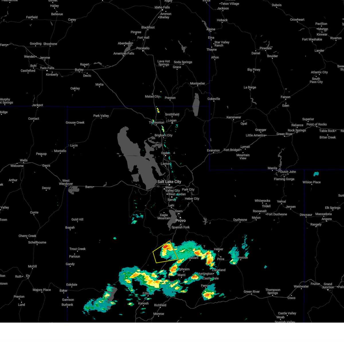
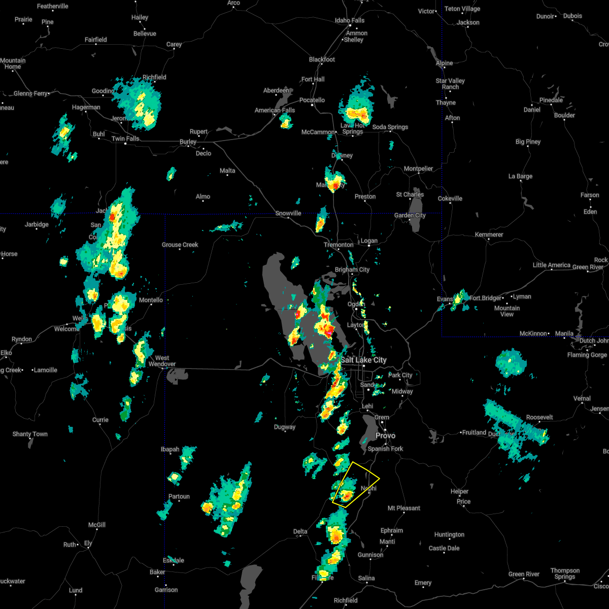
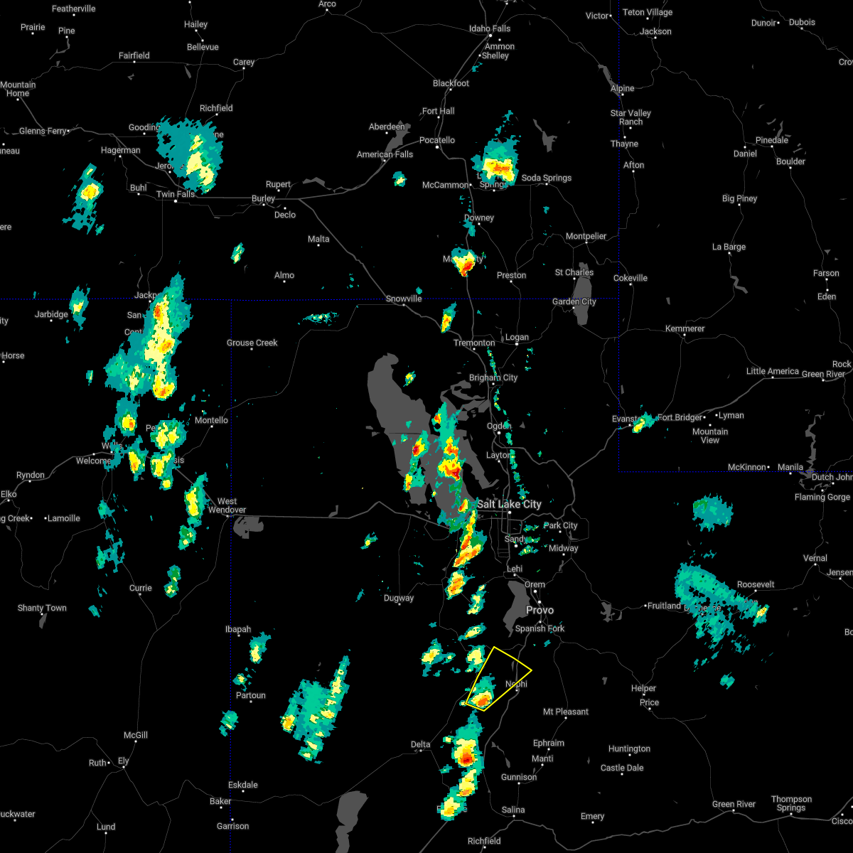
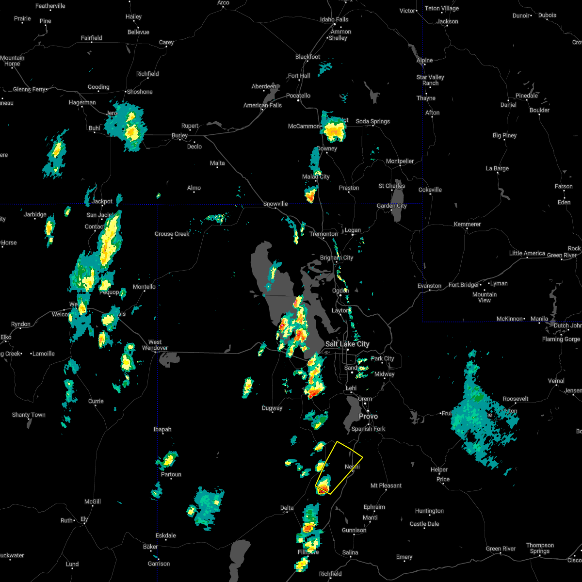
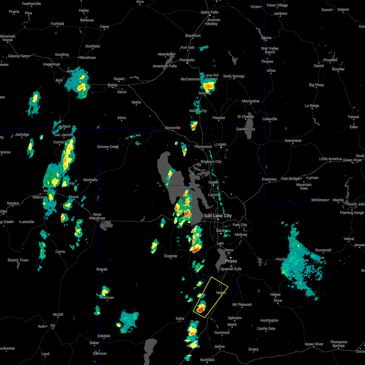
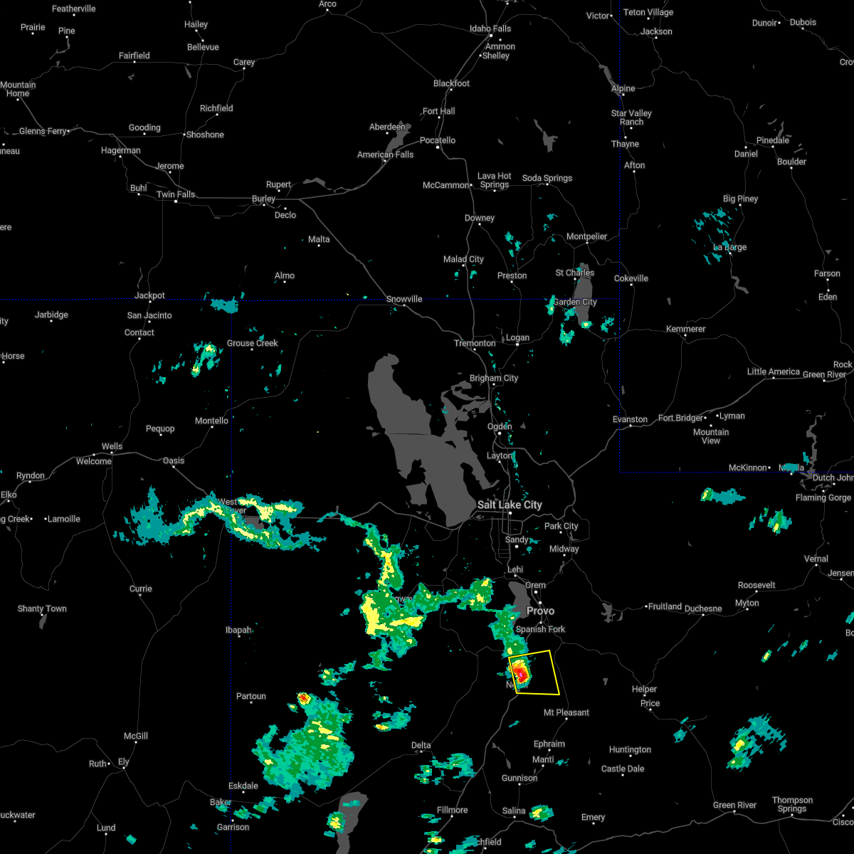
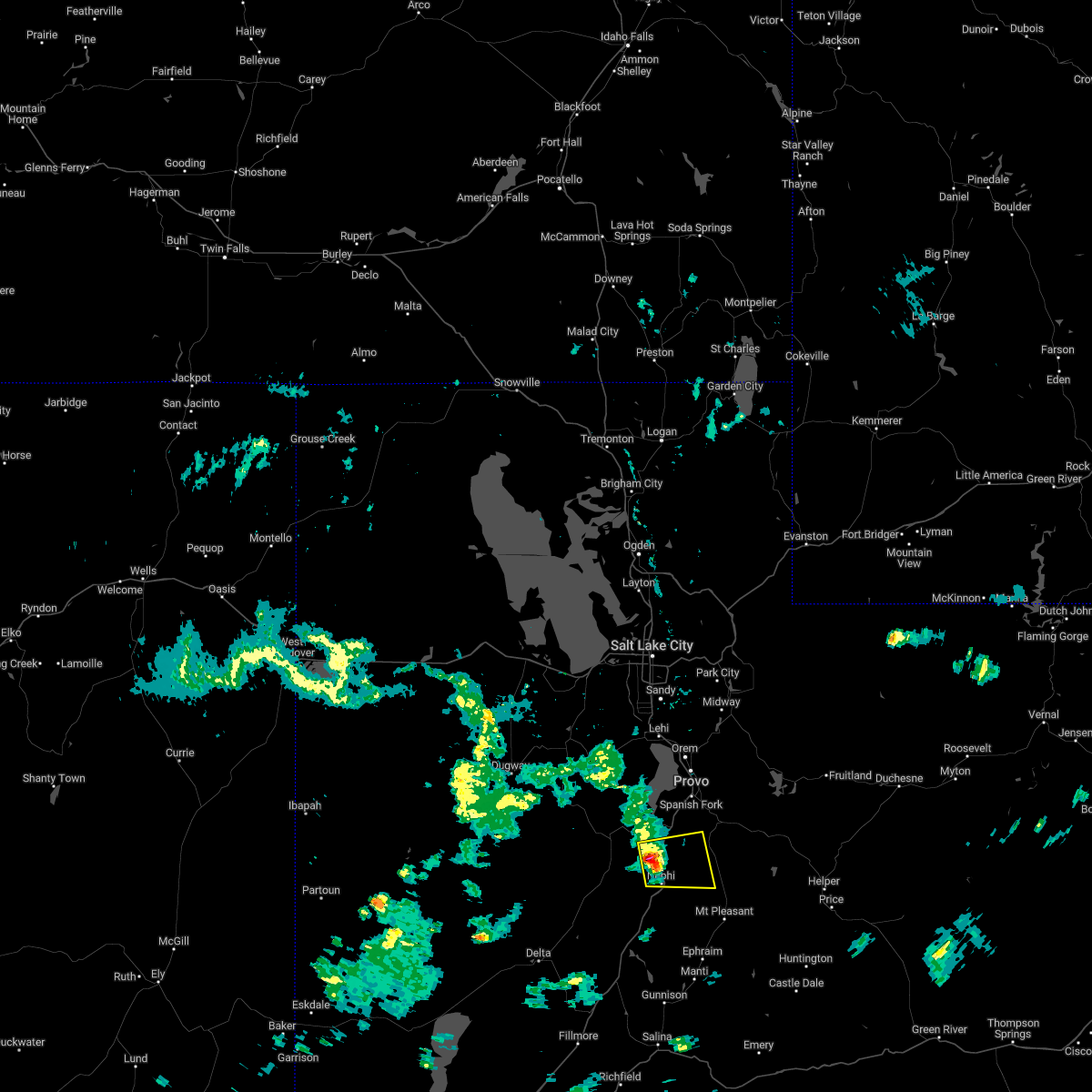
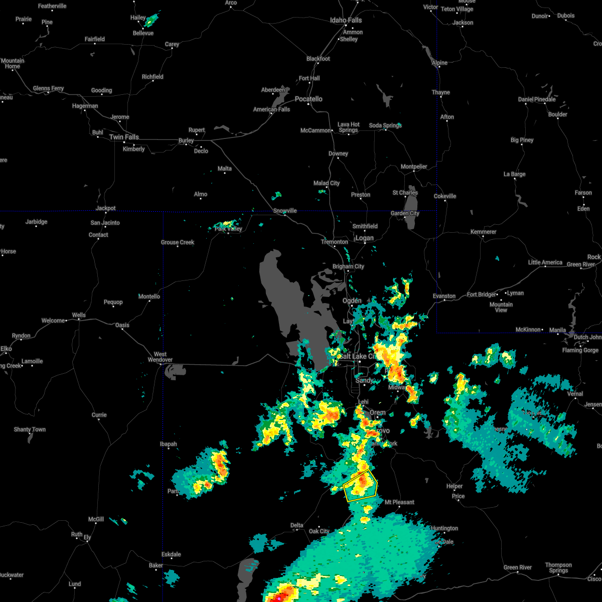
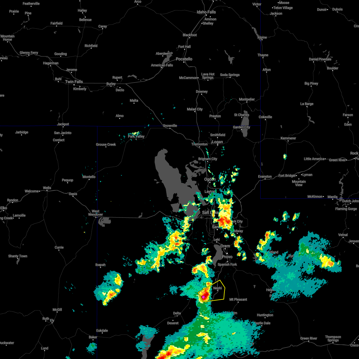
Hail Map for Mona, UT
The Mona, UT area has had 0 reports of on-the-ground hail by trained spotters, and has been under severe weather warnings 1 time during the past 12 months. Doppler radar has detected hail at or near Mona, UT on 6 occasions.
| Name: | Mona, UT |
| Where Located: | 57 miles WNW of Price, UT |
| Map: | Google Map for Mona, UT |
| Population: | 1547 |
| Housing Units: | 454 |
| More Info: | Search Google for Mona, UT |
0
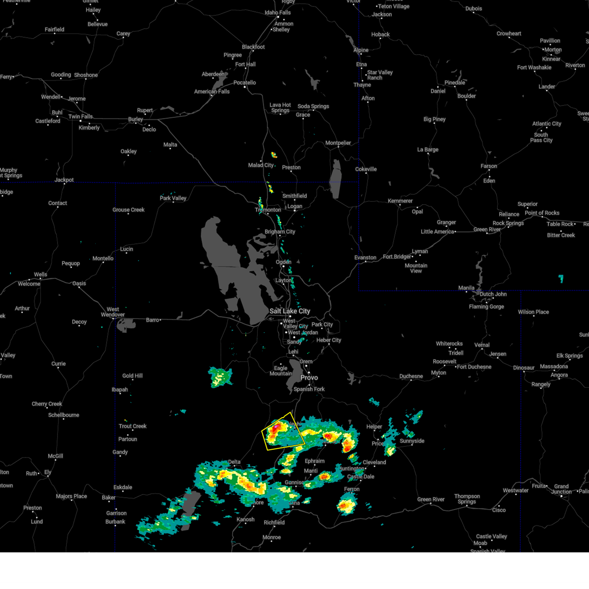
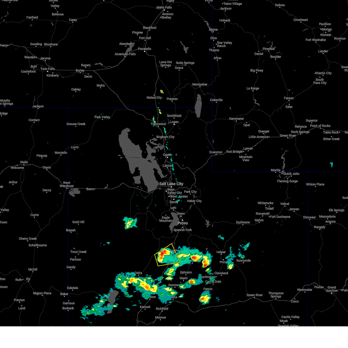
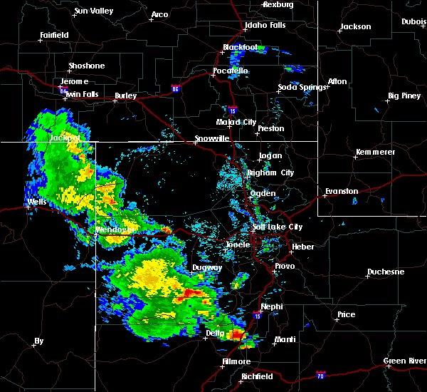
The Top Recent Hail Date for Mona, UT is Monday, August 19, 2024 (2nd out of 6)

Hail and Wind Damage Spotted near Mona, UT
| Date / Time | Report Details |
|---|---|
| 5/13/2026 3:57 PM MDT |
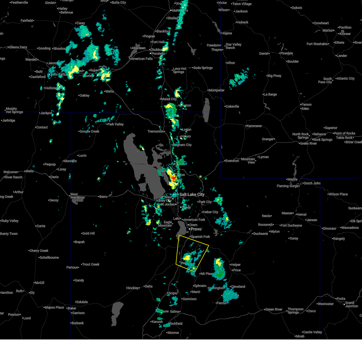 Svrslc the national weather service in salt lake city has issued a * severe thunderstorm warning for, north central sanpete county in central utah, east central juab county in central utah, south central utah county in northern utah, * until 430 pm mdt. * at 357 pm mdt, a severe thunderstorm was located 8 miles southeast of rocky ridge, or 10 miles northeast of nephi, moving northeast at 40 mph (radar indicated). Hazards include 60 mph wind gusts. expect damage to roofs, siding, and trees Svrslc the national weather service in salt lake city has issued a * severe thunderstorm warning for, north central sanpete county in central utah, east central juab county in central utah, south central utah county in northern utah, * until 430 pm mdt. * at 357 pm mdt, a severe thunderstorm was located 8 miles southeast of rocky ridge, or 10 miles northeast of nephi, moving northeast at 40 mph (radar indicated). Hazards include 60 mph wind gusts. expect damage to roofs, siding, and trees
|
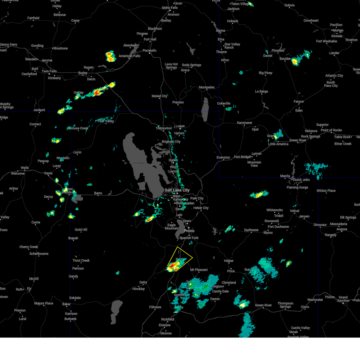
| 8/19/2024 6:14 PM MDT |
 The storm which prompted the warning has weakened below severe limits, and no longer poses an immediate threat to life or property. therefore, the warning will be allowed to expire. however gusty winds of up to 55 mph are still possible with this thunderstorm. The storm which prompted the warning has weakened below severe limits, and no longer poses an immediate threat to life or property. therefore, the warning will be allowed to expire. however gusty winds of up to 55 mph are still possible with this thunderstorm.
|
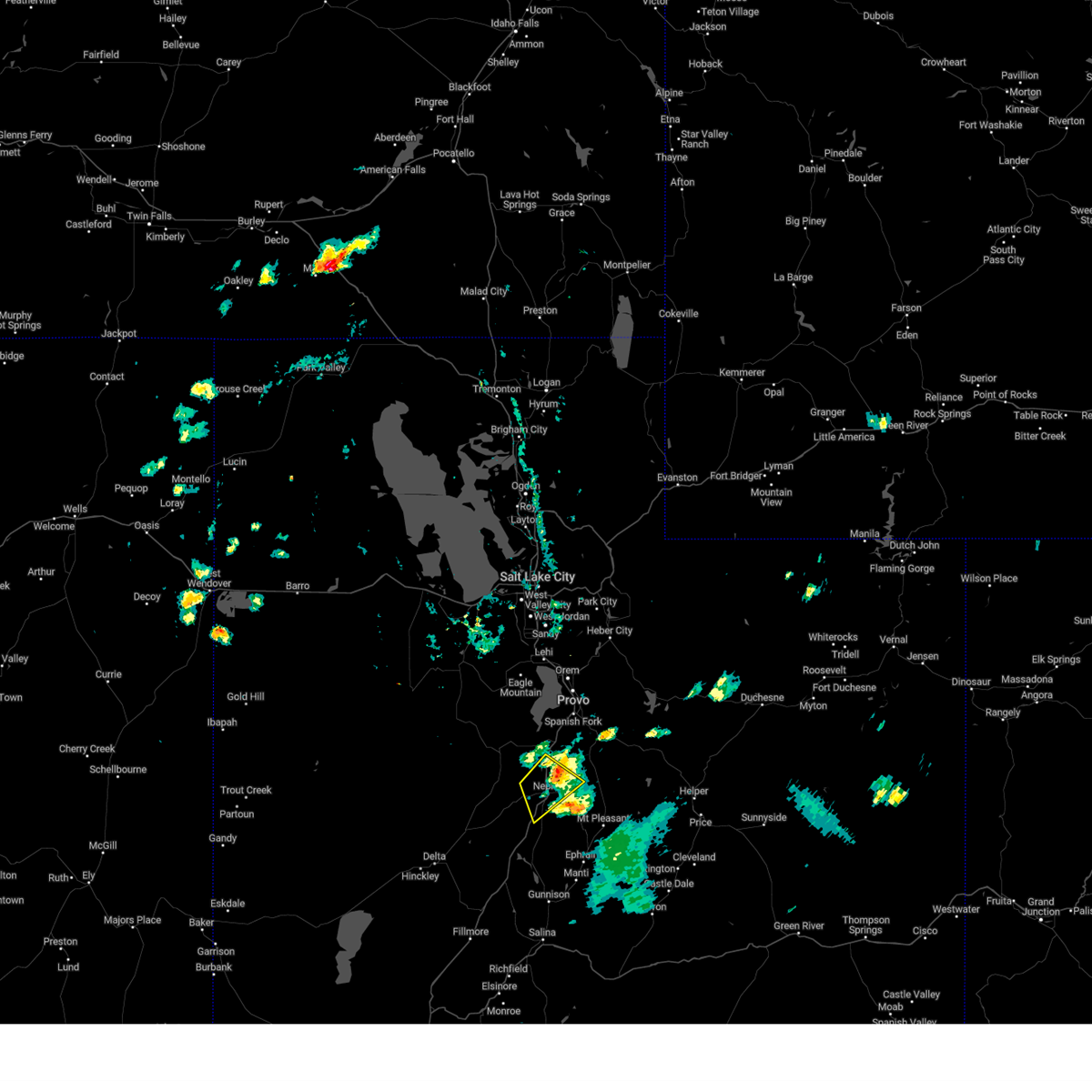
| 8/19/2024 5:57 PM MDT |
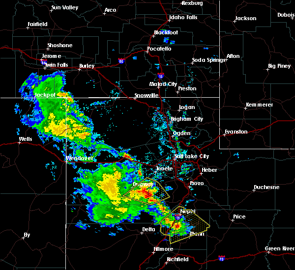
 At 557 pm mdt, a severe thunderstorm was located near nephi, moving northeast at 20 mph (radar indicated). Hazards include 60 mph wind gusts and quarter size hail. Hail damage to vehicles is expected. expect wind damage to roofs, siding, and trees. locations impacted include, nephi, rocky ridge, and mona. This includes interstate 15 between mile markers 214 and 238. At 557 pm mdt, a severe thunderstorm was located near nephi, moving northeast at 20 mph (radar indicated). Hazards include 60 mph wind gusts and quarter size hail. Hail damage to vehicles is expected. expect wind damage to roofs, siding, and trees. locations impacted include, nephi, rocky ridge, and mona. This includes interstate 15 between mile markers 214 and 238.
|
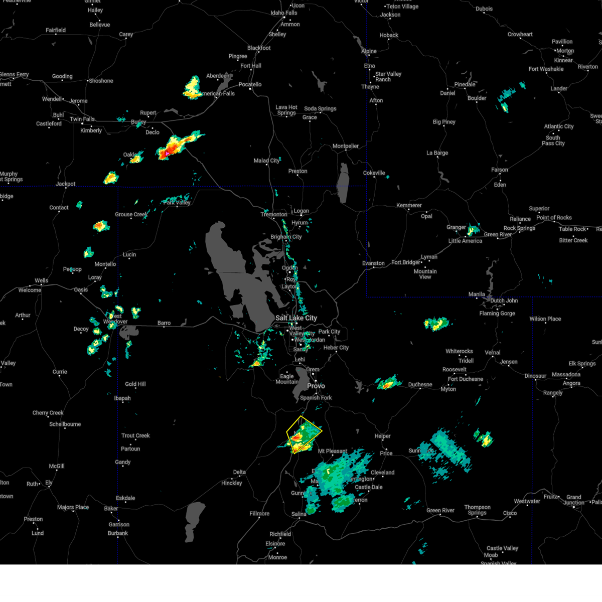
| 8/19/2024 5:40 PM MDT |
 Svrslc the national weather service in salt lake city has issued a * severe thunderstorm warning for, east central juab county in central utah, south central utah county in northern utah, * until 615 pm mdt. * at 540 pm mdt, a severe thunderstorm was located 7 miles southwest of nephi, moving northeast at 20 mph (radar indicated). Hazards include 60 mph wind gusts and quarter size hail. Hail damage to vehicles is expected. Expect wind damage to roofs, siding, and trees. Svrslc the national weather service in salt lake city has issued a * severe thunderstorm warning for, east central juab county in central utah, south central utah county in northern utah, * until 615 pm mdt. * at 540 pm mdt, a severe thunderstorm was located 7 miles southwest of nephi, moving northeast at 20 mph (radar indicated). Hazards include 60 mph wind gusts and quarter size hail. Hail damage to vehicles is expected. Expect wind damage to roofs, siding, and trees.
|
| 6/27/2024 9:41 PM MDT |
 The storm which prompted the warning has weakened below severe limits, and no longer poses an immediate threat to life or property. therefore, the warning will be allowed to expire. however small hail and gusty winds are still possible with this thunderstorm. The storm which prompted the warning has weakened below severe limits, and no longer poses an immediate threat to life or property. therefore, the warning will be allowed to expire. however small hail and gusty winds are still possible with this thunderstorm.
|
| 6/27/2024 9:25 PM MDT |
 At 924 pm mdt, a severe thunderstorm was located 8 miles southwest of nephi, moving northeast at 30 mph (radar indicated). Hazards include 60 mph wind gusts and quarter size hail. Hail damage to vehicles is expected. expect wind damage to roofs, siding, and trees. locations impacted include, nephi, mona, and levan. This includes interstate 15 between mile markers 210 and 229. At 924 pm mdt, a severe thunderstorm was located 8 miles southwest of nephi, moving northeast at 30 mph (radar indicated). Hazards include 60 mph wind gusts and quarter size hail. Hail damage to vehicles is expected. expect wind damage to roofs, siding, and trees. locations impacted include, nephi, mona, and levan. This includes interstate 15 between mile markers 210 and 229.
|
| 6/27/2024 9:25 PM MDT |
 the severe thunderstorm warning has been cancelled and is no longer in effect the severe thunderstorm warning has been cancelled and is no longer in effect
|
| 6/27/2024 9:04 PM MDT |
 Svrslc the national weather service in salt lake city has issued a * severe thunderstorm warning for, northeastern millard county in central utah, southeastern juab county in central utah, * until 945 pm mdt. * at 903 pm mdt, a severe thunderstorm was located 18 miles southwest of nephi, moving northeast at 30 mph (radar indicated). Hazards include 60 mph wind gusts and quarter size hail. Hail damage to vehicles is expected. Expect wind damage to roofs, siding, and trees. Svrslc the national weather service in salt lake city has issued a * severe thunderstorm warning for, northeastern millard county in central utah, southeastern juab county in central utah, * until 945 pm mdt. * at 903 pm mdt, a severe thunderstorm was located 18 miles southwest of nephi, moving northeast at 30 mph (radar indicated). Hazards include 60 mph wind gusts and quarter size hail. Hail damage to vehicles is expected. Expect wind damage to roofs, siding, and trees.
|
| 8/2/2023 2:38 PM MDT |
 At 237 pm mdt, severe thunderstorms were located along a line extending from 7 miles east of vernon to near elk ridge, moving north at 30 mph (radar indicated). Hazards include 70 mph wind gusts and quarter size hail. Hail damage to vehicles is expected. expect considerable tree damage. wind damage is also likely to mobile homes, roofs, and outbuildings. locations impacted include, payson, spanish fork, springville, santaquin, mapleton, salem, elk ridge, woodland hills, rocky ridge, vernon, palmyra, benjamin, lake shore, spring lake, west mountain, elberta, utah lake, mona, genola and goshen. this includes the following highways, interstate 15 between mile markers 228 and 261. us route 6 between mile markers 125 and 184. thunderstorm damage threat, considerable hail threat, radar indicated max hail size, 1. 00 in wind threat, observed max wind gust, 70 mph. At 237 pm mdt, severe thunderstorms were located along a line extending from 7 miles east of vernon to near elk ridge, moving north at 30 mph (radar indicated). Hazards include 70 mph wind gusts and quarter size hail. Hail damage to vehicles is expected. expect considerable tree damage. wind damage is also likely to mobile homes, roofs, and outbuildings. locations impacted include, payson, spanish fork, springville, santaquin, mapleton, salem, elk ridge, woodland hills, rocky ridge, vernon, palmyra, benjamin, lake shore, spring lake, west mountain, elberta, utah lake, mona, genola and goshen. this includes the following highways, interstate 15 between mile markers 228 and 261. us route 6 between mile markers 125 and 184. thunderstorm damage threat, considerable hail threat, radar indicated max hail size, 1. 00 in wind threat, observed max wind gust, 70 mph.
|
| 8/2/2023 2:22 PM MDT |
 At 221 pm mdt, severe thunderstorms were located along a line extending from 11 miles southeast of vernon to 6 miles southeast of rocky ridge, moving north at 30 mph (radar indicated). Hazards include 70 mph wind gusts and quarter size hail. at 210 pm a wind gust to 77 mph was reported west of nephi. Hail damage to vehicles is expected. expect considerable tree damage. wind damage is also likely to mobile homes, roofs, and outbuildings. locations impacted include, payson, spanish fork, springville, santaquin, mapleton, salem, elk ridge, woodland hills, rocky ridge, vernon, palmyra, benjamin, lake shore, spring lake, west mountain, elberta, utah lake, mona, genola and goshen. this includes the following highways, interstate 15 between mile markers 228 and 261. us route 6 between mile markers 125 and 184. thunderstorm damage threat, considerable hail threat, radar indicated max hail size, 1. 00 in wind threat, observed max wind gust, 70 mph. At 221 pm mdt, severe thunderstorms were located along a line extending from 11 miles southeast of vernon to 6 miles southeast of rocky ridge, moving north at 30 mph (radar indicated). Hazards include 70 mph wind gusts and quarter size hail. at 210 pm a wind gust to 77 mph was reported west of nephi. Hail damage to vehicles is expected. expect considerable tree damage. wind damage is also likely to mobile homes, roofs, and outbuildings. locations impacted include, payson, spanish fork, springville, santaquin, mapleton, salem, elk ridge, woodland hills, rocky ridge, vernon, palmyra, benjamin, lake shore, spring lake, west mountain, elberta, utah lake, mona, genola and goshen. this includes the following highways, interstate 15 between mile markers 228 and 261. us route 6 between mile markers 125 and 184. thunderstorm damage threat, considerable hail threat, radar indicated max hail size, 1. 00 in wind threat, observed max wind gust, 70 mph.
|
| 8/2/2023 1:46 PM MDT |
 At 145 pm mdt, severe thunderstorms were located along a line extending from 24 miles north of delta to 8 miles south of nephi, moving north at 30 mph (radar indicated. at 120 pm a wind gust to 61 mph was reported at the sevier river bridge along i-15). Hazards include 60 mph wind gusts and quarter size hail. Hail damage to vehicles is expected. Expect wind damage to roofs, siding, and trees. At 145 pm mdt, severe thunderstorms were located along a line extending from 24 miles north of delta to 8 miles south of nephi, moving north at 30 mph (radar indicated. at 120 pm a wind gust to 61 mph was reported at the sevier river bridge along i-15). Hazards include 60 mph wind gusts and quarter size hail. Hail damage to vehicles is expected. Expect wind damage to roofs, siding, and trees.
|
| 9/21/2022 12:53 PM MDT |
 The severe thunderstorm warning for northeastern juab and southwestern utah counties will expire at 100 pm mdt, the storm which prompted the warning has weakened below severe limits, and no longer poses an immediate threat to life or property. therefore, the warning will be allowed to expire. a severe thunderstorm watch remains in effect until 800 pm mdt for central and northern utah. The severe thunderstorm warning for northeastern juab and southwestern utah counties will expire at 100 pm mdt, the storm which prompted the warning has weakened below severe limits, and no longer poses an immediate threat to life or property. therefore, the warning will be allowed to expire. a severe thunderstorm watch remains in effect until 800 pm mdt for central and northern utah.
|
| 9/21/2022 12:49 PM MDT |
 At 1248 pm mdt, a severe thunderstorm was located 9 miles west of nephi, moving northeast at 45 mph (radar indicated). Hazards include 60 mph wind gusts and penny size hail. Expect damage to roofs, siding, and trees. locations impacted include, elberta and mona. this includes the following highways, interstate 15 between mile markers 229 and 237. us route 6 between mile markers 147 and 149. hail threat, radar indicated max hail size, 0. 75 in wind threat, radar indicated max wind gust, 60 mph. At 1248 pm mdt, a severe thunderstorm was located 9 miles west of nephi, moving northeast at 45 mph (radar indicated). Hazards include 60 mph wind gusts and penny size hail. Expect damage to roofs, siding, and trees. locations impacted include, elberta and mona. this includes the following highways, interstate 15 between mile markers 229 and 237. us route 6 between mile markers 147 and 149. hail threat, radar indicated max hail size, 0. 75 in wind threat, radar indicated max wind gust, 60 mph.
|
| 9/21/2022 12:35 PM MDT |
 At 1234 pm mdt, a severe thunderstorm was located 16 miles southwest of nephi, moving northeast at 40 mph (radar indicated). Hazards include 60 mph wind gusts and quarter size hail. Hail damage to vehicles is expected. expect wind damage to roofs, siding, and trees. locations impacted include, nephi, elberta and mona. this includes the following highways, interstate 15 between mile markers 228 and 237. us route 6 between mile markers 147 and 149. hail threat, radar indicated max hail size, 1. 00 in wind threat, radar indicated max wind gust, 60 mph. At 1234 pm mdt, a severe thunderstorm was located 16 miles southwest of nephi, moving northeast at 40 mph (radar indicated). Hazards include 60 mph wind gusts and quarter size hail. Hail damage to vehicles is expected. expect wind damage to roofs, siding, and trees. locations impacted include, nephi, elberta and mona. this includes the following highways, interstate 15 between mile markers 228 and 237. us route 6 between mile markers 147 and 149. hail threat, radar indicated max hail size, 1. 00 in wind threat, radar indicated max wind gust, 60 mph.
|
| 9/21/2022 12:26 PM MDT |
 At 1226 pm mdt, a severe thunderstorm was located 20 miles southwest of nephi, moving northeast at 45 mph (radar indicated). Hazards include 60 mph wind gusts and quarter size hail. Hail damage to vehicles is expected. Expect wind damage to roofs, siding, and trees. At 1226 pm mdt, a severe thunderstorm was located 20 miles southwest of nephi, moving northeast at 45 mph (radar indicated). Hazards include 60 mph wind gusts and quarter size hail. Hail damage to vehicles is expected. Expect wind damage to roofs, siding, and trees.
|
| 7/19/2022 8:30 PM MDT |
 At 830 pm mdt, a severe thunderstorm was located 7 miles southeast of rocky ridge, or 8 miles northeast of nephi, moving east at 30 mph (radar indicated). Hazards include 60 mph wind gusts and quarter size hail. Hail damage to vehicles is expected. expect wind damage to roofs, siding, and trees. locations impacted include, nephi, rocky ridge and mona. this includes interstate 15 between mile markers 225 and 240. hail threat, radar indicated max hail size, 1. 00 in wind threat, radar indicated max wind gust, 60 mph. At 830 pm mdt, a severe thunderstorm was located 7 miles southeast of rocky ridge, or 8 miles northeast of nephi, moving east at 30 mph (radar indicated). Hazards include 60 mph wind gusts and quarter size hail. Hail damage to vehicles is expected. expect wind damage to roofs, siding, and trees. locations impacted include, nephi, rocky ridge and mona. this includes interstate 15 between mile markers 225 and 240. hail threat, radar indicated max hail size, 1. 00 in wind threat, radar indicated max wind gust, 60 mph.
|
| 7/19/2022 8:20 PM MDT |
 At 819 pm mdt, a severe thunderstorm was located near rocky ridge, or 8 miles north of nephi, moving east at 20 mph (radar indicated). Hazards include 60 mph wind gusts and quarter size hail. Hail damage to vehicles is expected. Expect wind damage to roofs, siding, and trees. At 819 pm mdt, a severe thunderstorm was located near rocky ridge, or 8 miles north of nephi, moving east at 20 mph (radar indicated). Hazards include 60 mph wind gusts and quarter size hail. Hail damage to vehicles is expected. Expect wind damage to roofs, siding, and trees.
|
| 8/18/2021 2:38 PM MDT |
 The severe thunderstorm warning for east central juab and southwestern utah counties will expire at 245 pm mdt, the storms which prompted the warning have weakened below severe limits, and no longer pose an immediate threat to life or property. therefore, the warning will be allowed to expire. however heavy rain is still possible with these thunderstorms. a severe thunderstorm watch remains in effect until 800 pm mdt for central and northern utah. The severe thunderstorm warning for east central juab and southwestern utah counties will expire at 245 pm mdt, the storms which prompted the warning have weakened below severe limits, and no longer pose an immediate threat to life or property. therefore, the warning will be allowed to expire. however heavy rain is still possible with these thunderstorms. a severe thunderstorm watch remains in effect until 800 pm mdt for central and northern utah.
|
| 8/18/2021 2:30 PM MDT |
 At 229 pm mdt, severe thunderstorms were located along a line extending from near lindon to 10 miles east of woodland hills, moving northeast at 35 mph (radar indicated). Hazards include 60 mph wind gusts. Expect damage to roofs, siding, and trees. locations impacted include, provo, payson, nephi, spanish fork, springville, santaquin, mapleton, salem, elk ridge, woodland hills, rocky ridge, benjamin, palmyra, lake shore, spring lake, west mountain, elberta, utah lake, mona and genola. this includes the following highways, interstate 15 between mile markers 224 and 263. us route 6 between mile markers 150 and 195. us route 89 between mile markers 297 and 312. hail threat, radar indicated max hail size, <. 75 in wind threat, radar indicated max wind gust, 60 mph. At 229 pm mdt, severe thunderstorms were located along a line extending from near lindon to 10 miles east of woodland hills, moving northeast at 35 mph (radar indicated). Hazards include 60 mph wind gusts. Expect damage to roofs, siding, and trees. locations impacted include, provo, payson, nephi, spanish fork, springville, santaquin, mapleton, salem, elk ridge, woodland hills, rocky ridge, benjamin, palmyra, lake shore, spring lake, west mountain, elberta, utah lake, mona and genola. this includes the following highways, interstate 15 between mile markers 224 and 263. us route 6 between mile markers 150 and 195. us route 89 between mile markers 297 and 312. hail threat, radar indicated max hail size, <. 75 in wind threat, radar indicated max wind gust, 60 mph.
|
| 8/18/2021 2:05 PM MDT |
 At 205 pm mdt, severe thunderstorms were located along a line extending from 6 miles northwest of utah lake to 9 miles southeast of rocky ridge, moving east at 35 mph (radar indicated). Hazards include 60 mph wind gusts and quarter size hail. Hail damage to vehicles is expected. expect wind damage to roofs, siding, and trees. locations impacted include, provo, payson, nephi, orem, lehi, spanish fork, pleasant grove, springville, american fork, eagle mountain, lindon, alpine, santaquin, mapleton, salem, elk ridge, woodland hills, rocky ridge, vineyard and brigham young university. this includes the following highways, interstate 15 between mile markers 224 and 283. us route 6 between mile markers 150 and 195. Us route 89 between mile markers 297 and 312. At 205 pm mdt, severe thunderstorms were located along a line extending from 6 miles northwest of utah lake to 9 miles southeast of rocky ridge, moving east at 35 mph (radar indicated). Hazards include 60 mph wind gusts and quarter size hail. Hail damage to vehicles is expected. expect wind damage to roofs, siding, and trees. locations impacted include, provo, payson, nephi, orem, lehi, spanish fork, pleasant grove, springville, american fork, eagle mountain, lindon, alpine, santaquin, mapleton, salem, elk ridge, woodland hills, rocky ridge, vineyard and brigham young university. this includes the following highways, interstate 15 between mile markers 224 and 283. us route 6 between mile markers 150 and 195. Us route 89 between mile markers 297 and 312.
|
| 8/18/2021 1:46 PM MDT |
 At 145 pm mdt, severe thunderstorms were located along a line extending from 10 miles south of eagle mountain to near nephi, moving northeast at 35 mph (radar indicated). Hazards include 60 mph wind gusts. Expect damage to roofs, siding, and trees. locations impacted include, provo, payson, nephi, orem, lehi, spanish fork, pleasant grove, springville, american fork, eagle mountain, lindon, alpine, santaquin, mapleton, salem, elk ridge, woodland hills, rocky ridge, vineyard and brigham young university. this includes the following highways, interstate 15 between mile markers 223 and 282. us route 6 between mile markers 127 and 195. Us route 89 between mile markers 297 and 312. At 145 pm mdt, severe thunderstorms were located along a line extending from 10 miles south of eagle mountain to near nephi, moving northeast at 35 mph (radar indicated). Hazards include 60 mph wind gusts. Expect damage to roofs, siding, and trees. locations impacted include, provo, payson, nephi, orem, lehi, spanish fork, pleasant grove, springville, american fork, eagle mountain, lindon, alpine, santaquin, mapleton, salem, elk ridge, woodland hills, rocky ridge, vineyard and brigham young university. this includes the following highways, interstate 15 between mile markers 223 and 282. us route 6 between mile markers 127 and 195. Us route 89 between mile markers 297 and 312.
|
| 8/18/2021 1:24 PM MDT |
 At 124 pm mdt, severe thunderstorms were located along a line extending from 11 miles east of vernon to 10 miles west of nephi, moving northeast at 35 mph (radar indicated). Hazards include 60 mph wind gusts and quarter size hail. Hail damage to vehicles is expected. Expect wind damage to roofs, siding, and trees. At 124 pm mdt, severe thunderstorms were located along a line extending from 11 miles east of vernon to 10 miles west of nephi, moving northeast at 35 mph (radar indicated). Hazards include 60 mph wind gusts and quarter size hail. Hail damage to vehicles is expected. Expect wind damage to roofs, siding, and trees.
|
| 8/17/2021 6:29 PM MDT |
 At 628 pm mdt, a severe thunderstorm was located over nephi, moving northeast at 45 mph (radar indicated). Hazards include 60 mph wind gusts and penny size hail. Expect damage to roofs, siding, and trees. locations impacted include, nephi and mona. this includes interstate 15 between mile markers 217 and 234. hail threat, radar indicated max hail size, 0. 75 in wind threat, radar indicated max wind gust, 60 mph. At 628 pm mdt, a severe thunderstorm was located over nephi, moving northeast at 45 mph (radar indicated). Hazards include 60 mph wind gusts and penny size hail. Expect damage to roofs, siding, and trees. locations impacted include, nephi and mona. this includes interstate 15 between mile markers 217 and 234. hail threat, radar indicated max hail size, 0. 75 in wind threat, radar indicated max wind gust, 60 mph.
|
| 8/17/2021 6:10 PM MDT |
 At 610 pm mdt, a severe thunderstorm was located 12 miles west of nephi, moving northeast at 45 mph (radar indicated). Hazards include 60 mph wind gusts and half dollar size hail. Hail damage to vehicles is expected. Expect wind damage to roofs, siding, and trees. At 610 pm mdt, a severe thunderstorm was located 12 miles west of nephi, moving northeast at 45 mph (radar indicated). Hazards include 60 mph wind gusts and half dollar size hail. Hail damage to vehicles is expected. Expect wind damage to roofs, siding, and trees.
|
| 8/8/2019 5:48 PM MDT |
 At 548 pm mdt, a severe thunderstorm was located 11 miles south of nephi, moving northeast at 35 mph (radar indicated). Hazards include 60 mph wind gusts. Expect damage to roofs, siding, and trees. Locations impacted include, nephi, moroni, ephraim, mount pleasant, wales, mona, fairview, fountain green, spring city, levan and mills. At 548 pm mdt, a severe thunderstorm was located 11 miles south of nephi, moving northeast at 35 mph (radar indicated). Hazards include 60 mph wind gusts. Expect damage to roofs, siding, and trees. Locations impacted include, nephi, moroni, ephraim, mount pleasant, wales, mona, fairview, fountain green, spring city, levan and mills.
|
| 8/8/2019 5:28 PM MDT |
 At 527 pm mdt, a severe thunderstorm was located 13 miles north of scipio, moving northeast at 35 mph (radar indicated). Hazards include 60 mph wind gusts. expect damage to roofs, siding, and trees At 527 pm mdt, a severe thunderstorm was located 13 miles north of scipio, moving northeast at 35 mph (radar indicated). Hazards include 60 mph wind gusts. expect damage to roofs, siding, and trees
|
| 8/23/2018 12:08 AM MDT |
 At 1207 am mdt, a severe thunderstorm was located 8 miles west of nephi, moving east at 40 mph (radar indicated). Hazards include ping pong ball size hail and 60 mph wind gusts. People and animals outdoors will be injured. expect hail damage to roofs, siding, windows, and vehicles. expect wind damage to roofs, siding, and trees. this severe thunderstorm will be near, nephi around 1220 am mdt. Other locations impacted by this severe thunderstorm include fairview, mona, milburn, indianola and fountain green. At 1207 am mdt, a severe thunderstorm was located 8 miles west of nephi, moving east at 40 mph (radar indicated). Hazards include ping pong ball size hail and 60 mph wind gusts. People and animals outdoors will be injured. expect hail damage to roofs, siding, windows, and vehicles. expect wind damage to roofs, siding, and trees. this severe thunderstorm will be near, nephi around 1220 am mdt. Other locations impacted by this severe thunderstorm include fairview, mona, milburn, indianola and fountain green.
|
| 12/16/2016 12:58 PM MST |
 The severe thunderstorm warning for utah, southeastern tooele, eastern salt lake, northeastern juab, south central morgan, northwestern wasatch and southwestern summit counties will expire at 100 pm mst, the storms which prompted the warning have weakened below severe limits, and no longer pose an immediate threat to life or property. therefore the warning will be allowed to expire. however gusty winds are still possible with any lingering thunderstorms. The severe thunderstorm warning for utah, southeastern tooele, eastern salt lake, northeastern juab, south central morgan, northwestern wasatch and southwestern summit counties will expire at 100 pm mst, the storms which prompted the warning have weakened below severe limits, and no longer pose an immediate threat to life or property. therefore the warning will be allowed to expire. however gusty winds are still possible with any lingering thunderstorms.
|
| 12/16/2016 12:20 PM MST |
 At 1218 pm mst, doppler radar indicated a line of severe thunderstorms capable of producing damaging winds in excess of 60 mph. these storms were located along a line extending from near summit park to 25 miles northwest of delta, and moving southeast at 35 mph. At 1218 pm mst, doppler radar indicated a line of severe thunderstorms capable of producing damaging winds in excess of 60 mph. these storms were located along a line extending from near summit park to 25 miles northwest of delta, and moving southeast at 35 mph.
|
| 11/23/2016 5:39 PM MST |
 The severe thunderstorm warning for utah, southeastern tooele and northeastern juab counties will expire at 545 pm mst, the storms which prompted the warning have weakened below severe limits and exited the warned area. therefore the warning will be allowed to expire. The severe thunderstorm warning for utah, southeastern tooele and northeastern juab counties will expire at 545 pm mst, the storms which prompted the warning have weakened below severe limits and exited the warned area. therefore the warning will be allowed to expire.
|
| 11/23/2016 5:10 PM MST |
 At 510 pm mst, doppler radar indicated severe thunderstorms with a history of producing damaging winds in excess of 60 mph. these storms were located along a line extending from near lehi to 6 miles southwest of elberta, moving east at 40 mph. locations impacted include, provo, payson, nephi, orem, lehi, draper, spanish fork, pleasant grove, springville, american fork, eagle mountain, lindon, alpine, santaquin, mapleton, bluffdale, salem, elk ridge, woodland hills and rocky ridge. At 510 pm mst, doppler radar indicated severe thunderstorms with a history of producing damaging winds in excess of 60 mph. these storms were located along a line extending from near lehi to 6 miles southwest of elberta, moving east at 40 mph. locations impacted include, provo, payson, nephi, orem, lehi, draper, spanish fork, pleasant grove, springville, american fork, eagle mountain, lindon, alpine, santaquin, mapleton, bluffdale, salem, elk ridge, woodland hills and rocky ridge.
|
| 11/23/2016 4:40 PM MST |
 At 440 pm mst, doppler radar indicated a line of severe thunderstorms capable of producing damaging winds in excess of 60 mph. these storms were located along a line extending from 13 miles south of cedar fort to 25 miles northeast of delta, and moving east at 50 mph. At 440 pm mst, doppler radar indicated a line of severe thunderstorms capable of producing damaging winds in excess of 60 mph. these storms were located along a line extending from 13 miles south of cedar fort to 25 miles northeast of delta, and moving east at 50 mph.
|
Hail Maps for Mona, UT


Connect with Interactive Hail Maps