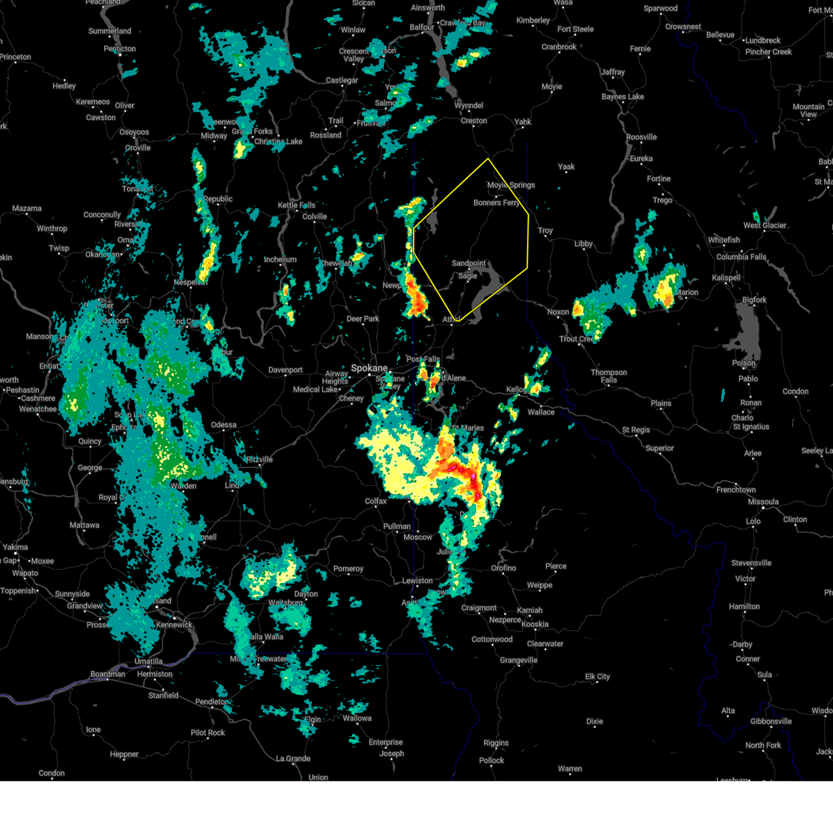
| 9/25/2024 5:57 PM PDT |
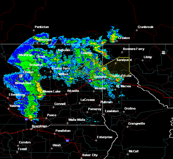
 Svrotx the national weather service in spokane has issued a * severe thunderstorm warning for, northeastern boundary county in the panhandle of idaho, * until 630 pm pdt. * at 557 pm pdt, a severe thunderstorm was located near moyie springs, or near bonners ferry, moving northeast at 45 mph (trained weather spotters). Hazards include 70 mph wind gusts and quarter size hail. Hail damage to vehicles is expected. expect considerable tree damage. Wind damage is also likely to mobile homes, roofs, and outbuildings. Svrotx the national weather service in spokane has issued a * severe thunderstorm warning for, northeastern boundary county in the panhandle of idaho, * until 630 pm pdt. * at 557 pm pdt, a severe thunderstorm was located near moyie springs, or near bonners ferry, moving northeast at 45 mph (trained weather spotters). Hazards include 70 mph wind gusts and quarter size hail. Hail damage to vehicles is expected. expect considerable tree damage. Wind damage is also likely to mobile homes, roofs, and outbuildings.
|
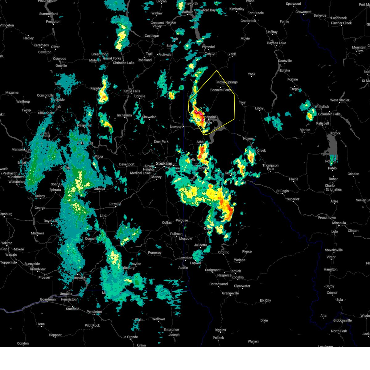
| 9/25/2024 5:53 PM PDT |
 At 552 pm pdt, a severe thunderstorm was located near bonners ferry, moving northeast at 60 mph (radar indicated). Hazards include 70 mph wind gusts and quarter size hail. Hail damage to vehicles is expected. expect considerable tree damage. wind damage is also likely to mobile homes, roofs, and outbuildings. locations impacted include, bonners ferry, moyie springs, east hope, hope, naples, and elmira. this includes the following highways, u. s. highway 95 in idaho between mile markers 487 and 520. u. s. Highway 2 in idaho between mile markers 65 and 69. At 552 pm pdt, a severe thunderstorm was located near bonners ferry, moving northeast at 60 mph (radar indicated). Hazards include 70 mph wind gusts and quarter size hail. Hail damage to vehicles is expected. expect considerable tree damage. wind damage is also likely to mobile homes, roofs, and outbuildings. locations impacted include, bonners ferry, moyie springs, east hope, hope, naples, and elmira. this includes the following highways, u. s. highway 95 in idaho between mile markers 487 and 520. u. s. Highway 2 in idaho between mile markers 65 and 69.
|
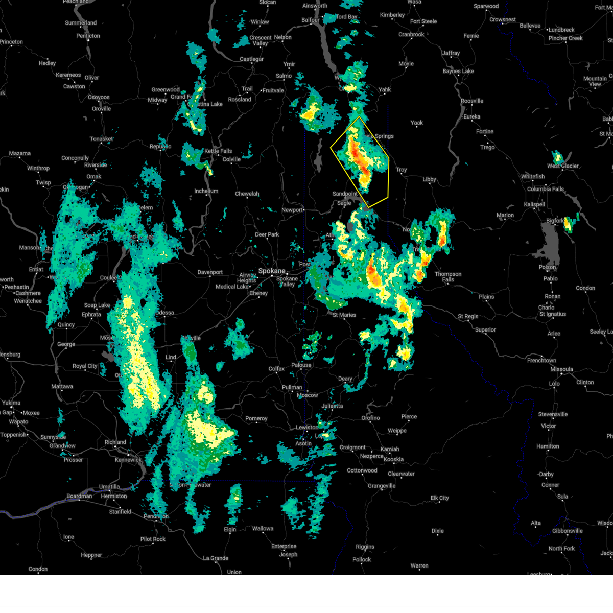
| 9/25/2024 5:28 PM PDT |
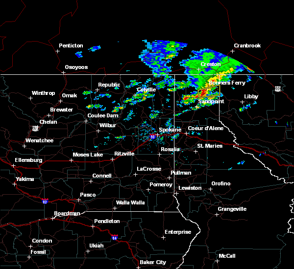
 At 527 pm pdt, a severe thunderstorm was located near ponderay, or 8 miles north of sandpoint, moving northeast at 60 mph (radar indicated). Hazards include 70 mph wind gusts and quarter size hail. Hail damage to vehicles is expected. expect considerable tree damage. wind damage is also likely to mobile homes, roofs, and outbuildings. locations impacted include, sandpoint, bonners ferry, ponderay, moyie springs, kootenai, dover, east hope, hope, colburn, schweitzer mountain, cocolalla, coolin, elmira, and naples. this includes the following highways, u. s. highway 95 in idaho between mile markers 459 and 520. u. s. Highway 2 in idaho between mile markers 16 and 69. At 527 pm pdt, a severe thunderstorm was located near ponderay, or 8 miles north of sandpoint, moving northeast at 60 mph (radar indicated). Hazards include 70 mph wind gusts and quarter size hail. Hail damage to vehicles is expected. expect considerable tree damage. wind damage is also likely to mobile homes, roofs, and outbuildings. locations impacted include, sandpoint, bonners ferry, ponderay, moyie springs, kootenai, dover, east hope, hope, colburn, schweitzer mountain, cocolalla, coolin, elmira, and naples. this includes the following highways, u. s. highway 95 in idaho between mile markers 459 and 520. u. s. Highway 2 in idaho between mile markers 16 and 69.
|
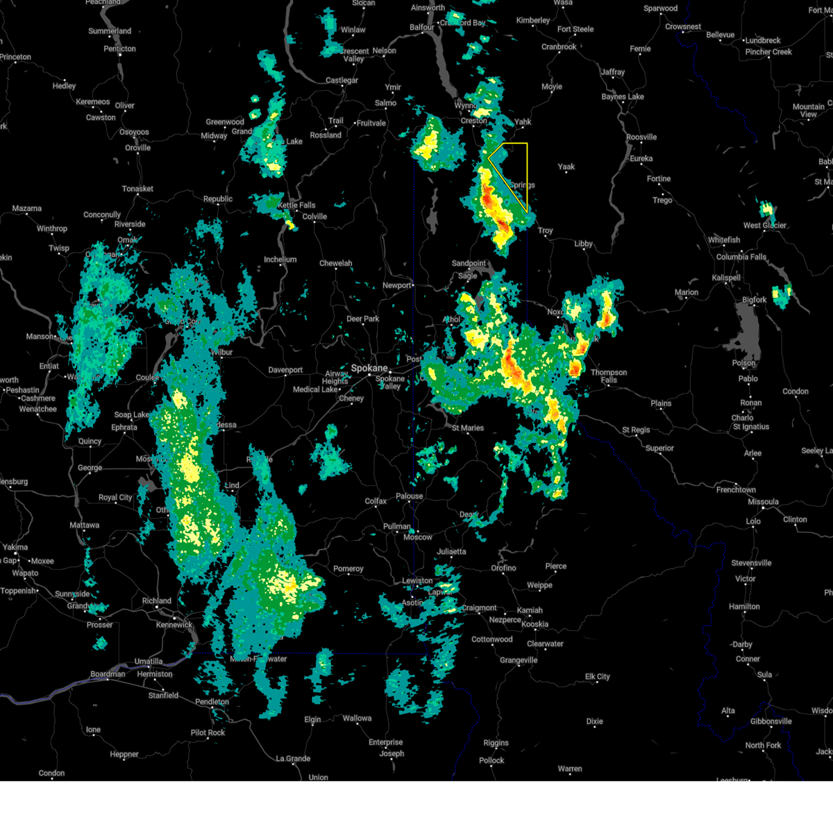
| 9/25/2024 5:09 PM PDT |
 Svrotx the national weather service in spokane has issued a * severe thunderstorm warning for, eastern boundary county in the panhandle of idaho, bonner county in the panhandle of idaho, * until 615 pm pdt. * at 508 pm pdt, a severe thunderstorm was located over priest river, moving northeast at 60 mph (radar indicated). Hazards include 60 mph wind gusts and penny size hail. expect damage to roofs, siding, and trees Svrotx the national weather service in spokane has issued a * severe thunderstorm warning for, eastern boundary county in the panhandle of idaho, bonner county in the panhandle of idaho, * until 615 pm pdt. * at 508 pm pdt, a severe thunderstorm was located over priest river, moving northeast at 60 mph (radar indicated). Hazards include 60 mph wind gusts and penny size hail. expect damage to roofs, siding, and trees
|
| 6/24/2020 4:08 PM PDT |
 At 407 pm pdt, a severe thunderstorm was located 7 miles southwest of bonners ferry, moving east at 30 mph (radar indicated). Hazards include quarter size hail. damage to vehicles is expected At 407 pm pdt, a severe thunderstorm was located 7 miles southwest of bonners ferry, moving east at 30 mph (radar indicated). Hazards include quarter size hail. damage to vehicles is expected
|
| 7/23/2019 9:53 PM PDT |
 At 953 pm pdt, severe thunderstorms were located along a line extending from 20 miles southwest of nordman to near priest river, moving northeast at 60 mph (radar indicated). Hazards include 60 mph wind gusts and penny size hail. expect damage to roofs, siding, and trees At 953 pm pdt, severe thunderstorms were located along a line extending from 20 miles southwest of nordman to near priest river, moving northeast at 60 mph (radar indicated). Hazards include 60 mph wind gusts and penny size hail. expect damage to roofs, siding, and trees
|
| 7/17/2013 12:50 PM PDT |
Large tree blown down onto highway 95 at milepost 533 in boundary county ID, 15.7 miles S of Moyie Springs, ID
|
| 6/24/2012 5:15 AM PDT |
Half Dollar sized hail reported 1.2 miles ESE of Moyie Springs, ID
|
| 6/24/2012 5:00 AM PDT |
Half Dollar sized hail reported 1.2 miles ESE of Moyie Springs, ID
|


Connect with Interactive Hail Maps