

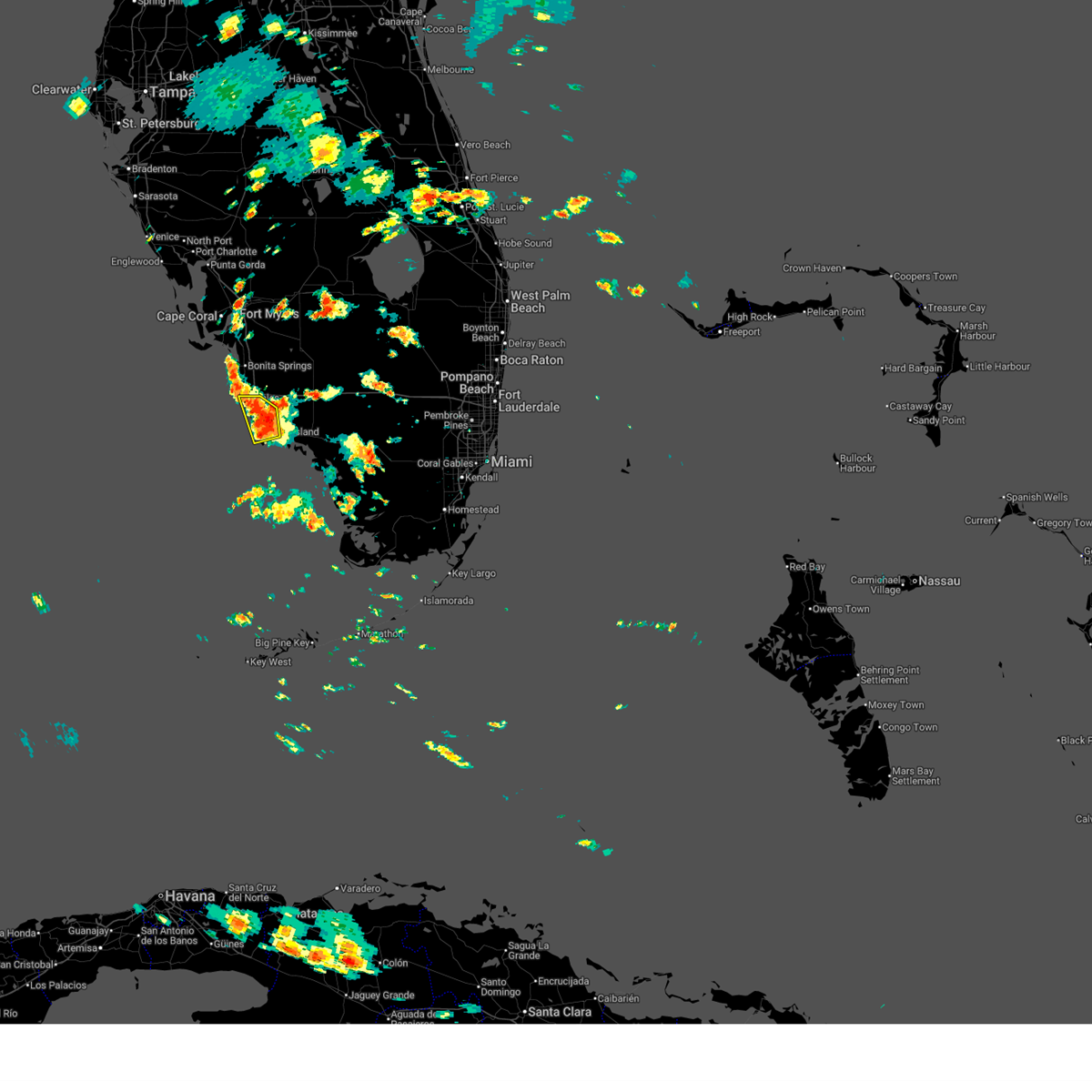
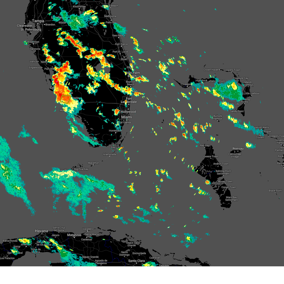
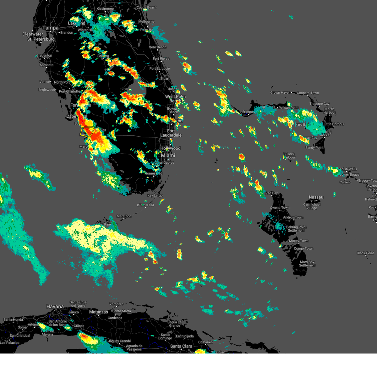
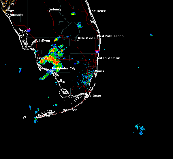
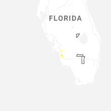
Hail Map for Naples, FL
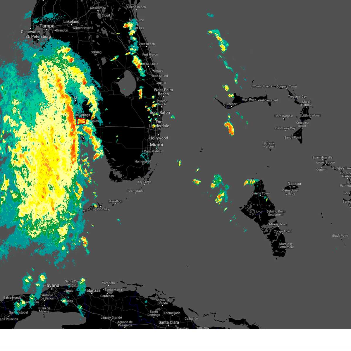
The Naples, FL area has had 9 reports of on-the-ground hail by trained spotters, and has been under severe weather warnings 3 times during the past 12 months. Doppler radar has detected hail at or near Naples, FL on 34 occasions, including 1 occasion during the past year.
| Name: | Naples, FL |
| Where Located: | 1.9 miles NNE of Naples, FL |
| Map: | Google Map for Naples, FL |
| Population: | 19537 |
| Housing Units: | 17753 |
| More Info: | Search Google for Naples, FL |
0
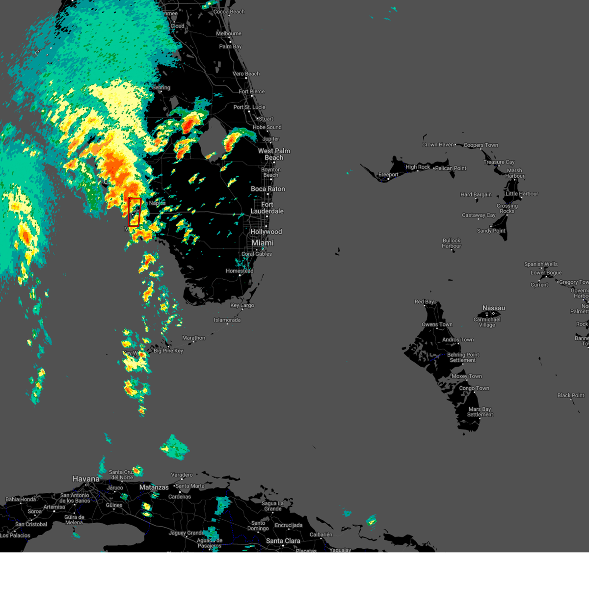
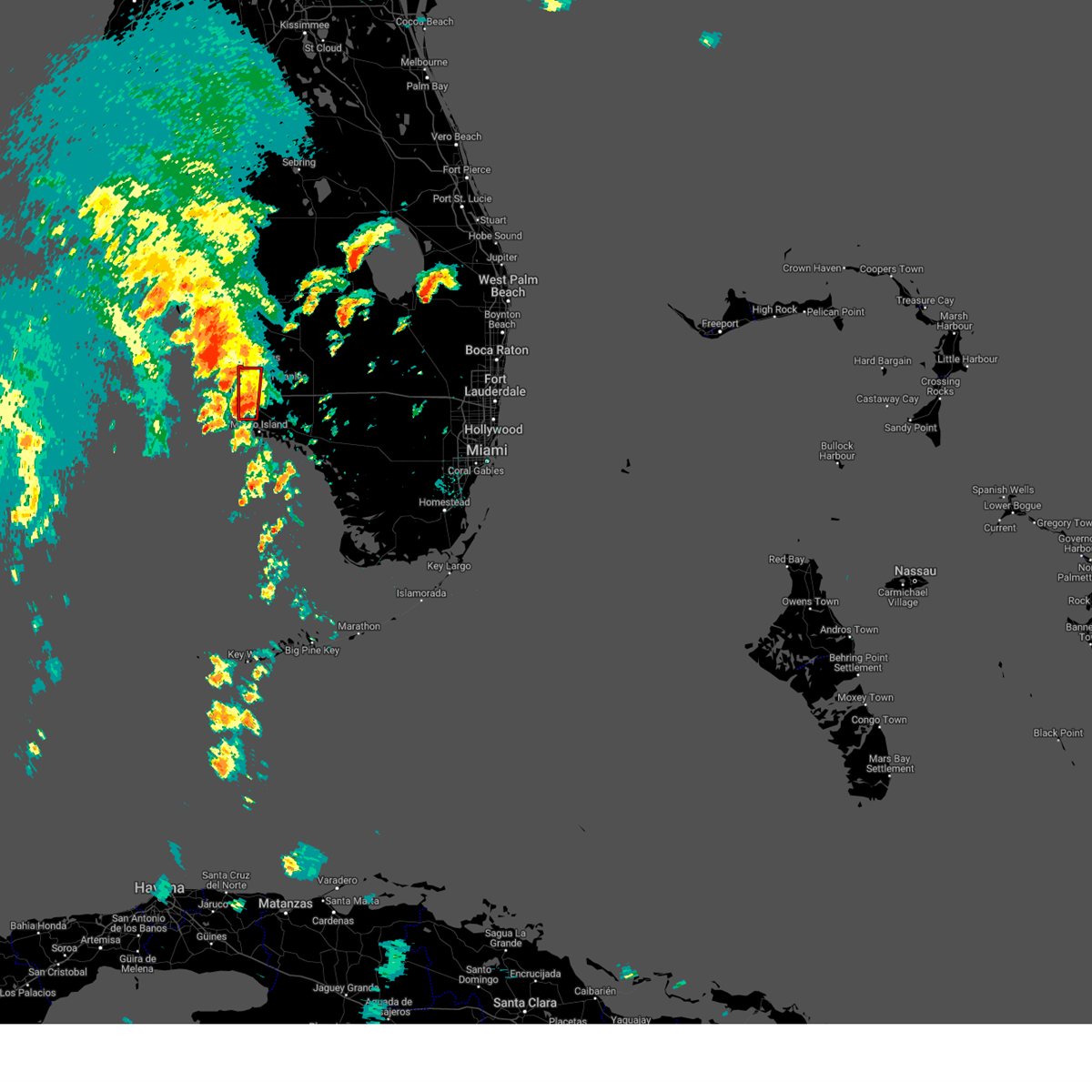
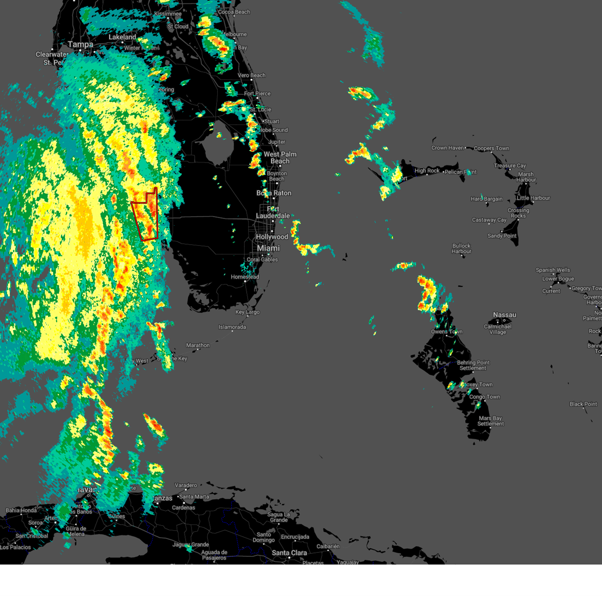
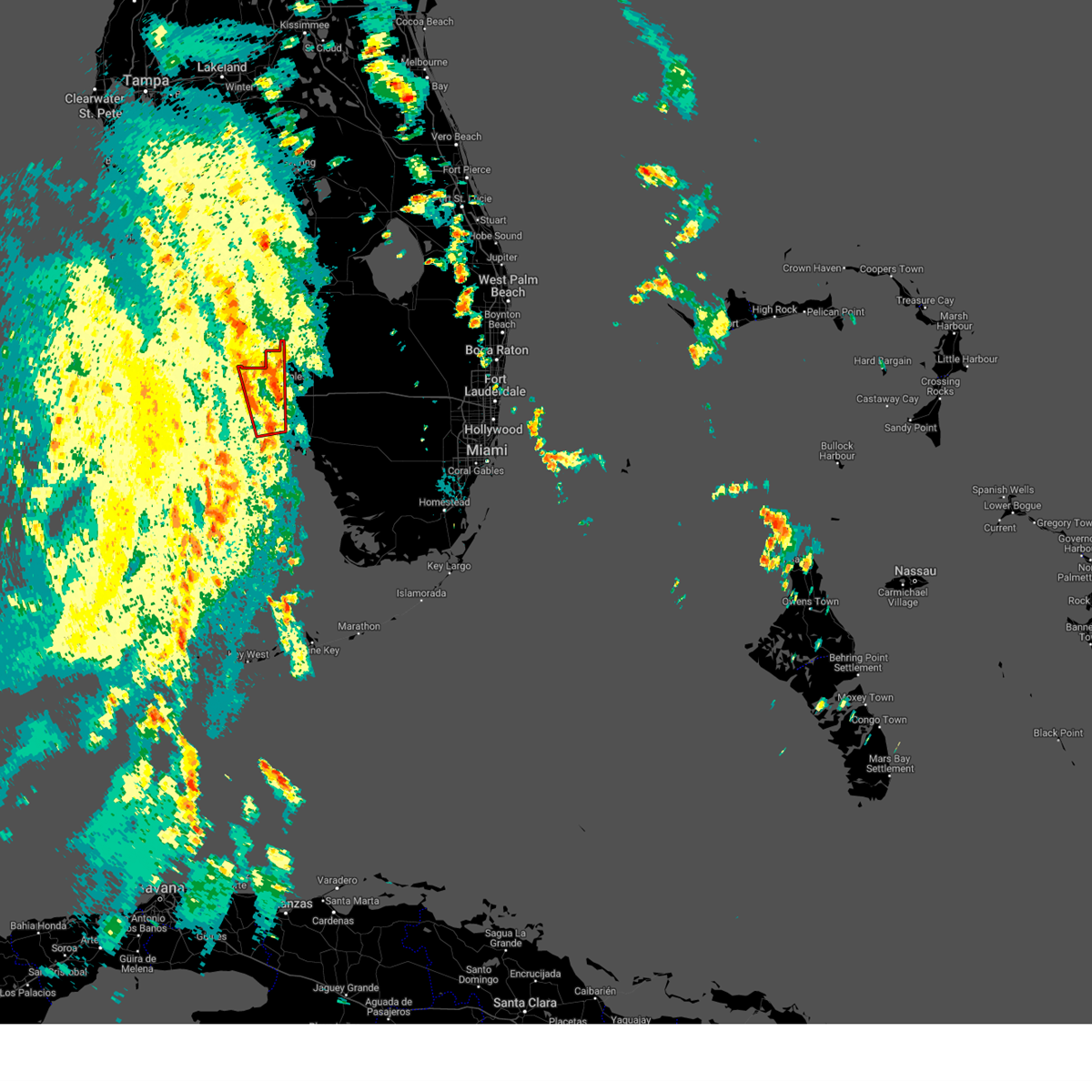
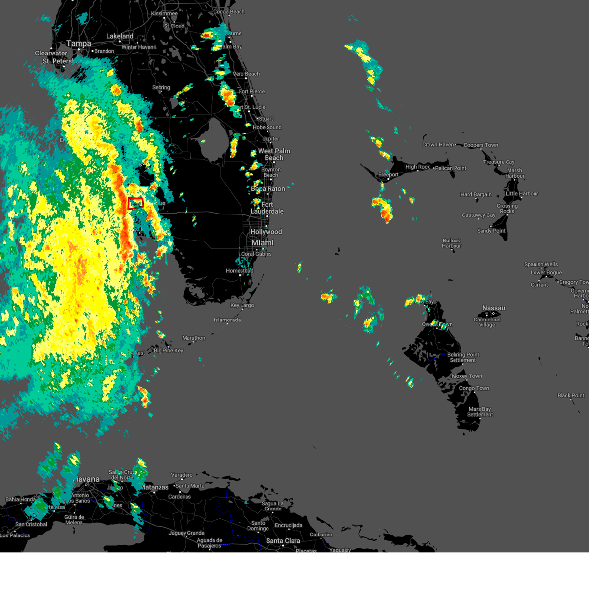
The Top Recent Hail Date for Naples, FL is Sunday, May 17, 2026 (18th out of 34)

Hail and Wind Damage Spotted near Naples, FL
| Date / Time | Report Details |
|---|---|
| 5/17/2026 3:23 PM EDT |
 The storm which prompted the warning has weakened below severe limits, and no longer poses an immediate threat to life or property. therefore, the warning will be allowed to expire. however, heavy rain is still possible with this thunderstorm. The storm which prompted the warning has weakened below severe limits, and no longer poses an immediate threat to life or property. therefore, the warning will be allowed to expire. however, heavy rain is still possible with this thunderstorm.
|
| 5/17/2026 3:09 PM EDT |
 At 309 pm edt, a severe thunderstorm was located over north naples, or near bonita springs, moving south at 5 mph (radar indicated). Hazards include 60 mph wind gusts and quarter size hail. Hail damage to vehicles is expected. expect wind damage to roofs, siding, and trees. Locations impacted include, naples, golden gate estates, naples park, west toll gate on alligator alley, vineyards, golden gate, north naples, east naples, pelican bay, and quail creek estate. At 309 pm edt, a severe thunderstorm was located over north naples, or near bonita springs, moving south at 5 mph (radar indicated). Hazards include 60 mph wind gusts and quarter size hail. Hail damage to vehicles is expected. expect wind damage to roofs, siding, and trees. Locations impacted include, naples, golden gate estates, naples park, west toll gate on alligator alley, vineyards, golden gate, north naples, east naples, pelican bay, and quail creek estate.
|
| 5/17/2026 2:42 PM EDT |
 Svrmfl the national weather service in miami has issued a * severe thunderstorm warning for, west central collier county in southwestern florida, * until 330 pm edt. * at 242 pm edt, a severe thunderstorm was located over naples park, or near bonita springs, moving south at 5 mph (radar indicated). Hazards include 60 mph wind gusts and quarter size hail. Hail damage to vehicles is expected. Expect wind damage to roofs, siding, and trees. Svrmfl the national weather service in miami has issued a * severe thunderstorm warning for, west central collier county in southwestern florida, * until 330 pm edt. * at 242 pm edt, a severe thunderstorm was located over naples park, or near bonita springs, moving south at 5 mph (radar indicated). Hazards include 60 mph wind gusts and quarter size hail. Hail damage to vehicles is expected. Expect wind damage to roofs, siding, and trees.
|
| 6/22/2025 3:52 PM EDT |
 Svrmfl the national weather service in miami has issued a * severe thunderstorm warning for, southwestern collier county in southwestern florida, * until 415 pm edt. * at 352 pm edt, a severe thunderstorm was located over marco island airport, or near marco island, and is nearly stationary (radar indicated). Hazards include 60 mph wind gusts and penny size hail. expect damage to roofs, siding, and trees Svrmfl the national weather service in miami has issued a * severe thunderstorm warning for, southwestern collier county in southwestern florida, * until 415 pm edt. * at 352 pm edt, a severe thunderstorm was located over marco island airport, or near marco island, and is nearly stationary (radar indicated). Hazards include 60 mph wind gusts and penny size hail. expect damage to roofs, siding, and trees
|
| 10/9/2024 2:53 PM EDT | Awos station kapf 1 ene naples reported a wind gust of 58mph as a band of hurricane milton moved through the are in collier county FL, 0.6 miles NW of Naples, FL |
| 10/9/2024 11:59 AM EDT |
 the tornado warning has been cancelled and is no longer in effect the tornado warning has been cancelled and is no longer in effect
|
| 10/9/2024 11:40 AM EDT |
 Tormfl the national weather service in miami has issued a * tornado warning for, west central collier county in southwestern florida, * until 1215 pm edt. * at 1139 am edt, a severe thunderstorm capable of producing a tornado was located near east naples, or near naples, moving north at 55 mph (radar indicated rotation). Hazards include tornado. Flying debris will be dangerous to those caught without shelter. mobile homes will be damaged or destroyed. damage to roofs, windows, and vehicles will occur. Tree damage is likely. Tormfl the national weather service in miami has issued a * tornado warning for, west central collier county in southwestern florida, * until 1215 pm edt. * at 1139 am edt, a severe thunderstorm capable of producing a tornado was located near east naples, or near naples, moving north at 55 mph (radar indicated rotation). Hazards include tornado. Flying debris will be dangerous to those caught without shelter. mobile homes will be damaged or destroyed. damage to roofs, windows, and vehicles will occur. Tree damage is likely.
|
| 8/28/2024 2:50 PM EDT |
 The storm which prompted the warning has moved out of the area. therefore, the warning will be allowed to expire. however, heavy rain is still possible with this thunderstorm. to report severe weather, contact your nearest law enforcement agency. they will relay your report to the national weather service miami. you can also share your report with nws miami on facebook and twitter. The storm which prompted the warning has moved out of the area. therefore, the warning will be allowed to expire. however, heavy rain is still possible with this thunderstorm. to report severe weather, contact your nearest law enforcement agency. they will relay your report to the national weather service miami. you can also share your report with nws miami on facebook and twitter.
|
| 8/28/2024 2:28 PM EDT |
 Svrmfl the national weather service in miami has issued a * severe thunderstorm warning for, west central collier county in southwestern florida, * until 300 pm edt. * at 227 pm edt, a severe thunderstorm was located over vineyards, or 7 miles northeast of naples, moving northwest at 25 mph (radar indicated). Hazards include 60 mph wind gusts. expect damage to roofs, siding, and trees Svrmfl the national weather service in miami has issued a * severe thunderstorm warning for, west central collier county in southwestern florida, * until 300 pm edt. * at 227 pm edt, a severe thunderstorm was located over vineyards, or 7 miles northeast of naples, moving northwest at 25 mph (radar indicated). Hazards include 60 mph wind gusts. expect damage to roofs, siding, and trees
|
| 8/4/2024 12:45 PM EDT |
 At 1245 pm edt, severe thunderstorms capable of producing tornadoes were located along a line extending from near west toll gate on alligator alley to orangetree, moving north at 20 mph (radar indicated rotation). Hazards include tornado. Expect damage to mobile homes, roofs, and vehicles. tree damage is likely. Locations impacted include, naples, marco island, golden gate estates, belle meade, orangetree, golden gate, east naples, lely resort, big corkscrew island, vineyards, royal palm hammock, naples park, marco island airport, naples manor, west toll gate on alligator alley, north naples, pelican bay, corkscrew swamp sanctuary, lely, and rookery bay aquatic preserve. At 1245 pm edt, severe thunderstorms capable of producing tornadoes were located along a line extending from near west toll gate on alligator alley to orangetree, moving north at 20 mph (radar indicated rotation). Hazards include tornado. Expect damage to mobile homes, roofs, and vehicles. tree damage is likely. Locations impacted include, naples, marco island, golden gate estates, belle meade, orangetree, golden gate, east naples, lely resort, big corkscrew island, vineyards, royal palm hammock, naples park, marco island airport, naples manor, west toll gate on alligator alley, north naples, pelican bay, corkscrew swamp sanctuary, lely, and rookery bay aquatic preserve.
|
| 8/4/2024 12:37 PM EDT |
 At 1237 pm edt, severe thunderstorms capable of producing tornadoes were located along a line extending from near marco island airport to near golden gate estates, moving north at 40 mph (radar indicated rotation). Hazards include tornado. Expect damage to mobile homes, roofs, and vehicles. tree damage is likely. Locations impacted include, naples, marco island, golden gate estates, belle meade, orangetree, golden gate, east naples, lely resort, big corkscrew island, vineyards, royal palm hammock, naples park, marco island airport, naples manor, west toll gate on alligator alley, north naples, pelican bay, corkscrew swamp sanctuary, lely, and rookery bay aquatic preserve. At 1237 pm edt, severe thunderstorms capable of producing tornadoes were located along a line extending from near marco island airport to near golden gate estates, moving north at 40 mph (radar indicated rotation). Hazards include tornado. Expect damage to mobile homes, roofs, and vehicles. tree damage is likely. Locations impacted include, naples, marco island, golden gate estates, belle meade, orangetree, golden gate, east naples, lely resort, big corkscrew island, vineyards, royal palm hammock, naples park, marco island airport, naples manor, west toll gate on alligator alley, north naples, pelican bay, corkscrew swamp sanctuary, lely, and rookery bay aquatic preserve.
|
| 8/4/2024 12:34 PM EDT |
 Tormfl the national weather service in miami has issued a * tornado warning for, western collier county in southwestern florida, * until 100 pm edt. * at 1234 pm edt, a severe thunderstorm capable of producing a tornado was located over marco island airport, or near marco island, moving north at 50 mph (radar indicated rotation). Hazards include tornado. Expect damage to mobile homes, roofs, and vehicles. Tree damage is likely. Tormfl the national weather service in miami has issued a * tornado warning for, western collier county in southwestern florida, * until 100 pm edt. * at 1234 pm edt, a severe thunderstorm capable of producing a tornado was located over marco island airport, or near marco island, moving north at 50 mph (radar indicated rotation). Hazards include tornado. Expect damage to mobile homes, roofs, and vehicles. Tree damage is likely.
|
| 8/4/2024 11:27 AM EDT |
 the tornado warning has been cancelled and is no longer in effect the tornado warning has been cancelled and is no longer in effect
|
| 8/4/2024 11:14 AM EDT |
 Tormfl the national weather service in miami has issued a * tornado warning for, west central collier county in southwestern florida, * until 1145 am edt. * at 1113 am edt, a severe thunderstorm capable of producing a tornado was located over north naples, or near bonita springs, moving north at 30 mph (radar indicated rotation). Hazards include tornado. Expect damage to mobile homes, roofs, and vehicles. Tree damage is likely. Tormfl the national weather service in miami has issued a * tornado warning for, west central collier county in southwestern florida, * until 1145 am edt. * at 1113 am edt, a severe thunderstorm capable of producing a tornado was located over north naples, or near bonita springs, moving north at 30 mph (radar indicated rotation). Hazards include tornado. Expect damage to mobile homes, roofs, and vehicles. Tree damage is likely.
|
| 5/31/2024 5:00 PM EDT |
 Svrmfl the national weather service in miami has issued a * severe thunderstorm warning for, southwestern collier county in southwestern florida, * until 530 pm edt. * at 500 pm edt, a severe thunderstorm was located near belle meade, or near marco island, and is nearly stationary (radar indicated). Hazards include 60 mph wind gusts and quarter size hail. Hail damage to vehicles is expected. Expect wind damage to roofs, siding, and trees. Svrmfl the national weather service in miami has issued a * severe thunderstorm warning for, southwestern collier county in southwestern florida, * until 530 pm edt. * at 500 pm edt, a severe thunderstorm was located near belle meade, or near marco island, and is nearly stationary (radar indicated). Hazards include 60 mph wind gusts and quarter size hail. Hail damage to vehicles is expected. Expect wind damage to roofs, siding, and trees.
|
| 8/29/2023 2:17 PM EDT |
 At 216 pm edt, severe thunderstorms capable of producing tornadoes were located along a line extending from near bonita springs to vineyards to near west toll gate on alligator alley, moving north northeast 35 mph (radar indicated rotation). Hazards include tornado. Expect damage to mobile homes, roofs, and vehicles. tree damage is likely. Locations impacted include, golden gate estates, naples park, west toll gate on alligator alley and vineyards. At 216 pm edt, severe thunderstorms capable of producing tornadoes were located along a line extending from near bonita springs to vineyards to near west toll gate on alligator alley, moving north northeast 35 mph (radar indicated rotation). Hazards include tornado. Expect damage to mobile homes, roofs, and vehicles. tree damage is likely. Locations impacted include, golden gate estates, naples park, west toll gate on alligator alley and vineyards.
|
| 8/29/2023 2:09 PM EDT |
 At 208 pm edt, severe thunderstorms capable of producing tornadoes along a line extending from bonita springs to near east naples to near belle meade, moving north at 35 mph (radar indicated rotation). Hazards include tornado. Expect damage to mobile homes, roofs, and vehicles. Tree damage is likely. At 208 pm edt, severe thunderstorms capable of producing tornadoes along a line extending from bonita springs to near east naples to near belle meade, moving north at 35 mph (radar indicated rotation). Hazards include tornado. Expect damage to mobile homes, roofs, and vehicles. Tree damage is likely.
|
| 8/29/2023 1:56 PM EDT |
 At 156 pm edt, severe thunderstorms capable of producing tornadoes were located along a line extending from near naples park to golden gate, moving north at 40 mph (radar indicated rotation). Hazards include tornado. Expect damage to mobile homes, roofs, and vehicles. tree damage is likely. Locations impacted include, naples, golden gate estates, naples park, belle meade and naples manor. At 156 pm edt, severe thunderstorms capable of producing tornadoes were located along a line extending from near naples park to golden gate, moving north at 40 mph (radar indicated rotation). Hazards include tornado. Expect damage to mobile homes, roofs, and vehicles. tree damage is likely. Locations impacted include, naples, golden gate estates, naples park, belle meade and naples manor.
|
| 8/29/2023 1:44 PM EDT |
 At 143 pm edt, couple of severe thunderstorm capable of producing tornados were located over naples manor, or near naples, moving north at 40 mph (radar indicated rotation). Hazards include tornado. Expect damage to mobile homes, roofs, and vehicles. Tree damage is likely. At 143 pm edt, couple of severe thunderstorm capable of producing tornados were located over naples manor, or near naples, moving north at 40 mph (radar indicated rotation). Hazards include tornado. Expect damage to mobile homes, roofs, and vehicles. Tree damage is likely.
|
| 9/27/2022 8:42 PM EDT |
 At 842 pm edt, a severe thunderstorm capable of producing a tornado was located near naples, moving northwest at 20 mph (radar indicated rotation). Hazards include tornado. Flying debris will be dangerous to those caught without shelter. mobile homes will be damaged or destroyed. damage to roofs, windows, and vehicles will occur. tree damage is likely. Locations impacted include, naples, golden gate estates, naples park, vineyards and golden gate. At 842 pm edt, a severe thunderstorm capable of producing a tornado was located near naples, moving northwest at 20 mph (radar indicated rotation). Hazards include tornado. Flying debris will be dangerous to those caught without shelter. mobile homes will be damaged or destroyed. damage to roofs, windows, and vehicles will occur. tree damage is likely. Locations impacted include, naples, golden gate estates, naples park, vineyards and golden gate.
|
| 9/27/2022 8:27 PM EDT |
 At 827 pm edt, a severe thunderstorm capable of producing a tornado was located over golden gate, or near naples, moving northwest at 20 mph (radar indicated rotation). Hazards include tornado. Flying debris will be dangerous to those caught without shelter. mobile homes will be damaged or destroyed. damage to roofs, windows, and vehicles will occur. Tree damage is likely. At 827 pm edt, a severe thunderstorm capable of producing a tornado was located over golden gate, or near naples, moving northwest at 20 mph (radar indicated rotation). Hazards include tornado. Flying debris will be dangerous to those caught without shelter. mobile homes will be damaged or destroyed. damage to roofs, windows, and vehicles will occur. Tree damage is likely.
|
| 9/27/2022 8:15 PM EDT |
 At 815 pm edt, a severe thunderstorm capable of producing a tornado was located over north naples, or near naples, moving northwest at 25 mph (radar indicated rotation). Hazards include tornado. Flying debris will be dangerous to those caught without shelter. mobile homes will be damaged or destroyed. damage to roofs, windows, and vehicles will occur. tree damage is likely. Locations impacted include, naples, golden gate estates, naples park, vineyards and golden gate. At 815 pm edt, a severe thunderstorm capable of producing a tornado was located over north naples, or near naples, moving northwest at 25 mph (radar indicated rotation). Hazards include tornado. Flying debris will be dangerous to those caught without shelter. mobile homes will be damaged or destroyed. damage to roofs, windows, and vehicles will occur. tree damage is likely. Locations impacted include, naples, golden gate estates, naples park, vineyards and golden gate.
|
| 9/27/2022 7:58 PM EDT |
 At 758 pm edt, a severe thunderstorm capable of producing a tornado was located over golden gate, or near golden gate estates, moving northwest at 25 mph (radar indicated rotation). Hazards include tornado. Flying debris will be dangerous to those caught without shelter. mobile homes will be damaged or destroyed. damage to roofs, windows, and vehicles will occur. Tree damage is likely. At 758 pm edt, a severe thunderstorm capable of producing a tornado was located over golden gate, or near golden gate estates, moving northwest at 25 mph (radar indicated rotation). Hazards include tornado. Flying debris will be dangerous to those caught without shelter. mobile homes will be damaged or destroyed. damage to roofs, windows, and vehicles will occur. Tree damage is likely.
|
| 8/3/2022 5:51 PM EDT |
 At 550 pm edt, a severe thunderstorm was located over naples park, or near bonita springs, moving northwest at 15 mph (radar indicated). Hazards include 60 mph wind gusts and quarter size hail. Hail damage to vehicles is expected. expect wind damage to roofs, siding, and trees. locations impacted include, naples, golden gate estates, naples park, vineyards and north naples. hail threat, radar indicated max hail size, 1. 00 in wind threat, radar indicated max wind gust, 60 mph. At 550 pm edt, a severe thunderstorm was located over naples park, or near bonita springs, moving northwest at 15 mph (radar indicated). Hazards include 60 mph wind gusts and quarter size hail. Hail damage to vehicles is expected. expect wind damage to roofs, siding, and trees. locations impacted include, naples, golden gate estates, naples park, vineyards and north naples. hail threat, radar indicated max hail size, 1. 00 in wind threat, radar indicated max wind gust, 60 mph.
|
| 8/3/2022 5:38 PM EDT | Quarter sized hail reported 7.2 miles S of Naples, FL, member of public reported quarter-sized hail (estimated) and trees downed just east of nch north naples hospital near sharwood dr. |
| 8/3/2022 5:30 PM EDT |
 At 530 pm edt, a severe thunderstorm was located over vineyards, or near naples, moving northwest at 15 mph (radar indicated). Hazards include 60 mph wind gusts and quarter size hail. Hail damage to vehicles is expected. Expect wind damage to roofs, siding, and trees. At 530 pm edt, a severe thunderstorm was located over vineyards, or near naples, moving northwest at 15 mph (radar indicated). Hazards include 60 mph wind gusts and quarter size hail. Hail damage to vehicles is expected. Expect wind damage to roofs, siding, and trees.
|
| 6/27/2022 6:44 PM EDT |
 At 643 pm edt, severe thunderstorms were located along a line extending from near big corkscrew island to 9 miles southeast of golden gate estates, moving west at 20 mph (radar indicated). Hazards include 60 mph wind gusts and quarter size hail. Hail damage to vehicles is expected. Expect wind damage to roofs, siding, and trees. At 643 pm edt, severe thunderstorms were located along a line extending from near big corkscrew island to 9 miles southeast of golden gate estates, moving west at 20 mph (radar indicated). Hazards include 60 mph wind gusts and quarter size hail. Hail damage to vehicles is expected. Expect wind damage to roofs, siding, and trees.
|
| 6/1/2022 6:25 PM EDT |
 The severe thunderstorm warning for northwestern collier county will expire at 630 pm edt, the storm which prompted the warning has weakened below severe limits, and no longer poses an immediate threat to life or property. therefore, the warning will be allowed to expire. however small hail, gusty winds and heavy rain are still possible with this thunderstorm. to report severe weather, contact your nearest law enforcement agency. they will relay your report to the national weather service miami. you can also share your report with nws miami on facebook and twitter. The severe thunderstorm warning for northwestern collier county will expire at 630 pm edt, the storm which prompted the warning has weakened below severe limits, and no longer poses an immediate threat to life or property. therefore, the warning will be allowed to expire. however small hail, gusty winds and heavy rain are still possible with this thunderstorm. to report severe weather, contact your nearest law enforcement agency. they will relay your report to the national weather service miami. you can also share your report with nws miami on facebook and twitter.
|
| 6/1/2022 5:42 PM EDT |
 At 542 pm edt, a severe thunderstorm was located near bonita springs, and is nearly stationary (radar indicated). Hazards include 60 mph wind gusts and quarter size hail. Hail damage to vehicles is expected. Expect wind damage to roofs, siding, and trees. At 542 pm edt, a severe thunderstorm was located near bonita springs, and is nearly stationary (radar indicated). Hazards include 60 mph wind gusts and quarter size hail. Hail damage to vehicles is expected. Expect wind damage to roofs, siding, and trees.
|
| 1/16/2022 10:13 AM EST |
 At 1012 am est, severe thunderstorms were located along a line extending from near ave maria to 13 miles south of cape romano, moving northeast at 35 mph (radar indicated). Hazards include 60 mph wind gusts. expect damage to roofs, siding, and trees At 1012 am est, severe thunderstorms were located along a line extending from near ave maria to 13 miles south of cape romano, moving northeast at 35 mph (radar indicated). Hazards include 60 mph wind gusts. expect damage to roofs, siding, and trees
|
| 1/16/2022 9:55 AM EST | Social media indicated semi-truck flipped on i-75 near mile marker 96 due to high winds in the are in collier county FL, 9.8 miles W of Naples, FL |
| 1/16/2022 9:44 AM EST |
 At 944 am est, a severe thunderstorm capable of producing a tornado was located over naples, moving northeast at 35 mph (radar indicated rotation). Hazards include tornado. Flying debris will be dangerous to those caught without shelter. mobile homes will be damaged or destroyed. damage to roofs, windows, and vehicles will occur. tree damage is likely. this dangerous storm will be near, golden gate, north naples, naples park and west toll gate on alligator alley around 955 am est. vineyards around 1000 am est. golden gate estates, orangetree and big corkscrew island around 1015 am est. Other locations impacted by this tornadic thunderstorm include pelican bay, corkscrew swamp sanctuary, lely, rookery bay aquatic preserve and quail creek estate. At 944 am est, a severe thunderstorm capable of producing a tornado was located over naples, moving northeast at 35 mph (radar indicated rotation). Hazards include tornado. Flying debris will be dangerous to those caught without shelter. mobile homes will be damaged or destroyed. damage to roofs, windows, and vehicles will occur. tree damage is likely. this dangerous storm will be near, golden gate, north naples, naples park and west toll gate on alligator alley around 955 am est. vineyards around 1000 am est. golden gate estates, orangetree and big corkscrew island around 1015 am est. Other locations impacted by this tornadic thunderstorm include pelican bay, corkscrew swamp sanctuary, lely, rookery bay aquatic preserve and quail creek estate.
|
| 1/16/2022 9:29 AM EST |
 At 928 am est, severe thunderstorms were located along a line extending from west toll gate on alligator alley to royal palm hammock, moving northeast at 35 mph (radar indicated). Hazards include 60 mph wind gusts. expect damage to roofs, siding, and trees At 928 am est, severe thunderstorms were located along a line extending from west toll gate on alligator alley to royal palm hammock, moving northeast at 35 mph (radar indicated). Hazards include 60 mph wind gusts. expect damage to roofs, siding, and trees
|
| 1/16/2022 9:19 AM EST |
 At 919 am est, a confirmed tornado was located over belle meade, or 8 miles north of marco island, moving northeast at 25 mph (radar confirmed tornado). Hazards include damaging tornado. Flying debris will be dangerous to those caught without shelter. mobile homes will be damaged or destroyed. damage to roofs, windows, and vehicles will occur. tree damage is likely. Locations impacted include, naples, marco island, golden gate estates, belle meade and marco island airport. At 919 am est, a confirmed tornado was located over belle meade, or 8 miles north of marco island, moving northeast at 25 mph (radar confirmed tornado). Hazards include damaging tornado. Flying debris will be dangerous to those caught without shelter. mobile homes will be damaged or destroyed. damage to roofs, windows, and vehicles will occur. tree damage is likely. Locations impacted include, naples, marco island, golden gate estates, belle meade and marco island airport.
|
| 1/16/2022 9:06 AM EST |
 At 905 am est, a severe thunderstorm capable of producing a tornado was located near marco island, moving northeast at 25 mph (radar indicated rotation). Hazards include tornado. Flying debris will be dangerous to those caught without shelter. mobile homes will be damaged or destroyed. damage to roofs, windows, and vehicles will occur. Tree damage is likely. At 905 am est, a severe thunderstorm capable of producing a tornado was located near marco island, moving northeast at 25 mph (radar indicated rotation). Hazards include tornado. Flying debris will be dangerous to those caught without shelter. mobile homes will be damaged or destroyed. damage to roofs, windows, and vehicles will occur. Tree damage is likely.
|
| 1/16/2022 8:54 AM EST |
 At 853 am est, severe thunderstorms were located along a line extending from near naples to near marco island, moving northeast at 40 mph (radar indicated). Hazards include 60 mph wind gusts. expect damage to roofs, siding, and trees At 853 am est, severe thunderstorms were located along a line extending from near naples to near marco island, moving northeast at 40 mph (radar indicated). Hazards include 60 mph wind gusts. expect damage to roofs, siding, and trees
|
| 10/28/2021 9:06 PM EDT |
 The severe thunderstorm warning for northwestern collier county will expire at 915 pm edt, the storm which prompted the warning has weakened below severe limits, and has exited the warned area. therefore, the warning will be allowed to expire. The severe thunderstorm warning for northwestern collier county will expire at 915 pm edt, the storm which prompted the warning has weakened below severe limits, and has exited the warned area. therefore, the warning will be allowed to expire.
|
| 10/28/2021 8:36 PM EDT |
 At 835 pm edt, a severe thunderstorm was located near naples, moving northeast at 35 mph (radar indicated). Hazards include 60 mph wind gusts. expect damage to roofs, siding, and trees At 835 pm edt, a severe thunderstorm was located near naples, moving northeast at 35 mph (radar indicated). Hazards include 60 mph wind gusts. expect damage to roofs, siding, and trees
|
| 6/26/2021 3:36 PM EDT |
 The severe thunderstorm warning for west central collier county will expire at 345 pm edt, the storm which prompted the warning has weakened below severe limits, and has exited the warned area. therefore, the warning will be allowed to expire. The severe thunderstorm warning for west central collier county will expire at 345 pm edt, the storm which prompted the warning has weakened below severe limits, and has exited the warned area. therefore, the warning will be allowed to expire.
|
| 6/26/2021 3:23 PM EDT |
 At 323 pm edt, a severe thunderstorm was located near naples, moving west at 15 mph (radar indicated). Hazards include 60 mph wind gusts and quarter size hail. Hail damage to vehicles is expected. expect wind damage to roofs, siding, and trees. Locations impacted include, naples, naples park, naples manor, east naples and north naples. At 323 pm edt, a severe thunderstorm was located near naples, moving west at 15 mph (radar indicated). Hazards include 60 mph wind gusts and quarter size hail. Hail damage to vehicles is expected. expect wind damage to roofs, siding, and trees. Locations impacted include, naples, naples park, naples manor, east naples and north naples.
|
| 6/26/2021 3:03 PM EDT |
 At 302 pm edt, a severe thunderstorm was located over east naples, or near naples, moving west at 20 mph (radar indicated). Hazards include 60 mph wind gusts and quarter size hail. Hail damage to vehicles is expected. Expect wind damage to roofs, siding, and trees. At 302 pm edt, a severe thunderstorm was located over east naples, or near naples, moving west at 20 mph (radar indicated). Hazards include 60 mph wind gusts and quarter size hail. Hail damage to vehicles is expected. Expect wind damage to roofs, siding, and trees.
|
| 6/16/2021 8:38 PM EDT |
 The severe thunderstorm warning for southwestern collier county will expire at 845 pm edt, the storm which prompted the warning has weakened below severe limits, and no longer poses an immediate threat to life or property. therefore, the warning will be allowed to expire. however gusty winds and heavy rain are still possible with this thunderstorm. to report severe weather, contact your nearest law enforcement agency. they will relay your report to the national weather service miami. The severe thunderstorm warning for southwestern collier county will expire at 845 pm edt, the storm which prompted the warning has weakened below severe limits, and no longer poses an immediate threat to life or property. therefore, the warning will be allowed to expire. however gusty winds and heavy rain are still possible with this thunderstorm. to report severe weather, contact your nearest law enforcement agency. they will relay your report to the national weather service miami.
|
| 6/16/2021 8:06 PM EDT |
 At 806 pm edt, a severe thunderstorm was located over marco island, moving north at 30 mph (radar indicated). Hazards include 60 mph wind gusts. expect damage to roofs, siding, and trees At 806 pm edt, a severe thunderstorm was located over marco island, moving north at 30 mph (radar indicated). Hazards include 60 mph wind gusts. expect damage to roofs, siding, and trees
|
| 5/31/2021 5:15 PM EDT |
 At 513 pm edt, severe thunderstorms were located along a line extending from near naples park to marco island airport, moving northwest at 10 mph (radar indicated). Hazards include 60 mph wind gusts and quarter size hail. Hail damage to vehicles is expected. expect wind damage to roofs, siding, and trees. Locations impacted include, naples, marco island, golden gate estates, cape romano and belle meade. At 513 pm edt, severe thunderstorms were located along a line extending from near naples park to marco island airport, moving northwest at 10 mph (radar indicated). Hazards include 60 mph wind gusts and quarter size hail. Hail damage to vehicles is expected. expect wind damage to roofs, siding, and trees. Locations impacted include, naples, marco island, golden gate estates, cape romano and belle meade.
|
| 5/31/2021 4:59 PM EDT |
 At 459 pm edt, severe thunderstorms were located along a line extending from near naples park to near royal palm hammock, moving northwest at 20 mph (radar indicated). Hazards include 60 mph wind gusts and quarter size hail. Hail damage to vehicles is expected. Expect wind damage to roofs, siding, and trees. At 459 pm edt, severe thunderstorms were located along a line extending from near naples park to near royal palm hammock, moving northwest at 20 mph (radar indicated). Hazards include 60 mph wind gusts and quarter size hail. Hail damage to vehicles is expected. Expect wind damage to roofs, siding, and trees.
|
| 5/31/2021 4:40 PM EDT | Storm spotter reported pea size hail and wind gusts 60 mph at 951 and rattlesnake hammoc in collier county FL, 7.2 miles WNW of Naples, FL |
| 5/31/2021 4:29 PM EDT |
 At 429 pm edt, severe thunderstorms were located along a line extending from golden gate to near royal palm hammock, moving west at 20 mph (radar indicated). Hazards include 60 mph wind gusts and quarter size hail. Hail damage to vehicles is expected. Expect wind damage to roofs, siding, and trees. At 429 pm edt, severe thunderstorms were located along a line extending from golden gate to near royal palm hammock, moving west at 20 mph (radar indicated). Hazards include 60 mph wind gusts and quarter size hail. Hail damage to vehicles is expected. Expect wind damage to roofs, siding, and trees.
|
| 5/22/2020 4:10 PM EDT | Damage to carport metal sheet covering... and a toppled medium sized palm tree onto at naples estates off rattlesnake hammock road. winds in the general area gusted to in collier county FL, 5.2 miles NW of Naples, FL |
| 5/18/2020 6:05 PM EDT | Report from mping: 1-inch tree limbs broken; shingles blown off. in area of hammock bay golf and country clu in collier county FL, 12.9 miles NNW of Naples, FL |
| 5/18/2020 5:55 PM EDT | Report from mping: 1-inch tree limbs broken; shingles blown off. in area of hammock bay golf and country club. corrected time based on wind measurement from marco islan in collier county FL, 12.9 miles NNW of Naples, FL |
| 5/18/2020 5:37 PM EDT | A wind gust of 58 mph was measured at the earth networks site nplhh at the hamilton harbor yacht club in naple in collier county FL, 4.5 miles N of Naples, FL |
| 5/18/2020 5:28 PM EDT |
 At 527 pm edt, a severe thunderstorm was located over naples, moving east at 25 mph (radar indicated). Hazards include 70 mph wind gusts and quarter size hail. Hail damage to vehicles is expected. expect considerable tree damage. Wind damage is also likely to mobile homes, roofs, and outbuildings. At 527 pm edt, a severe thunderstorm was located over naples, moving east at 25 mph (radar indicated). Hazards include 70 mph wind gusts and quarter size hail. Hail damage to vehicles is expected. expect considerable tree damage. Wind damage is also likely to mobile homes, roofs, and outbuildings.
|
| 4/26/2020 1:24 PM EDT |
 At 123 pm edt, severe thunderstorms were located along a line extending from 7 miles west of copeland to 7 miles west of cape romano, moving southeast at 35 mph (radar indicated). Hazards include 60 mph wind gusts and nickel size hail. expect damage to roofs, siding, and trees At 123 pm edt, severe thunderstorms were located along a line extending from 7 miles west of copeland to 7 miles west of cape romano, moving southeast at 35 mph (radar indicated). Hazards include 60 mph wind gusts and nickel size hail. expect damage to roofs, siding, and trees
|
| 4/26/2020 1:15 PM EDT | A thunderstorm wind gust of 59 mph / 51 knots was recorded by the awos station kmky marco islan in collier county FL, 13.5 miles NNW of Naples, FL |
| 4/26/2020 1:00 PM EDT | A broadcast media report from wink news relayed damage to homes... trees down and power lines down. time estimated via rada in collier county FL, 1.9 miles NNE of Naples, FL |
| 4/26/2020 12:54 PM EDT | Royal palm snapped at base. fell on house causing roof damage. time estimated from rada in collier county FL, 0.4 miles NNE of Naples, FL |
| 4/26/2020 12:53 PM EDT |
 At 1252 pm edt, a severe thunderstorm was located over naples, moving east at 25 mph. trained weather spotters reported large tree limbs down in the naples from this storm (trained weather spotters). Hazards include 60 mph wind gusts and quarter size hail. Hail damage to vehicles is expected. expect wind damage to roofs, siding, and trees. Locations impacted include, naples, marco island, golden gate estates, cape romano and belle meade. At 1252 pm edt, a severe thunderstorm was located over naples, moving east at 25 mph. trained weather spotters reported large tree limbs down in the naples from this storm (trained weather spotters). Hazards include 60 mph wind gusts and quarter size hail. Hail damage to vehicles is expected. expect wind damage to roofs, siding, and trees. Locations impacted include, naples, marco island, golden gate estates, cape romano and belle meade.
|
| 4/26/2020 12:52 PM EDT | Multiple royal palms snapped at base. branches down. street sign down. time estimated from rada in collier county FL, 1.9 miles NNE of Naples, FL |
| 4/26/2020 12:48 PM EDT | A thunderstorm wind gust of 68 mph/ 59 knots was recorded by the buoy station npsf1 located in naple in gmz656 county FL, 2.8 miles NNE of Naples, FL |
| 4/26/2020 12:42 PM EDT | A trained spotter called to report large tree limbs blown down due to a wind gust associated with a thunderstorm in the are in collier county FL, 2.2 miles SE of Naples, FL |
| 4/26/2020 12:40 PM EDT |
 At 1239 pm edt, a severe thunderstorm was located near naples, moving east at 25 mph (radar indicated). Hazards include 60 mph wind gusts and quarter size hail. Hail damage to vehicles is expected. Expect wind damage to roofs, siding, and trees. At 1239 pm edt, a severe thunderstorm was located near naples, moving east at 25 mph (radar indicated). Hazards include 60 mph wind gusts and quarter size hail. Hail damage to vehicles is expected. Expect wind damage to roofs, siding, and trees.
|
| 4/25/2020 8:52 AM EDT |
 The severe thunderstorm warning for southwestern collier county will expire at 900 am edt, the storm which prompted the warning has weakened below severe limits, and no longer poses an immediate threat to life or property. therefore, the warning will be allowed to expire. however gusty winds and heavy rain are still possible with this thunderstorm. to report severe weather, contact your nearest law enforcement agency. they will relay your report to the national weather service miami. The severe thunderstorm warning for southwestern collier county will expire at 900 am edt, the storm which prompted the warning has weakened below severe limits, and no longer poses an immediate threat to life or property. therefore, the warning will be allowed to expire. however gusty winds and heavy rain are still possible with this thunderstorm. to report severe weather, contact your nearest law enforcement agency. they will relay your report to the national weather service miami.
|
| 4/25/2020 8:19 AM EDT |
 At 757 am edt, a severe thunderstorm was located 8 miles west of naples, moving east at 25 mph (radar indicated). Hazards include 60 mph wind gusts and quarter size hail. Hail damage to vehicles is expected. Expect wind damage to roofs, siding, and trees. At 757 am edt, a severe thunderstorm was located 8 miles west of naples, moving east at 25 mph (radar indicated). Hazards include 60 mph wind gusts and quarter size hail. Hail damage to vehicles is expected. Expect wind damage to roofs, siding, and trees.
|
| 10/20/2019 1:52 AM EDT |
 At 152 am edt, severe thunderstorms were located along a line extending from golden gate to near royal palm hammock to 12 miles south of cape romano, moving northeast at 20 mph (radar indicated). Hazards include 60 mph wind gusts. Expect damage to roofs, siding, and trees. Locations impacted include, naples, marco island, chokoloskee, golden gate estates and everglades city. At 152 am edt, severe thunderstorms were located along a line extending from golden gate to near royal palm hammock to 12 miles south of cape romano, moving northeast at 20 mph (radar indicated). Hazards include 60 mph wind gusts. Expect damage to roofs, siding, and trees. Locations impacted include, naples, marco island, chokoloskee, golden gate estates and everglades city.
|
| 10/20/2019 1:40 AM EDT |
 At 140 am edt, severe thunderstorms were located along a line extending from near east naples to marco island airport to 15 miles south of cape romano, moving northeast at 25 mph (radar indicated). Hazards include 60 mph wind gusts. Expect damage to roofs, siding, and trees. Locations impacted include, naples, marco island, chokoloskee, golden gate estates and everglades city. At 140 am edt, severe thunderstorms were located along a line extending from near east naples to marco island airport to 15 miles south of cape romano, moving northeast at 25 mph (radar indicated). Hazards include 60 mph wind gusts. Expect damage to roofs, siding, and trees. Locations impacted include, naples, marco island, chokoloskee, golden gate estates and everglades city.
|
| 10/20/2019 1:22 AM EDT |
 At 122 am edt, severe thunderstorms were located along a line extending from 6 miles south of naples to 21 miles southwest of cape romano, moving northeast at 20 mph (radar indicated). Hazards include 60 mph wind gusts. expect damage to roofs, siding, and trees At 122 am edt, severe thunderstorms were located along a line extending from 6 miles south of naples to 21 miles southwest of cape romano, moving northeast at 20 mph (radar indicated). Hazards include 60 mph wind gusts. expect damage to roofs, siding, and trees
|
| 9/1/2019 6:22 PM EDT |
 At 622 pm edt, severe thunderstorms were located along a line extending from near west toll gate on alligator alley to near naples manor to near marco island, moving west at 15 mph (radar indicated). Hazards include 60 mph wind gusts. Expect damage to roofs, siding, and trees. Locations impacted include, naples, marco island, golden gate estates, cape romano and belle meade. At 622 pm edt, severe thunderstorms were located along a line extending from near west toll gate on alligator alley to near naples manor to near marco island, moving west at 15 mph (radar indicated). Hazards include 60 mph wind gusts. Expect damage to roofs, siding, and trees. Locations impacted include, naples, marco island, golden gate estates, cape romano and belle meade.
|
| 9/1/2019 6:04 PM EDT |
 At 603 pm edt, severe thunderstorms were located along a line extending from golden gate estates to lely resort to near marco island airport, moving southwest at 15 mph (radar indicated). Hazards include 60 mph wind gusts. expect damage to roofs, siding, and trees At 603 pm edt, severe thunderstorms were located along a line extending from golden gate estates to lely resort to near marco island airport, moving southwest at 15 mph (radar indicated). Hazards include 60 mph wind gusts. expect damage to roofs, siding, and trees
|
| 7/31/2019 4:44 PM EDT | Earth networks mesonet site located at the naples municipal airport tower recorded a wind gust of 38 knots /44 mph/ with an offshore moving thunderstor in collier county FL, 1.2 miles NNW of Naples, FL |
| 5/16/2019 3:25 PM EDT | Quarter sized hail reported 12.9 miles W of Naples, FL, driver on alligator alley took video of large hail falling around 0325 pm. location estimated by radar. video initially received from nbc2. |
| 12/20/2018 1:46 PM EST |
 At 146 pm est, a severe thunderstorm was located over golden gate, or near golden gate estates, moving northeast at 65 mph (radar indicated). Hazards include 60 mph wind gusts. Expect damage to roofs, siding, and trees. locations impacted include, naples, marco island, ave maria, golden gate estates and belle meade. A tornado watch remains in effect until 400 pm est for southwestern florida. At 146 pm est, a severe thunderstorm was located over golden gate, or near golden gate estates, moving northeast at 65 mph (radar indicated). Hazards include 60 mph wind gusts. Expect damage to roofs, siding, and trees. locations impacted include, naples, marco island, ave maria, golden gate estates and belle meade. A tornado watch remains in effect until 400 pm est for southwestern florida.
|
| 12/20/2018 1:45 PM EST |
 At 146 pm est, a severe thunderstorm was located over golden gate, or near golden gate estates, moving northeast at 65 mph (radar indicated). Hazards include 60 mph wind gusts. Expect damage to roofs, siding, and trees. locations impacted include, naples, marco island, ave maria, golden gate estates and belle meade. A tornado watch remains in effect until 400 pm est for southwestern florida. At 146 pm est, a severe thunderstorm was located over golden gate, or near golden gate estates, moving northeast at 65 mph (radar indicated). Hazards include 60 mph wind gusts. Expect damage to roofs, siding, and trees. locations impacted include, naples, marco island, ave maria, golden gate estates and belle meade. A tornado watch remains in effect until 400 pm est for southwestern florida.
|
| 3/20/2018 8:22 PM EDT |
 At 821 pm edt, a severe thunderstorm was located near belle meade, or near marco island, moving east at 50 mph (radar indicated). Hazards include 60 mph wind gusts and penny size hail. expect damage to roofs, siding, and trees At 821 pm edt, a severe thunderstorm was located near belle meade, or near marco island, moving east at 50 mph (radar indicated). Hazards include 60 mph wind gusts and penny size hail. expect damage to roofs, siding, and trees
|
| 12/9/2017 5:39 AM EST |
 At 539 am est, severe thunderstorms were located along a line extending from near charleston park to naples, moving northeast at 40 mph (radar indicated). Hazards include 60 mph wind gusts. expect damage to roofs, siding, and trees At 539 am est, severe thunderstorms were located along a line extending from near charleston park to naples, moving northeast at 40 mph (radar indicated). Hazards include 60 mph wind gusts. expect damage to roofs, siding, and trees
|
| 12/9/2017 5:35 AM EST | Asos at naples airport measured 58 mph thunderstorm wind gus in collier county FL, 1.2 miles NNW of Naples, FL |
| 12/9/2017 5:35 AM EST | Asos at naples airport measured 58 mph thunderstorm wind gus in collier county FL, 1.2 miles NNW of Naples, FL |
| 8/18/2017 7:36 PM EDT |
 At 735 pm edt, a severe thunderstorm was located near royal palm hammock, or 11 miles southeast of golden gate estates, moving northwest at 15 mph (radar indicated). Hazards include 60 mph wind gusts and quarter size hail. Hail damage to vehicles is expected. Expect wind damage to roofs, siding, and trees. At 735 pm edt, a severe thunderstorm was located near royal palm hammock, or 11 miles southeast of golden gate estates, moving northwest at 15 mph (radar indicated). Hazards include 60 mph wind gusts and quarter size hail. Hail damage to vehicles is expected. Expect wind damage to roofs, siding, and trees.
|
| 7/31/2017 1:12 PM EDT | Roof damage at a construction site on progress ave. debris from the roof also did damage to a pickup truck. naples airport reported a wind gust of 30mph in previous met in collier county FL, 1.7 miles W of Naples, FL |
| 6/7/2017 3:02 PM EDT |
 At 302 pm edt, a line of severe thunderstorms was located over west toll gate on alligator alley, or 7 miles south of golden gate estates, moving northeast at 50 mph (radar indicated). Hazards include 60 mph wind gusts and penny size hail. Expect damage to roofs, siding, and trees. Locations impacted include, naples, marco island, chokoloskee, ave maria and golden gate estates. At 302 pm edt, a line of severe thunderstorms was located over west toll gate on alligator alley, or 7 miles south of golden gate estates, moving northeast at 50 mph (radar indicated). Hazards include 60 mph wind gusts and penny size hail. Expect damage to roofs, siding, and trees. Locations impacted include, naples, marco island, chokoloskee, ave maria and golden gate estates.
|
| 6/7/2017 2:50 PM EDT |
 At 249 pm edt, a line of severe thunderstorms was located near naples manor, or near naples, moving northeast at 50 mph (radar indicated). Hazards include 60 mph wind gusts and penny size hail. Expect damage to roofs, siding, and trees. Locations impacted include, naples, marco island, chokoloskee, ave maria and golden gate estates. At 249 pm edt, a line of severe thunderstorms was located near naples manor, or near naples, moving northeast at 50 mph (radar indicated). Hazards include 60 mph wind gusts and penny size hail. Expect damage to roofs, siding, and trees. Locations impacted include, naples, marco island, chokoloskee, ave maria and golden gate estates.
|
| 6/7/2017 2:33 PM EDT |
 At 233 pm edt, a line of severe thunderstorms was located 16 miles southwest of naples, moving northeast at 50 mph (radar indicated). Hazards include 60 mph wind gusts and penny size hail. expect damage to roofs, siding, and trees At 233 pm edt, a line of severe thunderstorms was located 16 miles southwest of naples, moving northeast at 50 mph (radar indicated). Hazards include 60 mph wind gusts and penny size hail. expect damage to roofs, siding, and trees
|
| 7/13/2016 3:34 PM EDT |
 At 333 pm edt, a severe thunderstorm was located near golden gate estates, moving southwest at 5 mph (radar indicated). Hazards include 60 mph wind gusts and quarter size hail. Hail damage to vehicles is expected. expect wind damage to roofs, siding, and trees. This storm may produce funnel clouds. At 333 pm edt, a severe thunderstorm was located near golden gate estates, moving southwest at 5 mph (radar indicated). Hazards include 60 mph wind gusts and quarter size hail. Hail damage to vehicles is expected. expect wind damage to roofs, siding, and trees. This storm may produce funnel clouds.
|
| 6/6/2016 3:10 PM EDT |
 The tornado warning for northwestern collier county will expire at 315 pm edt, the storms which prompted the warning have moved out of the area. therefore, the warning will be allowed to expire. The tornado warning for northwestern collier county will expire at 315 pm edt, the storms which prompted the warning have moved out of the area. therefore, the warning will be allowed to expire.
|
| 6/6/2016 3:05 PM EDT |
 At 304 pm edt, severe thunderstorms capable of producing tornadoes were located along a line extending from near lovers key state park to near north naples, moving north at 50 mph (radar indicated rotation). Hazards include tornado. Flying debris will be dangerous to those caught without shelter. mobile homes will be damaged or destroyed. damage to roofs, windows, and vehicles will occur. tree damage is likely. Locations impacted include, naples, naples park, north naples and pelican bay. At 304 pm edt, severe thunderstorms capable of producing tornadoes were located along a line extending from near lovers key state park to near north naples, moving north at 50 mph (radar indicated rotation). Hazards include tornado. Flying debris will be dangerous to those caught without shelter. mobile homes will be damaged or destroyed. damage to roofs, windows, and vehicles will occur. tree damage is likely. Locations impacted include, naples, naples park, north naples and pelican bay.
|
| 6/6/2016 2:56 PM EDT |
 At 255 pm edt, severe thunderstorms capable of producing a tornado were located along a line extending from 6 miles southwest of lovers key state park to near east naples, moving north at 60 mph (radar indicated rotation). Hazards include tornado. Flying debris will be dangerous to those caught without shelter. mobile homes will be damaged or destroyed. damage to roofs, windows, and vehicles will occur. Tree damage is likely. At 255 pm edt, severe thunderstorms capable of producing a tornado were located along a line extending from 6 miles southwest of lovers key state park to near east naples, moving north at 60 mph (radar indicated rotation). Hazards include tornado. Flying debris will be dangerous to those caught without shelter. mobile homes will be damaged or destroyed. damage to roofs, windows, and vehicles will occur. Tree damage is likely.
|
| 2/16/2016 4:00 AM EST |
 At 400 am est, a severe thunderstorm capable of producing a tornado was located over vineyards, or near golden gate estates, moving east at 45 mph (radar indicated rotation). Hazards include tornado. Flying debris will be dangerous to those caught without shelter. mobile homes will be damaged or destroyed. damage to roofs, windows, and vehicles will occur. Tree damage is likely. At 400 am est, a severe thunderstorm capable of producing a tornado was located over vineyards, or near golden gate estates, moving east at 45 mph (radar indicated rotation). Hazards include tornado. Flying debris will be dangerous to those caught without shelter. mobile homes will be damaged or destroyed. damage to roofs, windows, and vehicles will occur. Tree damage is likely.
|
| 1/17/2016 5:40 AM EST | Trees and large tree limbs down in naples. a norfolk pine tree has been stripped. a tree is also down on a carport. powerlines are down in the area and a large tree is in collier county FL, 5.7 miles WSW of Naples, FL |
| 1/17/2016 5:39 AM EST |
 The tornado warning for northwestern collier county will expire at 545 am est, the storm which prompted the warning has weakened below severe limits, and no longer appears capable of producing a tornado. therefore the warning will be allowed to expire. a tornado watch remains in effect until 800 am est for southwestern florida. to report severe weather, contact your nearest law enforcement agency. they will relay your report to the national weather service miami. The tornado warning for northwestern collier county will expire at 545 am est, the storm which prompted the warning has weakened below severe limits, and no longer appears capable of producing a tornado. therefore the warning will be allowed to expire. a tornado watch remains in effect until 800 am est for southwestern florida. to report severe weather, contact your nearest law enforcement agency. they will relay your report to the national weather service miami.
|
| 1/17/2016 5:30 AM EST | Measured by weatherbug station on roof of collier county emergency operations center about 50 feet above ground leve in collier county FL, 6.6 miles NW of Naples, FL |
| 1/17/2016 5:30 AM EST | Large pine trees with tops torn off near coronado pkwy. large branches on top of car in collier county FL, 4.3 miles WSW of Naples, FL |
| 1/17/2016 5:27 AM EST | Transformers blown and power lines down in naples pier area. strong wind gusts estimated at least 60 mph by spotte in collier county FL, 2.8 miles NNE of Naples, FL |
| 1/17/2016 5:25 AM EST | Measured at naples municipal airport in collier county FL, 1.2 miles NNW of Naples, FL |
| 1/17/2016 5:25 AM EST | Measured by weatherbug station at hamilton harbor yacht clu in collier county FL, 4.5 miles N of Naples, FL |
| 1/17/2016 5:25 AM EST | At weatherbug station located at naples municipal airpor in collier county FL, 1.5 miles NW of Naples, FL |
| 1/17/2016 5:17 AM EST |
 At 517 am est, a severe thunderstorm capable of producing a tornado was located near naples, moving northeast at 60 mph (radar indicated rotation). Hazards include tornado. Flying debris will be dangerous to those caught without shelter. mobile homes will be damaged or destroyed. damage to roofs, windows and vehicles will occur. Tree damage is likely. At 517 am est, a severe thunderstorm capable of producing a tornado was located near naples, moving northeast at 60 mph (radar indicated rotation). Hazards include tornado. Flying debris will be dangerous to those caught without shelter. mobile homes will be damaged or destroyed. damage to roofs, windows and vehicles will occur. Tree damage is likely.
|
| 1/15/2016 12:34 PM EST |
 At 1233 pm est, severe thunderstorms were located along a line extending from 10 miles east of felda to east naples, moving east at 30 mph (radar indicated. a gust to 51 mph was reported at 1220 pm in immokalee). Hazards include 60 mph wind gusts. Expect damage to roofs. siding and trees. locations impacted include, naples, marco island, immokalee, golden gate estates and ave maria. A tornado watch remains in effect until 500 pm est for southwestern florida. At 1233 pm est, severe thunderstorms were located along a line extending from 10 miles east of felda to east naples, moving east at 30 mph (radar indicated. a gust to 51 mph was reported at 1220 pm in immokalee). Hazards include 60 mph wind gusts. Expect damage to roofs. siding and trees. locations impacted include, naples, marco island, immokalee, golden gate estates and ave maria. A tornado watch remains in effect until 500 pm est for southwestern florida.
|
| 1/15/2016 12:19 PM EST |
 At 1218 pm est, a severe thunderstorm was located over marco island, or over golden gate estates, moving east at 25 mph (radar indicated). Hazards include 60 mph wind gusts. Expect damage to roofs. Siding and trees. At 1218 pm est, a severe thunderstorm was located over marco island, or over golden gate estates, moving east at 25 mph (radar indicated). Hazards include 60 mph wind gusts. Expect damage to roofs. Siding and trees.
|
| 9/29/2015 10:40 AM EDT | Several roofs blown off of mobile homes in the cape sable lakes mobile home park. additional trees and branches were downed. some debris was blown into adjacent neighbo in collier county FL, 3.1 miles WNW of Naples, FL |
| 6/11/2015 6:20 PM EDT |
 At 620 pm edt, doppler radar indicated a severe thunderstorm capable of producing quarter size hail and damaging winds in excess of 60 mph. this storm was located over bonita springs, moving north at 25 mph. locations impacted include, naples, golden gate estates, vineyards, naples park and north naples. At 620 pm edt, doppler radar indicated a severe thunderstorm capable of producing quarter size hail and damaging winds in excess of 60 mph. this storm was located over bonita springs, moving north at 25 mph. locations impacted include, naples, golden gate estates, vineyards, naples park and north naples.
|
| 6/11/2015 6:11 PM EDT |
 At 610 pm edt, doppler radar indicated a severe thunderstorm capable of producing quarter size hail and damaging winds in excess of 60 mph. this storm was located near bonita springs, moving north at 25 mph. locations impacted include, naples, immokalee, golden gate estates, ave maria and vineyards. At 610 pm edt, doppler radar indicated a severe thunderstorm capable of producing quarter size hail and damaging winds in excess of 60 mph. this storm was located near bonita springs, moving north at 25 mph. locations impacted include, naples, immokalee, golden gate estates, ave maria and vineyards.
|
| 6/11/2015 6:00 PM EDT | Trees down and a flag pole bent in half at a summer camp. two large tents were destroyed. time estimated by rada in collier county FL, 3.2 miles SSW of Naples, FL |
| 6/11/2015 5:58 PM EDT |
 At 558 pm edt, doppler radar indicated a severe thunderstorm capable of producing large hail up to ping pong ball size and damaging winds in excess of 60 mph. this storm was located over north naples, or near naples, moving north at 25 mph. locations impacted include, naples, immokalee, golden gate estates, ave maria and vineyards. At 558 pm edt, doppler radar indicated a severe thunderstorm capable of producing large hail up to ping pong ball size and damaging winds in excess of 60 mph. this storm was located over north naples, or near naples, moving north at 25 mph. locations impacted include, naples, immokalee, golden gate estates, ave maria and vineyards.
|
| 6/11/2015 5:51 PM EDT |
 At 550 pm edt, doppler radar indicated a severe thunderstorm capable of producing quarter size hail and damaging winds in excess of 60 mph. this storm was located over orangetree, or near golden gate estates, moving northwest at 25 mph. locations impacted include, naples, immokalee, golden gate estates, ave maria and vineyards. At 550 pm edt, doppler radar indicated a severe thunderstorm capable of producing quarter size hail and damaging winds in excess of 60 mph. this storm was located over orangetree, or near golden gate estates, moving northwest at 25 mph. locations impacted include, naples, immokalee, golden gate estates, ave maria and vineyards.
|
| 6/11/2015 5:39 PM EDT |
 At 539 pm edt, doppler radar indicated a severe thunderstorm capable of producing quarter size hail and damaging winds in excess of 60 mph. this storm was located over orangetree, or over golden gate estates, moving north at 25 mph. locations impacted include, naples, immokalee, golden gate estates, ave maria and vineyards. At 539 pm edt, doppler radar indicated a severe thunderstorm capable of producing quarter size hail and damaging winds in excess of 60 mph. this storm was located over orangetree, or over golden gate estates, moving north at 25 mph. locations impacted include, naples, immokalee, golden gate estates, ave maria and vineyards.
|
| 6/11/2015 5:28 PM EDT |
 The national weather service in miami has issued a * severe thunderstorm warning for. northwestern collier county in southwestern florida. until 630 pm edt * at 528 pm edt. Doppler radar indicated a severe thunderstorm capable of producing quarter size hail and damaging winds in excess. The national weather service in miami has issued a * severe thunderstorm warning for. northwestern collier county in southwestern florida. until 630 pm edt * at 528 pm edt. Doppler radar indicated a severe thunderstorm capable of producing quarter size hail and damaging winds in excess.
|
| 5/11/2015 4:55 PM EDT | At 455 pm edt, doppler radar indicated a severe thunderstorm capable of producing quarter size hail and damaging winds in excess of 60 mph. this storm was located over golden gate, or near naples, moving west at 25 mph. locations impacted include, naples, golden gate estates, vineyards, golden gate and lely resort. |
| 5/11/2015 4:36 PM EDT | At 436 pm edt, doppler radar indicated a severe thunderstorm capable of producing quarter size hail and damaging winds in excess of 60 mph. this storm was located near east naples, or near naples, and moving west at 15 mph. |
| 6/26/2014 7:08 PM EDT | Half Dollar sized hail reported 4.2 miles SW of Naples, FL, on i-75 near pine ridge road exit 107. report received via social media. |
| 6/26/2014 6:44 PM EDT | Quarter sized hail reported 5.6 miles SW of Naples, FL |
| 6/15/2014 4:35 PM EDT | Trailer blown over and powerlines dow in collier county FL, 14.2 miles WSW of Naples, FL |
| 3/6/2014 1:00 PM EST | Several feet diameter tree branch downed near collier county government cente in collier county FL, 3.6 miles NNW of Naples, FL |
| 4/6/2012 10:00 AM EDT | Quarter sized hail reported 3.4 miles WNW of Naples, FL |
| 4/6/2012 9:55 AM EDT | Quarter sized hail reported 1.9 miles NNE of Naples, FL |
| 4/6/2012 9:55 AM EDT | Quarter sized hail reported 8.9 miles SW of Naples, FL, reported near collier boulevard 1 mile south of immokalee road. |
| 1/1/0001 12:00 AM | Numerous reports of tree branches and trees down across the naples-golden gate estates-immokalee areas. power lines reported down throughout naples and naples metro. ra in collier county FL, 1.9 miles NNE of Naples, FL |
| 1/1/0001 12:00 AM | Measured at hamilton harbor yacht club in naple in collier county FL, 1.9 miles NNE of Naples, FL |
| 1/1/0001 12:00 AM | Estimated 60-70 mph winds with 2 inch branches broken off many tree in collier county FL, 3.4 miles WNW of Naples, FL |
| 1/1/0001 12:00 AM | Full sized trees downed on rattlesnake in collier county FL, 3.4 miles WNW of Naples, FL |
| 1/1/0001 12:00 AM | Quarter sized hail reported 3.4 miles WNW of Naples, FL, hail was reported at the corner of tamiami trail and highway 951 to be about the size of quarters for a few minutes at walgreens. |
| 1/1/0001 12:00 AM | Quarter sized hail reported 22.3 miles NW of Naples, FL, hail ranged from dime to quarter sized for 5 to 10 min at the port of the islands resort. |
Hail Maps for Naples, FL


Connect with Interactive Hail Maps