

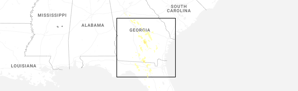
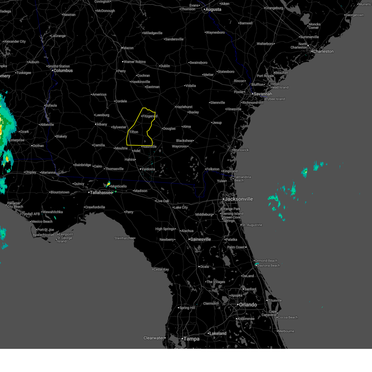
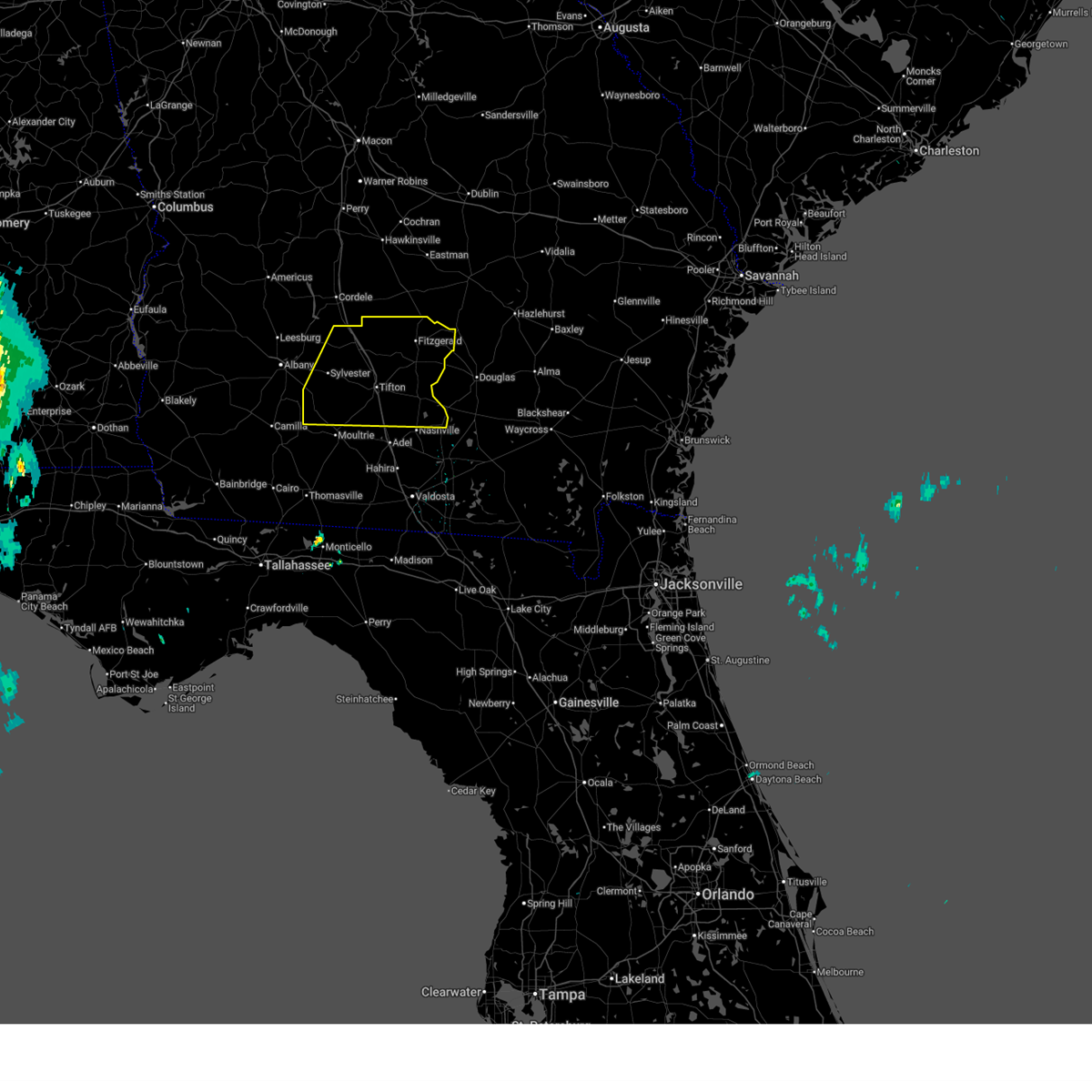
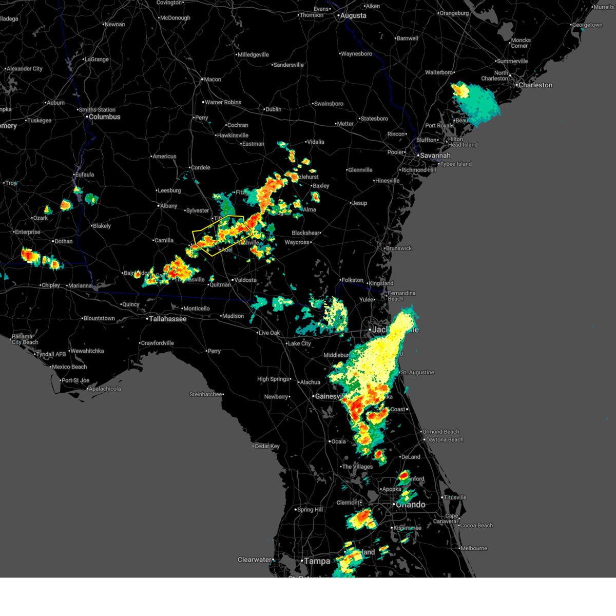
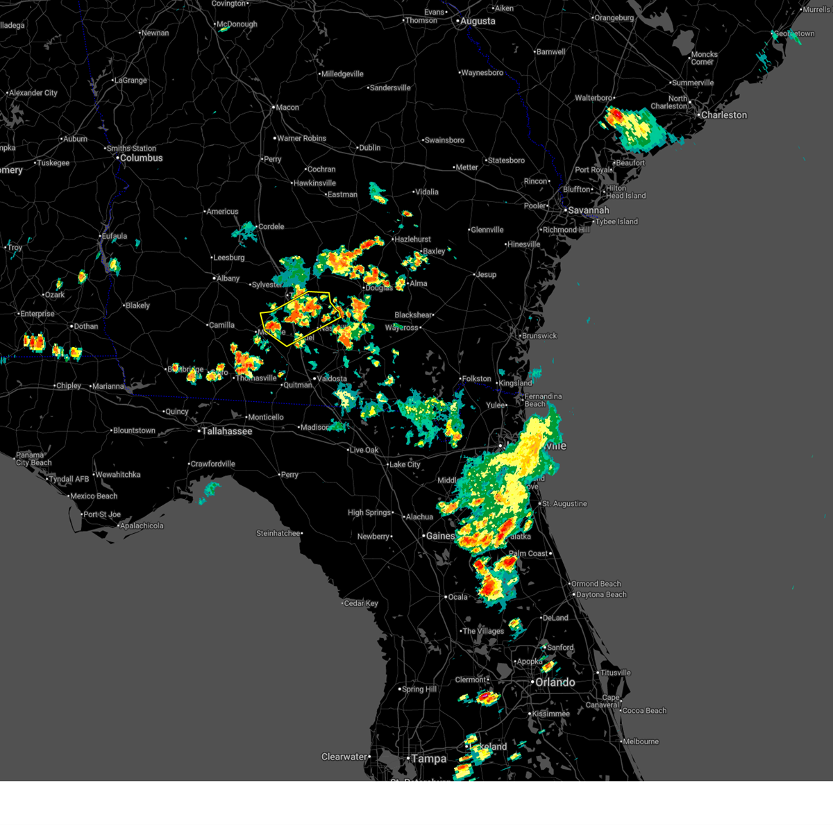
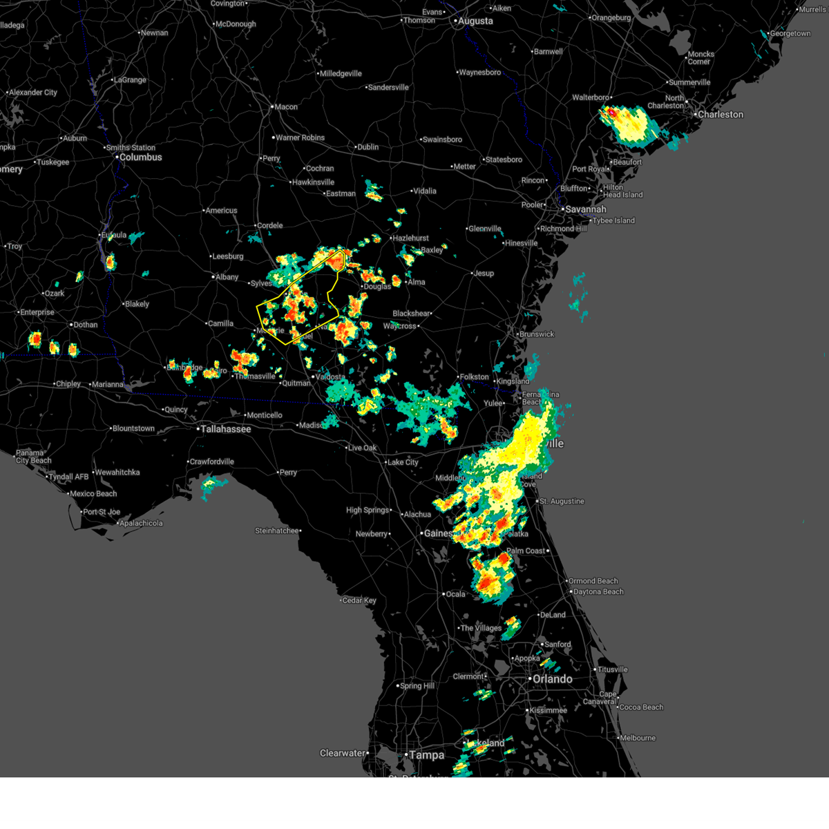
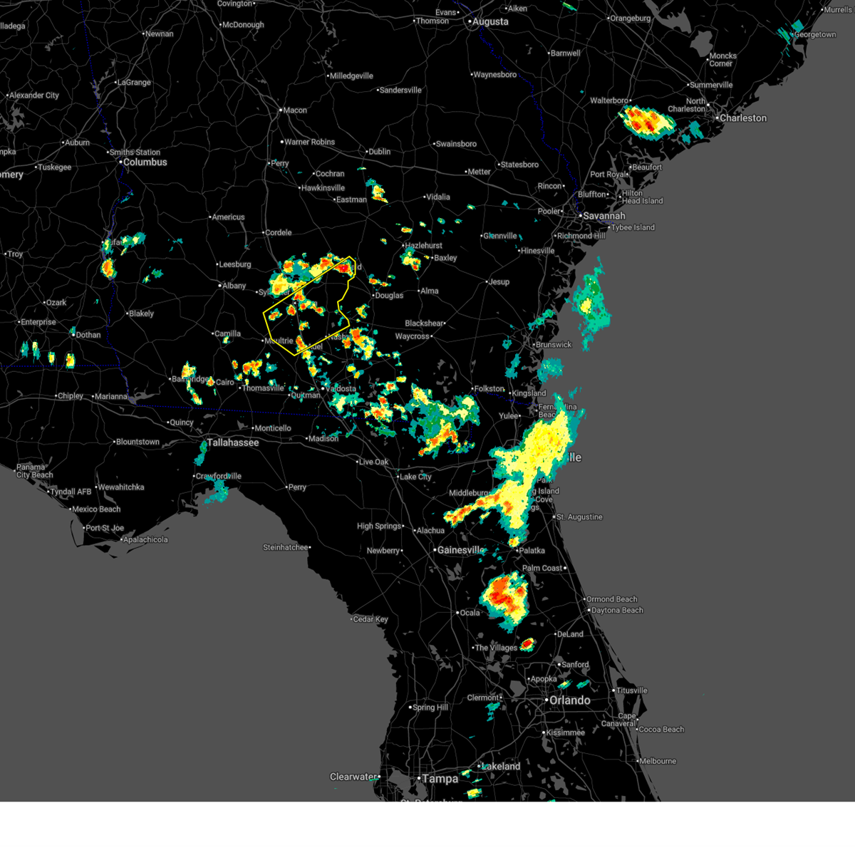
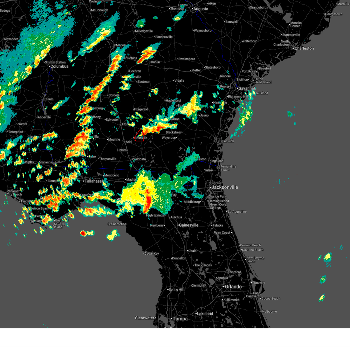
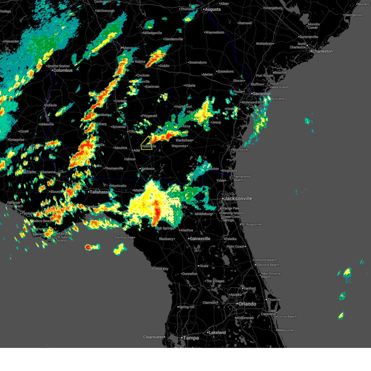
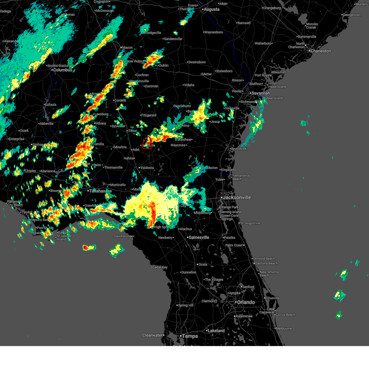
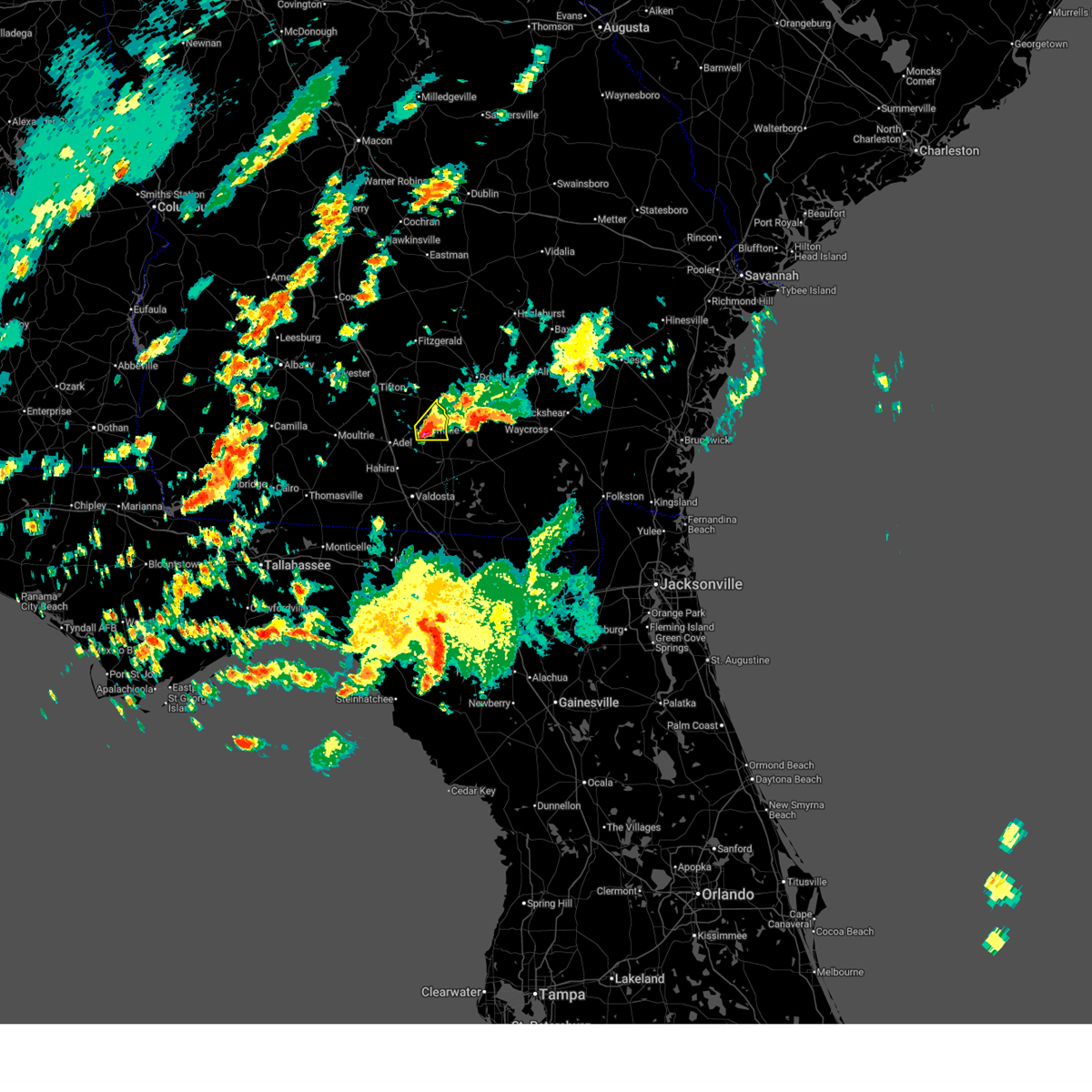
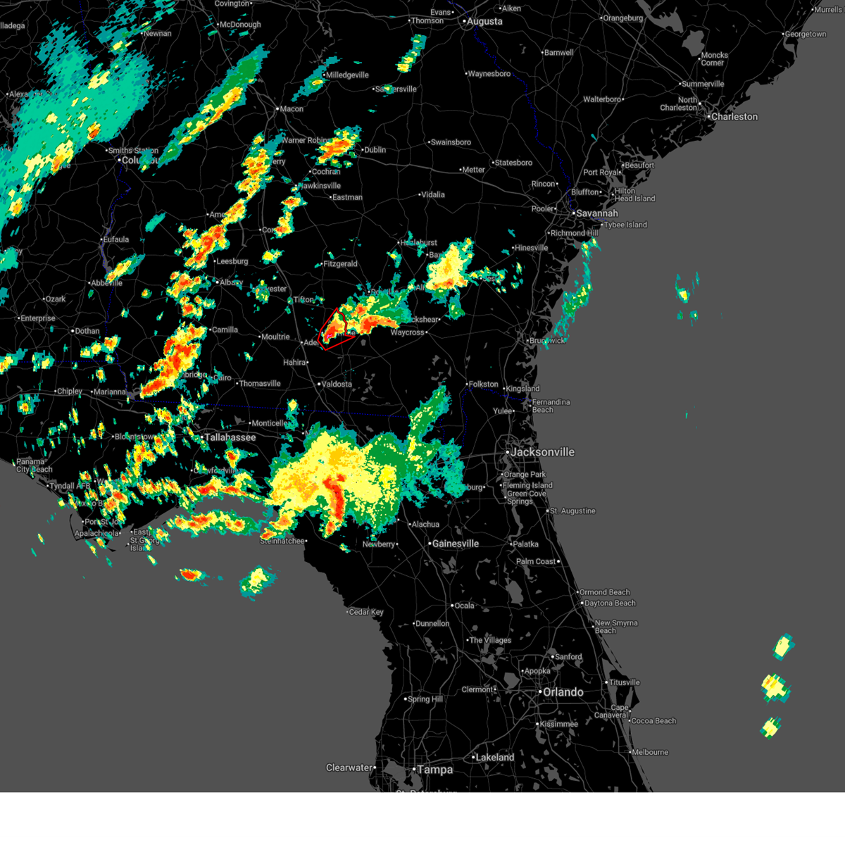
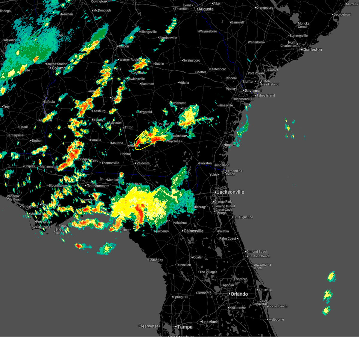
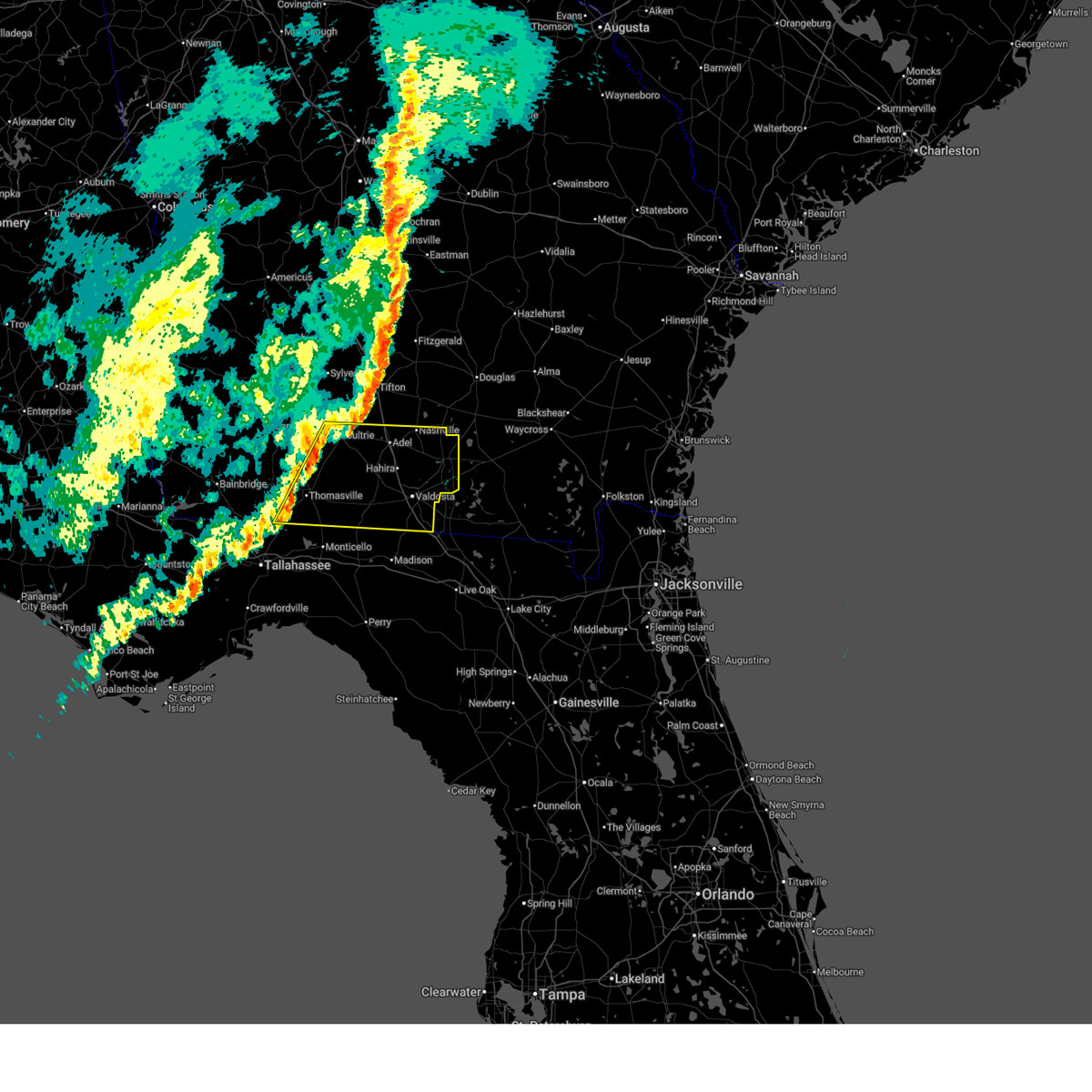
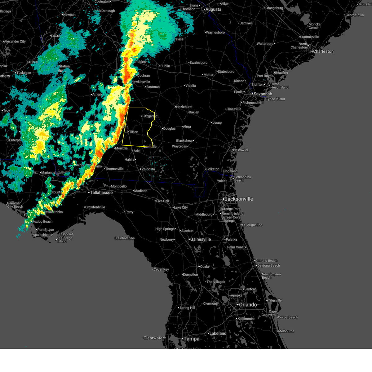
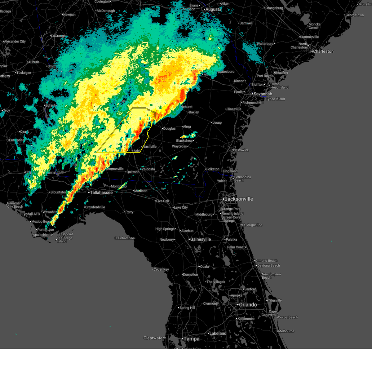
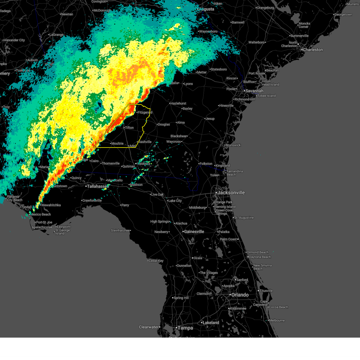
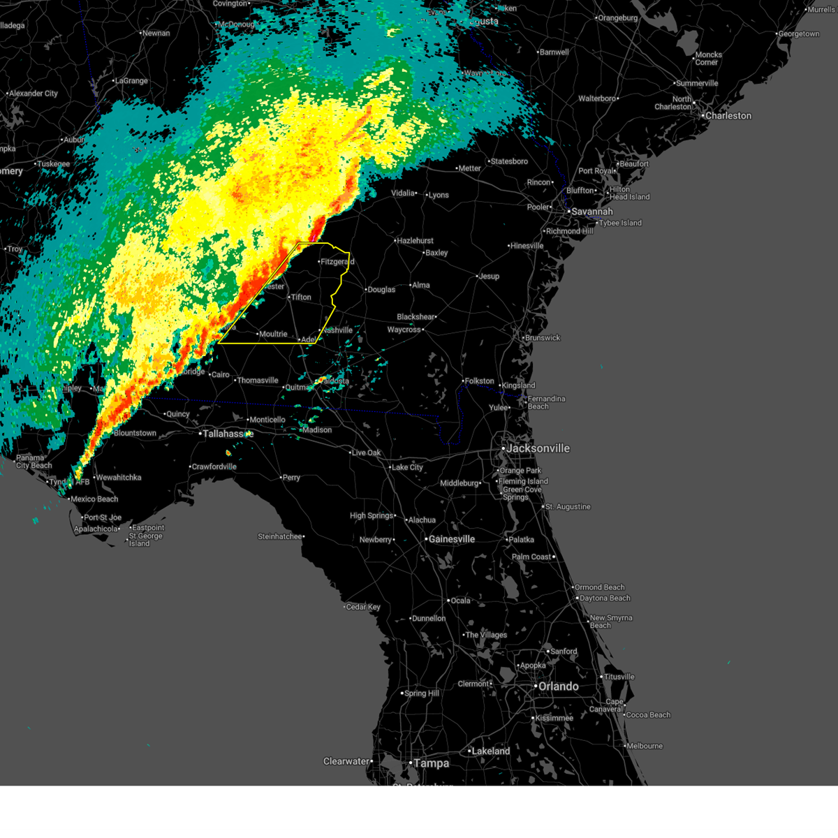
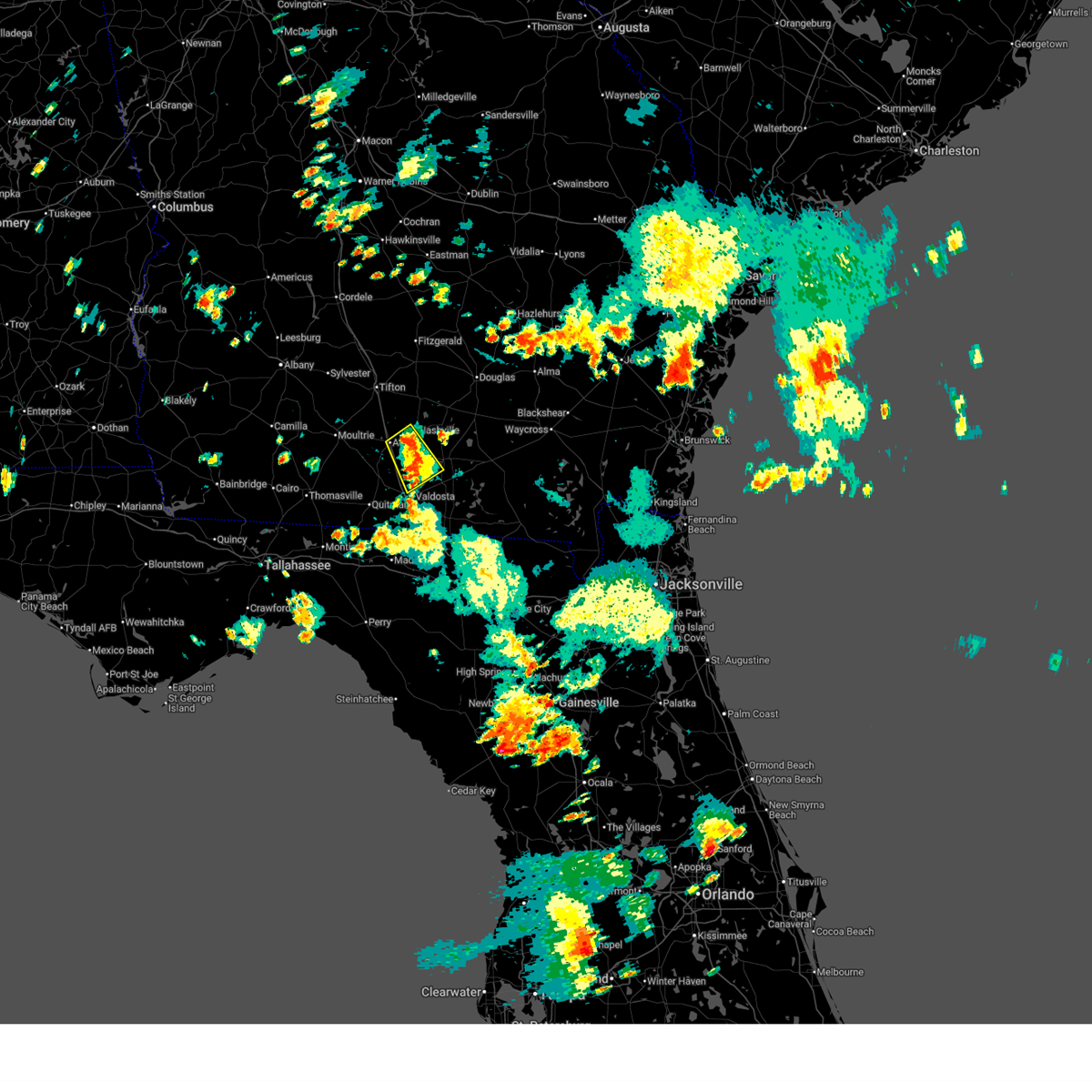
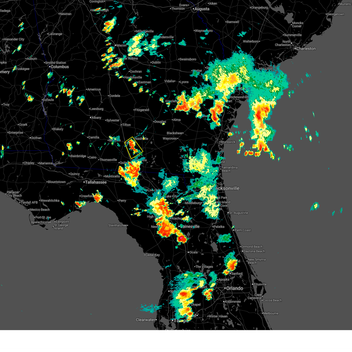
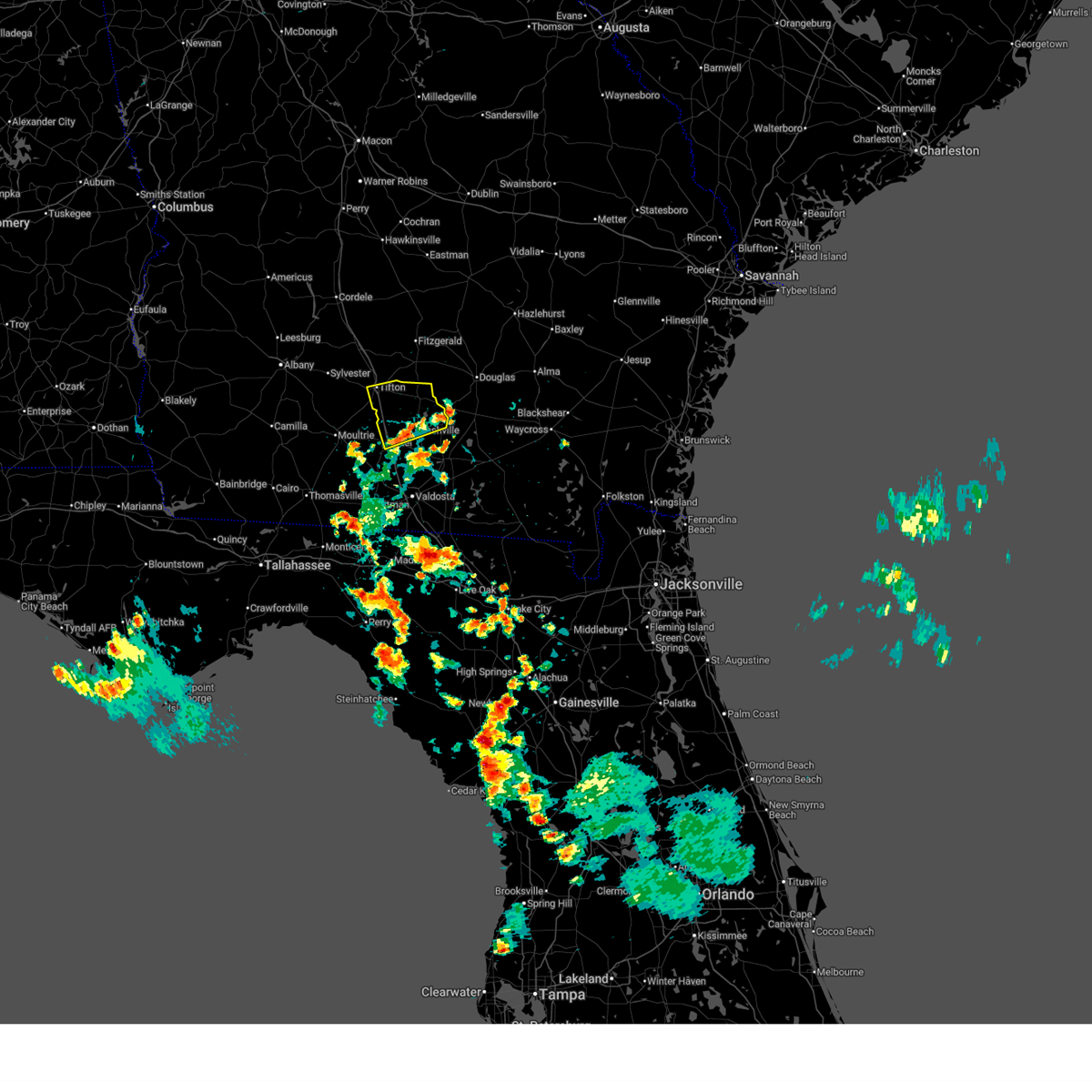
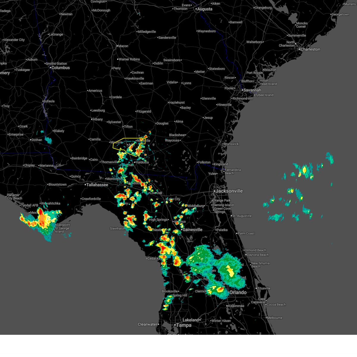
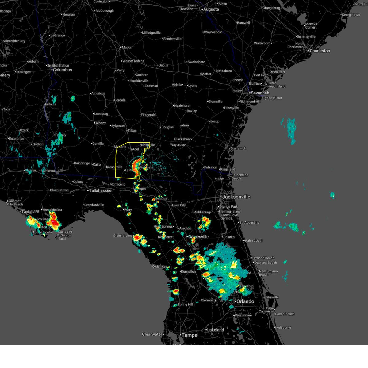
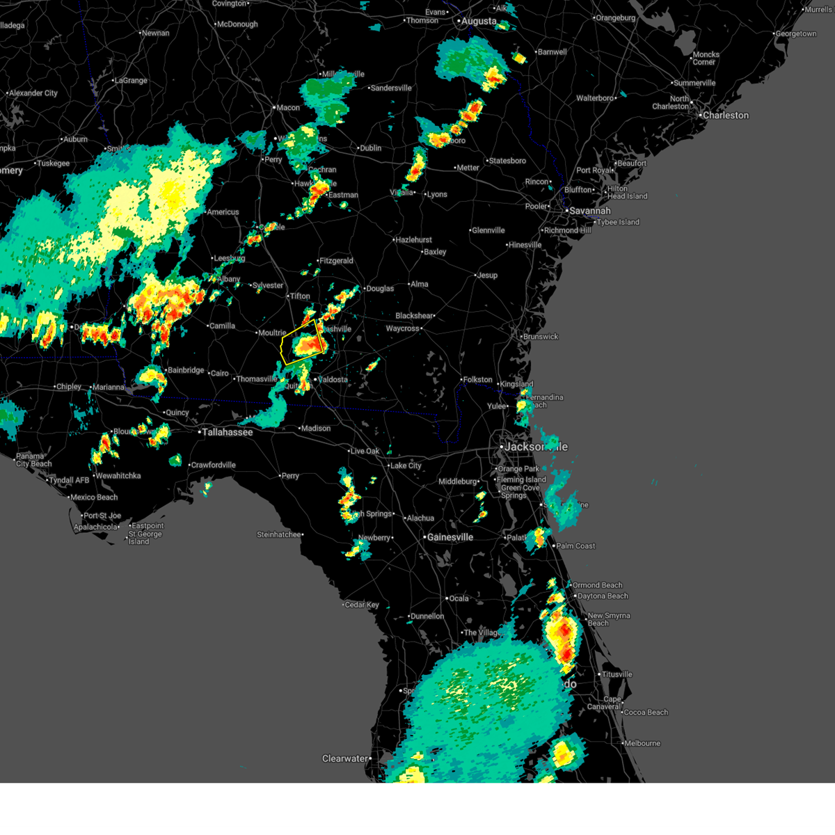
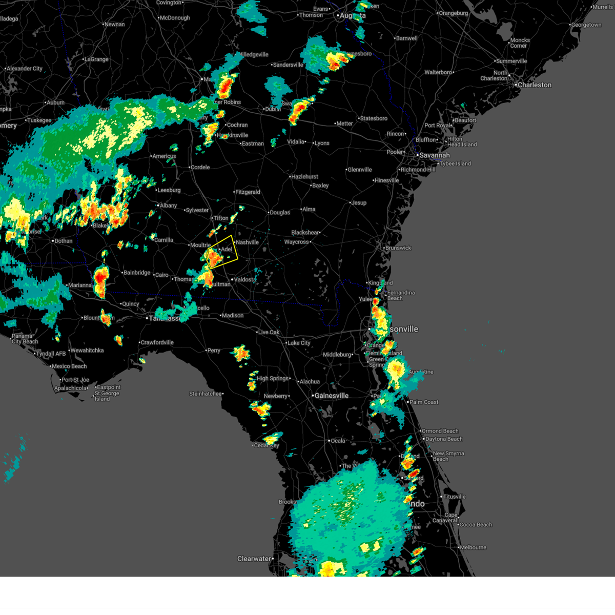
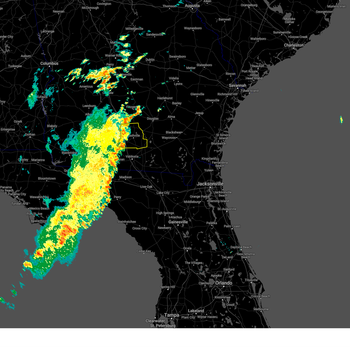
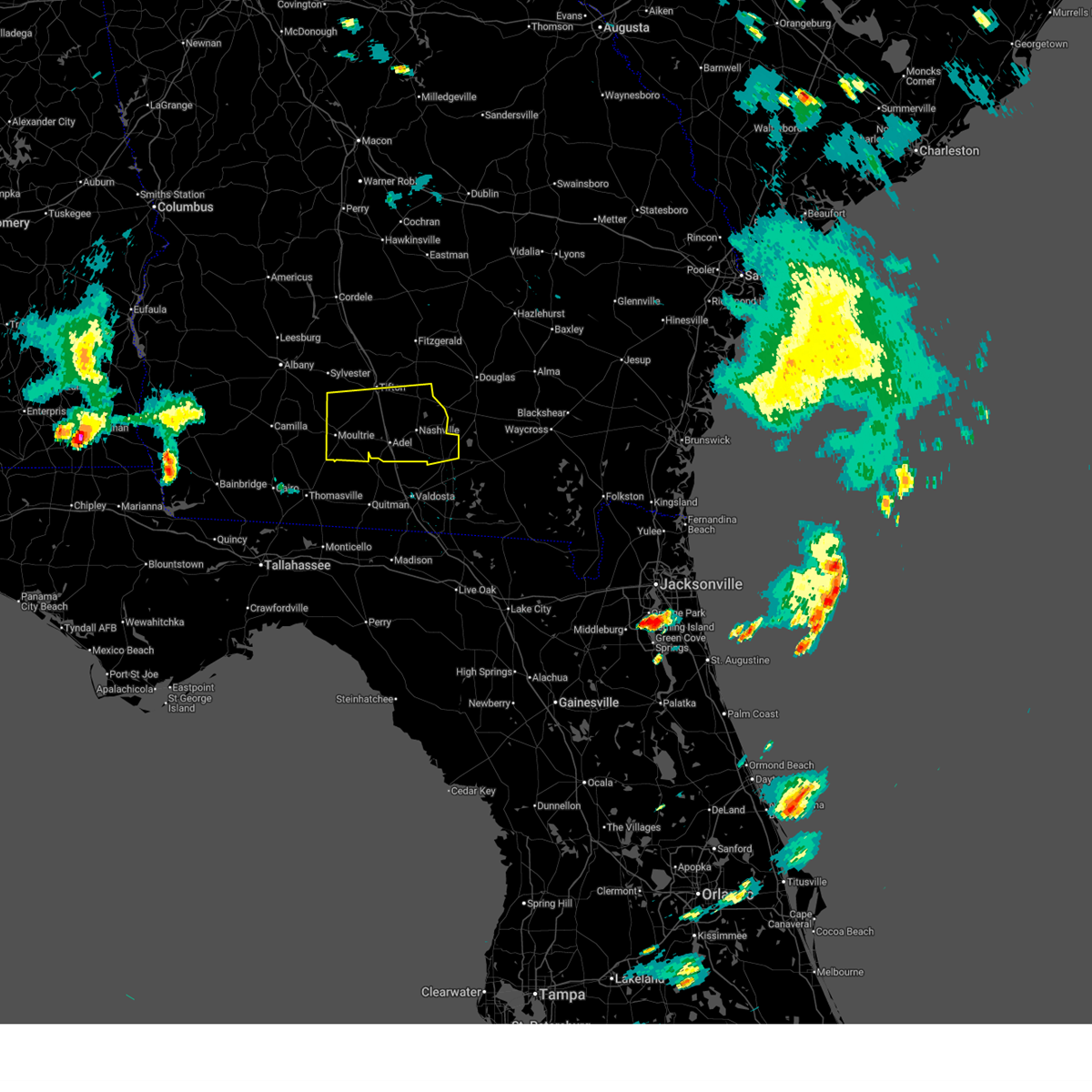
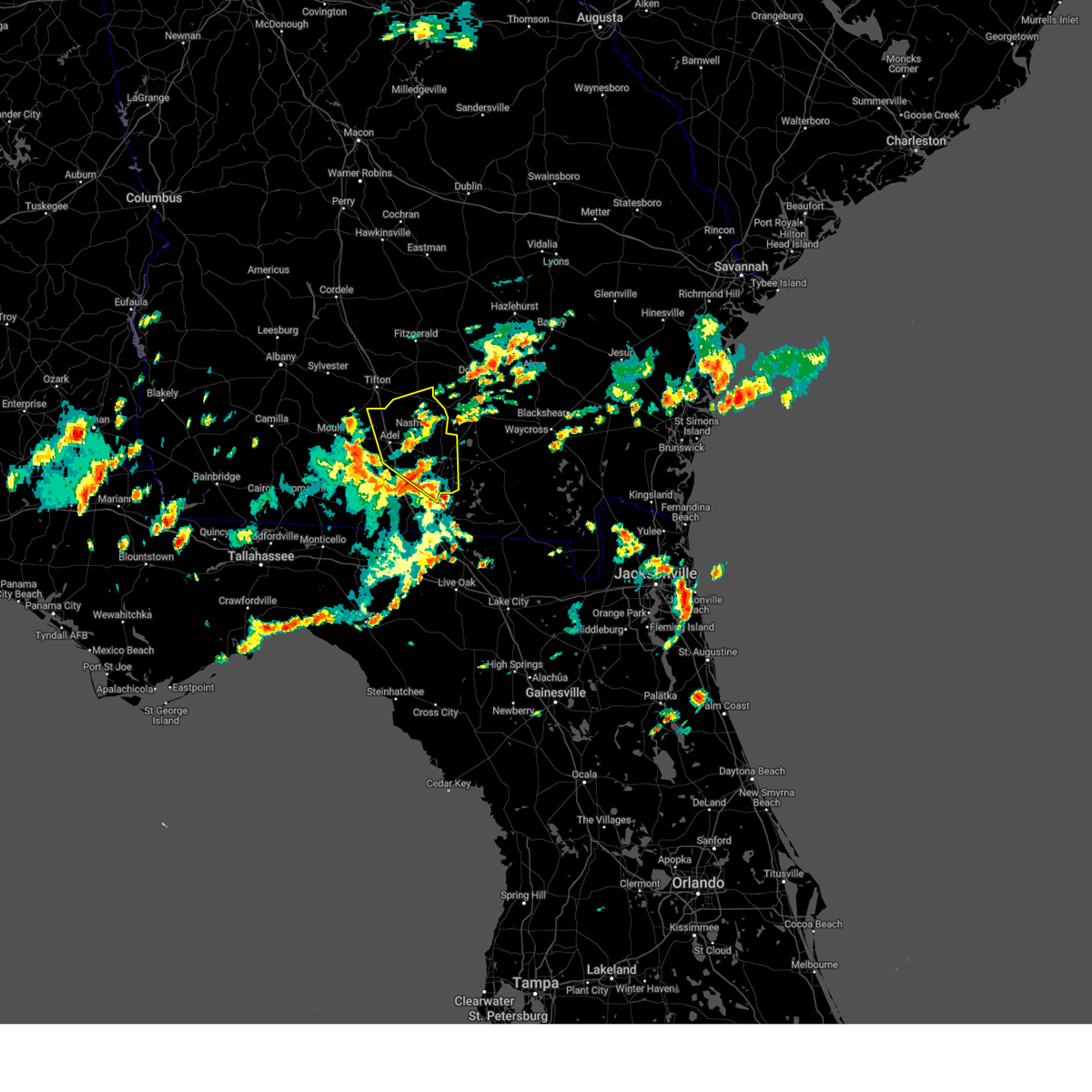
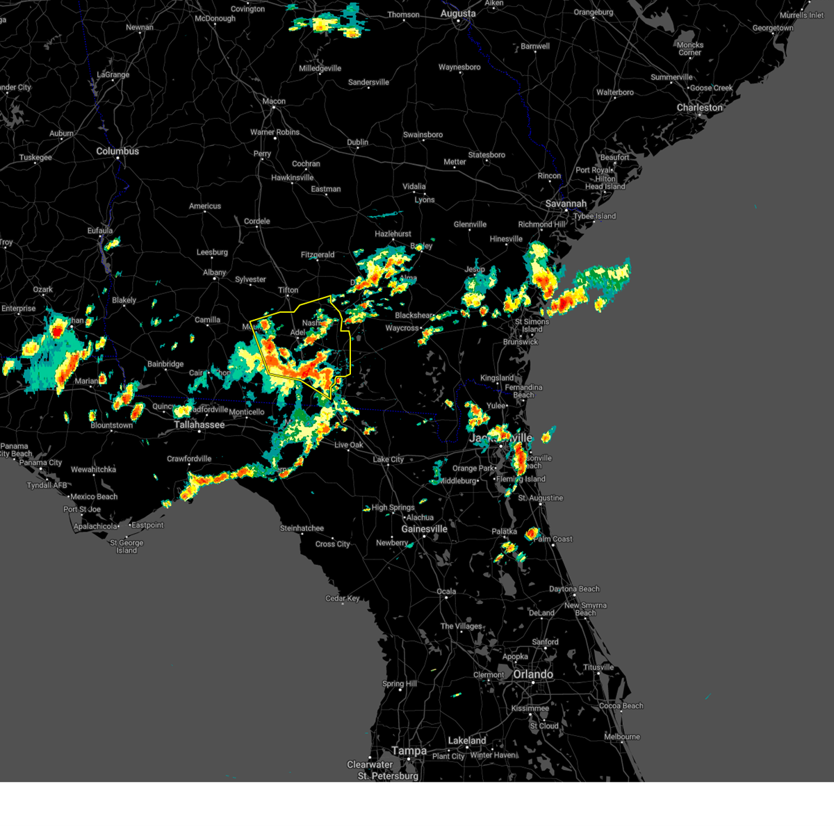
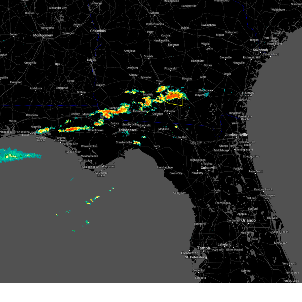
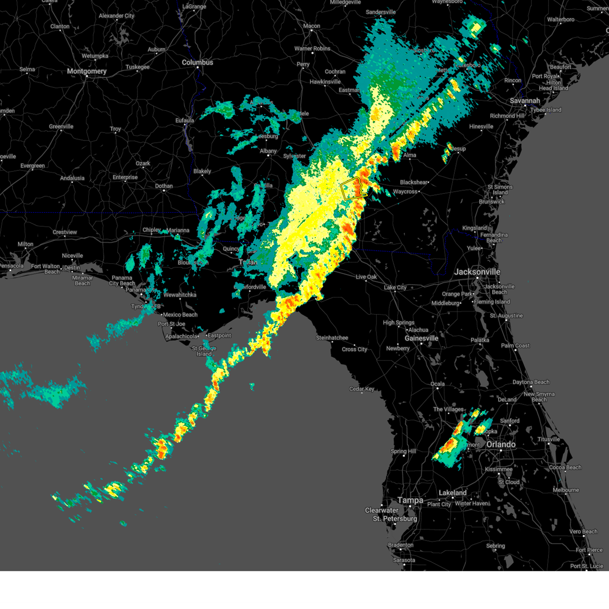
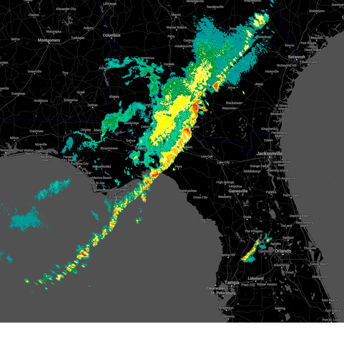
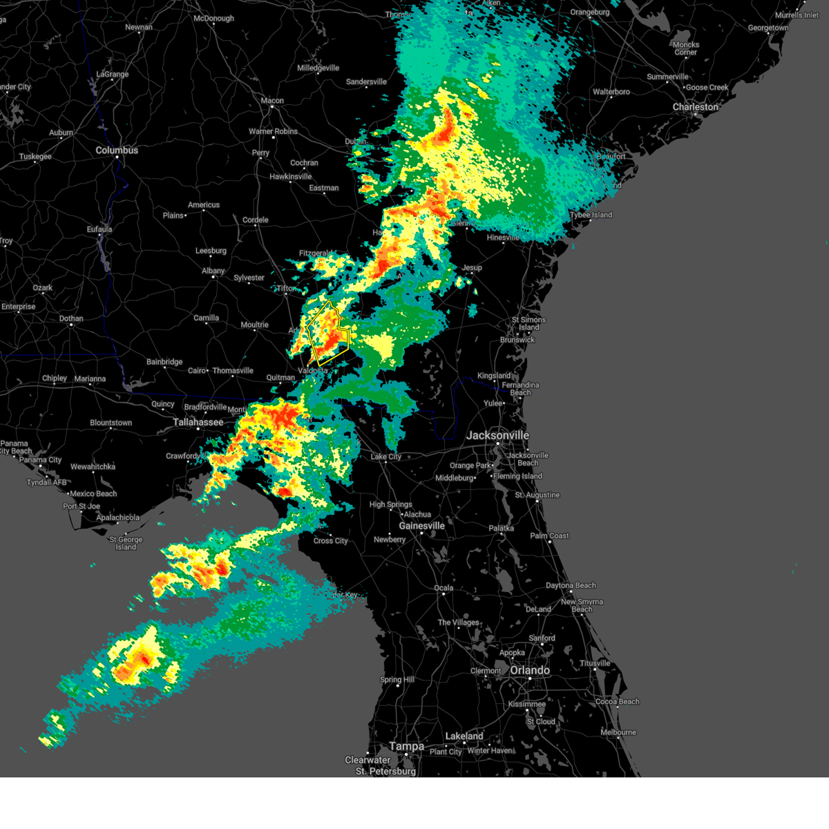
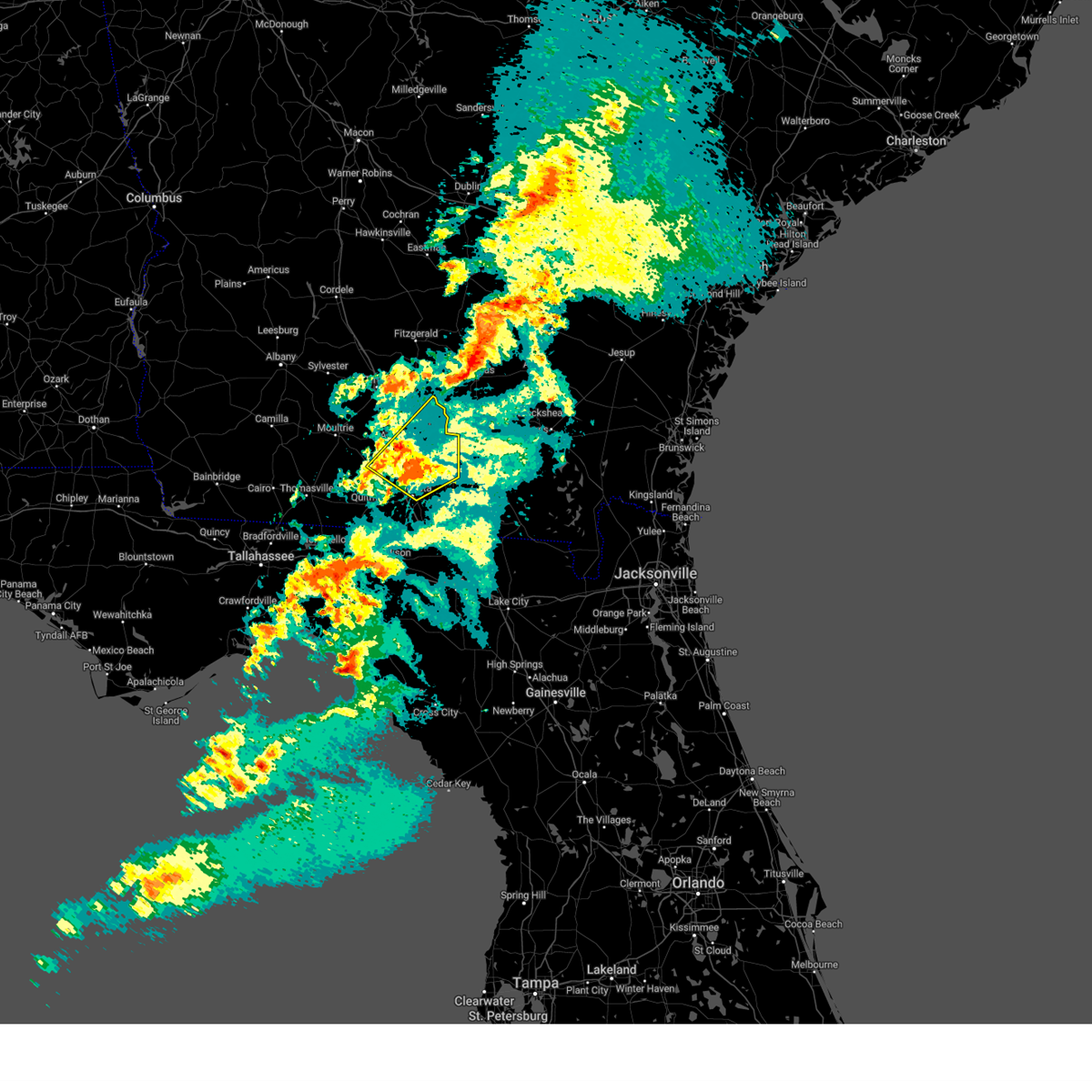
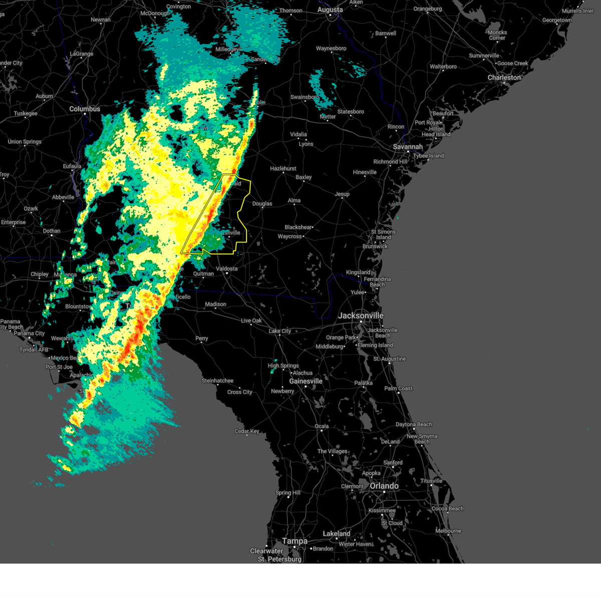
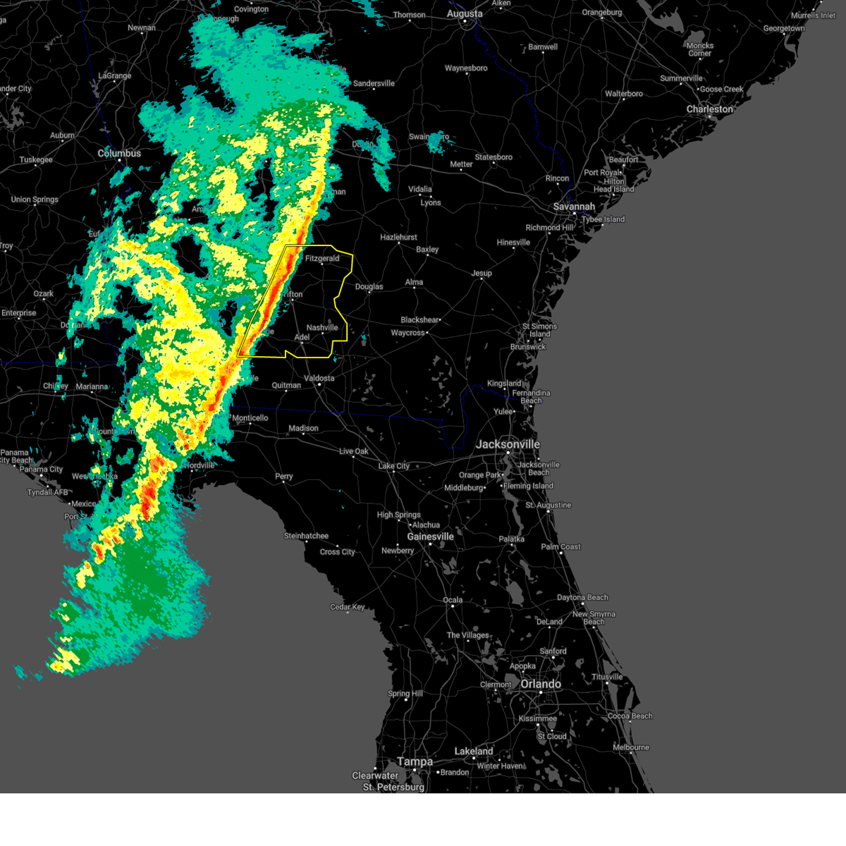
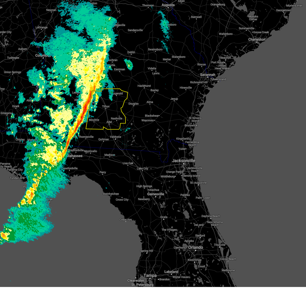
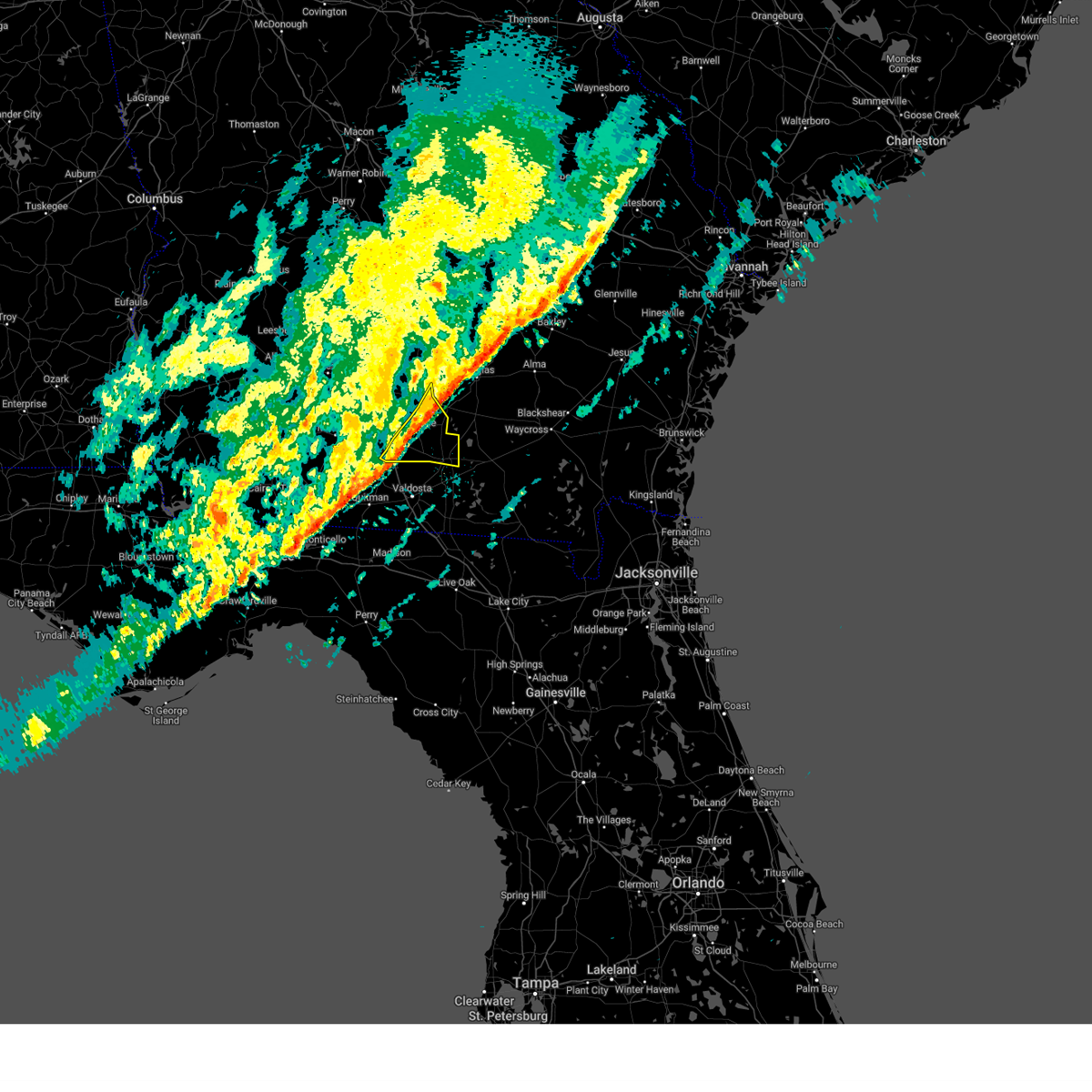
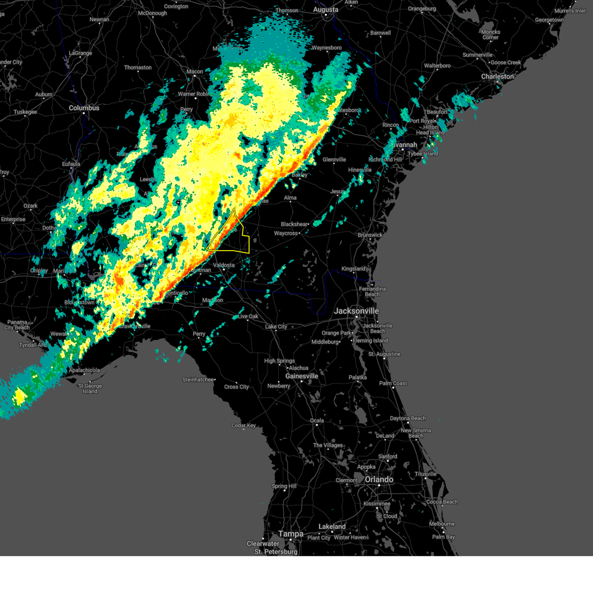
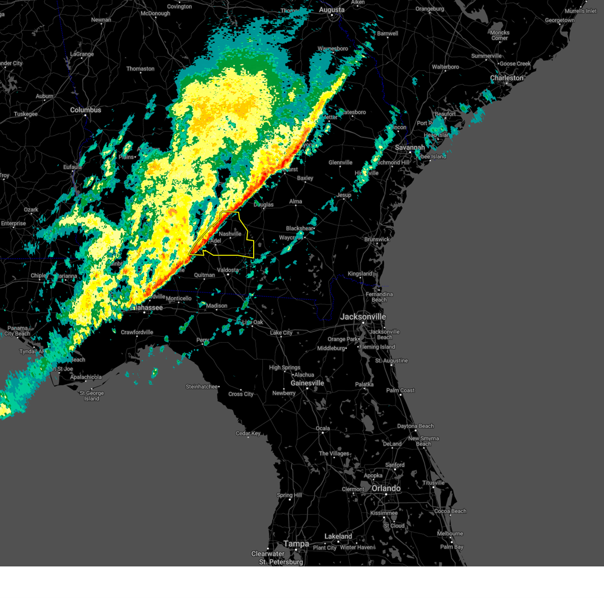
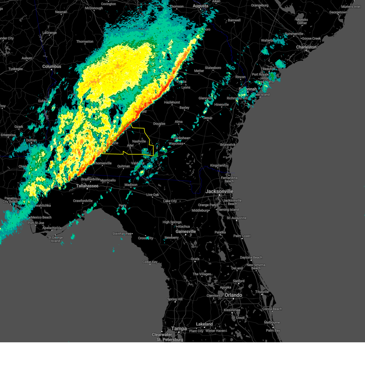
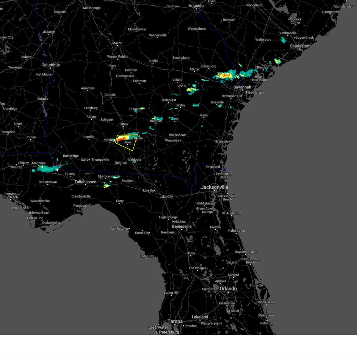
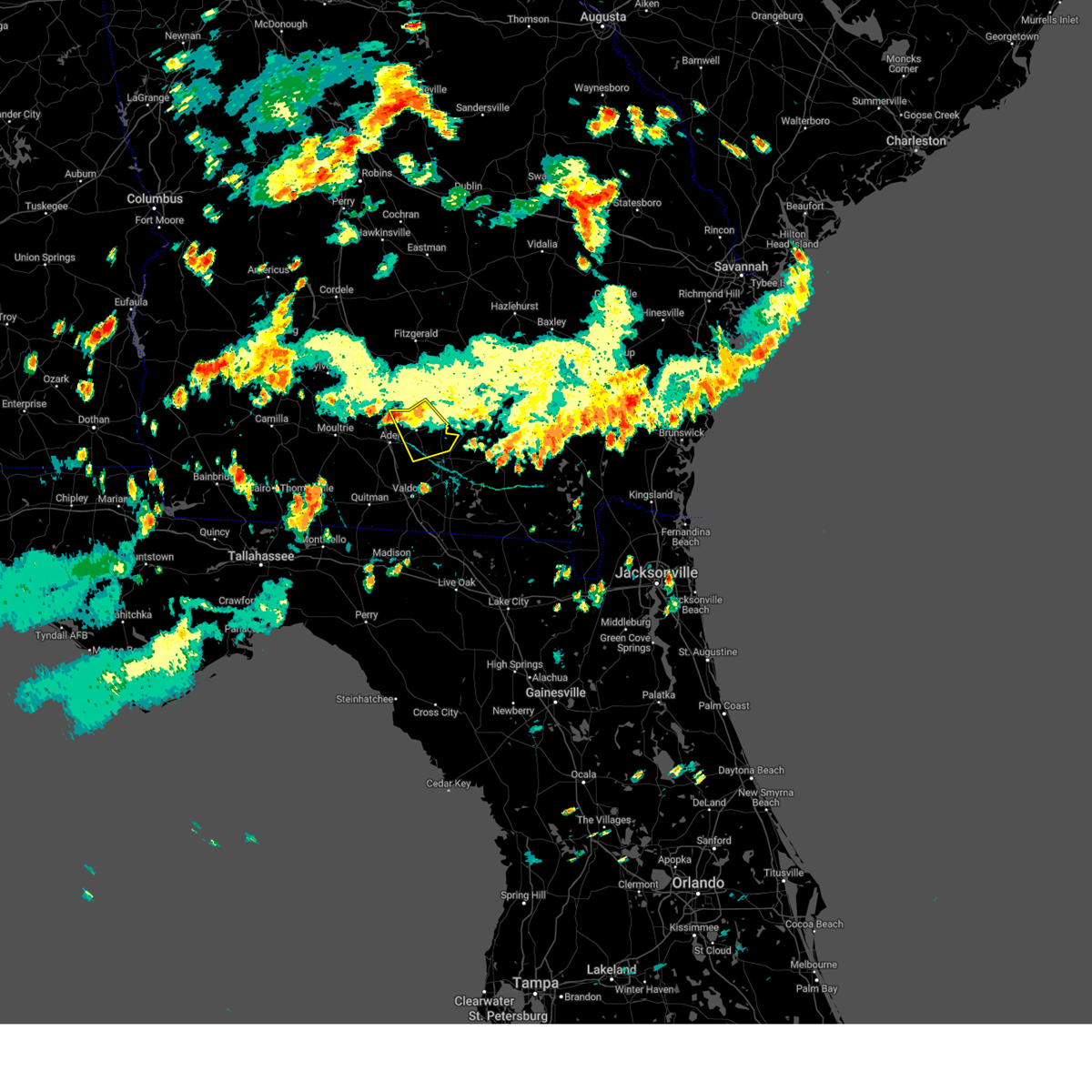
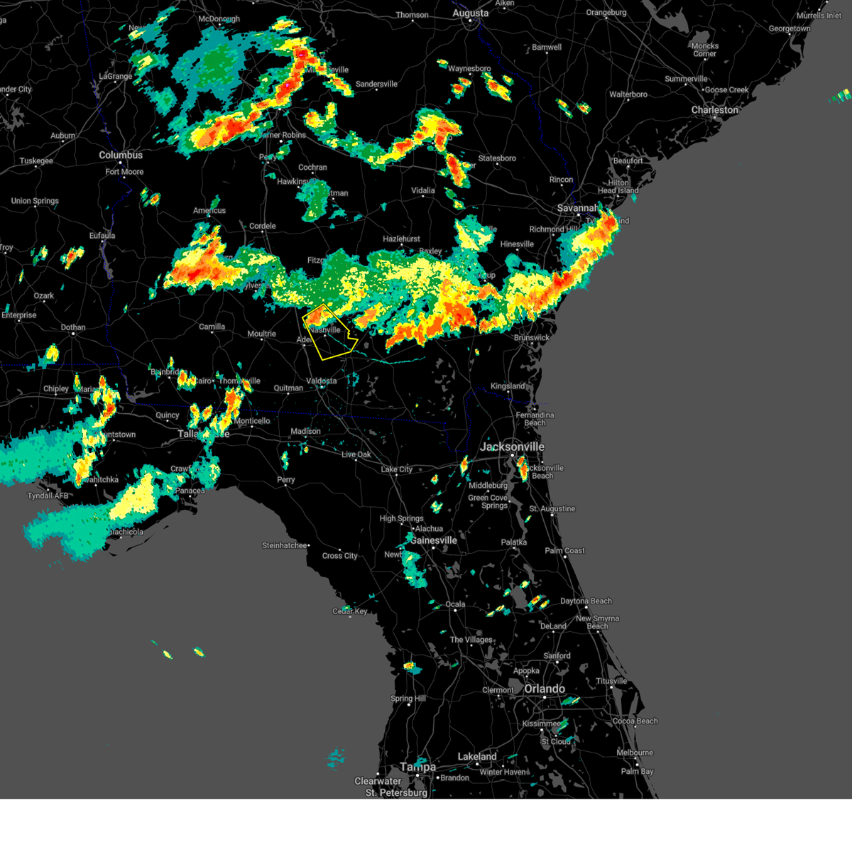
Hail Map for Nashville, GA
The Nashville, GA area has had 5 reports of on-the-ground hail by trained spotters, and has been under severe weather warnings 39 times during the past 12 months. Doppler radar has detected hail at or near Nashville, GA on 62 occasions, including 2 occasions during the past year.
| Name: | Nashville, GA |
| Where Located: | 31.6 miles SW of Douglas, GA |
| Map: | Google Map for Nashville, GA |
| Population: | 4939 |
| Housing Units: | 2248 |
| More Info: | Search Google for Nashville, GA |
0
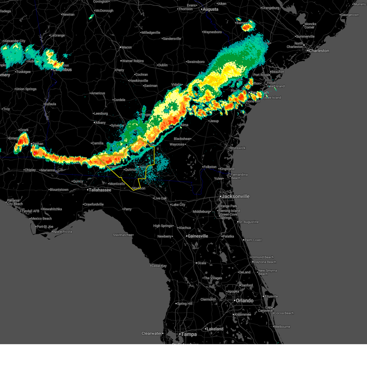
The Top Recent Hail Date for Nashville, GA is Sunday, May 17, 2026 (48th out of 62)
Hail and Wind Damage Spotted near Nashville, GA
| Date / Time | Report Details |
|---|---|
| 6/22/2026 5:00 PM EDT | Several trees blown over in east berrie in berrien county GA, 10.1 miles W of Nashville, GA |
| 6/22/2026 4:43 PM EDT | Several trees blown over in nashvill in berrien county GA, 0.1 miles NNE of Nashville, GA |
| 6/22/2026 4:38 PM EDT | Tree blown down near the long bridge peanut compan in berrien county GA, 3.7 miles ENE of Nashville, GA |
| 6/19/2026 1:11 AM EDT |
 The storms which prompted the warning have weakened below severe limits, and have exited the warned area. therefore, the warning will be allowed to expire. however, gusty winds are still possible with these thunderstorms. to report severe weather, contact your nearest law enforcement agency. they will relay your report to the national weather service tallahassee. The storms which prompted the warning have weakened below severe limits, and have exited the warned area. therefore, the warning will be allowed to expire. however, gusty winds are still possible with these thunderstorms. to report severe weather, contact your nearest law enforcement agency. they will relay your report to the national weather service tallahassee.
|
| 6/19/2026 12:48 AM EDT |
 At 1247 am edt, severe thunderstorms were located along a line extending from near jacksonville to lenox, moving east at 30 mph (radar indicated). Hazards include 60 mph wind gusts. Expect damage to roofs, siding, and trees. Locations impacted include, fitzgerald, tifton, ocilla, enigma, lenox, alapaha, mystic, unionville, eldorado, gladys, osierfield, glory, harding, wagon wheel, pinetta, ashton, weber, wray, bowens mill, and vanceville. At 1247 am edt, severe thunderstorms were located along a line extending from near jacksonville to lenox, moving east at 30 mph (radar indicated). Hazards include 60 mph wind gusts. Expect damage to roofs, siding, and trees. Locations impacted include, fitzgerald, tifton, ocilla, enigma, lenox, alapaha, mystic, unionville, eldorado, gladys, osierfield, glory, harding, wagon wheel, pinetta, ashton, weber, wray, bowens mill, and vanceville.
|
| 6/19/2026 12:25 AM EDT |
 At 1225 am edt, severe thunderstorms were located along a line extending from 9 miles south of rhine to norman park, moving east at 35 mph (radar indicated). Hazards include 60 mph wind gusts. Expect damage to roofs, siding, and trees. Locations impacted include, fitzgerald, tifton, ocilla, enigma, omega, norman park, lenox, ty ty, alapaha, mystic, unionville, phillipsburg, rebecca, eldorado, scooterville, gladys, osierfield, glory, harding, and wagon wheel. At 1225 am edt, severe thunderstorms were located along a line extending from 9 miles south of rhine to norman park, moving east at 35 mph (radar indicated). Hazards include 60 mph wind gusts. Expect damage to roofs, siding, and trees. Locations impacted include, fitzgerald, tifton, ocilla, enigma, omega, norman park, lenox, ty ty, alapaha, mystic, unionville, phillipsburg, rebecca, eldorado, scooterville, gladys, osierfield, glory, harding, and wagon wheel.
|
| 6/18/2026 11:49 PM EDT |
 Svrtae the national weather service in tallahassee has issued a * severe thunderstorm warning for, northern cook county in south central georgia, irwin county in south central georgia, berrien county in south central georgia, turner county in south central georgia, northern colquitt county in south central georgia, tift county in south central georgia, ben hill county in south central georgia, worth county in south central georgia, * until 115 am edt. * at 1149 pm edt, severe thunderstorms were located along a line extending from 6 miles east of arabi to near doerun, moving east at 35 mph (radar indicated). Hazards include 60 mph wind gusts. expect damage to roofs, siding, and trees Svrtae the national weather service in tallahassee has issued a * severe thunderstorm warning for, northern cook county in south central georgia, irwin county in south central georgia, berrien county in south central georgia, turner county in south central georgia, northern colquitt county in south central georgia, tift county in south central georgia, ben hill county in south central georgia, worth county in south central georgia, * until 115 am edt. * at 1149 pm edt, severe thunderstorms were located along a line extending from 6 miles east of arabi to near doerun, moving east at 35 mph (radar indicated). Hazards include 60 mph wind gusts. expect damage to roofs, siding, and trees
|
| 6/13/2026 8:12 PM EDT |
 The storms which prompted the warning have weakened below severe limits, and no longer pose an immediate threat to life or property. therefore, the warning will be allowed to expire. however, gusty winds are still possible with these thunderstorms. to report severe weather, contact your nearest law enforcement agency. they will relay your report to the national weather service tallahassee. The storms which prompted the warning have weakened below severe limits, and no longer pose an immediate threat to life or property. therefore, the warning will be allowed to expire. however, gusty winds are still possible with these thunderstorms. to report severe weather, contact your nearest law enforcement agency. they will relay your report to the national weather service tallahassee.
|
| 6/13/2026 8:01 PM EDT | Tree down on cornelius roa in berrien county GA, 3.6 miles E of Nashville, GA |
| 6/13/2026 7:44 PM EDT |
 At 743 pm edt, severe thunderstorms were located along a line extending from near alapaha to 6 miles south of norman park, moving southeast at 15 mph (radar indicated). Hazards include 60 mph wind gusts. Expect damage to roofs, siding, and trees. Locations impacted include, nashville, adel, sparks, enigma, omega, norman park, lenox, alapaha, ellenton, reed bingham state park, eldorado, gladys, massee, glory, flat ford, wagon wheel, cottle, cook co a/p, cool spring, and staunton. At 743 pm edt, severe thunderstorms were located along a line extending from near alapaha to 6 miles south of norman park, moving southeast at 15 mph (radar indicated). Hazards include 60 mph wind gusts. Expect damage to roofs, siding, and trees. Locations impacted include, nashville, adel, sparks, enigma, omega, norman park, lenox, alapaha, ellenton, reed bingham state park, eldorado, gladys, massee, glory, flat ford, wagon wheel, cottle, cook co a/p, cool spring, and staunton.
|
| 6/13/2026 7:34 PM EDT |
 At 734 pm edt, severe thunderstorms were located along a line extending from 6 miles north of ambrose to near norman park, moving southeast at 15 mph (radar indicated). Hazards include 60 mph wind gusts. Expect damage to roofs, siding, and trees. Locations impacted include, tifton, nashville, adel, ocilla, sparks, enigma, omega, norman park, lenox, alapaha, unionville, phillipsburg, ellenton, reed bingham state park, eldorado, scooterville, gladys, massee, osierfield, and glory. At 734 pm edt, severe thunderstorms were located along a line extending from 6 miles north of ambrose to near norman park, moving southeast at 15 mph (radar indicated). Hazards include 60 mph wind gusts. Expect damage to roofs, siding, and trees. Locations impacted include, tifton, nashville, adel, ocilla, sparks, enigma, omega, norman park, lenox, alapaha, unionville, phillipsburg, ellenton, reed bingham state park, eldorado, scooterville, gladys, massee, osierfield, and glory.
|
| 6/13/2026 7:15 PM EDT |
 Svrtae the national weather service in tallahassee has issued a * severe thunderstorm warning for, cook county in south central georgia, irwin county in south central georgia, berrien county in south central georgia, northeastern colquitt county in south central georgia, tift county in south central georgia, southeastern ben hill county in south central georgia, southeastern worth county in south central georgia, * until 815 pm edt. * at 715 pm edt, severe thunderstorms were located along a line extending from 8 miles northwest of ambrose to near omega, moving southeast at 15 mph (radar indicated). Hazards include 60 mph wind gusts. expect damage to roofs, siding, and trees Svrtae the national weather service in tallahassee has issued a * severe thunderstorm warning for, cook county in south central georgia, irwin county in south central georgia, berrien county in south central georgia, northeastern colquitt county in south central georgia, tift county in south central georgia, southeastern ben hill county in south central georgia, southeastern worth county in south central georgia, * until 815 pm edt. * at 715 pm edt, severe thunderstorms were located along a line extending from 8 miles northwest of ambrose to near omega, moving southeast at 15 mph (radar indicated). Hazards include 60 mph wind gusts. expect damage to roofs, siding, and trees
|
| 5/17/2026 5:40 PM EDT | Berrien county dispatch reported a downed tree on south dogwood d in berrien county GA, 0.7 miles E of Nashville, GA |
| 3/16/2026 6:16 AM EDT |
 the tornado warning has been cancelled and is no longer in effect the tornado warning has been cancelled and is no longer in effect
|
| 3/16/2026 6:15 AM EDT |
 the severe thunderstorm warning has been cancelled and is no longer in effect the severe thunderstorm warning has been cancelled and is no longer in effect
|
| 3/16/2026 6:05 AM EDT |
 the tornado warning has been cancelled and is no longer in effect the tornado warning has been cancelled and is no longer in effect
|
| 3/16/2026 6:05 AM EDT |
 At 605 am edt, a severe thunderstorm capable of producing a tornado was located near nashville, moving northeast at 25 mph (radar indicated rotation). Hazards include tornado and quarter size hail. Flying debris will be dangerous to those caught without shelter. mobile homes will be damaged or destroyed. damage to roofs, windows, and vehicles will occur. tree damage is likely. This tornadic thunderstorm will remain over mainly rural areas of east central berrien county, including the following locations, weber, berrien co a/p, and bannockburn. At 605 am edt, a severe thunderstorm capable of producing a tornado was located near nashville, moving northeast at 25 mph (radar indicated rotation). Hazards include tornado and quarter size hail. Flying debris will be dangerous to those caught without shelter. mobile homes will be damaged or destroyed. damage to roofs, windows, and vehicles will occur. tree damage is likely. This tornadic thunderstorm will remain over mainly rural areas of east central berrien county, including the following locations, weber, berrien co a/p, and bannockburn.
|
| 3/16/2026 6:04 AM EDT |
 At 604 am edt, a severe thunderstorm was located 8 miles east of nashville, moving northeast at 35 mph (radar indicated). Hazards include 60 mph wind gusts and penny size hail. Expect damage to roofs, siding, and trees. Locations impacted include, nashville, weber, berrien co a/p, and bannockburn. At 604 am edt, a severe thunderstorm was located 8 miles east of nashville, moving northeast at 35 mph (radar indicated). Hazards include 60 mph wind gusts and penny size hail. Expect damage to roofs, siding, and trees. Locations impacted include, nashville, weber, berrien co a/p, and bannockburn.
|
| 3/16/2026 6:04 AM EDT |
 the severe thunderstorm warning has been cancelled and is no longer in effect the severe thunderstorm warning has been cancelled and is no longer in effect
|
| 3/16/2026 5:54 AM EDT |
 At 554 am edt, a severe thunderstorm capable of producing a tornado was located near nashville, moving northeast at 25 mph (radar indicated rotation). Hazards include tornado and quarter size hail. Flying debris will be dangerous to those caught without shelter. mobile homes will be damaged or destroyed. damage to roofs, windows, and vehicles will occur. tree damage is likely. this dangerous storm will be near, nashville around 600 am edt. Other locations impacted by this tornadic thunderstorm include weber, berrien co a/p, allenville, teeterville, and bannockburn. At 554 am edt, a severe thunderstorm capable of producing a tornado was located near nashville, moving northeast at 25 mph (radar indicated rotation). Hazards include tornado and quarter size hail. Flying debris will be dangerous to those caught without shelter. mobile homes will be damaged or destroyed. damage to roofs, windows, and vehicles will occur. tree damage is likely. this dangerous storm will be near, nashville around 600 am edt. Other locations impacted by this tornadic thunderstorm include weber, berrien co a/p, allenville, teeterville, and bannockburn.
|
| 3/16/2026 5:54 AM EDT |
 the tornado warning has been cancelled and is no longer in effect the tornado warning has been cancelled and is no longer in effect
|
| 3/16/2026 5:53 AM EDT |
 the severe thunderstorm warning has been cancelled and is no longer in effect the severe thunderstorm warning has been cancelled and is no longer in effect
|
| 3/16/2026 5:53 AM EDT |
 At 552 am edt, a severe thunderstorm was located near nashville, moving northeast at 35 mph (radar indicated). Hazards include 60 mph wind gusts and penny size hail. Expect damage to roofs, siding, and trees. Locations impacted include, nashville, ray city, berrien co a/p, new lois, allenville, weber, teeterville, and bannockburn. At 552 am edt, a severe thunderstorm was located near nashville, moving northeast at 35 mph (radar indicated). Hazards include 60 mph wind gusts and penny size hail. Expect damage to roofs, siding, and trees. Locations impacted include, nashville, ray city, berrien co a/p, new lois, allenville, weber, teeterville, and bannockburn.
|
| 3/16/2026 5:45 AM EDT |
 Tortae the national weather service in tallahassee has issued a * tornado warning for, east central cook county in south central georgia, eastern berrien county in south central georgia, northern lanier county in south central georgia, * until 630 am edt. * at 545 am edt, a severe thunderstorm capable of producing a tornado was located near ray city, or near nashville, moving northeast at 25 mph (radar indicated rotation). Hazards include tornado and quarter size hail. Flying debris will be dangerous to those caught without shelter. mobile homes will be damaged or destroyed. damage to roofs, windows, and vehicles will occur. tree damage is likely. this dangerous storm will be near, nashville around 550 am edt. Other locations impacted by this tornadic thunderstorm include cottle, berrien co a/p, new lois, allenville, weber, teeterville, and bannockburn. Tortae the national weather service in tallahassee has issued a * tornado warning for, east central cook county in south central georgia, eastern berrien county in south central georgia, northern lanier county in south central georgia, * until 630 am edt. * at 545 am edt, a severe thunderstorm capable of producing a tornado was located near ray city, or near nashville, moving northeast at 25 mph (radar indicated rotation). Hazards include tornado and quarter size hail. Flying debris will be dangerous to those caught without shelter. mobile homes will be damaged or destroyed. damage to roofs, windows, and vehicles will occur. tree damage is likely. this dangerous storm will be near, nashville around 550 am edt. Other locations impacted by this tornadic thunderstorm include cottle, berrien co a/p, new lois, allenville, weber, teeterville, and bannockburn.
|
| 3/16/2026 5:39 AM EDT |
 Svrtae the national weather service in tallahassee has issued a * severe thunderstorm warning for, southeastern cook county in south central georgia, central berrien county in south central georgia, northern lanier county in south central georgia, * until 630 am edt. * at 539 am edt, a severe thunderstorm was located near ray city, or 7 miles southeast of adel, moving northeast at 35 mph (radar indicated). Hazards include 60 mph wind gusts and penny size hail. expect damage to roofs, siding, and trees Svrtae the national weather service in tallahassee has issued a * severe thunderstorm warning for, southeastern cook county in south central georgia, central berrien county in south central georgia, northern lanier county in south central georgia, * until 630 am edt. * at 539 am edt, a severe thunderstorm was located near ray city, or 7 miles southeast of adel, moving northeast at 35 mph (radar indicated). Hazards include 60 mph wind gusts and penny size hail. expect damage to roofs, siding, and trees
|
| 3/12/2026 8:17 AM EDT |
 the severe thunderstorm warning has been cancelled and is no longer in effect the severe thunderstorm warning has been cancelled and is no longer in effect
|
| 3/12/2026 8:03 AM EDT |
 At 802 am edt, severe thunderstorms were located along a line extending from 6 miles southeast of alapaha to near quitman, moving east at 65 mph (radar indicated). Hazards include 60 mph wind gusts. Expect damage to roofs, siding, and trees. Locations impacted include, lake park, nashville, lakeland, adel, valdosta, quitman, hahira, sparks, ray city, i-75 at exit 16, moody air force base, remerton, meigs, dasher, morven, cecil, grooverville, barretts, new lois, and massee. At 802 am edt, severe thunderstorms were located along a line extending from 6 miles southeast of alapaha to near quitman, moving east at 65 mph (radar indicated). Hazards include 60 mph wind gusts. Expect damage to roofs, siding, and trees. Locations impacted include, lake park, nashville, lakeland, adel, valdosta, quitman, hahira, sparks, ray city, i-75 at exit 16, moody air force base, remerton, meigs, dasher, morven, cecil, grooverville, barretts, new lois, and massee.
|
| 3/12/2026 8:03 AM EDT |
 the severe thunderstorm warning has been cancelled and is no longer in effect the severe thunderstorm warning has been cancelled and is no longer in effect
|
| 3/12/2026 8:01 AM EDT |
 At 801 am edt, severe thunderstorms were located along a line extending from 6 miles east of jacksonville to near willacoochee, moving east at 55 mph (radar indicated). Hazards include 60 mph wind gusts. Expect damage to roofs, siding, and trees. Locations impacted include, nashville, weber, glory, and bannockburn. At 801 am edt, severe thunderstorms were located along a line extending from 6 miles east of jacksonville to near willacoochee, moving east at 55 mph (radar indicated). Hazards include 60 mph wind gusts. Expect damage to roofs, siding, and trees. Locations impacted include, nashville, weber, glory, and bannockburn.
|
| 3/12/2026 8:01 AM EDT |
 the severe thunderstorm warning has been cancelled and is no longer in effect the severe thunderstorm warning has been cancelled and is no longer in effect
|
| 3/12/2026 7:49 AM EDT |
 At 749 am edt, a severe thunderstorm capable of producing a tornado was located near nashville, moving east at 35 mph (radar indicated rotation). Hazards include tornado. Flying debris will be dangerous to those caught without shelter. mobile homes will be damaged or destroyed. damage to roofs, windows, and vehicles will occur. tree damage is likely. this dangerous storm will be near, nashville around 755 am edt. Other locations impacted by this tornadic thunderstorm include weber, cottle, berrien co a/p, massee, and bannockburn. At 749 am edt, a severe thunderstorm capable of producing a tornado was located near nashville, moving east at 35 mph (radar indicated rotation). Hazards include tornado. Flying debris will be dangerous to those caught without shelter. mobile homes will be damaged or destroyed. damage to roofs, windows, and vehicles will occur. tree damage is likely. this dangerous storm will be near, nashville around 755 am edt. Other locations impacted by this tornadic thunderstorm include weber, cottle, berrien co a/p, massee, and bannockburn.
|
| 3/12/2026 7:39 AM EDT |
 Tortae the national weather service in tallahassee has issued a * tornado warning for, central cook county in south central georgia, central berrien county in south central georgia, * until 830 am edt. * at 739 am edt, a severe thunderstorm capable of producing a tornado was located near lenox, or 7 miles north of adel, moving east at 50 mph (radar indicated rotation). Hazards include tornado. Flying debris will be dangerous to those caught without shelter. mobile homes will be damaged or destroyed. damage to roofs, windows, and vehicles will occur. tree damage is likely. this dangerous storm will be near, nashville around 745 am edt. Other locations impacted by this tornadic thunderstorm include cottle, berrien co a/p, massee, barneyville, weber, laconte, wagon wheel, bannockburn, and allenville. Tortae the national weather service in tallahassee has issued a * tornado warning for, central cook county in south central georgia, central berrien county in south central georgia, * until 830 am edt. * at 739 am edt, a severe thunderstorm capable of producing a tornado was located near lenox, or 7 miles north of adel, moving east at 50 mph (radar indicated rotation). Hazards include tornado. Flying debris will be dangerous to those caught without shelter. mobile homes will be damaged or destroyed. damage to roofs, windows, and vehicles will occur. tree damage is likely. this dangerous storm will be near, nashville around 745 am edt. Other locations impacted by this tornadic thunderstorm include cottle, berrien co a/p, massee, barneyville, weber, laconte, wagon wheel, bannockburn, and allenville.
|
| 3/12/2026 7:36 AM EDT |
 At 736 am edt, severe thunderstorms were located along a line extending from near fitzgerald to near lenox, moving east at 55 mph (radar indicated). Hazards include 70 mph wind gusts. Expect considerable tree damage. damage is likely to mobile homes, roofs, and outbuildings. Locations impacted include, fitzgerald, tifton, ocilla, nashville, enigma, lenox, alapaha, mystic, unionville, phillipsburg, eldorado, gladys, osierfield, glory, harding, wagon wheel, pinetta, ashton, irwinville, and weber. At 736 am edt, severe thunderstorms were located along a line extending from near fitzgerald to near lenox, moving east at 55 mph (radar indicated). Hazards include 70 mph wind gusts. Expect considerable tree damage. damage is likely to mobile homes, roofs, and outbuildings. Locations impacted include, fitzgerald, tifton, ocilla, nashville, enigma, lenox, alapaha, mystic, unionville, phillipsburg, eldorado, gladys, osierfield, glory, harding, wagon wheel, pinetta, ashton, irwinville, and weber.
|
| 3/12/2026 7:36 AM EDT |
 the severe thunderstorm warning has been cancelled and is no longer in effect the severe thunderstorm warning has been cancelled and is no longer in effect
|
| 3/12/2026 7:26 AM EDT |
 Svrtae the national weather service in tallahassee has issued a * severe thunderstorm warning for, cook county in south central georgia, southeastern grady county in southwestern georgia, southeastern berrien county in south central georgia, lanier county in south central georgia, lowndes county in south central georgia, thomas county in south central georgia, brooks county in south central georgia, southern colquitt county in south central georgia, * until 900 am edt. * at 726 am edt, severe thunderstorms were located along a line extending from riverside to 14 miles northeast of tallahassee, moving east at 65 mph (radar indicated). Hazards include 60 mph wind gusts. expect damage to roofs, siding, and trees Svrtae the national weather service in tallahassee has issued a * severe thunderstorm warning for, cook county in south central georgia, southeastern grady county in southwestern georgia, southeastern berrien county in south central georgia, lanier county in south central georgia, lowndes county in south central georgia, thomas county in south central georgia, brooks county in south central georgia, southern colquitt county in south central georgia, * until 900 am edt. * at 726 am edt, severe thunderstorms were located along a line extending from riverside to 14 miles northeast of tallahassee, moving east at 65 mph (radar indicated). Hazards include 60 mph wind gusts. expect damage to roofs, siding, and trees
|
| 3/12/2026 7:15 AM EDT |
 Svrtae the national weather service in tallahassee has issued a * severe thunderstorm warning for, northern cook county in south central georgia, irwin county in south central georgia, berrien county in south central georgia, eastern turner county in south central georgia, northeastern colquitt county in south central georgia, tift county in south central georgia, ben hill county in south central georgia, * until 830 am edt. * at 715 am edt, severe thunderstorms were located along a line extending from 6 miles northeast of ashburn to near norman park, moving east at 55 mph (radar indicated). Hazards include 60 mph wind gusts and penny size hail. expect damage to roofs, siding, and trees Svrtae the national weather service in tallahassee has issued a * severe thunderstorm warning for, northern cook county in south central georgia, irwin county in south central georgia, berrien county in south central georgia, eastern turner county in south central georgia, northeastern colquitt county in south central georgia, tift county in south central georgia, ben hill county in south central georgia, * until 830 am edt. * at 715 am edt, severe thunderstorms were located along a line extending from 6 miles northeast of ashburn to near norman park, moving east at 55 mph (radar indicated). Hazards include 60 mph wind gusts and penny size hail. expect damage to roofs, siding, and trees
|
| 1/25/2026 5:41 PM EST |
 The storms which prompted the warning have moved out of the area. therefore, the warning will be allowed to expire. a tornado watch remains in effect until 700 pm est for south central georgia. remember, a severe thunderstorm warning still remains in effect for portions of ben hill, irwin, berrien, tift, and northern cook county until 6:15 pm est. The storms which prompted the warning have moved out of the area. therefore, the warning will be allowed to expire. a tornado watch remains in effect until 700 pm est for south central georgia. remember, a severe thunderstorm warning still remains in effect for portions of ben hill, irwin, berrien, tift, and northern cook county until 6:15 pm est.
|
| 1/25/2026 4:55 PM EST |
 At 455 pm est, severe thunderstorms were located along a line extending from 8 miles south of rhine to near riverside, moving east at 45 mph (radar indicated). Hazards include 60 mph wind gusts and quarter size hail. Hail damage to vehicles is expected. expect wind damage to roofs, siding, and trees. Locations impacted include, tifton, nashville, moultrie, adel, ocilla, fitzgerald, sparks, enigma, omega, norman park, lenox, doerun, ty ty, alapaha, phillipsburg, mystic, unionville, riverside, schley, and funston. At 455 pm est, severe thunderstorms were located along a line extending from 8 miles south of rhine to near riverside, moving east at 45 mph (radar indicated). Hazards include 60 mph wind gusts and quarter size hail. Hail damage to vehicles is expected. expect wind damage to roofs, siding, and trees. Locations impacted include, tifton, nashville, moultrie, adel, ocilla, fitzgerald, sparks, enigma, omega, norman park, lenox, doerun, ty ty, alapaha, phillipsburg, mystic, unionville, riverside, schley, and funston.
|
| 1/25/2026 4:45 PM EST |
 Svrtae the national weather service in tallahassee has issued a * severe thunderstorm warning for, cook county in south central georgia, irwin county in south central georgia, berrien county in south central georgia, southeastern turner county in south central georgia, southeastern mitchell county in southwestern georgia, colquitt county in south central georgia, tift county in south central georgia, ben hill county in south central georgia, southeastern worth county in south central georgia, * until 545 pm est. * at 445 pm est, severe thunderstorms were located along a line extending from 9 miles north of fitzgerald to 9 miles east of pelham, moving east at 45 mph (radar indicated). Hazards include 60 mph wind gusts. expect damage to roofs, siding, and trees Svrtae the national weather service in tallahassee has issued a * severe thunderstorm warning for, cook county in south central georgia, irwin county in south central georgia, berrien county in south central georgia, southeastern turner county in south central georgia, southeastern mitchell county in southwestern georgia, colquitt county in south central georgia, tift county in south central georgia, ben hill county in south central georgia, southeastern worth county in south central georgia, * until 545 pm est. * at 445 pm est, severe thunderstorms were located along a line extending from 9 miles north of fitzgerald to 9 miles east of pelham, moving east at 45 mph (radar indicated). Hazards include 60 mph wind gusts. expect damage to roofs, siding, and trees
|
| 11/9/2025 4:50 PM EST | the severe thunderstorm warning has been cancelled and is no longer in effect |
| 11/9/2025 4:50 PM EST | At 450 pm est, severe thunderstorms were located along a line extending from near adel to near quitman to 13 miles southwest of i-75 at exit 16, moving east at 45 mph (radar indicated). Hazards include 60 mph wind gusts and quarter size hail. Hail damage to vehicles is expected. expect wind damage to roofs, siding, and trees. Locations impacted include, monticello, adel, valdosta, lake park, lakeland, quitman, nashville, hahira, sparks, ray city, i-75 at exit 16, moody air force base, remerton, meigs, dasher, morven, cecil, barretts, greggs, and pinetta. |
| 11/9/2025 4:27 PM EST | Svrtae the national weather service in tallahassee has issued a * severe thunderstorm warning for, northeastern jefferson county in big bend florida, northeastern madison county in big bend florida, cook county in south central georgia, southeastern berrien county in south central georgia, lanier county in south central georgia, lowndes county in south central georgia, eastern thomas county in south central georgia, brooks county in south central georgia, southeastern colquitt county in south central georgia, * until 600 pm est. * at 426 pm est, severe thunderstorms were located along a line extending from 9 miles southeast of moultrie to boston to 10 miles northeast of monticello, moving east at 40 mph (radar indicated). Hazards include 60 mph wind gusts and quarter size hail. Hail damage to vehicles is expected. Expect wind damage to roofs, siding, and trees. |
| 8/16/2025 6:55 PM EDT |
 The storm which prompted the warning has weakened below severe limits, and no longer poses an immediate threat to life or property. therefore, the warning will be allowed to expire. The storm which prompted the warning has weakened below severe limits, and no longer poses an immediate threat to life or property. therefore, the warning will be allowed to expire.
|
| 8/16/2025 6:27 PM EDT |
 Svrtae the national weather service in tallahassee has issued a * severe thunderstorm warning for, southeastern cook county in south central georgia, south central berrien county in south central georgia, west central lanier county in south central georgia, north central lowndes county in south central georgia, * until 700 pm edt. * at 627 pm edt, a severe thunderstorm was located near nashville, moving southeast at 25 mph (radar indicated). Hazards include 60 mph wind gusts and penny size hail. expect damage to roofs, siding, and trees Svrtae the national weather service in tallahassee has issued a * severe thunderstorm warning for, southeastern cook county in south central georgia, south central berrien county in south central georgia, west central lanier county in south central georgia, north central lowndes county in south central georgia, * until 700 pm edt. * at 627 pm edt, a severe thunderstorm was located near nashville, moving southeast at 25 mph (radar indicated). Hazards include 60 mph wind gusts and penny size hail. expect damage to roofs, siding, and trees
|
| 6/26/2025 4:56 PM EDT |
 Svrtae the national weather service in tallahassee has issued a * severe thunderstorm warning for, central cook county in south central georgia, berrien county in south central georgia, southeastern tift county in south central georgia, * until 630 pm edt. * at 456 pm edt, severe thunderstorms were located along a line extending from near adel to near willacoochee, moving north at 10 mph (radar indicated). Hazards include 60 mph wind gusts and quarter size hail. Hail damage to vehicles is expected. Expect wind damage to roofs, siding, and trees. Svrtae the national weather service in tallahassee has issued a * severe thunderstorm warning for, central cook county in south central georgia, berrien county in south central georgia, southeastern tift county in south central georgia, * until 630 pm edt. * at 456 pm edt, severe thunderstorms were located along a line extending from near adel to near willacoochee, moving north at 10 mph (radar indicated). Hazards include 60 mph wind gusts and quarter size hail. Hail damage to vehicles is expected. Expect wind damage to roofs, siding, and trees.
|
| 6/26/2025 4:37 PM EDT |
 At 436 pm edt, severe thunderstorms were located along a line extending from near nashville to near adel, moving northwest at 10 mph (radar indicated). Hazards include 60 mph wind gusts. Expect damage to roofs, siding, and trees. Locations impacted include, nashville, adel, valdosta, hahira, sparks, ray city, moody air force base, berlin, cecil, ellenton, reed bingham state park, new lois, barretts, massee, greggs, flat ford, wagon wheel, allenville, weber, and cottle. At 436 pm edt, severe thunderstorms were located along a line extending from near nashville to near adel, moving northwest at 10 mph (radar indicated). Hazards include 60 mph wind gusts. Expect damage to roofs, siding, and trees. Locations impacted include, nashville, adel, valdosta, hahira, sparks, ray city, moody air force base, berlin, cecil, ellenton, reed bingham state park, new lois, barretts, massee, greggs, flat ford, wagon wheel, allenville, weber, and cottle.
|
| 6/26/2025 4:37 PM EDT |
 the severe thunderstorm warning has been cancelled and is no longer in effect the severe thunderstorm warning has been cancelled and is no longer in effect
|
| 6/26/2025 3:36 PM EDT |
 Svrtae the national weather service in tallahassee has issued a * severe thunderstorm warning for, cook county in south central georgia, southern berrien county in south central georgia, western lowndes county in south central georgia, brooks county in south central georgia, southeastern colquitt county in south central georgia, * until 500 pm edt. * at 336 pm edt, severe thunderstorms were located along a line extending from near hahira to 8 miles west of lake park, moving northwest at 10 mph (radar indicated). Hazards include 60 mph wind gusts. expect damage to roofs, siding, and trees Svrtae the national weather service in tallahassee has issued a * severe thunderstorm warning for, cook county in south central georgia, southern berrien county in south central georgia, western lowndes county in south central georgia, brooks county in south central georgia, southeastern colquitt county in south central georgia, * until 500 pm edt. * at 336 pm edt, severe thunderstorms were located along a line extending from near hahira to 8 miles west of lake park, moving northwest at 10 mph (radar indicated). Hazards include 60 mph wind gusts. expect damage to roofs, siding, and trees
|
| 6/26/2025 2:37 AM EDT |
 The storms which prompted the warning have weakened below severe limits, and no longer pose an immediate threat to life or property. therefore, the warning will be allowed to expire. however, gusty winds are still possible with these thunderstorms. a severe thunderstorm watch remains in effect until 400 am edt for south central and southwestern georgia. to report severe weather, contact your nearest law enforcement agency. they will relay your report to the national weather service tallahassee. The storms which prompted the warning have weakened below severe limits, and no longer pose an immediate threat to life or property. therefore, the warning will be allowed to expire. however, gusty winds are still possible with these thunderstorms. a severe thunderstorm watch remains in effect until 400 am edt for south central and southwestern georgia. to report severe weather, contact your nearest law enforcement agency. they will relay your report to the national weather service tallahassee.
|
| 6/26/2025 2:32 AM EDT |
 the severe thunderstorm warning has been cancelled and is no longer in effect the severe thunderstorm warning has been cancelled and is no longer in effect
|
| 6/26/2025 2:32 AM EDT |
 At 232 am edt, severe thunderstorms were located along a line extending from 7 miles south of de soto to near willacoochee, moving southwest at 35 mph (radar indicated). Hazards include 60 mph wind gusts and penny size hail. Expect damage to roofs, siding, and trees. Locations impacted include, sylvester, tifton, ashburn, ocilla, nashville, enigma, poulan, ty ty, alapaha, mystic, unionville, phillipsburg, worth, terrell, sycamore, sumner, warwick, eldorado, gladys, and sylvester airport. At 232 am edt, severe thunderstorms were located along a line extending from 7 miles south of de soto to near willacoochee, moving southwest at 35 mph (radar indicated). Hazards include 60 mph wind gusts and penny size hail. Expect damage to roofs, siding, and trees. Locations impacted include, sylvester, tifton, ashburn, ocilla, nashville, enigma, poulan, ty ty, alapaha, mystic, unionville, phillipsburg, worth, terrell, sycamore, sumner, warwick, eldorado, gladys, and sylvester airport.
|
| 6/26/2025 1:36 AM EDT |
 Svrtae the national weather service in tallahassee has issued a * severe thunderstorm warning for, irwin county in south central georgia, berrien county in south central georgia, turner county in south central georgia, tift county in south central georgia, ben hill county in south central georgia, central worth county in south central georgia, * until 245 am edt. * at 136 am edt, severe thunderstorms were located along a line extending from 6 miles east of pinehurst to 8 miles northwest of alma, moving southwest at 35 mph (radar indicated). Hazards include 60 mph wind gusts and penny size hail. expect damage to roofs, siding, and trees Svrtae the national weather service in tallahassee has issued a * severe thunderstorm warning for, irwin county in south central georgia, berrien county in south central georgia, turner county in south central georgia, tift county in south central georgia, ben hill county in south central georgia, central worth county in south central georgia, * until 245 am edt. * at 136 am edt, severe thunderstorms were located along a line extending from 6 miles east of pinehurst to 8 miles northwest of alma, moving southwest at 35 mph (radar indicated). Hazards include 60 mph wind gusts and penny size hail. expect damage to roofs, siding, and trees
|
| 6/19/2025 5:05 PM EDT |
 the severe thunderstorm warning has been cancelled and is no longer in effect the severe thunderstorm warning has been cancelled and is no longer in effect
|
| 6/19/2025 4:55 PM EDT | Tree down near allenville road and garner roa in berrien county GA, 4.4 miles NNW of Nashville, GA |
| 6/19/2025 4:32 PM EDT |
 At 432 pm edt, a severe thunderstorm was located near adel, moving northeast at 20 mph (radar indicated). Hazards include 60 mph wind gusts and quarter size hail. Hail damage to vehicles is expected. expect wind damage to roofs, siding, and trees. Locations impacted include, adel, nashville, hahira, sparks, morven, cecil, cottle, cook co a/p, barney, new lois, massee, greggs, pine valley, and i-75 at exit 29. At 432 pm edt, a severe thunderstorm was located near adel, moving northeast at 20 mph (radar indicated). Hazards include 60 mph wind gusts and quarter size hail. Hail damage to vehicles is expected. expect wind damage to roofs, siding, and trees. Locations impacted include, adel, nashville, hahira, sparks, morven, cecil, cottle, cook co a/p, barney, new lois, massee, greggs, pine valley, and i-75 at exit 29.
|
| 6/19/2025 4:32 PM EDT |
 the severe thunderstorm warning has been cancelled and is no longer in effect the severe thunderstorm warning has been cancelled and is no longer in effect
|
| 6/19/2025 4:30 PM EDT |
 Svrtae the national weather service in tallahassee has issued a * severe thunderstorm warning for, cook county in south central georgia, south central berrien county in south central georgia, northwestern lowndes county in south central georgia, north central brooks county in south central georgia, southeastern colquitt county in south central georgia, * until 515 pm edt. * at 430 pm edt, a severe thunderstorm was located near adel, moving northeast at 20 mph (radar indicated). Hazards include 60 mph wind gusts and quarter size hail. Hail damage to vehicles is expected. Expect wind damage to roofs, siding, and trees. Svrtae the national weather service in tallahassee has issued a * severe thunderstorm warning for, cook county in south central georgia, south central berrien county in south central georgia, northwestern lowndes county in south central georgia, north central brooks county in south central georgia, southeastern colquitt county in south central georgia, * until 515 pm edt. * at 430 pm edt, a severe thunderstorm was located near adel, moving northeast at 20 mph (radar indicated). Hazards include 60 mph wind gusts and quarter size hail. Hail damage to vehicles is expected. Expect wind damage to roofs, siding, and trees.
|
| 6/10/2025 6:05 AM EDT |
 The storms which prompted the warning have weakened below severe limits, and no longer pose an immediate threat to life or property. therefore, the warning will be allowed to expire. however, gusty winds are still possible with these thunderstorms. to report severe weather, contact your nearest law enforcement agency. they will relay your report to the national weather service tallahassee. The storms which prompted the warning have weakened below severe limits, and no longer pose an immediate threat to life or property. therefore, the warning will be allowed to expire. however, gusty winds are still possible with these thunderstorms. to report severe weather, contact your nearest law enforcement agency. they will relay your report to the national weather service tallahassee.
|
| 6/10/2025 5:33 AM EDT |
 At 533 am edt, severe thunderstorms were located along a line extending from near unionville to near adel, moving east at 40 mph (radar indicated). Hazards include 60 mph wind gusts. Expect damage to roofs, siding, and trees. Locations impacted include, nashville, lakeland, adel, tifton, sparks, enigma, ray city, lenox, alapaha, unionville, meigs, cecil, reed bingham state park, eldorado, new lois, massee, greggs, flat ford, glory, and wagon wheel. At 533 am edt, severe thunderstorms were located along a line extending from near unionville to near adel, moving east at 40 mph (radar indicated). Hazards include 60 mph wind gusts. Expect damage to roofs, siding, and trees. Locations impacted include, nashville, lakeland, adel, tifton, sparks, enigma, ray city, lenox, alapaha, unionville, meigs, cecil, reed bingham state park, eldorado, new lois, massee, greggs, flat ford, glory, and wagon wheel.
|
| 6/10/2025 5:33 AM EDT |
 the severe thunderstorm warning has been cancelled and is no longer in effect the severe thunderstorm warning has been cancelled and is no longer in effect
|
| 6/10/2025 5:00 AM EDT |
 Svrtae the national weather service in tallahassee has issued a * severe thunderstorm warning for, cook county in south central georgia, berrien county in south central georgia, northern lanier county in south central georgia, colquitt county in south central georgia, southern tift county in south central georgia, southeastern worth county in south central georgia, * until 615 am edt. * at 500 am edt, severe thunderstorms were located along a line extending from 8 miles northeast of doerun to near coolidge, moving east at 40 mph (radar indicated). Hazards include 60 mph wind gusts. expect damage to roofs, siding, and trees Svrtae the national weather service in tallahassee has issued a * severe thunderstorm warning for, cook county in south central georgia, berrien county in south central georgia, northern lanier county in south central georgia, colquitt county in south central georgia, southern tift county in south central georgia, southeastern worth county in south central georgia, * until 615 am edt. * at 500 am edt, severe thunderstorms were located along a line extending from 8 miles northeast of doerun to near coolidge, moving east at 40 mph (radar indicated). Hazards include 60 mph wind gusts. expect damage to roofs, siding, and trees
|
| 6/9/2025 2:14 PM EDT |
 The storms which prompted the warning have moved out of the area. therefore, the warning will be allowed to expire. however, gusty winds up to 50 mph and heavy rain are still possible with these thunderstorms in far eastern berrien county. The storms which prompted the warning have moved out of the area. therefore, the warning will be allowed to expire. however, gusty winds up to 50 mph and heavy rain are still possible with these thunderstorms in far eastern berrien county.
|
| 6/9/2025 1:50 PM EDT |
 the severe thunderstorm warning has been cancelled and is no longer in effect the severe thunderstorm warning has been cancelled and is no longer in effect
|
| 6/9/2025 1:50 PM EDT |
 At 150 pm edt, severe thunderstorms were located along a line extending from near sparks to near hahira to near lakeland to 7 miles northeast of mayday, moving northeast at 45 mph (radar indicated). Hazards include 60 mph wind gusts. Expect damage to roofs, siding, and trees. Locations impacted include, nashville, lakeland, adel, valdosta, hahira, sparks, enigma, ray city, lenox, alapaha, moody air force base, meigs, cecil, new lois, barretts, massee, greggs, flat ford, glory, and wagon wheel. At 150 pm edt, severe thunderstorms were located along a line extending from near sparks to near hahira to near lakeland to 7 miles northeast of mayday, moving northeast at 45 mph (radar indicated). Hazards include 60 mph wind gusts. Expect damage to roofs, siding, and trees. Locations impacted include, nashville, lakeland, adel, valdosta, hahira, sparks, enigma, ray city, lenox, alapaha, moody air force base, meigs, cecil, new lois, barretts, massee, greggs, flat ford, glory, and wagon wheel.
|
| 6/9/2025 1:29 PM EDT |
 Svrtae the national weather service in tallahassee has issued a * severe thunderstorm warning for, cook county in south central georgia, berrien county in south central georgia, lanier county in south central georgia, lowndes county in south central georgia, northern brooks county in south central georgia, eastern colquitt county in south central georgia, * until 215 pm edt. * at 129 pm edt, severe thunderstorms were located along a line extending from 9 miles southeast of moultrie to 9 miles east of pavo to near valdosta to 6 miles southwest of mayday, moving northeast at 45 mph (radar indicated). Hazards include 60 mph wind gusts. expect damage to roofs, siding, and trees Svrtae the national weather service in tallahassee has issued a * severe thunderstorm warning for, cook county in south central georgia, berrien county in south central georgia, lanier county in south central georgia, lowndes county in south central georgia, northern brooks county in south central georgia, eastern colquitt county in south central georgia, * until 215 pm edt. * at 129 pm edt, severe thunderstorms were located along a line extending from 9 miles southeast of moultrie to 9 miles east of pavo to near valdosta to 6 miles southwest of mayday, moving northeast at 45 mph (radar indicated). Hazards include 60 mph wind gusts. expect damage to roofs, siding, and trees
|
| 5/21/2025 12:13 PM EDT |
 Svrtae the national weather service in tallahassee has issued a * severe thunderstorm warning for, southeastern cook county in south central georgia, southeastern berrien county in south central georgia, lanier county in south central georgia, * until 100 pm edt. * at 1213 pm edt, severe thunderstorms were located along a line extending from 10 miles south of willacoochee to near nashville, moving southeast at 30 mph (radar indicated). Hazards include 60 mph wind gusts and quarter size hail. Hail damage to vehicles is expected. Expect wind damage to roofs, siding, and trees. Svrtae the national weather service in tallahassee has issued a * severe thunderstorm warning for, southeastern cook county in south central georgia, southeastern berrien county in south central georgia, lanier county in south central georgia, * until 100 pm edt. * at 1213 pm edt, severe thunderstorms were located along a line extending from 10 miles south of willacoochee to near nashville, moving southeast at 30 mph (radar indicated). Hazards include 60 mph wind gusts and quarter size hail. Hail damage to vehicles is expected. Expect wind damage to roofs, siding, and trees.
|
| 3/31/2025 5:04 PM EDT |
 the severe thunderstorm warning has been cancelled and is no longer in effect the severe thunderstorm warning has been cancelled and is no longer in effect
|
| 3/31/2025 4:43 PM EDT |
 Svrtae the national weather service in tallahassee has issued a * severe thunderstorm warning for, east central berrien county in south central georgia, northern lanier county in south central georgia, * until 515 pm edt. * at 442 pm edt, a severe thunderstorm was located near nashville, moving east at 35 mph (radar indicated). Hazards include 60 mph wind gusts and penny size hail. expect damage to roofs, siding, and trees Svrtae the national weather service in tallahassee has issued a * severe thunderstorm warning for, east central berrien county in south central georgia, northern lanier county in south central georgia, * until 515 pm edt. * at 442 pm edt, a severe thunderstorm was located near nashville, moving east at 35 mph (radar indicated). Hazards include 60 mph wind gusts and penny size hail. expect damage to roofs, siding, and trees
|
| 3/16/2025 8:32 AM EDT |
 the severe thunderstorm warning has been cancelled and is no longer in effect the severe thunderstorm warning has been cancelled and is no longer in effect
|
| 3/16/2025 8:32 AM EDT |
 At 832 am edt, a severe thunderstorm was located 9 miles northeast of lakeland, moving northeast at 60 mph (radar indicated). Hazards include 60 mph wind gusts and quarter size hail. Hail damage to vehicles is expected. expect wind damage to roofs, siding, and trees. Locations impacted include, courthouse, cottle, berrien co a/p, barretts, new lois, glory, nashville, hansell, moody air force base, bannockburn, meigs, lakeland, allenville, weber, ray city, and teeterville. At 832 am edt, a severe thunderstorm was located 9 miles northeast of lakeland, moving northeast at 60 mph (radar indicated). Hazards include 60 mph wind gusts and quarter size hail. Hail damage to vehicles is expected. expect wind damage to roofs, siding, and trees. Locations impacted include, courthouse, cottle, berrien co a/p, barretts, new lois, glory, nashville, hansell, moody air force base, bannockburn, meigs, lakeland, allenville, weber, ray city, and teeterville.
|
| 3/16/2025 8:24 AM EDT | Tree reported down on hwy 125 and van wheless r in berrien county GA, 4.5 miles SE of Nashville, GA |
| 3/16/2025 8:16 AM EDT |
 Svrtae the national weather service in tallahassee has issued a * severe thunderstorm warning for, southeastern cook county in south central georgia, central berrien county in south central georgia, lanier county in south central georgia, northern lowndes county in south central georgia, northeastern brooks county in south central georgia, * until 900 am edt. * at 816 am edt, a severe thunderstorm was located over moody air force base, or 8 miles west of lakeland, moving northeast at 55 mph (radar indicated). Hazards include 60 mph wind gusts and quarter size hail. Hail damage to vehicles is expected. Expect wind damage to roofs, siding, and trees. Svrtae the national weather service in tallahassee has issued a * severe thunderstorm warning for, southeastern cook county in south central georgia, central berrien county in south central georgia, lanier county in south central georgia, northern lowndes county in south central georgia, northeastern brooks county in south central georgia, * until 900 am edt. * at 816 am edt, a severe thunderstorm was located over moody air force base, or 8 miles west of lakeland, moving northeast at 55 mph (radar indicated). Hazards include 60 mph wind gusts and quarter size hail. Hail damage to vehicles is expected. Expect wind damage to roofs, siding, and trees.
|
| 3/5/2025 5:04 AM EST |
 At 504 am est, severe thunderstorms were located along a line extending from 9 miles north of fitzgerald to near pavo, moving east at 35 mph (radar indicated). Hazards include 60 mph wind gusts. Expect damage to roofs, siding, and trees. Locations impacted include, reed bingham state park, enigma, osierfield, greggs, waterloo, pinetta, tifton, moultrie municipal a/p, allenville, weber, vanceville, cottle, lulaville, berlin, nashville, sparks, tift airport, adel, fitzgerald municipal a/p, and phillipsburg. At 504 am est, severe thunderstorms were located along a line extending from 9 miles north of fitzgerald to near pavo, moving east at 35 mph (radar indicated). Hazards include 60 mph wind gusts. Expect damage to roofs, siding, and trees. Locations impacted include, reed bingham state park, enigma, osierfield, greggs, waterloo, pinetta, tifton, moultrie municipal a/p, allenville, weber, vanceville, cottle, lulaville, berlin, nashville, sparks, tift airport, adel, fitzgerald municipal a/p, and phillipsburg.
|
| 3/5/2025 5:04 AM EST |
 the severe thunderstorm warning has been cancelled and is no longer in effect the severe thunderstorm warning has been cancelled and is no longer in effect
|
| 3/5/2025 4:38 AM EST |
 At 438 am est, severe thunderstorms were located along a line extending from 8 miles south of rochelle to near coolidge, moving east at 35 mph (radar indicated). Hazards include 60 mph wind gusts. Expect damage to roofs, siding, and trees. Locations impacted include, funston, reed bingham state park, minton, scooterville, enigma, osierfield, greggs, waterloo, pinetta, tifton, inaha, moultrie municipal a/p, allenville, weber, turner co airport, irwinville airport, murphy, vanceville, cottle, and lulaville. At 438 am est, severe thunderstorms were located along a line extending from 8 miles south of rochelle to near coolidge, moving east at 35 mph (radar indicated). Hazards include 60 mph wind gusts. Expect damage to roofs, siding, and trees. Locations impacted include, funston, reed bingham state park, minton, scooterville, enigma, osierfield, greggs, waterloo, pinetta, tifton, inaha, moultrie municipal a/p, allenville, weber, turner co airport, irwinville airport, murphy, vanceville, cottle, and lulaville.
|
| 3/5/2025 4:03 AM EST |
 Svrtae the national weather service in tallahassee has issued a * severe thunderstorm warning for, cook county in south central georgia, irwin county in south central georgia, berrien county in south central georgia, turner county in south central georgia, colquitt county in south central georgia, tift county in south central georgia, ben hill county in south central georgia, eastern worth county in south central georgia, * until 530 am est. * at 403 am est, severe thunderstorms were located along a line extending from 7 miles west of arabi to pelham, moving east at 35 mph (radar indicated). Hazards include 60 mph wind gusts. expect damage to roofs, siding, and trees Svrtae the national weather service in tallahassee has issued a * severe thunderstorm warning for, cook county in south central georgia, irwin county in south central georgia, berrien county in south central georgia, turner county in south central georgia, colquitt county in south central georgia, tift county in south central georgia, ben hill county in south central georgia, eastern worth county in south central georgia, * until 530 am est. * at 403 am est, severe thunderstorms were located along a line extending from 7 miles west of arabi to pelham, moving east at 35 mph (radar indicated). Hazards include 60 mph wind gusts. expect damage to roofs, siding, and trees
|
| 2/16/2025 8:21 AM EST |
 the severe thunderstorm warning has been cancelled and is no longer in effect the severe thunderstorm warning has been cancelled and is no longer in effect
|
| 2/16/2025 8:21 AM EST |
 At 821 am est, severe thunderstorms were located along a line extending from 8 miles south of ambrose to near hahira, moving east at 45 mph (radar indicated). Hazards include 60 mph wind gusts. Expect damage to roofs, siding, and trees. Locations impacted include, nashville, lakeland, adel, ray city, meigs, cecil, courthouse, cottle, berrien co a/p, new lois, massee, glory, hansell, bannockburn, allenville, weber, and teeterville. At 821 am est, severe thunderstorms were located along a line extending from 8 miles south of ambrose to near hahira, moving east at 45 mph (radar indicated). Hazards include 60 mph wind gusts. Expect damage to roofs, siding, and trees. Locations impacted include, nashville, lakeland, adel, ray city, meigs, cecil, courthouse, cottle, berrien co a/p, new lois, massee, glory, hansell, bannockburn, allenville, weber, and teeterville.
|
| 2/16/2025 8:00 AM EST |
 the severe thunderstorm warning has been cancelled and is no longer in effect the severe thunderstorm warning has been cancelled and is no longer in effect
|
| 2/16/2025 8:00 AM EST |
 At 800 am est, severe thunderstorms were located along a line extending from near enigma to near pavo, moving east at 40 mph (radar indicated). Hazards include 60 mph wind gusts. Expect damage to roofs, siding, and trees. Locations impacted include, nashville, lakeland, adel, sparks, enigma, ray city, lenox, alapaha, meigs, berlin, cecil, ellenton, reed bingham state park, new lois, gladys, massee, greggs, glory, flat ford, and wagon wheel. At 800 am est, severe thunderstorms were located along a line extending from near enigma to near pavo, moving east at 40 mph (radar indicated). Hazards include 60 mph wind gusts. Expect damage to roofs, siding, and trees. Locations impacted include, nashville, lakeland, adel, sparks, enigma, ray city, lenox, alapaha, meigs, berlin, cecil, ellenton, reed bingham state park, new lois, gladys, massee, greggs, glory, flat ford, and wagon wheel.
|
| 2/16/2025 7:36 AM EST |
 Svrtae the national weather service in tallahassee has issued a * severe thunderstorm warning for, cook county in south central georgia, berrien county in south central georgia, lanier county in south central georgia, colquitt county in south central georgia, tift county in south central georgia, * until 900 am est. * at 736 am est, severe thunderstorms were located along a line extending from 6 miles north of tifton to 6 miles northwest of coolidge, moving east at 45 mph (radar indicated). Hazards include 60 mph wind gusts. expect damage to roofs, siding, and trees Svrtae the national weather service in tallahassee has issued a * severe thunderstorm warning for, cook county in south central georgia, berrien county in south central georgia, lanier county in south central georgia, colquitt county in south central georgia, tift county in south central georgia, * until 900 am est. * at 736 am est, severe thunderstorms were located along a line extending from 6 miles north of tifton to 6 miles northwest of coolidge, moving east at 45 mph (radar indicated). Hazards include 60 mph wind gusts. expect damage to roofs, siding, and trees
|
| 11/28/2024 3:38 PM EST |
 At 337 pm est, a severe thunderstorm was located near nashville, moving east at 35 mph (radar indicated). Hazards include quarter size hail. Damage to vehicles is expected. Locations impacted include, nashville, weber, berrien co a/p, and bannockburn. At 337 pm est, a severe thunderstorm was located near nashville, moving east at 35 mph (radar indicated). Hazards include quarter size hail. Damage to vehicles is expected. Locations impacted include, nashville, weber, berrien co a/p, and bannockburn.
|
| 11/28/2024 3:38 PM EST |
 the severe thunderstorm warning has been cancelled and is no longer in effect the severe thunderstorm warning has been cancelled and is no longer in effect
|
| 11/28/2024 3:36 PM EST |
 The storm which prompted the warning has moved out of the area. therefore, the warning will be allowed to expire. remember, a severe thunderstorm warning still remains in effect for berrien county through 400 pm est. The storm which prompted the warning has moved out of the area. therefore, the warning will be allowed to expire. remember, a severe thunderstorm warning still remains in effect for berrien county through 400 pm est.
|
| 11/28/2024 3:24 PM EST |
 Svrtae the national weather service in tallahassee has issued a * severe thunderstorm warning for, east central cook county in south central georgia, central berrien county in south central georgia, * until 400 pm est. * at 323 pm est, a severe thunderstorm was located over nashville, moving east at 35 mph (radar indicated). Hazards include quarter size hail. damage to vehicles is expected Svrtae the national weather service in tallahassee has issued a * severe thunderstorm warning for, east central cook county in south central georgia, central berrien county in south central georgia, * until 400 pm est. * at 323 pm est, a severe thunderstorm was located over nashville, moving east at 35 mph (radar indicated). Hazards include quarter size hail. damage to vehicles is expected
|
| 11/28/2024 3:12 PM EST |
 the severe thunderstorm warning has been cancelled and is no longer in effect the severe thunderstorm warning has been cancelled and is no longer in effect
|
| 11/28/2024 3:12 PM EST |
 At 312 pm est, a severe thunderstorm was located near sparks, or near adel, moving east at 30 mph (radar indicated). Hazards include quarter size hail. Damage to vehicles is expected. Locations impacted include, adel, nashville, sparks, lenox, cottle, cook co a/p, staunton, massee, barneyville, laconte, and wagon wheel. At 312 pm est, a severe thunderstorm was located near sparks, or near adel, moving east at 30 mph (radar indicated). Hazards include quarter size hail. Damage to vehicles is expected. Locations impacted include, adel, nashville, sparks, lenox, cottle, cook co a/p, staunton, massee, barneyville, laconte, and wagon wheel.
|
| 11/28/2024 2:57 PM EST |
 Svrtae the national weather service in tallahassee has issued a * severe thunderstorm warning for, cook county in south central georgia, southwestern berrien county in south central georgia, northeastern colquitt county in south central georgia, * until 345 pm est. * at 257 pm est, a severe thunderstorm was located near lenox, or 7 miles northwest of adel, moving east at 35 mph (radar indicated). Hazards include 60 mph wind gusts and quarter size hail. Hail damage to vehicles is expected. Expect wind damage to roofs, siding, and trees. Svrtae the national weather service in tallahassee has issued a * severe thunderstorm warning for, cook county in south central georgia, southwestern berrien county in south central georgia, northeastern colquitt county in south central georgia, * until 345 pm est. * at 257 pm est, a severe thunderstorm was located near lenox, or 7 miles northwest of adel, moving east at 35 mph (radar indicated). Hazards include 60 mph wind gusts and quarter size hail. Hail damage to vehicles is expected. Expect wind damage to roofs, siding, and trees.
|
| 8/18/2024 10:13 PM EDT |
 At 1013 pm edt, severe thunderstorms were located along a line extending from near ray city to 10 miles north of quitman to near boston, moving southeast at 30 mph (radar indicated). Hazards include 60 mph wind gusts. Expect damage to roofs, siding, and trees. Locations impacted include, nashville, adel, valdosta, madison, lake park, lakeland, quitman, hahira, sparks, boston, ray city, ochlocknee, pavo, coolidge, i-75 at exit 16, moody air force base, remerton, meigs, dasher, and morven. At 1013 pm edt, severe thunderstorms were located along a line extending from near ray city to 10 miles north of quitman to near boston, moving southeast at 30 mph (radar indicated). Hazards include 60 mph wind gusts. Expect damage to roofs, siding, and trees. Locations impacted include, nashville, adel, valdosta, madison, lake park, lakeland, quitman, hahira, sparks, boston, ray city, ochlocknee, pavo, coolidge, i-75 at exit 16, moody air force base, remerton, meigs, dasher, and morven.
|
| 8/18/2024 10:13 PM EDT |
 the severe thunderstorm warning has been cancelled and is no longer in effect the severe thunderstorm warning has been cancelled and is no longer in effect
|
| 8/18/2024 9:28 PM EDT |
 Svrtae the national weather service in tallahassee has issued a * severe thunderstorm warning for, northeastern madison county in big bend florida, cook county in south central georgia, central berrien county in south central georgia, lanier county in south central georgia, lowndes county in south central georgia, northern thomas county in south central georgia, brooks county in south central georgia, colquitt county in south central georgia, * until 1100 pm edt. * at 928 pm edt, severe thunderstorms were located along a line extending from near lenox to near moultrie to near ochlocknee, moving southeast at 35 mph (radar indicated). Hazards include 60 mph wind gusts. expect damage to roofs, siding, and trees Svrtae the national weather service in tallahassee has issued a * severe thunderstorm warning for, northeastern madison county in big bend florida, cook county in south central georgia, central berrien county in south central georgia, lanier county in south central georgia, lowndes county in south central georgia, northern thomas county in south central georgia, brooks county in south central georgia, colquitt county in south central georgia, * until 1100 pm edt. * at 928 pm edt, severe thunderstorms were located along a line extending from near lenox to near moultrie to near ochlocknee, moving southeast at 35 mph (radar indicated). Hazards include 60 mph wind gusts. expect damage to roofs, siding, and trees
|
| 7/31/2024 6:07 PM EDT |
 At 606 pm edt, a severe thunderstorm was located near nashville, moving southeast at 15 mph (radar indicated). Hazards include 60 mph wind gusts and penny size hail. Expect damage to roofs, siding, and trees. Locations impacted include, nashville, massee, and cottle. At 606 pm edt, a severe thunderstorm was located near nashville, moving southeast at 15 mph (radar indicated). Hazards include 60 mph wind gusts and penny size hail. Expect damage to roofs, siding, and trees. Locations impacted include, nashville, massee, and cottle.
|
| 7/31/2024 6:07 PM EDT |
 the severe thunderstorm warning has been cancelled and is no longer in effect the severe thunderstorm warning has been cancelled and is no longer in effect
|
| 7/31/2024 5:50 PM EDT |
 At 550 pm edt, a severe thunderstorm was located near nashville, moving southeast at 15 mph (radar indicated). Hazards include 60 mph wind gusts and penny size hail. Expect damage to roofs, siding, and trees. Locations impacted include, nashville, ray city, cottle, berrien co a/p, new lois, massee, allenville, weber, and teeterville. At 550 pm edt, a severe thunderstorm was located near nashville, moving southeast at 15 mph (radar indicated). Hazards include 60 mph wind gusts and penny size hail. Expect damage to roofs, siding, and trees. Locations impacted include, nashville, ray city, cottle, berrien co a/p, new lois, massee, allenville, weber, and teeterville.
|
| 7/31/2024 5:25 PM EDT |
 Svrtae the national weather service in tallahassee has issued a * severe thunderstorm warning for, northeastern cook county in south central georgia, berrien county in south central georgia, northern lanier county in south central georgia, * until 615 pm edt. * at 525 pm edt, a severe thunderstorm was located near enigma, or 9 miles northwest of nashville, moving southeast at 15 mph (radar indicated). Hazards include 60 mph wind gusts. expect damage to roofs, siding, and trees Svrtae the national weather service in tallahassee has issued a * severe thunderstorm warning for, northeastern cook county in south central georgia, berrien county in south central georgia, northern lanier county in south central georgia, * until 615 pm edt. * at 525 pm edt, a severe thunderstorm was located near enigma, or 9 miles northwest of nashville, moving southeast at 15 mph (radar indicated). Hazards include 60 mph wind gusts. expect damage to roofs, siding, and trees
|
| 6/30/2024 10:05 PM EDT |
 The storms which prompted the warning have weakened below severe limits, and no longer pose an immediate threat to life or property. therefore, the warning will be allowed to expire. to report severe weather, contact your nearest law enforcement agency. they will relay your report to the national weather service tallahassee. The storms which prompted the warning have weakened below severe limits, and no longer pose an immediate threat to life or property. therefore, the warning will be allowed to expire. to report severe weather, contact your nearest law enforcement agency. they will relay your report to the national weather service tallahassee.
|
| 6/30/2024 9:30 PM EDT | There were a few reports of trees down in berrien count in berrien county GA, 4.2 miles E of Nashville, GA |
| 6/30/2024 9:28 PM EDT |
 Svrtae the national weather service in tallahassee has issued a * severe thunderstorm warning for, cook county in south central georgia, southwestern berrien county in south central georgia, northwestern lowndes county in south central georgia, northeastern brooks county in south central georgia, * until 1015 pm edt. * at 928 pm edt, severe thunderstorms were located along a line extending from near nashville to near valdosta, moving west at 10 mph (radar indicated). Hazards include 60 mph wind gusts. expect damage to roofs, siding, and trees Svrtae the national weather service in tallahassee has issued a * severe thunderstorm warning for, cook county in south central georgia, southwestern berrien county in south central georgia, northwestern lowndes county in south central georgia, northeastern brooks county in south central georgia, * until 1015 pm edt. * at 928 pm edt, severe thunderstorms were located along a line extending from near nashville to near valdosta, moving west at 10 mph (radar indicated). Hazards include 60 mph wind gusts. expect damage to roofs, siding, and trees
|
| 5/28/2024 12:10 AM EDT | The berrien county 911 dispatch reported a tree down on powerlines along ga hwy 168 between seaborn boyd rd and ba warren r in berrien county GA, 6.6 miles WNW of Nashville, GA |
| 5/28/2024 12:02 AM EDT |
 the severe thunderstorm warning has been cancelled and is no longer in effect the severe thunderstorm warning has been cancelled and is no longer in effect
|
| 5/28/2024 12:02 AM EDT |
 At 1202 am edt, severe thunderstorms were located along a line extending from near nashville to near ray city to 7 miles northwest of moody air force base to near hahira, moving east at 35 mph (radar indicated). Hazards include 60 mph wind gusts and penny size hail. Expect damage to roofs, siding, and trees. Locations impacted include, lakeland, nashville, hahira, ray city, moody air force base, meigs, courthouse, barretts, new lois, allenville, hansell, and teeterville. At 1202 am edt, severe thunderstorms were located along a line extending from near nashville to near ray city to 7 miles northwest of moody air force base to near hahira, moving east at 35 mph (radar indicated). Hazards include 60 mph wind gusts and penny size hail. Expect damage to roofs, siding, and trees. Locations impacted include, lakeland, nashville, hahira, ray city, moody air force base, meigs, courthouse, barretts, new lois, allenville, hansell, and teeterville.
|
| 5/27/2024 11:45 PM EDT |
 Svrtae the national weather service in tallahassee has issued a * severe thunderstorm warning for, cook county in south central georgia, southeastern berrien county in south central georgia, lanier county in south central georgia, northwestern lowndes county in south central georgia, north central brooks county in south central georgia, * until 1230 am edt. * at 1145 pm edt, severe thunderstorms were located along a line extending from sparks to adel to 7 miles west of hahira, moving east at 30 mph (radar indicated). Hazards include 60 mph wind gusts and penny size hail. expect damage to roofs, siding, and trees Svrtae the national weather service in tallahassee has issued a * severe thunderstorm warning for, cook county in south central georgia, southeastern berrien county in south central georgia, lanier county in south central georgia, northwestern lowndes county in south central georgia, north central brooks county in south central georgia, * until 1230 am edt. * at 1145 pm edt, severe thunderstorms were located along a line extending from sparks to adel to 7 miles west of hahira, moving east at 30 mph (radar indicated). Hazards include 60 mph wind gusts and penny size hail. expect damage to roofs, siding, and trees
|
| 5/27/2024 9:06 PM EDT |
 The storm which prompted the warning has weakened below severe limits, and no longer poses an immediate threat to life or property. therefore, the warning will be allowed to expire. a severe thunderstorm watch remains in effect until 1000 pm edt for south central georgia. to report severe weather, contact your nearest law enforcement agency. they will relay your report to the national weather service tallahassee. The storm which prompted the warning has weakened below severe limits, and no longer poses an immediate threat to life or property. therefore, the warning will be allowed to expire. a severe thunderstorm watch remains in effect until 1000 pm edt for south central georgia. to report severe weather, contact your nearest law enforcement agency. they will relay your report to the national weather service tallahassee.
|
| 5/27/2024 8:18 PM EDT |
 At 818 pm edt, a severe thunderstorm was located over ray city, or 7 miles southeast of nashville, moving east at 15 mph (radar indicated). Hazards include 60 mph wind gusts. Expect damage to roofs, siding, and trees. Locations impacted include, nashville, lakeland, hahira, ray city, moody air force base, meigs, cecil, courthouse, cottle, berrien co a/p, greenwood, barretts, new lois, massee, hansell, i-75 at exit 29, allenville, weber, stockton, and teeterville. At 818 pm edt, a severe thunderstorm was located over ray city, or 7 miles southeast of nashville, moving east at 15 mph (radar indicated). Hazards include 60 mph wind gusts. Expect damage to roofs, siding, and trees. Locations impacted include, nashville, lakeland, hahira, ray city, moody air force base, meigs, cecil, courthouse, cottle, berrien co a/p, greenwood, barretts, new lois, massee, hansell, i-75 at exit 29, allenville, weber, stockton, and teeterville.
|
| 5/27/2024 7:38 PM EDT |
 Svrtae the national weather service in tallahassee has issued a * severe thunderstorm warning for, cook county in south central georgia, southeastern berrien county in south central georgia, lanier county in south central georgia, northern lowndes county in south central georgia, * until 915 pm edt. * at 738 pm edt, a severe thunderstorm was located near adel, moving east at 25 mph (radar indicated). Hazards include 60 mph wind gusts and quarter size hail. Hail damage to vehicles is expected. Expect wind damage to roofs, siding, and trees. Svrtae the national weather service in tallahassee has issued a * severe thunderstorm warning for, cook county in south central georgia, southeastern berrien county in south central georgia, lanier county in south central georgia, northern lowndes county in south central georgia, * until 915 pm edt. * at 738 pm edt, a severe thunderstorm was located near adel, moving east at 25 mph (radar indicated). Hazards include 60 mph wind gusts and quarter size hail. Hail damage to vehicles is expected. Expect wind damage to roofs, siding, and trees.
|
| 5/27/2024 7:32 PM EDT |
 At 732 pm edt, a severe thunderstorm was located near alapaha, or near nashville, moving southeast at 25 mph (radar indicated). Hazards include 70 mph wind gusts and quarter size hail. Hail damage to vehicles is expected. expect considerable tree damage. wind damage is also likely to mobile homes, roofs, and outbuildings. Locations impacted include, nashville, enigma, alapaha, cottle, berrien co a/p, gladys, weber, glory, and bannockburn. At 732 pm edt, a severe thunderstorm was located near alapaha, or near nashville, moving southeast at 25 mph (radar indicated). Hazards include 70 mph wind gusts and quarter size hail. Hail damage to vehicles is expected. expect considerable tree damage. wind damage is also likely to mobile homes, roofs, and outbuildings. Locations impacted include, nashville, enigma, alapaha, cottle, berrien co a/p, gladys, weber, glory, and bannockburn.
|
| 5/27/2024 7:32 PM EDT |
 the severe thunderstorm warning has been cancelled and is no longer in effect the severe thunderstorm warning has been cancelled and is no longer in effect
|
| 5/27/2024 7:03 PM EDT |
 At 703 pm edt, a severe thunderstorm was located near enigma, or 10 miles south of ocilla, moving east at 30 mph (radar indicated). Hazards include two inch hail and 70 mph wind gusts. People and animals outdoors will be injured. expect hail damage to roofs, siding, windows, and vehicles. expect considerable tree damage. wind damage is also likely to mobile homes, roofs, and outbuildings. Locations impacted include, tifton, nashville, enigma, omega, lenox, alapaha, unionville, phillipsburg, eldorado, gladys, massee, glory, flat ford, wagon wheel, weber, vanceville, cottle, hillsdale, cool spring, and staunton. At 703 pm edt, a severe thunderstorm was located near enigma, or 10 miles south of ocilla, moving east at 30 mph (radar indicated). Hazards include two inch hail and 70 mph wind gusts. People and animals outdoors will be injured. expect hail damage to roofs, siding, windows, and vehicles. expect considerable tree damage. wind damage is also likely to mobile homes, roofs, and outbuildings. Locations impacted include, tifton, nashville, enigma, omega, lenox, alapaha, unionville, phillipsburg, eldorado, gladys, massee, glory, flat ford, wagon wheel, weber, vanceville, cottle, hillsdale, cool spring, and staunton.
|
| 5/27/2024 7:00 PM EDT |
 Svrtae the national weather service in tallahassee has issued a * severe thunderstorm warning for, northern cook county in south central georgia, berrien county in south central georgia, northeastern colquitt county in south central georgia, southern tift county in south central georgia, * until 800 pm edt. * at 700 pm edt, a severe thunderstorm was located near unionville, or near tifton, moving east at 35 mph (radar indicated). Hazards include 60 mph wind gusts. expect damage to roofs, siding, and trees Svrtae the national weather service in tallahassee has issued a * severe thunderstorm warning for, northern cook county in south central georgia, berrien county in south central georgia, northeastern colquitt county in south central georgia, southern tift county in south central georgia, * until 800 pm edt. * at 700 pm edt, a severe thunderstorm was located near unionville, or near tifton, moving east at 35 mph (radar indicated). Hazards include 60 mph wind gusts. expect damage to roofs, siding, and trees
|
| 5/17/2024 8:21 PM EDT |
 The storm which prompted the warning has weakened below severe limits, and no longer appears capable of producing a tornado. therefore, the warning will be allowed to expire. a tornado watch remains in effect until 1100 pm edt for south central georgia. The storm which prompted the warning has weakened below severe limits, and no longer appears capable of producing a tornado. therefore, the warning will be allowed to expire. a tornado watch remains in effect until 1100 pm edt for south central georgia.
|
| 5/17/2024 8:10 PM EDT | Tree limbs on sr 11 both directions at fountain roa in berrien county GA, 0.1 miles NNE of Nashville, GA |
| 5/17/2024 8:06 PM EDT |
 At 805 pm edt, a confirmed tornado was located 10 miles northeast of pavo, or 10 miles southeast of moultrie, moving east at 25 mph (law enforcement confirmed tornado). Hazards include damaging tornado. Flying debris will be dangerous to those caught without shelter. mobile homes will be damaged or destroyed. damage to roofs, windows, and vehicles will occur. tree damage is likely. this tornado will be near, adel around 830 pm edt. Other locations impacted by this tornadic thunderstorm include reed bingham state park, cottle, cook co a/p, berrien co a/p, barretts, new lois, ellenton, massee, berlin, and greggs. At 805 pm edt, a confirmed tornado was located 10 miles northeast of pavo, or 10 miles southeast of moultrie, moving east at 25 mph (law enforcement confirmed tornado). Hazards include damaging tornado. Flying debris will be dangerous to those caught without shelter. mobile homes will be damaged or destroyed. damage to roofs, windows, and vehicles will occur. tree damage is likely. this tornado will be near, adel around 830 pm edt. Other locations impacted by this tornadic thunderstorm include reed bingham state park, cottle, cook co a/p, berrien co a/p, barretts, new lois, ellenton, massee, berlin, and greggs.
|
| 5/17/2024 8:03 PM EDT |
 At 802 pm edt, a severe thunderstorm capable of producing a tornado was located 9 miles northeast of pavo, or 9 miles southeast of moultrie, moving east at 25 mph (radar indicated rotation). Hazards include tornado. Flying debris will be dangerous to those caught without shelter. mobile homes will be damaged or destroyed. damage to roofs, windows, and vehicles will occur. tree damage is likely. this dangerous storm will be near, adel around 830 pm edt. Other locations impacted by this tornadic thunderstorm include reed bingham state park, cottle, cook co a/p, berrien co a/p, barretts, new lois, ellenton, massee, berlin, and greggs. At 802 pm edt, a severe thunderstorm capable of producing a tornado was located 9 miles northeast of pavo, or 9 miles southeast of moultrie, moving east at 25 mph (radar indicated rotation). Hazards include tornado. Flying debris will be dangerous to those caught without shelter. mobile homes will be damaged or destroyed. damage to roofs, windows, and vehicles will occur. tree damage is likely. this dangerous storm will be near, adel around 830 pm edt. Other locations impacted by this tornadic thunderstorm include reed bingham state park, cottle, cook co a/p, berrien co a/p, barretts, new lois, ellenton, massee, berlin, and greggs.
|
| 5/17/2024 8:03 PM EDT |
 the tornado warning has been cancelled and is no longer in effect the tornado warning has been cancelled and is no longer in effect
|
| 5/17/2024 7:36 PM EDT |
 the severe thunderstorm warning has been cancelled and is no longer in effect the severe thunderstorm warning has been cancelled and is no longer in effect
|
| 5/17/2024 7:36 PM EDT |
 At 736 pm edt, severe thunderstorms were located along a line extending from 6 miles south of ocilla to near enigma to near omega to near norman park to near moultrie to riverside to 9 miles northwest of coolidge to 9 miles north of ochlocknee to 6 miles south of pelham, moving east at 25 mph (radar indicated). Hazards include 60 mph wind gusts and penny size hail. Expect damage to roofs, siding, and trees. Locations impacted include, nashville, moultrie, adel, sparks, enigma, norman park, lenox, ochlocknee, alapaha, pavo, coolidge, riverside, schley, berlin, funston, cecil, ellenton, reed bingham state park, gladys, and massee. At 736 pm edt, severe thunderstorms were located along a line extending from 6 miles south of ocilla to near enigma to near omega to near norman park to near moultrie to riverside to 9 miles northwest of coolidge to 9 miles north of ochlocknee to 6 miles south of pelham, moving east at 25 mph (radar indicated). Hazards include 60 mph wind gusts and penny size hail. Expect damage to roofs, siding, and trees. Locations impacted include, nashville, moultrie, adel, sparks, enigma, norman park, lenox, ochlocknee, alapaha, pavo, coolidge, riverside, schley, berlin, funston, cecil, ellenton, reed bingham state park, gladys, and massee.
|
| 5/17/2024 7:34 PM EDT |
 Tortae the national weather service in tallahassee has issued a * tornado warning for, cook county in south central georgia, south central berrien county in south central georgia, west central lanier county in south central georgia, northwestern lowndes county in south central georgia, northeastern thomas county in south central georgia, northwestern brooks county in south central georgia, southern colquitt county in south central georgia, * until 830 pm edt. * at 734 pm edt, a severe thunderstorm capable of producing a tornado was located near coolidge, or 7 miles southwest of moultrie, moving east at 25 mph (radar indicated rotation). Hazards include tornado. Flying debris will be dangerous to those caught without shelter. mobile homes will be damaged or destroyed. damage to roofs, windows, and vehicles will occur. tree damage is likely. this dangerous storm will be near, moultrie around 740 pm edt. Other locations impacted by this tornadic thunderstorm include reed bingham state park, cottle, cook co a/p, barney, berrien co a/p, barretts, new lois, ellenton, massee, and autreyville. Tortae the national weather service in tallahassee has issued a * tornado warning for, cook county in south central georgia, south central berrien county in south central georgia, west central lanier county in south central georgia, northwestern lowndes county in south central georgia, northeastern thomas county in south central georgia, northwestern brooks county in south central georgia, southern colquitt county in south central georgia, * until 830 pm edt. * at 734 pm edt, a severe thunderstorm capable of producing a tornado was located near coolidge, or 7 miles southwest of moultrie, moving east at 25 mph (radar indicated rotation). Hazards include tornado. Flying debris will be dangerous to those caught without shelter. mobile homes will be damaged or destroyed. damage to roofs, windows, and vehicles will occur. tree damage is likely. this dangerous storm will be near, moultrie around 740 pm edt. Other locations impacted by this tornadic thunderstorm include reed bingham state park, cottle, cook co a/p, barney, berrien co a/p, barretts, new lois, ellenton, massee, and autreyville.
|
| 5/17/2024 7:02 PM EDT |
 Svrtae the national weather service in tallahassee has issued a * severe thunderstorm warning for, cook county in south central georgia, northeastern decatur county in southwestern georgia, northern grady county in southwestern georgia, southern irwin county in south central georgia, berrien county in south central georgia, southern mitchell county in southwestern georgia, northern thomas county in south central georgia, northwestern brooks county in south central georgia, colquitt county in south central georgia, tift county in south central georgia, southeastern worth county in south central georgia, * until 830 pm edt. * at 702 pm edt, severe thunderstorms were located along a line extending from near tifton to near ty ty to 7 miles northwest of norman park to near doerun to 9 miles northwest of riverside to 6 miles east of camilla to pelham to 12 miles northeast of bainbridge, moving east at 25 mph (radar indicated). Hazards include 60 mph wind gusts and penny size hail. expect damage to roofs, siding, and trees Svrtae the national weather service in tallahassee has issued a * severe thunderstorm warning for, cook county in south central georgia, northeastern decatur county in southwestern georgia, northern grady county in southwestern georgia, southern irwin county in south central georgia, berrien county in south central georgia, southern mitchell county in southwestern georgia, northern thomas county in south central georgia, northwestern brooks county in south central georgia, colquitt county in south central georgia, tift county in south central georgia, southeastern worth county in south central georgia, * until 830 pm edt. * at 702 pm edt, severe thunderstorms were located along a line extending from near tifton to near ty ty to 7 miles northwest of norman park to near doerun to 9 miles northwest of riverside to 6 miles east of camilla to pelham to 12 miles northeast of bainbridge, moving east at 25 mph (radar indicated). Hazards include 60 mph wind gusts and penny size hail. expect damage to roofs, siding, and trees
|
| 5/14/2024 7:19 AM EDT |
 the severe thunderstorm warning has been cancelled and is no longer in effect the severe thunderstorm warning has been cancelled and is no longer in effect
|
| 5/14/2024 7:02 AM EDT |
 At 702 am edt, severe thunderstorms were located along a line extending from near sparks to 7 miles west of needmore, moving northeast at 50 mph (radar indicated). Hazards include 60 mph wind gusts. Expect damage to roofs, siding, and trees. Locations impacted include, lakeland, nashville, ray city, moody air force base, meigs, naylor, courthouse, greenwood, barretts, new lois, hansell, allenville, stockton, and teeterville. At 702 am edt, severe thunderstorms were located along a line extending from near sparks to 7 miles west of needmore, moving northeast at 50 mph (radar indicated). Hazards include 60 mph wind gusts. Expect damage to roofs, siding, and trees. Locations impacted include, lakeland, nashville, ray city, moody air force base, meigs, naylor, courthouse, greenwood, barretts, new lois, hansell, allenville, stockton, and teeterville.
|
| 5/14/2024 7:02 AM EDT |
 the severe thunderstorm warning has been cancelled and is no longer in effect the severe thunderstorm warning has been cancelled and is no longer in effect
|
| 5/14/2024 6:43 AM EDT |
 At 643 am edt, severe thunderstorms were located along a line extending from 9 miles west of adel to jasper, moving northeast at 50 mph (radar indicated). Hazards include 60 mph wind gusts. Expect damage to roofs, siding, and trees. Locations impacted include, lake park, lakeland, adel, valdosta, hahira, sparks, ray city, i-75 at exit 16, moody air force base, remerton, meigs, dasher, morven, cecil, barretts, new lois, greggs, hansell, allenville, and clyattville. At 643 am edt, severe thunderstorms were located along a line extending from 9 miles west of adel to jasper, moving northeast at 50 mph (radar indicated). Hazards include 60 mph wind gusts. Expect damage to roofs, siding, and trees. Locations impacted include, lake park, lakeland, adel, valdosta, hahira, sparks, ray city, i-75 at exit 16, moody air force base, remerton, meigs, dasher, morven, cecil, barretts, new lois, greggs, hansell, allenville, and clyattville.
|
| 5/14/2024 6:34 AM EDT |
 At 634 am edt, severe thunderstorms were located along a line extending from 6 miles northeast of pavo to near suwannee springs, moving northeast at 50 mph (radar indicated). Hazards include 60 mph wind gusts. Expect damage to roofs, siding, and trees. Locations impacted include, lake park, lakeland, adel, valdosta, quitman, moultrie, hahira, sparks, ray city, i-75 at exit 16, moody air force base, remerton, meigs, dasher, morven, berlin, cecil, barretts, new lois, and greggs. At 634 am edt, severe thunderstorms were located along a line extending from 6 miles northeast of pavo to near suwannee springs, moving northeast at 50 mph (radar indicated). Hazards include 60 mph wind gusts. Expect damage to roofs, siding, and trees. Locations impacted include, lake park, lakeland, adel, valdosta, quitman, moultrie, hahira, sparks, ray city, i-75 at exit 16, moody air force base, remerton, meigs, dasher, morven, berlin, cecil, barretts, new lois, and greggs.
|
| 5/14/2024 6:34 AM EDT |
 the severe thunderstorm warning has been cancelled and is no longer in effect the severe thunderstorm warning has been cancelled and is no longer in effect
|
| 5/14/2024 6:19 AM EDT |
 At 619 am edt, severe thunderstorms were located along a line extending from near pavo to 7 miles south of suwannee river state park, moving east at 50 mph (radar indicated). Hazards include 60 mph wind gusts. Expect damage to roofs, siding, and trees. Locations impacted include, adel, valdosta, madison, lake park, lakeland, quitman, moultrie, hahira, sparks, boston, ray city, pavo, coolidge, i-75 at exit 16, moody air force base, remerton, meigs, dasher, morven, and berlin. At 619 am edt, severe thunderstorms were located along a line extending from near pavo to 7 miles south of suwannee river state park, moving east at 50 mph (radar indicated). Hazards include 60 mph wind gusts. Expect damage to roofs, siding, and trees. Locations impacted include, adel, valdosta, madison, lake park, lakeland, quitman, moultrie, hahira, sparks, boston, ray city, pavo, coolidge, i-75 at exit 16, moody air force base, remerton, meigs, dasher, morven, and berlin.
|
| 5/14/2024 6:01 AM EDT |
 Svrtae the national weather service in tallahassee has issued a * severe thunderstorm warning for, northeastern jefferson county in big bend florida, madison county in big bend florida, cook county in south central georgia, southeastern berrien county in south central georgia, lanier county in south central georgia, lowndes county in south central georgia, thomas county in south central georgia, brooks county in south central georgia, southern colquitt county in south central georgia, * until 730 am edt. * at 600 am edt, severe thunderstorms were located along a line extending from near thomasville to 6 miles southwest of dowling park, moving northeast at 50 mph (radar indicated). Hazards include 60 mph wind gusts. expect damage to roofs, siding, and trees Svrtae the national weather service in tallahassee has issued a * severe thunderstorm warning for, northeastern jefferson county in big bend florida, madison county in big bend florida, cook county in south central georgia, southeastern berrien county in south central georgia, lanier county in south central georgia, lowndes county in south central georgia, thomas county in south central georgia, brooks county in south central georgia, southern colquitt county in south central georgia, * until 730 am edt. * at 600 am edt, severe thunderstorms were located along a line extending from near thomasville to 6 miles southwest of dowling park, moving northeast at 50 mph (radar indicated). Hazards include 60 mph wind gusts. expect damage to roofs, siding, and trees
|
| 5/10/2024 8:06 AM EDT | The storms which prompted the warning have moved out of the area. therefore, the warning will be allowed to expire. a severe thunderstorm watch remains in effect until 1100 am edt for south central georgia. to report severe weather, contact your nearest law enforcement agency. they will relay your report to the national weather service tallahassee. |
| 5/10/2024 7:37 AM EDT | the tornado warning has been cancelled and is no longer in effect |
| 5/10/2024 7:37 AM EDT | At 737 am edt, severe thunderstorms capable of producing tornadoes were located along a line extending from 8 miles east of nashville to 8 miles south of quitman, moving east at 55 mph (radar indicated rotation). Hazards include tornado. Flying debris will be dangerous to those caught without shelter. mobile homes will be damaged or destroyed. damage to roofs, windows, and vehicles will occur. tree damage is likely. these dangerous storms will be near, valdosta, ray city, and moody air force base around 740 am edt. lakeland and i-75 at exit 16 around 745 am edt. lake park around 800 am edt. Other locations impacted by these tornadic storms include barretts, new lois, dasher, hansell, nankin, empress, allenville, clyattville, weber, and brooks co a/p. |
| 5/10/2024 7:22 AM EDT |
 Tortae the national weather service in tallahassee has issued a * tornado warning for, cook county in south central georgia, southeastern berrien county in south central georgia, lanier county in south central georgia, lowndes county in south central georgia, southeastern thomas county in south central georgia, brooks county in south central georgia, southeastern colquitt county in south central georgia, * until 815 am edt. * at 722 am edt, a severe thunderstorm capable of producing a tornado was located near boston, or 7 miles west of quitman, moving east at 45 mph (radar indicated rotation). Hazards include tornado. Flying debris will be dangerous to those caught without shelter. mobile homes will be damaged or destroyed. damage to roofs, windows, and vehicles will occur. tree damage is likely. this dangerous storm will be near, quitman around 725 am edt. valdosta and i-75 at exit 16 around 745 am edt. Other locations impacted by this tornadic thunderstorm include grooverville, barretts, new lois, massee, greggs, dasher, everett, hansell, nankin, and empress. Tortae the national weather service in tallahassee has issued a * tornado warning for, cook county in south central georgia, southeastern berrien county in south central georgia, lanier county in south central georgia, lowndes county in south central georgia, southeastern thomas county in south central georgia, brooks county in south central georgia, southeastern colquitt county in south central georgia, * until 815 am edt. * at 722 am edt, a severe thunderstorm capable of producing a tornado was located near boston, or 7 miles west of quitman, moving east at 45 mph (radar indicated rotation). Hazards include tornado. Flying debris will be dangerous to those caught without shelter. mobile homes will be damaged or destroyed. damage to roofs, windows, and vehicles will occur. tree damage is likely. this dangerous storm will be near, quitman around 725 am edt. valdosta and i-75 at exit 16 around 745 am edt. Other locations impacted by this tornadic thunderstorm include grooverville, barretts, new lois, massee, greggs, dasher, everett, hansell, nankin, and empress.
|
| 5/10/2024 7:20 AM EDT |
 At 719 am edt, severe thunderstorms were located along a line extending from near alapaha to 7 miles south of boston, moving east at 45 mph (radar indicated). Hazards include 70 mph wind gusts. Expect considerable tree damage. damage is likely to mobile homes, roofs, and outbuildings. Locations impacted include, nashville, adel, valdosta, lake park, lakeland, quitman, hahira, sparks, boston, enigma, ray city, lenox, alapaha, pavo, i-75 at exit 16, moody air force base, remerton, meigs, dasher, and morven. At 719 am edt, severe thunderstorms were located along a line extending from near alapaha to 7 miles south of boston, moving east at 45 mph (radar indicated). Hazards include 70 mph wind gusts. Expect considerable tree damage. damage is likely to mobile homes, roofs, and outbuildings. Locations impacted include, nashville, adel, valdosta, lake park, lakeland, quitman, hahira, sparks, boston, enigma, ray city, lenox, alapaha, pavo, i-75 at exit 16, moody air force base, remerton, meigs, dasher, and morven.
|
| 5/10/2024 7:20 AM EDT |
 the severe thunderstorm warning has been cancelled and is no longer in effect the severe thunderstorm warning has been cancelled and is no longer in effect
|
| 5/10/2024 6:27 AM EDT |
 Svrtae the national weather service in tallahassee has issued a * severe thunderstorm warning for, cook county in south central georgia, berrien county in south central georgia, lanier county in south central georgia, lowndes county in south central georgia, thomas county in south central georgia, brooks county in south central georgia, colquitt county in south central georgia, southern tift county in south central georgia, southern worth county in south central georgia, * until 800 am edt. * at 626 am edt, severe thunderstorms were located along a line extending from doerun to 11 miles south of cairo, moving east at 55 mph (radar indicated). Hazards include 60 mph wind gusts. expect damage to roofs, siding, and trees Svrtae the national weather service in tallahassee has issued a * severe thunderstorm warning for, cook county in south central georgia, berrien county in south central georgia, lanier county in south central georgia, lowndes county in south central georgia, thomas county in south central georgia, brooks county in south central georgia, colquitt county in south central georgia, southern tift county in south central georgia, southern worth county in south central georgia, * until 800 am edt. * at 626 am edt, severe thunderstorms were located along a line extending from doerun to 11 miles south of cairo, moving east at 55 mph (radar indicated). Hazards include 60 mph wind gusts. expect damage to roofs, siding, and trees
|
| 4/3/2024 8:00 AM EDT | the severe thunderstorm warning has been cancelled and is no longer in effect |
| 4/3/2024 7:43 AM EDT |
 the severe thunderstorm warning has been cancelled and is no longer in effect the severe thunderstorm warning has been cancelled and is no longer in effect
|
| 4/3/2024 7:43 AM EDT |
 At 743 am edt, severe thunderstorms were located along a line extending from near broxton to near sparks, moving east at 40 mph (radar indicated). Hazards include 60 mph wind gusts. Expect damage to roofs, siding, and trees. Locations impacted include, nashville, adel, sparks, enigma, ray city, lenox, alapaha, cecil, cottle, cook co a/p, staunton, berrien co a/p, new lois, massee, barneyville, greggs, pine valley, glory, wagon wheel, and bannockburn. At 743 am edt, severe thunderstorms were located along a line extending from near broxton to near sparks, moving east at 40 mph (radar indicated). Hazards include 60 mph wind gusts. Expect damage to roofs, siding, and trees. Locations impacted include, nashville, adel, sparks, enigma, ray city, lenox, alapaha, cecil, cottle, cook co a/p, staunton, berrien co a/p, new lois, massee, barneyville, greggs, pine valley, glory, wagon wheel, and bannockburn.
|
| 4/3/2024 6:45 AM EDT |
 Svrtae the national weather service in tallahassee has issued a * severe thunderstorm warning for, cook county in south central georgia, irwin county in south central georgia, berrien county in south central georgia, southern ben hill county in south central georgia, * until 815 am edt. * at 645 am edt, severe thunderstorms were located along a line extending from 8 miles northeast of ty ty to pelham, moving east at 40 mph (radar indicated). Hazards include 60 mph wind gusts. expect damage to roofs, siding, and trees Svrtae the national weather service in tallahassee has issued a * severe thunderstorm warning for, cook county in south central georgia, irwin county in south central georgia, berrien county in south central georgia, southern ben hill county in south central georgia, * until 815 am edt. * at 645 am edt, severe thunderstorms were located along a line extending from 8 miles northeast of ty ty to pelham, moving east at 40 mph (radar indicated). Hazards include 60 mph wind gusts. expect damage to roofs, siding, and trees
|
| 3/26/2024 5:14 PM EDT |
 the severe thunderstorm warning has been cancelled and is no longer in effect the severe thunderstorm warning has been cancelled and is no longer in effect
|
| 3/26/2024 5:14 PM EDT |
 At 514 pm edt, a severe thunderstorm was located near nashville, moving east at 50 mph (radar indicated). Hazards include half dollar size hail. Damage to vehicles is expected. Locations impacted include, nashville, alapaha, berrien co a/p, weber, glory, bannockburn, and cottle. At 514 pm edt, a severe thunderstorm was located near nashville, moving east at 50 mph (radar indicated). Hazards include half dollar size hail. Damage to vehicles is expected. Locations impacted include, nashville, alapaha, berrien co a/p, weber, glory, bannockburn, and cottle.
|
| 3/26/2024 5:09 PM EDT | Quarter sized hail reported 6.7 miles SE of Nashville, GA, picture of large hail from western berrien county near chaserville. |
| 3/26/2024 5:04 PM EDT |
 the severe thunderstorm warning has been cancelled and is no longer in effect the severe thunderstorm warning has been cancelled and is no longer in effect
|
| 3/26/2024 5:04 PM EDT |
 At 504 pm edt, a severe thunderstorm was located near lenox, or 7 miles north of adel, moving east at 50 mph (radar indicated). Hazards include half dollar size hail. Damage to vehicles is expected. Locations impacted include, nashville, adel, sparks, lenox, alapaha, cottle, staunton, berrien co a/p, massee, barneyville, glory, flat ford, wagon wheel, bannockburn, weber, and laconte. At 504 pm edt, a severe thunderstorm was located near lenox, or 7 miles north of adel, moving east at 50 mph (radar indicated). Hazards include half dollar size hail. Damage to vehicles is expected. Locations impacted include, nashville, adel, sparks, lenox, alapaha, cottle, staunton, berrien co a/p, massee, barneyville, glory, flat ford, wagon wheel, bannockburn, weber, and laconte.
|
| 3/26/2024 4:55 PM EDT |
 Svrtae the national weather service in tallahassee has issued a * severe thunderstorm warning for, cook county in south central georgia, berrien county in south central georgia, eastern colquitt county in south central georgia, * until 600 pm edt. * at 454 pm edt, a severe thunderstorm was located near sparks, or 8 miles northwest of adel, moving east at 50 mph (radar indicated). Hazards include quarter size hail. damage to vehicles is expected Svrtae the national weather service in tallahassee has issued a * severe thunderstorm warning for, cook county in south central georgia, berrien county in south central georgia, eastern colquitt county in south central georgia, * until 600 pm edt. * at 454 pm edt, a severe thunderstorm was located near sparks, or 8 miles northwest of adel, moving east at 50 mph (radar indicated). Hazards include quarter size hail. damage to vehicles is expected
|
| 2/4/2024 4:06 PM EST |
 The tornado warning for northeastern cook and central berrien counties will expire at 415 pm est, the storm which prompted the warning has weakened below severe limits, and no longer appears capable of producing a tornado. therefore, the warning will be allowed to expire. to report severe weather, contact your nearest law enforcement agency. they will relay your report to the national weather service tallahassee. The tornado warning for northeastern cook and central berrien counties will expire at 415 pm est, the storm which prompted the warning has weakened below severe limits, and no longer appears capable of producing a tornado. therefore, the warning will be allowed to expire. to report severe weather, contact your nearest law enforcement agency. they will relay your report to the national weather service tallahassee.
|
| 2/4/2024 4:02 PM EST |
 At 402 pm est, a severe thunderstorm capable of producing a tornado was located near nashville, moving north at 40 mph (radar indicated rotation). Hazards include tornado. Flying debris will be dangerous to those caught without shelter. mobile homes will be damaged or destroyed. damage to roofs, windows, and vehicles will occur. tree damage is likely. This tornadic thunderstorm will remain over mainly rural areas of northeastern cook and central berrien counties, including the following locations, berrien co a/p, massee, and cottle. At 402 pm est, a severe thunderstorm capable of producing a tornado was located near nashville, moving north at 40 mph (radar indicated rotation). Hazards include tornado. Flying debris will be dangerous to those caught without shelter. mobile homes will be damaged or destroyed. damage to roofs, windows, and vehicles will occur. tree damage is likely. This tornadic thunderstorm will remain over mainly rural areas of northeastern cook and central berrien counties, including the following locations, berrien co a/p, massee, and cottle.
|
| 2/4/2024 3:53 PM EST |
 At 353 pm est, a severe thunderstorm capable of producing a tornado was located near nashville, moving north at 30 mph (radar indicated rotation). Hazards include tornado. Flying debris will be dangerous to those caught without shelter. mobile homes will be damaged or destroyed. damage to roofs, windows, and vehicles will occur. tree damage is likely. this dangerous storm will be near, nashville around 400 pm est. Other locations impacted by this tornadic thunderstorm include cottle, berrien co a/p, massee, and allenville. At 353 pm est, a severe thunderstorm capable of producing a tornado was located near nashville, moving north at 30 mph (radar indicated rotation). Hazards include tornado. Flying debris will be dangerous to those caught without shelter. mobile homes will be damaged or destroyed. damage to roofs, windows, and vehicles will occur. tree damage is likely. this dangerous storm will be near, nashville around 400 pm est. Other locations impacted by this tornadic thunderstorm include cottle, berrien co a/p, massee, and allenville.
|
| 2/4/2024 3:42 PM EST |
 At 342 pm est, a severe thunderstorm capable of producing a tornado was located near ray city, or 7 miles south of nashville, moving north at 40 mph (radar indicated rotation). Hazards include tornado. Flying debris will be dangerous to those caught without shelter. mobile homes will be damaged or destroyed. damage to roofs, windows, and vehicles will occur. tree damage is likely. this dangerous storm will be near, nashville around 345 pm est. Other locations impacted by this tornadic thunderstorm include cottle, berrien co a/p, new lois, massee, and allenville. At 342 pm est, a severe thunderstorm capable of producing a tornado was located near ray city, or 7 miles south of nashville, moving north at 40 mph (radar indicated rotation). Hazards include tornado. Flying debris will be dangerous to those caught without shelter. mobile homes will be damaged or destroyed. damage to roofs, windows, and vehicles will occur. tree damage is likely. this dangerous storm will be near, nashville around 345 pm est. Other locations impacted by this tornadic thunderstorm include cottle, berrien co a/p, new lois, massee, and allenville.
|
| 1/12/2024 6:28 PM EST |
 At 627 pm est, a severe thunderstorm was located near lenox, or 7 miles northwest of adel, moving northeast at 60 mph (radar indicated). Hazards include 60 mph wind gusts and penny size hail. Expect damage to roofs, siding, and trees. locations impacted include, nashville, adel, moultrie, sparks, enigma, lenox, alapaha, berlin, ellenton, reed bingham state park, massee, greggs, flat ford, wagon wheel, allenville, cottle, cook co a/p, cool spring, staunton, and pineboro. hail threat, radar indicated max hail size, 0. 75 in wind threat, radar indicated max wind gust, 60 mph. At 627 pm est, a severe thunderstorm was located near lenox, or 7 miles northwest of adel, moving northeast at 60 mph (radar indicated). Hazards include 60 mph wind gusts and penny size hail. Expect damage to roofs, siding, and trees. locations impacted include, nashville, adel, moultrie, sparks, enigma, lenox, alapaha, berlin, ellenton, reed bingham state park, massee, greggs, flat ford, wagon wheel, allenville, cottle, cook co a/p, cool spring, staunton, and pineboro. hail threat, radar indicated max hail size, 0. 75 in wind threat, radar indicated max wind gust, 60 mph.
|
| 1/12/2024 6:01 PM EST |
 At 601 pm est, a severe thunderstorm was located over coolidge, or 12 miles southwest of moultrie, moving northeast at 60 mph (radar indicated). Hazards include 60 mph wind gusts and penny size hail. expect damage to roofs, siding, and trees At 601 pm est, a severe thunderstorm was located over coolidge, or 12 miles southwest of moultrie, moving northeast at 60 mph (radar indicated). Hazards include 60 mph wind gusts and penny size hail. expect damage to roofs, siding, and trees
|
| 1/9/2024 12:24 PM EST |
 At 1224 pm est, severe thunderstorms were located along a line extending from near alapaha to near lake park, moving east at 40 mph (radar indicated). Hazards include 70 mph wind gusts. Expect considerable tree damage. Damage is likely to mobile homes, roofs, and outbuildings. At 1224 pm est, severe thunderstorms were located along a line extending from near alapaha to near lake park, moving east at 40 mph (radar indicated). Hazards include 70 mph wind gusts. Expect considerable tree damage. Damage is likely to mobile homes, roofs, and outbuildings.
|
| 1/9/2024 12:19 PM EST |
 At 1219 pm est, severe thunderstorms were located along a line extending from near jacksonville to near ray city, moving east at 45 mph (radar indicated). Hazards include 70 mph wind gusts. Expect considerable tree damage. damage is likely to mobile homes, roofs, and outbuildings. Locations impacted include, nashville, lakeland, ray city, alapaha, meigs, courthouse, berrien co a/p, new lois, gladys, osierfield, glory, hansell, ashton, bannockburn, allenville, weber, wray, red bluff, and teeterville. At 1219 pm est, severe thunderstorms were located along a line extending from near jacksonville to near ray city, moving east at 45 mph (radar indicated). Hazards include 70 mph wind gusts. Expect considerable tree damage. damage is likely to mobile homes, roofs, and outbuildings. Locations impacted include, nashville, lakeland, ray city, alapaha, meigs, courthouse, berrien co a/p, new lois, gladys, osierfield, glory, hansell, ashton, bannockburn, allenville, weber, wray, red bluff, and teeterville.
|
| 1/9/2024 12:00 PM EST |
 At 1200 pm est, severe thunderstorms were located along a line extending from 8 miles south of rhine to near adel, moving east at 45 mph (radar indicated). Hazards include 70 mph wind gusts. Expect considerable tree damage. damage is likely to mobile homes, roofs, and outbuildings. Locations impacted include, nashville, adel, ocilla, fitzgerald, lakeland, tifton, sparks, enigma, ray city, lenox, alapaha, mystic, meigs, cecil, reed bingham state park, osierfield, greggs, pinetta, allenville, and weber. At 1200 pm est, severe thunderstorms were located along a line extending from 8 miles south of rhine to near adel, moving east at 45 mph (radar indicated). Hazards include 70 mph wind gusts. Expect considerable tree damage. damage is likely to mobile homes, roofs, and outbuildings. Locations impacted include, nashville, adel, ocilla, fitzgerald, lakeland, tifton, sparks, enigma, ray city, lenox, alapaha, mystic, meigs, cecil, reed bingham state park, osierfield, greggs, pinetta, allenville, and weber.
|
| 1/9/2024 11:38 AM EST |
 At 1138 am est, severe thunderstorms were located along a line extending from 9 miles south of rochelle to 6 miles north of pavo, moving east at 35 mph (radar indicated). Hazards include 70 mph wind gusts. Expect considerable tree damage. damage is likely to mobile homes, roofs, and outbuildings. Locations impacted include, tifton, nashville, moultrie, adel, ocilla, fitzgerald, lakeland, sparks, enigma, omega, ray city, norman park, lenox, ty ty, alapaha, phillipsburg, mystic, unionville, riverside, and meigs. At 1138 am est, severe thunderstorms were located along a line extending from 9 miles south of rochelle to 6 miles north of pavo, moving east at 35 mph (radar indicated). Hazards include 70 mph wind gusts. Expect considerable tree damage. damage is likely to mobile homes, roofs, and outbuildings. Locations impacted include, tifton, nashville, moultrie, adel, ocilla, fitzgerald, lakeland, sparks, enigma, omega, ray city, norman park, lenox, ty ty, alapaha, phillipsburg, mystic, unionville, riverside, and meigs.
|
| 1/9/2024 11:05 AM EST |
 At 1105 am est, severe thunderstorms were located along a line extending from near arabi to 8 miles northeast of ochlocknee, moving east at 45 mph (radar indicated). Hazards include 70 mph wind gusts. Expect considerable tree damage. Damage is likely to mobile homes, roofs, and outbuildings. At 1105 am est, severe thunderstorms were located along a line extending from near arabi to 8 miles northeast of ochlocknee, moving east at 45 mph (radar indicated). Hazards include 70 mph wind gusts. Expect considerable tree damage. Damage is likely to mobile homes, roofs, and outbuildings.
|
| 12/10/2023 10:29 AM EST |
 At 1029 am est, severe thunderstorms were located along a line extending from near pavo to 14 miles south of monticello, moving northeast at 40 mph (radar indicated). Hazards include 60 mph wind gusts. expect damage to roofs, siding, and trees At 1029 am est, severe thunderstorms were located along a line extending from near pavo to 14 miles south of monticello, moving northeast at 40 mph (radar indicated). Hazards include 60 mph wind gusts. expect damage to roofs, siding, and trees
|
| 8/25/2023 6:50 PM EDT | Trees and power lines down with a roof blown off of a buildin in berrien county GA, 0.6 miles S of Nashville, GA |
| 8/25/2023 6:50 PM EDT | Roof blown off pawn shop... trees down in yar in berrien county GA, 0.1 miles NNE of Nashville, GA |
| 8/25/2023 6:46 PM EDT |
 At 645 pm edt, severe thunderstorms were located along a line extending from nashville to near moody air force base to near mayday, moving southwest at 30 mph (radar indicated). Hazards include 60 mph wind gusts. Expect damage to roofs, siding, and trees. locations impacted include, nashville, lakeland, ray city, moody air force base, meigs, courthouse, cottle, berrien co a/p, greenwood, new lois, hansell, allenville, weber, stockton, and teeterville. hail threat, radar indicated max hail size, <. 75 in wind threat, radar indicated max wind gust, 60 mph. At 645 pm edt, severe thunderstorms were located along a line extending from nashville to near moody air force base to near mayday, moving southwest at 30 mph (radar indicated). Hazards include 60 mph wind gusts. Expect damage to roofs, siding, and trees. locations impacted include, nashville, lakeland, ray city, moody air force base, meigs, courthouse, cottle, berrien co a/p, greenwood, new lois, hansell, allenville, weber, stockton, and teeterville. hail threat, radar indicated max hail size, <. 75 in wind threat, radar indicated max wind gust, 60 mph.
|
| 8/25/2023 6:32 PM EDT |
 At 632 pm edt, severe thunderstorms were located along a line extending from 7 miles southwest of willacoochee to lakeland to 6 miles southwest of du pont, moving southwest at 20 mph (radar indicated). Hazards include 60 mph wind gusts. expect damage to roofs, siding, and trees At 632 pm edt, severe thunderstorms were located along a line extending from 7 miles southwest of willacoochee to lakeland to 6 miles southwest of du pont, moving southwest at 20 mph (radar indicated). Hazards include 60 mph wind gusts. expect damage to roofs, siding, and trees
|
| 8/8/2023 7:10 PM EDT |
 The severe thunderstorm warning for cook, central berrien and lanier counties will expire at 715 pm edt, the storms which prompted the warning have moved out of the area. therefore, the warning will be allowed to expire. a severe thunderstorm watch remains in effect until 900 pm edt for south central georgia. to report severe weather, contact your nearest law enforcement agency. they will relay your report to the national weather service tallahassee. The severe thunderstorm warning for cook, central berrien and lanier counties will expire at 715 pm edt, the storms which prompted the warning have moved out of the area. therefore, the warning will be allowed to expire. a severe thunderstorm watch remains in effect until 900 pm edt for south central georgia. to report severe weather, contact your nearest law enforcement agency. they will relay your report to the national weather service tallahassee.
|
| 8/8/2023 7:00 PM EDT |
 At 659 pm edt, severe thunderstorms were located along a line extending from near ambrose to 9 miles west of hahira, moving east at 20 mph (radar indicated). Hazards include 60 mph wind gusts. Expect damage to roofs, siding, and trees. locations impacted include, nashville, lakeland, adel, sparks, ray city, lenox, meigs, cecil, courthouse, cottle, cook co a/p, berrien co a/p, new lois, massee, barneyville, greggs, pine valley, wagon wheel, hansell and bannockburn. hail threat, radar indicated max hail size, <. 75 in wind threat, radar indicated max wind gust, 60 mph. At 659 pm edt, severe thunderstorms were located along a line extending from near ambrose to 9 miles west of hahira, moving east at 20 mph (radar indicated). Hazards include 60 mph wind gusts. Expect damage to roofs, siding, and trees. locations impacted include, nashville, lakeland, adel, sparks, ray city, lenox, meigs, cecil, courthouse, cottle, cook co a/p, berrien co a/p, new lois, massee, barneyville, greggs, pine valley, wagon wheel, hansell and bannockburn. hail threat, radar indicated max hail size, <. 75 in wind threat, radar indicated max wind gust, 60 mph.
|
| 8/8/2023 6:45 PM EDT | Numerous trees down on the west side of berrien county. storms still moving across eastern half of the count in berrien county GA, 0.6 miles S of Nashville, GA |
| 8/8/2023 6:36 PM EDT |
 At 635 pm edt, severe thunderstorms were located along a line extending from 8 miles northwest of ambrose to 8 miles northeast of pavo, moving east at 30 mph. numerous trees have been blown down in ben hill and irwin counties with this line of storms (radar indicated). Hazards include 70 mph wind gusts. Expect considerable tree damage. damage is likely to mobile homes, roofs, and outbuildings. locations impacted include, nashville, lakeland, adel, sparks, ray city, lenox, meigs, berlin, cecil, ellenton, reed bingham state park, new lois, massee, greggs, flat ford, wagon wheel, hansell, allenville, weber and teeterville. thunderstorm damage threat, considerable hail threat, radar indicated max hail size, <. 75 in wind threat, radar indicated max wind gust, 70 mph. At 635 pm edt, severe thunderstorms were located along a line extending from 8 miles northwest of ambrose to 8 miles northeast of pavo, moving east at 30 mph. numerous trees have been blown down in ben hill and irwin counties with this line of storms (radar indicated). Hazards include 70 mph wind gusts. Expect considerable tree damage. damage is likely to mobile homes, roofs, and outbuildings. locations impacted include, nashville, lakeland, adel, sparks, ray city, lenox, meigs, berlin, cecil, ellenton, reed bingham state park, new lois, massee, greggs, flat ford, wagon wheel, hansell, allenville, weber and teeterville. thunderstorm damage threat, considerable hail threat, radar indicated max hail size, <. 75 in wind threat, radar indicated max wind gust, 70 mph.
|
| 8/8/2023 6:21 PM EDT |
 At 621 pm edt, a severe thunderstorm was located 7 miles southeast of norman park, or 10 miles northwest of adel, moving east at 20 mph (trained weather spotters. a trained spotter measured a gust of 60 mph just northeast of moultrie). Hazards include 60 mph wind gusts. Expect damage to roofs, siding, and trees. locations impacted include, nashville, lakeland, adel, moultrie, sparks, omega, ray city, norman park, lenox, meigs, berlin, cecil, ellenton, reed bingham state park, new lois, massee, greggs, flat ford, wagon wheel and south moultrie. hail threat, radar indicated max hail size, <. 75 in wind threat, radar indicated max wind gust, 60 mph. At 621 pm edt, a severe thunderstorm was located 7 miles southeast of norman park, or 10 miles northwest of adel, moving east at 20 mph (trained weather spotters. a trained spotter measured a gust of 60 mph just northeast of moultrie). Hazards include 60 mph wind gusts. Expect damage to roofs, siding, and trees. locations impacted include, nashville, lakeland, adel, moultrie, sparks, omega, ray city, norman park, lenox, meigs, berlin, cecil, ellenton, reed bingham state park, new lois, massee, greggs, flat ford, wagon wheel and south moultrie. hail threat, radar indicated max hail size, <. 75 in wind threat, radar indicated max wind gust, 60 mph.
|
| 8/8/2023 5:49 PM EDT |
 At 549 pm edt, a severe thunderstorm was located over norman park, or 9 miles northeast of moultrie, moving east at 20 mph (radar indicated). Hazards include 60 mph wind gusts. expect damage to roofs, siding, and trees At 549 pm edt, a severe thunderstorm was located over norman park, or 9 miles northeast of moultrie, moving east at 20 mph (radar indicated). Hazards include 60 mph wind gusts. expect damage to roofs, siding, and trees
|
| 8/4/2023 5:07 PM EDT |
 At 506 pm edt, severe thunderstorms were located along a line extending from near ray city to near lake park, moving southeast at 30 mph (radar indicated). Hazards include 60 mph wind gusts. Expect damage to roofs, siding, and trees. locations impacted include, nashville, lakeland, lake park, valdosta, ray city, moody air force base, meigs, dasher, naylor, courthouse, berrien co a/p, greenwood, barretts, hansell, allenville, stockton, teeterville and new lois. hail threat, radar indicated max hail size, <. 75 in wind threat, radar indicated max wind gust, 60 mph. At 506 pm edt, severe thunderstorms were located along a line extending from near ray city to near lake park, moving southeast at 30 mph (radar indicated). Hazards include 60 mph wind gusts. Expect damage to roofs, siding, and trees. locations impacted include, nashville, lakeland, lake park, valdosta, ray city, moody air force base, meigs, dasher, naylor, courthouse, berrien co a/p, greenwood, barretts, hansell, allenville, stockton, teeterville and new lois. hail threat, radar indicated max hail size, <. 75 in wind threat, radar indicated max wind gust, 60 mph.
|
| 8/4/2023 4:57 PM EDT |
 At 457 pm edt, severe thunderstorms were located along a line extending from near nashville to i-75 at exit 16, moving southeast at 35 mph (radar indicated). Hazards include 60 mph wind gusts. Expect damage to roofs, siding, and trees. locations impacted include, nashville, lakeland, valdosta, lake park, ray city, i-75 at exit 16, moody air force base, remerton, meigs, dasher, barretts, new lois, massee, hansell, allenville, i-75 at exit 11, teeterville, naylor, courthouse and cottle. hail threat, radar indicated max hail size, <. 75 in wind threat, radar indicated max wind gust, 60 mph. At 457 pm edt, severe thunderstorms were located along a line extending from near nashville to i-75 at exit 16, moving southeast at 35 mph (radar indicated). Hazards include 60 mph wind gusts. Expect damage to roofs, siding, and trees. locations impacted include, nashville, lakeland, valdosta, lake park, ray city, i-75 at exit 16, moody air force base, remerton, meigs, dasher, barretts, new lois, massee, hansell, allenville, i-75 at exit 11, teeterville, naylor, courthouse and cottle. hail threat, radar indicated max hail size, <. 75 in wind threat, radar indicated max wind gust, 60 mph.
|
| 8/4/2023 4:42 PM EDT |
 At 442 pm edt, severe thunderstorms were located along a line extending from near sparks to near i-75 at exit 16, moving east at 25 mph (radar indicated). Hazards include 60 mph wind gusts. Expect damage to roofs, siding, and trees. locations impacted include, nashville, lakeland, valdosta, adel, lake park, hahira, ray city, lenox, i-75 at exit 16, moody air force base, remerton, meigs, dasher, morven, cecil, barretts, new lois, massee, hansell and allenville. hail threat, radar indicated max hail size, <. 75 in wind threat, radar indicated max wind gust, 60 mph. At 442 pm edt, severe thunderstorms were located along a line extending from near sparks to near i-75 at exit 16, moving east at 25 mph (radar indicated). Hazards include 60 mph wind gusts. Expect damage to roofs, siding, and trees. locations impacted include, nashville, lakeland, valdosta, adel, lake park, hahira, ray city, lenox, i-75 at exit 16, moody air force base, remerton, meigs, dasher, morven, cecil, barretts, new lois, massee, hansell and allenville. hail threat, radar indicated max hail size, <. 75 in wind threat, radar indicated max wind gust, 60 mph.
|
| 8/4/2023 4:25 PM EDT |
 At 425 pm edt, a severe thunderstorm was located 7 miles west of hahira, or 9 miles southwest of adel, moving southeast at 35 mph (radar indicated). Hazards include 60 mph wind gusts. Expect damage to roofs, siding, and trees. locations impacted include, nashville, lakeland, adel, valdosta, lake park, hahira, sparks, ray city, lenox, i-75 at exit 16, moody air force base, remerton, meigs, dasher, morven, cecil, barretts, new lois, massee and greggs. hail threat, radar indicated max hail size, <. 75 in wind threat, radar indicated max wind gust, 60 mph. At 425 pm edt, a severe thunderstorm was located 7 miles west of hahira, or 9 miles southwest of adel, moving southeast at 35 mph (radar indicated). Hazards include 60 mph wind gusts. Expect damage to roofs, siding, and trees. locations impacted include, nashville, lakeland, adel, valdosta, lake park, hahira, sparks, ray city, lenox, i-75 at exit 16, moody air force base, remerton, meigs, dasher, morven, cecil, barretts, new lois, massee and greggs. hail threat, radar indicated max hail size, <. 75 in wind threat, radar indicated max wind gust, 60 mph.
|
| 8/4/2023 4:10 PM EDT |
 At 409 pm edt, a severe thunderstorm was located 8 miles southwest of sparks, or 8 miles west of adel, moving southeast at 35 mph (radar indicated). Hazards include 60 mph wind gusts. Expect damage to roofs, siding, and trees. locations impacted include, nashville, adel, valdosta, lakeland, lake park, moultrie, hahira, sparks, ray city, lenox, i-75 at exit 16, moody air force base, remerton, meigs, dasher, morven, berlin, cecil, ellenton and reed bingham state park. hail threat, radar indicated max hail size, <. 75 in wind threat, radar indicated max wind gust, 60 mph. At 409 pm edt, a severe thunderstorm was located 8 miles southwest of sparks, or 8 miles west of adel, moving southeast at 35 mph (radar indicated). Hazards include 60 mph wind gusts. Expect damage to roofs, siding, and trees. locations impacted include, nashville, adel, valdosta, lakeland, lake park, moultrie, hahira, sparks, ray city, lenox, i-75 at exit 16, moody air force base, remerton, meigs, dasher, morven, berlin, cecil, ellenton and reed bingham state park. hail threat, radar indicated max hail size, <. 75 in wind threat, radar indicated max wind gust, 60 mph.
|
| 8/4/2023 3:54 PM EDT |
 At 354 pm edt, a severe thunderstorm was located near moultrie, moving southeast at 35 mph (radar indicated). Hazards include 60 mph wind gusts. expect damage to roofs, siding, and trees At 354 pm edt, a severe thunderstorm was located near moultrie, moving southeast at 35 mph (radar indicated). Hazards include 60 mph wind gusts. expect damage to roofs, siding, and trees
|
| 7/22/2023 2:45 PM EDT |
 At 245 pm edt, severe thunderstorms were located along a line extending from 7 miles north of du pont to near thomasville, moving southeast at 10 mph (radar indicated). Hazards include 60 mph wind gusts and penny size hail. Expect damage to roofs, siding, and trees. locations impacted include, nashville, lakeland, adel, thomasville, hahira, sparks, ray city, pavo, coolidge, moody air force base, meigs, morven, berlin, barwick, cecil, reed bingham state park, thomasville municipal a/p, barretts, new lois and massee. hail threat, radar indicated max hail size, 0. 75 in wind threat, radar indicated max wind gust, 60 mph. At 245 pm edt, severe thunderstorms were located along a line extending from 7 miles north of du pont to near thomasville, moving southeast at 10 mph (radar indicated). Hazards include 60 mph wind gusts and penny size hail. Expect damage to roofs, siding, and trees. locations impacted include, nashville, lakeland, adel, thomasville, hahira, sparks, ray city, pavo, coolidge, moody air force base, meigs, morven, berlin, barwick, cecil, reed bingham state park, thomasville municipal a/p, barretts, new lois and massee. hail threat, radar indicated max hail size, 0. 75 in wind threat, radar indicated max wind gust, 60 mph.
|
| 7/22/2023 1:55 PM EDT |
 At 155 pm edt, severe thunderstorms were located along a line extending from near alapaha to near pelham, moving east at 30 mph (radar indicated). Hazards include 60 mph wind gusts and penny size hail. expect damage to roofs, siding, and trees At 155 pm edt, severe thunderstorms were located along a line extending from near alapaha to near pelham, moving east at 30 mph (radar indicated). Hazards include 60 mph wind gusts and penny size hail. expect damage to roofs, siding, and trees
|
| 7/22/2023 12:37 AM EDT |
 The severe thunderstorm warning for cook and berrien counties will expire at 1245 am edt, the storm which prompted the warning has weakened below severe limits, and no longer poses an immediate threat to life or property. therefore, the warning will be allowed to expire. The severe thunderstorm warning for cook and berrien counties will expire at 1245 am edt, the storm which prompted the warning has weakened below severe limits, and no longer poses an immediate threat to life or property. therefore, the warning will be allowed to expire.
|
| 7/22/2023 12:06 AM EDT |
 At 1205 am edt, a severe thunderstorm was located near omega, or 9 miles south of tifton, moving southeast at 40 mph (radar indicated). Hazards include 60 mph wind gusts. expect damage to roofs, siding, and trees At 1205 am edt, a severe thunderstorm was located near omega, or 9 miles south of tifton, moving southeast at 40 mph (radar indicated). Hazards include 60 mph wind gusts. expect damage to roofs, siding, and trees
|
| 7/9/2023 5:02 PM EDT |
 At 502 pm edt, severe thunderstorms were located along a line extending from near alapaha to near mayday, moving east at 25 mph (radar indicated). Hazards include 60 mph wind gusts. Expect damage to roofs, siding, and trees. locations impacted include, nashville, lakeland, ray city, moody air force base, meigs, naylor, courthouse, berrien co a/p, greenwood, barretts, hansell, bannockburn, allenville, weber, stockton and teeterville. hail threat, radar indicated max hail size, <. 75 in wind threat, radar indicated max wind gust, 60 mph. At 502 pm edt, severe thunderstorms were located along a line extending from near alapaha to near mayday, moving east at 25 mph (radar indicated). Hazards include 60 mph wind gusts. Expect damage to roofs, siding, and trees. locations impacted include, nashville, lakeland, ray city, moody air force base, meigs, naylor, courthouse, berrien co a/p, greenwood, barretts, hansell, bannockburn, allenville, weber, stockton and teeterville. hail threat, radar indicated max hail size, <. 75 in wind threat, radar indicated max wind gust, 60 mph.
|
| 7/9/2023 4:19 PM EDT |
 At 419 pm edt, severe thunderstorms were located along a line extending from omega to adel to near valdosta, moving east at 20 mph (radar indicated). Hazards include 60 mph wind gusts. expect damage to roofs, siding, and trees At 419 pm edt, severe thunderstorms were located along a line extending from omega to adel to near valdosta, moving east at 20 mph (radar indicated). Hazards include 60 mph wind gusts. expect damage to roofs, siding, and trees
|
| 7/2/2023 7:46 PM EDT |
 At 746 pm edt, a severe thunderstorm was located near moody air force base, or 8 miles southwest of lakeland, moving north at 10 mph (radar indicated). Hazards include 60 mph wind gusts. expect damage to roofs, siding, and trees At 746 pm edt, a severe thunderstorm was located near moody air force base, or 8 miles southwest of lakeland, moving north at 10 mph (radar indicated). Hazards include 60 mph wind gusts. expect damage to roofs, siding, and trees
|
| 6/22/2023 3:52 PM EDT |
 At 352 pm edt, a severe thunderstorm was located near norman park, or 10 miles east of moultrie, moving east at 25 mph (radar indicated). Hazards include 60 mph wind gusts. Expect damage to roofs, siding, and trees. locations impacted include, nashville, adel, sparks, enigma, omega, norman park, lenox, alapaha, berlin, cecil, ellenton, reed bingham state park, new lois, massee, greggs, flat ford, wagon wheel, cottle, cook co a/p and cool spring. hail threat, radar indicated max hail size, <. 75 in wind threat, radar indicated max wind gust, 60 mph. At 352 pm edt, a severe thunderstorm was located near norman park, or 10 miles east of moultrie, moving east at 25 mph (radar indicated). Hazards include 60 mph wind gusts. Expect damage to roofs, siding, and trees. locations impacted include, nashville, adel, sparks, enigma, omega, norman park, lenox, alapaha, berlin, cecil, ellenton, reed bingham state park, new lois, massee, greggs, flat ford, wagon wheel, cottle, cook co a/p and cool spring. hail threat, radar indicated max hail size, <. 75 in wind threat, radar indicated max wind gust, 60 mph.
|
| 6/22/2023 3:38 PM EDT |
 At 338 pm edt, a severe thunderstorm was located near norman park, or near moultrie, moving east at 25 mph (radar indicated). Hazards include 60 mph wind gusts and penny size hail. expect damage to roofs, siding, and trees At 338 pm edt, a severe thunderstorm was located near norman park, or near moultrie, moving east at 25 mph (radar indicated). Hazards include 60 mph wind gusts and penny size hail. expect damage to roofs, siding, and trees
|
| 6/20/2023 11:10 PM EDT |
 The severe thunderstorm warning for berrien and lanier counties will expire at 1115 pm edt, the storms which prompted the warning have weakened below severe limits, and no longer pose an immediate threat to life or property. therefore, the warning will be allowed to expire. to report severe weather, contact your nearest law enforcement agency. they will relay your report to the national weather service tallahassee. The severe thunderstorm warning for berrien and lanier counties will expire at 1115 pm edt, the storms which prompted the warning have weakened below severe limits, and no longer pose an immediate threat to life or property. therefore, the warning will be allowed to expire. to report severe weather, contact your nearest law enforcement agency. they will relay your report to the national weather service tallahassee.
|
| 6/20/2023 10:46 PM EDT |
 At 1046 pm edt, severe thunderstorms were located along a line extending from near alapaha to near lakeland, moving northeast at 10 mph (radar indicated). Hazards include 60 mph wind gusts and penny size hail. Expect damage to roofs, siding, and trees. locations impacted include, nashville, lakeland, ray city, alapaha, moody air force base, meigs, courthouse, cottle, berrien co a/p, glory, hansell, bannockburn, allenville, weber and teeterville. hail threat, radar indicated max hail size, 0. 75 in wind threat, radar indicated max wind gust, 60 mph. At 1046 pm edt, severe thunderstorms were located along a line extending from near alapaha to near lakeland, moving northeast at 10 mph (radar indicated). Hazards include 60 mph wind gusts and penny size hail. Expect damage to roofs, siding, and trees. locations impacted include, nashville, lakeland, ray city, alapaha, moody air force base, meigs, courthouse, cottle, berrien co a/p, glory, hansell, bannockburn, allenville, weber and teeterville. hail threat, radar indicated max hail size, 0. 75 in wind threat, radar indicated max wind gust, 60 mph.
|
| 6/20/2023 10:40 PM EDT | Tree down between nashville and enigm in berrien county GA, 7.4 miles SSW of Nashville, GA |
| 6/20/2023 10:32 PM EDT |
 At 1032 pm edt, severe thunderstorms were located along a line extending from 6 miles northwest of nashville to near moody air force base, moving east at 15 mph (radar indicated). Hazards include 60 mph wind gusts and quarter size hail. Hail damage to vehicles is expected. Expect wind damage to roofs, siding, and trees. At 1032 pm edt, severe thunderstorms were located along a line extending from 6 miles northwest of nashville to near moody air force base, moving east at 15 mph (radar indicated). Hazards include 60 mph wind gusts and quarter size hail. Hail damage to vehicles is expected. Expect wind damage to roofs, siding, and trees.
|
| 6/19/2023 10:00 AM EDT | Corrects previous tstm wnd dmg report from 1 ne nashville. trees over powerlines. time estimated by rada in berrien county GA, 0.8 miles SW of Nashville, GA |
| 6/19/2023 9:35 AM EDT |
 At 935 am edt, severe thunderstorms were located along a line extending from near tifton to near lenox to 8 miles west of adel to 6 miles southeast of pavo to 7 miles southwest of boston to 14 miles northeast of tallahassee, moving east at 45 mph (radar indicated). Hazards include 60 mph wind gusts. expect damage to roofs, siding, and trees At 935 am edt, severe thunderstorms were located along a line extending from near tifton to near lenox to 8 miles west of adel to 6 miles southeast of pavo to 7 miles southwest of boston to 14 miles northeast of tallahassee, moving east at 45 mph (radar indicated). Hazards include 60 mph wind gusts. expect damage to roofs, siding, and trees
|
| 6/15/2023 10:53 AM EDT |
 The severe thunderstorm warning for southeastern irwin and central berrien counties will expire at 1100 am edt, the storms which prompted the warning have weakened below severe limits, and have exited the warned area. therefore, the warning will be allowed to expire. however gusty winds and heavy rain are still possible with these thunderstorms. a tornado watch remains in effect until 400 pm edt for south central georgia. The severe thunderstorm warning for southeastern irwin and central berrien counties will expire at 1100 am edt, the storms which prompted the warning have weakened below severe limits, and have exited the warned area. therefore, the warning will be allowed to expire. however gusty winds and heavy rain are still possible with these thunderstorms. a tornado watch remains in effect until 400 pm edt for south central georgia.
|
| 6/15/2023 10:43 AM EDT |
 At 1043 am edt, severe thunderstorms were located along a line extending from west green to 7 miles northwest of nashville, moving southeast at 40 mph (radar indicated). Hazards include 60 mph wind gusts and penny size hail. Expect damage to roofs, siding, and trees. locations impacted include, nashville, alapaha, weber, glory, berrien co a/p and bannockburn. hail threat, radar indicated max hail size, 0. 75 in wind threat, radar indicated max wind gust, 60 mph. At 1043 am edt, severe thunderstorms were located along a line extending from west green to 7 miles northwest of nashville, moving southeast at 40 mph (radar indicated). Hazards include 60 mph wind gusts and penny size hail. Expect damage to roofs, siding, and trees. locations impacted include, nashville, alapaha, weber, glory, berrien co a/p and bannockburn. hail threat, radar indicated max hail size, 0. 75 in wind threat, radar indicated max wind gust, 60 mph.
|
| 6/15/2023 10:16 AM EDT |
 At 1015 am edt, severe thunderstorms were located along a line extending from 6 miles west of pridgen to near phillipsburg, moving southeast at 40 mph (radar indicated). Hazards include 60 mph wind gusts and penny size hail. expect damage to roofs, siding, and trees At 1015 am edt, severe thunderstorms were located along a line extending from 6 miles west of pridgen to near phillipsburg, moving southeast at 40 mph (radar indicated). Hazards include 60 mph wind gusts and penny size hail. expect damage to roofs, siding, and trees
|
| 6/14/2023 9:33 PM EDT |
 At 933 pm edt, severe thunderstorms were located along a line extending from near lenox to 9 miles southeast of boston, moving east at 65 mph (radar indicated). Hazards include 60 mph wind gusts. Expect damage to roofs, siding, and trees. locations impacted include, nashville, adel, valdosta, lake park, lakeland, quitman, hahira, sparks, enigma, ray city, lenox, alapaha, i-75 at exit 16, moody air force base, remerton, meigs, dasher, morven, berlin and cecil. hail threat, radar indicated max hail size, <. 75 in wind threat, radar indicated max wind gust, 60 mph. At 933 pm edt, severe thunderstorms were located along a line extending from near lenox to 9 miles southeast of boston, moving east at 65 mph (radar indicated). Hazards include 60 mph wind gusts. Expect damage to roofs, siding, and trees. locations impacted include, nashville, adel, valdosta, lake park, lakeland, quitman, hahira, sparks, enigma, ray city, lenox, alapaha, i-75 at exit 16, moody air force base, remerton, meigs, dasher, morven, berlin and cecil. hail threat, radar indicated max hail size, <. 75 in wind threat, radar indicated max wind gust, 60 mph.
|
| 6/14/2023 9:03 PM EDT |
 At 902 pm edt, severe thunderstorms were located along a line extending from doerun to 8 miles north of havana, moving east at 55 mph (radar indicated). Hazards include 60 mph wind gusts. expect damage to roofs, siding, and trees At 902 pm edt, severe thunderstorms were located along a line extending from doerun to 8 miles north of havana, moving east at 55 mph (radar indicated). Hazards include 60 mph wind gusts. expect damage to roofs, siding, and trees
|
| 6/14/2023 7:54 PM EDT |
 At 754 pm edt, severe thunderstorms were located along a line extending from 7 miles north of lakeland to 6 miles north of quitman, moving southeast at 45 mph (radar indicated). Hazards include 60 mph wind gusts and quarter size hail. Hail damage to vehicles is expected. expect wind damage to roofs, siding, and trees. locations impacted include, lake park, lakeland, valdosta, nashville, adel, hahira, ray city, i-75 at exit 16, moody air force base, remerton, meigs, dasher, cecil, barretts, new lois, greggs, hansell, allenville, clyattville and weber. hail threat, radar indicated max hail size, 1. 00 in wind threat, radar indicated max wind gust, 60 mph. At 754 pm edt, severe thunderstorms were located along a line extending from 7 miles north of lakeland to 6 miles north of quitman, moving southeast at 45 mph (radar indicated). Hazards include 60 mph wind gusts and quarter size hail. Hail damage to vehicles is expected. expect wind damage to roofs, siding, and trees. locations impacted include, lake park, lakeland, valdosta, nashville, adel, hahira, ray city, i-75 at exit 16, moody air force base, remerton, meigs, dasher, cecil, barretts, new lois, greggs, hansell, allenville, clyattville and weber. hail threat, radar indicated max hail size, 1. 00 in wind threat, radar indicated max wind gust, 60 mph.
|
| 6/14/2023 7:21 PM EDT |
 At 721 pm edt, severe thunderstorms were located along a line extending from near alapaha to 6 miles south of moultrie, moving east at 55 mph (radar indicated). Hazards include 60 mph wind gusts and quarter size hail. Hail damage to vehicles is expected. Expect wind damage to roofs, siding, and trees. At 721 pm edt, severe thunderstorms were located along a line extending from near alapaha to 6 miles south of moultrie, moving east at 55 mph (radar indicated). Hazards include 60 mph wind gusts and quarter size hail. Hail damage to vehicles is expected. Expect wind damage to roofs, siding, and trees.
|
| 6/14/2023 7:01 PM EDT |
 At 701 pm edt, severe thunderstorms were located along a line extending from near doerun to 7 miles southwest of willacoochee, moving southeast at 40 mph (radar indicated). Hazards include two inch hail and 60 mph wind gusts. People and animals outdoors will be injured. expect hail damage to roofs, siding, windows, and vehicles. expect wind damage to roofs, siding, and trees. Locations impacted include, nashville, moultrie, adel, lakeland, sparks, enigma, omega, ray city, norman park, lenox, doerun, alapaha, riverside, schley, meigs, berlin, funston, cecil, ellenton and reed bingham state park. At 701 pm edt, severe thunderstorms were located along a line extending from near doerun to 7 miles southwest of willacoochee, moving southeast at 40 mph (radar indicated). Hazards include two inch hail and 60 mph wind gusts. People and animals outdoors will be injured. expect hail damage to roofs, siding, windows, and vehicles. expect wind damage to roofs, siding, and trees. Locations impacted include, nashville, moultrie, adel, lakeland, sparks, enigma, omega, ray city, norman park, lenox, doerun, alapaha, riverside, schley, meigs, berlin, funston, cecil, ellenton and reed bingham state park.
|
| 6/14/2023 6:53 PM EDT |
 The tornado warning for northeastern berrien county will expire at 700 pm edt, the tornado threat has diminished and the tornado warning has been cancelled. however, large hail and damaging winds remain likely and a severe thunderstorm warning remains in effect for the area. a tornado watch remains in effect until midnight edt for south central georgia. to report severe weather, contact your nearest law enforcement agency. they will relay your report to the national weather service tallahassee. remember, a severe thunderstorm warning still remains in effect for berrien county until 730 pm edt. The tornado warning for northeastern berrien county will expire at 700 pm edt, the tornado threat has diminished and the tornado warning has been cancelled. however, large hail and damaging winds remain likely and a severe thunderstorm warning remains in effect for the area. a tornado watch remains in effect until midnight edt for south central georgia. to report severe weather, contact your nearest law enforcement agency. they will relay your report to the national weather service tallahassee. remember, a severe thunderstorm warning still remains in effect for berrien county until 730 pm edt.
|
| 6/14/2023 6:38 PM EDT |
 At 638 pm edt, a confirmed tornado was located 7 miles southwest of willacoochee, moving east at 30 mph (emergency management confirmed tornado). Hazards include damaging tornado and quarter size hail. Flying debris will be dangerous to those caught without shelter. mobile homes will be damaged or destroyed. damage to roofs, windows, and vehicles will occur. tree damage is likely. This tornadic thunderstorm will remain over mainly rural areas of northeastern berrien county, including the following locations, weber, glory and bannockburn. At 638 pm edt, a confirmed tornado was located 7 miles southwest of willacoochee, moving east at 30 mph (emergency management confirmed tornado). Hazards include damaging tornado and quarter size hail. Flying debris will be dangerous to those caught without shelter. mobile homes will be damaged or destroyed. damage to roofs, windows, and vehicles will occur. tree damage is likely. This tornadic thunderstorm will remain over mainly rural areas of northeastern berrien county, including the following locations, weber, glory and bannockburn.
|
| 6/14/2023 6:10 PM EDT |
 At 610 pm edt, severe thunderstorms were located along a line extending from doerun to near alapaha, moving southeast at 45 mph (radar indicated). Hazards include 60 mph wind gusts and half dollar size hail. Hail damage to vehicles is expected. Expect wind damage to roofs, siding, and trees. At 610 pm edt, severe thunderstorms were located along a line extending from doerun to near alapaha, moving southeast at 45 mph (radar indicated). Hazards include 60 mph wind gusts and half dollar size hail. Hail damage to vehicles is expected. Expect wind damage to roofs, siding, and trees.
|
| 6/14/2023 6:10 PM EDT |
 At 610 pm edt, a severe thunderstorm capable of producing a tornado was located near lenox, or 10 miles northwest of nashville, moving east at 30 mph (radar indicated rotation). Hazards include tornado and quarter size hail. Flying debris will be dangerous to those caught without shelter. mobile homes will be damaged or destroyed. damage to roofs, windows, and vehicles will occur. tree damage is likely. this dangerous storm will be near, nashville and alapaha around 625 pm edt. Other locations impacted by this tornadic thunderstorm include weber, glory, berrien co a/p and bannockburn. At 610 pm edt, a severe thunderstorm capable of producing a tornado was located near lenox, or 10 miles northwest of nashville, moving east at 30 mph (radar indicated rotation). Hazards include tornado and quarter size hail. Flying debris will be dangerous to those caught without shelter. mobile homes will be damaged or destroyed. damage to roofs, windows, and vehicles will occur. tree damage is likely. this dangerous storm will be near, nashville and alapaha around 625 pm edt. Other locations impacted by this tornadic thunderstorm include weber, glory, berrien co a/p and bannockburn.
|
| 6/13/2023 5:51 PM EDT |
 At 550 pm edt, severe thunderstorms were located along a line extending from near willacoochee to near moody air force base, moving east at 50 mph (radar indicated). Hazards include 60 mph wind gusts. Expect damage to roofs, siding, and trees. locations impacted include, lakeland, nashville, ray city, meigs, courthouse, berrien co a/p, weber, hansell, bannockburn and teeterville. hail threat, radar indicated max hail size, <. 75 in wind threat, observed max wind gust, 60 mph. At 550 pm edt, severe thunderstorms were located along a line extending from near willacoochee to near moody air force base, moving east at 50 mph (radar indicated). Hazards include 60 mph wind gusts. Expect damage to roofs, siding, and trees. locations impacted include, lakeland, nashville, ray city, meigs, courthouse, berrien co a/p, weber, hansell, bannockburn and teeterville. hail threat, radar indicated max hail size, <. 75 in wind threat, observed max wind gust, 60 mph.
|
| 6/13/2023 5:45 PM EDT | A carport collapsed with trees dow in berrien county GA, 11.2 miles W of Nashville, GA |
| 6/13/2023 5:37 PM EDT |
 At 537 pm edt, severe thunderstorms were located along a line extending from near alapaha to near hahira, moving east at 45 mph (radar indicated). Hazards include 60 mph wind gusts. Expect damage to roofs, siding, and trees. locations impacted include, nashville, lakeland, adel, sparks, enigma, ray city, lenox, alapaha, meigs, cecil, new lois, gladys, massee, glory, flat ford, wagon wheel, hansell, allenville, weber and teeterville. hail threat, radar indicated max hail size, <. 75 in wind threat, observed max wind gust, 60 mph. At 537 pm edt, severe thunderstorms were located along a line extending from near alapaha to near hahira, moving east at 45 mph (radar indicated). Hazards include 60 mph wind gusts. Expect damage to roofs, siding, and trees. locations impacted include, nashville, lakeland, adel, sparks, enigma, ray city, lenox, alapaha, meigs, cecil, new lois, gladys, massee, glory, flat ford, wagon wheel, hansell, allenville, weber and teeterville. hail threat, radar indicated max hail size, <. 75 in wind threat, observed max wind gust, 60 mph.
|
| 6/13/2023 5:30 PM EDT | Numerous trees and powerlines down throughout berrien count in berrien county GA, 0.6 miles S of Nashville, GA |
| 6/13/2023 5:21 PM EDT |
 At 520 pm edt, severe thunderstorms were located along a line extending from near tifton to 8 miles west of adel, moving east at 50 mph (trained weather spotters. a trained spotter measured a 70 mph wind gust 1 mile north of fender in tift county). Hazards include 70 mph wind gusts. Expect considerable tree damage. damage is likely to mobile homes, roofs, and outbuildings. locations impacted include, tifton, nashville, adel, lakeland, moultrie, sparks, enigma, omega, ray city, norman park, lenox, alapaha, phillipsburg, unionville, meigs, berlin, cecil, ellenton, reed bingham state park and greggs. thunderstorm damage threat, considerable hail threat, radar indicated max hail size, <. 75 in wind threat, observed max wind gust, 70 mph. At 520 pm edt, severe thunderstorms were located along a line extending from near tifton to 8 miles west of adel, moving east at 50 mph (trained weather spotters. a trained spotter measured a 70 mph wind gust 1 mile north of fender in tift county). Hazards include 70 mph wind gusts. Expect considerable tree damage. damage is likely to mobile homes, roofs, and outbuildings. locations impacted include, tifton, nashville, adel, lakeland, moultrie, sparks, enigma, omega, ray city, norman park, lenox, alapaha, phillipsburg, unionville, meigs, berlin, cecil, ellenton, reed bingham state park and greggs. thunderstorm damage threat, considerable hail threat, radar indicated max hail size, <. 75 in wind threat, observed max wind gust, 70 mph.
|
| 6/13/2023 5:14 PM EDT |
 At 514 pm edt, severe thunderstorms were located along a line extending from near ty ty to 6 miles southeast of moultrie, moving east at 45 mph (emergency management. trees have been blown down in northern colquitt county). Hazards include 60 mph wind gusts. Expect damage to roofs, siding, and trees. locations impacted include, tifton, nashville, moultrie, adel, lakeland, sparks, enigma, omega, ray city, norman park, lenox, ty ty, alapaha, phillipsburg, unionville, riverside, meigs, berlin, sumner and cecil. hail threat, radar indicated max hail size, <. 75 in wind threat, observed max wind gust, 60 mph. At 514 pm edt, severe thunderstorms were located along a line extending from near ty ty to 6 miles southeast of moultrie, moving east at 45 mph (emergency management. trees have been blown down in northern colquitt county). Hazards include 60 mph wind gusts. Expect damage to roofs, siding, and trees. locations impacted include, tifton, nashville, moultrie, adel, lakeland, sparks, enigma, omega, ray city, norman park, lenox, ty ty, alapaha, phillipsburg, unionville, riverside, meigs, berlin, sumner and cecil. hail threat, radar indicated max hail size, <. 75 in wind threat, observed max wind gust, 60 mph.
|
| 6/13/2023 4:34 PM EDT |
 At 434 pm edt, severe thunderstorms were located along a line extending from near putney to near pelham, moving east at 45 mph (radar indicated). Hazards include 60 mph wind gusts. expect damage to roofs, siding, and trees At 434 pm edt, severe thunderstorms were located along a line extending from near putney to near pelham, moving east at 45 mph (radar indicated). Hazards include 60 mph wind gusts. expect damage to roofs, siding, and trees
|
| 4/26/2023 12:31 AM EDT | Quarter sized hail reported 0.1 miles NNE of Nashville, GA, quarter size hail reported in nashville via twitter. |
| 4/26/2023 12:29 AM EDT |
 At 1229 am edt, a severe thunderstorm was located over nashville, moving northeast at 15 mph (radar indicated). Hazards include 60 mph wind gusts and quarter size hail. Hail damage to vehicles is expected. expect wind damage to roofs, siding, and trees. locations impacted include, nashville, cottle, berrien co a/p and allenville. hail threat, radar indicated max hail size, 1. 00 in wind threat, radar indicated max wind gust, 60 mph. At 1229 am edt, a severe thunderstorm was located over nashville, moving northeast at 15 mph (radar indicated). Hazards include 60 mph wind gusts and quarter size hail. Hail damage to vehicles is expected. expect wind damage to roofs, siding, and trees. locations impacted include, nashville, cottle, berrien co a/p and allenville. hail threat, radar indicated max hail size, 1. 00 in wind threat, radar indicated max wind gust, 60 mph.
|
| 4/26/2023 12:15 AM EDT |
 At 1215 am edt, a severe thunderstorm was located near nashville, moving northeast at 10 mph (radar indicated). Hazards include quarter size hail. damage to vehicles is expected At 1215 am edt, a severe thunderstorm was located near nashville, moving northeast at 10 mph (radar indicated). Hazards include quarter size hail. damage to vehicles is expected
|
| 3/25/2023 2:20 PM EDT |
 At 220 pm edt, a severe thunderstorm was located near ray city, or 7 miles southeast of nashville, moving east at 40 mph. this storm has a history of gusts to 60 mph and ping pong sized hail (public and mesonet). Hazards include ping pong ball size hail and 60 mph wind gusts. People and animals outdoors will be injured. expect hail damage to roofs, siding, windows, and vehicles. Expect wind damage to roofs, siding, and trees. At 220 pm edt, a severe thunderstorm was located near ray city, or 7 miles southeast of nashville, moving east at 40 mph. this storm has a history of gusts to 60 mph and ping pong sized hail (public and mesonet). Hazards include ping pong ball size hail and 60 mph wind gusts. People and animals outdoors will be injured. expect hail damage to roofs, siding, windows, and vehicles. Expect wind damage to roofs, siding, and trees.
|
| 3/25/2023 2:14 PM EDT | Ambient weather mesonet site griffin ag measured a 58 mph gus in berrien county GA, 4.5 miles WSW of Nashville, GA |
| 3/25/2023 2:13 PM EDT | Trees down on hwy 125 near allenville r in berrien county GA, 5.5 miles NNW of Nashville, GA |
| 3/25/2023 2:11 PM EDT | Cable lines down reported near industrial park blvd and may av in berrien county GA, 1.3 miles WSW of Nashville, GA |
| 3/25/2023 2:09 PM EDT | Tree down on nashville enigma rd near the nashville city limit in berrien county GA, 1.4 miles SSE of Nashville, GA |
| 3/25/2023 1:55 PM EDT |
 At 155 pm edt, a severe thunderstorm capable of producing a tornado was located over adel, moving east at 45 mph (radar indicated rotation). Hazards include tornado and ping pong ball size hail. Flying debris will be dangerous to those caught without shelter. mobile homes will be damaged or destroyed. damage to roofs, windows, and vehicles will occur. tree damage is likely. this dangerous storm will be near, nashville and ray city around 210 pm edt. lakeland around 225 pm edt. Other locations impacted by this tornadic thunderstorm include courthouse, cottle, cook co a/p, berrien co a/p, new lois, massee, pine valley, hansell, meigs and allenville. At 155 pm edt, a severe thunderstorm capable of producing a tornado was located over adel, moving east at 45 mph (radar indicated rotation). Hazards include tornado and ping pong ball size hail. Flying debris will be dangerous to those caught without shelter. mobile homes will be damaged or destroyed. damage to roofs, windows, and vehicles will occur. tree damage is likely. this dangerous storm will be near, nashville and ray city around 210 pm edt. lakeland around 225 pm edt. Other locations impacted by this tornadic thunderstorm include courthouse, cottle, cook co a/p, berrien co a/p, new lois, massee, pine valley, hansell, meigs and allenville.
|
| 3/25/2023 1:35 PM EDT |
 At 134 pm edt, a severe thunderstorm capable of producing a tornado was located 8 miles southeast of norman park, or 9 miles east of moultrie, moving east at 45 mph (radar indicated rotation). Hazards include tornado and quarter size hail. Flying debris will be dangerous to those caught without shelter. mobile homes will be damaged or destroyed. damage to roofs, windows, and vehicles will occur. tree damage is likely. this dangerous storm will be near, adel and sparks around 150 pm edt. nashville and ray city around 200 pm edt. Other locations impacted by this tornadic thunderstorm include reed bingham state park, cottle, cook co a/p, cool spring, berrien co a/p, new lois, ellenton, massee, barneyville and flat ford. At 134 pm edt, a severe thunderstorm capable of producing a tornado was located 8 miles southeast of norman park, or 9 miles east of moultrie, moving east at 45 mph (radar indicated rotation). Hazards include tornado and quarter size hail. Flying debris will be dangerous to those caught without shelter. mobile homes will be damaged or destroyed. damage to roofs, windows, and vehicles will occur. tree damage is likely. this dangerous storm will be near, adel and sparks around 150 pm edt. nashville and ray city around 200 pm edt. Other locations impacted by this tornadic thunderstorm include reed bingham state park, cottle, cook co a/p, cool spring, berrien co a/p, new lois, ellenton, massee, barneyville and flat ford.
|
| 3/12/2023 3:20 PM EDT |
 At 320 pm edt, severe thunderstorms were located along a line extending from near nashville to near ray city to near hahira, moving east at 30 mph (radar indicated). Hazards include 60 mph wind gusts and penny size hail. Expect damage to roofs, siding, and trees. Locations impacted include, nashville, valdosta, hahira, ray city, cecil, berrien co a/p, new lois, i-75 at exit 29, allenville, weber and teeterville. At 320 pm edt, severe thunderstorms were located along a line extending from near nashville to near ray city to near hahira, moving east at 30 mph (radar indicated). Hazards include 60 mph wind gusts and penny size hail. Expect damage to roofs, siding, and trees. Locations impacted include, nashville, valdosta, hahira, ray city, cecil, berrien co a/p, new lois, i-75 at exit 29, allenville, weber and teeterville.
|
| 3/12/2023 2:58 PM EDT |
 At 257 pm edt, severe thunderstorms were located along a line extending from near lenox to sparks to 10 miles southwest of adel, moving east at 30 mph (radar indicated). Hazards include 60 mph wind gusts and penny size hail. expect damage to roofs, siding, and trees At 257 pm edt, severe thunderstorms were located along a line extending from near lenox to sparks to 10 miles southwest of adel, moving east at 30 mph (radar indicated). Hazards include 60 mph wind gusts and penny size hail. expect damage to roofs, siding, and trees
|
| 1/22/2023 5:52 PM EST |
 The tornado warning for central berrien county will expire at 600 pm est, the storm which prompted the warning has moved out of the area. therefore, the warning will be allowed to expire. to report severe weather, contact your nearest law enforcement agency. they will relay your report to the national weather service tallahassee. The tornado warning for central berrien county will expire at 600 pm est, the storm which prompted the warning has moved out of the area. therefore, the warning will be allowed to expire. to report severe weather, contact your nearest law enforcement agency. they will relay your report to the national weather service tallahassee.
|
| 1/22/2023 5:47 PM EST | A few trees down near teeterville roa in berrien county GA, 3.6 miles WNW of Nashville, GA |
| 1/22/2023 5:36 PM EST |
 At 536 pm est, a severe thunderstorm capable of producing a tornado was located over nashville, moving east at 45 mph. this storm has a history of producing damaging tornadoes (radar indicated rotation). Hazards include tornado. Flying debris will be dangerous to those caught without shelter. mobile homes will be damaged or destroyed. damage to roofs, windows, and vehicles will occur. tree damage is likely. This tornadic thunderstorm will remain over mainly rural areas of central berrien county, including the following locations, weber and berrien co a/p. At 536 pm est, a severe thunderstorm capable of producing a tornado was located over nashville, moving east at 45 mph. this storm has a history of producing damaging tornadoes (radar indicated rotation). Hazards include tornado. Flying debris will be dangerous to those caught without shelter. mobile homes will be damaged or destroyed. damage to roofs, windows, and vehicles will occur. tree damage is likely. This tornadic thunderstorm will remain over mainly rural areas of central berrien county, including the following locations, weber and berrien co a/p.
|
| 1/22/2023 5:33 PM EST |
 At 533 pm est, severe thunderstorms were located along a line extending from near alapaha to 8 miles south of boston, moving east at 40 mph (radar indicated). Hazards include 60 mph wind gusts. Expect damage to roofs, siding, and trees. Locations impacted include, nashville, adel, quitman, valdosta, hahira, sparks, enigma, alapaha, morven, cecil, grooverville, new lois, massee, greggs, everett, glory, empress, brooks co a/p, dixie and cottle. At 533 pm est, severe thunderstorms were located along a line extending from near alapaha to 8 miles south of boston, moving east at 40 mph (radar indicated). Hazards include 60 mph wind gusts. Expect damage to roofs, siding, and trees. Locations impacted include, nashville, adel, quitman, valdosta, hahira, sparks, enigma, alapaha, morven, cecil, grooverville, new lois, massee, greggs, everett, glory, empress, brooks co a/p, dixie and cottle.
|
| 1/22/2023 5:31 PM EST |
 At 531 pm est, a confirmed tornado was located near nashville, moving east at 45 mph (radar confirmed tornado). Hazards include damaging tornado. Flying debris will be dangerous to those caught without shelter. mobile homes will be damaged or destroyed. damage to roofs, windows, and vehicles will occur. tree damage is likely. this tornado will be near, nashville around 535 pm est. Other locations impacted by this tornadic thunderstorm include weber, cottle, berrien co a/p and massee. At 531 pm est, a confirmed tornado was located near nashville, moving east at 45 mph (radar confirmed tornado). Hazards include damaging tornado. Flying debris will be dangerous to those caught without shelter. mobile homes will be damaged or destroyed. damage to roofs, windows, and vehicles will occur. tree damage is likely. this tornado will be near, nashville around 535 pm est. Other locations impacted by this tornadic thunderstorm include weber, cottle, berrien co a/p and massee.
|
| 1/22/2023 5:22 PM EST |
 At 522 pm est, a tornado producing storm was located over adel, moving east at 45 mph (radar confirmed tornado). Hazards include damaging tornado. Flying debris will be dangerous to those caught without shelter. mobile homes will be damaged or destroyed. damage to roofs, windows, and vehicles will occur. tree damage is likely. this tornadic storm will be near, nashville around 535 pm est. Other locations impacted by this tornadic thunderstorm include weber, cottle, cook co a/p, berrien co a/p and massee. At 522 pm est, a tornado producing storm was located over adel, moving east at 45 mph (radar confirmed tornado). Hazards include damaging tornado. Flying debris will be dangerous to those caught without shelter. mobile homes will be damaged or destroyed. damage to roofs, windows, and vehicles will occur. tree damage is likely. this tornadic storm will be near, nashville around 535 pm est. Other locations impacted by this tornadic thunderstorm include weber, cottle, cook co a/p, berrien co a/p and massee.
|
| 1/22/2023 5:16 PM EST |
 At 516 pm est, a severe thunderstorm capable of producing a tornado was located over adel, moving northeast at 50 mph (radar indicated rotation). Hazards include tornado. Flying debris will be dangerous to those caught without shelter. mobile homes will be damaged or destroyed. damage to roofs, windows, and vehicles will occur. tree damage is likely. this dangerous storm will be near, lenox around 520 pm est. nashville around 535 pm est. Other locations impacted by this tornadic thunderstorm include cottle, cook co a/p, massee, barneyville, laconte, flat ford and wagon wheel. At 516 pm est, a severe thunderstorm capable of producing a tornado was located over adel, moving northeast at 50 mph (radar indicated rotation). Hazards include tornado. Flying debris will be dangerous to those caught without shelter. mobile homes will be damaged or destroyed. damage to roofs, windows, and vehicles will occur. tree damage is likely. this dangerous storm will be near, lenox around 520 pm est. nashville around 535 pm est. Other locations impacted by this tornadic thunderstorm include cottle, cook co a/p, massee, barneyville, laconte, flat ford and wagon wheel.
|
| 1/22/2023 5:01 PM EST |
 At 501 pm est, severe thunderstorms were located along a line extending from omega to 10 miles south of thomasville, moving east at 35 mph (radar indicated). Hazards include 60 mph wind gusts. expect damage to roofs, siding, and trees At 501 pm est, severe thunderstorms were located along a line extending from omega to 10 miles south of thomasville, moving east at 35 mph (radar indicated). Hazards include 60 mph wind gusts. expect damage to roofs, siding, and trees
|
| 1/22/2023 5:00 PM EST |
 At 500 pm est, a severe thunderstorm capable of producing a tornado was located 7 miles southeast of moultrie, moving northeast at 55 mph (radar indicated rotation). Hazards include tornado. Flying debris will be dangerous to those caught without shelter. mobile homes will be damaged or destroyed. damage to roofs, windows, and vehicles will occur. tree damage is likely. this dangerous storm will be near, adel and sparks around 515 pm est. lenox around 520 pm est. nashville around 530 pm est. Other locations impacted by this tornadic thunderstorm include reed bingham state park, cottle, cook co a/p, staunton, ellenton, massee, berlin, barneyville, flat ford and spence airport. At 500 pm est, a severe thunderstorm capable of producing a tornado was located 7 miles southeast of moultrie, moving northeast at 55 mph (radar indicated rotation). Hazards include tornado. Flying debris will be dangerous to those caught without shelter. mobile homes will be damaged or destroyed. damage to roofs, windows, and vehicles will occur. tree damage is likely. this dangerous storm will be near, adel and sparks around 515 pm est. lenox around 520 pm est. nashville around 530 pm est. Other locations impacted by this tornadic thunderstorm include reed bingham state park, cottle, cook co a/p, staunton, ellenton, massee, berlin, barneyville, flat ford and spence airport.
|
| 1/12/2023 8:29 PM EST |
 At 829 pm est, severe thunderstorms were located along a line extending from near fitzgerald to near norman park to 11 miles northwest of whigham, moving east at 35 mph (radar indicated). Hazards include 60 mph wind gusts and quarter size hail. Hail damage to vehicles is expected. Expect wind damage to roofs, siding, and trees. At 829 pm est, severe thunderstorms were located along a line extending from near fitzgerald to near norman park to 11 miles northwest of whigham, moving east at 35 mph (radar indicated). Hazards include 60 mph wind gusts and quarter size hail. Hail damage to vehicles is expected. Expect wind damage to roofs, siding, and trees.
|
| 11/30/2022 10:28 AM EST |
 At 1028 am est, severe thunderstorms were located along a line extending from 6 miles east of adel to near hahira to 8 miles north of monticello, moving east at 35 mph (radar indicated). Hazards include 60 mph wind gusts. Expect damage to roofs, siding, and trees. Locations impacted include, lake park, nashville, lakeland, quitman, valdosta, hahira, ray city, i-75 at exit 16, moody air force base, remerton, meigs, dasher, morven, cecil, barretts, new lois, hansell, nankin, empress and allenville. At 1028 am est, severe thunderstorms were located along a line extending from 6 miles east of adel to near hahira to 8 miles north of monticello, moving east at 35 mph (radar indicated). Hazards include 60 mph wind gusts. Expect damage to roofs, siding, and trees. Locations impacted include, lake park, nashville, lakeland, quitman, valdosta, hahira, ray city, i-75 at exit 16, moody air force base, remerton, meigs, dasher, morven, cecil, barretts, new lois, hansell, nankin, empress and allenville.
|
| 11/30/2022 10:08 AM EST |
 At 1008 am est, severe thunderstorms were located along a line extending from near sparks to 9 miles east of pavo to 9 miles south of thomasville, moving east at 35 mph (radar indicated). Hazards include 60 mph wind gusts. Expect damage to roofs, siding, and trees. Locations impacted include, nashville, adel, valdosta, lake park, lakeland, quitman, thomasville, moultrie, hahira, sparks, boston, ray city, pavo, i-75 at exit 16, moody air force base, remerton, meigs, dasher, morven and berlin. At 1008 am est, severe thunderstorms were located along a line extending from near sparks to 9 miles east of pavo to 9 miles south of thomasville, moving east at 35 mph (radar indicated). Hazards include 60 mph wind gusts. Expect damage to roofs, siding, and trees. Locations impacted include, nashville, adel, valdosta, lake park, lakeland, quitman, thomasville, moultrie, hahira, sparks, boston, ray city, pavo, i-75 at exit 16, moody air force base, remerton, meigs, dasher, morven and berlin.
|
| 11/30/2022 9:31 AM EST |
 At 931 am est, severe thunderstorms were located along a line extending from near riverside to near coolidge to 8 miles southwest of whigham, moving east at 35 mph (radar indicated). Hazards include 60 mph wind gusts. expect damage to roofs, siding, and trees At 931 am est, severe thunderstorms were located along a line extending from near riverside to near coolidge to 8 miles southwest of whigham, moving east at 35 mph (radar indicated). Hazards include 60 mph wind gusts. expect damage to roofs, siding, and trees
|
| 9/11/2022 4:27 PM EDT |
 The severe thunderstorm warning for southeastern berrien, lanier and northeastern lowndes counties will expire at 430 pm edt, the storms which prompted the warning have moved out of the area. therefore, the warning will be allowed to expire. The severe thunderstorm warning for southeastern berrien, lanier and northeastern lowndes counties will expire at 430 pm edt, the storms which prompted the warning have moved out of the area. therefore, the warning will be allowed to expire.
|
| 9/11/2022 4:17 PM EDT |
 At 417 pm edt, severe thunderstorms were located along a line extending from 9 miles south of willacoochee to near statenville, moving east at 30 mph (radar indicated). Hazards include 60 mph wind gusts. Expect damage to roofs, siding, and trees. locations impacted include, lakeland, nashville, ray city, moody air force base, meigs, naylor, courthouse, greenwood, hansell, allenville, weber, stockton and teeterville. hail threat, radar indicated max hail size, <. 75 in wind threat, radar indicated max wind gust, 60 mph. At 417 pm edt, severe thunderstorms were located along a line extending from 9 miles south of willacoochee to near statenville, moving east at 30 mph (radar indicated). Hazards include 60 mph wind gusts. Expect damage to roofs, siding, and trees. locations impacted include, lakeland, nashville, ray city, moody air force base, meigs, naylor, courthouse, greenwood, hansell, allenville, weber, stockton and teeterville. hail threat, radar indicated max hail size, <. 75 in wind threat, radar indicated max wind gust, 60 mph.
|
| 9/11/2022 3:54 PM EDT |
 At 354 pm edt, severe thunderstorms were located along a line extending from near nashville to near statenville, moving east at 30 mph (radar indicated). Hazards include 60 mph wind gusts. expect damage to roofs, siding, and trees At 354 pm edt, severe thunderstorms were located along a line extending from near nashville to near statenville, moving east at 30 mph (radar indicated). Hazards include 60 mph wind gusts. expect damage to roofs, siding, and trees
|
| 8/20/2022 7:13 PM EDT |
 At 713 pm edt, a severe thunderstorm was located near ray city, or 9 miles south of nashville, moving north at 10 mph (radar indicated). Hazards include 60 mph wind gusts. Expect damage to roofs, siding, and trees. locations impacted include, adel, nashville, sparks, ray city, cecil, cottle, berrien co a/p, new lois, massee, allenville, weber and laconte. hail threat, radar indicated max hail size, <. 75 in wind threat, radar indicated max wind gust, 60 mph. At 713 pm edt, a severe thunderstorm was located near ray city, or 9 miles south of nashville, moving north at 10 mph (radar indicated). Hazards include 60 mph wind gusts. Expect damage to roofs, siding, and trees. locations impacted include, adel, nashville, sparks, ray city, cecil, cottle, berrien co a/p, new lois, massee, allenville, weber and laconte. hail threat, radar indicated max hail size, <. 75 in wind threat, radar indicated max wind gust, 60 mph.
|
| 8/20/2022 6:58 PM EDT |
 At 658 pm edt, a severe thunderstorm was located near ray city, or 11 miles north of valdosta, moving north at 10 mph (radar indicated). Hazards include 60 mph wind gusts. expect damage to roofs, siding, and trees At 658 pm edt, a severe thunderstorm was located near ray city, or 11 miles north of valdosta, moving north at 10 mph (radar indicated). Hazards include 60 mph wind gusts. expect damage to roofs, siding, and trees
|
| 8/10/2022 4:14 PM EDT |
 At 414 pm edt, severe thunderstorms were located along a line extending from 6 miles north of alapaha to near moody air force base, moving northeast at 15 mph (radar indicated). Hazards include 60 mph wind gusts. expect damage to roofs, siding, and trees At 414 pm edt, severe thunderstorms were located along a line extending from 6 miles north of alapaha to near moody air force base, moving northeast at 15 mph (radar indicated). Hazards include 60 mph wind gusts. expect damage to roofs, siding, and trees
|
| 6/24/2022 5:16 PM EDT |
 At 516 pm edt, a severe thunderstorm was located 7 miles southeast of ocilla, moving south at 15 mph (radar indicated). Hazards include 60 mph wind gusts. expect damage to roofs, siding, and trees At 516 pm edt, a severe thunderstorm was located 7 miles southeast of ocilla, moving south at 15 mph (radar indicated). Hazards include 60 mph wind gusts. expect damage to roofs, siding, and trees
|
| 6/24/2022 4:45 PM EDT | Report of trees down on bobby kent r in berrien county GA, 4.8 miles E of Nashville, GA |
| 6/24/2022 4:45 PM EDT | Report of trees down on highway 12 in berrien county GA, 2.7 miles ESE of Nashville, GA |
| 6/24/2022 3:49 PM EDT |
 At 349 pm edt, a severe thunderstorm was located near sparks, or 7 miles northwest of adel, moving southeast at 25 mph (radar indicated). Hazards include 60 mph wind gusts. expect damage to roofs, siding, and trees At 349 pm edt, a severe thunderstorm was located near sparks, or 7 miles northwest of adel, moving southeast at 25 mph (radar indicated). Hazards include 60 mph wind gusts. expect damage to roofs, siding, and trees
|
| 6/14/2022 4:06 PM EDT |
 At 406 pm edt, severe thunderstorms were located along a line extending from 8 miles northeast of turner city to 6 miles northeast of nashville, moving south at 10 mph (radar indicated). Hazards include 60 mph wind gusts. Expect damage to roofs, siding, and trees. locations impacted include, sylvester, nashville, tifton, omega, norman park, lenox, poulan, doerun, ty ty, sumner, bridgeboro, minton, eldorado, scooterville, massee, sylvester airport, anderson city, flat ford, tempy and parkerville. hail threat, radar indicated max hail size, <. 75 in wind threat, radar indicated max wind gust, 60 mph. At 406 pm edt, severe thunderstorms were located along a line extending from 8 miles northeast of turner city to 6 miles northeast of nashville, moving south at 10 mph (radar indicated). Hazards include 60 mph wind gusts. Expect damage to roofs, siding, and trees. locations impacted include, sylvester, nashville, tifton, omega, norman park, lenox, poulan, doerun, ty ty, sumner, bridgeboro, minton, eldorado, scooterville, massee, sylvester airport, anderson city, flat ford, tempy and parkerville. hail threat, radar indicated max hail size, <. 75 in wind threat, radar indicated max wind gust, 60 mph.
|
| 6/14/2022 3:35 PM EDT |
 At 335 pm edt, severe thunderstorms were located along a line extending from 6 miles northwest of norman park to 9 miles north of lakeland, moving south at 15 mph (radar indicated). Hazards include 60 mph wind gusts. expect damage to roofs, siding, and trees At 335 pm edt, severe thunderstorms were located along a line extending from 6 miles northwest of norman park to 9 miles north of lakeland, moving south at 15 mph (radar indicated). Hazards include 60 mph wind gusts. expect damage to roofs, siding, and trees
|
| 6/14/2022 3:30 PM EDT |
 At 330 pm edt, severe thunderstorms were located along a line extending from 10 miles east of leesburg to near alapaha, moving south at 10 mph (radar indicated). Hazards include 60 mph wind gusts. Expect damage to roofs, siding, and trees. locations impacted include, tifton, nashville, sylvester, enigma, omega, norman park, lenox, poulan, doerun, ty ty, alapaha, phillipsburg, unionville, terrell, sycamore, sumner, minton, scooterville, sylvester airport and anderson city. hail threat, radar indicated max hail size, <. 75 in wind threat, radar indicated max wind gust, 60 mph. At 330 pm edt, severe thunderstorms were located along a line extending from 10 miles east of leesburg to near alapaha, moving south at 10 mph (radar indicated). Hazards include 60 mph wind gusts. Expect damage to roofs, siding, and trees. locations impacted include, tifton, nashville, sylvester, enigma, omega, norman park, lenox, poulan, doerun, ty ty, alapaha, phillipsburg, unionville, terrell, sycamore, sumner, minton, scooterville, sylvester airport and anderson city. hail threat, radar indicated max hail size, <. 75 in wind threat, radar indicated max wind gust, 60 mph.
|
| 6/14/2022 3:20 PM EDT | Berrien county dispatch reported a down tree on sr-135 (front of 5531 in berrien county GA, 10.3 miles WSW of Nashville, GA |
| 6/14/2022 3:09 PM EDT |
 At 309 pm edt, severe thunderstorms were located along a line extending from 12 miles east of leesburg to near alapaha, moving south at 10 mph (radar indicated). Hazards include 60 mph wind gusts. expect damage to roofs, siding, and trees At 309 pm edt, severe thunderstorms were located along a line extending from 12 miles east of leesburg to near alapaha, moving south at 10 mph (radar indicated). Hazards include 60 mph wind gusts. expect damage to roofs, siding, and trees
|
| 5/6/2022 2:54 PM EDT |
 At 253 pm edt, a severe thunderstorm was located near norman park, or 10 miles northeast of moultrie, moving northeast at 50 mph (radar indicated). Hazards include 60 mph wind gusts and quarter size hail. Hail damage to vehicles is expected. expect wind damage to roofs, siding, and trees. locations impacted include, tifton, adel, moultrie, sparks, omega, norman park, lenox, unionville, phillipsburg, ellenton, reed bingham state park, eldorado, scooterville, massee, flat ford, wagon wheel, vanceville, cottle, cook co a/p and cool spring. hail threat, radar indicated max hail size, 1. 00 in wind threat, radar indicated max wind gust, 60 mph. At 253 pm edt, a severe thunderstorm was located near norman park, or 10 miles northeast of moultrie, moving northeast at 50 mph (radar indicated). Hazards include 60 mph wind gusts and quarter size hail. Hail damage to vehicles is expected. expect wind damage to roofs, siding, and trees. locations impacted include, tifton, adel, moultrie, sparks, omega, norman park, lenox, unionville, phillipsburg, ellenton, reed bingham state park, eldorado, scooterville, massee, flat ford, wagon wheel, vanceville, cottle, cook co a/p and cool spring. hail threat, radar indicated max hail size, 1. 00 in wind threat, radar indicated max wind gust, 60 mph.
|
| 5/6/2022 2:36 PM EDT |
 At 235 pm edt, a severe thunderstorm was located near riverside, or near moultrie, moving northeast at 50 mph (radar indicated). Hazards include 60 mph wind gusts and quarter size hail. Hail damage to vehicles is expected. Expect wind damage to roofs, siding, and trees. At 235 pm edt, a severe thunderstorm was located near riverside, or near moultrie, moving northeast at 50 mph (radar indicated). Hazards include 60 mph wind gusts and quarter size hail. Hail damage to vehicles is expected. Expect wind damage to roofs, siding, and trees.
|
| 5/3/2022 7:15 PM EDT |
 At 715 pm edt, a severe thunderstorm was located near nashville, moving east at 10 mph (radar indicated). Hazards include 60 mph wind gusts and quarter size hail. Hail damage to vehicles is expected. expect wind damage to roofs, siding, and trees. locations impacted include, nashville, enigma, lenox, alapaha, cottle, eldorado, staunton, berrien co a/p, massee, glory, bannockburn, fender and weber. hail threat, radar indicated max hail size, 1. 00 in wind threat, radar indicated max wind gust, 60 mph. At 715 pm edt, a severe thunderstorm was located near nashville, moving east at 10 mph (radar indicated). Hazards include 60 mph wind gusts and quarter size hail. Hail damage to vehicles is expected. expect wind damage to roofs, siding, and trees. locations impacted include, nashville, enigma, lenox, alapaha, cottle, eldorado, staunton, berrien co a/p, massee, glory, bannockburn, fender and weber. hail threat, radar indicated max hail size, 1. 00 in wind threat, radar indicated max wind gust, 60 mph.
|
| 5/3/2022 6:47 PM EDT |
 At 647 pm edt, a severe thunderstorm was located near omega, or 11 miles south of tifton, moving east at 10 mph (radar indicated). Hazards include 60 mph wind gusts and quarter size hail. Hail damage to vehicles is expected. Expect wind damage to roofs, siding, and trees. At 647 pm edt, a severe thunderstorm was located near omega, or 11 miles south of tifton, moving east at 10 mph (radar indicated). Hazards include 60 mph wind gusts and quarter size hail. Hail damage to vehicles is expected. Expect wind damage to roofs, siding, and trees.
|
| 4/5/2022 5:21 PM EDT |
 At 521 pm edt, severe thunderstorms were located along a line extending from near lumber city to near ambrose to near alapaha to near sparks, moving east at 60 mph (radar indicated). Hazards include 70 mph wind gusts and penny size hail. Expect considerable tree damage. damage is likely to mobile homes, roofs, and outbuildings. Locations impacted include, nashville, adel, ocilla, fitzgerald, lakeland, tifton, moultrie, sparks, enigma, omega, ray city, norman park, lenox, alapaha, phillipsburg, mystic, unionville, meigs, berlin and cecil. At 521 pm edt, severe thunderstorms were located along a line extending from near lumber city to near ambrose to near alapaha to near sparks, moving east at 60 mph (radar indicated). Hazards include 70 mph wind gusts and penny size hail. Expect considerable tree damage. damage is likely to mobile homes, roofs, and outbuildings. Locations impacted include, nashville, adel, ocilla, fitzgerald, lakeland, tifton, moultrie, sparks, enigma, omega, ray city, norman park, lenox, alapaha, phillipsburg, mystic, unionville, meigs, berlin and cecil.
|
| 4/5/2022 4:39 PM EDT |
 At 438 pm edt, severe thunderstorms were located along a line extending from 6 miles southeast of rochelle to near tifton to near norman park to 8 miles north of ochlocknee, moving east at 55 mph (radar indicated). Hazards include 70 mph wind gusts and penny size hail. Expect considerable tree damage. Damage is likely to mobile homes, roofs, and outbuildings. At 438 pm edt, severe thunderstorms were located along a line extending from 6 miles southeast of rochelle to near tifton to near norman park to 8 miles north of ochlocknee, moving east at 55 mph (radar indicated). Hazards include 70 mph wind gusts and penny size hail. Expect considerable tree damage. Damage is likely to mobile homes, roofs, and outbuildings.
|
| 3/31/2022 11:38 AM EDT |
 The severe thunderstorm warning for northeastern berrien county will expire at 1145 am edt, the storms which prompted the warning have moved out of the area. therefore, the warning will be allowed to expire. a tornado watch remains in effect until 200 pm edt for south central georgia. The severe thunderstorm warning for northeastern berrien county will expire at 1145 am edt, the storms which prompted the warning have moved out of the area. therefore, the warning will be allowed to expire. a tornado watch remains in effect until 200 pm edt for south central georgia.
|
| 3/31/2022 11:27 AM EDT |
 At 1126 am edt, severe thunderstorms were located along a line extending from 9 miles southwest of ambrose to near willacoochee to near nashville, moving east at 35 mph (radar indicated). Hazards include 60 mph wind gusts. Expect damage to roofs, siding, and trees. Locations impacted include, nashville, glory and bannockburn. At 1126 am edt, severe thunderstorms were located along a line extending from 9 miles southwest of ambrose to near willacoochee to near nashville, moving east at 35 mph (radar indicated). Hazards include 60 mph wind gusts. Expect damage to roofs, siding, and trees. Locations impacted include, nashville, glory and bannockburn.
|
| 3/31/2022 11:14 AM EDT |
 At 1114 am edt, severe thunderstorms were located along a line extending from 10 miles east of enigma to near alapaha to near nashville, moving northeast at 40 mph (radar indicated). Hazards include 60 mph wind gusts. expect damage to roofs, siding, and trees At 1114 am edt, severe thunderstorms were located along a line extending from 10 miles east of enigma to near alapaha to near nashville, moving northeast at 40 mph (radar indicated). Hazards include 60 mph wind gusts. expect damage to roofs, siding, and trees
|
| 3/19/2022 5:16 PM EDT |
 At 516 pm edt, severe thunderstorms were located along a line extending from 7 miles southwest of willacoochee to near quitman, moving east at 40 mph (radar indicated). Hazards include 60 mph wind gusts and quarter size hail. Hail damage to vehicles is expected. expect wind damage to roofs, siding, and trees. locations impacted include, nashville, lakeland, valdosta, quitman, hahira, ray city, i-75 at exit 16, moody air force base, remerton, meigs, cecil, barretts, new lois, hansell, allenville, weber, teeterville, naylor, courthouse and berrien co a/p. hail threat, radar indicated max hail size, 1. 00 in wind threat, radar indicated max wind gust, 60 mph. At 516 pm edt, severe thunderstorms were located along a line extending from 7 miles southwest of willacoochee to near quitman, moving east at 40 mph (radar indicated). Hazards include 60 mph wind gusts and quarter size hail. Hail damage to vehicles is expected. expect wind damage to roofs, siding, and trees. locations impacted include, nashville, lakeland, valdosta, quitman, hahira, ray city, i-75 at exit 16, moody air force base, remerton, meigs, cecil, barretts, new lois, hansell, allenville, weber, teeterville, naylor, courthouse and berrien co a/p. hail threat, radar indicated max hail size, 1. 00 in wind threat, radar indicated max wind gust, 60 mph.
|
| 3/19/2022 5:10 PM EDT |
 At 510 pm edt, severe thunderstorms were located along a line extending from near nashville to near quitman, moving east at 35 mph (radar indicated). Hazards include 60 mph wind gusts. Expect damage to roofs, siding, and trees. locations impacted include, nashville, lakeland, valdosta, quitman, hahira, ray city, i-75 at exit 16, moody air force base, remerton, meigs, morven, cecil, barretts, new lois, hansell, allenville, weber, brooks co a/p, teeterville and naylor. hail threat, radar indicated max hail size, <. 75 in wind threat, radar indicated max wind gust, 60 mph. At 510 pm edt, severe thunderstorms were located along a line extending from near nashville to near quitman, moving east at 35 mph (radar indicated). Hazards include 60 mph wind gusts. Expect damage to roofs, siding, and trees. locations impacted include, nashville, lakeland, valdosta, quitman, hahira, ray city, i-75 at exit 16, moody air force base, remerton, meigs, morven, cecil, barretts, new lois, hansell, allenville, weber, brooks co a/p, teeterville and naylor. hail threat, radar indicated max hail size, <. 75 in wind threat, radar indicated max wind gust, 60 mph.
|
| 3/19/2022 5:05 PM EDT | Dispatch reported trees down around nashvill in berrien county GA, 0.1 miles NNE of Nashville, GA |
| 3/19/2022 4:53 PM EDT |
 At 453 pm edt, severe thunderstorms were located along a line extending from near sparks to 6 miles north of quitman, moving east at 40 mph (radar indicated). Hazards include 60 mph wind gusts. expect damage to roofs, siding, and trees At 453 pm edt, severe thunderstorms were located along a line extending from near sparks to 6 miles north of quitman, moving east at 40 mph (radar indicated). Hazards include 60 mph wind gusts. expect damage to roofs, siding, and trees
|
| 3/12/2022 6:05 AM EST |
 At 604 am est, severe thunderstorms were located along a line extending from 7 miles south of willacoochee to 8 miles south of quitman, moving east at 40 mph (radar indicated). Hazards include 60 mph wind gusts. Expect damage to roofs, siding, and trees. locations impacted include, nashville, adel, valdosta, lake park, lakeland, quitman, hahira, sparks, enigma, ray city, alapaha, i-75 at exit 16, moody air force base, remerton, meigs, dasher, morven, cecil, barretts and greggs. hail threat, radar indicated max hail size, <. 75 in wind threat, radar indicated max wind gust, 60 mph. At 604 am est, severe thunderstorms were located along a line extending from 7 miles south of willacoochee to 8 miles south of quitman, moving east at 40 mph (radar indicated). Hazards include 60 mph wind gusts. Expect damage to roofs, siding, and trees. locations impacted include, nashville, adel, valdosta, lake park, lakeland, quitman, hahira, sparks, enigma, ray city, alapaha, i-75 at exit 16, moody air force base, remerton, meigs, dasher, morven, cecil, barretts and greggs. hail threat, radar indicated max hail size, <. 75 in wind threat, radar indicated max wind gust, 60 mph.
|
| 3/12/2022 5:11 AM EST |
 At 511 am est, severe thunderstorms were located along a line extending from 9 miles northeast of ty ty to near coolidge, moving east at 40 mph (radar indicated). Hazards include 60 mph wind gusts. expect damage to roofs, siding, and trees At 511 am est, severe thunderstorms were located along a line extending from 9 miles northeast of ty ty to near coolidge, moving east at 40 mph (radar indicated). Hazards include 60 mph wind gusts. expect damage to roofs, siding, and trees
|
| 1/2/2022 10:12 PM EST |
 At 1012 pm est, severe thunderstorms were located along a line extending from 6 miles northeast of alapaha to 9 miles southwest of boston, moving east at 35 mph (radar indicated). Hazards include 60 mph wind gusts. Expect damage to roofs, siding, and trees. locations impacted include, nashville, adel, quitman, valdosta, hahira, sparks, boston, enigma, lenox, alapaha, pavo, morven, berlin, barwick, cecil, ellenton, reed bingham state park, greggs, everett and empress. hail threat, radar indicated max hail size, <. 75 in wind threat, radar indicated max wind gust, 60 mph. At 1012 pm est, severe thunderstorms were located along a line extending from 6 miles northeast of alapaha to 9 miles southwest of boston, moving east at 35 mph (radar indicated). Hazards include 60 mph wind gusts. Expect damage to roofs, siding, and trees. locations impacted include, nashville, adel, quitman, valdosta, hahira, sparks, boston, enigma, lenox, alapaha, pavo, morven, berlin, barwick, cecil, ellenton, reed bingham state park, greggs, everett and empress. hail threat, radar indicated max hail size, <. 75 in wind threat, radar indicated max wind gust, 60 mph.
|
| 1/2/2022 9:09 PM EST |
 At 909 pm est, severe thunderstorms were located along a line extending from 6 miles north of alapaha to 12 miles south of cairo, moving east at 20 mph (radar indicated). Hazards include 60 mph wind gusts. expect damage to roofs, siding, and trees At 909 pm est, severe thunderstorms were located along a line extending from 6 miles north of alapaha to 12 miles south of cairo, moving east at 20 mph (radar indicated). Hazards include 60 mph wind gusts. expect damage to roofs, siding, and trees
|
| 1/2/2022 9:00 PM EST |
 At 900 pm est, severe thunderstorms were located along a line extending from enigma to 12 miles northeast of havana, moving east at 15 mph (radar indicated). Hazards include 60 mph wind gusts. Expect damage to roofs, siding, and trees. locations impacted include, tifton, nashville, adel, thomasville, quitman, moultrie, valdosta, hahira, sparks, boston, enigma, omega, lenox, ochlocknee, alapaha, pavo, coolidge, phillipsburg, unionville and morven. hail threat, radar indicated max hail size, <. 75 in wind threat, radar indicated max wind gust, 60 mph. At 900 pm est, severe thunderstorms were located along a line extending from enigma to 12 miles northeast of havana, moving east at 15 mph (radar indicated). Hazards include 60 mph wind gusts. Expect damage to roofs, siding, and trees. locations impacted include, tifton, nashville, adel, thomasville, quitman, moultrie, valdosta, hahira, sparks, boston, enigma, omega, lenox, ochlocknee, alapaha, pavo, coolidge, phillipsburg, unionville and morven. hail threat, radar indicated max hail size, <. 75 in wind threat, radar indicated max wind gust, 60 mph.
|
| 1/2/2022 8:25 PM EST |
 At 825 pm est, severe thunderstorms were located along a line extending from near unionville to 7 miles northeast of havana, moving east at 20 mph (radar indicated). Hazards include 60 mph wind gusts. Expect damage to roofs, siding, and trees. locations impacted include, tifton, nashville, moultrie, adel, thomasville, cairo, quitman, valdosta, hahira, sparks, boston, enigma, omega, norman park, lenox, ochlocknee, alapaha, pavo, coolidge and phillipsburg. hail threat, radar indicated max hail size, <. 75 in wind threat, radar indicated max wind gust, 60 mph. At 825 pm est, severe thunderstorms were located along a line extending from near unionville to 7 miles northeast of havana, moving east at 20 mph (radar indicated). Hazards include 60 mph wind gusts. Expect damage to roofs, siding, and trees. locations impacted include, tifton, nashville, moultrie, adel, thomasville, cairo, quitman, valdosta, hahira, sparks, boston, enigma, omega, norman park, lenox, ochlocknee, alapaha, pavo, coolidge and phillipsburg. hail threat, radar indicated max hail size, <. 75 in wind threat, radar indicated max wind gust, 60 mph.
|
| 1/2/2022 7:47 PM EST |
 At 747 pm est, severe thunderstorms were located along a line extending from near phillipsburg to 10 miles north of quincy, moving east at 35 mph (radar indicated). Hazards include 60 mph wind gusts. expect damage to roofs, siding, and trees At 747 pm est, severe thunderstorms were located along a line extending from near phillipsburg to 10 miles north of quincy, moving east at 35 mph (radar indicated). Hazards include 60 mph wind gusts. expect damage to roofs, siding, and trees
|
| 12/30/2021 4:35 PM EST |
 The tornado warning for central berrien county will expire at 445 pm est, the storm which prompted the warning has weakened below severe limits, and no longer appears capable of producing a tornado. therefore, the warning will be allowed to expire. to report severe weather, contact your nearest law enforcement agency. they will relay your report to the national weather service tallahassee. The tornado warning for central berrien county will expire at 445 pm est, the storm which prompted the warning has weakened below severe limits, and no longer appears capable of producing a tornado. therefore, the warning will be allowed to expire. to report severe weather, contact your nearest law enforcement agency. they will relay your report to the national weather service tallahassee.
|
| 12/30/2021 4:21 PM EST |
 At 420 pm est, a severe thunderstorm capable of producing a tornado was located near nashville, moving east at 20 mph (radar indicated rotation). Hazards include tornado. Flying debris will be dangerous to those caught without shelter. mobile homes will be damaged or destroyed. damage to roofs, windows, and vehicles will occur. tree damage is likely. this dangerous storm will be near, nashville around 430 pm est. Other locations impacted by this tornadic thunderstorm include weber, berrien co a/p and cottle. At 420 pm est, a severe thunderstorm capable of producing a tornado was located near nashville, moving east at 20 mph (radar indicated rotation). Hazards include tornado. Flying debris will be dangerous to those caught without shelter. mobile homes will be damaged or destroyed. damage to roofs, windows, and vehicles will occur. tree damage is likely. this dangerous storm will be near, nashville around 430 pm est. Other locations impacted by this tornadic thunderstorm include weber, berrien co a/p and cottle.
|
| 12/30/2021 4:05 PM EST |
 At 405 pm est, a confirmed tornado was located near adel, moving east at 30 mph (radar confirmed tornado). Hazards include damaging tornado. Flying debris will be dangerous to those caught without shelter. mobile homes will be damaged or destroyed. damage to roofs, windows, and vehicles will occur. tree damage is likely. this tornado will be near, nashville around 425 pm est. Other locations impacted by this tornadic thunderstorm include weber, cottle, berrien co a/p, massee and allenville. At 405 pm est, a confirmed tornado was located near adel, moving east at 30 mph (radar confirmed tornado). Hazards include damaging tornado. Flying debris will be dangerous to those caught without shelter. mobile homes will be damaged or destroyed. damage to roofs, windows, and vehicles will occur. tree damage is likely. this tornado will be near, nashville around 425 pm est. Other locations impacted by this tornadic thunderstorm include weber, cottle, berrien co a/p, massee and allenville.
|
| 12/30/2021 4:01 PM EST |
 At 400 pm est, a severe thunderstorm capable of producing a tornado was located over sparks, or over adel, moving east at 30 mph (radar indicated rotation). Hazards include tornado. Flying debris will be dangerous to those caught without shelter. mobile homes will be damaged or destroyed. damage to roofs, windows, and vehicles will occur. tree damage is likely. this dangerous storm will be near, nashville around 420 pm est. Other locations impacted by this tornadic thunderstorm include cottle, cook co a/p, berrien co a/p, massee, allenville, barneyville, weber and laconte. At 400 pm est, a severe thunderstorm capable of producing a tornado was located over sparks, or over adel, moving east at 30 mph (radar indicated rotation). Hazards include tornado. Flying debris will be dangerous to those caught without shelter. mobile homes will be damaged or destroyed. damage to roofs, windows, and vehicles will occur. tree damage is likely. this dangerous storm will be near, nashville around 420 pm est. Other locations impacted by this tornadic thunderstorm include cottle, cook co a/p, berrien co a/p, massee, allenville, barneyville, weber and laconte.
|
| 9/1/2021 8:56 PM EDT |
 The severe thunderstorm warning for cook, southeastern berrien, lanier, northern lowndes, northwestern brooks and southeastern colquitt counties will expire at 900 pm edt, the storms which prompted the warning have weakened below severe limits, and no longer pose an immediate threat to life or property. therefore, the warning will be allowed to expire. however gusty winds and heavy rain are still possible with these thunderstorms. The severe thunderstorm warning for cook, southeastern berrien, lanier, northern lowndes, northwestern brooks and southeastern colquitt counties will expire at 900 pm edt, the storms which prompted the warning have weakened below severe limits, and no longer pose an immediate threat to life or property. therefore, the warning will be allowed to expire. however gusty winds and heavy rain are still possible with these thunderstorms.
|
| 9/1/2021 7:59 PM EDT |
 At 759 pm edt, severe thunderstorms were located along a line extending from 8 miles east of moultrie to near nashville, moving east at 20 mph (radar indicated). Hazards include 60 mph wind gusts. expect damage to roofs, siding, and trees At 759 pm edt, severe thunderstorms were located along a line extending from 8 miles east of moultrie to near nashville, moving east at 20 mph (radar indicated). Hazards include 60 mph wind gusts. expect damage to roofs, siding, and trees
|
| 8/31/2021 12:56 PM EDT |
 At 1256 pm edt, severe thunderstorms were located along a line extending from alapaha to 7 miles northeast of lake park, moving northeast at 35 mph (radar indicated). Hazards include 60 mph wind gusts. Expect damage to roofs, siding, and trees. locations impacted include, nashville, lakeland, enigma, ray city, alapaha, moody air force base, meigs, naylor, courthouse, berrien co a/p, greenwood, barretts, glory, hansell, bannockburn, allenville, weber, stockton and teeterville. hail threat, radar indicated max hail size, <. 75 in wind threat, radar indicated max wind gust, 60 mph. At 1256 pm edt, severe thunderstorms were located along a line extending from alapaha to 7 miles northeast of lake park, moving northeast at 35 mph (radar indicated). Hazards include 60 mph wind gusts. Expect damage to roofs, siding, and trees. locations impacted include, nashville, lakeland, enigma, ray city, alapaha, moody air force base, meigs, naylor, courthouse, berrien co a/p, greenwood, barretts, glory, hansell, bannockburn, allenville, weber, stockton and teeterville. hail threat, radar indicated max hail size, <. 75 in wind threat, radar indicated max wind gust, 60 mph.
|
| 8/31/2021 12:45 PM EDT | Report of a tree down on hwy 76 in berrien county GA, 6.2 miles WSW of Nashville, GA |
| 8/31/2021 12:28 PM EDT |
 At 1228 pm edt, severe thunderstorms were located along a line extending from near lenox to 9 miles west of lake park, moving northeast at 30 mph (radar indicated). Hazards include 60 mph wind gusts. expect damage to roofs, siding, and trees At 1228 pm edt, severe thunderstorms were located along a line extending from near lenox to 9 miles west of lake park, moving northeast at 30 mph (radar indicated). Hazards include 60 mph wind gusts. expect damage to roofs, siding, and trees
|
| 7/28/2021 7:00 PM EDT | Numerous trees and powerlines down across berrien count in berrien county GA, 0.6 miles S of Nashville, GA |
| 7/28/2021 7:00 PM EDT |
 At 700 pm edt, doppler radar indicated a severe thunderstorm capable of producing damaging winds in excess of 60 mph. this storm was located over ray city, or 7 miles southeast of nashville, and moving southwest at 35 mph. penny size hail may also accompany the damaging winds. At 700 pm edt, doppler radar indicated a severe thunderstorm capable of producing damaging winds in excess of 60 mph. this storm was located over ray city, or 7 miles southeast of nashville, and moving southwest at 35 mph. penny size hail may also accompany the damaging winds.
|
| 7/28/2021 6:30 PM EDT |
 At 630 pm edt, doppler radar indicated a severe thunderstorm capable of producing damaging winds in excess of 60 mph. this storm was located over willacoochee, and moving southwest at 40 mph. penny size hail may also accompany the damaging winds. At 630 pm edt, doppler radar indicated a severe thunderstorm capable of producing damaging winds in excess of 60 mph. this storm was located over willacoochee, and moving southwest at 40 mph. penny size hail may also accompany the damaging winds.
|
| 7/21/2021 3:06 PM EDT |
 At 306 pm edt, a severe thunderstorm was located over lakeland, moving northeast at 25 mph (radar indicated). Hazards include 60 mph wind gusts. expect damage to roofs, siding, and trees At 306 pm edt, a severe thunderstorm was located over lakeland, moving northeast at 25 mph (radar indicated). Hazards include 60 mph wind gusts. expect damage to roofs, siding, and trees
|
| 7/12/2021 4:50 PM EDT |
 At 450 pm edt, a severe thunderstorm was located near adel, moving north at 25 mph (radar indicated). Hazards include 60 mph wind gusts. expect damage to roofs, siding, and trees At 450 pm edt, a severe thunderstorm was located near adel, moving north at 25 mph (radar indicated). Hazards include 60 mph wind gusts. expect damage to roofs, siding, and trees
|
| 6/12/2021 8:05 PM EDT |
 The severe thunderstorm warning for cook, berrien and lanier counties will expire at 815 pm edt, the storms which prompted the warning have weakened below severe limits, and no longer pose an immediate threat to life or property. therefore, the warning will be allowed to expire. to report severe weather, contact your nearest law enforcement agency. they will relay your report to the national weather service tallahassee. The severe thunderstorm warning for cook, berrien and lanier counties will expire at 815 pm edt, the storms which prompted the warning have weakened below severe limits, and no longer pose an immediate threat to life or property. therefore, the warning will be allowed to expire. to report severe weather, contact your nearest law enforcement agency. they will relay your report to the national weather service tallahassee.
|
| 6/12/2021 7:54 PM EDT |
 At 754 pm edt, severe thunderstorms were located along a line extending from near sparks to 9 miles northeast of lakeland, moving southeast at 50 mph (radar indicated). Hazards include 60 mph wind gusts. Expect damage to roofs, siding, and trees. Locations impacted include, nashville, lakeland, adel, sparks, ray city, lenox, meigs, cecil, new lois, massee, greggs, flat ford, wagon wheel, hansell, allenville, weber, teeterville, courthouse, cottle and cook co a/p. At 754 pm edt, severe thunderstorms were located along a line extending from near sparks to 9 miles northeast of lakeland, moving southeast at 50 mph (radar indicated). Hazards include 60 mph wind gusts. Expect damage to roofs, siding, and trees. Locations impacted include, nashville, lakeland, adel, sparks, ray city, lenox, meigs, cecil, new lois, massee, greggs, flat ford, wagon wheel, hansell, allenville, weber, teeterville, courthouse, cottle and cook co a/p.
|
| 6/12/2021 7:46 PM EDT |
 At 745 pm edt, severe thunderstorms were located along a line extending from near lenox to 10 miles southwest of pearson, moving southeast at 55 mph (radar indicated). Hazards include 60 mph wind gusts. Expect damage to roofs, siding, and trees. Locations impacted include, tifton, nashville, lakeland, adel, sparks, enigma, ray city, lenox, alapaha, unionville, phillipsburg, meigs, cecil, eldorado, new lois, gladys, massee, greggs, glory and flat ford. At 745 pm edt, severe thunderstorms were located along a line extending from near lenox to 10 miles southwest of pearson, moving southeast at 55 mph (radar indicated). Hazards include 60 mph wind gusts. Expect damage to roofs, siding, and trees. Locations impacted include, tifton, nashville, lakeland, adel, sparks, enigma, ray city, lenox, alapaha, unionville, phillipsburg, meigs, cecil, eldorado, new lois, gladys, massee, greggs, glory and flat ford.
|
| 6/12/2021 7:40 PM EDT | 911 call center reported a tree was knocked dow in berrien county GA, 0.5 miles WNW of Nashville, GA |
| 6/12/2021 7:40 PM EDT | 911 call center reported a tree was knocked dow in berrien county GA, 1.7 miles W of Nashville, GA |
| 6/12/2021 7:40 PM EDT | 911 call center reported a tree was knocked dow in berrien county GA, 0.8 miles SW of Nashville, GA |
| 6/12/2021 7:36 PM EDT |
 At 735 pm edt, severe thunderstorms were located along a line extending from near unionville to 6 miles south of willacoochee, moving southeast at 50 mph (radar indicated). Hazards include 60 mph wind gusts. Expect damage to roofs, siding, and trees. Locations impacted include, tifton, nashville, lakeland, adel, sparks, enigma, omega, ray city, lenox, ty ty, alapaha, unionville, phillipsburg, meigs, cecil, ellenton, reed bingham state park, eldorado, new lois and gladys. At 735 pm edt, severe thunderstorms were located along a line extending from near unionville to 6 miles south of willacoochee, moving southeast at 50 mph (radar indicated). Hazards include 60 mph wind gusts. Expect damage to roofs, siding, and trees. Locations impacted include, tifton, nashville, lakeland, adel, sparks, enigma, omega, ray city, lenox, ty ty, alapaha, unionville, phillipsburg, meigs, cecil, ellenton, reed bingham state park, eldorado, new lois and gladys.
|
| 6/12/2021 7:30 PM EDT | 911 call center reported a tree was knocked dow in berrien county GA, 4.7 miles S of Nashville, GA |
| 6/12/2021 7:13 PM EDT |
 At 713 pm edt, severe thunderstorms were located along a line extending from 7 miles north of ty ty to 7 miles northeast of alapaha, moving southeast at 55 mph (radar indicated). Hazards include 60 mph wind gusts. expect damage to roofs, siding, and trees At 713 pm edt, severe thunderstorms were located along a line extending from 7 miles north of ty ty to 7 miles northeast of alapaha, moving southeast at 55 mph (radar indicated). Hazards include 60 mph wind gusts. expect damage to roofs, siding, and trees
|
| 5/12/2021 12:23 PM EDT |
 At 1222 pm edt, severe thunderstorms were located along a line extending from near mystic to near ray city, moving east at 45 mph (radar indicated). Hazards include 60 mph wind gusts. Expect damage to roofs, siding, and trees. Locations impacted include, nashville, lakeland, adel, ocilla, hahira, sparks, enigma, ray city, alapaha, mystic, moody air force base, meigs, cecil, barretts, new lois, gladys, massee, greggs, glory and waterloo. At 1222 pm edt, severe thunderstorms were located along a line extending from near mystic to near ray city, moving east at 45 mph (radar indicated). Hazards include 60 mph wind gusts. Expect damage to roofs, siding, and trees. Locations impacted include, nashville, lakeland, adel, ocilla, hahira, sparks, enigma, ray city, alapaha, mystic, moody air force base, meigs, cecil, barretts, new lois, gladys, massee, greggs, glory and waterloo.
|
| 5/12/2021 11:47 AM EDT |
 At 1147 am edt, severe thunderstorms were located along a line extending from near sylvester to near pavo, moving northeast at 40 mph (radar indicated). Hazards include 60 mph wind gusts. expect damage to roofs, siding, and trees At 1147 am edt, severe thunderstorms were located along a line extending from near sylvester to near pavo, moving northeast at 40 mph (radar indicated). Hazards include 60 mph wind gusts. expect damage to roofs, siding, and trees
|
| 5/4/2021 11:30 PM EDT | Trees down throughout the count in berrien county GA, 0.6 miles S of Nashville, GA |
| 5/4/2021 11:22 PM EDT |
 At 1122 pm edt, severe thunderstorms were located along a line extending from 6 miles southeast of ocilla to near pavo, moving east at 50 mph (radar indicated). Hazards include 60 mph wind gusts. Expect damage to roofs, siding, and trees. Locations impacted include, nashville, moultrie, adel, sparks, ray city, lenox, berlin, cecil, ellenton, reed bingham state park, new lois, massee, greggs, flat ford, wagon wheel, south moultrie, moultrie municipal a/p, allenville, weber and murphy. At 1122 pm edt, severe thunderstorms were located along a line extending from 6 miles southeast of ocilla to near pavo, moving east at 50 mph (radar indicated). Hazards include 60 mph wind gusts. Expect damage to roofs, siding, and trees. Locations impacted include, nashville, moultrie, adel, sparks, ray city, lenox, berlin, cecil, ellenton, reed bingham state park, new lois, massee, greggs, flat ford, wagon wheel, south moultrie, moultrie municipal a/p, allenville, weber and murphy.
|
| 5/4/2021 10:30 PM EDT |
 The national weather service in tallahassee has issued a * severe thunderstorm warning for. cook county in south central georgia. berrien county in south central georgia. colquitt county in south central georgia. Until 1145 pm edt. The national weather service in tallahassee has issued a * severe thunderstorm warning for. cook county in south central georgia. berrien county in south central georgia. colquitt county in south central georgia. Until 1145 pm edt.
|
| 4/24/2021 9:21 PM EDT |
 At 921 pm edt, a severe thunderstorm was located over pavo, or 15 miles northwest of quitman, moving east at 55 mph (radar indicated). Hazards include 70 mph wind gusts. Expect considerable tree damage. Damage is likely to mobile homes, roofs, and outbuildings. At 921 pm edt, a severe thunderstorm was located over pavo, or 15 miles northwest of quitman, moving east at 55 mph (radar indicated). Hazards include 70 mph wind gusts. Expect considerable tree damage. Damage is likely to mobile homes, roofs, and outbuildings.
|
| 4/24/2021 6:52 PM EDT |
 At 652 pm edt, severe thunderstorms were located along a line extending from near broxton to near lenox, moving east at 30 mph (radar indicated). Hazards include 60 mph wind gusts and quarter size hail. Hail damage to vehicles is expected. expect wind damage to roofs, siding, and trees. Locations impacted include, nashville, enigma, lenox, alapaha, cottle, staunton, berrien co a/p, gladys, weber, glory, wagon wheel and bannockburn. At 652 pm edt, severe thunderstorms were located along a line extending from near broxton to near lenox, moving east at 30 mph (radar indicated). Hazards include 60 mph wind gusts and quarter size hail. Hail damage to vehicles is expected. expect wind damage to roofs, siding, and trees. Locations impacted include, nashville, enigma, lenox, alapaha, cottle, staunton, berrien co a/p, gladys, weber, glory, wagon wheel and bannockburn.
|
| 4/24/2021 6:10 PM EDT |
 At 610 pm edt, severe thunderstorms were located along a line extending from near ocilla to 6 miles south of doerun, moving east at 30 mph (radar indicated). Hazards include 60 mph wind gusts and quarter size hail. Hail damage to vehicles is expected. Expect wind damage to roofs, siding, and trees. At 610 pm edt, severe thunderstorms were located along a line extending from near ocilla to 6 miles south of doerun, moving east at 30 mph (radar indicated). Hazards include 60 mph wind gusts and quarter size hail. Hail damage to vehicles is expected. Expect wind damage to roofs, siding, and trees.
|
| 4/24/2021 5:31 PM EDT |
 At 530 pm edt, severe thunderstorms were located along a line extending from ashburn to 8 miles south of poulan to near newton, moving east at 70 mph (radar indicated). Hazards include 60 mph wind gusts and quarter size hail. Hail damage to vehicles is expected. Expect wind damage to roofs, siding, and trees. At 530 pm edt, severe thunderstorms were located along a line extending from ashburn to 8 miles south of poulan to near newton, moving east at 70 mph (radar indicated). Hazards include 60 mph wind gusts and quarter size hail. Hail damage to vehicles is expected. Expect wind damage to roofs, siding, and trees.
|
| 4/24/2021 11:05 AM EDT |
 At 1104 am edt, severe thunderstorms were located along a line extending from near jacksonville to 6 miles south of ambrose to near willacoochee to nashville, moving east at 45 mph (radar indicated). Hazards include 70 mph wind gusts and quarter size hail. Hail damage to vehicles is expected. expect considerable tree damage. wind damage is also likely to mobile homes, roofs, and outbuildings. Locations impacted include, nashville, ocilla, enigma, alapaha, cottle, berrien co a/p, gladys, osierfield, glory, ashton, bannockburn, weber and wray. At 1104 am edt, severe thunderstorms were located along a line extending from near jacksonville to 6 miles south of ambrose to near willacoochee to nashville, moving east at 45 mph (radar indicated). Hazards include 70 mph wind gusts and quarter size hail. Hail damage to vehicles is expected. expect considerable tree damage. wind damage is also likely to mobile homes, roofs, and outbuildings. Locations impacted include, nashville, ocilla, enigma, alapaha, cottle, berrien co a/p, gladys, osierfield, glory, ashton, bannockburn, weber and wray.
|
| 4/24/2021 10:38 AM EDT |
 At 1037 am edt, severe thunderstorms were located along a line extending from 8 miles north of fitzgerald to 6 miles northwest of enigma to near lenox to 7 miles west of sparks, moving east at 45 mph (radar indicated). Hazards include 70 mph wind gusts and half dollar size hail. Hail damage to vehicles is expected. expect considerable tree damage. wind damage is also likely to mobile homes, roofs, and outbuildings. Locations impacted include, tifton, nashville, adel, ocilla, fitzgerald, lakeland, sparks, enigma, omega, ray city, lenox, ty ty, alapaha, phillipsburg, mystic, unionville, meigs, berlin, cecil and ellenton. At 1037 am edt, severe thunderstorms were located along a line extending from 8 miles north of fitzgerald to 6 miles northwest of enigma to near lenox to 7 miles west of sparks, moving east at 45 mph (radar indicated). Hazards include 70 mph wind gusts and half dollar size hail. Hail damage to vehicles is expected. expect considerable tree damage. wind damage is also likely to mobile homes, roofs, and outbuildings. Locations impacted include, tifton, nashville, adel, ocilla, fitzgerald, lakeland, sparks, enigma, omega, ray city, lenox, ty ty, alapaha, phillipsburg, mystic, unionville, meigs, berlin, cecil and ellenton.
|
| 4/24/2021 10:10 AM EDT |
 At 1009 am edt, severe thunderstorms were located along a line extending from 6 miles east of arabi to near ty ty to near moultrie to 8 miles northwest of coolidge, moving east at 60 mph (radar indicated). Hazards include 70 mph wind gusts and half dollar size hail. Hail damage to vehicles is expected. expect considerable tree damage. Wind damage is also likely to mobile homes, roofs, and outbuildings. At 1009 am edt, severe thunderstorms were located along a line extending from 6 miles east of arabi to near ty ty to near moultrie to 8 miles northwest of coolidge, moving east at 60 mph (radar indicated). Hazards include 70 mph wind gusts and half dollar size hail. Hail damage to vehicles is expected. expect considerable tree damage. Wind damage is also likely to mobile homes, roofs, and outbuildings.
|
| 12/24/2020 3:17 PM EST |
 At 317 pm est, severe thunderstorms were located along a line extending from near enigma to 7 miles south of quitman, moving northeast at 45 mph (radar indicated). Hazards include 60 mph wind gusts. Expect damage to roofs, siding, and trees. Locations impacted include, nashville, adel, valdosta, lake park, lakeland, quitman, hahira, sparks, enigma, ray city, lenox, alapaha, i-75 at exit 16, moody air force base, remerton, meigs, dasher, morven, cecil and barretts. At 317 pm est, severe thunderstorms were located along a line extending from near enigma to 7 miles south of quitman, moving northeast at 45 mph (radar indicated). Hazards include 60 mph wind gusts. Expect damage to roofs, siding, and trees. Locations impacted include, nashville, adel, valdosta, lake park, lakeland, quitman, hahira, sparks, enigma, ray city, lenox, alapaha, i-75 at exit 16, moody air force base, remerton, meigs, dasher, morven, cecil and barretts.
|
| 12/24/2020 3:02 PM EST |
 At 302 pm est, severe thunderstorms were located along a line extending from near omega to 9 miles southeast of boston, moving northeast at 35 mph (radar indicated). Hazards include 60 mph wind gusts. expect damage to roofs, siding, and trees At 302 pm est, severe thunderstorms were located along a line extending from near omega to 9 miles southeast of boston, moving northeast at 35 mph (radar indicated). Hazards include 60 mph wind gusts. expect damage to roofs, siding, and trees
|
| 8/24/2020 7:19 PM EDT |
 At 719 pm edt, severe thunderstorms were located along a line extending from near statenville to i-75 at exit 16 to near quitman, moving north at 45 mph (radar indicated). Hazards include 60 mph wind gusts. expect damage to roofs, siding, and trees At 719 pm edt, severe thunderstorms were located along a line extending from near statenville to i-75 at exit 16 to near quitman, moving north at 45 mph (radar indicated). Hazards include 60 mph wind gusts. expect damage to roofs, siding, and trees
|
| 6/24/2020 4:02 PM EDT |
 At 400 pm edt, a severe thunderstorm was located 7 miles east of nashville, moving southeast at 25 mph (radar indicated). Hazards include 60 mph wind gusts. Expect damage to roofs, siding, and trees. Locations impacted include, lakeland, nashville, ray city, meigs, courthouse, berrien co a/p, allenville, weber, hansell and teeterville. At 400 pm edt, a severe thunderstorm was located 7 miles east of nashville, moving southeast at 25 mph (radar indicated). Hazards include 60 mph wind gusts. Expect damage to roofs, siding, and trees. Locations impacted include, lakeland, nashville, ray city, meigs, courthouse, berrien co a/p, allenville, weber, hansell and teeterville.
|
| 6/24/2020 3:40 PM EDT |
 At 340 pm edt, a severe thunderstorm was located over nashville, moving southeast at 25 mph (radar indicated). Hazards include 60 mph wind gusts. expect damage to roofs, siding, and trees At 340 pm edt, a severe thunderstorm was located over nashville, moving southeast at 25 mph (radar indicated). Hazards include 60 mph wind gusts. expect damage to roofs, siding, and trees
|
| 6/24/2020 3:30 PM EDT | One tree fell onto a powerlin in berrien county GA, 7.2 miles SE of Nashville, GA |
| 4/30/2020 2:14 AM EDT |
 At 214 am edt, a severe thunderstorm capable of producing a tornado was located near sparks, or near adel, moving east at 35 mph (radar indicated rotation). Hazards include tornado. Flying debris will be dangerous to those caught without shelter. mobile homes will be damaged or destroyed. damage to roofs, windows, and vehicles will occur. tree damage is likely. this dangerous storm will be near, nashville around 230 am edt. Other locations impacted by this tornadic thunderstorm include weber, laconte, cottle, berrien co a/p, massee and bannockburn. At 214 am edt, a severe thunderstorm capable of producing a tornado was located near sparks, or near adel, moving east at 35 mph (radar indicated rotation). Hazards include tornado. Flying debris will be dangerous to those caught without shelter. mobile homes will be damaged or destroyed. damage to roofs, windows, and vehicles will occur. tree damage is likely. this dangerous storm will be near, nashville around 230 am edt. Other locations impacted by this tornadic thunderstorm include weber, laconte, cottle, berrien co a/p, massee and bannockburn.
|
| 4/23/2020 1:38 PM EDT |
 At 138 pm edt, severe thunderstorms were located along a line extending from near pearson to lakeland to i-75 at exit 16, moving east at 45 mph (radar indicated). Hazards include 70 mph wind gusts and quarter size hail. Hail damage to vehicles is expected. expect considerable tree damage. wind damage is also likely to mobile homes, roofs, and outbuildings. Locations impacted include, nashville, lakeland, adel, valdosta, hahira, sparks, ray city, alapaha, moody air force base, remerton, meigs, morven, berlin, cecil, barretts, new lois, massee, greggs, glory and hansell. At 138 pm edt, severe thunderstorms were located along a line extending from near pearson to lakeland to i-75 at exit 16, moving east at 45 mph (radar indicated). Hazards include 70 mph wind gusts and quarter size hail. Hail damage to vehicles is expected. expect considerable tree damage. wind damage is also likely to mobile homes, roofs, and outbuildings. Locations impacted include, nashville, lakeland, adel, valdosta, hahira, sparks, ray city, alapaha, moody air force base, remerton, meigs, morven, berlin, cecil, barretts, new lois, massee, greggs, glory and hansell.
|
| 4/23/2020 1:25 PM EDT | Trees down at highway 135 adn deerwood roa in lanier county GA, 10.1 miles WNW of Nashville, GA |
| 4/23/2020 1:24 PM EDT |
 At 123 pm edt, a confirmed tornado was located near nashville, moving east at 45 mph (law enforcement confirmed tornado). Hazards include damaging tornado and quarter size hail. Flying debris will be dangerous to those caught without shelter. mobile homes will be damaged or destroyed. damage to roofs, windows, and vehicles will occur. tree damage is likely. This tornadic thunderstorm will remain over mainly rural areas of southeastern berrien and northern lanier counties, including the following locations, courthouse, berrien co a/p, new lois, allenville, weber, bannockburn and teeterville. At 123 pm edt, a confirmed tornado was located near nashville, moving east at 45 mph (law enforcement confirmed tornado). Hazards include damaging tornado and quarter size hail. Flying debris will be dangerous to those caught without shelter. mobile homes will be damaged or destroyed. damage to roofs, windows, and vehicles will occur. tree damage is likely. This tornadic thunderstorm will remain over mainly rural areas of southeastern berrien and northern lanier counties, including the following locations, courthouse, berrien co a/p, new lois, allenville, weber, bannockburn and teeterville.
|
| 4/23/2020 1:17 PM EDT | Tree down near highway 129 and keen roa in berrien county GA, 2.5 miles NNW of Nashville, GA |
| 4/23/2020 1:10 PM EDT |
 At 110 pm edt, a confirmed tornado was located near adel, moving east at 45 mph (law enforcement confirmed tornado). Hazards include damaging tornado and quarter size hail. Flying debris will be dangerous to those caught without shelter. mobile homes will be damaged or destroyed. damage to roofs, windows, and vehicles will occur. tree damage is likely. the tornado will be near, nashville and ray city around 120 pm edt. Other locations impacted by this tornadic thunderstorm include courthouse, cottle, berrien co a/p, new lois, massee, allenville, weber, laconte, bannockburn and teeterville. At 110 pm edt, a confirmed tornado was located near adel, moving east at 45 mph (law enforcement confirmed tornado). Hazards include damaging tornado and quarter size hail. Flying debris will be dangerous to those caught without shelter. mobile homes will be damaged or destroyed. damage to roofs, windows, and vehicles will occur. tree damage is likely. the tornado will be near, nashville and ray city around 120 pm edt. Other locations impacted by this tornadic thunderstorm include courthouse, cottle, berrien co a/p, new lois, massee, allenville, weber, laconte, bannockburn and teeterville.
|
| 4/23/2020 1:00 PM EDT |
 At 100 pm edt, a confirmed tornado was located near sparks, or near adel, moving east at 45 mph (law enforcement confirmed tornado). Hazards include damaging tornado and quarter size hail. Flying debris will be dangerous to those caught without shelter. mobile homes will be damaged or destroyed. damage to roofs, windows, and vehicles will occur. tree damage is likely. this tornado will be near, sparks around 105 pm edt. adel around 110 pm edt. nashville around 120 pm edt. Other locations impacted by this tornadic thunderstorm include reed bingham state park, cottle, cook co a/p, staunton, berrien co a/p, new lois, massee, greggs, barneyville and pine valley. At 100 pm edt, a confirmed tornado was located near sparks, or near adel, moving east at 45 mph (law enforcement confirmed tornado). Hazards include damaging tornado and quarter size hail. Flying debris will be dangerous to those caught without shelter. mobile homes will be damaged or destroyed. damage to roofs, windows, and vehicles will occur. tree damage is likely. this tornado will be near, sparks around 105 pm edt. adel around 110 pm edt. nashville around 120 pm edt. Other locations impacted by this tornadic thunderstorm include reed bingham state park, cottle, cook co a/p, staunton, berrien co a/p, new lois, massee, greggs, barneyville and pine valley.
|
| 4/23/2020 12:50 PM EDT |
 At 1250 pm edt, a confirmed tornado was located 7 miles west of sparks, or 8 miles west of adel, moving east at 50 mph (law enforcement confirmed tornado). Hazards include damaging tornado and quarter size hail. Flying debris will be dangerous to those caught without shelter. mobile homes will be damaged or destroyed. damage to roofs, windows, and vehicles will occur. tree damage is likely. this tornado will be near, adel, sparks and lenox around 100 pm edt. nashville around 110 pm edt. ray city around 115 pm edt. Other locations impacted by this tornadic thunderstorm include reed bingham state park, cottle, cook co a/p, cool spring, staunton, pineboro, berrien co a/p, new lois, ellenton and massee. At 1250 pm edt, a confirmed tornado was located 7 miles west of sparks, or 8 miles west of adel, moving east at 50 mph (law enforcement confirmed tornado). Hazards include damaging tornado and quarter size hail. Flying debris will be dangerous to those caught without shelter. mobile homes will be damaged or destroyed. damage to roofs, windows, and vehicles will occur. tree damage is likely. this tornado will be near, adel, sparks and lenox around 100 pm edt. nashville around 110 pm edt. ray city around 115 pm edt. Other locations impacted by this tornadic thunderstorm include reed bingham state park, cottle, cook co a/p, cool spring, staunton, pineboro, berrien co a/p, new lois, ellenton and massee.
|
| 4/23/2020 12:48 PM EDT |
 The national weather service in tallahassee has issued a * severe thunderstorm warning for. cook county in south central georgia. berrien county in south central georgia. south central irwin county in south central georgia. Lanier county in south central georgia. The national weather service in tallahassee has issued a * severe thunderstorm warning for. cook county in south central georgia. berrien county in south central georgia. south central irwin county in south central georgia. Lanier county in south central georgia.
|
| 4/20/2020 3:30 AM EDT |
 At 329 am edt, severe thunderstorms were located along a line extending from near jacksonville to 7 miles south of ambrose to 7 miles south of willacoochee to near ray city, moving east at 50 mph (radar indicated). Hazards include 70 mph wind gusts. Expect considerable tree damage. damage is likely to mobile homes, roofs, and outbuildings. Locations impacted include, adel, nashville, courthouse, cottle, berrien co a/p, massee, allenville, weber, glory, bannockburn and teeterville. At 329 am edt, severe thunderstorms were located along a line extending from near jacksonville to 7 miles south of ambrose to 7 miles south of willacoochee to near ray city, moving east at 50 mph (radar indicated). Hazards include 70 mph wind gusts. Expect considerable tree damage. damage is likely to mobile homes, roofs, and outbuildings. Locations impacted include, adel, nashville, courthouse, cottle, berrien co a/p, massee, allenville, weber, glory, bannockburn and teeterville.
|
| 4/20/2020 3:10 AM EDT |
 At 310 am edt, severe thunderstorms were located along a line extending from 8 miles south of abbeville to near enigma to near lenox to 6 miles west of adel, moving east at 30 mph (radar indicated). Hazards include 70 mph wind gusts. Expect considerable tree damage. damage is likely to mobile homes, roofs, and outbuildings. Locations impacted include, fitzgerald, nashville, adel, ocilla, sparks, enigma, lenox, alapaha, mystic, ellenton, reed bingham state park, eldorado, gladys, massee, osierfield, glory, flat ford, wagon wheel, ashton and allenville. At 310 am edt, severe thunderstorms were located along a line extending from 8 miles south of abbeville to near enigma to near lenox to 6 miles west of adel, moving east at 30 mph (radar indicated). Hazards include 70 mph wind gusts. Expect considerable tree damage. damage is likely to mobile homes, roofs, and outbuildings. Locations impacted include, fitzgerald, nashville, adel, ocilla, sparks, enigma, lenox, alapaha, mystic, ellenton, reed bingham state park, eldorado, gladys, massee, osierfield, glory, flat ford, wagon wheel, ashton and allenville.
|
| 4/20/2020 3:00 AM EDT |
 At 259 am edt, severe thunderstorms were located along a line extending from 8 miles southeast of rochelle to near enigma to near lenox to 9 miles west of sparks, moving east at 35 mph (radar indicated). Hazards include 70 mph wind gusts and quarter size hail. Hail damage to vehicles is expected. expect considerable tree damage. wind damage is also likely to mobile homes, roofs, and outbuildings. Locations impacted include, tifton, nashville, moultrie, adel, ocilla, fitzgerald, sparks, enigma, omega, norman park, lenox, alapaha, phillipsburg, mystic, unionville, ellenton, rebecca, reed bingham state park, osierfield and waterloo. At 259 am edt, severe thunderstorms were located along a line extending from 8 miles southeast of rochelle to near enigma to near lenox to 9 miles west of sparks, moving east at 35 mph (radar indicated). Hazards include 70 mph wind gusts and quarter size hail. Hail damage to vehicles is expected. expect considerable tree damage. wind damage is also likely to mobile homes, roofs, and outbuildings. Locations impacted include, tifton, nashville, moultrie, adel, ocilla, fitzgerald, sparks, enigma, omega, norman park, lenox, alapaha, phillipsburg, mystic, unionville, ellenton, rebecca, reed bingham state park, osierfield and waterloo.
|
| 4/20/2020 2:38 AM EDT |
 At 238 am edt, severe thunderstorms were located along a line extending from near pitts to near omega to norman park to near riverside, moving east at 30 mph (radar indicated). Hazards include 70 mph wind gusts and quarter size hail. Hail damage to vehicles is expected. expect considerable tree damage. Wind damage is also likely to mobile homes, roofs, and outbuildings. At 238 am edt, severe thunderstorms were located along a line extending from near pitts to near omega to norman park to near riverside, moving east at 30 mph (radar indicated). Hazards include 70 mph wind gusts and quarter size hail. Hail damage to vehicles is expected. expect considerable tree damage. Wind damage is also likely to mobile homes, roofs, and outbuildings.
|
| 4/13/2020 7:38 AM EDT |
 At 737 am edt, severe thunderstorms were located along a line extending from 6 miles northeast of cogdell to 11 miles southeast of monticello, moving southeast at 30 mph (radar indicated). Hazards include 70 mph wind gusts. Expect considerable tree damage. damage is likely to mobile homes, roofs, and outbuildings. Locations impacted include, lake park, nashville, lakeland, quitman, valdosta, hahira, boston, ray city, i-75 at exit 16, moody air force base, remerton, meigs, dasher, morven, cecil, grooverville, barretts, new lois, everett and hansell. At 737 am edt, severe thunderstorms were located along a line extending from 6 miles northeast of cogdell to 11 miles southeast of monticello, moving southeast at 30 mph (radar indicated). Hazards include 70 mph wind gusts. Expect considerable tree damage. damage is likely to mobile homes, roofs, and outbuildings. Locations impacted include, lake park, nashville, lakeland, quitman, valdosta, hahira, boston, ray city, i-75 at exit 16, moody air force base, remerton, meigs, dasher, morven, cecil, grooverville, barretts, new lois, everett and hansell.
|
| 4/13/2020 6:52 AM EDT |
 At 652 am edt, severe thunderstorms were located along a line extending from near willacoochee to 15 miles northeast of tallahassee, moving east at 35 mph (radar indicated). Hazards include 70 mph wind gusts. Expect considerable tree damage. damage is likely to mobile homes, roofs, and outbuildings. Locations impacted include, nashville, adel, thomasville, lakeland, valdosta, lake park, quitman, cairo, moultrie, hahira, sparks, boston, ray city, lenox, ochlocknee, alapaha, pavo, coolidge, i-75 at exit 16 and moody air force base. At 652 am edt, severe thunderstorms were located along a line extending from near willacoochee to 15 miles northeast of tallahassee, moving east at 35 mph (radar indicated). Hazards include 70 mph wind gusts. Expect considerable tree damage. damage is likely to mobile homes, roofs, and outbuildings. Locations impacted include, nashville, adel, thomasville, lakeland, valdosta, lake park, quitman, cairo, moultrie, hahira, sparks, boston, ray city, lenox, ochlocknee, alapaha, pavo, coolidge, i-75 at exit 16 and moody air force base.
|
| 4/13/2020 6:27 AM EDT |
 At 627 am edt, severe thunderstorms were located along a line extending from near enigma to 6 miles northeast of havana, moving southeast at 40 mph (radar indicated). Hazards include 60 mph wind gusts. expect damage to roofs, siding, and trees At 627 am edt, severe thunderstorms were located along a line extending from near enigma to 6 miles northeast of havana, moving southeast at 40 mph (radar indicated). Hazards include 60 mph wind gusts. expect damage to roofs, siding, and trees
|
| 4/13/2020 6:22 AM EDT |
 At 622 am edt, severe thunderstorms were located along a line extending from near jacksonville to near adel, moving east at 45 mph (radar indicated). Hazards include 70 mph wind gusts. Expect considerable tree damage. damage is likely to mobile homes, roofs, and outbuildings. Locations impacted include, nashville, adel, ocilla, tifton, sparks, enigma, omega, ray city, lenox, alapaha, cecil, eldorado, new lois, gladys, massee, greggs, osierfield, glory, flat ford and wagon wheel. At 622 am edt, severe thunderstorms were located along a line extending from near jacksonville to near adel, moving east at 45 mph (radar indicated). Hazards include 70 mph wind gusts. Expect considerable tree damage. damage is likely to mobile homes, roofs, and outbuildings. Locations impacted include, nashville, adel, ocilla, tifton, sparks, enigma, omega, ray city, lenox, alapaha, cecil, eldorado, new lois, gladys, massee, greggs, osierfield, glory, flat ford and wagon wheel.
|
| 4/13/2020 5:21 AM EDT |
 At 521 am edt, severe thunderstorms were located along a line extending from near arabi to near pelham, moving east at 45 mph (radar indicated). Hazards include 70 mph wind gusts. Expect considerable tree damage. Damage is likely to mobile homes, roofs, and outbuildings. At 521 am edt, severe thunderstorms were located along a line extending from near arabi to near pelham, moving east at 45 mph (radar indicated). Hazards include 70 mph wind gusts. Expect considerable tree damage. Damage is likely to mobile homes, roofs, and outbuildings.
|
| 4/8/2020 8:16 PM EDT |
 At 816 pm edt, a severe thunderstorm was located near ray city, or 7 miles south of nashville, moving southeast at 40 mph (radar indicated). Hazards include 60 mph wind gusts. expect damage to roofs, siding, and trees At 816 pm edt, a severe thunderstorm was located near ray city, or 7 miles south of nashville, moving southeast at 40 mph (radar indicated). Hazards include 60 mph wind gusts. expect damage to roofs, siding, and trees
|
| 3/31/2020 2:49 PM EDT |
 At 249 pm edt, a severe thunderstorm was located near hahira, or 9 miles northwest of valdosta, moving east at 50 mph (radar indicated). Hazards include 60 mph wind gusts. expect damage to roofs, siding, and trees At 249 pm edt, a severe thunderstorm was located near hahira, or 9 miles northwest of valdosta, moving east at 50 mph (radar indicated). Hazards include 60 mph wind gusts. expect damage to roofs, siding, and trees
|
| 3/31/2020 2:31 PM EDT |
 At 231 pm edt, a severe thunderstorm was located over lenox, or 10 miles south of tifton, moving east at 55 mph (radar indicated). Hazards include 60 mph wind gusts. expect damage to roofs, siding, and trees At 231 pm edt, a severe thunderstorm was located over lenox, or 10 miles south of tifton, moving east at 55 mph (radar indicated). Hazards include 60 mph wind gusts. expect damage to roofs, siding, and trees
|
| 2/6/2020 6:18 PM EST |
 At 618 pm est, a severe thunderstorm was located 7 miles southeast of norman park, or 10 miles northwest of adel, moving northeast at 55 mph (radar indicated). Hazards include 60 mph wind gusts. expect damage to roofs, siding, and trees At 618 pm est, a severe thunderstorm was located 7 miles southeast of norman park, or 10 miles northwest of adel, moving northeast at 55 mph (radar indicated). Hazards include 60 mph wind gusts. expect damage to roofs, siding, and trees
|
| 8/14/2019 6:20 PM EDT |
 At 619 pm edt, a severe thunderstorm was located near enigma, or 9 miles northwest of nashville, moving southeast at 20 mph (radar indicated). Hazards include 60 mph wind gusts. Expect damage to roofs, siding, and trees. Locations impacted include, nashville, adel, sparks, enigma, lenox, alapaha, cottle, cook co a/p, staunton, berrien co a/p, massee, barneyville, glory, flat ford, wagon wheel, weber and laconte. At 619 pm edt, a severe thunderstorm was located near enigma, or 9 miles northwest of nashville, moving southeast at 20 mph (radar indicated). Hazards include 60 mph wind gusts. Expect damage to roofs, siding, and trees. Locations impacted include, nashville, adel, sparks, enigma, lenox, alapaha, cottle, cook co a/p, staunton, berrien co a/p, massee, barneyville, glory, flat ford, wagon wheel, weber and laconte.
|
| 8/14/2019 5:51 PM EDT |
 The national weather service in tallahassee has issued a * severe thunderstorm warning for. central cook county in south central georgia. berrien county in south central georgia. northeastern colquitt county in south central georgia. Tift county in south central georgia. The national weather service in tallahassee has issued a * severe thunderstorm warning for. central cook county in south central georgia. berrien county in south central georgia. northeastern colquitt county in south central georgia. Tift county in south central georgia.
|
| 6/24/2019 7:15 PM EDT |
 At 714 pm edt, a severe thunderstorm was located over ray city, or 7 miles northwest of lakeland, moving east at 35 mph (radar indicated). Hazards include 60 mph wind gusts. Expect damage to roofs, siding, and trees. Locations impacted include, nashville, valdosta, hahira, ray city, pavo, morven, barwick, barney, new lois, i-75 at exit 29, allenville, i-75 at exit 22 and oaklawn. At 714 pm edt, a severe thunderstorm was located over ray city, or 7 miles northwest of lakeland, moving east at 35 mph (radar indicated). Hazards include 60 mph wind gusts. Expect damage to roofs, siding, and trees. Locations impacted include, nashville, valdosta, hahira, ray city, pavo, morven, barwick, barney, new lois, i-75 at exit 29, allenville, i-75 at exit 22 and oaklawn.
|
| 6/24/2019 6:58 PM EDT |
 At 658 pm edt, a severe thunderstorm was located over adel, moving east at 30 mph (radar indicated). Hazards include 60 mph wind gusts. Expect damage to roofs, siding, and trees. Locations impacted include, nashville, adel, valdosta, hahira, sparks, ray city, lenox, pavo, morven, barwick, cecil, new lois, massee, greggs, flat ford, wagon wheel, allenville, cottle, cook co a/p and barney. At 658 pm edt, a severe thunderstorm was located over adel, moving east at 30 mph (radar indicated). Hazards include 60 mph wind gusts. Expect damage to roofs, siding, and trees. Locations impacted include, nashville, adel, valdosta, hahira, sparks, ray city, lenox, pavo, morven, barwick, cecil, new lois, massee, greggs, flat ford, wagon wheel, allenville, cottle, cook co a/p and barney.
|
| 6/24/2019 6:29 PM EDT |
 At 629 pm edt, a severe thunderstorm was located near norman park, or 7 miles east of moultrie, moving east at 30 mph (radar indicated). Hazards include 60 mph wind gusts. expect damage to roofs, siding, and trees At 629 pm edt, a severe thunderstorm was located near norman park, or 7 miles east of moultrie, moving east at 30 mph (radar indicated). Hazards include 60 mph wind gusts. expect damage to roofs, siding, and trees
|
| 6/20/2019 8:29 PM EDT |
 At 828 pm edt, severe thunderstorms were located along a line extending from pavo to near cogdell, moving east at 40 mph (radar indicated). Hazards include 60 mph wind gusts. Expect damage to roofs, siding, and trees. Locations impacted include, nashville, lakeland, adel, valdosta, hahira, sparks, ray city, lenox, pavo, moody air force base, meigs, morven, barwick, cecil, reed bingham state park, barretts, new lois, massee, greggs and glory. At 828 pm edt, severe thunderstorms were located along a line extending from pavo to near cogdell, moving east at 40 mph (radar indicated). Hazards include 60 mph wind gusts. Expect damage to roofs, siding, and trees. Locations impacted include, nashville, lakeland, adel, valdosta, hahira, sparks, ray city, lenox, pavo, moody air force base, meigs, morven, barwick, cecil, reed bingham state park, barretts, new lois, massee, greggs and glory.
|
| 6/20/2019 8:14 PM EDT |
 At 814 pm edt, severe thunderstorms were located along a line extending from near coolidge to near pearson, moving east at 40 mph (radar indicated). Hazards include 60 mph wind gusts. Expect damage to roofs, siding, and trees. Locations impacted include, nashville, adel, valdosta, lakeland, moultrie, hahira, sparks, ray city, lenox, ochlocknee, pavo, coolidge, moody air force base, meigs, morven, berlin, barwick, cecil, ellenton and reed bingham state park. At 814 pm edt, severe thunderstorms were located along a line extending from near coolidge to near pearson, moving east at 40 mph (radar indicated). Hazards include 60 mph wind gusts. Expect damage to roofs, siding, and trees. Locations impacted include, nashville, adel, valdosta, lakeland, moultrie, hahira, sparks, ray city, lenox, ochlocknee, pavo, coolidge, moody air force base, meigs, morven, berlin, barwick, cecil, ellenton and reed bingham state park.
|
| 6/20/2019 7:58 PM EDT | A few trees down near highway 125 just northwest of nashville... g in berrien county GA, 4.5 miles SE of Nashville, GA |
| 6/20/2019 7:40 PM EDT |
 At 740 pm edt, severe thunderstorms were located along a line extending from pelham to near alapaha, moving southeast at 35 mph (radar indicated. in addition, trees have been reported down with these storms). Hazards include 60 mph wind gusts. expect damage to roofs, siding, and trees At 740 pm edt, severe thunderstorms were located along a line extending from pelham to near alapaha, moving southeast at 35 mph (radar indicated. in addition, trees have been reported down with these storms). Hazards include 60 mph wind gusts. expect damage to roofs, siding, and trees
|
| 6/20/2019 7:22 PM EDT |
 At 722 pm edt, severe thunderstorms were located along a line extending from 7 miles southwest of ambrose to doerun, moving southeast at 25 mph (radar indicated). Hazards include 60 mph wind gusts. Expect damage to roofs, siding, and trees. Locations impacted include, tifton, nashville, moultrie, adel, sparks, enigma, omega, norman park, lenox, doerun, ty ty, alapaha, phillipsburg, unionville, riverside, schley, funston, ellenton, reed bingham state park and minton. At 722 pm edt, severe thunderstorms were located along a line extending from 7 miles southwest of ambrose to doerun, moving southeast at 25 mph (radar indicated). Hazards include 60 mph wind gusts. Expect damage to roofs, siding, and trees. Locations impacted include, tifton, nashville, moultrie, adel, sparks, enigma, omega, norman park, lenox, doerun, ty ty, alapaha, phillipsburg, unionville, riverside, schley, funston, ellenton, reed bingham state park and minton.
|
| 6/20/2019 7:00 PM EDT |
 At 700 pm edt, severe thunderstorms were located along a line extending from 6 miles southwest of ambrose to near doerun, moving southeast at 30 mph (radar indicated). Hazards include 60 mph wind gusts. Expect damage to roofs, siding, and trees. Locations impacted include, tifton, nashville, sylvester, moultrie, ocilla, adel, sparks, enigma, omega, norman park, lenox, poulan, doerun, ty ty, alapaha, phillipsburg, unionville, riverside, schley and funston. At 700 pm edt, severe thunderstorms were located along a line extending from 6 miles southwest of ambrose to near doerun, moving southeast at 30 mph (radar indicated). Hazards include 60 mph wind gusts. Expect damage to roofs, siding, and trees. Locations impacted include, tifton, nashville, sylvester, moultrie, ocilla, adel, sparks, enigma, omega, norman park, lenox, poulan, doerun, ty ty, alapaha, phillipsburg, unionville, riverside, schley and funston.
|
| 6/20/2019 6:50 PM EDT |
 At 650 pm edt, severe thunderstorms were located along a line extending from near ambrose to 7 miles north of doerun, moving southeast at 25 mph (radar indicated). Hazards include 60 mph wind gusts. Expect damage to roofs, siding, and trees. Locations impacted include, tifton, nashville, ocilla, sylvester, moultrie, fitzgerald, adel, sparks, enigma, omega, norman park, lenox, poulan, doerun, ty ty, alapaha, phillipsburg, mystic, unionville and riverside. At 650 pm edt, severe thunderstorms were located along a line extending from near ambrose to 7 miles north of doerun, moving southeast at 25 mph (radar indicated). Hazards include 60 mph wind gusts. Expect damage to roofs, siding, and trees. Locations impacted include, tifton, nashville, ocilla, sylvester, moultrie, fitzgerald, adel, sparks, enigma, omega, norman park, lenox, poulan, doerun, ty ty, alapaha, phillipsburg, mystic, unionville and riverside.
|
| 6/20/2019 6:20 PM EDT |
 At 619 pm edt, severe thunderstorms were located along a line extending from 8 miles northeast of fitzgerald to 6 miles east of marine corps logistics base, moving east at 35 mph (radar indicated). Hazards include 60 mph wind gusts. expect damage to roofs, siding, and trees At 619 pm edt, severe thunderstorms were located along a line extending from 8 miles northeast of fitzgerald to 6 miles east of marine corps logistics base, moving east at 35 mph (radar indicated). Hazards include 60 mph wind gusts. expect damage to roofs, siding, and trees
|
| 5/12/2019 3:06 PM EDT |
 The severe thunderstorm warning for southeastern cook, berrien, northern lowndes and lanier counties will expire at 315 pm edt, the storms which prompted the warning have weakened below severe limits, and have exited the warned area. therefore, the warning will be allowed to expire. a severe thunderstorm watch remains in effect until 900 pm edt for south central georgia. The severe thunderstorm warning for southeastern cook, berrien, northern lowndes and lanier counties will expire at 315 pm edt, the storms which prompted the warning have weakened below severe limits, and have exited the warned area. therefore, the warning will be allowed to expire. a severe thunderstorm watch remains in effect until 900 pm edt for south central georgia.
|
| 5/12/2019 2:38 PM EDT |
 At 237 pm edt, severe thunderstorms were located along a line extending from near willacoochee to near ray city to 7 miles southeast of quitman, moving east at 50 mph (radar indicated). Hazards include 60 mph wind gusts. Expect damage to roofs, siding, and trees. Locations impacted include, nashville, lakeland, hahira, ray city, moody air force base, meigs, cecil, courthouse, cottle, berrien co a/p, greenwood, barretts, new lois, massee, hansell, bannockburn, i-75 at exit 29, allenville, weber and teeterville. At 237 pm edt, severe thunderstorms were located along a line extending from near willacoochee to near ray city to 7 miles southeast of quitman, moving east at 50 mph (radar indicated). Hazards include 60 mph wind gusts. Expect damage to roofs, siding, and trees. Locations impacted include, nashville, lakeland, hahira, ray city, moody air force base, meigs, cecil, courthouse, cottle, berrien co a/p, greenwood, barretts, new lois, massee, hansell, bannockburn, i-75 at exit 29, allenville, weber and teeterville.
|
| 5/12/2019 2:29 PM EDT | Tree down off us-129 between nashville and ray cit in berrien county GA, 6.1 miles NNW of Nashville, GA |
| 5/12/2019 2:22 PM EDT |
 The national weather service in tallahassee has issued a * severe thunderstorm warning for. southeastern cook county in south central georgia. berrien county in south central georgia. lowndes county in south central georgia. Lanier county in south central georgia. The national weather service in tallahassee has issued a * severe thunderstorm warning for. southeastern cook county in south central georgia. berrien county in south central georgia. lowndes county in south central georgia. Lanier county in south central georgia.
|
| 5/12/2019 1:52 PM EDT |
 The national weather service in tallahassee has issued a * severe thunderstorm warning for. northeastern jefferson county in big bend of florida. northeastern leon county in big bend of florida. north central madison county in big bend of florida. Cook county in south central georgia. The national weather service in tallahassee has issued a * severe thunderstorm warning for. northeastern jefferson county in big bend of florida. northeastern leon county in big bend of florida. north central madison county in big bend of florida. Cook county in south central georgia.
|
| 5/12/2019 1:52 PM EDT |
 At 151 pm edt, severe thunderstorms were located along a line extending from 6 miles northwest of norman park to near pavo to 10 miles northwest of monticello, moving east at 35 mph (radar indicated). Hazards include 60 mph wind gusts. expect damage to roofs, siding, and trees At 151 pm edt, severe thunderstorms were located along a line extending from 6 miles northwest of norman park to near pavo to 10 miles northwest of monticello, moving east at 35 mph (radar indicated). Hazards include 60 mph wind gusts. expect damage to roofs, siding, and trees
|
| 4/19/2019 9:36 AM EDT |
 At 936 am edt, severe thunderstorms were located along a line extending from alapaha to near suwannee river state park, moving northeast at 50 mph (radar indicated). Hazards include 60 mph wind gusts. expect damage to roofs, siding, and trees At 936 am edt, severe thunderstorms were located along a line extending from alapaha to near suwannee river state park, moving northeast at 50 mph (radar indicated). Hazards include 60 mph wind gusts. expect damage to roofs, siding, and trees
|
| 4/14/2019 4:08 PM EDT |
 At 407 pm edt, a severe thunderstorm capable of producing a tornado was located over nashville, moving northeast at 45 mph (radar indicated rotation). Hazards include tornado. Flying debris will be dangerous to those caught without shelter. mobile homes will be damaged or destroyed. damage to roofs, windows, and vehicles will occur. tree damage is likely. This tornadic thunderstorm will remain over mainly rural areas of southeastern berrien county, including the following locations, weber, berrien co a/p and bannockburn. At 407 pm edt, a severe thunderstorm capable of producing a tornado was located over nashville, moving northeast at 45 mph (radar indicated rotation). Hazards include tornado. Flying debris will be dangerous to those caught without shelter. mobile homes will be damaged or destroyed. damage to roofs, windows, and vehicles will occur. tree damage is likely. This tornadic thunderstorm will remain over mainly rural areas of southeastern berrien county, including the following locations, weber, berrien co a/p and bannockburn.
|
| 4/14/2019 3:12 PM EDT |
 At 311 pm edt, severe thunderstorms were located along a line extending from near unionville to near boston, moving northeast at 55 mph (radar indicated). Hazards include 60 mph wind gusts. expect damage to roofs, siding, and trees At 311 pm edt, severe thunderstorms were located along a line extending from near unionville to near boston, moving northeast at 55 mph (radar indicated). Hazards include 60 mph wind gusts. expect damage to roofs, siding, and trees
|
| 8/29/2018 4:54 PM EDT |
 At 454 pm edt, severe thunderstorms were located along a line extending from 8 miles north of lakeland to 6 miles west of i-75 at exit 16, moving north at 25 mph (radar indicated). Hazards include 60 mph wind gusts. Expect damage to roofs, siding, and trees. Locations impacted include, nashville, lakeland, quitman, valdosta, hahira, ray city, i-75 at exit 16, moody air force base, remerton, meigs, morven, cecil, barretts, new lois, hansell, allenville, weber, brooks co a/p, teeterville and courthouse. At 454 pm edt, severe thunderstorms were located along a line extending from 8 miles north of lakeland to 6 miles west of i-75 at exit 16, moving north at 25 mph (radar indicated). Hazards include 60 mph wind gusts. Expect damage to roofs, siding, and trees. Locations impacted include, nashville, lakeland, quitman, valdosta, hahira, ray city, i-75 at exit 16, moody air force base, remerton, meigs, morven, cecil, barretts, new lois, hansell, allenville, weber, brooks co a/p, teeterville and courthouse.
|
| 8/29/2018 4:36 PM EDT |
 At 436 pm edt, severe thunderstorms were located along a line extending from near lakeland to 7 miles west of lake park, moving north at 25 mph (radar indicated). Hazards include 60 mph wind gusts. expect damage to roofs, siding, and trees At 436 pm edt, severe thunderstorms were located along a line extending from near lakeland to 7 miles west of lake park, moving north at 25 mph (radar indicated). Hazards include 60 mph wind gusts. expect damage to roofs, siding, and trees
|
| 7/27/2018 4:52 PM EDT |
 The severe thunderstorm warning for northeastern cook, berrien, northeastern colquitt and southeastern tift counties will expire at 500 pm edt, the storm which prompted the warning has weakened below severe limits, and no longer poses an immediate threat to life or property. therefore, the warning will be allowed to expire. however gusty winds and heavy rain are still possible with this thunderstorm. The severe thunderstorm warning for northeastern cook, berrien, northeastern colquitt and southeastern tift counties will expire at 500 pm edt, the storm which prompted the warning has weakened below severe limits, and no longer poses an immediate threat to life or property. therefore, the warning will be allowed to expire. however gusty winds and heavy rain are still possible with this thunderstorm.
|
| 7/27/2018 4:40 PM EDT |
 At 440 pm edt, a severe thunderstorm was located near unionville, or near tifton, moving east at 25 mph (radar indicated). Hazards include 60 mph wind gusts. Expect damage to roofs, siding, and trees. Locations impacted include, nashville, tifton, enigma, omega, lenox, alapaha, phillipsburg, unionville, vanceville, eldorado, berrien co a/p, gladys, glory, bannockburn, tift airport, fender, weber and brookfield. At 440 pm edt, a severe thunderstorm was located near unionville, or near tifton, moving east at 25 mph (radar indicated). Hazards include 60 mph wind gusts. Expect damage to roofs, siding, and trees. Locations impacted include, nashville, tifton, enigma, omega, lenox, alapaha, phillipsburg, unionville, vanceville, eldorado, berrien co a/p, gladys, glory, bannockburn, tift airport, fender, weber and brookfield.
|
| 7/27/2018 4:21 PM EDT |
 At 421 pm edt, a severe thunderstorm was located near ty ty, or near tifton, moving east at 25 mph (radar indicated). Hazards include 60 mph wind gusts. expect damage to roofs, siding, and trees At 421 pm edt, a severe thunderstorm was located near ty ty, or near tifton, moving east at 25 mph (radar indicated). Hazards include 60 mph wind gusts. expect damage to roofs, siding, and trees
|
| 6/4/2018 12:21 AM EDT |
 At 1221 am edt, a severe thunderstorm was located near nashville, moving southeast at 35 mph (radar indicated). Hazards include 60 mph wind gusts. Expect damage to roofs, siding, and trees. Locations impacted include, nashville, enigma, alapaha, berrien co a/p, weber, glory and bannockburn. At 1221 am edt, a severe thunderstorm was located near nashville, moving southeast at 35 mph (radar indicated). Hazards include 60 mph wind gusts. Expect damage to roofs, siding, and trees. Locations impacted include, nashville, enigma, alapaha, berrien co a/p, weber, glory and bannockburn.
|
| 6/4/2018 12:12 AM EDT |
 At 1211 am edt, a severe thunderstorm was located near alapaha, or 8 miles north of nashville, moving southeast at 35 mph. there have been reports of trees and power lines down in the tifton area with these storms (radar indicated). Hazards include 60 mph wind gusts. Expect damage to roofs, siding, and trees. Locations impacted include, nashville, enigma, lenox, alapaha, staunton, berrien co a/p, gladys, weber, glory and bannockburn. At 1211 am edt, a severe thunderstorm was located near alapaha, or 8 miles north of nashville, moving southeast at 35 mph. there have been reports of trees and power lines down in the tifton area with these storms (radar indicated). Hazards include 60 mph wind gusts. Expect damage to roofs, siding, and trees. Locations impacted include, nashville, enigma, lenox, alapaha, staunton, berrien co a/p, gladys, weber, glory and bannockburn.
|
| 6/3/2018 11:41 PM EDT |
 At 1141 pm edt, a severe thunderstorm was located over tifton, moving southeast at 35 mph (radar indicated). Hazards include 60 mph wind gusts and quarter size hail. Hail damage to vehicles is expected. Expect wind damage to roofs, siding, and trees. At 1141 pm edt, a severe thunderstorm was located over tifton, moving southeast at 35 mph (radar indicated). Hazards include 60 mph wind gusts and quarter size hail. Hail damage to vehicles is expected. Expect wind damage to roofs, siding, and trees.
|
| 4/15/2018 10:15 AM EDT | Tree down on chaserville roa in berrien county GA, 1.9 miles ESE of Nashville, GA |
| 4/15/2018 10:11 AM EDT |
 At 1011 am edt, severe thunderstorms were located along a line extending from near enigma to near blue springs, moving east at 30 mph (radar indicated). Hazards include 60 mph wind gusts. expect damage to roofs, siding, and trees At 1011 am edt, severe thunderstorms were located along a line extending from near enigma to near blue springs, moving east at 30 mph (radar indicated). Hazards include 60 mph wind gusts. expect damage to roofs, siding, and trees
|
| 4/15/2018 9:37 AM EDT |
 At 937 am edt, severe thunderstorms were located along a line extending from norman park to 6 miles southwest of madison, moving east at 40 mph (radar indicated). Hazards include 60 mph wind gusts. expect damage to roofs, siding, and trees At 937 am edt, severe thunderstorms were located along a line extending from norman park to 6 miles southwest of madison, moving east at 40 mph (radar indicated). Hazards include 60 mph wind gusts. expect damage to roofs, siding, and trees
|
| 7/15/2017 4:07 PM EDT |
 At 407 pm edt, a severe thunderstorm was located near enigma, or 11 miles northwest of nashville, moving east at 10 mph (radar indicated). Hazards include 60 mph wind gusts. Expect damage to roofs, siding, and trees. Locations impacted include, nashville, enigma, alapaha, cottle, berrien co a/p, gladys, weber, glory and bannockburn. At 407 pm edt, a severe thunderstorm was located near enigma, or 11 miles northwest of nashville, moving east at 10 mph (radar indicated). Hazards include 60 mph wind gusts. Expect damage to roofs, siding, and trees. Locations impacted include, nashville, enigma, alapaha, cottle, berrien co a/p, gladys, weber, glory and bannockburn.
|
| 7/15/2017 3:47 PM EDT |
 At 347 pm edt, a severe thunderstorm was located over enigma, or 11 miles east of tifton, moving northeast at 15 mph (radar indicated). Hazards include 60 mph wind gusts and quarter size hail. Hail damage to vehicles is expected. Expect wind damage to roofs, siding, and trees. At 347 pm edt, a severe thunderstorm was located over enigma, or 11 miles east of tifton, moving northeast at 15 mph (radar indicated). Hazards include 60 mph wind gusts and quarter size hail. Hail damage to vehicles is expected. Expect wind damage to roofs, siding, and trees.
|
| 7/13/2017 5:33 PM EDT |
 At 533 pm edt, a severe thunderstorm was located near nashville, moving northwest at 20 mph (radar indicated). Hazards include 60 mph wind gusts. Expect damage to roofs, siding, and trees. Locations impacted include, adel, nashville, sparks, enigma, lenox, alapaha, cottle, cook co a/p, staunton, massee, barneyville, glory, flat ford, wagon wheel, laconte and gladys. At 533 pm edt, a severe thunderstorm was located near nashville, moving northwest at 20 mph (radar indicated). Hazards include 60 mph wind gusts. Expect damage to roofs, siding, and trees. Locations impacted include, adel, nashville, sparks, enigma, lenox, alapaha, cottle, cook co a/p, staunton, massee, barneyville, glory, flat ford, wagon wheel, laconte and gladys.
|
| 7/13/2017 5:10 PM EDT |
 At 510 pm edt, a severe thunderstorm was located near nashville, moving northwest at 15 mph (radar indicated). Hazards include 60 mph wind gusts. expect damage to roofs, siding, and trees At 510 pm edt, a severe thunderstorm was located near nashville, moving northwest at 15 mph (radar indicated). Hazards include 60 mph wind gusts. expect damage to roofs, siding, and trees
|
| 5/24/2017 5:02 PM EDT | One tree down on lucile stree in berrien county GA, 0.7 miles E of Nashville, GA |
| 5/24/2017 5:02 PM EDT | One tree down on shane circl in berrien county GA, 1.5 miles ENE of Nashville, GA |
| 5/24/2017 5:00 PM EDT |
 At 500 pm edt, a severe thunderstorm was located near nashville, moving east at 30 mph (radar indicated). Hazards include 60 mph wind gusts. Expect damage to roofs, siding, and trees. locations impacted include, nashville, weber, cottle, berrien co a/p, allenville and bannockburn. A tornado watch remains in effect until 600 pm edt for south central georgia. At 500 pm edt, a severe thunderstorm was located near nashville, moving east at 30 mph (radar indicated). Hazards include 60 mph wind gusts. Expect damage to roofs, siding, and trees. locations impacted include, nashville, weber, cottle, berrien co a/p, allenville and bannockburn. A tornado watch remains in effect until 600 pm edt for south central georgia.
|
| 5/24/2017 4:46 PM EDT |
 At 445 pm edt, a severe thunderstorm was located over sparks, or over adel, moving east at 30 mph (radar indicated). Hazards include 60 mph wind gusts. expect damage to roofs, siding, and trees At 445 pm edt, a severe thunderstorm was located over sparks, or over adel, moving east at 30 mph (radar indicated). Hazards include 60 mph wind gusts. expect damage to roofs, siding, and trees
|
| 5/20/2017 8:13 PM EDT |
 At 813 pm edt, a severe thunderstorm was located over ray city, or near lakeland, moving northwest at 25 mph (radar indicated). Hazards include 60 mph wind gusts and quarter size hail. Hail damage to vehicles is expected. Expect wind damage to roofs, siding, and trees. At 813 pm edt, a severe thunderstorm was located over ray city, or near lakeland, moving northwest at 25 mph (radar indicated). Hazards include 60 mph wind gusts and quarter size hail. Hail damage to vehicles is expected. Expect wind damage to roofs, siding, and trees.
|
| 5/13/2017 1:38 PM EDT |
 At 138 pm edt, a severe thunderstorm was located near adel, moving east at 30 mph (radar indicated). Hazards include 60 mph wind gusts and quarter size hail. Hail damage to vehicles is expected. expect wind damage to roofs, siding, and trees. Locations impacted include, adel, nashville, sparks, cottle, cook co a/p, new lois, massee, greggs, barneyville, laconte, pine valley and wagon wheel. At 138 pm edt, a severe thunderstorm was located near adel, moving east at 30 mph (radar indicated). Hazards include 60 mph wind gusts and quarter size hail. Hail damage to vehicles is expected. expect wind damage to roofs, siding, and trees. Locations impacted include, adel, nashville, sparks, cottle, cook co a/p, new lois, massee, greggs, barneyville, laconte, pine valley and wagon wheel.
|
| 5/13/2017 1:14 PM EDT |
 At 113 pm edt, a severe thunderstorm was located 7 miles west of sparks, or 8 miles west of adel, moving east at 30 mph (radar indicated). Hazards include 60 mph wind gusts and quarter size hail. Hail damage to vehicles is expected. Expect wind damage to roofs, siding, and trees. At 113 pm edt, a severe thunderstorm was located 7 miles west of sparks, or 8 miles west of adel, moving east at 30 mph (radar indicated). Hazards include 60 mph wind gusts and quarter size hail. Hail damage to vehicles is expected. Expect wind damage to roofs, siding, and trees.
|
| 5/4/2017 12:32 PM EDT |
 At 1231 pm edt, a severe thunderstorm capable of producing a tornado was located over ray city, or 8 miles south of nashville, moving northeast at 35 mph (radar indicated rotation). Hazards include tornado. Flying debris will be dangerous to those caught without shelter. mobile homes will be damaged or destroyed. damage to roofs, windows, and vehicles will occur. tree damage is likely. this dangerous storm will be near, ray city around 1235 pm edt. nashville around 1245 pm edt. Other locations impacted by this tornadic thunderstorm include berrien co a/p, new lois, allenville and teeterville. At 1231 pm edt, a severe thunderstorm capable of producing a tornado was located over ray city, or 8 miles south of nashville, moving northeast at 35 mph (radar indicated rotation). Hazards include tornado. Flying debris will be dangerous to those caught without shelter. mobile homes will be damaged or destroyed. damage to roofs, windows, and vehicles will occur. tree damage is likely. this dangerous storm will be near, ray city around 1235 pm edt. nashville around 1245 pm edt. Other locations impacted by this tornadic thunderstorm include berrien co a/p, new lois, allenville and teeterville.
|
| 5/4/2017 12:19 PM EDT |
 At 1219 pm edt, a severe thunderstorm capable of producing a tornado was located over hahira, or 10 miles north of valdosta, moving northeast at 35 mph (radar indicated rotation). Hazards include tornado. Flying debris will be dangerous to those caught without shelter. mobile homes will be damaged or destroyed. damage to roofs, windows, and vehicles will occur. tree damage is likely. this dangerous storm will be near, ray city around 1235 pm edt. nashville around 1245 pm edt. Other locations impacted by this tornadic thunderstorm include cecil, berrien co a/p, new lois, i-75 at exit 29, allenville and teeterville. At 1219 pm edt, a severe thunderstorm capable of producing a tornado was located over hahira, or 10 miles north of valdosta, moving northeast at 35 mph (radar indicated rotation). Hazards include tornado. Flying debris will be dangerous to those caught without shelter. mobile homes will be damaged or destroyed. damage to roofs, windows, and vehicles will occur. tree damage is likely. this dangerous storm will be near, ray city around 1235 pm edt. nashville around 1245 pm edt. Other locations impacted by this tornadic thunderstorm include cecil, berrien co a/p, new lois, i-75 at exit 29, allenville and teeterville.
|
| 2/7/2017 8:09 PM EST |
 At 808 pm est, severe thunderstorms were located along a line extending from near alapaha to near lakeland to near lake park, moving east at 45 mph (radar indicated). Hazards include 60 mph wind gusts. Expect damage to roofs, siding, and trees. Locations impacted include, lake park, lakeland, nashville, valdosta, enigma, ray city, alapaha, moody air force base, meigs, dasher, allenville, i-75 at exit 5, naylor, i-75 at exit 11, glory, valdosta regional airport, hansell, greenwood, twin lakes and barretts. At 808 pm est, severe thunderstorms were located along a line extending from near alapaha to near lakeland to near lake park, moving east at 45 mph (radar indicated). Hazards include 60 mph wind gusts. Expect damage to roofs, siding, and trees. Locations impacted include, lake park, lakeland, nashville, valdosta, enigma, ray city, alapaha, moody air force base, meigs, dasher, allenville, i-75 at exit 5, naylor, i-75 at exit 11, glory, valdosta regional airport, hansell, greenwood, twin lakes and barretts.
|
| 2/7/2017 7:53 PM EST |
 At 753 pm est, severe thunderstorms were located along a line extending from enigma to near hahira to near i-75 at exit 16, moving east at 45 mph (radar indicated). Hazards include 60 mph wind gusts. expect damage to roofs, siding, and trees At 753 pm est, severe thunderstorms were located along a line extending from enigma to near hahira to near i-75 at exit 16, moving east at 45 mph (radar indicated). Hazards include 60 mph wind gusts. expect damage to roofs, siding, and trees
|
| 2/7/2017 7:37 PM EST |
 At 737 pm est, severe thunderstorms were located along a line extending from near omega to sparks to 8 miles southwest of hahira, moving east at 55 mph (radar indicated). Hazards include 60 mph wind gusts. expect damage to roofs, siding, and trees At 737 pm est, severe thunderstorms were located along a line extending from near omega to sparks to 8 miles southwest of hahira, moving east at 55 mph (radar indicated). Hazards include 60 mph wind gusts. expect damage to roofs, siding, and trees
|
| 2/7/2017 7:33 PM EST |
 At 733 pm est, severe thunderstorms were located along a line extending from omega to near sparks to 8 miles northeast of quitman, moving east at 55 mph (radar indicated). Hazards include 60 mph wind gusts. Expect damage to roofs, siding, and trees. Locations impacted include, quitman, moultrie, valdosta, lake park, lakeland, adel, nashville, tifton, hahira, sparks, boston, enigma, omega, ray city, norman park, lenox, doerun, alapaha, pavo and i-75 at exit 16. At 733 pm est, severe thunderstorms were located along a line extending from omega to near sparks to 8 miles northeast of quitman, moving east at 55 mph (radar indicated). Hazards include 60 mph wind gusts. Expect damage to roofs, siding, and trees. Locations impacted include, quitman, moultrie, valdosta, lake park, lakeland, adel, nashville, tifton, hahira, sparks, boston, enigma, omega, ray city, norman park, lenox, doerun, alapaha, pavo and i-75 at exit 16.
|
| 2/7/2017 7:06 PM EST |
 At 706 pm est, severe thunderstorms were located along a line extending from near doerun to 6 miles southwest of riverside to near thomasville, moving east at 55 mph (radar indicated). Hazards include 60 mph wind gusts. expect damage to roofs, siding, and trees At 706 pm est, severe thunderstorms were located along a line extending from near doerun to 6 miles southwest of riverside to near thomasville, moving east at 55 mph (radar indicated). Hazards include 60 mph wind gusts. expect damage to roofs, siding, and trees
|
| 1/22/2017 6:31 AM EST |
 At 631 am est, a severe thunderstorm was located near thomasville, moving northeast at 55 mph (radar indicated). Hazards include 60 mph wind gusts and quarter size hail. Hail damage to vehicles is expected. Expect wind damage to roofs, siding, and trees. At 631 am est, a severe thunderstorm was located near thomasville, moving northeast at 55 mph (radar indicated). Hazards include 60 mph wind gusts and quarter size hail. Hail damage to vehicles is expected. Expect wind damage to roofs, siding, and trees.
|
| 1/22/2017 6:06 AM EST |
 At 606 am est, severe thunderstorms were located along a line extending from near lenox to near cairo, moving northeast at 30 mph (radar indicated). Hazards include 60 mph wind gusts and quarter size hail. Hail damage to vehicles is expected. expect wind damage to roofs, siding, and trees. locations impacted include, thomasville, cairo, moultrie, adel, nashville, sparks, enigma, omega, norman park, lenox, ochlocknee, alapaha, pavo, coolidge, whigham, riverside, berlin, barwick, cecil and ellenton. A tornado watch remains in effect until 1000 am est for big bend of florida, and south central and southwestern georgia. At 606 am est, severe thunderstorms were located along a line extending from near lenox to near cairo, moving northeast at 30 mph (radar indicated). Hazards include 60 mph wind gusts and quarter size hail. Hail damage to vehicles is expected. expect wind damage to roofs, siding, and trees. locations impacted include, thomasville, cairo, moultrie, adel, nashville, sparks, enigma, omega, norman park, lenox, ochlocknee, alapaha, pavo, coolidge, whigham, riverside, berlin, barwick, cecil and ellenton. A tornado watch remains in effect until 1000 am est for big bend of florida, and south central and southwestern georgia.
|
| 1/22/2017 6:00 AM EST |
 At 600 am est, severe thunderstorms were located along a line extending from near enigma to near thomasville, moving northeast at 100 mph (radar indicated). Hazards include 60 mph wind gusts and quarter size hail. Hail damage to vehicles is expected. Expect wind damage to roofs, siding, and trees. At 600 am est, severe thunderstorms were located along a line extending from near enigma to near thomasville, moving northeast at 100 mph (radar indicated). Hazards include 60 mph wind gusts and quarter size hail. Hail damage to vehicles is expected. Expect wind damage to roofs, siding, and trees.
|
| 1/22/2017 4:21 AM EST |
 The tornado warning for southeastern berrien county will expire at 430 am est, the storm which prompted the warning has moved out of the area. therefore the warning will be allowed to expire. a tornado watch remains in effect until 1000 am est for south central georgia. to report severe weather, contact your nearest law enforcement agency. they will relay your report to the national weather service tallahassee. The tornado warning for southeastern berrien county will expire at 430 am est, the storm which prompted the warning has moved out of the area. therefore the warning will be allowed to expire. a tornado watch remains in effect until 1000 am est for south central georgia. to report severe weather, contact your nearest law enforcement agency. they will relay your report to the national weather service tallahassee.
|
| 1/22/2017 4:02 AM EST |
 At 401 am est, a confirmed large and extremely dangerous tornado was located near nashville, moving northeast at 55 mph. this is a particularly dangerous situation. take cover now! (radar confirmed tornado). Hazards include damaging tornado. You are in a life-threatening situation. flying debris may be deadly to those caught without shelter. mobile homes will be destroyed. considerable damage to homes, businesses, and vehicles is likely and complete destruction is possible. Locations impacted include, nashville, weber, berrien co a/p and bannockburn. At 401 am est, a confirmed large and extremely dangerous tornado was located near nashville, moving northeast at 55 mph. this is a particularly dangerous situation. take cover now! (radar confirmed tornado). Hazards include damaging tornado. You are in a life-threatening situation. flying debris may be deadly to those caught without shelter. mobile homes will be destroyed. considerable damage to homes, businesses, and vehicles is likely and complete destruction is possible. Locations impacted include, nashville, weber, berrien co a/p and bannockburn.
|
| 1/22/2017 3:57 AM EST |
 At 357 am est, a confirmed large and extremely dangerous tornado was located near nashville, moving northeast at 35 mph. this is a particularly dangerous situation. take cover now! (radar confirmed tornado). Hazards include damaging tornado. You are in a life-threatening situation. flying debris may be deadly to those caught without shelter. mobile homes will be destroyed. considerable damage to homes, businesses, and vehicles is likely and complete destruction is possible. This tornadic thunderstorm will remain over mainly rural areas of central berrien county, including the following locations: weber, allenville, new lois, cottle, berrien co a/p and bannockburn. At 357 am est, a confirmed large and extremely dangerous tornado was located near nashville, moving northeast at 35 mph. this is a particularly dangerous situation. take cover now! (radar confirmed tornado). Hazards include damaging tornado. You are in a life-threatening situation. flying debris may be deadly to those caught without shelter. mobile homes will be destroyed. considerable damage to homes, businesses, and vehicles is likely and complete destruction is possible. This tornadic thunderstorm will remain over mainly rural areas of central berrien county, including the following locations: weber, allenville, new lois, cottle, berrien co a/p and bannockburn.
|
| 1/22/2017 3:48 AM EST |
 At 348 am est, a confirmed tornado was located near adel, moving northeast at 50 mph (radar confirmed tornado). Hazards include damaging tornado. Flying debris will be dangerous to those caught without shelter. mobile homes will be damaged or destroyed. damage to roofs, windows, and vehicles will occur. tree damage is likely. this tornado will be near, nashville around 355 am est. Other locations impacted by this tornadic thunderstorm include weber, allenville, new lois, cottle, berrien co a/p and bannockburn. At 348 am est, a confirmed tornado was located near adel, moving northeast at 50 mph (radar confirmed tornado). Hazards include damaging tornado. Flying debris will be dangerous to those caught without shelter. mobile homes will be damaged or destroyed. damage to roofs, windows, and vehicles will occur. tree damage is likely. this tornado will be near, nashville around 355 am est. Other locations impacted by this tornadic thunderstorm include weber, allenville, new lois, cottle, berrien co a/p and bannockburn.
|
| 1/22/2017 3:34 AM EST |
 At 334 am est, a severe thunderstorm capable of producing a tornado was located near adel, moving northeast at 55 mph (radar indicated rotation). Hazards include tornado. Flying debris will be dangerous to those caught without shelter. mobile homes will be damaged or destroyed. damage to roofs, windows, and vehicles will occur. tree damage is likely. this dangerous storm will be near, ray city around 350 am est. nashville around 355 am est. Other locations impacted by this tornadic thunderstorm include weber, allenville, new lois, cottle, berrien co a/p and bannockburn. At 334 am est, a severe thunderstorm capable of producing a tornado was located near adel, moving northeast at 55 mph (radar indicated rotation). Hazards include tornado. Flying debris will be dangerous to those caught without shelter. mobile homes will be damaged or destroyed. damage to roofs, windows, and vehicles will occur. tree damage is likely. this dangerous storm will be near, ray city around 350 am est. nashville around 355 am est. Other locations impacted by this tornadic thunderstorm include weber, allenville, new lois, cottle, berrien co a/p and bannockburn.
|
| 1/2/2017 10:54 PM EST |
 At 1054 pm est, severe thunderstorms were located along a line extending from 7 miles south of pitts to 9 miles west of adel, moving northeast at 55 mph (radar indicated). Hazards include 70 mph wind gusts. Expect considerable tree damage. Damage is likely to mobile homes, roofs, and outbuildings. At 1054 pm est, severe thunderstorms were located along a line extending from 7 miles south of pitts to 9 miles west of adel, moving northeast at 55 mph (radar indicated). Hazards include 70 mph wind gusts. Expect considerable tree damage. Damage is likely to mobile homes, roofs, and outbuildings.
|
| 8/18/2016 9:47 PM EDT |
 At 947 pm edt, a severe thunderstorm was located near nashville, and is nearly stationary (radar indicated). Hazards include 60 mph wind gusts. Expect damage to roofs. siding. And trees. At 947 pm edt, a severe thunderstorm was located near nashville, and is nearly stationary (radar indicated). Hazards include 60 mph wind gusts. Expect damage to roofs. siding. And trees.
|
| 8/14/2016 8:50 PM EDT |
 The severe thunderstorm warning for berrien, cook, eastern colquitt, southeastern tift and southwestern irwin counties will expire at 900 pm edt, the storms which prompted the warning have weakened below severe limits, and no longer pose an immediate threat to life or property. therefore, the warning will be allowed to expire. to report severe weather, contact your nearest law enforcement agency. they will relay your report to the national weather service tallahassee. The severe thunderstorm warning for berrien, cook, eastern colquitt, southeastern tift and southwestern irwin counties will expire at 900 pm edt, the storms which prompted the warning have weakened below severe limits, and no longer pose an immediate threat to life or property. therefore, the warning will be allowed to expire. to report severe weather, contact your nearest law enforcement agency. they will relay your report to the national weather service tallahassee.
|
| 8/14/2016 8:34 PM EDT |
 At 834 pm edt, severe thunderstorms were located along a line extending from alapaha to 10 miles northeast of pavo, moving northwest at 30 mph. multiple trees have been blown down in berrien county (radar indicated). Hazards include 60 mph wind gusts. Expect damage to roofs. siding. and trees. Locations impacted include, moultrie, tifton, adel, nashville, ocilla, sparks, enigma, ome ga, norman park, lenox, alapaha, riverside, phillipsburg, unionville, berlin, cecil, ellenton, allenville, south moultrie and glory. At 834 pm edt, severe thunderstorms were located along a line extending from alapaha to 10 miles northeast of pavo, moving northwest at 30 mph. multiple trees have been blown down in berrien county (radar indicated). Hazards include 60 mph wind gusts. Expect damage to roofs. siding. and trees. Locations impacted include, moultrie, tifton, adel, nashville, ocilla, sparks, enigma, ome ga, norman park, lenox, alapaha, riverside, phillipsburg, unionville, berlin, cecil, ellenton, allenville, south moultrie and glory.
|
| 8/14/2016 8:15 PM EDT | Multiple trees down across berrien county in berrien county GA, 0.1 miles NNE of Nashville, GA |
| 8/14/2016 8:00 PM EDT | Power line down in berrien county GA, 7.7 miles W of Nashville, GA |
| 8/14/2016 8:00 PM EDT |
 At 800 pm edt, severe thunderstorms were located along a line extending from near lakeland to near quitman, moving northwest at 30 mph (radar indicated). Hazards include 60 mph wind gusts. Expect damage to roofs. siding. and trees. Locations impacted include, quitman, lakeland, valdosta, nashville, hahira, ray city, i-75 at exit 16, valdosta state university, moody air force base, remerton, meigs, morven, cecil, dixie, allenville, blue springs, empress, hansell, barretts and brooks co a/p. At 800 pm edt, severe thunderstorms were located along a line extending from near lakeland to near quitman, moving northwest at 30 mph (radar indicated). Hazards include 60 mph wind gusts. Expect damage to roofs. siding. and trees. Locations impacted include, quitman, lakeland, valdosta, nashville, hahira, ray city, i-75 at exit 16, valdosta state university, moody air force base, remerton, meigs, morven, cecil, dixie, allenville, blue springs, empress, hansell, barretts and brooks co a/p.
|
| 8/14/2016 7:53 PM EDT |
 At 753 pm edt, severe thunderstorms were located along a line extending from 8 miles north of lakeland to quitman, moving northwest at 30 mph (radar indicated). Hazards include 60 mph wind gusts. Expect damage to roofs. siding. And trees. At 753 pm edt, severe thunderstorms were located along a line extending from 8 miles north of lakeland to quitman, moving northwest at 30 mph (radar indicated). Hazards include 60 mph wind gusts. Expect damage to roofs. siding. And trees.
|
| 8/14/2016 7:41 PM EDT |
 At 740 pm edt, severe thunderstorms were located along a line extending from near lakeland to 8 miles southeast of quitman, moving northwest at 35 mph (radar indicated). Hazards include 60 mph wind gusts. Expect damage to roofs. siding. and trees. Locations impacted include, lake park, quitman, lakeland, valdosta, nashville, hahira, ray city, i-75 at exit 16, valdosta state university, moody air force base, remerton, meigs, dasher, morven, cecil, dixie, allenville, i- 75 at exit 5, blue springs and nankin. At 740 pm edt, severe thunderstorms were located along a line extending from near lakeland to 8 miles southeast of quitman, moving northwest at 35 mph (radar indicated). Hazards include 60 mph wind gusts. Expect damage to roofs. siding. and trees. Locations impacted include, lake park, quitman, lakeland, valdosta, nashville, hahira, ray city, i-75 at exit 16, valdosta state university, moody air force base, remerton, meigs, dasher, morven, cecil, dixie, allenville, i- 75 at exit 5, blue springs and nankin.
|
| 8/14/2016 7:06 PM EDT |
 At 706 pm edt, severe thunderstorms were located along a line extending from 10 miles north of needmore to near jennings, moving northwest at 30 mph (radar indicated). Hazards include 60 mph wind gusts. Expect damage to roofs. siding. And trees. At 706 pm edt, severe thunderstorms were located along a line extending from 10 miles north of needmore to near jennings, moving northwest at 30 mph (radar indicated). Hazards include 60 mph wind gusts. Expect damage to roofs. siding. And trees.
|
| 7/19/2016 6:07 PM EDT |
 At 607 pm edt, severe thunderstorms were located along a line extending from near nashville to near madison, moving west at 40 mph. these storms have a history of blowing down several trees (radar indicated). Hazards include 60 mph wind gusts. Expect damage to roofs. siding. And trees. At 607 pm edt, severe thunderstorms were located along a line extending from near nashville to near madison, moving west at 40 mph. these storms have a history of blowing down several trees (radar indicated). Hazards include 60 mph wind gusts. Expect damage to roofs. siding. And trees.
|
| 7/19/2016 5:50 PM EDT | Several trees down... some on power lines in berrien county GA, 0.1 miles NNE of Nashville, GA |
| 7/19/2016 5:48 PM EDT |
 At 547 pm edt, a severe thunderstorm was located 7 miles northeast of ray city, or 8 miles southeast of nashville, moving south at 35 mph. other severe storms were located near valdosta (radar indicated). Hazards include 60 mph wind gusts. Expect damage to roofs. siding. and trees. Locations impacted include, lake park, lakeland, nashville, valdosta, adel, hahira, ray city, i-75 at exit 16, valdosta state university, moody air force base, remerton, meigs, dasher, cecil, allenville, i-75 at exit 5, naylor, i-75 at exit 11, valdosta regional airport and hansell. At 547 pm edt, a severe thunderstorm was located 7 miles northeast of ray city, or 8 miles southeast of nashville, moving south at 35 mph. other severe storms were located near valdosta (radar indicated). Hazards include 60 mph wind gusts. Expect damage to roofs. siding. and trees. Locations impacted include, lake park, lakeland, nashville, valdosta, adel, hahira, ray city, i-75 at exit 16, valdosta state university, moody air force base, remerton, meigs, dasher, cecil, allenville, i-75 at exit 5, naylor, i-75 at exit 11, valdosta regional airport and hansell.
|
| 7/19/2016 5:32 PM EDT |
 At 532 pm edt, a severe thunderstorm was located near willacoochee, moving south at 20 mph. other strong to severe storms were also developing near valdosta (radar indicated). Hazards include 60 mph wind gusts. Expect damage to roofs. siding. and trees. Locations impacted include, lake park, lakeland, nashville, valdosta, adel, hahira, ray city, alapaha, i-75 at exit 16, valdosta state university, moody air force base, remerton, meigs, dasher, cecil, allenville, i-75 at exit 5, naylor, i-75 at exit 11 and glory. At 532 pm edt, a severe thunderstorm was located near willacoochee, moving south at 20 mph. other strong to severe storms were also developing near valdosta (radar indicated). Hazards include 60 mph wind gusts. Expect damage to roofs. siding. and trees. Locations impacted include, lake park, lakeland, nashville, valdosta, adel, hahira, ray city, alapaha, i-75 at exit 16, valdosta state university, moody air force base, remerton, meigs, dasher, cecil, allenville, i-75 at exit 5, naylor, i-75 at exit 11 and glory.
|
| 7/19/2016 5:10 PM EDT |
 At 510 pm edt, a severe thunderstorm was located near willacoochee, moving south at 35 mph (radar indicated). Hazards include 60 mph wind gusts. Expect damage to roofs. siding. And trees. At 510 pm edt, a severe thunderstorm was located near willacoochee, moving south at 35 mph (radar indicated). Hazards include 60 mph wind gusts. Expect damage to roofs. siding. And trees.
|
| 6/17/2016 10:23 PM EDT |
 At 1023 pm edt, severe thunderstorms were located along a line extending from near pearson to near lenox, moving southeast at 45 mph (radar indicated). Hazards include 60 mph wind gusts. Expect damage to roofs. siding. and trees. Locations impacted include, tifton, lakeland, adel, nashville, hahira, sparks, enigma, ray city, lenox, alapaha, unionville, phillipsburg, moody air force base, meigs, cecil, allenville, glory, eldorado, hansell and barretts. At 1023 pm edt, severe thunderstorms were located along a line extending from near pearson to near lenox, moving southeast at 45 mph (radar indicated). Hazards include 60 mph wind gusts. Expect damage to roofs. siding. and trees. Locations impacted include, tifton, lakeland, adel, nashville, hahira, sparks, enigma, ray city, lenox, alapaha, unionville, phillipsburg, moody air force base, meigs, cecil, allenville, glory, eldorado, hansell and barretts.
|
| 6/17/2016 10:20 PM EDT | A few power lines down in nashville in berrien county GA, 0.1 miles NNE of Nashville, GA |
| 6/17/2016 10:20 PM EDT | A few trees down along radio station road in berrien county GA, 6.4 miles W of Nashville, GA |
| 6/17/2016 9:56 PM EDT |
 At 955 pm edt, severe thunderstorms were located along a line extending from 6 miles southwest of ambrose to 7 miles northeast of ty ty, moving southeast at 45 mph (radar indicated). Hazards include 60 mph wind gusts. Expect damage to roofs. siding. And trees. At 955 pm edt, severe thunderstorms were located along a line extending from 6 miles southwest of ambrose to 7 miles northeast of ty ty, moving southeast at 45 mph (radar indicated). Hazards include 60 mph wind gusts. Expect damage to roofs. siding. And trees.
|
| 6/16/2016 6:01 PM EDT |
 At 559 pm edt, a severe thunderstorm was located near enigma, or 9 miles northwest of nashville, moving southeast at 20 mph (radar indicated). Hazards include 60 mph wind gusts. Expect damage to roofs. siding. and trees. Locations impacted include, tifton, nashville, enigma, alapaha, unionville, weber, tift airport, vanceville, brookfield, cottle and berrien co a/p. At 559 pm edt, a severe thunderstorm was located near enigma, or 9 miles northwest of nashville, moving southeast at 20 mph (radar indicated). Hazards include 60 mph wind gusts. Expect damage to roofs. siding. and trees. Locations impacted include, tifton, nashville, enigma, alapaha, unionville, weber, tift airport, vanceville, brookfield, cottle and berrien co a/p.
|
| 6/16/2016 5:38 PM EDT |
 At 537 pm edt, a severe thunderstorm was located near tifton, moving southeast at 25 mph (radar indicated). Hazards include 60 mph wind gusts and penny size hail. Expect damage to roofs. siding. And trees. At 537 pm edt, a severe thunderstorm was located near tifton, moving southeast at 25 mph (radar indicated). Hazards include 60 mph wind gusts and penny size hail. Expect damage to roofs. siding. And trees.
|
| 4/1/2016 5:00 PM EDT |
 At 500 pm edt, severe thunderstorms were located along a line extending from near willacoochee to 8 miles southwest of i-75 at exit 16, moving east at 40 mph (radar indicated). Hazards include 60 mph wind gusts. Expect damage to roofs. siding. and trees. locations impacted include, lakeland, valdosta, lake park, nashville, ray city, i-75 at exit 16, moody air force base, remerton, meigs, dasher, allenville, bannockburn, stockton, teeterville, naylor, i-75 at exit 11, weber, glory, valdosta regional airport and courthouse. A tornado watch remains in effect until 900 pm edt for south central georgia. At 500 pm edt, severe thunderstorms were located along a line extending from near willacoochee to 8 miles southwest of i-75 at exit 16, moving east at 40 mph (radar indicated). Hazards include 60 mph wind gusts. Expect damage to roofs. siding. and trees. locations impacted include, lakeland, valdosta, lake park, nashville, ray city, i-75 at exit 16, moody air force base, remerton, meigs, dasher, allenville, bannockburn, stockton, teeterville, naylor, i-75 at exit 11, weber, glory, valdosta regional airport and courthouse. A tornado watch remains in effect until 900 pm edt for south central georgia.
|
| 4/1/2016 4:57 PM EDT | Tree down and power line down in berrien county GA, 7 miles W of Nashville, GA |
| 4/1/2016 4:45 PM EDT |
 At 444 pm edt, severe thunderstorms were located along a line extending from 6 miles northeast of alapaha to quitman, moving east at 45 mph. these storms have a history of blowing down a few trees (radar indicated). Hazards include 60 mph wind gusts. Expect damage to roofs. siding. And trees. At 444 pm edt, severe thunderstorms were located along a line extending from 6 miles northeast of alapaha to quitman, moving east at 45 mph. these storms have a history of blowing down a few trees (radar indicated). Hazards include 60 mph wind gusts. Expect damage to roofs. siding. And trees.
|
| 4/1/2016 4:39 PM EDT |
 At 438 pm edt, severe thunderstorms were located along a line extending from near alapaha to near quitman, moving east at 40 mph. a couple of trees have been blown down in thomas county with these storms (radar indicated). Hazards include 60 mph wind gusts. Expect damage to roofs. siding. and trees. locations impacted include, adel, nashville, valdosta, hahira, sparks, enigma, alapaha, morven, cecil, pine valley, massee, new lois, cook co a/p, barney, cottle, berrien co a/p, i-75 at exit 29, greggs, kinderlou and i-75 at exit 22. A tornado watch remains in effect until 900 pm edt for south central georgia. At 438 pm edt, severe thunderstorms were located along a line extending from near alapaha to near quitman, moving east at 40 mph. a couple of trees have been blown down in thomas county with these storms (radar indicated). Hazards include 60 mph wind gusts. Expect damage to roofs. siding. and trees. locations impacted include, adel, nashville, valdosta, hahira, sparks, enigma, alapaha, morven, cecil, pine valley, massee, new lois, cook co a/p, barney, cottle, berrien co a/p, i-75 at exit 29, greggs, kinderlou and i-75 at exit 22. A tornado watch remains in effect until 900 pm edt for south central georgia.
|
| 4/1/2016 4:28 PM EDT |
 At 428 pm edt, severe thunderstorms were located along a line extending from near enigma to near pavo, moving east at 35 mph (radar indicated). Hazards include 60 mph wind gusts. Expect damage to roofs. siding. and trees. locations impacted include, adel, nashville, valdosta, tifton, hahira, sparks, enigma, lenox, alapaha, pavo, morven, berlin, barwick, cecil, ellenton, barney, reed bingham state park, oaklawn, hollis and flat ford. A tornado watch remains in effect until 900 pm edt for south central georgia. At 428 pm edt, severe thunderstorms were located along a line extending from near enigma to near pavo, moving east at 35 mph (radar indicated). Hazards include 60 mph wind gusts. Expect damage to roofs. siding. and trees. locations impacted include, adel, nashville, valdosta, tifton, hahira, sparks, enigma, lenox, alapaha, pavo, morven, berlin, barwick, cecil, ellenton, barney, reed bingham state park, oaklawn, hollis and flat ford. A tornado watch remains in effect until 900 pm edt for south central georgia.
|
| 4/1/2016 4:12 PM EDT |
 At 412 pm edt, severe thunderstorms were located along a line extending from near lenox to 7 miles northeast of thomasville, moving east at 35 mph (radar indicated). Hazards include 60 mph wind gusts. Expect damage to roofs. siding. And trees. At 412 pm edt, severe thunderstorms were located along a line extending from near lenox to 7 miles northeast of thomasville, moving east at 35 mph (radar indicated). Hazards include 60 mph wind gusts. Expect damage to roofs. siding. And trees.
|
| 8/7/2015 6:48 PM EDT |
 At 648 pm edt, the national weather service has detected a severe thunderstorm capable of producing damaging winds in excess of 60 mph. this storm was located near hahira, or 7 miles southeast of adel, and moving east at 30 mph. At 648 pm edt, the national weather service has detected a severe thunderstorm capable of producing damaging winds in excess of 60 mph. this storm was located near hahira, or 7 miles southeast of adel, and moving east at 30 mph.
|
| 7/23/2015 6:43 PM EDT |
 At 643 pm edt, the national weather service has detected a line of severe thunderstorms capable of producing quarter size hail and damaging winds in excess of 60 mph. these storms were located along a line extending from near willacoochee to 8 miles north of lakeland to near ray city, and moving east at 25 mph. At 643 pm edt, the national weather service has detected a line of severe thunderstorms capable of producing quarter size hail and damaging winds in excess of 60 mph. these storms were located along a line extending from near willacoochee to 8 miles north of lakeland to near ray city, and moving east at 25 mph.
|
| 7/23/2015 6:29 PM EDT |
 At 629 pm edt, doppler radar indicated a severe thunderstorm capable of producing quarter size hail and damaging winds in excess of 60 mph. this storm was located 7 miles northeast of nashville, moving east at 20 mph. locations impacted include, nashville, weber, glory, cottle, bannockburn and berrien co a/p. At 629 pm edt, doppler radar indicated a severe thunderstorm capable of producing quarter size hail and damaging winds in excess of 60 mph. this storm was located 7 miles northeast of nashville, moving east at 20 mph. locations impacted include, nashville, weber, glory, cottle, bannockburn and berrien co a/p.
|
| 7/23/2015 6:20 PM EDT | Several trees down in the city of nashvill in berrien county GA, 0.1 miles NNE of Nashville, GA |
| 7/23/2015 5:52 PM EDT |
 At 552 pm edt, the national weather service has detected a severe thunderstorm capable of producing quarter size hail and damaging winds in excess of 60 mph. this storm was located near lenox, or 8 miles northwest of nashville, and moving east at 20 mph. At 552 pm edt, the national weather service has detected a severe thunderstorm capable of producing quarter size hail and damaging winds in excess of 60 mph. this storm was located near lenox, or 8 miles northwest of nashville, and moving east at 20 mph.
|
| 7/19/2015 8:34 PM EDT |
 At 833 pm edt, doppler radar indicated a line of severe thunderstorms capable of producing damaging winds in excess of 60 mph. these storms were located along a line extending from 6 miles northwest of hahira to near lakeland, moving southeast at 45 mph. a 51 mph wind gust was recently measured at moody afb. locations impacted include, lakeland, adel, nashville, valdosta, hahira, sparks, ray city, i-75 at exit 16, moody air force base, remerton, meigs, morven, cecil, allenville, barney, naylor, valdosta regional airport, hansell, greenwood and greggs. At 833 pm edt, doppler radar indicated a line of severe thunderstorms capable of producing damaging winds in excess of 60 mph. these storms were located along a line extending from 6 miles northwest of hahira to near lakeland, moving southeast at 45 mph. a 51 mph wind gust was recently measured at moody afb. locations impacted include, lakeland, adel, nashville, valdosta, hahira, sparks, ray city, i-75 at exit 16, moody air force base, remerton, meigs, morven, cecil, allenville, barney, naylor, valdosta regional airport, hansell, greenwood and greggs.
|
| 7/19/2015 8:08 PM EDT |
 At 807 pm edt, the national weather service has detected a line of severe thunderstorms capable of producing damaging winds in excess of 60 mph. these storms were located along a line extending from 8 miles southeast of norman park to near adel, and moving southeast at 50 mph. At 807 pm edt, the national weather service has detected a line of severe thunderstorms capable of producing damaging winds in excess of 60 mph. these storms were located along a line extending from 8 miles southeast of norman park to near adel, and moving southeast at 50 mph.
|
| 7/15/2015 7:05 PM EDT |
 The severe thunderstorm warning for cook, colquitt, northern lanier and berrien counties will expire at 715 pm edt, the storms which prompted the warning have weakened below severe limits, and no longer poses an immediate threat to life or property. therefore the warning will be allowed to expire. to report severe weather, contact your nearest law enforcement agency. they will relay your report to the national weather service tallahassee. The severe thunderstorm warning for cook, colquitt, northern lanier and berrien counties will expire at 715 pm edt, the storms which prompted the warning have weakened below severe limits, and no longer poses an immediate threat to life or property. therefore the warning will be allowed to expire. to report severe weather, contact your nearest law enforcement agency. they will relay your report to the national weather service tallahassee.
|
| 7/15/2015 6:37 PM EDT |
 At 637 pm edt, doppler radar indicated a line of severe thunderstorms capable of producing damaging winds in excess of 60 mph. these storms were located along a line extending from near riverside to near douglas, moving southeast at 25 mph. locations impacted include, moultrie, lakeland, adel, nashville, sparks, enigma, omega, ray city, norman park, lenox, doerun, alapaha, riverside, schley, meigs, berlin, funston, cecil, ellenton and allenville. At 637 pm edt, doppler radar indicated a line of severe thunderstorms capable of producing damaging winds in excess of 60 mph. these storms were located along a line extending from near riverside to near douglas, moving southeast at 25 mph. locations impacted include, moultrie, lakeland, adel, nashville, sparks, enigma, omega, ray city, norman park, lenox, doerun, alapaha, riverside, schley, meigs, berlin, funston, cecil, ellenton and allenville.
|
| 7/15/2015 6:10 PM EDT |
 At 610 pm edt, the national weather service has detected a line of severe thunderstorms capable of producing damaging winds in excess of 60 mph. these storms were located along a line extending from 8 miles southwest of doerun to near ambrose, and moving southeast at 25 mph. At 610 pm edt, the national weather service has detected a line of severe thunderstorms capable of producing damaging winds in excess of 60 mph. these storms were located along a line extending from 8 miles southwest of doerun to near ambrose, and moving southeast at 25 mph.
|
| 7/14/2015 4:55 PM EDT |
 At 455 pm edt, the national weather service has detected a line of severe thunderstorms capable of producing damaging winds in excess of 60 mph. these storms were located along a line extending from adel to lakeland, and moving southeast at 10 mph. At 455 pm edt, the national weather service has detected a line of severe thunderstorms capable of producing damaging winds in excess of 60 mph. these storms were located along a line extending from adel to lakeland, and moving southeast at 10 mph.
|
| 7/5/2015 1:20 PM EDT | Tree down in berrien county GA, 3.1 miles NNE of Nashville, GA |
| 7/5/2015 1:20 PM EDT |
 At 120 pm edt, doppler radar indicated a line of severe thunderstorms capable of producing damaging winds in excess of 60 mph. these storms were located along a line extending from near alapaha to near hahira, moving east at 35 mph. locations impacted include, lakeland, adel, nashville, sparks, enigma, ray city, alapaha, meigs, cecil, laconte, massee, allenville, new lois, cook co a/p, bannockburn, teeterville, cottle, berrien co a/p, weber and glory. At 120 pm edt, doppler radar indicated a line of severe thunderstorms capable of producing damaging winds in excess of 60 mph. these storms were located along a line extending from near alapaha to near hahira, moving east at 35 mph. locations impacted include, lakeland, adel, nashville, sparks, enigma, ray city, alapaha, meigs, cecil, laconte, massee, allenville, new lois, cook co a/p, bannockburn, teeterville, cottle, berrien co a/p, weber and glory.
|
| 7/5/2015 1:20 PM EDT |
 A severe thunderstorm warning remains in effect until 145 pm edt for eastern cook. berrien and lanier counties. at 120 pm edt. doppler radar indicated a line of severe thunderstorms capable of producing damaging winds in excess of 60 mph. these storms were located along a line extending from near alapaha to near hahira. Moving east at 35 mph. A severe thunderstorm warning remains in effect until 145 pm edt for eastern cook. berrien and lanier counties. at 120 pm edt. doppler radar indicated a line of severe thunderstorms capable of producing damaging winds in excess of 60 mph. these storms were located along a line extending from near alapaha to near hahira. Moving east at 35 mph.
|
| 7/5/2015 1:05 PM EDT |
 The national weather service in tallahassee has issued a * severe thunderstorm warning for. southeastern tift county in south central georgia. cook county in south central georgia. berrien county in south central georgia. Lanier county in south central georgia. The national weather service in tallahassee has issued a * severe thunderstorm warning for. southeastern tift county in south central georgia. cook county in south central georgia. berrien county in south central georgia. Lanier county in south central georgia.
|
| 7/5/2015 1:05 PM EDT |
 At 105 pm edt, the national weather service has detected a line of severe thunderstorms capable of producing damaging winds in excess of 60 mph. these storms were located along a line extending from near enigma to near hahira, and moving east at 35 mph. At 105 pm edt, the national weather service has detected a line of severe thunderstorms capable of producing damaging winds in excess of 60 mph. these storms were located along a line extending from near enigma to near hahira, and moving east at 35 mph.
|
| 7/2/2015 4:24 PM EDT |
 At 423 pm edt, the national weather service has detected a line of severe thunderstorms capable of producing damaging winds in excess of 60 mph. these storms were located along a line extending from near lenox to near hahira, and moving east at 40 mph. At 423 pm edt, the national weather service has detected a line of severe thunderstorms capable of producing damaging winds in excess of 60 mph. these storms were located along a line extending from near lenox to near hahira, and moving east at 40 mph.
|
| 7/2/2015 3:46 PM EDT |
 At 346 pm edt, the national weather service has detected a severe thunderstorm capable of producing damaging winds in excess of 60 mph. this storm was located near moultrie, and moving east at 40 mph. At 346 pm edt, the national weather service has detected a severe thunderstorm capable of producing damaging winds in excess of 60 mph. this storm was located near moultrie, and moving east at 40 mph.
|
| 6/30/2015 1:04 PM EDT |
 At 104 pm edt, doppler radar indicated a line of severe thunderstorms capable of producing damaging winds in excess of 60 mph. these storms were located along a line extending from near sparks to 7 miles southeast of quitman, moving east at 35 mph. locations impacted include, lake park, lakeland, adel, nashville, valdosta, hahira, sparks, ray city, lenox, i-75 at exit 16, moody air force base, remerton, meigs, dasher, morven, cecil, allenville, i-75 at exit 5, blue springs and nankin. At 104 pm edt, doppler radar indicated a line of severe thunderstorms capable of producing damaging winds in excess of 60 mph. these storms were located along a line extending from near sparks to 7 miles southeast of quitman, moving east at 35 mph. locations impacted include, lake park, lakeland, adel, nashville, valdosta, hahira, sparks, ray city, lenox, i-75 at exit 16, moody air force base, remerton, meigs, dasher, morven, cecil, allenville, i-75 at exit 5, blue springs and nankin.
|
| 6/30/2015 12:33 PM EDT |
 At 1232 pm edt, the national weather service has detected a line of severe thunderstorms capable of producing damaging winds in excess of 60 mph. these storms were located along a line extending from near moultrie to near boston, and moving east at 40 mph. these storms have a history of wind damage in thomas county. At 1232 pm edt, the national weather service has detected a line of severe thunderstorms capable of producing damaging winds in excess of 60 mph. these storms were located along a line extending from near moultrie to near boston, and moving east at 40 mph. these storms have a history of wind damage in thomas county.
|
| 6/12/2015 8:31 PM EDT |
 At 831 pm edt, doppler radar indicated a severe thunderstorm capable of producing damaging winds in excess of 60 mph. this storm was located 8 miles east of nashville, moving northeast at 20 mph. locations impacted include, nashville, weber, berrien co a/p and bannockburn. At 831 pm edt, doppler radar indicated a severe thunderstorm capable of producing damaging winds in excess of 60 mph. this storm was located 8 miles east of nashville, moving northeast at 20 mph. locations impacted include, nashville, weber, berrien co a/p and bannockburn.
|
| 6/12/2015 8:27 PM EDT |
 At 827 pm edt, doppler radar indicated a severe thunderstorm capable of producing damaging winds in excess of 60 mph. this storm was located near nashville, moving northwest at 15 mph. locations impacted include, nashville and cottle. At 827 pm edt, doppler radar indicated a severe thunderstorm capable of producing damaging winds in excess of 60 mph. this storm was located near nashville, moving northwest at 15 mph. locations impacted include, nashville and cottle.
|
| 6/12/2015 8:25 PM EDT | Couple of trees down around highway 168 in berrien county GA, 5.3 miles W of Nashville, GA |
| 6/12/2015 8:14 PM EDT |
 At 813 pm edt, the national weather service has detected a severe thunderstorm capable of producing damaging winds in excess of 60 mph. this storm was located near ray city, or near nashville, and moving northeast at 20 mph. At 813 pm edt, the national weather service has detected a severe thunderstorm capable of producing damaging winds in excess of 60 mph. this storm was located near ray city, or near nashville, and moving northeast at 20 mph.
|
| 6/12/2015 7:58 PM EDT |
 At 758 pm edt, the national weather service has detected a severe thunderstorm capable of producing damaging winds in excess of 60 mph. this storm was located near ray city, or 8 miles south of nashville, and moving northwest at 15 mph. At 758 pm edt, the national weather service has detected a severe thunderstorm capable of producing damaging winds in excess of 60 mph. this storm was located near ray city, or 8 miles south of nashville, and moving northwest at 15 mph.
|
| 6/12/2015 7:54 PM EDT |
 At 754 pm edt, doppler radar indicated a severe thunderstorm capable of producing damaging winds in excess of 60 mph. this storm was located near ray city, or near nashville, moving north at 25 mph. locations impacted include, nashville, ray city, weber, allenville, new lois, teeterville, cottle and berrien co a/p. At 754 pm edt, doppler radar indicated a severe thunderstorm capable of producing damaging winds in excess of 60 mph. this storm was located near ray city, or near nashville, moving north at 25 mph. locations impacted include, nashville, ray city, weber, allenville, new lois, teeterville, cottle and berrien co a/p.
|
| 6/12/2015 7:28 PM EDT |
 The national weather service in tallahassee has issued a * severe thunderstorm warning for. north central lowndes county in south central georgia. southeastern cook county in south central georgia. southeastern berrien county in south central georgia. Northwestern lanier county in south central georgia. The national weather service in tallahassee has issued a * severe thunderstorm warning for. north central lowndes county in south central georgia. southeastern cook county in south central georgia. southeastern berrien county in south central georgia. Northwestern lanier county in south central georgia.
|
| 6/3/2015 7:37 PM EDT | At 737 pm edt, doppler radar indicated a line of severe thunderstorms capable of producing quarter size hail and damaging winds in excess of 60 mph. these storms were located along a line extending from 6 miles southwest of willacoochee to near moody air force base, moving southeast at 20 mph. locations impacted include, lakeland, nashville, valdosta, ray city, moody air force base, meigs, allenville, new lois, teeterville, berrien co a/p, naylor, weber, courthouse, hansell, barretts and stockton. |
| 6/3/2015 7:35 PM EDT | Tree down on cook road in berrien county GA, 5.9 miles W of Nashville, GA |
| 6/3/2015 7:15 PM EDT | Tree down on highway 76 in berrien county GA, 4.3 miles WSW of Nashville, GA |
| 6/3/2015 7:15 PM EDT | Tree down on rogers ave in nashville in berrien county GA, 0.1 miles NNE of Nashville, GA |
| 6/3/2015 7:15 PM EDT | Tree down near the intersection of radio station road and mark watson road in berrien county GA, 2.9 miles W of Nashville, GA |
| 6/3/2015 7:13 PM EDT | At 713 pm edt, the national weather service has detected a severe thunderstorm capable of producing quarter size hail and damaging winds in excess of 60 mph. this storm was located near nashville, and moving southeast at 25 mph. this storm has a history of producing large hail and downed trees. |
| 6/3/2015 6:31 PM EDT | At 630 pm edt, the national weather service has detected a severe thunderstorm capable of producing quarter size hail and damaging winds in excess of 60 mph. this storm was located near lenox, or 11 miles northwest of nashville, and moving southeast at 20 mph. |
| 5/19/2015 3:50 PM EDT | The public reported a few trees down across private property and a road east of nashville g in berrien county GA, 4.1 miles W of Nashville, GA |
| 4/25/2015 8:28 PM EDT | At 827 pm edt, national weather service doppler radar indicated a line of severe thunderstorms capable of producing damaging winds in excess of 60 mph. these storms were located along a line extending from 7 miles northwest of willacoochee to 6 miles southwest of nashville, moving east at 55 mph. locations impacted include, adel, nashville, sparks, enigma, ray city, alapaha, meigs, massee, allenville, new lois, cook co a/p, bannockburn, teeterville, cottle, berrien co a/p, weber, glory, courthouse and gladys. |
| 4/25/2015 8:27 PM EDT | Trees down around nashville in berrien county GA, 0.1 miles NNE of Nashville, GA |
| 4/25/2015 8:16 PM EDT | At 815 pm edt, doppler radar indicated a line of severe thunderstorms capable of producing destructive winds in excess of 70 mph. these storms were located along a line extending from near alapaha to near sparks, moving east at 55 mph. locations impacted include, adel, nashville, sparks, enigma, ray city, lenox, alapaha, meigs, allenville, reed bingham state park, glory, flat ford, laconte, massee, new lois, cook co a/p, bannockburn, teeterville, cottle and berrien co a/p. |
| 4/25/2015 7:49 PM EDT | At 748 pm edt, the national weather service has detected a line of severe thunderstorms capable of producing destructive winds in excess of 70 mph. these storms were located along a line extending from near fitzgerald to 6 miles east of doerun, and moving east at 55 mph. |
| 4/19/2015 3:01 PM EDT | this alert has expired |
| 4/19/2015 3:01 PM EDT | this alert has expired |
| 8/19/2014 4:45 PM EDT | Several trees down south of nashville. time estimated by rada in berrien county GA, 2.9 miles N of Nashville, GA |
| 3/16/2014 2:18 PM EDT | Large tree down at scruggs and davis street in nashville in berrien county GA, 0.1 miles NNE of Nashville, GA |
| 8/21/2013 3:15 PM EDT | Tree down on auliegaskins r in berrien county GA, 4.9 miles N of Nashville, GA |
| 3/23/2013 11:17 AM EDT | Public report of pine trees down on n old coffee road...via walb news 10 facebook page in berrien county GA, 2.7 miles S of Nashville, GA |
| 3/23/2013 11:15 AM EDT | Multiple trees and powerlines down within nashville city limits. several hail reports as wel in berrien county GA, 0.1 miles NNE of Nashville, GA |
| 3/23/2013 11:12 AM EDT | Golf Ball sized hail reported 3.1 miles ENE of Nashville, GA, public report of golf ball size hail on highway 76 about 3 miles west of nashville...via walb news 10 facebook page |
| 3/23/2013 11:05 AM EDT | Quarter sized hail reported 6.7 miles NNE of Nashville, GA, quarter size hail on hwy 37 in western berrien county. |
| 7/10/2012 7:20 PM EDT | Several trees felled by downburst 5 miles east of nashville. a few of the trees were in berrien county GA, 5.3 miles W of Nashville, GA |
| 1/1/0001 12:00 AM | Downed trees reported as cause of power outage in berrien county GA, 0.1 miles NNE of Nashville, GA |
| 1/1/0001 12:00 AM | Golf Ball sized hail reported 4.4 miles ESE of Nashville, GA, location is approximate...hail reported in western berrien county with core of severe thunderstorm. |
| 1/1/0001 12:00 AM | Multiple trees and powerlines reported down in the city of nashvill in berrien county GA, 0.1 miles NNE of Nashville, GA |
| 1/1/0001 12:00 AM | Multiple trees and powerlines down in alapaha...enigma and nashville. possible large hail in nashvill in berrien county GA, 0.1 miles NNE of Nashville, GA |
Hail Maps for Nashville, GA
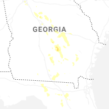
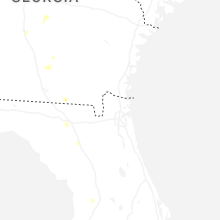
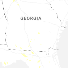
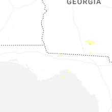


Connect with Interactive Hail Maps