

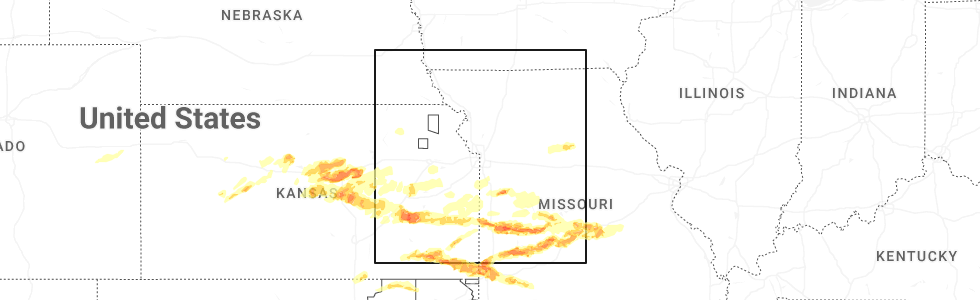
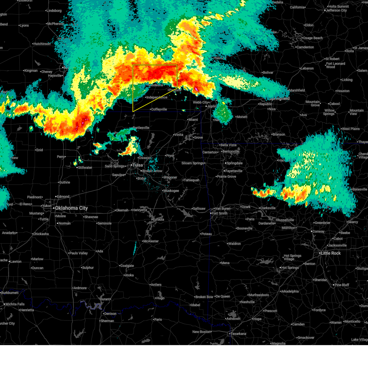
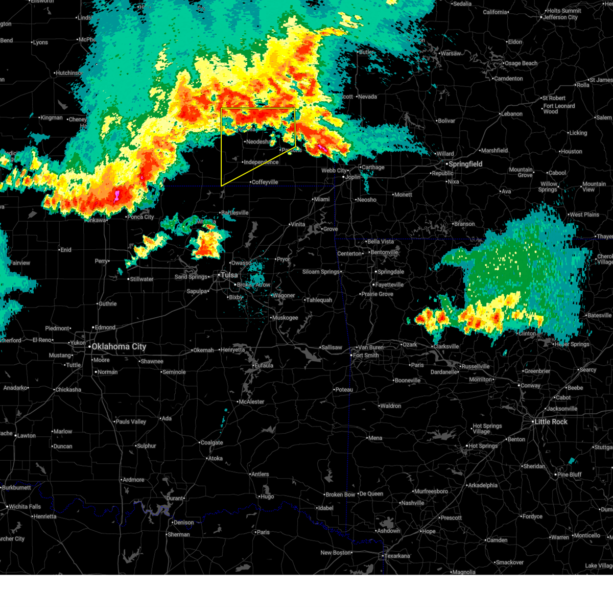
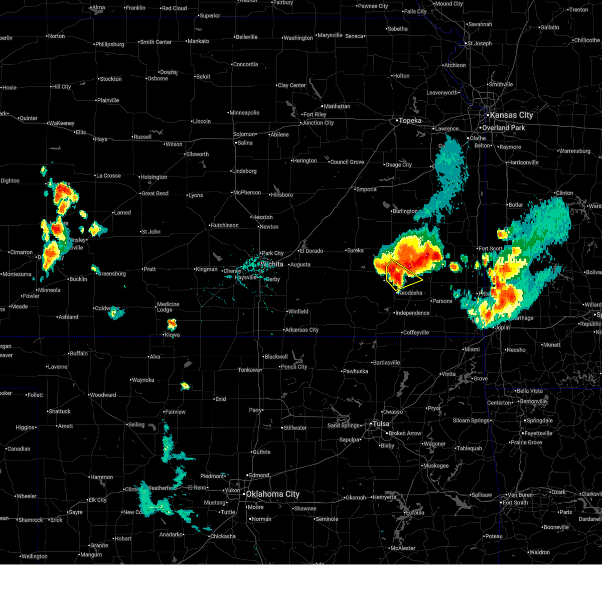
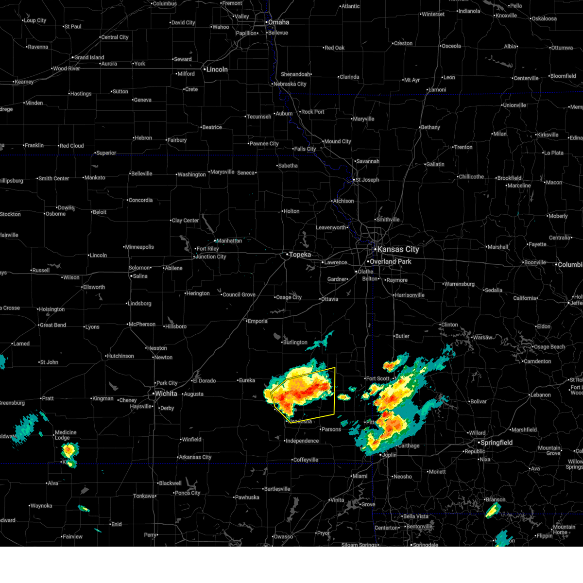
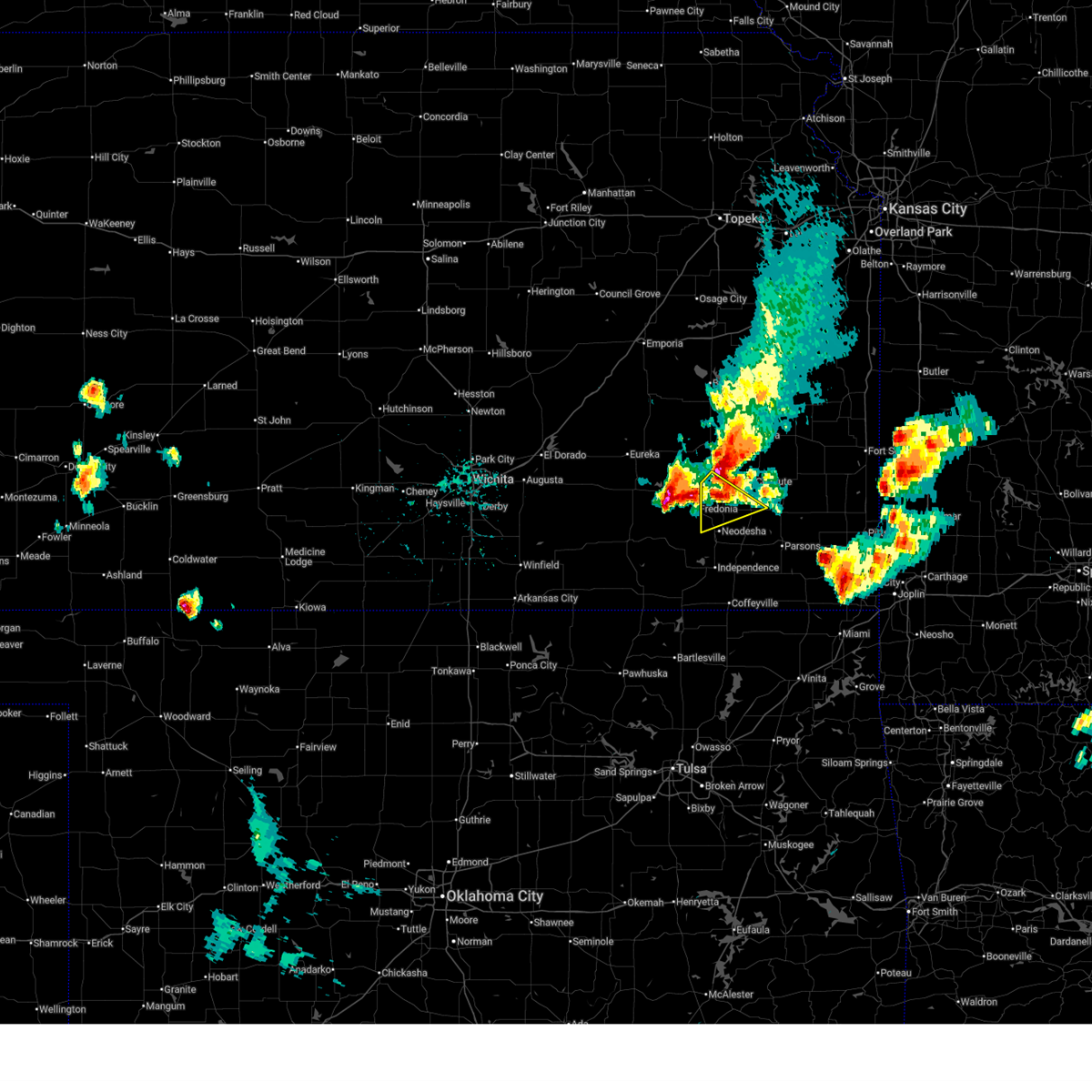
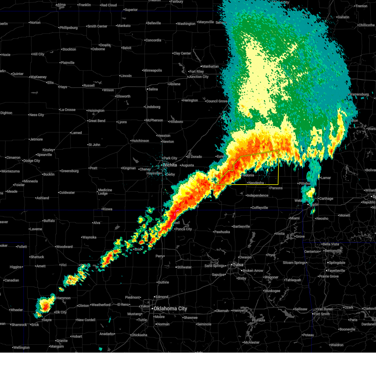
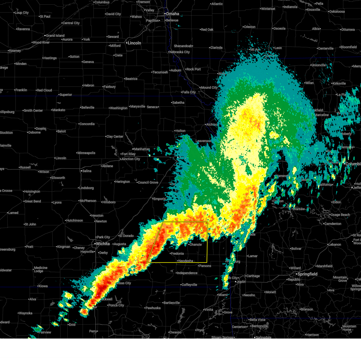
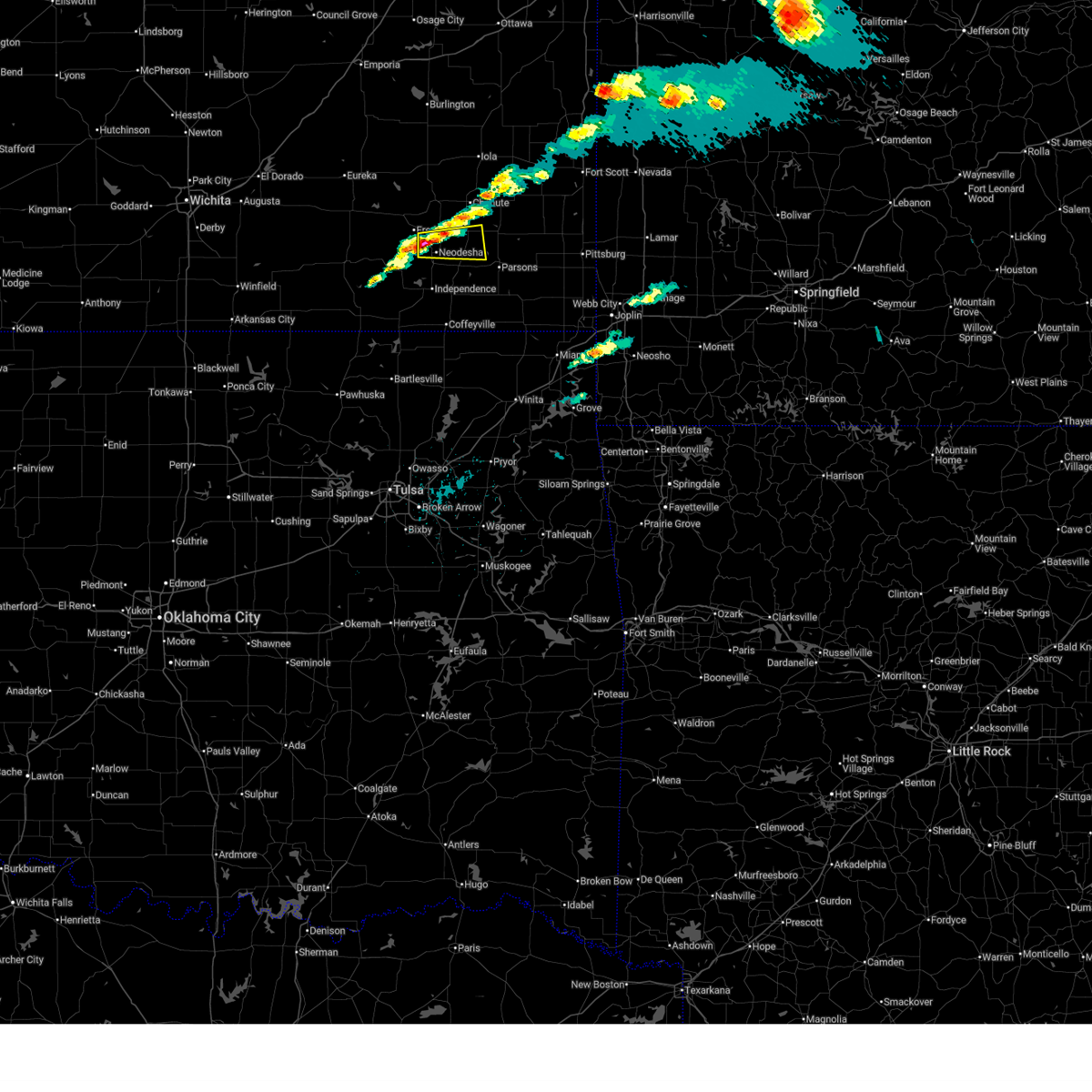
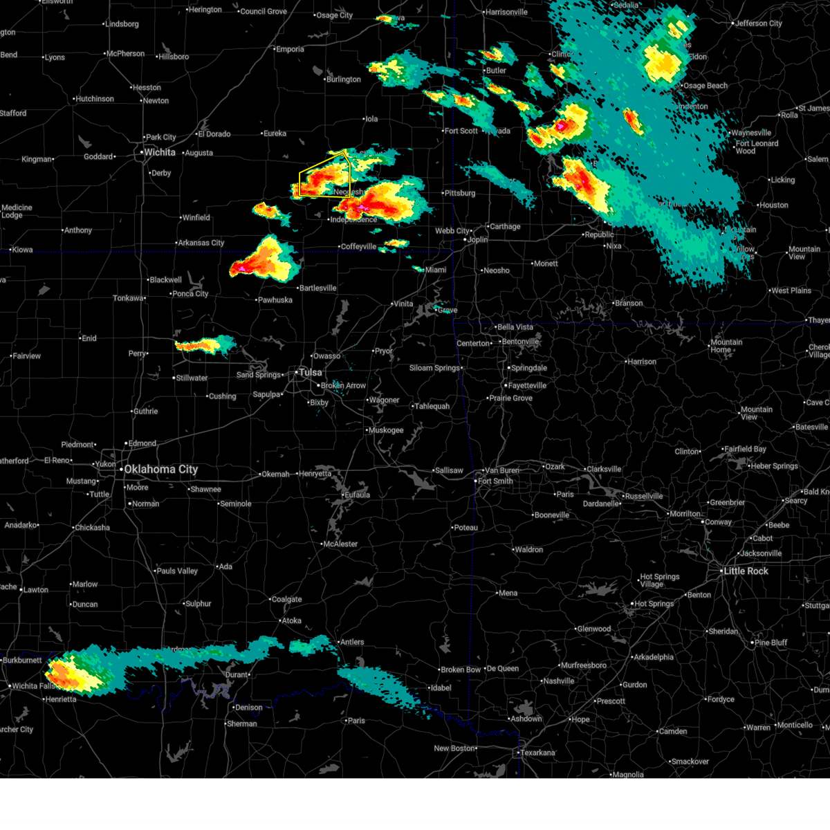
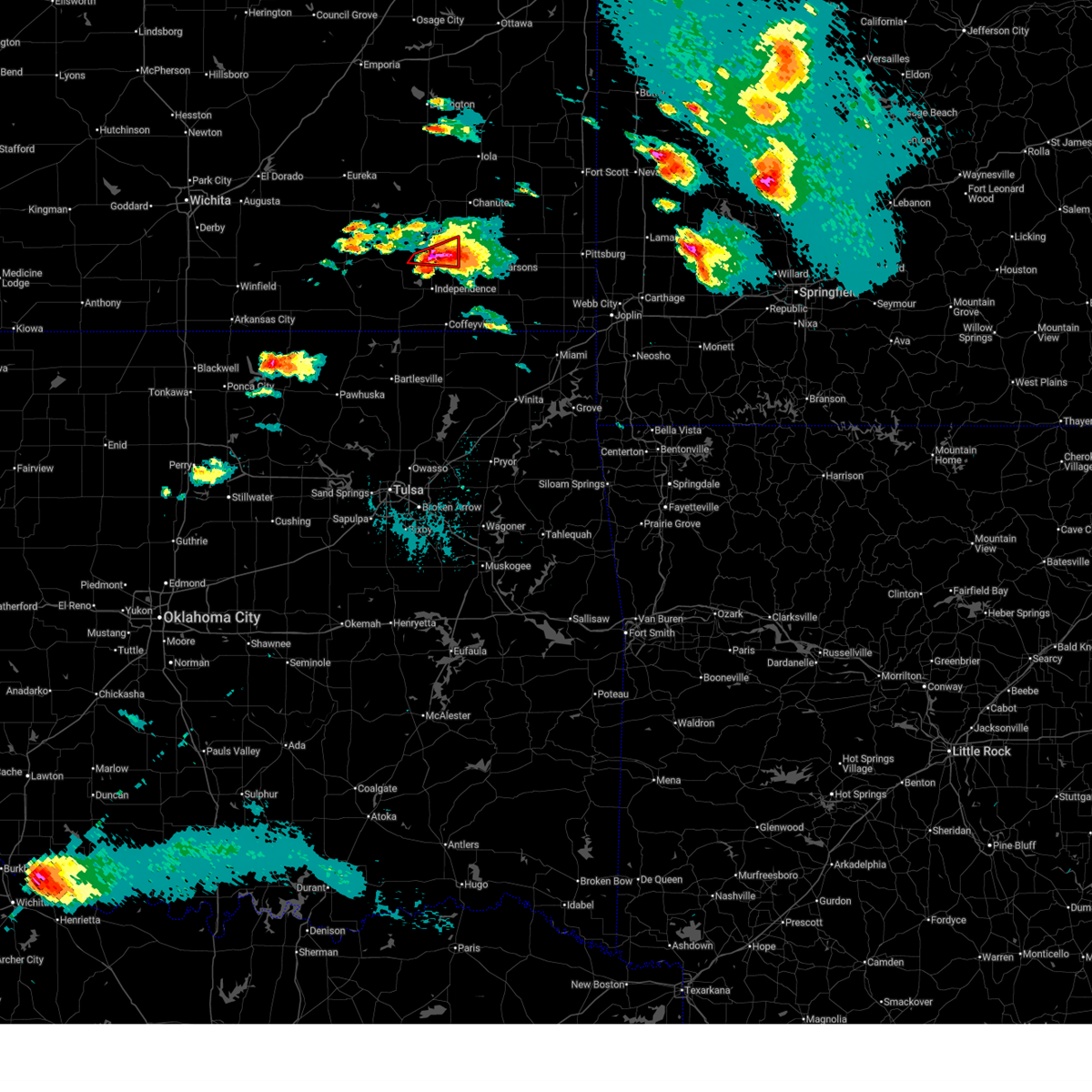
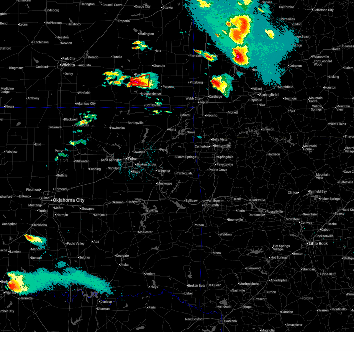
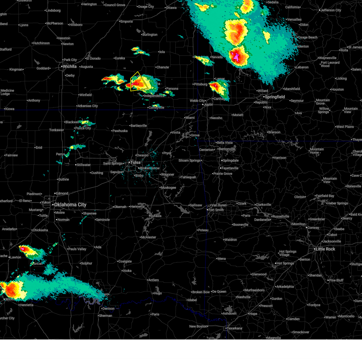
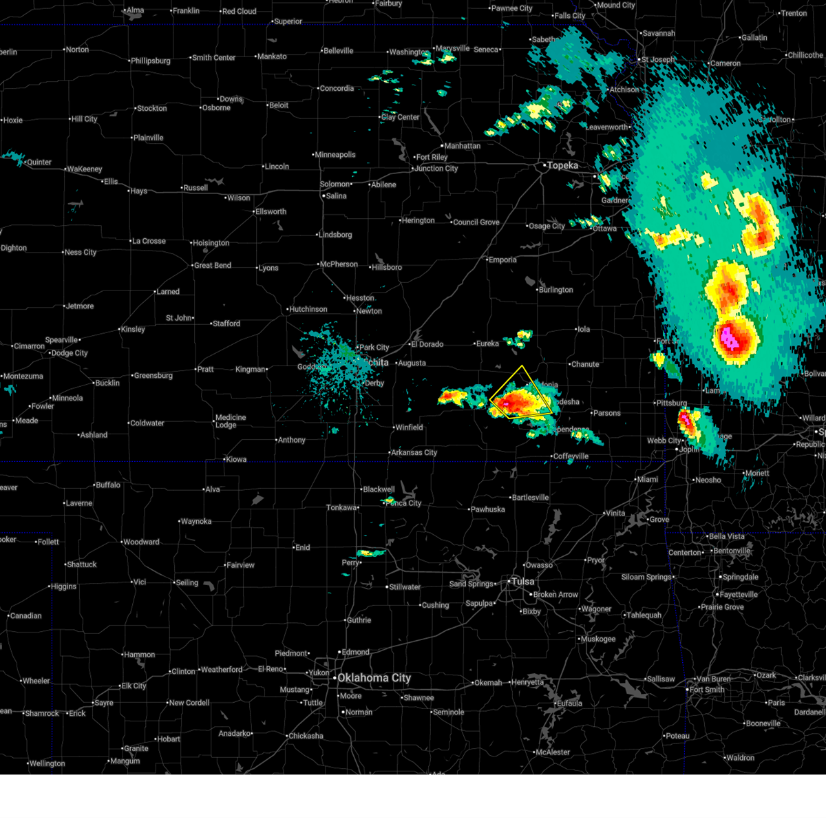
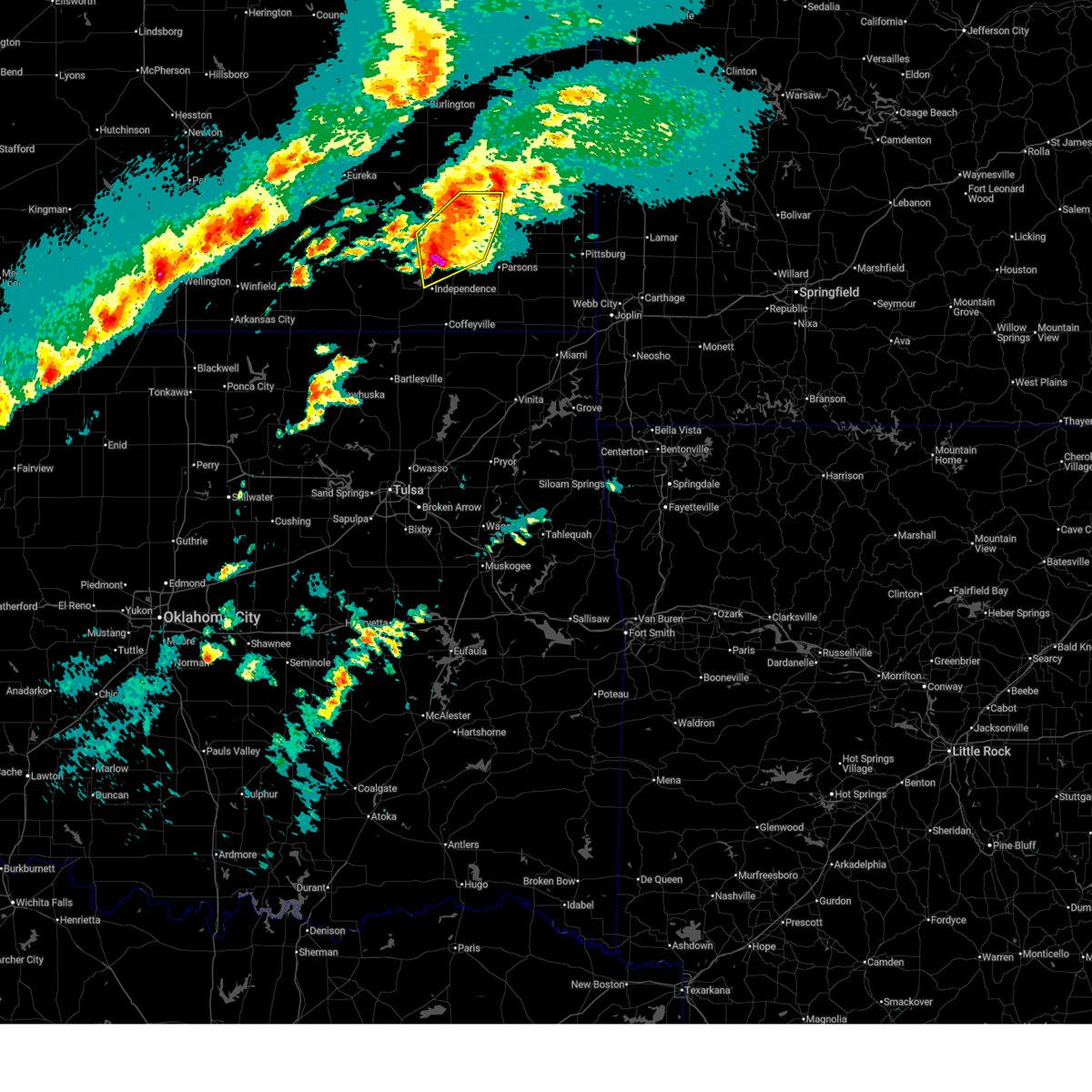
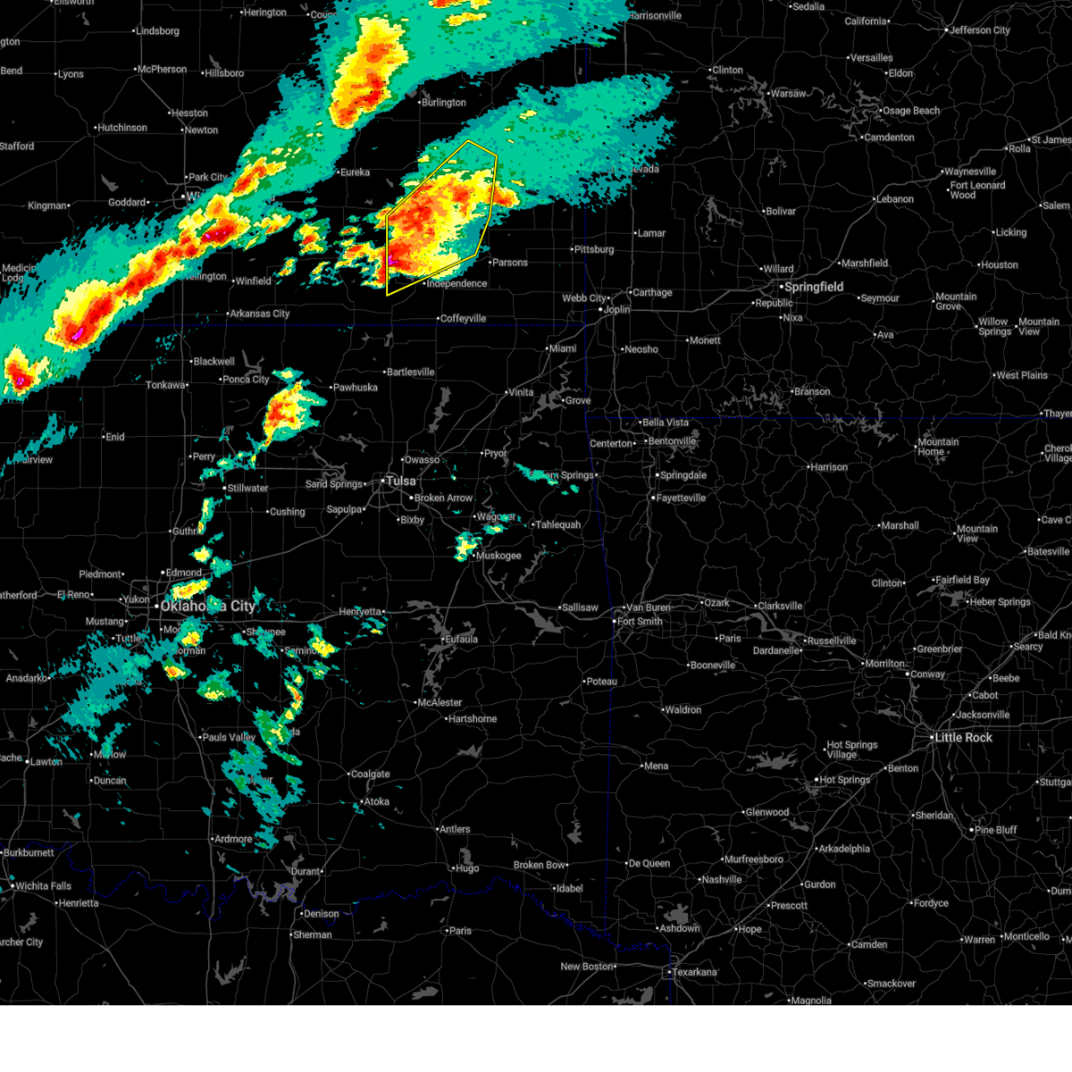
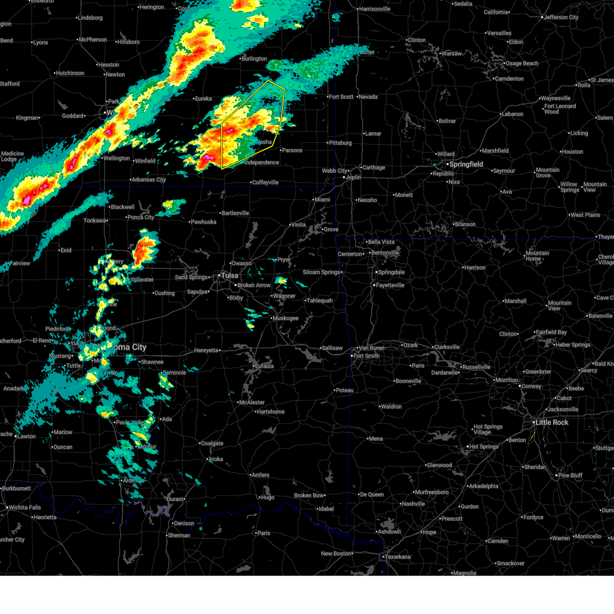
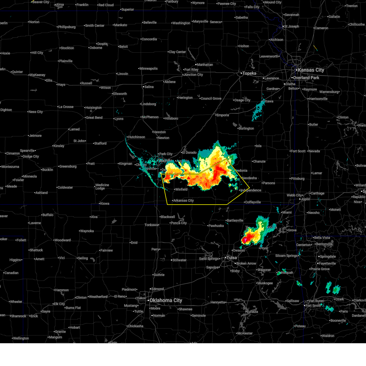
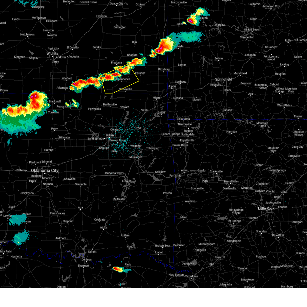
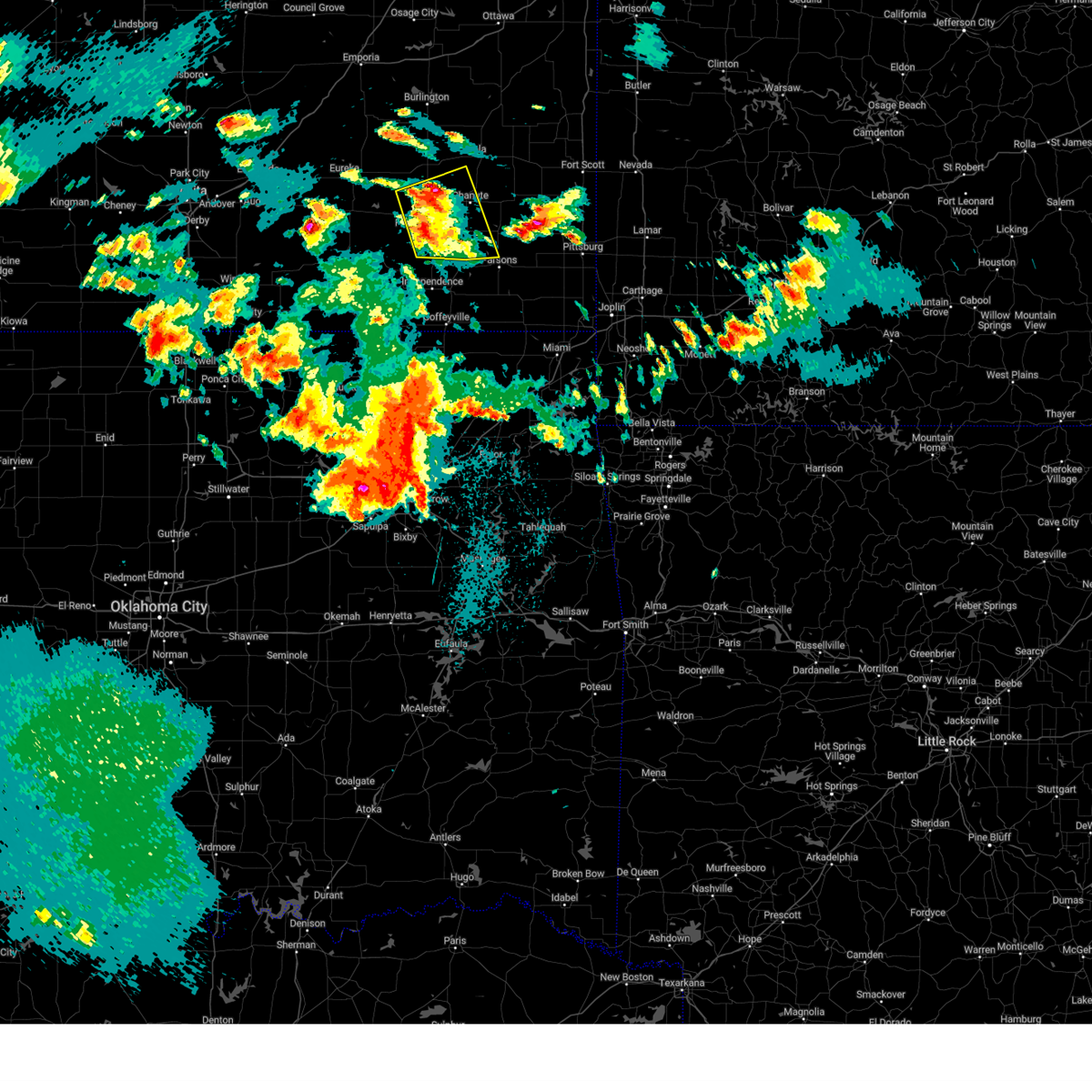
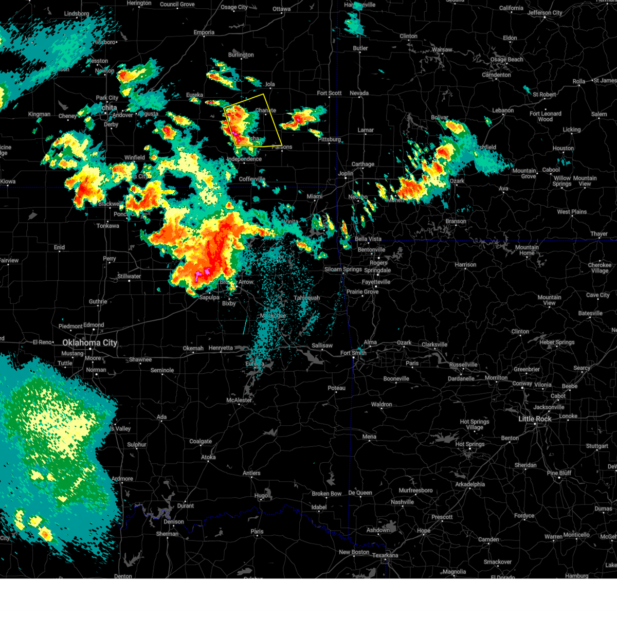
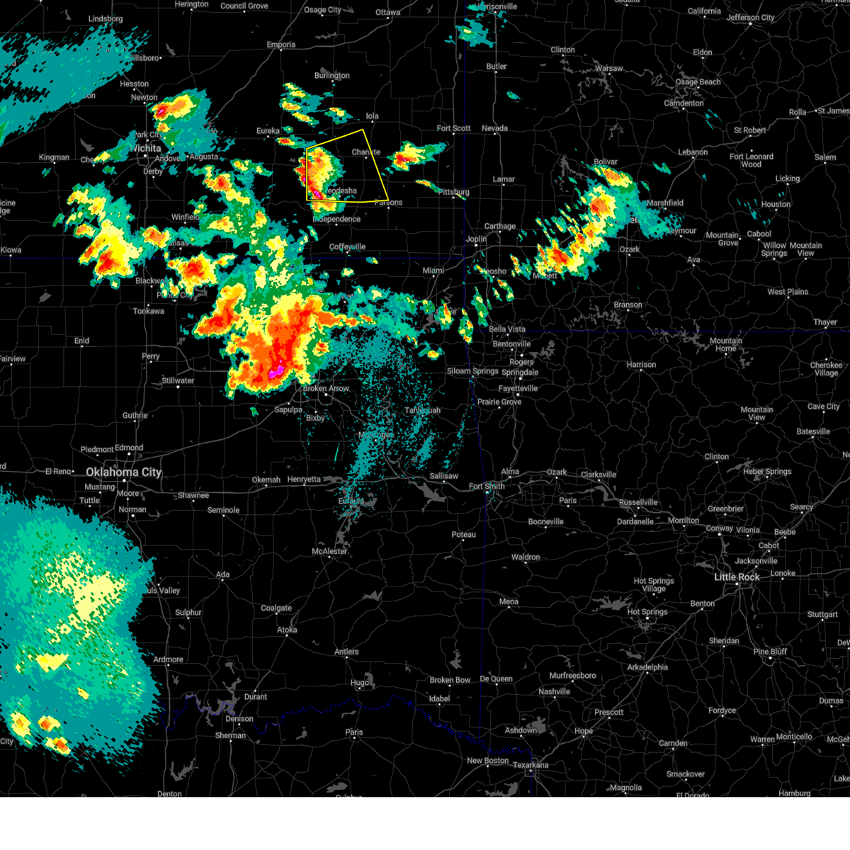
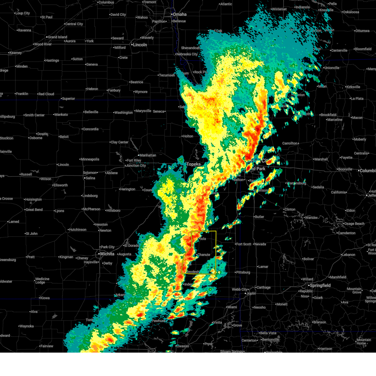
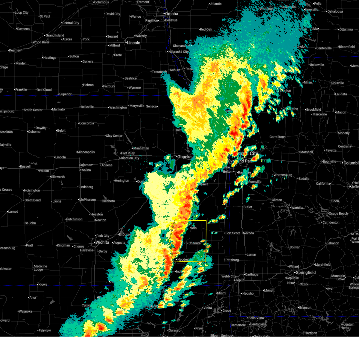
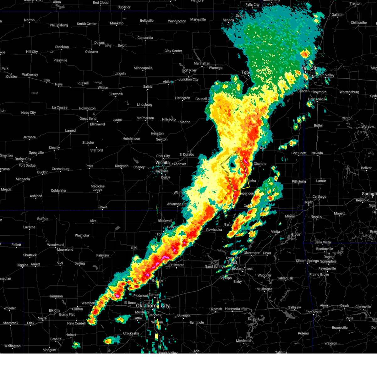
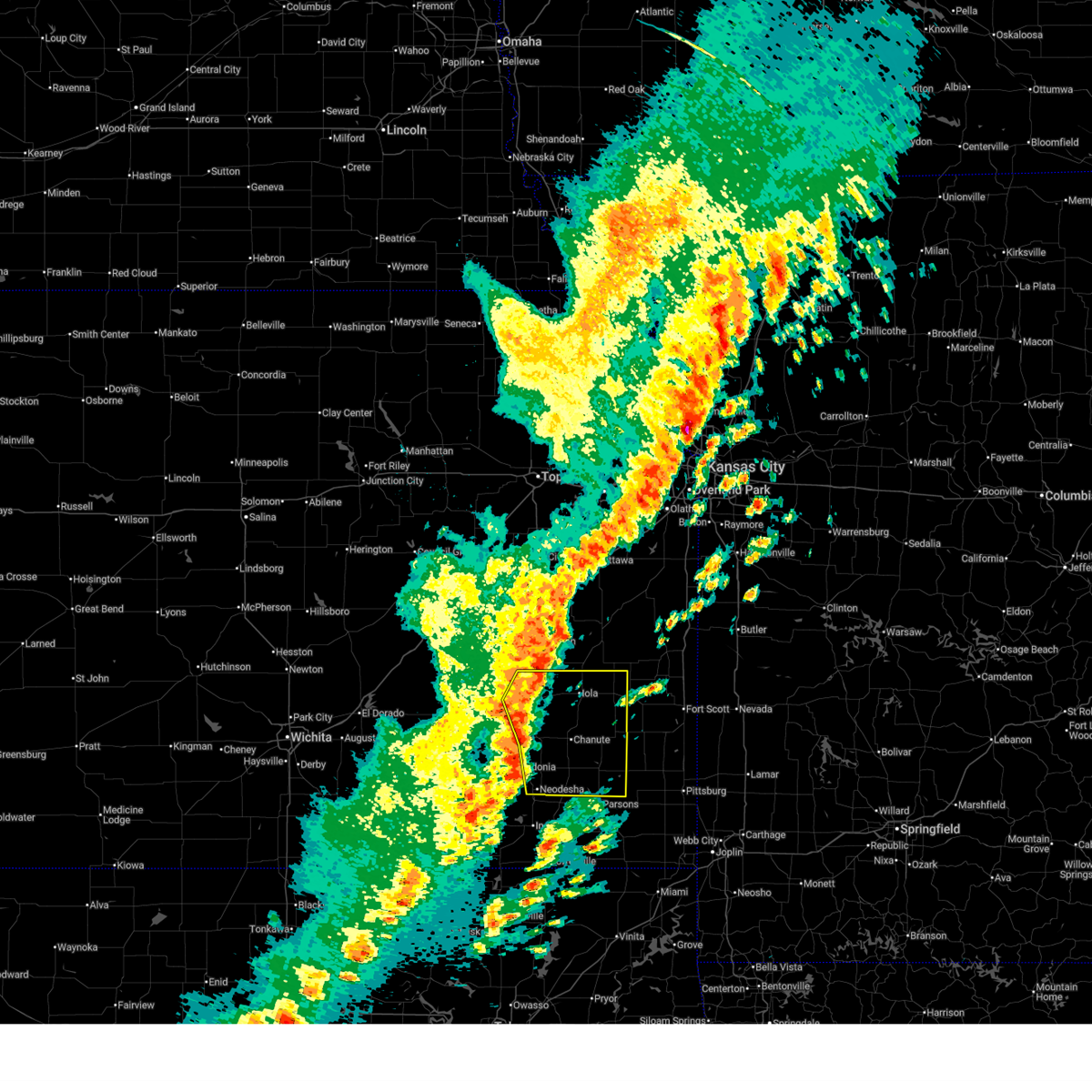
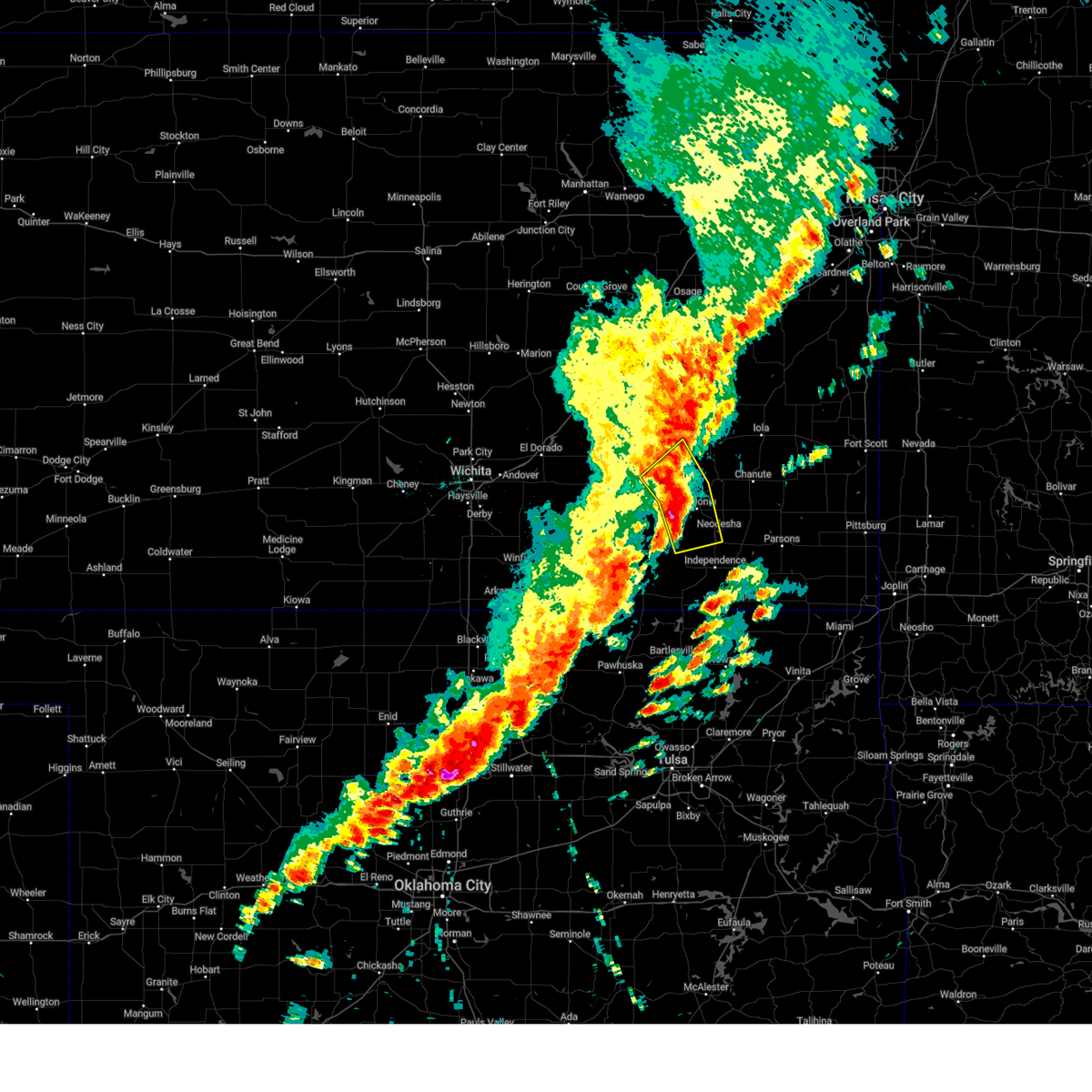
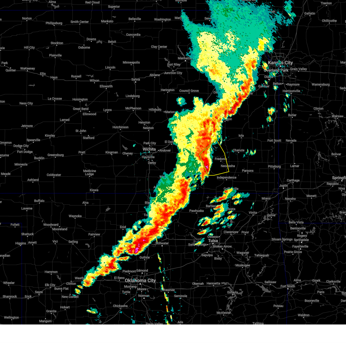
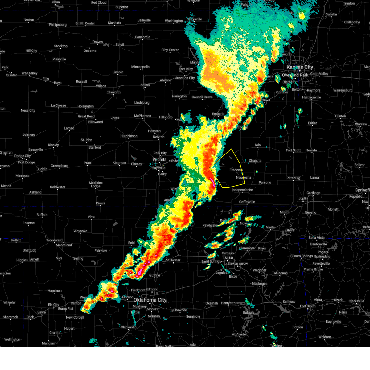
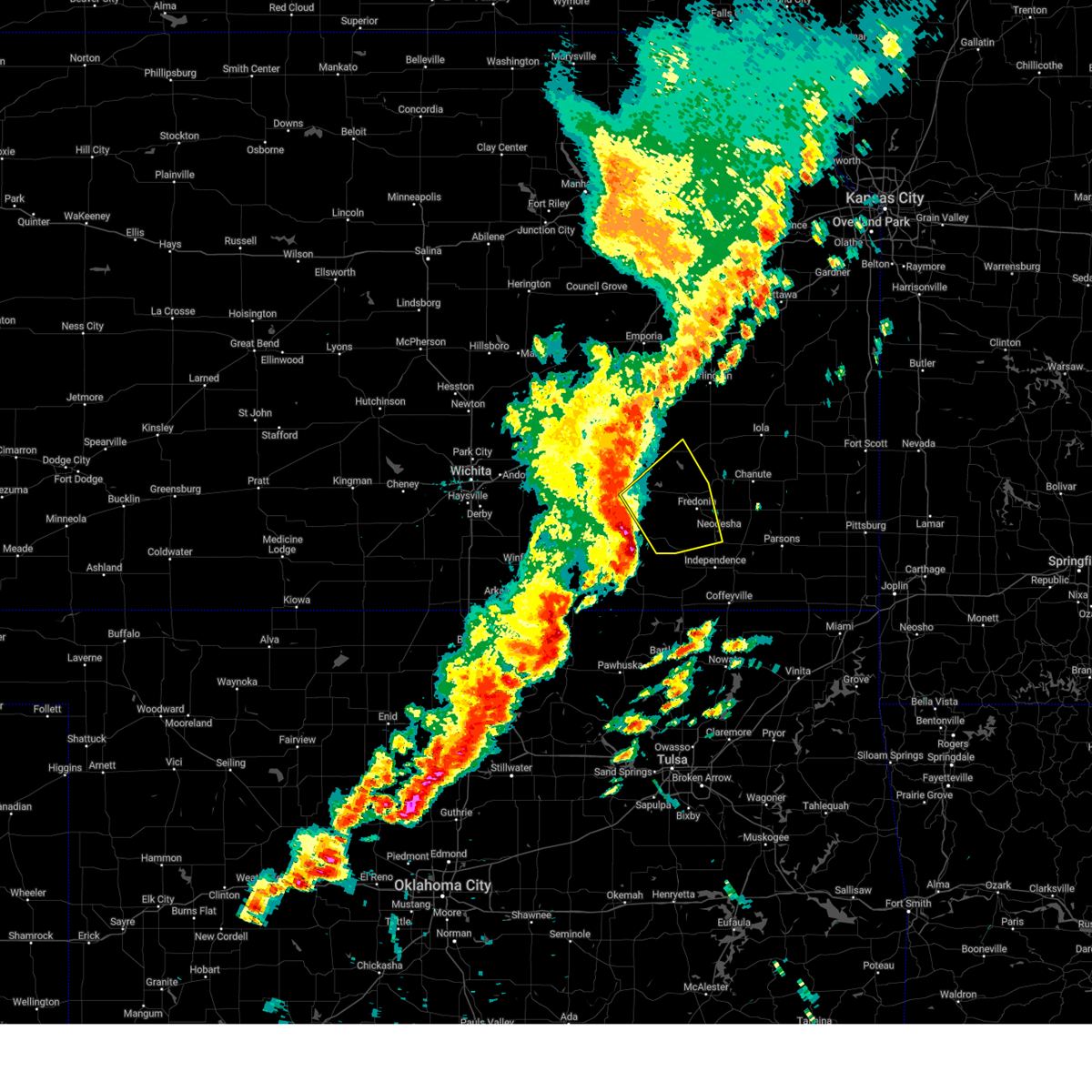
Hail Map for Neodesha, KS
The Neodesha, KS area has had 11 reports of on-the-ground hail by trained spotters, and has been under severe weather warnings 28 times during the past 12 months. Doppler radar has detected hail at or near Neodesha, KS on 100 occasions, including 8 occasions during the past year.
| Name: | Neodesha, KS |
| Where Located: | 21.9 miles SW of Chanute, KS |
| Map: | Google Map for Neodesha, KS |
| Population: | 2486 |
| Housing Units: | 1204 |
| More Info: | Search Google for Neodesha, KS |
4
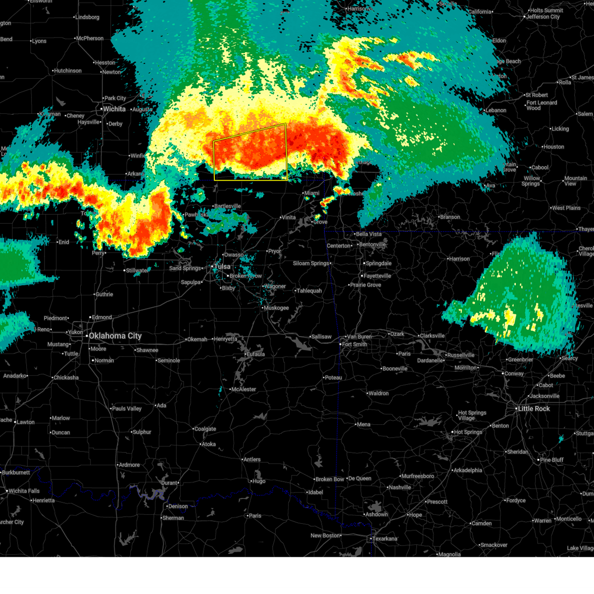
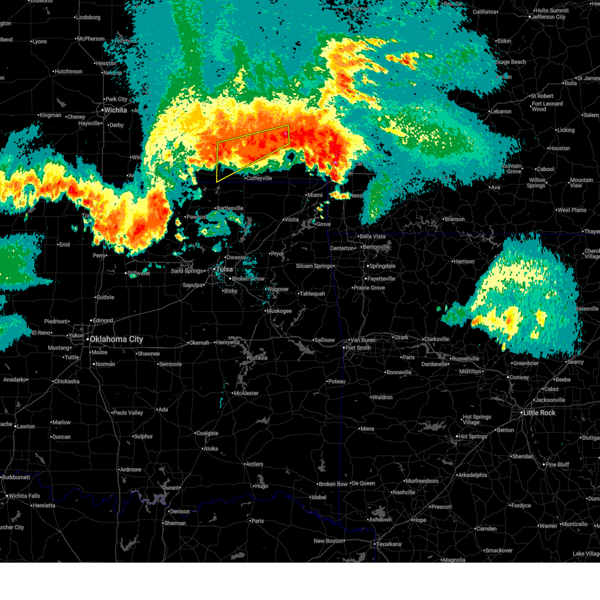
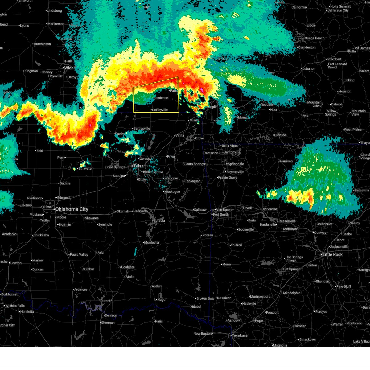
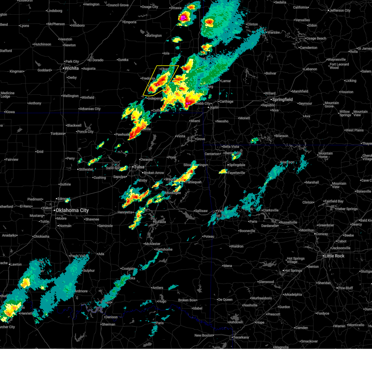
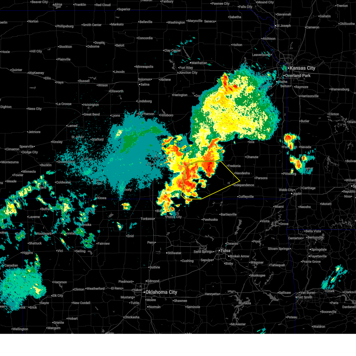
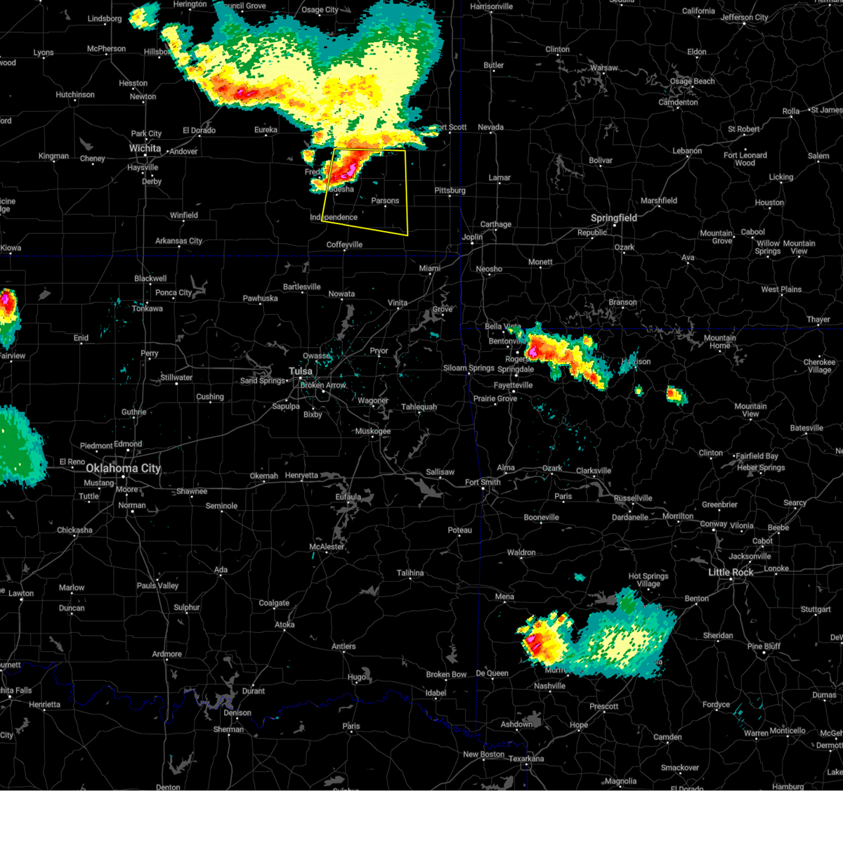
The Top Recent Hail Date for Neodesha, KS is Sunday, April 26, 2026 (5th out of 100)
Hail and Wind Damage Spotted near Neodesha, KS
| Date / Time | Report Details |
|---|---|
| 6/13/2026 10:41 PM CDT |
 At 1040 pm cdt, severe thunderstorms were located along a line extending from 5 miles northeast of oswego to 7 miles east of coffeyville to near havana, moving south to southeast at 50 mph (radar indicated. this storm has a history of producing 60 to 70 mph winds). Hazards include 70 mph wind gusts. Expect considerable tree damage. damage is likely to mobile homes, roofs, and outbuildings. locations impacted include, parsons, coffeyville, independence, neodesha, cherryvale, caney, oswego, chetopa, altamont, st. Paul, edna, dearing, mound valley, elk city, tyro, galesburg, liberty, havana, bolton, and sycamore. At 1040 pm cdt, severe thunderstorms were located along a line extending from 5 miles northeast of oswego to 7 miles east of coffeyville to near havana, moving south to southeast at 50 mph (radar indicated. this storm has a history of producing 60 to 70 mph winds). Hazards include 70 mph wind gusts. Expect considerable tree damage. damage is likely to mobile homes, roofs, and outbuildings. locations impacted include, parsons, coffeyville, independence, neodesha, cherryvale, caney, oswego, chetopa, altamont, st. Paul, edna, dearing, mound valley, elk city, tyro, galesburg, liberty, havana, bolton, and sycamore.
|
| 6/13/2026 10:38 PM CDT |
 At 1037 pm cdt, severe thunderstorms were located along a line extending from 6 miles south of mccune to havana, moving south at 45 mph (radar indicated. this storm has a history of producing damaging winds). Hazards include 70 mph wind gusts. Expect considerable tree damage. damage is likely to mobile homes, roofs, and outbuildings. locations impacted include, parsons, independence, neodesha, cherryvale, caney, st. Paul, elk city, galesburg, liberty, havana, bolton, sycamore, lake parsons, parsons tri city airport, dennis, elk city lake, big hill lake, elk city state park, south mound, and independence airport. At 1037 pm cdt, severe thunderstorms were located along a line extending from 6 miles south of mccune to havana, moving south at 45 mph (radar indicated. this storm has a history of producing damaging winds). Hazards include 70 mph wind gusts. Expect considerable tree damage. damage is likely to mobile homes, roofs, and outbuildings. locations impacted include, parsons, independence, neodesha, cherryvale, caney, st. Paul, elk city, galesburg, liberty, havana, bolton, sycamore, lake parsons, parsons tri city airport, dennis, elk city lake, big hill lake, elk city state park, south mound, and independence airport.
|
| 6/13/2026 10:22 PM CDT |
 Svrict the national weather service in wichita has issued a * severe thunderstorm warning for, southeastern wilson county in southeastern kansas, labette county in southeastern kansas, southern neosho county in southeastern kansas, montgomery county in southeastern kansas, * until 1130 pm cdt. * at 1020 pm cdt, severe thunderstorms were located along a line extending from 7 miles north of mccune to elk city, moving southeast at 45 mph (radar indicated. this line of storms has a history of producing winds greater than 60 mph). Hazards include 70 mph wind gusts and penny size hail. Expect considerable tree damage. Damage is likely to mobile homes, roofs, and outbuildings. Svrict the national weather service in wichita has issued a * severe thunderstorm warning for, southeastern wilson county in southeastern kansas, labette county in southeastern kansas, southern neosho county in southeastern kansas, montgomery county in southeastern kansas, * until 1130 pm cdt. * at 1020 pm cdt, severe thunderstorms were located along a line extending from 7 miles north of mccune to elk city, moving southeast at 45 mph (radar indicated. this line of storms has a history of producing winds greater than 60 mph). Hazards include 70 mph wind gusts and penny size hail. Expect considerable tree damage. Damage is likely to mobile homes, roofs, and outbuildings.
|
| 6/13/2026 10:05 PM CDT |
 At 1005 pm cdt, severe thunderstorms were located along a line extending from near walnut to 7 miles northeast of longton, moving southeast at 55 mph (trained weather spotters). Hazards include 60 to 70 mph wind gusts and penny size hail. Expect considerable tree damage. damage is likely to mobile homes, roofs, and outbuildings. locations impacted include, parsons, independence, chanute, neodesha, fredonia, cherryvale, caney, erie, st. Paul, thayer, altoona, elk city, buffalo, galesburg, liberty, havana, bolton, sycamore, benedict, and stark. At 1005 pm cdt, severe thunderstorms were located along a line extending from near walnut to 7 miles northeast of longton, moving southeast at 55 mph (trained weather spotters). Hazards include 60 to 70 mph wind gusts and penny size hail. Expect considerable tree damage. damage is likely to mobile homes, roofs, and outbuildings. locations impacted include, parsons, independence, chanute, neodesha, fredonia, cherryvale, caney, erie, st. Paul, thayer, altoona, elk city, buffalo, galesburg, liberty, havana, bolton, sycamore, benedict, and stark.
|
| 6/13/2026 9:49 PM CDT |
 Svrict the national weather service in wichita has issued a * severe thunderstorm warning for, wilson county in southeastern kansas, northern labette county in southeastern kansas, neosho county in southeastern kansas, montgomery county in southeastern kansas, * until 1045 pm cdt. * at 948 pm cdt, severe thunderstorms were located along a line extending from 5 miles southwest of blue mound to near buffalo to 8 miles west of severy, moving southeast at 50 mph (radar indicated). Hazards include 60 mph wind gusts. expect damage to roofs, siding, and trees Svrict the national weather service in wichita has issued a * severe thunderstorm warning for, wilson county in southeastern kansas, northern labette county in southeastern kansas, neosho county in southeastern kansas, montgomery county in southeastern kansas, * until 1045 pm cdt. * at 948 pm cdt, severe thunderstorms were located along a line extending from 5 miles southwest of blue mound to near buffalo to 8 miles west of severy, moving southeast at 50 mph (radar indicated). Hazards include 60 mph wind gusts. expect damage to roofs, siding, and trees
|
| 5/30/2026 3:43 PM CDT |
 At 343 pm cdt, a severe thunderstorm was located near altoona, or 10 miles east of fredonia, moving northeast at 35 mph (radar indicated). Hazards include 60 mph wind gusts and quarter size hail. Hail damage to vehicles is expected. expect wind damage to roofs, siding, and trees. Locations impacted include, altoona, buffalo, benedict, and earlton. At 343 pm cdt, a severe thunderstorm was located near altoona, or 10 miles east of fredonia, moving northeast at 35 mph (radar indicated). Hazards include 60 mph wind gusts and quarter size hail. Hail damage to vehicles is expected. expect wind damage to roofs, siding, and trees. Locations impacted include, altoona, buffalo, benedict, and earlton.
|
| 5/30/2026 3:41 PM CDT |
 Svrict the national weather service in wichita has issued a * severe thunderstorm warning for, eastern wilson county in southeastern kansas, neosho county in southeastern kansas, southeastern woodson county in southeastern kansas, southern allen county in southeastern kansas, * until 445 pm cdt. * at 341 pm cdt, severe thunderstorms were located along a line extending from 7 miles east of chanute to 7 miles northwest of fredonia, moving east at 20 mph (trained weather spotters). Hazards include 70 mph wind gusts and quarter size hail. Hail damage to vehicles is expected. expect considerable tree damage. Wind damage is also likely to mobile homes, roofs, and outbuildings. Svrict the national weather service in wichita has issued a * severe thunderstorm warning for, eastern wilson county in southeastern kansas, neosho county in southeastern kansas, southeastern woodson county in southeastern kansas, southern allen county in southeastern kansas, * until 445 pm cdt. * at 341 pm cdt, severe thunderstorms were located along a line extending from 7 miles east of chanute to 7 miles northwest of fredonia, moving east at 20 mph (trained weather spotters). Hazards include 70 mph wind gusts and quarter size hail. Hail damage to vehicles is expected. expect considerable tree damage. Wind damage is also likely to mobile homes, roofs, and outbuildings.
|
| 5/30/2026 3:15 PM CDT |
 Svrict the national weather service in wichita has issued a * severe thunderstorm warning for, eastern wilson county in southeastern kansas, west central neosho county in southeastern kansas, * until 400 pm cdt. * at 315 pm cdt, a severe thunderstorm was located 6 miles north of altoona, or 10 miles northeast of fredonia, moving northeast at 10 mph (radar indicated). Hazards include 60 mph wind gusts and quarter size hail. Hail damage to vehicles is expected. Expect wind damage to roofs, siding, and trees. Svrict the national weather service in wichita has issued a * severe thunderstorm warning for, eastern wilson county in southeastern kansas, west central neosho county in southeastern kansas, * until 400 pm cdt. * at 315 pm cdt, a severe thunderstorm was located 6 miles north of altoona, or 10 miles northeast of fredonia, moving northeast at 10 mph (radar indicated). Hazards include 60 mph wind gusts and quarter size hail. Hail damage to vehicles is expected. Expect wind damage to roofs, siding, and trees.
|
| 5/19/2026 12:46 AM CDT |
 At 1245 am cdt, severe thunderstorms were located along a line extending from near buffalo to 6 miles north of fredonia to near longton, moving east at 35 mph (radar indicated). Hazards include 60 mph wind gusts. Expect damage to roofs, siding, and trees. locations impacted include, chanute, neodesha, fredonia, humboldt, erie, st. Paul, thayer, altoona, buffalo, walnut, fall river, galesburg, savonburg, elsmore, benedict, stark, new albany, earlton, coyville, and lake parsons. At 1245 am cdt, severe thunderstorms were located along a line extending from near buffalo to 6 miles north of fredonia to near longton, moving east at 35 mph (radar indicated). Hazards include 60 mph wind gusts. Expect damage to roofs, siding, and trees. locations impacted include, chanute, neodesha, fredonia, humboldt, erie, st. Paul, thayer, altoona, buffalo, walnut, fall river, galesburg, savonburg, elsmore, benedict, stark, new albany, earlton, coyville, and lake parsons.
|
| 5/19/2026 12:21 AM CDT |
 Svrict the national weather service in wichita has issued a * severe thunderstorm warning for, northeastern elk county in southeastern kansas, wilson county in southeastern kansas, neosho county in southeastern kansas, woodson county in southeastern kansas, southeastern greenwood county in southeastern kansas, allen county in southeastern kansas, * until 145 am cdt. * at 1221 am cdt, severe thunderstorms were located along a line extending from near toronto to near fall river to 6 miles east of howard, moving east at 35 mph (radar indicated). Hazards include 60 mph wind gusts and quarter size hail. Hail damage to vehicles is expected. Expect wind damage to roofs, siding, and trees. Svrict the national weather service in wichita has issued a * severe thunderstorm warning for, northeastern elk county in southeastern kansas, wilson county in southeastern kansas, neosho county in southeastern kansas, woodson county in southeastern kansas, southeastern greenwood county in southeastern kansas, allen county in southeastern kansas, * until 145 am cdt. * at 1221 am cdt, severe thunderstorms were located along a line extending from near toronto to near fall river to 6 miles east of howard, moving east at 35 mph (radar indicated). Hazards include 60 mph wind gusts and quarter size hail. Hail damage to vehicles is expected. Expect wind damage to roofs, siding, and trees.
|
| 4/27/2026 3:33 PM CDT |
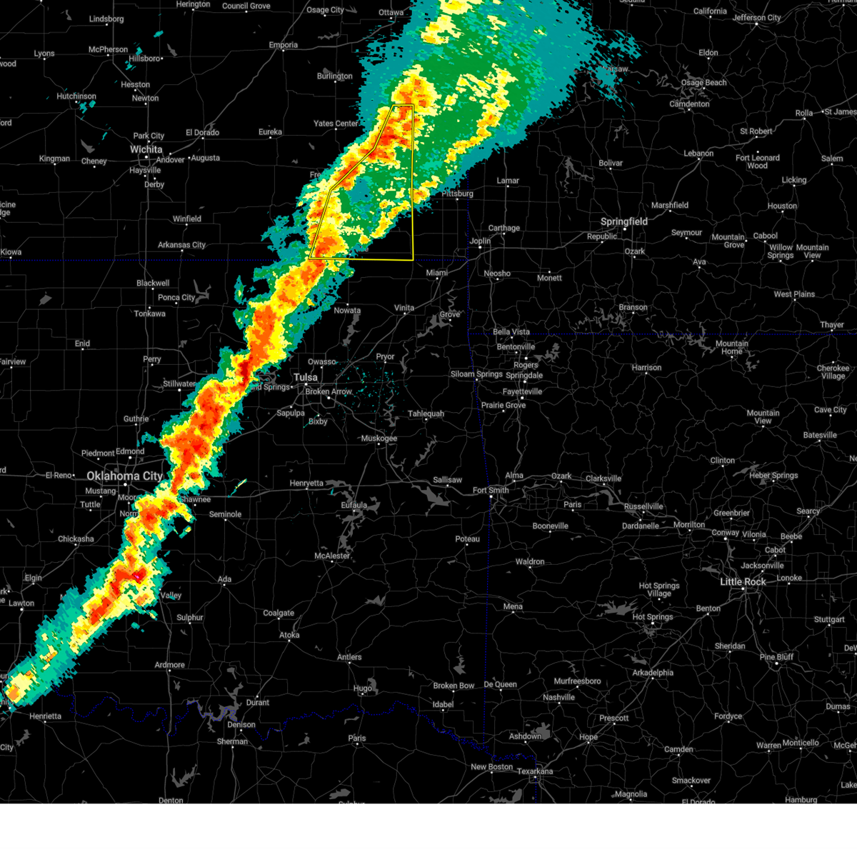
 At 332 pm cdt, a severe thunderstorm was located over neodesha, moving east at 35 mph (radar indicated). Hazards include 60 mph wind gusts and quarter size hail. Hail damage to vehicles is expected. expect wind damage to roofs, siding, and trees. Locations impacted include, neodesha, thayer, and altoona. At 332 pm cdt, a severe thunderstorm was located over neodesha, moving east at 35 mph (radar indicated). Hazards include 60 mph wind gusts and quarter size hail. Hail damage to vehicles is expected. expect wind damage to roofs, siding, and trees. Locations impacted include, neodesha, thayer, and altoona.
|
| 4/26/2026 8:16 PM CDT |
 Svrict the national weather service in wichita has issued a * severe thunderstorm warning for, wilson county in southeastern kansas, * until 900 pm cdt. * at 816 pm cdt, a severe thunderstorm was located near altoona, or near fredonia, moving east at 35 mph (radar indicated). Hazards include 60 mph wind gusts and half dollar size hail. Hail damage to vehicles is expected. Expect wind damage to roofs, siding, and trees. Svrict the national weather service in wichita has issued a * severe thunderstorm warning for, wilson county in southeastern kansas, * until 900 pm cdt. * at 816 pm cdt, a severe thunderstorm was located near altoona, or near fredonia, moving east at 35 mph (radar indicated). Hazards include 60 mph wind gusts and half dollar size hail. Hail damage to vehicles is expected. Expect wind damage to roofs, siding, and trees.
|
| 4/26/2026 7:07 PM CDT |
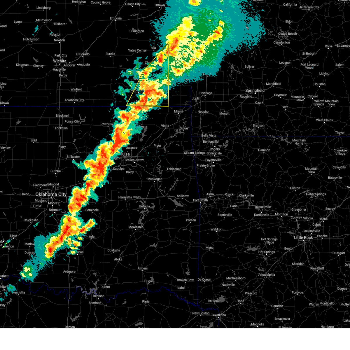
 At 706 pm cdt, a confirmed tornado was located 6 miles southwest of neodesha, moving east at 30 mph (public confirmed tornado). Hazards include damaging tornado and two inch hail. Flying debris will be dangerous to those caught without shelter. mobile homes will be damaged or destroyed. damage to roofs, windows, and vehicles will occur. tree damage is likely. Locations impacted include, sycamore. At 706 pm cdt, a confirmed tornado was located 6 miles southwest of neodesha, moving east at 30 mph (public confirmed tornado). Hazards include damaging tornado and two inch hail. Flying debris will be dangerous to those caught without shelter. mobile homes will be damaged or destroyed. damage to roofs, windows, and vehicles will occur. tree damage is likely. Locations impacted include, sycamore.
|
| 4/26/2026 6:47 PM CDT |
 Torict the national weather service in wichita has issued a * tornado warning for, southern wilson county in southeastern kansas, northeastern montgomery county in southeastern kansas, * until 730 pm cdt. * at 647 pm cdt, a confirmed tornado was located 6 miles west of neodesha, moving east at 25 mph (public confirmed tornado). Hazards include damaging tornado and half dollar size hail. Flying debris will be dangerous to those caught without shelter. mobile homes will be damaged or destroyed. damage to roofs, windows, and vehicles will occur. tree damage is likely. The tornado will be near, neodesha around 655 pm cdt. Torict the national weather service in wichita has issued a * tornado warning for, southern wilson county in southeastern kansas, northeastern montgomery county in southeastern kansas, * until 730 pm cdt. * at 647 pm cdt, a confirmed tornado was located 6 miles west of neodesha, moving east at 25 mph (public confirmed tornado). Hazards include damaging tornado and half dollar size hail. Flying debris will be dangerous to those caught without shelter. mobile homes will be damaged or destroyed. damage to roofs, windows, and vehicles will occur. tree damage is likely. The tornado will be near, neodesha around 655 pm cdt.
|
| 4/26/2026 6:33 PM CDT |
 At 633 pm cdt, a severe thunderstorm was located 6 miles north of elk city, or 11 miles southwest of fredonia, moving east at 20 mph (radar indicated). Hazards include 60 mph wind gusts and half dollar size hail. Hail damage to vehicles is expected. expect wind damage to roofs, siding, and trees. Locations impacted include, neodesha, fredonia, sycamore, and buxton. At 633 pm cdt, a severe thunderstorm was located 6 miles north of elk city, or 11 miles southwest of fredonia, moving east at 20 mph (radar indicated). Hazards include 60 mph wind gusts and half dollar size hail. Hail damage to vehicles is expected. expect wind damage to roofs, siding, and trees. Locations impacted include, neodesha, fredonia, sycamore, and buxton.
|
| 4/26/2026 6:13 PM CDT |
 Svrict the national weather service in wichita has issued a * severe thunderstorm warning for, southeastern elk county in southeastern kansas, western wilson county in southeastern kansas, northwestern montgomery county in southeastern kansas, * until 715 pm cdt. * at 613 pm cdt, a severe thunderstorm was located over longton, or 14 miles southeast of howard, moving east at 20 mph (radar indicated). Hazards include 60 mph wind gusts and half dollar size hail. Hail damage to vehicles is expected. Expect wind damage to roofs, siding, and trees. Svrict the national weather service in wichita has issued a * severe thunderstorm warning for, southeastern elk county in southeastern kansas, western wilson county in southeastern kansas, northwestern montgomery county in southeastern kansas, * until 715 pm cdt. * at 613 pm cdt, a severe thunderstorm was located over longton, or 14 miles southeast of howard, moving east at 20 mph (radar indicated). Hazards include 60 mph wind gusts and half dollar size hail. Hail damage to vehicles is expected. Expect wind damage to roofs, siding, and trees.
|
| 4/17/2026 4:10 PM CDT |
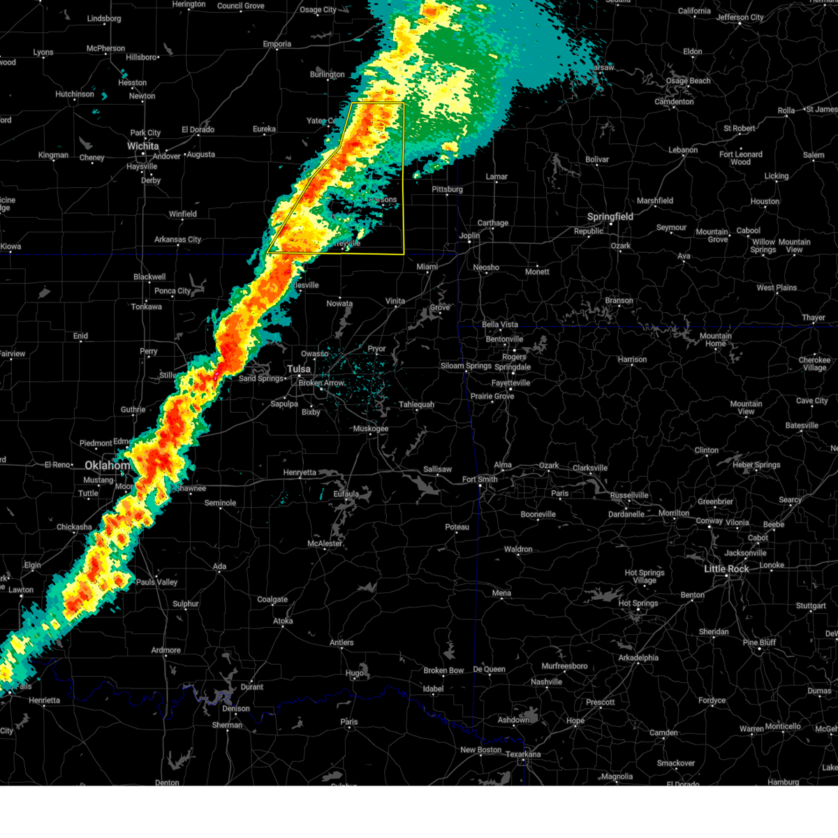
 At 410 pm cdt, a severe thunderstorm was located over neodesha, moving northeast at 50 mph (radar indicated). Hazards include 60 mph wind gusts and quarter size hail. Hail damage to vehicles is expected. expect wind damage to roofs, siding, and trees. Locations impacted include, independence, chanute, neodesha, thayer, altoona, galesburg, sycamore, earlton, parsons tri city airport, chanute airport, and lake parsons. At 410 pm cdt, a severe thunderstorm was located over neodesha, moving northeast at 50 mph (radar indicated). Hazards include 60 mph wind gusts and quarter size hail. Hail damage to vehicles is expected. expect wind damage to roofs, siding, and trees. Locations impacted include, independence, chanute, neodesha, thayer, altoona, galesburg, sycamore, earlton, parsons tri city airport, chanute airport, and lake parsons.
|
| 4/17/2026 3:59 PM CDT |
 At 358 pm cdt, a severe thunderstorm was located 2 miles north of elk city, or 10 miles southwest of neodesha, moving northeast at 55 mph (radar indicated). Hazards include 60 mph wind gusts and half dollar size hail. Hail damage to vehicles is expected. expect wind damage to roofs, siding, and trees. Locations impacted include, independence, chanute, iola, neodesha, fredonia, humboldt, la harpe, gas, thayer, altoona, elk city, buffalo, galesburg, sycamore, benedict, new albany, earlton, bassett, parsons tri city airport, and buxton. At 358 pm cdt, a severe thunderstorm was located 2 miles north of elk city, or 10 miles southwest of neodesha, moving northeast at 55 mph (radar indicated). Hazards include 60 mph wind gusts and half dollar size hail. Hail damage to vehicles is expected. expect wind damage to roofs, siding, and trees. Locations impacted include, independence, chanute, iola, neodesha, fredonia, humboldt, la harpe, gas, thayer, altoona, elk city, buffalo, galesburg, sycamore, benedict, new albany, earlton, bassett, parsons tri city airport, and buxton.
|
| 4/17/2026 3:39 PM CDT |
 Svrict the national weather service in wichita has issued a * severe thunderstorm warning for, wilson county in southeastern kansas, northwestern labette county in southeastern kansas, western neosho county in southeastern kansas, northern montgomery county in southeastern kansas, southeastern woodson county in southeastern kansas, western allen county in southeastern kansas, * until 445 pm cdt. * at 339 pm cdt, a severe thunderstorm was located near fredonia, moving northeast at 50 mph (radar indicated). Hazards include 60 mph wind gusts and quarter size hail. Hail damage to vehicles is expected. Expect wind damage to roofs, siding, and trees. Svrict the national weather service in wichita has issued a * severe thunderstorm warning for, wilson county in southeastern kansas, northwestern labette county in southeastern kansas, western neosho county in southeastern kansas, northern montgomery county in southeastern kansas, southeastern woodson county in southeastern kansas, western allen county in southeastern kansas, * until 445 pm cdt. * at 339 pm cdt, a severe thunderstorm was located near fredonia, moving northeast at 50 mph (radar indicated). Hazards include 60 mph wind gusts and quarter size hail. Hail damage to vehicles is expected. Expect wind damage to roofs, siding, and trees.
|
| 4/15/2026 4:26 PM CDT |
 Svrict the national weather service in wichita has issued a * severe thunderstorm warning for, southeastern wilson county in southeastern kansas, northwestern labette county in southeastern kansas, neosho county in southeastern kansas, northeastern montgomery county in southeastern kansas, * until 530 pm cdt. * at 426 pm cdt, a severe thunderstorm was located near thayer, or 9 miles east of neodesha, moving northeast at 45 mph (radar indicated). Hazards include 60 mph wind gusts and half dollar size hail. Hail damage to vehicles is expected. Expect wind damage to roofs, siding, and trees. Svrict the national weather service in wichita has issued a * severe thunderstorm warning for, southeastern wilson county in southeastern kansas, northwestern labette county in southeastern kansas, neosho county in southeastern kansas, northeastern montgomery county in southeastern kansas, * until 530 pm cdt. * at 426 pm cdt, a severe thunderstorm was located near thayer, or 9 miles east of neodesha, moving northeast at 45 mph (radar indicated). Hazards include 60 mph wind gusts and half dollar size hail. Hail damage to vehicles is expected. Expect wind damage to roofs, siding, and trees.
|
| 1/8/2026 9:58 AM CST | At least one 6-inch diameter tree limb dow in wilson county KS, 4.7 miles SW of Neodesha, KS |
| 1/8/2026 9:57 AM CST |
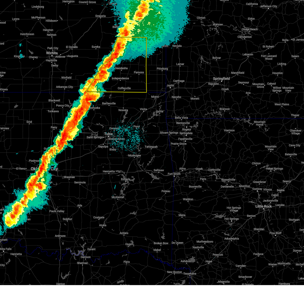
 At 956 am cst, a severe thunderstorm was located near neodesha, moving northeast at 60 mph (radar indicated). Hazards include 70 mph wind gusts. Expect considerable tree damage. damage is likely to mobile homes, roofs, and outbuildings. locations impacted include, parsons, independence, chanute, neodesha, cherryvale, erie, st. Paul, la harpe, moran, thayer, altoona, elk city, galesburg, liberty, bolton, sycamore, savonburg, elsmore, stark, and earlton. At 956 am cst, a severe thunderstorm was located near neodesha, moving northeast at 60 mph (radar indicated). Hazards include 70 mph wind gusts. Expect considerable tree damage. damage is likely to mobile homes, roofs, and outbuildings. locations impacted include, parsons, independence, chanute, neodesha, cherryvale, erie, st. Paul, la harpe, moran, thayer, altoona, elk city, galesburg, liberty, bolton, sycamore, savonburg, elsmore, stark, and earlton.
|
| 1/8/2026 9:43 AM CST |
 Svrict the national weather service in wichita has issued a * severe thunderstorm warning for, southeastern wilson county in southeastern kansas, northwestern labette county in southeastern kansas, neosho county in southeastern kansas, montgomery county in southeastern kansas, eastern allen county in southeastern kansas, * until 1045 am cst. * at 942 am cst, a severe thunderstorm was located over independence, moving northeast at 65 mph (emergency management reported power poles down in independence). Hazards include 70 mph wind gusts. Expect considerable tree damage. Damage is likely to mobile homes, roofs, and outbuildings. Svrict the national weather service in wichita has issued a * severe thunderstorm warning for, southeastern wilson county in southeastern kansas, northwestern labette county in southeastern kansas, neosho county in southeastern kansas, montgomery county in southeastern kansas, eastern allen county in southeastern kansas, * until 1045 am cst. * at 942 am cst, a severe thunderstorm was located over independence, moving northeast at 65 mph (emergency management reported power poles down in independence). Hazards include 70 mph wind gusts. Expect considerable tree damage. Damage is likely to mobile homes, roofs, and outbuildings.
|
| 7/30/2025 10:14 PM CDT |
 Svrict the national weather service in wichita has issued a * severe thunderstorm warning for, elk county in southeastern kansas, southwestern wilson county in southeastern kansas, eastern cowley county in south central kansas, northern montgomery county in southeastern kansas, southeastern butler county in south central kansas, chautauqua county in southeastern kansas, * until 1100 pm cdt. * at 1013 pm cdt, severe thunderstorms were located along a line extending from near longton to 5 miles south of grenola to 6 miles southwest of cedar vale, moving southeast at 25 mph (radar indicated). Hazards include 60 mph wind gusts and quarter size hail. Hail damage to vehicles is expected. Expect wind damage to roofs, siding, and trees. Svrict the national weather service in wichita has issued a * severe thunderstorm warning for, elk county in southeastern kansas, southwestern wilson county in southeastern kansas, eastern cowley county in south central kansas, northern montgomery county in southeastern kansas, southeastern butler county in south central kansas, chautauqua county in southeastern kansas, * until 1100 pm cdt. * at 1013 pm cdt, severe thunderstorms were located along a line extending from near longton to 5 miles south of grenola to 6 miles southwest of cedar vale, moving southeast at 25 mph (radar indicated). Hazards include 60 mph wind gusts and quarter size hail. Hail damage to vehicles is expected. Expect wind damage to roofs, siding, and trees.
|
| 6/29/2025 8:24 PM CDT |
 Svrict the national weather service in wichita has issued a * severe thunderstorm warning for, elk county in southeastern kansas, southwestern wilson county in southeastern kansas, cowley county in south central kansas, montgomery county in southeastern kansas, northeastern sumner county in south central kansas, chautauqua county in southeastern kansas, southeastern greenwood county in southeastern kansas, * until 915 pm cdt. * at 822 pm cdt, severe thunderstorms were located along a line extending from near fall river to near moline to near udall, moving southeast at 40 mph (radar indicated). Hazards include 60 mph wind gusts and quarter size hail. Hail damage to vehicles is expected. Expect wind damage to roofs, siding, and trees. Svrict the national weather service in wichita has issued a * severe thunderstorm warning for, elk county in southeastern kansas, southwestern wilson county in southeastern kansas, cowley county in south central kansas, montgomery county in southeastern kansas, northeastern sumner county in south central kansas, chautauqua county in southeastern kansas, southeastern greenwood county in southeastern kansas, * until 915 pm cdt. * at 822 pm cdt, severe thunderstorms were located along a line extending from near fall river to near moline to near udall, moving southeast at 40 mph (radar indicated). Hazards include 60 mph wind gusts and quarter size hail. Hail damage to vehicles is expected. Expect wind damage to roofs, siding, and trees.
|
| 6/18/2025 1:05 AM CDT |
 The storms which prompted the warning have weakened below severe limits, and no longer pose an immediate threat to life or property. therefore, the warning will be allowed to expire. however, gusty winds and heavy rain are still possible with these thunderstorms. a severe thunderstorm watch remains in effect until 400 am cdt for southeastern kansas. The storms which prompted the warning have weakened below severe limits, and no longer pose an immediate threat to life or property. therefore, the warning will be allowed to expire. however, gusty winds and heavy rain are still possible with these thunderstorms. a severe thunderstorm watch remains in effect until 400 am cdt for southeastern kansas.
|
| 6/18/2025 12:46 AM CDT |
 At 1244 am cdt, severe thunderstorms were located along a line extending from 5 miles south of neodesha to near liberty to 5 miles southwest of dearing, moving east at 30 mph (trained spotter reported 70 mph winds in tyro). Hazards include 70 mph wind gusts. Expect considerable tree damage. damage is likely to mobile homes, roofs, and outbuildings. Locations impacted include, coffeyville, independence, neodesha, cherryvale, caney, thayer, dearing, mound valley, elk city, tyro, liberty, bolton, sycamore, lake parsons, parsons tri city airport, angola, dennis, elk city lake, big hill lake, and elk city state park. At 1244 am cdt, severe thunderstorms were located along a line extending from 5 miles south of neodesha to near liberty to 5 miles southwest of dearing, moving east at 30 mph (trained spotter reported 70 mph winds in tyro). Hazards include 70 mph wind gusts. Expect considerable tree damage. damage is likely to mobile homes, roofs, and outbuildings. Locations impacted include, coffeyville, independence, neodesha, cherryvale, caney, thayer, dearing, mound valley, elk city, tyro, liberty, bolton, sycamore, lake parsons, parsons tri city airport, angola, dennis, elk city lake, big hill lake, and elk city state park.
|
| 6/18/2025 12:46 AM CDT |
 the severe thunderstorm warning has been cancelled and is no longer in effect the severe thunderstorm warning has been cancelled and is no longer in effect
|
| 6/18/2025 12:10 AM CDT |
 Svrict the national weather service in wichita has issued a * severe thunderstorm warning for, southeastern elk county in southeastern kansas, southern wilson county in southeastern kansas, western labette county in southeastern kansas, southwestern neosho county in southeastern kansas, montgomery county in southeastern kansas, eastern chautauqua county in southeastern kansas, * until 115 am cdt. * at 1210 am cdt, severe thunderstorms were located along a line extending from longton to 5 miles southwest of elk city to near peru, moving east at 50 mph (radar indicated). Hazards include 60 mph wind gusts. expect damage to roofs, siding, and trees Svrict the national weather service in wichita has issued a * severe thunderstorm warning for, southeastern elk county in southeastern kansas, southern wilson county in southeastern kansas, western labette county in southeastern kansas, southwestern neosho county in southeastern kansas, montgomery county in southeastern kansas, eastern chautauqua county in southeastern kansas, * until 115 am cdt. * at 1210 am cdt, severe thunderstorms were located along a line extending from longton to 5 miles southwest of elk city to near peru, moving east at 50 mph (radar indicated). Hazards include 60 mph wind gusts. expect damage to roofs, siding, and trees
|
| 6/8/2025 4:09 PM CDT | Quarter sized hail reported 4.5 miles N of Neodesha, KS, marble to quarter sized hail reported by the independence daily reporter. |
| 6/8/2025 3:35 PM CDT |
 At 334 pm cdt, severe thunderstorms were located along a line extending from 5 miles southeast of neodesha to 5 miles northeast of sedan, moving southeast at 15 mph (radar indicated). Hazards include 60 mph wind gusts and half dollar size hail. Hail damage to vehicles is expected. expect wind damage to roofs, siding, and trees. Locations impacted include, independence, neodesha, cherryvale, caney, thayer, mound valley, elk city, tyro, peru, liberty, havana, bolton, sycamore, niotaze, parsons tri city airport, dennis, elk city lake, big hill lake, elk city state park, and hale. At 334 pm cdt, severe thunderstorms were located along a line extending from 5 miles southeast of neodesha to 5 miles northeast of sedan, moving southeast at 15 mph (radar indicated). Hazards include 60 mph wind gusts and half dollar size hail. Hail damage to vehicles is expected. expect wind damage to roofs, siding, and trees. Locations impacted include, independence, neodesha, cherryvale, caney, thayer, mound valley, elk city, tyro, peru, liberty, havana, bolton, sycamore, niotaze, parsons tri city airport, dennis, elk city lake, big hill lake, elk city state park, and hale.
|
| 6/8/2025 3:23 PM CDT |
 Svrict the national weather service in wichita has issued a * severe thunderstorm warning for, southeastern elk county in southeastern kansas, southern wilson county in southeastern kansas, northwestern labette county in southeastern kansas, southwestern neosho county in southeastern kansas, montgomery county in southeastern kansas, eastern chautauqua county in southeastern kansas, * until 430 pm cdt. * at 322 pm cdt, severe thunderstorms were located along a line extending from 5 miles southwest of thayer to 8 miles north of peru, moving southeast at 30 mph (radar indicated). Hazards include 60 mph wind gusts and half dollar size hail. Hail damage to vehicles is expected. Expect wind damage to roofs, siding, and trees. Svrict the national weather service in wichita has issued a * severe thunderstorm warning for, southeastern elk county in southeastern kansas, southern wilson county in southeastern kansas, northwestern labette county in southeastern kansas, southwestern neosho county in southeastern kansas, montgomery county in southeastern kansas, eastern chautauqua county in southeastern kansas, * until 430 pm cdt. * at 322 pm cdt, severe thunderstorms were located along a line extending from 5 miles southwest of thayer to 8 miles north of peru, moving southeast at 30 mph (radar indicated). Hazards include 60 mph wind gusts and half dollar size hail. Hail damage to vehicles is expected. Expect wind damage to roofs, siding, and trees.
|
| 5/25/2025 3:07 AM CDT |
 the severe thunderstorm warning has been cancelled and is no longer in effect the severe thunderstorm warning has been cancelled and is no longer in effect
|
| 5/25/2025 2:52 AM CDT |
 At 251 am cdt, severe thunderstorms were located along a line extending from 6 miles west of buffalo to near neodesha, moving east at 35 mph (radar indicated). Hazards include quarter size hail. Damage to vehicles is expected. Locations impacted include, chanute, neodesha, fredonia, thayer, altoona, buffalo, galesburg, benedict, earlton, coyville, lake parsons, petrolia, rose, chanute airport, and toronto lake. At 251 am cdt, severe thunderstorms were located along a line extending from 6 miles west of buffalo to near neodesha, moving east at 35 mph (radar indicated). Hazards include quarter size hail. Damage to vehicles is expected. Locations impacted include, chanute, neodesha, fredonia, thayer, altoona, buffalo, galesburg, benedict, earlton, coyville, lake parsons, petrolia, rose, chanute airport, and toronto lake.
|
| 5/25/2025 2:41 AM CDT |
 Svrict the national weather service in wichita has issued a * severe thunderstorm warning for, wilson county in southeastern kansas, western neosho county in southeastern kansas, southern woodson county in southeastern kansas, southwestern allen county in southeastern kansas, * until 345 am cdt. * at 241 am cdt, severe thunderstorms were located along a line extending from 8 miles northeast of fall river to 6 miles west of neodesha, moving northeast at 35 mph (radar indicated). Hazards include ping pong ball size hail. People and animals outdoors will be injured. Expect damage to roofs, siding, windows, and vehicles. Svrict the national weather service in wichita has issued a * severe thunderstorm warning for, wilson county in southeastern kansas, western neosho county in southeastern kansas, southern woodson county in southeastern kansas, southwestern allen county in southeastern kansas, * until 345 am cdt. * at 241 am cdt, severe thunderstorms were located along a line extending from 8 miles northeast of fall river to 6 miles west of neodesha, moving northeast at 35 mph (radar indicated). Hazards include ping pong ball size hail. People and animals outdoors will be injured. Expect damage to roofs, siding, windows, and vehicles.
|
| 4/2/2025 6:16 AM CDT |
 At 616 am cdt, severe thunderstorms were located along a line extending from near mound city to near uniontown to near thayer to 7 miles east of coffeyville, moving east at 55 mph (radar indicated). Hazards include 60 mph wind gusts and quarter size hail. Hail damage to vehicles is expected. expect wind damage to roofs, siding, and trees. Locations impacted include, elsmore, parsons tri city airport, lake parsons, mound valley, angola, dennis, thayer, erie, elk city lake, tyro, big hill lake, liberty, elk city state park, earlton, edna, chetopa, cherryvale, south mound, parsons, and neodesha. At 616 am cdt, severe thunderstorms were located along a line extending from near mound city to near uniontown to near thayer to 7 miles east of coffeyville, moving east at 55 mph (radar indicated). Hazards include 60 mph wind gusts and quarter size hail. Hail damage to vehicles is expected. expect wind damage to roofs, siding, and trees. Locations impacted include, elsmore, parsons tri city airport, lake parsons, mound valley, angola, dennis, thayer, erie, elk city lake, tyro, big hill lake, liberty, elk city state park, earlton, edna, chetopa, cherryvale, south mound, parsons, and neodesha.
|
| 4/2/2025 6:01 AM CDT |
 the severe thunderstorm warning has been cancelled and is no longer in effect the severe thunderstorm warning has been cancelled and is no longer in effect
|
| 4/2/2025 6:01 AM CDT |
 At 600 am cdt, severe thunderstorms were located along a line extending from near kincaid to 10 miles south of la harpe to 5 miles west of thayer to near dearing, moving east at 25 mph (radar indicated). Hazards include 60 mph wind gusts and quarter size hail. Hail damage to vehicles is expected. expect wind damage to roofs, siding, and trees. Locations impacted include, elsmore, parsons tri city airport, lake parsons, mound valley, angola, dennis, thayer, erie, elk city lake, tyro, big hill lake, altoona, liberty, elk city state park, earlton, mildred, edna, chetopa, cherryvale, and south mound. At 600 am cdt, severe thunderstorms were located along a line extending from near kincaid to 10 miles south of la harpe to 5 miles west of thayer to near dearing, moving east at 25 mph (radar indicated). Hazards include 60 mph wind gusts and quarter size hail. Hail damage to vehicles is expected. expect wind damage to roofs, siding, and trees. Locations impacted include, elsmore, parsons tri city airport, lake parsons, mound valley, angola, dennis, thayer, erie, elk city lake, tyro, big hill lake, altoona, liberty, elk city state park, earlton, mildred, edna, chetopa, cherryvale, and south mound.
|
| 4/2/2025 5:38 AM CDT |
 At 538 am cdt, severe thunderstorms were located along a line extending from near colony to near chanute to 7 miles west of neodesha to near peru, moving east at 40 mph (radar indicated). Hazards include 60 mph wind gusts and quarter size hail. Hail damage to vehicles is expected. expect wind damage to roofs, siding, and trees. Locations impacted include, elsmore, parsons tri city airport, lake parsons, mound valley, angola, buxton, humboldt, erie, elk city lake, tyro, big hill lake, earlton, edna, neodesha, iola, piqua, dearing, petrolia, savonburg, and altamont. At 538 am cdt, severe thunderstorms were located along a line extending from near colony to near chanute to 7 miles west of neodesha to near peru, moving east at 40 mph (radar indicated). Hazards include 60 mph wind gusts and quarter size hail. Hail damage to vehicles is expected. expect wind damage to roofs, siding, and trees. Locations impacted include, elsmore, parsons tri city airport, lake parsons, mound valley, angola, buxton, humboldt, erie, elk city lake, tyro, big hill lake, earlton, edna, neodesha, iola, piqua, dearing, petrolia, savonburg, and altamont.
|
| 4/2/2025 5:14 AM CDT |
 Svrict the national weather service in wichita has issued a * severe thunderstorm warning for, eastern elk county in southeastern kansas, wilson county in southeastern kansas, labette county in southeastern kansas, neosho county in southeastern kansas, montgomery county in southeastern kansas, chautauqua county in southeastern kansas, woodson county in southeastern kansas, allen county in southeastern kansas, * until 645 am cdt. * at 514 am cdt, severe thunderstorms were located along a line extending from 5 miles west of neosho falls to 6 miles west of buffalo to longton to near elgin, moving east at 35 mph (radar indicated). Hazards include 60 mph wind gusts and quarter size hail. Hail damage to vehicles is expected. Expect wind damage to roofs, siding, and trees. Svrict the national weather service in wichita has issued a * severe thunderstorm warning for, eastern elk county in southeastern kansas, wilson county in southeastern kansas, labette county in southeastern kansas, neosho county in southeastern kansas, montgomery county in southeastern kansas, chautauqua county in southeastern kansas, woodson county in southeastern kansas, allen county in southeastern kansas, * until 645 am cdt. * at 514 am cdt, severe thunderstorms were located along a line extending from 5 miles west of neosho falls to 6 miles west of buffalo to longton to near elgin, moving east at 35 mph (radar indicated). Hazards include 60 mph wind gusts and quarter size hail. Hail damage to vehicles is expected. Expect wind damage to roofs, siding, and trees.
|
| 10/30/2024 7:56 PM CDT |
 At 756 pm cdt, severe thunderstorms were located along a line extending from 6 miles north of colony to 5 miles west of thayer, moving northeast at 55 mph (radar indicated). Hazards include 70 mph wind gusts and nickel size hail. Expect considerable tree damage. damage is likely to mobile homes, roofs, and outbuildings. locations impacted include, chanute, iola, neodesha, humboldt, erie, st. Paul, la harpe, gas, moran, thayer, altoona, neosho falls, galesburg, savonburg, elsmore, stark, earlton, mildred, bassett, and lake parsons. At 756 pm cdt, severe thunderstorms were located along a line extending from 6 miles north of colony to 5 miles west of thayer, moving northeast at 55 mph (radar indicated). Hazards include 70 mph wind gusts and nickel size hail. Expect considerable tree damage. damage is likely to mobile homes, roofs, and outbuildings. locations impacted include, chanute, iola, neodesha, humboldt, erie, st. Paul, la harpe, gas, moran, thayer, altoona, neosho falls, galesburg, savonburg, elsmore, stark, earlton, mildred, bassett, and lake parsons.
|
| 10/30/2024 7:51 PM CDT |
 At 750 pm cdt, severe thunderstorms were located along a line extending from 5 miles southeast of westphalia to neodesha, moving east at 40 mph (radar indicated). Hazards include 60 mph wind gusts and nickel size hail. Expect damage to roofs, siding, and trees. locations impacted include, chanute, iola, neodesha, humboldt, yates center, erie, st. Paul, la harpe, gas, moran, thayer, altoona, buffalo, neosho falls, galesburg, savonburg, elsmore, benedict, stark, and earlton. At 750 pm cdt, severe thunderstorms were located along a line extending from 5 miles southeast of westphalia to neodesha, moving east at 40 mph (radar indicated). Hazards include 60 mph wind gusts and nickel size hail. Expect damage to roofs, siding, and trees. locations impacted include, chanute, iola, neodesha, humboldt, yates center, erie, st. Paul, la harpe, gas, moran, thayer, altoona, buffalo, neosho falls, galesburg, savonburg, elsmore, benedict, stark, and earlton.
|
| 10/30/2024 7:41 PM CDT |
 The storms which prompted the warning have moved out of the area. therefore, the warning will be allowed to expire. a tornado watch remains in effect until 1000 pm cdt for southeastern kansas. The storms which prompted the warning have moved out of the area. therefore, the warning will be allowed to expire. a tornado watch remains in effect until 1000 pm cdt for southeastern kansas.
|
| 10/30/2024 7:35 PM CDT |
 Svrict the national weather service in wichita has issued a * severe thunderstorm warning for, eastern wilson county in southeastern kansas, neosho county in southeastern kansas, woodson county in southeastern kansas, allen county in southeastern kansas, * until 830 pm cdt. * at 735 pm cdt, severe thunderstorms were located along a line extending from near le roy to near neodesha, moving northeast at 55 mph (radar indicated). Hazards include 60 mph wind gusts and nickel size hail. expect damage to roofs, siding, and trees Svrict the national weather service in wichita has issued a * severe thunderstorm warning for, eastern wilson county in southeastern kansas, neosho county in southeastern kansas, woodson county in southeastern kansas, allen county in southeastern kansas, * until 830 pm cdt. * at 735 pm cdt, severe thunderstorms were located along a line extending from near le roy to near neodesha, moving northeast at 55 mph (radar indicated). Hazards include 60 mph wind gusts and nickel size hail. expect damage to roofs, siding, and trees
|
| 10/30/2024 7:21 PM CDT |
 At 721 pm cdt, severe thunderstorms were located along a line extending from 7 miles southwest of toronto to 5 miles southeast of fall river to 9 miles southwest of fredonia, moving northeast at 45 mph (trained weather spotters). Hazards include 70 mph wind gusts and quarter size hail. Hail damage to vehicles is expected. expect considerable tree damage. wind damage is also likely to mobile homes, roofs, and outbuildings. Locations impacted include, neodesha, fredonia, toronto, fall river, benedict, new albany, coyville, buxton, batesville, toronto lake, fall river state park, fall river lake, and cross timbers state park. At 721 pm cdt, severe thunderstorms were located along a line extending from 7 miles southwest of toronto to 5 miles southeast of fall river to 9 miles southwest of fredonia, moving northeast at 45 mph (trained weather spotters). Hazards include 70 mph wind gusts and quarter size hail. Hail damage to vehicles is expected. expect considerable tree damage. wind damage is also likely to mobile homes, roofs, and outbuildings. Locations impacted include, neodesha, fredonia, toronto, fall river, benedict, new albany, coyville, buxton, batesville, toronto lake, fall river state park, fall river lake, and cross timbers state park.
|
| 10/30/2024 7:11 PM CDT |
 At 710 pm cdt, severe thunderstorms were located along a line extending from 5 miles northwest of fall river to 12 miles east of howard to near longton, moving northeast at 45 mph (trained weather spotters 60 mph wind gusts 1 mile north of longton at 705 pm). Hazards include 70 mph wind gusts and quarter size hail. Hail damage to vehicles is expected. expect considerable tree damage. wind damage is also likely to mobile homes, roofs, and outbuildings. Locations impacted include, neodesha, fredonia, longton, toronto, severy, fall river, benedict, new albany, coyville, buxton, batesville, toronto lake, fall river state park, fall river lake, and cross timbers state park. At 710 pm cdt, severe thunderstorms were located along a line extending from 5 miles northwest of fall river to 12 miles east of howard to near longton, moving northeast at 45 mph (trained weather spotters 60 mph wind gusts 1 mile north of longton at 705 pm). Hazards include 70 mph wind gusts and quarter size hail. Hail damage to vehicles is expected. expect considerable tree damage. wind damage is also likely to mobile homes, roofs, and outbuildings. Locations impacted include, neodesha, fredonia, longton, toronto, severy, fall river, benedict, new albany, coyville, buxton, batesville, toronto lake, fall river state park, fall river lake, and cross timbers state park.
|
| 10/30/2024 7:03 PM CDT |
 At 702 pm cdt, severe thunderstorms were located along a line extending from near severy to near howard to near elk falls, moving northeast at 45 mph (trained weather spotters reported 60 mph winds at 650 pm). Hazards include 70 mph wind gusts and quarter size hail. Hail damage to vehicles is expected. expect considerable tree damage. wind damage is also likely to mobile homes, roofs, and outbuildings. Locations impacted include, neodesha, fredonia, longton, toronto, severy, fall river, benedict, new albany, coyville, buxton, batesville, toronto lake, fall river state park, fall river lake, and cross timbers state park. At 702 pm cdt, severe thunderstorms were located along a line extending from near severy to near howard to near elk falls, moving northeast at 45 mph (trained weather spotters reported 60 mph winds at 650 pm). Hazards include 70 mph wind gusts and quarter size hail. Hail damage to vehicles is expected. expect considerable tree damage. wind damage is also likely to mobile homes, roofs, and outbuildings. Locations impacted include, neodesha, fredonia, longton, toronto, severy, fall river, benedict, new albany, coyville, buxton, batesville, toronto lake, fall river state park, fall river lake, and cross timbers state park.
|
| 10/30/2024 6:52 PM CDT |
 Svrict the national weather service in wichita has issued a * severe thunderstorm warning for, eastern elk county in southeastern kansas, western wilson county in southeastern kansas, northwestern montgomery county in southeastern kansas, southwestern woodson county in southeastern kansas, southeastern greenwood county in southeastern kansas, * until 745 pm cdt. * at 651 pm cdt, severe thunderstorms were located along a line extending from 6 miles northwest of howard to near moline to 8 miles southwest of elk falls, moving northeast at 45 mph (radar indicated). Hazards include 70 mph wind gusts and quarter size hail. Hail damage to vehicles is expected. expect considerable tree damage. Wind damage is also likely to mobile homes, roofs, and outbuildings. Svrict the national weather service in wichita has issued a * severe thunderstorm warning for, eastern elk county in southeastern kansas, western wilson county in southeastern kansas, northwestern montgomery county in southeastern kansas, southwestern woodson county in southeastern kansas, southeastern greenwood county in southeastern kansas, * until 745 pm cdt. * at 651 pm cdt, severe thunderstorms were located along a line extending from 6 miles northwest of howard to near moline to 8 miles southwest of elk falls, moving northeast at 45 mph (radar indicated). Hazards include 70 mph wind gusts and quarter size hail. Hail damage to vehicles is expected. expect considerable tree damage. Wind damage is also likely to mobile homes, roofs, and outbuildings.
|
| 8/16/2024 6:06 PM CDT |
 Svrict the national weather service in wichita has issued a * severe thunderstorm warning for, eastern wilson county in southeastern kansas, northern labette county in southeastern kansas, neosho county in southeastern kansas, northeastern montgomery county in southeastern kansas, * until 645 pm cdt. * at 606 pm cdt, a severe thunderstorm was located near chanute, moving east at 60 mph (radar indicated). Hazards include 70 mph wind gusts. Expect considerable tree damage. Damage is likely to mobile homes, roofs, and outbuildings. Svrict the national weather service in wichita has issued a * severe thunderstorm warning for, eastern wilson county in southeastern kansas, northern labette county in southeastern kansas, neosho county in southeastern kansas, northeastern montgomery county in southeastern kansas, * until 645 pm cdt. * at 606 pm cdt, a severe thunderstorm was located near chanute, moving east at 60 mph (radar indicated). Hazards include 70 mph wind gusts. Expect considerable tree damage. Damage is likely to mobile homes, roofs, and outbuildings.
|
| 6/29/2024 6:36 PM CDT |
 The storm which prompted the warning has moved out of the area. therefore, the warning will be allowed to expire. however, gusty winds and heavy rain are still possible with this thunderstorm. a severe thunderstorm watch remains in effect until 1100 pm cdt for southeastern kansas. The storm which prompted the warning has moved out of the area. therefore, the warning will be allowed to expire. however, gusty winds and heavy rain are still possible with this thunderstorm. a severe thunderstorm watch remains in effect until 1100 pm cdt for southeastern kansas.
|
| 6/29/2024 6:07 PM CDT |
 At 607 pm cdt, a severe thunderstorm was located over neodesha, moving southeast at 15 mph (radar indicated). Hazards include 70 mph wind gusts and quarter size hail. Hail damage to vehicles is expected. expect considerable tree damage. wind damage is also likely to mobile homes, roofs, and outbuildings. Locations impacted include, neodesha, cherryvale, thayer, altoona, sycamore, parsons tri city airport, lake parsons, dennis, and big hill lake. At 607 pm cdt, a severe thunderstorm was located over neodesha, moving southeast at 15 mph (radar indicated). Hazards include 70 mph wind gusts and quarter size hail. Hail damage to vehicles is expected. expect considerable tree damage. wind damage is also likely to mobile homes, roofs, and outbuildings. Locations impacted include, neodesha, cherryvale, thayer, altoona, sycamore, parsons tri city airport, lake parsons, dennis, and big hill lake.
|
| 6/29/2024 6:02 PM CDT | Quarter sized hail reported 0.4 miles NW of Neodesha, KS, also had 70 mph winds with the hail. |
| 6/29/2024 5:56 PM CDT | Report from mping: 1-inch tree limbs broken; shingles blown of in wilson county KS, 0.9 miles WNW of Neodesha, KS |
| 6/29/2024 5:39 PM CDT |
 At 539 pm cdt, a severe thunderstorm was located near altoona, or near neodesha, moving southeast at 15 mph (radar indicated). Hazards include golf ball size hail and 70 mph wind gusts. People and animals outdoors will be injured. expect hail damage to roofs, siding, windows, and vehicles. expect considerable tree damage. wind damage is also likely to mobile homes, roofs, and outbuildings. Locations impacted include, neodesha, fredonia, cherryvale, thayer, altoona, sycamore, parsons tri city airport, lake parsons, buxton, dennis, and big hill lake. At 539 pm cdt, a severe thunderstorm was located near altoona, or near neodesha, moving southeast at 15 mph (radar indicated). Hazards include golf ball size hail and 70 mph wind gusts. People and animals outdoors will be injured. expect hail damage to roofs, siding, windows, and vehicles. expect considerable tree damage. wind damage is also likely to mobile homes, roofs, and outbuildings. Locations impacted include, neodesha, fredonia, cherryvale, thayer, altoona, sycamore, parsons tri city airport, lake parsons, buxton, dennis, and big hill lake.
|
| 6/29/2024 5:22 PM CDT |
 Svrict the national weather service in wichita has issued a * severe thunderstorm warning for, southern wilson county in southeastern kansas, northwestern labette county in southeastern kansas, southwestern neosho county in southeastern kansas, northern montgomery county in southeastern kansas, * until 645 pm cdt. * at 521 pm cdt, a severe thunderstorm was located over fredonia, moving southeast at 10 mph (radar indicated). Hazards include golf ball size hail and 70 mph wind gusts. People and animals outdoors will be injured. expect hail damage to roofs, siding, windows, and vehicles. expect considerable tree damage. Wind damage is also likely to mobile homes, roofs, and outbuildings. Svrict the national weather service in wichita has issued a * severe thunderstorm warning for, southern wilson county in southeastern kansas, northwestern labette county in southeastern kansas, southwestern neosho county in southeastern kansas, northern montgomery county in southeastern kansas, * until 645 pm cdt. * at 521 pm cdt, a severe thunderstorm was located over fredonia, moving southeast at 10 mph (radar indicated). Hazards include golf ball size hail and 70 mph wind gusts. People and animals outdoors will be injured. expect hail damage to roofs, siding, windows, and vehicles. expect considerable tree damage. Wind damage is also likely to mobile homes, roofs, and outbuildings.
|
| 6/26/2024 5:17 AM CDT |
 The severe portion of the storms which prompted the warning have moved out of the area. therefore, the warning has been allowed to expire. however, gusty winds are still possible with these thunderstorms. a severe thunderstorm warning remains in effect for southern neosho county until 530 am. a severe thunderstorm watch remains in effect until 1100 am cdt for southeastern kansas. The severe portion of the storms which prompted the warning have moved out of the area. therefore, the warning has been allowed to expire. however, gusty winds are still possible with these thunderstorms. a severe thunderstorm warning remains in effect for southern neosho county until 530 am. a severe thunderstorm watch remains in effect until 1100 am cdt for southeastern kansas.
|
| 6/26/2024 5:07 AM CDT |
 At 506 am cdt, severe thunderstorms were located along a line extending from 6 miles north of mccune to near galesburg to near fredonia, moving southeast at 65 mph (radar indicated). Hazards include 70 mph wind gusts. Expect considerable tree damage. damage is likely to mobile homes, roofs, and outbuildings. locations impacted include, chanute, neodesha, fredonia, erie, st. Paul, thayer, altoona, buffalo, galesburg, benedict, stark, new albany, earlton, coyville, lake parsons, chanute airport, and south mound. At 506 am cdt, severe thunderstorms were located along a line extending from 6 miles north of mccune to near galesburg to near fredonia, moving southeast at 65 mph (radar indicated). Hazards include 70 mph wind gusts. Expect considerable tree damage. damage is likely to mobile homes, roofs, and outbuildings. locations impacted include, chanute, neodesha, fredonia, erie, st. Paul, thayer, altoona, buffalo, galesburg, benedict, stark, new albany, earlton, coyville, lake parsons, chanute airport, and south mound.
|
| 6/26/2024 5:07 AM CDT |
 the severe thunderstorm warning has been cancelled and is no longer in effect the severe thunderstorm warning has been cancelled and is no longer in effect
|
| 6/26/2024 4:54 AM CDT |
 At 453 am cdt, severe thunderstorms were located along a line extending from walnut to near erie to near fall river, moving south- southeast at 55 mph (radar indicated). Hazards include 60 mph wind gusts. Expect damage to roofs, siding, and trees. locations impacted include, chanute, iola, eureka, neodesha, fredonia, humboldt, yates center, erie, st. Paul, la harpe, gas, moran, thayer, altoona, toronto, buffalo, fall river, neosho falls, galesburg, and savonburg. At 453 am cdt, severe thunderstorms were located along a line extending from walnut to near erie to near fall river, moving south- southeast at 55 mph (radar indicated). Hazards include 60 mph wind gusts. Expect damage to roofs, siding, and trees. locations impacted include, chanute, iola, eureka, neodesha, fredonia, humboldt, yates center, erie, st. Paul, la harpe, gas, moran, thayer, altoona, toronto, buffalo, fall river, neosho falls, galesburg, and savonburg.
|
| 6/26/2024 4:29 AM CDT |
 At 427 am cdt, severe thunderstorms were located along a line extending from near kincaid to gas to hamilton, moving southeast at 75 mph. in some areas to the west of yates center and altoona, the damaging winds may occur well out ahead of the thunderstorm and rain (radar indicated). Hazards include 70 mph wind gusts. Expect considerable tree damage. damage is likely to mobile homes, roofs, and outbuildings. locations impacted include, chanute, iola, eureka, neodesha, fredonia, humboldt, yates center, erie, madison, st. Paul, la harpe, gas, moran, thayer, altoona, toronto, hamilton, buffalo, fall river, and neosho falls. At 427 am cdt, severe thunderstorms were located along a line extending from near kincaid to gas to hamilton, moving southeast at 75 mph. in some areas to the west of yates center and altoona, the damaging winds may occur well out ahead of the thunderstorm and rain (radar indicated). Hazards include 70 mph wind gusts. Expect considerable tree damage. damage is likely to mobile homes, roofs, and outbuildings. locations impacted include, chanute, iola, eureka, neodesha, fredonia, humboldt, yates center, erie, madison, st. Paul, la harpe, gas, moran, thayer, altoona, toronto, hamilton, buffalo, fall river, and neosho falls.
|
| 6/26/2024 4:11 AM CDT |
 Svrict the national weather service in wichita has issued a * severe thunderstorm warning for, wilson county in southeastern kansas, neosho county in southeastern kansas, woodson county in southeastern kansas, eastern greenwood county in southeastern kansas, allen county in southeastern kansas, * until 515 am cdt. * at 408 am cdt, severe thunderstorms were located along a line extending from near garnett to near westphalia to 5 miles west of olpe, moving southeast at 80 mph. in some areas to the west of yates center and fredonia, the damaging winds may occur well out ahead of the thunderstorm and rain (radar indicated). Hazards include 70 mph wind gusts. Expect considerable tree damage. Damage is likely to mobile homes, roofs, and outbuildings. Svrict the national weather service in wichita has issued a * severe thunderstorm warning for, wilson county in southeastern kansas, neosho county in southeastern kansas, woodson county in southeastern kansas, eastern greenwood county in southeastern kansas, allen county in southeastern kansas, * until 515 am cdt. * at 408 am cdt, severe thunderstorms were located along a line extending from near garnett to near westphalia to 5 miles west of olpe, moving southeast at 80 mph. in some areas to the west of yates center and fredonia, the damaging winds may occur well out ahead of the thunderstorm and rain (radar indicated). Hazards include 70 mph wind gusts. Expect considerable tree damage. Damage is likely to mobile homes, roofs, and outbuildings.
|
| 5/16/2024 12:59 AM CDT |
 Svrict the national weather service in wichita has issued a * severe thunderstorm warning for, southeastern wilson county in southeastern kansas, northern labette county in southeastern kansas, southern neosho county in southeastern kansas, northeastern montgomery county in southeastern kansas, * until 200 am cdt. * at 1258 am cdt, a severe thunderstorm was located near cherryvale, moving east at 35 mph (radar indicated). Hazards include 60 mph wind gusts and quarter size hail. Hail damage to vehicles is expected. Expect wind damage to roofs, siding, and trees. Svrict the national weather service in wichita has issued a * severe thunderstorm warning for, southeastern wilson county in southeastern kansas, northern labette county in southeastern kansas, southern neosho county in southeastern kansas, northeastern montgomery county in southeastern kansas, * until 200 am cdt. * at 1258 am cdt, a severe thunderstorm was located near cherryvale, moving east at 35 mph (radar indicated). Hazards include 60 mph wind gusts and quarter size hail. Hail damage to vehicles is expected. Expect wind damage to roofs, siding, and trees.
|
| 5/6/2024 10:32 PM CDT |
 the severe thunderstorm warning has been cancelled and is no longer in effect the severe thunderstorm warning has been cancelled and is no longer in effect
|
| 5/6/2024 10:32 PM CDT |
 At 1032 pm cdt, severe thunderstorms were located along a line extending from near chanute to near coffeyville, moving northeast at 45 mph (radar indicated). Hazards include 60 mph wind gusts. Expect damage to roofs, siding, and trees. locations impacted include, parsons, coffeyville, independence, chanute, iola, cherryvale, humboldt, oswego, erie, chetopa, altamont, st. Paul, la harpe, gas, moran, thayer, edna, dearing, mound valley, and bronson. At 1032 pm cdt, severe thunderstorms were located along a line extending from near chanute to near coffeyville, moving northeast at 45 mph (radar indicated). Hazards include 60 mph wind gusts. Expect damage to roofs, siding, and trees. locations impacted include, parsons, coffeyville, independence, chanute, iola, cherryvale, humboldt, oswego, erie, chetopa, altamont, st. Paul, la harpe, gas, moran, thayer, edna, dearing, mound valley, and bronson.
|
| 5/6/2024 10:23 PM CDT |
 Svrict the national weather service in wichita has issued a * severe thunderstorm warning for, wilson county in southeastern kansas, labette county in southeastern kansas, neosho county in southeastern kansas, montgomery county in southeastern kansas, eastern woodson county in southeastern kansas, allen county in southeastern kansas, * until 1145 pm cdt. * at 1022 pm cdt, severe thunderstorms were located along a line extending from near buffalo to near liberty, moving northeast at 65 mph (radar indicated). Hazards include 60 mph wind gusts. expect damage to roofs, siding, and trees Svrict the national weather service in wichita has issued a * severe thunderstorm warning for, wilson county in southeastern kansas, labette county in southeastern kansas, neosho county in southeastern kansas, montgomery county in southeastern kansas, eastern woodson county in southeastern kansas, allen county in southeastern kansas, * until 1145 pm cdt. * at 1022 pm cdt, severe thunderstorms were located along a line extending from near buffalo to near liberty, moving northeast at 65 mph (radar indicated). Hazards include 60 mph wind gusts. expect damage to roofs, siding, and trees
|
| 5/6/2024 9:58 PM CDT |
 At 957 pm cdt, severe thunderstorms were located along a line extending from near iola to caney, moving northeast at 60 mph. 70mph winds were reported near elk city kansas (emergency management). Hazards include 70 mph wind gusts and nickel size hail. Expect considerable tree damage. damage is likely to mobile homes, roofs, and outbuildings. Locations impacted include, coffeyville, independence, chanute, iola, neodesha, fredonia, cherryvale, caney, humboldt, yates center, la harpe, gas, thayer, dearing, altoona, elk city, buffalo, tyro, neosho falls, and peru. At 957 pm cdt, severe thunderstorms were located along a line extending from near iola to caney, moving northeast at 60 mph. 70mph winds were reported near elk city kansas (emergency management). Hazards include 70 mph wind gusts and nickel size hail. Expect considerable tree damage. damage is likely to mobile homes, roofs, and outbuildings. Locations impacted include, coffeyville, independence, chanute, iola, neodesha, fredonia, cherryvale, caney, humboldt, yates center, la harpe, gas, thayer, dearing, altoona, elk city, buffalo, tyro, neosho falls, and peru.
|
| 5/6/2024 9:34 PM CDT |
 At 933 pm cdt, severe thunderstorms were located along a line extending from near yates center to 5 miles northwest of hulah, moving north at 60 mph (emergency management). Hazards include 70 mph wind gusts and nickel size hail. Expect considerable tree damage. damage is likely to mobile homes, roofs, and outbuildings. Locations impacted include, coffeyville, independence, chanute, iola, neodesha, fredonia, cherryvale, caney, humboldt, yates center, la harpe, gas, thayer, dearing, altoona, elk city, buffalo, tyro, neosho falls, and peru. At 933 pm cdt, severe thunderstorms were located along a line extending from near yates center to 5 miles northwest of hulah, moving north at 60 mph (emergency management). Hazards include 70 mph wind gusts and nickel size hail. Expect considerable tree damage. damage is likely to mobile homes, roofs, and outbuildings. Locations impacted include, coffeyville, independence, chanute, iola, neodesha, fredonia, cherryvale, caney, humboldt, yates center, la harpe, gas, thayer, dearing, altoona, elk city, buffalo, tyro, neosho falls, and peru.
|
| 5/6/2024 9:10 PM CDT |
 Svrict the national weather service in wichita has issued a * severe thunderstorm warning for, southeastern elk county in southeastern kansas, wilson county in southeastern kansas, northwestern labette county in southeastern kansas, western neosho county in southeastern kansas, montgomery county in southeastern kansas, eastern chautauqua county in southeastern kansas, eastern woodson county in southeastern kansas, allen county in southeastern kansas, * until 1030 pm cdt. * at 910 pm cdt, severe thunderstorms were located along a line extending from 7 miles north of yates center to chautauqua, moving east at 30 mph (radar indicated). Hazards include 70 mph wind gusts and nickel size hail. Expect considerable tree damage. Damage is likely to mobile homes, roofs, and outbuildings. Svrict the national weather service in wichita has issued a * severe thunderstorm warning for, southeastern elk county in southeastern kansas, wilson county in southeastern kansas, northwestern labette county in southeastern kansas, western neosho county in southeastern kansas, montgomery county in southeastern kansas, eastern chautauqua county in southeastern kansas, eastern woodson county in southeastern kansas, allen county in southeastern kansas, * until 1030 pm cdt. * at 910 pm cdt, severe thunderstorms were located along a line extending from 7 miles north of yates center to chautauqua, moving east at 30 mph (radar indicated). Hazards include 70 mph wind gusts and nickel size hail. Expect considerable tree damage. Damage is likely to mobile homes, roofs, and outbuildings.
|
| 4/30/2024 9:38 PM CDT |
 the severe thunderstorm warning has been cancelled and is no longer in effect the severe thunderstorm warning has been cancelled and is no longer in effect
|
| 4/30/2024 9:22 PM CDT |
 At 922 pm cdt, a severe thunderstorm was located 8 miles northeast of cherryvale, moving east at 35 mph (radar indicated). Hazards include 60 mph wind gusts and quarter size hail. Hail damage to vehicles is expected. expect wind damage to roofs, siding, and trees. Locations impacted include, neodesha, cherryvale, mound valley, sycamore, parsons tri city airport, lake parsons, dennis, and big hill lake. At 922 pm cdt, a severe thunderstorm was located 8 miles northeast of cherryvale, moving east at 35 mph (radar indicated). Hazards include 60 mph wind gusts and quarter size hail. Hail damage to vehicles is expected. expect wind damage to roofs, siding, and trees. Locations impacted include, neodesha, cherryvale, mound valley, sycamore, parsons tri city airport, lake parsons, dennis, and big hill lake.
|
| 4/30/2024 9:05 PM CDT |
 At 905 pm cdt, a severe thunderstorm was located over neodesha, moving southeast at 20 mph (radar indicated). Hazards include 60 mph wind gusts and quarter size hail. Hail damage to vehicles is expected. expect wind damage to roofs, siding, and trees. Locations impacted include, neodesha, cherryvale, thayer, altoona, mound valley, galesburg, sycamore, parsons tri city airport, lake parsons, dennis, and big hill lake. At 905 pm cdt, a severe thunderstorm was located over neodesha, moving southeast at 20 mph (radar indicated). Hazards include 60 mph wind gusts and quarter size hail. Hail damage to vehicles is expected. expect wind damage to roofs, siding, and trees. Locations impacted include, neodesha, cherryvale, thayer, altoona, mound valley, galesburg, sycamore, parsons tri city airport, lake parsons, dennis, and big hill lake.
|
| 4/30/2024 8:52 PM CDT |
 Svrict the national weather service in wichita has issued a * severe thunderstorm warning for, southern wilson county in southeastern kansas, northwestern labette county in southeastern kansas, southwestern neosho county in southeastern kansas, northeastern montgomery county in southeastern kansas, * until 1000 pm cdt. * at 852 pm cdt, a severe thunderstorm was located near neodesha, moving east at 30 mph (radar indicated). Hazards include 60 mph wind gusts and quarter size hail. Hail damage to vehicles is expected. Expect wind damage to roofs, siding, and trees. Svrict the national weather service in wichita has issued a * severe thunderstorm warning for, southern wilson county in southeastern kansas, northwestern labette county in southeastern kansas, southwestern neosho county in southeastern kansas, northeastern montgomery county in southeastern kansas, * until 1000 pm cdt. * at 852 pm cdt, a severe thunderstorm was located near neodesha, moving east at 30 mph (radar indicated). Hazards include 60 mph wind gusts and quarter size hail. Hail damage to vehicles is expected. Expect wind damage to roofs, siding, and trees.
|
| 4/27/2024 10:28 PM CDT |
 The storm which prompted the warning has weakened below severe limits, and no longer appears capable of producing a tornado. therefore, the warning will be allowed to expire. however, gusty winds and heavy rain are still possible with this thunderstorm. a tornado watch remains in effect until midnight cdt for southeastern kansas. remember, a severe thunderstorm warning still remains in effect for northwest neosho county untile 1130 pm cdt. The storm which prompted the warning has weakened below severe limits, and no longer appears capable of producing a tornado. therefore, the warning will be allowed to expire. however, gusty winds and heavy rain are still possible with this thunderstorm. a tornado watch remains in effect until midnight cdt for southeastern kansas. remember, a severe thunderstorm warning still remains in effect for northwest neosho county untile 1130 pm cdt.
|
| 4/27/2024 10:25 PM CDT |
 Svrict the national weather service in wichita has issued a * severe thunderstorm warning for, wilson county in southeastern kansas, western neosho county in southeastern kansas, eastern woodson county in southeastern kansas, allen county in southeastern kansas, * until 1130 pm cdt. * at 1025 pm cdt, a severe thunderstorm was located near altoona, or 10 miles southwest of chanute, moving northeast at 35 mph (radar indicated). Hazards include 60 mph wind gusts and quarter size hail. Hail damage to vehicles is expected. Expect wind damage to roofs, siding, and trees. Svrict the national weather service in wichita has issued a * severe thunderstorm warning for, wilson county in southeastern kansas, western neosho county in southeastern kansas, eastern woodson county in southeastern kansas, allen county in southeastern kansas, * until 1130 pm cdt. * at 1025 pm cdt, a severe thunderstorm was located near altoona, or 10 miles southwest of chanute, moving northeast at 35 mph (radar indicated). Hazards include 60 mph wind gusts and quarter size hail. Hail damage to vehicles is expected. Expect wind damage to roofs, siding, and trees.
|
| 4/27/2024 9:53 PM CDT |
 At 952 pm cdt, a confirmed tornado was located 6 miles south of fredonia, moving northeast at 30 mph (weather spotters confirmed a tornado on the ground 2 miles east of buxton). Hazards include damaging tornado and half dollar size hail. Flying debris will be dangerous to those caught without shelter. mobile homes will be damaged or destroyed. damage to roofs, windows, and vehicles will occur. tree damage is likely. this tornado will be near, neodesha around 1000 pm cdt. altoona around 1005 pm cdt. Other locations impacted by this tornadic thunderstorm include buxton. At 952 pm cdt, a confirmed tornado was located 6 miles south of fredonia, moving northeast at 30 mph (weather spotters confirmed a tornado on the ground 2 miles east of buxton). Hazards include damaging tornado and half dollar size hail. Flying debris will be dangerous to those caught without shelter. mobile homes will be damaged or destroyed. damage to roofs, windows, and vehicles will occur. tree damage is likely. this tornado will be near, neodesha around 1000 pm cdt. altoona around 1005 pm cdt. Other locations impacted by this tornadic thunderstorm include buxton.
|
| 4/27/2024 9:46 PM CDT |
 Torict the national weather service in wichita has issued a * tornado warning for, southern wilson county in southeastern kansas, * until 1015 pm cdt. * at 945 pm cdt, a severe thunderstorm capable of producing a tornado was located 8 miles southwest of fredonia, moving northeast at 30 mph (radar indicated rotation). Hazards include tornado and half dollar size hail. Flying debris will be dangerous to those caught without shelter. mobile homes will be damaged or destroyed. damage to roofs, windows, and vehicles will occur. tree damage is likely. this dangerous storm will be near, neodesha around 1000 pm cdt. altoona around 1005 pm cdt. Other locations impacted by this tornadic thunderstorm include buxton. Torict the national weather service in wichita has issued a * tornado warning for, southern wilson county in southeastern kansas, * until 1015 pm cdt. * at 945 pm cdt, a severe thunderstorm capable of producing a tornado was located 8 miles southwest of fredonia, moving northeast at 30 mph (radar indicated rotation). Hazards include tornado and half dollar size hail. Flying debris will be dangerous to those caught without shelter. mobile homes will be damaged or destroyed. damage to roofs, windows, and vehicles will occur. tree damage is likely. this dangerous storm will be near, neodesha around 1000 pm cdt. altoona around 1005 pm cdt. Other locations impacted by this tornadic thunderstorm include buxton.
|
| 4/27/2024 9:37 PM CDT |
 Torict the national weather service in wichita has issued a * tornado warning for, southeastern wilson county in southeastern kansas, western neosho county in southeastern kansas, * until 1030 pm cdt. * at 936 pm cdt, a confirmed tornado was located near altoona, or 6 miles north of neodesha, moving northeast at 30 mph (weather spotters confirmed tornado). Hazards include damaging tornado and golf ball size hail. Flying debris will be dangerous to those caught without shelter. mobile homes will be damaged or destroyed. damage to roofs, windows, and vehicles will occur. tree damage is likely. the tornado will be near, altoona around 940 pm cdt. thayer around 950 pm cdt. Other locations impacted by this tornadic thunderstorm include earlton and lake parsons. Torict the national weather service in wichita has issued a * tornado warning for, southeastern wilson county in southeastern kansas, western neosho county in southeastern kansas, * until 1030 pm cdt. * at 936 pm cdt, a confirmed tornado was located near altoona, or 6 miles north of neodesha, moving northeast at 30 mph (weather spotters confirmed tornado). Hazards include damaging tornado and golf ball size hail. Flying debris will be dangerous to those caught without shelter. mobile homes will be damaged or destroyed. damage to roofs, windows, and vehicles will occur. tree damage is likely. the tornado will be near, altoona around 940 pm cdt. thayer around 950 pm cdt. Other locations impacted by this tornadic thunderstorm include earlton and lake parsons.
|
| 4/27/2024 9:33 PM CDT |
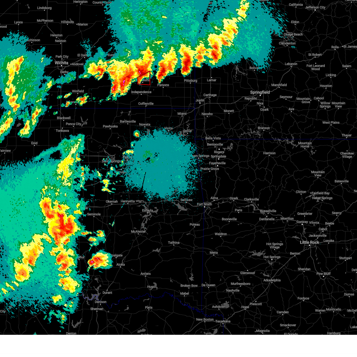 At 932 pm cdt, a confirmed tornado was located 5 miles north of neodesha, moving northeast at 50 mph (weather spotters confirmed tornado). Hazards include damaging tornado and golf ball size hail. Flying debris will be dangerous to those caught without shelter. mobile homes will be damaged or destroyed. damage to roofs, windows, and vehicles will occur. tree damage is likely. Locations impacted include, neodesha and altoona. At 932 pm cdt, a confirmed tornado was located 5 miles north of neodesha, moving northeast at 50 mph (weather spotters confirmed tornado). Hazards include damaging tornado and golf ball size hail. Flying debris will be dangerous to those caught without shelter. mobile homes will be damaged or destroyed. damage to roofs, windows, and vehicles will occur. tree damage is likely. Locations impacted include, neodesha and altoona.
|
| 4/27/2024 9:27 PM CDT |
 Svrict the national weather service in wichita has issued a * severe thunderstorm warning for, wilson county in southeastern kansas, * until 1030 pm cdt. * at 927 pm cdt, a severe thunderstorm was located 7 miles west of fredonia, moving northeast at 55 mph (radar indicated). Hazards include 60 mph wind gusts and quarter size hail. Hail damage to vehicles is expected. Expect wind damage to roofs, siding, and trees. Svrict the national weather service in wichita has issued a * severe thunderstorm warning for, wilson county in southeastern kansas, * until 1030 pm cdt. * at 927 pm cdt, a severe thunderstorm was located 7 miles west of fredonia, moving northeast at 55 mph (radar indicated). Hazards include 60 mph wind gusts and quarter size hail. Hail damage to vehicles is expected. Expect wind damage to roofs, siding, and trees.
|
| 4/27/2024 9:18 PM CDT |
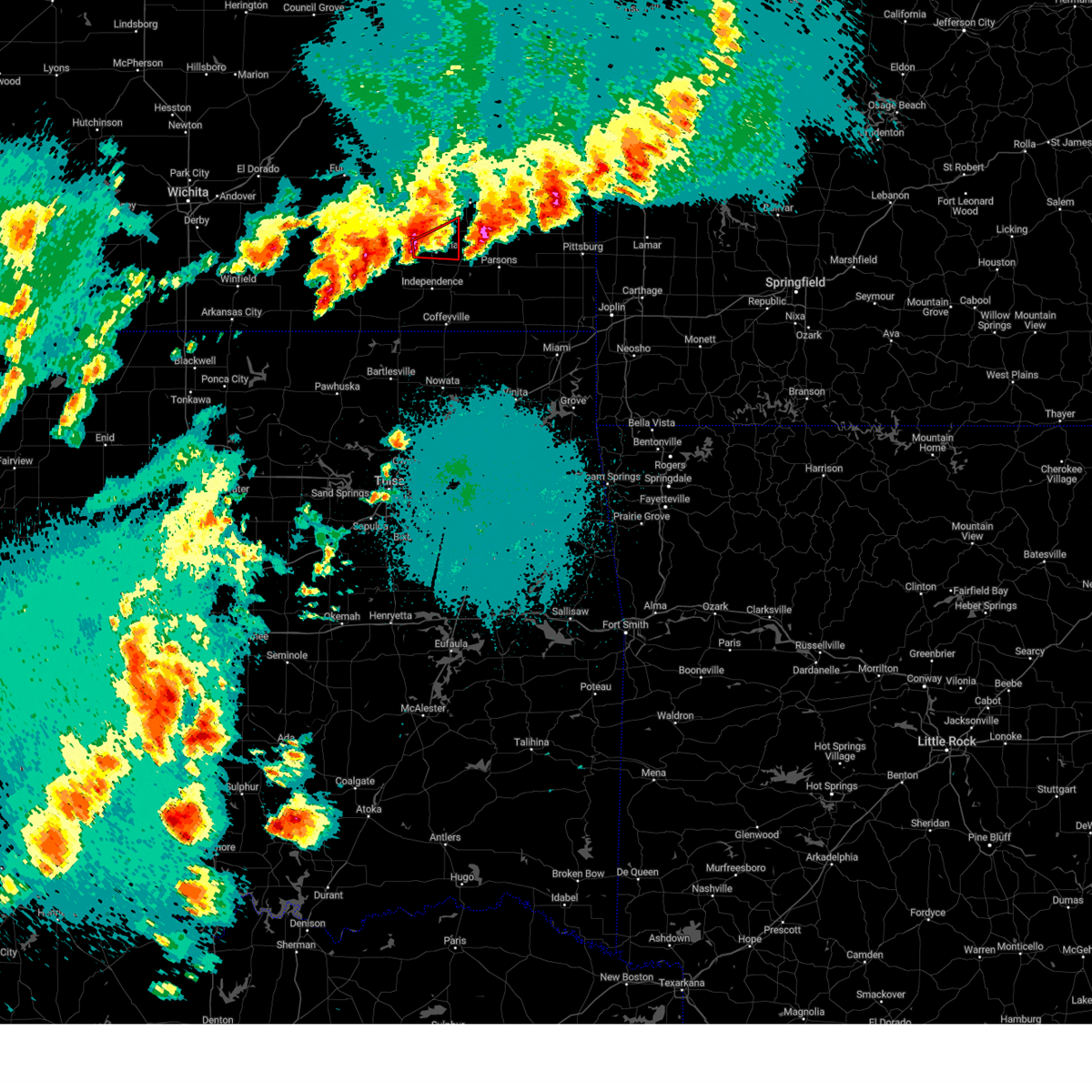 Torict the national weather service in wichita has issued a * tornado warning for, southeastern wilson county in southeastern kansas, * until 945 pm cdt. * at 918 pm cdt, a severe thunderstorm capable of producing a tornado was located over neodesha, moving east at 50 mph (radar indicated rotation). Hazards include tornado and golf ball size hail. Flying debris will be dangerous to those caught without shelter. mobile homes will be damaged or destroyed. damage to roofs, windows, and vehicles will occur. tree damage is likely. This tornadic thunderstorm will remain over mainly rural areas of southeastern wilson county. Torict the national weather service in wichita has issued a * tornado warning for, southeastern wilson county in southeastern kansas, * until 945 pm cdt. * at 918 pm cdt, a severe thunderstorm capable of producing a tornado was located over neodesha, moving east at 50 mph (radar indicated rotation). Hazards include tornado and golf ball size hail. Flying debris will be dangerous to those caught without shelter. mobile homes will be damaged or destroyed. damage to roofs, windows, and vehicles will occur. tree damage is likely. This tornadic thunderstorm will remain over mainly rural areas of southeastern wilson county.
|
| 4/27/2024 8:41 PM CDT |
 Torict the national weather service in wichita has issued a * tornado warning for, southeastern wilson county in southeastern kansas, northwestern labette county in southeastern kansas, southwestern neosho county in southeastern kansas, * until 915 pm cdt. * at 840 pm cdt, a severe thunderstorm capable of producing a tornado was located near cherryvale, moving northeast at 35 mph (radar indicated rotation). Hazards include tornado and golf ball size hail. Flying debris will be dangerous to those caught without shelter. mobile homes will be damaged or destroyed. damage to roofs, windows, and vehicles will occur. tree damage is likely. this dangerous storm will be near, galesburg around 905 pm cdt. Other locations impacted by this tornadic thunderstorm include parsons tri city airport, lake parsons, big hill lake, and dennis. Torict the national weather service in wichita has issued a * tornado warning for, southeastern wilson county in southeastern kansas, northwestern labette county in southeastern kansas, southwestern neosho county in southeastern kansas, * until 915 pm cdt. * at 840 pm cdt, a severe thunderstorm capable of producing a tornado was located near cherryvale, moving northeast at 35 mph (radar indicated rotation). Hazards include tornado and golf ball size hail. Flying debris will be dangerous to those caught without shelter. mobile homes will be damaged or destroyed. damage to roofs, windows, and vehicles will occur. tree damage is likely. this dangerous storm will be near, galesburg around 905 pm cdt. Other locations impacted by this tornadic thunderstorm include parsons tri city airport, lake parsons, big hill lake, and dennis.
|
| 4/27/2024 8:26 PM CDT |
 Svrict the national weather service in wichita has issued a * severe thunderstorm warning for, eastern wilson county in southeastern kansas, neosho county in southeastern kansas, * until 930 pm cdt. * at 826 pm cdt, a severe thunderstorm was located over neodesha, moving northeast at 30 mph (radar indicated). Hazards include 60 mph wind gusts and quarter size hail. Hail damage to vehicles is expected. Expect wind damage to roofs, siding, and trees. Svrict the national weather service in wichita has issued a * severe thunderstorm warning for, eastern wilson county in southeastern kansas, neosho county in southeastern kansas, * until 930 pm cdt. * at 826 pm cdt, a severe thunderstorm was located over neodesha, moving northeast at 30 mph (radar indicated). Hazards include 60 mph wind gusts and quarter size hail. Hail damage to vehicles is expected. Expect wind damage to roofs, siding, and trees.
|
| 4/27/2024 8:14 PM CDT | Quarter sized hail reported 0.4 miles NW of Neodesha, KS |
| 4/27/2024 7:43 PM CDT |
 Svrict the national weather service in wichita has issued a * severe thunderstorm warning for, southeastern wilson county in southeastern kansas, neosho county in southeastern kansas, * until 845 pm cdt. * at 743 pm cdt, a severe thunderstorm was located near neodesha, moving northeast at 40 mph (radar indicated). Hazards include 60 mph wind gusts and half dollar size hail. Hail damage to vehicles is expected. Expect wind damage to roofs, siding, and trees. Svrict the national weather service in wichita has issued a * severe thunderstorm warning for, southeastern wilson county in southeastern kansas, neosho county in southeastern kansas, * until 845 pm cdt. * at 743 pm cdt, a severe thunderstorm was located near neodesha, moving northeast at 40 mph (radar indicated). Hazards include 60 mph wind gusts and half dollar size hail. Hail damage to vehicles is expected. Expect wind damage to roofs, siding, and trees.
|
| 4/27/2024 7:41 PM CDT | Quarter sized hail reported 0.4 miles NW of Neodesha, KS |
| 4/27/2024 7:14 PM CDT |
 At 713 pm cdt, a severe thunderstorm was located over elk city, or 11 miles west of independence, moving northeast at 35 mph (radar indicated). Hazards include 60 mph wind gusts and quarter size hail. Hail damage to vehicles is expected. expect wind damage to roofs, siding, and trees. Locations impacted include, independence, neodesha, altoona, elk city, havana, bolton, sycamore, elk city lake, and elk city state park. At 713 pm cdt, a severe thunderstorm was located over elk city, or 11 miles west of independence, moving northeast at 35 mph (radar indicated). Hazards include 60 mph wind gusts and quarter size hail. Hail damage to vehicles is expected. expect wind damage to roofs, siding, and trees. Locations impacted include, independence, neodesha, altoona, elk city, havana, bolton, sycamore, elk city lake, and elk city state park.
|
| 4/27/2024 6:50 PM CDT |
 Svrict the national weather service in wichita has issued a * severe thunderstorm warning for, eastern wilson county in southeastern kansas, northern montgomery county in southeastern kansas, * until 745 pm cdt. * at 650 pm cdt, a severe thunderstorm was located near elk city, or 8 miles northwest of independence, moving northeast at 50 mph (radar indicated). Hazards include 60 mph wind gusts and quarter size hail. Hail damage to vehicles is expected. Expect wind damage to roofs, siding, and trees. Svrict the national weather service in wichita has issued a * severe thunderstorm warning for, eastern wilson county in southeastern kansas, northern montgomery county in southeastern kansas, * until 745 pm cdt. * at 650 pm cdt, a severe thunderstorm was located near elk city, or 8 miles northwest of independence, moving northeast at 50 mph (radar indicated). Hazards include 60 mph wind gusts and quarter size hail. Hail damage to vehicles is expected. Expect wind damage to roofs, siding, and trees.
|
| 8/6/2023 1:12 AM CDT |
 At 112 am cdt, severe thunderstorms were located along a line extending from near iola to near thayer to 6 miles southwest of elk city, moving east at 65 mph (radar indicated). Hazards include 60 mph wind gusts and nickel size hail. expect damage to roofs, siding, and trees At 112 am cdt, severe thunderstorms were located along a line extending from near iola to near thayer to 6 miles southwest of elk city, moving east at 65 mph (radar indicated). Hazards include 60 mph wind gusts and nickel size hail. expect damage to roofs, siding, and trees
|
| 8/6/2023 12:56 AM CDT |
 At 1255 am cdt, severe thunderstorms were located along a line extending from near yates center to 6 miles southwest of fredonia to 6 miles east of dexter, moving east-southeast at 60 mph (radar indicated). Hazards include 60 mph wind gusts and penny size hail. Expect damage to roofs, siding, and trees. locations impacted include, independence, neodesha, fredonia, yates center, sedan, howard, cedar vale, altoona, moline, longton, elk city, toronto, dexter, severy, buffalo, grenola, fall river, peru, chautauqua and elk falls. hail threat, radar indicated max hail size, 0. 75 in wind threat, radar indicated max wind gust, 60 mph. At 1255 am cdt, severe thunderstorms were located along a line extending from near yates center to 6 miles southwest of fredonia to 6 miles east of dexter, moving east-southeast at 60 mph (radar indicated). Hazards include 60 mph wind gusts and penny size hail. Expect damage to roofs, siding, and trees. locations impacted include, independence, neodesha, fredonia, yates center, sedan, howard, cedar vale, altoona, moline, longton, elk city, toronto, dexter, severy, buffalo, grenola, fall river, peru, chautauqua and elk falls. hail threat, radar indicated max hail size, 0. 75 in wind threat, radar indicated max wind gust, 60 mph.
|
| 8/6/2023 12:34 AM CDT |
 At 1233 am cdt, severe thunderstorms were located along a line extending from 7 miles southeast of hamilton to near severy to burden, moving east at 70 mph (radar indicated). Hazards include 70 mph wind gusts and nickel size hail. Expect considerable tree damage. Damage is likely to mobile homes, roofs, and outbuildings. At 1233 am cdt, severe thunderstorms were located along a line extending from 7 miles southeast of hamilton to near severy to burden, moving east at 70 mph (radar indicated). Hazards include 70 mph wind gusts and nickel size hail. Expect considerable tree damage. Damage is likely to mobile homes, roofs, and outbuildings.
|
| 7/14/2023 5:51 PM CDT |
 At 551 pm cdt, severe thunderstorms were located along a line extending from near st. paul to near independence to 6 miles north of grainola, moving southeast at 45 mph (radar indicated). Hazards include 70 mph wind gusts. Expect considerable tree damage. damage is likely to mobile homes, roofs, and outbuildings. locations impacted include, parsons, coffeyville, independence, neodesha, fredonia, cherryvale, caney, oswego, erie, chetopa, sedan, altamont, st. paul, cedar vale, thayer, edna, dearing, altoona, mound valley and elk city. thunderstorm damage threat, considerable hail threat, radar indicated max hail size, <. 75 in wind threat, radar indicated max wind gust, 70 mph. At 551 pm cdt, severe thunderstorms were located along a line extending from near st. paul to near independence to 6 miles north of grainola, moving southeast at 45 mph (radar indicated). Hazards include 70 mph wind gusts. Expect considerable tree damage. damage is likely to mobile homes, roofs, and outbuildings. locations impacted include, parsons, coffeyville, independence, neodesha, fredonia, cherryvale, caney, oswego, erie, chetopa, sedan, altamont, st. paul, cedar vale, thayer, edna, dearing, altoona, mound valley and elk city. thunderstorm damage threat, considerable hail threat, radar indicated max hail size, <. 75 in wind threat, radar indicated max wind gust, 70 mph.
|
| 7/14/2023 5:41 PM CDT |
 At 540 pm cdt, severe thunderstorms were located along a line extending from near erie to near independence to 6 miles north of hardy, moving east at 60 mph (radar indicated). Hazards include 70 mph wind gusts. Expect considerable tree damage. damage is likely to mobile homes, roofs, and outbuildings. locations impacted include, parsons, coffeyville, independence, neodesha, fredonia, cherryvale, caney, oswego, erie, chetopa, sedan, altamont, st. paul, cedar vale, thayer, edna, dearing, altoona, mound valley and elk city. thunderstorm damage threat, considerable hail threat, radar indicated max hail size, <. 75 in wind threat, radar indicated max wind gust, 70 mph. At 540 pm cdt, severe thunderstorms were located along a line extending from near erie to near independence to 6 miles north of hardy, moving east at 60 mph (radar indicated). Hazards include 70 mph wind gusts. Expect considerable tree damage. damage is likely to mobile homes, roofs, and outbuildings. locations impacted include, parsons, coffeyville, independence, neodesha, fredonia, cherryvale, caney, oswego, erie, chetopa, sedan, altamont, st. paul, cedar vale, thayer, edna, dearing, altoona, mound valley and elk city. thunderstorm damage threat, considerable hail threat, radar indicated max hail size, <. 75 in wind threat, radar indicated max wind gust, 70 mph.
|
| 7/14/2023 5:25 PM CDT |
 At 525 pm cdt, severe thunderstorms were located along a line extending from near altoona to 6 miles south of longton to near arkansas city, moving east at 50 mph (radar indicated). Hazards include 70 mph wind gusts. Expect considerable tree damage. Damage is likely to mobile homes, roofs, and outbuildings. At 525 pm cdt, severe thunderstorms were located along a line extending from near altoona to 6 miles south of longton to near arkansas city, moving east at 50 mph (radar indicated). Hazards include 70 mph wind gusts. Expect considerable tree damage. Damage is likely to mobile homes, roofs, and outbuildings.
|
| 7/13/2023 2:53 AM CDT |
 At 253 am cdt, severe thunderstorms were located along a line extending from near pittsburg to near galesburg to near thayer, moving east at 35 mph (radar indicated). Hazards include 60 mph wind gusts and quarter size hail. Hail damage to vehicles is expected. expect wind damage to roofs, siding, and trees. locations impacted include, parsons, independence, neodesha, fredonia, cherryvale, altamont, st. paul, thayer, altoona, mound valley, elk city, galesburg, sycamore, labette, new albany, parsons tri city airport, lake parsons, buxton, dennis and elk city lake. hail threat, radar indicated max hail size, 1. 00 in wind threat, radar indicated max wind gust, 60 mph. At 253 am cdt, severe thunderstorms were located along a line extending from near pittsburg to near galesburg to near thayer, moving east at 35 mph (radar indicated). Hazards include 60 mph wind gusts and quarter size hail. Hail damage to vehicles is expected. expect wind damage to roofs, siding, and trees. locations impacted include, parsons, independence, neodesha, fredonia, cherryvale, altamont, st. paul, thayer, altoona, mound valley, elk city, galesburg, sycamore, labette, new albany, parsons tri city airport, lake parsons, buxton, dennis and elk city lake. hail threat, radar indicated max hail size, 1. 00 in wind threat, radar indicated max wind gust, 60 mph.
|
| 7/13/2023 1:59 AM CDT |
 At 158 am cdt, severe thunderstorms were located along a line extending from near erie to 6 miles southwest of buffalo to near fall river, moving southeast at 35 mph (radar indicated). Hazards include 60 mph wind gusts and quarter size hail. Hail damage to vehicles is expected. Expect wind damage to roofs, siding, and trees. At 158 am cdt, severe thunderstorms were located along a line extending from near erie to 6 miles southwest of buffalo to near fall river, moving southeast at 35 mph (radar indicated). Hazards include 60 mph wind gusts and quarter size hail. Hail damage to vehicles is expected. Expect wind damage to roofs, siding, and trees.
|
| 7/13/2023 1:50 AM CDT |
 At 149 am cdt, severe thunderstorms were located along a line extending from 5 miles south of buffalo to near chanute to st. paul, moving east at 55 mph (radar indicated). Hazards include 60 mph wind gusts and quarter size hail. Hail damage to vehicles is expected. expect wind damage to roofs, siding, and trees. locations impacted include, neodesha, fredonia, altoona, fall river, new albany, coyville, fall river lake, buxton and fall river state park. hail threat, radar indicated max hail size, 1. 00 in wind threat, radar indicated max wind gust, 60 mph. At 149 am cdt, severe thunderstorms were located along a line extending from 5 miles south of buffalo to near chanute to st. paul, moving east at 55 mph (radar indicated). Hazards include 60 mph wind gusts and quarter size hail. Hail damage to vehicles is expected. expect wind damage to roofs, siding, and trees. locations impacted include, neodesha, fredonia, altoona, fall river, new albany, coyville, fall river lake, buxton and fall river state park. hail threat, radar indicated max hail size, 1. 00 in wind threat, radar indicated max wind gust, 60 mph.
|
| 7/13/2023 1:33 AM CDT |
 At 131 am cdt, severe thunderstorms were located along a line extending from 5 miles south of toronto to near buffalo to 6 miles southeast of chanute, moving southeast at 35 mph (radar indicated). Hazards include 60 mph wind gusts and quarter size hail. Hail damage to vehicles is expected. Expect wind damage to roofs, siding, and trees. At 131 am cdt, severe thunderstorms were located along a line extending from 5 miles south of toronto to near buffalo to 6 miles southeast of chanute, moving southeast at 35 mph (radar indicated). Hazards include 60 mph wind gusts and quarter size hail. Hail damage to vehicles is expected. Expect wind damage to roofs, siding, and trees.
|
| 6/3/2023 2:29 PM CDT |
 At 229 pm cdt, severe thunderstorms were located along a line extending from 8 miles north of elk city to 6 miles northeast of havana to coffeyville, moving west at 15 mph (trained weather spotters). Hazards include 60 mph wind gusts and penny size hail. expect damage to roofs, siding, and trees At 229 pm cdt, severe thunderstorms were located along a line extending from 8 miles north of elk city to 6 miles northeast of havana to coffeyville, moving west at 15 mph (trained weather spotters). Hazards include 60 mph wind gusts and penny size hail. expect damage to roofs, siding, and trees
|
| 5/31/2023 12:24 AM CDT |
 At 1224 am cdt, a severe thunderstorm was located near fredonia, moving south at 15 mph (radar indicated). Hazards include 60 mph wind gusts and quarter size hail. Hail damage to vehicles is expected. expect wind damage to roofs, siding, and trees. locations impacted include, fredonia, new albany and buxton. hail threat, radar indicated max hail size, 1. 00 in wind threat, radar indicated max wind gust, 60 mph. At 1224 am cdt, a severe thunderstorm was located near fredonia, moving south at 15 mph (radar indicated). Hazards include 60 mph wind gusts and quarter size hail. Hail damage to vehicles is expected. expect wind damage to roofs, siding, and trees. locations impacted include, fredonia, new albany and buxton. hail threat, radar indicated max hail size, 1. 00 in wind threat, radar indicated max wind gust, 60 mph.
|
| 5/31/2023 12:15 AM CDT |
 At 1215 am cdt, a severe thunderstorm was located over fredonia, moving south at 15 mph (radar indicated). Hazards include 60 mph wind gusts and quarter size hail. Hail damage to vehicles is expected. Expect wind damage to roofs, siding, and trees. At 1215 am cdt, a severe thunderstorm was located over fredonia, moving south at 15 mph (radar indicated). Hazards include 60 mph wind gusts and quarter size hail. Hail damage to vehicles is expected. Expect wind damage to roofs, siding, and trees.
|
| 5/12/2023 11:18 PM CDT |
 At 1118 pm cdt, a severe thunderstorm was located over neodesha, moving east at 20 mph (radar indicated). Hazards include 60 mph wind gusts and quarter size hail. Hail damage to vehicles is expected. Expect wind damage to roofs, siding, and trees. At 1118 pm cdt, a severe thunderstorm was located over neodesha, moving east at 20 mph (radar indicated). Hazards include 60 mph wind gusts and quarter size hail. Hail damage to vehicles is expected. Expect wind damage to roofs, siding, and trees.
|
| 5/12/2023 10:43 PM CDT |
 At 1043 pm cdt, a severe thunderstorm was located over fredonia, moving northeast at 15 mph (radar indicated). Hazards include ping pong ball size hail and 60 mph wind gusts. People and animals outdoors will be injured. expect hail damage to roofs, siding, windows, and vehicles. expect wind damage to roofs, siding, and trees. locations impacted include, neodesha, fredonia, altoona, benedict and buxton. hail threat, radar indicated max hail size, 1. 50 in wind threat, radar indicated max wind gust, 60 mph. At 1043 pm cdt, a severe thunderstorm was located over fredonia, moving northeast at 15 mph (radar indicated). Hazards include ping pong ball size hail and 60 mph wind gusts. People and animals outdoors will be injured. expect hail damage to roofs, siding, windows, and vehicles. expect wind damage to roofs, siding, and trees. locations impacted include, neodesha, fredonia, altoona, benedict and buxton. hail threat, radar indicated max hail size, 1. 50 in wind threat, radar indicated max wind gust, 60 mph.
|
| 5/12/2023 10:16 PM CDT |
 At 1016 pm cdt, a severe thunderstorm was located 8 miles east of longton, or 10 miles southwest of fredonia, moving northeast at 15 mph (radar indicated). Hazards include ping pong ball size hail and 60 mph wind gusts. People and animals outdoors will be injured. expect hail damage to roofs, siding, windows, and vehicles. Expect wind damage to roofs, siding, and trees. At 1016 pm cdt, a severe thunderstorm was located 8 miles east of longton, or 10 miles southwest of fredonia, moving northeast at 15 mph (radar indicated). Hazards include ping pong ball size hail and 60 mph wind gusts. People and animals outdoors will be injured. expect hail damage to roofs, siding, windows, and vehicles. Expect wind damage to roofs, siding, and trees.
|
| 5/9/2023 5:11 PM CDT |
 At 509 pm cdt, severe thunderstorms were located along a line extending from 7 miles west of humboldt to near grenola, moving south at 15 mph. damaging winds are occurring far beyond the area of precipitation, and along the leading gust front (radar indicated). Hazards include 70 mph wind gusts and penny size hail. Expect considerable tree damage. Damage is likely to mobile homes, roofs, and outbuildings. At 509 pm cdt, severe thunderstorms were located along a line extending from 7 miles west of humboldt to near grenola, moving south at 15 mph. damaging winds are occurring far beyond the area of precipitation, and along the leading gust front (radar indicated). Hazards include 70 mph wind gusts and penny size hail. Expect considerable tree damage. Damage is likely to mobile homes, roofs, and outbuildings.
|
| 2/26/2023 11:47 PM CST |
 At 1146 pm cst, severe thunderstorms were located along a line extending from 6 miles west of neosho falls to near buffalo to 7 miles northeast of sedan, moving northeast at 70 mph (radar indicated). Hazards include 60 mph wind gusts. Expect damage to roofs, siding, and trees. locations impacted include, coffeyville, independence, neodesha, fredonia, cherryvale, caney, yates center, sedan, dearing, altoona, longton, elk city, toronto, buffalo, tyro, fall river, neosho falls, peru, liberty and chautauqua. hail threat, radar indicated max hail size, <. 75 in wind threat, radar indicated max wind gust, 60 mph. At 1146 pm cst, severe thunderstorms were located along a line extending from 6 miles west of neosho falls to near buffalo to 7 miles northeast of sedan, moving northeast at 70 mph (radar indicated). Hazards include 60 mph wind gusts. Expect damage to roofs, siding, and trees. locations impacted include, coffeyville, independence, neodesha, fredonia, cherryvale, caney, yates center, sedan, dearing, altoona, longton, elk city, toronto, buffalo, tyro, fall river, neosho falls, peru, liberty and chautauqua. hail threat, radar indicated max hail size, <. 75 in wind threat, radar indicated max wind gust, 60 mph.
|
| 2/26/2023 11:02 PM CST |
 At 1102 pm cst, severe thunderstorms were located along a line extending from 10 miles northwest of eureka to near howard to near cedar vale, moving northeast at 65 mph (radar indicated). Hazards include 60 mph wind gusts. expect damage to roofs, siding, and trees At 1102 pm cst, severe thunderstorms were located along a line extending from 10 miles northwest of eureka to near howard to near cedar vale, moving northeast at 65 mph (radar indicated). Hazards include 60 mph wind gusts. expect damage to roofs, siding, and trees
|
| 10/12/2022 5:52 AM CDT |
 At 551 am cdt, a severe thunderstorm was located 7 miles south of thayer, or 8 miles northeast of cherryvale, moving east at 35 mph (radar indicated). Hazards include 60 mph wind gusts and quarter size hail. Hail damage to vehicles is expected. expect wind damage to roofs, siding, and trees. locations impacted include, parsons, independence, neodesha, cherryvale, erie, st. paul, thayer, mound valley, galesburg, sycamore, labette, parsons tri city airport, lake parsons, dennis, big hill lake, south mound and elk city state park. hail threat, radar indicated max hail size, 1. 00 in wind threat, radar indicated max wind gust, 60 mph. At 551 am cdt, a severe thunderstorm was located 7 miles south of thayer, or 8 miles northeast of cherryvale, moving east at 35 mph (radar indicated). Hazards include 60 mph wind gusts and quarter size hail. Hail damage to vehicles is expected. expect wind damage to roofs, siding, and trees. locations impacted include, parsons, independence, neodesha, cherryvale, erie, st. paul, thayer, mound valley, galesburg, sycamore, labette, parsons tri city airport, lake parsons, dennis, big hill lake, south mound and elk city state park. hail threat, radar indicated max hail size, 1. 00 in wind threat, radar indicated max wind gust, 60 mph.
|
| 10/12/2022 5:28 AM CDT |
 At 527 am cdt, a severe thunderstorm was located near neodesha, moving east at 45 mph (radar indicated). Hazards include 60 mph wind gusts and quarter size hail. Hail damage to vehicles is expected. Expect wind damage to roofs, siding, and trees. At 527 am cdt, a severe thunderstorm was located near neodesha, moving east at 45 mph (radar indicated). Hazards include 60 mph wind gusts and quarter size hail. Hail damage to vehicles is expected. Expect wind damage to roofs, siding, and trees.
|
| 6/1/2022 12:06 AM CDT |
 At 1205 am cdt, severe thunderstorms were located along a line extending from 5 miles south of kincaid to 6 miles north of erie to near fredonia, moving northeast at 35 mph (radar indicated). Hazards include 60 mph wind gusts and penny size hail. Expect damage to roofs, siding, and trees. locations impacted include, chanute, iola, neodesha, fredonia, humboldt, yates center, erie, st. paul, la harpe, gas, moran, thayer, altoona, buffalo, neosho falls, galesburg, savonburg, elsmore, benedict and stark. hail threat, radar indicated max hail size, 0. 75 in wind threat, observed max wind gust, 60 mph. At 1205 am cdt, severe thunderstorms were located along a line extending from 5 miles south of kincaid to 6 miles north of erie to near fredonia, moving northeast at 35 mph (radar indicated). Hazards include 60 mph wind gusts and penny size hail. Expect damage to roofs, siding, and trees. locations impacted include, chanute, iola, neodesha, fredonia, humboldt, yates center, erie, st. paul, la harpe, gas, moran, thayer, altoona, buffalo, neosho falls, galesburg, savonburg, elsmore, benedict and stark. hail threat, radar indicated max hail size, 0. 75 in wind threat, observed max wind gust, 60 mph.
|
| 5/31/2022 11:45 PM CDT |
 At 1144 pm cdt, a severe thunderstorm was located near fall river, or 7 miles northwest of fredonia, moving northeast at 35 mph (radar indicated). Hazards include ping pong ball size hail and 60 mph wind gusts. People and animals outdoors will be injured. expect hail damage to roofs, siding, windows, and vehicles. Expect wind damage to roofs, siding, and trees. At 1144 pm cdt, a severe thunderstorm was located near fall river, or 7 miles northwest of fredonia, moving northeast at 35 mph (radar indicated). Hazards include ping pong ball size hail and 60 mph wind gusts. People and animals outdoors will be injured. expect hail damage to roofs, siding, windows, and vehicles. Expect wind damage to roofs, siding, and trees.
|
| 5/15/2022 12:27 PM CDT |
 At 1227 pm cdt, a severe thunderstorm was located 6 miles southwest of buffalo, or 7 miles northeast of fredonia, moving southeast at 40 mph (radar indicated). Hazards include 60 mph wind gusts and quarter size hail. Hail damage to vehicles is expected. Expect wind damage to roofs, siding, and trees. At 1227 pm cdt, a severe thunderstorm was located 6 miles southwest of buffalo, or 7 miles northeast of fredonia, moving southeast at 40 mph (radar indicated). Hazards include 60 mph wind gusts and quarter size hail. Hail damage to vehicles is expected. Expect wind damage to roofs, siding, and trees.
|
| 4/30/2022 12:02 AM CDT |
 At 1202 am cdt, severe thunderstorms were located along a line extending from neodesha to 5 miles southeast of cedar vale, moving east at 40 mph (radar indicated). Hazards include 60 mph wind gusts and penny size hail. Expect damage to roofs, siding, and trees. locations impacted include, independence, neodesha, caney, sedan, elk city, peru, chautauqua, havana, elgin, bolton, sycamore, niotaze, buxton, elk city lake, elk city state park, hale and independence airport. hail threat, radar indicated max hail size, 0. 75 in wind threat, radar indicated max wind gust, 60 mph. At 1202 am cdt, severe thunderstorms were located along a line extending from neodesha to 5 miles southeast of cedar vale, moving east at 40 mph (radar indicated). Hazards include 60 mph wind gusts and penny size hail. Expect damage to roofs, siding, and trees. locations impacted include, independence, neodesha, caney, sedan, elk city, peru, chautauqua, havana, elgin, bolton, sycamore, niotaze, buxton, elk city lake, elk city state park, hale and independence airport. hail threat, radar indicated max hail size, 0. 75 in wind threat, radar indicated max wind gust, 60 mph.
|
| 4/29/2022 11:39 PM CDT |
 At 1139 pm cdt, severe thunderstorms were located along a line extending from 7 miles northeast of longton to 5 miles northeast of hardy, moving east at 40 mph (radar indicated). Hazards include 60 mph wind gusts and penny size hail. expect damage to roofs, siding, and trees At 1139 pm cdt, severe thunderstorms were located along a line extending from 7 miles northeast of longton to 5 miles northeast of hardy, moving east at 40 mph (radar indicated). Hazards include 60 mph wind gusts and penny size hail. expect damage to roofs, siding, and trees
|
| 12/15/2021 5:46 PM CST | Corrects previous tstm wnd dmg report from neodesha. report from mping: 3-inch tree limbs broken; power poles broke in wilson county KS, 0.4 miles NE of Neodesha, KS |
| 12/15/2021 3:46 PM CST | Report from mping: 3-inch tree limbs broken; power poles broke in wilson county KS, 0.4 miles NE of Neodesha, KS |
| 11/10/2021 7:38 PM CST |
 At 737 pm cst, severe thunderstorms were located along a line extending from 6 miles east of buffalo to near havana, moving east at 40 mph (radar indicated). Hazards include 60 mph wind gusts and nickel size hail. expect damage to roofs, siding, and trees At 737 pm cst, severe thunderstorms were located along a line extending from 6 miles east of buffalo to near havana, moving east at 40 mph (radar indicated). Hazards include 60 mph wind gusts and nickel size hail. expect damage to roofs, siding, and trees
|
| 10/12/2021 6:25 PM CDT |
 At 624 pm cdt, a severe thunderstorm was located near fredonia, moving northeast at 40 mph (radar indicated). Hazards include 60 mph wind gusts and quarter size hail. Hail damage to vehicles is expected. expect wind damage to roofs, siding, and trees. locations impacted include, independence, neodesha, fredonia, cherryvale, altoona, elk city, buffalo, sycamore, benedict, new albany, buxton, elk city lake and elk city state park. hail threat, radar indicated max hail size, 1. 00 in wind threat, radar indicated max wind gust, 60 mph. At 624 pm cdt, a severe thunderstorm was located near fredonia, moving northeast at 40 mph (radar indicated). Hazards include 60 mph wind gusts and quarter size hail. Hail damage to vehicles is expected. expect wind damage to roofs, siding, and trees. locations impacted include, independence, neodesha, fredonia, cherryvale, altoona, elk city, buffalo, sycamore, benedict, new albany, buxton, elk city lake and elk city state park. hail threat, radar indicated max hail size, 1. 00 in wind threat, radar indicated max wind gust, 60 mph.
|
| 10/12/2021 6:11 PM CDT |
 At 610 pm cdt, a severe thunderstorm was located near elk city, or 14 miles southwest of fredonia, moving east at 40 mph (radar indicated). Hazards include 60 mph wind gusts and quarter size hail. Hail damage to vehicles is expected. Expect wind damage to roofs, siding, and trees. At 610 pm cdt, a severe thunderstorm was located near elk city, or 14 miles southwest of fredonia, moving east at 40 mph (radar indicated). Hazards include 60 mph wind gusts and quarter size hail. Hail damage to vehicles is expected. Expect wind damage to roofs, siding, and trees.
|
| 6/25/2021 10:46 PM CDT |
 At 1045 pm cdt, severe thunderstorms were located along a line extending from kincaid to 7 miles north of erie to 5 miles east of neodesha, moving east at 50 mph (radar indicated). Hazards include 60 mph wind gusts and penny size hail. Expect damage to roofs, siding, and trees. locations impacted include, galesburg and st. Paul. At 1045 pm cdt, severe thunderstorms were located along a line extending from kincaid to 7 miles north of erie to 5 miles east of neodesha, moving east at 50 mph (radar indicated). Hazards include 60 mph wind gusts and penny size hail. Expect damage to roofs, siding, and trees. locations impacted include, galesburg and st. Paul.
|
| 6/25/2021 10:22 PM CDT |
 At 1022 pm cdt, severe thunderstorms were located along a line extending from near neosho falls to 7 miles southeast of buffalo to 5 miles north of elk city, moving east at 50 mph (radar indicated). Hazards include 60 mph wind gusts and penny size hail. Expect damage to roofs, siding, and trees. severe thunderstorms will be near, neosho falls around 1025 pm cdt. chanute around 1030 pm cdt. neodesha around 1040 pm cdt. other locations in the path of these severe thunderstorms include erie, thayer, galesburg and st. Paul. At 1022 pm cdt, severe thunderstorms were located along a line extending from near neosho falls to 7 miles southeast of buffalo to 5 miles north of elk city, moving east at 50 mph (radar indicated). Hazards include 60 mph wind gusts and penny size hail. Expect damage to roofs, siding, and trees. severe thunderstorms will be near, neosho falls around 1025 pm cdt. chanute around 1030 pm cdt. neodesha around 1040 pm cdt. other locations in the path of these severe thunderstorms include erie, thayer, galesburg and st. Paul.
|
| 8/29/2020 7:49 AM CDT |
 At 749 am cdt, severe thunderstorms were located along a line extending from 5 miles southwest of chanute to near mound valley to 5 miles west of edna, moving east at 50 mph (radar indicated). Hazards include 60 mph wind gusts and penny size hail. Expect damage to roofs, siding, and trees. locations impacted include, parsons, coffeyville, independence, chanute, neodesha, fredonia, cherryvale, oswego, erie, chetopa, altamont, st. Paul, thayer, edna, dearing, altoona, mound valley, buffalo, tyro and galesburg. At 749 am cdt, severe thunderstorms were located along a line extending from 5 miles southwest of chanute to near mound valley to 5 miles west of edna, moving east at 50 mph (radar indicated). Hazards include 60 mph wind gusts and penny size hail. Expect damage to roofs, siding, and trees. locations impacted include, parsons, coffeyville, independence, chanute, neodesha, fredonia, cherryvale, oswego, erie, chetopa, altamont, st. Paul, thayer, edna, dearing, altoona, mound valley, buffalo, tyro and galesburg.
|
| 8/29/2020 7:30 AM CDT |
 At 730 am cdt, severe thunderstorms were located along a line extending from 6 miles northeast of fredonia to near cherryvale to near south coffeyville, moving east at 65 mph (radar indicated). Hazards include 60 mph wind gusts and penny size hail. expect damage to roofs, siding, and trees At 730 am cdt, severe thunderstorms were located along a line extending from 6 miles northeast of fredonia to near cherryvale to near south coffeyville, moving east at 65 mph (radar indicated). Hazards include 60 mph wind gusts and penny size hail. expect damage to roofs, siding, and trees
|
| 7/20/2020 2:06 PM CDT |
 At 205 pm cdt, a severe thunderstorm was located near neodesha, moving east at 15 mph (radar indicated). Hazards include 60 mph wind gusts and quarter size hail. Hail damage to vehicles is expected. expect wind damage to roofs, siding, and trees. Locations impacted include, neodesha and sycamore. At 205 pm cdt, a severe thunderstorm was located near neodesha, moving east at 15 mph (radar indicated). Hazards include 60 mph wind gusts and quarter size hail. Hail damage to vehicles is expected. expect wind damage to roofs, siding, and trees. Locations impacted include, neodesha and sycamore.
|
| 7/20/2020 1:56 PM CDT |
 At 155 pm cdt, a severe thunderstorm was located over neodesha, moving east at 15 mph (radar indicated). Hazards include 60 mph wind gusts and quarter size hail. Hail damage to vehicles is expected. Expect wind damage to roofs, siding, and trees. At 155 pm cdt, a severe thunderstorm was located over neodesha, moving east at 15 mph (radar indicated). Hazards include 60 mph wind gusts and quarter size hail. Hail damage to vehicles is expected. Expect wind damage to roofs, siding, and trees.
|
| 7/11/2020 7:07 PM CDT |
 At 707 pm cdt, a severe thunderstorm was located 6 miles north of elk city, or 10 miles southwest of fredonia, moving southeast at 25 mph. this is a very dangerous storm (radar indicated). Hazards include three inch hail and 70 mph wind gusts. People and animals outdoors will be severely injured. expect shattered windows, extensive damage to roofs, siding, and vehicles. Locations impacted include, independence, neodesha, fredonia, cherryvale, altoona, longton, elk city, sycamore, hale, buxton, elk city lake and elk city state park. At 707 pm cdt, a severe thunderstorm was located 6 miles north of elk city, or 10 miles southwest of fredonia, moving southeast at 25 mph. this is a very dangerous storm (radar indicated). Hazards include three inch hail and 70 mph wind gusts. People and animals outdoors will be severely injured. expect shattered windows, extensive damage to roofs, siding, and vehicles. Locations impacted include, independence, neodesha, fredonia, cherryvale, altoona, longton, elk city, sycamore, hale, buxton, elk city lake and elk city state park.
|
| 7/11/2020 6:36 PM CDT |
 At 636 pm cdt, a severe thunderstorm was located near fall river, or 8 miles west of fredonia, moving southeast at 25 mph (radar indicated). Hazards include two inch hail and 60 mph wind gusts. People and animals outdoors will be injured. expect hail damage to roofs, siding, windows, and vehicles. expect wind damage to roofs, siding, and trees. Locations impacted include, independence, neodesha, fredonia, cherryvale, altoona, longton, elk city, sycamore, benedict, new albany, coyville, buxton, elk city lake, elk city state park and hale. At 636 pm cdt, a severe thunderstorm was located near fall river, or 8 miles west of fredonia, moving southeast at 25 mph (radar indicated). Hazards include two inch hail and 60 mph wind gusts. People and animals outdoors will be injured. expect hail damage to roofs, siding, windows, and vehicles. expect wind damage to roofs, siding, and trees. Locations impacted include, independence, neodesha, fredonia, cherryvale, altoona, longton, elk city, sycamore, benedict, new albany, coyville, buxton, elk city lake, elk city state park and hale.
|
| 7/11/2020 6:13 PM CDT |
 At 613 pm cdt, a severe thunderstorm was located near fall river, or 15 miles southeast of eureka, moving southeast at 30 mph (radar indicated). Hazards include golf ball size hail and 60 mph wind gusts. People and animals outdoors will be injured. expect hail damage to roofs, siding, windows, and vehicles. Expect wind damage to roofs, siding, and trees. At 613 pm cdt, a severe thunderstorm was located near fall river, or 15 miles southeast of eureka, moving southeast at 30 mph (radar indicated). Hazards include golf ball size hail and 60 mph wind gusts. People and animals outdoors will be injured. expect hail damage to roofs, siding, windows, and vehicles. Expect wind damage to roofs, siding, and trees.
|
| 7/11/2020 6:02 PM CDT |
 At 602 pm cdt, a severe thunderstorm was located near thayer, or 9 miles northeast of neodesha, moving southeast at 35 mph. tennis ball size hail has been reported with this storm. this is a very dangerous storm (trained weather spotters). Hazards include three inch hail and 70 mph wind gusts. People and animals outdoors will be severely injured. expect shattered windows, extensive damage to roofs, siding, and vehicles. Locations impacted include, neodesha, cherryvale, thayer, altoona, galesburg, earlton, lake parsons, parsons tri city airport, dennis and big hill lake. At 602 pm cdt, a severe thunderstorm was located near thayer, or 9 miles northeast of neodesha, moving southeast at 35 mph. tennis ball size hail has been reported with this storm. this is a very dangerous storm (trained weather spotters). Hazards include three inch hail and 70 mph wind gusts. People and animals outdoors will be severely injured. expect shattered windows, extensive damage to roofs, siding, and vehicles. Locations impacted include, neodesha, cherryvale, thayer, altoona, galesburg, earlton, lake parsons, parsons tri city airport, dennis and big hill lake.
|
| 7/11/2020 5:53 PM CDT |
 At 553 pm cdt, a severe thunderstorm was located near altoona, or 9 miles northeast of neodesha, moving southeast at 30 mph (trained weather spotters). Hazards include two inch hail and 60 mph wind gusts. People and animals outdoors will be injured. expect hail damage to roofs, siding, windows, and vehicles. expect wind damage to roofs, siding, and trees. Locations impacted include, neodesha, cherryvale, thayer, altoona, galesburg, earlton, lake parsons, parsons tri city airport, dennis and big hill lake. At 553 pm cdt, a severe thunderstorm was located near altoona, or 9 miles northeast of neodesha, moving southeast at 30 mph (trained weather spotters). Hazards include two inch hail and 60 mph wind gusts. People and animals outdoors will be injured. expect hail damage to roofs, siding, windows, and vehicles. expect wind damage to roofs, siding, and trees. Locations impacted include, neodesha, cherryvale, thayer, altoona, galesburg, earlton, lake parsons, parsons tri city airport, dennis and big hill lake.
|
| 7/11/2020 5:43 PM CDT |
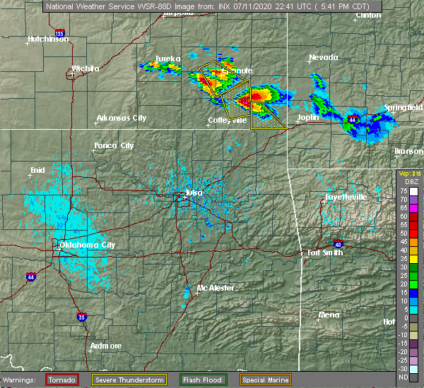 At 543 pm cdt, a severe thunderstorm was located near altoona, or 10 miles east of fredonia, moving southeast at 45 mph (radar indicated). Hazards include ping pong ball size hail and 60 mph wind gusts. People and animals outdoors will be injured. expect hail damage to roofs, siding, windows, and vehicles. Expect wind damage to roofs, siding, and trees. At 543 pm cdt, a severe thunderstorm was located near altoona, or 10 miles east of fredonia, moving southeast at 45 mph (radar indicated). Hazards include ping pong ball size hail and 60 mph wind gusts. People and animals outdoors will be injured. expect hail damage to roofs, siding, windows, and vehicles. Expect wind damage to roofs, siding, and trees.
|
| 5/3/2020 8:30 AM CDT |
 At 829 am cdt, severe thunderstorms were located along a line extending from 6 miles south of blue mound to near erie to near independence, moving east to southeast at 45 mph (radar indicated). Hazards include 70 mph wind gusts and quarter size hail. Hail damage to vehicles is expected. expect considerable tree damage. wind damage is also likely to mobile homes, roofs, and outbuildings. Locations impacted include, coffeyville, independence, chanute, neodesha, cherryvale, caney, erie, la harpe, moran, thayer, dearing, altoona, elk city, tyro, galesburg, liberty, havana, bolton, sycamore and savonburg. At 829 am cdt, severe thunderstorms were located along a line extending from 6 miles south of blue mound to near erie to near independence, moving east to southeast at 45 mph (radar indicated). Hazards include 70 mph wind gusts and quarter size hail. Hail damage to vehicles is expected. expect considerable tree damage. wind damage is also likely to mobile homes, roofs, and outbuildings. Locations impacted include, coffeyville, independence, chanute, neodesha, cherryvale, caney, erie, la harpe, moran, thayer, dearing, altoona, elk city, tyro, galesburg, liberty, havana, bolton, sycamore and savonburg.
|
| 5/3/2020 8:22 AM CDT |
 At 821 am cdt, severe thunderstorms were located along a line extending from 5 miles south of kincaid to 5 miles northwest of erie to near independence, moving east at 40 mph. these are very dangerous storms (radar indicated). Hazards include 80 mph wind gusts and quarter size hail. Flying debris will be dangerous to those caught without shelter. mobile homes will be heavily damaged. expect considerable damage to roofs, windows, and vehicles. extensive tree damage and power outages are likely. Locations impacted include, coffeyville, independence, chanute, neodesha, cherryvale, caney, erie, la harpe, moran, thayer, dearing, altoona, elk city, tyro, galesburg, liberty, havana, bolton, sycamore and savonburg. At 821 am cdt, severe thunderstorms were located along a line extending from 5 miles south of kincaid to 5 miles northwest of erie to near independence, moving east at 40 mph. these are very dangerous storms (radar indicated). Hazards include 80 mph wind gusts and quarter size hail. Flying debris will be dangerous to those caught without shelter. mobile homes will be heavily damaged. expect considerable damage to roofs, windows, and vehicles. extensive tree damage and power outages are likely. Locations impacted include, coffeyville, independence, chanute, neodesha, cherryvale, caney, erie, la harpe, moran, thayer, dearing, altoona, elk city, tyro, galesburg, liberty, havana, bolton, sycamore and savonburg.
|
| 5/3/2020 8:16 AM CDT |
 At 816 am cdt, severe thunderstorms were located along a line extending from 5 miles southeast of lone elm to 7 miles east of chanute to 6 miles northeast of elk city, moving east at 45 mph (radar indicated). Hazards include 60 mph wind gusts and quarter size hail. Hail damage to vehicles is expected. expect wind damage to roofs, siding, and trees. Locations impacted include, coffeyville, independence, chanute, neodesha, cherryvale, caney, erie, la harpe, moran, thayer, dearing, altoona, elk city, tyro, galesburg, liberty, havana, bolton, sycamore and savonburg. At 816 am cdt, severe thunderstorms were located along a line extending from 5 miles southeast of lone elm to 7 miles east of chanute to 6 miles northeast of elk city, moving east at 45 mph (radar indicated). Hazards include 60 mph wind gusts and quarter size hail. Hail damage to vehicles is expected. expect wind damage to roofs, siding, and trees. Locations impacted include, coffeyville, independence, chanute, neodesha, cherryvale, caney, erie, la harpe, moran, thayer, dearing, altoona, elk city, tyro, galesburg, liberty, havana, bolton, sycamore and savonburg.
|
| 5/3/2020 8:01 AM CDT |
 At 801 am cdt, severe thunderstorms were located along a line extending from 5 miles southwest of colony to near buffalo to near fall river to 5 miles south of longton, moving east at 40 mph (radar indicated). Hazards include 60 mph wind gusts and quarter size hail. Hail damage to vehicles is expected. Expect wind damage to roofs, siding, and trees. At 801 am cdt, severe thunderstorms were located along a line extending from 5 miles southwest of colony to near buffalo to near fall river to 5 miles south of longton, moving east at 40 mph (radar indicated). Hazards include 60 mph wind gusts and quarter size hail. Hail damage to vehicles is expected. Expect wind damage to roofs, siding, and trees.
|
| 4/28/2020 4:59 PM CDT |
 At 458 pm cdt, severe thunderstorms were located along a line extending from near thayer to near tyro to hulah, moving east- southeast at 40 mph (radar indicated). Hazards include 70 mph wind gusts and half dollar size hail. Hail damage to vehicles is expected. expect considerable tree damage. wind damage is also likely to mobile homes, roofs, and outbuildings. locations impacted include, parsons, coffeyville, independence, cherryvale, caney, erie, st. Paul, thayer, dearing, mound valley, tyro, galesburg, liberty, bolton, sycamore, earlton, lake parsons, parsons tri city airport, angola and dennis. At 458 pm cdt, severe thunderstorms were located along a line extending from near thayer to near tyro to hulah, moving east- southeast at 40 mph (radar indicated). Hazards include 70 mph wind gusts and half dollar size hail. Hail damage to vehicles is expected. expect considerable tree damage. wind damage is also likely to mobile homes, roofs, and outbuildings. locations impacted include, parsons, coffeyville, independence, cherryvale, caney, erie, st. Paul, thayer, dearing, mound valley, tyro, galesburg, liberty, bolton, sycamore, earlton, lake parsons, parsons tri city airport, angola and dennis.
|
| 4/28/2020 4:47 PM CDT |
 At 447 pm cdt, severe thunderstorms were located along a line extending from 5 miles northwest of thayer to 5 miles south of elk city to near chautauqua, moving east-southeast at 30 mph (radar indicated). Hazards include 70 mph wind gusts and half dollar size hail. Hail damage to vehicles is expected. expect considerable tree damage. Wind damage is also likely to mobile homes, roofs, and outbuildings. At 447 pm cdt, severe thunderstorms were located along a line extending from 5 miles northwest of thayer to 5 miles south of elk city to near chautauqua, moving east-southeast at 30 mph (radar indicated). Hazards include 70 mph wind gusts and half dollar size hail. Hail damage to vehicles is expected. expect considerable tree damage. Wind damage is also likely to mobile homes, roofs, and outbuildings.
|
| 4/28/2020 4:27 PM CDT |
 At 426 pm cdt, severe thunderstorms were located along a line extending from 7 miles southwest of buffalo to 5 miles south of longton to near cedar vale, moving east-southeast at 35 mph (radar indicated). Hazards include 70 mph wind gusts and ping pong ball size hail. People and animals outdoors will be injured. expect hail damage to roofs, siding, windows, and vehicles. expect considerable tree damage. wind damage is also likely to mobile homes, roofs, and outbuildings. Locations impacted include, independence, neodesha, fredonia, sedan, howard, cedar vale, altoona, moline, longton, elk city, buffalo, grenola, peru, chautauqua, elk falls, havana, elgin, bolton, sycamore and niotaze. At 426 pm cdt, severe thunderstorms were located along a line extending from 7 miles southwest of buffalo to 5 miles south of longton to near cedar vale, moving east-southeast at 35 mph (radar indicated). Hazards include 70 mph wind gusts and ping pong ball size hail. People and animals outdoors will be injured. expect hail damage to roofs, siding, windows, and vehicles. expect considerable tree damage. wind damage is also likely to mobile homes, roofs, and outbuildings. Locations impacted include, independence, neodesha, fredonia, sedan, howard, cedar vale, altoona, moline, longton, elk city, buffalo, grenola, peru, chautauqua, elk falls, havana, elgin, bolton, sycamore and niotaze.
|
| 4/28/2020 4:17 PM CDT |
 At 416 pm cdt, severe thunderstorms were located along a line extending from 9 miles west of buffalo to near elk falls to 7 miles southwest of dexter, moving east at 35 mph (radar indicated). Hazards include 70 mph wind gusts and ping pong ball size hail. People and animals outdoors will be injured. expect hail damage to roofs, siding, windows, and vehicles. expect considerable tree damage. wind damage is also likely to mobile homes, roofs, and outbuildings. Locations impacted include, independence, neodesha, fredonia, sedan, howard, cedar vale, altoona, moline, longton, elk city, dexter, buffalo, grenola, fall river, peru, chautauqua, elk falls, havana, elgin and bolton. At 416 pm cdt, severe thunderstorms were located along a line extending from 9 miles west of buffalo to near elk falls to 7 miles southwest of dexter, moving east at 35 mph (radar indicated). Hazards include 70 mph wind gusts and ping pong ball size hail. People and animals outdoors will be injured. expect hail damage to roofs, siding, windows, and vehicles. expect considerable tree damage. wind damage is also likely to mobile homes, roofs, and outbuildings. Locations impacted include, independence, neodesha, fredonia, sedan, howard, cedar vale, altoona, moline, longton, elk city, dexter, buffalo, grenola, fall river, peru, chautauqua, elk falls, havana, elgin and bolton.
|
| 4/28/2020 4:14 PM CDT |
 At 413 pm cdt, severe thunderstorms were located along a line extending from 7 miles northeast of fall river to near elk falls to 8 miles north of hardy, moving east-southeast at 35 mph (radar indicated). Hazards include 70 mph wind gusts and ping pong ball size hail. People and animals outdoors will be injured. expect hail damage to roofs, siding, windows, and vehicles. expect considerable tree damage. wind damage is also likely to mobile homes, roofs, and outbuildings. Locations impacted include, independence, neodesha, fredonia, sedan, howard, cedar vale, altoona, moline, longton, elk city, dexter, buffalo, grenola, fall river, peru, chautauqua, elk falls, havana, elgin and bolton. At 413 pm cdt, severe thunderstorms were located along a line extending from 7 miles northeast of fall river to near elk falls to 8 miles north of hardy, moving east-southeast at 35 mph (radar indicated). Hazards include 70 mph wind gusts and ping pong ball size hail. People and animals outdoors will be injured. expect hail damage to roofs, siding, windows, and vehicles. expect considerable tree damage. wind damage is also likely to mobile homes, roofs, and outbuildings. Locations impacted include, independence, neodesha, fredonia, sedan, howard, cedar vale, altoona, moline, longton, elk city, dexter, buffalo, grenola, fall river, peru, chautauqua, elk falls, havana, elgin and bolton.
|
| 4/28/2020 4:06 PM CDT |
 At 406 pm cdt, severe thunderstorms were located along a line extending from 6 miles southwest of toronto to near moline to 9 miles northwest of hardy, moving east-southeast at 30 mph (radar indicated). Hazards include 70 mph wind gusts and half dollar size hail. Hail damage to vehicles is expected. expect considerable tree damage. Wind damage is also likely to mobile homes, roofs, and outbuildings. At 406 pm cdt, severe thunderstorms were located along a line extending from 6 miles southwest of toronto to near moline to 9 miles northwest of hardy, moving east-southeast at 30 mph (radar indicated). Hazards include 70 mph wind gusts and half dollar size hail. Hail damage to vehicles is expected. expect considerable tree damage. Wind damage is also likely to mobile homes, roofs, and outbuildings.
|
| 4/24/2020 3:37 PM CDT |
 At 336 pm cdt, a severe thunderstorm was located 8 miles south of longton, or 10 miles northeast of sedan, moving northeast at 30 mph (radar indicated). Hazards include 60 mph wind gusts and penny size hail. expect damage to roofs, siding, and trees At 336 pm cdt, a severe thunderstorm was located 8 miles south of longton, or 10 miles northeast of sedan, moving northeast at 30 mph (radar indicated). Hazards include 60 mph wind gusts and penny size hail. expect damage to roofs, siding, and trees
|
| 9/28/2019 3:25 PM CDT |
 The severe thunderstorm warning for eastern wilson and northern montgomery counties will expire at 330 pm cdt, the storm which prompted the warning has weakened below severe limits, and no longer poses an immediate threat to life or property. therefore, the warning will be allowed to expire. however gusty winds and heavy rain are still possible with this thunderstorm. The severe thunderstorm warning for eastern wilson and northern montgomery counties will expire at 330 pm cdt, the storm which prompted the warning has weakened below severe limits, and no longer poses an immediate threat to life or property. therefore, the warning will be allowed to expire. however gusty winds and heavy rain are still possible with this thunderstorm.
|
| 9/28/2019 2:44 PM CDT |
 At 244 pm cdt, a severe thunderstorm was located near independence, moving north at 20 mph (radar indicated). Hazards include 60 mph wind gusts and quarter size hail. Hail damage to vehicles is expected. expect wind damage to roofs, siding, and trees. Locations impacted include, independence, neodesha, fredonia, altoona, sycamore, benedict, elk city lake and elk city state park. At 244 pm cdt, a severe thunderstorm was located near independence, moving north at 20 mph (radar indicated). Hazards include 60 mph wind gusts and quarter size hail. Hail damage to vehicles is expected. expect wind damage to roofs, siding, and trees. Locations impacted include, independence, neodesha, fredonia, altoona, sycamore, benedict, elk city lake and elk city state park.
|
| 9/28/2019 2:26 PM CDT |
 At 226 pm cdt, a severe thunderstorm was located near independence, moving northeast at 25 mph (radar indicated). Hazards include 60 mph wind gusts and quarter size hail. Hail damage to vehicles is expected. Expect wind damage to roofs, siding, and trees. At 226 pm cdt, a severe thunderstorm was located near independence, moving northeast at 25 mph (radar indicated). Hazards include 60 mph wind gusts and quarter size hail. Hail damage to vehicles is expected. Expect wind damage to roofs, siding, and trees.
|
| 9/21/2019 7:12 PM CDT |
 The tornado warning for southwestern wilson county will expire at 715 pm cdt, the storm which prompted the warning has weakened below severe limits, and no longer appears capable of producing a tornado. therefore, the warning will be allowed to expire. The tornado warning for southwestern wilson county will expire at 715 pm cdt, the storm which prompted the warning has weakened below severe limits, and no longer appears capable of producing a tornado. therefore, the warning will be allowed to expire.
|
| 9/21/2019 6:47 PM CDT |
 At 647 pm cdt, a severe thunderstorm capable of producing a tornado was located 6 miles southwest of fredonia, moving east at 20 mph (radar indicated rotation). Hazards include tornado. Flying debris will be dangerous to those caught without shelter. mobile homes will be damaged or destroyed. damage to roofs, windows, and vehicles will occur. tree damage is likely. Locations impacted include, neodesha, fredonia, benedict and buxton. At 647 pm cdt, a severe thunderstorm capable of producing a tornado was located 6 miles southwest of fredonia, moving east at 20 mph (radar indicated rotation). Hazards include tornado. Flying debris will be dangerous to those caught without shelter. mobile homes will be damaged or destroyed. damage to roofs, windows, and vehicles will occur. tree damage is likely. Locations impacted include, neodesha, fredonia, benedict and buxton.
|
| 9/21/2019 6:26 PM CDT |
 At 625 pm cdt, a severe thunderstorm capable of producing a tornado was located near longton, or 13 miles southwest of fredonia, moving east at 20 mph (radar indicated rotation). Hazards include tornado. Flying debris will be dangerous to those caught without shelter. mobile homes will be damaged or destroyed. damage to roofs, windows, and vehicles will occur. Tree damage is likely. At 625 pm cdt, a severe thunderstorm capable of producing a tornado was located near longton, or 13 miles southwest of fredonia, moving east at 20 mph (radar indicated rotation). Hazards include tornado. Flying debris will be dangerous to those caught without shelter. mobile homes will be damaged or destroyed. damage to roofs, windows, and vehicles will occur. Tree damage is likely.
|
| 8/30/2019 2:46 AM CDT |
 At 246 am cdt, severe thunderstorms were located along a line extending from thayer to near independence to near caney, moving east at 45 mph (radar indicated). Hazards include 60 mph wind gusts and nickel size hail. Expect damage to roofs, siding, and trees. locations impacted include, parsons, coffeyville, independence, neodesha, fredonia, cherryvale, caney, oswego, chetopa, altamont, st. Paul, thayer, edna, dearing, altoona, mound valley, elk city, tyro, galesburg and liberty. At 246 am cdt, severe thunderstorms were located along a line extending from thayer to near independence to near caney, moving east at 45 mph (radar indicated). Hazards include 60 mph wind gusts and nickel size hail. Expect damage to roofs, siding, and trees. locations impacted include, parsons, coffeyville, independence, neodesha, fredonia, cherryvale, caney, oswego, chetopa, altamont, st. Paul, thayer, edna, dearing, altoona, mound valley, elk city, tyro, galesburg and liberty.
|
| 8/30/2019 2:15 AM CDT |
 At 215 am cdt, severe thunderstorms were located along a line extending from 6 miles northwest of fredonia to 5 miles southeast of longton to 6 miles northwest of elgin, moving southeast at 55 mph (radar indicated). Hazards include 60 mph wind gusts and nickel size hail. expect damage to roofs, siding, and trees At 215 am cdt, severe thunderstorms were located along a line extending from 6 miles northwest of fredonia to 5 miles southeast of longton to 6 miles northwest of elgin, moving southeast at 55 mph (radar indicated). Hazards include 60 mph wind gusts and nickel size hail. expect damage to roofs, siding, and trees
|
| 8/21/2019 11:40 PM CDT |
 At 1139 pm cdt, severe thunderstorms were located along a line extending from 6 miles northeast of altoona to near cherryvale to near tyro, moving east at 30 mph (radar indicated). Hazards include 70 mph wind gusts and half dollar size hail. Hail damage to vehicles is expected. expect considerable tree damage. wind damage is also likely to mobile homes, roofs, and outbuildings. locations impacted include, parsons, coffeyville, independence, neodesha, cherryvale, caney, oswego, erie, chetopa, altamont, st. Paul, thayer, edna, dearing, altoona, mound valley, tyro, galesburg, liberty and havana. At 1139 pm cdt, severe thunderstorms were located along a line extending from 6 miles northeast of altoona to near cherryvale to near tyro, moving east at 30 mph (radar indicated). Hazards include 70 mph wind gusts and half dollar size hail. Hail damage to vehicles is expected. expect considerable tree damage. wind damage is also likely to mobile homes, roofs, and outbuildings. locations impacted include, parsons, coffeyville, independence, neodesha, cherryvale, caney, oswego, erie, chetopa, altamont, st. Paul, thayer, edna, dearing, altoona, mound valley, tyro, galesburg, liberty and havana.
|
| 8/21/2019 11:23 PM CDT |
 At 1123 pm cdt, severe thunderstorms were located along a line extending from 6 miles northwest of altoona to 6 miles north of independence to caney, moving east at 25 mph (radar indicated). Hazards include 70 mph wind gusts and ping pong ball size hail. People and animals outdoors will be injured. expect hail damage to roofs, siding, windows, and vehicles. expect considerable tree damage. wind damage is also likely to mobile homes, roofs, and outbuildings. locations impacted include, parsons, coffeyville, independence, neodesha, fredonia, cherryvale, caney, oswego, erie, chetopa, altamont, st. Paul, thayer, edna, dearing, altoona, mound valley, elk city, tyro and galesburg. At 1123 pm cdt, severe thunderstorms were located along a line extending from 6 miles northwest of altoona to 6 miles north of independence to caney, moving east at 25 mph (radar indicated). Hazards include 70 mph wind gusts and ping pong ball size hail. People and animals outdoors will be injured. expect hail damage to roofs, siding, windows, and vehicles. expect considerable tree damage. wind damage is also likely to mobile homes, roofs, and outbuildings. locations impacted include, parsons, coffeyville, independence, neodesha, fredonia, cherryvale, caney, oswego, erie, chetopa, altamont, st. Paul, thayer, edna, dearing, altoona, mound valley, elk city, tyro and galesburg.
|
| 8/21/2019 11:02 PM CDT |
 At 1102 pm cdt, a severe thunderstorm was located near elk city, or 8 miles west of independence, moving east at 35 mph (radar indicated). Hazards include 60 mph wind gusts and half dollar size hail. Hail damage to vehicles is expected. Expect wind damage to roofs, siding, and trees. At 1102 pm cdt, a severe thunderstorm was located near elk city, or 8 miles west of independence, moving east at 35 mph (radar indicated). Hazards include 60 mph wind gusts and half dollar size hail. Hail damage to vehicles is expected. Expect wind damage to roofs, siding, and trees.
|
| 8/8/2019 2:07 AM CDT |
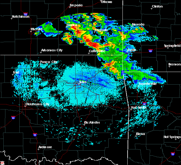 The severe thunderstorm warning for southeastern wilson and northeastern montgomery counties will expire at 215 am cdt, the storm which prompted the warning has weakened below severe limits, and no longer poses an immediate threat to life or property. therefore, the warning will be allowed to expire. however heavy rain is still possible with this thunderstorm. The severe thunderstorm warning for southeastern wilson and northeastern montgomery counties will expire at 215 am cdt, the storm which prompted the warning has weakened below severe limits, and no longer poses an immediate threat to life or property. therefore, the warning will be allowed to expire. however heavy rain is still possible with this thunderstorm.
|
| 8/8/2019 1:54 AM CDT |
 At 153 am cdt, a severe thunderstorm was located near neodesha, moving east at 20 mph (radar indicated). Hazards include 60 mph wind gusts and nickel size hail. Expect damage to roofs, siding, and trees. Locations impacted include, neodesha and altoona. At 153 am cdt, a severe thunderstorm was located near neodesha, moving east at 20 mph (radar indicated). Hazards include 60 mph wind gusts and nickel size hail. Expect damage to roofs, siding, and trees. Locations impacted include, neodesha and altoona.
|
| 8/8/2019 1:33 AM CDT |
 At 132 am cdt, a severe thunderstorm was located near neodesha, moving east at 20 mph (radar indicated). Hazards include 70 mph wind gusts and quarter size hail. Hail damage to vehicles is expected. expect considerable tree damage. Wind damage is also likely to mobile homes, roofs, and outbuildings. At 132 am cdt, a severe thunderstorm was located near neodesha, moving east at 20 mph (radar indicated). Hazards include 70 mph wind gusts and quarter size hail. Hail damage to vehicles is expected. expect considerable tree damage. Wind damage is also likely to mobile homes, roofs, and outbuildings.
|
| 8/1/2019 2:15 AM CDT |
 At 212 am cdt, a severe thunderstorm was located near neodesha, moving south at 40 mph. an additional severe thunderstorm was located near altamont and also moving south (radar indicated). Hazards include 60 mph wind gusts and half dollar size hail. Hail damage to vehicles is expected. Expect wind damage to roofs, siding, and trees. At 212 am cdt, a severe thunderstorm was located near neodesha, moving south at 40 mph. an additional severe thunderstorm was located near altamont and also moving south (radar indicated). Hazards include 60 mph wind gusts and half dollar size hail. Hail damage to vehicles is expected. Expect wind damage to roofs, siding, and trees.
|
| 8/1/2019 2:06 AM CDT |
 At 206 am cdt, a severe thunderstorm was located near cherryvale, moving south at 40 mph (radar indicated). Hazards include 60 mph wind gusts and half dollar size hail. Hail damage to vehicles is expected. expect wind damage to roofs, siding, and trees. Locations impacted include, neodesha, thayer and altoona. At 206 am cdt, a severe thunderstorm was located near cherryvale, moving south at 40 mph (radar indicated). Hazards include 60 mph wind gusts and half dollar size hail. Hail damage to vehicles is expected. expect wind damage to roofs, siding, and trees. Locations impacted include, neodesha, thayer and altoona.
|
| 8/1/2019 1:32 AM CDT |
 At 131 am cdt, a severe thunderstorm was located over buffalo, or 11 miles west of chanute, moving south at 40 mph (law enforcement. this storm has a history of large hail in the yates center area). Hazards include 60 mph wind gusts and half dollar size hail. Hail damage to vehicles is expected. Expect wind damage to roofs, siding, and trees. At 131 am cdt, a severe thunderstorm was located over buffalo, or 11 miles west of chanute, moving south at 40 mph (law enforcement. this storm has a history of large hail in the yates center area). Hazards include 60 mph wind gusts and half dollar size hail. Hail damage to vehicles is expected. Expect wind damage to roofs, siding, and trees.
|
| 6/23/2019 7:01 AM CDT |
 A severe thunderstorm warning remains in effect until 715 am cdt for wilson. montgomery and woodson counties. at 701 am cdt, severe thunderstorms were located along a line extending from 5 miles west of neosho falls to near neodesha to near tyro, moving east at 45 mph. hazard. 60 mph wind gusts. A severe thunderstorm warning remains in effect until 715 am cdt for wilson. montgomery and woodson counties. at 701 am cdt, severe thunderstorms were located along a line extending from 5 miles west of neosho falls to near neodesha to near tyro, moving east at 45 mph. hazard. 60 mph wind gusts.
|
| 6/23/2019 6:50 AM CDT |
 At 649 am cdt, severe thunderstorms were located along a line extending from 8 miles southwest of le roy to 5 miles south of fredonia to near caney, moving east at 45 mph (radar indicated). Hazards include 60 mph wind gusts. Expect damage to roofs, siding, and trees. Locations impacted include, coffeyville, independence, neodesha, fredonia, cherryvale, caney, yates center, dearing, altoona, elk city, toronto, buffalo, tyro, neosho falls, peru, liberty, havana, bolton, sycamore and niotaze. At 649 am cdt, severe thunderstorms were located along a line extending from 8 miles southwest of le roy to 5 miles south of fredonia to near caney, moving east at 45 mph (radar indicated). Hazards include 60 mph wind gusts. Expect damage to roofs, siding, and trees. Locations impacted include, coffeyville, independence, neodesha, fredonia, cherryvale, caney, yates center, dearing, altoona, elk city, toronto, buffalo, tyro, neosho falls, peru, liberty, havana, bolton, sycamore and niotaze.
|
| 6/23/2019 6:33 AM CDT |
 At 633 am cdt, severe thunderstorms were located along a line extending from 7 miles southwest of gridley to 6 miles northeast of longton to chautauqua, moving east at 45 mph (radar indicated). Hazards include 60 mph wind gusts. Expect damage to roofs, siding, and trees. Locations impacted include, coffeyville, independence, neodesha, fredonia, cherryvale, caney, yates center, sedan, madison, dearing, altoona, longton, elk city, toronto, hamilton, severy, buffalo, tyro, fall river and neosho falls. At 633 am cdt, severe thunderstorms were located along a line extending from 7 miles southwest of gridley to 6 miles northeast of longton to chautauqua, moving east at 45 mph (radar indicated). Hazards include 60 mph wind gusts. Expect damage to roofs, siding, and trees. Locations impacted include, coffeyville, independence, neodesha, fredonia, cherryvale, caney, yates center, sedan, madison, dearing, altoona, longton, elk city, toronto, hamilton, severy, buffalo, tyro, fall river and neosho falls.
|
| 6/23/2019 6:07 AM CDT |
 At 607 am cdt, severe thunderstorms were located along a line extending from 11 miles west of hamilton to near howard to 6 miles southeast of cedar vale, moving east at 45 mph (radar indicated). Hazards include 60 mph wind gusts and penny size hail. expect damage to roofs, siding, and trees At 607 am cdt, severe thunderstorms were located along a line extending from 11 miles west of hamilton to near howard to 6 miles southeast of cedar vale, moving east at 45 mph (radar indicated). Hazards include 60 mph wind gusts and penny size hail. expect damage to roofs, siding, and trees
|
| 6/22/2019 9:11 PM CDT | Microburst caused damage along tank ave between 4th and 8th streets. trees uprooted and power poles snapped of in wilson county KS, 0.4 miles NW of Neodesha, KS |
| 5/20/2019 6:59 PM CDT |
 A severe thunderstorm warning remains in effect until 745 pm cdt for southern wilson and montgomery counties. at 659 pm cdt, severe thunderstorms were located along a line extending from neodesha to near dearing, moving northeast at 50 mph. hazard. 60 mph wind gusts. source. Radar indicated. A severe thunderstorm warning remains in effect until 745 pm cdt for southern wilson and montgomery counties. at 659 pm cdt, severe thunderstorms were located along a line extending from neodesha to near dearing, moving northeast at 50 mph. hazard. 60 mph wind gusts. source. Radar indicated.
|
| 5/20/2019 6:47 PM CDT |
 A severe thunderstorm warning remains in effect until 745 pm cdt for southern wilson. montgomery and eastern chautauqua counties. at 647 pm cdt, severe thunderstorms were located along a line extending from 7 miles northeast of elk city to near tyro, moving northeast at 55 mph. hazard. 60 mph wind gusts. A severe thunderstorm warning remains in effect until 745 pm cdt for southern wilson. montgomery and eastern chautauqua counties. at 647 pm cdt, severe thunderstorms were located along a line extending from 7 miles northeast of elk city to near tyro, moving northeast at 55 mph. hazard. 60 mph wind gusts.
|
| 5/20/2019 6:42 PM CDT |
 At 642 pm cdt, a severe thunderstorm was located near independence, moving northeast at 80 mph (radar indicated). Hazards include 60 mph wind gusts. expect damage to roofs, siding, and trees At 642 pm cdt, a severe thunderstorm was located near independence, moving northeast at 80 mph (radar indicated). Hazards include 60 mph wind gusts. expect damage to roofs, siding, and trees
|
| 5/19/2019 12:27 AM CDT |
 The severe thunderstorm warning for southeastern elk, southern wilson, montgomery and eastern chautauqua counties will expire at 1230 am cdt, the severe thunderstorm which prompted the warning has moved out of the warned area. therefore, the warning will be allowed to expire. however gusty winds and heavy rain are still possible with this thunderstorm. The severe thunderstorm warning for southeastern elk, southern wilson, montgomery and eastern chautauqua counties will expire at 1230 am cdt, the severe thunderstorm which prompted the warning has moved out of the warned area. therefore, the warning will be allowed to expire. however gusty winds and heavy rain are still possible with this thunderstorm.
|
| 5/19/2019 12:15 AM CDT |
 At 1213 am cdt, severe thunderstorms were located along a line extending from neodesha to near cherryvale to 6 miles east of south coffeyville, moving northeast at 50 mph (radar indicated. this storm has a history of producing 60 to 70 mph winds near sedan and independence). Hazards include 60 mph wind gusts. expect damage to roofs, siding, and trees At 1213 am cdt, severe thunderstorms were located along a line extending from neodesha to near cherryvale to 6 miles east of south coffeyville, moving northeast at 50 mph (radar indicated. this storm has a history of producing 60 to 70 mph winds near sedan and independence). Hazards include 60 mph wind gusts. expect damage to roofs, siding, and trees
|
| 5/18/2019 11:43 PM CDT |
 At 1142 pm cdt, a severe thunderstorm was located 6 miles northwest of havana, or 10 miles east of sedan, moving east at 50 mph (radar indicated). Hazards include 60 mph wind gusts. expect damage to roofs, siding, and trees At 1142 pm cdt, a severe thunderstorm was located 6 miles northwest of havana, or 10 miles east of sedan, moving east at 50 mph (radar indicated). Hazards include 60 mph wind gusts. expect damage to roofs, siding, and trees
|
| 5/8/2019 2:55 AM CDT |
 The severe thunderstorm warning for wilson and montgomery counties will expire at 300 am cdt, the storms which prompted the warning have moved out of the area. therefore, the warning will be allowed to expire. however gusty winds are still possible with these thunderstorms. a tornado watch remains in effect until 500 am cdt for southeastern kansas. The severe thunderstorm warning for wilson and montgomery counties will expire at 300 am cdt, the storms which prompted the warning have moved out of the area. therefore, the warning will be allowed to expire. however gusty winds are still possible with these thunderstorms. a tornado watch remains in effect until 500 am cdt for southeastern kansas.
|
| 5/8/2019 2:05 AM CDT |
 At 205 am cdt, severe thunderstorms were located along a line extending from near fall river to elk city to caney, moving northeast at 40 mph (radar indicated). Hazards include 60 mph wind gusts. expect damage to roofs, siding, and trees At 205 am cdt, severe thunderstorms were located along a line extending from near fall river to elk city to caney, moving northeast at 40 mph (radar indicated). Hazards include 60 mph wind gusts. expect damage to roofs, siding, and trees
|
| 5/6/2019 11:34 PM CDT |
 At 1133 pm cdt, severe thunderstorms were located along a line extending from near fredonia to 7 miles south of thayer to near mccune, and are nearly stationary (law enforcement. at 1115pm, 60-70 mph wind gusts were reported in northern labette county). Hazards include 70 mph wind gusts and quarter size hail. Hail damage to vehicles is expected. expect considerable tree damage. wind damage is also likely to mobile homes, roofs, and outbuildings. locations impacted include, parsons, chanute, neodesha, fredonia, cherryvale, oswego, erie, altamont, st. Paul, thayer, altoona, mound valley, galesburg, sycamore, labette, benedict, earlton, lake parsons, parsons tri city airport and dennis. At 1133 pm cdt, severe thunderstorms were located along a line extending from near fredonia to 7 miles south of thayer to near mccune, and are nearly stationary (law enforcement. at 1115pm, 60-70 mph wind gusts were reported in northern labette county). Hazards include 70 mph wind gusts and quarter size hail. Hail damage to vehicles is expected. expect considerable tree damage. wind damage is also likely to mobile homes, roofs, and outbuildings. locations impacted include, parsons, chanute, neodesha, fredonia, cherryvale, oswego, erie, altamont, st. Paul, thayer, altoona, mound valley, galesburg, sycamore, labette, benedict, earlton, lake parsons, parsons tri city airport and dennis.
|
| 5/6/2019 11:00 PM CDT |
 At 1100 pm cdt, severe thunderstorms were located along a line extending from near fredonia to 7 miles south of thayer to near mccune, and are nearly stationary (emergency management. these storms have a history of producing damaging wind). Hazards include 60 mph wind gusts and quarter size hail. Hail damage to vehicles is expected. Expect wind damage to roofs, siding, and trees. At 1100 pm cdt, severe thunderstorms were located along a line extending from near fredonia to 7 miles south of thayer to near mccune, and are nearly stationary (emergency management. these storms have a history of producing damaging wind). Hazards include 60 mph wind gusts and quarter size hail. Hail damage to vehicles is expected. Expect wind damage to roofs, siding, and trees.
|
| 5/6/2019 9:58 PM CDT |
 At 958 pm cdt, a severe thunderstorm was located near chanute, moving east at 20 mph (radar indicated). Hazards include 60 mph wind gusts and quarter size hail. Hail damage to vehicles is expected. Expect wind damage to roofs, siding, and trees. At 958 pm cdt, a severe thunderstorm was located near chanute, moving east at 20 mph (radar indicated). Hazards include 60 mph wind gusts and quarter size hail. Hail damage to vehicles is expected. Expect wind damage to roofs, siding, and trees.
|
| 5/6/2019 9:53 PM CDT | Storm damage reported in wilson county KS, 4.6 miles S of Neodesha, KS |
| 4/29/2019 4:23 AM CDT |
 The severe thunderstorm warning for wilson, neosho and allen counties will expire at 430 am cdt, the storms which prompted the warning have weakened below severe limits, and no longer pose an immediate threat to life or property. therefore, the warning will be allowed to expire. however small hail, gusty winds and heavy rain are still possible with these thunderstorms. The severe thunderstorm warning for wilson, neosho and allen counties will expire at 430 am cdt, the storms which prompted the warning have weakened below severe limits, and no longer pose an immediate threat to life or property. therefore, the warning will be allowed to expire. however small hail, gusty winds and heavy rain are still possible with these thunderstorms.
|
| 4/29/2019 3:45 AM CDT |
 At 345 am cdt, severe thunderstorms were located along a line extending from lone elm to near iola to near fredonia, moving east at 70 mph (radar indicated). Hazards include 70 mph wind gusts and nickel size hail. Expect considerable tree damage. damage is likely to mobile homes, roofs, and outbuildings. locations impacted include, chanute, iola, neodesha, fredonia, humboldt, erie, st. Paul, la harpe, gas, moran, thayer, altoona, buffalo, galesburg, savonburg, elsmore, benedict, stark, new albany and earlton. At 345 am cdt, severe thunderstorms were located along a line extending from lone elm to near iola to near fredonia, moving east at 70 mph (radar indicated). Hazards include 70 mph wind gusts and nickel size hail. Expect considerable tree damage. damage is likely to mobile homes, roofs, and outbuildings. locations impacted include, chanute, iola, neodesha, fredonia, humboldt, erie, st. Paul, la harpe, gas, moran, thayer, altoona, buffalo, galesburg, savonburg, elsmore, benedict, stark, new albany and earlton.
|
| 4/29/2019 3:32 AM CDT |
 At 332 am cdt, severe thunderstorms were located along a line extending from near le roy to near yates center to fall river, moving southeast at 50 mph (radar indicated). Hazards include 70 mph wind gusts and quarter size hail. Hail damage to vehicles is expected. expect considerable tree damage. Wind damage is also likely to mobile homes, roofs, and outbuildings. At 332 am cdt, severe thunderstorms were located along a line extending from near le roy to near yates center to fall river, moving southeast at 50 mph (radar indicated). Hazards include 70 mph wind gusts and quarter size hail. Hail damage to vehicles is expected. expect considerable tree damage. Wind damage is also likely to mobile homes, roofs, and outbuildings.
|
| 11/30/2018 10:48 PM CST |
 At 1048 pm cst, severe thunderstorms were located along a line extending from 5 miles south of buffalo to galesburg to near chetopa, moving northeast at 55 mph (radar indicated). Hazards include 70 mph wind gusts and quarter size hail. Hail damage to vehicles is expected. expect considerable tree damage. wind damage is also likely to mobile homes, roofs, and outbuildings. locations impacted include, parsons, chanute, fredonia, oswego, erie, chetopa, altamont, st. paul, thayer, edna, altoona, mound valley, galesburg, bartlett, labette, benedict, stark, earlton, lake parsons and dennis. A tornado watch remains in effect until 500 am cst for southeastern kansas. At 1048 pm cst, severe thunderstorms were located along a line extending from 5 miles south of buffalo to galesburg to near chetopa, moving northeast at 55 mph (radar indicated). Hazards include 70 mph wind gusts and quarter size hail. Hail damage to vehicles is expected. expect considerable tree damage. wind damage is also likely to mobile homes, roofs, and outbuildings. locations impacted include, parsons, chanute, fredonia, oswego, erie, chetopa, altamont, st. paul, thayer, edna, altoona, mound valley, galesburg, bartlett, labette, benedict, stark, earlton, lake parsons and dennis. A tornado watch remains in effect until 500 am cst for southeastern kansas.
|
| 11/30/2018 10:37 PM CST |
 At 1037 pm cst, severe thunderstorms were located along a line extending from 5 miles northeast of fall river to cherryvale, moving north at 55 mph (radar indicated). Hazards include 70 mph wind gusts and quarter size hail. Hail damage to vehicles is expected. expect considerable tree damage. wind damage is also likely to mobile homes, roofs, and outbuildings. locations impacted include, coffeyville, independence, neodesha, cherryvale, edna, dearing, elk city, liberty, bolton, sycamore, parsons tri city airport, angola, buxton, elk city lake, big hill lake, elk city state park, independence airport and coffeyville airport. A tornado watch remains in effect until 500 am cst for southeastern kansas. At 1037 pm cst, severe thunderstorms were located along a line extending from 5 miles northeast of fall river to cherryvale, moving north at 55 mph (radar indicated). Hazards include 70 mph wind gusts and quarter size hail. Hail damage to vehicles is expected. expect considerable tree damage. wind damage is also likely to mobile homes, roofs, and outbuildings. locations impacted include, coffeyville, independence, neodesha, cherryvale, edna, dearing, elk city, liberty, bolton, sycamore, parsons tri city airport, angola, buxton, elk city lake, big hill lake, elk city state park, independence airport and coffeyville airport. A tornado watch remains in effect until 500 am cst for southeastern kansas.
|
| 11/30/2018 10:33 PM CST |
 At 1033 pm cst, severe thunderstorms were located along a line extending from near fredonia to 6 miles northeast of cherryvale to near edna, moving northeast at 55 mph (radar indicated). Hazards include 70 mph wind gusts and quarter size hail. Hail damage to vehicles is expected. expect considerable tree damage. Wind damage is also likely to mobile homes, roofs, and outbuildings. At 1033 pm cst, severe thunderstorms were located along a line extending from near fredonia to 6 miles northeast of cherryvale to near edna, moving northeast at 55 mph (radar indicated). Hazards include 70 mph wind gusts and quarter size hail. Hail damage to vehicles is expected. expect considerable tree damage. Wind damage is also likely to mobile homes, roofs, and outbuildings.
|
| 11/30/2018 10:11 PM CST |
 At 1010 pm cst, severe thunderstorms were located along a line extending from near elk falls to near dearing, moving north at 55 mph (radar indicated). Hazards include 60 mph wind gusts and quarter size hail. Hail damage to vehicles is expected. Expect wind damage to roofs, siding, and trees. At 1010 pm cst, severe thunderstorms were located along a line extending from near elk falls to near dearing, moving north at 55 mph (radar indicated). Hazards include 60 mph wind gusts and quarter size hail. Hail damage to vehicles is expected. Expect wind damage to roofs, siding, and trees.
|
| 8/14/2018 6:35 PM CDT |
 At 634 pm cdt, a severe thunderstorm was located over elk city, or 13 miles northwest of independence, moving northeast at 15 mph (radar indicated). Hazards include 60 mph wind gusts and penny size hail. Expect damage to roofs, siding, and trees. Locations impacted include, neodesha, fredonia, elk city, sycamore, hale, buxton, elk city lake and elk city state park. At 634 pm cdt, a severe thunderstorm was located over elk city, or 13 miles northwest of independence, moving northeast at 15 mph (radar indicated). Hazards include 60 mph wind gusts and penny size hail. Expect damage to roofs, siding, and trees. Locations impacted include, neodesha, fredonia, elk city, sycamore, hale, buxton, elk city lake and elk city state park.
|
| 8/14/2018 6:23 PM CDT |
 At 622 pm cdt, a severe thunderstorm was located near elk city, or 14 miles west of independence, moving northeast at 15 mph (radar indicated). Hazards include 60 mph wind gusts and half dollar size hail. Hail damage to vehicles is expected. Expect wind damage to roofs, siding, and trees. At 622 pm cdt, a severe thunderstorm was located near elk city, or 14 miles west of independence, moving northeast at 15 mph (radar indicated). Hazards include 60 mph wind gusts and half dollar size hail. Hail damage to vehicles is expected. Expect wind damage to roofs, siding, and trees.
|
| 6/26/2018 11:07 PM CDT |
 At 1107 pm cdt, a severe thunderstorm was located near neodesha, moving south at 15 mph (radar indicated). Hazards include 60 mph wind gusts and quarter size hail. Hail damage to vehicles is expected. expect wind damage to roofs, siding, and trees. Locations impacted include, neodesha, fredonia and altoona. At 1107 pm cdt, a severe thunderstorm was located near neodesha, moving south at 15 mph (radar indicated). Hazards include 60 mph wind gusts and quarter size hail. Hail damage to vehicles is expected. expect wind damage to roofs, siding, and trees. Locations impacted include, neodesha, fredonia and altoona.
|
| 6/26/2018 10:47 PM CDT |
 At 1047 pm cdt, a severe thunderstorm was located near fredonia, moving south at 25 mph (radar indicated). Hazards include 60 mph wind gusts and quarter size hail. Hail damage to vehicles is expected. Expect wind damage to roofs, siding, and trees. At 1047 pm cdt, a severe thunderstorm was located near fredonia, moving south at 25 mph (radar indicated). Hazards include 60 mph wind gusts and quarter size hail. Hail damage to vehicles is expected. Expect wind damage to roofs, siding, and trees.
|
| 6/12/2018 3:52 AM CDT |
 At 350 am cdt, severe thunderstorms were located along a line extending from near mccune to near oswego to 6 miles east of coffeyville, moving southeast at 40 mph (law enforcement). Hazards include 70 mph wind gusts and nickel size hail. Expect considerable tree damage. damage is likely to mobile homes, roofs, and outbuildings. locations impacted include, parsons, coffeyville, independence, neodesha, cherryvale, oswego, erie, chetopa, altamont, st. Paul, thayer, edna, mound valley, galesburg, liberty, sycamore, bartlett, labette, lake parsons and parsons tri city airport. At 350 am cdt, severe thunderstorms were located along a line extending from near mccune to near oswego to 6 miles east of coffeyville, moving southeast at 40 mph (law enforcement). Hazards include 70 mph wind gusts and nickel size hail. Expect considerable tree damage. damage is likely to mobile homes, roofs, and outbuildings. locations impacted include, parsons, coffeyville, independence, neodesha, cherryvale, oswego, erie, chetopa, altamont, st. Paul, thayer, edna, mound valley, galesburg, liberty, sycamore, bartlett, labette, lake parsons and parsons tri city airport.
|
| 6/12/2018 3:34 AM CDT |
 At 333 am cdt, severe thunderstorms were located along a line extending from near st. paul to near parsons to near liberty, moving southeast at 40 mph (law enforcement). Hazards include 60 mph wind gusts and nickel size hail. Expect damage to roofs, siding, and trees. locations impacted include, parsons, coffeyville, independence, neodesha, cherryvale, oswego, erie, chetopa, altamont, st. Paul, thayer, edna, mound valley, galesburg, liberty, sycamore, bartlett, labette, lake parsons and parsons tri city airport. At 333 am cdt, severe thunderstorms were located along a line extending from near st. paul to near parsons to near liberty, moving southeast at 40 mph (law enforcement). Hazards include 60 mph wind gusts and nickel size hail. Expect damage to roofs, siding, and trees. locations impacted include, parsons, coffeyville, independence, neodesha, cherryvale, oswego, erie, chetopa, altamont, st. Paul, thayer, edna, mound valley, galesburg, liberty, sycamore, bartlett, labette, lake parsons and parsons tri city airport.
|
| 6/12/2018 3:16 AM CDT |
 At 315 am cdt, severe thunderstorms were located along a line extending from near erie to near thayer to near neodesha, moving southeast at 40 mph (law enforcement). Hazards include 60 mph wind gusts and nickel size hail. expect damage to roofs, siding, and trees At 315 am cdt, severe thunderstorms were located along a line extending from near erie to near thayer to near neodesha, moving southeast at 40 mph (law enforcement). Hazards include 60 mph wind gusts and nickel size hail. expect damage to roofs, siding, and trees
|
| 5/29/2018 11:57 PM CDT |
 The severe thunderstorm warning for wilson, northern labette, neosho, montgomery, woodson and allen counties will expire at midnight cdt, the storm which prompted the warning has weakened below severe limits, and no longer poses an immediate threat to life or property. therefore the warning will be allowed to expire. however gusty winds are still possible with this thunderstorm. The severe thunderstorm warning for wilson, northern labette, neosho, montgomery, woodson and allen counties will expire at midnight cdt, the storm which prompted the warning has weakened below severe limits, and no longer poses an immediate threat to life or property. therefore the warning will be allowed to expire. however gusty winds are still possible with this thunderstorm.
|
| 5/29/2018 11:02 PM CDT |
 At 1102 pm cdt, a severe thunderstorm was located over fredonia, moving east at 40 mph (radar indicated). Hazards include 60 mph wind gusts and penny size hail. expect damage to roofs, siding, and trees At 1102 pm cdt, a severe thunderstorm was located over fredonia, moving east at 40 mph (radar indicated). Hazards include 60 mph wind gusts and penny size hail. expect damage to roofs, siding, and trees
|
| 5/20/2018 3:34 AM CDT |
 At 334 am cdt, severe thunderstorms were located along a line extending from 4 miles northwest of thayer to 5 miles west of edna, moving east at 45 mph (radar indicated). Hazards include 60 mph wind gusts and quarter size hail. Hail damage to vehicles is expected. expect wind damage to roofs, siding, and trees. Locations impacted include, coffeyville, independence, neodesha, fredonia, cherryvale, dearing, altoona and liberty. At 334 am cdt, severe thunderstorms were located along a line extending from 4 miles northwest of thayer to 5 miles west of edna, moving east at 45 mph (radar indicated). Hazards include 60 mph wind gusts and quarter size hail. Hail damage to vehicles is expected. expect wind damage to roofs, siding, and trees. Locations impacted include, coffeyville, independence, neodesha, fredonia, cherryvale, dearing, altoona and liberty.
|
| 5/20/2018 2:58 AM CDT |
 At 258 am cdt, severe thunderstorms were located along a line extending from 4 miles northwest of elk city to tyro, moving northeast at 25 mph (radar indicated). Hazards include 60 mph wind gusts and quarter size hail. Hail damage to vehicles is expected. expect wind damage to roofs, siding, and trees. Locations impacted include, coffeyville, independence, neodesha, fredonia, cherryvale, caney, dearing, altoona, elk city, tyro and liberty. At 258 am cdt, severe thunderstorms were located along a line extending from 4 miles northwest of elk city to tyro, moving northeast at 25 mph (radar indicated). Hazards include 60 mph wind gusts and quarter size hail. Hail damage to vehicles is expected. expect wind damage to roofs, siding, and trees. Locations impacted include, coffeyville, independence, neodesha, fredonia, cherryvale, caney, dearing, altoona, elk city, tyro and liberty.
|
| 5/20/2018 2:42 AM CDT |
 At 242 am cdt, severe thunderstorms were located along a line extending from 5 miles southeast of longton to near caney, moving northeast at 35 mph (radar indicated). Hazards include 60 mph wind gusts and quarter size hail. Hail damage to vehicles is expected. Expect wind damage to roofs, siding, and trees. At 242 am cdt, severe thunderstorms were located along a line extending from 5 miles southeast of longton to near caney, moving northeast at 35 mph (radar indicated). Hazards include 60 mph wind gusts and quarter size hail. Hail damage to vehicles is expected. Expect wind damage to roofs, siding, and trees.
|
| 5/19/2018 5:26 AM CDT |
 At 525 am cdt, a severe thunderstorm was located over longton, or 12 miles east of howard, moving northeast at 40 mph (radar indicated). Hazards include quarter size hail. damage to vehicles is expected At 525 am cdt, a severe thunderstorm was located over longton, or 12 miles east of howard, moving northeast at 40 mph (radar indicated). Hazards include quarter size hail. damage to vehicles is expected
|
| 5/14/2018 11:14 PM CDT |
 At 1114 pm cdt, severe thunderstorms were located along a line extending from near neodesha to near wann, moving east at 30 mph (radar indicated). Hazards include 60 mph wind gusts and quarter size hail. Hail damage to vehicles is expected. Expect wind damage to roofs, siding, and trees. At 1114 pm cdt, severe thunderstorms were located along a line extending from near neodesha to near wann, moving east at 30 mph (radar indicated). Hazards include 60 mph wind gusts and quarter size hail. Hail damage to vehicles is expected. Expect wind damage to roofs, siding, and trees.
|
| 5/14/2018 10:08 PM CDT |
 At 1008 pm cdt, severe thunderstorms were located along a line extending from 9 miles southwest of uniontown to near cedar vale, moving southeast at 40 mph (radar indicated). Hazards include 60 mph wind gusts and half dollar size hail. Hail damage to vehicles is expected. Expect wind damage to roofs, siding, and trees. At 1008 pm cdt, severe thunderstorms were located along a line extending from 9 miles southwest of uniontown to near cedar vale, moving southeast at 40 mph (radar indicated). Hazards include 60 mph wind gusts and half dollar size hail. Hail damage to vehicles is expected. Expect wind damage to roofs, siding, and trees.
|
| 10/14/2017 7:57 PM CDT |
 At 757 pm cdt, a severe thunderstorm was located 6 miles north of thayer, or 6 miles south of chanute, moving east at 35 mph (radar indicated). Hazards include 70 mph wind gusts. Expect considerable tree damage. damage is likely to mobile homes, roofs, and outbuildings. locations impacted include, parsons, chanute, neodesha, erie, st. Paul, thayer, altoona, galesburg, stark, earlton, lake parsons, dennis, chanute airport and south mound. At 757 pm cdt, a severe thunderstorm was located 6 miles north of thayer, or 6 miles south of chanute, moving east at 35 mph (radar indicated). Hazards include 70 mph wind gusts. Expect considerable tree damage. damage is likely to mobile homes, roofs, and outbuildings. locations impacted include, parsons, chanute, neodesha, erie, st. Paul, thayer, altoona, galesburg, stark, earlton, lake parsons, dennis, chanute airport and south mound.
|
| 10/14/2017 7:34 PM CDT |
 At 734 pm cdt, a severe thunderstorm was located over altoona, or 6 miles east of fredonia, moving northeast at 55 mph (radar indicated). Hazards include 70 mph wind gusts. Expect considerable tree damage. Damage is likely to mobile homes, roofs, and outbuildings. At 734 pm cdt, a severe thunderstorm was located over altoona, or 6 miles east of fredonia, moving northeast at 55 mph (radar indicated). Hazards include 70 mph wind gusts. Expect considerable tree damage. Damage is likely to mobile homes, roofs, and outbuildings.
|
| 10/14/2017 7:11 PM CDT |
 At 710 pm cdt, a severe thunderstorm was located near fredonia, moving northeast at 60 mph (radar indicated). Hazards include 70 mph wind gusts. Expect considerable tree damage. damage is likely to mobile homes, roofs, and outbuildings. Locations impacted include, fredonia, fall river, new albany, coyville, fall river lake, buxton and fall river state park. At 710 pm cdt, a severe thunderstorm was located near fredonia, moving northeast at 60 mph (radar indicated). Hazards include 70 mph wind gusts. Expect considerable tree damage. damage is likely to mobile homes, roofs, and outbuildings. Locations impacted include, fredonia, fall river, new albany, coyville, fall river lake, buxton and fall river state park.
|
| 10/14/2017 6:38 PM CDT |
 The national weather service in wichita has issued a * severe thunderstorm warning for. elk county in southeastern kansas. western wilson county in southeastern kansas. southeastern greenwood county in southeastern kansas. Until 745 pm cdt. The national weather service in wichita has issued a * severe thunderstorm warning for. elk county in southeastern kansas. western wilson county in southeastern kansas. southeastern greenwood county in southeastern kansas. Until 745 pm cdt.
|
| 9/16/2017 5:09 PM CDT |
 The severe thunderstorm warning for southeastern wilson and montgomery counties will expire at 515 pm cdt, the storm which prompted the warning has weakened below severe limits, and no longer poses an immediate threat to life or property. therefore the warning will be allowed to expire. however gusty winds of 40 to 50 mph are still possible with this thunderstorm. The severe thunderstorm warning for southeastern wilson and montgomery counties will expire at 515 pm cdt, the storm which prompted the warning has weakened below severe limits, and no longer poses an immediate threat to life or property. therefore the warning will be allowed to expire. however gusty winds of 40 to 50 mph are still possible with this thunderstorm.
|
| 9/16/2017 5:03 PM CDT |
 At 503 pm cdt, a severe thunderstorm was located near dearing, or 7 miles northwest of coffeyville, moving northeast at 30 mph (radar indicated). Hazards include 60 mph wind gusts and nickel size hail. Expect damage to roofs, siding, and trees. Locations impacted include, coffeyville, independence, neodesha, cherryvale, caney, dearing, tyro, liberty, bolton, sycamore, elk city lake, elk city state park, independence airport and coffeyville airport. At 503 pm cdt, a severe thunderstorm was located near dearing, or 7 miles northwest of coffeyville, moving northeast at 30 mph (radar indicated). Hazards include 60 mph wind gusts and nickel size hail. Expect damage to roofs, siding, and trees. Locations impacted include, coffeyville, independence, neodesha, cherryvale, caney, dearing, tyro, liberty, bolton, sycamore, elk city lake, elk city state park, independence airport and coffeyville airport.
|
| 9/16/2017 4:46 PM CDT |
 At 446 pm cdt, a severe thunderstorm was located over cherryvale, moving northeast at 35 mph (radar indicated). Hazards include 70 mph wind gusts and nickel size hail. Expect considerable tree damage. damage is likely to mobile homes, roofs, and outbuildings. Locations impacted include, coffeyville, independence, neodesha, cherryvale, caney, dearing, altoona, elk city, tyro, liberty, havana, bolton, sycamore, elk city lake, elk city state park, independence airport and coffeyville airport. At 446 pm cdt, a severe thunderstorm was located over cherryvale, moving northeast at 35 mph (radar indicated). Hazards include 70 mph wind gusts and nickel size hail. Expect considerable tree damage. damage is likely to mobile homes, roofs, and outbuildings. Locations impacted include, coffeyville, independence, neodesha, cherryvale, caney, dearing, altoona, elk city, tyro, liberty, havana, bolton, sycamore, elk city lake, elk city state park, independence airport and coffeyville airport.
|
| 9/16/2017 4:29 PM CDT |
 At 429 pm cdt, a severe thunderstorm was located near independence, moving east at 30 mph (radar indicated). Hazards include 60 to 70 mph wind gusts and nickel size hail. Expect considerable tree damage. damage is likely to mobile homes, roofs, and outbuildings. Locations impacted include, coffeyville, independence, neodesha, cherryvale, caney, dearing, altoona, elk city, tyro, liberty, havana, bolton, sycamore, elk city lake, elk city state park, independence airport and coffeyville airport. At 429 pm cdt, a severe thunderstorm was located near independence, moving east at 30 mph (radar indicated). Hazards include 60 to 70 mph wind gusts and nickel size hail. Expect considerable tree damage. damage is likely to mobile homes, roofs, and outbuildings. Locations impacted include, coffeyville, independence, neodesha, cherryvale, caney, dearing, altoona, elk city, tyro, liberty, havana, bolton, sycamore, elk city lake, elk city state park, independence airport and coffeyville airport.
|
| 9/16/2017 4:08 PM CDT |
 At 407 pm cdt, a severe thunderstorm was located 8 miles southwest of elk city, or 10 miles northeast of sedan, moving northeast at 40 mph (radar indicated). Hazards include 60 mph wind gusts and nickel size hail. expect damage to roofs, siding, and trees At 407 pm cdt, a severe thunderstorm was located 8 miles southwest of elk city, or 10 miles northeast of sedan, moving northeast at 40 mph (radar indicated). Hazards include 60 mph wind gusts and nickel size hail. expect damage to roofs, siding, and trees
|
| 9/16/2017 3:31 PM CDT |
 At 330 pm cdt, severe thunderstorms were located along a line extending from 5 miles north of toronto to 5 miles northwest of fredonia to near elk city, moving east at 30 mph (radar indicated). Hazards include 60 mph wind gusts and nickel size hail. Expect damage to roofs, siding, and trees. Locations impacted include, neodesha, fredonia, yates center, altoona, toronto, buffalo, sycamore, benedict, new albany, coyville, buxton, toronto lake, batesville, rose, cross timbers state park and piqua. At 330 pm cdt, severe thunderstorms were located along a line extending from 5 miles north of toronto to 5 miles northwest of fredonia to near elk city, moving east at 30 mph (radar indicated). Hazards include 60 mph wind gusts and nickel size hail. Expect damage to roofs, siding, and trees. Locations impacted include, neodesha, fredonia, yates center, altoona, toronto, buffalo, sycamore, benedict, new albany, coyville, buxton, toronto lake, batesville, rose, cross timbers state park and piqua.
|
| 9/16/2017 3:10 PM CDT |
 At 309 pm cdt, severe thunderstorms were located along a line extending from 7 miles northwest of toronto to fall river to near longton, moving east at 30 mph (radar indicated). Hazards include 60 mph wind gusts and nickel size hail. expect damage to roofs, siding, and trees At 309 pm cdt, severe thunderstorms were located along a line extending from 7 miles northwest of toronto to fall river to near longton, moving east at 30 mph (radar indicated). Hazards include 60 mph wind gusts and nickel size hail. expect damage to roofs, siding, and trees
|
| 8/20/2017 3:13 AM CDT |
 At 313 am cdt, a severe thunderstorm was located near neodesha, moving northeast at 10 mph (radar indicated). Hazards include 60 mph wind gusts and quarter size hail. Hail damage to vehicles is expected. Expect wind damage to roofs, siding, and trees. At 313 am cdt, a severe thunderstorm was located near neodesha, moving northeast at 10 mph (radar indicated). Hazards include 60 mph wind gusts and quarter size hail. Hail damage to vehicles is expected. Expect wind damage to roofs, siding, and trees.
|
| 8/16/2017 5:57 PM CDT |
 At 557 pm cdt, severe thunderstorms were located along a line extending from 5 miles east of chanute to near thayer, moving east at 45 mph (radar indicated). Hazards include 60 mph wind gusts and penny size hail. Expect damage to roofs, siding, and trees. locations impacted include, chanute, neodesha, erie, st. Paul, thayer, altoona, galesburg, stark, earlton, lake parsons, south mound and chanute airport. At 557 pm cdt, severe thunderstorms were located along a line extending from 5 miles east of chanute to near thayer, moving east at 45 mph (radar indicated). Hazards include 60 mph wind gusts and penny size hail. Expect damage to roofs, siding, and trees. locations impacted include, chanute, neodesha, erie, st. Paul, thayer, altoona, galesburg, stark, earlton, lake parsons, south mound and chanute airport.
|
| 8/16/2017 5:48 PM CDT |
 At 548 pm cdt, severe thunderstorms were located along a line extending from near chanute, to 5 miles east of neodesha, moving east at 45 mph (radar indicated). Hazards include 60 mph wind gusts and penny size hail. expect damage to roofs, siding, and trees At 548 pm cdt, severe thunderstorms were located along a line extending from near chanute, to 5 miles east of neodesha, moving east at 45 mph (radar indicated). Hazards include 60 mph wind gusts and penny size hail. expect damage to roofs, siding, and trees
|
| 8/16/2017 5:40 PM CDT |
 At 540 pm cdt, a severe thunderstorm was located 6 miles north of altoona, or 9 miles west of chanute, moving east at 45 mph (radar indicated). Hazards include 60 mph wind gusts and penny size hail. Expect damage to roofs, siding, and trees. Locations impacted include, neodesha, fredonia, altoona, buffalo, benedict, new albany, coyville and buxton. At 540 pm cdt, a severe thunderstorm was located 6 miles north of altoona, or 9 miles west of chanute, moving east at 45 mph (radar indicated). Hazards include 60 mph wind gusts and penny size hail. Expect damage to roofs, siding, and trees. Locations impacted include, neodesha, fredonia, altoona, buffalo, benedict, new albany, coyville and buxton.
|
| 8/16/2017 5:33 PM CDT |
 At 532 pm cdt, severe thunderstorms were located along a line extending from neosho falls, to 7 miles west of humboldt, to fredonia, moving east at 30 mph (radar indicated). Hazards include 60 mph wind gusts and penny size hail. Expect damage to roofs, siding, and trees. Locations impacted include, neodesha, fredonia, yates center, altoona, toronto, buffalo, neosho falls, benedict, new albany, coyville, buxton, toronto lake, batesville, rose, cross timbers state park and piqua. At 532 pm cdt, severe thunderstorms were located along a line extending from neosho falls, to 7 miles west of humboldt, to fredonia, moving east at 30 mph (radar indicated). Hazards include 60 mph wind gusts and penny size hail. Expect damage to roofs, siding, and trees. Locations impacted include, neodesha, fredonia, yates center, altoona, toronto, buffalo, neosho falls, benedict, new albany, coyville, buxton, toronto lake, batesville, rose, cross timbers state park and piqua.
|
| 8/16/2017 5:16 PM CDT |
 At 516 pm cdt, severe thunderstorms were located along a line extending from 7 miles southwest of le roy, to 5 miles south of yates center, to fredonia, moving east at 45 mph (radar indicated). Hazards include 60 mph wind gusts and penny size hail. Expect damage to roofs, siding, and trees. Locations impacted include, neodesha, fredonia, yates center, altoona, toronto, buffalo, neosho falls, benedict, new albany, coyville, buxton, toronto lake, batesville, rose, cross timbers state park and piqua. At 516 pm cdt, severe thunderstorms were located along a line extending from 7 miles southwest of le roy, to 5 miles south of yates center, to fredonia, moving east at 45 mph (radar indicated). Hazards include 60 mph wind gusts and penny size hail. Expect damage to roofs, siding, and trees. Locations impacted include, neodesha, fredonia, yates center, altoona, toronto, buffalo, neosho falls, benedict, new albany, coyville, buxton, toronto lake, batesville, rose, cross timbers state park and piqua.
|
| 8/16/2017 5:04 PM CDT |
 At 504 pm cdt, severe thunderstorms were located along a line extending from 5 miles southwest of gridley to near toronto to 7 miles southwest of fredonia, moving east at 35 mph (radar indicated). Hazards include 60 mph wind gusts and nickel size hail. expect damage to roofs, siding, and trees At 504 pm cdt, severe thunderstorms were located along a line extending from 5 miles southwest of gridley to near toronto to 7 miles southwest of fredonia, moving east at 35 mph (radar indicated). Hazards include 60 mph wind gusts and nickel size hail. expect damage to roofs, siding, and trees
|
| 6/29/2017 10:05 PM CDT |
 At 305 am cdt, severe thunderstorms were located along a line extending from near walnut to near galesburg to 6 miles northwest of independence, moving southeast at 50 mph (radar indicated). Hazards include 60 mph wind gusts. Expect damage to roofs, siding, and trees. locations impacted include, parsons, coffeyville, independence, neodesha, cherryvale, oswego, erie, chetopa, altamont, st. Paul, thayer, edna, mound valley, walnut, galesburg, liberty, sycamore, savonburg, bartlett and labette. At 305 am cdt, severe thunderstorms were located along a line extending from near walnut to near galesburg to 6 miles northwest of independence, moving southeast at 50 mph (radar indicated). Hazards include 60 mph wind gusts. Expect damage to roofs, siding, and trees. locations impacted include, parsons, coffeyville, independence, neodesha, cherryvale, oswego, erie, chetopa, altamont, st. Paul, thayer, edna, mound valley, walnut, galesburg, liberty, sycamore, savonburg, bartlett and labette.
|
| 6/29/2017 9:45 PM CDT |
 At 245 am cdt, severe thunderstorms were located along a line extending from 5 miles southwest of bronson to near erie to 6 miles northwest of independence, moving southeast at 50 mph (radar indicated). Hazards include 60 mph wind gusts and nickel size hail. expect damage to roofs, siding, and trees At 245 am cdt, severe thunderstorms were located along a line extending from 5 miles southwest of bronson to near erie to 6 miles northwest of independence, moving southeast at 50 mph (radar indicated). Hazards include 60 mph wind gusts and nickel size hail. expect damage to roofs, siding, and trees
|
| 6/17/2017 11:33 PM CDT |
 At 1133 pm cdt, severe thunderstorms were located along a line extending from near altoona to 5 miles north of dearing, moving east at 45 mph (radar indicated). Hazards include 70 mph wind gusts and penny size hail. Expect considerable tree damage. damage is likely to mobile homes, roofs, and outbuildings. Locations impacted include, parsons, neodesha, cherryvale, oswego, chetopa, altamont, thayer, edna, mound valley, elk city, sycamore, bartlett, labette, parsons tri city airport, lake parsons, angola, buxton, dennis, big hill lake and south mound. At 1133 pm cdt, severe thunderstorms were located along a line extending from near altoona to 5 miles north of dearing, moving east at 45 mph (radar indicated). Hazards include 70 mph wind gusts and penny size hail. Expect considerable tree damage. damage is likely to mobile homes, roofs, and outbuildings. Locations impacted include, parsons, neodesha, cherryvale, oswego, chetopa, altamont, thayer, edna, mound valley, elk city, sycamore, bartlett, labette, parsons tri city airport, lake parsons, angola, buxton, dennis, big hill lake and south mound.
|
| 6/17/2017 11:22 PM CDT |
 At 1122 pm cdt, severe thunderstorms were located along a line extending from near fredonia to 6 miles northwest of independence to near elk city, moving east at 45 mph (radar indicated). Hazards include 60 mph wind gusts and quarter size hail. Hail damage to vehicles is expected. Expect wind damage to roofs, siding, and trees. At 1122 pm cdt, severe thunderstorms were located along a line extending from near fredonia to 6 miles northwest of independence to near elk city, moving east at 45 mph (radar indicated). Hazards include 60 mph wind gusts and quarter size hail. Hail damage to vehicles is expected. Expect wind damage to roofs, siding, and trees.
|
| 6/17/2017 11:18 PM CDT |
 At 1117 pm cdt, severe thunderstorms were located along a line extending from near fredonia to elk city, moving east at 45 mph (radar indicated). Hazards include 70 mph wind gusts and nickel size hail. Expect considerable tree damage. damage is likely to mobile homes, roofs, and outbuildings. Locations impacted include, neodesha, fredonia, cherryvale, altoona, longton, elk city, sycamore, benedict, new albany, buxton and elk city lake. At 1117 pm cdt, severe thunderstorms were located along a line extending from near fredonia to elk city, moving east at 45 mph (radar indicated). Hazards include 70 mph wind gusts and nickel size hail. Expect considerable tree damage. damage is likely to mobile homes, roofs, and outbuildings. Locations impacted include, neodesha, fredonia, cherryvale, altoona, longton, elk city, sycamore, benedict, new albany, buxton and elk city lake.
|
| 6/17/2017 10:32 PM CDT |
 At 1032 pm cdt, severe thunderstorms were located along a line extending from 5 miles east of buffalo to 7 miles northeast of fredonia to fall river, moving southeast at 35 mph (radar indicated). Hazards include 70 mph wind gusts and quarter size hail. Hail damage to vehicles is expected. expect considerable tree damage. wind damage is also likely to mobile homes, roofs, and outbuildings. Locations impacted include, chanute, neodesha, fredonia, cherryvale, thayer, altoona, longton, elk city, galesburg, sycamore, benedict, new albany, earlton, parsons tri city airport, lake parsons, buxton, dennis, chanute airport, big hill lake and elk city lake. At 1032 pm cdt, severe thunderstorms were located along a line extending from 5 miles east of buffalo to 7 miles northeast of fredonia to fall river, moving southeast at 35 mph (radar indicated). Hazards include 70 mph wind gusts and quarter size hail. Hail damage to vehicles is expected. expect considerable tree damage. wind damage is also likely to mobile homes, roofs, and outbuildings. Locations impacted include, chanute, neodesha, fredonia, cherryvale, thayer, altoona, longton, elk city, galesburg, sycamore, benedict, new albany, earlton, parsons tri city airport, lake parsons, buxton, dennis, chanute airport, big hill lake and elk city lake.
|
| 6/17/2017 10:08 PM CDT |
 At 1008 pm cdt, severe thunderstorms were located along a line extending from 5 miles southwest of yates center to 6 miles northeast of fall river to 5 miles northeast of severy, moving southeast at 45 mph (radar indicated). Hazards include 70 mph wind gusts and penny size hail. Expect considerable tree damage. Damage is likely to mobile homes, roofs, and outbuildings. At 1008 pm cdt, severe thunderstorms were located along a line extending from 5 miles southwest of yates center to 6 miles northeast of fall river to 5 miles northeast of severy, moving southeast at 45 mph (radar indicated). Hazards include 70 mph wind gusts and penny size hail. Expect considerable tree damage. Damage is likely to mobile homes, roofs, and outbuildings.
|
| 5/11/2017 3:37 PM CDT |
 At 337 pm cdt, a severe thunderstorm was located near chanute, moving north at 35 mph (radar indicated). Hazards include ping pong ball size hail and 60 mph wind gusts. People and animals outdoors will be injured. expect hail damage to roofs, siding, windows, and vehicles. Expect wind damage to roofs, siding, and trees. At 337 pm cdt, a severe thunderstorm was located near chanute, moving north at 35 mph (radar indicated). Hazards include ping pong ball size hail and 60 mph wind gusts. People and animals outdoors will be injured. expect hail damage to roofs, siding, windows, and vehicles. Expect wind damage to roofs, siding, and trees.
|
| 5/10/2017 5:59 PM CDT |
 At 558 pm cdt, a severe thunderstorm was located 6 miles northwest of cherryvale, moving northeast at 45 mph (radar indicated). Hazards include golf ball size hail and 60 mph wind gusts. People and animals outdoors will be injured. expect hail damage to roofs, siding, windows, and vehicles. expect wind damage to roofs, siding, and trees. Locations impacted include, parsons, independence, chanute, neodesha, cherryvale, thayer, altoona, galesburg, sycamore, earlton, parsons tri city airport, lake parsons, dennis, big hill lake and south mound. At 558 pm cdt, a severe thunderstorm was located 6 miles northwest of cherryvale, moving northeast at 45 mph (radar indicated). Hazards include golf ball size hail and 60 mph wind gusts. People and animals outdoors will be injured. expect hail damage to roofs, siding, windows, and vehicles. expect wind damage to roofs, siding, and trees. Locations impacted include, parsons, independence, chanute, neodesha, cherryvale, thayer, altoona, galesburg, sycamore, earlton, parsons tri city airport, lake parsons, dennis, big hill lake and south mound.
|
| 5/10/2017 5:51 PM CDT |
 At 551 pm cdt, a severe thunderstorm was located near independence, moving northeast at 45 mph (radar indicated). Hazards include ping pong ball size hail and 60 mph wind gusts. People and animals outdoors will be injured. expect hail damage to roofs, siding, windows, and vehicles. Expect wind damage to roofs, siding, and trees. At 551 pm cdt, a severe thunderstorm was located near independence, moving northeast at 45 mph (radar indicated). Hazards include ping pong ball size hail and 60 mph wind gusts. People and animals outdoors will be injured. expect hail damage to roofs, siding, windows, and vehicles. Expect wind damage to roofs, siding, and trees.
|
| 4/4/2017 8:09 PM CDT |
 At 806 pm cdt, severe thunderstorms were located along a line extending from near buffalo to 5 miles south of chanute to near galesburg, moving east at 45 mph. these are very dangerous thunderstorms! (radar indicated). Hazards include winds around 80 mph and penny size hail. Flying debris will be dangerous to those caught without shelter. mobile homes will be heavily damaged. expect considerable damage to roofs, windows, and vehicles. extensive tree damage and power outages are likely. locations impacted include, independence, chanute, iola, neodesha, fredonia, humboldt, yates center, erie, st. Paul, la harpe, gas, moran, thayer, altoona, toronto, buffalo, fall river, neosho falls, galesburg and sycamore. At 806 pm cdt, severe thunderstorms were located along a line extending from near buffalo to 5 miles south of chanute to near galesburg, moving east at 45 mph. these are very dangerous thunderstorms! (radar indicated). Hazards include winds around 80 mph and penny size hail. Flying debris will be dangerous to those caught without shelter. mobile homes will be heavily damaged. expect considerable damage to roofs, windows, and vehicles. extensive tree damage and power outages are likely. locations impacted include, independence, chanute, iola, neodesha, fredonia, humboldt, yates center, erie, st. Paul, la harpe, gas, moran, thayer, altoona, toronto, buffalo, fall river, neosho falls, galesburg and sycamore.
|
| 4/4/2017 8:03 PM CDT |
 At 803 pm cdt, severe thunderstorms were located along a line extending from 5 miles southwest of yates center to near chanute to near thayer, moving northeast at 55 mph (radar indicated). Hazards include 70 mph wind gusts and nickel size hail. Expect considerable tree damage. damage is likely to mobile homes, roofs, and outbuildings. locations impacted include, chanute, iola, neodesha, fredonia, humboldt, yates center, erie, st. Paul, la harpe, gas, moran, thayer, altoona, toronto, buffalo, neosho falls, galesburg, savonburg, elsmore and benedict. At 803 pm cdt, severe thunderstorms were located along a line extending from 5 miles southwest of yates center to near chanute to near thayer, moving northeast at 55 mph (radar indicated). Hazards include 70 mph wind gusts and nickel size hail. Expect considerable tree damage. damage is likely to mobile homes, roofs, and outbuildings. locations impacted include, chanute, iola, neodesha, fredonia, humboldt, yates center, erie, st. Paul, la harpe, gas, moran, thayer, altoona, toronto, buffalo, neosho falls, galesburg, savonburg, elsmore and benedict.
|
| 4/4/2017 8:00 PM CDT | Estimated 50 to 60 mp in wilson county KS, 0.4 miles NW of Neodesha, KS |
| 4/4/2017 7:43 PM CDT |
 At 741 pm cdt, severe thunderstorms were located along a line extending from near fall river to near fredonia to 5 miles north of independence, moving northeast at 50 mph (radar indicated). Hazards include 70 mph wind gusts and nickel size hail. Expect considerable tree damage. Damage is likely to mobile homes, roofs, and outbuildings. At 741 pm cdt, severe thunderstorms were located along a line extending from near fall river to near fredonia to 5 miles north of independence, moving northeast at 50 mph (radar indicated). Hazards include 70 mph wind gusts and nickel size hail. Expect considerable tree damage. Damage is likely to mobile homes, roofs, and outbuildings.
|
| 3/6/2017 8:57 PM CST |
 At 857 pm cst, a severe thunderstorm was located over havana, or 7 miles north of caney, moving northeast at 60 mph (radar indicated). Hazards include 70 mph wind gusts and quarter size hail. Hail damage to vehicles is expected. expect considerable tree damage. Wind damage is also likely to mobile homes, roofs, and outbuildings. At 857 pm cst, a severe thunderstorm was located over havana, or 7 miles north of caney, moving northeast at 60 mph (radar indicated). Hazards include 70 mph wind gusts and quarter size hail. Hail damage to vehicles is expected. expect considerable tree damage. Wind damage is also likely to mobile homes, roofs, and outbuildings.
|
| 3/6/2017 8:44 PM CST |
 At 843 pm cst, severe thunderstorms were located along a line extending from neodesha to peru, moving east at 40 mph (radar indicated). Hazards include 60 mph wind gusts and quarter size hail. Hail damage to vehicles is expected. expect wind damage to roofs, siding, and trees. locations impacted include, independence, neodesha, sedan, elk city, peru, chautauqua, havana, elgin, bolton, sycamore, niotaze, elk city lake, elk city state park, hale and buxton. A tornado watch remains in effect until 300 am cst for southeastern kansas. At 843 pm cst, severe thunderstorms were located along a line extending from neodesha to peru, moving east at 40 mph (radar indicated). Hazards include 60 mph wind gusts and quarter size hail. Hail damage to vehicles is expected. expect wind damage to roofs, siding, and trees. locations impacted include, independence, neodesha, sedan, elk city, peru, chautauqua, havana, elgin, bolton, sycamore, niotaze, elk city lake, elk city state park, hale and buxton. A tornado watch remains in effect until 300 am cst for southeastern kansas.
|
| 3/6/2017 8:36 PM CST |
 At 836 pm cst, severe thunderstorms were located along a line extending from 6 miles south of fredonia to near sedan, moving east at 40 mph (radar indicated). Hazards include 60 mph wind gusts and half dollar size hail. Hail damage to vehicles is expected. expect wind damage to roofs, siding, and trees. locations impacted include, independence, neodesha, sedan, elk city, peru, chautauqua, havana, elgin, bolton, sycamore, niotaze, elk city lake, elk city state park, hale and buxton. A tornado watch remains in effect until 300 am cst for southeastern kansas. At 836 pm cst, severe thunderstorms were located along a line extending from 6 miles south of fredonia to near sedan, moving east at 40 mph (radar indicated). Hazards include 60 mph wind gusts and half dollar size hail. Hail damage to vehicles is expected. expect wind damage to roofs, siding, and trees. locations impacted include, independence, neodesha, sedan, elk city, peru, chautauqua, havana, elgin, bolton, sycamore, niotaze, elk city lake, elk city state park, hale and buxton. A tornado watch remains in effect until 300 am cst for southeastern kansas.
|
| 3/6/2017 8:32 PM CST |
 At 832 pm cst, severe thunderstorms were located along a line extending from 5 miles south of fredonia to near sedan, moving east at 40 mph (radar indicated). Hazards include 60 mph wind gusts and half dollar size hail. Hail damage to vehicles is expected. expect wind damage to roofs, siding, and trees. locations impacted include, independence, neodesha, sedan, howard, cedar vale, moline, longton, elk city, peru, chautauqua, elk falls, havana, elgin, bolton, sycamore, niotaze, buxton, elk city lake, elk city state park and hale. A tornado watch remains in effect until 300 am cst for south central and southeastern kansas. At 832 pm cst, severe thunderstorms were located along a line extending from 5 miles south of fredonia to near sedan, moving east at 40 mph (radar indicated). Hazards include 60 mph wind gusts and half dollar size hail. Hail damage to vehicles is expected. expect wind damage to roofs, siding, and trees. locations impacted include, independence, neodesha, sedan, howard, cedar vale, moline, longton, elk city, peru, chautauqua, elk falls, havana, elgin, bolton, sycamore, niotaze, buxton, elk city lake, elk city state park and hale. A tornado watch remains in effect until 300 am cst for south central and southeastern kansas.
|
| 3/6/2017 8:17 PM CST |
 At 817 pm cst, severe thunderstorms were located along a line extending from 8 miles northeast of longton to 6 miles east of cedar vale, moving east at 40 mph (radar indicated). Hazards include 60 mph wind gusts and half dollar size hail. Hail damage to vehicles is expected. expect wind damage to roofs, siding, and trees. locations impacted include, independence, neodesha, sedan, howard, cedar vale, moline, longton, elk city, peru, chautauqua, elk falls, havana, elgin, bolton, sycamore, niotaze, buxton, elk city lake, elk city state park and hale. A tornado watch remains in effect until 300 am cst for south central and southeastern kansas. At 817 pm cst, severe thunderstorms were located along a line extending from 8 miles northeast of longton to 6 miles east of cedar vale, moving east at 40 mph (radar indicated). Hazards include 60 mph wind gusts and half dollar size hail. Hail damage to vehicles is expected. expect wind damage to roofs, siding, and trees. locations impacted include, independence, neodesha, sedan, howard, cedar vale, moline, longton, elk city, peru, chautauqua, elk falls, havana, elgin, bolton, sycamore, niotaze, buxton, elk city lake, elk city state park and hale. A tornado watch remains in effect until 300 am cst for south central and southeastern kansas.
|
| 3/6/2017 8:00 PM CST |
 At 800 pm cst, severe thunderstorms were located along a line extending from near howard to 6 miles northwest of cedar vale, moving east at 40 mph (radar indicated). Hazards include 70 mph wind gusts and quarter size hail. Hail damage to vehicles is expected. expect considerable tree damage. Wind damage is also likely to mobile homes, roofs, and outbuildings. At 800 pm cst, severe thunderstorms were located along a line extending from near howard to 6 miles northwest of cedar vale, moving east at 40 mph (radar indicated). Hazards include 70 mph wind gusts and quarter size hail. Hail damage to vehicles is expected. expect considerable tree damage. Wind damage is also likely to mobile homes, roofs, and outbuildings.
|
| 2/28/2017 10:59 PM CST |
 At 1059 pm cst, severe thunderstorms were located along a line extending from erie to 5 miles north of dearing, moving east at 60 mph (radar indicated). Hazards include 60 mph wind gusts and quarter size hail. Hail damage to vehicles is expected. expect wind damage to roofs, siding, and trees. locations impacted include, parsons, independence, neodesha, cherryvale, erie, altamont, st. paul, thayer, mound valley, galesburg, liberty, bolton, sycamore, labette, earlton, lake parsons, parsons tri city airport, dennis, big hill lake and elk city state park. A tornado watch remains in effect until 400 am cst for southeastern kansas. At 1059 pm cst, severe thunderstorms were located along a line extending from erie to 5 miles north of dearing, moving east at 60 mph (radar indicated). Hazards include 60 mph wind gusts and quarter size hail. Hail damage to vehicles is expected. expect wind damage to roofs, siding, and trees. locations impacted include, parsons, independence, neodesha, cherryvale, erie, altamont, st. paul, thayer, mound valley, galesburg, liberty, bolton, sycamore, labette, earlton, lake parsons, parsons tri city airport, dennis, big hill lake and elk city state park. A tornado watch remains in effect until 400 am cst for southeastern kansas.
|
| 2/28/2017 10:46 PM CST |
 At 1045 pm cst, a severe thunderstorm was located over neodesha, moving east at 55 mph (radar indicated). Hazards include ping pong ball size hail and 60 mph wind gusts. People and animals outdoors will be injured. expect hail damage to roofs, siding, windows, and vehicles. Expect wind damage to roofs, siding, and trees. At 1045 pm cst, a severe thunderstorm was located over neodesha, moving east at 55 mph (radar indicated). Hazards include ping pong ball size hail and 60 mph wind gusts. People and animals outdoors will be injured. expect hail damage to roofs, siding, windows, and vehicles. Expect wind damage to roofs, siding, and trees.
|
| 9/15/2016 5:43 PM CDT |
 At 543 pm cdt, a severe thunderstorm was located over fredonia, moving northeast at 20 mph (radar indicated). Hazards include 60 mph wind gusts and quarter size hail. Hail damage to vehicles is expected. Expect wind damage to roofs, siding, and trees. At 543 pm cdt, a severe thunderstorm was located over fredonia, moving northeast at 20 mph (radar indicated). Hazards include 60 mph wind gusts and quarter size hail. Hail damage to vehicles is expected. Expect wind damage to roofs, siding, and trees.
|
| 7/14/2016 9:50 AM CDT |
 The severe thunderstorm warning for woodson, neosho, eastern wilson and allen counties will expire at 1000 am cdt, the storms which prompted the warning have weakened below severe limits, and no longer pose an immediate threat to life or property. therefore the warning will be allowed to expire. however gusty winds are still possible with these thunderstorms. The severe thunderstorm warning for woodson, neosho, eastern wilson and allen counties will expire at 1000 am cdt, the storms which prompted the warning have weakened below severe limits, and no longer pose an immediate threat to life or property. therefore the warning will be allowed to expire. however gusty winds are still possible with these thunderstorms.
|
| 7/14/2016 9:30 AM CDT |
 At 930 am cdt, severe thunderstorms were located along a line extending from 6 miles south of neosho falls to near st. paul, moving east at 30 mph (radar indicated). Hazards include 60 mph wind gusts and nickel size hail. Expect damage to roofs. siding. and trees. locations impacted include, chanute, iola, neodesha, humboldt, yates center, erie, st. Paul, la harpe, gas, moran, thayer, altoona, buffalo, neosho falls, galesburg, savonburg, elsmore, benedict, stark and earlton. At 930 am cdt, severe thunderstorms were located along a line extending from 6 miles south of neosho falls to near st. paul, moving east at 30 mph (radar indicated). Hazards include 60 mph wind gusts and nickel size hail. Expect damage to roofs. siding. and trees. locations impacted include, chanute, iola, neodesha, humboldt, yates center, erie, st. Paul, la harpe, gas, moran, thayer, altoona, buffalo, neosho falls, galesburg, savonburg, elsmore, benedict, stark and earlton.
|
| 7/14/2016 9:16 AM CDT |
 At 915 am cdt, severe thunderstorms were located along a line extending from 5 miles east of yates center to near galesburg, moving east at 30 mph (radar indicated). Hazards include 60 mph wind gusts and nickel size hail. Expect damage to roofs. siding. and trees. locations impacted include, chanute, iola, neodesha, humboldt, yates center, erie, st. Paul, la harpe, gas, moran, thayer, altoona, buffalo, neosho falls, galesburg, savonburg, elsmore, benedict, stark and earlton. At 915 am cdt, severe thunderstorms were located along a line extending from 5 miles east of yates center to near galesburg, moving east at 30 mph (radar indicated). Hazards include 60 mph wind gusts and nickel size hail. Expect damage to roofs. siding. and trees. locations impacted include, chanute, iola, neodesha, humboldt, yates center, erie, st. Paul, la harpe, gas, moran, thayer, altoona, buffalo, neosho falls, galesburg, savonburg, elsmore, benedict, stark and earlton.
|
| 7/14/2016 9:06 AM CDT |
 At 905 am cdt, a severe thunderstorm was located 6 miles north of buffalo, or 6 miles southeast of yates center, moving east at 30 mph (radar indicated). Hazards include 60 mph wind gusts and nickel size hail. Expect damage to roofs. siding. And trees. At 905 am cdt, a severe thunderstorm was located 6 miles north of buffalo, or 6 miles southeast of yates center, moving east at 30 mph (radar indicated). Hazards include 60 mph wind gusts and nickel size hail. Expect damage to roofs. siding. And trees.
|
| 7/7/2016 11:55 PM CDT |
 The severe thunderstorm warning for northern montgomery, neosho, wilson, northwestern labette and south central allen counties will expire at 1200 am cdt, the storms which prompted the warning have weakened below severe limits, and exited the warned area. therefore the warning will be allowed to expire. however small hail and gusty winds are still possible with these thunderstorms. a severe thunderstorm watch remains in effect until 200 am cdt for southeastern kansas. The severe thunderstorm warning for northern montgomery, neosho, wilson, northwestern labette and south central allen counties will expire at 1200 am cdt, the storms which prompted the warning have weakened below severe limits, and exited the warned area. therefore the warning will be allowed to expire. however small hail and gusty winds are still possible with these thunderstorms. a severe thunderstorm watch remains in effect until 200 am cdt for southeastern kansas.
|
| 7/7/2016 11:39 PM CDT |
 At 1138 pm cdt, severe thunderstorms were located along a line extending from near erie to galesburg to neodesha, moving southeast at 30 mph (radar indicated). Hazards include 60 mph wind gusts and quarter size hail. Hail damage to vehicles is expected. expect wind damage to roofs, siding, and trees. locations impacted include, independence, chanute, neodesha, fredonia, cherryvale, erie, st. Paul, thayer, altoona, elk city, galesburg, sycamore, new albany, earlton, parsons tri city airport, buxton, lake parsons, elk city lake, dennis and elk city state park. At 1138 pm cdt, severe thunderstorms were located along a line extending from near erie to galesburg to neodesha, moving southeast at 30 mph (radar indicated). Hazards include 60 mph wind gusts and quarter size hail. Hail damage to vehicles is expected. expect wind damage to roofs, siding, and trees. locations impacted include, independence, chanute, neodesha, fredonia, cherryvale, erie, st. Paul, thayer, altoona, elk city, galesburg, sycamore, new albany, earlton, parsons tri city airport, buxton, lake parsons, elk city lake, dennis and elk city state park.
|
| 7/7/2016 11:12 PM CDT |
 At 1110 pm cdt, severe thunderstorms were located along a line extending from 5 miles northeast of chanute to 6 miles northeast of altoona to near fredonia, moving southeast at 25 mph (radar indicated). Hazards include 60 mph wind gusts and quarter size hail. Hail damage to vehicles is expected. Expect wind damage to roofs, siding, and trees. At 1110 pm cdt, severe thunderstorms were located along a line extending from 5 miles northeast of chanute to 6 miles northeast of altoona to near fredonia, moving southeast at 25 mph (radar indicated). Hazards include 60 mph wind gusts and quarter size hail. Hail damage to vehicles is expected. Expect wind damage to roofs, siding, and trees.
|
| 7/6/2016 5:09 AM CDT |
 The severe thunderstorm warning for northeastern montgomery, southeastern woodson, neosho, eastern wilson, northern labette and southern allen counties will expire at 515 am cdt, the storms which prompted the warning have weakened below severe limits, and exited the warned area. therefore the warning will be allowed to expire. however gusty winds and heavy rain are still possible with these thunderstorms. a severe thunderstorm watch remains in effect until 900 am cdt for southeastern kansas. The severe thunderstorm warning for northeastern montgomery, southeastern woodson, neosho, eastern wilson, northern labette and southern allen counties will expire at 515 am cdt, the storms which prompted the warning have weakened below severe limits, and exited the warned area. therefore the warning will be allowed to expire. however gusty winds and heavy rain are still possible with these thunderstorms. a severe thunderstorm watch remains in effect until 900 am cdt for southeastern kansas.
|
| 7/6/2016 4:31 AM CDT |
 At 431 am cdt, severe thunderstorms were located along a line extending from 5 miles north of buffalo to near altoona to near independence, moving east at 80 mph (radar indicated). Hazards include 70 mph wind gusts and nickel size hail. Expect considerable tree damage. Damage is likely to mobile homes, roofs, and outbuildings. At 431 am cdt, severe thunderstorms were located along a line extending from 5 miles north of buffalo to near altoona to near independence, moving east at 80 mph (radar indicated). Hazards include 70 mph wind gusts and nickel size hail. Expect considerable tree damage. Damage is likely to mobile homes, roofs, and outbuildings.
|
| 7/6/2016 3:48 AM CDT |
 At 348 am cdt, severe thunderstorms were located along a line extending from 9 miles west of toronto to 7 miles southwest of grenola, moving east at 60 mph (radar indicated). Hazards include 60 mph wind gusts. Expect damage to roofs. siding. And trees. At 348 am cdt, severe thunderstorms were located along a line extending from 9 miles west of toronto to 7 miles southwest of grenola, moving east at 60 mph (radar indicated). Hazards include 60 mph wind gusts. Expect damage to roofs. siding. And trees.
|
| 4/29/2016 3:42 PM CDT | Quarter sized hail reported 0.4 miles NW of Neodesha, KS |
| 4/29/2016 3:35 PM CDT |
 At 333 pm cdt, severe thunderstorms were located along a line extending from near fredonia to 6 miles southwest of neodesha to near independence, moving east at 45 mph (radar indicated). Hazards include 70 mph wind gusts and ping pong ball size hail. People and animals outdoors will be injured. expect hail damage to roofs, siding, windows, and vehicles. expect considerable tree damage. Wind damage is also likely to mobile homes, roofs, and outbuildings. At 333 pm cdt, severe thunderstorms were located along a line extending from near fredonia to 6 miles southwest of neodesha to near independence, moving east at 45 mph (radar indicated). Hazards include 70 mph wind gusts and ping pong ball size hail. People and animals outdoors will be injured. expect hail damage to roofs, siding, windows, and vehicles. expect considerable tree damage. Wind damage is also likely to mobile homes, roofs, and outbuildings.
|
| 4/26/2016 11:24 PM CDT | Semi pulling doubles was blown over on highway 400 near the montgomery and wilson county lin in wilson county KS, 3.1 miles NE of Neodesha, KS |
| 4/26/2016 11:24 PM CDT |
 At 1124 pm cdt, a severe thunderstorm was located over parsons, moving northeast at 50 mph. this is a very dangerous storm (radar indicated). Hazards include 80 mph wind gusts and quarter size hail. Flying debris will be dangerous to those caught without shelter. mobile homes will be heavily damaged. expect considerable damage to roofs, windows, and vehicles. extensive tree damage and power outages are likely. locations impacted include, parsons, chanute, neodesha, cherryvale, erie, altamont, st. Paul, thayer, edna, altoona, mound valley, galesburg, sycamore, labette, earlton, angola, lake parsons, dennis, south mound and big hill lake. At 1124 pm cdt, a severe thunderstorm was located over parsons, moving northeast at 50 mph. this is a very dangerous storm (radar indicated). Hazards include 80 mph wind gusts and quarter size hail. Flying debris will be dangerous to those caught without shelter. mobile homes will be heavily damaged. expect considerable damage to roofs, windows, and vehicles. extensive tree damage and power outages are likely. locations impacted include, parsons, chanute, neodesha, cherryvale, erie, altamont, st. Paul, thayer, edna, altoona, mound valley, galesburg, sycamore, labette, earlton, angola, lake parsons, dennis, south mound and big hill lake.
|
| 4/26/2016 11:21 PM CDT |
 At 1121 pm cdt, a severe thunderstorm was located near galesburg, or 6 miles northwest of parsons, moving northeast at 70 mph (radar indicated). Hazards include 70 mph wind gusts and quarter size hail. Hail damage to vehicles is expected. expect considerable tree damage. wind damage is also likely to mobile homes, roofs, and outbuildings. locations impacted include, parsons, chanute, neodesha, cherryvale, erie, altamont, st. Paul, thayer, edna, altoona, mound valley, galesburg, sycamore, labette, earlton, angola, lake parsons, dennis, south mound and big hill lake. At 1121 pm cdt, a severe thunderstorm was located near galesburg, or 6 miles northwest of parsons, moving northeast at 70 mph (radar indicated). Hazards include 70 mph wind gusts and quarter size hail. Hail damage to vehicles is expected. expect considerable tree damage. wind damage is also likely to mobile homes, roofs, and outbuildings. locations impacted include, parsons, chanute, neodesha, cherryvale, erie, altamont, st. Paul, thayer, edna, altoona, mound valley, galesburg, sycamore, labette, earlton, angola, lake parsons, dennis, south mound and big hill lake.
|
| 4/26/2016 11:15 PM CDT |
 At 1115 pm cdt, a severe thunderstorm was located 7 miles south of thayer, or 8 miles north of cherryvale, moving northeast at 50 mph (radar indicated). Hazards include 70 mph wind gusts and quarter size hail. Hail damage to vehicles is expected. expect considerable tree damage. wind damage is also likely to mobile homes, roofs, and outbuildings. locations impacted include, parsons, independence, chanute, neodesha, cherryvale, erie, altamont, st. Paul, thayer, edna, altoona, mound valley, galesburg, liberty, sycamore, labette, earlton, angola, lake parsons and dennis. At 1115 pm cdt, a severe thunderstorm was located 7 miles south of thayer, or 8 miles north of cherryvale, moving northeast at 50 mph (radar indicated). Hazards include 70 mph wind gusts and quarter size hail. Hail damage to vehicles is expected. expect considerable tree damage. wind damage is also likely to mobile homes, roofs, and outbuildings. locations impacted include, parsons, independence, chanute, neodesha, cherryvale, erie, altamont, st. Paul, thayer, edna, altoona, mound valley, galesburg, liberty, sycamore, labette, earlton, angola, lake parsons and dennis.
|
| 4/26/2016 11:07 PM CDT |
 At 1107 pm cdt, a severe thunderstorm was located near cherryvale, moving northeast at 50 mph (radar indicated). Hazards include 70 mph wind gusts. Expect considerable tree damage. damage is likely to mobile homes, roofs, and outbuildings. locations impacted include, parsons, coffeyville, independence, chanute, neodesha, cherryvale, erie, altamont, st. Paul, thayer, edna, dearing, altoona, mound valley, galesburg, liberty, bolton, sycamore, labette and earlton. At 1107 pm cdt, a severe thunderstorm was located near cherryvale, moving northeast at 50 mph (radar indicated). Hazards include 70 mph wind gusts. Expect considerable tree damage. damage is likely to mobile homes, roofs, and outbuildings. locations impacted include, parsons, coffeyville, independence, chanute, neodesha, cherryvale, erie, altamont, st. Paul, thayer, edna, dearing, altoona, mound valley, galesburg, liberty, bolton, sycamore, labette and earlton.
|
| 4/26/2016 11:00 PM CDT |
 At 1100 pm cdt, a severe thunderstorm was located near independence, moving northeast at 50 mph (radar indicated). Hazards include 70 mph wind gusts. Expect considerable tree damage. damage is likely to mobile homes, roofs, and outbuildings. locations impacted include, parsons, coffeyville, independence, chanute, neodesha, cherryvale, erie, altamont, st. Paul, thayer, edna, dearing, altoona, mound valley, galesburg, liberty, bolton, sycamore, labette and earlton. At 1100 pm cdt, a severe thunderstorm was located near independence, moving northeast at 50 mph (radar indicated). Hazards include 70 mph wind gusts. Expect considerable tree damage. damage is likely to mobile homes, roofs, and outbuildings. locations impacted include, parsons, coffeyville, independence, chanute, neodesha, cherryvale, erie, altamont, st. Paul, thayer, edna, dearing, altoona, mound valley, galesburg, liberty, bolton, sycamore, labette and earlton.
|
| 4/26/2016 10:54 PM CDT |
 At 1053 pm cdt, a severe thunderstorm was located near independence, moving northeast at 50 mph (radar indicated). Hazards include 70 mph wind gusts. Expect considerable tree damage. Damage is likely to mobile homes, roofs, and outbuildings. At 1053 pm cdt, a severe thunderstorm was located near independence, moving northeast at 50 mph (radar indicated). Hazards include 70 mph wind gusts. Expect considerable tree damage. Damage is likely to mobile homes, roofs, and outbuildings.
|
| 4/10/2016 9:35 PM CDT |
 At 934 pm cdt, a severe thunderstorm was located near elk city, or 7 miles west of independence, moving east at 30 mph (radar indicated). Hazards include 60 mph wind gusts and quarter size hail. Hail damage to vehicles is expected. Expect wind damage to roofs, siding, and trees. At 934 pm cdt, a severe thunderstorm was located near elk city, or 7 miles west of independence, moving east at 30 mph (radar indicated). Hazards include 60 mph wind gusts and quarter size hail. Hail damage to vehicles is expected. Expect wind damage to roofs, siding, and trees.
|
| 4/10/2016 9:07 PM CDT |
 At 903 pm cdt, three severe thunderstorms were located in southeast kansas. one was located 8 miles northwest of independence near elk city, the second was located in the southeast corner of wilson countyabout 3 miles southwest of thayer, and the third was in east-central neosho county. all three thunderstorms were moving east at 45 mph (radar indicated). Hazards include 60 mph wind gusts and quarter sized hail. Hail damage to vehicles is expected. Expect wind damage to roofs, siding, and trees. At 903 pm cdt, three severe thunderstorms were located in southeast kansas. one was located 8 miles northwest of independence near elk city, the second was located in the southeast corner of wilson countyabout 3 miles southwest of thayer, and the third was in east-central neosho county. all three thunderstorms were moving east at 45 mph (radar indicated). Hazards include 60 mph wind gusts and quarter sized hail. Hail damage to vehicles is expected. Expect wind damage to roofs, siding, and trees.
|
| 9/18/2015 7:54 PM CDT |
 At 753 pm cdt, a severe thunderstorm was located over cherryvale, moving east at 35 mph (radar indicated). Hazards include 60 mph wind gusts and quarter size hail. Hail damage to vehicles is expected. expect wind damage to roofs, siding and trees. locations impacted include, parsons, neodesha, cherryvale, oswego, erie, altamont, st. Paul, thayer, mound valley, galesburg, liberty, labette, lake parsons, dennis, south mound, big hill lake, parsons tri city airport and coffeyville airport. At 753 pm cdt, a severe thunderstorm was located over cherryvale, moving east at 35 mph (radar indicated). Hazards include 60 mph wind gusts and quarter size hail. Hail damage to vehicles is expected. expect wind damage to roofs, siding and trees. locations impacted include, parsons, neodesha, cherryvale, oswego, erie, altamont, st. Paul, thayer, mound valley, galesburg, liberty, labette, lake parsons, dennis, south mound, big hill lake, parsons tri city airport and coffeyville airport.
|
| 9/18/2015 7:38 PM CDT |
 At 738 pm cdt, a severe thunderstorm was located over independence, moving east at 35 mph (radar indicated). Hazards include 60 mph wind gusts and quarter size hail. Hail damage to vehicles is expected. Expect wind damage to roofs, siding and trees. At 738 pm cdt, a severe thunderstorm was located over independence, moving east at 35 mph (radar indicated). Hazards include 60 mph wind gusts and quarter size hail. Hail damage to vehicles is expected. Expect wind damage to roofs, siding and trees.
|
| 5/16/2015 10:59 PM CDT | At 1057 pm cdt, severe thunderstorms were located along a line extending from 5 miles south of lone elm, to 5 miles east of chanute, to 5 miles northeast of cherryvale, to coffeyville, moving northeast at 45 mph (radar indicated). Hazards include 60 mph wind gusts. Expect damage to roofs. siding and trees. locations impacted include, parsons, coffeyville, independence, chanute, iola, neodesha, fredonia, cherryvale, caney, humboldt, oswego, yates center, erie, chetopa, altamont, st. paul, la harpe, gas, moran and thayer. a tornado watch remains in effect until midnight cdt for southeastern kansas. Possible. |
| 5/16/2015 10:48 PM CDT | At 1046 pm cdt, severe thunderstorms were located along a line extending from near colony, to chanute, to 5 miles north of cherryvale, to coffeyville, moving northeast at 45 mph (radar indicated). Hazards include 60 mph wind gusts and penny size hail. Expect damage to roofs. Siding and trees. |
| 4/8/2015 3:28 PM CDT | A severe thunderstorm warning remains in effect until 345 pm cdt for eastern montgomery. southeastern woodson. wilson. labette. southern allen and neosho counties. at 327 pm cdt. severe thunderstorms were located along a line extending from 7 miles northwest of humboldt to chanute to 5 miles south of thayer. Moving north at 65 mph. |
| 4/8/2015 3:20 PM CDT | A severe thunderstorm warning remains in effect until 345 pm cdt for eastern montgomery. southeastern woodson. wilson. labette. southern allen and neosho counties. at 320 pm cdt. severe thunderstorms were located along a line extending from near buffalo to 5 miles northwest of thayer to cherryvale. Moving north at 65 mph. |
| 4/8/2015 3:20 PM CDT | A severe thunderstorm warning remains in effect until 345 pm cdt for eastern montgomery. southeastern woodson. wilson. labette. southern allen and neosho counties. at 320 pm cdt. severe thunderstorms were located along a line extending from near buffalo to 5 miles northwest of thayer to cherryvale. Moving north at 65 mph. |
| 4/8/2015 3:14 PM CDT | A severe thunderstorm warning remains in effect until 330 pm cdt for montgomery and southwestern wilson counties. at 311 pm cdt. severe thunderstorms were located along a line extending from altoona to 7 miles north of cherryvale to near mound valley. moving east at 70 mph. These are very dangerous storms. |
| 4/8/2015 3:06 PM CDT | The national weather service in wichita has issued a * severe thunderstorm warning for. montgomery county in southeastern kansas. southeastern woodson county in southeastern kansas. wilson county in southeastern kansas. Labette county in southeastern kansas. |
| 4/8/2015 2:57 PM CDT | A severe thunderstorm warning remains in effect until 330 pm cdt for montgomery. southwestern wilson and southeastern elk counties. at 257 pm cdt. severe thunderstorms were located along a line extending from 7 miles southwest of fredonia to 5 miles northwest of independence to near dearing. moving east at 70 mph. These are very dangerous storms. |
| 4/8/2015 2:50 PM CDT | A severe thunderstorm warning remains in effect until 330 pm cdt for montgomery. eastern chautauqua. southwestern wilson and southeastern elk counties. at 250 pm cdt. severe thunderstorms were located along a line extending from near longton to near elk city to near tyro. Moving east at 70 mph. |
| 4/8/2015 2:43 PM CDT | A severe thunderstorm warning remains in effect until 330 pm cdt for montgomery. eastern chautauqua. southwestern wilson and southeastern elk counties. at 242 pm cdt. severe thunderstorms were located along a line extending from elk falls to 9 miles southwest of elk city to caney. Moving east at 70 mph. |
| 4/8/2015 2:35 PM CDT | The national weather service in wichita has issued a * severe thunderstorm warning for. montgomery county in southeastern kansas. eastern chautauqua county in southeastern kansas. southwestern wilson county in southeastern kansas. Southeastern elk county in southeastern kansas. |
| 4/7/2015 11:41 PM CDT | The national weather service in wichita has issued a * severe thunderstorm warning for. northeastern montgomery county in southeastern kansas. southeastern wilson county in southeastern kansas. northwestern labette county in southeastern kansas. Southwestern neosho county in southeastern kansas. |
| 4/7/2015 11:18 PM CDT | Quarter sized hail reported 6.1 miles NE of Neodesha, KS |
| 4/7/2015 10:45 PM CDT | Golf Ball sized hail reported 0.4 miles NW of Neodesha, KS, report via social media of golfball size hail. |
| 4/7/2015 10:45 PM CDT | The national weather service in wichita has issued a * tornado warning for. northeastern montgomery county in southeastern kansas. southeastern wilson county in southeastern kansas. northwestern labette county in southeastern kansas. Southwestern neosho county in southeastern kansas. |
| 4/7/2015 10:41 PM CDT | Quarter sized hail reported 1.4 miles WNW of Neodesha, KS |
| 4/7/2015 10:37 PM CDT | A tornado warning remains in effect until 1045 pm cdt for northeastern montgomery. southeastern wilson. northwestern labette and southwestern neosho counties. at 1037 pm cdt. a severe thunderstorm capable of producing a tornado was located 3 miles southeast of neodesha. moving east at 10 mph. hazard. Tornado and half dollar size hail. |
| 4/7/2015 10:27 PM CDT | A tornado warning remains in effect until 1045 pm cdt for northeastern montgomery. southeastern wilson. northwestern labette and southwestern neosho counties. at 1026 pm cdt. a severe thunderstorm capable of producing a tornado was located just southeast of neodesha. moving southeast at 20 mph. hazard. Tornado and half dollar size hail. |
| 4/7/2015 10:16 PM CDT | The national weather service in wichita has issued a * tornado warning for. northeastern montgomery county in southeastern kansas. southeastern wilson county in southeastern kansas. northwestern labette county in southeastern kansas. Southwestern neosho county in southeastern kansas. |
| 4/7/2015 10:09 PM CDT | Half Dollar sized hail reported 0.4 miles NW of Neodesha, KS, report via social media of quarter to half dollar size hail. |
| 4/7/2015 10:02 PM CDT | A severe thunderstorm warning remains in effect until 1015 pm cdt for southeastern wilson and southwestern neosho counties. at 1002 pm cdt. a severe thunderstorm was located near thayer. or 8 miles east of neodesha. moving east at 30 mph. hazard. half dollar size hail and 70 mph wind gusts. source. Radar indicated. |
| 4/7/2015 9:52 PM CDT | A severe thunderstorm warning remains in effect until 1015 pm cdt for southeastern wilson and western neosho counties. at 952 pm cdt. a severe thunderstorm was located near altoona. or 7 miles northeast of neodesha. moving east at 25 mph. hazard. half dollar size hail and 70 mph wind gusts. source. Radar indicated. |
| 4/7/2015 9:43 PM CDT | A severe thunderstorm warning remains in effect until 1015 pm cdt for southeastern wilson and western neosho counties. at 943 pm cdt. a severe thunderstorm was located near thayer. or 9 miles northeast of neodesha. moving east at 25 mph. this is a very dangerous storm. hazard. Half dollar size hail and 80 mph wind gusts. |
| 4/7/2015 9:29 PM CDT | The national weather service in wichita has issued a * severe thunderstorm warning for. southeastern wilson county in southeastern kansas. western neosho county in southeastern kansas. until 1015 pm cdt * at 929 pm cdt. a severe thunderstorm was located over altoona. Or. |
| 4/7/2015 8:55 PM CDT | Storm damage reported in wilson county KS, 3.1 miles S of Neodesha, KS |
| 4/7/2015 8:54 PM CDT | A severe thunderstorm warning remains in effect until 930 pm cdt for southeastern wilson and western neosho counties. at 853 pm cdt. a severe thunderstorm was located near altoona. or 7 miles northeast of neodesha. moving east at 15 mph. hazard. half dollar size hail and 70 mph wind gusts. source. Radar indicated. |
| 4/7/2015 8:43 PM CDT | The national weather service in wichita has issued a * severe thunderstorm warning for. southeastern wilson county in southeastern kansas. western neosho county in southeastern kansas. until 930 pm cdt * at 843 pm cdt. a severe thunderstorm was located over altoona. Or. |
| 4/3/2015 1:55 AM CDT | A severe thunderstorm warning remains in effect until 230 am cdt for eastern montgomery and southeastern wilson counties. at 155 am cdt. a severe thunderstorm was located near mound valley. or 8 miles southeast of cherryvale. moving east at 60 mph. this is a very dangerous storm. hazard. Golf ball size hail and 90 mph wind gusts. |
| 4/3/2015 1:50 AM CDT | A severe thunderstorm warning remains in effect until 200 am cdt for montgomery. woodson and wilson counties. at 149 am cdt. severe thunderstorms were located along a line extending from 8 miles northeast of buffalo to near neodesha to liberty. moving east at 60 mph. These are very dangerous storms. |
| 4/3/2015 1:40 AM CDT | A severe thunderstorm warning remains in effect until 230 am cdt for montgomery and southern wilson counties. at 140 am cdt. a severe thunderstorm was located over independence. moving east at 60 mph. this is a very dangerous storm. hazard. Golf ball size hail and 90 mph wind gusts. |
| 4/3/2015 1:38 AM CDT | The national weather service in wichita has issued a * severe thunderstorm warning for. montgomery county in southeastern kansas. southern wilson county in southeastern kansas. until 230 am cdt * at 138 am cdt. A severe thunderstorm was located near. |
| 4/3/2015 1:30 AM CDT | A severe thunderstorm warning remains in effect until 200 am cdt for eastern greenwood. montgomery. eastern chautauqua. woodson. wilson and eastern elk counties. at 128 am cdt. severe thunderstorms were located along a line extending from near toronto to near longton to 7 miles southwest of elk city. moving east at 60 mph. The most dangerous part of this. |
| 4/3/2015 1:20 AM CDT | A severe thunderstorm warning remains in effect until 200 am cdt for greenwood. montgomery. eastern chautauqua. woodson. wilson and elk counties. at 120 am cdt. severe thunderstorms were located along a line extending from 7 miles south of hamilton to near howard to 7 miles south of elk falls. Moving east at 55 mph. |
| 4/3/2015 1:13 AM CDT | A severe thunderstorm warning remains in effect until 200 am cdt for greenwood. montgomery. chautauqua. woodson. wilson and elk counties. at 112 am cdt. severe thunderstorms were located along a line extending from 6 miles north of eureka to 6 miles northwest of howard to moline. Moving east at 60 mph. |
| 4/3/2015 12:56 AM CDT | The national weather service in wichita has issued a * severe thunderstorm warning for. greenwood county in southeastern kansas. montgomery county in southeastern kansas. chautauqua county in southeastern kansas. Woodson county in southeastern kansas. |
| 3/25/2015 12:43 PM CDT | The severe thunderstorm warning for southeastern wilson county will expire at 1245 pm cdt. the storm which prompted the warning has moved out of the area. Therefore the warning will be allowed to expire. |
| 3/25/2015 12:32 PM CDT | A severe thunderstorm warning remains in effect until 1245 pm cdt for southeastern wilson county. at 1232 pm cdt. a severe thunderstorm was located near thayer. or 7 miles northeast of neodesha. moving northeast at 35 mph. hazard. golf ball size hail and 60 mph wind gusts. source. Radar indicated. |
| 3/25/2015 12:22 PM CDT | A severe thunderstorm warning remains in effect until 1245 pm cdt for northeastern montgomery and southeastern wilson counties. at 1221 pm cdt. a severe thunderstorm was located over neodesha. moving northeast at 35 mph. hazard. golf ball size hail and 60 mph wind gusts. source. Radar indicated. |
| 3/25/2015 12:09 PM CDT | A severe thunderstorm warning remains in effect until 1245 pm cdt for northern montgomery. southern wilson and southeastern elk counties. at 1208 pm cdt. a severe thunderstorm was located 7 miles west of neodesha. moving northeast at 35 mph. hazard. Golf ball size hail and 60 mph wind gusts. |
| 3/25/2015 11:58 AM CDT | The national weather service in wichita has issued a * severe thunderstorm warning for. northern montgomery county in southeastern kansas. southern wilson county in southeastern kansas. southeastern elk county in southeastern kansas. Until 1245 pm cdt. |
| 10/1/2014 2:56 PM CDT | Golf Ball sized hail reported 5 miles ESE of Neodesha, KS, delayed report. |
| 8/7/2013 2:14 AM CDT | Storm damage reported in wilson county KS, 1.1 miles SSW of Neodesha, KS |
| 1/1/0001 12:00 AM | A house was destroyed. rescuers were still trying to get a family out of the debris. time of occurrence estimated via doppler rada in wilson county KS, 1.7 miles SW of Neodesha, KS |
| 1/1/0001 12:00 AM | Quarter sized hail reported 0.4 miles NW of Neodesha, KS |
Hail Maps for Neodesha, KS
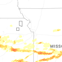
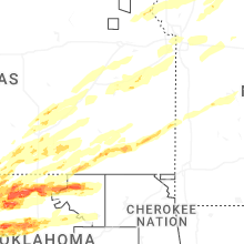

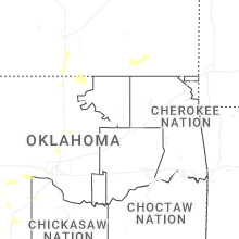
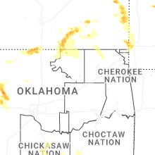


Connect with Interactive Hail Maps