

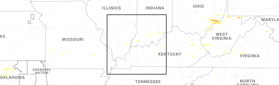
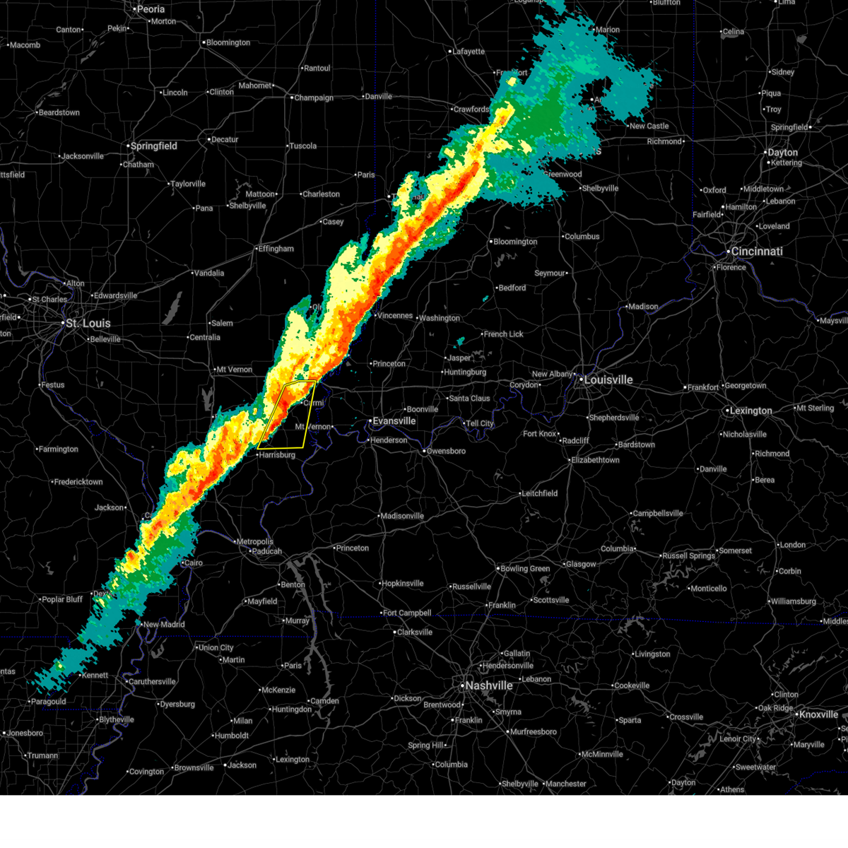
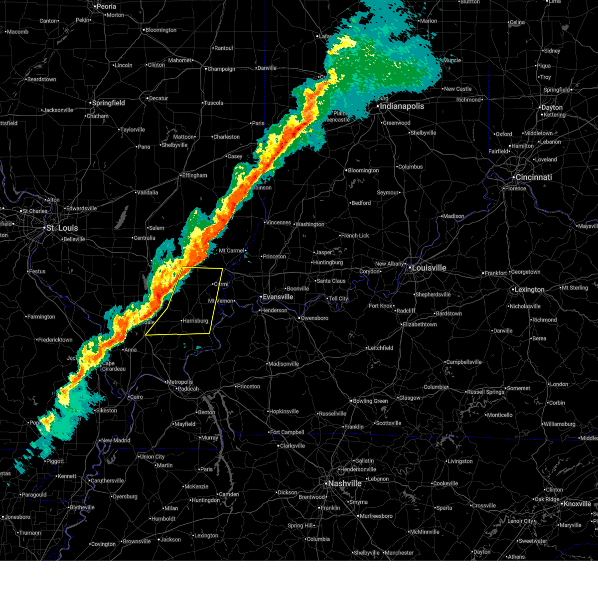
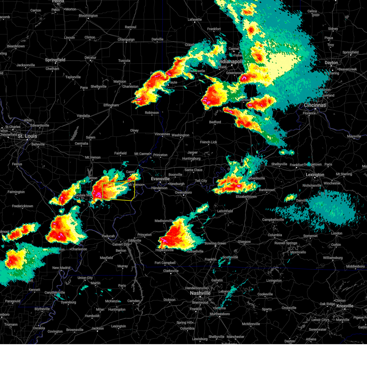
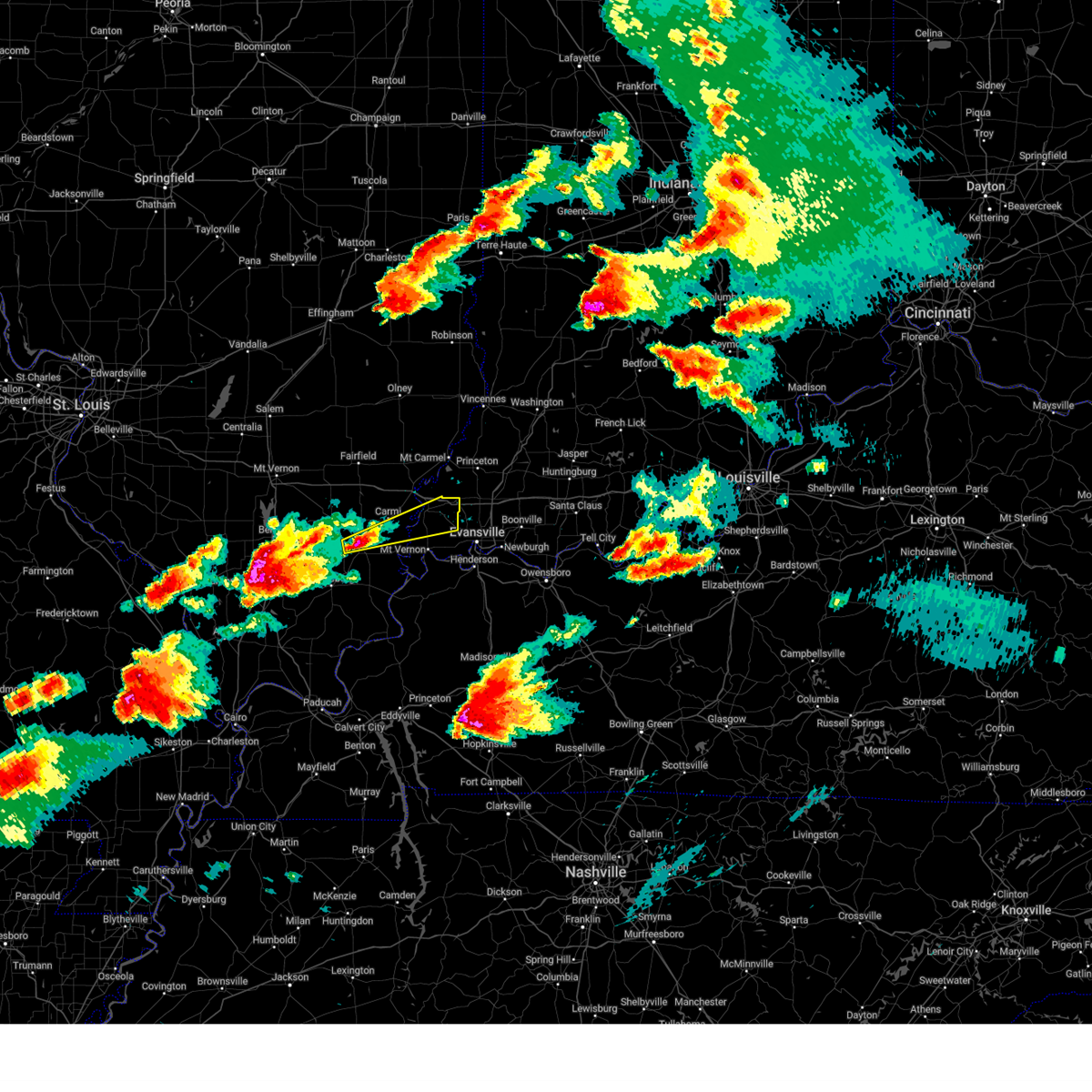
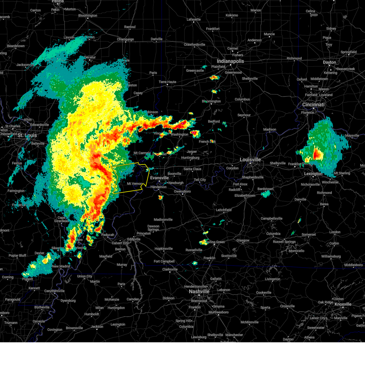
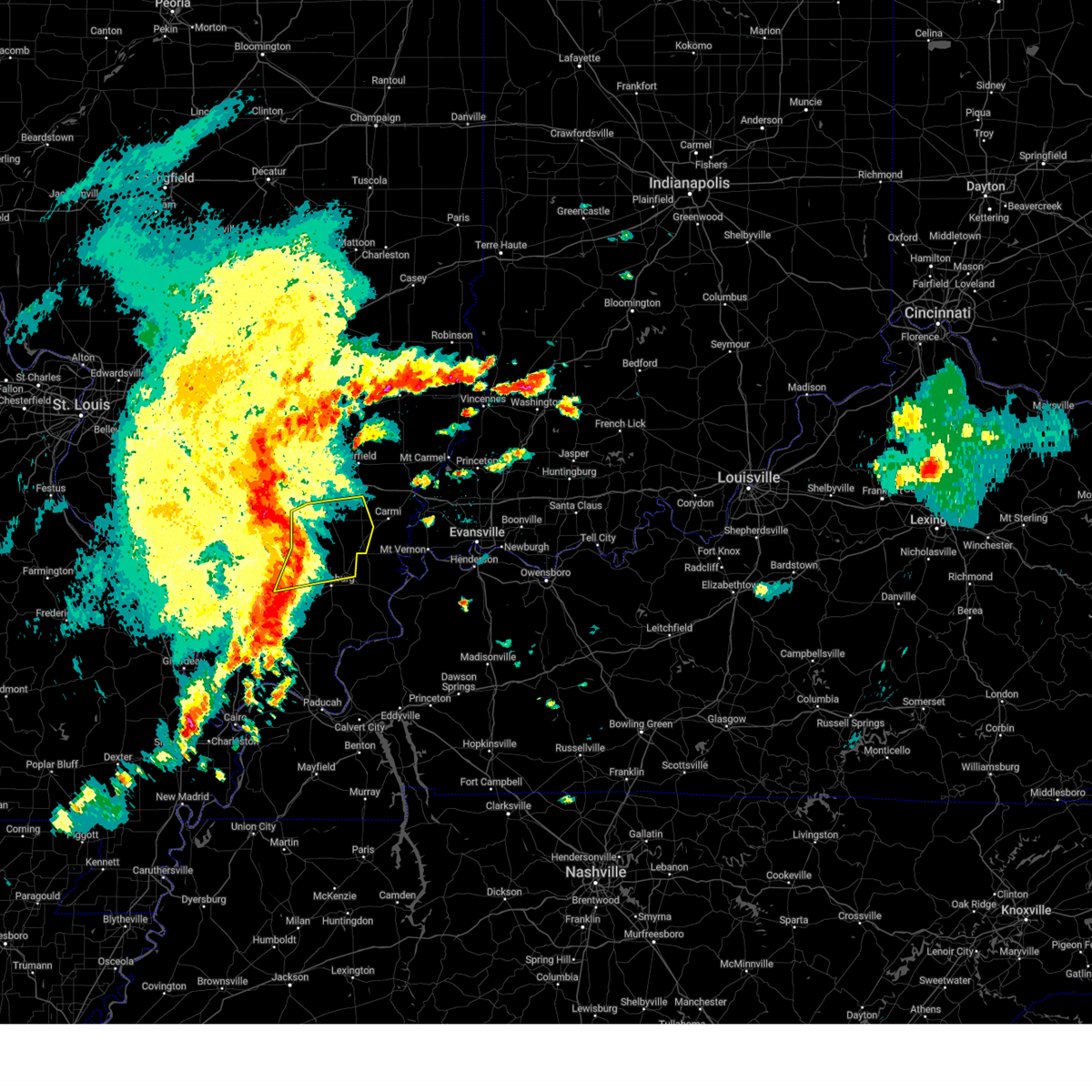
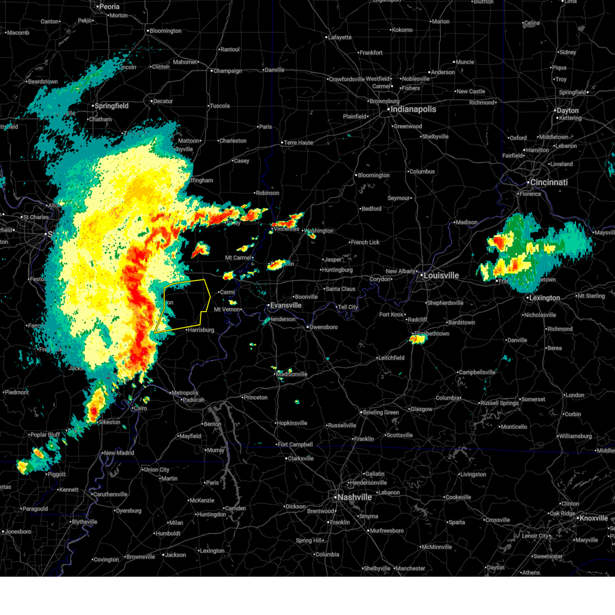
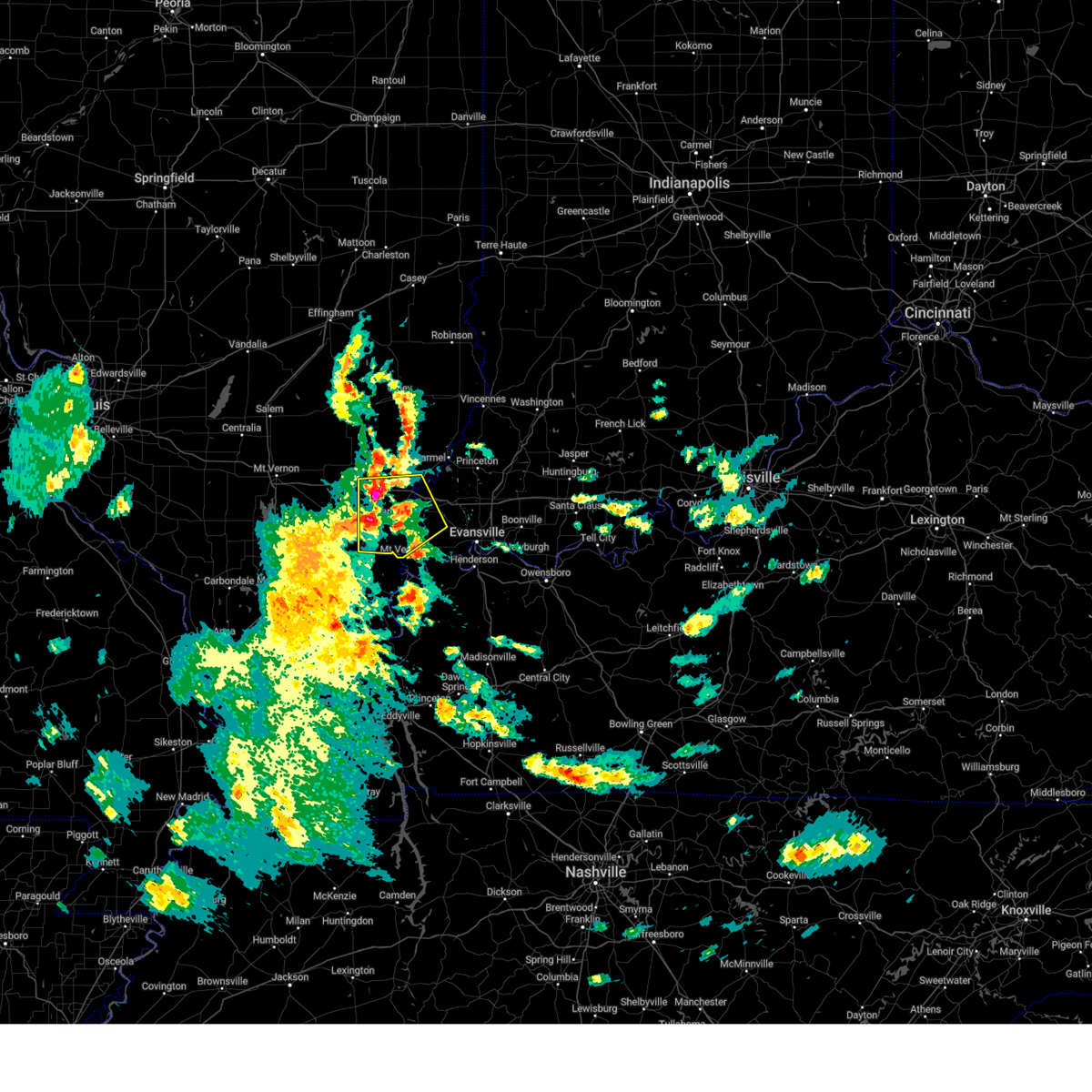
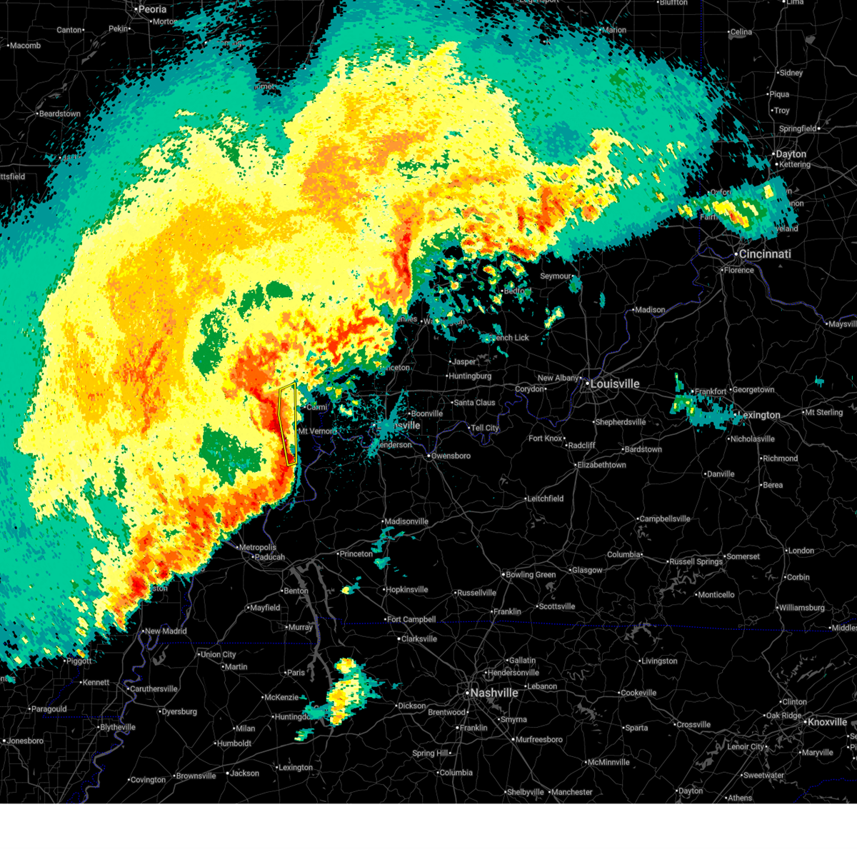
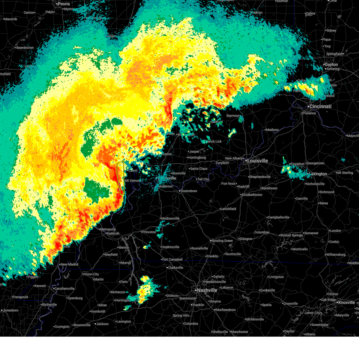
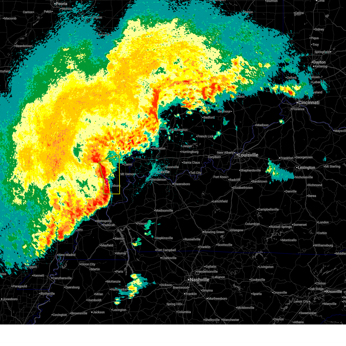
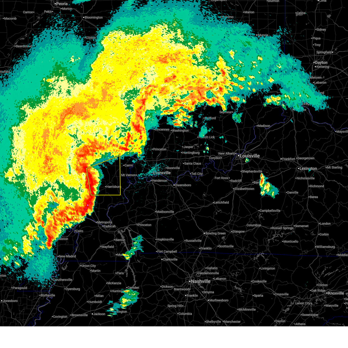
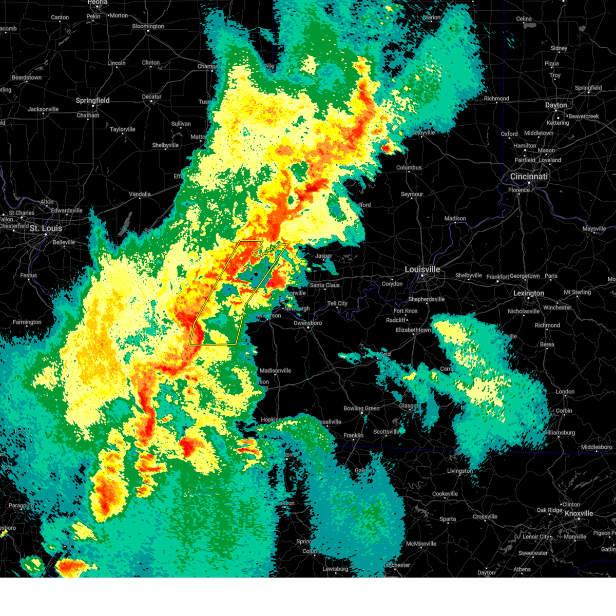
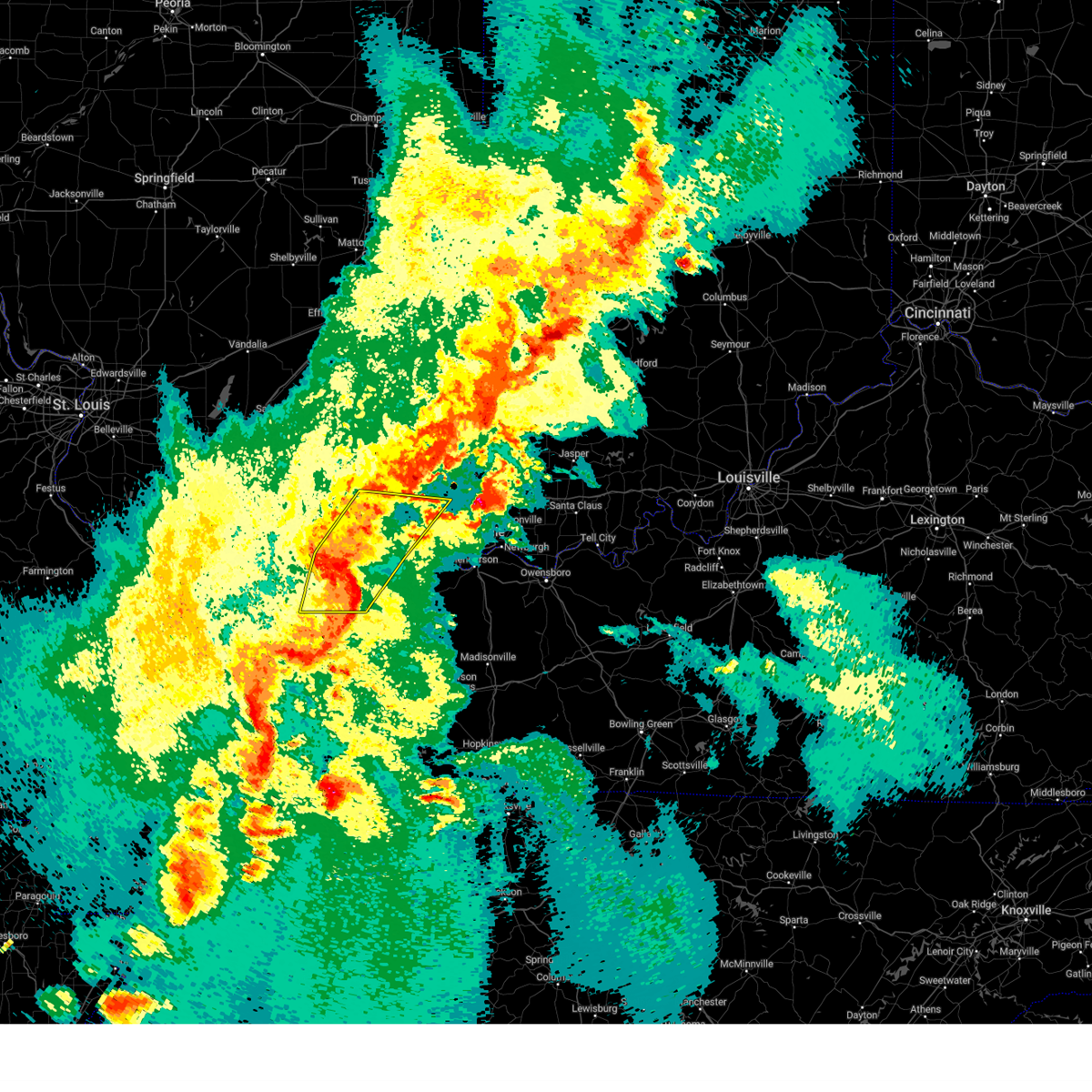
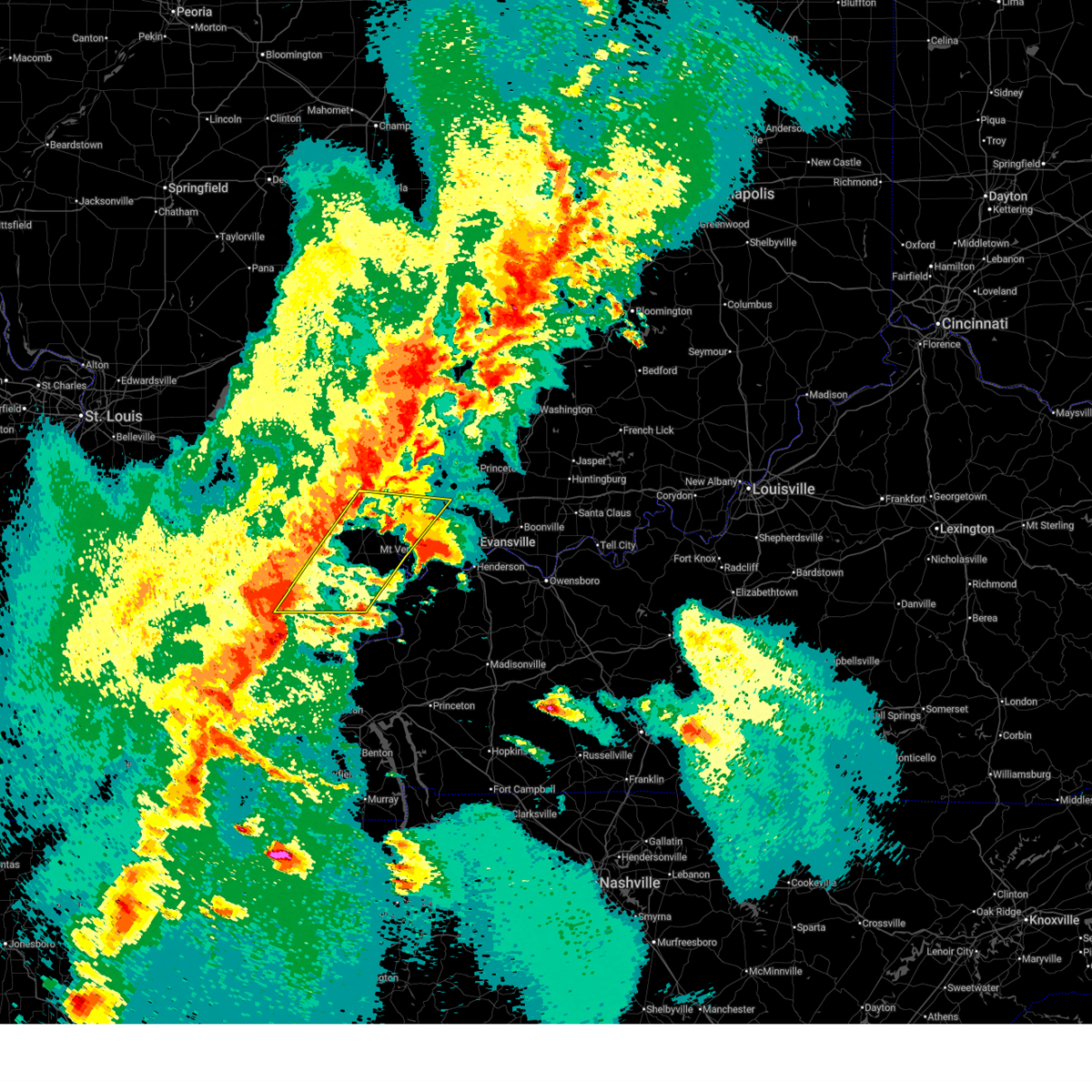
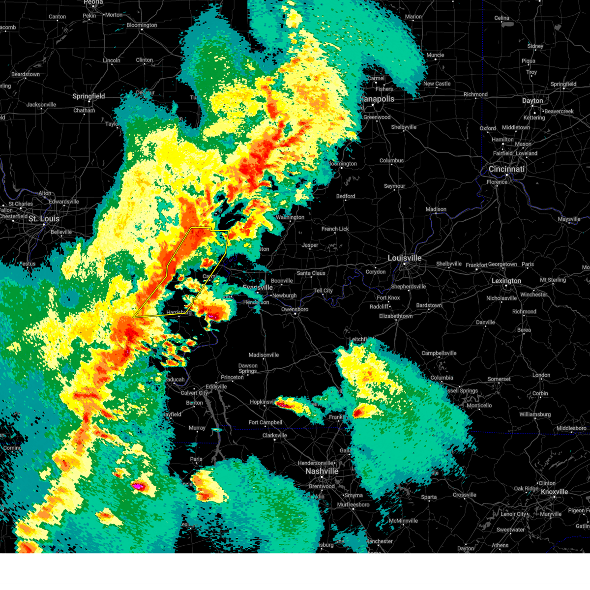
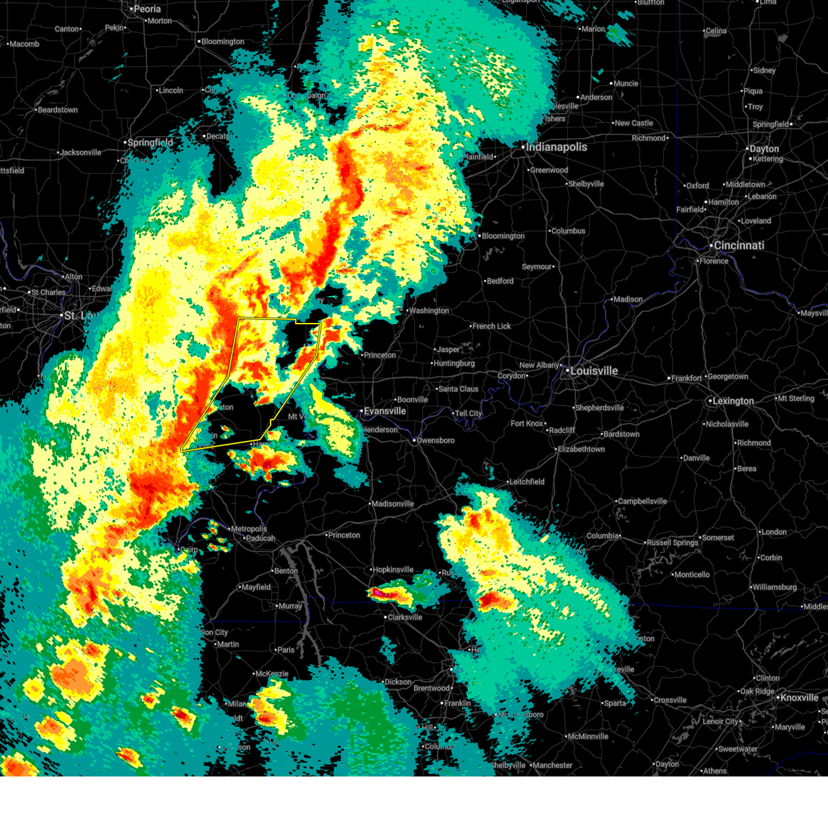
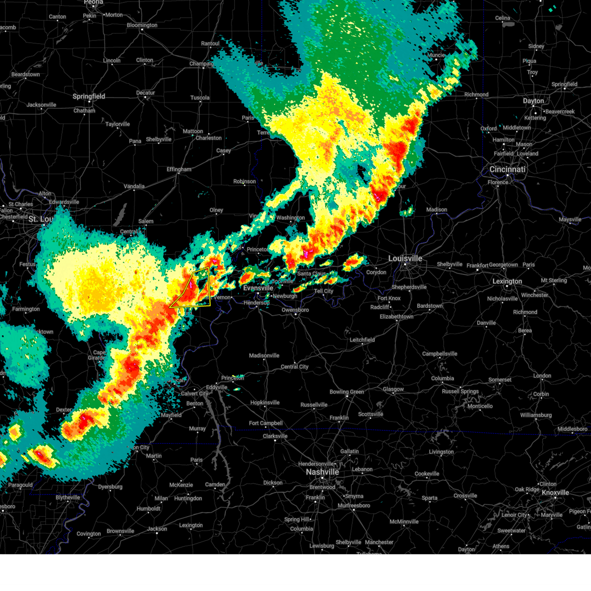
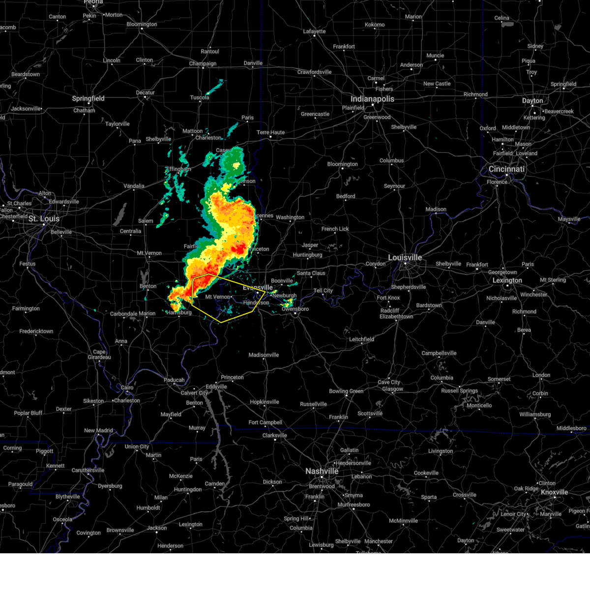
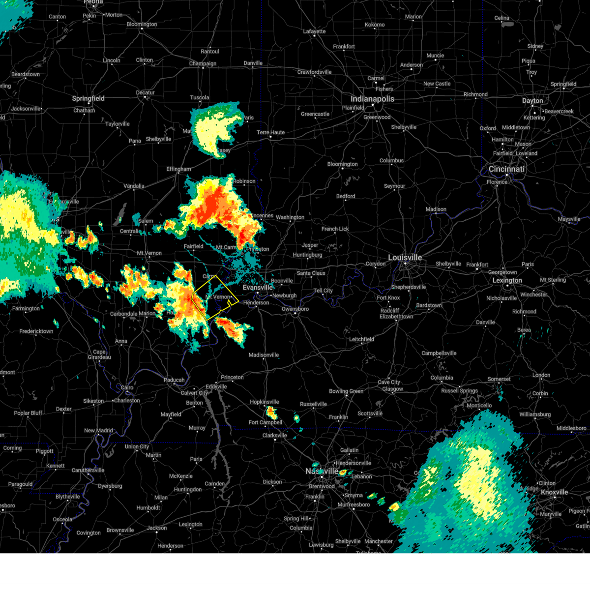
Hail Map for Norris City, IL
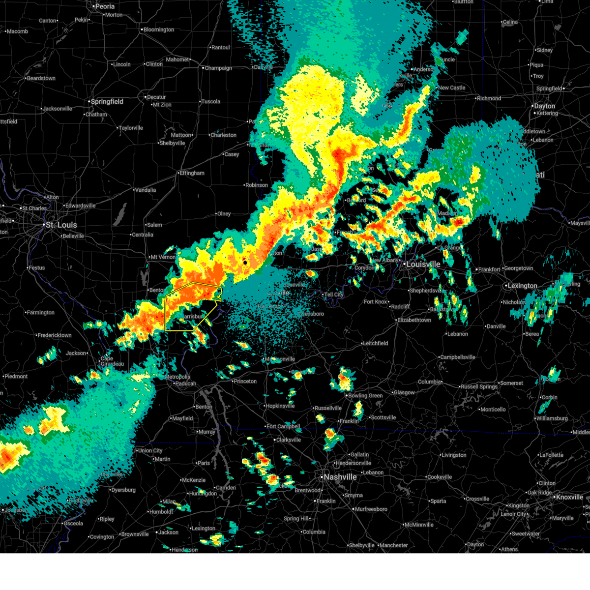
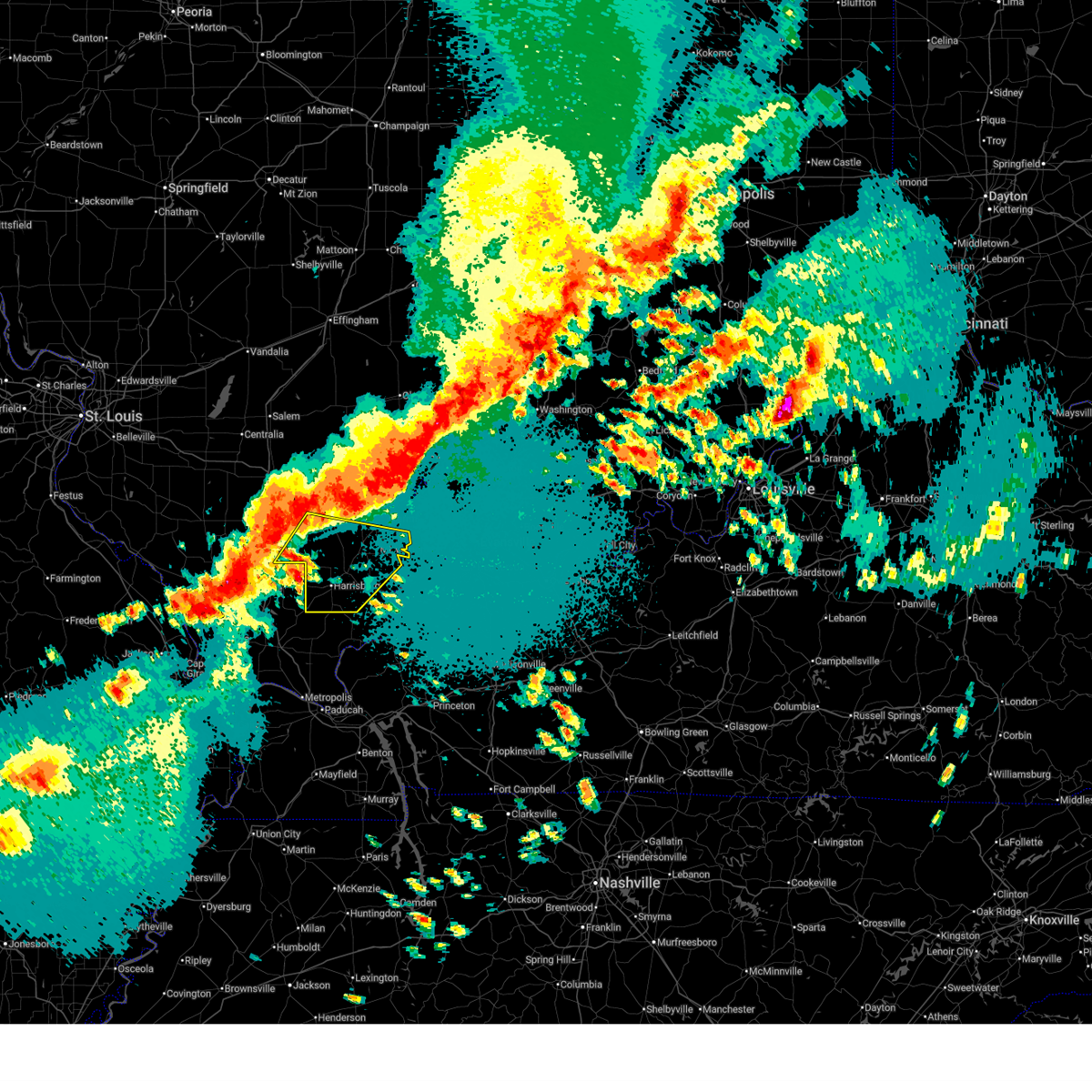
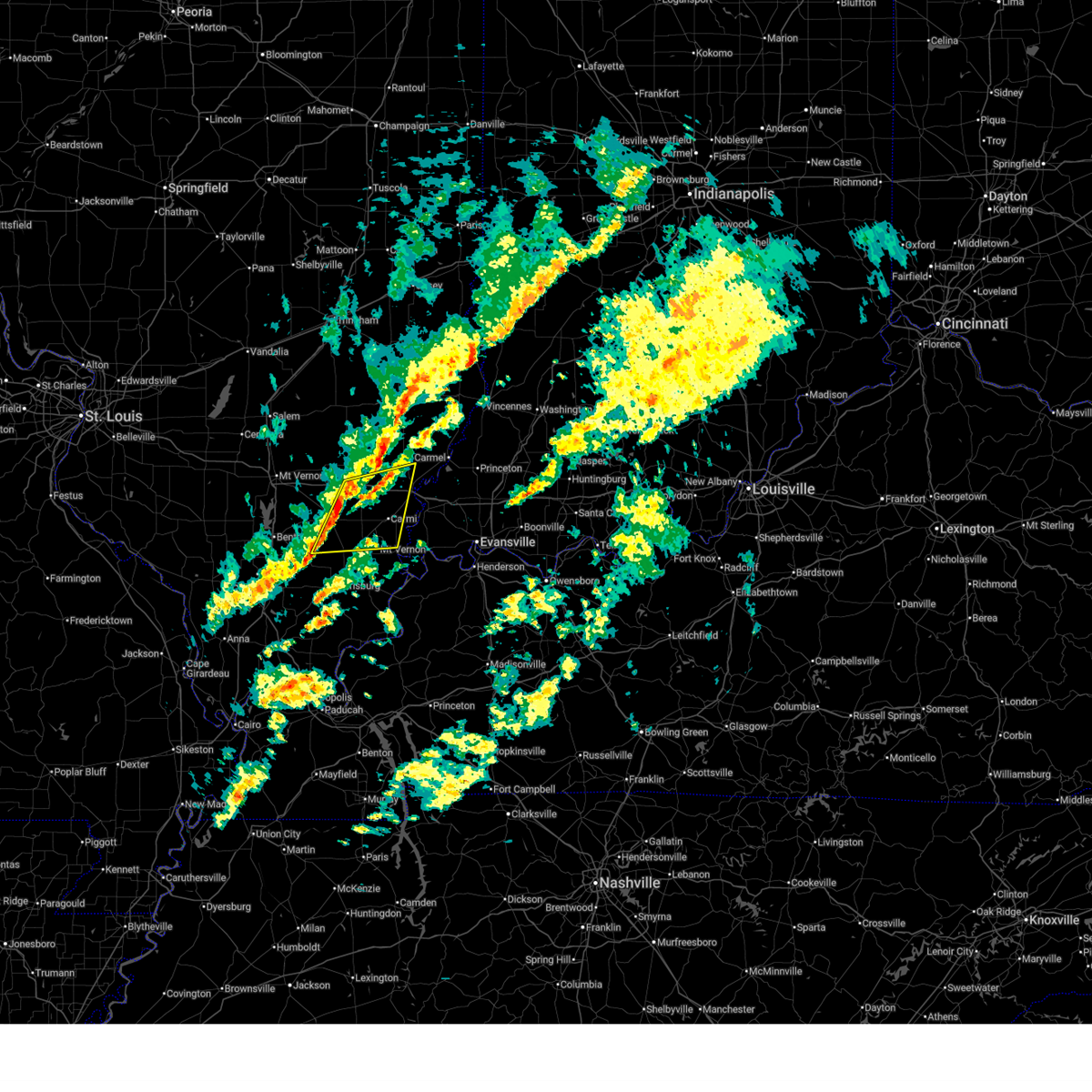
The Norris City, IL area has had 5 reports of on-the-ground hail by trained spotters, and has been under severe weather warnings 7 times during the past 12 months. Doppler radar has detected hail at or near Norris City, IL on 63 occasions, including 4 occasions during the past year.
| Name: | Norris City, IL |
| Where Located: | 41.7 miles W of Evansville, IN |
| Map: | Google Map for Norris City, IL |
| Population: | 1275 |
| Housing Units: | 635 |
| More Info: | Search Google for Norris City, IL |
1
The Top Recent Hail Date for Norris City, IL is Wednesday, April 1, 2026 (26th out of 63)
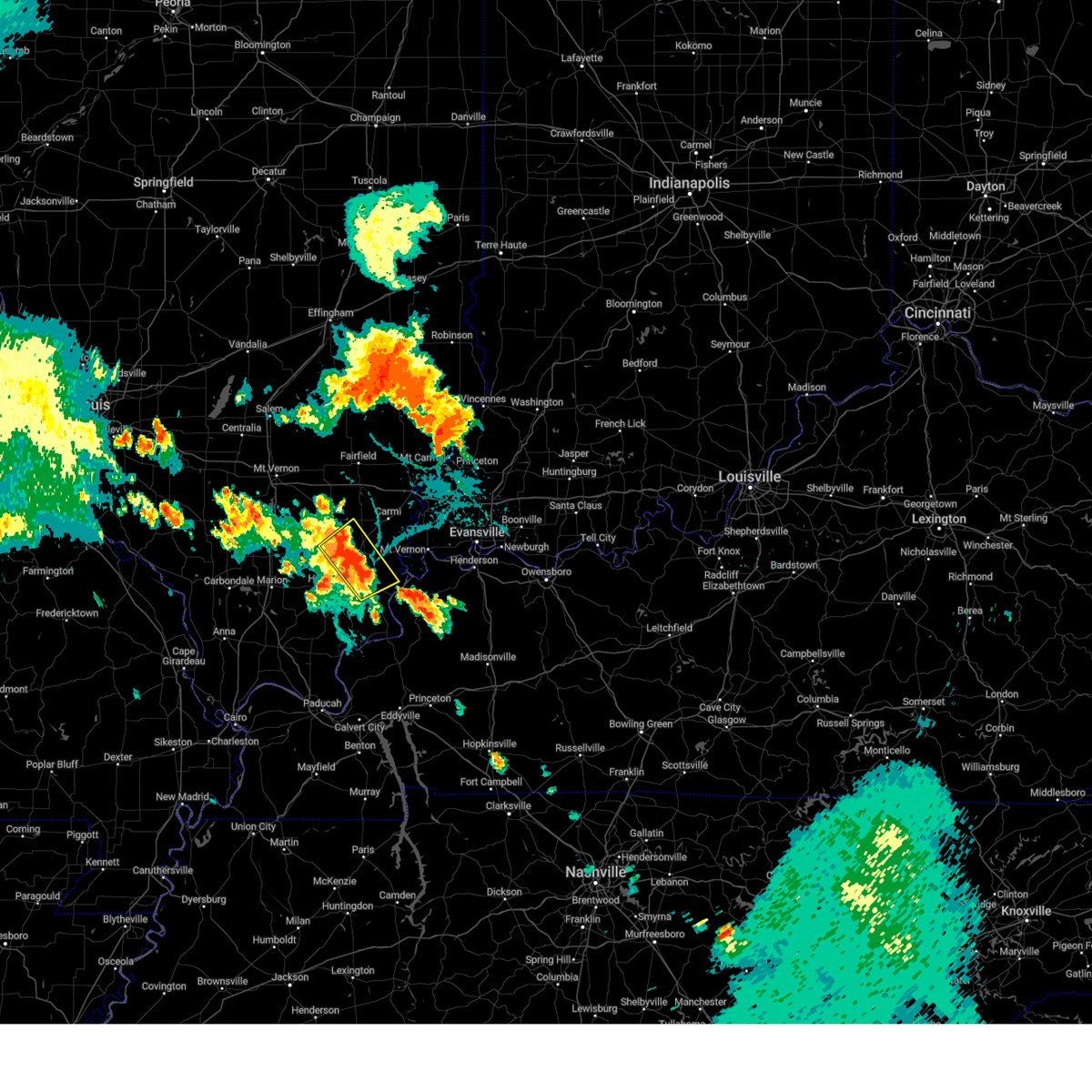
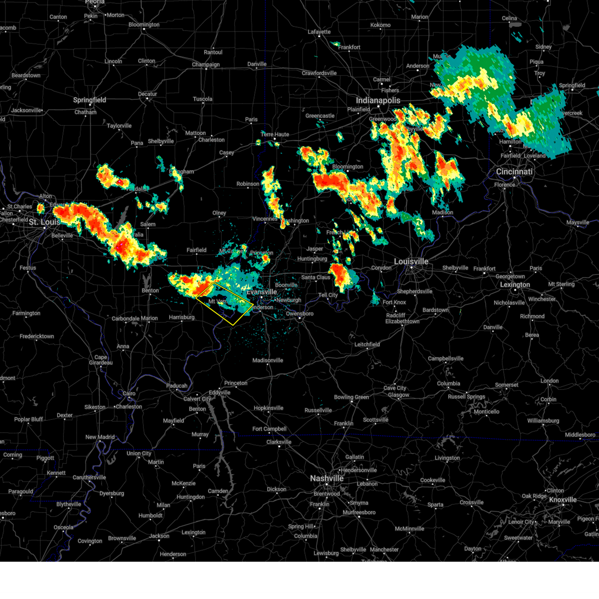
Hail and Wind Damage Spotted near Norris City, IL
| Date / Time | Report Details |
|---|---|
| 4/27/2026 10:29 PM CDT |
 At 1028 pm cdt, severe thunderstorms were located along a line extending from near mcleansboro to near lake of egypt area, moving east at 50 mph (radar indicated). Hazards include 60 mph wind gusts. Expect damage to roofs, siding, and trees. Locations impacted include, harrisburg, eldorado, norris city, galatia, ridgway, equality, carrier mills, new haven, raleigh, stonefort, omaha, broughton, junction, and muddy. At 1028 pm cdt, severe thunderstorms were located along a line extending from near mcleansboro to near lake of egypt area, moving east at 50 mph (radar indicated). Hazards include 60 mph wind gusts. Expect damage to roofs, siding, and trees. Locations impacted include, harrisburg, eldorado, norris city, galatia, ridgway, equality, carrier mills, new haven, raleigh, stonefort, omaha, broughton, junction, and muddy.
|
| 4/27/2026 10:09 PM CDT |
 Svrpah the national weather service in paducah has issued a * severe thunderstorm warning for, southern white county in southeastern illinois, saline county in southern illinois, southern hamilton county in south central illinois, southeastern franklin county in south central illinois, gallatin county in southern illinois, * until 1100 pm cdt. * at 1009 pm cdt, severe thunderstorms were located along a line extending from 10 miles east of rend lake area to cedar lake area, moving east at 50 mph (radar indicated). Hazards include 60 mph wind gusts and penny size hail. expect damage to roofs, siding, and trees Svrpah the national weather service in paducah has issued a * severe thunderstorm warning for, southern white county in southeastern illinois, saline county in southern illinois, southern hamilton county in south central illinois, southeastern franklin county in south central illinois, gallatin county in southern illinois, * until 1100 pm cdt. * at 1009 pm cdt, severe thunderstorms were located along a line extending from 10 miles east of rend lake area to cedar lake area, moving east at 50 mph (radar indicated). Hazards include 60 mph wind gusts and penny size hail. expect damage to roofs, siding, and trees
|
| 1/9/2026 2:01 AM CST |
 At 201 am cst, severe thunderstorms were located along a line extending from 8 miles north of enfield to 8 miles northeast of galatia, moving east at 35 mph (radar indicated). Hazards include 60 mph wind gusts. Expect damage to roofs, siding, and trees. locations impacted include, carmi, albion, norris city, crossville, enfield, mill shoals, broughton, browns, springerton, and burnt prairie. This includes interstate 64 in illinois between mile markers 108 and 128. At 201 am cst, severe thunderstorms were located along a line extending from 8 miles north of enfield to 8 miles northeast of galatia, moving east at 35 mph (radar indicated). Hazards include 60 mph wind gusts. Expect damage to roofs, siding, and trees. locations impacted include, carmi, albion, norris city, crossville, enfield, mill shoals, broughton, browns, springerton, and burnt prairie. This includes interstate 64 in illinois between mile markers 108 and 128.
|
| 1/9/2026 1:49 AM CST |
 Svrpah the national weather service in paducah has issued a * severe thunderstorm warning for, white county in southeastern illinois, southeastern wayne county in south central illinois, southern edwards county in southeastern illinois, eastern hamilton county in south central illinois, * until 230 am cst. * at 149 am cst, severe thunderstorms were located along a line extending from 9 miles northwest of enfield to 6 miles north of galatia, moving east at 35 mph (radar indicated). Hazards include 60 mph wind gusts. expect damage to roofs, siding, and trees Svrpah the national weather service in paducah has issued a * severe thunderstorm warning for, white county in southeastern illinois, southeastern wayne county in south central illinois, southern edwards county in southeastern illinois, eastern hamilton county in south central illinois, * until 230 am cst. * at 149 am cst, severe thunderstorms were located along a line extending from 9 miles northwest of enfield to 6 miles north of galatia, moving east at 35 mph (radar indicated). Hazards include 60 mph wind gusts. expect damage to roofs, siding, and trees
|
| 12/28/2025 6:12 PM CST |
 the severe thunderstorm warning has been cancelled and is no longer in effect the severe thunderstorm warning has been cancelled and is no longer in effect
|
| 12/28/2025 6:12 PM CST |
 At 612 pm cst, severe thunderstorms were located along a line extending from crossville to near eldorado, moving east at 80 mph (radar indicated). Hazards include 60 mph wind gusts. Expect damage to roofs, siding, and trees. locations impacted include, carmi, eldorado, norris city, ridgway, crossville, enfield, new haven, and omaha. This includes interstate 64 in illinois between mile markers 120 and 127. At 612 pm cst, severe thunderstorms were located along a line extending from crossville to near eldorado, moving east at 80 mph (radar indicated). Hazards include 60 mph wind gusts. Expect damage to roofs, siding, and trees. locations impacted include, carmi, eldorado, norris city, ridgway, crossville, enfield, new haven, and omaha. This includes interstate 64 in illinois between mile markers 120 and 127.
|
| 12/28/2025 5:44 PM CST |
 Svrpah the national weather service in paducah has issued a * severe thunderstorm warning for, white county in southeastern illinois, southeastern williamson county in southern illinois, saline county in southern illinois, hamilton county in south central illinois, gallatin county in southern illinois, * until 630 pm cst. * at 544 pm cst, severe thunderstorms were located along a line extending from 7 miles north of mcleansboro to near marion, moving east at 55 mph (radar indicated). Hazards include 60 mph wind gusts. expect damage to roofs, siding, and trees Svrpah the national weather service in paducah has issued a * severe thunderstorm warning for, white county in southeastern illinois, southeastern williamson county in southern illinois, saline county in southern illinois, hamilton county in south central illinois, gallatin county in southern illinois, * until 630 pm cst. * at 544 pm cst, severe thunderstorms were located along a line extending from 7 miles north of mcleansboro to near marion, moving east at 55 mph (radar indicated). Hazards include 60 mph wind gusts. expect damage to roofs, siding, and trees
|
| 5/16/2025 6:32 PM CDT |
 Svrpah the national weather service in paducah has issued a * severe thunderstorm warning for, southwestern white county in southeastern illinois, saline county in southern illinois, southern hamilton county in south central illinois, gallatin county in southern illinois, * until 715 pm cdt. * at 632 pm cdt, a severe thunderstorm was located near galatia, or 8 miles west of harrisburg, moving east at 60 mph (radar indicated). Hazards include two inch hail and 60 mph wind gusts. People and animals outdoors will be injured. expect hail damage to roofs, siding, windows, and vehicles. Expect wind damage to roofs, siding, and trees. Svrpah the national weather service in paducah has issued a * severe thunderstorm warning for, southwestern white county in southeastern illinois, saline county in southern illinois, southern hamilton county in south central illinois, gallatin county in southern illinois, * until 715 pm cdt. * at 632 pm cdt, a severe thunderstorm was located near galatia, or 8 miles west of harrisburg, moving east at 60 mph (radar indicated). Hazards include two inch hail and 60 mph wind gusts. People and animals outdoors will be injured. expect hail damage to roofs, siding, windows, and vehicles. Expect wind damage to roofs, siding, and trees.
|
| 5/16/2025 6:17 PM CDT |
 Svrpah the national weather service in paducah has issued a * severe thunderstorm warning for, southern white county in southeastern illinois, southeastern hamilton county in south central illinois, northern posey county in southwestern indiana, * until 700 pm cdt. * at 617 pm cdt, a severe thunderstorm was located over norris city, or 11 miles northeast of eldorado, moving east at 65 mph (radar indicated). Hazards include ping pong ball size hail and 60 mph wind gusts. People and animals outdoors will be injured. expect hail damage to roofs, siding, windows, and vehicles. Expect wind damage to roofs, siding, and trees. Svrpah the national weather service in paducah has issued a * severe thunderstorm warning for, southern white county in southeastern illinois, southeastern hamilton county in south central illinois, northern posey county in southwestern indiana, * until 700 pm cdt. * at 617 pm cdt, a severe thunderstorm was located over norris city, or 11 miles northeast of eldorado, moving east at 65 mph (radar indicated). Hazards include ping pong ball size hail and 60 mph wind gusts. People and animals outdoors will be injured. expect hail damage to roofs, siding, windows, and vehicles. Expect wind damage to roofs, siding, and trees.
|
| 4/29/2025 3:02 PM CDT |
 the severe thunderstorm warning has been cancelled and is no longer in effect the severe thunderstorm warning has been cancelled and is no longer in effect
|
| 4/29/2025 3:02 PM CDT |
 At 302 pm cdt, severe thunderstorms were located along a line extending from 7 miles north of mcleansboro to near norris city to eldorado, moving east at 50 mph (radar indicated). Hazards include 60 mph wind gusts. Expect damage to roofs, siding, and trees. Locations impacted include, enfield, norris city, eldorado, raleigh, springerton, mcleansboro, galatia, broughton, and macedonia. At 302 pm cdt, severe thunderstorms were located along a line extending from 7 miles north of mcleansboro to near norris city to eldorado, moving east at 50 mph (radar indicated). Hazards include 60 mph wind gusts. Expect damage to roofs, siding, and trees. Locations impacted include, enfield, norris city, eldorado, raleigh, springerton, mcleansboro, galatia, broughton, and macedonia.
|
| 4/29/2025 3:00 PM CDT |
 Svrpah the national weather service in paducah has issued a * severe thunderstorm warning for, white county in southeastern illinois, northeastern saline county in southern illinois, eastern hamilton county in south central illinois, northern gallatin county in southern illinois, posey county in southwestern indiana, * until 345 pm cdt. * at 300 pm cdt, severe thunderstorms were located along a line extending from 7 miles north of mcleansboro to near enfield to near eldorado, moving east at 50 mph (radar indicated). Hazards include 60 mph wind gusts. expect damage to roofs, siding, and trees Svrpah the national weather service in paducah has issued a * severe thunderstorm warning for, white county in southeastern illinois, northeastern saline county in southern illinois, eastern hamilton county in south central illinois, northern gallatin county in southern illinois, posey county in southwestern indiana, * until 345 pm cdt. * at 300 pm cdt, severe thunderstorms were located along a line extending from 7 miles north of mcleansboro to near enfield to near eldorado, moving east at 50 mph (radar indicated). Hazards include 60 mph wind gusts. expect damage to roofs, siding, and trees
|
| 4/29/2025 2:48 PM CDT |
 At 248 pm cdt, severe thunderstorms were located along a line extending from 12 miles south of bluford to 7 miles south of mcleansboro to near harrisburg, moving east at 50 mph (radar indicated). Hazards include 60 mph wind gusts. Expect damage to roofs, siding, and trees. Locations impacted include, enfield, norris city, eldorado, raleigh, thompsonville, pittsburg, springerton, macedonia, mcleansboro, galatia, broughton, and marion. At 248 pm cdt, severe thunderstorms were located along a line extending from 12 miles south of bluford to 7 miles south of mcleansboro to near harrisburg, moving east at 50 mph (radar indicated). Hazards include 60 mph wind gusts. Expect damage to roofs, siding, and trees. Locations impacted include, enfield, norris city, eldorado, raleigh, thompsonville, pittsburg, springerton, macedonia, mcleansboro, galatia, broughton, and marion.
|
| 4/29/2025 2:30 PM CDT |
 Svrpah the national weather service in paducah has issued a * severe thunderstorm warning for, southwestern white county in southeastern illinois, southeastern jefferson county in south central illinois, northeastern williamson county in southern illinois, northern saline county in southern illinois, hamilton county in south central illinois, eastern franklin county in south central illinois, * until 315 pm cdt. * at 229 pm cdt, severe thunderstorms were located along a line extending from near rend lake area to near west frankfort to marion, moving east at 50 mph (radar indicated). Hazards include 60 mph wind gusts. expect damage to roofs, siding, and trees Svrpah the national weather service in paducah has issued a * severe thunderstorm warning for, southwestern white county in southeastern illinois, southeastern jefferson county in south central illinois, northeastern williamson county in southern illinois, northern saline county in southern illinois, hamilton county in south central illinois, eastern franklin county in south central illinois, * until 315 pm cdt. * at 229 pm cdt, severe thunderstorms were located along a line extending from near rend lake area to near west frankfort to marion, moving east at 50 mph (radar indicated). Hazards include 60 mph wind gusts. expect damage to roofs, siding, and trees
|
| 4/10/2025 3:00 PM CDT |
 Svrpah the national weather service in paducah has issued a * severe thunderstorm warning for, white county in southeastern illinois, southeastern wayne county in south central illinois, southwestern wabash county in southeastern illinois, southern edwards county in southeastern illinois, western gibson county in southwestern indiana, northern posey county in southwestern indiana, * until 345 pm cdt. * at 259 pm cdt, a severe thunderstorm was located 9 miles northwest of crossville, or 11 miles north of carmi, moving southeast at 15 mph (radar indicated). Hazards include 60 mph wind gusts and quarter size hail. Hail damage to vehicles is expected. Expect wind damage to roofs, siding, and trees. Svrpah the national weather service in paducah has issued a * severe thunderstorm warning for, white county in southeastern illinois, southeastern wayne county in south central illinois, southwestern wabash county in southeastern illinois, southern edwards county in southeastern illinois, western gibson county in southwestern indiana, northern posey county in southwestern indiana, * until 345 pm cdt. * at 259 pm cdt, a severe thunderstorm was located 9 miles northwest of crossville, or 11 miles north of carmi, moving southeast at 15 mph (radar indicated). Hazards include 60 mph wind gusts and quarter size hail. Hail damage to vehicles is expected. Expect wind damage to roofs, siding, and trees.
|
| 4/4/2025 10:07 PM CDT |
 the severe thunderstorm warning has been cancelled and is no longer in effect the severe thunderstorm warning has been cancelled and is no longer in effect
|
| 4/4/2025 10:07 PM CDT |
 At 1007 pm cdt, severe thunderstorms were located along a line extending from near enfield to near shawneetown, moving east at 40 mph (radar indicated). Hazards include 60 mph wind gusts and half dollar size hail. Hail damage to vehicles is expected. expect wind damage to roofs, siding, and trees. Locations impacted include, enfield, omaha, springerton, ridgway, junction, and norris city. At 1007 pm cdt, severe thunderstorms were located along a line extending from near enfield to near shawneetown, moving east at 40 mph (radar indicated). Hazards include 60 mph wind gusts and half dollar size hail. Hail damage to vehicles is expected. expect wind damage to roofs, siding, and trees. Locations impacted include, enfield, omaha, springerton, ridgway, junction, and norris city.
|
| 4/4/2025 10:01 PM CDT |
 Svrpah the national weather service in paducah has issued a * severe thunderstorm warning for, white county in southeastern illinois, northern gallatin county in southern illinois, southwestern gibson county in southwestern indiana, posey county in southwestern indiana, west central henderson county in northwestern kentucky, north central union county in northwestern kentucky, * until 1045 pm cdt. * at 1001 pm cdt, severe thunderstorms were located along a line extending from enfield to near norris city to near ridgway, moving east at 50 mph (radar indicated). Hazards include 60 mph wind gusts and half dollar size hail. Hail damage to vehicles is expected. Expect wind damage to roofs, siding, and trees. Svrpah the national weather service in paducah has issued a * severe thunderstorm warning for, white county in southeastern illinois, northern gallatin county in southern illinois, southwestern gibson county in southwestern indiana, posey county in southwestern indiana, west central henderson county in northwestern kentucky, north central union county in northwestern kentucky, * until 1045 pm cdt. * at 1001 pm cdt, severe thunderstorms were located along a line extending from enfield to near norris city to near ridgway, moving east at 50 mph (radar indicated). Hazards include 60 mph wind gusts and half dollar size hail. Hail damage to vehicles is expected. Expect wind damage to roofs, siding, and trees.
|
| 4/4/2025 9:46 PM CDT |
 At 946 pm cdt, severe thunderstorms were located along a line extending from near mcleansboro to 8 miles southeast of harrisburg, moving east at 40 mph (radar indicated). Hazards include ping pong ball size hail and 60 mph wind gusts. People and animals outdoors will be injured. expect hail damage to roofs, siding, windows, and vehicles. expect wind damage to roofs, siding, and trees. Locations impacted include, enfield, muddy, eldorado, raleigh, springerton, ridgway, omaha, norris city, junction, harrisburg, equality, mcleansboro, and broughton. At 946 pm cdt, severe thunderstorms were located along a line extending from near mcleansboro to 8 miles southeast of harrisburg, moving east at 40 mph (radar indicated). Hazards include ping pong ball size hail and 60 mph wind gusts. People and animals outdoors will be injured. expect hail damage to roofs, siding, windows, and vehicles. expect wind damage to roofs, siding, and trees. Locations impacted include, enfield, muddy, eldorado, raleigh, springerton, ridgway, omaha, norris city, junction, harrisburg, equality, mcleansboro, and broughton.
|
| 4/4/2025 9:46 PM CDT |
 the severe thunderstorm warning has been cancelled and is no longer in effect the severe thunderstorm warning has been cancelled and is no longer in effect
|
| 4/4/2025 9:24 PM CDT |
 Svrpah the national weather service in paducah has issued a * severe thunderstorm warning for, western white county in southeastern illinois, eastern williamson county in southern illinois, saline county in southern illinois, hamilton county in south central illinois, eastern franklin county in south central illinois, western gallatin county in southern illinois, * until 1015 pm cdt. * at 924 pm cdt, severe thunderstorms were located along a line extending from near benton to near creal springs, moving east at 40 mph (radar indicated). Hazards include 60 mph wind gusts. expect damage to roofs, siding, and trees Svrpah the national weather service in paducah has issued a * severe thunderstorm warning for, western white county in southeastern illinois, eastern williamson county in southern illinois, saline county in southern illinois, hamilton county in south central illinois, eastern franklin county in south central illinois, western gallatin county in southern illinois, * until 1015 pm cdt. * at 924 pm cdt, severe thunderstorms were located along a line extending from near benton to near creal springs, moving east at 40 mph (radar indicated). Hazards include 60 mph wind gusts. expect damage to roofs, siding, and trees
|
| 4/2/2025 8:18 PM CDT |
 Svrpah the national weather service in paducah has issued a * severe thunderstorm warning for, white county in southeastern illinois, wabash county in southeastern illinois, southeastern edwards county in southeastern illinois, southeastern saline county in southern illinois, gallatin county in southern illinois, central gibson county in southwestern indiana, posey county in southwestern indiana, northwestern pike county in southwestern indiana, west central henderson county in northwestern kentucky, northwestern union county in northwestern kentucky, * until 900 pm cdt/1000 pm edt/. * at 817 pm cdt/917 pm edt/, severe thunderstorms were located along a line extending from near lawrenceville vincennes airport to near ridgway to 10 miles south of equality, moving east at 35 mph (radar indicated). Hazards include 70 mph wind gusts and quarter size hail. Hail damage to vehicles is expected. expect considerable tree damage. Wind damage is also likely to mobile homes, roofs, and outbuildings. Svrpah the national weather service in paducah has issued a * severe thunderstorm warning for, white county in southeastern illinois, wabash county in southeastern illinois, southeastern edwards county in southeastern illinois, southeastern saline county in southern illinois, gallatin county in southern illinois, central gibson county in southwestern indiana, posey county in southwestern indiana, northwestern pike county in southwestern indiana, west central henderson county in northwestern kentucky, northwestern union county in northwestern kentucky, * until 900 pm cdt/1000 pm edt/. * at 817 pm cdt/917 pm edt/, severe thunderstorms were located along a line extending from near lawrenceville vincennes airport to near ridgway to 10 miles south of equality, moving east at 35 mph (radar indicated). Hazards include 70 mph wind gusts and quarter size hail. Hail damage to vehicles is expected. expect considerable tree damage. Wind damage is also likely to mobile homes, roofs, and outbuildings.
|
| 4/2/2025 8:12 PM CDT |
 At 812 pm cdt, severe thunderstorms were located along a line extending from crossville to near norris city to 6 miles south of carrier mills, moving east at 40 mph (radar indicated). Hazards include 70 mph wind gusts and quarter size hail. Hail damage to vehicles is expected. expect considerable tree damage. wind damage is also likely to mobile homes, roofs, and outbuildings. locations impacted include, enfield, muddy, eldorado, raleigh, springerton, ridgway, phillipstown, poseyville, carmi, stonefort, omaha, carrier mills, new haven, norris city, junction, harrisburg, equality, maunie, new harmony, and crossville. This includes interstate 64 in indiana between mile markers 3 and 13. At 812 pm cdt, severe thunderstorms were located along a line extending from crossville to near norris city to 6 miles south of carrier mills, moving east at 40 mph (radar indicated). Hazards include 70 mph wind gusts and quarter size hail. Hail damage to vehicles is expected. expect considerable tree damage. wind damage is also likely to mobile homes, roofs, and outbuildings. locations impacted include, enfield, muddy, eldorado, raleigh, springerton, ridgway, phillipstown, poseyville, carmi, stonefort, omaha, carrier mills, new haven, norris city, junction, harrisburg, equality, maunie, new harmony, and crossville. This includes interstate 64 in indiana between mile markers 3 and 13.
|
| 4/2/2025 7:46 PM CDT |
 Svrpah the national weather service in paducah has issued a * severe thunderstorm warning for, white county in southeastern illinois, southeastern williamson county in southern illinois, saline county in southern illinois, southeastern hamilton county in south central illinois, gallatin county in southern illinois, northwestern posey county in southwestern indiana, * until 830 pm cdt. * at 746 pm cdt, severe thunderstorms were located along a line extending from 6 miles north of enfield to 6 miles north of galatia to near lake of egypt area, moving east at 40 mph (radar indicated). Hazards include 70 mph wind gusts and quarter size hail. Hail damage to vehicles is expected. expect considerable tree damage. Wind damage is also likely to mobile homes, roofs, and outbuildings. Svrpah the national weather service in paducah has issued a * severe thunderstorm warning for, white county in southeastern illinois, southeastern williamson county in southern illinois, saline county in southern illinois, southeastern hamilton county in south central illinois, gallatin county in southern illinois, northwestern posey county in southwestern indiana, * until 830 pm cdt. * at 746 pm cdt, severe thunderstorms were located along a line extending from 6 miles north of enfield to 6 miles north of galatia to near lake of egypt area, moving east at 40 mph (radar indicated). Hazards include 70 mph wind gusts and quarter size hail. Hail damage to vehicles is expected. expect considerable tree damage. Wind damage is also likely to mobile homes, roofs, and outbuildings.
|
| 4/2/2025 7:31 PM CDT |
 the severe thunderstorm warning has been cancelled and is no longer in effect the severe thunderstorm warning has been cancelled and is no longer in effect
|
| 4/2/2025 7:31 PM CDT |
 At 731 pm cdt, severe thunderstorms were located along a line extending from 7 miles south of noble to 8 miles north of mcleansboro to near energy, moving east at 40 mph (radar indicated). Hazards include 60 mph wind gusts and quarter size hail. Hail damage to vehicles is expected. expect wind damage to roofs, siding, and trees. locations impacted include, enfield, whiteash, mount erie, jeffersonville, burnt prairie, spillertown, eldorado, cisne, browns, pittsburg, hanaford, golden gate, crainville, bone gap, energy, norris city, thompsonville, west salem, raleigh, and springerton. this includes the following highways, interstate 57 in illinois between mile markers 54 and 63. Interstate 64 in illinois between mile markers 94 and 126. At 731 pm cdt, severe thunderstorms were located along a line extending from 7 miles south of noble to 8 miles north of mcleansboro to near energy, moving east at 40 mph (radar indicated). Hazards include 60 mph wind gusts and quarter size hail. Hail damage to vehicles is expected. expect wind damage to roofs, siding, and trees. locations impacted include, enfield, whiteash, mount erie, jeffersonville, burnt prairie, spillertown, eldorado, cisne, browns, pittsburg, hanaford, golden gate, crainville, bone gap, energy, norris city, thompsonville, west salem, raleigh, and springerton. this includes the following highways, interstate 57 in illinois between mile markers 54 and 63. Interstate 64 in illinois between mile markers 94 and 126.
|
| 4/2/2025 7:14 PM CDT |
 Svrpah the national weather service in paducah has issued a * severe thunderstorm warning for, western white county in southeastern illinois, wayne county in south central illinois, northwestern wabash county in southeastern illinois, southeastern jefferson county in south central illinois, edwards county in southeastern illinois, northern williamson county in southern illinois, northern saline county in southern illinois, hamilton county in south central illinois, eastern franklin county in south central illinois, * until 800 pm cdt. * at 714 pm cdt, severe thunderstorms were located along a line extending from near xenia to 7 miles south of bluford to carterville, moving east at 50 mph (radar indicated). Hazards include 70 mph wind gusts and quarter size hail. Hail damage to vehicles is expected. expect considerable tree damage. Wind damage is also likely to mobile homes, roofs, and outbuildings. Svrpah the national weather service in paducah has issued a * severe thunderstorm warning for, western white county in southeastern illinois, wayne county in south central illinois, northwestern wabash county in southeastern illinois, southeastern jefferson county in south central illinois, edwards county in southeastern illinois, northern williamson county in southern illinois, northern saline county in southern illinois, hamilton county in south central illinois, eastern franklin county in south central illinois, * until 800 pm cdt. * at 714 pm cdt, severe thunderstorms were located along a line extending from near xenia to 7 miles south of bluford to carterville, moving east at 50 mph (radar indicated). Hazards include 70 mph wind gusts and quarter size hail. Hail damage to vehicles is expected. expect considerable tree damage. Wind damage is also likely to mobile homes, roofs, and outbuildings.
|
| 3/30/2025 6:28 PM CDT |
 At 627 pm cdt, a severe thunderstorm was located over norris city, or 11 miles southeast of mcleansboro, moving east at 50 mph (radar indicated). Hazards include 60 mph wind gusts and quarter size hail. Hail damage to vehicles is expected. expect wind damage to roofs, siding, and trees. Locations impacted include, enfield, omaha, norris city, galatia, broughton, and carmi. At 627 pm cdt, a severe thunderstorm was located over norris city, or 11 miles southeast of mcleansboro, moving east at 50 mph (radar indicated). Hazards include 60 mph wind gusts and quarter size hail. Hail damage to vehicles is expected. expect wind damage to roofs, siding, and trees. Locations impacted include, enfield, omaha, norris city, galatia, broughton, and carmi.
|
| 3/30/2025 6:03 PM CDT |
 Svrpah the national weather service in paducah has issued a * severe thunderstorm warning for, western white county in southeastern illinois, northern saline county in southern illinois, hamilton county in south central illinois, northwestern gallatin county in southern illinois, * until 645 pm cdt. * at 603 pm cdt, a severe thunderstorm was located near thompsonville, or 11 miles east of benton, moving east at 50 mph (radar indicated). Hazards include 60 mph wind gusts and quarter size hail. Hail damage to vehicles is expected. Expect wind damage to roofs, siding, and trees. Svrpah the national weather service in paducah has issued a * severe thunderstorm warning for, western white county in southeastern illinois, northern saline county in southern illinois, hamilton county in south central illinois, northwestern gallatin county in southern illinois, * until 645 pm cdt. * at 603 pm cdt, a severe thunderstorm was located near thompsonville, or 11 miles east of benton, moving east at 50 mph (radar indicated). Hazards include 60 mph wind gusts and quarter size hail. Hail damage to vehicles is expected. Expect wind damage to roofs, siding, and trees.
|
| 8/1/2024 1:31 PM CDT |
 Svrpah the national weather service in paducah has issued a * severe thunderstorm warning for, southern white county in southeastern illinois, northern gallatin county in southern illinois, southern vanderburgh county in southwestern indiana, posey county in southwestern indiana, northwestern henderson county in northwestern kentucky, northern union county in northwestern kentucky, * until 215 pm cdt. * at 131 pm cdt, severe thunderstorms were located along a line extending from near new harmony to 7 miles southeast of carmi to near norris city, moving southeast at 35 mph (law enforcement). Hazards include 60 mph wind gusts. expect damage to roofs, siding, and trees Svrpah the national weather service in paducah has issued a * severe thunderstorm warning for, southern white county in southeastern illinois, northern gallatin county in southern illinois, southern vanderburgh county in southwestern indiana, posey county in southwestern indiana, northwestern henderson county in northwestern kentucky, northern union county in northwestern kentucky, * until 215 pm cdt. * at 131 pm cdt, severe thunderstorms were located along a line extending from near new harmony to 7 miles southeast of carmi to near norris city, moving southeast at 35 mph (law enforcement). Hazards include 60 mph wind gusts. expect damage to roofs, siding, and trees
|
| 8/1/2024 1:18 PM CDT |
 At 117 pm cdt, severe thunderstorms were located along a line extending from near crossville to near enfield to 9 miles northeast of galatia, moving southeast at 25 mph (radar indicated). Hazards include 60 mph wind gusts. Expect damage to roofs, siding, and trees. locations impacted include, carmi, mcleansboro, grayville, norris city, crossville, enfield, mill shoals, broughton, springerton, and burnt prairie. This includes interstate 64 in illinois between mile markers 106 and 130. At 117 pm cdt, severe thunderstorms were located along a line extending from near crossville to near enfield to 9 miles northeast of galatia, moving southeast at 25 mph (radar indicated). Hazards include 60 mph wind gusts. Expect damage to roofs, siding, and trees. locations impacted include, carmi, mcleansboro, grayville, norris city, crossville, enfield, mill shoals, broughton, springerton, and burnt prairie. This includes interstate 64 in illinois between mile markers 106 and 130.
|
| 8/1/2024 12:47 PM CDT |
 Svrpah the national weather service in paducah has issued a * severe thunderstorm warning for, white county in southeastern illinois, southeastern wayne county in south central illinois, southwestern wabash county in southeastern illinois, southern edwards county in southeastern illinois, hamilton county in south central illinois, * until 130 pm cdt. * at 1246 pm cdt, severe thunderstorms were located along a line extending from 6 miles southeast of fairfield to 9 miles northwest of enfield to near mcleansboro, moving southeast at 25 mph (public). Hazards include 60 mph wind gusts. expect damage to roofs, siding, and trees Svrpah the national weather service in paducah has issued a * severe thunderstorm warning for, white county in southeastern illinois, southeastern wayne county in south central illinois, southwestern wabash county in southeastern illinois, southern edwards county in southeastern illinois, hamilton county in south central illinois, * until 130 pm cdt. * at 1246 pm cdt, severe thunderstorms were located along a line extending from 6 miles southeast of fairfield to 9 miles northwest of enfield to near mcleansboro, moving southeast at 25 mph (public). Hazards include 60 mph wind gusts. expect damage to roofs, siding, and trees
|
| 7/30/2024 5:40 PM CDT |
 Svrpah the national weather service in paducah has issued a * severe thunderstorm warning for, southern white county in southeastern illinois, northern gallatin county in southern illinois, southwestern posey county in southwestern indiana, west central henderson county in northwestern kentucky, * until 630 pm cdt. * at 540 pm cdt, severe thunderstorms were located along a line extending from near norris city to near ridgway, moving northeast at 25 mph (radar indicated). Hazards include 60 mph wind gusts and quarter size hail. Hail damage to vehicles is expected. Expect wind damage to roofs, siding, and trees. Svrpah the national weather service in paducah has issued a * severe thunderstorm warning for, southern white county in southeastern illinois, northern gallatin county in southern illinois, southwestern posey county in southwestern indiana, west central henderson county in northwestern kentucky, * until 630 pm cdt. * at 540 pm cdt, severe thunderstorms were located along a line extending from near norris city to near ridgway, moving northeast at 25 mph (radar indicated). Hazards include 60 mph wind gusts and quarter size hail. Hail damage to vehicles is expected. Expect wind damage to roofs, siding, and trees.
|
| 7/30/2024 5:33 PM CDT |
 the severe thunderstorm warning has been cancelled and is no longer in effect the severe thunderstorm warning has been cancelled and is no longer in effect
|
| 7/30/2024 5:33 PM CDT |
 At 533 pm cdt, severe thunderstorms were located along a line extending from near mcleansboro to 6 miles southwest of norris city to near shawneetown, moving northeast at 15 mph (radar indicated). Hazards include 60 mph wind gusts and quarter size hail. Hail damage to vehicles is expected. expect wind damage to roofs, siding, and trees. Locations impacted include, eldorado, shawneetown, norris city, ridgway, equality, omaha, broughton, and junction. At 533 pm cdt, severe thunderstorms were located along a line extending from near mcleansboro to 6 miles southwest of norris city to near shawneetown, moving northeast at 15 mph (radar indicated). Hazards include 60 mph wind gusts and quarter size hail. Hail damage to vehicles is expected. expect wind damage to roofs, siding, and trees. Locations impacted include, eldorado, shawneetown, norris city, ridgway, equality, omaha, broughton, and junction.
|
| 7/30/2024 5:28 PM CDT |
 At 528 pm cdt, severe thunderstorms were located along a line extending from near mcleansboro to 6 miles north of eldorado to near equality, moving northeast at 20 mph (radar indicated). Hazards include 60 mph wind gusts and quarter size hail. Hail damage to vehicles is expected. expect wind damage to roofs, siding, and trees. Locations impacted include, eldorado, mcleansboro, shawneetown, norris city, ridgway, equality, omaha, broughton, junction, macedonia, and belle prairie city. At 528 pm cdt, severe thunderstorms were located along a line extending from near mcleansboro to 6 miles north of eldorado to near equality, moving northeast at 20 mph (radar indicated). Hazards include 60 mph wind gusts and quarter size hail. Hail damage to vehicles is expected. expect wind damage to roofs, siding, and trees. Locations impacted include, eldorado, mcleansboro, shawneetown, norris city, ridgway, equality, omaha, broughton, junction, macedonia, and belle prairie city.
|
| 7/30/2024 5:20 PM CDT |
 the severe thunderstorm warning has been cancelled and is no longer in effect the severe thunderstorm warning has been cancelled and is no longer in effect
|
| 7/30/2024 5:20 PM CDT |
 At 520 pm cdt, severe thunderstorms were located along a line extending from 9 miles west of mcleansboro to near galatia to near equality, moving northeast at 25 mph (radar indicated). Hazards include 70 mph wind gusts and quarter size hail. Hail damage to vehicles is expected. expect considerable tree damage. wind damage is also likely to mobile homes, roofs, and outbuildings. Locations impacted include, harrisburg, eldorado, mcleansboro, shawneetown, norris city, galatia, ridgway, equality, raleigh, omaha, broughton, junction, muddy, macedonia, and belle prairie city. At 520 pm cdt, severe thunderstorms were located along a line extending from 9 miles west of mcleansboro to near galatia to near equality, moving northeast at 25 mph (radar indicated). Hazards include 70 mph wind gusts and quarter size hail. Hail damage to vehicles is expected. expect considerable tree damage. wind damage is also likely to mobile homes, roofs, and outbuildings. Locations impacted include, harrisburg, eldorado, mcleansboro, shawneetown, norris city, galatia, ridgway, equality, raleigh, omaha, broughton, junction, muddy, macedonia, and belle prairie city.
|
| 7/30/2024 5:11 PM CDT |
 Svrpah the national weather service in paducah has issued a * severe thunderstorm warning for, southwestern white county in southeastern illinois, southeastern jefferson county in south central illinois, saline county in southern illinois, hamilton county in south central illinois, eastern franklin county in south central illinois, northern gallatin county in southern illinois, * until 600 pm cdt. * at 511 pm cdt, severe thunderstorms were located along a line extending from 8 miles northeast of benton to near harrisburg, moving northeast at 15 mph (radar indicated). Hazards include 70 mph wind gusts and quarter size hail. Hail damage to vehicles is expected. expect considerable tree damage. Wind damage is also likely to mobile homes, roofs, and outbuildings. Svrpah the national weather service in paducah has issued a * severe thunderstorm warning for, southwestern white county in southeastern illinois, southeastern jefferson county in south central illinois, saline county in southern illinois, hamilton county in south central illinois, eastern franklin county in south central illinois, northern gallatin county in southern illinois, * until 600 pm cdt. * at 511 pm cdt, severe thunderstorms were located along a line extending from 8 miles northeast of benton to near harrisburg, moving northeast at 15 mph (radar indicated). Hazards include 70 mph wind gusts and quarter size hail. Hail damage to vehicles is expected. expect considerable tree damage. Wind damage is also likely to mobile homes, roofs, and outbuildings.
|
| 7/29/2024 11:01 PM CDT |
 Svrpah the national weather service in paducah has issued a * severe thunderstorm warning for, southern white county in southeastern illinois, northeastern gallatin county in southern illinois, southern posey county in southwestern indiana, west central henderson county in northwestern kentucky, northeastern union county in northwestern kentucky, * until 1145 pm cdt. * at 1100 pm cdt, a severe thunderstorm was located near carmi, moving southeast at 35 mph (radar indicated). Hazards include 60 mph wind gusts and penny size hail. expect damage to roofs, siding, and trees Svrpah the national weather service in paducah has issued a * severe thunderstorm warning for, southern white county in southeastern illinois, northeastern gallatin county in southern illinois, southern posey county in southwestern indiana, west central henderson county in northwestern kentucky, northeastern union county in northwestern kentucky, * until 1145 pm cdt. * at 1100 pm cdt, a severe thunderstorm was located near carmi, moving southeast at 35 mph (radar indicated). Hazards include 60 mph wind gusts and penny size hail. expect damage to roofs, siding, and trees
|
| 5/26/2024 8:30 PM CDT |
 the severe thunderstorm warning has been cancelled and is no longer in effect the severe thunderstorm warning has been cancelled and is no longer in effect
|
| 5/26/2024 8:21 PM CDT |
 the severe thunderstorm warning has been cancelled and is no longer in effect the severe thunderstorm warning has been cancelled and is no longer in effect
|
| 5/26/2024 8:21 PM CDT |
 At 821 pm cdt, severe thunderstorms were located along a line extending from 8 miles northeast of fairfield to near mcleansboro to near pittsburg, moving east at 45 mph (radar indicated). Hazards include 70 mph wind gusts and quarter size hail. Hail damage to vehicles is expected. expect considerable tree damage. wind damage is also likely to mobile homes, roofs, and outbuildings. locations impacted include, fairfield, mcleansboro, norris city, enfield, mill shoals, broughton, springerton, mount erie, golden gate, and burnt prairie. This includes interstate 64 in illinois between mile markers 105 and 120. At 821 pm cdt, severe thunderstorms were located along a line extending from 8 miles northeast of fairfield to near mcleansboro to near pittsburg, moving east at 45 mph (radar indicated). Hazards include 70 mph wind gusts and quarter size hail. Hail damage to vehicles is expected. expect considerable tree damage. wind damage is also likely to mobile homes, roofs, and outbuildings. locations impacted include, fairfield, mcleansboro, norris city, enfield, mill shoals, broughton, springerton, mount erie, golden gate, and burnt prairie. This includes interstate 64 in illinois between mile markers 105 and 120.
|
| 5/26/2024 8:03 PM CDT |
 Svrpah the national weather service in paducah has issued a * severe thunderstorm warning for, white county in southeastern illinois, eastern wayne county in south central illinois, wabash county in southeastern illinois, edwards county in southeastern illinois, * until 900 pm cdt. * at 803 pm cdt, severe thunderstorms were located along a line extending from near cisne to 8 miles northwest of mcleansboro to near thompsonville, moving east at 50 mph (radar indicated). Hazards include 70 mph wind gusts and quarter size hail. Hail damage to vehicles is expected. expect considerable tree damage. Wind damage is also likely to mobile homes, roofs, and outbuildings. Svrpah the national weather service in paducah has issued a * severe thunderstorm warning for, white county in southeastern illinois, eastern wayne county in south central illinois, wabash county in southeastern illinois, edwards county in southeastern illinois, * until 900 pm cdt. * at 803 pm cdt, severe thunderstorms were located along a line extending from near cisne to 8 miles northwest of mcleansboro to near thompsonville, moving east at 50 mph (radar indicated). Hazards include 70 mph wind gusts and quarter size hail. Hail damage to vehicles is expected. expect considerable tree damage. Wind damage is also likely to mobile homes, roofs, and outbuildings.
|
| 5/26/2024 7:59 PM CDT |
 At 759 pm cdt, severe thunderstorms were located along a line extending from near cisne to 10 miles west of mcleansboro to near zeigler, moving southeast at 45 mph (radar indicated). Hazards include 70 mph wind gusts and quarter size hail. Hail damage to vehicles is expected. expect considerable tree damage. wind damage is also likely to mobile homes, roofs, and outbuildings. locations impacted include, west frankfort, benton, fairfield, mcleansboro, zeigler, norris city, wayne city, cisne, enfield, thompsonville, dahlgren, jeffersonville, orient, hanaford, freeman spur, sims, mill shoals, broughton, springerton, and mount erie. this includes the following highways, interstate 57 in illinois between mile markers 62 and 71. Interstate 64 in illinois between mile markers 92 and 120. At 759 pm cdt, severe thunderstorms were located along a line extending from near cisne to 10 miles west of mcleansboro to near zeigler, moving southeast at 45 mph (radar indicated). Hazards include 70 mph wind gusts and quarter size hail. Hail damage to vehicles is expected. expect considerable tree damage. wind damage is also likely to mobile homes, roofs, and outbuildings. locations impacted include, west frankfort, benton, fairfield, mcleansboro, zeigler, norris city, wayne city, cisne, enfield, thompsonville, dahlgren, jeffersonville, orient, hanaford, freeman spur, sims, mill shoals, broughton, springerton, and mount erie. this includes the following highways, interstate 57 in illinois between mile markers 62 and 71. Interstate 64 in illinois between mile markers 92 and 120.
|
| 5/26/2024 7:39 PM CDT |
 Svrpah the national weather service in paducah has issued a * severe thunderstorm warning for, northwestern white county in southeastern illinois, wayne county in south central illinois, hamilton county in south central illinois, eastern franklin county in south central illinois, * until 900 pm cdt. * at 738 pm cdt, severe thunderstorms were located along a line extending from 7 miles west of helm to 7 miles south of woodlawn to elkville, moving southeast at 45 mph (radar indicated). Hazards include 60 mph wind gusts and quarter size hail. Hail damage to vehicles is expected. Expect wind damage to roofs, siding, and trees. Svrpah the national weather service in paducah has issued a * severe thunderstorm warning for, northwestern white county in southeastern illinois, wayne county in south central illinois, hamilton county in south central illinois, eastern franklin county in south central illinois, * until 900 pm cdt. * at 738 pm cdt, severe thunderstorms were located along a line extending from 7 miles west of helm to 7 miles south of woodlawn to elkville, moving southeast at 45 mph (radar indicated). Hazards include 60 mph wind gusts and quarter size hail. Hail damage to vehicles is expected. Expect wind damage to roofs, siding, and trees.
|
| 5/8/2024 8:23 PM CDT |
 The storm which prompted the warning has moved out of the area. therefore, the warning will be allowed to expire. a tornado watch remains in effect until midnight cdt for south central, southern and southeastern illinois. The storm which prompted the warning has moved out of the area. therefore, the warning will be allowed to expire. a tornado watch remains in effect until midnight cdt for south central, southern and southeastern illinois.
|
| 5/8/2024 8:22 PM CDT |
 Svrpah the national weather service in paducah has issued a * severe thunderstorm warning for, white county in southeastern illinois, southeastern hamilton county in south central illinois, * until 915 pm cdt. * at 822 pm cdt, a severe thunderstorm was located near norris city, or 8 miles southeast of mcleansboro, moving east at 40 mph (radar indicated). Hazards include 60 mph wind gusts and quarter size hail. Hail damage to vehicles is expected. Expect wind damage to roofs, siding, and trees. Svrpah the national weather service in paducah has issued a * severe thunderstorm warning for, white county in southeastern illinois, southeastern hamilton county in south central illinois, * until 915 pm cdt. * at 822 pm cdt, a severe thunderstorm was located near norris city, or 8 miles southeast of mcleansboro, moving east at 40 mph (radar indicated). Hazards include 60 mph wind gusts and quarter size hail. Hail damage to vehicles is expected. Expect wind damage to roofs, siding, and trees.
|
| 5/8/2024 8:05 PM CDT |
 At 805 pm cdt, a severe thunderstorm was located just west of mcleansboro, moving east at 50 mph (radar indicated). Hazards include 60 mph wind gusts and half dollar size hail. Hail damage to vehicles is expected. expect wind damage to roofs, siding, and trees. Locations impacted include, carmi, mcleansboro, norris city, enfield, thompsonville, dahlgren, hanaford, broughton, springerton, and macedonia. At 805 pm cdt, a severe thunderstorm was located just west of mcleansboro, moving east at 50 mph (radar indicated). Hazards include 60 mph wind gusts and half dollar size hail. Hail damage to vehicles is expected. expect wind damage to roofs, siding, and trees. Locations impacted include, carmi, mcleansboro, norris city, enfield, thompsonville, dahlgren, hanaford, broughton, springerton, and macedonia.
|
| 5/8/2024 7:55 PM CDT |
 At 755 pm cdt, severe thunderstorms were located along a line extending from 8 miles south of wayne city to near west frankfort, moving east at 45 mph (radar indicated). Hazards include 60 mph wind gusts and half dollar size hail. Hail damage to vehicles is expected. expect wind damage to roofs, siding, and trees. locations impacted include, west frankfort, benton, carmi, mcleansboro, rend lake area, norris city, west city, enfield, thompsonville, dahlgren, buckner, orient, hanaford, ewing, freeman spur, broughton, springerton, and macedonia. This includes interstate 57 in illinois between mile markers 63 and 79. At 755 pm cdt, severe thunderstorms were located along a line extending from 8 miles south of wayne city to near west frankfort, moving east at 45 mph (radar indicated). Hazards include 60 mph wind gusts and half dollar size hail. Hail damage to vehicles is expected. expect wind damage to roofs, siding, and trees. locations impacted include, west frankfort, benton, carmi, mcleansboro, rend lake area, norris city, west city, enfield, thompsonville, dahlgren, buckner, orient, hanaford, ewing, freeman spur, broughton, springerton, and macedonia. This includes interstate 57 in illinois between mile markers 63 and 79.
|
| 5/8/2024 7:38 PM CDT |
 Svrpah the national weather service in paducah has issued a * severe thunderstorm warning for, western white county in southeastern illinois, southeastern jefferson county in south central illinois, northern saline county in southern illinois, hamilton county in south central illinois, franklin county in south central illinois, * until 830 pm cdt. * at 737 pm cdt, severe thunderstorms were located along a line extending from 7 miles south of bluford to near royalton, moving east at 45 mph (radar indicated). Hazards include 60 mph wind gusts and half dollar size hail. Hail damage to vehicles is expected. Expect wind damage to roofs, siding, and trees. Svrpah the national weather service in paducah has issued a * severe thunderstorm warning for, western white county in southeastern illinois, southeastern jefferson county in south central illinois, northern saline county in southern illinois, hamilton county in south central illinois, franklin county in south central illinois, * until 830 pm cdt. * at 737 pm cdt, severe thunderstorms were located along a line extending from 7 miles south of bluford to near royalton, moving east at 45 mph (radar indicated). Hazards include 60 mph wind gusts and half dollar size hail. Hail damage to vehicles is expected. Expect wind damage to roofs, siding, and trees.
|
| 4/18/2024 9:00 PM CDT |
 At 900 pm cdt, severe thunderstorms were located along a line extending from new harmony to 9 miles southeast of norris city, moving east at 45 mph (radar indicated). Hazards include 60 mph wind gusts and quarter size hail. Hail damage to vehicles is expected. expect wind damage to roofs, siding, and trees. Locations impacted include, mount vernon, carmi, eldorado, norris city, new harmony, blairsville, new haven, omaha, broughton, and maunie. At 900 pm cdt, severe thunderstorms were located along a line extending from new harmony to 9 miles southeast of norris city, moving east at 45 mph (radar indicated). Hazards include 60 mph wind gusts and quarter size hail. Hail damage to vehicles is expected. expect wind damage to roofs, siding, and trees. Locations impacted include, mount vernon, carmi, eldorado, norris city, new harmony, blairsville, new haven, omaha, broughton, and maunie.
|
| 4/18/2024 8:18 PM CDT |
 Svrpah the national weather service in paducah has issued a * severe thunderstorm warning for, white county in southeastern illinois, northern saline county in southern illinois, southeastern hamilton county in south central illinois, northern gallatin county in southern illinois, posey county in southwestern indiana, * until 915 pm cdt. * at 818 pm cdt, severe thunderstorms were located along a line extending from 7 miles northeast of mcleansboro to near thompsonville, moving east at 45 mph (radar indicated). Hazards include 60 mph wind gusts and quarter size hail. Hail damage to vehicles is expected. Expect wind damage to roofs, siding, and trees. Svrpah the national weather service in paducah has issued a * severe thunderstorm warning for, white county in southeastern illinois, northern saline county in southern illinois, southeastern hamilton county in south central illinois, northern gallatin county in southern illinois, posey county in southwestern indiana, * until 915 pm cdt. * at 818 pm cdt, severe thunderstorms were located along a line extending from 7 miles northeast of mcleansboro to near thompsonville, moving east at 45 mph (radar indicated). Hazards include 60 mph wind gusts and quarter size hail. Hail damage to vehicles is expected. Expect wind damage to roofs, siding, and trees.
|
| 4/2/2024 5:14 AM CDT |
 At 513 am cdt, severe thunderstorms were located along a line from fairfield to broughton, moving east at 60 mph (radar indicated). Hazards include 60 mph wind gusts. Expect damage to roofs, siding, and trees. locations impacted include, mount vernon, carmi, fairfield, albion, grayville, norris city, new harmony, crossville, enfield, bellmont, bone gap, mill shoals, keensburg, broughton, griffin, maunie, browns, springerton, golden gate, and burnt prairie. this includes the following highways, interstate 64 in indiana between mile markers 1 and 10. Interstate 64 in illinois between mile markers 108 and 130. At 513 am cdt, severe thunderstorms were located along a line from fairfield to broughton, moving east at 60 mph (radar indicated). Hazards include 60 mph wind gusts. Expect damage to roofs, siding, and trees. locations impacted include, mount vernon, carmi, fairfield, albion, grayville, norris city, new harmony, crossville, enfield, bellmont, bone gap, mill shoals, keensburg, broughton, griffin, maunie, browns, springerton, golden gate, and burnt prairie. this includes the following highways, interstate 64 in indiana between mile markers 1 and 10. Interstate 64 in illinois between mile markers 108 and 130.
|
| 4/2/2024 4:57 AM CDT |
 Svrpah the national weather service in paducah has issued a * severe thunderstorm warning for, white county in southeastern illinois, southern wayne county in south central illinois, southwestern wabash county in southeastern illinois, edwards county in southeastern illinois, hamilton county in south central illinois, southwestern gibson county in southwestern indiana, northwestern posey county in southwestern indiana, * until 545 am cdt. * at 457 am cdt, severe thunderstorms were located along a line extending from near cisne to near galatia, moving east at 60 mph (radar indicated). Hazards include 60 mph wind gusts. expect damage to roofs, siding, and trees Svrpah the national weather service in paducah has issued a * severe thunderstorm warning for, white county in southeastern illinois, southern wayne county in south central illinois, southwestern wabash county in southeastern illinois, edwards county in southeastern illinois, hamilton county in south central illinois, southwestern gibson county in southwestern indiana, northwestern posey county in southwestern indiana, * until 545 am cdt. * at 457 am cdt, severe thunderstorms were located along a line extending from near cisne to near galatia, moving east at 60 mph (radar indicated). Hazards include 60 mph wind gusts. expect damage to roofs, siding, and trees
|
| 3/14/2024 8:25 PM CDT |
 Svrpah the national weather service in paducah has issued a * severe thunderstorm warning for, white county in southeastern illinois, southeastern wayne county in south central illinois, wabash county in southeastern illinois, edwards county in southeastern illinois, southeastern hamilton county in south central illinois, central gibson county in southwestern indiana, posey county in southwestern indiana, * until 900 pm cdt. * at 822 pm cdt, severe thunderstorms were located near mount erie to golden gate to near norris city illinois, moving east at 50 mph (radar indicated). Hazards include 60 mph wind gusts and quarter size hail. Hail damage to vehicles is expected. Expect wind damage to roofs, siding, and trees. Svrpah the national weather service in paducah has issued a * severe thunderstorm warning for, white county in southeastern illinois, southeastern wayne county in south central illinois, wabash county in southeastern illinois, edwards county in southeastern illinois, southeastern hamilton county in south central illinois, central gibson county in southwestern indiana, posey county in southwestern indiana, * until 900 pm cdt. * at 822 pm cdt, severe thunderstorms were located near mount erie to golden gate to near norris city illinois, moving east at 50 mph (radar indicated). Hazards include 60 mph wind gusts and quarter size hail. Hail damage to vehicles is expected. Expect wind damage to roofs, siding, and trees.
|
| 8/7/2023 12:40 AM CDT |
 At 1240 am cdt, severe thunderstorms were located along a line extending from near norris city to near pittsburg, moving east at 40 mph (radar indicated). Hazards include 60 mph wind gusts and quarter size hail. Hail damage to vehicles is expected. expect wind damage to roofs, siding, and trees. locations impacted include, marion, herrin, harrisburg, carterville, eldorado, johnston city, norris city, crainville, cambria, energy, galatia, pittsburg, thompsonville, raleigh, omaha, whiteash, williamson county regional airport, colp, spillertown and broughton. This includes interstate 57 in illinois between mile markers 53 and 62. At 1240 am cdt, severe thunderstorms were located along a line extending from near norris city to near pittsburg, moving east at 40 mph (radar indicated). Hazards include 60 mph wind gusts and quarter size hail. Hail damage to vehicles is expected. expect wind damage to roofs, siding, and trees. locations impacted include, marion, herrin, harrisburg, carterville, eldorado, johnston city, norris city, crainville, cambria, energy, galatia, pittsburg, thompsonville, raleigh, omaha, whiteash, williamson county regional airport, colp, spillertown and broughton. This includes interstate 57 in illinois between mile markers 53 and 62.
|
| 8/7/2023 12:21 AM CDT |
 At 1220 am cdt, severe thunderstorms were located along a line extending from 6 miles north of galatia to near johnston city, moving east at 40 mph (radar indicated). Hazards include 60 mph wind gusts and penny size hail. expect damage to roofs, siding, and trees At 1220 am cdt, severe thunderstorms were located along a line extending from 6 miles north of galatia to near johnston city, moving east at 40 mph (radar indicated). Hazards include 60 mph wind gusts and penny size hail. expect damage to roofs, siding, and trees
|
| 7/29/2023 6:40 PM CDT |
 At 640 pm cdt, severe thunderstorms were located along a line extending from 8 miles east of fairfield to 6 miles south of carmi to near equality, moving east at 45 mph (radar indicated). Hazards include 70 mph wind gusts. Expect considerable tree damage. damage is likely to mobile homes, roofs, and outbuildings. locations impacted include, mount carmel, mount vernon, carmi, morganfield, albion, sturgis, shawneetown, breckinridge center, grayville, lancaster, owensville, norris city, poseyville, uniontown, west salem, ridgway, new harmony, crossville, enfield and equality. this includes the following highways, interstate 64 in indiana between mile markers 1 and 17. interstate 64 in illinois between mile markers 110 and 130. thunderstorm damage threat, considerable hail threat, radar indicated max hail size, <. 75 in wind threat, radar indicated max wind gust, 70 mph. At 640 pm cdt, severe thunderstorms were located along a line extending from 8 miles east of fairfield to 6 miles south of carmi to near equality, moving east at 45 mph (radar indicated). Hazards include 70 mph wind gusts. Expect considerable tree damage. damage is likely to mobile homes, roofs, and outbuildings. locations impacted include, mount carmel, mount vernon, carmi, morganfield, albion, sturgis, shawneetown, breckinridge center, grayville, lancaster, owensville, norris city, poseyville, uniontown, west salem, ridgway, new harmony, crossville, enfield and equality. this includes the following highways, interstate 64 in indiana between mile markers 1 and 17. interstate 64 in illinois between mile markers 110 and 130. thunderstorm damage threat, considerable hail threat, radar indicated max hail size, <. 75 in wind threat, radar indicated max wind gust, 70 mph.
|
| 7/29/2023 6:22 PM CDT |
 At 622 pm cdt, severe thunderstorms were located along a line extending from near cisne to near norris city to harrisburg, moving east at 45 mph (radar indicated). Hazards include 60 mph wind gusts. expect damage to roofs, siding, and trees At 622 pm cdt, severe thunderstorms were located along a line extending from near cisne to near norris city to harrisburg, moving east at 45 mph (radar indicated). Hazards include 60 mph wind gusts. expect damage to roofs, siding, and trees
|
| 7/14/2023 8:45 PM CDT |
 At 845 pm cdt, a severe thunderstorm was located 8 miles northeast of galatia, or 9 miles south of mcleansboro, moving south at 5 mph (radar indicated). Hazards include 60 mph wind gusts and penny size hail. Expect damage to roofs, siding, and trees. locations impacted include, norris city, raleigh and broughton. hail threat, radar indicated max hail size, 0. 75 in wind threat, radar indicated max wind gust, 60 mph. At 845 pm cdt, a severe thunderstorm was located 8 miles northeast of galatia, or 9 miles south of mcleansboro, moving south at 5 mph (radar indicated). Hazards include 60 mph wind gusts and penny size hail. Expect damage to roofs, siding, and trees. locations impacted include, norris city, raleigh and broughton. hail threat, radar indicated max hail size, 0. 75 in wind threat, radar indicated max wind gust, 60 mph.
|
| 7/14/2023 8:27 PM CDT |
 At 827 pm cdt, a severe thunderstorm was located 7 miles south of mcleansboro, moving southeast at 5 mph (law enforcement reported trees down south of mcleansboro). Hazards include 60 mph wind gusts and quarter size hail. Hail damage to vehicles is expected. Expect wind damage to roofs, siding, and trees. At 827 pm cdt, a severe thunderstorm was located 7 miles south of mcleansboro, moving southeast at 5 mph (law enforcement reported trees down south of mcleansboro). Hazards include 60 mph wind gusts and quarter size hail. Hail damage to vehicles is expected. Expect wind damage to roofs, siding, and trees.
|
| 7/2/2023 2:13 PM CDT |
 At 213 pm cdt, severe thunderstorms were located along a line extending from norris city to near equality, moving east at 30 mph (radar indicated). Hazards include 60 mph wind gusts and quarter size hail. Hail damage to vehicles is expected. Expect wind damage to roofs, siding, and trees. At 213 pm cdt, severe thunderstorms were located along a line extending from norris city to near equality, moving east at 30 mph (radar indicated). Hazards include 60 mph wind gusts and quarter size hail. Hail damage to vehicles is expected. Expect wind damage to roofs, siding, and trees.
|
| 7/2/2023 2:00 PM CDT | Corrects previous tstm wnd dmg report from norris city. trees and tree limbs down... damage to gate. estimated 65 mp in white county IL, 0.5 miles S of Norris City, IL |
| 7/2/2023 2:00 PM CDT | Corrects previous tstm wnd dmg report from norris city. trees and tree limbs down... damage to gate. estimated 65 mp in white county IL, 0.5 miles S of Norris City, IL |
| 7/2/2023 1:37 PM CDT |
 The severe thunderstorm warning for southwestern white and northwestern gallatin counties will expire at 145 pm cdt, a separate evere thunderstorm warning still remains in effect for parts of the county until 215 pm. The severe thunderstorm warning for southwestern white and northwestern gallatin counties will expire at 145 pm cdt, a separate evere thunderstorm warning still remains in effect for parts of the county until 215 pm.
|
| 7/2/2023 1:25 PM CDT |
 At 124 pm cdt, a severe thunderstorm was located near norris city, or 11 miles northeast of eldorado, moving east at 30 mph (radar indicated). Hazards include golf ball size hail and 60 mph wind gusts. People and animals outdoors will be injured. expect hail damage to roofs, siding, windows, and vehicles. expect wind damage to roofs, siding, and trees. locations impacted include, norris city, ridgway, new haven and omaha. thunderstorm damage threat, considerable hail threat, radar indicated max hail size, 1. 75 in wind threat, radar indicated max wind gust, 60 mph. At 124 pm cdt, a severe thunderstorm was located near norris city, or 11 miles northeast of eldorado, moving east at 30 mph (radar indicated). Hazards include golf ball size hail and 60 mph wind gusts. People and animals outdoors will be injured. expect hail damage to roofs, siding, windows, and vehicles. expect wind damage to roofs, siding, and trees. locations impacted include, norris city, ridgway, new haven and omaha. thunderstorm damage threat, considerable hail threat, radar indicated max hail size, 1. 75 in wind threat, radar indicated max wind gust, 60 mph.
|
| 7/2/2023 1:10 PM CDT |
 At 110 pm cdt, a severe thunderstorm was located near eldorado, moving east at 30 mph (radar indicated). Hazards include 60 mph wind gusts and half dollar size hail. Hail damage to vehicles is expected. expect wind damage to roofs, siding, and trees. locations impacted include, eldorado, norris city, ridgway, new haven, omaha and broughton. hail threat, radar indicated max hail size, 1. 25 in wind threat, radar indicated max wind gust, 60 mph. At 110 pm cdt, a severe thunderstorm was located near eldorado, moving east at 30 mph (radar indicated). Hazards include 60 mph wind gusts and half dollar size hail. Hail damage to vehicles is expected. expect wind damage to roofs, siding, and trees. locations impacted include, eldorado, norris city, ridgway, new haven, omaha and broughton. hail threat, radar indicated max hail size, 1. 25 in wind threat, radar indicated max wind gust, 60 mph.
|
| 7/2/2023 12:58 PM CDT |
 At 1258 pm cdt, a severe thunderstorm was located over eldorado, moving east at 30 mph (radar indicated). Hazards include 60 mph wind gusts and quarter size hail. Hail damage to vehicles is expected. Expect wind damage to roofs, siding, and trees. At 1258 pm cdt, a severe thunderstorm was located over eldorado, moving east at 30 mph (radar indicated). Hazards include 60 mph wind gusts and quarter size hail. Hail damage to vehicles is expected. Expect wind damage to roofs, siding, and trees.
|
| 7/1/2023 6:08 PM CDT |
 At 607 pm cdt, severe thunderstorms were located along a line extending from near cisne to near mcleansboro to near galatia, moving east at 35 mph (radar indicated). Hazards include 60 mph wind gusts. Expect damage to roofs, siding, and trees. locations impacted include, fairfield, mcleansboro, norris city, enfield, jeffersonville, omaha, sims, mill shoals, broughton, springerton, golden gate and burnt prairie. this includes interstate 64 in illinois between mile markers 101 and 119. hail threat, radar indicated max hail size, <. 75 in wind threat, radar indicated max wind gust, 60 mph. At 607 pm cdt, severe thunderstorms were located along a line extending from near cisne to near mcleansboro to near galatia, moving east at 35 mph (radar indicated). Hazards include 60 mph wind gusts. Expect damage to roofs, siding, and trees. locations impacted include, fairfield, mcleansboro, norris city, enfield, jeffersonville, omaha, sims, mill shoals, broughton, springerton, golden gate and burnt prairie. this includes interstate 64 in illinois between mile markers 101 and 119. hail threat, radar indicated max hail size, <. 75 in wind threat, radar indicated max wind gust, 60 mph.
|
| 7/1/2023 5:39 PM CDT |
 At 538 pm cdt, severe thunderstorms were located along a line extending from near omega to 11 miles east of rend lake area to near johnston city, moving east at 35 mph (radar indicated). Hazards include 70 mph wind gusts. Expect considerable tree damage. Damage is likely to mobile homes, roofs, and outbuildings. At 538 pm cdt, severe thunderstorms were located along a line extending from near omega to 11 miles east of rend lake area to near johnston city, moving east at 35 mph (radar indicated). Hazards include 70 mph wind gusts. Expect considerable tree damage. Damage is likely to mobile homes, roofs, and outbuildings.
|
| 7/1/2023 5:01 PM CDT |
 At 501 pm cdt, a severe thunderstorm was located 7 miles southwest of mcleansboro, moving east at 35 mph (radar indicated). Hazards include 60 mph wind gusts and quarter size hail. Hail damage to vehicles is expected. Expect wind damage to roofs, siding, and trees. At 501 pm cdt, a severe thunderstorm was located 7 miles southwest of mcleansboro, moving east at 35 mph (radar indicated). Hazards include 60 mph wind gusts and quarter size hail. Hail damage to vehicles is expected. Expect wind damage to roofs, siding, and trees.
|
| 5/7/2023 3:27 PM CDT |
 At 327 pm cdt, severe thunderstorms were located along a line extending from near enfield to near norris city, moving northeast at 30 mph (radar indicated). Hazards include 60 mph wind gusts. Expect damage to roofs, siding, and trees. locations impacted include, mount vernon, carmi, grayville, norris city, ridgway, crossville, enfield, new haven, omaha, mill shoals, maunie, springerton, burnt prairie and phillipstown. this includes interstate 64 in illinois between mile markers 117 and 130. hail threat, radar indicated max hail size, <. 75 in wind threat, radar indicated max wind gust, 60 mph. At 327 pm cdt, severe thunderstorms were located along a line extending from near enfield to near norris city, moving northeast at 30 mph (radar indicated). Hazards include 60 mph wind gusts. Expect damage to roofs, siding, and trees. locations impacted include, mount vernon, carmi, grayville, norris city, ridgway, crossville, enfield, new haven, omaha, mill shoals, maunie, springerton, burnt prairie and phillipstown. this includes interstate 64 in illinois between mile markers 117 and 130. hail threat, radar indicated max hail size, <. 75 in wind threat, radar indicated max wind gust, 60 mph.
|
| 5/7/2023 3:08 PM CDT |
 At 308 pm cdt, severe thunderstorms were located along a line extending from near mcleansboro to near marion, moving east at 30 mph (radar indicated). Hazards include 60 mph wind gusts and quarter size hail. Hail damage to vehicles is expected. Expect wind damage to roofs, siding, and trees. At 308 pm cdt, severe thunderstorms were located along a line extending from near mcleansboro to near marion, moving east at 30 mph (radar indicated). Hazards include 60 mph wind gusts and quarter size hail. Hail damage to vehicles is expected. Expect wind damage to roofs, siding, and trees.
|
| 3/31/2023 8:27 PM CDT | Quarter sized hail reported 0.3 miles NNE of Norris City, IL |
| 2/9/2023 3:57 AM CST |
 At 357 am cst, severe thunderstorms were located along a line extending from 6 miles north of mcleansboro to 6 miles southwest of norris city to near equality, moving northeast at 60 mph (radar indicated). Hazards include 60 mph wind gusts. Expect damage to roofs, siding, and trees. locations impacted include, eldorado, mcleansboro, norris city, ridgway, equality, omaha, broughton and junction. hail threat, radar indicated max hail size, <. 75 in wind threat, observed max wind gust, 60 mph. At 357 am cst, severe thunderstorms were located along a line extending from 6 miles north of mcleansboro to 6 miles southwest of norris city to near equality, moving northeast at 60 mph (radar indicated). Hazards include 60 mph wind gusts. Expect damage to roofs, siding, and trees. locations impacted include, eldorado, mcleansboro, norris city, ridgway, equality, omaha, broughton and junction. hail threat, radar indicated max hail size, <. 75 in wind threat, observed max wind gust, 60 mph.
|
| 2/9/2023 3:43 AM CST |
 At 342 am cst, severe thunderstorms were located along a line extending from 8 miles northeast of thompsonville to near harrisburg to 11 miles northwest of rosiclare, moving northeast at 55 mph (radar indicated). Hazards include 60 mph wind gusts. Expect damage to roofs, siding, and trees. locations impacted include, eldorado, mcleansboro, equality, ridgway and norris city. hail threat, radar indicated max hail size, <. 75 in wind threat, observed max wind gust, 60 mph. At 342 am cst, severe thunderstorms were located along a line extending from 8 miles northeast of thompsonville to near harrisburg to 11 miles northwest of rosiclare, moving northeast at 55 mph (radar indicated). Hazards include 60 mph wind gusts. Expect damage to roofs, siding, and trees. locations impacted include, eldorado, mcleansboro, equality, ridgway and norris city. hail threat, radar indicated max hail size, <. 75 in wind threat, observed max wind gust, 60 mph.
|
| 2/9/2023 3:26 AM CST |
 At 325 am cst, severe thunderstorms were located along a line extending from near west frankfort to near carrier mills to 6 miles northeast of dixon springs, moving northeast at 60 mph (radar indicated). Hazards include 60 mph wind gusts. Expect damage to roofs, siding, and trees. severe thunderstorms will be near, thompsonville around 330 am cst. harrisburg around 335 am cst. eldorado and galatia around 340 am cst. mcleansboro around 345 am cst. other locations in the path of these severe thunderstorms include equality, norris city and ridgway. hail threat, radar indicated max hail size, <. 75 in wind threat, observed max wind gust, 60 mph. At 325 am cst, severe thunderstorms were located along a line extending from near west frankfort to near carrier mills to 6 miles northeast of dixon springs, moving northeast at 60 mph (radar indicated). Hazards include 60 mph wind gusts. Expect damage to roofs, siding, and trees. severe thunderstorms will be near, thompsonville around 330 am cst. harrisburg around 335 am cst. eldorado and galatia around 340 am cst. mcleansboro around 345 am cst. other locations in the path of these severe thunderstorms include equality, norris city and ridgway. hail threat, radar indicated max hail size, <. 75 in wind threat, observed max wind gust, 60 mph.
|
| 7/7/2022 1:52 PM CDT |
 At 152 pm cdt, a severe thunderstorm was located near norris city, or 9 miles south of carmi, moving southeast at 20 mph (radar indicated). Hazards include 60 mph wind gusts and penny size hail. Expect damage to roofs, siding, and trees. this severe thunderstorm will remain over mainly rural areas of southern white county. hail threat, radar indicated max hail size, 0. 75 in wind threat, radar indicated max wind gust, 60 mph. At 152 pm cdt, a severe thunderstorm was located near norris city, or 9 miles south of carmi, moving southeast at 20 mph (radar indicated). Hazards include 60 mph wind gusts and penny size hail. Expect damage to roofs, siding, and trees. this severe thunderstorm will remain over mainly rural areas of southern white county. hail threat, radar indicated max hail size, 0. 75 in wind threat, radar indicated max wind gust, 60 mph.
|
| 6/17/2022 6:47 AM CDT |
 At 647 am cdt, severe thunderstorms were located along a line extending from near olney to near mcleansboro, moving southeast at 55 mph (radar indicated). Hazards include 70 mph wind gusts and quarter size hail. Hail damage to vehicles is expected. expect considerable tree damage. wind damage is also likely to mobile homes, roofs, and outbuildings. severe thunderstorms will be near, lancaster, norris city and west salem around 705 am cdt. other locations in the path of these severe thunderstorms include mount carmel. this includes the following highways, interstate 64 in indiana between mile markers 1 and 2. interstate 64 in illinois between mile markers 116 and 130. thunderstorm damage threat, considerable hail threat, radar indicated max hail size, 1. 00 in wind threat, radar indicated max wind gust, 70 mph. At 647 am cdt, severe thunderstorms were located along a line extending from near olney to near mcleansboro, moving southeast at 55 mph (radar indicated). Hazards include 70 mph wind gusts and quarter size hail. Hail damage to vehicles is expected. expect considerable tree damage. wind damage is also likely to mobile homes, roofs, and outbuildings. severe thunderstorms will be near, lancaster, norris city and west salem around 705 am cdt. other locations in the path of these severe thunderstorms include mount carmel. this includes the following highways, interstate 64 in indiana between mile markers 1 and 2. interstate 64 in illinois between mile markers 116 and 130. thunderstorm damage threat, considerable hail threat, radar indicated max hail size, 1. 00 in wind threat, radar indicated max wind gust, 70 mph.
|
| 12/5/2021 10:45 PM CST |
 At 1045 pm cst, a severe thunderstorm was located 7 miles south of mcleansboro, moving east at 55 mph (radar indicated). Hazards include 60 mph wind gusts. Expect damage to roofs, siding, and trees. this severe thunderstorm will be near, norris city around 1100 pm cst. other locations in the path of this severe thunderstorm include carmi. hail threat, radar indicated max hail size, <. 75 in wind threat, radar indicated max wind gust, 60 mph. At 1045 pm cst, a severe thunderstorm was located 7 miles south of mcleansboro, moving east at 55 mph (radar indicated). Hazards include 60 mph wind gusts. Expect damage to roofs, siding, and trees. this severe thunderstorm will be near, norris city around 1100 pm cst. other locations in the path of this severe thunderstorm include carmi. hail threat, radar indicated max hail size, <. 75 in wind threat, radar indicated max wind gust, 60 mph.
|
| 4/25/2020 12:40 PM CDT | Quarter sized hail reported 8.1 miles W of Norris City, IL, report from herald... il. mostly dime sized but a few quarter size hail stones. |
| 3/12/2020 2:08 PM CDT |
 At 207 pm cdt, a severe thunderstorm was located near mcleansboro, moving east at 45 mph (trained weather spotters. this storm destroyed a barn near benton). Hazards include 60 mph wind gusts and quarter size hail. Hail damage to vehicles is expected. expect wind damage to roofs, siding, and trees. Locations impacted include, mcleansboro, norris city, enfield, ina, dahlgren, ewing, mill shoals, springerton, macedonia, belle prairie city and burnt prairie. At 207 pm cdt, a severe thunderstorm was located near mcleansboro, moving east at 45 mph (trained weather spotters. this storm destroyed a barn near benton). Hazards include 60 mph wind gusts and quarter size hail. Hail damage to vehicles is expected. expect wind damage to roofs, siding, and trees. Locations impacted include, mcleansboro, norris city, enfield, ina, dahlgren, ewing, mill shoals, springerton, macedonia, belle prairie city and burnt prairie.
|
| 3/12/2020 1:56 PM CDT |
 At 155 pm cdt, a severe thunderstorm was located 10 miles east of rend lake area, moving east at 45 mph (trained weather spotters. spotters reported quarter size hail near rend lake college). Hazards include 60 mph wind gusts and quarter size hail. Hail damage to vehicles is expected. expect wind damage to roofs, siding, and trees. Locations impacted include, mcleansboro, norris city, enfield, ina, dahlgren, ewing, mill shoals, springerton, macedonia, belle prairie city and burnt prairie. At 155 pm cdt, a severe thunderstorm was located 10 miles east of rend lake area, moving east at 45 mph (trained weather spotters. spotters reported quarter size hail near rend lake college). Hazards include 60 mph wind gusts and quarter size hail. Hail damage to vehicles is expected. expect wind damage to roofs, siding, and trees. Locations impacted include, mcleansboro, norris city, enfield, ina, dahlgren, ewing, mill shoals, springerton, macedonia, belle prairie city and burnt prairie.
|
| 3/12/2020 1:47 PM CDT |
 At 147 pm cdt, a severe thunderstorm was located near rend lake area, moving east at 45 mph (trained weather spotters). Hazards include 60 mph wind gusts and quarter size hail. Hail damage to vehicles is expected. Expect wind damage to roofs, siding, and trees. At 147 pm cdt, a severe thunderstorm was located near rend lake area, moving east at 45 mph (trained weather spotters). Hazards include 60 mph wind gusts and quarter size hail. Hail damage to vehicles is expected. Expect wind damage to roofs, siding, and trees.
|
| 8/18/2019 4:21 PM CDT |
 The severe thunderstorm warning for white county will expire at 430 pm cdt, the storm which prompted the warning is weakening and exiting the warned area. therefore, the warning will be allowed to expire. a severe thunderstorm watch remains in effect until 700 pm cdt for southeastern illinois. The severe thunderstorm warning for white county will expire at 430 pm cdt, the storm which prompted the warning is weakening and exiting the warned area. therefore, the warning will be allowed to expire. a severe thunderstorm watch remains in effect until 700 pm cdt for southeastern illinois.
|
| 8/18/2019 4:07 PM CDT |
 At 407 pm cdt, a severe thunderstorm was located 7 miles southeast of carmi, moving east at 70 mph (radar indicated). Hazards include 60 mph wind gusts and quarter size hail. Hail damage to vehicles is expected. expect wind damage to roofs, siding, and trees. Locations impacted include, carmi, grayville, norris city, crossville, enfield, mill shoals, maunie, springerton, burnt prairie and phillipstown. At 407 pm cdt, a severe thunderstorm was located 7 miles southeast of carmi, moving east at 70 mph (radar indicated). Hazards include 60 mph wind gusts and quarter size hail. Hail damage to vehicles is expected. expect wind damage to roofs, siding, and trees. Locations impacted include, carmi, grayville, norris city, crossville, enfield, mill shoals, maunie, springerton, burnt prairie and phillipstown.
|
| 8/18/2019 3:51 PM CDT | Large trees fell on two different mobile homes in tow in white county IL, 0.5 miles S of Norris City, IL |
| 8/18/2019 3:41 PM CDT |
 At 341 pm cdt, a severe thunderstorm was located near mcleansboro, moving east at 40 mph (radar indicated). Hazards include 60 mph wind gusts and quarter size hail. Hail damage to vehicles is expected. Expect wind damage to roofs, siding, and trees. At 341 pm cdt, a severe thunderstorm was located near mcleansboro, moving east at 40 mph (radar indicated). Hazards include 60 mph wind gusts and quarter size hail. Hail damage to vehicles is expected. Expect wind damage to roofs, siding, and trees.
|
| 8/6/2019 4:26 PM CDT |
 At 425 pm cdt, a severe thunderstorm was located near eldorado, moving east at 20 mph (public reported quarter size hail near galatia at 4:19 pm). Hazards include 60 mph wind gusts and quarter size hail. Hail damage to vehicles is expected. Expect wind damage to roofs, siding, and trees. At 425 pm cdt, a severe thunderstorm was located near eldorado, moving east at 20 mph (public reported quarter size hail near galatia at 4:19 pm). Hazards include 60 mph wind gusts and quarter size hail. Hail damage to vehicles is expected. Expect wind damage to roofs, siding, and trees.
|
| 8/6/2019 4:16 PM CDT |
 At 415 pm cdt, a severe thunderstorm was located near eldorado, moving east at 35 mph (law enforcement reported golf ball sized hail at 4:10 pm 1 mile northwest of galatia). Hazards include golf ball size hail and 60 mph wind gusts. People and animals outdoors will be injured. expect hail damage to roofs, siding, windows, and vehicles. expect wind damage to roofs, siding, and trees. Locations impacted include, eldorado, norris city, galatia, ridgway, raleigh, omaha and broughton. At 415 pm cdt, a severe thunderstorm was located near eldorado, moving east at 35 mph (law enforcement reported golf ball sized hail at 4:10 pm 1 mile northwest of galatia). Hazards include golf ball size hail and 60 mph wind gusts. People and animals outdoors will be injured. expect hail damage to roofs, siding, windows, and vehicles. expect wind damage to roofs, siding, and trees. Locations impacted include, eldorado, norris city, galatia, ridgway, raleigh, omaha and broughton.
|
| 8/6/2019 4:04 PM CDT |
 At 403 pm cdt, a severe thunderstorm was located over carmi, moving southeast at 35 mph (radar indicated). Hazards include 60 mph wind gusts and quarter size hail. Hail damage to vehicles is expected. expect wind damage to roofs, siding, and trees. Locations impacted include, carmi, grayville, norris city, poseyville, new harmony, crossville, enfield, new haven, mill shoals, griffin, maunie, springerton, burnt prairie and phillipstown. At 403 pm cdt, a severe thunderstorm was located over carmi, moving southeast at 35 mph (radar indicated). Hazards include 60 mph wind gusts and quarter size hail. Hail damage to vehicles is expected. expect wind damage to roofs, siding, and trees. Locations impacted include, carmi, grayville, norris city, poseyville, new harmony, crossville, enfield, new haven, mill shoals, griffin, maunie, springerton, burnt prairie and phillipstown.
|
| 8/6/2019 3:57 PM CDT |
 At 357 pm cdt, a severe thunderstorm was located near thompsonville, or 13 miles southwest of mcleansboro, moving east at 25 mph (radar indicated). Hazards include ping pong ball size hail and 60 mph wind gusts. People and animals outdoors will be injured. expect hail damage to roofs, siding, windows, and vehicles. expect wind damage to roofs, siding, and trees. Locations impacted include, eldorado, norris city, galatia, ridgway, raleigh, omaha and broughton. At 357 pm cdt, a severe thunderstorm was located near thompsonville, or 13 miles southwest of mcleansboro, moving east at 25 mph (radar indicated). Hazards include ping pong ball size hail and 60 mph wind gusts. People and animals outdoors will be injured. expect hail damage to roofs, siding, windows, and vehicles. expect wind damage to roofs, siding, and trees. Locations impacted include, eldorado, norris city, galatia, ridgway, raleigh, omaha and broughton.
|
| 8/6/2019 3:54 PM CDT |
 At 353 pm cdt, a severe thunderstorm was located near carmi, moving southeast at 20 mph (radar indicated). Hazards include 60 mph wind gusts and quarter size hail. Hail damage to vehicles is expected. expect wind damage to roofs, siding, and trees. Locations impacted include, carmi, grayville, norris city, poseyville, new harmony, crossville, enfield, new haven, mill shoals, griffin, maunie, springerton, burnt prairie and phillipstown. At 353 pm cdt, a severe thunderstorm was located near carmi, moving southeast at 20 mph (radar indicated). Hazards include 60 mph wind gusts and quarter size hail. Hail damage to vehicles is expected. expect wind damage to roofs, siding, and trees. Locations impacted include, carmi, grayville, norris city, poseyville, new harmony, crossville, enfield, new haven, mill shoals, griffin, maunie, springerton, burnt prairie and phillipstown.
|
| 8/6/2019 3:52 PM CDT |
 At 352 pm cdt, a severe thunderstorm was located near thompsonville, or 13 miles southwest of mcleansboro, moving east at 35 mph (radar indicated). Hazards include 60 mph wind gusts and quarter size hail. Hail damage to vehicles is expected. Expect wind damage to roofs, siding, and trees. At 352 pm cdt, a severe thunderstorm was located near thompsonville, or 13 miles southwest of mcleansboro, moving east at 35 mph (radar indicated). Hazards include 60 mph wind gusts and quarter size hail. Hail damage to vehicles is expected. Expect wind damage to roofs, siding, and trees.
|
| 8/6/2019 3:44 PM CDT |
 At 344 pm cdt, a severe thunderstorm was located near carmi, moving southeast at 60 mph (radar indicated). Hazards include golf ball size hail and 60 mph wind gusts. People and animals outdoors will be injured. expect hail damage to roofs, siding, windows, and vehicles. Expect wind damage to roofs, siding, and trees. At 344 pm cdt, a severe thunderstorm was located near carmi, moving southeast at 60 mph (radar indicated). Hazards include golf ball size hail and 60 mph wind gusts. People and animals outdoors will be injured. expect hail damage to roofs, siding, windows, and vehicles. Expect wind damage to roofs, siding, and trees.
|
| 7/17/2019 8:57 PM CDT |
 The severe thunderstorm warning for western white, wayne and hamilton counties will expire at 900 pm cdt, the storms which prompted the warning have weakened below severe limits, and will continue exiting the warned area. therefore, the warning will be allowed to expire. a severe thunderstorm watch remains in effect until 900 pm cdt for south central and southeastern illinois. The severe thunderstorm warning for western white, wayne and hamilton counties will expire at 900 pm cdt, the storms which prompted the warning have weakened below severe limits, and will continue exiting the warned area. therefore, the warning will be allowed to expire. a severe thunderstorm watch remains in effect until 900 pm cdt for south central and southeastern illinois.
|
| 7/17/2019 8:28 PM CDT |
 At 827 pm cdt, severe thunderstorms were located along a line extending from near wayne city to 7 miles north of eldorado, moving southeast at 45 mph. these storms downed trees and power lines as they moved across jefferson county illinois (law enforcement). Hazards include 60 mph wind gusts. Expect damage to roofs, siding, and trees. Locations impacted include, carmi, fairfield, mcleansboro, norris city, wayne city, cisne, enfield, dahlgren, jeffersonville, sims, mill shoals, broughton, springerton, mount erie, keenes, johnsonville, golden gate, macedonia, belle prairie city and burnt prairie. At 827 pm cdt, severe thunderstorms were located along a line extending from near wayne city to 7 miles north of eldorado, moving southeast at 45 mph. these storms downed trees and power lines as they moved across jefferson county illinois (law enforcement). Hazards include 60 mph wind gusts. Expect damage to roofs, siding, and trees. Locations impacted include, carmi, fairfield, mcleansboro, norris city, wayne city, cisne, enfield, dahlgren, jeffersonville, sims, mill shoals, broughton, springerton, mount erie, keenes, johnsonville, golden gate, macedonia, belle prairie city and burnt prairie.
|
| 7/17/2019 8:06 PM CDT |
 At 806 pm cdt, severe thunderstorms were located along a line extending from 6 miles southwest of helm to near thompsonville, moving east at 35 mph. law enforcement reports numerous trees and power lines downed throughout jefferson county with these storms, so take cover now! (law enforcement). Hazards include 60 mph wind gusts. expect damage to roofs, siding, and trees At 806 pm cdt, severe thunderstorms were located along a line extending from 6 miles southwest of helm to near thompsonville, moving east at 35 mph. law enforcement reports numerous trees and power lines downed throughout jefferson county with these storms, so take cover now! (law enforcement). Hazards include 60 mph wind gusts. expect damage to roofs, siding, and trees
|
| 6/30/2019 8:05 PM CDT | Report of 60 mph winds along outflow boundary as it moved through tow in white county IL, 0.6 miles SW of Norris City, IL |
| 6/30/2019 7:59 PM CDT |
 At 757 pm cdt, severe winds out ahead of approaching thunderstorms were located along a line extending from near norris city to near corydon, moving south at 40 mph. there are reports of trees down along this line of winds (radar indicated). Hazards include 60 mph wind gusts. expect damage to roofs, siding, and trees At 757 pm cdt, severe winds out ahead of approaching thunderstorms were located along a line extending from near norris city to near corydon, moving south at 40 mph. there are reports of trees down along this line of winds (radar indicated). Hazards include 60 mph wind gusts. expect damage to roofs, siding, and trees
|
| 6/21/2019 3:32 PM CDT |
 At 331 pm cdt, severe thunderstorms were located along a line extending from near mount carmel to new harmony to near pittsburg, moving southeast at 35 mph (radar indicated). Hazards include 60 mph wind gusts and penny size hail. these storms have produced isolated wind gusts to 60 mph and widely scattered power outages. Expect damage to roofs, siding, and trees. Locations impacted include, marion, herrin, harrisburg, princeton, mount carmel, mount vernon, carterville, carmi, eldorado, johnston city, lancaster, owensville, norris city, crainville, cambria, energy, poseyville, galatia, ridgway and new harmony. At 331 pm cdt, severe thunderstorms were located along a line extending from near mount carmel to new harmony to near pittsburg, moving southeast at 35 mph (radar indicated). Hazards include 60 mph wind gusts and penny size hail. these storms have produced isolated wind gusts to 60 mph and widely scattered power outages. Expect damage to roofs, siding, and trees. Locations impacted include, marion, herrin, harrisburg, princeton, mount carmel, mount vernon, carterville, carmi, eldorado, johnston city, lancaster, owensville, norris city, crainville, cambria, energy, poseyville, galatia, ridgway and new harmony.
|
| 6/21/2019 3:17 PM CDT |
 At 317 pm cdt, severe thunderstorms were located along a line extending from near lancaster to near crossville to johnston city, moving southeast at 30 mph (radar indicated). Hazards include 60 mph wind gusts and penny size hail. Expect damage to roofs, siding, and trees. Locations impacted include, marion, herrin, harrisburg, princeton, west frankfort, mount carmel, mount vernon, carterville, carmi, eldorado, johnston city, albion, grayville, lancaster, owensville, norris city, crainville, cambria, energy and poseyville. At 317 pm cdt, severe thunderstorms were located along a line extending from near lancaster to near crossville to johnston city, moving southeast at 30 mph (radar indicated). Hazards include 60 mph wind gusts and penny size hail. Expect damage to roofs, siding, and trees. Locations impacted include, marion, herrin, harrisburg, princeton, west frankfort, mount carmel, mount vernon, carterville, carmi, eldorado, johnston city, albion, grayville, lancaster, owensville, norris city, crainville, cambria, energy and poseyville.
|
| 6/21/2019 2:59 PM CDT |
 At 257 pm cdt, severe thunderstorms were located along a line extending from near parkersburg to 10 miles northwest of crossville to near hurst, moving southeast at 35 mph (radar indicated). Hazards include 60 mph wind gusts and penny size hail. isolated power outages have been reported from these storms. expect damage to roofs, siding, and trees At 257 pm cdt, severe thunderstorms were located along a line extending from near parkersburg to 10 miles northwest of crossville to near hurst, moving southeast at 35 mph (radar indicated). Hazards include 60 mph wind gusts and penny size hail. isolated power outages have been reported from these storms. expect damage to roofs, siding, and trees
|
| 6/21/2019 2:40 PM CDT |
 At 239 pm cdt, severe thunderstorms were located along a line extending from near cisne to near wayne city to sesser, moving east at 40 mph (radar indicated). Hazards include 60 mph wind gusts and nickel size hail. the strongest winds estimated by radar are over northern wayne county. Expect damage to roofs, siding, and trees. Locations impacted include, benton, carmi, fairfield, mcleansboro, christopher, albion, rend lake area, sesser, norris city, wayne city, west salem, cisne, valier, west city, enfield, thompsonville, ina, dahlgren, buckner and bonnie. At 239 pm cdt, severe thunderstorms were located along a line extending from near cisne to near wayne city to sesser, moving east at 40 mph (radar indicated). Hazards include 60 mph wind gusts and nickel size hail. the strongest winds estimated by radar are over northern wayne county. Expect damage to roofs, siding, and trees. Locations impacted include, benton, carmi, fairfield, mcleansboro, christopher, albion, rend lake area, sesser, norris city, wayne city, west salem, cisne, valier, west city, enfield, thompsonville, ina, dahlgren, buckner and bonnie.
|
| 6/21/2019 2:21 PM CDT |
 At 221 pm cdt, severe thunderstorms were located along a line extending from near xenia to bluford to near tamaroa, moving east at 40 mph (trained weather spotters). Hazards include 60 mph wind gusts and nickel size hail. reported on the south side of mount vernon. expect damage to roofs, siding, and trees At 221 pm cdt, severe thunderstorms were located along a line extending from near xenia to bluford to near tamaroa, moving east at 40 mph (trained weather spotters). Hazards include 60 mph wind gusts and nickel size hail. reported on the south side of mount vernon. expect damage to roofs, siding, and trees
|
| 6/19/2019 2:05 PM CDT |
 At 204 pm cdt, severe thunderstorms were located along a line extending from near enfield to 7 miles southwest of mount vernon, moving northeast at 30 mph (radar indicated). Hazards include 60 mph wind gusts and quarter size hail. Hail damage to vehicles is expected. expect wind damage to roofs, siding, and trees. Locations impacted include, mount vernon, carmi, norris city, enfield and maunie. At 204 pm cdt, severe thunderstorms were located along a line extending from near enfield to 7 miles southwest of mount vernon, moving northeast at 30 mph (radar indicated). Hazards include 60 mph wind gusts and quarter size hail. Hail damage to vehicles is expected. expect wind damage to roofs, siding, and trees. Locations impacted include, mount vernon, carmi, norris city, enfield and maunie.
|
| 6/19/2019 1:58 PM CDT |
 At 157 pm cdt, severe thunderstorms were located along a line extending from near norris city to near uniontown, moving northeast at 30 mph (radar indicated). Hazards include 60 mph wind gusts and quarter size hail. Hail damage to vehicles is expected. expect wind damage to roofs, siding, and trees. Locations impacted include, mount vernon, carmi, norris city, enfield, new haven, omaha and maunie. At 157 pm cdt, severe thunderstorms were located along a line extending from near norris city to near uniontown, moving northeast at 30 mph (radar indicated). Hazards include 60 mph wind gusts and quarter size hail. Hail damage to vehicles is expected. expect wind damage to roofs, siding, and trees. Locations impacted include, mount vernon, carmi, norris city, enfield, new haven, omaha and maunie.
|
| 6/19/2019 1:44 PM CDT |
 At 143 pm cdt, severe thunderstorms were located along a line extending from 6 miles north of eldorado to near shawneetown, moving northeast at 30 mph (radar indicated). Hazards include 60 mph wind gusts and quarter size hail. Hail damage to vehicles is expected. Expect wind damage to roofs, siding, and trees. At 143 pm cdt, severe thunderstorms were located along a line extending from 6 miles north of eldorado to near shawneetown, moving northeast at 30 mph (radar indicated). Hazards include 60 mph wind gusts and quarter size hail. Hail damage to vehicles is expected. Expect wind damage to roofs, siding, and trees.
|
| 6/16/2019 5:55 PM CDT |
 At 555 pm cdt, a severe thunderstorm was located over norris city, or 10 miles southwest of carmi, moving northeast at 35 mph (radar indicated). Hazards include 60 mph wind gusts and quarter size hail. Hail damage to vehicles is expected. Expect wind damage to roofs, siding, and trees. At 555 pm cdt, a severe thunderstorm was located over norris city, or 10 miles southwest of carmi, moving northeast at 35 mph (radar indicated). Hazards include 60 mph wind gusts and quarter size hail. Hail damage to vehicles is expected. Expect wind damage to roofs, siding, and trees.
|
| 6/28/2018 7:52 PM CDT | Tree down on a house in norris city and multiple trees down in the are in white county IL, 0.5 miles S of Norris City, IL |
| 6/28/2018 7:09 PM CDT |
 At 708 pm cdt, severe thunderstorms were located along a line extending from 6 miles south of schnell to 8 miles northeast of mcleansboro to near johnston city to near ava, moving southeast at 55 mph (trained weather spotters. numerous reports of 60 to 70 mph winds with this line of storms. more damage is likely). Hazards include 70 mph wind gusts and quarter size hail. Hail damage to vehicles is expected. expect considerable tree damage. wind damage is also likely to mobile homes, roofs, and outbuildings. Locations impacted include, west frankfort, murphysboro, mount carmel, benton, du quoin, pinckneyville, carmi, fairfield, mcleansboro, christopher, albion, mount vernon, rend lake area, sesser, zeigler, grayville, de soto, lancaster, norris city and royalton. At 708 pm cdt, severe thunderstorms were located along a line extending from 6 miles south of schnell to 8 miles northeast of mcleansboro to near johnston city to near ava, moving southeast at 55 mph (trained weather spotters. numerous reports of 60 to 70 mph winds with this line of storms. more damage is likely). Hazards include 70 mph wind gusts and quarter size hail. Hail damage to vehicles is expected. expect considerable tree damage. wind damage is also likely to mobile homes, roofs, and outbuildings. Locations impacted include, west frankfort, murphysboro, mount carmel, benton, du quoin, pinckneyville, carmi, fairfield, mcleansboro, christopher, albion, mount vernon, rend lake area, sesser, zeigler, grayville, de soto, lancaster, norris city and royalton.
|
| 6/28/2018 6:25 PM CDT |
 At 624 pm cdt, severe thunderstorms were located along a line extending from near bible grove to near omega to near lively grove to near smithton, moving southeast at 65 mph (radar indicated). Hazards include 60 mph wind gusts and nickel size hail. expect damage to roofs, siding, and trees At 624 pm cdt, severe thunderstorms were located along a line extending from near bible grove to near omega to near lively grove to near smithton, moving southeast at 65 mph (radar indicated). Hazards include 60 mph wind gusts and nickel size hail. expect damage to roofs, siding, and trees
|
| 6/26/2018 9:50 AM CDT | Trees down along highway 1 in white county IL, 1.6 miles N of Norris City, IL |
| 6/26/2018 9:41 AM CDT |
 At 940 am cdt, a severe thunderstorm capable of producing a tornado was located near norris city, or 11 miles northeast of eldorado, moving east at 30 mph (radar indicated rotation). Hazards include tornado and quarter size hail. Flying debris will be dangerous to those caught without shelter. mobile homes will be damaged or destroyed. damage to roofs, windows, and vehicles will occur. tree damage is likely. This tornadic thunderstorm will remain over mainly rural areas of southern white county, including the following locations, maunie. At 940 am cdt, a severe thunderstorm capable of producing a tornado was located near norris city, or 11 miles northeast of eldorado, moving east at 30 mph (radar indicated rotation). Hazards include tornado and quarter size hail. Flying debris will be dangerous to those caught without shelter. mobile homes will be damaged or destroyed. damage to roofs, windows, and vehicles will occur. tree damage is likely. This tornadic thunderstorm will remain over mainly rural areas of southern white county, including the following locations, maunie.
|
| 6/26/2018 9:35 AM CDT |
 At 935 am cdt, severe thunderstorms were located along a line extending from 8 miles north of enfield to near norris city, moving east at 40 mph (radar indicated). Hazards include 60 mph wind gusts and quarter size hail. Hail damage to vehicles is expected. Expect wind damage to roofs, siding, and trees. At 935 am cdt, severe thunderstorms were located along a line extending from 8 miles north of enfield to near norris city, moving east at 40 mph (radar indicated). Hazards include 60 mph wind gusts and quarter size hail. Hail damage to vehicles is expected. Expect wind damage to roofs, siding, and trees.
|
| 5/31/2018 8:11 PM CDT |
 At 810 pm cdt, a severe thunderstorm was located 7 miles east of norris city, or 7 miles south of carmi, moving northeast at 40 mph. quarter sized hail has been reported with this storm (public). Hazards include 60 mph wind gusts and half dollar size hail. Hail damage to vehicles is expected. expect wind damage to roofs, siding, and trees. Locations impacted include, carmi, norris city and omaha. At 810 pm cdt, a severe thunderstorm was located 7 miles east of norris city, or 7 miles south of carmi, moving northeast at 40 mph. quarter sized hail has been reported with this storm (public). Hazards include 60 mph wind gusts and half dollar size hail. Hail damage to vehicles is expected. expect wind damage to roofs, siding, and trees. Locations impacted include, carmi, norris city and omaha.
|
| 5/31/2018 8:04 PM CDT | Quarter sized hail reported 3.7 miles N of Norris City, IL, quarter size hail reported. |
| 5/31/2018 8:01 PM CDT | Ping Pong Ball sized hail reported 0.5 miles S of Norris City, IL, ping pong size hail. |
| 5/31/2018 7:53 PM CDT |
 At 753 pm cdt, a severe thunderstorm was located near norris city, or near eldorado, moving northeast at 40 mph (radar indicated). Hazards include 60 mph wind gusts and half dollar size hail. Hail damage to vehicles is expected. Expect wind damage to roofs, siding, and trees. At 753 pm cdt, a severe thunderstorm was located near norris city, or near eldorado, moving northeast at 40 mph (radar indicated). Hazards include 60 mph wind gusts and half dollar size hail. Hail damage to vehicles is expected. Expect wind damage to roofs, siding, and trees.
|
| 5/31/2018 10:51 AM CDT |
 At 1051 am cdt, a severe thunderstorm was located near shawneetown, moving northeast at 45 mph. these storms have a history of downing trees and power lines, even with sub severe wind speeds (radar indicated). Hazards include 60 mph wind gusts. expect damage to roofs, siding, and trees At 1051 am cdt, a severe thunderstorm was located near shawneetown, moving northeast at 45 mph. these storms have a history of downing trees and power lines, even with sub severe wind speeds (radar indicated). Hazards include 60 mph wind gusts. expect damage to roofs, siding, and trees
|
| 5/31/2018 10:24 AM CDT |
 At 1023 am cdt, a severe thunderstorm was located over eldorado, moving east at 45 mph. numerous reports of trees down and power lines down have been received this morning, even with sub severe winds, due to the wet ground conditions (trained weather spotters). Hazards include 60 mph wind gusts. expect damage to roofs, siding, and trees At 1023 am cdt, a severe thunderstorm was located over eldorado, moving east at 45 mph. numerous reports of trees down and power lines down have been received this morning, even with sub severe winds, due to the wet ground conditions (trained weather spotters). Hazards include 60 mph wind gusts. expect damage to roofs, siding, and trees
|
| 4/3/2018 8:05 PM CDT |
 The severe thunderstorm warning for white, northeastern saline, southeastern hamilton and northwestern gallatin counties will expire at 815 pm cdt, the storm which prompted the warning has weakened below severe limits, and no longer poses an immediate threat to life or property. therefore the warning will be allowed to expire. The severe thunderstorm warning for white, northeastern saline, southeastern hamilton and northwestern gallatin counties will expire at 815 pm cdt, the storm which prompted the warning has weakened below severe limits, and no longer poses an immediate threat to life or property. therefore the warning will be allowed to expire.
|
| 4/3/2018 7:50 PM CDT |
 At 750 pm cdt, a severe thunderstorm was located near galatia, or 9 miles northwest of eldorado, moving northeast at 60 mph (trained weather spotters). Hazards include quarter size hail. damage to vehicles is expected At 750 pm cdt, a severe thunderstorm was located near galatia, or 9 miles northwest of eldorado, moving northeast at 60 mph (trained weather spotters). Hazards include quarter size hail. damage to vehicles is expected
|
| 4/3/2018 6:18 PM CDT |
 At 617 pm cdt, a severe thunderstorm capable of producing a tornado was located near eldorado, moving east at 40 mph (radar indicated rotation). Hazards include tornado. Flying debris will be dangerous to those caught without shelter. mobile homes will be damaged or destroyed. damage to roofs, windows, and vehicles will occur. Tree damage is likely. At 617 pm cdt, a severe thunderstorm capable of producing a tornado was located near eldorado, moving east at 40 mph (radar indicated rotation). Hazards include tornado. Flying debris will be dangerous to those caught without shelter. mobile homes will be damaged or destroyed. damage to roofs, windows, and vehicles will occur. Tree damage is likely.
|
| 4/16/2017 4:49 PM CDT |
 At 448 pm cdt, a severe thunderstorm was located near norris city, or 8 miles southwest of carmi, moving northeast at 45 mph (radar indicated). Hazards include 60 mph wind gusts. expect damage to roofs, siding, and trees At 448 pm cdt, a severe thunderstorm was located near norris city, or 8 miles southwest of carmi, moving northeast at 45 mph (radar indicated). Hazards include 60 mph wind gusts. expect damage to roofs, siding, and trees
|
| 4/16/2017 4:45 PM CDT | Resident had some shingle and siding damage to house. also a 3-4 foot diameter tree was dow in white county IL, 0.5 miles S of Norris City, IL |
| 2/28/2017 11:34 PM CST |
 At 1133 pm cst, a severe thunderstorm capable of producing a tornado was located near norris city, or 11 miles southwest of carmi, moving east at 55 mph (radar indicated rotation). Hazards include tornado. Flying debris will be dangerous to those caught without shelter. mobile homes will be damaged or destroyed. damage to roofs, windows, and vehicles will occur. tree damage is likely. Locations impacted include, norris city, new haven and maunie. At 1133 pm cst, a severe thunderstorm capable of producing a tornado was located near norris city, or 11 miles southwest of carmi, moving east at 55 mph (radar indicated rotation). Hazards include tornado. Flying debris will be dangerous to those caught without shelter. mobile homes will be damaged or destroyed. damage to roofs, windows, and vehicles will occur. tree damage is likely. Locations impacted include, norris city, new haven and maunie.
|
| 2/28/2017 11:21 PM CST |
 At 1121 pm cst, a severe thunderstorm capable of producing a tornado was located near eldorado, moving east at 55 mph (radar indicated rotation). Hazards include tornado and quarter size hail. Flying debris will be dangerous to those caught without shelter. mobile homes will be damaged or destroyed. damage to roofs, windows, and vehicles will occur. Tree damage is likely. At 1121 pm cst, a severe thunderstorm capable of producing a tornado was located near eldorado, moving east at 55 mph (radar indicated rotation). Hazards include tornado and quarter size hail. Flying debris will be dangerous to those caught without shelter. mobile homes will be damaged or destroyed. damage to roofs, windows, and vehicles will occur. Tree damage is likely.
|
| 2/28/2017 9:24 PM CST |
 At 923 pm cst, a severe thunderstorm capable of producing a tornado was located near mcleansboro, moving east at 50 mph (radar indicated rotation). Hazards include tornado and golf ball size hail. Flying debris will be dangerous to those caught without shelter. mobile homes will be damaged or destroyed. damage to roofs, windows, and vehicles will occur. Tree damage is likely. At 923 pm cst, a severe thunderstorm capable of producing a tornado was located near mcleansboro, moving east at 50 mph (radar indicated rotation). Hazards include tornado and golf ball size hail. Flying debris will be dangerous to those caught without shelter. mobile homes will be damaged or destroyed. damage to roofs, windows, and vehicles will occur. Tree damage is likely.
|
| 9/16/2016 6:56 PM CDT |
 The severe thunderstorm warning for western white and eastern hamilton counties will expire at 700 pm cdt, the storm which prompted the warning has weakened below severe limits, and no longer pose an immediate threat to life or property. therefore, the warning will be allowed to expire. The severe thunderstorm warning for western white and eastern hamilton counties will expire at 700 pm cdt, the storm which prompted the warning has weakened below severe limits, and no longer pose an immediate threat to life or property. therefore, the warning will be allowed to expire.
|
| 9/16/2016 6:36 PM CDT |
 At 635 pm cdt, a severe thunderstorm was located near norris city, or 8 miles southeast of mcleansboro, moving northeast at 30 mph (radar indicated). Hazards include 60 mph wind gusts and quarter size hail. Hail damage to vehicles is expected. expect wind damage to roofs, siding, and trees. Locations impacted include, carmi, norris city, enfield and springerton. At 635 pm cdt, a severe thunderstorm was located near norris city, or 8 miles southeast of mcleansboro, moving northeast at 30 mph (radar indicated). Hazards include 60 mph wind gusts and quarter size hail. Hail damage to vehicles is expected. expect wind damage to roofs, siding, and trees. Locations impacted include, carmi, norris city, enfield and springerton.
|
| 9/16/2016 6:28 PM CDT |
 At 627 pm cdt, a severe thunderstorm was located near norris city, or 10 miles southeast of mcleansboro, moving northeast at 30 mph (radar indicated). Hazards include 60 mph wind gusts and quarter size hail. Hail damage to vehicles is expected. Expect wind damage to roofs, siding, and trees. At 627 pm cdt, a severe thunderstorm was located near norris city, or 10 miles southeast of mcleansboro, moving northeast at 30 mph (radar indicated). Hazards include 60 mph wind gusts and quarter size hail. Hail damage to vehicles is expected. Expect wind damage to roofs, siding, and trees.
|
| 7/13/2016 5:56 PM CDT |
 The severe thunderstorm warning for eastern wayne and western white counties will expire at 600 pm cdt, the storms which prompted the warning have moved out of the area. therefore, the warning will be allowed to expire. a severe thunderstorm watch remains in effect until 900 pm cdt for south central and southeastern illinois. The severe thunderstorm warning for eastern wayne and western white counties will expire at 600 pm cdt, the storms which prompted the warning have moved out of the area. therefore, the warning will be allowed to expire. a severe thunderstorm watch remains in effect until 900 pm cdt for south central and southeastern illinois.
|
| 7/13/2016 5:42 PM CDT |
 At 541 pm cdt, severe thunderstorms were located along a line extending from 7 miles northwest of albion to near carmi to near norris city, moving east at 50 to 55 mph. these storms continue to produce widespread wind damage (radar indicated). Hazards include 60 mph wind gusts and penny size hail. Expect damage to roofs. siding. and trees. Locations impacted include, carmi, fairfield, norris city, enfield, mill shoals, springerton, mount erie, golden gate and burnt prairie. At 541 pm cdt, severe thunderstorms were located along a line extending from 7 miles northwest of albion to near carmi to near norris city, moving east at 50 to 55 mph. these storms continue to produce widespread wind damage (radar indicated). Hazards include 60 mph wind gusts and penny size hail. Expect damage to roofs. siding. and trees. Locations impacted include, carmi, fairfield, norris city, enfield, mill shoals, springerton, mount erie, golden gate and burnt prairie.
|
| 7/13/2016 5:05 PM CDT |
 At 504 pm cdt, the lead edge of wind damaging severe thunderstorms was located near mcleansboro, moving east at 60 mph. these storms have a history of producing damaging winds so take cover now! (radar indicated). Hazards include 60 mph wind gusts and penny size hail. Expect damage to roofs. siding. And trees. At 504 pm cdt, the lead edge of wind damaging severe thunderstorms was located near mcleansboro, moving east at 60 mph. these storms have a history of producing damaging winds so take cover now! (radar indicated). Hazards include 60 mph wind gusts and penny size hail. Expect damage to roofs. siding. And trees.
|
| 5/11/2016 7:03 PM CDT |
 At 703 pm cdt, a severe thunderstorm was located 7 miles west of mount vernon, moving east at 35 mph (radar indicated). Hazards include 60 mph wind gusts and quarter size hail. Hail damage to vehicles is expected. Expect wind damage to roofs, siding, and trees. At 703 pm cdt, a severe thunderstorm was located 7 miles west of mount vernon, moving east at 35 mph (radar indicated). Hazards include 60 mph wind gusts and quarter size hail. Hail damage to vehicles is expected. Expect wind damage to roofs, siding, and trees.
|
| 5/11/2016 6:33 PM CDT |
 At 633 pm cdt, a severe thunderstorm was located 7 miles west of norris city, or 8 miles north of eldorado, moving east at 30 mph (radar indicated). Hazards include 60 mph wind gusts and quarter size hail. Hail damage to vehicles is expected. Expect wind damage to roofs, siding, and trees. At 633 pm cdt, a severe thunderstorm was located 7 miles west of norris city, or 8 miles north of eldorado, moving east at 30 mph (radar indicated). Hazards include 60 mph wind gusts and quarter size hail. Hail damage to vehicles is expected. Expect wind damage to roofs, siding, and trees.
|
| 5/7/2016 6:51 PM CDT |
 The severe thunderstorm warning for white, wabash and edwards counties will expire at 700 pm cdt, the storm which prompted the warning is moving out of the area. therefore the warning will be allowed to expire at 700 pm cdt. a severe thunderstorm watch remains in effect until 900 pm cdt for southeastern illinois. a severe thunderstorm watch also remains in effect until 100 am cdt for southern illinois, and southwestern indiana. The severe thunderstorm warning for white, wabash and edwards counties will expire at 700 pm cdt, the storm which prompted the warning is moving out of the area. therefore the warning will be allowed to expire at 700 pm cdt. a severe thunderstorm watch remains in effect until 900 pm cdt for southeastern illinois. a severe thunderstorm watch also remains in effect until 100 am cdt for southern illinois, and southwestern indiana.
|
| 5/7/2016 6:36 PM CDT | Winds estimated greater than 60 mph... relayed through em scanne in white county IL, 0.5 miles S of Norris City, IL |
| 5/7/2016 6:20 PM CDT |
 At 618 pm cdt, a severe thunderstorm was located near fairfield, moving southeast at 65 mph. this storm just produced winds in excess of 60 mph in belle prairie city in northern hamilton county, and has a history of producing wind damage (radar indicated). Hazards include 60 mph wind gusts. Expect damage to roofs. siding. and trees. Locations impacted include, mount carmel, carmi, albion, grayville, lancaster, norris city, west salem, crossville, enfield, allendale, new haven, bellmont, bone gap, mill shoals, keensburg, maunie, browns, springerton, burnt prairie and phillipstown. At 618 pm cdt, a severe thunderstorm was located near fairfield, moving southeast at 65 mph. this storm just produced winds in excess of 60 mph in belle prairie city in northern hamilton county, and has a history of producing wind damage (radar indicated). Hazards include 60 mph wind gusts. Expect damage to roofs. siding. and trees. Locations impacted include, mount carmel, carmi, albion, grayville, lancaster, norris city, west salem, crossville, enfield, allendale, new haven, bellmont, bone gap, mill shoals, keensburg, maunie, browns, springerton, burnt prairie and phillipstown.
|
| 5/7/2016 6:13 PM CDT |
 At 612 pm cdt, a severe thunderstorm was located over fairfield, moving southeast at 65 mph. this storm has a history of producing wind damage with winds in excess of 60 mph (radar indicated). Hazards include 60 mph wind gusts. Expect damage to roofs. siding. And trees. At 612 pm cdt, a severe thunderstorm was located over fairfield, moving southeast at 65 mph. this storm has a history of producing wind damage with winds in excess of 60 mph (radar indicated). Hazards include 60 mph wind gusts. Expect damage to roofs. siding. And trees.
|
| 4/6/2016 3:53 PM CDT |
 At 352 pm cdt, a severe thunderstorm was located near grayville, or 9 miles south of albion, moving northeast at 45 mph (radar indicated). Hazards include 60 mph wind gusts. no additional reports have been received in the warned area. however, doppler radar continues to show the potential for damaging winds in that area. Expect damage to roofs. siding. and trees. Locations impacted include, mount vernon, carmi, fairfield, albion, grayville, norris city, poseyville, west salem, new harmony, crossville, enfield, blairsville, new haven, omaha, bone gap, mill shoals, griffin, maunie, browns and springerton. At 352 pm cdt, a severe thunderstorm was located near grayville, or 9 miles south of albion, moving northeast at 45 mph (radar indicated). Hazards include 60 mph wind gusts. no additional reports have been received in the warned area. however, doppler radar continues to show the potential for damaging winds in that area. Expect damage to roofs. siding. and trees. Locations impacted include, mount vernon, carmi, fairfield, albion, grayville, norris city, poseyville, west salem, new harmony, crossville, enfield, blairsville, new haven, omaha, bone gap, mill shoals, griffin, maunie, browns and springerton.
|
| 4/6/2016 3:38 PM CDT |
 At 337 pm cdt, a severe thunderstorm was located near carmi, moving northeast at 55 mph (law enforcement). Hazards include 70 mph wind gusts. 911 in harrisburg reported numerous power lines and power poles down. power lines were reported down in ridgeway illinois. little if any lightning is associated with this band of showers. Expect considerable tree damage. Damage is likely to mobile homes, roofs, and outbuildings. At 337 pm cdt, a severe thunderstorm was located near carmi, moving northeast at 55 mph (law enforcement). Hazards include 70 mph wind gusts. 911 in harrisburg reported numerous power lines and power poles down. power lines were reported down in ridgeway illinois. little if any lightning is associated with this band of showers. Expect considerable tree damage. Damage is likely to mobile homes, roofs, and outbuildings.
|
| 12/23/2015 12:14 PM CST | At 1214 pm cst, severe thunderstorms were located along a line extending from near cisne to near mcleansboro to near harrisburg, moving east at 55 mph (trained weather spotters). Hazards include 70 mph wind gusts. Expect considerable tree damage. Damage is likely to mobile homes, roofs and outbuildings. |
| 6/12/2015 6:34 PM CDT |
 The national weather service in paducah has issued a * severe thunderstorm warning for. north central gallatin county in southern illinois. white county in southeastern illinois. west central posey county in southwestern indiana. Until 715 pm cdt. The national weather service in paducah has issued a * severe thunderstorm warning for. north central gallatin county in southern illinois. white county in southeastern illinois. west central posey county in southwestern indiana. Until 715 pm cdt.
|
| 6/12/2015 6:34 PM CDT |
 At 633 pm cdt, a severe thunderstorm was located near norris city, or 7 miles south of carmi, moving northeast at 25 mph (radar indicated). Hazards include 60 mph wind gusts and quarter size hail. Hail damage to vehicles is expected. Expect wind damage to roofs, siding and trees. At 633 pm cdt, a severe thunderstorm was located near norris city, or 7 miles south of carmi, moving northeast at 25 mph (radar indicated). Hazards include 60 mph wind gusts and quarter size hail. Hail damage to vehicles is expected. Expect wind damage to roofs, siding and trees.
|
| 1/1/0001 12:00 AM | Storm damage reported in white county IL, 0.5 miles S of Norris City, IL |
| 1/1/0001 12:00 AM | Golf Ball sized hail reported 3.9 miles S of Norris City, IL, storm windows busted windshield cracked and a lot of dents in personal vehicle. |
Hail Maps for Norris City, IL

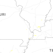


Connect with Interactive Hail Maps