

Hail Map for North Bend, NE
The North Bend, NE area has had 13 reports of on-the-ground hail by trained spotters, and has been under severe weather warnings 23 times during the past 12 months. Doppler radar has detected hail at or near North Bend, NE on 103 occasions, including 13 occasions during the past year.
| Name: | North Bend, NE |
| Where Located: | 45.8 miles WNW of Omaha, NE |
| Map: | Google Map for North Bend, NE |
| Population: | 1177 |
| Housing Units: | 501 |
| More Info: | Search Google for North Bend, NE |
1
The Top Recent Hail Date for North Bend, NE is Saturday, June 13, 2026 (25th out of 103)
Hail and Wind Damage Spotted near North Bend, NE
| Date / Time | Report Details |
|---|---|
| 5/18/2026 4:38 PM CDT |
 At 437 pm cdt, a severe thunderstorm was located 3 miles west of hooper, or 14 miles northwest of fremont, moving northeast at 50 mph (radar indicated). Hazards include 60 mph wind gusts and quarter size hail. Hail damage to vehicles is expected. expect wind damage to roofs, siding, and trees. This severe thunderstorm will remain over mainly rural areas of southwestern dodge and northwestern saunders counties, including the following locations, ames and czechland lake. At 437 pm cdt, a severe thunderstorm was located 3 miles west of hooper, or 14 miles northwest of fremont, moving northeast at 50 mph (radar indicated). Hazards include 60 mph wind gusts and quarter size hail. Hail damage to vehicles is expected. expect wind damage to roofs, siding, and trees. This severe thunderstorm will remain over mainly rural areas of southwestern dodge and northwestern saunders counties, including the following locations, ames and czechland lake.
|
| 5/18/2026 3:58 PM CDT |
 Svroax the national weather service in omaha has issued a * severe thunderstorm warning for, southwestern dodge county in east central nebraska, east central butler county in east central nebraska, northwestern saunders county in east central nebraska, * until 445 pm cdt. * at 358 pm cdt, a severe thunderstorm was located 6 miles north of valparaiso, or 13 miles west of wahoo, moving northeast at 50 mph (radar indicated). Hazards include 60 mph wind gusts and quarter size hail. Hail damage to vehicles is expected. expect wind damage to roofs, siding, and trees. this severe thunderstorm will be near, prague around 405 pm cdt. morse bluff around 415 pm cdt. Other locations in the path of this severe thunderstorm include north bend. Svroax the national weather service in omaha has issued a * severe thunderstorm warning for, southwestern dodge county in east central nebraska, east central butler county in east central nebraska, northwestern saunders county in east central nebraska, * until 445 pm cdt. * at 358 pm cdt, a severe thunderstorm was located 6 miles north of valparaiso, or 13 miles west of wahoo, moving northeast at 50 mph (radar indicated). Hazards include 60 mph wind gusts and quarter size hail. Hail damage to vehicles is expected. expect wind damage to roofs, siding, and trees. this severe thunderstorm will be near, prague around 405 pm cdt. morse bluff around 415 pm cdt. Other locations in the path of this severe thunderstorm include north bend.
|
| 5/17/2026 7:30 PM CDT |
 Svroax the national weather service in omaha has issued a * severe thunderstorm warning for, northwestern sarpy county in east central nebraska, washington county in east central nebraska, southern dodge county in east central nebraska, douglas county in east central nebraska, central saunders county in east central nebraska, * until 815 pm cdt. * at 730 pm cdt, severe thunderstorms were located along a line extending from 4 miles southwest of hooper to 4 miles southeast of ithaca, moving east at 50 mph (emergency management). Hazards include 60 mph wind gusts and quarter size hail. Hail damage to vehicles is expected. expect wind damage to roofs, siding, and trees. severe thunderstorms will be near, fremont, valley, yutan, mead, nickerson, inglewood, leshara, and woodcliff around 735 pm cdt. elkhorn, arlington, and waterloo around 740 pm cdt. omaha, flanagan lake, and zorinsky lake around 745 pm cdt. blair, bennington, boys town, kennard, and standing bear lake around 750 pm cdt. Other locations in the path of these severe thunderstorms include benson, fort calhoun, florence, carter lake and eppley airfield. Svroax the national weather service in omaha has issued a * severe thunderstorm warning for, northwestern sarpy county in east central nebraska, washington county in east central nebraska, southern dodge county in east central nebraska, douglas county in east central nebraska, central saunders county in east central nebraska, * until 815 pm cdt. * at 730 pm cdt, severe thunderstorms were located along a line extending from 4 miles southwest of hooper to 4 miles southeast of ithaca, moving east at 50 mph (emergency management). Hazards include 60 mph wind gusts and quarter size hail. Hail damage to vehicles is expected. expect wind damage to roofs, siding, and trees. severe thunderstorms will be near, fremont, valley, yutan, mead, nickerson, inglewood, leshara, and woodcliff around 735 pm cdt. elkhorn, arlington, and waterloo around 740 pm cdt. omaha, flanagan lake, and zorinsky lake around 745 pm cdt. blair, bennington, boys town, kennard, and standing bear lake around 750 pm cdt. Other locations in the path of these severe thunderstorms include benson, fort calhoun, florence, carter lake and eppley airfield.
|
| 5/17/2026 7:14 PM CDT | Upr statio in dodge county NE, 1.1 miles ENE of North Bend, NE |
| 4/15/2026 10:26 AM CDT |
 At 1025 am cdt, a severe thunderstorm was located 3 miles southwest of hooper, or 10 miles northwest of fremont, moving northeast at 40 mph. a second severe storm was located 3 miles north of north bend, also moving northeast at 40 mph (trained weather spotters reported quarter size hail at schuyler with this storm). Hazards include half dollar size hail. Damage to vehicles is expected. Locations impacted include, north bend, hooper, nickerson, and winslow. At 1025 am cdt, a severe thunderstorm was located 3 miles southwest of hooper, or 10 miles northwest of fremont, moving northeast at 40 mph. a second severe storm was located 3 miles north of north bend, also moving northeast at 40 mph (trained weather spotters reported quarter size hail at schuyler with this storm). Hazards include half dollar size hail. Damage to vehicles is expected. Locations impacted include, north bend, hooper, nickerson, and winslow.
|
| 4/15/2026 10:05 AM CDT |
 Svroax the national weather service in omaha has issued a * severe thunderstorm warning for, central dodge county in east central nebraska, * until 1100 am cdt. * at 1004 am cdt, a severe thunderstorm was located near linwood, or 16 miles northeast of david city, moving northeast at 35 mph (trained spotters and public reported quarter size hail near the platte river south of schuyler). Hazards include quarter size hail. damage to vehicles is expected Svroax the national weather service in omaha has issued a * severe thunderstorm warning for, central dodge county in east central nebraska, * until 1100 am cdt. * at 1004 am cdt, a severe thunderstorm was located near linwood, or 16 miles northeast of david city, moving northeast at 35 mph (trained spotters and public reported quarter size hail near the platte river south of schuyler). Hazards include quarter size hail. damage to vehicles is expected
|
| 9/22/2025 10:32 PM CDT | At 1032 pm cdt, a severe thunderstorm was located over north bend, or 14 miles west of fremont, moving east at 15 mph (radar indicated). Hazards include 60 mph wind gusts and quarter size hail. Hail damage to vehicles is expected. expect wind damage to roofs, siding, and trees. This severe storm will be near, morse bluff around 1035 pm cdt. |
| 9/22/2025 10:18 PM CDT | Svroax the national weather service in omaha has issued a * severe thunderstorm warning for, southern dodge county in east central nebraska, northwestern saunders county in east central nebraska, * until 1100 pm cdt. * at 1018 pm cdt, a severe thunderstorm was located near north bend, or 16 miles west of fremont, moving east at 15 mph (radar indicated). Hazards include 60 mph wind gusts and quarter size hail. Hail damage to vehicles is expected. expect wind damage to roofs, siding, and trees. This severe thunderstorm will be near, north bend and morse bluff around 1025 pm cdt. |
| 9/14/2025 4:07 PM CDT | The storms which prompted the warning have weakened below severe limits, and no longer pose an immediate threat to life or property. therefore, the warning will be allowed to expire. however, gusty winds are still possible with these thunderstorms. |
| 9/14/2025 4:00 PM CDT | the severe thunderstorm warning has been cancelled and is no longer in effect |
| 9/14/2025 4:00 PM CDT | At 359 pm cdt, severe thunderstorms were located along a line extending from near richland to 6 miles north of schuyler to 2 miles southeast of linwood, moving north at 50 mph (radar indicated). Hazards include 60 mph wind gusts and quarter size hail. Hail damage to vehicles is expected. expect wind damage to roofs, siding, and trees. Locations impacted include, howells and clarkson. |
| 9/14/2025 3:48 PM CDT | At 348 pm cdt, severe thunderstorms were located along a line extending from 2 miles south of bellwood to near schuyler to 2 miles east of bruno, moving east at 50 mph (radar indicated). Hazards include 60 mph wind gusts and quarter size hail. Hail damage to vehicles is expected. expect wind damage to roofs, siding, and trees. these severe storms will be near, octavia and abie around 355 pm cdt. North bend and morse bluff around 400 pm cdt. |
| 9/14/2025 3:42 PM CDT | Svroax the national weather service in omaha has issued a * severe thunderstorm warning for, colfax county in northeastern nebraska, east central platte county in northeastern nebraska, southwestern dodge county in east central nebraska, butler county in east central nebraska, northwestern saunders county in east central nebraska, * until 415 pm cdt. * at 342 pm cdt, severe thunderstorms were located along a line extending from 3 miles northeast of rising city to near octavia to 4 miles northeast of brainard, moving north at 50 mph (radar indicated). Hazards include 60 mph wind gusts and quarter size hail. Hail damage to vehicles is expected. expect wind damage to roofs, siding, and trees. Severe thunderstorms will be near, schuyler, bellwood, bruno, linwood, richland, and abie around 350 pm cdt. |
| 8/22/2025 4:13 PM CDT |
 Svroax the national weather service in omaha has issued a * severe thunderstorm warning for, southeastern dodge county in east central nebraska, north central saunders county in east central nebraska, * until 500 pm cdt. * at 412 pm cdt, a severe thunderstorm was located 7 miles northeast of north bend, or 12 miles northwest of fremont, moving southeast at 15 mph (radar indicated). Hazards include 60 mph wind gusts and quarter size hail. Hail damage to vehicles is expected. Expect wind damage to roofs, siding, and trees. Svroax the national weather service in omaha has issued a * severe thunderstorm warning for, southeastern dodge county in east central nebraska, north central saunders county in east central nebraska, * until 500 pm cdt. * at 412 pm cdt, a severe thunderstorm was located 7 miles northeast of north bend, or 12 miles northwest of fremont, moving southeast at 15 mph (radar indicated). Hazards include 60 mph wind gusts and quarter size hail. Hail damage to vehicles is expected. Expect wind damage to roofs, siding, and trees.
|
| 8/9/2025 5:46 AM CDT |
 Svroax the national weather service in omaha has issued a * severe thunderstorm warning for, southwestern burt county in east central nebraska, northwestern washington county in east central nebraska, central dodge county in east central nebraska, northwestern saunders county in east central nebraska, * until 630 am cdt. * at 545 am cdt, a severe thunderstorm was located 3 miles northeast of prague, or 12 miles northwest of wahoo, moving northeast at 50 mph (radar indicated). Hazards include 60 mph wind gusts and quarter size hail. Hail damage to vehicles is expected. expect wind damage to roofs, siding, and trees. this severe thunderstorm will be near, cedar bluffs and morse bluff around 550 am cdt. fremont around 600 am cdt. nickerson around 605 am cdt. Other locations in the path of this severe thunderstorm include herman. Svroax the national weather service in omaha has issued a * severe thunderstorm warning for, southwestern burt county in east central nebraska, northwestern washington county in east central nebraska, central dodge county in east central nebraska, northwestern saunders county in east central nebraska, * until 630 am cdt. * at 545 am cdt, a severe thunderstorm was located 3 miles northeast of prague, or 12 miles northwest of wahoo, moving northeast at 50 mph (radar indicated). Hazards include 60 mph wind gusts and quarter size hail. Hail damage to vehicles is expected. expect wind damage to roofs, siding, and trees. this severe thunderstorm will be near, cedar bluffs and morse bluff around 550 am cdt. fremont around 600 am cdt. nickerson around 605 am cdt. Other locations in the path of this severe thunderstorm include herman.
|
| 7/15/2025 11:21 PM CDT |
 At 1120 pm cdt, severe thunderstorms were located along a line extending from near morse bluff to 2 miles west of weston to 2 miles northwest of dwight, moving east at 40 mph (law enforcement). Hazards include 60 mph wind gusts. Expect damage to roofs, siding, and trees. Locations impacted include, fremont, seward, wahoo, david city, waverly, north bend, ceresco, cedar bluffs, valparaiso, mead, malcolm, brainard, inglewood, weston, prague, staplehurst, garland, dwight, bee, and ulysses. At 1120 pm cdt, severe thunderstorms were located along a line extending from near morse bluff to 2 miles west of weston to 2 miles northwest of dwight, moving east at 40 mph (law enforcement). Hazards include 60 mph wind gusts. Expect damage to roofs, siding, and trees. Locations impacted include, fremont, seward, wahoo, david city, waverly, north bend, ceresco, cedar bluffs, valparaiso, mead, malcolm, brainard, inglewood, weston, prague, staplehurst, garland, dwight, bee, and ulysses.
|
| 7/15/2025 11:21 PM CDT |
 the severe thunderstorm warning has been cancelled and is no longer in effect the severe thunderstorm warning has been cancelled and is no longer in effect
|
| 7/15/2025 11:08 PM CDT |
 the severe thunderstorm warning has been cancelled and is no longer in effect the severe thunderstorm warning has been cancelled and is no longer in effect
|
| 7/15/2025 11:08 PM CDT |
 At 1108 pm cdt, severe thunderstorms were located along a line extending from 4 miles west of north bend to 4 miles southeast of bruno to 6 miles south of david city, moving east at 40 mph (law enforcement). Hazards include 60 mph wind gusts. Expect damage to roofs, siding, and trees. Locations impacted include, north bend, brainard, weston, prague, morse bluff, malmo, cedar bluffs, wahoo, colon, fremont, inglewood, woodcliff and mead. At 1108 pm cdt, severe thunderstorms were located along a line extending from 4 miles west of north bend to 4 miles southeast of bruno to 6 miles south of david city, moving east at 40 mph (law enforcement). Hazards include 60 mph wind gusts. Expect damage to roofs, siding, and trees. Locations impacted include, north bend, brainard, weston, prague, morse bluff, malmo, cedar bluffs, wahoo, colon, fremont, inglewood, woodcliff and mead.
|
| 7/15/2025 10:51 PM CDT |
 Svroax the national weather service in omaha has issued a * severe thunderstorm warning for, colfax county in northeastern nebraska, southeastern platte county in northeastern nebraska, northern lancaster county in southeastern nebraska, southwestern dodge county in east central nebraska, northern seward county in southeastern nebraska, northwestern douglas county in east central nebraska, butler county in east central nebraska, saunders county in east central nebraska, * until 1130 pm cdt. * at 1051 pm cdt, severe thunderstorms were located along a line extending from 6 miles north of schuyler to near octavia to 3 miles north of rising city, moving southeast at 40 mph (law enforcement). Hazards include 60 mph wind gusts. Expect damage to roofs, siding, and trees. severe thunderstorms will be near, david city, schuyler, rising city, octavia, bruno, linwood, and abie around 1055 pm cdt. brainard around 1100 pm cdt. north bend and prague around 1105 pm cdt. dwight and morse bluff around 1110 pm cdt. other locations in the path of these severe thunderstorms include weston, malmo and valparaiso. This includes interstate 80 in nebraska between mile markers 373 and 377. Svroax the national weather service in omaha has issued a * severe thunderstorm warning for, colfax county in northeastern nebraska, southeastern platte county in northeastern nebraska, northern lancaster county in southeastern nebraska, southwestern dodge county in east central nebraska, northern seward county in southeastern nebraska, northwestern douglas county in east central nebraska, butler county in east central nebraska, saunders county in east central nebraska, * until 1130 pm cdt. * at 1051 pm cdt, severe thunderstorms were located along a line extending from 6 miles north of schuyler to near octavia to 3 miles north of rising city, moving southeast at 40 mph (law enforcement). Hazards include 60 mph wind gusts. Expect damage to roofs, siding, and trees. severe thunderstorms will be near, david city, schuyler, rising city, octavia, bruno, linwood, and abie around 1055 pm cdt. brainard around 1100 pm cdt. north bend and prague around 1105 pm cdt. dwight and morse bluff around 1110 pm cdt. other locations in the path of these severe thunderstorms include weston, malmo and valparaiso. This includes interstate 80 in nebraska between mile markers 373 and 377.
|
| 7/7/2025 9:41 PM CDT |
 At 940 pm cdt, severe thunderstorms were located along a line extending from 2 miles southwest of woodbine to 2 miles east of fremont to near octavia, moving south at 40 mph (radar indicated). Hazards include 60 mph wind gusts and quarter size hail. Hail damage to vehicles is expected. expect wind damage to roofs, siding, and trees. these severe storms will be near, fremont, blair, missouri valley, logan, arlington, cedar bluffs, kennard, inglewood, prague, and leshara around 945 pm cdt. Other locations in the path of these severe thunderstorms include bennington, valley, fort calhoun, brainard, malmo, omaha, wahoo, elkhorn, yutan, waterloo, mead, weston, flanagan lake, ithaca, florence, standing bear lake, boys town, neola, crescent, valparaiso, eppley airfield, benson, zorinsky lake, millard, carter lake, underwood and midtown. At 940 pm cdt, severe thunderstorms were located along a line extending from 2 miles southwest of woodbine to 2 miles east of fremont to near octavia, moving south at 40 mph (radar indicated). Hazards include 60 mph wind gusts and quarter size hail. Hail damage to vehicles is expected. expect wind damage to roofs, siding, and trees. these severe storms will be near, fremont, blair, missouri valley, logan, arlington, cedar bluffs, kennard, inglewood, prague, and leshara around 945 pm cdt. Other locations in the path of these severe thunderstorms include bennington, valley, fort calhoun, brainard, malmo, omaha, wahoo, elkhorn, yutan, waterloo, mead, weston, flanagan lake, ithaca, florence, standing bear lake, boys town, neola, crescent, valparaiso, eppley airfield, benson, zorinsky lake, millard, carter lake, underwood and midtown.
|
| 7/7/2025 9:29 PM CDT |
 Svroax the national weather service in omaha has issued a * severe thunderstorm warning for, northwestern pottawattamie county in southwestern iowa, harrison county in southwestern iowa, southwestern shelby county in southwestern iowa, northwestern sarpy county in east central nebraska, southeastern burt county in east central nebraska, southeastern colfax county in northeastern nebraska, washington county in east central nebraska, southern dodge county in east central nebraska, douglas county in east central nebraska, eastern butler county in east central nebraska, saunders county in east central nebraska, * until 1015 pm cdt. * at 928 pm cdt, severe thunderstorms were located along a line extending from 6 miles northwest of woodbine to nickerson to schuyler, moving south at 40 mph (radar indicated). Hazards include 60 mph wind gusts and quarter size hail. Hail damage to vehicles is expected. expect wind damage to roofs, siding, and trees. severe thunderstorms will be near, fremont, blair, logan, woodbine, arlington, cedar bluffs, inglewood, modale, magnolia, and morse bluff around 935 pm cdt. missouri valley, kennard, prague, and bruno around 940 pm cdt. valley, fort calhoun, malmo, leshara, and colon around 945 pm cdt. other locations in the path of these severe thunderstorms include omaha, wahoo, bennington, waterloo, brainard, elkhorn, yutan, mead, weston, flanagan lake, standing bear lake, boys town, neola, crescent, ithaca, benson, florence, zorinsky lake, millard, carter lake, underwood, valparaiso and eppley airfield. this includes the following highways, interstate 29 between mile markers 58 and 92. Interstate 80 in iowa between mile markers 20 and 34. Svroax the national weather service in omaha has issued a * severe thunderstorm warning for, northwestern pottawattamie county in southwestern iowa, harrison county in southwestern iowa, southwestern shelby county in southwestern iowa, northwestern sarpy county in east central nebraska, southeastern burt county in east central nebraska, southeastern colfax county in northeastern nebraska, washington county in east central nebraska, southern dodge county in east central nebraska, douglas county in east central nebraska, eastern butler county in east central nebraska, saunders county in east central nebraska, * until 1015 pm cdt. * at 928 pm cdt, severe thunderstorms were located along a line extending from 6 miles northwest of woodbine to nickerson to schuyler, moving south at 40 mph (radar indicated). Hazards include 60 mph wind gusts and quarter size hail. Hail damage to vehicles is expected. expect wind damage to roofs, siding, and trees. severe thunderstorms will be near, fremont, blair, logan, woodbine, arlington, cedar bluffs, inglewood, modale, magnolia, and morse bluff around 935 pm cdt. missouri valley, kennard, prague, and bruno around 940 pm cdt. valley, fort calhoun, malmo, leshara, and colon around 945 pm cdt. other locations in the path of these severe thunderstorms include omaha, wahoo, bennington, waterloo, brainard, elkhorn, yutan, mead, weston, flanagan lake, standing bear lake, boys town, neola, crescent, ithaca, benson, florence, zorinsky lake, millard, carter lake, underwood, valparaiso and eppley airfield. this includes the following highways, interstate 29 between mile markers 58 and 92. Interstate 80 in iowa between mile markers 20 and 34.
|
| 7/7/2025 9:22 PM CDT |
 At 921 pm cdt, severe thunderstorms were located along a line extending from 4 miles east of pisgah to 2 miles east of hooper to 4 miles north of schuyler, moving southeast at 40 mph (weather instrument measurement. at 916 pm, 60 mph winds were reported in tekamah). Hazards include 60 mph wind gusts and quarter size hail. Hail damage to vehicles is expected. expect wind damage to roofs, siding, and trees. these severe storms will be near, schuyler, north bend, hooper, mondamin, nickerson, and herman around 925 pm cdt. Other locations in the path of these severe thunderstorms include fremont, woodbine, modale, magnolia, morse bluff, linwood, blair and logan. At 921 pm cdt, severe thunderstorms were located along a line extending from 4 miles east of pisgah to 2 miles east of hooper to 4 miles north of schuyler, moving southeast at 40 mph (weather instrument measurement. at 916 pm, 60 mph winds were reported in tekamah). Hazards include 60 mph wind gusts and quarter size hail. Hail damage to vehicles is expected. expect wind damage to roofs, siding, and trees. these severe storms will be near, schuyler, north bend, hooper, mondamin, nickerson, and herman around 925 pm cdt. Other locations in the path of these severe thunderstorms include fremont, woodbine, modale, magnolia, morse bluff, linwood, blair and logan.
|
| 7/7/2025 9:07 PM CDT |
 Svroax the national weather service in omaha has issued a * severe thunderstorm warning for, southwestern monona county in west central iowa, western harrison county in southwestern iowa, burt county in east central nebraska, southern cuming county in northeastern nebraska, colfax county in northeastern nebraska, northwestern washington county in east central nebraska, dodge county in east central nebraska, northeastern butler county in east central nebraska, northwestern saunders county in east central nebraska, southeastern stanton county in northeastern nebraska, * until 945 pm cdt. * at 906 pm cdt, severe thunderstorms were located along a line extending from 6 miles south of castana to 5 miles west of uehling to 4 miles southeast of leigh, moving southeast at 35 mph (radar indicated). Hazards include 60 mph wind gusts and quarter size hail. Hail damage to vehicles is expected. expect wind damage to roofs, siding, and trees. severe thunderstorms will be near, tekamah, scribner, snyder, uehling, moorhead, blencoe, and craig around 910 pm cdt. hooper, pisgah, and little sioux around 915 pm cdt. schuyler, mondamin, and herman around 925 pm cdt. other locations in the path of these severe thunderstorms include north bend, nickerson, woodbine, modale, magnolia, morse bluff and linwood. This includes interstate 29 between mile markers 82 and 112. Svroax the national weather service in omaha has issued a * severe thunderstorm warning for, southwestern monona county in west central iowa, western harrison county in southwestern iowa, burt county in east central nebraska, southern cuming county in northeastern nebraska, colfax county in northeastern nebraska, northwestern washington county in east central nebraska, dodge county in east central nebraska, northeastern butler county in east central nebraska, northwestern saunders county in east central nebraska, southeastern stanton county in northeastern nebraska, * until 945 pm cdt. * at 906 pm cdt, severe thunderstorms were located along a line extending from 6 miles south of castana to 5 miles west of uehling to 4 miles southeast of leigh, moving southeast at 35 mph (radar indicated). Hazards include 60 mph wind gusts and quarter size hail. Hail damage to vehicles is expected. expect wind damage to roofs, siding, and trees. severe thunderstorms will be near, tekamah, scribner, snyder, uehling, moorhead, blencoe, and craig around 910 pm cdt. hooper, pisgah, and little sioux around 915 pm cdt. schuyler, mondamin, and herman around 925 pm cdt. other locations in the path of these severe thunderstorms include north bend, nickerson, woodbine, modale, magnolia, morse bluff and linwood. This includes interstate 29 between mile markers 82 and 112.
|
| 6/25/2025 5:03 PM CDT |
 the severe thunderstorm warning has been cancelled and is no longer in effect the severe thunderstorm warning has been cancelled and is no longer in effect
|
| 6/25/2025 4:42 PM CDT |
 Svroax the national weather service in omaha has issued a * severe thunderstorm warning for, southeastern colfax county in northeastern nebraska, western dodge county in east central nebraska, * until 515 pm cdt. * at 441 pm cdt, a severe thunderstorm was located 6 miles north of linwood, or 19 miles northeast of david city, moving northeast at 40 mph (radar indicated). Hazards include 60 mph wind gusts. Expect damage to roofs, siding, and trees. This severe thunderstorm will remain over mainly rural areas of southeastern colfax and western dodge counties, including the following locations, rogers and fishers elementary. Svroax the national weather service in omaha has issued a * severe thunderstorm warning for, southeastern colfax county in northeastern nebraska, western dodge county in east central nebraska, * until 515 pm cdt. * at 441 pm cdt, a severe thunderstorm was located 6 miles north of linwood, or 19 miles northeast of david city, moving northeast at 40 mph (radar indicated). Hazards include 60 mph wind gusts. Expect damage to roofs, siding, and trees. This severe thunderstorm will remain over mainly rural areas of southeastern colfax and western dodge counties, including the following locations, rogers and fishers elementary.
|
| 6/19/2025 11:55 PM CDT |
 The strong winds which prompted the warning have weakened below severe limits, and the storm has exited the warned area. therefore, the warning will be allowed to expire. however, gusty winds up to 40 mph are still possible. The strong winds which prompted the warning have weakened below severe limits, and the storm has exited the warned area. therefore, the warning will be allowed to expire. however, gusty winds up to 40 mph are still possible.
|
| 6/19/2025 11:14 PM CDT |
 Svroax the national weather service in omaha has issued a * severe thunderstorm warning for, northwestern mills county in southwestern iowa, western pottawattamie county in southwestern iowa, southwestern harrison county in southwestern iowa, south central burt county in east central nebraska, colfax county in northeastern nebraska, douglas county in east central nebraska, northern saunders county in east central nebraska, northeastern sarpy county in east central nebraska, southwestern cuming county in northeastern nebraska, washington county in east central nebraska, dodge county in east central nebraska, northeastern butler county in east central nebraska, southeastern stanton county in northeastern nebraska, * until midnight cdt. * at 1111 pm cdt, showers and thunderstorms producing damaging winds up to 60 mph were located across southern dodge, northern saunders, and into washington and douglas counties, moving east at 20 mph (radar indicated). Hazards include 60 mph wind gusts. Expect damage to roofs, siding, and trees. this severe thunderstorm will be near, fremont and cedar bluffs around 1115 pm cdt. inglewood around 1125 pm cdt. woodcliff around 1130 pm cdt. other locations in the path of this severe thunderstorm include arlington. people attending charles schwab field should seek safe shelter immediately! this includes the following highways, interstate 29 between mile markers 42 and 84. interstate 80 in iowa between mile markers 1 and 14. Interstate 80 in nebraska between mile markers 443 and 454. Svroax the national weather service in omaha has issued a * severe thunderstorm warning for, northwestern mills county in southwestern iowa, western pottawattamie county in southwestern iowa, southwestern harrison county in southwestern iowa, south central burt county in east central nebraska, colfax county in northeastern nebraska, douglas county in east central nebraska, northern saunders county in east central nebraska, northeastern sarpy county in east central nebraska, southwestern cuming county in northeastern nebraska, washington county in east central nebraska, dodge county in east central nebraska, northeastern butler county in east central nebraska, southeastern stanton county in northeastern nebraska, * until midnight cdt. * at 1111 pm cdt, showers and thunderstorms producing damaging winds up to 60 mph were located across southern dodge, northern saunders, and into washington and douglas counties, moving east at 20 mph (radar indicated). Hazards include 60 mph wind gusts. Expect damage to roofs, siding, and trees. this severe thunderstorm will be near, fremont and cedar bluffs around 1115 pm cdt. inglewood around 1125 pm cdt. woodcliff around 1130 pm cdt. other locations in the path of this severe thunderstorm include arlington. people attending charles schwab field should seek safe shelter immediately! this includes the following highways, interstate 29 between mile markers 42 and 84. interstate 80 in iowa between mile markers 1 and 14. Interstate 80 in nebraska between mile markers 443 and 454.
|
| 5/19/2025 6:32 PM CDT |
 At 631 pm cdt, severe thunderstorms were located along a line extending from 3 miles east of nickerson to colon, moving northeast at 30 mph (radar indicated). Hazards include 60 mph wind gusts and quarter size hail. Hail damage to vehicles is expected. expect wind damage to roofs, siding, and trees. these severe storms will be near, fremont, arlington, inglewood, colon, and woodcliff around 635 pm cdt. Other locations in the path of these severe thunderstorms include leshara. At 631 pm cdt, severe thunderstorms were located along a line extending from 3 miles east of nickerson to colon, moving northeast at 30 mph (radar indicated). Hazards include 60 mph wind gusts and quarter size hail. Hail damage to vehicles is expected. expect wind damage to roofs, siding, and trees. these severe storms will be near, fremont, arlington, inglewood, colon, and woodcliff around 635 pm cdt. Other locations in the path of these severe thunderstorms include leshara.
|
| 5/19/2025 6:17 PM CDT |
 the severe thunderstorm warning has been cancelled and is no longer in effect the severe thunderstorm warning has been cancelled and is no longer in effect
|
| 5/19/2025 6:16 PM CDT |
 Svroax the national weather service in omaha has issued a * severe thunderstorm warning for, southwestern washington county in east central nebraska, southeastern dodge county in east central nebraska, northwestern douglas county in east central nebraska, northeastern saunders county in east central nebraska, * until 645 pm cdt. * at 616 pm cdt, a severe thunderstorm was located near cedar bluffs, or 8 miles southwest of fremont, moving east at 40 mph (radar indicated). Hazards include 60 mph wind gusts and quarter size hail. Hail damage to vehicles is expected. expect wind damage to roofs, siding, and trees. this severe thunderstorm will be near, fremont, cedar bluffs, and inglewood around 620 pm cdt. woodcliff around 625 pm cdt. Arlington around 635 pm cdt. Svroax the national weather service in omaha has issued a * severe thunderstorm warning for, southwestern washington county in east central nebraska, southeastern dodge county in east central nebraska, northwestern douglas county in east central nebraska, northeastern saunders county in east central nebraska, * until 645 pm cdt. * at 616 pm cdt, a severe thunderstorm was located near cedar bluffs, or 8 miles southwest of fremont, moving east at 40 mph (radar indicated). Hazards include 60 mph wind gusts and quarter size hail. Hail damage to vehicles is expected. expect wind damage to roofs, siding, and trees. this severe thunderstorm will be near, fremont, cedar bluffs, and inglewood around 620 pm cdt. woodcliff around 625 pm cdt. Arlington around 635 pm cdt.
|
| 5/19/2025 6:02 PM CDT |
 At 602 pm cdt, a severe thunderstorm was located over linwood, or 13 miles northeast of david city, moving northeast at 25 mph (radar indicated). Hazards include 60 mph wind gusts and half dollar size hail. Hail damage to vehicles is expected. expect wind damage to roofs, siding, and trees. Locations impacted include, north bend and morse bluff. At 602 pm cdt, a severe thunderstorm was located over linwood, or 13 miles northeast of david city, moving northeast at 25 mph (radar indicated). Hazards include 60 mph wind gusts and half dollar size hail. Hail damage to vehicles is expected. expect wind damage to roofs, siding, and trees. Locations impacted include, north bend and morse bluff.
|
| 5/19/2025 5:47 PM CDT |
 the tornado warning has been cancelled and is no longer in effect the tornado warning has been cancelled and is no longer in effect
|
| 5/19/2025 5:47 PM CDT |
 At 546 pm cdt, a severe thunderstorm capable of producing a tornado was located near north bend, or 12 miles west of fremont, moving northeast at 25 mph (radar indicated rotation). Hazards include tornado and two inch hail. Flying debris will be dangerous to those caught without shelter. mobile homes will be damaged or destroyed. damage to roofs, windows, and vehicles will occur. tree damage is likely. This tornadic thunderstorm will remain over mainly rural areas of southwestern dodge county. At 546 pm cdt, a severe thunderstorm capable of producing a tornado was located near north bend, or 12 miles west of fremont, moving northeast at 25 mph (radar indicated rotation). Hazards include tornado and two inch hail. Flying debris will be dangerous to those caught without shelter. mobile homes will be damaged or destroyed. damage to roofs, windows, and vehicles will occur. tree damage is likely. This tornadic thunderstorm will remain over mainly rural areas of southwestern dodge county.
|
| 5/19/2025 5:47 PM CDT |
 At 547 pm cdt, a severe thunderstorm was located over octavia, or 8 miles northeast of david city, moving northeast at 25 mph (radar indicated). Hazards include 60 mph wind gusts and half dollar size hail. Hail damage to vehicles is expected. expect wind damage to roofs, siding, and trees. this severe storm will be near, linwood and abie around 550 pm cdt. Other locations in the path of this severe thunderstorm include north bend and morse bluff. At 547 pm cdt, a severe thunderstorm was located over octavia, or 8 miles northeast of david city, moving northeast at 25 mph (radar indicated). Hazards include 60 mph wind gusts and half dollar size hail. Hail damage to vehicles is expected. expect wind damage to roofs, siding, and trees. this severe storm will be near, linwood and abie around 550 pm cdt. Other locations in the path of this severe thunderstorm include north bend and morse bluff.
|
| 5/19/2025 5:43 PM CDT |
 the severe thunderstorm warning has been cancelled and is no longer in effect the severe thunderstorm warning has been cancelled and is no longer in effect
|
| 5/19/2025 5:43 PM CDT |
 At 542 pm cdt, a severe thunderstorm was located 7 miles north of north bend, or 19 miles northwest of fremont, moving northeast at 25 mph (radar indicated). Hazards include golf ball size hail and 60 mph wind gusts. People and animals outdoors will be injured. expect hail damage to roofs, siding, windows, and vehicles. expect wind damage to roofs, siding, and trees. Locations impacted include, north bend, scribner, snyder, morse bluff, rogers, and dead timber state recreation area. At 542 pm cdt, a severe thunderstorm was located 7 miles north of north bend, or 19 miles northwest of fremont, moving northeast at 25 mph (radar indicated). Hazards include golf ball size hail and 60 mph wind gusts. People and animals outdoors will be injured. expect hail damage to roofs, siding, windows, and vehicles. expect wind damage to roofs, siding, and trees. Locations impacted include, north bend, scribner, snyder, morse bluff, rogers, and dead timber state recreation area.
|
| 5/19/2025 5:39 PM CDT | Golf Ball sized hail reported 5.3 miles SE of North Bend, NE |
| 5/19/2025 5:39 PM CDT |
 At 538 pm cdt, a severe thunderstorm capable of producing a tornado was located over north bend, or 15 miles west of fremont, moving northeast at 25 mph (radar indicated rotation). Hazards include tornado and golf ball size hail. Flying debris will be dangerous to those caught without shelter. mobile homes will be damaged or destroyed. damage to roofs, windows, and vehicles will occur. tree damage is likely. This tornadic thunderstorm will remain over mainly rural areas of southwestern dodge and northern saunders counties. At 538 pm cdt, a severe thunderstorm capable of producing a tornado was located over north bend, or 15 miles west of fremont, moving northeast at 25 mph (radar indicated rotation). Hazards include tornado and golf ball size hail. Flying debris will be dangerous to those caught without shelter. mobile homes will be damaged or destroyed. damage to roofs, windows, and vehicles will occur. tree damage is likely. This tornadic thunderstorm will remain over mainly rural areas of southwestern dodge and northern saunders counties.
|
| 5/19/2025 5:37 PM CDT |
 Svroax the national weather service in omaha has issued a * severe thunderstorm warning for, southeastern colfax county in northeastern nebraska, southwestern dodge county in east central nebraska, eastern butler county in east central nebraska, northwestern saunders county in east central nebraska, * until 630 pm cdt. * at 537 pm cdt, a severe thunderstorm was located near octavia, or 5 miles northeast of david city, moving northeast at 25 mph (radar indicated). Hazards include 60 mph wind gusts and half dollar size hail. Hail damage to vehicles is expected. expect wind damage to roofs, siding, and trees. this severe thunderstorm will be near, octavia and abie around 545 pm cdt. linwood around 550 pm cdt. Other locations in the path of this severe thunderstorm include north bend and morse bluff. Svroax the national weather service in omaha has issued a * severe thunderstorm warning for, southeastern colfax county in northeastern nebraska, southwestern dodge county in east central nebraska, eastern butler county in east central nebraska, northwestern saunders county in east central nebraska, * until 630 pm cdt. * at 537 pm cdt, a severe thunderstorm was located near octavia, or 5 miles northeast of david city, moving northeast at 25 mph (radar indicated). Hazards include 60 mph wind gusts and half dollar size hail. Hail damage to vehicles is expected. expect wind damage to roofs, siding, and trees. this severe thunderstorm will be near, octavia and abie around 545 pm cdt. linwood around 550 pm cdt. Other locations in the path of this severe thunderstorm include north bend and morse bluff.
|
| 5/19/2025 5:30 PM CDT |
 Toroax the national weather service in omaha has issued a * tornado warning for, southwestern dodge county in east central nebraska, northwestern saunders county in east central nebraska, * until 600 pm cdt. * at 529 pm cdt, a confirmed tornado was located 4 miles west of north bend, or 19 miles west of fremont, moving northeast at 25 mph (weather spotters confirmed tornado). Hazards include damaging tornado and golf ball size hail. Flying debris will be dangerous to those caught without shelter. mobile homes will be damaged or destroyed. damage to roofs, windows, and vehicles will occur. tree damage is likely. The tornado will be near, north bend around 535 pm cdt. Toroax the national weather service in omaha has issued a * tornado warning for, southwestern dodge county in east central nebraska, northwestern saunders county in east central nebraska, * until 600 pm cdt. * at 529 pm cdt, a confirmed tornado was located 4 miles west of north bend, or 19 miles west of fremont, moving northeast at 25 mph (weather spotters confirmed tornado). Hazards include damaging tornado and golf ball size hail. Flying debris will be dangerous to those caught without shelter. mobile homes will be damaged or destroyed. damage to roofs, windows, and vehicles will occur. tree damage is likely. The tornado will be near, north bend around 535 pm cdt.
|
| 5/19/2025 5:24 PM CDT |
 Svroax the national weather service in omaha has issued a * severe thunderstorm warning for, south central cuming county in northeastern nebraska, southeastern colfax county in northeastern nebraska, dodge county in east central nebraska, northeastern butler county in east central nebraska, northwestern saunders county in east central nebraska, * until 615 pm cdt. * at 524 pm cdt, a severe thunderstorm was located 6 miles northeast of schuyler, or 19 miles northeast of david city, moving northeast at 25 mph (radar indicated). Hazards include golf ball size hail and 60 mph wind gusts. People and animals outdoors will be injured. expect hail damage to roofs, siding, windows, and vehicles. Expect wind damage to roofs, siding, and trees. Svroax the national weather service in omaha has issued a * severe thunderstorm warning for, south central cuming county in northeastern nebraska, southeastern colfax county in northeastern nebraska, dodge county in east central nebraska, northeastern butler county in east central nebraska, northwestern saunders county in east central nebraska, * until 615 pm cdt. * at 524 pm cdt, a severe thunderstorm was located 6 miles northeast of schuyler, or 19 miles northeast of david city, moving northeast at 25 mph (radar indicated). Hazards include golf ball size hail and 60 mph wind gusts. People and animals outdoors will be injured. expect hail damage to roofs, siding, windows, and vehicles. Expect wind damage to roofs, siding, and trees.
|
| 5/19/2025 5:14 PM CDT |
 At 512 pm cdt, a severe thunderstorm was located 5 miles north of schuyler, or 17 miles east of columbus, moving northeast at 30 mph (trained weather spotters. at 510 pm, ping pong ball size hail was reported 3 miles northwest of schuyler). Hazards include ping pong ball size hail and 60 mph wind gusts. People and animals outdoors will be injured. expect hail damage to roofs, siding, windows, and vehicles. expect wind damage to roofs, siding, and trees. This severe thunderstorm will remain over mainly rural areas of colfax, southeastern platte, southwestern dodge, northern butler and northwestern saunders counties, including the following locations, fishers elementary, central community college, rogers, lake babcock, camp pawnee, camp luther, and lake north. At 512 pm cdt, a severe thunderstorm was located 5 miles north of schuyler, or 17 miles east of columbus, moving northeast at 30 mph (trained weather spotters. at 510 pm, ping pong ball size hail was reported 3 miles northwest of schuyler). Hazards include ping pong ball size hail and 60 mph wind gusts. People and animals outdoors will be injured. expect hail damage to roofs, siding, windows, and vehicles. expect wind damage to roofs, siding, and trees. This severe thunderstorm will remain over mainly rural areas of colfax, southeastern platte, southwestern dodge, northern butler and northwestern saunders counties, including the following locations, fishers elementary, central community college, rogers, lake babcock, camp pawnee, camp luther, and lake north.
|
| 5/19/2025 4:50 PM CDT |
 Svroax the national weather service in omaha has issued a * severe thunderstorm warning for, colfax county in northeastern nebraska, southeastern platte county in northeastern nebraska, southwestern dodge county in east central nebraska, northern butler county in east central nebraska, northwestern saunders county in east central nebraska, * until 530 pm cdt. * at 450 pm cdt, a severe thunderstorm was located over richland, or 8 miles east of columbus, moving northeast at 30 mph (radar indicated). Hazards include ping pong ball size hail and 60 mph wind gusts. People and animals outdoors will be injured. expect hail damage to roofs, siding, windows, and vehicles. expect wind damage to roofs, siding, and trees. This severe thunderstorm will be near, schuyler around 455 pm cdt. Svroax the national weather service in omaha has issued a * severe thunderstorm warning for, colfax county in northeastern nebraska, southeastern platte county in northeastern nebraska, southwestern dodge county in east central nebraska, northern butler county in east central nebraska, northwestern saunders county in east central nebraska, * until 530 pm cdt. * at 450 pm cdt, a severe thunderstorm was located over richland, or 8 miles east of columbus, moving northeast at 30 mph (radar indicated). Hazards include ping pong ball size hail and 60 mph wind gusts. People and animals outdoors will be injured. expect hail damage to roofs, siding, windows, and vehicles. expect wind damage to roofs, siding, and trees. This severe thunderstorm will be near, schuyler around 455 pm cdt.
|
| 4/17/2025 6:24 PM CDT |
 The storm which prompted the warning has weakened below severe limits, and no longer poses an immediate threat to life or property. therefore, the warning will be allowed to expire. however, small hail is still possible with this thunderstorm. a tornado watch remains in effect until midnight cdt for east central nebraska. The storm which prompted the warning has weakened below severe limits, and no longer poses an immediate threat to life or property. therefore, the warning will be allowed to expire. however, small hail is still possible with this thunderstorm. a tornado watch remains in effect until midnight cdt for east central nebraska.
|
| 4/17/2025 6:20 PM CDT | Baseball sized hail reported 5.8 miles W of North Bend, NE, mix of golfball and baseball-size hail. |
| 4/17/2025 6:15 PM CDT |
 the severe thunderstorm warning has been cancelled and is no longer in effect the severe thunderstorm warning has been cancelled and is no longer in effect
|
| 4/17/2025 6:15 PM CDT |
 At 615 pm cdt, a severe thunderstorm was located 3 miles southeast of octavia, or 6 miles northeast of david city, moving east at 35 mph (radar indicated). Hazards include 60 mph wind gusts and quarter size hail. Hail damage to vehicles is expected. expect wind damage to roofs, siding, and trees. Locations impacted include, bruno, abie, prague and morse bluff. At 615 pm cdt, a severe thunderstorm was located 3 miles southeast of octavia, or 6 miles northeast of david city, moving east at 35 mph (radar indicated). Hazards include 60 mph wind gusts and quarter size hail. Hail damage to vehicles is expected. expect wind damage to roofs, siding, and trees. Locations impacted include, bruno, abie, prague and morse bluff.
|
| 4/17/2025 6:11 PM CDT |
 the tornado warning has been cancelled and is no longer in effect the tornado warning has been cancelled and is no longer in effect
|
| 4/17/2025 6:11 PM CDT |
 At 611 pm cdt, a severe thunderstorm capable of producing a tornado was located 4 miles northeast of north bend, or 12 miles west of fremont, moving east at 35 mph (radar indicated rotation). Hazards include tornado and two inch hail. Flying debris will be dangerous to those caught without shelter. mobile homes will be damaged or destroyed. damage to roofs, windows, and vehicles will occur. tree damage is likely. This tornadic thunderstorm will remain over mainly rural areas of southwestern dodge county, including the following locations, ames. At 611 pm cdt, a severe thunderstorm capable of producing a tornado was located 4 miles northeast of north bend, or 12 miles west of fremont, moving east at 35 mph (radar indicated rotation). Hazards include tornado and two inch hail. Flying debris will be dangerous to those caught without shelter. mobile homes will be damaged or destroyed. damage to roofs, windows, and vehicles will occur. tree damage is likely. This tornadic thunderstorm will remain over mainly rural areas of southwestern dodge county, including the following locations, ames.
|
| 4/17/2025 5:59 PM CDT | Personal weather statio in dodge county NE, 4.7 miles E of North Bend, NE |
| 4/17/2025 5:59 PM CDT |
 the tornado warning has been cancelled and is no longer in effect the tornado warning has been cancelled and is no longer in effect
|
| 4/17/2025 5:59 PM CDT |
 At 558 pm cdt, a severe thunderstorm capable of producing a tornado was located 3 miles west of north bend, or 18 miles west of fremont, moving east at 35 mph (radar indicated rotation). Hazards include tornado and two inch hail. Flying debris will be dangerous to those caught without shelter. mobile homes will be damaged or destroyed. damage to roofs, windows, and vehicles will occur. tree damage is likely. This dangerous storm will be near, north bend and morse bluff around 605 pm cdt. At 558 pm cdt, a severe thunderstorm capable of producing a tornado was located 3 miles west of north bend, or 18 miles west of fremont, moving east at 35 mph (radar indicated rotation). Hazards include tornado and two inch hail. Flying debris will be dangerous to those caught without shelter. mobile homes will be damaged or destroyed. damage to roofs, windows, and vehicles will occur. tree damage is likely. This dangerous storm will be near, north bend and morse bluff around 605 pm cdt.
|
| 4/17/2025 5:59 PM CDT |
 At 558 pm cdt, a severe thunderstorm was located 3 miles northwest of david city, moving northeast at 40 mph (radar indicated). Hazards include 60 mph wind gusts and half dollar size hail. Hail damage to vehicles is expected. expect wind damage to roofs, siding, and trees. this severe storm will be near, octavia around 605 pm cdt. abie around 610 pm cdt. Other locations in the path of this severe thunderstorm include linwood, north bend and morse bluff. At 558 pm cdt, a severe thunderstorm was located 3 miles northwest of david city, moving northeast at 40 mph (radar indicated). Hazards include 60 mph wind gusts and half dollar size hail. Hail damage to vehicles is expected. expect wind damage to roofs, siding, and trees. this severe storm will be near, octavia around 605 pm cdt. abie around 610 pm cdt. Other locations in the path of this severe thunderstorm include linwood, north bend and morse bluff.
|
| 4/17/2025 5:58 PM CDT | Storm damage reported in dodge county NE, 6.2 miles E of North Bend, NE |
| 4/17/2025 5:50 PM CDT |
 At 550 pm cdt, a severe thunderstorm was located 4 miles south of bellwood, or 6 miles west of david city, moving northeast at 40 mph (radar indicated). Hazards include 60 mph wind gusts and half dollar size hail. Hail damage to vehicles is expected. expect wind damage to roofs, siding, and trees. this severe storm will be near, david city and bellwood around 555 pm cdt. octavia around 600 pm cdt. Other locations in the path of this severe thunderstorm include abie, linwood, north bend and morse bluff. At 550 pm cdt, a severe thunderstorm was located 4 miles south of bellwood, or 6 miles west of david city, moving northeast at 40 mph (radar indicated). Hazards include 60 mph wind gusts and half dollar size hail. Hail damage to vehicles is expected. expect wind damage to roofs, siding, and trees. this severe storm will be near, david city and bellwood around 555 pm cdt. octavia around 600 pm cdt. Other locations in the path of this severe thunderstorm include abie, linwood, north bend and morse bluff.
|
| 4/17/2025 5:49 PM CDT |
 Toroax the national weather service in omaha has issued a * tornado warning for, southeastern colfax county in northeastern nebraska, southwestern dodge county in east central nebraska, northeastern butler county in east central nebraska, northwestern saunders county in east central nebraska, * until 630 pm cdt. * at 548 pm cdt, a severe thunderstorm capable of producing a tornado was located 3 miles northeast of schuyler, or 16 miles northeast of david city, moving east at 35 mph (radar indicated rotation). Hazards include tornado and hail up to two inches in diameter. Flying debris will be dangerous to those caught without shelter. mobile homes will be damaged or destroyed. damage to roofs, windows, and vehicles will occur. tree damage is likely. This dangerous storm will be near, north bend around 605 pm cdt. Toroax the national weather service in omaha has issued a * tornado warning for, southeastern colfax county in northeastern nebraska, southwestern dodge county in east central nebraska, northeastern butler county in east central nebraska, northwestern saunders county in east central nebraska, * until 630 pm cdt. * at 548 pm cdt, a severe thunderstorm capable of producing a tornado was located 3 miles northeast of schuyler, or 16 miles northeast of david city, moving east at 35 mph (radar indicated rotation). Hazards include tornado and hail up to two inches in diameter. Flying debris will be dangerous to those caught without shelter. mobile homes will be damaged or destroyed. damage to roofs, windows, and vehicles will occur. tree damage is likely. This dangerous storm will be near, north bend around 605 pm cdt.
|
| 4/17/2025 5:47 PM CDT | Quarter sized hail reported 7.3 miles SE of North Bend, NE |
| 4/17/2025 5:40 PM CDT |
 Svroax the national weather service in omaha has issued a * severe thunderstorm warning for, southern colfax county in northeastern nebraska, southwestern dodge county in east central nebraska, central butler county in east central nebraska, northwestern saunders county in east central nebraska, * until 630 pm cdt. * at 539 pm cdt, a severe thunderstorm was located 5 miles north of rising city, or 10 miles west of david city, moving northeast at 35 mph (radar indicated). Hazards include 60 mph wind gusts and quarter size hail. Hail damage to vehicles is expected. expect wind damage to roofs, siding, and trees. this severe thunderstorm will be near, bellwood around 545 pm cdt. octavia around 555 pm cdt. Other locations in the path of this severe thunderstorm include linwood, abie, north bend and morse bluff. Svroax the national weather service in omaha has issued a * severe thunderstorm warning for, southern colfax county in northeastern nebraska, southwestern dodge county in east central nebraska, central butler county in east central nebraska, northwestern saunders county in east central nebraska, * until 630 pm cdt. * at 539 pm cdt, a severe thunderstorm was located 5 miles north of rising city, or 10 miles west of david city, moving northeast at 35 mph (radar indicated). Hazards include 60 mph wind gusts and quarter size hail. Hail damage to vehicles is expected. expect wind damage to roofs, siding, and trees. this severe thunderstorm will be near, bellwood around 545 pm cdt. octavia around 555 pm cdt. Other locations in the path of this severe thunderstorm include linwood, abie, north bend and morse bluff.
|
| 4/1/2025 9:52 PM CDT |
 At 951 pm cdt, a severe thunderstorm was located 4 miles northeast of north bend, or 12 miles northwest of fremont, moving northeast at 45 mph (radar indicated). Hazards include 60 mph wind gusts and quarter size hail. Hail damage to vehicles is expected. expect wind damage to roofs, siding, and trees. Locations impacted include, ames, scribner, morse bluff, north bend, fremont lakes state recreation area, camp eagle, camp cedars, inglewood, woodcliff, winslow, hooper, cedar bluffs, uehling, fremont, and nickerson. At 951 pm cdt, a severe thunderstorm was located 4 miles northeast of north bend, or 12 miles northwest of fremont, moving northeast at 45 mph (radar indicated). Hazards include 60 mph wind gusts and quarter size hail. Hail damage to vehicles is expected. expect wind damage to roofs, siding, and trees. Locations impacted include, ames, scribner, morse bluff, north bend, fremont lakes state recreation area, camp eagle, camp cedars, inglewood, woodcliff, winslow, hooper, cedar bluffs, uehling, fremont, and nickerson.
|
| 4/1/2025 9:40 PM CDT |
 Svroax the national weather service in omaha has issued a * severe thunderstorm warning for, dodge county in east central nebraska, northwestern saunders county in east central nebraska, * until 1030 pm cdt. * at 940 pm cdt, a severe thunderstorm was located 5 miles west of north bend, or 20 miles northeast of david city, moving northeast at 45 mph (radar indicated). Hazards include 60 mph wind gusts and quarter size hail. Hail damage to vehicles is expected. Expect wind damage to roofs, siding, and trees. Svroax the national weather service in omaha has issued a * severe thunderstorm warning for, dodge county in east central nebraska, northwestern saunders county in east central nebraska, * until 1030 pm cdt. * at 940 pm cdt, a severe thunderstorm was located 5 miles west of north bend, or 20 miles northeast of david city, moving northeast at 45 mph (radar indicated). Hazards include 60 mph wind gusts and quarter size hail. Hail damage to vehicles is expected. Expect wind damage to roofs, siding, and trees.
|
| 3/14/2025 4:59 PM CDT |
 At 458 pm cdt, severe thunderstorms were located along a line extending from 2 miles southwest of north bend to 2 miles west of fort calhoun to near oakland, moving north at 55 mph (weather instrument measurement. at 4:48 pm, a 62 mph wind gust was reported at omaha eppley field). Hazards include 60 mph wind gusts and nickel size hail. Expect damage to roofs, siding, and trees. Locations impacted include, two rivers state recreation area, millard, council bluffs airport, florence, tennant, ralston, inglewood, nishna bend recreation area, winslow, czechland lake, arlington, historical village welcome center, narrows river park, underwood, benson, standing bear lake, glenwood, magnolia, emerson, and woodcliff. At 458 pm cdt, severe thunderstorms were located along a line extending from 2 miles southwest of north bend to 2 miles west of fort calhoun to near oakland, moving north at 55 mph (weather instrument measurement. at 4:48 pm, a 62 mph wind gust was reported at omaha eppley field). Hazards include 60 mph wind gusts and nickel size hail. Expect damage to roofs, siding, and trees. Locations impacted include, two rivers state recreation area, millard, council bluffs airport, florence, tennant, ralston, inglewood, nishna bend recreation area, winslow, czechland lake, arlington, historical village welcome center, narrows river park, underwood, benson, standing bear lake, glenwood, magnolia, emerson, and woodcliff.
|
| 3/14/2025 4:48 PM CDT |
 At 448 pm cdt, severe thunderstorms were located along a line extending from 3 miles southwest of prague to 2 miles north of standing bear lake to 3 miles east of oakland, moving north at 55 mph (radar indicated). Hazards include 60 mph wind gusts and nickel size hail. Expect damage to roofs, siding, and trees. Locations impacted include, two rivers state recreation area, millard, council bluffs airport, florence, tennant, ralston, inglewood, nishna bend recreation area, winslow, czechland lake, arlington, historical village welcome center, narrows river park, underwood, benson, standing bear lake, glenwood, magnolia, emerson, and woodcliff. At 448 pm cdt, severe thunderstorms were located along a line extending from 3 miles southwest of prague to 2 miles north of standing bear lake to 3 miles east of oakland, moving north at 55 mph (radar indicated). Hazards include 60 mph wind gusts and nickel size hail. Expect damage to roofs, siding, and trees. Locations impacted include, two rivers state recreation area, millard, council bluffs airport, florence, tennant, ralston, inglewood, nishna bend recreation area, winslow, czechland lake, arlington, historical village welcome center, narrows river park, underwood, benson, standing bear lake, glenwood, magnolia, emerson, and woodcliff.
|
| 3/14/2025 4:38 PM CDT |
 At 438 pm cdt, severe thunderstorms were located along a line extending from malmo to 2 miles southeast of carson, moving north at 50 mph (radar indicated). Hazards include 60 mph wind gusts and nickel size hail. Expect damage to roofs, siding, and trees. Locations impacted include, two rivers state recreation area, millard, council bluffs airport, florence, tennant, ralston, inglewood, nishna bend recreation area, winslow, czechland lake, arlington, historical village welcome center, narrows river park, underwood, benson, standing bear lake, glenwood, magnolia, emerson, and woodcliff. At 438 pm cdt, severe thunderstorms were located along a line extending from malmo to 2 miles southeast of carson, moving north at 50 mph (radar indicated). Hazards include 60 mph wind gusts and nickel size hail. Expect damage to roofs, siding, and trees. Locations impacted include, two rivers state recreation area, millard, council bluffs airport, florence, tennant, ralston, inglewood, nishna bend recreation area, winslow, czechland lake, arlington, historical village welcome center, narrows river park, underwood, benson, standing bear lake, glenwood, magnolia, emerson, and woodcliff.
|
| 3/14/2025 4:24 PM CDT |
 Svroax the national weather service in omaha has issued a * severe thunderstorm warning for, west central montgomery county in southwestern iowa, northern mills county in southwestern iowa, pottawattamie county in southwestern iowa, southern harrison county in southwestern iowa, southwestern shelby county in southwestern iowa, sarpy county in east central nebraska, south central burt county in east central nebraska, washington county in east central nebraska, dodge county in east central nebraska, douglas county in east central nebraska, saunders county in east central nebraska, * until 515 pm cdt. * at 424 pm cdt, severe thunderstorms were located along a line extending from 5 miles south of weston to 2 miles northeast of emerson, moving north at 55 mph (radar indicated). Hazards include 60 mph wind gusts and nickel size hail. expect damage to roofs, siding, and trees Svroax the national weather service in omaha has issued a * severe thunderstorm warning for, west central montgomery county in southwestern iowa, northern mills county in southwestern iowa, pottawattamie county in southwestern iowa, southern harrison county in southwestern iowa, southwestern shelby county in southwestern iowa, sarpy county in east central nebraska, south central burt county in east central nebraska, washington county in east central nebraska, dodge county in east central nebraska, douglas county in east central nebraska, saunders county in east central nebraska, * until 515 pm cdt. * at 424 pm cdt, severe thunderstorms were located along a line extending from 5 miles south of weston to 2 miles northeast of emerson, moving north at 55 mph (radar indicated). Hazards include 60 mph wind gusts and nickel size hail. expect damage to roofs, siding, and trees
|
| 6/25/2024 11:44 PM CDT |
 the severe thunderstorm warning has been cancelled and is no longer in effect the severe thunderstorm warning has been cancelled and is no longer in effect
|
| 6/25/2024 11:23 PM CDT |
 At 1123 pm cdt, a severe thunderstorm was located 7 miles north of north bend, or 18 miles northwest of fremont, moving southeast at 45 mph (radar indicated). Hazards include 60 mph wind gusts and quarter size hail. Hail damage to vehicles is expected. expect wind damage to roofs, siding, and trees. Locations impacted include, fremont, north bend, cedar bluffs, inglewood, morse bluff, camp eagle, camp cedars, ames, and fremont lakes state recreation area. At 1123 pm cdt, a severe thunderstorm was located 7 miles north of north bend, or 18 miles northwest of fremont, moving southeast at 45 mph (radar indicated). Hazards include 60 mph wind gusts and quarter size hail. Hail damage to vehicles is expected. expect wind damage to roofs, siding, and trees. Locations impacted include, fremont, north bend, cedar bluffs, inglewood, morse bluff, camp eagle, camp cedars, ames, and fremont lakes state recreation area.
|
| 6/25/2024 11:22 PM CDT |
 Svroax the national weather service in omaha has issued a * severe thunderstorm warning for, east central colfax county in northeastern nebraska, southern dodge county in east central nebraska, north central saunders county in east central nebraska, * until 1215 am cdt. * at 1122 pm cdt, a severe thunderstorm was located 8 miles south of snyder, or 18 miles south of west point, moving southeast at 45 mph (radar indicated). Hazards include quarter size hail. damage to vehicles is expected Svroax the national weather service in omaha has issued a * severe thunderstorm warning for, east central colfax county in northeastern nebraska, southern dodge county in east central nebraska, north central saunders county in east central nebraska, * until 1215 am cdt. * at 1122 pm cdt, a severe thunderstorm was located 8 miles south of snyder, or 18 miles south of west point, moving southeast at 45 mph (radar indicated). Hazards include quarter size hail. damage to vehicles is expected
|
| 6/25/2024 8:36 PM CDT | Report from mping: 3-inch tree limbs broken; power poles broke in dodge county NE, 1.6 miles W of North Bend, NE |
| 6/25/2024 8:32 PM CDT |
 At 832 pm cdt, a severe thunderstorm was located over north bend, or 15 miles west of fremont, moving southeast at 30 mph (radar indicated). Hazards include 60 mph wind gusts and quarter size hail. Hail damage to vehicles is expected. expect wind damage to roofs, siding, and trees. Locations impacted include, north bend, cedar bluffs, prague, morse bluff, linwood, rogers, ames, and czechland lake. At 832 pm cdt, a severe thunderstorm was located over north bend, or 15 miles west of fremont, moving southeast at 30 mph (radar indicated). Hazards include 60 mph wind gusts and quarter size hail. Hail damage to vehicles is expected. expect wind damage to roofs, siding, and trees. Locations impacted include, north bend, cedar bluffs, prague, morse bluff, linwood, rogers, ames, and czechland lake.
|
| 6/25/2024 8:15 PM CDT |
 Svroax the national weather service in omaha has issued a * severe thunderstorm warning for, southeastern colfax county in northeastern nebraska, southwestern dodge county in east central nebraska, northeastern butler county in east central nebraska, northwestern saunders county in east central nebraska, * until 900 pm cdt. * at 815 pm cdt, a severe thunderstorm was located 8 miles north of linwood, or 21 miles northeast of david city, moving southeast at 30 mph (radar indicated). Hazards include 60 mph wind gusts and quarter size hail. Hail damage to vehicles is expected. Expect wind damage to roofs, siding, and trees. Svroax the national weather service in omaha has issued a * severe thunderstorm warning for, southeastern colfax county in northeastern nebraska, southwestern dodge county in east central nebraska, northeastern butler county in east central nebraska, northwestern saunders county in east central nebraska, * until 900 pm cdt. * at 815 pm cdt, a severe thunderstorm was located 8 miles north of linwood, or 21 miles northeast of david city, moving southeast at 30 mph (radar indicated). Hazards include 60 mph wind gusts and quarter size hail. Hail damage to vehicles is expected. Expect wind damage to roofs, siding, and trees.
|
| 5/24/2024 1:53 AM CDT |
 Svroax the national weather service in omaha has issued a * severe thunderstorm warning for, western pottawattamie county in southwestern iowa, southwestern harrison county in southwestern iowa, southern burt county in east central nebraska, northeastern colfax county in northeastern nebraska, lancaster county in southeastern nebraska, eastern seward county in southeastern nebraska, douglas county in east central nebraska, saunders county in east central nebraska, sarpy county in east central nebraska, washington county in east central nebraska, dodge county in east central nebraska, northwestern otoe county in southeastern nebraska, southeastern butler county in east central nebraska, cass county in southeastern nebraska, * until 245 am cdt. * at 153 am cdt, severe thunderstorms were located along a line extending from 4 miles northeast of snyder to 2 miles west of cedar bluffs to near pleasant dale, moving east at 55 mph (radar indicated). Hazards include 70 mph wind gusts and quarter size hail. Hail damage to vehicles is expected. expect considerable tree damage. Wind damage is also likely to mobile homes, roofs, and outbuildings. Svroax the national weather service in omaha has issued a * severe thunderstorm warning for, western pottawattamie county in southwestern iowa, southwestern harrison county in southwestern iowa, southern burt county in east central nebraska, northeastern colfax county in northeastern nebraska, lancaster county in southeastern nebraska, eastern seward county in southeastern nebraska, douglas county in east central nebraska, saunders county in east central nebraska, sarpy county in east central nebraska, washington county in east central nebraska, dodge county in east central nebraska, northwestern otoe county in southeastern nebraska, southeastern butler county in east central nebraska, cass county in southeastern nebraska, * until 245 am cdt. * at 153 am cdt, severe thunderstorms were located along a line extending from 4 miles northeast of snyder to 2 miles west of cedar bluffs to near pleasant dale, moving east at 55 mph (radar indicated). Hazards include 70 mph wind gusts and quarter size hail. Hail damage to vehicles is expected. expect considerable tree damage. Wind damage is also likely to mobile homes, roofs, and outbuildings.
|
| 5/24/2024 1:47 AM CDT |
 At 147 am cdt, a severe thunderstorm capable of producing a tornado was located 4 miles south of morse bluff, or 13 miles northwest of wahoo, moving east at 50 mph (radar indicated rotation). Hazards include tornado and quarter size hail. Flying debris will be dangerous to those caught without shelter. mobile homes will be damaged or destroyed. damage to roofs, windows, and vehicles will occur. tree damage is likely. this dangerous storm will be near, morse bluff around 150 am cdt. Cedar bluffs around 155 am cdt. At 147 am cdt, a severe thunderstorm capable of producing a tornado was located 4 miles south of morse bluff, or 13 miles northwest of wahoo, moving east at 50 mph (radar indicated rotation). Hazards include tornado and quarter size hail. Flying debris will be dangerous to those caught without shelter. mobile homes will be damaged or destroyed. damage to roofs, windows, and vehicles will occur. tree damage is likely. this dangerous storm will be near, morse bluff around 150 am cdt. Cedar bluffs around 155 am cdt.
|
| 5/24/2024 1:47 AM CDT |
 the tornado warning has been cancelled and is no longer in effect the tornado warning has been cancelled and is no longer in effect
|
| 5/24/2024 1:46 AM CDT |
 the tornado warning has been cancelled and is no longer in effect the tornado warning has been cancelled and is no longer in effect
|
| 5/24/2024 1:46 AM CDT |
 At 145 am cdt, a severe thunderstorm capable of producing a tornado was located 3 miles northwest of north bend, or 17 miles west of fremont, moving east at 50 mph (radar indicated rotation). Hazards include tornado and quarter size hail. Flying debris will be dangerous to those caught without shelter. mobile homes will be damaged or destroyed. damage to roofs, windows, and vehicles will occur. tree damage is likely. this dangerous storm will be near, north bend around 150 am cdt. Other locations in the path of this tornadic thunderstorm include nickerson. At 145 am cdt, a severe thunderstorm capable of producing a tornado was located 3 miles northwest of north bend, or 17 miles west of fremont, moving east at 50 mph (radar indicated rotation). Hazards include tornado and quarter size hail. Flying debris will be dangerous to those caught without shelter. mobile homes will be damaged or destroyed. damage to roofs, windows, and vehicles will occur. tree damage is likely. this dangerous storm will be near, north bend around 150 am cdt. Other locations in the path of this tornadic thunderstorm include nickerson.
|
| 5/24/2024 1:40 AM CDT |
 At 140 am cdt, a severe thunderstorm capable of producing a tornado was located 3 miles northeast of abie, or 14 miles northeast of david city, moving east at 50 mph (radar indicated rotation). Hazards include tornado and quarter size hail. Flying debris will be dangerous to those caught without shelter. mobile homes will be damaged or destroyed. damage to roofs, windows, and vehicles will occur. tree damage is likely. this dangerous storm will be near, prague and morse bluff around 145 am cdt. Other locations in the path of this tornadic thunderstorm include cedar bluffs. At 140 am cdt, a severe thunderstorm capable of producing a tornado was located 3 miles northeast of abie, or 14 miles northeast of david city, moving east at 50 mph (radar indicated rotation). Hazards include tornado and quarter size hail. Flying debris will be dangerous to those caught without shelter. mobile homes will be damaged or destroyed. damage to roofs, windows, and vehicles will occur. tree damage is likely. this dangerous storm will be near, prague and morse bluff around 145 am cdt. Other locations in the path of this tornadic thunderstorm include cedar bluffs.
|
| 5/24/2024 1:32 AM CDT |
 the tornado warning has been cancelled and is no longer in effect the tornado warning has been cancelled and is no longer in effect
|
| 5/24/2024 1:32 AM CDT |
 At 132 am cdt, a severe thunderstorm capable of producing a tornado was located over octavia, or 8 miles northeast of david city, moving east at 50 mph (radar indicated rotation). Hazards include tornado and ping pong ball size hail. Flying debris will be dangerous to those caught without shelter. mobile homes will be damaged or destroyed. damage to roofs, windows, and vehicles will occur. tree damage is likely. this dangerous storm will be near, linwood around 140 am cdt. Other locations in the path of this tornadic thunderstorm include prague, morse bluff and cedar bluffs. At 132 am cdt, a severe thunderstorm capable of producing a tornado was located over octavia, or 8 miles northeast of david city, moving east at 50 mph (radar indicated rotation). Hazards include tornado and ping pong ball size hail. Flying debris will be dangerous to those caught without shelter. mobile homes will be damaged or destroyed. damage to roofs, windows, and vehicles will occur. tree damage is likely. this dangerous storm will be near, linwood around 140 am cdt. Other locations in the path of this tornadic thunderstorm include prague, morse bluff and cedar bluffs.
|
| 5/24/2024 1:32 AM CDT |
 At 132 am cdt, a severe thunderstorm capable of producing a tornado was located 4 miles northeast of schuyler, or 17 miles northeast of david city, moving east at 55 mph (radar indicated rotation). Hazards include tornado and quarter size hail. Flying debris will be dangerous to those caught without shelter. mobile homes will be damaged or destroyed. damage to roofs, windows, and vehicles will occur. tree damage is likely. this dangerous storm will be near, north bend around 140 am cdt. Other locations in the path of this tornadic thunderstorm include nickerson. At 132 am cdt, a severe thunderstorm capable of producing a tornado was located 4 miles northeast of schuyler, or 17 miles northeast of david city, moving east at 55 mph (radar indicated rotation). Hazards include tornado and quarter size hail. Flying debris will be dangerous to those caught without shelter. mobile homes will be damaged or destroyed. damage to roofs, windows, and vehicles will occur. tree damage is likely. this dangerous storm will be near, north bend around 140 am cdt. Other locations in the path of this tornadic thunderstorm include nickerson.
|
| 5/24/2024 1:26 AM CDT |
 Toroax the national weather service in omaha has issued a * tornado warning for, southern colfax county in northeastern nebraska, southern dodge county in east central nebraska, northeastern butler county in east central nebraska, northwestern saunders county in east central nebraska, * until 215 am cdt. * at 126 am cdt, a severe thunderstorm capable of producing a tornado was located near schuyler, or 13 miles east of columbus, moving east at 55 mph (radar indicated rotation). Hazards include tornado and quarter size hail. Flying debris will be dangerous to those caught without shelter. mobile homes will be damaged or destroyed. damage to roofs, windows, and vehicles will occur. tree damage is likely. this dangerous storm will be near, schuyler around 130 am cdt. north bend around 140 am cdt. Other locations in the path of this tornadic thunderstorm include nickerson. Toroax the national weather service in omaha has issued a * tornado warning for, southern colfax county in northeastern nebraska, southern dodge county in east central nebraska, northeastern butler county in east central nebraska, northwestern saunders county in east central nebraska, * until 215 am cdt. * at 126 am cdt, a severe thunderstorm capable of producing a tornado was located near schuyler, or 13 miles east of columbus, moving east at 55 mph (radar indicated rotation). Hazards include tornado and quarter size hail. Flying debris will be dangerous to those caught without shelter. mobile homes will be damaged or destroyed. damage to roofs, windows, and vehicles will occur. tree damage is likely. this dangerous storm will be near, schuyler around 130 am cdt. north bend around 140 am cdt. Other locations in the path of this tornadic thunderstorm include nickerson.
|
| 5/24/2024 1:24 AM CDT |
 Toroax the national weather service in omaha has issued a * tornado warning for, southern colfax county in northeastern nebraska, southwestern dodge county in east central nebraska, northeastern butler county in east central nebraska, northwestern saunders county in east central nebraska, * until 200 am cdt. * at 123 am cdt, a severe thunderstorm capable of producing a tornado was located 3 miles east of bellwood, or 5 miles north of david city, moving east at 50 mph (radar indicated rotation). Hazards include tornado and ping pong ball size hail. Flying debris will be dangerous to those caught without shelter. mobile homes will be damaged or destroyed. damage to roofs, windows, and vehicles will occur. tree damage is likely. this dangerous storm will be near, octavia and abie around 130 am cdt. bruno around 135 am cdt. Other locations in the path of this tornadic thunderstorm include prague and cedar bluffs. Toroax the national weather service in omaha has issued a * tornado warning for, southern colfax county in northeastern nebraska, southwestern dodge county in east central nebraska, northeastern butler county in east central nebraska, northwestern saunders county in east central nebraska, * until 200 am cdt. * at 123 am cdt, a severe thunderstorm capable of producing a tornado was located 3 miles east of bellwood, or 5 miles north of david city, moving east at 50 mph (radar indicated rotation). Hazards include tornado and ping pong ball size hail. Flying debris will be dangerous to those caught without shelter. mobile homes will be damaged or destroyed. damage to roofs, windows, and vehicles will occur. tree damage is likely. this dangerous storm will be near, octavia and abie around 130 am cdt. bruno around 135 am cdt. Other locations in the path of this tornadic thunderstorm include prague and cedar bluffs.
|
| 5/24/2024 1:17 AM CDT |
 Svroax the national weather service in omaha has issued a * severe thunderstorm warning for, southwestern burt county in east central nebraska, southern cuming county in northeastern nebraska, colfax county in northeastern nebraska, eastern platte county in northeastern nebraska, dodge county in east central nebraska, northern butler county in east central nebraska, northern saunders county in east central nebraska, southeastern stanton county in northeastern nebraska, * until 200 am cdt. * at 117 am cdt, severe thunderstorms were located along a line extending from 2 miles north of leigh to 5 miles south of bellwood, moving east at 65 mph (radar indicated). Hazards include 70 mph wind gusts and quarter size hail. Hail damage to vehicles is expected. expect considerable tree damage. Wind damage is also likely to mobile homes, roofs, and outbuildings. Svroax the national weather service in omaha has issued a * severe thunderstorm warning for, southwestern burt county in east central nebraska, southern cuming county in northeastern nebraska, colfax county in northeastern nebraska, eastern platte county in northeastern nebraska, dodge county in east central nebraska, northern butler county in east central nebraska, northern saunders county in east central nebraska, southeastern stanton county in northeastern nebraska, * until 200 am cdt. * at 117 am cdt, severe thunderstorms were located along a line extending from 2 miles north of leigh to 5 miles south of bellwood, moving east at 65 mph (radar indicated). Hazards include 70 mph wind gusts and quarter size hail. Hail damage to vehicles is expected. expect considerable tree damage. Wind damage is also likely to mobile homes, roofs, and outbuildings.
|
| 5/21/2024 5:35 AM CDT |
 At 534 am cdt, severe thunderstorms were located along a line extending from 2 miles west of dodge to 8 miles north of north bend to 3 miles east of linwood, moving northeast at 60 mph. these are destructive storms for snyder, scribner, and north bend (weather instrument measurement). Hazards include 80 mph wind gusts and penny size hail. Flying debris will be dangerous to those caught without shelter. mobile homes will be heavily damaged. expect considerable damage to roofs, windows, and vehicles. extensive tree damage and power outages are likely. Locations impacted include, west point, david city, schuyler, north bend, scribner, dodge, howells, snyder, morse bluff, octavia, bruno, linwood, abie, rogers, dead timber state recreation area, fishers elementary, and czechland lake. At 534 am cdt, severe thunderstorms were located along a line extending from 2 miles west of dodge to 8 miles north of north bend to 3 miles east of linwood, moving northeast at 60 mph. these are destructive storms for snyder, scribner, and north bend (weather instrument measurement). Hazards include 80 mph wind gusts and penny size hail. Flying debris will be dangerous to those caught without shelter. mobile homes will be heavily damaged. expect considerable damage to roofs, windows, and vehicles. extensive tree damage and power outages are likely. Locations impacted include, west point, david city, schuyler, north bend, scribner, dodge, howells, snyder, morse bluff, octavia, bruno, linwood, abie, rogers, dead timber state recreation area, fishers elementary, and czechland lake.
|
| 5/21/2024 5:34 AM CDT |
 At 534 am cdt, a severe thunderstorm capable of producing a tornado was located near morse bluff, or 15 miles northwest of wahoo, moving east at 45 mph (radar indicated rotation). Hazards include tornado. Flying debris will be dangerous to those caught without shelter. mobile homes will be damaged or destroyed. damage to roofs, windows, and vehicles will occur. tree damage is likely. this dangerous storm will be near, cedar bluffs around 540 am cdt. fremont around 545 am cdt. Other locations in the path of this tornadic thunderstorm include inglewood and woodcliff. At 534 am cdt, a severe thunderstorm capable of producing a tornado was located near morse bluff, or 15 miles northwest of wahoo, moving east at 45 mph (radar indicated rotation). Hazards include tornado. Flying debris will be dangerous to those caught without shelter. mobile homes will be damaged or destroyed. damage to roofs, windows, and vehicles will occur. tree damage is likely. this dangerous storm will be near, cedar bluffs around 540 am cdt. fremont around 545 am cdt. Other locations in the path of this tornadic thunderstorm include inglewood and woodcliff.
|
| 5/21/2024 5:34 AM CDT |
 the tornado warning has been cancelled and is no longer in effect the tornado warning has been cancelled and is no longer in effect
|
| 5/21/2024 5:27 AM CDT |
 Toroax the national weather service in omaha has issued a * tornado warning for, southeastern colfax county in northeastern nebraska, southern dodge county in east central nebraska, northeastern butler county in east central nebraska, northwestern saunders county in east central nebraska, * until 600 am cdt. * at 527 am cdt, a severe thunderstorm capable of producing a tornado was located over linwood, or 15 miles northeast of david city, moving east at 55 mph (radar indicated rotation). Hazards include tornado. Flying debris will be dangerous to those caught without shelter. mobile homes will be damaged or destroyed. damage to roofs, windows, and vehicles will occur. tree damage is likely. this dangerous storm will be near, north bend and morse bluff around 530 am cdt. cedar bluffs around 540 am cdt. fremont around 545 am cdt. Other locations in the path of this tornadic thunderstorm include inglewood and nickerson. Toroax the national weather service in omaha has issued a * tornado warning for, southeastern colfax county in northeastern nebraska, southern dodge county in east central nebraska, northeastern butler county in east central nebraska, northwestern saunders county in east central nebraska, * until 600 am cdt. * at 527 am cdt, a severe thunderstorm capable of producing a tornado was located over linwood, or 15 miles northeast of david city, moving east at 55 mph (radar indicated rotation). Hazards include tornado. Flying debris will be dangerous to those caught without shelter. mobile homes will be damaged or destroyed. damage to roofs, windows, and vehicles will occur. tree damage is likely. this dangerous storm will be near, north bend and morse bluff around 530 am cdt. cedar bluffs around 540 am cdt. fremont around 545 am cdt. Other locations in the path of this tornadic thunderstorm include inglewood and nickerson.
|
| 5/21/2024 5:23 AM CDT |
 the severe thunderstorm warning has been cancelled and is no longer in effect the severe thunderstorm warning has been cancelled and is no longer in effect
|
| 5/21/2024 5:23 AM CDT |
 At 522 am cdt, severe thunderstorms were located along a line extending from 6 miles south of clarkson to 4 miles northeast of schuyler to near octavia, moving northeast at 60 mph (weather instrument measurement. at 505 am, a 63 mph wind gust was reported at the columbus awos). Hazards include 70 mph wind gusts and penny size hail. Expect considerable tree damage. damage is likely to mobile homes, roofs, and outbuildings. Locations impacted include, west point, david city, schuyler, north bend, scribner, dodge, howells, snyder, morse bluff, octavia, bruno, linwood, abie, rogers, dead timber state recreation area, fishers elementary, and czechland lake. At 522 am cdt, severe thunderstorms were located along a line extending from 6 miles south of clarkson to 4 miles northeast of schuyler to near octavia, moving northeast at 60 mph (weather instrument measurement. at 505 am, a 63 mph wind gust was reported at the columbus awos). Hazards include 70 mph wind gusts and penny size hail. Expect considerable tree damage. damage is likely to mobile homes, roofs, and outbuildings. Locations impacted include, west point, david city, schuyler, north bend, scribner, dodge, howells, snyder, morse bluff, octavia, bruno, linwood, abie, rogers, dead timber state recreation area, fishers elementary, and czechland lake.
|
| 5/21/2024 5:16 AM CDT |
 At 516 am cdt, severe thunderstorms were located along a line extending from 7 miles south of leigh to 2 miles west of schuyler to near david city, moving northeast at 55 mph (public. at 503 am, a 63 mph wind gust was reported in columbus). Hazards include 70 mph wind gusts and penny size hail. Expect considerable tree damage. damage is likely to mobile homes, roofs, and outbuildings. Locations impacted include, west point, david city, schuyler, north bend, scribner, dodge, howells, bellwood, snyder, morse bluff, octavia, bruno, linwood, richland, abie, rogers, dead timber state recreation area, fishers elementary, camp luther, and czechland lake. At 516 am cdt, severe thunderstorms were located along a line extending from 7 miles south of leigh to 2 miles west of schuyler to near david city, moving northeast at 55 mph (public. at 503 am, a 63 mph wind gust was reported in columbus). Hazards include 70 mph wind gusts and penny size hail. Expect considerable tree damage. damage is likely to mobile homes, roofs, and outbuildings. Locations impacted include, west point, david city, schuyler, north bend, scribner, dodge, howells, bellwood, snyder, morse bluff, octavia, bruno, linwood, richland, abie, rogers, dead timber state recreation area, fishers elementary, camp luther, and czechland lake.
|
| 5/21/2024 5:12 AM CDT |
 Toroax the national weather service in omaha has issued a * tornado warning for, central colfax county in northeastern nebraska, east central platte county in northeastern nebraska, western dodge county in east central nebraska, * until 545 am cdt. * at 512 am cdt, a severe thunderstorm capable of producing a tornado was located 3 miles north of richland, or 8 miles northeast of columbus, moving east at 60 mph (radar indicated rotation). Hazards include tornado. Flying debris will be dangerous to those caught without shelter. mobile homes will be damaged or destroyed. damage to roofs, windows, and vehicles will occur. tree damage is likely. This tornadic thunderstorm will remain over mainly rural areas of central colfax, east central platte and western dodge counties, including the following locations, camp luther, rogers, and fishers elementary. Toroax the national weather service in omaha has issued a * tornado warning for, central colfax county in northeastern nebraska, east central platte county in northeastern nebraska, western dodge county in east central nebraska, * until 545 am cdt. * at 512 am cdt, a severe thunderstorm capable of producing a tornado was located 3 miles north of richland, or 8 miles northeast of columbus, moving east at 60 mph (radar indicated rotation). Hazards include tornado. Flying debris will be dangerous to those caught without shelter. mobile homes will be damaged or destroyed. damage to roofs, windows, and vehicles will occur. tree damage is likely. This tornadic thunderstorm will remain over mainly rural areas of central colfax, east central platte and western dodge counties, including the following locations, camp luther, rogers, and fishers elementary.
|
| 5/21/2024 5:00 AM CDT |
 Svroax the national weather service in omaha has issued a * severe thunderstorm warning for, southwestern cuming county in northeastern nebraska, colfax county in northeastern nebraska, southeastern platte county in northeastern nebraska, western dodge county in east central nebraska, central butler county in east central nebraska, northwestern saunders county in east central nebraska, * until 545 am cdt. * at 500 am cdt, severe thunderstorms were located along a line extending from 2 miles north of duncan to 7 miles west of bellwood to 3 miles south of shelby, moving northeast at 60 mph. Hazards include 70 mph wind gusts and penny size hail. Expect considerable tree damage. Damage is likely to mobile homes, roofs, and outbuildings. Svroax the national weather service in omaha has issued a * severe thunderstorm warning for, southwestern cuming county in northeastern nebraska, colfax county in northeastern nebraska, southeastern platte county in northeastern nebraska, western dodge county in east central nebraska, central butler county in east central nebraska, northwestern saunders county in east central nebraska, * until 545 am cdt. * at 500 am cdt, severe thunderstorms were located along a line extending from 2 miles north of duncan to 7 miles west of bellwood to 3 miles south of shelby, moving northeast at 60 mph. Hazards include 70 mph wind gusts and penny size hail. Expect considerable tree damage. Damage is likely to mobile homes, roofs, and outbuildings.
|
| 5/21/2024 1:07 AM CDT |
 the severe thunderstorm warning has been cancelled and is no longer in effect the severe thunderstorm warning has been cancelled and is no longer in effect
|
| 5/21/2024 12:56 AM CDT |
 At 1255 am cdt, a severe thunderstorm was located over north bend, or 15 miles west of fremont, moving northeast at 25 mph (radar indicated). Hazards include 60 mph wind gusts and quarter size hail. Hail damage to vehicles is expected. expect wind damage to roofs, siding, and trees. Locations impacted include, north bend, scribner, morse bluff, linwood, and rogers. At 1255 am cdt, a severe thunderstorm was located over north bend, or 15 miles west of fremont, moving northeast at 25 mph (radar indicated). Hazards include 60 mph wind gusts and quarter size hail. Hail damage to vehicles is expected. expect wind damage to roofs, siding, and trees. Locations impacted include, north bend, scribner, morse bluff, linwood, and rogers.
|
| 5/21/2024 12:45 AM CDT |
 Svroax the national weather service in omaha has issued a * severe thunderstorm warning for, southeastern colfax county in northeastern nebraska, western dodge county in east central nebraska, northeastern butler county in east central nebraska, northwestern saunders county in east central nebraska, * until 130 am cdt. * at 1245 am cdt, a severe thunderstorm was located 3 miles west of north bend, or 18 miles west of fremont, moving northeast at 25 mph (radar indicated). Hazards include quarter size hail. damage to vehicles is expected Svroax the national weather service in omaha has issued a * severe thunderstorm warning for, southeastern colfax county in northeastern nebraska, western dodge county in east central nebraska, northeastern butler county in east central nebraska, northwestern saunders county in east central nebraska, * until 130 am cdt. * at 1245 am cdt, a severe thunderstorm was located 3 miles west of north bend, or 18 miles west of fremont, moving northeast at 25 mph (radar indicated). Hazards include quarter size hail. damage to vehicles is expected
|
| 5/6/2024 7:19 PM CDT |
 the severe thunderstorm warning has been cancelled and is no longer in effect the severe thunderstorm warning has been cancelled and is no longer in effect
|
| 5/6/2024 7:19 PM CDT |
 At 719 pm cdt, severe thunderstorms were located along a line extending from 3 miles northeast of prague to 4 miles south of weston, moving northeast at 40 mph (radar indicated). Hazards include 60 mph wind gusts and quarter size hail. Hail damage to vehicles is expected. expect wind damage to roofs, siding, and trees. Locations impacted include, fremont, wahoo, north bend, scribner, hooper, cedar bluffs, valparaiso, nickerson, inglewood, weston, prague, uehling, morse bluff, malmo, colon, woodcliff, winslow, ames, lake wanahoo recreation area, and fremont lakes state recreation area. At 719 pm cdt, severe thunderstorms were located along a line extending from 3 miles northeast of prague to 4 miles south of weston, moving northeast at 40 mph (radar indicated). Hazards include 60 mph wind gusts and quarter size hail. Hail damage to vehicles is expected. expect wind damage to roofs, siding, and trees. Locations impacted include, fremont, wahoo, north bend, scribner, hooper, cedar bluffs, valparaiso, nickerson, inglewood, weston, prague, uehling, morse bluff, malmo, colon, woodcliff, winslow, ames, lake wanahoo recreation area, and fremont lakes state recreation area.
|
| 5/6/2024 7:11 PM CDT |
 Svroax the national weather service in omaha has issued a * severe thunderstorm warning for, dodge county in east central nebraska, southeastern butler county in east central nebraska, western saunders county in east central nebraska, * until 745 pm cdt. * at 710 pm cdt, a severe thunderstorm was located 3 miles southwest of malmo, or 8 miles west of wahoo, moving northeast at 65 mph (radar indicated). Hazards include 60 mph wind gusts and quarter size hail. Hail damage to vehicles is expected. Expect wind damage to roofs, siding, and trees. Svroax the national weather service in omaha has issued a * severe thunderstorm warning for, dodge county in east central nebraska, southeastern butler county in east central nebraska, western saunders county in east central nebraska, * until 745 pm cdt. * at 710 pm cdt, a severe thunderstorm was located 3 miles southwest of malmo, or 8 miles west of wahoo, moving northeast at 65 mph (radar indicated). Hazards include 60 mph wind gusts and quarter size hail. Hail damage to vehicles is expected. Expect wind damage to roofs, siding, and trees.
|
| 4/30/2024 2:36 PM CDT |
 the severe thunderstorm warning has been cancelled and is no longer in effect the severe thunderstorm warning has been cancelled and is no longer in effect
|
| 4/30/2024 2:36 PM CDT |
 At 235 pm cdt, a severe thunderstorm was located over north bend, or 13 miles west of fremont, moving northeast at 40 mph (radar indicated). Hazards include quarter size hail. Damage to vehicles is expected. Locations impacted include, north bend, hooper, morse bluff, and winslow. At 235 pm cdt, a severe thunderstorm was located over north bend, or 13 miles west of fremont, moving northeast at 40 mph (radar indicated). Hazards include quarter size hail. Damage to vehicles is expected. Locations impacted include, north bend, hooper, morse bluff, and winslow.
|
| 4/30/2024 2:21 PM CDT |
 Svroax the national weather service in omaha has issued a * severe thunderstorm warning for, central dodge county in east central nebraska, northeastern butler county in east central nebraska, northwestern saunders county in east central nebraska, * until 300 pm cdt. * at 221 pm cdt, a severe thunderstorm was located near linwood, or 16 miles northeast of david city, moving northeast at 35 mph (radar indicated). Hazards include quarter size hail. damage to vehicles is expected Svroax the national weather service in omaha has issued a * severe thunderstorm warning for, central dodge county in east central nebraska, northeastern butler county in east central nebraska, northwestern saunders county in east central nebraska, * until 300 pm cdt. * at 221 pm cdt, a severe thunderstorm was located near linwood, or 16 miles northeast of david city, moving northeast at 35 mph (radar indicated). Hazards include quarter size hail. damage to vehicles is expected
|
| 4/26/2024 12:53 AM CDT |
 Svroax the national weather service in omaha has issued a * severe thunderstorm warning for, central dodge county in east central nebraska, northwestern saunders county in east central nebraska, * until 130 am cdt. * at 1253 am cdt, a severe thunderstorm was located 4 miles northeast of prague, or 11 miles northwest of wahoo, moving north at 55 mph (radar indicated). Hazards include quarter size hail. Damage to vehicles is expected. this severe thunderstorm will be near, north bend and morse bluff around 100 am cdt. Hooper around 110 am cdt. Svroax the national weather service in omaha has issued a * severe thunderstorm warning for, central dodge county in east central nebraska, northwestern saunders county in east central nebraska, * until 130 am cdt. * at 1253 am cdt, a severe thunderstorm was located 4 miles northeast of prague, or 11 miles northwest of wahoo, moving north at 55 mph (radar indicated). Hazards include quarter size hail. Damage to vehicles is expected. this severe thunderstorm will be near, north bend and morse bluff around 100 am cdt. Hooper around 110 am cdt.
|
| 4/16/2024 6:00 AM CDT |
 the severe thunderstorm warning has been cancelled and is no longer in effect the severe thunderstorm warning has been cancelled and is no longer in effect
|
| 4/16/2024 5:49 AM CDT |
 At 549 am cdt, a severe thunderstorm was located near bruno, or 11 miles east of david city, moving north at 45 mph (radar indicated). Hazards include 60 mph wind gusts and penny size hail. Expect damage to roofs, siding, and trees. Locations impacted include, north bend, prague, morse bluff, bruno, linwood, abie, rogers, and czechland lake. At 549 am cdt, a severe thunderstorm was located near bruno, or 11 miles east of david city, moving north at 45 mph (radar indicated). Hazards include 60 mph wind gusts and penny size hail. Expect damage to roofs, siding, and trees. Locations impacted include, north bend, prague, morse bluff, bruno, linwood, abie, rogers, and czechland lake.
|
| 4/16/2024 5:41 AM CDT |
 Svroax the national weather service in omaha has issued a * severe thunderstorm warning for, southeastern colfax county in northeastern nebraska, southwestern dodge county in east central nebraska, eastern butler county in east central nebraska, western saunders county in east central nebraska, * until 630 am cdt. * at 541 am cdt, a severe thunderstorm was located 4 miles east of brainard, or 11 miles southeast of david city, moving north at 45 mph (radar indicated). Hazards include 60 mph wind gusts and penny size hail. expect damage to roofs, siding, and trees Svroax the national weather service in omaha has issued a * severe thunderstorm warning for, southeastern colfax county in northeastern nebraska, southwestern dodge county in east central nebraska, eastern butler county in east central nebraska, western saunders county in east central nebraska, * until 630 am cdt. * at 541 am cdt, a severe thunderstorm was located 4 miles east of brainard, or 11 miles southeast of david city, moving north at 45 mph (radar indicated). Hazards include 60 mph wind gusts and penny size hail. expect damage to roofs, siding, and trees
|
| 10/3/2023 7:52 PM CDT |
 At 751 pm cdt, severe thunderstorms were located along a line extending from near wisner to 2 miles southwest of west point to 2 miles southeast of prague, moving northeast at 65 mph (radar indicated). Hazards include 60 mph wind gusts. Expect damage to roofs, siding, and trees. locations impacted include, fremont, wahoo, west point, valley, oakland, arlington, north bend, yutan, scribner, lyons, hooper, walthill, winnebago, beemer, cedar bluffs, valparaiso, mead, bancroft, nickerson, and inglewood. hail threat, radar indicated max hail size, <. 75 in wind threat, observed max wind gust, 60 mph. At 751 pm cdt, severe thunderstorms were located along a line extending from near wisner to 2 miles southwest of west point to 2 miles southeast of prague, moving northeast at 65 mph (radar indicated). Hazards include 60 mph wind gusts. Expect damage to roofs, siding, and trees. locations impacted include, fremont, wahoo, west point, valley, oakland, arlington, north bend, yutan, scribner, lyons, hooper, walthill, winnebago, beemer, cedar bluffs, valparaiso, mead, bancroft, nickerson, and inglewood. hail threat, radar indicated max hail size, <. 75 in wind threat, observed max wind gust, 60 mph.
|
| 10/3/2023 7:36 PM CDT |
 At 736 pm cdt, severe thunderstorms were located along a line extending from 5 miles north of clarkson to 6 miles southeast of howells to near dwight, moving northeast at 65 mph (radar indicated). Hazards include 70 mph wind gusts. Expect considerable tree damage. Damage is likely to mobile homes, roofs, and outbuildings. At 736 pm cdt, severe thunderstorms were located along a line extending from 5 miles north of clarkson to 6 miles southeast of howells to near dwight, moving northeast at 65 mph (radar indicated). Hazards include 70 mph wind gusts. Expect considerable tree damage. Damage is likely to mobile homes, roofs, and outbuildings.
|
| 9/23/2023 10:02 AM CDT |
 At 1001 am cdt, a severe thunderstorm was located 7 miles northeast of schuyler, or 20 miles northeast of david city, moving east at 30 mph (radar indicated). Hazards include ping pong ball size hail and 60 mph wind gusts. People and animals outdoors will be injured. expect hail damage to roofs, siding, windows, and vehicles. Expect wind damage to roofs, siding, and trees. At 1001 am cdt, a severe thunderstorm was located 7 miles northeast of schuyler, or 20 miles northeast of david city, moving east at 30 mph (radar indicated). Hazards include ping pong ball size hail and 60 mph wind gusts. People and animals outdoors will be injured. expect hail damage to roofs, siding, windows, and vehicles. Expect wind damage to roofs, siding, and trees.
|
| 7/24/2023 4:06 AM CDT |
 The severe thunderstorm warning for east central colfax, southwestern dodge and north central saunders counties will expire at 415 am cdt, the storm which prompted the warning has weakened below severe limits, and has exited the warned area. therefore, the warning will be allowed to expire. a severe thunderstorm watch remains in effect until 900 am cdt for northeastern and east central nebraska. The severe thunderstorm warning for east central colfax, southwestern dodge and north central saunders counties will expire at 415 am cdt, the storm which prompted the warning has weakened below severe limits, and has exited the warned area. therefore, the warning will be allowed to expire. a severe thunderstorm watch remains in effect until 900 am cdt for northeastern and east central nebraska.
|
| 7/24/2023 3:58 AM CDT |
 At 357 am cdt, a severe thunderstorm was located 4 miles east of north bend, or 10 miles west of fremont, moving southeast at 30 mph (radar indicated). Hazards include quarter size hail. Damage to vehicles is expected. locations impacted include, north bend, morse bluff and ames. hail threat, radar indicated max hail size, 1. 00 in wind threat, radar indicated max wind gust, <50 mph. At 357 am cdt, a severe thunderstorm was located 4 miles east of north bend, or 10 miles west of fremont, moving southeast at 30 mph (radar indicated). Hazards include quarter size hail. Damage to vehicles is expected. locations impacted include, north bend, morse bluff and ames. hail threat, radar indicated max hail size, 1. 00 in wind threat, radar indicated max wind gust, <50 mph.
|
| 7/24/2023 3:26 AM CDT |
 At 325 am cdt, a severe thunderstorm was located 5 miles south of dodge, or 16 miles southwest of west point, moving southeast at 30 mph (radar indicated). Hazards include quarter size hail. damage to vehicles is expected At 325 am cdt, a severe thunderstorm was located 5 miles south of dodge, or 16 miles southwest of west point, moving southeast at 30 mph (radar indicated). Hazards include quarter size hail. damage to vehicles is expected
|
| 7/12/2023 5:53 AM CDT |
 At 553 am cdt, severe thunderstorms were located along a line extending from 2 miles south of pisgah to near bennington to 4 miles north of valparaiso, moving southeast at 75 mph (radar indicated). Hazards include 70 mph wind gusts. Expect considerable tree damage. damage is likely to mobile homes, roofs, and outbuildings. locations impacted include, ralston, boys town, woodbine, aksarben, benson, florence, standing bear lake, chalco, council bluffs, bellevue, papillion, offutt afb, la vista, carter lake, logan, south omaha, midtown, eppley airfield, waverly, greenwood, persia, glenwood, eagle, neola, minden, pacific junction, murdock and elmwood. people attending westfair amphitheater should seek safe shelter immediately! thunderstorm damage threat, considerable hail threat, radar indicated max hail size, <. 75 in wind threat, observed max wind gust, 70 mph. At 553 am cdt, severe thunderstorms were located along a line extending from 2 miles south of pisgah to near bennington to 4 miles north of valparaiso, moving southeast at 75 mph (radar indicated). Hazards include 70 mph wind gusts. Expect considerable tree damage. damage is likely to mobile homes, roofs, and outbuildings. locations impacted include, ralston, boys town, woodbine, aksarben, benson, florence, standing bear lake, chalco, council bluffs, bellevue, papillion, offutt afb, la vista, carter lake, logan, south omaha, midtown, eppley airfield, waverly, greenwood, persia, glenwood, eagle, neola, minden, pacific junction, murdock and elmwood. people attending westfair amphitheater should seek safe shelter immediately! thunderstorm damage threat, considerable hail threat, radar indicated max hail size, <. 75 in wind threat, observed max wind gust, 70 mph.
|
| 7/12/2023 5:18 AM CDT |
 At 518 am cdt, severe thunderstorms were located along a line extending from 5 miles west of winnebago to 4 miles north of snyder to 2 miles northeast of platte center, moving southeast at 80 mph (radar indicated). Hazards include 70 mph wind gusts and penny size hail. Expect considerable tree damage. damage is likely to mobile homes, roofs, and outbuildings. severe thunderstorms will be near, scribner, snyder and macy around 525 am cdt. hooper around 530 am cdt. decatur and nickerson around 535 am cdt. other locations in the path of these severe thunderstorms include fremont, arlington, inglewood, octavia, abie, valley, kennard, blencoe, bruno, bennington, elkhorn, waterloo, pisgah, little sioux, omaha, boys town, millard, valparaiso, mondamin, weston, standing bear lake, flanagan lake, zorinsky lake, ralston, la vista, carter lake, logan, woodbine, ceresco, magnolia, davey, aksarben and midtown. people attending westfair amphitheater should seek safe shelter immediately! this includes the following highways, interstate 29 between mile markers 32 and 125. interstate 80 in iowa between mile markers 1 and 31. interstate 80 in nebraska between mile markers 409 and 454. thunderstorm damage threat, considerable hail threat, radar indicated max hail size, 0. 75 in wind threat, observed max wind gust, 70 mph. At 518 am cdt, severe thunderstorms were located along a line extending from 5 miles west of winnebago to 4 miles north of snyder to 2 miles northeast of platte center, moving southeast at 80 mph (radar indicated). Hazards include 70 mph wind gusts and penny size hail. Expect considerable tree damage. damage is likely to mobile homes, roofs, and outbuildings. severe thunderstorms will be near, scribner, snyder and macy around 525 am cdt. hooper around 530 am cdt. decatur and nickerson around 535 am cdt. other locations in the path of these severe thunderstorms include fremont, arlington, inglewood, octavia, abie, valley, kennard, blencoe, bruno, bennington, elkhorn, waterloo, pisgah, little sioux, omaha, boys town, millard, valparaiso, mondamin, weston, standing bear lake, flanagan lake, zorinsky lake, ralston, la vista, carter lake, logan, woodbine, ceresco, magnolia, davey, aksarben and midtown. people attending westfair amphitheater should seek safe shelter immediately! this includes the following highways, interstate 29 between mile markers 32 and 125. interstate 80 in iowa between mile markers 1 and 31. interstate 80 in nebraska between mile markers 409 and 454. thunderstorm damage threat, considerable hail threat, radar indicated max hail size, 0. 75 in wind threat, observed max wind gust, 70 mph.
|
| 7/4/2023 6:16 PM CDT |
 At 616 pm cdt, a severe thunderstorm was located near schuyler, or 14 miles northeast of david city, moving east at 25 mph (radar indicated). Hazards include 60 mph wind gusts and quarter size hail. Hail damage to vehicles is expected. expect wind damage to roofs, siding, and trees. this severe storm will be near, linwood around 625 pm cdt. other locations in the path of this severe thunderstorm include abie and north bend. hail threat, radar indicated max hail size, 1. 00 in wind threat, radar indicated max wind gust, 60 mph. At 616 pm cdt, a severe thunderstorm was located near schuyler, or 14 miles northeast of david city, moving east at 25 mph (radar indicated). Hazards include 60 mph wind gusts and quarter size hail. Hail damage to vehicles is expected. expect wind damage to roofs, siding, and trees. this severe storm will be near, linwood around 625 pm cdt. other locations in the path of this severe thunderstorm include abie and north bend. hail threat, radar indicated max hail size, 1. 00 in wind threat, radar indicated max wind gust, 60 mph.
|
| 7/4/2023 6:06 PM CDT |
 At 606 pm cdt, a severe thunderstorm was located near schuyler, or 14 miles east of columbus, moving east at 25 mph (radar indicated). Hazards include 60 mph wind gusts and quarter size hail. Hail damage to vehicles is expected. expect wind damage to roofs, siding, and trees. this severe thunderstorm will be near, schuyler around 610 pm cdt. linwood around 625 pm cdt. other locations in the path of this severe thunderstorm include abie and north bend. hail threat, radar indicated max hail size, 1. 00 in wind threat, radar indicated max wind gust, 60 mph. At 606 pm cdt, a severe thunderstorm was located near schuyler, or 14 miles east of columbus, moving east at 25 mph (radar indicated). Hazards include 60 mph wind gusts and quarter size hail. Hail damage to vehicles is expected. expect wind damage to roofs, siding, and trees. this severe thunderstorm will be near, schuyler around 610 pm cdt. linwood around 625 pm cdt. other locations in the path of this severe thunderstorm include abie and north bend. hail threat, radar indicated max hail size, 1. 00 in wind threat, radar indicated max wind gust, 60 mph.
|
| 6/4/2023 2:55 PM CDT |
 The severe thunderstorm warning for southern dodge and north central saunders counties will expire at 300 pm cdt, the storm which prompted the warning has weakened below severe limits, and no longer poses an immediate threat to life or property. therefore, the warning will be allowed to expire. however small hail, gusty winds and heavy rain are still possible with this thunderstorm. The severe thunderstorm warning for southern dodge and north central saunders counties will expire at 300 pm cdt, the storm which prompted the warning has weakened below severe limits, and no longer poses an immediate threat to life or property. therefore, the warning will be allowed to expire. however small hail, gusty winds and heavy rain are still possible with this thunderstorm.
|
| 6/4/2023 2:48 PM CDT |
 At 247 pm cdt, a severe thunderstorm was located near morse bluff, or 13 miles west of fremont, moving west at 15 mph (radar indicated). Hazards include 60 mph wind gusts and quarter size hail. Hail damage to vehicles is expected. expect wind damage to roofs, siding, and trees. locations impacted include, north bend, cedar bluffs, morse bluff and ames. hail threat, radar indicated max hail size, 1. 00 in wind threat, radar indicated max wind gust, 60 mph. At 247 pm cdt, a severe thunderstorm was located near morse bluff, or 13 miles west of fremont, moving west at 15 mph (radar indicated). Hazards include 60 mph wind gusts and quarter size hail. Hail damage to vehicles is expected. expect wind damage to roofs, siding, and trees. locations impacted include, north bend, cedar bluffs, morse bluff and ames. hail threat, radar indicated max hail size, 1. 00 in wind threat, radar indicated max wind gust, 60 mph.
|
| 6/4/2023 2:28 PM CDT |
 At 228 pm cdt, a severe thunderstorm was located over cedar bluffs, or 6 miles west of fremont, moving west at 10 mph (radar indicated). Hazards include 60 mph wind gusts and quarter size hail. Hail damage to vehicles is expected. Expect wind damage to roofs, siding, and trees. At 228 pm cdt, a severe thunderstorm was located over cedar bluffs, or 6 miles west of fremont, moving west at 10 mph (radar indicated). Hazards include 60 mph wind gusts and quarter size hail. Hail damage to vehicles is expected. Expect wind damage to roofs, siding, and trees.
|
| 5/12/2023 6:42 PM CDT |
 The severe thunderstorm warning for southeastern cuming, western dodge and northwestern saunders counties will expire at 645 pm cdt, the storm which prompted the warning has weakened below severe limits, and no longer poses an immediate threat to life or property. therefore, the warning will be allowed to expire. a tornado watch remains in effect until 900 pm cdt for northeastern and east central nebraska. remember, a tornado warning still remains in effect for other storms in portions of dodge, saunders, and cuming counties. The severe thunderstorm warning for southeastern cuming, western dodge and northwestern saunders counties will expire at 645 pm cdt, the storm which prompted the warning has weakened below severe limits, and no longer poses an immediate threat to life or property. therefore, the warning will be allowed to expire. a tornado watch remains in effect until 900 pm cdt for northeastern and east central nebraska. remember, a tornado warning still remains in effect for other storms in portions of dodge, saunders, and cuming counties.
|
| 5/12/2023 6:32 PM CDT |
 At 631 pm cdt, a severe thunderstorm was located 3 miles south of snyder, or 13 miles south of west point, moving north at 25 mph (radar indicated). Hazards include golf ball size hail and 60 mph wind gusts. People and animals outdoors will be injured. expect hail damage to roofs, siding, windows, and vehicles. expect wind damage to roofs, siding, and trees. locations impacted include, scribner, snyder, dodge, west point and beemer. thunderstorm damage threat, considerable hail threat, radar indicated max hail size, 1. 75 in wind threat, radar indicated max wind gust, 60 mph. At 631 pm cdt, a severe thunderstorm was located 3 miles south of snyder, or 13 miles south of west point, moving north at 25 mph (radar indicated). Hazards include golf ball size hail and 60 mph wind gusts. People and animals outdoors will be injured. expect hail damage to roofs, siding, windows, and vehicles. expect wind damage to roofs, siding, and trees. locations impacted include, scribner, snyder, dodge, west point and beemer. thunderstorm damage threat, considerable hail threat, radar indicated max hail size, 1. 75 in wind threat, radar indicated max wind gust, 60 mph.
|
| 5/12/2023 6:07 PM CDT |
 At 606 pm cdt, a severe thunderstorm was located 7 miles northwest of north bend, or 21 miles west of fremont, moving north at 40 mph. a second severe storm was located 5 miles southwest of morse bluff (radar indicated). Hazards include golf ball size hail and 60 mph wind gusts. People and animals outdoors will be injured. expect hail damage to roofs, siding, windows, and vehicles. expect wind damage to roofs, siding, and trees. this severe thunderstorm will be near, morse bluff around 615 pm cdt. dodge and snyder around 625 pm cdt. other locations in the path of this severe thunderstorm include west point and beemer. thunderstorm damage threat, considerable hail threat, radar indicated max hail size, 1. 75 in wind threat, radar indicated max wind gust, 60 mph. At 606 pm cdt, a severe thunderstorm was located 7 miles northwest of north bend, or 21 miles west of fremont, moving north at 40 mph. a second severe storm was located 5 miles southwest of morse bluff (radar indicated). Hazards include golf ball size hail and 60 mph wind gusts. People and animals outdoors will be injured. expect hail damage to roofs, siding, windows, and vehicles. expect wind damage to roofs, siding, and trees. this severe thunderstorm will be near, morse bluff around 615 pm cdt. dodge and snyder around 625 pm cdt. other locations in the path of this severe thunderstorm include west point and beemer. thunderstorm damage threat, considerable hail threat, radar indicated max hail size, 1. 75 in wind threat, radar indicated max wind gust, 60 mph.
|
| 5/12/2023 5:45 PM CDT | Ping Pong Ball sized hail reported 2.6 miles W of North Bend, NE, report from mping: ping pong ball (1.50 in.). |
| 5/12/2023 5:44 PM CDT | Half Dollar sized hail reported 1.6 miles W of North Bend, NE, report from mping: half dollar (1.25 in.). |
| 5/12/2023 5:37 PM CDT | Half Dollar sized hail reported 3.1 miles E of North Bend, NE, report from mping: half dollar (1.25 in.). |
| 5/12/2023 5:36 PM CDT |
 At 536 pm cdt, a severe thunderstorm capable of producing a tornado was located near morse bluff, or 13 miles west of fremont, moving northeast at 35 mph. this is a new storm following the initial tornado passing through dodge county (radar indicated rotation). Hazards include tornado and two inch hail. Flying debris will be dangerous to those caught without shelter. mobile homes will be damaged or destroyed. damage to roofs, windows, and vehicles will occur. tree damage is likely. Locations impacted include, north bend. At 536 pm cdt, a severe thunderstorm capable of producing a tornado was located near morse bluff, or 13 miles west of fremont, moving northeast at 35 mph. this is a new storm following the initial tornado passing through dodge county (radar indicated rotation). Hazards include tornado and two inch hail. Flying debris will be dangerous to those caught without shelter. mobile homes will be damaged or destroyed. damage to roofs, windows, and vehicles will occur. tree damage is likely. Locations impacted include, north bend.
|
| 5/12/2023 5:24 PM CDT |
 At 524 pm cdt, a severe thunderstorm capable of producing a tornado was located over prague, or 12 miles northwest of wahoo, moving northeast at 35 mph (radar indicated rotation). Hazards include tornado and golf ball size hail. Flying debris will be dangerous to those caught without shelter. mobile homes will be damaged or destroyed. damage to roofs, windows, and vehicles will occur. tree damage is likely. this dangerous storm will be near, morse bluff around 540 pm cdt. Other locations in the path of this tornadic thunderstorm include north bend. At 524 pm cdt, a severe thunderstorm capable of producing a tornado was located over prague, or 12 miles northwest of wahoo, moving northeast at 35 mph (radar indicated rotation). Hazards include tornado and golf ball size hail. Flying debris will be dangerous to those caught without shelter. mobile homes will be damaged or destroyed. damage to roofs, windows, and vehicles will occur. tree damage is likely. this dangerous storm will be near, morse bluff around 540 pm cdt. Other locations in the path of this tornadic thunderstorm include north bend.
|
| 5/12/2023 5:02 PM CDT |
 At 501 pm cdt, a severe thunderstorm capable of producing a tornado was located near morse bluff, or 14 miles northwest of wahoo, moving north at 25 mph (radar indicated rotation). Hazards include tornado and half dollar size hail. Flying debris will be dangerous to those caught without shelter. mobile homes will be damaged or destroyed. damage to roofs, windows, and vehicles will occur. tree damage is likely. this dangerous storm will be near, morse bluff around 510 pm cdt. North bend around 515 pm cdt. At 501 pm cdt, a severe thunderstorm capable of producing a tornado was located near morse bluff, or 14 miles northwest of wahoo, moving north at 25 mph (radar indicated rotation). Hazards include tornado and half dollar size hail. Flying debris will be dangerous to those caught without shelter. mobile homes will be damaged or destroyed. damage to roofs, windows, and vehicles will occur. tree damage is likely. this dangerous storm will be near, morse bluff around 510 pm cdt. North bend around 515 pm cdt.
|
| 7/11/2022 1:58 AM CDT |
 At 158 am cdt, severe thunderstorms were located along a line extending from 5 miles south of wisner to 5 miles south of snyder to near octavia, moving east at 60 mph (radar indicated). Hazards include 70 mph wind gusts. Expect considerable tree damage. damage is likely to mobile homes, roofs, and outbuildings. locations impacted include, scribner, west point, hooper, nickerson, cedar bluffs, oakland, lyons, craig, woodcliff and tekamah. thunderstorm damage threat, considerable hail threat, radar indicated max hail size, <. 75 in wind threat, radar indicated max wind gust, 70 mph. At 158 am cdt, severe thunderstorms were located along a line extending from 5 miles south of wisner to 5 miles south of snyder to near octavia, moving east at 60 mph (radar indicated). Hazards include 70 mph wind gusts. Expect considerable tree damage. damage is likely to mobile homes, roofs, and outbuildings. locations impacted include, scribner, west point, hooper, nickerson, cedar bluffs, oakland, lyons, craig, woodcliff and tekamah. thunderstorm damage threat, considerable hail threat, radar indicated max hail size, <. 75 in wind threat, radar indicated max wind gust, 70 mph.
|
| 7/11/2022 1:42 AM CDT |
 At 141 am cdt, severe thunderstorms were located along a line extending from 2 miles north of stanton to 3 miles southeast of clarkson to 3 miles southeast of columbus, moving east at 60 mph (radar indicated). Hazards include 70 mph wind gusts. Expect considerable tree damage. damage is likely to mobile homes, roofs, and outbuildings. severe thunderstorms will be near, howells around 145 am cdt. dodge and pilger around 150 am cdt. schuyler, wisner and snyder around 155 am cdt. scribner, beemer and linwood around 200 am cdt. other locations in the path of these severe thunderstorms include north bend, uehling, morse bluff, oakland, bancroft, craig, rosalie, lyons, cedar bluffs, fremont, tekamah, nickerson, inglewood and woodcliff. thunderstorm damage threat, considerable hail threat, radar indicated max hail size, <. 75 in wind threat, radar indicated max wind gust, 70 mph. At 141 am cdt, severe thunderstorms were located along a line extending from 2 miles north of stanton to 3 miles southeast of clarkson to 3 miles southeast of columbus, moving east at 60 mph (radar indicated). Hazards include 70 mph wind gusts. Expect considerable tree damage. damage is likely to mobile homes, roofs, and outbuildings. severe thunderstorms will be near, howells around 145 am cdt. dodge and pilger around 150 am cdt. schuyler, wisner and snyder around 155 am cdt. scribner, beemer and linwood around 200 am cdt. other locations in the path of these severe thunderstorms include north bend, uehling, morse bluff, oakland, bancroft, craig, rosalie, lyons, cedar bluffs, fremont, tekamah, nickerson, inglewood and woodcliff. thunderstorm damage threat, considerable hail threat, radar indicated max hail size, <. 75 in wind threat, radar indicated max wind gust, 70 mph.
|
| 6/15/2022 3:55 AM CDT |
 At 355 am cdt, a severe thunderstorm was located 5 miles northeast of north bend, or 10 miles west of fremont, moving northeast at 45 mph (radar indicated). Hazards include 60 mph wind gusts and quarter size hail. Hail damage to vehicles is expected. expect wind damage to roofs, siding, and trees. this severe storm will be near, hooper and nickerson around 410 am cdt. hail threat, radar indicated max hail size, 1. 00 in wind threat, radar indicated max wind gust, 60 mph. At 355 am cdt, a severe thunderstorm was located 5 miles northeast of north bend, or 10 miles west of fremont, moving northeast at 45 mph (radar indicated). Hazards include 60 mph wind gusts and quarter size hail. Hail damage to vehicles is expected. expect wind damage to roofs, siding, and trees. this severe storm will be near, hooper and nickerson around 410 am cdt. hail threat, radar indicated max hail size, 1. 00 in wind threat, radar indicated max wind gust, 60 mph.
|
| 6/15/2022 3:52 AM CDT |
 At 352 am cdt, a severe thunderstorm was located 3 miles northeast of north bend, or 12 miles west of fremont, moving northeast at 45 mph (radar indicated). Hazards include 60 mph wind gusts and quarter size hail. Hail damage to vehicles is expected. expect wind damage to roofs, siding, and trees. locations impacted include, hooper and nickerson. hail threat, radar indicated max hail size, 1. 00 in wind threat, radar indicated max wind gust, 60 mph. At 352 am cdt, a severe thunderstorm was located 3 miles northeast of north bend, or 12 miles west of fremont, moving northeast at 45 mph (radar indicated). Hazards include 60 mph wind gusts and quarter size hail. Hail damage to vehicles is expected. expect wind damage to roofs, siding, and trees. locations impacted include, hooper and nickerson. hail threat, radar indicated max hail size, 1. 00 in wind threat, radar indicated max wind gust, 60 mph.
|
| 6/15/2022 3:45 AM CDT |
 At 345 am cdt, a severe thunderstorm was located 3 miles northeast of linwood, or 18 miles northeast of david city, moving northeast at 45 mph (radar indicated). Hazards include 60 mph wind gusts and quarter size hail. Hail damage to vehicles is expected. expect wind damage to roofs, siding, and trees. this severe storm will be near, north bend and morse bluff around 350 am cdt. other locations in the path of this severe thunderstorm include scribner and hooper. hail threat, radar indicated max hail size, 1. 00 in wind threat, radar indicated max wind gust, 60 mph. At 345 am cdt, a severe thunderstorm was located 3 miles northeast of linwood, or 18 miles northeast of david city, moving northeast at 45 mph (radar indicated). Hazards include 60 mph wind gusts and quarter size hail. Hail damage to vehicles is expected. expect wind damage to roofs, siding, and trees. this severe storm will be near, north bend and morse bluff around 350 am cdt. other locations in the path of this severe thunderstorm include scribner and hooper. hail threat, radar indicated max hail size, 1. 00 in wind threat, radar indicated max wind gust, 60 mph.
|
| 6/15/2022 3:37 AM CDT |
 At 337 am cdt, a severe thunderstorm was located near abie, or 11 miles northeast of david city, moving northeast at 45 mph (radar indicated). Hazards include 60 mph wind gusts and quarter size hail. Hail damage to vehicles is expected. expect wind damage to roofs, siding, and trees. this severe thunderstorm will be near, morse bluff around 350 am cdt. north bend around 355 am cdt. other locations in the path of this severe thunderstorm include scribner and hooper. hail threat, radar indicated max hail size, 1. 00 in wind threat, radar indicated max wind gust, 60 mph. At 337 am cdt, a severe thunderstorm was located near abie, or 11 miles northeast of david city, moving northeast at 45 mph (radar indicated). Hazards include 60 mph wind gusts and quarter size hail. Hail damage to vehicles is expected. expect wind damage to roofs, siding, and trees. this severe thunderstorm will be near, morse bluff around 350 am cdt. north bend around 355 am cdt. other locations in the path of this severe thunderstorm include scribner and hooper. hail threat, radar indicated max hail size, 1. 00 in wind threat, radar indicated max wind gust, 60 mph.
|
| 6/11/2022 3:59 PM CDT |
 At 359 pm cdt, a severe thunderstorm was located 7 miles north of cedar bluffs, or 8 miles northwest of fremont, moving southeast at 35 mph (radar indicated). Hazards include ping pong ball size hail and 60 mph wind gusts. People and animals outdoors will be injured. expect hail damage to roofs, siding, windows, and vehicles. expect wind damage to roofs, siding, and trees. this severe thunderstorm will remain over mainly rural areas of southwestern dodge county, including the following locations, ames. hail threat, radar indicated max hail size, 1. 50 in wind threat, radar indicated max wind gust, 60 mph. At 359 pm cdt, a severe thunderstorm was located 7 miles north of cedar bluffs, or 8 miles northwest of fremont, moving southeast at 35 mph (radar indicated). Hazards include ping pong ball size hail and 60 mph wind gusts. People and animals outdoors will be injured. expect hail damage to roofs, siding, windows, and vehicles. expect wind damage to roofs, siding, and trees. this severe thunderstorm will remain over mainly rural areas of southwestern dodge county, including the following locations, ames. hail threat, radar indicated max hail size, 1. 50 in wind threat, radar indicated max wind gust, 60 mph.
|
| 6/11/2022 3:51 PM CDT |
 At 350 pm cdt, a severe thunderstorm was located 6 miles northeast of north bend, or 14 miles northwest of fremont, moving east at 35 mph (radar indicated). Hazards include ping pong ball size hail and 60 mph wind gusts. People and animals outdoors will be injured. expect hail damage to roofs, siding, windows, and vehicles. expect wind damage to roofs, siding, and trees. this severe thunderstorm will remain over mainly rural areas of east central colfax and western dodge counties, including the following locations, ames. hail threat, radar indicated max hail size, 1. 50 in wind threat, radar indicated max wind gust, 60 mph. At 350 pm cdt, a severe thunderstorm was located 6 miles northeast of north bend, or 14 miles northwest of fremont, moving east at 35 mph (radar indicated). Hazards include ping pong ball size hail and 60 mph wind gusts. People and animals outdoors will be injured. expect hail damage to roofs, siding, windows, and vehicles. expect wind damage to roofs, siding, and trees. this severe thunderstorm will remain over mainly rural areas of east central colfax and western dodge counties, including the following locations, ames. hail threat, radar indicated max hail size, 1. 50 in wind threat, radar indicated max wind gust, 60 mph.
|
| 6/11/2022 3:36 PM CDT |
 At 336 pm cdt, a severe thunderstorm was located 7 miles southwest of snyder, or 17 miles southwest of west point, moving east at 40 mph (radar indicated). Hazards include ping pong ball size hail and 60 mph wind gusts. People and animals outdoors will be injured. expect hail damage to roofs, siding, windows, and vehicles. expect wind damage to roofs, siding, and trees. this severe thunderstorm will be near, north bend around 350 pm cdt. hail threat, radar indicated max hail size, 1. 50 in wind threat, radar indicated max wind gust, 60 mph. At 336 pm cdt, a severe thunderstorm was located 7 miles southwest of snyder, or 17 miles southwest of west point, moving east at 40 mph (radar indicated). Hazards include ping pong ball size hail and 60 mph wind gusts. People and animals outdoors will be injured. expect hail damage to roofs, siding, windows, and vehicles. expect wind damage to roofs, siding, and trees. this severe thunderstorm will be near, north bend around 350 pm cdt. hail threat, radar indicated max hail size, 1. 50 in wind threat, radar indicated max wind gust, 60 mph.
|
| 5/12/2022 6:02 PM CDT |
 At 601 pm cdt, a severe thunderstorm was located 5 miles northeast of schuyler, or 18 miles east of columbus, moving north at 60 mph (radar indicated). Hazards include 70 mph wind gusts, quarter size hail, and blowing dust. Hail damage to vehicles is expected. expect considerable tree damage. wind damage is also likely to mobile homes, roofs, and outbuildings. this severe thunderstorm will be near, dodge and snyder around 620 pm cdt. other locations in the path of this severe thunderstorm include west point. thunderstorm damage threat, considerable hail threat, radar indicated max hail size, 1. 00 in wind threat, radar indicated max wind gust, 70 mph. At 601 pm cdt, a severe thunderstorm was located 5 miles northeast of schuyler, or 18 miles east of columbus, moving north at 60 mph (radar indicated). Hazards include 70 mph wind gusts, quarter size hail, and blowing dust. Hail damage to vehicles is expected. expect considerable tree damage. wind damage is also likely to mobile homes, roofs, and outbuildings. this severe thunderstorm will be near, dodge and snyder around 620 pm cdt. other locations in the path of this severe thunderstorm include west point. thunderstorm damage threat, considerable hail threat, radar indicated max hail size, 1. 00 in wind threat, radar indicated max wind gust, 70 mph.
|
| 4/29/2022 8:31 PM CDT |
 At 831 pm cdt, severe thunderstorms were located along a line extending from near scribner to 9 miles northwest of waverly, moving east at 50 mph (radar indicated). Hazards include 60 mph wind gusts. Expect damage to roofs, siding, and trees. locations impacted include, hooper. hail threat, radar indicated max hail size, <. 75 in wind threat, radar indicated max wind gust, 60 mph. At 831 pm cdt, severe thunderstorms were located along a line extending from near scribner to 9 miles northwest of waverly, moving east at 50 mph (radar indicated). Hazards include 60 mph wind gusts. Expect damage to roofs, siding, and trees. locations impacted include, hooper. hail threat, radar indicated max hail size, <. 75 in wind threat, radar indicated max wind gust, 60 mph.
|
| 4/29/2022 8:16 PM CDT |
 At 816 pm cdt, a severe thunderstorm was located 7 miles northwest of north bend, or 24 miles east of columbus, moving east at 40 mph (radar indicated). Hazards include 60 mph wind gusts. Expect damage to roofs, siding, and trees. locations impacted include, north bend. hail threat, radar indicated max hail size, <. 75 in wind threat, radar indicated max wind gust, 60 mph. At 816 pm cdt, a severe thunderstorm was located 7 miles northwest of north bend, or 24 miles east of columbus, moving east at 40 mph (radar indicated). Hazards include 60 mph wind gusts. Expect damage to roofs, siding, and trees. locations impacted include, north bend. hail threat, radar indicated max hail size, <. 75 in wind threat, radar indicated max wind gust, 60 mph.
|
| 4/29/2022 8:07 PM CDT |
 At 807 pm cdt, severe thunderstorms were located along a line extending from 6 miles north of schuyler to garland, moving northeast at 40 mph (radar indicated). Hazards include 60 mph wind gusts. Expect damage to roofs, siding, and trees. severe thunderstorms will be near, schuyler around 810 pm cdt. dwight around 815 pm cdt. valparaiso around 825 pm cdt. other locations in the path of these severe thunderstorms include wahoo and hooper. hail threat, radar indicated max hail size, <. 75 in wind threat, radar indicated max wind gust, 60 mph. At 807 pm cdt, severe thunderstorms were located along a line extending from 6 miles north of schuyler to garland, moving northeast at 40 mph (radar indicated). Hazards include 60 mph wind gusts. Expect damage to roofs, siding, and trees. severe thunderstorms will be near, schuyler around 810 pm cdt. dwight around 815 pm cdt. valparaiso around 825 pm cdt. other locations in the path of these severe thunderstorms include wahoo and hooper. hail threat, radar indicated max hail size, <. 75 in wind threat, radar indicated max wind gust, 60 mph.
|
| 4/29/2022 7:41 PM CDT |
 At 740 pm cdt, a severe thunderstorm was located near columbus, moving east at 55 mph (radar indicated). Hazards include 60 mph wind gusts. Expect damage to roofs, siding, and trees. this severe thunderstorm will be near, schuyler around 755 pm cdt. other locations in the path of this severe thunderstorm include north bend. hail threat, radar indicated max hail size, <. 75 in wind threat, radar indicated max wind gust, 60 mph. At 740 pm cdt, a severe thunderstorm was located near columbus, moving east at 55 mph (radar indicated). Hazards include 60 mph wind gusts. Expect damage to roofs, siding, and trees. this severe thunderstorm will be near, schuyler around 755 pm cdt. other locations in the path of this severe thunderstorm include north bend. hail threat, radar indicated max hail size, <. 75 in wind threat, radar indicated max wind gust, 60 mph.
|
| 4/12/2022 6:58 PM CDT |
 At 658 pm cdt, severe thunderstorms were located along a line extending from near west point to 5 miles northeast of prague, moving east at 40 mph (radar indicated. one inch hail was reported in west point, ne). Hazards include 70 mph wind gusts and half dollar size hail. Hail damage to vehicles is expected. expect considerable tree damage. wind damage is also likely to mobile homes, roofs, and outbuildings. these severe storms will be near, lyons around 710 pm cdt. other locations in the path of these severe thunderstorms include inglewood, fremont, craig, valley, tekamah, arlington, decatur and kennard. thunderstorm damage threat, considerable hail threat, observed max hail size, 1. 25 in wind threat, radar indicated max wind gust, 70 mph. At 658 pm cdt, severe thunderstorms were located along a line extending from near west point to 5 miles northeast of prague, moving east at 40 mph (radar indicated. one inch hail was reported in west point, ne). Hazards include 70 mph wind gusts and half dollar size hail. Hail damage to vehicles is expected. expect considerable tree damage. wind damage is also likely to mobile homes, roofs, and outbuildings. these severe storms will be near, lyons around 710 pm cdt. other locations in the path of these severe thunderstorms include inglewood, fremont, craig, valley, tekamah, arlington, decatur and kennard. thunderstorm damage threat, considerable hail threat, observed max hail size, 1. 25 in wind threat, radar indicated max wind gust, 70 mph.
|
| 4/12/2022 6:56 PM CDT |
 The severe thunderstorm warning for southeastern colfax, southwestern dodge, northeastern butler and northwestern saunders counties will expire at 700 pm cdt, the storm which prompted the warning has moved out of the area. therefore, the warning will be allowed to expire. a severe thunderstorm watch remains in effect until 100 am cdt for east central nebraska. remember, a severe thunderstorm warning still remains in effect for parts of the area as the storm moves east. The severe thunderstorm warning for southeastern colfax, southwestern dodge, northeastern butler and northwestern saunders counties will expire at 700 pm cdt, the storm which prompted the warning has moved out of the area. therefore, the warning will be allowed to expire. a severe thunderstorm watch remains in effect until 100 am cdt for east central nebraska. remember, a severe thunderstorm warning still remains in effect for parts of the area as the storm moves east.
|
| 4/12/2022 6:51 PM CDT |
 At 650 pm cdt, severe thunderstorms were located along a line extending from west point to near prague, moving east at 40 mph (radar indicated). Hazards include 60 mph wind gusts and quarter size hail. Hail damage to vehicles is expected. expect wind damage to roofs, siding, and trees. severe thunderstorms will be near, west point around 655 pm cdt. cedar bluffs around 705 pm cdt. lyons around 710 pm cdt. other locations in the path of these severe thunderstorms include fremont, inglewood, craig, valley, tekamah, arlington and kennard. this includes interstate 29 between mile markers 99 and 112. hail threat, radar indicated max hail size, 1. 00 in wind threat, radar indicated max wind gust, 60 mph. At 650 pm cdt, severe thunderstorms were located along a line extending from west point to near prague, moving east at 40 mph (radar indicated). Hazards include 60 mph wind gusts and quarter size hail. Hail damage to vehicles is expected. expect wind damage to roofs, siding, and trees. severe thunderstorms will be near, west point around 655 pm cdt. cedar bluffs around 705 pm cdt. lyons around 710 pm cdt. other locations in the path of these severe thunderstorms include fremont, inglewood, craig, valley, tekamah, arlington and kennard. this includes interstate 29 between mile markers 99 and 112. hail threat, radar indicated max hail size, 1. 00 in wind threat, radar indicated max wind gust, 60 mph.
|
| 4/12/2022 6:44 PM CDT |
 At 644 pm cdt, a severe thunderstorm was located over north bend, or 30 miles east of columbus, moving east at 45 mph (radar indicated). Hazards include 60 mph wind gusts and half dollar size hail. Hail damage to vehicles is expected. expect wind damage to roofs, siding, and trees. This severe thunderstorm will remain over mainly rural areas of southeastern colfax, southwestern dodge, northeastern butler and northwestern saunders counties, including the following locations, morse bluff, linwood, rogers and 7 miles north of north bend. At 644 pm cdt, a severe thunderstorm was located over north bend, or 30 miles east of columbus, moving east at 45 mph (radar indicated). Hazards include 60 mph wind gusts and half dollar size hail. Hail damage to vehicles is expected. expect wind damage to roofs, siding, and trees. This severe thunderstorm will remain over mainly rural areas of southeastern colfax, southwestern dodge, northeastern butler and northwestern saunders counties, including the following locations, morse bluff, linwood, rogers and 7 miles north of north bend.
|
| 4/12/2022 6:30 PM CDT |
 At 629 pm cdt, a severe thunderstorm was located near schuyler, or 18 miles east of columbus, moving east at 45 mph (radar indicated). Hazards include 60 mph wind gusts and half dollar size hail. Hail damage to vehicles is expected. expect wind damage to roofs, siding, and trees. this severe thunderstorm will be near, north bend around 645 pm cdt. hail threat, radar indicated max hail size, 1. 25 in wind threat, radar indicated max wind gust, 60 mph. At 629 pm cdt, a severe thunderstorm was located near schuyler, or 18 miles east of columbus, moving east at 45 mph (radar indicated). Hazards include 60 mph wind gusts and half dollar size hail. Hail damage to vehicles is expected. expect wind damage to roofs, siding, and trees. this severe thunderstorm will be near, north bend around 645 pm cdt. hail threat, radar indicated max hail size, 1. 25 in wind threat, radar indicated max wind gust, 60 mph.
|
| 8/31/2021 12:45 AM CDT |
 At 1245 am cdt, severe thunderstorms were located along a line extending from 5 miles southeast of uehling to 6 miles northeast of north bend, moving southeast at 35 mph (radar indicated). Hazards include 60 mph wind gusts and nickel size hail. Expect damage to roofs, siding, and trees. these severe thunderstorms will remain over mainly rural areas of southwestern burt, southeastern cuming, northwestern washington, dodge and northwestern saunders counties, including the following locations, dead timber state recreation area, morse bluff, winslow and 7 miles north of north bend. hail threat, radar indicated max hail size, 0. 88 in wind threat, radar indicated max wind gust, 60 mph. At 1245 am cdt, severe thunderstorms were located along a line extending from 5 miles southeast of uehling to 6 miles northeast of north bend, moving southeast at 35 mph (radar indicated). Hazards include 60 mph wind gusts and nickel size hail. Expect damage to roofs, siding, and trees. these severe thunderstorms will remain over mainly rural areas of southwestern burt, southeastern cuming, northwestern washington, dodge and northwestern saunders counties, including the following locations, dead timber state recreation area, morse bluff, winslow and 7 miles north of north bend. hail threat, radar indicated max hail size, 0. 88 in wind threat, radar indicated max wind gust, 60 mph.
|
| 8/31/2021 12:31 AM CDT |
 At 1230 am cdt, severe thunderstorms were located along a line extending from near uehling to 7 miles south of snyder, moving south at 35 mph (radar indicated). Hazards include 60 mph wind gusts and nickel size hail. Expect damage to roofs, siding, and trees. severe thunderstorms will be near, north bend and hooper around 1245 am cdt. other locations in the path of these severe thunderstorms include nickerson. hail threat, radar indicated max hail size, 0. 88 in wind threat, radar indicated max wind gust, 60 mph. At 1230 am cdt, severe thunderstorms were located along a line extending from near uehling to 7 miles south of snyder, moving south at 35 mph (radar indicated). Hazards include 60 mph wind gusts and nickel size hail. Expect damage to roofs, siding, and trees. severe thunderstorms will be near, north bend and hooper around 1245 am cdt. other locations in the path of these severe thunderstorms include nickerson. hail threat, radar indicated max hail size, 0. 88 in wind threat, radar indicated max wind gust, 60 mph.
|
| 8/28/2021 10:24 PM CDT |
 At 1024 pm cdt, severe thunderstorms were located along a line extending from west point to near hooper to near north bend, moving east at 35 mph (radar indicated). Hazards include 60 mph wind gusts. Expect damage to roofs, siding, and trees. locations impacted include, fremont, north bend, scribner, hooper, dodge, nickerson, inglewood, snyder, uehling, morse bluff, winslow, dead timber state recreation area, 7 miles north of north bend, fremont lakes state recreation area, camp eagle and camp cedars. hail threat, radar indicated max hail size, <. 75 in wind threat, radar indicated max wind gust, 60 mph. At 1024 pm cdt, severe thunderstorms were located along a line extending from west point to near hooper to near north bend, moving east at 35 mph (radar indicated). Hazards include 60 mph wind gusts. Expect damage to roofs, siding, and trees. locations impacted include, fremont, north bend, scribner, hooper, dodge, nickerson, inglewood, snyder, uehling, morse bluff, winslow, dead timber state recreation area, 7 miles north of north bend, fremont lakes state recreation area, camp eagle and camp cedars. hail threat, radar indicated max hail size, <. 75 in wind threat, radar indicated max wind gust, 60 mph.
|
| 8/28/2021 10:15 PM CDT |
 At 1015 pm cdt, severe thunderstorms were located along a line extending from 4 miles west of west point to near scribner to 7 miles east of schuyler, moving east at 40 mph (radar indicated). Hazards include 60 mph wind gusts. Expect damage to roofs, siding, and trees. locations impacted include, fremont, schuyler, west point, north bend, scribner, hooper, dodge, nickerson, inglewood, snyder, uehling, oakland, morse bluff, winslow, rogers, linwood, dead timber state recreation area, 7 miles north of north bend, fremont lakes state recreation area and 10 miles west of west point. hail threat, radar indicated max hail size, <. 75 in wind threat, radar indicated max wind gust, 60 mph. At 1015 pm cdt, severe thunderstorms were located along a line extending from 4 miles west of west point to near scribner to 7 miles east of schuyler, moving east at 40 mph (radar indicated). Hazards include 60 mph wind gusts. Expect damage to roofs, siding, and trees. locations impacted include, fremont, schuyler, west point, north bend, scribner, hooper, dodge, nickerson, inglewood, snyder, uehling, oakland, morse bluff, winslow, rogers, linwood, dead timber state recreation area, 7 miles north of north bend, fremont lakes state recreation area and 10 miles west of west point. hail threat, radar indicated max hail size, <. 75 in wind threat, radar indicated max wind gust, 60 mph.
|
| 8/28/2021 10:13 PM CDT |
 At 1012 pm cdt, severe thunderstorms were located along a line extending from 5 miles west of west point to near snyder to 5 miles west of north bend, moving east at 30 mph (radar indicated). Hazards include 60 mph wind gusts. Expect damage to roofs, siding, and trees. locations impacted include, west point, scribner, hooper, uehling, fremont, nickerson and inglewood. hail threat, radar indicated max hail size, <. 75 in wind threat, radar indicated max wind gust, 60 mph. At 1012 pm cdt, severe thunderstorms were located along a line extending from 5 miles west of west point to near snyder to 5 miles west of north bend, moving east at 30 mph (radar indicated). Hazards include 60 mph wind gusts. Expect damage to roofs, siding, and trees. locations impacted include, west point, scribner, hooper, uehling, fremont, nickerson and inglewood. hail threat, radar indicated max hail size, <. 75 in wind threat, radar indicated max wind gust, 60 mph.
|
| 8/28/2021 9:53 PM CDT |
 At 952 pm cdt, severe thunderstorms were located along a line extending from 9 miles south of wisner to near howells to 4 miles north of schuyler, moving east at 35 mph (radar indicated). Hazards include 60 mph wind gusts. Expect damage to roofs, siding, and trees. severe thunderstorms will be near, dodge around 1000 pm cdt. beemer and snyder around 1005 pm cdt. other locations in the path of these severe thunderstorms include west point, north bend, scribner, hooper, uehling, lyons, fremont, nickerson and inglewood. hail threat, radar indicated max hail size, <. 75 in wind threat, radar indicated max wind gust, 60 mph. At 952 pm cdt, severe thunderstorms were located along a line extending from 9 miles south of wisner to near howells to 4 miles north of schuyler, moving east at 35 mph (radar indicated). Hazards include 60 mph wind gusts. Expect damage to roofs, siding, and trees. severe thunderstorms will be near, dodge around 1000 pm cdt. beemer and snyder around 1005 pm cdt. other locations in the path of these severe thunderstorms include west point, north bend, scribner, hooper, uehling, lyons, fremont, nickerson and inglewood. hail threat, radar indicated max hail size, <. 75 in wind threat, radar indicated max wind gust, 60 mph.
|
| 7/10/2021 12:09 AM CDT |
 At 1209 am cdt, severe thunderstorms were located along a line extending from near hooper to near prague, moving southeast at 45 mph (radar indicated). Hazards include 70 mph wind gusts. Expect considerable tree damage. damage is likely to mobile homes, roofs, and outbuildings. these severe storms will be near, fremont and nickerson around 1215 am cdt. Other locations in the path of these severe thunderstorms include wahoo and mead. At 1209 am cdt, severe thunderstorms were located along a line extending from near hooper to near prague, moving southeast at 45 mph (radar indicated). Hazards include 70 mph wind gusts. Expect considerable tree damage. damage is likely to mobile homes, roofs, and outbuildings. these severe storms will be near, fremont and nickerson around 1215 am cdt. Other locations in the path of these severe thunderstorms include wahoo and mead.
|
| 7/10/2021 12:02 AM CDT |
 At 1202 am cdt, severe thunderstorms were located along a line extending from hooper to 7 miles northwest of prague, moving southeast at 45 mph (radar indicated). Hazards include 70 mph wind gusts and penny size hail. Expect considerable tree damage. damage is likely to mobile homes, roofs, and outbuildings. these severe storms will be near, hooper around 1205 am cdt. nickerson and prague around 1210 am cdt. Other locations in the path of these severe thunderstorms include fremont, weston, wahoo and mead. At 1202 am cdt, severe thunderstorms were located along a line extending from hooper to 7 miles northwest of prague, moving southeast at 45 mph (radar indicated). Hazards include 70 mph wind gusts and penny size hail. Expect considerable tree damage. damage is likely to mobile homes, roofs, and outbuildings. these severe storms will be near, hooper around 1205 am cdt. nickerson and prague around 1210 am cdt. Other locations in the path of these severe thunderstorms include fremont, weston, wahoo and mead.
|
| 7/9/2021 11:53 PM CDT |
 At 1153 pm cdt, severe thunderstorms were located along a line extending from scribner to near schuyler, moving southeast at 45 mph (radar indicated). Hazards include 70 mph wind gusts and penny size hail. Expect considerable tree damage. damage is likely to mobile homes, roofs, and outbuildings. these severe storms will be near, hooper around 1200 am cdt. Other locations in the path of these severe thunderstorms include nickerson, prague, fremont, weston, wahoo and mead. At 1153 pm cdt, severe thunderstorms were located along a line extending from scribner to near schuyler, moving southeast at 45 mph (radar indicated). Hazards include 70 mph wind gusts and penny size hail. Expect considerable tree damage. damage is likely to mobile homes, roofs, and outbuildings. these severe storms will be near, hooper around 1200 am cdt. Other locations in the path of these severe thunderstorms include nickerson, prague, fremont, weston, wahoo and mead.
|
| 7/9/2021 11:41 PM CDT |
 At 1140 pm cdt, severe thunderstorms were located along a line extending from near snyder to 5 miles northwest of schuyler, moving southeast at 45 mph (radar indicated). Hazards include 70 mph wind gusts and penny size hail. Expect considerable tree damage. damage is likely to mobile homes, roofs, and outbuildings. severe thunderstorms will be near, snyder around 1145 pm cdt. scribner around 1150 pm cdt. hooper around 1200 am cdt. Other locations in the path of these severe thunderstorms include nickerson, prague, fremont, weston and wahoo. At 1140 pm cdt, severe thunderstorms were located along a line extending from near snyder to 5 miles northwest of schuyler, moving southeast at 45 mph (radar indicated). Hazards include 70 mph wind gusts and penny size hail. Expect considerable tree damage. damage is likely to mobile homes, roofs, and outbuildings. severe thunderstorms will be near, snyder around 1145 pm cdt. scribner around 1150 pm cdt. hooper around 1200 am cdt. Other locations in the path of these severe thunderstorms include nickerson, prague, fremont, weston and wahoo.
|
| 7/9/2021 11:34 PM CDT |
 At 1134 pm cdt, severe thunderstorms were located along a line extending from 7 miles east of hooper to 4 miles southwest of david city, moving east at 45 mph (radar indicated). Hazards include 60 mph wind gusts and penny size hail. Expect damage to roofs, siding, and trees. Locations impacted include, fremont, schuyler, david city, north bend, scribner, hooper, cedar bluffs, bellwood, rising city, nickerson, prague, snyder, uehling, morse bluff, octavia, malmo, winslow, bruno, rogers and linwood. At 1134 pm cdt, severe thunderstorms were located along a line extending from 7 miles east of hooper to 4 miles southwest of david city, moving east at 45 mph (radar indicated). Hazards include 60 mph wind gusts and penny size hail. Expect damage to roofs, siding, and trees. Locations impacted include, fremont, schuyler, david city, north bend, scribner, hooper, cedar bluffs, bellwood, rising city, nickerson, prague, snyder, uehling, morse bluff, octavia, malmo, winslow, bruno, rogers and linwood.
|
| 7/9/2021 11:18 PM CDT |
 At 1118 pm cdt, severe thunderstorms were located along a line extending from near hooper to near shelby, moving east at 40 mph (radar indicated). Hazards include 65 mph wind gusts and penny size hail. Expect damage to roofs, siding, and trees. Locations impacted include, columbus, fremont, schuyler, david city, north bend, scribner, hooper, cedar bluffs, bellwood, rising city, nickerson, prague, snyder, uehling, morse bluff, octavia, malmo, winslow, bruno and rogers. At 1118 pm cdt, severe thunderstorms were located along a line extending from near hooper to near shelby, moving east at 40 mph (radar indicated). Hazards include 65 mph wind gusts and penny size hail. Expect damage to roofs, siding, and trees. Locations impacted include, columbus, fremont, schuyler, david city, north bend, scribner, hooper, cedar bluffs, bellwood, rising city, nickerson, prague, snyder, uehling, morse bluff, octavia, malmo, winslow, bruno and rogers.
|
| 7/9/2021 11:11 PM CDT |
 At 1111 pm cdt, severe thunderstorms were located along a line extending from near scribner to 4 miles north of rising city, moving east at 40 mph (radar indicated). Hazards include 65 mph wind gusts and penny size hail. Expect damage to roofs, siding, and trees. Locations impacted include, columbus, fremont, schuyler, david city, north bend, scribner, hooper, dodge, cedar bluffs, bellwood, rising city, nickerson, duncan, prague, snyder, uehling, morse bluff, octavia, malmo and winslow. At 1111 pm cdt, severe thunderstorms were located along a line extending from near scribner to 4 miles north of rising city, moving east at 40 mph (radar indicated). Hazards include 65 mph wind gusts and penny size hail. Expect damage to roofs, siding, and trees. Locations impacted include, columbus, fremont, schuyler, david city, north bend, scribner, hooper, dodge, cedar bluffs, bellwood, rising city, nickerson, duncan, prague, snyder, uehling, morse bluff, octavia, malmo and winslow.
|
| 7/9/2021 10:56 PM CDT |
 At 1055 pm cdt, severe thunderstorms were located along a line extending from 4 miles southwest of snyder to 5 miles south of columbus, moving east at 45 mph (radar indicated). Hazards include 65 mph wind gusts and penny size hail. Expect damage to roofs, siding, and trees. severe thunderstorms will be near, dodge and snyder around 1100 pm cdt. david city and scribner around 1110 pm cdt. schuyler and hooper around 1115 pm cdt. Other locations in the path of these severe thunderstorms include nickerson, uehling, north bend, prague, cedar bluffs and fremont. At 1055 pm cdt, severe thunderstorms were located along a line extending from 4 miles southwest of snyder to 5 miles south of columbus, moving east at 45 mph (radar indicated). Hazards include 65 mph wind gusts and penny size hail. Expect damage to roofs, siding, and trees. severe thunderstorms will be near, dodge and snyder around 1100 pm cdt. david city and scribner around 1110 pm cdt. schuyler and hooper around 1115 pm cdt. Other locations in the path of these severe thunderstorms include nickerson, uehling, north bend, prague, cedar bluffs and fremont.
|
| 6/24/2021 2:06 AM CDT |
 At 204 am cdt, severe thunderstorms were located along a line extending from 4 miles northeast of bancroft to near wahoo, moving east at 65 mph. these are very dangerous storms (doppler radar. trained weather spotters recorded a gust of 71 mph in howells, ne at 1:55am). Hazards include 80 mph wind gusts. Flying debris will be dangerous to those caught without shelter. mobile homes will be heavily damaged. expect considerable damage to roofs, windows, and vehicles. extensive tree damage and power outages are likely. these severe storms will be near, macy around 210 am cdt. Other locations in the path of these severe thunderstorms include decatur, whiting and onawa. At 204 am cdt, severe thunderstorms were located along a line extending from 4 miles northeast of bancroft to near wahoo, moving east at 65 mph. these are very dangerous storms (doppler radar. trained weather spotters recorded a gust of 71 mph in howells, ne at 1:55am). Hazards include 80 mph wind gusts. Flying debris will be dangerous to those caught without shelter. mobile homes will be heavily damaged. expect considerable damage to roofs, windows, and vehicles. extensive tree damage and power outages are likely. these severe storms will be near, macy around 210 am cdt. Other locations in the path of these severe thunderstorms include decatur, whiting and onawa.
|
| 6/24/2021 1:59 AM CDT | Multiple large tree branches down. report time based on rada in dodge county NE, 0.4 miles S of North Bend, NE |
| 6/24/2021 1:55 AM CDT |
 At 155 am cdt, severe thunderstorms were located along a line extending from 7 miles southeast of schuyler to 4 miles north of gresham, moving southeast at 50 mph (radar indicated). Hazards include 65 mph wind gusts. Expect damage to roofs, siding, and trees. severe thunderstorms will be near, prague and ulysses around 205 am cdt. weston, staplehurst and bee around 215 am cdt. other locations in the path of these severe thunderstorms include seward, wahoo, mead, garland, milford and pleasant dale. This includes interstate 80 in nebraska between mile markers 366 and 388. At 155 am cdt, severe thunderstorms were located along a line extending from 7 miles southeast of schuyler to 4 miles north of gresham, moving southeast at 50 mph (radar indicated). Hazards include 65 mph wind gusts. Expect damage to roofs, siding, and trees. severe thunderstorms will be near, prague and ulysses around 205 am cdt. weston, staplehurst and bee around 215 am cdt. other locations in the path of these severe thunderstorms include seward, wahoo, mead, garland, milford and pleasant dale. This includes interstate 80 in nebraska between mile markers 366 and 388.
|
| 6/24/2021 1:51 AM CDT |
 At 150 am cdt, severe thunderstorms were located along a line extending from near pender to near prague, moving east at 65 mph. these are very dangerous storms (radar indicated. the columbus airport recorded a 61mph gust at 1:48am. this storm has a history of producing gusts over 80mph and uprooting large trees). Hazards include 80 mph wind gusts. Flying debris will be dangerous to those caught without shelter. mobile homes will be heavily damaged. expect considerable damage to roofs, windows, and vehicles. extensive tree damage and power outages are likely. these severe storms will be near, bancroft around 200 am cdt. Other locations in the path of these severe thunderstorms include walthill, macy, decatur, whiting and onawa. At 150 am cdt, severe thunderstorms were located along a line extending from near pender to near prague, moving east at 65 mph. these are very dangerous storms (radar indicated. the columbus airport recorded a 61mph gust at 1:48am. this storm has a history of producing gusts over 80mph and uprooting large trees). Hazards include 80 mph wind gusts. Flying debris will be dangerous to those caught without shelter. mobile homes will be heavily damaged. expect considerable damage to roofs, windows, and vehicles. extensive tree damage and power outages are likely. these severe storms will be near, bancroft around 200 am cdt. Other locations in the path of these severe thunderstorms include walthill, macy, decatur, whiting and onawa.
|
| 6/24/2021 1:43 AM CDT |
 At 142 am cdt, severe thunderstorms were located along a line extending from 7 miles north of wisner to 6 miles north of brainard, moving east at 65 mph. these are very dangerous storms (radar indicated. this storm has a history of producing 80mph gusts and uprooting large trees). Hazards include 80 mph wind gusts and penny size hail. Flying debris will be dangerous to those caught without shelter. mobile homes will be heavily damaged. expect considerable damage to roofs, windows, and vehicles. extensive tree damage and power outages are likely. severe thunderstorms will be near, pender around 150 am cdt. walthill and bancroft around 200 am cdt. other locations in the path of these severe thunderstorms include lyons, macy, decatur and onawa. This includes interstate 29 between mile markers 109 and 125. At 142 am cdt, severe thunderstorms were located along a line extending from 7 miles north of wisner to 6 miles north of brainard, moving east at 65 mph. these are very dangerous storms (radar indicated. this storm has a history of producing 80mph gusts and uprooting large trees). Hazards include 80 mph wind gusts and penny size hail. Flying debris will be dangerous to those caught without shelter. mobile homes will be heavily damaged. expect considerable damage to roofs, windows, and vehicles. extensive tree damage and power outages are likely. severe thunderstorms will be near, pender around 150 am cdt. walthill and bancroft around 200 am cdt. other locations in the path of these severe thunderstorms include lyons, macy, decatur and onawa. This includes interstate 29 between mile markers 109 and 125.
|
| 6/24/2021 1:34 AM CDT |
 At 132 am cdt, doppler radar indicated storms located along a line extending from 4 miles southeast of winside to near columbus, moving east at 75 mph. these are very dangerous storms (doppler radar. this storm has a history of producing 80 mph gusts and uprooting trees). Hazards include 80 mph wind gusts and penny size hail. Flying debris will be dangerous to those caught without shelter. mobile homes will be heavily damaged. expect considerable damage to roofs, windows, and vehicles. extensive tree damage and power outages are likely. these severe storms will be near, wisner around 140 am cdt. Other locations in the path of these severe thunderstorms include schuyler, david city, pender, bancroft, prague, walthill and cedar bluffs. At 132 am cdt, doppler radar indicated storms located along a line extending from 4 miles southeast of winside to near columbus, moving east at 75 mph. these are very dangerous storms (doppler radar. this storm has a history of producing 80 mph gusts and uprooting trees). Hazards include 80 mph wind gusts and penny size hail. Flying debris will be dangerous to those caught without shelter. mobile homes will be heavily damaged. expect considerable damage to roofs, windows, and vehicles. extensive tree damage and power outages are likely. these severe storms will be near, wisner around 140 am cdt. Other locations in the path of these severe thunderstorms include schuyler, david city, pender, bancroft, prague, walthill and cedar bluffs.
|
| 6/24/2021 1:22 AM CDT |
 At 121 am cdt, severe thunderstorms were located along a line extending from near hoskins to 4 miles south of monroe, moving east at 75 mph. these are very dangerous storms (this line of storms has a history of producing wind gusts over 80 mph). Hazards include 80 mph wind gusts and penny size hail. Flying debris will be dangerous to those caught without shelter. mobile homes will be heavily damaged. expect considerable damage to roofs, windows, and vehicles. extensive tree damage and power outages are likely. severe thunderstorms will be near, columbus around 130 am cdt. bellwood and pilger around 135 am cdt. david city and wisner around 140 am cdt. Other locations in the path of these severe thunderstorms include schuyler and pender. At 121 am cdt, severe thunderstorms were located along a line extending from near hoskins to 4 miles south of monroe, moving east at 75 mph. these are very dangerous storms (this line of storms has a history of producing wind gusts over 80 mph). Hazards include 80 mph wind gusts and penny size hail. Flying debris will be dangerous to those caught without shelter. mobile homes will be heavily damaged. expect considerable damage to roofs, windows, and vehicles. extensive tree damage and power outages are likely. severe thunderstorms will be near, columbus around 130 am cdt. bellwood and pilger around 135 am cdt. david city and wisner around 140 am cdt. Other locations in the path of these severe thunderstorms include schuyler and pender.
|
| 8/16/2020 4:43 PM CDT |
 At 443 pm cdt, a severe thunderstorm was located over prague, or 31 miles east of columbus, moving south at 30 mph (radar indicated). Hazards include 60 mph wind gusts and quarter size hail. Hail damage to vehicles is expected. expect wind damage to roofs, siding, and trees. Locations impacted include, schuyler, wahoo, north bend, cedar bluffs, brainard, weston, prague, ithaca, morse bluff, octavia, malmo, colon, bruno, rogers, linwood and abie. At 443 pm cdt, a severe thunderstorm was located over prague, or 31 miles east of columbus, moving south at 30 mph (radar indicated). Hazards include 60 mph wind gusts and quarter size hail. Hail damage to vehicles is expected. expect wind damage to roofs, siding, and trees. Locations impacted include, schuyler, wahoo, north bend, cedar bluffs, brainard, weston, prague, ithaca, morse bluff, octavia, malmo, colon, bruno, rogers, linwood and abie.
|
| 8/16/2020 4:27 PM CDT |
 At 427 pm cdt, a severe thunderstorm was located over north bend, or 28 miles east of columbus, moving south at 30 mph (radar indicated). Hazards include 60 mph wind gusts and quarter size hail. Hail damage to vehicles is expected. Expect wind damage to roofs, siding, and trees. At 427 pm cdt, a severe thunderstorm was located over north bend, or 28 miles east of columbus, moving south at 30 mph (radar indicated). Hazards include 60 mph wind gusts and quarter size hail. Hail damage to vehicles is expected. Expect wind damage to roofs, siding, and trees.
|
| 8/16/2020 3:55 PM CDT |
 At 355 pm cdt, a severe thunderstorm was located near scribner, or 34 miles northeast of columbus, moving southeast at 30 mph (radar indicated). Hazards include ping pong ball size hail and 60 mph wind gusts. People and animals outdoors will be injured. expect hail damage to roofs, siding, windows, and vehicles. Expect wind damage to roofs, siding, and trees. At 355 pm cdt, a severe thunderstorm was located near scribner, or 34 miles northeast of columbus, moving southeast at 30 mph (radar indicated). Hazards include ping pong ball size hail and 60 mph wind gusts. People and animals outdoors will be injured. expect hail damage to roofs, siding, windows, and vehicles. Expect wind damage to roofs, siding, and trees.
|
| 8/16/2020 3:38 PM CDT |
 At 337 pm cdt, a severe thunderstorm was located over north bend, or 27 miles east of columbus, moving southeast at 25 mph (radar indicated). Hazards include 60 mph wind gusts and quarter size hail. Hail damage to vehicles is expected. Expect wind damage to roofs, siding, and trees. At 337 pm cdt, a severe thunderstorm was located over north bend, or 27 miles east of columbus, moving southeast at 25 mph (radar indicated). Hazards include 60 mph wind gusts and quarter size hail. Hail damage to vehicles is expected. Expect wind damage to roofs, siding, and trees.
|
| 7/11/2020 12:53 AM CDT |
 At 1252 am cdt, severe thunderstorms were located along a line extending from near bancroft to 6 miles north of uehling to 4 miles east of north bend, moving southeast at 45 mph (radar indicated). Hazards include 60 mph wind gusts and quarter size hail. Hail damage to vehicles is expected. Expect wind damage to roofs, siding, and trees. At 1252 am cdt, severe thunderstorms were located along a line extending from near bancroft to 6 miles north of uehling to 4 miles east of north bend, moving southeast at 45 mph (radar indicated). Hazards include 60 mph wind gusts and quarter size hail. Hail damage to vehicles is expected. Expect wind damage to roofs, siding, and trees.
|
| 7/9/2020 1:25 AM CDT |
 The severe thunderstorm warning for southeastern colfax, southwestern dodge, northeastern butler and northwestern saunders counties will expire at 130 am cdt, the storms which prompted the warning have weakened below severe limits, and no longer pose an immediate threat to life or property. therefore, the warning will be allowed to expire. strong winds up to 55 mph remain possible with these storms. a severe thunderstorm watch remains in effect until 500 am cdt for northeastern and east central nebraska. The severe thunderstorm warning for southeastern colfax, southwestern dodge, northeastern butler and northwestern saunders counties will expire at 130 am cdt, the storms which prompted the warning have weakened below severe limits, and no longer pose an immediate threat to life or property. therefore, the warning will be allowed to expire. strong winds up to 55 mph remain possible with these storms. a severe thunderstorm watch remains in effect until 500 am cdt for northeastern and east central nebraska.
|
| 7/9/2020 1:16 AM CDT |
 At 116 am cdt, severe thunderstorms were located along a line extending from 6 miles north of schuyler to 6 miles southwest of north bend to 5 miles north of weston, moving northeast at 35 mph (radar indicated). Hazards include 60 mph wind gusts. Expect damage to roofs, siding, and trees. Locations impacted include, north bend, weston, prague, morse bluff, malmo, rogers and linwood. At 116 am cdt, severe thunderstorms were located along a line extending from 6 miles north of schuyler to 6 miles southwest of north bend to 5 miles north of weston, moving northeast at 35 mph (radar indicated). Hazards include 60 mph wind gusts. Expect damage to roofs, siding, and trees. Locations impacted include, north bend, weston, prague, morse bluff, malmo, rogers and linwood.
|
| 7/9/2020 1:04 AM CDT |
 At 103 am cdt, severe thunderstorms were located along a line extending from 5 miles west of schuyler to 9 miles northeast of david city to 4 miles east of brainard, moving northeast at 40 mph (radar indicated). Hazards include 60 mph wind gusts. expect damage to roofs, siding, and trees At 103 am cdt, severe thunderstorms were located along a line extending from 5 miles west of schuyler to 9 miles northeast of david city to 4 miles east of brainard, moving northeast at 40 mph (radar indicated). Hazards include 60 mph wind gusts. expect damage to roofs, siding, and trees
|
| 6/30/2020 11:10 PM CDT |
 At 1109 pm cdt, a severe thunderstorm was located over schuyler, or 13 miles east of columbus, moving east at 40 mph (radar indicated). Hazards include 75 mph wind gusts and penny size hail. Expect considerable tree damage. Damage is likely to mobile homes, roofs, and outbuildings. At 1109 pm cdt, a severe thunderstorm was located over schuyler, or 13 miles east of columbus, moving east at 40 mph (radar indicated). Hazards include 75 mph wind gusts and penny size hail. Expect considerable tree damage. Damage is likely to mobile homes, roofs, and outbuildings.
|
| 6/22/2020 4:27 PM CDT |
 At 426 pm cdt, a severe thunderstorm was located near scribner, or 35 miles northeast of columbus, moving southeast at 40 mph (trained weather spotters in howells, nebraska reported wind gusting to 60 mph). Hazards include 60 mph wind gusts. Expect damage to roofs, siding, and trees. Locations impacted include, fremont, north bend, scribner, hooper, dodge, cedar bluffs, nickerson, snyder, uehling, morse bluff, winslow, rogers, dead timber state recreation area, 7 miles north of north bend, fremont lakes state recreation area, camp eagle and camp cedars. At 426 pm cdt, a severe thunderstorm was located near scribner, or 35 miles northeast of columbus, moving southeast at 40 mph (trained weather spotters in howells, nebraska reported wind gusting to 60 mph). Hazards include 60 mph wind gusts. Expect damage to roofs, siding, and trees. Locations impacted include, fremont, north bend, scribner, hooper, dodge, cedar bluffs, nickerson, snyder, uehling, morse bluff, winslow, rogers, dead timber state recreation area, 7 miles north of north bend, fremont lakes state recreation area, camp eagle and camp cedars.
|
| 6/22/2020 4:12 PM CDT |
 At 411 pm cdt, a severe thunderstorm was located over dodge, or 31 miles northeast of columbus, moving southeast at 40 mph (radar indicated). Hazards include 60 mph wind gusts. expect damage to roofs, siding, and trees At 411 pm cdt, a severe thunderstorm was located over dodge, or 31 miles northeast of columbus, moving southeast at 40 mph (radar indicated). Hazards include 60 mph wind gusts. expect damage to roofs, siding, and trees
|
| 6/9/2020 4:24 PM CDT |
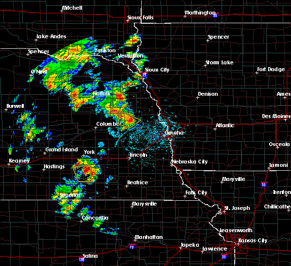 The severe thunderstorm warning for dodge county will expire at 430 pm cdt, the severe thunderstorm which prompted the warning has weakened. therefore, the warning will be allowed to expire. a tornado watch remains in effect until 1000 pm cdt for east central nebraska. The severe thunderstorm warning for dodge county will expire at 430 pm cdt, the severe thunderstorm which prompted the warning has weakened. therefore, the warning will be allowed to expire. a tornado watch remains in effect until 1000 pm cdt for east central nebraska.
|
| 6/9/2020 4:04 PM CDT |
 At 403 pm cdt, a severe thunderstorm was located 5 miles north of north bend, or 32 miles east of columbus, moving northeast at 35 mph (radar indicated). Hazards include quarter size hail. Damage to vehicles is expected. Locations impacted include, north bend, scribner, hooper, snyder and 7 miles north of north bend. At 403 pm cdt, a severe thunderstorm was located 5 miles north of north bend, or 32 miles east of columbus, moving northeast at 35 mph (radar indicated). Hazards include quarter size hail. Damage to vehicles is expected. Locations impacted include, north bend, scribner, hooper, snyder and 7 miles north of north bend.
|
| 6/9/2020 3:45 PM CDT |
 At 344 pm cdt, a severe thunderstorm was located 6 miles west of north bend, or 23 miles east of columbus, moving northeast at 35 mph (radar indicated). Hazards include quarter size hail. damage to vehicles is expected At 344 pm cdt, a severe thunderstorm was located 6 miles west of north bend, or 23 miles east of columbus, moving northeast at 35 mph (radar indicated). Hazards include quarter size hail. damage to vehicles is expected
|
| 5/24/2020 3:47 AM CDT |
 At 346 am cdt, severe thunderstorms were located along a line extending from 6 miles southeast of wayne to 6 miles west of west point to 4 miles south of schuyler, moving east at 40 mph (radar indicated). Hazards include 70 mph wind gusts. Expect considerable tree damage. Damage is likely to mobile homes, roofs, and outbuildings. At 346 am cdt, severe thunderstorms were located along a line extending from 6 miles southeast of wayne to 6 miles west of west point to 4 miles south of schuyler, moving east at 40 mph (radar indicated). Hazards include 70 mph wind gusts. Expect considerable tree damage. Damage is likely to mobile homes, roofs, and outbuildings.
|
| 5/16/2019 7:21 PM CDT |
 At 720 pm cdt, a severe thunderstorm was located over north bend, or 32 miles east of columbus, moving northeast at 20 mph (radar indicated). Hazards include 60 mph wind gusts and quarter size hail. Hail damage to vehicles is expected. Expect wind damage to roofs, siding, and trees. At 720 pm cdt, a severe thunderstorm was located over north bend, or 32 miles east of columbus, moving northeast at 20 mph (radar indicated). Hazards include 60 mph wind gusts and quarter size hail. Hail damage to vehicles is expected. Expect wind damage to roofs, siding, and trees.
|
| 8/5/2018 10:21 PM CDT |
 The severe thunderstorm warning for southwestern dodge and northwestern saunders counties will expire at 1030 pm cdt, the storm which prompted the warning has weakened below severe limits, and no longer poses an immediate threat to life or property. therefore, the warning will be allowed to expire. however small hail, gusty winds and heavy rain are still possible with this thunderstorm. The severe thunderstorm warning for southwestern dodge and northwestern saunders counties will expire at 1030 pm cdt, the storm which prompted the warning has weakened below severe limits, and no longer poses an immediate threat to life or property. therefore, the warning will be allowed to expire. however small hail, gusty winds and heavy rain are still possible with this thunderstorm.
|
| 8/5/2018 10:18 PM CDT |
 At 1018 pm cdt, a severe thunderstorm was located 4 miles southeast of north bend, or 32 miles east of columbus, moving northeast at 45 mph (radar indicated). Hazards include 60 mph wind gusts and quarter size hail. Hail damage to vehicles is expected. expect wind damage to roofs, siding, and trees. Locations impacted include, north bend, cedar bluffs, morse bluff and camp cedars. At 1018 pm cdt, a severe thunderstorm was located 4 miles southeast of north bend, or 32 miles east of columbus, moving northeast at 45 mph (radar indicated). Hazards include 60 mph wind gusts and quarter size hail. Hail damage to vehicles is expected. expect wind damage to roofs, siding, and trees. Locations impacted include, north bend, cedar bluffs, morse bluff and camp cedars.
|
| 8/5/2018 10:13 PM CDT |
 At 1012 pm cdt, a severe thunderstorm was located 5 miles south of north bend, or 28 miles east of columbus, moving northeast at 45 mph (radar indicated). Hazards include 60 mph wind gusts and quarter size hail. Hail damage to vehicles is expected. expect wind damage to roofs, siding, and trees. Locations impacted include, north bend, cedar bluffs, prague, morse bluff and camp cedars. At 1012 pm cdt, a severe thunderstorm was located 5 miles south of north bend, or 28 miles east of columbus, moving northeast at 45 mph (radar indicated). Hazards include 60 mph wind gusts and quarter size hail. Hail damage to vehicles is expected. expect wind damage to roofs, siding, and trees. Locations impacted include, north bend, cedar bluffs, prague, morse bluff and camp cedars.
|
| 8/5/2018 10:07 PM CDT |
 At 1007 pm cdt, a severe thunderstorm was located 4 miles northwest of prague, or 25 miles east of columbus, moving northeast at 45 mph (radar indicated). Hazards include 60 mph wind gusts and quarter size hail. Hail damage to vehicles is expected. expect wind damage to roofs, siding, and trees. Locations impacted include, north bend, cedar bluffs, prague, morse bluff, linwood, abie and camp cedars. At 1007 pm cdt, a severe thunderstorm was located 4 miles northwest of prague, or 25 miles east of columbus, moving northeast at 45 mph (radar indicated). Hazards include 60 mph wind gusts and quarter size hail. Hail damage to vehicles is expected. expect wind damage to roofs, siding, and trees. Locations impacted include, north bend, cedar bluffs, prague, morse bluff, linwood, abie and camp cedars.
|
| 8/5/2018 10:04 PM CDT |
 At 1003 pm cdt, a severe thunderstorm was located 6 miles west of prague, or 23 miles east of columbus, moving northeast at 45 mph (radar indicated). Hazards include 60 mph wind gusts and quarter size hail. Hail damage to vehicles is expected. Expect wind damage to roofs, siding, and trees. At 1003 pm cdt, a severe thunderstorm was located 6 miles west of prague, or 23 miles east of columbus, moving northeast at 45 mph (radar indicated). Hazards include 60 mph wind gusts and quarter size hail. Hail damage to vehicles is expected. Expect wind damage to roofs, siding, and trees.
|
| 8/5/2018 9:17 PM CDT |
 At 917 pm cdt, a severe thunderstorm was located 5 miles south of scribner, or 36 miles east of columbus, moving northeast at 40 mph (radar indicated). Hazards include 60 mph wind gusts and quarter size hail. Hail damage to vehicles is expected. expect wind damage to roofs, siding, and trees. Locations impacted include, north bend, scribner, hooper, nickerson and winslow. At 917 pm cdt, a severe thunderstorm was located 5 miles south of scribner, or 36 miles east of columbus, moving northeast at 40 mph (radar indicated). Hazards include 60 mph wind gusts and quarter size hail. Hail damage to vehicles is expected. expect wind damage to roofs, siding, and trees. Locations impacted include, north bend, scribner, hooper, nickerson and winslow.
|
| 8/5/2018 9:10 PM CDT | Quarter sized hail reported 6.1 miles S of North Bend, NE |
| 8/5/2018 9:10 PM CDT |
 At 910 pm cdt, a severe thunderstorm was located 5 miles north of north bend, or 32 miles east of columbus, moving northeast at 40 mph (radar indicated). Hazards include 60 mph wind gusts and quarter size hail. Hail damage to vehicles is expected. Expect wind damage to roofs, siding, and trees. At 910 pm cdt, a severe thunderstorm was located 5 miles north of north bend, or 32 miles east of columbus, moving northeast at 40 mph (radar indicated). Hazards include 60 mph wind gusts and quarter size hail. Hail damage to vehicles is expected. Expect wind damage to roofs, siding, and trees.
|
| 6/9/2018 3:00 AM CDT |
 At 300 am cdt, severe thunderstorms were located along a line extending from near howells to near brainard, moving east at 40 mph (radar indicated). Hazards include 60 mph wind gusts. expect damage to roofs, siding, and trees At 300 am cdt, severe thunderstorms were located along a line extending from near howells to near brainard, moving east at 40 mph (radar indicated). Hazards include 60 mph wind gusts. expect damage to roofs, siding, and trees
|
| 6/6/2018 7:32 PM CDT |
 At 731 pm cdt, severe thunderstorms were located along a line extending from near hooper to 6 miles west of north bend to near columbus, moving southeast at 10 mph (radar indicated). Hazards include golf ball size hail and 70 mph wind gusts. People and animals outdoors will be injured. expect hail damage to roofs, siding, windows, and vehicles. expect considerable tree damage. Wind damage is also likely to mobile homes, roofs, and outbuildings. At 731 pm cdt, severe thunderstorms were located along a line extending from near hooper to 6 miles west of north bend to near columbus, moving southeast at 10 mph (radar indicated). Hazards include golf ball size hail and 70 mph wind gusts. People and animals outdoors will be injured. expect hail damage to roofs, siding, windows, and vehicles. expect considerable tree damage. Wind damage is also likely to mobile homes, roofs, and outbuildings.
|
| 6/6/2018 6:45 PM CDT |
 At 644 pm cdt, a severe thunderstorm was located over snyder, or 34 miles northeast of columbus, moving south at 20 mph (radar indicated). Hazards include tennis ball size hail and 60 mph wind gusts. People and animals outdoors will be injured. expect hail damage to roofs, siding, windows, and vehicles. Expect wind damage to roofs, siding, and trees. At 644 pm cdt, a severe thunderstorm was located over snyder, or 34 miles northeast of columbus, moving south at 20 mph (radar indicated). Hazards include tennis ball size hail and 60 mph wind gusts. People and animals outdoors will be injured. expect hail damage to roofs, siding, windows, and vehicles. Expect wind damage to roofs, siding, and trees.
|
| 6/6/2018 6:26 PM CDT |
 At 624 pm cdt, outflow containing severe wind gusts ahead of severe thunderstorms was located along a line extending from 7 miles northeast of clarkson to howells to 6 miles southwest of snyder to near scribner, moving southwest at 30 mph (radar indicated). Hazards include 60 mph wind gusts. expect damage to roofs, siding, and trees At 624 pm cdt, outflow containing severe wind gusts ahead of severe thunderstorms was located along a line extending from 7 miles northeast of clarkson to howells to 6 miles southwest of snyder to near scribner, moving southwest at 30 mph (radar indicated). Hazards include 60 mph wind gusts. expect damage to roofs, siding, and trees
|
| 6/1/2018 11:26 PM CDT |
 At 1124 pm cdt, the leading edge of a line of severe thunderstorms was located along a line extending from 4 miles north of nickerson to near mead, moving east at 40 mph. additional damaging winds are expected well behind the leading edge of these storms (trained weather spotters reported 60 mph winds at dodge. wind damage has been reported along this entire line of storms). Hazards include 70 mph wind gusts and penny size hail. Expect considerable tree damage. damage is likely to mobile homes, roofs, and outbuildings. Locations impacted include, fremont, wahoo, david city, north bend, scribner, hooper, cedar bluffs, rising city, nickerson, brainard, inglewood, weston, prague, snyder, uehling, morse bluff, octavia, malmo, colon and winslow. At 1124 pm cdt, the leading edge of a line of severe thunderstorms was located along a line extending from 4 miles north of nickerson to near mead, moving east at 40 mph. additional damaging winds are expected well behind the leading edge of these storms (trained weather spotters reported 60 mph winds at dodge. wind damage has been reported along this entire line of storms). Hazards include 70 mph wind gusts and penny size hail. Expect considerable tree damage. damage is likely to mobile homes, roofs, and outbuildings. Locations impacted include, fremont, wahoo, david city, north bend, scribner, hooper, cedar bluffs, rising city, nickerson, brainard, inglewood, weston, prague, snyder, uehling, morse bluff, octavia, malmo, colon and winslow.
|
| 6/1/2018 11:09 PM CDT |
 At 1107 pm cdt, the leading edge of severe thunderstorms was located along a line extending from near scribner to 3 miles west of cedar bluffs to 5 miles south of david city, moving east at 50 mph. damaging winds continue well behind the leading edge of the storms as well (trained weather spotters reported power lines down in clarkson. additional wind damage has been reported along this entire line of storms). Hazards include 70 mph wind gusts and quarter size hail. Hail damage to vehicles is expected. expect considerable tree damage. wind damage is also likely to mobile homes, roofs, and outbuildings. Locations impacted include, fremont, wahoo, david city, north bend, scribner, hooper, dodge, cedar bluffs, valparaiso, bellwood, rising city, nickerson, brainard, inglewood, weston, prague, snyder, uehling, dwight and ulysses. At 1107 pm cdt, the leading edge of severe thunderstorms was located along a line extending from near scribner to 3 miles west of cedar bluffs to 5 miles south of david city, moving east at 50 mph. damaging winds continue well behind the leading edge of the storms as well (trained weather spotters reported power lines down in clarkson. additional wind damage has been reported along this entire line of storms). Hazards include 70 mph wind gusts and quarter size hail. Hail damage to vehicles is expected. expect considerable tree damage. wind damage is also likely to mobile homes, roofs, and outbuildings. Locations impacted include, fremont, wahoo, david city, north bend, scribner, hooper, dodge, cedar bluffs, valparaiso, bellwood, rising city, nickerson, brainard, inglewood, weston, prague, snyder, uehling, dwight and ulysses.
|
| 6/1/2018 10:44 PM CDT |
 At 1043 pm cdt, severe thunderstorms were located along a line extending from near howells to 6 miles north of schuyler to 6 miles south of duncan, moving east at 40 mph. this is the leading edge of an area of damaging thunderstorm winds (trained weather spotters reported wind damage across platte county and the columbus airport measured 63 mph wind gust at 1042 pm). Hazards include 70 mph wind gusts and half dollar size hail. Hail damage to vehicles is expected. expect considerable tree damage. Wind damage is also likely to mobile homes, roofs, and outbuildings. At 1043 pm cdt, severe thunderstorms were located along a line extending from near howells to 6 miles north of schuyler to 6 miles south of duncan, moving east at 40 mph. this is the leading edge of an area of damaging thunderstorm winds (trained weather spotters reported wind damage across platte county and the columbus airport measured 63 mph wind gust at 1042 pm). Hazards include 70 mph wind gusts and half dollar size hail. Hail damage to vehicles is expected. expect considerable tree damage. Wind damage is also likely to mobile homes, roofs, and outbuildings.
|
| 5/1/2018 6:07 PM CDT |
 At 606 pm cdt, a severe thunderstorm was located 5 miles west of nickerson, or 34 miles northwest of omaha, moving northeast at 25 mph. a second severe storm was located 2 miles east of north bend (radar indicated). Hazards include golf ball size hail and 60 mph wind gusts. People and animals outdoors will be injured. expect hail damage to roofs, siding, windows, and vehicles. expect wind damage to roofs, siding, and trees. locations impacted include, north bend, hooper, nickerson and winslow. this includes the following highways, highway 275 in nebraska between mile markers 137 and 140. highway 30 in nebraska between mile markers 408 and 420, and near mile marker 426. highway 77 in nebraska between mile markers 117 and 126. A tornado watch remains in effect until 1000 pm cdt for east central nebraska. At 606 pm cdt, a severe thunderstorm was located 5 miles west of nickerson, or 34 miles northwest of omaha, moving northeast at 25 mph. a second severe storm was located 2 miles east of north bend (radar indicated). Hazards include golf ball size hail and 60 mph wind gusts. People and animals outdoors will be injured. expect hail damage to roofs, siding, windows, and vehicles. expect wind damage to roofs, siding, and trees. locations impacted include, north bend, hooper, nickerson and winslow. this includes the following highways, highway 275 in nebraska between mile markers 137 and 140. highway 30 in nebraska between mile markers 408 and 420, and near mile marker 426. highway 77 in nebraska between mile markers 117 and 126. A tornado watch remains in effect until 1000 pm cdt for east central nebraska.
|
| 5/1/2018 5:42 PM CDT |
 At 541 pm cdt, a severe thunderstorm was located over north bend, or 30 miles east of columbus, moving northeast at 25 mph. this is a very dangerous storm (radar indicated. this storm has a history of hail up to the size of baseballs). Hazards include baseball size hail. People and animals outdoors will be severely injured. Expect shattered windows, extensive damage to roofs, siding, and vehicles. At 541 pm cdt, a severe thunderstorm was located over north bend, or 30 miles east of columbus, moving northeast at 25 mph. this is a very dangerous storm (radar indicated. this storm has a history of hail up to the size of baseballs). Hazards include baseball size hail. People and animals outdoors will be severely injured. Expect shattered windows, extensive damage to roofs, siding, and vehicles.
|
| 5/1/2018 5:39 PM CDT | Quarter sized hail reported 3.3 miles SE of North Bend, NE |
| 5/1/2018 5:29 PM CDT |
 At 528 pm cdt, a severe thunderstorm was located near north bend, or 27 miles east of columbus, moving northeast at 25 mph. this is a very dangerous storm (trained weather spotters have reported up to baseball size hail with this storm near octavia). Hazards include baseball size hail and 60 mph wind gusts. People and animals outdoors will be severely injured. expect shattered windows, extensive damage to roofs, siding, and vehicles. locations impacted include, north bend, cedar bluffs, morse bluff, camp eagle, camp cedars and fremont lakes state recreation area. this includes highway 30 in nebraska between mile markers 402 and 423. A tornado watch remains in effect until 1000 pm cdt for northeastern and east central nebraska. At 528 pm cdt, a severe thunderstorm was located near north bend, or 27 miles east of columbus, moving northeast at 25 mph. this is a very dangerous storm (trained weather spotters have reported up to baseball size hail with this storm near octavia). Hazards include baseball size hail and 60 mph wind gusts. People and animals outdoors will be severely injured. expect shattered windows, extensive damage to roofs, siding, and vehicles. locations impacted include, north bend, cedar bluffs, morse bluff, camp eagle, camp cedars and fremont lakes state recreation area. this includes highway 30 in nebraska between mile markers 402 and 423. A tornado watch remains in effect until 1000 pm cdt for northeastern and east central nebraska.
|
| 5/1/2018 5:27 PM CDT | Half Dollar sized hail reported 0.4 miles S of North Bend, NE, relayed via retired nws employee. |
| 5/1/2018 5:11 PM CDT |
 At 509 pm cdt, a severe thunderstorm was located 8 miles northwest of prague, or 22 miles east of columbus, moving northeast at 25 mph. a tornado warning is also in effect for this storm as it has a history of producing a funnel cloud. this is a very dangerous storm (trained weather spotters reported hail larger than 2 inches 3 miles east of octavia with this storm). Hazards include baseball size hail and 60 mph wind gusts. People and animals outdoors will be severely injured. expect shattered windows, extensive damage to roofs, siding, and vehicles. locations impacted include, north bend, cedar bluffs, prague, morse bluff, bruno, rogers, linwood, abie, camp eagle, camp cedars and fremont lakes state recreation area. this includes highway 30 in nebraska between mile markers 402 and 423. A tornado watch remains in effect until 1000 pm cdt for northeastern and east central nebraska. At 509 pm cdt, a severe thunderstorm was located 8 miles northwest of prague, or 22 miles east of columbus, moving northeast at 25 mph. a tornado warning is also in effect for this storm as it has a history of producing a funnel cloud. this is a very dangerous storm (trained weather spotters reported hail larger than 2 inches 3 miles east of octavia with this storm). Hazards include baseball size hail and 60 mph wind gusts. People and animals outdoors will be severely injured. expect shattered windows, extensive damage to roofs, siding, and vehicles. locations impacted include, north bend, cedar bluffs, prague, morse bluff, bruno, rogers, linwood, abie, camp eagle, camp cedars and fremont lakes state recreation area. this includes highway 30 in nebraska between mile markers 402 and 423. A tornado watch remains in effect until 1000 pm cdt for northeastern and east central nebraska.
|
| 5/1/2018 4:55 PM CDT |
 At 454 pm cdt, a severe thunderstorm was located 6 miles south of schuyler, or 17 miles east of columbus, moving northeast at 30 mph. this is a very dangerous storm (trained weather spotters reported two inch hail north of david city and golf ball size hail in octavia with this storm). Hazards include baseball size hail and 60 mph wind gusts. People and animals outdoors will be severely injured. Expect shattered windows, extensive damage to roofs, siding, and vehicles. At 454 pm cdt, a severe thunderstorm was located 6 miles south of schuyler, or 17 miles east of columbus, moving northeast at 30 mph. this is a very dangerous storm (trained weather spotters reported two inch hail north of david city and golf ball size hail in octavia with this storm). Hazards include baseball size hail and 60 mph wind gusts. People and animals outdoors will be severely injured. Expect shattered windows, extensive damage to roofs, siding, and vehicles.
|
| 8/19/2017 11:21 PM CDT |
 The severe thunderstorm warning for southeastern colfax, southwestern dodge and northwestern saunders counties will expire at 1130 pm cdt, the storm which prompted the warning has weakened and was exiting the warned area. therefore, the warning will be allowed to expire at 1130 pm. however gusty winds and heavy rain are still possible with more thunderstorms moving in from the west. The severe thunderstorm warning for southeastern colfax, southwestern dodge and northwestern saunders counties will expire at 1130 pm cdt, the storm which prompted the warning has weakened and was exiting the warned area. therefore, the warning will be allowed to expire at 1130 pm. however gusty winds and heavy rain are still possible with more thunderstorms moving in from the west.
|
| 8/19/2017 11:07 PM CDT |
 At 1107 pm cdt, a severe thunderstorm was located 9 miles northeast of schuyler, or 22 miles east of columbus, moving east at 45 mph (radar indicated). Hazards include 60 mph wind gusts. Expect damage to roofs, siding, and trees. locations impacted include, north bend, morse bluff, rogers, 9 miles north of schuyler and 7 miles north of north bend. This includes highway 30 in nebraska between mile markers 399 and 414. At 1107 pm cdt, a severe thunderstorm was located 9 miles northeast of schuyler, or 22 miles east of columbus, moving east at 45 mph (radar indicated). Hazards include 60 mph wind gusts. Expect damage to roofs, siding, and trees. locations impacted include, north bend, morse bluff, rogers, 9 miles north of schuyler and 7 miles north of north bend. This includes highway 30 in nebraska between mile markers 399 and 414.
|
| 8/19/2017 10:55 PM CDT |
 At 1054 pm cdt, a severe thunderstorm was located 9 miles south of clarkson, or 15 miles northeast of columbus, moving east at 40 mph. winds greater than 60 mph were reported with this storm 6 miles southwest of leigh at 1050 pm (radar indicated). Hazards include 70 mph wind gusts. Expect considerable tree damage. Damage is likely to mobile homes, roofs, and outbuildings. At 1054 pm cdt, a severe thunderstorm was located 9 miles south of clarkson, or 15 miles northeast of columbus, moving east at 40 mph. winds greater than 60 mph were reported with this storm 6 miles southwest of leigh at 1050 pm (radar indicated). Hazards include 70 mph wind gusts. Expect considerable tree damage. Damage is likely to mobile homes, roofs, and outbuildings.
|
| 6/16/2017 7:07 PM CDT |
 At 706 pm cdt, severe thunderstorms were located along a line extending from 4 miles northwest of pisgah to near shelby, moving southeast at 35 mph (radar indicated). Hazards include 70 mph wind gusts and quarter size hail. Hail damage to vehicles is expected. expect considerable tree damage. Wind damage is also likely to mobile homes, roofs, and outbuildings. At 706 pm cdt, severe thunderstorms were located along a line extending from 4 miles northwest of pisgah to near shelby, moving southeast at 35 mph (radar indicated). Hazards include 70 mph wind gusts and quarter size hail. Hail damage to vehicles is expected. expect considerable tree damage. Wind damage is also likely to mobile homes, roofs, and outbuildings.
|
| 6/16/2017 6:47 PM CDT |
 At 647 pm cdt, severe thunderstorms were located along a line extending from 6 miles northeast of tekamah to 5 miles north of schuyler, moving southeast at 35 mph (radar indicated). Hazards include 60 mph wind gusts and quarter size hail. Hail damage to vehicles is expected. Expect wind damage to roofs, siding, and trees. At 647 pm cdt, severe thunderstorms were located along a line extending from 6 miles northeast of tekamah to 5 miles north of schuyler, moving southeast at 35 mph (radar indicated). Hazards include 60 mph wind gusts and quarter size hail. Hail damage to vehicles is expected. Expect wind damage to roofs, siding, and trees.
|
| 6/13/2017 11:37 PM CDT |
 The severe thunderstorm warning for southern colfax, northern lancaster, southwestern dodge, northeastern seward, eastern butler and saunders counties will expire at 1145 pm cdt, the storms which prompted the warning have weakened below severe limits, and no longer pose an immediate threat to life or property. therefore the warning will be allowed to expire. however small hail, gusty winds and heavy rain are still possible with these thunderstorms. a severe thunderstorm watch remains in effect until 100 am cdt for southeastern, northeastern and east central nebraska. The severe thunderstorm warning for southern colfax, northern lancaster, southwestern dodge, northeastern seward, eastern butler and saunders counties will expire at 1145 pm cdt, the storms which prompted the warning have weakened below severe limits, and no longer pose an immediate threat to life or property. therefore the warning will be allowed to expire. however small hail, gusty winds and heavy rain are still possible with these thunderstorms. a severe thunderstorm watch remains in effect until 100 am cdt for southeastern, northeastern and east central nebraska.
|
| 6/13/2017 11:31 PM CDT |
 At 1130 pm cdt, severe thunderstorms were located along a line extending from near schuyler to near north bend to 3 miles north of wahoo to 7 miles southeast of valparaiso, moving northeast at 45 mph (trained weather spotters). Hazards include 60 mph wind gusts. Expect damage to roofs, siding, and trees. locations impacted include, schuyler, wahoo, waverly, north bend, cedar bluffs, valparaiso, mead, weston, prague, ceresco, raymond, davey, ithaca, morse bluff, octavia, malmo, colon, bruno, rogers and linwood. this includes the following highways, highway 30 in nebraska between mile markers 387 and 420. highway 77 in nebraska near mile marker 74, and between mile markers 81 and 100. Highway 92 in nebraska between mile markers 433 and 452. At 1130 pm cdt, severe thunderstorms were located along a line extending from near schuyler to near north bend to 3 miles north of wahoo to 7 miles southeast of valparaiso, moving northeast at 45 mph (trained weather spotters). Hazards include 60 mph wind gusts. Expect damage to roofs, siding, and trees. locations impacted include, schuyler, wahoo, waverly, north bend, cedar bluffs, valparaiso, mead, weston, prague, ceresco, raymond, davey, ithaca, morse bluff, octavia, malmo, colon, bruno, rogers and linwood. this includes the following highways, highway 30 in nebraska between mile markers 387 and 420. highway 77 in nebraska near mile marker 74, and between mile markers 81 and 100. Highway 92 in nebraska between mile markers 433 and 452.
|
| 6/13/2017 11:14 PM CDT |
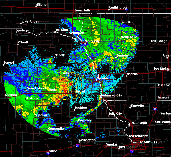 At 1112 pm cdt, severe thunderstorms were located along a line extending from near bellwood to 6 miles west of prague to near valparaiso to 6 miles southeast of pleasant dale, moving northeast at 40 mph (trained weather spotters). Hazards include 60 mph wind gusts. expect damage to roofs, siding, and trees At 1112 pm cdt, severe thunderstorms were located along a line extending from near bellwood to 6 miles west of prague to near valparaiso to 6 miles southeast of pleasant dale, moving northeast at 40 mph (trained weather spotters). Hazards include 60 mph wind gusts. expect damage to roofs, siding, and trees
|
| 6/13/2017 9:18 PM CDT |
 At 918 pm cdt, severe thunderstorms were located along a line extending from 4 miles southwest of snyder to 5 miles southwest of prague to 4 miles west of beaver crossing, moving east at 35 mph (radar indicated). Hazards include 60 mph wind gusts and half dollar size hail. Hail damage to vehicles is expected. expect wind damage to roofs, siding, and trees. locations impacted include, fremont, seward, schuyler, wahoo, david city, milford, north bend, utica, hooper, cedar bluffs, valparaiso, bellwood, beaver crossing, rising city, brainard, inglewood, weston, prague, staplehurst and garland. this includes the following highways, highway 275 in nebraska between mile markers 135 and 140. highway 30 in nebraska between mile markers 387 and 426. highway 77 in nebraska between mile markers 90 and 93, and between mile markers 108 and 126. highway 92 in nebraska between mile markers 412 and 452. Interstate 80 in nebraska between mile markers 366 and 392. At 918 pm cdt, severe thunderstorms were located along a line extending from 4 miles southwest of snyder to 5 miles southwest of prague to 4 miles west of beaver crossing, moving east at 35 mph (radar indicated). Hazards include 60 mph wind gusts and half dollar size hail. Hail damage to vehicles is expected. expect wind damage to roofs, siding, and trees. locations impacted include, fremont, seward, schuyler, wahoo, david city, milford, north bend, utica, hooper, cedar bluffs, valparaiso, bellwood, beaver crossing, rising city, brainard, inglewood, weston, prague, staplehurst and garland. this includes the following highways, highway 275 in nebraska between mile markers 135 and 140. highway 30 in nebraska between mile markers 387 and 426. highway 77 in nebraska between mile markers 90 and 93, and between mile markers 108 and 126. highway 92 in nebraska between mile markers 412 and 452. Interstate 80 in nebraska between mile markers 366 and 392.
|
| 6/13/2017 9:07 PM CDT |
 At 906 pm cdt, severe thunderstorms were located along a line extending from 6 miles south of howells to 5 miles east of david city to 3 miles southwest of beaver crossing, moving east at 40 mph (radar indicated). Hazards include 60 mph wind gusts and quarter size hail. Hail damage to vehicles is expected. Expect wind damage to roofs, siding, and trees. At 906 pm cdt, severe thunderstorms were located along a line extending from 6 miles south of howells to 5 miles east of david city to 3 miles southwest of beaver crossing, moving east at 40 mph (radar indicated). Hazards include 60 mph wind gusts and quarter size hail. Hail damage to vehicles is expected. Expect wind damage to roofs, siding, and trees.
|
| 6/13/2017 8:59 PM CDT |
 At 859 pm cdt, severe thunderstorms were located along a line extending from 4 miles east of scribner to 3 miles south of inglewood to 5 miles south of valparaiso, moving east at 45 mph (radar indicated). Hazards include 60 mph wind gusts. Expect damage to roofs, siding, and trees. locations impacted include, fremont, schuyler, wahoo, david city, north bend, scribner, hooper, clarkson, dodge, cedar bluffs, valparaiso, howells, bellwood, rising city, nickerson, brainard, inglewood, weston, prague and snyder. this includes the following highways, highway 275 in nebraska between mile markers 124 and 156. highway 30 in nebraska between mile markers 387 and 426. highway 77 in nebraska between mile markers 90 and 93, and between mile markers 108 and 135. Highway 92 in nebraska between mile markers 409 and 446. At 859 pm cdt, severe thunderstorms were located along a line extending from 4 miles east of scribner to 3 miles south of inglewood to 5 miles south of valparaiso, moving east at 45 mph (radar indicated). Hazards include 60 mph wind gusts. Expect damage to roofs, siding, and trees. locations impacted include, fremont, schuyler, wahoo, david city, north bend, scribner, hooper, clarkson, dodge, cedar bluffs, valparaiso, howells, bellwood, rising city, nickerson, brainard, inglewood, weston, prague and snyder. this includes the following highways, highway 275 in nebraska between mile markers 124 and 156. highway 30 in nebraska between mile markers 387 and 426. highway 77 in nebraska between mile markers 90 and 93, and between mile markers 108 and 135. Highway 92 in nebraska between mile markers 409 and 446.
|
| 6/13/2017 8:42 PM CDT |
 At 840 pm cdt, severe thunderstorms were located along a line extending from dodge to near north bend to 3 miles southeast of ulysses, moving east at 45 mph. another line of storms was moving across southern platte and into western butler counties, also moving east at 45 mph (radar indicated). Hazards include 60 mph wind gusts. expect damage to roofs, siding, and trees At 840 pm cdt, severe thunderstorms were located along a line extending from dodge to near north bend to 3 miles southeast of ulysses, moving east at 45 mph. another line of storms was moving across southern platte and into western butler counties, also moving east at 45 mph (radar indicated). Hazards include 60 mph wind gusts. expect damage to roofs, siding, and trees
|
| 6/13/2017 8:32 PM CDT |
 At 831 pm cdt, severe thunderstorms were located along a line extending from near howells to 6 miles northeast of schuyler to 4 miles south of david city, moving east at 50 mph (radar indicated). Hazards include 70 mph wind gusts and nickel size hail. Expect considerable tree damage. damage is likely to mobile homes, roofs, and outbuildings. locations impacted include, schuyler, wahoo, david city, north bend, scribner, clarkson, dodge, cedar bluffs, valparaiso, howells, bellwood, rising city, brainard, weston, prague, snyder, dwight, ulysses, morse bluff and octavia. this includes the following highways, highway 275 in nebraska between mile markers 127 and 132. highway 30 in nebraska between mile markers 387 and 420. highway 77 in nebraska between mile markers 85 and 93. Highway 92 in nebraska between mile markers 409 and 446. At 831 pm cdt, severe thunderstorms were located along a line extending from near howells to 6 miles northeast of schuyler to 4 miles south of david city, moving east at 50 mph (radar indicated). Hazards include 70 mph wind gusts and nickel size hail. Expect considerable tree damage. damage is likely to mobile homes, roofs, and outbuildings. locations impacted include, schuyler, wahoo, david city, north bend, scribner, clarkson, dodge, cedar bluffs, valparaiso, howells, bellwood, rising city, brainard, weston, prague, snyder, dwight, ulysses, morse bluff and octavia. this includes the following highways, highway 275 in nebraska between mile markers 127 and 132. highway 30 in nebraska between mile markers 387 and 420. highway 77 in nebraska between mile markers 85 and 93. Highway 92 in nebraska between mile markers 409 and 446.
|
| 6/13/2017 8:21 PM CDT |
 At 821 pm cdt, severe thunderstorms were located along a line extending from 3 miles southwest of clarkson to 3 miles west of schuyler to 3 miles northeast of ulysses, moving east at 50 mph (trained weather spotters). Hazards include 70 mph wind gusts and nickel size hail. Expect considerable tree damage. Damage is likely to mobile homes, roofs, and outbuildings. At 821 pm cdt, severe thunderstorms were located along a line extending from 3 miles southwest of clarkson to 3 miles west of schuyler to 3 miles northeast of ulysses, moving east at 50 mph (trained weather spotters). Hazards include 70 mph wind gusts and nickel size hail. Expect considerable tree damage. Damage is likely to mobile homes, roofs, and outbuildings.
|
| 12/25/2016 3:02 PM CST |
 At 301 pm cst, a severe thunderstorm was located 4 miles southeast of brainard, or 26 miles northwest of lincoln, moving northeast at 50 mph (radar indicated). Hazards include 60 mph wind gusts. expect damage to roofs, siding, and trees At 301 pm cst, a severe thunderstorm was located 4 miles southeast of brainard, or 26 miles northwest of lincoln, moving northeast at 50 mph (radar indicated). Hazards include 60 mph wind gusts. expect damage to roofs, siding, and trees
|
| 7/7/2016 12:28 AM CDT | The severe thunderstorm warning for northeastern butler. southwestern dodge. southeastern colfax and northwestern saunders counties will expire at 1230 am cdt. the storm which prompted the warning has weakened and has exited the warned area. therefore. the warning will be allowed to expire. However gusty winds are still possible with this thunderstorm. |
| 7/7/2016 12:14 AM CDT |
 At 1214 am cdt, a severe thunderstorm was located 4 miles east of schuyler, or 19 miles east of columbus, moving east at 45 mph (radar indicated). Hazards include 60 mph wind gusts. Expect damage to roofs. siding and trees. Locations impacted include, schuyler, north bend, morse bluff, octavia, rogers, linwood, 7 miles north of north bend and 9 miles north of schuyler. At 1214 am cdt, a severe thunderstorm was located 4 miles east of schuyler, or 19 miles east of columbus, moving east at 45 mph (radar indicated). Hazards include 60 mph wind gusts. Expect damage to roofs. siding and trees. Locations impacted include, schuyler, north bend, morse bluff, octavia, rogers, linwood, 7 miles north of north bend and 9 miles north of schuyler.
|
| 7/7/2016 12:05 AM CDT |
 At 1204 am cdt, a severe thunderstorm was located near schuyler, or 12 miles east of columbus, moving east at 50 mph. 60 mph winds were reported with this storm at columbus at 1155 pm (radar indicated). Hazards include 60 mph wind gusts. Expect damage to roofs. siding and trees. Locations impacted include, schuyler, north bend, morse bluff, rogers, linwood, richland, 7 miles north of north bend, 9 miles north of schuyler and camp luther. At 1204 am cdt, a severe thunderstorm was located near schuyler, or 12 miles east of columbus, moving east at 50 mph. 60 mph winds were reported with this storm at columbus at 1155 pm (radar indicated). Hazards include 60 mph wind gusts. Expect damage to roofs. siding and trees. Locations impacted include, schuyler, north bend, morse bluff, rogers, linwood, richland, 7 miles north of north bend, 9 miles north of schuyler and camp luther.
|
| 7/6/2016 11:58 PM CDT |
 At 1158 pm cdt, a severe thunderstorm was located 6 miles northeast of columbus, moving east at 50 mph (radar indicated). Hazards include 60 mph wind gusts. Expect damage to roofs. Siding and trees. At 1158 pm cdt, a severe thunderstorm was located 6 miles northeast of columbus, moving east at 50 mph (radar indicated). Hazards include 60 mph wind gusts. Expect damage to roofs. Siding and trees.
|
| 7/5/2016 10:00 PM CDT |
 At 958 pm cdt, severe thunderstorms were located along a line extending from 3 miles southeast of uehling to 3 miles south of cedar bluffs, moving east at 45 mph. radar indicated that winds had decreased a little from earlier. the large hail was most likely in northeast dodge county (radar indicated). Hazards include 60 mph wind gusts and quarter size hail. Hail damage to vehicles is expected. expect wind damage to roofs, siding and trees. locations impacted include, fremont, valley, arlington, north bend, scribner, waterloo, hooper, cedar bluffs, nickerson, inglewood, prague, morse bluff, malmo, leshara, colon, winslow, fremont lakes state recreation area, 7 miles north of north bend, camp eagle and camp cedars. this includes the following highways, highway 275 in nebraska between mile markers 129 and 167. highway 30 in nebraska between mile markers 411 and 438. Highway 77 in nebraska between milemarkers 104 and 129. At 958 pm cdt, severe thunderstorms were located along a line extending from 3 miles southeast of uehling to 3 miles south of cedar bluffs, moving east at 45 mph. radar indicated that winds had decreased a little from earlier. the large hail was most likely in northeast dodge county (radar indicated). Hazards include 60 mph wind gusts and quarter size hail. Hail damage to vehicles is expected. expect wind damage to roofs, siding and trees. locations impacted include, fremont, valley, arlington, north bend, scribner, waterloo, hooper, cedar bluffs, nickerson, inglewood, prague, morse bluff, malmo, leshara, colon, winslow, fremont lakes state recreation area, 7 miles north of north bend, camp eagle and camp cedars. this includes the following highways, highway 275 in nebraska between mile markers 129 and 167. highway 30 in nebraska between mile markers 411 and 438. Highway 77 in nebraska between milemarkers 104 and 129.
|
| 7/5/2016 9:54 PM CDT |
 The severe thunderstorm warning for northeastern butler, western dodge, east central colfax and northwestern saunders counties will expire at 1000 pm cdt, the storms which prompted the warning have moved out of the warned area. another warning is in effect farther east for parts of dodge and saunders counties. a severe thunderstorm watch remains in effect until 100 am cdt for northeastern and east central nebraska. The severe thunderstorm warning for northeastern butler, western dodge, east central colfax and northwestern saunders counties will expire at 1000 pm cdt, the storms which prompted the warning have moved out of the warned area. another warning is in effect farther east for parts of dodge and saunders counties. a severe thunderstorm watch remains in effect until 100 am cdt for northeastern and east central nebraska.
|
| 7/5/2016 9:51 PM CDT |
 At 950 pm cdt, severe thunderstorms were located along a line extending from 4 miles north of hooper to 6 miles southwest of cedar bluffs, moving east at 35 mph (radar indicated). Hazards include 70 mph wind gusts and quarter size hail. Hail damage to vehicles is expected. expect considerable tree damage. wind damage is also likely to mobile homes, roofs and outbuildings. locations impacted include, fremont, valley, arlington, north bend, scribner, waterloo, hooper, cedar bluffs, nickerson, inglewood, prague, morse bluff, malmo, leshara, colon, winslow, fremont lakes state recreation area, 7 miles north of north bend, camp eagle and camp cedars. this includes the following highways, highway 275 in nebraska between mile markers 129 and 167. highway 30 in nebraska between mile markers 411 and 438. Highway 77 in nebraska between milemarkers 104 and 129. At 950 pm cdt, severe thunderstorms were located along a line extending from 4 miles north of hooper to 6 miles southwest of cedar bluffs, moving east at 35 mph (radar indicated). Hazards include 70 mph wind gusts and quarter size hail. Hail damage to vehicles is expected. expect considerable tree damage. wind damage is also likely to mobile homes, roofs and outbuildings. locations impacted include, fremont, valley, arlington, north bend, scribner, waterloo, hooper, cedar bluffs, nickerson, inglewood, prague, morse bluff, malmo, leshara, colon, winslow, fremont lakes state recreation area, 7 miles north of north bend, camp eagle and camp cedars. this includes the following highways, highway 275 in nebraska between mile markers 129 and 167. highway 30 in nebraska between mile markers 411 and 438. Highway 77 in nebraska between milemarkers 104 and 129.
|
| 7/5/2016 9:45 PM CDT |
 At 945 pm cdt, severe thunderstorms were located along a line extending from 5 miles south of scribner to near prague, moving east at 40 mph (radar indicated). Hazards include 70 mph wind gusts and quarter size hail. Hail damage to vehicles is expected. expect considerable tree damage. wind damage is also likely to mobile homes, roofs and outbuildings. locations impacted include, north bend, prague, morse bluff, rogers, linwood, abie and 7 miles north of north bend. This includes highway 30 in nebraska between mile markers 402 and 414. At 945 pm cdt, severe thunderstorms were located along a line extending from 5 miles south of scribner to near prague, moving east at 40 mph (radar indicated). Hazards include 70 mph wind gusts and quarter size hail. Hail damage to vehicles is expected. expect considerable tree damage. wind damage is also likely to mobile homes, roofs and outbuildings. locations impacted include, north bend, prague, morse bluff, rogers, linwood, abie and 7 miles north of north bend. This includes highway 30 in nebraska between mile markers 402 and 414.
|
| 7/5/2016 9:42 PM CDT |
 At 940 pm cdt, severe thunderstorms were located along a line extending from near scribner to 4 miles northeast of prague, moving east at 45 mph. the strongest winds are tracking along the platte river and from north bend to fremont (radar indicated). Hazards include 70 mph wind gusts and quarter size hail. Hail damage to vehicles is expected. expect considerable tree damage. wind damage is also likely to mobile homes, roofs and outbuildings. locations impacted include, fremont, valley, arlington, north bend, scribner, waterloo, hooper, cedar bluffs, nickerson, inglewood, prague, morse bluff, malmo, leshara, colon, winslow, fremont lakes state recreation area, 7 miles north of north bend, camp eagle and camp cedars. this includes the following highways, highway 275 in nebraska between mile markers 129 and 167. highway 30 in nebraska between mile markers 411 and 438. Highway 77 in nebraska between milemarkers 104 and 129. At 940 pm cdt, severe thunderstorms were located along a line extending from near scribner to 4 miles northeast of prague, moving east at 45 mph. the strongest winds are tracking along the platte river and from north bend to fremont (radar indicated). Hazards include 70 mph wind gusts and quarter size hail. Hail damage to vehicles is expected. expect considerable tree damage. wind damage is also likely to mobile homes, roofs and outbuildings. locations impacted include, fremont, valley, arlington, north bend, scribner, waterloo, hooper, cedar bluffs, nickerson, inglewood, prague, morse bluff, malmo, leshara, colon, winslow, fremont lakes state recreation area, 7 miles north of north bend, camp eagle and camp cedars. this includes the following highways, highway 275 in nebraska between mile markers 129 and 167. highway 30 in nebraska between mile markers 411 and 438. Highway 77 in nebraska between milemarkers 104 and 129.
|
| 7/5/2016 9:37 PM CDT |
 At 937 pm cdt, severe thunderstorms were located along a line extending from 3 miles west of scribner to 3 miles north of prague, moving east at 40 mph (radar indicated). Hazards include 70 mph wind gusts and quarter size hail. Hail damage to vehicles is expected. expect considerable tree damage. wind damage is also likely to mobile homes, roofs and outbuildings. locations impacted include, north bend, prague, morse bluff, bruno, rogers, linwood, abie and 7 miles north of north bend. This includes highway 30 in nebraska between mile markers 402 and 414. At 937 pm cdt, severe thunderstorms were located along a line extending from 3 miles west of scribner to 3 miles north of prague, moving east at 40 mph (radar indicated). Hazards include 70 mph wind gusts and quarter size hail. Hail damage to vehicles is expected. expect considerable tree damage. wind damage is also likely to mobile homes, roofs and outbuildings. locations impacted include, north bend, prague, morse bluff, bruno, rogers, linwood, abie and 7 miles north of north bend. This includes highway 30 in nebraska between mile markers 402 and 414.
|
| 7/5/2016 9:34 PM CDT |
 At 933 pm cdt, severe thunderstorms were located along a line extending from near scribner to near prague, moving east at 45 mph. some strong winds are occurring with a gust front out ahead of the main area of rain and hail (radar indicated). Hazards include 70 mph wind gusts and quarter size hail. Hail damage to vehicles is expected. expect considerable tree damage. Wind damage is also likely to mobile homes, roofs and outbuildings. At 933 pm cdt, severe thunderstorms were located along a line extending from near scribner to near prague, moving east at 45 mph. some strong winds are occurring with a gust front out ahead of the main area of rain and hail (radar indicated). Hazards include 70 mph wind gusts and quarter size hail. Hail damage to vehicles is expected. expect considerable tree damage. Wind damage is also likely to mobile homes, roofs and outbuildings.
|
| 7/5/2016 9:30 PM CDT |
 At 930 pm cdt, severe thunderstorms were located along a line extending from 3 miles southeast of snyder to 5 miles north of prague, moving east at 45 mph (radar indicated). Hazards include 70 mph wind gusts and quarter size hail. Hail damage to vehicles is expected. expect considerable tree damage. wind damage is also likely to mobile homes, roofs and outbuildings. locations impacted include, schuyler, north bend, prague, morse bluff, octavia, bruno, rogers, linwood, abie and 7 miles north of north bend. This includes highway 30 in nebraska between mile markers 399 and 414. At 930 pm cdt, severe thunderstorms were located along a line extending from 3 miles southeast of snyder to 5 miles north of prague, moving east at 45 mph (radar indicated). Hazards include 70 mph wind gusts and quarter size hail. Hail damage to vehicles is expected. expect considerable tree damage. wind damage is also likely to mobile homes, roofs and outbuildings. locations impacted include, schuyler, north bend, prague, morse bluff, octavia, bruno, rogers, linwood, abie and 7 miles north of north bend. This includes highway 30 in nebraska between mile markers 399 and 414.
|
| 7/5/2016 9:24 PM CDT |
 At 923 pm cdt, severe thunderstorms were located along a line extending from 4 miles south of snyder to 6 miles northwest of prague, moving east at 45 mph. the strongest winds are likely from along the platte river northward into colfax and dodge counties. these are very dangerous storms (radar indicated). Hazards include 80 mph wind gusts and quarter size hail. Flying debris will be dangerous to those caught without shelter. mobile homes will be heavily damaged. expect considerable damage to roofs, windows and vehicles. extensive tree damage and power outages are likely. locations impacted include, schuyler, david city, north bend, prague, morse bluff, octavia, malmo, bruno, rogers, linwood, abie, 7 miles north of north bend and 9 miles north of schuyler. This includes highway 30 in nebraska between mile markers 393 and 414. At 923 pm cdt, severe thunderstorms were located along a line extending from 4 miles south of snyder to 6 miles northwest of prague, moving east at 45 mph. the strongest winds are likely from along the platte river northward into colfax and dodge counties. these are very dangerous storms (radar indicated). Hazards include 80 mph wind gusts and quarter size hail. Flying debris will be dangerous to those caught without shelter. mobile homes will be heavily damaged. expect considerable damage to roofs, windows and vehicles. extensive tree damage and power outages are likely. locations impacted include, schuyler, david city, north bend, prague, morse bluff, octavia, malmo, bruno, rogers, linwood, abie, 7 miles north of north bend and 9 miles north of schuyler. This includes highway 30 in nebraska between mile markers 393 and 414.
|
| 7/5/2016 9:20 PM CDT | Several 8 inch diameter tree limbs down in dodge county NE, 3.3 miles SE of North Bend, NE |
| 7/5/2016 9:16 PM CDT |
 At 916 pm cdt, severe thunderstorms were located along a line extending from 7 miles south of dodge to 6 miles southeast of schuyler, moving east at 45 mph. these are very dangerous storms (radar indicated). Hazards include 80 mph wind gusts and quarter size hail. Flying debris will be dangerous to those caught without shelter. mobile homes will be heavily damaged. expect considerable damage to roofs, windows and vehicles. extensive tree damage and power outages are likely. locations impacted include, schuyler, david city, north bend, prague, morse bluff, octavia, malmo, bruno, rogers, linwood, abie, 7 miles north of north bend and 9 miles north of schuyler. This includes highway 30 in nebraska between mile markers 393 and 414. At 916 pm cdt, severe thunderstorms were located along a line extending from 7 miles south of dodge to 6 miles southeast of schuyler, moving east at 45 mph. these are very dangerous storms (radar indicated). Hazards include 80 mph wind gusts and quarter size hail. Flying debris will be dangerous to those caught without shelter. mobile homes will be heavily damaged. expect considerable damage to roofs, windows and vehicles. extensive tree damage and power outages are likely. locations impacted include, schuyler, david city, north bend, prague, morse bluff, octavia, malmo, bruno, rogers, linwood, abie, 7 miles north of north bend and 9 miles north of schuyler. This includes highway 30 in nebraska between mile markers 393 and 414.
|
| 7/5/2016 9:09 PM CDT |
 At 909 pm cdt, severe thunderstorms were located along a line extending from 5 miles south of howells to david city, moving east at 45 mph. strong winds are occurring out ahead of the rain and hail (radar indicated). Hazards include 70 mph wind gusts and quarter size hail. Hail damage to vehicles is expected. expect considerable tree damage. Wind damage is also likely to mobile homes, roofs and outbuildings. At 909 pm cdt, severe thunderstorms were located along a line extending from 5 miles south of howells to david city, moving east at 45 mph. strong winds are occurring out ahead of the rain and hail (radar indicated). Hazards include 70 mph wind gusts and quarter size hail. Hail damage to vehicles is expected. expect considerable tree damage. Wind damage is also likely to mobile homes, roofs and outbuildings.
|
| 5/10/2016 11:29 PM CDT |
 At 1129 pm cdt, a severe thunderstorm was located 4 miles northwest of prague, or 25 miles east of columbus, moving northeast at 30 mph (radar indicated). Hazards include 60 mph wind gusts. Expect damage to roofs. Siding and trees. At 1129 pm cdt, a severe thunderstorm was located 4 miles northwest of prague, or 25 miles east of columbus, moving northeast at 30 mph (radar indicated). Hazards include 60 mph wind gusts. Expect damage to roofs. Siding and trees.
|
| 5/2/2015 9:07 PM CDT | At 906 pm cdt, severe thunderstorms were located along a line extending from near north bend to 6 miles west of cedar bluffs, moving east at 15 mph (radar indicated). Hazards include golf ball size hail. People and animals outdoors will be injured. Expect damage to roofs, siding, windows and vehicles. |
| 4/1/2015 8:56 PM CDT | A severe thunderstorm warning remains in effect until 915 pm cdt for dodge and northwestern saunders counties. at 855 pm cdt. a severe thunderstorm was located near north bend. or 33 miles east of columbus. moving east at 45 mph. hazard. 60 mph wind gusts and penny size hail. source. Radar indicated. |
| 4/1/2015 8:42 PM CDT | The national weather service in omaha has issued a * severe thunderstorm warning for. dodge county in east central nebraska. southeastern colfax county in northeastern nebraska. northwestern saunders county in east central nebraska. Until 915 pm cdt. |
| 6/28/2014 9:06 PM CDT | Quarter sized hail reported 1.8 miles S of North Bend, NE, also 45-55 mph winds and 0.40 of rainfall. |
| 6/3/2014 5:00 PM CDT | Quarter sized hail reported 0.4 miles S of North Bend, NE |
| 8/1/2013 6:35 PM CDT | Some small branches dow in dodge county NE, 0.4 miles S of North Bend, NE |
| 4/9/2013 6:55 PM CDT | Quarter sized hail reported 3.6 miles SSE of North Bend, NE |
| 4/9/2013 4:55 AM CDT | Storm damage reported in dodge county NE, 0.4 miles S of North Bend, NE |
| 5/19/2012 7:00 PM CDT | Quarter sized hail reported 0.4 miles S of North Bend, NE |
Hail Maps for North Bend, NE


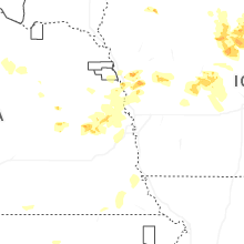
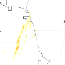
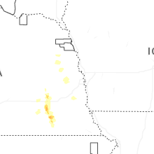
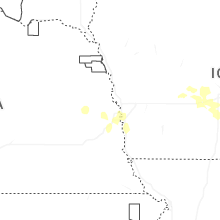
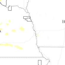
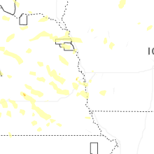
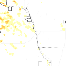

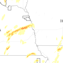


Connect with Interactive Hail Maps