

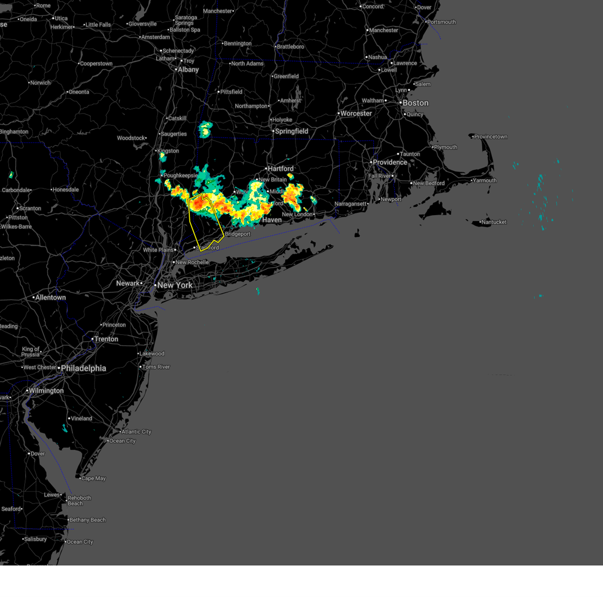
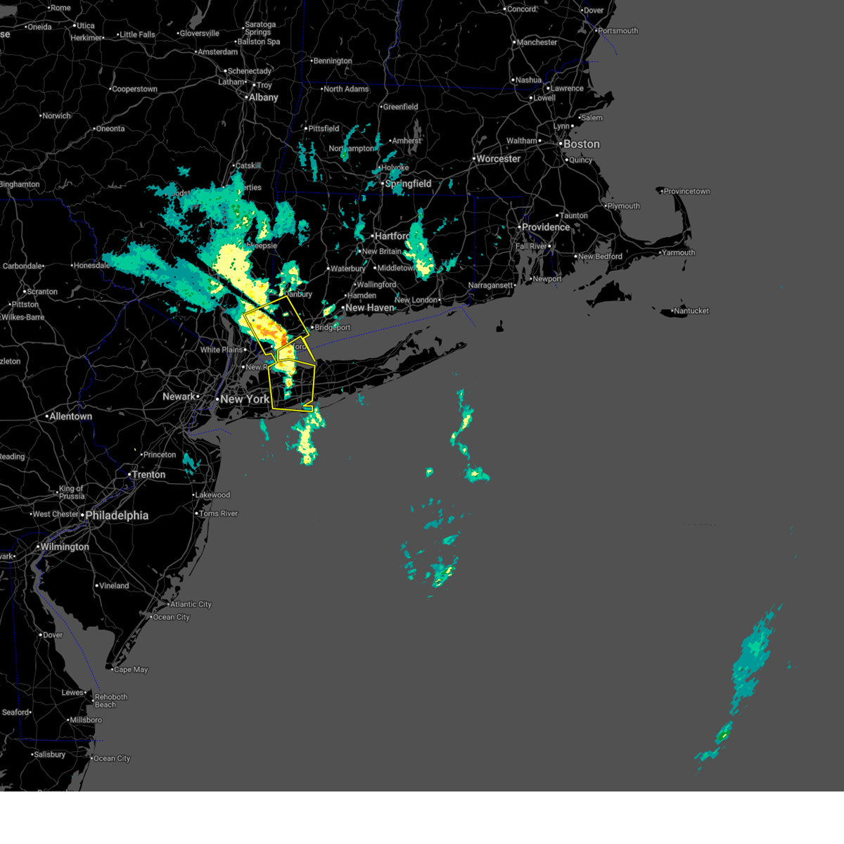
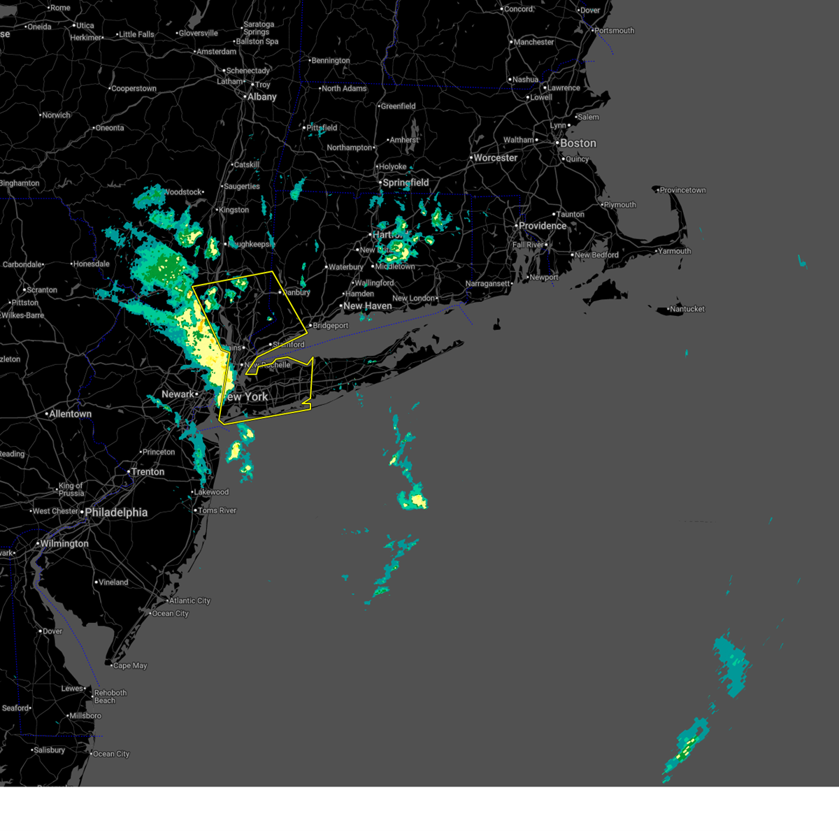
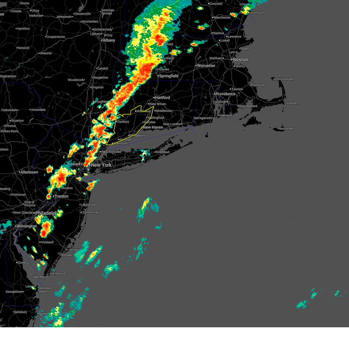
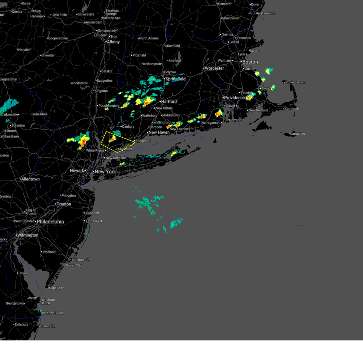
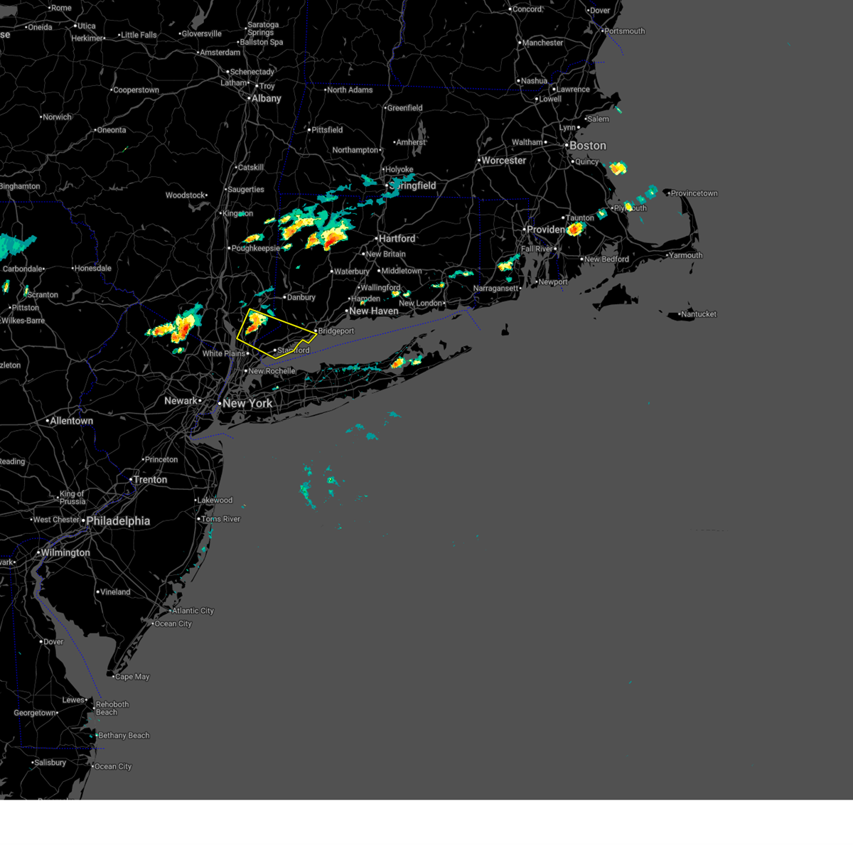
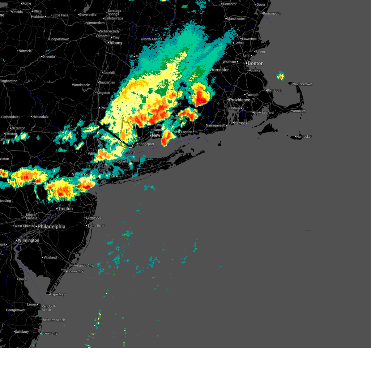
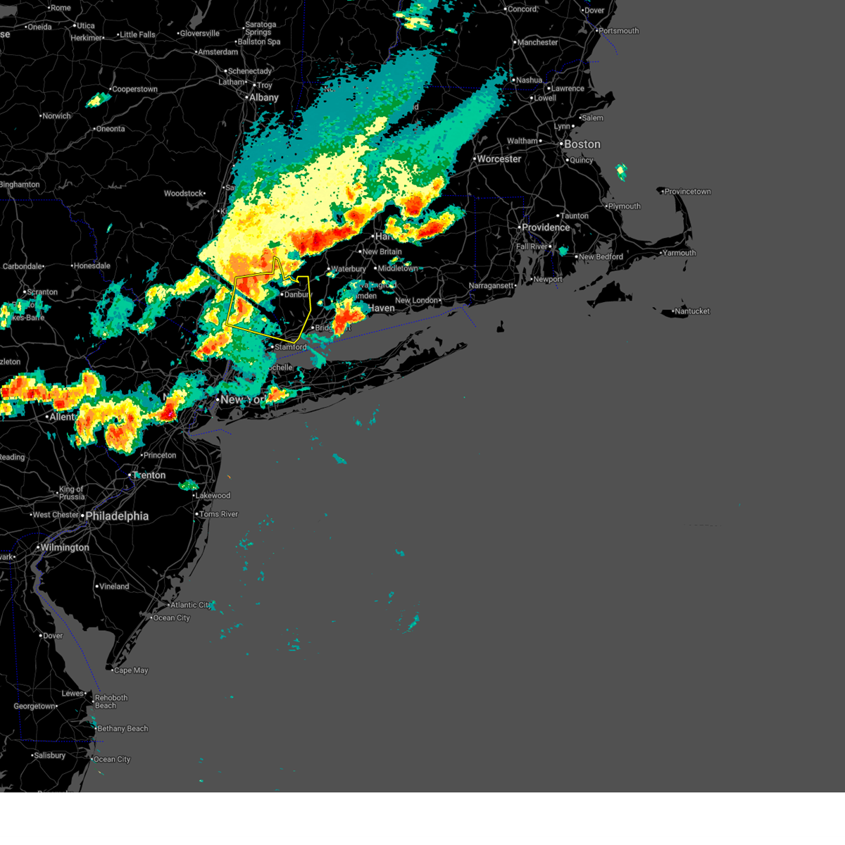
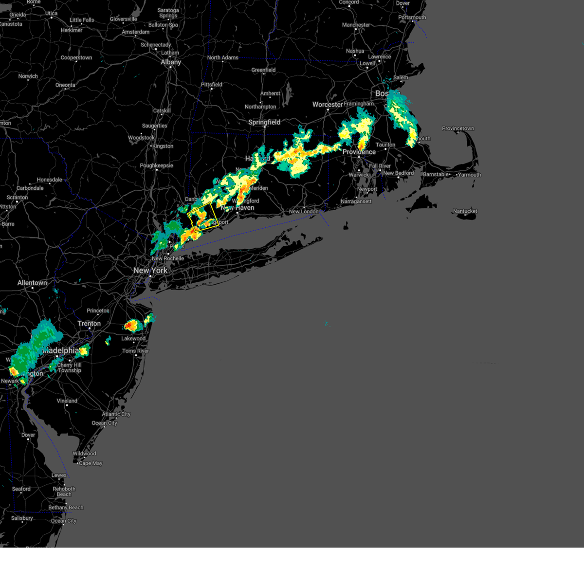
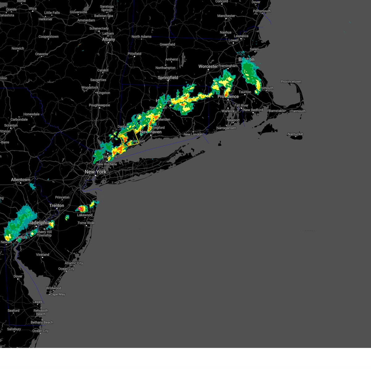
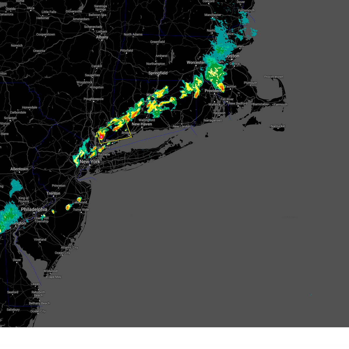
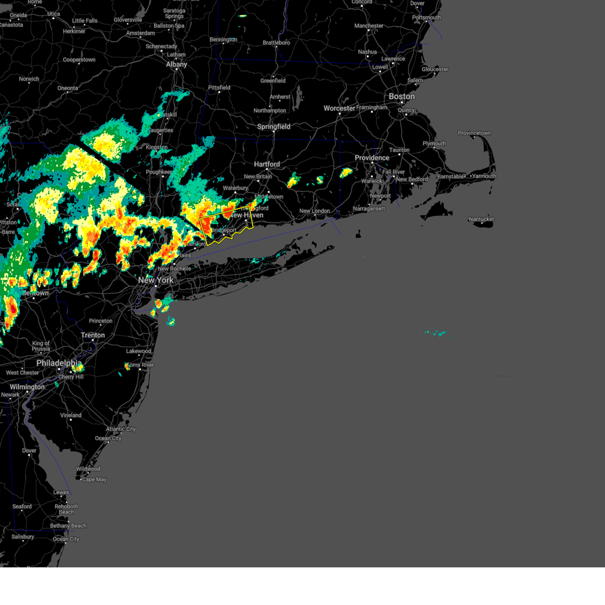
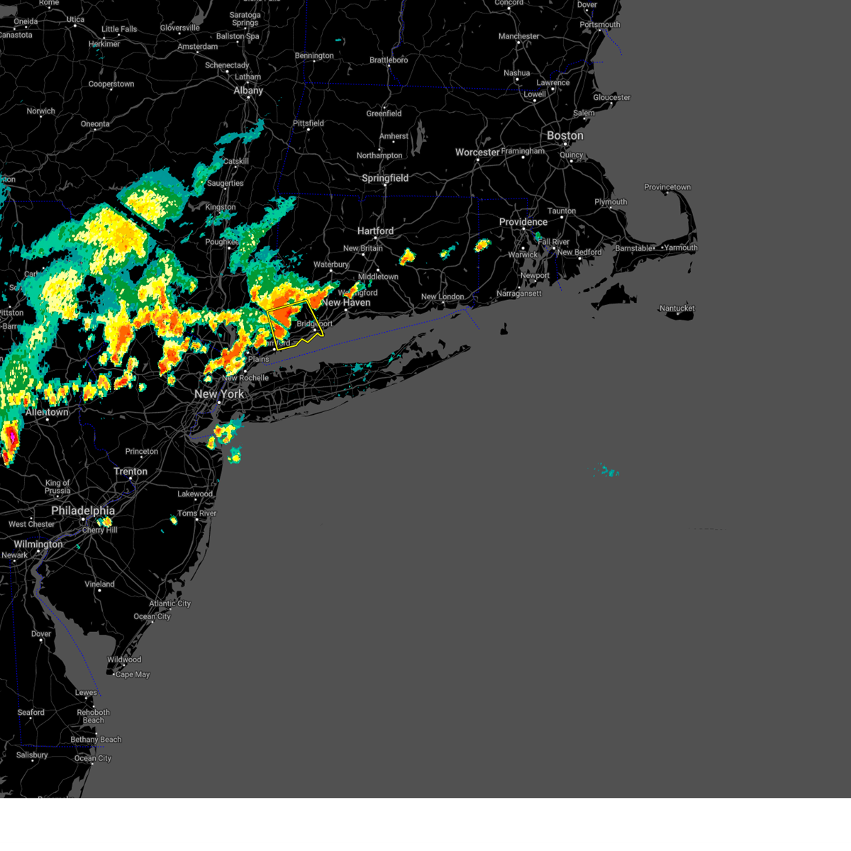
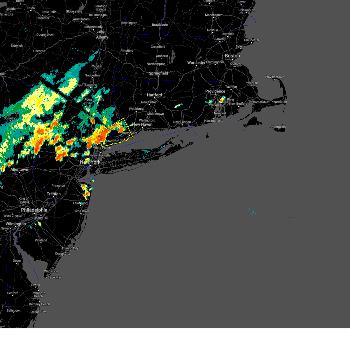
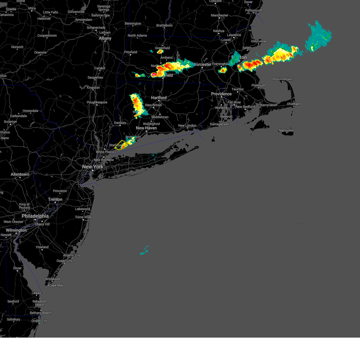
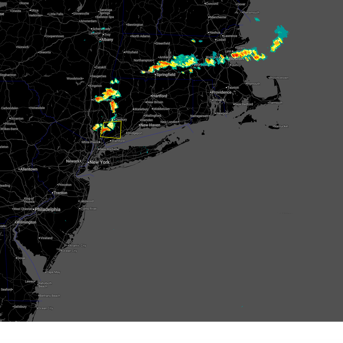
Hail Map for Norwalk, CT
The Norwalk, CT area has had 1 report of on-the-ground hail by trained spotters, and has been under severe weather warnings 14 times during the past 12 months. Doppler radar has detected hail at or near Norwalk, CT on 26 occasions.
| Name: | Norwalk, CT |
| Where Located: | 41.7 miles NE of Brooklyn, NY |
| Map: | Google Map for Norwalk, CT |
| Population: | 85603 |
| Housing Units: | 35415 |
| More Info: | Search Google for Norwalk, CT |
1
The Top Recent Hail Date for Norwalk, CT is Wednesday, July 17, 2024 (9th out of 26)

Hail and Wind Damage Spotted near Norwalk, CT
| Date / Time | Report Details |
|---|---|
| 6/11/2026 4:52 PM EDT |
 Svrokx the national weather service in upton ny has issued a * severe thunderstorm warning for, fairfield county in southern connecticut, northern westchester county in southeastern new york, east central putnam county in southeastern new york, * until 545 pm edt. * at 452 pm edt, a severe thunderstorm was located near new fairfield, or near danbury, moving south at 30 mph (radar indicated). Hazards include 60 mph wind gusts and quarter size hail. Minor hail damage to vehicles is possible. expect wind damage to trees and power lines. this severe thunderstorm will be near, danbury and ridgefield around 500 pm edt. wilton and weston around 510 pm edt. Norwalk and fairfield around 525 pm edt. Svrokx the national weather service in upton ny has issued a * severe thunderstorm warning for, fairfield county in southern connecticut, northern westchester county in southeastern new york, east central putnam county in southeastern new york, * until 545 pm edt. * at 452 pm edt, a severe thunderstorm was located near new fairfield, or near danbury, moving south at 30 mph (radar indicated). Hazards include 60 mph wind gusts and quarter size hail. Minor hail damage to vehicles is possible. expect wind damage to trees and power lines. this severe thunderstorm will be near, danbury and ridgefield around 500 pm edt. wilton and weston around 510 pm edt. Norwalk and fairfield around 525 pm edt.
|
| 6/6/2026 8:20 PM EDT | Mesonet site xgll at greens ledge ligh in anz335 county CT, 5.4 miles N of Norwalk, CT |
| 6/6/2026 7:53 PM EDT |
 Svrokx the national weather service in upton ny has issued a * severe thunderstorm warning for, fairfield county in southern connecticut, west central new haven county in southern connecticut, northern westchester county in southeastern new york, eastern putnam county in southeastern new york, * until 845 pm edt. * at 752 pm edt, a severe thunderstorm was located near bedford, or near mount kisco, moving east at 40 mph (radar indicated). Hazards include 60 mph wind gusts and penny size hail. Expect damage to trees and power lines. this severe thunderstorm will be near, ridgefield and wilton around 800 pm edt. new canaan and weston around 805 pm edt. fairfield and westport around 815 pm edt. bridgeport and trumbull around 820 pm edt. Stratford around 825 pm edt. Svrokx the national weather service in upton ny has issued a * severe thunderstorm warning for, fairfield county in southern connecticut, west central new haven county in southern connecticut, northern westchester county in southeastern new york, eastern putnam county in southeastern new york, * until 845 pm edt. * at 752 pm edt, a severe thunderstorm was located near bedford, or near mount kisco, moving east at 40 mph (radar indicated). Hazards include 60 mph wind gusts and penny size hail. Expect damage to trees and power lines. this severe thunderstorm will be near, ridgefield and wilton around 800 pm edt. new canaan and weston around 805 pm edt. fairfield and westport around 815 pm edt. bridgeport and trumbull around 820 pm edt. Stratford around 825 pm edt.
|
| 5/20/2026 5:47 PM EDT |
 At 547 pm edt, a severe thunderstorm was located over wilton, or near new canaan, moving east at 35 mph (radar indicated). Hazards include 60 mph wind gusts and quarter size hail. Minor hail damage to vehicles is possible. expect wind damage to trees and power lines. this severe storm will be near, norwalk and fairfield around 555 pm edt. bridgeport and trumbull around 600 pm edt. Stratford around 610 pm edt. At 547 pm edt, a severe thunderstorm was located over wilton, or near new canaan, moving east at 35 mph (radar indicated). Hazards include 60 mph wind gusts and quarter size hail. Minor hail damage to vehicles is possible. expect wind damage to trees and power lines. this severe storm will be near, norwalk and fairfield around 555 pm edt. bridgeport and trumbull around 600 pm edt. Stratford around 610 pm edt.
|
| 5/20/2026 5:25 PM EDT |
 Svrokx the national weather service in upton ny has issued a * severe thunderstorm warning for, southern fairfield county in southern connecticut, northern westchester county in southeastern new york, * until 615 pm edt. * at 525 pm edt, a severe thunderstorm was located over mount kisco, moving east at 40 mph (radar indicated). Hazards include 60 mph wind gusts and quarter size hail. Minor hail damage to vehicles is possible. expect wind damage to trees and power lines. this severe thunderstorm will be near, stamford and new canaan around 530 pm edt. ridgefield and wilton around 535 pm edt. weston around 540 pm edt. norwalk and westport around 545 pm edt. fairfield around 550 pm edt. bridgeport and trumbull around 555 pm edt. Stratford around 600 pm edt. Svrokx the national weather service in upton ny has issued a * severe thunderstorm warning for, southern fairfield county in southern connecticut, northern westchester county in southeastern new york, * until 615 pm edt. * at 525 pm edt, a severe thunderstorm was located over mount kisco, moving east at 40 mph (radar indicated). Hazards include 60 mph wind gusts and quarter size hail. Minor hail damage to vehicles is possible. expect wind damage to trees and power lines. this severe thunderstorm will be near, stamford and new canaan around 530 pm edt. ridgefield and wilton around 535 pm edt. weston around 540 pm edt. norwalk and westport around 545 pm edt. fairfield around 550 pm edt. bridgeport and trumbull around 555 pm edt. Stratford around 600 pm edt.
|
| 12/19/2025 4:47 PM EST |
 the severe thunderstorm warning has been cancelled and is no longer in effect the severe thunderstorm warning has been cancelled and is no longer in effect
|
| 12/19/2025 4:47 PM EST |
 At 446 pm est, severe thunderstorms were located along a line extending from near lake carmel to near wilton to near centerport to farmingdale, moving east at 45 mph (trained weather spotters). Hazards include 60 mph wind gusts. Expect damage to trees and power lines. these severe storms will be near, norwalk and danbury around 450 pm est. brentwood and smithtown around 455 pm est. Hauppauge around 500 pm est. At 446 pm est, severe thunderstorms were located along a line extending from near lake carmel to near wilton to near centerport to farmingdale, moving east at 45 mph (trained weather spotters). Hazards include 60 mph wind gusts. Expect damage to trees and power lines. these severe storms will be near, norwalk and danbury around 450 pm est. brentwood and smithtown around 455 pm est. Hauppauge around 500 pm est.
|
| 12/19/2025 4:41 PM EST | Mesonet station xgll - greens ledge ligh in anz335 county CT, 5.4 miles N of Norwalk, CT |
| 12/19/2025 4:12 PM EST |
 Svrokx the national weather service in upton ny has issued a * severe thunderstorm warning for, fairfield county in southern connecticut, westchester county in southeastern new york, east central orange county in southeastern new york, putnam county in southeastern new york, queens county in southeastern new york, bronx county in southeastern new york, western suffolk county in southeastern new york, kings county in southeastern new york, rockland county in southeastern new york, nassau county in southeastern new york, * until 500 pm est. * at 410 pm est, showers with embedded thunderstorms were located along a line extending from near chester to near nyack to east tremont to flatbush, moving east at 45 mph (trained weather spotters). Hazards include 60 mph wind gusts. Expect damage to trees and power lines. severe thunderstorms will be near, jamaica and yonkers around 415 pm est. valley stream and port chester around 420 pm est. garden city and lynbrook around 425 pm est. stamford and westbury around 430 pm est. levittown and plainview around 435 pm est. norwalk and huntington station around 440 pm est. danbury and dix hills around 445 pm est. Commack and deer park around 450 pm est. Svrokx the national weather service in upton ny has issued a * severe thunderstorm warning for, fairfield county in southern connecticut, westchester county in southeastern new york, east central orange county in southeastern new york, putnam county in southeastern new york, queens county in southeastern new york, bronx county in southeastern new york, western suffolk county in southeastern new york, kings county in southeastern new york, rockland county in southeastern new york, nassau county in southeastern new york, * until 500 pm est. * at 410 pm est, showers with embedded thunderstorms were located along a line extending from near chester to near nyack to east tremont to flatbush, moving east at 45 mph (trained weather spotters). Hazards include 60 mph wind gusts. Expect damage to trees and power lines. severe thunderstorms will be near, jamaica and yonkers around 415 pm est. valley stream and port chester around 420 pm est. garden city and lynbrook around 425 pm est. stamford and westbury around 430 pm est. levittown and plainview around 435 pm est. norwalk and huntington station around 440 pm est. danbury and dix hills around 445 pm est. Commack and deer park around 450 pm est.
|
| 9/6/2025 3:55 PM EDT |
 The storms which prompted the warning have weakened below severe limits, and no longer pose an immediate threat to life or property. therefore, the warning will be allowed to expire. a severe thunderstorm watch remains in effect until 800 pm edt for southern connecticut, and southeastern new york. The storms which prompted the warning have weakened below severe limits, and no longer pose an immediate threat to life or property. therefore, the warning will be allowed to expire. a severe thunderstorm watch remains in effect until 800 pm edt for southern connecticut, and southeastern new york.
|
| 9/6/2025 3:37 PM EDT | 60 mph measured at greens ledge ligh in anz335 county CT, 5.4 miles N of Norwalk, CT |
| 9/6/2025 3:15 PM EDT |
 Svrokx the national weather service in upton ny has issued a * severe thunderstorm warning for, fairfield county in southern connecticut, northern middlesex county in southern connecticut, new haven county in southern connecticut, * until 400 pm edt. * at 315 pm edt, severe thunderstorms were located along a line extending from brookfield to redding to near georgetown to near new canaan to greenwich, moving east at 40 mph (radar indicated). Hazards include 60 mph wind gusts. Expect damage to trees and power lines. severe thunderstorms will be near, stamford and norwalk around 320 pm edt. fairfield around 325 pm edt. bridgeport and shelton around 330 pm edt. waterbury and naugatuck around 335 pm edt. wolcott and stratford around 340 pm edt. milford and hamden around 345 pm edt. New haven around 350 pm edt. Svrokx the national weather service in upton ny has issued a * severe thunderstorm warning for, fairfield county in southern connecticut, northern middlesex county in southern connecticut, new haven county in southern connecticut, * until 400 pm edt. * at 315 pm edt, severe thunderstorms were located along a line extending from brookfield to redding to near georgetown to near new canaan to greenwich, moving east at 40 mph (radar indicated). Hazards include 60 mph wind gusts. Expect damage to trees and power lines. severe thunderstorms will be near, stamford and norwalk around 320 pm edt. fairfield around 325 pm edt. bridgeport and shelton around 330 pm edt. waterbury and naugatuck around 335 pm edt. wolcott and stratford around 340 pm edt. milford and hamden around 345 pm edt. New haven around 350 pm edt.
|
| 7/25/2025 3:25 PM EDT | Trees down on power lines and blocking south avenue... nursery road... and buttery roa in fairfield county CT, 4.2 miles ESE of Norwalk, CT |
| 7/8/2025 9:05 PM EDT | Mesonet site xgll at greens ledge ligh in anz335 county CT, 5.4 miles N of Norwalk, CT |
| 7/8/2025 2:32 PM EDT |
 the severe thunderstorm warning has been cancelled and is no longer in effect the severe thunderstorm warning has been cancelled and is no longer in effect
|
| 7/8/2025 2:13 PM EDT |
 Svrokx the national weather service in upton ny has issued a * severe thunderstorm warning for, southern fairfield county in southern connecticut, northern westchester county in southeastern new york, * until 300 pm edt. * at 213 pm edt, a severe thunderstorm was located over mount kisco, moving southeast at 30 mph (radar indicated). Hazards include 60 mph wind gusts. Expect damage to trees and power lines. this severe thunderstorm will be near, stamford and greenwich around 220 pm edt. new canaan around 225 pm edt. darien around 230 pm edt. norwalk around 235 pm edt. wilton around 240 pm edt. Westport around 245 pm edt. Svrokx the national weather service in upton ny has issued a * severe thunderstorm warning for, southern fairfield county in southern connecticut, northern westchester county in southeastern new york, * until 300 pm edt. * at 213 pm edt, a severe thunderstorm was located over mount kisco, moving southeast at 30 mph (radar indicated). Hazards include 60 mph wind gusts. Expect damage to trees and power lines. this severe thunderstorm will be near, stamford and greenwich around 220 pm edt. new canaan around 225 pm edt. darien around 230 pm edt. norwalk around 235 pm edt. wilton around 240 pm edt. Westport around 245 pm edt.
|
| 7/3/2025 6:31 PM EDT |
 the severe thunderstorm warning has been cancelled and is no longer in effect the severe thunderstorm warning has been cancelled and is no longer in effect
|
| 7/3/2025 6:31 PM EDT |
 At 631 pm edt, severe thunderstorms were located along a line extending from near new milford to bethel to near georgetown to near new canaan, moving southeast at 50 mph (radar indicated). Hazards include 60 mph wind gusts. Expect damage to trees and power lines. These severe storms will be near, norwalk and southbury around 635 pm edt. At 631 pm edt, severe thunderstorms were located along a line extending from near new milford to bethel to near georgetown to near new canaan, moving southeast at 50 mph (radar indicated). Hazards include 60 mph wind gusts. Expect damage to trees and power lines. These severe storms will be near, norwalk and southbury around 635 pm edt.
|
| 7/3/2025 6:05 PM EDT |
 Svrokx the national weather service in upton ny has issued a * severe thunderstorm warning for, fairfield county in southern connecticut, western new haven county in southern connecticut, northern westchester county in southeastern new york, putnam county in southeastern new york, * until 645 pm edt. * at 604 pm edt, severe thunderstorms were located along a line extending from near hopewell junction to 6 miles east of fishkill to near fahnestock state park to near yorktown heights, moving east at 55 mph (radar indicated). Hazards include 60 mph wind gusts and quarter size hail. Minor hail damage to vehicles is possible. expect wind damage to trees and power lines. severe thunderstorms will be near, mount kisco and mahopac around 610 pm edt. danbury and sherman around 615 pm edt. stamford and new canaan around 620 pm edt. norwalk and southbury around 625 pm edt. Fairfield and trumbull around 630 pm edt. Svrokx the national weather service in upton ny has issued a * severe thunderstorm warning for, fairfield county in southern connecticut, western new haven county in southern connecticut, northern westchester county in southeastern new york, putnam county in southeastern new york, * until 645 pm edt. * at 604 pm edt, severe thunderstorms were located along a line extending from near hopewell junction to 6 miles east of fishkill to near fahnestock state park to near yorktown heights, moving east at 55 mph (radar indicated). Hazards include 60 mph wind gusts and quarter size hail. Minor hail damage to vehicles is possible. expect wind damage to trees and power lines. severe thunderstorms will be near, mount kisco and mahopac around 610 pm edt. danbury and sherman around 615 pm edt. stamford and new canaan around 620 pm edt. norwalk and southbury around 625 pm edt. Fairfield and trumbull around 630 pm edt.
|
| 5/3/2025 7:00 PM EDT |
 the severe thunderstorm warning has been cancelled and is no longer in effect the severe thunderstorm warning has been cancelled and is no longer in effect
|
| 5/3/2025 6:54 PM EDT |
 At 653 pm edt, a severe thunderstorm was located over georgetown, or 8 miles northeast of new canaan, moving east at 35 mph (radar indicated). Hazards include 60 mph wind gusts. Expect damage to trees and power lines. This severe storm will be near, newtown and fairfield around 700 pm edt. At 653 pm edt, a severe thunderstorm was located over georgetown, or 8 miles northeast of new canaan, moving east at 35 mph (radar indicated). Hazards include 60 mph wind gusts. Expect damage to trees and power lines. This severe storm will be near, newtown and fairfield around 700 pm edt.
|
| 5/3/2025 6:54 PM EDT |
 the severe thunderstorm warning has been cancelled and is no longer in effect the severe thunderstorm warning has been cancelled and is no longer in effect
|
| 5/3/2025 6:28 PM EDT |
 Svrokx the national weather service in upton ny has issued a * severe thunderstorm warning for, fairfield county in southern connecticut, northern westchester county in southeastern new york, * until 715 pm edt. * at 627 pm edt, a severe thunderstorm was located over mount kisco, moving east at 35 mph (radar indicated). Hazards include 60 mph wind gusts and quarter size hail. Minor hail damage to vehicles is possible. expect wind damage to trees and power lines. this severe thunderstorm will be near, stamford and new canaan around 635 pm edt. ridgefield and wilton around 640 pm edt. weston and redding around 645 pm edt. fairfield around 655 pm edt. Newtown and trumbull around 700 pm edt. Svrokx the national weather service in upton ny has issued a * severe thunderstorm warning for, fairfield county in southern connecticut, northern westchester county in southeastern new york, * until 715 pm edt. * at 627 pm edt, a severe thunderstorm was located over mount kisco, moving east at 35 mph (radar indicated). Hazards include 60 mph wind gusts and quarter size hail. Minor hail damage to vehicles is possible. expect wind damage to trees and power lines. this severe thunderstorm will be near, stamford and new canaan around 635 pm edt. ridgefield and wilton around 640 pm edt. weston and redding around 645 pm edt. fairfield around 655 pm edt. Newtown and trumbull around 700 pm edt.
|
| 8/3/2024 4:41 PM EDT |
 Svrokx the national weather service in upton ny has issued a * severe thunderstorm warning for, southern fairfield county in southern connecticut, southwestern new haven county in southern connecticut, * until 530 pm edt. * at 441 pm edt, a severe thunderstorm was located over weston, or 8 miles northwest of bridgeport, moving east at 25 mph (radar indicated). Hazards include 60 mph wind gusts. expect damage to trees and power lines Svrokx the national weather service in upton ny has issued a * severe thunderstorm warning for, southern fairfield county in southern connecticut, southwestern new haven county in southern connecticut, * until 530 pm edt. * at 441 pm edt, a severe thunderstorm was located over weston, or 8 miles northwest of bridgeport, moving east at 25 mph (radar indicated). Hazards include 60 mph wind gusts. expect damage to trees and power lines
|
| 8/3/2024 4:34 PM EDT |
 At 434 pm edt, a severe thunderstorm was located over wilton, or near new canaan, moving east at 35 mph (radar indicated). Hazards include 60 mph wind gusts and penny size hail. Expect damage to trees and power lines. Locations impacted include, bridgeport, stamford, norwalk, new canaan, newtown, fairfield, stratford, trumbull, westport, ridgefield, darien, monroe, bethel, wilton, and weston. At 434 pm edt, a severe thunderstorm was located over wilton, or near new canaan, moving east at 35 mph (radar indicated). Hazards include 60 mph wind gusts and penny size hail. Expect damage to trees and power lines. Locations impacted include, bridgeport, stamford, norwalk, new canaan, newtown, fairfield, stratford, trumbull, westport, ridgefield, darien, monroe, bethel, wilton, and weston.
|
| 8/3/2024 4:07 PM EDT |
 Svrokx the national weather service in upton ny has issued a * severe thunderstorm warning for, fairfield county in southern connecticut, central westchester county in southeastern new york, * until 445 pm edt. * at 406 pm edt, a severe thunderstorm was located near hawthorne, or near mount kisco, moving east at 30 mph (radar indicated). Hazards include 60 mph wind gusts and quarter size hail. Minor hail damage to vehicles is possible. Expect wind damage to trees and power lines. Svrokx the national weather service in upton ny has issued a * severe thunderstorm warning for, fairfield county in southern connecticut, central westchester county in southeastern new york, * until 445 pm edt. * at 406 pm edt, a severe thunderstorm was located near hawthorne, or near mount kisco, moving east at 30 mph (radar indicated). Hazards include 60 mph wind gusts and quarter size hail. Minor hail damage to vehicles is possible. Expect wind damage to trees and power lines.
|
| 7/17/2024 10:24 PM EDT |
 Svrokx the national weather service in upton ny has issued a * severe thunderstorm warning for, southern fairfield county in southern connecticut, south central new haven county in southern connecticut, * until 1115 pm edt. * at 1023 pm edt, severe thunderstorms were located along a line extending from near wilton to near fairfield to 7 miles northwest of stony brook, moving northeast at 40 mph (radar indicated). Hazards include 60 mph wind gusts. Expect damage to trees and power lines. severe thunderstorms will be near, bridgeport and milford around 1030 pm edt. monroe around 1035 pm edt. shelton around 1040 pm edt. orange around 1045 pm edt. new haven and seymour around 1050 pm edt. branford around 1055 pm edt. Hamden and north haven around 1100 pm edt. Svrokx the national weather service in upton ny has issued a * severe thunderstorm warning for, southern fairfield county in southern connecticut, south central new haven county in southern connecticut, * until 1115 pm edt. * at 1023 pm edt, severe thunderstorms were located along a line extending from near wilton to near fairfield to 7 miles northwest of stony brook, moving northeast at 40 mph (radar indicated). Hazards include 60 mph wind gusts. Expect damage to trees and power lines. severe thunderstorms will be near, bridgeport and milford around 1030 pm edt. monroe around 1035 pm edt. shelton around 1040 pm edt. orange around 1045 pm edt. new haven and seymour around 1050 pm edt. branford around 1055 pm edt. Hamden and north haven around 1100 pm edt.
|
| 7/17/2024 10:12 PM EDT | Gust reported by the weatherflow station greens ledge ligh in anz335 county CT, 5.4 miles N of Norwalk, CT |
| 7/17/2024 10:12 PM EDT | Gust reported by the weatherflow station greens ledge ligh in anz335 county CT, 5.4 miles N of Norwalk, CT |
| 7/17/2024 5:44 PM EDT |
 The storms which prompted the warning have weakened below severe limits, and have exited the warned area. therefore, the warning will be allowed to expire. a special weather statement has been issued for wind gusts up to 40 mph. a severe thunderstorm watch remains in effect until 800 pm edt for southern connecticut, and southeastern new york. The storms which prompted the warning have weakened below severe limits, and have exited the warned area. therefore, the warning will be allowed to expire. a special weather statement has been issued for wind gusts up to 40 mph. a severe thunderstorm watch remains in effect until 800 pm edt for southern connecticut, and southeastern new york.
|
| 7/17/2024 5:24 PM EDT |
 At 523 pm edt, severe thunderstorms were located along a line extending from naugatuck to derby to bridgeport, moving east at 30 mph (radar indicated). Hazards include 60 mph wind gusts. Expect damage to trees and power lines. these severe storms will be near, new haven and milford around 530 pm edt. Branford and north branford around 540 pm edt. At 523 pm edt, severe thunderstorms were located along a line extending from naugatuck to derby to bridgeport, moving east at 30 mph (radar indicated). Hazards include 60 mph wind gusts. Expect damage to trees and power lines. these severe storms will be near, new haven and milford around 530 pm edt. Branford and north branford around 540 pm edt.
|
| 7/17/2024 5:06 PM EDT |
 The storms which prompted the warning have moved out of the area. therefore, the warning will be allowed to expire. a new severe thunderstorm warning has been issued. a severe thunderstorm watch remains in effect until 800 pm edt for southern connecticut, northeastern new jersey, and southeastern new york. The storms which prompted the warning have moved out of the area. therefore, the warning will be allowed to expire. a new severe thunderstorm warning has been issued. a severe thunderstorm watch remains in effect until 800 pm edt for southern connecticut, northeastern new jersey, and southeastern new york.
|
| 7/17/2024 5:05 PM EDT |
 Svrokx the national weather service in upton ny has issued a * severe thunderstorm warning for, fairfield county in southern connecticut, central new haven county in southern connecticut, * until 545 pm edt. * at 504 pm edt, severe thunderstorms were located along a line extending from southbury to near monroe to near weston, moving east at 30 mph (radar indicated). Hazards include 60 mph wind gusts. Expect damage to trees and power lines. severe thunderstorms will be near, bridgeport and shelton around 510 pm edt. milford and naugatuck around 515 pm edt. new haven and prospect around 520 pm edt. hamden and cheshire around 525 pm edt. North haven around 530 pm edt. Svrokx the national weather service in upton ny has issued a * severe thunderstorm warning for, fairfield county in southern connecticut, central new haven county in southern connecticut, * until 545 pm edt. * at 504 pm edt, severe thunderstorms were located along a line extending from southbury to near monroe to near weston, moving east at 30 mph (radar indicated). Hazards include 60 mph wind gusts. Expect damage to trees and power lines. severe thunderstorms will be near, bridgeport and shelton around 510 pm edt. milford and naugatuck around 515 pm edt. new haven and prospect around 520 pm edt. hamden and cheshire around 525 pm edt. North haven around 530 pm edt.
|
| 7/17/2024 4:53 PM EDT |
 the severe thunderstorm warning has been cancelled and is no longer in effect the severe thunderstorm warning has been cancelled and is no longer in effect
|
| 7/17/2024 4:53 PM EDT |
 At 452 pm edt, severe thunderstorms were located along a line extending from near danbury to near greenwich to bronxville, moving east at 25 mph (radar indicated). Hazards include 60 mph wind gusts. Expect damage to trees and power lines. these severe storms will be near, stamford and norwalk around 500 pm edt. monroe around 505 pm edt. southbury and westport around 510 pm edt. Fairfield and trumbull around 515 pm edt. At 452 pm edt, severe thunderstorms were located along a line extending from near danbury to near greenwich to bronxville, moving east at 25 mph (radar indicated). Hazards include 60 mph wind gusts. Expect damage to trees and power lines. these severe storms will be near, stamford and norwalk around 500 pm edt. monroe around 505 pm edt. southbury and westport around 510 pm edt. Fairfield and trumbull around 515 pm edt.
|
| 7/17/2024 4:33 PM EDT |
 Svrokx the national weather service in upton ny has issued a * severe thunderstorm warning for, fairfield county in southern connecticut, western new haven county in southern connecticut, east central bergen county in northeastern new jersey, westchester county in southeastern new york, eastern putnam county in southeastern new york, bronx county in southeastern new york, rockland county in southeastern new york, * until 515 pm edt. * at 432 pm edt, severe thunderstorms were located along a line extending from near brewster to near hawthorne to englewood, moving east at 25 mph (radar indicated). Hazards include 60 mph wind gusts. Expect damage to trees and power lines. severe thunderstorms will be near, yonkers and stamford around 435 pm edt. harrison and redding around 440 pm edt. new rochelle and new canaan around 445 pm edt. port chester around 450 pm edt. rye and newtown around 455 pm edt. Norwalk around 500 pm edt. Svrokx the national weather service in upton ny has issued a * severe thunderstorm warning for, fairfield county in southern connecticut, western new haven county in southern connecticut, east central bergen county in northeastern new jersey, westchester county in southeastern new york, eastern putnam county in southeastern new york, bronx county in southeastern new york, rockland county in southeastern new york, * until 515 pm edt. * at 432 pm edt, severe thunderstorms were located along a line extending from near brewster to near hawthorne to englewood, moving east at 25 mph (radar indicated). Hazards include 60 mph wind gusts. Expect damage to trees and power lines. severe thunderstorms will be near, yonkers and stamford around 435 pm edt. harrison and redding around 440 pm edt. new rochelle and new canaan around 445 pm edt. port chester around 450 pm edt. rye and newtown around 455 pm edt. Norwalk around 500 pm edt.
|
| 7/15/2024 4:56 PM EDT |
 The storm which prompted the warning has moved out of the area. therefore, the warning will be allowed to expire. The storm which prompted the warning has moved out of the area. therefore, the warning will be allowed to expire.
|
| 7/15/2024 4:51 PM EDT |
 At 451 pm edt, a severe thunderstorm was located over norwalk, moving southeast at 15 mph (radar indicated). Hazards include 60 mph wind gusts. Expect damage to trees and power lines. This severe storm will be near, westport around 455 pm edt. At 451 pm edt, a severe thunderstorm was located over norwalk, moving southeast at 15 mph (radar indicated). Hazards include 60 mph wind gusts. Expect damage to trees and power lines. This severe storm will be near, westport around 455 pm edt.
|
| 7/15/2024 4:41 PM EDT |
 At 440 pm edt, a severe thunderstorm was located over norwalk, moving southeast at 20 mph (law enforcement). Hazards include 60 mph wind gusts. Expect damage to trees and power lines. This severe storm will be near, norwalk and westport around 445 pm edt. At 440 pm edt, a severe thunderstorm was located over norwalk, moving southeast at 20 mph (law enforcement). Hazards include 60 mph wind gusts. Expect damage to trees and power lines. This severe storm will be near, norwalk and westport around 445 pm edt.
|
| 7/15/2024 4:27 PM EDT |
 Svrokx the national weather service in upton ny has issued a * severe thunderstorm warning for, southern fairfield county in southern connecticut, * until 500 pm edt. * at 426 pm edt, a severe thunderstorm was located over new canaan, moving east at 20 mph (law enforcement). Hazards include 60 mph wind gusts. Expect damage to trees and power lines. this severe thunderstorm will be near, stamford and norwalk around 430 pm edt. westport around 435 pm edt. Fairfield around 450 pm edt. Svrokx the national weather service in upton ny has issued a * severe thunderstorm warning for, southern fairfield county in southern connecticut, * until 500 pm edt. * at 426 pm edt, a severe thunderstorm was located over new canaan, moving east at 20 mph (law enforcement). Hazards include 60 mph wind gusts. Expect damage to trees and power lines. this severe thunderstorm will be near, stamford and norwalk around 430 pm edt. westport around 435 pm edt. Fairfield around 450 pm edt.
|
| 7/15/2024 4:17 PM EDT |
 At 416 pm edt, a severe thunderstorm was located near bedford, or near new canaan, moving east at 20 mph (radar indicated). Hazards include 60 mph wind gusts and penny size hail. Expect damage to trees and power lines. this severe storm will be near, stamford and new canaan around 420 pm edt. norwalk around 425 pm edt. Westport and weston around 435 pm edt. At 416 pm edt, a severe thunderstorm was located near bedford, or near new canaan, moving east at 20 mph (radar indicated). Hazards include 60 mph wind gusts and penny size hail. Expect damage to trees and power lines. this severe storm will be near, stamford and new canaan around 420 pm edt. norwalk around 425 pm edt. Westport and weston around 435 pm edt.
|
| 7/15/2024 4:05 PM EDT |
 At 404 pm edt, a severe thunderstorm was located near bedford, or near mount kisco, moving east at 15 mph (radar indicated). Hazards include 60 mph wind gusts and penny size hail. Expect damage to trees and power lines. this severe storm will be near, stamford and new canaan around 410 pm edt. Ridgefield and wilton around 415 pm edt. At 404 pm edt, a severe thunderstorm was located near bedford, or near mount kisco, moving east at 15 mph (radar indicated). Hazards include 60 mph wind gusts and penny size hail. Expect damage to trees and power lines. this severe storm will be near, stamford and new canaan around 410 pm edt. Ridgefield and wilton around 415 pm edt.
|
| 7/15/2024 4:04 PM EDT |
 At 403 pm edt, a severe thunderstorm was located over ridgefield, or 7 miles north of new canaan, moving east at 20 mph (radar indicated). Hazards include 60 mph wind gusts and penny size hail. Expect damage to trees and power lines. this severe storm will be near, ridgefield and wilton around 410 pm edt. Fairfield around 420 pm edt. At 403 pm edt, a severe thunderstorm was located over ridgefield, or 7 miles north of new canaan, moving east at 20 mph (radar indicated). Hazards include 60 mph wind gusts and penny size hail. Expect damage to trees and power lines. this severe storm will be near, ridgefield and wilton around 410 pm edt. Fairfield around 420 pm edt.
|
| 7/15/2024 3:46 PM EDT |
 Svrokx the national weather service in upton ny has issued a * severe thunderstorm warning for, southern fairfield county in southern connecticut, northern westchester county in southeastern new york, * until 430 pm edt. * at 345 pm edt, a severe thunderstorm was located near bedford, or near mount kisco, moving east at 20 mph (radar indicated). Hazards include 60 mph wind gusts and penny size hail. Expect damage to trees and power lines. this severe thunderstorm will be near, ridgefield around 350 pm edt. new canaan and wilton around 355 pm edt. redding around 400 pm edt. weston and georgetown around 405 pm edt. Fairfield and westport around 420 pm edt. Svrokx the national weather service in upton ny has issued a * severe thunderstorm warning for, southern fairfield county in southern connecticut, northern westchester county in southeastern new york, * until 430 pm edt. * at 345 pm edt, a severe thunderstorm was located near bedford, or near mount kisco, moving east at 20 mph (radar indicated). Hazards include 60 mph wind gusts and penny size hail. Expect damage to trees and power lines. this severe thunderstorm will be near, ridgefield around 350 pm edt. new canaan and wilton around 355 pm edt. redding around 400 pm edt. weston and georgetown around 405 pm edt. Fairfield and westport around 420 pm edt.
|
| 6/26/2024 9:17 PM EDT |
 The storms which prompted the warning will move east of the expired warned area, but will move into the new downstream warned area. a severe thunderstorm watch remains in effect until midnight edt for southern connecticut, and southeastern new york. The storms which prompted the warning will move east of the expired warned area, but will move into the new downstream warned area. a severe thunderstorm watch remains in effect until midnight edt for southern connecticut, and southeastern new york.
|
| 6/26/2024 9:07 PM EDT |
 Svrokx the national weather service in upton ny has issued a * severe thunderstorm warning for, fairfield county in southern connecticut, central middlesex county in southern connecticut, new haven county in southern connecticut, northern westchester county in southeastern new york, eastern putnam county in southeastern new york, * until 945 pm edt. * at 907 pm edt, severe thunderstorms were located along a line extending from near dover plains to near ridgefield to near darien, moving east at 45 mph (radar indicated). Hazards include 60 mph wind gusts. Expect damage to trees and power lines. severe thunderstorms will be near, stamford and norwalk around 910 pm edt. southbury and fairfield around 915 pm edt. bridgeport and shelton around 920 pm edt. stratford and seymour around 925 pm edt. milford and naugatuck around 930 pm edt. new haven and waterbury around 935 pm edt. Prospect around 940 pm edt. Svrokx the national weather service in upton ny has issued a * severe thunderstorm warning for, fairfield county in southern connecticut, central middlesex county in southern connecticut, new haven county in southern connecticut, northern westchester county in southeastern new york, eastern putnam county in southeastern new york, * until 945 pm edt. * at 907 pm edt, severe thunderstorms were located along a line extending from near dover plains to near ridgefield to near darien, moving east at 45 mph (radar indicated). Hazards include 60 mph wind gusts. Expect damage to trees and power lines. severe thunderstorms will be near, stamford and norwalk around 910 pm edt. southbury and fairfield around 915 pm edt. bridgeport and shelton around 920 pm edt. stratford and seymour around 925 pm edt. milford and naugatuck around 930 pm edt. new haven and waterbury around 935 pm edt. Prospect around 940 pm edt.
|
| 6/26/2024 8:26 PM EDT |
 Svrokx the national weather service in upton ny has issued a * severe thunderstorm warning for, fairfield county in southern connecticut, westchester county in southeastern new york, eastern orange county in southeastern new york, putnam county in southeastern new york, rockland county in southeastern new york, * until 915 pm edt. * at 826 pm edt, severe thunderstorms were located along a line extending from near phillipsport to near west point to near monsey, moving east at 50 mph (radar indicated). Hazards include 60 mph wind gusts. Expect damage to trees and power lines. severe thunderstorms will be near, new city and peekskill around 830 pm edt. newburgh and ossining around 835 pm edt. yorktown heights and fahnestock state park around 840 pm edt. mount kisco and mahopac around 845 pm edt. stamford and brewster around 850 pm edt. danbury and new canaan around 855 pm edt. darien and wilton around 900 pm edt. norwalk and sherman around 905 pm edt. Newtown around 910 pm edt. Svrokx the national weather service in upton ny has issued a * severe thunderstorm warning for, fairfield county in southern connecticut, westchester county in southeastern new york, eastern orange county in southeastern new york, putnam county in southeastern new york, rockland county in southeastern new york, * until 915 pm edt. * at 826 pm edt, severe thunderstorms were located along a line extending from near phillipsport to near west point to near monsey, moving east at 50 mph (radar indicated). Hazards include 60 mph wind gusts. Expect damage to trees and power lines. severe thunderstorms will be near, new city and peekskill around 830 pm edt. newburgh and ossining around 835 pm edt. yorktown heights and fahnestock state park around 840 pm edt. mount kisco and mahopac around 845 pm edt. stamford and brewster around 850 pm edt. danbury and new canaan around 855 pm edt. darien and wilton around 900 pm edt. norwalk and sherman around 905 pm edt. Newtown around 910 pm edt.
|
| 6/14/2024 7:20 PM EDT |
 The storm which prompted the warning has weakened below severe limits, and is exiting the warned area. therefore, the warning will be allowed to expire. however, heavy rain is still possible with this thunderstorm. The storm which prompted the warning has weakened below severe limits, and is exiting the warned area. therefore, the warning will be allowed to expire. however, heavy rain is still possible with this thunderstorm.
|
| 6/14/2024 6:58 PM EDT |
 the severe thunderstorm warning has been cancelled and is no longer in effect the severe thunderstorm warning has been cancelled and is no longer in effect
|
| 6/14/2024 6:58 PM EDT |
 At 657 pm edt, a severe thunderstorm was located over harrison, or over port chester, moving east at 30 mph (radar indicated). Hazards include 60 mph wind gusts and quarter size hail. Minor hail damage to vehicles is possible. expect wind damage to trees and power lines. this severe storm will be near, stamford and greenwich around 705 pm edt. darien around 710 pm edt. Norwalk around 715 pm edt. At 657 pm edt, a severe thunderstorm was located over harrison, or over port chester, moving east at 30 mph (radar indicated). Hazards include 60 mph wind gusts and quarter size hail. Minor hail damage to vehicles is possible. expect wind damage to trees and power lines. this severe storm will be near, stamford and greenwich around 705 pm edt. darien around 710 pm edt. Norwalk around 715 pm edt.
|
| 6/14/2024 6:38 PM EDT |
 Svrokx the national weather service in upton ny has issued a * severe thunderstorm warning for, southern fairfield county in southern connecticut, southern westchester county in southeastern new york, rockland county in southeastern new york, * until 730 pm edt. * at 638 pm edt, a severe thunderstorm was located over dobbs ferry, moving east at 30 mph (radar indicated). Hazards include 60 mph wind gusts and quarter size hail. Minor hail damage to vehicles is possible. expect wind damage to trees and power lines. this severe thunderstorm will be near, white plains and harrison around 645 pm edt. port chester and greenwich around 650 pm edt. stamford around 700 pm edt. darien around 710 pm edt. Norwalk around 715 pm edt. Svrokx the national weather service in upton ny has issued a * severe thunderstorm warning for, southern fairfield county in southern connecticut, southern westchester county in southeastern new york, rockland county in southeastern new york, * until 730 pm edt. * at 638 pm edt, a severe thunderstorm was located over dobbs ferry, moving east at 30 mph (radar indicated). Hazards include 60 mph wind gusts and quarter size hail. Minor hail damage to vehicles is possible. expect wind damage to trees and power lines. this severe thunderstorm will be near, white plains and harrison around 645 pm edt. port chester and greenwich around 650 pm edt. stamford around 700 pm edt. darien around 710 pm edt. Norwalk around 715 pm edt.
|
| 5/23/2024 10:40 AM EDT |
 The storms which prompted the warning have exited and weakened below severe limits. therefore, the warning will be allowed to expire. The storms which prompted the warning have exited and weakened below severe limits. therefore, the warning will be allowed to expire.
|
| 5/23/2024 9:54 AM EDT |
 Svrokx the national weather service in upton ny has issued a * severe thunderstorm warning for, fairfield county in southern connecticut, west central new haven county in southern connecticut, hudson county in northeastern new jersey, eastern bergen county in northeastern new jersey, eastern putnam county in southeastern new york, queens county in southeastern new york, bronx county in southeastern new york, richmond county in southeastern new york, kings county in southeastern new york, rockland county in southeastern new york, westchester county in southeastern new york, west central suffolk county in southeastern new york, new york (manhattan) county in southeastern new york, nassau county in southeastern new york, * until 1045 am edt. * at 954 am edt, severe thunderstorms were located along a line extending from yorktown heights to yonkers to park slope, moving east at 55 mph (radar indicated). Hazards include 60 mph wind gusts. Expect damage to trees and power lines. severe thunderstorms will be near, jamaica and new rochelle around 1000 am edt. stamford and danbury around 1005 am edt. garden city and mineola around 1010 am edt. norwalk and syosset around 1015 am edt. levittown and huntington station around 1020 am edt. bridgeport and shelton around 1025 am edt. commack and deer park around 1030 am edt. Naugatuck and middlebury around 1035 am edt. Svrokx the national weather service in upton ny has issued a * severe thunderstorm warning for, fairfield county in southern connecticut, west central new haven county in southern connecticut, hudson county in northeastern new jersey, eastern bergen county in northeastern new jersey, eastern putnam county in southeastern new york, queens county in southeastern new york, bronx county in southeastern new york, richmond county in southeastern new york, kings county in southeastern new york, rockland county in southeastern new york, westchester county in southeastern new york, west central suffolk county in southeastern new york, new york (manhattan) county in southeastern new york, nassau county in southeastern new york, * until 1045 am edt. * at 954 am edt, severe thunderstorms were located along a line extending from yorktown heights to yonkers to park slope, moving east at 55 mph (radar indicated). Hazards include 60 mph wind gusts. Expect damage to trees and power lines. severe thunderstorms will be near, jamaica and new rochelle around 1000 am edt. stamford and danbury around 1005 am edt. garden city and mineola around 1010 am edt. norwalk and syosset around 1015 am edt. levittown and huntington station around 1020 am edt. bridgeport and shelton around 1025 am edt. commack and deer park around 1030 am edt. Naugatuck and middlebury around 1035 am edt.
|
| 7/29/2023 7:41 PM EDT |
 At 741 pm edt, severe thunderstorms were located along a line extending from near greenwich to near jackson heights, moving east at 45 mph (radar indicated). Hazards include 60 mph wind gusts. expect damage to trees and power lines At 741 pm edt, severe thunderstorms were located along a line extending from near greenwich to near jackson heights, moving east at 45 mph (radar indicated). Hazards include 60 mph wind gusts. expect damage to trees and power lines
|
| 7/9/2023 8:27 PM EDT |
 At 827 pm edt, a severe thunderstorm was located near stamford, moving north at 10 mph (radar indicated). Hazards include 60 mph wind gusts. Expect damage to trees and power lines. This severe thunderstorm will be near, stamford and norwalk around 915 pm edt. At 827 pm edt, a severe thunderstorm was located near stamford, moving north at 10 mph (radar indicated). Hazards include 60 mph wind gusts. Expect damage to trees and power lines. This severe thunderstorm will be near, stamford and norwalk around 915 pm edt.
|
| 7/3/2023 9:33 PM EDT |
 At 932 pm edt, a severe thunderstorm was located near westport, or near norwalk, moving east at 30 mph (radar indicated). Hazards include 60 mph wind gusts and quarter size hail. Minor hail damage to vehicles is possible. expect wind damage to trees and power lines. this severe thunderstorm will be near, bridgeport around 945 pm edt. trumbull around 950 pm edt. milford and stratford around 1005 pm edt. orange around 1015 pm edt. hail threat, radar indicated max hail size, 1. 00 in wind threat, radar indicated max wind gust, 60 mph. At 932 pm edt, a severe thunderstorm was located near westport, or near norwalk, moving east at 30 mph (radar indicated). Hazards include 60 mph wind gusts and quarter size hail. Minor hail damage to vehicles is possible. expect wind damage to trees and power lines. this severe thunderstorm will be near, bridgeport around 945 pm edt. trumbull around 950 pm edt. milford and stratford around 1005 pm edt. orange around 1015 pm edt. hail threat, radar indicated max hail size, 1. 00 in wind threat, radar indicated max wind gust, 60 mph.
|
| 7/3/2023 6:27 PM EDT |
 The severe thunderstorm warning for southern fairfield county will expire at 630 pm edt, the storm which prompted the warning has weakened below severe limits, and has exited the warned area. therefore, the warning will be allowed to expire. The severe thunderstorm warning for southern fairfield county will expire at 630 pm edt, the storm which prompted the warning has weakened below severe limits, and has exited the warned area. therefore, the warning will be allowed to expire.
|
| 7/3/2023 6:01 PM EDT |
 At 600 pm edt, a severe thunderstorm was located over wilton, or near new canaan, moving east at 20 mph (radar indicated). Hazards include 60 mph wind gusts and quarter size hail. Minor hail damage to vehicles is possible. expect wind damage to trees and power lines. this severe storm will be near, norwalk and wilton around 605 pm edt. weston around 610 pm edt. westport around 615 pm edt. bridgeport and fairfield around 630 pm edt. Trumbull around 635 pm edt. At 600 pm edt, a severe thunderstorm was located over wilton, or near new canaan, moving east at 20 mph (radar indicated). Hazards include 60 mph wind gusts and quarter size hail. Minor hail damage to vehicles is possible. expect wind damage to trees and power lines. this severe storm will be near, norwalk and wilton around 605 pm edt. weston around 610 pm edt. westport around 615 pm edt. bridgeport and fairfield around 630 pm edt. Trumbull around 635 pm edt.
|
| 7/3/2023 5:39 PM EDT |
 At 539 pm edt, a severe thunderstorm was located near bedford, or 7 miles east of mount kisco, moving east at 20 mph (radar indicated). Hazards include golf ball size hail and 60 mph wind gusts. People and animals outdoors will be injured. expect hail damage to roofs, siding, windows, and vehicles. expect wind damage to trees and power lines. this severe thunderstorm will be near, stamford around 545 pm edt. new canaan around 555 pm edt. darien and wilton around 600 pm edt. norwalk around 605 pm edt. weston around 610 pm edt. westport around 620 pm edt. Bridgeport and fairfield around 630 pm edt. At 539 pm edt, a severe thunderstorm was located near bedford, or 7 miles east of mount kisco, moving east at 20 mph (radar indicated). Hazards include golf ball size hail and 60 mph wind gusts. People and animals outdoors will be injured. expect hail damage to roofs, siding, windows, and vehicles. expect wind damage to trees and power lines. this severe thunderstorm will be near, stamford around 545 pm edt. new canaan around 555 pm edt. darien and wilton around 600 pm edt. norwalk around 605 pm edt. weston around 610 pm edt. westport around 620 pm edt. Bridgeport and fairfield around 630 pm edt.
|
| 6/6/2023 3:04 PM EDT |
 At 304 pm edt, a severe thunderstorm was located over greenwich, or over port chester, moving southeast at 35 mph (radar indicated). Hazards include 60 mph wind gusts and quarter size hail. Minor hail damage to vehicles is possible. expect wind damage to trees and power lines. this severe thunderstorm will remain over mainly rural areas of southern fairfield and southern westchester counties. hail threat, radar indicated max hail size, 1. 00 in wind threat, radar indicated max wind gust, 60 mph. At 304 pm edt, a severe thunderstorm was located over greenwich, or over port chester, moving southeast at 35 mph (radar indicated). Hazards include 60 mph wind gusts and quarter size hail. Minor hail damage to vehicles is possible. expect wind damage to trees and power lines. this severe thunderstorm will remain over mainly rural areas of southern fairfield and southern westchester counties. hail threat, radar indicated max hail size, 1. 00 in wind threat, radar indicated max wind gust, 60 mph.
|
| 6/6/2023 2:53 PM EDT |
 At 252 pm edt, a severe thunderstorm was located near hawthorne, or near white plains, moving southeast at 35 mph (radar indicated). Hazards include 60 mph wind gusts and quarter size hail. Minor hail damage to vehicles is possible. expect wind damage to trees and power lines. this severe thunderstorm will be near, greenwich around 300 pm edt. port chester around 305 pm edt. rye around 310 pm edt. hail threat, radar indicated max hail size, 1. 00 in wind threat, radar indicated max wind gust, 60 mph. At 252 pm edt, a severe thunderstorm was located near hawthorne, or near white plains, moving southeast at 35 mph (radar indicated). Hazards include 60 mph wind gusts and quarter size hail. Minor hail damage to vehicles is possible. expect wind damage to trees and power lines. this severe thunderstorm will be near, greenwich around 300 pm edt. port chester around 305 pm edt. rye around 310 pm edt. hail threat, radar indicated max hail size, 1. 00 in wind threat, radar indicated max wind gust, 60 mph.
|
| 6/2/2023 6:06 PM EDT |
 At 605 pm edt, a severe thunderstorm was located near mahopac, moving south at 15 mph (radar indicated). Hazards include 60 mph wind gusts and quarter size hail. Minor hail damage to vehicles is possible. expect wind damage to trees and power lines. this severe thunderstorm will be near, peekskill around 625 pm edt. yorktown heights around 630 pm edt. mount kisco around 650 pm edt. ossining and haverstraw around 700 pm edt. hail threat, radar indicated max hail size, 1. 00 in wind threat, radar indicated max wind gust, 60 mph. At 605 pm edt, a severe thunderstorm was located near mahopac, moving south at 15 mph (radar indicated). Hazards include 60 mph wind gusts and quarter size hail. Minor hail damage to vehicles is possible. expect wind damage to trees and power lines. this severe thunderstorm will be near, peekskill around 625 pm edt. yorktown heights around 630 pm edt. mount kisco around 650 pm edt. ossining and haverstraw around 700 pm edt. hail threat, radar indicated max hail size, 1. 00 in wind threat, radar indicated max wind gust, 60 mph.
|
| 7/18/2022 3:36 PM EDT |
 The severe thunderstorm warning for southern fairfield and south central westchester counties will expire at 345 pm edt, the storm which prompted the warning has weakened below severe limits, and is exiting the warned area. therefore, the warning will be allowed to expire. a severe thunderstorm watch remains in effect until 1000 pm edt for southern connecticut, and southeastern new york. The severe thunderstorm warning for southern fairfield and south central westchester counties will expire at 345 pm edt, the storm which prompted the warning has weakened below severe limits, and is exiting the warned area. therefore, the warning will be allowed to expire. a severe thunderstorm watch remains in effect until 1000 pm edt for southern connecticut, and southeastern new york.
|
| 7/18/2022 3:19 PM EDT |
 At 319 pm edt, a severe thunderstorm was located over stamford, moving east at 30 mph (radar indicated). Hazards include 60 mph wind gusts and penny size hail. Expect damage to trees and power lines. this severe storm will be near, darien around 330 pm edt. hail threat, radar indicated max hail size, 0. 75 in wind threat, radar indicated max wind gust, 60 mph. At 319 pm edt, a severe thunderstorm was located over stamford, moving east at 30 mph (radar indicated). Hazards include 60 mph wind gusts and penny size hail. Expect damage to trees and power lines. this severe storm will be near, darien around 330 pm edt. hail threat, radar indicated max hail size, 0. 75 in wind threat, radar indicated max wind gust, 60 mph.
|
| 7/18/2022 2:59 PM EDT |
 At 259 pm edt, a severe thunderstorm was located over scarsdale, or near rye, moving east at 30 mph (radar indicated). Hazards include 60 mph wind gusts and penny size hail. Expect damage to trees and power lines. this severe thunderstorm will be near, rye around 305 pm edt. port chester around 310 pm edt. darien around 330 pm edt. hail threat, radar indicated max hail size, 0. 75 in wind threat, radar indicated max wind gust, 60 mph. At 259 pm edt, a severe thunderstorm was located over scarsdale, or near rye, moving east at 30 mph (radar indicated). Hazards include 60 mph wind gusts and penny size hail. Expect damage to trees and power lines. this severe thunderstorm will be near, rye around 305 pm edt. port chester around 310 pm edt. darien around 330 pm edt. hail threat, radar indicated max hail size, 0. 75 in wind threat, radar indicated max wind gust, 60 mph.
|
| 4/14/2022 5:36 PM EDT |
 At 535 pm edt, a severe thunderstorm was located over rye, moving east at 35 mph (radar indicated). Hazards include 60 mph wind gusts and penny size hail. Expect damage to trees and power lines. this severe storm will be near, darien around 600 pm edt. norwalk around 605 pm edt. westport around 615 pm edt. hail threat, radar indicated max hail size, 0. 75 in wind threat, radar indicated max wind gust, 60 mph. At 535 pm edt, a severe thunderstorm was located over rye, moving east at 35 mph (radar indicated). Hazards include 60 mph wind gusts and penny size hail. Expect damage to trees and power lines. this severe storm will be near, darien around 600 pm edt. norwalk around 605 pm edt. westport around 615 pm edt. hail threat, radar indicated max hail size, 0. 75 in wind threat, radar indicated max wind gust, 60 mph.
|
| 4/14/2022 5:24 PM EDT |
 At 524 pm edt, a severe thunderstorm was located over bronxville, or over yonkers, moving east at 35 mph (radar indicated). Hazards include 60 mph wind gusts and penny size hail. Expect damage to trees and power lines. this severe thunderstorm will be near, scarsdale around 530 pm edt. white plains and rye around 535 pm edt. port chester around 540 pm edt. darien around 600 pm edt. norwalk around 605 pm edt. westport around 615 pm edt. hail threat, radar indicated max hail size, 0. 75 in wind threat, radar indicated max wind gust, 60 mph. At 524 pm edt, a severe thunderstorm was located over bronxville, or over yonkers, moving east at 35 mph (radar indicated). Hazards include 60 mph wind gusts and penny size hail. Expect damage to trees and power lines. this severe thunderstorm will be near, scarsdale around 530 pm edt. white plains and rye around 535 pm edt. port chester around 540 pm edt. darien around 600 pm edt. norwalk around 605 pm edt. westport around 615 pm edt. hail threat, radar indicated max hail size, 0. 75 in wind threat, radar indicated max wind gust, 60 mph.
|
| 3/7/2022 9:30 PM EST |
 At 928 pm est, a severe thunderstorm was located over mahopac, moving east at 55 mph (radar indicated). Hazards include 60 mph wind gusts. Expect damage to trees and power lines. this severe storm will be near, brewster around 935 pm est. ridgefield and bethel around 945 pm est. wilton and weston around 950 pm est. monroe around 1000 pm est. hail threat, radar indicated max hail size, <. 75 in wind threat, radar indicated max wind gust, 60 mph. At 928 pm est, a severe thunderstorm was located over mahopac, moving east at 55 mph (radar indicated). Hazards include 60 mph wind gusts. Expect damage to trees and power lines. this severe storm will be near, brewster around 935 pm est. ridgefield and bethel around 945 pm est. wilton and weston around 950 pm est. monroe around 1000 pm est. hail threat, radar indicated max hail size, <. 75 in wind threat, radar indicated max wind gust, 60 mph.
|
| 3/7/2022 9:26 PM EST |
 At 925 pm est, severe thunderstorms were located along a line extending from near ossining to near bayonne to elizabeth to princeton, moving east at 60 mph (radar indicated). Hazards include 60 mph wind gusts. Expect damage to trees and power lines. these severe storms will be near, jersey city and bayonne around 930 pm est. coney island and crown heights around 935 pm est. stamford and flatbush around 940 pm est. jamaica and norwalk around 945 pm est. valley stream and lynbrook around 950 pm est. long beach and garden city around 955 pm est. hail threat, radar indicated max hail size, <. 75 in wind threat, radar indicated max wind gust, 60 mph. At 925 pm est, severe thunderstorms were located along a line extending from near ossining to near bayonne to elizabeth to princeton, moving east at 60 mph (radar indicated). Hazards include 60 mph wind gusts. Expect damage to trees and power lines. these severe storms will be near, jersey city and bayonne around 930 pm est. coney island and crown heights around 935 pm est. stamford and flatbush around 940 pm est. jamaica and norwalk around 945 pm est. valley stream and lynbrook around 950 pm est. long beach and garden city around 955 pm est. hail threat, radar indicated max hail size, <. 75 in wind threat, radar indicated max wind gust, 60 mph.
|
| 3/7/2022 9:01 PM EST |
 At 901 pm est, a severe thunderstorm was located near goshen, moving east at 55 mph (radar indicated). Hazards include 60 mph wind gusts. Expect damage to trees and power lines. this severe thunderstorm will be near, newburgh and west point around 915 pm est. peekskill around 920 pm est. fahnestock state park around 925 pm est. mahopac and lake carmel around 930 pm est. brewster around 935 pm est. new canaan and ridgefield around 945 pm est. wilton and weston around 950 pm est. monroe around 1000 pm est. hail threat, radar indicated max hail size, <. 75 in wind threat, radar indicated max wind gust, 60 mph. At 901 pm est, a severe thunderstorm was located near goshen, moving east at 55 mph (radar indicated). Hazards include 60 mph wind gusts. Expect damage to trees and power lines. this severe thunderstorm will be near, newburgh and west point around 915 pm est. peekskill around 920 pm est. fahnestock state park around 925 pm est. mahopac and lake carmel around 930 pm est. brewster around 935 pm est. new canaan and ridgefield around 945 pm est. wilton and weston around 950 pm est. monroe around 1000 pm est. hail threat, radar indicated max hail size, <. 75 in wind threat, radar indicated max wind gust, 60 mph.
|
| 3/7/2022 8:52 PM EST |
 At 852 pm est, severe thunderstorms were located along a line extending from near warwick to near peapack and gladstone to near white house station to dublin, moving east at 60 mph (radar indicated). Hazards include 70 mph wind gusts. Expect considerable tree damage. damage is likely to mobile homes, roofs, and outbuildings. severe thunderstorms will be near, warwick and greenwood lake around 855 pm est. ringwood and sloatsburg around 900 pm est. suffern around 905 pm est. plainfield and summit around 910 pm est. new city and millburn around 915 pm est. newark and elizabeth around 920 pm est. jersey city and bayonne around 925 pm est. hoboken and the verrazano narrows bridge around 930 pm est. stamford and flatbush around 935 pm est. jamaica and new canaan around 940 pm est. norwalk and valley stream around 945 pm est. thunderstorm damage threat, considerable hail threat, radar indicated max hail size, <. 75 in wind threat, radar indicated max wind gust, 70 mph. At 852 pm est, severe thunderstorms were located along a line extending from near warwick to near peapack and gladstone to near white house station to dublin, moving east at 60 mph (radar indicated). Hazards include 70 mph wind gusts. Expect considerable tree damage. damage is likely to mobile homes, roofs, and outbuildings. severe thunderstorms will be near, warwick and greenwood lake around 855 pm est. ringwood and sloatsburg around 900 pm est. suffern around 905 pm est. plainfield and summit around 910 pm est. new city and millburn around 915 pm est. newark and elizabeth around 920 pm est. jersey city and bayonne around 925 pm est. hoboken and the verrazano narrows bridge around 930 pm est. stamford and flatbush around 935 pm est. jamaica and new canaan around 940 pm est. norwalk and valley stream around 945 pm est. thunderstorm damage threat, considerable hail threat, radar indicated max hail size, <. 75 in wind threat, radar indicated max wind gust, 70 mph.
|
| 10/16/2021 5:54 PM EDT |
 At 553 pm edt, severe thunderstorms were located along a line extending from near lake carmel to harrison, moving northeast at 40 mph (radar indicated). Hazards include 60 mph wind gusts. Expect damage to trees and power lines. severe thunderstorms will be near, lake carmel around 600 pm edt. new fairfield and bedford around 605 pm edt. stamford and darien around 610 pm edt. sherman around 615 pm edt. norwalk and new canaan around 620 pm edt. wilton and georgetown around 625 pm edt. westport and weston around 630 pm edt. fairfield around 635 pm edt. trumbull and monroe around 645 pm edt. hail threat, radar indicated max hail size, <. 75 in wind threat, radar indicated max wind gust, 60 mph. At 553 pm edt, severe thunderstorms were located along a line extending from near lake carmel to harrison, moving northeast at 40 mph (radar indicated). Hazards include 60 mph wind gusts. Expect damage to trees and power lines. severe thunderstorms will be near, lake carmel around 600 pm edt. new fairfield and bedford around 605 pm edt. stamford and darien around 610 pm edt. sherman around 615 pm edt. norwalk and new canaan around 620 pm edt. wilton and georgetown around 625 pm edt. westport and weston around 630 pm edt. fairfield around 635 pm edt. trumbull and monroe around 645 pm edt. hail threat, radar indicated max hail size, <. 75 in wind threat, radar indicated max wind gust, 60 mph.
|
| 9/1/2021 10:20 PM EDT |
 At 1019 pm edt, severe thunderstorms were located along a line extending from bedford to near bayville, moving northeast at 20 mph (radar indicated). Hazards include 60 mph wind gusts. Expect damage to trees and power lines. severe thunderstorms will be near, new canaan around 1045 pm edt. ridgefield and wilton around 1055 pm edt. weston around 1105 pm edt. Trumbull and redding around 1115 pm edt. At 1019 pm edt, severe thunderstorms were located along a line extending from bedford to near bayville, moving northeast at 20 mph (radar indicated). Hazards include 60 mph wind gusts. Expect damage to trees and power lines. severe thunderstorms will be near, new canaan around 1045 pm edt. ridgefield and wilton around 1055 pm edt. weston around 1105 pm edt. Trumbull and redding around 1115 pm edt.
|
| 9/1/2021 9:25 PM EDT |
 At 925 pm edt, severe thunderstorms were located along a line extending from norwood to sands point, moving northeast at 30 mph (radar indicated). Hazards include 60 mph wind gusts. Expect damage to trees and power lines. severe thunderstorms will be near, glen cove around 930 pm edt. rye and nyack around 935 pm edt. white plains and tarrytown around 940 pm edt. port chester and harrison around 945 pm edt. ossining and hawthorne around 950 pm edt. mount kisco and greenwich around 1005 pm edt. darien around 1010 pm edt. stamford and norwalk around 1015 pm edt. new canaan around 1020 pm edt. Fairfield and westport around 1030 pm edt. At 925 pm edt, severe thunderstorms were located along a line extending from norwood to sands point, moving northeast at 30 mph (radar indicated). Hazards include 60 mph wind gusts. Expect damage to trees and power lines. severe thunderstorms will be near, glen cove around 930 pm edt. rye and nyack around 935 pm edt. white plains and tarrytown around 940 pm edt. port chester and harrison around 945 pm edt. ossining and hawthorne around 950 pm edt. mount kisco and greenwich around 1005 pm edt. darien around 1010 pm edt. stamford and norwalk around 1015 pm edt. new canaan around 1020 pm edt. Fairfield and westport around 1030 pm edt.
|
| 7/6/2021 7:12 PM EDT |
 The severe thunderstorm warning for southern fairfield, hudson, southeastern union, southeastern bergen, southern westchester, queens, richmond, bronx, western suffolk, kings, new york (manhattan) and nassau counties will expire at 715 pm edt, the storms which prompted the warning are exiting the warned area. therefore, the warning will be allowed to expire. a severe thunderstorm watch remains in effect until 1000 pm edt for southern connecticut, northeastern new jersey, and southeastern new york. to report severe weather, contact your nearest law enforcement agency. they will relay your report to the national weather service upton ny. The severe thunderstorm warning for southern fairfield, hudson, southeastern union, southeastern bergen, southern westchester, queens, richmond, bronx, western suffolk, kings, new york (manhattan) and nassau counties will expire at 715 pm edt, the storms which prompted the warning are exiting the warned area. therefore, the warning will be allowed to expire. a severe thunderstorm watch remains in effect until 1000 pm edt for southern connecticut, northeastern new jersey, and southeastern new york. to report severe weather, contact your nearest law enforcement agency. they will relay your report to the national weather service upton ny.
|
| 7/6/2021 6:37 PM EDT |
 The severe thunderstorm warning for southern fairfield county will expire at 645 pm edt, the storm which prompted the warning has moved out of the area. therefore, the warning will be allowed to expire. a severe thunderstorm watch remains in effect until 1000 pm edt for southern connecticut, and southeastern new york. The severe thunderstorm warning for southern fairfield county will expire at 645 pm edt, the storm which prompted the warning has moved out of the area. therefore, the warning will be allowed to expire. a severe thunderstorm watch remains in effect until 1000 pm edt for southern connecticut, and southeastern new york.
|
| 7/6/2021 6:28 PM EDT |
 At 626 pm edt, severe thunderstorms were located along a line extending from near dobbs ferry to flushing to huguenot, moving southeast at 60 mph (radar indicated). Hazards include 70 mph wind gusts. Expect damage to trees and power lines. severe thunderstorms will be near, jamaica and new rochelle around 630 pm edt. valley stream and port chester around 635 pm edt. long beach and glen cove around 640 pm edt. levittown and freeport around 645 pm edt. plainview and massapequa around 650 pm edt. huntington station and lindenhurst around 655 pm edt. brentwood and commack around 700 pm edt. islip and hauppauge around 705 pm edt. Centereach and ronkonkoma around 710 pm edt. At 626 pm edt, severe thunderstorms were located along a line extending from near dobbs ferry to flushing to huguenot, moving southeast at 60 mph (radar indicated). Hazards include 70 mph wind gusts. Expect damage to trees and power lines. severe thunderstorms will be near, jamaica and new rochelle around 630 pm edt. valley stream and port chester around 635 pm edt. long beach and glen cove around 640 pm edt. levittown and freeport around 645 pm edt. plainview and massapequa around 650 pm edt. huntington station and lindenhurst around 655 pm edt. brentwood and commack around 700 pm edt. islip and hauppauge around 705 pm edt. Centereach and ronkonkoma around 710 pm edt.
|
| 7/6/2021 6:22 PM EDT |
 At 621 pm edt, a severe thunderstorm was located over wilton, or near norwalk, moving east at 40 mph (radar indicated). Hazards include 60 mph wind gusts and quarter size hail. Minor hail damage to vehicles is possible. expect wind damage to trees and power lines. this severe storm will be near, westport around 625 pm edt. Bridgeport and fairfield around 630 pm edt. At 621 pm edt, a severe thunderstorm was located over wilton, or near norwalk, moving east at 40 mph (radar indicated). Hazards include 60 mph wind gusts and quarter size hail. Minor hail damage to vehicles is possible. expect wind damage to trees and power lines. this severe storm will be near, westport around 625 pm edt. Bridgeport and fairfield around 630 pm edt.
|
| 7/6/2021 6:11 PM EDT |
 At 611 pm edt, a severe thunderstorm was located near new canaan, moving east at 40 mph (radar indicated). Hazards include 60 mph wind gusts and quarter size hail. Minor hail damage to vehicles is possible. expect wind damage to trees and power lines. this severe storm will be near, norwalk and darien around 615 pm edt. weston around 620 pm edt. westport around 625 pm edt. Bridgeport and fairfield around 630 pm edt. At 611 pm edt, a severe thunderstorm was located near new canaan, moving east at 40 mph (radar indicated). Hazards include 60 mph wind gusts and quarter size hail. Minor hail damage to vehicles is possible. expect wind damage to trees and power lines. this severe storm will be near, norwalk and darien around 615 pm edt. weston around 620 pm edt. westport around 625 pm edt. Bridgeport and fairfield around 630 pm edt.
|
| 7/6/2021 5:49 PM EDT |
 At 549 pm edt, a severe thunderstorm was located over yorktown heights, or near mount kisco, moving east at 40 mph (radar indicated). Hazards include 60 mph wind gusts and quarter size hail. Minor hail damage to vehicles is possible. expect wind damage to trees and power lines. this severe thunderstorm will be near, bedford around 600 pm edt. greenwich around 605 pm edt. stamford around 610 pm edt. new canaan and darien around 615 pm edt. norwalk and weston around 620 pm edt. westport around 625 pm edt. Bridgeport and fairfield around 630 pm edt. At 549 pm edt, a severe thunderstorm was located over yorktown heights, or near mount kisco, moving east at 40 mph (radar indicated). Hazards include 60 mph wind gusts and quarter size hail. Minor hail damage to vehicles is possible. expect wind damage to trees and power lines. this severe thunderstorm will be near, bedford around 600 pm edt. greenwich around 605 pm edt. stamford around 610 pm edt. new canaan and darien around 615 pm edt. norwalk and weston around 620 pm edt. westport around 625 pm edt. Bridgeport and fairfield around 630 pm edt.
|
| 4/21/2021 3:51 PM EDT |
 The severe thunderstorm warning for southern fairfield, new haven and northern middlesex counties will expire at 400 pm edt, the storms which prompted the warning have weakened below severe limits, and no longer pose an immediate threat to life or property. therefore, the warning will be allowed to expire. however gusty winds are still possible with these thunderstorms. The severe thunderstorm warning for southern fairfield, new haven and northern middlesex counties will expire at 400 pm edt, the storms which prompted the warning have weakened below severe limits, and no longer pose an immediate threat to life or property. therefore, the warning will be allowed to expire. however gusty winds are still possible with these thunderstorms.
|
| 4/21/2021 3:28 PM EDT |
 At 327 pm edt, severe thunderstorms were located along a line extending from oakville to 7 miles south of westport, moving east at 40 mph (radar indicated). Hazards include 60 mph wind gusts and penny size hail. Expect damage to trees and power lines. Locations impacted include, bridgeport, new haven, waterbury, meriden, milford, middletown, wallingford, shelton, naugatuck, guilford, southbury, wolcott, durham, newtown and fairfield. At 327 pm edt, severe thunderstorms were located along a line extending from oakville to 7 miles south of westport, moving east at 40 mph (radar indicated). Hazards include 60 mph wind gusts and penny size hail. Expect damage to trees and power lines. Locations impacted include, bridgeport, new haven, waterbury, meriden, milford, middletown, wallingford, shelton, naugatuck, guilford, southbury, wolcott, durham, newtown and fairfield.
|
| 4/21/2021 2:53 PM EDT |
 At 253 pm edt, severe thunderstorms were located along a line extending from gaylordsville to port washington, moving east at 40 mph (radar indicated). Hazards include 60 mph wind gusts and penny size hail. expect damage to trees and power lines At 253 pm edt, severe thunderstorms were located along a line extending from gaylordsville to port washington, moving east at 40 mph (radar indicated). Hazards include 60 mph wind gusts and penny size hail. expect damage to trees and power lines
|
| 4/21/2021 2:28 PM EDT |
 At 228 pm edt, a severe thunderstorm was located over dobbs ferry, moving northeast at 30 mph (radar indicated). Hazards include 60 mph wind gusts and quarter size hail. Minor hail damage to vehicles is possible. expect wind damage to trees and power lines. this severe thunderstorm will be near, scarsdale around 235 pm edt. white plains and tarrytown around 240 pm edt. harrison and hawthorne around 245 pm edt. mount kisco around 300 pm edt. greenwich and bedford around 305 pm edt. darien around 310 pm edt. Stamford and new canaan around 315 pm edt. At 228 pm edt, a severe thunderstorm was located over dobbs ferry, moving northeast at 30 mph (radar indicated). Hazards include 60 mph wind gusts and quarter size hail. Minor hail damage to vehicles is possible. expect wind damage to trees and power lines. this severe thunderstorm will be near, scarsdale around 235 pm edt. white plains and tarrytown around 240 pm edt. harrison and hawthorne around 245 pm edt. mount kisco around 300 pm edt. greenwich and bedford around 305 pm edt. darien around 310 pm edt. Stamford and new canaan around 315 pm edt.
|
| 11/15/2020 9:24 PM EST |
 At 924 pm est, severe thunderstorms were located along a line extending from near southington to near gilgo state park, moving east at 50 mph (radar indicated). Hazards include 60 mph wind gusts. Expect damage to trees and power lines. these severe storms will be near, wallingford and wolcott around 930 pm est. meriden and middletown around 935 pm est. sayville and cromwell around 940 pm est. patchogue and portland around 945 pm est. shirley and mastic around 955 pm est. Center moriches around 1000 pm est. At 924 pm est, severe thunderstorms were located along a line extending from near southington to near gilgo state park, moving east at 50 mph (radar indicated). Hazards include 60 mph wind gusts. Expect damage to trees and power lines. these severe storms will be near, wallingford and wolcott around 930 pm est. meriden and middletown around 935 pm est. sayville and cromwell around 940 pm est. patchogue and portland around 945 pm est. shirley and mastic around 955 pm est. Center moriches around 1000 pm est.
|
| 11/15/2020 8:41 PM EST |
 At 840 pm est, severe thunderstorms were located along a line extending from lake carmel to near sandy hook, moving east at 70 mph (radar indicated). Hazards include 60 mph wind gusts. Expect damage to trees and power lines. severe thunderstorms will be near, brewster around 845 pm est. danbury and bethel around 850 pm est. long beach and newtown around 855 pm est. freeport and jones beach around 900 pm est. massapequa and southbury around 905 pm est. waterbury and lindenhurst around 910 pm est. islip and brentwood around 915 pm est. ronkonkoma and sayville around 920 pm est. patchogue and holbrook around 925 pm est. shirley and medford around 930 pm est. manorville and center moriches around 935 pm est. Calverton around 940 pm est. At 840 pm est, severe thunderstorms were located along a line extending from lake carmel to near sandy hook, moving east at 70 mph (radar indicated). Hazards include 60 mph wind gusts. Expect damage to trees and power lines. severe thunderstorms will be near, brewster around 845 pm est. danbury and bethel around 850 pm est. long beach and newtown around 855 pm est. freeport and jones beach around 900 pm est. massapequa and southbury around 905 pm est. waterbury and lindenhurst around 910 pm est. islip and brentwood around 915 pm est. ronkonkoma and sayville around 920 pm est. patchogue and holbrook around 925 pm est. shirley and medford around 930 pm est. manorville and center moriches around 935 pm est. Calverton around 940 pm est.
|
| 8/27/2020 7:55 PM EDT |
 The severe thunderstorm warning for southern fairfield and central westchester counties will expire at 800 pm edt, the storm which prompted the warning has moved out of the area. therefore, the warning will be allowed to expire. a tornado watch remains in effect until 800 pm edt for southern connecticut, and southeastern new york. The severe thunderstorm warning for southern fairfield and central westchester counties will expire at 800 pm edt, the storm which prompted the warning has moved out of the area. therefore, the warning will be allowed to expire. a tornado watch remains in effect until 800 pm edt for southern connecticut, and southeastern new york.
|
| 8/27/2020 7:45 PM EDT |
 At 744 pm edt, a severe thunderstorm was located over norwalk, moving east at 55 mph (radar indicated). Hazards include 60 mph wind gusts and penny size hail. Expect damage to trees and power lines. This severe storm will be near, westport around 750 pm edt. At 744 pm edt, a severe thunderstorm was located over norwalk, moving east at 55 mph (radar indicated). Hazards include 60 mph wind gusts and penny size hail. Expect damage to trees and power lines. This severe storm will be near, westport around 750 pm edt.
|
| 8/27/2020 7:38 PM EDT |
 The severe thunderstorm warning for central fairfield, northern westchester and putnam counties will expire at 745 pm edt, the storm which prompted the warning has weakened below severe limits, and has exited the warned area. therefore, the warning will be allowed to expire. a tornado watch remains in effect until 800 pm edt for southern connecticut, and southeastern new york. The severe thunderstorm warning for central fairfield, northern westchester and putnam counties will expire at 745 pm edt, the storm which prompted the warning has weakened below severe limits, and has exited the warned area. therefore, the warning will be allowed to expire. a tornado watch remains in effect until 800 pm edt for southern connecticut, and southeastern new york.
|
| 8/27/2020 7:21 PM EDT |
 At 721 pm edt, a severe thunderstorm was located over ossining, moving east at 45 mph (radar indicated). Hazards include 60 mph wind gusts and penny size hail. Expect damage to trees and power lines. this severe thunderstorm will be near, yorktown heights around 725 pm edt. mount kisco and hawthorne around 730 pm edt. bedford around 735 pm edt. stamford around 740 pm edt. new canaan and greenwich around 745 pm edt. Norwalk and wilton around 750 pm edt. At 721 pm edt, a severe thunderstorm was located over ossining, moving east at 45 mph (radar indicated). Hazards include 60 mph wind gusts and penny size hail. Expect damage to trees and power lines. this severe thunderstorm will be near, yorktown heights around 725 pm edt. mount kisco and hawthorne around 730 pm edt. bedford around 735 pm edt. stamford around 740 pm edt. new canaan and greenwich around 745 pm edt. Norwalk and wilton around 750 pm edt.
|
| 8/27/2020 6:54 PM EDT |
 At 654 pm edt, a severe thunderstorm was located near mahopac, moving southeast at 55 mph (radar indicated). Hazards include 60 mph wind gusts and quarter size hail. Minor hail damage to vehicles is possible. expect wind damage to trees and power lines. this severe thunderstorm will be near, brewster around 705 pm edt. bedford around 710 pm edt. danbury and new canaan around 715 pm edt. wilton and redding around 720 pm edt. fairfield and westport around 725 pm edt. trumbull around 730 pm edt. Shelton around 735 pm edt. At 654 pm edt, a severe thunderstorm was located near mahopac, moving southeast at 55 mph (radar indicated). Hazards include 60 mph wind gusts and quarter size hail. Minor hail damage to vehicles is possible. expect wind damage to trees and power lines. this severe thunderstorm will be near, brewster around 705 pm edt. bedford around 710 pm edt. danbury and new canaan around 715 pm edt. wilton and redding around 720 pm edt. fairfield and westport around 725 pm edt. trumbull around 730 pm edt. Shelton around 735 pm edt.
|
| 8/27/2020 6:08 PM EDT |
 The severe thunderstorm warning for southern fairfield, northern westchester and putnam counties will expire at 615 pm edt, the storm which prompted the warning has weakened below severe limits, and has exited the warned area. therefore, the warning will be allowed to expire. however gusty winds are still possible with this thunderstorm. a tornado watch remains in effect until 800 pm edt for southern connecticut, and southeastern new york. The severe thunderstorm warning for southern fairfield, northern westchester and putnam counties will expire at 615 pm edt, the storm which prompted the warning has weakened below severe limits, and has exited the warned area. therefore, the warning will be allowed to expire. however gusty winds are still possible with this thunderstorm. a tornado watch remains in effect until 800 pm edt for southern connecticut, and southeastern new york.
|
| 8/27/2020 5:35 PM EDT |
 At 535 pm edt, a severe thunderstorm was located over fairfield, or near norwalk, moving southeast at 40 mph (radar indicated). Hazards include 70 mph wind gusts and quarter size hail. Minor hail damage to vehicles is possible. expect considerable tree damage. wind damage is also likely to mobile homes, roofs, and outbuildings. This severe thunderstorm will remain over ${nolocphrase} of southern fairfield and central westchester counties. At 535 pm edt, a severe thunderstorm was located over fairfield, or near norwalk, moving southeast at 40 mph (radar indicated). Hazards include 70 mph wind gusts and quarter size hail. Minor hail damage to vehicles is possible. expect considerable tree damage. wind damage is also likely to mobile homes, roofs, and outbuildings. This severe thunderstorm will remain over ${nolocphrase} of southern fairfield and central westchester counties.
|
| 8/27/2020 5:29 PM EDT |
 At 529 pm edt, a severe thunderstorm was located near peekskill, moving southeast at 40 mph (radar indicated). Hazards include 60 mph wind gusts. Expect damage to trees and power lines. this severe thunderstorm will be near, mahopac around 535 pm edt. yorktown heights around 540 pm edt. mount kisco around 545 pm edt. bedford around 555 pm edt. stamford and ridgefield around 600 pm edt. new canaan and darien around 605 pm edt. wilton and weston around 610 pm edt. Norwalk and westport around 615 pm edt. At 529 pm edt, a severe thunderstorm was located near peekskill, moving southeast at 40 mph (radar indicated). Hazards include 60 mph wind gusts. Expect damage to trees and power lines. this severe thunderstorm will be near, mahopac around 535 pm edt. yorktown heights around 540 pm edt. mount kisco around 545 pm edt. bedford around 555 pm edt. stamford and ridgefield around 600 pm edt. new canaan and darien around 605 pm edt. wilton and weston around 610 pm edt. Norwalk and westport around 615 pm edt.
|
| 8/27/2020 5:12 PM EDT |
 At 512 pm edt, a severe thunderstorm was located near ridgefield, or 8 miles northwest of new canaan, moving southeast at 40 mph (radar indicated). Hazards include 60 mph wind gusts and quarter size hail. Minor hail damage to vehicles is possible. expect wind damage to trees and power lines. this severe thunderstorm will be near, stamford and georgetown around 520 pm edt. new canaan and darien around 525 pm edt. norwalk and wilton around 530 pm edt. Fairfield and westport around 535 pm edt. At 512 pm edt, a severe thunderstorm was located near ridgefield, or 8 miles northwest of new canaan, moving southeast at 40 mph (radar indicated). Hazards include 60 mph wind gusts and quarter size hail. Minor hail damage to vehicles is possible. expect wind damage to trees and power lines. this severe thunderstorm will be near, stamford and georgetown around 520 pm edt. new canaan and darien around 525 pm edt. norwalk and wilton around 530 pm edt. Fairfield and westport around 535 pm edt.
|
| 8/27/2020 4:59 PM EDT |
 A severe thunderstorm warning remains in effect until 515 pm edt for fairfield. northern westchester and putnam counties. at 459 pm edt, a severe thunderstorm was located near mahopac, moving southeast at 50 mph. hazard. 60 mph wind gusts. source. Radar indicated. A severe thunderstorm warning remains in effect until 515 pm edt for fairfield. northern westchester and putnam counties. at 459 pm edt, a severe thunderstorm was located near mahopac, moving southeast at 50 mph. hazard. 60 mph wind gusts. source. Radar indicated.
|
| 8/27/2020 4:59 PM EDT |
 At 426 pm edt, a severe thunderstorm was located over fishkill, or near beacon, moving southeast at 45 mph (radar indicated). Hazards include 60 mph wind gusts. Expect damage to trees and power lines. this severe thunderstorm will be near, fahnestock state park around 430 pm edt. new york--newark around 435 pm edt. lake carmel and mahopac around 440 pm edt. brewster around 445 pm edt. danbury and bedford around 455 pm edt. new canaan and ridgefield around 500 pm edt. wilton and weston around 505 pm edt. Norwalk and fairfield around 510 pm edt. At 426 pm edt, a severe thunderstorm was located over fishkill, or near beacon, moving southeast at 45 mph (radar indicated). Hazards include 60 mph wind gusts. Expect damage to trees and power lines. this severe thunderstorm will be near, fahnestock state park around 430 pm edt. new york--newark around 435 pm edt. lake carmel and mahopac around 440 pm edt. brewster around 445 pm edt. danbury and bedford around 455 pm edt. new canaan and ridgefield around 500 pm edt. wilton and weston around 505 pm edt. Norwalk and fairfield around 510 pm edt.
|
| 8/27/2020 4:27 PM EDT |
 At 426 pm edt, a severe thunderstorm was located over fishkill, or near beacon, moving southeast at 45 mph (radar indicated). Hazards include 60 mph wind gusts. Expect damage to trees and power lines. this severe thunderstorm will be near, fahnestock state park around 430 pm edt. new york--newark around 435 pm edt. lake carmel and mahopac around 440 pm edt. brewster around 445 pm edt. danbury and bedford around 455 pm edt. new canaan and ridgefield around 500 pm edt. wilton and weston around 505 pm edt. Norwalk and fairfield around 510 pm edt. At 426 pm edt, a severe thunderstorm was located over fishkill, or near beacon, moving southeast at 45 mph (radar indicated). Hazards include 60 mph wind gusts. Expect damage to trees and power lines. this severe thunderstorm will be near, fahnestock state park around 430 pm edt. new york--newark around 435 pm edt. lake carmel and mahopac around 440 pm edt. brewster around 445 pm edt. danbury and bedford around 455 pm edt. new canaan and ridgefield around 500 pm edt. wilton and weston around 505 pm edt. Norwalk and fairfield around 510 pm edt.
|
| 8/25/2020 5:36 PM EDT |
 At 534 pm edt, a severe thunderstorm was located over ridgefield, or 8 miles south of danbury, moving southeast at 40 mph (radar indicated). Hazards include 60 mph wind gusts and penny size hail. Expect damage to trees and power lines. this severe storm will be near, new canaan around 540 pm edt. wilton around 545 pm edt. norwalk and westport around 550 pm edt. Bridgeport and fairfield around 555 pm edt. At 534 pm edt, a severe thunderstorm was located over ridgefield, or 8 miles south of danbury, moving southeast at 40 mph (radar indicated). Hazards include 60 mph wind gusts and penny size hail. Expect damage to trees and power lines. this severe storm will be near, new canaan around 540 pm edt. wilton around 545 pm edt. norwalk and westport around 550 pm edt. Bridgeport and fairfield around 555 pm edt.
|
| 8/25/2020 5:14 PM EDT |
 At 514 pm edt, a severe thunderstorm was located over carmel, or near mahopac, moving southeast at 40 mph (radar indicated). Hazards include 60 mph wind gusts and penny size hail. Expect damage to trees and power lines. this severe thunderstorm will be near, danbury around 530 pm edt. ridgefield around 535 pm edt. new canaan and redding around 540 pm edt. wilton around 545 pm edt. norwalk and fairfield around 550 pm edt. Bridgeport around 555 pm edt. At 514 pm edt, a severe thunderstorm was located over carmel, or near mahopac, moving southeast at 40 mph (radar indicated). Hazards include 60 mph wind gusts and penny size hail. Expect damage to trees and power lines. this severe thunderstorm will be near, danbury around 530 pm edt. ridgefield around 535 pm edt. new canaan and redding around 540 pm edt. wilton around 545 pm edt. norwalk and fairfield around 550 pm edt. Bridgeport around 555 pm edt.
|
| 8/4/2020 1:38 PM EDT |
 The national weather service in upton ny has issued a * tornado warning for. central fairfield county in southern connecticut. until 215 pm edt. At 138 pm edt, a severe thunderstorm capable of producing a tornado was located near norwalk, moving north at 70 mph. The national weather service in upton ny has issued a * tornado warning for. central fairfield county in southern connecticut. until 215 pm edt. At 138 pm edt, a severe thunderstorm capable of producing a tornado was located near norwalk, moving north at 70 mph.
|
| 8/3/2020 10:39 PM EDT |
 The severe thunderstorm warning for fairfield, new haven, central middlesex, central westchester and eastern putnam counties will expire at 1045 pm edt, the storms which prompted the warning have weakened below severe limits, and no longer pose an immediate threat to life or property. therefore, the warning will be allowed to expire. however gusty winds over 40 mph are still possible with these thunderstorms. The severe thunderstorm warning for fairfield, new haven, central middlesex, central westchester and eastern putnam counties will expire at 1045 pm edt, the storms which prompted the warning have weakened below severe limits, and no longer pose an immediate threat to life or property. therefore, the warning will be allowed to expire. however gusty winds over 40 mph are still possible with these thunderstorms.
|
| 8/3/2020 10:22 PM EDT |
 At 1022 pm edt, severe thunderstorms were located along a line extending from near yorktown heights to near bridgeport--stamford to near branford, moving northeast at 60 mph (radar indicated). Hazards include 60 mph wind gusts. Expect damage to trees and power lines. these severe storms will be near, new haven and milford around 1025 pm edt. branford and north brandford around 1030 pm edt. newtown and lake carmel around 1035 pm edt. wallingford and guilford around 1040 pm edt. Naugatuck and durham around 1045 pm edt. At 1022 pm edt, severe thunderstorms were located along a line extending from near yorktown heights to near bridgeport--stamford to near branford, moving northeast at 60 mph (radar indicated). Hazards include 60 mph wind gusts. Expect damage to trees and power lines. these severe storms will be near, new haven and milford around 1025 pm edt. branford and north brandford around 1030 pm edt. newtown and lake carmel around 1035 pm edt. wallingford and guilford around 1040 pm edt. Naugatuck and durham around 1045 pm edt.
|
| 8/3/2020 9:45 PM EDT |
 At 945 pm edt, severe thunderstorms were located along a line extending from tappan to near stony brook, moving northeast at 30 mph (radar indicated). Hazards include 60 mph wind gusts. Expect damage to trees and power lines. severe thunderstorms will be near, white plains around 955 pm edt. mount kisco around 1020 pm edt. milford and bedford around 1030 pm edt. Brewster and lake carmel around 1045 pm edt. At 945 pm edt, severe thunderstorms were located along a line extending from tappan to near stony brook, moving northeast at 30 mph (radar indicated). Hazards include 60 mph wind gusts. Expect damage to trees and power lines. severe thunderstorms will be near, white plains around 955 pm edt. mount kisco around 1020 pm edt. milford and bedford around 1030 pm edt. Brewster and lake carmel around 1045 pm edt.
|
| 7/30/2020 4:49 PM EDT |
 At 449 pm edt, a severe thunderstorm was located over wilton, or near norwalk, moving east at 20 mph (radar indicated). Hazards include 60 mph wind gusts. Expect damage to trees and power lines. this severe storm will be near, fairfield around 510 pm edt. Bridgeport around 515 pm edt. At 449 pm edt, a severe thunderstorm was located over wilton, or near norwalk, moving east at 20 mph (radar indicated). Hazards include 60 mph wind gusts. Expect damage to trees and power lines. this severe storm will be near, fairfield around 510 pm edt. Bridgeport around 515 pm edt.
|
| 7/30/2020 4:38 PM EDT |
 At 438 pm edt, a severe thunderstorm was located over wilton, or near new canaan, moving east at 25 mph (radar indicated). Hazards include 60 mph wind gusts. Expect damage to trees and power lines. this severe storm will be near, westport and weston around 455 pm edt. fairfield around 510 pm edt. Bridgeport around 515 pm edt. At 438 pm edt, a severe thunderstorm was located over wilton, or near new canaan, moving east at 25 mph (radar indicated). Hazards include 60 mph wind gusts. Expect damage to trees and power lines. this severe storm will be near, westport and weston around 455 pm edt. fairfield around 510 pm edt. Bridgeport around 515 pm edt.
|
| 7/30/2020 4:33 PM EDT | Tree down near the merrit 7 metro north station reported by metro north railroa in fairfield county CT, 2.3 miles S of Norwalk, CT |
| 7/30/2020 4:27 PM EDT |
 At 426 pm edt, a severe thunderstorm was located over new canaan, moving east at 25 mph (radar indicated). Hazards include 60 mph wind gusts. Expect damage to trees and power lines. this severe storm will be near, darien around 430 pm edt. norwalk around 445 pm edt. wilton around 450 pm edt. westport and weston around 455 pm edt. fairfield around 510 pm edt. Bridgeport around 515 pm edt. At 426 pm edt, a severe thunderstorm was located over new canaan, moving east at 25 mph (radar indicated). Hazards include 60 mph wind gusts. Expect damage to trees and power lines. this severe storm will be near, darien around 430 pm edt. norwalk around 445 pm edt. wilton around 450 pm edt. westport and weston around 455 pm edt. fairfield around 510 pm edt. Bridgeport around 515 pm edt.
|
| 7/30/2020 4:27 PM EDT |
 At 407 pm edt, a severe thunderstorm was located over bedford, or near mount kisco, moving east at 25 mph (radar indicated). Hazards include 60 mph wind gusts. Expect damage to trees and power lines. this severe thunderstorm will be near, stamford around 420 pm edt. ridgefield and darien around 430 pm edt. new canaan around 435 pm edt. georgetown around 440 pm edt. norwalk and wilton around 450 pm edt. weston around 455 pm edt. Bridgeport and fairfield around 500 pm edt. At 407 pm edt, a severe thunderstorm was located over bedford, or near mount kisco, moving east at 25 mph (radar indicated). Hazards include 60 mph wind gusts. Expect damage to trees and power lines. this severe thunderstorm will be near, stamford around 420 pm edt. ridgefield and darien around 430 pm edt. new canaan around 435 pm edt. georgetown around 440 pm edt. norwalk and wilton around 450 pm edt. weston around 455 pm edt. Bridgeport and fairfield around 500 pm edt.
|
| 7/30/2020 4:20 PM EDT | Trees were reported down on silvermine road... mill road... and valley roa in fairfield county CT, 3.5 miles SSE of Norwalk, CT |
| 7/30/2020 4:08 PM EDT |
 At 407 pm edt, a severe thunderstorm was located over bedford, or near mount kisco, moving east at 25 mph (radar indicated). Hazards include 60 mph wind gusts. Expect damage to trees and power lines. this severe thunderstorm will be near, stamford around 420 pm edt. ridgefield and darien around 430 pm edt. new canaan around 435 pm edt. georgetown around 440 pm edt. norwalk and wilton around 450 pm edt. weston around 455 pm edt. Bridgeport and fairfield around 500 pm edt. At 407 pm edt, a severe thunderstorm was located over bedford, or near mount kisco, moving east at 25 mph (radar indicated). Hazards include 60 mph wind gusts. Expect damage to trees and power lines. this severe thunderstorm will be near, stamford around 420 pm edt. ridgefield and darien around 430 pm edt. new canaan around 435 pm edt. georgetown around 440 pm edt. norwalk and wilton around 450 pm edt. weston around 455 pm edt. Bridgeport and fairfield around 500 pm edt.
|
| 6/28/2020 4:46 PM EDT |
 At 444 pm edt, a severe thunderstorm was located over stamford, moving east at 25 mph (the public reported wind gusts of around 50 mph while radar indicated potentially stronger winds). Hazards include 60 mph wind gusts. Expect damage to trees and power lines. this severe storm will be near, darien around 500 pm edt. norwalk around 510 pm edt. Northport around 515 pm edt. At 444 pm edt, a severe thunderstorm was located over stamford, moving east at 25 mph (the public reported wind gusts of around 50 mph while radar indicated potentially stronger winds). Hazards include 60 mph wind gusts. Expect damage to trees and power lines. this severe storm will be near, darien around 500 pm edt. norwalk around 510 pm edt. Northport around 515 pm edt.
|
| 6/28/2020 4:22 PM EDT |
 At 421 pm edt, a severe thunderstorm was located over white plains, moving east at 25 mph (radar indicated). Hazards include 60 mph wind gusts and hail up to one inch in diameter. Expect damage to trees and power lines. this severe thunderstorm will be near, white plains and scarsdale around 425 pm edt. harrison around 430 pm edt. rye around 435 pm edt. port chester around 440 pm edt. greenwich around 450 pm edt. Norwalk and darien around 500 pm edt. At 421 pm edt, a severe thunderstorm was located over white plains, moving east at 25 mph (radar indicated). Hazards include 60 mph wind gusts and hail up to one inch in diameter. Expect damage to trees and power lines. this severe thunderstorm will be near, white plains and scarsdale around 425 pm edt. harrison around 430 pm edt. rye around 435 pm edt. port chester around 440 pm edt. greenwich around 450 pm edt. Norwalk and darien around 500 pm edt.
|
| 4/21/2020 2:40 PM EDT |
 At 239 pm edt, severe thunderstorms were located along a line extending from 6 miles east of yorktown heights to cardinal spellman hs, moving east at 45 mph (radar indicated). Hazards include 60 mph wind gusts. Expect damage to trees and power lines. severe thunderstorms will be near, bedford around 245 pm edt. port chester and rye around 250 pm edt. new canaan and georgetown around 255 pm edt. wilton and redding around 300 pm edt. westport and weston around 305 pm edt. Fairfield and trumbull around 310 pm edt. At 239 pm edt, severe thunderstorms were located along a line extending from 6 miles east of yorktown heights to cardinal spellman hs, moving east at 45 mph (radar indicated). Hazards include 60 mph wind gusts. Expect damage to trees and power lines. severe thunderstorms will be near, bedford around 245 pm edt. port chester and rye around 250 pm edt. new canaan and georgetown around 255 pm edt. wilton and redding around 300 pm edt. westport and weston around 305 pm edt. Fairfield and trumbull around 310 pm edt.
|
| 9/4/2019 3:56 PM EDT |
 At 356 pm edt, a severe thunderstorm was located over new canaan, moving east at 25 mph (radar indicated). Hazards include 60 mph wind gusts and penny size hail. Expect damage to trees and power lines. this severe thunderstorm will be near, darien around 400 pm edt. new canaan around 405 pm edt. norwalk around 410 pm edt. wilton around 415 pm edt. westport around 425 pm edt. bridgeport and fairfield around 435 pm edt. Stratford around 445 pm edt. At 356 pm edt, a severe thunderstorm was located over new canaan, moving east at 25 mph (radar indicated). Hazards include 60 mph wind gusts and penny size hail. Expect damage to trees and power lines. this severe thunderstorm will be near, darien around 400 pm edt. new canaan around 405 pm edt. norwalk around 410 pm edt. wilton around 415 pm edt. westport around 425 pm edt. bridgeport and fairfield around 435 pm edt. Stratford around 445 pm edt.
|
| 8/21/2019 5:12 PM EDT |
 At 512 pm edt, a severe thunderstorm was located over new canaan, moving east at 25 mph (radar indicated). Hazards include 60 mph wind gusts and penny size hail. Expect damage to trees and power lines. this severe thunderstorm will be near, wilton around 520 pm edt. westport and weston around 530 pm edt. bridgeport and fairfield around 545 pm edt. trumbull around 555 pm edt. Shelton and stratford around 605 pm edt. At 512 pm edt, a severe thunderstorm was located over new canaan, moving east at 25 mph (radar indicated). Hazards include 60 mph wind gusts and penny size hail. Expect damage to trees and power lines. this severe thunderstorm will be near, wilton around 520 pm edt. westport and weston around 530 pm edt. bridgeport and fairfield around 545 pm edt. trumbull around 555 pm edt. Shelton and stratford around 605 pm edt.
|
| 8/3/2019 8:39 PM EDT |
 At 839 pm edt, a severe thunderstorm was located near brewster, moving southeast at 20 mph (radar indicated). Hazards include 60 mph wind gusts and quarter size hail. Minor hail damage to vehicles is possible. expect wind damage to trees and power lines. this severe storm will be near, ridgefield around 850 pm edt. georgetown around 905 pm edt. stamford and new canaan around 910 pm edt. Norwalk and westport around 915 pm edt. At 839 pm edt, a severe thunderstorm was located near brewster, moving southeast at 20 mph (radar indicated). Hazards include 60 mph wind gusts and quarter size hail. Minor hail damage to vehicles is possible. expect wind damage to trees and power lines. this severe storm will be near, ridgefield around 850 pm edt. georgetown around 905 pm edt. stamford and new canaan around 910 pm edt. Norwalk and westport around 915 pm edt.
|
| 8/3/2019 8:39 PM EDT |
 At 823 pm edt, a severe thunderstorm was located over brewster, moving southeast at 20 mph (radar indicated). Hazards include 60 mph wind gusts and penny size hail. Expect damage to trees and power lines. this severe thunderstorm will be near, ridgefield around 850 pm edt. georgetown around 905 pm edt. stamford and new canaan around 910 pm edt. Norwalk and westport around 915 pm edt. At 823 pm edt, a severe thunderstorm was located over brewster, moving southeast at 20 mph (radar indicated). Hazards include 60 mph wind gusts and penny size hail. Expect damage to trees and power lines. this severe thunderstorm will be near, ridgefield around 850 pm edt. georgetown around 905 pm edt. stamford and new canaan around 910 pm edt. Norwalk and westport around 915 pm edt.
|
| 8/3/2019 8:23 PM EDT |
 The national weather service in upton ny has issued a * severe thunderstorm warning for. central fairfield county in southern connecticut. northern westchester county in southeastern new york. eastern putnam county in southeastern new york. Until 915 pm edt. The national weather service in upton ny has issued a * severe thunderstorm warning for. central fairfield county in southern connecticut. northern westchester county in southeastern new york. eastern putnam county in southeastern new york. Until 915 pm edt.
|
| 7/22/2019 4:36 PM EDT |
 At 435 pm edt, severe thunderstorms were located along a line extending from near brookfield to near redding to new canaan, moving east at 35 mph (radar indicated). Hazards include 60 mph wind gusts. Expect damage to trees and power lines. these severe storms will be near, newtown around 440 pm edt. Bridgeport and shelton around 445 pm edt. At 435 pm edt, severe thunderstorms were located along a line extending from near brookfield to near redding to new canaan, moving east at 35 mph (radar indicated). Hazards include 60 mph wind gusts. Expect damage to trees and power lines. these severe storms will be near, newtown around 440 pm edt. Bridgeport and shelton around 445 pm edt.
|
| 7/22/2019 3:56 PM EDT |
 At 355 pm edt, severe thunderstorms were located along a line extending from near fahnestock state park to near yorktown heights to ossining, moving east at 35 mph (radar indicated). Hazards include 60 mph wind gusts. Expect damage to trees and power lines. severe thunderstorms will be near, mahopac around 400 pm edt. lake carmel and carmel around 405 pm edt. mount kisco and brewster around 410 pm edt. new fairfield and bedford around 420 pm edt. ridgefield and brookfield around 425 pm edt. stamford and danbury around 430 pm edt. norwalk and new canaan around 435 pm edt. Bridgeport and shelton around 445 pm edt. At 355 pm edt, severe thunderstorms were located along a line extending from near fahnestock state park to near yorktown heights to ossining, moving east at 35 mph (radar indicated). Hazards include 60 mph wind gusts. Expect damage to trees and power lines. severe thunderstorms will be near, mahopac around 400 pm edt. lake carmel and carmel around 405 pm edt. mount kisco and brewster around 410 pm edt. new fairfield and bedford around 420 pm edt. ridgefield and brookfield around 425 pm edt. stamford and danbury around 430 pm edt. norwalk and new canaan around 435 pm edt. Bridgeport and shelton around 445 pm edt.
|
| 7/6/2019 3:12 PM EDT |
 At 311 pm edt, a severe thunderstorm was located near greenwich, or near port chester, moving northeast at 15 mph (radar indicated). Hazards include 60 mph wind gusts and quarter size hail. Minor hail damage to vehicles is possible. expect wind damage to trees and power lines. this severe thunderstorm will be near, mount kisco around 325 pm edt. greenwich around 330 pm edt. bedford around 335 pm edt. stamford and darien around 345 pm edt. norwalk around 400 pm edt. new canaan around 405 pm edt. Westport and ridgefield around 415 pm edt. At 311 pm edt, a severe thunderstorm was located near greenwich, or near port chester, moving northeast at 15 mph (radar indicated). Hazards include 60 mph wind gusts and quarter size hail. Minor hail damage to vehicles is possible. expect wind damage to trees and power lines. this severe thunderstorm will be near, mount kisco around 325 pm edt. greenwich around 330 pm edt. bedford around 335 pm edt. stamford and darien around 345 pm edt. norwalk around 400 pm edt. new canaan around 405 pm edt. Westport and ridgefield around 415 pm edt.
|
| 6/30/2019 2:35 PM EDT |
 The severe thunderstorm warning for southern fairfield county will expire at 245 pm edt, the severe thunderstorm which prompted the warning has moved out of the warned area. therefore, the warning will be allowed to expire. The severe thunderstorm warning for southern fairfield county will expire at 245 pm edt, the severe thunderstorm which prompted the warning has moved out of the warned area. therefore, the warning will be allowed to expire.
|
| 6/30/2019 2:23 PM EDT |
 At 223 pm edt, a severe thunderstorm was located over fairfield, or near bridgeport, moving southeast at 35 mph (radar indicated). Hazards include 60 mph wind gusts and quarter size hail. Minor hail damage to vehicles is possible. expect wind damage to trees and power lines. This severe thunderstorm will remain over mainly rural areas of southern fairfield county. At 223 pm edt, a severe thunderstorm was located over fairfield, or near bridgeport, moving southeast at 35 mph (radar indicated). Hazards include 60 mph wind gusts and quarter size hail. Minor hail damage to vehicles is possible. expect wind damage to trees and power lines. This severe thunderstorm will remain over mainly rural areas of southern fairfield county.
|
| 6/30/2019 2:18 PM EDT |
 At 218 pm edt, a severe thunderstorm was located near fairfield, or near bridgeport, moving southeast at 35 mph (radar indicated). Hazards include 60 mph wind gusts and quarter size hail. Minor hail damage to vehicles is possible. expect wind damage to trees and power lines. This severe storm will be near, bridgeport around 225 pm edt. At 218 pm edt, a severe thunderstorm was located near fairfield, or near bridgeport, moving southeast at 35 mph (radar indicated). Hazards include 60 mph wind gusts and quarter size hail. Minor hail damage to vehicles is possible. expect wind damage to trees and power lines. This severe storm will be near, bridgeport around 225 pm edt.
|
| 6/30/2019 2:10 PM EDT | Multiple trees fell knocking down power lines and transforme in fairfield county CT, 1.9 miles N of Norwalk, CT |
| 6/30/2019 2:10 PM EDT | Trees down on styles lane in fairfield county CT, 1.9 miles N of Norwalk, CT |
| 6/30/2019 1:58 PM EDT |
 At 157 pm edt, a severe thunderstorm was located near bethel, or near danbury, moving southeast at 45 mph (radar indicated). Hazards include 60 mph wind gusts and quarter size hail. Minor hail damage to vehicles is possible. expect wind damage to trees and power lines. this severe thunderstorm will be near, new canaan and wilton around 205 pm edt. weston around 210 pm edt. norwalk and westport around 215 pm edt. Bridgeport and fairfield around 220 pm edt. At 157 pm edt, a severe thunderstorm was located near bethel, or near danbury, moving southeast at 45 mph (radar indicated). Hazards include 60 mph wind gusts and quarter size hail. Minor hail damage to vehicles is possible. expect wind damage to trees and power lines. this severe thunderstorm will be near, new canaan and wilton around 205 pm edt. weston around 210 pm edt. norwalk and westport around 215 pm edt. Bridgeport and fairfield around 220 pm edt.
|
| 6/29/2019 7:57 PM EDT |
 At 737 pm edt, a severe thunderstorm was located over westport, or over norwalk, moving southeast at 25 mph (radar indicated). Hazards include 60 mph wind gusts and quarter size hail. Minor hail damage to vehicles is possible. Expect wind damage to trees and power lines. At 737 pm edt, a severe thunderstorm was located over westport, or over norwalk, moving southeast at 25 mph (radar indicated). Hazards include 60 mph wind gusts and quarter size hail. Minor hail damage to vehicles is possible. Expect wind damage to trees and power lines.
|
| 6/29/2019 7:38 PM EDT |
 At 737 pm edt, a severe thunderstorm was located over westport, or over norwalk, moving southeast at 25 mph (radar indicated). Hazards include 60 mph wind gusts and quarter size hail. Minor hail damage to vehicles is possible. Expect wind damage to trees and power lines. At 737 pm edt, a severe thunderstorm was located over westport, or over norwalk, moving southeast at 25 mph (radar indicated). Hazards include 60 mph wind gusts and quarter size hail. Minor hail damage to vehicles is possible. Expect wind damage to trees and power lines.
|
| 10/2/2018 7:07 PM EDT | Tree down on west norwalk road and ravenwood road in fairfield county CT, 1.9 miles N of Norwalk, CT |
| 10/2/2018 7:07 PM EDT |
 At 706 pm edt, severe thunderstorms were located along a line extending from weston to wilton to norwalk to near stamford, moving southeast at 40 mph (radar indicated). Hazards include 60 mph wind gusts. Expect damage to trees and power lines. these severe storms will be near, westport around 710 pm edt. bridgeport and fairfield around 715 pm edt. stratford around 725 pm edt. A tornado watch remains in effect until midnight. At 706 pm edt, severe thunderstorms were located along a line extending from weston to wilton to norwalk to near stamford, moving southeast at 40 mph (radar indicated). Hazards include 60 mph wind gusts. Expect damage to trees and power lines. these severe storms will be near, westport around 710 pm edt. bridgeport and fairfield around 715 pm edt. stratford around 725 pm edt. A tornado watch remains in effect until midnight.
|
| 10/2/2018 6:57 PM EDT |
 At 657 pm edt, severe thunderstorms were located along a line extending from near ridgefield to new canaan to greenwich, moving southeast at 30 mph (radar indicated). Hazards include 60 mph wind gusts. Expect damage to trees and power lines. these severe storms will be near, stamford and new canaan around 700 pm edt. norwalk and weston around 705 pm edt. westport around 715 pm edt. bridgeport and fairfield around 720 pm edt. A tornado watch remains in effect until midnight edt for southern connecticut, and southeastern new york. At 657 pm edt, severe thunderstorms were located along a line extending from near ridgefield to new canaan to greenwich, moving southeast at 30 mph (radar indicated). Hazards include 60 mph wind gusts. Expect damage to trees and power lines. these severe storms will be near, stamford and new canaan around 700 pm edt. norwalk and weston around 705 pm edt. westport around 715 pm edt. bridgeport and fairfield around 720 pm edt. A tornado watch remains in effect until midnight edt for southern connecticut, and southeastern new york.
|
| 10/2/2018 6:43 PM EDT |
 At 643 pm edt, a severe thunderstorm was located over bedford, or near mount kisco, moving southeast at 30 mph (radar indicated). Hazards include 60 mph wind gusts. Expect damage to trees and power lines. this severe thunderstorm will be near, greenwich around 650 pm edt. stamford around 655 pm edt. new canaan and darien around 700 pm edt. norwalk around 705 pm edt. westport around 715 pm edt. A tornado watch remains in effect until midnight edt for southern connecticut, and southeastern new york. At 643 pm edt, a severe thunderstorm was located over bedford, or near mount kisco, moving southeast at 30 mph (radar indicated). Hazards include 60 mph wind gusts. Expect damage to trees and power lines. this severe thunderstorm will be near, greenwich around 650 pm edt. stamford around 655 pm edt. new canaan and darien around 700 pm edt. norwalk around 705 pm edt. westport around 715 pm edt. A tornado watch remains in effect until midnight edt for southern connecticut, and southeastern new york.
|
| 10/2/2018 5:46 PM EDT | Trees down on route 106 and farm road in fairfield county CT, 3.8 miles ESE of Norwalk, CT |
| 10/2/2018 5:45 PM EDT | Trees down across merritt parkway at exit 3 in fairfield county CT, 3.8 miles ESE of Norwalk, CT |
| 10/2/2018 5:45 PM EDT | Multiple utility poles down on scribner avenue between yorkshire road and gillies lan in fairfield county CT, 1.9 miles N of Norwalk, CT |
| 10/2/2018 5:44 PM EDT | Large tree down on west norwalk road near stony lane in fairfield county CT, 1.9 miles N of Norwalk, CT |
| 10/2/2018 5:36 PM EDT |
 At 535 pm edt, a severe thunderstorm was located over norwalk, moving east at 25 mph (radar indicated). Hazards include 70 mph wind gusts and ping pong ball size hail. People and animals outdoors will be injured. expect hail damage to roofs, siding, windows, and vehicles. expect considerable tree damage. wind damage is also likely to mobile homes, roofs, and outbuildings. this severe storm will be near, norwalk around 540 pm edt. westport around 545 pm edt. A tornado watch remains in effect until midnight edt for southern connecticut. At 535 pm edt, a severe thunderstorm was located over norwalk, moving east at 25 mph (radar indicated). Hazards include 70 mph wind gusts and ping pong ball size hail. People and animals outdoors will be injured. expect hail damage to roofs, siding, windows, and vehicles. expect considerable tree damage. wind damage is also likely to mobile homes, roofs, and outbuildings. this severe storm will be near, norwalk around 540 pm edt. westport around 545 pm edt. A tornado watch remains in effect until midnight edt for southern connecticut.
|
| 10/2/2018 5:35 PM EDT | Route 15 between exits 37 and 38 closed due to downed trees in both direction in fairfield county CT, 3.8 miles ESE of Norwalk, CT |
| 10/2/2018 5:33 PM EDT |
 At 533 pm edt, a severe thunderstorm capable of producing a tornado was located over new canaan, moving east at 20 mph (radar indicated rotation). Hazards include tornado and ping pong ball size hail. Flying debris will be dangerous to those caught without shelter. mobile homes will be damaged or destroyed. damage to roofs, windows, and vehicles will occur. tree damage is likely. this dangerous storm will be near, norwalk around 540 pm edt. Westport around 555 pm edt. At 533 pm edt, a severe thunderstorm capable of producing a tornado was located over new canaan, moving east at 20 mph (radar indicated rotation). Hazards include tornado and ping pong ball size hail. Flying debris will be dangerous to those caught without shelter. mobile homes will be damaged or destroyed. damage to roofs, windows, and vehicles will occur. tree damage is likely. this dangerous storm will be near, norwalk around 540 pm edt. Westport around 555 pm edt.
|
| 10/2/2018 5:31 PM EDT |
 At 530 pm edt, a severe thunderstorm was located over new canaan, moving east at 30 mph (radar indicated). Hazards include ping pong ball size hail and 60 mph wind gusts. People and animals outdoors will be injured. expect hail damage to roofs, siding, windows, and vehicles. expect wind damage to trees and power lines. this severe thunderstorm will be near, norwalk and darien around 535 pm edt. westport around 545 pm edt. A tornado watch remains in effect until midnight edt for southern connecticut. At 530 pm edt, a severe thunderstorm was located over new canaan, moving east at 30 mph (radar indicated). Hazards include ping pong ball size hail and 60 mph wind gusts. People and animals outdoors will be injured. expect hail damage to roofs, siding, windows, and vehicles. expect wind damage to trees and power lines. this severe thunderstorm will be near, norwalk and darien around 535 pm edt. westport around 545 pm edt. A tornado watch remains in effect until midnight edt for southern connecticut.
|
| 10/2/2018 5:30 PM EDT | Quarter sized hail reported 3.8 miles ESE of Norwalk, CT |
| 10/2/2018 5:28 PM EDT |
 At 528 pm edt, a severe thunderstorm was located over new canaan, moving east at 35 mph (radar indicated). Hazards include 60 mph wind gusts and penny size hail. Expect damage to trees and power lines. this severe thunderstorm will be near, norwalk around 535 pm edt. westport around 540 pm edt. A tornado watch remains in effect until midnight edt for southern connecticut. At 528 pm edt, a severe thunderstorm was located over new canaan, moving east at 35 mph (radar indicated). Hazards include 60 mph wind gusts and penny size hail. Expect damage to trees and power lines. this severe thunderstorm will be near, norwalk around 535 pm edt. westport around 540 pm edt. A tornado watch remains in effect until midnight edt for southern connecticut.
|
| 9/6/2018 5:26 PM EDT |
 The severe thunderstorm warning for southern fairfield county will expire at 530 pm edt, the severe thunderstorm which prompted the warning has moved out of the warned area. therefore, the warning will be allowed to expire. The severe thunderstorm warning for southern fairfield county will expire at 530 pm edt, the severe thunderstorm which prompted the warning has moved out of the warned area. therefore, the warning will be allowed to expire.
|
| 9/6/2018 5:18 PM EDT |
 At 517 pm edt, a severe thunderstorm was located near weston, or near bridgeport, moving east at 15 mph (radar indicated). Hazards include 60 mph wind gusts and quarter size hail. Minor hail damage to vehicles is possible. expect wind damage to trees and power lines. This severe storm will be near, trumbull around 530 pm edt. At 517 pm edt, a severe thunderstorm was located near weston, or near bridgeport, moving east at 15 mph (radar indicated). Hazards include 60 mph wind gusts and quarter size hail. Minor hail damage to vehicles is possible. expect wind damage to trees and power lines. This severe storm will be near, trumbull around 530 pm edt.
|
| 9/6/2018 5:03 PM EDT |
 At 503 pm edt, a severe thunderstorm was located over weston, or 7 miles northeast of new canaan, moving east at 15 mph (radar indicated). Hazards include 60 mph wind gusts and quarter size hail. Minor hail damage to vehicles is possible. expect wind damage to trees and power lines. This severe storm will be near, fairfield and trumbull around 530 pm edt. At 503 pm edt, a severe thunderstorm was located over weston, or 7 miles northeast of new canaan, moving east at 15 mph (radar indicated). Hazards include 60 mph wind gusts and quarter size hail. Minor hail damage to vehicles is possible. expect wind damage to trees and power lines. This severe storm will be near, fairfield and trumbull around 530 pm edt.
|
| 9/6/2018 4:55 PM EDT | Numerous trees reported down in fairfield county CT, 3.8 miles ESE of Norwalk, CT |
| 9/6/2018 4:43 PM EDT |
 At 442 pm edt, a severe thunderstorm was located near ridgefield, or near new canaan, moving east at 15 mph (radar indicated). Hazards include 60 mph wind gusts and quarter size hail. Minor hail damage to vehicles is possible. expect wind damage to trees and power lines. this severe thunderstorm will be near, norwalk around 450 pm edt. wilton and georgetown around 500 pm edt. weston around 510 pm edt. westport around 515 pm edt. Fairfield and trumbull around 530 pm edt. At 442 pm edt, a severe thunderstorm was located near ridgefield, or near new canaan, moving east at 15 mph (radar indicated). Hazards include 60 mph wind gusts and quarter size hail. Minor hail damage to vehicles is possible. expect wind damage to trees and power lines. this severe thunderstorm will be near, norwalk around 450 pm edt. wilton and georgetown around 500 pm edt. weston around 510 pm edt. westport around 515 pm edt. Fairfield and trumbull around 530 pm edt.
|
| 8/17/2018 7:46 PM EDT |
 At 745 pm edt, severe thunderstorms were located along a line extending from near brewster to near new canaan, moving northeast at 25 mph (radar indicated). Hazards include 60 mph wind gusts and quarter size hail. Minor hail damage to vehicles is possible. expect wind damage to trees and power lines. these severe storms will be near, georgetown around 805 pm edt. fairfield and weston around 810 pm edt. Danbury and ridgefield around 815 pm edt. At 745 pm edt, severe thunderstorms were located along a line extending from near brewster to near new canaan, moving northeast at 25 mph (radar indicated). Hazards include 60 mph wind gusts and quarter size hail. Minor hail damage to vehicles is possible. expect wind damage to trees and power lines. these severe storms will be near, georgetown around 805 pm edt. fairfield and weston around 810 pm edt. Danbury and ridgefield around 815 pm edt.
|
| 8/17/2018 7:29 PM EDT |
 At 729 pm edt, severe thunderstorms were located along a line extending from near yorktown heights to greenwich, moving northeast at 40 mph (radar indicated). Hazards include 60 mph wind gusts and quarter size hail. Minor hail damage to vehicles is possible. expect wind damage to trees and power lines. severe thunderstorms will be near, norwalk and new canaan around 745 pm edt. westport and wilton around 755 pm edt. ridgefield and weston around 800 pm edt. danbury and redding around 805 pm edt. Bethel around 810 pm edt. At 729 pm edt, severe thunderstorms were located along a line extending from near yorktown heights to greenwich, moving northeast at 40 mph (radar indicated). Hazards include 60 mph wind gusts and quarter size hail. Minor hail damage to vehicles is possible. expect wind damage to trees and power lines. severe thunderstorms will be near, norwalk and new canaan around 745 pm edt. westport and wilton around 755 pm edt. ridgefield and weston around 800 pm edt. danbury and redding around 805 pm edt. Bethel around 810 pm edt.
|
| 8/8/2018 6:18 PM EDT |
 At 617 pm edt, a severe thunderstorm was located over monroe, or near newtown, moving east at 10 mph (radar indicated). Hazards include 60 mph wind gusts and quarter size hail. Minor hail damage to vehicles is possible. expect wind damage to trees and power lines. this severe storm will be near, monroe around 640 pm edt. Milford and shelton around 645 pm edt. At 617 pm edt, a severe thunderstorm was located over monroe, or near newtown, moving east at 10 mph (radar indicated). Hazards include 60 mph wind gusts and quarter size hail. Minor hail damage to vehicles is possible. expect wind damage to trees and power lines. this severe storm will be near, monroe around 640 pm edt. Milford and shelton around 645 pm edt.
|
| 8/8/2018 6:00 PM EDT |
 At 559 pm edt, a severe thunderstorm was located near redding, or near newtown, moving east at 10 mph. another severe thunderstorm was located just east of waterbury (radar indicated). Hazards include 60 mph wind gusts and quarter size hail. Minor hail damage to vehicles is possible. expect wind damage to trees and power lines. this severe thunderstorm will be near, bridgeport around 605 pm edt. trumbull around 625 pm edt. monroe around 640 pm edt. Milford and shelton around 645 pm edt. At 559 pm edt, a severe thunderstorm was located near redding, or near newtown, moving east at 10 mph. another severe thunderstorm was located just east of waterbury (radar indicated). Hazards include 60 mph wind gusts and quarter size hail. Minor hail damage to vehicles is possible. expect wind damage to trees and power lines. this severe thunderstorm will be near, bridgeport around 605 pm edt. trumbull around 625 pm edt. monroe around 640 pm edt. Milford and shelton around 645 pm edt.
|
| 6/24/2018 8:20 PM EDT |
 At 819 pm edt, a severe thunderstorm was located near new canaan, moving east at 30 mph (radar indicated). Hazards include 60 mph wind gusts and quarter size hail. Minor hail damage to vehicles is possible. expect wind damage to trees and power lines. this severe storm will be near, new canaan and darien around 825 pm edt. Norwalk around 830 pm edt. At 819 pm edt, a severe thunderstorm was located near new canaan, moving east at 30 mph (radar indicated). Hazards include 60 mph wind gusts and quarter size hail. Minor hail damage to vehicles is possible. expect wind damage to trees and power lines. this severe storm will be near, new canaan and darien around 825 pm edt. Norwalk around 830 pm edt.
|
| 6/24/2018 8:00 PM EDT |
 At 759 pm edt, a severe thunderstorm was located over hawthorne, or near mount kisco, moving east at 30 mph (radar indicated). Hazards include 60 mph wind gusts and quarter size hail. Minor hail damage to vehicles is possible. expect wind damage to trees and power lines. this severe thunderstorm will be near, greenwich and bedford around 810 pm edt. stamford around 820 pm edt. new canaan and darien around 825 pm edt. Norwalk around 830 pm edt. At 759 pm edt, a severe thunderstorm was located over hawthorne, or near mount kisco, moving east at 30 mph (radar indicated). Hazards include 60 mph wind gusts and quarter size hail. Minor hail damage to vehicles is possible. expect wind damage to trees and power lines. this severe thunderstorm will be near, greenwich and bedford around 810 pm edt. stamford around 820 pm edt. new canaan and darien around 825 pm edt. Norwalk around 830 pm edt.
|
| 5/15/2018 5:19 PM EDT |
 At 516 pm edt, severe thunderstorms were located along a line extending from near tolland to plainville to near hamden to stamford to kearny to near white house station, moving east at 50 mph (trained weather spotters and automated surface observations, with numerous reports of wind damage). Hazards include 70 mph wind gusts and nickel size hail. Expect considerable tree damage. damage is likely to mobile homes, roofs, and outbuildings. Locations impacted include, newark, jersey city, jamaica, yonkers, paterson, bridgeport, new haven, elizabeth, stamford, flatbush, waterbury, norwalk, danbury, new rochelle and flushing. At 516 pm edt, severe thunderstorms were located along a line extending from near tolland to plainville to near hamden to stamford to kearny to near white house station, moving east at 50 mph (trained weather spotters and automated surface observations, with numerous reports of wind damage). Hazards include 70 mph wind gusts and nickel size hail. Expect considerable tree damage. damage is likely to mobile homes, roofs, and outbuildings. Locations impacted include, newark, jersey city, jamaica, yonkers, paterson, bridgeport, new haven, elizabeth, stamford, flatbush, waterbury, norwalk, danbury, new rochelle and flushing.
|
| 5/15/2018 5:15 PM EDT | Tree down on power lines at the intersection of carter street and buttery roa in fairfield county CT, 2.5 miles SE of Norwalk, CT |
| 5/15/2018 4:51 PM EDT |
 At 448 pm edt, severe thunderstorms were located along a line extending from near windsor locks to sherman to danbury to near pomona to boonton to near bloomsbury, moving east at 45 mph (mesonet observations and trained weather spotters. the new york state mesonet site at beacon reported winds of 78 mph at 420 pm). Hazards include 70 mph wind gusts and quarter size hail. Minor hail damage to vehicles is possible. expect considerable tree damage. Wind damage is also likely to mobile homes, roofs, and outbuildings. At 448 pm edt, severe thunderstorms were located along a line extending from near windsor locks to sherman to danbury to near pomona to boonton to near bloomsbury, moving east at 45 mph (mesonet observations and trained weather spotters. the new york state mesonet site at beacon reported winds of 78 mph at 420 pm). Hazards include 70 mph wind gusts and quarter size hail. Minor hail damage to vehicles is possible. expect considerable tree damage. Wind damage is also likely to mobile homes, roofs, and outbuildings.
|
| 5/3/2018 7:21 PM EDT |
 At 720 pm edt, showers and thunderstorms capable of producing damaging winds amd small hail along a line extending from bridgeport to near norwalk to near glen cove, moving east at 50 mph (radar indicated). Hazards include 60 mph wind gusts. Expect damage to trees and power lines. These severe storms will be near, stratford around 725 pm edt. At 720 pm edt, showers and thunderstorms capable of producing damaging winds amd small hail along a line extending from bridgeport to near norwalk to near glen cove, moving east at 50 mph (radar indicated). Hazards include 60 mph wind gusts. Expect damage to trees and power lines. These severe storms will be near, stratford around 725 pm edt.
|
| 5/3/2018 7:07 PM EDT |
 At 706 pm edt, showers and thunderstorms capable of producing damaging winds and small hail were located along a line extending from weston to near new canaan to bronxville, moving east at 60 mph (radar indicated). Hazards include 60 mph wind gusts. Expect damage to trees and power lines. these severe storms will be near, norwalk and westport around 710 pm edt. bridgeport and fairfield around 715 pm edt. Stratford around 720 pm edt. At 706 pm edt, showers and thunderstorms capable of producing damaging winds and small hail were located along a line extending from weston to near new canaan to bronxville, moving east at 60 mph (radar indicated). Hazards include 60 mph wind gusts. Expect damage to trees and power lines. these severe storms will be near, norwalk and westport around 710 pm edt. bridgeport and fairfield around 715 pm edt. Stratford around 720 pm edt.
|
| 5/3/2018 6:45 PM EDT |
 At 644 pm edt, showers and thunderstorms capable of producing damaging winds were located along a line extending from near yorktown heights to near upper nyack to near nanuet, moving east at 50 mph (radar indicated). Hazards include 60 mph wind gusts. Expect damage to trees and power lines. severe thunderstorms will be near, tarrytown and mount kisco around 650 pm edt. dobbs ferry and hawthorne around 655 pm edt. yonkers and stamford around 700 pm edt. new rochelle and white plains around 705 pm edt. norwalk and port chester around 710 pm edt. Westport around 715 pm edt. At 644 pm edt, showers and thunderstorms capable of producing damaging winds were located along a line extending from near yorktown heights to near upper nyack to near nanuet, moving east at 50 mph (radar indicated). Hazards include 60 mph wind gusts. Expect damage to trees and power lines. severe thunderstorms will be near, tarrytown and mount kisco around 650 pm edt. dobbs ferry and hawthorne around 655 pm edt. yonkers and stamford around 700 pm edt. new rochelle and white plains around 705 pm edt. norwalk and port chester around 710 pm edt. Westport around 715 pm edt.
|
| 7/13/2017 3:30 PM EDT |
 At 330 pm edt, a severe thunderstorm was located over weston, or 7 miles northwest of bridgeport, moving east at 35 mph (radar indicated). Hazards include 70 mph wind gusts and quarter size hail. Hail damage to vehicles is expected. expect considerable tree damage. wind damage is also likely to mobile homes, roofs, and outbuildings. this severe storm will be near, bridgeport around 335 pm edt. trumbull around 340 pm edt. milford and stratford around 350 pm edt. Orange around 400 pm edt. At 330 pm edt, a severe thunderstorm was located over weston, or 7 miles northwest of bridgeport, moving east at 35 mph (radar indicated). Hazards include 70 mph wind gusts and quarter size hail. Hail damage to vehicles is expected. expect considerable tree damage. wind damage is also likely to mobile homes, roofs, and outbuildings. this severe storm will be near, bridgeport around 335 pm edt. trumbull around 340 pm edt. milford and stratford around 350 pm edt. Orange around 400 pm edt.
|
| 7/13/2017 3:21 PM EDT |
 At 321 pm edt, a severe thunderstorm was located near ridgefield, or near new canaan, moving east at 20 mph (radar indicated). Hazards include 60 mph wind gusts. Expect damage to roofs, siding, and trees. this severe storm will be near, wilton and georgetown around 325 pm edt. Norwalk and weston around 330 pm edt. At 321 pm edt, a severe thunderstorm was located near ridgefield, or near new canaan, moving east at 20 mph (radar indicated). Hazards include 60 mph wind gusts. Expect damage to roofs, siding, and trees. this severe storm will be near, wilton and georgetown around 325 pm edt. Norwalk and weston around 330 pm edt.
|
| 7/13/2017 3:19 PM EDT |
 At 318 pm edt, a severe thunderstorm was located over georgetown, or near new canaan, moving east at 35 mph (radar indicated). Hazards include 60 mph wind gusts and quarter size hail. Hail damage to vehicles is expected. expect wind damage to roofs, siding, and trees. this severe thunderstorm will be near, westport around 330 pm edt. bridgeport and fairfield around 335 pm edt. Stratford around 345 pm edt. At 318 pm edt, a severe thunderstorm was located over georgetown, or near new canaan, moving east at 35 mph (radar indicated). Hazards include 60 mph wind gusts and quarter size hail. Hail damage to vehicles is expected. expect wind damage to roofs, siding, and trees. this severe thunderstorm will be near, westport around 330 pm edt. bridgeport and fairfield around 335 pm edt. Stratford around 345 pm edt.
|
| 7/13/2017 2:54 PM EDT |
 At 253 pm edt, a severe thunderstorm was located near bedford, or near mount kisco, moving east at 20 mph (radar indicated). Hazards include 60 mph wind gusts. Expect damage to roofs, siding, and trees. this severe storm will be near, stamford around 315 pm edt. ridgefield around 320 pm edt. new canaan around 325 pm edt. Norwalk and wilton around 330 pm edt. At 253 pm edt, a severe thunderstorm was located near bedford, or near mount kisco, moving east at 20 mph (radar indicated). Hazards include 60 mph wind gusts. Expect damage to roofs, siding, and trees. this severe storm will be near, stamford around 315 pm edt. ridgefield around 320 pm edt. new canaan around 325 pm edt. Norwalk and wilton around 330 pm edt.
|
| 7/13/2017 2:27 PM EDT |
 At 226 pm edt, a severe thunderstorm was located near yorktown heights, or near peekskill, moving east at 20 mph (radar indicated). Hazards include 60 mph wind gusts. Expect damage to roofs, siding, and trees. this severe thunderstorm will be near, mount kisco around 250 pm edt. bedford around 300 pm edt. stamford around 315 pm edt. ridgefield around 320 pm edt. new canaan around 325 pm edt. Norwalk and wilton around 330 pm edt. At 226 pm edt, a severe thunderstorm was located near yorktown heights, or near peekskill, moving east at 20 mph (radar indicated). Hazards include 60 mph wind gusts. Expect damage to roofs, siding, and trees. this severe thunderstorm will be near, mount kisco around 250 pm edt. bedford around 300 pm edt. stamford around 315 pm edt. ridgefield around 320 pm edt. new canaan around 325 pm edt. Norwalk and wilton around 330 pm edt.
|
| 6/19/2017 6:22 PM EDT |
 The severe thunderstorm warning for fairfield, western new haven and northern westchester counties will expire at 630 pm edt, the storm which prompted the warning has weakened below severe limits, and no longer poses an immediate threat to life or property. therefore the warning will be allowed to expire. however gusty winds are still possible with this thunderstorm. a severe thunderstorm watch remains in effect until 800 pm edt for southern connecticut, and southeastern new york. remember, a severe thunderstorm warning still remains in effect until 8 pm. The severe thunderstorm warning for fairfield, western new haven and northern westchester counties will expire at 630 pm edt, the storm which prompted the warning has weakened below severe limits, and no longer poses an immediate threat to life or property. therefore the warning will be allowed to expire. however gusty winds are still possible with this thunderstorm. a severe thunderstorm watch remains in effect until 800 pm edt for southern connecticut, and southeastern new york. remember, a severe thunderstorm warning still remains in effect until 8 pm.
|
| 6/19/2017 5:57 PM EDT |
 At 534 pm edt, a severe thunderstorm was located over new canaan, moving northeast at 45 mph (radar indicated). Hazards include 60 mph wind gusts and penny size hail. Expect damage to roofs, siding, and trees. this severe thunderstorm will be near, georgetown around 540 pm edt. weston around 545 pm edt. bridgeport and fairfield around 550 pm edt. trumbull around 555 pm edt. milford and shelton around 600 pm edt. orange and derby around 605 pm edt. seymour and woodbridge around 610 pm edt. naugatuck and beacon falls around 615 pm edt. hamden and prospect around 620 pm edt. wallingford and cheshire around 625 pm edt. Wolcott around 630 pm edt. At 534 pm edt, a severe thunderstorm was located over new canaan, moving northeast at 45 mph (radar indicated). Hazards include 60 mph wind gusts and penny size hail. Expect damage to roofs, siding, and trees. this severe thunderstorm will be near, georgetown around 540 pm edt. weston around 545 pm edt. bridgeport and fairfield around 550 pm edt. trumbull around 555 pm edt. milford and shelton around 600 pm edt. orange and derby around 605 pm edt. seymour and woodbridge around 610 pm edt. naugatuck and beacon falls around 615 pm edt. hamden and prospect around 620 pm edt. wallingford and cheshire around 625 pm edt. Wolcott around 630 pm edt.
|
| 6/19/2017 5:57 PM EDT |
 At 556 pm edt, a severe thunderstorm was located over monroe, or near shelton, moving northeast at 45 mph (radar indicated). Hazards include 60 mph wind gusts and penny size hail. Expect damage to roofs, siding, and trees. this severe storm will be near, milford and shelton around 600 pm edt. derby around 605 pm edt. southbury and seymour around 610 pm edt. naugatuck and beacon falls around 615 pm edt. hamden and prospect around 620 pm edt. wallingford and cheshire around 625 pm edt. Wolcott around 630 pm edt. At 556 pm edt, a severe thunderstorm was located over monroe, or near shelton, moving northeast at 45 mph (radar indicated). Hazards include 60 mph wind gusts and penny size hail. Expect damage to roofs, siding, and trees. this severe storm will be near, milford and shelton around 600 pm edt. derby around 605 pm edt. southbury and seymour around 610 pm edt. naugatuck and beacon falls around 615 pm edt. hamden and prospect around 620 pm edt. wallingford and cheshire around 625 pm edt. Wolcott around 630 pm edt.
|
| 6/19/2017 5:34 PM EDT |
 At 534 pm edt, a severe thunderstorm was located over new canaan, moving northeast at 45 mph (radar indicated). Hazards include 60 mph wind gusts and penny size hail. Expect damage to roofs, siding, and trees. this severe thunderstorm will be near, georgetown around 540 pm edt. weston around 545 pm edt. bridgeport and fairfield around 550 pm edt. trumbull around 555 pm edt. milford and shelton around 600 pm edt. orange and derby around 605 pm edt. seymour and woodbridge around 610 pm edt. naugatuck and beacon falls around 615 pm edt. hamden and prospect around 620 pm edt. wallingford and cheshire around 625 pm edt. Wolcott around 630 pm edt. At 534 pm edt, a severe thunderstorm was located over new canaan, moving northeast at 45 mph (radar indicated). Hazards include 60 mph wind gusts and penny size hail. Expect damage to roofs, siding, and trees. this severe thunderstorm will be near, georgetown around 540 pm edt. weston around 545 pm edt. bridgeport and fairfield around 550 pm edt. trumbull around 555 pm edt. milford and shelton around 600 pm edt. orange and derby around 605 pm edt. seymour and woodbridge around 610 pm edt. naugatuck and beacon falls around 615 pm edt. hamden and prospect around 620 pm edt. wallingford and cheshire around 625 pm edt. Wolcott around 630 pm edt.
|
| 9/14/2016 4:57 PM EDT | Tree snapped and downed near railroad crossing at talmage hill station in fairfield county CT, 3.8 miles ESE of Norwalk, CT |
| 8/14/2016 12:07 AM EDT |
 At 1206 am edt, a severe thunderstorm was located over ossining, moving east at 30 mph (radar indicated). Hazards include 60 mph wind gusts. Expect damage to roofs. siding. and trees. this severe storm will be near, hawthorne around 1210 am edt. mount kisco and yorktown heights around 1220 am edt. stamford, greenwich and bedford around 1230 am edt. Other locations impacted by this severe thunderstorm include armonk, pleasantville, golden`s bridge, buchanan, jefferson valley, crotonoon-hudson, briarcliff manor, thornwood and peach lake. At 1206 am edt, a severe thunderstorm was located over ossining, moving east at 30 mph (radar indicated). Hazards include 60 mph wind gusts. Expect damage to roofs. siding. and trees. this severe storm will be near, hawthorne around 1210 am edt. mount kisco and yorktown heights around 1220 am edt. stamford, greenwich and bedford around 1230 am edt. Other locations impacted by this severe thunderstorm include armonk, pleasantville, golden`s bridge, buchanan, jefferson valley, crotonoon-hudson, briarcliff manor, thornwood and peach lake.
|
| 8/13/2016 11:49 PM EDT |
 At 1148 pm edt, a severe thunderstorm was located over new city, moving east at 25 mph (radar indicated). Hazards include 60 mph wind gusts. Expect damage to roofs. siding. and trees. this severe thunderstorm will be near, haverstraw and nyack around 1155 pm edt. north tarrytown and upper nyack around 1200 am edt. ossining and peekskill around 1205 am edt. hawthorne around 1210 am edt. mount kisco and yorktown heights around 1220 am edt. stamford, greenwich and bedford around 1230 am edt. Other locations impacted by this severe thunderstorm include west haverstraw, pleasantville, west nyack, blauvelt, valley cottage, spring valley, thornwood, armonk, thiells and chestnut ridge. At 1148 pm edt, a severe thunderstorm was located over new city, moving east at 25 mph (radar indicated). Hazards include 60 mph wind gusts. Expect damage to roofs. siding. and trees. this severe thunderstorm will be near, haverstraw and nyack around 1155 pm edt. north tarrytown and upper nyack around 1200 am edt. ossining and peekskill around 1205 am edt. hawthorne around 1210 am edt. mount kisco and yorktown heights around 1220 am edt. stamford, greenwich and bedford around 1230 am edt. Other locations impacted by this severe thunderstorm include west haverstraw, pleasantville, west nyack, blauvelt, valley cottage, spring valley, thornwood, armonk, thiells and chestnut ridge.
|
| 8/13/2016 9:00 PM EDT |
 At 859 pm edt, a severe thunderstorm was located over stamford, moving east at 30 mph (radar indicated). Hazards include 60 mph wind gusts. Expect damage to roofs. siding. and trees. Locations impacted include, stamford, norwalk, new canaan, greenwich, westport, darien, wilton and bridgeport--stamford. At 859 pm edt, a severe thunderstorm was located over stamford, moving east at 30 mph (radar indicated). Hazards include 60 mph wind gusts. Expect damage to roofs. siding. and trees. Locations impacted include, stamford, norwalk, new canaan, greenwich, westport, darien, wilton and bridgeport--stamford.
|
| 8/13/2016 8:39 PM EDT | Down utility pole on granite d in fairfield county CT, 1.9 miles N of Norwalk, CT |
| 8/13/2016 8:24 PM EDT |
 At 822 pm edt, severe thunderstorms were located near scarsdale and demarest, moving east at 25 mph (radar indicated). Hazards include 60 mph wind gusts. Expect damage to roofs. siding. And trees. At 822 pm edt, severe thunderstorms were located near scarsdale and demarest, moving east at 25 mph (radar indicated). Hazards include 60 mph wind gusts. Expect damage to roofs. siding. And trees.
|
| 7/25/2016 7:00 PM EDT |
 At 658 pm edt, severe thunderstorms were located along a line extending from near redding to near hawthorne to harrison to yonkers, moving east at 40 mph (radar indicated). Hazards include wind gusts up to 60 mph. Expect damage to roofs. siding. and trees. these severe storms will be near, bridgeport, fairfield, trumbull, westport, weston and redding around 705 pm edt. stamford and shelton around 710 pm edt. norwalk, stratford, darien and derby around 715 pm edt. Other locations impacted by these severe thunderstorms include pleasantville, easton, hastings-on- hudson, greenville, tuckahoe, rye brook, mount vernon, thornwood, elmsford and armonk. At 658 pm edt, severe thunderstorms were located along a line extending from near redding to near hawthorne to harrison to yonkers, moving east at 40 mph (radar indicated). Hazards include wind gusts up to 60 mph. Expect damage to roofs. siding. and trees. these severe storms will be near, bridgeport, fairfield, trumbull, westport, weston and redding around 705 pm edt. stamford and shelton around 710 pm edt. norwalk, stratford, darien and derby around 715 pm edt. Other locations impacted by these severe thunderstorms include pleasantville, easton, hastings-on- hudson, greenville, tuckahoe, rye brook, mount vernon, thornwood, elmsford and armonk.
|
| 7/25/2016 6:32 PM EDT |
 At 631 pm edt, severe thunderstorms were located along a line extending from near peekskill to new city to hawthorne, moving east at 40 mph (radar indicated). Hazards include 60 mph wind gusts. Expect damage to roofs. siding. and trees. severe thunderstorms will be near, peekskill, haverstraw, nyack, upper nyack and orangeburg around 635 pm edt. englewood and hawthorne around 645 pm edt. yonkers, dobbs ferry and bedford around 655 pm edt. stamford, white plains, new canaan, harrison and ridgefield around 705 pm edt. Port chester, rye, darien, wilton and georgetown around 710 pm edt. At 631 pm edt, severe thunderstorms were located along a line extending from near peekskill to new city to hawthorne, moving east at 40 mph (radar indicated). Hazards include 60 mph wind gusts. Expect damage to roofs. siding. and trees. severe thunderstorms will be near, peekskill, haverstraw, nyack, upper nyack and orangeburg around 635 pm edt. englewood and hawthorne around 645 pm edt. yonkers, dobbs ferry and bedford around 655 pm edt. stamford, white plains, new canaan, harrison and ridgefield around 705 pm edt. Port chester, rye, darien, wilton and georgetown around 710 pm edt.
|
| 7/25/2016 4:11 PM EDT | The severe thunderstorm warning for fairfield, southern middlesex, new haven and central westchester counties will expire at 415 pm edt, the storms which prompted the warning have weakened. therefore, the warning will be allowed to expire. a severe thunderstorm watch remains in effect until 800 pm edt for southern connecticut, and southeastern new york. |
| 7/25/2016 4:11 PM EDT | The severe thunderstorm warning for fairfield, southern middlesex, new haven and central westchester counties will expire at 415 pm edt, the storms which prompted the warning have weakened. therefore, the warning will be allowed to expire. a severe thunderstorm watch remains in effect until 800 pm edt for southern connecticut, and southeastern new york. |
| 7/25/2016 3:09 PM EDT |
 At 308 pm edt, severe thunderstorms were located along a line extending from brookfield to near danbury to bedford to hawthorne, moving east at 45 mph (radar indicated). Hazards include 60 mph wind gusts. Expect damage to roofs. siding. and trees. severe thunderstorms will be near, new canaan, newtown, bethel, wilton, redding and georgetown around 315 pm edt. norwalk, darien and weston around 320 pm edt. shelton, southbury, fairfield, monroe and bridgeport--stamford around 325 pm edt. bridgeport, naugatuck, trumbull, westport, seymour and derby around 330 pm edt. milford, woodbridge, beacon falls and bethany around 335 pm edt. hamden, stratford and orange around 340 pm edt. new haven around 345 pm edt. branford and north haven around 350 pm edt. Other locations impacted by these severe thunderstorms include peach lake, pleasantville, oxford, easton, deep river, essex, madison, rye brook, thornwood and ansonia. At 308 pm edt, severe thunderstorms were located along a line extending from brookfield to near danbury to bedford to hawthorne, moving east at 45 mph (radar indicated). Hazards include 60 mph wind gusts. Expect damage to roofs. siding. and trees. severe thunderstorms will be near, new canaan, newtown, bethel, wilton, redding and georgetown around 315 pm edt. norwalk, darien and weston around 320 pm edt. shelton, southbury, fairfield, monroe and bridgeport--stamford around 325 pm edt. bridgeport, naugatuck, trumbull, westport, seymour and derby around 330 pm edt. milford, woodbridge, beacon falls and bethany around 335 pm edt. hamden, stratford and orange around 340 pm edt. new haven around 345 pm edt. branford and north haven around 350 pm edt. Other locations impacted by these severe thunderstorms include peach lake, pleasantville, oxford, easton, deep river, essex, madison, rye brook, thornwood and ansonia.
|
| 7/14/2016 4:44 PM EDT |
 At 443 pm edt, a severe thunderstorm was located over huntington station, moving east at 50 mph (radar indicated. at 358 pm...a tree fell on a car at branchbrook drive in newark nj). Hazards include 60 mph wind gusts. Expect damage to roofs. siding. and trees. Locations impacted include, new york, oyster bay, huntington, yonkers, stamford, new rochelle, glen cove, garden city, mineola, rye, westbury, great neck, northport, commack, syosset, midtown manhattan, east tremont, mott haven, flushing and huntington station. At 443 pm edt, a severe thunderstorm was located over huntington station, moving east at 50 mph (radar indicated. at 358 pm...a tree fell on a car at branchbrook drive in newark nj). Hazards include 60 mph wind gusts. Expect damage to roofs. siding. and trees. Locations impacted include, new york, oyster bay, huntington, yonkers, stamford, new rochelle, glen cove, garden city, mineola, rye, westbury, great neck, northport, commack, syosset, midtown manhattan, east tremont, mott haven, flushing and huntington station.
|
| 7/14/2016 4:12 PM EDT |
 At 410 pm edt, a severe thunderstorm was located over mott haven, moving east at 50 mph (radar indicated. at 345 pm a tree was reported down on north avenue in westfield nj). Hazards include 60 mph wind gusts. Expect damage to roofs. siding. And trees. At 410 pm edt, a severe thunderstorm was located over mott haven, moving east at 50 mph (radar indicated. at 345 pm a tree was reported down on north avenue in westfield nj). Hazards include 60 mph wind gusts. Expect damage to roofs. siding. And trees.
|
| 7/7/2016 4:04 PM EDT |
 At 403 pm edt, a severe thunderstorm was located near bedford, or 7 miles northeast of mount kisco, moving east at 15 mph (radar indicated). Hazards include 60 mph wind gusts. Expect damage to roofs. siding. and trees. this severe thunderstorm will be near, new canaan around 425 pm edt. ridgefield, wilton and georgetown around 435 pm edt. westport, weston and redding around 445 pm edt. Other locations impacted by this severe thunderstorm include golden`s bridge and easton. At 403 pm edt, a severe thunderstorm was located near bedford, or 7 miles northeast of mount kisco, moving east at 15 mph (radar indicated). Hazards include 60 mph wind gusts. Expect damage to roofs. siding. and trees. this severe thunderstorm will be near, new canaan around 425 pm edt. ridgefield, wilton and georgetown around 435 pm edt. westport, weston and redding around 445 pm edt. Other locations impacted by this severe thunderstorm include golden`s bridge and easton.
|
| 7/1/2016 6:42 PM EDT | The severe thunderstorm warning for central fairfield and northern westchester counties will expire at 645 pm edt, the severe thunderstorm which prompted the warning has weakened. therefore, the warning will be allowed to expire. a tornado watch remains in effect until 1000 pm edt for southern connecticut, and southeastern new york. |
| 7/1/2016 6:42 PM EDT | The severe thunderstorm warning for central fairfield and northern westchester counties will expire at 645 pm edt, the severe thunderstorm which prompted the warning has weakened. therefore, the warning will be allowed to expire. a tornado watch remains in effect until 1000 pm edt for southern connecticut, and southeastern new york. |
| 7/1/2016 6:34 PM EDT |
 At 633 pm edt, a severe thunderstorm was located near new canaan, moving east at 25 mph (radar indicated). Hazards include 60 mph wind gusts. Expect damage to roofs. siding. and trees. this severe storm will be near, westport, wilton, weston and georgetown around 645 pm edt. other locations impacted by this severe thunderstorm include easton. A tornado watch remains in effect until 1000 pm edt for southern connecticut, and southeastern new york. At 633 pm edt, a severe thunderstorm was located near new canaan, moving east at 25 mph (radar indicated). Hazards include 60 mph wind gusts. Expect damage to roofs. siding. and trees. this severe storm will be near, westport, wilton, weston and georgetown around 645 pm edt. other locations impacted by this severe thunderstorm include easton. A tornado watch remains in effect until 1000 pm edt for southern connecticut, and southeastern new york.
|
| 7/1/2016 6:06 PM EDT |
 At 606 pm edt, a severe thunderstorm was located over hawthorne, or near mount kisco, moving east at 25 mph (radar indicated). Hazards include 60 mph wind gusts. Expect damage to roofs. siding. and trees. this severe thunderstorm will be near, mount kisco around 610 pm edt. greenwich around 620 pm edt. bedford around 630 pm edt. stamford and darien around 635 pm edt. new canaan around 640 pm edt. norwalk, westport, wilton and georgetown around 645 pm edt. other locations impacted by this severe thunderstorm include armonk, pleasantville, golden`s bridge, rye brook, briarcliff manor, thornwood, hartsdale, elmsford, greenville and easton. A tornado watch remains in effect until 1000 pm edt for southern connecticut, and southeastern new york. At 606 pm edt, a severe thunderstorm was located over hawthorne, or near mount kisco, moving east at 25 mph (radar indicated). Hazards include 60 mph wind gusts. Expect damage to roofs. siding. and trees. this severe thunderstorm will be near, mount kisco around 610 pm edt. greenwich around 620 pm edt. bedford around 630 pm edt. stamford and darien around 635 pm edt. new canaan around 640 pm edt. norwalk, westport, wilton and georgetown around 645 pm edt. other locations impacted by this severe thunderstorm include armonk, pleasantville, golden`s bridge, rye brook, briarcliff manor, thornwood, hartsdale, elmsford, greenville and easton. A tornado watch remains in effect until 1000 pm edt for southern connecticut, and southeastern new york.
|
| 6/21/2016 4:43 AM EDT |
 At 443 am edt, a severe thunderstorm was located near westport, or near norwalk, moving southeast at 35 mph (radar indicated). Hazards include 60 mph wind gusts and quarter size hail. Hail damage to vehicles is expected. expect wind damage to roofs, siding, and trees. This severe thunderstorm will remain over mainly rural areas of southern fairfield county. At 443 am edt, a severe thunderstorm was located near westport, or near norwalk, moving southeast at 35 mph (radar indicated). Hazards include 60 mph wind gusts and quarter size hail. Hail damage to vehicles is expected. expect wind damage to roofs, siding, and trees. This severe thunderstorm will remain over mainly rural areas of southern fairfield county.
|
| 2/25/2016 12:27 AM EST | The severe thunderstorm warning for western new haven, fairfield, union, essex, hudson, eastern passaic, bergen, eastern orange, kings, queens, richmond, rockland, westchester, new york, bronx, central nassau and putnam counties will expire at 1230 am est, the storms which prompted the warning have moved out of the warned area. therefore the warning will be allowed to expire. |
| 2/25/2016 12:27 AM EST | The severe thunderstorm warning for western new haven, fairfield, union, essex, hudson, eastern passaic, bergen, eastern orange, kings, queens, richmond, rockland, westchester, new york, bronx, central nassau and putnam counties will expire at 1230 am est, the storms which prompted the warning have moved out of the warned area. therefore the warning will be allowed to expire. |
| 2/25/2016 12:27 AM EST | The severe thunderstorm warning for western new haven, fairfield, union, essex, hudson, eastern passaic, bergen, eastern orange, kings, queens, richmond, rockland, westchester, new york, bronx, central nassau and putnam counties will expire at 1230 am est, the storms which prompted the warning have moved out of the warned area. therefore the warning will be allowed to expire. |
| 2/25/2016 12:00 AM EST |
 At 1159 pm est, doppler radar indicated a line of severe thunderstorms capable of producing damaging winds in excess of 60 mph. these storms were located along a line extending from near myers corner to near new city to lyndhurst, moving northeast at 50 mph. these severe storms will be near, peekskill around 1205 am est. ridgewood, yorktown heights and riverdale around 1210 am est. yonkers, dobbs ferry, tappan, mahopac, bronxville, norwood and pearl river around 1215 am est. white plains, tarrytown, nyack, brewster, north tarrytown, lake carmel, nanuet, carmel, upper nyack and orangeburg around 1220 am est. new york--newark and hawthorne around 1225 am est. mount kisco, pawling and new fairfield around 1230 am est. other locations impacted by these severe thunderstorms include west hempstead, thomaston, west haverstraw, pleasantville, springfield, mount vernon, montclair, spring valley, hillside and washington heights. At 1159 pm est, doppler radar indicated a line of severe thunderstorms capable of producing damaging winds in excess of 60 mph. these storms were located along a line extending from near myers corner to near new city to lyndhurst, moving northeast at 50 mph. these severe storms will be near, peekskill around 1205 am est. ridgewood, yorktown heights and riverdale around 1210 am est. yonkers, dobbs ferry, tappan, mahopac, bronxville, norwood and pearl river around 1215 am est. white plains, tarrytown, nyack, brewster, north tarrytown, lake carmel, nanuet, carmel, upper nyack and orangeburg around 1220 am est. new york--newark and hawthorne around 1225 am est. mount kisco, pawling and new fairfield around 1230 am est. other locations impacted by these severe thunderstorms include west hempstead, thomaston, west haverstraw, pleasantville, springfield, mount vernon, montclair, spring valley, hillside and washington heights.
|
| 2/24/2016 11:26 PM EST |
 At 1122 pm est, doppler radar indicated a line of severe thunderstorms capable of producing damaging winds in excess of 60 mph. this line extending across the lower hudson valley of new york through portions of new york city and portions of northeast new jersey. it was moving northeast at 40 mph. * severe thunderstorms will be near, bergenfield, and riverdale around 1130 pm est. yonkers, tappan, norwood and orangeburg around 1135 pm est. new rochelle, tarrytown, dobbs ferry, nyack, bronxville and upper nyack around 1140 pm est. north tarrytown and scarsdale around 1145 pm est. white plains, perth amboy, harrison, hawthorne and colonia around 1150 pm est. port chester around 1155 pm est. linden, greenwich and carteret around 1200 am est. bedford and port richmond around 1205 am est. other locations impacted by these severe thunderstorms include west hempstead, thomaston, west haverstraw, pleasantville, springfield, mount vernon, montclair, spring valley, hillside and washington heights. At 1122 pm est, doppler radar indicated a line of severe thunderstorms capable of producing damaging winds in excess of 60 mph. this line extending across the lower hudson valley of new york through portions of new york city and portions of northeast new jersey. it was moving northeast at 40 mph. * severe thunderstorms will be near, bergenfield, and riverdale around 1130 pm est. yonkers, tappan, norwood and orangeburg around 1135 pm est. new rochelle, tarrytown, dobbs ferry, nyack, bronxville and upper nyack around 1140 pm est. north tarrytown and scarsdale around 1145 pm est. white plains, perth amboy, harrison, hawthorne and colonia around 1150 pm est. port chester around 1155 pm est. linden, greenwich and carteret around 1200 am est. bedford and port richmond around 1205 am est. other locations impacted by these severe thunderstorms include west hempstead, thomaston, west haverstraw, pleasantville, springfield, mount vernon, montclair, spring valley, hillside and washington heights.
|
| 6/23/2015 4:09 PM EDT |
 At 408 pm edt, doppler radar indicated a severe thunderstorm capable of producing damaging winds in excess of 60 mph. this storm was located over monroe, or near newtown, moving east at 65 mph. penny size hail may also accompany the damaging winds. locations impacted include, bridgeport, norwalk, danbury, milford, shelton, naugatuck, southbury, sherman, newtown, fairfield, stratford, trumbull, westport, ridgefield, monroe, bethel, wilton, seymour, brookfield and orange. At 408 pm edt, doppler radar indicated a severe thunderstorm capable of producing damaging winds in excess of 60 mph. this storm was located over monroe, or near newtown, moving east at 65 mph. penny size hail may also accompany the damaging winds. locations impacted include, bridgeport, norwalk, danbury, milford, shelton, naugatuck, southbury, sherman, newtown, fairfield, stratford, trumbull, westport, ridgefield, monroe, bethel, wilton, seymour, brookfield and orange.
|
| 6/23/2015 3:44 PM EDT |
 At 343 pm edt, doppler radar indicated an area of severe thunderstorms capable of producing destructive winds in excess of 60 mph. these storms are located near yorktown heights, or near mount kisco, and moving east at 60 mph. penny size hail may also accompany the damaging winds. At 343 pm edt, doppler radar indicated an area of severe thunderstorms capable of producing destructive winds in excess of 60 mph. these storms are located near yorktown heights, or near mount kisco, and moving east at 60 mph. penny size hail may also accompany the damaging winds.
|
| 5/31/2015 4:10 PM EDT | At 410 pm edt, doppler radar indicated a severe thunderstorm capable of producing quarter size hail and damaging winds in excess of 60 mph. this storm was located near bedford, or near mount kisco, and moving northeast at 30 mph. * this severe thunderstorm will be near, new canaan, darien and scotts corners around 420 pm edt. ridgefield and wilton around 430 pm edt. norwalk and georgetown around 435 pm edt. westport around 440 pm edt. bethel around 445 pm edt. bridgeport, shelton, stratford, trumbull and monroe around 500 pm edt. other locations impacted by this severe thunderstorm include armonk and easton. |
| 5/31/2015 4:10 PM EDT | At 410 pm edt, doppler radar indicated a severe thunderstorm capable of producing quarter size hail and damaging winds in excess of 60 mph. this storm was located near bedford, or near mount kisco, and moving northeast at 30 mph. * this severe thunderstorm will be near, new canaan, darien and scotts corners around 420 pm edt. ridgefield and wilton around 430 pm edt. norwalk and georgetown around 435 pm edt. westport around 440 pm edt. bethel around 445 pm edt. bridgeport, shelton, stratford, trumbull and monroe around 500 pm edt. other locations impacted by this severe thunderstorm include armonk and easton. |
| 5/28/2015 4:38 PM EDT | At 438 pm edt, doppler radar indicated a severe thunderstorm capable of producing quarter size hail and damaging winds in excess of 60 mph. this storm was located near brewster, and moving southeast at 20 mph. * this severe thunderstorm will be near, ridgefield around 455 pm edt. bethel and georgetown around 505 pm edt. norwalk, westport and wilton around 515 pm edt. other locations impacted by this severe thunderstorm include easton, peach lake and golden`s bridge. |
| 5/28/2015 4:38 PM EDT | At 438 pm edt, doppler radar indicated a severe thunderstorm capable of producing quarter size hail and damaging winds in excess of 60 mph. this storm was located near brewster, and moving southeast at 20 mph. * this severe thunderstorm will be near, ridgefield around 455 pm edt. bethel and georgetown around 505 pm edt. norwalk, westport and wilton around 515 pm edt. other locations impacted by this severe thunderstorm include easton, peach lake and golden`s bridge. |
| 9/6/2014 4:52 PM EDT | Live wires down on camp stree in fairfield county CT, 1.9 miles N of Norwalk, CT |
| 9/6/2014 4:50 PM EDT | Tree and wires down on roof of home at weed avenue and gray squirrel driv in fairfield county CT, 1.9 miles N of Norwalk, CT |
| 9/6/2014 4:45 PM EDT | Tree down at filbert and barbara roa in fairfield county CT, 1.9 miles N of Norwalk, CT |
| 6/17/2013 2:20 PM EDT | Large tree down at calf pasture beac in fairfield county CT, 1.9 miles N of Norwalk, CT |
| 6/17/2013 2:15 PM EDT | Norwalk light mesonet in fairfield county CT, 1.9 miles N of Norwalk, CT |
| 6/17/2013 2:15 PM EDT | Two different reports of wires down. tree down on wires on scribner avenu in fairfield county CT, 1.9 miles N of Norwalk, CT |
| 7/15/2012 5:25 PM EDT | Tree down on wires at old stamford and talmadge rds in fairfield county CT, 1.4 miles E of Norwalk, CT |
Hail Maps for Norwalk, CT


Connect with Interactive Hail Maps