

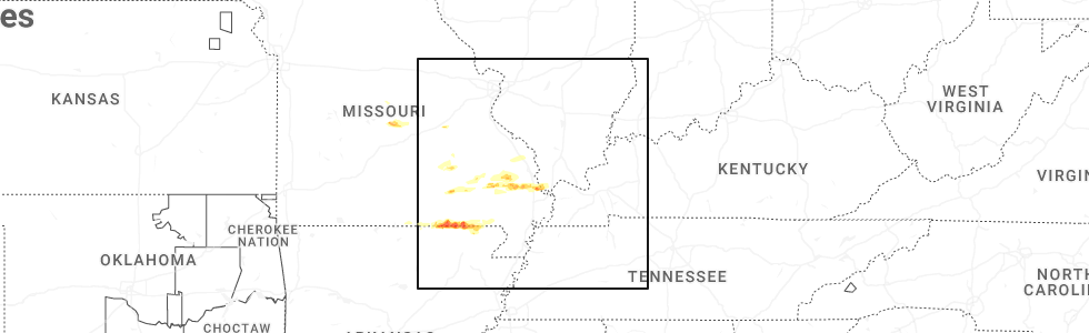
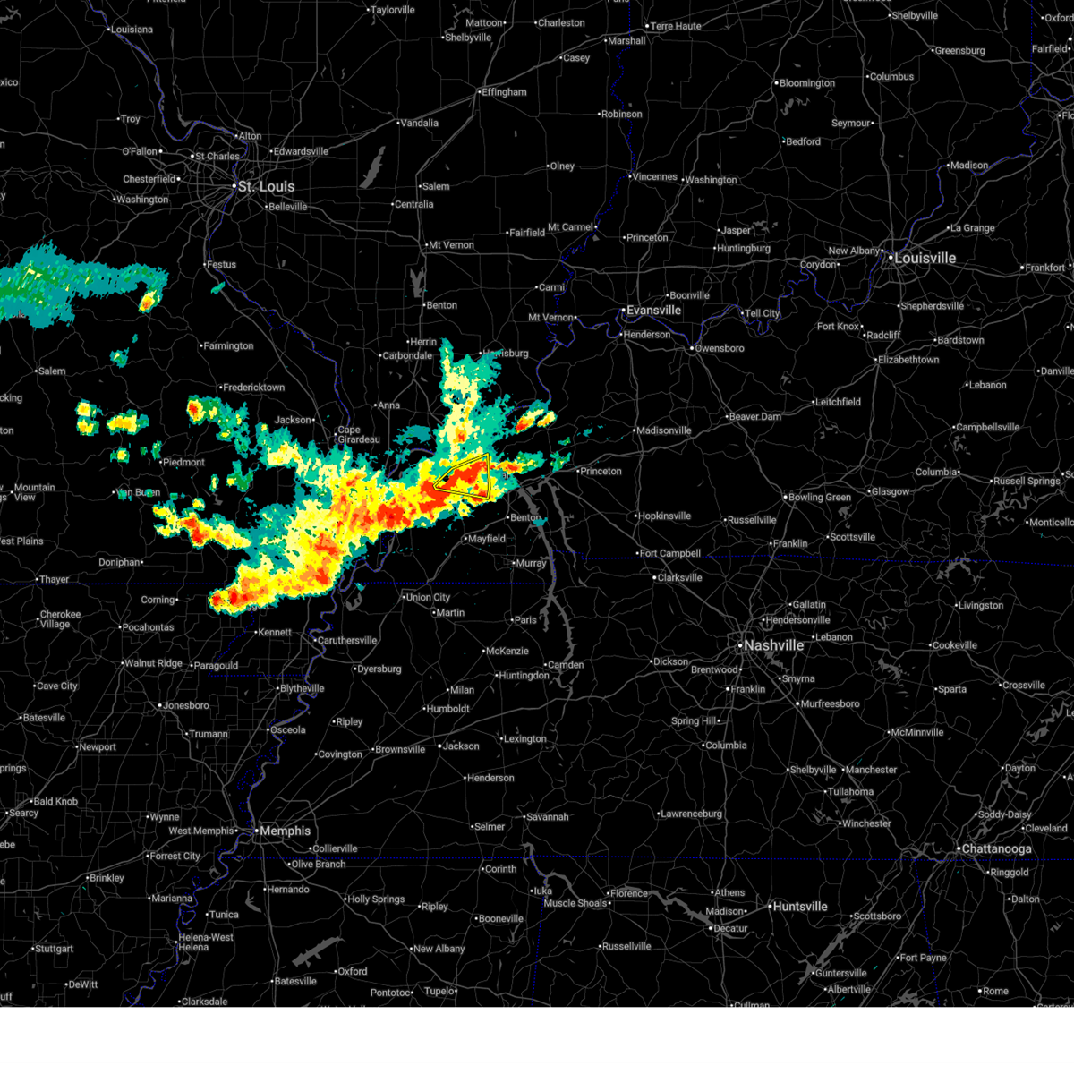
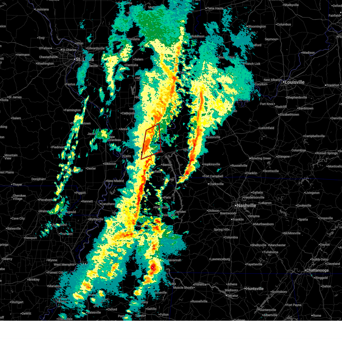
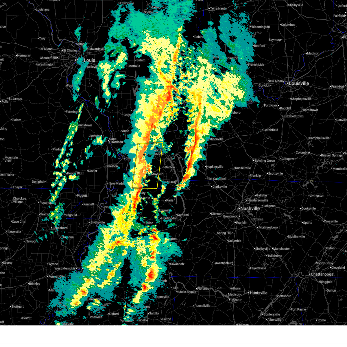
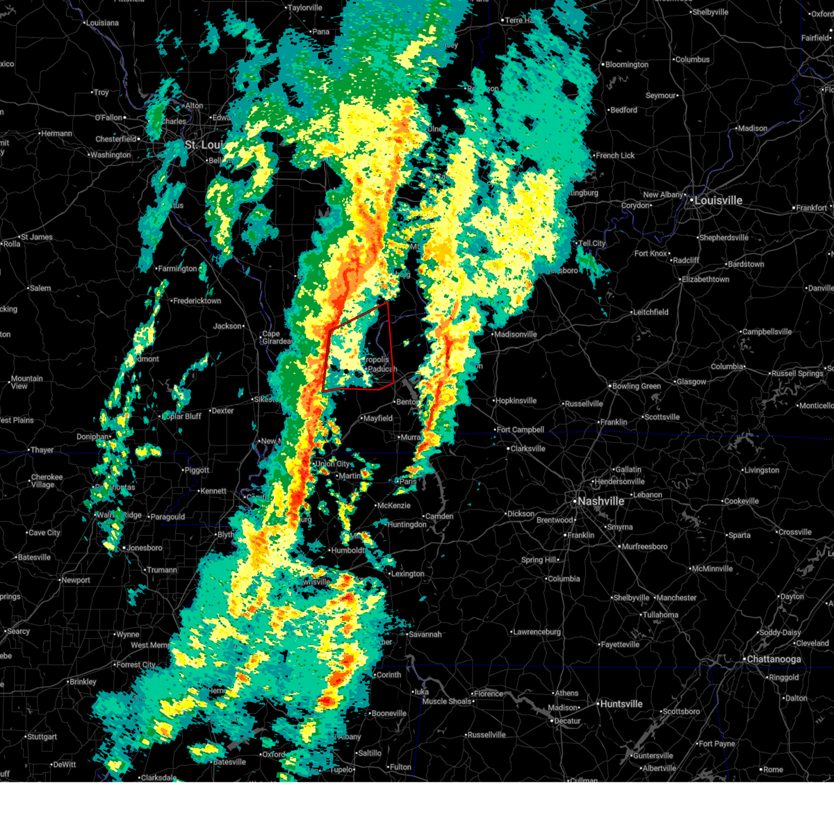
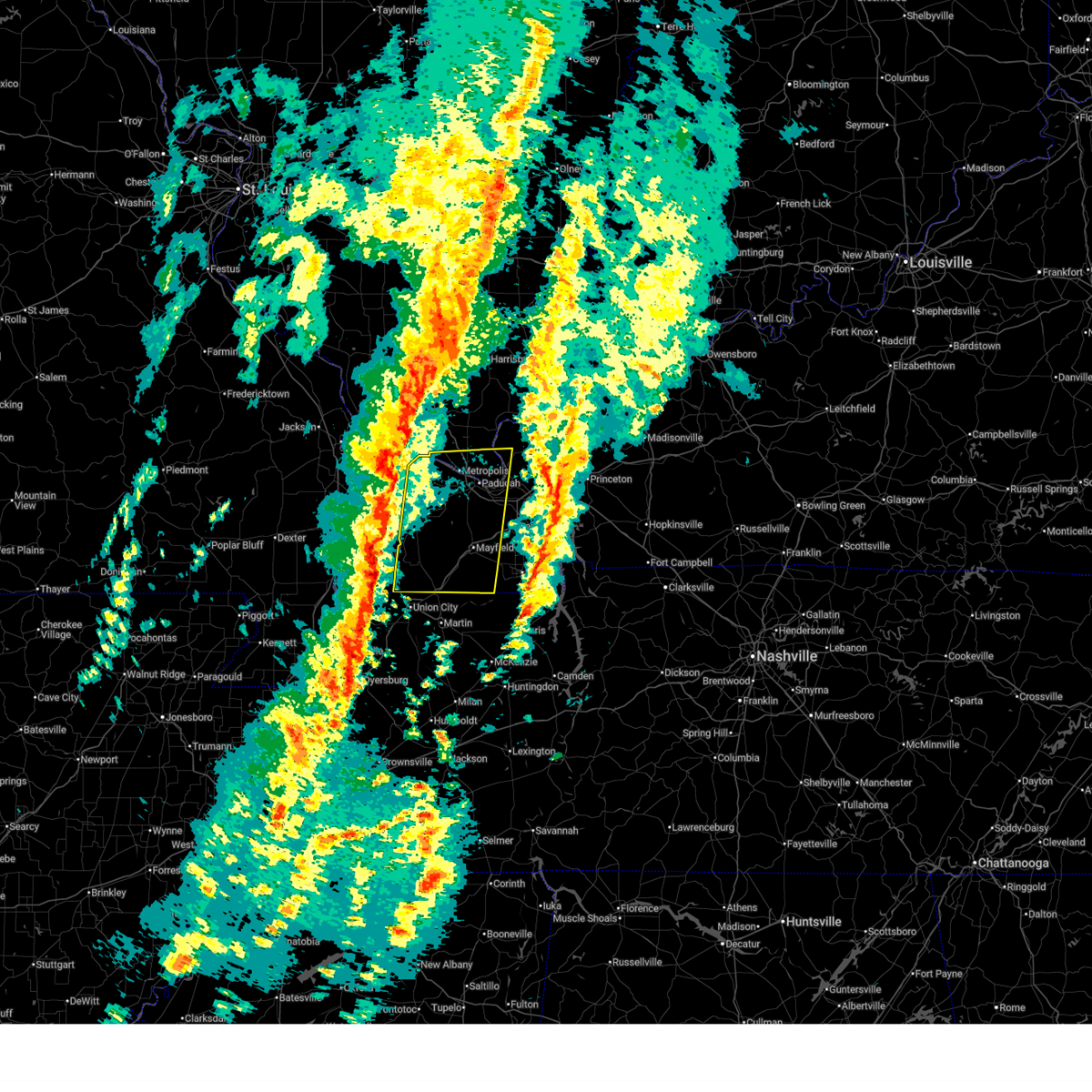
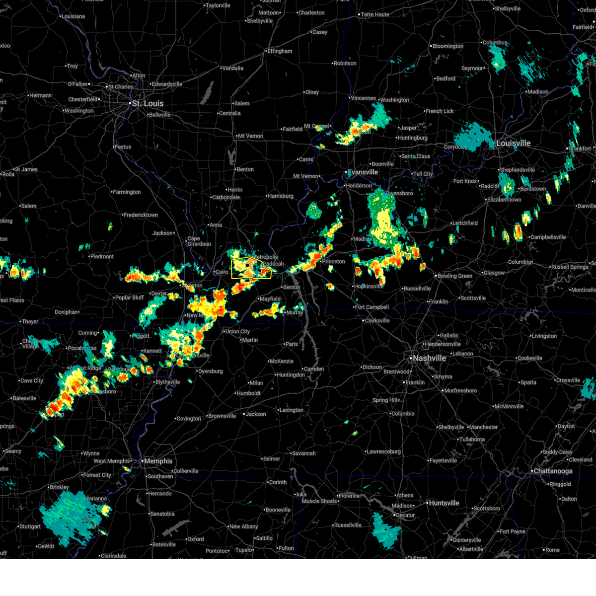
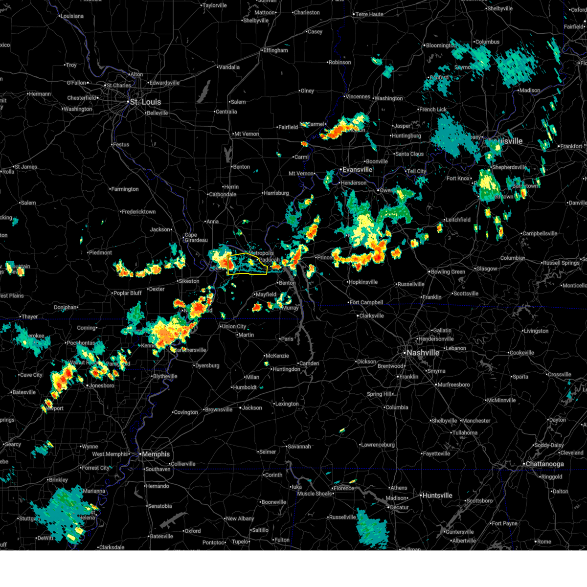
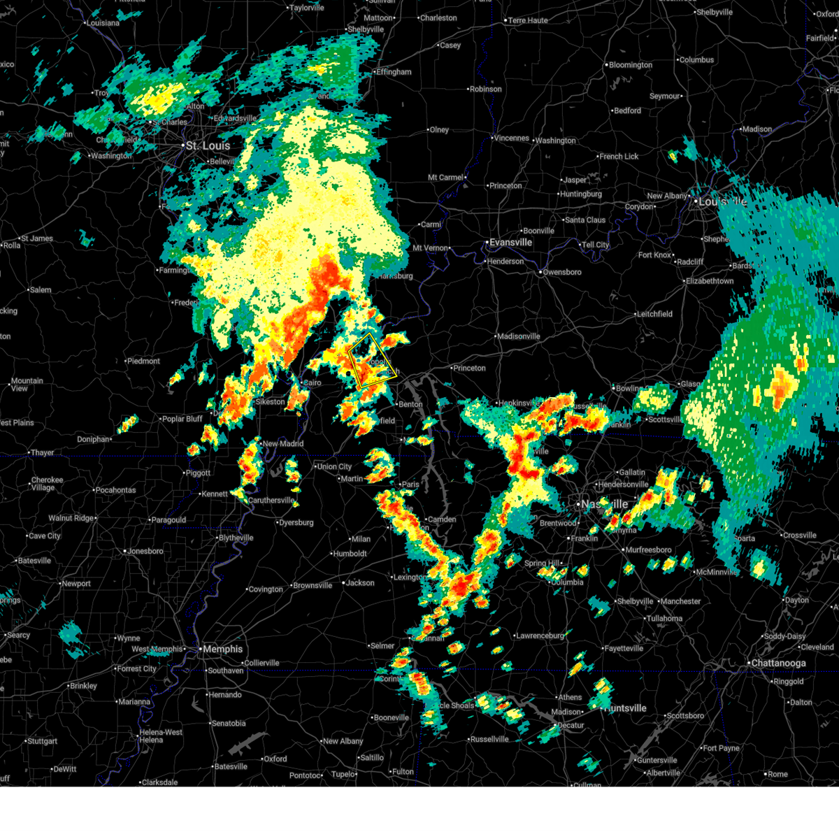
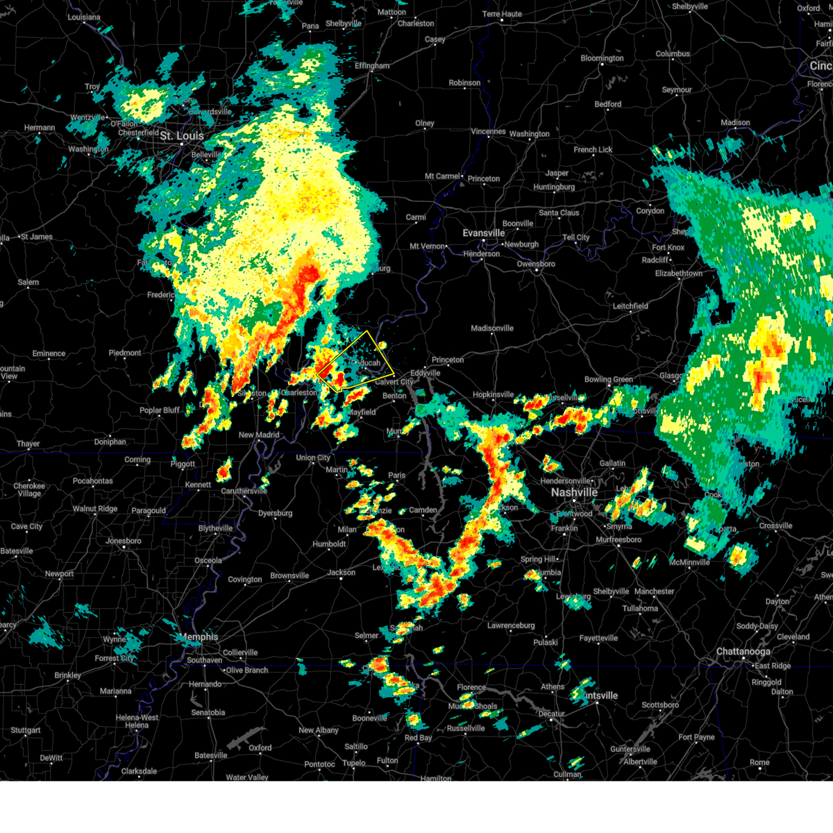
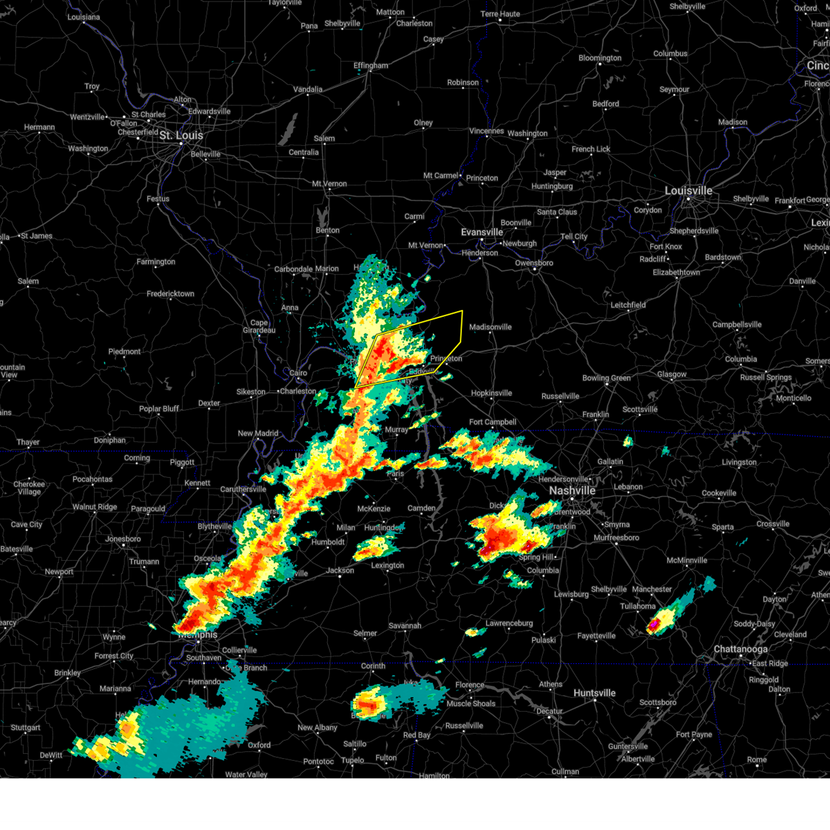
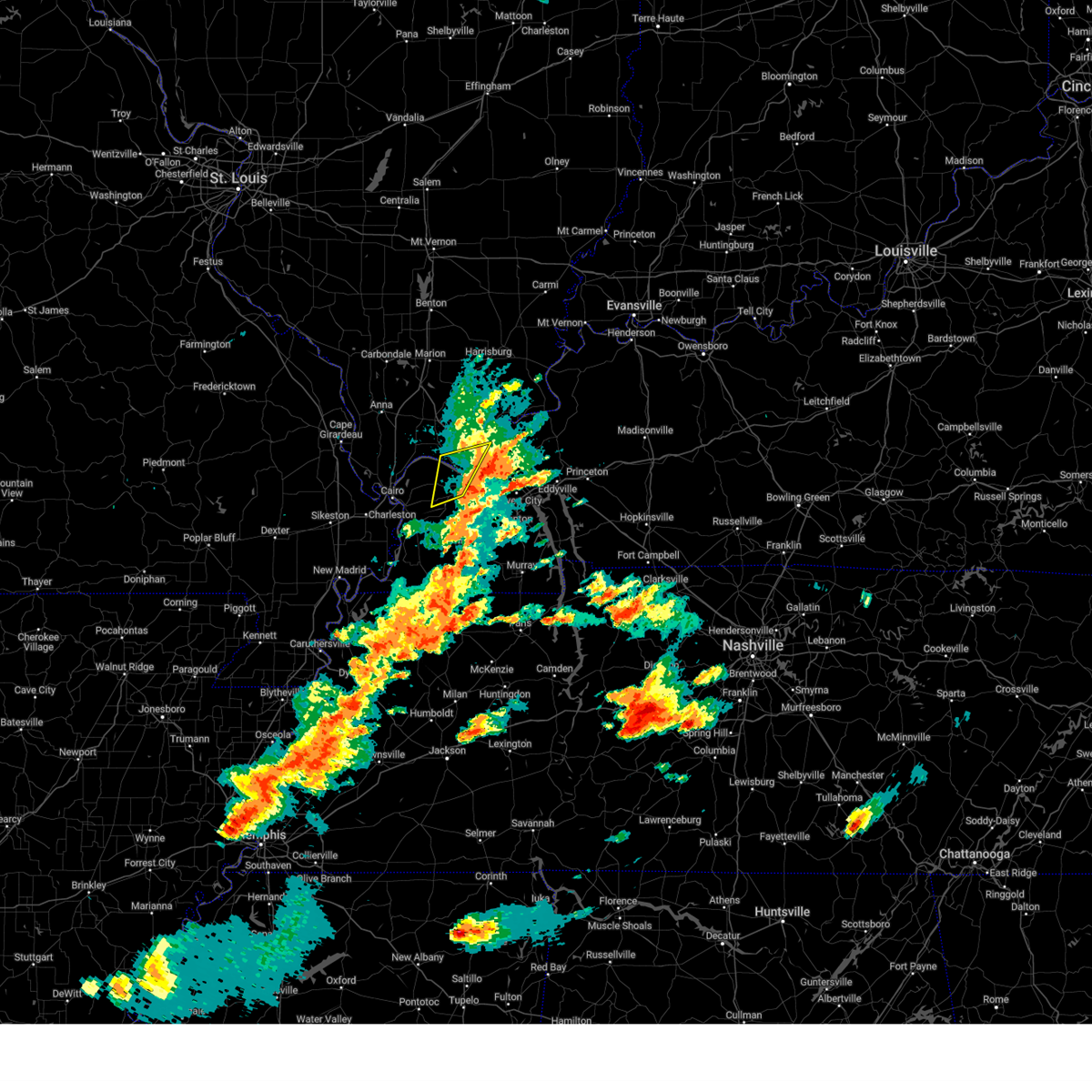
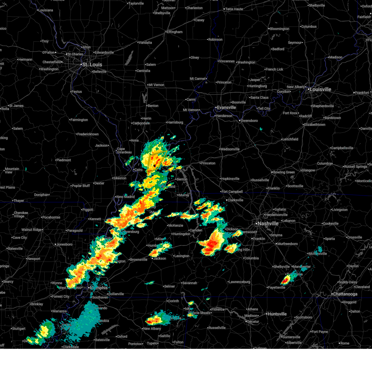
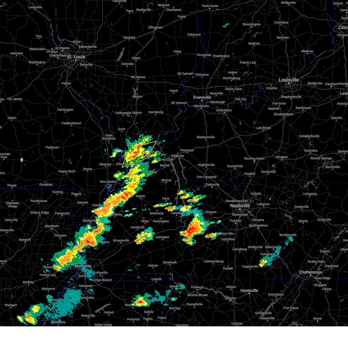
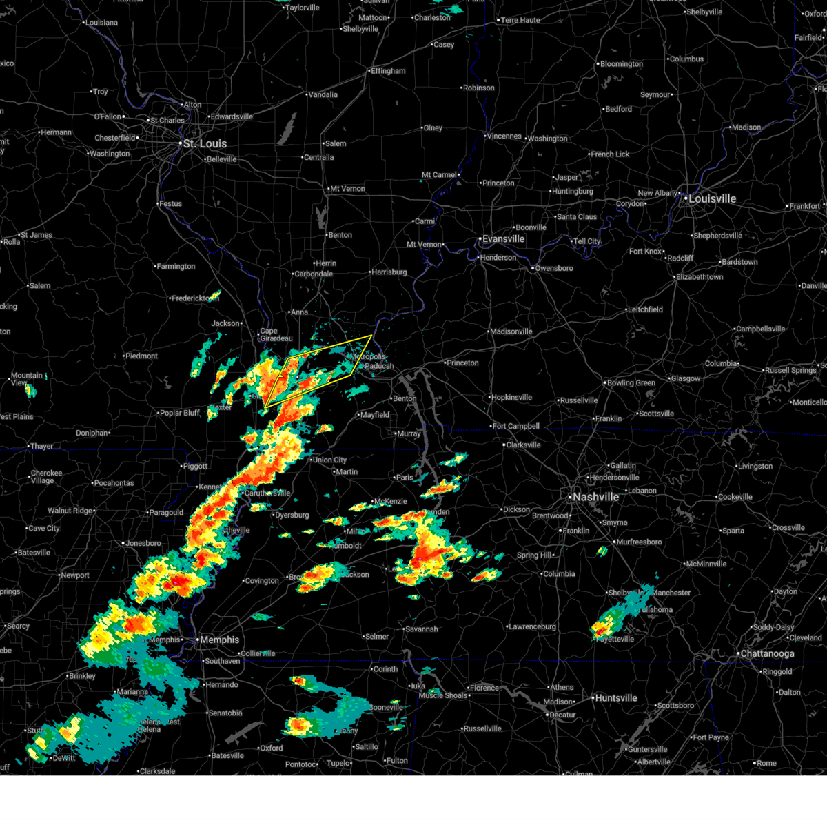
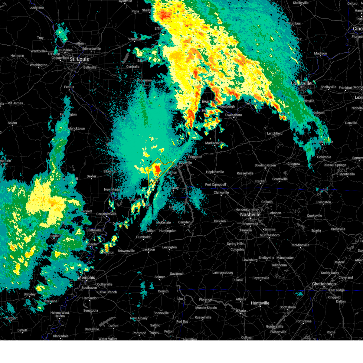
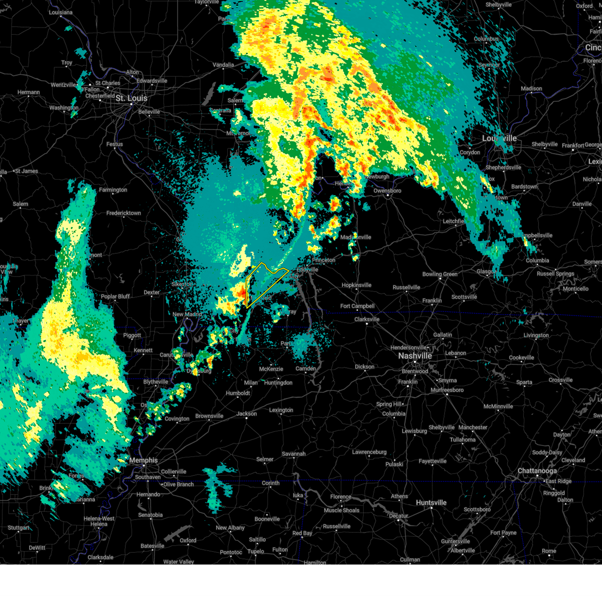
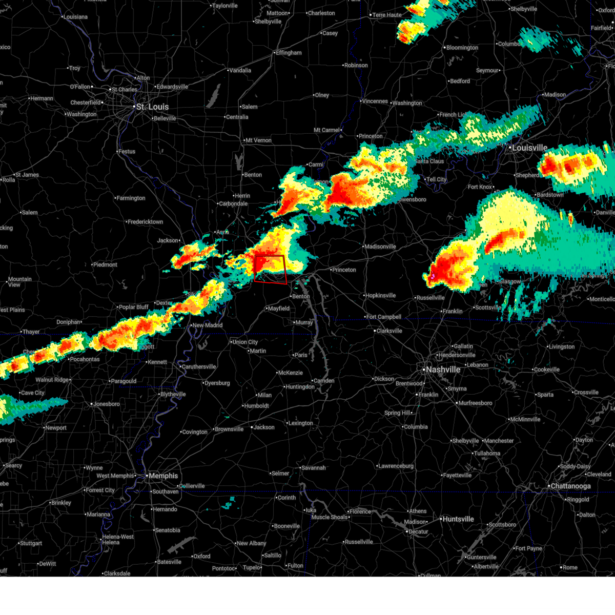
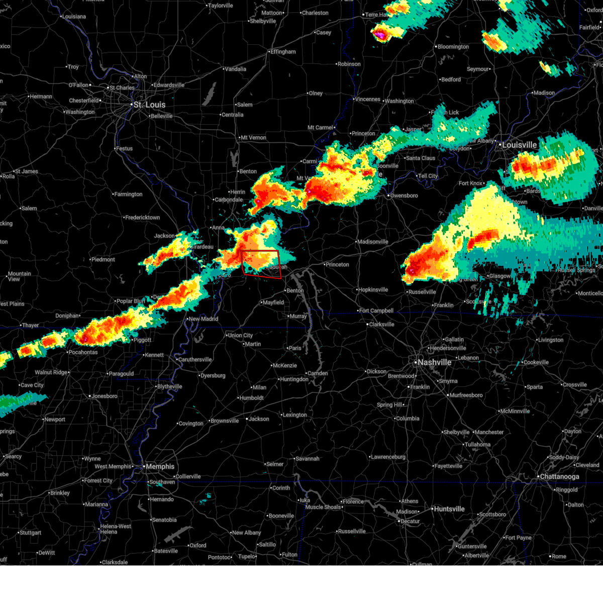
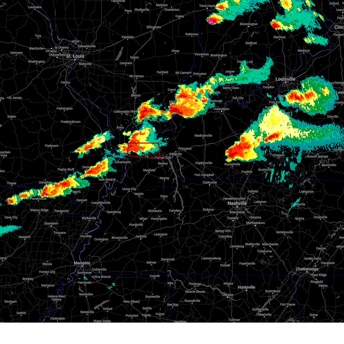
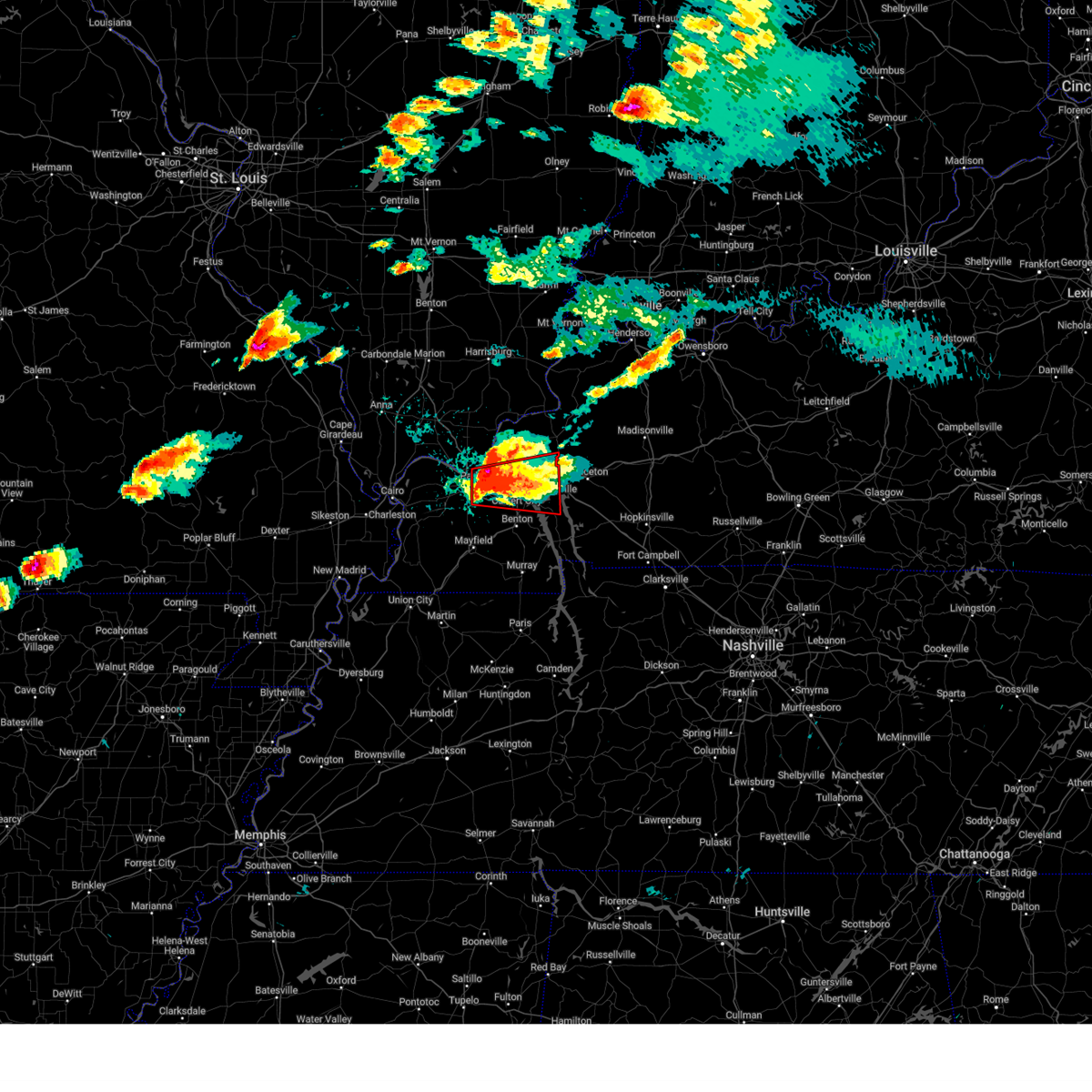
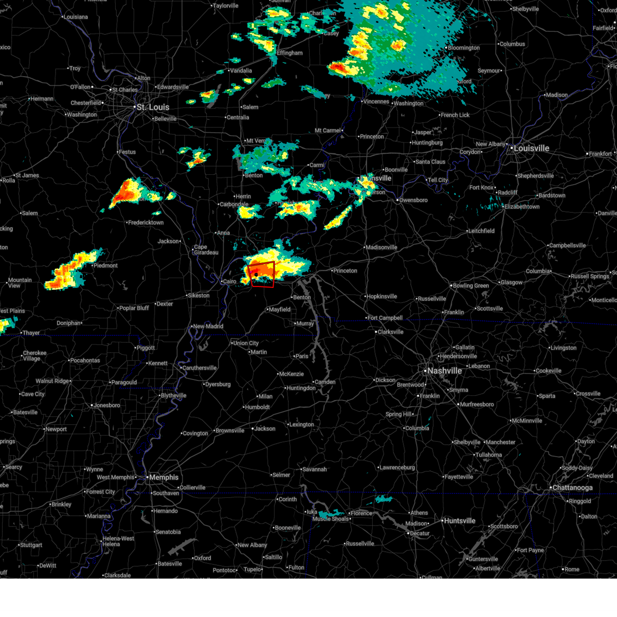
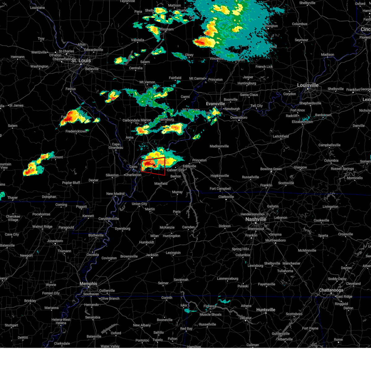
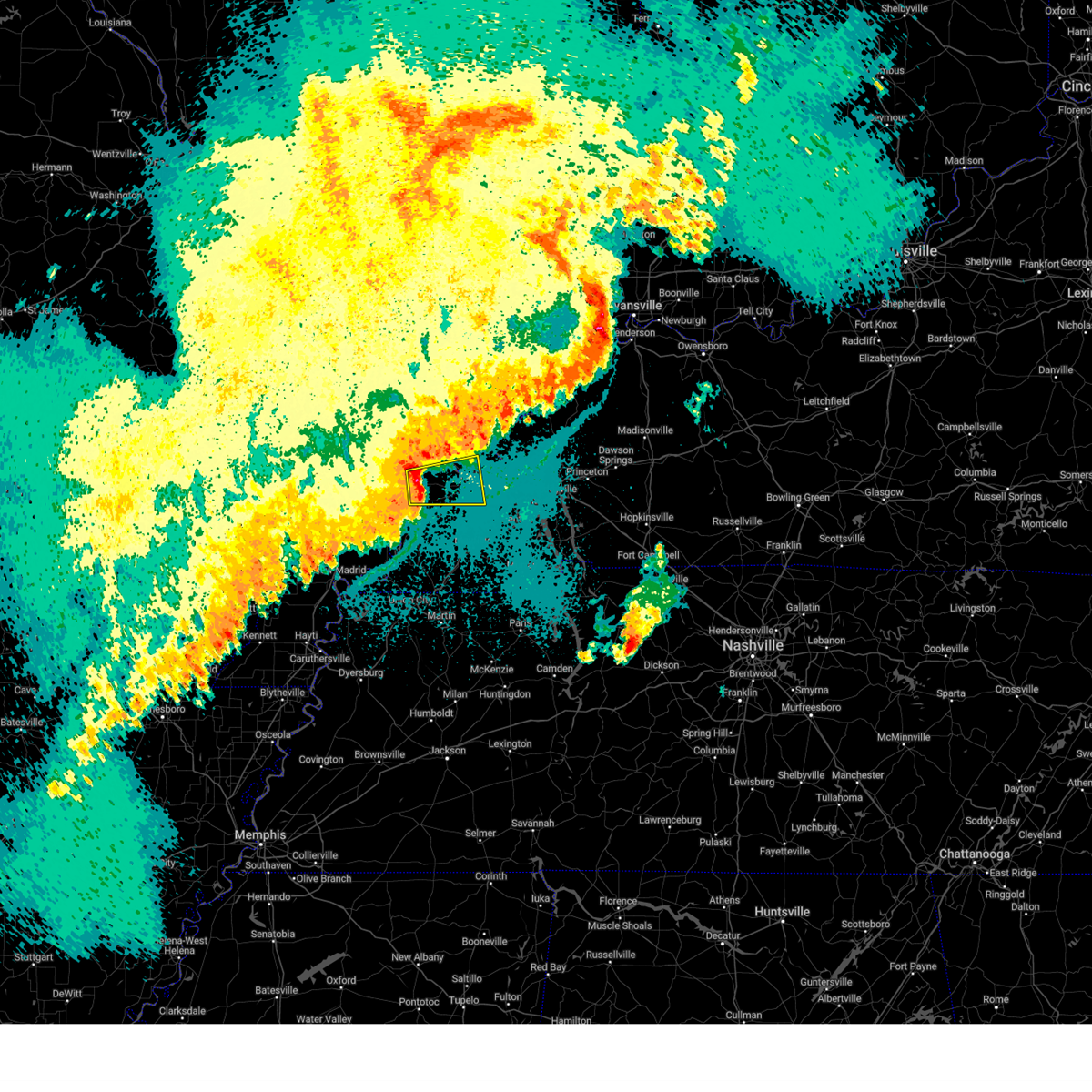
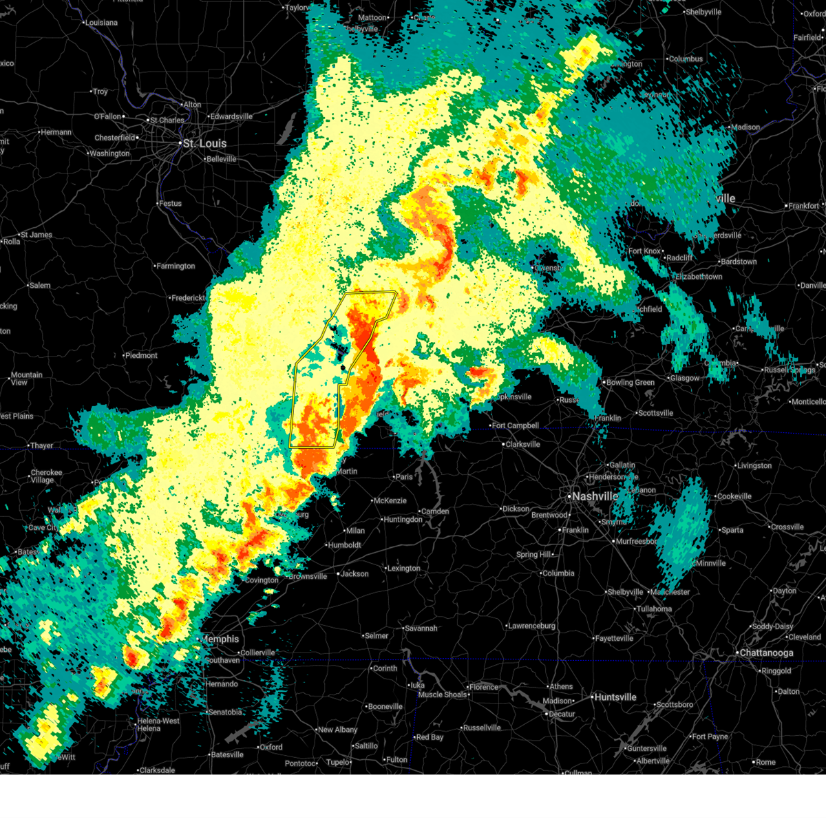
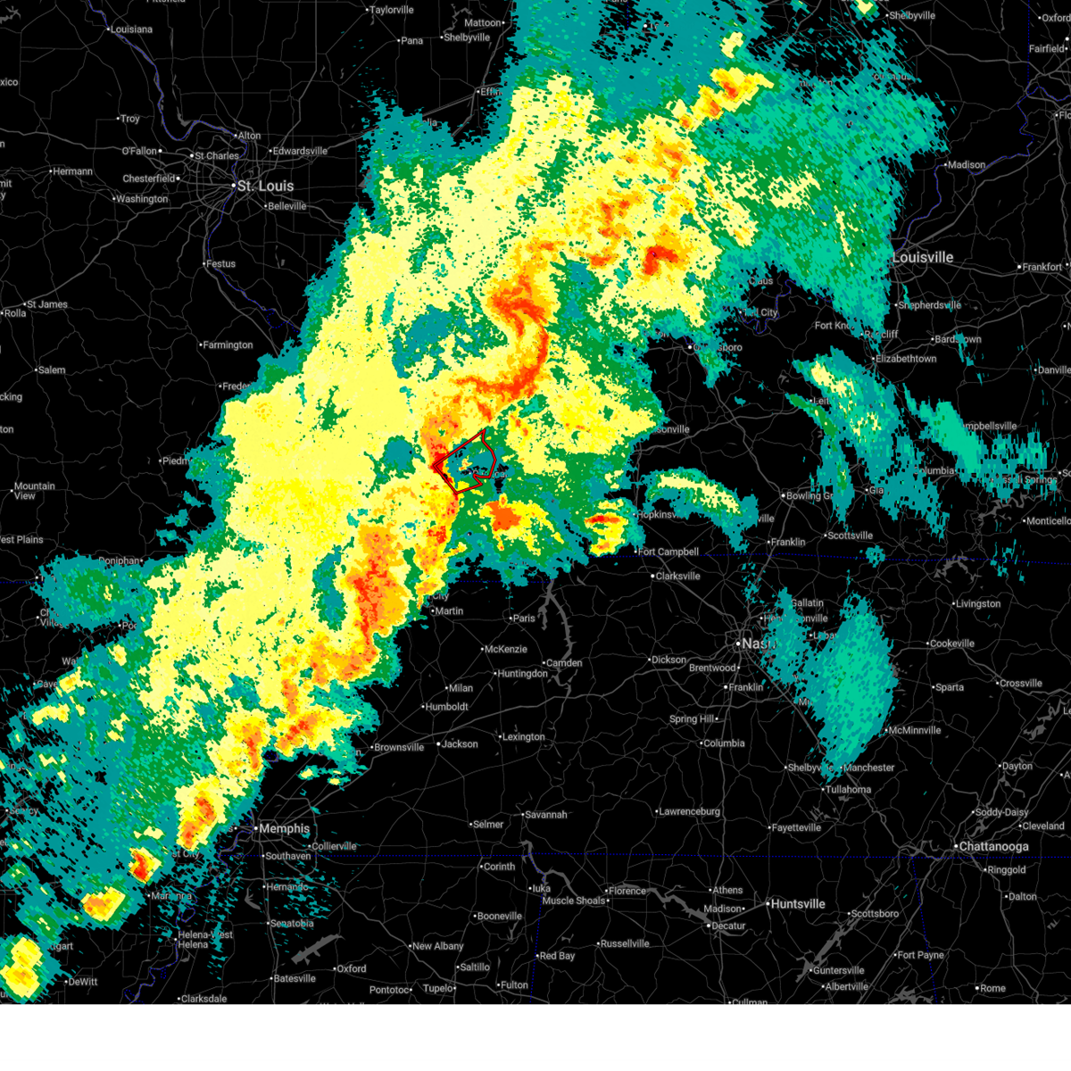
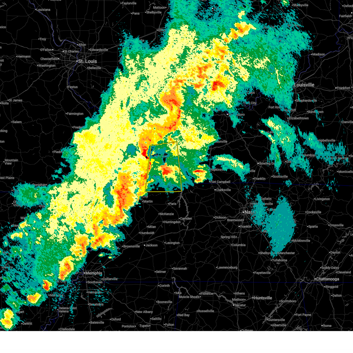
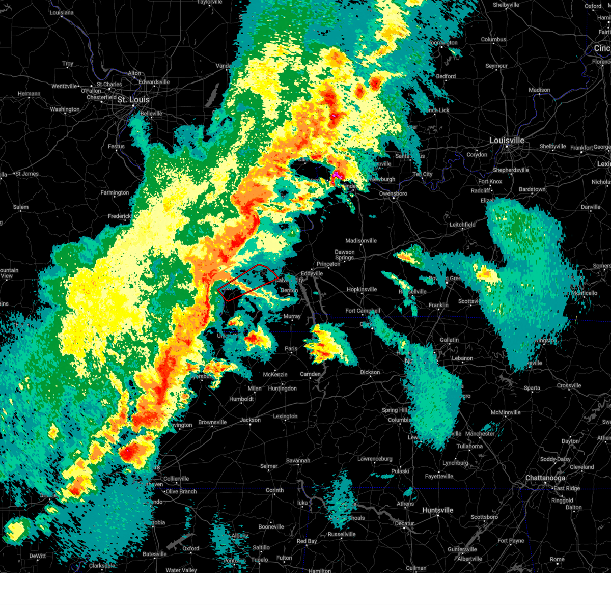
Hail Map for Paducah, KY
The Paducah, KY area has had 25 reports of on-the-ground hail by trained spotters, and has been under severe weather warnings 22 times during the past 12 months. Doppler radar has detected hail at or near Paducah, KY on 98 occasions, including 5 occasions during the past year.
| Name: | Paducah, KY |
| Where Located: | 51.2 miles ESE of Cape Girardeau, MO |
| Map: | Google Map for Paducah, KY |
| Population: | 25024 |
| Housing Units: | 12851 |
| More Info: | Search Google for Paducah, KY |
1
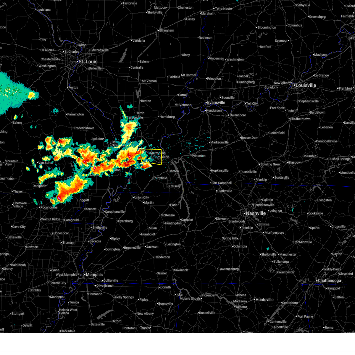
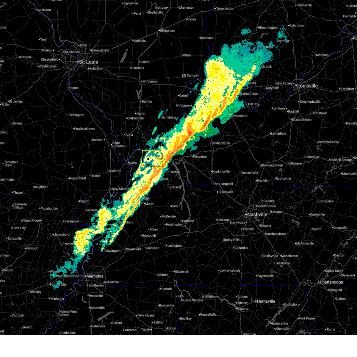
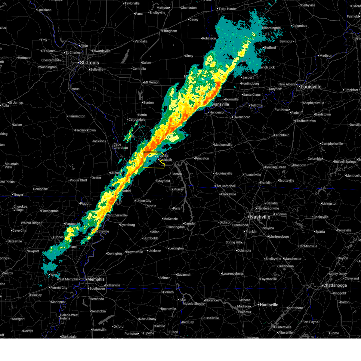
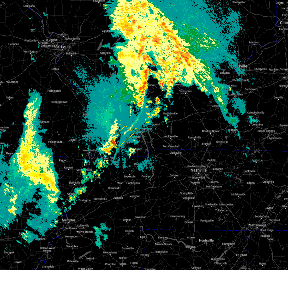
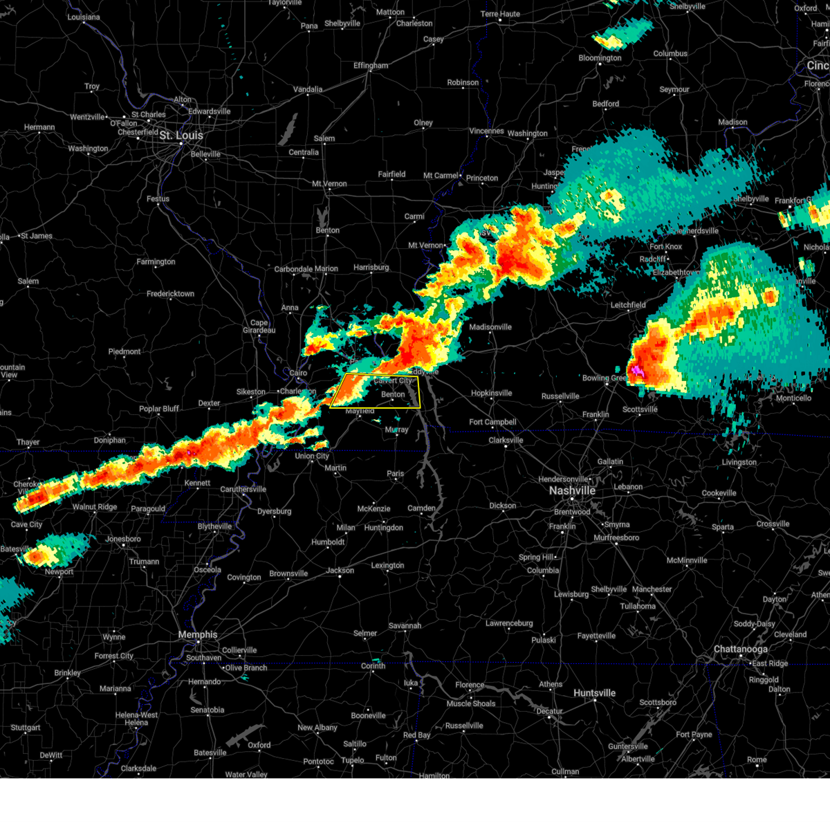
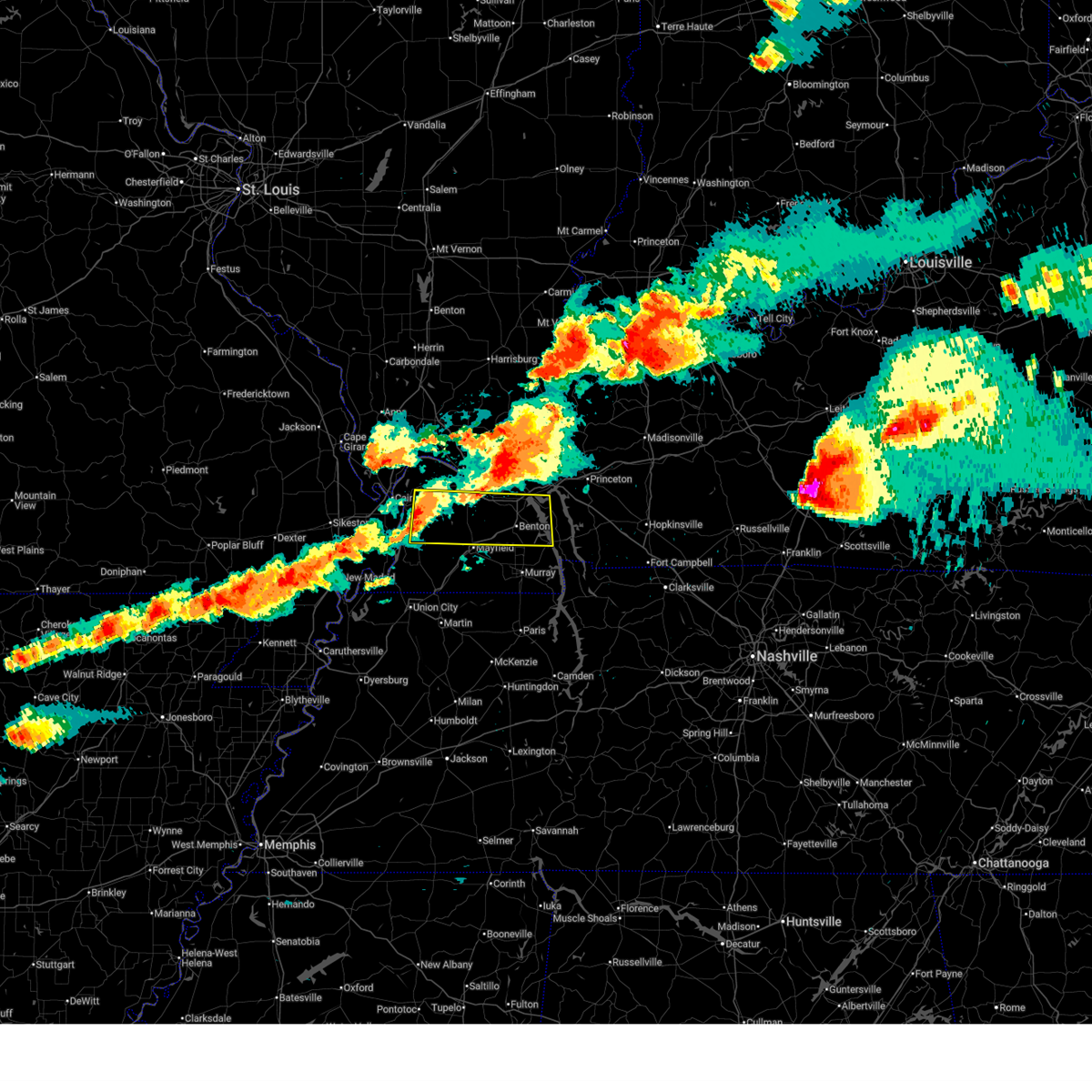
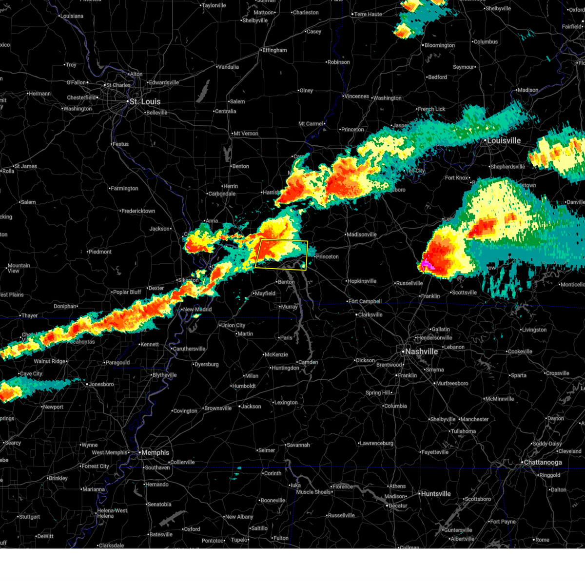
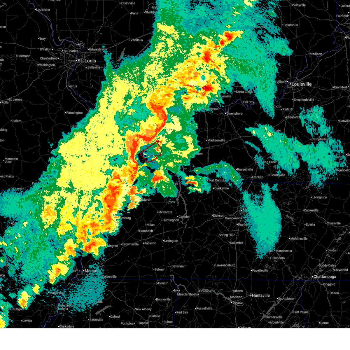
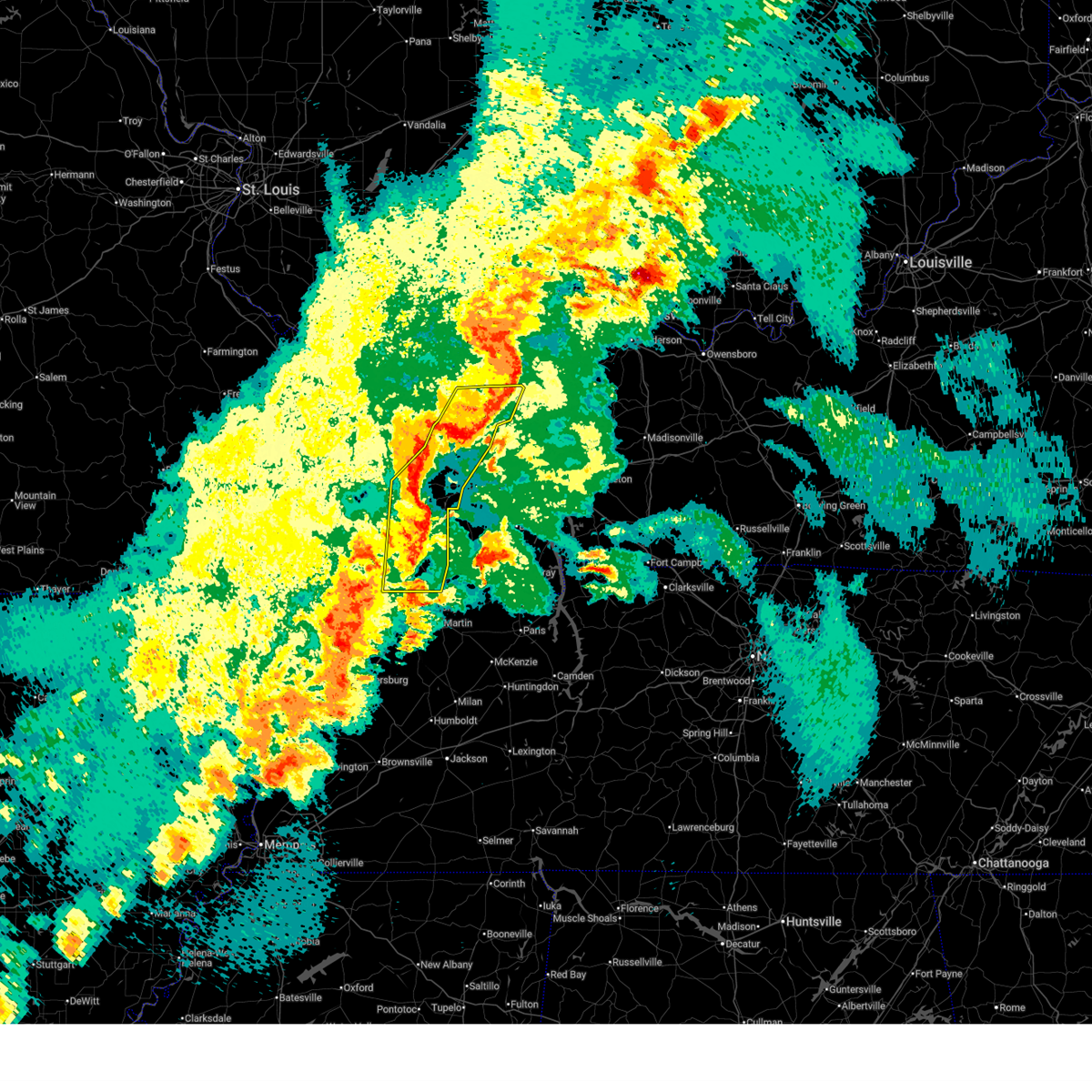
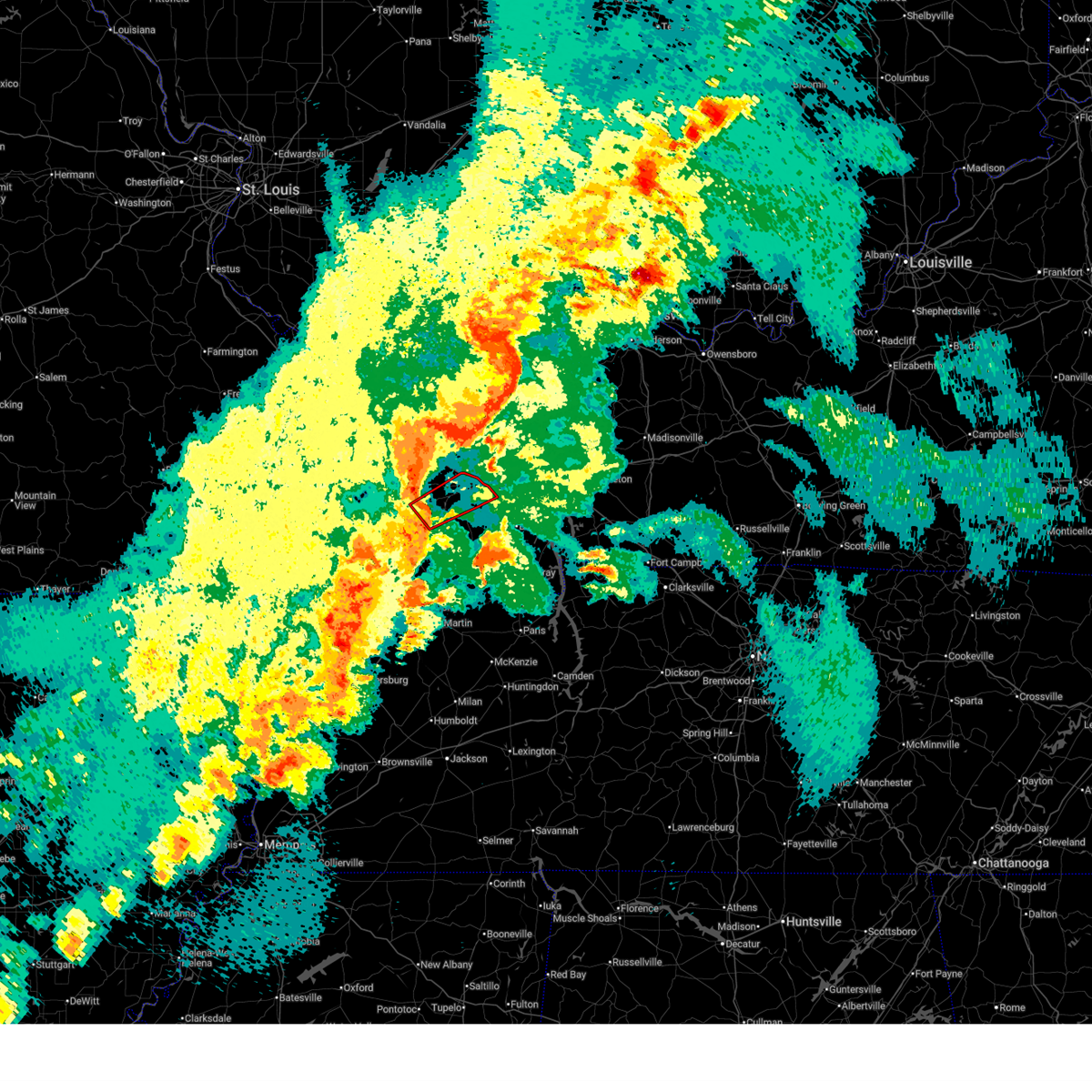
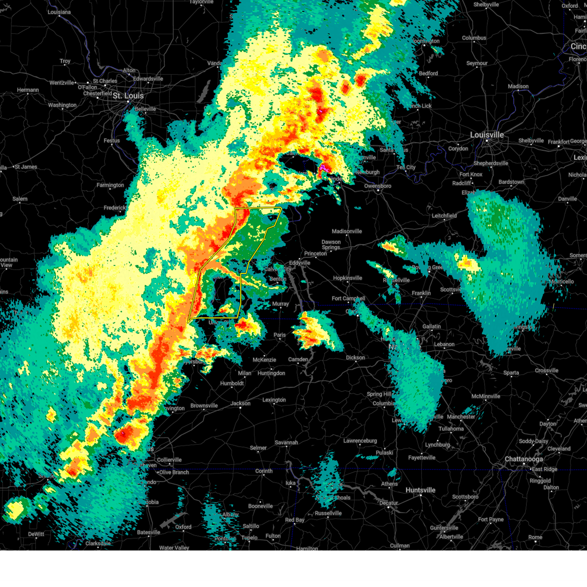
The Top Recent Hail Date for Paducah, KY is Thursday, April 16, 2026 (20th out of 98)
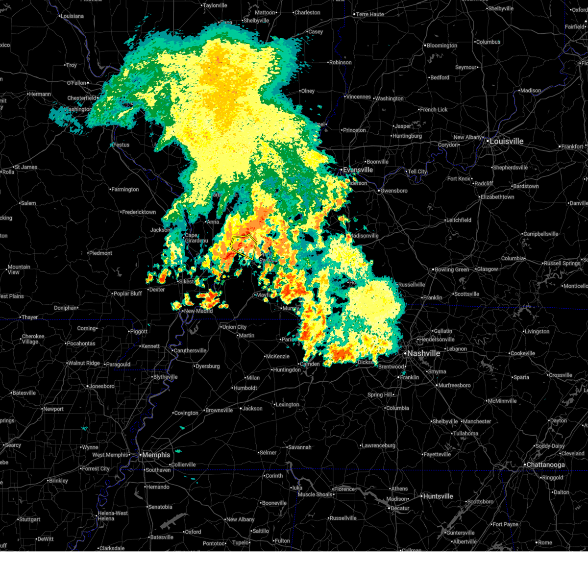
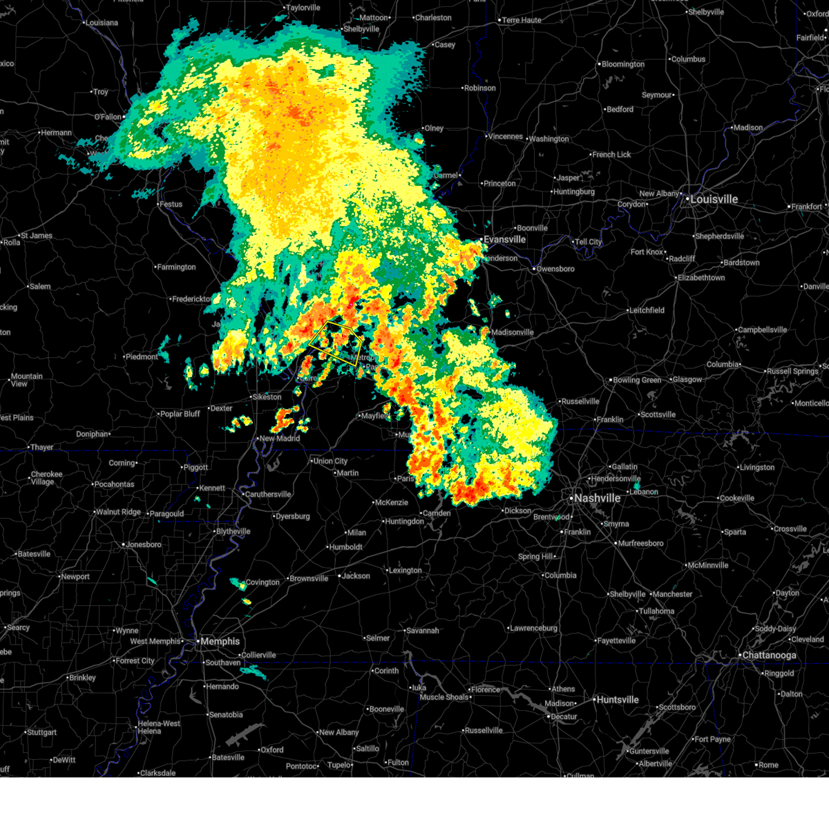
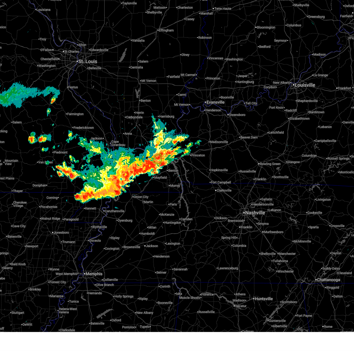
Hail and Wind Damage Spotted near Paducah, KY
| Date / Time | Report Details |
|---|---|
| 6/1/2026 8:26 AM CDT |
 At 826 am cdt, severe thunderstorms were located along a line extending from near new columbia to 7 miles southeast of karnak, moving southeast at 45 mph (radar indicated). Hazards include 60 mph wind gusts. Expect damage to roofs, siding, and trees. locations impacted include, metropolis, new columbia, and joppa. this includes the following highways, interstate 24 in kentucky between mile markers 1 and 2. Interstate 24 in illinois between mile markers 26 and 38. At 826 am cdt, severe thunderstorms were located along a line extending from near new columbia to 7 miles southeast of karnak, moving southeast at 45 mph (radar indicated). Hazards include 60 mph wind gusts. Expect damage to roofs, siding, and trees. locations impacted include, metropolis, new columbia, and joppa. this includes the following highways, interstate 24 in kentucky between mile markers 1 and 2. Interstate 24 in illinois between mile markers 26 and 38.
|
| 6/1/2026 8:15 AM CDT |
 Svrpah the national weather service in paducah has issued a * severe thunderstorm warning for, northeastern pulaski county in southern illinois, massac county in southern illinois, southeastern johnson county in southern illinois, north central ballard county in western kentucky, northwestern mccracken county in western kentucky, * until 900 am cdt. * at 815 am cdt, severe thunderstorms were located along a line extending from 6 miles south of vienna to near karnak, moving southeast at 40 mph (radar indicated). Hazards include 60 mph wind gusts. expect damage to roofs, siding, and trees Svrpah the national weather service in paducah has issued a * severe thunderstorm warning for, northeastern pulaski county in southern illinois, massac county in southern illinois, southeastern johnson county in southern illinois, north central ballard county in western kentucky, northwestern mccracken county in western kentucky, * until 900 am cdt. * at 815 am cdt, severe thunderstorms were located along a line extending from 6 miles south of vienna to near karnak, moving southeast at 40 mph (radar indicated). Hazards include 60 mph wind gusts. expect damage to roofs, siding, and trees
|
| 4/16/2026 4:44 PM CDT |
 At 444 pm cdt, a severe thunderstorm was located over ledbetter, or near reidland, moving east at 35 mph (radar indicated). Hazards include 60 mph wind gusts and quarter size hail. Hail damage to vehicles is expected. expect wind damage to roofs, siding, and trees. locations impacted include, paducah, reidland, and ledbetter. This includes interstate 24 in kentucky between mile markers 9 and 17. At 444 pm cdt, a severe thunderstorm was located over ledbetter, or near reidland, moving east at 35 mph (radar indicated). Hazards include 60 mph wind gusts and quarter size hail. Hail damage to vehicles is expected. expect wind damage to roofs, siding, and trees. locations impacted include, paducah, reidland, and ledbetter. This includes interstate 24 in kentucky between mile markers 9 and 17.
|
| 4/16/2026 4:34 PM CDT |
 At 434 pm cdt, a severe thunderstorm was located near paducah, moving east at 40 mph (radar indicated). Hazards include 60 mph wind gusts and quarter size hail. Hail damage to vehicles is expected. expect wind damage to roofs, siding, and trees. locations impacted include, paducah, lone oak, reidland, brookport, barkley regional airport, west paducah, and ledbetter. This includes interstate 24 in kentucky between mile markers 1 and 17. At 434 pm cdt, a severe thunderstorm was located near paducah, moving east at 40 mph (radar indicated). Hazards include 60 mph wind gusts and quarter size hail. Hail damage to vehicles is expected. expect wind damage to roofs, siding, and trees. locations impacted include, paducah, lone oak, reidland, brookport, barkley regional airport, west paducah, and ledbetter. This includes interstate 24 in kentucky between mile markers 1 and 17.
|
| 4/16/2026 4:04 PM CDT |
 Svrpah the national weather service in paducah has issued a * severe thunderstorm warning for, southern massac county in southern illinois, south central pope county in southern illinois, southwestern livingston county in western kentucky, northeastern ballard county in western kentucky, mccracken county in western kentucky, * until 500 pm cdt. * at 404 pm cdt, a severe thunderstorm was located over la center, moving east at 40 mph (radar indicated). Hazards include 60 mph wind gusts and half dollar size hail. Hail damage to vehicles is expected. Expect wind damage to roofs, siding, and trees. Svrpah the national weather service in paducah has issued a * severe thunderstorm warning for, southern massac county in southern illinois, south central pope county in southern illinois, southwestern livingston county in western kentucky, northeastern ballard county in western kentucky, mccracken county in western kentucky, * until 500 pm cdt. * at 404 pm cdt, a severe thunderstorm was located over la center, moving east at 40 mph (radar indicated). Hazards include 60 mph wind gusts and half dollar size hail. Hail damage to vehicles is expected. Expect wind damage to roofs, siding, and trees.
|
| 3/15/2026 8:27 PM CDT |
 The storms which prompted the warning have moved out of the area. therefore, the warning will be allowed to expire. a tornado watch remains in effect until 1100 pm cdt for southern illinois, and western kentucky. The storms which prompted the warning have moved out of the area. therefore, the warning will be allowed to expire. a tornado watch remains in effect until 1100 pm cdt for southern illinois, and western kentucky.
|
| 3/15/2026 8:24 PM CDT |
 the tornado warning has been cancelled and is no longer in effect the tornado warning has been cancelled and is no longer in effect
|
| 3/15/2026 8:17 PM CDT |
 At 816 pm cdt, severe thunderstorms were located along a line extending from near brookport to near latham, moving east at 50 mph (radar indicated). Hazards include 60 mph wind gusts. Expect damage to roofs, siding, and trees. locations impacted include, paducah, mayfield, reidland, lone oak, brookport, burna, ledbetter, lynnville, sedalia, wingo, smithland, hamletsburg, and symsonia. this includes the following highways, interstate 24 in kentucky between mile markers 1 and 20. interstate 24 in illinois between mile markers 34 and 38. Interstate 69 in kentucky between mile markers 11 and 36. At 816 pm cdt, severe thunderstorms were located along a line extending from near brookport to near latham, moving east at 50 mph (radar indicated). Hazards include 60 mph wind gusts. Expect damage to roofs, siding, and trees. locations impacted include, paducah, mayfield, reidland, lone oak, brookport, burna, ledbetter, lynnville, sedalia, wingo, smithland, hamletsburg, and symsonia. this includes the following highways, interstate 24 in kentucky between mile markers 1 and 20. interstate 24 in illinois between mile markers 34 and 38. Interstate 69 in kentucky between mile markers 11 and 36.
|
| 3/15/2026 8:17 PM CDT |
 the severe thunderstorm warning has been cancelled and is no longer in effect the severe thunderstorm warning has been cancelled and is no longer in effect
|
| 3/15/2026 8:14 PM CDT |
 At 814 pm cdt, a severe squall line capable of producing both tornadoes and extensive straight line wind damage was located along a line extending from 6 miles northeast of dixon springs to near lovelaceville, moving northeast at 60 mph (radar indicated rotation). Hazards include tornado. Flying debris will be dangerous to those caught without shelter. mobile homes will be damaged or destroyed. damage to roofs, windows, and vehicles will occur. tree damage is likely. these dangerous storms will be near, paducah, reidland, lone oak, brookport, golconda, and ledbetter around 820 pm cdt. burna around 825 pm cdt. other locations impacted by these tornadic storms include smithland and hamletsburg. this includes the following highways, interstate 24 in kentucky between mile markers 1 and 11. Interstate 24 in illinois between mile markers 31 and 38. At 814 pm cdt, a severe squall line capable of producing both tornadoes and extensive straight line wind damage was located along a line extending from 6 miles northeast of dixon springs to near lovelaceville, moving northeast at 60 mph (radar indicated rotation). Hazards include tornado. Flying debris will be dangerous to those caught without shelter. mobile homes will be damaged or destroyed. damage to roofs, windows, and vehicles will occur. tree damage is likely. these dangerous storms will be near, paducah, reidland, lone oak, brookport, golconda, and ledbetter around 820 pm cdt. burna around 825 pm cdt. other locations impacted by these tornadic storms include smithland and hamletsburg. this includes the following highways, interstate 24 in kentucky between mile markers 1 and 11. Interstate 24 in illinois between mile markers 31 and 38.
|
| 3/15/2026 8:14 PM CDT |
 the tornado warning has been cancelled and is no longer in effect the tornado warning has been cancelled and is no longer in effect
|
| 3/15/2026 8:06 PM CDT |
 At 806 pm cdt, severe thunderstorms were located along a line extending from metropolis to near martin, moving east at 50 mph (radar indicated). Hazards include 60 mph wind gusts. Expect damage to roofs, siding, and trees. locations impacted include, paducah, mayfield, metropolis, fulton, clinton, reidland, lone oak, brookport, barkley regional airport, burna, ledbetter, lynnville, fulgham, sedalia, lovelaceville, west paducah, wingo, kevil, joppa, and smithland. this includes the following highways, interstate 24 in kentucky between mile markers 1 and 20. interstate 24 in illinois between mile markers 30 and 38. Interstate 69 in kentucky between mile markers 1 and 36. At 806 pm cdt, severe thunderstorms were located along a line extending from metropolis to near martin, moving east at 50 mph (radar indicated). Hazards include 60 mph wind gusts. Expect damage to roofs, siding, and trees. locations impacted include, paducah, mayfield, metropolis, fulton, clinton, reidland, lone oak, brookport, barkley regional airport, burna, ledbetter, lynnville, fulgham, sedalia, lovelaceville, west paducah, wingo, kevil, joppa, and smithland. this includes the following highways, interstate 24 in kentucky between mile markers 1 and 20. interstate 24 in illinois between mile markers 30 and 38. Interstate 69 in kentucky between mile markers 1 and 36.
|
| 3/15/2026 7:56 PM CDT |
 Torpah the national weather service in paducah has issued a * tornado warning for, massac county in southern illinois, pope county in southern illinois, southeastern johnson county in southern illinois, western livingston county in western kentucky, northwestern marshall county in western kentucky, eastern ballard county in western kentucky, mccracken county in western kentucky, * until 845 pm cdt. * at 756 pm cdt, severe thunderstorms capable of producing both tornadoes and extensive straight line wind damage were located along a line extending from near karnak to near bardwell, moving northeast at 50 mph (radar indicated rotation). Hazards include tornado. Flying debris will be dangerous to those caught without shelter. mobile homes will be damaged or destroyed. damage to roofs, windows, and vehicles will occur. tree damage is likely. these dangerous storms will be near, new columbia, barkley regional airport, and lovelaceville around 800 pm cdt. paducah, metropolis, dixon springs, and west paducah around 805 pm cdt. lone oak and brookport around 810 pm cdt. reidland, golconda, and ledbetter around 820 pm cdt. burna around 830 pm cdt. calvert city around 835 pm cdt. other locations impacted by these tornadic storms include smithland, joppa, hamletsburg, kevil, and blandville. this includes the following highways, interstate 24 in kentucky between mile markers 1 and 24. Interstate 24 in illinois between mile markers 20 and 38. Torpah the national weather service in paducah has issued a * tornado warning for, massac county in southern illinois, pope county in southern illinois, southeastern johnson county in southern illinois, western livingston county in western kentucky, northwestern marshall county in western kentucky, eastern ballard county in western kentucky, mccracken county in western kentucky, * until 845 pm cdt. * at 756 pm cdt, severe thunderstorms capable of producing both tornadoes and extensive straight line wind damage were located along a line extending from near karnak to near bardwell, moving northeast at 50 mph (radar indicated rotation). Hazards include tornado. Flying debris will be dangerous to those caught without shelter. mobile homes will be damaged or destroyed. damage to roofs, windows, and vehicles will occur. tree damage is likely. these dangerous storms will be near, new columbia, barkley regional airport, and lovelaceville around 800 pm cdt. paducah, metropolis, dixon springs, and west paducah around 805 pm cdt. lone oak and brookport around 810 pm cdt. reidland, golconda, and ledbetter around 820 pm cdt. burna around 830 pm cdt. calvert city around 835 pm cdt. other locations impacted by these tornadic storms include smithland, joppa, hamletsburg, kevil, and blandville. this includes the following highways, interstate 24 in kentucky between mile markers 1 and 24. Interstate 24 in illinois between mile markers 20 and 38.
|
| 3/15/2026 7:43 PM CDT |
 Svrpah the national weather service in paducah has issued a * severe thunderstorm warning for, massac county in southern illinois, southeastern pope county in southern illinois, eastern fulton county in western kentucky, northwestern calloway county in western kentucky, southwestern livingston county in western kentucky, western marshall county in western kentucky, carlisle county in western kentucky, hickman county in western kentucky, ballard county in western kentucky, mccracken county in western kentucky, graves county in western kentucky, * until 830 pm cdt. * at 743 pm cdt, severe thunderstorms were located along a line extending from 8 miles northwest of la center to near troy, moving east at 50 mph (radar indicated). Hazards include 70 mph wind gusts. Expect considerable tree damage. Damage is likely to mobile homes, roofs, and outbuildings. Svrpah the national weather service in paducah has issued a * severe thunderstorm warning for, massac county in southern illinois, southeastern pope county in southern illinois, eastern fulton county in western kentucky, northwestern calloway county in western kentucky, southwestern livingston county in western kentucky, western marshall county in western kentucky, carlisle county in western kentucky, hickman county in western kentucky, ballard county in western kentucky, mccracken county in western kentucky, graves county in western kentucky, * until 830 pm cdt. * at 743 pm cdt, severe thunderstorms were located along a line extending from 8 miles northwest of la center to near troy, moving east at 50 mph (radar indicated). Hazards include 70 mph wind gusts. Expect considerable tree damage. Damage is likely to mobile homes, roofs, and outbuildings.
|
| 12/28/2025 7:27 PM CST |
 The storm which prompted the warning has moved out of the area. therefore, the warning will be allowed to expire. a tornado watch remains in effect until 900 pm cst for southern illinois, and western kentucky. The storm which prompted the warning has moved out of the area. therefore, the warning will be allowed to expire. a tornado watch remains in effect until 900 pm cst for southern illinois, and western kentucky.
|
| 12/28/2025 7:09 PM CST | A tree was blown down across the road near chester hack drive and bloom avenue. time estimated from rada in mccracken county KY, 3.7 miles W of Paducah, KY |
| 12/28/2025 6:50 PM CST |
 Svrpah the national weather service in paducah has issued a * severe thunderstorm warning for, southern massac county in southern illinois, southeastern ballard county in western kentucky, mccracken county in western kentucky, * until 730 pm cst. * at 649 pm cst, a severe thunderstorm was located near la center, moving east at 50 mph (radar indicated). Hazards include 60 mph wind gusts. expect damage to roofs, siding, and trees Svrpah the national weather service in paducah has issued a * severe thunderstorm warning for, southern massac county in southern illinois, southeastern ballard county in western kentucky, mccracken county in western kentucky, * until 730 pm cst. * at 649 pm cst, a severe thunderstorm was located near la center, moving east at 50 mph (radar indicated). Hazards include 60 mph wind gusts. expect damage to roofs, siding, and trees
|
| 12/18/2025 3:25 PM CST |
 Torpah the national weather service in paducah has issued a * tornado warning for, massac county in southern illinois, central pope county in southern illinois, central ballard county in western kentucky, northwestern mccracken county in western kentucky, * until 400 pm cst. * at 325 pm cst, a severe thunderstorm capable of producing a tornado was located over la center, moving northeast at 65 mph (radar indicated rotation). Hazards include tornado. Flying debris will be dangerous to those caught without shelter. mobile homes will be damaged or destroyed. damage to roofs, windows, and vehicles will occur. tree damage is likely. this dangerous storm will be near, paducah, metropolis, and west paducah around 330 pm cst. brookport around 335 pm cst. other locations impacted by this tornadic thunderstorm include joppa and kevil. this includes the following highways, interstate 24 in kentucky between mile markers 1 and 3. Interstate 24 in illinois between mile markers 29 and 38. Torpah the national weather service in paducah has issued a * tornado warning for, massac county in southern illinois, central pope county in southern illinois, central ballard county in western kentucky, northwestern mccracken county in western kentucky, * until 400 pm cst. * at 325 pm cst, a severe thunderstorm capable of producing a tornado was located over la center, moving northeast at 65 mph (radar indicated rotation). Hazards include tornado. Flying debris will be dangerous to those caught without shelter. mobile homes will be damaged or destroyed. damage to roofs, windows, and vehicles will occur. tree damage is likely. this dangerous storm will be near, paducah, metropolis, and west paducah around 330 pm cst. brookport around 335 pm cst. other locations impacted by this tornadic thunderstorm include joppa and kevil. this includes the following highways, interstate 24 in kentucky between mile markers 1 and 3. Interstate 24 in illinois between mile markers 29 and 38.
|
| 8/19/2025 4:39 PM CDT |
 The storms which prompted the warning have weakened below severe limits, and have exited the warned area. therefore, the warning will be allowed to expire. The storms which prompted the warning have weakened below severe limits, and have exited the warned area. therefore, the warning will be allowed to expire.
|
| 8/19/2025 4:27 PM CDT |
 Svrpah the national weather service in paducah has issued a * severe thunderstorm warning for, southeastern mccracken county in western kentucky, * until 515 pm cdt. * at 427 pm cdt, a severe thunderstorm was located over lone oak, moving southeast at 15 mph (radar indicated). Hazards include 60 mph wind gusts and quarter size hail. Hail damage to vehicles is expected. Expect wind damage to roofs, siding, and trees. Svrpah the national weather service in paducah has issued a * severe thunderstorm warning for, southeastern mccracken county in western kentucky, * until 515 pm cdt. * at 427 pm cdt, a severe thunderstorm was located over lone oak, moving southeast at 15 mph (radar indicated). Hazards include 60 mph wind gusts and quarter size hail. Hail damage to vehicles is expected. Expect wind damage to roofs, siding, and trees.
|
| 8/19/2025 3:53 PM CDT |
 Svrpah the national weather service in paducah has issued a * severe thunderstorm warning for, massac county in southern illinois, southern pope county in southern illinois, western livingston county in western kentucky, central mccracken county in western kentucky, * until 445 pm cdt. * at 353 pm cdt, severe thunderstorms were located along a line extending from near new columbia to 7 miles southwest of golconda, moving south at 10 mph (radar indicated). Hazards include 60 mph wind gusts. expect damage to roofs, siding, and trees Svrpah the national weather service in paducah has issued a * severe thunderstorm warning for, massac county in southern illinois, southern pope county in southern illinois, western livingston county in western kentucky, central mccracken county in western kentucky, * until 445 pm cdt. * at 353 pm cdt, severe thunderstorms were located along a line extending from near new columbia to 7 miles southwest of golconda, moving south at 10 mph (radar indicated). Hazards include 60 mph wind gusts. expect damage to roofs, siding, and trees
|
| 7/18/2025 4:30 PM CDT | Power lines down on a firetruck at levin and park avenue in paducah. time estimated from rada in mccracken county KY, 1.9 miles SW of Paducah, KY |
| 7/12/2025 6:01 PM CDT |
 the severe thunderstorm warning has been cancelled and is no longer in effect the severe thunderstorm warning has been cancelled and is no longer in effect
|
| 7/12/2025 5:36 PM CDT |
 Svrpah the national weather service in paducah has issued a * severe thunderstorm warning for, southeastern ballard county in western kentucky, mccracken county in western kentucky, * until 615 pm cdt. * at 535 pm cdt, a severe thunderstorm was located near lovelaceville, or near la center, moving east at 30 mph (radar indicated). Hazards include 60 mph wind gusts. expect damage to roofs, siding, and trees Svrpah the national weather service in paducah has issued a * severe thunderstorm warning for, southeastern ballard county in western kentucky, mccracken county in western kentucky, * until 615 pm cdt. * at 535 pm cdt, a severe thunderstorm was located near lovelaceville, or near la center, moving east at 30 mph (radar indicated). Hazards include 60 mph wind gusts. expect damage to roofs, siding, and trees
|
| 6/6/2025 2:10 PM CDT |
 At 209 pm cdt, a severe thunderstorm was located over brookport, or near paducah, moving northeast at 35 mph (radar indicated). Hazards include 60 mph wind gusts and quarter size hail. Hail damage to vehicles is expected. expect wind damage to roofs, siding, and trees. locations impacted include, paducah, metropolis, calvert city, lone oak, reidland, brookport, ledbetter, and hamletsburg. this includes the following highways, interstate 24 in kentucky between mile markers 1 and 13. Interstate 24 in illinois between mile markers 31 and 38. At 209 pm cdt, a severe thunderstorm was located over brookport, or near paducah, moving northeast at 35 mph (radar indicated). Hazards include 60 mph wind gusts and quarter size hail. Hail damage to vehicles is expected. expect wind damage to roofs, siding, and trees. locations impacted include, paducah, metropolis, calvert city, lone oak, reidland, brookport, ledbetter, and hamletsburg. this includes the following highways, interstate 24 in kentucky between mile markers 1 and 13. Interstate 24 in illinois between mile markers 31 and 38.
|
| 6/6/2025 2:10 PM CDT |
 the severe thunderstorm warning has been cancelled and is no longer in effect the severe thunderstorm warning has been cancelled and is no longer in effect
|
| 6/6/2025 1:47 PM CDT |
 Svrpah the national weather service in paducah has issued a * severe thunderstorm warning for, eastern massac county in southern illinois, southern pope county in southern illinois, southwestern livingston county in western kentucky, northwestern marshall county in western kentucky, northeastern carlisle county in western kentucky, southeastern ballard county in western kentucky, mccracken county in western kentucky, * until 230 pm cdt. * at 146 pm cdt, a severe thunderstorm was located over lovelaceville, or 9 miles west of lone oak, moving northeast at 35 mph (radar indicated). Hazards include 60 mph wind gusts and quarter size hail. Hail damage to vehicles is expected. Expect wind damage to roofs, siding, and trees. Svrpah the national weather service in paducah has issued a * severe thunderstorm warning for, eastern massac county in southern illinois, southern pope county in southern illinois, southwestern livingston county in western kentucky, northwestern marshall county in western kentucky, northeastern carlisle county in western kentucky, southeastern ballard county in western kentucky, mccracken county in western kentucky, * until 230 pm cdt. * at 146 pm cdt, a severe thunderstorm was located over lovelaceville, or 9 miles west of lone oak, moving northeast at 35 mph (radar indicated). Hazards include 60 mph wind gusts and quarter size hail. Hail damage to vehicles is expected. Expect wind damage to roofs, siding, and trees.
|
| 5/20/2025 3:46 PM CDT |
 At 346 pm cdt, severe thunderstorms were located along a line extending from near joy to 8 miles southeast of burna to reidland, moving east at 60 mph (radar indicated). Hazards include 60 mph wind gusts. Expect damage to roofs, siding, and trees. locations impacted include, paducah, providence, marion, calvert city, eddyville, reidland, salem, burna, ledbetter, creswell, farmersville, kuttawa, fredonia, grand rivers, smithland, hamletsburg, fryer, and dycusburg. this includes the following highways, interstate 24 in kentucky between mile markers 9 and 23, and between mile markers 26 and 45. Interstate 69 in kentucky between mile markers 68 and 78. At 346 pm cdt, severe thunderstorms were located along a line extending from near joy to 8 miles southeast of burna to reidland, moving east at 60 mph (radar indicated). Hazards include 60 mph wind gusts. Expect damage to roofs, siding, and trees. locations impacted include, paducah, providence, marion, calvert city, eddyville, reidland, salem, burna, ledbetter, creswell, farmersville, kuttawa, fredonia, grand rivers, smithland, hamletsburg, fryer, and dycusburg. this includes the following highways, interstate 24 in kentucky between mile markers 9 and 23, and between mile markers 26 and 45. Interstate 69 in kentucky between mile markers 68 and 78.
|
| 5/20/2025 3:46 PM CDT |
 the severe thunderstorm warning has been cancelled and is no longer in effect the severe thunderstorm warning has been cancelled and is no longer in effect
|
| 5/20/2025 3:44 PM CDT |
 The storms which prompted the warning have moved out of the area. therefore, the warning will be allowed to expire. a tornado watch remains in effect until 800 pm cdt for southern illinois, and western kentucky. The storms which prompted the warning have moved out of the area. therefore, the warning will be allowed to expire. a tornado watch remains in effect until 800 pm cdt for southern illinois, and western kentucky.
|
| 5/20/2025 3:34 PM CDT |
 Svrpah the national weather service in paducah has issued a * severe thunderstorm warning for, eastern massac county in southern illinois, southeastern pope county in southern illinois, crittenden county in western kentucky, livingston county in western kentucky, central caldwell county in western kentucky, northwestern marshall county in western kentucky, northeastern carlisle county in western kentucky, mccracken county in western kentucky, west central hopkins county in northwestern kentucky, southwestern webster county in northwestern kentucky, northwestern graves county in western kentucky, northwestern lyon county in western kentucky, * until 415 pm cdt. * at 334 pm cdt, severe thunderstorms were located along a line extending from near golconda to near ledbetter to near lovelaceville, moving east at 60 mph (radar indicated). Hazards include 60 mph wind gusts. expect damage to roofs, siding, and trees Svrpah the national weather service in paducah has issued a * severe thunderstorm warning for, eastern massac county in southern illinois, southeastern pope county in southern illinois, crittenden county in western kentucky, livingston county in western kentucky, central caldwell county in western kentucky, northwestern marshall county in western kentucky, northeastern carlisle county in western kentucky, mccracken county in western kentucky, west central hopkins county in northwestern kentucky, southwestern webster county in northwestern kentucky, northwestern graves county in western kentucky, northwestern lyon county in western kentucky, * until 415 pm cdt. * at 334 pm cdt, severe thunderstorms were located along a line extending from near golconda to near ledbetter to near lovelaceville, moving east at 60 mph (radar indicated). Hazards include 60 mph wind gusts. expect damage to roofs, siding, and trees
|
| 5/20/2025 3:33 PM CDT |
 the severe thunderstorm warning has been cancelled and is no longer in effect the severe thunderstorm warning has been cancelled and is no longer in effect
|
| 5/20/2025 3:33 PM CDT |
 At 333 pm cdt, severe thunderstorms were located along a line extending from near dixon springs to near barkley regional airport, moving northeast at 55 mph (radar indicated). Hazards include 60 mph wind gusts. Expect damage to roofs, siding, and trees. locations impacted include, paducah, metropolis, west paducah, barkley regional airport, kevil, and joppa. this includes the following highways, interstate 24 in kentucky between mile markers 1 and 4. Interstate 24 in illinois between mile markers 30 and 38. At 333 pm cdt, severe thunderstorms were located along a line extending from near dixon springs to near barkley regional airport, moving northeast at 55 mph (radar indicated). Hazards include 60 mph wind gusts. Expect damage to roofs, siding, and trees. locations impacted include, paducah, metropolis, west paducah, barkley regional airport, kevil, and joppa. this includes the following highways, interstate 24 in kentucky between mile markers 1 and 4. Interstate 24 in illinois between mile markers 30 and 38.
|
| 5/20/2025 3:16 PM CDT |
 the severe thunderstorm warning has been cancelled and is no longer in effect the severe thunderstorm warning has been cancelled and is no longer in effect
|
| 5/20/2025 3:16 PM CDT |
 At 316 pm cdt, severe thunderstorms were located along a line extending from 6 miles southwest of new columbia to wickliffe, moving northeast at 55 mph (radar indicated). Hazards include 60 mph wind gusts and nickel size hail. Expect damage to roofs, siding, and trees. locations impacted include, paducah, metropolis, cairo, la center, wickliffe, barlow, wyatt, barkley regional airport, west paducah, kevil, joppa, and blandville. this includes the following highways, interstate 24 in kentucky between mile markers 1 and 4. Interstate 24 in illinois between mile markers 30 and 38. At 316 pm cdt, severe thunderstorms were located along a line extending from 6 miles southwest of new columbia to wickliffe, moving northeast at 55 mph (radar indicated). Hazards include 60 mph wind gusts and nickel size hail. Expect damage to roofs, siding, and trees. locations impacted include, paducah, metropolis, cairo, la center, wickliffe, barlow, wyatt, barkley regional airport, west paducah, kevil, joppa, and blandville. this includes the following highways, interstate 24 in kentucky between mile markers 1 and 4. Interstate 24 in illinois between mile markers 30 and 38.
|
| 5/20/2025 3:01 PM CDT |
 Svrpah the national weather service in paducah has issued a * severe thunderstorm warning for, southwestern pulaski county in southern illinois, central massac county in southern illinois, central pope county in southern illinois, southeastern alexander county in southern illinois, northwestern carlisle county in western kentucky, ballard county in western kentucky, western mccracken county in western kentucky, northern mississippi county in southeastern missouri, * until 345 pm cdt. * at 301 pm cdt, severe thunderstorms were located along a line extending from 6 miles northeast of mound city to near anniston, moving northeast at 55 mph (radar indicated). Hazards include 60 mph wind gusts and quarter size hail. Hail damage to vehicles is expected. Expect wind damage to roofs, siding, and trees. Svrpah the national weather service in paducah has issued a * severe thunderstorm warning for, southwestern pulaski county in southern illinois, central massac county in southern illinois, central pope county in southern illinois, southeastern alexander county in southern illinois, northwestern carlisle county in western kentucky, ballard county in western kentucky, western mccracken county in western kentucky, northern mississippi county in southeastern missouri, * until 345 pm cdt. * at 301 pm cdt, severe thunderstorms were located along a line extending from 6 miles northeast of mound city to near anniston, moving northeast at 55 mph (radar indicated). Hazards include 60 mph wind gusts and quarter size hail. Hail damage to vehicles is expected. Expect wind damage to roofs, siding, and trees.
|
| 5/20/2025 3:37 AM CDT |
 the severe thunderstorm warning has been cancelled and is no longer in effect the severe thunderstorm warning has been cancelled and is no longer in effect
|
| 5/20/2025 3:15 AM CDT |
 At 315 am cdt, a severe thunderstorm was located 9 miles northwest of mayfield, moving northeast at 50 mph (radar indicated). Hazards include 60 mph wind gusts and half dollar size hail. Hail damage to vehicles is expected. expect wind damage to roofs, siding, and trees. locations impacted include, paducah, calvert city, lone oak, reidland, lowes, fancy farm, and symsonia. This includes interstate 24 in kentucky between mile markers 5 and 23. At 315 am cdt, a severe thunderstorm was located 9 miles northwest of mayfield, moving northeast at 50 mph (radar indicated). Hazards include 60 mph wind gusts and half dollar size hail. Hail damage to vehicles is expected. expect wind damage to roofs, siding, and trees. locations impacted include, paducah, calvert city, lone oak, reidland, lowes, fancy farm, and symsonia. This includes interstate 24 in kentucky between mile markers 5 and 23.
|
| 5/20/2025 3:15 AM CDT |
 the severe thunderstorm warning has been cancelled and is no longer in effect the severe thunderstorm warning has been cancelled and is no longer in effect
|
| 5/20/2025 3:07 AM CDT |
 Svrpah the national weather service in paducah has issued a * severe thunderstorm warning for, northwestern marshall county in western kentucky, southeastern carlisle county in western kentucky, northeastern hickman county in western kentucky, southeastern mccracken county in western kentucky, northern graves county in western kentucky, * until 400 am cdt. * at 307 am cdt, a severe thunderstorm was located 10 miles southeast of bardwell, moving northeast at 55 mph (radar indicated). Hazards include 60 mph wind gusts and quarter size hail. Hail damage to vehicles is expected. Expect wind damage to roofs, siding, and trees. Svrpah the national weather service in paducah has issued a * severe thunderstorm warning for, northwestern marshall county in western kentucky, southeastern carlisle county in western kentucky, northeastern hickman county in western kentucky, southeastern mccracken county in western kentucky, northern graves county in western kentucky, * until 400 am cdt. * at 307 am cdt, a severe thunderstorm was located 10 miles southeast of bardwell, moving northeast at 55 mph (radar indicated). Hazards include 60 mph wind gusts and quarter size hail. Hail damage to vehicles is expected. Expect wind damage to roofs, siding, and trees.
|
| 5/16/2025 8:02 PM CDT |
 At 801 pm cdt, a severe thunderstorm was located 9 miles south of lone oak, moving east at 65 mph (radar indicated). Hazards include 60 mph wind gusts. Expect damage to roofs, siding, and trees. locations impacted include, paducah, benton, calvert city, hillman ferry campground, reidland, lone oak, birmingham ferry recreation area, demumbers bay campground, land between the lakes area, grand rivers, lowes, symsonia, and fancy farm. this includes the following highways, interstate 24 in kentucky between mile markers 9 and 29. Interstate 69 in kentucky between mile markers 34 and 51. At 801 pm cdt, a severe thunderstorm was located 9 miles south of lone oak, moving east at 65 mph (radar indicated). Hazards include 60 mph wind gusts. Expect damage to roofs, siding, and trees. locations impacted include, paducah, benton, calvert city, hillman ferry campground, reidland, lone oak, birmingham ferry recreation area, demumbers bay campground, land between the lakes area, grand rivers, lowes, symsonia, and fancy farm. this includes the following highways, interstate 24 in kentucky between mile markers 9 and 29. Interstate 69 in kentucky between mile markers 34 and 51.
|
| 5/16/2025 8:02 PM CDT |
 the severe thunderstorm warning has been cancelled and is no longer in effect the severe thunderstorm warning has been cancelled and is no longer in effect
|
| 5/16/2025 7:48 PM CDT |
 Svrpah the national weather service in paducah has issued a * severe thunderstorm warning for, southeastern livingston county in western kentucky, marshall county in western kentucky, carlisle county in western kentucky, northeastern hickman county in western kentucky, west central trigg county in western kentucky, southeastern ballard county in western kentucky, southern mccracken county in western kentucky, northern graves county in western kentucky, southwestern lyon county in western kentucky, * until 830 pm cdt. * at 747 pm cdt, a severe thunderstorm was located near bardwell, moving east at 65 mph (radar indicated). Hazards include 60 mph wind gusts. expect damage to roofs, siding, and trees Svrpah the national weather service in paducah has issued a * severe thunderstorm warning for, southeastern livingston county in western kentucky, marshall county in western kentucky, carlisle county in western kentucky, northeastern hickman county in western kentucky, west central trigg county in western kentucky, southeastern ballard county in western kentucky, southern mccracken county in western kentucky, northern graves county in western kentucky, southwestern lyon county in western kentucky, * until 830 pm cdt. * at 747 pm cdt, a severe thunderstorm was located near bardwell, moving east at 65 mph (radar indicated). Hazards include 60 mph wind gusts. expect damage to roofs, siding, and trees
|
| 5/16/2025 7:43 PM CDT |
 At 743 pm cdt, a severe thunderstorm was located near ledbetter, or 9 miles north of reidland, moving east at 50 mph (radar indicated). Hazards include 60 mph wind gusts and quarter size hail. Hail damage to vehicles is expected. expect wind damage to roofs, siding, and trees. locations impacted include, paducah, calvert city, eddyville, reidland, land between the lakes area, salem, burna, ledbetter, kuttawa, fredonia, grand rivers, smithland, hamletsburg, and dycusburg. this includes the following highways, interstate 24 in kentucky between mile markers 10 and 14, and between mile markers 17 and 48. Interstate 69 in kentucky between mile markers 68 and 74. At 743 pm cdt, a severe thunderstorm was located near ledbetter, or 9 miles north of reidland, moving east at 50 mph (radar indicated). Hazards include 60 mph wind gusts and quarter size hail. Hail damage to vehicles is expected. expect wind damage to roofs, siding, and trees. locations impacted include, paducah, calvert city, eddyville, reidland, land between the lakes area, salem, burna, ledbetter, kuttawa, fredonia, grand rivers, smithland, hamletsburg, and dycusburg. this includes the following highways, interstate 24 in kentucky between mile markers 10 and 14, and between mile markers 17 and 48. Interstate 69 in kentucky between mile markers 68 and 74.
|
| 5/16/2025 7:35 PM CDT |
 the tornado warning has been cancelled and is no longer in effect the tornado warning has been cancelled and is no longer in effect
|
| 5/16/2025 7:34 PM CDT |
 Svrpah the national weather service in paducah has issued a * severe thunderstorm warning for, eastern massac county in southern illinois, southeastern pope county in southern illinois, south central crittenden county in western kentucky, livingston county in western kentucky, west central caldwell county in western kentucky, northwestern marshall county in western kentucky, southeastern mccracken county in western kentucky, lyon county in western kentucky, * until 815 pm cdt. * at 734 pm cdt, a severe thunderstorm was located over brookport, or near metropolis, moving east at 50 mph (radar indicated). Hazards include 60 mph wind gusts and quarter size hail. Hail damage to vehicles is expected. Expect wind damage to roofs, siding, and trees. Svrpah the national weather service in paducah has issued a * severe thunderstorm warning for, eastern massac county in southern illinois, southeastern pope county in southern illinois, south central crittenden county in western kentucky, livingston county in western kentucky, west central caldwell county in western kentucky, northwestern marshall county in western kentucky, southeastern mccracken county in western kentucky, lyon county in western kentucky, * until 815 pm cdt. * at 734 pm cdt, a severe thunderstorm was located over brookport, or near metropolis, moving east at 50 mph (radar indicated). Hazards include 60 mph wind gusts and quarter size hail. Hail damage to vehicles is expected. Expect wind damage to roofs, siding, and trees.
|
| 5/16/2025 7:30 PM CDT |
 At 730 pm cdt, a severe thunderstorm capable of producing a tornado was located over brookport, or near paducah, moving east at 45 mph (radar indicated rotation). Hazards include tornado and half dollar size hail. Flying debris will be dangerous to those caught without shelter. mobile homes will be damaged or destroyed. damage to roofs, windows, and vehicles will occur. tree damage is likely. this dangerous storm will be near, paducah, reidland, and ledbetter around 735 pm cdt. other locations impacted by this tornadic thunderstorm include hamletsburg. this includes the following highways, interstate 24 in kentucky between mile markers 1 and 21. Interstate 24 in illinois between mile markers 32 and 38. At 730 pm cdt, a severe thunderstorm capable of producing a tornado was located over brookport, or near paducah, moving east at 45 mph (radar indicated rotation). Hazards include tornado and half dollar size hail. Flying debris will be dangerous to those caught without shelter. mobile homes will be damaged or destroyed. damage to roofs, windows, and vehicles will occur. tree damage is likely. this dangerous storm will be near, paducah, reidland, and ledbetter around 735 pm cdt. other locations impacted by this tornadic thunderstorm include hamletsburg. this includes the following highways, interstate 24 in kentucky between mile markers 1 and 21. Interstate 24 in illinois between mile markers 32 and 38.
|
| 5/16/2025 7:21 PM CDT |
 At 721 pm cdt, a severe thunderstorm capable of producing a tornado was located over west paducah, or near metropolis, moving east at 60 mph (radar indicated rotation). Hazards include tornado and two inch hail. Flying debris will be dangerous to those caught without shelter. mobile homes will be damaged or destroyed. damage to roofs, windows, and vehicles will occur. tree damage is likely. this dangerous storm will be near, paducah, metropolis, lone oak, brookport, and west paducah around 725 pm cdt. reidland and ledbetter around 730 pm cdt. other locations impacted by this tornadic thunderstorm include joppa and hamletsburg. this includes the following highways, interstate 24 in kentucky between mile markers 1 and 21. Interstate 24 in illinois between mile markers 32 and 38. At 721 pm cdt, a severe thunderstorm capable of producing a tornado was located over west paducah, or near metropolis, moving east at 60 mph (radar indicated rotation). Hazards include tornado and two inch hail. Flying debris will be dangerous to those caught without shelter. mobile homes will be damaged or destroyed. damage to roofs, windows, and vehicles will occur. tree damage is likely. this dangerous storm will be near, paducah, metropolis, lone oak, brookport, and west paducah around 725 pm cdt. reidland and ledbetter around 730 pm cdt. other locations impacted by this tornadic thunderstorm include joppa and hamletsburg. this includes the following highways, interstate 24 in kentucky between mile markers 1 and 21. Interstate 24 in illinois between mile markers 32 and 38.
|
| 5/16/2025 7:21 PM CDT |
 the tornado warning has been cancelled and is no longer in effect the tornado warning has been cancelled and is no longer in effect
|
| 5/16/2025 7:09 PM CDT |
 Torpah the national weather service in paducah has issued a * tornado warning for, east central pulaski county in southern illinois, central massac county in southern illinois, southeastern pope county in southern illinois, southwestern livingston county in western kentucky, northwestern marshall county in western kentucky, central ballard county in western kentucky, mccracken county in western kentucky, * until 800 pm cdt. * at 708 pm cdt, a severe thunderstorm capable of producing a tornado was located over la center, moving east at 45 mph (radar indicated rotation). Hazards include tornado and baseball size hail. Flying debris will be dangerous to those caught without shelter. mobile homes will be damaged or destroyed. damage to roofs, windows, and vehicles will occur. tree damage is likely. this dangerous storm will be near, west paducah and barkley regional airport around 715 pm cdt. paducah and metropolis around 720 pm cdt. lone oak and brookport around 725 pm cdt. reidland around 730 pm cdt. ledbetter around 735 pm cdt. other locations impacted by this tornadic thunderstorm include joppa, hamletsburg, kevil, and olmsted. this includes the following highways, interstate 24 in kentucky between mile markers 1 and 21. Interstate 24 in illinois between mile markers 32 and 38. Torpah the national weather service in paducah has issued a * tornado warning for, east central pulaski county in southern illinois, central massac county in southern illinois, southeastern pope county in southern illinois, southwestern livingston county in western kentucky, northwestern marshall county in western kentucky, central ballard county in western kentucky, mccracken county in western kentucky, * until 800 pm cdt. * at 708 pm cdt, a severe thunderstorm capable of producing a tornado was located over la center, moving east at 45 mph (radar indicated rotation). Hazards include tornado and baseball size hail. Flying debris will be dangerous to those caught without shelter. mobile homes will be damaged or destroyed. damage to roofs, windows, and vehicles will occur. tree damage is likely. this dangerous storm will be near, west paducah and barkley regional airport around 715 pm cdt. paducah and metropolis around 720 pm cdt. lone oak and brookport around 725 pm cdt. reidland around 730 pm cdt. ledbetter around 735 pm cdt. other locations impacted by this tornadic thunderstorm include joppa, hamletsburg, kevil, and olmsted. this includes the following highways, interstate 24 in kentucky between mile markers 1 and 21. Interstate 24 in illinois between mile markers 32 and 38.
|
| 5/16/2025 5:16 PM CDT |
 At 515 pm cdt, a severe thunderstorm capable of producing a tornado was located over reidland, moving east at 55 mph (radar indicated rotation). Hazards include tornado and baseball size hail. golf ball sized hail was reported in paducah. Flying debris will be dangerous to those caught without shelter. mobile homes will be damaged or destroyed. damage to roofs, windows, and vehicles will occur. tree damage is likely. this dangerous storm will be near, calvert city, reidland, and ledbetter around 520 pm cdt. land between the lakes area, hillman ferry campground, and demumbers bay campground around 530 pm cdt. eddyville and birmingham ferry recreation area around 535 pm cdt. other locations impacted by this tornadic thunderstorm include smithland, dycusburg, grand rivers, kuttawa, and hamletsburg. this includes the following highways, interstate 24 in kentucky between mile markers 7 and 42. Interstate 69 in kentucky between mile markers 49 and 69. At 515 pm cdt, a severe thunderstorm capable of producing a tornado was located over reidland, moving east at 55 mph (radar indicated rotation). Hazards include tornado and baseball size hail. golf ball sized hail was reported in paducah. Flying debris will be dangerous to those caught without shelter. mobile homes will be damaged or destroyed. damage to roofs, windows, and vehicles will occur. tree damage is likely. this dangerous storm will be near, calvert city, reidland, and ledbetter around 520 pm cdt. land between the lakes area, hillman ferry campground, and demumbers bay campground around 530 pm cdt. eddyville and birmingham ferry recreation area around 535 pm cdt. other locations impacted by this tornadic thunderstorm include smithland, dycusburg, grand rivers, kuttawa, and hamletsburg. this includes the following highways, interstate 24 in kentucky between mile markers 7 and 42. Interstate 69 in kentucky between mile markers 49 and 69.
|
| 5/16/2025 5:11 PM CDT | Golf Ball sized hail reported 2.4 miles SW of Paducah, KY |
| 5/16/2025 5:09 PM CDT | 1 inch hail and power lines/power poles broke across the road at the ema offic in mccracken county KY, 1.9 miles S of Paducah, KY |
| 5/16/2025 5:04 PM CDT |
 At 503 pm cdt, a severe thunderstorm capable of producing a tornado was located near barkley regional airport, or near lone oak, moving east at 55 mph (radar indicated rotation). Hazards include tornado and three inch hail. Flying debris will be dangerous to those caught without shelter. mobile homes will be damaged or destroyed. damage to roofs, windows, and vehicles will occur. tree damage is likely. this dangerous storm will be near, paducah, lone oak, and brookport around 510 pm cdt. this includes the following highways, interstate 24 in kentucky between mile markers 1 and 12. Interstate 24 in illinois between mile markers 37 and 38. At 503 pm cdt, a severe thunderstorm capable of producing a tornado was located near barkley regional airport, or near lone oak, moving east at 55 mph (radar indicated rotation). Hazards include tornado and three inch hail. Flying debris will be dangerous to those caught without shelter. mobile homes will be damaged or destroyed. damage to roofs, windows, and vehicles will occur. tree damage is likely. this dangerous storm will be near, paducah, lone oak, and brookport around 510 pm cdt. this includes the following highways, interstate 24 in kentucky between mile markers 1 and 12. Interstate 24 in illinois between mile markers 37 and 38.
|
| 5/16/2025 5:04 PM CDT |
 the tornado warning has been cancelled and is no longer in effect the tornado warning has been cancelled and is no longer in effect
|
| 5/16/2025 5:02 PM CDT | Half Dollar sized hail reported 5.8 miles E of Paducah, KY |
| 5/16/2025 5:02 PM CDT |
 Torpah the national weather service in paducah has issued a * tornado warning for, southeastern massac county in southern illinois, southeastern pope county in southern illinois, south central crittenden county in western kentucky, southern livingston county in western kentucky, northern marshall county in western kentucky, southeastern mccracken county in western kentucky, western lyon county in western kentucky, * until 545 pm cdt. * at 502 pm cdt, a severe thunderstorm capable of producing a tornado was located over barkley regional airport, or near lone oak, moving east at 55 mph (radar indicated rotation). Hazards include tornado and hail up to three inches in diameter. Flying debris will be dangerous to those caught without shelter. mobile homes will be damaged or destroyed. damage to roofs, windows, and vehicles will occur. tree damage is likely. this dangerous storm will be near, paducah, reidland, lone oak, brookport, and ledbetter around 505 pm cdt. calvert city around 515 pm cdt. land between the lakes area around 525 pm cdt. eddyville and demumbers bay campground around 530 pm cdt. other locations impacted by this tornadic thunderstorm include smithland, dycusburg, grand rivers, kuttawa, and hamletsburg. this includes the following highways, interstate 24 in kentucky between mile markers 5 and 42. Interstate 69 in kentucky between mile markers 49 and 69. Torpah the national weather service in paducah has issued a * tornado warning for, southeastern massac county in southern illinois, southeastern pope county in southern illinois, south central crittenden county in western kentucky, southern livingston county in western kentucky, northern marshall county in western kentucky, southeastern mccracken county in western kentucky, western lyon county in western kentucky, * until 545 pm cdt. * at 502 pm cdt, a severe thunderstorm capable of producing a tornado was located over barkley regional airport, or near lone oak, moving east at 55 mph (radar indicated rotation). Hazards include tornado and hail up to three inches in diameter. Flying debris will be dangerous to those caught without shelter. mobile homes will be damaged or destroyed. damage to roofs, windows, and vehicles will occur. tree damage is likely. this dangerous storm will be near, paducah, reidland, lone oak, brookport, and ledbetter around 505 pm cdt. calvert city around 515 pm cdt. land between the lakes area around 525 pm cdt. eddyville and demumbers bay campground around 530 pm cdt. other locations impacted by this tornadic thunderstorm include smithland, dycusburg, grand rivers, kuttawa, and hamletsburg. this includes the following highways, interstate 24 in kentucky between mile markers 5 and 42. Interstate 69 in kentucky between mile markers 49 and 69.
|
| 5/16/2025 4:55 PM CDT | Ping Pong Ball sized hail reported 7.3 miles ESE of Paducah, KY, report from mping: ping pong ball (1.50 in.). |
| 5/16/2025 4:54 PM CDT | Quarter sized hail reported 7.3 miles ESE of Paducah, KY, report from mping: quarter (1.00 in.). |
| 5/16/2025 4:53 PM CDT |
 the tornado warning has been cancelled and is no longer in effect the tornado warning has been cancelled and is no longer in effect
|
| 5/16/2025 4:53 PM CDT |
 At 452 pm cdt, a confirmed tornado was located near la center, moving east at 45 mph (weather spotters confirmed tornado. baseball sized hail was reported in barlow, kentucky). Hazards include damaging tornado and three inch hail. Flying debris will be dangerous to those caught without shelter. mobile homes will be damaged or destroyed. damage to roofs, windows, and vehicles will occur. tree damage is likely. this tornado will be near, barkley regional airport and lovelaceville around 455 pm cdt. paducah, lone oak, and west paducah around 500 pm cdt. brookport around 510 pm cdt. other locations impacted by this tornadic thunderstorm include kevil. this includes the following highways, interstate 24 in kentucky between mile markers 1 and 12. Interstate 24 in illinois between mile markers 36 and 38. At 452 pm cdt, a confirmed tornado was located near la center, moving east at 45 mph (weather spotters confirmed tornado. baseball sized hail was reported in barlow, kentucky). Hazards include damaging tornado and three inch hail. Flying debris will be dangerous to those caught without shelter. mobile homes will be damaged or destroyed. damage to roofs, windows, and vehicles will occur. tree damage is likely. this tornado will be near, barkley regional airport and lovelaceville around 455 pm cdt. paducah, lone oak, and west paducah around 500 pm cdt. brookport around 510 pm cdt. other locations impacted by this tornadic thunderstorm include kevil. this includes the following highways, interstate 24 in kentucky between mile markers 1 and 12. Interstate 24 in illinois between mile markers 36 and 38.
|
| 5/16/2025 4:27 PM CDT |
 Torpah the national weather service in paducah has issued a * tornado warning for, southwestern pulaski county in southern illinois, southeastern massac county in southern illinois, southeastern alexander county in southern illinois, northern carlisle county in western kentucky, ballard county in western kentucky, mccracken county in western kentucky, northwestern graves county in western kentucky, northeastern mississippi county in southeastern missouri, * until 515 pm cdt. * at 427 pm cdt, a confirmed tornado was located near cairo, moving east at 55 mph (weather spotters confirmed tornado). Hazards include damaging tornado and hail up to three inches in diameter. Flying debris will be dangerous to those caught without shelter. mobile homes will be damaged or destroyed. damage to roofs, windows, and vehicles will occur. tree damage is likely. the tornado will be near, cairo, wickliffe, mounds, and mound city around 430 pm cdt. la center and barlow around 435 pm cdt. lovelaceville around 445 pm cdt. west paducah and barkley regional airport around 450 pm cdt. paducah and lone oak around 455 pm cdt. brookport around 500 pm cdt. other locations impacted by this tornadic thunderstorm include kevil, blandville, and lowes. this includes the following highways, interstate 24 in kentucky between mile markers 1 and 12. interstate 24 in illinois between mile markers 36 and 38. Interstate 57 in illinois between mile markers 1 and 7. Torpah the national weather service in paducah has issued a * tornado warning for, southwestern pulaski county in southern illinois, southeastern massac county in southern illinois, southeastern alexander county in southern illinois, northern carlisle county in western kentucky, ballard county in western kentucky, mccracken county in western kentucky, northwestern graves county in western kentucky, northeastern mississippi county in southeastern missouri, * until 515 pm cdt. * at 427 pm cdt, a confirmed tornado was located near cairo, moving east at 55 mph (weather spotters confirmed tornado). Hazards include damaging tornado and hail up to three inches in diameter. Flying debris will be dangerous to those caught without shelter. mobile homes will be damaged or destroyed. damage to roofs, windows, and vehicles will occur. tree damage is likely. the tornado will be near, cairo, wickliffe, mounds, and mound city around 430 pm cdt. la center and barlow around 435 pm cdt. lovelaceville around 445 pm cdt. west paducah and barkley regional airport around 450 pm cdt. paducah and lone oak around 455 pm cdt. brookport around 500 pm cdt. other locations impacted by this tornadic thunderstorm include kevil, blandville, and lowes. this includes the following highways, interstate 24 in kentucky between mile markers 1 and 12. interstate 24 in illinois between mile markers 36 and 38. Interstate 57 in illinois between mile markers 1 and 7.
|
| 4/4/2025 10:59 PM CDT |
 At 1058 pm cdt, severe thunderstorms were located along a line extending from near metropolis to near brookport to near lone oak, moving east at 45 mph (radar indicated). Hazards include 60 mph wind gusts and quarter size hail. Hail damage to vehicles is expected. expect wind damage to roofs, siding, and trees. locations impacted include, paducah, west paducah, lone oak, metropolis, and brookport. this includes the following highways, interstate 24 in kentucky between mile markers 1 and 12. Interstate 24 in illinois between mile markers 34 and 38. At 1058 pm cdt, severe thunderstorms were located along a line extending from near metropolis to near brookport to near lone oak, moving east at 45 mph (radar indicated). Hazards include 60 mph wind gusts and quarter size hail. Hail damage to vehicles is expected. expect wind damage to roofs, siding, and trees. locations impacted include, paducah, west paducah, lone oak, metropolis, and brookport. this includes the following highways, interstate 24 in kentucky between mile markers 1 and 12. Interstate 24 in illinois between mile markers 34 and 38.
|
| 4/4/2025 10:59 PM CDT |
 the severe thunderstorm warning has been cancelled and is no longer in effect the severe thunderstorm warning has been cancelled and is no longer in effect
|
| 4/4/2025 10:47 PM CDT |
 At 1047 pm cdt, a severe thunderstorm was located over barkley regional airport, or 7 miles southwest of metropolis, moving east at 35 mph (radar indicated). Hazards include 60 mph wind gusts and quarter size hail. Hail damage to vehicles is expected. expect wind damage to roofs, siding, and trees. locations impacted include, lone oak, barkley regional airport, metropolis, paducah, west paducah, brookport, and kevil. this includes the following highways, interstate 24 in kentucky between mile markers 1 and 12. Interstate 24 in illinois between mile markers 34 and 38. At 1047 pm cdt, a severe thunderstorm was located over barkley regional airport, or 7 miles southwest of metropolis, moving east at 35 mph (radar indicated). Hazards include 60 mph wind gusts and quarter size hail. Hail damage to vehicles is expected. expect wind damage to roofs, siding, and trees. locations impacted include, lone oak, barkley regional airport, metropolis, paducah, west paducah, brookport, and kevil. this includes the following highways, interstate 24 in kentucky between mile markers 1 and 12. Interstate 24 in illinois between mile markers 34 and 38.
|
| 4/4/2025 10:33 PM CDT |
 Svrpah the national weather service in paducah has issued a * severe thunderstorm warning for, central massac county in southern illinois, central ballard county in western kentucky, mccracken county in western kentucky, * until 1115 pm cdt. * at 1032 pm cdt, a severe thunderstorm was located over la center, moving east at 35 mph (radar indicated). Hazards include 60 mph wind gusts and quarter size hail. Hail damage to vehicles is expected. Expect wind damage to roofs, siding, and trees. Svrpah the national weather service in paducah has issued a * severe thunderstorm warning for, central massac county in southern illinois, central ballard county in western kentucky, mccracken county in western kentucky, * until 1115 pm cdt. * at 1032 pm cdt, a severe thunderstorm was located over la center, moving east at 35 mph (radar indicated). Hazards include 60 mph wind gusts and quarter size hail. Hail damage to vehicles is expected. Expect wind damage to roofs, siding, and trees.
|
| 4/2/2025 8:51 PM CDT |
 At 851 pm cdt, severe thunderstorms were located along a line extending from joy to near calvert city to near latham, moving northeast at 60 mph (radar indicated). Hazards include 70 mph wind gusts. Expect considerable tree damage. damage is likely to mobile homes, roofs, and outbuildings. locations impacted include, kirksey, burna, murray, hazel, ledbetter, hillman ferry campground, reidland, aurora, smithland, kuttawa, lynnville, sedalia, hardin, salem, demumbers bay campground, harris grove, new concord, hamletsburg, benton, and mayfield. this includes the following highways, interstate 24 in kentucky between mile markers 12 and 39. Interstate 69 in kentucky between mile markers 21 and 51. At 851 pm cdt, severe thunderstorms were located along a line extending from joy to near calvert city to near latham, moving northeast at 60 mph (radar indicated). Hazards include 70 mph wind gusts. Expect considerable tree damage. damage is likely to mobile homes, roofs, and outbuildings. locations impacted include, kirksey, burna, murray, hazel, ledbetter, hillman ferry campground, reidland, aurora, smithland, kuttawa, lynnville, sedalia, hardin, salem, demumbers bay campground, harris grove, new concord, hamletsburg, benton, and mayfield. this includes the following highways, interstate 24 in kentucky between mile markers 12 and 39. Interstate 69 in kentucky between mile markers 21 and 51.
|
| 4/2/2025 8:42 PM CDT |
 The storms which prompted the warning have moved out of the area. therefore, the warning will be allowed to expire. however, gusty winds and heavy rain are still possible with these thunderstorms. a tornado watch remains in effect until midnight cdt for southern illinois, western kentucky, and southeastern missouri. The storms which prompted the warning have moved out of the area. therefore, the warning will be allowed to expire. however, gusty winds and heavy rain are still possible with these thunderstorms. a tornado watch remains in effect until midnight cdt for southern illinois, western kentucky, and southeastern missouri.
|
| 4/2/2025 8:36 PM CDT |
 At 835 pm cdt, a confirmed tornado was located over midtown paducah near park avenue , moving east at 50 mph (radar confirmed tornado). Hazards include damaging tornado. Flying debris will be dangerous to those caught without shelter. mobile homes will be damaged or destroyed. damage to roofs, windows, and vehicles will occur. tree damage is likely. this tornado will be near, paducah, reidland, and brookport around 840 pm cdt. this includes the following highways, interstate 24 in kentucky between mile markers 1 and 11. Interstate 24 in illinois between mile markers 34 and 38. At 835 pm cdt, a confirmed tornado was located over midtown paducah near park avenue , moving east at 50 mph (radar confirmed tornado). Hazards include damaging tornado. Flying debris will be dangerous to those caught without shelter. mobile homes will be damaged or destroyed. damage to roofs, windows, and vehicles will occur. tree damage is likely. this tornado will be near, paducah, reidland, and brookport around 840 pm cdt. this includes the following highways, interstate 24 in kentucky between mile markers 1 and 11. Interstate 24 in illinois between mile markers 34 and 38.
|
| 4/2/2025 8:32 PM CDT |
 Svrpah the national weather service in paducah has issued a * severe thunderstorm warning for, southeastern massac county in southern illinois, southeastern pope county in southern illinois, calloway county in western kentucky, southwestern crittenden county in western kentucky, livingston county in western kentucky, marshall county in western kentucky, west central trigg county in western kentucky, southeastern mccracken county in western kentucky, graves county in western kentucky, western lyon county in western kentucky, * until 915 pm cdt. * at 832 pm cdt, severe thunderstorms were located along a line extending from 6 miles north of brookport to 7 miles west of lynnville, moving northeast at 90 mph (radar indicated). Hazards include 70 mph wind gusts. Expect considerable tree damage. Damage is likely to mobile homes, roofs, and outbuildings. Svrpah the national weather service in paducah has issued a * severe thunderstorm warning for, southeastern massac county in southern illinois, southeastern pope county in southern illinois, calloway county in western kentucky, southwestern crittenden county in western kentucky, livingston county in western kentucky, marshall county in western kentucky, west central trigg county in western kentucky, southeastern mccracken county in western kentucky, graves county in western kentucky, western lyon county in western kentucky, * until 915 pm cdt. * at 832 pm cdt, severe thunderstorms were located along a line extending from 6 miles north of brookport to 7 miles west of lynnville, moving northeast at 90 mph (radar indicated). Hazards include 70 mph wind gusts. Expect considerable tree damage. Damage is likely to mobile homes, roofs, and outbuildings.
|
| 4/2/2025 8:18 PM CDT |
 Torpah the national weather service in paducah has issued a * tornado warning for, southeastern massac county in southern illinois, southeastern pope county in southern illinois, central mccracken county in western kentucky, * until 900 pm cdt. * at 817 pm cdt, a severe thunderstorm capable of producing a tornado was located over lovelaceville, or 8 miles southeast of la center, moving northeast at 75 mph (radar indicated rotation). Hazards include tornado. Flying debris will be dangerous to those caught without shelter. mobile homes will be damaged or destroyed. damage to roofs, windows, and vehicles will occur. tree damage is likely. this dangerous storm will be near, paducah, metropolis, west paducah, lone oak, brookport, and barkley regional airport around 825 pm cdt. reidland around 830 pm cdt. this includes the following highways, interstate 24 in kentucky between mile markers 1 and 11. Interstate 24 in illinois between mile markers 34 and 38. Torpah the national weather service in paducah has issued a * tornado warning for, southeastern massac county in southern illinois, southeastern pope county in southern illinois, central mccracken county in western kentucky, * until 900 pm cdt. * at 817 pm cdt, a severe thunderstorm capable of producing a tornado was located over lovelaceville, or 8 miles southeast of la center, moving northeast at 75 mph (radar indicated rotation). Hazards include tornado. Flying debris will be dangerous to those caught without shelter. mobile homes will be damaged or destroyed. damage to roofs, windows, and vehicles will occur. tree damage is likely. this dangerous storm will be near, paducah, metropolis, west paducah, lone oak, brookport, and barkley regional airport around 825 pm cdt. reidland around 830 pm cdt. this includes the following highways, interstate 24 in kentucky between mile markers 1 and 11. Interstate 24 in illinois between mile markers 34 and 38.
|
| 4/2/2025 8:16 PM CDT |
 At 815 pm cdt, severe thunderstorms were located along a line extending from near carrier mills to 12 miles south of harrisburg to dixon springs to la center to hickman, moving east at 45 mph (radar indicated). Hazards include 70 mph wind gusts and quarter size hail. Hail damage to vehicles is expected. expect considerable tree damage. wind damage is also likely to mobile homes, roofs, and outbuildings. locations impacted include, karbers ridge, barkley regional airport, cayce, mound city, kevil, bardwell, fulgham, joppa, lovelaceville, olmsted, arlington, new columbia, simpson, la center, hickman, dixon springs, blandville, clinton, barlow, and wickliffe. this includes the following highways, interstate 24 in kentucky between mile markers 1 and 3. interstate 24 in illinois between mile markers 16 and 38. Interstate 69 in kentucky between mile markers 1 and 5. At 815 pm cdt, severe thunderstorms were located along a line extending from near carrier mills to 12 miles south of harrisburg to dixon springs to la center to hickman, moving east at 45 mph (radar indicated). Hazards include 70 mph wind gusts and quarter size hail. Hail damage to vehicles is expected. expect considerable tree damage. wind damage is also likely to mobile homes, roofs, and outbuildings. locations impacted include, karbers ridge, barkley regional airport, cayce, mound city, kevil, bardwell, fulgham, joppa, lovelaceville, olmsted, arlington, new columbia, simpson, la center, hickman, dixon springs, blandville, clinton, barlow, and wickliffe. this includes the following highways, interstate 24 in kentucky between mile markers 1 and 3. interstate 24 in illinois between mile markers 16 and 38. Interstate 69 in kentucky between mile markers 1 and 5.
|
| 4/2/2025 8:16 PM CDT |
 the severe thunderstorm warning has been cancelled and is no longer in effect the severe thunderstorm warning has been cancelled and is no longer in effect
|
| 4/2/2025 8:15 PM CDT |
 the tornado warning has been cancelled and is no longer in effect the tornado warning has been cancelled and is no longer in effect
|
| 4/2/2025 8:15 PM CDT |
 At 815 pm cdt, a severe thunderstorm capable of producing a tornado was located near lovelaceville, or near bardwell, moving northeast at 45 mph (radar indicated rotation). Hazards include tornado. Flying debris will be dangerous to those caught without shelter. mobile homes will be damaged or destroyed. damage to roofs, windows, and vehicles will occur. tree damage is likely. this dangerous storm will be near, lovelaceville and barkley regional airport around 820 pm cdt. paducah, west paducah, and lone oak around 825 pm cdt. reidland around 835 pm cdt. other locations impacted by this tornadic thunderstorm include blandville. This includes interstate 24 in kentucky between mile markers 1 and 15. At 815 pm cdt, a severe thunderstorm capable of producing a tornado was located near lovelaceville, or near bardwell, moving northeast at 45 mph (radar indicated rotation). Hazards include tornado. Flying debris will be dangerous to those caught without shelter. mobile homes will be damaged or destroyed. damage to roofs, windows, and vehicles will occur. tree damage is likely. this dangerous storm will be near, lovelaceville and barkley regional airport around 820 pm cdt. paducah, west paducah, and lone oak around 825 pm cdt. reidland around 835 pm cdt. other locations impacted by this tornadic thunderstorm include blandville. This includes interstate 24 in kentucky between mile markers 1 and 15.
|
| 4/2/2025 8:04 PM CDT |
 Torpah the national weather service in paducah has issued a * tornado warning for, southwestern livingston county in western kentucky, carlisle county in western kentucky, southeastern ballard county in western kentucky, mccracken county in western kentucky, northwestern graves county in western kentucky, east central mississippi county in southeastern missouri, * until 830 pm cdt. * at 804 pm cdt, a severe thunderstorm capable of producing a tornado was located near bardwell, moving northeast at 60 mph (radar indicated rotation). Hazards include tornado. Flying debris will be dangerous to those caught without shelter. mobile homes will be damaged or destroyed. damage to roofs, windows, and vehicles will occur. tree damage is likely. this dangerous storm will be near, wickliffe, bardwell, and lovelaceville around 810 pm cdt. paducah, west paducah, lone oak, and barkley regional airport around 820 pm cdt. other locations impacted by this tornadic thunderstorm include blandville. This includes interstate 24 in kentucky between mile markers 1 and 15. Torpah the national weather service in paducah has issued a * tornado warning for, southwestern livingston county in western kentucky, carlisle county in western kentucky, southeastern ballard county in western kentucky, mccracken county in western kentucky, northwestern graves county in western kentucky, east central mississippi county in southeastern missouri, * until 830 pm cdt. * at 804 pm cdt, a severe thunderstorm capable of producing a tornado was located near bardwell, moving northeast at 60 mph (radar indicated rotation). Hazards include tornado. Flying debris will be dangerous to those caught without shelter. mobile homes will be damaged or destroyed. damage to roofs, windows, and vehicles will occur. tree damage is likely. this dangerous storm will be near, wickliffe, bardwell, and lovelaceville around 810 pm cdt. paducah, west paducah, lone oak, and barkley regional airport around 820 pm cdt. other locations impacted by this tornadic thunderstorm include blandville. This includes interstate 24 in kentucky between mile markers 1 and 15.
|
| 4/2/2025 7:53 PM CDT |
 Svrpah the national weather service in paducah has issued a * severe thunderstorm warning for, central pulaski county in southern illinois, pope county in southern illinois, eastern johnson county in southern illinois, southeastern alexander county in southern illinois, northwestern hardin county in southern illinois, massac county in southern illinois, ballard county in western kentucky, western mccracken county in western kentucky, fulton county in western kentucky, carlisle county in western kentucky, hickman county in western kentucky, mississippi county in southeastern missouri, east central new madrid county in southeastern missouri, * until 845 pm cdt. * at 753 pm cdt, severe thunderstorms were located along a line extending from near lake of egypt area to near vienna to karnak to near cairo to 8 miles north of tiptonville, moving east at 45 mph (radar indicated). Hazards include 70 mph wind gusts and quarter size hail. Hail damage to vehicles is expected. expect considerable tree damage. Wind damage is also likely to mobile homes, roofs, and outbuildings. Svrpah the national weather service in paducah has issued a * severe thunderstorm warning for, central pulaski county in southern illinois, pope county in southern illinois, eastern johnson county in southern illinois, southeastern alexander county in southern illinois, northwestern hardin county in southern illinois, massac county in southern illinois, ballard county in western kentucky, western mccracken county in western kentucky, fulton county in western kentucky, carlisle county in western kentucky, hickman county in western kentucky, mississippi county in southeastern missouri, east central new madrid county in southeastern missouri, * until 845 pm cdt. * at 753 pm cdt, severe thunderstorms were located along a line extending from near lake of egypt area to near vienna to karnak to near cairo to 8 miles north of tiptonville, moving east at 45 mph (radar indicated). Hazards include 70 mph wind gusts and quarter size hail. Hail damage to vehicles is expected. expect considerable tree damage. Wind damage is also likely to mobile homes, roofs, and outbuildings.
|
| 3/30/2025 6:46 PM CDT |
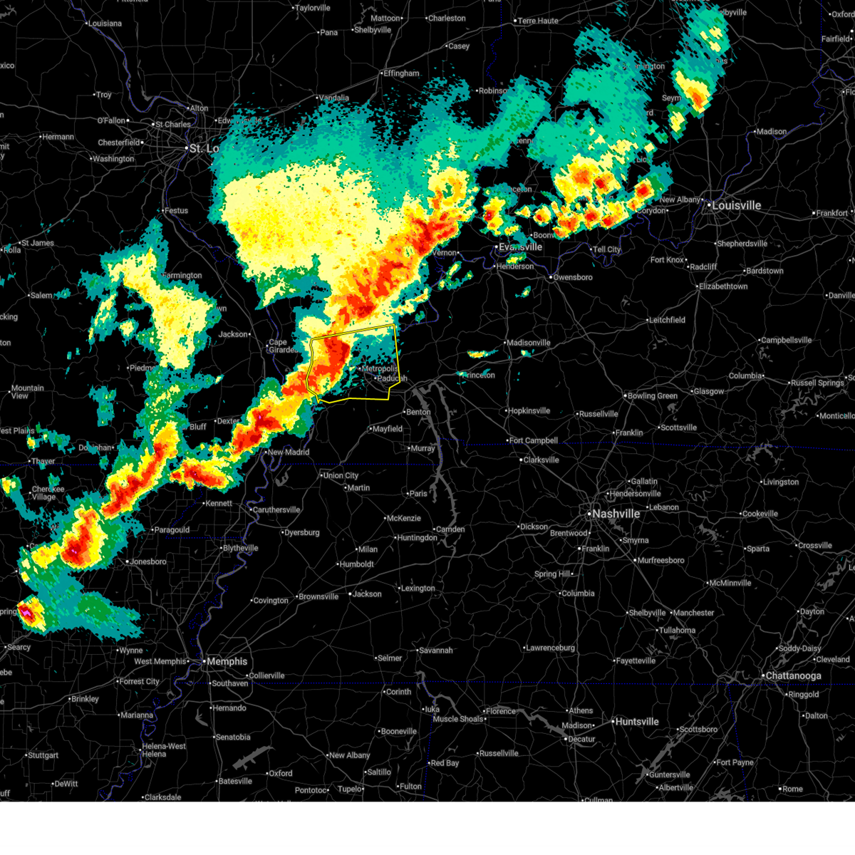 At 645 pm cdt, severe thunderstorms were located along a line extending from near new columbia to la center, moving east at 55 mph (radar indicated). Hazards include 70 mph wind gusts. Expect considerable tree damage. damage is likely to mobile homes, roofs, and outbuildings. locations impacted include, barkley regional airport, mound city, ledbetter, kevil, reidland, smithland, paducah, joppa, karnak, brookport, lovelaceville, olmsted, new columbia, golconda, la center, belknap, hamletsburg, dixon springs, blandville, and barlow. this includes the following highways, interstate 24 in kentucky between mile markers 1 and 17. Interstate 24 in illinois between mile markers 19 and 38. At 645 pm cdt, severe thunderstorms were located along a line extending from near new columbia to la center, moving east at 55 mph (radar indicated). Hazards include 70 mph wind gusts. Expect considerable tree damage. damage is likely to mobile homes, roofs, and outbuildings. locations impacted include, barkley regional airport, mound city, ledbetter, kevil, reidland, smithland, paducah, joppa, karnak, brookport, lovelaceville, olmsted, new columbia, golconda, la center, belknap, hamletsburg, dixon springs, blandville, and barlow. this includes the following highways, interstate 24 in kentucky between mile markers 1 and 17. Interstate 24 in illinois between mile markers 19 and 38.
|
| 3/30/2025 6:22 PM CDT |
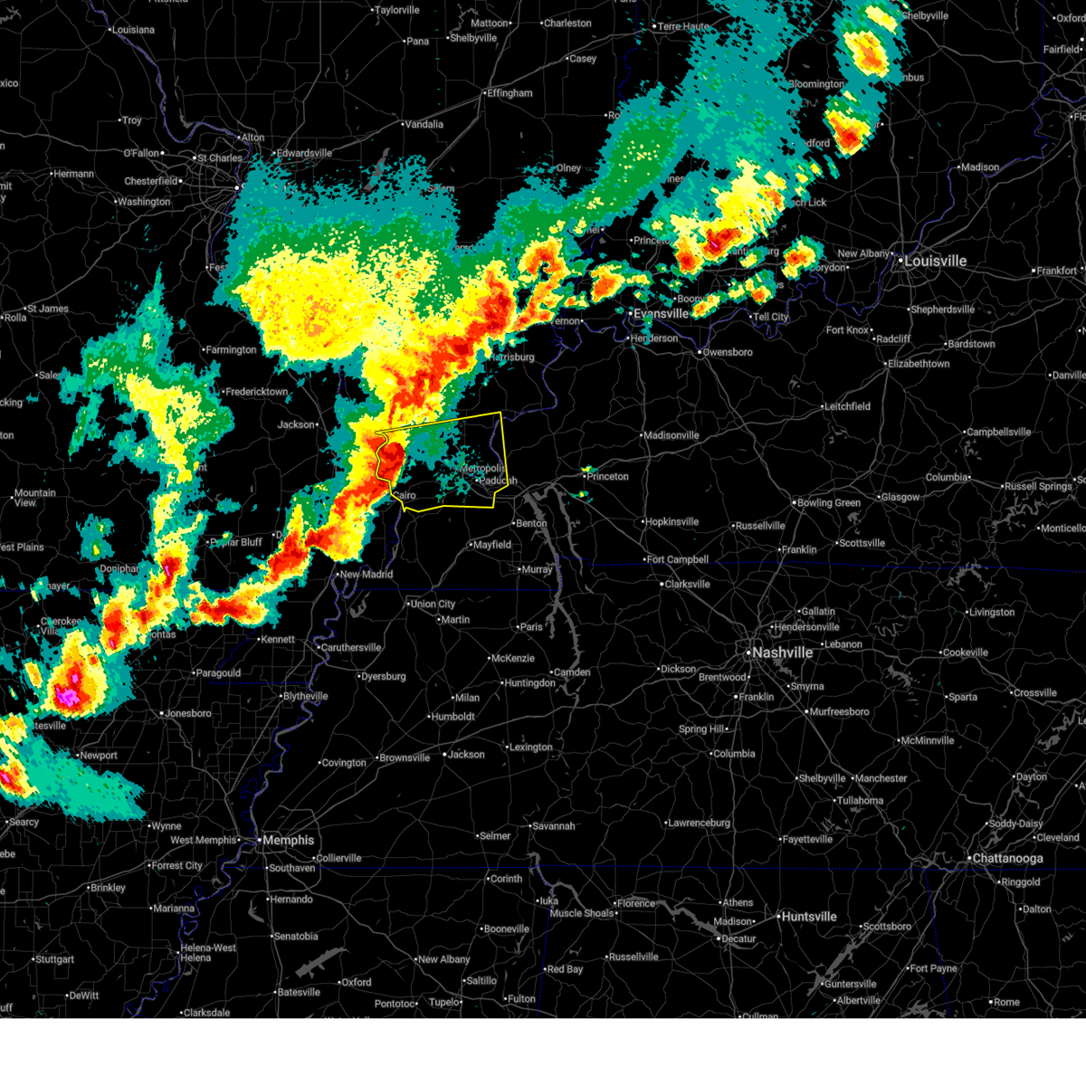 Svrpah the national weather service in paducah has issued a * severe thunderstorm warning for, southeastern union county in southern illinois, pulaski county in southern illinois, massac county in southern illinois, central pope county in southern illinois, southern johnson county in southern illinois, western livingston county in western kentucky, ballard county in western kentucky, mccracken county in western kentucky, * until 700 pm cdt. * at 622 pm cdt, severe thunderstorms were located along a line extending from near tamms to near cairo, moving east at 55 mph (radar indicated). Hazards include 70 mph wind gusts. Expect considerable tree damage. Damage is likely to mobile homes, roofs, and outbuildings. Svrpah the national weather service in paducah has issued a * severe thunderstorm warning for, southeastern union county in southern illinois, pulaski county in southern illinois, massac county in southern illinois, central pope county in southern illinois, southern johnson county in southern illinois, western livingston county in western kentucky, ballard county in western kentucky, mccracken county in western kentucky, * until 700 pm cdt. * at 622 pm cdt, severe thunderstorms were located along a line extending from near tamms to near cairo, moving east at 55 mph (radar indicated). Hazards include 70 mph wind gusts. Expect considerable tree damage. Damage is likely to mobile homes, roofs, and outbuildings.
|
| 3/15/2025 10:50 AM CDT |
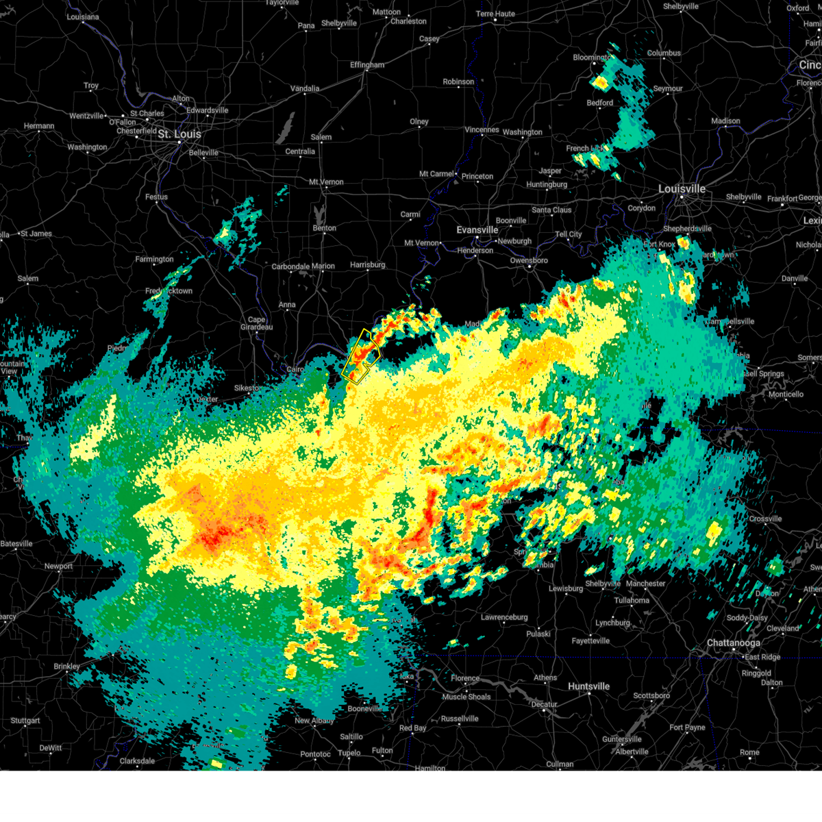 the severe thunderstorm warning has been cancelled and is no longer in effect the severe thunderstorm warning has been cancelled and is no longer in effect
|
| 3/15/2025 10:44 AM CDT |
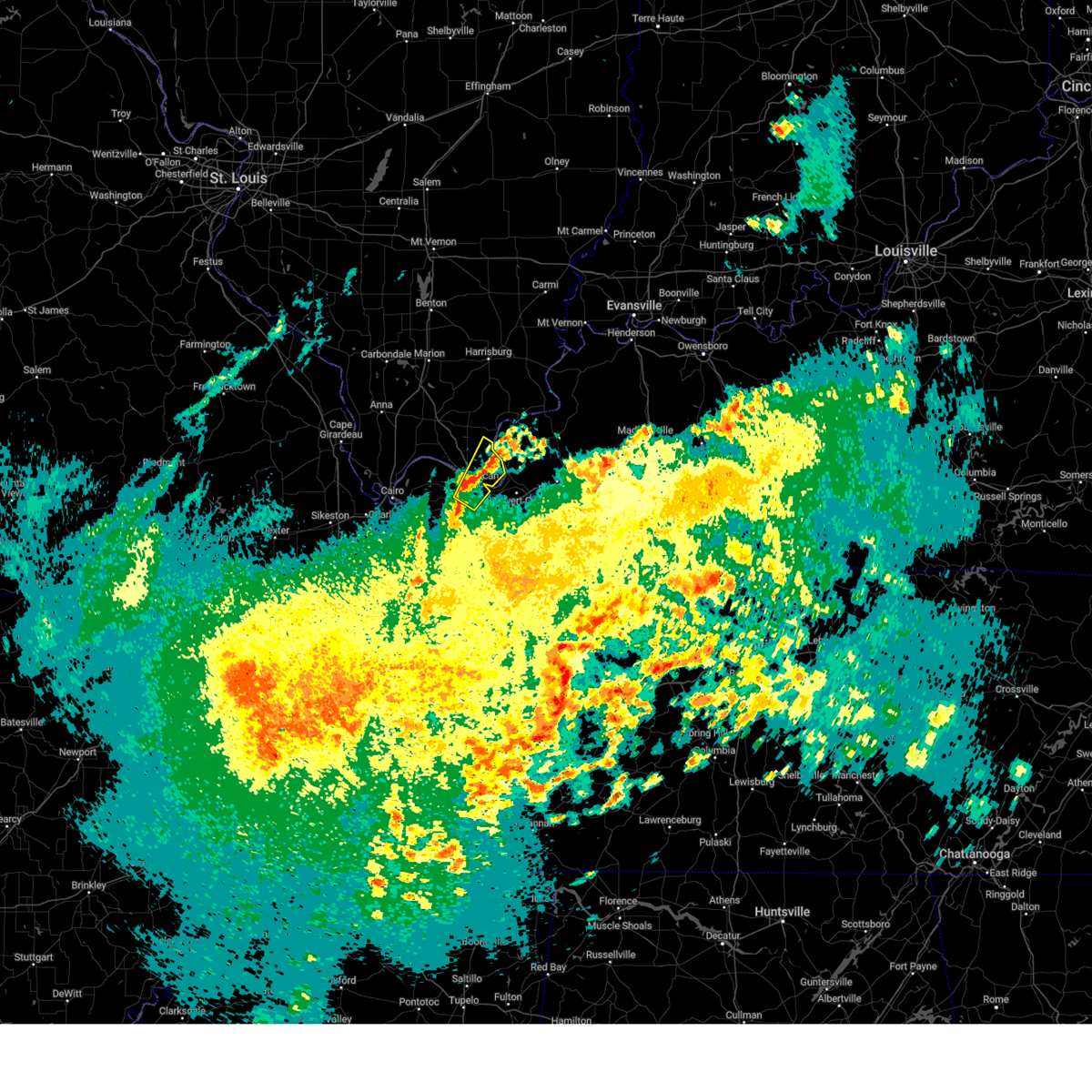 At 1044 am cdt, a severe thunderstorm was located over brookport, or near paducah, moving northeast at 45 mph (radar indicated). Hazards include 60 mph wind gusts and quarter size hail. Hail damage to vehicles is expected. expect wind damage to roofs, siding, and trees. locations impacted include, paducah, lone oak, brookport, hamletsburg, and reidland. this includes the following highways, interstate 24 in kentucky between mile markers 1 and 12. Interstate 24 in illinois near mile marker 38. At 1044 am cdt, a severe thunderstorm was located over brookport, or near paducah, moving northeast at 45 mph (radar indicated). Hazards include 60 mph wind gusts and quarter size hail. Hail damage to vehicles is expected. expect wind damage to roofs, siding, and trees. locations impacted include, paducah, lone oak, brookport, hamletsburg, and reidland. this includes the following highways, interstate 24 in kentucky between mile markers 1 and 12. Interstate 24 in illinois near mile marker 38.
|
| 3/15/2025 10:44 AM CDT |
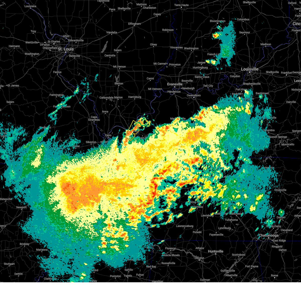 the severe thunderstorm warning has been cancelled and is no longer in effect the severe thunderstorm warning has been cancelled and is no longer in effect
|
| 3/15/2025 10:33 AM CDT |
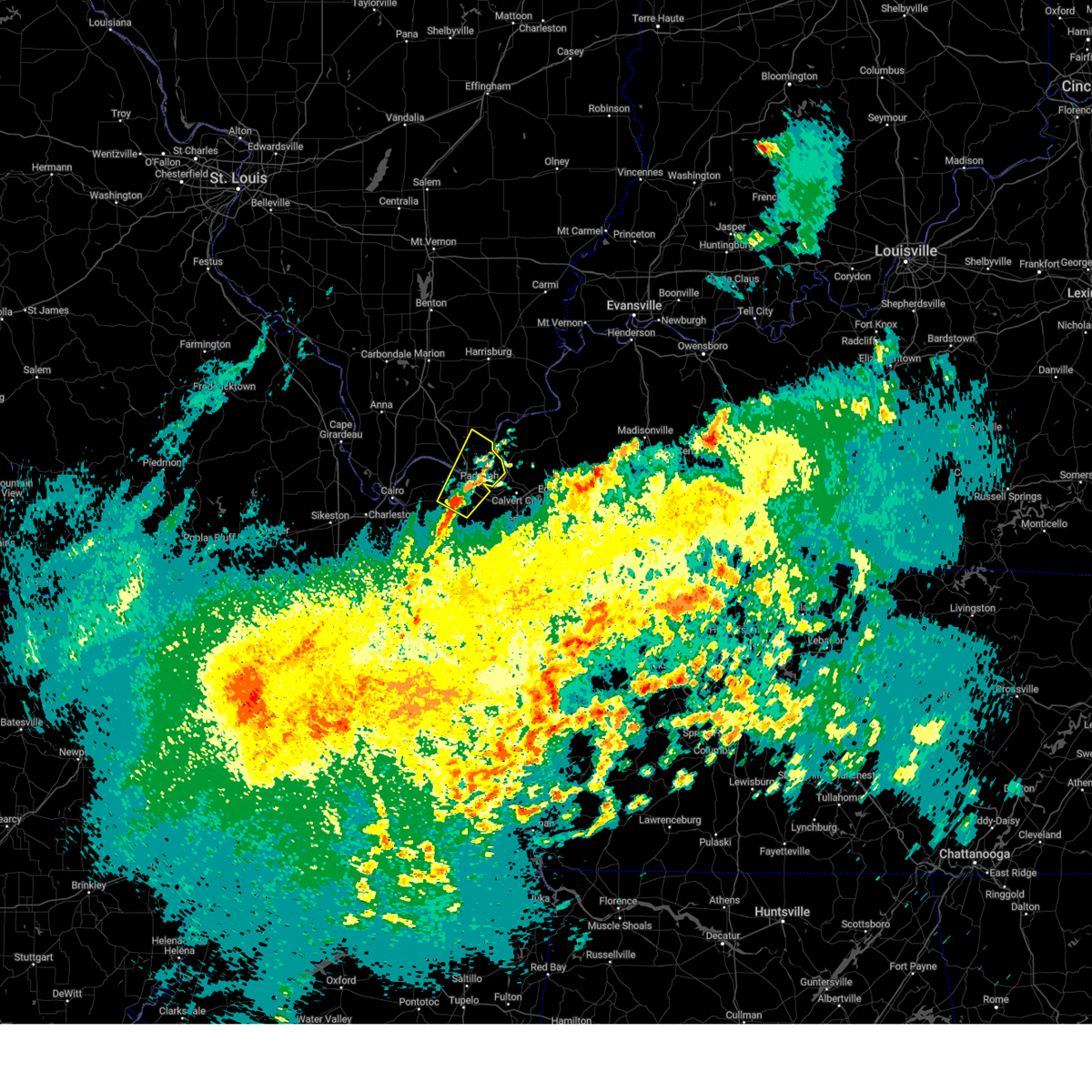 Svrpah the national weather service in paducah has issued a * severe thunderstorm warning for, eastern massac county in southern illinois, southern pope county in southern illinois, southeastern ballard county in western kentucky, mccracken county in western kentucky, north central graves county in western kentucky, * until 1115 am cdt. * at 1032 am cdt, a severe thunderstorm was located near barkley regional airport, or near lone oak, moving northeast at 45 mph (public). Hazards include 60 mph wind gusts and quarter size hail. Hail damage to vehicles is expected. Expect wind damage to roofs, siding, and trees. Svrpah the national weather service in paducah has issued a * severe thunderstorm warning for, eastern massac county in southern illinois, southern pope county in southern illinois, southeastern ballard county in western kentucky, mccracken county in western kentucky, north central graves county in western kentucky, * until 1115 am cdt. * at 1032 am cdt, a severe thunderstorm was located near barkley regional airport, or near lone oak, moving northeast at 45 mph (public). Hazards include 60 mph wind gusts and quarter size hail. Hail damage to vehicles is expected. Expect wind damage to roofs, siding, and trees.
|
| 3/15/2025 3:30 AM CDT |
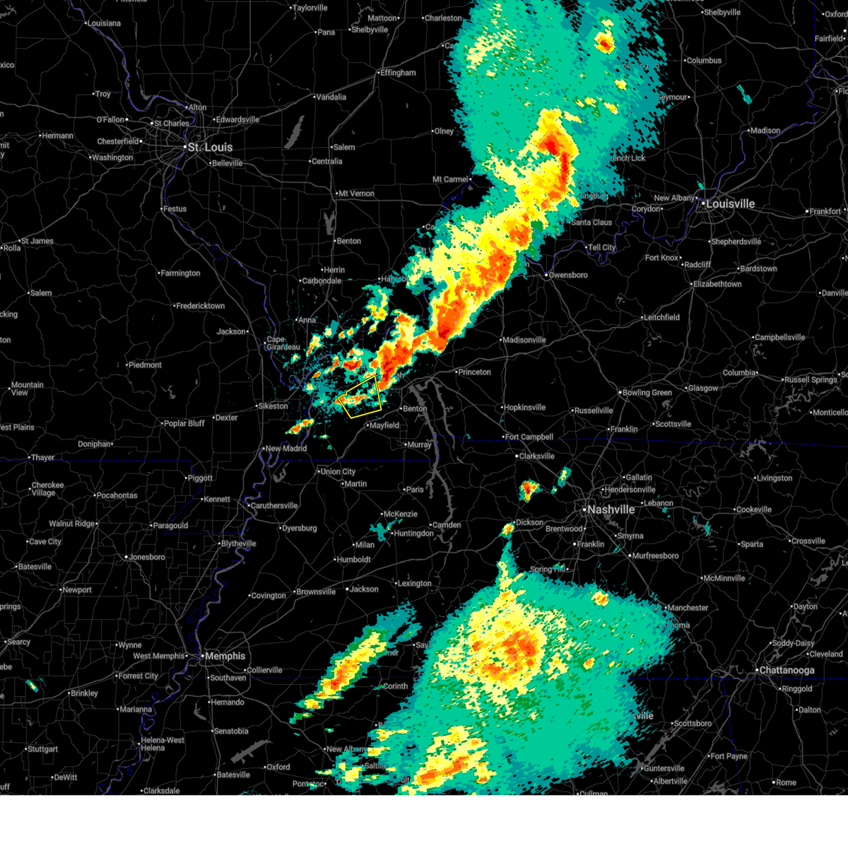 The storm which prompted the warning has moved out of the area. therefore, the warning has been allowed to expire. a tornado watch remains in effect until 400 am cdt for western kentucky. The storm which prompted the warning has moved out of the area. therefore, the warning has been allowed to expire. a tornado watch remains in effect until 400 am cdt for western kentucky.
|
| 3/15/2025 3:19 AM CDT | Quarter sized hail reported 1.5 miles N of Paducah, KY |
| 3/15/2025 3:15 AM CDT |
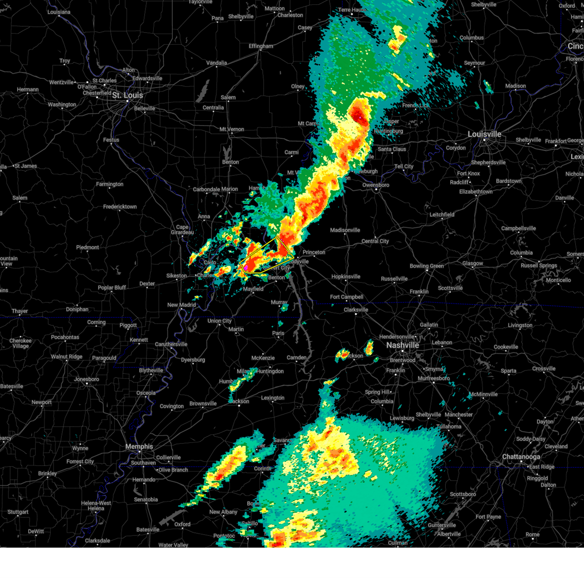 Svrpah the national weather service in paducah has issued a * severe thunderstorm warning for, southeastern massac county in southern illinois, southeastern pope county in southern illinois, southern livingston county in western kentucky, northwestern marshall county in western kentucky, southeastern mccracken county in western kentucky, northwestern lyon county in western kentucky, * until 400 am cdt. * at 315 am cdt, a severe thunderstorm was located over lone oak, moving northeast at 50 mph (radar indicated). Hazards include ping pong ball size hail and 60 mph wind gusts. People and animals outdoors will be injured. expect hail damage to roofs, siding, windows, and vehicles. Expect wind damage to roofs, siding, and trees. Svrpah the national weather service in paducah has issued a * severe thunderstorm warning for, southeastern massac county in southern illinois, southeastern pope county in southern illinois, southern livingston county in western kentucky, northwestern marshall county in western kentucky, southeastern mccracken county in western kentucky, northwestern lyon county in western kentucky, * until 400 am cdt. * at 315 am cdt, a severe thunderstorm was located over lone oak, moving northeast at 50 mph (radar indicated). Hazards include ping pong ball size hail and 60 mph wind gusts. People and animals outdoors will be injured. expect hail damage to roofs, siding, windows, and vehicles. Expect wind damage to roofs, siding, and trees.
|
| 3/15/2025 3:10 AM CDT |
 the severe thunderstorm warning has been cancelled and is no longer in effect the severe thunderstorm warning has been cancelled and is no longer in effect
|
| 3/15/2025 3:10 AM CDT |
 At 310 am cdt, a severe thunderstorm was located near lovelaceville, or 9 miles southwest of lone oak, moving northeast at 60 mph (radar indicated). Hazards include two inch hail and 70 mph wind gusts. People and animals outdoors will be injured. expect hail damage to roofs, siding, windows, and vehicles. expect considerable tree damage. wind damage is also likely to mobile homes, roofs, and outbuildings. locations impacted include, lowes, lone oak, fancy farm, and paducah. This includes interstate 24 in kentucky between mile markers 8 and 12. At 310 am cdt, a severe thunderstorm was located near lovelaceville, or 9 miles southwest of lone oak, moving northeast at 60 mph (radar indicated). Hazards include two inch hail and 70 mph wind gusts. People and animals outdoors will be injured. expect hail damage to roofs, siding, windows, and vehicles. expect considerable tree damage. wind damage is also likely to mobile homes, roofs, and outbuildings. locations impacted include, lowes, lone oak, fancy farm, and paducah. This includes interstate 24 in kentucky between mile markers 8 and 12.
|
| 3/15/2025 3:01 AM CDT |
 At 301 am cdt, a severe thunderstorm was located 8 miles east of bardwell, moving northeast at 55 mph (radar indicated). Hazards include golf ball size hail and 70 mph wind gusts. People and animals outdoors will be injured. expect hail damage to roofs, siding, windows, and vehicles. expect considerable tree damage. wind damage is also likely to mobile homes, roofs, and outbuildings. locations impacted include, lowes, lone oak, bardwell, fancy farm, and paducah. This includes interstate 24 in kentucky between mile markers 8 and 12. At 301 am cdt, a severe thunderstorm was located 8 miles east of bardwell, moving northeast at 55 mph (radar indicated). Hazards include golf ball size hail and 70 mph wind gusts. People and animals outdoors will be injured. expect hail damage to roofs, siding, windows, and vehicles. expect considerable tree damage. wind damage is also likely to mobile homes, roofs, and outbuildings. locations impacted include, lowes, lone oak, bardwell, fancy farm, and paducah. This includes interstate 24 in kentucky between mile markers 8 and 12.
|
| 3/15/2025 2:57 AM CDT |
 the tornado warning has been cancelled and is no longer in effect the tornado warning has been cancelled and is no longer in effect
|
| 3/15/2025 2:56 AM CDT |
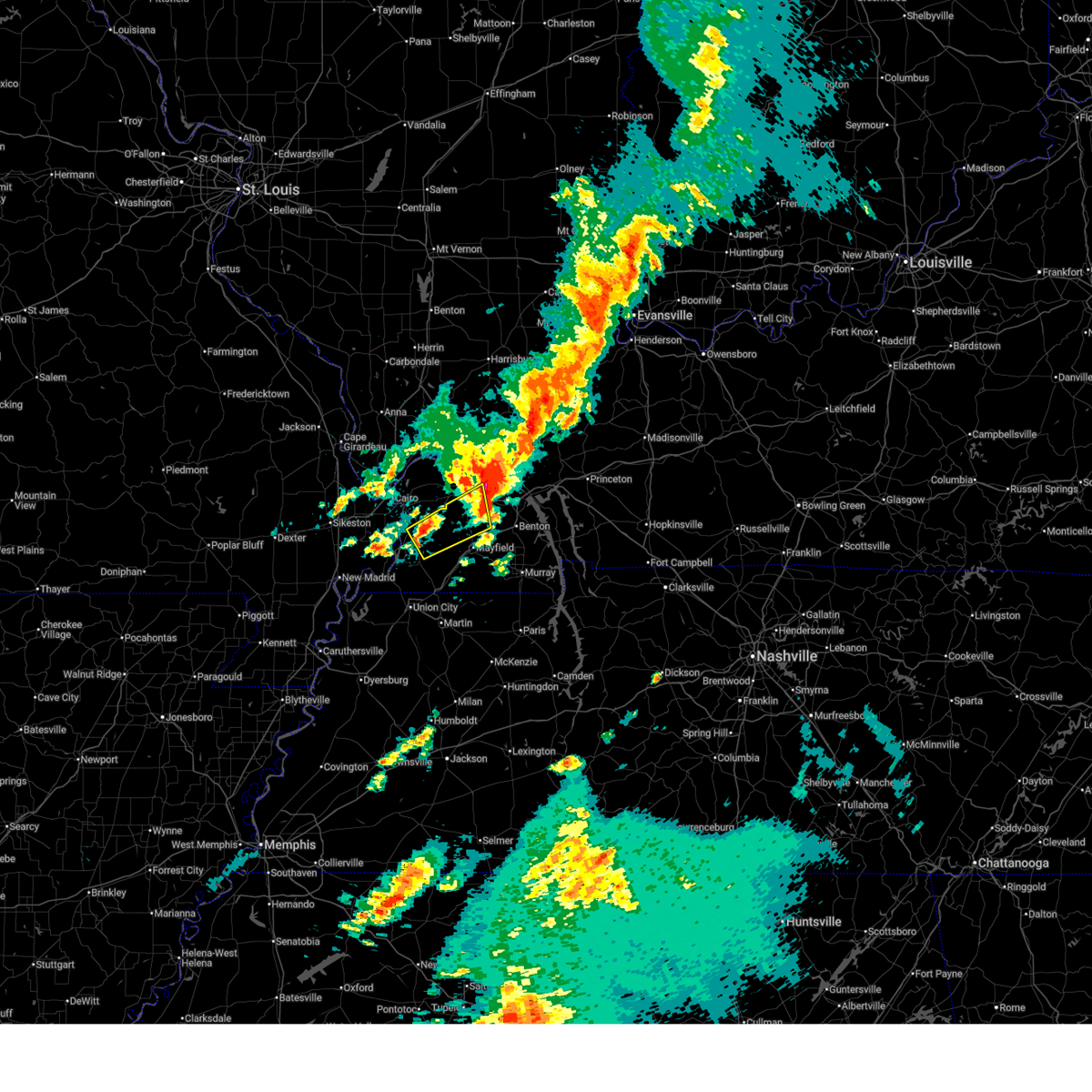 Svrpah the national weather service in paducah has issued a * severe thunderstorm warning for, carlisle county in western kentucky, northeastern hickman county in western kentucky, southeastern mccracken county in western kentucky, northern graves county in western kentucky, * until 330 am cdt. * at 255 am cdt, a severe thunderstorm was located near bardwell, moving northeast at 60 mph (radar indicated). Hazards include 60 mph wind gusts and half dollar size hail. Hail damage to vehicles is expected. Expect wind damage to roofs, siding, and trees. Svrpah the national weather service in paducah has issued a * severe thunderstorm warning for, carlisle county in western kentucky, northeastern hickman county in western kentucky, southeastern mccracken county in western kentucky, northern graves county in western kentucky, * until 330 am cdt. * at 255 am cdt, a severe thunderstorm was located near bardwell, moving northeast at 60 mph (radar indicated). Hazards include 60 mph wind gusts and half dollar size hail. Hail damage to vehicles is expected. Expect wind damage to roofs, siding, and trees.
|
| 3/15/2025 2:43 AM CDT |
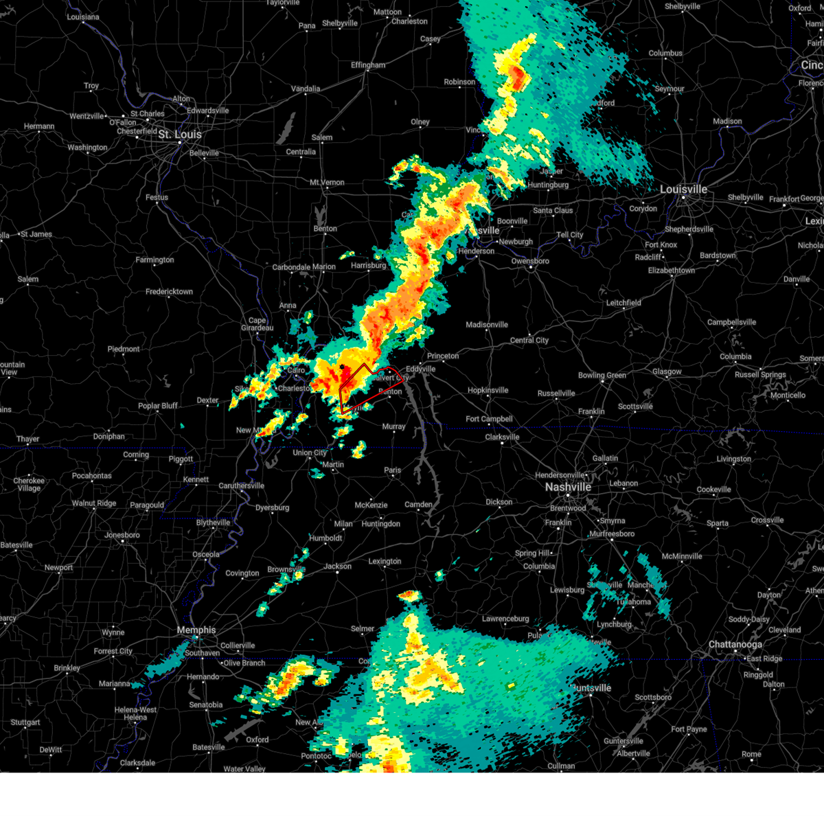 At 242 am cdt, a severe thunderstorm capable of producing a tornado was located 9 miles north of mayfield, moving northeast at 60 mph (radar indicated rotation). Hazards include tornado. Flying debris will be dangerous to those caught without shelter. mobile homes will be damaged or destroyed. damage to roofs, windows, and vehicles will occur. tree damage is likely. this dangerous storm will be near, paducah and reidland around 250 am cdt. calvert city around 255 am cdt. other locations impacted by this tornadic thunderstorm include lowes and symsonia. this includes the following highways, interstate 24 in kentucky between mile markers 8 and 29. Interstate 69 in kentucky between mile markers 47 and 51. At 242 am cdt, a severe thunderstorm capable of producing a tornado was located 9 miles north of mayfield, moving northeast at 60 mph (radar indicated rotation). Hazards include tornado. Flying debris will be dangerous to those caught without shelter. mobile homes will be damaged or destroyed. damage to roofs, windows, and vehicles will occur. tree damage is likely. this dangerous storm will be near, paducah and reidland around 250 am cdt. calvert city around 255 am cdt. other locations impacted by this tornadic thunderstorm include lowes and symsonia. this includes the following highways, interstate 24 in kentucky between mile markers 8 and 29. Interstate 69 in kentucky between mile markers 47 and 51.
|
| 3/15/2025 2:43 AM CDT |
 the tornado warning has been cancelled and is no longer in effect the tornado warning has been cancelled and is no longer in effect
|
| 3/15/2025 2:31 AM CDT |
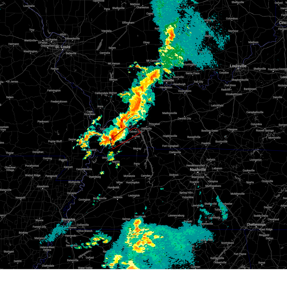 At 231 am cdt, a severe thunderstorm capable of producing a tornado was located 9 miles north of fulgham, or 10 miles west of mayfield, moving northeast at 60 mph (radar indicated rotation). Hazards include tornado. Flying debris will be dangerous to those caught without shelter. mobile homes will be damaged or destroyed. damage to roofs, windows, and vehicles will occur. tree damage is likely. this dangerous storm will be near, mayfield around 235 am cdt. reidland around 245 am cdt. calvert city around 255 am cdt. other locations impacted by this tornadic thunderstorm include lowes, fancy farm, and symsonia. this includes the following highways, interstate 24 in kentucky between mile markers 8 and 29. Interstate 69 in kentucky between mile markers 46 and 51. At 231 am cdt, a severe thunderstorm capable of producing a tornado was located 9 miles north of fulgham, or 10 miles west of mayfield, moving northeast at 60 mph (radar indicated rotation). Hazards include tornado. Flying debris will be dangerous to those caught without shelter. mobile homes will be damaged or destroyed. damage to roofs, windows, and vehicles will occur. tree damage is likely. this dangerous storm will be near, mayfield around 235 am cdt. reidland around 245 am cdt. calvert city around 255 am cdt. other locations impacted by this tornadic thunderstorm include lowes, fancy farm, and symsonia. this includes the following highways, interstate 24 in kentucky between mile markers 8 and 29. Interstate 69 in kentucky between mile markers 46 and 51.
|
| 3/15/2025 2:28 AM CDT | Tree down blocking the road on north friendship and guyline roa in mccracken county KY, 1.5 miles WSW of Paducah, KY |
| 3/15/2025 2:24 AM CDT |
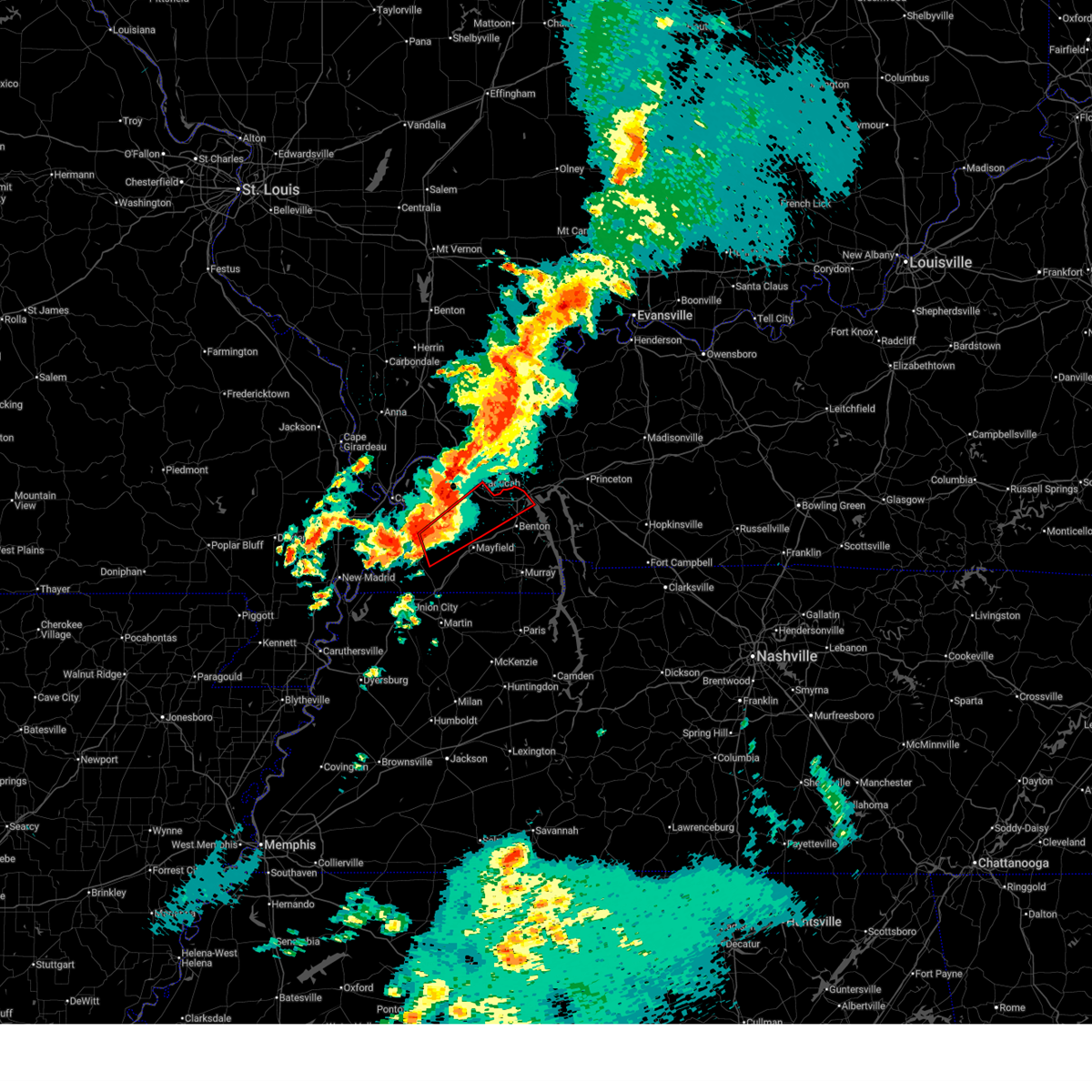 Torpah the national weather service in paducah has issued a * tornado warning for, northwestern marshall county in western kentucky, southeastern carlisle county in western kentucky, northeastern hickman county in western kentucky, southeastern mccracken county in western kentucky, northern graves county in western kentucky, * until 315 am cdt. * at 223 am cdt, a severe thunderstorm capable of producing a tornado was located near clinton, moving northeast at 60 mph (radar indicated rotation). Hazards include tornado. Flying debris will be dangerous to those caught without shelter. mobile homes will be damaged or destroyed. damage to roofs, windows, and vehicles will occur. tree damage is likely. this dangerous storm will be near, mayfield around 235 am cdt. reidland around 245 am cdt. paducah around 250 am cdt. calvert city around 255 am cdt. other locations impacted by this tornadic thunderstorm include lowes, fancy farm, and symsonia. this includes the following highways, interstate 24 in kentucky between mile markers 8 and 29. Interstate 69 in kentucky between mile markers 46 and 51. Torpah the national weather service in paducah has issued a * tornado warning for, northwestern marshall county in western kentucky, southeastern carlisle county in western kentucky, northeastern hickman county in western kentucky, southeastern mccracken county in western kentucky, northern graves county in western kentucky, * until 315 am cdt. * at 223 am cdt, a severe thunderstorm capable of producing a tornado was located near clinton, moving northeast at 60 mph (radar indicated rotation). Hazards include tornado. Flying debris will be dangerous to those caught without shelter. mobile homes will be damaged or destroyed. damage to roofs, windows, and vehicles will occur. tree damage is likely. this dangerous storm will be near, mayfield around 235 am cdt. reidland around 245 am cdt. paducah around 250 am cdt. calvert city around 255 am cdt. other locations impacted by this tornadic thunderstorm include lowes, fancy farm, and symsonia. this includes the following highways, interstate 24 in kentucky between mile markers 8 and 29. Interstate 69 in kentucky between mile markers 46 and 51.
|
| 3/15/2025 2:15 AM CDT |
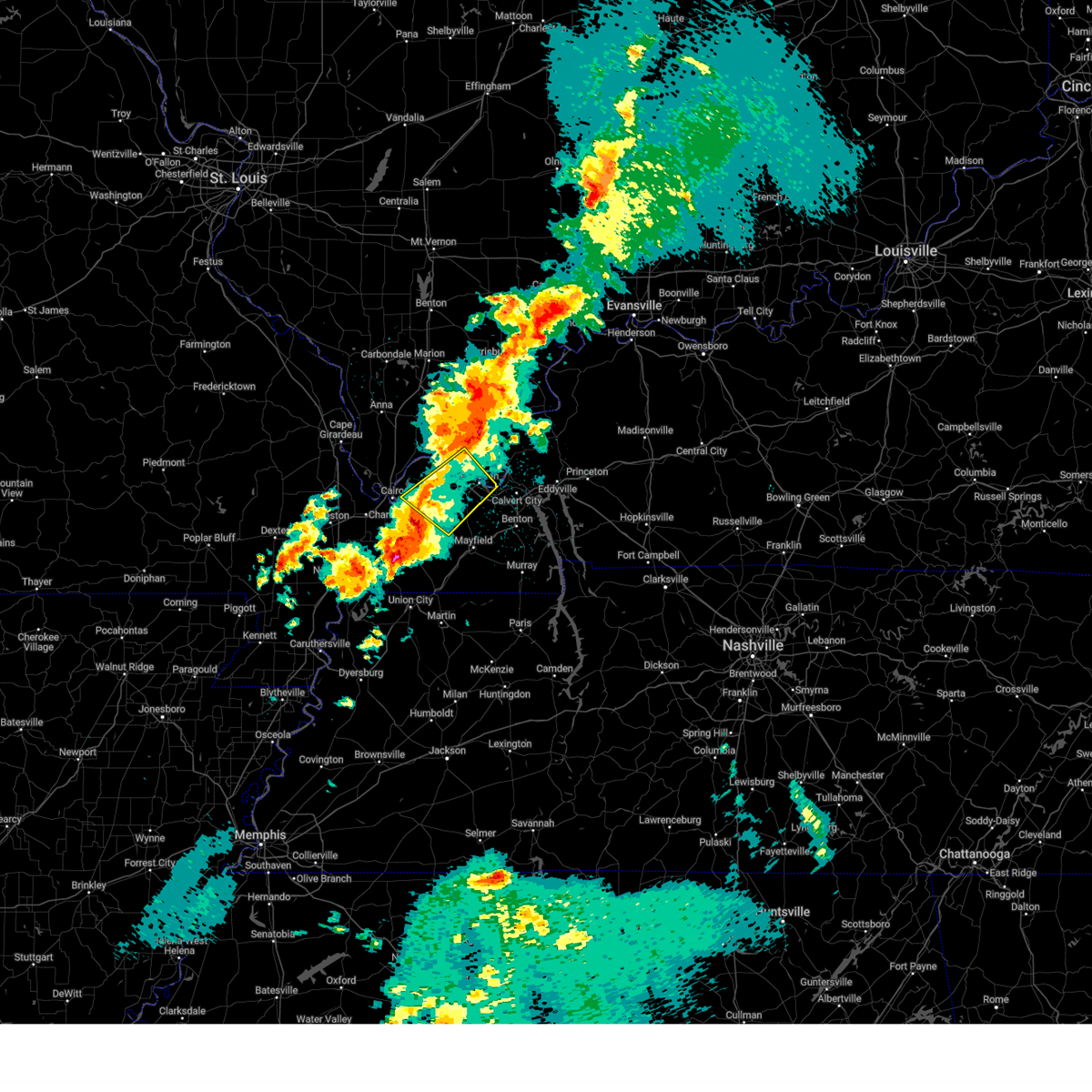 Svrpah the national weather service in paducah has issued a * severe thunderstorm warning for, central massac county in southern illinois, southwestern livingston county in western kentucky, northeastern carlisle county in western kentucky, southern ballard county in western kentucky, mccracken county in western kentucky, northwestern graves county in western kentucky, * until 300 am cdt. * at 215 am cdt, a severe thunderstorm was located near lovelaceville, or near bardwell, moving northeast at 70 mph (radar indicated). Hazards include 70 mph wind gusts. Expect considerable tree damage. Damage is likely to mobile homes, roofs, and outbuildings. Svrpah the national weather service in paducah has issued a * severe thunderstorm warning for, central massac county in southern illinois, southwestern livingston county in western kentucky, northeastern carlisle county in western kentucky, southern ballard county in western kentucky, mccracken county in western kentucky, northwestern graves county in western kentucky, * until 300 am cdt. * at 215 am cdt, a severe thunderstorm was located near lovelaceville, or near bardwell, moving northeast at 70 mph (radar indicated). Hazards include 70 mph wind gusts. Expect considerable tree damage. Damage is likely to mobile homes, roofs, and outbuildings.
|
| 8/15/2024 9:27 PM CDT |
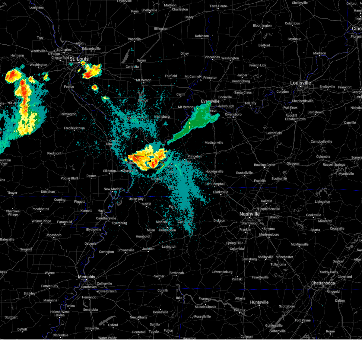 The storms which prompted the warning have weakened below severe limits, and no longer pose an immediate threat to life or property. therefore, the warning will be allowed to expire. however, gusty winds and heavy rain are still possible with these thunderstorms. a severe thunderstorm watch remains in effect until midnight cdt for southern illinois, and western kentucky. The storms which prompted the warning have weakened below severe limits, and no longer pose an immediate threat to life or property. therefore, the warning will be allowed to expire. however, gusty winds and heavy rain are still possible with these thunderstorms. a severe thunderstorm watch remains in effect until midnight cdt for southern illinois, and western kentucky.
|
| 8/15/2024 9:15 PM CDT | Power lines down on lightfoot road. tree blocking road on childress and blandvill in mccracken county KY, 5.2 miles E of Paducah, KY |
| 8/15/2024 9:10 PM CDT |
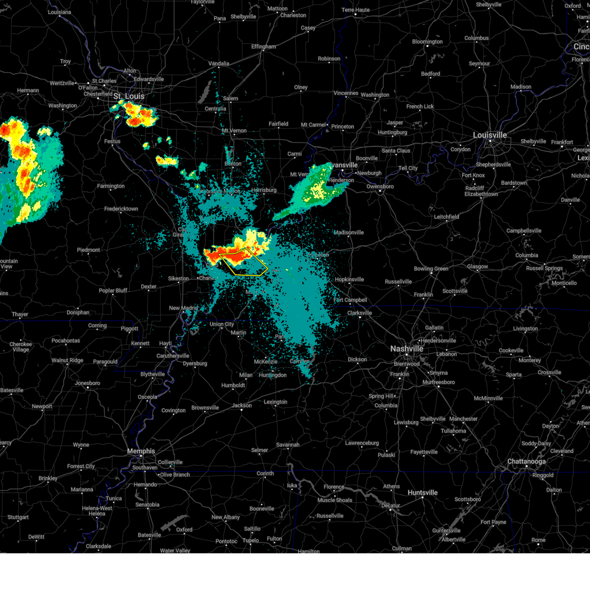 the severe thunderstorm warning has been cancelled and is no longer in effect the severe thunderstorm warning has been cancelled and is no longer in effect
|
| 8/15/2024 9:10 PM CDT |
 At 909 pm cdt, severe thunderstorms were located along a line extending from metropolis to near barkley regional airport to near la center, moving southeast at 20 mph (radar indicated). Hazards include 60 mph wind gusts. Expect damage to roofs, siding, and trees. locations impacted include, paducah, metropolis, la center, lone oak, reidland, barkley regional airport, west paducah, lovelaceville, and kevil. this includes the following highways, interstate 24 in kentucky between mile markers 1 and 15. Interstate 24 in illinois near mile marker 38. At 909 pm cdt, severe thunderstorms were located along a line extending from metropolis to near barkley regional airport to near la center, moving southeast at 20 mph (radar indicated). Hazards include 60 mph wind gusts. Expect damage to roofs, siding, and trees. locations impacted include, paducah, metropolis, la center, lone oak, reidland, barkley regional airport, west paducah, lovelaceville, and kevil. this includes the following highways, interstate 24 in kentucky between mile markers 1 and 15. Interstate 24 in illinois near mile marker 38.
|
| 8/15/2024 8:49 PM CDT |
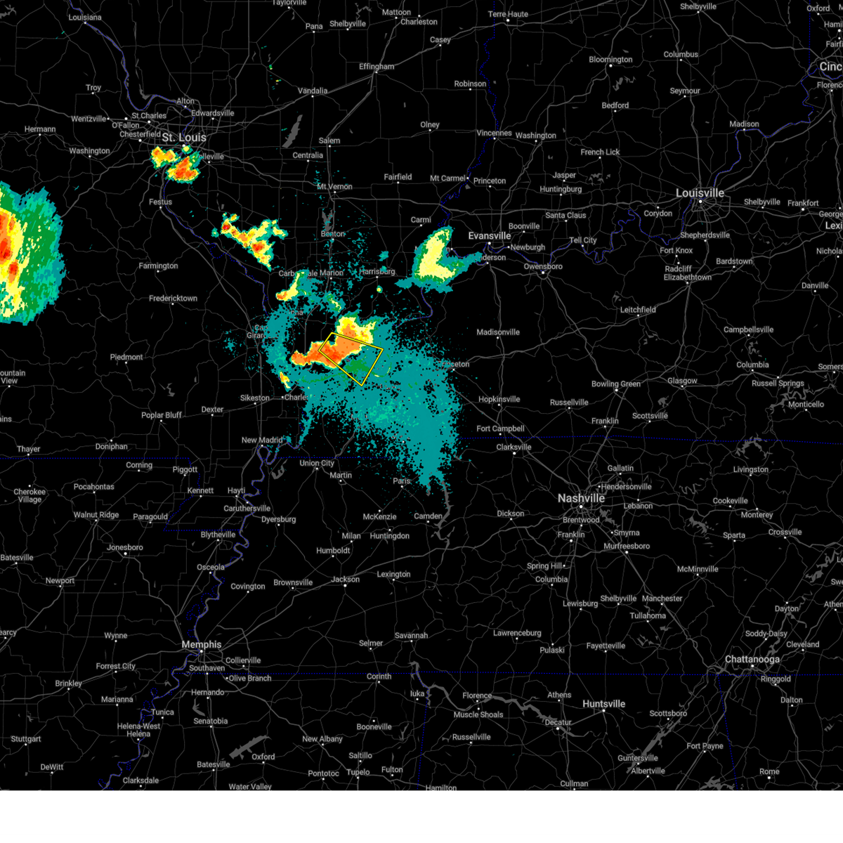 the severe thunderstorm warning has been cancelled and is no longer in effect the severe thunderstorm warning has been cancelled and is no longer in effect
|
| 8/15/2024 8:45 PM CDT |
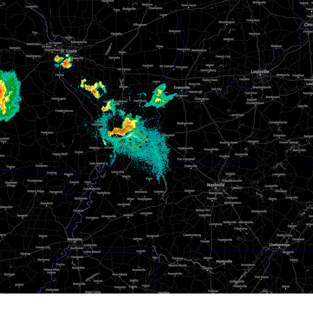 Svrpah the national weather service in paducah has issued a * severe thunderstorm warning for, central pulaski county in southern illinois, massac county in southern illinois, southern pope county in southern illinois, southwestern livingston county in western kentucky, central ballard county in western kentucky, mccracken county in western kentucky, * until 930 pm cdt. * at 844 pm cdt, severe thunderstorms were located along a line extending from near metropolis to 7 miles northwest of barkley regional airport to near la center, moving southeast at 20 mph (law enforcement). Hazards include 70 mph wind gusts and quarter size hail. Hail damage to vehicles is expected. expect considerable tree damage. Wind damage is also likely to mobile homes, roofs, and outbuildings. Svrpah the national weather service in paducah has issued a * severe thunderstorm warning for, central pulaski county in southern illinois, massac county in southern illinois, southern pope county in southern illinois, southwestern livingston county in western kentucky, central ballard county in western kentucky, mccracken county in western kentucky, * until 930 pm cdt. * at 844 pm cdt, severe thunderstorms were located along a line extending from near metropolis to 7 miles northwest of barkley regional airport to near la center, moving southeast at 20 mph (law enforcement). Hazards include 70 mph wind gusts and quarter size hail. Hail damage to vehicles is expected. expect considerable tree damage. Wind damage is also likely to mobile homes, roofs, and outbuildings.
|
| 8/15/2024 8:25 PM CDT |
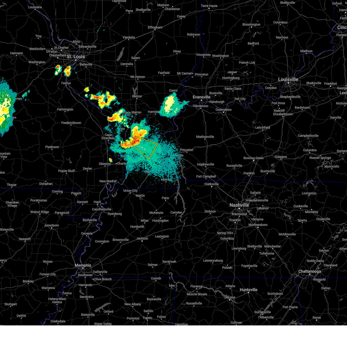 Svrpah the national weather service in paducah has issued a * severe thunderstorm warning for, northeastern pulaski county in southern illinois, massac county in southern illinois, west central pope county in southern illinois, south central johnson county in southern illinois, northeastern ballard county in western kentucky, central mccracken county in western kentucky, * until 900 pm cdt. * at 822 pm cdt, a severe thunderstorm was located near karnak, or 9 miles south of vienna, moving southeast at 30 mph (law enforcement. wind damage was reported in southern union and johnson counties). Hazards include 70 mph wind gusts and quarter size hail. Hail damage to vehicles is expected. expect considerable tree damage. Wind damage is also likely to mobile homes, roofs, and outbuildings. Svrpah the national weather service in paducah has issued a * severe thunderstorm warning for, northeastern pulaski county in southern illinois, massac county in southern illinois, west central pope county in southern illinois, south central johnson county in southern illinois, northeastern ballard county in western kentucky, central mccracken county in western kentucky, * until 900 pm cdt. * at 822 pm cdt, a severe thunderstorm was located near karnak, or 9 miles south of vienna, moving southeast at 30 mph (law enforcement. wind damage was reported in southern union and johnson counties). Hazards include 70 mph wind gusts and quarter size hail. Hail damage to vehicles is expected. expect considerable tree damage. Wind damage is also likely to mobile homes, roofs, and outbuildings.
|
| 7/30/2024 9:29 PM CDT |
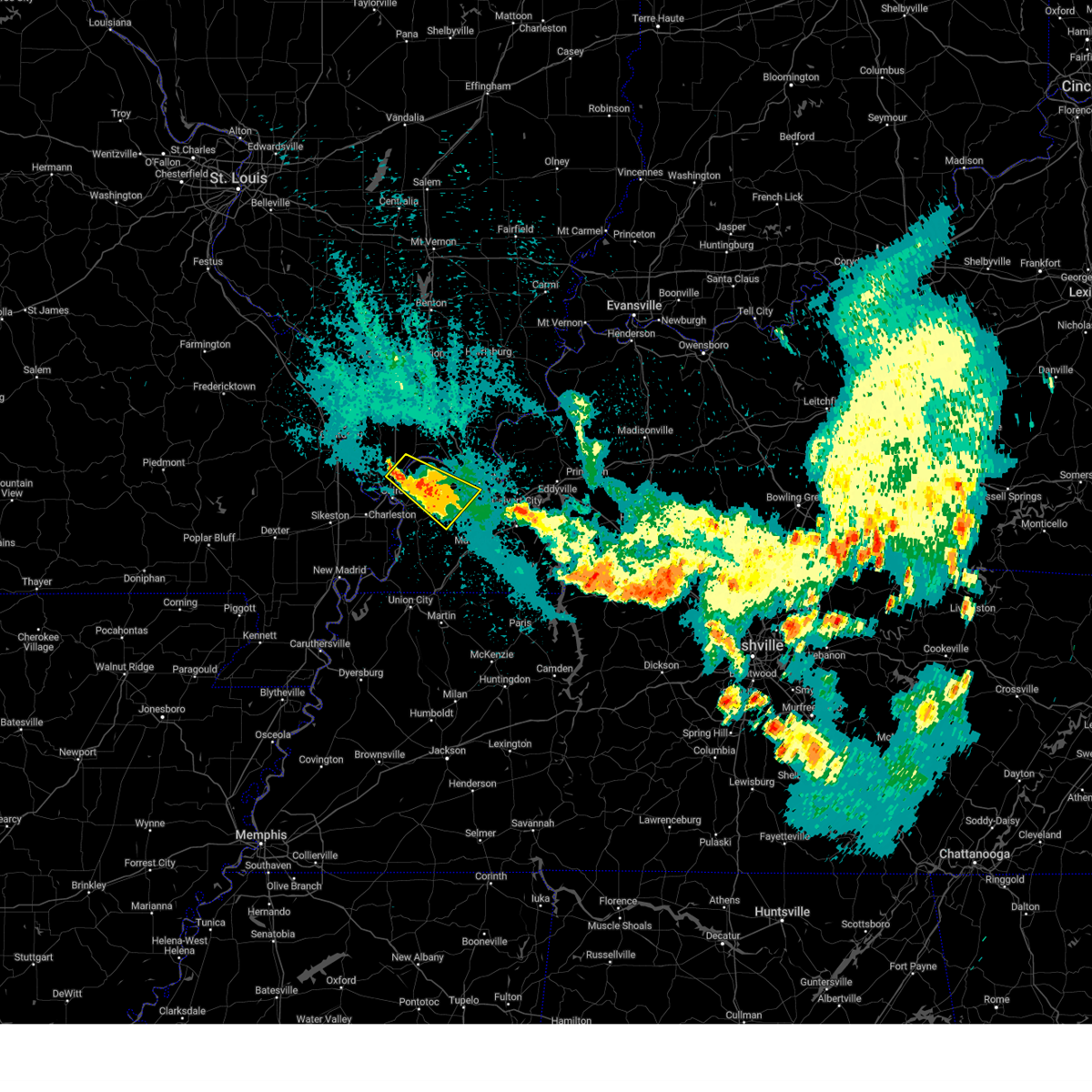 At 929 pm cdt, a severe thunderstorm was located near la center, moving southeast at 35 mph (radar indicated). Hazards include 60 mph wind gusts and quarter size hail. Hail damage to vehicles is expected. expect wind damage to roofs, siding, and trees. locations impacted include, paducah, la center, lone oak, mounds, barlow, mound city, barkley regional airport, west paducah, lovelaceville, kevil, olmsted, lowes, and blandville. this includes the following highways, interstate 24 in kentucky between mile markers 4 and 9. Interstate 57 in illinois between mile markers 6 and 10. At 929 pm cdt, a severe thunderstorm was located near la center, moving southeast at 35 mph (radar indicated). Hazards include 60 mph wind gusts and quarter size hail. Hail damage to vehicles is expected. expect wind damage to roofs, siding, and trees. locations impacted include, paducah, la center, lone oak, mounds, barlow, mound city, barkley regional airport, west paducah, lovelaceville, kevil, olmsted, lowes, and blandville. this includes the following highways, interstate 24 in kentucky between mile markers 4 and 9. Interstate 57 in illinois between mile markers 6 and 10.
|
| 7/30/2024 9:12 PM CDT |
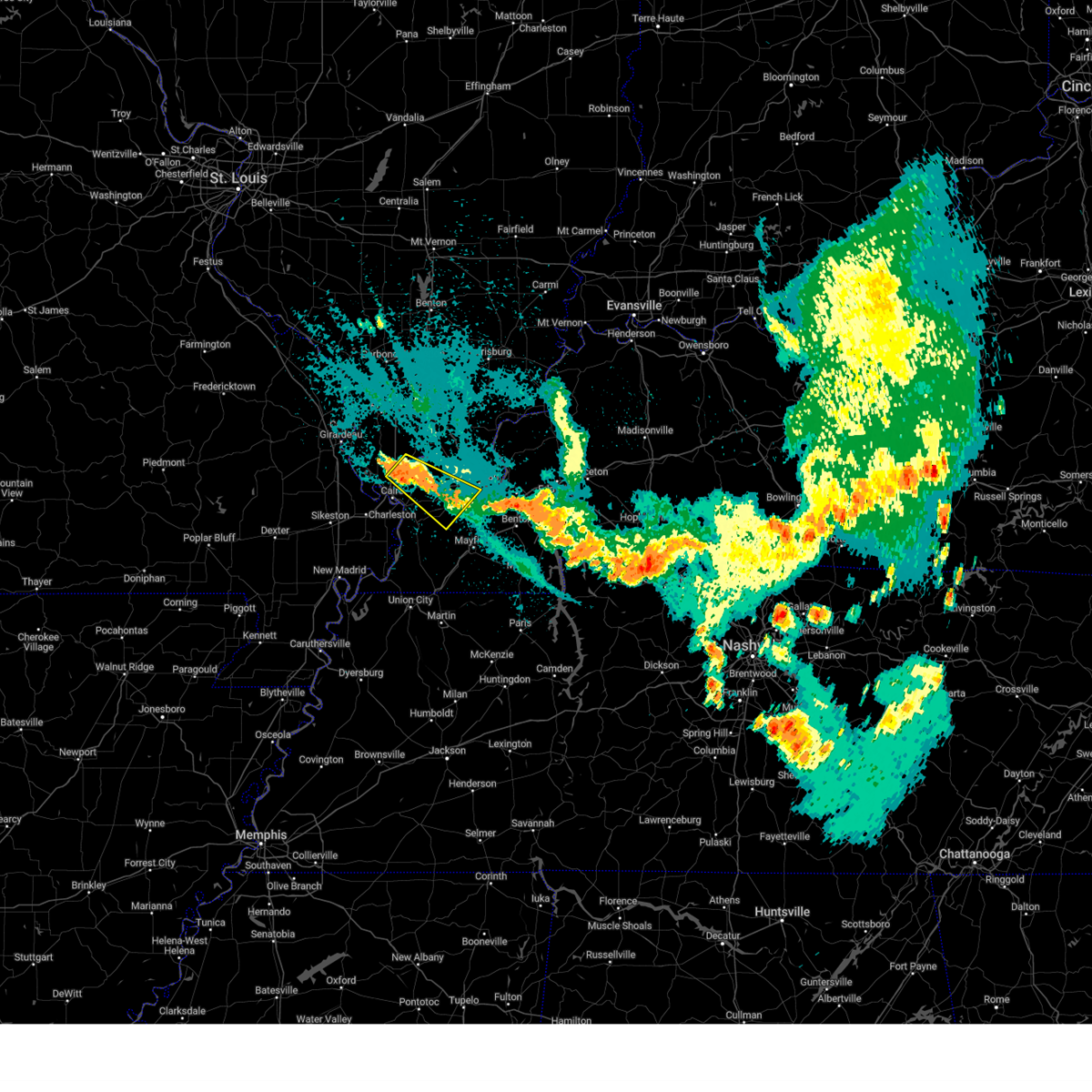 Svrpah the national weather service in paducah has issued a * severe thunderstorm warning for, southwestern pulaski county in southern illinois, northeastern carlisle county in western kentucky, ballard county in western kentucky, southwestern mccracken county in western kentucky, northwestern graves county in western kentucky, * until 1000 pm cdt. * at 912 pm cdt, a severe thunderstorm was located near mound city, or near la center, moving southeast at 35 mph (radar indicated). Hazards include 60 mph wind gusts and quarter size hail. Hail damage to vehicles is expected. Expect wind damage to roofs, siding, and trees. Svrpah the national weather service in paducah has issued a * severe thunderstorm warning for, southwestern pulaski county in southern illinois, northeastern carlisle county in western kentucky, ballard county in western kentucky, southwestern mccracken county in western kentucky, northwestern graves county in western kentucky, * until 1000 pm cdt. * at 912 pm cdt, a severe thunderstorm was located near mound city, or near la center, moving southeast at 35 mph (radar indicated). Hazards include 60 mph wind gusts and quarter size hail. Hail damage to vehicles is expected. Expect wind damage to roofs, siding, and trees.
|
| 5/26/2024 9:34 PM CDT |
 At 933 pm cdt, severe thunderstorms were located along a line extending from 6 miles northeast of calvert city to 7 miles northwest of mayfield to near dorena, moving east at 125 mph (radar indicated). Hazards include 60 mph wind gusts and quarter size hail. Hail damage to vehicles is expected. expect wind damage to roofs, siding, and trees. locations impacted include, paducah, bardwell, lone oak, towosahgy state historic site, reidland, arlington, columbus, and lowes. this includes the following highways, interstate 24 in kentucky between mile markers 7 and 17. Interstate 55 near mile marker 54. At 933 pm cdt, severe thunderstorms were located along a line extending from 6 miles northeast of calvert city to 7 miles northwest of mayfield to near dorena, moving east at 125 mph (radar indicated). Hazards include 60 mph wind gusts and quarter size hail. Hail damage to vehicles is expected. expect wind damage to roofs, siding, and trees. locations impacted include, paducah, bardwell, lone oak, towosahgy state historic site, reidland, arlington, columbus, and lowes. this includes the following highways, interstate 24 in kentucky between mile markers 7 and 17. Interstate 55 near mile marker 54.
|
| 5/26/2024 9:34 PM CDT |
 the severe thunderstorm warning has been cancelled and is no longer in effect the severe thunderstorm warning has been cancelled and is no longer in effect
|
| 5/26/2024 8:41 PM CDT |
 Svrpah the national weather service in paducah has issued a * severe thunderstorm warning for, central pulaski county in southern illinois, southern massac county in southern illinois, southeastern alexander county in southern illinois, carlisle county in western kentucky, northwestern hickman county in western kentucky, ballard county in western kentucky, mccracken county in western kentucky, northwestern graves county in western kentucky, mississippi county in southeastern missouri, northeastern new madrid county in southeastern missouri, * until 945 pm cdt. * at 841 pm cdt, severe thunderstorms were located along a line extending from near karnak to near charleston to near bernie, moving southeast at 40 mph (radar indicated). Hazards include 60 mph wind gusts and quarter size hail. Hail damage to vehicles is expected. Expect wind damage to roofs, siding, and trees. Svrpah the national weather service in paducah has issued a * severe thunderstorm warning for, central pulaski county in southern illinois, southern massac county in southern illinois, southeastern alexander county in southern illinois, carlisle county in western kentucky, northwestern hickman county in western kentucky, ballard county in western kentucky, mccracken county in western kentucky, northwestern graves county in western kentucky, mississippi county in southeastern missouri, northeastern new madrid county in southeastern missouri, * until 945 pm cdt. * at 841 pm cdt, severe thunderstorms were located along a line extending from near karnak to near charleston to near bernie, moving southeast at 40 mph (radar indicated). Hazards include 60 mph wind gusts and quarter size hail. Hail damage to vehicles is expected. Expect wind damage to roofs, siding, and trees.
|
| 5/26/2024 7:06 PM CDT |
 Svrpah the national weather service in paducah has issued a * severe thunderstorm warning for, south central crittenden county in western kentucky, southern livingston county in western kentucky, northwestern marshall county in western kentucky, southeastern mccracken county in western kentucky, northwestern lyon county in western kentucky, * until 745 pm cdt. * at 706 pm cdt, a severe thunderstorm was located over ledbetter, or near reidland, moving east at 30 mph (radar indicated). Hazards include 70 mph wind gusts and half dollar size hail. Hail damage to vehicles is expected. expect considerable tree damage. Wind damage is also likely to mobile homes, roofs, and outbuildings. Svrpah the national weather service in paducah has issued a * severe thunderstorm warning for, south central crittenden county in western kentucky, southern livingston county in western kentucky, northwestern marshall county in western kentucky, southeastern mccracken county in western kentucky, northwestern lyon county in western kentucky, * until 745 pm cdt. * at 706 pm cdt, a severe thunderstorm was located over ledbetter, or near reidland, moving east at 30 mph (radar indicated). Hazards include 70 mph wind gusts and half dollar size hail. Hail damage to vehicles is expected. expect considerable tree damage. Wind damage is also likely to mobile homes, roofs, and outbuildings.
|
| 5/26/2024 8:20 AM CDT |
 Svrpah the national weather service in paducah has issued a * severe thunderstorm warning for, eastern massac county in southern illinois, southern pope county in southern illinois, calloway county in western kentucky, crittenden county in western kentucky, livingston county in western kentucky, caldwell county in western kentucky, marshall county in western kentucky, trigg county in western kentucky, southeastern mccracken county in western kentucky, graves county in western kentucky, lyon county in western kentucky, * until 900 am cdt. * at 819 am cdt, severe thunderstorms were located along a line extending from 8 miles southwest of golconda to near reidland to near latham, moving east at 70 mph (radar indicated). Hazards include 70 mph wind gusts. Expect considerable tree damage. Damage is likely to mobile homes, roofs, and outbuildings. Svrpah the national weather service in paducah has issued a * severe thunderstorm warning for, eastern massac county in southern illinois, southern pope county in southern illinois, calloway county in western kentucky, crittenden county in western kentucky, livingston county in western kentucky, caldwell county in western kentucky, marshall county in western kentucky, trigg county in western kentucky, southeastern mccracken county in western kentucky, graves county in western kentucky, lyon county in western kentucky, * until 900 am cdt. * at 819 am cdt, severe thunderstorms were located along a line extending from 8 miles southwest of golconda to near reidland to near latham, moving east at 70 mph (radar indicated). Hazards include 70 mph wind gusts. Expect considerable tree damage. Damage is likely to mobile homes, roofs, and outbuildings.
|
| 5/26/2024 8:15 AM CDT | Trees blown down and blocking the road at clarkline and old mayfield road in mccracken county KY, 1.5 miles WSW of Paducah, KY |
| 5/26/2024 8:02 AM CDT |
 At 802 am cdt, severe thunderstorms were located along a line extending from 6 miles east of anna to 6 miles northeast of la center to 6 miles south of bardwell to near hickman, moving northeast at 75 mph (radar indicated). Hazards include 70 mph wind gusts and penny size hail. Expect considerable tree damage. damage is likely to mobile homes, roofs, and outbuildings. locations impacted include, paducah, mayfield, metropolis, anna, fulton, hickman, jonesboro, vienna, clinton, la center, bardwell, wickliffe, lone oak, reidland, cobden, goreville, brookport, mounds, dongola, and barlow. this includes the following highways, interstate 24 in kentucky between mile markers 1 and 16. interstate 24 in illinois between mile markers 1 and 38. interstate 57 in illinois between mile markers 5 and 43. Interstate 69 in kentucky between mile markers 1 and 28. At 802 am cdt, severe thunderstorms were located along a line extending from 6 miles east of anna to 6 miles northeast of la center to 6 miles south of bardwell to near hickman, moving northeast at 75 mph (radar indicated). Hazards include 70 mph wind gusts and penny size hail. Expect considerable tree damage. damage is likely to mobile homes, roofs, and outbuildings. locations impacted include, paducah, mayfield, metropolis, anna, fulton, hickman, jonesboro, vienna, clinton, la center, bardwell, wickliffe, lone oak, reidland, cobden, goreville, brookport, mounds, dongola, and barlow. this includes the following highways, interstate 24 in kentucky between mile markers 1 and 16. interstate 24 in illinois between mile markers 1 and 38. interstate 57 in illinois between mile markers 5 and 43. Interstate 69 in kentucky between mile markers 1 and 28.
|
| 5/26/2024 8:02 AM CDT |
 the severe thunderstorm warning has been cancelled and is no longer in effect the severe thunderstorm warning has been cancelled and is no longer in effect
|
| 5/26/2024 7:42 AM CDT |
 Svrpah the national weather service in paducah has issued a * severe thunderstorm warning for, union county in southern illinois, pulaski county in southern illinois, southern pope county in southern illinois, johnson county in southern illinois, alexander county in southern illinois, massac county in southern illinois, south central williamson county in southern illinois, ballard county in western kentucky, mccracken county in western kentucky, fulton county in western kentucky, southwestern livingston county in western kentucky, carlisle county in western kentucky, hickman county in western kentucky, graves county in western kentucky, mississippi county in southeastern missouri, southeastern new madrid county in southeastern missouri, east central cape girardeau county in southeastern missouri, * until 830 am cdt. * at 741 am cdt, severe thunderstorms were located along a line extending from near cape girardeau to near cairo to near big oak tree state park to near tiptonville, moving northeast at 75 mph (radar indicated). Hazards include 70 mph wind gusts and penny size hail. Expect considerable tree damage. Damage is likely to mobile homes, roofs, and outbuildings. Svrpah the national weather service in paducah has issued a * severe thunderstorm warning for, union county in southern illinois, pulaski county in southern illinois, southern pope county in southern illinois, johnson county in southern illinois, alexander county in southern illinois, massac county in southern illinois, south central williamson county in southern illinois, ballard county in western kentucky, mccracken county in western kentucky, fulton county in western kentucky, southwestern livingston county in western kentucky, carlisle county in western kentucky, hickman county in western kentucky, graves county in western kentucky, mississippi county in southeastern missouri, southeastern new madrid county in southeastern missouri, east central cape girardeau county in southeastern missouri, * until 830 am cdt. * at 741 am cdt, severe thunderstorms were located along a line extending from near cape girardeau to near cairo to near big oak tree state park to near tiptonville, moving northeast at 75 mph (radar indicated). Hazards include 70 mph wind gusts and penny size hail. Expect considerable tree damage. Damage is likely to mobile homes, roofs, and outbuildings.
|
| 5/8/2024 7:49 PM CDT |
 the severe thunderstorm warning has been cancelled and is no longer in effect the severe thunderstorm warning has been cancelled and is no longer in effect
|
| 5/8/2024 7:40 PM CDT |
 At 740 pm cdt, a severe thunderstorm was located near ledbetter, or near paducah, moving northeast at 30 mph (trained weather spotters). Hazards include 60 mph wind gusts and quarter size hail. Hail damage to vehicles is expected. expect wind damage to roofs, siding, and trees. Locations impacted include, paducah, reidland, brookport, and ledbetter. At 740 pm cdt, a severe thunderstorm was located near ledbetter, or near paducah, moving northeast at 30 mph (trained weather spotters). Hazards include 60 mph wind gusts and quarter size hail. Hail damage to vehicles is expected. expect wind damage to roofs, siding, and trees. Locations impacted include, paducah, reidland, brookport, and ledbetter.
|
| 5/8/2024 7:40 PM CDT |
 the severe thunderstorm warning has been cancelled and is no longer in effect the severe thunderstorm warning has been cancelled and is no longer in effect
|
| 5/8/2024 7:29 PM CDT | Half Dollar sized hail reported 1.3 miles E of Paducah, KY, reported at friendship road and new holt road. |
| 5/8/2024 7:23 PM CDT |
 Svrpah the national weather service in paducah has issued a * severe thunderstorm warning for, southeastern massac county in southern illinois, southeastern pope county in southern illinois, southwestern livingston county in western kentucky, northwestern marshall county in western kentucky, southeastern mccracken county in western kentucky, * until 800 pm cdt. * at 723 pm cdt, a severe thunderstorm was located over lone oak, moving northeast at 25 mph (radar indicated). Hazards include 60 mph wind gusts and quarter size hail. Hail damage to vehicles is expected. Expect wind damage to roofs, siding, and trees. Svrpah the national weather service in paducah has issued a * severe thunderstorm warning for, southeastern massac county in southern illinois, southeastern pope county in southern illinois, southwestern livingston county in western kentucky, northwestern marshall county in western kentucky, southeastern mccracken county in western kentucky, * until 800 pm cdt. * at 723 pm cdt, a severe thunderstorm was located over lone oak, moving northeast at 25 mph (radar indicated). Hazards include 60 mph wind gusts and quarter size hail. Hail damage to vehicles is expected. Expect wind damage to roofs, siding, and trees.
|
| 5/8/2024 7:20 PM CDT | Quarter sized hail reported 3.3 miles ENE of Paducah, KY |
| 5/8/2024 3:22 PM CDT |
 The storm which prompted the warning has weakened below severe limits, and no longer poses an immediate threat to life or property. therefore, the warning will be allowed to expire. a tornado watch remains in effect until 500 pm cdt for southern illinois, and western kentucky. The storm which prompted the warning has weakened below severe limits, and no longer poses an immediate threat to life or property. therefore, the warning will be allowed to expire. a tornado watch remains in effect until 500 pm cdt for southern illinois, and western kentucky.
|
| 5/8/2024 2:55 PM CDT |
 the severe thunderstorm warning has been cancelled and is no longer in effect the severe thunderstorm warning has been cancelled and is no longer in effect
|
| 5/8/2024 2:55 PM CDT |
 At 255 pm cdt, a severe thunderstorm was located over reidland, moving northeast at 35 mph (radar indicated). Hazards include 60 mph wind gusts and quarter size hail. Hail damage to vehicles is expected. expect wind damage to roofs, siding, and trees. locations impacted include, paducah, calvert city, reidland, burna, ledbetter, smithland, and hamletsburg. This includes interstate 24 in kentucky between mile markers 5 and 23, and between mile markers 26 and 28. At 255 pm cdt, a severe thunderstorm was located over reidland, moving northeast at 35 mph (radar indicated). Hazards include 60 mph wind gusts and quarter size hail. Hail damage to vehicles is expected. expect wind damage to roofs, siding, and trees. locations impacted include, paducah, calvert city, reidland, burna, ledbetter, smithland, and hamletsburg. This includes interstate 24 in kentucky between mile markers 5 and 23, and between mile markers 26 and 28.
|
| 5/8/2024 2:39 PM CDT |
 Svrpah the national weather service in paducah has issued a * severe thunderstorm warning for, southeastern massac county in southern illinois, southeastern pope county in southern illinois, southwestern livingston county in western kentucky, northwestern marshall county in western kentucky, southeastern mccracken county in western kentucky, north central graves county in western kentucky, * until 330 pm cdt. * at 238 pm cdt, a severe thunderstorm was located near lovelaceville, or southwest of lone oak, moving northeast at 30 mph (radar indicated). Hazards include 60 mph wind gusts and quarter size hail. Hail damage to vehicles is expected. Expect wind damage to roofs, siding, and trees. Svrpah the national weather service in paducah has issued a * severe thunderstorm warning for, southeastern massac county in southern illinois, southeastern pope county in southern illinois, southwestern livingston county in western kentucky, northwestern marshall county in western kentucky, southeastern mccracken county in western kentucky, north central graves county in western kentucky, * until 330 pm cdt. * at 238 pm cdt, a severe thunderstorm was located near lovelaceville, or southwest of lone oak, moving northeast at 30 mph (radar indicated). Hazards include 60 mph wind gusts and quarter size hail. Hail damage to vehicles is expected. Expect wind damage to roofs, siding, and trees.
|
| 4/2/2024 5:28 AM CDT |
 the severe thunderstorm warning has been cancelled and is no longer in effect the severe thunderstorm warning has been cancelled and is no longer in effect
|
| 4/2/2024 5:28 AM CDT |
 At 528 am cdt, severe thunderstorms were located along a line extending from near ridgway to 7 miles north of ledbetter, moving east at 65 mph (radar indicated). Hazards include 70 mph wind gusts. Expect considerable tree damage. damage is likely to mobile homes, roofs, and outbuildings. locations impacted include, evansville, henderson, paducah, mount vernon, princeton, morganfield, providence, marion, dawson springs, calvert city, eddyville, sturgis, shawneetown, breckinridge center, reidland, sebree, clay, rosiclare, uniontown, and ridgway. this includes the following highways, interstate 24 in kentucky between mile markers 10 and 46. interstate 69 in kentucky between mile markers 68 and 95, and between mile markers 129 and 148. Audubon parkway between mile markers 1 and 11. At 528 am cdt, severe thunderstorms were located along a line extending from near ridgway to 7 miles north of ledbetter, moving east at 65 mph (radar indicated). Hazards include 70 mph wind gusts. Expect considerable tree damage. damage is likely to mobile homes, roofs, and outbuildings. locations impacted include, evansville, henderson, paducah, mount vernon, princeton, morganfield, providence, marion, dawson springs, calvert city, eddyville, sturgis, shawneetown, breckinridge center, reidland, sebree, clay, rosiclare, uniontown, and ridgway. this includes the following highways, interstate 24 in kentucky between mile markers 10 and 46. interstate 69 in kentucky between mile markers 68 and 95, and between mile markers 129 and 148. Audubon parkway between mile markers 1 and 11.
|
| 4/2/2024 5:26 AM CDT |
 the tornado warning has been cancelled and is no longer in effect the tornado warning has been cancelled and is no longer in effect
|
| 4/2/2024 5:26 AM CDT |
 The storm which prompted the warning no longer appears capable of producing a tornado. therefore, the warning will be allowed to expire. a tornado watch remains in effect until 800 am cdt for southern illinois, and western kentucky. remember, a severe thunderstorm warning still remains in effect. The storm which prompted the warning no longer appears capable of producing a tornado. therefore, the warning will be allowed to expire. a tornado watch remains in effect until 800 am cdt for southern illinois, and western kentucky. remember, a severe thunderstorm warning still remains in effect.
|
| 4/2/2024 5:15 AM CDT |
 At 514 am cdt, a severe squall line capable of producing both tornadoes and extensive straight line wind damage was located over metropolis, moving east at 45 mph (radar indicated rotation). Hazards include tornado. Flying debris will be dangerous to those caught without shelter. mobile homes will be damaged or destroyed. damage to roofs, windows, and vehicles will occur. tree damage is likely. these dangerous storms will be near, paducah and brookport around 520 am cdt. this includes the following highways, interstate 24 in kentucky between mile markers 1 and 4. Interstate 24 in illinois between mile markers 27 and 38. At 514 am cdt, a severe squall line capable of producing both tornadoes and extensive straight line wind damage was located over metropolis, moving east at 45 mph (radar indicated rotation). Hazards include tornado. Flying debris will be dangerous to those caught without shelter. mobile homes will be damaged or destroyed. damage to roofs, windows, and vehicles will occur. tree damage is likely. these dangerous storms will be near, paducah and brookport around 520 am cdt. this includes the following highways, interstate 24 in kentucky between mile markers 1 and 4. Interstate 24 in illinois between mile markers 27 and 38.
|
| 4/2/2024 5:15 AM CDT |
 the tornado warning has been cancelled and is no longer in effect the tornado warning has been cancelled and is no longer in effect
|
| 4/2/2024 5:11 AM CDT |
 Svrpah the national weather service in paducah has issued a * severe thunderstorm warning for, east central johnson county in southern illinois, southwestern white county in southeastern illinois, massac county in southern illinois, southeastern hamilton county in south central illinois, gallatin county in southern illinois, pope county in southern illinois, saline county in southern illinois, hardin county in southern illinois, southern vanderburgh county in southwestern indiana, southwestern posey county in southwestern indiana, henderson county in northwestern kentucky, western hopkins county in northwestern kentucky, northern lyon county in western kentucky, livingston county in western kentucky, northwestern christian county in south central kentucky, northwestern mclean county in northwestern kentucky, northwestern graves county in western kentucky, caldwell county in western kentucky, northwestern marshall county in western kentucky, southeastern ballard county in western kentucky, mccracken county in western kentucky, crittenden county in western kentucky, northeastern carlisle county in western kentucky, union county in northwestern kentucky, webster county in northwestern kentucky, * until 615 am cdt. * at 511 am cdt, severe thunderstorms were located along a line extending from near harrisburg to near west paducah, moving east at 65 mph (radar indicated). Hazards include 70 mph wind gusts. Expect considerable tree damage. Damage is likely to mobile homes, roofs, and outbuildings. Svrpah the national weather service in paducah has issued a * severe thunderstorm warning for, east central johnson county in southern illinois, southwestern white county in southeastern illinois, massac county in southern illinois, southeastern hamilton county in south central illinois, gallatin county in southern illinois, pope county in southern illinois, saline county in southern illinois, hardin county in southern illinois, southern vanderburgh county in southwestern indiana, southwestern posey county in southwestern indiana, henderson county in northwestern kentucky, western hopkins county in northwestern kentucky, northern lyon county in western kentucky, livingston county in western kentucky, northwestern christian county in south central kentucky, northwestern mclean county in northwestern kentucky, northwestern graves county in western kentucky, caldwell county in western kentucky, northwestern marshall county in western kentucky, southeastern ballard county in western kentucky, mccracken county in western kentucky, crittenden county in western kentucky, northeastern carlisle county in western kentucky, union county in northwestern kentucky, webster county in northwestern kentucky, * until 615 am cdt. * at 511 am cdt, severe thunderstorms were located along a line extending from near harrisburg to near west paducah, moving east at 65 mph (radar indicated). Hazards include 70 mph wind gusts. Expect considerable tree damage. Damage is likely to mobile homes, roofs, and outbuildings.
|
| 4/2/2024 5:08 AM CDT |
 Torpah the national weather service in paducah has issued a * tornado warning for, southeastern massac county in southern illinois, northeastern carlisle county in western kentucky, southeastern ballard county in western kentucky, mccracken county in western kentucky, northern graves county in western kentucky, * until 530 am cdt. * at 508 am cdt, a severe thunderstorm capable of producing a tornado was located near lovelaceville, or 7 miles southeast of la center, moving east at 45 mph (radar indicated rotation). Hazards include tornado. Flying debris will be dangerous to those caught without shelter. mobile homes will be damaged or destroyed. damage to roofs, windows, and vehicles will occur. tree damage is likely. this dangerous storm will be near, paducah, lone oak, west paducah, barkley regional airport, and lovelaceville around 515 am cdt. other locations impacted by this tornadic thunderstorm include symsonia. This includes interstate 24 in kentucky between mile markers 2 and 17. Torpah the national weather service in paducah has issued a * tornado warning for, southeastern massac county in southern illinois, northeastern carlisle county in western kentucky, southeastern ballard county in western kentucky, mccracken county in western kentucky, northern graves county in western kentucky, * until 530 am cdt. * at 508 am cdt, a severe thunderstorm capable of producing a tornado was located near lovelaceville, or 7 miles southeast of la center, moving east at 45 mph (radar indicated rotation). Hazards include tornado. Flying debris will be dangerous to those caught without shelter. mobile homes will be damaged or destroyed. damage to roofs, windows, and vehicles will occur. tree damage is likely. this dangerous storm will be near, paducah, lone oak, west paducah, barkley regional airport, and lovelaceville around 515 am cdt. other locations impacted by this tornadic thunderstorm include symsonia. This includes interstate 24 in kentucky between mile markers 2 and 17.
|
| 1/1/0001 12:00 AM | Carports blown off a building... other roof damage. trees and powerlines down in the heath and woodville rd. are in mccracken county KY, 7.1 miles ESE of Paducah, KY |
| 4/2/2024 5:00 AM CDT |
 Torpah the national weather service in paducah has issued a * tornado warning for, east central pulaski county in southern illinois, massac county in southern illinois, southern pope county in southern illinois, northeastern ballard county in western kentucky, northern mccracken county in western kentucky, * until 545 am cdt. * at 500 am cdt, a severe thunderstorm capable of producing a tornado was located near la center, moving east at 50 mph (radar indicated rotation). Hazards include tornado. Flying debris will be dangerous to those caught without shelter. mobile homes will be damaged or destroyed. damage to roofs, windows, and vehicles will occur. tree damage is likely. this dangerous storm will be near, metropolis, west paducah, and barkley regional airport around 505 am cdt. paducah and brookport around 510 am cdt. other locations impacted by this tornadic thunderstorm include joppa and kevil. this includes the following highways, interstate 24 in kentucky between mile markers 1 and 4. Interstate 24 in illinois between mile markers 27 and 38. Torpah the national weather service in paducah has issued a * tornado warning for, east central pulaski county in southern illinois, massac county in southern illinois, southern pope county in southern illinois, northeastern ballard county in western kentucky, northern mccracken county in western kentucky, * until 545 am cdt. * at 500 am cdt, a severe thunderstorm capable of producing a tornado was located near la center, moving east at 50 mph (radar indicated rotation). Hazards include tornado. Flying debris will be dangerous to those caught without shelter. mobile homes will be damaged or destroyed. damage to roofs, windows, and vehicles will occur. tree damage is likely. this dangerous storm will be near, metropolis, west paducah, and barkley regional airport around 505 am cdt. paducah and brookport around 510 am cdt. other locations impacted by this tornadic thunderstorm include joppa and kevil. this includes the following highways, interstate 24 in kentucky between mile markers 1 and 4. Interstate 24 in illinois between mile markers 27 and 38.
|
| 4/2/2024 4:56 AM CDT |
 the severe thunderstorm warning has been cancelled and is no longer in effect the severe thunderstorm warning has been cancelled and is no longer in effect
|
| 4/2/2024 4:56 AM CDT |
 At 456 am cdt, severe thunderstorms were located along a line extending from near pittsburg to near la center, moving east at 55 mph (trained weather spotters). Hazards include 70 mph wind gusts. Expect considerable tree damage. damage is likely to mobile homes, roofs, and outbuildings. locations impacted include, paducah, marion, herrin, harrisburg, west frankfort, metropolis, eldorado, johnston city, vienna, la center, reidland, lone oak, energy, goreville, brookport, galatia, barlow, golconda, mound city, and pittsburg. this includes the following highways, interstate 24 in kentucky between mile markers 1 and 13. interstate 24 in illinois between mile markers 1 and 38. Interstate 57 in illinois between mile markers 37 and 64. At 456 am cdt, severe thunderstorms were located along a line extending from near pittsburg to near la center, moving east at 55 mph (trained weather spotters). Hazards include 70 mph wind gusts. Expect considerable tree damage. damage is likely to mobile homes, roofs, and outbuildings. locations impacted include, paducah, marion, herrin, harrisburg, west frankfort, metropolis, eldorado, johnston city, vienna, la center, reidland, lone oak, energy, goreville, brookport, galatia, barlow, golconda, mound city, and pittsburg. this includes the following highways, interstate 24 in kentucky between mile markers 1 and 13. interstate 24 in illinois between mile markers 1 and 38. Interstate 57 in illinois between mile markers 37 and 64.
|
| 4/2/2024 4:35 AM CDT |
 Svrpah the national weather service in paducah has issued a * severe thunderstorm warning for, union county in southern illinois, pulaski county in southern illinois, pope county in southern illinois, johnson county in southern illinois, saline county in southern illinois, alexander county in southern illinois, southeastern franklin county in south central illinois, massac county in southern illinois, williamson county in southern illinois, southeastern jackson county in southern illinois, ballard county in western kentucky, mccracken county in western kentucky, western livingston county in western kentucky, north central mississippi county in southeastern missouri, east central scott county in southeastern missouri, * until 515 am cdt. * at 435 am cdt, severe thunderstorms were located along a line extending from near hurst to near olive branch, moving east at 55 mph (trained weather spotters. cape girardeau airport reported gusts to 66 mph). Hazards include 70 mph wind gusts. Expect considerable tree damage. Damage is likely to mobile homes, roofs, and outbuildings. Svrpah the national weather service in paducah has issued a * severe thunderstorm warning for, union county in southern illinois, pulaski county in southern illinois, pope county in southern illinois, johnson county in southern illinois, saline county in southern illinois, alexander county in southern illinois, southeastern franklin county in south central illinois, massac county in southern illinois, williamson county in southern illinois, southeastern jackson county in southern illinois, ballard county in western kentucky, mccracken county in western kentucky, western livingston county in western kentucky, north central mississippi county in southeastern missouri, east central scott county in southeastern missouri, * until 515 am cdt. * at 435 am cdt, severe thunderstorms were located along a line extending from near hurst to near olive branch, moving east at 55 mph (trained weather spotters. cape girardeau airport reported gusts to 66 mph). Hazards include 70 mph wind gusts. Expect considerable tree damage. Damage is likely to mobile homes, roofs, and outbuildings.
|
| 3/14/2024 9:04 PM CDT | Power lines down on home and trees down on strathmoor drive in paducah. also power outages reported on n 8th street in paducah and in the st. johns area of mccracken co in mccracken county KY, 2.6 miles S of Paducah, KY |
| 3/14/2024 8:29 PM CDT |
 Svrpah the national weather service in paducah has issued a * severe thunderstorm warning for, massac county in southern illinois, pope county in southern illinois, southeastern johnson county in southern illinois, fulton county in western kentucky, eastern carlisle county in western kentucky, hickman county in western kentucky, southeastern ballard county in western kentucky, mccracken county in western kentucky, graves county in western kentucky, * until 915 pm cdt. * at 829 pm cdt, severe thunderstorms were located along a line extending from near vienna to bardwell to near clayton, moving east at 45 mph (radar indicated). Hazards include 60 mph wind gusts. expect damage to roofs, siding, and trees Svrpah the national weather service in paducah has issued a * severe thunderstorm warning for, massac county in southern illinois, pope county in southern illinois, southeastern johnson county in southern illinois, fulton county in western kentucky, eastern carlisle county in western kentucky, hickman county in western kentucky, southeastern ballard county in western kentucky, mccracken county in western kentucky, graves county in western kentucky, * until 915 pm cdt. * at 829 pm cdt, severe thunderstorms were located along a line extending from near vienna to bardwell to near clayton, moving east at 45 mph (radar indicated). Hazards include 60 mph wind gusts. expect damage to roofs, siding, and trees
|
| 3/6/2024 9:05 AM CST |
 Torpah the national weather service in paducah has issued a * this is a test message. tornado warning for, henderson county in northwestern kentucky, caldwell county in western kentucky, marshall county in western kentucky, trigg county in western kentucky, ballard county in western kentucky, mccracken county in western kentucky, hopkins county in northwestern kentucky, lyon county in western kentucky, fulton county in western kentucky, calloway county in western kentucky, daviess county in northwestern kentucky, muhlenberg county in south central kentucky, crittenden county in western kentucky, livingston county in western kentucky, christian county in south central kentucky, carlisle county in western kentucky, hickman county in western kentucky, mclean county in northwestern kentucky, todd county in south central kentucky, union county in northwestern kentucky, webster county in northwestern kentucky, graves county in western kentucky, * this is a test message. until 915 am cst. * this is a test message. this is a test tornado warning message. there is no severe weather occurring at this time. this test warning message is part of the annual kentucky tornado drill. if this were an actual severe weather event, you would be given information about the hazard. the national weather service, kentucky emergency management agency and the kentucky weather preparedness committee encourages the use of this time to activate and review your severe weather safety plans. repeating, this has been a test tornado warning message for the 2024 kentucky tornado drill. this concludes the test (test radar indicated rotation). Hazards include test tornado. There are no impacts. this is a test tornado warning. this is a test message. Locations include, all counties in western kentucky. Torpah the national weather service in paducah has issued a * this is a test message. tornado warning for, henderson county in northwestern kentucky, caldwell county in western kentucky, marshall county in western kentucky, trigg county in western kentucky, ballard county in western kentucky, mccracken county in western kentucky, hopkins county in northwestern kentucky, lyon county in western kentucky, fulton county in western kentucky, calloway county in western kentucky, daviess county in northwestern kentucky, muhlenberg county in south central kentucky, crittenden county in western kentucky, livingston county in western kentucky, christian county in south central kentucky, carlisle county in western kentucky, hickman county in western kentucky, mclean county in northwestern kentucky, todd county in south central kentucky, union county in northwestern kentucky, webster county in northwestern kentucky, graves county in western kentucky, * this is a test message. until 915 am cst. * this is a test message. this is a test tornado warning message. there is no severe weather occurring at this time. this test warning message is part of the annual kentucky tornado drill. if this were an actual severe weather event, you would be given information about the hazard. the national weather service, kentucky emergency management agency and the kentucky weather preparedness committee encourages the use of this time to activate and review your severe weather safety plans. repeating, this has been a test tornado warning message for the 2024 kentucky tornado drill. this concludes the test (test radar indicated rotation). Hazards include test tornado. There are no impacts. this is a test tornado warning. this is a test message. Locations include, all counties in western kentucky.
|
| 8/14/2023 4:14 AM CDT |
 At 414 am cdt, a severe thunderstorm capable of producing a tornado was located 7 miles east of lovelaceville, or 7 miles south of lone oak, moving east at 60 mph (radar indicated rotation). Hazards include tornado. Flying debris will be dangerous to those caught without shelter. mobile homes will be damaged or destroyed. damage to roofs, windows, and vehicles will occur. tree damage is likely. this dangerous storm will be near, paducah around 420 am cdt. reidland around 425 am cdt. ledbetter around 430 am cdt. other locations in the path of this tornadic thunderstorm include calvert city. this includes the following highways, interstate 24 in kentucky between mile markers 10 and 27. Interstate 69 in kentucky between mile markers 42 and 51. At 414 am cdt, a severe thunderstorm capable of producing a tornado was located 7 miles east of lovelaceville, or 7 miles south of lone oak, moving east at 60 mph (radar indicated rotation). Hazards include tornado. Flying debris will be dangerous to those caught without shelter. mobile homes will be damaged or destroyed. damage to roofs, windows, and vehicles will occur. tree damage is likely. this dangerous storm will be near, paducah around 420 am cdt. reidland around 425 am cdt. ledbetter around 430 am cdt. other locations in the path of this tornadic thunderstorm include calvert city. this includes the following highways, interstate 24 in kentucky between mile markers 10 and 27. Interstate 69 in kentucky between mile markers 42 and 51.
|
| 8/5/2023 5:06 AM CDT |
 The severe thunderstorm warning for west central massac, eastern ballard and western mccracken counties will expire at 515 am cdt, the storm which prompted the warning has weakened below severe limits, and no longer poses an immediate threat to life or property. therefore, the warning will be allowed to expire. however heavy rain is still likely with this thunderstorm. The severe thunderstorm warning for west central massac, eastern ballard and western mccracken counties will expire at 515 am cdt, the storm which prompted the warning has weakened below severe limits, and no longer poses an immediate threat to life or property. therefore, the warning will be allowed to expire. however heavy rain is still likely with this thunderstorm.
|
| 8/5/2023 4:26 AM CDT |
 At 425 am cdt, a severe thunderstorm was located 7 miles northeast of la center, moving southeast at 35 mph (radar indicated). Hazards include 60 mph wind gusts. expect damage to roofs, siding, and trees At 425 am cdt, a severe thunderstorm was located 7 miles northeast of la center, moving southeast at 35 mph (radar indicated). Hazards include 60 mph wind gusts. expect damage to roofs, siding, and trees
|
| 8/3/2023 1:06 AM CDT |
 The severe thunderstorm warning for eastern union, pulaski, northwestern massac, johnson, eastern alexander, northwestern carlisle, ballard, western mccracken, northeastern mississippi and east central scott counties will expire at 115 am cdt, the storms which prompted the warning have weakened below severe limits, and no longer pose an immediate threat to life or property. therefore, the warning will be allowed to expire. however gusty winds are still possible with these thunderstorms. a severe thunderstorm watch remains in effect until 300 am cdt for southern illinois, western kentucky, and southeastern missouri. The severe thunderstorm warning for eastern union, pulaski, northwestern massac, johnson, eastern alexander, northwestern carlisle, ballard, western mccracken, northeastern mississippi and east central scott counties will expire at 115 am cdt, the storms which prompted the warning have weakened below severe limits, and no longer pose an immediate threat to life or property. therefore, the warning will be allowed to expire. however gusty winds are still possible with these thunderstorms. a severe thunderstorm watch remains in effect until 300 am cdt for southern illinois, western kentucky, and southeastern missouri.
|
| 8/3/2023 12:47 AM CDT |
 At 1247 am cdt, severe thunderstorms were located along a line extending from goreville to 6 miles south of karnak to near charleston, moving southeast at 50 mph (radar indicated). Hazards include 60 mph wind gusts. Expect damage to roofs, siding, and trees. locations impacted include, paducah, metropolis, cairo, vienna, la center, wickliffe, goreville, mounds, dongola, barlow, mound city, karnak, lake of egypt area, barkley regional airport, horseshoe lake conservation area, new columbia, olive branch, west paducah, ullin and kevil. this includes the following highways, interstate 24 in illinois between mile markers 2 and 32. interstate 57 in illinois between mile markers 1 and 43. interstate 57 in missouri between mile markers 16 and 21. interstate 55 between mile markers 79 and 80. hail threat, radar indicated max hail size, <. 75 in wind threat, radar indicated max wind gust, 60 mph. At 1247 am cdt, severe thunderstorms were located along a line extending from goreville to 6 miles south of karnak to near charleston, moving southeast at 50 mph (radar indicated). Hazards include 60 mph wind gusts. Expect damage to roofs, siding, and trees. locations impacted include, paducah, metropolis, cairo, vienna, la center, wickliffe, goreville, mounds, dongola, barlow, mound city, karnak, lake of egypt area, barkley regional airport, horseshoe lake conservation area, new columbia, olive branch, west paducah, ullin and kevil. this includes the following highways, interstate 24 in illinois between mile markers 2 and 32. interstate 57 in illinois between mile markers 1 and 43. interstate 57 in missouri between mile markers 16 and 21. interstate 55 between mile markers 79 and 80. hail threat, radar indicated max hail size, <. 75 in wind threat, radar indicated max wind gust, 60 mph.
|
| 8/3/2023 12:29 AM CDT |
 At 1229 am cdt, severe thunderstorms were located along a line extending from near cedar lake area to near tamms to near oran, moving southeast at 45 mph (radar indicated). Hazards include 60 mph wind gusts. expect damage to roofs, siding, and trees At 1229 am cdt, severe thunderstorms were located along a line extending from near cedar lake area to near tamms to near oran, moving southeast at 45 mph (radar indicated). Hazards include 60 mph wind gusts. expect damage to roofs, siding, and trees
|
| 7/29/2023 6:58 PM CDT | Tree through roof of apartment. also tree limb on power line near hendro in mccracken county KY, 8.3 miles WNW of Paducah, KY |
| 7/29/2023 6:28 PM CDT |
 At 627 pm cdt, severe thunderstorms were located along a line extending from near carrier mills to near vienna to olive branch, moving southeast at 35 mph (radar indicated). Hazards include 60 mph wind gusts. expect damage to roofs, siding, and trees At 627 pm cdt, severe thunderstorms were located along a line extending from near carrier mills to near vienna to olive branch, moving southeast at 35 mph (radar indicated). Hazards include 60 mph wind gusts. expect damage to roofs, siding, and trees
|
| 7/24/2023 3:20 PM CDT |
 At 320 pm cdt, a severe thunderstorm was located near ledbetter, or near paducah, moving east at 15 mph (radar indicated). Hazards include 60 mph wind gusts and half dollar size hail. Hail damage to vehicles is expected. expect wind damage to roofs, siding, and trees. locations impacted include, paducah and ledbetter. hail threat, radar indicated max hail size, 1. 25 in wind threat, radar indicated max wind gust, 60 mph. At 320 pm cdt, a severe thunderstorm was located near ledbetter, or near paducah, moving east at 15 mph (radar indicated). Hazards include 60 mph wind gusts and half dollar size hail. Hail damage to vehicles is expected. expect wind damage to roofs, siding, and trees. locations impacted include, paducah and ledbetter. hail threat, radar indicated max hail size, 1. 25 in wind threat, radar indicated max wind gust, 60 mph.
|
| 7/24/2023 3:05 PM CDT | Report by off-duty nws employee. large tree limbs down in neighborhood near noble park area. measured 1.88 inches of rain within about 1 hou in mccracken county KY, 2.4 miles WSW of Paducah, KY |
| 7/24/2023 3:03 PM CDT |
 At 303 pm cdt, a severe thunderstorm was located over paducah, moving east at 15 mph (radar indicated). Hazards include 60 mph wind gusts and quarter size hail. Hail damage to vehicles is expected. Expect wind damage to roofs, siding, and trees. At 303 pm cdt, a severe thunderstorm was located over paducah, moving east at 15 mph (radar indicated). Hazards include 60 mph wind gusts and quarter size hail. Hail damage to vehicles is expected. Expect wind damage to roofs, siding, and trees.
|
| 7/20/2023 10:32 AM CDT |
 At 1031 am cdt, a severe thunderstorm was located over paducah, moving southeast at 45 mph (trained weather spotters). Hazards include 70 mph wind gusts and quarter size hail. Hail damage to vehicles is expected. expect considerable tree damage. wind damage is also likely to mobile homes, roofs, and outbuildings. locations impacted include, paducah, lone oak, reidland, brookport, ledbetter, hamletsburg and symsonia. this includes interstate 24 in kentucky between mile markers 4 and 19. thunderstorm damage threat, considerable hail threat, observed max hail size, 1. 00 in wind threat, radar indicated max wind gust, 70 mph. At 1031 am cdt, a severe thunderstorm was located over paducah, moving southeast at 45 mph (trained weather spotters). Hazards include 70 mph wind gusts and quarter size hail. Hail damage to vehicles is expected. expect considerable tree damage. wind damage is also likely to mobile homes, roofs, and outbuildings. locations impacted include, paducah, lone oak, reidland, brookport, ledbetter, hamletsburg and symsonia. this includes interstate 24 in kentucky between mile markers 4 and 19. thunderstorm damage threat, considerable hail threat, observed max hail size, 1. 00 in wind threat, radar indicated max wind gust, 70 mph.
|
| 7/20/2023 10:31 AM CDT | Tree down on top of vehicl in mccracken county KY, 8.1 miles WNW of Paducah, KY |
| 7/20/2023 10:29 AM CDT | Damage reported at the convention center in downtown paduca in mccracken county KY, 4.1 miles WSW of Paducah, KY |
| 7/20/2023 10:26 AM CDT | Tree down over the roa in mccracken county KY, 1.5 miles W of Paducah, KY |
| 7/20/2023 10:26 AM CDT | Tree down over the roa in mccracken county KY, 1.3 miles S of Paducah, KY |
| 7/20/2023 10:21 AM CDT |
 At 1021 am cdt, a severe thunderstorm was located over metropolis, moving southeast at 45 mph (trained weather spotters). Hazards include 60 mph wind gusts and quarter size hail. Hail damage to vehicles is expected. expect wind damage to roofs, siding, and trees. locations impacted include, paducah, metropolis, la center, reidland, lone oak, brookport, barkley regional airport, ledbetter, west paducah, kevil, joppa, hamletsburg and symsonia. this includes the following highways, interstate 24 in kentucky between mile markers 1 and 19. interstate 24 in illinois between mile markers 30 and 38. hail threat, observed max hail size, 1. 00 in wind threat, radar indicated max wind gust, 60 mph. At 1021 am cdt, a severe thunderstorm was located over metropolis, moving southeast at 45 mph (trained weather spotters). Hazards include 60 mph wind gusts and quarter size hail. Hail damage to vehicles is expected. expect wind damage to roofs, siding, and trees. locations impacted include, paducah, metropolis, la center, reidland, lone oak, brookport, barkley regional airport, ledbetter, west paducah, kevil, joppa, hamletsburg and symsonia. this includes the following highways, interstate 24 in kentucky between mile markers 1 and 19. interstate 24 in illinois between mile markers 30 and 38. hail threat, observed max hail size, 1. 00 in wind threat, radar indicated max wind gust, 60 mph.
|
| 7/20/2023 10:04 AM CDT |
 At 1004 am cdt, a severe thunderstorm was located near karnak, or 8 miles north of la center, moving southeast at 45 mph (radar indicated). Hazards include 70 mph wind gusts and quarter size hail. Hail damage to vehicles is expected. expect considerable tree damage. Wind damage is also likely to mobile homes, roofs, and outbuildings. At 1004 am cdt, a severe thunderstorm was located near karnak, or 8 miles north of la center, moving southeast at 45 mph (radar indicated). Hazards include 70 mph wind gusts and quarter size hail. Hail damage to vehicles is expected. expect considerable tree damage. Wind damage is also likely to mobile homes, roofs, and outbuildings.
|
| 7/19/2023 7:43 AM CDT |
 At 742 am cdt, severe thunderstorms were located along a line extending from near vienna to karnak to dongola, moving east at 45 mph (radar indicated). Hazards include 60 mph wind gusts. Expect damage to roofs, siding, and trees. locations impacted include, paducah, metropolis, brookport, karnak, new columbia, joppa, new grand chain and belknap. this includes the following highways, interstate 24 in kentucky between mile markers 1 and 4. interstate 24 in illinois between mile markers 19 and 38. hail threat, radar indicated max hail size, <. 75 in wind threat, radar indicated max wind gust, 60 mph. At 742 am cdt, severe thunderstorms were located along a line extending from near vienna to karnak to dongola, moving east at 45 mph (radar indicated). Hazards include 60 mph wind gusts. Expect damage to roofs, siding, and trees. locations impacted include, paducah, metropolis, brookport, karnak, new columbia, joppa, new grand chain and belknap. this includes the following highways, interstate 24 in kentucky between mile markers 1 and 4. interstate 24 in illinois between mile markers 19 and 38. hail threat, radar indicated max hail size, <. 75 in wind threat, radar indicated max wind gust, 60 mph.
|
| 7/19/2023 7:30 AM CDT |
 At 729 am cdt, severe thunderstorms were located along a line extending from near vienna to near dongola to near jonesboro, moving east at 45 mph (radar indicated). Hazards include 60 mph wind gusts. expect damage to roofs, siding, and trees At 729 am cdt, severe thunderstorms were located along a line extending from near vienna to near dongola to near jonesboro, moving east at 45 mph (radar indicated). Hazards include 60 mph wind gusts. expect damage to roofs, siding, and trees
|
| 7/18/2023 1:04 PM CDT |
 At 104 pm cdt, a severe thunderstorm capable of producing a tornado was located over barkley regional airport, or near lone oak, moving east at 50 mph (radar indicated rotation). Hazards include tornado. Flying debris will be dangerous to those caught without shelter. mobile homes will be damaged or destroyed. damage to roofs, windows, and vehicles will occur. tree damage is likely. this dangerous storm will be near, paducah around 110 pm cdt. This includes interstate 24 in kentucky between mile markers 6 and 10. At 104 pm cdt, a severe thunderstorm capable of producing a tornado was located over barkley regional airport, or near lone oak, moving east at 50 mph (radar indicated rotation). Hazards include tornado. Flying debris will be dangerous to those caught without shelter. mobile homes will be damaged or destroyed. damage to roofs, windows, and vehicles will occur. tree damage is likely. this dangerous storm will be near, paducah around 110 pm cdt. This includes interstate 24 in kentucky between mile markers 6 and 10.
|
| 7/18/2023 12:51 PM CDT |
 At 1251 pm cdt, a severe thunderstorm capable of producing a tornado was located near la center, moving east at 50 mph (radar indicated rotation). Hazards include tornado. Flying debris will be dangerous to those caught without shelter. mobile homes will be damaged or destroyed. damage to roofs, windows, and vehicles will occur. tree damage is likely. this dangerous storm will be near, barkley regional airport around 100 pm cdt. paducah and lone oak around 110 pm cdt. This includes interstate 24 in kentucky between mile markers 5 and 10. At 1251 pm cdt, a severe thunderstorm capable of producing a tornado was located near la center, moving east at 50 mph (radar indicated rotation). Hazards include tornado. Flying debris will be dangerous to those caught without shelter. mobile homes will be damaged or destroyed. damage to roofs, windows, and vehicles will occur. tree damage is likely. this dangerous storm will be near, barkley regional airport around 100 pm cdt. paducah and lone oak around 110 pm cdt. This includes interstate 24 in kentucky between mile markers 5 and 10.
|
| 7/18/2023 12:41 PM CDT |
 At 1240 pm cdt, severe thunderstorms were located along a line extending from 7 miles east of cobden to 6 miles east of tamms to cairo to near anniston, moving east at 50 mph (radar indicated). Hazards include 70 mph wind gusts and penny size hail. Expect considerable tree damage. Damage is likely to mobile homes, roofs, and outbuildings. At 1240 pm cdt, severe thunderstorms were located along a line extending from 7 miles east of cobden to 6 miles east of tamms to cairo to near anniston, moving east at 50 mph (radar indicated). Hazards include 70 mph wind gusts and penny size hail. Expect considerable tree damage. Damage is likely to mobile homes, roofs, and outbuildings.
|
| 7/17/2023 8:30 PM CDT |
 At 830 pm cdt, severe thunderstorms were located along a line extending from 6 miles north of ledbetter to 8 miles south of reidland, moving east at 40 mph (radar indicated). Hazards include 60 mph wind gusts. expect damage to roofs, siding, and trees At 830 pm cdt, severe thunderstorms were located along a line extending from 6 miles north of ledbetter to 8 miles south of reidland, moving east at 40 mph (radar indicated). Hazards include 60 mph wind gusts. expect damage to roofs, siding, and trees
|
| 7/17/2023 8:15 PM CDT |
 At 814 pm cdt, a severe thunderstorm was located near lone oak, moving east at 40 mph (radar indicated). Hazards include 60 mph wind gusts and penny size hail. Expect damage to roofs, siding, and trees. locations impacted include, paducah, lone oak, west paducah, barkley regional airport, lovelaceville and lowes. this includes interstate 24 in kentucky between mile markers 4 and 12. hail threat, radar indicated max hail size, 0. 75 in wind threat, radar indicated max wind gust, 60 mph. At 814 pm cdt, a severe thunderstorm was located near lone oak, moving east at 40 mph (radar indicated). Hazards include 60 mph wind gusts and penny size hail. Expect damage to roofs, siding, and trees. locations impacted include, paducah, lone oak, west paducah, barkley regional airport, lovelaceville and lowes. this includes interstate 24 in kentucky between mile markers 4 and 12. hail threat, radar indicated max hail size, 0. 75 in wind threat, radar indicated max wind gust, 60 mph.
|
| 7/17/2023 8:12 PM CDT |
 At 811 pm cdt, a severe thunderstorm was located near lone oak, moving east at 40 mph (radar indicated). Hazards include 70 mph wind gusts and penny size hail. Expect considerable tree damage. damage is likely to mobile homes, roofs, and outbuildings. locations impacted include, paducah, lone oak, west paducah, barkley regional airport, lovelaceville and lowes. this includes interstate 24 in kentucky between mile markers 4 and 12. thunderstorm damage threat, considerable hail threat, radar indicated max hail size, 0. 75 in wind threat, radar indicated max wind gust, 70 mph. At 811 pm cdt, a severe thunderstorm was located near lone oak, moving east at 40 mph (radar indicated). Hazards include 70 mph wind gusts and penny size hail. Expect considerable tree damage. damage is likely to mobile homes, roofs, and outbuildings. locations impacted include, paducah, lone oak, west paducah, barkley regional airport, lovelaceville and lowes. this includes interstate 24 in kentucky between mile markers 4 and 12. thunderstorm damage threat, considerable hail threat, radar indicated max hail size, 0. 75 in wind threat, radar indicated max wind gust, 70 mph.
|
| 7/17/2023 8:07 PM CDT | Trees dow in mccracken county KY, 6.4 miles ENE of Paducah, KY |
| 7/17/2023 7:59 PM CDT |
 At 759 pm cdt, a severe thunderstorm was located over lovelaceville, or 9 miles southeast of la center, moving east at 40 mph (radar indicated). Hazards include 70 mph wind gusts and quarter size hail. Hail damage to vehicles is expected. expect considerable tree damage. wind damage is also likely to mobile homes, roofs, and outbuildings. locations impacted include, paducah, lone oak, barkley regional airport, west paducah, lovelaceville, kevil and lowes. this includes interstate 24 in kentucky between mile markers 4 and 12. thunderstorm damage threat, considerable hail threat, radar indicated max hail size, 1. 00 in wind threat, radar indicated max wind gust, 70 mph. At 759 pm cdt, a severe thunderstorm was located over lovelaceville, or 9 miles southeast of la center, moving east at 40 mph (radar indicated). Hazards include 70 mph wind gusts and quarter size hail. Hail damage to vehicles is expected. expect considerable tree damage. wind damage is also likely to mobile homes, roofs, and outbuildings. locations impacted include, paducah, lone oak, barkley regional airport, west paducah, lovelaceville, kevil and lowes. this includes interstate 24 in kentucky between mile markers 4 and 12. thunderstorm damage threat, considerable hail threat, radar indicated max hail size, 1. 00 in wind threat, radar indicated max wind gust, 70 mph.
|
| 7/17/2023 7:45 PM CDT |
 At 745 pm cdt, a severe thunderstorm was located over wickliffe, moving east at 40 mph (radar indicated). Hazards include 70 mph wind gusts and ping pong ball size hail. People and animals outdoors will be injured. expect hail damage to roofs, siding, windows, and vehicles. expect considerable tree damage. Wind damage is also likely to mobile homes, roofs, and outbuildings. At 745 pm cdt, a severe thunderstorm was located over wickliffe, moving east at 40 mph (radar indicated). Hazards include 70 mph wind gusts and ping pong ball size hail. People and animals outdoors will be injured. expect hail damage to roofs, siding, windows, and vehicles. expect considerable tree damage. Wind damage is also likely to mobile homes, roofs, and outbuildings.
|
| 7/2/2023 5:12 PM CDT |
 At 512 pm cdt, severe thunderstorms were located along a line extending from near brookport to ledbetter to 6 miles northwest of mayfield, moving east at 50 mph (radar indicated). Hazards include 60 mph wind gusts and penny size hail. Expect damage to roofs, siding, and trees. locations impacted include, paducah, mayfield, metropolis, benton, calvert city, reidland, lone oak, brookport, barkley regional airport, ledbetter, west paducah, grand rivers, smithland, lowes, fancy farm, hamletsburg and symsonia. this includes the following highways, interstate 24 in kentucky between mile markers 1 and 33. interstate 24 in illinois between mile markers 33 and 38. interstate 69 in kentucky between mile markers 29 and 51. hail threat, radar indicated max hail size, 0. 75 in wind threat, radar indicated max wind gust, 60 mph. At 512 pm cdt, severe thunderstorms were located along a line extending from near brookport to ledbetter to 6 miles northwest of mayfield, moving east at 50 mph (radar indicated). Hazards include 60 mph wind gusts and penny size hail. Expect damage to roofs, siding, and trees. locations impacted include, paducah, mayfield, metropolis, benton, calvert city, reidland, lone oak, brookport, barkley regional airport, ledbetter, west paducah, grand rivers, smithland, lowes, fancy farm, hamletsburg and symsonia. this includes the following highways, interstate 24 in kentucky between mile markers 1 and 33. interstate 24 in illinois between mile markers 33 and 38. interstate 69 in kentucky between mile markers 29 and 51. hail threat, radar indicated max hail size, 0. 75 in wind threat, radar indicated max wind gust, 60 mph.
|
| 7/2/2023 5:07 PM CDT | Large tree limbs dow in mccracken county KY, 6.8 miles NE of Paducah, KY |
| 7/2/2023 5:05 PM CDT |
 At 504 pm cdt, severe thunderstorms were located along a line extending from near metropolis to paducah to 10 miles southeast of bardwell, moving east at 50 mph (radar indicated). Hazards include 60 mph wind gusts and nickel size hail. Expect damage to roofs, siding, and trees. locations impacted include, paducah, mayfield, metropolis, benton, calvert city, reidland, lone oak, brookport, barkley regional airport, ledbetter, west paducah, lovelaceville, grand rivers, kevil, joppa, smithland, lowes, fancy farm, hamletsburg and symsonia. this includes the following highways, interstate 24 in kentucky between mile markers 1 and 33. interstate 24 in illinois between mile markers 32 and 38. interstate 69 in kentucky between mile markers 28 and 51. hail threat, radar indicated max hail size, 0. 88 in wind threat, radar indicated max wind gust, 60 mph. At 504 pm cdt, severe thunderstorms were located along a line extending from near metropolis to paducah to 10 miles southeast of bardwell, moving east at 50 mph (radar indicated). Hazards include 60 mph wind gusts and nickel size hail. Expect damage to roofs, siding, and trees. locations impacted include, paducah, mayfield, metropolis, benton, calvert city, reidland, lone oak, brookport, barkley regional airport, ledbetter, west paducah, lovelaceville, grand rivers, kevil, joppa, smithland, lowes, fancy farm, hamletsburg and symsonia. this includes the following highways, interstate 24 in kentucky between mile markers 1 and 33. interstate 24 in illinois between mile markers 32 and 38. interstate 69 in kentucky between mile markers 28 and 51. hail threat, radar indicated max hail size, 0. 88 in wind threat, radar indicated max wind gust, 60 mph.
|
| 7/2/2023 4:51 PM CDT |
 At 451 pm cdt, severe thunderstorms were located along a line extending from 6 miles south of karnak to near barkley regional airport to near bardwell, moving east at 50 mph (radar indicated). Hazards include 60 mph wind gusts and half dollar size hail. Hail damage to vehicles is expected. Expect wind damage to roofs, siding, and trees. At 451 pm cdt, severe thunderstorms were located along a line extending from 6 miles south of karnak to near barkley regional airport to near bardwell, moving east at 50 mph (radar indicated). Hazards include 60 mph wind gusts and half dollar size hail. Hail damage to vehicles is expected. Expect wind damage to roofs, siding, and trees.
|
| 7/2/2023 4:36 PM CDT |
 At 436 pm cdt, severe thunderstorms were located along a line extending from mound city to 6 miles southeast of wyatt, moving east at 50 mph (radar indicated). Hazards include 60 mph wind gusts and quarter size hail. Hail damage to vehicles is expected. Expect wind damage to roofs, siding, and trees. At 436 pm cdt, severe thunderstorms were located along a line extending from mound city to 6 miles southeast of wyatt, moving east at 50 mph (radar indicated). Hazards include 60 mph wind gusts and quarter size hail. Hail damage to vehicles is expected. Expect wind damage to roofs, siding, and trees.
|
| 7/2/2023 4:18 PM CDT |
 At 418 pm cdt, a severe thunderstorm was located over mound city, or near cairo, moving east at 45 mph (radar indicated). Hazards include 60 mph wind gusts. expect damage to roofs, siding, and trees At 418 pm cdt, a severe thunderstorm was located over mound city, or near cairo, moving east at 45 mph (radar indicated). Hazards include 60 mph wind gusts. expect damage to roofs, siding, and trees
|
| 7/2/2023 3:38 PM CDT |
 At 338 pm cdt, severe thunderstorms were located along a line extending from near dixon springs to near metropolis, moving east at 45 mph (trained weather spotters). Hazards include 70 mph wind gusts. Expect considerable tree damage. Damage is likely to mobile homes, roofs, and outbuildings. At 338 pm cdt, severe thunderstorms were located along a line extending from near dixon springs to near metropolis, moving east at 45 mph (trained weather spotters). Hazards include 70 mph wind gusts. Expect considerable tree damage. Damage is likely to mobile homes, roofs, and outbuildings.
|
| 7/2/2023 3:19 PM CDT |
 At 319 pm cdt, severe thunderstorms were located along a line extending from near karnak to 6 miles north of la center, moving east at 45 mph (radar indicated). Hazards include 60 mph wind gusts. Expect damage to roofs, siding, and trees. locations impacted include, paducah, metropolis, vienna, brookport, karnak, dixon springs, new columbia, joppa, cypress, new grand chain, belknap, eddyville and simpson. this includes the following highways, interstate 24 in kentucky between mile markers 1 and 3. interstate 24 in illinois between mile markers 12 and 38. hail threat, radar indicated max hail size, <. 75 in wind threat, radar indicated max wind gust, 60 mph. At 319 pm cdt, severe thunderstorms were located along a line extending from near karnak to 6 miles north of la center, moving east at 45 mph (radar indicated). Hazards include 60 mph wind gusts. Expect damage to roofs, siding, and trees. locations impacted include, paducah, metropolis, vienna, brookport, karnak, dixon springs, new columbia, joppa, cypress, new grand chain, belknap, eddyville and simpson. this includes the following highways, interstate 24 in kentucky between mile markers 1 and 3. interstate 24 in illinois between mile markers 12 and 38. hail threat, radar indicated max hail size, <. 75 in wind threat, radar indicated max wind gust, 60 mph.
|
| 7/2/2023 3:10 PM CDT |
 At 309 pm cdt, severe thunderstorms were located along a line extending from near dongola to near mound city, moving east at 45 mph (radar indicated). Hazards include 60 mph wind gusts. Expect damage to roofs, siding, and trees. locations impacted include, paducah, metropolis, vienna, brookport, mounds, dongola, tamms, mound city, karnak, dixon springs, new columbia, ullin, joppa, olmsted, cypress, new grand chain, pulaski, belknap, eddyville and mill creek. this includes the following highways, interstate 24 in kentucky between mile markers 1 and 2. interstate 24 in illinois between mile markers 12 and 38. interstate 57 in illinois between mile markers 5 and 29. hail threat, radar indicated max hail size, <. 75 in wind threat, radar indicated max wind gust, 60 mph. At 309 pm cdt, severe thunderstorms were located along a line extending from near dongola to near mound city, moving east at 45 mph (radar indicated). Hazards include 60 mph wind gusts. Expect damage to roofs, siding, and trees. locations impacted include, paducah, metropolis, vienna, brookport, mounds, dongola, tamms, mound city, karnak, dixon springs, new columbia, ullin, joppa, olmsted, cypress, new grand chain, pulaski, belknap, eddyville and mill creek. this includes the following highways, interstate 24 in kentucky between mile markers 1 and 2. interstate 24 in illinois between mile markers 12 and 38. interstate 57 in illinois between mile markers 5 and 29. hail threat, radar indicated max hail size, <. 75 in wind threat, radar indicated max wind gust, 60 mph.
|
| 7/2/2023 3:00 PM CDT |
 At 300 pm cdt, severe thunderstorms were located along a line extending from near dongola to near mounds, moving east at 45 mph (radar indicated). Hazards include 70 mph wind gusts. Expect considerable tree damage. Damage is likely to mobile homes, roofs, and outbuildings. At 300 pm cdt, severe thunderstorms were located along a line extending from near dongola to near mounds, moving east at 45 mph (radar indicated). Hazards include 70 mph wind gusts. Expect considerable tree damage. Damage is likely to mobile homes, roofs, and outbuildings.
|
| 7/2/2023 9:40 AM CDT | A few trees down in the count in mccracken county KY, 4.1 miles WSW of Paducah, KY |
| 7/1/2023 9:39 PM CDT |
 At 939 pm cdt, severe thunderstorms were located along a line extending from near west paducah to near mayfield, moving northeast at 45 mph (radar indicated). Hazards include 60 mph wind gusts. Expect damage to roofs, siding, and trees. locations impacted include, paducah, mayfield, metropolis, benton, calvert city, lone oak, reidland, brookport, barkley regional airport, west paducah and symsonia. this includes the following highways, interstate 24 in kentucky between mile markers 1 and 29. interstate 24 in illinois between mile markers 31 and 38. interstate 69 in kentucky between mile markers 20 and 51. hail threat, radar indicated max hail size, <. 75 in wind threat, radar indicated max wind gust, 60 mph. At 939 pm cdt, severe thunderstorms were located along a line extending from near west paducah to near mayfield, moving northeast at 45 mph (radar indicated). Hazards include 60 mph wind gusts. Expect damage to roofs, siding, and trees. locations impacted include, paducah, mayfield, metropolis, benton, calvert city, lone oak, reidland, brookport, barkley regional airport, west paducah and symsonia. this includes the following highways, interstate 24 in kentucky between mile markers 1 and 29. interstate 24 in illinois between mile markers 31 and 38. interstate 69 in kentucky between mile markers 20 and 51. hail threat, radar indicated max hail size, <. 75 in wind threat, radar indicated max wind gust, 60 mph.
|
| 7/1/2023 9:32 PM CDT |
 At 932 pm cdt, severe thunderstorms were located along a line extending from near la center to 8 miles west of mayfield, moving northeast at 45 mph (nws forecasters. wind estimated at 60 mph as it passed through barkley airport at 929 pm). Hazards include 60 mph wind gusts. Expect damage to roofs, siding, and trees. locations impacted include, paducah, mayfield, metropolis, benton, calvert city, la center, reidland, lone oak, brookport, barkley regional airport, west paducah, lovelaceville, kevil, lowes, fancy farm, blandville and symsonia. this includes the following highways, interstate 24 in kentucky between mile markers 1 and 29. interstate 24 in illinois between mile markers 30 and 38. interstate 69 in kentucky between mile markers 20 and 51. hail threat, radar indicated max hail size, <. 75 in wind threat, radar indicated max wind gust, 60 mph. At 932 pm cdt, severe thunderstorms were located along a line extending from near la center to 8 miles west of mayfield, moving northeast at 45 mph (nws forecasters. wind estimated at 60 mph as it passed through barkley airport at 929 pm). Hazards include 60 mph wind gusts. Expect damage to roofs, siding, and trees. locations impacted include, paducah, mayfield, metropolis, benton, calvert city, la center, reidland, lone oak, brookport, barkley regional airport, west paducah, lovelaceville, kevil, lowes, fancy farm, blandville and symsonia. this includes the following highways, interstate 24 in kentucky between mile markers 1 and 29. interstate 24 in illinois between mile markers 30 and 38. interstate 69 in kentucky between mile markers 20 and 51. hail threat, radar indicated max hail size, <. 75 in wind threat, radar indicated max wind gust, 60 mph.
|
| 7/1/2023 9:30 PM CDT | 60 mph estimated gust as the storm passed by the wfo. asos sensor faile in mccracken county KY, 5.2 miles E of Paducah, KY |
| 7/1/2023 9:28 PM CDT |
 At 928 pm cdt, severe thunderstorms were located along a line extending from near la center to 8 miles west of mayfield, moving northeast at 45 mph (radar indicated). Hazards include 60 mph wind gusts. expect damage to roofs, siding, and trees At 928 pm cdt, severe thunderstorms were located along a line extending from near la center to 8 miles west of mayfield, moving northeast at 45 mph (radar indicated). Hazards include 60 mph wind gusts. expect damage to roofs, siding, and trees
|
| 5/8/2023 11:51 PM CDT |
 The severe thunderstorm warning for mccracken county will expire at midnight cdt, the storms which prompted the warning have weakened below severe limits, and no longer pose an immediate threat to life or property. therefore, the warning will be allowed to expire. however gusty winds are still possible with these thunderstorms. a severe thunderstorm watch remains in effect until 200 am cdt for southern illinois, and western kentucky. to report severe weather, contact your nearest law enforcement agency. they will relay your report to the national weather service paducah. The severe thunderstorm warning for mccracken county will expire at midnight cdt, the storms which prompted the warning have weakened below severe limits, and no longer pose an immediate threat to life or property. therefore, the warning will be allowed to expire. however gusty winds are still possible with these thunderstorms. a severe thunderstorm watch remains in effect until 200 am cdt for southern illinois, and western kentucky. to report severe weather, contact your nearest law enforcement agency. they will relay your report to the national weather service paducah.
|
| 5/8/2023 11:34 PM CDT |
 At 1134 pm cdt, severe thunderstorms were located along a line extending from near metropolis to west paducah to near lovelaceville, moving east at 40 mph (radar indicated). Hazards include 60 mph wind gusts. Expect damage to roofs, siding, and trees. locations impacted include, paducah, lone oak, reidland, west paducah and barkley regional airport. this includes interstate 24 in kentucky between mile markers 1 and 17. hail threat, radar indicated max hail size, <. 75 in wind threat, radar indicated max wind gust, 60 mph. At 1134 pm cdt, severe thunderstorms were located along a line extending from near metropolis to west paducah to near lovelaceville, moving east at 40 mph (radar indicated). Hazards include 60 mph wind gusts. Expect damage to roofs, siding, and trees. locations impacted include, paducah, lone oak, reidland, west paducah and barkley regional airport. this includes interstate 24 in kentucky between mile markers 1 and 17. hail threat, radar indicated max hail size, <. 75 in wind threat, radar indicated max wind gust, 60 mph.
|
| 5/8/2023 11:10 PM CDT |
 At 1110 pm cdt, severe thunderstorms were located along a line extending from 8 miles southwest of karnak to near barlow to near wickliffe, moving east at 40 mph (radar indicated). Hazards include 70 mph wind gusts and nickel size hail. Expect considerable tree damage. Damage is likely to mobile homes, roofs, and outbuildings. At 1110 pm cdt, severe thunderstorms were located along a line extending from 8 miles southwest of karnak to near barlow to near wickliffe, moving east at 40 mph (radar indicated). Hazards include 70 mph wind gusts and nickel size hail. Expect considerable tree damage. Damage is likely to mobile homes, roofs, and outbuildings.
|
| 5/8/2023 11:32 AM CDT | Several trees down throughout the city and count in mccracken county KY, 0.6 miles SSW of Paducah, KY |
| 5/7/2023 5:22 PM CDT |
 At 522 pm cdt, a severe thunderstorm was located over barkley regional airport, or 7 miles west of lone oak, moving northeast at 20 mph (radar indicated). Hazards include quarter size hail. Damage to vehicles is expected. locations impacted include, paducah, lone oak, reidland, west paducah, barkley regional airport and kevil. this includes interstate 24 in kentucky between mile markers 1 and 13. hail threat, radar indicated max hail size, 1. 00 in wind threat, radar indicated max wind gust, <50 mph. At 522 pm cdt, a severe thunderstorm was located over barkley regional airport, or 7 miles west of lone oak, moving northeast at 20 mph (radar indicated). Hazards include quarter size hail. Damage to vehicles is expected. locations impacted include, paducah, lone oak, reidland, west paducah, barkley regional airport and kevil. this includes interstate 24 in kentucky between mile markers 1 and 13. hail threat, radar indicated max hail size, 1. 00 in wind threat, radar indicated max wind gust, <50 mph.
|
| 5/7/2023 5:12 PM CDT |
 At 512 pm cdt, a severe thunderstorm was located near lovelaceville, or 8 miles southeast of la center, moving northeast at 20 mph (radar indicated). Hazards include 60 mph wind gusts and quarter size hail. Hail damage to vehicles is expected. expect wind damage to roofs, siding, and trees. locations impacted include, paducah, la center, lone oak, reidland, barkley regional airport, west paducah, lovelaceville and kevil. this includes interstate 24 in kentucky between mile markers 1 and 13. hail threat, radar indicated max hail size, 1. 00 in wind threat, radar indicated max wind gust, 60 mph. At 512 pm cdt, a severe thunderstorm was located near lovelaceville, or 8 miles southeast of la center, moving northeast at 20 mph (radar indicated). Hazards include 60 mph wind gusts and quarter size hail. Hail damage to vehicles is expected. expect wind damage to roofs, siding, and trees. locations impacted include, paducah, la center, lone oak, reidland, barkley regional airport, west paducah, lovelaceville and kevil. this includes interstate 24 in kentucky between mile markers 1 and 13. hail threat, radar indicated max hail size, 1. 00 in wind threat, radar indicated max wind gust, 60 mph.
|
| 5/7/2023 4:53 PM CDT |
 At 452 pm cdt, a severe thunderstorm was located near blandville, moving northeast at 20 mph (radar indicated). Hazards include 60 mph wind gusts and half dollar size hail. Hail damage to vehicles is expected. Expect wind damage to roofs, siding, and trees. At 452 pm cdt, a severe thunderstorm was located near blandville, moving northeast at 20 mph (radar indicated). Hazards include 60 mph wind gusts and half dollar size hail. Hail damage to vehicles is expected. Expect wind damage to roofs, siding, and trees.
|
| 5/7/2023 2:27 PM CDT |
 At 227 pm cdt, severe thunderstorms were located along a line extending from 7 miles northeast of vienna to near metropolis, moving northeast at 35 mph (radar indicated). Hazards include 60 mph wind gusts and quarter size hail. Hail damage to vehicles is expected. Expect wind damage to roofs, siding, and trees. At 227 pm cdt, severe thunderstorms were located along a line extending from 7 miles northeast of vienna to near metropolis, moving northeast at 35 mph (radar indicated). Hazards include 60 mph wind gusts and quarter size hail. Hail damage to vehicles is expected. Expect wind damage to roofs, siding, and trees.
|
| 5/7/2023 2:06 PM CDT |
 At 206 pm cdt, a severe thunderstorm was located 7 miles west of metropolis, moving east at 35 mph (radar indicated). Hazards include 60 mph wind gusts and quarter size hail. Hail damage to vehicles is expected. expect wind damage to roofs, siding, and trees. locations impacted include, paducah, metropolis, la center, brookport, karnak, west paducah, new columbia, barkley regional airport, kevil, joppa and new grand chain. this includes the following highways, interstate 24 in kentucky between mile markers 1 and 4. interstate 24 in illinois between mile markers 24 and 38. hail threat, radar indicated max hail size, 1. 00 in wind threat, radar indicated max wind gust, 60 mph. At 206 pm cdt, a severe thunderstorm was located 7 miles west of metropolis, moving east at 35 mph (radar indicated). Hazards include 60 mph wind gusts and quarter size hail. Hail damage to vehicles is expected. expect wind damage to roofs, siding, and trees. locations impacted include, paducah, metropolis, la center, brookport, karnak, west paducah, new columbia, barkley regional airport, kevil, joppa and new grand chain. this includes the following highways, interstate 24 in kentucky between mile markers 1 and 4. interstate 24 in illinois between mile markers 24 and 38. hail threat, radar indicated max hail size, 1. 00 in wind threat, radar indicated max wind gust, 60 mph.
|
| 5/7/2023 1:54 PM CDT |
 At 154 pm cdt, a severe thunderstorm was located near la center, moving east at 35 mph (radar indicated). Hazards include 60 mph wind gusts and quarter size hail. Hail damage to vehicles is expected. expect wind damage to roofs, siding, and trees. locations impacted include, paducah, metropolis, la center, brookport, barlow, karnak, west paducah, new columbia, barkley regional airport, kevil, joppa, olmsted and new grand chain. this includes the following highways, interstate 24 in kentucky between mile markers 1 and 4. interstate 24 in illinois between mile markers 24 and 38. hail threat, radar indicated max hail size, 1. 00 in wind threat, radar indicated max wind gust, 60 mph. At 154 pm cdt, a severe thunderstorm was located near la center, moving east at 35 mph (radar indicated). Hazards include 60 mph wind gusts and quarter size hail. Hail damage to vehicles is expected. expect wind damage to roofs, siding, and trees. locations impacted include, paducah, metropolis, la center, brookport, barlow, karnak, west paducah, new columbia, barkley regional airport, kevil, joppa, olmsted and new grand chain. this includes the following highways, interstate 24 in kentucky between mile markers 1 and 4. interstate 24 in illinois between mile markers 24 and 38. hail threat, radar indicated max hail size, 1. 00 in wind threat, radar indicated max wind gust, 60 mph.
|
| 5/7/2023 1:41 PM CDT |
 At 141 pm cdt, a severe thunderstorm was located near mound city, or 9 miles north of cairo, moving east at 35 mph (radar indicated). Hazards include 60 mph wind gusts and quarter size hail. Hail damage to vehicles is expected. Expect wind damage to roofs, siding, and trees. At 141 pm cdt, a severe thunderstorm was located near mound city, or 9 miles north of cairo, moving east at 35 mph (radar indicated). Hazards include 60 mph wind gusts and quarter size hail. Hail damage to vehicles is expected. Expect wind damage to roofs, siding, and trees.
|
| 4/15/2023 3:01 PM CDT |
 At 301 pm cdt, a severe thunderstorm was located near metropolis, moving east at 40 mph (radar indicated). Hazards include 60 mph wind gusts and half dollar size hail. Hail damage to vehicles is expected. expect wind damage to roofs, siding, and trees. locations impacted include, paducah, metropolis, reidland, brookport, west paducah, barkley regional airport, kevil and joppa. this includes the following highways, interstate 24 in kentucky between mile markers 1 and 7. interstate 24 in illinois between mile markers 31 and 38. hail threat, radar indicated max hail size, 1. 25 in wind threat, radar indicated max wind gust, 60 mph. At 301 pm cdt, a severe thunderstorm was located near metropolis, moving east at 40 mph (radar indicated). Hazards include 60 mph wind gusts and half dollar size hail. Hail damage to vehicles is expected. expect wind damage to roofs, siding, and trees. locations impacted include, paducah, metropolis, reidland, brookport, west paducah, barkley regional airport, kevil and joppa. this includes the following highways, interstate 24 in kentucky between mile markers 1 and 7. interstate 24 in illinois between mile markers 31 and 38. hail threat, radar indicated max hail size, 1. 25 in wind threat, radar indicated max wind gust, 60 mph.
|
| 4/15/2023 2:47 PM CDT |
 At 245 pm cdt, a severe thunderstorm was located over mainly rural areas of northern ballard county, moving east at 35 mph (radar indicated). Hazards include 60 mph wind gusts and half dollar size hail. Hail damage to vehicles is expected. Expect wind damage to roofs, siding, and trees. At 245 pm cdt, a severe thunderstorm was located over mainly rural areas of northern ballard county, moving east at 35 mph (radar indicated). Hazards include 60 mph wind gusts and half dollar size hail. Hail damage to vehicles is expected. Expect wind damage to roofs, siding, and trees.
|
| 4/5/2023 1:35 PM CDT |
 At 135 pm cdt, severe thunderstorms were located along a line extending from near metropolis to 9 miles southeast of lovelaceville to near south fulton, moving northeast at 55 mph (radar indicated). Hazards include 60 mph wind gusts. expect damage to roofs, siding, and trees At 135 pm cdt, severe thunderstorms were located along a line extending from near metropolis to 9 miles southeast of lovelaceville to near south fulton, moving northeast at 55 mph (radar indicated). Hazards include 60 mph wind gusts. expect damage to roofs, siding, and trees
|
| 4/5/2023 1:23 PM CDT |
 At 122 pm cdt, severe thunderstorms were located along a line extending from near mounds to near wickliffe to near clinton, moving northeast at 45 mph (radar indicated). Hazards include 60 mph wind gusts. Expect damage to roofs, siding, and trees. Locations impacted include, metropolis, la center, bardwell, wickliffe, barlow, mound city, barkley regional airport, west paducah, lovelaceville, kevil, joppa, arlington, belknap, lowes, fancy farm and blandville. At 122 pm cdt, severe thunderstorms were located along a line extending from near mounds to near wickliffe to near clinton, moving northeast at 45 mph (radar indicated). Hazards include 60 mph wind gusts. Expect damage to roofs, siding, and trees. Locations impacted include, metropolis, la center, bardwell, wickliffe, barlow, mound city, barkley regional airport, west paducah, lovelaceville, kevil, joppa, arlington, belknap, lowes, fancy farm and blandville.
|
| 4/5/2023 1:07 PM CDT |
 At 105 pm cdt, severe thunderstorms were located from near miller city illinois to wyatt and wolf island missouri, moving northeast at 45 mph (radar indicated). Hazards include 60 mph wind gusts. expect damage to roofs, siding, and trees At 105 pm cdt, severe thunderstorms were located from near miller city illinois to wyatt and wolf island missouri, moving northeast at 45 mph (radar indicated). Hazards include 60 mph wind gusts. expect damage to roofs, siding, and trees
|
| 3/3/2023 11:38 AM CST |
 The severe thunderstorm warning for eastern massac, calloway, western marshall, eastern mccracken and eastern graves counties will expire at 1145 am cst, the storms which prompted the warning have moved out of the area. therefore, the warning will be allowed to expire. a warning continues for the easternmost parts of calloway and marshall counties. a tornado watch remains in effect until 100 pm cst for southern illinois, and western kentucky. The severe thunderstorm warning for eastern massac, calloway, western marshall, eastern mccracken and eastern graves counties will expire at 1145 am cst, the storms which prompted the warning have moved out of the area. therefore, the warning will be allowed to expire. a warning continues for the easternmost parts of calloway and marshall counties. a tornado watch remains in effect until 100 pm cst for southern illinois, and western kentucky.
|
| 3/3/2023 11:19 AM CST |
 At 1119 am cst, severe thunderstorms were located over mainly rural from about 6 miles south of murray to just east of metropolis, moving east at 60 mph (trained weather spotters). Hazards include 70 mph wind gusts. Expect considerable tree damage. damage is likely to mobile homes, roofs, and outbuildings. locations impacted include, paducah, murray, mayfield, metropolis, benton, reidland, lone oak, brookport, lynnville, hardin, hazel, new concord, kirksey, brewers, harris grove and symsonia. this includes the following highways, interstate 24 in kentucky between mile markers 1 and 24. interstate 24 in illinois between mile markers 32 and 38. interstate 69 in kentucky between mile markers 27 and 49. thunderstorm damage threat, considerable hail threat, radar indicated max hail size, <. 75 in wind threat, radar indicated max wind gust, 70 mph. At 1119 am cst, severe thunderstorms were located over mainly rural from about 6 miles south of murray to just east of metropolis, moving east at 60 mph (trained weather spotters). Hazards include 70 mph wind gusts. Expect considerable tree damage. damage is likely to mobile homes, roofs, and outbuildings. locations impacted include, paducah, murray, mayfield, metropolis, benton, reidland, lone oak, brookport, lynnville, hardin, hazel, new concord, kirksey, brewers, harris grove and symsonia. this includes the following highways, interstate 24 in kentucky between mile markers 1 and 24. interstate 24 in illinois between mile markers 32 and 38. interstate 69 in kentucky between mile markers 27 and 49. thunderstorm damage threat, considerable hail threat, radar indicated max hail size, <. 75 in wind threat, radar indicated max wind gust, 70 mph.
|
| 3/3/2023 11:16 AM CST |
 At 1116 am cst, a severe thunderstorm capable of producing a tornado was located over reidland, moving northeast at 60 mph (radar indicated rotation). Hazards include tornado. Flying debris will be dangerous to those caught without shelter. mobile homes will be damaged or destroyed. damage to roofs, windows, and vehicles will occur. tree damage is likely. this dangerous storm will be near, ledbetter around 1120 am cst. This includes interstate 24 in kentucky between mile markers 8 and 19. At 1116 am cst, a severe thunderstorm capable of producing a tornado was located over reidland, moving northeast at 60 mph (radar indicated rotation). Hazards include tornado. Flying debris will be dangerous to those caught without shelter. mobile homes will be damaged or destroyed. damage to roofs, windows, and vehicles will occur. tree damage is likely. this dangerous storm will be near, ledbetter around 1120 am cst. This includes interstate 24 in kentucky between mile markers 8 and 19.
|
| 3/3/2023 11:15 AM CST |
 At 1115 am cst, severe thunderstorms were located along a line extending from 7 miles north of brookport to 6 miles west of benton to near murray, moving northeast at 65 mph (radar indicated). Hazards include 70 mph wind gusts. Expect considerable tree damage. Damage is likely to mobile homes, roofs, and outbuildings. At 1115 am cst, severe thunderstorms were located along a line extending from 7 miles north of brookport to 6 miles west of benton to near murray, moving northeast at 65 mph (radar indicated). Hazards include 70 mph wind gusts. Expect considerable tree damage. Damage is likely to mobile homes, roofs, and outbuildings.
|
| 3/3/2023 11:12 AM CST |
 At 1112 am cst, a confirmed tornado was located just south of reidland, moving northeast at 55 mph. this tornado will cross i-24 near exit 11 (radar confirmed tornado). Hazards include damaging tornado. Flying debris will be dangerous to those caught without shelter. mobile homes will be damaged or destroyed. damage to roofs, windows, and vehicles will occur. tree damage is likely. this tornado will be near, paducah around 1115 am cst. reidland around 1120 am cst. ledbetter around 1125 am cst. This includes interstate 24 in kentucky between mile markers 8 and 20. At 1112 am cst, a confirmed tornado was located just south of reidland, moving northeast at 55 mph. this tornado will cross i-24 near exit 11 (radar confirmed tornado). Hazards include damaging tornado. Flying debris will be dangerous to those caught without shelter. mobile homes will be damaged or destroyed. damage to roofs, windows, and vehicles will occur. tree damage is likely. this tornado will be near, paducah around 1115 am cst. reidland around 1120 am cst. ledbetter around 1125 am cst. This includes interstate 24 in kentucky between mile markers 8 and 20.
|
| 3/3/2023 11:09 AM CST |
 At 1109 am cst, a severe thunderstorm capable of producing a tornado was located near reidland, moving northeast at 60 mph (radar indicated rotation). Hazards include tornado. Flying debris will be dangerous to those caught without shelter. mobile homes will be damaged or destroyed. damage to roofs, windows, and vehicles will occur. tree damage is likely. this dangerous storm will be near, reidland around 1115 am cst. ledbetter around 1120 am cst. This includes interstate 24 in kentucky between mile markers 8 and 20. At 1109 am cst, a severe thunderstorm capable of producing a tornado was located near reidland, moving northeast at 60 mph (radar indicated rotation). Hazards include tornado. Flying debris will be dangerous to those caught without shelter. mobile homes will be damaged or destroyed. damage to roofs, windows, and vehicles will occur. tree damage is likely. this dangerous storm will be near, reidland around 1115 am cst. ledbetter around 1120 am cst. This includes interstate 24 in kentucky between mile markers 8 and 20.
|
| 3/3/2023 11:04 AM CST |
 At 1103 am cst, severe thunderstorms were located from near kevil to just west of mayfield to near cuba, kentucky, moving northeast at 65 mph. multiple reports of wind gusts of 60 to 75 mph have been received with this line (trained weather spotters). Hazards include 70 mph wind gusts. Expect considerable tree damage. damage is likely to mobile homes, roofs, and outbuildings. locations impacted include, paducah, murray, mayfield, metropolis, benton, la center, wickliffe, reidland, lone oak, brookport, barlow, barkley regional airport, lynnville, sedalia, lovelaceville, west paducah, wingo, hardin, hazel and kevil. this includes the following highways, interstate 24 in kentucky between mile markers 1 and 24. interstate 24 in illinois between mile markers 31 and 38. interstate 69 in kentucky between mile markers 9 and 49. thunderstorm damage threat, considerable hail threat, radar indicated max hail size, <. 75 in wind threat, radar indicated max wind gust, 70 mph. At 1103 am cst, severe thunderstorms were located from near kevil to just west of mayfield to near cuba, kentucky, moving northeast at 65 mph. multiple reports of wind gusts of 60 to 75 mph have been received with this line (trained weather spotters). Hazards include 70 mph wind gusts. Expect considerable tree damage. damage is likely to mobile homes, roofs, and outbuildings. locations impacted include, paducah, murray, mayfield, metropolis, benton, la center, wickliffe, reidland, lone oak, brookport, barlow, barkley regional airport, lynnville, sedalia, lovelaceville, west paducah, wingo, hardin, hazel and kevil. this includes the following highways, interstate 24 in kentucky between mile markers 1 and 24. interstate 24 in illinois between mile markers 31 and 38. interstate 69 in kentucky between mile markers 9 and 49. thunderstorm damage threat, considerable hail threat, radar indicated max hail size, <. 75 in wind threat, radar indicated max wind gust, 70 mph.
|
| 3/3/2023 10:44 AM CST |
 At 1044 am cst, severe thunderstorms were located along a line extending from wickliffe to fulton, moving east at 60 mph (trained weather spotters. mesonet reported a 74 mph wind gust at fulton). Hazards include 70 mph wind gusts. Expect considerable tree damage. Damage is likely to mobile homes, roofs, and outbuildings. At 1044 am cst, severe thunderstorms were located along a line extending from wickliffe to fulton, moving east at 60 mph (trained weather spotters. mesonet reported a 74 mph wind gust at fulton). Hazards include 70 mph wind gusts. Expect considerable tree damage. Damage is likely to mobile homes, roofs, and outbuildings.
|
| 2/22/2023 3:55 PM CST | Utility pole down along epperson road in reidlan in mccracken county KY, 8.3 miles WNW of Paducah, KY |
| 2/22/2023 3:29 PM CST |
 At 329 pm cst, severe thunderstorms were located along a line extending from 7 miles southeast of karnak to near clinton, moving east at 50 mph (radar indicated). Hazards include 60 mph wind gusts. Expect damage to roofs, siding, and trees. severe thunderstorms will be near, metropolis and new columbia around 340 pm cst. other locations in the path of these severe thunderstorms include mayfield. this includes the following highways, interstate 24 in kentucky between mile markers 1 and 17. interstate 24 in illinois between mile markers 24 and 38. interstate 69 in kentucky between mile markers 17 and 34. hail threat, radar indicated max hail size, <. 75 in wind threat, radar indicated max wind gust, 60 mph. At 329 pm cst, severe thunderstorms were located along a line extending from 7 miles southeast of karnak to near clinton, moving east at 50 mph (radar indicated). Hazards include 60 mph wind gusts. Expect damage to roofs, siding, and trees. severe thunderstorms will be near, metropolis and new columbia around 340 pm cst. other locations in the path of these severe thunderstorms include mayfield. this includes the following highways, interstate 24 in kentucky between mile markers 1 and 17. interstate 24 in illinois between mile markers 24 and 38. interstate 69 in kentucky between mile markers 17 and 34. hail threat, radar indicated max hail size, <. 75 in wind threat, radar indicated max wind gust, 60 mph.
|
| 2/16/2023 3:00 AM CST |
 At 300 am cst, a severe thunderstorm was located 9 miles south of lone oak, moving northeast at 40 mph (radar indicated). Hazards include 60 mph wind gusts and penny size hail. Expect damage to roofs, siding, and trees. locations impacted include, paducah and reidland. this includes interstate 24 in kentucky between mile markers 8 and 17. hail threat, radar indicated max hail size, 0. 75 in wind threat, radar indicated max wind gust, 60 mph. At 300 am cst, a severe thunderstorm was located 9 miles south of lone oak, moving northeast at 40 mph (radar indicated). Hazards include 60 mph wind gusts and penny size hail. Expect damage to roofs, siding, and trees. locations impacted include, paducah and reidland. this includes interstate 24 in kentucky between mile markers 8 and 17. hail threat, radar indicated max hail size, 0. 75 in wind threat, radar indicated max wind gust, 60 mph.
|
| 2/16/2023 2:42 AM CST |
 At 242 am cst, a severe thunderstorm was located 7 miles southeast of lovelaceville, or 9 miles south of lone oak, moving northeast at 20 mph (radar indicated). Hazards include 60 mph wind gusts and nickel size hail. Expect damage to roofs, siding, and trees. this severe thunderstorm will be near, paducah around 255 am cst. other locations in the path of this severe thunderstorm include reidland. this includes interstate 24 in kentucky between mile markers 8 and 17. hail threat, radar indicated max hail size, 0. 88 in wind threat, radar indicated max wind gust, 60 mph. At 242 am cst, a severe thunderstorm was located 7 miles southeast of lovelaceville, or 9 miles south of lone oak, moving northeast at 20 mph (radar indicated). Hazards include 60 mph wind gusts and nickel size hail. Expect damage to roofs, siding, and trees. this severe thunderstorm will be near, paducah around 255 am cst. other locations in the path of this severe thunderstorm include reidland. this includes interstate 24 in kentucky between mile markers 8 and 17. hail threat, radar indicated max hail size, 0. 88 in wind threat, radar indicated max wind gust, 60 mph.
|
| 2/9/2023 3:25 AM CST | 1-inch tree limbs broken. shingles blown off. wind gusts associated with passing line of showers. time estimated from rada in mccracken county KY, 2.2 miles N of Paducah, KY |
| 1/12/2023 3:41 AM CST |
 The severe thunderstorm warning for southeastern mccracken and northeastern graves counties will expire at 345 am cst, the severe thunderstorm which prompted the warning has moved out of the warned area. therefore, the warning will be allowed to expire. a severe thunderstorm watch remains in effect until 500 am cst for southern illinois, and western kentucky. The severe thunderstorm warning for southeastern mccracken and northeastern graves counties will expire at 345 am cst, the severe thunderstorm which prompted the warning has moved out of the warned area. therefore, the warning will be allowed to expire. a severe thunderstorm watch remains in effect until 500 am cst for southern illinois, and western kentucky.
|
| 1/12/2023 3:35 AM CST | Quarter sized hail reported 8.3 miles WNW of Paducah, KY, quarter sized hail between exits 16 and 17 in the reidland area. |
| 1/12/2023 3:35 AM CST |
 At 335 am cst, a severe thunderstorm was located over reidland, moving northeast at 60 mph (radar indicated). Hazards include golf ball size hail and 60 mph wind gusts. large amounts of hail may accumulate on roaddways including interstate 24 near reidland. People and animals outdoors will be injured. expect hail damage to roofs, siding, windows, and vehicles. expect wind damage to roofs, siding, and trees. this severe thunderstorm will remain over mainly rural areas of southeastern mccracken and northeastern graves counties, including the following locations, symsonia. this includes interstate 24 in kentucky between mile markers 9 and 17. thunderstorm damage threat, considerable hail threat, radar indicated max hail size, 1. 75 in wind threat, radar indicated max wind gust, 60 mph. At 335 am cst, a severe thunderstorm was located over reidland, moving northeast at 60 mph (radar indicated). Hazards include golf ball size hail and 60 mph wind gusts. large amounts of hail may accumulate on roaddways including interstate 24 near reidland. People and animals outdoors will be injured. expect hail damage to roofs, siding, windows, and vehicles. expect wind damage to roofs, siding, and trees. this severe thunderstorm will remain over mainly rural areas of southeastern mccracken and northeastern graves counties, including the following locations, symsonia. this includes interstate 24 in kentucky between mile markers 9 and 17. thunderstorm damage threat, considerable hail threat, radar indicated max hail size, 1. 75 in wind threat, radar indicated max wind gust, 60 mph.
|
| 1/12/2023 3:34 AM CST | Golf Ball sized hail reported 8.1 miles WNW of Paducah, KY, golfball hail reported in reidland. |
| 1/12/2023 3:30 AM CST |
 At 330 am cst, a severe thunderstorm was located near reidland, moving northeast at 55 mph (radar indicated). Hazards include golf ball size hail and 60 mph wind gusts. People and animals outdoors will be injured. expect hail damage to roofs, siding, windows, and vehicles. expect wind damage to roofs, siding, and trees. this severe storm will be near, reidland around 335 am cst. this includes interstate 24 in kentucky between mile markers 7 and 17. thunderstorm damage threat, considerable hail threat, radar indicated max hail size, 1. 75 in wind threat, radar indicated max wind gust, 60 mph. At 330 am cst, a severe thunderstorm was located near reidland, moving northeast at 55 mph (radar indicated). Hazards include golf ball size hail and 60 mph wind gusts. People and animals outdoors will be injured. expect hail damage to roofs, siding, windows, and vehicles. expect wind damage to roofs, siding, and trees. this severe storm will be near, reidland around 335 am cst. this includes interstate 24 in kentucky between mile markers 7 and 17. thunderstorm damage threat, considerable hail threat, radar indicated max hail size, 1. 75 in wind threat, radar indicated max wind gust, 60 mph.
|
| 1/12/2023 3:18 AM CST |
 At 318 am cst, a severe thunderstorm was located near lovelaceville, or 10 miles southwest of lone oak, moving northeast at 55 mph (radar indicated). Hazards include 60 mph wind gusts and half dollar size hail. Hail damage to vehicles is expected. expect wind damage to roofs, siding, and trees. this severe thunderstorm will be near, paducah and lone oak around 325 am cst. reidland around 335 am cst. this includes interstate 24 in kentucky between mile markers 7 and 17. hail threat, radar indicated max hail size, 1. 25 in wind threat, radar indicated max wind gust, 60 mph. At 318 am cst, a severe thunderstorm was located near lovelaceville, or 10 miles southwest of lone oak, moving northeast at 55 mph (radar indicated). Hazards include 60 mph wind gusts and half dollar size hail. Hail damage to vehicles is expected. expect wind damage to roofs, siding, and trees. this severe thunderstorm will be near, paducah and lone oak around 325 am cst. reidland around 335 am cst. this includes interstate 24 in kentucky between mile markers 7 and 17. hail threat, radar indicated max hail size, 1. 25 in wind threat, radar indicated max wind gust, 60 mph.
|
| 1/12/2023 1:46 AM CST |
 At 145 am cst, severe thunderstorms were located from just west of cairo to just west of wickliffe, moving northeast at 60 mph (radar indicated). Hazards include 60 mph wind gusts and penny size hail. Expect damage to roofs, siding, and trees. severe thunderstorms will be near, cairo, mounds and mound city around 155 am cst. wickliffe around 200 am cst. barlow around 205 am cst. other locations in the path of these severe thunderstorms include la center, lovelaceville, barkley regional airport and west paducah. this includes the following highways, interstate 57 in illinois between mile markers 1 and 14. interstate 57 in missouri between mile markers 19 and 21. hail threat, radar indicated max hail size, 0. 75 in wind threat, radar indicated max wind gust, 60 mph. At 145 am cst, severe thunderstorms were located from just west of cairo to just west of wickliffe, moving northeast at 60 mph (radar indicated). Hazards include 60 mph wind gusts and penny size hail. Expect damage to roofs, siding, and trees. severe thunderstorms will be near, cairo, mounds and mound city around 155 am cst. wickliffe around 200 am cst. barlow around 205 am cst. other locations in the path of these severe thunderstorms include la center, lovelaceville, barkley regional airport and west paducah. this includes the following highways, interstate 57 in illinois between mile markers 1 and 14. interstate 57 in missouri between mile markers 19 and 21. hail threat, radar indicated max hail size, 0. 75 in wind threat, radar indicated max wind gust, 60 mph.
|
| 1/2/2023 9:16 PM CST |
 At 915 pm cst, severe thunderstorms were located over mainly rural from just east of brookport to about 4 miles south of reidland , moving northeast at 50 mph (radar indicated). Hazards include 60 mph wind gusts. Expect damage to roofs, siding, and trees. locations impacted include, ledbetter. this includes interstate 24 in kentucky between mile markers 10 and 23. hail threat, radar indicated max hail size, <. 75 in wind threat, radar indicated max wind gust, 60 mph. At 915 pm cst, severe thunderstorms were located over mainly rural from just east of brookport to about 4 miles south of reidland , moving northeast at 50 mph (radar indicated). Hazards include 60 mph wind gusts. Expect damage to roofs, siding, and trees. locations impacted include, ledbetter. this includes interstate 24 in kentucky between mile markers 10 and 23. hail threat, radar indicated max hail size, <. 75 in wind threat, radar indicated max wind gust, 60 mph.
|
| 1/2/2023 9:12 PM CST |
 At 912 pm cst, a severe thunderstorm capable of producing a tornado was located near reidland, moving east at 40 mph (radar indicated rotation). Hazards include tornado. Flying debris will be dangerous to those caught without shelter. mobile homes will be damaged or destroyed. damage to roofs, windows, and vehicles will occur. tree damage is likely. this dangerous storm will be near, reidland around 915 pm cst. ledbetter around 920 pm cst. calvert city around 930 pm cst. This includes interstate 24 in kentucky between mile markers 9 and 14. At 912 pm cst, a severe thunderstorm capable of producing a tornado was located near reidland, moving east at 40 mph (radar indicated rotation). Hazards include tornado. Flying debris will be dangerous to those caught without shelter. mobile homes will be damaged or destroyed. damage to roofs, windows, and vehicles will occur. tree damage is likely. this dangerous storm will be near, reidland around 915 pm cst. ledbetter around 920 pm cst. calvert city around 930 pm cst. This includes interstate 24 in kentucky between mile markers 9 and 14.
|
| 1/2/2023 9:03 PM CST |
 At 903 pm cst, severe thunderstorms were located about 5 miles south of paducah moving northeast at 45 mph (radar indicated). Hazards include 60 mph wind gusts. Expect damage to roofs, siding, and trees. severe thunderstorms will be near, brookport around 910 pm cst. reidland around 920 pm cst. other locations in the path of these severe thunderstorms include ledbetter. this includes interstate 24 in kentucky between mile markers 2 and 23. hail threat, radar indicated max hail size, <. 75 in wind threat, radar indicated max wind gust, 60 mph. At 903 pm cst, severe thunderstorms were located about 5 miles south of paducah moving northeast at 45 mph (radar indicated). Hazards include 60 mph wind gusts. Expect damage to roofs, siding, and trees. severe thunderstorms will be near, brookport around 910 pm cst. reidland around 920 pm cst. other locations in the path of these severe thunderstorms include ledbetter. this includes interstate 24 in kentucky between mile markers 2 and 23. hail threat, radar indicated max hail size, <. 75 in wind threat, radar indicated max wind gust, 60 mph.
|
| 7/17/2022 10:23 PM CDT |
 At 1023 pm cdt, severe thunderstorms were located along a line extending from near dixon springs to near ledbetter to 6 miles northwest of mayfield to near clinton to near cayce, moving east at 30 mph (radar indicated). Hazards include 60 mph wind gusts and penny size hail. Expect damage to roofs, siding, and trees. locations impacted include, reidland, ledbetter and mayfield. this includes the following highways, interstate 24 in kentucky between mile markers 1 and 16. interstate 24 in illinois between mile markers 25 and 38. interstate 69 in kentucky between mile markers 16 and 33. hail threat, radar indicated max hail size, 0. 75 in wind threat, radar indicated max wind gust, 60 mph. At 1023 pm cdt, severe thunderstorms were located along a line extending from near dixon springs to near ledbetter to 6 miles northwest of mayfield to near clinton to near cayce, moving east at 30 mph (radar indicated). Hazards include 60 mph wind gusts and penny size hail. Expect damage to roofs, siding, and trees. locations impacted include, reidland, ledbetter and mayfield. this includes the following highways, interstate 24 in kentucky between mile markers 1 and 16. interstate 24 in illinois between mile markers 25 and 38. interstate 69 in kentucky between mile markers 16 and 33. hail threat, radar indicated max hail size, 0. 75 in wind threat, radar indicated max wind gust, 60 mph.
|
| 7/17/2022 9:47 PM CDT |
 At 947 pm cdt, severe thunderstorms were located along a line extending from near karnak to near barkley regional airport to near bardwell to near anniston to near big oak tree state park, moving southeast at 45 mph (radar indicated). Hazards include 70 mph wind gusts and penny size hail. Expect considerable tree damage. damage is likely to mobile homes, roofs, and outbuildings. severe thunderstorms will be near, bardwell, barkley regional airport, west paducah and lovelaceville around 955 pm cdt. paducah and lone oak around 1000 pm cdt. other locations in the path of these severe thunderstorms include metropolis, clinton, mayfield, brookport, reidland and ledbetter. this includes the following highways, interstate 24 in kentucky between mile markers 1 and 16. interstate 24 in illinois between mile markers 24 and 38. interstate 69 in kentucky between mile markers 16 and 33. thunderstorm damage threat, considerable hail threat, radar indicated max hail size, 0. 75 in wind threat, radar indicated max wind gust, 70 mph. At 947 pm cdt, severe thunderstorms were located along a line extending from near karnak to near barkley regional airport to near bardwell to near anniston to near big oak tree state park, moving southeast at 45 mph (radar indicated). Hazards include 70 mph wind gusts and penny size hail. Expect considerable tree damage. damage is likely to mobile homes, roofs, and outbuildings. severe thunderstorms will be near, bardwell, barkley regional airport, west paducah and lovelaceville around 955 pm cdt. paducah and lone oak around 1000 pm cdt. other locations in the path of these severe thunderstorms include metropolis, clinton, mayfield, brookport, reidland and ledbetter. this includes the following highways, interstate 24 in kentucky between mile markers 1 and 16. interstate 24 in illinois between mile markers 24 and 38. interstate 69 in kentucky between mile markers 16 and 33. thunderstorm damage threat, considerable hail threat, radar indicated max hail size, 0. 75 in wind threat, radar indicated max wind gust, 70 mph.
|
| 6/17/2022 8:21 AM CDT | Public report via mping - 1 inch limbs broke in mccracken county KY, 2.1 miles SSW of Paducah, KY |
| 6/17/2022 8:12 AM CDT | Was still gusting 55 to 60 mph at time of repor in mccracken county KY, 2 miles W of Paducah, KY |
| 6/17/2022 8:10 AM CDT | Estimated 55 to 60 mph wind in mccracken county KY, 2 miles W of Paducah, KY |
| 6/17/2022 7:49 AM CDT |
 At 749 am cdt, severe thunderstorms were located along a line extending from near sturgis to golconda to near mound city, moving southeast at 40 mph (radar indicated). Hazards include 60 mph wind gusts. Expect damage to roofs, siding, and trees. severe thunderstorms will be near, joy around 755 am cdt. wickliffe and burna around 800 am cdt. other locations in the path of these severe thunderstorms include salem, lovelaceville and eddyville. this includes interstate 24 in kentucky between mile markers 1 and 24, and between mile markers 27 and 41. hail threat, radar indicated max hail size, <. 75 in wind threat, radar indicated max wind gust, 60 mph. At 749 am cdt, severe thunderstorms were located along a line extending from near sturgis to golconda to near mound city, moving southeast at 40 mph (radar indicated). Hazards include 60 mph wind gusts. Expect damage to roofs, siding, and trees. severe thunderstorms will be near, joy around 755 am cdt. wickliffe and burna around 800 am cdt. other locations in the path of these severe thunderstorms include salem, lovelaceville and eddyville. this includes interstate 24 in kentucky between mile markers 1 and 24, and between mile markers 27 and 41. hail threat, radar indicated max hail size, <. 75 in wind threat, radar indicated max wind gust, 60 mph.
|
| 5/21/2022 3:01 PM CDT |
 At 300 pm cdt, a severe thunderstorm was located 7 miles southwest of reidland, moving northeast at 25 mph (radar indicated). Hazards include quarter size hail. Damage to vehicles is expected. this severe storm will be near, paducah around 305 pm cdt. other locations in the path of this severe thunderstorm include reidland and calvert city. this includes the following highways, interstate 24 in kentucky between mile markers 9 and 29. interstate 69 in kentucky between mile markers 48 and 51. hail threat, radar indicated max hail size, 1. 00 in wind threat, radar indicated max wind gust, <50 mph. At 300 pm cdt, a severe thunderstorm was located 7 miles southwest of reidland, moving northeast at 25 mph (radar indicated). Hazards include quarter size hail. Damage to vehicles is expected. this severe storm will be near, paducah around 305 pm cdt. other locations in the path of this severe thunderstorm include reidland and calvert city. this includes the following highways, interstate 24 in kentucky between mile markers 9 and 29. interstate 69 in kentucky between mile markers 48 and 51. hail threat, radar indicated max hail size, 1. 00 in wind threat, radar indicated max wind gust, <50 mph.
|
| 5/21/2022 2:50 PM CDT |
 At 250 pm cdt, a severe thunderstorm was located 8 miles south of lone oak, moving northeast at 30 mph (radar indicated). Hazards include quarter size hail. Damage to vehicles is expected. this severe thunderstorm will be near, paducah around 255 pm cdt. reidland around 310 pm cdt. other locations in the path of this severe thunderstorm include calvert city. this includes the following highways, interstate 24 in kentucky between mile markers 9 and 29. interstate 69 in kentucky between mile markers 48 and 51. hail threat, radar indicated max hail size, 1. 00 in wind threat, radar indicated max wind gust, <50 mph. At 250 pm cdt, a severe thunderstorm was located 8 miles south of lone oak, moving northeast at 30 mph (radar indicated). Hazards include quarter size hail. Damage to vehicles is expected. this severe thunderstorm will be near, paducah around 255 pm cdt. reidland around 310 pm cdt. other locations in the path of this severe thunderstorm include calvert city. this includes the following highways, interstate 24 in kentucky between mile markers 9 and 29. interstate 69 in kentucky between mile markers 48 and 51. hail threat, radar indicated max hail size, 1. 00 in wind threat, radar indicated max wind gust, <50 mph.
|
| 5/21/2022 2:11 PM CDT |
 At 210 pm cdt, a severe thunderstorm was located near brookport, or 9 miles northeast of paducah, moving northeast at 30 mph. other strong storms extended back to west paducah (radar indicated). Hazards include quarter size hail. Damage to vehicles is expected. locations impacted include, burna and joy. this includes the following highways, interstate 24 in kentucky between mile markers 1 and 12. interstate 24 in illinois between mile markers 34 and 38. hail threat, radar indicated max hail size, 1. 00 in wind threat, radar indicated max wind gust, <50 mph. At 210 pm cdt, a severe thunderstorm was located near brookport, or 9 miles northeast of paducah, moving northeast at 30 mph. other strong storms extended back to west paducah (radar indicated). Hazards include quarter size hail. Damage to vehicles is expected. locations impacted include, burna and joy. this includes the following highways, interstate 24 in kentucky between mile markers 1 and 12. interstate 24 in illinois between mile markers 34 and 38. hail threat, radar indicated max hail size, 1. 00 in wind threat, radar indicated max wind gust, <50 mph.
|
| 5/21/2022 1:56 PM CDT |
 At 155 pm cdt, a severe thunderstorm was located over brookport, or near paducah, moving northeast at 30 mph (radar indicated). Hazards include quarter size hail. Damage to vehicles is expected. this severe thunderstorm will be near, brookport around 205 pm cdt. other locations in the path of this severe thunderstorm include burna and joy. this includes the following highways, interstate 24 in kentucky between mile markers 1 and 12. interstate 24 in illinois between mile markers 34 and 38. hail threat, radar indicated max hail size, 1. 00 in wind threat, radar indicated max wind gust, <50 mph. At 155 pm cdt, a severe thunderstorm was located over brookport, or near paducah, moving northeast at 30 mph (radar indicated). Hazards include quarter size hail. Damage to vehicles is expected. this severe thunderstorm will be near, brookport around 205 pm cdt. other locations in the path of this severe thunderstorm include burna and joy. this includes the following highways, interstate 24 in kentucky between mile markers 1 and 12. interstate 24 in illinois between mile markers 34 and 38. hail threat, radar indicated max hail size, 1. 00 in wind threat, radar indicated max wind gust, <50 mph.
|
| 5/15/2022 6:22 PM CDT |
 The severe thunderstorm warning for mccracken county will expire at 630 pm cdt, the storm which prompted the warning has weakened below severe limits, and no longer poses an immediate threat to life or property. therefore, the warning will be allowed to expire. however gusty winds are still possible with this thunderstorm. a severe thunderstorm watch remains in effect until 800 pm cdt for southern illinois, and western kentucky. The severe thunderstorm warning for mccracken county will expire at 630 pm cdt, the storm which prompted the warning has weakened below severe limits, and no longer poses an immediate threat to life or property. therefore, the warning will be allowed to expire. however gusty winds are still possible with this thunderstorm. a severe thunderstorm watch remains in effect until 800 pm cdt for southern illinois, and western kentucky.
|
| 5/15/2022 6:03 PM CDT |
 At 602 pm cdt, a severe thunderstorm was located over lovelaceville, or 9 miles west of lone oak, moving northeast at 35 mph (radar indicated). Hazards include 60 mph wind gusts. Expect damage to roofs, siding, and trees. this severe thunderstorm will be near, barkley regional airport around 610 pm cdt. paducah, lone oak and west paducah around 615 pm cdt. other locations in the path of this severe thunderstorm include reidland. this includes interstate 24 in kentucky between mile markers 1 and 17. hail threat, radar indicated max hail size, <. 75 in wind threat, radar indicated max wind gust, 60 mph. At 602 pm cdt, a severe thunderstorm was located over lovelaceville, or 9 miles west of lone oak, moving northeast at 35 mph (radar indicated). Hazards include 60 mph wind gusts. Expect damage to roofs, siding, and trees. this severe thunderstorm will be near, barkley regional airport around 610 pm cdt. paducah, lone oak and west paducah around 615 pm cdt. other locations in the path of this severe thunderstorm include reidland. this includes interstate 24 in kentucky between mile markers 1 and 17. hail threat, radar indicated max hail size, <. 75 in wind threat, radar indicated max wind gust, 60 mph.
|
| 5/2/2022 11:06 PM CDT |
 At 1106 pm cdt, severe thunderstorms were located along a line extending from west paducah to lone oak, moving northeast at 30 mph (radar indicated). Hazards include 60 mph wind gusts and penny size hail. Expect damage to roofs, siding, and trees. severe thunderstorms will be near, paducah around 1110 pm cdt. metropolis around 1115 pm cdt. brookport around 1125 pm cdt. other locations in the path of these severe thunderstorms include ledbetter. this includes the following highways, interstate 24 in kentucky between mile markers 1 and 11. interstate 24 in illinois between mile markers 35 and 38. hail threat, radar indicated max hail size, 0. 75 in wind threat, radar indicated max wind gust, 60 mph. At 1106 pm cdt, severe thunderstorms were located along a line extending from west paducah to lone oak, moving northeast at 30 mph (radar indicated). Hazards include 60 mph wind gusts and penny size hail. Expect damage to roofs, siding, and trees. severe thunderstorms will be near, paducah around 1110 pm cdt. metropolis around 1115 pm cdt. brookport around 1125 pm cdt. other locations in the path of these severe thunderstorms include ledbetter. this includes the following highways, interstate 24 in kentucky between mile markers 1 and 11. interstate 24 in illinois between mile markers 35 and 38. hail threat, radar indicated max hail size, 0. 75 in wind threat, radar indicated max wind gust, 60 mph.
|
| 3/30/2022 5:39 PM CDT |
 The severe thunderstorm warning for northeastern pulaski, massac, southern pope, southeastern fulton, hickman, carlisle, mccracken, ballard and western graves counties will expire at 545 pm cdt, the storms which prompted the warning have moved out of the area. therefore, the warning will be allowed to expire. a tornado watch remains in effect until 1000 pm cdt for southern illinois, and western kentucky. The severe thunderstorm warning for northeastern pulaski, massac, southern pope, southeastern fulton, hickman, carlisle, mccracken, ballard and western graves counties will expire at 545 pm cdt, the storms which prompted the warning have moved out of the area. therefore, the warning will be allowed to expire. a tornado watch remains in effect until 1000 pm cdt for southern illinois, and western kentucky.
|
| 3/30/2022 5:25 PM CDT | Approximately 975 customers without power in paduca in mccracken county KY, 3 miles WNW of Paducah, KY |
| 3/30/2022 4:59 PM CDT | Storm damage reported in mccracken county KY, 5.8 miles E of Paducah, KY |
| 3/30/2022 4:58 PM CDT |
 At 458 pm cdt, severe thunderstorms were located along a line extending from 6 miles west of karnak to near union city, moving northeast at 45 mph (radar indicated). Hazards include 60 mph wind gusts. Expect damage to roofs, siding, and trees. severe thunderstorms will be near, karnak around 505 pm cdt. clinton around 515 pm cdt. other locations in the path of these severe thunderstorms include fulgham and mayfield. this includes the following highways, interstate 24 in kentucky between mile markers 1 and 12. interstate 24 in illinois between mile markers 24 and 38. Interstate 69 in kentucky between mile markers 1 and 23. At 458 pm cdt, severe thunderstorms were located along a line extending from 6 miles west of karnak to near union city, moving northeast at 45 mph (radar indicated). Hazards include 60 mph wind gusts. Expect damage to roofs, siding, and trees. severe thunderstorms will be near, karnak around 505 pm cdt. clinton around 515 pm cdt. other locations in the path of these severe thunderstorms include fulgham and mayfield. this includes the following highways, interstate 24 in kentucky between mile markers 1 and 12. interstate 24 in illinois between mile markers 24 and 38. Interstate 69 in kentucky between mile markers 1 and 23.
|
| 12/5/2021 7:35 PM CST | Ping Pong Ball sized hail reported 4.3 miles NE of Paducah, KY, most hail was dimed size largest was 1.5 inches. |
| 12/5/2021 7:24 PM CST |
 At 723 pm cst, severe thunderstorms were located along a line extending from near barkley regional airport to near lovelaceville, moving northeast at 60 mph (radar indicated). Hazards include 60 mph wind gusts and penny size hail. Expect damage to roofs, siding, and trees. these severe storms will be near, paducah, metropolis and lone oak around 730 pm cst. other locations in the path of these severe thunderstorms include brookport, reidland and ledbetter. this includes the following highways, interstate 24 in kentucky between mile markers 1 and 17. interstate 24 in illinois between mile markers 35 and 38. hail threat, radar indicated max hail size, 0. 75 in wind threat, radar indicated max wind gust, 60 mph. At 723 pm cst, severe thunderstorms were located along a line extending from near barkley regional airport to near lovelaceville, moving northeast at 60 mph (radar indicated). Hazards include 60 mph wind gusts and penny size hail. Expect damage to roofs, siding, and trees. these severe storms will be near, paducah, metropolis and lone oak around 730 pm cst. other locations in the path of these severe thunderstorms include brookport, reidland and ledbetter. this includes the following highways, interstate 24 in kentucky between mile markers 1 and 17. interstate 24 in illinois between mile markers 35 and 38. hail threat, radar indicated max hail size, 0. 75 in wind threat, radar indicated max wind gust, 60 mph.
|
| 12/5/2021 7:11 PM CST |
 At 711 pm cst, severe thunderstorms were located along a line extending from near barlow to 7 miles southwest of lovelaceville to near bardwell, moving northeast at 60 mph (radar indicated). Hazards include 60 mph wind gusts and penny size hail. Expect damage to roofs, siding, and trees. severe thunderstorms will be near, lovelaceville around 720 pm cst. west paducah and barkley regional airport around 725 pm cst. paducah, metropolis and lone oak around 730 pm cst. other locations in the path of these severe thunderstorms include brookport, reidland and ledbetter. this includes the following highways, interstate 24 in kentucky between mile markers 1 and 17. interstate 24 in illinois between mile markers 35 and 38. hail threat, radar indicated max hail size, 0. 75 in wind threat, radar indicated max wind gust, 60 mph. At 711 pm cst, severe thunderstorms were located along a line extending from near barlow to 7 miles southwest of lovelaceville to near bardwell, moving northeast at 60 mph (radar indicated). Hazards include 60 mph wind gusts and penny size hail. Expect damage to roofs, siding, and trees. severe thunderstorms will be near, lovelaceville around 720 pm cst. west paducah and barkley regional airport around 725 pm cst. paducah, metropolis and lone oak around 730 pm cst. other locations in the path of these severe thunderstorms include brookport, reidland and ledbetter. this includes the following highways, interstate 24 in kentucky between mile markers 1 and 17. interstate 24 in illinois between mile markers 35 and 38. hail threat, radar indicated max hail size, 0. 75 in wind threat, radar indicated max wind gust, 60 mph.
|
| 10/15/2021 6:23 PM CDT |
 At 621 pm cdt, a severe thunderstorm was located near metropolis, moving east at 35 mph (radar indicated). Hazards include 60 mph wind gusts and penny size hail. Expect damage to roofs, siding, and trees. locations impacted include, paducah, metropolis, brookport and joppa. this includes the following highways, interstate 24 in kentucky between mile markers 1 and 3. interstate 24 in illinois between mile markers 32 and 38. hail threat, radar indicated max hail size, 0. 75 in wind threat, radar indicated max wind gust, 60 mph. At 621 pm cdt, a severe thunderstorm was located near metropolis, moving east at 35 mph (radar indicated). Hazards include 60 mph wind gusts and penny size hail. Expect damage to roofs, siding, and trees. locations impacted include, paducah, metropolis, brookport and joppa. this includes the following highways, interstate 24 in kentucky between mile markers 1 and 3. interstate 24 in illinois between mile markers 32 and 38. hail threat, radar indicated max hail size, 0. 75 in wind threat, radar indicated max wind gust, 60 mph.
|
| 10/15/2021 6:07 PM CDT |
 At 606 pm cdt, a severe thunderstorm was located near la center, moving east at 35 mph (public). Hazards include 60 mph wind gusts and penny size hail. expect damage to roofs, siding, and trees At 606 pm cdt, a severe thunderstorm was located near la center, moving east at 35 mph (public). Hazards include 60 mph wind gusts and penny size hail. expect damage to roofs, siding, and trees
|
| 6/13/2021 12:43 AM CDT |
 At 1226 am cdt, a severe thunderstorm was located near brookport, or near paducah, moving south at 25 mph (radar indicated). Hazards include 60 mph wind gusts and quarter size hail. Hail damage to vehicles is expected. expect wind damage to roofs, siding, and trees. Locations impacted include, reidland, lone oak and paducah. At 1226 am cdt, a severe thunderstorm was located near brookport, or near paducah, moving south at 25 mph (radar indicated). Hazards include 60 mph wind gusts and quarter size hail. Hail damage to vehicles is expected. expect wind damage to roofs, siding, and trees. Locations impacted include, reidland, lone oak and paducah.
|
| 6/13/2021 12:43 AM CDT |
 The severe thunderstorm warning for southeastern massac, southeastern pope, southwestern livingston, northwestern marshall and southeastern mccracken counties will expire at 1245 am cdt, the storm which prompted the warning has weakened below severe limits, and no longer poses an immediate threat to life or property. therefore, the warning will be allowed to expire. however small hail, gusty winds and heavy rain are still possible with this thunderstorm. The severe thunderstorm warning for southeastern massac, southeastern pope, southwestern livingston, northwestern marshall and southeastern mccracken counties will expire at 1245 am cdt, the storm which prompted the warning has weakened below severe limits, and no longer poses an immediate threat to life or property. therefore, the warning will be allowed to expire. however small hail, gusty winds and heavy rain are still possible with this thunderstorm.
|
| 6/13/2021 12:26 AM CDT |
 At 1226 am cdt, a severe thunderstorm was located near brookport, or near paducah, moving south at 25 mph (radar indicated). Hazards include 60 mph wind gusts and quarter size hail. Hail damage to vehicles is expected. expect wind damage to roofs, siding, and trees. Locations impacted include, reidland, lone oak and paducah. At 1226 am cdt, a severe thunderstorm was located near brookport, or near paducah, moving south at 25 mph (radar indicated). Hazards include 60 mph wind gusts and quarter size hail. Hail damage to vehicles is expected. expect wind damage to roofs, siding, and trees. Locations impacted include, reidland, lone oak and paducah.
|
| 6/13/2021 12:02 AM CDT |
 At 1201 am cdt, a severe thunderstorm was located near burna, or 13 miles east of metropolis, moving south at 25 mph (radar indicated). Hazards include 60 mph wind gusts and half dollar size hail. Hail damage to vehicles is expected. expect wind damage to roofs, siding, and trees. this severe thunderstorm will be near, brookport around 1220 am cdt. Other locations in the path of this severe thunderstorm include ledbetter, reidland, lone oak and paducah. At 1201 am cdt, a severe thunderstorm was located near burna, or 13 miles east of metropolis, moving south at 25 mph (radar indicated). Hazards include 60 mph wind gusts and half dollar size hail. Hail damage to vehicles is expected. expect wind damage to roofs, siding, and trees. this severe thunderstorm will be near, brookport around 1220 am cdt. Other locations in the path of this severe thunderstorm include ledbetter, reidland, lone oak and paducah.
|
| 10/23/2020 3:50 PM CDT | Tree down on husband roa in mccracken county KY, 4.5 miles WNW of Paducah, KY |
| 10/23/2020 3:22 PM CDT | Trees down along the mccracken/ballard county line near lovelaceville. time estimated by rada in mccracken county KY, 10.6 miles NE of Paducah, KY |
| 6/30/2020 3:10 PM CDT | At least six power poles snapped by high winds. time estimated from rada in mccracken county KY, 2.1 miles SSE of Paducah, KY |
| 4/8/2020 8:17 PM CDT |
 At 817 pm cdt, a severe thunderstorm was located 7 miles south of karnak, or 8 miles north of la center, moving southeast at 35 mph (radar indicated). Hazards include 60 mph wind gusts and half dollar size hail. Hail damage to vehicles is expected. Expect wind damage to roofs, siding, and trees. At 817 pm cdt, a severe thunderstorm was located 7 miles south of karnak, or 8 miles north of la center, moving southeast at 35 mph (radar indicated). Hazards include 60 mph wind gusts and half dollar size hail. Hail damage to vehicles is expected. Expect wind damage to roofs, siding, and trees.
|
| 3/28/2020 7:46 PM CDT |
 At 745 pm cdt, severe thunderstorms were located along a line extending from near paducah to 6 miles southeast of bardwell, moving east at 50 mph (radar indicated). Hazards include 60 mph wind gusts and quarter size hail. Hail damage to vehicles is expected. Expect wind damage to roofs, siding, and trees. At 745 pm cdt, severe thunderstorms were located along a line extending from near paducah to 6 miles southeast of bardwell, moving east at 50 mph (radar indicated). Hazards include 60 mph wind gusts and quarter size hail. Hail damage to vehicles is expected. Expect wind damage to roofs, siding, and trees.
|
| 3/28/2020 7:34 PM CDT |
 At 732 pm cdt, a severe thunderstorm capable of producing a tornado was located just north of barkley regional airport, moving northeast at 50 mph (radar indicated rotation). Hazards include tornado and quarter size hail. Flying debris will be dangerous to those caught without shelter. mobile homes will be damaged or destroyed. damage to roofs, windows, and vehicles will occur. tree damage is likely. this dangerous storm will be near, west paducah around 735 pm cdt. lone oak around 740 pm cdt. Other locations impacted by this tornadic thunderstorm include kevil. At 732 pm cdt, a severe thunderstorm capable of producing a tornado was located just north of barkley regional airport, moving northeast at 50 mph (radar indicated rotation). Hazards include tornado and quarter size hail. Flying debris will be dangerous to those caught without shelter. mobile homes will be damaged or destroyed. damage to roofs, windows, and vehicles will occur. tree damage is likely. this dangerous storm will be near, west paducah around 735 pm cdt. lone oak around 740 pm cdt. Other locations impacted by this tornadic thunderstorm include kevil.
|
| 3/28/2020 7:23 PM CDT |
 At 723 pm cdt, a severe thunderstorm capable of producing a tornado was located near la center, moving northeast at 60 mph (radar indicated rotation). Hazards include tornado and quarter size hail. Flying debris will be dangerous to those caught without shelter. mobile homes will be damaged or destroyed. damage to roofs, windows, and vehicles will occur. tree damage is likely. this dangerous storm will be near, west paducah and barkley regional airport around 730 pm cdt. other locations impacted by this tornadic thunderstorm include kevil. This includes interstate 24 in kentucky between mile markers 1 and 6. At 723 pm cdt, a severe thunderstorm capable of producing a tornado was located near la center, moving northeast at 60 mph (radar indicated rotation). Hazards include tornado and quarter size hail. Flying debris will be dangerous to those caught without shelter. mobile homes will be damaged or destroyed. damage to roofs, windows, and vehicles will occur. tree damage is likely. this dangerous storm will be near, west paducah and barkley regional airport around 730 pm cdt. other locations impacted by this tornadic thunderstorm include kevil. This includes interstate 24 in kentucky between mile markers 1 and 6.
|
| 3/28/2020 6:37 PM CDT |
 At 637 pm cdt, a severe thunderstorm was located over barlow, or over la center, moving northeast at 45 mph (radar indicated). Hazards include 60 mph wind gusts. expect damage to roofs, siding, and trees At 637 pm cdt, a severe thunderstorm was located over barlow, or over la center, moving northeast at 45 mph (radar indicated). Hazards include 60 mph wind gusts. expect damage to roofs, siding, and trees
|
| 3/20/2020 1:46 AM CDT |
 At 146 am cdt, a severe thunderstorm capable of producing a tornado was located near lone oak, moving east at 30 mph (radar indicated rotation). Hazards include tornado and quarter size hail. Flying debris will be dangerous to those caught without shelter. mobile homes will be damaged or destroyed. damage to roofs, windows, and vehicles will occur. tree damage is likely. This tornadic thunderstorm will remain over mainly rural areas of southeastern mccracken and northeastern graves counties, including the following locations, symsonia. At 146 am cdt, a severe thunderstorm capable of producing a tornado was located near lone oak, moving east at 30 mph (radar indicated rotation). Hazards include tornado and quarter size hail. Flying debris will be dangerous to those caught without shelter. mobile homes will be damaged or destroyed. damage to roofs, windows, and vehicles will occur. tree damage is likely. This tornadic thunderstorm will remain over mainly rural areas of southeastern mccracken and northeastern graves counties, including the following locations, symsonia.
|
| 3/20/2020 1:40 AM CDT |
 At 140 am cdt, a severe thunderstorm capable of producing a tornado was located near lovelaceville, or 7 miles southwest of lone oak, moving east at 30 mph (radar indicated rotation). Hazards include tornado and quarter size hail. Flying debris will be dangerous to those caught without shelter. mobile homes will be damaged or destroyed. damage to roofs, windows, and vehicles will occur. tree damage is likely. this dangerous storm will be near, paducah around 150 am cdt. other locations impacted by this tornadic thunderstorm include lowes and symsonia. This includes interstate 24 in kentucky between mile markers 9 and 13. At 140 am cdt, a severe thunderstorm capable of producing a tornado was located near lovelaceville, or 7 miles southwest of lone oak, moving east at 30 mph (radar indicated rotation). Hazards include tornado and quarter size hail. Flying debris will be dangerous to those caught without shelter. mobile homes will be damaged or destroyed. damage to roofs, windows, and vehicles will occur. tree damage is likely. this dangerous storm will be near, paducah around 150 am cdt. other locations impacted by this tornadic thunderstorm include lowes and symsonia. This includes interstate 24 in kentucky between mile markers 9 and 13.
|
| 3/2/2020 10:04 PM CST |
 At 1004 pm cst, severe thunderstorms were located along a line extending from near burna to reidland to 7 miles south of lone oak, moving east at 45 mph (radar indicated). Hazards include 60 mph wind gusts and quarter size hail. Hail damage to vehicles is expected. expect wind damage to roofs, siding, and trees. Locations impacted include, paducah, calvert city, reidland, ledbetter, smithland, hamletsburg and symsonia. At 1004 pm cst, severe thunderstorms were located along a line extending from near burna to reidland to 7 miles south of lone oak, moving east at 45 mph (radar indicated). Hazards include 60 mph wind gusts and quarter size hail. Hail damage to vehicles is expected. expect wind damage to roofs, siding, and trees. Locations impacted include, paducah, calvert city, reidland, ledbetter, smithland, hamletsburg and symsonia.
|
| 3/2/2020 9:53 PM CST |
 At 953 pm cst, severe thunderstorms were located along a line extending from 8 miles southwest of golconda to 7 miles south of lone oak to near bardwell, moving east at 50 mph (radar indicated). Hazards include 60 mph wind gusts and quarter size hail. Hail damage to vehicles is expected. expect wind damage to roofs, siding, and trees. Locations impacted include, paducah, metropolis, calvert city, lone oak, reidland, brookport, west paducah, ledbetter, barkley regional airport, smithland, hamletsburg and symsonia. At 953 pm cst, severe thunderstorms were located along a line extending from 8 miles southwest of golconda to 7 miles south of lone oak to near bardwell, moving east at 50 mph (radar indicated). Hazards include 60 mph wind gusts and quarter size hail. Hail damage to vehicles is expected. expect wind damage to roofs, siding, and trees. Locations impacted include, paducah, metropolis, calvert city, lone oak, reidland, brookport, west paducah, ledbetter, barkley regional airport, smithland, hamletsburg and symsonia.
|
| 3/2/2020 9:32 PM CST |
 At 932 pm cst, severe thunderstorms were located along a line extending from 6 miles southeast of karnak to near bardwell to near wyatt, moving east at 45 mph (radar indicated). Hazards include 60 mph wind gusts and quarter size hail. Hail damage to vehicles is expected. Expect wind damage to roofs, siding, and trees. At 932 pm cst, severe thunderstorms were located along a line extending from 6 miles southeast of karnak to near bardwell to near wyatt, moving east at 45 mph (radar indicated). Hazards include 60 mph wind gusts and quarter size hail. Hail damage to vehicles is expected. Expect wind damage to roofs, siding, and trees.
|
| 3/2/2020 5:57 PM CST | Half Dollar sized hail reported 4.1 miles WSW of Paducah, KY, reported in downtown paducah. relayed via twitter. time estimated by radar. |
| 3/2/2020 5:53 PM CST |
 At 552 pm cst, a severe thunderstorm was located over brookport, or near paducah, moving east at 30 mph (at 5:50 pm trained weather spotters reported heavy dime to quarter size hail covering the ground across western mccracken county, ky). Hazards include 60 mph wind gusts and quarter size hail. Hail damage to vehicles is expected. Expect wind damage to roofs, siding, and trees. At 552 pm cst, a severe thunderstorm was located over brookport, or near paducah, moving east at 30 mph (at 5:50 pm trained weather spotters reported heavy dime to quarter size hail covering the ground across western mccracken county, ky). Hazards include 60 mph wind gusts and quarter size hail. Hail damage to vehicles is expected. Expect wind damage to roofs, siding, and trees.
|
| 3/2/2020 5:49 PM CST | Golf Ball sized hail reported 3.7 miles SW of Paducah, KY, time estimated from radar. relayed via twitter. |
| 3/2/2020 5:37 PM CST |
 At 536 pm cst, a severe thunderstorm was located over west paducah, or near metropolis, moving east at 30 mph (trained weather spotters. at 5:30 pm trained weather spotters reported hail up to quarter size and larger in kevil in ballard county). Hazards include 60 mph wind gusts and half dollar size hail. Hail damage to vehicles is expected. expect wind damage to roofs, siding, and trees. Locations impacted include, paducah, metropolis, lone oak, brookport, west paducah and barkley regional airport. At 536 pm cst, a severe thunderstorm was located over west paducah, or near metropolis, moving east at 30 mph (trained weather spotters. at 5:30 pm trained weather spotters reported hail up to quarter size and larger in kevil in ballard county). Hazards include 60 mph wind gusts and half dollar size hail. Hail damage to vehicles is expected. expect wind damage to roofs, siding, and trees. Locations impacted include, paducah, metropolis, lone oak, brookport, west paducah and barkley regional airport.
|
| 3/2/2020 5:22 PM CST |
 At 522 pm cst, a severe thunderstorm was located near la center, moving east at 25 mph (radar indicated). Hazards include golf ball size hail and 60 mph wind gusts. People and animals outdoors will be injured. expect hail damage to roofs, siding, windows, and vehicles. expect wind damage to roofs, siding, and trees. Locations impacted include, paducah, metropolis, la center, lone oak, brookport, barkley regional airport, west paducah and kevil. At 522 pm cst, a severe thunderstorm was located near la center, moving east at 25 mph (radar indicated). Hazards include golf ball size hail and 60 mph wind gusts. People and animals outdoors will be injured. expect hail damage to roofs, siding, windows, and vehicles. expect wind damage to roofs, siding, and trees. Locations impacted include, paducah, metropolis, la center, lone oak, brookport, barkley regional airport, west paducah and kevil.
|
| 3/2/2020 5:13 PM CST |
 At 512 pm cst, a severe thunderstorm was located over la center, moving east at 30 mph (radar indicated). Hazards include 60 mph wind gusts and quarter size hail. Hail damage to vehicles is expected. Expect wind damage to roofs, siding, and trees. At 512 pm cst, a severe thunderstorm was located over la center, moving east at 30 mph (radar indicated). Hazards include 60 mph wind gusts and quarter size hail. Hail damage to vehicles is expected. Expect wind damage to roofs, siding, and trees.
|
| 7/17/2019 9:07 PM CDT |
 The severe thunderstorm warning for western marshall, southeastern mccracken and northern graves counties will expire at 915 pm cdt, the storm which prompted the warning continues moving out of the area. therefore, the warning will be allowed to expire. The severe thunderstorm warning for western marshall, southeastern mccracken and northern graves counties will expire at 915 pm cdt, the storm which prompted the warning continues moving out of the area. therefore, the warning will be allowed to expire.
|
| 7/17/2019 8:26 PM CDT |
 At 826 pm cdt, a severe thunderstorm was located 7 miles south of lone oak, moving east at 30 mph (radar indicated). Hazards include 60 mph wind gusts. expect damage to roofs, siding, and trees At 826 pm cdt, a severe thunderstorm was located 7 miles south of lone oak, moving east at 30 mph (radar indicated). Hazards include 60 mph wind gusts. expect damage to roofs, siding, and trees
|
| 7/17/2019 8:23 PM CDT |
 The severe thunderstorm warning for northwestern massac, mccracken and ballard counties will expire at 830 pm cdt, the storm which prompted the warning will be exiting the warned area. it has produced winds generally around 40 mph. no damage reports have been received. therefore, the warning will be allowed to expire. a severe thunderstorm watch remains in effect until 900 pm cdt for southern illinois. The severe thunderstorm warning for northwestern massac, mccracken and ballard counties will expire at 830 pm cdt, the storm which prompted the warning will be exiting the warned area. it has produced winds generally around 40 mph. no damage reports have been received. therefore, the warning will be allowed to expire. a severe thunderstorm watch remains in effect until 900 pm cdt for southern illinois.
|
| 7/17/2019 7:51 PM CDT |
 At 750 pm cdt, a severe thunderstorm was located near karnak, or 8 miles north of la center, moving southeast at 15 mph (radar indicated). Hazards include 60 mph wind gusts. expect damage to roofs, siding, and trees At 750 pm cdt, a severe thunderstorm was located near karnak, or 8 miles north of la center, moving southeast at 15 mph (radar indicated). Hazards include 60 mph wind gusts. expect damage to roofs, siding, and trees
|
| 7/10/2019 4:02 PM CDT |
 At 401 pm cdt, a severe thunderstorm was located near lovelaceville, or 7 miles west of lone oak, moving southwest at 10 mph (radar indicated. 66 mph winds at barkley regional airport. power outages have been reported. the storm has weakened slightly. but additional high wind gusts cannot be ruled out). Hazards include 60 mph wind gusts. Expect damage to roofs, siding, and trees. Locations impacted include, paducah, lone oak, west paducah, barkley regional airport and lovelaceville. At 401 pm cdt, a severe thunderstorm was located near lovelaceville, or 7 miles west of lone oak, moving southwest at 10 mph (radar indicated. 66 mph winds at barkley regional airport. power outages have been reported. the storm has weakened slightly. but additional high wind gusts cannot be ruled out). Hazards include 60 mph wind gusts. Expect damage to roofs, siding, and trees. Locations impacted include, paducah, lone oak, west paducah, barkley regional airport and lovelaceville.
|
| 7/10/2019 3:46 PM CDT | Corrects previous tstm wnd gst report from 2 sse heat in mccracken county KY, 5.7 miles E of Paducah, KY |
| 7/10/2019 3:45 PM CDT | Storm damage reported in mccracken county KY, 5.7 miles E of Paducah, KY |
| 7/10/2019 3:45 PM CDT |
 At 345 pm cdt, a severe thunderstorm was located over barkley regional airport, or near lone oak, moving southwest at 10 mph (radar indicated). Hazards include 60 mph wind gusts. expect damage to roofs, siding, and trees At 345 pm cdt, a severe thunderstorm was located over barkley regional airport, or near lone oak, moving southwest at 10 mph (radar indicated). Hazards include 60 mph wind gusts. expect damage to roofs, siding, and trees
|
| 6/26/2019 6:46 PM CDT |
 At 644 pm cdt, an outflow boundary ahead of approaching thunderstorms is producing winds up to 60 mph. this boundary extended from 9 miles north of rosiclare to near barkley regional airport, moving east at 50 mph (radar indicated). Hazards include 60 mph wind gusts. Expect damage to roofs, siding, and trees. severe thunderstorms will be near, reidland around 700 pm cdt. ledbetter around 705 pm cdt. burna around 715 pm cdt. Other locations impacted by these severe thunderstorms include carrsville, smithland and hamletsburg. At 644 pm cdt, an outflow boundary ahead of approaching thunderstorms is producing winds up to 60 mph. this boundary extended from 9 miles north of rosiclare to near barkley regional airport, moving east at 50 mph (radar indicated). Hazards include 60 mph wind gusts. Expect damage to roofs, siding, and trees. severe thunderstorms will be near, reidland around 700 pm cdt. ledbetter around 705 pm cdt. burna around 715 pm cdt. Other locations impacted by these severe thunderstorms include carrsville, smithland and hamletsburg.
|
| 6/26/2019 6:40 PM CDT | 58 mph gusts measured at nws paducah aso in mccracken county KY, 5.8 miles E of Paducah, KY |
| 6/23/2019 5:06 PM CDT |
 The tornado warning for southeastern massac, southwestern livingston and southeastern mccracken counties will expire at 515 pm cdt, the storm which prompted the warning has moved out of the area. therefore, the warning will be allowed to expire. a severe thunderstorm watch remains in effect until 800 pm cdt for southern illinois, and western kentucky. to report severe weather, contact your nearest law enforcement agency. they will relay your report to the national weather service paducah. The tornado warning for southeastern massac, southwestern livingston and southeastern mccracken counties will expire at 515 pm cdt, the storm which prompted the warning has moved out of the area. therefore, the warning will be allowed to expire. a severe thunderstorm watch remains in effect until 800 pm cdt for southern illinois, and western kentucky. to report severe weather, contact your nearest law enforcement agency. they will relay your report to the national weather service paducah.
|
| 6/23/2019 4:54 PM CDT | Soffit blown off a hom in mccracken county KY, 9.9 miles WNW of Paducah, KY |
| 6/23/2019 4:53 PM CDT | Restaurant signs blown down and windows blown out of storefront on southside of paduca in mccracken county KY, 4 miles WNW of Paducah, KY |
| 6/23/2019 4:53 PM CDT | Large tree fell down onto a fence and the side of a house. time estimate in mccracken county KY, 8.3 miles WNW of Paducah, KY |
| 6/23/2019 4:53 PM CDT | Roof damage to a former church. time estimate in mccracken county KY, 4.2 miles W of Paducah, KY |
| 6/23/2019 4:52 PM CDT |
 At 452 pm cdt, a severe thunderstorm capable of producing a tornado was located over paducah, moving northeast at 50 mph (radar indicated rotation). Hazards include tornado. Flying debris will be dangerous to those caught without shelter. mobile homes will be damaged or destroyed. damage to roofs, windows, and vehicles will occur. tree damage is likely. this dangerous storm will be near, reidland around 455 pm cdt. Ledbetter around 500 pm cdt. At 452 pm cdt, a severe thunderstorm capable of producing a tornado was located over paducah, moving northeast at 50 mph (radar indicated rotation). Hazards include tornado. Flying debris will be dangerous to those caught without shelter. mobile homes will be damaged or destroyed. damage to roofs, windows, and vehicles will occur. tree damage is likely. this dangerous storm will be near, reidland around 455 pm cdt. Ledbetter around 500 pm cdt.
|
| 6/23/2019 4:51 PM CDT |
 At 450 pm cdt, severe thunderstorms were located along a line extending from 6 miles northeast of vienna to near metropolis to near lone oak to near mayfield to near fulgham, moving east at 40 mph (radar indicated). Hazards include 70 mph wind gusts and quarter size hail. Hail damage to vehicles is expected. expect considerable tree damage. wind damage is also likely to mobile homes, roofs, and outbuildings. Locations impacted include, paducah, murray, mayfield, metropolis, benton, calvert city, vienna, reidland, lone oak, rosiclare, brookport, salem, golconda, barkley regional airport, burna, ledbetter, sedalia, new columbia, dixon springs and joy. At 450 pm cdt, severe thunderstorms were located along a line extending from 6 miles northeast of vienna to near metropolis to near lone oak to near mayfield to near fulgham, moving east at 40 mph (radar indicated). Hazards include 70 mph wind gusts and quarter size hail. Hail damage to vehicles is expected. expect considerable tree damage. wind damage is also likely to mobile homes, roofs, and outbuildings. Locations impacted include, paducah, murray, mayfield, metropolis, benton, calvert city, vienna, reidland, lone oak, rosiclare, brookport, salem, golconda, barkley regional airport, burna, ledbetter, sedalia, new columbia, dixon springs and joy.
|
| 6/23/2019 4:49 PM CDT | Storm damage reported in mccracken county KY, 2.5 miles ESE of Paducah, KY |
| 6/23/2019 4:45 PM CDT | Several old growth trees uprooted... several large healthy branches down... siding ripped off pole barn. time estimate in mccracken county KY, 3.2 miles NNE of Paducah, KY |
| 6/23/2019 4:43 PM CDT | Structural damage on a farm... including sections of roofs removed... damaged grain bins... and tree damage. time estimate in mccracken county KY, 5.5 miles NE of Paducah, KY |
| 6/23/2019 4:42 PM CDT |
 At 442 pm cdt, a severe thunderstorm capable of producing a tornado was located near lone oak, moving northeast at 50 mph (radar indicated rotation). Hazards include tornado. Flying debris will be dangerous to those caught without shelter. mobile homes will be damaged or destroyed. damage to roofs, windows, and vehicles will occur. tree damage is likely. this dangerous storm will be near, paducah around 450 pm cdt. reidland and brookport around 455 pm cdt. Ledbetter around 500 pm cdt. At 442 pm cdt, a severe thunderstorm capable of producing a tornado was located near lone oak, moving northeast at 50 mph (radar indicated rotation). Hazards include tornado. Flying debris will be dangerous to those caught without shelter. mobile homes will be damaged or destroyed. damage to roofs, windows, and vehicles will occur. tree damage is likely. this dangerous storm will be near, paducah around 450 pm cdt. reidland and brookport around 455 pm cdt. Ledbetter around 500 pm cdt.
|
| 6/23/2019 4:37 PM CDT |
 At 436 pm cdt, severe thunderstorms were located along a line extending from near vienna to 7 miles west of metropolis to near lovelaceville to near fulgham, moving east at 40 mph (radar indicated). Hazards include 60 mph wind gusts and half dollar size hail. Hail damage to vehicles is expected. Expect wind damage to roofs, siding, and trees. At 436 pm cdt, severe thunderstorms were located along a line extending from near vienna to 7 miles west of metropolis to near lovelaceville to near fulgham, moving east at 40 mph (radar indicated). Hazards include 60 mph wind gusts and half dollar size hail. Hail damage to vehicles is expected. Expect wind damage to roofs, siding, and trees.
|
| 6/23/2019 4:37 PM CDT |
 At 437 pm cdt, a severe thunderstorm capable of producing a tornado was located over lovelaceville, or 9 miles southeast of la center, moving northeast at 45 mph (radar indicated rotation). Hazards include tornado. Flying debris will be dangerous to those caught without shelter. mobile homes will be damaged or destroyed. damage to roofs, windows, and vehicles will occur. tree damage is likely. this dangerous storm will be near, paducah, barkley regional airport and west paducah around 445 pm cdt. Other locations impacted by this tornadic thunderstorm include blandville. At 437 pm cdt, a severe thunderstorm capable of producing a tornado was located over lovelaceville, or 9 miles southeast of la center, moving northeast at 45 mph (radar indicated rotation). Hazards include tornado. Flying debris will be dangerous to those caught without shelter. mobile homes will be damaged or destroyed. damage to roofs, windows, and vehicles will occur. tree damage is likely. this dangerous storm will be near, paducah, barkley regional airport and west paducah around 445 pm cdt. Other locations impacted by this tornadic thunderstorm include blandville.
|
| 6/23/2019 4:37 PM CDT |
 At 436 pm cdt, severe thunderstorms were located along a line extending from near vienna to 7 miles west of metropolis to near lovelaceville to near fulgham, moving east at 40 mph (radar indicated). Hazards include 60 mph wind gusts and half dollar size hail. Hail damage to vehicles is expected. Expect wind damage to roofs, siding, and trees. At 436 pm cdt, severe thunderstorms were located along a line extending from near vienna to 7 miles west of metropolis to near lovelaceville to near fulgham, moving east at 40 mph (radar indicated). Hazards include 60 mph wind gusts and half dollar size hail. Hail damage to vehicles is expected. Expect wind damage to roofs, siding, and trees.
|
| 6/23/2019 4:31 PM CDT |
 At 431 pm cdt, a severe thunderstorm capable of producing a tornado was located near lovelaceville, or near bardwell, moving northeast at 40 mph (radar indicated rotation). Hazards include tornado. Flying debris will be dangerous to those caught without shelter. mobile homes will be damaged or destroyed. damage to roofs, windows, and vehicles will occur. tree damage is likely. this dangerous storm will be near, lovelaceville around 440 pm cdt. paducah, barkley regional airport and west paducah around 445 pm cdt. Other locations impacted by this tornadic thunderstorm include blandville. At 431 pm cdt, a severe thunderstorm capable of producing a tornado was located near lovelaceville, or near bardwell, moving northeast at 40 mph (radar indicated rotation). Hazards include tornado. Flying debris will be dangerous to those caught without shelter. mobile homes will be damaged or destroyed. damage to roofs, windows, and vehicles will occur. tree damage is likely. this dangerous storm will be near, lovelaceville around 440 pm cdt. paducah, barkley regional airport and west paducah around 445 pm cdt. Other locations impacted by this tornadic thunderstorm include blandville.
|
| 6/21/2019 5:22 PM CDT | Several trees down. time estimate in mccracken county KY, 1.5 miles N of Paducah, KY |
| 6/21/2019 5:22 PM CDT | Structural damage to buildings in downtown paducah. large trees down along broadway. time estimate in mccracken county KY, 2.1 miles WSW of Paducah, KY |
| 6/21/2019 5:17 PM CDT | Semi truck overturned on the i-24 bridge over the ohio rive in mccracken county KY, 4.9 miles SSE of Paducah, KY |
| 6/21/2019 5:16 PM CDT | Barkley regional airport temporary airport tower trailer shifted off foundation. time estimate in mccracken county KY, 5.7 miles E of Paducah, KY |
| 6/21/2019 5:07 PM CDT |
 At 506 pm cdt, severe thunderstorms were located along a line extending from near dixon springs to 6 miles northeast of bardwell to near east prairie to malden, moving east at 60 mph (radar indicated). Hazards include 70 mph wind gusts and nickel size hail. Expect considerable tree damage. Damage is likely to mobile homes, roofs, and outbuildings. At 506 pm cdt, severe thunderstorms were located along a line extending from near dixon springs to 6 miles northeast of bardwell to near east prairie to malden, moving east at 60 mph (radar indicated). Hazards include 70 mph wind gusts and nickel size hail. Expect considerable tree damage. Damage is likely to mobile homes, roofs, and outbuildings.
|
| 6/19/2019 2:36 PM CDT |
 At 236 pm cdt, a severe thunderstorm was located 7 miles south of lone oak, moving northeast at 25 mph (radar indicated). Hazards include 60 mph wind gusts. Expect damage to roofs, siding, and trees. Locations impacted include, paducah and reidland. At 236 pm cdt, a severe thunderstorm was located 7 miles south of lone oak, moving northeast at 25 mph (radar indicated). Hazards include 60 mph wind gusts. Expect damage to roofs, siding, and trees. Locations impacted include, paducah and reidland.
|
| 6/19/2019 2:25 PM CDT |
 At 225 pm cdt, a severe thunderstorm was located 8 miles southeast of lovelaceville, or 11 miles northwest of mayfield, moving northeast at 25 mph. another severe thunderstorm was in southern mccracken county (radar indicated). Hazards include 60 mph wind gusts and penny size hail. expect damage to roofs, siding, and trees At 225 pm cdt, a severe thunderstorm was located 8 miles southeast of lovelaceville, or 11 miles northwest of mayfield, moving northeast at 25 mph. another severe thunderstorm was in southern mccracken county (radar indicated). Hazards include 60 mph wind gusts and penny size hail. expect damage to roofs, siding, and trees
|
| 3/14/2019 10:34 AM CDT |
 At 1034 am cdt, a severe thunderstorm was located over west paducah, or near metropolis, moving northeast at 60 mph (radar indicated). Hazards include 60 mph wind gusts. expect damage to roofs, siding, and trees At 1034 am cdt, a severe thunderstorm was located over west paducah, or near metropolis, moving northeast at 60 mph (radar indicated). Hazards include 60 mph wind gusts. expect damage to roofs, siding, and trees
|
| 3/14/2019 9:56 AM CDT |
 At 956 am cdt, a severe thunderstorm capable of producing a tornado was located over brookport, or over paducah, moving northeast at 65 mph (radar indicated rotation). Hazards include tornado. Flying debris will be dangerous to those caught without shelter. mobile homes will be damaged or destroyed. damage to roofs, windows, and vehicles will occur. tree damage is likely. This tornadic thunderstorm will remain over mainly rural areas of southeastern massac, southeastern pope, central livingston and central mccracken counties, including the following locations, smithland and hamletsburg. At 956 am cdt, a severe thunderstorm capable of producing a tornado was located over brookport, or over paducah, moving northeast at 65 mph (radar indicated rotation). Hazards include tornado. Flying debris will be dangerous to those caught without shelter. mobile homes will be damaged or destroyed. damage to roofs, windows, and vehicles will occur. tree damage is likely. This tornadic thunderstorm will remain over mainly rural areas of southeastern massac, southeastern pope, central livingston and central mccracken counties, including the following locations, smithland and hamletsburg.
|
| 3/14/2019 9:27 AM CDT |
 At 926 am cdt, a confirmed tornado was located near lovelaceville, or 7 miles southwest of lone oak, moving northeast at 55 mph (weather spotters confirmed tornado). Hazards include damaging tornado. Flying debris will be dangerous to those caught without shelter. mobile homes will be damaged or destroyed. damage to roofs, windows, and vehicles will occur. tree damage is likely. the tornado will be near, paducah around 930 am cdt. lone oak and west paducah around 935 am cdt. brookport around 940 am cdt. ledbetter around 945 am cdt. Other locations impacted by this tornadic thunderstorm include smithland and hamletsburg. At 926 am cdt, a confirmed tornado was located near lovelaceville, or 7 miles southwest of lone oak, moving northeast at 55 mph (weather spotters confirmed tornado). Hazards include damaging tornado. Flying debris will be dangerous to those caught without shelter. mobile homes will be damaged or destroyed. damage to roofs, windows, and vehicles will occur. tree damage is likely. the tornado will be near, paducah around 930 am cdt. lone oak and west paducah around 935 am cdt. brookport around 940 am cdt. ledbetter around 945 am cdt. Other locations impacted by this tornadic thunderstorm include smithland and hamletsburg.
|
| 3/14/2019 8:12 AM CDT |
 At 812 am cdt, a severe thunderstorm was located near lovelaceville, or near la center, moving northeast at 80 mph (radar indicated). Hazards include 60 mph wind gusts. expect damage to roofs, siding, and trees At 812 am cdt, a severe thunderstorm was located near lovelaceville, or near la center, moving northeast at 80 mph (radar indicated). Hazards include 60 mph wind gusts. expect damage to roofs, siding, and trees
|
| 2/7/2019 10:47 AM CST |
 At 1046 am cst, a severe thunderstorm was located near brookport, or near metropolis, moving northeast at 55 mph (radar indicated). Hazards include 60 mph wind gusts. 60 mph winds were measured at the airport in paducah at 1039am. Expect damage to roofs, siding, and trees. Locations impacted include, paducah, metropolis, lone oak, brookport and west paducah. At 1046 am cst, a severe thunderstorm was located near brookport, or near metropolis, moving northeast at 55 mph (radar indicated). Hazards include 60 mph wind gusts. 60 mph winds were measured at the airport in paducah at 1039am. Expect damage to roofs, siding, and trees. Locations impacted include, paducah, metropolis, lone oak, brookport and west paducah.
|
| 2/7/2019 10:46 AM CST | Power lines down near the intersection of dr. mlk jr. drive and n. 11th st. time estimated from rada in mccracken county KY, 3.7 miles WSW of Paducah, KY |
| 2/7/2019 10:40 AM CST | Power lines down at the intersection of shaffer road and noble road. time estimated from rada in mccracken county KY, 3.6 miles SSE of Paducah, KY |
| 2/7/2019 10:39 AM CST | Wind gust at national weather service offic in mccracken county KY, 5.8 miles E of Paducah, KY |
| 2/7/2019 10:39 AM CST |
 At 1039 am cst, a severe thunderstorm was located over metropolis, moving northeast at 55 mph (radar indicated). Hazards include 60 mph wind gusts. expect damage to roofs, siding, and trees At 1039 am cst, a severe thunderstorm was located over metropolis, moving northeast at 55 mph (radar indicated). Hazards include 60 mph wind gusts. expect damage to roofs, siding, and trees
|
| 12/31/2018 11:56 AM CST |
 At 1156 am cst, a severe thunderstorm capable of producing a tornado was located near reidland, moving northeast at 65 mph (radar indicated rotation). Hazards include tornado. Flying debris will be dangerous to those caught without shelter. mobile homes will be damaged or destroyed. damage to roofs, windows, and vehicles will occur. tree damage is likely. this dangerous storm will be near, ledbetter around 1205 pm cst. calvert city around 1210 pm cst. Other locations impacted by this tornadic thunderstorm include smithland and hamletsburg. At 1156 am cst, a severe thunderstorm capable of producing a tornado was located near reidland, moving northeast at 65 mph (radar indicated rotation). Hazards include tornado. Flying debris will be dangerous to those caught without shelter. mobile homes will be damaged or destroyed. damage to roofs, windows, and vehicles will occur. tree damage is likely. this dangerous storm will be near, ledbetter around 1205 pm cst. calvert city around 1210 pm cst. Other locations impacted by this tornadic thunderstorm include smithland and hamletsburg.
|
| 12/31/2018 11:47 AM CST | Roof damage reported at the rural king including an ac unit that was torn off the roo in mccracken county KY, 2 miles S of Paducah, KY |
| 12/31/2018 11:47 AM CST | Nws damage survey found that a microburst with estimated peak winds of 80 mph occurred in paducah. the event began at 11:47 am cst about 4 miles w of downtown paducah ( in mccracken county KY, 2.7 miles SSE of Paducah, KY |
| 8/20/2018 7:02 PM CDT |
 The national weather service in paducah has issued a * severe thunderstorm warning for. southeastern massac county in southern illinois. southeastern pope county in southern illinois. southwestern livingston county in western kentucky. East central mccracken county in western kentucky. The national weather service in paducah has issued a * severe thunderstorm warning for. southeastern massac county in southern illinois. southeastern pope county in southern illinois. southwestern livingston county in western kentucky. East central mccracken county in western kentucky.
|
| 7/15/2018 12:27 PM CDT |
 At 1226 pm cdt, a severe thunderstorm was located over ledbetter, or over reidland, moving east at 30 mph (radar indicated). Hazards include 60 mph wind gusts and quarter size hail. Hail damage to vehicles is expected. Expect wind damage to roofs, siding, and trees. At 1226 pm cdt, a severe thunderstorm was located over ledbetter, or over reidland, moving east at 30 mph (radar indicated). Hazards include 60 mph wind gusts and quarter size hail. Hail damage to vehicles is expected. Expect wind damage to roofs, siding, and trees.
|
| 6/28/2018 8:21 PM CDT | Power outages reported in lone oa in mccracken county KY, 1.5 miles N of Paducah, KY |
| 6/28/2018 8:20 PM CDT | Estimated 60 mph wind in mccracken county KY, 8.3 miles WNW of Paducah, KY |
| 6/28/2018 8:14 PM CDT |
 At 814 pm cdt, severe thunderstorms were located along a line extending from near eddyville to 6 miles south of lone oak to near mound city, moving southeast at 70 mph (radar indicated). Hazards include 60 mph wind gusts. expect damage to roofs, siding, and trees At 814 pm cdt, severe thunderstorms were located along a line extending from near eddyville to 6 miles south of lone oak to near mound city, moving southeast at 70 mph (radar indicated). Hazards include 60 mph wind gusts. expect damage to roofs, siding, and trees
|
| 6/28/2018 8:10 PM CDT | Numerous reports of trees and power lines down and some power outages in the paducah are in mccracken county KY, 1.5 miles WSW of Paducah, KY |
| 6/28/2018 8:10 PM CDT | Several reports of trees and large limbs down in massac county IL, 4.5 miles SSW of Paducah, KY |
| 6/28/2018 8:09 PM CDT | Measured wind gust to 62 mph at kpah aso in mccracken county KY, 4.3 miles ESE of Paducah, KY |
| 6/28/2018 7:35 PM CDT |
 At 734 pm cdt, severe thunderstorms were located along a line extending from near equality to 10 miles north of dixon springs to near goreville to near cobden, moving southeast at 70 mph (trained weather spotters). Hazards include 70 mph wind gusts and quarter size hail. Hail damage to vehicles is expected. expect considerable tree damage. Wind damage is also likely to mobile homes, roofs, and outbuildings. At 734 pm cdt, severe thunderstorms were located along a line extending from near equality to 10 miles north of dixon springs to near goreville to near cobden, moving southeast at 70 mph (trained weather spotters). Hazards include 70 mph wind gusts and quarter size hail. Hail damage to vehicles is expected. expect considerable tree damage. Wind damage is also likely to mobile homes, roofs, and outbuildings.
|
| 6/28/2018 10:36 AM CDT |
 At 1036 am cdt, a severe thunderstorm was located near barlow, or near la center, moving east at 25 mph (radar indicated). Hazards include 60 mph wind gusts and penny size hail. expect damage to roofs, siding, and trees At 1036 am cdt, a severe thunderstorm was located near barlow, or near la center, moving east at 25 mph (radar indicated). Hazards include 60 mph wind gusts and penny size hail. expect damage to roofs, siding, and trees
|
| 6/12/2018 4:36 PM CDT | Tree down along county club lan in mccracken county KY, 1.5 miles WSW of Paducah, KY |
| 5/31/2018 5:10 PM CDT |
 The severe thunderstorm warning for southeastern massac and central mccracken counties will expire at 515 pm cdt, the storm which prompted the warning has moved out of the area. therefore, the warning will be allowed to expire. a tornado watch remains in effect until 800 pm cdt for southern illinois, and western kentucky. The severe thunderstorm warning for southeastern massac and central mccracken counties will expire at 515 pm cdt, the storm which prompted the warning has moved out of the area. therefore, the warning will be allowed to expire. a tornado watch remains in effect until 800 pm cdt for southern illinois, and western kentucky.
|
| 5/31/2018 5:10 PM CDT |
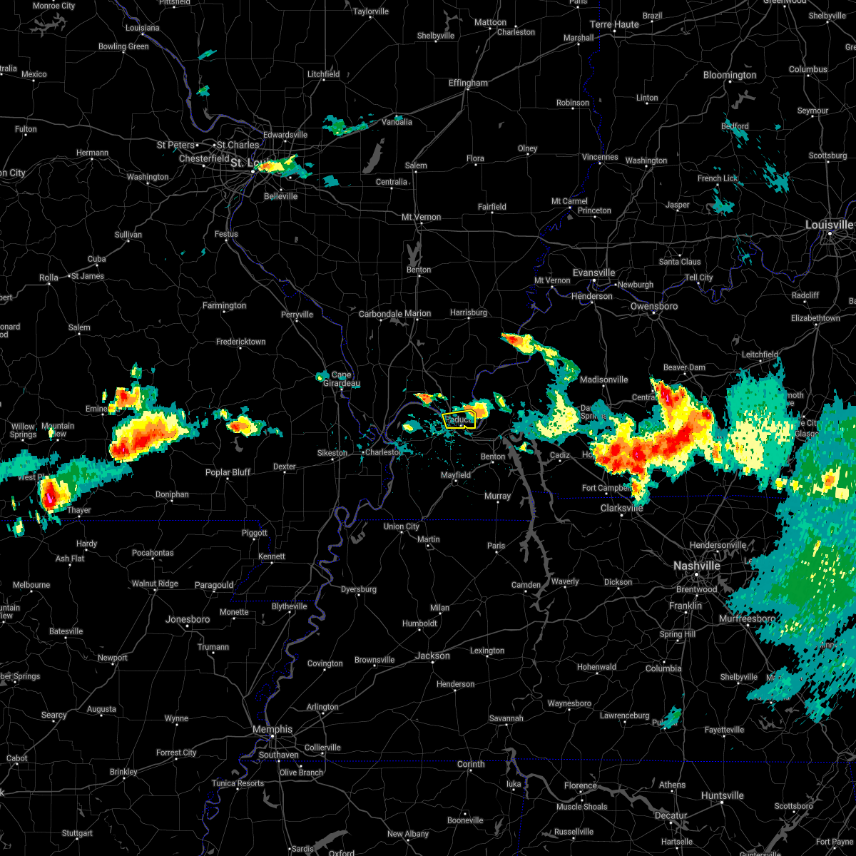 The severe thunderstorm warning for southeastern massac and central mccracken counties will expire at 515 pm cdt, the storm which prompted the warning has moved out of the area. therefore, the warning will be allowed to expire. a tornado watch remains in effect until 800 pm cdt for southern illinois, and western kentucky. The severe thunderstorm warning for southeastern massac and central mccracken counties will expire at 515 pm cdt, the storm which prompted the warning has moved out of the area. therefore, the warning will be allowed to expire. a tornado watch remains in effect until 800 pm cdt for southern illinois, and western kentucky.
|
| 5/31/2018 4:47 PM CDT |
 At 446 pm cdt, a severe thunderstorm was located over metropolis, moving east at 35 mph (radar indicated). Hazards include 60 mph wind gusts and quarter size hail. Hail damage to vehicles is expected. Expect wind damage to roofs, siding, and trees. At 446 pm cdt, a severe thunderstorm was located over metropolis, moving east at 35 mph (radar indicated). Hazards include 60 mph wind gusts and quarter size hail. Hail damage to vehicles is expected. Expect wind damage to roofs, siding, and trees.
|
| 5/31/2018 3:52 PM CDT | Quarter sized hail reported 4.3 miles ESE of Paducah, KY, public report via broadcast media |
| 5/31/2018 3:45 PM CDT |
 At 344 pm cdt, a severe thunderstorm was located near west paducah, or 8 miles east of la center, moving east at 35 mph (radar indicated). Hazards include 60 mph wind gusts and quarter size hail. Hail damage to vehicles is expected. Expect wind damage to roofs, siding, and trees. At 344 pm cdt, a severe thunderstorm was located near west paducah, or 8 miles east of la center, moving east at 35 mph (radar indicated). Hazards include 60 mph wind gusts and quarter size hail. Hail damage to vehicles is expected. Expect wind damage to roofs, siding, and trees.
|
| 5/31/2018 3:13 PM CDT |
 At 312 pm cdt, a severe thunderstorm was located over barlow, or near wickliffe, moving east at 35 mph. this storm produced quarter sized hail as it moved over cairo (radar indicated). Hazards include 60 mph wind gusts and quarter size hail. Hail damage to vehicles is expected. Expect wind damage to roofs, siding, and trees. At 312 pm cdt, a severe thunderstorm was located over barlow, or near wickliffe, moving east at 35 mph. this storm produced quarter sized hail as it moved over cairo (radar indicated). Hazards include 60 mph wind gusts and quarter size hail. Hail damage to vehicles is expected. Expect wind damage to roofs, siding, and trees.
|
| 5/27/2018 6:16 PM CDT |
 At 613 pm cdt, a severe thunderstorm was located north of kevil, moving south at 10 mph (radar indicated). Hazards include 60 mph wind gusts and nickel size hail. another severe storm was developing near grahamville. Expect damage to roofs, siding, and trees. Locations impacted include, paducah, metropolis, west paducah and joppa. At 613 pm cdt, a severe thunderstorm was located north of kevil, moving south at 10 mph (radar indicated). Hazards include 60 mph wind gusts and nickel size hail. another severe storm was developing near grahamville. Expect damage to roofs, siding, and trees. Locations impacted include, paducah, metropolis, west paducah and joppa.
|
| 5/27/2018 5:49 PM CDT |
 At 546 pm cdt, a severe thunderstorm was located 8 miles southeast of karnak, or 9 miles northeast of la center, moving southwest at 10 mph (radar indicated). Hazards include 60 mph wind gusts and nickel size hail. expect damage to roofs, siding, and trees At 546 pm cdt, a severe thunderstorm was located 8 miles southeast of karnak, or 9 miles northeast of la center, moving southwest at 10 mph (radar indicated). Hazards include 60 mph wind gusts and nickel size hail. expect damage to roofs, siding, and trees
|
| 5/6/2018 3:26 PM CDT |
 The severe thunderstorm warning for southeastern massac, southern pope, southwestern livingston, northwestern marshall and southeastern mccracken counties will expire at 330 pm cdt, the storm which prompted the warning has weakened below severe limits, and no longer poses an immediate threat to life or property. therefore the warning will be allowed to expire. The severe thunderstorm warning for southeastern massac, southern pope, southwestern livingston, northwestern marshall and southeastern mccracken counties will expire at 330 pm cdt, the storm which prompted the warning has weakened below severe limits, and no longer poses an immediate threat to life or property. therefore the warning will be allowed to expire.
|
| 5/6/2018 3:17 PM CDT |
 At 317 pm cdt, a severe thunderstorm was located over ledbetter, or near reidland, moving southeast at 25 mph (radar indicated). Hazards include 60 mph wind gusts and quarter size hail. Hail damage to vehicles is expected. expect wind damage to roofs, siding, and trees. Locations impacted include, paducah, reidland and ledbetter. At 317 pm cdt, a severe thunderstorm was located over ledbetter, or near reidland, moving southeast at 25 mph (radar indicated). Hazards include 60 mph wind gusts and quarter size hail. Hail damage to vehicles is expected. expect wind damage to roofs, siding, and trees. Locations impacted include, paducah, reidland and ledbetter.
|
| 5/6/2018 2:54 PM CDT |
 At 254 pm cdt, a severe thunderstorm was located over paducah, moving east at 25 mph (radar indicated). Hazards include 60 mph wind gusts and quarter size hail. Hail damage to vehicles is expected. Expect wind damage to roofs, siding, and trees. At 254 pm cdt, a severe thunderstorm was located over paducah, moving east at 25 mph (radar indicated). Hazards include 60 mph wind gusts and quarter size hail. Hail damage to vehicles is expected. Expect wind damage to roofs, siding, and trees.
|
| 4/3/2018 6:19 PM CDT |
 At 619 pm cdt, a severe thunderstorm was located near la center, moving east at 35 mph (radar indicated). Hazards include 60 mph wind gusts and quarter size hail. Hail damage to vehicles is expected. Expect wind damage to roofs, siding, and trees. At 619 pm cdt, a severe thunderstorm was located near la center, moving east at 35 mph (radar indicated). Hazards include 60 mph wind gusts and quarter size hail. Hail damage to vehicles is expected. Expect wind damage to roofs, siding, and trees.
|
| 2/24/2018 7:51 PM CST |
 The tornado warning for southeastern mccracken county will expire at 800 pm cst, the storm which prompted the warning has weakened below severe limits, and has exited the warned area. therefore, the warning will be allowed to expire. a tornado watch remains in effect until 900 pm cst for southern illinois, and western kentucky. The tornado warning for southeastern mccracken county will expire at 800 pm cst, the storm which prompted the warning has weakened below severe limits, and has exited the warned area. therefore, the warning will be allowed to expire. a tornado watch remains in effect until 900 pm cst for southern illinois, and western kentucky.
|
| 2/24/2018 7:40 PM CST |
 At 740 pm cst, a severe thunderstorm capable of producing a tornado was located over lone oak, moving northeast at 45 mph (radar indicated rotation). Hazards include tornado. Flying debris will be dangerous to those caught without shelter. mobile homes will be damaged or destroyed. damage to roofs, windows, and vehicles will occur. Tree damage is likely. At 740 pm cst, a severe thunderstorm capable of producing a tornado was located over lone oak, moving northeast at 45 mph (radar indicated rotation). Hazards include tornado. Flying debris will be dangerous to those caught without shelter. mobile homes will be damaged or destroyed. damage to roofs, windows, and vehicles will occur. Tree damage is likely.
|
| 11/18/2017 2:15 PM CST | Reported power outages throughout the communit in mccracken county KY, 1.5 miles WSW of Paducah, KY |
| 11/18/2017 2:10 PM CST | Downed trees reported in the community. photos sent social medi in mccracken county KY, 4.3 miles ESE of Paducah, KY |
| 11/18/2017 2:04 PM CST |
 At 203 pm cst, severe thunderstorms were located along a line extending from 7 miles southwest of burna to near massac to near bardwell, moving east at 45 mph (radar indicated). Hazards include 60 mph wind gusts. Expect damage to roofs, siding, and trees. Locations impacted include, paducah, lone oak, brookport, massac, woodlawn-oakdale, hendron and lovelaceville. At 203 pm cst, severe thunderstorms were located along a line extending from 7 miles southwest of burna to near massac to near bardwell, moving east at 45 mph (radar indicated). Hazards include 60 mph wind gusts. Expect damage to roofs, siding, and trees. Locations impacted include, paducah, lone oak, brookport, massac, woodlawn-oakdale, hendron and lovelaceville.
|
| 11/18/2017 1:44 PM CST |
 At 143 pm cst, severe thunderstorms were located along a line extending from near new columbia to near barlow to wyatt, moving east at 35 mph (radar indicated). Hazards include 60 mph wind gusts. expect damage to roofs, siding, and trees At 143 pm cst, severe thunderstorms were located along a line extending from near new columbia to near barlow to wyatt, moving east at 35 mph (radar indicated). Hazards include 60 mph wind gusts. expect damage to roofs, siding, and trees
|
| 9/5/2017 6:12 AM CDT |
 At 611 am cdt, a severe thunderstorm was located over massac, or near lone oak, moving east at 30 mph (radar indicated). Hazards include quarter size hail. Damage to vehicles is expected. Locations impacted include, paducah, lone oak, reidland, hendron, massac and woodlawn-oakdale. At 611 am cdt, a severe thunderstorm was located over massac, or near lone oak, moving east at 30 mph (radar indicated). Hazards include quarter size hail. Damage to vehicles is expected. Locations impacted include, paducah, lone oak, reidland, hendron, massac and woodlawn-oakdale.
|
| 9/5/2017 5:59 AM CDT |
 At 559 am cdt, a severe thunderstorm was located near west paducah, or near la center, moving east at 30 mph (radar indicated). Hazards include 60 mph wind gusts and half dollar size hail. Hail damage to vehicles is expected. Expect wind damage to roofs, siding, and trees. At 559 am cdt, a severe thunderstorm was located near west paducah, or near la center, moving east at 30 mph (radar indicated). Hazards include 60 mph wind gusts and half dollar size hail. Hail damage to vehicles is expected. Expect wind damage to roofs, siding, and trees.
|
| 5/27/2017 6:20 PM CDT | Tree down on brian avenue off maxon r in mccracken county KY, 3.6 miles E of Paducah, KY |
| 5/27/2017 6:10 PM CDT |
 At 608 pm cdt, severe thunderstorms were located along a line extending from goreville to near barlow to near east prairie, moving east at 65 mph. these are very dangerous storms (law enforcement. structural damage has been reported in stoddard county with 80 mph winds reported near sikeston missouri). Hazards include 80 mph wind gusts and nickel size hail. Flying debris will be dangerous to those caught without shelter. mobile homes will be heavily damaged. expect considerable damage to roofs, windows, and vehicles. Extensive tree damage and power outages are likely. At 608 pm cdt, severe thunderstorms were located along a line extending from goreville to near barlow to near east prairie, moving east at 65 mph. these are very dangerous storms (law enforcement. structural damage has been reported in stoddard county with 80 mph winds reported near sikeston missouri). Hazards include 80 mph wind gusts and nickel size hail. Flying debris will be dangerous to those caught without shelter. mobile homes will be heavily damaged. expect considerable damage to roofs, windows, and vehicles. Extensive tree damage and power outages are likely.
|
| 5/27/2017 4:00 PM CDT | Quarter sized hail reported 4.3 miles ESE of Paducah, KY, up to 1.25 inch hail |
| 5/27/2017 3:48 PM CDT |
 At 348 pm cdt, a severe thunderstorm was located near lovelaceville, or 8 miles southeast of la center, moving east at 25 mph (radar indicated). Hazards include quarter size hail. damage to vehicles is expected At 348 pm cdt, a severe thunderstorm was located near lovelaceville, or 8 miles southeast of la center, moving east at 25 mph (radar indicated). Hazards include quarter size hail. damage to vehicles is expected
|
| 4/30/2017 3:34 AM CDT |
 At 331 am cdt, severe thunderstorms were located along a line extending from near wickliffe to near lovelaceville, moving northeast at 80 mph (radar indicated). Hazards include 60 mph wind gusts. expect damage to roofs, siding, and trees At 331 am cdt, severe thunderstorms were located along a line extending from near wickliffe to near lovelaceville, moving northeast at 80 mph (radar indicated). Hazards include 60 mph wind gusts. expect damage to roofs, siding, and trees
|
| 4/26/2017 7:44 PM CDT |
 At 743 pm cdt, severe thunderstorms were located along a line extending from near metropolis to 7 miles northeast of sedalia, moving east at 65 mph (radar indicated). Hazards include 60 mph wind gusts. expect damage to roofs, siding, and trees At 743 pm cdt, severe thunderstorms were located along a line extending from near metropolis to 7 miles northeast of sedalia, moving east at 65 mph (radar indicated). Hazards include 60 mph wind gusts. expect damage to roofs, siding, and trees
|
| 4/26/2017 7:37 PM CDT | Storm damage reported in mccracken county KY, 3.2 miles NNE of Paducah, KY |
| 4/26/2017 7:30 PM CDT |
 At 729 pm cdt, severe thunderstorms were located along a line extending from near la center to 9 miles south of lovelaceville, moving northeast at 65 mph (radar indicated). Hazards include 60 mph wind gusts and quarter size hail. Hail damage to vehicles is expected. expect wind damage to roofs, siding, and trees. Locations impacted include, paducah, metropolis, reidland, lone oak, brookport, massac, hendron, woodlawn-oakdale, west paducah, lovelaceville, kevil, lowes, fancy farm, blandville and symsonia. At 729 pm cdt, severe thunderstorms were located along a line extending from near la center to 9 miles south of lovelaceville, moving northeast at 65 mph (radar indicated). Hazards include 60 mph wind gusts and quarter size hail. Hail damage to vehicles is expected. expect wind damage to roofs, siding, and trees. Locations impacted include, paducah, metropolis, reidland, lone oak, brookport, massac, hendron, woodlawn-oakdale, west paducah, lovelaceville, kevil, lowes, fancy farm, blandville and symsonia.
|
| 4/26/2017 7:11 PM CDT |
 At 710 pm cdt, severe thunderstorms were located along a line extending from near wyatt to near clinton, moving northeast at 65 mph (radar indicated). Hazards include 60 mph wind gusts and quarter size hail. Hail damage to vehicles is expected. Expect wind damage to roofs, siding, and trees. At 710 pm cdt, severe thunderstorms were located along a line extending from near wyatt to near clinton, moving northeast at 65 mph (radar indicated). Hazards include 60 mph wind gusts and quarter size hail. Hail damage to vehicles is expected. Expect wind damage to roofs, siding, and trees.
|
| 3/7/2017 4:15 AM CST | Power outages in brookpor in massac county IL, 4.5 miles SSW of Paducah, KY |
| 3/7/2017 4:07 AM CST |
 At 407 am cst, a severe thunderstorm was located near west paducah, or near metropolis, moving east at 35 mph (radar indicated). Hazards include 60 mph wind gusts and nickel size hail. Expect damage to roofs, siding, and trees. Locations impacted include, paducah. At 407 am cst, a severe thunderstorm was located near west paducah, or near metropolis, moving east at 35 mph (radar indicated). Hazards include 60 mph wind gusts and nickel size hail. Expect damage to roofs, siding, and trees. Locations impacted include, paducah.
|
| 3/7/2017 3:54 AM CST |
 At 354 am cst, a severe thunderstorm was located near la center, moving east at 30 mph (radar indicated). Hazards include 70 mph wind gusts and nickel size hail. Expect considerable tree damage. Damage is likely to mobile homes, roofs, and outbuildings. At 354 am cst, a severe thunderstorm was located near la center, moving east at 30 mph (radar indicated). Hazards include 70 mph wind gusts and nickel size hail. Expect considerable tree damage. Damage is likely to mobile homes, roofs, and outbuildings.
|
| 3/1/2017 5:15 AM CST | Power pole on a car...powerline on car and trees down in mccracken county KY, 1.5 miles N of Paducah, KY |
| 3/1/2017 5:13 AM CST | Storm damage reported in mccracken county KY, 3.6 miles E of Paducah, KY |
| 3/1/2017 5:06 AM CST |
 At 506 am cst, severe thunderstorms were located along a line extending from near dongola to near wickliffe, moving east at 110 mph. these are very dangerous storms (radar indicated). Hazards include 80 mph wind gusts and penny size hail. Flying debris will be dangerous to those caught without shelter. mobile homes will be heavily damaged. expect considerable damage to roofs, windows, and vehicles. Extensive tree damage and power outages are likely. At 506 am cst, severe thunderstorms were located along a line extending from near dongola to near wickliffe, moving east at 110 mph. these are very dangerous storms (radar indicated). Hazards include 80 mph wind gusts and penny size hail. Flying debris will be dangerous to those caught without shelter. mobile homes will be heavily damaged. expect considerable damage to roofs, windows, and vehicles. Extensive tree damage and power outages are likely.
|
| 12/17/2016 3:10 PM CST |
 At 310 pm cst, a severe thunderstorm was located over woodlawn-oakdale, or over reidland, moving northeast at 55 mph (trained weather spotters). Hazards include quarter size hail. damage to vehicles is expected At 310 pm cst, a severe thunderstorm was located over woodlawn-oakdale, or over reidland, moving northeast at 55 mph (trained weather spotters). Hazards include quarter size hail. damage to vehicles is expected
|
| 12/17/2016 3:07 PM CST | Quarter sized hail reported 1.5 miles N of Paducah, KY, quarter size hail reported |
| 12/17/2016 3:05 PM CST | Hen Egg sized hail reported 1.5 miles N of Paducah, KY |
| 12/17/2016 2:55 PM CST |
 At 255 pm cst, a severe thunderstorm was located near lovelaceville, or 9 miles southwest of lone oak, moving northeast at 50 mph (radar indicated). Hazards include 60 mph wind gusts and quarter size hail. Hail damage to vehicles is expected. expect wind damage to roofs, siding, and trees. locations impacted include, paducah, lone oak, woodlawn-oakdale, hendron, massac, symsonia and lowes. A tornado watch remains in effect until 900 pm cst for western kentucky. At 255 pm cst, a severe thunderstorm was located near lovelaceville, or 9 miles southwest of lone oak, moving northeast at 50 mph (radar indicated). Hazards include 60 mph wind gusts and quarter size hail. Hail damage to vehicles is expected. expect wind damage to roofs, siding, and trees. locations impacted include, paducah, lone oak, woodlawn-oakdale, hendron, massac, symsonia and lowes. A tornado watch remains in effect until 900 pm cst for western kentucky.
|
| 12/17/2016 2:43 PM CST |
 At 243 pm cst, a severe thunderstorm was located near bardwell, moving northeast at 50 mph (radar indicated). Hazards include 60 mph wind gusts and quarter size hail. Hail damage to vehicles is expected. Expect wind damage to roofs, siding, and trees. At 243 pm cst, a severe thunderstorm was located near bardwell, moving northeast at 50 mph (radar indicated). Hazards include 60 mph wind gusts and quarter size hail. Hail damage to vehicles is expected. Expect wind damage to roofs, siding, and trees.
|
| 8/5/2016 5:35 PM CDT | Large tree on house...on cairo road near maxon christian church in mccracken county KY, 4.3 miles ESE of Paducah, KY |
| 8/5/2016 5:34 PM CDT | Tree down on road in mccracken county KY, 5.7 miles E of Paducah, KY |
| 8/5/2016 4:56 PM CDT |
 At 455 pm cdt, a severe thunderstorm was located near la center, moving south at 15 mph (radar indicated). Hazards include 60 mph wind gusts. Expect damage to roofs. siding. And trees. At 455 pm cdt, a severe thunderstorm was located near la center, moving south at 15 mph (radar indicated). Hazards include 60 mph wind gusts. Expect damage to roofs. siding. And trees.
|
| 7/8/2016 6:32 PM CDT | Large tree over husbands roa in mccracken county KY, 1.5 miles WSW of Paducah, KY |
| 7/8/2016 6:11 PM CDT |
 At 610 pm cdt, severe thunderstorms were located along a line extending from barlow to 6 miles southeast of bardwell, moving northeast at 50 mph (radar indicated). Hazards include 60 mph wind gusts. Expect damage to roofs. siding. And trees. At 610 pm cdt, severe thunderstorms were located along a line extending from barlow to 6 miles southeast of bardwell, moving northeast at 50 mph (radar indicated). Hazards include 60 mph wind gusts. Expect damage to roofs. siding. And trees.
|
| 7/7/2016 1:41 PM CDT | Late report. tree uprooted from stor in mccracken county KY, 2.5 miles NW of Paducah, KY |
| 7/7/2016 1:39 PM CDT | Late report. large trees down 2 miles south of barkley regional airpor in mccracken county KY, 4.3 miles ESE of Paducah, KY |
| 7/7/2016 1:24 PM CDT | Power outages reported throughout the community in mccracken county KY, 8.3 miles WNW of Paducah, KY |
| 7/7/2016 1:15 PM CDT | Multiple trees down with power outages throughout the communit in mccracken county KY, 1.5 miles N of Paducah, KY |
| 7/7/2016 1:08 PM CDT | Late report. tree uprooted from stor in mccracken county KY, 2.5 miles NW of Paducah, KY |
| 7/7/2016 1:00 PM CDT |
 At 1259 pm cdt, severe thunderstorms were located along a line extending from 7 miles southeast of new columbia to 9 miles northwest of mayfield, moving east at 50 mph (radar indicated). Hazards include 60 mph wind gusts. Expect damage to roofs. siding. and trees. Locations impacted include, paducah, metropolis, reidland, lone oak, brookport, golconda, hendron, lovelaceville, dixon springs, massac, west paducah, woodlawn-oakdale, kevil, joppa, lowes and symsonia. At 1259 pm cdt, severe thunderstorms were located along a line extending from 7 miles southeast of new columbia to 9 miles northwest of mayfield, moving east at 50 mph (radar indicated). Hazards include 60 mph wind gusts. Expect damage to roofs. siding. and trees. Locations impacted include, paducah, metropolis, reidland, lone oak, brookport, golconda, hendron, lovelaceville, dixon springs, massac, west paducah, woodlawn-oakdale, kevil, joppa, lowes and symsonia.
|
| 7/7/2016 12:40 PM CDT |
 At 1240 pm cdt, severe thunderstorms were located along a line extending from near karnak to bardwell, moving east at 50 mph (radar indicated). Hazards include 60 mph wind gusts. Expect damage to roofs. siding. And trees. At 1240 pm cdt, severe thunderstorms were located along a line extending from near karnak to bardwell, moving east at 50 mph (radar indicated). Hazards include 60 mph wind gusts. Expect damage to roofs. siding. And trees.
|
| 7/6/2016 2:04 PM CDT |
 At 203 pm cdt, severe thunderstorms were located along a line extending from joy to near benton to near palmersville, moving east at 55 mph (trained weather spotters). Hazards include 70 mph wind gusts and penny size hail. Expect considerable tree damage. damage is likely to mobile homes, roofs, and outbuildings. Locations impacted include, paducah, mayfield, calvert city, reidland, golconda, lynnville, sedalia, woodlawn-oakdale, burna, joy, ledbetter, wingo, smithland, hamletsburg and symsonia. At 203 pm cdt, severe thunderstorms were located along a line extending from joy to near benton to near palmersville, moving east at 55 mph (trained weather spotters). Hazards include 70 mph wind gusts and penny size hail. Expect considerable tree damage. damage is likely to mobile homes, roofs, and outbuildings. Locations impacted include, paducah, mayfield, calvert city, reidland, golconda, lynnville, sedalia, woodlawn-oakdale, burna, joy, ledbetter, wingo, smithland, hamletsburg and symsonia.
|
| 7/6/2016 2:00 PM CDT | Trees down and uprooted near kmart . time estimate in mccracken county KY, 1.2 miles NW of Paducah, KY |
| 7/6/2016 2:00 PM CDT | Trees down on berger road. time estimate in mccracken county KY, 1.5 miles W of Paducah, KY |
| 7/6/2016 1:56 PM CDT | Numerous trees dow in mccracken county KY, 2 miles ENE of Paducah, KY |
| 7/6/2016 1:55 PM CDT | Tree down on hous in mccracken county KY, 3.2 miles ESE of Paducah, KY |
| 7/6/2016 1:52 PM CDT | South side of paduca in mccracken county KY, 4.8 miles W of Paducah, KY |
| 7/6/2016 1:50 PM CDT | Two trees down. estimated 70 mph wind in mccracken county KY, 4.3 miles NE of Paducah, KY |
| 7/6/2016 1:48 PM CDT | Trees down on broadway and joe clifton driv in mccracken county KY, 3.3 miles WSW of Paducah, KY |
| 7/6/2016 1:45 PM CDT |
 At 144 pm cdt, severe thunderstorms were located along a line extending from dixon springs to 7 miles southeast of lovelaceville to south fulton, moving east at 60 mph (trained weather spotters). Hazards include 70 mph wind gusts and penny size hail. Expect considerable tree damage. damage is likely to mobile homes, roofs, and outbuildings. Locations impacted include, paducah, mayfield, metropolis, calvert city, fulton, reidland, lone oak, brookport, golconda, west paducah, woodlawn-oakdale, joy, fulgham, hendron, massac, lynnville, sedalia, burna, ledbetter and wingo. At 144 pm cdt, severe thunderstorms were located along a line extending from dixon springs to 7 miles southeast of lovelaceville to south fulton, moving east at 60 mph (trained weather spotters). Hazards include 70 mph wind gusts and penny size hail. Expect considerable tree damage. damage is likely to mobile homes, roofs, and outbuildings. Locations impacted include, paducah, mayfield, metropolis, calvert city, fulton, reidland, lone oak, brookport, golconda, west paducah, woodlawn-oakdale, joy, fulgham, hendron, massac, lynnville, sedalia, burna, ledbetter and wingo.
|
| 7/6/2016 1:43 PM CDT | 7000 people without power in paducah...lone oa in mccracken county KY, 0.9 miles NNW of Paducah, KY |
| 7/6/2016 1:40 PM CDT | . in mccracken county KY, 5.8 miles E of Paducah, KY |
| 7/6/2016 1:28 PM CDT |
 At 127 pm cdt, severe thunderstorms were located along a line extending from near vienna to near wickliffe to near hickman, moving east at 55 mph (trained weather spotters). Hazards include 60 mph wind gusts and nickel size hail. Expect damage to roofs. siding. And trees. At 127 pm cdt, severe thunderstorms were located along a line extending from near vienna to near wickliffe to near hickman, moving east at 55 mph (trained weather spotters). Hazards include 60 mph wind gusts and nickel size hail. Expect damage to roofs. siding. And trees.
|
| 7/6/2016 12:40 PM CDT | Measured at paducah airport in mccracken county KY, 4.3 miles ESE of Paducah, KY |
| 6/15/2016 1:23 PM CDT | Trees snapped and uprooted along hwy 62 in 3 locations. fire rescue and law enforcement are respondin in mccracken county KY, 9.4 miles ENE of Paducah, KY |
| 12/23/2015 3:26 PM CST | Power outages reported throughout the downtown are in mccracken county KY, 1.5 miles WSW of Paducah, KY |
| 12/23/2015 3:04 PM CST | At 303 pm cst, severe thunderstorms were located along a line extending from near dixon springs to near lovelaceville, moving east at 60 mph (radar indicated). Hazards include 60 mph wind gusts. Expect damage to roofs. Siding and trees. |
| 12/23/2015 3:04 PM CST | At 303 pm cst, severe thunderstorms were located along a line extending from near dixon springs to near lovelaceville, moving east at 60 mph (radar indicated). Hazards include 60 mph wind gusts. Expect damage to roofs. Siding and trees. |
| 7/9/2015 7:16 PM CDT |
 At 716 pm cdt, a severe thunderstorm was located 7 miles southwest of new columbia, or 8 miles northwest of metropolis, moving east at 20 mph (radar indicated). Hazards include 60 mph wind gusts. Expect damage to roofs. Siding and trees. At 716 pm cdt, a severe thunderstorm was located 7 miles southwest of new columbia, or 8 miles northwest of metropolis, moving east at 20 mph (radar indicated). Hazards include 60 mph wind gusts. Expect damage to roofs. Siding and trees.
|
| 7/7/2015 4:50 AM CDT |
 At 450 am cdt, a severe thunderstorm was located near west paducah, or 7 miles southwest of metropolis, moving east at 35 mph (radar indicated). Hazards include 60 mph wind gusts. Expect damage to roofs. Siding and trees. At 450 am cdt, a severe thunderstorm was located near west paducah, or 7 miles southwest of metropolis, moving east at 35 mph (radar indicated). Hazards include 60 mph wind gusts. Expect damage to roofs. Siding and trees.
|
| 6/26/2015 3:11 PM CDT | The severe thunderstorm warning for southwestern mccracken county will expire at 315 pm cdt, a severe thunderstorm watch remains in effect until 800 pm cdt for western kentucky. |
| 6/26/2015 2:50 PM CDT | Tennis Ball sized hail reported 9.4 miles ENE of Paducah, KY, late report. picture and report via social media. |
| 6/26/2015 2:49 PM CDT | At 249 pm cdt, a severe thunderstorm was located over lovelaceville, or 8 miles southwest of lone oak, moving east at 30 mph (radar indicated). Hazards include 60 mph wind gusts and quarter size hail. Hail damage to vehicles is expected. Expect wind damage to roofs, siding and trees. |
| 4/3/2015 8:49 AM CDT | The national weather service in paducah has issued a * severe thunderstorm warning for. southeastern mccracken county in western kentucky. northern marshall county in western kentucky. southern livingston county in western kentucky. Until 915 am cdt. |
| 10/13/2014 3:40 PM CDT | Report of roof damage at intersection of 12th street and madison. semi-tractor damaged at exit 4. downed power lines and outages reported along lovelaceville roa in mccracken county KY, 1.5 miles WSW of Paducah, KY |
| 10/13/2014 3:32 PM CDT | Downed power lines along woodville road in western mccracken count in mccracken county KY, 6.4 miles E of Paducah, KY |
| 8/19/2014 4:40 PM CDT | Mesaured at paducah aso in mccracken county KY, 1.5 miles WSW of Paducah, KY |
| 11/17/2013 3:00 PM CST | Church roof collapsed along bell avenue. emergency responders on the wa in mccracken county KY, 1.5 miles WSW of Paducah, KY |
| 11/17/2013 2:49 PM CST | Golf Ball sized hail reported 1.5 miles W of Paducah, KY, golf ball size hail reported. |
| 11/17/2013 2:45 PM CST | Quarter sized hail reported 8.3 miles WNW of Paducah, KY, quarter size hail reported. |
| 11/17/2013 2:32 PM CST | Small limbs blown down. possible rotatio in mccracken county KY, 4.3 miles ESE of Paducah, KY |
| 11/17/2013 2:30 PM CST | Brookport bridge close in mccracken county KY, 1.5 miles WSW of Paducah, KY |
| 11/17/2013 2:15 PM CST | Roof damaged along bobo road. small shed destroyed and blown into nearby field. nearby home collecting belongings blown into yar in mccracken county KY, 1.5 miles WSW of Paducah, KY |
| 11/17/2013 2:15 PM CST | Large tree down blocking noble road just east of interstate 24. nearby barn has roof damag in mccracken county KY, 4.3 miles ESE of Paducah, KY |
| 10/5/2013 6:16 PM CDT | Non rotating wall cloud. no damage reported. no funnel clouds reporte in mccracken county KY, 1.5 miles WSW of Paducah, KY |
| 10/5/2013 5:55 PM CDT | Wall cloud reported by spotters in western mccracken county in mccracken county KY, 1.5 miles WSW of Paducah, KY |
| 8/7/2013 6:10 AM CDT | Dozens of trees and limbs down. carport blown 400 feet and destroye in mccracken county KY, 4 miles NNE of Paducah, KY |
| 6/17/2013 2:29 PM CDT | Tree down over benton road in reidland near railroad tracks. another tree down across new hope church roa in mccracken county KY, 1.5 miles WSW of Paducah, KY |
| 5/30/2013 7:49 PM CDT | Quarter sized hail reported 1.5 miles WSW of Paducah, KY, quarter size hail reported on olivet church road |
| 5/30/2013 7:45 PM CDT | Storm damage reported in mccracken county KY, 4.4 miles SSE of Paducah, KY |
| 5/30/2013 7:45 PM CDT | Signage/billboard blown down off exit 3 in paducah in mccracken county KY, 1.5 miles WSW of Paducah, KY |
| 5/30/2013 7:40 PM CDT | Several trees down and 1/2 inch hail reported in mccracken county KY, 2.5 miles ESE of Paducah, KY |
| 1/12/2013 2:45 PM CST | Time estimated. large tree limbs down across portions of south end of town. one home had some shingles blown of in mccracken county KY, 1.5 miles WSW of Paducah, KY |
| 9/6/2012 7:00 PM CDT | Shingles blown off house onto neighbors house. trees branches down. time estimated. late report. relayed through e in mccracken county KY, 1.5 miles WSW of Paducah, KY |
| 9/1/2012 8:00 PM CDT | Tree damage reported in northern mccracken count in mccracken county KY, 4.4 miles SSE of Paducah, KY |
| 9/1/2012 7:45 PM CDT | Large tree limb down on bruce stree in mccracken county KY, 1.5 miles WSW of Paducah, KY |
| 8/16/2012 7:36 PM CDT | Estimated wind near lourdes hospital in pa in mccracken county KY, 1.5 miles WSW of Paducah, KY |
| 8/16/2012 7:35 PM CDT | Tree reported down on house in paducah near intersection of s 30th st and mississippi st. no details at this time. called 91 in mccracken county KY, 1.5 miles WSW of Paducah, KY |
| 8/16/2012 7:27 PM CDT | Wind measured at barkley regional airport in west pa in mccracken county KY, 4.3 miles ESE of Paducah, KY |
| 3/23/2012 12:19 PM CDT | Quarter sized hail reported 8.3 miles WNW of Paducah, KY |
| 1/1/0001 12:00 AM | Wind gusts estimated 60 to 70 mph near lourdes hospital at exit in mccracken county KY, 1.5 miles WSW of Paducah, KY |
| 1/1/0001 12:00 AM | Quarter sized hail reported 1.5 miles WSW of Paducah, KY, quarter size hail reported on south side of town as well as downtown. |
| 1/1/0001 12:00 AM | Roof blown off of home and laying across highway 268 just west of hwy 62 intersectio in mccracken county KY, 4.3 miles ESE of Paducah, KY |
| 1/1/0001 12:00 AM | Measured at barkley regional airport aso in mccracken county KY, 4.3 miles ESE of Paducah, KY |
| 1/1/0001 12:00 AM | Mobile home destoryed along ogden landing road. late repor in mccracken county KY, 4.3 miles ESE of Paducah, KY |
| 1/1/0001 12:00 AM | Estimated winds 60 to 70 mph. numerous large tree limbs down. /corrected location from eddyville ky to unionville il in massac county IL, 7.6 miles WSW of Paducah, KY |
| 1/1/0001 12:00 AM | Large limbs down on south side...widespread power outages...some limbs down on cars and power lines down on trimple stree in mccracken county KY, 1.5 miles WSW of Paducah, KY |
| 1/1/0001 12:00 AM | Large tree down on roadway on mayfield-metropolis roa in mccracken county KY, 1.5 miles WSW of Paducah, KY |
| 1/1/0001 12:00 AM | Tree on home on jefferson stree in mccracken county KY, 1.5 miles WSW of Paducah, KY |
| 1/1/0001 12:00 AM | Wind gust reported along highway 60 just west of paduca in mccracken county KY, 1.5 miles WSW of Paducah, KY |
| 1/1/0001 12:00 AM | Tree on power lines...12th and caldwell stree in mccracken county KY, 1.5 miles WSW of Paducah, KY |
| 1/1/0001 12:00 AM | Wind gusts estimated 70 to 80 mph in the farley are in mccracken county KY, 1.5 miles WSW of Paducah, KY |
| 1/1/0001 12:00 AM | Reported at barkley regional airpor in mccracken county KY, 4.3 miles ESE of Paducah, KY |
| 1/1/0001 12:00 AM | Storm damage reported in mccracken county KY, 4.3 miles ESE of Paducah, KY |
| 1/1/0001 12:00 AM | 4 telephone poles snapped along 16th stree in mccracken county KY, 1.5 miles WSW of Paducah, KY |
| 1/1/0001 12:00 AM | Downed and uprooted trees along with some power poles damaged near intersection of bruce and pecan driv in mccracken county KY, 1.5 miles WSW of Paducah, KY |
| 1/1/0001 12:00 AM | Measured gust at barkley regional airpor in mccracken county KY, 4.3 miles ESE of Paducah, KY |
| 1/1/0001 12:00 AM | Late report. tree damage reported throughout the area. underpinning on several mobile homes damage in mccracken county KY, 4.3 miles ESE of Paducah, KY |
| 1/1/0001 12:00 AM | Pea size hail reported with stor in mccracken county KY, 1.5 miles WSW of Paducah, KY |
| 1/1/0001 12:00 AM | Reported at barkley regional airpor in mccracken county KY, 4.3 miles ESE of Paducah, KY |
| 1/1/0001 12:00 AM | Ping Pong Ball sized hail reported 1.5 miles WSW of Paducah, KY |
| 1/1/0001 12:00 AM | Ping Pong Ball sized hail reported 4.3 miles ESE of Paducah, KY, occurred at the national weather service office near barkley regional airport. |
| 1/1/0001 12:00 AM | Quarter sized hail reported 4.3 miles ESE of Paducah, KY, quarter size hail reported at national weather service office. |
| 1/1/0001 12:00 AM | Late report...tree down on home in the reidland area along hwy 131/said roa in mccracken county KY, 1.5 miles WSW of Paducah, KY |
Hail Maps for Paducah, KY
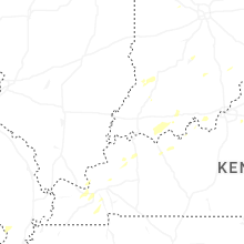

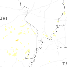
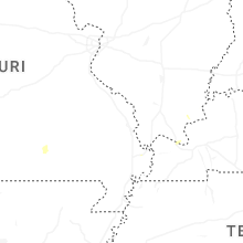
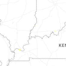


Connect with Interactive Hail Maps