

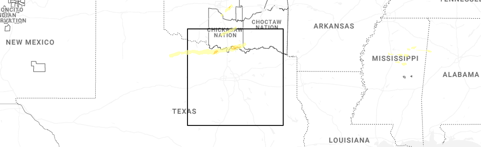
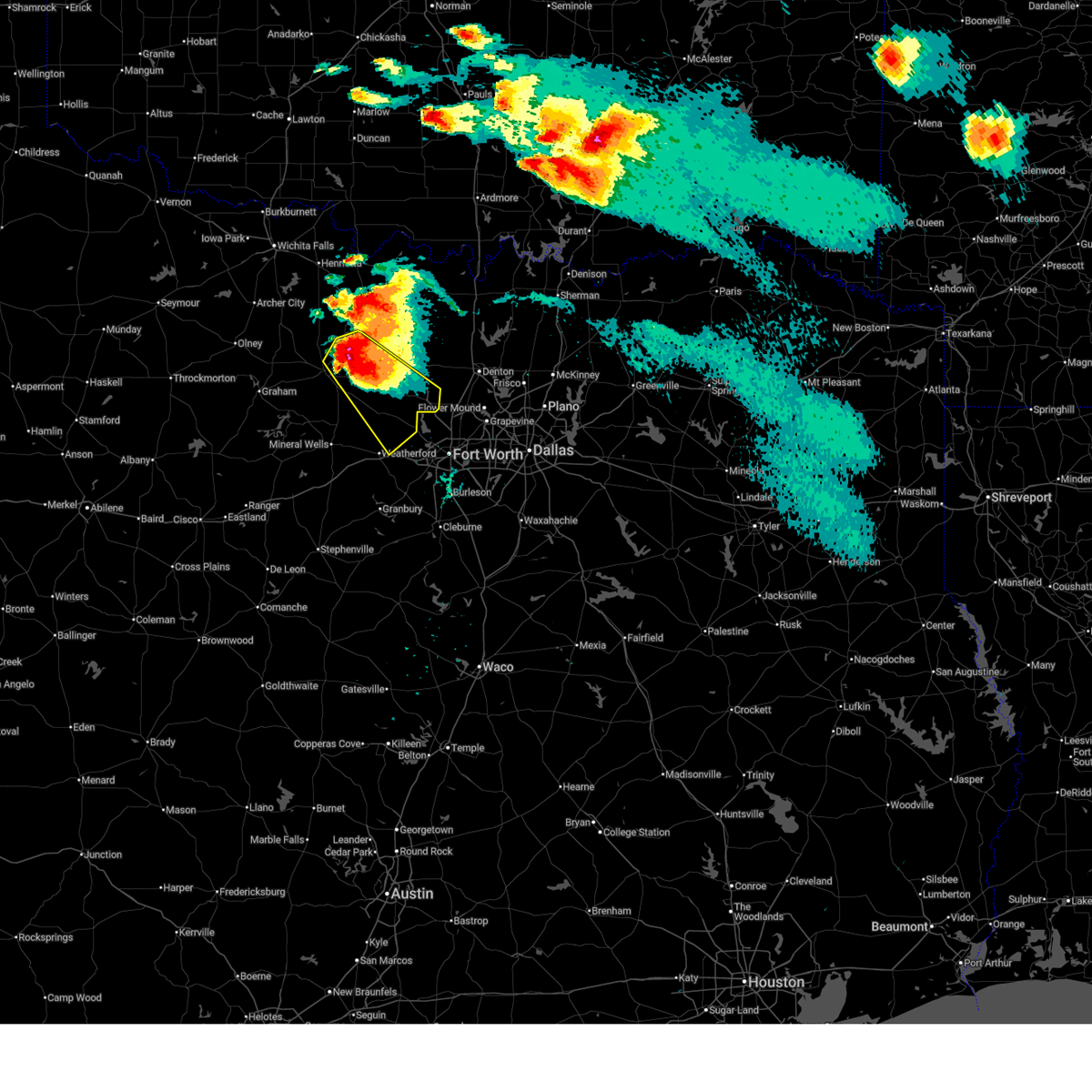
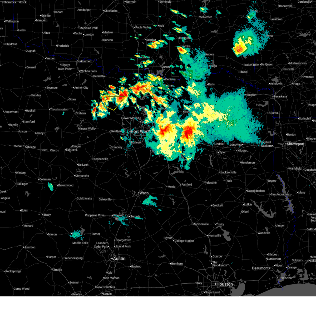
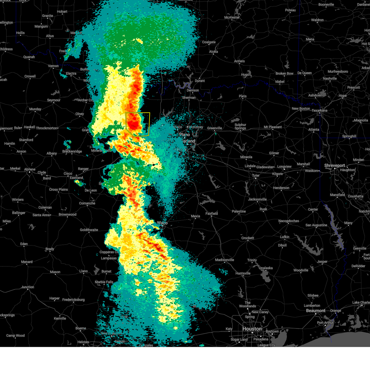
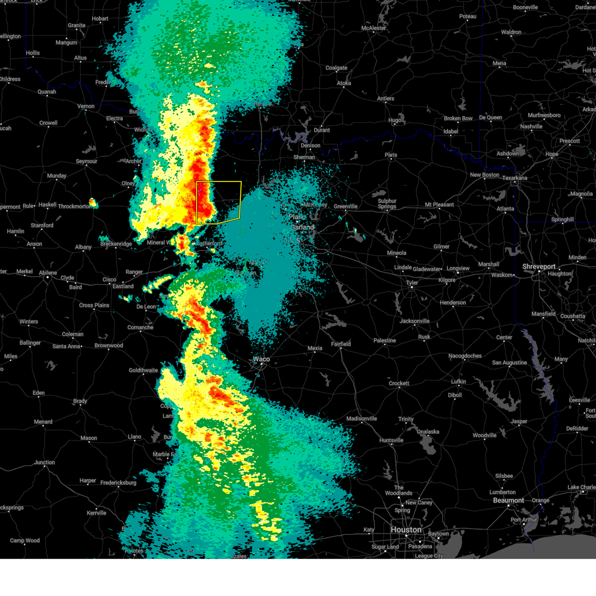
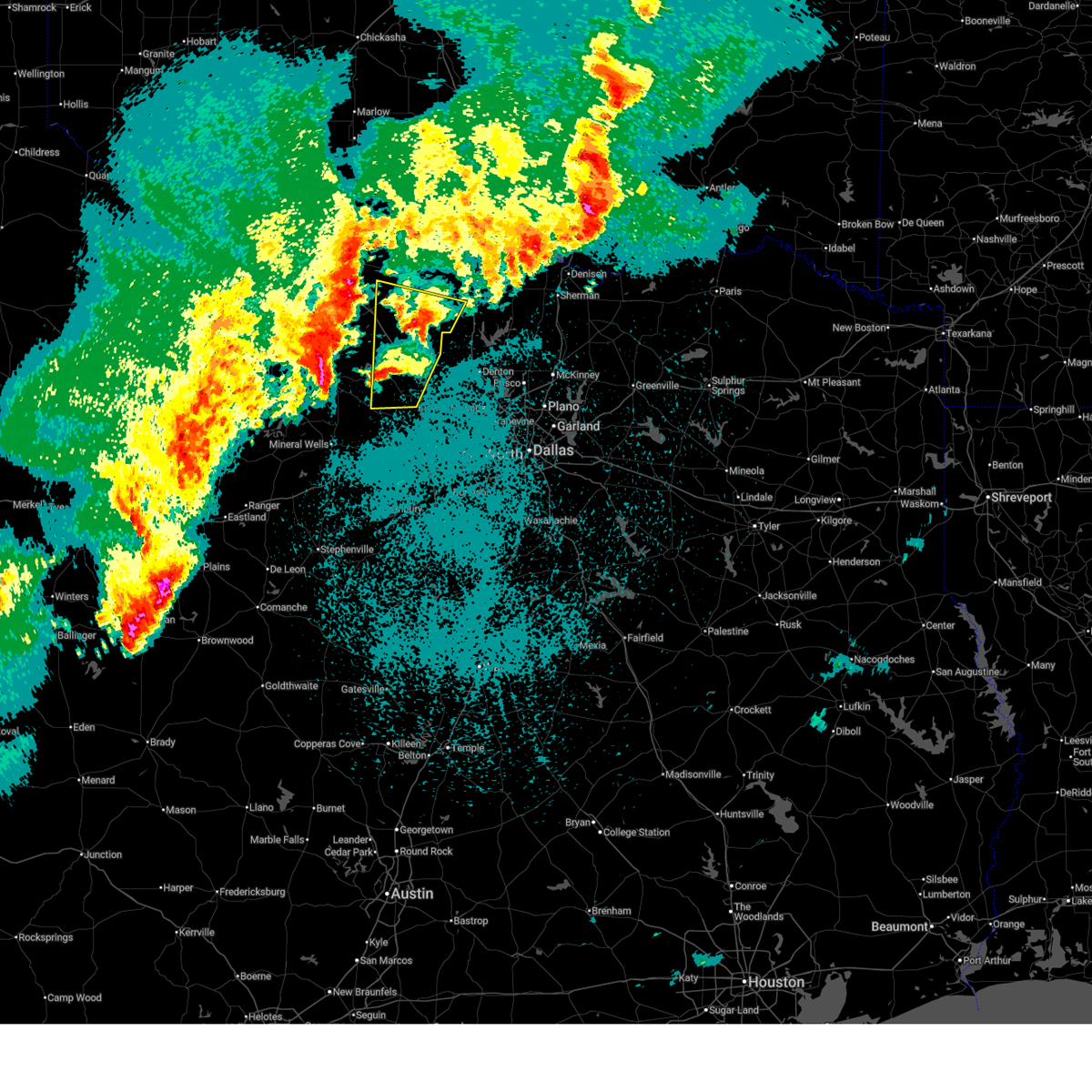
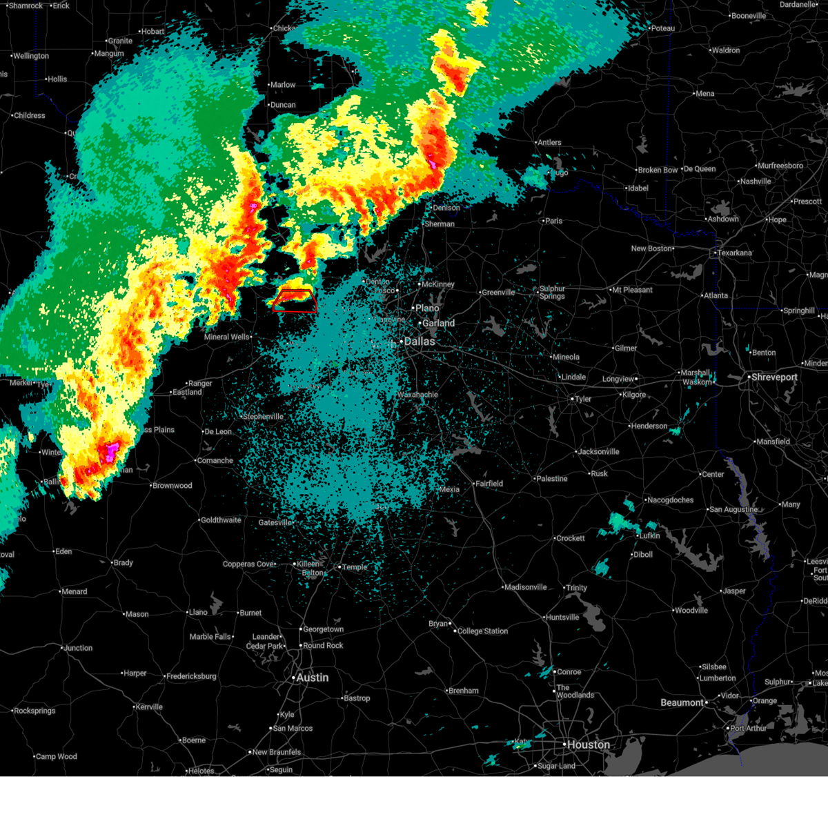
Hail Map for Paradise, TX
The Paradise, TX area has had 13 reports of on-the-ground hail by trained spotters, and has been under severe weather warnings 23 times during the past 12 months. Doppler radar has detected hail at or near Paradise, TX on 98 occasions, including 6 occasions during the past year.
| Name: | Paradise, TX |
| Where Located: | 57.9 miles WNW of Dallas, TX |
| Map: | Google Map for Paradise, TX |
| Population: | 441 |
| Housing Units: | 200 |
| More Info: | Search Google for Paradise, TX |
2
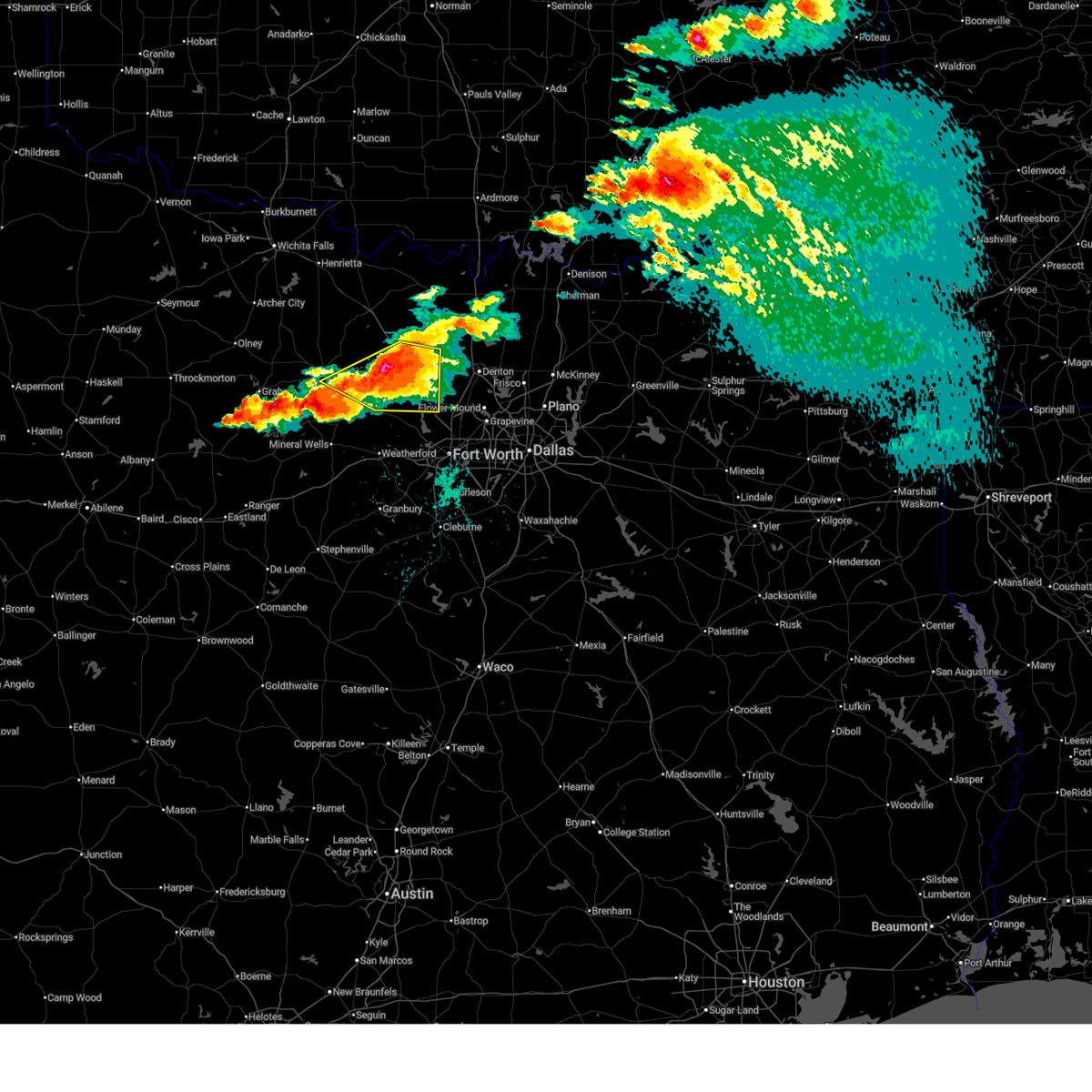
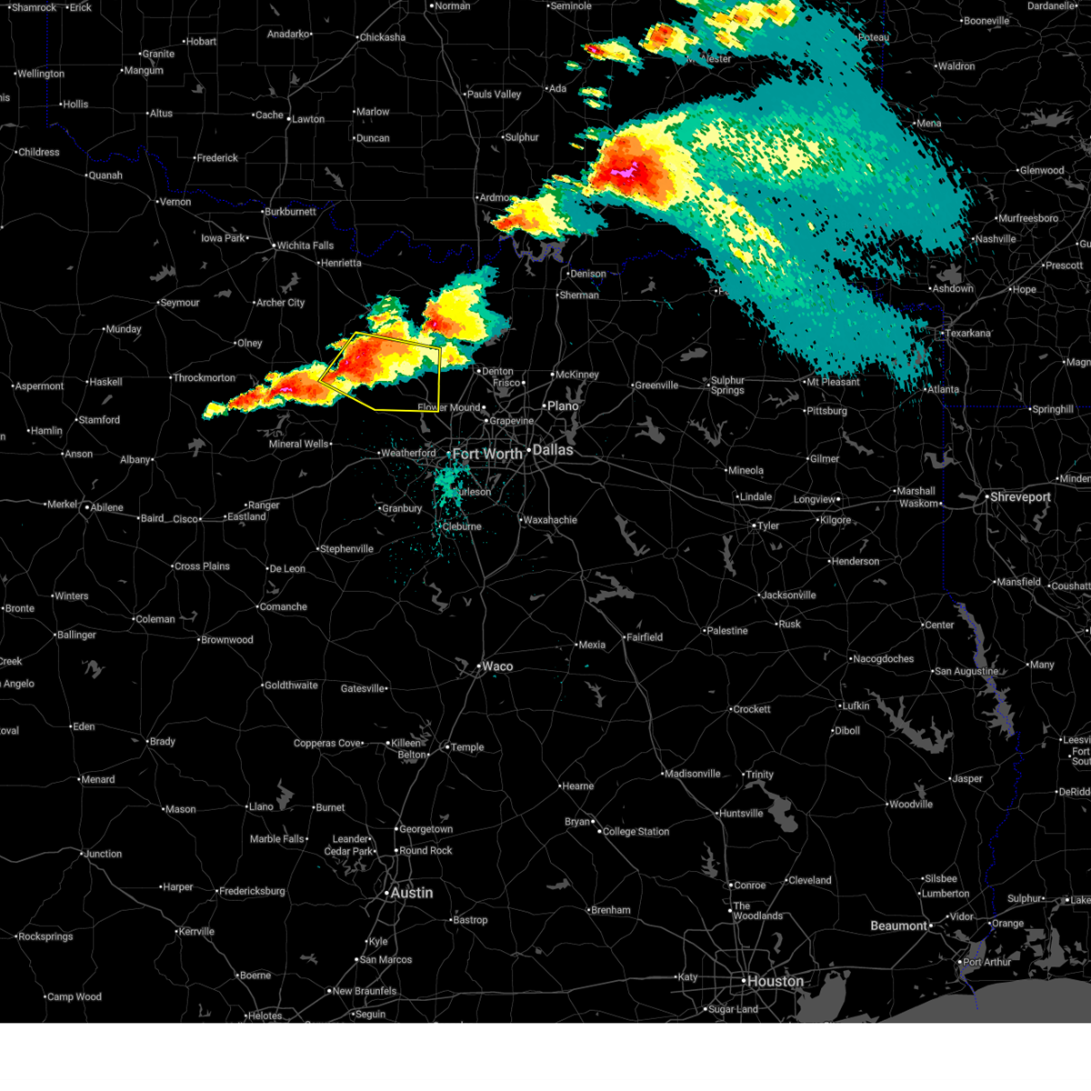
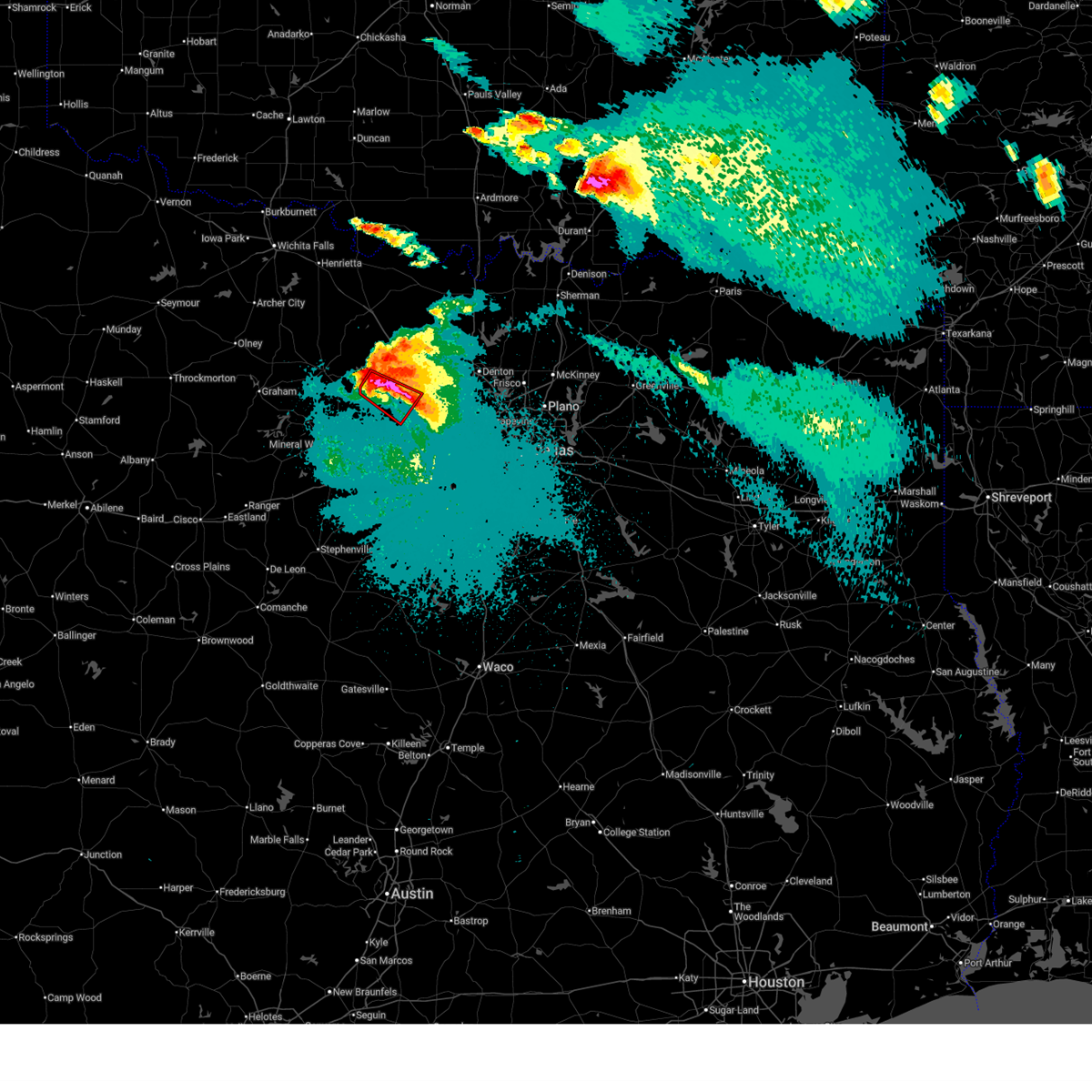
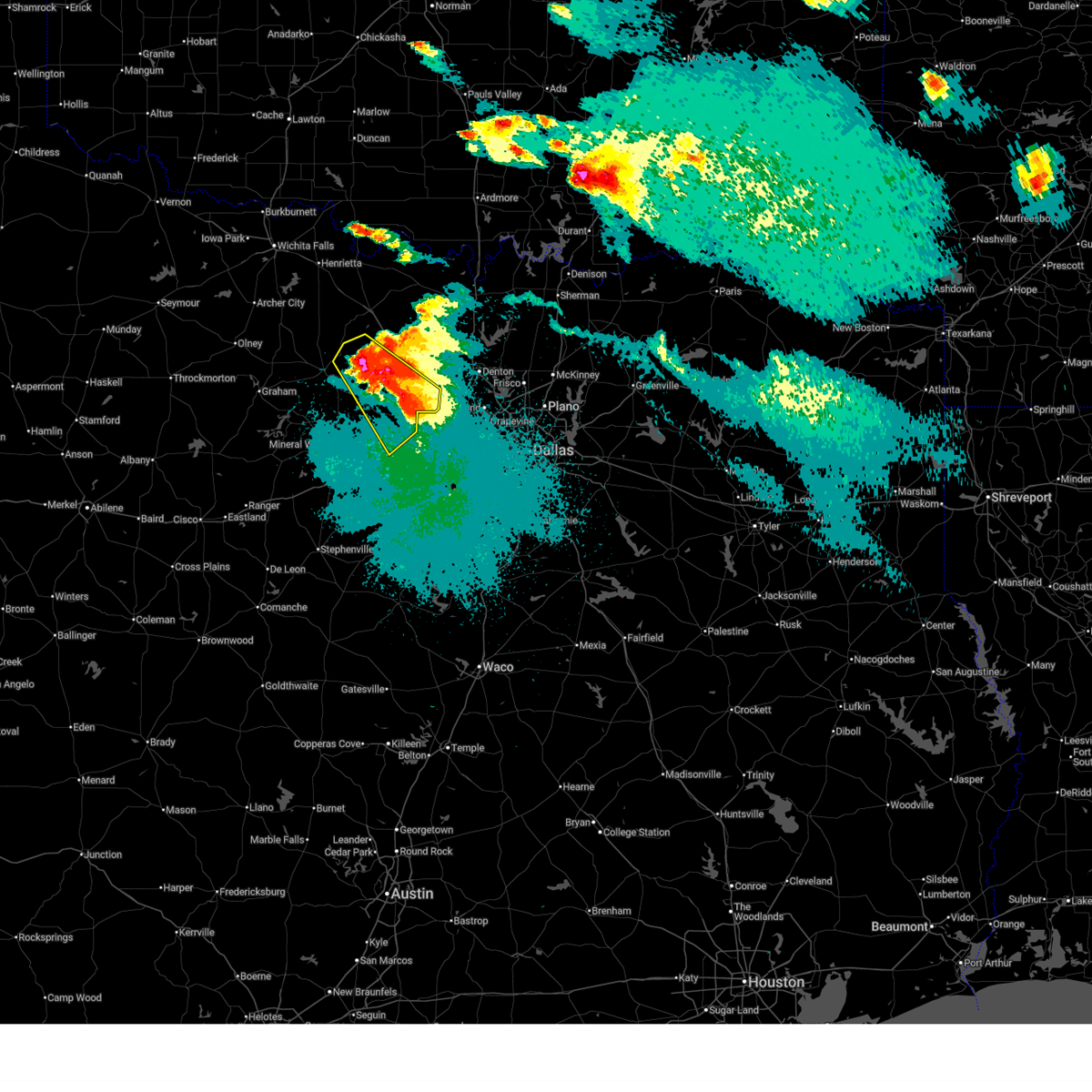
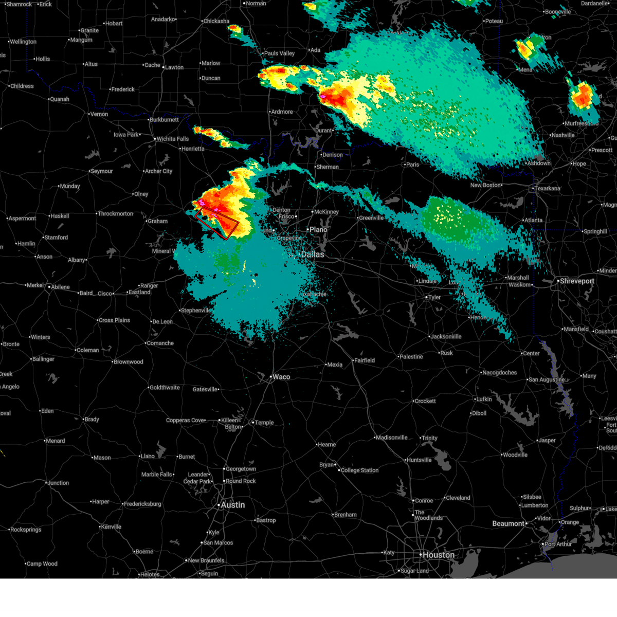
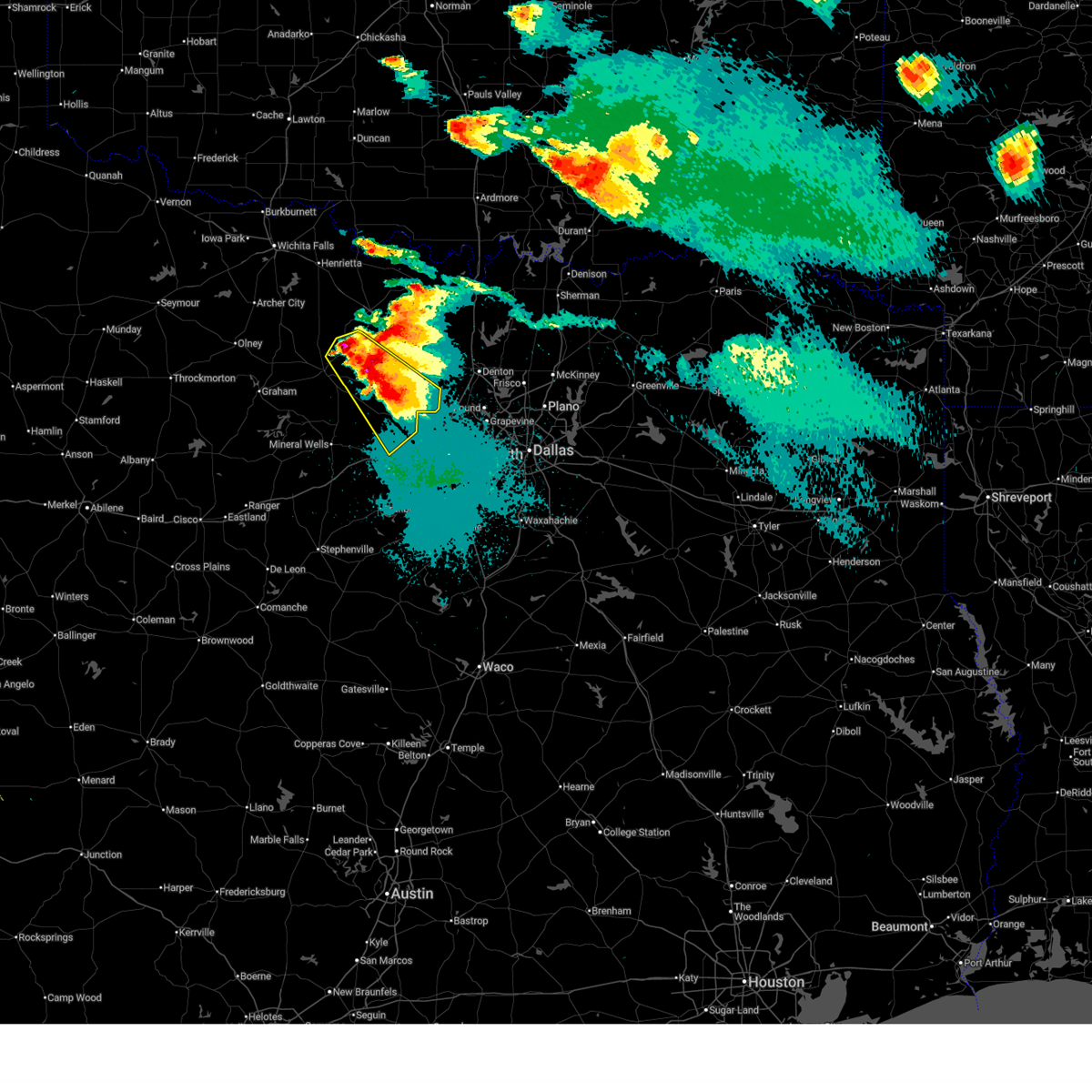
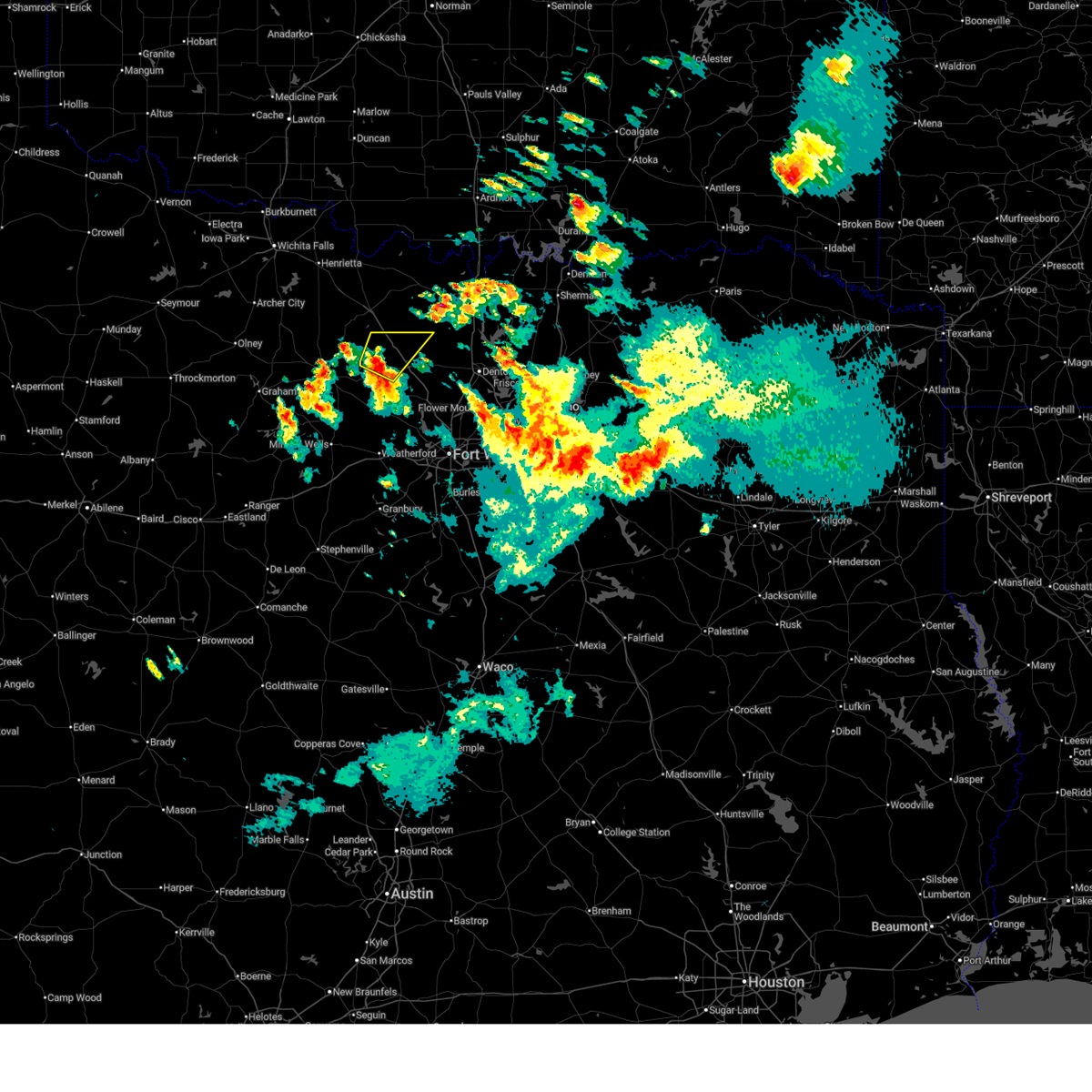
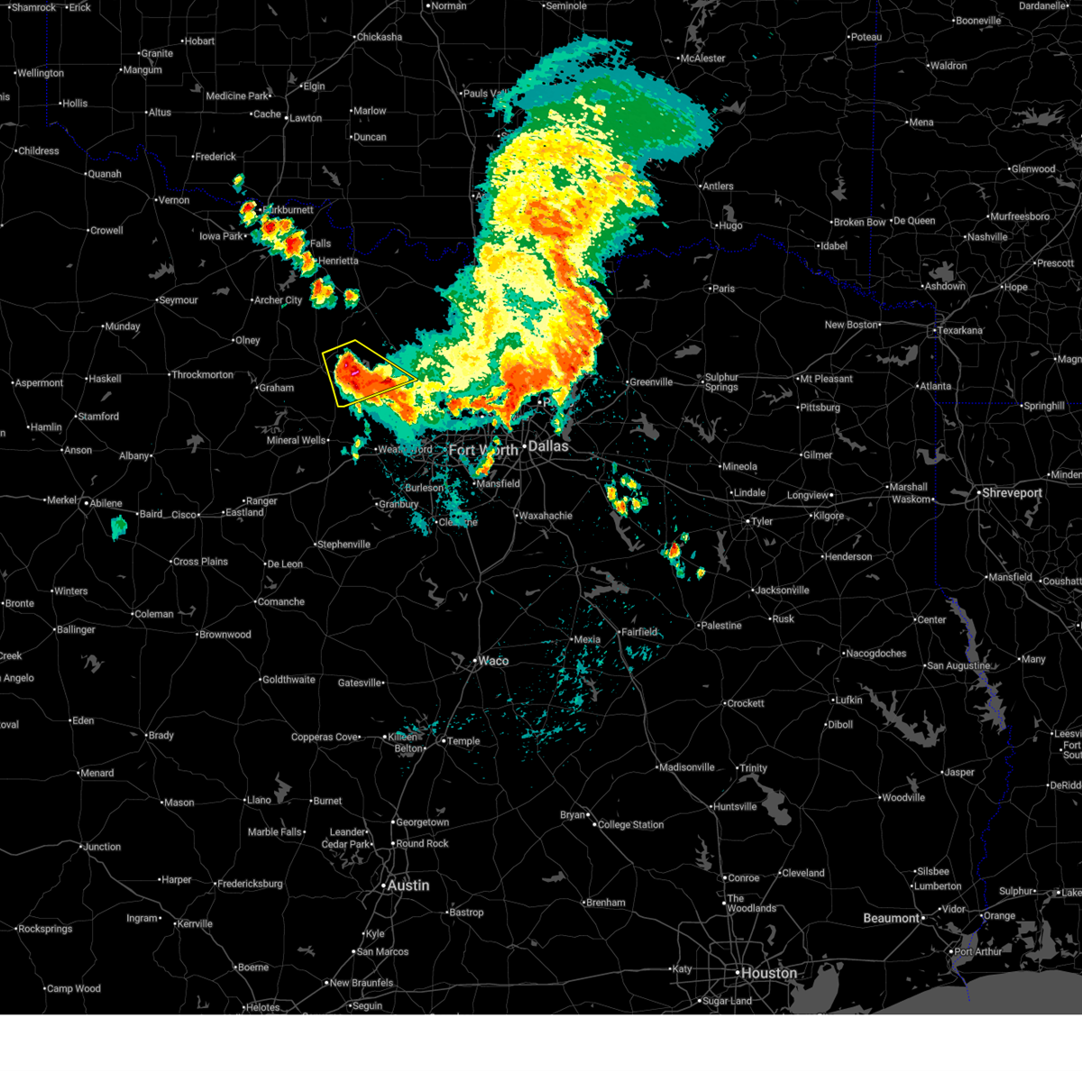
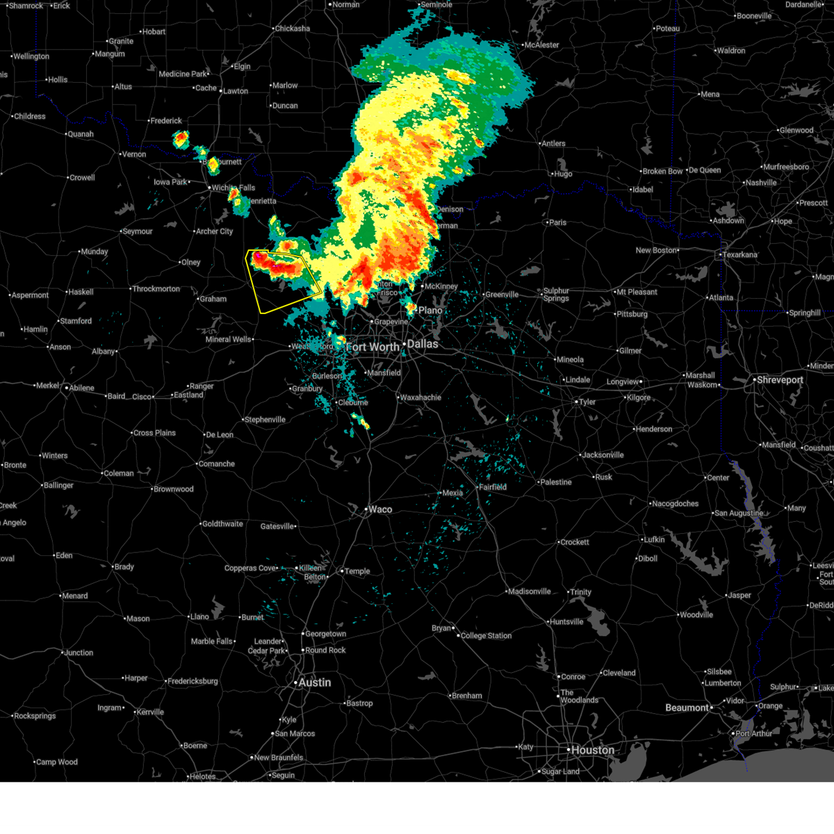
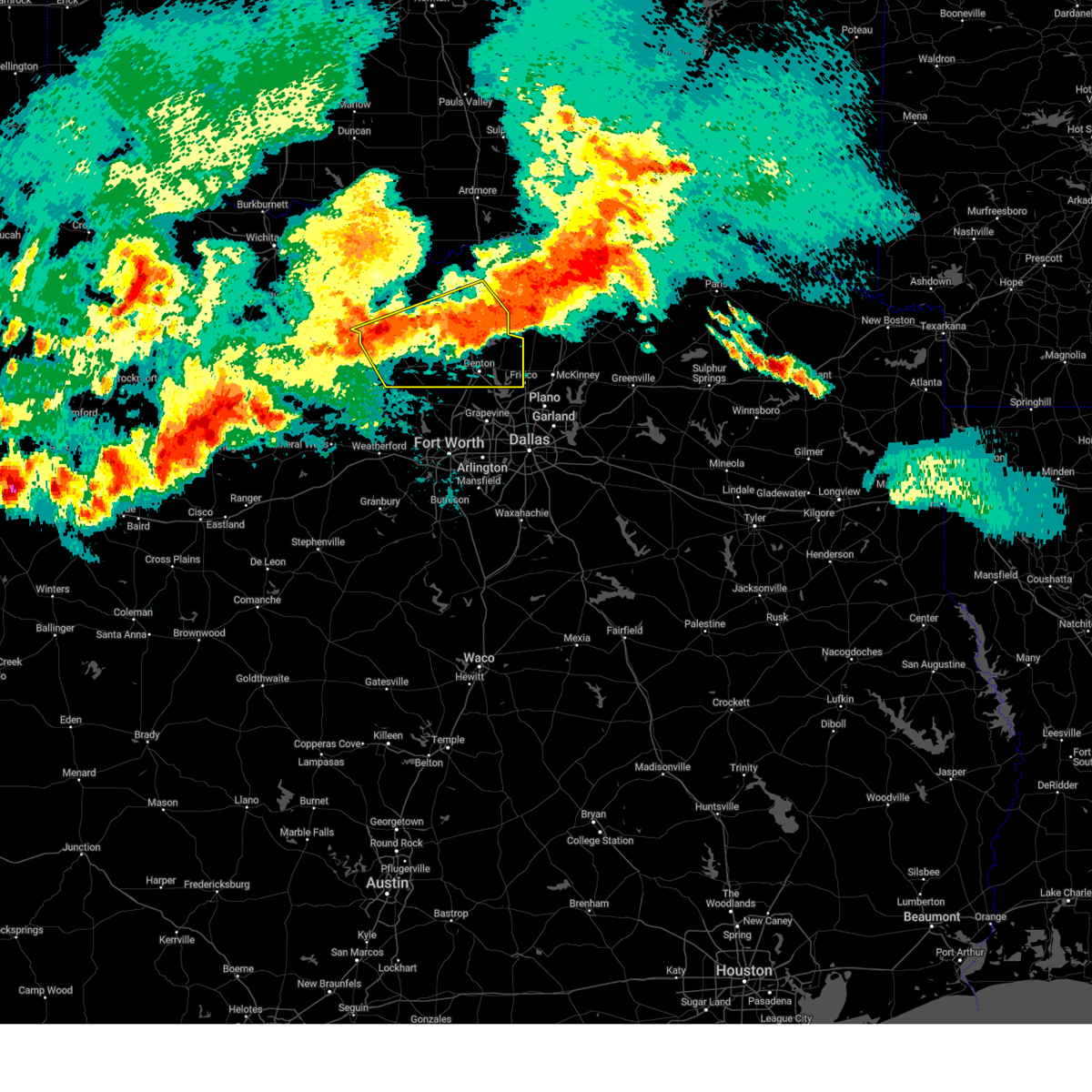
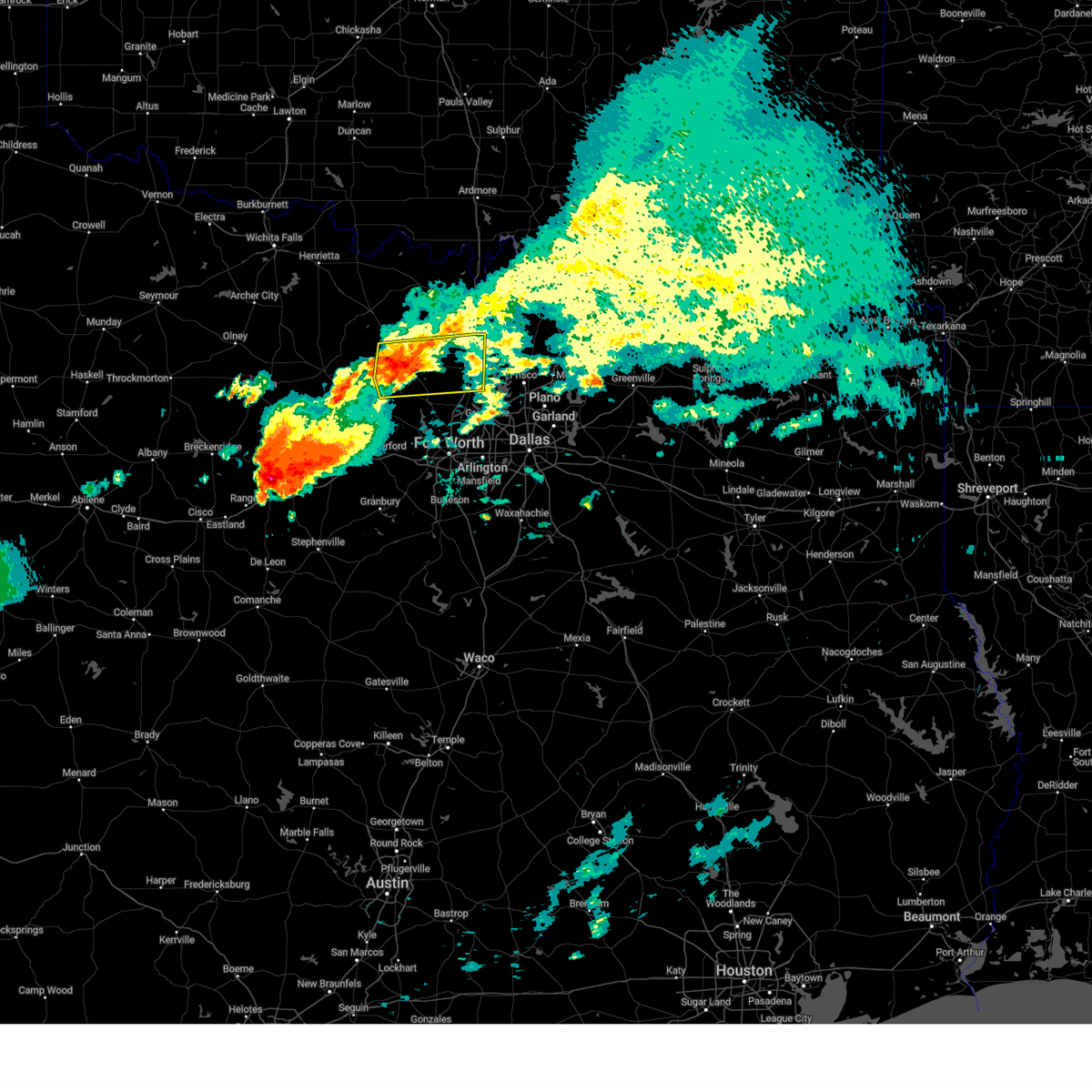
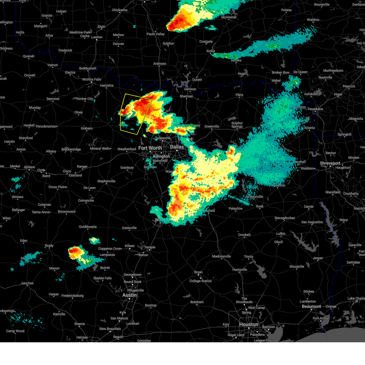
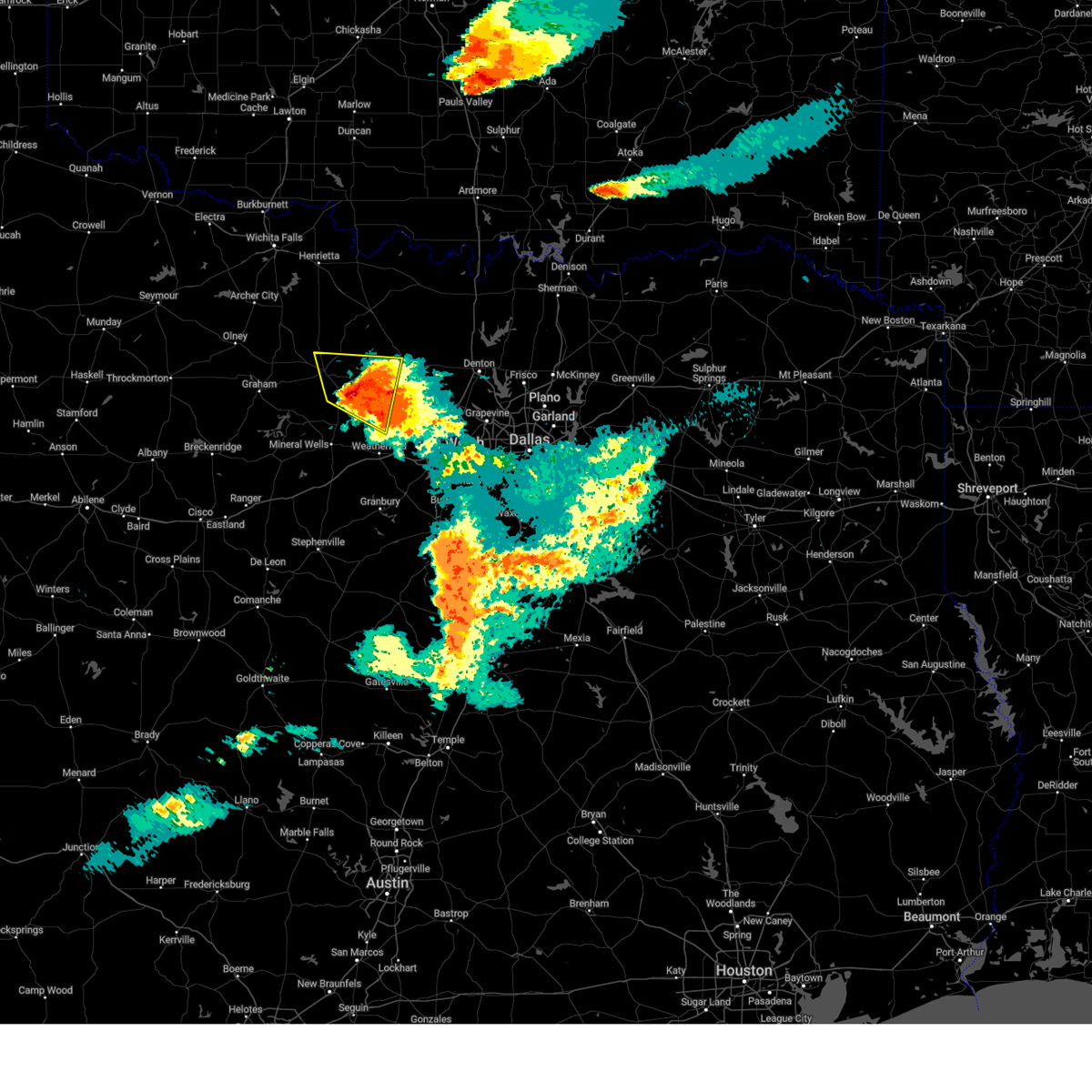
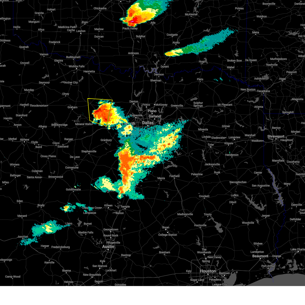
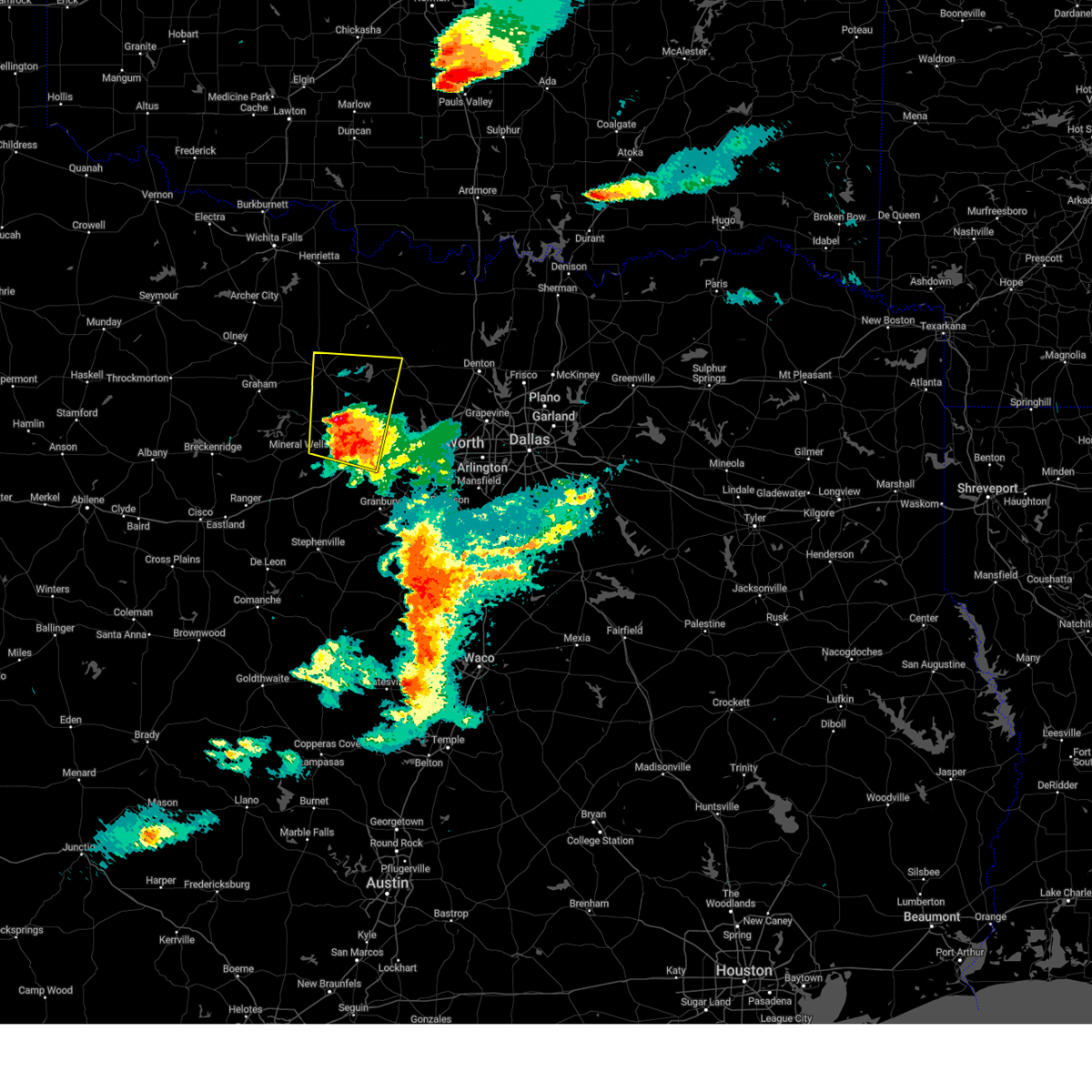
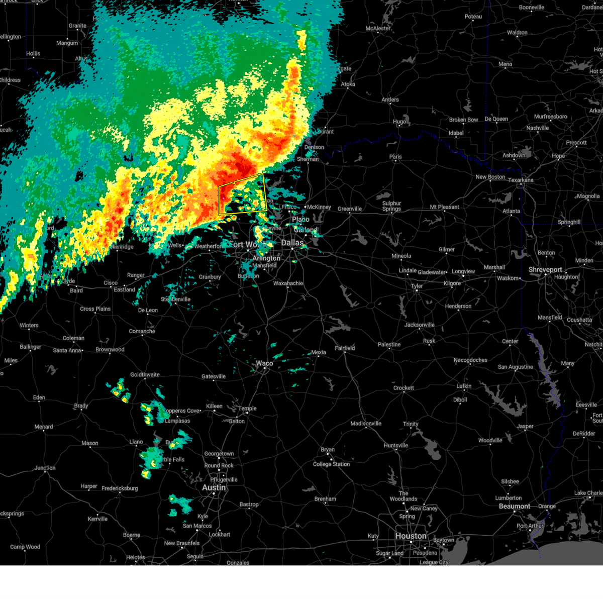
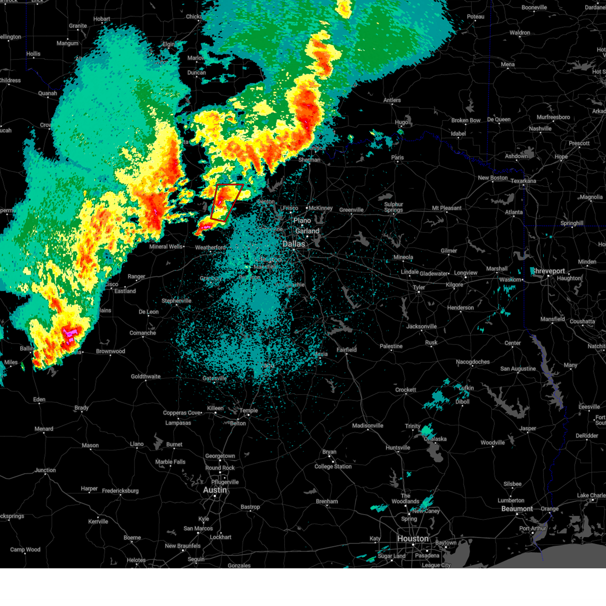
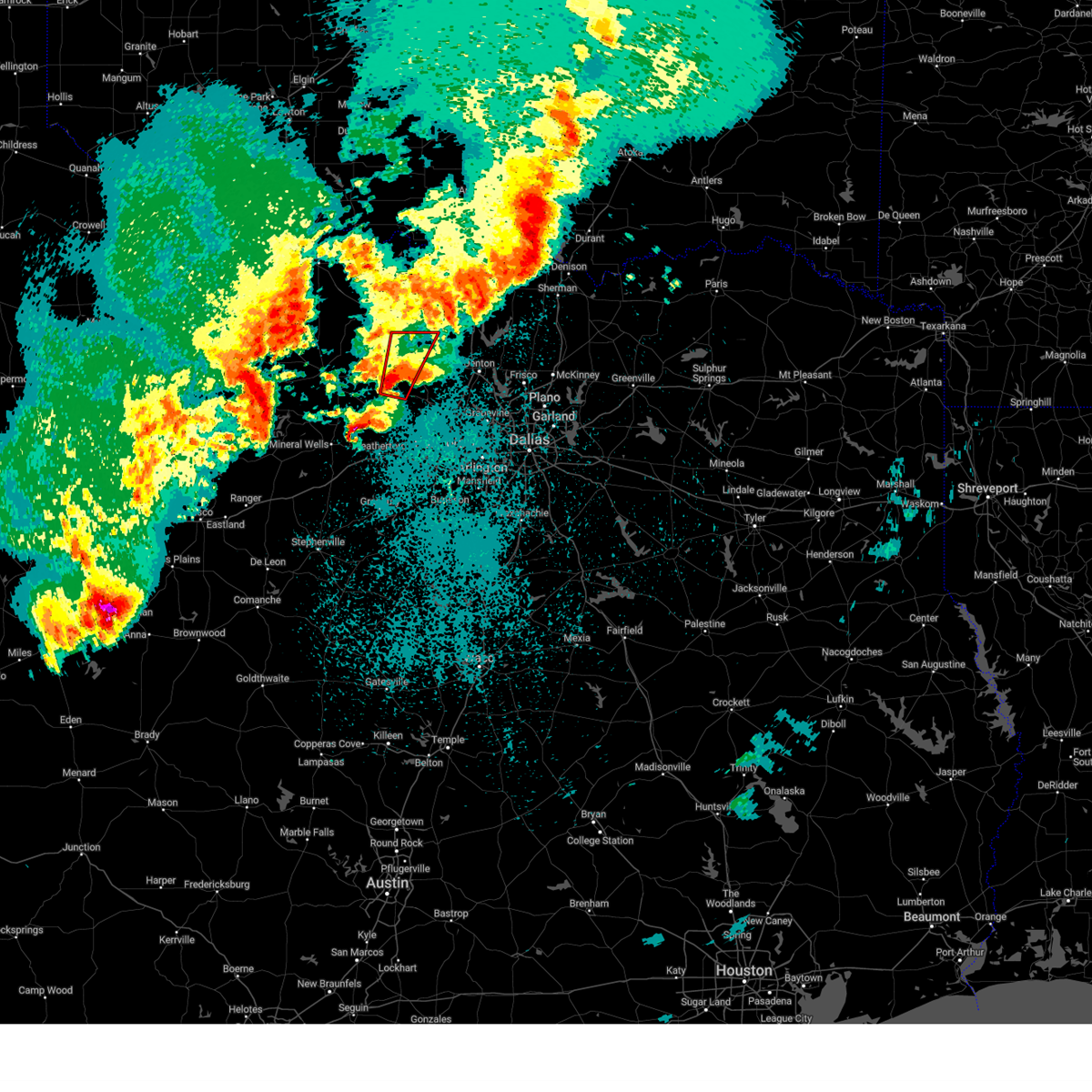
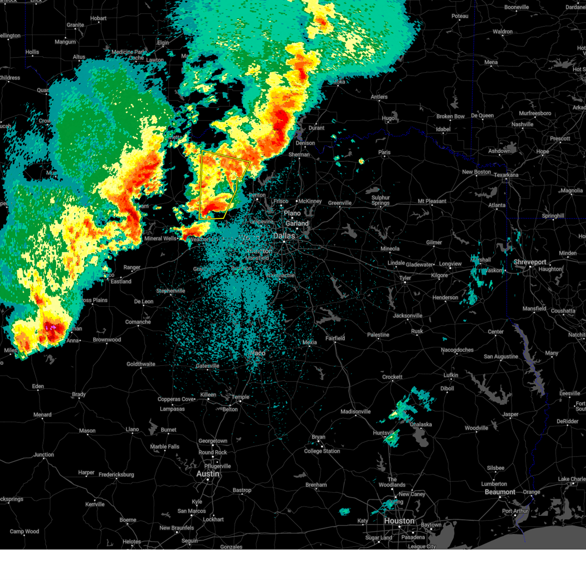
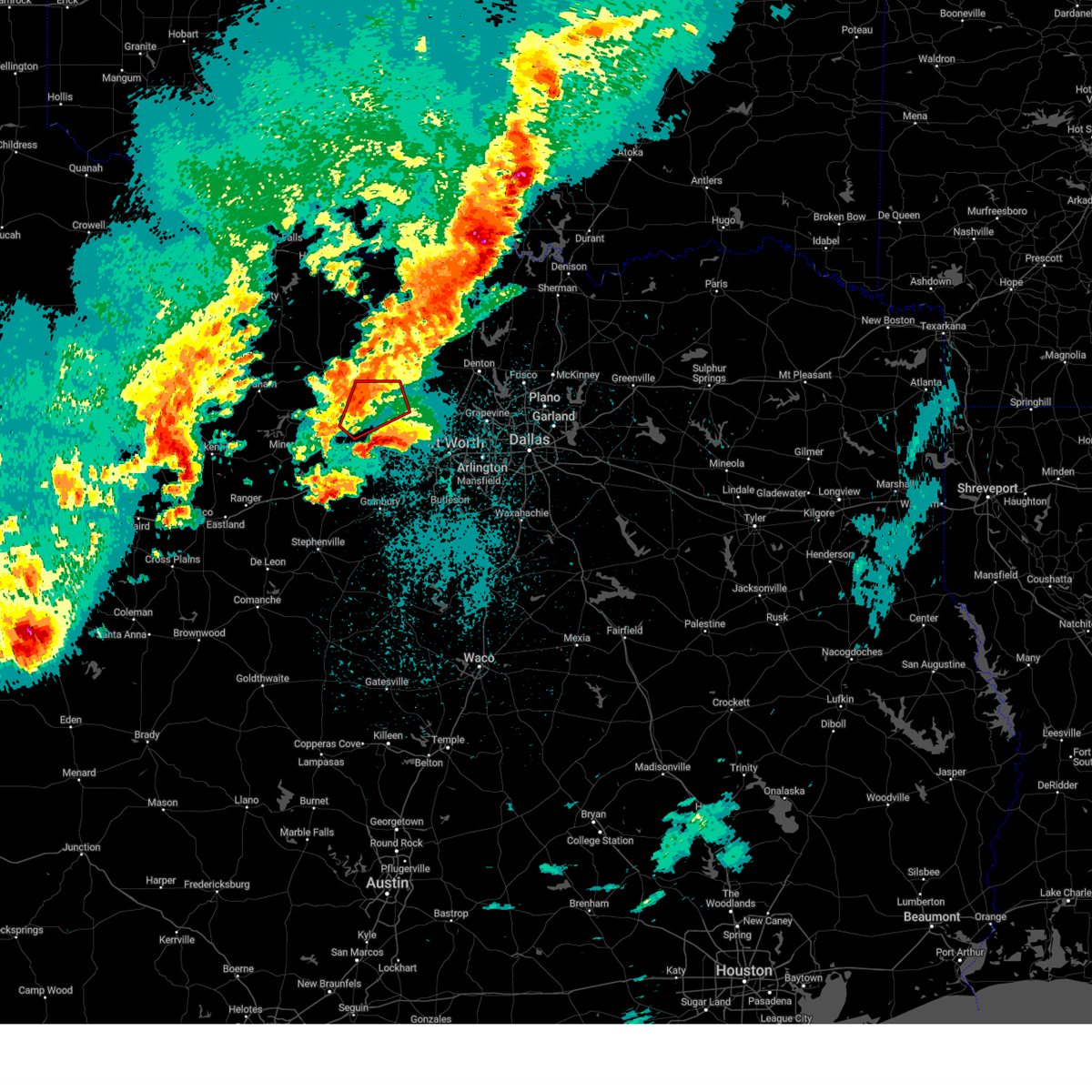
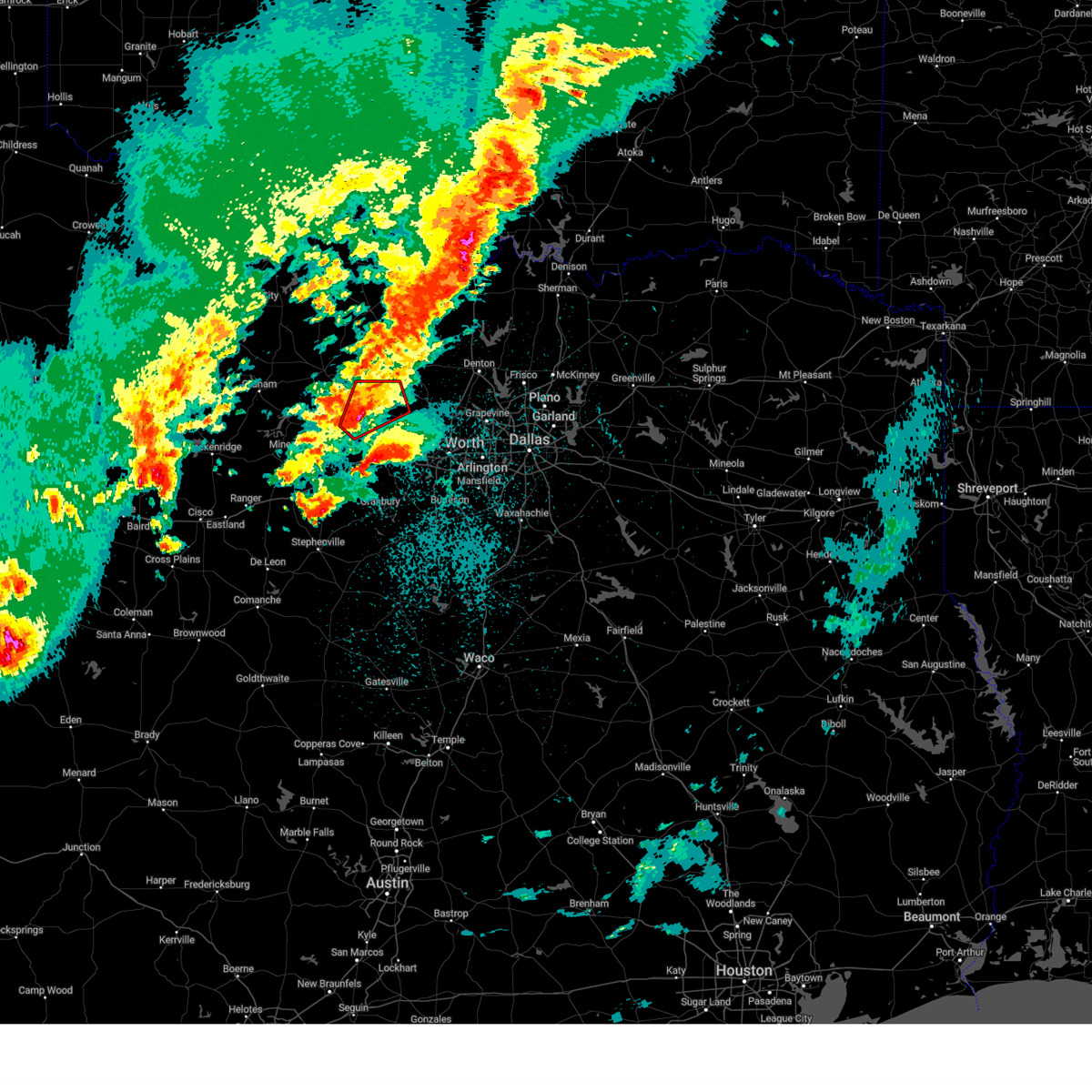
The Top Recent Hail Date for Paradise, TX is Tuesday, April 28, 2026 (5th out of 98)
Hail and Wind Damage Spotted near Paradise, TX
| Date / Time | Report Details |
|---|---|
| 4/28/2026 4:36 PM CDT |
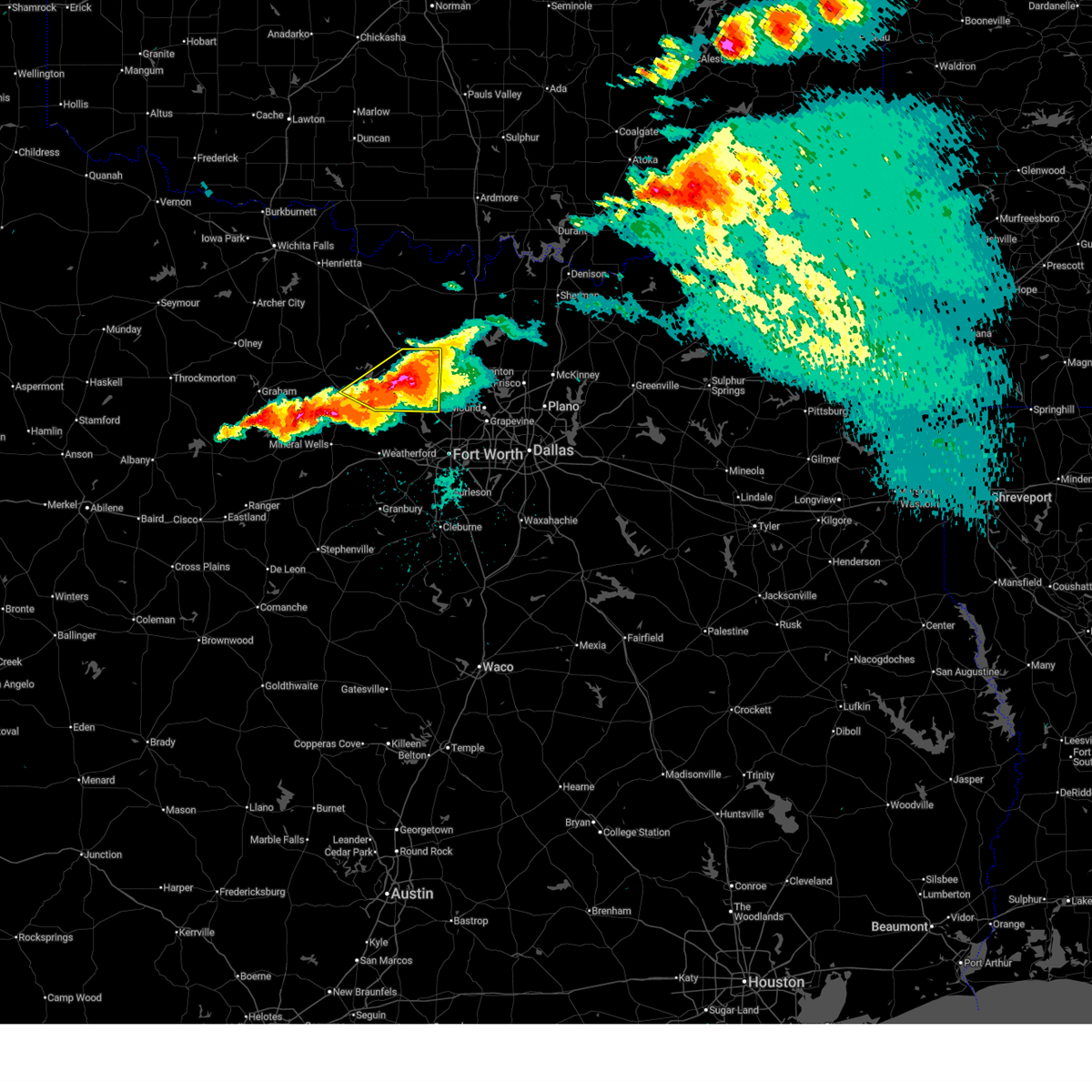 At 436 pm cdt, a severe thunderstorm was located near paradise, or 9 miles northwest of briar, moving southeast at 30 mph (radar indicated). Hazards include golf ball size hail and 70 mph wind gusts. People and animals outdoors will be injured. expect hail damage to roofs, siding, windows, and vehicles. expect considerable tree damage. wind damage is also likely to mobile homes, roofs, and outbuildings. Locations impacted include, decatur, bridgeport, briar, pecan acres, rhome, haslet, new fairview, aurora, boyd, paradise, runaway bay, newark, lake bridgeport, cottondale, keeter, joplin, balsora, and boonsville. At 436 pm cdt, a severe thunderstorm was located near paradise, or 9 miles northwest of briar, moving southeast at 30 mph (radar indicated). Hazards include golf ball size hail and 70 mph wind gusts. People and animals outdoors will be injured. expect hail damage to roofs, siding, windows, and vehicles. expect considerable tree damage. wind damage is also likely to mobile homes, roofs, and outbuildings. Locations impacted include, decatur, bridgeport, briar, pecan acres, rhome, haslet, new fairview, aurora, boyd, paradise, runaway bay, newark, lake bridgeport, cottondale, keeter, joplin, balsora, and boonsville.
|
| 4/28/2026 4:30 PM CDT |
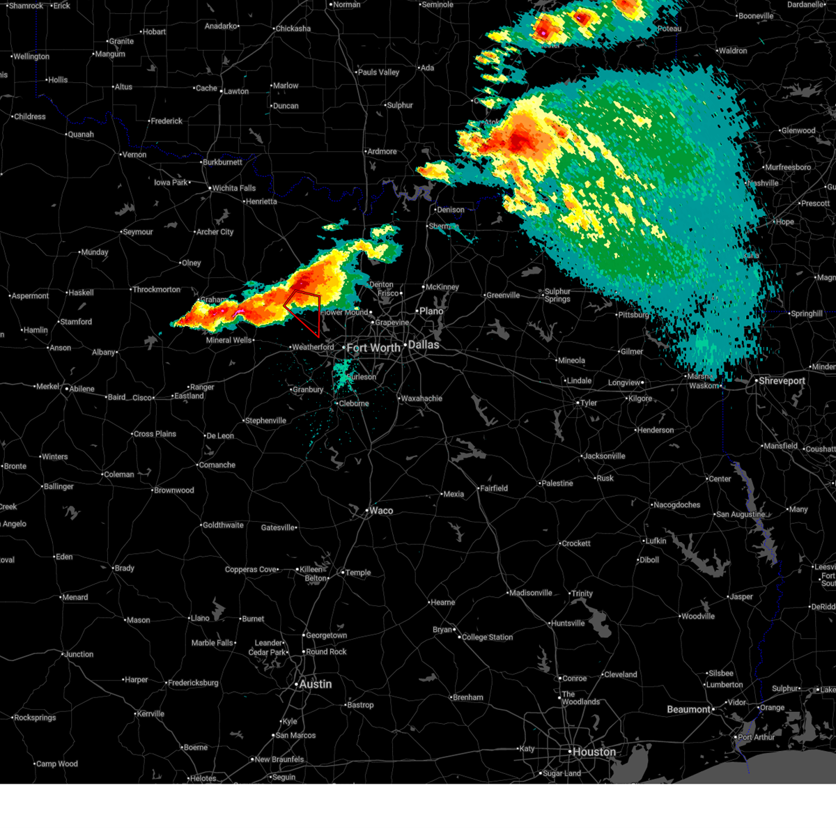 Torfwd the national weather service in fort worth has issued a * tornado warning for, southwestern wise county in north central texas, northeastern parker county in north central texas, * until 500 pm cdt. * at 429 pm cdt, a severe thunderstorm capable of producing a tornado was located near paradise, or 9 miles south of bridgeport, moving southeast at 30 mph (radar indicated rotation). Hazards include tornado and golf ball size hail plus 65 mph winds. Flying debris will be dangerous to those caught without shelter. mobile homes will be damaged or destroyed. damage to roofs, windows, and vehicles will occur. Tree damage is likely. Torfwd the national weather service in fort worth has issued a * tornado warning for, southwestern wise county in north central texas, northeastern parker county in north central texas, * until 500 pm cdt. * at 429 pm cdt, a severe thunderstorm capable of producing a tornado was located near paradise, or 9 miles south of bridgeport, moving southeast at 30 mph (radar indicated rotation). Hazards include tornado and golf ball size hail plus 65 mph winds. Flying debris will be dangerous to those caught without shelter. mobile homes will be damaged or destroyed. damage to roofs, windows, and vehicles will occur. Tree damage is likely.
|
| 4/28/2026 4:24 PM CDT | Golf Ball sized hail reported 1.7 miles SE of Paradise, TX, report of golf ball sized hail near paradise. from mping. |
| 4/28/2026 4:19 PM CDT |
 At 419 pm cdt, a large severe thunderstorm was located near bridgeport, moving southeast at 25 mph (radar indicated). Hazards include golf ball size hail and 65 mph wind gusts. People and animals outdoors will be injured. expect hail damage to roofs, siding, windows, and vehicles. expect wind damage to roofs, siding, and trees. Locations impacted include, decatur, bridgeport, briar, pecan acres, rhome, haslet, alvord, new fairview, aurora, boyd, chico, paradise, runaway bay, newark, lake bridgeport, cottondale, keeter, joplin, balsora, and boonsville. At 419 pm cdt, a large severe thunderstorm was located near bridgeport, moving southeast at 25 mph (radar indicated). Hazards include golf ball size hail and 65 mph wind gusts. People and animals outdoors will be injured. expect hail damage to roofs, siding, windows, and vehicles. expect wind damage to roofs, siding, and trees. Locations impacted include, decatur, bridgeport, briar, pecan acres, rhome, haslet, alvord, new fairview, aurora, boyd, chico, paradise, runaway bay, newark, lake bridgeport, cottondale, keeter, joplin, balsora, and boonsville.
|
| 4/28/2026 3:55 PM CDT |
 Svrfwd the national weather service in fort worth has issued a * severe thunderstorm warning for, wise county in north central texas, southeastern jack county in north central texas, * until 500 pm cdt. * at 355 pm cdt, a severe thunderstorm was located 7 miles west of lake bridgeport, or 9 miles east of jacksboro, moving southeast at 35 mph (radar indicated). Hazards include ping pong ball size hail and 60 mph wind gusts. People and animals outdoors will be injured. expect hail damage to roofs, siding, windows, and vehicles. expect wind damage to roofs, siding, and trees. this severe thunderstorm will be near, lake bridgeport around 400 pm cdt. bridgeport around 405 pm cdt. paradise around 420 pm cdt. briar and boyd around 430 pm cdt. aurora around 435 pm cdt. pecan acres and rhome around 440 pm cdt. haslet around 445 pm cdt. Other locations impacted by this severe thunderstorm include cundiff, cottondale, park springs, lake bridgeport, keeter, crafton, joplin, balsora, boonsville, and wizard wells. Svrfwd the national weather service in fort worth has issued a * severe thunderstorm warning for, wise county in north central texas, southeastern jack county in north central texas, * until 500 pm cdt. * at 355 pm cdt, a severe thunderstorm was located 7 miles west of lake bridgeport, or 9 miles east of jacksboro, moving southeast at 35 mph (radar indicated). Hazards include ping pong ball size hail and 60 mph wind gusts. People and animals outdoors will be injured. expect hail damage to roofs, siding, windows, and vehicles. expect wind damage to roofs, siding, and trees. this severe thunderstorm will be near, lake bridgeport around 400 pm cdt. bridgeport around 405 pm cdt. paradise around 420 pm cdt. briar and boyd around 430 pm cdt. aurora around 435 pm cdt. pecan acres and rhome around 440 pm cdt. haslet around 445 pm cdt. Other locations impacted by this severe thunderstorm include cundiff, cottondale, park springs, lake bridgeport, keeter, crafton, joplin, balsora, boonsville, and wizard wells.
|
| 4/28/2026 2:47 PM CDT |
 Svrfwd the national weather service in fort worth has issued a * severe thunderstorm warning for, southwestern montague county in north central texas, northwestern wise county in north central texas, northeastern jack county in north central texas, * until 400 pm cdt. * at 246 pm cdt, a severe thunderstorm was located near newport, or 13 miles west of bowie, moving southeast at 35 mph (radar indicated). Hazards include 70 mph wind gusts and ping pong ball size hail. People and animals outdoors will be injured. expect hail damage to roofs, siding, windows, and vehicles. expect considerable tree damage. Wind damage is also likely to mobile homes, roofs, and outbuildings. Svrfwd the national weather service in fort worth has issued a * severe thunderstorm warning for, southwestern montague county in north central texas, northwestern wise county in north central texas, northeastern jack county in north central texas, * until 400 pm cdt. * at 246 pm cdt, a severe thunderstorm was located near newport, or 13 miles west of bowie, moving southeast at 35 mph (radar indicated). Hazards include 70 mph wind gusts and ping pong ball size hail. People and animals outdoors will be injured. expect hail damage to roofs, siding, windows, and vehicles. expect considerable tree damage. Wind damage is also likely to mobile homes, roofs, and outbuildings.
|
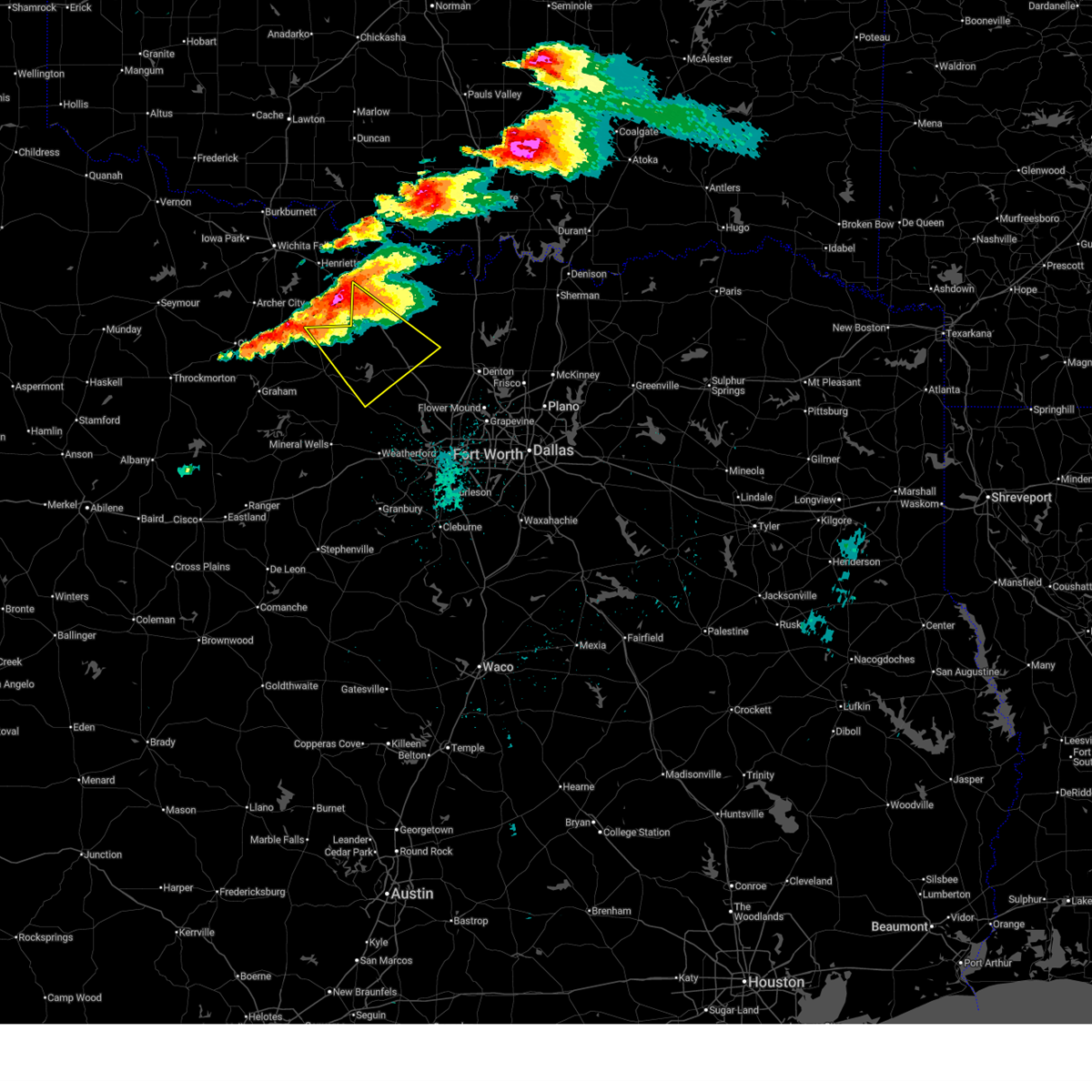
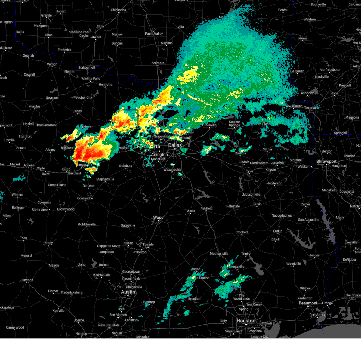
| 4/25/2026 9:46 PM CDT |
 At 945 pm cdt, severe thunderstorms were located along a line extending from near poolville to near pecan acres, moving southeast at 25 mph. these are destructive storms for southern wise, northwest tarrant, and northeast parker counties (radar indicated). Hazards include baseball size hail and 70 mph wind gusts. People and animals outdoors will be severely injured. expect shattered windows, extensive damage to roofs, siding, and vehicles. these severe storms will be near, azle, briar, eagle mountain, pecan acres, reno, springtown, pelican bay, and haslet around 950 pm cdt. Other locations impacted by these severe thunderstorms include balsora, cottondale, newark, highland addition, keeter, sanctuary, and la junta. At 945 pm cdt, severe thunderstorms were located along a line extending from near poolville to near pecan acres, moving southeast at 25 mph. these are destructive storms for southern wise, northwest tarrant, and northeast parker counties (radar indicated). Hazards include baseball size hail and 70 mph wind gusts. People and animals outdoors will be severely injured. expect shattered windows, extensive damage to roofs, siding, and vehicles. these severe storms will be near, azle, briar, eagle mountain, pecan acres, reno, springtown, pelican bay, and haslet around 950 pm cdt. Other locations impacted by these severe thunderstorms include balsora, cottondale, newark, highland addition, keeter, sanctuary, and la junta.
|
| 4/25/2026 9:28 PM CDT | Golf Ball sized hail reported 3.6 miles NNE of Paradise, TX, report from mping. |
| 4/25/2026 9:27 PM CDT |
 At 926 pm cdt, severe thunderstorms were located along a line extending from near lake bridgeport to aurora, moving southeast at 30 mph. these are destructive storms for southern wise county (radar indicated). Hazards include baseball size hail and 70 mph wind gusts. People and animals outdoors will be severely injured. expect shattered windows, extensive damage to roofs, siding, and vehicles. these severe storms will be near, briar, pecan acres, rhome, haslet, aurora, boyd, and lake bridgeport around 930 pm cdt. reno around 935 pm cdt. azle, eagle mountain, and springtown around 940 pm cdt. pelican bay around 945 pm cdt. Other locations impacted by these severe thunderstorms include balsora, cottondale, newark, runaway bay, lake bridgeport, highland addition, keeter, sanctuary, and la junta. At 926 pm cdt, severe thunderstorms were located along a line extending from near lake bridgeport to aurora, moving southeast at 30 mph. these are destructive storms for southern wise county (radar indicated). Hazards include baseball size hail and 70 mph wind gusts. People and animals outdoors will be severely injured. expect shattered windows, extensive damage to roofs, siding, and vehicles. these severe storms will be near, briar, pecan acres, rhome, haslet, aurora, boyd, and lake bridgeport around 930 pm cdt. reno around 935 pm cdt. azle, eagle mountain, and springtown around 940 pm cdt. pelican bay around 945 pm cdt. Other locations impacted by these severe thunderstorms include balsora, cottondale, newark, runaway bay, lake bridgeport, highland addition, keeter, sanctuary, and la junta.
|
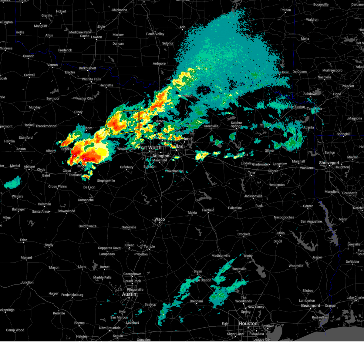
| 4/25/2026 9:23 PM CDT |
 At 923 pm cdt, a severe thunderstorm capable of producing a tornado was located near paradise, or 8 miles south of bridgeport, moving southeast at 10 mph (radar indicated rotation). Hazards include tornado and tennis ball size hail. Flying debris will be dangerous to those caught without shelter. mobile homes will be damaged or destroyed. damage to roofs, windows, and vehicles will occur. tree damage is likely. This tornadic thunderstorm will remain over mainly rural areas of southwestern wise and north central parker counties, including the following locations, balsora, boonsville, cottondale, runaway bay, lake bridgeport, keeter, and highland addition. At 923 pm cdt, a severe thunderstorm capable of producing a tornado was located near paradise, or 8 miles south of bridgeport, moving southeast at 10 mph (radar indicated rotation). Hazards include tornado and tennis ball size hail. Flying debris will be dangerous to those caught without shelter. mobile homes will be damaged or destroyed. damage to roofs, windows, and vehicles will occur. tree damage is likely. This tornadic thunderstorm will remain over mainly rural areas of southwestern wise and north central parker counties, including the following locations, balsora, boonsville, cottondale, runaway bay, lake bridgeport, keeter, and highland addition.
|
| 4/25/2026 9:15 PM CDT |
 The storms that prompted this severe thunderstorm warning conitnue to produce a severe threat. as such, a new severe thunderstorm warning has been issued for eastern jack, wise, northeast parker, and northwest tarrant counties through 1015 pm cdt. a tornado watch remains in effect until 1100 pm cdt for north central texas. The storms that prompted this severe thunderstorm warning conitnue to produce a severe threat. as such, a new severe thunderstorm warning has been issued for eastern jack, wise, northeast parker, and northwest tarrant counties through 1015 pm cdt. a tornado watch remains in effect until 1100 pm cdt for north central texas.
|
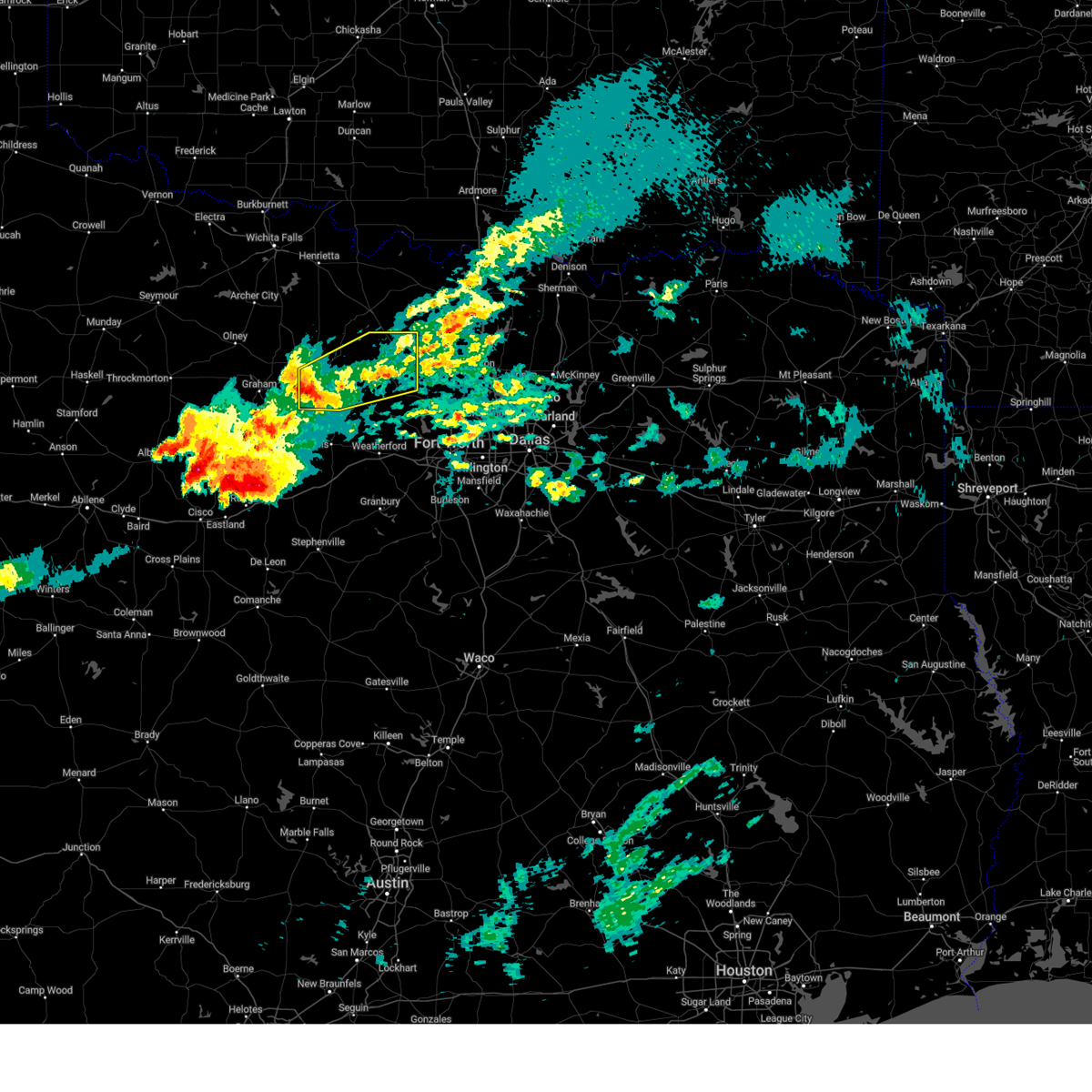
| 4/25/2026 9:13 PM CDT |
 Svrfwd the national weather service in fort worth has issued a * severe thunderstorm warning for, southwestern wise county in north central texas, east central jack county in north central texas, northeastern parker county in north central texas, northwestern tarrant county in north central texas, * until 1015 pm cdt. * at 912 pm cdt, severe thunderstorms were located along a line extending from 7 miles northwest of lake bridgeport to near boyd, moving southeast at 20 mph (radar indicated). Hazards include tennis ball size hail and 70 mph wind gusts. People and animals outdoors will be injured. expect hail damage to roofs, siding, windows, and vehicles. expect considerable tree damage. wind damage is also likely to mobile homes, roofs, and outbuildings. severe thunderstorms will be near, bridgeport, briar, pecan acres, reno, aurora, boyd, paradise, and lake bridgeport around 920 pm cdt. eagle mountain and rhome around 930 pm cdt. pelican bay and haslet around 940 pm cdt. Other locations impacted by these severe thunderstorms include balsora, wizard wells, vineyard, cottondale, newark, runaway bay, lake bridgeport, highland addition, keeter, and sanctuary. Svrfwd the national weather service in fort worth has issued a * severe thunderstorm warning for, southwestern wise county in north central texas, east central jack county in north central texas, northeastern parker county in north central texas, northwestern tarrant county in north central texas, * until 1015 pm cdt. * at 912 pm cdt, severe thunderstorms were located along a line extending from 7 miles northwest of lake bridgeport to near boyd, moving southeast at 20 mph (radar indicated). Hazards include tennis ball size hail and 70 mph wind gusts. People and animals outdoors will be injured. expect hail damage to roofs, siding, windows, and vehicles. expect considerable tree damage. wind damage is also likely to mobile homes, roofs, and outbuildings. severe thunderstorms will be near, bridgeport, briar, pecan acres, reno, aurora, boyd, paradise, and lake bridgeport around 920 pm cdt. eagle mountain and rhome around 930 pm cdt. pelican bay and haslet around 940 pm cdt. Other locations impacted by these severe thunderstorms include balsora, wizard wells, vineyard, cottondale, newark, runaway bay, lake bridgeport, highland addition, keeter, and sanctuary.
|
| 4/25/2026 9:10 PM CDT |
 Torfwd the national weather service in fort worth has issued a * tornado warning for, southwestern wise county in north central texas, east central jack county in north central texas, north central parker county in north central texas, * until 1000 pm cdt. * at 909 pm cdt, a severe thunderstorm capable of producing a tornado was located 7 miles northeast of poolville, or 9 miles south of bridgeport, moving southeast at 15 mph. an additional area of rotation was located in runaway bay, moving to the west at around 5 mph (radar indicated rotation). Hazards include tornado and tennis ball size hail. Flying debris will be dangerous to those caught without shelter. mobile homes will be damaged or destroyed. damage to roofs, windows, and vehicles will occur. tree damage is likely. this dangerous storm will be near, springtown around 925 pm cdt. briar around 940 pm cdt. Other locations impacted by this tornadic thunderstorm include balsora, boonsville, vineyard, cottondale, runaway bay, lake bridgeport, keeter, wizard wells, and highland addition. Torfwd the national weather service in fort worth has issued a * tornado warning for, southwestern wise county in north central texas, east central jack county in north central texas, north central parker county in north central texas, * until 1000 pm cdt. * at 909 pm cdt, a severe thunderstorm capable of producing a tornado was located 7 miles northeast of poolville, or 9 miles south of bridgeport, moving southeast at 15 mph. an additional area of rotation was located in runaway bay, moving to the west at around 5 mph (radar indicated rotation). Hazards include tornado and tennis ball size hail. Flying debris will be dangerous to those caught without shelter. mobile homes will be damaged or destroyed. damage to roofs, windows, and vehicles will occur. tree damage is likely. this dangerous storm will be near, springtown around 925 pm cdt. briar around 940 pm cdt. Other locations impacted by this tornadic thunderstorm include balsora, boonsville, vineyard, cottondale, runaway bay, lake bridgeport, keeter, wizard wells, and highland addition.
|
| 4/25/2026 9:02 PM CDT |
 At 902 pm cdt, severe thunderstorms were located along a line extending from near springtown to 8 miles northwest of lake bridgeport, moving southeast at 30 mph (radar indicated). Hazards include tennis ball size hail and 70 mph wind gusts. People and animals outdoors will be injured. expect hail damage to roofs, siding, windows, and vehicles. expect considerable tree damage. wind damage is also likely to mobile homes, roofs, and outbuildings. these severe storms will be near, azle, bridgeport, briar, reno, springtown, and lake bridgeport around 910 pm cdt. paradise around 915 pm cdt. pecan acres around 930 pm cdt. boyd around 940 pm cdt. Other locations impacted by these severe thunderstorms include cundiff, cottondale, lake bridgeport, keeter, crafton, balsora, agnes, boonsville, wizard wells, and vineyard. At 902 pm cdt, severe thunderstorms were located along a line extending from near springtown to 8 miles northwest of lake bridgeport, moving southeast at 30 mph (radar indicated). Hazards include tennis ball size hail and 70 mph wind gusts. People and animals outdoors will be injured. expect hail damage to roofs, siding, windows, and vehicles. expect considerable tree damage. wind damage is also likely to mobile homes, roofs, and outbuildings. these severe storms will be near, azle, bridgeport, briar, reno, springtown, and lake bridgeport around 910 pm cdt. paradise around 915 pm cdt. pecan acres around 930 pm cdt. boyd around 940 pm cdt. Other locations impacted by these severe thunderstorms include cundiff, cottondale, lake bridgeport, keeter, crafton, balsora, agnes, boonsville, wizard wells, and vineyard.
|
| 4/25/2026 9:00 PM CDT | Golf Ball sized hail reported 5.9 miles NNE of Paradise, TX |
| 4/25/2026 8:50 PM CDT |
 At 849 pm cdt, severe thunderstorms were located along a line extending from 6 miles southwest of paradise to 7 miles south of newport, moving east at 15 mph (public. at 843 pm cdt 2 inch hail was reported in runaway bay). Hazards include two inch hail and 70 mph wind gusts. People and animals outdoors will be injured. expect hail damage to roofs, siding, windows, and vehicles. expect considerable tree damage. wind damage is also likely to mobile homes, roofs, and outbuildings. these severe storms will be near, bridgeport, paradise, and lake bridgeport around 855 pm cdt. chico around 905 pm cdt. briar and boyd around 910 pm cdt. aurora around 920 pm cdt. pecan acres and rhome around 925 pm cdt. Other locations impacted by these severe thunderstorms include cundiff, cottondale, lake bridgeport, keeter, crafton, joplin, balsora, agnes, boonsville, and wizard wells. At 849 pm cdt, severe thunderstorms were located along a line extending from 6 miles southwest of paradise to 7 miles south of newport, moving east at 15 mph (public. at 843 pm cdt 2 inch hail was reported in runaway bay). Hazards include two inch hail and 70 mph wind gusts. People and animals outdoors will be injured. expect hail damage to roofs, siding, windows, and vehicles. expect considerable tree damage. wind damage is also likely to mobile homes, roofs, and outbuildings. these severe storms will be near, bridgeport, paradise, and lake bridgeport around 855 pm cdt. chico around 905 pm cdt. briar and boyd around 910 pm cdt. aurora around 920 pm cdt. pecan acres and rhome around 925 pm cdt. Other locations impacted by these severe thunderstorms include cundiff, cottondale, lake bridgeport, keeter, crafton, joplin, balsora, agnes, boonsville, and wizard wells.
|
| 4/25/2026 8:16 PM CDT |
 Svrfwd the national weather service in fort worth has issued a * severe thunderstorm warning for, wise county in north central texas, eastern jack county in north central texas, northeastern parker county in north central texas, * until 915 pm cdt. * at 815 pm cdt, a severe thunderstorm was located near lake bridgeport, or 8 miles west of bridgeport, moving southeast at 35 mph. this is a destructive storm for eastern jack, western and southern wise, and northern parker counties. (radar indicated). Hazards include baseball size hail and 70 mph wind gusts. People and animals outdoors will be severely injured. expect shattered windows, extensive damage to roofs, siding, and vehicles. this severe thunderstorm will be near, bridgeport and lake bridgeport around 820 pm cdt. springtown around 845 pm cdt. briar and reno around 850 pm cdt. azle around 900 pm cdt. Other locations impacted by this severe thunderstorm include cundiff, cottondale, lake bridgeport, keeter, crafton, gibtown, joplin, balsora, agnes, and boonsville. Svrfwd the national weather service in fort worth has issued a * severe thunderstorm warning for, wise county in north central texas, eastern jack county in north central texas, northeastern parker county in north central texas, * until 915 pm cdt. * at 815 pm cdt, a severe thunderstorm was located near lake bridgeport, or 8 miles west of bridgeport, moving southeast at 35 mph. this is a destructive storm for eastern jack, western and southern wise, and northern parker counties. (radar indicated). Hazards include baseball size hail and 70 mph wind gusts. People and animals outdoors will be severely injured. expect shattered windows, extensive damage to roofs, siding, and vehicles. this severe thunderstorm will be near, bridgeport and lake bridgeport around 820 pm cdt. springtown around 845 pm cdt. briar and reno around 850 pm cdt. azle around 900 pm cdt. Other locations impacted by this severe thunderstorm include cundiff, cottondale, lake bridgeport, keeter, crafton, gibtown, joplin, balsora, agnes, and boonsville.
|
| 4/15/2026 7:13 PM CDT |
 Svrfwd the national weather service in fort worth has issued a * severe thunderstorm warning for, wise county in north central texas, east central jack county in north central texas, * until 800 pm cdt. * at 713 pm cdt, a severe thunderstorm was located near lake bridgeport, or 8 miles west of bridgeport, moving east at 40 mph (radar indicated). Hazards include ping pong ball size hail and 60 mph wind gusts. People and animals outdoors will be injured. expect hail damage to roofs, siding, windows, and vehicles. expect wind damage to roofs, siding, and trees. this severe thunderstorm will be near, bridgeport and lake bridgeport around 720 pm cdt. decatur around 730 pm cdt. Other locations impacted by this severe thunderstorm include balsora, vineyard, wizard wells, greenwood, runaway bay, lake bridgeport, and slidell. Svrfwd the national weather service in fort worth has issued a * severe thunderstorm warning for, wise county in north central texas, east central jack county in north central texas, * until 800 pm cdt. * at 713 pm cdt, a severe thunderstorm was located near lake bridgeport, or 8 miles west of bridgeport, moving east at 40 mph (radar indicated). Hazards include ping pong ball size hail and 60 mph wind gusts. People and animals outdoors will be injured. expect hail damage to roofs, siding, windows, and vehicles. expect wind damage to roofs, siding, and trees. this severe thunderstorm will be near, bridgeport and lake bridgeport around 720 pm cdt. decatur around 730 pm cdt. Other locations impacted by this severe thunderstorm include balsora, vineyard, wizard wells, greenwood, runaway bay, lake bridgeport, and slidell.
|
| 3/10/2026 8:55 PM CDT | Corrects previous tstm wnd dmg report from 2 n paradise. delayed report. emergency manager reported downed trees on cr 3250 north of paradis in wise county TX, 1.8 miles S of Paradise, TX |
| 3/10/2026 8:55 PM CDT | Corrects previous tstm wnd dmg report from 2 n paradise. delayed report. emergency manager reported downed trees on cr 3250 north of paradis in wise county TX, 1.8 miles S of Paradise, TX |
| 3/10/2026 8:54 PM CDT |
 Svrfwd the national weather service in fort worth has issued a * severe thunderstorm warning for, southeastern montague county in north central texas, wise county in north central texas, denton county in north central texas, southern cooke county in north central texas, * until 1000 pm cdt. * at 854 pm cdt, a severe thunderstorm was located over decatur, moving east at 50 mph (radar indicated). Hazards include 65 mph wind gusts and quarter size hail. Hail damage to vehicles is expected. expect wind damage to roofs, siding, and trees. this severe thunderstorm will be near, sanger around 915 pm cdt. ray roberts park isle du bois and ray roberts park johnson branch around 930 pm cdt. pilot point around 935 pm cdt. other locations impacted by this severe thunderstorm include rosston, valley view, cottondale, providence village, stony, ponder, lake ray roberts, lewisville lake, bolivar, and lincoln park. this includes the following highways, interstate 35 between mile markers 468 and 501. interstate 35w between mile markers 68 and 85. Interstate 35e between mile markers 446 and 466. Svrfwd the national weather service in fort worth has issued a * severe thunderstorm warning for, southeastern montague county in north central texas, wise county in north central texas, denton county in north central texas, southern cooke county in north central texas, * until 1000 pm cdt. * at 854 pm cdt, a severe thunderstorm was located over decatur, moving east at 50 mph (radar indicated). Hazards include 65 mph wind gusts and quarter size hail. Hail damage to vehicles is expected. expect wind damage to roofs, siding, and trees. this severe thunderstorm will be near, sanger around 915 pm cdt. ray roberts park isle du bois and ray roberts park johnson branch around 930 pm cdt. pilot point around 935 pm cdt. other locations impacted by this severe thunderstorm include rosston, valley view, cottondale, providence village, stony, ponder, lake ray roberts, lewisville lake, bolivar, and lincoln park. this includes the following highways, interstate 35 between mile markers 468 and 501. interstate 35w between mile markers 68 and 85. Interstate 35e between mile markers 446 and 466.
|
| 3/10/2026 8:46 PM CDT | Quarter sized hail reported 6.5 miles NNE of Paradise, TX, amateur radio operator relayed report of 1 inch hail south of bridgeport. |
| 3/10/2026 8:06 PM CDT |
 Svrfwd the national weather service in fort worth has issued a * severe thunderstorm warning for, wise county in north central texas, eastern jack county in north central texas, * until 900 pm cdt. * at 806 pm cdt, a severe thunderstorm was located near fort richardson state park, or 7 miles south of jacksboro, moving northeast at 45 mph (radar indicated). Hazards include 70 mph wind gusts and quarter size hail. Hail damage to vehicles is expected. expect considerable tree damage. wind damage is also likely to mobile homes, roofs, and outbuildings. this severe thunderstorm will be near, lake bridgeport around 820 pm cdt. bridgeport and chico around 835 pm cdt. alvord around 845 pm cdt. Other locations impacted by this severe thunderstorm include lost creek reservoir, cundiff, greenwood, cottondale, park springs, lake bridgeport, keeter, crafton, gibtown, and joplin. Svrfwd the national weather service in fort worth has issued a * severe thunderstorm warning for, wise county in north central texas, eastern jack county in north central texas, * until 900 pm cdt. * at 806 pm cdt, a severe thunderstorm was located near fort richardson state park, or 7 miles south of jacksboro, moving northeast at 45 mph (radar indicated). Hazards include 70 mph wind gusts and quarter size hail. Hail damage to vehicles is expected. expect considerable tree damage. wind damage is also likely to mobile homes, roofs, and outbuildings. this severe thunderstorm will be near, lake bridgeport around 820 pm cdt. bridgeport and chico around 835 pm cdt. alvord around 845 pm cdt. Other locations impacted by this severe thunderstorm include lost creek reservoir, cundiff, greenwood, cottondale, park springs, lake bridgeport, keeter, crafton, gibtown, and joplin.
|
| 3/4/2026 10:21 PM CST |
 The storm which prompted the warning has weakened below severe limits, and has exited the warned area. therefore, the warning will be allowed to expire. however gusty winds and heavy rain are still possible with this thunderstorm. a severe thunderstorm watch remains in effect until 1100 pm cst for north central texas. The storm which prompted the warning has weakened below severe limits, and has exited the warned area. therefore, the warning will be allowed to expire. however gusty winds and heavy rain are still possible with this thunderstorm. a severe thunderstorm watch remains in effect until 1100 pm cst for north central texas.
|
| 3/4/2026 9:49 PM CST |
 Svrfwd the national weather service in fort worth has issued a * severe thunderstorm warning for, northwestern wise county in north central texas, * until 1030 pm cst. * at 949 pm cst, a severe thunderstorm was located over chico, or near bridgeport, moving northeast at 30 mph (radar indicated). Hazards include half dollar size hail. Damage to vehicles is possible. this severe thunderstorm will be near, alvord around 955 pm cst. Other locations impacted by this severe thunderstorm include park springs, greenwood, and lake bridgeport. Svrfwd the national weather service in fort worth has issued a * severe thunderstorm warning for, northwestern wise county in north central texas, * until 1030 pm cst. * at 949 pm cst, a severe thunderstorm was located over chico, or near bridgeport, moving northeast at 30 mph (radar indicated). Hazards include half dollar size hail. Damage to vehicles is possible. this severe thunderstorm will be near, alvord around 955 pm cst. Other locations impacted by this severe thunderstorm include park springs, greenwood, and lake bridgeport.
|
| 9/23/2025 7:07 PM CDT | Svrfwd the national weather service in fort worth has issued a * severe thunderstorm warning for, northern wise county in north central texas, east central jack county in north central texas, * until 800 pm cdt. * at 707 pm cdt, a severe thunderstorm was located near lake bridgeport, or 9 miles west of bridgeport, moving east at 30 mph (radar indicated). Hazards include 60 mph wind gusts and quarter size hail. Hail damage to vehicles is expected. expect wind damage to roofs, siding, and trees. this severe thunderstorm will be near, lake bridgeport around 710 pm cdt. bridgeport and chico around 715 pm cdt. decatur around 740 pm cdt. Other locations impacted by this severe thunderstorm include vineyard, cundiff, wizard wells, greenwood, slidell, runaway bay, and lake bridgeport. |
| 8/4/2025 4:19 AM CDT |
 At 419 am cdt, a severe thunderstorm was located near lake bridgeport, or 10 miles west of bridgeport, moving southeast at 30 mph (radar indicated). Hazards include 60 mph wind gusts and quarter size hail. Hail damage to vehicles is expected. expect wind damage to roofs, siding, and trees. this severe storm will be near, lake bridgeport around 425 am cdt. Other locations impacted by this severe thunderstorm include gibtown, joplin, balsora, boonsville, cundiff, vineyard, wizard wells, runaway bay, and lake bridgeport. At 419 am cdt, a severe thunderstorm was located near lake bridgeport, or 10 miles west of bridgeport, moving southeast at 30 mph (radar indicated). Hazards include 60 mph wind gusts and quarter size hail. Hail damage to vehicles is expected. expect wind damage to roofs, siding, and trees. this severe storm will be near, lake bridgeport around 425 am cdt. Other locations impacted by this severe thunderstorm include gibtown, joplin, balsora, boonsville, cundiff, vineyard, wizard wells, runaway bay, and lake bridgeport.
|
| 8/4/2025 3:59 AM CDT |
 At 359 am cdt, a severe thunderstorm was located 9 miles northeast of jacksboro, moving south at 20 mph (radar indicated). Hazards include ping pong ball size hail and 60 mph wind gusts. People and animals outdoors will be injured. expect hail damage to roofs, siding, windows, and vehicles. expect wind damage to roofs, siding, and trees. this severe storm will be near, lake bridgeport around 410 am cdt. Other locations impacted by this severe thunderstorm include gibtown, joplin, balsora, boonsville, cundiff, vineyard, wizard wells, runaway bay, lake bridgeport, and crafton. At 359 am cdt, a severe thunderstorm was located 9 miles northeast of jacksboro, moving south at 20 mph (radar indicated). Hazards include ping pong ball size hail and 60 mph wind gusts. People and animals outdoors will be injured. expect hail damage to roofs, siding, windows, and vehicles. expect wind damage to roofs, siding, and trees. this severe storm will be near, lake bridgeport around 410 am cdt. Other locations impacted by this severe thunderstorm include gibtown, joplin, balsora, boonsville, cundiff, vineyard, wizard wells, runaway bay, lake bridgeport, and crafton.
|
| 8/4/2025 3:44 AM CDT |
 Svrfwd the national weather service in fort worth has issued a * severe thunderstorm warning for, western wise county in north central texas, eastern jack county in north central texas, * until 445 am cdt. * at 344 am cdt, a severe thunderstorm was located near newport, or 12 miles northeast of jacksboro, moving southeast at 25 mph (radar indicated). Hazards include 60 mph wind gusts and quarter size hail. Hail damage to vehicles is expected. expect wind damage to roofs, siding, and trees. this severe thunderstorm will be near, lake bridgeport around 400 am cdt. Other locations impacted by this severe thunderstorm include gibtown, joplin, balsora, boonsville, cundiff, vineyard, wizard wells, park springs, runaway bay, and lake bridgeport. Svrfwd the national weather service in fort worth has issued a * severe thunderstorm warning for, western wise county in north central texas, eastern jack county in north central texas, * until 445 am cdt. * at 344 am cdt, a severe thunderstorm was located near newport, or 12 miles northeast of jacksboro, moving southeast at 25 mph (radar indicated). Hazards include 60 mph wind gusts and quarter size hail. Hail damage to vehicles is expected. expect wind damage to roofs, siding, and trees. this severe thunderstorm will be near, lake bridgeport around 400 am cdt. Other locations impacted by this severe thunderstorm include gibtown, joplin, balsora, boonsville, cundiff, vineyard, wizard wells, park springs, runaway bay, and lake bridgeport.
|
| 6/8/2025 9:41 PM CDT |
 At 940 pm cdt, severe thunderstorms were located along a line extending from near ray roberts park johnson branch to near chico, moving southeast at 35 mph (radar indicated). Hazards include 70 mph wind gusts and quarter size hail. Hail damage to vehicles is expected. expect considerable tree damage. wind damage is also likely to mobile homes, roofs, and outbuildings. these severe storms will be near, sanger, bridgeport, ray roberts park isle du bois, decatur, and ray roberts park johnson branch around 945 pm cdt. denton and pilot point around 950 pm cdt. paradise, aubrey, and krum around 955 pm cdt. krugerville, new fairview, and cross roads around 1000 pm cdt. hackberry, and little elm around 1015 pm cdt. the colony around 1020 pm cdt. Other locations impacted by these severe thunderstorms include rosston, valley view, park springs, crafton, providence village, stony, ponder, lake ray roberts, bolivar, and lincoln park. At 940 pm cdt, severe thunderstorms were located along a line extending from near ray roberts park johnson branch to near chico, moving southeast at 35 mph (radar indicated). Hazards include 70 mph wind gusts and quarter size hail. Hail damage to vehicles is expected. expect considerable tree damage. wind damage is also likely to mobile homes, roofs, and outbuildings. these severe storms will be near, sanger, bridgeport, ray roberts park isle du bois, decatur, and ray roberts park johnson branch around 945 pm cdt. denton and pilot point around 950 pm cdt. paradise, aubrey, and krum around 955 pm cdt. krugerville, new fairview, and cross roads around 1000 pm cdt. hackberry, and little elm around 1015 pm cdt. the colony around 1020 pm cdt. Other locations impacted by these severe thunderstorms include rosston, valley view, park springs, crafton, providence village, stony, ponder, lake ray roberts, bolivar, and lincoln park.
|
| 6/8/2025 9:04 PM CDT |
 Svrfwd the national weather service in fort worth has issued a * severe thunderstorm warning for, southern montague county in north central texas, wise county in north central texas, denton county in north central texas, cooke county in north central texas, * until 1000 pm cdt. * at 904 pm cdt, severe thunderstorms were located along a line extending from near lindsay to bowie, moving southeast at 45 mph (radar indicated). Hazards include 70 mph wind gusts and quarter size hail. Hail damage to vehicles is expected. expect considerable tree damage. wind damage is also likely to mobile homes, roofs, and outbuildings. severe thunderstorms will be near, lindsay, sunset, and gainesville around 910 pm cdt. lake kiowa around 915 pm cdt. alvord around 920 pm cdt. sanger and ray roberts park johnson branch around 925 pm cdt. ray roberts park isle du bois and pilot point around 930 pm cdt. denton and decatur around 935 pm cdt. aubrey and krum around 940 pm cdt. krugerville, new fairview, celina, and cross roads around 945 pm cdt. other locations impacted by these severe thunderstorms include rosston, valley view, park springs, crafton, providence village, stony, ponder, lake ray roberts, bolivar, and lincoln park. this includes the following highways, interstate 35 between mile markers 468 and 503. interstate 35w between mile markers 79 and 85. Interstate 35e between mile markers 458 and 466. Svrfwd the national weather service in fort worth has issued a * severe thunderstorm warning for, southern montague county in north central texas, wise county in north central texas, denton county in north central texas, cooke county in north central texas, * until 1000 pm cdt. * at 904 pm cdt, severe thunderstorms were located along a line extending from near lindsay to bowie, moving southeast at 45 mph (radar indicated). Hazards include 70 mph wind gusts and quarter size hail. Hail damage to vehicles is expected. expect considerable tree damage. wind damage is also likely to mobile homes, roofs, and outbuildings. severe thunderstorms will be near, lindsay, sunset, and gainesville around 910 pm cdt. lake kiowa around 915 pm cdt. alvord around 920 pm cdt. sanger and ray roberts park johnson branch around 925 pm cdt. ray roberts park isle du bois and pilot point around 930 pm cdt. denton and decatur around 935 pm cdt. aubrey and krum around 940 pm cdt. krugerville, new fairview, celina, and cross roads around 945 pm cdt. other locations impacted by these severe thunderstorms include rosston, valley view, park springs, crafton, providence village, stony, ponder, lake ray roberts, bolivar, and lincoln park. this includes the following highways, interstate 35 between mile markers 468 and 503. interstate 35w between mile markers 79 and 85. Interstate 35e between mile markers 458 and 466.
|
| 5/18/2025 8:39 PM CDT |
 The storm which prompted the warning has weakened below severe limits. therefore the warning will be allowed to expire. however small hail, gusty winds and heavy rain are still possible with this thunderstorm. a tornado watch remains in effect until 1000 pm cdt for north central texas. The storm which prompted the warning has weakened below severe limits. therefore the warning will be allowed to expire. however small hail, gusty winds and heavy rain are still possible with this thunderstorm. a tornado watch remains in effect until 1000 pm cdt for north central texas.
|
| 5/18/2025 8:15 PM CDT |
 At 815 pm cdt, a severe thunderstorm was located 7 miles northwest of krum, or 9 miles west of sanger, moving east at 35 mph (radar indicated). Hazards include ping pong ball size hail and 60 mph wind gusts. People and animals outdoors will be injured. expect hail damage to roofs, siding, windows, and vehicles. expect wind damage to roofs, siding, and trees. this severe storm will be near, sanger around 820 pm cdt. Other locations impacted by this severe thunderstorm include stony, ponder, greenwood, bolivar, slidell, dish, cottondale, and lake ray roberts. At 815 pm cdt, a severe thunderstorm was located 7 miles northwest of krum, or 9 miles west of sanger, moving east at 35 mph (radar indicated). Hazards include ping pong ball size hail and 60 mph wind gusts. People and animals outdoors will be injured. expect hail damage to roofs, siding, windows, and vehicles. expect wind damage to roofs, siding, and trees. this severe storm will be near, sanger around 820 pm cdt. Other locations impacted by this severe thunderstorm include stony, ponder, greenwood, bolivar, slidell, dish, cottondale, and lake ray roberts.
|
| 5/18/2025 7:58 PM CDT |
 At 756 pm cdt, a severe thunderstorm was located near decatur, moving east at 35 mph (radar indicated). Hazards include 60 mph wind gusts and quarter size hail. Hail damage to vehicles is expected. expect wind damage to roofs, siding, and trees. this severe storm will be near, sanger around 815 pm cdt. Other locations impacted by this severe thunderstorm include stony, ponder, greenwood, bolivar, slidell, dish, cottondale, and lake ray roberts. At 756 pm cdt, a severe thunderstorm was located near decatur, moving east at 35 mph (radar indicated). Hazards include 60 mph wind gusts and quarter size hail. Hail damage to vehicles is expected. expect wind damage to roofs, siding, and trees. this severe storm will be near, sanger around 815 pm cdt. Other locations impacted by this severe thunderstorm include stony, ponder, greenwood, bolivar, slidell, dish, cottondale, and lake ray roberts.
|
| 5/18/2025 7:45 PM CDT |
 Svrfwd the national weather service in fort worth has issued a * severe thunderstorm warning for, central wise county in north central texas, northwestern denton county in north central texas, * until 845 pm cdt. * at 744 pm cdt, a severe thunderstorm was located near bridgeport, moving east at 35 mph (radar indicated). Hazards include 60 mph wind gusts and half dollar size hail. Hail damage to vehicles is expected. expect wind damage to roofs, siding, and trees. this severe thunderstorm will be near, decatur around 750 pm cdt. krum around 825 pm cdt. denton and sanger around 830 pm cdt. Other locations impacted by this severe thunderstorm include stony, ponder, greenwood, bolivar, slidell, dish, cottondale, and lake ray roberts. Svrfwd the national weather service in fort worth has issued a * severe thunderstorm warning for, central wise county in north central texas, northwestern denton county in north central texas, * until 845 pm cdt. * at 744 pm cdt, a severe thunderstorm was located near bridgeport, moving east at 35 mph (radar indicated). Hazards include 60 mph wind gusts and half dollar size hail. Hail damage to vehicles is expected. expect wind damage to roofs, siding, and trees. this severe thunderstorm will be near, decatur around 750 pm cdt. krum around 825 pm cdt. denton and sanger around 830 pm cdt. Other locations impacted by this severe thunderstorm include stony, ponder, greenwood, bolivar, slidell, dish, cottondale, and lake ray roberts.
|
| 5/18/2025 7:27 PM CDT |
 At 724 pm cdt, a severe thunderstorm was located over lake bridgeport, or 7 miles west of bridgeport, moving northeast at 35 mph (radar indicated). Hazards include 60 mph wind gusts and quarter size hail. Hail damage to vehicles is expected. expect wind damage to roofs, siding, and trees. this severe storm will be near, bridgeport and lake bridgeport around 730 pm cdt. chico around 735 pm cdt. decatur around 750 pm cdt. Other locations impacted by this severe thunderstorm include joplin, balsora, vineyard, wizard wells, cundiff, park springs, runaway bay, lake bridgeport, and crafton. At 724 pm cdt, a severe thunderstorm was located over lake bridgeport, or 7 miles west of bridgeport, moving northeast at 35 mph (radar indicated). Hazards include 60 mph wind gusts and quarter size hail. Hail damage to vehicles is expected. expect wind damage to roofs, siding, and trees. this severe storm will be near, bridgeport and lake bridgeport around 730 pm cdt. chico around 735 pm cdt. decatur around 750 pm cdt. Other locations impacted by this severe thunderstorm include joplin, balsora, vineyard, wizard wells, cundiff, park springs, runaway bay, lake bridgeport, and crafton.
|
| 5/18/2025 7:12 PM CDT |
 At 712 pm cdt, a severe thunderstorm was located 7 miles east of jacksboro, moving northeast at 45 mph (radar indicated). Hazards include ping pong ball size hail and 60 mph wind gusts. People and animals outdoors will be injured. expect hail damage to roofs, siding, windows, and vehicles. expect wind damage to roofs, siding, and trees. this severe storm will be near, lake bridgeport around 715 pm cdt. chico around 725 pm cdt. bridgeport around 730 pm cdt. alvord around 735 pm cdt. Other locations impacted by this severe thunderstorm include joplin, balsora, boonsville, lost creek reservoir, vineyard, wizard wells, cundiff, park springs, runaway bay, and lake bridgeport. At 712 pm cdt, a severe thunderstorm was located 7 miles east of jacksboro, moving northeast at 45 mph (radar indicated). Hazards include ping pong ball size hail and 60 mph wind gusts. People and animals outdoors will be injured. expect hail damage to roofs, siding, windows, and vehicles. expect wind damage to roofs, siding, and trees. this severe storm will be near, lake bridgeport around 715 pm cdt. chico around 725 pm cdt. bridgeport around 730 pm cdt. alvord around 735 pm cdt. Other locations impacted by this severe thunderstorm include joplin, balsora, boonsville, lost creek reservoir, vineyard, wizard wells, cundiff, park springs, runaway bay, and lake bridgeport.
|
| 5/18/2025 6:59 PM CDT |
 Svrfwd the national weather service in fort worth has issued a * severe thunderstorm warning for, western wise county in north central texas, southern jack county in north central texas, * until 745 pm cdt. * at 659 pm cdt, a severe thunderstorm was located near fort richardson state park, or near jacksboro, moving northeast at 45 mph (radar indicated). Hazards include ping pong ball size hail and 60 mph wind gusts. People and animals outdoors will be injured. expect hail damage to roofs, siding, windows, and vehicles. expect wind damage to roofs, siding, and trees. this severe thunderstorm will be near, jacksboro and fort richardson state park around 705 pm cdt. lake bridgeport around 710 pm cdt. chico around 725 pm cdt. alvord around 735 pm cdt. Other locations impacted by this severe thunderstorm include lost creek reservoir, cundiff, park springs, lake bridgeport, crafton, gibtown, joplin, balsora, perrin, and bartons chapel. Svrfwd the national weather service in fort worth has issued a * severe thunderstorm warning for, western wise county in north central texas, southern jack county in north central texas, * until 745 pm cdt. * at 659 pm cdt, a severe thunderstorm was located near fort richardson state park, or near jacksboro, moving northeast at 45 mph (radar indicated). Hazards include ping pong ball size hail and 60 mph wind gusts. People and animals outdoors will be injured. expect hail damage to roofs, siding, windows, and vehicles. expect wind damage to roofs, siding, and trees. this severe thunderstorm will be near, jacksboro and fort richardson state park around 705 pm cdt. lake bridgeport around 710 pm cdt. chico around 725 pm cdt. alvord around 735 pm cdt. Other locations impacted by this severe thunderstorm include lost creek reservoir, cundiff, park springs, lake bridgeport, crafton, gibtown, joplin, balsora, perrin, and bartons chapel.
|
| 5/17/2025 6:27 PM CDT |
 the severe thunderstorm warning has been cancelled and is no longer in effect the severe thunderstorm warning has been cancelled and is no longer in effect
|
| 5/17/2025 6:04 PM CDT |
 the severe thunderstorm warning has been cancelled and is no longer in effect the severe thunderstorm warning has been cancelled and is no longer in effect
|
| 5/17/2025 6:03 PM CDT |
 Svrfwd the national weather service in fort worth has issued a * severe thunderstorm warning for, southern montague county in north central texas, wise county in north central texas, southwestern cooke county in north central texas, * until 700 pm cdt. * at 602 pm cdt, a severe thunderstorm was located over lake bridgeport, moving northeast at 35 mph (emergency management. at 558 pm cdt....baseball size hail and downed trees were reported near bridgeport and runaway bay with this storm). Hazards include golf ball size hail and 60 mph wind gusts. People and animals outdoors will be injured. expect hail damage to roofs, siding, windows, and vehicles. Expect wind damage to roofs, siding, and trees. Svrfwd the national weather service in fort worth has issued a * severe thunderstorm warning for, southern montague county in north central texas, wise county in north central texas, southwestern cooke county in north central texas, * until 700 pm cdt. * at 602 pm cdt, a severe thunderstorm was located over lake bridgeport, moving northeast at 35 mph (emergency management. at 558 pm cdt....baseball size hail and downed trees were reported near bridgeport and runaway bay with this storm). Hazards include golf ball size hail and 60 mph wind gusts. People and animals outdoors will be injured. expect hail damage to roofs, siding, windows, and vehicles. Expect wind damage to roofs, siding, and trees.
|
| 5/17/2025 5:50 PM CDT |
 the severe thunderstorm warning has been cancelled and is no longer in effect the severe thunderstorm warning has been cancelled and is no longer in effect
|
| 5/17/2025 5:50 PM CDT |
 At 549 pm cdt, a severe thunderstorm was located near runaway bay and vineyard, or 11 miles southwest of bridgeport, moving northeast at 25 mph (trained weather spotters). Hazards include golf ball size hail and 70 mph wind gusts. People and animals outdoors will be injured. expect hail damage to roofs, siding, windows, and vehicles. expect considerable tree damage. wind damage is also likely to mobile homes, roofs, and outbuildings. Locations impacted include, cottondale, lake bridgeport, gibtown, bridgeport, joplin, balsora, chico, boonsville, vineyard, wizard wells, runaway bay, paradise, and jacksboro. At 549 pm cdt, a severe thunderstorm was located near runaway bay and vineyard, or 11 miles southwest of bridgeport, moving northeast at 25 mph (trained weather spotters). Hazards include golf ball size hail and 70 mph wind gusts. People and animals outdoors will be injured. expect hail damage to roofs, siding, windows, and vehicles. expect considerable tree damage. wind damage is also likely to mobile homes, roofs, and outbuildings. Locations impacted include, cottondale, lake bridgeport, gibtown, bridgeport, joplin, balsora, chico, boonsville, vineyard, wizard wells, runaway bay, paradise, and jacksboro.
|
| 5/17/2025 5:45 PM CDT | Several facebook reports of numerous trees down in and around paradise with some outbuildings damage in wise county TX, 0.3 miles NNE of Paradise, TX |
| 5/17/2025 5:43 PM CDT |
 the severe thunderstorm warning has been cancelled and is no longer in effect the severe thunderstorm warning has been cancelled and is no longer in effect
|
| 5/17/2025 5:43 PM CDT |
 At 542 pm cdt, a severe thunderstorm was located near joplin, or 14 miles southeast of jacksboro, moving northeast at 30 mph (trained weather spotters. at 540 pm cdt...70 mph winds and ping pong ball size hail was reported in joplin with this storm). Hazards include 70 mph wind gusts and ping pong ball size hail. People and animals outdoors will be injured. expect hail damage to roofs, siding, windows, and vehicles. expect considerable tree damage. wind damage is also likely to mobile homes, roofs, and outbuildings. Locations impacted include, poolville, jacksboro, lost creek reservoir, cottondale, lake bridgeport, fort richardson state park, gibtown, bridgeport, joplin, balsora, chico, perrin, agnes, boonsville, vineyard, wizard wells, runaway bay, and paradise. At 542 pm cdt, a severe thunderstorm was located near joplin, or 14 miles southeast of jacksboro, moving northeast at 30 mph (trained weather spotters. at 540 pm cdt...70 mph winds and ping pong ball size hail was reported in joplin with this storm). Hazards include 70 mph wind gusts and ping pong ball size hail. People and animals outdoors will be injured. expect hail damage to roofs, siding, windows, and vehicles. expect considerable tree damage. wind damage is also likely to mobile homes, roofs, and outbuildings. Locations impacted include, poolville, jacksboro, lost creek reservoir, cottondale, lake bridgeport, fort richardson state park, gibtown, bridgeport, joplin, balsora, chico, perrin, agnes, boonsville, vineyard, wizard wells, runaway bay, and paradise.
|
| 5/17/2025 5:38 PM CDT |
 At 537 pm cdt, a severe thunderstorm was located near joplin, or 13 miles southeast of jacksboro, moving north at 25 mph (radar indicated). Hazards include 60 mph wind gusts and quarter size hail. Hail damage to vehicles is expected. expect wind damage to roofs, siding, and trees. Locations impacted include, adell, poolville, lost creek reservoir, cottondale, gibtown, bridgeport, joplin, chico, agnes, boonsville, vineyard, wizard wells, oran, garner, salesville, peadenville, peaster, jacksboro, whitt, and advance. At 537 pm cdt, a severe thunderstorm was located near joplin, or 13 miles southeast of jacksboro, moving north at 25 mph (radar indicated). Hazards include 60 mph wind gusts and quarter size hail. Hail damage to vehicles is expected. expect wind damage to roofs, siding, and trees. Locations impacted include, adell, poolville, lost creek reservoir, cottondale, gibtown, bridgeport, joplin, chico, agnes, boonsville, vineyard, wizard wells, oran, garner, salesville, peadenville, peaster, jacksboro, whitt, and advance.
|
| 5/17/2025 5:26 PM CDT |
 At 526 pm cdt, a severe thunderstorm was located near perrin, or 12 miles north of mineral wells, moving northeast at 35 mph (radar indicated). Hazards include golf ball size hail and 60 mph wind gusts. People and animals outdoors will be injured. expect hail damage to roofs, siding, windows, and vehicles. expect wind damage to roofs, siding, and trees. Locations impacted include, adell, poolville, lost creek reservoir, cottondale, cool, lake mineral wells, gibtown, bridgeport, joplin, chico, agnes, bartons chapel, boonsville, bennett, vineyard, wizard wells, oran, garner, graford, and salesville. At 526 pm cdt, a severe thunderstorm was located near perrin, or 12 miles north of mineral wells, moving northeast at 35 mph (radar indicated). Hazards include golf ball size hail and 60 mph wind gusts. People and animals outdoors will be injured. expect hail damage to roofs, siding, windows, and vehicles. expect wind damage to roofs, siding, and trees. Locations impacted include, adell, poolville, lost creek reservoir, cottondale, cool, lake mineral wells, gibtown, bridgeport, joplin, chico, agnes, bartons chapel, boonsville, bennett, vineyard, wizard wells, oran, garner, graford, and salesville.
|
| 5/17/2025 5:20 PM CDT |
 Svrfwd the national weather service in fort worth has issued a * severe thunderstorm warning for, southwestern wise county in north central texas, southeastern jack county in north central texas, northwestern parker county in north central texas, northeastern palo pinto county in north central texas, * until 615 pm cdt. * at 519 pm cdt, a severe thunderstorm was located 7 miles north of mineral wells, moving northeast at 25 mph (radar indicated). Hazards include 60 mph wind gusts and quarter size hail. Hail damage to vehicles is expected. Expect wind damage to roofs, siding, and trees. Svrfwd the national weather service in fort worth has issued a * severe thunderstorm warning for, southwestern wise county in north central texas, southeastern jack county in north central texas, northwestern parker county in north central texas, northeastern palo pinto county in north central texas, * until 615 pm cdt. * at 519 pm cdt, a severe thunderstorm was located 7 miles north of mineral wells, moving northeast at 25 mph (radar indicated). Hazards include 60 mph wind gusts and quarter size hail. Hail damage to vehicles is expected. Expect wind damage to roofs, siding, and trees.
|
| 4/30/2025 8:39 AM CDT |
 Svrfwd the national weather service in fort worth has issued a * severe thunderstorm warning for, northeastern wise county in north central texas, northwestern denton county in north central texas, southwestern cooke county in north central texas, * until 930 am cdt. * at 839 am cdt, a severe thunderstorm was located near decatur, moving east at 40 mph (radar indicated). Hazards include 60 mph wind gusts and nickel size hail. expect damage to roofs, siding, and trees Svrfwd the national weather service in fort worth has issued a * severe thunderstorm warning for, northeastern wise county in north central texas, northwestern denton county in north central texas, southwestern cooke county in north central texas, * until 930 am cdt. * at 839 am cdt, a severe thunderstorm was located near decatur, moving east at 40 mph (radar indicated). Hazards include 60 mph wind gusts and nickel size hail. expect damage to roofs, siding, and trees
|
| 4/23/2025 4:18 AM CDT |
 At 417 am cdt, a severe thunderstorm was located over decatur, moving northeast at 30 mph (radar indicated). Hazards include 60 mph wind gusts and quarter size hail. Hail damage to vehicles is expected. expect wind damage to roofs, siding, and trees. this severe storm will be near, decatur around 425 am cdt. Other locations impacted by this severe thunderstorm include park springs, lake bridgeport, greenwood, slidell, cottondale, and keeter. At 417 am cdt, a severe thunderstorm was located over decatur, moving northeast at 30 mph (radar indicated). Hazards include 60 mph wind gusts and quarter size hail. Hail damage to vehicles is expected. expect wind damage to roofs, siding, and trees. this severe storm will be near, decatur around 425 am cdt. Other locations impacted by this severe thunderstorm include park springs, lake bridgeport, greenwood, slidell, cottondale, and keeter.
|
| 4/23/2025 3:55 AM CDT |
 Svrfwd the national weather service in fort worth has issued a * severe thunderstorm warning for, wise county in north central texas, * until 445 am cdt. * at 355 am cdt, a severe thunderstorm was located near bridgeport, moving northeast at 30 mph (radar indicated). Hazards include 60 mph wind gusts and quarter size hail. Hail damage to vehicles is expected. expect wind damage to roofs, siding, and trees. this severe thunderstorm will be near, paradise and bridgeport around 400 am cdt. decatur around 410 am cdt. Other locations impacted by this severe thunderstorm include balsora, boonsville, greenwood, slidell, cottondale, park springs, keeter, runaway bay, lake bridgeport, and crafton. Svrfwd the national weather service in fort worth has issued a * severe thunderstorm warning for, wise county in north central texas, * until 445 am cdt. * at 355 am cdt, a severe thunderstorm was located near bridgeport, moving northeast at 30 mph (radar indicated). Hazards include 60 mph wind gusts and quarter size hail. Hail damage to vehicles is expected. expect wind damage to roofs, siding, and trees. this severe thunderstorm will be near, paradise and bridgeport around 400 am cdt. decatur around 410 am cdt. Other locations impacted by this severe thunderstorm include balsora, boonsville, greenwood, slidell, cottondale, park springs, keeter, runaway bay, lake bridgeport, and crafton.
|
| 4/19/2025 11:44 PM CDT |
 The storm which prompted the warning has weakened below severe limits. therefore the warning will be allowed to expire. however gusty winds are still possible with this thunderstorm. a tornado watch remains in effect until midnight cdt for north central texas. a tornado watch also remains in effect until 700 am cdt for north central texas. The storm which prompted the warning has weakened below severe limits. therefore the warning will be allowed to expire. however gusty winds are still possible with this thunderstorm. a tornado watch remains in effect until midnight cdt for north central texas. a tornado watch also remains in effect until 700 am cdt for north central texas.
|
| 4/19/2025 11:30 PM CDT |
 the tornado warning has been cancelled and is no longer in effect the tornado warning has been cancelled and is no longer in effect
|
| 4/19/2025 11:27 PM CDT |
 the tornado warning has been cancelled and is no longer in effect the tornado warning has been cancelled and is no longer in effect
|
| 4/19/2025 11:27 PM CDT |
 At 1126 pm cdt, a severe thunderstorm capable of producing a tornado was located over poolville, or 15 miles west of briar, moving northeast at 30 mph (radar indicated rotation). Hazards include tornado and ping pong ball size hail. Flying debris will be dangerous to those caught without shelter. mobile homes will be damaged or destroyed. damage to roofs, windows, and vehicles will occur. tree damage is likely. this dangerous storm will be near, paradise around 1145 pm cdt. Other locations impacted by this tornadic thunderstorm include balsora, boonsville, keeter, and cottondale. At 1126 pm cdt, a severe thunderstorm capable of producing a tornado was located over poolville, or 15 miles west of briar, moving northeast at 30 mph (radar indicated rotation). Hazards include tornado and ping pong ball size hail. Flying debris will be dangerous to those caught without shelter. mobile homes will be damaged or destroyed. damage to roofs, windows, and vehicles will occur. tree damage is likely. this dangerous storm will be near, paradise around 1145 pm cdt. Other locations impacted by this tornadic thunderstorm include balsora, boonsville, keeter, and cottondale.
|
| 4/19/2025 11:18 PM CDT |
 the tornado warning has been cancelled and is no longer in effect the tornado warning has been cancelled and is no longer in effect
|
| 4/19/2025 11:13 PM CDT |
 Torfwd the national weather service in fort worth has issued a * tornado warning for, southwestern wise county in north central texas, northern parker county in north central texas, * until midnight cdt. * at 1112 pm cdt, a severe thunderstorm capable of producing a tornado was located near poolville, or 12 miles northeast of mineral wells, moving northeast at 30 mph (radar indicated rotation). Hazards include tornado and golf ball size hail. Flying debris will be dangerous to those caught without shelter. mobile homes will be damaged or destroyed. damage to roofs, windows, and vehicles will occur. tree damage is likely. this dangerous storm will be near, poolville around 1120 pm cdt. paradise around 1145 pm cdt. Other locations impacted by this tornadic thunderstorm include adell, balsora, agnes, boonsville, advance, cottondale, keeter, highland addition, and authon. Torfwd the national weather service in fort worth has issued a * tornado warning for, southwestern wise county in north central texas, northern parker county in north central texas, * until midnight cdt. * at 1112 pm cdt, a severe thunderstorm capable of producing a tornado was located near poolville, or 12 miles northeast of mineral wells, moving northeast at 30 mph (radar indicated rotation). Hazards include tornado and golf ball size hail. Flying debris will be dangerous to those caught without shelter. mobile homes will be damaged or destroyed. damage to roofs, windows, and vehicles will occur. tree damage is likely. this dangerous storm will be near, poolville around 1120 pm cdt. paradise around 1145 pm cdt. Other locations impacted by this tornadic thunderstorm include adell, balsora, agnes, boonsville, advance, cottondale, keeter, highland addition, and authon.
|
| 4/19/2025 11:02 PM CDT |
 Torfwd the national weather service in fort worth has issued a * tornado warning for, central wise county in north central texas, * until 1130 pm cdt. * at 1102 pm cdt, a severe thunderstorm capable of producing a tornado was located over paradise, or near bridgeport, moving north at 35 mph (radar indicated rotation). Hazards include tornado. Flying debris will be dangerous to those caught without shelter. mobile homes will be damaged or destroyed. damage to roofs, windows, and vehicles will occur. tree damage is likely. this dangerous storm will be near, paradise, bridgeport, and decatur around 1105 pm cdt. Other locations impacted by this tornadic thunderstorm include greenwood and cottondale. Torfwd the national weather service in fort worth has issued a * tornado warning for, central wise county in north central texas, * until 1130 pm cdt. * at 1102 pm cdt, a severe thunderstorm capable of producing a tornado was located over paradise, or near bridgeport, moving north at 35 mph (radar indicated rotation). Hazards include tornado. Flying debris will be dangerous to those caught without shelter. mobile homes will be damaged or destroyed. damage to roofs, windows, and vehicles will occur. tree damage is likely. this dangerous storm will be near, paradise, bridgeport, and decatur around 1105 pm cdt. Other locations impacted by this tornadic thunderstorm include greenwood and cottondale.
|
| 4/19/2025 10:55 PM CDT |
 Svrfwd the national weather service in fort worth has issued a * severe thunderstorm warning for, southeastern montague county in north central texas, wise county in north central texas, southwestern cooke county in north central texas, * until 1145 pm cdt. * at 1054 pm cdt, a severe thunderstorm was located near paradise, or 7 miles south of bridgeport, moving north at 55 mph (radar indicated). Hazards include 65 mph wind gusts and quarter size hail. Hail damage to vehicles is expected. expect wind damage to roofs, siding, and trees. this severe thunderstorm will be near, paradise and bridgeport around 1100 pm cdt. alvord around 1110 pm cdt. Other locations impacted by this severe thunderstorm include prairie point, greenwood, rosston, cottondale, fruitland, park springs, keeter, lake bridgeport, montague, and forestburg. Svrfwd the national weather service in fort worth has issued a * severe thunderstorm warning for, southeastern montague county in north central texas, wise county in north central texas, southwestern cooke county in north central texas, * until 1145 pm cdt. * at 1054 pm cdt, a severe thunderstorm was located near paradise, or 7 miles south of bridgeport, moving north at 55 mph (radar indicated). Hazards include 65 mph wind gusts and quarter size hail. Hail damage to vehicles is expected. expect wind damage to roofs, siding, and trees. this severe thunderstorm will be near, paradise and bridgeport around 1100 pm cdt. alvord around 1110 pm cdt. Other locations impacted by this severe thunderstorm include prairie point, greenwood, rosston, cottondale, fruitland, park springs, keeter, lake bridgeport, montague, and forestburg.
|
| 4/19/2025 10:08 PM CDT |
 the tornado warning has been cancelled and is no longer in effect the tornado warning has been cancelled and is no longer in effect
|
| 4/19/2025 9:56 PM CDT |
 Torfwd the national weather service in fort worth has issued a * tornado warning for, southwestern wise county in north central texas, southeastern jack county in north central texas, northwestern parker county in north central texas, * until 1045 pm cdt. * at 955 pm cdt, a severe thunderstorm capable of producing a tornado was located 7 miles southwest of poolville, or 10 miles northeast of mineral wells, moving northeast at 30 mph (radar indicated rotation). Hazards include tornado and ping pong ball size hail. Flying debris will be dangerous to those caught without shelter. mobile homes will be damaged or destroyed. damage to roofs, windows, and vehicles will occur. tree damage is likely. this dangerous storm will be near, poolville around 1000 pm cdt. paradise around 1030 pm cdt. Other locations impacted by this tornadic thunderstorm include gibtown, adell, balsora, agnes, whitt, boonsville, advance, authon, cottondale, and keeter. Torfwd the national weather service in fort worth has issued a * tornado warning for, southwestern wise county in north central texas, southeastern jack county in north central texas, northwestern parker county in north central texas, * until 1045 pm cdt. * at 955 pm cdt, a severe thunderstorm capable of producing a tornado was located 7 miles southwest of poolville, or 10 miles northeast of mineral wells, moving northeast at 30 mph (radar indicated rotation). Hazards include tornado and ping pong ball size hail. Flying debris will be dangerous to those caught without shelter. mobile homes will be damaged or destroyed. damage to roofs, windows, and vehicles will occur. tree damage is likely. this dangerous storm will be near, poolville around 1000 pm cdt. paradise around 1030 pm cdt. Other locations impacted by this tornadic thunderstorm include gibtown, adell, balsora, agnes, whitt, boonsville, advance, authon, cottondale, and keeter.
|
| 4/19/2025 4:00 AM CDT |
 Svrfwd the national weather service in fort worth has issued a * severe thunderstorm warning for, southwestern wise county in north central texas, southeastern jack county in north central texas, parker county in north central texas, northeastern palo pinto county in north central texas, * until 430 am cdt. * at 359 am cdt, a severe thunderstorm was located over cool, or near mineral wells, moving east at 50 mph (radar indicated). Hazards include 60 mph wind gusts and quarter size hail. Hail damage to vehicles is expected. expect wind damage to roofs, siding, and trees. this severe thunderstorm will be near, weatherford around 405 am cdt. lake weatherford around 415 am cdt. azle and reno around 425 am cdt. other locations impacted by this severe thunderstorm include brock junction, adell, peaster, whitt, advance, dennis, cottondale, annetta south, keeter, and gibtown. this includes the following highways, interstate 20 between mile markers 389 and 422. Interstate 30 near mile marker 1. Svrfwd the national weather service in fort worth has issued a * severe thunderstorm warning for, southwestern wise county in north central texas, southeastern jack county in north central texas, parker county in north central texas, northeastern palo pinto county in north central texas, * until 430 am cdt. * at 359 am cdt, a severe thunderstorm was located over cool, or near mineral wells, moving east at 50 mph (radar indicated). Hazards include 60 mph wind gusts and quarter size hail. Hail damage to vehicles is expected. expect wind damage to roofs, siding, and trees. this severe thunderstorm will be near, weatherford around 405 am cdt. lake weatherford around 415 am cdt. azle and reno around 425 am cdt. other locations impacted by this severe thunderstorm include brock junction, adell, peaster, whitt, advance, dennis, cottondale, annetta south, keeter, and gibtown. this includes the following highways, interstate 20 between mile markers 389 and 422. Interstate 30 near mile marker 1.
|
| 3/4/2025 4:42 AM CST |
 Svrfwd the national weather service in fort worth has issued a * severe thunderstorm warning for, wise county in north central texas, denton county in north central texas, eastern parker county in north central texas, tarrant county in north central texas, western dallas county in north central texas, * until 545 am cst. * at 440 am cst, severe thunderstorms were located along a line extending from alvord to springtown to near western lake, moving east at 50 mph. this storm is currently producing 70 mph winds and wind damage near decatur in wise county! (radar indicated). Hazards include 70 mph wind gusts and quarter size hail. Expect considerable tree damage. wind damage is also likely to mobile homes, roofs, and outbuildings. severe thunderstorms will be near, lake weatherford, aurora, alvord, boyd, pecan acres, eagle mountain, annetta, aledo, new fairview, and fort worth around 445 am cst. haslet and rhome around 450 am cst. white settlement, lake worth, sansom park, benbrook, saginaw, and westworth village around 455 am cst. justin, blue mound, and river oaks around 500 am cst. denton, edgecliff village, flower mound, edgecliff, roanoke, keller, haltom city, northlake, crowley, and watauga around 505 am cst. bartonville, sanger, north richland hills, richland hills, corral city, krum, forest hill, trophy club, argyle, and everman around 510 am cst. double oak, copper canyon, euless, rendon, kennedale, colleyville, bedford, arlington, grapevine, and hurst around 515 am cst. pantego, corinth, highland village, lewisville, hickory creek, mansfield, shady shores, and dfw intl airport around 520 am cst. other locations impacted by these severe thunderstorms include cottondale, joe pool lake, mountain creek lake, providence village, stony, ponder, lewisville lake, bolivar, lincoln park, and dish. this includes the following highways, interstate 35 between mile markers 468 and 481. interstate 35w between mile markers 38 and 85. interstate 35e between mile markers 432 and 466. interstate 20 between mile markers 410 and 463. Interstate 30 between mile markers 1 and 42. Svrfwd the national weather service in fort worth has issued a * severe thunderstorm warning for, wise county in north central texas, denton county in north central texas, eastern parker county in north central texas, tarrant county in north central texas, western dallas county in north central texas, * until 545 am cst. * at 440 am cst, severe thunderstorms were located along a line extending from alvord to springtown to near western lake, moving east at 50 mph. this storm is currently producing 70 mph winds and wind damage near decatur in wise county! (radar indicated). Hazards include 70 mph wind gusts and quarter size hail. Expect considerable tree damage. wind damage is also likely to mobile homes, roofs, and outbuildings. severe thunderstorms will be near, lake weatherford, aurora, alvord, boyd, pecan acres, eagle mountain, annetta, aledo, new fairview, and fort worth around 445 am cst. haslet and rhome around 450 am cst. white settlement, lake worth, sansom park, benbrook, saginaw, and westworth village around 455 am cst. justin, blue mound, and river oaks around 500 am cst. denton, edgecliff village, flower mound, edgecliff, roanoke, keller, haltom city, northlake, crowley, and watauga around 505 am cst. bartonville, sanger, north richland hills, richland hills, corral city, krum, forest hill, trophy club, argyle, and everman around 510 am cst. double oak, copper canyon, euless, rendon, kennedale, colleyville, bedford, arlington, grapevine, and hurst around 515 am cst. pantego, corinth, highland village, lewisville, hickory creek, mansfield, shady shores, and dfw intl airport around 520 am cst. other locations impacted by these severe thunderstorms include cottondale, joe pool lake, mountain creek lake, providence village, stony, ponder, lewisville lake, bolivar, lincoln park, and dish. this includes the following highways, interstate 35 between mile markers 468 and 481. interstate 35w between mile markers 38 and 85. interstate 35e between mile markers 432 and 466. interstate 20 between mile markers 410 and 463. Interstate 30 between mile markers 1 and 42.
|
| 3/4/2025 4:36 AM CST |
 the severe thunderstorm warning has been cancelled and is no longer in effect the severe thunderstorm warning has been cancelled and is no longer in effect
|
| 3/4/2025 4:36 AM CST |
 At 435 am cst, severe thunderstorms were located along a line extending from near sunset to poolville to brock, moving east at 55 mph. a 66 mph wind gust was measured near poolville at 433 am cst (trained weather spotters). Hazards include 65 mph wind gusts and penny size hail. Expect damage to roofs, siding, and trees. these severe storms will be near, lake weatherford, alvord, paradise, bridgeport, briar, decatur, weatherford, reno, springtown, and hudson oaks around 440 am cst. boyd, annetta, aledo, willow park, and azle around 445 am cst. Other locations impacted by these severe thunderstorms include adell, dennis, cottondale, park springs, crafton, agnes, boonsville, bennett, garner, and tin top. At 435 am cst, severe thunderstorms were located along a line extending from near sunset to poolville to brock, moving east at 55 mph. a 66 mph wind gust was measured near poolville at 433 am cst (trained weather spotters). Hazards include 65 mph wind gusts and penny size hail. Expect damage to roofs, siding, and trees. these severe storms will be near, lake weatherford, alvord, paradise, bridgeport, briar, decatur, weatherford, reno, springtown, and hudson oaks around 440 am cst. boyd, annetta, aledo, willow park, and azle around 445 am cst. Other locations impacted by these severe thunderstorms include adell, dennis, cottondale, park springs, crafton, agnes, boonsville, bennett, garner, and tin top.
|
| 3/4/2025 4:22 AM CST |
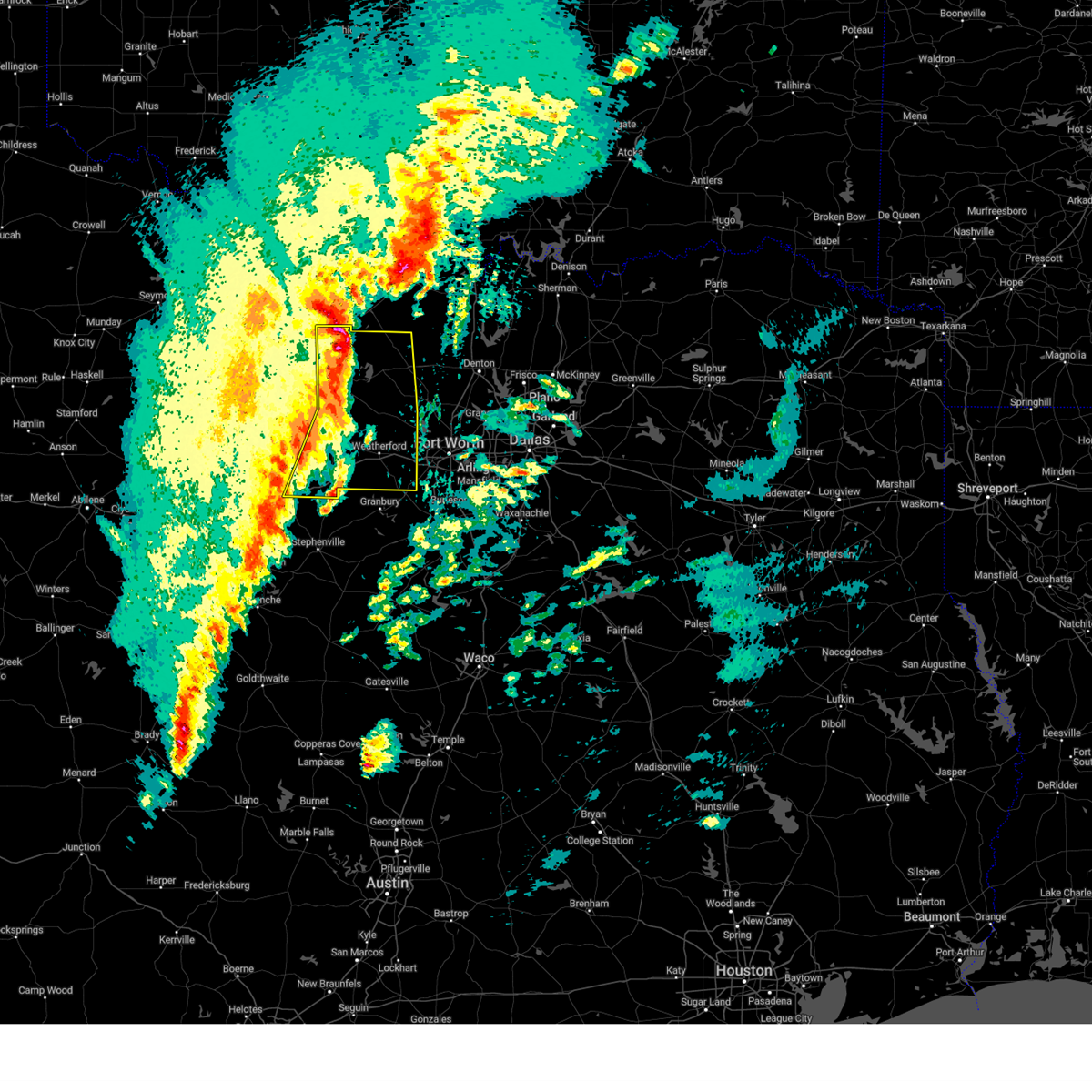 At 422 am cst, severe thunderstorms were located along a line extending from near newport to poolville to lipan, moving east at 55 mph (radar indicated). Hazards include 60 mph wind gusts and penny size hail. Expect damage to roofs, siding, and trees. these severe storms will be near, cool, poolville, bridgeport, brock, and lake bridgeport around 425 am cst. sunset, chico, and weatherford around 430 am cst. alvord, paradise, springtown, and western lake around 435 am cst. lake weatherford, boyd, annetta, willow park, briar, decatur, reno, and hudson oaks around 440 am cst. aledo and azle around 445 am cst. Other locations impacted by these severe thunderstorms include adell, lost creek reservoir, santo, cundiff, dennis, cottondale, park springs, crafton, gibtown, and joplin. At 422 am cst, severe thunderstorms were located along a line extending from near newport to poolville to lipan, moving east at 55 mph (radar indicated). Hazards include 60 mph wind gusts and penny size hail. Expect damage to roofs, siding, and trees. these severe storms will be near, cool, poolville, bridgeport, brock, and lake bridgeport around 425 am cst. sunset, chico, and weatherford around 430 am cst. alvord, paradise, springtown, and western lake around 435 am cst. lake weatherford, boyd, annetta, willow park, briar, decatur, reno, and hudson oaks around 440 am cst. aledo and azle around 445 am cst. Other locations impacted by these severe thunderstorms include adell, lost creek reservoir, santo, cundiff, dennis, cottondale, park springs, crafton, gibtown, and joplin.
|
| 3/4/2025 4:03 AM CST |
 At 402 am cst, severe thunderstorms were located along a line extending from near jacksboro to graford to gordon, moving east at 60 mph (radar indicated). Hazards include 60 mph wind gusts and penny size hail. Expect damage to roofs, siding, and trees. these severe storms will be near, jacksboro, mineral wells, and fort richardson state park around 410 am cst. cool and lake mineral wells around 415 am cst. poolville, brock, and lake bridgeport around 420 am cst. bridgeport, chico, and weatherford around 425 am cst. paradise, springtown, and western lake around 430 am cst. lake weatherford, alvord, annetta, willow park, briar, decatur, reno, and hudson oaks around 435 am cst. Boyd, aledo, and azle around 440 am cst. At 402 am cst, severe thunderstorms were located along a line extending from near jacksboro to graford to gordon, moving east at 60 mph (radar indicated). Hazards include 60 mph wind gusts and penny size hail. Expect damage to roofs, siding, and trees. these severe storms will be near, jacksboro, mineral wells, and fort richardson state park around 410 am cst. cool and lake mineral wells around 415 am cst. poolville, brock, and lake bridgeport around 420 am cst. bridgeport, chico, and weatherford around 425 am cst. paradise, springtown, and western lake around 430 am cst. lake weatherford, alvord, annetta, willow park, briar, decatur, reno, and hudson oaks around 435 am cst. Boyd, aledo, and azle around 440 am cst.
|
| 3/4/2025 4:03 AM CST |
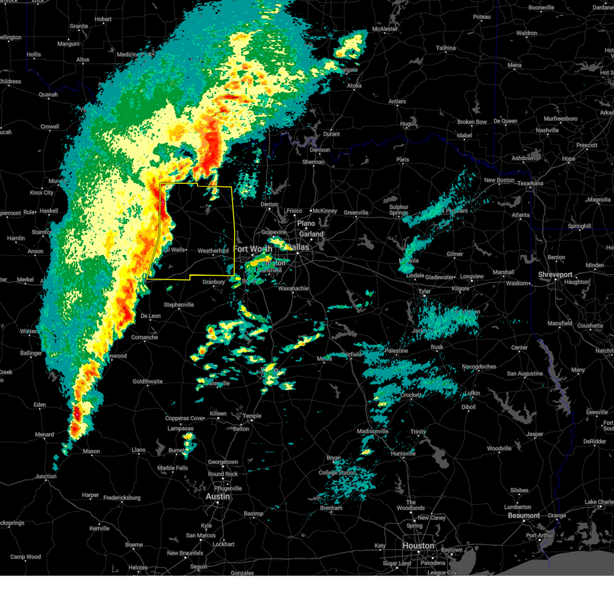 the severe thunderstorm warning has been cancelled and is no longer in effect the severe thunderstorm warning has been cancelled and is no longer in effect
|
| 3/4/2025 3:52 AM CST |
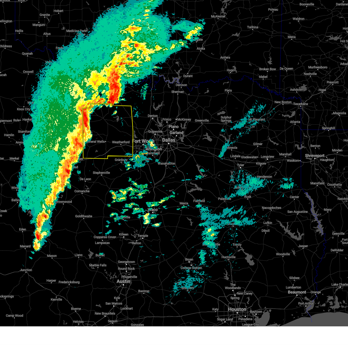 Svrfwd the national weather service in fort worth has issued a * severe thunderstorm warning for, eastern young county in north central texas, wise county in north central texas, jack county in north central texas, parker county in north central texas, palo pinto county in north central texas, * until 500 am cst. * at 352 am cst, severe thunderstorms were located along a line extending from from loving to graford to strawn, moving east at 55 mph (radar indicated). Hazards include 60 mph wind gusts and penny size hail. Expect damage to roofs, siding, and trees. severe thunderstorms will be near, lake palo pinto, jacksboro, graford, gordon, and palo pinto around 400 am cst. mineral wells and fort richardson state park around 405 am cst. cool and lake mineral wells around 410 am cst. poolville, brock, and lake bridgeport around 420 am cst. bridgeport and weatherford around 425 am cst. chico, springtown, and western lake around 430 am cst. lake weatherford, alvord, paradise, sunset, and hudson oaks around 435 am cst. boyd, annetta, aledo, willow park, briar, decatur, azle, and reno around 440 am cst. other locations impacted by these severe thunderstorms include santo, cundiff, park springs, crafton, gibtown, joplin, bartons chapel, bennett, vineyard, and wizard wells. this includes the following highways, interstate 20 between mile markers 370 and 422. Interstate 30 near mile marker 1. Svrfwd the national weather service in fort worth has issued a * severe thunderstorm warning for, eastern young county in north central texas, wise county in north central texas, jack county in north central texas, parker county in north central texas, palo pinto county in north central texas, * until 500 am cst. * at 352 am cst, severe thunderstorms were located along a line extending from from loving to graford to strawn, moving east at 55 mph (radar indicated). Hazards include 60 mph wind gusts and penny size hail. Expect damage to roofs, siding, and trees. severe thunderstorms will be near, lake palo pinto, jacksboro, graford, gordon, and palo pinto around 400 am cst. mineral wells and fort richardson state park around 405 am cst. cool and lake mineral wells around 410 am cst. poolville, brock, and lake bridgeport around 420 am cst. bridgeport and weatherford around 425 am cst. chico, springtown, and western lake around 430 am cst. lake weatherford, alvord, paradise, sunset, and hudson oaks around 435 am cst. boyd, annetta, aledo, willow park, briar, decatur, azle, and reno around 440 am cst. other locations impacted by these severe thunderstorms include santo, cundiff, park springs, crafton, gibtown, joplin, bartons chapel, bennett, vineyard, and wizard wells. this includes the following highways, interstate 20 between mile markers 370 and 422. Interstate 30 near mile marker 1.
|
| 3/4/2025 3:12 AM CST |
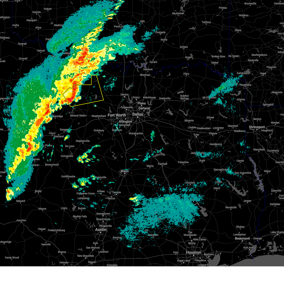 Svrfwd the national weather service in fort worth has issued a * severe thunderstorm warning for, southwestern montague county in north central texas, eastern young county in north central texas, northwestern wise county in north central texas, jack county in north central texas, * until 400 am cst. * at 312 am cst, a severe thunderstorm was located over bryson, or 11 miles northeast of graham, moving northeast at 60 mph (radar indicated). Hazards include 60 mph wind gusts and quarter size hail. Hail damage to vehicles is expected. expect wind damage to roofs, siding, and trees. this severe thunderstorm will be near, bryson around 315 am cst. newport around 340 am cst. lake amon g carter around 345 am cst. bowie around 350 am cst. Other locations impacted by this severe thunderstorm include jermyn, lost creek reservoir, cundiff, fruitland, park springs, jean, loving, lake bridgeport, crafton, and joplin. Svrfwd the national weather service in fort worth has issued a * severe thunderstorm warning for, southwestern montague county in north central texas, eastern young county in north central texas, northwestern wise county in north central texas, jack county in north central texas, * until 400 am cst. * at 312 am cst, a severe thunderstorm was located over bryson, or 11 miles northeast of graham, moving northeast at 60 mph (radar indicated). Hazards include 60 mph wind gusts and quarter size hail. Hail damage to vehicles is expected. expect wind damage to roofs, siding, and trees. this severe thunderstorm will be near, bryson around 315 am cst. newport around 340 am cst. lake amon g carter around 345 am cst. bowie around 350 am cst. Other locations impacted by this severe thunderstorm include jermyn, lost creek reservoir, cundiff, fruitland, park springs, jean, loving, lake bridgeport, crafton, and joplin.
|
| 11/8/2024 2:08 PM CST |
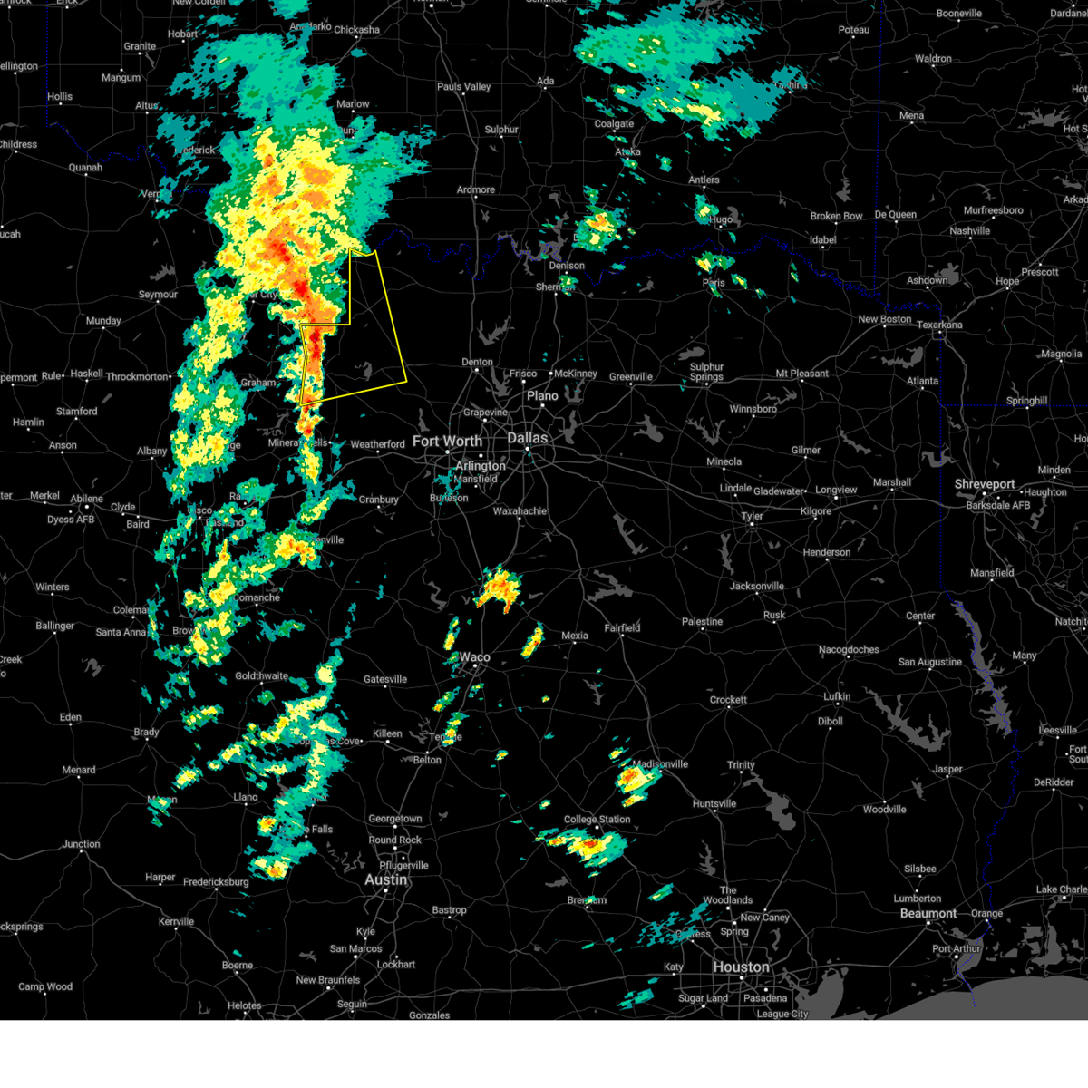 At 207 pm cst, a severe thunderstorm was located 7 miles north of jacksboro, moving northeast at 30 mph (radar indicated). Hazards include 65 mph wind gusts. Expect damage to roofs, siding, and trees. this severe storm will be near, newport around 230 pm cst. Other locations impacted by this severe thunderstorm include lost creek reservoir, cundiff, fruitland, park springs, lake bridgeport, crafton, ringgold, joplin, balsora, and bartons chapel. At 207 pm cst, a severe thunderstorm was located 7 miles north of jacksboro, moving northeast at 30 mph (radar indicated). Hazards include 65 mph wind gusts. Expect damage to roofs, siding, and trees. this severe storm will be near, newport around 230 pm cst. Other locations impacted by this severe thunderstorm include lost creek reservoir, cundiff, fruitland, park springs, lake bridgeport, crafton, ringgold, joplin, balsora, and bartons chapel.
|
| 11/8/2024 1:48 PM CST |
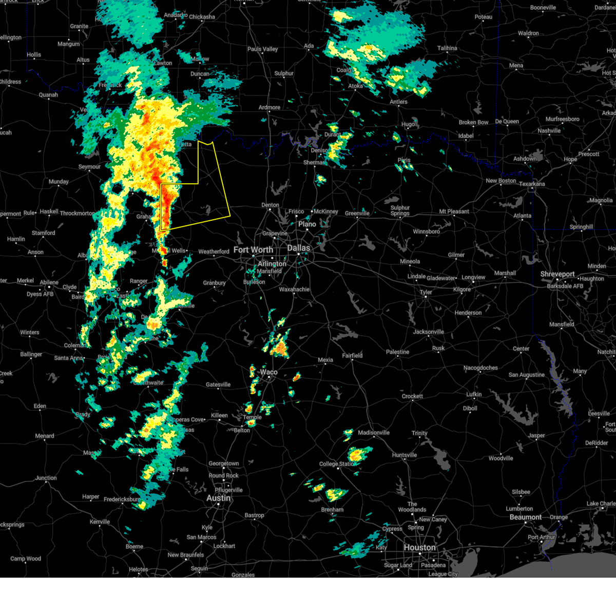 Svrfwd the national weather service in fort worth has issued a * severe thunderstorm warning for, western montague county in north central texas, northwestern wise county in north central texas, jack county in north central texas, * until 230 pm cst. * at 148 pm cst, a severe thunderstorm was located 8 miles northeast of bryson, or 8 miles west of jacksboro, moving northeast at 55 mph (radar indicated). Hazards include 65 mph wind gusts. Expect damage to roofs, siding, and trees. this severe thunderstorm will be near, lake amon g carter around 215 pm cst. bowie and sunset around 220 pm cst. Other locations impacted by this severe thunderstorm include jermyn, lost creek reservoir, cundiff, fruitland, park springs, lake bridgeport, crafton, ringgold, joplin, and balsora. Svrfwd the national weather service in fort worth has issued a * severe thunderstorm warning for, western montague county in north central texas, northwestern wise county in north central texas, jack county in north central texas, * until 230 pm cst. * at 148 pm cst, a severe thunderstorm was located 8 miles northeast of bryson, or 8 miles west of jacksboro, moving northeast at 55 mph (radar indicated). Hazards include 65 mph wind gusts. Expect damage to roofs, siding, and trees. this severe thunderstorm will be near, lake amon g carter around 215 pm cst. bowie and sunset around 220 pm cst. Other locations impacted by this severe thunderstorm include jermyn, lost creek reservoir, cundiff, fruitland, park springs, lake bridgeport, crafton, ringgold, joplin, and balsora.
|
| 11/8/2024 2:38 AM CST |
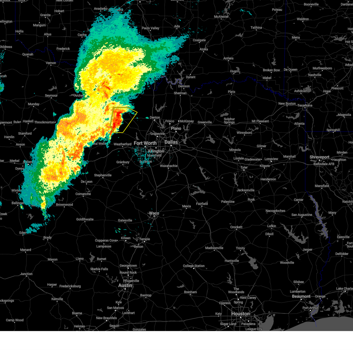 The storm which prompted the warning has weakened below severe limits. therefore the warning will be allowed to expire. however small hail and gusty winds are still possible with this thunderstorm. The storm which prompted the warning has weakened below severe limits. therefore the warning will be allowed to expire. however small hail and gusty winds are still possible with this thunderstorm.
|
| 11/8/2024 2:05 AM CST |
 the severe thunderstorm warning has been cancelled and is no longer in effect the severe thunderstorm warning has been cancelled and is no longer in effect
|
| 11/8/2024 2:05 AM CST |
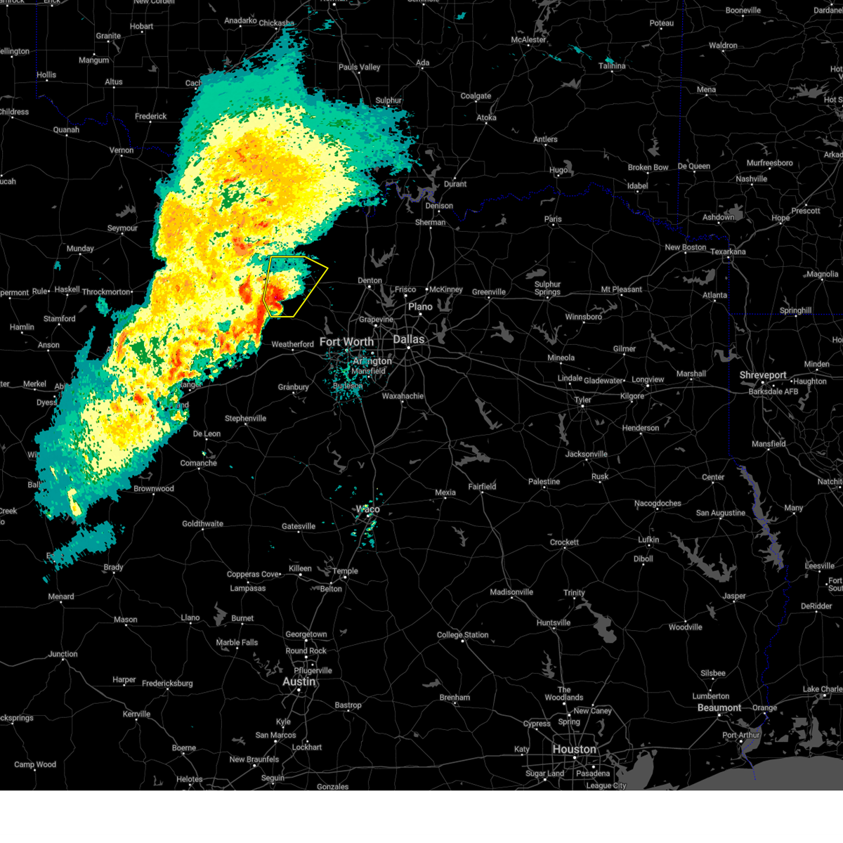 At 204 am cst, a severe thunderstorm was located 7 miles southwest of lake bridgeport, or 10 miles southwest of bridgeport, moving northeast at 25 mph (radar indicated). Hazards include 60 mph wind gusts and half dollar size hail. Hail damage to vehicles is expected. expect wind damage to roofs, siding, and trees. this severe storm will be near, bridgeport and lake bridgeport around 210 am cst. chico around 225 am cst. alvord around 245 am cst. Other locations impacted by this severe thunderstorm include gibtown, joplin, balsora, boonsville, wizard wells, vineyard, cundiff, park springs, runaway bay, and lake bridgeport. At 204 am cst, a severe thunderstorm was located 7 miles southwest of lake bridgeport, or 10 miles southwest of bridgeport, moving northeast at 25 mph (radar indicated). Hazards include 60 mph wind gusts and half dollar size hail. Hail damage to vehicles is expected. expect wind damage to roofs, siding, and trees. this severe storm will be near, bridgeport and lake bridgeport around 210 am cst. chico around 225 am cst. alvord around 245 am cst. Other locations impacted by this severe thunderstorm include gibtown, joplin, balsora, boonsville, wizard wells, vineyard, cundiff, park springs, runaway bay, and lake bridgeport.
|
| 11/8/2024 1:44 AM CST |
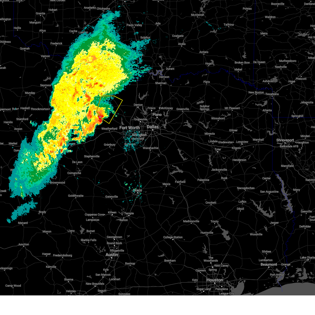 Svrfwd the national weather service in fort worth has issued a * severe thunderstorm warning for, northwestern wise county in north central texas, eastern jack county in north central texas, north central parker county in north central texas, * until 245 am cst. * at 143 am cst, a severe thunderstorm was located 8 miles northwest of poolville, or 15 miles southeast of jacksboro, moving northeast at 30 mph (radar indicated). Hazards include 60 mph wind gusts and half dollar size hail. Hail damage to vehicles is expected. expect wind damage to roofs, siding, and trees. this severe thunderstorm will be near, lake bridgeport around 150 am cst. bridgeport around 200 am cst. chico around 210 am cst. alvord around 230 am cst. Other locations impacted by this severe thunderstorm include cundiff, cottondale, park springs, lake bridgeport, crafton, gibtown, joplin, balsora, agnes, and boonsville. Svrfwd the national weather service in fort worth has issued a * severe thunderstorm warning for, northwestern wise county in north central texas, eastern jack county in north central texas, north central parker county in north central texas, * until 245 am cst. * at 143 am cst, a severe thunderstorm was located 8 miles northwest of poolville, or 15 miles southeast of jacksboro, moving northeast at 30 mph (radar indicated). Hazards include 60 mph wind gusts and half dollar size hail. Hail damage to vehicles is expected. expect wind damage to roofs, siding, and trees. this severe thunderstorm will be near, lake bridgeport around 150 am cst. bridgeport around 200 am cst. chico around 210 am cst. alvord around 230 am cst. Other locations impacted by this severe thunderstorm include cundiff, cottondale, park springs, lake bridgeport, crafton, gibtown, joplin, balsora, agnes, and boonsville.
|
| 11/4/2024 11:47 AM CST |
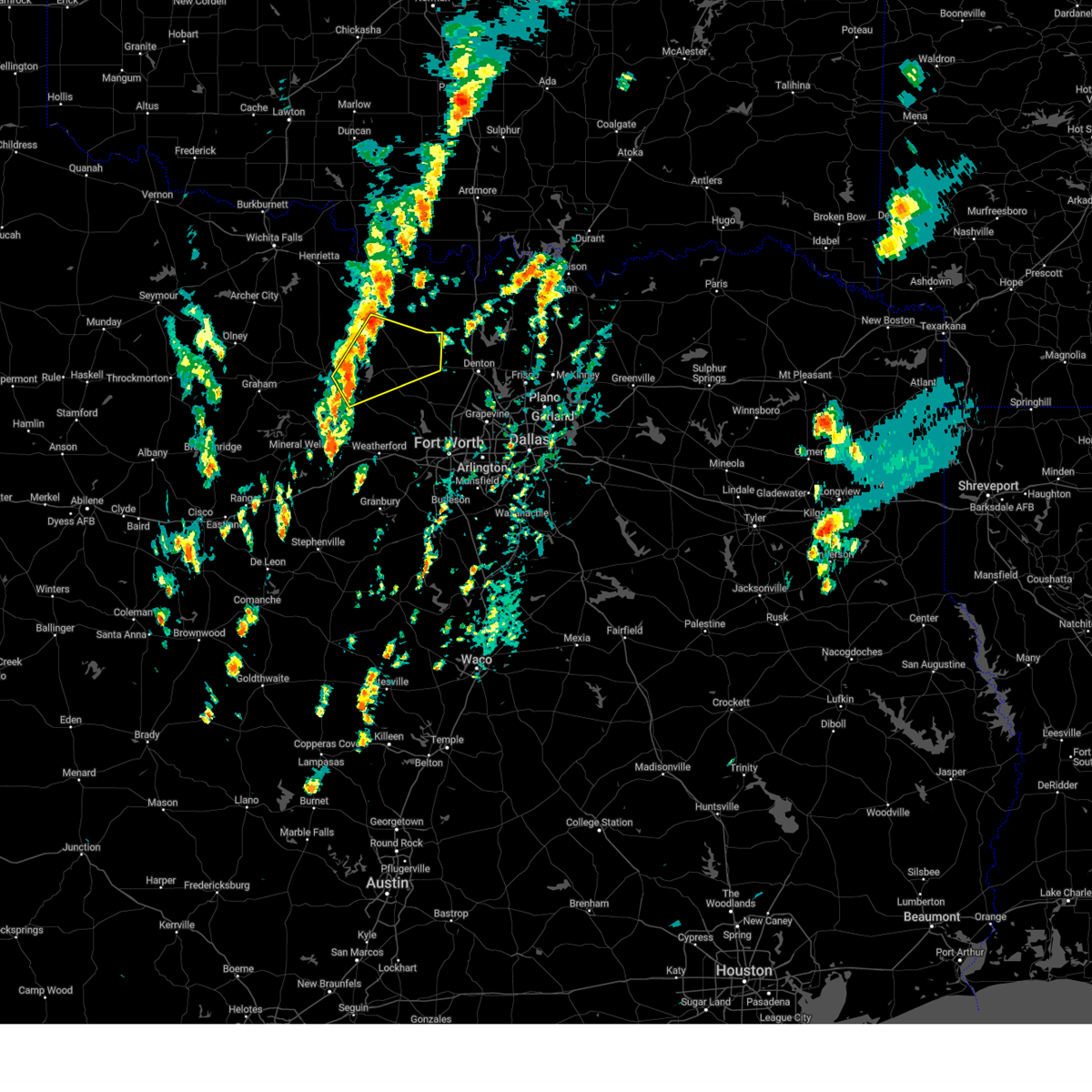 Svrfwd the national weather service in fort worth has issued a * severe thunderstorm warning for, south central montague county in north central texas, wise county in north central texas, southeastern jack county in north central texas, * until 1230 pm cst. * at 1147 am cst, a severe thunderstorm was located 7 miles southwest of lake bridgeport, or 11 miles east of jacksboro, moving northeast at 40 mph (radar indicated). Hazards include 60 mph wind gusts and quarter size hail. Hail damage to vehicles is expected. expect wind damage to roofs, siding, and trees. this severe thunderstorm will be near, lake bridgeport around 1150 am cst. bridgeport around 1155 am cst. chico around 1200 pm cst. alvord around 1215 pm cst. Other locations impacted by this severe thunderstorm include cundiff, greenwood, fruitland, park springs, lake bridgeport, crafton, joplin, balsora, boonsville, and wizard wells. Svrfwd the national weather service in fort worth has issued a * severe thunderstorm warning for, south central montague county in north central texas, wise county in north central texas, southeastern jack county in north central texas, * until 1230 pm cst. * at 1147 am cst, a severe thunderstorm was located 7 miles southwest of lake bridgeport, or 11 miles east of jacksboro, moving northeast at 40 mph (radar indicated). Hazards include 60 mph wind gusts and quarter size hail. Hail damage to vehicles is expected. expect wind damage to roofs, siding, and trees. this severe thunderstorm will be near, lake bridgeport around 1150 am cst. bridgeport around 1155 am cst. chico around 1200 pm cst. alvord around 1215 pm cst. Other locations impacted by this severe thunderstorm include cundiff, greenwood, fruitland, park springs, lake bridgeport, crafton, joplin, balsora, boonsville, and wizard wells.
|
| 6/2/2024 5:04 PM CDT |
 At 503 pm cdt, the leading edge of a cluster of severe thunderstorms was located along a line extending from near decatur to near springtown, moving east at 50 mph (radar indicated). Hazards include 60 mph wind gusts and nickel size hail. Expect damage to roofs, siding, and trees. These severe storms will be near, briar, pecan acres, reno, rhome, new fairview, aurora, and boyd around 510 pm cdt. At 503 pm cdt, the leading edge of a cluster of severe thunderstorms was located along a line extending from near decatur to near springtown, moving east at 50 mph (radar indicated). Hazards include 60 mph wind gusts and nickel size hail. Expect damage to roofs, siding, and trees. These severe storms will be near, briar, pecan acres, reno, rhome, new fairview, aurora, and boyd around 510 pm cdt.
|
| 6/2/2024 4:36 PM CDT |
 Svrfwd the national weather service in fort worth has issued a * severe thunderstorm warning for, wise county in north central texas, northern parker county in north central texas, * until 530 pm cdt. * at 434 pm cdt, the leading edge of a cluster of severe thunderstorms was located along a line from western wise county into southeastern jack county, moving east at 45 mph (radar indicated). Hazards include 65 mph wind gusts and nickel size hail. Expect damage to roofs, siding, and trees. severe thunderstorms will be near, bridgeport, chico, and lake bridgeport around 440 pm cdt. paradise around 445 pm cdt. alvord and poolville around 450 pm cdt. Decatur and boyd around 455 pm cdt. Svrfwd the national weather service in fort worth has issued a * severe thunderstorm warning for, wise county in north central texas, northern parker county in north central texas, * until 530 pm cdt. * at 434 pm cdt, the leading edge of a cluster of severe thunderstorms was located along a line from western wise county into southeastern jack county, moving east at 45 mph (radar indicated). Hazards include 65 mph wind gusts and nickel size hail. Expect damage to roofs, siding, and trees. severe thunderstorms will be near, bridgeport, chico, and lake bridgeport around 440 pm cdt. paradise around 445 pm cdt. alvord and poolville around 450 pm cdt. Decatur and boyd around 455 pm cdt.
|
| 5/28/2024 5:11 AM CDT |
 At 510 am cdt, a severe thunderstorm was located near bridgeport, moving southeast at 30 mph (radar indicated). Hazards include golf ball size hail and 65 mph wind gusts. People and animals outdoors will be injured. expect hail damage to roofs, siding, windows, and vehicles. expect wind damage to roofs, siding, and trees. this severe storm will be near, decatur and paradise around 515 am cdt. boyd around 525 am cdt. briar and aurora around 530 am cdt. pecan acres around 535 am cdt. reno and rhome around 540 am cdt. Other locations impacted by this severe thunderstorm include rosston, cottondale, providence village, ponder, stony, lake ray roberts, agnes, boonsville, bolivar, and lincoln park. At 510 am cdt, a severe thunderstorm was located near bridgeport, moving southeast at 30 mph (radar indicated). Hazards include golf ball size hail and 65 mph wind gusts. People and animals outdoors will be injured. expect hail damage to roofs, siding, windows, and vehicles. expect wind damage to roofs, siding, and trees. this severe storm will be near, decatur and paradise around 515 am cdt. boyd around 525 am cdt. briar and aurora around 530 am cdt. pecan acres around 535 am cdt. reno and rhome around 540 am cdt. Other locations impacted by this severe thunderstorm include rosston, cottondale, providence village, ponder, stony, lake ray roberts, agnes, boonsville, bolivar, and lincoln park.
|
| 5/28/2024 5:00 AM CDT |
 Svrfwd the national weather service in fort worth has issued a * severe thunderstorm warning for, wise county in north central texas, denton county in north central texas, northeastern parker county in north central texas, southwestern cooke county in north central texas, * until 600 am cdt. * at 459 am cdt, a severe thunderstorm was located 8 miles east of alvord, or 9 miles north of decatur, moving southeast at 25 mph (radar indicated). Hazards include 65 mph wind gusts and quarter size hail. Hail damage to vehicles is expected. expect wind damage to roofs, siding, and trees. this severe thunderstorm will be near, northlake around 535 am cdt. denton and justin around 540 am cdt. flower mound, argyle, and corral city around 545 am cdt. other locations impacted by this severe thunderstorm include rosston, cottondale, providence village, ponder, stony, lake ray roberts, agnes, boonsville, bolivar, and lincoln park. this includes the following highways, interstate 35 between mile markers 468 and 484. interstate 35w between mile markers 75 and 85. Interstate 35e between mile markers 460 and 466. Svrfwd the national weather service in fort worth has issued a * severe thunderstorm warning for, wise county in north central texas, denton county in north central texas, northeastern parker county in north central texas, southwestern cooke county in north central texas, * until 600 am cdt. * at 459 am cdt, a severe thunderstorm was located 8 miles east of alvord, or 9 miles north of decatur, moving southeast at 25 mph (radar indicated). Hazards include 65 mph wind gusts and quarter size hail. Hail damage to vehicles is expected. expect wind damage to roofs, siding, and trees. this severe thunderstorm will be near, northlake around 535 am cdt. denton and justin around 540 am cdt. flower mound, argyle, and corral city around 545 am cdt. other locations impacted by this severe thunderstorm include rosston, cottondale, providence village, ponder, stony, lake ray roberts, agnes, boonsville, bolivar, and lincoln park. this includes the following highways, interstate 35 between mile markers 468 and 484. interstate 35w between mile markers 75 and 85. Interstate 35e between mile markers 460 and 466.
|
| 5/22/2024 12:27 PM CDT | Quarter sized hail reported 8.1 miles NNE of Paradise, TX, quarter size hail s of cottondate. |
| 4/9/2024 12:33 AM CDT |
 the severe thunderstorm warning has been cancelled and is no longer in effect the severe thunderstorm warning has been cancelled and is no longer in effect
|
| 4/9/2024 12:33 AM CDT |
 At 1232 am cdt, severe thunderstorms were located along a line extending from near st. jo to near alvord to bridgeport, moving east at 25 mph (radar indicated). Hazards include 60 mph wind gusts and quarter size hail. Hail damage to vehicles is expected. expect wind damage to roofs, siding, and trees. locations impacted include, decatur, bridgeport, bowie, alvord, st. Jo, chico, paradise, sunset, lake amon g carter, runaway bay, lake bridgeport, montague, fruitland, park springs, crafton, forestburg, stoneburg, and mallard. At 1232 am cdt, severe thunderstorms were located along a line extending from near st. jo to near alvord to bridgeport, moving east at 25 mph (radar indicated). Hazards include 60 mph wind gusts and quarter size hail. Hail damage to vehicles is expected. expect wind damage to roofs, siding, and trees. locations impacted include, decatur, bridgeport, bowie, alvord, st. Jo, chico, paradise, sunset, lake amon g carter, runaway bay, lake bridgeport, montague, fruitland, park springs, crafton, forestburg, stoneburg, and mallard.
|
| 4/9/2024 12:16 AM CDT |
 At 1216 am cdt, severe thunderstorms were located along a line extending from 6 miles southeast of nocona to near sunset to near lake bridgeport, moving east at 25 mph (radar indicated). Hazards include 60 mph wind gusts and quarter size hail. Hail damage to vehicles is expected. expect wind damage to roofs, siding, and trees. locations impacted include, decatur, bridgeport, bowie, alvord, st. Jo, chico, paradise, sunset, lake amon g carter, runaway bay, lake bridgeport, montague, cundiff, fruitland, park springs, crafton, forestburg, stoneburg, wizard wells, and vineyard. At 1216 am cdt, severe thunderstorms were located along a line extending from 6 miles southeast of nocona to near sunset to near lake bridgeport, moving east at 25 mph (radar indicated). Hazards include 60 mph wind gusts and quarter size hail. Hail damage to vehicles is expected. expect wind damage to roofs, siding, and trees. locations impacted include, decatur, bridgeport, bowie, alvord, st. Jo, chico, paradise, sunset, lake amon g carter, runaway bay, lake bridgeport, montague, cundiff, fruitland, park springs, crafton, forestburg, stoneburg, wizard wells, and vineyard.
|
| 4/8/2024 11:43 PM CDT |
 Svrfwd the national weather service in fort worth has issued a * severe thunderstorm warning for, southern montague county in north central texas, western wise county in north central texas, eastern jack county in north central texas, * until 1245 am cdt. * at 1142 pm cdt, severe thunderstorms were located along a line extending from 6 miles east of bellevue to 7 miles southeast of newport to near fort richardson state park, moving east at 25 mph (radar indicated). Hazards include ping pong ball size hail and 60 mph wind gusts. People and animals outdoors will be injured. expect hail damage to roofs, siding, windows, and vehicles. Expect wind damage to roofs, siding, and trees. Svrfwd the national weather service in fort worth has issued a * severe thunderstorm warning for, southern montague county in north central texas, western wise county in north central texas, eastern jack county in north central texas, * until 1245 am cdt. * at 1142 pm cdt, severe thunderstorms were located along a line extending from 6 miles east of bellevue to 7 miles southeast of newport to near fort richardson state park, moving east at 25 mph (radar indicated). Hazards include ping pong ball size hail and 60 mph wind gusts. People and animals outdoors will be injured. expect hail damage to roofs, siding, windows, and vehicles. Expect wind damage to roofs, siding, and trees.
|
| 4/8/2024 11:28 PM CDT |
 the severe thunderstorm warning has been cancelled and is no longer in effect the severe thunderstorm warning has been cancelled and is no longer in effect
|
| 4/8/2024 11:28 PM CDT |
 At 1128 pm cdt, a severe thunderstorm was located near new fairview, or 7 miles southeast of decatur, moving northeast at 45 mph (radar indicated). Hazards include ping pong ball size hail and 60 mph wind gusts. People and animals outdoors will be injured. expect hail damage to roofs, siding, windows, and vehicles. expect wind damage to roofs, siding, and trees. Locations impacted include, decatur, briar, pecan acres, krum, rhome, new fairview, aurora, boyd, paradise, ponder, newark, greenwood, cottondale, keeter, stony, and slidell. At 1128 pm cdt, a severe thunderstorm was located near new fairview, or 7 miles southeast of decatur, moving northeast at 45 mph (radar indicated). Hazards include ping pong ball size hail and 60 mph wind gusts. People and animals outdoors will be injured. expect hail damage to roofs, siding, windows, and vehicles. expect wind damage to roofs, siding, and trees. Locations impacted include, decatur, briar, pecan acres, krum, rhome, new fairview, aurora, boyd, paradise, ponder, newark, greenwood, cottondale, keeter, stony, and slidell.
|
| 4/8/2024 11:12 PM CDT |
 Svrfwd the national weather service in fort worth has issued a * severe thunderstorm warning for, eastern wise county in north central texas, northwestern denton county in north central texas, northeastern parker county in north central texas, * until midnight cdt. * at 1112 pm cdt, a severe thunderstorm was located near briar, moving northeast at 45 mph (radar indicated). Hazards include ping pong ball size hail and 60 mph wind gusts. People and animals outdoors will be injured. expect hail damage to roofs, siding, windows, and vehicles. Expect wind damage to roofs, siding, and trees. Svrfwd the national weather service in fort worth has issued a * severe thunderstorm warning for, eastern wise county in north central texas, northwestern denton county in north central texas, northeastern parker county in north central texas, * until midnight cdt. * at 1112 pm cdt, a severe thunderstorm was located near briar, moving northeast at 45 mph (radar indicated). Hazards include ping pong ball size hail and 60 mph wind gusts. People and animals outdoors will be injured. expect hail damage to roofs, siding, windows, and vehicles. Expect wind damage to roofs, siding, and trees.
|
| 4/1/2024 6:25 PM CDT |
 At 624 pm cdt, a severe thunderstorm was located over springtown, moving east at 50 mph (radar indicated). Hazards include 65 mph wind gusts and half dollar size hail. Hail damage to vehicles is expected. expect wind damage to roofs, siding, and trees. this severe storm will be near, briar, reno, and springtown around 630 pm cdt. pecan acres, rhome, aurora, and boyd around 635 pm cdt. Other locations impacted by this severe thunderstorm include peaster, agnes, boonsville, cottondale, newark, sanctuary, keeter, highland addition, and la junta. At 624 pm cdt, a severe thunderstorm was located over springtown, moving east at 50 mph (radar indicated). Hazards include 65 mph wind gusts and half dollar size hail. Hail damage to vehicles is expected. expect wind damage to roofs, siding, and trees. this severe storm will be near, briar, reno, and springtown around 630 pm cdt. pecan acres, rhome, aurora, and boyd around 635 pm cdt. Other locations impacted by this severe thunderstorm include peaster, agnes, boonsville, cottondale, newark, sanctuary, keeter, highland addition, and la junta.
|
| 4/1/2024 6:25 PM CDT |
 the severe thunderstorm warning has been cancelled and is no longer in effect the severe thunderstorm warning has been cancelled and is no longer in effect
|
| 4/1/2024 6:08 PM CDT |
 Svrfwd the national weather service in fort worth has issued a * severe thunderstorm warning for, southern wise county in north central texas, southeastern jack county in north central texas, northern parker county in north central texas, northwestern tarrant county in north central texas, * until 700 pm cdt. * at 607 pm cdt, a severe thunderstorm was located near poolville, moving east at 50 mph (radar indicated). Hazards include 65 mph wind gusts and half dollar size hail. Hail damage to vehicles is expected. expect wind damage to roofs, siding, and trees. this severe thunderstorm will be near, poolville around 610 pm cdt. springtown around 615 pm cdt. briar and reno around 625 pm cdt. pecan acres, rhome, and aurora around 630 pm cdt. Other locations impacted by this severe thunderstorm include adell, peaster, whitt, advance, cottondale, keeter, gibtown, agnes, boonsville, and authon. Svrfwd the national weather service in fort worth has issued a * severe thunderstorm warning for, southern wise county in north central texas, southeastern jack county in north central texas, northern parker county in north central texas, northwestern tarrant county in north central texas, * until 700 pm cdt. * at 607 pm cdt, a severe thunderstorm was located near poolville, moving east at 50 mph (radar indicated). Hazards include 65 mph wind gusts and half dollar size hail. Hail damage to vehicles is expected. expect wind damage to roofs, siding, and trees. this severe thunderstorm will be near, poolville around 610 pm cdt. springtown around 615 pm cdt. briar and reno around 625 pm cdt. pecan acres, rhome, and aurora around 630 pm cdt. Other locations impacted by this severe thunderstorm include adell, peaster, whitt, advance, cottondale, keeter, gibtown, agnes, boonsville, and authon.
|
| 10/4/2023 7:59 PM CDT |
 At 758 pm cdt, severe thunderstorms were located along a line extending from 12 miles north of jacksboro to near fort richardson state park to near graford, moving east at 35 mph (radar indicated. ping-pong ball sized hail reported 4 miles south of jacksboro). Hazards include golf ball size hail and 60 mph wind gusts. People and animals outdoors will be injured. expect hail damage to roofs, siding, windows, and vehicles. expect wind damage to roofs, siding, and trees. locations impacted include, weatherford, mineral wells, bridgeport, jacksboro, alvord, chico, graford, poolville, paradise, cool, lake mineral wells, fort richardson state park, runaway bay, millsap, perrin, lake bridgeport, adell, advance, salesville, and cundiff. thunderstorm damage threat, considerable hail threat, observed max hail size, 1. 75 in wind threat, radar indicated max wind gust, 60 mph. At 758 pm cdt, severe thunderstorms were located along a line extending from 12 miles north of jacksboro to near fort richardson state park to near graford, moving east at 35 mph (radar indicated. ping-pong ball sized hail reported 4 miles south of jacksboro). Hazards include golf ball size hail and 60 mph wind gusts. People and animals outdoors will be injured. expect hail damage to roofs, siding, windows, and vehicles. expect wind damage to roofs, siding, and trees. locations impacted include, weatherford, mineral wells, bridgeport, jacksboro, alvord, chico, graford, poolville, paradise, cool, lake mineral wells, fort richardson state park, runaway bay, millsap, perrin, lake bridgeport, adell, advance, salesville, and cundiff. thunderstorm damage threat, considerable hail threat, observed max hail size, 1. 75 in wind threat, radar indicated max wind gust, 60 mph.
|
| 10/4/2023 7:50 PM CDT |
 At 749 pm cdt, severe thunderstorms were located along a line extending from 13 miles northwest of jacksboro to 6 miles east of bryson to 7 miles west of graford, moving east at 35 mph (radar indicated). Hazards include 60 mph wind gusts and penny size hail. expect damage to roofs, siding, and trees At 749 pm cdt, severe thunderstorms were located along a line extending from 13 miles northwest of jacksboro to 6 miles east of bryson to 7 miles west of graford, moving east at 35 mph (radar indicated). Hazards include 60 mph wind gusts and penny size hail. expect damage to roofs, siding, and trees
|
| 6/13/2023 5:53 AM CDT |
 At 552 am cdt, a severe thunderstorm was located near springtown, or 8 miles west of briar, moving east at 30 mph (public). Hazards include ping pong ball size hail. People and animals outdoors will be injured. expect damage to roofs, siding, windows, and vehicles. locations impacted include, bridgeport, briar, reno, springtown, new fairview, aurora, boyd, poolville, paradise, lake bridgeport, runaway bay, sanctuary, la junta, cottondale, keeter, balsora, agnes, boonsville and highland addition. hail threat, radar indicated max hail size, 1. 50 in wind threat, radar indicated max wind gust, <50 mph. At 552 am cdt, a severe thunderstorm was located near springtown, or 8 miles west of briar, moving east at 30 mph (public). Hazards include ping pong ball size hail. People and animals outdoors will be injured. expect damage to roofs, siding, windows, and vehicles. locations impacted include, bridgeport, briar, reno, springtown, new fairview, aurora, boyd, poolville, paradise, lake bridgeport, runaway bay, sanctuary, la junta, cottondale, keeter, balsora, agnes, boonsville and highland addition. hail threat, radar indicated max hail size, 1. 50 in wind threat, radar indicated max wind gust, <50 mph.
|
| 6/13/2023 5:39 AM CDT |
 At 538 am cdt, a severe thunderstorm was located near poolville, or 10 miles southwest of bridgeport, moving east at 30 mph (public). Hazards include golf ball size hail. People and animals outdoors will be injured. expect damage to roofs, siding, windows, and vehicles. locations impacted include, bridgeport, briar, reno, springtown, new fairview, aurora, boyd, poolville, paradise, lake bridgeport, runaway bay, sanctuary, la junta, cottondale, keeter, balsora, agnes, boonsville and highland addition. thunderstorm damage threat, considerable hail threat, radar indicated max hail size, 1. 75 in wind threat, radar indicated max wind gust, <50 mph. At 538 am cdt, a severe thunderstorm was located near poolville, or 10 miles southwest of bridgeport, moving east at 30 mph (public). Hazards include golf ball size hail. People and animals outdoors will be injured. expect damage to roofs, siding, windows, and vehicles. locations impacted include, bridgeport, briar, reno, springtown, new fairview, aurora, boyd, poolville, paradise, lake bridgeport, runaway bay, sanctuary, la junta, cottondale, keeter, balsora, agnes, boonsville and highland addition. thunderstorm damage threat, considerable hail threat, radar indicated max hail size, 1. 75 in wind threat, radar indicated max wind gust, <50 mph.
|
| 6/13/2023 5:26 AM CDT |
 At 526 am cdt, a severe thunderstorm was located 9 miles northwest of poolville, or 13 miles southwest of bridgeport, moving east at 30 mph (radar indicated). Hazards include ping pong ball size hail. People and animals outdoors will be injured. Expect damage to roofs, siding, windows, and vehicles. At 526 am cdt, a severe thunderstorm was located 9 miles northwest of poolville, or 13 miles southwest of bridgeport, moving east at 30 mph (radar indicated). Hazards include ping pong ball size hail. People and animals outdoors will be injured. Expect damage to roofs, siding, windows, and vehicles.
|
| 5/5/2023 4:38 PM CDT |
 At 437 pm cdt, a severe thunderstorm was located over alvord, or 9 miles north of bridgeport, moving northeast at 20 mph (radar indicated). Hazards include 65 mph wind gusts and quarter size hail. Hail damage to vehicles is expected. expect wind damage to roofs, siding, and trees. locations impacted include, decatur, bridgeport, alvord, chico, paradise, lake bridgeport, greenwood, slidell and park springs. hail threat, observed max hail size, 1. 00 in wind threat, radar indicated max wind gust, 65 mph. At 437 pm cdt, a severe thunderstorm was located over alvord, or 9 miles north of bridgeport, moving northeast at 20 mph (radar indicated). Hazards include 65 mph wind gusts and quarter size hail. Hail damage to vehicles is expected. expect wind damage to roofs, siding, and trees. locations impacted include, decatur, bridgeport, alvord, chico, paradise, lake bridgeport, greenwood, slidell and park springs. hail threat, observed max hail size, 1. 00 in wind threat, radar indicated max wind gust, 65 mph.
|
| 5/5/2023 4:09 PM CDT |
 At 409 pm cdt, a severe thunderstorm was located over bridgeport, moving northeast at 25 mph (radar indicated). Hazards include 65 mph wind gusts and quarter size hail. Hail damage to vehicles is expected. Expect wind damage to roofs, siding, and trees. At 409 pm cdt, a severe thunderstorm was located over bridgeport, moving northeast at 25 mph (radar indicated). Hazards include 65 mph wind gusts and quarter size hail. Hail damage to vehicles is expected. Expect wind damage to roofs, siding, and trees.
|
| 4/2/2023 6:28 PM CDT |
 At 628 pm cdt, a severe thunderstorm was located near poolville, or 12 miles south of bridgeport, moving east at 35 mph (radar indicated). Hazards include 60 mph wind gusts and quarter size hail. Hail damage to vehicles is expected. expect wind damage to roofs, siding, and trees. locations impacted include, azle, briar, pecan acres, reno, springtown, rhome, new fairview, aurora, boyd, poolville, paradise, newark, sanctuary, la junta, advance, cottondale, keeter, balsora, agnes and boonsville. hail threat, radar indicated max hail size, 1. 00 in wind threat, radar indicated max wind gust, 60 mph. At 628 pm cdt, a severe thunderstorm was located near poolville, or 12 miles south of bridgeport, moving east at 35 mph (radar indicated). Hazards include 60 mph wind gusts and quarter size hail. Hail damage to vehicles is expected. expect wind damage to roofs, siding, and trees. locations impacted include, azle, briar, pecan acres, reno, springtown, rhome, new fairview, aurora, boyd, poolville, paradise, newark, sanctuary, la junta, advance, cottondale, keeter, balsora, agnes and boonsville. hail threat, radar indicated max hail size, 1. 00 in wind threat, radar indicated max wind gust, 60 mph.
|
| 4/2/2023 5:59 PM CDT |
 At 559 pm cdt, a severe thunderstorm was located 10 miles northwest of poolville, or 13 miles southeast of jacksboro, moving east at 40 mph (radar indicated). Hazards include 60 mph wind gusts and quarter size hail. Hail damage to vehicles is expected. Expect wind damage to roofs, siding, and trees. At 559 pm cdt, a severe thunderstorm was located 10 miles northwest of poolville, or 13 miles southeast of jacksboro, moving east at 40 mph (radar indicated). Hazards include 60 mph wind gusts and quarter size hail. Hail damage to vehicles is expected. Expect wind damage to roofs, siding, and trees.
|
| 4/2/2023 3:34 PM CDT |
 At 334 pm cdt, a severe thunderstorm was located near weatherford, moving east at 55 mph (radar indicated). Hazards include 60 mph wind gusts and half dollar size hail. Hail damage to vehicles is expected. expect wind damage to roofs, siding, and trees. locations impacted include, weatherford, azle, briar, willow park, reno, springtown, hudson oaks, poolville, paradise, lake weatherford, perrin, sanctuary, la junta, adell, advance, cottondale, gibtown, agnes, boonsville and garner. hail threat, radar indicated max hail size, 1. 25 in wind threat, radar indicated max wind gust, 60 mph. At 334 pm cdt, a severe thunderstorm was located near weatherford, moving east at 55 mph (radar indicated). Hazards include 60 mph wind gusts and half dollar size hail. Hail damage to vehicles is expected. expect wind damage to roofs, siding, and trees. locations impacted include, weatherford, azle, briar, willow park, reno, springtown, hudson oaks, poolville, paradise, lake weatherford, perrin, sanctuary, la junta, adell, advance, cottondale, gibtown, agnes, boonsville and garner. hail threat, radar indicated max hail size, 1. 25 in wind threat, radar indicated max wind gust, 60 mph.
|
| 4/2/2023 3:23 PM CDT |
 At 323 pm cdt, a severe thunderstorm was located near brock, or 9 miles southeast of mineral wells, moving east at 55 mph (radar indicated). Hazards include 60 mph wind gusts and half dollar size hail. Hail damage to vehicles is expected. expect wind damage to roofs, siding, and trees. locations impacted include, weatherford, mineral wells, azle, briar, willow park, reno, aledo, springtown, brock, hudson oaks, annetta, graford, poolville, paradise, cool, lake mineral wells, lake weatherford, annetta north, millsap and perrin. hail threat, radar indicated max hail size, 1. 25 in wind threat, radar indicated max wind gust, 60 mph. At 323 pm cdt, a severe thunderstorm was located near brock, or 9 miles southeast of mineral wells, moving east at 55 mph (radar indicated). Hazards include 60 mph wind gusts and half dollar size hail. Hail damage to vehicles is expected. expect wind damage to roofs, siding, and trees. locations impacted include, weatherford, mineral wells, azle, briar, willow park, reno, aledo, springtown, brock, hudson oaks, annetta, graford, poolville, paradise, cool, lake mineral wells, lake weatherford, annetta north, millsap and perrin. hail threat, radar indicated max hail size, 1. 25 in wind threat, radar indicated max wind gust, 60 mph.
|
| 4/2/2023 3:21 PM CDT |
 At 320 pm cdt, a severe thunderstorm was located over sunset, or 10 miles south of bowie, moving northeast at 45 mph (radar indicated). Hazards include golf ball size hail and 60 mph wind gusts. People and animals outdoors will be injured. expect hail damage to roofs, siding, windows, and vehicles. expect wind damage to roofs, siding, and trees. locations impacted include, decatur, bridgeport, bowie, jacksboro, alvord, chico, fort richardson state park, sunset, lake amon g carter, newport, runaway bay, lake bridgeport, montague, cundiff, lost creek reservoir, fruitland, park springs, crafton, balsora and wizard wells. thunderstorm damage threat, considerable hail threat, radar indicated max hail size, 1. 75 in wind threat, radar indicated max wind gust, 60 mph. At 320 pm cdt, a severe thunderstorm was located over sunset, or 10 miles south of bowie, moving northeast at 45 mph (radar indicated). Hazards include golf ball size hail and 60 mph wind gusts. People and animals outdoors will be injured. expect hail damage to roofs, siding, windows, and vehicles. expect wind damage to roofs, siding, and trees. locations impacted include, decatur, bridgeport, bowie, jacksboro, alvord, chico, fort richardson state park, sunset, lake amon g carter, newport, runaway bay, lake bridgeport, montague, cundiff, lost creek reservoir, fruitland, park springs, crafton, balsora and wizard wells. thunderstorm damage threat, considerable hail threat, radar indicated max hail size, 1. 75 in wind threat, radar indicated max wind gust, 60 mph.
|
| 4/2/2023 3:15 PM CDT |
 At 315 pm cdt, a severe thunderstorm was located near brock, or 8 miles south of mineral wells, moving east at 55 mph (radar indicated). Hazards include 60 mph wind gusts and half dollar size hail. Hail damage to vehicles is expected. Expect wind damage to roofs, siding, and trees. At 315 pm cdt, a severe thunderstorm was located near brock, or 8 miles south of mineral wells, moving east at 55 mph (radar indicated). Hazards include 60 mph wind gusts and half dollar size hail. Hail damage to vehicles is expected. Expect wind damage to roofs, siding, and trees.
|
| 3/24/2023 5:16 AM CDT |
 At 515 am cdt, a severe thunderstorm was located over paradise, or near bridgeport, moving northeast at 55 mph (radar indicated). Hazards include 65 mph wind gusts. Expect damage to roofs, siding, and trees. Locations impacted include, decatur, bridgeport, briar, pecan acres, rhome, new fairview, aurora, boyd, paradise, runaway bay, newark, lake bridgeport, cottondale, keeter, balsora, boonsville and slidell. At 515 am cdt, a severe thunderstorm was located over paradise, or near bridgeport, moving northeast at 55 mph (radar indicated). Hazards include 65 mph wind gusts. Expect damage to roofs, siding, and trees. Locations impacted include, decatur, bridgeport, briar, pecan acres, rhome, new fairview, aurora, boyd, paradise, runaway bay, newark, lake bridgeport, cottondale, keeter, balsora, boonsville and slidell.
|
| 3/24/2023 4:49 AM CDT |
 At 448 am cdt, a severe thunderstorm was located 9 miles east of graford, or 10 miles north of mineral wells, moving northeast at 50 mph (radar indicated). Hazards include 65 mph wind gusts. expect damage to roofs, siding, and trees At 448 am cdt, a severe thunderstorm was located 9 miles east of graford, or 10 miles north of mineral wells, moving northeast at 50 mph (radar indicated). Hazards include 65 mph wind gusts. expect damage to roofs, siding, and trees
|
| 3/2/2023 5:27 PM CST |
 At 527 pm cst, a line of severe thunderstorms was located from alvord to boyd, moving east at 40 mph (radar indicated). Hazards include 60 mph wind gusts and nickel size hail. expect damage to roofs, siding, and trees At 527 pm cst, a line of severe thunderstorms was located from alvord to boyd, moving east at 40 mph (radar indicated). Hazards include 60 mph wind gusts and nickel size hail. expect damage to roofs, siding, and trees
|
| 3/2/2023 2:42 PM CST |
 At 242 pm cst, a severe thunderstorm was located near decatur, moving northeast at 45 mph (radar indicated). Hazards include ping pong ball size hail and 60 mph wind gusts. People and animals outdoors will be injured. expect hail damage to roofs, siding, windows, and vehicles. expect wind damage to roofs, siding, and trees. locations impacted include, decatur, bridgeport, alvord, paradise and greenwood. hail threat, radar indicated max hail size, 1. 50 in wind threat, radar indicated max wind gust, 60 mph. At 242 pm cst, a severe thunderstorm was located near decatur, moving northeast at 45 mph (radar indicated). Hazards include ping pong ball size hail and 60 mph wind gusts. People and animals outdoors will be injured. expect hail damage to roofs, siding, windows, and vehicles. expect wind damage to roofs, siding, and trees. locations impacted include, decatur, bridgeport, alvord, paradise and greenwood. hail threat, radar indicated max hail size, 1. 50 in wind threat, radar indicated max wind gust, 60 mph.
|
| 3/2/2023 2:32 PM CST |
 At 232 pm cst, a severe thunderstorm was located over decatur, moving northeast at 45 mph (radar indicated). Hazards include ping pong ball size hail and 60 mph wind gusts. People and animals outdoors will be injured. expect hail damage to roofs, siding, windows, and vehicles. expect wind damage to roofs, siding, and trees. locations impacted include, decatur, bridgeport, alvord, boyd, chico, paradise, runaway bay, lake bridgeport, balsora, greenwood and cottondale. hail threat, radar indicated max hail size, 1. 50 in wind threat, radar indicated max wind gust, 60 mph. At 232 pm cst, a severe thunderstorm was located over decatur, moving northeast at 45 mph (radar indicated). Hazards include ping pong ball size hail and 60 mph wind gusts. People and animals outdoors will be injured. expect hail damage to roofs, siding, windows, and vehicles. expect wind damage to roofs, siding, and trees. locations impacted include, decatur, bridgeport, alvord, boyd, chico, paradise, runaway bay, lake bridgeport, balsora, greenwood and cottondale. hail threat, radar indicated max hail size, 1. 50 in wind threat, radar indicated max wind gust, 60 mph.
|
| 3/2/2023 2:14 PM CST |
 At 214 pm cst, a severe thunderstorm was located 7 miles southwest of paradise, or 8 miles south of bridgeport, moving northeast at 45 mph (radar indicated). Hazards include ping pong ball size hail and 60 mph wind gusts. People and animals outdoors will be injured. expect hail damage to roofs, siding, windows, and vehicles. expect wind damage to roofs, siding, and trees. locations impacted include, decatur, bridgeport, briar, alvord, boyd, chico, paradise, runaway bay, lake bridgeport, greenwood, cottondale, park springs, keeter, balsora and boonsville. hail threat, radar indicated max hail size, 1. 50 in wind threat, radar indicated max wind gust, 60 mph. At 214 pm cst, a severe thunderstorm was located 7 miles southwest of paradise, or 8 miles south of bridgeport, moving northeast at 45 mph (radar indicated). Hazards include ping pong ball size hail and 60 mph wind gusts. People and animals outdoors will be injured. expect hail damage to roofs, siding, windows, and vehicles. expect wind damage to roofs, siding, and trees. locations impacted include, decatur, bridgeport, briar, alvord, boyd, chico, paradise, runaway bay, lake bridgeport, greenwood, cottondale, park springs, keeter, balsora and boonsville. hail threat, radar indicated max hail size, 1. 50 in wind threat, radar indicated max wind gust, 60 mph.
|
| 3/2/2023 2:05 PM CST |
 At 205 pm cst, a severe thunderstorm was located near poolville, or 13 miles southwest of bridgeport, moving northeast at 45 mph (radar indicated). Hazards include ping pong ball size hail and 60 mph wind gusts. People and animals outdoors will be injured. expect hail damage to roofs, siding, windows, and vehicles. Expect wind damage to roofs, siding, and trees. At 205 pm cst, a severe thunderstorm was located near poolville, or 13 miles southwest of bridgeport, moving northeast at 45 mph (radar indicated). Hazards include ping pong ball size hail and 60 mph wind gusts. People and animals outdoors will be injured. expect hail damage to roofs, siding, windows, and vehicles. Expect wind damage to roofs, siding, and trees.
|
| 12/13/2022 6:57 AM CST |
 At 657 am cst, a severe thunderstorm capable of producing a tornado was located over paradise, or 7 miles southeast of bridgeport, moving northeast at 30 mph (radar indicated rotation). Hazards include tornado. Flying debris will be dangerous to those caught without shelter. mobile homes will be damaged or destroyed. damage to roofs, windows, and vehicles will occur. tree damage is likely. this dangerous storm will be near, decatur around 715 am cst. krum around 745 am cst. Other locations impacted by this tornadic thunderstorm include ponder, stony, bolivar, slidell and cottondale. At 657 am cst, a severe thunderstorm capable of producing a tornado was located over paradise, or 7 miles southeast of bridgeport, moving northeast at 30 mph (radar indicated rotation). Hazards include tornado. Flying debris will be dangerous to those caught without shelter. mobile homes will be damaged or destroyed. damage to roofs, windows, and vehicles will occur. tree damage is likely. this dangerous storm will be near, decatur around 715 am cst. krum around 745 am cst. Other locations impacted by this tornadic thunderstorm include ponder, stony, bolivar, slidell and cottondale.
|
| 12/13/2022 6:38 AM CST |
 At 637 am cst, a severe thunderstorm capable of producing a tornado was located near poolville, or 11 miles south of bridgeport, moving northeast at 35 mph (radar indicated rotation). Hazards include tornado. Flying debris will be dangerous to those caught without shelter. mobile homes will be damaged or destroyed. damage to roofs, windows, and vehicles will occur. tree damage is likely. this dangerous storm will be near, paradise around 655 am cst. Other locations impacted by this tornadic thunderstorm include keeter, cottondale and boonsville. At 637 am cst, a severe thunderstorm capable of producing a tornado was located near poolville, or 11 miles south of bridgeport, moving northeast at 35 mph (radar indicated rotation). Hazards include tornado. Flying debris will be dangerous to those caught without shelter. mobile homes will be damaged or destroyed. damage to roofs, windows, and vehicles will occur. tree damage is likely. this dangerous storm will be near, paradise around 655 am cst. Other locations impacted by this tornadic thunderstorm include keeter, cottondale and boonsville.
|
| 12/13/2022 6:12 AM CST |
 At 612 am cst, a severe thunderstorm capable of producing a tornado was located near lake mineral wells, or 7 miles northeast of mineral wells, moving northeast at 35 mph (radar indicated rotation). Hazards include tornado. Flying debris will be dangerous to those caught without shelter. mobile homes will be damaged or destroyed. damage to roofs, windows, and vehicles will occur. tree damage is likely. this dangerous storm will be near, poolville around 625 am cst. springtown around 645 am cst. paradise around 655 am cst. Other locations impacted by this tornadic thunderstorm include adell, agnes, whitt, advance, authon, cottondale, keeter, boonsville and garner. At 612 am cst, a severe thunderstorm capable of producing a tornado was located near lake mineral wells, or 7 miles northeast of mineral wells, moving northeast at 35 mph (radar indicated rotation). Hazards include tornado. Flying debris will be dangerous to those caught without shelter. mobile homes will be damaged or destroyed. damage to roofs, windows, and vehicles will occur. tree damage is likely. this dangerous storm will be near, poolville around 625 am cst. springtown around 645 am cst. paradise around 655 am cst. Other locations impacted by this tornadic thunderstorm include adell, agnes, whitt, advance, authon, cottondale, keeter, boonsville and garner.
|
| 10/24/2022 9:55 AM CDT | Delayed report: emergency manager reports damaging to buildings in/around paradise. most of the damage is garage doors being blown i in wise county TX, 0.3 miles NNE of Paradise, TX |
| 10/24/2022 9:41 AM CDT |
 At 940 am cdt, severe thunderstorms were located along a line extending from near paradise to near poolville to near western lake, moving east at 50 mph (radar indicated). Hazards include 60 mph wind gusts. expect damage to roofs, siding, and trees At 940 am cdt, severe thunderstorms were located along a line extending from near paradise to near poolville to near western lake, moving east at 50 mph (radar indicated). Hazards include 60 mph wind gusts. expect damage to roofs, siding, and trees
|
| 9/4/2022 3:13 PM CDT |
 At 312 pm cdt, a severe thunderstorm was located near runaway bay, moving south at 15 mph (radar indicated). Hazards include 60 mph wind gusts and quarter size hail. Hail damage to vehicles is expected. Expect wind damage to roofs, siding, and trees. At 312 pm cdt, a severe thunderstorm was located near runaway bay, moving south at 15 mph (radar indicated). Hazards include 60 mph wind gusts and quarter size hail. Hail damage to vehicles is expected. Expect wind damage to roofs, siding, and trees.
|
| 4/4/2022 7:52 PM CDT |
 At 752 pm cdt, severe thunderstorms were located along a line extending from 11 miles west of sanger to near springtown, moving east at 30 mph (radar indicated). Hazards include 60 mph wind gusts and quarter size hail. Hail damage to vehicles is expected. Expect wind damage to roofs, siding, and trees. At 752 pm cdt, severe thunderstorms were located along a line extending from 11 miles west of sanger to near springtown, moving east at 30 mph (radar indicated). Hazards include 60 mph wind gusts and quarter size hail. Hail damage to vehicles is expected. Expect wind damage to roofs, siding, and trees.
|
| 4/4/2022 7:34 PM CDT |
 At 733 pm cdt, a severe thunderstorm was located near decatur, moving east at 30 mph (radar indicated). Hazards include 60 mph wind gusts. Expect damage to roofs, siding, and trees. locations impacted include, decatur, bridgeport, briar, pecan acres, alvord, new fairview, aurora, boyd, chico, paradise, cottondale, boonsville, rhome, runaway bay, newark and lake bridgeport. hail threat, radar indicated max hail size, <. 75 in wind threat, radar indicated max wind gust, 60 mph. At 733 pm cdt, a severe thunderstorm was located near decatur, moving east at 30 mph (radar indicated). Hazards include 60 mph wind gusts. Expect damage to roofs, siding, and trees. locations impacted include, decatur, bridgeport, briar, pecan acres, alvord, new fairview, aurora, boyd, chico, paradise, cottondale, boonsville, rhome, runaway bay, newark and lake bridgeport. hail threat, radar indicated max hail size, <. 75 in wind threat, radar indicated max wind gust, 60 mph.
|
| 4/4/2022 7:00 PM CDT |
 At 700 pm cdt, a severe thunderstorm was located near chico, or 9 miles northwest of bridgeport, moving east at 35 mph (radar indicated). Hazards include 60 mph wind gusts. expect damage to roofs, siding, and trees At 700 pm cdt, a severe thunderstorm was located near chico, or 9 miles northwest of bridgeport, moving east at 35 mph (radar indicated). Hazards include 60 mph wind gusts. expect damage to roofs, siding, and trees
|
| 3/21/2022 5:34 PM CDT | Confirmed structure damage at 170 cr-4287 near paradis in wise county TX, 0.3 miles NNE of Paradise, TX |
| 3/21/2022 4:41 PM CDT |
 At 441 pm cdt, a severe thunderstorm capable of producing a tornado was located near paradise, or 9 miles southeast of bridgeport, moving northeast at 40 mph (radar indicated rotation). Hazards include tornado. Flying debris will be dangerous to those caught without shelter. mobile homes will be damaged or destroyed. damage to roofs, windows, and vehicles will occur. tree damage is likely. This dangerous storm will be near, decatur around 500 pm cdt. At 441 pm cdt, a severe thunderstorm capable of producing a tornado was located near paradise, or 9 miles southeast of bridgeport, moving northeast at 40 mph (radar indicated rotation). Hazards include tornado. Flying debris will be dangerous to those caught without shelter. mobile homes will be damaged or destroyed. damage to roofs, windows, and vehicles will occur. tree damage is likely. This dangerous storm will be near, decatur around 500 pm cdt.
|
| 2/21/2022 8:03 PM CST | Ping Pong Ball sized hail reported 0.3 miles NNE of Paradise, TX |
| 2/21/2022 8:00 PM CST | Hen Egg sized hail reported 5.3 miles NNE of Paradise, TX, 2.125 inch hail measured. time estimated. |
| 2/21/2022 7:56 PM CST | Quarter sized hail reported 6.7 miles ENE of Paradise, TX |
| 2/21/2022 7:56 PM CST |
 At 755 pm cst, a severe thunderstorm was located near cottondale, or 7 miles south of bridgeport, moving east at 50 mph (radar indicated). Hazards include ping pong ball size hail and 60 mph wind gusts. People and animals outdoors will be injured. expect hail damage to roofs, siding, windows, and vehicles. expect wind damage to roofs, siding, and trees. locations impacted include, decatur, bridgeport, briar, pecan acres, new fairview, aurora, boyd, paradise, cottondale, boonsville, rhome, runaway bay, newark and lake bridgeport. hail threat, radar indicated max hail size, 1. 50 in wind threat, radar indicated max wind gust, 60 mph. At 755 pm cst, a severe thunderstorm was located near cottondale, or 7 miles south of bridgeport, moving east at 50 mph (radar indicated). Hazards include ping pong ball size hail and 60 mph wind gusts. People and animals outdoors will be injured. expect hail damage to roofs, siding, windows, and vehicles. expect wind damage to roofs, siding, and trees. locations impacted include, decatur, bridgeport, briar, pecan acres, new fairview, aurora, boyd, paradise, cottondale, boonsville, rhome, runaway bay, newark and lake bridgeport. hail threat, radar indicated max hail size, 1. 50 in wind threat, radar indicated max wind gust, 60 mph.
|
| 2/21/2022 7:45 PM CST |
 At 744 pm cst, a severe thunderstorm was located near boonsville, or 14 miles southwest of bridgeport, moving east at 50 mph (radar indicated). Hazards include 60 mph wind gusts and half dollar size hail. Hail damage to vehicles is expected. expect wind damage to roofs, siding, and trees. locations impacted include, decatur, bridgeport, briar, pecan acres, springtown, new fairview, aurora, boyd, paradise, poolville, cottondale, boonsville, rhome, runaway bay, newark and lake bridgeport. hail threat, radar indicated max hail size, 1. 25 in wind threat, radar indicated max wind gust, 60 mph. At 744 pm cst, a severe thunderstorm was located near boonsville, or 14 miles southwest of bridgeport, moving east at 50 mph (radar indicated). Hazards include 60 mph wind gusts and half dollar size hail. Hail damage to vehicles is expected. expect wind damage to roofs, siding, and trees. locations impacted include, decatur, bridgeport, briar, pecan acres, springtown, new fairview, aurora, boyd, paradise, poolville, cottondale, boonsville, rhome, runaway bay, newark and lake bridgeport. hail threat, radar indicated max hail size, 1. 25 in wind threat, radar indicated max wind gust, 60 mph.
|
| 2/21/2022 7:35 PM CST |
 At 734 pm cst, a severe thunderstorm was located 11 miles northeast of graford, or 14 miles south of jacksboro, moving east at 50 mph (radar indicated). Hazards include 60 mph wind gusts and quarter size hail. Hail damage to vehicles is expected. Expect wind damage to roofs, siding, and trees. At 734 pm cst, a severe thunderstorm was located 11 miles northeast of graford, or 14 miles south of jacksboro, moving east at 50 mph (radar indicated). Hazards include 60 mph wind gusts and quarter size hail. Hail damage to vehicles is expected. Expect wind damage to roofs, siding, and trees.
|
| 11/10/2021 8:56 PM CST |
 At 856 pm cst, severe thunderstorms were located along a line extending from near anna to near boonsville, moving southeast at 30 mph (radar indicated). Hazards include 65 mph wind gusts and penny size hail. expect damage to roofs, siding, and trees At 856 pm cst, severe thunderstorms were located along a line extending from near anna to near boonsville, moving southeast at 30 mph (radar indicated). Hazards include 65 mph wind gusts and penny size hail. expect damage to roofs, siding, and trees
|
| 11/10/2021 8:23 PM CST |
 At 821 pm cst, severe thunderstorms were located along a line extending from near krum to near jacksboro, moving southeast at 40 mph (radar indicated). Hazards include 60 mph wind gusts and quarter size hail. Hail damage to vehicles is expected. Expect wind damage to roofs, siding, and trees. At 821 pm cst, severe thunderstorms were located along a line extending from near krum to near jacksboro, moving southeast at 40 mph (radar indicated). Hazards include 60 mph wind gusts and quarter size hail. Hail damage to vehicles is expected. Expect wind damage to roofs, siding, and trees.
|
| 11/10/2021 7:56 PM CST |
 At 755 pm cst, severe thunderstorms were located along a line extending from near thackerville to near chico, moving east at 50 mph (radar indicated). Hazards include 60 mph wind gusts and quarter size hail. Hail damage to vehicles is expected. Expect wind damage to roofs, siding, and trees. At 755 pm cst, severe thunderstorms were located along a line extending from near thackerville to near chico, moving east at 50 mph (radar indicated). Hazards include 60 mph wind gusts and quarter size hail. Hail damage to vehicles is expected. Expect wind damage to roofs, siding, and trees.
|
| 10/27/2021 2:13 AM CDT |
 At 212 am cdt, severe thunderstorms were located along a line extending from near chico to 7 miles north of oak trail shores, moving east at 45 mph (radar indicated). Hazards include 65 mph wind gusts. Expect damage to roofs, siding, and trees. locations impacted include, weatherford, azle, decatur, bridgeport, briar, pecan acres, willow park, reno, aledo, springtown, hudson oaks, alvord, annetta, new fairview, aurora, boyd, chico, paradise, poolville and cottondale. hail threat, radar indicated max hail size, <. 75 in wind threat, radar indicated max wind gust, 65 mph. At 212 am cdt, severe thunderstorms were located along a line extending from near chico to 7 miles north of oak trail shores, moving east at 45 mph (radar indicated). Hazards include 65 mph wind gusts. Expect damage to roofs, siding, and trees. locations impacted include, weatherford, azle, decatur, bridgeport, briar, pecan acres, willow park, reno, aledo, springtown, hudson oaks, alvord, annetta, new fairview, aurora, boyd, chico, paradise, poolville and cottondale. hail threat, radar indicated max hail size, <. 75 in wind threat, radar indicated max wind gust, 65 mph.
|
| 10/27/2021 2:00 AM CDT |
 At 159 am cdt, severe thunderstorms were located along a line extending from 9 miles west of chico to 10 miles northeast of lipan, moving east at 55 mph (radar indicated). Hazards include 65 mph wind gusts. Expect damage to roofs, siding, and trees. locations impacted include, weatherford, mineral wells, azle, decatur, bridgeport, briar, pecan acres, willow park, reno, aledo, springtown, hudson oaks, alvord, annetta, new fairview, aurora, boyd, chico, paradise and cool. hail threat, radar indicated max hail size, <. 75 in wind threat, observed max wind gust, 65 mph. At 159 am cdt, severe thunderstorms were located along a line extending from 9 miles west of chico to 10 miles northeast of lipan, moving east at 55 mph (radar indicated). Hazards include 65 mph wind gusts. Expect damage to roofs, siding, and trees. locations impacted include, weatherford, mineral wells, azle, decatur, bridgeport, briar, pecan acres, willow park, reno, aledo, springtown, hudson oaks, alvord, annetta, new fairview, aurora, boyd, chico, paradise and cool. hail threat, radar indicated max hail size, <. 75 in wind threat, observed max wind gust, 65 mph.
|
| 10/27/2021 1:44 AM CDT |
 At 143 am cdt, severe thunderstorms were located along a line extending from near jacksboro to 7 miles northwest of lipan, moving east at 55 mph (radar indicated). Hazards include 60 mph wind gusts. expect damage to roofs, siding, and trees At 143 am cdt, severe thunderstorms were located along a line extending from near jacksboro to 7 miles northwest of lipan, moving east at 55 mph (radar indicated). Hazards include 60 mph wind gusts. expect damage to roofs, siding, and trees
|
| 10/10/2021 8:08 PM CDT |
 At 808 pm cdt, a severe thunderstorm was located 11 miles west of boonsville, or 13 miles southeast of jacksboro, moving east at 55 mph (radar indicated). Hazards include 70 mph wind gusts and quarter size hail. Hail damage to vehicles is expected. expect considerable tree damage. Wind damage is also likely to mobile homes, roofs, and outbuildings. At 808 pm cdt, a severe thunderstorm was located 11 miles west of boonsville, or 13 miles southeast of jacksboro, moving east at 55 mph (radar indicated). Hazards include 70 mph wind gusts and quarter size hail. Hail damage to vehicles is expected. expect considerable tree damage. Wind damage is also likely to mobile homes, roofs, and outbuildings.
|
| 10/10/2021 7:54 PM CDT |
 At 753 pm cdt, severe thunderstorms were located along a line extending from near newport to near graford to near gorman, moving east at 50 mph (radar indicated). Hazards include 60 mph wind gusts and quarter size hail. Hail damage to vehicles is expected. Expect wind damage to roofs, siding, and trees. At 753 pm cdt, severe thunderstorms were located along a line extending from near newport to near graford to near gorman, moving east at 50 mph (radar indicated). Hazards include 60 mph wind gusts and quarter size hail. Hail damage to vehicles is expected. Expect wind damage to roofs, siding, and trees.
|
| 7/27/2021 5:57 PM CDT |
 At 556 pm cdt, a severe thunderstorm was located near bridgeport, moving south at 5 mph (radar indicated). Hazards include 60 mph wind gusts. expect damage to roofs, siding, and trees At 556 pm cdt, a severe thunderstorm was located near bridgeport, moving south at 5 mph (radar indicated). Hazards include 60 mph wind gusts. expect damage to roofs, siding, and trees
|
| 7/27/2021 5:30 PM CDT |
 At 528 pm cdt, a cluster of severe thunderstorms were located across central wise county moving southwest at 5 mph. 60 mph winds and tree damage were reported in bridgeport with these storms (public). Hazards include 60 mph wind gusts. Expect damage to roofs, siding, and trees. Locations impacted include, decatur, bridgeport, alvord, new fairview, boyd, chico, paradise, cottondale and lake bridgeport. At 528 pm cdt, a cluster of severe thunderstorms were located across central wise county moving southwest at 5 mph. 60 mph winds and tree damage were reported in bridgeport with these storms (public). Hazards include 60 mph wind gusts. Expect damage to roofs, siding, and trees. Locations impacted include, decatur, bridgeport, alvord, new fairview, boyd, chico, paradise, cottondale and lake bridgeport.
|
| 7/27/2021 5:02 PM CDT |
 At 501 pm cdt, a severe thunderstorm was located over decatur, moving southwest at 5 mph (radar indicated). Hazards include 60 mph wind gusts. expect damage to roofs, siding, and trees At 501 pm cdt, a severe thunderstorm was located over decatur, moving southwest at 5 mph (radar indicated). Hazards include 60 mph wind gusts. expect damage to roofs, siding, and trees
|
| 5/17/2021 2:19 AM CDT |
 At 218 am cdt, a severe thunderstorm was located over chico, or near bridgeport, moving east at 25 mph (radar indicated). Hazards include 60 mph wind gusts and quarter size hail. Hail damage to vehicles is expected. expect wind damage to roofs, siding, and trees. Locations impacted include, decatur, bridgeport, alvord, chico, paradise, runaway bay and lake bridgeport. At 218 am cdt, a severe thunderstorm was located over chico, or near bridgeport, moving east at 25 mph (radar indicated). Hazards include 60 mph wind gusts and quarter size hail. Hail damage to vehicles is expected. expect wind damage to roofs, siding, and trees. Locations impacted include, decatur, bridgeport, alvord, chico, paradise, runaway bay and lake bridgeport.
|
| 5/17/2021 2:09 AM CDT |
 At 209 am cdt, a severe thunderstorm was located near bridgeport, moving east at 25 mph (radar indicated). Hazards include 60 mph wind gusts and quarter size hail. Hail damage to vehicles is expected. Expect wind damage to roofs, siding, and trees. At 209 am cdt, a severe thunderstorm was located near bridgeport, moving east at 25 mph (radar indicated). Hazards include 60 mph wind gusts and quarter size hail. Hail damage to vehicles is expected. Expect wind damage to roofs, siding, and trees.
|
| 5/3/2021 6:56 PM CDT |
 At 656 pm cdt, a severe thunderstorm was located over briar, moving north at 35 mph. golf ball size hail was reported with this storm over azle (radar indicated). Hazards include golf ball size hail and 60 mph wind gusts. People and animals outdoors will be injured. expect hail damage to roofs, siding, windows, and vehicles. Expect wind damage to roofs, siding, and trees. At 656 pm cdt, a severe thunderstorm was located over briar, moving north at 35 mph. golf ball size hail was reported with this storm over azle (radar indicated). Hazards include golf ball size hail and 60 mph wind gusts. People and animals outdoors will be injured. expect hail damage to roofs, siding, windows, and vehicles. Expect wind damage to roofs, siding, and trees.
|
| 5/3/2021 5:05 PM CDT |
 At 505 pm cdt, a severe thunderstorm was located near paradise, or near decatur, moving northeast at 30 mph (radar indicated). Hazards include golf ball size hail and 60 mph wind gusts. People and animals outdoors will be injured. expect hail damage to roofs, siding, windows, and vehicles. Expect wind damage to roofs, siding, and trees. At 505 pm cdt, a severe thunderstorm was located near paradise, or near decatur, moving northeast at 30 mph (radar indicated). Hazards include golf ball size hail and 60 mph wind gusts. People and animals outdoors will be injured. expect hail damage to roofs, siding, windows, and vehicles. Expect wind damage to roofs, siding, and trees.
|
| 3/17/2021 4:19 AM CDT |
 At 418 am cdt, severe thunderstorms were located along a line extending from decatur to near annetta, moving east at 45 mph (radar indicated). Hazards include 60 mph wind gusts and nickel size hail. Expect damage to roofs, siding, and trees. Locations impacted include, fort worth, arlington, irving, grand prairie, denton, lewisville, flower mound, mansfield, euless, bedford, grapevine, haltom city, keller, coppell, hurst, burleson, southlake, weatherford, watauga and colleyville. At 418 am cdt, severe thunderstorms were located along a line extending from decatur to near annetta, moving east at 45 mph (radar indicated). Hazards include 60 mph wind gusts and nickel size hail. Expect damage to roofs, siding, and trees. Locations impacted include, fort worth, arlington, irving, grand prairie, denton, lewisville, flower mound, mansfield, euless, bedford, grapevine, haltom city, keller, coppell, hurst, burleson, southlake, weatherford, watauga and colleyville.
|
| 3/17/2021 3:40 AM CDT |
 The national weather service in fort worth has issued a * severe thunderstorm warning for. wise county in north central texas. denton county in north central texas. parker county in north central texas. Tarrant county in north central texas. The national weather service in fort worth has issued a * severe thunderstorm warning for. wise county in north central texas. denton county in north central texas. parker county in north central texas. Tarrant county in north central texas.
|
| 5/22/2020 11:26 PM CDT |
 At 1126 pm cdt, a severe thunderstorm was located near alvord, or near decatur, moving southeast at 35 mph (radar indicated). Hazards include 65 mph wind gusts and quarter size hail. Hail damage to vehicles is expected. Expect wind damage to roofs, siding, and trees. At 1126 pm cdt, a severe thunderstorm was located near alvord, or near decatur, moving southeast at 35 mph (radar indicated). Hazards include 65 mph wind gusts and quarter size hail. Hail damage to vehicles is expected. Expect wind damage to roofs, siding, and trees.
|
| 5/22/2020 10:31 PM CDT |
 At 1031 pm cdt, a severe thunderstorm was located 8 miles northeast of decatur, moving southeast at 30 mph (radar indicated). Hazards include 65 mph wind gusts and half dollar size hail. Hail damage to vehicles is expected. expect wind damage to roofs, siding, and trees. Locations impacted include, denton, flower mound, sanger, decatur, bridgeport, bowie, briar, roanoke, pecan acres, krum, pilot point, argyle, justin, aubrey, northlake, muenster, haslet, alvord, new fairview and aurora. At 1031 pm cdt, a severe thunderstorm was located 8 miles northeast of decatur, moving southeast at 30 mph (radar indicated). Hazards include 65 mph wind gusts and half dollar size hail. Hail damage to vehicles is expected. expect wind damage to roofs, siding, and trees. Locations impacted include, denton, flower mound, sanger, decatur, bridgeport, bowie, briar, roanoke, pecan acres, krum, pilot point, argyle, justin, aubrey, northlake, muenster, haslet, alvord, new fairview and aurora.
|
| 5/22/2020 10:09 PM CDT |
 At 1009 pm cdt, a severe thunderstorm was located near alvord, or 13 miles north of decatur, moving southeast at 30 mph (radar indicated). Hazards include golf ball size hail and 65 mph wind gusts. People and animals outdoors will be injured. expect hail damage to roofs, siding, windows, and vehicles. Expect wind damage to roofs, siding, and trees. At 1009 pm cdt, a severe thunderstorm was located near alvord, or 13 miles north of decatur, moving southeast at 30 mph (radar indicated). Hazards include golf ball size hail and 65 mph wind gusts. People and animals outdoors will be injured. expect hail damage to roofs, siding, windows, and vehicles. Expect wind damage to roofs, siding, and trees.
|
| 5/7/2020 9:51 PM CDT |
 At 950 pm cdt, a severe thunderstorm was located near poolville, or 10 miles northeast of mineral wells, moving southeast at 45 mph (radar indicated). Hazards include two inch hail and 60 mph wind gusts. People and animals outdoors will be injured. expect hail damage to roofs, siding, windows, and vehicles. expect wind damage to roofs, siding, and trees. Locations impacted include, weatherford, mineral wells, azle, decatur, bridgeport, briar, willow park, reno, aledo, springtown, hudson oaks, annetta, boyd, paradise, cool, poolville, cottondale, boonsville, mineral wells state park and runaway bay. At 950 pm cdt, a severe thunderstorm was located near poolville, or 10 miles northeast of mineral wells, moving southeast at 45 mph (radar indicated). Hazards include two inch hail and 60 mph wind gusts. People and animals outdoors will be injured. expect hail damage to roofs, siding, windows, and vehicles. expect wind damage to roofs, siding, and trees. Locations impacted include, weatherford, mineral wells, azle, decatur, bridgeport, briar, willow park, reno, aledo, springtown, hudson oaks, annetta, boyd, paradise, cool, poolville, cottondale, boonsville, mineral wells state park and runaway bay.
|
| 5/7/2020 9:28 PM CDT |
 At 927 pm cdt, a severe thunderstorm was located 7 miles south of jacksboro, moving southeast at 45 mph (radar indicated). Hazards include two inch hail and 60 mph wind gusts. People and animals outdoors will be injured. expect hail damage to roofs, siding, windows, and vehicles. Expect wind damage to roofs, siding, and trees. At 927 pm cdt, a severe thunderstorm was located 7 miles south of jacksboro, moving southeast at 45 mph (radar indicated). Hazards include two inch hail and 60 mph wind gusts. People and animals outdoors will be injured. expect hail damage to roofs, siding, windows, and vehicles. Expect wind damage to roofs, siding, and trees.
|
| 4/28/2020 10:34 PM CDT |
 At 1032 pm cdt, a severe thunderstorm was located near cottondale, or 10 miles south of bridgeport, moving southeast at 25 mph (radar indicated). Hazards include 60 mph wind gusts and quarter size hail. Hail damage to vehicles is expected. expect wind damage to roofs, siding, and trees. this severe storm will be near, briar around 1100 pm cdt. Other storms within the warned area may produce hail to the size of nickels and wind gusts in excess of 40 mph. At 1032 pm cdt, a severe thunderstorm was located near cottondale, or 10 miles south of bridgeport, moving southeast at 25 mph (radar indicated). Hazards include 60 mph wind gusts and quarter size hail. Hail damage to vehicles is expected. expect wind damage to roofs, siding, and trees. this severe storm will be near, briar around 1100 pm cdt. Other storms within the warned area may produce hail to the size of nickels and wind gusts in excess of 40 mph.
|
| 4/28/2020 9:59 PM CDT |
 At 958 pm cdt, a severe thunderstorm was located near bellevue, or 7 miles west of bowie, moving south at 35 mph. at 952 pm cdt, ping pong ball size hail was reported with this storm in bellevue (trained weather spotters). Hazards include golf ball size hail and 60 mph wind gusts. People and animals outdoors will be injured. expect hail damage to roofs, siding, windows, and vehicles. Expect wind damage to roofs, siding, and trees. At 958 pm cdt, a severe thunderstorm was located near bellevue, or 7 miles west of bowie, moving south at 35 mph. at 952 pm cdt, ping pong ball size hail was reported with this storm in bellevue (trained weather spotters). Hazards include golf ball size hail and 60 mph wind gusts. People and animals outdoors will be injured. expect hail damage to roofs, siding, windows, and vehicles. Expect wind damage to roofs, siding, and trees.
|
| 4/28/2020 3:50 AM CDT |
 At 349 am cdt, a severe thunderstorm was located over over azle, moving east at 20 mph. at 340 am cdt, quarter size hail was reported in azle (trained weather spotters). Hazards include ping pong ball size hail. People and animals outdoors will be injured. expect damage to roofs, siding, windows, and vehicles. Locations impacted include, fort worth, haltom city, benbrook, saginaw, white settlement, azle, river oaks, sansom park, lake worth, eagle mountain, briar, north richland hills, pecan acres, willow park, reno, aledo, springtown, westworth village, blue mound and pelican bay. At 349 am cdt, a severe thunderstorm was located over over azle, moving east at 20 mph. at 340 am cdt, quarter size hail was reported in azle (trained weather spotters). Hazards include ping pong ball size hail. People and animals outdoors will be injured. expect damage to roofs, siding, windows, and vehicles. Locations impacted include, fort worth, haltom city, benbrook, saginaw, white settlement, azle, river oaks, sansom park, lake worth, eagle mountain, briar, north richland hills, pecan acres, willow park, reno, aledo, springtown, westworth village, blue mound and pelican bay.
|
| 4/28/2020 3:35 AM CDT | Quarter sized hail reported 5.6 miles NE of Paradise, TX, social media report. |
| 4/28/2020 3:24 AM CDT |
 At 324 am cdt, a severe thunderstorm was located 8 miles south of bridgeport, moving southeast at 30 mph (radar indicated). Hazards include half dollar size hail. damage to vehicles is possible At 324 am cdt, a severe thunderstorm was located 8 miles south of bridgeport, moving southeast at 30 mph (radar indicated). Hazards include half dollar size hail. damage to vehicles is possible
|
| 4/28/2020 3:11 AM CDT |
 At 310 am cdt, a severe thunderstorm was located over lake bridgeport, moving southeast at 20 mph (radar indicated). Hazards include half dollar size hail. Damage to vehicles is possible. Locations impacted include, decatur, bridgeport, chico, paradise, boonsville, cottondale, runaway bay and lake bridgeport. At 310 am cdt, a severe thunderstorm was located over lake bridgeport, moving southeast at 20 mph (radar indicated). Hazards include half dollar size hail. Damage to vehicles is possible. Locations impacted include, decatur, bridgeport, chico, paradise, boonsville, cottondale, runaway bay and lake bridgeport.
|
| 4/28/2020 2:57 AM CDT |
 At 245 am cdt, a severe thunderstorm was located 10 miles northeast of jacksboro, and another severe thunderstorm was over runaway bay. both storms are moving southeast at 15 mph (radar indicated). Hazards include quarter size hail. damage to vehicles is possible At 245 am cdt, a severe thunderstorm was located 10 miles northeast of jacksboro, and another severe thunderstorm was over runaway bay. both storms are moving southeast at 15 mph (radar indicated). Hazards include quarter size hail. damage to vehicles is possible
|
| 4/28/2020 2:47 AM CDT |
 At 245 am cdt, a severe thunderstorm was located 10 miles northeast of jacksboro, and another severe thunderstorm was over runaway bay. both storms are moving southeast at 15 mph (radar indicated). Hazards include quarter size hail. damage to vehicles is possible At 245 am cdt, a severe thunderstorm was located 10 miles northeast of jacksboro, and another severe thunderstorm was over runaway bay. both storms are moving southeast at 15 mph (radar indicated). Hazards include quarter size hail. damage to vehicles is possible
|
| 3/18/2020 11:13 PM CDT |
 At 1113 pm cdt, severe thunderstorms were located along a line extending from near new fairview to near weatherford, moving east at 40 mph (radar indicated). Hazards include 60 mph wind gusts. Expect damage to roofs, siding, and trees. locations impacted include, azle, decatur, briar, pecan acres, reno, springtown, new fairview, aurora, boyd, paradise, cottondale, rhome, newark and sanctuary. A tornado watch remains in effect until midnight cdt for north central texas. At 1113 pm cdt, severe thunderstorms were located along a line extending from near new fairview to near weatherford, moving east at 40 mph (radar indicated). Hazards include 60 mph wind gusts. Expect damage to roofs, siding, and trees. locations impacted include, azle, decatur, briar, pecan acres, reno, springtown, new fairview, aurora, boyd, paradise, cottondale, rhome, newark and sanctuary. A tornado watch remains in effect until midnight cdt for north central texas.
|
| 3/18/2020 10:59 PM CDT |
 At 1059 pm cdt, severe thunderstorms were located along a line extending from near boyd to 10 miles west of weatherford, moving east at 30 mph. these storms produced a 56 mph wind gust at mineral wells airport over the last several minutes (radar indicated). Hazards include 60 mph wind gusts and penny size hail. Expect damage to roofs, siding, and trees. locations impacted include, weatherford, mineral wells, azle, decatur, bridgeport, briar, pecan acres, willow park, reno, springtown, hudson oaks, new fairview, aurora, boyd, paradise, cool, poolville, cottondale, boonsville and mineral wells state park. A tornado watch remains in effect until midnight cdt for north central texas. At 1059 pm cdt, severe thunderstorms were located along a line extending from near boyd to 10 miles west of weatherford, moving east at 30 mph. these storms produced a 56 mph wind gust at mineral wells airport over the last several minutes (radar indicated). Hazards include 60 mph wind gusts and penny size hail. Expect damage to roofs, siding, and trees. locations impacted include, weatherford, mineral wells, azle, decatur, bridgeport, briar, pecan acres, willow park, reno, springtown, hudson oaks, new fairview, aurora, boyd, paradise, cool, poolville, cottondale, boonsville and mineral wells state park. A tornado watch remains in effect until midnight cdt for north central texas.
|
| 3/18/2020 10:40 PM CDT |
 At 1040 pm cdt, severe thunderstorms were located along a line extending from near boonsville to 9 miles southwest of mineral wells, moving east at 40 mph (radar indicated). Hazards include 60 mph wind gusts and quarter size hail. Hail damage to vehicles is expected. Expect wind damage to roofs, siding, and trees. At 1040 pm cdt, severe thunderstorms were located along a line extending from near boonsville to 9 miles southwest of mineral wells, moving east at 40 mph (radar indicated). Hazards include 60 mph wind gusts and quarter size hail. Hail damage to vehicles is expected. Expect wind damage to roofs, siding, and trees.
|
| 1/10/2020 3:26 PM CST |
 At 325 pm cst, a severe thunderstorm was located near springtown, or near briar, moving northeast at 50 mph (radar indicated). Hazards include 60 mph wind gusts and quarter size hail. Hail damage to vehicles is expected. Expect wind damage to roofs, siding, and trees. At 325 pm cst, a severe thunderstorm was located near springtown, or near briar, moving northeast at 50 mph (radar indicated). Hazards include 60 mph wind gusts and quarter size hail. Hail damage to vehicles is expected. Expect wind damage to roofs, siding, and trees.
|
| 1/10/2020 3:20 PM CST |
 At 318 pm cst, another severe thunderstorm capable of producing a tornado was located near paradise, or 7 miles south of decatur, moving northeast at 25 mph. the first severe thunderstorm that prompted this tornado warning has weakened and moved out of wise county (radar indicated rotation). Hazards include tornado and quarter size hail. Flying debris will be dangerous to those caught without shelter. mobile homes will be damaged or destroyed. damage to roofs, windows, and vehicles will occur. tree damage is likely. Locations impacted include, decatur, briar, new fairview, aurora, boyd, paradise and cottondale. At 318 pm cst, another severe thunderstorm capable of producing a tornado was located near paradise, or 7 miles south of decatur, moving northeast at 25 mph. the first severe thunderstorm that prompted this tornado warning has weakened and moved out of wise county (radar indicated rotation). Hazards include tornado and quarter size hail. Flying debris will be dangerous to those caught without shelter. mobile homes will be damaged or destroyed. damage to roofs, windows, and vehicles will occur. tree damage is likely. Locations impacted include, decatur, briar, new fairview, aurora, boyd, paradise and cottondale.
|
| 1/10/2020 3:07 PM CST |
 At 306 pm cst, a severe thunderstorm capable of producing a tornado was located 3 miles east of decatur, moving northeast at 45 mph (radar indicated rotation). Hazards include tornado and quarter size hail. Flying debris will be dangerous to those caught without shelter. mobile homes will be damaged or destroyed. damage to roofs, windows, and vehicles will occur. tree damage is likely. this tornadic thunderstorm will remain over mainly rural areas of northeastern wise county. The communities of greenwood and slidell are in the path of this storm. At 306 pm cst, a severe thunderstorm capable of producing a tornado was located 3 miles east of decatur, moving northeast at 45 mph (radar indicated rotation). Hazards include tornado and quarter size hail. Flying debris will be dangerous to those caught without shelter. mobile homes will be damaged or destroyed. damage to roofs, windows, and vehicles will occur. tree damage is likely. this tornadic thunderstorm will remain over mainly rural areas of northeastern wise county. The communities of greenwood and slidell are in the path of this storm.
|
| 1/10/2020 2:45 PM CST |
 At 245 pm cst, a severe thunderstorm capable of producing a tornado was located near boyd, or 8 miles northwest of briar, moving northeast at 50 mph (radar indicated rotation). Hazards include tornado and quarter size hail. Flying debris will be dangerous to those caught without shelter. mobile homes will be damaged or destroyed. damage to roofs, windows, and vehicles will occur. tree damage is likely. This dangerous storm will be near, decatur around 300 pm cst. At 245 pm cst, a severe thunderstorm capable of producing a tornado was located near boyd, or 8 miles northwest of briar, moving northeast at 50 mph (radar indicated rotation). Hazards include tornado and quarter size hail. Flying debris will be dangerous to those caught without shelter. mobile homes will be damaged or destroyed. damage to roofs, windows, and vehicles will occur. tree damage is likely. This dangerous storm will be near, decatur around 300 pm cst.
|
| 1/10/2020 2:36 PM CST |
 At 236 pm cst, a severe thunderstorm was located over springtown, or 7 miles west of briar, moving northeast at 50 mph (radar indicated). Hazards include 60 mph wind gusts and quarter size hail. Hail damage to vehicles is expected. Expect wind damage to roofs, siding, and trees. At 236 pm cst, a severe thunderstorm was located over springtown, or 7 miles west of briar, moving northeast at 50 mph (radar indicated). Hazards include 60 mph wind gusts and quarter size hail. Hail damage to vehicles is expected. Expect wind damage to roofs, siding, and trees.
|
| 10/20/2019 7:26 PM CDT |
 At 726 pm cdt, a severe thunderstorm was located near decatur, moving northeast at 55 mph (radar indicated). Hazards include golf ball size hail and 60 mph wind gusts. People and animals outdoors will be injured. expect hail damage to roofs, siding, windows, and vehicles. expect wind damage to roofs, siding, and trees. locations impacted include, decatur, briar, new fairview, aurora, boyd, paradise, cottondale and rhome. A tornado watch remains in effect until 200 am cdt for north central texas. At 726 pm cdt, a severe thunderstorm was located near decatur, moving northeast at 55 mph (radar indicated). Hazards include golf ball size hail and 60 mph wind gusts. People and animals outdoors will be injured. expect hail damage to roofs, siding, windows, and vehicles. expect wind damage to roofs, siding, and trees. locations impacted include, decatur, briar, new fairview, aurora, boyd, paradise, cottondale and rhome. A tornado watch remains in effect until 200 am cdt for north central texas.
|
| 10/20/2019 7:12 PM CDT |
 At 711 pm cdt, a severe thunderstorm was located near springtown, or 7 miles west of briar, moving northeast at 55 mph. this storm produced golf ball size hail in poolville (radar indicated). Hazards include golf ball size hail and 60 mph wind gusts. People and animals outdoors will be injured. expect hail damage to roofs, siding, windows, and vehicles. expect wind damage to roofs, siding, and trees. locations impacted include, decatur, bridgeport, briar, pecan acres, new fairview, aurora, boyd, paradise, cottondale, rhome and newark. A tornado watch remains in effect until 200 am cdt for north central texas. At 711 pm cdt, a severe thunderstorm was located near springtown, or 7 miles west of briar, moving northeast at 55 mph. this storm produced golf ball size hail in poolville (radar indicated). Hazards include golf ball size hail and 60 mph wind gusts. People and animals outdoors will be injured. expect hail damage to roofs, siding, windows, and vehicles. expect wind damage to roofs, siding, and trees. locations impacted include, decatur, bridgeport, briar, pecan acres, new fairview, aurora, boyd, paradise, cottondale, rhome and newark. A tornado watch remains in effect until 200 am cdt for north central texas.
|
| 10/20/2019 7:06 PM CDT |
 At 706 pm cdt, a severe thunderstorm was located over springtown, or 10 miles west of briar, moving northeast at 55 mph (radar indicated). Hazards include 60 mph wind gusts and half dollar size hail. Hail damage to vehicles is expected. Expect wind damage to roofs, siding, and trees. At 706 pm cdt, a severe thunderstorm was located over springtown, or 10 miles west of briar, moving northeast at 55 mph (radar indicated). Hazards include 60 mph wind gusts and half dollar size hail. Hail damage to vehicles is expected. Expect wind damage to roofs, siding, and trees.
|
| 5/29/2019 12:50 PM CDT |
 At 1250 pm cdt, a severe thunderstorm was located near willow park, or near weatherford, moving east at 40 mph (radar indicated). Hazards include 60 mph wind gusts and quarter size hail. Hail damage to vehicles is expected. expect wind damage to roofs, siding, and trees. locations impacted include, weatherford, azle, briar, willow park, reno, aledo, springtown, hudson oaks, annetta, boyd, paradise, poolville, cottondale, boonsville, annetta south, annetta north and sanctuary. A tornado watch remains in effect until 800 pm cdt for north central texas. At 1250 pm cdt, a severe thunderstorm was located near willow park, or near weatherford, moving east at 40 mph (radar indicated). Hazards include 60 mph wind gusts and quarter size hail. Hail damage to vehicles is expected. expect wind damage to roofs, siding, and trees. locations impacted include, weatherford, azle, briar, willow park, reno, aledo, springtown, hudson oaks, annetta, boyd, paradise, poolville, cottondale, boonsville, annetta south, annetta north and sanctuary. A tornado watch remains in effect until 800 pm cdt for north central texas.
|
| 5/29/2019 12:39 PM CDT |
 At 1238 pm cdt, severe thunderstorms were located along a line extending from near poolville to 6 miles northwest of weatherford to 9 miles north of oak trail shores, moving east at 45 mph (radar indicated). Hazards include 60 mph wind gusts and quarter size hail. Hail damage to vehicles is expected. expect wind damage to roofs, siding, and trees. Locations impacted include, weatherford, azle, briar, willow park, reno, aledo, springtown, hudson oaks, annetta, boyd, paradise, poolville, cottondale, boonsville, annetta south, annetta north and sanctuary. At 1238 pm cdt, severe thunderstorms were located along a line extending from near poolville to 6 miles northwest of weatherford to 9 miles north of oak trail shores, moving east at 45 mph (radar indicated). Hazards include 60 mph wind gusts and quarter size hail. Hail damage to vehicles is expected. expect wind damage to roofs, siding, and trees. Locations impacted include, weatherford, azle, briar, willow park, reno, aledo, springtown, hudson oaks, annetta, boyd, paradise, poolville, cottondale, boonsville, annetta south, annetta north and sanctuary.
|
| 5/29/2019 12:15 PM CDT |
 At 1215 pm cdt, severe thunderstorms were located along a line extending from 7 miles northeast of graford to mineral wells to 6 miles northwest of lipan, moving east at 45 mph (radar indicated). Hazards include 60 mph wind gusts and quarter size hail. Hail damage to vehicles is expected. Expect wind damage to roofs, siding, and trees. At 1215 pm cdt, severe thunderstorms were located along a line extending from 7 miles northeast of graford to mineral wells to 6 miles northwest of lipan, moving east at 45 mph (radar indicated). Hazards include 60 mph wind gusts and quarter size hail. Hail damage to vehicles is expected. Expect wind damage to roofs, siding, and trees.
|
| 5/1/2019 9:09 PM CDT |
 At 909 pm cdt, a severe thunderstorm was located over paradise, or near bridgeport, moving east at 40 mph (radar indicated). Hazards include 60 mph wind gusts. Expect damage to roofs, siding, and trees. Locations impacted include, decatur, bridgeport, alvord, new fairview, aurora, boyd, chico, paradise, cottondale, boonsville, rhome, runaway bay and lake bridgeport. At 909 pm cdt, a severe thunderstorm was located over paradise, or near bridgeport, moving east at 40 mph (radar indicated). Hazards include 60 mph wind gusts. Expect damage to roofs, siding, and trees. Locations impacted include, decatur, bridgeport, alvord, new fairview, aurora, boyd, chico, paradise, cottondale, boonsville, rhome, runaway bay and lake bridgeport.
|
| 5/1/2019 8:26 PM CDT |
 At 825 pm cdt, a severe thunderstorm was located near jacksboro, moving east at 45 mph (radar indicated). Hazards include 60 mph wind gusts and quarter size hail. Hail damage to vehicles is expected. Expect wind damage to roofs, siding, and trees. At 825 pm cdt, a severe thunderstorm was located near jacksboro, moving east at 45 mph (radar indicated). Hazards include 60 mph wind gusts and quarter size hail. Hail damage to vehicles is expected. Expect wind damage to roofs, siding, and trees.
|
| 4/17/2019 10:42 PM CDT |
 At 1042 pm cdt, a severe thunderstorm was located near bridgeport, moving northeast at 35 mph (radar indicated). Hazards include golf ball size hail and 60 mph wind gusts. People and animals outdoors will be injured. expect hail damage to roofs, siding, windows, and vehicles. expect wind damage to roofs, siding, and trees. Locations impacted include, decatur, bridgeport, alvord, new fairview, aurora, boyd, chico, paradise, cottondale, boonsville, rhome, runaway bay and lake bridgeport. At 1042 pm cdt, a severe thunderstorm was located near bridgeport, moving northeast at 35 mph (radar indicated). Hazards include golf ball size hail and 60 mph wind gusts. People and animals outdoors will be injured. expect hail damage to roofs, siding, windows, and vehicles. expect wind damage to roofs, siding, and trees. Locations impacted include, decatur, bridgeport, alvord, new fairview, aurora, boyd, chico, paradise, cottondale, boonsville, rhome, runaway bay and lake bridgeport.
|
| 4/17/2019 10:33 PM CDT |
 At 1033 pm cdt, a severe thunderstorm was located near boonsville, or 9 miles southwest of bridgeport, moving northeast at 35 mph (radar indicated). Hazards include 60 mph wind gusts and quarter size hail. Hail damage to vehicles is expected. Expect wind damage to roofs, siding, and trees. At 1033 pm cdt, a severe thunderstorm was located near boonsville, or 9 miles southwest of bridgeport, moving northeast at 35 mph (radar indicated). Hazards include 60 mph wind gusts and quarter size hail. Hail damage to vehicles is expected. Expect wind damage to roofs, siding, and trees.
|
| 4/17/2019 8:31 PM CDT |
 At 830 pm cdt, a severe thunderstorm was located near alvord, or 7 miles northwest of decatur, moving east at 30 mph (radar indicated. storm spotters reported quarter size hail near chico). Hazards include ping pong ball size hail and 60 mph wind gusts. People and animals outdoors will be injured. expect hail damage to roofs, siding, windows, and vehicles. Expect wind damage to roofs, siding, and trees. At 830 pm cdt, a severe thunderstorm was located near alvord, or 7 miles northwest of decatur, moving east at 30 mph (radar indicated. storm spotters reported quarter size hail near chico). Hazards include ping pong ball size hail and 60 mph wind gusts. People and animals outdoors will be injured. expect hail damage to roofs, siding, windows, and vehicles. Expect wind damage to roofs, siding, and trees.
|
| 4/13/2019 10:10 AM CDT |
 At 1009 am cdt, a severe thunderstorm was located near boyd, or 8 miles northwest of briar, moving north at 50 mph. in addition, another thunderstorm is developing near lake worth and may become severe (radar indicated). Hazards include quarter size hail. Damage to vehicles is possible. Locations impacted include, weatherford, azle, decatur, bridgeport, briar, willow park, reno, aledo, springtown, hudson oaks, alvord, annetta, boyd, chico, paradise, cottondale, runaway bay, annetta north, lake bridgeport and sanctuary. At 1009 am cdt, a severe thunderstorm was located near boyd, or 8 miles northwest of briar, moving north at 50 mph. in addition, another thunderstorm is developing near lake worth and may become severe (radar indicated). Hazards include quarter size hail. Damage to vehicles is possible. Locations impacted include, weatherford, azle, decatur, bridgeport, briar, willow park, reno, aledo, springtown, hudson oaks, alvord, annetta, boyd, chico, paradise, cottondale, runaway bay, annetta north, lake bridgeport and sanctuary.
|
| 4/13/2019 9:40 AM CDT |
 At 940 am cdt, a severe thunderstorm was located over willow park, or 8 miles west of white settlement, moving north at 45 mph (radar indicated). Hazards include half dollar size hail. damage to vehicles is possible At 940 am cdt, a severe thunderstorm was located over willow park, or 8 miles west of white settlement, moving north at 45 mph (radar indicated). Hazards include half dollar size hail. damage to vehicles is possible
|
| 3/13/2019 4:15 AM CDT |
 At 414 am cdt, severe thunderstorms were located 9 miles east of decatur, moving northeast at 50 mph (radar indicated). Hazards include 60 mph wind gusts. Expect damage to roofs, siding, and trees. Locations impacted include, decatur, bridgeport, briar, pecan acres, new fairview, aurora, boyd, paradise, boonsville, cottondale, rhome and newark. At 414 am cdt, severe thunderstorms were located 9 miles east of decatur, moving northeast at 50 mph (radar indicated). Hazards include 60 mph wind gusts. Expect damage to roofs, siding, and trees. Locations impacted include, decatur, bridgeport, briar, pecan acres, new fairview, aurora, boyd, paradise, boonsville, cottondale, rhome and newark.
|
| 3/13/2019 3:29 AM CDT |
 At 328 am cdt, severe thunderstorms were located along a line extending from newport to boonsville, moving northeast at 50 mph (radar indicated). Hazards include 60 mph wind gusts. expect damage to roofs, siding, and trees At 328 am cdt, severe thunderstorms were located along a line extending from newport to boonsville, moving northeast at 50 mph (radar indicated). Hazards include 60 mph wind gusts. expect damage to roofs, siding, and trees
|
| 11/30/2018 8:04 PM CST |
 At 803 pm cst, severe thunderstorms were located along a line extending from 11 miles southeast of forestburg to near springtown, moving east at 40 mph (radar indicated). Hazards include 60 mph wind gusts and quarter size hail. Hail damage to vehicles is expected. Expect wind damage to roofs, siding, and trees. At 803 pm cst, severe thunderstorms were located along a line extending from 11 miles southeast of forestburg to near springtown, moving east at 40 mph (radar indicated). Hazards include 60 mph wind gusts and quarter size hail. Hail damage to vehicles is expected. Expect wind damage to roofs, siding, and trees.
|
| 11/30/2018 7:48 PM CST |
 At 747 pm cst, severe thunderstorms were located along a line extending from bridgeport to near cool, moving east at 35 mph (radar indicated). Hazards include 60 mph wind gusts and quarter size hail. Hail damage to vehicles is expected. expect wind damage to roofs, siding, and trees. locations impacted include, weatherford, mineral wells, azle, decatur, bridgeport, briar, pecan acres, willow park, reno, aledo, springtown, hudson oaks, annetta, new fairview, aurora, boyd, paradise, cool, poolville and cottondale. A tornado watch remains in effect until midnight cst for north central texas. At 747 pm cst, severe thunderstorms were located along a line extending from bridgeport to near cool, moving east at 35 mph (radar indicated). Hazards include 60 mph wind gusts and quarter size hail. Hail damage to vehicles is expected. expect wind damage to roofs, siding, and trees. locations impacted include, weatherford, mineral wells, azle, decatur, bridgeport, briar, pecan acres, willow park, reno, aledo, springtown, hudson oaks, annetta, new fairview, aurora, boyd, paradise, cool, poolville and cottondale. A tornado watch remains in effect until midnight cst for north central texas.
|
| 11/30/2018 7:21 PM CST |
 At 721 pm cst, a line of severe thunderstorms was located 8 miles northwest of mineral wells state park, or 8 miles north of mineral wells, moving east at 45 mph (radar indicated). Hazards include 60 mph wind gusts and quarter size hail. Hail damage to vehicles is expected. Expect wind damage to roofs, siding, and trees. At 721 pm cst, a line of severe thunderstorms was located 8 miles northwest of mineral wells state park, or 8 miles north of mineral wells, moving east at 45 mph (radar indicated). Hazards include 60 mph wind gusts and quarter size hail. Hail damage to vehicles is expected. Expect wind damage to roofs, siding, and trees.
|
| 5/3/2018 9:03 AM CDT |
 At 903 am cdt, a severe thunderstorm was located over chico, or near bridgeport, moving northeast at 65 mph (source...law enforcement reported damage to road signs on the south side of the city of jacksboro). Hazards include 65 mph wind gusts and quarter size hail. Hail damage to vehicles is expected. expect wind damage to roofs, siding, and trees. Locations impacted include, decatur, bridgeport, briar, alvord, aurora, boyd, chico, paradise, cottondale, forestburg, sunset, boonsville, runaway bay and lake bridgeport. At 903 am cdt, a severe thunderstorm was located over chico, or near bridgeport, moving northeast at 65 mph (source...law enforcement reported damage to road signs on the south side of the city of jacksboro). Hazards include 65 mph wind gusts and quarter size hail. Hail damage to vehicles is expected. expect wind damage to roofs, siding, and trees. Locations impacted include, decatur, bridgeport, briar, alvord, aurora, boyd, chico, paradise, cottondale, forestburg, sunset, boonsville, runaway bay and lake bridgeport.
|
| 5/3/2018 8:58 AM CDT |
 At 857 am cdt, a severe thunderstorm was located near runaway bay or 7 miles northwest of bridgeport, moving northeast at 60 mph (radar indicated). Hazards include 65 mph wind gusts and quarter size hail. Hail damage to vehicles is expected. expect wind damage to roofs, siding, and trees. Locations impacted include, decatur, bridgeport, briar, alvord, aurora, boyd, chico, paradise, cottondale, forestburg, sunset, boonsville, runaway bay and lake bridgeport. At 857 am cdt, a severe thunderstorm was located near runaway bay or 7 miles northwest of bridgeport, moving northeast at 60 mph (radar indicated). Hazards include 65 mph wind gusts and quarter size hail. Hail damage to vehicles is expected. expect wind damage to roofs, siding, and trees. Locations impacted include, decatur, bridgeport, briar, alvord, aurora, boyd, chico, paradise, cottondale, forestburg, sunset, boonsville, runaway bay and lake bridgeport.
|
| 5/3/2018 8:56 AM CDT |
 At 856 am cdt, a severe thunderstorm was located near chico, or near bridgeport, moving northeast at 65 mph (radar indicated). Hazards include 65 mph wind gusts and quarter size hail. Hail damage to vehicles is expected. Expect wind damage to roofs, siding, and trees. At 856 am cdt, a severe thunderstorm was located near chico, or near bridgeport, moving northeast at 65 mph (radar indicated). Hazards include 65 mph wind gusts and quarter size hail. Hail damage to vehicles is expected. Expect wind damage to roofs, siding, and trees.
|
| 8/6/2017 6:07 PM CDT |
 At 607 pm cdt, a severe thunderstorm was located over springtown, or near briar, moving southeast at 15 mph (radar indicated). Hazards include 65 mph wind gusts and quarter size hail. Hail damage to vehicles is expected. Expect wind damage to roofs, siding, and trees. At 607 pm cdt, a severe thunderstorm was located over springtown, or near briar, moving southeast at 15 mph (radar indicated). Hazards include 65 mph wind gusts and quarter size hail. Hail damage to vehicles is expected. Expect wind damage to roofs, siding, and trees.
|
| 8/6/2017 5:41 PM CDT |
 The severe thunderstorm warning for west central wise county will expire at 545 pm cdt, the storm which prompted the warning has weakened below severe limits, and has exited the warned area. therefore, the warning will be allowed to expire. however heavy rain is still possible with this thunderstorm. The severe thunderstorm warning for west central wise county will expire at 545 pm cdt, the storm which prompted the warning has weakened below severe limits, and has exited the warned area. therefore, the warning will be allowed to expire. however heavy rain is still possible with this thunderstorm.
|
| 8/6/2017 5:33 PM CDT |
 At 533 pm cdt, a severe thunderstorm was located over bridgeport, moving southeast at 20 mph (radar indicated). Hazards include 60 mph wind gusts and nickel size hail. Expect damage to roofs, siding, and trees. Locations impacted include, bridgeport, chico, paradise, runaway bay and lake bridgeport. At 533 pm cdt, a severe thunderstorm was located over bridgeport, moving southeast at 20 mph (radar indicated). Hazards include 60 mph wind gusts and nickel size hail. Expect damage to roofs, siding, and trees. Locations impacted include, bridgeport, chico, paradise, runaway bay and lake bridgeport.
|
| 8/6/2017 5:14 PM CDT |
 At 514 pm cdt, severe thunderstorms were located along a line extending from 14 miles southeast of windthorst to near chico, moving south at 10 mph (radar indicated). Hazards include 60 mph wind gusts and nickel size hail. Expect damage to roofs, siding, and trees. Locations impacted include, bridgeport, jacksboro, alvord, chico, paradise, newport, runaway bay and lake bridgeport. At 514 pm cdt, severe thunderstorms were located along a line extending from 14 miles southeast of windthorst to near chico, moving south at 10 mph (radar indicated). Hazards include 60 mph wind gusts and nickel size hail. Expect damage to roofs, siding, and trees. Locations impacted include, bridgeport, jacksboro, alvord, chico, paradise, newport, runaway bay and lake bridgeport.
|
| 8/6/2017 4:43 PM CDT |
 At 443 pm cdt, severe thunderstorms were located along a line extending from 12 miles southeast of windthorst to near chico, moving southeast at 10 mph (radar indicated). Hazards include 60 mph wind gusts and quarter size hail. Hail damage to vehicles is expected. Expect wind damage to roofs, siding, and trees. At 443 pm cdt, severe thunderstorms were located along a line extending from 12 miles southeast of windthorst to near chico, moving southeast at 10 mph (radar indicated). Hazards include 60 mph wind gusts and quarter size hail. Hail damage to vehicles is expected. Expect wind damage to roofs, siding, and trees.
|
| 6/19/2017 6:18 AM CDT |
 At 617 am cdt, a severe thunderstorm was located near decatur, moving south at 25 mph (radar indicated). Hazards include 60 mph wind gusts and quarter size hail. Hail damage to vehicles is expected. Expect wind damage to roofs, siding, and trees. At 617 am cdt, a severe thunderstorm was located near decatur, moving south at 25 mph (radar indicated). Hazards include 60 mph wind gusts and quarter size hail. Hail damage to vehicles is expected. Expect wind damage to roofs, siding, and trees.
|
| 5/28/2017 3:10 AM CDT |
 At 310 am cdt, a severe thunderstorm was located 9 miles northeast of decatur, moving east at 35 mph (radar indicated). Hazards include quarter size hail. Damage to vehicles is possible. Locations impacted include, decatur, bridgeport, alvord, chico, paradise, forestburg and lake bridgeport. At 310 am cdt, a severe thunderstorm was located 9 miles northeast of decatur, moving east at 35 mph (radar indicated). Hazards include quarter size hail. Damage to vehicles is possible. Locations impacted include, decatur, bridgeport, alvord, chico, paradise, forestburg and lake bridgeport.
|
| 5/28/2017 2:41 AM CDT |
 At 241 am cdt, a severe thunderstorm was located over alvord, or 8 miles north of bridgeport, moving southeast at 35 mph (radar indicated). Hazards include quarter size hail. damage to vehicles is possible At 241 am cdt, a severe thunderstorm was located over alvord, or 8 miles north of bridgeport, moving southeast at 35 mph (radar indicated). Hazards include quarter size hail. damage to vehicles is possible
|
| 3/29/2017 1:08 AM CDT |
 At 107 am cdt, a severe thunderstorm was located 10 miles west of boonsville, or 11 miles southeast of jacksboro, moving northeast at 30 mph (radar indicated). Hazards include 60 mph wind gusts and nickel size hail. Expect damage to roofs, siding, and trees. this severe thunderstorm will be near, boonsville around 125 am cdt. bridgeport around 145 am cdt. paradise around 150 am cdt. Other locations impacted by this severe thunderstorm include runaway bay and lake bridgeport. At 107 am cdt, a severe thunderstorm was located 10 miles west of boonsville, or 11 miles southeast of jacksboro, moving northeast at 30 mph (radar indicated). Hazards include 60 mph wind gusts and nickel size hail. Expect damage to roofs, siding, and trees. this severe thunderstorm will be near, boonsville around 125 am cdt. bridgeport around 145 am cdt. paradise around 150 am cdt. Other locations impacted by this severe thunderstorm include runaway bay and lake bridgeport.
|
| 3/26/2017 6:21 PM CDT | Golf Ball sized hail reported 0.5 miles WNW of Paradise, TX |
| 3/26/2017 6:21 PM CDT |
 At 621 pm cdt, a severe thunderstorm was located near decatur, moving east at 30 mph (radar indicated). Hazards include golf ball size hail and 65 mph wind gusts. People and animals outdoors will be injured. expect hail damage to roofs, siding, windows, and vehicles. expect wind damage to roofs, siding, and trees. this severe storm will be near, herman around 640 pm cdt. A tornado watch remains in effect until 1100 pm cdt for north central texas. At 621 pm cdt, a severe thunderstorm was located near decatur, moving east at 30 mph (radar indicated). Hazards include golf ball size hail and 65 mph wind gusts. People and animals outdoors will be injured. expect hail damage to roofs, siding, windows, and vehicles. expect wind damage to roofs, siding, and trees. this severe storm will be near, herman around 640 pm cdt. A tornado watch remains in effect until 1100 pm cdt for north central texas.
|
| 3/26/2017 6:09 PM CDT | Golf Ball sized hail reported 4.8 miles E of Paradise, TX |
| 3/26/2017 6:08 PM CDT |
 At 608 pm cdt, a severe thunderstorm was located over paradise, or near bridgeport, moving northeast at 30 mph (radar indicated). Hazards include golf ball size hail and 60 mph wind gusts. People and animals outdoors will be injured. expect hail damage to roofs, siding, windows, and vehicles. expect wind damage to roofs, siding, and trees. locations impacted include, decatur, bridgeport, new fairview, aurora, boyd, paradise and cottondale. A tornado watch remains in effect until 1100 pm cdt for north central texas. At 608 pm cdt, a severe thunderstorm was located over paradise, or near bridgeport, moving northeast at 30 mph (radar indicated). Hazards include golf ball size hail and 60 mph wind gusts. People and animals outdoors will be injured. expect hail damage to roofs, siding, windows, and vehicles. expect wind damage to roofs, siding, and trees. locations impacted include, decatur, bridgeport, new fairview, aurora, boyd, paradise and cottondale. A tornado watch remains in effect until 1100 pm cdt for north central texas.
|
| 3/26/2017 5:57 PM CDT |
 At 557 pm cdt, a severe thunderstorm was located near boonsville, or 7 miles south of bridgeport, moving east at 35 mph (radar indicated). Hazards include ping pong ball size hail and 60 mph wind gusts. People and animals outdoors will be injured. expect hail damage to roofs, siding, windows, and vehicles. expect wind damage to roofs, siding, and trees. locations impacted include, decatur, bridgeport, briar, pecan acres, new fairview, aurora, boyd, paradise, cottondale, boonsville, runaway bay, newark and lake bridgeport. A tornado watch remains in effect until 1100 pm cdt for north central texas. At 557 pm cdt, a severe thunderstorm was located near boonsville, or 7 miles south of bridgeport, moving east at 35 mph (radar indicated). Hazards include ping pong ball size hail and 60 mph wind gusts. People and animals outdoors will be injured. expect hail damage to roofs, siding, windows, and vehicles. expect wind damage to roofs, siding, and trees. locations impacted include, decatur, bridgeport, briar, pecan acres, new fairview, aurora, boyd, paradise, cottondale, boonsville, runaway bay, newark and lake bridgeport. A tornado watch remains in effect until 1100 pm cdt for north central texas.
|
| 3/26/2017 5:38 PM CDT |
 At 537 pm cdt, a severe thunderstorm was located near boonsville, or 15 miles southwest of bridgeport, moving east at 35 mph (radar indicated). Hazards include 60 mph wind gusts and half dollar size hail. Hail damage to vehicles is expected. expect wind damage to roofs, siding, and trees. this severe thunderstorm will be near, boonsville around 545 pm cdt. bridgeport and cottondale around 605 pm cdt. paradise around 610 pm cdt. decatur around 625 pm cdt. new fairview around 635 pm cdt. other locations impacted by this severe thunderstorm include runaway bay, lake bridgeport and newark. A tornado watch remains in effect until 1100 pm cdt for north central texas. At 537 pm cdt, a severe thunderstorm was located near boonsville, or 15 miles southwest of bridgeport, moving east at 35 mph (radar indicated). Hazards include 60 mph wind gusts and half dollar size hail. Hail damage to vehicles is expected. expect wind damage to roofs, siding, and trees. this severe thunderstorm will be near, boonsville around 545 pm cdt. bridgeport and cottondale around 605 pm cdt. paradise around 610 pm cdt. decatur around 625 pm cdt. new fairview around 635 pm cdt. other locations impacted by this severe thunderstorm include runaway bay, lake bridgeport and newark. A tornado watch remains in effect until 1100 pm cdt for north central texas.
|
| 7/15/2016 8:32 AM CDT |
 At 829 am cdt, a severe thunderstorm was located over corral city, or near trophy club, moving east at 40 mph (radar indicated). Hazards include 65 mph wind gusts and quarter size hail. Hail damage to vehicles is expected. expect wind damage to roofs, siding, and trees. Locations impacted include, denton, flower mound, trophy club, decatur, briar, roanoke, pecan acres, argyle, justin, double oak, northlake, haslet, bartonville, copper canyon, new fairview, aurora, boyd, paradise, corral city and cottondale. At 829 am cdt, a severe thunderstorm was located over corral city, or near trophy club, moving east at 40 mph (radar indicated). Hazards include 65 mph wind gusts and quarter size hail. Hail damage to vehicles is expected. expect wind damage to roofs, siding, and trees. Locations impacted include, denton, flower mound, trophy club, decatur, briar, roanoke, pecan acres, argyle, justin, double oak, northlake, haslet, bartonville, copper canyon, new fairview, aurora, boyd, paradise, corral city and cottondale.
|
| 7/15/2016 8:21 AM CDT |
 At 819 am cdt, a severe thunderstorm was located near pecan acres, or near briar, moving southeast at 15 mph (radar indicated). Hazards include 65 mph wind gusts and quarter size hail. Hail damage to vehicles is expected. expect wind damage to roofs, siding, and trees. Locations impacted include, fort worth, denton, flower mound, azle, trophy club, decatur, briar, eagle mountain, roanoke, pecan acres, argyle, justin, reno, double oak, northlake, pelican bay, haslet, bartonville, copper canyon and new fairview. At 819 am cdt, a severe thunderstorm was located near pecan acres, or near briar, moving southeast at 15 mph (radar indicated). Hazards include 65 mph wind gusts and quarter size hail. Hail damage to vehicles is expected. expect wind damage to roofs, siding, and trees. Locations impacted include, fort worth, denton, flower mound, azle, trophy club, decatur, briar, eagle mountain, roanoke, pecan acres, argyle, justin, reno, double oak, northlake, pelican bay, haslet, bartonville, copper canyon and new fairview.
|
| 7/15/2016 8:05 AM CDT |
 The national weather service in fort worth has issued a * severe thunderstorm warning for. northeastern parker county in north central texas. southeastern wise county in north central texas. southwestern denton county in north central texas. Northwestern tarrant county in north central texas. The national weather service in fort worth has issued a * severe thunderstorm warning for. northeastern parker county in north central texas. southeastern wise county in north central texas. southwestern denton county in north central texas. Northwestern tarrant county in north central texas.
|
| 7/15/2016 8:05 AM CDT |
 At 804 am cdt, a severe thunderstorm was located over boyd, or near briar, moving southeast at 35 mph (radar indicated). Hazards include 65 mph wind gusts and quarter size hail. Hail damage to vehicles is expected. Expect wind damage to roofs, siding, and trees. At 804 am cdt, a severe thunderstorm was located over boyd, or near briar, moving southeast at 35 mph (radar indicated). Hazards include 65 mph wind gusts and quarter size hail. Hail damage to vehicles is expected. Expect wind damage to roofs, siding, and trees.
|
| 7/15/2016 8:00 AM CDT |
 At 759 am cdt, a severe thunderstorm was located over paradise, or near decatur, moving southeast at 25 mph (radar indicated). Hazards include 65 mph wind gusts and quarter size hail. Hail damage to vehicles is expected. expect wind damage to roofs, siding, and trees. Locations impacted include, decatur, bridgeport, briar, pecan acres, alvord, aurora, boyd, chico, paradise, boonsville, cottondale, runaway bay, newark and lake bridgeport. At 759 am cdt, a severe thunderstorm was located over paradise, or near decatur, moving southeast at 25 mph (radar indicated). Hazards include 65 mph wind gusts and quarter size hail. Hail damage to vehicles is expected. expect wind damage to roofs, siding, and trees. Locations impacted include, decatur, bridgeport, briar, pecan acres, alvord, aurora, boyd, chico, paradise, boonsville, cottondale, runaway bay, newark and lake bridgeport.
|
| 7/15/2016 7:22 AM CDT |
 At 722 am cdt, a severe thunderstorm was located 7 miles northwest of chico, or 12 miles south of bowie, moving southeast at 25 mph (radar indicated). Hazards include 60 mph wind gusts and quarter size hail. Hail damage to vehicles is expected. expect wind damage to roofs, siding, and trees. this severe thunderstorm will be near, chico around 740 am cdt. bridgeport around 755 am cdt. paradise around 810 am cdt. cottondale and boonsville around 815 am cdt. Other locations impacted by this severe thunderstorm include lake bridgeport, runaway bay and newark. At 722 am cdt, a severe thunderstorm was located 7 miles northwest of chico, or 12 miles south of bowie, moving southeast at 25 mph (radar indicated). Hazards include 60 mph wind gusts and quarter size hail. Hail damage to vehicles is expected. expect wind damage to roofs, siding, and trees. this severe thunderstorm will be near, chico around 740 am cdt. bridgeport around 755 am cdt. paradise around 810 am cdt. cottondale and boonsville around 815 am cdt. Other locations impacted by this severe thunderstorm include lake bridgeport, runaway bay and newark.
|
| 5/29/2016 3:41 AM CDT |
 The severe thunderstorm warning for wise county will expire at 345 am cdt, the storm which prompted the warning has weakened below severe limits. therefore the warning will be allowed to expire. however small hail and heavy rain are still possible with this thunderstorm. The severe thunderstorm warning for wise county will expire at 345 am cdt, the storm which prompted the warning has weakened below severe limits. therefore the warning will be allowed to expire. however small hail and heavy rain are still possible with this thunderstorm.
|
| 5/29/2016 3:23 AM CDT |
 At 320 am cdt, a severe thunderstorm was located over paradise, or near bridgeport, moving east at 20 mph (radar indicated). Hazards include 60 mph wind gusts and quarter size hail. Hail damage to vehicles is expected. expect wind damage to roofs, siding, and trees. this severe storm will be near, decatur around 340 am cdt. Other locations impacted by this severe thunderstorm include lake bridgeport and runaway bay. At 320 am cdt, a severe thunderstorm was located over paradise, or near bridgeport, moving east at 20 mph (radar indicated). Hazards include 60 mph wind gusts and quarter size hail. Hail damage to vehicles is expected. expect wind damage to roofs, siding, and trees. this severe storm will be near, decatur around 340 am cdt. Other locations impacted by this severe thunderstorm include lake bridgeport and runaway bay.
|
| 5/29/2016 3:03 AM CDT |
 At 259 am cdt, a severe thunderstorm was located near bridgeport, moving east at 20 mph (public indicated. at 245 am...estimated wind gusts to near 70 mph was reported west of runaway bay). Hazards include 60 mph wind gusts and quarter size hail. Hail damage to vehicles is expected. expect wind damage to roofs, siding, and trees. this severe storm will be near, bridgeport around 310 am cdt. paradise around 320 am cdt. decatur around 340 am cdt. Other locations impacted by this severe thunderstorm include lake bridgeport and runaway bay. At 259 am cdt, a severe thunderstorm was located near bridgeport, moving east at 20 mph (public indicated. at 245 am...estimated wind gusts to near 70 mph was reported west of runaway bay). Hazards include 60 mph wind gusts and quarter size hail. Hail damage to vehicles is expected. expect wind damage to roofs, siding, and trees. this severe storm will be near, bridgeport around 310 am cdt. paradise around 320 am cdt. decatur around 340 am cdt. Other locations impacted by this severe thunderstorm include lake bridgeport and runaway bay.
|
| 5/29/2016 2:41 AM CDT |
 At 241 am cdt, a severe thunderstorm was located 9 miles northwest of boonsville, or 10 miles west of bridgeport, moving east at 20 mph (radar indicated). Hazards include 60 mph wind gusts and quarter size hail. Hail damage to vehicles is expected. expect wind damage to roofs, siding, and trees. this severe thunderstorm will be near, chico around 305 am cdt. bridgeport around 310 am cdt. paradise around 320 am cdt. decatur around 340 am cdt. Other locations impacted by this severe thunderstorm include lake bridgeport and runaway bay. At 241 am cdt, a severe thunderstorm was located 9 miles northwest of boonsville, or 10 miles west of bridgeport, moving east at 20 mph (radar indicated). Hazards include 60 mph wind gusts and quarter size hail. Hail damage to vehicles is expected. expect wind damage to roofs, siding, and trees. this severe thunderstorm will be near, chico around 305 am cdt. bridgeport around 310 am cdt. paradise around 320 am cdt. decatur around 340 am cdt. Other locations impacted by this severe thunderstorm include lake bridgeport and runaway bay.
|
| 5/8/2016 8:05 PM CDT |
 The severe thunderstorm warning for northeastern parker and wise counties will expire at 815 pm cdt, the storm which prompted the warning has weakened below severe limits. therefore the warning will be allowed to expire. a severe thunderstorm watch remains in effect until 900 pm cdt for north central texas. The severe thunderstorm warning for northeastern parker and wise counties will expire at 815 pm cdt, the storm which prompted the warning has weakened below severe limits. therefore the warning will be allowed to expire. a severe thunderstorm watch remains in effect until 900 pm cdt for north central texas.
|
| 5/8/2016 7:49 PM CDT |
 At 748 pm cdt, a severe thunderstorm was located near bridgeport, moving northeast at 45 mph (radar indicated). Hazards include 60 mph wind gusts. Expect damage to roofs. siding. and trees. this severe storm will be near, decatur around 805 pm cdt. Other locations impacted by this severe thunderstorm include rhome, sanctuary, lake bridgeport, runaway bay and newark. At 748 pm cdt, a severe thunderstorm was located near bridgeport, moving northeast at 45 mph (radar indicated). Hazards include 60 mph wind gusts. Expect damage to roofs. siding. and trees. this severe storm will be near, decatur around 805 pm cdt. Other locations impacted by this severe thunderstorm include rhome, sanctuary, lake bridgeport, runaway bay and newark.
|
| 5/8/2016 7:12 PM CDT |
 At 711 pm cdt, a severe thunderstorm was located near graford, or 13 miles northwest of mineral wells, moving northeast at 45 mph (radar indicated). Hazards include 60 mph wind gusts. Expect damage to roofs. siding. and trees. this severe thunderstorm will be near, poolville around 735 pm cdt. boonsville around 740 pm cdt. bridgeport and cottondale around 750 pm cdt. paradise around 755 pm cdt. decatur around 805 pm cdt. Other locations impacted by this severe thunderstorm include rhome, millsap, sanctuary, lake bridgeport, runaway bay and newark. At 711 pm cdt, a severe thunderstorm was located near graford, or 13 miles northwest of mineral wells, moving northeast at 45 mph (radar indicated). Hazards include 60 mph wind gusts. Expect damage to roofs. siding. and trees. this severe thunderstorm will be near, poolville around 735 pm cdt. boonsville around 740 pm cdt. bridgeport and cottondale around 750 pm cdt. paradise around 755 pm cdt. decatur around 805 pm cdt. Other locations impacted by this severe thunderstorm include rhome, millsap, sanctuary, lake bridgeport, runaway bay and newark.
|
| 4/29/2016 2:52 PM CDT |
 At 252 pm cdt, a severe thunderstorm was located over decatur, moving northeast at 25 mph (radar indicated). Hazards include 60 mph wind gusts and quarter size hail. Hail damage to vehicles is expected. expect wind damage to roofs, siding, and trees. this severe storm will be near, decatur around 300 pm cdt. A tornado watch remains in effect until 1000 pm cdt for north central texas. At 252 pm cdt, a severe thunderstorm was located over decatur, moving northeast at 25 mph (radar indicated). Hazards include 60 mph wind gusts and quarter size hail. Hail damage to vehicles is expected. expect wind damage to roofs, siding, and trees. this severe storm will be near, decatur around 300 pm cdt. A tornado watch remains in effect until 1000 pm cdt for north central texas.
|
| 4/29/2016 2:32 PM CDT |
 At 232 pm cdt, a severe thunderstorm was located over cottondale, or 8 miles south of bridgeport, moving northeast at 25 mph. another severe storm was located near boyd, also moving northeast at 25 mph (radar indicated). Hazards include 60 mph wind gusts and quarter size hail. Hail damage to vehicles is expected. expect wind damage to roofs, siding, and trees. this severe thunderstorm will be near, boyd and paradise around 245 pm cdt. decatur around 310 pm cdt. A tornado watch remains in effect until 1000 pm cdt for north central texas. At 232 pm cdt, a severe thunderstorm was located over cottondale, or 8 miles south of bridgeport, moving northeast at 25 mph. another severe storm was located near boyd, also moving northeast at 25 mph (radar indicated). Hazards include 60 mph wind gusts and quarter size hail. Hail damage to vehicles is expected. expect wind damage to roofs, siding, and trees. this severe thunderstorm will be near, boyd and paradise around 245 pm cdt. decatur around 310 pm cdt. A tornado watch remains in effect until 1000 pm cdt for north central texas.
|
| 4/26/2016 9:01 PM CDT |
 At 900 pm cdt, severe thunderstorms were located along a line extending from 7 miles east of alvord to springtown to 9 miles north of oak trail shores, moving east at 40 mph (radar indicated). Hazards include 60 mph wind gusts and nickel size hail. Expect damage to roofs. siding. and trees. locations impacted include, weatherford, azle, decatur, bridgeport, briar, pecan acres, willow park, reno, aledo, springtown, hudson oaks, alvord, annetta, new fairview, aurora, boyd, chico, paradise, cool and boonsville. A tornado watch remains in effect until midnight cdt for north central texas. At 900 pm cdt, severe thunderstorms were located along a line extending from 7 miles east of alvord to springtown to 9 miles north of oak trail shores, moving east at 40 mph (radar indicated). Hazards include 60 mph wind gusts and nickel size hail. Expect damage to roofs. siding. and trees. locations impacted include, weatherford, azle, decatur, bridgeport, briar, pecan acres, willow park, reno, aledo, springtown, hudson oaks, alvord, annetta, new fairview, aurora, boyd, chico, paradise, cool and boonsville. A tornado watch remains in effect until midnight cdt for north central texas.
|
| 4/26/2016 8:31 PM CDT |
 At 831 pm cdt, severe thunderstorms were located along a line extending from bowie to runaway bay to gordon, moving east at 40 mph (radar indicated). Hazards include 60 mph wind gusts and penny size hail. Expect damage to roofs. siding. And trees. At 831 pm cdt, severe thunderstorms were located along a line extending from bowie to runaway bay to gordon, moving east at 40 mph (radar indicated). Hazards include 60 mph wind gusts and penny size hail. Expect damage to roofs. siding. And trees.
|
| 3/30/2016 4:11 PM CDT | The severe thunderstorm warning for southern wise county will expire at 415 pm cdt. the storm which prompted the warning has weakened below severe limits. however small hail is still possible with these storms. A severe thunderstorm watch remains in effect until 900 pm cdt for north central texas. |
| 3/30/2016 3:50 PM CDT |
 At 349 pm cdt, a severe thunderstorm was located over paradise, or near decatur, moving northeast at 25 mph (radar indicated). Hazards include 60 mph wind gusts and quarter size hail. Hail damage to vehicles is expected. expect wind damage to roofs, siding, and trees. This severe storm will be near, decatur around 410 pm cdt. At 349 pm cdt, a severe thunderstorm was located over paradise, or near decatur, moving northeast at 25 mph (radar indicated). Hazards include 60 mph wind gusts and quarter size hail. Hail damage to vehicles is expected. expect wind damage to roofs, siding, and trees. This severe storm will be near, decatur around 410 pm cdt.
|
| 3/30/2016 3:36 PM CDT |
 At 334 pm cdt, a severe thunderstorm was located over cottondale, or 8 miles south of bridgeport, moving northeast at 10 mph (radar indicated and spotter reports). Hazards include 60 mph wind gusts and half dollar size hail. Hail damage to vehicles is expected. expect wind damage to roofs, siding, and trees. this severe storm will be near, paradise around 355 pm cdt. aurora and boyd around 415 pm cdt. Other locations impacted by this severe thunderstorm include rhome and newark. At 334 pm cdt, a severe thunderstorm was located over cottondale, or 8 miles south of bridgeport, moving northeast at 10 mph (radar indicated and spotter reports). Hazards include 60 mph wind gusts and half dollar size hail. Hail damage to vehicles is expected. expect wind damage to roofs, siding, and trees. this severe storm will be near, paradise around 355 pm cdt. aurora and boyd around 415 pm cdt. Other locations impacted by this severe thunderstorm include rhome and newark.
|
| 3/30/2016 3:15 PM CDT |
 At 314 pm cdt, a severe thunderstorm was located near cottondale, or 10 miles south of bridgeport, moving northeast at 20 mph (radar indicated). Hazards include 60 mph wind gusts and half dollar size hail. Hail damage to vehicles is expected. expect wind damage to roofs, siding, and trees. this severe thunderstorm will be near, cottondale around 330 pm cdt. paradise around 340 pm cdt. boyd around 345 pm cdt. aurora around 350 pm cdt. decatur around 405 pm cdt. new fairview around 415 pm cdt. Other locations impacted by this severe thunderstorm include rhome and newark. At 314 pm cdt, a severe thunderstorm was located near cottondale, or 10 miles south of bridgeport, moving northeast at 20 mph (radar indicated). Hazards include 60 mph wind gusts and half dollar size hail. Hail damage to vehicles is expected. expect wind damage to roofs, siding, and trees. this severe thunderstorm will be near, cottondale around 330 pm cdt. paradise around 340 pm cdt. boyd around 345 pm cdt. aurora around 350 pm cdt. decatur around 405 pm cdt. new fairview around 415 pm cdt. Other locations impacted by this severe thunderstorm include rhome and newark.
|
| 3/23/2016 8:12 PM CDT |
 At 812 pm cdt, a severe thunderstorm was located over boyd, or near briar, moving northeast at 55 mph (radar indicated). Hazards include ping pong ball size hail and 65 mph wind gusts. People and animals outdoors will be injured. expect hail damage to roofs, siding, windows, and vehicles. expect wind damage to roofs, siding, and trees. Locations impacted include, briar, pecan acres, reno, springtown, new fairview, aurora, boyd, paradise, boonsville, cottondale, rhome and newark. At 812 pm cdt, a severe thunderstorm was located over boyd, or near briar, moving northeast at 55 mph (radar indicated). Hazards include ping pong ball size hail and 65 mph wind gusts. People and animals outdoors will be injured. expect hail damage to roofs, siding, windows, and vehicles. expect wind damage to roofs, siding, and trees. Locations impacted include, briar, pecan acres, reno, springtown, new fairview, aurora, boyd, paradise, boonsville, cottondale, rhome and newark.
|
| 3/23/2016 8:04 PM CDT |
 At 803 pm cdt, a severe thunderstorm was located near cottondale, or 8 miles west of briar, moving northeast at 55 mph (radar indicated). Hazards include 60 mph wind gusts and half dollar size hail. Hail damage to vehicles is expected. Expect wind damage to roofs, siding, and trees. At 803 pm cdt, a severe thunderstorm was located near cottondale, or 8 miles west of briar, moving northeast at 55 mph (radar indicated). Hazards include 60 mph wind gusts and half dollar size hail. Hail damage to vehicles is expected. Expect wind damage to roofs, siding, and trees.
|
| 3/17/2016 8:53 AM CDT |
 The severe thunderstorm warning for wise county will expire at 900 am cdt, the storm which prompted the warning has weakened below severe limits, and no longer pose an immediate threat to life or property. therefore the warning will be allowed to expire. The severe thunderstorm warning for wise county will expire at 900 am cdt, the storm which prompted the warning has weakened below severe limits, and no longer pose an immediate threat to life or property. therefore the warning will be allowed to expire.
|
| 3/17/2016 7:57 AM CDT |
 At 757 am cdt, a severe thunderstorm was located near boonsville, or 7 miles south of bridgeport, moving northeast at 25 mph (radar indicated). Hazards include quarter size hail. damage to vehicles is expected At 757 am cdt, a severe thunderstorm was located near boonsville, or 7 miles south of bridgeport, moving northeast at 25 mph (radar indicated). Hazards include quarter size hail. damage to vehicles is expected
|
| 3/17/2016 5:26 AM CDT |
 At 525 am cdt, a severe thunderstorm was located 7 miles north of mineral wells, moving east at 30 mph (radar indicated). Hazards include quarter size hail. damage to vehicles is expected At 525 am cdt, a severe thunderstorm was located 7 miles north of mineral wells, moving east at 30 mph (radar indicated). Hazards include quarter size hail. damage to vehicles is expected
|
| 3/8/2016 7:25 AM CST |
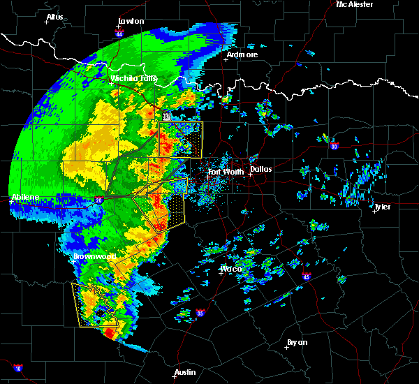 At 725 am cst, a severe thunderstorm was located over bridgeport, moving northeast at 45 mph (radar indicated). Hazards include 60 mph wind gusts. Expect damage to roofs. siding. And trees. At 725 am cst, a severe thunderstorm was located over bridgeport, moving northeast at 45 mph (radar indicated). Hazards include 60 mph wind gusts. Expect damage to roofs. siding. And trees.
|
| 3/7/2016 6:45 PM CST |
 At 644 pm cst, a severe thunderstorm was located over cottondale, or 9 miles northwest of briar, moving northeast at 35 mph (radar indicated). Hazards include 60 mph wind gusts and quarter size hail. Hail damage to vehicles is expected. Expect wind damage to roofs, siding, and trees. At 644 pm cst, a severe thunderstorm was located over cottondale, or 9 miles northwest of briar, moving northeast at 35 mph (radar indicated). Hazards include 60 mph wind gusts and quarter size hail. Hail damage to vehicles is expected. Expect wind damage to roofs, siding, and trees.
|
| 11/5/2015 5:26 PM CST |
 At 525 pm cst, a severe thunderstorm was located near cottondale, or 8 miles northwest of briar, moving northeast at 55 mph (radar indicated). Hazards include 70 mph wind gusts and quarter size hail. Hail damage to vehicles is expected. expect considerable tree damage. wind damage is also likely to mobile homes, roofs and outbuildings. locations impacted include, briar, pecan acres, new fairview, aurora, boyd, paradise, boonsville, cottondale, rhome and newark. A tornado watch remains in effect until 800 pm cst for north central texas. At 525 pm cst, a severe thunderstorm was located near cottondale, or 8 miles northwest of briar, moving northeast at 55 mph (radar indicated). Hazards include 70 mph wind gusts and quarter size hail. Hail damage to vehicles is expected. expect considerable tree damage. wind damage is also likely to mobile homes, roofs and outbuildings. locations impacted include, briar, pecan acres, new fairview, aurora, boyd, paradise, boonsville, cottondale, rhome and newark. A tornado watch remains in effect until 800 pm cst for north central texas.
|
| 11/5/2015 5:06 PM CST |
 At 505 pm cst, a severe thunderstorm was located near poolville, or 12 miles northeast of mineral wells, moving east at 50 mph (radar indicated). Hazards include 70 mph wind gusts and quarter size hail. Hail damage to vehicles is expected. expect considerable tree damage. Wind damage is also likely to mobile homes, roofs and outbuildings. At 505 pm cst, a severe thunderstorm was located near poolville, or 12 miles northeast of mineral wells, moving east at 50 mph (radar indicated). Hazards include 70 mph wind gusts and quarter size hail. Hail damage to vehicles is expected. expect considerable tree damage. Wind damage is also likely to mobile homes, roofs and outbuildings.
|
| 11/5/2015 5:02 PM CST |
 A severe thunderstorm warning remains in effect until 530 pm cst for wise county. at 501 pm cst. a severe thunderstorm was located near decatur. moving northeast at 50 mph. hazard. 70 mph wind gusts and quarter size hail. source. Radar indicated. A severe thunderstorm warning remains in effect until 530 pm cst for wise county. at 501 pm cst. a severe thunderstorm was located near decatur. moving northeast at 50 mph. hazard. 70 mph wind gusts and quarter size hail. source. Radar indicated.
|
| 11/5/2015 4:44 PM CST |
 At 443 pm cst, a severe thunderstorm was located over boonsville, or 9 miles southwest of bridgeport, moving northeast at 50 mph (radar indicated). Hazards include 60 mph wind gusts and quarter size hail. Hail damage to vehicles is expected. Expect wind damage to roofs, siding and trees. At 443 pm cst, a severe thunderstorm was located over boonsville, or 9 miles southwest of bridgeport, moving northeast at 50 mph (radar indicated). Hazards include 60 mph wind gusts and quarter size hail. Hail damage to vehicles is expected. Expect wind damage to roofs, siding and trees.
|
| 11/5/2015 2:05 PM CST |
 At 205 pm cst, a severe thunderstorm was located over boonsville, or 10 miles southwest of bridgeport, moving northeast at 50 mph (radar indicated). Hazards include 60 mph wind gusts and quarter size hail. Hail damage to vehicles is expected. expect wind damage to roofs, siding and trees. locations impacted include, decatur, bridgeport, briar, new fairview, aurora, boyd, paradise, boonsville, cottondale, rhome, runaway bay and lake bridgeport. A tornado watch remains in effect until 800 pm cst for north central texas. At 205 pm cst, a severe thunderstorm was located over boonsville, or 10 miles southwest of bridgeport, moving northeast at 50 mph (radar indicated). Hazards include 60 mph wind gusts and quarter size hail. Hail damage to vehicles is expected. expect wind damage to roofs, siding and trees. locations impacted include, decatur, bridgeport, briar, new fairview, aurora, boyd, paradise, boonsville, cottondale, rhome, runaway bay and lake bridgeport. A tornado watch remains in effect until 800 pm cst for north central texas.
|
| 11/5/2015 1:55 PM CST |
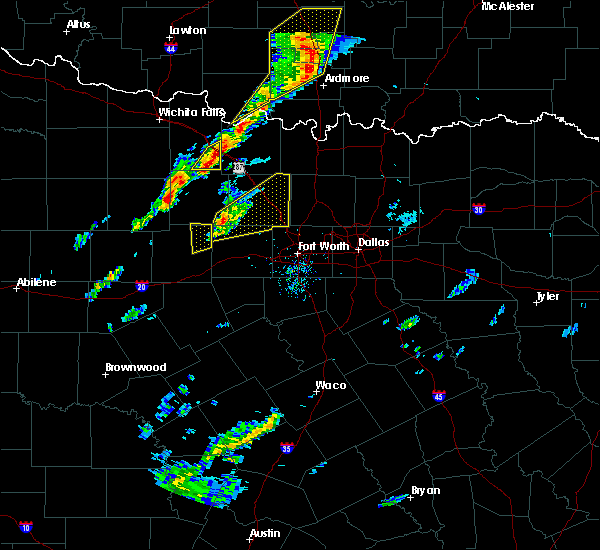 At 155 pm cst, a severe thunderstorm was located 7 miles west of poolville, or 14 miles northeast of mineral wells, moving northeast at 50 mph (radar indicated). Hazards include 60 mph wind gusts and quarter size hail. Hail damage to vehicles is expected. Expect wind damage to roofs, siding and trees. At 155 pm cst, a severe thunderstorm was located 7 miles west of poolville, or 14 miles northeast of mineral wells, moving northeast at 50 mph (radar indicated). Hazards include 60 mph wind gusts and quarter size hail. Hail damage to vehicles is expected. Expect wind damage to roofs, siding and trees.
|
| 5/28/2015 8:12 PM CDT | The severe thunderstorm warning for parker, wise, northeastern palo pinto and eastern jack counties will expire at 815 pm cdt, the storms which prompted the warning have weakened below severe limits, and no longer pose an immediate threat to life or property. therefore the warning will be allowed to expire. however small. |
| 5/28/2015 7:56 PM CDT | At 756 pm cdt, severe thunderstorms were located along a line extending from near sunset to near cottondale to 6 miles south of cool, moving east at 15 mph (radar indicated). Hazards include 60 mph wind gusts and quarter size hail. Hail damage to vehicles is expected. expect wind damage to roofs, siding and trees. locations impacted include, weatherford, mineral wells, azle, decatur, bridgeport, jacksboro, briar, pecan acres, willow park, reno, aledo, springtown, hudson oaks, alvord, annetta, new fairview, aurora, boyd, chico and graford. this includes the following interstates, interstate 20 between mile markers 397 and 422. Interstate 30 near mile marker 1. |
| 5/28/2015 7:21 PM CDT | At 720 pm cdt, severe thunderstorms were located along a line extending from near newport to 7 miles northwest of boonsville to 12 miles southwest of graford, moving east at 45 mph (radar indicated). Hazards include 70 mph wind gusts and quarter size hail. Hail damage to vehicles is expected. expect considerable tree damage. Wind damage is also likely to mobile homes, roofs and outbuildings. |
| 5/25/2015 2:13 PM CDT | The severe thunderstorm warning for eastern wise and eastern montague counties will expire at 215 pm cdt, the storms which prompted the warning have moved out of the area and weakened. therefore the warning will be allowed to expire. however gusty winds are still possible with these thunderstorms. a tornado watch remains in effect until 600 pm cdt for north central texas. |
| 5/25/2015 2:05 PM CDT | At 204 pm cdt, severe thunderstorms were located along a line extending from near forestburg to 7 miles northeast of decatur to near new fairview, moving east at 50 mph (radar indicated). Hazards include 70 mph wind gusts and penny size hail. Expect considerable tree damage. damage is likely to mobile homes, roofs and outbuildings. locations impacted include, decatur, nocona, briar, pecan acres, new fairview, aurora, boyd, st. jo, paradise, forestburg, cottondale, rhome and newark. A tornado watch remains in effect until 600 pm cdt for north central texas. |
| 5/25/2015 1:47 PM CDT | At 147 pm cdt, severe thunderstorms were located along a line extending from near forestburg to 7 miles northeast of decatur to near boyd, moving east at 45 mph (radar indicated). Hazards include 70 mph wind gusts and penny size hail. Expect considerable tree damage. damage is likely to mobile homes, roofs and outbuildings. locations impacted include, decatur, bridgeport, bowie, nocona, briar, pecan acres, alvord, new fairview, aurora, boyd, st. jo, chico, paradise, stoneburg, forestburg, sunset, boonsville, cottondale, rhome and runaway bay. A tornado watch remains in effect until 600 pm cdt for north central texas. |
| 5/25/2015 1:31 PM CDT | At 131 pm cdt, severe thunderstorms were located along a line extending from near bowie to near alvord to near cottondale, moving east at 50 mph (radar indicated). Hazards include 70 mph wind gusts and penny size hail. Expect considerable tree damage. damage is likely to mobile homes, roofs and outbuildings. locations impacted include, decatur, bridgeport, bowie, nocona, briar, pecan acres, alvord, new fairview, aurora, boyd, st. jo, chico, paradise, stoneburg, forestburg, sunset, boonsville, cottondale, rhome and runaway bay. A tornado watch remains in effect until 600 pm cdt for north central texas. |
| 5/25/2015 1:11 PM CDT | At 110 pm cdt, severe thunderstorms were located along a line extending from near newport to 9 miles west of chico to near poolville, moving east at 50 mph (radar indicated). Hazards include 60 mph wind gusts and penny size hail. Expect damage to roofs. Siding and trees. |
| 5/19/2015 11:36 PM CDT | At 1135 pm cdt, a severe thunderstorm was located near chico, or near bridgeport, moving east at 45 mph (radar indicated). Hazards include 70 mph wind gusts and half dollar size hail. Hail damage to vehicles is expected. expect considerable tree damage. wind damage is also likely to mobile homes, roofs and outbuildings. locations impacted include, decatur, bridgeport, alvord, new fairview, chico, paradise, runaway bay and lake bridgeport. A tornado watch remains in effect until midnight cdt for north central texas. |
| 5/19/2015 11:21 PM CDT | At 1119 pm cdt, a severe thunderstorm was located over chico, or near bridgeport, moving east at 30 mph (radar indicated). Hazards include tennis ball size hail and 60 mph wind gusts. People and animals outdoors will be injured. expect hail damage to roofs, siding, windows and vehicles. expect wind damage to roofs, siding and trees. locations impacted include, decatur, bridgeport, alvord, new fairview, chico, paradise, runaway bay and lake bridgeport. A tornado watch remains in effect until midnight cdt for north central texas. |
| 5/19/2015 11:03 PM CDT | At 1102 pm cdt, a severe thunderstorm was located near chico, or 8 miles northwest of bridgeport, moving east at 25 mph (radar indicated). Hazards include two inch hail and 60 mph wind gusts. People and animals outdoors will be injured. expect hail damage to roofs, siding, windows and vehicles. expect wind damage to roofs, siding and trees. locations impacted include, decatur, bridgeport, alvord, new fairview, aurora, boyd, chico, paradise, runaway bay and lake bridgeport. A tornado watch remains in effect until midnight cdt for north central texas. |
| 5/19/2015 11:03 PM CDT | At 1102 pm cdt, a severe thunderstorm was located near chico, or 8 miles northwest of bridgeport, moving east at 25 mph (radar indicated). Hazards include two inch hail and 60 mph wind gusts. People and animals outdoors will be injured. expect hail damage to roofs, siding, windows and vehicles. expect wind damage to roofs, siding and trees. locations impacted include, decatur, bridgeport, alvord, new fairview, aurora, boyd, chico, paradise, runaway bay and lake bridgeport. A tornado watch remains in effect until midnight cdt for north central texas. |
| 5/19/2015 10:43 PM CDT | At 1042 pm cdt, a severe thunderstorm was located 10 miles west of chico, or 11 miles east of jacksboro, moving east at 45 mph (radar indicated). Hazards include two inch hail and 60 mph wind gusts. People and animals outdoors will be injured. expect hail damage to roofs, siding, windows and vehicles. Expect wind damage to roofs, siding and trees. |
| 5/19/2015 10:34 PM CDT | At 1032 pm cdt, a severe thunderstorm was located near bridgeport, moving east at 40 mph, and a tornado warning remains in effect for central portions of wise county. this is a very dangerous storm (radar indicated). Hazards include 80 mph wind gusts and two inch hail. Flying debris will be dangerous to those caught without shelter. mobile homes will be heavily damaged. expect considerable damage to roofs, windows and vehicles. extensive tree damage and power outages are likely. locations impacted include, decatur, bridgeport, jacksboro, briar, pecan acres, alvord, new fairview, aurora, boyd, chico, paradise, boonsville, cottondale, rhome, runaway bay, newark and lake bridgeport. A tornado watch remains in effect until midnight cdt for north central texas. |
| 5/19/2015 10:08 PM CDT | At 1007 pm cdt, a severe thunderstorm capable of producing a tornado was located over paradise moving east at 30 mph (radar indicated rotation). Hazards include tornado and hail up to two inches in diameter. Flying debris will be dangerous to those caught without shelter. mobile homes will be damaged or destroyed. damage to roofs, windows and vehicles will occur. tree damage is likely. this dangerous storm will be near, boyd around 1020 pm cdt. aurora around 1025 pm cdt. new fairview around 1040 pm cdt. Other locations impacted by this tornadic thunderstorm include rhome. |
| 5/19/2015 10:01 PM CDT | At 1000 pm cdt, a possible dangerous tornado was located between runaway bay and paradise, moving east at 15 mph. this is a particularly dangerous situation (radar indicated rotation). Hazards include damaging tornado. You are in a life threatening situation. flying debris may be deadly to those caught without shelter. mobile homes will be destroyed. considerable damage to homes, businesses and vehicles is likely and complete destruction is possible. the tornado will be near, bridgeport around 1005 pm cdt. paradise and cottondale around 1015 pm cdt. Other locations impacted by this tornadic thunderstorm include lake bridgeport and runaway bay. |
| 5/19/2015 9:51 PM CDT | At 949 pm cdt, a severe thunderstorm was located near bridgeport, moving east at 40 mph, a tornado warning remains in effect for western portions of wise county as well. this is a very dangerous storm (radar indicated). Hazards include 80 mph wind gusts and two inch hail. Flying debris will be dangerous to those caught without shelter. mobile homes will be heavily damaged. expect considerable damage to roofs, windows and vehicles. extensive tree damage and power outages are likely. locations impacted include, decatur, bridgeport, jacksboro, briar, pecan acres, alvord, new fairview, aurora, boyd, chico, paradise, boonsville, cottondale, rhome, runaway bay, newark and lake bridgeport. A tornado watch remains in effect until midnight cdt for north central texas. |
| 5/19/2015 9:43 PM CDT | At 941 pm cdt, a severe thunderstorm was located near boonsville, or 10 miles southwest of bridgeport, moving east at 40 mph. also tornado warning remains in effect for southwestern portions of wise county including runaway bay until 10:15 pm (radar indicated). Hazards include two inch hail and 60 mph wind gusts. People and animals outdoors will be injured. expect hail damage to roofs, siding, windows and vehicles. Expect wind damage to roofs, siding and trees. |
| 5/19/2015 9:42 PM CDT | At 940 pm cdt, a confirmed dangerous tornado was located near boonsville, or 8 miles west of bridgeport, moving east at 15 mph. this tornado will directly impact runaway bay and possibly lake bridgeport! this tornado may be moving along highway 380. this is a particularly dangerous situation (weather spotters confirmed tornado). Hazards include damaging tornado. You are in a life threatening situation. flying debris may be deadly to those caught without shelter. mobile homes will be destroyed. considerable damage to homes, businesses and vehicles is likely and complete destruction is possible. the tornado will be near, bridgeport around 1005 pm cdt. paradise and cottondale around 1015 pm cdt. Other locations impacted by this tornadic thunderstorm include lake bridgeport and runaway bay. |
| 5/19/2015 9:06 PM CDT | At 906 pm cdt, a severe thunderstorm was located near boonsville, or 12 miles southwest of bridgeport, moving east at 40 mph (radar indicated). Hazards include ping pong ball size hail and 60 mph wind gusts. People and animals outdoors will be injured. expect hail damage to roofs, siding, windows and vehicles. Expect wind damage to roofs, siding and trees. |
| 5/19/2015 7:01 PM CDT | At 701 pm cdt, a severe thunderstorm was located 8 miles north of mineral wells state park, or 10 miles north of mineral wells, moving northeast at 25 mph (radar indicated). Hazards include ping pong ball size hail and 60 mph wind gusts. People and animals outdoors will be injured. expect hail damage to roofs, siding, windows and vehicles. Expect wind damage to roofs, siding and trees. |
| 5/17/2015 12:30 AM CDT | At 1229 am cdt, severe thunderstorms were located along a line extending from near decatur to justin to white settlement, moving east at 60 mph (radar indicated). Hazards include 60 mph wind gusts. Expect damage to roofs. siding and trees. locations impacted include, fort worth, denton, lewisville, flower mound, euless, bedford, grapevine, haltom city, keller, coppell, hurst, the colony, southlake, watauga, colleyville, benbrook, corinth, saginaw, white settlement and highland village. 75in. |
| 5/17/2015 12:07 AM CDT | At 1205 am cdt, severe thunderstorms were located along a line extending from near poolville to near springtown to willow park, moving east at 60 mph (radar indicated). Hazards include 70 mph wind gusts. Expect considerable tree damage. Damage is likely to mobile homes, roofs and outbuildings. |
| 5/10/2015 2:12 PM CDT | At 211 pm cdt, a severe thunderstorm was located near corral city, or 7 miles southwest of denton, moving northeast at 35 mph (radar indicated). Hazards include 60 mph wind gusts and quarter size hail. Hail damage to vehicles is expected. expect wind damage to roofs, siding and trees. locations impacted include, fort worth, denton, flower mound, keller, corinth, saginaw, trophy club, sanger, decatur, bridgeport, briar, eagle mountain, roanoke, pecan acres, krum, pilot point, argyle, justin, shady shores and aubrey. this includes the following interstates, interstate 35 between mile markers 468 and 481. interstate 35w between mile markers 60 and 85. interstate 35e between mile markers 460 and 466. interstate 820 between mile markers 13 and 15. a tornado watch remains in effect until 900 pm cdt for north central texas. 1. 00in. |
| 5/10/2015 1:42 PM CDT | At 141 pm cdt, a severe thunderstorm was located over pelican bay, or over briar, moving northeast at 55 mph. another severe thunderstorm was also located west of haslet near pelican acres, .along moving northeast (radar indicated). Hazards include 60 mph wind gusts and quarter size hail. Hail damage to vehicles is expected. Expect wind damage to roofs, siding and trees. |
| 5/7/2015 8:54 PM CDT | At 854 pm cdt, severe thunderstorms were located along a line extending from near decatur to near boyd to 6 miles north of weatherford, moving east at 50 mph (radar indicated). Hazards include 70 mph wind gusts and quarter size hail. Hail damage to vehicles is expected. expect considerable tree damage. Wind damage is also likely to mobile homes, roofs and outbuildings. |
| 5/7/2015 8:07 PM CDT | At 806 pm cdt, severe thunderstorms were located along a line extending from near jacksboro to near graford to 10 miles northwest of gordon, moving east at 45 mph (radar indicated). Hazards include 70 mph wind gusts and quarter size hail. Hail damage to vehicles is expected. expect considerable tree damage. Wind damage is also likely to mobile homes, roofs and outbuildings. |
| 5/7/2015 7:52 PM CDT | At 752 pm cdt, a severe thunderstorm capable of producing a tornado was located 10 miles east of jacksboro, moving east at 15 mph (radar indicated rotation). Hazards include tornado and golf ball size hail. Flying debris will be dangerous to those caught without shelter. mobile homes will be damaged or destroyed. damage to roofs, windows and vehicles will occur. tree damage is likely. this dangerous storm will be near, bridgeport and chico around 815 pm cdt. other locations impacted by this tornadic thunderstorm include lake bridgeport and runaway bay. Radar indicated. |
| 5/7/2015 6:52 PM CDT | Half Dollar sized hail reported 6.1 miles NNE of Paradise, TX, half dollar size hail in cottondale at hwy 114 and hwy 51. |
| 5/7/2015 5:13 PM CDT | At 512 pm cdt, a severe thunderstorm was located near springtown, or 11 miles north of weatherford, moving north at 40 mph (radar indicated). Hazards include ping pong ball size hail and 60 mph wind gusts. People and animals outdoors will be injured. expect hail damage to roofs, siding, windows and vehicles. Expect wind damage to roofs, siding and trees. |
| 4/1/2015 7:43 PM CDT | A severe thunderstorm warning remains in effect until 815 pm cdt for south central wise and northeastern parker counties. at 742 pm cdt. a severe thunderstorm was located near springtown. or 10 miles west of briar. moving northeast at 25 mph. hazard. 60 mph wind gusts and quarter size hail. source. Trained weather spotters. |
| 4/1/2015 7:29 PM CDT | The national weather service in fort worth has issued a * severe thunderstorm warning for. south central wise county in north central texas. northeastern parker county in north central texas. until 815 pm cdt * at 729 pm cdt. A severe thunderstorm was located near poolville. |
| 3/9/2013 5:13 PM CST | Quarter sized hail reported 1.7 miles SE of Paradise, TX, quarter size hail reported in paradise. |
Hail Maps for Paradise, TX
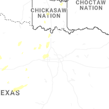
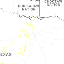

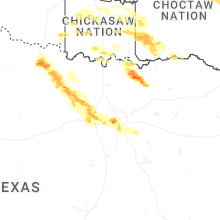
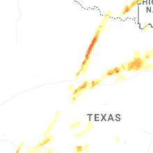
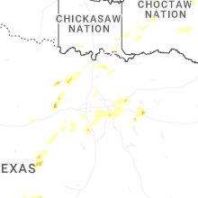
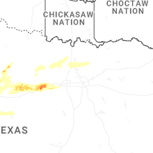
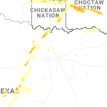
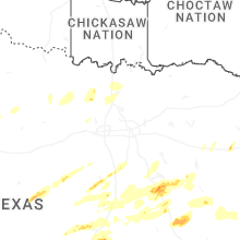
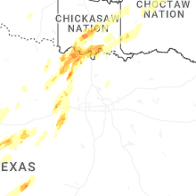
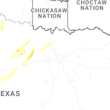


Connect with Interactive Hail Maps