

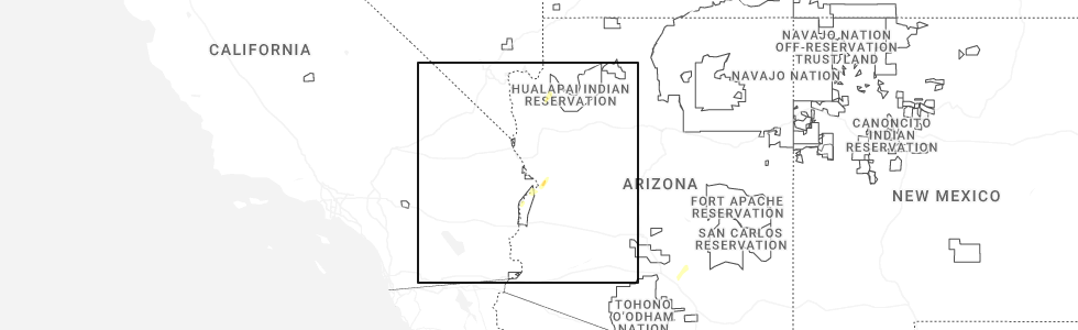
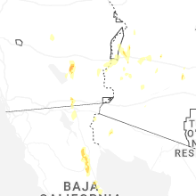
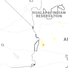
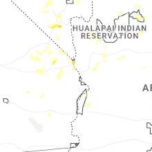
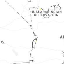
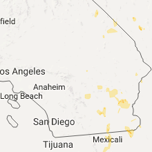
Hail Map for Parker, AZ
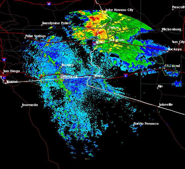
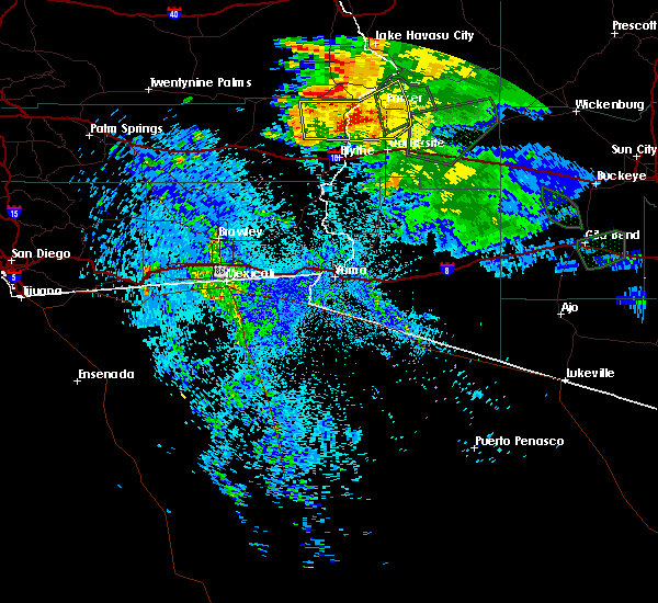
The Parker, AZ area has had 0 reports of on-the-ground hail by trained spotters, and has been under severe weather warnings 10 times during the past 12 months. Doppler radar has detected hail at or near Parker, AZ on 16 occasions, including 3 occasions during the past year.
| Name: | Parker, AZ |
| Where Located: | 24.8 miles S of Lake Havasu City, AZ |
| Map: | Google Map for Parker, AZ |
| Population: | 3083 |
| Housing Units: | 1098 |
| More Info: | Search Google for Parker, AZ |
1
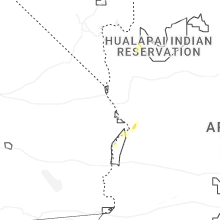
The Top Recent Hail Date for Parker, AZ is Monday, October 13, 2025 (6th out of 16)
Hail and Wind Damage Spotted near Parker, AZ
| Date / Time | Report Details |
|---|---|
| 10/13/2025 9:27 AM MST | The storm which prompted the warning has moved out of the area. therefore, the warning will be allowed to expire. however, small hail and gusty winds are still possible with this thunderstorm. remember, a severe thunderstorm warning still remains in effect for a portion of far northwestern la paz county including the parker area and locations to the north and east of parker. |
| 10/13/2025 9:26 AM MST | Svrpsr the national weather service in phoenix has issued a * severe thunderstorm warning for, northwestern la paz county in west central arizona, * until 1015 am mst. * at 925 am mst, a severe thunderstorm was located over parker, moving northeast at 20 mph (radar indicated). Hazards include 60 mph wind gusts. expect damage to roofs, siding, and trees |
| 10/13/2025 9:18 AM MST | At 918 am mst, a severe thunderstorm was located near parker, moving northeast at 20 mph (radar indicated). Hazards include 60 mph wind gusts. Expect damage to roofs, siding, and trees. locations impacted include, parker. This includes az route 95 between mile markers 136 and 145. |
| 10/13/2025 9:09 AM MST | the severe thunderstorm warning has been cancelled and is no longer in effect |
| 10/13/2025 9:09 AM MST | At 908 am mst, a severe thunderstorm was located 8 miles south of big river, or 8 miles southwest of parker, moving northeast at 20 mph (radar indicated). Hazards include 60 mph wind gusts. Expect damage to roofs, siding, and trees. locations impacted include, parker and poston. This includes az route 95 between mile markers 136 and 145. |
| 10/13/2025 8:52 AM MST | Svrpsr the national weather service in phoenix has issued a * severe thunderstorm warning for, northwestern la paz county in west central arizona, riverside county in southern california, * until 930 am mst/930 am pdt/. * at 852 am mst/852 am pdt/, a severe thunderstorm was located 14 miles south of big river, or 15 miles southwest of parker, moving northeast at 20 mph (radar indicated). Hazards include 60 mph wind gusts and quarter size hail. Hail damage to vehicles is expected. Expect wind damage to roofs, siding, and trees. |
| 9/18/2025 1:42 PM MST | At 142 pm mst/142 pm pdt/, a severe thunderstorm was located near big river, or 8 miles southwest of parker, moving north at 20 mph (radar indicated). Hazards include 60 mph wind gusts and quarter size hail. Hail damage to vehicles is expected. expect wind damage to roofs, siding, and trees. locations impacted include, poston. this includes the following highways, az route 95 between mile markers 134 and 140. Ca route 95 between mile markers 27 and 36. |
| 9/18/2025 1:10 PM MST | Svrpsr the national weather service in phoenix has issued a * severe thunderstorm warning for, northwestern la paz county in west central arizona, riverside county in southern california, * until 200 pm mst/200 pm pdt/. * at 109 pm mst/109 pm pdt/, a severe thunderstorm was located 15 miles south of parker, moving northwest at 20 mph (radar indicated). Hazards include 60 mph wind gusts and quarter size hail. Hail damage to vehicles is expected. Expect wind damage to roofs, siding, and trees. |
| 9/18/2025 12:50 PM MST | At 1250 pm mst, a severe thunderstorm was located 11 miles north of quartzsite, or 20 miles south of parker, moving northwest at 15 mph (radar indicated). Hazards include 60 mph wind gusts and quarter size hail. Hail damage to vehicles is expected. expect wind damage to roofs, siding, and trees. this severe thunderstorm will remain over mainly rural areas of west central la paz county. this includes the following highways, az route 72 between mile markers 14 and 15. Az route 95 between mile markers 115 and 133. |
| 9/18/2025 12:29 PM MST | Svrpsr the national weather service in phoenix has issued a * severe thunderstorm warning for, west central la paz county in west central arizona, * until 115 pm mst. * at 1229 pm mst, a severe thunderstorm was located near quartzsite, or 25 miles south of parker, moving northwest at 15 mph (radar indicated). Hazards include 60 mph wind gusts and quarter size hail. Hail damage to vehicles is expected. Expect wind damage to roofs, siding, and trees. |
| 9/12/2022 3:50 PM MST |
 The severe thunderstorm warning for north central la paz county will expire at 400 pm mst, the storm which prompted the warning has weakened below severe limits, and has exited the warned area. therefore, the warning will be allowed to expire. The severe thunderstorm warning for north central la paz county will expire at 400 pm mst, the storm which prompted the warning has weakened below severe limits, and has exited the warned area. therefore, the warning will be allowed to expire.
|
| 9/12/2022 3:04 PM MST |
 At 304 pm mst, a severe thunderstorm was located near parker, moving north at 20 mph (radar indicated). Hazards include 60 mph wind gusts and penny size hail. expect damage to roofs, siding, and trees At 304 pm mst, a severe thunderstorm was located near parker, moving north at 20 mph (radar indicated). Hazards include 60 mph wind gusts and penny size hail. expect damage to roofs, siding, and trees
|
| 8/24/2022 8:07 PM MST | At 807 pm mst, a severe thunderstorm was located over bouse, or 19 miles southeast of parker, and is nearly stationary (radar indicated). Hazards include 60 mph wind gusts. Expect damage to roofs, siding, and trees. locations impacted include, bouse. this includes the following highways, az route 72 between mile markers 14 and 32. az route 95 between mile markers 122 and 130. hail threat, radar indicated max hail size, <. 75 in wind threat, radar indicated max wind gust, 60 mph. |
| 8/24/2022 7:49 PM MST | At 749 pm mst, a severe thunderstorm was located over bouse, or 19 miles southeast of parker, and is nearly stationary (radar indicated). Hazards include 60 mph wind gusts. expect damage to roofs, siding, and trees |
| 8/21/2022 11:16 PM MST | At 1116 pm mst/1116 pm pdt/, severe thunderstorms were located along a line extending from 9 miles south of big river to 17 miles northeast of blythe to 7 miles southeast of quartzsite to 8 miles northeast of kofa wildlife refuge, moving southwest at 25 mph (radar indicated). Hazards include 60 mph wind gusts. Expect damage to roofs, siding, and trees. locations impacted include, parker, quartzsite, brenda, vicksburg junction, kofa wildlife refuge, vicksburg and poston. this includes the following highways, az interstate 10 between mile markers 11 and 54. us highway 60 between mile markers 31 and 51. az route 72 between mile markers 14 and 16, and between mile markers 44 and 49. hail threat, radar indicated max hail size, <. 75 in wind threat, radar indicated max wind gust, 60 mph. |
| 8/21/2022 11:16 PM MST | At 1116 pm mst/1116 pm pdt/, severe thunderstorms were located along a line extending from 9 miles south of big river to 17 miles northeast of blythe to 7 miles southeast of quartzsite to 8 miles northeast of kofa wildlife refuge, moving southwest at 25 mph (radar indicated). Hazards include 60 mph wind gusts. Expect damage to roofs, siding, and trees. locations impacted include, parker, quartzsite, brenda, vicksburg junction, kofa wildlife refuge, vicksburg and poston. this includes the following highways, az interstate 10 between mile markers 11 and 54. us highway 60 between mile markers 31 and 51. az route 72 between mile markers 14 and 16, and between mile markers 44 and 49. hail threat, radar indicated max hail size, <. 75 in wind threat, radar indicated max wind gust, 60 mph. |
| 8/21/2022 11:09 PM MST | The severe thunderstorm warning for southwestern mohave and southeastern san bernardino counties will expire at 1115 pm pdt/1115 pm mst/, the storm which prompted the warning has weakened below severe limits, and no longer poses an immediate threat to life or property. therefore, the warning will be allowed to expire. however gusty winds are still possible with this thunderstorm. |
| 8/21/2022 11:09 PM MST | The severe thunderstorm warning for southwestern mohave and southeastern san bernardino counties will expire at 1115 pm pdt/1115 pm mst/, the storm which prompted the warning has weakened below severe limits, and no longer poses an immediate threat to life or property. therefore, the warning will be allowed to expire. however gusty winds are still possible with this thunderstorm. |
| 8/21/2022 11:01 PM MST | At 1101 pm mst/1101 pm pdt/, severe thunderstorms were located along a line extending from near big river to 17 miles west of bouse to 7 miles east of quartzsite to 6 miles southeast of brenda, moving southwest at 35 mph (radar indicated). Hazards include 60 mph wind gusts. Expect damage to roofs, siding, and trees. locations impacted include, parker, quartzsite, salome, brenda, vicksburg junction, buckskin mountain park, wenden, kofa wildlife refuge, vicksburg, bouse, harcuvar and poston. this includes the following highways, az interstate 10 between mile markers 11 and 54. us highway 60 between mile markers 31 and 64. az route 72 between mile markers 14 and 49. hail threat, radar indicated max hail size, <. 75 in wind threat, radar indicated max wind gust, 60 mph. |
| 8/21/2022 11:01 PM MST | At 1101 pm mst/1101 pm pdt/, severe thunderstorms were located along a line extending from near big river to 17 miles west of bouse to 7 miles east of quartzsite to 6 miles southeast of brenda, moving southwest at 35 mph (radar indicated). Hazards include 60 mph wind gusts. Expect damage to roofs, siding, and trees. locations impacted include, parker, quartzsite, salome, brenda, vicksburg junction, buckskin mountain park, wenden, kofa wildlife refuge, vicksburg, bouse, harcuvar and poston. this includes the following highways, az interstate 10 between mile markers 11 and 54. us highway 60 between mile markers 31 and 64. az route 72 between mile markers 14 and 49. hail threat, radar indicated max hail size, <. 75 in wind threat, radar indicated max wind gust, 60 mph. |
| 8/21/2022 10:41 PM MST | At 1040 pm pdt/1040 pm mst/, a severe thunderstorm was located 10 miles northeast of desert hills, or 11 miles northeast of lake havasu city, moving southwest at 30 mph. wind gusts to 60 mph were observed at yucca with this storm earlier (radar indicated). Hazards include 60 mph wind gusts. Expect damage to roofs and trees. locations impacted include, lake havasu city, topock, parker dam, needles, three dunes campground, cattail cove state park, desert hills, black meadow landing campground, earp and big river. this includes the following highways, interstate 40 in arizona between mile markers 0 and 22. interstate 40 in california between mile markers 148 and 155. hail threat, radar indicated max hail size, <. 75 in wind threat, radar indicated max wind gust, 60 mph. |
| 8/21/2022 10:41 PM MST | At 1040 pm pdt/1040 pm mst/, a severe thunderstorm was located 10 miles northeast of desert hills, or 11 miles northeast of lake havasu city, moving southwest at 30 mph. wind gusts to 60 mph were observed at yucca with this storm earlier (radar indicated). Hazards include 60 mph wind gusts. Expect damage to roofs and trees. locations impacted include, lake havasu city, topock, parker dam, needles, three dunes campground, cattail cove state park, desert hills, black meadow landing campground, earp and big river. this includes the following highways, interstate 40 in arizona between mile markers 0 and 22. interstate 40 in california between mile markers 148 and 155. hail threat, radar indicated max hail size, <. 75 in wind threat, radar indicated max wind gust, 60 mph. |
| 8/21/2022 10:33 PM MST | At 1032 pm mst/1032 pm pdt/, severe thunderstorms were located along a line extending from parker dam to 7 miles northwest of bouse to 8 miles northwest of vicksburg to near salome, moving southwest at 25 mph (radar indicated). Hazards include 60 mph wind gusts. expect damage to roofs, siding, and trees |
| 8/21/2022 10:33 PM MST | At 1032 pm mst/1032 pm pdt/, severe thunderstorms were located along a line extending from parker dam to 7 miles northwest of bouse to 8 miles northwest of vicksburg to near salome, moving southwest at 25 mph (radar indicated). Hazards include 60 mph wind gusts. expect damage to roofs, siding, and trees |
| 8/21/2022 10:03 PM MST | At 1003 pm pdt/1003 pm mst/, a severe thunderstorm was located near yucca, moving south at 30 mph. this storm will approach lake havasu city through 11pm (radar indicated). Hazards include 60 mph wind gusts and quarter size hail. Hail damage to vehicles is expected. Expect wind damage to roofs and trees. |
| 8/21/2022 10:03 PM MST | At 1003 pm pdt/1003 pm mst/, a severe thunderstorm was located near yucca, moving south at 30 mph. this storm will approach lake havasu city through 11pm (radar indicated). Hazards include 60 mph wind gusts and quarter size hail. Hail damage to vehicles is expected. Expect wind damage to roofs and trees. |
| 7/28/2022 6:09 PM PDT |
 At 609 pm pdt/609 pm mst/, a severe thunderstorm was located near lake havasu city, moving southwest at 20 mph (radar indicated). Hazards include 60 mph wind gusts. Expect damage to roofs and trees. locations impacted include, lake havasu city, highway 95 at mile marker 29, parker dam, three dunes campground, cattail cove state park, desert hills, black meadow landing campground, essex, earp, vidal junction and big river. hail threat, radar indicated max hail size, <. 75 in wind threat, radar indicated max wind gust, 60 mph. At 609 pm pdt/609 pm mst/, a severe thunderstorm was located near lake havasu city, moving southwest at 20 mph (radar indicated). Hazards include 60 mph wind gusts. Expect damage to roofs and trees. locations impacted include, lake havasu city, highway 95 at mile marker 29, parker dam, three dunes campground, cattail cove state park, desert hills, black meadow landing campground, essex, earp, vidal junction and big river. hail threat, radar indicated max hail size, <. 75 in wind threat, radar indicated max wind gust, 60 mph.
|
| 7/28/2022 5:46 PM PDT |
 At 546 pm pdt/546 pm mst/, a severe thunderstorm was located over lake havasu city, moving southwest at 20 mph (radar indicated). Hazards include 60 mph wind gusts. expect damage to roofs and trees At 546 pm pdt/546 pm mst/, a severe thunderstorm was located over lake havasu city, moving southwest at 20 mph (radar indicated). Hazards include 60 mph wind gusts. expect damage to roofs and trees
|
| 8/16/2021 2:54 AM MST |
 The severe thunderstorm warning for central la paz county will expire at 300 am mst, the storm which prompted the warning has weakened below severe limits, and has exited the warned area. therefore, the warning will be allowed to expire. however heavy rain is still possible with this thunderstorm. The severe thunderstorm warning for central la paz county will expire at 300 am mst, the storm which prompted the warning has weakened below severe limits, and has exited the warned area. therefore, the warning will be allowed to expire. however heavy rain is still possible with this thunderstorm.
|
| 8/16/2021 1:54 AM MST |
 At 154 am mst, a severe thunderstorm was located 7 miles east of bouse, or 27 miles southeast of parker, moving southwest at 30 mph (radar indicated). Hazards include 60 mph wind gusts and quarter size hail. Hail damage to vehicles is expected. Expect wind damage to roofs, siding, and trees. At 154 am mst, a severe thunderstorm was located 7 miles east of bouse, or 27 miles southeast of parker, moving southwest at 30 mph (radar indicated). Hazards include 60 mph wind gusts and quarter size hail. Hail damage to vehicles is expected. Expect wind damage to roofs, siding, and trees.
|
| 8/10/2021 7:23 PM PDT |
 The severe thunderstorm warning for southeastern san bernardino county will expire at 730 pm pdt, the storms which prompted the warning have weakened below severe limits, and have exited the warned area. therefore, the warning will be allowed to expire. however, thunderstorms continue to produce heavy rainfall and a flash flood warning remains in effect for southeast san bernardino county, primarily along highway 95 south of needles. The severe thunderstorm warning for southeastern san bernardino county will expire at 730 pm pdt, the storms which prompted the warning have weakened below severe limits, and have exited the warned area. therefore, the warning will be allowed to expire. however, thunderstorms continue to produce heavy rainfall and a flash flood warning remains in effect for southeast san bernardino county, primarily along highway 95 south of needles.
|
| 8/10/2021 7:03 PM PDT |
 At 659 pm pdt, severe thunderstorms were located along a line extending from 16 miles northwest of highway 95 at mile marker 29 to 10 miles northwest of vidal junction to 8 miles southwest of big river to 14 miles west of bouse, moving southwest at 30 mph (radar indicated). Hazards include 60 mph wind gusts. Expect damage to roofs and trees. locations impacted include, highway 95 at mile marker 29, earp, vidal junction and big river. hail threat, radar indicated max hail size, <. 75 in wind threat, observed max wind gust, 60 mph. At 659 pm pdt, severe thunderstorms were located along a line extending from 16 miles northwest of highway 95 at mile marker 29 to 10 miles northwest of vidal junction to 8 miles southwest of big river to 14 miles west of bouse, moving southwest at 30 mph (radar indicated). Hazards include 60 mph wind gusts. Expect damage to roofs and trees. locations impacted include, highway 95 at mile marker 29, earp, vidal junction and big river. hail threat, radar indicated max hail size, <. 75 in wind threat, observed max wind gust, 60 mph.
|
| 8/10/2021 6:53 PM MST |
 At 651 pm mst/pdt, severe thunderstorms were over northern and western la paz county and moving south-southwest at up to 45 mph (radar indicated). Hazards include 60 mph wind gusts. half inch sized hail. Expect damage to roofs, siding, and trees. locations impacted include, parker, quartzsite, salome, brenda, wenden, vicksburg, bouse, harcuvar and poston. this includes the following highways, az interstate 10 between mile markers 8 and 64. us highway 60 between mile markers 31 and 73. Az route 72 between mile markers 14 and 49. At 651 pm mst/pdt, severe thunderstorms were over northern and western la paz county and moving south-southwest at up to 45 mph (radar indicated). Hazards include 60 mph wind gusts. half inch sized hail. Expect damage to roofs, siding, and trees. locations impacted include, parker, quartzsite, salome, brenda, wenden, vicksburg, bouse, harcuvar and poston. this includes the following highways, az interstate 10 between mile markers 8 and 64. us highway 60 between mile markers 31 and 73. Az route 72 between mile markers 14 and 49.
|
| 8/10/2021 6:43 PM PDT |
 At 641 pm pdt/641 pm mst/, severe thunderstorms were located along a line extending from 17 miles southwest of needles to near big river, moving southwest at 30 mph (radar indicated). Hazards include 60 mph wind gusts. expect damage to roofs and trees At 641 pm pdt/641 pm mst/, severe thunderstorms were located along a line extending from 17 miles southwest of needles to near big river, moving southwest at 30 mph (radar indicated). Hazards include 60 mph wind gusts. expect damage to roofs and trees
|
| 8/10/2021 6:31 PM MST |
 At 628 pm pdt/628 pm mst/, severe thunderstorms were located along a line extending from 8 miles south of needles to 4 miles west of lake havasu city to near parker, moving southwest at 25 mph (wind speeds of 59 mph have been observed in lake havasu city). Hazards include 60 mph wind gusts and near zero visibility due to blowing dust. Expect damage to roofs and trees. locations impacted include, lake havasu city, highway 95 at mile marker 29, topock, parker dam, alamo lake, needles, three dunes campground, alamo state park, desert hills, black meadow landing campground, mohave valley, cattail cove state park, arizona village, earp, vidal junction, big river, mesquite creek, mojave ranch estates and willow valley. this includes the following highways, interstate 40 in arizona between mile markers 0 and 17. interstate 40 in california between mile markers 140 and 155. hail threat, radar indicated max hail size, <. 75 in wind threat, observed max wind gust, 60 mph. At 628 pm pdt/628 pm mst/, severe thunderstorms were located along a line extending from 8 miles south of needles to 4 miles west of lake havasu city to near parker, moving southwest at 25 mph (wind speeds of 59 mph have been observed in lake havasu city). Hazards include 60 mph wind gusts and near zero visibility due to blowing dust. Expect damage to roofs and trees. locations impacted include, lake havasu city, highway 95 at mile marker 29, topock, parker dam, alamo lake, needles, three dunes campground, alamo state park, desert hills, black meadow landing campground, mohave valley, cattail cove state park, arizona village, earp, vidal junction, big river, mesquite creek, mojave ranch estates and willow valley. this includes the following highways, interstate 40 in arizona between mile markers 0 and 17. interstate 40 in california between mile markers 140 and 155. hail threat, radar indicated max hail size, <. 75 in wind threat, observed max wind gust, 60 mph.
|
| 8/10/2021 6:30 PM MST |
 At 625 pm mst/pdt, severe thunderstorms were located over northern and western portions of la paz county moving south and southwest at 45 mph (radar indicated). Hazards include 60 mph wind gusts. half inch sized hail. expect damage to roofs, siding, and trees At 625 pm mst/pdt, severe thunderstorms were located over northern and western portions of la paz county moving south and southwest at 45 mph (radar indicated). Hazards include 60 mph wind gusts. half inch sized hail. expect damage to roofs, siding, and trees
|
| 8/10/2021 5:59 PM MST |
 At 557 pm pdt/557 pm mst/, severe thunderstorms were located along a line extending from near arizona village to desert hills to 2 miles east of lake havasu city to near parker dam, moving southwest at 25 mph (radar indicated). Hazards include 60 mph wind gusts. Expect damage to roofs and trees. locations impacted include, lake havasu city, highway 95 at mile marker 29, topock, parker dam, alamo lake, needles, three dunes campground, alamo state park, desert hills, black meadow landing campground, mohave valley, cattail cove state park, arizona village, earp, vidal junction, big river, mesquite creek, mojave ranch estates and willow valley. this includes the following highways, interstate 40 in arizona between mile markers 0 and 17. interstate 40 in california between mile markers 140 and 155. hail threat, radar indicated max hail size, <. 75 in wind threat, radar indicated max wind gust, 60 mph. At 557 pm pdt/557 pm mst/, severe thunderstorms were located along a line extending from near arizona village to desert hills to 2 miles east of lake havasu city to near parker dam, moving southwest at 25 mph (radar indicated). Hazards include 60 mph wind gusts. Expect damage to roofs and trees. locations impacted include, lake havasu city, highway 95 at mile marker 29, topock, parker dam, alamo lake, needles, three dunes campground, alamo state park, desert hills, black meadow landing campground, mohave valley, cattail cove state park, arizona village, earp, vidal junction, big river, mesquite creek, mojave ranch estates and willow valley. this includes the following highways, interstate 40 in arizona between mile markers 0 and 17. interstate 40 in california between mile markers 140 and 155. hail threat, radar indicated max hail size, <. 75 in wind threat, radar indicated max wind gust, 60 mph.
|
| 8/10/2021 5:35 PM MST |
 At 534 pm pdt/534 pm mst/, severe thunderstorms were located along a line extending from near arizona village to 6 miles northeast of lake havasu city to 14 miles east of parker dam to 13 miles south of alamo state park, moving southwest at 30 mph (radar indicated). Hazards include 60 mph wind gusts. Expect damage to roofs and trees. locations impacted include, lake havasu city, highway 95 at mile marker 29, topock, parker dam, alamo lake, needles, three dunes campground, alamo state park, desert hills, black meadow landing campground, mohave valley, cattail cove state park, arizona village, earp, vidal junction, big river, mesquite creek, mojave ranch estates and willow valley. this includes the following highways, interstate 40 in arizona between mile markers 0 and 17. interstate 40 in california between mile markers 140 and 155. hail threat, radar indicated max hail size, <. 75 in wind threat, radar indicated max wind gust, 60 mph. At 534 pm pdt/534 pm mst/, severe thunderstorms were located along a line extending from near arizona village to 6 miles northeast of lake havasu city to 14 miles east of parker dam to 13 miles south of alamo state park, moving southwest at 30 mph (radar indicated). Hazards include 60 mph wind gusts. Expect damage to roofs and trees. locations impacted include, lake havasu city, highway 95 at mile marker 29, topock, parker dam, alamo lake, needles, three dunes campground, alamo state park, desert hills, black meadow landing campground, mohave valley, cattail cove state park, arizona village, earp, vidal junction, big river, mesquite creek, mojave ranch estates and willow valley. this includes the following highways, interstate 40 in arizona between mile markers 0 and 17. interstate 40 in california between mile markers 140 and 155. hail threat, radar indicated max hail size, <. 75 in wind threat, radar indicated max wind gust, 60 mph.
|
| 8/10/2021 5:13 PM MST |
 At 509 pm pdt/509 pm mst/, severe thunderstorms were located along a line extending from near oatman to 11 miles south of yucca to the south to the la paz county line, moving southwest at 25 mph (radar indicated). Hazards include 60 mph wind gusts. expect damage to roofs and trees At 509 pm pdt/509 pm mst/, severe thunderstorms were located along a line extending from near oatman to 11 miles south of yucca to the south to the la paz county line, moving southwest at 25 mph (radar indicated). Hazards include 60 mph wind gusts. expect damage to roofs and trees
|
| 11/28/2019 6:49 PM MST |
 At 649 pm mst/549 pm pst/, a severe thunderstorm was located near big river, or 7 miles west of parker, moving northeast at 35 mph (radar indicated). Hazards include 60 mph wind gusts. Expect damage to roofs, siding, and trees. locations impacted include, parker and poston. this includes the following highways, az route 72 between mile markers 14 and 23. az route 95 between mile markers 125 and 150. Ca route 95 between mile markers 14 and 23, and between mile markers 27 and 36. At 649 pm mst/549 pm pst/, a severe thunderstorm was located near big river, or 7 miles west of parker, moving northeast at 35 mph (radar indicated). Hazards include 60 mph wind gusts. Expect damage to roofs, siding, and trees. locations impacted include, parker and poston. this includes the following highways, az route 72 between mile markers 14 and 23. az route 95 between mile markers 125 and 150. Ca route 95 between mile markers 14 and 23, and between mile markers 27 and 36.
|
| 11/28/2019 6:32 PM MST |
 At 632 pm mst/532 pm pst/, a severe thunderstorm was located 11 miles south of vidal junction, or 16 miles southwest of parker, moving northeast at 40 mph (radar indicated). Hazards include 60 mph wind gusts. Expect damage to roofs, siding, and trees. locations impacted include, parker and poston. this includes the following highways, az route 72 between mile markers 14 and 23. az route 95 between mile markers 125 and 150. Ca route 95 between mile markers 14 and 36. At 632 pm mst/532 pm pst/, a severe thunderstorm was located 11 miles south of vidal junction, or 16 miles southwest of parker, moving northeast at 40 mph (radar indicated). Hazards include 60 mph wind gusts. Expect damage to roofs, siding, and trees. locations impacted include, parker and poston. this includes the following highways, az route 72 between mile markers 14 and 23. az route 95 between mile markers 125 and 150. Ca route 95 between mile markers 14 and 36.
|
| 11/28/2019 6:16 PM MST |
 At 616 pm mst/516 pm pst/, a severe thunderstorm was located 8 miles east of midland, or 26 miles southwest of parker, moving northeast at 40 mph (radar indicated). Hazards include 60 mph wind gusts. expect damage to roofs, siding, and trees At 616 pm mst/516 pm pst/, a severe thunderstorm was located 8 miles east of midland, or 26 miles southwest of parker, moving northeast at 40 mph (radar indicated). Hazards include 60 mph wind gusts. expect damage to roofs, siding, and trees
|
| 9/23/2019 10:08 AM MST |
 At 1007 am mst, a severe thunderstorm was located near bouse, or 21 miles southeast of parker, moving northeast at 25 mph (radar indicated). Hazards include 60 mph wind gusts and quarter size hail. Hail damage to vehicles is expected. expect wind damage to roofs, siding, and trees. locations impacted include, bouse. this includes the following highways, az route 72 between mile markers 14 and 35. Az route 95 between mile markers 121 and 131. At 1007 am mst, a severe thunderstorm was located near bouse, or 21 miles southeast of parker, moving northeast at 25 mph (radar indicated). Hazards include 60 mph wind gusts and quarter size hail. Hail damage to vehicles is expected. expect wind damage to roofs, siding, and trees. locations impacted include, bouse. this includes the following highways, az route 72 between mile markers 14 and 35. Az route 95 between mile markers 121 and 131.
|
| 9/23/2019 9:47 AM MST |
 At 947 am mst, a severe thunderstorm was located near bouse, or 17 miles southeast of parker, moving northeast at 30 mph (radar indicated). Hazards include 60 mph wind gusts and quarter size hail. Hail damage to vehicles is expected. Expect wind damage to roofs, siding, and trees. At 947 am mst, a severe thunderstorm was located near bouse, or 17 miles southeast of parker, moving northeast at 30 mph (radar indicated). Hazards include 60 mph wind gusts and quarter size hail. Hail damage to vehicles is expected. Expect wind damage to roofs, siding, and trees.
|
| 9/1/2019 10:50 PM MST |
 The severe thunderstorm warning for northwestern la paz and riverside counties will expire at 1100 pm mst/1100 pm pdt/, the storm which prompted the warning has weakened below severe limits, and no longer poses an immediate threat to life or property. therefore, the warning will be allowed to expire. however heavy rain is still possible with this thunderstorm. a severe thunderstorm watch remains in effect until 1100 pm mst/1100 pm pdt/ for west central arizona. The severe thunderstorm warning for northwestern la paz and riverside counties will expire at 1100 pm mst/1100 pm pdt/, the storm which prompted the warning has weakened below severe limits, and no longer poses an immediate threat to life or property. therefore, the warning will be allowed to expire. however heavy rain is still possible with this thunderstorm. a severe thunderstorm watch remains in effect until 1100 pm mst/1100 pm pdt/ for west central arizona.
|
| 9/1/2019 10:49 PM MST | At least 20 power poles reported down on mohave road between burns road and poston road. time estimated from rada in la paz county AZ, 8.5 miles NE of Parker, AZ |
| 9/1/2019 10:37 PM MST |
 At 1037 pm mst/1037 pm pdt/, a severe thunderstorm was located 15 miles southwest of big river, or 17 miles southwest of parker, moving west at 30 mph (radar indicated). Hazards include 60 mph wind gusts. Expect damage to roofs, siding, and trees. locations impacted include, parker, midland and poston. this includes the following highways, az route 72 between mile markers 14 and 18. az route 95 between mile markers 118 and 142. Ca route 95 between mile markers 13 and 34. At 1037 pm mst/1037 pm pdt/, a severe thunderstorm was located 15 miles southwest of big river, or 17 miles southwest of parker, moving west at 30 mph (radar indicated). Hazards include 60 mph wind gusts. Expect damage to roofs, siding, and trees. locations impacted include, parker, midland and poston. this includes the following highways, az route 72 between mile markers 14 and 18. az route 95 between mile markers 118 and 142. Ca route 95 between mile markers 13 and 34.
|
| 9/1/2019 10:12 PM MST |
 At 1011 pm mst/1011 pm pdt/, a severe thunderstorm was located 12 miles south of big river, or 13 miles southwest of parker, moving west at 35 mph (radar indicated). Hazards include 60 mph wind gusts. expect damage to roofs, siding, and trees At 1011 pm mst/1011 pm pdt/, a severe thunderstorm was located 12 miles south of big river, or 13 miles southwest of parker, moving west at 35 mph (radar indicated). Hazards include 60 mph wind gusts. expect damage to roofs, siding, and trees
|
| 9/1/2019 10:00 PM MST |
 At 959 pm mst, severe thunderstorms were located along a line extending from near parker to 10 miles southwest of bouse, moving west at 25 mph (radar indicated). Hazards include 60 mph wind gusts. Expect damage to roofs, siding, and trees. locations impacted include, parker, quartzsite, bouse, buckskin mountain park and poston. this includes the following highways, az route 72 between mile markers 14 and 33. Az route 95 between mile markers 112 and 143, near mile marker 146, and between mile markers 148 and 149. At 959 pm mst, severe thunderstorms were located along a line extending from near parker to 10 miles southwest of bouse, moving west at 25 mph (radar indicated). Hazards include 60 mph wind gusts. Expect damage to roofs, siding, and trees. locations impacted include, parker, quartzsite, bouse, buckskin mountain park and poston. this includes the following highways, az route 72 between mile markers 14 and 33. Az route 95 between mile markers 112 and 143, near mile marker 146, and between mile markers 148 and 149.
|
| 9/1/2019 9:49 PM MST | ***corrects previous tstm wnd dmg report from 6 nne poston. at least 20 power poles reported down on mohave road between burns road and poston road. time estimated from in la paz county AZ, 8.5 miles NE of Parker, AZ |
| 9/1/2019 9:34 PM MST |
 The national weather service in phoenix has issued a * severe thunderstorm warning for. northwestern la paz county in west central arizona. riverside county in southern california. until 1015 pm mst/1015 pm pdt/. At 934 pm mst/934 pm pdt/, severe thunderstorms were located along. The national weather service in phoenix has issued a * severe thunderstorm warning for. northwestern la paz county in west central arizona. riverside county in southern california. until 1015 pm mst/1015 pm pdt/. At 934 pm mst/934 pm pdt/, severe thunderstorms were located along.
|
| 7/21/2018 7:42 AM MST |
 The severe thunderstorm warning for northwestern la paz and riverside counties will expire at 745 am mst/745 am pdt/, the storms which prompted the warning have weakened below severe limits, and no longer pose an immediate threat to life or property. therefore, the warning will be allowed to expire. The severe thunderstorm warning for northwestern la paz and riverside counties will expire at 745 am mst/745 am pdt/, the storms which prompted the warning have weakened below severe limits, and no longer pose an immediate threat to life or property. therefore, the warning will be allowed to expire.
|
| 7/21/2018 7:33 AM MST |
 At 731 am mst/731 am pdt/, severe thunderstorms were located along a line extending from 7 miles southwest of black meadow landing campground to 9 miles southwest of big river to 9 miles east of midland to nicholls warm springs to 8 miles west of cibola, moving west at 40 mph. areas along the leading edge of this storm have recorded gusts up to 55 mph (radar indicated). Hazards include 60 mph wind gusts. Expect damage to roofs, siding, and trees. locations impacted include, parker, blythe, nicholls warm springs, midland, buckskin mountain park, blythe airport, ripley, east blythe, poston and ehrenberg. this includes the following highways, ca interstate 10 between mile markers 127 and 156. az route 95 between mile markers 135 and 146, between mile markers 148 and 154, and between mile markers 156 and 161. Ca route 95 between mile markers 1 and 36. At 731 am mst/731 am pdt/, severe thunderstorms were located along a line extending from 7 miles southwest of black meadow landing campground to 9 miles southwest of big river to 9 miles east of midland to nicholls warm springs to 8 miles west of cibola, moving west at 40 mph. areas along the leading edge of this storm have recorded gusts up to 55 mph (radar indicated). Hazards include 60 mph wind gusts. Expect damage to roofs, siding, and trees. locations impacted include, parker, blythe, nicholls warm springs, midland, buckskin mountain park, blythe airport, ripley, east blythe, poston and ehrenberg. this includes the following highways, ca interstate 10 between mile markers 127 and 156. az route 95 between mile markers 135 and 146, between mile markers 148 and 154, and between mile markers 156 and 161. Ca route 95 between mile markers 1 and 36.
|
| 7/21/2018 7:05 AM MST |
 At 705 am mst/705 am pdt/, severe thunderstorms were located along a line extending from 7 miles east of buckskin mountain park to 8 miles south of parker to 15 miles northwest of quartzsite to near blythe to 8 miles southeast of cibola, moving west at 40 mph (radar indicated). Hazards include 60 mph wind gusts. expect damage to roofs, siding, and trees At 705 am mst/705 am pdt/, severe thunderstorms were located along a line extending from 7 miles east of buckskin mountain park to 8 miles south of parker to 15 miles northwest of quartzsite to near blythe to 8 miles southeast of cibola, moving west at 40 mph (radar indicated). Hazards include 60 mph wind gusts. expect damage to roofs, siding, and trees
|
| 7/18/2018 1:12 AM MST |
 The severe thunderstorm warning for northwestern la paz and riverside counties will expire at 115 am mst/115 am pdt/, the storm which prompted the warning has moved out of the area. therefore, the warning will be allowed to expire. however gusty winds are still possible with this thunderstorm. The severe thunderstorm warning for northwestern la paz and riverside counties will expire at 115 am mst/115 am pdt/, the storm which prompted the warning has moved out of the area. therefore, the warning will be allowed to expire. however gusty winds are still possible with this thunderstorm.
|
| 7/18/2018 1:03 AM MST |
 At 103 am mst/103 am pdt/, a severe thunderstorm was located 15 miles south of big river, or 16 miles southwest of parker, moving west at 35 mph (radar indicated). Hazards include 60 mph wind gusts and quarter size hail. Hail damage to vehicles is expected. expect wind damage to roofs, siding, and trees. locations impacted include, poston. this includes the following highways, az route 72 between mile markers 14 and 17. az route 95 between mile markers 120 and 139. Ca route 95 between mile markers 18 and 36. At 103 am mst/103 am pdt/, a severe thunderstorm was located 15 miles south of big river, or 16 miles southwest of parker, moving west at 35 mph (radar indicated). Hazards include 60 mph wind gusts and quarter size hail. Hail damage to vehicles is expected. expect wind damage to roofs, siding, and trees. locations impacted include, poston. this includes the following highways, az route 72 between mile markers 14 and 17. az route 95 between mile markers 120 and 139. Ca route 95 between mile markers 18 and 36.
|
| 7/18/2018 1:03 AM MST |
 At 1251 am mst/1251 am pdt/, a severe thunderstorm was located 12 miles south of parker, moving west at 35 mph (radar indicated). Hazards include 60 mph wind gusts and quarter size hail. Hail damage to vehicles is expected. expect wind damage to roofs, siding, and trees. locations impacted include, parker, bouse and poston. this includes the following highways, az route 72 between mile markers 14 and 30. az route 95 between mile markers 120 and 146, and between mile markers 148 and 153. Ca route 95 between mile markers 18 and 36. At 1251 am mst/1251 am pdt/, a severe thunderstorm was located 12 miles south of parker, moving west at 35 mph (radar indicated). Hazards include 60 mph wind gusts and quarter size hail. Hail damage to vehicles is expected. expect wind damage to roofs, siding, and trees. locations impacted include, parker, bouse and poston. this includes the following highways, az route 72 between mile markers 14 and 30. az route 95 between mile markers 120 and 146, and between mile markers 148 and 153. Ca route 95 between mile markers 18 and 36.
|
| 7/18/2018 12:51 AM MST |
 At 1251 am mst/1251 am pdt/, a severe thunderstorm was located 12 miles south of parker, moving west at 35 mph (radar indicated). Hazards include 60 mph wind gusts and quarter size hail. Hail damage to vehicles is expected. expect wind damage to roofs, siding, and trees. locations impacted include, parker, bouse and poston. this includes the following highways, az route 72 between mile markers 14 and 30. az route 95 between mile markers 120 and 146, and between mile markers 148 and 153. Ca route 95 between mile markers 18 and 36. At 1251 am mst/1251 am pdt/, a severe thunderstorm was located 12 miles south of parker, moving west at 35 mph (radar indicated). Hazards include 60 mph wind gusts and quarter size hail. Hail damage to vehicles is expected. expect wind damage to roofs, siding, and trees. locations impacted include, parker, bouse and poston. this includes the following highways, az route 72 between mile markers 14 and 30. az route 95 between mile markers 120 and 146, and between mile markers 148 and 153. Ca route 95 between mile markers 18 and 36.
|
| 7/18/2018 12:39 AM MST |
 At 1239 am mst/1239 am pdt/, a severe thunderstorm was located 11 miles west of bouse, or 11 miles southeast of parker, moving west at 35 mph (radar indicated). Hazards include 60 mph wind gusts and quarter size hail. Hail damage to vehicles is expected. Expect wind damage to roofs, siding, and trees. At 1239 am mst/1239 am pdt/, a severe thunderstorm was located 11 miles west of bouse, or 11 miles southeast of parker, moving west at 35 mph (radar indicated). Hazards include 60 mph wind gusts and quarter size hail. Hail damage to vehicles is expected. Expect wind damage to roofs, siding, and trees.
|
| 7/17/2017 8:33 PM MST |
 At 833 pm pdt/833 pm mst/, severe thunderstorms were located along a line extending from near yucca to near black meadow landing campground to 14 miles east of bouse, moving west at 15 mph (radar indicated). Hazards include 60 mph wind gusts and penny size hail. Expect damage to roofs, siding, and trees. Locations impacted include, lake havasu city, parker dam, three dunes campground, cattail cove state park, black meadow landing campground, earp, big river and desert hills. At 833 pm pdt/833 pm mst/, severe thunderstorms were located along a line extending from near yucca to near black meadow landing campground to 14 miles east of bouse, moving west at 15 mph (radar indicated). Hazards include 60 mph wind gusts and penny size hail. Expect damage to roofs, siding, and trees. Locations impacted include, lake havasu city, parker dam, three dunes campground, cattail cove state park, black meadow landing campground, earp, big river and desert hills.
|
| 7/17/2017 8:09 PM MST |
 At 809 pm pdt/809 pm mst/, severe thunderstorms were located along a line extending from yucca to near parker dam to 13 miles northwest of wenden, moving west at 15 mph (radar indicated). Hazards include 60 mph wind gusts and quarter size hail. Hail damage to vehicles is expected. Expect wind damage to roofs, siding, and trees. At 809 pm pdt/809 pm mst/, severe thunderstorms were located along a line extending from yucca to near parker dam to 13 miles northwest of wenden, moving west at 15 mph (radar indicated). Hazards include 60 mph wind gusts and quarter size hail. Hail damage to vehicles is expected. Expect wind damage to roofs, siding, and trees.
|
| 7/17/2017 7:50 PM MST |
 At 749 pm pdt/749 pm mst/, severe thunderstorms were located along a line extending from near yucca to near parker dam to 12 miles north of wenden, moving west at 15 mph (radar indicated). Hazards include 60 mph wind gusts and quarter size hail. Hail damage to vehicles is expected. expect wind damage to roofs, siding, and trees. locations impacted include, lake havasu city, highway 95 at mile marker 29, parker dam, three dunes campground, cattail cove state park, desert hills, black meadow landing campground, earp, vidal junction and big river. This includes interstate 40 in arizona between mile markers 12 and 13. At 749 pm pdt/749 pm mst/, severe thunderstorms were located along a line extending from near yucca to near parker dam to 12 miles north of wenden, moving west at 15 mph (radar indicated). Hazards include 60 mph wind gusts and quarter size hail. Hail damage to vehicles is expected. expect wind damage to roofs, siding, and trees. locations impacted include, lake havasu city, highway 95 at mile marker 29, parker dam, three dunes campground, cattail cove state park, desert hills, black meadow landing campground, earp, vidal junction and big river. This includes interstate 40 in arizona between mile markers 12 and 13.
|
| 7/17/2017 7:19 PM MST |
 At 718 pm pdt/718 pm mst/, severe thunderstorms were located along a line extending from 11 miles east of yucca to 11 miles east of parker dam to 13 miles northwest of gladden, moving west at 15 mph towards lake havasu city and parker dam (radar indicated). Hazards include 60 mph wind gusts and quarter size hail. Hail damage to vehicles is expected. Expect wind damage to roofs, siding, and trees. At 718 pm pdt/718 pm mst/, severe thunderstorms were located along a line extending from 11 miles east of yucca to 11 miles east of parker dam to 13 miles northwest of gladden, moving west at 15 mph towards lake havasu city and parker dam (radar indicated). Hazards include 60 mph wind gusts and quarter size hail. Hail damage to vehicles is expected. Expect wind damage to roofs, siding, and trees.
|
| 7/30/2016 12:36 AM MST |
 At 1232 am pdt/1232 am mst/, trained spotters reported thunderstorm wind gusts creating blowing dust reducing visibility to one-quarter mile across southern mohave and southeast san bernardino counties. wind gusts to 60 mph are possible with this storm. the gust front was moving northwest at 35 mph across southeast san bernardino county. locations impacted include, lake havasu city, wikieup, alamo lake, highway 95 at mile marker 29, parker dam, three dunes campground, earp, cattail cove state park, desert hills, burro creek campground, vidal junction, black meadow landing campground and big river. At 1232 am pdt/1232 am mst/, trained spotters reported thunderstorm wind gusts creating blowing dust reducing visibility to one-quarter mile across southern mohave and southeast san bernardino counties. wind gusts to 60 mph are possible with this storm. the gust front was moving northwest at 35 mph across southeast san bernardino county. locations impacted include, lake havasu city, wikieup, alamo lake, highway 95 at mile marker 29, parker dam, three dunes campground, earp, cattail cove state park, desert hills, burro creek campground, vidal junction, black meadow landing campground and big river.
|
| 7/29/2016 11:41 PM MST |
 The national weather service in las vegas has issued a * severe thunderstorm warning for. southwestern mohave county in northwestern arizona. southeastern san bernardino county in southern california. until 115 am pdt/115 am mst/ * at 1139 pm pdt/1139 pm mst/. Doppler radar indicated severe. The national weather service in las vegas has issued a * severe thunderstorm warning for. southwestern mohave county in northwestern arizona. southeastern san bernardino county in southern california. until 115 am pdt/115 am mst/ * at 1139 pm pdt/1139 pm mst/. Doppler radar indicated severe.
|
| 7/29/2016 11:41 PM MST |
 At 1139 pm pdt/1139 pm mst/, doppler radar indicated severe thunderstorm capable of producing damaging winds in excess of 60 mph as well as blowing dust with visibility briefly below one quarter mile. the storms are located just east of lake havasu city moving northwest at 35 mph. At 1139 pm pdt/1139 pm mst/, doppler radar indicated severe thunderstorm capable of producing damaging winds in excess of 60 mph as well as blowing dust with visibility briefly below one quarter mile. the storms are located just east of lake havasu city moving northwest at 35 mph.
|
| 8/6/2015 2:32 PM MST |
 At 230 pm mst, doppler radar indicated severe thunderstorms capable of producing damaging winds in excess of 60 mph. this storm was located 12 miles south of parker, and moving north at 10 mph. motorists along highway 95 approaching the intersection of highway 72 should be alert for sudden gusts to 60 mph, and or damaging winds. * this severe thunderstorm will remain over mainly rural areas of north central la paz county. At 230 pm mst, doppler radar indicated severe thunderstorms capable of producing damaging winds in excess of 60 mph. this storm was located 12 miles south of parker, and moving north at 10 mph. motorists along highway 95 approaching the intersection of highway 72 should be alert for sudden gusts to 60 mph, and or damaging winds. * this severe thunderstorm will remain over mainly rural areas of north central la paz county.
|
| 8/6/2015 2:10 PM MST |
 At 209 pm mst, doppler radar indicated severe thunderstorms capable of producing damaging winds in excess of 60 mph. this storm was located 12 miles north of quartzsite, or 19 miles south of parker, moving north at 10 mph. severe thunderstorms were also detected 25 miles east of quartzsite along interstate 10. this severe thunderstorm will remain over mainly rural areas of central la paz county. At 209 pm mst, doppler radar indicated severe thunderstorms capable of producing damaging winds in excess of 60 mph. this storm was located 12 miles north of quartzsite, or 19 miles south of parker, moving north at 10 mph. severe thunderstorms were also detected 25 miles east of quartzsite along interstate 10. this severe thunderstorm will remain over mainly rural areas of central la paz county.
|
| 8/6/2015 2:07 PM MST |
 At 205 pm mst, doppler radar indicated severe thunderstorms capable of producing damaging winds in excess of 60 mph. this storm was located 10 miles southwest of bouse, or 20 miles south of parker, moving north at 8 mph. * this severe thunderstorm will remain over mainly rural areas of central la paz county. At 205 pm mst, doppler radar indicated severe thunderstorms capable of producing damaging winds in excess of 60 mph. this storm was located 10 miles southwest of bouse, or 20 miles south of parker, moving north at 8 mph. * this severe thunderstorm will remain over mainly rural areas of central la paz county.
|
| 7/8/2014 6:10 PM MST | Delayed report. 4 mobile homes flipped over. power poles down. roof damage. time estimate in la paz county AZ, 0.8 miles SSE of Parker, AZ |
| 7/31/2012 12:30 PM MST | Power lines down along az-95 north and south of parker. all washes runnin in la paz county AZ, 0.8 miles SSE of Parker, AZ |
Hail Maps for Parker, AZ


Connect with Interactive Hail Maps