

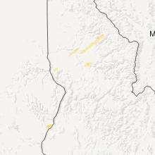
Hail Map for Peck, ID
The Peck, ID area has had 0 reports of on-the-ground hail by trained spotters, and has been under severe weather warnings 0 times during the past 12 months. Doppler radar has detected hail at or near Peck, ID on 4 occasions.
| Name: | Peck, ID |
| Where Located: | 40.7 miles NNW of Grangeville, ID |
| Map: | Google Map for Peck, ID |
| Population: | 197 |
| Housing Units: | 95 |
| More Info: | Search Google for Peck, ID |
0
The Top Recent Hail Date for Peck, ID is Thursday, August 11, 2022 (3rd out of 4)

Hail and Wind Damage Spotted near Peck, ID
| Date / Time | Report Details |
|---|---|
| 8/12/2022 1:11 PM PDT |
 At 110 pm pdt, severe thunderstorms were located along a line extending from near orofino to near nezperce, moving northeast at 45 mph (public). Hazards include 60 mph wind gusts have been reported with this storm. hail up to 1 inch is possible. Hail damage to vehicles is expected. expect wind damage to roofs, siding, and trees. locations impacted include, kamiah, craigmont, nezperce, peck, reubens and mohler. this includes the following highways, u. s. highway 95 in idaho between mile markers 268 and 276. u. s. highway 12 in idaho between mile markers 52 and 54, and between mile markers 59 and 67. hail threat, radar indicated max hail size, 1. 00 in wind threat, radar indicated max wind gust, 60 mph. At 110 pm pdt, severe thunderstorms were located along a line extending from near orofino to near nezperce, moving northeast at 45 mph (public). Hazards include 60 mph wind gusts have been reported with this storm. hail up to 1 inch is possible. Hail damage to vehicles is expected. expect wind damage to roofs, siding, and trees. locations impacted include, kamiah, craigmont, nezperce, peck, reubens and mohler. this includes the following highways, u. s. highway 95 in idaho between mile markers 268 and 276. u. s. highway 12 in idaho between mile markers 52 and 54, and between mile markers 59 and 67. hail threat, radar indicated max hail size, 1. 00 in wind threat, radar indicated max wind gust, 60 mph.
|
| 8/12/2022 12:52 PM PDT |
 At 1252 pm pdt, severe thunderstorms were located along a line extending from 8 miles east of culdesac to 14 miles south of craigmont, moving northeast at 45 mph (radar indicated). Hazards include 60 mph wind gusts and half dollar size hail. Hail damage to vehicles is expected. Expect wind damage to roofs, siding, and trees. At 1252 pm pdt, severe thunderstorms were located along a line extending from 8 miles east of culdesac to 14 miles south of craigmont, moving northeast at 45 mph (radar indicated). Hazards include 60 mph wind gusts and half dollar size hail. Hail damage to vehicles is expected. Expect wind damage to roofs, siding, and trees.
|
| 8/17/2020 6:25 PM PDT |
 At 622 pm pdt, a severe thunderstorm was located 19 miles northeast of enterprise, moving northeast at 35 mph. the thunderstorms are looking to enter nez perce county by 6:45pm. brief heavy downpours and wind gusts up to 50 mph are possible (doppler radar indicated). Hazards include 50 mph wind gusts and penny size hail. expect damage to roofs, siding, and trees At 622 pm pdt, a severe thunderstorm was located 19 miles northeast of enterprise, moving northeast at 35 mph. the thunderstorms are looking to enter nez perce county by 6:45pm. brief heavy downpours and wind gusts up to 50 mph are possible (doppler radar indicated). Hazards include 50 mph wind gusts and penny size hail. expect damage to roofs, siding, and trees
|
| 6/8/2016 3:15 PM PDT |
 At 315 pm pdt, doppler radar indicated a severe thunderstorm capable of producing quarter size hail and damaging winds in excess of 60 mph. this storm was located 10 miles south of winchester, or 21 miles south of lapwai, and moving northeast at 40 mph. At 315 pm pdt, doppler radar indicated a severe thunderstorm capable of producing quarter size hail and damaging winds in excess of 60 mph. this storm was located 10 miles south of winchester, or 21 miles south of lapwai, and moving northeast at 40 mph.
|
| 6/8/2016 2:38 PM PDT |
 The severe thunderstorm warning for northern lewis and east central nez perce counties will expire at 245 pm pdt, the storm which prompted the warning has weakened below severe limits, and no longer poses an immediate threat to life or property. therefore the warning will be allowed to expire. to report severe weather, contact your nearest law enforcement agency. they will relay your report to the national weather service spokane. The severe thunderstorm warning for northern lewis and east central nez perce counties will expire at 245 pm pdt, the storm which prompted the warning has weakened below severe limits, and no longer poses an immediate threat to life or property. therefore the warning will be allowed to expire. to report severe weather, contact your nearest law enforcement agency. they will relay your report to the national weather service spokane.
|
| 6/8/2016 2:29 PM PDT |
 At 228 pm pdt, trained weather spotters reported a severe thunderstorm producing large hail up to ping pong ball size and damaging winds in excess of 60 mph. this storm was located near craigmont, or 13 miles southwest of orofino, moving northeast at 45 mph. , correction on reported hail size, in addition, at 220 pm hail up to the size of quarters was reported in craigmont. locations impacted include, craigmont, peck, reubens and mohler. At 228 pm pdt, trained weather spotters reported a severe thunderstorm producing large hail up to ping pong ball size and damaging winds in excess of 60 mph. this storm was located near craigmont, or 13 miles southwest of orofino, moving northeast at 45 mph. , correction on reported hail size, in addition, at 220 pm hail up to the size of quarters was reported in craigmont. locations impacted include, craigmont, peck, reubens and mohler.
|
| 6/8/2016 2:27 PM PDT |
 At 225 pm pdt, trained weather spotters reported a severe thunderstorm producing large hail up to ping pong size and damaging winds in excess of 60 mph. this storm was located near craigmont, or 15 miles southwest of orofino, moving northeast at 45 mph. in addition, at 220 pm pdt quarter size hail was reported in craigmont. locations impacted include, craigmont, peck, reubens and mohler. At 225 pm pdt, trained weather spotters reported a severe thunderstorm producing large hail up to ping pong size and damaging winds in excess of 60 mph. this storm was located near craigmont, or 15 miles southwest of orofino, moving northeast at 45 mph. in addition, at 220 pm pdt quarter size hail was reported in craigmont. locations impacted include, craigmont, peck, reubens and mohler.
|
| 6/8/2016 2:19 PM PDT |
 At 219 pm pdt, doppler radar indicated a severe thunderstorm capable of producing large hail up to ping pong ball size and damaging winds in excess of 60 mph. this storm was located over craigmont, or 18 miles southeast of lapwai, moving northeast at 45 mph. locations impacted include, craigmont, winchester, peck, reubens and mohler. At 219 pm pdt, doppler radar indicated a severe thunderstorm capable of producing large hail up to ping pong ball size and damaging winds in excess of 60 mph. this storm was located over craigmont, or 18 miles southeast of lapwai, moving northeast at 45 mph. locations impacted include, craigmont, winchester, peck, reubens and mohler.
|
| 6/8/2016 2:12 PM PDT |
 At 212 pm pdt, doppler radar indicated a severe thunderstorm capable of producing quarter size hail and damaging winds in excess of 60 mph. this storm was located near winchester, or 18 miles southeast of lapwai, and moving northeast at 35 mph. At 212 pm pdt, doppler radar indicated a severe thunderstorm capable of producing quarter size hail and damaging winds in excess of 60 mph. this storm was located near winchester, or 18 miles southeast of lapwai, and moving northeast at 35 mph.
|
| 6/1/2015 6:12 PM PDT | At 611 pm pdt, doppler radar indicated a line of severe thunderstorms capable of producing quarter to half dollar size hail and damaging winds to 60 mph. this storm was located near culdesac, or near lapwai, and moving northeast at 45 mph. there are multiple cells in this line capable of producing large hail. |
Hail Maps for Peck, ID


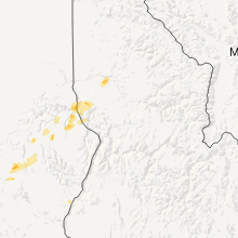
Connect with Interactive Hail Maps